Cumulative Impact Assessment and Management:
300
Cumulative Impact Assessment and Management: HYDROPOWER DEVELOPMENT IN THE TRISHULI RIVER BASIN, NEPAL IN PARTNERSHIP WITH
-
Upload
khangminh22 -
Category
Documents
-
view
0 -
download
0
Transcript of Cumulative Impact Assessment and Management:

Cumulative Impact Assessment and Management: HYDROPOWER DEVELOPMENT IN THE TRISHULI RIVER BASIN, NEPAL
IN PARTNERSHIP WITH

ii
ABOUT IFC
IFC—a sister organization of the World Bank and member of the World Bank Group—is the largest global development institution focused on the private sector in emerging markets. We work with more than 2,000 businesses worldwide, using our capital, expertise, and influence to create markets and opportunities where they are needed most. In fiscal year 2019, we delivered more than $19 billion in long-term financing for developing countries, leveraging the power of the private sector to end extreme poverty and boost shared prosperity. For more information, visit www.ifc.org.
COPYRIGHT AND DISCLAIMER NOTICE
© International Finance Corporation 2020. All rights reserved.2121 Pennsylvania Avenue, N.W. Washington, D.C. 20433Internet: www.ifc.org
The material in this work is copyrighted. Copying and/or transmitting portions or all of this work without permission may be a violation of applicable law. IFC encourages dissemination of its work and will normally grant permission to reproduce portions of the work promptly, and when the reproduction is for educational and non-commercial purposes, without a fee, subject to such attributions and notices as we may reasonably require.
IFC does not guarantee the accuracy, reliability or completeness of the content included in this work, or for the conclusions or judgments described herein, and accepts no responsibility or liability for any omissions or errors (including, without limitation, typographical errors and technical errors) in the content whatsoever or for reliance thereon. The boundaries, colors, denominations, and other information shown on any map in this work do not imply any judgment on the part of The World Bank concerning the legal status of any territory or the endorsement or acceptance of such boundaries. The findings, interpretations, and conclusions expressed in this volume do not necessarily reflect the views of the Executive Directors of The World Bank or the governments they represent.
The contents of this work are intended for general informational purposes only and are not intended to constitute legal, securities, or investment advice, an opinion regarding the appropriateness of any investment, or a solicitation of any type. IFC or its affiliates may have an investment in, provide other advice or services to, or otherwise have a financial interest in, certain of the companies and parties named herein.
All other queries on rights and licenses, including subsidiary rights, should be addressed to IFC’s Corporate Relations Department, 2121 Pennsylvania Avenue, N.W., Washington, D.C. 20433.
International Finance Corporation is an international organization established by Articles of Agreement among its member countries, and a member of the World Bank Group. All names, logos and trademarks IFC are the property of IFC and you may not use any of such materials for any purpose without the express written consent of IFC. Additionally, “International Finance Corporation” and “IFC” are registered trademarks of IFC and are protected under international law. All other product names, trademarks and registered trademarks are property of their respective owners.
Photo credits: Leeanne Alonso; Halvard Kaasa; ERM Photographs; and International Finance Corporation.
Suggested citation: International Finance Corporation. 2020. Cumulative Impact Assessment and Management: Hydropower Development in the Trishuli River Basin, Nepal. International Finance Corporation, Washington, DC, USA.

iii
IN PARTNERSHIP WITH
Cumulative Impact Assessment and Management: HYDROPOWER DEVELOPMENT IN THE TRISHULI RIVER BASIN, NEPAL

iv
AcknowledgmentsThe Cumulative Impact Assessment and Management: Hydropower Development in the Trishuli River Basin, Nepal was carried out by a consortium of ERM India Private Limited, Nepal Environmental and Scientific Services, and Hagler Bailly Pakistan. The contributing authors of the report are Rutuja Tendolkar, Arun Venkataraman, David Blaha, Naresh Rimal, Apoorva Sahay, Neena Singh, Samiksha Bhandari, Vaqar Zakaria, Cate Brown, Halvard Kaasa, Narayanhari Rijal, Salil Devkota, Ramu Subedi, Pablo Cardinale, Kate Lazarus, and Leeanne Alonso.
The International Finance Corporation team that commissioned and led the study through the Hydro Environmental and Social Advisory program (www.ifc.org/hydroadvisory) was Kate Lazarus, Pablo Cardinale, Leeanne Alonso, and Upasana Pradhan Shrestha, who provided training, guidance, and feedback and organized various workshops throughout the study. They were also instrumental in setting up the Trishuli Basin Developers Group, which met several times throughout the course of the study to provide input and guidance.
We are thankful for the generous support from the Australian Government through the Sustainable Development Investment Portfolio, the Japanese Government, and the Norwegian Ministry of Foreign Affairs. We would like to extend our gratitude to the communities and civil society organizations as well as all participants who were key informants and/or participated in stakeholder meetings for contributing their valuable time and knowledge toward the creation of this report.

v
ContentsAcknowledgments .........................................................................................iv
Acronyms and Abbreviations ..........................................................................xii
Executive Summary ......................................................................................... 1
Chapter 1: Introduction ................................................................................. 25
Background .......................................................................................................25Project Overview ................................................................................................25
CIA Study Context .............................................................................................................. 26Scope of Work ..................................................................................................................... 27Scope Exclusions ................................................................................................................. 27
Approach and Methodology ................................................................................28
Adapting the Conceptual CIA Approach ............................................................................. 28Key Enablers ...................................................................................................................... 30
Limitations ........................................................................................................ 33
Chapter 2: Administrative and Regulatory Framework ...................................... 35
Administrative Framework ................................................................................. 35
River Basin Plans ................................................................................................................ 36Revised EIA Guidelines ...................................................................................................... 36Local Governance ............................................................................................................... 37ESRM Guidelines of the Nepal Rastra Bank ...................................................................... 37Proposed Chitwan Annapurna Landscape (CHAL) Strategy .............................................. 37
Compendium of Applicable Regulations ...............................................................38Other Basin-Level Initiatives ................................................................................45
Chapter 3: Project and Study Context .............................................................49
Trishuli River: Major River Basin Characteristics ...................................................49Hydropower Projects ..........................................................................................49
Transmission Lines .............................................................................................................. 50Roads and Local Infrastructure ........................................................................................... 50Construction Phase Resource Requirements ........................................................................ 54
CIA Study Context .............................................................................................54
Spatial Boundary ................................................................................................................. 54Temporal Boundary ............................................................................................................ 55Project Development Scenarios ........................................................................................... 56Initial VEC Identification .................................................................................................... 56
Stressors and Regional Developments ................................................................. 57
Climate Change .................................................................................................................. 57Unregulated Fishing ............................................................................................................ 58Aftermath of the Earthquake .............................................................................................. 58Hydropower Development in Budhi Gandaki Basin ........................................................... 60

vi
OBOR and Prithvi Highway Upgrade ............................................................................... 61Riverbed Sand and Gravel Mining ...................................................................................... 62Urbanization and Industrial Development Midstream of the Basin .................................... 63Solid Waste Management .................................................................................................... 64In-migration ....................................................................................................................... 65
Stakeholder Identification and Engagement .........................................................66
Chapter 4: Valued Environmental Components ................................................. 77
Initial VEC Identification ..................................................................................... 77Stakeholder Perception and Feedback .................................................................. 77Finalization of VECs ............................................................................................ 81
Chapter 5: Valued Environmental Component: Aquatic Habitat ......................... 83
Rationale for Screening ......................................................................................83Baseline Conditions ...........................................................................................83
Elevation Profile of the Trishuli River Basin ........................................................................ 83Fish Diversity in the Trishuli River Basin ............................................................................ 84Aquatic Habitat for Fish Species along the Mainstem ......................................................... 89Aquatic Habitat for Fish in the Tributaries .......................................................................... 90
Methodology .................................................................................................... 91Key Stressors .....................................................................................................92
Sand and Gravel Mining ..................................................................................................... 92Access Roads ...................................................................................................................... 92Climate Change .................................................................................................................. 92
Significant Impacts ............................................................................................93
Fish Integrity ....................................................................................................................... 93Overall Ecosystem Integrity ................................................................................................ 94Fragmentation of Aquatic Habitat due to Hydropower Development ................................. 96
Proposed Mitigation ...........................................................................................98
Barrier Effects and Low Flows along the Trishuli Mainstem ............................................... 98Barrier Effects and Low Flows along Tributaries ............................................................... 100
Chapter 6: Valued Environmental Component: Terrestrial Habitat .....................103
Rationale for Screening .................................................................................... 103Baseline Conditions ......................................................................................... 103Methodology .................................................................................................. 104Key Stressors ................................................................................................... 105Significant Impacts .......................................................................................... 105
Access Roads .................................................................................................................... 105Transmission Lines ............................................................................................................ 106
Proposed Mitigation ......................................................................................... 106
Chapter 7: Valued Environmental Component: Social ...................................... 109
Socioeconomic Baseline of the Trishuli River Basin .............................................. 109
Water Availability ............................................................................................................. 116

vii
Indigenous Communities ................................................................................................... 116Community Forests ........................................................................................................... 116Migration Trends .............................................................................................................. 118Community Health ........................................................................................................... 119
Religious and Cultural Sites ............................................................................... 119
Rationale for Screening .................................................................................................... 119Baseline Conditions .......................................................................................................... 121Key Stressors .................................................................................................................... 123Methodology ................................................................................................................... 123Significant Cumulative Impacts ........................................................................................ 123Proposed Mitigation Measures .......................................................................................... 125
Livelihoods .......................................................................................................125
Rationale for Screening .................................................................................................... 125Baseline Conditions .......................................................................................................... 125Key Stressors .................................................................................................................... 131Methodology ................................................................................................................... 131Significant Cumulative Impacts (Relative to the Baseline) ................................................. 133Proposed Mitigation ......................................................................................................... 135
Cumulative Implications for Basin-Level Development ......................................... 137
Chapter 8: Valued Environmental Component: Water Resources ....................... 141
Rationale for Screening ...................................................................................... 141Key Stressors .................................................................................................... 141Baseline Conditions .......................................................................................... 141
Upstream .......................................................................................................................... 141Midstream ........................................................................................................................ 142Downstream ..................................................................................................................... 142Surface Water Quality ....................................................................................................... 142Springs .............................................................................................................................. 143
Methodology ...................................................................................................143Significant Cumulative Impacts ..........................................................................143
Surface Water .................................................................................................................... 143Springs ............................................................................................................................. 143
Chapter 9: Mitigation, Monitoring, and Moving Toward Sustainable Development Pathways ................................................................................145
Cumulative Impact Management Framework ......................................................145The Proposed High-Management Action ..............................................................145
Assumptions ..................................................................................................................... 149Summary of Sustainable Development Pathways .............................................................. 149Changes in Ecosystem Integrity in the High-Management Action ..................................... 149
Chapter 10: Implementation Arrangements and Conclusions ............................ 157
Organization Structure ...................................................................................... 157
Overarching River Basin Management Plan ...................................................................... 157

viii
Facilitating the formation of Local Impact Management Committees .............................. 160Budget and Funding Modalities ....................................................................................... 160Disclosure and Stakeholder Engagement ........................................................................... 161
Conclusions ...................................................................................................... 161
References ...................................................................................................163
Appendix A: Key Stakeholder Consultations ....................................................170
Appendix B: Cumulative Impact Assessment Questionnaire: Settlement FGD .....219
Appendix C: Legal and Institutional Guidance on Hydropower Development in Nepal ...................................................................................................... 220
Appendix D: EFlows Assessment of the Trishuli River Basin .............................. 234
Acronyms and Abbreviations ..............................................................................237Units ................................................................................................................237
Appendix E: Project Descriptions ................................................................... 282

ix
List of Tables
Table ES.1 VECs Considered for the Assessment ...................................................................................4Table ES.2 Trishuli River Basin Hydropower Projects ...........................................................................6Table ES.3 Ecosystem Integrity Categories ..........................................................................................11Table ES.4 Changes in Overall Ecosystem Integrity across Project Development Scenarios .................12Table ES.5 Summary of Cumulative Impacts if Unmitigated ................................................................12Table ES.6 Proposed Mitigation Measures per Stakeholder Type .........................................................15Table ES.7 Suggested Elements of a High-Management Action ...........................................................18Table ES.8 Ecosystem Integrity Based on Cumulative Impacts .............................................................22Table 1.1 Engagement Mechanisms and Data Collection Tools ...........................................................31Table 2.1 Key Applicable Acts, Regulations, and International Standards ...........................................39Table 2.2 Insights from Basin Initiatives ..............................................................................................45Table 3.1 Hydropower Projects (June 2018) .......................................................................................52Table 3.2 Upcoming Transmission Line Projects in TRB ......................................................................53Table 3.3 Stakeholder Profile ...............................................................................................................67Table 4.1 Screening Process of Identified VECs ..................................................................................78Table 4.2 Approach for Final VECs .....................................................................................................81Table 5.1 Fish Species Recorded in the Trishuli Basin ..........................................................................85Table 5.2 Ecological Integrity Ratings .................................................................................................93Table 5.3 Fish Integrity at Seven EFlows Sites .....................................................................................94Table 5.4 Baseline Ecological Status of the Trishuli River ....................................................................96Table 5.5 Overall Ecosystem Integrity .................................................................................................96Table 6.1 Mammal Species of Conservation Significance in the TRB .................................................104Table 6.2 Bird Species of Conservation Significance in the TRB ........................................................104Table 6.3 Proposed Mitigation for Langtang National Park (LNP) ...................................................107Table 7.1 Demographic Indicators ....................................................................................................109Table 7.2 Overview of Community Forest User Groups ....................................................................118 Table 7.3 Demography and Migration ............................................................................................119Table 7.4 Overview of Health Infrastructure .....................................................................................120Table 7.5 Baseline Status of Religious and Cultural Sites ...................................................................122Table 7.6 Land-Acquisition Impacts ..................................................................................................129Table 7.7 Stakeholder Perceptions on Land Acquisition ....................................................................130Table 7.8 Cumulative Implications on Livelihood Activities ..............................................................132Table 7.9 Cumulative Impacts on Livelihoods ...................................................................................134Table 7.10 Basin-Level Intensity of Social Impacts ............................................................................138Table 8.1 Baseline Water Quality (based on turbidity and coliform levels) at Various Sections along the River ..................................................................................................................................142Table 9.1 Summary of Cumulative Impacts in TRB: Mitigation and Monitoring .............................146Table 9.2 Proposed High-Management Action ..................................................................................150Table 9.3 Interpretation and Inference ..............................................................................................154Table 9.4 Changes in Ecosystem Integrity under Different Management Scenarios ............................155

x
List of Figures
Figure ES.1 Overview of the Trishuli River Basin .................................................................................. 1Figure ES.2 Cumulative Impact Assessment Process .............................................................................. 2Figure ES.3 Proposed Structure to Implement a High-Management Action ......................................... 17Figure ES.4 Comparative Analysis of the Business-as-Usual Scenario and High-Management Action .. 22Figure 1.1 The Trishuli River Basin .................................................................................................... 26Figure 1.2 Conceptual CIA Approach ................................................................................................. 28Figure 1.3 Key Activities Undertaken in the Assessment ...................................................................... 30Figure 2.1 Administrative Framework ................................................................................................. 35Figure 3.1 Characteristics of the Trishuli River Basin .......................................................................... 51Figure 3.2 Comparative Migration Trends .......................................................................................... 65Figure 4.1 VEC Screening Process ....................................................................................................... 77Figure 5.1 Elevation Zones of the Trishuli River with Slope and Temperature Zones .......................... 83Figure 7.1 Socioeconomic Profile: Upstream ...................................................................................... 110Figure 7.2 Socioeconomic Profile: Midstream .................................................................................... 112Figure 7.3 Socioeconomic Profile: Downstream ................................................................................. 114Figure 7.4 Comparative Population Numbers of Indigenous Communities ....................................... 116Figure 7.5 Confluence of the Trishuli River with its Tributaries Phalankhu and Salankhu Khola, which Provide Adequate Flows for Religious Ceremonies at the Designated Cremation Sites or Ghats ................................................................................................................................................ 122Figure 7.6 Cultural and Religious Sites Upstream and Midstream ..................................................... 124Figure 7.7 Fish Integrity Assessment .................................................................................................. 133Figure 9.1 Comparison of Business-as-Usual and High-Management Development Action ............... 153Figure 10.1 Proposed Institutional Structure ..................................................................................... 158Figure 10.2 Conceptual Framework for the Koshi Basin Program ..................................................... 159
List of Boxes
Box ES.1 Summary of Stressors ............................................................................................................ 7Box 1.1 Upper Trishuli-1 ..................................................................................................................... 27Box 2.1 The Environment-Friendly Local Governance Framework (2013) .......................................... 38Box 3.1 Landslides and Hydropower Projects ..................................................................................... 54Box 3.2 Key Insights: State of Glaciers in Nepal .................................................................................. 58Box 3.3 Case Study: IDP Camp at Bidur, Nuwakot District ................................................................ 60Box 3.4 Sand and Gravel Mining, 2017–18 ........................................................................................ 62Box 3.5 Mining-Control Measures in Dhading District ....................................................................... 64Box 7.1 Profile of Key Indigenous Communities ............................................................................... 117Box 7.2 Role of Traditional Healers .................................................................................................. 121Box 7.3 Small-Scale Aquaculture Initiatives....................................................................................... 127Box 10.1 Free, Prior, and Informed Consent (FPIC) Agreement for UT-1 .......................................... 161

xi
List of Maps
Map ES.1 Spatial Extent of the Study Area ........................................................................................... 3Map ES.2 Sampling Locations of the 2018 Water Quality and Aquatic Biodiversity Surveys ................. 9Map F1.1.1 River Basin Terrain .......................................................................................................... 26Map 3.1 Trishuli Basin with Municipal Boundaries ............................................................................. 50Map 3.2 Overview of the CIA Study Area within the Trishuli River Basin .......................................... 56Map 3.3 Earthquake-Affected Districts ............................................................................................... 59Map 3.4 Nepal’s Proposed Railway Network ..................................................................................... 61Map 3.5 Map of Sand Mining ............................................................................................................. 63Map 5.1 Delineation of Elevation and Temperature Zones ................................................................. 84Map 5.2 EFlows Sites and Hydropower Projects ................................................................................. 89Map 5.3 Fish Integrity: Existing and Full Development ....................................................................... 95Map 5.4 Ecosystem Integrity: Existing and Full Development ............................................................. 97Map 6.1 Implications of Transmission Line Projects ......................................................................... 106Map F7.1.1 Upstream Study Region ................................................................................................. 111Map 7.2.1 Midstream Study Region ................................................................................................. 113Map 7.3.1 Downstream Study Region .............................................................................................. 115Map 7.1 Rafting Route on the Trishuli River .................................................................................... 128Map 7.2 Intensity of Livelihood Implications vis-à-vis Fish Integrity: Upstream ................................ 135Map 7.3 Livelihood Implications vis-à-vis Fish Integrity: Midstream ................................................ 136Map 7.4 Livelihood Implications vis-à-vis Fish Integrity: Downstream ............................................. 137

xii
Acronyms and AbbreviationsBES Baseline Ecosystem Status CDO Chief District Officer CFUG Community Forest User Group CHAL Chitwan Annapurna Landscape CIA Cumulative Impact Assessment DCCs District Coordination Committee DFO District Forest Office DoED Department of Electricity Development DoH Department of Health DoR Department of Roads DRIFT Downstream Response to Imposed Flow Transformations E&S Environmental and Social EIA Environmental Impact Assessment EMP Environment Management Plan EPA Environment Protection Act EPR Environment Protection Rules ESG Environmental, Social, and Governance ESIA Environmental and Social Impact Assessment ESMP Environmental and Social Management Plan ESRM Environmental and Social Risk Management FECOFUN Federation of Community Forestry Users Nepal GLOF Glacial Lake Outburst Floods HEP Hydroelectric Project HPP Hydropower Project IBN Investment Board Nepal ICIMOD International Centre for Integrated Mountain Development IDP Internally Displaced Person IEE Initial Environment Examinations IFC International Finance Corporation IPs Indigenous Peoples JICA Japan International Cooperation Agency KV Kilovolt LAHURNIP Lawyers’ Association for Human Rights of Nepalese Indigenous Peoples LMC Local Impact Management Committee LNP Langtang National Park MoFE Ministry of Forests and Environment MoEWRI Ministry of Energy, Water Resources and Irrigation MW Megawatt NDWQS National Drinking Water Quality Standards NEA Nepal Electricity Authority NEFIN Nepal Federation of Indigenous Nationalities NESS Nepal Environmental and Scientific Services NTFP Non-Timber Forest Products

xiii
NWEDC Nepal Water and Energy Development Company OBOR One Belt, One Road Project PANI Program on Aquatic Natural Resources Improvement PS IFC Performance Standards RoR Run of the River SESIA Supplemental Environment and Social Environmental Impact Assessment SEZ Special Economic Zone TAR Tibet Autonomous Region THDF Trishuli Hydropower Developers Forum TRB Trishuli River Basin TRBMP Trishuli River Basin Management Plan UT-1 Upper Trishuli–1 (power project) VEC Valued Environmental Component YONSED Youth Network for Social and Environmental Development WECS Water and Energy Commission Secretariat


1
EXECUTIVE SUMMARY
Introduction
The Trishuli River Basin (TRB) covers an area of 32,000 square kilometers across the Central Development Region of Nepal and makes up approximately 13% of the Gandaki River Basin. The Trishuli River originates in the Trans-Himalayan Zone within the Tibet Autonomous Region of the People’s Republic of China. The Trishuli River cascades downward from an altitude of 2,600 meters into Nepal at the Rasuwa Pass (Rasuwa District). It continues its descent for 130 kilometers through high-altitude mountains (Nuwakot, Dhading, and Gorkha Districts) before joining the Kali Gandaki River at Devighat (Chitwan District).
There are six operational hydropower projects along the Trishuli River and its major tributaries that total 81 megawatts (MW). In addition, seven hydropower
projects (total of 286 MW) are under construction and at least 23 hydropower projects are in the planning stage with survey licenses being issued by the Department of Electricity Development (DoED June 2018).
Cumulative impacts of operational hydropower projects; such as aquatic habitat fragmentation, degradation of the catchment area, reduced water availability, and an increased risk of landslides are already evident in the TRB (ESSA 2014). In April 2015, Nepal suffered a major earthquake that further altered environmental and social conditions (ERM 2019). While hydropower developers have prepared Environmental Impact Assessments (EIAs) for specific projects within the TRB, there have been limited efforts to provide a basin-level understanding of cumulative impacts to valued
Figure ES.1 Overview of the Trishuli River Basin
Features Description
Catchment area
6,624.7 square kilometers up to the confluence with Budhi Gandaki River
Physiography • Varied spatial distribution across mountains of Trans Himalaya to the Middle Hills and the Siwalik range
• Steep and fragile geomorphology makes the area vulnerable to natural disasters
Hydrology • Spatial distribution varies across physiographic zones creating microclimates that affect annual water availability
• Springs are a major source of water
Key biodiversity areas
• Langtang National Park and buffer area of Shivpuri National Park
• Migratory route for aquatic fauna and flyways for migratory birds
• Link protected areas in the north with Shivpuri National Park toward the east and Chitwan National Park toward the South
Livelihood patterns
Main economic activities include forestry, agriculture and participation in tourism-related activities from rafting, and religious sites
Demographic Trends
• Low population density upstream with a gradual increase downstream (the five districts have an average population density of 144 square kilometers)
• Brahmin Chhetri, Gurung, Magar, Tamang, Newar, Thakali, Tharu, Bhote and Dalit are the major ethnic groups in the region (the majority of the people follow Hinduism and Buddhism)
• Other than Chitwan, most districts have had a negative population growth indicating out-migration
These demographic trends, and especially the negative population growth rates and changing sex ratios, have implications on natural resource management and the roles of gender in agriculture and resource governance (Ministry of Forests and Soil Conservation 2015).
Natural disasters are critical drivers of vulnerability for communities, particularly floods, landslides, forest fires, and the Gorkha earthquake of April 2015.
144/km2
population density
42%of the total
population is employed
1,117 : 1000sex ratio
of females tomales
Source: Adapted from information obtained in the Strategy and Action Plan 2016–2025 (Ministry of Forests and Soil Conservation 2015) and Dandekhya et al. 2017. Note that in 2018 the Ministry of Forests and Soil Conservation became the Ministry of Forests and Environment.

2 Cumulative Impact Assessment and Management: Hydropower Development in the Trishuli River Basin, Nepal
environmental components (VECs)1 in the context of multiple hydropower projects acting in concert with the altered baseline conditions (since the April 2015 earthquake) and other stressors.
This Cumulative Impact Assessment and Management (CIA) of hydropower development in the TRB has been undertaken by the International Finance Corporation (IFC) to strengthen understanding of environmental and social impacts of hydropower development that go beyond individual project-level impact assessments and by considering a multiproject, basin-wide understanding of potential cumulative impacts in the TRB.
The “Executive Summary” of the CIA describes the key findings of a year-long assessment (from December 2017 to January 2019) and includes the following:
• An overview of the TRB along with the rationale
1 VECs are defined as fundamental elements of the physical, biological, or socioeconomic environment (including the air, water, soil, terrain, vegetation, wildlife, fish, birds, and land use) that are likely to be the most sensitive receptors to the impacts of a proposed project or the cumulative impacts of several projects. While VECs include social dimensions, they are defined as valued environmental components as per IFC 2013.
for spatial and temporal boundaries and VECs identification
• A quantitative and qualitative understanding of potential cumulative impacts across VECs (to the extent feasible and using qualitative extrapolation) as identified by stakeholder groups
• Recommendations on mitigation measures along with a framework for the establishment of sustainable development pathways that may be implemented and monitored by hydropower developers, local communities, and national stakeholders
The CIA follows a six-step process (Figure ES.2) provided subsequently as per the IFC Good Practice Handbook on Cumulative Impact Assessment and Management (IFC 2013).
Figure ES.2 Cumulative Impact Assessment Process
Note: VEC = valued environmental component.
Determine spatial and temporal boundaries
Determine present conditions of VECs
Assess cumulative impacts and evaluate their significance over VECs' predicted future conditions
Design and implement: (a) adequate strategies, plans, and procedures to manage cumulative impacts, (b) appropriate monitoring indicators, and (c) supervision mechanisms
Identify VECs in consultation with a�ected communities and stakeholders
Identify all developments and external natural and social stressors a�ecting the VECs
Step
1St
ep 2
Step
3St
ep 4
& 5
Step
6
Analysis of the existing legal, institutional,
and governance framew
ork

Executive Summary 3
Step 1: Determining Spatial and Temporal Boundaries
Spatial Extent of the Study Area
The spatial extent of the study area includes the entire catchment of the Trishuli River from the Tibetan border to the point immediately downstream of the Super Trishuli Hydropower Project (Map ES.1).
For ascertaining the baseline conditions with respect to the VECs, the study area was divided into the upstream, midstream, and downstream reaches on the basis of topographic elevation, water temperature, and agro-climatic zones.
Temporal Boundaries
Temporal boundaries considered for the CIA include
projects in two scenarios likely to be developed within the next 10 years (“projects under construction and committed”) and within 50 years (“full development scenario,” which includes all “committed scenario” projects plus future planned projects). These scenarios are in addition to an “existing scenario,” which includes six projects presently operating.
Step 2: Identify VECs, Developments, and Stressors
Identification of VECs
Table ES.1 summarizes the VECs included in the CIA; they were identified through a robust stakeholder engagement program across federal, district, and community levels. Identification of VECs also included
Map ES.1 Spatial Extent of the Study Area

4 Cumulative Impact Assessment and Management: Hydropower Development in the Trishuli River Basin, Nepal
Identified VEC Available information Key basin-level impacts to consider
Assessment approach
Langtang National Park (LNP)
• Location of hydropower projects and associated facilities around LNP
• Biodiversity values and data on the LNP
• Impact on biodiversity values from LNP linked to footprint of project components and illegal and unregulated resource extraction due to stressors
• Qualitative assessment of impacts from hydropower, transmission lines, and stressors working in concert
Aquatic habitat • Hydrological time series data
• Select parameters on operational hydropower projects
• Results from environmental DNA (eDNA) and connectivity assessments around Upper Trishuli–1 project
• Reduction in flows that may lead to degradation of ecosystem integrity and fish habitat
• Fragmentation of habitats
• Set up of the Downstream Response to Imposed Flow Transformations (DRIFT) model and its interpretation for project development scenarios
Cultural and religious sites
• Mapping of specific cultural and religious sites along with their significance
• Information on local dependence
• Insufficient quantity and quality of flows to carry out religious and culturally significant activities due to a cascade of projects
• Livelihood implications on the local economy
• Qualitative assessment of low flow areas using the results from DRIFT in order to ascertain feasibility of controlled releases
Livelihoods • River-based livelihoods
• Ecosystem services– based livelihoods
• Information on land and natural resource–based impacts
• Change in flows may affect river use–based livelihoods
• Poor mitigation and compensation policies of land-based impacts may exacerbate economic vulnerabilities
• Extrapolation of DRIFT results for river-based livelihoods and ecosystem services
• Cumulative land and livelihood loss in specific sections of the study area
Water resources • Water quality information from IEE and EIA reports and secondary sources
• Dependence of local communities on surface water and springs
• Deterioration of water quality linked to muck disposal and other stressors such as waste management from urban areas
• Qualitative assessment of implications on water resources on springs
• Mapping of specific sites where high TDS/fecal coliform has been detected in under-construction projects and urban areas
Table ES.1 VECs Considered for the Assessment
Note: IEE = Initial Environment Examinations; EIA = Environmental Impact Assessment; TDS = total dissolved solids.

Executive Summary 5
field reconnaissance and literature reviews. A total of 52 stakeholder groups were identified and prioritized for consultation across the study timeline; they represent a subset of the following broad categories:
Hydropower Developers: Entities (independent power producers) that will own and operate under construction, committed, and planned hydropower projects that are considered for the Trishuli CIA and that actively participate in the Hydropower Developers Forum
Government Authorities (ministries and national authorities): Key ministries and departments that manage and establish policies to regulate the resources and VECs that are considered by the project
District Authorities: Departments of the national authorities and ministries that implement the policies established at a national level under the governance mechanisms put in place by respective Chief District Officers
Local Authorities: Urban and rural municipalities and specific local governance bodies (for example, the Wildlife Crime and Control Branch) that have been established for local governance and management of resources within the identified administrative structures and jurisdictions
Local and National NGOs: Entities that are active in promoting development and conservation activities within the TRB
International NGOs: Entities that are engaged at national- and international-level discussions on hydropower development and that may be actively interested in the outcomes of the CIA at a river-basin level
External Agencies: These include local contractors and companies engaged in sand mining, local infrastructure development, and so forth that are contributing to localized stressors for the VECs identified
Research Agencies: These include fisheries research stations as well as local entities that are undertaking ongoing data collection linked to critical resources such as aquatic ecosystems
Affected Communities: Local communities within the 20 urban and rural municipalities that inhabit the area of influence of existing and under-construction hydropower projects across the TRB.
Identification of All Developments for Consideration of Basin-level Impacts
Hydropower development has been the main development activity in recent years in the TRB in view of the basin’s hydropower potential and the area’s existing power deficit. In addition to the six operational projects and the seven projects under construction projects, another 23 projects (1,163 MW) are in different stages of planning (from financial closure to being allotted a survey license) as per DoED data of June 2018 (Table ES.2).
Several project development scenarios (see Table ES.4) were assumed to help understand cumulative impacts along with available information on major associated project facilities, such as transmission lines and access roads. Scenarios 1, 2a, 2b, and 3 include Business-as-Usual (BAU), Management, and High Management actions (see Tables ES.6 and ES.7).
Scenario 1: Existing Projects Scenario (Baseline): This development scenario represents the present conditions in which six of the existing projects are operational, and is referred to as Existing or Operational Scenario.
Scenario 2a: Under Construction Scenario (Existing + Under-Construction Projects). This scenario represents the expected conditions considering six existing projects, and seven under-construction projects.
Scenario 2b: Under Construction and Committed Scenario (Existing + Under-Construction + Committed Projects) (within 10 years). This scenario represents the expected conditions considering Scenario 1 and 2a plus the UT-1 project, which is the only project with a power purchase agreement that is not yet under construction.
Scenario 3: Full Development Scenario (all projects foreseen within 50 years): This scenario represents conditions in which all of the above and 23 other planned projects are operational.

6 Cumulative Impact Assessment and Management: Hydropower Development in the Trishuli River Basin, Nepal
Status Main stem projects Capacity (MW) Tributary Capacity (MW)
Operational 2 38 4 43
Trishuli 24 Chilime 22
Devighat 14 Mailung Khola 5
Tadi Khola 14
Thoppal Khola 2
Under construction
3 208 4 78
Rasuwagadhi 111 Upper Sanjen 14.8
Upper Trishuli - 3A (UT-3A)
60 Sanjen Hydro 42.5
Upper Trishuli - 3B (UT-3B)
37 Upper Mailung A 6.42
Upper Mailung Khola
14.3
Planned 6 582.6 17 581
Upper Trishuli–1 (UT-1) 216 Sanjen Khola 78
Trishuli Galchi 75 Langtang Khola Small
10
Super Trishuli 100 Salankhu Khola 2.5
Upper Trishuli 2 102 Phalaku Khola 14.7
Upper Trishuli 1 Cascade
24.6 Phalaku Khola 5
Middle Trishuli Ganga Nadi
65 Upper Tadi 11
Middle Tadi Khola 5
Lower Tadi 4.993
Ankhu Khola 49.5
Bhotekoshi Khola 33.5
Mathillo Langtang 24.35
Langtang Khola 310
Trishuli Khola 4.409
Upper Mailung B 7.5
Middle Mailung 10
Tadi Ghyamphedi 4.7
Tadi Khola 5.5
Table ES.2 Trishuli River Basin Hydropower Projects
Note: UT-1 is considered a committed project.

Executive Summary 7
External Stressors
In addition to hydropower projects, stressors and anticipated regional developments have been considered, as illustrated in Box ES.1.
Based on observations and consultations with local communities across the TRB, fishing is carried out across the basin, but the patterns and dependence vary. While overfishing has occurred in the past, fishing is currently carried out mostly for subsistence and to complement existing income sources. Certain communities that were traditionally known to be predominantly fish-based have moved toward regular income from sand mining and other livelihoods.
These stressors are identified based on their potential to attenuate the baseline conditions of the VECs screened into the assessment.
Step 3: Determine Baseline Conditions of the VECs
Langtang National Park (LNP)
Established in 1976, the LNP is the nearest Himalayan National Park to the capital city of Kathmandu, with an area of 1,710 square kilometers that extends over the southern mountainous terrain of the Nepal-China (Tibet) border. The park lies in the pinnacle, the meeting point between Indo-Malayan and Palearctic realms, and has important ecosystems of both realms, thereby harboring significant biodiversity and a wide range of vegetation types along the altitudinal range between 1,000 and 7,245 meters. LNP is the third most popular trekking destination among the protected areas of Nepal.
.
... .
.
. . ..
..
..
. ..
..
... .
..
Climate Change and Extreme Events• Climate change-induced phenomena (such as glacial lake outburst floods and
variability in runoff) pose significant implications to hydropower, land use, and rural livelihoods.
• Temperatures have already been observed to be rising, and are projected to increase further over the coming decades.
Slope Stability and the Aftermath of the 2015 Earthquake• Road and bridge construction has also increased landslides and disposal of soil
into the Trishuli River. Following the earthquake and aftershocks, districts within the basin were among those severely impacted with respect to damage to life and property, loss of forest cover, increased sedimentation, damage to tourism infrastructure, and displacement of local communities.
Sand and Sediment Mining in the Trishuli River• More than 500 small- and large-scale sand and sediment mining enterprises are
located in Nuwakot and Dhading districts. The implication is significant lowering of riverbeds and river pollution from rock crushing. Slush drained by these mines and crusher industries are a major pollution source.
Rapid Urbanization• Upgrades along Prithvi Highway, proposed infrastructure developments such as
the One Belt and One Road Project, and proximity to the border with China have stimulated urbanization within the basin. This has also resulted in in-migration and competition for scarce resources, haphazard access road development, and solid waste dumping into the Trishuli River.
Box ES.1 Summary of Stressors
.
... .
.
. . ..
..
..
. ..
..
... .
..

8 Cumulative Impact Assessment and Management: Hydropower Development in the Trishuli River Basin, Nepal
The LNP was perceived to be an important VEC for terrestrial habitat due to the forest land requirement and proposed transmission lines of at least four planned hydropower projects within the national park. Construction of infrastructure and access roads may cumulatively impact biodiversity habitats within the LNP.
Aquatic Habitat
The aquatic baseline of the basin, which is categorized according to the cold, cool, and cool to warm bioclimatic zones, was compiled from three sources:
• Review of secondary literature and available, representative EIAs
• A 2018 basin-wide aquatic environmental DNA (eDNA) survey carried out by the Centre for Molecular Dynamics Nepal (CMDN)
• Review of secondary literature and EIAs (Rajbanshi 1996; NESS 2012–14) revealed the presence of 49 species. Of these 49 species, 5 species are listed as threatened: Tor putitora (EN), Schizothorax richardsonii (VU), Neolissocheilus hexagonolepis (NT), Tor tor (NT), which are migratory, and Balitora brucei (NT) are present in the Trishuli River (IUCN 2019, Red List version 2018-1). Two species, Danio aequipinnulus and Psilorhynchoides pseudecheneis, are endemic to Nepal.
The 2018 surveys sampled aquatic water quality, macroinvertebrates, periphyton, and fish species at seven ecological flow sites (Map ES.2).
From the Sweco (2016) surveys, which focused on the upper Trishuli River area, breeding Common Snow Trout (Schizothorax richardsonii) individuals were recorded from Chilime Khola (upstream of UT-1) and Andheri Khola (downstream of Trishuli 3B), although no data were presented on fish size distribution. The densities of Common Snow Trout fry and fingerlings in the main river were considerably less than in the
2 A review of tourism brochures that provide information on rafting and recreational activities in the basin suggests that the river is named after the trident wielded by Lord Shiva of the Hindu pantheon. Legend proclaims that Lord Shiva drove his trident into the ground at Gosaikunda to create three springs that are the source of the river.
tributaries, which seem to be of vital importance to the fish population. Species diversity and fish abundance increased downstream. The authors also observed that the Trishuli 3A infrastructure could already be acting as a barrier to upstream fish migration.
The 2018 surveys were undertaken in the upstream reach of the TRB. This included an eDNA analysis (CMDN 2018) which identified a total of 25 fish species. It may be noted that eDNA is still in experimental stages and results are being confirmed and tested with further studies. One issue is that the reference eDNA database (NCBI GenBank) has limited data available on Himalayan fish species, which creates uncertainties in the species identifications from the eDNA study. The application of eDNA is being further investigated for use in long-term monitoring of fish in the TRB.
Due to their threatened and migratory status, and because they are fished extensively for commercial and sustenance purposes, the Common Snow Trout and the Golden Mahseer were determined to be important components of the Aquatic Habitat VEC.
Cultural Sites
The TRB has religious and mythological value to local communities due to the myths concerning the origins of the river.2 The river flow supports cultural practices and rituals linked to religious ceremonies and cremation rites of Hindus. The population in the upstream of the basin is predominantly Buddhist and does not practice cremation rites along the banks of the river. Cremation and/or burial practices of communities such as the Tamang, Gurung, and Chepang are linked to groves and forested areas in the uplands and not to the river. However, other communities undertake cremation rites along the main stem of the TRB. Two specific locations—Uttargaya (between upstream and midstream) and Devighat (midstream)—have emerged as regionally significant for pilgrims and national tourists due to the inflow of multiple tributaries that support cremation-related rites and temples of local significance.

Executive Summary 9
Livelihoods
Basin-wide stakeholder consultations prioritized the
consideration of livelihoods that are dependent on
the Trishuli River and related ecosystem services as
a VEC. River-based and ecosystem services-based
livelihoods were discussed along with the potential
significance of land-acquisition impacts on land and
natural resources of local communities. While physical
and economic displacement is a localized impact of
hydropower projects, the CIA has considered whether
multiple projects (and their associated facilities) within
the same municipality and/or tributary along with
potential loss of livelihood activities (linked to imposed
flow restrictions in dewatered reaches) have led to an
increase in economic vulnerability within the TRB.
The assessment has also tried to establish whether
there are certain vulnerable social groups that may
not be directly affected by land acquisition but whose
livelihoods may be impacted due to reduced flows
and implications on ecosystems and fish integrity.
Map ES.2 Sampling Locations of the 2018 Water Quality and Aquatic Biodiversity Surveys
Fishing Livelihoods
Artisanal fishing livelihoods (capture fishing, subsistence fishing, and recreation fishing) have declined in the TRB (Gurung et al. 2011). Consultations indicate that this decline is due to the reduction in fish resources, degradation of water quality and habitat, and availability of wage labor as an income-generating activity (especially linked to sand mining). However, consultations with local communities indicated subsistence-level dependence on fishing as follows:
• Limited fishing activities, even for subsistence or recreation, were reported upstream, other than for specific locations, such as Mailung Khola.
• In the midstream section, even though this area has seen degradation due to intense sand mining activities and urbanization, fishing as a livelihood activity is carried out by Dalit, Magar, Rai, and certain Tamang households.
• Downstream of the TRB, Rai, Magar, Majhi, and Chepang communities undertake fishing activities

10 Cumulative Impact Assessment and Management: Hydropower Development in the Trishuli River Basin, Nepal
in Icchyakayamana and Gandaki municipalities above the confluence between Trishuli and Budhi Gandaki to supply restaurants along the Prithvi Highway and linked to seasonal demands from activities such as tourism, rafting, pilgrimage, and so forth.
There is limited processing and/or value addition of fish that are caught since they are either sold to restaurants or consumed. Fishery Research Stations in Nuwakot and Dhunche (funded by the Nepal Agricultural Research Council) has been focusing on intensification of aquaculture and capture fisheries to support livelihood activities that are less dependent on flows.
Overall, cumulative impacts on fishing livelihoods are not considered significant, as few people depend on fishing livelihoods and have already shifted to aquaculture and capture fisheries. Impacts to subsistence-level fishing are best managed through the CIA’s biodiversity-related recommendations.
Other Ecosystem Services-Based Livelihoods
Some communities and families in the midstream and downstream sections of the study area rely on the river for some ecosystem services-based livelihoods, such as for irrigation, river-based sand mining, and whitewater rafting.
The gradual urbanization, upgrading of local infrastructure, and the development of hydropower projects in the TRB have spurred local enterprise and trade opportunities. These are linked to sand and gravel mining; crusher units and quarries; construction contractors and service providers for hydropower developers; the general plying of private vehicles and dumper trucks; and the establishment of restaurants and grocery stores in urban areas and tourist towns.
Primary consultations with local communities and the Nepal Association of Rafting Agencies indicated that whitewater rafting as a tourism and recreational activity occurs only in the downstream area of the basin. The peak season for rafting is from October to February, when 15,000 to 20,000 tourists visit
annually to raft. June to August each year (during the monsoon season) is the low season for this activity, due to the velocity of the river.
Water Resources
Water availability in the TRB depends on annual rainfall and glacier melt (upstream in the Tibet Autonomous Region) and is affected by extreme events and interventions such as river diversion schemes (Dandekhya et al. 2017).
In the upstream study area, it has been reported that during the earthquake water infrastructure such as pipes in Rasuwa District were badly damaged, leaving villages with no access to clean and safe drinking water (CAFOD 2015). There is no use of river water for irrigation or for drinking in view of the altitude and general riparian topography, which makes access to the riverbank difficult. The midstream area in Nuwakot faces scarcity of safe drinking water, which is exacerbated by landslides that engulf available drinking water pipelines (Dandekhya and Piryani 2015).
In Kispang, Bidur, and Benighat the major drinking water source is piped water supply and is not linked to the river or to springs. There are exceptions in some villages, such as Belkotgadi, where the communities have installed wells on the banks of the Trishuli. In the downstream area, it is estimated that each settlement in this district has one or two streams. Local communities use piped water (not the Trishuli River) for drinking. However, the source of water for agriculture varies from river water channeled directly to the fields to water directed to small-scale storage systems, such as ponds and tanks.
Analysis of water quality based on turbidity and coliform levels (from untreated domestic sewage) at various sections along the river indicates that turbidity levels are high as the river flows through the midstream and downstream sections, and it is likely that sand and gravel mining are significant contributors to high turbidity levels. E-coli concentrations, while exceeding the National Drinking Water Quality Standards (NDWQS) at all sampling locations, is highest in the midstream and downstream sections.

Executive Summary 11
Springs are unlikely to be cumulatively impacted by hydropower projects in the TRB. However as project specific impacts are likely; it is essential that developers carry out a preconstruction baseline study of springs in and around the dam, diversion tunnels, and other excavation areas (for example, quarries).
Steps 4 and 5: Evaluation of Cumulative Impacts on VECs and their significance
Cumulative Impacts on Aquatic Habitat
The DRIFT model evaluated multiple stressors on aquatic habitat and classified the resulting habitat condition using ecosystem integrity categories ranging from unmodified (“A”) to critically/extremely modified (“F”), which are described in Table ES.3.
Table ES.4 shows the predicted changes in ecosystem integrity at each of the seven environmental flows (EFlows) study sites (presented in Map ES.2) for existing/baseline conditions and then incrementally for each of the different scenarios under a business-as-usual scenario (construction and operation in compliance
with local requirements). As indicated in Table ES.4, ecosystem integrity along the Trishuli River, in the absence of significant management actions, such as those that would be required if IFC’s Performance Standards (PS) were to be applied, is predicted to decline primarily from ecosystem integrity categories B and C to categories D and E for the most part.
Qualitative Discussion of Cumulative Impacts on Other VECs
The analysis of cumulative impacts on VECs involves estimating the future state of the VECs that may result from the impacts they experience from various past, present, and predictable future developments. Cumulative impacts as described in the report are based on current and planned conditions of the TRB, without any responsive actions to prevent or reduce the impacts.
Table ES.5 summarizes key cumulative impacts on each identified VEC in the TRB.
In the business-as-usual project development scenarios, construction and commissioning timelines of the under-construction and planned projects are likely to coincide within a 7 to 10 year timeline across the
Ecological category
Corresponding DRIFT overall integrity score
Description of the habitat condition
A >-0.25 Unmodified: The ecosystem is still in a natural condition.
B >-0.75 Slightly modified: A small change in natural habitats and biota has taken place, but the ecosystem functions are essentially unchanged.
C >-1.5 Moderately modified: Loss and change of natural habitat and biota has occurred, but the basic ecosystem functions are still predominantly unchanged.
D >-2.5 Largely modified: A large loss of natural habitat, biota and basic ecosystem functions has occurred.
E >-3.5 Seriously modified: The loss of natural habitat, biota, and basic ecosystem functions is extensive.
F <-3.5 Critically/extremely modified. The system has been critically modified with an almost complete loss of natural habitat and biota. In the worst instances, basic ecosystem functions have been changed and the changes are irreversible.
Table ES.3 Ecosystem Integrity Categories
Note: DRIFT = Downstream Response to Imposed Flow Transformations model.

12 Cumulative Impact Assessment and Management: Hydropower Development in the Trishuli River Basin, Nepal
upstream and midstream reaches. This timeline will also coincide with regional developments such as the OBOR linkage, an increase access road construction, and gradual urbanization in the midstream.
During this timeline, the intensity of the following impacts are likely to amplify overall in the TRB, especially in Rasuwa and Nuwakot Districts: (i) In-migration to the basin; (ii) local economic and demographic changes; (iii) pressure on local resources
linked to community forest user groups (CFUGs), drinking water facilities, health infrastructure, and so forth; and (iv) community health and safety impacts. While the mitigation of adverse impacts is to some extent covered by approved Environment Management Plans (EMPs) of hydropower projects, there is a need to demarcate zones of intense hydropower development and an overarching approach to “localized cumulative impacts management” involving the developers, contractors, and municipalities.
EFlows site/ reach
Existing (Scenario 1)
Under- construction (Scenario 2a)
Under- construction
and committed (Scenario 2b)
Full development (Scenario 3)
EFlows Site 1 B B/C C/D D
EFlows Site 2 B B/C E E
EFlows Site 3 C C/D D E
EFlows Site 4 C C C D
EFlows Site 5 C C C D
EFlows Site 6 C/D C/D C/D D
EFlows Site 7 B B B C
Table ES.4 Changes in Overall Ecosystem Integrity across Project Development Scenarios
Note: Letter grades are defined in Table ES.3.
Identified VEC Key non-HPP stressors
Cumulative impacts from HPPs
Cumulative impact significance
Terrestrial biodiversity: Langtang National Park (LNP)
• Infrastructure development associated with upgrading of the Prithvi Highway and the proposed One Belt One Road (OBOR) initiative road infrastructure connecting to the China Border
• Declining populations of species of conservation significance through illegal extraction, exploitation, and export
• No significant impacts envisaged on wildlife dispersal and migratory bird corridors
• Access roads and transmission lines will provide improved access and potentially increase illegal entry into the LNP, resulting in the loss and degradation of habitat from logging and wildlife through poaching.
• Lower capacity transmission lines within the park have a minimal footprint and thereby do not impact habitat for threatened or endemic species.
• The transmission line network is unlikely to endanger any major flyway for migratory bird species.
Table ES.5 Summary of Cumulative Impacts if Unmitigated
Continued on the next page

Executive Summary 13
Identified VEC Key non-HPP stressors Cumulative impacts from HPPs
Cumulative impact significance
Aquatic habitat: Habitat quality
• Sand and gravel mining and processing
• Soil from landslides and dumping of spoil from road construction degrading aquatic habitat
• Alteration of aquatic habitats and deterioration of water quality as indicated by ecosystem integrity results across project development scenarios
• Significance was evaluated on the basis of ecosystem integrity as predicted by the DRIFT model at different EFlows sites. Ecosystem integrity is expected to progressively deteriorate based on the scenarios modelled from existing ecosystem integrity categories B, C, and D (slightly/moderately/largely modified) to D and E (largely/seriously modified) for the full-development scenario, if there are no mitigation measures implemented.
Aquatic habitat: Aquatic biodiversity (particularly fish) These are populations that are in discrete management units due to cumulative impact of HPPs and include altered ecological flows in diversion reaches.
• Sand and sediment mining
• Access roads that may render stretches of the river upstream accessible with potential increase in unregulated fishing
• Climate change resulting in long-term temporal changes in flow in diversion reaches already compromised by low flows caused by dams
• Impediments to upstream and downstream migration in both main stem and tributaries as a result of multiple HPP dams, leading to declines of Snow Trout and Mahseer populations
• Degradation of aquatic habitats and lowered water depths from modification on natural flow regimes leading to impediments to upstream migration
• Significance evaluated based on DRIFT modelling. Based on the scenarios modelled, fish integrity is expected to progressively deteriorate if there are no mitigation measures implemented. Existing integrity ranges from Ecosystem Integrity Category B (slightly modified) to Ecosystem Integrity Category C/D (moderately/largely modified). These are predicted to deteriorate to Ecosystem Integrity categories. E (seriously modified) and F (critically/extremely modified) for the full-development scenario.
Cultural and religious sites: Uttargaya and Devighat These sites have regional importance as sites for Hindu rituals, ceremonies, and pilgrimages during the year.
• Sand and gravel mining activities resulting in degradation of river banks, with river subsidence altering water quality
• Quality of water linked to increased fecal coliform and pollution-load untreated sewage from nearby towns; furthering loss of heritage resources and intangible cultural services relative to the baseline condition
• Reduction in flow in specific river segments (for example, diversion reaches)
• Significance evaluated based on water quality and flow. Flow impacts are expected to be more project specific than cumulative and best managed as part of individual project EIA review process.
Continued on the next page

14 Cumulative Impact Assessment and Management: Hydropower Development in the Trishuli River Basin, Nepal
Identified VEC Key non-HPP stressors Cumulative impacts from HPPs
Cumulative impact significance
Livelihoods Unregulated fishing has been declining, but it continues to contribute to subsistence livelihoods as well as providing a supplementary income source from sale of fish to restaurants and hotels along the Prithvi Highway.
• Sand and sediment mining leading to degradation of aquatic habitat and with implications on fish resources
• In the full-development scenario, fish integrity likely to be significantly impacted in the upstream reach, indicating a general decline in the possibility of fishing-based livelihood
• Livelihood impacts may increase on certain vulnerable social groups (Rai, Magar, and Dalit) that may depend on fishing more than other communities
• Significance evaluated based on DRIFT-modelled changes to overall fish integrity. Assessment indicates that fish abundance will be impacted, although relatively few families rely exclusively on fishing as a livelihood.
• Overall significance of impacts upstream is linked to economic displacement and will be significant in view of multiple projects.
• Overall significance of impacts midstream is minor; however, specific communities such as Rai, Magar, and Dalit may be affected due to loss of livelihoods linked to fishing.
• Overall significance of impacts downstream is minor, other than for local communities that support rafting and tourism activities—localized impact linked to Super Trishuli HPP.
Water resources: Surface water quality Basin water quality is poor, and turbidity and coliform levels increase in downstream. Trishuli River is not used directly for drinking.
• Sand and sediment mining
• Spoil disposal from construction activities
• Solid waste and untreated sewage from major or urban settlements along the banks of the Trishuli River
• Additional projects in concert with increased intensity of existing stressors likely to further degrade habitats, but may tend to be spatially restricted (other than in the midstream reach)
• Significance analysis of water quality based on turbidity and coliform levels at various sections along the river indicates that the impacts of stressors such as sand and gravel mining and disposal of soil are significant.
Note: HPP = hydropower project.

Executive Summary 15
Steps 6: Managing Cumulative Impacts
This step describes proposed mitigation measures for each of the identified VECs, but also proposes a “high-management” action for enhanced management and protection of VECs and suggests an organizational structure for effective cooperative management of these important river basin resources.
VEC-Specific Mitigation Measures
The CIA study identifies VEC-specific potential
cumulative impacts in the TRB and proposes mitigation
and monitoring measures at three different stakeholder
levels: Individual hydropower developers, government
authorities, and local communities. Table ES.6 provides
a short description of the proposed mitigations measures
per stakeholder type for each identified VEC.
Identified VEC Proposed mitigation measures
Hydropower developers Government authorities
Local communities
Terrestrial biodiversity: LNP
• Contractor Management Plans to raise awareness of contractors engaged in coordination with local access road contractors
• Increased funding and resources to LNP forest guards
• Shared access road development plan by adjoining municipalities to reduce access and disturbance in park
Aquatic habitat: Habitat quality
• Release of adequate EFlows for aquatic biodiversity
• Development and testing of robust methodology for aquatic baselines and monitoring
• Training of environmental staff in survey and monitoring methods
• Researching and testing novel survey/monitoring methods (e.g., eDNA)
• Fish surveys carried out by the Fisheries Research Stations
• Habitat Restoration Plans to be prepared
• Capacity building for staff for aquatic baseline surveys and monitoring
• Reviewing and updating regulations for aquatic habitat protection as needed
• Regulating sand mining through municipality level governance
• Community-based protection/stewardship of river reaches within their area of influence and use
• Implementing actions for controlling erosion and runoff into the river, with emphasis on those pertaining to access roads
Aquatic habitat: Habitat contiguity
• Provision of fish passes with design validation by a fisheries expert (For most existing projects, the expectation to retrospectively add a fish pass or fish ladder has been considered likely not practical)
• Maintaining enhanced connectivity between main stem and tributaries, including river training
• Provision of appropriate EFlows based on holistic assessments of affected river segments
• Monitoring and enforcement of functioning fish ladder and EFlows releases
• Capacity building for monitoring fish passages and migratory fishes
• Enforcement of fishing and mining regulations
• Community-based regulation of capture fisheries for Snow Trout and Golden Mahseer
• Community-based protection of fish breeding areas in tributaries
Table ES.6 Proposed Mitigation Measures per Stakeholder Type
Continued on the next page

16 Cumulative Impact Assessment and Management: Hydropower Development in the Trishuli River Basin, Nepal
Identified VEC Proposed mitigation measures
Hydropower developers Government authorities
Local communities
Aquatic habitat: Habitat contiguity (continued)
• Development and testing of robust monitoring methodology; training of environmental staff
• Monitoring of fish passage and abundance during migratory season
• Enhancement of fish breeding areas in tributaries
• Additional research on fish hatcheries to international standards
Cultural and religious sites: Uttargaya and Devighat
• Undertaking an assessment of the actual requirements for water flow in dewater reaches for normal rituals as well as during specific times through the year, especially during the dry season
• Regional policy directives to temporarily stop mining activities at least during key festivals/pilgrimages and regionally significant rituals
• Implementing domestic wastewater treatment for towns currently discharging untreated sewage into the river
• Raising awareness among local communities and sand and gravel mining entities for management of waste along with specific zones being declared for muck/spoil disposal
• Education to stop disposal of solid waste in riverbeds and tributaries
• Construction of septic systems
Livelihoods • Granting reservoir area fishing rights and/or licenses based on district allocations
• Developing focused livelihood support plans for specific communities of cold-water aquaculture schemes
• Agreement on principles of avoidance measures, compensation, and livelihood restoration
• Good grievance redress mechanism
• Developing Sustainable Fishing Plans for specific sections of the basin
• Coordinating with individual hydropower developers to ensure livelihoods are restored
• Implementation of Sustainable Fishing Plans
• Community-based cold-water aquaculture/fish farm schemes
• Community monitoring and supervision
Water resources: Surface water quality
• Implementation of the Environment Management Plan on muck disposal during construction
• Implementation of regulations on sand and gravel mining
• Exploring sewage treatment options
• Increase awareness by local communities on household waste disposal through engaging with municipal authorities and community-based organizations.

Executive Summary 17
Proposed High-Management Action
Steps 4 and 5 in the CIA process show that the assessed scenarios would result in significant degradation of aquatic biodiversity and several other VECs. Although the mitigation actions proposed in Table ES.5 and Table ES.6 are a start to mitigating cumulative impacts, based on the level of development proposed for the TRB, additional management actions at a higher level, such as a high-management action, are also suggested to address the significant cumulative impacts that are predicted to affect the basin.
The high-management action comprises a combination of quasi-regulatory, incentive-based, and technical measures to manage fish populations in the TRB along with regulation of sediment mining and watershed management; all will contribute to improvement of habitats and consequently reduction of cumulative impacts across VECs. This scenario suggests measures to be jointly implemented by hydropower developers, municipalities, and local communities, facilitated by the perception of shared benefits until a basin-level sustainable hydropower strategy for Trishuli is adopted by the government of Nepal.
Trishuli Hydropower Developers Forum
• Developers• Lenders (facilitated by the IFC)• NEA• DoED• MoFE• MoEWRI• Others by invitation
Community volunteers for implementation
Project-specific forums (e.g. UT1 Adivasi Janajati Advisory
Council
Local HSE leads of projectssuch as UT1, UT3A,
Mailung, etc.
Municipalityrepresentatives
Structure of LMC2 in upstream reach of TRB
Community river guards and mining supervisors
for monitoring activities
Local Impact Management Committee 1 (LMC1)
Local Impact Management Committee 2 (LMC2) LMC3 LMC4, etc.
Technical Resources Group
Figure ES.3 Proposed Structure to Implement a High-Management Action
Note: NEA = Nepal Electricity Authority; DoED = Department of Electricity Development; MoFE = Ministry of Forests and Environment; MoEWRI = Ministry of Energy, Water Resources, and Irrigation.

18 Cumulative Impact Assessment and Management: Hydropower Development in the Trishuli River Basin, Nepal
The high-management action is premised under the following assumptions:
• Hydropower developers across the TRB will sign on to a cumulative impacts management charter that goes beyond compliance requirements of EMP implementation of individual hydropower projects. This charter will form the basis of a formal structure to set up the Trishuli Hydropower Developer’s Forum (THDF) as a developer-driven institution to manage cumulative impacts.
• Municipalities will be empowered under the proposed revisions to the Environment-Friendly Local Governance Framework (2013) to align with the proposed decentralization in the federal
governance structure and to form Local Impact Management Committees (LMCs), which will include participation from hydropower developers and local NGOs/community-based organizations.
• A technical resource group (through participation by government ministries, conservation groups, research agencies, and multilateral development banks/donor agency experts) will provide strategic support and guidance for approval by the THDF and implementation by the LMCs.
Table ES.7 summarizes sustainable development pathways that can be conceptualized and implemented under the high-management action.
Theme Description Responsibility
Developer’s charter on sustainable hydropower in Trishuli River Basin
This would be a vision and commitments-driven document that could include the following:• Applying a uniform set of standards for including fish passages in the
design of projects based on a review of contemporary and innovative designs for fish in conjunction with leading experts in this discipline
• Developing guidelines to prepare and implement an environmental flow management framework for each hydropower project based on available secondary guidance on adaptive management: This should be project/reach specific keeping in mind ecological, cultural and social sensitivities inherent for the river reach
• Researching and developing a robust standard methodology for aquatic baseline surveys and monitoring for ESIAs to be used by all hydropower projects and possibly adopted into government regulations: Train HPP and government staff in methodologies
• Assessing land-based and livelihood impacts from projects in order to develop and fund livelihood restoration measures (e.g. fishing, skills development, and agricultural intensification schemes) as a form of local community development around hydropower projects
• Expanding the regulatory EMPs into a comprehensive Environmental and Social Management Plan that would incorporate safeguards to manage localized social impacts linked to in-migration, resource requirements, and community health and safety
• Conducting issue- or theme-specific studies for sensitivities within the area of influence of the hydropower project, such as assessment of flows for cultural practices, inventory of springs, and so forth
• Developing principles for all future land acquisition based on avoidance measures, compensation at replacement cost, informed consultation, and participation and emphasis on livelihood restoration of affected communities
Trishuli Hydropower Developers Forum (THDF) with support from Local Impact Management Committees (LMCs)
Table ES.7 Suggested Elements of a High-Management Action
Continued on the next page

Executive Summary 19
Theme Description Responsibility
Developer’s charter on sustainable hydropower in Trishuli River Basin (continued)
• Supporting suppliers of sand, gravel, and aggregates to implement sustainable mining techniques
• Overarching framework on contractor management with specific safeguards to manage unregulated fishing, access into forest areas, muck disposal, and any other waste dumping, project-induced influx
• Developing and monitoring project-specific grievance redress mechanisms
• Having representatives from key developers could come together to agree on provisions of the charter: The technical resource group could help the THDF formulate a charter.
Community-based river guards across river reaches
Each LMC could deploy community-based river guards and associated field-level supervision to undertake the following:• Detect violation of restrictions, rules, and regulations approved
by the LMC for protection of river and tributaries and take corrective actions as permissible
• Maintain contact with the local community and promote awareness and education on importance of natural resources (including illegal sand mining and unregulated fishing)
• Support implementation of incentive-based measures such as community-based sustainable fishing
• Collect data on status of protection and awareness, record grievances, and report
LMC
Preparation and implementation of Sustainable Fishing Plans
• Mechanisms on regulated fishing managed by local communities in coordination with hydropower developers could be prepared by LMCs with support from a technical resource group. The basic principles followed could include establishing a conservation program, conducting research to estimate sustainable harvesting quotas, setting up a system of permitting for harvesting, utilizing the revenues generated to manage the conservation and harvesting program, and monitoring to ensure that the program objectives including protection of fish populations and sustainability of the program are met.
LMC
Development of indigenous fish hatcheries for fish stocking
• Captive (hatchery) breeding of fish species impacted by HPPs may be considered as a measure that is supplemental to other management measures such as protection, habitat management, and fish passages, but not as a substitute for them.
LMCs supported by Fishery Research Station at Nuwakot and Dhunche
Farming of commercially valuable fish species
• Providing alternative means of incomes or livelihoods through promotion of fish farming could help in the reduction of anthropogenic pressures on the river ecosystems. There are several Brown Trout (Salmo trutta) and Rainbow Trout (Oncorhynchus mykiss) farms, some of them started with international assistance (e.g., Japan International Cooperation Agency, or JICA) with considerable capacity and commitment. Such farms could be developed in areas where indigenous fish stocks are depleted due to overfishing.
LMCs supported by Fisheries Research Centre
Continued on the next page

20 Cumulative Impact Assessment and Management: Hydropower Development in the Trishuli River Basin, Nepal
Theme Description Responsibility
Preparation and implementation of Sustainable Sediment Mining Plans
• Given that it is entirely plausible that the demand for sediment will continue to increase in the foreseeable future, achieving the high-management action would necessitate management and control that could limit the impact of mining on the river and its tributaries in the face of increased demand and volumes being abstracted. This mining plans could be elaborated to include the following:
o Ban mining in sensitive areas and identifying nonsensitive areas to focus mining activities.
o Mine outside the riverbed only in the river banks, and ensure that any unavoidable mining in the riverbed takes place in areas expected to be flooded by reservoirs instead of in the projected dewatered reaches.
o Implement on-site control of mining activities linked to equipment and techniques used, manage spoil disposal, and so forth.
o Rehabilitate or restore habitats already degraded by mining, especially in the midstream reach.
o Identify alternative sources of aggregate for construction: Among other practices, (i) reuse spoil from construction of hydropower projects, and (ii) use open rock quarries on hillsides (with due recognition of any springs) as source of gravel.
• An important component of the sustainable sediment mining plans would be to appoint community based mining supervisors and guards from within the LMCs to enforce restrictions.
• Depending on the level of pressure from mining, the number of supervisors and guards assigned for this purpose could vary, and where pressures are low, the responsibilities for implementation of the sustainable sediment mining plan could be assigned to the river guards.
• These mining plans could be developed by municipalities, as sand and sediment mining enterprises are a major source of revenue. There is also an overlap between owners of sand-mining entities and key local leaders (including municipality representatives). Municipalities may seek support from the technical resource group for the identification of mining areas through modelling (to predict the location, quality, and quantity of sediment deposits linked with hydropower projects); identification of key ecological sites or reaches within the system to identify no-go or restricted use areas; and the necessary engagement with the affected mining and local community.
LMCs with potential assistance from the District Coordination Committee.
Watershed management
• A watershed management program could help improve water quality in the basin, critical for the protection of biodiversity and river-based livelihoods. Actions that could be supported by the THDF and LMCs include (i) programs focusing on areas including reforestation to meet community requirements for fuel wood and timber remaining within the limits of sustainable harvesting to reduce erosion and risk of landslides, and (ii) land-use management.
LMCs
Continued on the next page

Executive Summary 21
Theme Description Responsibility
Watershed management (continued)
• The watershed management program could also link to any basin-level plans and benefit-sharing plans. In partnership with the provincial government it could allow for the coordinated planning and implementation of watershed and community investment initiatives. Also, suggestions should be included for management of water use in both agriculture and households, and management of water quality at the local level, including enhanced community wastewater treatment.
Delineating no-go areas for hydropower development
• LMCs could strongly advocate for setting aside stretches of river and tributaries that are of high ecological importance to help preserve key features of aquatic biodiversity in the basin—including spawning grounds of fish and stretches or tributaries still in pristine condition, for example, the undammed Nyam khola, a tributary of the Mailung Khola, which is an important source site for Common Snow Trout for the Mailung Khola downstream of the dewatered area of the Mailung Khola HPP. LMCs, through the THDF, could recommend certain no-go areas for consideration by DoED, NEA, and MoEWRI. The technical resource group could support capacity building and reaching out to the provincial and national government ministries and departments.
LMCs
Mahseer and Snow Trout sanctuary
• Consider designating one or more important fish spawning tributaries (for example, the Tadi Khola) as a Mahseer and Snow Trout sanctuary, which would remain free flowing (that is, no hydropower development) and develop and foster domestic wastewater treatment and solid waste management to improve water quality and riparian and river health.
THDF with support from LMCs
Cumulative Impact Assessment of the Alternative Management Scenarios
Figure ES.4 and Table ES.8 illustrate ecosystem integrity ratings along the Trishuli River under a business-as-usual scenario (continuation of complying only with local regulation) and an all projects high-management action (for example, all projects implementing mitigation measures compliant with IFC PS/good international industry practice, or GIIP) for each of the project development scenarios.
In summary, this analysis indicates the following (refer to Table ES.3 and Table ES.4 for the ecosystem integrity ratings A to F):
• Present ecological status (PES) shows the Trishuli River maintaining an existing ecosystem integrity of B/C assuming no new hydropower development or increase in external stressors (Scenario 1).
• The business-as-usual (BAU) scenario shows ecosystem integrity of the Trishuli River degrading
from existing B/C conditions, to C/D as under-construction HPPs come on line (Scenario 2a), decreasing further to D as the committed project (UT-1 HPP) is constructed (Scenario 2b), and ultimately falling to E as future planned projects are developed (Scenario 3). Clearly this would not be a sustainable outcome.
• The all projects high-management also shows the ecosystem integrity of the Trishuli River degrading to C/D as under-construction HPPs come on line (Scenario 2a), but then an improvement to a B ecosystem integrity rating as high-management measures are required for all new HPPs and retro-fitted on the existing HPPs. In the full-development scenario (Scenario 3), and given the sheer magnitude of the impacts associated with 23 additional HPPs (committed and planned), the Trishuli River ecosystem integrity is ultimately predicted to degrade back to a C, even if all projects apply GIIP per IFC PSs. An ecosystem integrity rating of B could be maintained, however, if the future number of HPPs in the basin were limited.

22 Cumulative Impact Assessment and Management: Hydropower Development in the Trishuli River Basin, Nepal
Figure ES.4 Comparative Analysis of the Business-as-Usual Scenario and High- Management Action
Note: BAU = business as usual; HM = high management; PES = present ecological status.
E
D
C
B
A100%
90%
80%
70%
60%
50%
40%
30%
20%
10%
0%
1000
900
800
700
600
500
400
300
200
100
0
Ecol
ogic
al in
tegr
ity
Cap
acit
y of
pro
ject
(MW
)
Present ecological status:Baseline status of river
If all developers were toimplement high management
actionsIf projects were limited in the basin
Business As Usual: Ifpressures continueunchecked and hydropowerdevelopment occurs againstexisting regulations
MW BAU All Projects HM PES
ExistingScenario 1
Under-constructionScenario 2a
Under-construction and committed
Scenario 2b
Full developmentScenario 3
Table ES.8 Ecosystem Integrity Based on Cumulative Impacts
Project development scenarios
Existing (Scenario 1)
Under- construction (Scenario 2a)
Committed (Scenario 2b)
Full Development
(Scenario 3)
BAU B/C C/D D E
All projects high-management
B/C C/D B/C+ C
Limiting projects in the basin and all remaining projects with high management supported by government of Nepal and other stakeholders
B/C C/D B/C+ B/C+
Note: BAU = business as usual.

Executive Summary 23
Based on the DRIFT model results, the analysis suggests that implementation of a high-management action can help maintain, or even improve, the ecosystem integrity of the TRB.
Implementation of the High-Management Action
The institutional structure illustrated in Figure ES.3 is recommended to be set up to implement high-management actions that are combined into a TRB Management Plan by the technical resource group with a reference to the Sustainable Hydropower Development Charter. The structure of each LMC would build on existing networks of health, safety, and environment teams of hydropower developers, river user groups (fishing, irrigation, sanitation, and so forth), Langtang National Park authorities, CFUGs, and representatives of project specific committees (for example, the UT-1 Adibasi Janajati Advisory Council). A suggested function of each LMC includes the following:
• Implementation of the TRB Management Plan for an identified spatial stretch of the river
• Watershed management and habitat conservation actions
• Creating awareness among local communities and settlements on biodiversity conservation, proper waste management, and sustainable fisheries
• Imposing regulations and/or moratoriums on capture fisheries during the breeding season and on intensive techniques of fishing
• Forming and mobilization of community-based patrolling (river guards and mining supervisors) who will also undertake periodic monitoring of the implementation of commitments under the Sustainable Hydropower Development Charter
The identified institutional structure will also have a formal mechanism to communicate its approach, initiatives, and outcomes. Localized stakeholder engagement will also need facilitation by the Provincial/Municipality and/or District Coordination Committee representatives.
CIA Conclusions
Hydropower development combined with stressors and key regional initiatives cumulatively affect VECs such as aquatic and terrestrial biodiversity, livelihoods, cultural and religious sites, and water resources within the TRB. The upstream reach is likely to be more significantly affected due to the number of projects that are coming up in Mailung Khola, Langtang National Park, and Salankhu Khola over and above the main stem. Given the large number of proposed hydropower projects and other stressors in the basin, continuation of a business-as-usual approach is predicted to result in significant degradation of the Trishuli River and other important VECs, including terrestrial biodiversity, community livelihoods, cultural and religious sites, and water quality.
The suggested high-management action offers a sustainable development pathway to maintain, or potentially even enhance, current levels of ecosystem integrity and VEC conditions. This high-management approach is envisioned as a cooperative approach that could be implemented through a combination of developer-driven mitigation measures, community-based monitoring, civil society and university technical support, and governmental oversight. The implementation of these mitigation measures is expected to promote sustainable development while developing hydroelectric projects in the TRB, balancing the need for optimal energy supply with environmental protection, maintenance of social livelihoods and well-being, and sustainable management of water resources.

24 Cumulative Impact Assessment and Management: Hydropower Development in the Trishuli River Basin, Nepal

25
CHAPTER 1:
INTRODUCTION
Background
The Trishuli River Basin (TRB) covers an area of 32,000 square kilometers across the Central Development Region of Nepal and makes up approximately 13 percent of the Gandaki River Basin (one of the nine major river basins in Nepal). There are six operational hydropower projects totaling 81 megawatts (MW) along the Trishuli River and its major tributaries. In addition, seven hydropower projects (totaling 286 MW) are under construction and at least 23 hydropower projects are in the planning stage with survey licenses being issued by the Department of Electricity Development (DoED 2018).
This Cumulative Impact Assessment and Management: Hydropower Development in the Trishuli River Basin, Nepal was undertaken by the International Finance Corporation (IFC) to strengthen understanding of environmental and social impacts of hydropower development that go beyond individual project-level impact assessments by considering a multiproject, basin-wide understanding of potential cumulative impacts in the TRB. The CIA was conducted by ERM India Private in consortium with Hagler Bailly, Pakistan; Nepal Environmental and Scientific Services (NESS), Nepal; and Sweco, Sweden, and focused on valued environmental components (VECs). VECs are defined as fundamental elements of the physical, biological, or socio-economic environment (including the air, water, soil, terrain, vegetation, wildlife, fish, birds, and land use) that are likely to be the receptors most sensitive to the impacts of a proposed project or the cumulative impacts of several projects (IFC 2013).
This final CIA report is the outcome of stakeholder consultations, qualitative and quantitative data analysis, and strategic workshops from December 2017 to January 2019. It includes the following elements to enable sustainable hydropower development in the TRB:
• An overview of the basin along with the rationale for spatial and temporal boundaries and VECs identification
• A quantitative and qualitative understanding of potential cumulative impacts across VECs (to the extent feasible and using qualitative extrapolation) as identified by stakeholder groups
• Recommendations on mitigation measures along with a framework for the establishment of sustainable development pathways that may be implemented and monitored by hydropower developers, local communities, and national stakeholders
• A suggested institutional arrangement for implementation of sustainable development pathways through the Trishuli Hydropower Developers Forum (THDF), a community-based local management committee structure facilitated by hydropower developers
Project Overview
Figure 1.1 summarizes the overarching basin-level context of the Trishuli River.
In view of 81 MW of operational hydropower projects and 286 MW of under-construction hydropower projects, cumulative impacts are already evident within the TRB. These include aquatic habitat fragmentation, overall degradation of the catchment area, reduced water availability, and the increased risk of landslides (ESSA 2014). In April 2015, Nepal suffered a large earthquake; districts within the TRB (especially Rasuwa District) were among the worst affected areas in the country. The earthquake further altered environmental and social conditions within the basin (ERM 2018). While hydropower developers have prepared Environmental Impact Assessments (EIAs) for specific projects within the TRB, there have been limited efforts to provide a basin-level understanding of cumulative environmental, social and ecological impacts of hydropower development in the context of the “altered” baseline conditions and other stressors.

26 Cumulative Impact Assessment and Management: Hydropower Development in the Trishuli River Basin, Nepal
CIA Study Context
The IFC defines cumulative impacts as the combination of multiple impacts from existing projects, the proposed project, and/or anticipated future projects that may result in significant adverse and/or beneficial impacts that would not be expected in the case of stand-alone projects. In the case of the TRB, cumulative impacts result from the successive, incremental, or combined effects of operational and under-construction hydropower development when considered with planned or reasonably anticipated future ones (for example, where survey licenses may have been awarded by the government of Nepal). Apart from the proposed
Upper Trishuli-1 (UT-1) project (see Box 1.1), none of the other hydropower projects have considered the impacts arising from the combined operations of the existing and proposed plants in the area.
As noted, the current study was commissioned to establish a multiproject, basin-wide understanding of potential cumulative impacts in the TRB. While the CIA will entail a specific set of recommendations in terms of impacts and mitigation for identified VECs, it also intends to engage and facilitate collaborative assessment, monitoring, and management of cumulative impacts via the participatory development and implementation of the THDF along with other stakeholders at a community and basin level.
Figure 1.1 The Trishuli River Basin
Map F1.1.1 River Basin Terrain
• The Gandaki Basin is one of the largest river basins in Nepal and has the highest hydropower potential. Its rivers are critical for conservation with seven protected areas.
• The Trishuli River is one of seven confluent rivers of the Gandaki Basin. Trishuli is a transboundary river (originating from the Tibet Autonomous Region in the People’s Republic of China) with a length of 106 kilometers across Nepal.
The Trishuli River meets Budhi Gandaki at Benighat Rorand municipality (bordering Gorkha and Dhading districts) and continues into the Chitwan Annapurna Landscape (CHAL), an identified geographic area. The total catchment area of the Trishuli River up to its confluence with Budhi Gandaki is approximately 6,624.7 square kilometers.
The Trishuli River lies within the physiographic zones defined by average altitude range of 250 meters to 2,000 meters and high valley landscapes with gradients in the initial 40 km and rapids along its length up to the CHAL.
Hydropower Development in the Trishuli River (DoED June 2018)
Photo F1.1.1 TRB in Rasuwa District
Photo F1.1.2 TRB at Benighat Rorang Confluence
six operational hydro projects aggregating
to 81 MW
seven under-construction hydro
projects aggregating to 286 MW
twenty-three committed/planned hydro projects that
aggregate to 1,163 MW

Chapter 1: Introduction 27
Scope of Work
The scope of work for the CIA of the TRB included the following elements:
Upgrading the UT-1 CIA study to develop a multiproject, basin-level understanding of potential cumulative impacts through a scoping process:
• Creating revised spatial boundaries considering basin-wide river reaches
• Updating the temporal boundaries to align with basin-wide information on project development
• Screening and evaluating valued environmental and social components
• Reviewing the existing administrative framework relevant to the CIA and conducting a forward-looking assessment of the regulations that has implications for the mitigation measures proposed
• Identifying and consulting with stakeholders to scope the CIA and to determine baseline conditions of VECs screened into the assessment
• Consolidating information from available EIAs of other hydropower projects within the TRB to determine baseline conditions of the VECs
• Developing a specific assessment of ecological flows using a holistic model based on certain assumptions and available data
• Assessing the cumulative impacts and their significance on the VECs that are screened in
• Making suggestions for mitigation measures along with a framework for the THDF to manage, monitor, and supervise cumulative impacts identified along with any additional assessments that may be required
Scope Exclusions
The following scope exclusions are pertinent:
• No primary baseline data on social, environmental and ecological conditions of identified VECs were undertaken. Available information within existing EIA reports, secondary data in the public domain, and stakeholder perceptions at a basin level were compiled to develop a narrative to ascertain cumulative impacts.
• The study considers the portion of the Trishuli River within Nepal (up to an identified point as determined by the spatial boundary) and does not specifically consider the river in the Tibet Autonomous Region.
Box 1.1 Upper Trishuli-1
The Nepal Water and Energy Development Company Limited (NWEDC) is undertaking the development of the 216 MW Upper Trishuli-1 Hydropower Project on the Trishuli River. The project components will be located near Dhunche within the Rasuwa District of the Central Development Region of Nepal, approximately 70 kilometers northeast of Kathmandu. The plant is expected to generate 1,456.4 gigawatt hours of electricity per year, of which 1,149.7 gigawatt hours will be generated during the wet season and 306.7 gigawatt hours during the dry season. NWEDC is a joint venture company formed by three Korean companies (Korea South East Power Company, Daelim Industrial Corporation, and Kyeryong Construction Industrial Corporation), the IFC, and a Nepali investor. The government of Nepal formally executed the power purchase agreement with NWEDC for the development of UT-1 on January 28, 2018 (Urja Khabar 2018). As the proponents of UT-1 include the IFC and other international financial institutions as a part of the lender’s consortium, a Summary Environment and Social Impact Assessment was developed for the purposes of public disclosure; it included implications and recommendations from the basin-level Cumulative Impact Assessment that were to be included in the management plans.
Source: IFC 2019.
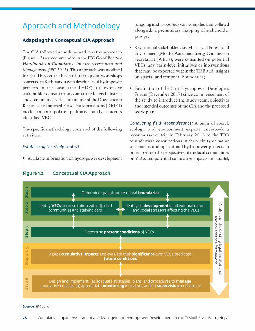
28 Cumulative Impact Assessment and Management: Hydropower Development in the Trishuli River Basin, Nepal
Approach and Methodology
Adapting the Conceptual CIA Approach
The CIA followed a modular and iterative approach (Figure 1.2) as recommended in the IFC Good Practice Handbook on Cumulative Impact Assessment and Management (IFC 2013). This approach was modified for the TRB on the basis of (i) frequent workshops convened in Kathmandu with developers of hydropower projects in the basin (the THDF), (ii) extensive stakeholder consultations out at the federal, district and community levels, and (iii) use of the Downstream Response to Imposed Flow Transformations (DRIFT) model to extrapolate qualitative analysis across identified VECs.
The specific methodology consisted of the following activities:
Establishing the study context:
• Available information on hydropower development
(ongoing and proposed) was compiled and collated alongside a preliminary mapping of stakeholder groups;
• Key national stakeholders, i.e. Ministry of Forests and Environment (MoFE), Water and Energy Commission Secretariat (WECs), were consulted on potential VECs, any basin-level initiatives or interventions that may be expected within the TRB and insights on spatial and temporal boundaries;
• Facilitation of the First Hydropower Developers Forum (December 2017) since commencement of the study to introduce the study team, objectives and intended outcomes of the CIA and the proposed work plan.
Conducting field reconnaissance: A team of social, ecology, and environment experts undertook a reconnaissance trip in February 2018 to the TRB to undertake consultations in the vicinity of major settlements and operational hydropower projects in order to screen the perspectives of the local communities on VECs and potential cumulative impacts. In parallel,
Determine spatial and temporal boundaries
Determine present conditions of VECs
Assess cumulative impacts and evaluate their significance over VECs' predicted future conditions
Design and implement: (a) adequate strategies, plans, and procedures to manage cumulative impacts, (b) appropriate monitoring indicators, and (c) supervision mechanisms
Identify VECs in consultation with a�ected communities and stakeholders
Identify all developments and external natural and social stressors a�ecting the VECs
Step
1St
ep 2
Step
3St
ep 4
& 5
Step
6
Analysis of the existing legal, institutional,
and governance framew
ork
Figure 1.2 Conceptual CIA Approach
Source: IFC 2013.

Chapter 1: Introduction 29
an Inception Report was submitted and a Second Hydropower Developers Forum (January 2018) was facilitated to provide an update on the CIA, challenges in terms of information gaps, and VECs for further assessment.
Selecting VECs: Chapter 4 provides a flow chart to summarize the process through which VECs were initially identified, screened, and finalized for inclusion as a part of the CIA.
Determining baseline conditions of the VECs: Further to establishing the study context and screening of VECs, a Stakeholder Identification and Consultation Plan was prepared to scope key groups and entities that are to be consulted in order to determine baseline conditions of the VECs screened into the assessment. Qualitative tools (ecosystem services and community perceptions on a CIA questionnaire, focus group discussions, and key informant interviews) were used to elicit feedback from stakeholders at national, provincial, and district levels and within the basin (municipalities, communities around both operational projects and those under construction and local nongovernmental organizations).
Collecting secondary data and reviewing the regulatory landscape: In parallel, a data-sharing platform was set
up to obtain information on projects from the THDF on land acquisition, operational modalities, water quality information, baseline profile, and so forth.
Presenting findings and reporting: Further to the completion of data compilation and analysis, two key workshops helped to streamline stakeholder inputs into this final version of the CIA for the TRB:
• Third Hydropower Developers Forum, June 2018: This workshop presented the key results of the qualitative and quantitative analysis on the VECs screened, in terms of cumulative impacts, distinct from localized project impacts. The stakeholders were also asked to discuss mitigation options that consider regulators, local communities, and the developers for the cumulative impacts and stressors that were presented;
• Fourth Hydropower Developers Forum, November 2018: This workshop (Photo 1.1) presented the outcomes of hydropower development on the VECs based on data analysis of a business-as-usual development scenario. A recommended high-management action was introduced that incorporates sustainable development pathways to identify potential implications and provide solutions for cumulative impacts. Suggestions
Photo 1.1 Fourth Hydropower Developer’s Workshop (November 2018)
Source: IFC 2018.

30 Cumulative Impact Assessment and Management: Hydropower Development in the Trishuli River Basin, Nepal
were thereafter invited on the implementation of the high-management action and its institutional structure through the developer-driven THDF and local impact management committees across the TRB.
Figure 1.3 illustrates key activities that were undertaken for the CIA. Specific aspects of the approach and methodology that determined the spatial and temporal boundaries and selection of VECs and their baseline data collection are further elaborated in Chapters 3 and 4 of this report. The methodology to assess cumulative impacts and its significance for each identified VEC is discussed across Chapters 5 to 8 of the CIA report.
Key Enablers
Ongoing engagement with the group of hydropower developers was deemed as key to appraising progress of the study and to provide insights from basin-level consultations with stakeholder groups. These workshops also included government entities and input on other river basin initiatives in Nepal to help
stress the need for multistakeholder collaboration in addressing cumulative impacts in the TRB.
A Stakeholder Identification and Consultation Plan was developed and implemented to document the following:
• Stakeholder identification and mapping of their profile and influence
• Categorization of stakeholders in order to inform their involvement in confirming the spatial and temporal boundaries, identification of VECs, and opinions on projects resulting in individual and cumulative impacts
• A proposed plan and mechanism to engage the stakeholders
Based on the stakeholder identification, their interest, influence mapping, and feedback vis-à-vis suggested VECs, engagement mechanisms were designed to elicit their participation at national, provincial, and basin
Figure 1.3 Key Activities Undertaken in the Assessment
Set Up of the Study Context
Information Review and Data
Collection
VEC Screening and Baseline
Impact Assessment Reporting
• Interactions with federal stakeholders
• Confirm the study area and identify hydropower project scenarios
• Determine spatial and temporal boundaries
• Preliminary VEC listing
• Identification of stressors
• Spreadsheet on key information for hydro projects
• Compilation of IEE and ESIA reports
• Compilation of other public information sources
• Use of information from research agencies
• National and basin-level stakeholder engagement on perceptions of VECs, impacts from hydro- power projects and any other regional stressors and developments
• Screening in of VECs
• Confirmation of baseline conditions
• Quantitative assessment of flows through the DRIFT Model
• Qualitative assessment of other VECs screened into the CIA
• Significance assessment of basin-level impacts versus localized project impacts
• Presentation of results at the Third and Fourth Hydro Developer Forums
• Development of high- management actions
• Develop report inclusive of an imple- mentation arrangement for the THDF
Ince
ptio
n
Info
rmat
ion
Rev
iew
VEC
Bas
elin
e
Impa
ct A
sses
smen
t
Rep
orti
ng
Analysis of the regulatory framework and ongoing stakeholder engagement

Chapter 1: Introduction 31
levels and the participation of communities living
hydropower projects under construction (Table 1.1).
Appendix A captures key stakeholder consultations
recorded for the CIA, and Appendix B includes the
tools used for perceptions on determining baseline
conditions of VECs and impacts.
Appreciation of the Regulatory Framework
The CIA of the TRB was drafted within the context of
an evolving regulatory and administrative framework on
water resources management, sustainable hydropower
development, and decentralization. The Nepal Water
and Energy Commission Secretariat, with support from
the World Bank Group, is in the process of developing
river basin plans across major rivers, including the
Gandaki Basin.1
1 While this initiative remains under way, the outcome of the river basin plans is expected to inform hydropower development master plans and implementation of recommendations of the CIA.
In parallel, the following regulatory initiatives are being driven by the government of Nepal and other organizations, with implications for basin-level planning:
• Revision of the Water Resources Strategy by the Ministry of Energy, Water Resources, and Irrigation to identify sectoral policies to access water within priority watersheds
• Effort to assess cumulative impacts in other river basins, for instance, in the Kabeli River
• Implementation of the revised EIA guidelines (2017) and Manual on EIA for Hydropower Projects (2018) by the MoFE
• Revisions to existing policies on climate change and forests along with some modifications of the National Park Act (1980)
Table 1.1 Engagement Mechanisms and Data Collection Tools
Tool/technique Descriptions
Data-sharing platform Based on the initial workshops, a spreadsheet-based data-sharing platform was developed for circulation among national-level government authorities and the independent power producers. This platform intended to capture critical information linked to project components, associated facilities, information on flows, and mitigation for the same as a part of the design as well as data on affected communities and compensation packages.
Ecosystem services and community perceptions on CIA questionnaire
A proprietary ecosystems screening tool was adapted based on World Resources Institute (WRI) guidance. The field team administered the tool through group consultations at the village and community level. This was complemented by a proprietary tool for stakeholder feedback on VECs, their stressors, their baseline conditions, and insights on impacts and mitigation. Some of the data to be collected includes use of compensation, any out-migration of physically displaced households, changes in livelihoods after compensation, health concerns during and after construction, and the general integration of gender and vulnerable communities into the process for identifying accrued development benefits.
Focus group discussions A checklist of themes was developed to facilitate focus group discussions on the interplay between thematic areas and sustainable livelihoods, ecosystem services, and VECs that represent resources likely to be impacted at an overarching basin level.
Semi-structured interviews
Semi-structured interviews protocols were developed for provincial, district, and national stakeholders. For specific stakeholder groups, notably institutions and international NGOs, position statements on hydropower development and published sources of literature were considered.

32 Cumulative Impact Assessment and Management: Hydropower Development in the Trishuli River Basin, Nepal
• Government of Nepal issuance of “Directives on Licensing of Energy Projects–2018,” with safeguards on development timelines and the need for hydropower projects to be designed on the basis of flow exceedance
• Nepal Rastra Bank’s issuance of Guidelines on Environmental and Social Risk Management, applicable for project lending above a certain threshold (mostly hydropower projects), effective June 1, 2018
• Government of Nepal updating of the Environment-Friendly Local Governance Framework (2013) to account for the new governance structures that will enable municipalities to provide indicator-based local development proposals
These ongoing initiatives indicate that an enabling policy environment for sustainable hydropower development is imminent. While mindful of these efforts, the key regulations, applicable standards, and initiatives that informed the CIA include the following:
• Constitution of Nepal (2015) and key acts, policies, and guidelines on environmental protection, soil and watershed conservation, biodiversity conservation, and land acquisition and resettlement
• International good practice:
• IFC Performance Standards, 2012
• IFC CIA Good Practice Handbook, 2013
• IFC Environmental, Health, and Safety (EHS) Approaches for Hydropower Projects, 2018
• WBG Environmental Flows for Hydropower Projects, 2018
• Review of strategies and implementation arrangements of the following:
• Australian Aid in partnership with International Centre for Integrated Mountain Development (ICIMOD) and International Water Management Institute development of strategies to enhance ecosystem services
and reduce poverty in the Koshi River Basin through a regionally coordinated water resources management plan
• Chitwan Annapurna Landscape (CHAL) Strategy (2016–25)
• USAID’s PANI Project, which developed an Aquatic Animals and Biodiversity Conservation Bill, endorsed by three municipalities in the Karnali River
Use of a Holistic Ecological Model
DRIFT is a holistic model with which to study impacts of hydropower development on biodiversity and ecosystems. The CIA made use of DRIFT to predict impacts of hydropower project scenarios on the ecological integrity and fish abundance of habitats at selected sites along the main stem of the Trishuli River.
The following input parameters were used to set up DRIFT:
• Seven EFlows sites in the main river and four EFlows sites in the tributaries
• Daily time series hydrological data for the seven EFlows sites
• Four indicator fish species: Snow Trout (Schizothorax richardsonii), Golden Mahseer (Tor putitora), Baduna (Garra annandalei), and Indian Catfish (Glyptothorax indicus), which are dependent on the following indicators; geomorphology, algae, and macro-invertebrates
• Assumptions made on connectivity for upstream and downstream fish migration and connectivity for sediment flow
• Lessons learned by evaluating EFlows in other projects within the basin and elsewhere in the Himalayan region
• Appendix D includes the DRIFT Assessment Report (September 2018) along with its methodological set up

Chapter 1: Introduction 33
Limitations
The CIA report was drafted in view of the following limitations:
• The CIA includes a discussion of the cumulative impacts of 36 hydropower projects (including the six operational projects) based on information received from DoED’s website as of June 30, 2018. Information on associated facilities of hydropower projects (transmission lines, quarries, and access roads) is depicted based on available data in the public domain and/or received from developers.
• Information within available Initial Environment Examinations and EIA reports on specific parameters within technical specifications of hydropower projects (for example, tunnels) and also the baseline used for the assessment. Data available within EIA reports and in the public domain were triangulated with stakeholder perceptions at a basin level to compile baseline social, environmental, and ecological conditions of identified VECs. Additional primary data collection on social and environmental parameters was not undertaken.
• Response curves as a part of DRIFT were developed for the identified scenarios only for aquatic habitat as a VEC and not for the other VECs under consideration.
• Geographic information system (GIS) mapping was used to demonstrate analysis and results but did not involve any spatial analysis for identification and demarcation of spatial boundaries. For that purpose, available maps and related nonspatial data were collected and collated from different government agencies and stakeholders and then utilized for preparing GIS layers.
• Where information was not available, information gaps are highlighted.
• The project team focused only on VECs identified by stakeholder groups during the scoping component of the CIA and in the inception report.
• ERM India Private has not developed a specific data-sharing platform but has relied on iterative information made available by developers.

35
CHAPTER 2:
ADMINISTRATIVE AND REGULATORY FRAMEWORKChapter 2 provides an overview of the administrative framework for water resources management and sustainable hydropower development; regulations, policies, and standards that have informed the Cumulative Impact Assessment and Management: Hydropower Development in the Trishuli River Basin, Nepal; and insights from other basin-level initiatives in Nepal to guide the eventual implementation of emerging recommendations.
Administrative Framework
The Constitution of Nepal (2015) incorporates environmentally friendly governance with sustainable social and economic development as its vision (Ministry
of Forests and Soil Conservation 2015) and has accorded a high priority to protecting, promoting, and using water resources effectively. As a part of the new provisions, the constitution mandates the federal government to conserve water resources and to develop policy and standards for multiple water uses and the provincial governments to manage water resources within their jurisdiction. Drinking water and watershed management are under the jurisdiction of local government. However, water resource management is also under the concurrent rights of the state, province, and local governments. Figure 2.1 illustrates the administrative framework for the TRB with respect to legislative matters on water sources with relevance to sustainable hydropower development.
Federal structure for any central-level legislation on hydropower development in Nepal
• The Nepal Electricity Authority (NEA), Department of Electricity Development (DoED), Ministry of Forests and Environment (MoFE), and the Ministry of Land Revenue and Land Survey are the relevant decision makers. The Water and Energy Commission Secretariat (WECS) and Investment Board Nepal (IBN) are key advisory bodies.
• Federal matters include international boundary river issues, preservation of water resources, big hydroelectricity and irrigation projects, environmental management, national forests within provinces, water use, environment management, national parks and reserves, wetlands, forest policy, land use policies, and tourism development.
Provincial
• The Trishuli River Basin falls under provinces 3 and 4. The most recent governments at that provincial level took office in January-February 2018.
• Provincial matters include provincial roads, land management records, mining, research and management, national forests within provinces, water use, and environmental management.
Local
• The Trishuli Basin covers five districts: Rasuwa, Nuwakot, Dhading, Chitwan, and Gorkha. District Coordination Committees (DCCs) are responsible for implementation of the plans and activities as directed by the provincial administration.
• The DCCs oversee a total of 14 rural and urban municipalities that are in the Trishuli River catchment. Each of these municipalities has a specific advisory committee.
• Local matters are watershed, wildlife, mining protection, small hydro projects, alternative energy, and environmental issues.
Figure 2.1 Administrative Framework

36 Cumulative Impact Assessment and Management: Hydropower Development in the Trishuli River Basin, Nepal
Matters on such services such (i) electricity, water-supply, and irrigation; (ii) service fees, charges, penalties, and royalties from natural resources; (iii) forests, wildlife, birds, water uses, environment, ecology, and biodiversity; and (iv) royalties from natural resources are within the concurrent responsibilities at different levels.
An enabling policy environment for sustainable hydropower development is imminent in view of the following initiatives:
River Basin Plans
The WECS is mandated to implement river basin plans for sustainable management of basin resources according to the agreed management plans that ensure conservation of natural resources under the National Water Resources Strategy and National Water Plan. The WECS is in the process of commissioning a study to formulate river basin plans for all the nine major river basins in Nepal (including Gandaki River Basin, of which Trishuli is a part), and will subsequently prepare a hydropower development master plan for Nepal based on these river basin plans.
In the interim, the Department of Irrigation has commissioned a study to prepare an irrigation master plan for Nepal that will complement the river basin plans prepared under the WECS. Hence, there is an opportunity for the MoFE to propose an ecosystem approach to river basin planning and water allocation.
The World Bank has also commissioned studies to undertake a CIA in the Tamor Basin, in eastern Nepal, due to its financing of the 32 MW Kabeli A project located in the midstream section of the basin.
Revised EIA Guidelines
The government of Nepal enacted the Environment Protection Act (EPA) and the Environment Protection Rules (EPR) in 1997, making the integration of Initial Environment Examinations (IEEs) and Environmental Impact Assessments (EIAs) legally binding. EIAs need to be undertaken for projects with a capacity higher than 50 megawatts; that are located in national parks, wildlife reserves, or conservation areas; that result in the displacement of more than 100 households or the loss of a single tract of forest of more than
five hectares; and/or that have multiple purposes. Hydropower projects below these thresholds require an IEE to determine the need for undertaking a detailed and comprehensive EIA (Ministry of Forests and Environment 2018).
A review of available literature (Bhatt and Khanal 2010; Khadka and Tuladhar 2012; Singh 2007; and Ministry of Environment, Science, and Technology 2006) highlights the following observations on the EIA approval process as well as the effectiveness of the existing guidelines in identifying and mitigating impacts of hydropower development:
• There is a mismatch between the survey license boundaries and the study area in that a survey license may apply to amore confined geographical area than the study area required to be covered by a CIA. There is lack of specific guidance to define the spatial boundaries for the delineation of area of impacts of the project.
• The guidelines and policies do not specify precise methods and approaches to be adopted for cumulative impacts management, ecological flow determination, watershed management, and general livelihood restoration of local communities.
• The EIA reports tend to focus on only perceived significant impacts typical of the hydropower sector, without contextualizing to the location and the socioeconomic, physical, and river-basin context.
• There is a reported lack of coordination among the related sectors and ministries, which results in delays in the approval of the projects and the implementation and monitoring of the management plans, especially in larger projects such as hydropower projects.
The existing guidelines and manuals for EIAs were revised. The General EIA Guidelines 2017 and the Hydropower Environmental Impact Assessment Manual (Ministry of Forests and Environment 2018) will function as a guidance and reference for developers with respect to the following:
• To allow project developers to mitigate environmental and social (E&S) risks and impacts,

Chapter 2: Administrative and Regulatory Framework 37
identify unforeseen risks and impacts, and manage E&S performance through the life of a project
• To improve financial and operational performance of projects by optimizing the management of inputs such as water and energy, and minimizing emissions, effluents, and waste, leading to a more efficient and cost-effective operation
• To identify ways to maximize local development benefits and greater acceptance of the project by stakeholders
Local Governance
Communities in Nepal have a tradition of strong local institutions for managing social affairs and resources. Associations such as the Community Forest User Groups (CFUGs), erstwhile Village Development Committees, and Amma Samooha or “mothers’ groups” have an established governance mechanism for managing resources such as forests, pasturelands, irrigation systems, and community assets.
Subsequent to the decentralization, in March 2017 a total of 744 local governance units were established, which include four metropolitan cities and 13 submetropolitan cities, 246 urban municipalities or nagarpalika, and 481 village municipalities or gaonpalikas. These local governance units (LGUs) co-exist with traditional and formal institutions such as the CFUGs to implement legislative matters within their jurisdiction on watershed, wildlife, mining protection, small hydro projects, alternative energy, and issues of environment.
Each LGU has an established administrative structure that includes departments such as social justice, environment development, and economic affairs. The implementation of the Trishuli Basin Co-Management Platform will require integration with the agenda and development plan that have been determined by the LGUs in accordance to the Environment-Friendly Local Governance Framework (EFLGF) of 2013 (Box 2.1) and the Ministry of Federal Affairs and Local Development requirements.
ESRM Guidelines of the Nepal Rastra Bank
Nepal Rastra Bank launched the Environmental and Social Risk Management (ESRM) Guidelines (Nepal Rastra Bank 2018) for banks and financial institutions, effective for all lending activities from June 1, 2018. The guidelines focus on environmental, social, and climatic risks, which banks and financial institutions need to assess for corporate loans, project finance, and general lending activities (based on certain exposure thresholds).
In view of Nepal’s hydropower potential and the projected growth in lending to this sector, the guidelines outline specific safeguard requirements that hydropower developers are to incorporate within their project over and above legal requirements. The scope of the bank’s E&S due diligence and decision to fund a hydropower project will be contingent on the control measures for E&S factors that a developer commits to establishing.
These E&S factors include watershed management, habitat conversion, water quality, effects on aquatic populations, reservoir management, pollution prevention and control, health and safety during construction and operation, and emergency preparedness and response (for example, in case of a dam failure or flooding). Proposed and under-construction hydropower projects within the TRB must comply with the covenants imposed by lending agencies as an outcome of implementing the ESRM guidelines.
Proposed Chitwan Annapurna Landscape (CHAL) Strategy
The CHAL strategy issued in 2016 (Ministry of Forests and Soil Conservation 2015) recognizes that reversing the impacts of large hydropower projects within the river basins that make up the Chitwan Annapurna Landscape (including Trishuli) is not feasible and has recommended the following measures for new hydropower projects:
• Project planning in the Gandaki River Basin should follow the Integrated Water Resources Management principles at river basin and sub-basin levels, as have already been adopted and emphasized by

38 Cumulative Impact Assessment and Management: Hydropower Development in the Trishuli River Basin, Nepal
the government of Nepal in its Water Resources Strategy (2002) and National Water Plan (2005).
• Plans to develop water resource use and extraction should ensure that sufficient water is released downstream to maintain necessary environmental flows to sustain ecosystem functions and services in the CHAL.
Compendium of Applicable Regulations
Appendix C provides a compendium of the major policies, regulations, guidelines, and acts of Nepal that have a direct bearing on hydropower development. The CIA has also referred to the following international standards and guidance on sustainable hydropower development:
• World Bank Group Good Practice Handbook: Environmental Flows for Hydropower Projects, Guidance for the Private Sector in Emerging Markets, February 2018
• IFC Good Practice Handbook on Cumulative Impact Assessment and Management: Guidance for the Private Sector in Emerging Markets, August 2013
• IFC Good Practice Note on Environmental, Health, and Safety Approaches to Hydropower Projects, March 2018
• International Hydropower Association, “Hydropower Sustainability Assessment Protocol,” updated July 2018
Some of the key regulations that directly inform basin-level sustainable hydropower development and have been considered for the CIA of TRB are presented in Table 2.1.
Box 2.1 The Environment-Friendly Local Governance Framework (2013)
On October 9, 2013, the government of Nepal endorsed a new EFLGF to enhance the adaptive capacities of local communities to cope with the impacts of climate change. The EFLGF proposes areas of intervention and indicators of development to declare local administrative and governance units as “environmentally friendly.” In 2016, the Ministry of Federal Affairs and Local Development implemented the framework in 14 districts and 54 municipalities under the local governance initiative.
The United National Development Programme (UNDP) has been supporting the EFLGF initiative by compiling and documenting good practice in order to enhance knowledge of local bodies for identification of development activities that are climate-change resilient and that contribute to livelihood improvement. Some of the key intervention areas that can be aligned for localized impact management of hydropower projects include the following:
• Management of a joint sanitary landfill site for solid and household waste (especially relevant for urban municipalities such as Bidur)
• Developing a localized inventory of spring sources within the municipality and developing a protection plan
• Investment in river cut areas for erosion protection
• Construction of nurseries in open, barren, government land
Among the initiatives identified as good practices by the UNDP, communities within the Gorkha and Chitwan Districts of the TRB have been recognized for initiatives of spring conservation and creation of community-managed ponds, which enhance tourism values and provide reliable drinking water supply.
Source: Ministry of Federal Affairs and Local Development 2015.

Chapter 2: Administrative and Regulatory Framework 39
Regulatory citation Key requirements Relevance for Trishuli River Basin and coverage in the CIA
Regulations
Environment Protection Act (1997)
• Article 3 mandates IEE/EIA study for development projects.
• Article 4 prohibits implementation of projects without approval.
• Articles 5 and 6 describe the approval procedures.
• Article 7 prohibits emission of pollutants beyond the prescribed standards.
• Articles 9 and 10 stipulate provisions for the protection of natural heritage and environmental protection area.
• Article 17 stipulates compensation provisions arising from the discharge of waste and pollution.
• Article 18 includes provision of punishment for actions against the act and rules, guidelines, and standards formulated under the act.
• Article 19 stipulates the rights to appeal to the concerned appellate court against the decision of concerned authority.
The requirements for conducting IEE/EIA of hydropower projects, approval processes, and other associated requirements are provided.
Soil and Watershed Conservation Act (1982)
• Article 10 prohibits actions within any protected watershed area declared pursuant to article 3 of this act.
• Article 24 stipulates there are no obstacles for the government of Nepal to use to develop water resources.
Presents protected watershed and their conservation requirements.
Aquatic Animal Protection Act (1960) with amendments in 1998
• Section 5 (5B) presents provisions of fish passes and fish hatchery while constructing water diversion structures and requirement of prior permission from the government.
Enforces the requirement for protection of aquatic species in a particular river, permission requirements, minimal downstream flow requirements, and ban on certain activities like killing of fish by chemical or current.
National Foundation for Upliftment of Adivasi/Janjati Act, 2058 BS (2002)
• The act prescribes a number of provisions to overall improve the lot of the Adivasi/Janajati by formulating and implementing programs relating to the social, educational, economic, and cultural development. This is done through creating an environment for social inclusion of disadvantaged and indigenous people and ensuring participation of disadvantaged groups in the mainstream of overall national development of the country, by designing and implementing special programs for disadvantaged groups.
Ensures rights of Adivasi/Janjati groups.
Table 2.1 Key Applicable Acts, Regulations, and International Standards
Continued on the next page

40 Cumulative Impact Assessment and Management: Hydropower Development in the Trishuli River Basin, Nepal
Regulatory citation
Key requirements Relevance for Trishuli River Basin and coverage in the CIA
Regulations (continued)
Local Government Operation Act (2017)
This act states the roles of local bodies in Nepal. The jurisdiction, roles, and responsibilities of personnel appointed in local bodies are clearly mentioned.• Section 2 (k): Regulation of authorized development works,
encroachment of public property related to rights of Municipality and village committee
• Section 11 (d) (2): Tax on local infrastructures
• Section 11 (g) (1): Enactment of laws and policies related to local development
• Section 11 (g) (2): Regulation of projects related to economic, social, environmental, and technical aspects
• Section 11 (u): Management related to water resources, wildlife, mines, and minerals
• Section 11 (4), (12) (c) (d): Related to work, responsibility, and right of municipality, village committee, and ward committee
Presents the jurisdiction, roles, and responsibilities of local bodies toward a project and a project’s reporting and other responsibilities to a local body.
Water Resources Act (1992)
• Article 3 stipulates the water resource rights of government.
• Article 4 prohibits use of water resources without obtaining a license, except for specified uses under the Act.
• Article 7 establishes the order of priority for the utilization of water resources.
• Article 8 stipulates procedures for water resource licensing.
• Article 16 empowers government to utilize the water resources and acquisition of other lands and property for the development of water resource as stipulated in the act.
• Article 18 stipulates the right of the government to fix the quality standards of water.
• Article 19 prohibits pollution of water resources above prescribed pollution tolerance limits.
• Article 20 prohibits causing harm and adverse effects on the environment while developing a water resource project.
Presents requirements for obtaining a license for project development and establishes priority for different water development schemes (for example, drinking water, irrigation, and hydropower).
Forest Act 2049 BS (1993) with amendments to 2055 BS and 2073 BS
• Article 17 includes provision of lease and permit from the government to establish rights on the facilities on the national forest.
• Article 18 prohibits transfer of facilities or any other rights on the national forest to the others.
• Article 22 establishes government rights on the forest products of the national forest.
• Article 25 empowers government to hand over a National Forest as Community Forest for communities to develop, conserve, use, and manage, including selling and distributing the forest products independently by fixing their prices according to a work plan.
• Article 31 empowers the government of Nepal to grant any part of a National Forest in the form of Leasehold Forest for the purpose of forest conservation.
Pertains to project requirements associated with forest-related tasks, including for government- and community-owned forests.
Continued on the next page

Chapter 2: Administrative and Regulatory Framework 41
Regulatory citation
Key requirements Relevance for Trishuli River Basin and coverage in the CIA
Regulations (continued)
Forest Act 2049 BS (1993) with amendments to 2055 BS and 2073 BS (continued)
• Article 49 prohibits any actions causing harm to the forest other than specified in the act and rules under the act.
• Article 67 stipulates land rights of the government on the Community Forest, Leasehold Forest, and Religious Forest.
Guidelines, Plans, and Policies
Hydropower Development Policy (2001)
Section 5• Subsection 5.7: Environmental protection
• Subsection 5.8: Mitigation planning of the affected resources
• Subsection 5.20: Opportunity for local people in employment
Section 6• Subsection 6.1: Environmental release, assistance in the land
and property acquisition, responsibility for resettlement, and rehabilitation of project-affected people
• Subsection 6.5: Provisions of hydroelectric project transfer to government of Nepal
• Subsection 6.12: Royalty payments to local area, licensing provisions for survey and generation, terms of license
• Subsection 6.13: fee provisions
Presents licensing provisions for hydropower survey and generation, royalty payments to local areas, requirements for environmental and social studies, responsibilities for land acquisition and resettlement, minimum downstream release, and other considerations.
Under this policy, certain projects must execute a specific Project Development Agreement, which sets forth commitments on E&S aspects over and above regulatory requirements.
Land Acquisition, Resettlement and Rehabilitation Policy for Infrastructure Development Projects (2015)
• Recognizes the need for a resettlement and rehabilitation plan to ensure that the livelihoods of project-affected persons or households be at least above the pre-project conditions
• Emphasizes that the project development agency conducts meaningful consultation with project-affected persons, communities, and sensitive groups, particularly poor, landless, senior citizens, women, children, indigenous/Janajati groups, disabled, helpless, and persons having no legal rights on the operated land while preparing land acquisition, resettlement, and rehabilitation plan
• Requires completion of compensation, resettlement, rehabilitation, and other benefits to the project-affected persons/households prior to the physical and economic displacement by the project
• Requires that the land-acquisition process, as far as possible, be undertaken through negotiation with project-affected persons/households in a way that is transparent, free, fair, and justifiable
It is understood that projects under planning will be required to adhere to the policy. This can help standardize procedures for land acquisition, different compensation packages, and rehabilitation commitments and provide a framework for considering the rights of non-titleholders.
Continued on the next page

42 Cumulative Impact Assessment and Management: Hydropower Development in the Trishuli River Basin, Nepal
Regulatory citation
Key requirements Relevance for Trishuli River Basin and coverage in the CIA
Guidelines, Plans, and Policies (continued)
Land Acquisition, Resettlement and Rehabilitation Policy for Infrastructure Development Projects (2015) (continued)
• Requires that land based compensation and resettlement be provided to persons/households who lose all of their property or whose livelihood is agriculture based
• Requires inclusive programs for the enhancement of socioeconomic development of disadvantaged groups, such as marginalized groups that lack access to resources (for example, Dalit, indigenous or Janajati groups, single women)
• Requires that compensation be paid for built properties, including resettlement and rehabilitation benefits for persons/households who do not have land or legal rights to the currently operated land
• Requires project development agency to ensure the allocation of resources required for resettlement/rehabilitation and livelihood restoration of the project-affected persons/households
Climate Change Policy (2011)
Includes:• Climate adaptation and disaster risk reduction
• Low carbon development and climate resilience
• Access to financial resources and utilization
• Capacity building, peoples’ participation and empowerment
• Study, research, technology transfer, climate-friendly natural resources management, and institutional set up with legal provisions
• Importance of monitoring and evaluation
Identifies greenhouse gasses, climate change, and other disaster-related issues and mitigations with alignment to the United Nations Framework Convention on Climate Change (1992), to which Nepal is a signatory.
National EIA Guidelines (2017), MoFE
• Generic information on the procedures for EIA Scoping, terms-of-reference preparation, baseline environmental studies, information disclosure, public consultation, prediction and evaluation of impacts, mitigation prescriptions, monitoring, and EIA report preparation in line with the EPA and the EPR.
Presents guidelines for preparation of EIA reports, which have recommendations to improve and streamline data collection and impact assessments.
Hydropower Environmental Impact Assessment Manual (2018), MoFE
• The EIA manual enforces a comprehensive EIA adhering to the spirit of the Environment Protection Act and associated Environment Protection Rules, National EIA guidelines, and international good practices for sustainable hydropower development. This manual has been developed within the framework of existing policies, acts, and regulations of the government of Nepal, is to be used as a reference document, and will not supersede prevailing laws.
Presents guidelines for preparation of hydropower EIA reports, which have recommendations to improve and streamline data collection toward mitigation of significant impacts.
Continued on the next page

Chapter 2: Administrative and Regulatory Framework 43
Regulatory citation
Key requirements Relevance for Trishuli River Basin and coverage in the CIA
Guidelines, Plans, and Policies (continued)
Guidelines on Land Use of Forest Area for other Purposes (2006)
• The guidelines address conditions required to make forest lands available to development projects and required compensatory measures for the loss of forest land use and forest products.
Provides guidelines for use of forest land and compensatory forestation requirements.
Guideline for Physical Infrastructure Development and Operation in Protected Areas (2008)
• Sets guidelines for infrastructure development in protected areas.
Presents project requirements for infrastructure development.
Water Resources Strategy Nepal (2002) and National Water Plan Nepal (2005)
• Section 4: Social development principles and environmental sustainability principles
• Section 5: Strategic output 2 (Sustainable Management of Watersheds and Aquatic Ecosystems) and strategic output 5 (Cost-Effective and Sustainable Hydropower Development)
The Water Resources Strategy is being revised into a National Water Plan that is presently in draft stage. This may have relevant frameworks that would guide the formation and implementation of the Trishuli Basin Co-Management Platform.
International Standards
Good Practice Handbook (GPH) on Cumulative Impact Assessment and Management:Guidance for the Private Sector in Emerging Markets (IFC 2013)
• This GPH emphasizes that governments are responsible for preparing CIA frameworks to assist the private sector in the identification and management of cumulative impacts. But because such frameworks rarely exist, the private sector has an interest in considering not only its own contribution to cumulative impacts but also other projects and external factors that may affect similar VECs.
The methodology for the CIA of the TRB has been developed based on the six-step approach recommended by IFC’s Good Practice Handbook. The IFC is funding the CIA of the TRB in view of its interest in projects upstream and downstream of UT-1 (in which it is an equity investor) and has thus benchmarked the study as an initiative for the regulators, hydropower developers, the affected communities, and other stakeholders to coordinate efforts to manage cumulative impacts at the watershed level.
Continued on the next page

44 Cumulative Impact Assessment and Management: Hydropower Development in the Trishuli River Basin, Nepal
Regulatory citation
Key requirements Relevance for Trishuli River Basin and coverage in the CIA
International Standards (continued)
Good Practice Note (GPN) on EHS Approaches for Hydropower Projects (IFC 2018b)
The GPN provides suggestions on EHS impact management for run-of-river diversion, run-of-river reservoir, storage reservoir, and pumped storage types of facilities. The GPN requires cumulative impacts assessment and management to do the following:• Assess cumulative effects of cascading projects located in the
same river system
• Assess effects of other projects over a larger watershed or regional area that may cross jurisdictional boundaries
• Include effects due to natural perturbations affecting environmental components and human actions
• Assess effects during a longer period of time into the past and future
• Consider effects on VECs resulting from interactions with other actions, and not just the effects of the single action under review
• Include other past, existing, and future (for example, reasonably foreseeable) projects
• Evaluate significance of effects that are beyond local, direct effects
The CIA has considered specific management and performance monitoring indicators on aspects such as community health and safety for inclusion in an impact management framework for individual hydropower developers to mitigate localized impacts of their projects.
Good Practice Handbook (GPH) on Environmental Flows for Hydropower Projects (IFC 2018a)
This GPH provides guidance to practitioners on taking rigorous and consistent approaches to assess and manage hydropower project impacts on downstream river ecosystems and people through the assessment and provision of environmental flows (EFlows).
The holistic EFlows model used for the CIA has considered the principles of the GPH for response curves linked to fish and aquatic habitat. The suggested mitigation and monitoring regime also considers the log frame approach recommended by the GPH.
Hydropower Sustainability Environmental, Social and Governance (ESG) Gap Analysis Tool (HESG Tool) (IHA 2018)
The ESG tool was developed by the International Hydropower Association between February 2017 and June 2018 under the mandate of the Hydropower Sustainability Assessment Council, with the support of the Swiss State Secretariat for Economic Affairs. It provides a framework for developers to assess their projects against specified criteria in order to evaluate gaps.
The ESG tool (July 2018) parameters have been considered for developing a monitoring protocol for use by the THDF.
Good Practice Handbook on Addressing Projects Impacts on Fishing-based Livelihoods (IFC 2015)
This handbook is intended to be a guide for projects whose development and operations impact fish resources and habitats, fisheries, and the fishing-based livelihoods.
The assessment of fishing as an activity within the livelihoods VEC has considered principles outlined in this GPH to evaluate significance and determine additional studies that may be needed.

Chapter 2: Administrative and Regulatory Framework 45
Other Basin-Level Initiatives
For the TRB, integrated planning and management
of cumulative impacts will require an entity that
can bring together stakeholders relevant to water
management, energy development, environmental and
social management, and local governance to discuss and agree on common goals for harnessing water and other resources in the basin in a sustainable manner.
Table 2.2 presents information and insights on three initiatives that have relevance for a basin-level management program for TRB.
Project Overview Key features Key insights
The Koshi Basin Program
Australia Aid in partnership with the International Centre for Integrated Mountain Development and the International Water Management Institute are developing strategies to enhance ecosystem services and reduce poverty in the Koshi River Basin through a regionally coordinated water resources management plan.
• Established the mutual dependency of upstream and downstream communities along the river basin for dry season water through the Water Evaluation and Planning System
• Used a watershed model to assess implications on the quantity and quality of water in the river basin to understand hydrological regime, water supply and demand scenarios, extreme events such as floods and droughts, and associated changes
• Watershed model included Soil and Water Assessment Tool to show spatial variation of precipitation, evapotranspiration, and available water within the basin
• Enhance the capacity of rural women, men, and local stakeholders in water management through access to information, knowledge, gender-friendly technologies, and improved water infrastructure.
• Encourage participation of women at decision-making levels. There is low representation of women among water-related groups despite increased burden on them to manage water for their households and for agriculture.
• Strengthen collective farming and riverbed farming.
• Recognize that people have limited access to adaptation options (especially women) and, therefore, water management options for livelihood improvement should be designed.
Table 2.2 Insights from Basin Initiatives
Continued on the next page
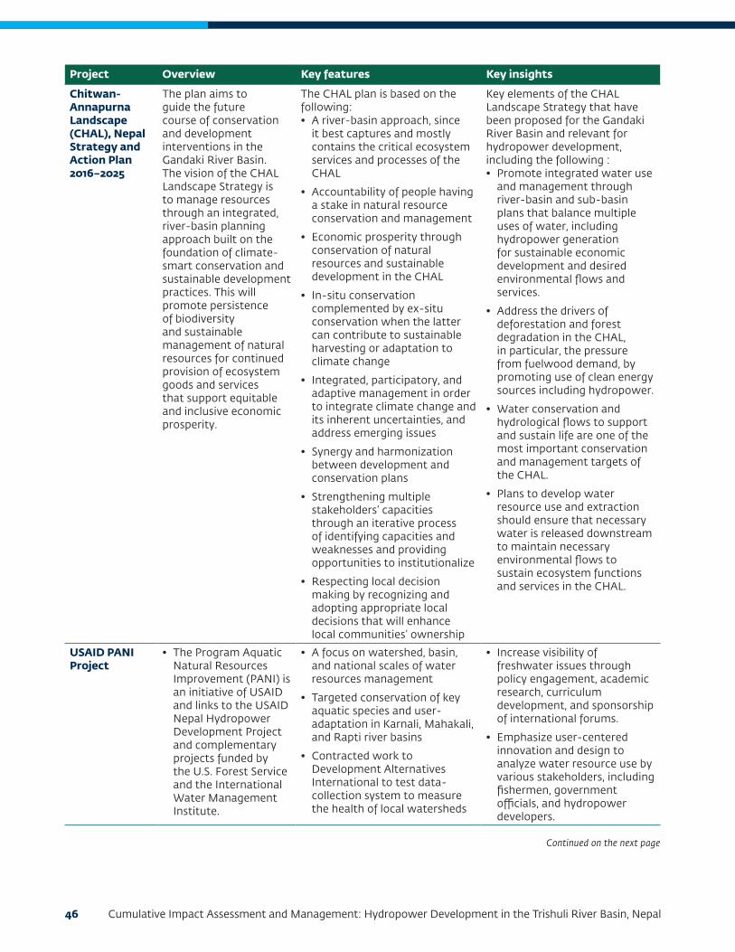
46 Cumulative Impact Assessment and Management: Hydropower Development in the Trishuli River Basin, Nepal
Project Overview Key features Key insights
Chitwan-Annapurna Landscape (CHAL), Nepal Strategy and Action Plan 2016–2025
The plan aims to guide the future course of conservation and development interventions in the Gandaki River Basin. The vision of the CHAL Landscape Strategy is to manage resources through an integrated, river-basin planning approach built on the foundation of climate-smart conservation and sustainable development practices. This will promote persistence of biodiversity and sustainable management of natural resources for continued provision of ecosystem goods and services that support equitable and inclusive economic prosperity.
The CHAL plan is based on the following:• A river-basin approach, since
it best captures and mostly contains the critical ecosystem services and processes of the CHAL
• Accountability of people having a stake in natural resource conservation and management
• Economic prosperity through conservation of natural resources and sustainable development in the CHAL
• In-situ conservation complemented by ex-situ conservation when the latter can contribute to sustainable harvesting or adaptation to climate change
• Integrated, participatory, and adaptive management in order to integrate climate change and its inherent uncertainties, and address emerging issues
• Synergy and harmonization between development and conservation plans
• Strengthening multiple stakeholders’ capacities through an iterative process of identifying capacities and weaknesses and providing opportunities to institutionalize
• Respecting local decision making by recognizing and adopting appropriate local decisions that will enhance local communities’ ownership
Key elements of the CHAL Landscape Strategy that have been proposed for the Gandaki River Basin and relevant for hydropower development, including the following : • Promote integrated water use
and management through river-basin and sub-basin plans that balance multiple uses of water, including hydropower generation for sustainable economic development and desired environmental flows and services.
• Address the drivers of deforestation and forest degradation in the CHAL, in particular, the pressure from fuelwood demand, by promoting use of clean energy sources including hydropower.
• Water conservation and hydrological flows to support and sustain life are one of the most important conservation and management targets of the CHAL.
• Plans to develop water resource use and extraction should ensure that necessary water is released downstream to maintain necessary environmental flows to sustain ecosystem functions and services in the CHAL.
USAID PANI Project
• The Program Aquatic Natural Resources Improvement (PANI) is an initiative of USAID and links to the USAID Nepal Hydropower Development Project and complementary projects funded by the U.S. Forest Service and the International Water Management Institute.
• A focus on watershed, basin, and national scales of water resources management
• Targeted conservation of key aquatic species and user-adaptation in Karnali, Mahakali, and Rapti river basins
• Contracted work to Development Alternatives International to test data-collection system to measure the health of local watersheds
• Increase visibility of freshwater issues through policy engagement, academic research, curriculum development, and sponsorship of international forums.
• Emphasize user-centered innovation and design to analyze water resource use by various stakeholders, including fishermen, government officials, and hydropower developers.
Continued on the next page
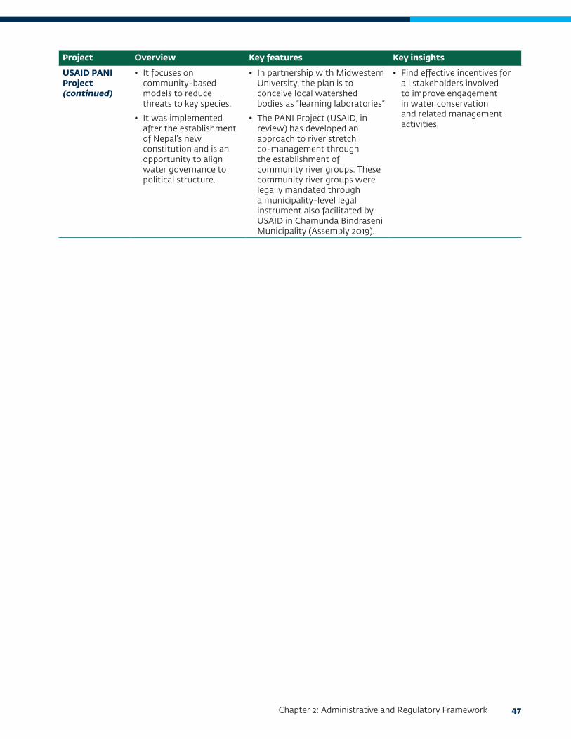
Chapter 2: Administrative and Regulatory Framework 47
Project Overview Key features Key insights
USAID PANI Project (continued)
• It focuses on community-based models to reduce threats to key species.
• It was implemented after the establishment of Nepal’s new constitution and is an opportunity to align water governance to political structure.
• In partnership with Midwestern University, the plan is to conceive local watershed bodies as “learning laboratories”
• The PANI Project (USAID, in review) has developed an approach to river stretch co-management through the establishment of community river groups. These community river groups were legally mandated through a municipality-level legal instrument also facilitated by USAID in Chamunda Bindraseni Municipality (Assembly 2019).
• Find effective incentives for all stakeholders involved to improve engagement in water conservation and related management activities.


49
CHAPTER 3:
PROJECT AND STUDY CONTEXT
Trishuli River: Major River Basin Characteristics
There are nine major river systems in Nepal: Mahakali, Karnali, Babai, Rapti, Gandaki, Bagmati, Kamala, Koshi, and the Kankai. The Gandaki River Basin supports 19 percent of the country’s population (CBS 2014) and contributes 26 percent of the country’s total water availability (WECS 2013). The transboundary Gandaki River system has seven major tributaries: Kali Gandaki, Seti Gandaki, Madi, Marsyangdi, Daraudi, Budhi Gandaki, and Trishuli.
The Trishuli River Basin (TRB), one of the few rivers with a glacier in its catchment areas, originates in the Trans-Himalayan Zone, in the plateau town of Gyirong within Tibet Autonomous Region of the People’s Republic of China (where it is known as Bhote Koshi). The Trishuli River cascades from an altitude of 2,600 meters into Nepal at the Rasuwa Pass (Rasuwa District). It continues its descent for 130 kilometers through high-altitude mountains of Nuwakot, Dhading, and Gorkha District before joining the Kali Gandaki River at Devghat (Chitwan District). Only 523 megawatts (MW), 10 percent of the Gandaki Basin’s feasible hydropower potential of 5,270 MW (Pandit 2016), has been harnessed.
Based on variation in gradient, the temperature the Trishuli River can be delineated into three zones:
• A steep (3 percent slope) cold water zone (upstream)
• A less steep (1 percent slope) cold-to-cool zone (midstream)
• A milder (<1 percent) cool-to-warm zone (downstream)
The spatial delineation of these zones are provided in “Elevation Profile of the Trishuli River Basin” in Chapter 5.
There are certain common economic, social, and cultural features that link upstream, midstream, and downstream river reaches in the TRB. Likewise, there exist certain similarities and differences in resource utilization patterns (for example, in agriculture, fishing,
and other riverine-based livelihoods) and economic conditions (linked to market access, gender, inequality, and other income-related issues). These are thereafter discussed as a part of the socioeconomic baseline to introduce identified social valued environmental components (VECs).
Map 3.1 and Figure 3.1 present the municipalities in the TRB and attributes that pertain to physiography, demography, and associated vulnerabilities.
Hydropower Projects
Hydropower development has been the main activity in recent years in the Gandaki River System (including the Trishuli watershed) in view of the basin’s potential and the existing power deficit as illustrated in Figure 3.1 under “Vulnerability Downstream.” Of the five districts within the TRB, Nuwakot has the highest number of households with access to electricity, at 83 percent (CBS 2012).
In addition to the six operational projects and the seven under-construction projects (that aggregate to 358 MW), another 23 projects are in different stages of planning (from financial closure to being allotted a survey license) as per Department of Electricity Development data (DoED 2018, June). The following Table 3.1 highlights the 36 projects considered for the TRB Cumulative Impact Assessment and Management (CIA).
A majority of the operational and under-construction hydropower projects are understood to be run-of-river projects as indicated during consultations with the DoED (in December 2017) and select hydropower developers at the workshops.
In addition to the major components of the hydropower projects, the CIA has also considered the ancillary and associated facilities, including infrastructure, quarries, access roads, and so forth.

50 Cumulative Impact Assessment and Management: Hydropower Development in the Trishuli River Basin, Nepal
Transmission Lines
Power evacuation from hydropower projects in the TRB will involve construction of low-tension power transmission lines to a pooling substation, from which a high-tension line will connect the project to a larger substation directly linked to the national grid. Table 3.2 presents the transmission line infrastructure considered for the CIA.
The three key grid-connected substations proposed for location in the TRB include the Chilime hub in Rasuwa District, a Nepal Electricity Authority (NEA) project); Ratmate in Nuwakot District (MCA Nepal Project); and Trishuli 3B hub substation (NEA project). A majority of these transmission lines (with the exception of MCA Nepal) will require an Initial Environment Examination (IEE) for approvals under
the Environment Protection Act of 1997. Also note that at their Investment Summit in March 2019, Investment Board Nepal (IBN) also announced a large solar project that will connect into Chilime power evacuation hub to be developed in Rasuwa District.
Roads and Local Infrastructure
Roads in TRB are concentrated in the middle part of the watershed, where the population density is higher and the topography is more favorable. The development of hydropower projects in the upper part is driving the extension of the road networks into this region. However, construction of roads in this part of the watershed requires significant investments in both construction and maintenance because of the remote location and the harsh topography. Access roads include roads used to bring construction materials and
Map 3.1 Trishuli Basin with Municipal Boundaries
Source: Adapted from information obtained in the CHAL Strategy and Action Plan 2016–2025 (Ministry of Forests and Soil Conservation 2015); and Dandekhya et al. 2017.

Chapter 3: Project and Study Context 51
Features Description
Catchment area 6624.7 square kilometers up to the confluence with Budhi Gandaki River
Physiography • Varied spatial distribution across mountains of Trans Himalaya to the Middle Hills and the Siwalik range
• Steep and fragile geomorphology makes the area vulnerable to natural disasters
Hydrology • Spatial distribution varies across physiographic zones creating microclimates that affect annual water availability
• Springs are a major source of water
Key biodiversity areas
• Langtang National Park and buffer area of Shivpuri National Park
• Migratory route for aquatic fauna and flyways for migratory birds
• Link protected areas in the north with Shivpuri National Park toward the east and Chitwan National Park toward the South
Livelihood patterns
Main economic activities include forestry, agriculture and participation in tourism-related activities from rafting, and religious sites
Demographic Trends
• Low population density upstream with a gradual increase downstream (the five districts have an average population density of 144 square kilometers)
• Brahmin Chhetri, Gurung, Magar, Tamang, Newar, Thakali, Tharu, Bhote and Dalit are the major ethnic groups in the region (the majority of the people follow Hinduism and Buddhism)
• Other than Chitwan, most districts have had a negative population growth indicating out-migration
These demographic trends, and especially the negative population growth rates and changing sex ratios, have implications on natural resource management and the roles of gender in agriculture and resource governance (Ministry of Forests and Soil Conservation 2015).
Natural disasters are critical drivers of vulnerability for communities, particularly floods, landslides, forest fires, and the Gorkha earthquake of April 2015.
Population density of 144
per square kilometer
42% of the total
population is employed
Skewed sex ratio of 1,117 females per 1,000 males
Natural disasters are critical drivers of vulnerability for communities in the basin. Although the most common disasters are floods and landslides, the greatest economic loss in the basin is from forest fires which are triggered by wind in the dry season.
Vulnerability upstream The mountain areas are fragile, and heavy rainfall during the monsoon triggers landslides that obstruct and wash away road, cultivated land, and houses. UNDP (2015) reported that farmers in Langtang and Rasuwa had reduced intensive agriculture and had opted for petty labor and portering due to increase in the frequencies of landslides (that cause road blocks and interruption while transporting produce to local markets) and variability in rainfall. This has relegated the local community to prefer subsistence farming and production of staple crops.
Vulnerability midstream The poor state of roads in the villages in Nuwakot and Gorkha district affects the transportation of agriculture outputs to nearby markets, and thus farmers’ income.
The lack of provision of basic services by the local government also contributes to local vulnerability; in some places government-constructed drinking water systems have cease to function. As in some other parts of the basin, Nuwakot and Gorkha are characterized by male outmigration. The women left behind are often vulnerable and unable to negotiate for water rights and access to facilities.
Vulnerability downstream Communities are vulnerable to flash floods and landslides that affect their fields and forests, and thus availability of fuelwood. Electricity is very limited and people depend on the community forests for fuel, but access to the forests is limited (in view of access and activity control imposed arounds the buffer of Chitwan National Park) and people are exposed to risks of wildlife attack. Despite farmers’ training programs on alternative agricultural and farming practices, conflicts between humans and wildlife are increasing the community’s vulnerability, particularly in view of loss of income.
Figure 3.1 Characteristics of the Trishuli River Basin
Source: Adapted from information obtained in the CHAL Strategy and Action Plan 2016–2025 (Ministry of Forests and Soil Conservation 2015); and Dandekhya et al. 2017.

52 Cumulative Impact Assessment and Management: Hydropower Development in the Trishuli River Basin, Nepal
Status Main stem projects Capacity (MW) Tributary Capacity (MW)
Operational 2 38 4 43
Trishuli 24 Chilime 22
Devighat 14 Mailung Khola 5
Tadi Khola 14
Thoppal Khola 2
Under construction
3 208 4 78
Rasuwagadhi 111 Upper Sanjen 14.8
Upper Trishuli - 3A (UT-3A)
60 Sanjen Hydro 42.5
Upper Trishuliv- 3B (UT-3B)
37 Upper Mailung A 6.42
Upper Mailung Khola
14.3
Planned 6 582.6 17 581
Upper Trishuli–1 (UT-1) 216 Sanjen Khola 78
Trishuli Galchi 75 Langtang Khola Small
10
Super Trishuli 100 Salankhu Khola 2.5
Upper Trishuli 2 102 Phalaku Khola 14.7
Upper Trishuli 1 Cascade
24.6 Phalaku Khola 5
Middle Trishuli Ganga Nadi
65 Upper Tadi 11
Middle Tadi Khola 5
Lower Tadi 4.993
Ankhu Khola 49.5
Bhotekoshi Khola 33.5
Mathillo Langtang 24.35
Langtang Khola 310
Trishuli Khola 4.409
Upper Mailung B 7.5
Middle Mailung 10
Tadi Ghyamphedi 4.7
Tadi Khola 5.5
Table 3.1 Hydropower Projects (June 2018)
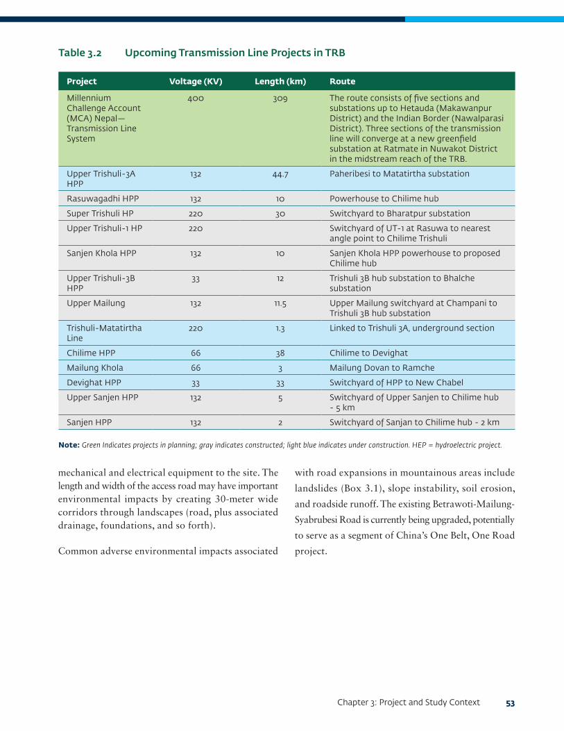
Chapter 3: Project and Study Context 53
mechanical and electrical equipment to the site. The length and width of the access road may have important environmental impacts by creating 30-meter wide corridors through landscapes (road, plus associated drainage, foundations, and so forth).
Common adverse environmental impacts associated
with road expansions in mountainous areas include
landslides (Box 3.1), slope instability, soil erosion,
and roadside runoff. The existing Betrawoti-Mailung-
Syabrubesi Road is currently being upgraded, potentially
to serve as a segment of China’s One Belt, One Road
project.
Project Voltage (KV) Length (km) Route
Millennium Challenge Account (MCA) Nepal—Transmission Line System
400 309 The route consists of five sections and substations up to Hetauda (Makawanpur District) and the Indian Border (Nawalparasi District). Three sections of the transmission line will converge at a new greenfield substation at Ratmate in Nuwakot District in the midstream reach of the TRB.
Upper Trishuli-3A HPP
132 44.7 Paheribesi to Matatirtha substation
Rasuwagadhi HPP 132 10 Powerhouse to Chilime hub
Super Trishuli HP 220 30 Switchyard to Bharatpur substation
Upper Trishuli-1 HP 220 Switchyard of UT-1 at Rasuwa to nearest angle point to Chilime Trishuli
Sanjen Khola HPP 132 10 Sanjen Khola HPP powerhouse to proposed Chilime hub
Upper Trishuli-3B HPP
33 12 Trishuli 3B hub substation to Bhalche substation
Upper Mailung 132 11.5 Upper Mailung switchyard at Champani to Trishuli 3B hub substation
Trishuli-Matatirtha Line
220 1.3 Linked to Trishuli 3A, underground section
Chilime HPP 66 38 Chilime to Devighat
Mailung Khola 66 3 Mailung Dovan to Ramche
Devighat HPP 33 33 Switchyard of HPP to New Chabel
Upper Sanjen HPP 132 5 Switchyard of Upper Sanjen to Chilime hub - 5 km
Sanjen HPP 132 2 Switchyard of Sanjan to Chilime hub - 2 km
Table 3.2 Upcoming Transmission Line Projects in TRB
Note: Green Indicates projects in planning; gray indicates constructed; light blue indicates under construction. HEP = hydroelectric project.

54 Cumulative Impact Assessment and Management: Hydropower Development in the Trishuli River Basin, Nepal
Construction Phase Resource Requirements
Ongoing construction activities (see an illustration at Rasuwagadhi in Photo 3.1) and imminent mobilization for projects under planning will require key resources:
• Quarries and borrow areas to meet construction phase requirements, especially for the reservoir wall
• Workforce (mostly skilled workers and some unskilled workers) for headworks, tunnel, and powerhouse construction
• A construction workers’ camp, spoils disposal area, laydown areas, access roads, water treatment plant, concrete batching plant, and aggregate crushing plant
• Site preparation and tunneling work generate spoils that need to be properly disposed of in a designated spoils disposal area
• Accommodation arrangements including ancillary elements such as potable water, sewage infrastructure,
utilities to run the worker camps, and so forth, which tend to impinge on and use local infrastructure
These aspects of construction are usually considered for the individual EIA of hydropower projects. However, in view of the number of projects coming up, especially in Rasuwa and Nuwakot Districts, the construction phase timelines are likely to be seven to 10 years, and the demand for resources for the associated facilities will be unprecedented for the basin.
CIA Study Context
Spatial Boundary
The Trishuli River extends into the CHAL region after its confluence with the Budhi Gandaki River at Benighat. The catchment of the Budhi Gandaki River has not been included within this CIA, as it represents a different basin and watershed. However, hydropower development in the Budhi Gandaki River has been considered a stressor and anticipated regional development. For the CIA, the spatial boundary of the
Box 3.1 Landslides and Hydropower Projects
Landslides are the most important factor in land degradation in Nepal. Landslides occur almost every year, particularly in the sloping areas of high mountains and low hills during the monsoon season. The upper part of the basin is especially affected by this problem. As much as 5 percent of all landslides in Nepal are associated with newly constructed roads and trails (ADB and ICIMOD 2006). Landslides and dumping of spoil from road construction result in solids pollution of the Trishuli River and with a likely significant increase in total dissolved solid levels, degrading aquatic habitats. While carrying out construction activities, it is anticipated that emergency situations may occur at construction sites, which may threaten life and property. A probable emergency may be loose fall or collapsing of tunnels. Tunnels are important structures in hydropower projects, but they pose the possibility of collapse during construction, which may cause significant time and cost overruns (Tun and Singal 2016).
Fatalities associated with tunnel collapse occurred during the construction of the Upper Madi hydroelectric project in Kaski (located in northeast Pokhara) in April 2014 (Petley 2014). A landslide-triggered collapse of the entrance of the tunnel, resulting in the loss of life of 3 of the 15 workers trapped underground. A similar incident at the Arun III hydropower project in June 2018 resulted in the blockage of a tunnel portal because of muck and huge boulders, endangering the lives of 4 workers (Uniindia News Service 2018).
The Trishuli 3A project was severely damaged due to landslides triggered by the 2015 earthquake. The landslides damaged areas close to the dam site, posing a threat to the safety of the dam and the workers. The project subsequently installed concrete on the hill on the right side of the dam along with nets and fences. Due to the earthquake, the dam’s two gates were also damaged; they were later repaired. This has caused delays in construction of the tunnel and other structures of the project. Management and mitigation measures can avoid or considerably reduce the extent of tunnel collapse through proper underground excavation support systems during planning and construction of hydropower projects.

Chapter 3: Project and Study Context 55
Photo 3.1 Under-Construction Rasuwagadhi HPP (February 2018)
a. Worker camps b. Batching plants
c. Construction activities for head works
study area includes the entire catchment of Trishuli River in the upper reaches (up to the Tibet Autonomous Region border at Rasuwa Pass) and the lower reach extends up to the point immediately downstream of Super Trishuli HPP (planned 100 MW project). No proposed hydropower projects have been identified in the China portion of the river basin (ERM 2018). Key tributaries, towns, and settlements that are within a two-kilometer-wide corridor (one kilometer along each side of the river) are considered in the study area.
The study area is divided into discrete management units (see “Fragmentation of DMUs Due to Hydropower Development” in Chapter 5 for details) for aquatic habitat and for indicator fish species. For ascertaining the baseline conditions with respect to social receptors and valued ecosystem components, the study area is divided into the upstream, midstream, and downstream
reach based on certain characteristics and features as described in Chapter 7.
Map 3.2 illustrates the study area considered for the CIA (including the 36 hydropower projects identified in Table 3.1).
Temporal Boundary
Temporal boundaries under consideration for the CIA will include projects likely to come up within the next 10 years. The temporal scope will extend to 50 years (which is likely to coincide with the life cycle of large hydropower projects). This temporal boundary is relevant for all HPPs in the basin, as none are likely to be decommissioned due to termination of operations linked to exigencies such as oversiltation of headwaters. Here it is assumed that all projects,

56 Cumulative Impact Assessment and Management: Hydropower Development in the Trishuli River Basin, Nepal
as typical for large projects, have been designed to withstand earthquakes of at least 9.0 on the Richter scale. However, this assumption may need further verification based on insights received at the developer’s workshop.
Project Development Scenarios
The following project development scenarios are considered for the quantitative ecological flow assessment of the TRB:
• Scenario 1, Existing Projects (Baseline): This scenario represents the present conditions in which six of the existing projects as listed in Table 3.1 are operational.
• Scenarios 2a and 2b, Existing + Under-Construction + Committed Projects (within 10 years): This scenario
represents the expected conditions in which six of the existing projects, seven of under-construction projects, and the UT-1 project (which is the only project that has presently been committed), as listed in Table 3.1 are operational.
• Scenario 3, Full Development (within 50 years): This scenario represents conditions in which all of the above and the planned projects as listed in Table 3.1 are developed.
Initial VEC Identification
During the scoping stage of the CIA, the following VECs were identified through the review of secondary literature and inputs from regulators such as DoED, NEA, and the Ministry of Forests and Environment (MoFE):
Map 3.2 Overview of the CIA Study Area within the Trishuli River Basin

Chapter 3: Project and Study Context 57
• Aquatic habitat
• Fish species, notably the Golden Mahseer (Tor putitora) and Common Snow Trout (Schizothorax richardsonii), along with other likely species of conservation importance
• Water flow, water quality, and sediment transport
• River flow
• Sediment transportation
• Terrestrial habitat
• Habitat fragmentation
• Migratory birds and any other vulnerable species
• Langtang National Park
• Slope stability
• Water resources (including springs and drinking water quality of surface water)
• Religious and cultural sites: including cremation sites and pilgrimage sites that depend on water flow (for example, Uttargaya and Devighat) as well as potential community forests with religious significance
• Livelihoods: Implications on (i) river-based livelihoods and ecosystem services (based on imposed flow transformation) and (ii) land-based livelihoods due to acquisition of land for multiple hydropower projects and associated facilities
• Indigenous peoples, in view of the ethnical and cultural diversity that exists in the TRB
• Community Forests, in view of potential access interruptions due to their location with the submergence areas of reservoir projects
• Community health linked to water quality, general emissions considering multiple stressors, and microclimates around reservoir areas.
Chapter 4 outlines the process of screening of VECs to identify the ones that were considered for assessment of cumulative impacts.
Stressors and Regional Developments
This section profiles key stressors and anticipated or existing regional developments that are considered significant in view of the baseline conditions of identified VECs.
Climate Change
Recent literature on the effect of climate change on water resources in Nepal cites two impacts as critical: glacial lake outburst floods (GLOF) and variability of river runoff (Bajracharya, Acharya, and Ale 2011). Hydropower projects in the Gandaki Basin face challenges because of the changes in rainfall and temperature and fluctuation in runoff and discharge, which affects power generation. The Gandaki River contains 1,025 glaciers, and this freshwater feeds into its tributary, the Trishuli River (Bajracharya, Mool, and Joshi 2002). According to recent studies, temperatures have already been rising and are projected to increase further over the coming decades. The fluctuations in temperature (most pronounced during winter and least during peak monsoon) directly affect water resources and hydropower-related activities.
GLOFs are described as “a sudden release of a significant amount of water retained in a glacial lake,” which in turn displaces huge quantities of water, leading to dam overtopping and consequently dam failure (Emmer 2017). The Trishuli sub-basin contains 50 glacial lakes—which is 2.59 percent of the total Gandaki Basin (Mool 2011). Hazards associated with shrinking glaciers (potentially dangerous glacial lakes) can adversely affect large infrastructure investment, downstream vulnerability, and property damage (see Box 3.2).
Variability of river runoff is exacerbated by unnatural hydrological shifts because of run-of-river hydropower plants. Inconsistent energy production; with respect to the generation capacity and approved operation plans has been reported from the Trishuli and Chilime hydropower projects due to variations in the water supply (Bajracharya and Shrestha 2011). The managers and operators at the Trishuli run-of-river hydropower plant (15 MW) in Bidur noted that reduced river
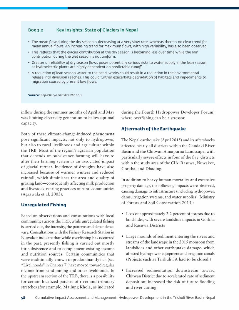
58 Cumulative Impact Assessment and Management: Hydropower Development in the Trishuli River Basin, Nepal
inflow during the summer months of April and May was limiting electricity generation to below optimal capacity.
Both of these climate-change-induced phenomena pose significant impacts, not only to hydropower, but also to rural livelihoods and agriculture within the TRB. Most of the region’s agrarian population that depends on subsistence farming will have to alter their farming system as an associated impact of glacial retreat. Incidence of droughts have also increased because of warmer winters and reduced rainfall, which diminishes the area and quality of grazing land—consequently affecting milk production and livestock-rearing practices of rural communities (Agrawala et al. 2003).
Unregulated Fishing
Based on observations and consultations with local communities across the TRB, while unregulated fishing is carried out, the intensity, the patterns and dependence vary. Consultations with the Fishery Research Station in Nuwakot indicate that while overfishing has occurred in the past, presently fishing is carried out mostly for subsistence and to complement existing income and nutrition sources. Certain communities that were traditionally known to predominantly fish (see “Livelihoods” in Chapter 7) have moved toward regular income from sand mining and other livelihoods. In the upstream section of the TRB, there is a possibility for certain localized patches of river and tributary stretches (for example, Mailung Khola, as indicated
Box 3.2 Key Insights: State of Glaciers in Nepal
• The mean flow during the dry season is decreasing at a very slow rate, whereas there is no clear trend for mean annual flows. An increasing trend for maximum flows, with high variability, has also been observed.
• This reflects that the glacier contribution at the dry season is becoming less over time while the rain contribution during the wet season is not uniform.
• Greater unreliability of dry season flows poses potentially serious risks to water supply in the lean season as hydroelectric plants are highly dependent on predictable runoff.
• A reduction of lean season water to the head-works could result in a reduction in the environmental release into diversion reaches. This could further exacerbate degradation of habitats and impediments to migration caused by present low flows.
Source: Bajracharya and Shrestha 2011.
during the Fourth Hydropower Developer Forum) where overfishing can be a stressor.
Aftermath of the Earthquake
The Nepal earthquake (April 2015) and its aftershocks affected nearly all districts within the Gandaki River Basin and the Chitwan Annapurna Landscape, with particularly severe effects in four of the five districts within the study area of the CIA: Rasuwa, Nuwakot, Gorkha, and Dhading.
In addition to heavy human mortality and extensive property damage, the following impacts were observed, causing damage to infrastructure (including hydropower, dams, irrigation systems, and water supplies) (Ministry of Forests and Soil Conservation 2015):
• Loss of approximately 2.2 percent of forests due to landslides, with severe landslide impacts in Gorkha and Rasuwa Districts
• Large mounds of sediment entering the rivers and streams of the landscape in the 2015 monsoon from landslides and other earthquake damage, which affected hydropower equipment and irrigation canals (Projects such as Trishuli 3A had to be closed.)
• Increased sedimentation downstream toward Chitwan District due to accelerated rate of sediment deposition; increased the risk of future flooding and river cutting

Chapter 3: Project and Study Context 59
• Damaged tourism infrastructure in Langtang National Park and near the cultural sites of Uttargaya and Gosaikunda (lodges, teahouses, and trails)
Map 3.3 presents the areas most affected.
Reconstruction and rehabilitation activities are ongoing and likely to continue until 2020. These activities have the potential to generate localized impacts from reconstruction, such as inappropriate extraction of timber, stone, sand, and gravel for buildings and infrastructure; resettlement in forests and important biodiversity areas; inappropriate disposal of earthquake waste; damage from hastily reconstructed infrastructure; and damage from reconstruction of water supplies and sanitation facilities.
The earthquake has also resulted in movements of communities within the severely affected districts into
internally displaced persons (IDPs) camps, most of which have been established near urban municipalities such as Bidur and do not have adequate waste disposal and sanitation facilities (Box 3.3). Livelihoods of local communities (especially indigenous communities such as the Tamang) living within these camps have also been affected (potentially permanently) due to changes in work and life patterns from subsistence farming to petty labor.
The CHAL strategy (Ministry of Forests and Soil Conservation 2015) has incorporated earthquake recovery as a specific activity to minimize adverse impacts in the landscape and to enable disaster risk reduction and resilient natural resources. It is understood that a Rapid Environment Assessment (2015) was undertaken of the postearthquake reconstruction program and is reported to be under implementation to minimize adverse impacts.
Map 3.3 Earthquake-Affected Districts
Source: CHAL Strategy and Action Plan 2016–2025 (Ministry of Forests and Soil Conservation 2015).

60 Cumulative Impact Assessment and Management: Hydropower Development in the Trishuli River Basin, Nepal
Discussions with the DoED (December 2017) indicate that recently planned projects are being designed to withstand earthquakes of intensity of over 8.5 on the Richter scale.
Hydropower Development in Budhi Gandaki Basin
The Budhi Gandaki River, located in the Central
Western Development Region of Nepal, meets the
Trishuli River at Benighat (in Dhading District). The
potential for a 600 MW storage-type hydroelectric
plant with average annual generation capacity of 2,495
gigawatt hours was identified during the Gandaki Basin
study in the late 1970s, with the proposed tailrace
located approximately two kilometers upstream of the
confluence with the Trishuli River in Gorkha District.
Box 3.3 Case Study: IDP Camp at Bidur, Nuwakot District
Around 83 households are living in Pipaltar, Bidur-5 in a camp for internally displaced persons. They were initially settled in Kalikasthan in Rasuwa following the 2015 earthquake and moved to the current location a year ago after landslides risk in Kalikasthan. The Bidur camp is privately owned by two Tamang landowners and the residents have paid NPR 150,000 or US$1,500 (one-time payment) for each unit. Each unit has a common area, a kitchen, a bedroom, and a toilet. The camp has access to electricity. Children go to nearby schools in Bidur.
Photo B3.3.1 Bidur Camp
While the female members of the family are engaged in agriculture and daily wage labor, the male members of the family are still working in Rasuwa, as there are more business opportunities there, especially with the increased prospects in construction and trade following the road extension to the Chinese border. Residents living in the camp are predominantly Tamang and are not fluent in Nepali. Integration into the communities nearby, which have mostly Brahmins and Chettri residents, is, therefore, a challenge. The households are, however, reluctant to move back to their village in Rasuwa, not only because they feel unsafe and more at risk of natural disasters, but also because they see more opportunities closer to a bigger city like Bidur.
Source: Field consultations (April–May 2018)

Chapter 3: Project and Study Context 61
The new prefeasibility study of the project conducted by Tractebel Engineering Company indicated that the capacity of the hydropower plant could be increased to 1,200 MW. Located at the same site, the total catchment area of Dhading and Nuwakot would be 935 square kilometers (MoEWRI 2019). According to a report by Rivers without Boundaries (2017), an international network of organizations and experts who advocate and promote best practices in river management, the major impediments for this project are its long development period, size, resettlement needs, seismicity, geological hazards, and adverse impact on aquatic and terrestrial biodiversity.
Under the new circumstances of the Belt and Road Initiative, the project gained some traction through a new bilateral partnership between Nepal and China. However, in 2017, Nepal cancelled the Budhigandaki project, which was contracted to a Chinese developer company. In 2018, the government announced plans to revive the Budhigandaki Hydropower Project again through funding by the China Gezhouba Group Corporation (UNRCCA 2018).
OBOR and Prithvi Highway Upgrade
The One Belt, One Road (OBOR) initiative is a massive road infrastructure project funded by the Chinese government to link China with all of South and Central Asia. Nepal signed membership to the effort in 2017. Under the mandate of this initiative, China wants to construct a railway line that will connect Gyirong (the Tibet Autonomous Region town where the Trishuli River originates) to Kathmandu. The newly instated Railways Department of Nepal has drafted a 20-year development plan to build 4,000 kilometers of rail services to further link Nepal to its immediate geopolitical neighbors (Map 3.4). A report by the news publication the Third Pole (Bhushal 2017) revealed that rail and road development under OBOR are already under way: the road service from Gyirong to Rasuwagadhi is already operational and roads in Nepal to towns that will be connected by rail are in various stages of construction and operation. These include Syafrubeshi-Betrawati (28 kilometers under construction), Betrawati-Galchhi (36 kilometers in operation), and Galchhi-Kathmandu (50 kilometers
Map 3.4 Nepal’s Proposed Railway Network
Source: Based on Chinadialogue
India
ChinaNepalShigatse
Kakarvitta
To NewJaipaiguriBiratnagar
Jogbani
Itahari
Bardibas
Simara
BirgunjRaxaul
KerungRasuwa Ghadi
Pokhara
Butwal
Nautanwa
Nepalgunj
Kohalpur
Gadda Chauki
Kodari
Kathmandu
Janakpur
Jaynagar
80 km
40 mi

62 Cumulative Impact Assessment and Management: Hydropower Development in the Trishuli River Basin, Nepal
in operation), all of which are located in the TRB.
To facilitate quick progress of the project along the Trishuli River, Nepal’s army is working to open up the track from Betrawati to Syafrubeshi, situated 17 kilometers from the Chinese border (Bhushal 2017). This stretch of road, expected to be completed by 2018, will link the Tibet Autonomous Region border in the north to the Prithvi Highway.
A spokesperson of the Railways Department stated that there is 90 percent likelihood of the Kathmandu-Gyirong railway construction happening, either over bridges or through tunnels that will trigger infrastructural expansion along the TRB. The network, connectivity, and movement opportunities provided by the OBOR initiative will open up economic opportunities in the form of trade and tourism for the citizens residing in the districts of Rasuwa, Nuwakot, and Dhading. Economic and urban growth is one consequence of the OBOR program, but environmentalists are cautious of the adverse impacts on fragile ecosystems that can aggravate disaster risks such as landslides and flooding because of improper infrastructural development (Sudmeier-Rieux et al. 2018).
Besides plans to expand major trunk roads along existing highway routes, there will be new routes that will connect rural towns and cities in the surrounding areas as feeder roads (Himalayan Times 2018). There
exists a concern that the satellite roads that will develop adjacent to trunk roads along the length of the TRB will be poorly constructed. National roads are generally constructed with proper engineering standards, but these rural roads will lack proper design and could cause significant environmental damage while straining local resources (Himalayan Times 2018).
Riverbed Sand and Gravel Mining
Most of the downstream sections from Devighat are heavily sand and gravel mined. Sand mines are also prevalent upstream on the Tadi Khola near its confluence with the Trishuli River. There ae both legal and illegal mines. Local communities believe that water quality and fish abundance are very poor downstream of these sand and gravel mines (Box 3.4, Map 3.5).
The thriving sand and gravel mining industries in the Trishuli riverbed can be attributed to increasing demand for building materials to meet the upswing in urbanization in Kathmandu and surrounding areas as well as demand from hydropower developers for construction-phase requirements. Although Nepal banned riverbed excavation in 1991, the majority of sand comes from illegal mining operations (Third Pole 2017). In spite of certain policy initiatives (see Box 3.5), illegal mining activities continue in the TRB.
The implication is significant lowering of riverbeds
Box 3.4 Sand and Gravel Mining, 2017–18
• Two hundred sand-washing machines are installed on the banks of the Trishuli River over a distance of 150 kilometers, and more than 47 sand-washing industries operate around the Prithvi Highway.
• More than 1,000 trucks are registered in Dhading District to carry sand and gravel to Kathmandu and other cities.
• Over 400 sand-mining, -washing, and -crushing industries are in Dhading and Nuwakot Districts, and there are 12 sand- and gravel-mining sites and 28 sand-processing centers (Phirphire village development committee) downstream, at about seven kilometers from Galchi.
The illegal and haphazard extraction of sand and aggregates from the Trishuli River at Bidur and the Ratmate section has increased recently. The local administration of Nuwakot District banned sand-mining activities in March 2018. The mining companies filed an appeal to the Supreme Court to lift the ban. The Supreme Court ordered the administration to allow sand mining for a certain period, other than in the monsoon season between July and September 2018. The court has mentioned that due to the postearthquake scenario in the country, several construction activities are ongoing, and this ban could be counterproductive.

Chapter 3: Project and Study Context 63
Map 3.5 Map of Sand Mining
and increasing river pollution from rock crushing. Slush drained by the sand mines and crusher industries is a major source of pollution in the Trishuli River.
Urbanization and Industrial Development Midstream of the Basin
Prithvi Highway’s proximity to this urban core center has facilitated trade and commerce opportunities through movement of raw materials and finished products to and from upcoming industrial villages situated in the river basin. For example, in Nuwakot District, the provision of rural transportation is providing new opportunities for mobility of people. The District Transport Master Plan for Nuwakot documents that the district is served by transport facilities that link it to national strategic road networks through a combination of highways and feeder roads, namely, the Mahendra Highway,
Dhalkebar-Jankpur-Bindi Highway, and the Dharapani-Janakpur and Birendra Bazaar-Mahinathpur roads. The increasing accessibility through this network of connecting infrastructure has helped in developing access to rural-urban linkages.
One of the main objectives of Nepal’s 2010 Industrial Policy was to promote industrial sector development and boost regional employment opportunities. The government of Nepal proposed special economic zones (SEZs) in eight districts, including Ratmate-Jiling-Devighat Village Development Committees in Nuwakot District of Nepal (Muzzini and Aparicio 2013). They want to promote business, industrial development, foreign trade export, and domestic and foreign investment and provide special incentive packages for upcoming industrial villages. Operationalization of SEZs in the identified districts of Nuwakot in Province three will be implemented. As

64 Cumulative Impact Assessment and Management: Hydropower Development in the Trishuli River Basin, Nepal
Box 3.5 Mining-Control Measures in Dhading District
In 2018, Dhading became the first district to enact standards to regulate the activities of mining firms involved in extraction, operation, and sale of riverbed materials (Rathore 2018a). The provisions of the new standard are as follows:
• Any crusher or sand-washing firms may operate only from 6am-6pm.
• A power supply permit can be received only after a joint supervision of the local body, District Coordination Committee, Department of Survey, Nepal Electricity Authority, Small and Cottage Industries Development Committee, and the local administration. (The power supply of companies in violation of rules was cut off by the Riverbed Materials Supervision and Coordination Committee earlier this year).
• Firms are required to install technology to separate thick and viscous material in muddy water before draining out the water from factories.
• All firms are mandated to install a three-level water tank to separate muddy elements in the water.
• Sand-washing firms should operate away from river area and at least 100 meters from the nearest highway.
• Public areas cannot be encroached upon for operating any factory-related to riverbed materials.
Despite this intervention, there is no decrease in the unlawful extraction of sand and boulders in the Trishuli River in Dhading District. According to a government report, sand mines are operating illegally in areas around Prithvi Highway through the use of fake company registration documents (Rathore 2018b). Out of the estimated 400 sand-mining and -washing factories operating in the district, only 73 factories have obtained a license to operate from the District Administration Office of Dhading. Even registered factories extract sand beyond the specified minimum threshold assigned to them.
an initial phase prerequisite, there are prefeasibility and site assessment studies being conducted for the Ratmate-Jiling-Devighat proposed SEZ. Increased urbanization can be expected if efforts continue to develop and improve infrastructure facilities for the establishment of medium- and large-scale industries in the study area.
Solid Waste Management
The Trishuli River is under threat from two main sources of waste pollution: raw sewage and nonbiodegradable trash. Efficient disposal of waste has been a struggle for local municipal bodies, which results in the release of garbage and plastic directly along the banks of the river. Solid waste management practices in villages and towns along the river is nonexistent. In all towns along the basin, there was excessive dumping of solid and plastic waste in the river.
Bidur Municipality is the largest local unit of Nuwakot District and faces an acute mismanagement of sewage facilities. A lack of this service forces the locals of
Trishuli and Devighat to dump their sewage and garbage released from their houses and toilets directly in the Trishuli River. A report prepared jointly by Clean Energy Nepal and Environment and Public Health Organization indicated that plastics are the single largest portion of the waste stream in Bidur Municipality, much higher than other rural municipalities (Tuladhar and Joshi 2004). The final disposal of the collected waste is done directly at a crude dumping site on the banks of the Trishuli River. The lack of any proposed specially designated landfill site or formal composting facilities for the municipality suggests that the present site will continue to be used in the foreseeable future. The operating Trishuli hydropower plant engineers indicated that they had to close down the turbines frequently due to dumping of waste.
The Betrawoti-Mailung-Syaphrubesi Road is in disrepair along several stretches as a consequence of landslides. Roadwork was observed occurring at several locations with all spoil being dumped in the river. Representative communities consulted during the TRB CIA indicated that building of access roads for

Chapter 3: Project and Study Context 65
village infrastructure has led to loss of soil stability, exacerbating landslides and loss of biodiversity.
The Nepal River Conservation Trust (NRCT) started five waterkeeper organizations in Nepal, on the Bagmati, Karnali, Trishuli, Sun Koshi, and Seti Gandaki rivers, to protect these important waterways. Organized by the NRCT, Nepal’s Youth Alliance Environment and two participating universities, the Second Nepal River Summit (2017) was held on the banks of the Trishuli River to advocate for land and river conservation, including protection from severe pollution (Khan 2017; NRCT 2017). Members of the Trishuli River Waterkeepers are advocating for heritage river status for the Trishuli River.
In-migration
Hydropower development offers risks and opportunities that has promoted internal migration into the TRB for livelihoods and for perceived benefits (linked to local development shares and other benefit-sharing mechanisms from hydropower projects). Smaller cities
such as Kurintar downstream, Bidur midstream, and Syabrubeshi upstream are experiencing high levels of urbanization (Bakrania 2015). The projects and processes associated with hydropower are evolving rapidly, causing unanticipated flows and reverse flows related to population migration. Despite an increase in natural calamities like earthquakes, floods, and landslides in the TRB, there is also an increase in opportunities for labor and local businesses due to hydropower development and urban growth in periphery market towns along the Prithvi Highway. Central Hills and Mountains (Figure 3.2) have witnessed an increase in in-migration by 24 percent in rural areas and 49 percent in urban areas.
While in-migration has generated positive effects for the local economy, especially in and around hydropower projects, major challenges include lack of adequate town planning and noncompliance with building codes in urban municipalities; increased unplanned squatting on public and private land, especially in buffer zones of community forests; and unmanaged land-use practices making land unsafe during extreme events. There is
Figure 3.2 Comparative Migration Trends
Source: Labor Force Survey (CBS 2008).
UrbanRural
Kathmandu ValleyWest Tarai
Central TaraiEastern Tarai
West Hills and MountainsCentral and Eastern Hills and Mountains
West TaraiCentral TaraiEastern Tarai
West Hills and MountainsCentral Hills and MountainsEastern Hills and Mountains
Ru
ral
Urb
an
Migrants as a share of local population (%)
Out-migration Net migration In-migration
-16 29 45 -31 -5 26 -15 36 51 -14 26 40 -17 19 36 -18 22 39 -14 35 48 -17 33 49 -19 9 29 -24 2 25 -28 4 32 -37 -16 21 -35 -12 24-48 -24 23
-60 -40 -20 0 20 40 60

66 Cumulative Impact Assessment and Management: Hydropower Development in the Trishuli River Basin, Nepal
also limited attention to ameliorating availability of local infrastructure in terms of sanitation networks, drinking water, and health care, further exacerbating the adverse impacts of in-migration.
Stakeholder Identification and Engagement
Stakeholder groups have been identified based on the following:
• Groups that directly benefit from proposed developments
• Groups that are directly negatively affected by proposed developments
• Those who directly interact with the ecosystem components that overlap with the proposed developments
• Those who indirectly influence the use or conditions of those environmental and social components—such as regulatory groups, external research agencies, local, national nongovernmental organizations (NGOs), and so forth
A total of 52 stakeholder groups were identified that are a subset of the following broad categories:
• Hydropower developers: Entities (independent power producers) that will own and operate under-construction, committed, and planned hydropower projects that were considered for the Trishuli CIA and actively participate in the Trishuli Hydropower Developers Forum (THDF)
• Government authorities (ministries and national authorities): Key ministries and departments that manage and establish policies to regulate the resources and VECs
• District authorities: Departments of the national authorities and ministries that implement the policies established at a national level under the governance mechanisms put in place by respective Chief District Officers
• Local authorities: Urban and rural municipalities and specific local governance bodies (for example, the Wildlife Crime and Control Branch) that have been established for local governance and management of resources within the identified administrative structures and jurisdictions
• Local and national NGOs: Entities that are active in promoting development and conservation activities within the TRB
• International NGOs: Entities that are engaged at national- and international-level discussions on hydropower development and that may be actively interested in the outcomes of the CIA at a river-basin level
• External agencies: Including local contractors and companies engaged in sand mining, local infrastructure development, and so forth that are contributing to localized stressors for the VECs identified
• Research agencies: Including fisheries research stations as well as local entities that are undertaking ongoing data collection linked to critical resources such as aquatic ecosystems
• Affected communities: Local communities within the 20 urban and rural municipalities that inhabit the area of influence of existing and under-construction hydropower projects across the basin
• Lenders and project proponents: Key international finance institutions and relevant project proponents such as NEA, IFC, and Nepal Water and Energy Development Company Limited that are expected to drive the formation of the THDF and the implementation of its objectives.
A qualitative influence mapping was undertaken based on two parameters: (i) interest in cumulative impacts that will affect the TRB and (ii) influence in the assessment and management of cumulative impacts. Based on the qualitative mapping, a rating of “high,” “medium,” or “low” was provided to prioritize stakeholders for engagement over April–July 2018 (see Table 3.3 and Appendix A).

Chapter 3: Project and Study Context 67
Stakeholder group
Emerging concerns on basin-level hydropower development
Relevance for implementation of cumulative impact management in the Trishuli River Basin
Lenders and projects proponents
Nepal Electricity Authority (NEA)
The NEA, a vertically-integrated government-owned utility, is responsible for generating, transmitting, and distributing adequate, reliable, and affordable power by planning, constructing, operating, and maintaining all facilities in Nepal’s power system, both interconnected and isolated. NEA generates approximately 60 percent of the current electricity output in Nepal and serves as the single buyer for generated electricity for domestic grid-based electricity supply. NEA’s board of directors is chaired by the minister of energy and consists of representatives from the Ministry of Energy, Ministry of Finance, industrial and financial sectors, consumers, and other nongovernmental stakeholders.
NEA has interests in implementing the recommendations of the CIA due to its current operating and under-construction hydropower projects in the TRB.
Hydropower Developers Forum
The IFC has facilitated an interactive forum across more than 30 developers of hydropower projects with interests in the TRB. The forum also includes entities such as Independent Power Producers Association of Nepal (IPPAN) and specific interest groups (for example, MCA Nepal). Since the inception of the CIA study, three formal meetings have been conducted for inputs into the set-up of the spatial and temporal boundaries, selection of VECs, discussion on emerging impacts, and recommendations on cumulative impacts.
Representatives of the current Hydropower Developers Forum for the TRB will regroup and become a part of the Trishuli Basin Co-Management Platform to oversee basin-level implementation of mitigation measures and monitoring of impacts.
Domestic and international lenders and project financers
The primary aim of development partners is to provide financial and technical support to Nepal’s government and private sector in developing and managing development projects including hydropower plants (HPPs). Domestic lenders are also required to assess E&S risks from project finance under the ESRM Guidelines, which are broadly aligned to international standards.
As funding agencies, lenders will be keen to understand key outcomes of the CIA for the TRB, especially those that are interested in the projects within the study area that are advised to put in place specific mitigations, such as fish passes and attraction flows.
Government and national authorities
Ministry of Energy, Water Resources, and Irrigation (MoEWRI)
The ministry is primarily responsible for managing Nepal’s energy and water resources sector. The ministry’s main role is to develop energy resources in the country via policy development, planning, energy conservation, regulation, research, and studies for energy and its utilization; construction, operation, maintenance, and promotion of multipurpose electricity projects. The ministry ensures that water resources are used for the benefit of the local people and nation with the generation of economic and affordable electricity and development of irrigation facilities. It also creates a transmission network and promote efficiency in power generation.
MoEWRI is the main government authority with the mandate and responsibility to coordinate management of water resources in Nepal, including HPPs.
MoEWRI representative shall be a member of the Trishuli Hydropower Developers Forum (THDF) and will be instrumental in policy formulation and monitoring.
Table 3.3 Stakeholder Profile
Continued on the next page

68 Cumulative Impact Assessment and Management: Hydropower Development in the Trishuli River Basin, Nepal
Stakeholder group
Emerging concerns on basin-level hydropower development
Relevance for implementation of cumulative impact management in the Trishuli River Basin
Government and national authorities (continued)
Ministry of Forests and Environment (MoFE)
The ministry is responsible for the conservation of forests and management of the environment in the country. Its main purposes are to enhance sustainable growth of the forest and to manage the biodiversity, flora, and fauna and also to increase the development of forest-related enterprises in order to combat poverty throughout the rural areas of Nepal. The ministry primarily concerned with the implementation of policies and program relating to conservation of the country’s natural resources including lakes, rivers, biodiversity, forests, and wildlife, ensuring the welfare of animals and the prevention and abatement of pollution.
MoFE is the key government agency with the mandate and responsibility to coordinate management of environment-related issues in hydropower planning by ensuring that impacts are assessed and control measures are put in place and thereafter monitored. MoFE representative shall be a member of the THDF.
Department of Electricity Development (DoED)
The major functions of the department are to ensure transparency of the regulatory framework; accommodate, promote, and facilitate the private sector’s participation in power sector by providing “one stop” service, and license to power projects. The DoED issues licenses for hydropower projects at different stages of a proposal or project based on fulfillment of certain criteria set by the government.
DoED is a critical agency in the effort to ensure that if specific stretches of the river are identified for preservation and conservation, no licenses are issued for the same.
Department of National Parks and Wildlife Conservation (DoNPWC)
The main concern of DoNPWC is conservation of wildlife biodiversity and management of protected areas in Nepal, especially endangered species or cities under the concerned hydro project’s footprint.
DoNPWC plays important roles in conserving terrestrial biodiversity, especially endangered or threatened wildlife conservation in CIA management.
Investment Board Nepal (IBN)
The IBN is the administrative body responsible for the implementation of Nepal’s large infrastructure projects, including hydropower projects above 500 MW. IBN’s legal mandate is to (i) improve the country’s investment climate by creating a framework for the selection and evaluation of projects and providing incentives to encourage investments and (ii) negotiate concession agreements (project development agreements, or PDAs).
IBN can function as an advisory group to the THDF and will be critical in policy formulation and monitoring (including specific requirements in the PDA) to ascertain cumulative impacts for any large hydropower projects in the TRB.
Water and Energy Commission Secretariat (WECS)
WECS is responsible for reviewing and recommending multipurpose, large- and medium-scale water resource projects. It formulates, analyzes, and enacts the necessary laws pertaining to the development of water resources and energy and establishes coordination among national and sectoral policies.
WECS is presently in the process of developing basin-level watershed management plans, which will need to be considered in the formulation of the THDF.
Province, district and local authorities
Provincial government
Provincial governments share important mandates and responsibilities in managing development projects including HPPs within the province. They have authority in developing policies and plans related to overall development of their province and also issuing licenses of HPPs and overseeing their implementation.
Provincial government representative shall be instrumental in policy formulation and monitoring.
Continued on the next page

Chapter 3: Project and Study Context 69
Stakeholder group
Emerging concerns on basin-level hydropower development
Relevance for implementation of cumulative impact management in the Trishuli River Basin
Province, district and local authorities (continued)
District Administration Office (CDO Office)
CDO is the main authoritative government administrative unit of the district. CDO is the president of Compensation Fixation Committee in the rapid action plan component of the HPPs. For the smooth and proper functioning of the project, the involvement of CDO is essential. The primary concerns of CDO pertain to the impacts of the project on the villages, especially the project-affected households and individuals. Its concern is that HPPs should pay adequate to implement the mitigation measures to be undertaken by the concerned hydroelectric project.
Any emerging policies for land acquisition and livelihood restoration will need inputs and feedback from the CDO’s office.
Local government (Nagarpalika and Gaunpalika)
Nagarpalikas and Gaunpalikas are the local governments in the current government structure in Nepal with authority to make decisions related to natural resources, so they should be considered the key stakeholders. Chairpersons and committee members of the local governments have a major role to play in enforcing the Environment-Friendly Local Governance Framework (2013) and participating in watershed management initiatives that are put in place by hydropower projects. Local governments also have the authority to directly request HPPs to release adequate water for downstream users, including for sustenance of livelihood activities and culturally important rites. They are also involved in the following:
• Empowering the local communities to get benefits from the HPP as per the provisions of EPA/EPR and EIA report
• Being involved in the public hearing of the EIA report
• Monitoring the activities of the HPPs to determine whether they are working as per the EPA/EPR, EIA guideline, and EMP
The municipality is keen to work with the HPPs for the sustainability of the project and to build a harmonious relationship between people and project, generating high level of ownership.
Local government is a crucial stakeholder under the decentralized federal structure in Nepal for implementing community-based mitigation measures.
Local governments can also play a mediation role between the THDF and the local communities and are also important stakeholders providing inputs to compensation-determination committees that are set up for land acquisition.
Langtang National Park (LNP)
LNP was established in 1976 and is spread across three districts (including Rasuwa) with the aim to conserve the unique flora and fauna of the region. Its main concern is to conserve the wildlife and plants found in the Langtang area, such as the red panda. The LNP is concerned with biodiversity conservation and environment friendly development, including hydropower projects. Recently, the main challenges of LNP pertain to the prevention and control of poaching and trade in wildlife and other forest resources across the border, which is attributed to the increase in the number of access roads due to local infrastructure and hydropower development.
There are also some planned hydropower projects to be developed within LNP and/or in the buffer areas, and for these the authorities of LNP seek greater participation in environmental approvals and planning.
As a part of the upstream section of the TRB falls within the buffer zone of the LNP, these authorities are crucial participants in implementing specific measures and/or monitoring mechanisms.
Continued on the next page

70 Cumulative Impact Assessment and Management: Hydropower Development in the Trishuli River Basin, Nepal
Stakeholder group
Emerging concerns on basin-level hydropower development
Relevance for implementation of cumulative impact management in the Trishuli River Basin
Province, district and local authorities (continued)
District Forest Officer (DFO)
The DFO is mandated to reinforce policy and plans related to forest and biodiversity. It operates within the now restructured Divisional and Subdivisional Forest Office. DFOs are concerned with the protection of forests and biodiversity, terrestrial and aquatic ecosystems, forest biodiversity, and environment friendly infrastructure development including HPPs. DFOs are also empowered to:
• enforce IEEs and EIAs by all the HPPs as per the provision of EPA 1997 and
• monitor the implementation of the EMPs developed by the HPPs.
Part of the TRB comes under the forest areas that DFOs manage and thus they need to be a part of any river-basin planning in order to implement and monitor mitigation measures.
District health posts
The main concern of district health post is to provide health care and related services to health seekers. There may be increased sexually transmitted diseases like Human Immunodeficiency Virus–Acquired Immunodeficiency Syndrome (HIV AIDS) to local communities through workers who come to work in HPPs. There may be increased unwanted pregnancy to women, especially girls due to increased arrival of workers.
The health posts are responsible for providing health services to local people and workers.
They also work to increase awareness among local communities, workers, and developers about health issues.
District Coordination Committee (DCC)
DCCs are responsible for coordination and monitoring of development activities, so they have limited human resources and responsibilities with respect to the implementation of development projects, including HPPs. However, DCCs are a key resource group to be informed on progress and made aware of any challenges and/or bottlenecks in basin-level management.
DCCs shall be vital in the effort to coordinate activities among different stakeholders, especially local governments, like rural municipalities, for the smooth implementation of development projects, including HPPs.
Department of Roads (DoR)
The DoR is concerned with development of the road network and upgrading the existing roads to increase access to the people in coordination with the DCC and local municipalities. It is responsible for developing plans for national roads and providing technical support for their development. It is also responsible for reinforcement of the policy and plans related to road construction.
As a key stakeholder, DoRs develop policy and plans and oversee environmentally friendly road construction.
Department of Health (DoH)
The DoH is responsible for the policy and plans related with health issues and infrastructure outreach. The primary concern of DoH is to establish health institutions in the villages where there is no access to health facilities. DoH establishes health institutions and service centers and provides services related to the health of the affected communities and others.
The DoH can support the monitoring of localized health implications from altered flows, water quality, and other parameters across the basin.
Continued on the next page

Chapter 3: Project and Study Context 71
Stakeholder group
Emerging concerns on basin-level hydropower development
Relevance for implementation of cumulative impact management in the Trishuli River Basin
Community-based organizations and national representations
Nepal Federation of Indigenous Nationalities (NEFIN)
NEFIN is largely involved in the advocacy of indigenous people’s (IPs’) rights related to the environment—land, water, forests, and so forth. NEFIN is a pan-Nepal organization working on collective rights of IPs. It has a presence in 71 districts and 2,500 villages in Nepal where the IP population is significant. It works on advocacy, government dialogue, working for the interest of IPs in projects affecting IPs, and running campaigns and spreading awareness on IPs’ rights. The primary concern of NEFIN is the issue of displacement of indigenous people from natural resources to which they have been attached materially and culturally. Concerns specific to hydropower projects include impacts on ancestral land and cultural heritage, consideration of compensation for collective rights of IPs, avoidance of customary owned land, impact on poor and landless and measures for poverty alleviation, social integration impacts due to displacement, and livelihood and natural resource management.
NEFIN undertook the free, prior, and informed consent process for UT-1 HPP, upstream of the basin and, thus, any engagement process will need to align with the outcomes of the agreement reached.
Sand-mining groups and associations
Sand-mining groups are concerned with the decline of sand in the mining areas, which largely arises from sedimentation flushing. They are also a major raw material suppliers to hydropower projects under construction and generate local employment.
Municipalities that participate in mechanisms to monitor impacts can engage with sand-mining groups and associations and enforce specific control measures as recommended by certain districts, such as Dhading.
Nepal Association of Rafting Agencies (NARA)
NARA is a formal organization of agencies that are involved in rafting. It coordinates interests and issues of rafting agencies with the intent to introduce and promote whitewater rafting in Nepal among national and international tourists. The key concern of rafting association is reduced flows and therefore impacts on rapids, especially downstream sections of the river basin.
NARA will need to be kept informed of any specific studies that are undertaken to ascertain flow requirements for activities such as rafting and implications if any for tourism.
Fishery Research Stations
There are two government- and donor-funded fishery research stations, at Dhunche and Nuwakot, in the TRB with a focus on Snow Trout and Rainbow Trout hatchlings and intensive riverine aquaculture activities. These agencies are already aware of implications of imposed flow transformations within the river basin and collect data on parameters linked to aquatic habitat.
Fisheries research agencies will be important entities to engage for supporting monitoring and ongoing data collection with the basin.
Federation of Community Forestry Users Nepal (FECOFUN)
FECOFUN is a formal network of Forest User Groups. It plays a key role in promoting and protecting the rights of community forest users through capacity strengthening, economic empowerment, sustainable resource management, technical support, advocacy and lobbying, policy development, national and international networking, and upholding the values of inclusive democracy, gender balance, and social justice. It focuses on self-reliance and empowerment of community forest users through the application of social and economic justice in the equitable use and sustainable management of community forests.
FECOFUN can be a resource group related to localized impacts of hydropower projects on compensation for loss of forest land through restorative afforestation, monetary compensation, and livelihood restoration.
Continued on the next page

72 Cumulative Impact Assessment and Management: Hydropower Development in the Trishuli River Basin, Nepal
Stakeholder group
Emerging concerns on basin-level hydropower development
Relevance for implementation of cumulative impact management in the Trishuli River Basin
Affected communities
Rural communities near operational and under-construction hydropower projects
A majority of these communities are within settlements upstream of the TRB, in the Rasuwa District, where there is multiple hydropower development along the main stem and tributaries (Sanjen and Mailung Khola). These communities are further profiled in the discussion on social VECs. The primary concerns of the communities living nearby the HPPs are the following issues:
• Access of information of the HPPs of the basin area is lacking, such as their EIA, compensation, and opportunities for local community.
• Community infrastructure like temples, schools, hospitals, guthi land, and so forth should not demolished for an HPP transmission line or diverted in other ways.
• Water is the main source of livelihood to the local people for drinking and agro-pastoral activities, and the water is gradually being impacted.
• There is a lack of consistent employment opportunities within operational projects.
• There is a decline of water resources and springs due to the construction of tunnels.
• An increase in landslide events are reported due to blasting.
Key findings and suggestions and mitigation measures of the CIA study need to be shared with the local stakeholders. These stakeholders also need to be involved in the monitoring of impacts on the VECs.
Community Forest User Groups (CFUGs)
There are more than 516 CFUGs in the affected Gaunpalikas and Nagarpalikas area of the TRB, covering more than 95 percent of population of the area. They are concerned with communal management of forests through which local people and CFUGs can fulfill their forest product needs and can generate income through timber and nontimber forest products, thus enabling the following:
• Participation of local people in forest management and sharing of benefits in an equitable manner
• Conservation of forest through local development and poverty reduction by utilizing forest products.
The primary concerns of the CFUG (users and executive members) are loss of productive forest patches. CFUGs want to ensure continued supply of ecosystem services and access to remaining forest areas. Of issue is the degradation of forest cover due to project activities. There may be an increase of illegal deforestation and illegal cutting as a result of project-related activities, improved access to forest areas, and location of construction and worker camps in the buffer zones.
CFUGs are legal institutions with a mandate to manage community forests and are one of the major stakeholders to consider for community-led participation in cumulative impact monitoring and management. All the sociocultural, livelihood, biodiversity VECs are directly or indirectly connected with the CFUGs.
Continued on the next page

Chapter 3: Project and Study Context 73
Stakeholder group
Emerging concerns on basin-level hydropower development
Relevance for implementation of cumulative impact management in the Trishuli River Basin
Affected communities (continued)
Fishing communities
The key concern of the fishing communities is loss of fishes in the river and tributaries resulting in impacts to the livelihoods of the communities. The availability of fishes in the river, the continued supply of water in the river, and employment opportunities are their key concerns and expectations. Some of the local people rely on fishing for their livelihood. Therefore, continued flow of water in the river is essential for the continuity of livelihoods. At the same time, fishing communities are also responsible for increased fishing pressures, especially in certain stretches of the river.
A critical component of stakeholder engagement during implementation will be to make fishing communities aware of sustainable artisanal fishing techniques and to specifically avoid certain types of fishing.
Indigenous people (IP)
Tamangs, Gurungs, Magar, Majhi, Rai, Gharti/Bujhel, and Baramu are among the key indigenous communities of the TRB. The Tamang community is the dominant community upstream of the basin, where the ethnography of the basin changes as the river moves downstream. IPs have been at the forefront of raising issues on environmentally friendly management of resources through their representatives in Jan Sarokar Samitis and municipalities. IPs are also recently and externally supported through local and national advocacy groups such as NEFIN, LAHURNIP, and so forth and are thus key opinion makers and mobilizers of the local communities. Specific projects in the basin, such as UT-1, have established that IP communities are to be adversely impacted and mitigation measures have been put in place (such as an Indigenous Peoples Development Plan and a consultation process that requires documented free prior and informed consent prior to project development).
In view of the engagement mechanisms that will be put in place by NEFIN to implement the agreement that was facilitated for achieving free, prior, and informed consent for UT-1, other indigenous communities may expect an extension of the same with respect to the outcomes of the CIA. In line with principles of informed consultation and participation, the specific river-basin management plan that is developed should be formally disclosed and an understanding of the components of eventual mitigation should be facilitated among IPs while soliciting their input.
Vulnerable social groups
Discussions with local communities in and around hydropower projects indicated that there are certain social groups that are not able to share the benefits that a hydropower project may bring due to their existing vulnerabilities (social and economic) and/or induced vulnerabilities. These include the following:
• The Majhi community, midstream and downstream of the TRB, have gradually changed their livelihoods toward petty labor due to inconsistent fish catch and marginal income from artisanal fishing but have not been considered impacted communities in compensation programs.
• Communities living within internally displaced persons camps have had to temporarily and/or permanently shift their residence in the aftermath of the earthquake.
• Unskilled migrant laborer’s have come into the area to obtain employment in hydropower projects.
Forums at the community level will seek participation and feedback from vulnerable social groups and may require their active engagement for specific activities, such as monitoring of fishing impacts.
Continued on the next page

74 Cumulative Impact Assessment and Management: Hydropower Development in the Trishuli River Basin, Nepal
Stakeholder group
Emerging concerns on basin-level hydropower development
Relevance for implementation of cumulative impact management in the Trishuli River Basin
Affected communities (continued)
Vulnerable social groups (continued)
• Women’s groups (across a range of communities) have reported lack of direct engagement and inclusion by hydropower developers beyond invitations to participate in meetings and public hearings.
Non-Governmental Organizations
Local, regional, and national NGOs
NGOs and advocacy groups such as Langtang Area Conservation Concern Society (LACCoS), Niti Foundation, Hydropower Journalists Association, and Nepal Water Conservation Foundation advocated for different issues related to the HPPs, such as ensuring free prior and consent consultations with the local communities and civil societies, human rights, rights of the local people and stakeholders, and so forth. Some NGOs and advocacy groups engage in wildlife advocacy and environmental conservation.
Local teams of conservation-focused NGOs such as LACCOS that are willing to participate in collaborative basin-level management will be useful in generating overall participation, interest, and awareness.
International conservation-focused inter-governmental bodies and NGOs such as ICIMOD, WWF, and IUCN
Intergovernmental bodies and international NGOs such as the International Centre for Integrated Mountain Development (ICIMOD), World Wildlife Fund (WWF), and the International Union for Conservation of Nature (IUCN) are working in the field of community-enabled wildlife conservation and have a range of funded programs and activities in Nepal. These organizations provide platforms for a wider range of people to learn and appreciate the environment and to acknowledge the link between conservation and sustainable development. Based on recent publications, WWF has been facilitating discussion forums such as the “Regional Sustainable Infrastructure Workshop on Improving Outcomes in Hydropower and Infrastructure Development in Nepal, Bhutan and India” in June 2016 and the IUCN has focused on protected area management along with river-basin-level initiatives to organize consultative forums.
ICIMOD, WWF and IUCN will be interested in supporting research, sharing knowledge, and documenting lessons learned from implementing the recommendations of this study.
Lawyers’ Association for Human Rights of Nepalese Indigenous Peoples (LAHURNIP)
LAHURNIP is a pioneer organization of human rights lawyers working for the rights of IPs in Nepal. LAHURNIP is promoting better implementation of ILO Convention No. 169, United Nations Declaration on the Rights of Indigenous Peoples, inter alia other international human rights instruments that Nepal is a party to. It has been working to create solidarity among regional and international IPs’ rights promotional movements. In the TRB, LAHURNIP is supporting indigenous communities to manifest their rights, particularly those who are affected by the projects in their land, territories, and natural resources, through laws and policies.
A LAHURNIP (2017) report on impacts of the UT-1 Project on Indigenous Communities in Rasuwa was submitted to the project proponent (as an independent deliverable) along with recommendations to hydropower developers and other stakeholders. LAHURNIP is likely to be a key interest group.
Continued on the next page

Chapter 3: Project and Study Context 75
Stakeholder group
Emerging concerns on basin-level hydropower development
Relevance for implementation of cumulative impact management in the Trishuli River Basin
Non-Governmental Organizations (continued)
International Rivers and South Asia Network of Dams, Rivers, and People (SANDRP)
International Rivers is working with civil society groups in South Asia (among other geographies) to protect their rivers and watersheds. International Rivers has been actively tracking civil society campaigns on West Seti and Arun III Hydropower Projects in Nepal.
SANDRP is an informal network working on issues related to rivers, communities, and large-scale water infrastructure like dams: their environmental and social impacts and their performance and issues related to governance of rivers and dams. SANDRP has been following hydropower development in Nepal and is at the forefront of commenting on documents published online, linked to social and environmental impacts.
Potential interest group that may want to participate in planning, reviewing, and/or monitoring outcomes of the implementation of the CIA.
76 Cumulative Impact Assessment and Management: Hydropower Development in the Trishuli River Basin, Nepal

77
CHAPTER 4:
VALUED ENVIRONMENTAL COMPONENTS
Initial VEC Identification
Valued environmental components (VECs) are defined as fundamental elements of the physical, biological, or socioeconomic environment, (including the air, water, soil, terrain, vegetation, wildlife, fish, birds, and land use) that are likely to be the most sensitive receptors to the impacts of a proposed project or the cumulative impacts of several projects.
After setting up the study context and identifying relevant stakeholders, a set of preliminary VECs was developed as summarized in “Initial VEC Identification,” Chapter 3. This list was supported by research agencies and established secondary data sources. Figure 4.1 illustrates the VEC screening process adopted for the Cumulative Impact Assessment and Management:
Hydropower Development in the Trishuli River Basin, Nepal.
Stakeholder Perception and Feedback
To confirm the VECs to be screened into the CIA, a national- and basin-level stakeholder consultation was undertaken (Table 4.1). Data from this information-gathering process helped confirm the identified baseline conditions and helped to identify basin-level impacts versus localized project impacts. A qualitative assessment of the information collected from these initial consultations was an essential step to screen the VECs into the CIA of hydropower development in the TRB.
Figure 4.1 VEC Screening Process
National level stakeholder consultations and secondary literature
Basin-level consultations during reconnaissance
Preliminary identification of
VECs
NoYes Importance of relevance for stakeholders
Is the VEC directly impacted by hydropower projects and associated facilities?
Are the impacts on the VEC increased due to multiple projects and additional stressors?
Screened into CIA
Assessing high level baseline conditions
of the VECs
Determine indicators to study implications
of stressors and hydro projects
Qualitative and quantitative impact
assessment
Additional mitigation proposed for
significant cumulative impacts
Screened Out
No
Yes
Yes
No

78 Cumulative Impact Assessment and Management: Hydropower Development in the Trishuli River Basin, Nepal
Table 4.1 Screening Process of Identified VECs
VECs Direct impacts from hydropower projects
Specific stakeholders that indicated relevance for further considerations
Cumulative implications and decisions for screening
Aquatic habitat
Alterations in downstream flow and sediment volume can lead to impacts on aquatic habitat, barriers to fish migration, and so forth.
• Bidur Municipality (Nuwakot)
• UHSM Bidur Municipality (Nuwakot)
• Kispang Rural Municipality (Nuwakot)
• Rafting Association of Nepal (Dhading)
• Langtang Area Conservation Society (Rasuwa)
• Nepal Agro-forestry Foundation (Rasuwa)
• Kalika Rural Municipality (Rasuwa)
• EFlows assessment points to changing water temperature across the study area due to different operational modalities which is likely to affect aquatic ecology.
• Specific stressors such as sand and gravel mining are exacerbating adverse impacts to aquatic habitat, necessitating a basin-wide approach at assessment and mitigation.
• Fifty-six percent of stakeholder respondents felt that aquatic biodiversity was an important VEC, cumulatively impacted by future hydropower development.
Screened into the CIA as Aquatic Habitat.
Terrestrial habitat and Langtang National Park
Fragmentation of the river corridor and improvement of access may trigger illegal hunting and poaching and loss of vegetation and biodiversity.
• District Forest Office (Rasuwa)
• Nepal Agro-forestry Foundation (Rasuwa)
• Rafting Association of Nepal (Dhading)
• District Forest Office (Nuwakot)
• Jalpa Community Forest User Group (CFUG) (Nuwakot)
• Forest land requirement and proposed transmission lines for four proposed HPPs from within park zone to build infrastructure and access roads may impact wildlife corridors and migratory species;
• Cumulatively, terrestrial habitat and Langtang National Park were assessed as relevant VECs by 60 percent of the stakeholders consulted;
Screened into the CIA as Terrestrial Habitat and Langtang National Park.
Surface water quality
Decline in use of river water has reduced dependence in favor of springs. Reports suggest that water springs have diminished, a decline linked to the earthquake and tunneling and blasting activities
• Siddhalek Rural Municipality (Dhading)
• PB-CFUG (Nuwakot)
• District Soil Conservation Office (Rasuwa)
• Women’s Group CFUG (Nuwakot)
• Approximately 32 percent of stakeholder groups were concerned about water quality of the Trishuli Main stem and a majority also noted changes in the hydrogeological patterns reportedly linked to construction activities, especially in the aftermath of the earthquake;
• Water availability is a key issue across the basin and is directly linked to health of communities and thus was assessed as a resource that needs to be considered at a basin level;
Screened into the CIA as Water Resources.
Continued on the next page

Chapter 4: Valued Environmental Components 79
Continued on the next page
VECs Direct impacts from hydropower projects
Specific stakeholders that indicated relevance for further considerations
Cumulative implications and decisions for screening
Slope stability
Change in river contours due to HPP construction and tunneling may trigger landslides on the flanks of reservoirs.
Deposition of gravel from landslides damages forest cover and arable land.
• BZ-CFUG (Rasuwa)
• District Soil Conservation Office (Rasuwa)
• District Forest Office (Rasuwa)
• Nepal Agro-forestry Foundation (Rasuwa)
Assessed by stakeholder consultations as a localized impact wherein specific indicators (such as increased landslides) could not be attributed to hydropower development alone in view of the implications of road construction.
Not screened into the CIA.
Cultural and Religious sites
Insufficient flows immediately upstream of these sites during the festivals and seasons are linked to pilgrimages and other specific time periods.
• Bidur Municipality (Nuwakot)
• FECOFUN, District Chapter (Nuwakot)
• UHSM Bidur Municipality (Nuwakot)
• BZ-CFUG (Rasuwa)
• Kispang Rural Municipality (Nuwakot)
• Benighat Rural Municipality (Dhading)
• Siddhalek Rural Municipality (Dhading)
• Gajuri Rural Municipality (Dhading)
• Galchhi Rural Municipality (Rural)
• District Forest Office (Rasuwa)
• Kalikamai CFUG Dhaibung (Rasuwa)
• Nepal Agro-forestry Foundation (Rasuwa)
• Kalika Rural Municipality (Rasuwa)
• Community and Rural Devt. Society (Nuwakot)
• Gosaikunda Lake (within LNP), Devighat, and Uttargaya are regionally and nationally significant cultural and tourist sites that are also contributors to the local economy.
• The significance of these sites emanate from religious/mythological value, holy bathing/cremation site for Hindus, cultural significance, and river basin civilization.
• Approximately 66 percent of stakeholder groups considered religious/cultural sites as a VEC for which impacts could be attributed only to the hydropower projects immediately upstream and where cascading projects have an implication on flows.
Screened into the CIA as Cultural and Religious Sites.
Livelihoods of local communities around hydropower projects
General impoverishment due to compensation policies not having considered in-kind compensation, specific category of land users and livelihood restoration.
Flow transformations also influence river-based livelihoods and ecosystem services linked to the river basin.
• Bidur Municipality (Nuwakot)
• FECOFUN, District Chapter (Nuwakot)
• Local NGO (Dhading)
• UHSM Bidur Municipality (Nuwakot)
• BZ-CFUG (Rasuwa)
• Kispang Rural Municipality (Nuwakot)
• Janajati Mahasangh (Nuwakot)
• Benighat Rural Municipality (Dhading)
• Rafting Association of Nepal (Dhading)
Seventy-six percent of stakeholders consulted indicated relevance of assessing livelihood impacts at a basin level due to inconsistent land-acquisition policies and procedures, limited influence of the government to account for livelihood restoration and consideration of fishing communities, and the interdependencies across multiple other activities with livelihoods (for example, religious and cultural sites, white water rafting, and sand mining).
Screened into the CIA as Livelihoods.

80 Cumulative Impact Assessment and Management: Hydropower Development in the Trishuli River Basin, Nepal
VECs Direct impacts from hydropower projects
Specific stakeholders that indicated relevance for further considerations
Cumulative implications and decisions for screening
Livelihoods of local communities around hydropower projects (continued)
• Siddhalek Rural Municipality (Dhading)
• Gajuri Rural Municipality (Dhading)
• Galchhi Rural Municipality (Rural)
• Langtang Area Conservation Society (Rasuwa)
• Kalikamai CFUG Dhaibung (Rasuwa)
• Nepal Agro-forestry Foundation (Rasuwa)
• Kalika Rural Municipality (Rasuwa)
• Community and Rural Devt. Society (Nuwakot)
• Jalpa Community CFUG (Nuwakot)
• Women Group CFUG (Nuwakot)
Indigenous communities
In-migration is influencing change in the demographics and cultural identity of the basin.
A threat to supplementary livelihoods is linked to the river.
• FECOFUN, District Chapter (Nuwakot)
• UHSM Bidur Municipality (Nuwakot)
• Janajati Mahasangh (Nuwakot)
• Fishing/Indigenous Communities (Nuwakot)
The profile and spread of indigenous communities across the basin varies, with the highest proportion being in Rasuwa. Specific indigenous peoples (IPs) communities’ interests are interlinked with the livelihood and aquatic biodiversity VEC. Impacts to IP communities is a localized issue that hydropower developers are to address as a part of stakeholder engagement, indigenous peoples development plans, and free, prior, and informed consent.
Not screened into the CIA.
Community forests
An impact on available CFUG resources is due to the land footprint of HPPs (especially the submergence areas of reservoirs).
• FECOFUN, District Chapter (Nuwakot)
• PB-CFUG (Nuwakot)
• District Forest Office (Rasuwa)
• District Forest Office (Nuwakot)
• Jalpa Community CFUG (Nuwakot)
• Women Group CFUG (Nuwakot)
While CFUGs may be situated along the river, their spatial extent extends upward on the slopes, and access to these areas has reportedly improved because of hydropower development.
Not screened into the CIA.
Community health
IEE/EIA reports of prior hydropower construction indicates pressure on health infrastructure, shortages in water supply, decline in water quality, and the introduction of communicable and sexually transmitted diseases
• Bidur Municipality (Nuwakot)
• FECOFUN, District Chapter (Nuwakot)
• Local NGO (Dhading)
• BZ-CFUG (Rasuwa)
• Benighat Rural Municipality (Dhading)
Stakeholder groups ascertained that health implications are localized issues and need to be monitored by municipalities and the Department of Health.
Not screened into the CIA.
Note: See Table 3.3 for descriptions of the stakeholders.

Chapter 4: Valued Environmental Components 81
Finalization of VECs
The results of the stakeholder perceptions during field surveys in April and May 2018, data analysis of information in the EIA reports, and the literature review resulted in the inclusion of the following VECs presented in Table 4.2.
Identified VEC Available information Key basin-level impacts to consider
Assessment approach
Aquatic Habitat • Hydrological time series data
• Select parameters on operational hydropower projects
Reduction in flows that may lead to degradation of ecosystem integrity and fish habitat
Set up of the Downstream Response to Imposed Flow Transformations (DRIFT) model and assessment of outcomes linked to scenarios
Terrestrial Habitat and Langtang National Park
• Location of HPPs and associated facilities around LNP
• Biodiversity values and data on the LNP
Impact on biodiversity values from LNP linked to footprint of project components and illegal and unregulated resource extraction due to stressors
Qualitative assessment of impacts from hydropower, transmission lines, and stressors working in concert
Cultural and Religious Sites
• Mapping of specific cultural and religious sites along with their significance
• Information on local dependence and links to practices of indigenous peoples
• Insufficient flows to carry out religious and culturally significant activities
• Livelihood implications on the local economy dependent upon these resources
Qualitative assessment of low flow areas using the results from DRIFT in order to ascertain feasibility of controlled releases
Livelihoods • River-based livelihoods
• Ecosystem services-based livelihoods
• Information on land and natural resource- based impacts of eight hydropower projects
• Change in flows may affect river-use based livelihoods
• Poor mitigation and compensation policies of land-based impacts may exacerbate economic vulnerabilities.
• Interpretation of DRIFT results for river-based livelihoods and ecosystem services
• Impact significance of impact and mitigation information of 8 hydropower projects
Water Resources • Water quality information from IEE and EIA reports and secondary sources
• Dependence of local communities on surface water and springs
Deterioration of water quality linked to muck disposal and other stressors such as waste management from urban areas
• Qualitative assessment of implications on water resources on springs
• Mapping of specific sites where high TDS/fecal coliform has been detected to under-construction projects and urban areas
Table 4.2 Approach for Final VECs
Note: A discussion on indigenous communities and health has been provided as a context to the social VECs in Chapter 7.


83
CHAPTER 5:
VALUED ENVIRONMENTAL COMPONENT: AQUATIC HABITAT
Rationale for Screening
The impacts of hydropower development on aquatic biodiversity are well known and are summarized in IFC (2018a). In addition to barriers to fish migration and dispersal, hydropower projects may also alter downstream flow and sediment volumes, timing, predictability, and flow change rates, which, together with temperature, water clarity, and other water quality changes, can alter species composition and relative abundance, and can disrupt flow-related cues that trigger important fish life milestones such as migration or spawning.
Baseline Conditions
Elevation Profile of the Trishuli River Basin (TRB)
Figure 5.1 illustrates the elevation profile of the Trishuli River and the distribution of elevation and temperature zones. The upper reach of the river from the Chinese border up to the Upper Trishuli-3B hydropower plant (HPP) is steep with an average slope of 3 percent. From Upper Trishuli-3B to just above the Tadi Khola confluence, the river is moderately steep, with an average slope of 1 percent. From there onward, downstream of Super Trishuli, the Trishuli River has a relatively mild slope with an average slope of 0.3 percent.
Map 5.1 of the TRB portrays these zones geographically.
Figure 5.1 Elevation Zones of the Trishuli River with Slope and Temperature Zones
Source: DRIFT Model Report, September 2018, Appendix D.
Cold water zone
Steep section of riverModerately steep section of river Section of river with mild slope
Cold-cool water zone Cool-warm water zone
20 40 60 80 100 120 140 160
Distance (km)
Con
flu
ence
of K
ali G
anda
ki
Inte
rnat
ion
al b
oun
dary
00
500
1,000
1,500
2,000
2,500
Rasuwagadhi
Rasuwa Bhotekoshi
Chilime
Mailung
Salankhu Khola/Phalanku Khola
Tadi Khola Mahesh KholaBudhi Gandaki
Marsyandi River
Seti River
Upper Trishuli-2
EF 1
EF 2EF 3
EF 4
EF 5
EF 7
EF 6
Upper Trishuli-1
UT-1 Cascade
Upper Trishuli-3A
Upper Trishuli-3BTrishuli HEP
Devighat HEP
Devighat Cascade
Trishuli Galchi Third Trishuli NadiSuper Trishuli HPP
Hydropower plant (HPP) location River elevation profile River confluence Existing Environmental Flows (EF) Sites
Elev
atio
n (m
)

84 Cumulative Impact Assessment and Management: Hydropower Development in the Trishuli River Basin, Nepal
Fish Diversity in the Trishuli River Basin
A total of 60 species of fish have so far been reported for the TRB (Table 5.1). Rajbanshi (2002) provides a summary of fish species from previous studies, while additional field research by Nepal Environmental and Scientific Services (NESS 2012a, 2012b, and 2014a), Sweco (2016), and the Center for Molecular Dynamics-Nepal (CMDN 2018) added species to the list. The International Union for Conservation of Nature Red List of Threatened Species (IUCN 2019) and the Fishbase database (Fishbase 2019) have been used to update the nomenclature.
In March and April 2018, researchers from CMDN applied and tested environmental DNA sampling, also known as eDNA, along the Trishuli River as part of the Cumulative Impact Assessment and Management (CIA) study. The CMDN team collected fish and water samples at six of the seven EFlows sites (EF1 was excluded) (CMDN 2018). See Map 5.2.
eDNA is a new sampling and monitoring method for aquatic diversity and has increasingly appeared to be a promising noninvasive method for improving aquatic biodiversity monitoring. eDNA sampling involves collecting a sample of water, filtering out the detritus, and analyzing the water for DNA, genetic material from aquatic organisms. eDNA is still in experimental stages and thus the analyses conducted are considered preliminary and need to be confirmed and tested with further studies.
The eDNA study tentatively identified 25 species of fish across the six eDNA sampling locations (Table 5.1), although some were only identified to the genus level (for example, Barilius sp. and Schizothorax sp.). A major challenge is that the reference eDNA database (National Center for Biotechnology Information GenBank) has limited data available on Himalayan fish species, which creates uncertainties in the species identifications from the eDNA study.
Map 5.1 Delineation of Elevation and Temperature Zones
Source: DRIFT Model Report, September 2018, Appendix D.

Chapter 5: Valued Environmental Component: Aquatic Habitat 85
Table 5.1 Fish Species Recorded in the Trishuli Basin
English name
Latin name IUCN Red List status (version 2018-1)
Nepal status (MoFSC 2014)
Endemic to Nepal
Rajbanshi (2002)
NESS (2012a, 2012b, 2014a)
Sweco (2016)
CMDN (2018)
Chaguni Chagunius chagunio
LC VU No
Spotted Snakehead
Channa punctata
LC
Angra Labeo
Labeo angra LC No
Rohu L. rohita LC No Unknown L. dyocheilus LC No Kuria Labeo
L.gonius LC No
Kalabans Bangana dero LC No Copper Mahseer
Neolissocheilus hexagonolepis
NT VU No
Mahseer Tor tor NT VU No Golden Mahseer
Tor putitora EN EN No
Rosy Barb Puntius conchonius
LC No
Dark Mahseer
Naziritor chelynoides
VU
Gangetic Latia
Crossocheilus latius
LC No
Indian Trout
Raiamas bola LC No
Barred Baril
Barilius barila LC No
Barna Baril Barilius barna LC No Indian Trout
Raiamas bola LC No
Hamilton’s Baril
Barilius bendelisis
LC No
Tileo Baril Barilius tileo LC No Vagra Baril Barilius vagra LC No
Continued on the next page

86 Cumulative Impact Assessment and Management: Hydropower Development in the Trishuli River Basin, Nepal
Continued on the next page
English name
Latin name IUCN Red List status (version 2018-1)
Nepal status (MoFSC 2014)
Endemic to Nepal
Rajbanshi (2002)
NESS (2012a, 2012b, 2014a)
Sweco (2016)
CMDN (2018)
Giant Danio
Danio aequipinnulus
DD Yes (upper and middle reaches of Koshi, Gandaki, and Mahakali Rivers)
Bengal Danio
Danio devario NA No
Leopard Danio
Danio rerio LC VU No
Flying Barb Esomus danricus
LC No
Blue Laubuca
Laubuka laubuca
NA No
Gora Chela Securicula gora
LC No
Large Razorbelly Minnow
Salmostoma bacaila
LC No
Annandale Garra
Garra annandalei
LC No
Gotyla Garra gotyla LC No Gangetic Latia
Tariqilabeo latius
LC No
Brown Trout
Oncorhynchus mykiss
LC No (intro-duced)
Common Snow Trout
Schizothorax richardsonii
VU VU No
Chirruh Snow Trout
Schizothorax esocinus
NA No
Dinnawah Snow Trout
Schizothorax progastus
LC VU No
Balitora Minnow
Psilorhynchus balitora
LC No

Chapter 5: Valued Environmental Component: Aquatic Habitat 87
Continued on the next page
English name
Latin name IUCN Red List status (version 2018-1)
Nepal status (MoFSC 2014)
Endemic to Nepal
Rajbanshi (2002)
NESS (2012a, 2012b, 2014a)
Sweco (2016)
CMDN (2018)
Unknown Schistura savona
LC No
Unknown Schistura multifasciata
LC No
Stone Loach
Schistura corica
LC No
Stone Cat Glyptosternum (Myersglanis) blythi
LC No
Unknown Glyptothorax telchitta
LC No
Three Lined Catfish
Glyptothorax trilineatus
LC No
Glypto-thorax Catfish
Glyptothorax indicus/garhwali
LC No
Unknown Glyptothorax cavia
LC No
Mrigal Carp
Cirrhinus cirrhosus
LC No
Common Carp
Cyprinus carpio
LC No
Goldfish Carassius auratus
LC No (intro-duced)
Stone Carp Psilorhyn-choides pseudecheneis
LC Yes (however extends into the Ganga River system slightly south of the Indo-Nepal border)
Stone Loach
Nemacheilus rupicola
No
Gray’s Stone Loach
Balitora brucei
NT No

88 Cumulative Impact Assessment and Management: Hydropower Development in the Trishuli River Basin, Nepal
Note: IUCN = International Union for Conservation of Nature; MoFSC = Ministry of Forests and Soil Conservation; NESS = Nepal Environmental and Scientific Services; CMDN = Center for Molecular Dynamics-Nepal. IUCN conservation status: EN = endangered, VU = vulnerable; LC = least concern; DD = data deficient, NA = not assessed.
English name
Latin name IUCN Red List status (version 2018-1)
Nepal status (MoFSC 2014)
Endemic to Nepal
Rajbanshi (2002)
NESS (2012a, 2012b, 2014a)
Sweco (2016)
CMDN (2018)
Mottled Loach
Acanthocobitis botia
LC No
Stone Loach
Nemacheilus corica
LC No
Creek Loach
Schistura beavani
LC No
Unknown Schistura rupecula
LC
Guntea Loach
Lepidocephalus guntea
LC No
Almorha Loach
Botia almorhae
LC No
Yoyo Loach
Botia lohachata
LC
Catfish Amblyceps mangois
LC No
Sucker Throat Catfish
Pseudecheneis sulcatus
LC No
Torrent Catfish
Euchiloglanis (Parachilo-glanis) hodgarti
LC No
Dwarf Goonch
Bagarius NT No

Chapter 5: Valued Environmental Component: Aquatic Habitat 89
Aquatic Habitat for Fish Species along the Mainstem
This baseline establishes the key sites for migration, foraging, and spawning across the mainstem of the river and the tributaries. Due to their higher water temperature, tributaries are considered more conducive for spawning for several species.
Cold Zone (Upstream)
Along the Trishuli River, fish are found right up to the Tibet Autonomous Region border. Due to minimal hydropower development in the Tibet Autonomous Region, lower population density, relatively pristine habitat, and altitudes conducive for fish, the Kyirong Tsangpo (name of Trishuli River in the Tibet Autonomous Region) may contain contiguous habitat for coldwater fish species. The EIA for the Rasuwagadhi HPP located three kilometers downstream of the border
Map 5.2 EFlows Sites and Hydropower Projects
Source: DRIFT Model Report, September 2018, Appendix D.
with the Tibet Autonomous Region (NESS 2012a) reports three species of fish within the project’s area of influence; Glyptothorax telchitta, Glyptothorax
trilineatus (Three-Lined Catfish), and Psilorhynchus pseudecheneis (Stone Carp). Given the altitudinal range of the Common Snow Trout (Schizothorax richardsonii), 300 meters to 2,810 meters (IUCN 2019, vers.2018-1), this species is also likely found along the river in the Tibet Autonomous Region.
At the Rasuwagadhi site, except for the fecal coliform and turbidity, physical and chemical parameters of the Trishuli River are well within the parameters of the Nepal Drinking Water Quality Standards (NDWQS) (NESS 2012a).
At the UT-1 Site, the water quality was found to be quite good with all parameters well within the NDWQS values (NESS 2012b).

90 Cumulative Impact Assessment and Management: Hydropower Development in the Trishuli River Basin, Nepal
Cold to Cool Zone (Midstream)
The river gets flatter and emerges from the gorge upstream of Betrawati. The riverbed is covered by large boulders, gravels, pebbles of quartzite, gneiss, and phyllite mixed with silty and sandy matrix.
Due to significant urbanization along the banks and sand and gravel mining, water quality deteriorates substantially in this zone. Turbidity, iron, and coliforms and in some locations manganese (Ratmate and Uttar Gaya), exceed the NDWQS (NESS pers. comm.)
This zone is the northern limit for migratory species such as Tor (Mahseer), Tor putitora (Golden Mahseer), and Neolissocheilus hexagonolepis (Copper Mahseer). It is likely that among these species the Copper Mahseer is the most abundant.
Cool to Warm Zone (Downstream)
The Trishuli River flows within a gorge with a width varying between 100 to 300 meters at the valley bottom. The gorge is flanked by the flat alluvial terraces of the Trishuli River, standing at heights varying from 20 to 50 meters on either bank. The riverbed of wide valleys is covered by large boulders, gravels, pebbles of quartzite, gneiss, and phyllite mixed with silty and sandy matrix.
The water quality of the Trishuli River varies significantly in the dry and wet season. In the dry season, as there is little runoff-related erosion in the catchment, the water is relatively free from suspended solids and looks clean, whereas in the monsoon, the runoff-related erosion in the catchment makes it highly turbid, charged with high concentration of suspended solids. Apart from this, the discharge of untreated sewage and disposal of the solid waste from the townships and village located along the Trishuli River also contribute to the river water pollution (NESS 2012b).
This zone of the river has several cold water species including a higher density of Golden Mahseer and Copper Mahseer than the upstream sections of the river. Bagarius bagarius (Dwarf Goonch) is not found in the upstream sections of the river.
Aquatic Habitat for Fish in the Tributaries
Cool Zone
Sanjen Khola: The EIA (NESS 2014a) for the planned Sanjen HPP (78 MW) reports that there are no fish in the Sanjen Khola due to temperatures being too cold (180C in October 2013) to support fish fauna.
Chilime Khola: Sweco (2016) sampled Chilime Khola approximately five kilometers upstream of Syafrubesi Bazar and close to where the Khola is dammed upstream and the residual water flow is low. In March there was still sufficient water to provide habitats for fish. The river is a clear water river. The temperature in the Khola on March 3, 2016, at 11.30 am was 16°C. The temperature in Trishuli River was 11°C. Eleven Common Snow Trout in spawning condition were sampled by electro-fishing. In the area above a small waterfall, a single mature male was caught. No fry were observed in this area.
Langtang Khola: This tributary flows into the Trishuli River in the upper reaches. Langtang Khola is a cold snow-fed tributary. No fish were detected in April 2015, when sampled by Sweco (2016). The river temperature at 2 pm on the March 3, 2016 was 11°C, and according to earlier measurements done by NESS (NESS 2012a), the temperature normally is closer to 7–8°C in the morning.
Trishuli Khola: The Trishuli Khola is the first tributary where fish upstream of UT-1/UT-3A/UT-3B, can enter. The Sweco team (Sweco 2016) recorded water temperature on March 4, 2016, at 8.30 am as 9°C. This is a clear river with low exposure to sunlight in the lower parts of the river ravine. The tributary was not sampled, due to steep slopes and landslides caused by earthquakes.
Mailung khola: Mailung Khola is one of few tributaries in the middle Trishuli where fish can enter from the Trishuli River and may have a function in its fish population dynamics. Mailung Khola flows into the Trishuli River just upstream of the UT-3A HPP and downstream of the planned tailrace for UT-1 HPP. The water temperature on at 1 pm on March 4, 2016, was 16°C and the river was clear. Electrofishing by Sweco (2016) resulted in a total catch of 50 fish comprising

Chapter 5: Valued Environmental Component: Aquatic Habitat 91
fry, fingerlings, and mature fish, which is a high density when compared to the Trishuli River. Common Snow Trout was the dominant species while Glyptosternum blythi (Stone Cat) and Psilorhynchoides pseudecheneis (Stone Carp) were caught in the rapids. Even though the tributary is dammed upstream, Common Snow Trout are found above the dam (H. Kaasa and IFC, pers. comm.)
Cold to Cool Zone
Trishuli River Upstream of Andehri Khola: Sweco (2016) sampled a site upstream of Andehri Khola and downstream of UT-3B HPP. Electrofishing activity was carried out March 2, 2016, at 3 pm. The catch was five Common Snow Trout and one Neolissocheilus hexagonolepis (Copper Mahseer), but no fry or fingerlings. The temperature in the river, in this shallow area, was 14°C and the water was light milky green. When searching close to the shore a small tributary was observed, coming from a flat area along the river. Water temperature in this tributary was 20°C. Under a stone in this tributary with water only a few cm deep, 36 Common Snow Trout were seen. Of these, two were fingerlings. Searching a little further upstream, a high abundance of fish was found in a small creek. Further up the creek more fingerlings and fry were detected. The fish density was extremely high. The following additional species were also observed here; Garra annandalei (Annadale Gara), Schistura multififaciatus, Barilius bandelisis (Hamilton’s Baril), and Glyptosternum blythi (Stone Cat).
Andehri Khola: Andehri khola is a small tributary with clear water and a high density of fish. The water temperature on February 29, 2106, at 1.30 pm was 20°C (Sweco 2016). Electrofishing was performed in the tributary, while cast net and driftnet were performed in the Trishuli River. The catch in Andehri khola was 412 fish with Common Snow Trout as the dominant species. Garra sp. and Schistura multififaciatus were also present.
Phalanku Khola and Salankhu Khola: The sampling of fish was carried out on March 4. 2016. The river had clear water and a temperature of 19.5°C at 11 am (Sweco 2016). The electrofishing catch was 56 fish. This is not high density compared to other smaller tributaries. However, it had a very high
percentage of fry and fingerlings. Dominant species were Neolissocheilus hexgonolepis (Copper Mahseer), Glyptothorax pectinopterus (River Cat), Aspidoparia sps (Common Snow Trout), Glyptosternum blythi (Stone Cat), Garra annandalei (Annandale Garra), and Schistura multififaciatus. This sampling locality is upstream of the existing Trisuli HPP. Local fishermen said that an extremely big flood last year caused a decrease in the fish population. The fish diversity of the Salankhu Khola is likely to be similar to that of Phalanku Khola.
Tadi Khola: The Tadi Khola aquatic habitat extends upstream of the existing Tadi Khola HPP. This section of the river is likely to be highly fragmented by at least three planned HPPs: Lower Tadi, Middle Tadi, and Upper Tadi. It has yet to be confirmed whether any of the HPPs are planning fish passes, although the IEE of the Middle Tadi HPP does not indicate so. There is little information on the fish fauna of the Tadi Khola, although the Middle Tadi HPP IEE reports the following species upstream of its proposed powerhouse: Channa gachua (Dwarf Snakehead), Garra gotyla (Gotyla), and Common Snow Trout. It thereby appears that the population of Common Snow Trout is likely to be fragmented once these three dams are constructed.
In addition to a few minor tributaries, the Mahesh Khola, the Kalphu Khola, and the Thoppal Khola also enter the Trishuli River in this zone. There is little information on their baseline status.
Cool to Warm Zone
Tributaries downstream of the Super Trishuli HPP: The spatial boundary of the CIA does not include this area.
Methodology
In this study, the Downstream Response to Instream Flow Transformations (DRIFT) model was used to study impacts of hydropower development on river biodiversity and ecosystems. Details of the application of DRIFT for assessing cumulative impacts are provided in Appendix D. The salient features are as follows:

92 Cumulative Impact Assessment and Management: Hydropower Development in the Trishuli River Basin, Nepal
• DRIFT was used to predict impacts of hydropower project scenarios on the ecological integrity and fish abundance of habitats at selected sites along the Trishuli River mainstem.
• Lessons learned from evaluating EFlows in other projects within the basin and elsewhere in the Himalayan Region, were incorporated.
The following input parameters were used to set up the DRIFT model:
• Seven EFlows sites were established in the main river.
• Daily time series hydrological data were gathered for the seven EFlows sites.
• Assumptions were made on connectivity for upstream and downstream fish migration and connectivity for sediment flow
• Four indicator fish species were evaluated: Snow Trout (Schizothorax richardsonii), Golden Mahseer (Tor putitora), Buduna (Garra annandalei), and Indian Catfish (Glyptothorax indicus), which are dependent on the following indicators; geomorphology, algae, and macro-invertebrates.
The justifications for using these indicator species in DRIFT are provided in Appendix D.
Key Stressors
The following stressors have been identified as impacting water quality and thereby aquatic biodiversity.
Sand and Gravel Mining
“Riverbed Sand and Gravel Mining” in Chapter 3 provides information for the Trishuli River. Sand and gravel mining is likely to result in greater turbidity thereby deteriorating habitat for aquatic diversity. Released minerals from mined deposits are also likely to degrade water quality. Due to the proximity of machinery to the river, there is likely to be a higher discharge of leaked compounds, such as hydrocarbons,
into the river. Furthermore, any camps associated with mining may result in disposal of untreated solid and liquid waste into the river. Finally, the mining itself directly causes major alteration of the natural riverbed habitat.
Access Roads
All communities interviewed indicated that building of access roads for village infrastructure has led to loss of soil stability, exacerbating landslides. This is compounded by deforestation caused by upstream communities. Landslides and dumping of spoil from road construction result in solids pollution of the Trishuli River, with a likely significant increase in total dissolved solid levels and degrading aquatic habitats. The summary (ERM 2018) suggests that the cold and cold-cool zones experience high to medium risks of landslides and, given substantial road development in this area, are likely to have significant degradation of aquatic habitats by landslides and dumping of spoil from road construction.
Climate Change
As indicated in the “Climate Change” subsection of Chapter 3, the mean flow during the dry season is decreasing at a very slow rate, whereas there is no clear trend for mean annual flows. An increasing trend for maximum flows with high variability is observed. This reflects that the glacier contribution at the dry season is becoming less over time while the rain contribution during the wet season is not uniform. Greater unreliability of dry season flows poses potentially serious risks to water supplies in the lean season, as hydropower projects are highly dependent on predictable runoff (Bajracharya, Acharya, and Ale 2011; Bajracharya and Shresthra 2011).
A reduction of lean season water to the head-works could result in a reduction in the environmental release into diversion reaches. This could further exacerbate degradation of habitats and impediments to migration caused by present low flows. However, it needs to be established whether this is conceivable within the 50 year temporal boundary.

Chapter 5: Valued Environmental Component: Aquatic Habitat 93
Significant Impacts
Cumulative impacts have been assessed from the DRIFT model. The setup of the model in terms of the input parameters used the scenarios modelled, and the results are provided in Appendix D. This section summarizes the results in Appendix D with appropriate interpretation. For explanations of terms such as ecosystem integrity and fish integrity, please refer to Appendix D.
Integrity ratings arose from initial calculations of predicted abundance of fish, which were then compared with baseline values. Changes were assigned as positive or negative depending on whether an increase in abundance was a move toward or away from the baseline. For ease of interpreting the results, Table 5.2 provides the ecological category for the abundance changes and its implications for habitat alteration.
Fish Integrity
Table 5.3 provides fish integrity scores for the seven EFlows sites for each of the four project-development scenarios. A key assumption made for all scenarios is that the barrier effect of the weir as a percentage
of reduction in fish migration is 100 percent for fish migrating upstream and 90 percent for fish migrating downstream. These cumulative impacts were predicted for HPPs without including mitigation such as fish passes in place.
The fish integrity scores for four scenarios are derived from the DRIFT model. However, these results have been extrapolated for scenario 3 of complete development using the following rationales:
EFlows Site 1: The population of fish will decline further with additional hydropower projects under the full development scenario (scenario 3). There will be marginal impacts on the fish population in Langtang Khola, as this tributary is snowmelt fed and does not offer much breeding and spawning ground for fish. The impacts on the fish in Chilime Khola (which already has two under-construction and one existing project) will be also marginal. However, additional HPPs in Trishuli Khola will impact fish. Overall ecosystem integrity is estimated to drop from C/D to D at EFlows site 1 with the additional HPPs in the “planned—survey license given” scenario.
EFlows Site 2: The population of fish will drop further at EFlows site 2 due to the addition of UT-1 HPP to
Ecological category
Corresponding DRIFT overall integrity score
Description of the habitat condition
A >-0.25 Unmodified. Still in a natural condition.
B >-0.75 Slightly modified. A small change in natural habitats and biota has taken place but the ecosystem functions are essentially unchanged.
C >-1.5 Moderately modified. Loss and change of natural habitat and biota has occurred, but the basic ecosystem functions are still predominantly unchanged.
D >-2.5 Largely modified. A large loss of natural habitat, biota and basic ecosystem functions has occurred.
E >-3.5 Seriously modified. The loss of natural habitat, biota and basic ecosystem functions is extensive.
F <-3.5 Critically/Extremely modified. The system has been critically modified with an almost complete loss of natural habitat and biota. In the worst instances, basic ecosystem functions have been completely altered, and the changes are irreversible.
Table 5.2 Ecological Integrity Ratings
Source: Kleynhans 1996.

94 Cumulative Impact Assessment and Management: Hydropower Development in the Trishuli River Basin, Nepal
the cascade of UT 3A and B in the full development scenario. However, ecosystem integrity, which will already be very low at this site with 24 existing, committed, and planned HPP projects, will remain at E.
EFlows Site 3: The population of fish will significantly drop at EFlows site 3, with the addition of three HPPs: UT-1, Middle Mailung, and Upper Mailung B. Fish breeding in the main Trishuli River and Mailung Khola will occur at this site in the summer, however, the fish will be trapped between the dams and will not be able to access favorable feeding and breeding areas. The breeding in Mailung Khola will further decline with the additional HPPs in this tributary. The contribution of Mailung Khola to population of fish in the main Trishuli River at EFlows site 3 will therefore decline further. The overall ecosystem integrity will drop from D to E category.
EFlows Site 4: The population of fish will drop further at EFlows site 4 due to addition of Middle Trishuli Ganga Nadi HPP in the “planned—survey license given” scenario. The overall ecosystem integrity will drop from C/D to D at this site.
EFlows Sites 5, 6, and 7: Additional projects will not have a significant incremental impact on the population of fish, and overall ecosystem integrity will remain the same at these sites.
Additional projects in Tadi Khola tributary will have impacts on the fish populations in the upper reaches of Tadi Khola. However, these projects will not have
a significant incremental impact on the population of the Common Snow Trout or Golden Mahseer in the main Trishuli River, as existing projects on Tadi Khola have already isolated the upstream breeding and feeding areas of these fish from the Trishuli River.
These rationales are also relevant for explaining changes to overall ecosystem integrity as described in “Overall Ecosystem Integrity” of Chapter 5. Appendix D provides a species specific account on the cumulative impacts that can be predicted for each of the four indicator species.
Map 5.3 spatially illustrates the deterioration of fish integrity across the existing projects and full development scenario.
Overall Ecosystem Integrity
Table 5.4 provides the baseline ecosystem status (BES) at the seven EFlows sites along the Trishuli River.
With the six scenarios in place the BES is expected to change as indicated in Table 5.5 at each of the EFlows sites.
As mentioned above, ecosystem integrity is significantly influenced by fish integrity.
There are no large storage dams in the study area with peaking (peaking power generation refers to an operating regime where high flows are passed through turbines for limited durations to maximize
Table 5.3 Fish Integrity at Seven EFlows Sites
EFlows site/ reach
Existing (Scenario 1)
Under- construction (Scenario 2a)
Under- construction
and committed (Scenario 2b)
Full development (Scenario 3)
EFlows Site 1 C D F F
EFlows Site 2 C D F F
EFlows Site 3 D F F F
EFlows Site 4 D D D E
EFlows Site 5 D D D E
EFlows Site 6 C/D C/D C/D E
EFlows Site 7 B B B C

Chapter 5: Valued Environmental Component: Aquatic Habitat 95
Map 5.3 Fish Integrity: Existing and Full Development
a. Existing scenario (Scenario 1)
b. Full-development scenario (Scenario 3)

96 Cumulative Impact Assessment and Management: Hydropower Development in the Trishuli River Basin, Nepal
power production during periods when demand and consequent power prices are high) planned for any of the projects. The hydrology will remain unaffected in a true run-of-the-river (RoR) operation mode. With very limited storage capacities, the capacity of the dams to store sediment will also be very limited, although the impacts of sediment will be initially high, when the reservoirs are filling up with sediment. Loss of river habitat due to inundation will also be low as the reservoir areas are small. A few of the projects have extended low flow sections, such as UT-1 and the rest are mostly small HPPs.
With such a large number of projects with relatively small capacities and limited storage operating in true RoR mode, the barrier effect will be the predominant impact of hydropower development in both the main river and tributaries. Upstream fish migrations and access to feeding and breeding areas will be impeded. Common Snow Trout will be mostly impacted in the upstream sections, while Golden Mahseer will be
affected in the lower reaches.
Furthermore, due to the addition of these projects, the abundances of algae and macro-invertebrates, which are already low at sites 4, 5, and 6 as a result of heavy sand and gravel mining, remain unaltered due to the addition of dewatered section and altered flow. Similarly, the geomorphological condition at sites 4, 5, and 6 are likely to remain unaltered with new projects added to the basin.
Map 5.4 spatially indicates the deterioration of ecosystem integrity across the existing projects and full development scenario.
Fragmentation of Aquatic Habitat due to Hydropower Development
The aquatic habitat of the Trishuli River has already been partially fragmented by two existing hydropower projects: Upper Trishuli 3A HPP and the Trishuli HPP. These dams form a barrier to upstream migration
Table 5.4 Baseline Ecological Status of the Trishuli River
Discipline EFlows Site 1
EFlows Site 2
EFlows Site 3
EFlows Site 4
EFlows Site 5
EFlows Site 6
EFlows Site 7
Geomorphology A/B A/B A/B A/B B/C C B
Algae B B B B B/C D B
Macro-invertebrates B B B B C D B
Fish B/C B/C B/C B/C B/C C B
Overall ecosystem integrity B B B B B/C C B
Table 5.5 Overall Ecosystem Integrity
EFlows site/ reach
Existing (Scenario 1)
Under- construction (Scenario 2a)
Under- construction
and committed (Scenario 2b)
Full development (Scenario 3)
EFlows Site 1 B B/C C/D D
EFlows Site 2 B B/C E E
EFlows Site 3 C C/D D E
EFlows Site 4 C C C D
EFlows Site 5 C C C D
EFlows Site 6 C/D C/D C/D D
EFlows Site 7 B B B C
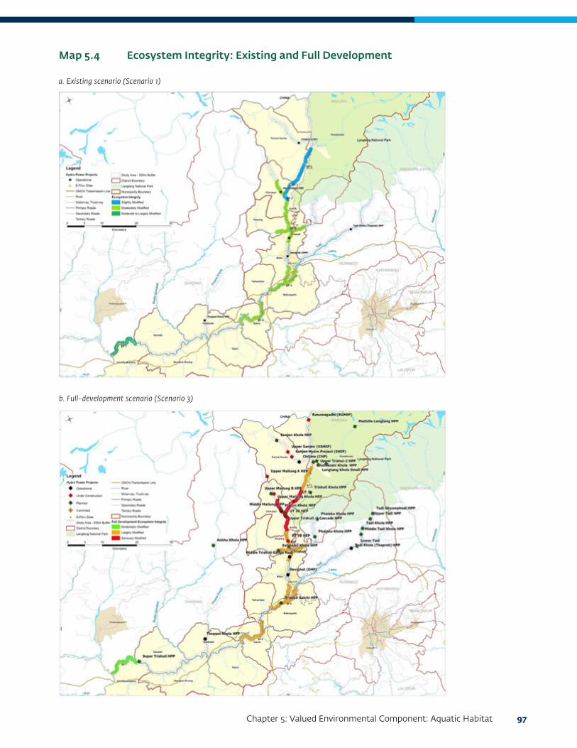
Chapter 5: Valued Environmental Component: Aquatic Habitat 97
Map 5.4 Ecosystem Integrity: Existing and Full Development
a. Existing scenario (Scenario 1)
b. Full-development scenario (Scenario 3)

98 Cumulative Impact Assessment and Management: Hydropower Development in the Trishuli River Basin, Nepal
of migratory fish species, including the Common Snow Trout. Fish, including adults, fry, and larvae, are able to move downstream over the low weirs of these dams. Trishuli HPP has only a half weir and an underwater sluice gate that permits fish to pass downstream. Thus, habitats for the main migratory fish species in the Trishuli River, the Golden Mahseer and Common Snow Trout, are currently fragmented into three sections.
It is anticipated that with additional dams under the scenarios discussed, both the mainstem of the river and tributaries where dams are planned will be further fragmented, which will result in small isolated populations of these two fish species. In the midstream section and along the tributaries, this effect will be more relevant for Common Snow Trout. Golden Mahseer access to upstream areas of the Tadi Khola and Salankhu and Phalanku Kholas, has already been obstructed, due to dams such as the existing Trishuli Dam.
Proposed Mitigation
The following mitigation actions, listed according to impact, are possible means of reducing the cumulative impacts of development on the aquatic environment in the TRB.
Barrier Effects and Low Flows along the Trishuli Mainstem
Passage
• Research is needed to understand fish behavior for upstream and downstream migrations across dams, to support design of fish passages that are effective.
• In many cases, fish passes are poorly designed and do not work. An apparent example is the fish pass designed for UT-3A project, which was damaged by the earthquake and is presently being repaired.
• Fish passages are often not considered due to the height of the dam. In general, fish passages can be designed fairly easily for dams of 10 meters or less. However, dams of 30 meters or more can
also include some type of fish passage such as a fish ladder or fish lift.
• Successful fish passages in Nepal should be used as examples for fish passage design and operation for the fish species of interest in the TRB, namely Snow Trout and Mahseer. In the TRB, UT-1 has planned a fish pass for Snow Trout utilizing international expertise. Two other projects, Super Trishuli and Rasuwagadhi HPP, have also planned fish passes. Khimti Khola HPP has a fish passage designed to simulate natural conditions (H. Kaasa, pers. comm.).
• There are examples of functioning fish passages in other countries that can also be used to guide the design, operation, and monitoring of a successful fish passage in the TRB (Schmutz and Mielach 2015). There are also many examples of failed fish passages that should be reviewed to avoid similar problems in Nepal.
• Information is needed to understand where fish passages are planned for projects in the basin and where fish passages are needed to maintain continuity right through the cascade.
• Guidelines should be prepared for the design of fish passes specifically suited for indigenous species (IFC 2018b). Continuous research, guided by monitoring, is needed to improve the design of passages and to identify technologies that are suited for particular conditions.
• Development of a robust methodology for monitoring the effectiveness of fish passages (for example, counting the number of fish that pass through the ladder) is needed for all HPPs with a fish passage.
• Capacity building is needed for hydropower project environmental staff as well as for government employees who work with fish passages in order to ensure that they are able to monitor and assess the efficacy of the passages.
Design and Management of EFlows in Low Flows and Bypass Sections
• EFlows should be designed within the framework

Chapter 5: Valued Environmental Component: Aquatic Habitat 99
of sustainable development to balance conservation of aquatic ecosystem with loss in power generation as EFlows are increased.
• Nepal’s guidelines for EFlows, which require EFlows to be 10 percent of the minimum average monthly flow, should be reevaluated to include evaluation and management of impacts of flow modifications on biodiversity. IFC guidelines on selection of EFlows methods could be adopted as a model (IFC 2018a).
• Attention should be given to management of EFlows in cascades, where there should be consistency in operating rules for the powerhouses, and operation of power plants should be coordinated to maintain EFlows in the cascade.
• Further research is needed on the habitat requirements of fish and other aquatic species in relation to river flow rate, water depth, and so forth in order to provide the data needed for EFlows assessments and an underlying rationale for the selection of EFlows.
• Nepal government hydropower regulators should increase monitoring and inspections to ensure that EFlows, as determined by the EFlows assessment, are released. They should consider requiring HPPs to post real-time EFlows data on their website to facilitate monitoring of EFlows.1
Management of Peaking
• A basin-level strategy should be developed for collaboratively designing power plants in the basin to avoid peaking designs where possible and to minimize impacts of peaking when not.
• For any hydropower projects considering peaking operation, a robust EFlows assessment should be conducted to evaluate a range of peaking scenarios in order to reach a balance between power generation and environmental protection.
• Peaking operations should consider options for
1 See the example for AD Hydro Power Limited projects (Allain and Duhangan) in India at http://hppcblive.com/live/allain.
regulating peaking impacts such through a cascade or with a regulating dam downstream.
Management of Sand and Gravel Mining
• Dams should be designed to let the sediments through, minimizing accumulations in reservoirs.
• Sustainable sediment mining plans should be formulated on a scientific basis, to balance the economic benefits of mining with the impact of mining on aquatic ecosystems and to achieve a win-win for the economy and the environment.
• Due to the high mining pressures in the lower reaches of the TRB, sediment-mining plans need to be developed and enforced for each hydropower project and for the basin. While a policy will be needed at the federal government level, enforcement will have to be organized at provincial and local level.
Management of Unregulated Fishing
• Sustainable harvesting practices need to be introduced. There are some examples where commercial harvesting of fish is regulated by the government, such as on the Mahakali River.
• Regulation of fishing by communities should be explored.
• Subsistence fishing should be allowed where sustainable, but fishing methods should be controlled, and use of destructive practices such as electrocution and fishing with nets of fine mesh sizes should be prohibited.
• The use of chemicals to catch fish should be strongly prohibited. By using chemicals or biocides, both macroinvertebrates and fish and their fry are killed. Use of these chemicals not only poisons the fish but is also dangerous for people who eat the fish.

100 Cumulative Impact Assessment and Management: Hydropower Development in the Trishuli River Basin, Nepal
Research on Aquatic Ecology
• There is a need for the development of a robust methodology per international standards to establish baselines for aquatic biodiversity during an ESIA process, as well as methodologies for long-term monitoring of aquatic habitats and biodiversity. A good understanding of river ecosystems is required for managing impacts of hydropower on fish populations. This will include aquatic biodiversity, composition, and distribution of fish species and the importance of connectivity between the main river and tributaries (see IFC 2018a, 2018b).
• Some hydropower projects have already been constructed. The impacts of these on fish populations need to be studied to understand how future projects will impact the aquatic ecosystems and fish populations.
• Novel and new survey and monitoring methodologies should be explored and tested (e.g. eDNA) and training provided to hydropower project environmental staff and government staff.
• Capacity building is needed for hydropower projects environmental staff as well as for government employees who work with fish passages in order to ensure that they are able to monitor and assess the efficacy of the passages.
• Government should review and update regulations for aquatic habitat protection as needed.
Native Fish Hatcheries
• Fish hatcheries, or other captive propagation of fish, are often the preferred mitigation option for hydropower projects.
• Many Himalayan fish species, including the Snow Trout and Mahseer, are able to be bred in captivity in Nepal.
• However, many studies of fish in other countries have shown that hatchery-bred fish are not as healthy or robust as wild fish and that they do not serve to increase the wild populations when released
(Brown and Day 2002). Few, if any, studies have been conducted on hatchery fish released in the Himalayas in order to determine success rates.
• Hatcheries should not be considered a primary mitigation option, as they are unlikely to help in maintaining wild fish populations. More research is needed to understand the conditions under which hatcheries can help. Until then, other mitigation options that are proven to work should be investigated, and research should be carried out on how to supplement fish populations in the wild through hatcheries.
Barrier Effects and Low Flows along Tributaries
Tributaries entering the main stem of the Trishuli River, in addition to offering habitat for fish, are also important spawning areas. As discussed for the river’s mainstem, prior to designing mitigation, there needs to be a thorough understanding of patterns of aquatic biodiversity, the composition and distribution of fish species, and the location of spawning sites (see IFC 2018a and 2018b). Tributaries are a key to the viability of fish populations in the TRB, as they serve as spawning areas, nursing areas, and recruitment areas. Tributaries are highly threatened in the TRB as a series of dams, such as those planned along the Mailung, Phalanku, Salankhu, and Tadi Kholas, not only impede migration upstream, but isolate existing populations into small fragmented populations with limited chances of survival.
Furthermore, low flows caused by diversion for power generation, for the same tributaries mentioned above, alter habitat and impede migrations by lowering depth over and above low natural depths already existing in tributaries. It may added here that several tributaries such the Sanjen and Langtang Kholas are snow fed and do not provide spawning habitats, so those that do are quite vital for fish survival in the basin.
The following recommendations are relevant for all tributaries providing habitat and spawning opportunities for fish:
• River stretches between hydropower projects should be thoroughly assessed for fish diversity and their

Chapter 5: Valued Environmental Component: Aquatic Habitat 101
abundance. This will not only provide information on how important the assessed tributaries are for the viability of fish populations in the basin, but will provide valuable information for designing mitigation, such as spawning species, seasons for spawning, and priority spawning sites.
• Every hydropower project should do an adequate EFlows assessment (as per IFC 2018a) and not simply follow the 10 percent of the minimum monthly flow recommendation. A major parameter to be assessed is the flow to be released in the migratory season for fish to reach spawning sites.
• Fish passage should be included on dams along tributaries, particularly because these dams are often less than 10 meters high and therefore well suited for fish ladders. Where possible, dams (maintaining riverbed level and dam slope) should have weirs mimicking the natural flow of the rivers so that fish can pass.
• Government monitoring should be increased to ensure that EFlows, as determined by the EFlows assessment, are released.
• Hydropower project planning by government agencies such as the Department of Electricity Development should consider the number of projects on each tributary. Mailung Khola is a snow-fed river directly impacted by climate change. Other tributaries do not enter the Mailung Khola. As a result, Mailung Khola may become oversaturated with projects, and other tributaries should be identified that should not have any future hydropower plans and can be used as an offset.
• For rivers like the Trishuli, where the fish population in the main river seems to be directly dependent on the fish production in the tributaries, it would be important to investigate the relative importance of each tributary for the total fish population. Such tributaries may act as refuges for the fish population.
• Hatcheries for indigenous fish species should be only a back-up/low priority alternative.
• Adequate baseline surveys and monitoring following robust methodologies and research on fish migration patterns and biology are needed for tributaries in the basin.
102 Cumulative Impact Assessment and Management: Hydropower Development in the Trishuli River Basin, Nepal

103
CHAPTER 6:
VALUED ENVIRONMENTAL COMPONENT: TERRESTRIAL HABITAT
Rationale for Screening
From the stakeholder engagement described in “Finalization of VECs” in Chapter 4, 28 percent of the stakeholder respondents thought that the Langtang National Park (LNP) was a VEC due to the forest land requirement and proposed transmission lines for four proposed hydropower projects within the park. Construction of infrastructure and access roads may cumulatively impact biodiversity habitats within the LNP.
Baseline Conditions
As per the Forest Act (1993), Nepal’s forests are defined as follows:
National Forest means all forest excluding Private Forest, whether marked or unmarked with a forest boundary and shall also include waste or uncultivated land or unregistered lands surrounded by the forest or situated near the adjoining forest as well as paths, ponds, lakes, rivers or streams and riverine lands within the forest. National Forests include the following:
• Community Forest—National Forest handed over to users groups for the development, protection, and utilization in the interest of the community
• Government-Managed Forest—to be managed by government of Nepal
• Protected Forest—a National Forest declared by government of Nepal to be of special environmental, scientific, or cultural importance
• Leasehold Forest—a National Forest handed over as a leasehold pursuant to any institution established under prevailing laws, industry based on forest products, or community
• Religious Forest—a National Forest handed over to a religious body or group for its development, conservation, and utilization
• Private Forest—a forest planted, nurtured, or conserved in any private land owned by an individual pursuant to prevailing laws
Furthermore, in Nepal under the National Park and Wildlife Conservation Act (1973), the central government may, if it deems necessary, declare an area as a national park or reserve or conservation area by publishing a notice in the Nepal Gazette and indicating the boundary thereof.
All these categories of forests are found in the Trishuli River Basin (TRB) and provide habitat for several species of conservation significance. Mammals of conservation significance are provided in Table 6.1 while birds of conservation significance are provided in Table 6.2.
While there is some footprint of projects on natural terrestrial habitat through the diversion of forests for building infrastructure for dams, tunnels, spoil disposal sites, quarries, and labor construction camps and marginal impacts through impoundment, impacts tend to be project specific and not cumulative. The cumulative footprint of these projects, for example, does not impede dispersal of mammals or birds or result in major losses of habitat reducing the viability of species populations. The above species (in Table 6.1 and Table 6.2) of conservation significance are, thereby, not considered VECs in the assessment of cumulative impacts. However, given the proximity of the projects to the LNP, or in some cases locations within, and the likely cumulative impacts to the park, the LNP is considered a biodiversity VEC.
The LNP is the nearest Himalayan park to the capital city of Kathmandu. Established In 1976, the park has an area of 1,710 square kilometers that extends over parts of Nuwakot, Rasuwa, and Sindhupalchowk Districts, the southern mountainous terrain of the Tibet Autonomous Region. The park lies at the pinnacle, the meeting point between Indo-Malayan and Palearctic realms, and has important ecosystems of both realms.

104 Cumulative Impact Assessment and Management: Hydropower Development in the Trishuli River Basin, Nepal
LNP has a wide range of vegetation types along the
altitudinal range between 1,000 and 7,245 meters. It is
the third most popular trekking destination among the
protected areas of Nepal. The buffer zone of LNP, with
an area of 418.3 square kilometers, was constituted
on April 27, 1998 and includes the settlements in
the park and a mutual impact zone outside. A buffer
zone management committee, 21 user committees,
and more than 336 user groups work to manage the
buffer zone to reduce the biotic pressure in the park
by generating resources to meet their needs.
Methodology
The following projects are proposed in the LNP’s
buffer zone:
• Middle Tadi (11 megawatts, MW) (construction
license given)
Common name Latin Name IUCN status Red list of Nepal’s mammals*
Assamese monkey Macaca assamensis NT EN
Terai grey langur Semnopithecus hector NT LC
Asiatic black bear Ursus thibetanus VU EN
Himalayan goral Nemorhedus goral NT NT
Common leopard Panthera pardus VU VU
Source: Jnawali et al. 2011. * Extracted from NESS 2014b.
Note: EN = endangered; NT = near threatened; VU = vulnerable; IUCN = International Union for Conservation of Nature. The IUCN denotes international status, while the Red List is specific to Nepal.
Table 6.1 Mammal Species of Conservation Significance in the TRB
Common name Latin name IUCN status
National Red List of Birds of Nepal*
Protected status (NPWC Act 1973)
Steppe eagle Aquila nipalensis EN VU
Greater spotted eagle Clanga clanga VU VU
Imperial eagle Aquilia heliaca VU VU
Cinerous vulture Aegypius monachus NT EN
Ibisbill Ibidorhyncha struthersii LC EN
Red-headed vulture Sarcogyps calvus CR EN
Source: Inskipp et al. 2016. * Extracted from the LNP Management Plan.
Note: CR = Critically Endangered; EN = Endangered; NT = Near Threatened; VU = Vulnerable; IUCN = International Union for Conservation of Nature; NPWC = National Park and Wildlife Conservation.
Table 6.2 Bird Species of Conservation Significance in the TRB
• Upper Tadi (5.5 MW) (construction license given)
• UT-1 (216 MW) (construction license given)
• Tadi Ghyamphedi (4.7 MW) (survey license given)
• Tadi Khola (4.0 MW) (survey license given)
The following projects are proposed in the LNPs core zone:
• Langtang Khola Small HPP (10 MW) (construction license given)
• Langtang Khola Reservoir HPP (310 MW) (survey license given)
• Mathillo Langtang HPP (25.5 MW) (survey license given)
The likely footprint of projects in terms of land requirements and access roads of the eight projects in the park’s buffer and core zone were qualitatively assessed to identify any cumulative impacts.

Chapter 6: Valued Environmental Component: Terrestrial Habitat 105
Key Stressors
A new road is very likely to pass through the buffer areas of the park in the Rasuwa and Nuwakot Districts. While the alignment of this road is not confirmed, it will provide construction works engaged in hydropower projects (HPPs) greater connectivity to the smaller access roads in the core zone of the park, constructed for hydropower projects. The road is thereby likely to facilitate the following impacts:
• Extraction of threatened and endemic nontimber forest produce for illegal export to the Tibet Autonomous Region to supply the traditional Chinese food, ornamental plant, and medicine industries. Stakeholders and the LNP Management Plan have indicated that the LNP houses several endemic species of traditional value. These include the following:
• Carum carvi (Persian fennel): used as spice in cooking
• Meconopsis taylori: ornamental species and collectors item
• Elaeagnus tricholepsis: ornamental species and collectors item
• Delphinium williamsii: ornamental species and collectors item
• Primula sharmae: ornamental species and collectors item
• Zanthoxylum nepalensis: medicinal plant
• Larix nepalensis: an endemic plant whose distribution is nowhere as abundant as in Langtang valley. Described as “Nepalese Larch” by botanists, it is an iconic plant of Langtang valley.
Unsustainable poaching of wildlife, extraction of threatened and endemic species, and disruption of traditional extraction values due to influx of construction-phase workers
Threatened species found in the LNP, whose meat or other products would be increasingly sought by construction workers and foreign and domestic wildlife
traders for commercial sale within Nepal or export to China, include the following:
• Naemorhedus goral: IUCN NT (v2018-1); Nepal Red-List (Jnawali et al, 2011) NT).
• Capricornis thar: IUCN category NT (version 2018-1); Nepal Red List category DD.
• Moschus chrysogaster: IUCN EN (v2018-1); Nepal Red List EN (usually found at higher altitudes but is also found at 2000 meters). The musk gland would be highly sought after.
• Ovis ammon: IUCN NT (v2018-1); Nepal Red List DD (usually found at higher altitudes, but may descend during winter).
• Rusa unicolor: IUCN VU (v2018-1); Nepal Red List VU.
See Tables 6.1 and 6.2 for IUCN and Red List classifications.
Significant Impacts
Access Roads
Given the preliminary stages of the three projects within the LNP core zone, details of access roads to be constructed are presently not available. (It was, however, established that the road for the Langtang Small Khola project was constructed). It is, however, very evident that these future access roads will provide greater connectivity to the present Nepal–Tibet Autonomous Region highway and later to the highway built under the One Belt, One Road initiative. This will increase illegal access into the LNP of construction workers, local community members, and outsiders such as foreign and domestic wildlife traders intending to exploit the LNP’s resources. While this will result in loss and degradation of habitat through illegal felling of wood, grass and reed collection, fire, encroachments, and so forth, cumulative impacts are only to be anticipated for species of commercial interest. The addition of projects under the scenarios already described will lead to an increase in the access road network. This will lead to increased incursions into the LNP, resulting in further threat to the species mentioned.

106 Cumulative Impact Assessment and Management: Hydropower Development in the Trishuli River Basin, Nepal
Transmission Lines
Map 6.1 displays the existing and future transmission line network in the TRB for projects included in “Transmission Lines” in Chapter 3. With the development of projects under the scenarios mentioned, the transmission line network will increase both within the park or adjacent to it. As can be seen from Map 6.1, except for some lower capacity lines (12 kilovolt, KV) serving villages in the LNP, most of the alignment of present and future transmission lines (33, 133, and 220 KV) are outside the park or in the buffer area. The lower capacity lines within the park have a minimal footprint and thereby do not impact habitat for threatened or endemic species. This will also be true for future development of these lower capacity lines resulting from hydropower development, within the core zone of the park.
As there are no wildlife dispersal corridors overlapping with the transmission alignment, there are no cumulative impacts by the transmission lines within and outside the park to wildlife dispersal.
A few threatened passage migrants—for example, Pallas’s Eagle (Haliaeetus leucoryphus), IUCN EN
and Nepal Red List, CR; Eurasian Curlew (Numenius arquata), IUCN NT and Nepal Red List CR; Saker Falcon (Falco cherrug), IUCN EN, and Nepal Red List EN—may pass through the basin, but the TRB is not a major flyway for migratory bird species. The transmission line network is unlikely to endanger any regionally or nationally significant concentrations of these species.
Proposed Mitigation
The sources of impacts to the LNP include the following:
• Access roads
• Transmission lines
• Civil structures
• Worker/engineer’s accommodations
The recommendations in Table 6.3, as provided by the Cumulative Impact Assessment and Management (CIA), can contribute toward managing habitats such as LNP to minimize adverse impacts from access roads and HPPs. These impacts are not necessarily cumulative.
Map 6.1 Implications of Transmission Line Projects

Chapter 6: Valued Environmental Component: Terrestrial Habitat 107
To improve capacity and coordination across stakeholders responsible for management of the park, it is recommended that the following structural actions be implemented to ensure coordination and monitoring of the actions in Table 6.3:
• Formation of District Coordination Committee involving LNP officials, district government officials, developers of TL/HPP/access roads, and so forth
• District-level framework and planning
• Recommendation and suggestions to province government and national government
• Integration in national-level planning
• Harmonizing HPP and Infrastructure development licensing
• Establishment of enforcement and follow-up mechanisms at the district level
• Training and capacity building of implementers (DCC, developers, and so forth)
• Project reporting to DDC) and province and national levels
• Review meetings and follow-up
• Compliance needed for license renewal (at the DDC, province, and national levels)
Source of impact Mitigation
Potential impacts from access road construction within LNP include:
• Land instability (landslide, erosion)
• Loss of topsoil
• Impact on flora and fauna through illegal extraction and hunting
• Disturbance to wildlife dispersal
• Solid waste and gaseous pollution in LNP
• Avoid development of access roads for hydropower projects through LNP
• If there are no alternatives, use commonly constructed access roads on a shared basis between hydropower projects.
Transmission lines are likely to pose electrocution risks to large-bodied birds such as storks, cranes, vultures, and large raptors. The LNP has several such species that may be impacted by the transmission lines.
If impacts to LNP due to the transmission line (TL) alignment are unavoidable:
• Use shared TLs by all hydropower projects in the basin
• Use insulated conductors in the TL system
• Compensate the LNP for right-of-way impact along the alignment
• Maintain clearance as per existing and future standards
• Place bird diverters across conductors in an appropriate manner to enhance visibility; should glow at night for nocturnal migrants
While the footprint of civil structures is likely to be small when compared to the total area of the park, localized impacts and potential increase in illegal extraction may be expected.
• Place proper fencing around project structure to reduce risks of death or injury to mammals.
• Prepare and implement blasting/explosive management plan, to avoid damage to habitats in the LNP.
Worker camps and engineer accommodation: Even though the footprint may be minimal, workers and other staff of hydropower projects may indulge in illegal extraction of biodiversity resources within the LNP. There could be further impacts of improper solid or liquid waste disposal from these camps.
• Prepare and implement workers code of conduct.
• Use hoarding boards in local languages for skilled and unskilled workers on illegal activities within the LNP.
• Punish unethical, illegal activities of workers (for example, for killing of wildlife and consuming game meat, setting fires).
• Solid and liquid waste management plan and consequent action for such camps
Table 6.3 Proposed Mitigation for Langtang National Park (LNP)

108 Cumulative Impact Assessment and Management: Hydropower Development in the Trishuli River Basin, Nepal
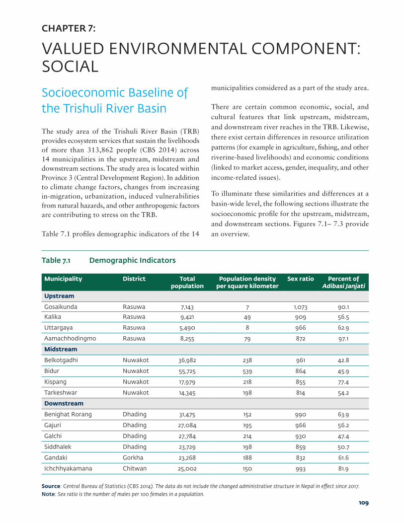
109
CHAPTER 7:
VALUED ENVIRONMENTAL COMPONENT: SOCIAL
Socioeconomic Baseline of the Trishuli River Basin
The study area of the Trishuli River Basin (TRB) provides ecosystem services that sustain the livelihoods of more than 313,862 people (CBS 2014) across 14 municipalities in the upstream, midstream and downstream sections. The study area is located within Province 3 (Central Development Region). In addition to climate change factors, changes from increasing in-migration, urbanization, induced vulnerabilities from natural hazards, and other anthropogenic factors are contributing to stress on the TRB.
Table 7.1 profiles demographic indicators of the 14
municipalities considered as a part of the study area.
There are certain common economic, social, and cultural features that link upstream, midstream, and downstream river reaches in the TRB. Likewise, there exist certain differences in resource utilization patterns (for example in agriculture, fishing, and other riverine-based livelihoods) and economic conditions (linked to market access, gender, inequality, and other income-related issues).
To illuminate these similarities and differences at a basin-wide level, the following sections illustrate the socioeconomic profile for the upstream, midstream, and downstream sections. Figures 7.1– 7.3 provide an overview.
Municipality District Total population
Population density per square kilometer
Sex ratio Percent of Adibasi Janjati
Upstream
Gosaikunda Rasuwa 7,143 7 1,073 90.1
Kalika Rasuwa 9,421 49 909 56.5
Uttargaya Rasuwa 5,490 8 966 62.9
Aamachhodingmo Rasuwa 8,255 79 872 97.1
Midstream
Belkotgadhi Nuwakot 36,982 238 961 42.8
Bidur Nuwakot 55,725 539 864 45.9
Kispang Nuwakot 17,979 218 855 77.4
Tarkeshwar Nuwakot 14,345 198 814 54.2
Downstream
Benighat Rorang Dhading 31,475 152 990 63.9
Gajuri Dhading 27,084 195 966 56.2
Galchi Dhading 27,784 214 930 47.4
Siddhalek Dhading 23,729 198 859 50.7
Gandaki Gorkha 23,268 188 832 61.6
Ichchhyakamana Chitwan 25,002 150 993 81.9
Table 7.1 Demographic Indicators
Source: Central Bureau of Statistics (CBS 2014). The data do not include the changed administrative structure in Nepal in effect since 2017.Note: Sex ratio is the number of males per 100 females in a population.

110 Cumulative Impact Assessment and Management: Hydropower Development in the Trishuli River Basin, Nepal
Figure 7.1 Socioeconomic Profile: Upstream
The upstream study area of the TRB falls in Rasuwa District of central Nepal. Its altitude ranges from 1,000 to 7,250 meters, with some of the highest alpine mountain ranges in the country (Humagain and Shrestha 2009). This upper catchment area of the TRB is not used for irrigation or water supply. Almost 56 percent of the total area of Rasuwa belongs to Langtang National Park (LNP), an important biodiversity location in Nepal. The area under cultivation is low because of the steep hills and mountains. The Tamang people, an ancient indigenous group of Nepal, with their own richly developed traditions, local customs, rituals, and cultural practices, inhabit more than 65 percent of this area. They derive significant ecological and livelihood values from forests.
• The climate is temperate or subalpine.
• Changes in snowfall and rainfall patterns is a major water-related concern.
• Tibeto Burman communities such as the Tamang, Gurung, and Rai.
• Agriculture mostly relies on rainfed farming, thus making it vulnerable to water stress and extreme events.
• While maize remains an important crop, there is a gradual shift away from the traditional cereal-based cropping to cash-generating vegetables and organic farming.
Photo F7.1.1 Upstream Geography
Photo F7.1.2
Photo F7.1.3
• A majority of local communities use fuelwood for cooking, whereas electricity is mainly used for lighting.
• The government of Nepal declared Rasuwa District as an area for raising trout. However, a gradual increase in temperatures has affected cold water fish, with more intense activities in tributaries and supported by the research station in Dhunche.
• Majority of the households depend on agriculture and animal husbandry as their main source of income. Decline in crop yields is influencing adaptation strategies such as commercial herb farming and tourism as alternate sources of income, resulting in the development of tourism villages such as Syaphrubesi. Medicinal plant collection, forest and nontimber forest products, wage labor and ecotourism are some of the supplementary income sources for the residents of Rasuwa.
• The earthquake of 2015 flattened entire villages and displaced complete village populations in Rasuwa, making it one of the worst affected districts in all of Nepal. Several erstwhile VDCs reported local communities having out-migrated further downstream of the basin to settle into Internally Displaced People Camps, such as Nuwakot.
• The focus of government interventions (in addition to rehabilitation of earthquake victims) is to encourage farmers to move toward commercial livestock rearing, implement afforestation programs, and support governance, biodiversity conservation, and livelihood enhancement of communities.

Chapter 7: Valued Environmental Component: Social 111
Map F7.1.1 Upstream Study Region
Hill origin high caste group
Janajati
Hill DalitsTarai origin Madhesi caste group
Others
75%
4%
1%
0%
20%
Total area 100 sq km
Forest area 60%
Cultivated area 10%

112 Cumulative Impact Assessment and Management: Hydropower Development in the Trishuli River Basin, Nepal
Figure 7.2 Socioeconomic Profile: Midstream
The middle part of the TRB falls in Nuwakot District of central Nepal, about 75 kilometers north of Kathmandu. Nuwakot is predominantly covered in hills and highlands with an elevation range from 457 to 5,144 meters above sea level (Gurung, Basnet, and Lamsal 2006). Fishing, agriculture, and ecotourism are some of the main occupations. Rainbow Trout farming in the hilly terraces of Nuwakot is supported by the presence of suitable land and cold-water streams, along with ready market access. The local people of Nuwakot perceive an increase in the frequency of floods and landslides in the area, caused by a combination of factors like road construction, increase in rainfall, and possibly, hydropower development along the river basin.
• The climate is subtropical to temperate.
• Water-induced landslides, drying up of springs, and droughts are major water-related concerns.
• Hill origin high caste groups dominate along with Adivasi Janjati.
• Water for irrigation is a concern among the farming community because of the variability of rainfall. The previous cropping pattern of paddy in the monsoon season and wheat in the winter season remains. However, there is a decline in productivity for the wheat crop.
• Drought-resistant crops such as drought-resistant rice are cultivated in rainfed areas and staple crops and a variety of vegetables in irrigated areas.
Photo F7.2.1 Midstream Geography
Photo F7.2.2
Photo F7.2.3
• An estimated 83 percent of households in Nuwakot (CBS 2012) have access to electricity. However, fuelwood remains a major fuel source for cooking (with increasing use of liquefied petroleum gas (LPG) in urban areas) along with lighting.
• Increased urbanization in towns such as Ratmate, Bidur, and Belkotgadhi has emerged as a key regional influence for local economic and demographic trends.
• In recent years, unreliable rainfall patterns are affecting crop yields. Nuwakot has seen migration due to increased problems in agriculture resulting from the decline in water availability and insufficient production. However, specific areas such as Battar Bazar and Bidur have seen an increase in in-migration of subsistence farmers and increase in less water-intensive crops. Farmers are negotiating with upstream users to increase their allocation of water within their water user associations (if present) and reducing canal leakages and plot drainage.
• Scarcity of drinking water is a major problem faced by these communities, with most people susceptible to low-quality water and waterborne diseases. Water problems are exacerbated by the incidence of extreme natural events like landslides as they sweep away existing drinking water pipelines.
• After the earthquake of 2015, there was an influx of people from their original villages in Nuwakot and there is social impoverishment associated with displaced populations. District Development Councils are allocating funds for disaster risk reduction and undertaking programs of protection of slopes to reduce landslides.
Source: Source: Dandekeya et al. 2017; Ministry of Forests and Soil Conservation 2015; CBS 2014; Basin-level consultations.

Chapter 7: Valued Environmental Component: Social 113
Map 7.2.1 Midstream Study Region
Total area 442.1 sq km
Forest area 37%
Cultivated area 43%
Hill origin high caste group
Janajati
Hill Dalits
Muslim
Tarai Dalits
38%
7%
0%
1%Other cultural groups 1%
52%
Tarai origin Madhesi caste group 1%

114 Cumulative Impact Assessment and Management: Hydropower Development in the Trishuli River Basin, Nepal
Figure 7.3 Socioeconomic Profile: Downstream
The lower part of the TRB falls in Dhading, Gorkha, and Chitwan Districts with a mild river gradient, a subtropical to temperate climatic regime, and an extreme range of elevation from 430 to 7,409 meters (Regmi 2003). The area is accessible from Kathmandu via the Prithvi Highway, which connects Pokhara and Narayangarh. Sand and gravel mining, rafting and adventure sports, and agroforestry have helped to enhance the economic conditions of poor and marginalized areas where crop farming is not a sustainable livelihood option. Fishing, mining, agriculture, sale of agro-products, and ecotourism are the prominent occupations here.
• The climate is mostly tropical.
• Hill origin high caste groups dominate along with Adivasi Janjati.
• Water for irrigation, floods, and droughts are major water-related concern.
• The areas close to the river are affected by inundation of fields and massive silt deposition during floods, which reduce the productivity of the land. Farmers are moving away from paddy cultivation.
• Drought-resistant crops such as lentils, sesame, maize, potatoes, peanut, and mustard, and drought-resistant rice are cultivated in rainfed areas.
• Decreased agricultural productivity and shifts in farming season have led to economic vulnerability and shift toward labor.
Photo F7.3.1 Downstream Geography
• Access to electricity and use of solar power, kerosene, or biogas for lighting is predominant along with fuelwood for cooking.
• Sand mining continues unabated along the river leading to decline in water quality, increase in floods, and riverbed subsidence as reported.
• Adaption techniques include use of pumps, small-scale water storage ponds to irrigate fields such as potatoes, and raising the height of tube wells.
• The area suffers from undeveloped infrastructure like roads and electricity, and poor-quality sewage and sanitation facilities. District statistics reveal that less than 40 percent of the population has access to clean drinking water.
• Loss of biodiversity (compounded by deforestation upstream), escalating illegal wildlife trading activities, hill slope disturbances triggering landslides, and early runoff causing flash floods are some of the environmental issues in this district.
• Government initiatives: The district government has been working on issues linked to the provision of irrigation and drinking water, flood control and erosion, construction of river bank protection structures, and water-induced disaster mitigation, and has allocated resources and implemented development plans focused on these areas.
Source: CBS 2014; Dandekeya et al. 2017; Ministry of Forests and Soil Conservation 2015; and basin-level consultations.
Photo F7.3.2
Photo F7.3.3

Chapter 7: Valued Environmental Component: Social 115
Map 7.3.1 Downstream Study Region
Total area 572.2 sq km
Forest area 53%
Cultivated area 30%
Janajati
47%
Hill origin high caste group38%
Hill Dalits12%
Tarai origin Madhesi caste group 1%
Other cultural groups 1%

116 Cumulative Impact Assessment and Management: Hydropower Development in the Trishuli River Basin, Nepal
Water Availability
Chapter 8 of this report provides an overview of water resources as a VEC and summarizes the baseline conditions on water availability and concerns across upstream, midstream, and downstream of the basin. Overall, communities indicate that the aftermath of the 2015 earthquake has seen an intensification of water shortages, which is further attenuated by the drying up of springs, damages to spring conveyance systems due to landslides, and general decline in surface water quality in the midstream and downstream sections.
Indigenous Communities
There are approximately 19 indigenous community groups (Adivasi janjati) across the basin. Figure 7.4 presents the comparative populations. While the absolute numbers of these communities are high in the midstream and downstream reaches, the proportion of the population gradually declines from 75.9 percent in the upstream area, 57.2 percent in the midstream area, and 55 percent in the downstream area.
Community Forests
Forests in the watershed are managed either by the government or by Community Forest User Groups (CFUGs). Local CFUGs include groups that manage religious forests (predominant in the midstream), buffer zone management committees (such as around Langtang National Park), and general Community Forests. CFUGs protect and manage these forests and also conduct development activities, in accordance with an operational management plan approved by the District Forest Office (DFO) as per the Operational Guidelines for Community Forestry Development Program, 2002. Table 7.2 summarizes the number of CFUG groups in each of the municipalities within the study area based on information provided by the Federation of Community Forestry Users Nepal.
Consultations with municipalities in the vicinity of operational and under-construction hydropower projects (HPPs) indicated that, in general, there is no major large-scale loss of land under CFUGs. Specific CFUGs that are under submergence areas may be
Figure 7.4 Comparative Population Numbers of Indigenous Communities
Rai/Sanuwar/Danuwar
Others (Baramo, Sherpa, etc.)
Chepang/Praja
Majhi
Kumal
Newar
Tamang
Magar
Gurung
Ghale
Bhujel/Gharti
0 10,000 20,000 30,000 40,000 50,000
Downstream Midstream UpstreamSource: CBS 2014.

Chapter 7: Valued Environmental Component: Social 117
Tamang community Chepang community Rai community Newar community Magar community
• The Tamang are Buddhist by religion. Ghyangs (Buddhist Monasteries) are the main religious centers.
• Lakes and mountains located upstream of TRB, such as Ammachhodingmo, Gosaikunda, Bhairabkunda, Suryakunda, Saraswati kunda etc. are the major cultural sites of local communities.
• The economic life of the Tamang is mainly dependent upon agriculture and wage labor. They also keep livestock.
• Tamangs in Rasuwa have a distinct language and dialect. However, those settled in Nuwakot and Dhading are better integrated with the hill caste, hill origin communities.
• Chepang community is found in the midstream and downstream region of TRB.
• Similar to other Tibeto-Burman groups like Tamangs and Gurungs, their cremation practices are carried out upland.
• Chepang community used to practice shifting cultivation, and they have traditionally not owned any land in the TRB. Presently, their main livelihood is wage labor and agricultural labor.
• In the TRB, Nepali language has reportedly become more prevalent among the Chepang community instead of their own distinct dialect.
• This community associates itself as Danuwar and Sanuwar Rai and are different from the ethnic origins of Rai found in eastern Nepal.
• No specific sacred area is in the project area. Cremation practices are linked to the river.
• As reported, the community does not have a distinct worship, cultural practice pattern and/or distinct aspects of cultural heritage.
• The livelihood activities are agriculture, labor, and livestock rearing.
• They are integrated with the mainstream community and speak Nepali.
• Guthi is the main sociocultural as well as political organization of the Newar people in the project area with specific Guthi land in Rasuwa and in Dhading.
• The Newar people of the project area cremate the dead on the river bank, especially on the confluence of Budhi-Gandaki and its tributaries. Hindu Newar and Buddhist Newar have their own priests. Unlike other caste and ethnic groups, Guthi members are essential for funeral rites.
• Their sacred site is known as the Subrana Budda Bihar and is not located near the Trishuli River.
• Magar are mainly divided into three clans; Rana, Thapa, and Ale. These three clans are also sub-divided into 20 sub-clans.
• No specific sacred sites in the TRB.
• Majority of the Magar in the project area undertake cremation activities along the confluence of Budhi-Gandaki.
• Agriculture and service in the armed forces are the main livelihoods. Out-migration to Persian Gulf countries is also prevalent. Some of the Magar are involved in labor, craft, and masonry works.
• They have a distinct language that includes dialects such as Kham Magar and Kaike Magar. This community is not found upstream of the basin.
Box 7.1 Profile of Key Indigenous Communities

118 Cumulative Impact Assessment and Management: Hydropower Development in the Trishuli River Basin, Nepal
impacted by certain projects. However, these are
localized impacts that need mitigation in accordance
to the provisions of the Forest Act (1993). In general,
access road development associated with HPPs in the
upstream have enabled communities to improve their
accessibility to CFUGs.
Migration Trends
The TRB has been characterized by the gradual
urbanization along urban local bodies and tourist
towns along the mainstem. The gradual demographic
change is likely to be further enhanced due to regional
infrastructure development projects such as upgrading
and improving activities of the Trishuli Highway and
railway corridor development within the basin as a
part of the One Belt One Road project.
Table 7.3 provides in-migration data for key districts as well as the current population, indicating that out-migration has also occurred to bring about an overall decline in population growth.
Nuwakot has seen a trend of out-migration linked to a decline in crop yields and agricultural incomes as well as a decline in water availability. Communities have preferred settling in the Kathmandu Valley, specifically areas such as Shivpuri and Shankarapur. However, Nuwakot, towns such as Bidur have reported in-migration due to construction of internally displaced people camps and an increase in subsistence farmers seeking economic opportunities. Studies on the Gandaki Basin in general note that migration has enabled families to adapt, with many able to move to safer locations away from landslide- and flood-prone zones (Dandekheya et al. 2017).
Municipality District Number of CFUGs
Number of CFUG
households
Area under CFUG (ha)
Proportion of the total
municipality area
Upstream
Gosaikunda Rasuwa 8 479 243 1%
Kalika Rasuwa 40 2,878 1.921 10%
Uttargaya Rasuwa 32 2,434 1.370 2%
Aamachhodingmo Rasuwa 36 2,568 1.607 15%
Midstream
Belkotgadhi Nuwakot 23 5,449 3.265 21%
Bidur Nuwakot 66 8,028 4.175 40%
Kispang Nuwakot 28 2,487 1.873 23%
Tarkeshwar Nuwakot 45 2,385 3.184 43%
Downstream
Benighat Rorang Dhading 51 5,752 3.571 17%
Gajuri Dhading 63 5,548 3.448 25%
Galchi Dhading 69 5,577 3.959 31%
Siddhalek Dhading 58 6,569 2.632 22%
Gandaki Gorkha 53 5,261 1.840 15%
Ichchhyakamana Chitwan 9 1,085 1.581 9%
Table 7.2 Overview of Community Forest User Groups
Source: FECOFUN 2018.Note: ha = hectare.

Chapter 7: Valued Environmental Component: Social 119
Community Health
The study area of the TRB has only 2 major district hospitals, in Gosaikunda (Rasuwa) and Bidur (Nuwakot). Other health care facilities include health posts, primary and community health centers, and health assistants. The Gosaikunda District Hospital is noted to be well equipped in terms of infrastructure, resources, and technical staff. This is attributed to the general importance of the tourism industry in Rasuwa, which attracts domestic tourists and trekkers linked to religious sites, lakes, and the Langtang National Park.
Health infrastructure in downstream municipalities, such as Icchyakamana, Galchi, and Gajuri, is noted to be a major challenge, mostly due to accessibility. Table 7.4 presents available information on health care infrastructure and typical health concerns of local communities across the basin.
In general, access to health care in the basin for local communities depends upon their geographic location, available transportation facilities, and condition of roads (District Health Reports and Consultation at District Hospitals (Gosaikunda and Bidur) with health professionals and local communities, 2018). The role of traditional healers and use of CFUG areas for medicinal plants and herbs remains significant, especially in Rasuwa District (Box 7.2).
Discussions with health-care professionals in Gosaikunda and Bidur and a review of available basin-level studies indicated the following general trends in community health:
• An increase in upper respiratory tract infections
due to general exposure to dust and air emissions, mostly along the Prithvi Highway
• An improvement in the status of women and child health due to targeted interventions of sanitation initiatives by the Department of Health, an increase in the use of toilets, and presence of programs by USAID and Parivartan Nepal on water, sanitation, and health
• A general nutritional deficiency in view of the decline in productivity of staple crops, changes in cropping patterns and yields, and the consumption of packaged foods
• An increased incidence of water-borne and vector-borne diseases such as malaria, Japanese encephalitis, and kalazar linked to contamination of fresh water sources and scarcity of water during the dry season
• High blood pressure and diabetes linked to changes in consumption patterns and reportedly due to increased use of pesticides in food
There is no specific basin-level assessment of health impacts and/or implications of hydropower development, road construction, industrialization, and urbanization on the prevailing health profile of local communities within the TRB.
Religious and Cultural Sites
Rationale for Screening
The TRB has religious and mythological value to local communities, with the myths concerning the
District Total population in 2001
In-migration as share of district
population in 2001
Total population in 2011
Growth rate
Rasuwa 44,731 6.3% 43,300 Decline by 3.1%
Nuwakot 288,478 4.29% 277,471 Decline by 3.8%
Dhading 338,658 4.12% 336,067 Decline by 0.76%
Aamachhodingmo Rasuwa 36 2,568 1.607
Table 7.3 Demography and Migration

120 Cumulative Impact Assessment and Management: Hydropower Development in the Trishuli River Basin, Nepal
Spat
ial
exte
nt
Mu
nic
i-pa
lity
Hea
lth
car
e in
fras
tru
ctu
reH
ealt
h c
are
reso
urc
e: T
ech
nic
al s
taff
Hea
lth
po
stP
rim
ary
hea
lth
car
e ce
nte
r
Dis
tric
t h
ospi
tal
Com
mu
n-
ity
hea
lth
ca
re
cen
ter–
supp
orte
d h
ospi
tal
Doc
tor
(MB
BS/
MD
)
Nu
rse
staff
Hea
lth
as
sist
ant
AN
MLa
b as
sist
ant
Ups
trea
mG
osai
kund
a6
-1
26
317
133
Parb
ati
Kun
da4
--
--
-6
8-
Kal
ika
21
-1
32
66
1
Utt
arga
ya3
--
--
-5
6-
Key
C
once
rns
The
mos
t pr
edom
inan
t he
alth
-car
e ri
sks
spre
ad a
cros
s th
ese
gaun
palik
as (
adm
inis
trat
ive
divi
sion
s) a
re t
ypho
id,
tube
rcul
osis
, gyn
aeco
mas
tia,
dia
rrhe
a, o
rtho
paed
ic d
isor
ders
, and
ova
rian
-rel
ated
pro
blem
s in
fem
ales
. Wat
er-b
orne
di
seas
es li
ke d
ysen
tery
, cho
lera
, and
gas
troe
nter
itis
, alo
ng w
ith
the
typh
oid
and
diar
rhea
, are
ext
rem
ely
com
mon
in a
ll of
Ras
uwa
Dis
tric
t. C
omm
unic
able
dis
ease
inci
denc
e ha
s al
so r
isen
, but
the
re a
re li
mit
ed d
ata
on a
ttri
buti
ng t
he s
ame
to
spec
ific
aspe
cts
linke
d to
the
infl
ux o
f wor
kers
or
prox
imit
y to
the
bor
der.
Mid
stre
amK
ispa
ng5
--
--
-6
7-
Bid
ur6
-1
-8
244
63
Bel
kotg
adhi
6-
--
--
66
-
Tark
eshw
ar5
--
--
-5
7-
Key
C
once
rns
The
mos
t pr
eval
ent
heal
th c
ondi
tion
s ac
ross
the
four
gau
npal
ikas
are
ski
n di
seas
e, t
ypho
id, t
uber
culo
sis,
gyn
aeco
mas
tia,
an
d di
arrh
ea. A
s in
the
cas
e of
ups
trea
m c
omm
unit
ies,
wat
er-b
orne
dis
ease
s ar
e ra
mpa
nt in
the
mid
stre
am m
unic
ipal
itie
s.
Dow
nst
ream
Sidd
hale
k3
--
--
-5
5-
Gaj
uri
21
--
32
56
1
Ben
igha
t R
oran
g4
--
--
-6
7-
Gal
chi
3-
--
--
47
-
Key
C
once
rns
Acu
te r
espi
rato
ry in
fect
ion
typh
oid,
tub
ercu
losi
s, k
idne
y st
ones
, gyn
aeco
mas
tia,
dia
rrhe
a, a
nd h
yper
tens
ion
are
key
conc
erns
. Bon
e fr
actu
re s
eem
s to
be
a co
mm
on p
robl
em, w
hile
the
inci
denc
e of
STD
s, H
IV, a
nd A
IDS
is v
ery
low
. Com
pare
d to
ups
trea
m a
nd m
idst
ream
are
as, t
here
are
few
er r
epor
ted
wat
er-b
orne
dis
ease
occ
urre
nces
in t
his
area
, des
pite
its
bein
g pr
one
to fl
oods
.
Table 7.4 Overview of Health Infrastructure
Sou
rce:
Dis
tric
t he
alth
repo
rts
and
cons
ulta
tion
at
dist
rict
hosp
ital
s (G
osai
kund
a an
d B
idur
) wit
h he
alth
pro
fess
iona
ls in
loca
l com
mun
itie
s 20
18.
Not
e: M
BBS
= B
ache
lor o
f Med
icin
e, B
ache
lor O
f Sur
gery
; MD
= D
octo
r Of M
edic
ine.
STD
= s
exua
lly tr
ansm
itted
dis
ease
; HIV
= H
uman
Imm
unod
efici
ency
Viru
s; A
IDS
= A
cqui
red
Imm
unod
efici
ency
Sy
ndro
me.

Chapter 7: Valued Environmental Component: Social 121
Box 7.2 Role of Traditional Healers
Tibetan medicine (Sowa Rigpa, or “knowledge of healing”) prescribes herbal medicines, butter and oil mixtures, and needle therapy to cure diseases and ailments. The Tamang people, originally from the Tibet Autonomous Region, practice Tibetan forms of healing and medicine in districts of Rasuwa, Nuwakot, and Dhading (Gewali 2008). Folk medicine developed in Nepal from ethnic and indigenous groups’ treatment and healing processes. Several studies can be found that document ethnobotany and medicinal plants of Rasuwa and Dhading District. There is a huge diversity and number of medicinal plants in Rasuwa District, especially in the LNP area. Out of the 25–95 species of medicinal plants, several are found to be threatened by illegal trading. The hotspots for these vulnerable medicinal plants in the national park area are Cholangpati-Gosaikunda and Langtang-Kyanjin (Humagain and Shrestha 2009).
origins of the river.1 The river flow supports cultural practices and rituals linked to religious ceremonies and cremation rites of Hindus (including certain indigenous communities). Over 66 percent of stakeholder groups consulted perceived hydropower development to affect the natural flow of water at specific religious and cultural sites that have regional significance. These sites also support livelihoods linked to ancillary activities to provide goods and services to pilgrims and tourists that visit the basin.
Baseline Conditions
The population upstream of the TRB is predominantly Buddhist and does not practice cremation rites along the banks of the river. Cremation and burial practices of communities such as the Tamang, Gurung, and Chepang across the basin are linked to groves and forest areas in the uplands and not to the river. However, most other communities undertake cremation rites along the mainstem of the river basin. Three locations—Uttargaya and Devighat (midstream) and Devghat (downstream of the study area)—have emerged as regionally significant for pilgrims and national tourists due to the inflow of multiple tributaries that support cremation-related rites and temples of local significance. (See Photo 7.1 and Figure 7.5.)
Table 7.5 provides available baseline information on these sites.
1 A review of tourism brochures on rafting and recreation activities in the TRB suggests that the river is named after the trident wielded by Lord Shiva of the Hindu Pantheon. Legend proclaims that Lord Shiva drove his trident into the ground at Gosaikunda to create three springs, the source of the river.
Photo F7.1 Temple at Uttargaya
Source: ERM Photographs (February 2018)

122 Cumulative Impact Assessment and Management: Hydropower Development in the Trishuli River Basin, Nepal
Figure 7.5 Confluence of the Trishuli River with its Tributaries Phalankhu and Salankhu Khola, which Provide Adequate Flows for Religious Ceremonies at the Designated Cremation Sites or Ghats
Cultural/religious site
Description and religious significance Other local significance
Upstream
Gosaikunda Lake
• Major culturally significant tourist site located within Langtang National Park
• Known for specific trekking expeditions up to the lake
• Between 2,500 and 3,000 pilgrims and visitors annually
Tourism is an important contributor to revenues of the Langtang National Park (annually estimated to be NPR 60 million), which in turn supports conservation activities.
Local cremation sites
A majority of the burial and cremation places of Tamang and Gurung communities are located upland and not along the river
NA
Uttargaya • Nationally relevant Hindu cultural site with a temple dedicated to Lord Ram, five cremation, sites and four religious ceremony platforms
• Three specific festivals (Gangadussehra in June, Janai Purnima in August, and a pilgrimage in December) attract devotees and tourists
• At least 15,000–16,000 tourists from Nepal and India visit Uttargaya each year (based on 2017 data)
Ancillary activities to support cultural tourism around Uttargaya involve approximately 150 local people through restaurants, shops, porter services and teahouses.
Table 7.5 Baseline Status of Religious and Cultural Sites
Continued on the next page.

Chapter 7: Valued Environmental Component: Social 123
Key Stressors
Sand- and gravel-mining activities result in degradation of river banks, with river subsidence altering water quality. In addition, the lack of waste management and sewage treatment leads to accumulation of waste disposed into the Trishuli River.
Methodology
Gosaikunda was assessed to be not impacted. Potential interference with access is not relevant for this site as it is located within Langtang National Park. There may be a potential increase in the number of tourists and/or pilgrims into park due to improved local infrastructure spurred by cumulative hydropower development.
In the upstream and midstream area of the mainstem, spatial information pertaining to the cultural sites in the TRB was superimposed with the locations of HPPs considering full development (Figure 7.6). Ecosystem integrity assessment in the full development scenario was extrapolated to undertake a qualitative assessment in order to ascertain reduction in the quality and quantity of water available for rituals in Uttargaya and Devighat. It should be noted that there was limited information on the change in flow levels and/or any
specific areas of reduced flows due to the cascade of projects along the river and specific tributaries.
Devghat is located 10 kilometers downstream of the last HPP being considered and is thus out of the study area. Finally, the location at the confluence of Budhi Gandaki and Trishuli does not have major hydropower development immediately upstream (other than Thoppal Khola and Trishuli Galchi over 15–20 kilometers upstream), and hence there is likely to be sufficient flow to support cremation and other activities.
Significant Cumulative Impacts
Regionally significant cultural and religious sites at Uttargaya and Devighat require clean water in sufficient quantity and at least chest-high depths for local communities (and pilgrims) to perform traditional ceremonies and rituals (including weddings and cremations). These sites are located immediately downstream of a cascade of HPPs along the Trishuli, Phalankhu Khola, Salankhu Khola, and Tadi Khola.
The development of cascading HPPs in concert with sand- and gravel-mining activities in Tadi Khola and upstream of Betrawati will affect the two indicators
Cultural/religious site
Description and religious significance Other local significance
Midstream
Devighat • Regionally significant cremation ground at the confluence of Tadi Khola and Trishuli rivers
• Revered for several sacred temples and ashrams
• Most Hindu festivals are celebrated at this location
• Approximately 4,000–5,000 tourists and visitors were recorded in 2017
Ancillary activities to support cultural tourism around Devighat involve approximately 60 local people through restaurants, shops, porter services, and teahouses.
Local cremation sites
No specific data and/or inventory of local cremation sites in this stretch of the river
NA
Downstream
Devghat Located 10 kilometers downstream of the Super Trishuli Project and not a part of the study area
NA
Confluence of Budhi Gandaki and Trishuli River
Important cremation site for communities that include Kumal and Newar, but this is not assessed to be regionally significant
NA
Note: NA = not applicable.

124 Cumulative Impact Assessment and Management: Hydropower Development in the Trishuli River Basin, Nepal
being considered for impact significance: quantity and quality of water along the mainstem of Trishuli River:
• Water Quantity: Cascading projects will impact the quantity of water available, especially to maintain a depth to perform ceremonies. In the absence of specific data on flow and seasonality, no quantitative estimates of sufficient flows are available;
• Water Quality: Quality of water linked to increased fecal coliform and pollution load will further contribute toward loss of heritage resources and intangible cultural services relative to the baseline condition. Stakeholders have already indicated water quality issues from muck disposal of projects such at UT 3A and along Mailung Khola.
The integrity and value of both Uttargaya and Devighat
Figure 7.6 Cultural and Religious Sites Upstream and Midstream
Cascade of Hydro Projects up stream of Uttargaya and
Devighat
Flow for cultural/religious practices required year
round
Water quality is an issue linked to muck disposal and
fecal coliform
Integrity and value of these sites potentially undermined with indirect impact on local
economy
Other stressors include river-bed mining and lack of
waste management
will be undermined in the full development scenario
due to an impact on clean flowing water, with an
indirect impact on the local economy that is dependent
on revenue linked to Devighat and Uttargaya. The
impact of reduced flows will be more intense during
the dry season, which coincides, with some religious
festivals celebrated through pilgrimages to these two
locations annually. There is limited data to suggest
whether reduced flows will arise from a specific project
and/or due to the influence of a cascade of projects.
Consulted stakeholder groups expressed that
preservation of these sites ss a priority concern during
cumulative impact management. A specific assessment
of sufficiency of flows is required for the main stem
and tributaries in order to plan controlled releases,
at least during key periods during the year.

Chapter 7: Valued Environmental Component: Social 125
Proposed Mitigation Measures
As discussed in “Significant Cumulative Impacts (Relative to the Baseline)” above, cultural and religious activities at Uttargaya and Devighat will be affected in the full development scenario due to impacts on water quantity and quality (further exacerbated by sand mining and waste disposal into the Trishuli River).
The following mitigation measures are proposed:
Water Quantity: Undertake an assessment of the actual requirements for water flow for normal rituals as well as during specific festivals and pilgrimages through the year, especially during the dry season. This assessment will be required to confirm whether the current EFlows release (in view of all other projects upstream) is sufficient for maintaining the required depth (for ceremonies and religious activities associated with cremation, rituals, and so forth) or if additional EFlows release may be required during specific rituals;
Water Quality: Raise awareness among local communities and other stakeholder groups (including hydropower developers and sand- and gravel-mining entities) upstream about proper management of waste, and declare specific zones for disposal of muck, spoil, and other wastes.
Challenges
• Ensuring compliance regarding the implementation of proper waste management by hydropower developers and other projects
• Monitoring of EFlows release
Governance Structure and Activities for Mitigation Planning
• Form platforms and/or working groups comprising the temple management committee, hydropower developers, and local authorities to monitor, implement the actions, and make the concerned authorities more accountable (using the Environment-Friendly Local Governance Framework).
• Monitor EFlows release (responsibility of the management committees).
• Increase public acceptance of development projects in the TRB, including hydropower, for sustainability and benefit sharing.
• Develop localized policy directives to temporarily stop the mining activities at least during key festivals and pilgrimages and regionally significant rituals.
Livelihoods
Rationale for Screening
Basin-level stakeholders considered livelihoods that are dependent on the river and related ecosystem services to be the most significant valued ecosystem components to consider under the Cumulative Impact Assessment and Management (CIA). This perception was justified in view of the physical and economic displacement linked to hydropower development and inconsistent policies on land acquisition and compensation that have been implemented for projects under construction.
While physical and economic displacement is a localized impact of HPPs, the CIA has considered whether multiple projects (and their associated facilities) within the same municipality and/or tributary, along with potential loss of livelihood activities linked to the river, have led to an increase in economic vulnerability within the basin. The assessment has also tried to establish if there are certain vulnerable social groups that may not directly benefit from land acquisition but whose livelihoods may be affected by reduced flows and implications for ecosystem services.
Baseline Conditions
Fishing Livelihoods
Artisanal fishing livelihoods (capture fishing, subsistence fishing, and recreational fishing) have seen a decline in the TRB (Gurung et al. 2011). Consultations indicate that this decline is due to the reduction in fish resources, degradation of water quality and habitat, and the availability of wage labor as an income-generating activity. There is a lack of comparable temporal and spatial data on fishing as a livelihood activity across different parts of the river basin. However, in general, the following has been ascertained:

126 Cumulative Impact Assessment and Management: Hydropower Development in the Trishuli River Basin, Nepal
• Asla (Schizothorax richardsonii), Katle (Neolissocheilus hexagonolepis), Buduna (Garra annandalei), and Nakhata are the most common species of fish caught from March to May and June to August each year. Usually, the lean season for fishing across the river is December to February.
• Conventional fishing gear such as cast net, basket trap, and gill net are typically used and are thought to be less efficient than other nonconventional methods (such as electrofishing). It is understood that nonconventional methods are prohibited and are being controlled by local authorities.
• Fisherfolk have reported diminishing catches every one-to-two years, making capture fishery an incidental activity due to irregular income patterns.
However, consultations with local communities in the midstream and downstream river reaches indicated that certain indigenous communities (especially Magar, Rai, and the Chepang communities) continue to engage in fishing as an important subsistence activity. In particular:
• Limited fishing activities, even for subsistence or recreation, were reported upstream, other than for specific locations, such as Mailung Khola. Even the UT-1 Supplemental Environmental and Social Impact Assessment indicates that very few households engage in fishing as a livelihood activity. The Environmental Impact Assessment (EIA) for Rasuwagadhi and Sanjen Khola (NESS 2012a, 2014a) also suggested that other than occasional recreational fishing and as a supplementary nutrition source (fish protein is a very valuable factor for human health), there is negligible dependence upon fishing.
• In the midstream section, even though this area has seen degradation due to intense sand-mining activities and urbanization, fishing as a livelihood activity is carried out by Dalit, Magar, Rai, and certain Tamang households (assessed to be approximately 120 in all, l based on consultations near under-construction HPPs).
• Downstream of the river basin, Rai, Magar, Majhi, and Chepang communities undertake fishing activities in Ichhyakamana and Gandaki municipalities above
the confluence of the Trishuli and Budhi Gandaki.
There is limited processing and/or value addition of fishing, and the fish caught are either sold to restaurants or consumed. Consultations at markets in Betrawati, Battar Bazar, Gajuri, and Dhunche indicated that, on average, each restaurant purchases approximately 2–3 kilograms of fish in the lean season and 7–12 kilograms in the peak season. Due to the irregular supply of indigenous and local varieties of fish, Rainbow Trout are purchased through small-scale aquaculture farms in Rasuwa and Nuwakot. Consultations near the under-construction Rasuwagadhi HPP indicated that fish is procured from the Kathmandu valley. Fishery Research Stations in Nuwakot and Dhunche (funded by the Nepal Agricultural Research Council) have been focusing on intensification of riverine aquaculture and capture fisheries to support livelihood activities that are less dependent on sufficient flows (Box 7.3).
Riverine Agriculture
The section “Socioeconomic Baseline of the TRB” of Chapter 7 provided an overview of types of cropping patterns upstream, midstream, and downstream of the river. The main types of agricultural areas in the basin include bari (upland irrigated), khet (riverine), pakho (unirrigated), and floodplain agriculture. Bari and pakho are widely practiced in the middle mountains, where land cover on steep slopes is cleared with little or no terracing, resulting in erosion and loss of top soils.
Existing EIA baselines have limited information on average income from agriculture. However, consultations indicate that income levels range from NPR 50,000–100,000 (US$500–1,000) for the post-monsoon crop and NPR 80,000–150,000 (US$800–1,500) for the winter crop. Communities in the midstream and downstream sections of the river practice riverine agriculture and also use the river for irrigation and/or by installation of small-capacity pumps.
Typically, agricultural land closer to the river is given to land users under three types of land tenure arrangements: adhiya, or sharecropping (predominant upstream and downstream); bandhagi, or convenience-based use, with collateral linked to loan repayment (predominant midstream); and kut farming, or contract farming

Chapter 7: Valued Environmental Component: Social 127
Box 7.3 Small-Scale Aquaculture Initiatives
The Nepal Agricultural Research Council introduced cold-water aquaculture practices on trout farming through the research station in Nuwakot. Extensive services and training were provided on feed ingredients, water quality, breeding, and fry nursing and rearing for development of a package of practices. Since then the following aquaculture initiatives have attempted to reduce river dependence for fishing livelihoods:
• Between 1998 and 2005, the Japanese International Cooperation Agency (JICA) supported three private farms with hatcheries and nurseries (two in Nuwakot and one in Rasuwa Districts) for scaling up Rainbow Trout farming to enhance livelihoods of hill communities. Three private trout breeders were developed, and about 200,000 fry were produced and distributed by the end of the project.
• In 2006, the government of Nepal declared Rasuwa and Nuwakot as trout-growing districts under the One Village, One Pond program, in which trout farming was prioritized as a way to support local farmers through cold-water resource use and local tourism.
It is understood that presently there are approximately 25–30 small-scale aquaculture farms rearing Rainbow Trout. Information in 2007 gives an indication of the intensity of the activity:
Constraints to the commercialization of small-scale cold-water aquaculture in the area include the supply of quality feed (research stations and the small-scale farms have limited capacity to produce required feed) and lack of extension services and human resources to scale up the activity and improve the adoption of this initiative. However, rural areas along the Trishuli River have the potential for small-scale fish production of local fish species. For instance, Common Snow Trout are easy to feed with sheep food, fry are cheap to buy, and ponds will be simple to construct and will tolerate local water quality. The costs incurred for introducing exotic species such as the Brown Trout will be more expensive than the Common Snow Trout as they require special water quality and expensive ponds.
Source: Shrestha and Pant 2012.
Number of farmers522
Area (square meters)328
2,351
Estimated production (kilograms)1,135
28,543
DistrictRasuwaNuwakot
(predominant midstream). The midstream section also has several absentee landowners who have migrated to Kathmandu, leaving local communities and land users to cultivate their land.
Trade Opportunities and Wage Labor
The gradual urbanization, upgrade of local infrastructure, and relative potential for pipeline HPPs in the TRB have spurred local enterprise and trade opportunities linked to sand and gravel mining, crusher units and quarries, construction contractors and service providers for hydropower developers, general plying of private vehicles and dumper trucks, and restaurants and grocery stores along urban areas
and tourist towns. These have resulted in wage-labor opportunities for unskilled and semi-skilled categories, especially in Bidur and the downstream area.
The building and construction sector (including local access roads) and sand and gravel mining, local quarries, and crushers are the principal source of wage labor, employing at least 5,000 local workers cumulatively. These opportunities are job specific and are not regular means of income generation. However, these opportunities have resulted in fast and accessible cash being infused into the local economy, leading to the growth and expansion of markets around Dhunche and Syaphrubeshi (upstream), Battar Bazar and Bidur (midstream), and Benighat/Kurintar (downstream).

128 Cumulative Impact Assessment and Management: Hydropower Development in the Trishuli River Basin, Nepal
River Rafting and Recreation
Primary consultations with local communities and the Nepal Association of Rafting Agencies (NARA) indicated that whitewater rafting as a tourism and recreational activity occurs only in the downstream area of the TRB. There are approximately 15 professional rafting agencies (associated with NARA) that operate trips and expeditions along the Trishuli River. A typical package lasts for approximately three days and includes accommodation, food, porter services, equipment, and internal transport.
Map 7.1 illustrates the route commencing in Gajuri/Melekhu and passing along Baireni/Charaudi/Fishling to end at Mugling/Devghat. This stretch has class 2 and class 3 rapids.
The peak season for rafting is from October to February, when approximately 15,000–20,000 tourists raft. June to August ( monsoon season) is the lean season for this activity, due to the velocity of the river. During this season, tourists prefer to camp along the banks of the Trishuli (Mugling, Fishling, and Kurintar) as part of their trips to Chitwan National Park.
Rafting agencies reported that each agency generates
Map 7.1 Rafting Route on the Trishuli River
Source: Mountain Hiking & Trekking 2019.
approximately NPR 3,000,000–4,000,000 (US$30,000–40,000) per month during the peak season and approximately NPR 5,000,000–8,000,000 (US$5,000–8,000) per month during the lean season. Overall, there are a total of 300 staff members and workers employed by these rafting agencies, most of whom are guides, porters, and cooks from the local area. These earn approximately NPR 150,000–400,000 (US$1,500–4,000) during the year across the two seasons.
Land-Acquisition Practices
A study by USAID (2014) of HPPs in Nepal suggested that while procurement of land is undertaken under the provisions of the Land Acquisition Act of 1977, there are no consistent approaches for the participation of local communities, the development of context-specific entitlements (especially for informal rights holders and loss of access to natural resources), and no grievance redressal. These issues are dealt with on a project-by-project basis, which has led to inconsistency in land-acquisition practices. Table 7.6 captures information as obtained from EIA reports on land footprint, impacts, and details on compensation packages as reported.

Chapter 7: Valued Environmental Component: Social 129
Indicator Upstream of TRB Mid-stream
Down-stream
Rasu-wagadhi
Sanjen Khola
UT-1 UT3A UT3B Upper Tadi Khola
Trishuli Galchi
Super Trishuli
Capacity (MW)
111 42 216 60 37 11 75 100
Status Under con-struction
Under con-struction
Committed/ access road under con-struction
Under con-struction
Under con-struction
Planned Planned Planned
Total land footprint (ha)
39.22 20.2 107.79 34.8 34.21 4.5 72.67 79.18
Private land (ha)
7.6 (20%) 2.7 (13%) 5 (5%) 13.3 (40%) 3.84 (11%) 0.7 (20%) 1.74 (2%) 10.74 (14%)
CFUG land (ha)
0 10.1 78.6 1.41 1.5 0 1.4 3.6
Number of villages impacted
6 1 8 5 2 1 7 5
Number of households impacted
92 13 154 42 52 29 20 25
Physically impacted households
0 2 (15%) 28 (18%) 12 (28%) 4 (8%) 2 (8%) 0 20%
Total com-pensation package as per EIA report
US $1,635,209
US $507,830 Not Avail-able
US $2,084,825
US $1,700,000
US $219,580 US $2,200,000
US $2,850,000
Other support and benefits
Ten percent maximum equity shares; priority em-ployment; support to rural roads and health posts
No specific information on shares
Livelihood restoration; upgrading community infrastruc-ture; foot trails; free electrifica-tion; 10% maximum equity shares
No specific information on shares
No specific information on shares
No specific information on shares
No specific information on shares
No specific information on shares;community infrastruc-ture devel-opment; priority em-ployment
Table 7.6 Land-Acquisition Impacts
Note: ha = hectares; CFUG = Community Forest User Group.
Land-acquisition practices of UT 3A and UT-1 have been reported in the public domain, providing information on the land classification process and the rates determined by the compensation fixation committees. Consultations in municipalities and villages around under-construction HPPs indicated that a share-purchase mechanism was likely to be put in place wherein any member of the local community
who is residing permanently in the districts of the project area, at the date on which the construction activities for the project commence, would be eligible to purchase shares.
Table 7.7 captures stakeholder feedback and insights on land acquisition across different sections of the basin.

130 Cumulative Impact Assessment and Management: Hydropower Development in the Trishuli River Basin, Nepal
Overall, stakeholder feedback indicates the following:
• The revised land-acquisition policy is yet to be enforced by developers and the Nepal Electricity Authority (NEA), resulting in certain categories of impacted entities (land users, informal rights holders, and groups affected by natural-resource based livelihoods) not being considered.
• Compensation rates for land are reported to be above the market price. However, there is lack of
transparency in the compensation fixation criterion. For instance, the asset compensation principle for trees is being inconsistently applied.
• While land prices and land value have generally increased, the transmission line alignments have led to depreciation of land value along the right of way.
• There are limited tracking mechanisms to assess productive use of compensation. However, there is
Municipality Perception on nature and intensity of impacts
Views on compensation and mitigation
Upstream
Gosaikunda Generally, grazing and pasture land is not adequately compensated.
• NPR 8–10 lakhs/ropani (US$8,000–10,000/ropani) is offered as compensation, which is significantly more than the government rate.
• Generally, physically displaced households are moving to Bidur and Kathmandu.
• Compensation is being used for construction of buildings, purchasing vehicles, and purchasing land.
District Forest Officer
Impact on CFUG land is felt differently by among user groups.
• There is a lack of transparent criteria for actual compensation paid, and it is usually based on negotiations.
Kalika • Impacts such as valuation of land affected by transmission infrastructure has not been included in the compensation.
• There is a suggestion that local communities be a part of the compensation committee.
Uttargaya • Municipality leaders perceive that sufficient compensation is being provided by proponents of UT 3A and 3B and that households are investing the compensation in land and assets such as trucks as well as using it to repay loans.
Midstream
Bidur Land procured by HPPs is not being used and is kept barren; One area of crop land is being converted into grazing land.
Downstream
Galchi Land procurement is yet to commence for the downstream projects,
• There is an expectation to compensate local communities engaged in sand mining in case this activity is impacted by the HPP.
• Communities indicated that in-kind compensation should be offered.
Kispang • The is a perception in the community that hydropower developers are making false commitments on supporting infrastructure and employment generation.
Table 7.7 Stakeholder Perceptions on Land Acquisition
Source: Stakeholder Consultations in May and July 2018.

Chapter 7: Valued Environmental Component: Social 131
an increasing trend toward consumptive use and out-migration. Farmers that prefer to buy land have to move upward, away from productive land closer to riverine areas.
• There is an overall change in the livelihood profile for specific communities that is not considered under the compensation package, and there is limited monitoring data to further asses the intensity and implications of this change, in terms of increased economic vulnerabilities.
Key Stressors
Natural hazards (such as droughts and floods), landslides, and the aftermath of the earthquake increase the vulnerability of local communities whose livelihoods are linked to the Trishuli River and to the ecosystem services that the basin provides. Similarly, land-acquisition activities linked to road widening, regional developments and projects, and major transmission infrastructure development may lead to cumulative impacts on households already affected by one or more HPPs.
Methodology
Livelihood Activities
The livelihood activities described in “Baseline Conditions” in Chapter 7 have been bifurcated into the aspects and indicators presented in Table 7.8. Stakeholder consultations and impact assessment Chapters of EIA reports have been used to assess relevance for consideration into the CIA as summarized subsequently. Significant Interactions indicating potential cumulative impacts are highlighted in green.
Summary of DRIFT Assessment
The DRIFT assessment has indicated the following key conclusions used to analyze fishing livelihoods with respect to full development of 36 HPPs:
Findings for Indicator Fish Species:
• The population of Snow Trout will deteriorate relative to the existing scenario due to the impact
of additional barriers created by dams, which will stop seasonal migration and access to spawning grounds.
• The Golden Mahseer requires flowing water for breeding. While this fish will survive in the mainstem of the Trishuli River, the reservoir with fine sediments in the bed will not provide a preferred habitat for this fish, and it will not be able to breed in the reservoirs.
• Indigenous species such as Baduna and Nakhata will sustain their population in the free low sections of the river with relatively low levels of flow release. However, they are not suited for reservoirs or lake environments.
Findings for Fish Integrity: Fish integrity will vary from critically modified in the upstream to seriously modified in the midstream. The downstream section is ascertained to be moderately modified (Figure 7.7).
Overall Findings: The overarching findings indicate that full development will affect aquatic ecology across fish integrity, ecosystem integrity, and its implications for the population of indicator fish species. All of the indicator fish species will be significantly impacted by the reservoirs and low flow section created by the HPPs. The indigenous Garra and Glyptothorax species will be practically eliminated in the upstream sections and in specific sections midstream as they cannot survive in lake environments and need cobble beds for feeding and shelter. The migratory Snow Trout and Mahseer also need a flowing river environment for survival and growth. However, the reservoirs are likely to sustain the populations of these species.
Land-Acquisition Impacts
To ascertain cumulative implications of land acquisition, available data from specific projects, along with stakeholder perceptions in municipalities where land procurement and construction is undertaken; have been analyzed to derive quantitative indicators of impact significance.

132 Cumulative Impact Assessment and Management: Hydropower Development in the Trishuli River Basin, Nepal
Activity Indicators and relevance
Upstream Midstream Downstream
River-based livelihoods
Fishing There is culturally significant activity for the Tamang community as well as for the Baramu community.
Fishing is a complementary source of household income, especially linked to engagement of the community in net making using traditional techniques.
Fishing is an important livelihood activity for Majhi, Kumal, and Magar communities as well as certain Hill Dalits. Communities living in internally displaced people (IDP) camps along the river also undertake fishing, mostly along tributaries. However, consultations indicated that the dependence on fishing for income generation has decreased due to degraded habitat and a decline in fishing resources and a gradual shift toward wage labor.
This is an important livelihood activity for Majhi, Kumal, and Magar communities as well as certain Hill Dalits. Communities continue to engage in fishing. The recreational activities linked to rafting in the downstream stretch support ancillary facilities such as restaurants, which are markets for peak season fishing.
Sand mining Negligible sand and gravel mining are carried out due to the river gradient. However, in view of multiple HPPs coming up in Rasuwa, there can be an increase in this activity due to improved access to the river.
Ninety sand mining and processing plants and smaller centers are located near Betravati and Ratamate and along Tadi Khola. These centers (phirphire) together engage at least 950–1,200 local persons for wage labor, including those from communities living in IDP camps in Bidur.
There are at least 12 legal sand-mining and processing plants along with 28 smaller centers. At least 800–900 local persons are engaged.
Riverine agriculture
Communities mostly undertake upland cultivation due to difficulties in accessing the river bank.
There are some riverine terraces and some intensity of flood plain agriculture.
Limited riverine agriculture is practiced, as these areas have experienced intense floods.
Ecosystem services linked to Trishuli River
Use of river water for drinking and agriculture
Not relevant: drinking water comes from springs, and no riverine agriculture is practiced.
People depend mostly piped water supply and springs. There is no use of the river for irrigation, as water channels/conveyance pipelines from kholas up to water mills are the prevalent irrigation technique.
River water is used for irrigation through pumping and lift irrigation schemes.
River transport Not relevant: the river has a steep gradient.
Not relevant: local infrastructure projects connect municipalities across the river.
The river flow has a high velocity in the downstream section due to the combined inflow from upstream and the tributaries, making water transport a treacherous activity.
Rafting and recreational use of the river
Not relevant: there is none in this area.
Rafting activities start from somewhere in the lower end of this each.
Rafting is a key economic and tourism activity in this stretch and provides local employment.
Table 7.8 Cumulative Implications on Livelihood Activities
Note: Significant Interactions indicating potential cumulative impacts are highlighted in green.

Chapter 7: Valued Environmental Component: Social 133
Qualitative Intensity Mapping
Based on the assessment of interaction between livelihood activities and land-acquisition impacts, qualitative intensity mapping was undertaken for the upstream, midstream, and downstream river reaches based on available information. Findings on fish integrity based on running the DRIFT model for the full development scenario were superimposed on the locations of HPPs, settlements, and land use.
Significant Cumulative Impacts (Relative to the Baseline)
Table 7.9 summarizes the significance of impacts linked to river-based livelihoods, ecosystem services, and cumulative land-acquisition implications for each reach within the TRB.
Figure 7.7 Fish Integrity Assessment
20 40 60 80 100 120 140 160
Distance (km)
Con
flu
ence
of K
ali G
anda
ki
Inte
rnat
ion
al b
oun
dary
00
500
1,000
1,500
2,000
2,500
Rasuwagadhi
Rasuwa Bhotekoshi
Chilime
Mailung
Salankhu Khola/Phalanku Khola
Tadi Khola Mahesh KholaBudhi Gandaki
Marsyandi River
Seti River
Upper Trishuli-2
EF 1
EF 2EF 3
EF 4
EF 5
EF 7
EF 6
Upper Trishuli-1
UT-1 Cascade
Upper Trishuli-3A
Upper Trishuli-3BTrishuli HEP
Devighat HEP
Devighat Cascade
Trishuli Galchi Third Trishuli NadiSuper Trishuli HPP
Hydropower plant (HPP) location River elevation profile River confluence Existing Environmental Flows (EF) Sites
Elev
atio
n (m
)
Critically modified
Seriouslymodified
Seriouslymodified
Moderatelymodified
Steep section of river Section of river with mild slope
Moderately steep section of river
Cold water zone Cold-cool water zone Cool-warm water zone
Implications upstream:
• Fish populations will decline for the full development scenario.
• Impacts on Langtang Khola and Chilime Khola will be marginal due to limited breeding and spawning grounds.
• Fish populations will drop significantly due to the UT-1, UT-3A, UT-3B cascade.
• Fish will be trapped between the dams and will not be able to access favorable feeding and breeding areas.
• Contribution from Mailung Khola to population of fish in the main Trishuli River will decline further.
Implications midstream:
• Fish populations will decline due to the addition of Middle Trishuli Ganga Nadi after the cascades of Uttargaya and Devighat.
• The overall ecosystem integrity is also seriously modified.
Implications downstream:
• Full development scenario will not have a significant incremental impact on the population of fish and overall ecosystem integrity will remain the moderately modified at these sites.

134 Cumulative Impact Assessment and Management: Hydropower Development in the Trishuli River Basin, Nepal
Aspect for qualitative assessment
Study area for social VECs
Upstream (Map 7.2)
Midstream (Map 7.3)
Downstream (Map 7.4)
Number of projects in full development scenario
Thirty projects aggregating to 1,285 megawatts (MW)
Four projects aggregating to 100 MW.
Two projects aggregating to 161 MW
River-based livelihoods
Seriously to critically modified fish integrity implies impacts on fishing livelihoods in spite of access to the river due to access roads of HPPs.
Fish integrity is likely to be seriously modified, which will result in impacts to fishing-based livelihoods of specific communities. There will also be localized implications to riverine agriculture.
Fish integrity is likely to be moderately affected, which may result in an increase in fishing pressures from communities upstream.
Ecosystem services–based livelihoods
Increase in sand mining due to improved access to the river
Existing intensity of sand mining likely to increase further.
Implication on rafting as a recreation activity if there is variability in flow and water quality upstream
Land-acquisition impacts
650 hectares of land requirement and potential acquisition may entail significant economic and physical displacement, mostly of indigenous Tamang communities.
Land-based livelihoods may not be significantly affected, but land owners may need to move upland, away from productive areas along the bank that will be within the land footprint and/or diversion reaches.
Land-acquisition impacts will be localized to the Super Trishuli HPP and will not be cumulatively significant.
Extrapolation of fish integrity in the full development scenario
The DRIFT Model Assessment indicates that fish integrity between Chilime and Kalika will be seriously to critically affected, indicating a general decline in any possibility of fishing-based livelihoods even though access to the river will have improved. There is likely to be an increase in sand-mining activities, which may involve local communities for wage labor opportunities. Land-acquisition impacts are likely to be significant in view of the 30 HPPs that will come up in the full development scenario, necessitating at least 640 hectares of land (using an average of 0.5 hectares per MW).
Livelihood impacts are assessed to be minor with respect to economic displacement due to land procurement and/or implications for riverine agriculture. However, vulnerability of certain communities (Rai, Magar, and Dalit) that are dependent on fishing may increase.
Livelihood impacts are assessed to be minor. Rafting activities and associated tourism-based labor requirements may be cumulatively affected only in there is variable flow and water quality declines.
Overall significance
Livelihood impacts linked to economic displacement will be significant in view of multiple projects.
Minor impact significance to livelihoods is expected overall, but specific communities such as Rai, Magar, and Dalit may be impacted due to loss of livelihoods linked to fishing.
Minor impact significance to livelihoods is expected overall, other than for local communities that support rafting and tourism activities. There will be localized impact linked to Super Trishuli.
Table 7.9 Cumulative Impacts on Livelihoods
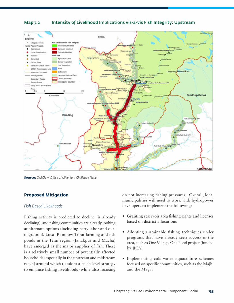
Chapter 7: Valued Environmental Component: Social 135
Proposed Mitigation
Fish Based Livelihoods
Fishing activity is predicted to decline (is already declining), and fishing communities are already looking at alternate options (including petty labor and out-migration). Local Rainbow Trout farming and fish ponds in the Terai region (Janakpur and Macha) have emerged as the major supplier of fish. There is a relatively small number of potentially affected households (especially in the upstream and midstream reach) around which to adopt a basin-level strategy to enhance fishing livelihoods (while also focusing
Map 7.2 Intensity of Livelihood Implications vis-à-vis Fish Integrity: Upstream
Source: OMCN = Office of Millenium Challenge Nepal
on not increasing fishing pressures). Overall, local municipalities will need to work with hydropower developers to implement the following:
• Granting reservoir area fishing rights and licenses based on district allocations
• Adopting sustainable fishing techniques under programs that have already seen success in the area, such as One Village, One Pond project (funded by JICA)
• Implementing cold-water aquaculture schemes focused on specific communities, such as the Majhi and the Magar

136 Cumulative Impact Assessment and Management: Hydropower Development in the Trishuli River Basin, Nepal
Other River-based Livelihoods
There will be an overall loss of productive riverine area in the midstream reach (and in select locations upstream) that cannot be replaced. Agricultural intensification schemes can be implemented to make upland areas more productive (through irrigation) so that the impact on overall productivity in the basin is mitigated.
Recommendations for Land-Procurement Strategy
Local municipalities and communities need to be made aware of the Land Acquisition, Resettlement and Rehabilitation Policy for Infrastructure Development Projects, 2015. Hydropower developers should agree to implement certain principles on compensation, consideration of existing economic vulnerabilities, and livelihood restoration.
Map 7.3 Livelihood Implications vis-à-vis Fish Integrity: Midstream
Source: OMCN = Office of Millenium Challenge Nepal

Chapter 7: Valued Environmental Component: Social 137
Cumulative Implications for Basin-Level Development
Project development of the 7 HPPs under construction and the other 23 projects under planning (mostly midstream and upstream of the basin) is likely to entail 7–10 years of intense construction activity. This timeline will also coincide with regional developments such as the OBOR linkage, increase in access-road construction, and gradual urbanization in the midstream.
During this timeline, the intensity of the following social impacts (see Table 7.10) are likely to amplify, at an overall basin-level, especially upstream in Rasuwa District:
• In-migration into the TRB
• Local economic and demographic changes
• Pressure on local resources linked to CFUGs, drinking water facilities, health infrastructure, and so forth
• Community health and safety impacts
Map 7.4 Livelihood Implications vis-à-vis Fish Integrity: Downstream
Source: OMCN = Office of Millenium Challenge Nepal

138 Cumulative Impact Assessment and Management: Hydropower Development in the Trishuli River Basin, Nepal
Theme Impacts Remarks on basin-level intensity
Challenges in mitigation and enhancement
In-migration An influx of migrant workers and others seeking economic opportunity around construction areas will lead to in-migration and localized changes in the demographic profile.
While in-migration may entail adverse effects on health, encroachment into forests, social conflicts, and cultural values of indigenous communities; there is an opportunity of overall economic development due to the influx of additional capital, demand for local goods and services, opportunity for petty trade, and so forth.
• There is limited monitoring of village- and municipality-level of demographic and economic changes linked to temporary and/or short- to medium-term in-migration that may have already occurred in Rasuwa and Nuwakot Districts.
• Further to decentralization, local governance units are yet to put in place any specific zonal plans on housing, waste management, business development, and social welfare that takes into account the effects of in-migration.
Community health and safety
• There is potential for an increase in vector-borne diseases, communicable diseases, and localized nuisance impacts due to dust, noise, and air emissions.
• Further reduction in water quality and availability due to waste management practices, blasting, and tunneling activities will increase vulnerability of the local community.
In view of the number of projects in Rasuwa District and in the upper reaches of the midstream section in Nuwakot, these areas are particularly vulnerable to adverse community health and safety impacts.
• There is a lack of community-health impact focused baseline data to monitor trends and outbreak of any diseases and/or conditions.
• There is likewise a lack of expansion plans to improve health care access in and around specific areas that have cascading HPPs.
Table 7.10 Basin-Level Intensity of Social Impacts
Benefit-sharing mechanisms to be put in place by NEA and other hydropower developers may encourage an additional influx into the area; reportedly, entities deemed to be residing on land to be developed at the start of construction are eligible for purchase of equity shares.
While the mitigation of adverse impacts and the enhancement of beneficial impacts is to some extent covered by EMPs of HPPs, there is a need to demarcate zones of intense hydropower development upstream, midstream, and downstream.
Each of these zones can adopt a localized, cumulative-impact management framework involving hydropower developers, their contractors, and local municipalities in monitoring and addressing such cumulative concerns. The cumulative-impact management framework can adapt useful indicators from the Hydropower Sustainability ESG Gap Analysis Tool (IHA 2018).
Continued on the next page.

Chapter 7: Valued Environmental Component: Social 139
Theme Impacts Remarks on basin-level intensity
Challenges in mitigation and enhancement
Employment generation
The coinciding timelines of the construction phase will entail labor requirement for unskilled and semiskilled categories of workers. Estimates suggest that the requirement for laborers within the 7–10 year construction period can range from 5,000–10,000. However, this employment is short term and nonpermanent in nature, as the operations phase of HPPs will not entail a retention of these numbers.
Even short-term employment generation will result in skill development (due to the specific nature of skills required for construction of HPPs) and an overall increase in the wage levels.
• There is a general lack of government and/or private institutions that can provide skill development training despite the increasing employability potential of the local communities.
• The focus of project developers (and their contractors) on minimizing costs and a lack of effective regulation for hiring practices provide developers with economic disincentives to hire local employment or, when they do, pay more than standard local wages.
Local infrastructure
Cumulative regional development of hydropower and ancillary facilities is likely to bring about overall physical infrastructure development with respect to roads, telecommunication, and accessibility to remote areas and access to electricity.
As planning of local infrastructure is being done by municipalities, there is limited attention to holistic infrastructure, access, and linkage plans across the basin.
• Lack of transparency and inadequate monitoring at the government level is leading to misuse of allocated funds for infrastructure development, either from the provincial/federal levels and/or through taxation of HPPs.


141
CHAPTER 8:
VALUED ENVIRONMENTAL COMPONENT: WATER RESOURCES
Rationale for Screening
Water availability in the Trishuli River Basin (TRB) depends on annual rainfall and glacier melt (upstream in the Tibet Autonomous Region) and is affected by extreme events and interventions such as river diversion schemes (Dandekheya et al, 2017). These have led to increased problems for water supply systems.
Stakeholder consultations indicate that other than domestic purposes, surface water from the Trishuli River itself is not used for drinking purposes. Most of the communities consulted indicated that they use untreated water from springs and from piped water systems provided by municipalities. However, consultations on potential VECs indicated that hydropower construction activities (particularly muck disposal), coupled with other factors such as sand and gravel mining and blasting for construction, have led to the following:
• Decline in surface water quality of the Trishuli River and also certain tributaries such as Tadi Khola, Chilime, and Mailung Khola
• Drying up of springs
Communities also indicate that in the aftermath of the 2015 earthquake they have also seen an intensification of water shortages. In view of limited baseline studies that consider water resources across the basin in its entirety, stakeholder consultations indicated the need to consider the same as a VEC.
Key Stressors
Local communities as well as chairpersons of municipalities perceive the following factors as stressors for water resources:
• Sand and gravel mining across the river basin (in spite of local regulations and interventions for control, such as in Dhading)
• Landslides and dumping of spoil as a consequence of access road construction
• Increased urbanization and lack of solid waste management, which result in waste dumping and sewage at locations along the banks of the river, particularly in Nuwakot and tourist towns of Rasuwa
• Climate change
• Potential that affected urban and rural municipalities around under-construction hydropower projects (HPPs) have experienced springs drying up due to tunneling, blasting, and other intrusive excavation activities
Based on information provided, there are no functional sewage treatment plants at a municipality and/or HPP level that have been installed in the basin.
Baseline Conditions Upstream
It has been reported that during the earthquake, water infrastructure such pipes in Rasuwa District were badly damaged, leaving villages with no access to clean and safe drinking water (CAFOD 2015). On the other hand, there is no use of river water for irrigation or for drinking due to the altitude and general riparian topography, which make access to the riverbank difficult.
The provision of new and improved water services is reported to be slow. In Gosaikunda, it is reported that community settlements rely on two to four springs for water, and that communities depend on one to two springs in Parbati Kunda, Kalika and Uttargaya. Three villages in Gosaikunda were badly affected by water shortages—Chilime, Goljung, and Sayphrubeshi. Consultations suggested that impacts on springs are due to the earthquake, landslides, and hydropower development. The shortage of water increased the workload for women and girls, since they have to

142 Cumulative Impact Assessment and Management: Hydropower Development in the Trishuli River Basin, Nepal
walk long distances to alternative sources to procure water for drinking for daily use.
Midstream
The midstream area in Nuwakot faces scarcity of safe drinking water, which is exacerbated by landslides, which engulf available drinking water pipelines (Dandekhya and Piryani 2015). In Kispang, Bidur, and Benighat, the major drinking water source is piped water supply and not linked to the river or to springs. The exception is in some villages, like Belkotgadi, where the communities have installed wells on the banks of the Trishuli.
Elsewhere, villagers had no quality concerns, but some communities depend on river water (from both the main river and its tributaries) for drinking during the latter part of the dry season, as the springs dry up and the public system is not reliable. The reduction in rainfall is seen to have increased the dependence on river water, while at the same time reducing the volume of surface water (which leads to deteriorating water quality and has health implications). In the monsoon season, landslides and intense rainfall have led to a reported disruption of water sources and spring conveyance systems (Dandekhya and Piryani 2015).
Downstream
It is estimated that each settlement in this district has one or two streams. Local communities use piped water for drinking (and not the Trishuli River). However, the source of water for agriculture varies from river water being channeled directly to the fields to some small-scale storage systems in the form of ponds and tanks. However, poor operation and maintenance of irrigation systems have been noted as a limiting factor in cultivating two or three crops per year. Water access is generally high due to the increased use of motor pumps and tube wells.
Surface Water Quality
The stressors noted in the “Key Stressors” section of Chapter 8 influence the levels of turbidity and coliform. These specific parameters have been used as indicators of the baseline condition of water quality as provided in Table 8.1.
As indicated, turbidity and coliform levels increase as the river moves downstream. While turbidity is highly dependent on seasonal variations in flow, increasing during the snowmelt and the monsoon, other factors such as sand and gravel mining, dumping of spoil from
Location Turbidity (NTU)
Exceedance of NDWQS
Coliforms Exceedance of NDWQS
Source
Upstream
Rasuwagadhi 17-33 Yes None No EIA of Rasuwagadhi HPP (NESS 2014a)
UT-1 <1-39 Yes High Yes EIA for UT-1 (NESS 2014b)
Midstream
Uttar Gaya 140 Yes >1100 Yes Water quality reports (NESS 2016)
Ratmate 130 Yes >1100 Yes Water quality reports (NESS 2016)
Belkogadi 110 Yes >1100 Yes Water quality reports (NESS 2016)
Downstream
Galchi 180 Yes >1100 Yes Water quality reports (NESS 2016)
Table 8.1 Baseline Water Quality (based on turbidity and coliform levels) at Various Sections along the River
Note: NTU = Nephelometric Turbidity Units; NDWQS = National Drinking Water Quality Standards.

Chapter 8: Valued Environmental Component: Water Resources 143
road construction, and landslides can contribute to increases in turbidity. However, turbidity levels are high as the river flows through the midstream and downstream sections, and it is likely that sand and gravel mining are significant contributors to high turbidity levels.
E-coli concentrations, while exceeding the National Drinking Water Quality Standards (NDWQS) at all sampling locations, is highest in the midstream and downstream sections. These are where major towns such as Betrawati, Bidur, Kurintar, and Ratmate are located. The release of untreated sewage into the river appears to be a major cause for these elevated levels.
Springs
The upstream area in Rasuwa District has witnessed drying up of springs in the aftermath of the earthquake. A study conducted by Youth Network for Social and Environmental Development (YONSED) in Laharepauwa, Ramche, and Bhorle villages in Rasuwa, identified 29, 30, and 55 springs, respectively, that had dried up (Dandekhya et al. 2017). Communities have reported that landslides had also washed away spring sources and affected water availability. Studies undertaken along tributaries midstream (Poudel and Duex 2017) have attributed drying up of springs to changes in hydrometeorological patterns.
Methodology
Available information on baseline water availability, arrangements, and quality were qualitatively assessed to determine if multiple HPPs can cumulatively further exacerbate water quality and shortages as well as impacts on springs. The methodology has the following limitations:
• There is no available information on monitoring of water quality in reservoir areas near the operational HPPs.
• There is limited hydrogeological data in the existing impact assessment reports on inventory of springs
1 A contractor of UT3A was found to be engaged in sand mining downstream of the project. This type of extraction may repeat in construction of other HPPs and trigger local commercial operations that continue well after HPP-triggered extraction has ceased.
and impacts for the same that can be spatially represented.
Significant Cumulative Impacts Surface Water
Water quality is already poor in the TRB, specifically in the midstream and downstream sections. Addition of future projects under the scenarios discussed are unlikely to act in concert to result in cumulative impacts. As discussed in “Overall Ecosystem Integrity” in Chapter 5, while additional projects are likely to further degrade habitats in the midstream sections (already highly degraded), these impacts cannot be considered cumulative, as they will tend to be spatially restricted. In addition, the impacts of stressors such as sand and gravel mining and disposal of soil seem to be more significant than hydropower development.1
Springs
There is limited multidisciplinary research on the watershed hydrogeology, socioeconomic dependence, impacts of climate change, and natural hazards on spring water to provide any conclusion remarks. However, a majority of the available literature has attributed drying up of springs to natural factors and not specifically to cumulative effects of HPPs. At a project level, a preconstruction baseline of springs in and around the dam, diversion tunnels, and other excavation areas (such as quarries) needs to be undertaken. Thereafter, hydropower developers (along with local municipality and district authorities) can consider launching watershed-scale spring rejuvenation programs targeting depression and contact springs by involving local communities, government agencies, and other stakeholders.

144 Cumulative Impact Assessment and Management: Hydropower Development in the Trishuli River Basin, Nepal
145
CHAPTER 9:
MITIGATION, MONITORING, AND MOVING TOWARD SUSTAINABLE DEVELOPMENT PATHWAYSSeveral sections of this report have summarized emerging recommendations and proposed mitigation measures for aquatic and terrestrial biodiversity and the social aspects of the valued environmental components (VECs). (See the “Proposed Mitigation” sections in Chapters 5 and 6 and the “Proposed Mitigation” subsections under “Religious and Cultural Sites” and “Livelihoods” in Chapter 7.) This section summarizes the monitoring regime based on emerging recommendations identified for selected VECs for the Trishuli River Basin (TRB) in order to mitigate cumulative impacts on valued ecosystem components (upstream, midstream, and downstream).
Cumulative Impact Management Framework
Each river reach of the TRB (municipalities within specific districts) can implement a localized impact management and monitoring framework that will address the following issues in order to mitigate impacts from multiple project development and construction projects: population influx, water resources, and health implications.
This framework will be developed as a component of the high-management action as recommended in Table 9.2—in particular, it can be part of the Developer’s Charter on Sustainable Hydropower Development in the basin. Actions and measures described as follows will be addressed by hydropower project (HPP) developers to manage their contribution to cumulative impacts.
• Ensure at least all mainstem HPPs operate in a run-of-river mode to maintain natural hydrology and water quality.
• Manage riparian landscapes surrounding reservoirs and areas upstream of reservoirs to minimize hypoxia in reservoirs.
• Monitor extent of in-migration and target local benefit-sharing/community investment funds to increase infrastructure and services capacity.
• Coordinate with rafting agencies to maintain flows suitable for recreational use, if any, and potentially provide suitable flows on specific days during the peak recreation period.
• Provide sufficient flows to maintain water levels for irrigation intakes during the dry season.
The proposed monitoring mechanism (see Table 9.1) provides a framework for developing the scope and framework for the implementation of the high-management action outlined in Chapter 10 and includes monitoring elements that can adapt pressure-state-response (PSR) models in Cumulative Impact Assessments as described in Neri et al. (2016) as well as the ESG Gap Analysis Tool (IHA 2018).
The Proposed High-Management Action
Ecological and social VECs in the TRB are presently under pressure from business as usual hydropower development, and they increase with the intensity of identified stressors. The recommended mitigation measures for each VEC can collectively contribute toward a high-management action that balances energy needs, environmental protection, stakeholder concerns, livelihoods, and management of water resources.
Here we present such actions as a road map to improving the ecosystem integrity of the TRB through collaboration and willingness across stakeholder groups (including developers and the government authorities) and through a commitment around actions that will cumulatively enhance the environmental and social aspects of the basin. The outcomes on

146 Cumulative Impact Assessment and Management: Hydropower Development in the Trishuli River Basin, Nepal
Table 9.1 Summary of Cumulative Impacts in TRB: Mitigation and Monitoring
Continued on the next page
Iden
tifi
ed V
EC
Key
non
-HP
P
stre
ssor
sC
um
ula
tive
im
pact
from
H
PP
s
Cu
mu
lati
ve im
pact
si
gnifi
can
ceP
ropo
sed
mit
igat
ion
mea
sure
s
Hyd
ropo
wer
de
velo
pers
Gov
ern
men
t au
thor
itie
sLo
cal c
omm
un
itie
s
Terr
estr
ial
biod
iver
sity
: La
ngt
ang
Nat
ion
al P
ark
(LN
P)
• In
fras
truc
ture
de
velo
pmen
t as
soci
ated
wit
h up
grad
ing
of t
he
Prit
hvi H
ighw
ay
and
the
prop
osed
One
B
elt,
One
Roa
d in
itia
tive
roa
d in
fras
truc
ture
co
nnec
ting
in
to t
he C
hina
bo
rder
• D
eclin
ing
popu
lati
ons
of s
peci
es o
f co
nser
vati
on
sign
ifica
nce
thro
ugh
illeg
al
extr
acti
on,
expl
oita
tion
, an
d ex
port
• N
o si
gnifi
cant
im
pact
s en
visa
ged
on
wild
life
disp
ersa
l an
d m
igra
tory
bi
rd c
orri
dors
• A
cces
s ro
ads
and
tran
smis
sion
lin
es w
ill p
rovi
de im
prov
ed
acce
ss a
nd p
oten
tial
ly
incr
ease
ille
gal e
ntry
into
the
LN
P, r
esul
ting
in t
he lo
ss a
nd
degr
adat
ion
of h
abit
at fr
om
logg
ing
and
wild
life
thro
ugh
poac
hing
.
• Lo
wer
cap
acit
y tr
ansm
issi
on
lines
wit
hin
the
park
hav
e a
min
imal
foot
prin
t an
d th
ereb
y do
not
impa
ct h
abit
at
for
thre
aten
ed o
r en
dem
ic
spec
ies.
• Tr
ansm
issi
on li
ne n
etw
ork
is u
nlik
ely
to e
ndan
ger
any
maj
or fl
yway
for
mig
rato
ry
bird
spe
cies
.
• C
ontr
acto
r M
anag
emen
t Pl
ans
to r
aise
aw
aren
ess
of c
ontr
acto
rs
enga
ged,
in
coor
dina
tion
wit
h lo
cal a
cces
s ro
ad
cont
ract
ors
• In
crea
sed
fund
ing
and
reso
urce
s to
LN
P fo
rest
gua
rds
• Sh
ared
acc
ess
road
dev
elop
men
t pl
an b
y ad
join
ing
mun
icip
alit
ies
to
redu
ce a
cces
s an
d di
stur
banc
e in
par
k
Aqu
atic
h
abit
at:
Hab
itat
qu
alit
y
• Sa
nd a
nd g
rave
l m
inin
g an
d pr
oces
sing
• So
il fr
om
land
slid
es a
nd
dum
ping
of
spoi
l fro
m r
oad
cons
truc
tion
de
grad
ing
aqua
tic
habi
tat
• A
lter
atio
n of
aqu
atic
ha
bita
ts a
nd
dete
rior
atio
n of
w
ater
qua
lity
as in
dica
ted
by e
cosy
stem
in
tegr
ity
resu
lts
acro
ss p
roje
ct
deve
lopm
ent
scen
ario
s
• Si
gnifi
canc
e w
as e
valu
ated
on
the
bas
is o
f eco
syst
em
inte
grit
y as
pre
dict
ed b
y th
e D
RIF
T m
odel
at
diff
eren
t EF
low
s si
tes.
Eco
syst
em
inte
grit
y is
exp
ecte
d to
pr
ogre
ssiv
ely
dete
rior
ate
base
d on
the
thr
ee s
cena
rios
m
odel
led
from
exi
stin
g ec
osys
tem
inte
grit
y ca
tego
ries
B
, C, a
nd D
(sl
ight
ly,
mod
erat
ely,
and
larg
ely
mod
ified
) to
cat
egor
ies
D
and
E (l
arge
ly a
nd s
erio
usly
m
odifi
ed)
for
the
full-
deve
lopm
ent
scen
ario
.
• R
elea
se o
f ade
quat
e EF
low
s fo
r aq
uati
c bi
odiv
ersi
ty
• D
evel
opm
ent
and
test
ing
of r
obus
t m
etho
dolo
gy fo
r aq
uati
c ba
selin
es
and
mon
itor
ing
• Tr
aini
ng o
f en
viro
nmen
tal
staff
in s
urve
y an
d m
onit
orin
g m
etho
ds
• R
esea
rchi
ng a
nd
test
ing
nove
l sur
vey/
mon
itor
ing
met
hods
(f
or e
xam
ple,
eD
NA
).
• •F
ish
surv
eys
carr
ied
out
by t
he F
ishe
ries
R
esea
rch
Stat
ions
• H
abit
at R
esto
rati
on
Plan
s to
be
prep
ared
• C
apac
ity
build
ing
for
staff
for
aqua
tic
base
line
surv
eys
and
mon
itor
ing
• R
evie
win
g an
d up
dati
ng o
f re
gula
tion
s fo
r aq
uati
c ha
bita
t pr
otec
tion
as
need
ed
• R
egul
atin
g sa
nd
min
ing
thro
ugh
mun
icip
alit
y le
vel
gove
rnan
ce
• C
omm
unit
y-ba
sed
prot
ecti
on
and
stew
ards
hip
of r
iver
rea
ches
w
ithi
n th
eir
area
of
infl
uenc
e/us
e
• Im
plem
enti
ng
acti
ons
for
cont
rolli
ng e
rosi
on
and
runo
ff in
to
the
rive
r, w
ith
emph
asis
on
thos
e pe
rtai
ning
to
acce
ss r
oads

Chapter 9: Mitigation, Monitoring, and Moving Toward Sustainable Development Pathways 147
Continued on the next page
Iden
tifi
ed V
EC
Key
non
-HP
P
stre
ssor
sC
um
ula
tive
impa
ct
from
HP
Ps
Cu
mu
lati
ve im
pact
si
gnifi
can
ceP
ropo
sed
mit
igat
ion
mea
sure
s
Hyd
ropo
wer
dev
elop
ers
Gov
ern
men
t au
thor
itie
sLo
cal
com
mu
nit
ies
Aqu
atic
h
abit
at:
Hab
itat
co
nti
guit
y
• Sa
nd a
nd
sedi
men
t m
inin
g
• A
cces
s ro
ads
that
may
ren
der
stre
tche
s of
the
ri
ver
upst
ream
ac
cess
ible
w
ith
pote
ntia
l in
crea
se in
un
regu
late
d fi
shin
g
• C
limat
e ch
ange
re
sult
ing
in
long
-ter
m
tem
pora
l ch
ange
s in
flow
in
div
ersi
on
reac
hes
alre
ady
com
prom
ised
by
low
flow
s ca
used
by
dam
s
• Im
pedi
men
ts t
o up
stre
am a
nd
dow
nstr
eam
m
igra
tion
in b
oth
mai
n st
em a
nd
trib
utar
ies
as a
re
sult
of m
ulti
ple
HPP
dam
s le
adin
g to
dec
lines
of S
now
Tr
out
and
Mah
seer
po
pula
tion
s
• •D
egra
dati
on o
f aq
uati
c ha
bita
ts
and
low
ered
w
ater
dep
ths
from
mod
ifica
tion
of
nat
ural
flow
re
gim
es le
adin
g to
impe
dim
ents
to
ups
trea
m
mig
rati
on
• Si
gnifi
canc
e is
ev
alua
ted
base
d on
D
RIF
T m
odel
ing.
Fi
sh in
tegr
ity
is e
xpec
ted
to
prog
ress
ivel
y de
teri
orat
e ba
sed
on t
he fo
ur
scen
ario
s m
odel
led.
Ex
isti
ng in
tegr
ity
rang
es fr
om
ecos
yste
m in
tegr
ity
cate
gory
B (
slig
htly
m
odifi
ed)
to
cate
gory
C o
r D
(m
oder
atel
y or
la
rgel
y m
odifi
ed).
Thes
e ar
e pr
edic
ted
to d
eter
iora
te
to c
ateg
orie
s. E
(s
erio
usly
mod
ified
) an
d F
(Cri
tica
lly
or e
xtre
mel
y m
odifi
ed)
for
the
full-
deve
lopm
ent
scen
ario
.
• Pr
ovis
ion
of fi
sh p
asse
s w
ith
desi
gn v
alid
atio
n by
a fi
sher
ies
expe
rt (
For
mos
t ex
isti
ng p
roje
cts,
th
e ex
pect
atio
n to
ret
rosp
ecti
vely
ad
d a
fish
pas
s or
fish
ladd
er
has
been
con
side
red
likel
y no
t pr
acti
cal.)
• En
hanc
ing
conn
ecti
vity
bet
wee
n m
ain
stem
and
tri
buta
ries
, in
clud
ing
rive
r tr
aini
ng, t
o be
m
aint
aine
d
• M
ahse
er a
nd S
now
Tro
ut
sanc
tuar
ies
• Pr
ovis
ion
of a
ppro
pria
te E
Flow
s ba
sed
on h
olis
tic
asse
ssm
ents
of
affec
ted
rive
r se
gmen
ts
• D
evel
opm
ent
and
test
ing
of
robu
st m
onit
orin
g m
etho
dolo
gy:
trai
ning
of e
nvir
onm
enta
l sta
ff
• M
onit
orin
g of
fish
pas
sage
and
ab
unda
nce
duri
ng m
igra
tory
se
ason
• M
onit
orin
g an
d en
forc
emen
t of
fu
ncti
onin
g fi
sh
ladd
er a
nd E
Flow
s re
leas
es
• C
apac
ity
build
ing
for
mon
itor
ing
fish
pas
sage
s an
d m
igra
tory
fish
es
• En
forc
emen
t of
fi
shin
g an
d m
inin
g re
gula
tion
s
• En
hanc
emen
t of
fi
sh b
reed
ing
area
s in
tri
buta
ries
• A
ddit
iona
l res
earc
h on
fish
hat
cher
ies
to in
tern
atio
nal
stan
dard
s
• C
omm
unit
y-ba
sed
regu
lati
on
of c
aptu
re
fish
erie
s fo
r Sn
ow T
rout
an
d G
olde
n M
ahse
er
• C
omm
unit
y-ba
sed
prot
ecti
on o
f fi
sh b
reed
ing
area
s in
tr
ibut
arie
s
Cu
ltu
ral a
nd
relig
iou
s si
tes:
U
ttar
gaya
an
d D
evig
hat
• Sa
nd-
and
grav
el-m
inin
g ac
tivi
ties
re
sult
ing
in
degr
adat
ion
of
rive
r ba
nks
wit
h ri
ver
subs
iden
ce
alte
ring
wat
er
qual
ity
• R
educ
tion
in fl
ow
in s
peci
fic
rive
r se
gmen
ts (
for
exam
ple,
div
ersi
on
reac
hes)
• Si
gnifi
canc
e is
ev
alua
ted
base
d on
w
ater
qua
lity
and
flow
. Fl
ow im
pact
s ar
e ex
pect
ed t
o be
mor
e pr
ojec
t-sp
ecifi
c ra
ther
tha
n cu
mul
ativ
e an
d be
st m
anag
ed a
s pa
rt o
f ind
ivid
ual
proj
ect
EIA
rev
iew
pr
oces
s.
• U
nder
taki
ng a
n as
sess
men
t of
the
act
ual r
equi
rem
ents
for
wat
er fl
ow in
dew
ater
rea
ches
for
norm
al r
itua
ls a
s w
ell a
s du
ring
sp
ecifi
c ti
mes
thr
ough
the
yea
r, es
peci
ally
dur
ing
the
dry
seas
on
peri
od
• R
egio
nal p
olic
y di
rect
ives
to
tem
pora
rily
sto
p m
inin
g ac
tivi
ties
at
leas
t du
ring
ke
y fe
stiv
als
and
pilg
rim
ages
an
d re
gion
ally
si
gnifi
cant
rit
uals
• R
aisi
ng
awar
enes
s am
ong
loca
l co
mm
unit
ies
and
sand
- an
d gr
avel
-m
inin
g en
titi
es fo
r m
anag
emen
t of
was
te
alon
g w
ith
spec
ific
zone
s be
ing
decl
ared
for
muc
k/sp
oil
disp
osal
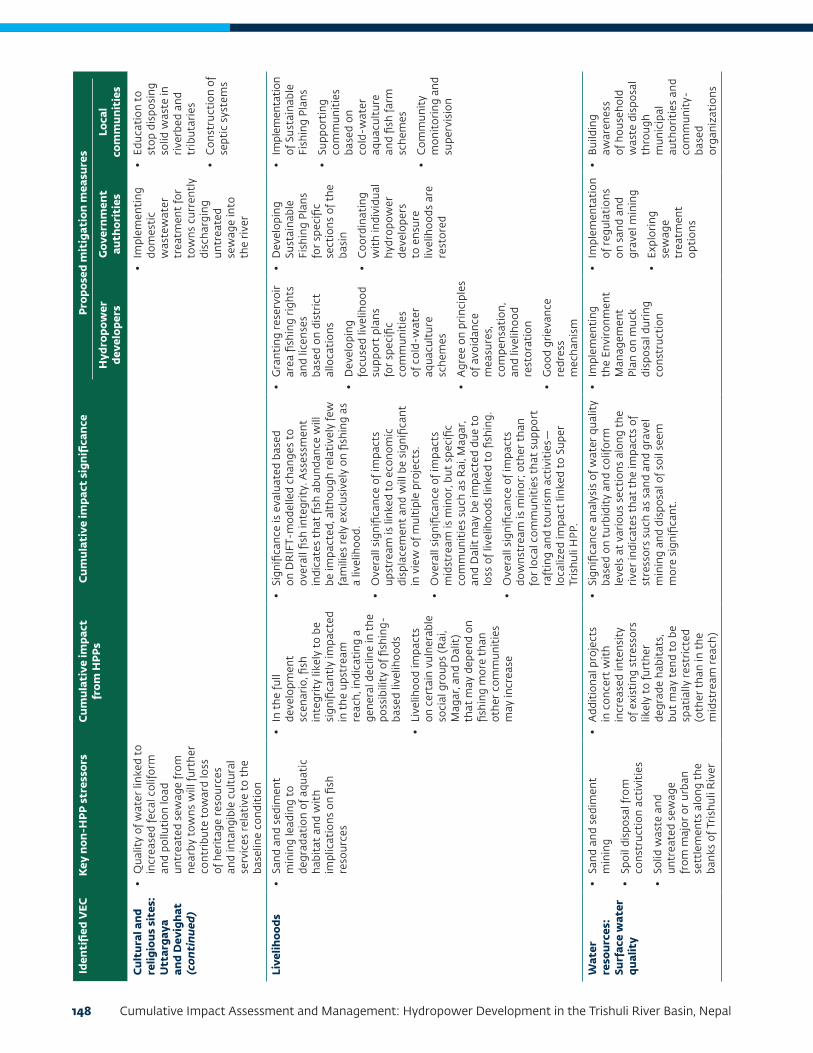
148 Cumulative Impact Assessment and Management: Hydropower Development in the Trishuli River Basin, Nepal
Iden
tifi
ed V
EC
Key
non
-HP
P s
tres
sors
Cu
mu
lati
ve im
pact
fr
om H
PP
sC
um
ula
tive
impa
ct s
ign
ifica
nce
Pro
pose
d m
itig
atio
n m
easu
res
Hyd
ropo
wer
de
velo
pers
Gov
ern
men
t au
thor
itie
sLo
cal
com
mu
nit
ies
Cu
ltu
ral a
nd
relig
iou
s si
tes:
U
ttar
gaya
an
d D
evig
hat
(c
onti
nu
ed)
• Q
ualit
y of
wat
er li
nked
to
incr
ease
d fe
cal c
olifo
rm
and
pollu
tion
load
un
trea
ted
sew
age
from
ne
arby
tow
ns w
ill fu
rthe
r co
ntri
bute
tow
ard
loss
of
her
itag
e re
sour
ces
and
inta
ngib
le c
ultu
ral
serv
ices
rel
ativ
e to
the
ba
selin
e co
ndit
ion
• Im
plem
enti
ng
dom
esti
c w
aste
wat
er
trea
tmen
t fo
r to
wns
cur
rent
ly
disc
harg
ing
untr
eate
d se
wag
e in
to
the
rive
r
• Ed
ucat
ion
to
stop
dis
posi
ng
solid
was
te in
ri
verb
ed a
nd
trib
utar
ies
• C
onst
ruct
ion
of
sept
ic s
yste
ms
Live
lihoo
ds
• Sa
nd a
nd s
edim
ent
min
ing
lead
ing
to
degr
adat
ion
of a
quat
ic
habi
tat
and
wit
h im
plic
atio
ns o
n fi
sh
reso
urce
s
• In
the
full
deve
lopm
ent
scen
ario
, fish
in
tegr
ity
likel
y to
be
sign
ifica
ntly
impa
cted
in
the
ups
trea
m
reac
h, in
dica
ting
a
gene
ral d
eclin
e in
the
po
ssib
ility
of fi
shin
g-ba
sed
livel
ihoo
ds
• Li
velih
ood
impa
cts
on c
erta
in v
ulne
rabl
e so
cial
gro
ups
(Rai
, M
agar
, and
Dal
it)
that
may
dep
end
on
fish
ing
mor
e th
an
othe
r co
mm
unit
ies
may
incr
ease
• Si
gnifi
canc
e is
eva
luat
ed b
ased
on
DR
IFT-
mod
elle
d ch
ange
s to
ov
eral
l fish
inte
grit
y. A
sses
smen
t in
dica
tes
that
fish
abu
ndan
ce w
ill
be im
pact
ed, a
ltho
ugh
rela
tive
ly fe
w
fam
ilies
rel
y ex
clus
ivel
y on
fish
ing
as
a liv
elih
ood.
• O
vera
ll si
gnifi
canc
e of
impa
cts
upst
ream
is li
nked
to
econ
omic
di
spla
cem
ent
and
will
be
sign
ifica
nt
in v
iew
of m
ulti
ple
proj
ects
.
• O
vera
ll si
gnifi
canc
e of
impa
cts
mid
stre
am is
min
or, b
ut s
peci
fic
com
mun
itie
s su
ch a
s R
ai, M
agar
, an
d D
alit
may
be
impa
cted
due
to
loss
of l
ivel
ihoo
ds li
nked
to
fish
ing.
• O
vera
ll si
gnifi
canc
e of
impa
cts
dow
nstr
eam
is m
inor
; oth
er t
han
for
loca
l com
mun
itie
s th
at s
uppo
rt
raft
ing
and
tour
ism
act
ivit
ies—
loca
lized
impa
ct li
nked
to
Supe
r Tr
ishu
li H
PP.
• G
rant
ing
rese
rvoi
r ar
ea fi
shin
g ri
ghts
an
d lic
ense
s ba
sed
on d
istr
ict
allo
cati
ons
• D
evel
opin
g fo
cuse
d liv
elih
ood
supp
ort
plan
s fo
r sp
ecifi
c co
mm
unit
ies
of c
old-
wat
er
aqua
cult
ure
sche
mes
• A
gree
on
prin
cipl
es
of a
void
ance
m
easu
res,
co
mpe
nsat
ion,
an
d liv
elih
ood
rest
orat
ion
• G
ood
grie
vanc
e re
dres
s m
echa
nism
• D
evel
opin
g Su
stai
nabl
e Fi
shin
g Pl
ans
for
spec
ific
sect
ions
of t
he
basi
n
• C
oord
inat
ing
wit
h in
divi
dual
hy
drop
ower
de
velo
pers
to
ens
ure
livel
ihoo
ds a
re
rest
ored
• Im
plem
enta
tion
of
Sus
tain
able
Fi
shin
g Pl
ans
• Su
ppor
ting
co
mm
unit
ies
base
d on
co
ld-w
ater
aq
uacu
ltur
e
and
fish
farm
sc
hem
es
• C
omm
unit
y m
onit
orin
g an
d su
perv
isio
n
Wat
er
reso
urc
es:
Surf
ace
wat
er
qual
ity
• Sa
nd a
nd s
edim
ent
min
ing
• Sp
oil d
ispo
sal f
rom
co
nstr
ucti
on a
ctiv
itie
s
• So
lid w
aste
and
un
trea
ted
sew
age
from
maj
or o
r ur
ban
sett
lem
ents
alo
ng t
he
bank
s of
Tri
shul
i Riv
er
• A
ddit
iona
l pro
ject
s in
con
cert
wit
h in
crea
sed
inte
nsit
y of
exi
stin
g st
ress
ors
likel
y to
furt
her
degr
ade
habi
tats
, bu
t m
ay t
end
to b
e sp
atia
lly r
estr
icte
d (o
ther
tha
n in
the
m
idst
ream
rea
ch)
• Si
gnifi
canc
e an
alys
is o
f wat
er q
ualit
y ba
sed
on t
urbi
dity
and
col
iform
le
vels
at
vari
ous
sect
ions
alo
ng t
he
rive
r in
dica
tes
that
the
impa
cts
of
stre
ssor
s su
ch a
s sa
nd a
nd g
rave
l m
inin
g an
d di
spos
al o
f soi
l see
m
mor
e si
gnifi
cant
.
• Im
plem
enti
ng
the
Envi
ronm
ent
Man
agem
ent
Plan
on
muc
k di
spos
al d
urin
g co
nstr
ucti
on
• Im
plem
enta
tion
of
reg
ulat
ions
on
san
d an
d gr
avel
min
ing
• Ex
plor
ing
sew
age
trea
tmen
t op
tion
s
• B
uild
ing
awar
enes
s of
hou
seho
ld
was
te d
ispo
sal
thro
ugh
mun
icip
al
auth
orit
ies
and
com
mun
ity-
base
d or
gani
zati
ons

Chapter 9: Mitigation, Monitoring, and Moving Toward Sustainable Development Pathways 149
ecosystem integrity are thereafter inferred based on extrapolation of the DRIFT model results.
The high-management action comprises a combination of quasi-regulatory, incentive-based, and technical measures to manage fish populations in the basin along with regulation of sediment mining and watershed management, which will contribute to the improvement of habitats and consequently reduction of cumulative impacts across VECs. This scenario suggests measures to be jointly implemented by hydropower developers, municipalities, and local communities, facilitated by the perception of shared benefits until a basin-level sustainable hydropower strategy for Trishuli is adopted by the government of Nepal.
The high-management action packages and complements the actions provided in Table 9.1 and enables the formation of a local institutional and community-based framework to implement the actions.
Assumptions
The high-management action is premised on the following assumptions:
• Hydropower developers across the TRB will sign on to a Cumulative Impacts Management Charter that goes beyond compliance requirements of Environment Management Plan (EMP) implementation of individual HPPs. This charter will form the basis of a formal structure to set up the Trishuli Hydropower Developer’s Forum (THDP) as a developer-driven institution to manage cumulative impacts.
• Municipalities will be empowered under the proposed revisions to the Environment-Friendly Local Governance Framework (2013) to form Local Impact Management Committees (LMCs), which will include participation from hydropower developers and local nongovernmental organizations and community-based organizations.
• A Technical Resource Group (through participation by government ministries and conservation and research agencies) will provide strategic support and guidance for approval by the THDF and implementation by the LMCs.
Summary of Sustainable Development Pathways
Table 9.2 summarizes sustainable development pathways that can be conceptualized and implemented under the high-management action.
Changes in Ecosystem Integrity in the High-Management Action
This section compares the ecosystem integrity across project development scenarios (existing, under construction, and full development) to extrapolate implications for the high-management action.
The present ecological status (PES) of the river was first established on the basis of the recommendations of the EFlows assessment team, which visited the basin in March 2018. Available ESIA reports for HPPs in the basin, including that for the UT-1 project and baseline studies conducted as a part of the CIA, also provided a basis for determination of the PES of the basin.
The DRIFT modelling presents impacts as changes in the abundance of indicators that represent the river ecosystem compared to the present day status of the indicators. The indicators include fish species and other elements in the food chain, such as the macroinvertebrates and algae, and habitat characteristics such as flow, hydraulics, and river morphology. In addition to the impacts of hydropower development in the basin, there are a number of anthropogenic pressures that reduce fish populations on the river ecosystems, such as fishing, itself; extraction of sediments, including sand, gravel, and boulders forming the riverbeds, that damages aquatic habitats; and disposal of polluted water and solid waste in the river, which affects the water quality and consequentially the habitat quality.
As indicated in Figure 9.1, the PES of the TRB was assessed as 67% or slightly/moderately modified. The PES is shown as a horizontal line for reference purposes. Thereafter, changes in PES over time and with increasing hydropower development, represented in the project development scenarios, are predicted across the set-ups indicated.

150 Cumulative Impact Assessment and Management: Hydropower Development in the Trishuli River Basin, Nepal
Theme Description Responsibility
Developer’s Charter on Sustainable Hydropower in the Trishuli River Basin
This is anticipated to be a vision- and commitment-driven document that will include the following:
• Applying a uniform set of standards for including fish passes in the design of projects based on a review of contemporary and innovative designs for fish passes in conjunction with leading experts in this discipline
• Developing guidelines to prepare and implement an environmental flow management framework for each HPP based on available secondary guidance on adaptive management (This should be project- or reach-specific, keeping in mind ecological, cultural, and social sensitivities inherent for the river reach.)
• Researching and developing a robust standard methodology for aquatic baseline surveys and monitoring for Environmental and Social Impact Assessments (ESIAs) to be used by all HPPs and possibly adopted into government regulations (and training HPP and government staff in methodologies)
• Assessing land-based and livelihood impacts from projects in order to develop and fund livelihood restoration measures (focused on fishing, skills development, and agricultural intensification schemes as identified in the recent free, prior, and informed consent agreement for UT-1) as a form of local community development around HPPs
• Expanding the regulatory EMPs into a comprehensive Environment and Social Management Plan (such as in the case of Upper Trishuli-1), which will incorporate safeguards to manage localized social impacts linked to in-migration, resource requirements, and community health and safety
• Conducting issue- and theme-specific studies for sensitivities within the area of influence of the HPP, such as assessment of flows for cultural practices; inventory of springs, and so forth
• Developing principles for all future land acquisition based on avoidance measures, compensation at replacement cost, informed consultation and participation, and emphasis on livelihood restoration of affected communities
• Supporting suppliers of sand, gravel, and aggregates to implement sustainable mining techniques
• Creating overarching framework on contractor management with specific safeguards to manage unregulated fishing, access into forest areas, muck disposal, and any other waste dumping related to project-induced influx
• Developing and monitoring project-specific grievance redress mechanisms
Representatives from key developers; such as NWEDC, Super Trishuli, and NEA, may come together to agree on provisions of the charter. The Technical Resource Group can help the THDF formulate a charter. The charter will be monitored by a subgroup of each LMC. Based on the recommendations outlined in the CIA, the Developer’s Charter on Sustainable Hydropower can be prepared within a three-month timeline, after which, each HPP can develop an implementation plan for relevant commitments.
Trishuli Hydropower Developers Forum (THDP) with support from Local Impact Management Committees (LMCs) as per Chapter 10
Table 9.2 Proposed High-Management Action
Continued on the next page

Chapter 9: Mitigation, Monitoring, and Moving Toward Sustainable Development Pathways 151
Theme Description Responsibility
Community-based river guards across river reaches
Each LMC will deploy community-based river guards and associated field-level supervision to undertake the following:
• Detect violation of restrictions, rules, and regulations approved by the LMC for protection of the river and tributaries and take corrective actions as permissible
• Maintain contact with the local community and promote awareness and education on the importance of natural resources (including illegal sand mining and unregulated fishing)
• Support implementation of incentive-based measures such as community-based sustainable fishing
• Collect data on status of protection and awareness, record grievances, and report
LMCs as per Chapter 10
Preparation and implementation of Sustainable Fishing Plans
Mechanisms on regulated fishing managed by local communities in coordination with hydropower developers can be prepared by LMCs with support from the Technical Resource Group. The basic principles followed include establishing a conservation program, conducting research to estimate sustainable harvesting quotas, setting up a system of permitting for harvesting, utilizing the revenues generated to manage the conservation and harvesting program, and monitoring to ensure the program objectives—including protection of fish populations and sustainability of the program—are met.
LMCs as per Chapter 10
Development of indigenous fish hatcheries for fish stocking
Where an HPP limits the access of the fish to its breeding areas that are generally located in the tributaries, stocking of fish bred in a hatchery can be considered as a means for mitigating the loss of breeding areas. It is advisable to consider captive breeding and stocking as a measure that is supplemental to other management measures such as protection, habitat management, and fish passes, rather than a substitute for them.
LMCs as per Chapter 10 supported by Fishery Research Center (Fisheries Research Stations Nuwakot and Dhunche).
Farming of commercially valuable fish species
Providing alternative means of incomes or livelihoods through promotion of fish farming can help reduce anthropogenic pressures on the river ecosystems. There are several Brown Trout (Salmo Trutta) and Rainbow Trout (Oncorhynchus mykiss) farms, some of them started with international assistance (for example, JICA) with considerable capacity and commitment. Such farms should be developed in areas where indigenous fish stocks are depleted due to overfishing. It is to be emphasized here that farming of indigenous fish species is far more preferable than farming invasive trout species that may compete and suppress wild populations of indigenous species.
LMCs as per Chapter 10 supported by Fisheries Research Centre
Preparation and implementation of Sustainable Sediment Mining Plans
Given that it is entirely plausible that the demand for sediment will continue to increase in the foreseeable future, achieving the high management will necessitate management and control that will limit the impact of mining on the river and its tributaries in the face of increased demand and volumes being abstracted. These mining plans will be elaborated to include the following:
• Ban of mining in sensitive areas and identifying nonsensitive areas to focus mining activities
• Implementation of on-site control of mining activities related to equipment and techniques used, manage spoil disposal, and so forth
• Rehabilitation and restoration of habitats already degraded by mining, especially in the midstream reach
LMCs as per Chapter 10 with potential assistance from the District Coordination Committee
Continued on the next page

152 Cumulative Impact Assessment and Management: Hydropower Development in the Trishuli River Basin, Nepal
Theme Description Responsibility
Preparation and implementation of Sustainable Sediment Mining Plans (continued)
• Identification of alternative sources of aggregate for construction, including (i) reuse of spoil from construction of HPPs and (ii) use of open rock quarries on hillsides (with due recognition of any springs) as source of gravels
• An important component of the sustainable sediment-mining plans will be to appoint community-based mining supervisors and river guards from within the LMCs to enforce restrictions on mining. Depending on the level of pressure from mining, the number of supervisors and guards assigned for this purpose can vary, and where pressures are low, the responsibilities for implementation of the sustainable sediment-mining plan can be assigned to the river guards.
• These mining plans should be developed by municipalities, as sand and sediment mining enterprises are a major source of revenue. There is also an overlap between owners of sand-mining entities and key local leaders (including municipality representatives). Municipalities may seek support from the Technical Resource Group for (i) the identification of mining areas through modelling (to predict the location, quality, and quantity of sediment deposits linked with HPPs); (ii) identification of key ecological sites or reaches within the system, to ascertain no-go or restricted use areas; and (iii) define the necessary engagement with the affected mining and local community.
Watershed management
A watershed management program can help improve water quality in the basin and play a critical role in protection of biodiversity and river-based livelihoods. Actions that can be supported by the THDF and LMCs include (i) programs focusing on areas needing reforestation to meet community requirements for fuel wood and timber, while being watchful of the limits of sustainable harvesting to reduce erosion and risk of landslides; and (ii) land use management. The watershed management program should also have a link to any basin-level plans, benefit-sharing plans. It should be developed and implemented in partnership with the provincial government to allow for the coordinated planning and implementation of watershed and community investment initiatives. Suggestions for management of water use in both agriculture and households and management of water quality at the local level must also be included.
LMCs as per Chapter 10
Delineating no-go areas for hydropower development
Management committees should strongly advocate for the setting aside of stretches of river and tributaries that are of high ecological importance and can help in preservation of key features of aquatic biodiversity in the basin. They can include spawning grounds of fish and stretches and certain tributaries that are still in pristine condition. An example is the undammed Nyam khola, a tributary of the Mailung Khola, which is an important source site for Common Snow Trout of the Mailung Khola downstream of the dewatered area of the Mailung Khola HPP. LMCs, through the THDF, will recommend certain no-go areas for consideration by DoED, NEA, and MoEWRI. The Technical Resource Group will support in capacity building and in reaching out to the provincial and national government ministries and departments to identify and manage these no-go areas.
LMCs as per Chapter 10
Mahseer and Snow Trout sanctuary
Consider designating one or more important fish spawning tributaries (for example, the Tadi Khola) as a Mahseer and Snow Trout sanctuary, which would remain free flowing (that is, no hydropower development) and develop and foster domestic wastewater treatment and solid waste management to improve water quality and riparian and river health.
THDF with support from the LMCs

Chapter 9: Mitigation, Monitoring, and Moving Toward Sustainable Development Pathways 153
Figure 9.1 Comparison of Business-as-Usual and High-Management Development Action
E
D
C
B
A100%
90%
80%
70%
60%
50%
40%
30%
20%
10%
0%
1000
900
800
700
600
500
400
300
200
100
0
MW BAU All Projects HM PES
Ecol
ogic
al in
tegr
ity
Cap
acit
y of
pro
ject
(MW
)
Present ecological status:Baseline status of river
If projects were limited in the basin
Business As Usual: If pressures continueunchecked and hydropower development occurs against existing regulations
ExistingScenario 1
Under-constructionScenario 2a
Under-construction and committed
Scenario 2b
Full developmentScenario 3
If all developers were toimplement high management
actions
Results from the Jhelum-Poonch Basin, Pakistan, were used to prepare indicative predictions for impacts of the high-management actions to control anthropogenic pressures in the TRB on the ecosystem integrity of the river.
Explanations for the management actions are provided in Table 9.3.
The comparison of project development scenarios (Table 9.3) by incorporating high-management actions suggests that a concerted effort across stakeholders, facilitated by a perception of shared benefits, can help restore ecosystem integrity of the TRB to the PES level.
Table 9.4 summarizes changes in ecosystem integrity under the different management scenarios.
In summary, this analysis indicates the following (refer to Table ES.3 and Table ES.4 for details on ecosystem integrity ratings A to F):
• Present Ecological Status (PES) shows the Trishuli River maintaining its existing ecosystem integrity of B/C assuming no new hydropower development or increase in external stressors.
• Business-as-Usual (BAU) Scenario shows ecosystem integrity of the Trishuli River degrading from existing B/C conditions to C/D as under-construction HPPs come on line, decreasing further to D as the committed project (UT-1 HPP) is constructed, and ultimately falling to D/E as future planned projects are developed. Clearly this would not be a sustainable outcome.

154 Cumulative Impact Assessment and Management: Hydropower Development in the Trishuli River Basin, Nepal
Table 9.3 Interpretation and Inference
Set-up/ scenario Description Responsibility
Hydropower impacts only
This set-up represents the predictions of changes in ecological integrity of the river system in the basin using the DRIFT model on the basis of impact of HPPs alone, and ignoring the impact of anthropogenic pressures or the improvement in ecological integrity due to measures introduced to manage the pressures. This is necessary as all results obtained for the other scenarios refer to this.
For this scenario, over a 30-year period, the ecological integrity is predicted to decline from the PES of 67 percent (slightly modified/moderately modified) with existing projects to 64 percent with under-construction projects, to 59 percent with committed projects, and to 47 percent (moderately/largely modified) under full development.
Business as usual This set-up presents a condition in which anthropogenic pressures on the river ecosystem continue unchecked and increase in line with present trends. This scenario reflects the current state of management in the Trishuli River supported by the observations made by the EFlows assessment team in March and April 2018. The salient anthropogenic pressures considered are unsustainable fishing practices leading to depletion of fish stocks and unchecked sand and gravel mining.
Assuming full development of hydropower in the basin as represented by the planned scenario, the ecological integrity is predicted to decline to seriously/critically modified due to the combined impact of hydropower projects and resource extraction.
High-management actions by all developers
This set-up models the predicted change to ecosystem integrity if all hydropower developers implement high-management measures.
If all the projects in the basin were to implement the high-management action, the ecological integrity of the basin is expected improve by about 35 percent as compared to the business-as-usual scenario with committed developments. This will result in improvement of ecological integrity slightly above the PES, maintaining it as slightly modified/moderately modified.
Limiting project development
This set-up assesses the implications if case projects located in ecologically sensitive areas are avoided.
It will be possible to improve the ecological integrity of the basin to category B, or slightly modified, if some of the projects located in ecologically sensitive areas could be avoided.
• All Projects High-Management Action also shows the ecosystem integrity of the Trishuli River degrading to C/D as under-construction HPPs come on line, but then an improvement to a B ecosystem integrity rating as high-management measures are required for all new HPPs and retro-fitted on the existing HPPs. In the full-development scenario, given the sheer magnitude of the impacts associated with 23 additional HPPs (committed and planned), the Trishuli River ecosystem integrity is ultimately predicted to degrade back to a C, even if all projects
apply good international industry practice (GIIP)
per International Finance Corporation Performance
Standards. An ecosystem integrity rating of B could
be maintained, however, if the future number of
HPPs in the basin were limited.
Based on the DRIFT model results, the analysis above
suggests that implementation of a high-management
action can help maintain, or even improve, the ecosystem
integrity of the TRB.

Chapter 9: Mitigation, Monitoring, and Moving Toward Sustainable Development Pathways 155
Table 9.4 Changes in Ecosystem Integrity under Different Management Scenarios
Project development scenarios
Existing (Scenario 1)
Under- construction (Scenario 2a)
Under- construction
and committed (Scenario 2b)
Full development (Scenario 3)
Business-as-usual B/C C/D D E
All projects high-management action
B/C C/D B/C+ C
Limiting projects in the basin, with remaining projects under high-management action, supported by the government of Nepal and other stakeholders
B/C C/D B/C+ B/C+

156 Cumulative Impact Assessment and Management: Hydropower Development in the Trishuli River Basin, Nepal

157
CHAPTER 10:
IMPLEMENTATION ARRANGEMENTS AND CONCLUSIONSChapter 10 summarizes the suggested institutional arrangements and structure to implement mitigation measures provided in the high-management actions across the Trishuli River Basin (TRB). The structure and approach toward implementation have taken cognizance of the following:
• USAID’s Program on Aquatic Natural Resources Improvement’s River Stretch Co-Management Concept Paper (forthcoming)
• Information available in the public domain on the evolving regulatory landscape for Nepal to govern river-basin planning and sustainable hydropower development
• Feedback and insights from participants at the Fourth Hydropower Developer’s Forum, facilitated on November 29, 2018
Organization Structure
It is recommended that three key collaborative management groups be formed to implement sustainable development pathways identified under the high-management action as in the proposed institutional structure in Figure 10.1.
Senior leadership and representatives of hydropower developers across the TRB can consider coming together to form the Trishuli Hydropower Developer’s Forum (THDF) at a Kathmandu level in order to be accountable for overall implementation.
The THDF may facilitate the formation of Local Impact Management Committees (LMCs) across the upstream, midstream, and downstream reaches of the basin. The key roles and responsibilities of the LMCs are to implement and monitor the high-management action for an identified river stretch in order to manage their local river sources for multiple uses (for example, sustainable capture fisheries, environmentally friendly
irrigation infrastructure, and sustainable hydropower, among others), with a focus on aquatic biodiversity conservation.
In recognition of the need to provide strategic support, undertake studies, and provide guidance to the LMCs and the THDF, a Technical Resource Group (TRG) can be formed through funding from the THDF. (See “Budget and Funding Modalities” in Chapter 10.)
Overarching River Basin Management Plan
For the TRB, a conceptual framework like the one developed for the Koshi Basin Program, (Figure 10.2) can help develop shared understanding and effective communication among all stakeholders involved in the process of basin-wide water management.
The Soil and Water Assessment Tool and Water Evaluation and Planning System assessment tools were used in the Koshi Basin Program to determine in which geographic region or location there is higher precipitation and water availability in the water basin. On these were superimposed sector demands for highest water need by use (hydropower, agriculture, and domestic), along with seasonal and interannual variability in water availability.
The Soil and Water Assessment Tool and Water Evaluation and Planning System assessment tools were used in the Koshi Basin Program to determine in which geographic region or location there is higher precipitation and water availability in the water basin. On these were superimposed sector demands for highest water need by use (hydropower, agriculture, and domestic), along with seasonal and interannual variability in water availability.
Using the Koshi Basin Program as inspiration, the proposed institutional structure for TRB can be set up to implement high-management actions that are combined into a TRB Management Plan by the TRG in the context of the Sustainable Hydropower Development

158 Cumulative Impact Assessment and Management: Hydropower Development in the Trishuli River Basin, Nepal
Charter. This TRG may be coordinated by a think tank or conservation agency respected by the local communities in the basin and will be supported by the Fisheries Research Station (Nuwakot and Dhunche); district and provincial department representatives of Ministry of Forests and Environment, Ministry of Population, Ministry of Federal Affairs and Local Development, and the Fisheries Department; and inputs from district chapters of Federation of Community Forestry Users Nepal.
It is strongly recommended that an LMC for the upstream reach be set up first, given the advanced stage of environmental and social planning under the Nepal Electricity Authority and other developers such as UT-1, and that lessons learned from this initiative
be emulated across all identified stretches. The Trishuli Basin Management Plan should ultimately capture the basin-wide collective experience from all LMCs.
The TRB Management Plan will also include a specific data collection and monitoring protocol that should be the basis for collaborative monitoring through the LMCs. The Hydropower Sustainability Assessment Protocol (ESG Tool) may be used to develop the same. The TRB Management Plan (TRBMP) will be presented to the THDF, local municipality authorities and the LMCs (once formed), and thereafter handed over for implementation. The TRG may revisit the TRBMP once policies governing basin-level planning are disclosed.
Figure 10.1 Proposed Institutional Structure
Trishuli Hydropower Developers Forum
• Developers• Lenders (facilitated by the IFC)• NEA• DoED• MoFE• MoEWRI• Others by invitation
Community volunteers for implementation
Project-specific forums (e.g. UT1 Adivasi Janajati Advisory
Council
Local HSE leads of projectssuch as UT1, UT3A,
Mailung, etc.
Municipalityrepresentatives
Structure of LMC2 in upstream reach of TRB
Community river guards and mining supervisors
for monitoring activities
Local Impact Management Committee 1 (LMC1)
Local Impact Management Committee 2 (LMC2) LMC3 LMC4, etc.
Technical Resources Group
Note: IFC = International Finance Corporation; NEA = Nepal Electricity Authority; DoED = Department of Electricity; MoFE = Ministry of Forests and Environment; MoEWRI = Ministry of Energy, Water Resources and Irrigation.

Chapter 10: Implementation Arrangements and Conclusions 159
Figure 10.2 Conceptual Framework for the Koshi Basin Program
Source: ICIMOD n.d.

160 Cumulative Impact Assessment and Management: Hydropower Development in the Trishuli River Basin, Nepal
Facilitating the formation of Local Impact Management Committees
Constituting the LMCs
The structure of each LMC will build on existing networks of health, safety, and environment teams of hydropower developers; river-user groups (fishing, irrigation, sanitation, and so forth); Langtang National Park authorities; Community Forest User Groups, and representatives of project-specific committees: for example, the UT-1 Adibasi Janajati Advisory Council. The process of selecting volunteers to implement the TRBMP and its monitoring (through river guards and mining supervisors) will give priority to groups that are dependent on river-based livelihoods and will give due consideration to gender equity and social inclusion.
A suggested function of each LMC includes the following:
• Implementation of the TRBMP for an identified spatial stretch of the river
• Creating awareness among local communities and settlements on biodiversity conservation, proper waste management, and sustainable fisheries
• Imposing regulations and/or moratoriums on capture fisheries during the breeding season and on intensive techniques of fishing
• Formation and mobilization of community-based patrolling (river guards and mining supervisors) who will also undertake periodic monitoring of the implementation of commitments under the Sustainable Hydropower Development Charter
• Carrying out administrative responsibilities, such as maintenance of the account and records and annual audit of income and expenditure with its disclosure to local municipalities and the THDF
Once constituted, each LMC should develop a funding proposal for their relevant municipalities under the Environment-Friendly Local Governance Framework, 2013.
Spatial Extent
With support from the THDF and the TRG, LMCs will delineate the boundaries for implementation of the TRB Management Plan, aiming to establish stretches that are within the area of influence of the key hydropower projects (HPPs) identified for that reach. Identification of river stretches will consider a manageable length’s or area’s topographical factors; local social, environmental, and biodiversity values of the settlements; and the area of influence of two-to-three HPPs represented within the LMC.
The case study in Box 10.1 illustrates the outcome of free, prior, and informed consent (FPIC) consultations for UT-1 as an example for a developer and local community-led forum.
Budget and Funding Modalities
The key sources of funding for LMCs are suggested as follows:
• Diversion of a portion of taxes and royalties received from sand-mining entities by municipalities (For example, 10 percent of revenue from sand-mining entities within the spatial extent of the area managed by each LMC could be reinvested.)
• One to 2 percent of the annual environmental and social management plans (ESMPs) implementation budget of constituent HPPs within that LMC (It is expected that the existing EMP will be revised into an ESMP based on the adoption of the Sustainable Development Charter.)
Federal government funding through the Environment-Friendly Local Governance Framework, 2013.
Each LMC should establish its procedures and guidelines for the management of the funds and an accounting system based on guidance provided by the Environment-Friendly Local Governance Framework, 2013.
It is expected that the THDF will fund the TRG based on submission of proposals and expression of interests to participate in or undertake studies.

Chapter 10: Implementation Arrangements and Conclusions 161
Box 10.1 Free, Prior, and Informed Consent (FPIC) Agreement for UT-1
A tripartite agreement was executed on November 1, 2018 in Battar (Bidur Municipality) to document the outcomes of discussions between the UT-1 Adibasi Janajati Advisory Council and the Nepal Water and Energy Development Company (NWEDC), the project proponents of UT-1, to mitigate impacts linked to the project’s use of land under traditional ownership/customary use of the Tamang community across 10 affected villages in Rasuwa District.
The key principles governing the agreement include the following:
• Recognition of the role of a partnership among the local indigenous peoples (IPs), local government, and NWEDC for the purpose of the sustainable development of the indigenous community
• Respect for the priority right of the local Tamang indigenous people to use the resources of fauna and flora and their growing aspiration for self-governance and control over the environment of their native habitat
• Emphasis on the distinctive spiritual ties of the Tamang people to their land and the paramount importance of the preservation and protection of their habitat
• Recognition of the local IP rights to define their sustainable development priorities
The key components of the agreement included (i) building capacity (in the form of leadership training and skill development) to enable the residents to actively participate in the management of their own affairs; (ii) improving the lives and livelihoods of the Tamang project-affected people through the implementation of social and economic development plans in a culturally appropriate manner; and (iii) disclosing information about the environmental impact of the project.
Source: Urja Khabar 2018.
Finally, budgets for any changes that HPPs need to undertake to implement adaptive management measures will be borne as project costs.
Disclosure and Stakeholder Engagement
The identified institutional structure will also have a formal mechanism to communicate its approach, initiatives, and outcomes. Localized stakeholder engagement will also need facilitation by the Provincial, Municipality, and District Coordination Committees’ representatives. Finally, any feedback, suggestions, and grievances on implementation of LMC initiatives may be addressed to urban and rural municipalities at the local level.
Conclusions
Hydropower development combined with stressors and key regional initiatives cumulatively affect valued environmental components (VECs) such as aquatic
and terrestrial biodiversity, livelihoods, cultural and religious sites, and water resources within the TRB. The coinciding project development timelines of hydropower developments in the planning stage are likely to further accentuate localized impacts pertaining to community health and safety, labor influx, pressure on local resources (especially drinking water, roads, and health infrastructure), and demographic and economic changes. The upstream reach is likely to be more significantly affected due to the number of projects that are coming up in Mailung Khola, Langtang National Park, and Salankhu Khola over and above the main stem.
Given the large number of proposed HPPs and other stressors in the TRB, continuation of a business-as-usual approach is predicted to result in significant degradation of the Trishuli River and other important VECs, including terrestrial biodiversity, community livelihoods, cultural and religious sites, and water quality. The outcome of the Cumulative Impact Assessment and Management suggests that a high-

162 Cumulative Impact Assessment and Management: Hydropower Development in the Trishuli River Basin, Nepal
management action offers a sustainable development pathway to maintain, or potentially even enhance, current levels of ecosystem integrity and VEC conditions with stakeholder initiative across developers, local governments, and basin-level affected communities. The high-management action is envisioned as a collaborative approach that could be implemented through a combination of developer-driven mitigation measures, community-based monitoring, civil society and university technical support, and governmental oversight.
Development of an institutional structure through the THDF, LMCs, and a TRG (supported by imminent policy initiatives, basin management plan, collaborative data collection and monitoring mechanisms, and proactive stakeholder engagement) will enable the following:
• Recognition of the roles and responsibilities of individual HPPs in impact mitigation and monitoring
• A more direct line of communication among stakeholders that are interested in enabling sustainable hydropower development within the TRB: government agencies, project developers, finance institutions, international organizations, and affected communities
• Early identification of key issues that are specific to a reach or section of the river in a collaborative manner and through coordinated solutions (as well as by sharing good practices and lessons learned)
• Coordination in reach-level planning and siting of facilities
• Provision of the opportunity for exchange of information for better mitigation of adverse cumulative impacts and enhancement of positive cumulative impacts at a basin level
• Engagement of local communities across the basin to enable their participation and community-based monitoring in the river basin initiative, thereby facilitating ownership and managing expectations
The implementation of these mitigation measures is expected to promote sustainable development while developing hydroelectric projects in the TRB, balancing the need for optimal energy supply with environmental protection, maintenance of social livelihoods and well-being, and sustainable management of water resources.

References 163
REFERENCESADB (Asian Development Bank) and ICIMOD (International Centre for Integrated Mountain
Development). 2006. Environment Assessment of Nepal: Emerging Issues and Challenges. Kathmandu. https://lib.icimod.org/record/7410
Agrawala, S., V. Raksakulthai, M. van Aalst, P. Larsen, J. Smith, and J. Reynolds. 2003. Development and Climate Change in Nepal: Focus on Water Resources and Hydropower. Paris: Organisation for Economic Co-operation and Development. https://www.oecd.org/env/cc/19742202.pdf
Assembly (Assembly of Chamunda Vindraseni Nagarpalika). 2019. Bill to Make Provisions on the Conservation of Aquatic Animals and Aquatic Biodiversity of Chamunda Vindraseni Nagarpalika.
Bajracharya, S. R., P. Mool, and S. P. Joshi. 2002. “Spatial Database Development of Glaciers and Glacial Lakes in the Identification of Potentially Dangerous Glacial Lakes of Nepal Using Remote Sensing and Geographic Information Systems.” Draft. Kathmandu. https://pdfs.semanticscholar.org/3c3c/5a1ec979d1f9a9e514216c3bba5439571afb.pdf
Bajracharya, S. R., and B. Shrestha, eds. 2011. The Status of Glaciers in the Hindu Kush-Himalayan Region. Kathmandu: ICIMOD. http://lib.riskreductionafrica.org/bitstream/handle/123456789/1124/the%20status%20of%20glaciers%20in%20the%20hindu.pdf?sequence=1
Bajracharya, T. R., S. Acharya, and B. B. Ale. 2011. “Changing Climatic Parameters and its Possible Impacts in Hydropower Generation in Nepal (A Case Study on Gandaki River Basin).” Journal of the Institute of Engineering 8 (1–2): http://dx.doi.org/10.3126/jie.v8i1-2.5108
Bakrania, S. 2015. Urbanisation and Urban Growth in Nepal. GSDRC Applied Knowledge Services: Helpdesk Research Report 1294. London: GSDRC. http://gsdrc.org/wp-content/uploads/2015/11/HDQ1294.pdf
Bhatt, R. P., and S. N. Khanal. 2010. “Environmental Impact Assessment System and Process: A Study on Policy and Legal Instruments in Nepal.” African Journal of Environmental Science and Technology 4 (9):. 586–94. https://www.ajol.info/index.php/ajest/article/view/71316/60268
Bhushal, R. 2017. “Nepal’s OBOR railway dreams.” Third Pole. July 10. https://www.thethirdpole.net/en/2017/07/10/nepals-obor-railway-dreams/
CAFOD (Catholic Agency for Overseas Development). 2015. “Nepal.” Projects in Focus: Nepal. London: CAFOD. https://cafod.org.uk/content/download/28639/308240/version/1/file/Proposal%20for%20Nepal%20PiF%20PDF.pdf
CBS (Central Bureau of Statistics, Government of Nepal). 2014. Socio-economic data published by CBS in 2014 based on the 2011 census by the government of Nepal. Kathmandu: CBS. https://cbs.gov.np/catalog/atlas/

164 Cumulative Impact Assessment and Management: Hydropower Development in the Trishuli River Basin, Nepal
CMDN (Center for Molecular Dynamics-Nepal). 2018. Aquatic Ecology Field Survey of UT-1 Dewatered Reach and Trishuli River Basin, Nepal. Final Findings and Results Reported to International Finance Corporation (IFC). Kathmandu: CMDN.
Dandekhya, S., M. England, R. Ghate, C. G. Goodrich, S. Nepal, A. Prakash, A. Shrestha, S. Singh, M. S. Shrestha, and P. B. Udas, 2017. “The Gandaki Basin—Maintaining Livelihoods in the face of Landslides, Floods, and Drought.” HI-AWARE Working Paper 9, International Centre for Integrated Mountain Development, Kathmandu. https://lib.icimod.org/record/32707
Dandekhya, S., and A. Piryani. 2015. “Challenges of Hill Communities in Nuwakot District.” Kathmandu: ICIMOD. http://www.icimod.org/?q=17345.government
DoED (Department of Electricity Development). 2018. “Power Plants for Generation.” Kathmandu: DoED. https://doed.gov.np/
Emmer, A. 2017. “Glacier Retreat and Glacial Lake Outburst Floods (GLOFs).” In Oxford Research Encyclopedia of Natural Hazard Science. Oxford University Press. https://oxfordre.com/naturalhazardscience/naturalhazardscience/view/10.1093/acrefore/9780199389407.001.0001/acrefore-9780199389407-e-275
ERM (Environmental Resources Management). 2018. Non-Technical Updated Environmental and Social Impact Assessment Summary Report: Upper-Trishuli Hydropower Project, Nepal. Kathmandu: Nepal Water and Energy Development Company and International Finance Corporation. http://nwedcpl.com/uploads/disclosure/nwedc_disclosure_1._Final_ESIA_UT-1_June_2018.pdf
ERM. 2019. Upper Trishuli-1 Hydropower Project Updated Non-Technical ESIA Addenda. London: ERM for Asian Development Bank. https://www.adb.org/projects/documents/nep-49086-001-esia
ESSA (Environmental and Cumulative Effects Assessment). 2014. “Environmental, Social and Cumulative Impact Assessment for Hydropower Development in the Upper Trishuli Basin, Nepal.” Vancouver, BC: ESSA. http://essa.com/wp-content/uploads/2014/01/Essa_Project_Sheet-Nepal.pdf
FECOFUN (Federation of community Forestry Users Nepal). 2018. Website. http://fecofun.org.np/
Gewali, M. B. 2008. Aspects of Traditional Medicine in Nepal. Japan: Institute of Natural Medicine, University of Toyama. https://lib.icimod.org/record/13840
Gurung, T. B., S. R. Basnet, and K. P. Lamsal. 2006. “Rainbow Trout Farming in Hill Terrace of Nuwakot, Nepal.” Aquaculture Asia 11 (2): 17–18. http://library.enaca.org/AquacultureAsia/Articles/April-June-2006/April-June-06.pdf#page=18
Gurung, T. B., A. Rayamajhi, G. Lamsal, R. P. Dhakal, and S.R. Basnet. 2011. “Mid-hill River Fish and Fisheries: Resilience to Food and Nutritional Security Among Hill Communities in Upper Trishuli, Nepal.” Proceedings of the 8th National Workshop on Livestock and Fisheries Research, 10–20. Kathmandu: Nepal Agricultural Research Council.
Himalayan Times. 2018. “Belkotgadhi Municipality to Expand, Upgrade 255 Local Roads.” Kathmandu. https://thehimalayantimes.com/nepal/belkotgadhi-municipality-to-expand-upgrade-255-local-roads/

References 165
Humagain, K., and K. Shrestha. 2009. “Medicinal Plants in Rasuwa District, Central Nepal: Trade and Livelihood.” Journal of Plant Science 6: 39–46. https://www.academia.edu/30914973/Medicinal_plants_in_Rasuwa_district_central_Nepal_trade_and_livelihood
ICIMOD (International Centre for Integrated Mountain Development). n.d. “Future of the Koshi Basin: A Visual Presentation of the Transboundary Basin.” Kathmandu: Koshi Basin Programme. http://www.icimod.org/initiative/koshi-basin-initiative
IFC (International Finance Corporation). 2013. Good Practice Handbook on Cumulative Impact Assessment and Management: Guidance for the Private Sector in Emerging Markets. Washington, DC: IFC. https://www.ifc.org/wps/wcm/connect/topics_ext_content/ifc_external_corporate_site/sustainability-at-ifc/publications/publications_handbook_cumulativeimpactassessment
IFC. 2015. Addressing Project Impacts on Fishing-based Livelihoods—A Good Practice Handbook: Baseline Assessment and Development of a Fisheries Livelihood Restoration Plan. Washington, DC: IFC. https://www.commdev.org/publications/addressing-project-impacts-on-fishing-based-livelihoods-a-good-practice-handbook-baseline-assessment-and-development-of-a-fisheries-livelihood-restoration-plan/
IFC. 2018a. Good Practice Handbook; Environmental Flows for Hydropower Projects. Guidance for the Private Sector in Emerging Markets. Washington, DC: IFC. https://www.ifc.org/wps/wcm/connect/topics_ext_content/ifc_external_corporate_site/sustainability-at-ifc/publications/publications_handbook_eflows
IFC. 2018b. “Good Practice Note: Environmental, Health, and Safety Approaches for Hydropower Projects.” Washington, DC: IFC. http://www.ifc.org/EHSHydropower
IFC. 2019. IFC Project Information Portal: Upper Trishuli-1. Washington, DC: IFC. https://disclosures.ifc.org/#/projectDetail/ESRS/35701
IHA (International Hydropower Association). 2018. Hydropower Sustainability ESG Gap Analysis Tool (HESG Tool). London: IHA. https://www.hydropower.org/esg-tool
Inskipp C., H. S. Baral, S. Phuyal, T. R. Bhatt, M. Khatiwada, T. Inskipp, A. Khatiwada, S. Gurung, P. B. Singh, L. Murray, L. Poudyal, and R. Amin. 2016. The Status of Nepal’s Birds: The National Red List Series. Zoological Society of London, UK.
IUCN (International Union for Conservation of Nature). 2019. IUCN Red List of Threatened Species. Cambridge: UK: IUCN. https://www.iucnredlist.org
Jnawali, S. R., H. S. Baral, S. Lee, K. P. Acharya, G. P. Upadhyay, M. Pandey, R. Shrestha, D, Joshi, B. R. Laminchhane, J. Griffiths, A. P. Khatiwada, N. Subedi, and R. Amin, compilers. 2011. The Status of Nepal Mammals: The National Red List Series. Kathmandu: Department of National Parks and Wildlife Conservation.

166 Cumulative Impact Assessment and Management: Hydropower Development in the Trishuli River Basin, Nepal
Khadka, R. B., and B. Tuladhar. 2012. “Developing an Environmental Impact Assessment System in Nepal.” Impact Assessment 14 (4): 435–47.
Khan, S. 2017. “Saving Nepal’s Last Wild River: A Summit Amid the Himalayan Summits Where More Waterkeepers Arise.” Waterkeeper Alliance 13 (2): 27. https://waterkeeper.org/magazine/volume-13-issue-2/a-summit-amid-the-himalayan-summits-where-more-waterkeepers-arise
Kleynhans, C. J. 1996. “A Qualitative Procedure for the Assessment of the Habitat Integrity Status of the Luvuvhu River (Limpopo system, South Africa).” Journal of Aquatic Ecosystem Health 5(1): 41–54.
LAHURNIP (Lawyers’ Association for Human Rights of Nepalese Indigenous Peoples). 2017. Study on the Impact of the Upper Trishuli-1, 216 MW Hydropower Project on The Indigenous Communities of Rasuwa. Kathmandu: LAHURNIP. https://www.lahurnip.org/uploads/articles/UT%201%20Report_FINAL_ENG.pdf
MoEST (Ministry of Environment, Science, and Technology). 2006. A Guide to Streamlining of EIA Approval Process. Kathmandu: MoEST. https://www.mope.gov.np/download/A%20Guide%20to%20Streamlining%20of%20Environmental %20Impact%20Assessment%20Approval%20Process.pdf.74aae0f9f0f0b2fd3439ac254dd74622
MoEWRI (Ministry of Energy, Water Resources and Irrigation). 2019. “Budhigandaki Hydropower Project.” Kathmandu. Environment Compensation Distribution, Resettlement and Rehabilitation Unit, MoEWRI. https://bghep.gov.np/en
MoFALD (Ministry of Federal Affairs and Local Development). 2015. Compilation on Best Practices of Environment Friendly Local Governance Program (EFLGP). Kathmandu: MoFALD. https://www.undp.org/content/dam/nepal/docs/generic/Compilation-on-Best-Practices-of-Environment-Friendly-Local-Governance-Program-(EFLGP).pdf
MoFE (Ministry of Forests and Environment). 2018. Hydropower Environmental Impact Assessment Manual. Kathmandu: MoFE. http://mofe.gov.np/downloadfile/Hydropower%20Environmental%20Impact%20Assessment%20Manual_1537854204.pdf
MoFSC (Ministry of Forests and Soil Conservation). 2014. Nepal Biodiversity Strategy and Action Plan 2014–2020. Kathmandu: MoFSC, Government of Nepal.
MoFSC. 2015. Strategy and Action Plan 2016–2025, Chitwan-Annapurna Landscape. Singha Durbar, Kathmandu: Ministry of Forests and Soil Conservation. http://d2ouvy59p0dg6k.cloudfront.net/downloads/strategy_and_action_plan_2016_2025__chitwan_annapurna_landscape__nepal.pdf
Mool, P. K. 2011. Glacial Lakes and Glacial Lake Outburst Floods in Nepal. Kathmandu: ICIMOD. http://www.icimod.org/dvds/201104_GLOF/reports/final_report.pdf

References 167
Mountain Hiking & Trekking. 2019. “Trishuli River Map.” https://www.google.com/search?q=Trishuli+Rafting+Map&rls=com.microsoft:en-IN:IE-Address&tbm=isch&source=iu&ictx=1&fir=0-g4qyJIMBT4HM%253A%252CAGGyakzN5VMalM%252C_&vet=1&usg=AI4_-kSrpWeJqKly-e1POmgPWf6GhqCmjw&sa=X&ved=2ahUKEwja8b_fta3lAhW57XMBHeCUA4gQ9QEwAHoECAUQBg#imgdii=hZY5AK9a6iL47M:&imgrc=0-g4qyJIMBT4HM:&spf=1571663223722&vet=1
Muzzini, E., and G. Aparicio. 2013. Urban Growth and Spatial Transition in Nepal: An Initial Assessment. Washington, DC. World Bank.
National Conservation Strategy Implementation Project. 1994. Environmental Impact Assessment Guidelines 1993. Kathmandu. https://www.mope.gov.np/download/national%20environmental%20impact%20assessment%20guidelines_1993.pdf.5c279708fcab326b6cb9289b4d551b0d
NESS (Nepal Environmental and Scientific Services). 2012a. Environmental Impact Assessment Study 111 MW Rasuwagadhi Hydroelectric Project (RGHEP). Kathmandu: NESS, project proponent Chilime Hydropower Company.
NESS. 2012b. Environmental Impact Assessment for the Upper Trishuli 1 (216 MW) Hydroelectric Project. Kathmandu: NESS, project proponent Nepal Water and Electricity Development Corporation.
NESS. 2014a. Environmental Impact Assessment of Sanjen Khola Hydroelectric Project (SKHEP). Kathmandu: NESS, project proponent Salasungi Power.
NESS. 2014b. Environmental Impact Assessment of Upper Trishuli 1 Hydroelectric Project (SKHEP). Kathmandu: NESS, project proponent Nepal Water and Energy Development Company (NWEDC).
NESS. 2016. NESS. 2016. Baseline Monitoring and Aquatic Ecology and Water Quality Analysis of Upper Trishuli Hydropower Project (216 MW), Field Visit and Consolidated Final Report. Kathmandu: Prepared by Nepal Environmental and Scientific Services Ltd. For the Nepal Water & Energy Development Company (NWEDC).
NRB (Nepal Rastra Bank). 2018. Guidelines on Environmental and Social Risk Management for Banks and Financial Institutions. Kathmandu: NRB. https://www.nrb.org.np/bfr/directives/Guidelines--Guideline_on_Environmental_&_Social_Risk_Management_for_Banks_and_Financial_Institutions_2018-new.pdf
Neri, A. C., P. Dupin, and L. E. Sanchez. 2016. “A Pressure–State-Response Approach to Cumulative Impact Assessment.” Journal of Cleaner Production 126: 288–98. https://doi.org/10.1016/j.jclepro.2016.02.134
NRCT (Nepal River Conservation Trust). 2017. Proceedings from the 2nd National River Summit, 2017. Gorkha,Nepal: NRCT. http://www.nrct.org.np/wp-content/uploads/2018/05/Proceeding-of-NRS2017_Final_Compressed.pdf
Pandit, A. 2016. “Energy Mix in the Gandaki River Basin.” Kathmandu: Hi-Aware. https://lib.icimod.org/record/32177

168 Cumulative Impact Assessment and Management: Hydropower Development in the Trishuli River Basin, Nepal
Petley, D. 2014. “Upper Madi: Another Fatal Landslide at a HEP Scheme in the Himalayas.” Landslide blog entry, April 28. https://blogs.agu.org/landslideblog/2014/04/28/upper-madi-1/
Poudel, D. D., and T. W. Duex. 2017. “Vanishing Springs in Nepalese Mountains: Assessment of Water Sources, Farmers’ Perceptions, and Climate Change Adaptation.” Mountain Research and Development 37 (1): 35–46. https://bioone.org/journals/mountain-research-and-development/volume-37/issue-1/MRD-JOURNAL-D-16-00039.1/Vanishing-Springs-in-Nepalese-Mountains--Assessment-of-Water-Sources/10.1659/MRD-JOURNAL-D-16-00039.1.full
Rajbanshi, K. G. 1996. Conservation Status of the Inland Fish Fauna of Nepal. Kathmandu: Royal Nepal Academy of Science and Technology.
Rajbanshi, K. G. 2002. “Zoogeographical Distribution and the Status of Coldwater Fish of Nepal: Cold-water Fisheries in the trans-Himalayan Countries.” FAO Technical Paper 431, Food and Agriculture Organization, Rome.
Rathore, H. S. 2018a. “Dhading Enacts New Mining Standards.” Kathmandu Post. March 23. https://kathmandupost.com/money/2018/03/23/dhading-enacts-new-mining-standards
Rathore, H. S. 2018b. “Sand Mines Operating Using Fake Papers.” Kathmandu Post. March 6. https://kathmandupost.com/money/2018/03/06/sand-mines-operating-using-fake-papers
Regmi, B. N. 2003. “Contribution of Agroforestry for Rural Livelihoods: A Case of Dhading District, Nepal.” Paper presented at the International Conference on Rural Livelihoods, Forests and Biodiversity, May 19–23, Bonn, Germany. https://www.cifor.org/publications/corporate/cd-roms/bonn-proc/pdfs/papers/T3_FINAL_Regmi.pdf
Rivers without Boundaries. 2017. “Budhi Gandaki Hydro in Nepal: BRI Project from the Previous Century.” Rivers without Boundaries. http://www.transrivers.org/2017/2116/
Schmutz, S., and C. Mielach. 2015. “Review of Existing Research on Fish Passage through Large Dams and its Applicability to Mekong Mainstream Dams.” MRC Technical Paper 48. Mekong River Commission, Phnom Penh, Cambodia.
Shrestha, M. K., and J. Pant, eds. 2012. Small-scale Aquaculture for Rural Livelihoods: Proceedings of the National Symposium on Small-scale Aquaculture for Increasing Resilience of Rural Livelihoods in Nepal. Rampur, Chitwan, Nepal: Institute of Agriculture and Animal Science, Tribhuvan University, and Penang, Malaysia: WorldFish Center. http://pubs.iclarm.net/resource_centre/WF_3347.pdf
Singh, D. B. 2007. “Dealing with the Environment in Hydropower Development.” Kathmandu: Department of Electricity Development, Government of Nepal. https://www.academia.edu/16397338/582_en_Dealing_with_the_Environmental_Chanllenges_in_Hydropower_Development

References 169
Sudmeier-Rieux, K., B. G. McAdoo, S. Devkota, and P. Lal Chandra Rajbhandari. 2018. “Brief Communication: Vehicles for Development or Disaster? The New Silk Route, Landslides, and Geopolitics in Nepal.” Natural Hazards and Earth System Sciences Discussions 1-7. https://www.researchgate.net/publication/322642885_Brief_Communication_Vehicles_for_development_or_disaster_The_new_Silk_Route_landslides_and_geopolitics_in_Nepal
Sweco. 2016. Upper Trishuli-1 Field Visit Report: Fishery Migration Research. Stockholm: Sweco.
Third Pole. 2017. “Sandmining Is Destroying Asia’s Rivers.” May 5. https://www.thethirdpole.net/en/2017/05/05/sandmining-is-destroying-asias-rivers/
Tuladhar, B., and G. R. Joshi. 2004. Solid Waste Management in Bidur Municipality. Kathmandu: Ministry of Local Development: Solid Waste Management and Resource Mobilization Center. Retrieved from https://www.cen.org.np/uploaded/8_Bidur.pdf
Tun, S., and S. Singal. 2016. “Management of Hydropower Tunnels to Prevent Collapse and Remedial Measures.” Hydro Nepal: Journal of Water, Energy and Environment 19: 31–37. https://doi.org/10.3126/hn.v19i0.15349
Uniindia News Service. 2018. “Landslide on Road to Arun III HEP, Nepal: Successful OP by SJVN Ltd. Saves 4 Lives: SJVNL.” June 18. http://www.uniindia.com/landslide-on-road-to-arun-iii-hep-nepal-successful-op-by-sjvn-ltd-saves-4-lives-sjvnl/states/news/1264321.html
UNRCCA (United Nations Regional Center for Preventive Diplomacy for Central Asia). 2018. 2017 Water Yearbook: Central Asia and Around the Globe. Tashkent, Uzbekistan: UNRCCA. http://www.cawater-info.net/yearbook/pdf/yearbook2017_en.pdf
Urja Khabar. 2018. “UT-1 PPA Okay, Milestone of Foreign Investment in Hydropower.” January 28. http://www.english.urjakhabar.com/ut-1-ppa-okay-milestone-foreign-investment-hydropower
USAID. 2014. Affirmative Investigations for Hydropower Projects in Nepal: Upper Marsyangdi 2, Upper Trishuli 1, and Upper Arun. Washington, DC: USAID. https://ecd.usaid.gov/repository/titlexiii/2016/Trip_Report_24.pdf
USAID. (forthcoming). “Guidance Note: Pani River Stretch Co-Management Concept.” Washington, DC: USAID.
WECS (Water and Energy Commission Secretariat). 2013. National Energy Strategy of Nepal. Kathmandu: Government of Nepal.

170 Cumulative Impact Assessment and Management: Hydropower Development in the Trishuli River Basin, Nepal
APPENDIX A: KEY STAKEHOLDER CONSULTATIONS
Preinception Visit
Basic details
Location: Kathmandu, MoPE Office Village: Kathmandu
District: Kathmandu Date: December 4, 2017
Purpose of the visit: To introduce the Cumulative Impact Assessment (CIA) for Trishuli River Basin and request for information from MoPE on upcoming policy initiatives and suggestions on VECs and key stakeholders (national level) to be included in the assessment.
Key points discussed
• MoPE is presently involved in finalizing the General Environmental Impact Assessment (EIA) Guidelines for approval by the Council of Ministers (update of 1993, likely to be in place in January 2018).
• Aware of the EIA Guidelines for Hydropower: This will be taken up once the general guidelines are approved.
• While cumulative impacts have not been specifically considered under the guidelines, there is a generic mention of climate change impacts as well as glacial lake outburst floods (GLOF).
• EFlows: 10% minimum lean season flow requirements are driven by the Ministry of Energy. This requirement has a strong push by the Independent Power Producers (IPP) lobby. MoPE is aware that the hydropower guidelines recommend that the EFlows must be linked to the basin’s hydrology and downstream users.
• Fish Pass: Not mandatory as per the existing and revised guidelines—this is a lender’s requirement.
• MoPE is likely to merge with the Forests, Soil and Conservation Ministry and the population component will be merged into the Ministry of Health.
• Initial Environment Examinations (IEE) and EIA requirements:
• No approvals required for hydro projects less than 1 megawatt (MW).
• Projects of 1 to 50 MW must undertake an IEE, which is reviewed and approved by the Department of Electricity Development (DoED).
• Projects greater than 50 MW as well as projects in conservation areas require EIA approval from the MoPE.
• Projects less than 50 MW, but which have at least 5 hectares of land affected and/or forest clearance and/or conservation area impact will also require EIA approval from the MoPE.
• Data for the CIA is a challenge. The team may need to make a formal request to the MoPE secretary to access EIA reports available for the basin.
• General discussion on stakeholder groups:
1. Roads and irrigation departments will need to be involved in the CIA to understand other projects that are proposed for consideration as stressors.
2. There is an ongoing initiative led by the Department of National Parks and Wildlife Reserves to not consider new hydropower projects (HPPs) within protected areas, such as Langtang National Park. Implications on existing projects as well as projects that are under various stages of approval will need to be developed.
3. No specific initiative of the Government of Nepal (GoN) to integrate/consolidate multiple transmission lines other than the MCC project (Lapsiphedi to Ratmate corridor).
4. Other national level stakeholders:
• Environment department of each relevant ministry (irrigation, roads, industries, and so forth)
• Federal Affairs and Local Development Department—especially for quarries
Ministry of Population and Environment (MoPE)

Appendix A: Key Stakeholder Consultations 171
Basic details
Location: NWEDC Office, Kathmandu Village: Kathmandu
District: Kathmandu Date: December 4, 2017
Purpose of the visit: To introduce the CIA for Trishuli River Basin and obtain buy-in from NWEDC to be the key facilitator from the hydropower developer perspective.
Key points discussed
• General data challenges: Other developers will have limited environmental and social (E&S) data due to lack of any specific lender obligations, Tibet side will also be an issue, so gauging station data at the border with Nepal will need to be considered;
• VECs:
• There is a need to split biodiversity into terrestrial, aquatic, migratory birds and overall habitat changes.
• Chitwan Annapurna landscape, along the southern portion of the Trishuli River Basin, has a different habitat and topographical profile.
• Drinking water needs to be considered as a VEC, potentially rural roads as well (can be clubbed into local infrastructure).
• UT 3A construction has resumed. Tunneling is going on. As per NWEDC, this is the only project, other than UT 1 which has considered a fish pass.
• NWEDC is aware of the Koshi Integrated River Basin Management Plan that has been prepared by the Water and Energy Commission Secretariat. No such plan exists for Trishuli.
• From a developers’ perspective, the CIA recommendations will need to consider the following:
• Practical and implementation-oriented actions
• How to facilitate and integrate the numerous developers, with differing scales and general awareness levels (Lender obligations will drive compliance for some developers, but not all.)
Meeting attended by
1. Mr. Ashok Baniya, NWEDC2. Mr. Giriraj Adhikari, NWEDC3. Dr. Arun Venkataraman, ERM4. Dr. Salil Devakota, NESS 5. Ms. Rutuja Tendolkar, ERM
Nepal Water and Energy Development Company (NWEDC)
• General discussion on valued environmental and social components (VECs):
1. Consider health and sanitation: there have been instances of cholera outbreak during hydropower construction phases (linked to indiscriminate solid and liquid waste disposal). In general, the water quality in Trishuli River is considered of poor quality.
2. Transmission lines and migratory birds can also be considered within the study. However, there is a constraint that some of the developers have already commenced construction of their transmission lines.
• Spatial boundary: Cut-off for the boundary of the Trishuli River Basin is important. There is a need to consider the landscape linked to Chitwan National Park as well as the river basin after confluence with the Budhi Gandaki River Basin.
Meeting attended by
1. Ms. Jwala Shrestha, Under Secretary, MoPE2. Dr. Arun Venkataraman, ERM3. Dr. Salil Devakota, NESS 4. Ms. Rutuja Tendolkar, ERM

172 Cumulative Impact Assessment and Management: Hydropower Development in the Trishuli River Basin, Nepal
Basic details
Location: IBN Office, Kathmandu Village: Kathmandu
District: Kathmandu Date: December 5, 2017
Purpose of the visit: To introduce the CIA for Trishuli River Basin and request for support as and when required. ERM is aware that IBN will only get involved for projects over 500 MW that have a public-private partnership (PPP)–led development strategy.
Key points discussed
• IBN Focus:
• 500 MW and PPP projects
• Presently limited to Arun 3, Upper Karnali, and West Seti
• No large HPPs identified in Trishuli as of now—however, IBN gets involved only once direction is provided by the Ministry of Energy
• Other studies and initiatives:
• US AID is focusing on river basins in the Far Western Development Region, i.e., Karnali, Mahakali and Rapti Basin.
• There is a suggestion to connect with Policy Entrepreneurs Incorporated (PEI), which is working with JVS to support the Water and Energy Commission Secretariat (WECS) in developing a basin development strategy for the Kamala River Basin.
• There are three separate initiatives on transmission lines: a World Bank led initiative for policy development (Nepal Environmental and Scientific Services has been contracted), an Asian Development Bank study, and a Joint Secretary of DoED study. However, these studies are not being coordinated or aligned. It is understood that for all of the transmission line policy initiatives, social issues are a focus area.
• Hariban Project is funded by the WWF for greening of infrastructure development.
• For transmission lines: permanent land comes under the land acquisition act, whereas right of way comes under the electricity acts. Separate committees are formed and there is no coordination between them
• Key developments as stressors:
• Trishuli Highway up to China
• Railway link associated with the One Belt, One Road project
• Multiple quarries and some limestone mines in Trishuli River Basin
• International Finance Corporation (IFC) and Ministry of Tourism initiative for regulation of hotels in conservation areas
• DoED guidelines on monitoring of environmental impacts, especially riparian release, are not monitored by developers or the government.
• Decentralization and change in administrative structure implies that gaon palikas have more authority to interface with project permits, taxes, and so forth. This needs to be understood, and gaon palikas need to be involved as stakeholders as early as possible.
• Other stakeholders will include Nepal Water Conservation Foundation, Niti Foundation, JVS, Nepal Hydropower Journalists Association.
Meeting attended by
1. Ms. Srijana Bhattarai, Social Expert, IBNMr. Prem Khanal, Social Expert, IBN2. Mr. Neelesh, Environment Expert, IBN 3. Dr. Arun Venkataraman, ERM4. Dr. Salil Devakota, NESS 5. Ms. Rutuja Tendolkar, ERM
Investment Board of Nepal (IBN)

Appendix A: Key Stakeholder Consultations 173
Basic details
Location: DoED Office, Kathmandu Village: Kathmandu
District: Kathmandu Date: December 5, 2017
Purpose of the visit: To introduce the CIA for the Trishuli River Basin and obtain details of HPP developers (most updated list/information).
Key points discussed
• Discussion started on how there was a demand from the gaon palika of Thppal Khola (Perfect Energy) on releasing more capacity at the tailrace, as this is just above cremation site of the village.
• GoN reserved projects are projects where the survey license has been cancelled as developers could not meet their commitments and/or the projects did not get developer buy-in. Studies are reconsidered and more details are added to try and address any constraints that potential developers may have identified during their due diligence studies.
• Stressors: Consider the Master Plan of the Department of Roads
• Rasuwa Langtang Storage Project (larger than UT 1, around 300 MW) survey license has been issued. If the Power Purchase Agreement (PPA) is executed, this project will be taken up on a fast track basis.
• There is a transmission line master plan. However, developers link the evacuation to their own project development.
• DoED is encouraging developers to link each other’s power evacuation corridors.
• There are no plans to decommission operational projects of the Nepal Electricity Authority (NEA) on Trishuli that are nearing their end of Operation and Maintenance (O&M) concession. Such projects will be repowered, upgraded, or improved.
• DoED will submit an updated list of developers and projects on December 11, 2017.
Meeting attended by
1. Mr. Sanjay Dhungel, Deputy Director General, DoED2. Mr. Hemantraj Ghimire, Environment Officer, DoED3. Dr. Salil Devakota, NESS 4. Ms. Rutuja Tendolkar, ERM
Basic details
Location: Kathmandu Name of organization: Department of Environment
District: Kathmandu Date: December 4, 2017
Purpose of the visit: To understand and obtain the DoENV’s views and concerns on cumulative impact in the Trishuli Basin.
Key points discussed
• All the projects in the corridor must meet the national standards for air, water, noise, and soil. The regular and periodic monitoring is essential.
• The projects should follow the Environment Management Plan (EMP) as per the approved EIA. The projects in the Trishuli corridor should consider local level development, agriculture intensification, livelihood restoration, and conservation of aquatic species. There is no coordination between and among developers.
• It is advisable that all the developers in the basin join together and initiate partnership with the government and other entities for overall development of basin.
• All the central-level stakeholders should have meaningful consultations in preparation for basin- level planning.
• The concept should be integrated in an overall national planning through National Planning Commission.
Meeting attended by
1. Mr. Durga P. Dawadi, DoENV2. Mr. Salil Devkota, NESS3. Mr. Ramu Subedi, NESS
Department of Electricity Development (DoED)
Department of Environment (DoENV)
174 Cumulative Impact Assessment and Management: Hydropower Development in the Trishuli River Basin, Nepal
Basic details
Location: Department of Forests and Soil Conservation Village: Kathmandu
District: Kathmandu Date: December 13, 2017
Purpose of the visit: To obtain the department’s concerns on cumulative impacts in the Trishuli River Basin.
Key points discussed
• Baseline status and impacts basic information is available with forest and wildlife officials in the district. The District Forest Office (DFO) and the chief warden of Langtang National Park, who are Dunche, should also be consulted.
• Developers have compiled IEEs and EIAs. Biodiversity baseline information is available in these documents.
• A major concern of the department is the loss of forests and trees cut in the following categories: joint forest management forests, community forests, and government-managed forests.
• Also of major concern are impacts to biodiversity hotspots, red-list species, protected species, habitat fragmentation, aquatic species and forest utilization such as nontimber forest products (NTFPs), and medicinal and aromatic plant collection.
• Impacts to these resources should be clearly assessed and appropriate mitigation proposed.
• During the construction phase, impacts due to labor influx should be considered.
• There was a short discussion in the prevailing guidelines on compensating for forest loss. There are two options:
1. The project proponent finances compensation in the same forest type adjacent to the project area with planting of indigenous trees similar to the species composition of the impacted area. The compensation area is managed for five years by the project proponent and then returned to the forest department. If suitable land is not available, a financial contribution that will allow for this kind of compensation will be accepted by the government.
2. For nonprofit organizations like government agencies, each species cut needs to be replanted in a 1:25 ratio. The replanting can be carried out in both government and public land.
• A Forest Resource Assessment Survey has recently been carried out for the whole country. GIS shape-files specifically for the Trishuli Basin are available with Nepal Environmental and Scientific Services (NESS).
• It is also important to obtain reports in soil vulnerability in the basin from the Department of Soil and Water Conservation.
Meeting attended by
1. Sampath Yadav-Deputy Director General/Joint Secretary, Department of Forests2. Mohan Kafle, Under Secretary, Department of Forests3. Arun Venkataraman, ERM4. Ramu Subedi, NESS
Inception Visit and Developers Meeting
Ministry of Forests and Soil Conservation (MoFSC)

Appendix A: Key Stakeholder Consultations 175
Basic details
Location: IFC Meeting Room Village: Kathmandu
District: Bagmati Date: December 14, 2017
Purpose of the visit: To explain the objectives and process for Trishuli Basin CIA process and obtain responses from hydropower developers on impacts and VECs likely to occur in the basin.
Key points discussed
• Update on the CIA plan and progress since last developer’s meeting
• Overview of final Trishuli River Basin CIA terms of reference (TOR) (45 minutes):
• Incorporation of developer’s Input
• Objectives of the CIA
• CIA process overview
• Developer committee role in the CIA process
• Consultations with Developers on the following:
• Spatial and temporal boundaries of CIA
• Potential activities, projects, and other stressors
• Identification of potential VECs
• Stakeholder Involvement in the CIA;
• Conclusions, next steps and concluding remarks.
Meeting attended by
1. Shyam Upadhyaya, OMCN2. Dibya Raj Pant, Blue Energy3. Subarna Das Shrestha, Sanima Hydro4. Sarad Bashyal, Mailu Khola JVCL5. Pushkar Bhusal, NWEDC6. Bijay Sen Khadka, Chilime HPS7. David Maharjan, Hydrosolutions8. Ashok Baniya, NWEDC(UT-1)9. Srijana Bhattarai, IBN10. Prem Khanal, IBN11. Sanjeev Budhathoki, Middle Trishuli HEP12. Rubin Thapa. Middle Trishuli HEP13. Narayan Rijal, SAN Engineering Solutions14. Avash Ojha, NEA15. Salil Devkota, NESS16. Ramu Subedi, NESS17. David Blaha, ERM18. Neena Singh, ERM19. Arun Venkataraman, ERM20. Leeanne Alonso, IFC21. Bhishma Pandit, IFC22. Upasana Pradhan, IFC
Trishuli Hydropower Developer Forum (THDF)

176 Cumulative Impact Assessment and Management: Hydropower Development in the Trishuli River Basin, Nepal
Basic details
Location: Trishuli River Basin Village: Consultations between Trishuli Galchi to Rasuwagadhi based on road access
District: Rasuwa and Nuwakot Districts Date: February 10–13, 2018
Purpose of the visit: Reconnaissance of the basin and to understand preliminary perceptions on spatial and temporal boundaries, cumulative versus localized impacts from hydropower development, stressors and potential VECs.
Key points discussed
• Stakeholders consulted and HPPs visited:
• Fisheries Research Centre rainbow trout farm (Dhunge), Trishuli, Nuwakot
• Trishuli HPP pondage (Dhunge), Nuwakot
• Dupche Rural Municipality and village community consultations
• Office of Chief Conservation Officer-Langtang National Park consultations
• Chairperson of Gosaikunda Rural Municipality consultations
• Chilime Hydro Power House site visit and consultations
• Rasuwagadhi HPP construction site (tailrace and headworks)
• District Forest Office (DFO) Rasuwa District consultations
• District Administration Office (CDO Office), Rasuwa District consultations
• Langtang National Park–Kalisthan Range Post, Rasuwa consultations
• Dhaibung Buffer Zone Users Committee, Kalikasthan, Rasuwa consultations
• Uttar Gaya, Betrawati site visit and consultations with local community
• Trishuli HPP Power House, Nuwakot site visit and consultations
• Salient findings from visual observations and stakeholder consultations: Stressors:
• Most of the downstream sections from Devighat are heavily sand or gravel mined. Sand mines are also prevalent upstream on the Tadi Khola. There are both legal and illegal mines. Local communities believe that water quality and fish abundance are very poor downstream.
• All communities indicate that building of access roads for village infrastructure has led to loss of soil stability, exacerbating landslides and loss of biodiversity. This has been compounded by deforestation caused by upstream communities.
• The Galchi-Rasuwgadhi Road is in disrepair along several stretches as a consequence of landslides. We observed road work occurring at several locations with all spoil being dumped in the river.
• Solid waste management practices in villages and towns along the river is nonexistent. In all towns we crossed there was excessive dumping of waste in the river. The Trishuli engineers indicated that they had to close down the turbines frequently due to dumping of waste.
• Concerns that increased traffic to and from China will escalate illegal wildlife trade.
Project impacts:
• Low flow conditions appear to be a major concern for downstream users. There were protests by the community at Betrawati due to the proposed Trishuli Galchi project, which will divert water released to maintain the Uttar Gaya sacred site, which has at least seven cremation grounds. Impacts on low flows on cremation grounds are likely to be relevant for Devighat, which lies at the confluence of the Tadi Khola and Trishuli River. Both rivers have several dams proposed. We are also informed that the Sanjen Khola has dried up due to diversion of water.
Reconnaissance Visit (February 2018): Basin-Level Consultations
Appendix A: Key Stakeholder Consultations 177
• Building of access roads by hydropower developers, welcomed by local communities, are likely to decrease soil stability, exacerbating landslides and loss of biodiversity. An access road is presently being built in the Langtang National Park.
• Deforestation is occurring along rights-of-way of transmission lines in ecologically sensitive areas. The transmission line for the Chilime HPP passes through the Langtang National Park. We also observed the transmission line for Upper Trishuli 3A being erected on a forest slope and along the banks of the Trishuli River.
• Labor influx is resulting in health issues such as spread of HIV and other venereal diseases.
• Poor management of compensation payment, especially to marginal groups, has rendered them landless and without a future source of livelihood.
• Any biased distribution of compensation and actual disbursement of local benefits is likely to impact vulnerable households.
• While the EIA reports have information on the baseline, the discussion of social impacts (with the exception of UT-1) is very generic and is not satisfactory foe determining VEC conditions and project-induced vulnerabilities.
• Considering the number of projects operational and under late-construction phases in the basin, the stakeholder consultation phase presents an opportunity to collect more specific social impact information by focusing on VDCs and gaon palikas in and around these HPPs.
• Some of the data that can be collected include use of compensation, any out-migration of physically displaced households, changes in livelihoods postcompensation, health concerns during construction and postconstruction, and general integration of gender and vulnerable communities into development benefits accrued
Suggestion on VECs:
• Locals reported the presence of four species in the midstream sections of the river: Snow Trout (Schizothorax richardsonii) (Asla), Neolissochilus hexagonolepis (Katle), Garra annandalei (Buduna and/or Nakhata).
• In the upstream and downstream sections, locals did not report many fish. Golden Mahseer (Tor putitora) were reported only if locals were prompted, and it appears that the river has very few of this species.
• There are types of Asla reported in the river; While Buche Asla is Schizothorax richardsonii, Chuche Asla is Schizothoraichthyes progastus. The two species may not be easily differentiated. However, we did see the former in a restaurant in Betrawati.
• Smooth-coated otter (Lutrogale perspicallata) was not reported to be found in the river.
• Habitats in Langtang National Park through access roads, transmission lines and exploitation by migrant labor force
Cultural sites: • All consultations indicated the religious site at Uttar Gaya, Bertwati, is greatly threatened by low-flow
conditions. Some consultations indicated that the religious site at Devighat is also threatened by low flow.
Social:• Vulnerable groups impacted by in-migration through disease, mismanagement of compensation, and so
forth (already provided under project impacts).
Meeting attended by
1. Arun Venkataraman and Rutuja Tendolkar, ERM2. Ramu Subedi and Naresh Rimal, NESS3. Representatives of various stakeholder groups as noted above

178 Cumulative Impact Assessment and Management: Hydropower Development in the Trishuli River Basin, Nepal
Basic details
Location: Ministry of Federal Affairs and Local Development
Village: Kathmandu
District: Kathmandu Date: February 14, 2018
Purpose of the visit: To understand role in mitigation of localized impacts.
Key points discussed
• Mr. Chakrapani Sharma, presently head of monitoring and evaluation at the ministry, was the architect of the highly acclaimed Environment-Friendly Local Governance Framework (EFLGF). With the new federal structure and decentralization in the new constitution, the local governments need to implement this framework and MoFALD is playing a role in facilitating and capacity building within the rural municipalities and municipalities.
• To ensure that hydropower does not compromise the environmental health of the Trishuli Basin and well-being of local communities, there is a strong need that EIAs and IEEs for future hydro development recognize the EFLGF and incorporate its principles and monitoring framework in their EMPs. He further highlighted that the framework is now under review to align with the new governance structure of Nepal
Meeting attended by
1. Arun Venkataraman, ERM2. Ramu Subedi, NESS3. Mr. Chakrapani Sharma, MoFALD
Basic details
Location: WECs Village: Kathmandu
District: Kathmandu Date: 2019
Purpose of the visit: To understand basin level planning of river basin initiatives.
Key points discussed
• WECs explained that while there are no river basin management plans for Nepal, the draft Water Resource Policy in presently being finalized and would be presented before the cabinet a few weeks after the meeting. However, it still does not recognize the new federal structure and will need to be adapted in the future. The Joint Secretary added that WECS is going to prepare a river basin plan for all rivers with support from the World Bank, a task expected to be complete in three years. He highlighted that the new Water Resource Policy considers the CIA as an important component. Due to the future variability in irrigation by springs because of climate change, the Ministry of Irrigation is also contemplating lift irrigation from the river basin.
Meeting attended by
1. Mr. Madhav Belbase, Joint Secretary, WECS2. Arun Venkataraman, ERM3. Ramu Subedi, NESS
Reconnaissance Visit (February 2018): Kathmandu Consultations
Ministry of Federal Affairs and Local Development (MoFALD)
Water and Energy Commission Secretariat (WECS)

Appendix A: Key Stakeholder Consultations 179
Basic details
Location: Kathmandu Name of organization: Ministry of Forests and Environment
District: Kathmandu Date: December 18, 2017
Purpose of the visit: Understanding the MoFE’s views and concerns on cumulative impact in the Trishuli Basin.
Key points discussed
• The hydropower developers are not complying with the approved EIA report. The compliance with EIA recommendations and preparation of a regular progress report and its submission to the DoENV is essential.
• Effective implementation of the EMP is key.
• Hydroelectric projects must ensure minimum impacts to forest and biodiversity.
• A basin approach is to be followed to manage the issues identified by the CIA study.
• Regular monitoring, reporting, and recording of noncompliance by HPPs and necessary corrective measures are essential for gradual improvement in EMP implementation.
• Institutional development, capacity building, and knowledge management at central-level institutions are important for overall improvement of environmental and social safeguards in the hydropower sector.
Meeting attended by
1. Dr. Maheshwor Dhakal, Joint Secretary, MoFE2. Mr. Ishwori Paneru, Officer, MoFE 3. Mr. Surendra Raj Pant, Ecologist, MoFE 4. Mr. Salil Devkota, NESS5. Mr. Ramu Subedi, NESS
Basic details
Location: Kathmandu Name of organization: Nepal Agriculture Research Council
District: Kathmandu Date: January 9, 2018
Purpose of the visit: Understanding the NARC’s views and concerns on cumulative impact in the Trishuli Basin.
Key points discussed
• NARC has shown concern about the conservation of aquatic species. According to NARC, there are many HPPs in the basin, and only few projects have fish passage provision; the majority of projects have no such provisions.
• The proper baseline study of aquatic species and project-specific measures are recommended. The basin-level planning should incorporate conservation measures and strict monitoring and reporting mechanism to concerned agencies.
• Capacity building and institutional strengthening in research and development in NARC and other government entities are recommended.
Meeting attended by
1. Dr. Tek Bahadur Gurung, Director, NARC2. Mr. Kishor Kumar Upadhyay, Fisheries biologist, NESS
Key Informant Consultations: Kathmandu Central Stakeholders
Ministry of Forests and Environment (MoFE)
Nepal Agriculture Research Council (NARC)

180 Cumulative Impact Assessment and Management: Hydropower Development in the Trishuli River Basin, Nepal
Basic details
Location: Kathmandu Name of organization: Ministry of Energy, Water Resources and Irrigation
District: Kathmandu Date: March 27, 2018
Purpose of the visit: To obtain the views and concerns of the Ministry of Energy, Water Resources and Irrigation on cumulative impacts in the Trishuli Basin.
Key points discussed
• Importance of basin level planning in Nepal
• The efforts made by GoN in basin level planning
• The water resource policy which is in draft stage will highlight some of the important aspect regarding basin level planning
• Since federal structure is already in place, a series of consultation processes involving the newly elected local governments in selected sites would be required.
• It is urgent to come up with basin level planning, all the existing projects in basin should be mainstream to the planned basin level planning
• The development in basin must align with basin plan. The strict follow up and adherence with basin plan is must to avoid haphazard development
• The license for hydropower and other development activities should be in accordance with basin level plan.
• Roles and responsibility of institutions for basin level planning should be clearly spelled out (including the central government, province government, local government)
Meeting attended by
1. Mr. Prawin Raj Aryal, Joint Secretary, Ministry of Energy, Water Resources and Irrigation2. Mr. Salil Devkota, NESS
Basic details
Location: Kathmandu Name of organization: Nepal Electricity Authority
District: Kathmandu Date: April 18, 2018
Purpose of the visit: To obtain the views and concerns of NEA on cumulative impact in the Trishuli Basin.
Key points discussed
• River-basin planning demands coordination among different agencies, which requires quite substantial time in developing understanding and the formation of a committee representing the agencies.
• The integral part of a plan must include infrastructure development, scientific and sustainable management of natural resources, capacity building, institutional strengthening, and building ownership at local level.
• Hydropower (generation) and transmission should be planned in line with a basin plan.
• The modality of partnership with various entities, replicating success stories, and developing realistic activities along with an achievable timeframe are key for the success of implementation of the River Basin Plan.
Meeting attended by
1. Mr. Rajeev Sharma, DMD, NEA2. Mr. Salil Devkota, NESS
Ministry of Energy, Water Resources and Irrigation (MoEWRI)
Nepal Electricity Authority (NEA)

Appendix A: Key Stakeholder Consultations 181
Basic details
Location: Department of Road City: Kathmandu Metropolitan City
District: Kathmandu Date: July 26, 2018
Purpose of the visit: Understanding the availability of infrastructure-related data, especially for roads.
Key points discussed
• The participant interviewee was made aware of the CIA and was specifically asked questions related to infrastructural data available.
• The response from the director was that data are available online: http://dor.gov.np/home/page/road-statistics and other relevant information is available in the web site.
• The information is provided for the different development regions. Other institutional information are also available in the web site.
Meeting attended by
1. Mr. Rabindra N. Shrestha, DoR2. Dr. Naresh Rimal, NESS
Basic details
Location: Department of Irrigation City: Lalitpur Metropolitan City
District: Kathmandu Date: July 13, 2018
Purpose of the visit: Understanding the availability of information on local water mills and irrigation schemes data within the basin.
Key points discussed
• The Department of Irrigation has the Trishuli Basin Inventory Plan.
• The detailed irrigation information on the basin is available in the Irrigation Master Plan that will be available soon.
• Other project-related information can also be obtained at www.doi.gov.np.
Meeting attended by
1. Mr. Shushil Acharya, DoI2. Dr. Naresh Rimal, NESS
Basic details
Location: Department of Geology City: Kathmandu Metropolitan City
District: Kathmandu Date: July 19, 2018
Purpose of the visit: Understanding the availability of information on Current activities, constraints and any other developments in the area.
Key points discussed
• The department is preparing engineering geology map of the Bidur Municipality.
• The report will be published soon.
Meeting attended by
1. Mr. Jay R. Ghimire, Department of Mines and Geology2. Dr. Naresh Rimal, NESS
Department of Roads (DoR)
Department of Irrigation (DoI)
Department of Mines and Geology
182 Cumulative Impact Assessment and Management: Hydropower Development in the Trishuli River Basin, Nepal
Basic details
Location: Department of Tourism City: Kathmandu Metropolitan City
District: Kathmandu Date: July 16, 2018
Purpose of the visit: Understanding the availability of information on current activities on Uttargaya confluence and the general religious and tourism profile of the Trishuli River Basin constraints and any other developments in the area.
Key points discussed
• Development should not be seen in a piecemeal basis. Since Nepal doe have coastal areas for recreation, we should use the river banks for recreational activities and maintain its integrity.
• We should be cognizant of Agenda 21 of the United Nations and Sustainable Development Goals of the Government of Nepal.
Meeting attended by
1. Mr. Danduraj Ghimire, Department of Tourism 2. Dr. Naresh Rimal, NESS
Basic details
Location: Department of Urban Development and Building Construction
City: Kathmandu Metropolitan City
District: Kathmandu Date: August 3, 2018
Purpose of the visit: Understanding the availability of information on waste management, in-migration, and challenges faced and support received.
Key points discussed
• Bidur Municipality is receiving support from the department on the overall urban planning.
• The project is supported by People’s Republic of China under the UN Habitat platform.
• The department has conducted population trend analysis.
Meeting attended by
1. Mr. Padma Mainali, Department of Urban Development and Building Construction2. Dr. Naresh Rimal, NESS
Basic details
Location: Niti Foundation City: Kathmandu Metropolitan City
District: Kathmandu Date: August 1, 2018
Purpose of the visit: Understanding the general perceptions toward HPPs.
Key points discussed
• The local hydropower project should improve the quality of hydropower development. However, the producers have rent seeking behavior, and are only concerned with immediate cost recovery. This can negatively impact local shareholders’ future in the case of the reduced life of the infrastructure.
• In terms of the social and environmental safeguard, local government should act as a liaison between producers and the community for conflict reduction and creating win-win situations. The producers should refrain from acting like the extractive industry.
Meeting attended by
1. Mr. Mohan Das Manandhar, Niti Foundation2. Dr. Naresh Rimal, NESS
Department of Tourism
Department of Urban Development and Building Construction (DoUDBC)
Niti Foundation

Appendix A: Key Stakeholder Consultations 183
Basic details
Location: Institute for Social and Environmental Transition, Nepal
City: Lalitpur Metropolitan City
District: Kathmandu Date: August 1, 2018
Purpose of the visit: Understanding the general perceptions toward HPPs.
Key points discussed
• Besides the energy needs, costs involved, and regulation, the quality of the project and the maintenance of the ecosystem’s required water flow and compliance are the most important issues.
Meeting attended by
1. Mr. Ajay Dixit, Institute for Social and Environmental Transition2. Dr. Naresh Rimal, NESS
Basic details
Location: Nepal Environment Society City: Kathmandu Metropolitan City
District: Kathmandu Date: August 1, 2018
Purpose of the visit: To sensitize the society about the CIA study and their roles in studies and awareness.
Key points discussed
• The role of society in creating awareness and sensitization about the CIA
• Involvement of civil society and professional organizations in CIA studies
• Implementation of CIA findings
• Advocacy for CIA studies at national level.
Meeting attended by
1. Dr Madan Koirala, Nepal Environment Society2. Dr. Jiban Poudel, NESS
Basic details
Location: WWF Nepal City: Kathmandu Metropolitan City
District: Kathmandu Date: June 8, 2018
Purpose of the visit: To obtain the WWF’s views and concerns on cumulative impacts in the Trishuli River Basin.
Key points discussed
• Discussed were WWF’s Nepal work in the Trishuli Basin, key issues and possible impact of HEPs in the basin, and possibility of collaboration for Trishuli management committees.
• HEPs should make minimum impact on Biodiversity in the basin.
• River basin management plan and approach are key to manage the basin sustainably.
• Proper environmental assessment and effective implementation of EMP are crucial.
Meeting attended by
1. Mr. Ugan Manadhar, WWF Nepal2. Mr. Rajesh Sada, WWF Nepal3. Mr. Ramu Subedi, NESS
Institute for Social and Environmental Transition
Nepal Environment Society
WWF, Nepal

184 Cumulative Impact Assessment and Management: Hydropower Development in the Trishuli River Basin, Nepal
Basic details
Location: Kamaladi City: Kathmandu Metropolitan City
District: Kathmandu Date: June 8, 2018
Purpose of the visit: To obtain the IPPAN’s views and concerns on cumulative impact in the Trishuli Basin.
Key points discussed
• Basin-level planning and role of IPPAN as advisory and advocacy in Government of Nepal
• Implementation of ESIA on the ground, monitoring of HPPs, resources sharing, and resources allocation to project areas by projects in the basin
• Integration of CIA concept in overall basin development
Meeting attended by
1. Mr. Kumar Pandey, VP, IPPAN2. Salil Devkota, NESS
Basic details
Location: Anamnagar City: Kathmandu Metropolitan City
District: Kathmandu Date: June 10, 2018
Purpose of the visit: To inform CAN about CIA study objectives and its importance in basin level planning, obtain the views of the contractors.
Key points discussed
• Objectives of the CIA
• The CIA study and its implementation
• Roles and responsibilities of contractors in overall environmental management of the project
Meeting attended by
1. Mr. Hum Nath Koirala, Mr. Pitamber Badu, Member of CAN2. Salil Devkota, NESS
Basic details
Location: Thapathali City: Kathmandu Metropolitan City
District: Kathmandu Date: June 10, 2018
Purpose of the visit: To find out about understandings of CIA and its coverage in university syllabus.
Key points discussed
• Objectives of the CIA
• The CIA study and its implementation
• The importance of the CIA
• Integration of CIA in curriculum
• Trainings on CIA
Meeting attended by
1. Mr. Naresh Rimal, NESS2. Dr. Bhupendra Devkota, Principal
Independent Power Producers Association-Nepal (IPPAN)
Contractor’s Association of Nepal (CAN)
College of Applied Sciences–Nepal (Tribhuwan University affiliated Environmental Science College)

Appendix A: Key Stakeholder Consultations 185
Basic details
Location: Kupandole City: Lalitpur Metropolitan City
District: Kathmandu Date: June 11, 2018
Purpose of the visit: Find out about Government of Nepal understanding of the CIA and provide orientation regarding the CIA and its applicability in Nepalese context.
Key points discussed
• How CIA could be mainstreamed in the national ESIA
• Compliance
• Institutional strengthening
Meeting attended by
1. Mr. Shanker Poudel2. Salil Devkota/ Ashish Adhikari, NESS
Basic details
Location: Tripureshwar City: Kathmandu Metropolitan City
District: Kathmandu Date: June 12, 2018
Purpose of the visit: To obtain information about industries in Trishuli River corridor, status of industries, environmental and social compliance by industries, status of monitoring, and their understandings of CIA
Key points discussed
• Understanding:
1. The sand mining and other industries operating in the Trishuli Basin
2. The status of environmental and social studies conducted by such mines—if not conducted, the reason; and if conducted, the quality of the report, mechanisms for control of illegal quarrying, and the use of CIA in their overall industrial planning in the Trishuli corridor
Meeting attended by
1. Mr. Amit Koirala, Env Unit Chief2. Salil Devkota/ Ashish Adhikari, NESS
Basic details
Location: Balaju City: Kathmandu Metropolitan City
District: Kathmandu Date: June 13, 2018
Purpose of the visit: Laboratory analysis, quality control of construction materials, role of NBSM in quality assurance
Key points discussed
• To strengthen quality control measures of construction materials by avoiding pollution and over exploitation of natural resources, Nepal Standard requirements
Meeting attended by
1. Lekh Nath Kandel, Director, QC2. Salil Devkota/ Ashish Adhikari, NESS
Department of Environment (DoENV)
Department of Industry (DoI)
Nepal Bureau of Standards and Metrology (NBSM)

186 Cumulative Impact Assessment and Management: Hydropower Development in the Trishuli River Basin, Nepal
Basic details
Location: Province Ministry of Industry, Tourisms, Forest and Environment, Gandaki Province
City: Pokhara
District: Kaski Date: July 22, 2018
Purpose of the visit: To obtain the province’s MoITFE views and concerns on cumulative impact in the Trishuli Basin.
Key points discussed
• EPs are to make minimum impact on forest, biodiversity, and local people.
• Ministry of Forests and Environment has set up its structure at the watershed level for management of the watershed.
• Some impact has been seen in forest, land, and biodiversity by HEPs.
• Payment for ecosystem services should be made by the HEPs of Trishuli Basin as it is in Kulekhani HEPs.
• Basin approach should be adopted by the Government of Nepal, and HEPs should be part of this.
• A basin management fund should be created to manage the issues related to river basin.
• Coordination with the province ministry by the HEP developers is important.
Meeting attended by
1. Dr. Buddhi Sagar Paudel, Secretary, MoITFE, Province Government, Gandaki Province 2. Mr. Nirjan Shrestha, Under Secretary, MoITFE, Province Government, Gandaki Province3. Mr. Ghanendra Khanal, Section Officer, MoITFE, Province Government, Gandaki Province4. Mr. Ramu Subedi, NESS5. Mr. Lila Raj Paudyal, NESS
Provincial Consultations
Ministry of Industry, Tourisms, Forest and Environment (MoITFE), Gandaki Province
Basic details
Location: Province Ministry of Industry, Tourisms, Forest and Environment, Province 3
City: Hetauda
District: Makawanpur Date: July 24, 2018
Purpose of the visit: To obtain the province MoITFE’s views and concerns on cumulative impact in the Trishuli Basin.
Key points discussed
• No detail comprehensive study is done on HEPs impacts on biodiversity in the basin.
• The ministry has just been established so yet to develop the province government’s policy and plans for basin management.
• The Government of Nepal has adopted a basin approach and is going to set up its structure accordingly.
• HEPs are to make no or minimal impact on biodiversity and should follow Government of Nepal’s policy and standards strictly.
• Province government is willing to be a part of any management committees.
Meeting attended by
1. Mr. Shiva Wagle, Secretary, MoITFE, Province Government, Province 32. Mr. Ramu Subedi, NESS
Ministry of Industry, Tourism and Forest and Environment (MoITFE), Province 3

Appendix A: Key Stakeholder Consultations 187
Basic details
Location: Gosaikunda Gaupalika Office Village: Gosaikunda
District: Rasuwa Date: July 20, 2018
Purpose of the visit: To obtain Gaupalika’s concerns and views on cumulative impacts in the Trishuli Basin.
Key points discussed
• There has been a loss of a few areas of agricultural lands and the related annual crop production of the land.
• The local people used to graze their livestock in barren land after harvesting of crops, which is also restricted.
• Affected people received good compensation in cash for the loss of agricultural land. The amount was 8 to 10 lakh Nepali currency per ropani, which was more than 20 times greater than the actual price.
• The affected people utilized the case for buying land in Bidur and Kathmandu and invested the compensation in the transportation sector for livelihood. Few households misused the compensation for everyday expenses.
• Some of the households used the cash for construction of new buildings as well as repair of old ones damaged by the 2015 earthquake. They lost their land as well as cash.
• The local community depends on the land acquired by hydro-projects for agriculture and grazing livestock in winter.
• Local people received good compensation for the loss and support to livelihood restoration, as well as employment opportunities and shares in the hydroproject.
• There is no impact on drinking water; the local people do not depend on the rivers for water where the project has developed.
Meeting attended by
1. Kaisang Tamang, Chairman2. Jeevan Paudel, NESS3. Prakash Ghimire, NESS4. Ashish Adhikary, NESS
District Consultations
Gosaikunda Municipality
Basic details
Location: Health Post Village: Gosaikunda
District: Rasuwa Date: July 20, 2018
Purpose of the visit: To obtain the Health Post’s views and concerns on cumulative impacts in the Trishuli Basin.
Key points discussed
• Water-borne diseases are a problem: cough, typhoid, TB, stone, headache, gyeno, diarrhea, ovarian problem in females, broken bones
• There is no any recent diseases outbreak since influx of migrant labor.
• None of the local people were impacted by new diseases.
• During the constriction period, four individuals were injured.
Meeting attended by
1. Health post Incharge of Shyaphru2. Jeevan Paudel, NESS3. Prakash Ghimir, NESS4. Ashish Adhikary, NESS
Rasuwa Health Post

188 Cumulative Impact Assessment and Management: Hydropower Development in the Trishuli River Basin, Nepal
Basic details
Location: Gaupalika Village: Parvatikunda
District: Rasuwa Date: July 21, 2018
Purpose of the visit: To obtain Gaupalika’s views and concerns on cumulative impacts in the Trishuli Basin.
Key points discussed
• Local population share of hydropower
• Increased job opportunities, particularly driving
• Electrification in the villages
• Decreased foreign migration trend
• Impact on open grazing of livestock in low altitude zone, especially Haku area during the winter season
• Provided 10% shared to local people by Chilime Hydro project
• No impact to agricultural land and agricultural productivity
• Educated people, especially technicians, got job opportunities at the projects
• No stone and stone mining
Meeting attended by
1. Kami Tashi Waiba, Gaupalika resident 2. Jeevan Paudel- NESS3. Prakash Ghimire-NESS4. Ashish Adhikary - NESS5. Kaisang Tamang- chairman
Basic details
Location: District Hospital Village: Dhunche
District: Rasuwa Date: April 5, 2018
Purpose of the visit: To obtain primary information related to health from the District Hospital with respect to the cumulative impacts in the Trishuli Basin.
Key points discussed
• Water-borne diseases are a problem: cough, typhoid, TB, stone, headache, diarrhea, ovarian problem in female, and broken bones.
• There are no recent diseases outbreaks since influx of migrant labor.
• None of the local people are impacted by new diseases.
• During the constriction period, no individuals were injured.
• For severe disease, District Hospital refers cases to Kathmandu.
Meeting attended by
1. District Health Officer and medical personnel2. Jeevan Paudel, NESS3. Prakash Ghimire, NESS4. Ashish Adhikary, NESS
Parvatikunda Municipality
Dhunche, District Hospital

Appendix A: Key Stakeholder Consultations 189
Basic details
Location: Primary Health Centre Village: Kalikasthan
District: Rasuwa Date: April 4, 2018
Purpose of the visit: To obtain the information on health issues from the PHC.
Key points discussed
• Water-borne diseases are a problem: cough, typhoid, TB, stone, headache, gastric, diarrhea, ovarian problem in female, and broken bones.
• There are no recent diseases outbreak since the influx of migrant labor.
• None of the local people were impacted by new diseases.
• For severe disease, PHC refers cases to Kathmandu.
Meeting attended by
1. Public Health Centre staff2. Jeevan Paudel, NESS3. Prakash Ghimir, NESS4. Ashish Adhikary, NESS
Basic details
Location: Uttargaya RM Village/City: Betrawati
District: Rasuwa Date: July 23, 2018
Purpose of the visit: To obtain the local communities’ views on and concerns about cumulative impacts in the Trishuli Basin.
Key points discussed
• About 60 to 70 households were involved in business; some households totally depended on business and some are doing business and agriculture together.
• The foreign migration trend has declined as a result of employment opportunities provided by development project, road construction, and the reconstruction activities after the 2015 earthquake.
• Individual are involved in fishing as a secondary occupation.
• In peak season, two to three kilograms of fish per day can be collected by a fisherman, compared to about one kilogram in lean season.
• They earn about NPR 5,000–6,000 earn per month by fishing.
Meeting attended by
1. Pramod Acharya- Local community member, Betrawati2. Jeevan Paudel, NESS3. Prakash Ghimire, NESS4. Ashish Adhikary, NESS
Kalikasthan, Primary Health Centre (PHC)
Utargaya Rural Municipality (URM)

190 Cumulative Impact Assessment and Management: Hydropower Development in the Trishuli River Basin, Nepal
Basic details
Location: District Coordination Committee Office Village/City: Bidur Bazar
District: Nuwakot Date: July 23, 2018
Purpose of the visit: To obtain the DCC’s views and concerns on cumulative impacts in the Trishuli Basin.
Key points discussed
• The DCC is no longer functional so has not been involved actively in HEPs affairs recently.
• Representatives are not aware of the HEP activities going on in the basin.
• Constitutionally the roles of the DDC has been transferred to local government at the municipality or rural municipality level.
• Less impact should be made by the HEPs on biodiversity and local livelihoods.
• Local people and local government should also benefit from the HEPs of the Trishuli Basin.
Meeting attended by
1. Sachyut Raj Upreti, DCC District Coordination Officer2. Jeevan Paudel, NESS3. Prakash Ghimire, NESS4. Ashish Adhikary, NESS
Basic details
Location: Belkotgadi Rural Municipality Village: Ratmate (Rai and fishing community)
District: Nuwakot Date: July 24, 2018
Purpose of the visit: To assess the existing situation of Rai and fishing communities and their concerns on cumulative impacts in the Trishuli Basin.
Key points discussed
• About 70% of people depend on agriculture, 7% on foreign labor, 5% on service jobs, and 3% in wage labor in this community.
• Rai people are involved in fishing and mining.
• There are landslides due to sand and stone mining.
• Impact on drinking water is seen. Eight to ten wells were located on the bank of the Trishuli River and used by about 200 plus households for household usage.
• Phir-phire (sand refining) was widely occurring in the river, but now government has restricted them to 100 meters from the road and the river, which displaced many Phir-phire.
• Agriculture is gradually declining and foreign employment is increasing.
Meeting attended by
1. Jeevan Paudel, NESS2. Prakash Ghimire, NESS3. Ashish Adhikary, NESS4. Hari Krishna and seven others
District Coordination Committee (DCC), Nuwakot
Belkotgadhi Rural Municipality

Appendix A: Key Stakeholder Consultations 191
Basic details
Location: Tarakeshwor RM Village: Kolputar
District: Nuwakot Date: September 4, 2018
Purpose of the visit: To obtain The Gaupalika’s views and concerns on cumulative impacts in the Trishuli Basin.
Key points discussed
• HEPs may impact sand mining and aquatic biodiversity.
• Sand mining has created employment to local people: 200–400 persons are involved in sand mining per day, and three to four persons get employment per Phir-phire and earn about 2000 NPR per day.
• Sand mining is the main source of livelihood for people; nonresident people visit to the area for fishing.
• Gaupalika should be consulted during the HEP construction and operation work.
Meeting attended by
1. Binod Tiwari, Gaupalika representative 2. Jeevan Paudel, NESS3. Prakash Ghimire, NESS4. Ashish Adhikary, NESS
Basic details
Location: District Coordination Committee Office Village/City: Dhadingbeshi
District: Dhading Date: July 25, 2018
Purpose of the visit: To obtain the DCC’s concerns on cumulative impacts in the Trishuli Basin.
Key points discussed
• HEPs will have a negative impact in the local community, local people, and the environment.
• There are so many sand mining areas in the river basin, like Galchi to Baireni Area, as well as crusher industries.
• There will be drastic changes in the natural flow of river from the Ghalchi to Bairani stretches of the Trishuli River due to sand- and gravel-mining industries.
• Direct extraction of the sand and gravel and riverbed materials has had a high impact on the local environment and people. It has polluted the river.
• There is a lack of coordination and communication with local government (Gaupalika) and local communities by some proponents of the hydropower project.
• A mechanism for coordination and joint work should be established among the HEP proponents, concerned stakeholders, and local government.
Meeting attended by
1. Jagganath Nepal, Chairperson DCC2. Jeevan Paudel, NESS3. Prakash Ghimire, NESS4. Ashish Adhikary, NESS
Tarkeshwar Rural Municipality
DCC Office, Dhading

192 Cumulative Impact Assessment and Management: Hydropower Development in the Trishuli River Basin, Nepal
Basic details
Location: District Hospital Village/City: Dhadingbeshi
District: Dhading Date: July 26, 2018
Purpose of the visit: To obtain the information on health issues with respect to the cumulative impacts in the Trishuli Basin.
Key points discussed
• Water-borne diseases such as cough, typhoid, TB, stone, headache, diarrhea, ovarian problems generally result in visits to hospital for the treatment.
• There have been no sexually transmitted diseases.
• There is a problem with air, noise, sound pollution, including the noise generated from construction activities such as vehicle movement and various construction equipment.
• Annually about 1,350 patients visit the district hospital. For major cases, patients are referred to Kathmandu for diagnosis and treatment.
Meeting attended by
1. District health officer in charge and information Officer2. Jeevan Paudel, NESS3. Prakash Ghimire, NESS4. Ashish Adhikary, NESS
Basic details
Location: Gandaki RM Village: Makaisingh
District: Gorkha Date: July 27, 2018
Purpose of the visit: To obtain the views and concerns of local communities on cumulative impacts in the Trishuli Basin.
Key points discussed
• Local community:
• Twenty-five households are affected by the HEP; except for a few, all households have received compensation.
• Fishing is not a primary occupation of local people; sometime villagers go to the river for fishing for household consumption,
• Fifty percent of young males are involved in rafting businesses.
• Chepang community:
• Community is dependent on rain-fed agriculture; only two to three months received sufficient water from rain.
• Male are largely involved in wage labor outside village.
• The people are not involved in fishing.
• A few Chepang youth have jobs in rafting.
• A few Chepang households are affected by the Super-Trishuli Hydroproject.
• Women are largely involved in wage labor, especially crossing the loads over Trishuli River.
District Hospital, Dhading
Gandaki Rural Municipality

Appendix A: Key Stakeholder Consultations 193
Basic details
Location: District Coordination Committee Gorkha Bazar
District: Gorkha Date: July 27, 2018
Purpose of the visit: To obtain the DCC’s views and concerns on cumulative impacts in the Trishuli Basin.
Key points discussed
• There are only a few HEPs project sin the downstream area of the Trishuli river. More HEPs should be constructed in the downstream area of the Trishuli River for minimal negative impact.
• Local people and local government should benefit along with the HEPs.
• Hydropower projects should benefit local people and local government.
• The local people should get reasonable compensation of the lost property by the HEP projects.
• HEPs should support to develop roads, schools, electricity, health post, and water supply in the affected areas.
• HEPs should provide employment opportunity to unskilled and semi-skilled labor of the affected areas.
Meeting attended by
1. Ashok Kumar Gurung, DCC Coordinator2. Jeevan Paudel, NESS3. Prakash Ghimire, NESS4. Ashish Adhikary, NESS
District Coordination Committee (DCC), Gorkha
• Rafting company:
• There are 150 registered rafting companies in Nepal.
• Both boys and girls are involved in rafting, although girls’ involvement is low.
• Rafting provides new opportunities to local people; some of young are currently using their skill of rafting.
• A person can earn about 40,000–50,000 NPR in a season from rafting.
Meeting attended by
1. Manish Singh Thapa, key person 2. Bishnu Silwal, rafting company3. Jeevan Paude, NESS4. Prakash Ghimire, NESS5. Ashish Adhikary, NESS

194 Cumulative Impact Assessment and Management: Hydropower Development in the Trishuli River Basin, Nepal
Basic details
Location: District Hospital Gorkha Bazar
District: Gorkha Date: July 27, 2018
Purpose of the visit: To obtain health information for the cumulative impacts study of the Trishuli Basin.
Key points discussed
• Water-borne diseases are a problem: cough, typhoid, TB, stone, headache, gyeno, diarrhea, ovarian problem in female, and broken bones.
• There is no any recent disease outbreak since the influx of migrant labor.
• None of the local people have been impacted by new diseases.
• No major diseases and sexually transmitted diseases have been reported.
• Annually, about 2,750 patients visit to this hospital. For severe cases, patients are referred to Kathmandu.
Meeting attended by
1. Raj Kumar Pokherel, health officer in charge2. Jeevan Paudel, NESS3. Prakash Ghimire, NESS4. Ashish Adhikary, NESS
Basic details
Location: Ichhakamana RM Village: Chumkhola
District: Chitwan Date: July 30, 2018
Purpose of the visit: To obtain Gaupalika’s views and concerns on cumulative impacts in the Trishuli Basin.
Key points discussed
• There are few HEPs in downstream areas. Some impact on environment and land has been seen.
• Some local people are affected the Supper Trishuli HEP, including the land area of the Hotel Siddhartha Resort land and Shangrila Petrol Pump.
• There are mixed communities in the Gaupalika. Thakali, Magar, Chepang, and Gurung are the main caste and ethnic groups in this area. Hotel business, agriculture and wage labor are the main occupation of the people living in the Gaupalika.
• Remittance is the one of the major sources of income of the local people. People from the Gaupalika go to city centers such as Kathmandu, Pokhara, and Chitwan and oversees to such destinations as Qatar, Dubai, and the United Arab Emirates for employment.
• HEP should coordinate with the local government while developing and operating HEPs.
Meeting attended by
1. Hom Bahadur Gurung, Gaupalika representative2. Jeevan Paudel, NESS3. Prakash Ghimire, NESS4. Ashish Adhikary, NESS
District Hospital, Gorkha
Ichhakamana Rural Municipality

Appendix A: Key Stakeholder Consultations 195
Basic details
Location: Kalika Village: Kalika
District: Rasuwa
Purpose of the visit: To obtain The Department’s concerns on cumulative impacts in the Trishuli Basin.
Important Notice: This document, intended for internal use of ERM, provides a working summary of the main facts captured during the meetings held, not formal minutes. It is therefore deliberately not exhaustive or chronological and, being provided for information, is not intended for official review or approval.
Key points discussed
• The most important VECs for the respondents included cultural sites such as Uttergaya, livelihood and fair compensation to the local people who are affected by the HPPs, human health and livelihoods as access road of HPPs and HPPs construction are causing landslides and pollution, and aquatic life as many local people depend on them for their livelihoods.
• By determining the affected people on the basis of geography (district), some affected people were left out of the entitlements.
• Local people are not aware of the EIA/IEE provision and whether such studies were carried out or not.
• Survey activities were conducted without providing proper communication to local residents, and construction activities were done forcefully without addressing their concerns.
• Explosions conducted during HPPs activities cause vibrations. These vibrations lead to landslides followed by fatalities and displacement of locals. It also caused miscarriages in pregnant humans and animals.
• Aquatic life seems to have deteriorated after the construction of dams for the HPPs. Fishing could be done in huge proportions but is not possible now.
• Policy must be made so that absentee landowners or those directly affected households by the project are provided necessary compensation even if they are not currently residing in the area.
• The religious sites along the river should be preserved.
• Locals should be warned beforehand when conduction explosions may occur; their risks should be properly studied, and if they leads to any damage, affected people should be appropriately compensated
Meeting attended by
1. Mr. Chhatra Bahadur Dhakal, EC member2. Mr. Shyam Maya Ghale, user3. Mr. Min Nath Paudel, user4. Mr. Yubraj Dhakal, user5. Mr. Tek Bahadur Dhakal, user6. Mr. Ramu Subedi, NESS7. Mr. Lila Raj Paudyal, NESS
Basin Level Consultations: Upstream
Archale Pakha BZ–Community Forest User Group (CFUG), Rasuwa
196 Cumulative Impact Assessment and Management: Hydropower Development in the Trishuli River Basin, Nepal
Basic details
Location: Rasuwa Village: Rasuwa
District: Rasuwa
Purpose of the visit: To obtain the DFO’s concerns on cumulative impacts in the Trishuli Basin.
Important notice: This document, intended for internal use of ERM, provides a working summary of the main facts captured during the meetings held, not formal minutes. It is therefore deliberately not exhaustive or chronological and, being provided for information, is not intended for official review or approval.
Key points discussed
• The most important VECs for the respondents included terrestrial and aquatic ecosystem, forest biodiversity, and environment-friendly infrastructure development, including HPPs.
• Parbati Kunda, Gosaikunda, and Uttargaya are examples of holy place in Rasuwa district that have other religious or aesthetic values as well. Rasuwa Gadi is historical place in the district situated on the Nepal-China border. There are other many tourism destinations in the district.
• There are altogether 71 community forest user groups (CFUGs) formed so far in Rasuwa district, out of which about 30% are situated along the Trishuli River.
• Dahalfedi, Dashinkali, and Tetang Community Forests (CF) are highly affected by the HPP. Use rights of about 10 hectares of forest land of Dalfedi CF have been given to the Chilime HPP.
• The Langtang National Park is the habitat of wild animals like red panda, ghoral, thar, musk deer, leopard, bear, and many more birds, reptiles, amphibians and fishes.
• HPPs are being constructed even in the core area of the national park in the recent year; the government has given top priority to hydropower projects, roads, and infrastructures rather than biodiversity and ecosystems.
• There are altogether 10 HPPs under construction in buffer zone area of Lanagtang National park.
• Road and hydropower construction work has been doing using blasting, which directly affects biodiversity, including natural habitat; habitat fragmentation is key concern.
• The HPP has provided compensation (in terms of money) to affected households and institutions but compensation was fixed on a lamp-sump basis, per the negotiation between or among the respective parties. There is no specific compensation criterion. Due to this lack, land that belongs to private owners is quite difficult to take by the HPP to build transmission towers. Due to these difficulties, most of the transmission towers are built in the forest areas whose tenure rights are with the government.
• The Chilime is the first HPP in the district, and it has generated the highest economic opportunity to the local residents.
• HPP developers have no or little concern about the environment, biodiversity, ecosystems, and so forth.
• The hydropower project has provided financial compensation to those CFUGs whose land is in the transmission route (for electric tower construction and RoW as well).
• The governance or the transparency issue seems in most CFUGs to be about the compensation amount provided by the HPP. Groups expense the money haphazardly. Some local elites capture all the money provided, and it is not even deposited in the bank.
• EFlows are less than mentioned in the EMP.
• Enforcement of IEE and IEE by all the HPPs as per the provision of EPA/EPR is essential.
• Monitoring of the implementation of the EMP developed by the HPP is also key.
• The EIA of each HPP has been undertaken, but its implementation is quite poor and not properly done by the HPP companies. An independent monitoring team should be formed to monitor the environmental impact mitigation measures written in the EIA report.
Meeting attended by
1. Rajan Shrestha, acting DFO, Rasuwa2. Mr. Ramu Subedi, NESS3. Mr. Lila Raj Paudyal, NESS
District Forest Office (DFO), Rasuwa

Appendix A: Key Stakeholder Consultations 197
Basic details
Location: District Soil Conservation Office, Rasuwa Village: Rasuwa
District: Rasuwa
Purpose of the visit: To obtain the DSCO’s concerns on cumulative impacts in the Trishuli Basin.
Important notice: This document, intended for internal use of ERM, provides a working summary of the main facts captured during the meetings held, not formal minutes. It is therefore deliberately not exhaustive or chronological and, being provided for information, is not intended for official review or approval.
Key points discussed
• The most important VECs for the respondents included sustainable watershed management, water source protection, and reduction of landslides and flash floods.
• HPPs are generating employment opportunities for the local people. The Chilime HPP is providing financial support for various community development activities and infrastructure like school construction, drinking water supply and sanitation, trail construction, water source protection, and so forth through local governmental, nongovernmental, and community-based organizations.
• The HPP has also provided local shares, which sufficiently contribute for the economic growth of the affected people.
• The DSCO has prepared the watershed management and water source protection plan of three major watersheds in the district. DSCO Rasuwa will coordinate with the HPP for implementation of those management plans in the future.
• Mostly roadside areas are prone and susceptible to landslides.
• Effective implementation of the IEE and EIA EMP is necessary.
• Regular monitoring of the implementation of the EMP and coordination with DSCO by the HPP developers is essential, as many activities shall be implemented in collaboration
Meeting attended by
1. Nirmala Khatiwada, District Soil Conservation Office2. Prasant Kumar Thapa, District Soil Conservation Office3. Nikas Kathayat, District Soil Conservation Office4. Mr. Ramu Subedi, NESS5. Mr. Lila Raj Paudyal, NESS
District Soil Conservation Office (DSCO), Rasuwa
Basic details
Location: Langtang Area Conservation Concern Society (LACCoS), Rasuwa
Village: Rasuwa
District: Rasuwa
Purpose of the visit: To obtain the society’s concerns on cumulative impacts in the Trishuli Basin.
Important notice: This document, intended for internal use of ERM, provides a working summary of the main facts captured during the meetings held, not formal minutes. It is therefore deliberately not exhaustive or chronological and, being provided for information, is not intended for official review or approval.
Key points discussed
• The most important VECs for the respondents included biodiversity, livelihoods of the local people, pollution-free development, sustainable development, and power for prosperity.
• The HPP has providing money to the local government institutions (DDC and Village Development Committee) and community groups like forest user groups, but it is misused due to lack of proper monitoring. Governance with transparency is the big and challenging issue in the country.
• There is not any negative impact seems so far in the society due to the causes of hydropower in the district, but wild animals have migrated due to the cause of blasting for construction of HPP.
Langtang Area Conservation Concern Society (LACCoS), Rasuwa

198 Cumulative Impact Assessment and Management: Hydropower Development in the Trishuli River Basin, Nepal
Basic details
Location: Kalikamai BZ –CFUG Dhaibung, Rasuwa Village: Rasuwa
District: Rasuwa
Purpose of the visit: To obtain The Department’s concerns on cumulative impacts in the Trishuli Basin.
Important notice: This document, intended for internal use of ERM, provides a working summary of the main facts captured during the meetings held, not formal minutes. It is therefore deliberately not exhaustive or chronological and, being provided for information, is not intended for official review or approval.
Key points discussed
• The most important VECs for the respondents included conservation of religious or cultural sites along the river and local development. Bedrawati, Uttar Gaya has religious or cultural values, particularly for the Hindu religion
• This particular location is the main cremation place of the Hindu religions. This is one of the holy sites as well. Natural flow of water in Trisuli River should not be disturbed to such sites by any means.
• Hydropower has acquired greater importance in recent years, but ecology and environment are equally important. Some sort of balance action is needed between environment and development.
• We heard that there is an EIA provision, which is compulsory in each development initiatives, and all HPPs are compelled to follow that recommendation. However, there is lack of awareness among the local population about environmental safeguards agreed to by the HPP during agreement. The local population is also unaware of the roles of the respective stakeholders and people residing in the HPP area.
• Most of the HPP contractors used money and muscle power to accomplish the project.
• Compensation for the land that covered by the tower is provided. However, no compensation is provided for land under the transmission line. This is unfair as the land has restrictions imposed. The landowner cannot build any structure, and financial institutions do not provide loans on land affected by transmission lines. Ergo, the value of the land parcel also diminishes. Government should address these genuine problems by making appropriate policy changes.
Meeting attended by
1. Radhika Devi Neupane2. Jhamka Nath Neupane3. Gyan maya Tamang4. Lalmaya Tamang5. Khadka Maya Neupane 6. Anjita Tamang7. Mr. Ramu Subedi, NESS8. Mr. Lila Raj Paudyal, NESS
Kalikamai Buffer Zone –CFUG Dhaibung, Rasuwa
• Major impacts are perceived by respondent included:
• Socioeconomic impact: Power for prosperity change in lifestyle of the people by the HPP equity local shares
• Migration of settlement due to the cause of HPP
• Hard to maintain road due to the cause of heavy load of HPP materials
• High chances of landslide along the roadside (Trishuli River corridor) due to blasting
• The mitigation measures proposed included provision to allocate 2–5% budget of total HPP cost for environment protection and safeguards; priority should give to the social development so that the ownership of local people would increase toward HPPs.
• HPP should invest in local community infrastructure development.
Meeting attended by
1. Sunil Ghale, treasurer2. Mr. Ramu Subedi, NESS3. Mr. Lila Raj Paudyal, NESS

Appendix A: Key Stakeholder Consultations 199
Basic details
Location: Nepal Agro-forestry Foundation (Local NGO) Kalikasthan, Rasuwa
Village: Rasuwa
District: Rasuwa
Purpose of the visit: To obtain the NGO’s concerns on cumulative impacts in the Trishuli Basin.
Important notice: This document, intended for internal use of ERM, provides a working summary of the main facts captured during the meetings held, not formal minutes. It is therefore deliberately not exhaustive or chronological and, being provided for information, is not intended for official review or approval.
Key points discussed
• The most important VECs for the respondents included conservation of agro-biodiversity and protection of natural landscape of holy places along the river basin. The natural landscape and flow of water in Trishuli River at Uttar Gaya Holy place should not be disturbed. Environmental degradation, ecological disturbance, and pollution are other major concerns
• Many stakeholders’ view is that most HPPs are not implementing the measures suggested in the EIA and do not recognize public concerns, which create conflict and cause delays.
• It is understood that 10% of water on the river is released as EFlows. This is not followed properly in winter season, which is also the lean season and causes the river to dry up. This affects fishes and other aquatic animals. However, It is difficult to say that reduction of aquatic population is due only to the HPP.
• Landslide occur frequently, but functional coordination and collaboration with district soil conservation office and local government seems to be missing.
• The HPP has direct effects on fish, frogs, and other amphibians. Previously there were many fish in the river, but now their population has drastically decreased.
• HPP companies should follow the provision of EPA and EPR while developing HPPs.
• Sensitize local government on environmental policy and their role on HPP development and mitigating negative impact
• Coordination with local NGOs and local government by the HPP developers should be undertaken.
Meeting attended by
1. Kamal Adhakari2. Mr. Ramu Subedi, NESS3. Mr. Lila Raj Paudyal, NESS
Nepal Agro-Forestry Foundation (Local NGO) Kalikasthan, Rasuwa

200 Cumulative Impact Assessment and Management: Hydropower Development in the Trishuli River Basin, Nepal
Basic details
Location: Kalika Rural Municipality, Kalikasthan, Rasuwa
Village: Rasuwa
District: Rasuwa
Purpose of the visit: To obtain the municipality’s concerns on cumulative impacts in the Trishuli Basin.
Important notice: This document, intended for internal use of ERM, provides a working summary of the main facts captured during the meetings held, not formal minutes. It is therefore deliberately not exhaustive or chronological and, being provided for information, is not intended for official review or approval.
Key points discussed
• The most important VECs for the respondents included conservation of the cultural and religious sites, sustainable supply of water, sustainable development and livelihoods of the local people, and fish resources.
• Uttar Gaya has great religious values for Hindus. Therefore, the local government has the responsibility to protect and conserve this religious site. Environmental degradation, ecological disturbance, encroachment, and pollution in the name of development would not be acceptable to the people and rural municipality.
• The municipality is keen to work with the HPPs for the sustainability of the project and build harmonious relationships between people and project, generating high level of ownership. The HPP should have to work in close coordination with the local government.
• There is no ethnic group totally dependent on fishery for their livelihoods. There were many fish found in the past, but now their population has drastically decreased;
• There is a need to commence independent research by the experts on 10% EFlows. It is difficult to say that reduction of aquatic population is due only to the HPP.
• HPPs have to share the EIA report and the mitigation measures written in the report. They also have to recognize public concerns and be accountable for the clauses in the agreement.
• Consultation and coordination with the local government should be mandatory. It will help local government play a mediation role between and among the concerned parties and individuals, help manage the disputes, and help to accomplish the project in time. The local government representatives should be involved, as a witness to decide on the compensation to the private land needed for the transmission line.
• Local people and the local government representatives also are unaware about various HPP-related policies.
• Local government representative (Gaupalika, Nagarpalika) should be on a monitoring committee of the HPP, which will help develop functional coordination and cooperation with each other. It helps to create a feeling of ownership of the local people toward the HPP.
• There is a need to provide additional financial opportunity to those households affected by transmission lines. (Provide an additional 10% share to those affected by transmission lines.)
Meeting attended by
1. Sita Kumari Paudel (Adhikari), Chairperson2. Mr. Ramu Subedi, NESS3. Mr. Lila Raj Paudyal, NESS
Kalika Rural Municipality, Rasuwa

Appendix A: Key Stakeholder Consultations 201
Basic details
Location:Bidur Village: Bidur
District: Nuwakot
Purpose of the visit: To understand the major VECs, perceptions toward the HPPs and key concerns.
Important notice: This document, intended for internal use of ERM, provides a working summary of the main facts captured during the meetings held, not formal minutes. It is therefore deliberately not exhaustive or chronological and, being provided for information, is not intended for official review or approval.
Key points discussed
• The most important VECs for the respondents included religious and cremation sites like Devighat and aquatic biodiversity of the river: for example, fish, health, and livelihoods of local people living in and around the HPP site.
• The local people have to face negative impacts of the HPPs while the power generated by the project is used nationwide. The government must address this situation by providing adequate compensation to the affected people.
• There are many projects that acquired land at low compensation but have not started any activity. These parcels should be returned to landowners so that they can utilize the land properly for cultivation.
• There is a lack of proper management of soil, sand, and gravel during construction of roads for HPPs, and blasting procedures cause land degradation and landslides.
• There is a lack of sharing information with the affected people and local government.
• The excessive land used by HPPs is leading to people’s landlessness.
• HPPs have led to diminishing fish populations, and releasing only 10% EFlows would not be sufficient to maintain the aquatic ecosystem.
• Funeral ceremonies are performed at every confluence of river, and these have religious importance that will never be compromised by any development initiatives, including HPPs.
• Before construction of the HPP, the developer must consult and coordinate with local people and local government and should listen to their concerns and suggestions.
• HPP should provide local government correct information about the project including the possible impact and suggested mitigating measures.
• The EIA of each HPP has been undertaken, but implementation aspect is quite poor and not properly done by the HPP or other agencies. Therefore, there is a need to form a monitoring committee comprising representatives from local bodies.
• Local people should have priority for employment opportunities in HPPs.
• Skill training must be provided prior to the project-affected people, and human resources should be developed at local level.
• There is no accountable and responsible agency at local level to listen to the complaints and feedback regarding the HPP. Therefore, there should be an agency to respond to the complaints and feedback provided by the local people related to the HPP.
Meeting attended by
1. Sanju Pandit, Mayor2. Mr. Ramu Subedi, NESS3. Mr. Lila Raj Paudyal, NESS
Basin-Level Consultations: Midstream
Bidur Municipality, Nuwakot

202 Cumulative Impact Assessment and Management: Hydropower Development in the Trishuli River Basin, Nepal
Basic details
Location: Bidur Village: Bidur
District: Nuwakot
Purpose of the visit: To understand the major VECs, perceptions toward the HPPs, and key concerns.
Important notice: This document, intended for internal use of ERM, provides a working summary of the main facts captured during the meetings held, not formal minutes. It is therefore deliberately not exhaustive or chronological and, being provided for information, is not intended for official review or approval.
Key points discussed
• The most important VECs for the respondents included ecosystem services, the religious sites along the river, livelihoods of the people who are dependent of the river such as Majhi communities, and conservation of biodiversity along the river basin.
• There are a lot of HPPs, and their quantity may threaten the existence of culturally important sites like Uttar Gayaa and Devighat.
• The number of households affected by the transmission line is very much larger than the HPP footprint itself.
• EFlows might be different in each river. They are dependent upon the use of water by the farmer for irrigation and drinking water supply, the aquatic population, the number of religious sites, and so forth.
• People do not know how and where to invest the money they get as compensation. There is a risk of their wasting money paid to them. There is a need to provide entrepreneurship training to them for better utilization of money.
• Locals do not know how much money is allocated by the HPP for the community development.
• Locals are kept out of the loop throughout the process of HPP construction, which results in various conflicts and may cause unnecessary delays.
• Fishermen and farmers who directly depend on these rivers are hit the hardest.
• Nobody is aware of the findings of EIA and suggested mitigating measures.
• No monitoring committee exists to judge whether the objective of the EIA is met or not.
• Transmission Lines must be either underground or insulated by nonmetallic substances. This helps to reduce risks caused by the lines and prevent deforestation along the right of way (RoW). Hence, the land under the RoW can be used for cultivation.
• Power substations should exist to collect the power and cumulative transmission lines (One Door) should be used for all HPPs rather than using separate lines for each project. This will reduce unnecessary costs of a project.
• To reduce pollutant accumulation and protect aquatic life, EFlows of every river must be researched and may be increased to more than 10%.
• Awareness building should be held on the rightful use of compensation money before distributing the compensation. This helps local people make right decisions.
• EIA implementation must be monitored through a committee formed by local stakeholders (DCO respective agencies and local government).
• The budget allocated for mitigating environmental impact should be spent by local bodies, which helps to increase transparency and trust.
• HPPs must take proper initiative so as not to affect cultural entities, and a dam should not be constructed nearer than 1.0 to 1.5 kilometers from cultural and religious sites like Uttar Gayaa.
• Policy must be formulated to provide the employment opportunities for the HPP-affected people. Increase ownership toward HPPs by local people to reduce emerging conflicts.
Meeting attended by
1. Narayan Prasad Nepal, Chairperson 2. Mr. Ramu Subedi, NESS3. Mr. Lila Raj Paudyal, NESS
Federation of Community Forestry Users Nepal (FECOFUN) District Chapter, Nuwakot

Appendix A: Key Stakeholder Consultations 203
Basic details
Location: Bidur Village: Bidur
District: Nuwakot
Purpose of the visit: To understand the major VECs, perceptions toward the HPPs, and key concerns.
Important notice: This document, intended for internal use of ERM, provides a working summary of the main facts captured during the meetings held, not formal minutes. It is therefore deliberately not exhaustive or chronological and, being provided for information, is not intended for official review or approval.
Key points discussed
• The most important VECs for the respondents include river basin civilization (Nadi Savyata); cultural and religious site such as Uttar Gaya, Jalpa Devi, and Dupcheswor Mahadev; livelihoods of the people who are defendant of the river such as Majhi communities; and conservation of biodiversity along the river basin.
• The quantity of HPPs, this may threaten the existence of culturally important sites like Uttar Gayaa and Devighat.
• Chilime HPPs uplifted the socioeconomic condition of local people through shares and compensation for affected households.
• Pollution in the river due to construction of dams made it difficult to perform cultural and religious activities such as bathing and cremation (funeral process).
• Construction of dams and unregulated EFlows of water caused deposition of pollutants in the river. This caused aquatic life in the river to be endangered to the point of extinction.
• Proper norms should be established clearly dictating reasonable compensation to be given based on rational identification of the affected.
• EFlows of the river should be thoroughly researched and its implementation should be done properly.
• Wildlife displacement has been caused due to drying out of rivers caused by dams, which causes inconvenience to the local people.
• Local government should be given the responsibility of implementing the funds given by the HPP for the overall development of the affected community. It would also monitor the activities proposed in the EIA report.
• EFlows of the river must be regularly monitored.
Meeting attended by
1. Mr. Indra Bahadur Pandit, Chairperson 2. NESS
Basic details
Location: Kispang Village: Kispang
District: Nuwakot
Purpose of the visit: To understand the major VECs, perceptions toward the HPPs, and key concerns.
Important notice: This document, intended for internal use of ERM, provides a working summary of the main facts captured during the meetings held, not formal minutes. It is therefore deliberately not exhaustive or chronological and, being provided for information, is not intended for official review or approval.
Key points discussed
• The most important VECs for the respondents include aquatic biodiversity; biodiversity conservation, such as free movement of wildlife; sustainable development along the river basin; and preservation of cultural and religious site.
• HPPs proposed to build schools, hospitals, roads, and create employment opportunity in order to claim land, but the propositions were not fulfilled. Such propositions were falsely made or untruthful.
• There is weak emphasis on EIA, biodiversity conservation, sustainable development and livelihood.
Upabhokta Hith Samrakshayan Manch, Bidur Municipality, Nuwakot
Kispang Rural Municipality Nuwakot
204 Cumulative Impact Assessment and Management: Hydropower Development in the Trishuli River Basin, Nepal
Basic details
Location: Bidur Village: Bidur
District: Nuwakot
Purpose of the visit: To understand the major VECs, perceptions toward the HPPs, and key concerns.
Important notice: This document, intended for internal use of ERM, provides a working summary of the main facts captured during the meetings held, not formal minutes. It is therefore deliberately not exhaustive or chronological and, being provided for information, is not intended for official review or approval.
Key points discussed
• The most important VECs for the respondents include livelihoods and traditional occupation of the Indigenous people (as per the ILO 169) living along the river; fishes in the river, as many local indigenous people such as Kumal and Rai depend on fishing for their living; the cultural sites; and getting fair benefits for the affected/local people from the HPPs.
• Livelihoods of the local people should not be affected due the HPPs.
• Most of the local people are not aware of the environmental assessment that HPPs conduct.
• Open wires of transmission lines have caused safety issues and various hazards.
• Kumal and Rai people have left their fishing occupation due to drastically decreasing aquatic population.
• Open transmission lines should be replaced with covered wires.
• Compensation amount must be decided as per the policy and procedure. A compensation committee can be formed comprising the local government representatives and respective stakeholders.
Meeting attended by
1. Mr. Bhagawan Rana, Chairperson2. Mr. Debendra Bahadur Thapa, local residence of Bidur Municipality3. Mr. Subhakar Thapa, local resident of Bidur Municipality4. Mr. Prem Maya Purja, local resident of Bidur Municipality 5. Mr. Suryamati Thapa, local resident of Bidur Municipality6. Mr. Ramu Subedi, NESS7. Mr. Lila Raj Paudyal, NESS
Janajati Mahasangh (NEFIN), Nuwakot
• Wildlife displacement has been caused due to drying out of rivers caused by dams, which causes inconvenience to the local people.
• Local government should be given the responsibility of implementing the funds given by the HPP for the overall development of the affected community. Monitoring of the activities proposed in the EIA report is also essential.
• EFlows of the river must be regularly monitored.
Meeting attended by
1. Mr. Narhari Bhatta (Chairperson, Ward 5) 2. Mr. Shankar Oli (Secretary of Kispang Rural Municipality, Ward 5)3. Mr. Ramu Subedi, NESS4. Mr. Lila Raj Paudyal, NESS

Appendix A: Key Stakeholder Consultations 205
Basic details
Location: Kispang Village: Kispang
District: Nuwakot
Purpose of the visit: To understand the major VECs, perceptions toward the HPPs, and key concerns.
Important notice: This document, intended for internal use of ERM, provides a working summary of the main facts captured during the meetings held, not formal minutes. It is therefore deliberately not exhaustive or chronological and, being provided for information, is not intended for official review or approval.
Key points discussed
• “Water is more important to me than power. I can live without power but not without water.”
• HPPs are paying minimum compensation of trees to be cut in CFUGs.
• Pollution may increase in Trishuli River in the future to such an extent that it might become polluted to the level of Bishnumati River in Kathmandu at present.
• Construction of tunnel has caused water sources to dry out.
• Blasting and deforestation has caused displacement of wildlife in forest.
• Water must be allowed to flow along the river path at least once a week to wash away pollutants and conserve aquatic life. The public must we warned of such activities.
• HPPs must not obstruct the resources necessary for public to sustain everyday life. The project must take responsibility to restore the resources to previous conditions.
Meeting attended by
1. Mr. Jit Bahadur Gurung2. Mr. Ramu Subedi, NESS3. Mr. Lila Raj Paudyal, NESS
Basic details
Location: Bidur Village: Bidur
District: Nuwakot
Purpose of the visit: To understand the major VECs, perceptions toward the HPPs and key concerns.
Important notice: This document, intended for internal use of ERM, provides a working summary of the main facts captured during the meetings held, not formal minutes. It is therefore deliberately not exhaustive or chronological and, being provided for information, is not intended for official review or approval.
Key points discussed
• The most important VECs for the respondents include fishes in the river, continued supply of water in the river, and employment opportunity for the indigenous communities.
• There is no special fishery group, and nobody is directly involved in fishing for their livelihood, but they are fishing for the use of free time and recreational purposes.
• The fishing activities in the project area are seen as entertainment but not an income source.
• Mainly Rai and Kumal are involved in fishing activities. There used to be plenty of fishes in the Trisuli River about 50 years ago. They used to catch plenty of fishes (4–5 kilograms) within an hour, but in the recent year availability of fishes is almost zero. No fishing at all.
• The varieties of fish are also decreasing compared to a few years back. It might be the effect of widely used pesticides in the off-season to grow the off-season vegetable in their farmland.
• Some mitigation measures can be providing alternative livelihoods to the fisherman and employment opportunities to the fishing communities in the HPPs.
Pahare Bhaldada Community Forest User Group (CFUG)
Fishing Communities / Indigenous Peoples Community, Nuwakot

206 Cumulative Impact Assessment and Management: Hydropower Development in the Trishuli River Basin, Nepal
Basic details
Location: Bidur Village: Bidur
District: Nuwakot
Purpose of the visit: To understand the major VECs, perceptions toward the HPPs, and key concerns.
Important notice: This document, intended for internal use of ERM, provides a working summary of the main facts captured during the meetings held, not formal minutes. It is therefore deliberately not exhaustive or chronological and, being provided for information, is not intended for official review or approval.
Key points discussed
• The most important VECs for the respondents include religious sites such as Uttergaya, livelihoods of the local people, and sustainable development.
• Livelihoods of local people and traditional occupations should not be impacted due to HPP construction.
• Most HPPs have not properly followed the EFlows policies and EIA mitigation measures sufficiently as per the EIA report.
• Most of the local people are concerned about EFlows of water in the river downriver of the dam (10% water should be continue as per the agreement), as in most cases it is not happening.
• Some mitigation measures can be:
• Religious site should be protected.
• Transmission line should be either underground or covered by insulation wire aiming to minimize risk.
• Provide compensation should be made to those households who have directly affected by the transmission line.
• Provide seedlings to carry-out agro-forestry activities under transmission lines.
Meeting attended by
1. Dinesh Rimal2. Mr. Ramu Subedi, NESS3. Mr. Lila Raj Paudyal, NESS
Community and Rural Development Society (an NGO), Nuwakot
Meeting attended by
1. Mandra dhunga, Nuwakot2. Mohan Bir Rai3. Indra Bahadur Rai4. Rishi Kumar Rai5. Mr. Ramu Subedi, NESS6. Mr. Lila Raj Paudyal, NESS
Basic details
Location: Bidur Village: Bidur
District: Nuwakot
Purpose of the visit: To understand the major VECs, perceptions toward the HPPs, and key concerns.
Important notice: This document, intended for internal use of ERM, provides a working summary of the main facts captured during the meetings held, not formal minutes. It is therefore deliberately not exhaustive or chronological and, being provided for information, is not intended for official review or approval.
Key points discussed
• The most important VECs for the respondents was sustainable infrastructure development.
District Administration Office, Nuwakot

Appendix A: Key Stakeholder Consultations 207
Basic details
Location: Bidur Village: Bidur
District: Nuwakot
Purpose of the visit: To understand the major VECs, perceptions toward the HPPs, and key concerns.
Important notice: This document, intended for internal use of ERM, provides a working summary of the main facts captured during the meetings held, not formal minutes. It is therefore deliberately not exhaustive or chronological and, being provided for information, is not intended for official review or approval.
Key points discussed
• The most important VECs for the respondents were ecosystem services, forest biodiversity, and environment friendly infrastructure development.
• Under the transmission line, NTFPs and spices should be cultivated.
• Transmission lines should be construct along the fire line for the wise use of land situated under the RoW.
• Land under the RoW can be used or managed as a parks, picnic spots, or recreational sites.
• NTFP cultivation and agro-forestry scheme can be undertaken along the RoW.
Meeting attended by
1. Padam Raj Nepal, DFO2. Mr. Lila Raj Paudyal, NESS
District Forest Office, Nuwakot
• Not many negative impacts of HPPs have been seen, and District Administration Office has provided necessary support to HPP developers in the district.
• Land acquisition is taking time in some HPPs.
• Religious sites should be protected.
• Compensation of the land under the transmission line (RoW) should be given on an annual basis and land ownership should be with the landlord.
• Local people should be allowed to cultivate NTFP or perennial crops and fruits under the RoW.
• Formulation of HPP policy and guidelines should be done in a holistic way.
Meeting attended by
1. Nandalal Sharma, Acting CDO2. Mr. Ramu Subedi, NESS3. Mr. Lila Raj Paudyal, NESS
Basic details
Location: Bidur Village: Bidur
District: Nuwakot
Purpose of the visit: To understand the major VECs, perceptions toward the HPPs, and key concerns.
Important notice: This document, intended for internal use of ERM, provides a working summary of the main facts captured during the meetings held, not formal minutes. It is therefore deliberately not exhaustive or chronological and, being provided for information, is not intended for official review or approval.
Key points discussed
• The most important VECs for the respondents include conservation of biodiversity, environmentally friendly HPP development, and livelihoods of the local people who are dependent in the river resources.
• Access to information about HPPs, such as EIA, compensation and opportunities for local community, is not provided.
Jalpa Community Forest User Group, Nuwakot

208 Cumulative Impact Assessment and Management: Hydropower Development in the Trishuli River Basin, Nepal
Basic details
Location: Bidur Village: Bidur
District: Nuwakot
Purpose of the visit: To understand the major VECs, perceptions toward the HPPs, and key concerns.
Important notice: This document, intended for internal use of ERM, provides a working summary of the main facts captured during the meetings held, not formal minutes. It is therefore deliberately not exhaustive or chronological and, being provided for information, is not intended for official review or approval.
Key points discussed
• The most important VECs for the respondents include conservation of water springs and sustainable supply of fodder for cattle and fuelwood for energy, and employment opportunities to local people/women in the HPPs.
• We are not aware of the HPP and its impact as we were not involved directly in the consultation.
• The Chilime HPP is not doing everything properly, so current is passing all the time under this RoW.
• The households, which are nearby the transmission line RoW, are at high risk. Last year the electric wire of a high-tension line was broken down and tied up or connected with the local power supply wire. TV and other electronic devices were burnt and damaged due to the high voltage of power. Luckily, no human casualties took place. Chilime HPP has given compensation for the electronic equipment destroyed. Now we feel that we are at high risk all the time. The risk increases during thunderstorms.
• If we had been aware pf this consequence beforehand, then we would not have allowed the construction of the RoW via our land. Financial institutions also not accepting the land situated under the RoW as collateral while providing a loan.
• Security and safety of the people should be given high priority.
Meeting attended by
1. Women of Jalpa devi CFUG2. Mr. Ramu Subedi, NESS3. Mr. Lila Raj Paudyal, NESS
Women’s Group Jalpa devi CFUG
• Community infrastructure like temples, schools, hospitals, guthi, and so forth should not demolished for HPP transmission line or diverted in other ways.
• In the Trishuli corridor there are number of HPPs under construction, some are in operation, and other few are at the initial stage and doing EIA. Constructing RoW in a coordinated way by 3A, 3B, and Chilime HPPs would be good rather constructing RoW separately. It would be cost-effective and sustainable as well.
• Long-term plan should be made for the HPP transmission line.
• The EIA reports need to be shared with the local stakeholders, and mitigation measures should be implemented properly and on time. The local people should be aware of the EIA of the HPP and transmission line.
• Local residents should have access to information regarding HPPs and other information of public importance.
• Local government should take the responsibility to implement the EIA activities on the ground and the monitoring thereof.
• Compensation for the transmission line (RoW) should be done on annual basis.
• High-quality materials should be used to construct the transmission line; otherwise local people will be at risk all the time.
Meeting attended by
1. Hari Pyakurel, Chairperson 2. Mr. Ramu Subedi, NESS3. Mr. Lila Raj Paudyal, NESS

Appendix A: Key Stakeholder Consultations 209
Basic details
Location: Kispang Rural Municipality Nuwakot Village: Kispang
District: Nuwakot
Purpose of the visit: To understand the major VECs, perceptions toward the HPPs and key concerns.
Important notice: This document, intended for internal use of ERM, provides a working summary of the main facts captured during the meetings held, not formal minutes. It is therefore deliberately not exhaustive or chronological and, being provided for information, is not intended for official review or approval.
Key points discussed
• The most important VECs for the respondents included aquatic biodiversity, biodiversity conservation such as free movement of wildlife, sustainable development along the river basin, and preservation of cultural and religious sites.
• Stakeholders consulted communicated that during the land acquisition and planning stages, HPPs proposed to build schools, hospitals, roads, and create employment opportunity in order to claim lands. However, once the land is acquired these propositions are not fulfilled.
• There is weak emphasis on biodiversity conservation, sustainable development, and livelihood restoration in EIA studies.
• One of the major impacts of HPPs is on wildlife due to drying out of rivers.
• As mitigation measures, local government should be given the responsibility of implementing the funds given by the HPP for the overall development of the affected community.
• Local government should also be included in monitoring of the activities to mitigate impacts proposed in the EIA report.
• EFlows of the river must be regularly monitored.
Meeting attended by
1. Mr. Narhari Bhatta, Chairperson, Ward 52. Mr. Shankar Oli, Secretary of Kispang Rural Municipality Ward 53. Mr. Ramu Subedi, NESS4. Mr. Lila Raj Paudyal, NESS
Basin-Level Consultations: Downstream
Kipsang Rural Municipality
Basic details
Location: Benighat Rural Municipality Village: Benighat
District: Dhading
Purpose of the visit: To understand the major VECs, perceptions toward the HPPs, and key concerns.
Important notice: This document, intended for internal use of ERM, provides a working summary of the main facts captured during the meetings held, not formal minutes. It is therefore deliberately not exhaustive or chronological and, being provided for information, is not intended for official review or approval.
Key points discussed
• The most important VECs for the respondents included the need for cultural and religious sites to function in their traditional rituals, development of local areas, livelihoods of the local people, pollution, and public health.
• Local people are willing to provide land to government if HPPs coordinate and cooperate with local stakeholders on development issues.
• One major concern was lack of timely information disclosure on land impacted due to transmission lines.
• There is lack of awareness on the purpose and scope of EIA studies.
Benighat Rural Municipality

210 Cumulative Impact Assessment and Management: Hydropower Development in the Trishuli River Basin, Nepal
Basic details
Location: Benighat Village: Benighat
District: Dhading
Purpose of the visit: To understand the major VECs, perceptions toward the HPPs, and key concerns.
Important notice: This document, intended for internal use of ERM, provides a working summary of the main facts captured during the meetings held, not formal minutes. It is therefore deliberately not exhaustive or chronological and, being provided for information, is not intended for official review or approval.
Key points discussed
• The most important VECs for the respondents include river flow, pollution free river, scenic beauty along the river, and aquatic biodiversity.
• Adventure tourism (rafting) in Trishuli River is more important than the power generation potential. Only rafting can earn more revenue than HPPs. No disturbance of the natural landscape should be undertaken.
• The government should understand that HPP development would severely impact tourism in the area, especially from international tourists. Hence, rivers with high tourism potential should not be selected for HPP development.
• There is a concern that licenses are awarded to anybody who comes up with the proposal of building an HPP without conducting proper research on its impact.
• The local population is not made aware of the impacts of HP development.
• The government is exaggerating the need for HPPs for the economic growth of Nepal.
• The government should understand that tourism is also a major sector, which contributes to economic prosperity of Nepal without degrading the environment, ecosystems, and culture. There are other ways to develop without causing the degradation of the environment, such as focusing on tourism and agriculture.
• Pollution due to the sand and gravel mining in the river is also a major concern. They impact river flow and degrade the natural environment, leading to flash floods, landslides, and so forth.
• HPPs should select areas to construct dams and other infrastructures in such a way that it does not affect water required for rafting. Areas that do not have direct impact must be considered.
• Government must strengthen its licensing policy so that only feasible and sustainable projects are issued licenses.
• It is necessary to conduct awareness programs to inform all related parties about the importance of such businesses.
• It is necessary to promote tourism along with infrastructural needs. Activities such as rafting promote tourism and employment opportunities and also contribute to the nation’s economy without affecting the natural landscape, environment, and ecosystem.
Rafting Association of Nepal/Royal Beach Camp Benighat, Dhading
• Raw materials for HPPs such as sand and gravel mining cause pollution at the local level.
• People must be made aware of the short- and long-term impacts of project in advance.
• Necessary provisions of accommodation and compensation must be incorporated in the entitlements.
• HPPs must inform the people in advance before conducting activities such as surveys, EIA, and construction works.
• EIA reports must be presented to local governments and monitoring responsibility must be given to them.
Meeting attended by
1. Mr. Devi Prasad Silwal, Vice Chairperson2. Mr. Harsa Bahadur Thapa, Administrative Officer 3. Mr. Parsuram Ghimire, Planning Officer4. Mr. Gaud Raj Upreti, Chairperson of Ward 55. Mr. Lila Raj Paudyal, NESS

Appendix A: Key Stakeholder Consultations 211
Basic details
Location: Siddilekh Village: Siddilekh
District: Dhading
Purpose of the visit: To understand the major VECs, perceptions toward the HPPs, and key concerns.
Important notice: This document, intended for internal use of ERM, provides a working summary of the main facts captured during the meetings held, not formal minutes. It is therefore deliberately not exhaustive or chronological and, being provided for information, is not intended for official review or approval.
Key points discussed
• The most important VECs for the respondents include sustainable development of Gaupalika, continued supply of water from the water springs, and livelihoods of the local people.
• The government and projects should define specific roles and responsibility of the local government in the HPP development process.
• Ten percent EFlows may be enough only for certain rivers at certain times and may be not sufficient overall.
• Decrease in river flow level may affect cremation Ghats.
• The government is not strict enough and does not take necessary action against the HPP companies that do not abide by the rules.
• They were of the opinion that HPPs are causing massive deforestation that leads to landslides and flood.
• EFlows percentage must be estimated according to local supply needs, as standard EFlows of 10% does not seem appropriate.
• To counter issues of lack of river flow near cremation grounds, individual cremation sites must be merged to create a common one.
• HPPs that are delayed must face consequences or even have their license revoked. Local bodies should have responsibility to initiate or stall the projects in such conditions.
Meeting attended by
1. Mr. Prem Nath Silwal, Chairperson2. Ms. Kamala Sharma, Vice Chairperson3. Mr. Ramu Subedi, NESS4. Mr. Lila Raj Paudyal, NESS
Siddilekh Rural Municipality, Dhading
Meeting attended by
1. Mr. Bishnu Hari Silwal, EC member 2. Mr. Ramu Subedi, NESS3. Mr. Lila Raj Paudyal, NESS

212 Cumulative Impact Assessment and Management: Hydropower Development in the Trishuli River Basin, Nepal
Basic details
Location: Gajuri Village: Gajuri
District: Dhading
Purpose of the visit: To understand the major VECs, perceptions toward the HPPs, and key concerns.
Important notice: This document, intended for internal use of ERM, provides a working summary of the main facts captured during the meetings held, not formal minutes. It is therefore deliberately not exhaustive or chronological and, being provided for information, is not intended for official review or approval.
Key points discussed
• The most important VECs for the respondents include scenic beauty of the landscape, the need for cultural and religious sites to function in their traditional rituals, the development of local areas and livelihoods of the local people, and control of pollution.
• Survey activities were conducted without giving proper information to the local residents, and construction activities were done without prior agreement and consultations with the community.
• There is lack of awareness and information disclosure on components of the CIA study and its purpose.
• Participation of local government bodies and people in surveys of transmission lines should be ensured to prevent future conflicts between local people and HPP.
• Local bodies should be included for monitoring and implementation of the EIA.
• The beauty and aesthetic of river must be preserved to boost tourism.
Meeting attended by
1. Mr. Rajendra Bikram Basnet, Chairperson 2. Mr. Ramu Subedi, NESS3. Mr. Lila Raj Paudyal, NESS
Basic details
Location: Galchhi Village: Galchhi
District: Dhading
Purpose of the visit: To understand the major VECs, perceptions toward the HPPs, and key concerns.
Important notice: This document, intended for internal use of ERM, provides a working summary of the main facts captured during the meetings held, not formal minutes. It is therefore deliberately not exhaustive or chronological and, being provided for information, is not intended for official review or approval.
Key points discussed
• The most important VECs for the respondents include irrigation from the river, cultural and religious sites able to function in their traditional rituals, development of local areas, and livelihoods of the local people.
• Construct HPPs to reduce dependency on foreign import of electricity. Enough power needs to be generated.
• Compensation is given based on price dictated by the government, which does not meet expectations of many affected people. For example, some people may not want money for their land but may want land instead.
• Affected people must be provided with high compensation and alternative settlement. Delays in HPPs’ execution leads to delays in payments and compensation and should be stopped.
Meeting attended by
1. Mr. Krishna Hari Shrestha, Chairperson 2. Mr. Ramu Subedi, NESS3. Mr. Lila Raj Paudyal, NESS
Gajuri Rural Municipality, Dhading
Galchhi Rural Municipality, Dhading
Appendix A: Key Stakeholder Consultations 213
Basic details
Location: Galchhi Village: Galchhi
District: Dhading
Purpose of the visit: To understand the major VECs, perceptions toward the HPPs, and key concerns.
Important notice: This document, intended for internal use of ERM, provides a working summary of the main facts captured during the meetings held, not formal minutes. It is therefore deliberately not exhaustive or chronological and, being provided for information, is not intended for official review or approval.
Key points discussed
• The most important VECs for the respondents include governance and livelihoods of local people living along the river: people’s rights and access to information, ensuring fair benefits to the affected and local people from the HPPs, creating or maintaining livelihoods of the local people living along the river, such as fishery communities, and treating human health at risk from environmental pollution.
• All respondents opined that hydropower is necessary for the economic development of the nation. However, they further added that every development initiative has positive as well as negative impacts on our society and environment. But the positive impact should outweigh the negative.
• Construction of HPPs and transmission lines have been conducted without proper coordination, interaction, and sharing of information with local residents and affected households.
• There is lack of early awareness among local people about the effects of HPPs on the environment and society.
• Projects overemphasize the positive affects while underplaying or even not revealing the negatives impacts.
• In the winter season, the rivers get highly polluted, which poses risks to aquatic life. Also, nobody knows the long-term impacts on aquatic ecology.
• Policies should be made about minimum distance between two successive HPPs.
• There should be involvement of local bodies and people on documentation, reporting, and addressing of activities and problems of a project and awareness of mechanisms that can be used to bring these to the attention of locals.
Meeting attended by
1. Mr. Chetnath Tripati2. Mr. Jhanka Khadka, local resident Galchhi Rural Municipality, Dhading3. Mr. Madhab Khatiwada, local resident Galchhi Rural Municipality, Dhading4. Mr. Ramu Subedi, NESS5. Mr. Lila Raj Paudyal, NESS
RIMS- Local NGO, Dhading

214 Cumulative Impact Assessment and Management: Hydropower Development in the Trishuli River Basin, Nepal
Representative Photographs
Photo A.1
Fish market survey with local restaurant and trader at Betrawati, Uttargaya Gaupalika, Rasuwa (Upstream)
Photo A.2
Consultation with local communities living near a planned HEP at Uttargaya, Rasuwa (Upstream)
Photo A.3
Consultation with officials of a health post of Kalika Gaunpalika, Rasuwa (Upstream)
Photo A.4
Consultation with officials of a health post of Kalika Gaunpalika, Rasuwa (Upstream)

Appendix A: Key Stakeholder Consultations 215
Photo A.5
FGD with local community living near a HEP in Gosaikunda RM, Rasuwa (Upstream)
Photo A.6
FGD with local community living near a HEP in Gosaikunda RM, Rasuwa (Upstream)
Photo A.7
Consultation meeting with chairperson and locals of Parbatikunda RM, Rasuwa (Upstream)
Photo A.8
Consultation meeting with chairman and locals of Parbatikunda RM, Rasuwa (Upstream)
Photo A.9
Consultation with chairperson of Ward 3 of Kispang RM, Nuwakot (Midstream)
Photo A.10
Consultation with chairperson of Bidur Municipality, Nuwakot (Midstream)

216 Cumulative Impact Assessment and Management: Hydropower Development in the Trishuli River Basin, Nepal
Photo A.11
Consultation with local communities in Bidur Municipality, Nuwakot (Midstream)
Photo A.12
FGD with local women in Pipalchautari, Bidur Municipality, Nuwakot (Midstream)
Photo A.13
FGD with local community in Bidur Municipality (Midstream)
Photo A.14
Consultation with the rep. of the Tundi Aggregate and Sand Refining Company, Nuwakot (Midstream)
Photo A.15
FGD with local communities in Ratomate, Nuwakot (Midstream)
Photo A.16
FGD with Rai community in Belkotgadi RM (Midstream)

Appendix A: Key Stakeholder Consultations 217
Photo A.17
Consultation with local people in Gandaki RM, Gorkha (Downstream)
Photo A.18
FGD with local community in Makaisingh, Gandaki RM, Gorkha (Downstream)
Photo A.19
Consultation with Chepang community in Gorkha(Downstream)
Photo A.20
Consulting with rafting stakeholder at Makaisingh , Gandaki RM, Gorkha, (Downstream)
Photo A.21
Sand and gravel mining site in Trishuli, Dhading(Downstream)
Photo A.22
Consultation with staff of an Aggregate and Sand Refining Company at Siddhalek, Dhading (Downstream)

218 Cumulative Impact Assessment and Management: Hydropower Development in the Trishuli River Basin, Nepal
Photo A.23
Consultation with the officials of District Hospital of Dhading (Downstream)
Photo A.24
Consultation with the coordinator of District Coordination Committee, Dhading (Downstream)
Photo A.25
Consultation with the coordinator of District Coordination Committee, Gorkha (Downstream)
Photo A.26
Consultation with the workers involved in rafting at Fishling, Chitawan (Downstream)
Photo A.27
Rafting in Trishuli River in Fishling, Chitawan (Downstream)
Photo A.28
Rafting in Trishuli River in Fishling, Chitawan (Downstream)
Source: ERM Project Teams Note: FGD = focus group discussion; HEP = hydroelectric project

Appendix B: Cumulative Impact Assessment Questionnaire: Settlement FGD 219
APPENDIX B: CUMULATIVE IMPACT ASSESSMENT QUESTIONNAIRE: SETTLEMENT FGDKey questions Targeted interviewees
VEC (valued environmental component) Identification
What are the key environmental and/or social attributes within the project area of influence that your community/stakeholder group values the most? Why?
Are any of the following attributes of high value?
• Flow regime
• Sediment load transport
• Aquatic biology
• Recreational uses of the river
• Forest cover
• Specific terrestrial species
• Land property/land use
• Cultural values
• Other?
Please indicate stakeholder group interviewed
VEC Current and Future Baseline
For a given VEC, what is your knowledge of its current condition (i.e., excellent, good, regular, poor, unknown)?
Are you aware of any existing baseline data for that VEC? How is this condition measured/ is there a known threshold?
What is an acceptable level for a change of status for this VEC?
Please indicate stakeholder group interviewed
Other Projects or Activities
Are you aware of other existing or planned projects or activities in the UT-1 project’s area of influence or that interact with the VECs? Please provide details or references.
Please indicate stakeholder group interviewed
Mitigation Measures and Monitoring
Are you aware of any plans, programs, initiatives, strategies designed or planned to manage the condition of that VEC or otherwise in the project’s area of influence?
Are you aware of any existing efforts to monitor or measure the condition of that VEC?
Do you know which entities/institutions are involved?
Please indicate stakeholder group interviewed

220 Cumulative Impact Assessment and Management: Hydropower Development in the Trishuli River Basin, Nepal
APPENDIX C: LEGAL AND INSTITUTIONAL GUIDANCE ON HYDROPOWER DEVELOPMENT IN NEPAL
Regulatory citation or policy
Key requirement Relevance for hydropower development
Constitution of Nepal
• Article 20 (1) human rights: Right to live in clean and healthy environment
• Article 24: Right to property, 24(2)(3)—Right to property, compensation to be provided in accordance with law
• Article 27: Right to information
• Article 32: Right to language and culture—preservation and promote cultural civilization and heritage.
• Article 34: Right to labor
• Article 35: Right of Children—nonemployment of children in any factory, mine or engaged in similar other hazardous work
• Article 37: Right to housing—noninfringement of residence except in accordance with the law
• Article 42: Right to social justice—farmers’ right to have access to lands
• Article 44: Right to the Consumer—right to obtain quality goods and services, right to obtain compensation for injury suffered from any substandard services
• Article 51(d) and (e): Policies relating to economy, industry, and commerce; policies relating to agriculture and land reforms
• Article 51(f)(2): Policies related to development—priority to environment-friendly development
• Article 51(g)(1): Policies related to protection, promotion, and use of natural resources—promotion and protection of environment friendly and sustainable use of natural resources.
• Article 51(g)(3): Reliable supply of energy in affordable and easy manner, proper use of energy
• Article 51(g)(5): Right to conserve, promote, and make sustainable use of forest, wildlife, birds, vegetation, and biodiversity, by mitigating possible risks to environment from industrial and physical development, while raising awareness of general public about environment cleanliness
• Article 51(g)(6): Right to maintain the forest area in necessary lands for ecological balance
• Article 51(g)(7): Right to adopt appropriate measures to abolish or mitigate existing or possible adverse environmental impacts on the nature, environment, or biological diversity
• Article 51(g)(8): Right to pursue the environmentally sustainable development such as the principles of polluter pays, of precaution in environmental precaution, and of prior informed consent
• Article 51(g) (9): Right to make advance warning, preparedness, rescue, relief, and rehabilitation in order to mitigate risks from natural disasters
• Article 51(h)(11): Right to manage unplanned settlement and develop planned and systematic settlement
All articles and clauses are mandatory. The specific articles are highlighted under key requirements

Appendix C: Legal and Institutional Guidance on Hydropower Development in Nepal 221
Regulatory citation or policy
Key requirement Relevance for hydropower development
• Article 51(i): Policies relating to labor and employment
• Article 51(j): Policies relating to social justice and inclusion—to identify the freed bonded labors, Kamlari, Harawa, Charawa, tillers, landless, and squatters and rehabilitate them by providing housing, housing plot for residence, and cultivable land or employment for their livelihoods
• Related to Article 57 (1): The power of the Federation shall be vested in the matters enumerated in Schedule 5, Article 109. Legislative power of federal parliament shall be enumerated in Schedule 5 no. 14—central level large electricity, irrigations, and other projects; Schedule 5 no. 26—mines excavation; Schedule 5 no. 28—land-use policies, human settlement development policies, tourism policies, environment adaptation; Schedule 5 no. 27—national and international environment management, national parks, wildlife reserves and wetlands, national forest policies, carbon services
• Related to Article 57 (2) Article 197: The powers of a state shall be vested in the matters enumerated in Schedule 6. Schedule 6 no. 7—state-level electricity, irrigation, and water supply services, navigation; Schedule 6 no. 16—management of land, land records; Schedule 6 no. 17— exploration and management of mines; Schedule 6 no. 19—use of forest and water management of environment within the state
• Related to Article 57(3), Article 109, 162(4), Article 197 Schedule 7 no. 2—supply, distribution, price control, quality, and monitoring of essential goods and services; Schedule 7 no. 6—acquisition, requisitioning of property, and creation of right in property; Schedule 7 no. 13—state boundary river, waterways, environment protection, biological diversity; Schedule 7 no. 15—industries and mines and physical infrastructures; Schedule 7 no. 17—early preparedness for, rescue, relief, and rehabilitation from, natural, and manmade calamities; Schedule 7 no. 23—utilization of forests, mountains, forest conservation areas, and waters stretching in interstate form; Schedule 7 no. 24—land policies and laws relating thereto
• Related to Article 57(4), Article 214(2), Article 221 (2), Article 226(1): Schedule 8 no. 7—local level development plans and projects; Schedule 8 no. 10—local market management, environment protection, and biodiversity; Schedule 8 no. 20—disaster management; Schedule 8 no. 21—protection of watersheds, wildlife, mines. and minerals
• Related to Article 57 (5), Article 109, Article 162(4), Article 197, Article 214 (2), Article 221(2) and Article 226(1): Schedule 9 no. 5—services such as electricity, water supply, irrigation; Schedule 9 no. 6—service fee, charge, penalty, and royalty from natural resources, tourism fee; Schedule 9 no. 7—forests, wildlife, birds, water uses, environment, ecology, and biodiversity; Schedule 9 no. 8—mines and minerals; Schedule 9 no. 9—disaster management; Schedule 9 no. 14—royalty from natural resources
Environment Protection Act, 1997 (2053 BS)
• Article 3 mandates IEE/EIA study for development projects; Article 4 prohibits implementation of projects without approval; Articles 5 and 6 describe the approval procedures; Article 7 prohibits emission of pollutants beyond the prescribed standards; Articles 9 and 10 stipulate provisions for the protection of natural heritage and environmental protection area; Article 17 stipulates compensation provisions arising from the discharge of waste and pollution; Article 18 includes provision of punishment for actions against the act and rules, guidelines, and standards formulated under the act; Article 19 stipulates the rights to appeal to the concerned Appellate court against the decision of concerned authority.
The requirements for conducting IEE/EIA of hydropower projects, and its approval processes and other associated requirements.
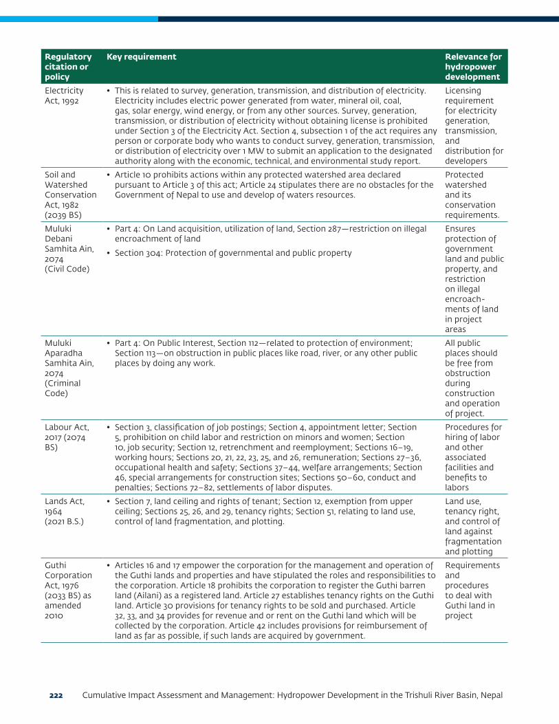
222 Cumulative Impact Assessment and Management: Hydropower Development in the Trishuli River Basin, Nepal
Regulatory citation or policy
Key requirement Relevance for hydropower development
Electricity Act, 1992
• This is related to survey, generation, transmission, and distribution of electricity. Electricity includes electric power generated from water, mineral oil, coal, gas, solar energy, wind energy, or from any other sources. Survey, generation, transmission, or distribution of electricity without obtaining license is prohibited under Section 3 of the Electricity Act. Section 4, subsection 1 of the act requires any person or corporate body who wants to conduct survey, generation, transmission, or distribution of electricity over 1 MW to submit an application to the designated authority along with the economic, technical, and environmental study report.
Licensing requirement for electricity generation, transmission, and distribution for developers
Soil and Watershed Conservation Act, 1982 (2039 BS)
• Article 10 prohibits actions within any protected watershed area declared pursuant to Article 3 of this act; Article 24 stipulates there are no obstacles for the Government of Nepal to use and develop of waters resources.
Protected watershed and its conservation requirements.
Muluki Debani Samhita Ain, 2074(Civil Code)
• Part 4: On Land acquisition, utilization of land, Section 287—restriction on illegal encroachment of land
• Section 304: Protection of governmental and public property
Ensures protection of government land and public property, and restriction on illegal encroach-ments of land in project areas
Muluki Aparadha Samhita Ain, 2074(Criminal Code)
• Part 4: On Public Interest, Section 112—related to protection of environment; Section 113—on obstruction in public places like road, river, or any other public places by doing any work.
All public places should be free from obstruction during construction and operation of project.
Labour Act, 2017 (2074 BS)
• Section 3, classification of job postings; Section 4, appointment letter; Section 5, prohibition on child labor and restriction on minors and women; Section 10, job security; Section 12, retrenchment and reemployment; Sections 16–19, working hours; Sections 20, 21, 22, 23, 25, and 26, remuneration; Sections 27–36, occupational health and safety; Sections 37–44, welfare arrangements; Section 46, special arrangements for construction sites; Sections 50–60, conduct and penalties; Sections 72–82, settlements of labor disputes.
Procedures for hiring of labor and other associated facilities and benefits to labors
Lands Act, 1964 (2021 B.S.)
• Section 7, land ceiling and rights of tenant; Section 12, exemption from upper ceiling; Sections 25, 26, and 29, tenancy rights; Section 51, relating to land use, control of land fragmentation, and plotting.
Land use, tenancy right, and control of land against fragmentation and plotting
Guthi Corporation Act, 1976 (2033 BS) as amended 2010
• Articles 16 and 17 empower the corporation for the management and operation of the Guthi lands and properties and have stipulated the roles and responsibilities to the corporation. Article 18 prohibits the corporation to register the Guthi barren land (Ailani) as a registered land. Article 27 establishes tenancy rights on the Guthi land. Article 30 provisions for tenancy rights to be sold and purchased. Article 32, 33, and 34 provides for revenue and or rent on the Guthi land which will be collected by the corporation. Article 42 includes provisions for reimbursement of land as far as possible, if such lands are acquired by government.
Requirements and procedures to deal with Guthi land in project

Appendix C: Legal and Institutional Guidance on Hydropower Development in Nepal 223
Regulatory citation or policy
Key requirement Relevance for hydropower development
Aquatic Animal Protection Act, 1960 (2017 BS) with amendments in 2055 BS
• Section 5 (5B), provisions of fish ladder and fish hatchery while constructing water diversion structures and requirement of prior permission from the government.
Enforces the requirement for protection of aquatic species in particular rivers, permission requirements, minimal downstream flow requirements, and bans on certain activities such as killing of fish by chemical or current.
National Foundation for Upliftment of Aadibasi/Janjati Act, 2002 (2058 BS)
The act prescribes a number of provisions to overall improve the lot of the Aadibasi/Janajati by formulating and implementing programs relating to the social, educational, economic, and cultural development through:
• Creating an environment for social inclusion of disadvantaged and indigenous people ensuring participation of disadvantaged groups in the mainstream of overall national development of the country, by designing and implementing special programs for disadvantaged groups
• Protecting and preserving their culture, language and knowledge and promoting the traditional knowledge, skills, technology, and special knowledge of the Aadibasi/Janajati and providing assistance in its vocational use
Ensures right of Adivashi/Janajati.
Right to Information Act, 2064 BS (2007)
• The aim of this act is to make the functions of the state open and transparent in accordance with the democratic system and to make it responsible and accountable to the citizens. It intends to make the access of citizens to the information of public importance held in public bodies simple and easy and to protect sensitive information that could have an adverse impact on the interest of the nation and citizens.
• Clause 3 of the act ensures the “Right to Information.” It says that every citizen shall, subject to this act, have the right to information and they shall have access to the information held in the public Bodies unless confidentiality has been maintained by laws.
• Clause 4 of the act describes the “Responsibility of a Public Body” to disseminate information. It mentions that each public body has to respect and protect the right to information of citizens. Public bodies shall have the following responsibilities for the purpose of protecting the right to information of citizens: to classify and update information and make them public; publish and broadcast to make the citizens’ access to information simple and easy; to conduct its functions openly and transparently; and to provide appropriate training and orientation to its staffs.
• Public bodies may use different national languages and mass media while publishing, broadcasting, or making information public. A public body shall arrange for an information officer for the purpose of disseminating information held in its office.
• Clause 7 of the act prescribes the “Procedures of Acquiring Information.” It states that a Nepali citizen, who is interested in obtaining any information under this act, shall submit an application before a concerned information officer by stating the reason to receive such information.
Ensures right to information of citizens via regular and meaningful information dissemination through various print and electronic media.
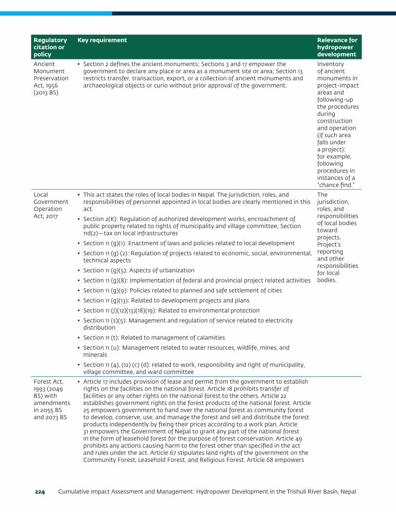
224 Cumulative Impact Assessment and Management: Hydropower Development in the Trishuli River Basin, Nepal
Regulatory citation or policy
Key requirement Relevance for hydropower development
Ancient Monument Preservation Act, 1956 (2013 BS)
• Section 2 defines the ancient monuments; Sections 3 and 17 empower the government to declare any place or area as a monument site or area; Section 13 restricts transfer, transaction, export, or a collection of ancient monuments and archaeological objects or curio without prior approval of the government.
Inventory of ancient monuments in project-impact areas and following-up the procedures during construction and operation (if such area falls under a project): for example, following procedures in instances of a “chance find.”
Local Government Operation Act, 2017
• This act states the roles of local bodies in Nepal. The jurisdiction, roles, and responsibilities of personnel appointed in local bodies are clearly mentioned in this act.
• Section 2(K): Regulation of authorized development works, encroachment of public property related to rights of municipality and village committee; Section 11d(2)—tax on local infrastructures
• Section 11 (g)(1): Enactment of laws and policies related to local development
• Section 11 (g) (2): Regulation of projects related to economic, social, environmental, technical aspects
• Section 11 (g)(5): Aspects of urbanization
• Section 11 (g)(8): Implementation of federal and provincial project related activities
• Section 11 (g)(9): Policies related to planned and safe settlement of cities
• Section 11 (g)(13): Related to development projects and plans
• Section 11 (J)(12)(13)(18)(19): Related to environmental protection
• Section 11 (s)(5): Management and regulation of service related to electricity distribution
• Section 11 (t): Related to management of calamities
• Section 11 (u): Management related to water resources, wildlife, mines, and minerals
• Section 11 (4), (12) (c) (d): related to work, responsibility and right of municipality, village committee, and ward committee
The jurisdiction, roles, and responsibilities of local bodies toward projects. Project’s reporting and other responsibilities for local bodies.
Forest Act, 1993 (2049 BS) with amendments in 2055 BS and 2073 BS
• Article 17 includes provision of lease and permit from the government to establish rights on the facilities on the national forest. Article 18 prohibits transfer of facilities or any other rights on the national forest to the others. Article 22 establishes government rights on the forest products of the national forest. Article 25 empowers government to hand over the national forest as community forest to develop, conserve, use, and manage the forest and sell and distribute the forest products independently by fixing their prices according to a work plan. Article 31 empowers the Government of Nepal to grant any part of the national forest in the form of leasehold forest for the purpose of forest conservation. Article 49 prohibits any actions causing harm to the forest other than specified in the act and rules under the act. Article 67 stipulates land rights of the government on the Community Forest, Leasehold Forest, and Religious Forest. Article 68 empowers

Appendix C: Legal and Institutional Guidance on Hydropower Development in Nepal 225
Regulatory citation or policy
Key requirement Relevance for hydropower development
government to give assent to use any part of the Government-Managed Forest, Community Forest, Leasehold Forest ,or Religious Forest for the implementation of a given national priority plan or project if there is no alternative for the plan or project implementation.
Project requirements associated with forest-related tasks, including government and community forest
Land Acquisition Act, 1977 (2034 BS)
• Article 3 grants power to the government to acquire any land anywhere for public purposes, subject to compensation under the act. Rule 4 empowers government to acquire land upon request by institutions subject to the payment of compensation and all other expenses under the act Rules 5–8 stipulate provisions and procedures for initiating the initial land-acquisition process and estimating compensation rates. Rules 8 and 9 stipulate procedures and provisions for notification of land acquisition. Rule 11 provides for the right to file complaints by those affected by public notice with regard to the land rights. Rules 13–15 stipulate procedures and provisions of setting compensation Rules 16 and 17 stipulate criteria for setting compensation Rule 19 stipulates disclosure of compensation entitlement through public notification Rule 25 includes provision of complaints against the compensation rates to the Ministry of Home affairs. The decision of the Ministry of Home affairs on the complaint is final.
Procedures for land acquisition and compensation payment for project
Water Resources Act, 1992 (2049 BS)
• Article 3 stipulates the water resource rights of government. Article 4 prohibits use of water resources without obtaining a license, except for specified uses under the act. Article 7 establishes the order of priority for the utilization of water resources. Article 8 stipulates procedures for water resource licensing. Article 16 empowers government to utilize the water resources and acquisition of other lands and property for the development of water resource as stipulated in the act. Article 18 stipulates the right of the government to fix the quality standards of water. Article 19 prohibits pollution of water resources above prescribed pollution tolerance limits. Article 20 prohibits causing harm and adverse effects on the environment while developing a water resource project.
Requirement for obtaining license for project development and establishing priority for different water development (for example, drinking water, irrigation, hydropower)
Electricity Regulations, 1993
• This regulation has been formulated for the implementation of the provisions made in the Electricity Act, 1992. Rule 12 (f) and 13 (g) are related to environmental studies which emphasize that the environmental study report should include the measures to be taken to minimize the adverse effects of the project on physical, biological, and social environments and should also elaborate utilization of local labor, source of materials, benefits to the local people after the completion of the project, training to local people in relation to construction, maintenance and operation, facilities required for construction site, and safety arrangements.
Requirement for environmental studies and preparation of report, emphasizing minimization of project induced impacts
Labour Rules, 1993 (2050 BS)
• Rule 3 and 4 set time for deploying minor and woman at work. Rule 6 stipulates the circumstances in which non-Nepalese citizen may be engaged in work. Rule 11 addresses no discrimination in remuneration. Rules 15–17 stipulate compensation against injury, grievous hurt resulting in physical disability and in case of death.
Related to project labors, compensation, and benefits

226 Cumulative Impact Assessment and Management: Hydropower Development in the Trishuli River Basin, Nepal
Regulatory citation or policy
Key requirement Relevance for hydropower development
Ancient Monuments Preservation Rules, 2046 BS (1989) with amendments in 2049, 2053, 2056, and 2058 BS
• Rule 4: Approval from the department has to be obtained for any construction work
Related to ancient monument preservation (if applicable for a particular project)
Forest Rules, 1995 (2051 BS) with amendments in 2056 BS, 2059 BS and 2062 BS
• Rule 7 prohibits forest cutting without obtaining a license. Rule 8 stipulates the procedures of licensing for forest products. Rule 65 makes a national priority project developer that uses national forest areas responsible for the compensation of the loss or harm to any local individual or community due to the project, and also makes the developer responsible to cover all expenses required for the cutting, milling ,and transporting the forest products in a forest area to be used.
Forest loss assessment, loss compensation, permission for clearances, approvals, and associated tasks
Environment Protection Rules, 1997 (2054 BS) as amended
• Rule 3 stipulates environmental screening criteria for undertaking the IEE/EIA study.
• Rules 4–6 stipulate procedures for determining scope for IEE/EIA, including public notification and approval of IEE/EIA scope of works.
• Rules 7 and 10 stipulate provisions for conducting IEE/EIA assessments, including public notifications and public hearings for IEE/EIA works and requirements of recommendation letters from the project development DCOs/Municipalities.
• Rule 11 stipulates approval procedures including disclosure of IEE/EIA report.
• Rule 12 mandates developers to comply with the approved IEE/EIA provisions to avoid, mitigate, and monitor impacts.
• Rule 13 stipulates the responsibility of the concerned body to monitor project implementation
• Rule 14 stipulates the responsibility of the ministry to conduct environmental examination of the project two years after construction completion.
• Rules 15–20 identify prohibitions and control of pollution.
• Rules 26–33 stipulate procedures and provisions for the conservation of Natural Heritage and Environmental Conservation Zones.
• Rules 45–47 stipulate procedures and provisions for compensation to those affected by a project.
Procedures for conducting IEE/EIA, approval processes etc.
Hydropower Development Policy, 2001 (2058 BS)
• Section 5, subsection 5.7, environmental protection; subsection 5.8, mitigation planning of the affected resources; subsection 5.20, opportunity for local people in employment
• Section 6, subsection 6.1, environmental release, assistance in the land and property acquisition, responsibility for resettlement and rehabilitation of project-affected people; subsection 6.5, provisions of HEP transfer to Government of Nepal; subsection 6.12; royalty payments to local area, licensing provisions for survey and generation, terms of license; subsection 6.13, fee provisions
Licensing provisions for hydropower for survey and generation, royalty payments to local areas, requirement for environmental and social studies,

Appendix C: Legal and Institutional Guidance on Hydropower Development in Nepal 227
Regulatory citation or policy
Key requirement Relevance for hydropower development
responsibilities for land acquisition and resettlement, minimum downstream release, and so forth
Land Acquisition, Resettlement and Rehabilitation Policy for Infrastructure Development Projects, 2015 (2071 BS)
• Recognizes the need for resettlement and rehabilitation plan to ensure the livelihoods of project-affected persons or households be at least above the preproject conditions
• Emphasizes that the project development agency conducts meaningful consultation with project: affected persons, communities, and sensitive groups, particularly poor, landless, senior citizens, women, children, indigenous/Janajati groups, disabled, helpless and persons having no legal rights on the operated land while preparing land acquisition, resettlement and rehabilitation plan
• Requires completion of compensation, resettlement, rehabilitation, and other benefits to the project-affected persons/households prior to the physical and economic displacement by the project
• Land acquisition process, as far as possible, to be undertaken through a process of negotiation with project-affected persons/households through transparent, free, fair, and justifiable process
• Requires that land-based compensation and resettlement be provided to persons/households who lose all of their property, or whose livelihood is agriculture based
• Requires relocation and resettlement of project-affected persons/households close to their current place of residence until and otherwise s/he willingly prefer to relocate him/herself
• Requires inclusive programs for the enhancement of socioeconomic development of disadvantaged groups, such as marginalized groups that lack access to resources (Dalit, Indigenous or Janajati groups, single women, and so forth)
• Requires that compensation be paid for built properties, including resettlement and rehabilitation benefits for persons/households who do not have land or legal rights to the currently operated land
• Requires determination of compensation rates for affected land and property based on scientific methods such that the compensation rates are not less than the minimum market price
• Requires access on project benefit (share allocations) to the affected persons/households for projects where there is a potential return on investment
• Requires provision of subsidized rates to the project-affected persons/households for projects providing services
• Requires the following additional project assistance in addition to compensation and resettlement:
• Residential facilities
• Goods transportation assistance
• Relocation assistance
• Relocation for business assistance
• House rental assistance
• Additional assistance as recommended by the plan to address seriously project-affected households and vulnerable groups (Dalit, Janajati or marginalized Indigenous, single women, helpless, disabled, senior citizens, and so forth)
Process, procedures, for land acquisition, different compensation packages for land acquisition, and compensation

228 Cumulative Impact Assessment and Management: Hydropower Development in the Trishuli River Basin, Nepal
Regulatory citation or policy
Key requirement Relevance for hydropower development
• Employment opportunities to seriously project-affected households and vulnerable groups (Dalit, Janajati or marginalized Indigenous, single women, helpless, disabled, senior citizens, and so forth) based on their skills and capabilities
• Requires livelihood restoration plan to address the seriously project-affected households and vulnerable groups
• Requires an adequate mechanism to listen to, register, and resolve the grievances of the project-affected persons and communities
• Requires an effective institution to ensure that the objectives of land acquisition, compensation, resettlement, and rehabilitation action plans are achieved and to evaluate and monitor the effects on the livelihood of the project displaced persons
• Requires project development agency to ensure the allocation of resources required for resettlement/rehabilitation and livelihood restoration of the project-affected persons/households
Forest Policy, 2015 (2071 BS)
• Land-use planning and change in land use categories, conservation of bio-diversity, eco-systems and genetic resources.
Forest-related study and assessment
Land Use Policy (2069 BS)
• The Ministry of Land Reform and Management launched this policy to ensure the optimum use of land and portions of land and aims to encourage optimal use of land for agriculture. The policy also talks of adopting the concept of aggregating parcels of land to acquire land for development projects.
Applicable for selection of land, land-use type, different land identification, and planning for project
Climate Change Policy, 2011 (2067 BS), GoN
• Includes climate adaptation and disaster risk reduction; low carbon development and climate resilience; access to financial resources and utilization; capacity building, peoples’ participation, and empowerment; study, research, technology transfer, climate friendly natural resources management ,and institutional set up with legal provisions; and importance of monitoring and evaluation.
In identifica-tion of greenhouse gasses, climate change, and other disaster-related issues and mitigations
Convention on Biological Diversity, 1992
• Article 14 of the convention introduces appropriate procedures requiring project EIA.
Convention on International Trade in Endangered Species of Wild Fauna and Flora (CITES), 1973
• Article II of the convention classifies species as appendix I, II, and III species that are subjected to regulation so as not to endanger their survival.
United Nations Framework Convention on Climate Change, 1992
• Article 4 (f): Impact assessment to avoid or mitigate or adapt to climate change

Appendix C: Legal and Institutional Guidance on Hydropower Development in Nepal 229
Regulatory citation or policy
Key requirement Relevance for hydropower development
United Nations Declaration on the Rights of Indigenous Peoples, 2007
• The declaration sets out the individual and collective rights of indigenous peoples, as well as their rights to culture, identity, language, employment, health, education, and other issues (Articles 1–4). It also “emphasizes the rights of indigenous peoples to maintain and strengthen their own institutions, cultures and traditions “(Article 5) and to pursue “their development in keeping with their own needs and aspirations (Article 23).” It “prohibits discrimination against indigenous peoples” (Article 21), and it “promotes their full and effective participation in all matters that concern them and their right to remain distinct and to pursue their own visions of economic and social development (Articles 25–30).”***
Convention (No.169) Concerning Indigenous and Tribal Peoples in Independent Countries, 1989
• Article 7: The right of the indigenous and tribal people to decide their own priorities for the process of development
• Articles 12–15: The safeguards of rights of the indigenous people in the land and natural resources in territories traditionally occupied by them
• Article 16: Participation in the decision-making process and resettlement process with full compensation of the resulting loss or injury
The Fourteenth Plan (2073/74–2075/76)
• The plan prioritizes independent, fair and socially oriented national economy and well-being of Nepalese people. The Three Year Plan envisions ranking Nepal to middle-income country status along with social justice and welfare.
National Water Plan Nepal, 2005
• Part D, Section 6: Environmental management, inclusive of impact identification, mitigation actions, monitoring, auditing, and institutional mechanism.
Nepal National Biodiversity Strategy and Action Plan,2014–2020
• The action plan aims to (i) address the underlying causes of biodiversity across government and society; (ii) reduce the direct pressure on biodiversity and promote sustainable use; (iii) improve the status of biodiversity by safeguarding ecosystem, species, and genetic diversity; (iv) enhance the benefits to all from biodiversity and ecosystem services; and (v) enhance implementation through participatory planning knowledge management and capacity building.
Nepal Biodiversity Strategy Implemen-tation Plan, 2006
• Action plan FO1: Forest biodiversity conservation through community participation
• Action plan PA1: Species conservation and habitat management in protected area
• Action plan CS2: Landscape level biodiversity conservation.
Nepal Biodiversity Strategy 2002
• Chapter 5, Section 5.1, Subsection 5.1.1, landscape planning; Subsection 5.1.4, in-situ conservation of habitat and species; Subsection 5.1.8, cross-sectoral coordination for bio-diversity conservation; Subsection 5.1.13, IEE/EIA of development projects to avoid significant impacts on biodiversity and implement the provisions to minimize the impacts
• Section 5.2, Subsection 5.2.1 (5.2.1.2), cross-sectoral coordination for protected area conservation
Water Resources Strategy Nepal, 2002
• Section 4: Social development principles, and environmental sustainability principles
• Section 5: Strategic output 2—sustainable management of watersheds and aquatic ecosystems; strategic output 5—cost-effective and sustainable hydropower development
230 Cumulative Impact Assessment and Management: Hydropower Development in the Trishuli River Basin, Nepal
Regulatory citation or policy
Key requirement Relevance for hydropower development
National Conservation Strategy, Nepal, 1988
• The policy principles include (i) ensure the sustainable use of Nepal’s land and renewable resources; (ii) preserve the biological diversity of Nepal to maintain and improve the variety and quality of crops and livestock, and maintain the variety of wild species both plant and animal; and (iii) maintain the essential ecological and life-support systems such as soil regeneration, nutrient recycling, and the protection and cleansing of water and air.
National Energy Crisis Resolution and Energy Development Decade Concept Paper (2072 BS)
• The concept paper was approved by the cabinet decision of 2072/08/08. The overall objective of the concept paper is to avoid the hindrances and hassles in construction of hydropower projects without violating the existing legal requirements.
Forest Encroachment Control Strategy, 2012
• Emphasizes achieving 40 percent forest coverage through avoidance and control of forest encroachment and reclaiming of encroached forest areas.
National EIA Guidelines, 2017, MoPE
• Generic information on the procedures for EIA scoping, terms-of-reference preparation, baseline environmental studies, information disclosure, public consultation, prediction and evaluation of impacts, mitigation prescriptions, monitoring and EIA report preparation in line with the EPA, and the EPR.
Guidelines for preparation of EIA report
Department of Electricity Development Manuals
• Specific environmental manuals for hydropower development studies. A total of seven manuals have been prepared by DoED to cover different components of EIA, environmental management and monitoring. These include:
• Manual for Preparing Scoping Document for Environmental Impact Assessment (EIA) of Hydropower Project (2001)
• Manual for Public Involvement in the Environmental Impact Assessment (EIA) Process of Hydropower Project (2001)
• Manual for Preparing Terms of References (ToR) for Environmental Impact Assessment (EIA) of Hydropower Projects, with Notes on EIA Report Preparation, (2001)
• Manual for Preparing Environmental Management Plan (EMP) for Hydropower Projects, (2002)
• Manual for Developing and Reviewing Water Quality Monitoring Plans and Results for Hydropower Projects, (2002)
• Manual for Conducting Public Hearings in the Environmental Impact Assessment Process for Hydropower Projects (2004)
• Manual for Addressing Gender Issues in Environmental impact Assessment/Initial Environmental examination for Hydropower Projects, (2005)
Provide directions and guidelines through various manuals for conducting various tasks under EIA
Guidelines on Land Use of Forest Area for other Purposes (Ban Chhetra ko Jagga Anya Prayojan ko Lagi Upalab-dha Garaune Karyabidhi, 2063 BS), 2006
• The guidelines address conditions required to make forest lands available to development projects and the required compensatory measures for the loss of forest land use and forest products.
Provide guidelines for use of forest land, compensatory forestation requirements

Appendix C: Legal and Institutional Guidance on Hydropower Development in Nepal 231
Regulatory citation or policy
Key requirement Relevance for hydropower development
Forest Products Collection, Sale and Distribution Guidelines, 2000 (2057 BS)
• The guidelines specifies various procedure and formats for getting approval for vegetation clearance, delineation of lands for vegetation clearance, evaluation of wood volume, and so forth.
Related to forest products loss calculation, clearance, and loss calculations
EIA Guidelines for Forestry Sector, 1995 (2051 BS)
• The guideline specifies the EIA procedures to be followed while undertaking environmental studies that involve forest areas.
Procedures to be followed for EIA study in forest area
Community Forest Development Guidelines, 2006 (2065 BS)
• Guidelines set the processes and procedures to identify and build capacity within the Community Forest User Groups, prepare Community Forest management plans, and implement Community Forest management plans.
Procedures dealing with community forest in project areas
Community Forest Inventory Guidelines, 2005 (2062 BS)
• Community Forest Inventory Guidelines detail the process and procedures for evaluating the forest stock and it’s harvesting potential in Community Forests.
In case of community forest–related cases
Environmental Management Guidelines (Road), 1999 (2056 BS)
• The guideline for roads focuses on the major issues for environmental management while developing or upgrading a road corridor. It sets procedures for environmental assessment and highlights the potential impacts and mitigation measures for road projects.
Requirements related to a project’s own access roads and main access road
MoPE Guide to Environmental Management Plans of Hydropower Projects 2006 (2063 B.S.)
• MoPE has published guidelines for conducting IEE/EIA of hydropower development projects, which detail methods and procedures for the preparation of environmental management plans, environmental auditing and environmental monitoring plans:
• A Guide to Environmental Management Plans of Hydropower Projects (MoEST, 2006)
• A Guide to Environmental Auditing of Hydropower Projects (MoEST, 2006)
• A Guide to Environmental Monitoring of Hydropower Projects (MoEST, 2006)
Details of EMP contents in EIA report
EIA Guidelines for Water Resource Sector, 1994 (2050 BS)
• The guidelines set procedures for (i) identification of positive and negative impacts of water resource projects over both short-term and long-term periods on natural and human environments; (ii) development of mitigation management and monitoring plans; and (iii) public hearings and interaction with affected groups, NGOs, donors, and relevant government agencies.
Guideline for Physical Infrastructure Development and Operation in Protected Areas, 2008 (2065 BS)
• Sets guidelines for infrastructure development in protected areas Project requirements for infrastructure development

232 Cumulative Impact Assessment and Management: Hydropower Development in the Trishuli River Basin, Nepal
Regulatory citation or policy
Key requirement Relevance for hydropower development
Nepal Water Quality Guidelines for the Protection of Aquatic Ecosystem, 2008
• Sets guidelines of the water quality for the protection of aquatic ecosystem Water quality to be maintained by project for aquatic ecosystem conservation
Nepal Water Quality Guidelines for Recreation, 2008
• Sets guidelines of the water quality that can be used for recreational purpose
Nepal Vehicle Mass Emission Standard, 2012 (2069 BS)
• Compliance to Type I to Type V tests for vehicles fueled with gasoline and diesel imported for a project
Projects vehicle standards
Generic Standard Part I: Tolerance Limits for Industrial Effluents to be discharged into Inland Surface Waters (2058 BS)
• Tolerance limits of effluent discharged into inland surface waters Projects waste water quality prior disposal in inland surface water
National Ambient Air Quality Standards for Nepal, 2012 (2069 BS)
• Limits of ambient air quality parameters around construction sites Projects air quality threshold during construction and operation phase
National Drinking Water Quality Standards, 2006 (2063 BS)
• Quality of drinking water supply in the project camps and construction sites Drinking water quality for staff and workers during construction and operation phase
National Ambient Sound Quality Standard, 2012 (2069 BS)
• Noise levels for different land-use categories and noise generating equipment Noise levels to maintain during construction and operation phase of project

Appendix C: Legal and Institutional Guidance on Hydropower Development in Nepal 233
Regulatory citation or policy
Key requirement Relevance for hydropower development
Exhaust Emission Standards for Diesel Generating Sets, 2012 (2069 BS)
• Emissions standards for exhaust emissions of diesel plants/generating sets Standards for diesel plant/generator sets used in projects
National Indoor Air Quality Standards, 2009(2066 BS)
• The time weighted (1~24hrs) standards are given for PM10, PM2.5, CO, carbon dioxide (CO2) for indoor environments. The units of measure for the standards are parts per million (ppm) by volume, milligrams per cubic meter of air (mg/m3), and micrograms per cubic meter of air (µg/m3). Monitoring of carbon dioxide is to ensure the adequacy of the ventilation of the monitoring sites. The provision for measurement of PM2.5 is preferred; the PM2.5 values can be converted to the corresponding PM10 values by application of a PM2.5/ PM10 ratio of 0.5.
Air quality standards to be maintained by project during construction and operation phase

234 Cumulative Impact Assessment and Management: Hydropower Development in the Trishuli River Basin, Nepal
APPENDIX D: EFLOWS ASSESSMENT OF THE TRISHULI RIVER BASIN
ContentsAcronyms and Abbreviations ......................................................................... 237
Units ........................................................................................................... 237
1. Introduction ..............................................................................................238
The EFlows Study Area .......................................................................................238EFlows Assessment ........................................................................................... 241
EFlows Sites ...................................................................................................................... 241Indicator Fish Species and Distribution ............................................................................. 244Elevation Profile of Trishuli River ..................................................................................... 245Scenarios ........................................................................................................................... 246
2. Data and Assumptions .............................................................................. 248
Project Delineation ........................................................................................... 248Indicator Groups .............................................................................................. 249Response Curves .............................................................................................. 249Connectivity Barrier of HPPs .............................................................................. 249
3. Hydrology ............................................................................................... 250
4. Fish Indicators Used in the EFlows Assessment and Their Flow-Related Needs ..........................................................................................................253
5. Ecosystem Indicators................................................................................ 258
6. Ecological Status ..................................................................................... 259
Baseline Ecological Status of the EFlows Sites ..................................................... 259
7. Response Curves ...................................................................................... 260
8. Scenarios Evaluated ..................................................................................272
Assumption for Barriers to Fish ...........................................................................272
9. Results of Scenario Analyses ......................................................................275
Survey License Given Projects .............................................................................276Impacts on Indicator Fish Species ........................................................................277
Snow Trout (Schizothorax) ............................................................................................... 277Mahseer (Tor) ................................................................................................................... 279Buduna (Garra) ................................................................................................................. 279Indian Catfish (Glyptothorax) ........................................................................................... 279
10. Conclusions ........................................................................................... 280
11. References ............................................................................................... 281

Contents 235
List of Tables
Table D1.1: Hydropower Projects Used in DRIFT DSS ......................................................................240Table D1.2: EFlows Sites and Rationale for Selection .........................................................................241Table D3.1: Parameters Used for Seasonal Divisions ..........................................................................251Table D3.2: Flow Indicators Used in the Trishuli River ......................................................................251Table D4.1: Summary of Key Life History Aspects and Flow Related Needs of Snow Trout ..............253Table D4.2: Preferences for Flow–dependent Habitat, Breeding, and Migratory Behavior of the Mahseer ..........................................................................................................................256Table D4.3: Preferences for Flow-Dependent Habitat, Breeding, and Migratory Behavior of the Buduna ............................................................................................................................256Table D4.4: Preferences for Flow-Dependent Habitat, Breeding, and Migratory Behavior of the Indian Catfish ..................................................................................................................257Table D5.1: Ecosystem Indicators Used in the Trishuli River DRIFT DSS...........................................258Table D6.1: Categories for Baseline Ecological Status .......................................................................259Table D6.2: BES of the EFlows Sites on the Trishuli River .................................................................259Table D7.1: Exposed Sand and Gravel Bars .......................................................................................261Table D7.2: Exposed cobble and boulder bars ...................................................................................262Table D7.3: Median bed sedimentsize ................................................................................................263Table D7.4: Area of Secondary Channels and Backwaters ..................................................................264Table D7.5: Algae ...............................................................................................................................265Table D7.6: Ephemeroptera, Plecoptera, and Trichoptera (EPT) .........................................................266Table D7.7: Snow Trout .....................................................................................................................267Table D8.1: Scenarios Selected for the Assessment Including HPPs ...................................................272Table D8.2: Project Accounted for Cumulative Impact Assessment of Trishuli Basin Based on Extrapolation of DRIFT DSS Results ..............................................................................274Table D9.1 Ecological Integrity Ratings ............................................................................................275Table D9.2: Overall Integrity for Each Site Associated with Each Scenario ........................................276Table D9.3: Fish Integrity for Each EFlows Site Associated with Each Scenario .................................276Table D9.4: The Mean Percentage Changes (relative to scenario 1 baseline of 100%) for the Indicator Fish Species ......................................................................................................278
List of Figures
Figure D1.1: Elevation Profile of the Trishuli River with Slope and Division of Temperature Zones ........................................................................................................................... 247Figure D2.1: Setup Layout for EFlows Assessment ............................................................................ 248Figure D3.1: One Year (1967) of the Baseline Hydrological Record at EFlows Site 4, Showing the Seasonal Divisions, from Left to Right, into Dry, Transitional 1, Wet, Transitional 2, and Back into Dry (m3/sec =cubic meters/sec) ............................................................... 250Figure D3.2: Examples of Annual Time-Series of a DRIFT Flow Indicator: Average Daily Volume in the Dry Season (showing four scenarios) .................................................................. 252
236 Cumulative Impact Assessment and Management: Hydropower Development in the Trishuli River Basin, Nepal
List of Maps
Map D1.1: HPPs and EFlows Sites in the EFlows Study Area............................................................ 239Map D1.2: Delineation of Temperature Zones across the Basin ........................................................ 245Map D1.3: DMU Delineation for Snow Trout and Mahseer ............................................................. 246

Contents 237
Acronyms and Abbreviations
°C Degree CelsiusBES Baseline Ecological StatusCIA Cumulative Impact AssessmentDMU Discrete Management UnitsDRIFT Downstream Response to Imposed Flow TransformationDSS Decision Support SystemEF EFlowsEFlows Environmental FlowsEPT Ephemeroptera, Plecoptera, and TrichopteraESSA Environmental Social System AssessmentHEP Hydroelectric ProjectHPP Hydropower ProjectIBAs Important Bird AreasIFC International Finance CorporationIUCN International Union for Conservation of NatureKBAs Key Biodiversity AreasNCMG National Mission for Clean GangaPS Performance StandardsUT Upper Trishuli
Units
m3/sec Cubic meters/secondMg MilligrammesMW Mega Watts
238 Cumulative Impact Assessment and Management: Hydropower Development in the Trishuli River Basin, Nepal
1. Introduction
1 See ESSA Technologies. 2014. Cumulative Impact Assessment-Upper Trishuli-1 Hydropower Project. Ottawa. App D, 12.
The Trishuli River is a transboundary river and drains the catchment of one of the eight subbasins of the Gandaki River Basin in Central Nepal. It covers an area of 32,000 square kilometers, which is 13 percent of the total Gandaki area. The Trishuli watershed lies within the physiographic zones defined by an average altitude range of 250 meters to 2000 meters and high valley landscapes.
The Trishuli River originates in the Tibet Autonomous Region of the People’s Republic of China, where it is known as Bhotekoshi. The catchment area of Trishuli River is 6,624.7 square kilometers up to the confluence with the Budhi Gandaki, for a river length of 120 kilometers. The approximately106 kilometers of Trishuli River within Nepal shows a gradient of about 3 percent in the initial 40 kilometers, with rapids dominating the longitudinal profile, but there are no impassable falls for fish.1 The elevation range in this 40 kilometers varies from 800 meters to 2,000 meters.
The Environmental Flow (EFlows) Assessment was carried out as part of the Cumulative Impact Assessment and Management: Hydropower Development in the Trishuli River Basin, Nepal. The Downstream Response to Imposed Flow Transformations (DRIFT) model is used for the EFlows Assessment. The EFlows Assessment team qualitatively apply the lessons learned from evaluating EFlowss using the DRIFT model for other hydropower projects in the Trishuli Basin and elsewhere in the Himalayan region to assess the likely impacts of hydropower developments on river biodiversity and ecosystems and make recommendations on management measures to minimize these impacts.
The EFlows Study Area
For the CIA study, the study area includes entire catchment of Trishuli River in the upper reaches (also including the part that lies in Tibet) and the lower reach up to the point immediately downstream of Super Trishuli Hydropower Plant (HPP). For the EFlows Assessment, the upper limit of the EFlows study area is the Chinese border whereas the lower limit is immediately downstream of Super Trishuli HPP, same as that of the study area of the CIA.
As shown in Map D1.1 and the Google Earth image in Photo D1.1, the EFlows study area lies downstream of Chinese border close to Rasuwagadhi Hydropower Project (HPP), and upstream of confluence of the Super Trishuli HPP. A total of 6 existing, 7 under-construction, 1 committed, and 23 planned projects in this study area are shown in the map with different color codes and listed in Table D1.1. The list includes 24 projects that were included in the DRIFT model, and an additional 12 that were not modelled but the impact of which was assessed extrapolating the impacts of the 24 that were modeled.

Contents 239
Map D1.1: HPPs and EFlows Sites in the EFlows Study Area
Photo D1.1: Location of EFlows Sites

240 Cumulative Impact Assessment and Management: Hydropower Development in the Trishuli River Basin, Nepal
No Project status/stage MW River
Existing/Operational
1 Chilime (CHP) 22.0 Chilime Khola
2 Mailung Khola HPP 5.0 Mailung Khola
3 Trishuli (THP) 24.0 Trishuli Mainstem
4 Devighat (DHP) 14.0 Trishuli Mainstem
5 Tadi Khola (Thaprek) HPP 5.0 Tadi Khola
6 Thoppal HPP 2.0 Thoppal Khola
Under-Construction
1 Rasuwagadhi (RGHEP) 111.0 Trishuli Mainstem
2 Upper Sanjen (USHEP) (NEA SPV) 15.0 Chilime Khola
3 Sanjen Hydro Project (SHEP) (NEA SPV) 42.0 Chilime Khola
4 Upper Mailung A HEP 6.0 Mailung Khola
5 Upper Mailung Khola HEP (Molina Power) 14.0 Mailung Khola
6 Upper Trishuli-3A HPP (UT-3A) 60.0 Trishuli Mainstem
7 Upper Trishuli-3B HPP (UT-3B) 37.0 Trishuli Mainstem
Committed
1 Upper Trishuli-1 HPP (UT-1) 216.0 Trishuli Mainstem
Planned
1 Sanjen Khola HEP (Salasungi Power) 78.0 Chilime Khola
2 Langtang Khola Small HPP 10.0 Langtang Khola
3 Salankhu Khola HPP 2.5.0 Salankhu Khola
4 Phalaku Khola HPP 15.0 Betrabati Khola
5 Phalaku Khola HPP 5.0 Betrabati Khola
6 Upper Tadi HPP 11.0 Tadi Khola
7 Middle Tadi HPP 5.5 Tadi Khola
8 Lower Tadi HPP 5.0 Tadi Khola
9 Trishuli Galchi HPP 75.0 Trishuli Mainstem
10 Super Trishuli HPP 100.0 Trishuli Mainstem
11 Upper Trishui-2 HPP 102.0 Trishuli Mainstem
12 Bhotekoshi Khola HPP 44.0 Bhotekoshi Khola
13 Mathillo Langtang HPP 24.35 Langtang Khola
14 Langtang Khola Reservoir HPP 310.0 Langtang Khola
15 Trishuli Khola HPP 4.4 Trishuli Khola
16 Upper Trishuli-1 Cascade HPP 24.6 Trishuli Mainstem
17 Upper Mailung B HPP 7.5 Mailung Khola
18 Middle Mailung HPP 10.0 Mailung Khola
19 Middle Trishuli Ganga Nadi HPP 65.0 Trishuli Mainstem
20 Tadi Ghyamphedi HPP 4.7 Tadi Khola
21 Tadi Khola HPP 4.0 Tadi Khola
Table D1.1: Hydropower Projects Used in DRIFT DSS
Source: ERM.
Note: DSS = Decision Support System; HEP = hydroelectric project; MW = megawatts.

Contents 241
EFlows site Location Latitude Longitude Comments
EFlows 1 Upstream UT-1 HPP (216 MW) dam
28° 07’ 35.84” 85° 17’ 50.37” This site is same as that modelled in DRIFT EFlows Assessment for the Upper Trishuli 1 HPP. This site has been chosen to illustrate the impact of barrier created by UT-1 HPP to migration of the Snow Trout.
EFlows 2 Between UT-1 weir and tailrace
28° 5' 27.89" 85° 14' 7.76" This site is same as that modelled in DRIFT EFlows Assessment for the Upper Trishuli 1 HPP. This site has been chosen to assess the impact of varying level of EFlows release from the UT-1 dam in the low-flow section of the river created by diversion of river water into power generation tunnels.
EFlows 3 Downstream of UT-1 tailrace
28° 4' 13.71" 85° 12' 28.76" This site is same as that modelled in DRIFT EFlows Assessment for the Upper Trishuli 1 HPP. This site has been chosen to show recovery associated with restoration of river flow as the water diverted for power generation is released back into the river. This site and the reach downstream, however, will be impacted by variations in flow if the UT-1 power plant is operated in peaking mode.
EFlows 4 Downstream of UT-3B (37 MW)
27°59' 39.92" 85° 11' 2.94" UT-3B is a cascade of UT-3A (60 MW, Photo D1.2 and Photo D1.3) and both the projects are under-construction. The site has been chosen to capture the barrier effects created by UT-3A dam on fish migration. Similarly, effect of tributaries such as Salankhu/ Phalankhu on the fish migration and breeding can be captured.
EFlows 5 Upstream of Tadi confluence
27°51' 41.17" 85° 6' 30.62" This EFlows Site is chosen up stream confluence of Tadi tributary with Trishuli River. This site has been chosen to study the barrier effects created by existing hydropower projects viz., Trishuli HEP (24 MW, Photo D1.4) and Devighat HPP (14.1 MW) on the fish migration and also to study the effect of changing water temperature to aquatic life due to mixing of tributaries into the main river.
EFlows 6 Downstream of Mahesh Khola confluence
27°48' 12.99" 84° 59' 28.22" This EFlows Site is selected downstream of the confluence of Mahesh Khola. This site lies fairly on the mild slope of the river. The warm water from Mahesh Khola entering into the cool water of the Trishuli River will create a different condition for fish species which will be of interest for this study.
EFlows 7 Downstream of Super Trishuli HPP
27° 52' 43.47 84° 35' 32.03" This EFlows Site is located immediately downstream of Super Trishuli HPP (100 MW). This is to include the possible barrier effect created by Super Trishuli dam.
Table D1.2: EFlows Sites and Rationale for Selection
EFlows Assessment
EFlows Sites
Seven EFlows sites have been chosen on the main Trishuli River in the EFlows study area. In addition, migration nodes have been established to represent
the tributaries. Table D1.2 provides a brief description and rationale for selection of sites.
Continued on the next page

242 Cumulative Impact Assessment and Management: Hydropower Development in the Trishuli River Basin, Nepal
EFlows site Location Latitude Longitude Comments
EFlows 8 Chilime Khola
Migration and breeding node, not to be modelled in DRIFT
EFlows 9 Mailung River
Migration and breeding node, not to be modelled in DRIFT
EFlows 10 Salankhu and Phalankhu Rivers
Migration and breeding node, not to be modelled in DRIFT
EFlows 11 Tadi Khola Migration and breeding node, not to be modelled in DRIFT
Photo D1.2: Dam Site of UT-3A, 2015
Source: Halvard Kaasa.
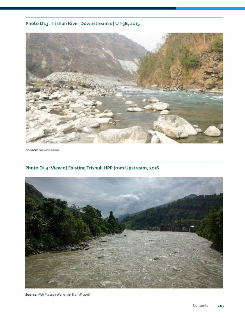
Contents 243
Photo D1.3: Trishuli River Downstream of UT-3B, 2015
Source: Halvard Kaasa.
Photo D1.4: View of Existing Trishuli HPP from Upstream, 2016
Source: Fish Passage Workshop Trishuli, 2016.

244 Cumulative Impact Assessment and Management: Hydropower Development in the Trishuli River Basin, Nepal
The EFlows sites have not been located in the tributaries, although they might have potential in terms of breeding and migration. This is to limit the scope of the study within the main river. However, for illustrative purposes, one EFlows site each has been placed in four tributaries: Chilime Khola, Mailung Khola, Salankhu Khola, and Tadi Khola (different from the main EFlows sites).
Although the Budhi Gandaki River lies upstream of the proposed EFlows site 7 and could be mitigation against the barrier effect created by Super Trishuli HPP dam depending on whether or not there might be future developments in the river, we have not included it in our study and is outside of scope of work.
Indicator Fish Species and Distribution
Indicator fish species considered in the EFlows Assessment are the following:
• Snow Trout Schizothorax richardsonii, this is representative of other Snow Trout (Schizothorax) species of the Trishuli River.
• Golden Mahseer Tor putitora, this is representative of other Mahseer (Tor) species of the Trishuli River.
• Buduna Garra annandalei (Photo D1.5), this is representative of other Garra species of the Trishuli River.
• Indian Catfish Glyptothorax indicus, this is representative of other Glyptothorax species of the Trishuli River.
The first two are migratory species while the remaining two are nonmigratory or resident species.
Construction of dams is likely to impact both the resident and migratory fish species. The migratory species will be affected by the barrier created by the dams as well as alterations in flows, while the nonmigratory species will be affected by alterations in flows. Indicator species were also selected to cover the entire EFlows study area based on their temperature preference. Snow Trout is found in cold-cool water zone, Mahseer and Indian Catfish in cool water zone while Buduna is found in cool-warm water zone. The following is an indicative delineation of these zones, as illustrated in Map D1.2.
• The Trishuli River upstream of the confluence with Salankhu Khola is a cold-water zone. Maximum summer temperatures in this zone are estimated to range between 16°C and 18°C.
• The Trishuli River downstream of the confluence with Salankhu Khola and upstream of the site of Super Trishuli dam is a cold-cool water zone. Maximum summer temperatures in this zone are estimated to range between 20°C and 22°C.
Photo D1.5: Buduna (Garra annandalei) from Andheri Khola, Tributary of Trishuli River, 2015
Source: Halvard Kaasa.

Contents 245
• The Trishuli River downstream of site of Super Trishuli dam is cool-warm-water zone. Summer temperatures in this zone are estimated to range between 23°C and 26°C.
Map D1.3 shows the regional distribution of the two migratory species selected as indicators for the EFlows Assessment, the Snow Trout and the Mahseer, and the “Discrete Management Units” (DMUs)2 in which these species are presently confined in. The range of Mahseer is limited to elevations of the order of 300 meters to 1,100 meters, while the Snow Trout covers the entire range of Mahseer and migrates further up the streams to elevations of the order of 500 meters to 3,000 meters.
2 As per Criteria 1 through 3 of IFC PS6 (2012), the DMU is what the project should determine is a sensible boundary (ecological or political) which defines the area of habitat to be considered for the Critical Habitat Assessment. This discrete management unit is an area with a definable boundary within which the biological communities and/or management issues have more in common with each other than they do with those in adjacent areas (adapted from the definition of discreteness by the Alliance for Zero Extinction). A discrete management unit may or may not have an actual management boundary (for example, legally protected areas, World Heritage sites, Key Biodiversity Areas (KBAs), Important Bird Areas (IBAs) community reserves, and so forth) but could also be defined by some other sensible ecologically definable boundary (for example, watershed, interfluvial zone, intact forest patch within patchy modified habitat, grass land habitat, and so forth). The delineation of the management unit will depend on the species (and, at times, subspecies) of concern.
Elevation Profile of Trishuli River
Figure D1.1 illustrates the elevation profile of the Trishuli River, distribution of elevation and temperature zones, as well as location of EFlows sites. The upper reach of the EFlows study area from the Chinese border up to the Upper Trishuli-3B HPP is steep with an average slope of 3 percent. From Upper Trishuli-3B to just above the Tadi Khola confluence, the river is moderately steep with an average slope of 1 percent. From there onward up to the EFlows site 7 (downstream of Super Trishuli), the Trishuli River has a relatively mild slope with an average slope of 0.3 percent.
Map D1.2: Delineation of Temperature Zones across the Basin

246 Cumulative Impact Assessment and Management: Hydropower Development in the Trishuli River Basin, Nepal
Scenarios
The following scenarios are being used in the DRIFT for the EFlows Assessment of the Trishuli Basin:
1. Scenario 1, Existing Projects: This scenario represents the present conditions in which 6 of the existing projects as listed in Table D1.1 are operational.
2. Scenario 2 (10 years), Existing + Under-Construction + Committed Projects: This scenario represents the expected conditions in which 6 of the existing projects, 7 of under-construction project, and the UT-1 project (which is the only project that has presently been committed) as listed in Table D1.1 are operational.
Map D1.3: DMU Delineation for Snow Trout and Mahseer
Note: DMU = Discrete Management Unit.
3. Full Development (50 years): This scenario represents conditions in which all of the above as well as 10 planned projects are operational (the results of this scenario were however further extrapolated for 11 projects representing the “planned/survey license given” scenario within the overall full development scenario).
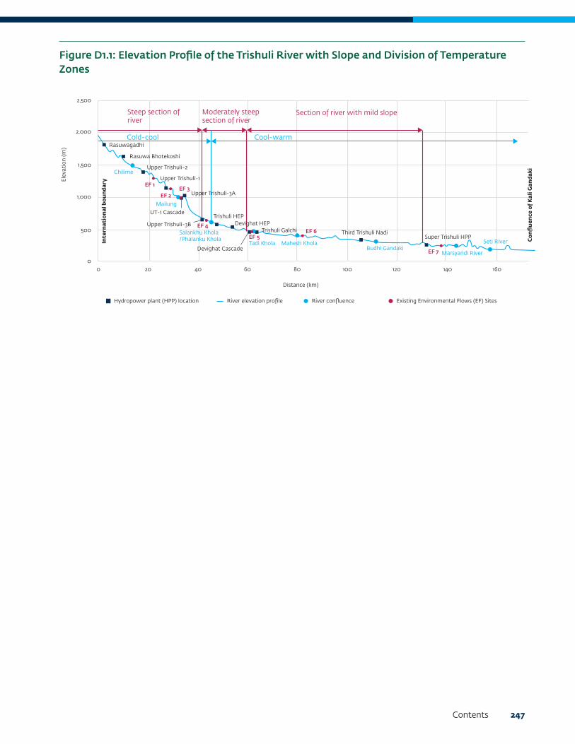
Contents 247
Figure D1.1: Elevation Profile of the Trishuli River with Slope and Division of Temperature Zones
Cold-cool
Steep section of river
Moderately steep section of river
Section of river with mild slope
Cool-warm
20 40 60 80 100 120 140 160
Distance (km)
Con
flu
ence
of K
ali G
anda
ki
Inte
rnat
ion
al b
oun
dary
00
500
1,000
1,500
2,000
2,500
Rasuwagadhi
Rasuwa Bhotekoshi
Chilime
Mailung
Salankhu Khola/Phalanku Khola
Tadi Khola Mahesh KholaBudhi Gandaki
Marsyandi River
Seti River
Upper Trishuli-2
EF 1
EF 2EF 3
EF 4
EF 5
EF 7
EF 6
Upper Trishuli-1
UT-1 Cascade
Upper Trishuli-3A
Upper Trishuli-3BTrishuli HEP
Devighat HEP
Devighat Cascade
Trishuli Galchi Third Trishuli NadiSuper Trishuli HPP
Hydropower plant (HPP) location River elevation profile River confluence Existing Environmental Flows (EF) Sites
Elev
atio
n (m
)

248 Cumulative Impact Assessment and Management: Hydropower Development in the Trishuli River Basin, Nepal
2. Data and Assumptions
Project Delineation
Nodes and arcs are the basic requirements of DRIFT DSS setup and must be added before any of the other activities can be completed. Once they have been specified, the zones, sites, and infrastructure can be added. The relationships between these effectively create a map of the river system. Nodes may be defined at the following:
• Sites
• Where zones begin and end (if these are between sites)
• Tributary confluences
• Upstream of impoundments or other infrastructure where these are upstream of the study reach if these impact on connectivity.
Arcs are segments of river that join nodes. One or more arcs combine to form a zone. And sites are locations where biophysical sampling has been done, or for which biophysical information is available. All the information in the DSS is linked to and reported in relation to a site (and in the integrity maps section of analysis, they are reported by zone).
In this study, project delineation is carried out such that each HPP is located between two nodes. Nodes are defined at the starting point of the project boundary (that is, at the Chinese Border), at tributaries and tributary confluences, and at EFlows sites. Arcs are connecting each node and the sites defined are the EFlows sites. Paths are defined to indicate both ways of migration at each site. Setup layout for the EFlows Assessment is as shown in Figure D2.1.
6-EF0
7
3018
800
1-EF1
2-EF2
5
3-EF3
10
11-EF4
UT-3B
UT-3A
UT-1
12
14
15
16-EF5
17
19-EF6
20
22-EF7
Super Trishuli
Devighat (E)
Trishuli (E)
6
7
10
12
1
2
3
13
14
15
17
18
19
20
22
23
24
11
8
4
16
21
Node
Node& Site
WaterResource
Development
Arc #
River/ Tributary
Name
Chilime
Langtang
Tadi
Tris
huli
Mailune
Salankhu
Budhi Gondaki
Figure D2.1: Setup Layout for EFlows Assessment

Contents 249
Indicator Groups
Following groups of indicators have been selected for modeling:
• Fish: This indicator is defined throughout the project area, that is, in the main river as well as in the tributaries according to distribution as discussed in the section “Indicator Fish Species and Distribution” in chapter 1.
• Algae: Defined for main river only
• Invertebrates: Defined for the main river only
• Geomorphology: Defined in the main river as well as the tributaries as it is strongly related to fish
Response Curves
For fish, the response curves from the Neelum-Jhelum Basin have been utilized for modelling of the Trishuli Basin, since both have similar species and are Himalayan Rivers. For other indicators, available information and expert judgment is being used for preparing the response curves.
Connectivity Barrier of HPPs
Fish ladders are being considered in modelling of fish migration in the main river. However, fish ladders are not considered in the tributaries, since there are other factors acting on and affecting fish migration between the tributaries and main river. An example is loss of connectivity due to reservoirs created by the dams, which are not being considered in this analysis for tributaries.
The following is the rationale used for the connectivity dependence of fish:
• Without fish ladders, the upstream connectivity reduction will be 100 percent (that is, UT-1 blocks 100 percent movement up from EFlows [EF] 2 to EF 1) for any dam.
• Without fish ladders, the downstream barrier to movement will be 90 percent (that is, UT-1 blocks 90 percent of fish from moving downstream from EF 1 to EF 2).
• If there are chains of dams (as on Chilime Khola tributary):
• The connectivity-barrier effect will be slightly reduced, moving “away” from the site in question. Reduction in barrier can be based on the amount of habitat, perhaps the “biological length” dammed by each dam on the tributary.
• For dependence response curves from EF 5 to EF 4:
• A relative portion of the population above EF 4 and below EF 5 will be considered in winter, in summer, and over the whole year.
• The importance of the EF 5 population to that at EF 4 will be considered; if EF 5 is no longer there to “feed” EF 4, for example, in the case of Mahseer, it will pretty much die out above EF 4, because there is no breeding habitat, further upstream is too cold, so the percent dependence of EF 4 on EF 5 is pretty much 100 percent.
The following rationale will be used for barrier-connectivity dependence of sediments:
• For bed load, percent reduction is taken to be 10 percent in the main river and 5 percent in the tributaries. For a typical run-of-river project, bed load reduction due to barrier effect is usually not the case. Very small amounts of the bed load will be held back by the dam; the rest will pass through it.
For suspended load, percent reduction is taken as 5 percent in both the main river and the tributaries.

250 Cumulative Impact Assessment and Management: Hydropower Development in the Trishuli River Basin, Nepal
3. HydrologyThe baseline and scenario hydrological daily time series data for the first three EFlows sites were used from the previous EFlows study of Upper Trishuli-1 HEP. These data were provided by Nepal Water and Energy Development Company, the developer of UT-1 HEP. These are based largely on flow data obtained from the Department of Hydrology and Meteorology gauging station at Betrawati. The best available long-term hydrological data were for the period 1967 to 2013, and so this was the period on which the EFlows Assessment was based.
Details of the hydrological data available for the Upper Trishuli-1 HEP and the procedures undertaken to obtain then are covered in Detail Design Report-II, Civil of UT-1 HEP.
The baseline and scenario hydrological daily time series for the other scenarios were calculated using the “catchment area ratio approach.”
The hydrological record for the Trishuli River suggests that this is a flood-pulse system, with four well-defined seasons (Figure D3.1). Once the seasons were defined, DRIFT calculated a suite of ecologically relevant flow indicators that were used by the specialists to determine the flow-related links to the ecosystem indicators. The flow indicators and the reasons for their selection as indicators are given in Table D3.2. Each flow indicator was calculated for each year in the hydrological record, thereby deriving an annual times-series of 47 years for each flow indicator.
The flow indicators are used as drivers of change in other aspects of the river ecosystem. They are reported in the results to provide context for and understanding about the ecosystem responses. They are not used in the calculation of ecosystem integrity.
Figure D3.1: One Year (1967) of the Baseline Hydrological Record at EFlows Site 4, Showing the Seasonal Divisions, from Left to Right, into Dry, Transitional 1, Wet, Transitional 2, and Back into Dry (m3/sec =cubic meters/sec)
Ave
rage
dai
ly fl
ow (m
3 /s)
Cum
ulative inflow (%
)
600
550
500
450
400
350
300
250
200
150
100
50
0
02/
01/
67
09/
01/
67
16/0
1/67
23/0
1/67
30/0
1/67
06/
02/
67
13/0
2/67
20/0
2/67
27/0
2/67
06/
03/
67
13/0
3/67
20/0
3/67
27/0
3/67
03/
04/
67
10/0
4/67
17/0
4/67
24/0
4/67
01/
05/
67
08/
05/
67
15/0
5/67
22/0
5/67
29/0
5/67
05/
06/
67
12/0
6/67
19/0
6/67
26/0
6/67
03/
07/
67
10/0
6/67
17/0
7/67
24/0
7/67
31/0
7/67
07/
08/
67
14/0
8/67
21/0
8/67
28/0
8/67
04/
09/
67
11/0
9/67
18/0
9/67
25/0
9/67
02/
10/6
7
09/
10/6
7
16/1
0/6
7
23/1
0/6
7
30/1
0/6
7
06/
11/6
7
13/1
1/67
20/1
1/67
27/1
1/67
04/
12/6
7
11/1
2/67
18/1
2/67
25/1
2/67
100
90
80
70
60
50
40
30
20
10
0
Sub-daily Hydrograph Season boundaries Wet threshold Dry threshold

Contents 251
Indicator Reason for selection as indicators
Mean annual runoff Gives an indication of annual abstraction/addition of water, if any.
Dry season minimum five-day discharge
Dry season minimum day-day average flows influence available habitat area, fish movement, and winter temperatures (buffering)
Dry season onset Onset and duration of seasons: • Link with climatic factors
• Cues fruiting and flowering
• Cues migration and breeding
• Support life-history patterns
Dry season duration The dry season is typically the harshest season for aquatic life to survive. This is the time when flows are low, water quality influences potentially stronger, and temperatures (either hot or cold) are most challenging. Increases in the duration of this harsh period can have significant influence on overall chances of survival.
Dry season average daily volume Dry periods:• Promote in-channel growth
• Support larval stages
• Maintain intra-annual variability
Wet season onset Onset and duration of seasons: • Link with climatic factors
• Cues fruiting and flowering
• Cues migration/breeding
• Support life-history patterns
Wet season duration Important for supporting life-stages, such as hatching and growth of young. The wet season is also when most erosion and deposition occurs due to the higher shear stress and sediment loads in the river.
Wet season flood volume Floods: • dictate channel form
• flush and deposit sediment and debris
• promotes habitat diversity
• support floodplains
• distribute seeds
• facilitate connectivity
• control terrestrial encroachment
Division Parameter
Start of the hydrological year January
End of dry season 4 x minimum dry season discharge
Start of wet season 1.1 x mean annual discharge
End of transition 2 4 x minimum dry season discharge, and the recession rate <0.1 m3/day over 10 days
Table D3.1: Parameters Used for Seasonal Divisions
Table D3.2: Flow Indicators Used in the Trishuli River
Continued on the next page

252 Cumulative Impact Assessment and Management: Hydropower Development in the Trishuli River Basin, Nepal
The scenarios used in this assessment did not include consideration of peaking-power operations. If this scenario was considered then the additional flow indicators linked to daily range in discharge—wet, transition, and dry seasons—would be selected. Changes in water level over short periods are important for a number of reasons:
• The shear stress changes rapidly as the flow rate changes, affecting both the water surface slope and the depth of the river. Thus, conditions for erosion but also for animals and plants change rapidly over this time, often to a point where they can no longer maintain their position in the channel, resulting in wash-away.
• Rapid decreases in flow can also lead to stranding of animals as flows recede from an area quicker than the animals can respond.
• As water levels decrease, riverbanks may not drain as quickly as the river recedes, leading to an over pressuring within the banks that reduces bank stability.
Figure D3.2 shows examples of annual time-series of a DRIFT flow indicator with average daily volume in the dry season (showing four scenarios).
Indicator Reason for selection as indicators
Transition1 and Transition 2 average daily volume
Dry-wet-dry transitions: • Distribute sediments and nutrients flushed from the watershed
• Distribute seeds
• Support migration of adults and larvae
Transition 2 recession slope Transition 2 recession shape refers to the speed at which the flows change from wet season flows to dry season flows. Under natural conditions this is usually a relatively gentle transition, but this can change with impoundments. If it is a very quick transition, there can be issues of bank collapse and/or stranding similar to those described for “within-day range in discharge.”
Figure D3.2: Examples of Annual Time-Series of a DRIFT Flow Indicator: Average Daily Volume in the Dry Season (showing four scenarios)
Ave
rage
dai
ly v
olum
e (M
m3/
day)
1968
1970
1972
1974
1976
1978
1980
1982
1984
1986
1988
1990
1992
1994
1996
1998
200
0
200
2
200
4
200
6
200
8
2010
2012
Base-2016 Ddv 10_MinM_FoFP Ddv 30_MinM_NoFP Ddv 20_MeanM_NoFP Ddv
5
4
3
2
1
0

Contents 253
4. Fish Indicators Used in the EFlows Assessment and Their Flow-Related NeedsThe Trishuli River is a fast-flowing river with higher gradient (approximately 3 percent) in the initial length followed by moderate slope (approximately 1 percent) and mild slope (approximately 0.3 percent) as the river reaches plains (see profile of the river in Figure D1.1). The river is rich in fish biodiversity, especially the cold-water fish like Snow Trout. As outlined in the section “Indicator Fish Species and Distribution” in chapter 1, the following four fish indicators were selected as indicators for EFlows Assessment:
• Snow Trout (Schizothorax richardsonii)
• Golden Mahseer (Tor putitora)
• Buduna (Garra annandalei)
• Indian Catfish (Glyptothorax indicus)
The first two species are migratory, whereas the remaining two are nonmigratory or resident fish species. All the species selected as indicators demonstrate a comparatively higher degree of specialization in habitat preference in the study area. In other words, the habitat range of these
species was observed to terminate either moving upstream or downstream within the study area. Changes in flow regime are therefore likely to have a comparatively high level of impact on these species. The Snow Trout is found in the entire study area, whereas the Golden Mahseer, the Buduna, and the Glyptothorax are reported to be found at or below EFlows site 4.
The Snow Trout prefers to live among rocks and is primarily a bottom feeder, preferably feeding near big submerged stones. It is mainly herbivorous, feeding mainly on algal slimes, aquatic plants, and detritus but also aquatic insect larvae encrusted on the rocks (Vishwanath 2010). The Snow Trout has two spawning periods, March–April and October–November. It migrates from lakes and rivers of the valley to the adjoining tributaries to find suitable places for breeding, mainly in side streams or a side channels along the main river bed (Jhingran 1991; Welcomme 1985; and Sunder 1997).
A summary of key life history aspects of the Snow Trout is provided in Table D4.1. It includes the preferences for flow-dependent habitat, breeding, and migratory behavior.
Habitat, food, and temporal pattern
Juveniles Adults (nonbreeding) Spawning
Informa-tion/ data
References Informa-tion/data
References Informa-tion/data
References
Habitat and flow prefer-ences
Description of habitat
- - Found in rivers and streams of mountain-ous areas of the Hima-layas, India, Afghanistan, and Nepal
Menon 1999; Sunder et al. 1999; Talwar and Jhingran 1991
Clear water on gravel-ly or stony grounds or on fine peb-bles (50–80 millimeter diameter)
Shrestha and Khanna 1976
Table D4.1: Summary of Key Life History Aspects and Flow Related Needs of Snow Trout
Continued on the next page

254 Cumulative Impact Assessment and Management: Hydropower Development in the Trishuli River Basin, Nepal
Habitat, food, and temporal pattern
Juveniles Adults (nonbreeding) Spawning
Informa-tion/ data
References Informa-tion/data
References Informa-tion/data
References
Habitat and flow preferences (continued)
Altitude - - The Snow Trout is found in abundance in the 1,875 meter to 3,125 meters above sea level zone and prefers rapid, pool, and riffle types of habitats
IUCN Red List of Threatened Species (Vishwanath, W.)
- -
Substrate Stones and gravels
Raina and Petr 1999
Rocks and big sub-merged stones
IUCN Red List of Threatened Species (Vishwanath 2010)
Developing eggs and larvae have been seen in semi-stag-nant nursery beds along riverbanks interspaced with gravel and stones
Raina and Petr 1999
Depth <0.75 meters Shrestha and Khanna 1976
1–3 meters NCMG n.d. 1–3 meters Shrestha and Khanna 1976
Velocity 0–2 meters per second
Shrestha and Khanna 1976
2–8.4 m/s (Note: the upper value may not be high as this would pose energetic constraints for fish and needs to be verified).
NCMG n.d. 2–8.4 meters per second
Shrestha and Khanna 1976
Temperature 10–18 0C Shrestha and Khanna 1976
7.2–22 0C NCMG n.d. 12–15 0C Shrestha and Khanna 1976
Dissolved O2 6–8 mg/l http://www.fao.org/do-crep/005/y3994e/y3994e0q.htm
6–8 mg/l Rai et al. n.d. 10–15 mg/l Sunder 1997; Shrestha and Khanna 1976
Table D4.1: Summary of Key Life History Aspects and Flow Related Needs of Snow Trout (continued)
Continued on the next page

Contents 255
Habitat, food, and temporal pattern
Juveniles Adults (nonbreeding) Spawning
Informa-tion/ data
References Informa-tion/data
References Informa-tion/data
References
Food preferences Inverte-brates, algae
Omnivorous and oppor-tunist feeder. Mainly algae, fish, and in-vertebrates.
Shrestha 1990; Jhin-gran 1991
n/a n/a
Additional information
Information/data References
Migration Snow Trout migrate upstream at the start of the monsoon season in March–April and downstream at the end of this season in October–November for spawning.
Shrestha 1990; Negi 1994; Talwar and Jhingran 1991
Triggers Breeding is triggered by snowmelt and rise in turbidity. Fish move to breeding grounds in shallow side pools, side channels, and tributaries of the river with cobbles and gravely beds. Eggs hatch in this season, and fries and fingerlings remain in shallow waters in side channels.
Jhingran 1991; Welcomme 1985; Sunder 1997
Spawning behavior
Snow Trout spawns when two years old, depending on food supply. Mature Snow Trout has a change in color during the breeding time. Mature males develop tubercles on either side of the snout, faint yellow color of the body, and reddish color of fins. Females spawn in natural as well as in artificial environments. This fish can spawn naturally or by stripping the wild/cultured mature female during the spawning season. It spawns in September/October and March/April.
Rai et al. n.d.
Months Flow conditions
Fish Behavior References
May/June Onset of flood season
Snow Trout spawn in spring. By this time of the year, the fish eggs reach their final stage of maturity provided the aquatic system provides sufficient food required for proper development of eggs. Once the eggs reach their final stage of maturity, the fish are ready to spawn under various triggers like the snowmelt, rise in water temperature, comparatively higher turbidity level, swelling of rivers, creation of side channels, and so forth, mainly linked with the monsoon rains and snowmelt in the upper reaches of the Himalayan rivers.
Negi 1994; Rafique and Qureshi 1997; Talwar and Jhingran 1991
October– November
Onset of winter season
Snow Trout migrates downstream during winter as water temperatures decline in the upper reaches of the rivers, and a part of population may spawn at this time. It is not found in the upper reaches of the rivers in the cold winter months.
EF Assessment UT-1 HEP, ESSA, Nov. 2014; Shrestha 1990; Sivakumar 2008; Tal-war and Jhingran 1991
Table D4.1: Summary of Key Life History Aspects and Flow Related Needs of Snow Trout (continued)
For other indicator fish species, for example, Mahseer, Buduna and Indian Catfish, the preferences for flow-dependent habitat, breeding, and migratory behavior as well as a summary of the annual cycle of breeding and growth of these fish are shown in Table D4.2, Table D4.3, and Table D4.4.
The variations in the abundance of fish species in response to variations in selected flow indicators for the Trishuli River are described in terms of a series of response curves. (See chapter 7, “Response Curves.”)

256 Cumulative Impact Assessment and Management: Hydropower Development in the Trishuli River Basin, Nepal
Adults Juveniles Spawning
Depth of water 0.5–2.0 meters 0.1–0.3 meters 0.3–0.5 meters
Velocity 0–3 meters per second 0–0.5 meters per second 0.5–1.0 meters per second
Habitat Inhibit streams, pools and lakes. Found in rapid streams with rocky bed.
Slow-moving water with rocky bed.
Spawning is done in well-oxygenated and calm water with gravel bed.
Substrate Rocky, stony Cobbles Stones, cobbles
Temperature 15–25 °C 20–25 °C 21–25°C
Dissolved O2 6–8 milligrammes/litre (mg/l)
6–8 mg/l 6–8 mg/l
Food Omnivorous, food consists of macroinvertebrates, dipteran larvae and plant matter.
Diatoms, ciliates, rotifers, crustaceans and fish fry.
Planktons
Spawning period May–August
Breeding period and trigger
May–August in the flood season. Breeding is triggered by arise in temperature after the dry season. Breeds both in river as well as in tributaries in suitable habitat.
Movement pattern From Mangla reservoir or deep waters to breeding areas in side nullahs. It migrates upstream from the main river into rivulets mainly during the southwest monsoon. Migration process is due to the reproductive biology of the fish and also in search of fresh feeding grounds.
Movement triggers Rise in water temperature, swollen river and expansion of habitat.
Other flow–related needs Is sensitive to pollution.
Adults Juveniles Spawning
Depth 0.3–0.7 meters 0.1–0.5 meters 0.2–0.3 meters
Velocity 1–2 meters per second 0.3–0.5 meters per second 0–0.5 meters per second
Habitat Slow moving water with boulders, rocks
Slow moving water with rocky beds
Side channels with vegetation and shallow pools
Substrate Rocky Rocky Cobble
Temperature 16–24°C 18–22°C 18–22°C
Dissolved O2 4–6 mg/l 4–6 mg/l 4–6 mg/l
Food Algae and diatoms, detritus Algae and diatoms –
Breeding period and trigger
May–August in the Flood Season. Breeding is triggered by rise in temperature after the Dry Season. Spawning in side channels in shallow waters (10–20 centimeters) with boulders, vegetation, and low currents.
Movement pattern Shows seasonal movement.
Movement timing During fall and spring season.
Movement triggers Availability of side pools with shallow waters, rise in temperature
Other flow-related needs Is sensitive to pollution. Can tolerate turbidity.
Table D4.2: Preferences for Flow–dependent Habitat, Breeding, and Migratory Behavior of the Mahseer
Table D4.3: Preferences for Flow-Dependent Habitat, Breeding, and Migratory Behavior of the Buduna

Contents 257
Adults Juveniles Spawning
Depth Shallow (<1.0 meters) Shallow (<0.5 meters) Shallow (<0.5 meters)
Velocity Slow (0.5–2.0 meters per second), can tolerate floods by taking shelter under boulders and in shallow backwater pools.
Slow (0.5–1.0 meters per second)
Slow (0.5–1.0 meters per second)
Habitat Side pools with mild water current along the fast-flowing water. The river bottom with fine gravel and gravel mixed with sand
Side channels with mild water current and gravely river bed
Riffles, shallow pools, with gravely beds
Substrate Gravely or gravely/sandy Gravely or gravely/sandy Gravely or gravely/sandy
Temperature 15–22 °C 15–22 °C 15–22 °C
Dissolved O2 6–8 mg/l and can survive 5–6 mg/l
6–8 mg/l 6–8 mg/l
Food Insect larvae, micro-invertebrate
Micro-invertebrates –
Breeding period and trigger
Late April–August in the flood Season/ snowmelt high flow. Breeding is triggered by rise in temperature after the Dry Season. Spawning in side channels in shallow waters (10–20 centimeters) with gravely and gravel-sand mixed river beds and low currents.
Movement pattern Shows limited dispersal movements for spawning and feeding
Movement timing Limited movement at the onset of wet season for breeding feeding and also at the onset of dry season for overwintering
Movement triggers Swollen rivers, change in water temperature, day length, change in turbidity
Other flow-related needs Is sensitive to pollution. Can tolerate turbidity.
Table D4.4: Preferences for Flow-Dependent Habitat, Breeding, and Migratory Behavior of the Indian Catfish

258 Cumulative Impact Assessment and Management: Hydropower Development in the Trishuli River Basin, Nepal
EFlows Sites Site 1 Site 2 Site 3 Site 4 Site 5 Site 6 Site 7
Geomorphology
Bedload inflows
Suspended sediment inflows
Suspended sediment load
Exposed sand and gravel bars
Exposed cobble and boulder bars
Median bed sediment size (armouring)
Area of secondary channels, backwaters
Algae
Algae
Macro-invertebrates
EPT abundance
Fish
Alwan snot trout guild
Garra guild
Glyptothorax
Table D5.1: Ecosystem Indicators Used in the Trishuli River DRIFT DSS
5. Ecosystem IndicatorsEcosystem indicators comprised riverine components that respond to a change in river flow (or sediment) by changing their abundance, concentration, or extent (area). The ecosystem indicators that are selected to capture the response to changes in water flow and longitudinal connectivity are most influential in the life history of the fish species considered. This is shown in Table D5.1.
Each indicator is linked with other indicators deemed to be driving change. The aim is not to try to capture every conceivable link, but rather to restrict the links to those that are most meaningful and can be used to predict the bulk of the likely responses to a change in the supply of water, sediment, or longitudinal connectivity. For migratory fish species, links were also made upstream and downstream to sites to ensure that the effects of disruption of these migration routes by HPPs could also be captured.

Contents 259
6. Ecological StatusThe descriptions for Ecological Status categories are provided in Table D6.1.
Baseline Ecological Status of the EFlows Sites
The baseline ecological status (BES) used for the Trishuli River in this assessment is summarized in Table D6.2.
The EFlows Assessment team visited the EFlows sites 2 to 7 in March 2018. The EIA study report, CIA study report, and other assessments of UT-1 HEP provide a basis for deciding the BES of the EFlows sites 1,
2, and 3, which lie in the UT-1 project boundary. As the Trishuli River follows a mild slope from EFlows site 5 and downward to EFlows site 6, a substantial sand and gravel mining was seen at site. Most of the aggregate machines were operating along the banks of the Trishuli River in this stretch. Therefore, the EFlows Assessment team rated the BES of the EFlows sites 5 and 6 to be low. However, as the river flows further down, the river health is not as degraded compared to the above two sites and also with relatively clear water from Buddhi Gandaki, a large tributary of the Trishuli River, which it joins above the EFlows site 7. The team therefore rated the EFlows site 7 as in better condition.
Ecological category
Description of the habitat condition
A Unmodified. Still in a natural condition.
B Slightly modified. A small change in natural habitats and biota has taken place but the ecosystem functions are essentially unchanged.
C Moderately modified. Loss and change of natural habitat and biota has occurred, but the basic ecosystem functions are still predominantly unchanged.
D Largely modified: A large loss of natural habitat, biota and basic ecosystem functions has occurred.
E Seriously modified. The loss of natural habitat, biota, and basic ecosystem functions is extensive.
F Critically/Extremely modified. The system has been critically modified with an almost complete loss of natural habitat and biota. In the worst instances, basic ecosystem functions have been changed and the changes are irreversible.
Table D6.1: Categories for Baseline Ecological Status
Source: After Kleynhans 1997.
Table D6.2: BES of the EFlows Sites on the Trishuli River
Discipline EFlows Site 1
EFlows Site 2
EFlows Site 3
EFlows Site 4
EFlows Site 5
EFlows Site 6
EFlows Site 7
Geomorphology A/B A/B A/B A/B B/C C B
Algae B B B B B/C D B
Macro-invertebrates B B B B C D B
Fish B/C B/C B/C B/C B/C C B
Overall ecosystem integrity B B B B B/C C B

260 Cumulative Impact Assessment and Management: Hydropower Development in the Trishuli River Basin, Nepal
7. Response CurvesThe response curves do not address any of the scenarios directly. The curves are drawn for a range of possible changes in each linked indicator, regardless of what is expected to occur in any of the scenarios. For this reason, some of the explanations and/or X-axes refer to conditions that are unlikely to occur under any of the scenarios but are needed for completion of the response curves. In addition, each response curve has a shape that assumes that all other conditions (indicators) remain at baseline.
The relationships are similar across all areas, although the actual curves may differ slightly from what is shown here. For the exact relationship used for each focus area please refer to the DSS. The focus area used as an example is denoted in the caption.
The response curves relationships used for this assessment were not derived specifically for the assessment for the Trishuli River. For fish, the response curves from the Neelum-Jhelum Basin have been utilized for modeling of Trishuli Basin, since the river basins have similar species and are Himalayan Rivers. For other indicators, available information and expert judgement was used for preparing the response curves.
The linked indicators, the response curves and the explanations of the shape of the response curves for each of the indicators, using EFlows site 4 as an example, are tabulated as follows:
Table D7.1 Exposed Sand and Gravel Bars
Table D7.2 Exposed Cobble and Boulder Bars
Table D7.3 Median Bed Sediment Size
Table D7.4 Area of Secondary Channels and Backwaters
Table D7.5 Algae
Table D7.6 Ephemeroptera, Plecoptera, and Trichoptera (EPT)
Table D7.7 Snow Trout

Contents 261
Linked indicator and response curve Explanation
a. Dry season duration (D Season) During the dry season when sediment levels are low, finer sediment is scoured from the active channel, leading to a slow loss of sand and gravel bars. The longer the dry season, the more erosion of bars will occur.
b. Wet season duration (F season) Longer wet seasons mean a longer period of high flows with relatively lower sediment loads. (In this river observed data suggest that the peak sediment loads generally occur early in the wet season, prior to peak discharge.) Thus, longer wet seasons may mean greater erosion (widening and deepening) in the main channel, causing some reduction of sand and gravel.
c. Max 5d wet season Q (F season) Larger floods are associated with higher sediment loads, and with widespread channel instability and reworking of the channel bed and banks. Large floods will thus introduce more sediment and create more sand and gravel bars during the flood season (which can be exposed as sand and gravel bars during the dry season).
d. Dry season ave daily vol (D season) Lower flows mean that more bars will be exposed.
Table D7.1: Exposed Sand and Gravel Bars
Desc Days Y1 Y2
Min 0.000 0.000
Min base 154.000 0.000
179.000 0.000
Median 204.000 0.000
222.000 -0.100
Max base 240.000 -0.300
Max base 276.000 -0.400
Desc Days Y1 Y2
Min 0.000 0.500
Min base 84.000 0.100
98.000 0.050
Median 112.000 0.000
131.500 -0.100
Max base 151.000 -0.500
Max base 173.650 -0.600
Desc m3/s Y1 Y2
Min 0.000 -2.000
Min base 391.480 -0.500
522.460 -0.100
Median 653.440 0.000
873.940 0.300
Max base 1094.440 1.200
Max base 1258.606 1.500
Desc Mm3/d Y1 Y2
Min 0.000 1.000
Min base 3.800 0.200
4.283 0.100
Median 4.675 0.000
6.286 -0.200
Max base 7.896 -0.600
Max base 9.081 -1.000
% B
ase
100
80
60
40
20
00 100 200
% B
ase
100
80
60
40
20
00 100
% B
ase
140
120
100
80
60
40
20
00 1,000
% B
ase
120
100
80
60
40
20
00 5
Desc Days Y1 Y2
Min 0.000 0.000
Min base 154.000 0.000
179.000 0.000
Median 204.000 0.000
222.000 -0.100
Max base 240.000 -0.300
Max base 276.000 -0.400
Desc Days Y1 Y2
Min 0.000 0.500
Min base 84.000 0.100
98.000 0.050
Median 112.000 0.000
131.500 -0.100
Max base 151.000 -0.500
Max base 173.650 -0.600
Desc m3/s Y1 Y2
Min 0.000 -2.000
Min base 391.480 -0.500
522.460 -0.100
Median 653.440 0.000
873.940 0.300
Max base 1094.440 1.200
Max base 1258.606 1.500
Desc Mm3/d Y1 Y2
Min 0.000 1.000
Min base 3.800 0.200
4.283 0.100
Median 4.675 0.000
6.286 -0.200
Max base 7.896 -0.600
Max base 9.081 -1.000
% B
ase
100
80
60
40
20
00 100 200
% B
ase
100
80
60
40
20
00 100%
Bas
e
140
120
100
80
60
40
20
00 1,000
% B
ase
120
100
80
60
40
20
00 5
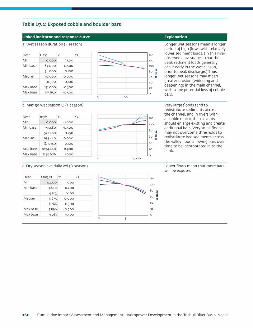
262 Cumulative Impact Assessment and Management: Hydropower Development in the Trishuli River Basin, Nepal
Linked indicator and response curve Explanation
a. Wet season duration (F season) Longer wet seasons mean a longer period of high flows with relatively lower sediment loads. (In this river observed data suggest that the peak sediment loads generally occur early in the wet season, prior to peak discharge.) Thus, longer wet seasons may mean greater erosion (widening and deepening) in the main channel, with some potential loss of cobble bars.
b. Max 5d wet season Q (F season) Very large floods tend to redistribute sediments across the channel, and in rivers with a cobble matrix these events should enlarge existing and create additional bars. Very small floods may not overcome thresholds to redistribute bed sediments across the valley floor, allowing bars over time to be incorporated in to the bank.
c. Dry season ave daily vol (D season) Lower flows mean that more bars will be exposed
Table D7.2: Exposed cobble and boulder bars
Desc Days Y1 Y2
Min 0.000 1.500
Min base 84.000 0.500
98.000 0.100
Median 112.000 0.000
131.500 -0.100
Max base 151.000 -0.300
Max base 173.650 -0.500
Desc m3/s Y1 Y2
Min 0.000 -1.000
Min base 391.480 -0.500
522.460 -0.250
Median 653.440 0.000
873.940 0.100
Max base 1094.440 0.900
Max base 1258.606 1.000
Desc Mm3/d Y1 Y2
Min 0.000 1.000
Min base 3.890 0.200
4.283 0.100
Median 4.675 0.000
6.286 -0.300
Max base 7.896 -0.900
Max base 9.081 -1.500
% B
ase
140
120
100
80
60
40
20
00 100
% B
ase
120
100
80
60
40
20
00 1,000
% B
ase
120
100
80
60
40
20
00 5

Contents 263
Linked indicator and response curve Explanation
a. Max 5d wet season Q (F season) Larger floods are associated with higher sediment loads, and with widespread channel instability and reworking of the channel bed and banks. Large floods will thus reset the channel sediments, resulting in overall finer average bed sediment conditions.
b. Dry season ave daily vol (D season) The lower the dry season discharge, the more fines that can deposited on the channel bed and thus the smaller the mean bed sediment size will become. The higher the dry season discharge, the more fines that will be removed and the coarser the (now armored) channel bed will become.
Table D7.3: Median bed sedimentsize
Desc m3/s Y1 Y2
Min 0.000 1.000
Min base 391.480 0.350
522.460 0.150
Median 653.440 0.000
873.940 -0.200
Max base 1094.440 -0.600
Max base 1258.606 -1.000
Desc Mm3/d Y1 Y2
Min 0.000 -0.500
Min base 3.890 -0.150
4.283 -0.050
Median 4.675 0.000
6.286 0.150
Max base 7.896 0.250
Max base 9.081 0.350
% B
ase
120
100
80
60
40
20
00 1,000
% B
ase
100
80
60
40
20
00 5

264 Cumulative Impact Assessment and Management: Hydropower Development in the Trishuli River Basin, Nepal
Linked indicator and response curve Explanation
a. Dry season duration (D Season) During the dry season when sediment levels are low, the active channel bed slowly erodes, increasing capacity and leading to a slow abandonment of secondary channels. The longer the dry season, the more secondary channel abandonment will occur. This process will be exacerbated by reductions in sediment from upstream dams.
b. Wet season duration (F season) Longer wet seasons mean a longer period of high flows with relatively lower sediment loads. (In this river observed data suggest that the peak sediment loads generally occur early in the wet season, prior to peak discharge.) Thus, longer wet seasons may mean greater erosion (widening/deepening) in the main channel, causing some loss of secondary channels.
c. Max 5d wet season Q (F season) Very large floods will over-widen the channel and erode areas for secondary channels to form. Very small or failed floods may not be able to counteract channel narrowing of the low flow season.
d. Dry season ave daily vol (D season) The higher the average dry season flows, the more secondary channels will remain active during the low flow season (and thus available for instream biota).
Table D7.4: Area of Secondary Channels and Backwaters
Desc Days Y1 Y2
Min 0.000 0.000
Min base 154.000 0.000
179.000 9.000
Median 204.000 0.000
222.000 -0.100
Max base 240.000 -0.400
Max base 276.000 -0.600
Desc Days Y1 Y2
Min 0.000 0.000
Min base 84.000 0.000
98.000 0.000
Median 112.000 0.000
131.500 -0.100
Max base 151.000 -0.500
Max base 173.650 -0.600
Desc m3/s Y1 Y2
Min 0.000 -1.000
Min base 391.480 -0.300
522.460 -0.100
Median 653.440 0.000
873.940 0.500
Max base 1094.440 1.500
Max base 1258.606 2.000
Desc Mm3/d Y1 Y2
Min 0.000 -4.000
Min base 3.890 -0.500
4.283 -0.200
Median 4.675 0.000
6.286 0.200
Max base 7.896 0.800
Max base 9.081 1.000
% B
ase
100
80
60
40
20
00 100 200
% B
ase
100
80
60
40
20
00 100
% B
ase
150
100
50
00 1,000
% B
ase
120
100
80
60
40
20
00 5
Desc Days Y1 Y2
Min 0.000 0.000
Min base 154.000 0.000
179.000 9.000
Median 204.000 0.000
222.000 -0.100
Max base 240.000 -0.400
Max base 276.000 -0.600
Desc Days Y1 Y2
Min 0.000 0.000
Min base 84.000 0.000
98.000 0.000
Median 112.000 0.000
131.500 -0.100
Max base 151.000 -0.500
Max base 173.650 -0.600
Desc m3/s Y1 Y2
Min 0.000 -1.000
Min base 391.480 -0.300
522.460 -0.100
Median 653.440 0.000
873.940 0.500
Max base 1094.440 1.500
Max base 1258.606 2.000
Desc Mm3/d Y1 Y2
Min 0.000 -4.000
Min base 3.890 -0.500
4.283 -0.200
Median 4.675 0.000
6.286 0.200
Max base 7.896 0.800
Max base 9.081 1.000
% B
ase
100
80
60
40
20
00 100 200
% B
ase
100
80
60
40
20
00 100
% B
ase
150
100
50
00 1,000
% B
ase
120
100
80
60
40
20
00 5

Contents 265
Linked indicator and response curve Explanation
a. Dry season duration (D Season) Longer dry season means more time for algae to become established and temperatures also favorable toward the end of the dry season.
b. Min 5d dry season Q (D season) Lower discharge means calmer conditions, better for algae, to a point. At 0 cumecs (one cubic meter of water per second) the river will freeze.
c. Max 5d wet season Q (F season) Lower peak flows and warm conditions will favor algae growth. Higher turbidity and currents will adversely affect the population.
d. Median bed sediment size [armouring] (F season) The more stable (armored) the bed, the greater the flows necessary to remove algae.
Table D7.5: Algae
Desc Days Y1 Y2
Min 0.000 -2.000
Min base 154.000 -0.500
179.000 -0.100
Median 204.000 0.000
222.000 0.000
Max base 240.000 5.000
Max base 276.000 1.000
Desc m3/s Y1 Y2
Min 0.000 0.000
Min base 25.620 1.000
30.570 0.100
Median 35.520 0.000
40.260 0.000
Max base 45.000 -0.250
Max base 51.750 -0.500
Desc m3/s Y1 Y2
Min 0.000 2.000
Min base 391.480 0.500
522.460 0.200
Median 653.440 0.000
873.940 -0.200
Max base 1094.440 -0.500
Max base 1258.606 -1.000
Desc %Base Y1 Y2
Min 0.000 -0.300
Min base 25.000 -0.200
50.000 -0.100
Median 100.000 0.000
150.000 0.000
Max base 200.000 0.500
Max base 250.000 1.000
% B
ase
120
100
80
60
40
20
00 100 200
% B
ase
120
100
80
60
40
20
00 20 40
% B
ase
150
100
50
00 1,000
% B
ase
120
100
80
60
40
20
00 100 200

266 Cumulative Impact Assessment and Management: Hydropower Development in the Trishuli River Basin, Nepal
Linked indicator and response curve Explanation
a. Dry season duration (D Season) Aquatic invertebrates have life histories that are adapted to wide variations in seasonal flows, but populations are likely to drop slightly if the low-flow period is too long. A longer period of low flows is also likely to increase the risks of mortality as a result of high water temperature once the seasons change.
b. Min 5d dry season Q (D season) With less discharge there is less wetted area.
c. Wet season onset (F season) Delayed onset will affect cues for emergence/laying eggs
d. Wet season duration (F season) The absence of a wet period will not provide the cues needed for hatching of eggs. Sufficient wet season duration is required to provide time for eggs to mature and hatch.
Table D7.6: Ephemeroptera, Plecoptera, and Trichoptera (EPT)
Continued on next page
Desc Days Y1 Y2
Min 0.000 1.000
Min base 154.000 0.500
179.000 0.000
Median 204.000 0.000
222.000 0.000
Max base 240.000 -0.500
Max base 276.000 -1.000
Desc m3/s Y1 Y2
Min 0.000 -2.000
Min base 25.620 -0.250
30.570 0.000
Median 35.520 0.000
40.260 0.000
Max base 45.000 0.500
Max base 51.750 1.000
Desc Cal week Y1 Y2
Min 19.000 1.000
Min base 20.000 1.000
22.000 0.500
Median 24.000 0.000
25.500 -0.200
Max base 27.000 -0.900
Max base 31.050 -1.500
Desc Days Y1 Y2
Min 0.000 -2.000
Min base 84.000 -0.500
98.000 0.000
Median 112.000 0.000
131.500 0.000
Max base 151.000 0.400
Max base 173.650 0.500
Desc %Base Y1 Y2
Min 0.000 -2.000
Min base 25.000 -1.000
50.000 -0.250
Median 100.000 0.000
150.000 1.000
Max base 200.000 1.000
Max base 150.000 -0.250
Desc %Base Y1 Y2
Min 0.000 -1.000
Min base 25.000 -0.500
50.000 0.000
Median 100.000 0.000
150.000 0.000
Max base 200.000 0.200
Max base 250.000 0.500
% B
ase
120
100
80
60
40
20
00 100 200
% B
ase
120
100
80
60
40
20
00 20 40
% B
ase
120
100
80
60
40
20
020 25 30
% B
ase
100
80
60
40
20
00 100
% B
ase
120
100
80
60
40
20
00 100 200
% B
ase
100
80
60
40
20
00 100 200
Desc Days Y1 Y2
Min 0.000 1.000
Min base 154.000 0.500
179.000 0.000
Median 204.000 0.000
222.000 0.000
Max base 240.000 -0.500
Max base 276.000 -1.000
Desc m3/s Y1 Y2
Min 0.000 -2.000
Min base 25.620 -0.250
30.570 0.000
Median 35.520 0.000
40.260 0.000
Max base 45.000 0.500
Max base 51.750 1.000
Desc Cal week Y1 Y2
Min 19.000 1.000
Min base 20.000 1.000
22.000 0.500
Median 24.000 0.000
25.500 -0.200
Max base 27.000 -0.900
Max base 31.050 -1.500
Desc Days Y1 Y2
Min 0.000 -2.000
Min base 84.000 -0.500
98.000 0.000
Median 112.000 0.000
131.500 0.000
Max base 151.000 0.400
Max base 173.650 0.500
Desc %Base Y1 Y2
Min 0.000 -2.000
Min base 25.000 -1.000
50.000 -0.250
Median 100.000 0.000
150.000 1.000
Max base 200.000 1.000
Max base 150.000 -0.250
Desc %Base Y1 Y2
Min 0.000 -1.000
Min base 25.000 -0.500
50.000 0.000
Median 100.000 0.000
150.000 0.000
Max base 200.000 0.200
Max base 250.000 0.500
% B
ase
120
100
80
60
40
20
00 100 200
% B
ase
120
100
80
60
40
20
00 20 40
% B
ase
120
100
80
60
40
20
020 25 30
% B
ase
100
80
60
40
20
00 100
% B
ase
120
100
80
60
40
20
00 100 200
% B
ase
100
80
60
40
20
00 100 200

Contents 267
Linked indicator and response curve Explanation
a. Min 5d dry season Q (D season) Lower flows mean lower water levels, low temperatures as a result of lack of buffering. Can tolerate low temperatures and high turbidity. Field surveys in winter recorded temperatures of around 8oC, and air temperatures around 8–9oC.
Linked indicator and response curve Explanation
e. Median bed sediment size [armouring] (D season) Fine sediments are difficult to attach to, EPT will do better with a more armored bed up to a point beyond which they will decline again.
f. Algae (F season) EPT eat algae.
Table D7.6: Ephemeroptera, Plecoptera, and Trichoptera (EPT) (continued)
Table D7.7: Snow Trout
Continued on next page
Desc Days Y1 Y2
Min 0.000 1.000
Min base 154.000 0.500
179.000 0.000
Median 204.000 0.000
222.000 0.000
Max base 240.000 -0.500
Max base 276.000 -1.000
Desc m3/s Y1 Y2
Min 0.000 -2.000
Min base 25.620 -0.250
30.570 0.000
Median 35.520 0.000
40.260 0.000
Max base 45.000 0.500
Max base 51.750 1.000
Desc Cal week Y1 Y2
Min 19.000 1.000
Min base 20.000 1.000
22.000 0.500
Median 24.000 0.000
25.500 -0.200
Max base 27.000 -0.900
Max base 31.050 -1.500
Desc Days Y1 Y2
Min 0.000 -2.000
Min base 84.000 -0.500
98.000 0.000
Median 112.000 0.000
131.500 0.000
Max base 151.000 0.400
Max base 173.650 0.500
Desc %Base Y1 Y2
Min 0.000 -2.000
Min base 25.000 -1.000
50.000 -0.250
Median 100.000 0.000
150.000 1.000
Max base 200.000 1.000
Max base 150.000 -0.250
Desc %Base Y1 Y2
Min 0.000 -1.000
Min base 25.000 -0.500
50.000 0.000
Median 100.000 0.000
150.000 0.000
Max base 200.000 0.200
Max base 250.000 0.500
% B
ase
120
100
80
60
40
20
00 100 200
% B
ase
120
100
80
60
40
20
00 20 40
% B
ase
120
100
80
60
40
20
020 25 30
% B
ase
100
80
60
40
20
00 100
% B
ase
120
100
80
60
40
20
00 100 200
% B
ase
100
80
60
40
20
00 100 200
Desc Days Y1 Y2
Min 0.000 1.000
Min base 154.000 0.500
179.000 0.000
Median 204.000 0.000
222.000 0.000
Max base 240.000 -0.500
Max base 276.000 -1.000
Desc m3/s Y1 Y2
Min 0.000 -2.000
Min base 25.620 -0.250
30.570 0.000
Median 35.520 0.000
40.260 0.000
Max base 45.000 0.500
Max base 51.750 1.000
Desc Cal week Y1 Y2
Min 19.000 1.000
Min base 20.000 1.000
22.000 0.500
Median 24.000 0.000
25.500 -0.200
Max base 27.000 -0.900
Max base 31.050 -1.500
Desc Days Y1 Y2
Min 0.000 -2.000
Min base 84.000 -0.500
98.000 0.000
Median 112.000 0.000
131.500 0.000
Max base 151.000 0.400
Max base 173.650 0.500
Desc %Base Y1 Y2
Min 0.000 -2.000
Min base 25.000 -1.000
50.000 -0.250
Median 100.000 0.000
150.000 1.000
Max base 200.000 1.000
Max base 150.000 -0.250
Desc %Base Y1 Y2
Min 0.000 -1.000
Min base 25.000 -0.500
50.000 0.000
Median 100.000 0.000
150.000 0.000
Max base 200.000 0.200
Max base 250.000 0.500
% B
ase
120
100
80
60
40
20
00 100 200
% B
ase
120
100
80
60
40
20
00 20 40
% B
ase
120
100
80
60
40
20
020 25 30
% B
ase
100
80
60
40
20
00 100
% B
ase
120
100
80
60
40
20
00 100 200
% B
ase
100
80
60
40
20
00 100 200
Desc m3/s Y1 Y2
Min 0.000 -2.000
Min base 25.620 -0.150
30.570 0.000
Median 35.520 0.000
40.260 0.000
Max base 45.000 0.100
Max base 51.750 0.100
Desc Cal week Y1 Y2
Min 15.000 -0.500
Min base 20.000 0.200
22.000 0.050
Median 24.000 0.000
25.500 0.000
Max base 27.000 -0.500
Max base 31.050 -2.000
Desc m3/s Y1 Y2
Min 0.000 -1.500
Min base 391.480 -0.150
522.460 -0.050
Median 653.440 0.000
873.940 0.100
Max base 1094.440 0.100
Max base 1258.606 0.100
Desc %Base Y1 Y2
Min 0.000 0.500
Min base 25.000 0.100
50.000 0.000
Median 100.000 0.000
150.000 0.000
Max base 200.000 -0.100
Max base 250.000 -0.500
% B
ase
100
80
60
40
20
00 20 40
% B
ase
100
80
60
40
20
015 20 25 30
% B
ase
100
80
60
40
20
00 1,000
% B
ase
100
80
60
40
20
00 100 200

268 Cumulative Impact Assessment and Management: Hydropower Development in the Trishuli River Basin, Nepal
Linked indicator and response curve Explanation
b. Wet season onset (F season) The Snow Trout breeds during summer season from May to August (Negi 1994). By this time of the year, the fish eggs reach their final stage of maturity provided the aquatic system provides sufficient food required for proper development of eggs. Once the eggs reach to their final stage of maturity, the fish is ready to spawn under various triggers like the snowmelt, rise in water temperature, comparatively higher turbidity level, swelling of rivers, creation of side channels and so forth, mainly linked with the monsoon rains and snowmelt in the upper reaches of the Himalayan rivers (Rafique and Qureshi 1997). The breeding triggers, however, should coincide with the maturity of eggs in the ovary of fish for successful spawning.Early onset of the flood season (a month before the median) is predicted to lead to better food availability early in the season, which would help the proper development of eggs leading to improved breeding. In years when there is a delayed onset of the flood season, it is predicted that the fish would have mature eggs but could miss the necessary triggers for breeding. Eggs could perish within the fish and be reabsorbed. Failure of the flood season would mean that breeding habitats in the side channels do not become available, resulting in the failure of breeding.
c. Max 5d wet season Q (F season) Lower flows in the wet season means lower water levels: may result in higher water temperatures as a result of lack of buffering. Can tolerate a range of water temperatures 8°C to 22°C (Sharma 1989) [optimal temperature 15–16°C]. Field surveys in summer recorded temperatures of around 14–16oC.
Table D7.7: Snow Trout (continued)
Continued on next page
Desc m3/s Y1 Y2
Min 0.000 -2.000
Min base 25.620 -0.150
30.570 0.000
Median 35.520 0.000
40.260 0.000
Max base 45.000 0.100
Max base 51.750 0.100
Desc Cal week Y1 Y2
Min 15.000 -0.500
Min base 20.000 0.200
22.000 0.050
Median 24.000 0.000
25.500 0.000
Max base 27.000 -0.500
Max base 31.050 -2.000
Desc m3/s Y1 Y2
Min 0.000 -1.500
Min base 391.480 -0.150
522.460 -0.050
Median 653.440 0.000
873.940 0.100
Max base 1094.440 0.100
Max base 1258.606 0.100
Desc %Base Y1 Y2
Min 0.000 0.500
Min base 25.000 0.100
50.000 0.000
Median 100.000 0.000
150.000 0.000
Max base 200.000 -0.100
Max base 250.000 -0.500
% B
ase
100
80
60
40
20
00 20 40
% B
ase
100
80
60
40
20
015 20 25 30
% B
ase
100
80
60
40
20
00 1,000
% B
ase
100
80
60
40
20
00 100 200
Desc m3/s Y1 Y2
Min 0.000 -2.000
Min base 25.620 -0.150
30.570 0.000
Median 35.520 0.000
40.260 0.000
Max base 45.000 0.100
Max base 51.750 0.100
Desc Cal week Y1 Y2
Min 15.000 -0.500
Min base 20.000 0.200
22.000 0.050
Median 24.000 0.000
25.500 0.000
Max base 27.000 -0.500
Max base 31.050 -2.000
Desc m3/s Y1 Y2
Min 0.000 -1.500
Min base 391.480 -0.150
522.460 -0.050
Median 653.440 0.000
873.940 0.100
Max base 1094.440 0.100
Max base 1258.606 0.100
Desc %Base Y1 Y2
Min 0.000 0.500
Min base 25.000 0.100
50.000 0.000
Median 100.000 0.000
150.000 0.000
Max base 200.000 -0.100
Max base 250.000 -0.500
% B
ase
100
80
60
40
20
00 20 40
% B
ase
100
80
60
40
20
015 20 25 30
% B
ase
100
80
60
40
20
00 1,000
% B
ase
100
80
60
40
20
00 100 200

Contents 269
Linked indicator and response curve Explanation
d. Exposed sand and gravel bars (D season) Prefer breeding habitat is side streams and back waters with gravel, rocky, cobbly bed. Pools and crevices preferred for wintering. Expanding sand and gravel bars will deteriorate habitat quality (pools and riffles).
e. Median bed sediment size [armouring] (F season) The fish favor areas with gravel and algae. Gravel beds, free of fine sediment, provide habitat for attached algae and are the feeding and breeding grounds for snow trout. Armoring would increase the availability of food for this fish, while fine sediment in the bed would reduce the area available for algal growth (Talwar and Jhingran 1991; Raina and Petr 1999).With decreasing particle sizes, there would be a higher chance of embeddedness of the spawning areas. The smaller particles fill the interstitial spaces and make it hard for attached algae to grow on the gravely and cobble bed resulting in less fish food production and hence a considerable decrease in fish population. Accumulation of larger particles in the river bed (armoring) result in a growth of attached algae, which is food for the fish. It also becomes the breeding habitat for fish as they prefers the gravely and cobble bed for breeding. Consequently, the armoring of the bed results in a modest increase in fish population.
Table D7.7: Snow Trout (continued)
Continued on next page
Desc m3/s Y1 Y2
Min 0.000 -2.000
Min base 25.620 -0.150
30.570 0.000
Median 35.520 0.000
40.260 0.000
Max base 45.000 0.100
Max base 51.750 0.100
Desc Cal week Y1 Y2
Min 15.000 -0.500
Min base 20.000 0.200
22.000 0.050
Median 24.000 0.000
25.500 0.000
Max base 27.000 -0.500
Max base 31.050 -2.000
Desc m3/s Y1 Y2
Min 0.000 -1.500
Min base 391.480 -0.150
522.460 -0.050
Median 653.440 0.000
873.940 0.100
Max base 1094.440 0.100
Max base 1258.606 0.100
Desc %Base Y1 Y2
Min 0.000 0.500
Min base 25.000 0.100
50.000 0.000
Median 100.000 0.000
150.000 0.000
Max base 200.000 -0.100
Max base 250.000 -0.500
% B
ase
100
80
60
40
20
00 20 40
% B
ase
100
80
60
40
20
015 20 25 30
% B
ase
100
80
60
40
20
00 1,000
% B
ase
100
80
60
40
20
00 100 200
Desc %Base Y1 Y2
Min 0.000 -1.000
Min base 25.000 -0.800
50.000 0.000
Median 100.000 0.000
150.000 0.000
Max base 200.000 0.200
Max base 250.000 0.500
Desc %Base Y1 Y2
Min 0.000 -1.000
Min base 25.000 0.500
50.000 -0.200
Median 100.000 0.000
150.000 0.100
Max base 200.000 0.200
Max base 250.000 0.300
Desc %Base Y1 Y2
Min 0.000 -1.000
Min base 25.000 -0.500
50.000 -0.200
Median 100.000 0.000
150.000 0.100
Max base 200.000 0.200
Max base 250.000 0.300
Desc %Base Y1 Y2
Min 0.000 -0.500
Min base 25.000 -0.250
50.000 -0.050
Median 100.000 0.000
150.000 0.000
Max base 200.000 0.200
Max base 250.000 0.300
% B
ase
100
80
60
40
20
00 100 200
% B
ase
100
80
60
40
20
00 100 200
% B
ase
100
80
60
40
20
00 50 100 150 200 250
% B
ase
100
80
60
40
20
00 100 200

270 Cumulative Impact Assessment and Management: Hydropower Development in the Trishuli River Basin, Nepal
Linked indicator and response curve Explanation
f. Areas of secondary channels, backwaters (D season)
g. Algae (D season) Snow Trout are omnivorous and feed on algae and aquatic invertebrates, mainly EPT (Raina and Petr 1999). Its mouth is adapted to scraping algae from stones (Rai et al. n.d.).
h. EPT abundance (F season) Snow Trout are omnivorous and feed on algae and aquatic invertebrates, mainly EPT (Raina and Petr 1999). They are opportunist feeders and their dependence on invertebrates varies depending on the season and stage of maturity. In years with low EPT productivity, the fish would have less invertebrate food and the population would be compromised (Jhingran 1991).In years with high EPT productivity, all age classes of fish would have better growth and fattening for overwintering and a high fecundity rate, which would lead to overall higher numbers.
Table D7.7: Snow Trout (continued)
Continued on next page
Desc %Base Y1 Y2
Min 0.000 -1.000
Min base 25.000 -0.800
50.000 0.000
Median 100.000 0.000
150.000 0.000
Max base 200.000 0.200
Max base 250.000 0.500
Desc %Base Y1 Y2
Min 0.000 -1.000
Min base 25.000 0.500
50.000 -0.200
Median 100.000 0.000
150.000 0.100
Max base 200.000 0.200
Max base 250.000 0.300
Desc %Base Y1 Y2
Min 0.000 -1.000
Min base 25.000 -0.500
50.000 -0.200
Median 100.000 0.000
150.000 0.100
Max base 200.000 0.200
Max base 250.000 0.300
Desc %Base Y1 Y2
Min 0.000 -0.500
Min base 25.000 -0.250
50.000 -0.050
Median 100.000 0.000
150.000 0.000
Max base 200.000 0.200
Max base 250.000 0.300
% B
ase
100
80
60
40
20
00 100 200
% B
ase
100
80
60
40
20
00 100 200
% B
ase
100
80
60
40
20
00 50 100 150 200 250
% B
ase
100
80
60
40
20
00 100 200
Desc %Base Y1 Y2
Min 0.000 -1.000
Min base 25.000 -0.800
50.000 0.000
Median 100.000 0.000
150.000 0.000
Max base 200.000 0.200
Max base 250.000 0.500
Desc %Base Y1 Y2
Min 0.000 -1.000
Min base 25.000 0.500
50.000 -0.200
Median 100.000 0.000
150.000 0.100
Max base 200.000 0.200
Max base 250.000 0.300
Desc %Base Y1 Y2
Min 0.000 -1.000
Min base 25.000 -0.500
50.000 -0.200
Median 100.000 0.000
150.000 0.100
Max base 200.000 0.200
Max base 250.000 0.300
Desc %Base Y1 Y2
Min 0.000 -0.500
Min base 25.000 -0.250
50.000 -0.050
Median 100.000 0.000
150.000 0.000
Max base 200.000 0.200
Max base 250.000 0.300
% B
ase
100
80
60
40
20
00 100 200
% B
ase
100
80
60
40
20
00 100 200
% B
ase
100
80
60
40
20
00 50 100 150 200 250
% B
ase
100
80
60
40
20
00 100 200
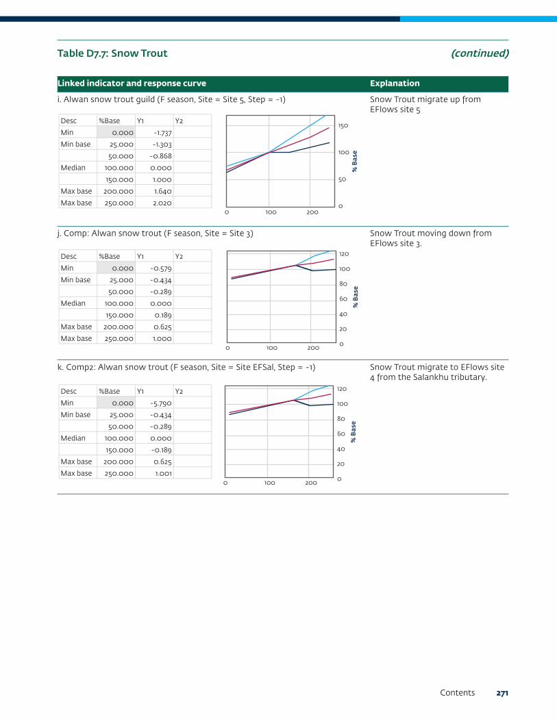
Contents 271
Linked indicator and response curve Explanation
i. Alwan snow trout guild (F season, Site = Site 5, Step = -1) Snow Trout migrate up from EFlows site 5
j. Comp: Alwan snow trout (F season, Site = Site 3) Snow Trout moving down from EFlows site 3.
k. Comp2: Alwan snow trout (F season, Site = Site EFSal, Step = -1) Snow Trout migrate to EFlows site 4 from the Salankhu tributary.
Table D7.7: Snow Trout (continued)
Desc %Base Y1 Y2
Min 0.000 -1.737
Min base 25.000 -1.303
50.000 -0.868
Median 100.000 0.000
150.000 1.000
Max base 200.000 1.640
Max base 250.000 2.020
Desc %Base Y1 Y2
Min 0.000 -0.579
Min base 25.000 -0.434
50.000 -0.289
Median 100.000 0.000
150.000 0.189
Max base 200.000 0.625
Max base 250.000 1.000
Desc %Base Y1 Y2
Min 0.000 -5.790
Min base 25.000 -0.434
50.000 -0.289
Median 100.000 0.000
150.000 -0.189
Max base 200.000 0.625
Max base 250.000 1.001
% B
ase
150
100
50
00 100 200
% B
ase
120
100
80
60
40
20
00 100 200
% B
ase
120
100
80
60
40
20
00 100 200
Desc %Base Y1 Y2
Min 0.000 -1.737
Min base 25.000 -1.303
50.000 -0.868
Median 100.000 0.000
150.000 1.000
Max base 200.000 1.640
Max base 250.000 2.020
Desc %Base Y1 Y2
Min 0.000 -0.579
Min base 25.000 -0.434
50.000 -0.289
Median 100.000 0.000
150.000 0.189
Max base 200.000 0.625
Max base 250.000 1.000
Desc %Base Y1 Y2
Min 0.000 -5.790
Min base 25.000 -0.434
50.000 -0.289
Median 100.000 0.000
150.000 -0.189
Max base 200.000 0.625
Max base 250.000 1.001
% B
ase
150
100
50
00 100 200
% B
ase
120
100
80
60
40
20
00 100 200%
Bas
e
120
100
80
60
40
20
00 100 200
Desc %Base Y1 Y2
Min 0.000 -1.737
Min base 25.000 -1.303
50.000 -0.868
Median 100.000 0.000
150.000 1.000
Max base 200.000 1.640
Max base 250.000 2.020
Desc %Base Y1 Y2
Min 0.000 -0.579
Min base 25.000 -0.434
50.000 -0.289
Median 100.000 0.000
150.000 0.189
Max base 200.000 0.625
Max base 250.000 1.000
Desc %Base Y1 Y2
Min 0.000 -5.790
Min base 25.000 -0.434
50.000 -0.289
Median 100.000 0.000
150.000 -0.189
Max base 200.000 0.625
Max base 250.000 1.001
% B
ase
150
100
50
00 100 200
% B
ase
120
100
80
60
40
20
00 100 200%
Bas
e
120
100
80
60
40
20
00 100 200

272 Cumulative Impact Assessment and Management: Hydropower Development in the Trishuli River Basin, Nepal
8. Scenarios EvaluatedThe following scenarios were evaluated:
1. Scenario 1: Existing Projects
2. Scenario 2: Existing and Under-construction (Scenario 2a) and Committed (Scenario 2b)
3. Scenario 3: Full Development (Existing + Under-Construction + Committed + Planned Projects)
Apart from the 24 HPPs listed in Table D8.1 for which the DRIFT assessment was conducted, an additional 11 HPPs listed in Table D8.2 (categorized as “planned—survey license given”) were also accounted for in the cumulative impact assessment. These additional HPPs were not modeled in the DRIFT DSS. However, on the basis of expert judgment, impacts from these 11 additional projects were estimated based on extrapolation of DRIFT DSS results for the 24 HPPs.
Assumption for Barriers to Fish
The influence of the weir and reservoir of different HPPs on Snow Trout and Mahseer populations at the various sites is partially attributable to the barrier created to the movement of fish between breeding and feeding areas, or between the main stream and tributaries. To account for this influence, the DRIFT DSS considered the influence of weirs on the movement of Snow Trout and Mahseer between the EFlows sites.
Within the DRIFT DSS, the barrier effect of water resource developments is modelled through specifying percentage reductions (or increases) in the “connectivity” between one site and another. Connectivity effects are specified per indicator.
The impact of the barrier on fish is dictated by a combination of migration success and dependence on migration. For instance, a population of fish may depend on getting past a barrier in order to access spawning and/or breeding grounds, and there may be no other location where the fish breed: this population would be highly dependent on migration.
Scenarios Code Name of HPP Operation used in scenario
Barrier effect on fish (reduction)
Barrier effect on sediments (reduction)
Upstream Downstream Bed load Suspended load
Existing projects
Existing Chilime HEP Base load 100% 90% 10% 5%
Mailung Khola HPP
Base load 100% 90% 10% 5%
Trishuli HEP Base load 100% 90% 10% 5%
Devighat HEP Base load 100% 90% 10% 5%
Tadi Khola HPP1
Base load 100% 90% 10% 5%
Thoppal Khola HPP
N/A
Table D8.1: Scenarios Selected for the Assessment Including HPPs
Continued on next page

Contents 273
Scenarios Code Name of HPP Operation used in scenario
Barrier effect on fish (reduction)
Barrier effect on sediments (reduction)
Upstream Downstream Bed load Suspended load
Upper Sanjen HPP
Base load 100% 90% 5% 5%
Sanjen HPP Base load 100% 90% 10% 5%
Upper Mailung A HEP
Base load 100% 90% 5% 5%
Upper Mailung Khola HEP
Base load 100% 90% 5% 5%
UT-3A HEP Base load 100% 90% 10% 5%
UT-3B HEP Base load 100% 90% 10% 5%
Existing, under-con-struction, and committed projects
Com-mitted
UT-1 Base load 100% 90% 10% 5%
Existing, under-con-struction, committed, and planned projects
Full develop-ment
Sanjen Khola HEP (Salasungi Power)
Base load 100% 90% 10% 5%
Langtang Khola Small HPP
Base load 100% 90% 10% 5%
Salankhu Khola HPP
Base load 100% 90% 10% 5%
Phalaku Khola HPP
Base load 100% 90% 10% 5%
Phalaku Khola HPP
Base load 100% 90% 10% 5%
Upper Tadi HPP
Base load 100% 90% 10% 5%
Middle Tadi Khola HHP
Base load 100% 90% 10% 5%
Lower Tadi Base load 100% 90% 10% 5%
Trishuli Galchi HPP
Base load 100% 90% 10% 5%
Super Trishuli HPP
Base load 100% 90% 10% 5%
Table D8.1: Scenarios Selected for the Assessment Including HPPs (continued)

274 Cumulative Impact Assessment and Management: Hydropower Development in the Trishuli River Basin, Nepal
No. HPPs planned/survey license given MW River
1 Upper Trishui-2 HPP 102.0 Trishuli Mainstem
2 Bhotekoshi Khola HPP 44.0 Bhotekoshi Khola
3 Mathillo Langtang HPP 24.35 Langtang Khola
4 Langtang Khola Reservoir HPP 310.0 Langtang Khola
5 Trishuli Khola HPP 4.4 Trishuli Khola
6 Upper Trishuli 1 Cascade HPP 24.6 Trishuli Mainstem
7 Upper Mailung B HPP 7.5 Mailung Khola
8 Middle Mailung HPP 10.0 Mailung Khola
9 Middle Trishuli Ganga Nadi HPP 65.0 Trishuli Mainstem
10 Tadi Ghyamphedi HPP 4.7 Tadi Khola
11 Tadi Khola HPP 4.0 Tadi Khola
Table D8.2: Project Accounted for Cumulative Impact Assessment of Trishuli Basin Based on Extrapolation of DRIFT DSS Results

Contents 275
9. Results of Scenario AnalysesFor each scenario, the predicted changes in the river ecosystem are evaluated per site as:
1. estimated mean percentage change from baseline in the abundance, area, or concentration of key indicators, and
2. a time-series of abundance, area, or concentration of key indicators under the flow regime resulting from each scenario.
Integrity ratings were calculated from the abundance changes by assigning a positive or negative sign to changes in abundance depending on whether an increase in abundance is a move toward natural or away. The integrity ratings for each indicator were then combined to provide an overall ecosystem integrity. The ecological integrity ratings (after Kleynhans 1996) are shown in Table D9.1.
The overall ecosystem integrity for each EFlows site associated with each scenario is summarized in Table D9.2. Projects categorized as “planned/survey license given” were also accounted for in the cumulative impact assessment based on extrapolation of DRIFT DSS results for the 24 HPPs that were modeled. Overall ecosystem integrity estimated in this manner for the Planned/survey license given is provided in the last column in table D9.2.
The fish integrity is shown in Table D9.3.
Most of the sites are not affected by flow changes as a result of HPPs, but depending on the scenarios, they may be affected by the barrier effect created by the weirs of these HPPs.
Ecological category
Corresponding DRIFT overall integrity score
Description of the habitat condition
A >-0.25 Unmodified. Still in a natural condition.
B >-0.75 Slightly modified. A small change in natural habitats and biota has taken place but the ecosystem functions are essentially unchanged.
C >-1.5 Moderately modified. Loss and change of natural habitat and biota has occurred, but the basic ecosystem functions are still predominantly unchanged.
D >-2.5 Largely modified. A large loss of natural habitat, biota and basic ecosystem functions has occurred.
E >-3.5 Seriously modified. The loss of natural habitat, biota and basic ecosystem functions is extensive.
F <-3.5 Critically / Extremely modified. The system has been critically modified with an almost complete loss of natural habitat and biota. In the worst instances, basic ecosystem functions have completely altered and the changes are irreversible.
Table D9.1 Ecological Integrity Ratings
Source: Kleynhans 1996.
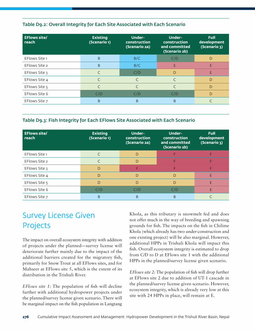
276 Cumulative Impact Assessment and Management: Hydropower Development in the Trishuli River Basin, Nepal
Table D9.2: Overall Integrity for Each Site Associated with Each Scenario
EFlows site/ reach
Existing (Scenario 1)
Under- construction (Scenario 2a)
Under- construction
and committed (Scenario 2b)
Full development (Scenario 3)
EFlows Site 1 B B/C C/D D
EFlows Site 2 B B/C E E
EFlows Site 3 C C/D D E
EFlows Site 4 C C C D
EFlows Site 5 C C C D
EFlows Site 6 C/D C/D C/D D
EFlows Site 7 B B B C
Table D9.3: Fish Integrity for Each EFlows Site Associated with Each Scenario
EFlows site/ reach
Existing (Scenario 1)
Under- construction (Scenario 2a)
Under- construction
and committed (Scenario 2b)
Full development (Scenario 3)
EFlows Site 1 C D F F
EFlows Site 2 C D F F
EFlows Site 3 D F F F
EFlows Site 4 D D D E
EFlows Site 5 D D D E
EFlows Site 6 C/D C/D C/D E
EFlows Site 7 B B B C
Survey License Given Projects
The impact on overall ecosystem integrity with addition of projects under the planned—survey license will deteriorate further mainly due to the impact of the additional barriers created for the migratory fish, primarily for Snow Trout at all EFlows sites, and for Mahseer at EFlows site 5, which is the extent of its distribution in the Trishuli River.
EFlows site 1: The population of fish will decline further with additional hydropower projects under the planned/survey license given scenario. There will be marginal impact on the fish population in Langtang
Khola, as this tributary is snowmelt fed and does not offer much in the way of breeding and spawning grounds for fish. The impacts on the fish in Chilime Khola (which already has two under-construction and one existing project) will be also marginal. However, additional HPPs in Trishuli Khola will impact this fish. Overall ecosystem integrity is estimated to drop from C/D to D at EFlows site 1 with the additional HPPs in the planned/survey license given scenario.
EFlows site 2: The population of fish will drop further at EFlows site 2 due to addition of UT-1 cascade in the planned/survey license given scenario. However, ecosystem integrity, which is already very low at this site with 24 HPPs in place, will remain at E.

Contents 277
EFlows site 3: The population of fish will significantly drop at EFlows site 3 with the addition of three HPPs: UT-1 cascade, Middle Mailung and Upper Mailung B. Fish breeding in main Trishuli River and Mailung Khola will be found at this site in the summer, but the fish will be trapped between the dams and will not be able to access favorable feeding and breeding areas. The breeding in Mailung Khola will further decline with the additional HPPs in this tributary. The contribution of Mailung Khola to population of fish in the main Trishuli River at EFlows site 3 will therefore decline further. The overall ecosystem integrity will drop from D to E category.
EFlows site 4: The population of fish will drop further at EFlows site 4 due to addition of Middle Trishuli Ganga Nandi HPP in the planned/survey license given scenario. The overall ecosystem integrity will drop from C/D to D at this site.
EFlows sites 5, 6, and 7: Additional projects will not have a significant incremental impact on the population of fish, and overall ecosystem integrity will remain same at these sites.
Additional projects in Tadi Khola tributary will have impacts on the fish populations in the upper reaches of Tadi Khol. However, these projects will not have a significant incremental impact on the population of both the Snow Trout and Mahseer in the main Trishuli River. As Existing projects on Tadi Khola have already isolated the upstream breeding and feeding areas of these fish from the Trishuli River.
Impacts on Indicator Fish Species
The summary of mean percentage changes relative to the baseline (which equals 100 percent) for indicators fish species at different EFlows sites under different scenarios as calculated by the DRIFT model is shown in Table D9.4.
Snow Trout (Schizothorax)
Table D9.4 includes the predicted impacts for the Snow Trout. This is a large-sized commercially important
migratory fish that is captured and sold in the summer season. This fish requires a lotic or river habitat for breeding. Its population is decreasing due to introduction of exotics, damming of the rivers, and overfishing. It migrates to different parts of the Trishuli River during winter and summer seasons depending upon the seasonal temperature changes and is therefore prone to impacts as a result of any change in temperature regime, flow patterns, and damming. This is illustrated by the decline in its population seen in the baseline
1. With UT-1 HPP in place under Committed Scenario, the Snow Trout population is likely to decrease significantly at EFlows site 1 due to barrier to both upstream and downstream migration created by the dam.
2. Operation of the UT-1 project (committed) will result in low flows at EFlows site 2, severely impacting the population of Snow Trout.
3. At EFlows site 3, even though the flow downstream of tailrace of UT-1 is restored, the barrier to migration created by UT-3A (under-construction) has a significant impact on the population of this fish.
4. EFlows site 4 is already degraded due to extensive sediment mining. Fish populations are therefore expected to be low at this site (Table D9.4)
5. The planned projects, namely Trishuli Ghaki and Super Trishuli, present barriers to migration of Snow Trout, significantly impacting the population of this fish at EFlows sites 5 and 6 and restricting the access of the fish to breeding areas located in Tadi Khola tributary.
6. The population of this fish is relatively unaffected at EFlows site 7 where the fish have access to breeding areas in a number of tributaries downstream and can also breed in the river, in which the flow is not as turbulent as at upstream sites. The temperature at this site is also moderated by the tributaries that flow in to the river such as Budhi Gandakai and Kali Gandaki further downstream.

278 Cumulative Impact Assessment and Management: Hydropower Development in the Trishuli River Basin, Nepal
Table D9.4: The Mean Percentage Changes (relative to scenario 1 baseline of 100%) for the Indicator Fish Species
Fish species EFlows site
Existing Under-construction
Committed Planned (10 projects)
Snow Trout 1 -8.0 -16.6 -53.1 -58.5
2 -9.5 -21.4 -92.8 -93.0
3 -26.0 -57.5 -66.0 -66.1
4 -45.7 -55.0 -55.0 -68.5
5 -25.6 -25.7 -25.8 -61.9
6 -18.0 -18.3 -18.4 -68.3
7 -3.9 -4.4 -4.6 -16.3
Mahseer 4 -59.4 -58.3 -57.9 -85.7
5 -55.2 -53.0 -52.6 -88.0
6 -29.9 -28.2 -27.7 -71.8
7 -16.8 -15.3 -14.8 -54.0
Buduna 4 0.0 0.0 0.0 0.0
5 0.0 0.0 0.0 0.0
6 0.0 0.0 0.0 0.0
7 0.0 0.0 0.0 0.0
Indian Catfish 4 0.0 0.2 0.3 0.3
5 0.6 1.0 1.1 1.3
6 0.2 0.3 0.3 0.5
7 0.1 0.2 0.2 0.4
Note: Change representing a decline in condition relative to baseline is marked as follows: Orange = change >40–70%; red = change >70%.
The anticipated impacts on Snow Trout with the addition of projects under the planned/survey licenses given scenario are as follows:
1. With the addition of projects under the planned/survey license given scenario, the population of Snow Trout will deteriorate further, mainly due to the impact of the additional barriers created, which will stop seasonal migration as well as access to spawning grounds.
2. The population of Snow Trout will be marginally impacted in Langtang Khola and Chilime Khola. However, additional HPPs in Trishuli Khola will significantly impact this fish, and the overall population of this fish at EFlows site 1 will drop further.
3. The population of Snow Trout will also decline further at EFlows site 2, as its population will be trapped within the low-flow area of UT-1 and impoundments of UT-1 cascade. The fish at EFlows site 2 will not be able to access their spawning and seasonal migration grounds.
4. The addition of UT-1 cascade, Middle Mailung HPP, and Upper Mailung B HPP will result in a decline in Snow Trout population at EFlows site 3. Fish will breed in main Trishuli River and Mailung Khola in summers at this site. However, the fish will be trapped between the UT-1 cascade and UT-3A dams and will not be able to access feeding, migration, and breeding areas upstream of UT-1 cascade and downstream of UT-3A dam.

Contents 279
5. The population of Snow Trout will also be trapped at EFlows site 4 with the addition of Middle Trishuli Ganga Nandi HPP. The fish will lose access to their feeding and breeding grounds at this site and population will drop further.
6. At EFlows sites 5, 6, and 7 and the additional projects in the planned/survey license given scenario will not have a significant incremental impact on the population of Snow Trout, as projects in this scenario are located upstream of these sites.
Mahseer (Tor)
Table D9.4 shows the predicted impacts for the Mahseer. The Mahseer also face intense human pressures such as fishing and mining. This fish inhabit fast-flowing stretches and pools. They can colonize impoundments, and so may survive within the reservoirs, but they require flowing water for breeding. This is an economically important fish both from a food and ecotourism perspective. While this fish will survive in the main stem of the Trishuli River, the reservoir with fine sediments in the bed will not provide a preferred habitat for this fish, and it will not be able to breed in the reservoirs. The tributaries in which Mahseer breeds are located mainly downstream of the EFlows site 4.
1. The Mahseer is already is already degraded at EFlows site 4 due to extensive sediment mining. The population of this fish is therefore expected to be low at this site. This is also a long-distant migratory fish that migrates from EFlows site 4 downward all the way up to the Ganges. However, existing projects (for example, Trishuli HPP and Devighat HPP) have already set barriers to its migration.
2. The impacts on this fish at EFlows site 5 will also be similar to EFlows site 4.
3. The planned projects, namely Trishuli Ghaki and Super Trishuli, present barriers to the migration of this fish, which is significantly impacting the population of this fish at EFlows sites 6 and 7 and restricting the access of this fish to its overwintering areas located in downstream section of river.
4. With the addition of projects under the planned/
survey license given scenario, the population of Mahseer will deteriorate mainly at EFlows site 5, as this fish is not found upstream of existing Trishuli HEP. Its population at sites 6 and 7 will not be affected further as there are no additional projects under the planned/survey license given category below EFlows site 5.
Buduna (Garra)
Table D9.4 shows the predicted impacts for the Buduna. This fish is adapted to river conditions and does not prefer a lake or lentic environment, although some fish may be found in the reservoirs. Relatively low levels of flow release are sufficient to support the population of this fish. This is the reason this fish is showing no change under different scenarios. The additional projects under the planned/survey license given category will not have any incremental impact on population of Buduna as there are no additional projects in this scenario within the occurrence range of this species.
Indian Catfish (Glyptothorax)
Table D9.4 show predicted changes for the Indian Catfish. This is a benthopelagic and carnivorous species, which occurs only in fast-flowing hill streams and feeds on aquatic insect larvae. It is a small fish with no significant direct fishing pressures. As the fish is small and is not likely to swim through the reservoir, the population in the remaining stretches will become isolated but the population there will be sustained. This fish is likely to suffer very insignificant change due to project developments under different scenarios. Being a nonmigratory fish species, its population is not likely to reduce in any of scenarios. The additional projects under the planned/survey license given category will not have any incremental impact on population of Indian Catfish as there are no additional projects in this scenario within the occurrence range of this species.

280 Cumulative Impact Assessment and Management: Hydropower Development in the Trishuli River Basin, Nepal
10. ConclusionsThe indicators used in the EFlows Assessment of the Trishuli Basin depict that the current plans of hydropower development in the Trishuli River and its tributaries are likely to affect the aquatic ecology of the Trishuli River. However, provided adequate provision is made for successful upstream and downstream passage of fish species past the weirs, the bulk of its impact should be minimized within the stretch of the river considered in this assessment.
Altogether five scenarios were evaluated at seven major EFlows sites:
1. Upstream of UT-1 dam site
2. Dewatered reach of the UT-1 HEP
3. Downstream of UT-1 tailrace
4. Downstream of UT-3B tailrace
5. Upstream of Tadi Khola Confluence
6. Downstream of Mahesh Khola confluence
7. Downstream of Super Trishuli HPP
As shown in Table D9.4, the Snow Trout populations will be significantly affected at EFlows sites 1 to 3, moderately affected at EFlows site 4, and the effects will be lower moving downward from EFlows site 5, as the connectivity barrier effects will be reduced and contributions from the tributaries in the snow trout population will be more. Golden Mahseer is, however, likely to suffer much under different scenarios, the severe case being the Super Trishuli HPP in place.
The results presented here concentrate on the summary information contained in the assessment of ecological integrity. This gives an indication of the overall situation of biodiversity in the Trishuli Basin if full development is carried out. It is very useful to look at more detailed indictor results of each site as these underline the fact that under the committed and the planned scenarios, it will be very difficult to prevent loss of fish species.
The response curves used in the EFlows Assessment of Neelum-Jhelum Basin in Pakistan have been utilized for this assessment, since the two river basins are similar and they have similar fish species. Regarding sediments, experience of typical run-of-river hydropower projects in Nepal have been applied for defining the connectivity issues in DRIFT DSS.
All of the indicators fish species will be significantly impacted by the reservoirs and low-flow section created by the HPPs. The Garra and Glyptothorax species will be practically eliminated in these sections as they cannot survive in lake environments and need cobble beds for feeding and shelter. The migratory Snow Trout and Mahseer also need a flowing river environment for survival and growth. However, the reservoirs will sustain the populations of these species and will provide refuge in winters.
Contents 281
11. ReferencesJhingran, V.G. 1991. Fish and Fisheries of India. 3rd Ed., Hindustan Publishing Co., Delhi, India.
Kleynhans, C.J. 1996. A qualitative procedure for the assessment of the habitat integrity status of the Luvuvhu River. Journal of Aquatic Ecosystem Health 5: 41 - 54.
Kleynhans, C.J. 1997. The development of a fish index to assess the biological integrity of South African rivers. Water SA 25 (3) 265-278.
Menon, A.G.K. 1999. Check list - Fresh water fishes of India. Rec. zool. Sun. India. Oec. Paper No. 175: i-xxix, 1-366 pp.
Negi, S.S. 1994. Himalayan Fishes and Fisheries. Ashish Publishing House, New Delhi.
NMCG (National Mission for Clean Ganga). n.d. “Priority Species of Ganga.” New Delhi: Ministry of Jal Shakti. https://nmcg.nic.in/BioFish.aspx.
Rafique M. and M.Y. Qureshi. 1997. A contribution to the Fish and Fisheries of Azad Kashmir. In: Biodiversity of Pakistan (eds. S.A. Mufti, C.A. Woods and S.A. Hasan), pp. 335-343. Pak. Mus. Nat. Hist. Islbd. & Fl. Mus. Nat. Hist. USA.
Rai, A.K., B.R. Pradhan, S.R. Basnet and D.B. Sawr. n.d. “Present Status of Snow Trout in Nepal.” Kathmandu: Fisheries Research Division, Godawari. http://www.fao.org/3/y3994e/y3994e0q.htm.
Raina, H.S. and T. Petr. 1999. Coldwater fish and fisheries in the Indian Himalayas: lakes and reservoirs. FAO Fisheries Technical Paper. No. 385: 64-88. Rome, FAO.
Sharma, B.P. 1989. Status of Schizothorax sp. in the Indian-Chinese sub-continent. FAO Fisheries Report. No. 405 (Suppl.): 90-94. Rome, FAO.
Shrestha, T.K. 1990. Resource ecology of the Himalayan waters. Curriculum Development Centre, Tribhuvan University, Kathmandu, Nepal. 645 p.
Shrestha, T.K. and S.S. Khanna. 1976. Histology and seasonal changes in testes of hill stream fish, Schizothorax plagiostomus. Z. Mikrosk. Anat. Fosh., 90(4): 749-761.
Sivakumar, K. 2008. Species richness, distribution pattern and habitat use of fishes in the Trans Himalaya, India. Elc. J. Ichthyology, 1:31-42.
Sunder, S. 1997. A review on the Biological studies of Schizothoracids in J. & K. state and elsewhere in India and their cultural possibilities. In: Recent Research in Cold water Fisheries (ed. K.L. Sehgal), pp. 157-171. Today and Tomorrows’ Printers and Publishers, New Delhi.
Sunder, S., H.S. Raina, and C.B. Joshi. 1999. Fishes of Indian Upland. Bulletin No. 2. National Research Centre on Coldwater Fisheries. ICAR, Bhimtal (Nainital), Uttaranchal, India.
Talwar, P.K. and A.G. Jhingran. 1991. Inland Fishes (2 vols.). Oxford and IBH publishing co. New Dehli, Bombay, Calcutta.
Vishwanath, W. 2010. Schizothorax richardsoni. In: IUCN 2011. IUCN Red List of Threatened Species, vers. 2011.2. [accessed 27 October 2010]
Welcomme, R.L. 1985. River Fisheries. FAO Fisheries Technical Paper No. 262, Rome. 330 pp.

282 Cumulative Impact Assessment and Management: Hydropower Development in the Trishuli River Basin, Nepal
APPENDIX E: PROJECT DESCRIPTIONSProject name as per DoED website (24 Nov. 2017)
Capacity (MW) as per DoED website
Status as per DoED website
Location (river, GP, district)
District IEE/EIA needed
Dam coordinates
Power house coordinates
Reservoir coordinates
Project located on main river of tributary
Name of river or tributary
Dam height (m)
Power house ca-pacity (MW)
Length of river between dam and power-house (km)
Project name as per DoED website (24 Nov. 2017)
Length of reser-voir up-stream of dam (km)
If tunnel exists, length of tunnel (km)
Type of operation (please tick)
If the project has an EFlows require-ment what is this? (cu-mecs)
Has the project provid-ed a monthy EFlows sched-ule?
How many days of sedi-ment flushing will be carried out?
When will sed-iment flush-ing be carried out?
What is the frequen-cy of flushing?
Is a fish pass ladder planned for the project?
If so, what is the de-sign?
Has the project provided average monthly discharg-es for all years monitor-ing has taken place?
Has the project provided baseline water quality reports?
Has the project provided baseline water tem-perature moni-toring reports?
Lat. Long. Lat. Long. Lat. Long. Contin-uous run
of the river
Run of the
river of a daily basis (sea-sonal peak-ing)
Peak-ing
only
Existing Existing
Devighat (DHP)
14.1 Opera-tional
Trishuli River
Nuwakot Yes NA NA 27° 53' 16.8"
85° 08'
02.76"
NA NA River Trishuli NA NA NA Devighat (DHP)
NA NA NA NA NA NA NA NA NA NA NA NA NA NA NA
Trishuli 24 Opera-tional
Trishuli River
Nuwakot 27° 57' 46.78"
85° 10' 13.43"
27° 55' 17.1"
85° 08'
45.45"
27° 56' 13.5"
85° 09'
7.44"
River Trishuli NA 24 NA Trishuli Pondage is down-stream of dam for peaking purposes
NA No NA P Not pro-vided, but half the dam can accom-modate spillway
NA NA NA NA No, but fish may be able to migrate through the spill way.
NA NA NA NA
Chilime (CHP)
22.1 Opera-tional
Chilime Khola
Rasuwa 28o 11' 33"
88o 18' 10"
28o 9' 52"
88o 19' 59"
28o 11' 17"
88o 18' 26"
Tributary Chilime Diver-sion only
22.1 7 Chilime (CHP)
Pondage upstream
3.36 No NA P No EFlows (as all water is diverted from the Chillime Khola into the tail race)
NA During rainy season only
On alternate days
NA No NA NA NA NA
Mailung Khola HEP
5 Opera-tional
Mailun Khola
Rasuwa Yes 28o 04' 56"
85o 11' 58"
28o 04' 13"
85o 12' 26"
NA NA Tributary Mailung Khola
NA 5 NA Mailung Khola HEP
NA NA P NA No NA NA NA NA No NA NA NA NA
Thoppal Khola HPP
1.65 Opera-tional
Thoppal Khola
Dhading Yes 27o 49' 17"
84o 50' 31"
NA NA NA NA Tributary Thopal 3.5 1.4 NA Thoppal Khola HPP
NA NA P NA No NA NA NA NA No NA NA NA NA
Tadi Khola (Thaprek) HPP
5 Opera-tional
Tadi Khola
Nuwakot Yes 27o 55' 21"
85o 20' 54"
27o 55' 22"
85o 19' 38"
NA NA Tributary Tadi Khola
NA 5 NA Tadi Khola (Thaprek) HPP
NA NA P NA No NA NA NA NA No NA NA NA NA
Under Construction Under Construction
Rasu-wagadhi (RGHEP)
111 Con-struction license issued
Trishuli River
Rasuwa 28o 16' 39"
85o 12' 03"
28o 14' 25"
85o 21' 22"
NA NA River Bhote Koshi
9 100 NA Rasu-wagadhi (RGHEP)
No reservoir
4.375 P NA No Not provided but likely to be 10 % of minimum monthly flow.
NA NA NA NA Yes NA NA NA NA
UT 3A HEP
60 Con-struction license issued
Trishuli River
Rasuwa Yes 28o 03' 39"
85o 23' 03"
28o 03' 08"
85o 12' 18"
NA NA River Trishuli NA 60 NA UT 3A HEP
No reservoir
NA NA NA NA NA NA NA NA NA Yes NA NA NA NA
UT 3B HEP
37 Con-struction license issued
Trishuli River
Nuwakot Yes 27o 59' 12"
85o 10' 11"
NA NA NA NA River Trishuli Cascade 37 NA UT 3B HEP
No reservoir
NA NA NA NA NA NA NA NA NA No NA NA NA NA
Upper Mailung Khola HEP
14.3 Con-struction license issued
Mailung Khola
Rasuwa 28° 07’
48.70” N
85° 11’ 57.65”
E
28° 06’
03.30” N
85° 11’ 46.69”
E
NA NA Tributary Mailung Khola
5.11 14.3 2.98 Upper Mailung Khola HEP
0.03 2.3 P NA No 0.102 No Settling basin- regular flushing; reservoir- flushing once in f/Y, if needed.
12 hr, if needed.
NA No NA No Yes No
Upper Mailung A HEP
6.42 Con-struction license issued
Mailung Khola
Rasuwa Yes 28o 09' 45"
85o 11' 00"
NA NA NA NA Tributary Mailung Khola
14.8 NA NA Upper Mailung A HEP
NA NA P NA No NA NA NA NA NA NA NA NA NA NA
Upper Sanjen (USHEP)
14.8 Con-struction license issued
Sanjen Khola
Rasuwa Yes 28o 13' 00"
85o 16' 30"
NA NA NA NA Tributary Sanjen Khola
NA NA NA Upper Sanjen (USHEP)
NA NA NA NA NA NA NA NA NA NA NA NA NA NA NA

Appendix E: Project Descriptions 283
Continued on next page
Project name as per DoED website (24 Nov. 2017)
Capacity (MW) as per DoED website
Status as per DoED website
Location (river, GP, district)
District IEE/EIA needed
Dam coordinates
Power house coordinates
Reservoir coordinates
Project located on main river of tributary
Name of river or tributary
Dam height (m)
Power house ca-pacity (MW)
Length of river between dam and power-house (km)
Project name as per DoED website (24 Nov. 2017)
Length of reser-voir up-stream of dam (km)
If tunnel exists, length of tunnel (km)
Type of operation (please tick)
If the project has an EFlows require-ment what is this? (cu-mecs)
Has the project provid-ed a monthy EFlows sched-ule?
How many days of sedi-ment flushing will be carried out?
When will sed-iment flush-ing be carried out?
What is the frequen-cy of flushing?
Is a fish pass ladder planned for the project?
If so, what is the de-sign?
Has the project provided average monthly discharg-es for all years monitor-ing has taken place?
Has the project provided baseline water quality reports?
Has the project provided baseline water tem-perature moni-toring reports?
Lat. Long. Lat. Long. Lat. Long. Contin-uous run
of the river
Run of the
river of a daily basis (sea-sonal peak-ing)
Peak-ing
only
Existing Existing
Devighat (DHP)
14.1 Opera-tional
Trishuli River
Nuwakot Yes NA NA 27° 53' 16.8"
85° 08'
02.76"
NA NA River Trishuli NA NA NA Devighat (DHP)
NA NA NA NA NA NA NA NA NA NA NA NA NA NA NA
Trishuli 24 Opera-tional
Trishuli River
Nuwakot 27° 57' 46.78"
85° 10' 13.43"
27° 55' 17.1"
85° 08'
45.45"
27° 56' 13.5"
85° 09'
7.44"
River Trishuli NA 24 NA Trishuli Pondage is down-stream of dam for peaking purposes
NA No NA P Not pro-vided, but half the dam can accom-modate spillway
NA NA NA NA No, but fish may be able to migrate through the spill way.
NA NA NA NA
Chilime (CHP)
22.1 Opera-tional
Chilime Khola
Rasuwa 28o 11' 33"
88o 18' 10"
28o 9' 52"
88o 19' 59"
28o 11' 17"
88o 18' 26"
Tributary Chilime Diver-sion only
22.1 7 Chilime (CHP)
Pondage upstream
3.36 No NA P No EFlows (as all water is diverted from the Chillime Khola into the tail race)
NA During rainy season only
On alternate days
NA No NA NA NA NA
Mailung Khola HEP
5 Opera-tional
Mailun Khola
Rasuwa Yes 28o 04' 56"
85o 11' 58"
28o 04' 13"
85o 12' 26"
NA NA Tributary Mailung Khola
NA 5 NA Mailung Khola HEP
NA NA P NA No NA NA NA NA No NA NA NA NA
Thoppal Khola HPP
1.65 Opera-tional
Thoppal Khola
Dhading Yes 27o 49' 17"
84o 50' 31"
NA NA NA NA Tributary Thopal 3.5 1.4 NA Thoppal Khola HPP
NA NA P NA No NA NA NA NA No NA NA NA NA
Tadi Khola (Thaprek) HPP
5 Opera-tional
Tadi Khola
Nuwakot Yes 27o 55' 21"
85o 20' 54"
27o 55' 22"
85o 19' 38"
NA NA Tributary Tadi Khola
NA 5 NA Tadi Khola (Thaprek) HPP
NA NA P NA No NA NA NA NA No NA NA NA NA
Under Construction Under Construction
Rasu-wagadhi (RGHEP)
111 Con-struction license issued
Trishuli River
Rasuwa 28o 16' 39"
85o 12' 03"
28o 14' 25"
85o 21' 22"
NA NA River Bhote Koshi
9 100 NA Rasu-wagadhi (RGHEP)
No reservoir
4.375 P NA No Not provided but likely to be 10 % of minimum monthly flow.
NA NA NA NA Yes NA NA NA NA
UT 3A HEP
60 Con-struction license issued
Trishuli River
Rasuwa Yes 28o 03' 39"
85o 23' 03"
28o 03' 08"
85o 12' 18"
NA NA River Trishuli NA 60 NA UT 3A HEP
No reservoir
NA NA NA NA NA NA NA NA NA Yes NA NA NA NA
UT 3B HEP
37 Con-struction license issued
Trishuli River
Nuwakot Yes 27o 59' 12"
85o 10' 11"
NA NA NA NA River Trishuli Cascade 37 NA UT 3B HEP
No reservoir
NA NA NA NA NA NA NA NA NA No NA NA NA NA
Upper Mailung Khola HEP
14.3 Con-struction license issued
Mailung Khola
Rasuwa 28° 07’
48.70” N
85° 11’ 57.65”
E
28° 06’
03.30” N
85° 11’ 46.69”
E
NA NA Tributary Mailung Khola
5.11 14.3 2.98 Upper Mailung Khola HEP
0.03 2.3 P NA No 0.102 No Settling basin- regular flushing; reservoir- flushing once in f/Y, if needed.
12 hr, if needed.
NA No NA No Yes No
Upper Mailung A HEP
6.42 Con-struction license issued
Mailung Khola
Rasuwa Yes 28o 09' 45"
85o 11' 00"
NA NA NA NA Tributary Mailung Khola
14.8 NA NA Upper Mailung A HEP
NA NA P NA No NA NA NA NA NA NA NA NA NA NA
Upper Sanjen (USHEP)
14.8 Con-struction license issued
Sanjen Khola
Rasuwa Yes 28o 13' 00"
85o 16' 30"
NA NA NA NA Tributary Sanjen Khola
NA NA NA Upper Sanjen (USHEP)
NA NA NA NA NA NA NA NA NA NA NA NA NA NA NA

284 Cumulative Impact Assessment and Management: Hydropower Development in the Trishuli River Basin, Nepal
Project name as per DoED website (24 Nov. 2017)
Capacity (MW) as per DoED website
Status as per DoED website
Location (river, GP, district)
District IEE/EIA needed
Dam coordinates
Power house coordinates
Reservoir coordinates
Project located on main river of tributary
Name of river or tributary
Dam height (m)
Power house ca-pacity (MW)
Length of river between dam and power-house (km)
Project name as per DoED website (24 Nov. 2017)
Length of reser-voir up-stream of dam (km)
If tunnel exists, length of tunnel (km)
Type of operation (please tick)
If the project has an EFlows require-ment what is this? (cu-mecs)
Has the project provid-ed a monthy EFlows sched-ule?
How many days of sedi-ment flushing will be carried out?
When will sed-iment flush-ing be carried out?
What is the frequen-cy of flushing?
Is a fish pass ladder planned for the project?
If so, what is the de-sign?
Has the project provided average monthly discharg-es for all years monitor-ing has taken place?
Has the project provided baseline water quality reports?
Has the project provided baseline water tem-perature moni-toring reports?
Lat. Long. Lat. Long. Lat. Long. Contin-uous run
of the river
Run of the
river of a daily basis (sea-sonal peak-ing)
Peak-ing
only
Under Construction (continued) Under Construction (continued)
Sanjen Hydro Project (SHEP)
42.5 Con-struction license issued
Sanjen Khola
Rasuwa Yes 28o 11' 00"
85o 16' 30"
NA NA NA NA Tributary Sanjen Khola
NA NA NA Sanjen Hydro Project (SHEP)
NA NA NA NA NA NA NA NA NA NA NA NA NA NA NA
Committed Committed
UT 1 216 Con-struction license issued
Trishuli River
Rasuwa 28° 07’
32” N
85° 18’ 03” E
28° 04’
37” N
85° 12’ 40” E
NA NA River Trishuli 29.5 216 12 UT 1 Noreservoir
9.7 P See next column
Yes 44 times a year (Nov-Apr: 1 each month, May-3, June-6, July-12, Aug-9, Sep-6, Oct-2), 3 hrs. for 1 time
3.67 times/month
NA Yes NA Yes Yes Yes
Planned Planned
Super Trishuli Hydro Project
100 Applied for con-struction license for gen-eration
Trishuli River
Rasuwa 27°51' 37''N
84° 38' 39"E
At toe of dam
NA NA River Trishuli 24.5 100 Power-house at toe of dam
Super Trishuli Hydro Project
5 No P P No 10.62 No "Winter Monsson"
"One or twice More fre-quent"
NA NA NA NA Yes Yes
Sanjen Khola HEP
78 Con-struction license issued
Sanjen Khola
Rasuwa 28o 14' 26"
85o 15' 00"
NA NA NA NA Tributary Sanjen Khola
2.31 78 5 Sanjen Khola HEP
Noreservoir
4.413 P NA No 0.196 No NA NA NA No NA No Yes Yes
Upper Tadi HPP
11 Con-struction license issued
Tadi Khola
Nuwakot NA NA NA NA NA NA Tributary Tadi Khola
3 11 Upper Tadi HPP
Noreservoir
2.416 P NA NA 6.3 No NA NA NA No NA No No No
Tadi Khola Hydro Project
5 Con-struction license issued
Tadi Khola
Nuwakot Yes 27o 56' 04"
85o 22' 53"
NA NA NA NA Tributary Tadi Khola
5 NA NA Tadi Khola Hydro Project
NA NA NA NA NA NA NA NA NA NA NA NA NA NA NA
Lower Tadi
4.993 Con-struction license issued
Tadi Khola
Nuwakot Yes 27o 55' 05"
85o 21' 08"
NA NA NA NA Tributary Tadi Khola
4.933 NA NA Lower Tadi
NA NA NA NA NA NA NA NA NA NA NA NA NA NA NA
Langtang Khola Small Hy-dropower Project
10 Con-struction license issued
Langtang Rasuwa Yes 28o 09' 05"
85o 20' 34"
NA NA NA NA Tributary Langtang Khola
NA NA NA Langtang Khola Small Hy-dropower Project
NA NA NA NA NA NA NA NA NA NA NA NA NA NA NA
Salankhu Khola HPP
2.5 Con-struction license issued
Salankhu Khola
Nuwakot 27o 59' 00"
85o 07' 30"
NA NA NA NA Tributary Salankhu Khola
2.5 2.2 NA Salankhu Khola HPP
No reservoir
3.209 P NA NA 0.043 No NA NA NA NA NA NA NA NA
Phalaku Khola HPP
5 Con-struction license issued
Phalaku Khola
Rasuwa Yes 27o 58' 09"
85o 15' 17"
NA NA NA NA Tributary Phalanku Khola
NA NA NA Phalaku Khola HPP
NA NA NA NA NA NA NA NA NA NA NA NA NA NA NA
Phalaku Khola HPP
14.7 Con-struction license issued
Phalaku Khola
Rasuwa Yes 28o 00' 15"
85o 16' 10"
NA NA NA NA Tributary Phalanku Khola
NA NA NA Phalaku Khola HPP
NA NA NA NA NA NA NA NA NA NA NA NA NA NA NA
Trishuli Galchi HPP
75 Con-struction license issued
Trishuli River
Nuwakot 27° 51' 48" N
85° 05' 47
" E
27° 47' 52" N
84° 58'
20" N
NA NA River Trishuli 2.5 75 8.15 Trishuli Galchi HPP
3 8.15 P NA NA NA NA NA NA NA NA NA NA NA NA
Ankhu Khola HPP
49.5 Con-struction license
Ankhu Khola
Dhading Not in the basin but IEE is available
28° 04’
00” N
84° 58’
35” E
28° 07’
00” N
85° 01’ 04” E
NA NA Tributary Ankhu Khola
7.5 42.9 6 Ankhu Khola HPP
No reservoir
5.197 P NA NA See next column
Yes NA NA NA Yes Denil Type
Yes Yes Yes

Appendix E: Project Descriptions 285
Project name as per DoED website (24 Nov. 2017)
Capacity (MW) as per DoED website
Status as per DoED website
Location (river, GP, district)
District IEE/EIA needed
Dam coordinates
Power house coordinates
Reservoir coordinates
Project located on main river of tributary
Name of river or tributary
Dam height (m)
Power house ca-pacity (MW)
Length of river between dam and power-house (km)
Project name as per DoED website (24 Nov. 2017)
Length of reser-voir up-stream of dam (km)
If tunnel exists, length of tunnel (km)
Type of operation (please tick)
If the project has an EFlows require-ment what is this? (cu-mecs)
Has the project provid-ed a monthy EFlows sched-ule?
How many days of sedi-ment flushing will be carried out?
When will sed-iment flush-ing be carried out?
What is the frequen-cy of flushing?
Is a fish pass ladder planned for the project?
If so, what is the de-sign?
Has the project provided average monthly discharg-es for all years monitor-ing has taken place?
Has the project provided baseline water quality reports?
Has the project provided baseline water tem-perature moni-toring reports?
Lat. Long. Lat. Long. Lat. Long. Contin-uous run
of the river
Run of the
river of a daily basis (sea-sonal peak-ing)
Peak-ing
only
Under Construction (continued) Under Construction (continued)
Sanjen Hydro Project (SHEP)
42.5 Con-struction license issued
Sanjen Khola
Rasuwa Yes 28o 11' 00"
85o 16' 30"
NA NA NA NA Tributary Sanjen Khola
NA NA NA Sanjen Hydro Project (SHEP)
NA NA NA NA NA NA NA NA NA NA NA NA NA NA NA
Committed Committed
UT 1 216 Con-struction license issued
Trishuli River
Rasuwa 28° 07’
32” N
85° 18’ 03” E
28° 04’
37” N
85° 12’ 40” E
NA NA River Trishuli 29.5 216 12 UT 1 Noreservoir
9.7 P See next column
Yes 44 times a year (Nov-Apr: 1 each month, May-3, June-6, July-12, Aug-9, Sep-6, Oct-2), 3 hrs. for 1 time
3.67 times/month
NA Yes NA Yes Yes Yes
Planned Planned
Super Trishuli Hydro Project
100 Applied for con-struction license for gen-eration
Trishuli River
Rasuwa 27°51' 37''N
84° 38' 39"E
At toe of dam
NA NA River Trishuli 24.5 100 Power-house at toe of dam
Super Trishuli Hydro Project
5 No P P No 10.62 No "Winter Monsson"
"One or twice More fre-quent"
NA NA NA NA Yes Yes
Sanjen Khola HEP
78 Con-struction license issued
Sanjen Khola
Rasuwa 28o 14' 26"
85o 15' 00"
NA NA NA NA Tributary Sanjen Khola
2.31 78 5 Sanjen Khola HEP
Noreservoir
4.413 P NA No 0.196 No NA NA NA No NA No Yes Yes
Upper Tadi HPP
11 Con-struction license issued
Tadi Khola
Nuwakot NA NA NA NA NA NA Tributary Tadi Khola
3 11 Upper Tadi HPP
Noreservoir
2.416 P NA NA 6.3 No NA NA NA No NA No No No
Tadi Khola Hydro Project
5 Con-struction license issued
Tadi Khola
Nuwakot Yes 27o 56' 04"
85o 22' 53"
NA NA NA NA Tributary Tadi Khola
5 NA NA Tadi Khola Hydro Project
NA NA NA NA NA NA NA NA NA NA NA NA NA NA NA
Lower Tadi
4.993 Con-struction license issued
Tadi Khola
Nuwakot Yes 27o 55' 05"
85o 21' 08"
NA NA NA NA Tributary Tadi Khola
4.933 NA NA Lower Tadi
NA NA NA NA NA NA NA NA NA NA NA NA NA NA NA
Langtang Khola Small Hy-dropower Project
10 Con-struction license issued
Langtang Rasuwa Yes 28o 09' 05"
85o 20' 34"
NA NA NA NA Tributary Langtang Khola
NA NA NA Langtang Khola Small Hy-dropower Project
NA NA NA NA NA NA NA NA NA NA NA NA NA NA NA
Salankhu Khola HPP
2.5 Con-struction license issued
Salankhu Khola
Nuwakot 27o 59' 00"
85o 07' 30"
NA NA NA NA Tributary Salankhu Khola
2.5 2.2 NA Salankhu Khola HPP
No reservoir
3.209 P NA NA 0.043 No NA NA NA NA NA NA NA NA
Phalaku Khola HPP
5 Con-struction license issued
Phalaku Khola
Rasuwa Yes 27o 58' 09"
85o 15' 17"
NA NA NA NA Tributary Phalanku Khola
NA NA NA Phalaku Khola HPP
NA NA NA NA NA NA NA NA NA NA NA NA NA NA NA
Phalaku Khola HPP
14.7 Con-struction license issued
Phalaku Khola
Rasuwa Yes 28o 00' 15"
85o 16' 10"
NA NA NA NA Tributary Phalanku Khola
NA NA NA Phalaku Khola HPP
NA NA NA NA NA NA NA NA NA NA NA NA NA NA NA
Trishuli Galchi HPP
75 Con-struction license issued
Trishuli River
Nuwakot 27° 51' 48" N
85° 05' 47
" E
27° 47' 52" N
84° 58'
20" N
NA NA River Trishuli 2.5 75 8.15 Trishuli Galchi HPP
3 8.15 P NA NA NA NA NA NA NA NA NA NA NA NA
Ankhu Khola HPP
49.5 Con-struction license
Ankhu Khola
Dhading Not in the basin but IEE is available
28° 04’
00” N
84° 58’
35” E
28° 07’
00” N
85° 01’ 04” E
NA NA Tributary Ankhu Khola
7.5 42.9 6 Ankhu Khola HPP
No reservoir
5.197 P NA NA See next column
Yes NA NA NA Yes Denil Type
Yes Yes Yes

2121 Pennsylvania Ave., NWWashington, D.C. 20433, USAwww.ifc.org/sustainability May 2020