Cultural Resources Survey and National Register Testing of Comite River Diversion Project, East...
215
Cultural Resources Series Report Number: COELMN/PD-97/1 U.S. Army Corps of Engineers New Orleans District CULTURAL RESOURCES SURVEY AND NATIONAL REGISTER TESTING OF COMITE RIVER DIVERSION PROJECT, EAST BATON ROUGE PARISH, LOUISIANA March 1997 FINAL REPORT VOLUME I OF II Chapters I - VIII R. Christopher Goodwin & Associates, Inc. 5824 Plauche Street New Orleans, LA 70123 '»nOQUALtnriNSEECTED a PREPARED FOR: U.S. Army Corps of Engineers New Orleans District P.O. Box 60267 New Orleans, LA 70160 Unclassified. Distribution is unlimited. 19980514 035
-
Upload
independent -
Category
Documents
-
view
1 -
download
0
Transcript of Cultural Resources Survey and National Register Testing of Comite River Diversion Project, East...
Cultural Resources Series Report Number: COELMN/PD-97/1
U.S. Army Corps of Engineers New Orleans District
CULTURAL RESOURCES SURVEY AND NATIONAL REGISTER TESTING OF COMITE RIVER DIVERSION PROJECT, EAST BATON ROUGE PARISH, LOUISIANA
March 1997
FINAL REPORT
VOLUME I OF II Chapters I - VIII
R. Christopher Goodwin & Associates, Inc. 5824 Plauche Street New Orleans, LA 70123
'»nOQUALtnriNSEECTED a
PREPARED FOR:
U.S. Army Corps of Engineers New Orleans District P.O. Box 60267 New Orleans, LA 70160
Unclassified. Distribution is unlimited.
19980514 035
SECURITY CLASSIFICATION OF THIS PAGE
REPORT DOCUMENTATION PAGE Form Approved OMB No. 0704-0188
1a. REPORT SECURITY CLASSIFICATION 1b. RESTRICTIVE MARKINGS
2a. SECURITY CLASSIFICATION AUTHORITY
2b. DECLASSIFICATION/DOWNGRADING SCHEDULE
3. DISTRIBUTION/AVAILABILITY OF REPORT
Unclassified. Distribution is unlimited.
4. PERFORMING ORGANIZATION REPORT NUMBER(S) 5. MONITORING ORGANIZATION REPORT NUMBER(S)
6a. NAME OF PERFORMING ORGANIZATION
R. Christopher Goodwin & Associates, Inc.
6b. OFFICE SYMBOL (if applicable)
7a. NAME OF MONITORING ORGANIZATION U.S. Army Corps of Engineers New Orleans District
6c. ADDRESS (City, State, and ZIP Code) 5824 Plauche St. New Orleans, LA 70123
7b. ADDRESS (City, State, and ZIP Code) P.O. Box 60267 New Orleans, LA 70160-0267
8a. NAME OF FUNDING/SPONSORING ORGANIZATION U.S. Army Corps of Engineers New Orleans District
8b. OFFICE SYMBOL (if applicable) CELM-PD-RN
9. PROCUREMENT INSTRUMENT IDENTIFICATION NUMBER
COELMN/PD-97/1
8c. ADDRESS (City, State and ZIP Code) P.O. Box 60267 New Orleans, LA 70160-0267
10. SOURCE OF FUNDING NUMBERS
PROGRAM ELEMENT NO.
N/A
PROJECT NO. Civil Works Funding
TASK NO. WORK UNIT ACCESSION NO.
11. TITLE (Include Security Classification) CULTURAL RESOURCES SURVEY AND NATIONAL REGISTER TESTING OF COMITE RIVER DIVERSION PROJECT, EAST BATON ROUGE PARISH, LOUISIANA
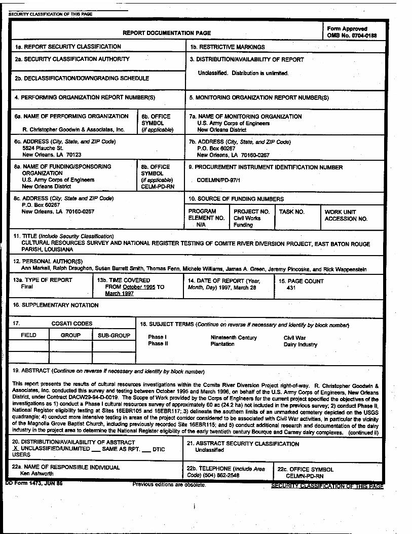
12. PERSONAL AUTHOR(S) Ann Markell, Ralph Draughon, Susan Barrett Smith, Thomas Fenn, Michele Williams, James A. Green, Jeremy Pincoske, and Rick Wappenstein
13a. TYPE OF REPORT Final
13b. TIME COVERED FROM October 1995 TO March 1997
14. DATE OF REPORT (Year, Month, Day) 1997, March 28
15. PAGE COUNT 431
16. SUPPLEMENTARY NOTATION
17. COSATI CODES
FIELD GROUP SUB-GROUP
18. SUBJECT TERMS (Continue on reverse if necessary and identify by block number)
Phase I Phase II
Nineteenth Century Plantation
Civil War Dairy Industry
19. ABSTRACT (Continue on reverse if necessary and identify by block number)
This report presents the results of cultural resources investigations within the Comite River Diversion Project right-of-way. R. Christopher Goodwin & Associates, Inc. conducted this survey and testing between October 1995 and March 1996, on behalf of the U.S. Army Corps of Engineers, New Orleans District, under Contract DACW29-94-D-0019. The Scope of Work provided by the Corps of Engineers for the current project specified the objectives of the investigations as 1) conduct a Phase I cultural resources survey of approximately 60 ac (24.2 ha) not included in the previous survey; 2) conduct Phase II National Register eligibility testing at Sites 16EBR105 and 16EBR117;.3) delineate the southern limits of an unmarked cemetery depicted on the USGS quadrangle; 4) conduct more intensive testing in areas of the project corridor considered to be associated with Civil War activities, in particular the vicinity of the Magnolia Grove Baptist Church, including previously recorded Site 16EBR115; and 5) conduct additional research and documentation of the dairy industry in the project area to determine the National Register eligibility of the early twentieth century Bourque and Carney dairy complexes, (continued ii)
20. DISTRIBUTION/AVAILABILITY OF ABSTRACT JL UNCLASSIFIED/UNLIMITED SAME AS RPT. USERS
DTIC
22a. NAME OF RESPONSIBLE INDIVIDUAL Ken Ashworth
CTormT473^!flNT^^^^^^"^^™"™
21. ABSTRACT SECURITY CLASSIFICATION Unclassified
22b. TELEPHONE (Include Area Code) (504) 862-2548
Previous eoifionsareobsolet?
22c. OFFICE SYMBOL CELMN-PD-RN
^^•iijai»T«»iVMia[«iiWv,MiJii:iMÄW
19. ABSTRACT (continued)
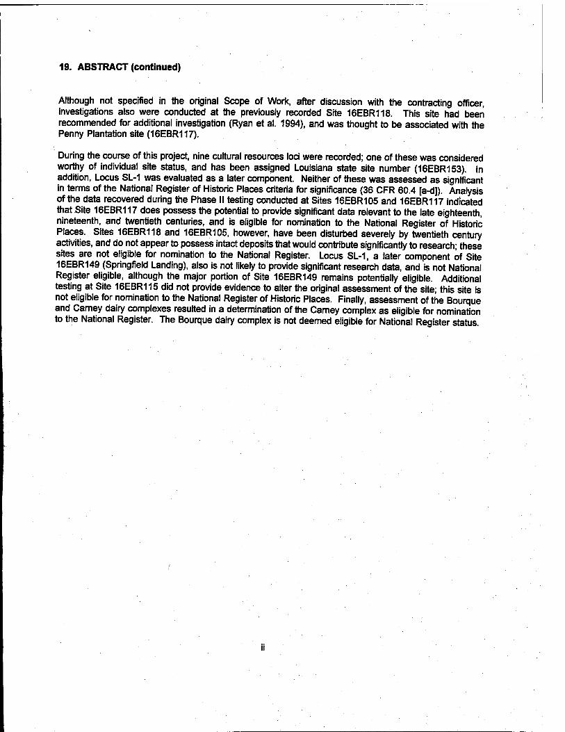
Although not specified in the original Scope of Work, after discussion with the contracting officer, investigations also were conducted at the previously recorded Site 16EBR118. This site had been recommended for additional investigation (Ryan et al. 1994), and was thought to be associated with the Penny Plantation site (16EBR117).
During the course of this project, nine cultural resources loci were recorded; one of these was considered worthy of individual site status, and has been assigned Louisiana state site number (16EBR153). In addition, Locus SL-1 was evaluated as a later component. Neither of these was assessed as significant in terms of the National Register of Historic Places criteria for significance (36 CFR 60.4 [a-d]). Analysis of the data recovered during the Phase II testing conducted at Sites 16EBR105 and 16EBR117 indicated that Site 16EBR117 does possess the potential to provide significant data relevant to the late eighteenth, nineteenth, and twentieth centuries, and is eligible for nomination to the National Register of Historic Places. Sites 16EBR118 and 16EBR105, however, have been disturbed severely by twentieth century activities, and do not appear to possess intact deposits that would contribute significantly to research; these sites are not eligible for nomination to the National Register. Locus SL-1, a later component of Site 16EBR149 (Springfield Landing), also is not likely to provide significant research data, and is not National Register eligible, although the major portion of Site 16EBR149 remains potentially eligible. Additional testing at Site 16EBR115 did not provide evidence to alter the original assessment of the site; this site is not eligible for nomination to the National Register of Historic Places. Finally, assessment of the Bourque and Carney dairy complexes resulted in a determination of the Carney complex as eligible for nomination to the National Register. The Bourque dairy complex is not deemed eligible for National Register status.

REPLY TO ATTENTION OF:
DEPARTMENT OF THE ARMY NEW ORLEANS DISTRICT, CORPS OF ENGINEERS
P.O. BOX 60267 NEW ORLEANS, LOUISIANA 70160-0267
April 3, 1997
Planning Division Environmental Analysis Branch
To the Reader:
This cultural resource effort was designed and guided by the U.S. Army Corps of Engineers, New Orleans District, as part of our cultural resources management program. The report documents the results of a combined cultural resources survey and National Register Testing of cultural resources sites located within the project corridor of the proposed Comite River Diversion project, East Baton Rouge Parish, Louisiana.
We concur with the authors' recommendations regarding site significance and National Register of Historic Places eligibility. The Louisiana State Historic Preservation Officer also concurs with the authors' recommendations and eligibility determinations.
qennetn A. Ashworth contracting Officer's Representative
'JUJ-Ar R. H. Schroeder, Jr. Chief, Planning Divisionv

CULTURAL RESOURCES SURVEY AND NATIONAL REGISTER TESTING OF COMITE RIVER DIVERSION PROJECT,
EAST BATON ROUGE PARISH, LOUISIANA
FINAL REPORT
Ann Markell, Ralph Draughon, Susan Barrett Smith, Thomas Fenn, Michele Williams, James A. Green, Jeremy Pincoske, and Rick Wappenstein
R. Christopher Goodwin & Associates, Inc. 5824 Plauche Street
New Orleans, LA 70123
March 1997
For
U.S. Army Corps of Engineers New Orleans District
P.O. Box 60267 New Orleans, LA 70160-0267
IV
TABLE OF CONTENTS
VOLUME I
REPORT DOCUMENTATION PAGE ............... i
LETTER TO THE READER „,
TITLE PAGE • • • •; • • • ■ • IV
LIST OF FIGURES • • • IX
LIST OF TABLES xrv
ACKNOWLEDGMENTS • •.-••• xv
I. INTRODUCTION. Project Description and Impacts ' ] Results of Survey and Excavation ' ' . Organization of the Report ....... ' t
II. NATURAL SETTING ....... Introduction •••••••••••..... 6 Physiography 6 Geomorphology !| Soils..... •'■ ■". • 6
Flora . . . ' " " " '•■'••' 12
Fauna 13 Climate 14
•• ......... . 15
III. PREHISTORIC AND HISTORIC CULTURAL SEQUENCE 17 Prehistory ''
Introduction " 'V-, Paleo-lndian Stage (12,000 - 8000 B.P.) .... Z Archaic Stage (8000 - 3000 B.P.) ]l
Early Archaic Period ™ Middle Archaic Period ........ ...... 19 Late Archaic Period ^
Poverty Point Culture (4000 r 2500 B.P.) ....... «2 Woodland Stage (3000 - 900 B.P.) ZZ
Tchefuncte Culture (2500 - 2000 B.P.) ..... «, Marksville Culture (2100 -1600 B.P.) 24 Troyville-Coles Creek Period (ca. 1600 - 800 B.P)
Mississippian Stage (800 - 300 B.P.) ..... 2? Emergent Mississippian Period (800 - 550 B.P.) ...... 26 Late Mississippian Period (550 - 300 B.P.) •■•....... ^o

Historical Development 27 Historic Contact 27
Early Settlements on Cooper and Lilly Bayous 28 Pioneers in the Project Corridor 29 The Overthrow of Spanish Rule in the Project Corridor, 1810 29 Antebellum Settlement 30 Civil War in the Project Area 31 Postbellum Activities Near the Project Corridor 34 The Twentieth Century ... 35
IV. LAND TENURE HISTORY 36
Penny Plantation (Site 16EBR117)/Carney Dairy Complex and Site 16EBR118 ........../ 36 Penny Family Tenure: 1798 - 1841 36 Smylie Family Tenure: 1841 - 1854 ............. 40 Knox Family Tenure: 1850 through the Late Nineteenth Century 40 Early Twentieth Century Tenure 42 Carney Family Tenure: 1916 - Present 42
Land Tenure History - J. A. McHugh House Site (16EBR105) 44 O'Connor Family Tenure: 1798 -1810 44 Antebellum Land Tenure: 1810 -1859 .]........ 48 McHugh Family Tenure: 1859 - Present ...... .............. 48
Summary 51
V. PREVIOUS INVESTIGATIONS 52 Introduction 52 Previous Cultural Resources Surveys and Assessments . 52 Phase I Cultural Resources Survey of the Comite River Diversion Project 64 Previously Recorded Archeological Sites in the Vicinity of the Project Area 67
VI. FIELD AND LABORATORY METHODS 69
Field Methods '.'.'.'.'. 69 Phase I Cultural Resources Survey 69 Phase II Testing i! ....... 70 Mechanical Excavation .........
Laboratory Methods 71 Historic Analyses 71 Prehistoric Lithic Analyses .............. 71 Prehistoric Ceramic Analyses 72 Faunal Analyses 72
Paleoethnobotanical Analysis 73
Methods and Materials 73 Preservation Bias 74
VII. RESULTS OF FIELD INVESTIGATIONS 75 introduction ••■••.. Phase I Investigations 75
Locus 3-1 Loci 6-1 and 6-2 77
Locus 6-1 .".'" 77
Locus 6-2 , 77
VI

Loci 16-1, 16-2, and 16-3 77 Locus 16-1 82 Site 16EBR153 (Locus 16-2) 82 Locus 16-3 82 Delineation of the Cemetery in Area 16 82
Magnolia Grove Baptist Church Survey Area, Loci MGC-1 and MGC-2, and Site 16EBR115 85
Locus MGC-1 85 Locus MGC-2 87 Site 16EBR115 87
Springfield Landing/Cooper's Bayou Survey Area (SL) 87 Site 16EBR149 (Springfield Landing) 90 Trenches 1-3 90 Trenches 4-5 and Locus SL-1 90
Phase II Investigations at Site 16EBR117 (Penny Plantation) 96 Site Background 96 Topography and Expected Soils 96 Results of Excavation 99 Avenue of Oaks Area 99 Area of the Carney House 113 Barn and Utility Building Area 125
Phase II Investigations at Site 16EBR118 125 The Carney and Bourque Farms and the Twentieth Century Dairy Industry 132
The Development of the Dairy Industry in East Baton Rouge Parish 132 The Carney Dairy Complex 133 The Bourque Dairy Complex 136 Summary 137
Phase II Investigations at Site 16EBR105 (John A. McHugh House) 137 Site Background 137 Topography and Expected Soils 139 Results of Excavation 139
Unit 1 141 Unit 2 141 Units 3 and 4 147 Unit 5 149 Unit 6 149 Unit 7 152 Unit 8 152 Units 9 and 10 155 Summary of Investigations at Site 16EBR105 155
VIII. SUMMARY AND RECOMMENDATIONS 159 Introduction 15g Phase I Testing and Delineation 159
Site 16EBR153 (Locus 16-2) 159 Site 16EBR115 159 Site 16EBR449 (Springfield Landing) 164
Locus SL-1 164 Recommendations for Site 16EBR149 164
Cemetery Delineation in Area 16 164
VII
Phase II Testing and Evaluation 165
Site 16EBR105 165 Site 16EBR117 (Penny Plantation) 165
Recommendations for Site 16EBR117 (Penny Plantation) . 166 Site 16EBR118 '.'.'.'.'.'.'.. I 167 The Carney and Bourque Dairy Complexes 167
The Carney Dairy Complex . 168 Bourque Dairy Complex ! 168
REFERENCES CITED 169
VOLUME II
ARTIFACT INVENTORIES .Appendix!
LOUISIANA STATE SITE FORMS Appendix II
PREVIOUSLY RECORDED STANDING STRUCTURE FORMS Appendix III
SCOPE OFWORK Appendix IV
VIII
LIST OF FIGURES
Figure 1. Excerpts from the 1996 digital 7.5' series topographic quadrangles, Sheet 1 Port Hudson, Zachary, Walls, and Scotlandville, Louisiana, depicting
survey segment areas (hatched) and cultural resources loci identified within the Comite River Diversion project area 2
Figure 1. Excerpts from the 1996 digital 7.5'series topographic quadrangles, Sheet 2 Zachary, Fred, Comite, and Scotlandville, Louisiana, depicting survey
segment areas (hatched) and cultural resources loci identified within the Comite River Diversion project area .3
Figure 2. Generalized geology of the Florida Parishes, Louisiana (adapted from Mossa and Autin 1989) .8
Figure 3. General distribution and thickness of loess deposits in the Florida Parishes, Louisiana (adapted from Mossa and Autin 1989) 10
Figure 4. Historical channels of the Mississippi River in the vicinity of the project area (adapted from Brunsden and Kesel 1973) 11
Figure 5. Schematic representation of the general land tenure history of the Penny/Carney tract in Sections 89 and 70, T5S, R1W, west of Baton Rouge Bayou 37
Figure 6. [1860] Louisiana State Land Office survey of Section 89, T5S, R1W, depicting Springfield Road and tract bounding parties/sections as of the 1819 claim confirmation 38
Figure 7. [ca. 1810] Excerpt from the Pintado Papers, Mississippi River: Rio Iberville to Thompson's Creek, depicting the James Penny and William O'Connor tracts 39
Figure 8. [1863] Excerpt from the Harwood-approved map, Baton Rouge to Port Hudson, depicting the Springfield, Bayou Sara, and Clinton roads, church (Pipkin's Chapel), and Federal troop movements in the project vicinity 41
Figure 9. [1895] Excerpt from Kaiser and Swensson's Map of the Parish of East Baton Rouge, Louisiana, depicting the Knox and McHugh land tracts and surrounding landmarks, in relation to the project sites 43
Figure 10. [1939] Excerpt from Tobin's aerial survey of East Baton Rouge Parish, depicting the Carney and McHugh project tracts 45
Figure 11. [1944] Excerpt from Mundingei^s Map Showing Survey for Partition of Lands of J. B. & Mrs. Emma Graham Carney, depicting the Bowman Carney tract .46
IX
Figure 12. Schematic representation of the general land tenure history of the McHugh tract in Section 8, T5S, R1E, west of McHugh Road 47
Figure 13. [1905] Excerpt from Monget's Map of Part of McHugh Estate, Showing Portions Owned by Heirs of Mrs. A. J. McHugh, depicting the T. E. & D. S. McHugh tract in Sections 7 and 8, T5S, R1E 50
Figure 14. Excerpts from the 1996 digital 7.5' series topographic quadrangles, Sheet 1 Port Hudson, Zachary, Walls, and Scotlandville, Louisiana, depicting
archeological sites within 1.6 km (1 mi) of and cultural resources loci identified within the Comite River Diversion project area 56
Figure 14. Excerpts from the 1996 digital 7.5' series topographic quadrangles, Sheet 2 Zachary, Fred, Comite, and Scotlandville, Louisiana, depicting
archeological sites within 1.6 km (1 mi) of and cultural resources loci identified within the Comite River Diversion project area 57
Figure 15. Historic overlay closeup depicting an early 1863 position of Springfield Landing and roads, based on the Harwood-approved map, Baton Rouge to Port Hudson 76
Figure 16. Historic overlay depicting roads and Federal troop locations in early 1863, based on the Harwood-approved map, Baton Rouge to Port Hudson 78
Figure 17. Plan of Site 16EBR153 (Locus 16-2) and Locus 16-1, depicting location of transects and shovel tests 81
Figure 18. Plan of the unmarked cemetery in Survey Area 16, showing the location of Bayou Baton Rouge, the probable cemetery boundaries, possible grave shafts, and trenches 84
Figure 19. Plan of Magnolia Grove Church survey area, previously recorded Site 16EBR115, and Loci MGC-1 and MGC-2, depicting locations of transects, shovel tests, and metal detector survey 86
Figure 20. Plan of the Springfield Landing/Cooper Bayou survey area, depicting the location of previously identified Site 16EBR149 (Springfield Landing), Locus SL-1, and exploratory trenches 89
Figure 21. Profile of Trench 1 in Springfield Landing/Cooper Bayou survey area 91
Figure 22. Profile of the west wall of Trench 2 in the Springfield Landing/Cooper Bayou survey area 92
Figure 23. Profile of the north wall of Trench 3 in the Springfield Landing/Cooper Bayou survey area 93
Figure 24. Profile of the east wall of Trench 4 in the Springfield Landing/Cooper Bayou survey area 94

Figure 25. Profile of the southwest wall of Trench 5 in the Springfield Landing/Cooper Bayou survey area 95
Figure 26. Plan of Sites 16EBR117 and 16EBR118 (Penny Plantation), depicting the locations of shovel tests, excavation units, and structures g7
Figure 27. View of Site 16EBR117, from the east 98
Figure 28. Avenue of oaks at Site 16EBR117. View is from the west 100
Figure 29. Profile of Unit 1 at Site 16EBR117 102
Figure 30. Selected edge decorated ceramics from Site 16EBR117: (a) pearlware with green scalloped edge (FS 2-2-119); (b) whiteware with green relief-molded bead edge (FS 2-198); (c) pearlware with blue relief-molded edge (FS 2-132); (d) pearlware with blue floral edge (FS 2-197); (e - h) pearlware with blue edge (FS 2-116, 2-187, 2-124, and 2-181) 103
Figure 31. Selected miscellaneous artifacts from site 16EBR117: (a) brass fork (FS 2-182); (b) hand-painted porcelain doll leg (FS 2-143); (c) white ball clay tobacco pipe stem fragment (FS 2-125); (d) hexagonal glass furniture knob (FS 2-182); (e) brass furniture hinge (FS 2-128) KM
Figure 32. Selected artifacts from site 16EBR117: (a) bisque porcelain two hole button (FS 2-181); (b) black glass four hole button (FS 2-182); (c) brass suspender button with mother-of-pearl center (FS 2-182); (d) flat, iron button with soldered loop, front with floral impression possibly brass or gold plated (FS 2-124); (e) brass plated iron button with embossed eagle and 16 stars on front, and "OMANCO EXTRA RICH" on back (FS 2-158); (f) brass plated iron button with "A Weyman & Co. Warranted" and soldered loop on back (FS 2-193); (g) brass plated iron shoe buckle with stamped design (FS 2-193) 110
Figure 33. Profile of Unit 11 at Site 16EBR117 111
Figure 34. Profile of Unit 13 at Site 16EBR117 112
Figure 35. Selected ceramic sherds from Site 16EBR117: (a) whiteware handle sherd with underglaze hand-painted black floral pattern (FS 2-132); (b) whiteware body sherd with underglaze hand-painted polychrome floral decoration (FS 2-134); (c, d) pearlware with underglaze hand- painted polychrome floral decoration (FS 2-116 and 2-117); (e, f) engine- turned whiteware bowl sherds with annular polychrome decoration (FS 2-116); (g, h) engine-turned, annular whiteware (FS 2-195 and 2-117); (i, j, k) mocha decorated whiteware (FS 2-109 and 2-116); (I) finger-painted "common-cable" whiteware (FS 2-116) ' 114
Figure 36. Plan and profile of Unit 5 at Site 16EBR117, showing Features 5-1 andM 116
Figure 37. Profile of Unit 8 at Site 16EBR117 117
XI

Figure 38. Profile of Unit 9 at Site 16EBR117 118
Figure 39. Plan and profile of Unit 7 at Site 16EBR117, showing the location and profile of Feature 7-1 120
Figure 40. Profile of Unit 6 at Site 16EBR117 ..... 121
Figure 41. Profile of Unit 10 at Site 16EBR117, showing Feature 10-1 ... 123
Figure 42. Plan and profile of Unit 18 at Site 16EBR117, showing locations and profiles of Features 18-1 and 18-2 124
Figure 43. Profile of Unit 2 at Site 16EBR117 126
Figure 44. Profile of Unit 3 at Site 16EBR117 127
Figure 45. Plan and profile of Unit 14 at Site 16EBR118, showing Feature 14-1 129
Figure 46. Profile of Unit 15 at Site 16EBR118 131
Figure 47. Northern facade of the Carney dairy barn at Site 16EBR117 134
Figure 48. View of the interior of the Carney dairy bam at Site 16EBR117 . 135
Figure 49. View, facing west, of the yard area of Site 16EBR105 138
Figure 50. Plan of Site 16EBR105 (John A. McHugh House), showing the locations of shovel tests and excavation units 140
Figure 51. Plan and profile of Unit 2 at Site 16EBR105, showing location of Feature 2-1 146
Figure 52. Plan and profile of Units 3 and 4 at Site 16EBR105, showing location of Feature 4-1, the brick chimney foundation 148
Figure 53. Profile of Unit 5 at Site 16EBR105 150
Figure 54. Plan and profile of Unit 6 at Site 16EBR105, showing the brick pier (Feature 6-1), and posthole (Feature 6-2) 151
Figure 55. Profile of Unit 7 at Site 16EBR105 153
Figure 56. Profile of Unit 8 at Site 16EBR105, showing Feature 8-1 154
Figure 57. Selected ceramic and glass artifacts from Site 16EBR105: (a) annular yellowware bowl sherd (FS 2-34); (b) annular whiteware rim sherd from cup (FS 2-26); <c and d) stenciled whiteware (FS 2-9 and 2-34); (e) stenciled milk glass with red floral pattern (FS 2-12); (f) ironstone with maker's mark "...OD/[G]EORGE/8" (FS 2-9); (g) porcelain with polychrome decal decoration (FS 2-26); (h) whiteware with polychrome decal decoration (FS 2-26) 155
XII

Figure 58. Miscellaneous kitchen artifacts from Site 16EBR105: (a) milk glass lid liner (FS 2-26); (b) zinc canning jar lid with script "Ball" in center (FS 2-26) 157
Figure 59. Selected glass artifacts from Site 16EBR105: (a) tooled lip from "ST. Drake's 1860 Plantation Bitters" bottle, circa 1862 -1884 (FS 2-18); (b) milk glass vessel, small ointment or lip balm jar (FS 2-20); (c) rectangular medicine bottle embossed with "...TD ACOR..." (FS 2-11); (d) rim shard from wide-mouth bottle (FS 2-9); (e) body shard from rectangular bottle with embossed vertical script "Rawle[igh's]M, post circa 1889 (FS 2-47); (f) pressed glass bowl shard (FS 2-8) 158
XIII

TABLE OF CONTENTS
Table 1. Previous archeological surveys conducted in the vicinity of the Comite River Diversion Project area 53
Table 2. Previously recorded sites located within 1.6 km (1 mi) of the Comite River Diversion Project area 58
Table 3. Flotation-derived plant remains from the Comite River Diversion Project area 73
Table 4. Wood from Site 16EBR105 74
Table 5. Cultural resources loci identified in the Comite River Diversion Project area 79
Table 6. Artifacts recovered during cultural resources survey of the Comite River Diversion Project area 80
Table 7. Diagnostic attribute chronology of artifacts recovered during cultural resources investigations for the Comite River Diversion Project 83
Table 8. Materials recovered during metal detector survey of Site 16EBR115. .. 88
Table 9. Features recorded at Sites 16EBR117 and 16EBR118 99
Table 10. Historic material recovered during investigations at Site 16EBR117 . 105
Table 11. Faunal material recovered from Site 16EBR117 119
Table 12. Historic material recovered during investigations at Site 16EBR118 130
Table 13. Dairy production in East Baton Rouge Parish, 1899 -1939 133
Table 14. Features recorded at Site 16EBR105 . 139
Table 15. Cultural material recovered during Phase II investigations at Site 16EBR105 142
Table 16. Faunal material recovered from Site 16EBR105 147
Table 17. Archeological sites recorded during Phase I and Phase II investigations for the Comite River Diversion Project 160
XIV

ACKNOWLEDGMENTS
We would like to express our gratitude to those individuals who gave their time and effort to assist us in the completion of this project. Mr. Ronnie McCallum and Mr. Jerry Jackson conducted the metal detector surveys and provided significant information regarding local history during the Civil War. Dr. Lynn Hanneman shared useful insight into the twentieth century dairy industry in Louisiana. Mr. Francis Jackson and the McHugh heirs granted access to their property and helped to facilitate the excavation of Site 16EBR105. Mr. and Mrs. Bowman Carney, Jr., and their family were generous with their time and granted not only access to their land, the location of Sites 16EBR117 and 16EBR118, but also shared their extensive knowledge of the property with personnel from R. Christopher Goodwin & Associates, Inc. Mr. and Mrs. Adrian Decker granted access to their property to conduct testing and also shared much information on local history. Hall-Buck Marine and Mr. Warren Munson helped facilitate this project by allowing the use of an access road on their property.
We also would like to thank the staffs of the East Baton Rouge Parish Clerk of Court office, Baton Rouge; East Baton Rouge Parish Tax Assessor office, Baton Rouge; the Louisiana Division of Archives, Records Management, and History; Louisiana State Land Office, Department of Natural Resources; East Baton Rouge Parish Public Library, Centroplex Branch and Bluebonnet Regional Branch, Baton Rouge; and Howard-Tilton Memorial Library, Tulane University, New Orleans;
At R. Christopher Goodwin & Associates, Inc., Dr. R. Christopher Goodwin served as Principal Investigator. Dr. Ann Markell served as Project Manager. Dr. Cinder Griffin and Dr. Markell directed the field investigations. Connie Darby, B.A., and Richard Wappenstein, B.S., served as Crew Chiefs; they were assisted in the field by Kirk Freeman, B.A., Alison Van Wagner, B.S., Jeremy Horowitz, B.A., Angela Shelly, B.A., Gary Gordon, B.A., James Gist, B.A., Elaine Wombold, B.A., James A. Green, and Tom Fenn, B.A Jeremy Pincoske, B.A., and Angele Montana, M.A, provided much valued research. Dave Courington, B.A., and Shirley Rambeau, A.A., prepared the graphic materials included in this report. The report was produced by Christine Herman, B.A., she was assisted by Adele Bienvenu and Rebecca Perego, B.A.
xv
CHAPTER I
INTRODUCTION
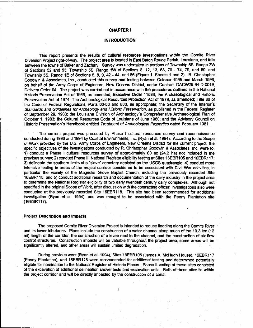
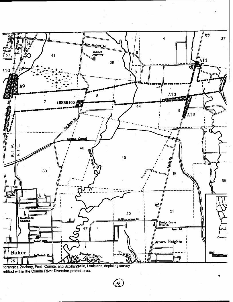
This report presents the results of cultural resources investigations within the Comite River Diversion Project right-of-way. The project area is located in East Baton Rouge Parish, Louisiana, and falls between the towns of Baker and Zachary. Survey was undertaken in portions of Township 5S, Range 2W of Sections 52 and 53; Township 5S, Range 1W of Sections 8, 12, 13, 68, 70 - 74, 79, and 89; and Township 5S, Range 1E of Sections 6, 8, 9, 42 - 44, and 56 (Figure 1, Sheets 1 and 2). R. Christopher Goodwin & Associates, Inc., conducted this survey and testing between October 1995 and March 1996, on behalf of the Army Corps of Engineers, New Orleans District, under Contract DACW29-94-D-0019, Delivery Order 04. The project was carried out in accordance with the procedures outlined in the National Historic Preservation Act of 1966, as amended; Executive Order 11593; the Archaeological and Historic Preservation Act of 1974; The Archaeological Resources Protection Act of 1979, as amended; Title 36 of the Code of Federal Regulations, Parts 60-66 and 800, as appropriate; the Secretary of the Interior's Standards and Guidelines for Archeology and Historic Preservation, as published in the Federal Register of September 29, 1983; the Louisiana Division of Archaeology's Comprehensive Archaeological Plan of October 1, 1983; the Cultural Resources Code of Louisiana of June 1980; and the Advisory Council on Historic Preservation's Handbook entitled Treatment of Archeological Properties dated February 1981.
The current project was preceded by Phase I cultural resources survey and reconnaissance conducted during 1993 and 1994 by Coastal Environments, Inc. (Ryan et'al. 1994). According to the Scope of Work provided by the U.S. Army Corps of Engineers, New Orleans District for the current project, the specific objectives of the investigations conducted by R. Christopher Goodwin & Associates, Inc. were to: 1) conduct a Phase I cultural resources survey of approximately 60 ac (24.2 ha) not included in the previous survey; 2) conduct Phase II, National Register eligibility testing at Sites 16EBR105 and 16EBR117; 3) delineate the southern limits of a "slave" cemetery depicted on the USGS quadrangle; 4) conduct more intensive testing in areas of the project corridor considered to be associated with Civil War activities, in particular the vicinity of the Magnolia Grove Baptist Church, including the previously recorded Site 16EBR115; and 5) conduct additional research and documentation of the dairy industry in the project area to determine the National Register eligibility of two early twentieth century dairy complexes. Although not specified in the original Scope of Work, after discussion with the contracting officer, investigations also were conducted at the previously recorded Site 16EBR118. This site had been recommended for additional investigation (Ryan et al. 1994), and was thought to be associated with the Penny Plantation site (16EBR117).
Project Description and Impacts
The proposed Comite River Diversion Project is intended to reduce flooding along the Comite River and its lower tributaries. Plans include the construction of a water channel along much of the 19.3 km (12 mi) length of the corridor, the construction of a levee next to the channel, and the construction of six flow control structures. Construction impacts will be variable throughout the project area; some areas will be significantly altered, and other areas will sustain limited degradation.
During previous work (Ryan et al. 1994), Sites16EBR105 (James A. McH ugh House), 16EBR117 (Penny Plantation), and 16EBR118 were recommended for additional testing and determined potentially eligible for nomination to the National Register of Historic Places. Phase II testing at these sites consisted of the excavation of additional delineation shovel tests and excavation units. Both of these sites lie within the project corridor and will be directly impacted by the construction of a canal.

Figure 1 Excerpts from the 1996 digital 7.5* series topographic quadrang es, Port Hudson, Zachary, Walls, and Scotia Sheet 1 survey segment areas (hatched) and cultural resources loci identified within the Comite River Diversion pn
©

ladrang es, Port Hudson, Zachary, Walls, and Scotlandville, Louisiana, depicting i loci identified within the Comite River Diversion project area.

auisiana, depicting
Q

Figure 1 Excerpts from the 1996 digital 7.5' series topographic quadrangles, Zachary, Fred, Comite, and Scotlandville sXrt 2 segment areas (hatched) and cultural resources loci identified within the Com,te R.ver D.vers.on project a,
0
idrangles, Zachary, Fred, Comite, and Scotlandville, Louisiana, depicting survey ■ntified within the Comite River Diversion project area.
(&>
600 1000 1800
icting survey
(D

Site 16EBR117 also encompasses the Carney Dairy Complex, dating from the first quarter of the twentieth century. This group of standing structures and the Bourque Dairy Complex, also located within the current project area, were recorded during the initial Phase I survey (Ryan et al. 1994.) Research to determine the local and regional significance of the dairy industry in East Baton Rouge Parish was conducted during the current project, and the two dairy complexes were assessed for their eligibility for nomination to the National Register of Historic Places.
An area in the vicinity of the Magnolia Grove Baptist Church was more intensively examined during the current project, using metal detector survey and close interval shovel testing. Although this area had been included in earlier survey (Ryan et al. 1994), additional investigations were conducted because of cartographic evidence suggesting that intensive Civil War activities had taken place in the vicinity. Project plans have been revised, and no longer include this area; no direct impact is expected. Previously recorded Site 16EBR115 is located in this survey area, and was re-surveyed using a metal detector during the current project. This site had initially been evaluated as not eligible for inclusion in the National Register of Historic Places (Ryan et al. 1994). While some additional data was retrieved during the current testing, this did not affect the assessment of site significance.
Finally, backhoe trenching was conducted both in an area adjacent to Cooper's Bayou and Profit Island Chute, and in the vicinity of an unmarked cemetery along Bayou Baton Rouge (Figure 1, Sheets 1 and 2). Impact in the area adjacent to Cooper Bayou is expected to involve severe erosion along the bayou. The only impacts expected in the vicinity of the cemetery will be from clearing and snagging along Bayou Baton Rouge.
Results of Survey and Excavation
During the course of this project, nine cultural resources loci (3-1,6-1, 6-2,16-1,16-2,16-3, MGC- 1, MGC-2, and SL-1) were recorded. One of these (16-2) was considered to be worthy of site status and has been assigned a Louisiana state site number (16EBR153). Locus SL-1, was located within Site 16EBR149 (Springfield Landing). It has been recorded as a late nineteenth century occupation within the larger site. Because of agricultural disturbance and the sparse nature of the recovered data, Site 16EBR153 was not assessed as significant in terms of the National Register of Historic Places criteria for evaluation (36CFR 60.4 [a-d]). Locus SL-1 of Site 16EBR149 produced an extremely light density of late nineteenth and early twentieth century materials suggestive of a small hunting or fishing camp. Because of the very sparse nature of the deposit, it is not considered likely to produce significant research data. As a part of the Springfield Landing site (16EBR149), however, it should be considered to be potentially significant.
Analysis of the data recovered during the Phase II testing conducted at Sites 16EBR105, 16EBR117, and 16EBR118, indicated that Site 16EBR117 does possess the potential to provide significant data relevant to the late eighteenth, nineteenth, and twentieth centuries. Sites 16EBR118 and 16EBR105, however, have been severely disturbed by twentieth century activities, and do not appear to possess intact deposits that would significantly contribute to research.
Research on the history of the dairy industry in East Baton Rouge Parish, and an architectural review of the Bourque and Carney Dairy complexes also were conducted during this project. Of the two complexes, it was determined that only the Carney Dairy complex, associated with Site 16EBR117, retained sufficient structural and contextual integrity to qualify for inclusion in the National Register of Historic Places.

Organization of the Report
An overview of the geomorphological characteristics and natural setting of the project area is provided in Chapter II. The prehistoric and historic contexts are chronicled in Chapter III, and Chapter IV provides details of land tenure at the Penny and McHugh sites (16EBR105 and 16EBR117). Previous cultural resources investigations and previously recorded sites in the vicinity of the project area are discussed in Chapter V. Field and analytical methods employed during the project are presented in Chapter VI. The results of investigations are reviewed in Chapter VII. A summary of the project and recommendations for future investigations are discussed in Chapter VIII. Finally, the artifact inventories, state site forms, previously recorded standing structure survey forms, and the Scope of Work are included in Appendices I, II, III, and IV, respectively.

CHAPTER II
NATURAL SETTING
Introduction
Environment often exerts a strong influence on the nature, distribution, and preservation of archeological deposits. Throughout the Comite River Diversion project area, knowledge of these environmental factors was essential to the conduct of cultural resources survey and analysis. A review of the environment and geomorphology of East Baton Rouge Parish, Louisiana, in the vicinity of the project area is presented in this chapter. Physiographic features, geomorphologic characteristics, and soils in the project area are discussed; in addition, descriptions of the typical climate and the major floral and faunal communities are included.
Physiography
Much of the project area is situated within the Comite River Basin, a major distributary of the Amite River. The Comite drainage basin comprises the Comite River, its tributaries, and the land drained by these waterways. It extends southward approximately 90 km (56 mi) from the southwestern comer of Amite County, Mississippi, through East Feliciana and East Baton Rouge parishes, Louisiana, until it joins the Amite River due east of Baton Rouge. The current project area is confined to the lower half of the basin, between Zachary and Baker, Louisiana.
The 19.3 km (12 mi) corridor of the proposed Comite River Diversion Project is located in the central portion of East Baton Rouge Parish, extending west from the Comite River to the junction of Cooper Bayou and Profit Island Chute on the Mississippi River (Figure 1, Sheets 1 and 2). The project area is situated within the Central Gulf Coastal Plain section of the Coastal Plain physiographic province, which extends from western Florida to northeastern Mexico. This section is a relatively youthful, recently emergent, terraced coastal plain. In East Baton Rouge Parish, the major physiographic subdivisions described by Saucier (1994) include the Lower Mississippi alluvial valley and the adjacent uplands. The Lower Mississippi alluvial valley in East Baton Rouge Parish is a relatively narrow strip of land between the active Mississippi River channel and the eastern bluffs of the alluvial valley.
The project area varies in elevation from less than 7.6 m (25 ft) NGVD on the Mississippi River flood plain along Profit Island Chute, to a high of approximately 27.4 m (90 ft) NGVD in the vicinity of the communities of Irene and Baker. Drainages in the region, from west to east, include Coopers Bayou, Lilly Bayou, Bayou Baton Rouge, Cypress Bayou, Whites Bayou, the Comite River, and the tributaries of these waterways. All drainages west of, and including Bayou Baton Rouge, flow into Profit Island Chute and the Mississippi River; drainages east of Bayou Baton Rouge flow into the Comite River. Cypress Bayou discharges some of its flow into Bayou Baton Rouge through Baker Canal. While only a few of these water sources have a direct impact on the project area, each has been a contributor to the prehistoric and historic development of the region.
Geomorphology
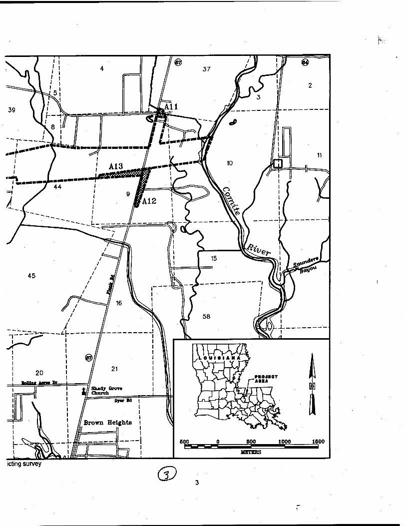
The most prominent geomorphological surface features in the project area are the Pleistocene age terraced Intermediate and Prairie complexes, and the Holocene age deposits along the eastern edge

of the Mississippi River alluvial valley (Figure 2). Previously termed the Intermediate and Prairie terraces (Mossa and Autin 1989; Saucier 1963, 1974; Sibley 1972), the Intermediate and Prairie complexes were renamed in light of recent research that identified major chronological distinctions between these terraced complexes (Mossa and Autin 1989:10; Saucier 1994:83; Autin et al. 1991:549-50).
Although the Citronelle Formation of the Upland Complex is not extant within the project area, the Upland Complex is found in both East and West Feliciana parishes, and it extends minimally into the northern portion of East Baton Rouge Parish (Snead and McCulloh 1984). The Citronelle Formation includes numerous gravel deposits and outcrops that were of importance for lithic production during prehistoric times, and early prehistoric sites often are located near these gravel outcroppings (Gagliano 1963; KREMG 1982, 1984).
The Intermediate Complex is situated between the Upland Complex and the Prairie Complex. It is a parallel coast-trending series of formations, with limited surface exposure. Previous designations for the Intermediate Complex include the Port Hudson Formation (Hilgard 1866, 1869; Harris and Veatch 1899), the Columbia Formation (McGee 1891; Clendinin 1892), the St. Elmo Terrace (Matson 1916), the Lissie Formation (Doering 1935,1956), the Second Terrace (Fisk 1938a), the Montgomery Terrace (Fisk 1938b), the Intermediate Terrace(s) (Parsons 1967; Snead and McCulloh 1984), and the Irene Terrace (Durham et al. 1967). Characteristics such as lithology, pedologic features, slope, degree of dissection, and topographic position have been used to differentiate components of the Intermediate Complex from the Upland and Prairie complexes. In the Florida Parishes, including East Baton Rouge Parish, the deposits of the Intermediate Complex consist of a fining-upward sequence capped by laminated clay, and overlain by a distinctive geosol and loess (Autin et al. 1991:556; Saucier 1994:170). A basal member of sand and gravel is present within the Intermediate Complex, but this sequence is rarely exposed. The terraces of the Intermediate Complex are moderately dissected, although this characteristic is less pronounced than in the bordering Upland Complex (Mossa 1989:14). The Intermediate Complex is topographically higher, and exhibits greater slopes than the Prairie Complex to the south. Structural movements along local faults, such as those identified at Irene (Durham et al. 1967; Snead and McCulloh 1984), may have influenced morphologic expressions of the surfaces of the complex. The Intermediate Complex is capped by both Peoria and pre-Peoria loess in the western Florida Parishes (Mossa 1989:16).
According to its relative stratigraphic and topographic position, the complex is thought to date from the late Early Pleistocene to the Sangamon interglacial (ca. pre-1.3 million to 125,000 years ago) (Autin et al. 1991:555-56; Saucier 1994:218-20). The western portion of the Comite River Diversion project area passes through the Intermediate Complex, from west of Baker to the upper boundaries of the Lilly Bayou and Cooper Bayou flood plains.
The Prairie Complex is a low-relief, constructional landform oriented predominately east-west across southeastern Louisiana. Extending southward from the Intermediate Complex to the Mississippi River Deltaic Plain, near Port Vincent, French Settlement, and north of Gonzales; the Prairie Complex subsumes the majority of the project area. It consists of a sequence of as many as three morphostratigraphic and depositional units comprised of fluvial, colluvial, deltaic, estuarine, and marine deposits (Autin et al. 1991:556: Saucier 1994:173). Within the Florida Parishes of Louisiana, lower, middle, and upper units tentatively have been defined. Separated by erosional unconformities, these units range in age from pre- Wsconsinan (pre-78,000 before present [B.P.]) to Late Wisconsinan (ca. 12,000 B.P.) (Saucier 1994:173). In the project area, the Prairie Complex is represented only by undifferentiated coastal plain, backswamp, and meander belt deposits (Saucier 1994:173-180).
The undifferentiated coastal plain deposits occur as two reasonably distinct sedimentary sequences; a lower, basal unit consists of fossiliferous silts and clays, and an upper unit is composed of interfingered, lenticular masses of fluvial clays, silts, and silty sands (Saucier 1994:178). The lower unit is interpreted as having been deposited in a brackish-water environment (Saucier 1994:178); however, hypotheses about
O) eo O)
■s < •a c n ra (0 (» o
E p
•a •s. •o 3, m c ra (0 '5 o
(0 <D
W •c (0 0. ra
■o •c o u. <D
O
i o o CD
T3 O N
"i O c o
CM
£
other influences differ. Autin et al. (1991:558) suggest that the deposition of the lower unit resulted from a sea-level rise that occurred approximately 130,000 to 120,000 years ago. Saucier (1994:178) hypothesized that deposition occurred in a large sound or lagoon between the Ingleside Barrier Trend and the mainland shoreline. The Ingleside Barrier Trend is a barrier/beach complex, a portion of which extends along the Gulf Coast east of the mouth of the Pearl River (Saucier 1994:177, Figure 47). There is general agreement that the lower unit dates from the Sangamon Age, ca. 300,000 to 120,000 years B.P. (Autin et al. 1991:588).
The upper unit of the Prairie Complex is alluvial and colluvial in origin; it was deposited by small streams, and also was deposited as slope wash from the Intermediate Complex and older formations to the north (Autin et al. 1991:558; Saucier 1994:179). In addition, the upper unit includes, or merges with, true fluvial terraces that extend inland along the larger streams of the local coastal plain. No true fluvial terraces are present within the project area, but one is present along the Comite River, a few miles downstream from the eastern end of the project area. The alluvial and colluvial materials forming the upper unit of the Prairie Complex eventually filled the Pontchartrain Basin, resulting in a broad, gently sloping, terrestrial alluvial plain (Autin et al. 1991:558; Saucier 1994:179). This upper unit deposit is thought to be Wisconsinan in age (ca. 80,000 to 15,000 years B.P.).
Portions of both the lower and upper units of the Prairie Complex in the western Florida Parishes are covered by a blanket deposit of loess identified as Peoria Loess (Figure 3). This loess generally is found as a band that measures 25 to 30 km (15.5 to 18.6 mi) in width, running from western Kentucky to south of Baton Rouge on the eastern side of the alluvial valley (Autin et al. 1991:560). Mossa and Autin (1989: Figure 7), however, illustrate two loess deposits, Peoria and Pre-Peoria, covering most of the Florida Parishes. A single or combined loess deposit can range from less than 1 m (3.3 ft) to as much as 9 m (29.5 ft) in thickness. The thickest deposits in the Florida Parishes, resulting from overlapping loess deposits, are located in the western and northwestern parishes. At Vicksburg, Mississippi, Peoria Loess dates from the "late Wisconsin in age and has been radiocarbon dated from 17,850 to 21,270 yrs B.P." (Autin et al. 1991:569-70). Within the project area, loess deposits range in thickness from approximately 1 m (3.3 ft) near the Amite River to greater than 3 m (9.8 ft) near the Mississippi River alluvial valley (Autin 1985:96; Mossa and Autin 1989: Figure 7). These loess deposits serve as the parent material for most of the surface soils developed on loess deposits within the project area. The Peoria Loess is described as "...yellowish brown or brown (10YR to 7.5 YR), well-sorted, porous, slightly indurated, eolian silt that may or may not be calcareous" (Autin et al. 1991:560).
The dominant geomorphic process along the western edge of the project area has been the mass movement of soils by lateral channel bank erosion. Erosion of the banks of the Mississippi River is a significant problem in locating and evaluating cultural resources on the shores of this major river. A figure in Brunsden and Kesel (1973: Figure 3) illustrates the extent of the erosion between ca. 1883 and 1973 in the immediate vicinity of the project boundary (Figure 4). Since 1883, lateral erosion of the east bank of the Mississippi River just above Profit Island Chute has been between 335 and 610 m (1,100 and 2,000 ft) or approximately 3.7 to 7.0 m (12 to 23 ft) per year (Brunsden and Kesel 1973:582). Other researchers in the area also have reported significant loss of bankline due to lateral erosion (Autin et al. 1989:28). It seems likely that erosion of a similar magnitude has occurred along the east bank of Profit Island Chute, within the project area; cultural remains in this area will have sustained significant adverse impact.
Flooding in the Comite River Basin is triggered by episodes of heavy rainfall that cause headwater and backwater overflow around the confluences of the Comite River and its tributaries. Extensive flooding has impacted the area in and near the cities of Baton Rouge, Baker, Zachary, Denham Springs, Gonzales, and Sorrento, and the towns of Port Vincent and French Settlement. The damages caused by this flooding have been summarized in two evaluation studies prepared by the U.S. Army Corps of Engineers, New Orleans District (U.S. Army Corps of Engineers 1984, 1989).
APPROXWATE LOCATION
OF PROJECT
Sicüy Island Peoria Combined
Thickness
III III 3-9 M
1-3 M
<1M
3-9 M
1-3 M
<1M
6-9 M
2-6 M
1-4 M
<2M
MUei
Figure 3. General distribution and thickness of loess deposits in the Florida Parishes, Louisiana (adapted from Mossa and Autin 1989).
10

MittitsioOi Bar* Focncnc Firti tf Port Wmrot B»r* Ommad tor CUrrty
1700-22* Ahtr o/io« 1849 1863 «83
WS-6 609
192» --— 1941 »52 1960 «63 «66 — «71 11 i 11 Pbictocan« Ttfraec
— F«IM Rivw CutoH
1909 B21. «60. 1966 US Geological Suvty. «49. «63
ADoraomftt ** *»»« '»**■. 'S52- B53
DM •cKSbSil B59. «Ö. «71 ft*« Hudton
«49
Pntwnt baul < conditions
Lstar inursity ■ggrMMion C«p*tlOOt
kMarnwdiat« ntanuty during flood suot
High inansity act*« bkiti rtVMC
Figure 4. Historical channels of the Mississippi River in the vicinity of the project area (adapted from Brunsden and Kesel 1973).
11
Although floods occur with greater frequency to the south, more drastic changes in river levels occur in the northern part of the project area. During the month of August 1989, Mississippi River levels in Denham Springs ranged from 3.58 to 6.22 m (11.76 to 20.40 ft) NGVD. For the same period in Port Vincent, river levels ranged from 0.17 to 0.80 m (0.56 to 2.63 ft) NGVD. In one 12-hour period at the Denham Springs station, on August 7,1989, the river elevation rose 1.34 m (4.38 ft) (U.S. Department of the Interior 1989).
Land subsidence is a more gradual process that may affect prehistoric sites in the lower Amite Basin (U.S. Army Corps of Engineers 1984:44). Sibley has suggested that the Mississippi River deltaic plain in southeastern Louisiana subsides at an approximate rate of more than 24 cm (0.78 ft) per century (Sibley 1972:47). In the more confined area of the Pontchartrain Basin, Saucier suggests that subsidence has occurred at a rate of approximately 11.9 cm (0.39 ft) per century over the past 4,400 years (Saucier 1963:13). Similarly, Jones and Shuman (1988) observed that "subsidence of the Pleistocene Prairie terrace, especially in southern Livingston Parish, has produced islands of relatively well-drained land surrounded by swamp or bordering streams." Many of these "islands" contain prehistoric sites (Jones and Shuman 1988), and their presence may indicate site locations. Because of continued subsidence, portions of these sites may sustain significant effects from slumping.
Soils
Numerous soil associations are found within the project area; fluvial activity has helped to diversify these associations through deposition and by dissection of existing deposits. The major associations are the Sharkey-Mhoon-Crevasse association, the Olivier-Loring-Terrace escarpments association, the Olivier- Loring association, the Calhoun-Zachary-Frost association, and the Olivier-Calhoun-Loring association.
Soils of the Sharkey-Mhoon-Crevasse association are poorly drained to excessively drained, clayey, loamy, and sandy soils of the Mississippi River flood plain that are subject to overflow (Dance et al. 1968:3). These soils are flooded once or twice a year and hold to a general pattern within the association consisting of gently sloping Crevasse soils along riverbanks, level and depressional Sharkey Soils in back swamp areas, and level or nearly level Mhoon soils between the Crevasse and Sharkey soils. This association represents approximately 6 percent of the parish, and the association typically consists of 60 percent Sharkey and Tunica soils, 30 percent loamy alluvial land and Mhoon soils, and 10 percent Crevasse soils (Dance et al. 1968:3). Within the current project area, however, this soils association consists primarily of Loamy alluvial land and Mhoon soils with lesser amounts of Crevasse soils, and virtually no Sharkey and Tunica soils.
Soils of the Olivier-Loring-Terrace escarpments association occur in an irregular belt that extends southward from the northwest portion of the parish and crosses the southern third. This belt includes a steep escarpment that rises from the Mississippi River flood plain to the level areas of the Prairie and Intermediate complexes (Dance et al. 1968:4). This steep escarpment within the project area is called the Mobile Ridge and marks the eastern boundary of the Mississippi River alluvial valley. The soils of this association are level to gently sloping and are poorly to moderately well drained. This association accounts for about 11 percent of the parish, and the major soil types of the association consist of approximately 47 percent Olivier soils, 23 percent Loring soils, and 22 percent Terrace escarpment soils. This association, however, only occurs at two locations within the project area: along Cooper and Lilly bayous and along Bayou Baton Rouge. Within these two contexts, the soils found within the association primarily consist of: 1) Terrace escarpments; 2) Loring silt loam, 0 to 1 percent slopes; 3) Loring silt loam, 1 to 3 percent slopes; 4) Olivier silt loam, 0 to 1 percent slopes; and 5) Olivier silt loam, 1 to 3 percent slopes. These soils generally have a silt loam surface layer and a silty clay loam subsoil that begins between 0.4 to 0.6 m (1.25 to 2 ft) below ground surface. Minor amounts of Calhoun silt loam also occur within this association. In addition, a substantial amount of Cascilla silt loam, a major component of the Cascilla-Ochlockonee soil
12

association, occurs along Cooper and Lily bayous. The Cascilla-Ochlockonee association typically is found as level or nearly level, well-drained, loamy soils on flood plains of the Amite and Comite rivers and their tributaries (Dance et al. 1968:3).
Soils of the Olivier-Loring association, nearly level to gently sloping loamy soils that occur on ridges and in low, broad valleys, cover approximately 7 percent of East Baton Rouge Parish (Dance et al. 1968:4). This association includes somewhat poorly drained to moderately well-drained soils. Typically, this association consists of approximately 50 percent Olivier soils and 35 percent Loring soils. Olivier soils tend to have a surface layer of grayish-brown silt loam and a yellowish-brown silty clay subsoil mottled with gray, while Loring soils have a surface layer of brown silt loam and a brown silty clay loam subsoil (Dance et al. 1968:4). Calhoun silt loam and Zachary silt loam account for minor percentages of the association in general and within the project area. This soil association is almost exclusively located in the Intermediate Complex, in the northern portion of the parish.
Calhoun-Zachary-Frost association soils are described as level to nearly level, poorly drained, loamy soils on broad flats and in depressions (Dance et al. 1968:5). This soil association occurs most frequently within the current project area, and it accounts for approximately 20 percent of the parish soils (Dance et al. 1968:5). In general, Calhoun soils, found mostly on broad flats, account for 60 percent of the association, while Zachary and Frost soils, found in depressions, account for 19 and 12 percent of the association, respectively. Within the project area, the most common soils of the Calhoun-Zachary-Frost association include: Calhoun silt loam; Zachary silt loam; and Frost silt loam. Other soils of this association that occur only in minor amounts include Verdun-Deerford silt loams; Jeanerette, light-colored variant-Frost silt loams; and Calhoun-Bonn and Fountain silt loams. All of these soils have a silt loam surface layer and a silty clay loam subsoil (Dance et al. 1968:5).
Olivier-Calhoun-Loring association soils are level, poorly to moderately well-drained, loamy soils situated on broad flats and in slight depressions. This soil association comprises approximately 19 percent of the parish, but within the project area is one of the least common associations. Olivier and Loring soils, which make up 60 and 14 percent, respectively, of the association, are located in smooth areas, while the poorly drained Calhoun soils are located on flats and in shallow depressions (Dance et al. 1968:5). Calhoun soils account for 25 percent of the association. All of the soils have surface layers of silty loam and subsoil layers of clay loam or silty clay loam, while only Olivier and Loring soils have a fragipan below the subsoil starting at approximately 0.6 m (2 ft). Within the project area, Olivier soils are the dominant soils in this association with minor amounts of Loring and Calhoun soils occurring. A fairly substantial amount of Zachary soils, however, also occur within the project area, particularly in the deeper depressions along sluggish drainageways.
Flora
Two major forest types are present within the current project boundaries: bottomland hardwood/cypress forest and upland hardwood forest (Brown 1980:xxxiv). Floral species present in the drier portions of the bottomlands overlap with species present in the upland forests. More water-tolerant species would be found in (seasonally) inundated portions of the Mississippi and Comite rivers and their associated bayous. This complex mosaic of seasonally overlapping habitats results in a greater variety of species than would be present in a more uniform environment.
The natural levees and terraces of the Comite and Mississippi rivers are comprised of seasonally enriched soils, supporting a number of arboreal species. On these drier areas of the bottomlands the woody species would include: sweetgum (Liquidambar styraciflua), cherrybark oak (Quercus falcata var. pagodaefolia), willow oak {Quercus phellos), cow oak {Quercus prinus), Nutall oak {Quercus texana), American elm {Ulmus americana), winged elm (Ulmus alata), persimmon {Diosyros virginiana), cottonwood
13

(Populus deltoides), American sycamore (Platanus occidentalis), black willow (Salix nigra), honey locust (Gleditsia triacanthos), water locust (Gleditsia aquatica), and hackberry (Celtis occidentalis) (Brown 1980; Brown and Kirkman 1990).
Many of the bottomland trees would occur occasionally on the upland terraces to the west of the Mississippi flood plain. In addition, a very specific group of trees only occur on the rich and well-drained soils of the upland hardwood forests. Many of these trees are more commonly associated with mesophytic forests of the upper Midwest. The arboreal species include white oak (Quercus alba), sugar maple (Acer saccharinum), beech {Fagus grandifloria), black cherry (Prunus serotina), tulip tree (Lirodendron tulipifera), shagbark hickory (Carya ovata), dogwood {Cornus sp), and redbud (Cercus canadensis) (Brown 1980; Brown and Kirkman 1990).
All of these woody species, from both habitats, functioned as sources of fuel and/or lumber. Arboreal species like locust, tulip tree, sycamore, hickory, elms, and oaks were sold or used locally for lumber. The wood from honey and water locust is very strong and was used for fence posts. Young black willow twigs were woven into baskets and wicker furniture, while white oak, split into fine strips was used for basketry. Wine and beer barrels also were produced from white oak lumber. In addition, American elm wood was steamed and bent into forms for barrel and wheel hoops, veneer, and baskets (Brown and Kirkman 1990:124).
The wild fruits and nuts from hardwood forests were important subsistence resources for animals and possibly humans. The nuts from various oak, hickory, and beech species served as a good source of winter forage for swine and wild life. Persimmon and black cherry fruits were dried or made into beer (in the case of cherries). "An interesting and important contribution may have been [persimmon's] attraction for opossums. The animals flock to the trees in fall and are easily caught, sometimes several at a single tree" (Hillard 1972:90). Giant cane (Arundenaria gigantea and Arundenaria tecta), grown in the forest breaks, was used by the early settlers to graze their hogs and cattle on the young cane shoots. Cane also served as an important source of raw materials for basketry, fishing poles, and cane bottomed chairs. Climbing plants like grapes (especially muscadine grapes) and blackberries were probably collected for consumption or made into jams, pies, and/or wines. Black cherries were an important ingredient in many home health remedies (Moerman 1986:373-375). Medicinal plants present in this environment include sassafras (Sassafras albidum), pokeweed (Phytolacca americana), and catbrier (Smilax bonx-nox).
The lower lying areas of the project area contained some of the previously discussed arboreal and herbaceous species. In addition, taxa unique to these inundated environments are found. The swampy areas of the riverbanks and bayous contain bald cypress (Taxodium distichum), swamp red maple (Acer rubrum var. drummondii), tupelo gum {Nyssia aquatica), water ash (Fraxinus carolininana), pumpkin ash (Fraxinus profunda) (Brown 1980; Brown and Kirkman 1990).
Swamps also provided a good sources for fuel wood. Bald cypress was especially important because it is highly resistant to decay and therefore has been used for "construction timbers, docks, boasts, and exterior siding" (Brown and Kirkman 1990:57). Again, this area served as an important source for wild plants and animals, since it was less likely to be cultivated than the better drained areas.
Fauna
It is difficult to assess how numerous some animal species were prior to nineteenth and twentieth century logging, farming, and marsh drainage. Certain birds and mammals, such as white-tailed deer, rabbits, and bobwhite quail thrive in disturbed habitats. These species were present prehistorically and historically, but they probably were less numerous than suggested by modem species distributions.
14

Most of the terrestrial animal species present in the project area moved freely between the upland and bottomland environments. Among the game species that may have been present are white tailed deer (Odocoileus virginianus), eastern and swamp rabbits (Sylvilagus floridanus and S. carolinensis), river otter {Lutra canadensis), opossum (Didelphis virginiana), raccoon (Procyon lotor), gray and fox squirrels (Sciurus carolinensis and S. niger), alligator (Alligator mississippiensis), black bear (Ursus americanus), wild turkey (Melwagrisgalloparo), and quail (Colinus virgianus) (Ransom 1981; Lowery 1974). "Wild turkey, rabbit, and squirrel [historically] tended to replace domestic poultry and eggs in the diet during the winter" (Hillard 1972: 47).
During the spring and fall migrations, a huge variety of migratory waterfowl inhabited the Mississippi River and its surrounding uplands (Ransom 1981). Migratory waterfowl such as ducks, geese (both members of the Anatidae family), snipes (Gallinago gallinago), plover (Charadriidae family), bobwhite quail {Colinus virginianus), morning doves {Zenaida macroura), and passenger pigeons (Ectopistes migratorius) were hunted.
Aquatic and semi-aquatic faunal resources were numerous and varied in the project area. Some of the more important game fish available in the Mississippi and Comite rivers include white and yellow bass (Morone chrysops and M. mississippiensis), carp (Cyprinus carpio), various catfish species {Ictalurus and Pylodistis spp.), white crappie (Promoxis annularis), freshwater drum (Aplodinotus grunniens), garfish (Lepisosteus spp.), sauger (Stizostedoin canadensis), and shads (Dorosoma spp.) (Ransom 1981).
Other aquatic sources of protein included softshell turtles (family Trionychidae), common snapping turtles {Chelydra sepentina), alligator snapping turtles {Macroclemys termmicncki), various frogs (Family Ranidae), Louisiana red crawfish (Procambarus clarki), and freshwater Unioncean clams (Ransom 1981).
Climate
The project area has a humid subtropical climate with prevailing southerly winds. Air movement from the Gulf of Mexico is responsible for the abundant moisture in the region. Rainfall is the major cause of flooding in the area; the typical storm that causes flooding produces heavy rainfall for three to five days. "It is usually the result of a near-stationary cold front that moves across southeastern Louisiana and southern Mississippi with warm and humid air from the Gulf of Mexico moving inland ahead of the front" (U.S. Army Corps of Engineers 1989:1:41). These storms are capable of producing rainfall at a rate of one or more inches per hour, and generally occur in the spring; the four major floods between 1973 and 1983 occurred in March and April. Flooding is sometimes extreme if preceding months received abundant rainfall. Hurricanes also can affect flooding in the Amite River basin with heavy rains and high winds (Lee 1985; U.S. Army Corps of Engineers 1989:1:41-48).
The average annual normal rainfall at Baton Rouge is 141.7 cm (55.77 in). July is the wettest month with a normal average of 18 cm (7.07 in), while October is driest with a normal average of 6.7 cm (2.63 in). The greatest 24-hour rainfall, 36.7 cm (14.43 in), occurred on August 2,1983, and was recorded at the Baton Rouge Sherwood gauge. Snowfall is rare in the project area (U.S. Department of Commerce 1988; U.S. Army Corps of Engineers 1989:1:10).
Movement of air from the Gulf of Mexico also keeps temperature ranges from varying greatly throughout the year. The average normal annual temperature for the basin is 19.7° C (67.5° F). January is the coldest month with an average temperature of 10.4°C (50.8° F), while July is the hottest month with an average temperature of 27.8° C (82.1° F). A maximum temperature of 43° C (110° F) was recorded in August, 1909, in Baton Rouge; a low of -16.6° C (2° F) was recorded in February 1899 (U.S. Department of Commerce 1988; U.S. Army Corps of Engineers 1989:1:10).
15

Wind records from Ryan Airport in Baton Rouge indicate winds mostly are from the southeast and average 12.2 km (7.6 mi) per hour. March is the windiest month, with a mean wind speed of 15 km (9.4 mi) per hour; August is the calmest month, with an average wind speed of 9 km (5.6 mi) per hour. The maximum wind speed on record from this site is 93 km (58 mi) per hour, recorded during Hurricane Betsy in September 1965 (U.S. Department of Commerce 1988).
16

CHAPTER III
PREHISTORIC AND HISTORIC CULTURAL SEQUENCE
Prehistory
Introduction
The Comite River Diversion Project extends from the west bank of the Comite River to the east bank of the Mississippi River, in East Baton Rouge Parish. East Baton Rouge Parish is one of the eight Florida parishes (St. Tammany, Washington, Tangipahoa, St. Helena, Livingston, St. Tammany, East Feliciana, and West Feliciana) that constitute Management Unit IV as defined in Louisiana's Comprehensive Archaeological Plan (Smith et al. 1983). The prehistory of Management Unit IV has been documented from circa (ca.) 12,000 - 300 B.P.; this period has been divided into four general archeological stages. These four stages (Paleo-lndian, Archaic, Woodland, and Mississippian) represent developmental segments characterized by dominant patterns of subsistence and technology (Kreiger 1953; Willey and Phillips 1958). Each stage consists of a sequence of chronologically defined periods, which may be sub-divided into phases based on sets of artifacts and other cultural traits characteristic of a particular geographic region (Jenkins 1979; Walthall 1980). While different systems have been used to organize and describe the culture history of the region (e.g., the Paleo-lndian, Meso-lndian, and Neo-lndian eras used by Neuman [1984]), the syncratic stage-period-phase system described by Willey and Phillips (1958) will be used in the following discussion. In a recent model for the prehistoric sequence of this region, eight cultural units have been designated; these units are the Paleo-lndian, Archaic, Poverty Point, Tchefuncte, Marksville, Troyville- Coles Creek, Plaquemine, and Mississippian (Smith et al. 1983). Other recent research (Kidder 1988), however, suggests that the Plaquemine culture was actually a variant phase of the Emergent Mississippian period; it will be discussed as such in this chapter.
Paleo-lndian Stage (12000 - 8000 B.P.I
Initial human occupation of the southeastern United States generally is believed to have occurred sometime between 10,000 and 12,000 years ago (10,000 - 12,000 B.P.). Paleo-lndian sites are characterized by a distinct assemblage of lithic tools that includes fluted and unfluted lanceolate projectile points, unifacial end and side scrapers, gravers, and spokeshaves.
The earliest Paleo-lndian culture identified in North America has been named "Clovis," after the type-site in the Southwest. In the western United States, Clovis sites appear to fall within a relatively narrow time range, between 10,900 and 11,500 B.P. (Haynes 1991; Story et al.1990:178). While the evidence for earlier "pre-Clovis" or "pre-projectile point" occupations continues to be debated, no earlier sites have been documented convincingly in North America (Humphrey and Stanford 1979). The smaller, fluted Folsom points, found in the Great Plains and Southern Plains, and unfluted Midland projectile points, were once thought to postdate Clovis', however, accepted radiocarbon dating of numerous Folsom components in Texas produced dates ranging from ca. 10,000 to 11,000 B.P. (Largent et al. 1991:323-332; Story et al. 1990:189). These dates suggest that the Folsom culture may be partially contemporaneous with Clovis culture. The lithic tool assemblage of the Clovis and Folsom cultures, generally is referred to as the Llano complex.
Similar to the Llano complex, the Piano complex represents a Southern Plains tradition. In East Texas and Louisiana, the Piano complex is represented by unfluted lanceolate Piainview, Firstview, Hell
17

Gap, and Angostura projectile points. These types initially were thought to be variants of the Clovis point, but radiocarbon dating suggests a later temporal placement. Current data place the Piano complex between ca. 8000 and 10,100 B.P. (Turner and Hester 1985:66, 141). Piano-type artifacts have been recovered throughout Louisiana (e.g., Cantly and Kern 1984; Gagliano 1963:12; Hillman 1990:206-207).
Another Paleo-lndian tradition identified in North America is the Cody complex. The Cody assemblage includes stemmed, lanceolate Scottsbluff and Eden projectile points and the Cody knife, a stemmed knife with an oblique blade. Cody complex bifacial tools usually are identifiable by the presence of fine comedial pressure flaking. The uplands in the Texarkana region of northwestern Louisiana, northeastern Texas, and southern Arkansas have produced relatively large numbers of Cody complex artifacts (Gagliano and Gregory 1965:62-77; Story et al. 1990:209), but reliable radiocarbon (14C) dates have not conclusively dated the complex. These 14C dates range from 9100 to 10,200 B.P. (Story et al. 1990:209), although Turner and Hester (1985:149) date Scottsbluff projectile points from ca. 8650 to 9120 B.P.
Paleo-lndian peoples are thought to have been highly mobile hunter-gatherers who resided in small bands or in extended family groups. The formerly prevalent notion that characterized the Paleo-lndian populations as specialized big game hunters seems less tenable as information becomes available from a more inclusive set of Paleo-lndian sites. While sufficient evidence exists for the exploitation of large mammals (mega-fauna) including mammoth, mastodon, bison, caribou, and elk at sites in the western and northern United States, kill sites are rare in the Southeast (Webb et al. 1983). The presence of Clovis-like fluted projectile points in the southeastern United States is thought to reflect contemporaneity with Clovis sites recorded in the western and northern parts of the country. Whether this also suggests that big game hunting was a dominant adaptive strategy in the Southeast is less certain, because of the environmental differences and the range associated with most megafauna. Excavations at the Kimmswick site, in southeastern Missouri, however, produced Clovis projectile points in direct association with disarticulated mastodon bones, suggesting that Southeastern Paleo-lndian populations did exploit large Pleistocene mammals at least occasionally (Graham et al. 1981). Although there is little data upon which to base a dietary reconstruction, Paleo-lndian subsistence throughout the Southeast is believed to have encompassed a broad spectrum of resources, including fish, fowl, deer, small mammals, nuts, and gathered plants (Smith 1986:9-10; Steponaitis 1986:369; Walthall 1980:36). The exception possibly could be the Folsom culture. Folsom artifacts have been associated consistently with bison kill sites on the Great Plains. The lack of faunal evidence in association with Folsom finds in eastern Texas and Louisiana, due mainly to the highly acidic nature of the soils and the moist climate, precludes insight into more general subsistence strategies. The Folsom culture could represent an adaptation to a specialized hunting strategy associated with the cyclical migration of large herds of bison (Story et al. 1990:189).
Most of the archeological evidence associated with the Paleo-lndian presence in the Southeast is limited to surface finds of diagnostic projectile points (Mason 1962). In the lower Mississippi valley, Paleo- lndian projectile points have been recovered along valley margins, but rarely in the alluvial valley or along the coastal plain; distributional studies indicate that Paleo-lndian sites in the eastern United States tend to be located on eroded terrace and plateau surfaces (Walthall 1980). Perhaps the best documented area in the lower Mississippi valley is Macon Ridge. Located in northeast Louisiana, Macon Ridge represents a relict Pleistocene braid plain that until recently was not known to contain sites older than the Late Archaic period (Saucier 1981). Hillman (1990), however, recently collected information from 121 sites on the Macon Ridge. Investigations at these sites have produced more than 1,000 Paleo-lndian and "epipaleoindian" projectile points or knives, including 272 Dalton-Meserve, 39 Hardin, and over 400 San Patrice types. Hillman concluded that Early and Middle Paleo-lndian occupation of Macon Ridge was sporadic or seasonal, possibly reflecting the somewhat inhospitable conditions caused by the excessive accumulation of wind-blown dust across open grasslands during the formation of the loess hills (Hillman 1990). The distribution of recorded sites suggests that Ma?on Ridge was occupied most intensely during the Late Paleo-lndian and Early Archaic periods. During the Late Paleo-lndian period, hunting and base camps were
18

located very close to streams, ponds, or sloughs, on landforms generally no more than 1 m (3.3 ft) above the water source, even when higher elevations or ridges were located in the immediate vicinity.
By the Early Archaic, settlement had shifted to the higher elevations, possibly reflecting an environmental transformation of Macon Ridge from open grasslands to open woodlands (Hillman 1990). Brain (1983) states that Paleo-lndian projectile points have been found along relict channels of the Mississippi River and remnant Pleistocene surfaces in the flood plain that pre-date ca. 9,000 B.P. In Louisiana, Paleo-lndian sites have been recorded along Tertiary upland ridges and uplands/floodplain bluffs (Guy and Gunn 1983); Clovis, Folsom, Scottsbluff, and Plainview projectile points have been recovered from the surface of these sites. Although the majority of these projectile points have been found in northern Louisiana, a few have been recovered from late Pleistocene Prairie Terrace deposits in southern Louisiana.
Written in 1983, Louisiana's Comprehensive Archaeological Plan documented only two Paleo-lndian sites (the Jones Creek site [16EBR13] and the Palmer site [16EBR26]) within Management Unit IV (Smith et al. 1983). Located in East Baton Rouge and East Feliciana parishes, these sites demonstrate the presence of Late Paleo-lndian sites within Management Unit IV, and in proximity to the current project area. Additionally, a Dalton point and a pair of unfluted Clovis points were recovered from the Garcia Site (160R34), southeast of Lake Pontchartrain. The recovery of these points suggests a Paleolithic to Early Archaic occupation of this area. Lake Pontchartrain represented the shoreline of the Gulf of Mexico during the Pleistocene period, and it is likely that a majority of the Paleo-lndian stage sites in this alluvial area are presently underwater. More intensive research is needed to define the nature and extent of these occupations.
Archaic Stage (8000 - 3000 B.P.I
The term "Archaic" first was used as a description for the pre-ceramic cultures that followed the Paleolithic stage (Ritchie 1935). Environmental pressures, a warming trend, and a drier climate at the end of the Pleistocene, accompanied by a rise in sea level, resulted in a combination of technological and social changes (Willey and Phillips 1958; Byers 1959), including a shift to diversified resource and food procurement strategies (Haag 1971). Caldwell (1958) termed this hunting and gathering specialization as "maximum forest efficiency" Brain (1971) adapted this phrase to "maximum riverine efficiency," in reference to southeastern riverine and coastal communities. Archaic peoples moved on a seasonal basis to exploit a home range defined by the availability of nuts, fruits, fish, game, shell fish, and other natural resources (Müller 1978). Archaic populations apparently exploited a greater variety of terrestrial and marine species than their Paleo-lndian predecessors. Many populations with successful strategies during the Archaic sequence went on to develop the first quasi-permanent settlements (Neitzel and Perry 1978), and the increased number of sites dating from the Archaic stage suggests an increase in population throughout the area (Jenkins 1974; Müller 1978).
The Paleo-lndian to Archaic stage transition was accompanied by a change in projectile point morphology. These changes included the emergence of a wide variety of notched and stemmed projectile point forms, and the disappearance of the fluted projectile point. Nevertheless, evidence suggests continuity between the adaptations of the Paleo-lndian and the later Archaic peoples who occupied the deciduous forests of the region (Smith 1986). The Archaic stage can be divided into three subdivisions or periods. The Early Archaic, Middle Archaic, and Late Archaic periods are marked by substantive changes in projectile point morphology, as well as by changes in the composition of general artifact assemblages.
Early Archaic Period. In the Southeast, the Early Archaic period generally dates from ca. 8000 to 10,000 B.P.; regional variation affects the assignment of dates, especially during the transitional period between the Late Paleolithic and the Early Archaic.
19
Dalton projectile points were the temporal successors of Clovis projectile points and date from 9900 to 10,500 B.P. in Arkansas and Missouri (Goodyear 1982:382) and from 9000 to 9700 B.P. in northwestern Alabama (DeJarnette et al. 1962; Griffin 1974). Dalton, Beaver Lake, Hardin, and Lost Lake projectile points were recovered from the "Dalton Zones" at the Olive Branch site, in Alexander County, Illinois; these strata lay immediately above material that date from ca. 9975 B.P. (Gramly and Funk 1991:29).
Dalton projectile points occasionally are recovered in association with bifacially chipped stone adzes that may represent woodworking tools (Goodyear 1974:41-42). Chipped and groundstone celts, probably the functional equivalent of Dalton adzes, have been recovered from the Kirk Horizon in Zone 16 at the St. Albans site and from Early Archaic sites in the Little Tennessee River valley (Smith 1986:14). Artifacts associated with the Dalton culture appear to be restricted to the northern portion of Louisiana.
Some of the earliest recognized Terminal Paleo/Early Archaic projectile point types identified in Louisiana are the San Patrice, Keithville, and Pelican forms (Webb et al. 1971). Previously ascribed to northwestern Louisiana, northeastern Texas, and southwestern Arkansas, later investigations suggest that the range of San Patrice includes an area extending from central Texas to southwestern Alabama, and from southern Louisiana to central Arkansas (Brain 1983:32; Cantley and Kern 1984; Giliberti 1995). In southeastern Louisiana, San Patrice projectile points have been recovered from East Baton Rouge Parish (Gagliano 1963:112).
The San Patrice culture represents an adaptation of hunters/gatherers to the resources of a more restricted area. The hallmark of the San Patrice is the almost exclusive use of local lithic materials for tool production. Tool assemblages include San Patrice var. Hope and St. John projectile points, hafted scrapers, Albany side scrapers, unifacial scrapers, burins, and engravers (Webb et al. 1971). More recently, Keithville var. A and B, San Patrice var. Geneill, and New River projectile point types have been added to the assemblage (Brain 1983; Giliberti 1995). There have been no reliable 14C dates for these types, but estimates based on morphology and stratigraphic position suggest a temporal span between 8000 and 10,000 B.P. (Brain 1983:25; Story 1990:202; Turner and Hester 1985:147; Webb 1981). While Ensor (1987) hypothesized that San Patrice and related southeastern projectile point forms may have developed from earlier Dalton point forms, Story (1990:197) has suggested that both Dalton and San Patrice types evolved from the earlier fluted point traditions.
Throughout the Early Archaic, the subsistence pattern probably resembled that of the preceding Paleo-lndian stage. Early Archaic peoples traveled seasonally in small groups between a series of base camps and extractive sites, hunting deer and collecting acorns and nuts (Chapman and Shea 1981; Lentz 1986; Parmalee 1962; Parmalee et al. 1976). The extent to which the resources of the floodplain environments of the Lower Mississippi Alluvial Valley were exploited remains unknown.
The earliest recovered food processing tools, including manos, milling stones, and nutting stones, were from Early Archaic period sites. While living floors associated with hearths, shallow pit features, and milling tools are known from the Early and Middle Archaic, there is little evidence suggestive of below- ground food storage (Steponaitis 1986:371). Much of our knowledge regarding Paleolithic and Archaic period subsistence is limited by problems of preservation. For example, lithic tools often are the only artifacts to survive, and they provide information only about a narrow range of activities, such as tool manufacture and maintenance, animal processing, and working of wood and bone. Although they rarely are preserved in the archeological record, clothing, baskets, and other artifacts made of perishable materials such as bone, wood, antler, shell, hair, hide, plant fiber, and feathers were no doubt an important part of the Archaic cultural tradition. Impressions of woven mats and net bags preserved in fired clay hearths from Kirk strata at the Icehouse Bottom site (40MR23) in Monroe County, Tennessee, have provided rare insight into the richness of the Early Archaic material culture (Chapman and Adovasio 1977).
20

The Early Archaic cultures immediately preceding San Patrice in Louisiana are little understood. Diagnostic projectile points dating from the Early Archaic period, including Cache River, Calf Creek, Kirk, and Palmer types only have been recovered from questionable contexts, and in limited numbers. Several sites in the southeastern Louisiana region contain Early Archaic material. The Claibome site (22HA501) is an approximately 11 ac (4.5 ha) multi-component site located on a terrace overlooking the left descending bank of the Pearl River. Site 22HA501 is known primarily for its Poverty Point affiliation, but excavations directed by Greenwell (1984:133) in 1979 produced "a variety of [unspecified] Paleo-lndian- Archaic transition and Archaic points," recovered from a single stratum that predated identified features from the Poverty Point occupation. Additional work by Bruseth (1991) reports that Kirk and Morrow Mountain points, although rare, were recovered from the site. Gagliano's (1963:12) survey of "preceramic" sites in southern Louisiana and Mississippi found that Kirk Serrated projectile points were not uncommon in the southeastern portion of the state.
Middle Archaic Period. Significant environmental changes caused by the subsidence of continental glaciation during the Middle Archaic period resulted in a warmer and drier climate; by approximately 3000 B.P., modem climatic and environmental conditions prevailed. These changes may have resulted in stronger regional diversification, which affected technological and sociopolitical organization. Technological innovations included the refinement of groundstone, and the appearance of bone and antler implements.
This transitional period is typified by the Morrow Mountain horizon. Diagnostic artifacts include small - medium sized, triangular projectile points with short tapered stems. Morrow Mountain forms are distributed widely; they have been recovered from the eastern seaboard to as far west as Nevada, and from near the Gulf of Mexico to as far north as New England (Walthall 1980). In Louisiana, the Middle Archaic is represented by projectile points that include Morrow Mountain, Johnson, Edgewood, and possibly Calcasieu types (Campbell et al. 1990:96; Green 1991; Perino 1985:195). Excavations at 16VN791 in Vernon Parish, Louisiana, recovered evidence of a long tradition of corner notched projectile points beginning in the late Middle Archaic. It has been suggested that these, and other points in the region, were derived from types indigenous to central Louisiana (Campbell et al. 1990).
Late Archaic Period. A relative increase in the number of recorded Late Archaic sites in the United States suggests population growth during this period. Artifact assemblages are characterized by the presence of steatite vessels, groundstone, occasional fiber-tempered pottery, and stemmed, comer-notched projectile points.
In the eastern United States, the Late Archaic economy focused on a few resources, including deer, mussels, and nuts. Jenkins (1974) described a seasonal procurement strategy in Middle Tennessee that included the springtime exploitation of forested riverine areas, and the fall/winter reliance on harvested and stored foods and faunal species common to the upland areas. Archeological investigations of Late Archaic shell middens and mounds also indicate a reliance on shellfish, fish, and riverine fauna and flora (Jenkins 1974).
Archaic period sites typically are found along the boundary of Quaternary and Tertiary areas with relatively flat or undulating bluff tops overlooking the floodplains. Within Management Unit IV, Late Archaic sites are recorded on Prairie terraces and relict levees (Gagliano 1963). Archaic style projectile points are common throughout the state; however, few of Louisiana's discrete, intact Archaic deposits have been excavated systematically, or reported comprehensively (Neuman 1984). Late Archaic sites in the west- central and northern part of the state have yielded Bulverde, "Carrolltoh, Delhi/Ellis, Ensor, Epps, Gary, Kent, Macon, Marcos, Motley, Palmillas, Pontchartrain, Sinner, and Yarbrough projectile points. Groundstone objects recovered from these sites included celts/axes, plummets, and steatite bowl fragments (Campbell et al. 1990; Smith 1975).
21

The Late Archaic type site for the Pearl River phase (Gagliano 1963) is Cedarland Plantation (22HA506); this is a rangia shell midden located near the mouth of the Pearl River and adjacent to the Claiborne site (22HA501), in southeastern Mississippi. Artifacts recovered from this site include Gary and Pontchartrain projectile point types, modified bone/antler tools, steatite vessels, utilized shell, and ornamental items (beads/plummets). A small number of clay lined fire hearths also have been identified at this location (Gagliano 1963).
Poverty Point Culture Y4000 - 2500 B.P.^
Poverty Point, a transitional culture that originated ca. 4000 B.P., is best represented by Site 16WC5 in northeastern Louisiana. The site is adjacent to Bayou Macon and near several major rivers, including the Mississippi, Tensas, Ouachita, and Boeuf. This riverine location was ideal for exploiting the flow of trade goods from other regions (Jeter and Jackson 1990:142; Müller 1978; Neitzel and Perry 1978); evidence of long distance trade includes ceramics from the St. Johns River region of Florida and lithic materials from deposits in Arkansas, Illinois, Indiana, Missouri, Ohio, Oklahoma, and Tennessee (Connaway etal. 1977:106-119; Gibson 1974:26; Gibson 1979,1994; Jeter and Jackson 1994; Lehmann 1982:11-18; Webb 1982:13-14).
The Poverty Point site (16WC5) is distinguished primarily by its large earthworks and its complex microlithic industry. The earthworks include six segmented ridges, 15 to 46 m (50 to 150 ft) wide, that form five sides of an octagon, and several other mounds scattered throughout the immediate site area. The largest mound, Mound A, may be a large bird effigy (Webb 1982).
Artifacts identified at Site 16WC5, and associated with Poverty Point culture, include atlatls, plummets, beads and pendants, micro flints and blades, clay cooking balls and figurines, and food storage and preparation containers. Containers were made of steatite, basketry, and ceramic; most ceramics were sand tempered, although some grit, clay, fiber-tempered, and untempered sherds were recovered. Webb (1982) also reported the recovery of seed processing implements, stone hoe blades, nutting stones, milling stones, and earthen ovens.
Brain (1971) identified Poverty Point as a bottomland occurrence, and Webb (1982) suggested that Poverty Point sites typically are found in four locations. These areas include the Quaternary terraces or older land masses that overlook major stream courses, along major river levees of active or relict river channels, at river-lake junctions, and along coastal estuaries or older land surfaces located within coastal marsh areas. These sites appear to be located in areas well suited to the dual purpose of the exploitation of forest-edge resources and the transport of exotic materials. Sites range in size from large ceremonial centers to small hamlets or foraging stations.
In southeastern Louisiana, small shell middens located along the shoreline of Lake Pontchartrain exhibit Poverty Point traits and suggest seasonal and specialized adaptations to marsh environments. These sites represent two phases of Poverty Point culture: the Bayou Jasmine and Garcia. Bayou Jasmine phase sites are located on the western shore of the lake as well as along the natural levee ridges of the Mississippi River distributaries. Garcia phase sites are located along the eastern shore of Lake Pontchartrain. The Garcia site (160R34), the type site for the Garcia phase, was found to contain a deposit of Rangia shells and midden debris. Radiocarbon dates from Bayou Jasmine Phase components cluster around 3450 B.P., while Garcia phase sites date about 1,000 years later (Gagliano 1963; Gagliano and Saucier 1963). Bayou Jasmine phase sites, such as the type site located along the western shore of the lake, exhibit Poverty Point traits exclusively (Duhe 1976). In contrast, Garcia phase sites along the eastern shore contain both bone tool and microlithic industries (Gagliano and Saucier 1963). Additionally, the Claiborne site (22HA501) is considered by Webb (1977) to be a Poverty Point regional center. In the
22

original publication of Louisiana's Comprehensive Archaeological Plan, only three Poverty Point sites were documented in Management Unit IV (Smith et al. 1983).
Woodland Stage (3000 - 900 B.P.I
The Woodland stage in Louisiana is characterized by a combination of itinerant and possibly sedentary agriculture, the introduction of the bow and arrow, and the widespread use of ceramics. The Woodland stage includes the Early, Middle, and Late periods. The Early Woodland (ca. 2500 - 2000 B.P.) is represented by the Tchefuncte culture, the Middle Woodland (ca. 2000 -1600 B.P.) is associated with the Marksville culture, and the Late Woodland (ca. 1,600 - 800 B.P.) originated with the transitional Troyville culture but is dominated by Coles Creek culture. In most parts of the region, the Woodland stage was eclipsed by the Emergent Mississippian stage.
Tchefuncte Culture (2500 - 2000 B.P.I Tchefuncte culture was characterized by the first widespread use of pottery, although a hunting and gathering tradition, with a tool inventory similar to the Late Archaic, persisted (Byrd 1994; Neuman 1984; Shenkel 1981:23). The culture first was identified at the type site 16ST1, located on the north shore of Lake Pontchartrain (Ford and Quimby 1945; Weinstein and Rivet 1978). Later, the Tchefuncte culture was defined by Ford and Quimby (1945), based on Work Progress Administration (WPA) excavations at Big Oak Island (160R6) and at Little Woods Midden (160R1-5), on the southeastern edge of Lake Pontchartrain. Originally, Tchefuncte culture was thought to be an adaptation to the southwestern Louisiana coast and to the central portion of the Vermilion River in south-central Louisiana. Tchefuncte or Tchefuncte-like ceramics now have been found in southeastern Missouri, northwestern Mississippi, the Yazoo Basin, coastal Alabama, and east Texas (Brookes and Taylor 1986:23-27; Mainfort 1986:54; Neuman 1984; Webb et al. 1969:32-35; Weinstein 1986:102). In coastal Louisiana, six phases have been designated for the Tchefuncte period. From west to east, these are the Sabine Lake phase bordering Sabine Lake in southeastern Texas and southwestern Louisiana; the Grand Lake phase in the Grand Lake and Vermilion Bay area; the Lafayette phase on the west side of the Atchafalaya basin (west of the Vermilion River); the Beau Mire phase below Baton Rouge in the Ascension Parish area, and the Pontchartrain phase encompassing Lake Maurepas and Lake Pontchartrain in the Pontchartrain Basin (Weinstein 1986:108). For the purposes of this review, a date range for the Tchefuncte period of ca. 2500 to 2000 B.P. will be used; however; research suggests that temporal differences exist even within the same region, and are quite wide in different regions (Webb et al. 1969:96; Weinstein 1986). Most agree that Tchefuncte dates from as early as 2700 B.P. in the south; in the north it is known as the Tchula period, and terminates sometime around 1900 B.P. (Gibson and Shenkel 1988:14; Perrault and Weinstein 1994:48-49; Shenkel 1974:47; Toth 1988:19). There is evidence, however, .that suggests that coastal Tchefuncte sites were in existence until ca. 1700 B.P. (Byrd 1994:23; Neuman 1984:135). If these dates are correct, it implies that the last remaining coastal Tchefuncte communities were coeval with late Marksville culture (Toth 1988:27-28).
Most Tchefuncte sites are classified as coastal middens, or as inland villages or hamlets. Settlement usually occurred along the slack water environments of slow, secondary streams that drained bottomlands, floodplain lakes, and littoral zones (Neuman 1984; Toth 1988:21-23).
Tchefuncte ceramics were low-fired, and tempered with either sand or clay (Phillips 1970). The northern Tchula variant ceramics are clay/grog tempered, or temperless, and often are associated with minor amounts of distinctive, sand tempered, incised, pinched, and plain ceramic types, which may represent trade from northern Alabama (Jenkins 1982; Williams and Brain 1983). Vessel forms consist of bowls, cylindrical and shouldered jars, and globular pots that sometime exhibit podal supports. Many vessels are plain; however, some are decorated with punctations, incisions, simple stamping, drag and jab, and rocker stamping. Punctated types are more numerous than stamped types, but parallel and zoned banding, stippled triangles, chevrons, and nested diamonds also represent popular motifs. During the later
23

portion of the Tchefuncte period, red filming also was used to decorate some vessels (Perrault and Weinstein 1994:46-47; Speaker et al. 1986:38; Phillips 1970).
The stone and bone tool subassemblages remained largely unchanged from the preceding Poverty Point culture. Stone tools included boat stones, grooved plummets, chipped celts, and sandstone saws; bone tools included awls, fish hooks, socketed antler points, and ornaments. In addition, some tools such as chisels, containers, punches, and ornamental artifacts were manufactured from shell. Projectile points characteristic of Tchefuncte culture include Delhi, Ellis, Epps, Gary, Macon, Motley, and Pontchartrain (Ford and Quimby 1945; Smith et al. 1983:163).
Tchefuncte burials and artifacts suggest an egalitarian social organization. The population probably operated at the band level, with as many as 25 to 50 individuals per band. The widespread distribution of similar ceramic types and motifs implies a patrilocal residence with exogamous band marriage (Speaker et al. 1986:39).
Examination of faunal and floral remains from Morton Shell Mound (16IB3), a coastal Tchefuncte shell midden, suggests that some coastal sites were occupied on a seasonal basis, usually in the summer and autumn, and possibly during the spring (Byrd 1976,1994:103). The preponderance of freshwater fish remains at sites such as Big Oak Island (160R6) and Little Oak Island (160R7) indicates a reliance on aquatic resources (Shenkel and Gibson 1974).
Marksville Culture (2100 -1600 B.P.). Marksville culture, named for the Marksville site (16AV1) in Avoyelles Parish, often is viewed as a localized version of the elaborate midwestem Hopewell culture (Toth 1988:29-73). Marksville peoples probably used a hunting, fishing, and gathering subsistence strategy much like those associated with earlier periods. A more highly organized social structure is implied by the complex geometric earthworks, conical burial mounds, and unique mortuary ritual system that characterize Marksville. Some items, such as elaborately decorated ceramics, were manufactured primarily for inclusion in burials. Burial items also include pearl beads, carved stone effigy pipes, copper ear spools, copper tubes, galena beads, and carved coal objects. Toward the end of the Marksville period, a simplification of mortuary practices is noted, possibly due to a decline in Hopewellian influences (Smith et al. 1983; Speaker et al. 1986).
The Marksville period, for the purpose of this study, is assigned an age from ca. 2100 to 1600 B.P. (Kidder 1988:52; Toth 1988:9). Radiocarbon dates associated with Marksville ceramics from other regions of the Southeast suggest that the introduction of Hopewellian traits into the lower Mississippi valley possibly started as early as 2200 B.P. and lasted to ca. 1550 B.P. (Ford 1988:63; Mainfort 1988:143-144).
Ceramic decorative motifs such as cross-hatching, U-shaped incised lines, zoned dentate rocker stamping, cord-wrapped stick impressions, stylized birds, and bisected circles were shared by both Marksville and Hopewell cultures (Toth 1988:45-50). Additional Marksville traits include a chipped stone assemblage of knives, scrapers, celts, drills, groundstone atlatl weights and plummets, bone awls and fishhooks, baked clay balls, and medium to large stemmed projectile points. A variety of exotic artifacts commonly found at Marksville sites suggests extensive trade networks. Some commonly recovered exotic items include imported copper earspools, panpipes, platform pipes, figurines, and beads (Toth 1988:50- 73; Neuman 1984). The utilitarian material culture remained essentially unchanged, reflecting an overall continuity in subsistence systems (Toth 1988:211).
Gagliano (1963), suggests that subsistence activities were a cyclical/seasonal activity that revolved around two or more shifting camps. Shellfish collecting stations on natural levees and lower terraces were occupied and utilized during the summer months. During the winter months, semi-permanent hunting/gathering camps on the Prairie terrace were occupied.
24
Troyville-Coles Creek Period (ca. 1600 - 800 B.P.I Troyville culture was named after the Troyville mound group (16CT7) in Jonesville, Louisiana. Troyville represents a transition from the Middle to Late Woodland period that culminated in Coles Creek culture (Gibson 1984). Neuman (1984) places the beginning of the Troyville culture at ca. 1605 B.P., and Kidder (1988:57) places the beginning of the Coles Creek ca. 1200 B.P. The continuing developments of agriculture and the refinement of the bow and arrow during this time radically altered subsequent prehistoric lifeways. During the Troyville cultural period, bean and squash agriculture may have became widespread; this shift in subsistence practices may have fostered the increasing complexity of settlement patterns and social organization.
The emergence of the Coles Creek culture, distinguishable from Troyville by approximately 1200 B.P., was accompanied by significant economic and social changes in the lower Mississippi valley. By the end of the Coles Creek period, communities had increased in size and complexity; large-scale mound construction, a resumption of long-distance trade, implied the re-emergence of a chiefdom-like society in the Southeast (Müller 1978).
The theory that subsistence based on intensive maize agriculture was a hallmark of Coles Creek culture, has recently come under scrutiny (Kidder 1992). Although Coles Creek populations exhibit tooth decay rates consistent with a diet based on starchy foods such as maize, limited archeobotanical evidence for maize in Coles Creek midden deposits suggests that consumption of some other starchy foods must have been the cause (Kidder 1992; Steponaitis 1986). The preponderance of available evidence suggests that widespread maize cultivation in the lower Mississippi valley was not practiced until after the Coles Creek period, ca. 800 B.P. (Kidder 1992:26; Kidder and Fritz 1993). Thus, while maize existed during the Coles Creek period, and has been recovered archeologically, it was not the economic basis of the society.
Earlier assumptions about the nature and extent of social and political differentiation during Coles Creek also must be reexamined. Square-sided, flat-topped mounds believed to serve as platform bases for elite structures appear first during Coles Creek. However, evidence for the elite residential or mortuary structures often said to be associated with Coles Creek mounds remains elusive prior to 1000 B.P. (Kidder and Fritz 1993; Smith 1986; Steponaitis 1986). Nevertheless, both the form of the platform mounds and their arrangement around plazas is possibly indicative of Mesoamerican influence (Willey 1958; Williams and Brain 1983).
The Coles Creek peoples continued to use Troyville type ceramics, with some elaborations (Mclntire 1958). The Churupa Punctated and the Mazique Incised designs, both of which are characteristic of the Troyville culture, were used by both Coles Creek and Plaquemine pottery makers (Mclntire 1958). Similarly, French Fork Incised, which formed the basis for many Troyville classifications, continued to be used well into the Coles Creek period (Phillips 1970). Coles Creek peoples developed a new ceramic complex that included larger vessels and a wider range of decorative motifs (Neuman 1984). Coles Creek Incised, Beldeau Incised, and Pontchartrain Check Stamped ceramics characterize the period (Phillips 1970; Gibson 1976; Weinstein 1976; Weinstein et al. 1979). A distinctive decorative type, Coles Creek Incised, contains a series of parallel incised lines perpendicular to the rim of the vessel, often accompanied underneath by a row of triangular impressions (Gibson 1976; Phillips 1970:70; Phillips et al. 1951:96-97). Several of the ceramic motifs suggest outside cultural influences. French Fork Incised motifs and decorative techniques, for example, mimic almost exactly Weeden Island Incised and Weeden Island Punctated from the northwestern Florida Gulf Coast (Phillips 1970:84; Phillips et al. 1951:101; Willey 1949:411-422). Pontchartrain Check Stamped ceramics also appear at the same time as the resurgence of the check stamped ceramic tradition during Weeden Island III in northwestern Florida (Brown 1981:31).
Coles Creek sites primarily were situated along stream systems where soil composition and fertility were favorable for agriculture. Natural levees, particularly those situated along old cutoffs and inactive channels, appear to have been the most desirable locations (Neuman 1984). Coles Creek shell middens commonly occur in the coastal region on higher portions of natural levees (Springer 1974).
25

Most large Coles Creek sites contain one or more mounds. Coles Creek mounds typically are larger, and exhibit more building episodes than the earlier Marksville burial mounds. Burials occasionally are recovered from Coles Creek mounds; however, the primary function of the mounds appears to have been ceremonial. At some Coles Creek sites, mounds are connected by low, narrow causeways; sometimes, plazas are associated with these multiple mound sites (Gibson 1985b). The complexity of Coles Creek mound systems suggests a more complex social structure; a centralized authority and sizable labor force must have existed to build, maintain, and utilize these mounds. The centralized authority probably was of a special religious class, while the general population occupied the region surrounding the large ceremonial centers (Gibson 1985b; Neuman 1984; Smith et al. 1983). Small Coles Creek sites consist mostly of hamlets and shell middens, and they normally do not contain mounds.
Mississippian Stage (800 - 300 B.P.l
The Mississippian stage represents a cultural climax in population growth and social and political organization for those cultures occupying the southeastern United States (Phillips 1970; Williams and Brain 1983). In the lower Mississippi valley, the advent of the Mississippian stage is signaled at sites along the lower Mississippi and along the northern Gulf Coast by the arrival of such traits as shell tempered ceramics, trianglular arrow points, copper-sheathed wooden earspools, and maize/bean/squash agriculture from the Cahokia area (Williams and Brain 1983). Formalized site plans consisting of large "temple mounds" and plazas have been noted throughout the Southeast at such places as Winterville, Transylvania (16EC8), Natchez, Moundvilie, Bottle Creek, Etowah, and Kolomoki (Williams and Brain 1983; Hudson 1978; Walthall 1980; Knight 1984). In Louisiana Archaeological Management District IV, the Mississippian culture stage can be subdivided into the Plaquemine or Emergent Mississippian period (800 - 550 B.P.), and the Late Mississippian period (550 - 300 B.P.).
Emergent Mississippian Period (800 - 550 B.P.I The Emergent Mississippian period or Plaquemine culture represents a transitional phase from Coles Creek culture to Mississippian culture (Kidder 1988). Interaction with the emerging Mississippian cultures of the middle Mississippi valley was probably of sufficient influence during the later part of the Coles Creek period to initiate the cultural change that eventually characterized the Plaquemine culture. The Medora site (16WBR1), described by Quimby (1951), typifies Plaquemine culture. Plaquemine peoples continued the settlement patterns, economic organization, and religious practices established during the Coles Creek period; however, agriculture, sociopolitical structure, and religious ceremonialism intensified, suggesting a shift to a more complex social hierarchy. Plaquemine subsistence probably was based mainly on agriculture, supplemented by hunting and gathering activities. Sites range from ceremonial sites with multiple mounds surrounding a central plaza, to dispersed villages and hamlets (Neuman 1984; Smith et al. 1983).
Although Plaquemine ceramics are derived from the Coles Creek tradition, they display distinctive features that mark the emergence of a new cultural tradition. In addition to incising and punctating pottery, Plaquemine craftsmen also brushed and engraved vessels (Phillips 1970;). Plaquemine Brushed appears to have been the most widespread ceramic type. Plaquemine ceramic types included Leland Incised, Hardy Incised, L'Eau Noire Incised, Anna Burnished Plain, and Addis Plain. By ca. 550 B.P., the Plaquemine culture apparently had evolved into a true Mississippian culture (Kidder 1988:75)
Investigations at Caney Slough East, primarily a Late Mississippian period site in Fontainebleau State Park, yielded a ceramic assemblage composed of Plaquemine, lower Mississippi valley Mississippian, and coastal Alabama/Florida ceramics. The site was interpreted either as a pure Plaquemine component or as a local group utilizing Plaquemine ceramics (Guevin et al. 1988:8-9). The presence of non-local ceramics, and the admixture of Plaquemine and Mississippian ceramics at the site tend to support the assumption that this site represents a Mississippian site with ties to the Plaquemine culture and contact with tribes far to the east. As observed from the Caney Slough East site, Neuman's (1984) and others
26
contention that Plaquemines culture could have lasted into the protohistoric or early contact period is possible.
Gregory (1979) indicates that Plaquemine sites demonstrate a propensity towards lowland areas including swamps and marshes; however, Louisiana's Comprehensive Archaeological Plan documents only eight Plaquemine cultural period sites in Management Unit IV (Smith et al. 1983). Neuman (1984) cites Hall's observation that Plaquemine culture sites in the upper Tensas basin were located most frequently on well-drained natural levees characterized by sandy soils.
Late Mississippian Period (550 - 300 B.P.I Between ca. 550 and 300 B.P., several traits now considered diagnostic of the Mississippian period were wide-spread across most of the Southeast. These include well-designed mound groups, a wide distribution of sites and trade networks, shell tempered ceramics, and a revival of ceremonial funerary practice (Griffin 1990:7-9).
Mississippian subsistence was based on the cultivation of maize, beans, squash and pumpkins; collection of local plants, nuts and seeds; and fishing and hunting of local species. Major Mississippian sites were located on fertile bottomlands of major river valleys. A typical Mississippian settlement consisted of an orderly arrangement of village houses, surrounding a truncated pyramidal mound. These mounds served as platforms for temples or houses for the elite. A highly organized and complex social system undoubtedly existed in order to plan these intricate communities.
Ceramic types are characterized by shell tempering, an innovation that enabled potters to create larger vessels (Brain 1971; Steponaitis 1983). Ceramic vessels included such forms as globular jars, plates, bottles, and pots; a loop handle is evident on many vessels. Decorative techniques include engraving, negative painting, and incising; modeled animal heads and anthropomorphic images also adorn ceramic vessels. Other artifacts in the Mississippian assemblage include chipped and groundstone tools; shell hairpins, beads, and gorgets; and mica and copper items.
Historical Development
Historic Contact
The earliest known contact between Europeans and the aboriginal populations of Louisiana was during the 1539 -1543 expedition of Hemando de Soto. This initial human contact was responsible for severe Native American population depletion related to epidemics of European introduced diseases (Ramenovsky 1987; Smith 1987). By the time of LaSalle's 1682 expeditions, the native populations had undergone major social reorganization. The breakdown of the complex Mississippian societies during the terminal Prehistoric period (Anderson 1990; Blitz 1991a, 1991b; Peebles and Kus 1977; Peebles and Mann 1981; Steponaitis 1991; Welch 1990), the great social and demographic reorganizations of the Protohistoric period (1539 - 1673), and the better documented, but little studied Colonial period, all contributed to researchers' difficulty in documenting cultural continuity.
Lifeways of the early historic Native Americans reflected those of the Late Mississippian and Plaquemine peoples. The Native Americans practiced subsistence agriculture, growing maize, beans, squash, and pumpkin. Agriculture was supplemented by the gathering of wild plants; hunting and fishing also remained important components of the aboriginal subsistence system. Villages described in early accounts were similar to those at Plaquemine and Mississippian sites. The larger villages featured one or more truncated pyramidal mounds surmounted by chiefs' houses and temples; the remaining villagers lived in the area surrounding the mounds and in satellite hamlets. Houses apparently were rectangular and constructed of poles placed in the ground, with wattle and daub walls and thatched roofs (Swanton 1946).
27

In the lower Mississippi valley, tribal groups of Muskhogean linguistic stock were represented by the Acolapissa, Bayougoula, Chawasha, Houma, Mugulasha, Okelousa, Tangipahoa, and Washa,. The Tunican linguistic group included the Tunica tribe, who resided near Angola, Louisiana. As French and Spanish settlement expanded, during the eighteenth century, these tribes were forced westward, or joined remnant tribes scattered throughout the unpopulated portions of southern Louisiana (Kniffen et al. 1987).
The Mississippi River borders the 19 km (12 mi) western edge of the project corridor; the Comite River serves as the eastern boundary. Between the waterways lies an agrarian community known since the late eighteenth century as 'The Plains." The community has no precise limits. As one historian and chronicler has explained:
The historic little community of The Plains is located approximately twenty miles north of Baton Rouge, Louisiana, on the old highway known as the Bayou Sara Road that leads to St. Francisvilie, and on to Natchez, Mississippi. No more than an intersection with a church, store, filling station, and a few houses, it has been for over a hundred years the hub of an area extending five miles or better in each direction (Jennings 1989:1).
The Plains community lies on a prairie that stretches from Bayou Manchac to the Felicianas. In 1704, Andre Penicaut, a young French carpenter, left the following account of the first European exploration of the vicinity. He wrote:
When we got to Baton Rouge we went ashore to hunt... Beyond the forest into which we had entered we found a prairie. Never in my life have I seen such great numbers of buffalo, harts, and roes ... We killed five buffaloes, which we skinned and cut up in order to carry some to our comrades who had stayed with the boats .... We felt so well off at that place that we remained more than ten days (Jennings 1974:4-5).
Although the Houma occupied the project corridor at the time of Penicaut's visit, a rival tribe, the Tunica, seized the territory soon thereafter. The Tunica held The Plains when European settlement began during the late eighteenth century.
Although unpopulated by Europeans, the project corridor lay in territory claimed by France until 1763, when the French relinquished their title to Britain. In 1783, at the conclusion of the American Revolution, the British in turn surrendered the territory to Spain. Permanent settlement of the study area began under Spanish rule.
In 1785, documents referred to the land between the Mississippi and Comite rivers as St. John's Plains. The "St. John" probably derives from an eighteenth century Catholic mission, named for St. John the Baptist, that had briefly been established in the vicinity. By 1790, English-speaking settlers from the Natchez region of the United States were receiving Spanish land grants and occupying The Plains (Jennings 1974:118, 11).
Earlv Settlements on Cooper and Lilly Bavous
The earliest permanent settlements in the project corridor occurred under Spanish land grants on Cooper and Lilly bayous near the Mississippi River. In an historical overview of the study site, it was suggested convincingly that the name of Cooper Bayou was derived from John Cooper, the original
28

recipient of a land grant just north of the project corridor. Nevertheless, the report incorrectly lists Cooper's holding as Section 43 rather than his actual property, Section 45 of Township 5S, Range 2E (Ryan et al. 1994:39, 47; Lowerie and Franklin 1834:3:53).
The Spanish originally called Lilly Bayou Arroyo del Diablo or Devil's Creek; it took its present name from Thomas Lilley, a Catholic, Maryland-bom settler who in 1790 received a Spanish land grant to Section 50 of Township 5S, Range 1W, and Section 81 of Township 5S, Range 2W (Ryan et al. 1994:39,47). Lilley has been described as "Perhaps the most important and influential pioneer of The Plains...." (Jennings 1989:268). Certainly he served as progenitor to many prominent families who still occupy the neighborhood. Lilley established Springfield Plantation in the project corridor; the agricultural enterprise included one of the earliest cotton gins in Louisiana and a store that served the neighborhood. Cotton constituted the principal cash crop at Springfield, but the plantation also produced com and at various times even indigo and rice. Lilley's mercantile connections in Baton Rouge and New Orleans facilitated the marketing of his crops and the provisioning of his store (Jennings 1989:268-273; Ryan et al. 1994:39-47).
Pioneers in the Project Corridor
A local historian has provided the following description of the arrival of American settlers in the project corridor:
These first families were seasoned pioneers, having lived in the wilderness around Natchez, and they knew from experience the necessity of being neighborly. As each new family arrived, they were assisted in erecting their first shelter by the home-steaders who had preceded them. In old documents these dwellings are described as being one room, log houses and a lean-to kitchen with a door on the front and perhaps a window. (Jennings 1989:15,322).
Through the end of the eighteenth century, the population of Spanish West Florida remained small. In 1798, the colony had so few inhabitants - only 800 men - that deputy surveyor Vincente Sebastian Pintado described it as "... a complete desert" (Napier 1985:31).
In 1803, the United States purchased the Louisiana Territory from France, but until 1810 Spain retained control ofthat portion of West Florida containing the study site area (Bums 1932:405-407; Davis 1971:162-164; Ellis 1981:64). Despite Spanish rule, American settlement increased. By 1804, the Methodists had established a meeting house on Redwood Creek, which flows into the Comite River above and outside of the eastern terminus of the project corridor. Lorenzo Dow, a powerful evangelist to frontier America, called sinners to salvation at the site (Jennings 1974:120).
The Overthrow of Spanish Rule in the Project Corridor. 1810
As more Americans moved into Spanish West Florida, dissatisfaction with the Spanish colonial government grew. With the consent of Governor Carlos de Lassus, delegates convened first on July 25-27 and later on August 13-15,1810 at the home of Richard Devall (sometimes spelled Duvall in early records) to discuss their grievances. The exact location of Devall's house remains in doubt, but local tradition indicates that it stood in Section 76 of Township 5S, Range 1W, outside of the project corridor. John Christian Buhler had been the original owner of the property (Jennings 1989:29, 24; Round Table Club 1980:135).
29

Despite the official permission given for the convention, Spanish authorities regarded this assembly with misgivings; they secretly requested military assistance from Pensacola and Cuba to deal with a potential crisis. As the Spanish suspected, the Americans progressed by the end of summer from discussion of grievances to open rebellion; on September 23,1810, they seized the Spanish fort at Baton Rouge. Declaring their independence from Spain, the rebels created the Republic of West Florida, which existed for 74 days (Meyers 1976:116; Chambers 1898:27-32; Davis 1971:172-173; Jennings 1974:11,24,27-38).
When a convention met at St. Francisville to organize their new government, the delegates at the same time petitioned the United States for annexation. On October 27, President James Madison directed Governor William C. C. Claiborne of Orleans Territory to take possession of West Florida (Davis 1971:173; Ellis 1981:75-79). Claiborne promptly raised the American flag over the former Spanish territory. Americans rapidly organized new governmental institutions; by the end of 1812, the project corridor lay in East Baton Rouge Parish, State of Louisiana, United States of America (Davis 1971:173, 176; Ellis 1981:82, 85).
Antebellum Settlement
In contrast to southern Louisiana, the vicinity of the project area was populated primarily by British or Scots-Irish settlers, the earliest of whom had emigrated from the Atlantic colonies during Spanish rule of West Florida. The settlers also brought African-American slaves to labor on the newly acquired lands. Settlement originally was concentrated along the Mississippi River and its tributaries (Newton 1989:22-24, 27-28).
The plantation system, which utilized controlled labor and practiced staple crop agriculture, developed along the western portions of the project corridor; it did not operate on the eastern terminus at the Comite River. On the eastern edge, small farms predominated, in part because the Comite River at the time provided an inadequate route to market for staple crops. Economic differences apparently promoted social divisions; an elderly resident of The Plains described the eastern portion of the project corridor as a wasteland with a class of residents deemed unsuitable for social interaction (Jennings 1989:149, quoting Judith Mills Ratcliffs unpublished reminiscences).
The economy of the project corridor depended heavily upon agriculture throughout the nineteenth century; cotton provided the major antebellum cash crop. In 1860 members of the Devall family produced 85 hogsheads of sugar in the swampy lands of Section 53 of Township 5S, Range 2W, which included a small portion of the project corridor (Champomier 1860:7). In general, however, the study area proved ill- adapted to cane growing.
Other crops grown in the project corridor included corn, sweet potatoes, peas, beans, oats, and fruits such as peaches, persimmons, and pears. In 1790, John Buhler, who then owned Section 76 of Township 5S, Range 1W (outside the project corridor), instructed his agent to plant 100 peach trees. Buhler also stocked his acreage with 50 cows and calves (Jennings 1989:14).
In spite of this promising beginning, extensive dairying did not develop in the vicinity of the project corridor during the antebellum era. In 1860, the large planters of East Baton Rouge Parish, i.e., those who owned 50 or more slaves, held an average of only 16 milk cows as compared to the 32 milk cows held, on average, by large slaveholders in West Feliciana Parish (Menn 1964:39). The largest herd of dairy cattle that can be identified on The Plains during the antebellum era was owned by O. C. Vanlandingham, who lived below the project corridor. Vanlandingham owned 30 milk cows (Menn 1964:141-142). Robert Thomas "Mr. Bob" Young who built and owned The Plains Store and Masonic Lodge, above the project corridor, owned 20 milk cows in 1860 (Jennings 1989:160-161; Menn 1964:141-142).
30

In the small agricultural units in the eastern project corridor, swine provided the primary meat source. Hogs required little attention; they foraged in the woods. Furthermore, pork was preserved easily, an asset in the warm Louisiana climate. Farmers also ranged cattle in the woods, rounding them up annually for the drive to the market towns where they would be shipped to New Orleans (Police Jury of Baton Rouge et al. ca. 1889:8).
Antebellum cotton planters in the project corridor succeeded in making money, but at a slower rate than contemporary sugar planters in parishes to the south. According to a local historian of The Plains:
as they [the cotton planters] prospered, the old raised log houses were replaced with two story clapboard houses. These were usually composed of eight rooms and a wide center hall. The rooms were quite large and had very high ceilings. Each room had a fireplace for warmth in the winter, and floor length windows to catch the least breeze in summer. Wide porches extended the entire length of the house upstairs and down. A few of these houses were of brick, and all of them had the kitchen in a separate building as a fire precaution (Jennings 1974:50).
In 1860, on the eve of the Civil War, Henry Edwin Sale owned 57 slaves, the largest number of bondsmen held by a planter within the project corridor. Sale's plantation, which included Springfield Landing, was located in Sections 53 and 44 of Township 5S, Range 2W. His slaves lived in 13 cabins on the 445 ha (1,100 ac) plantation, 324 ha (800 ac) of which were cultivated. Unlike other large planters in the vicinity, Sale kept only five milk cows on his place. He concentrated on the production of cotton as a staple crop and in 1860, harvested 309 ginned bales (Menn 1964:140-141; Jennings 1989:346; Ryan et al. 1994; 53; Norman 1858).
Sale's first wife, long since deceased, had been a member of the Posey family of Woodville, Mississippi; the Poseys still held an interest in Sale's agricultural enterprise. One transcriber of the 1860 record identifies Henry Edwin Sale as H. E. Sabe and says his partner "may have been Posey" (Menn 1964:138-141).
O. C. Vanlandingham, below the project corridor, owned 78 slaves who produced 240 bales of cotton in 1860. "Mr. Bob" Young, above the project corridor, held 82 slaves who raised 615 bales of cotton in that year. The Census of 1860 identified Sales, Vanlandingham, and Young as the largest slaveholders in The Plains community on the eve of the Civil War. None of the three produced sugar (Menn 1964:138- 142).
At the eastern terminus of the project corridor the land remained relatively undeveloped during the antebellum era. A few scattered farms existed along the Comite River and nearby creeks. Such holdings typically consisted of a small dwelling, surrounded by cleared land utilized for small-scale farming (Jackson 1989:53).
Civil War in the Project Area
Federal forces in 1862 captured Baton Rouge, below the project corridor, and in the following year besieged the Confederate citadel at Port Hudson, just above the project location. During the siege, various alarms and diversions occurred in the vicinity of the study site.
To attack the Confederate bastion atVicksburg, Mississippi, in March 1863, Admiral David Farragut and his Federal fleet had to sail upstream past the guns of Port Hudson, Louisiana, which commanded the
31

river. In order to create a diversion, Federal troops from Baton Rouge invaded The Plains to assail the batteries of Port Hudson from the land side.
From Baton Rouge, Federal troops marched into the project area on March 14, 1863. They bivouacked in various locations in the vicinity of the Baton Rouge-Bayou Sara Road crossroads (now State Highway 964) and the Springfield Landing Road (now Carney Road; see Figure 16, page 78). Barnabas Pipkin Chapel, named for an early Methodist missionary to The Plains, provided a landmark at the crossroads. Nevertheless, Federal officers sometimes referred to the location as "Bame's Crossroads," a corruption of Behrnes" Crossroads. George F. Behmes and his family lived near the crossroads and to the east of Baton Rouge Bayou in Section 77 of Township 5S, Range 1W (Jennings 1989:195-196, 337-338).
Major General Nathaniel Banks, in command of the Federal army in the project corridor, encamped at the Reverend Simpson Newport's two-story white frame plantation house, which stood at the end of a tree-shaded lane leading from Springfield Landing Road. The Newport house was located just outside of the project corridor in Section 71 of Township 5S, Range 1W. At 1:00 p.m. on Saturday afternoon, March 14, General Banks sat on the veranda and sent the following message to Admiral Farragut: "When will you open fire? We shall be ready this evening" (Edmonds 1983:1:64). At 5:00 p.m., the Admiral replied that he would begin the attempt to pass by Port Hudson at 8:00 p.m.
When evening came, General Banks failed to support the navy. He had relied on an inaccurate map that indicated that he could reach Port Hudson by the Springfield Landing Road. Instead of a road, he found a path and a footbridge impassable to artillery (Edmonds 1983:1:67). Since he could not provide assistance to the admiral, General Banks encamped for the evening in the vicinity of the project corridor.
Brigadier General Cuvier Grover and his Fourth Division bivouacked just north of the crossroads and Pipkin's Chapel. Across the heavily timbered Baton Rouge Bayou to the left of General Grover1, Colonel Charles Paine's brigade was situated on the Springfield Landing Road along with two artillery batteries. Paine's Brigade belonged to Brigadier General William H. Emory's Second Division rather than to General Graver's forces. The remainder of General Emory's division was located south of the crossroads on the plantations of Alonzo D. Alexander and R. Turner Merritt. Alonzo Alexander, the grandson of John Christian Buhler, occupied one of the earliest established plantations on The Plains; it was situated in Section 76 of Township 5S, Range 1W, outside of the project corridor.
The Federal Signal Corps on March 14 established a semaphore station at Springfield Landing for communication with Admiral Farragut and the fleet. Couriers rode back and forth between the crossroads and the landing during the day and night. A Federal soldier, Henry A. Willis of the Fifty-Third Regiment, Massachusetts Volunteers, described the initial invasion of the project corridor. He wrote:
March 14th, we marched at daybreak and proceeded about ten miles towards Port Hudson and bivouacked for the night on the "[Alonzo] Alexander Plantation," [in Section 76 of Township 5S, Range 1W, outside of the project corridor] about three miles from the river and town. This was the night of the bombardment, and successful passage of a portion of Admiral Farragut's fleet past the batteries of Port Hudson. The men slept upon their arms, expecting that morning would call them to join in an attack by the land forces on the enemy's works. The fleet had been engaged all the afternoon and continued in the evening. We lay and watched after dark by the light of the burning fuses the course of the shells thrown from the mortars on the gunboats as they described their beautiful curves to the point of explosion, until suddenly the sky became illuminated by a great light; we watched it as it seemed to be moving down the river, amid the constant booming of heavy guns, when suddenly there shot forth a blaze yet more brilliant, accompanied by a
32

tremendous explosion, which shook the earth as by a great convulsion ... It was only too evident that it was a burning vessel... (Willis 1889:70-71).
The Federal fleet attempted to steal by Port Hudson during the night, but Confederates built such an immense bonfire on the west bank of the river that the batteries on the east bank could see the outline of the ships moving upstream. Nevertheless, shots from Federal gunboats broke up the bonfire and scattered the soldiers and civilians who tended it. Thereafter, the attempted passage took place in darkness interrupted only by the light of bursting shells. Heavy black smoke hung over the riverbed and also impaired visibility for the combatants (Winters 1963:216).
Admiral Farragut's flagship, the Hartford, passed the Confederate batteries with the gunboat Albatross lashed to her port side, but the Confederate guns forced the remainder of the Federal fleet to turn back and stand down river. During the night, the last Federal ship that attempted to pass Port Hudson, an ancient sidewheeler called the Mississippi, ran aground in a mudbank within range of the Confederate guns. When a shot hit the ship's storeroom and set the Mississippi on fire, the crew had to abandon ship and scuttle the vessel. As water poured into the hull, the burning ship lifted off from the mud and drifted downriver. The remaining fleet dispersed hastily to avoid the danger posed by their own ship. As they fled, Federal sailors could hear the rebel yells from Port Hudson above the sound of the cannon. When the fire on the Mississippi reached the powder magazine the vessel exploded with a deafening blast and a burst of flame that could be heard and seen for miles around (Winters 1963:216-217).
It was the explosion of the Mississippi that alarmed Henry Willis and his regiment at their bivouac 4.8 km (3 mi) from the river. Willis recalled,"... we were filled with gloomy forebodings that our fleet had been defeated and perhaps destroyed . . ." (Willis 1889:71).
When Banks learned that Admiral Farragut, the Hartford, and the Albatross had passed Port Hudson and proceeded upriver, the General chose to consider that his own mission had been accomplished. He ordered his army to withdraw from the land approaches to Port Hudson and return to Baton Rouge. His soldiers reluctantly obeyed his orders. Many Federals felt a sense of shame that Banks' force had accomplished so little (Edmonds 1983:1:P150-153).
Nevertheless, various expeditions and detachments of Federal troops continued to harass residents of the project corridor and The Plains during the ensuing weeks. Six days after the naval engagement of March 14, one young matron in The Plains protested that the Federals were "stealing cotton, killing cattle, sheep and anything that chanced to come within range of their guns." She wrote:
The Yankees threaten to have possession soon of every inch of land between Baton Rouge and Clinton [Louisiana] but they will have to do some fighting first. Our cavalry are so divided, that they can do nothing but dodge about and occasionally fire a random shot at a Yankee or catch a deserter. Poor fellows, they are not to blame but their leaders are in fault (Jennings 1974:61).
In May 1863, General Banks and Federal troops returned in full force to The Plains to besiege Fort Hudson. The main action took place several miles north of the project corridor at The Plains Store; a major skirmish occurred between Federal troops and Confederate forces defending the fortress on the river. Besieged from all sides for 48 days, Port Hudson surrendered on July 9, 1863, five days after the fall of Vicksburg.
33
The marches and countermarches of the two armies had a destructive effect on The Plains; both Confederates and Federals seized supplies from local farmers. In a letter from The Plains in April 1865, shortly after the surrender of the Confederacy, Ann Aldrich describes the local situation:
You can hardly imagine the change that this country has undergone, I feel so sad when I ride through The Plains once the abode of happiness and hospitality, now deserted and the homes that we spent so many happy hours in, there is nothing left but the chimney, the buildings are all torn away and the fences destroyed . .. You seldom see any cattle or horses feeding on The Plains. The places in many instances are cultivated without being fenced there being no fear of stock. It is wonderful how we have been sustained so far, but I assure you there is a great deal of suffering in this country, but it is borne with an uncomplaining spirit (Jennings 1974:79, quoting Mrs. C.A. Aldrich).
The emancipation of the slaves, which accompanied Confederate defeat, not only severely disrupted the labor supply, but also eliminated the considerable capital East Baton Rouge Parish agriculturalists had invested in human bondage. Besides upsetting the economy and disturbing the market for cotton, the war brought about a political upheaval. The cotton planter, at least temporarily, lost his former political influence in local, state, and national government.
Postbellum Activities Near the Project Corridor
In East Baton Rouge Parish, farmers returned to cotton cultivation after the Civil War, albeit on a smaller scale (Jennings 1974:96, 100-101). In 1887, the project corridor lay in the East Baton Rouge Parish Fourth Ward, which a publication promoting the parish described as:
... the most extensive ward of the Capital parish, covering eleven square miles ... [It] is bounded north by the parish of East Feliciana, east by the Comite river, south by the Third Ward line and west by the Mississippi river. This section is the home of the practical and prosperous farmer, a fact evidenced by its well cultivated farms, good fences, dwelling houses and cabins, its fine cattle, etc. (Police Jury of East Baton Rouge ca. 1888:27).
The neighborhood still remains agricultural today.
In the 1880s, the Louisville, New Orleans, and Texas Railroad, later part of the Yazoo and Mississippi Valley system, was constructed in East Baton Rouge Parish, providing competition for the existing steamboat trade (Jennings 1974:97, 149; Police Jury of East Baton Rouge et al. ca.1889:4). The railroad line stopped east of The Plains, near the Zachary family home. The community of Zachary grew up at the stop; it was incorporated August 2, 1889 (Jennings 1974:149).
Mrs. Charles Ratcliff, who grew up in The Plains in the latter part of the nineteenth century, recalled the arrival of the railroad and its impact on the project corridor. She reminisced:
A road was cut out leading from The Plains . .. thru Zachary out east. I say 'cut out' as that whole country for miles around was a wilderness. During the rainy season this road would become impassable and only wagons could go thru. The people who lived out east of Zachary were called "Switch Caners" or "Red Necks." Until the railroad came [in 1883-
34
1884], the people from the Plains and the people in Zachary never mingled, but as Zachary built up, this changed (Jennings 1989:149, quoting Judith Mills Ratcliffs unpublished reminiscences).
By opening the yellow-pine forests to the lumber industry, the railroads brought economic benefits to people in the eastern portion of the project area. The railroads ran spurs into the timber stands to facilitate the transport of cut logs. Sawmill towns joined the new depot communities along the railways (Newton 1989:31).
The Twentieth Century
The project corridor has maintained a fairly stable agricultural base through the twentieth century, although cotton production often proved unreliable. In 1905, the crop was disturbed by boll weevils, and during the First World War, suffered considerable fluctuations in the international cotton market. Soon after the Armistice of 1918, the price of cotton skyrocketed and then crashed. In the early 1920s, an agricultural depression that preceded the international economic collapse of October 1929 severely affected the project area. As the Depression deepened in the 1930s, the situation of the cotton farmer worsened, until involvement of the European powers in the Second World War, beginning in 1939, alleviated the farmer's plight.
As cotton proved less profitable, many East Baton Rouge farmers invested in dairy cattle and livestock. Cattle and dairy farming assumed particular importance. As one commentator has noted:
About 1940, with the advice and help of the Agricultural Department, many of the farmers were encouraged to plow the fields and plant clover and seeds to produce a good pasture. From then on the farms have prospered, and cattle and dairy farming have replaced the old money crops of cotton, cane and corn (Jennings 1974:186).
The development of this dairy industry is discussed in more detail in Chapter VII of this report.
35

CHAPTER IV
LAND TENURE HISTORY
Penny Plantation (Site 16EBR117)/Carney Dairy Complex and Site 16EBR118
The tract of land containing the Penny Plantation/Carney Dairy Bam site (16EBR117) and Site 16EBR118 is situated in Sections 89 and 70 of Township 5S, Range 1W, East Baton Rouge Parish. The property today consists of 39.54 ac (16 ha), bounded to the east by Bayou Baton Rouge and to the north by Carney Road, formerly known as the Plains-Springfield Road (Tax Assessment Records 1995, East Baton Rouge Parish Tax Assessor and Map Room). This land title history focuses primarily on the acreage containing Sites 16EBR117 and 16EBR118, rather than the entire historic plantation. A schematic representation of the land tenure of the Penny/Carney site vicinity, from Spanish claim to present, is included in this chapter (Figure 5).
Penny Family Tenure: 1798 - 1841
Edinburgh-bom James Penny emigrated to America as a young boy and settled around 1770 in Lancaster County, Pennsylvania. Following military service during the Revolutionary War, Penny proceeded southwestward to Louisiana, then a part of Spanish West Florida (Jennings 1989:322). Colonial government records indicate that Penny lived in the region as early as 1788, when he co-purchased a 10 x 40-arpent tract on the "Hill of the Springs, or Fountains" [the Bayou Fountain bluffs, aka the Dutch Highlands], in the Manchac District below Baton Rouge (Works Progress Administration [WPA] ca. 1936:1:137-138,143-144).
Within a decade of the Manchac District transaction, James (Santiago) Penny had made The Plains area his permanent residence. According to government documents, Penny settled on the tract later designated as Section 70 of Township 5S, Range 1W, in 1798. The American State Papers reported that the Penny land claims had been inhabited and cultivated since 1785; however, Spanish records and surveys clearly confirm the Section 70 tract as vacant land prior to 1798. The 116 ac (47 ha) tract (Section 89) adjoining the northern Penny boundary remained uninhabited until around 1806 (Figure 6) (Louisiana State Land Office 1852a, 1852b, 1852c, 1854; Lowrie and Franklin 1834:3:47, 56; Morales 1799; Pintado Papers ca. 1810a; WPA ca. 1937-1938:7:322).
In April 1803, James Penny became involved in litigation brought against his brother-in-law, John Kennard, and John Draughan by neighbor Richard Devall of Little Plains Plantation. The lawsuit emerged as the result of the defendants' castration of stallions belonging to Devall and the John Buhler succession. According to various depositions given by the designated parties and nearby landowners (Thomas Lilley, Abraham Lobdell, Dr. Robert Yair, et al. [Figure 7]), Penny demanded that Devall prevent his horses, "naturally of a vicious breed," from "running on the little ones on his [Penny's] plantation." The defendants and their allies claimed license to geld the stallions based on an earlier gubernatorial decree against stud horses ranging "at large" (stated orally in 1797, but "not established by regulation"). The plaintiff argued, however, that the incident stemmed from "the avarice of... John Kennard, sustained by his brother-in-law, James Penny," i.e., because Kennard lived with Penny and stabled "an American jack" on his property, Devall accused the two men of removing the local stud competition. This lawsuit is significant in relation to the project area because the various depositions not only confirm establishment of the Penny plantation, but also note the existence of structures on the property, specifically a stable and a house. Although the exact building locations were not defined, the residence was described as a one-room house with its door
36

-1
1990-
1980 —
1 1970 — Bowmon Corney
1960 —
1950 —
1940 —
1930 — Emmo Graham, wife of/and James Bowman Carney
1920 —
1910 —
1900 —
Dr. Isooc T. Young
1890 —
1880 —
Robert S. Knox, James W. Knox, ond Motildo F. Knox Webb
1870 — James C. Knox
1860 —
1850
18<10 Reverend James Smylie
Penny Estate
1830 —
1820 — Jomes Penny
1810 —
1800 — |
1790 —I Spanish Colonial
Government I
t in hgu
re 5. Schemat.crepresentat.on of the general land tenure history of the Penny/CaTn^Tlrad Secbons 89 and 70, T5S, R1W, west of Baton Rouge Bayou ™ny/t,arney trad
37

.-■*■-
Figure 6. [1860] Louisiana State Land Office survey of Section 89, T5S, R1W, depicting Springfield Road and tract bounding parties/sections as of the 1819 claim confirmation.
38

£"•-•-■ ,.~J-- -N / K Z J. ~7-~
,i .--i 4'', & / 3 7 -I / * /
•a c a
c a> Q. » a> E CD -i
a c
a. a>
■o
«' a .*» c o CO Q. E o
1 i I (O
«0
2 CD Q. CO Q. o CO
CD x:
/N
u <— CO
CD O U C X c
UJ o Ü
cFÖ 5 E *~ .2 cd <=
GO

facing the front yard where one of the Devall stallions was castrated. Judgment eventually was declared (January 15,1804) in favor of plaintiff Devall; Kennard and Draughan were ordered to pay 200 pesos and costs, and Penny was reproached "(even though it was not proved)" for his "great part in the proceedings of Kennard" (WPA ca. 1937-1938:7:298-326).
Despite the confrontation with his neighbors and the colonial government, James Penny played an active role in the affairs of The Plains throughout the early nineteenth century. Numerous records noted that Penny was granted power-of-attorney, was appointed estate executor, or acted as witness to various documents and transactions involving lands and successions in the Springfield - Baton Rouge Bayou region. Penny also acquired several other properties in the Baton Rouge District, later East Baton Rouge Parish, during this time period. In 1831, his land holdings totaled over 1,800 ac (728 ha), and his personal property included 31 slaves. By that time, the one-room log structure on the subject tract had been replaced by a large, tall-piered residence. James Penny died sometime between 1832 and 1841; he and his wife, Nancy Kennard, were buried north of the Springfield Road (now Carney Road) in Section 71 of Township 5S, Range 1W (Conveyance Records, East Baton Rouge Parish Clerk of Court [EBRPCOC]; Jennings 1989:320, 322-323; WPA 1936-1940; Zachary Bicentennial Committee [ZBC] 1975:16,271,273).
Smylie Family Tenure: 1841-1854
On January 18,1841, the estate of James Penny was adjudicated to the Reverend James Smylie of Amite County, Mississippi. Smylie may have been one of the ministers who made "occasional visits" to the Plains Presbyterian congregation prior to the installment of a permanent pastor in 1841. Although he may have been an itinerant preacher, the Reverend Smylie certainly took enough interest in the area to maintain land holdings there over the next decade. The Smylie acquisition, specifically Sections 89, 70, and 72 of Township 5S, Range 1W, was described as 1,120 arpents (948 ac, or 384 ha) bounded on the north by Samuel Steer and on the south by George F. Behrnes. All buildings and improvements, including a sugar mill, were conveyed with the real estate (Jennings 1989:126-128; Parish Judges Book Q, Folio 353, Entry No. 282 [PJB Q:353, #282], EBRPCOC).
Knox Family Tenure: 1850 through the Late Nineteenth Century
On November 2, 1850, Smylie sold the western portion of his lands to James C. Knox of East Baton Rouge Parish. Bounding parties of the 620-arpent tract (525 ac, or 212 ha) were Simpson W. Newport to the north, George F. Behrnes to the south, vendor Smylie to the east, and Thomas Lilly [Lilley] to the west. Four years later, Knox purchased the remainder of their paternal estate from the Smylie heirs. The balance was described then as 500 arpents (423 ac, or 171 ha) "on the Public Road from Baton Rouge to Bayou Sara," bounded north by S. W. Newport and James Sullivan, south by the Fortier heirs, east by public lands, and west by the 1850 Knox acquisition (Conveyance Book [COB] C:419, #436; COB J:344, #274, EBRPCOC).
James Knox and his family held title to much of the former Penny acreage through the end of the nineteenth century. According to an 1863 map of the region, though, it appears that although Knox owned the property at that time, a man named Hunt (Samuel or David) may have lived on, or managed, the Knox lands during the Civil War (Figure 8). Samuel Hunt was a nearby landowner during the war years, and David E. Hunt was a late nineteenth-century co-owner of the Knox acreage. It could not be determined whether or not James Knox suffered any property damage during the Civil War; however, it is known that in March 1863, while Union General Nathaniel Banks was headquartered at the Newport Plantation across Springfield Road, Federal troops ransacked the properties of many of the Knox neighbors, including Thomas Lilley, Joseph Neville, A. D. Alexander, E. P. Vanlandigham (sometimes spelled Vallandingham), G. Barnes [George Behrnes], and Samuel Hunt. Whether this last-named reference was to the Hunt land
40

to «
© ^f
Q. C
»I O JS-
<D !=
— ü
CO
£ 3
41

holdings or to the Hunt residence on Knox property could not be concluded (Figure 8) (Edmonds 1983:146- 148). For further information on the Civil War in The Plains region, please refer to the discussion presented earlier in this chapter.
On May 18, 1889, James C. Knox transferred a portion of his community property in East Baton Rouge and Pointe Coupee parishes to his children - Robert S. Knox, James W. Knox, and Matilda F. Knox, widow of John F. Webb - to settle the succession of his late wife and their mother, Mary E. Smith Knox. James C. Knox retained usufruct and residence on the East Baton Rouge tract, which consisted of 662.5 arpents (561 ac, or 227 ha) on the Baton Rouge and Bayou Sara Road and on the Plains and Springfield Road. Bounding parties at that time were Mrs. S. Newport to the north; the Behme [Behrnes] estate to the south; Shaffett, Mrs. Webb, and J. C. Knox to the east; and Block and Mills to the west. The Knox siblings partitioned the acreage among themselves in April 1894, then began selling off smaller portions. The 1895 Kaiser and Swensson map, though, depicted Knox family co-ownership of the entire tract with David E. Hunt, who, in fact, had purchased only those portions of Sections 89 and 70 east of Baton Rouge Bayou and the project area (Figure 9) (COB 11:249, Original 72/Bundle 33 [0.72/B.33]; COB 17:406, 0.175/B.48, EBRPCOC).
Early Twentieth Century Tenure
There were several sell-offs of the Knox property during the late nineteenth and early twentieth centuries. Adolphus de Bretton [deBretton] apparently acquired the subject tract, east of the Sam Jones acreage and west of Baton Rouge Bayou (Figure 9), close to the turn of the century. DeBretton was a Zachary merchant and town trustee who purchased extensive acreage in The Plains region (Conveyance Records, EBRPCOC; Jennings 1989:249; ZBC 1975:137). The first post office for the nearby community of Irene (less than 2 km [1 mi] northwest of the Penny Plantation Site) was established in 1888 in a deBretton-owned store on the comer of the Plains-Springfield and Port Hudson-Springfield roads; the first postmaster was store manager Stephen O. Beauchamp, who owned the northern contiguous tract (Section 71 west of Baton Rouge Bayou). There is some confusion about the original location of the Irene store/post office. According to the 1895 Kaiser and Swensson map, the structure was located in the northwestern comer of Section 89, south of Springfield Road; as per a 1919 survey, though, it was situated in the southwestern comer of Section 71, north of the road, and, therefore, on Beauchamp, rather than deBretton land (Figure 9) (Plan Book 1:9, 0.1/B.272, EBRPCOC). In any case, the post office, named in honor of the wives of the first two postmasters, was moved in 1903 to its present location, southwest of Section 70 and west of the Louisiana and Arkansas Railroad, over 2 km (1 mi) southwest of the Penny/Carney project sites (ZBC 1975:137).
In late 1902, Adolphus deBretton sold a portion of his property on the Springfield and Port Hudson Road (apparently including the subject tract - see note in following paragraph) to Dr. Isaac T. Young (COB 28:483, 0.157/B.82, EBRPCOC). "Dr. Ike" was married first to Virginia "Jennie" Lilley, 1872-1882, and after her death, to Eunice Lilley Carney, 1907-1920. All three were descendants of prominent Plains pioneers James Young, Thomas Lilley, and Thomas Carney; their progeny remain a mainstay of the region today (Caillouet 1976:45-46; Jennings 1989:232-235, 261, 268-272, 383-388, 416).
Camev Family Tenure: 1916-Present
On January 22,1916, Dr. Young sold several of his land tracts to James Bowman Carney, a cousin to Eunice Carney Young. The acreage containing both the Penny Plantation and the Carney Dairy Bam sites apparently was included in this property transaction. It should be noted at this point that an examination of the public records of East Baton Rouge Parish indicates that said land tract may have been given a deceptive description in early twentieth century documents. The road bordering the northern edge
42
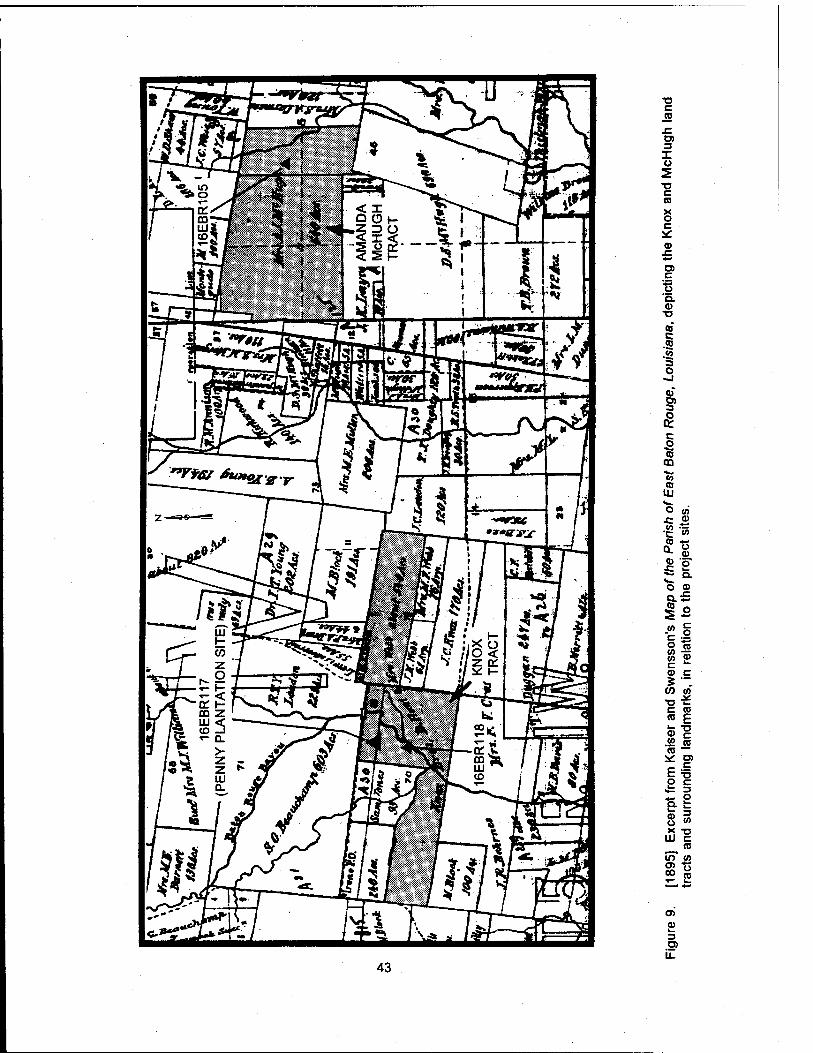
43
C ra
O)
X u
c CO
X o c a: 0)
ra c o D. a>
CD c •S .5 5 o -J
Si 3 o
Q: c
CD CO
<o .TO IU v. O V,
■c 2. •g »
■5"s" i °- O CD
is -M if (/} to ■o-K C CD CO E
51 .<2 CD CO —
^ D>
5 § -I S S X "O W C
CD
m to oo n
as CO
3 a> il
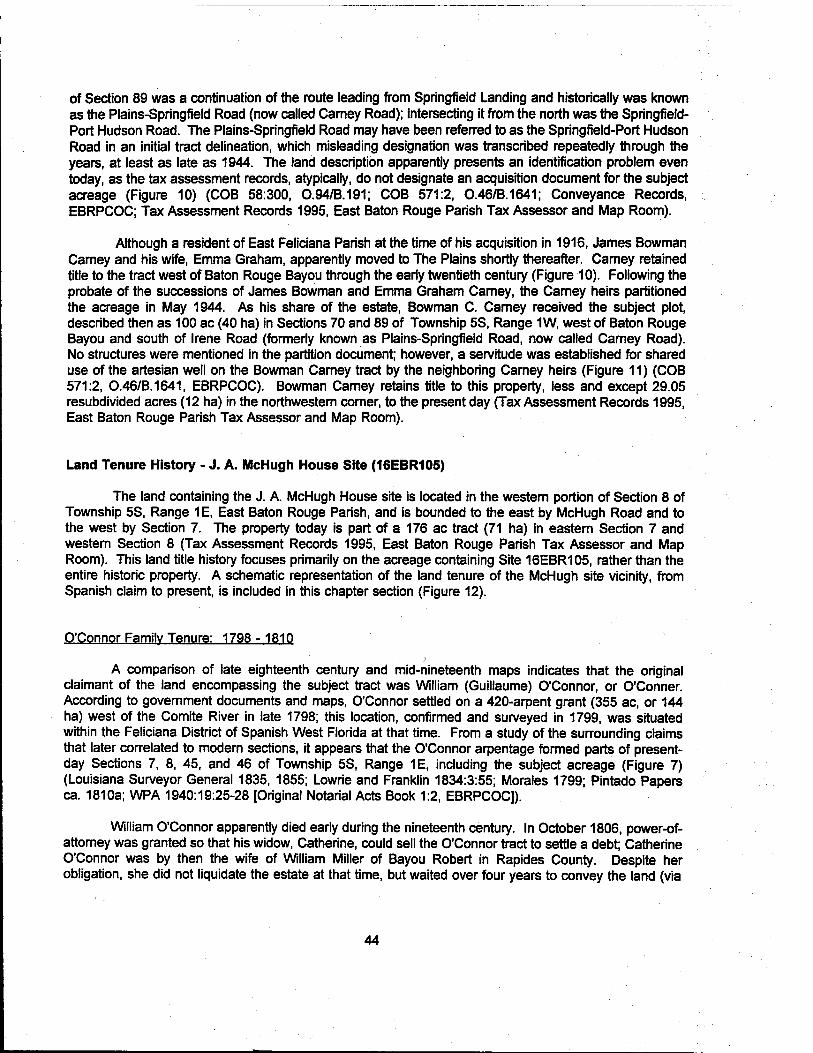
of Section 89 was a continuation of the route leading from Springfield Landing and historically was known as the Plains-Springfield Road (now called Carney Road); intersecting it from the north was the Springfield- Port Hudson Road. The Plains-Springfield Road may have been referred to as the Springfield-Port Hudson Road in an initial tract delineation, which misleading designation was transcribed repeatedly through the years, at least as late as 1944. The land description apparently presents an identification problem even today, as the tax assessment records, atypically, do not designate an acquisition document for the subject acreage (Figure 10) (COB 58:300, 0.94/B.191; COB 571:2, 0.46/B.1641; Conveyance Records, EBRPCOC; Tax Assessment Records 1995, East Baton Rouge Parish Tax Assessor and Map Room).
Although a resident of East Feliciana Parish at the time of his acquisition in 1916, James Bowman Carney and his wife, Emma Graham, apparently moved to The Plains shortly thereafter. Carney retained title to the tract west of Baton Rouge Bayou through the early twentieth century (Figure 10). Following the probate of the successions of James Bowman and Emma Graham Carney, the Carney heirs partitioned the acreage in May 1944. As his share of the estate, Bowman C. Carney received the subject plot, described then as 100 ac (40 ha) in Sections 70 and 89 of Township 5S, Range 1W, west of Baton Rouge Bayou and south of Irene Road (formerly known as Plains-Springfield Road, now called Carney Road). No structures were mentioned in the partition document; however, a servitude was established for shared use of the artesian well on the Bowman Carney tract by the neighboring Carney heirs (Figure 11) (COB 571:2, 0.46/B.1641, EBRPCOC). Bowman Carney retains title to this property, less and except 29.05 resubdivided acres (12 ha) in the northwestern comer, to the present day (Tax Assessment Records 1995, East Baton Rouge Parish Tax Assessor and Map Room).
Land Tenure History - J. A. McHugh House Site (16EBR105)
The land containing the J. A. McHugh House site is located in the western portion of Section 8 of Township 5S, Range 1E, East Baton Rouge Parish, and is bounded to the east by McHugh Road and to the west by Section 7. The property today is part of a 176 ac tract (71 ha) in eastern Section 7 and western Section 8 (Tax Assessment Records 1995, East Baton Rouge Parish Tax Assessor and Map Room). This land title history focuses primarily on the acreage containing Site 16EBR105, rather than the entire historic property. A schematic representation of the land tenure of the McHugh site vicinity, from Spanish claim to present, is included in this chapter section (Figure 12).
O'Connor Family Tenure: 1798 - 1810
A comparison of late eighteenth century and mid-nineteenth maps indicates that the original claimant of the land encompassing the subject tract was William (Guillaume) O'Connor, or O'Conner. According to government documents and maps, O'Connor settled on a 420-arpent grant (355 ac, or 144 ha) west of the Comite River in late 1798; this location, confirmed and surveyed in 1799, was situated within the Feliciana District of Spanish West Florida at that time. From a study of the surrounding claims that later correlated to modem sections, it appears that the O'Connor arpentage formed parts of present- day Sections 7, 8, 45, and 46 of Township 5S, Range 1E, including the subject acreage (Figure 7) (Louisiana Surveyor General 1835, 1855; Lowrie and Franklin 1834:3:55; Morales 1799; Pintado Papers ca. 1810a; WPA 1940:19:25-28 [Original Notarial Acts Book 1:2, EBRPCOC]).
William O'Connor apparently died early during the nineteenth century. In October 1806, power-of- attorney was granted so that his widow, Catherine, could sell the O'Connor tract to settle a debt; Catherine O'Connor was by then the wife of William Miller of Bayou Robert in Rapides County. Despite her obligation, she did not liquidate the estate at that time, but waited over four years to convey the land (via
44
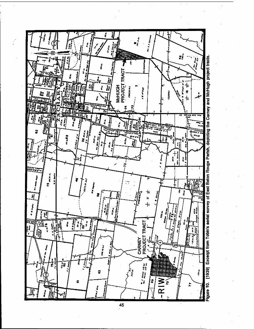

Figure 11. [1944] Excerpt from Mundinger's Map Showing Survey for Partition of Lands of J. B. & Mrs. Emma Graham Carney, depicting the Bowman Carney tract.
46

1990 —
1980 —
1970
1960 —I
1950-
1940-
1930-
1920
1910
1900
1890
1880
1870
1860 —I
1850
1840
1830
1820 —|
1810
1800
1790
McHugh Heirs
Soroh Elizabeth McHugh (McHugh widow)
Soroh E. ond Dovid S. McHugh Guy S. McHugh. Williom B. McHugh. Dovid R. McHugh, ond J«t»e W. McHugh
Soroh Elizabeth Shoffett, wife of/ond Dovid S. McHugh
Thomas E. McHughy
Amanda Jone Bridges McHugh (McHugh widow)
sk. J. 8. McHugh Eltole
J. A. McHugh Heirs
Amanda Jane Bridges, wife of/and John Anthony McHugh
United States Government
Lond Tenure Unknown \ >
John Reo Edward Rondolph^
_ Lony»tr«(h Eitol« ____________
Catherine O'Connor Miller J _Cp nnor j*i_ow_
Williom O'Connor
Spanish Coloniol Government
CONVEYANCE DATE UNKNOWN
PROPERTY INTEREST
Figure 12. Schematic representation of the general land tenure history of the McHugh tract in Section 8, T5S, R1E, west of McHugh Road.
47

attorney Thomas Lilley) to Jonathan Longstreth of the Mississippi Territory (WPA 1940:19:25-28 [Original Notarial Acts Book 1:2, EBRPCOC}).
Antebellum Lsnri Tenure: 1810-1859
Jonathan Longstreth acquired the O'Connor tract, described as 420 ac [arpents] (355 ac, or 144 ha) on a branch of the Comite River, on December 28,1810. The East Baton Rouge Parish conveyance indices also list Longstreth as Jonathan Longstreet, perhaps the same Longstreet who tutored the children of Thomas Lilley during that time period and chronicled The Plains conventions leading to the West Florida Revolution in 1810 (Conveyance Indices, EBRPCOC; Jennings 1989:109; PJB C:407, #364, EBRPCOC).
Longstreth died sometime prior to October 1, 1814, at which time his estate was adjudicated to Edward Randolph of Wilkinson County (Pinckneyville), Mississippi. Fourteen months later, Randolph conveyed the tract to John Rea, or Rhea (listed by both spellings in the East Baton Rouge Parish conveyance indices), of Feliciana Parish (PJB C:407, 605, EBRPCOC). Like Longstreet, both Edward Randolph and John Rhea had strong ties to the 1810 West Florida Revolution. Rhea served first as delegate and then as president of the convention for representative government, later a revolutionary congress. Randolph, who had family connections in The Plains, drafted the constitution and, it has been speculated, the Proclamation of Independence, as well (Jennings 1989:27-38; Meyers 1976:77-104). For further information concerning the West Florida Revolution, please refer to the discussion presented previously in this chapter.
By 1835, the former O'Connor tract had been resurveyed by the U.S. government, its original area subdivided to encompass the northern edges of Sections 45 and 46, the eastern end of Section 7, and the western segment of Section 8 of Township 5S, Range 1E. The land tenure progression is indefinite between the Rea/Rhea acquisition in December 1815 and the U.S. surveys approved in 1835 and 1853. It is known, however, that Rea, or Rhea, accumulated numerous properties during the early nineteenth century; among these tracts were at least 18 Spanish claims (over 10,000 total ac [4,047 total ha]), seven of which were declared fraudulent. It is quite possible, then, that the former O'Connor tract, although confirmed by both Spanish and U.S. governments, may have been "lost" in the confusion surrounding the Rea/Rhea properties. The acreage apparently was determined the property of the U.S. government by 1845, when the sections were depicted in their present configuration on the La Tourette map of that year (Conveyance Records, EBRPCOC; Davis 1971:171-172; La Tourette 1845; Louisiana Surveyor General 1855).
McHugh Family Tenure: 1859 - Present
In March 1859, John Anthony McHugh acquired Lot 2 of Section 8 of Township 5S, Range 1E, from the U.S. government, Certificate No. 3633; patent was granted in the following year on June 1, 1860. McHugh also acquired adjacent portions of Section 7 in 1859-1860. Lot 2 was described as the western fractional half of Section 8 and contained 253.60 ac (103 ha); the land was purchased by McHugh for $0.25 per acre (COB X/580-582, #423-425; U.S. Government n.d.).
John Anthony McHugh was the son of John McHugh, who served in the Louisiana militia during the Battle of New Orleans and died shortly thereafter (March 1815) due to illness. Progenitor of the clan was Philip McHugh, an Irishman who settled along White's Bayou during the early nineteenth century. The Philip McHugh tract was located northwest of the subject acreage, along the northern edge of the present- day town of Zachary. John A. McHugh inherited a share in this property ca. 1836, following the death of his grandfather (Carmena 1951:1-4; Jennings 1989:300-301; Lowrie and Franklin 1834:3:51; Pintado Papers ca. 1810a; PJB P: 148, EBRPCOC).
48

Throughout his lifetime, John Anthony McHugh remained occupied in the affairs of The Plains, serving as both a justice of the peace and a notary public. Additionally, as a young man in 1840, he was appointed first lieutenant in the 11th Regiment of the Louisiana Militia, and in later years, he belonged to the Masonic organization. No doubt due to his activities in the region, he became known as "Squire McHugh" (Caillouet 1976:240; Carmena 1951:7-10; Sheriff's Sales Book C:175, EBRPCOC).
Squire McHugh lived a long and apparently prosperous life on The Plains, 1814 -1874; however, public records and family letters indicate that he feared his demise prior to marriage and fatherhood. On January 31,1850, at the age of 35, McHugh wrote his Last Will and Testament, leaving 2 slaves and 100 head of cattle to his cousin, Rachel Kent, of Carroll Parish. The document stipulated that if Miss Kent pre- deceased McHugh, his estate was to be divided between two female friends, whose names have since been crossed out (COB D:87, #82, EBRPCOC). Interestingly, in February and March of the same year, McHugh proposed marriage, in anxious but very businesslike terms, to Amanda Jane Bridges of Greensburg in St. Helena Parish (formerly of The Plains). McHugh penned these far from romantic words: "My health is not better than when you saw me. I am in need of someone to sympathize with me and to treat me with love and kindness." A week later, McHugh wrote to Amanda that he had "still the means of living comfortably and if you are willing to do this, the sooner it is done the better;" McHugh further noted that he made "this proposition to you in preference to any one in this neighborhood, because I know that you . . . would be a wife that would be better to me than any other I know" (Carmena 1951:4-6). Consequently, Rachel Kent and any eligible ladies of the community promptly lost all chances of both "comfortable" marriage and inheritance, as Amanda Bridges and Squire McHugh entered a marriage contract on April 22, 1850, followed by the ceremony a week later (Carmena 1951:6; COB D:167, #168, EBRPCOC).
In the years following his 1859 acquisition of the subject tract, John A. McHugh built a home and farmed the acreage while, at the same time, adding to his land holdings. According to a letter written to his brother-in-law on March 14, 1869, McHugh anticipated a poor com crop in the region: "We have had an unusually rainy winter, and the spring is backward." That season, he intended to plant only 5 ac (2 ha) in com, if that, "as my stock [hogs and cattle] will take up all my time" (Carmena 1951:7; Conveyance Records, EBRPCOC).
John A. McHugh died on April 2,1874. Nearly a decade later, in May 1883, his widow and children partitioned the estate. Widow Amanda Bridges McHugh received the central 346 ac (140 ha) of the Home Tract, including the family residence and the subject acreage in Section 8. Amanda McHugh lived on the Home Tract through the turn of the century. Although the western portion of Section 7 (west of Site 16EBR105) originally was allotted to James Babin McHugh in 1883, his mother had acquired the property, which adjoined her acreage, by 1895 (Figure 9) (Carmena 1951:8-9; COB 7:175, #136 [J. M. Loudon Notarial Book C:135, EBRPCOC]; McHugh Family File n.d.).
Following the death of Amanda McHugh in January 1905, the McHugh estate was resubdivided by her children, James Babin McHugh, David Samuel McHugh, Thomas Edward McHugh, and Susanna Amanda McHugh Carmena (wife of Simeon Fillmore Carmena). On August 28, 1905, that portion of Section 8 west of McHugh Road and the adjoining acreage in eastern Section 7 were allocated to Thomas and David McHugh. Tom Ed McHugh, who was the first mayor of Zachary (elected in 1889) and who later served as East Baton Rouge Parish Clerk of Court and Deputy Sheriff, held his undivided one-half interest in the 176-ac (71 ha) tract for only two months before selling the share to his brother, delivering full property interest to David McHugh (Figure 13) (Caillouet 1976:241; Carmena 1951:9; COB 34:277, Probate No. 2170, 22nd Judicial District Court [JDC]; COB 33:564, O.14/B.102; COB 33:643, O.115/B.102, EBRPCOC; Jennings 1989:232, 301-302; ZBC 1975:137).
49

Figure 13. [1905] Excerpt from Monger's Map of Part of McHugh Estate, Showing Portions Owned by Heirs of Mrs. A. J. McHugh, depicting the T. E. & D. S. McHugh tract in Sections 7 and 8, T5S, R1E.
50

David S. McHugh and his family have retained title to the subject tract through the twentieth century. In November 1919, McHugh sold nine land tracts, including the subject acreage, to his sons, Guy S., William B., David R., and Jesse W. McHugh. Nearly three years later, the siblings reconveyed the 176 ac (71 ha ) in Sections 7 and 8 to their father, who retained sole title until his death in 1926 (Caillouet 1976:241; COB 83:143, 0.29/B.275; COB 110:295, 0.61/B.376, EBRPCOC; McHugh Family File n.d.).
David S. and James B. McHugh were married to sisters Sarah Elizabeth and Rachel F. Shaffett, respectively, descendants of Plains pioneers Anthony and Sarah E. Chichester Shaffett. Both couples, as well as their siblings, produced large families whose progeny have figured prominently in the twentieth century development of The Plains (Caillouet 1976:241; Jennings 1989:301, 352-353). After the death of David S. McHugh in 1926, his widow and heirs received the estate, which, in addition to his portion of the Home Tract, included 128 cattle, 13 mules, 5 horses, 3 saddles, 1 "old wagon," 1 mowing machine, 1 hay press, 12 hoes, 6 plows, 3 harrows, various farming implements, household furniture and effects, and 1 "baby Overland Touring Car" (COB 173:114, Probate No. 254,19th JDC, EBRPCOC; McHugh Family File n.d.).
The McHugh children and grandchildren inherited title to 13 land tracts, including the subject acreage, following the death of widow Sarah Elizabeth McHugh in 1938. The property was described in her Judgment of Possession, filed March 20,1939, as 176 ac (71 ha) in the Fourth Ward [Sections 7 and 8, T5S, R1E], bounded on the east by the "public road known as the McHugh Road" and on the west by J. B. McHugh (Figure 10) (COB 400:389, Probate No. 2710, Division B, 19th JDC, EBRPCOC; McHugh Family n.d.). The descendants of David and Sarah McHugh continue to hold collective title to the subject tract in Section 8 to the present day; however, the property has been uninhabited since at least the mid- twentieth century. The current East Baton Rouge Parish tax assessment roll lists Guy McHugh et al. (10 other McHugh interest-holders) as owners of the property today (Ryan et al. 1994:109; Tax Assessment Records 1995, East Baton Rouge Parish Tax Assessor and Map Room).
Summary
The project areas containing the Penny Plantation/Carney Dairy Bam site (16EBR117), Site 16EBR118, and the J. A. McHugh House Site (16EBR105) have remained part of an agricultural region from earliest tenure to the present. The two land tracts encompassing the sites both were surveyed under Spanish Colonial rule, and were farmed and/or occupied through much of the nineteenth century. Plantation structures existed on the Penny/Carney acreage as early as 1802; the agricultural tradition has continued there to the present day under ownership of the Bowman Carney family. To the east, the McHugh family has held tenure to the farmland in Section 8 west of McHugh Road since 1859, although the property today is uninhabited. The archeological evidence accumulated during the occupation of these two properties is recounted in the remainder of this report.
51

CHAPTER V
PREVIOUS INVESTIGATIONS
Introduction
A review of the cultural resources surveys and excavations that have been performed within the immediate vicinity of the proposed Comite River Diversion Project right-of-way is presented in this chapter. The 19 linear km (12 linear mi) project corridor is located in East Baton Rouge Parish, extending from the Comite River to the junction of Coppers Bayou and Profit Island Chute on the Mississippi River (Figure 14, Sheets 1-4). The immediate vicinity has been defined as that area within an 8 km (5 mi) radius of the current project area. Between 1976 and 1993,18 cultural resources surveys, and one emergency mitigation excavation have been conducted in the vicinity of the project area. Previous investigations have been summarized in Table 1; the locations of previously recorded sites are shown in Figure 14, Sheets 1 and 2 and Table 2.
Previous Cultural Resources Surveys and Assessments
The first cultural resources survey on record at the Department of Archaeology in Baton Rouge, Louisiana, was conducted in 1976 by Richard A. Marshall for the Florida Gas Transmission Company (Marshall 1976). The project included four proposed pipeline construction areas, two of which were located in the vicinity of the proposed Comite River Diversion Project. The first of these areas was an easement running from Scotlandville to just south of Zachary, in East Baton Rouge Parish. Pedestrian reconnaissance was conducted on January 3,1976, but produced no evidence of cultural activity. However, six areas were recorded as possessing a high probability for subsurface cultural material. Based on these predictions, these loci were recommended either for further testing, monitoring, or avoidance. None of these loci was located 1.6 km (1 mi) within of the current project area. The second area surveyed by Marshall was a new pipeline corridor located adjacent to an extant right-of-way, extending from Irene to the Colonial Tank Farm, north of Port Hudson, Louisiana. Pedestrian reconnaissance was conducted on January 9 and 10, 1976, but yielded no evidence of cultural activity. Based on historical evidence, remote sensing monitoring was recommended for the portion of this easement that was within the boundaries of the Port Hudson National Historic Landmark.
In 1976, the Louisiana Department of Transportation and Development conducted pedestrian surveys prior to the expansion of U.S. Route 61 between Scotlandville and Port Hudson, Louisiana (Rivet 1976a), and the construction of the LA Route 64 bridge spanning the Comite River (Rivet 1976b). Only one isolated, plain, prehistoric sherd was recovered during these surveys, and no additional testing was recommended.
In March and April 1978, Espey, Huston & Associates, Inc. conducted a cultural resources survey of construction sites for microwave towers and a substation proposed by Cajun Electric Power Cooperative, Inc. (Nichols 1978). The proposed construction areas were scattered throughout Louisiana, and only one of the construction sites (Area 4) was within the immediate vicinity of the Comite River Diversion Project. Construction Area 4 was located south of Zachary, Louisiana, and consisted of approximately 4 ha (10 ac) of pasture. The survey consisted of a pedestrian walk-over and the excavation of two shovel tests; no cultural material was recovered, and no additional testing was recommended.
52

Table 1. Previous Archeolog cal Surveys Conducted in the vicinity of the Comite River Diversion Project Area. 1 CLIENT/ FIELD RESEARCH CONTRACTING PROJECT
|DATE TITLE /AUTHOR ORGANIZATION ORGANIZATION DESCRIPTION RECOMMENDATIONS
Hfttt An Archaeological Site Independent Florida Gas Pedestrian survey of Recommendations include the Survey of Four Proposed researcher Transmission four pipeline avoidance of 2 sites, the Pipeline Construction Sites Company construction areas for testing of 2 sites, and the in Louisiana (Marshall Florida Gas monitoring of 4 additional 1976) Transmission Co. sites.
1976 Scotlandville - Aisen Staff Archeologist Louisiana Department Pedestrian survey of If cultural material is Highway (North Section), of Transportation and areas affected by the uncovered during Route U.S. 61 and Alsen - Development expansion of Route construction, the "contractor Port Hudson Highway U.S. 61 control clause" must be put Route U.S. 61, East Baton into effect. Rouge Parish (Rivet 1976a)
1976 Comite River Bridge and Staff Archeologist Louisiana Department Pedestrian survey of If cultural material is Approaches, Route LA 64, of Transportation and areas affected by uncovered during East Baton Rouge Parish Development bridge replacement construction, the "contractor (Rivet 1976b) across the Comite River
on Route LA 64 control clause" must be put into effect.
1978 Cultural Resources Survey Espey, Huston and Cajun Electric Power Pedestrian survey and No additional testing of 19 Microwave Tower Associates, Inc. Cooperative, Inc. shovel testing of areas recommended, although it and Substations in to be affected by the was recommended that two Louisiana, Cajun Electric construction of 19 sites be monitored. Power Cooperative, Inc. microwave towers and (Nichols 1978) substations
1978 Junction LA 67 - Indian Staff Archeologist Louisiana Department Pedestrian survey of If cultural material is Mound Highway, Route LA of Transportation and areas to be affected by uncovered during 64, East Baton Rouge Development the upgrade of Route construction, the "contractor Parish (Rivet 1978) LA64 control clause" must be put
into effect.
1979 Cultural Resources Survey Southern Mid-Louisiana Gas Pedestrian survey and No additional testing of a Proposed Pipeline Archaeological Company shovel testing of areas recommended. Right-of-Way Near Port Research, Inc. to be affected by the Hudson, East Baton Rouge construction of a Parish, Louisiana (Spencer proposed pipeline for 1980) Mid-Louisiana Gas
Company
1980 A Cultural Resource New World EMANCO, Inc. Pedestrian survey and No additional testing Survey of a Proposed Research, Inc. shovel testing of areas recommended. Transcontinental Gas Pipe to be affected by the Line Project in East construction of a Feliciana and East Baton proposed 11.4 km (7.1 Rouge Parishes, Louisiana mi) pipeline [New World Research Inc. 1980)
53

Table 1, continued CLIENT/ I
FIELD RESEARCH CONTRACTING PROJECT DATE TITLE/AUTHOR ORGANIZATION ORGANIZATION DESCRIPTION RECOMMENDATIONS |
1982 An Archeological Survey of National Park U.S. Army Corps of Pedestrian survey of No additional testing the Proposed Point Coupee Service, Denver Engineers, New borrow pits used for the recommended. -Arbroth Levee Service Center, Orleans District proposed levee Enlargement (M-270 to Southeast - enlargement 249.5-R), Pointe Coupee Southwest Team and West Baton Rouge Parishes, Louisiana (Stuart and Greene 1983)
1983 Cultural Resources Survey Staff Archeologist Louisiana Department Pedestrian survey of If cultural material is of LA 19, Baker - Zachary of Transportation and areas to be affected by uncovered during Highway, East Baton Development the expansion of Route construction, the "contractor Rouge Parish (Deshotels LA 19, between Baker control clause" must be put 1983) and Zachary, La. into effect.
1985 Salvage Excavations at Staff Archeologist Louisiana Division of Salvage excavations of 'Two excavation units quickly 16EBR64 (Smith 1986) Archaeology 16EBR64 to be affected
by construction on Georgia Pacific Company property
revealed that the site had been thoroughly disturbed and that further work would not be fruitful."(Smith 1986)
1989 Literature Search and R. Christopher U.S. Army Corps of Literature search, Further Phase I testing was Research Design Amite Goodwin & Engineers, New pedestrian survey, and recommended on all River and Tributaries Associates, Inc. Orleans District shovel testing of construction areas Project Ascension, East approximately 93 ha Baton Rouge, and (230 ac) for the Livingston Parishes, proposed construction Louisiana (Goodwin et of several flood control al.1990) items.
1991 A Cultural Resources Geo-Marine, Inc. Georgia Pacific Pedestrian survey and No additional testing Evaluation of the Proposed Corporation shovel testing of recommended. Landfill Areas at the approximately 27 ha Georgia Pacific Corporation (67 ac) for the proposed Port Hudson Operations in construction of two East Baton Rouge Parish, landfills Louisiana (Austin and Hunt 1991)
1993 Phase I Cultural Resources R. Christopher Florida Gas Pedestrian survey and No additional testing was Survey of the Proposed 30 Goodwin and Transmission shovel testing of 0.09 recommended. x 30 m Florida Gas Associates, Inc. company ha (0.22 ac) for the Transmission Company proposed upgrade of a Compressor Station 8 compressor station Upgrade, East Baton Rouge Parish, Louisiana (Athens et al. 1993)
54

Table 1, continued CLIENT/ I FIELD RESEARCH CONTRACTING PROJECT
DATE TITLE/AUTHOR ORGANIZATION ORGANIZATION DESCRIPTION RECOMMENDATIONS
1993 Cultural Resource Survey Coastal Exxon Pipeline Pedestrian survey and No additional testing was
of Exxon Pipeline Environments, Inc. Company shovel testing of recommended; however, it
Company's Proposed approximately 233 ha was recommended that
Pipeline Route, East Baton (575.75 ac) for the Locality A of Site 16EBR42, a
Rouge and East Feliciana construction of a Confederate cannon Parishes, Louisiana proposed pipeline emplacement, be avoided (Perrault 1993)
1993 Supplemental Cultural R. Christopher U. S. Army Corps of Pedestrian survey, Additional testing was Resources Investigations Goodwin & Engineers, New shovel testing, and recommended for Site and Site Testing for the Associates, Inc. Orleans District evaluatory testing of 16WBR39 if it becomes Pointe Coupee to Arbroth areas affected by the threatened by construction. Levee Enlargement and levee enlargement and Areas of Site 16WBR26 Seepage Control Project, seepage control should be avoided during West Baton Rouge Parish, projects construction. Louisiana (Hinks et al. 1993)
1993 Archaeological and Coastal U. S. Army Corps of Emergency survey and No recommendations were Historical Investigations of Environments, Inc. Engineers, New excavations at made. the Price - Williams Orleans District 16WBR40and Cemetery and the Mahier 16WBR41 located in Building Rosehill Plantation the right-of-way of the West Baton Rouge Parish, Arbroth Revetment Louisiana (Hahn 1994)
d.d. Cultural Resources Survey Earth Search, inc. U.S. Army Corps of Pedestrian survey, Sites 16WBR12.16WBR19 - of Mississippi River Levee Engineers, New shovel testing, and 16WBR20,16WBR23, and Revetment Projects, M Orleans District evaluatory testing of 16WBR26,16WBR29, 270.2 to 246.0-R (Yakubik areas to be impacted by 16WBR38 and 16PC62 were 1994). proposed levee and
revetment projects along the Mississippi River
recommended for inclusion into the NRHP.
1993- Cultural Resources Survey Coastal U. S. Army Corps of Pedestrian survey, Sites 16EBR105,16EBR106, 1994 of the Proposed Comite Environments, Inc. Engineers, New shovel testing, and and 16EBR117were
River Diversion Alignment, Orleans District architectural survey of a recommended as potentially East Baton Rouge Parish, 12 mi x 3,000 ft corridor significant for inclusion in the Louisiana (Ryan et al. for the proposed NRHP. Additional testing is 1994) Comite River Diversion
alignment recommended for 16EBR104, 16EBR118,16EBR122, 16EBR124,16EBR125, and 16EBR131-16EBR133.
55
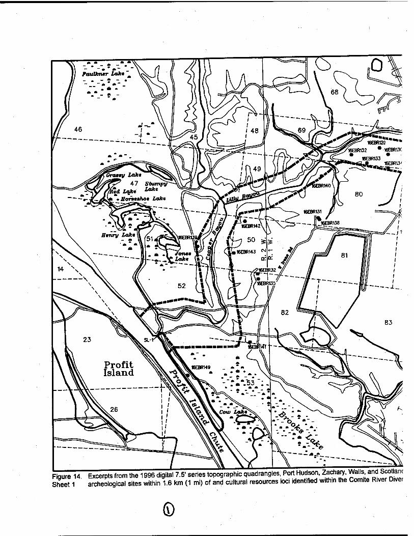
Figure 14 Excerpts from the 1996 digital 7.5" series topographic quadrang es, Port Hudson, Zachary. Walls and Scotlanc SheeM aSogical sites within 1.6 km (1 mi) of and cultural resources loci identified with.n the Comite R.ver D,ver
©
drang es, Port Hudson, Zachary, Walls, and Scotlandville, Louisiana, depicting sources loci identified within the Comite River Diversion project area.
56
1^?%^
picting
(D 56
Figure 14. Sheet 2
Excerots from the 1996 digital 7.5" series topographic quadrangles, Zachary, Fred, Comite, and Scotlandville, I SogioaTsilL within 1.6 km (1 mi) of and cultural resources loci identified within the Com.te R.ver D,ve
<D

,ic quadrangles, Zachary, Fred, Comite, and Scotlandville, Louisiana, depicting ural resources loci identified within the Comite River Diversion project area.
JL
fr*f>$'}

ui o z 111 a. in u. in
(D 00 a>
ez CO
E 3
co T3 C CO CO CD c o -3
o
3)
"5
S c
i T3 O O
CD Riv
et 1
983;
Jon
es a
nd
Shu
man
198
6; R
yan
et a
l. 19
94
3
1
in en O)
äi ■fe- es
T3 C CO
x: t o 3
Ü CD
2" a. c o
fi CD > Q L. a > s B 1 o o o £ 4-1
£ ci c
*r c o E
S '> c
111
(A CO o o
■a a
■s o u £ (0 S to
a> a>
To 'S c CO
05 05
15 S c CO
I?
05
75
S c CO
f O) O)
to s CZ CO
0 o>
to S c CO
■>*■ o> O)
to s c CO
&
o> a>
s c CO >. ■
0> a>
tö S c CO
05
to CO
c CO
IS?
■» en o>
■5
s c CO
a:
05 05
tö s c CO
05 05
tö a> c CO
-■ Of < B « 2 }= P o jo b F O £ <uj«o II
3 c O CO a. 'cö
CO o IS 'E co
'co
'S z
1! 3 c o o> 0- 'cö
=*tz •s s C li= S 'E O CO
Q. *cö
*1z
II Ä c O CO 0- 'cö
c
s '£ CO
'co
o Z
c
8 IP 'E CO
'co
o Z
tz s
<p 'E CO
'co
o Z
c CO Ü IB 'E CO
■5
0 Z
CO CO ■■s Ü C IE S c 0 CO Q- 'co
CO CO
tlcg 3 'E O C3) Q. 'cö
c
8 IS 'E CO
'Ü)
s Z
c CO 0 IS 'c CO '5
0 Z
c
8 IS CZ OS CO
0 z
8 IS 'cz CO '5
s z
c
8 ■s 'E O)
'co
0 z
c CO 0 IS 'cz CO
■5
s z
<
<u
e" 0.
c o
> Q
(9 Z t- co ui I- (0 3 o Si DC 0.
c o 75 CD
o Ü
8 3 co
T3 c CO
c •2 „ 'S to a> 3
8J? JO w
i s CO o
c g tS CD
8 8 € 3
CO
ST £ 3 CO
CZ CO
"iz to a>
■o a>
CZ g
ts a;
o ü
8 3
CO
■a c cs c o
8 1 c^
3£ CO v>
CO c to Ä
o
CO
CO .CZ
to aj
15 > o SI CO
CO c to aj
0 c co
co c to CD
I sz co
CO c to 3 a) > 0
CO
■0 c CO
c 0
If 8 » ° CD
n^ = j?
CO cö
T3 C CO
c 0
1? 8 1 §^ 3 > 32.
CO «5
CO .c to 3 "03 > 0 sz CO
CO CZ
to 3
0 .c co
CO .CZ
to 3 tE > 0 sz CO
CO c to 3 "33 > 0 sz CO
0) >
0)
E o ü 0) JZ «•— O
E a: o u. Q Z
5
8 CO t 0)
ai ■o
8 E OJ
a> •c
E
"5 CD O)
TJ 111
8 E OJ
CD c
8 o to '53
8 CD b 3 CD
•tz
S 0.
a>
s a>
To i_ 3 to Z
8 CO t aj CD CZ
8 o to 'a> 0.
8 E OJ
a> CZ
8 o to '5 Q.
8 E a> c
8 o 0) 'S
8 E ü a> c
8 Q CO
'53 0.
8 CO L_ L_
B CD c
8 0 to 'CD
Q.
8 E aj a> c
8 0 to 'äi 0.
8 E 3 CD c
8 CO
'53 a.
8 E 3 a> CZ
8 0 to 'CD
Q.
8 E 3 a> c
8 0 to 'ffi 0.
8 E 3 0) c
8 Q CO
'CD
0.
8 E 3 a> c
8 0 to '53 Q_
8 E 3 a> c
8 J2 CO
CD
0.
1^ IT CD
c IE
K O 111 H Z
CD
2 CD co S 'S c O CO
E -e i_- 3 5 to U. T3
CU
2 CD CD O "2 c
O CO E € i-" 3 '5 » LL T>
CD
E «B CD 0 "5 c O CO
E € L.- 3
'cö « LL -a
?.8 II 83 X .2
UJ TJ
CD
S «B a> 0 "2 c O (0 E € !-" 3 '5 M U. T3
.2.8 E S
o CO 0. =5
.2.8 1 s E.€ o 3 o CO 0- =5
.2.8 I s P. € S 3 0 CO 0. =5
° 8
S 3 0 co 0. =5
a> 8 O CO E € LT 3
'5 .12 U. T3
.2.8 & £ F.I 0 CO 0. =5
08 i 5 . » 1—
S 3 0 CO Q- =5
.2.8 E S
0 co Q. =5
.2.8 E S
0 3 0 CO Ü. =5
08
F.-e S 3 0 CO Q- =5
.2.8
li 0 CO 0. =5
.2.8 |i • - t—
S 3 0 CO 0. =5
3 ■o d> *-■ CO Ü o _l (0
CO T3 (1)
Z o F 0.
S o CO Ul o
0)
CO
Ü C 3 O
E u 'ez o to IE £ 0-
a> CD
E 8 ü 'C o to if
aj '» 13 c 3 O E ü •c
CO IE E 0.
£• a> CD
E 8 ü
P CO
if
T3 CD
l*= CO c •c Q. to
i o cp •c .£ o -a
if 5
o
u ■c o ts te J: « E S Q- co
aj 'cö CD
3
•G 5 to Ü •c Q CO
if
aj '» £ 3 T3 5 S Ü •c 0 to if
Ü !c
u •c 0 to S £ ts E S
Q_ co
aj ■5
E 3 ts 5 to 0
*vZ q 10 if
o> CZ
'a c ra « ©
0 t3 S 5 x »
1 8 CO
ts 3 '■E CO
ü •c 0 to if
1 8 CO
tj 3 '•E CO
Ü ■c
CO
i
3 '» CD
3
ts 2 to u
•!Z 0 to if
1 8 CO
•c 3 '€ CO
Ü •c 0 to if
ü !E
ü •c 0 to S
£ g Q. co
CO 0 CO
ts 3 ■•E CO
u •c 0 to ir
y o o a>
>. to 3 O
in
CO o 3
a>
1 o
CO
1
a>
'> 13 cz ra o o
CO
£> CO c Ü CO N
CO
1 ■D E LL
■o E
LL
£• CO
0 CO N
CO sz 0 CO N
£■ CO
13 CO N
£• CO x: 0 CO N
£• CO sz 0 CO N
£• CO sz 0 CO N
£• CO
15 CO N
£• CO sz 0 CO Nl
aj
'> T3 C CO
8 co
aj > ■a c
JO
0 Ü co
>
Q.
csi a> fzt CO l-
o z <m OS zz 111 z
H CO 1
CM CO a m ID
m DC m LU
to CO a. m UJ
■*
s ffl LU
O ^— Q: CO LU CO
CM O r- a. m LU CO
co 0 ^— t£ CO UJ CO
s ffl UJ co
10 0
a. m LU co
CO 0
a. m LU co
r- 0
ffl a. UJ CO
00 0 T— a m LU co
05 0
5 ffl LU CO
0
s ffl UJ CO
s m LU <o
CM
5 m UJ co
58
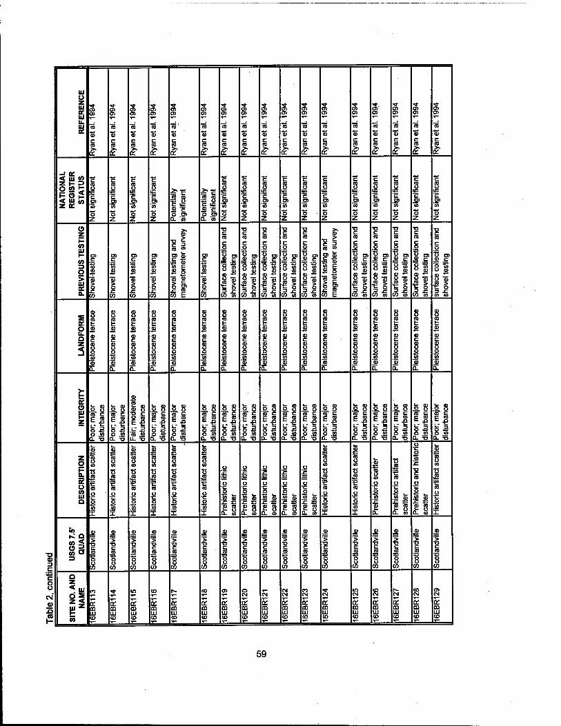
•a CD 3 C
c o u c\f ©
111 o z UJ a: Ul u. Ul
tn o»
15 S c
O)
to a> c (0
■5 a5 c CO
■5 s c «I
a> o>
To' a> c CO
a o>
'S c CO
o> o>
■5 'S c CO
5"
o>
to s c CO
D?
05
■5
tu c CO
o>
RJ
S c (0
o>
nj S c CO
o> en
tö
c CO
o> 0
S c CO >.
en
ra a> c CO
L?1
0
tö S c CO
o> o>
tö S c CO
o>
■5 s c CO >» tr
NA
TIO
NA
L
RE
GIS
TE
R
ST
AT
US
I c CO
'S Z
** c 8 IB
'c p>
■5
0 Z
8 c a) 'S 'S z
c 8
u= c 0
'co
0 Z
1 8 C IB
3 c O O) 0- «
■S 8 C IB
£ "5 p O)
Q. 'co
c 8 o>
'tö
s z
c 8 c O)
'co
s z
c 8 'c O)
■5
p z
c 8 IB
C O) '» P Z
c 8 'E O) « S Z
c 8 'c '5 p z
c 8 IB
C P)
'co
p Z
c 8 IB C O)
'co
S Z
c 8 IB
C O) » p Z
c 8
■B C O)
■5
p Z
c 8 IB
'c P> '5 p Z
(9 z
(0 Ul H CO 3 O
£ DC a.
c to a>
05 > o r. to
o> jz "ui aj
s 0 c to
c M a>
> 0
CO
O) c to aj
"s 0
co
! ? = CO J» P> 0
CO c
Ä 0
5 f co E
c
w &
I co
■a c CO
c p
1? 8»
CO w
■a c CO
c p
1? 8 1 §^
CO o>
■a c co c p
1?
§^ •fS >
CO to
C (0
c p
8 I
•il co «
■0 c CO
c p
1 g» si
co »
1 E i CO «
D) CD
■5 CD CO c
£ p
?1 co E
c CO
c p
1? 81 §^
CO «
■a cz CO
c p
I? 8 »
■JS 5 = 5
CO «
■0 c co c p
IE 8 |
CO m
C co c p
1? 8|
•2 > CO m
■0 c CO
c 0
V. °> JD C
p t5 p p
8 Tu ■B § W 10
£
O u. a z 3
8 CO t 4>
CD c 8 o «5 55 a.
a) 0
E 3 a> c 8 0
to '55 a.
8 E a> a> c 8 0 to ■55 a.
8 E £ (D C
8 0
to '<u a.
8 I B CD C
8 p 10
's a.
8
CD c 8 p
M
'cu CL
8 E 0
CD c 8 p
to '55 0.
8
Ä a) c 8 p CO
■5 a.
8 E 52 <u c 8 p
to '5 a.
8 CO t a a> c 8 CO
'S a.
8 H Ä cu c 8 CJ CO
■5 a.
8 e Ü! CD c 8 p
to CD
a.
8 E ä CD C
8 JJ CO
'5 a.
8 E CD C
8 JJ CO
■5 0-
8 E £ CD c 8 J2 CO
'CD
a.
8 E CD C
8 CO
'5 a.
8 E £ CD c 8 p
to 'p
a.
K (9 Ul 1- z
2.8
s a o CO 0. =5
° 8
s 3 0 0 Q. '-5
CD
2 » <D Ö "2 <= O (0
E € i_- 3
'5 » u. -0
.2.8 «^ E Ül S 3 0 0 D- =5
08 | S ll O « Q. =5
°8 E.l s a p CO
a. =5
08
p CO
Q. =5
.2.8
0 CO 0. 5
.2.8 «^ E E.l S 3 O CO
a. =5
.2.8
li p CO
Q- =5
.2.8 E S ll p CO
0. =5
.2.8
ll p CO
a. =5
.2.8 «^ E E! s 2 O (A
°8 1 s l| p CO
0. =5
2.8
ll p CO
a. =5
.2.8 i S P.-G S 3 0 tn
a. '-5
.2.8 g g fe 3 O «
Ü_ 'S
z o F a. cc o CO Ul a
CD
s CO
ts a t CD
U 'C o to x
£ S 10
.2 '■e CO
,p
O
to if
£ s a) tj .2 '•c CD
O •c V)
X
£ 8 CO
■■E CO
ü ■c 0
to X
8 CO
•s •S5 '•5 (0
Ü •c p CO
X
£ 8 CO
•53 a '€ CO 0 •c p
to if
Ü
£
u ■c p
to a) JC s
s 8 0. co
ü
Ü •c p CO m
£ 8 a. 10
0
0 •c p to j)
S 8 0. co
o '£
p •c p
to m
S 8 0- co
ü !c
a •c p
to te
e s QL 10
c 8 CO
•s '€ CO
p •c J3 CO
X
£ 8 10
T3 45 '■c CO
Ü •c p
to if
i_ <D *S
8 CO
Ü •c p
to
s> 0.
'S
'€ CO
ü ■c J2 10 aj f S3
s 8 0- co
p
J2 10 !c •0 c CO
p •c p
.2 te
1 s a. co
£ 8 CO
K
'■c CO
Ü ■c p
to if
^ a co< CO O 3
0)
> T3 C jg o ü CO
©
'> ■D C
JO
O O
co
'> ■0 c
JO
S 0
CO
JD
> ■0 c CO
8 CO
aj
■> ■a c
JS 0 0
co
> c CO
CO
■> ■0 c
JO
p 0
co
JD
> ■a c CO
? CO
JÜ
■> ■a c
JO
p 0
CO
JU
"5 ■0 c CO
CO
JD
> ■a c
JO
S o co
JD
■5 ■p c CO
8 CO
JD
> ■a c
JO
B 0
CO
JD
■> ■a c CO
8 co
JD
'> ■P c CO
8 CO
JD
> ■a c
JO
p 0 co
JD
■> T3 c
JO
p p
CO
a z «111
zz Ul z
1- co
CO
K CD XI CO
E m HI CD
10
CD LU CO
co
m LU CO
S CO LU CO
00
5 CD LU CO
0>
s CD LU co
0 CM
5 CD LU CO
CM
on m LU CO
CM CM
E CD LU CO
CM
E 03 LU CO
E CD LU co
10 CM
E CD LU CO
to CM
OH m LU co
CM
E CD LU CO
CD CM
E CO LU CO
a> CM
E m LU CO
59

T3 <D
C
C o u CM" a> si CO
Ul o z UJ ae UJ U. Ul
O)
CD
S cz CO
5"
en o>
"5
«3 c CO
05 05
to a» c CO
a> o>
'S tu c CO >.
DC
en Cn
CO
a> c CO
en en
CO
c co >.
Ti- en en
CO
a! c CO
c
'3 ■a o o O
en en
CO o)
«? C _; ra co O. a)
en en
CO
tu c ca
en
CO
'S c CO
en en
ca
tu c CO
en en
ca
tu c ca
«s?
en en
ca
S c ca >.
<* en en
co
S c CO
en en
ca
tu c ca
t en en
CO
S c CO >.
Tf en en
CO
tu c CO
NA
TIO
NA
L
RE
GIS
TE
R
STA
TUS
c CO o
c □) 5>
o z
II 3 c O O) Q- "co
tz 8 «=
'cz o>
'co
o z
cz
8 c en
'co
o z
c CO o
■B 'c D)
'55
C3 Z
CO CO
JS c O O) 0- '5
to c
£ cu ■a c
c CO Ü
IB 'E en
'co
o Z
c
8 u= 'c en M
o Z
c CO o
'E en
'co
o z
c
8 u= 'c en '5
"5 Z
8 IB C en '5
o Z
c ca o is c en
'co
o Z
tz CO o IB 'c en '» S Z
c
8 IB 'E en to o z
c
8 IB 'E en CD
o Z
c
8 ■B 'c en « o Z
O z i- CO UJ 1- 0)
o Si EC CL
c CO
c o
I? 8 »
JS 5
CO w
en c to 3
> o c co
T3 c CO
c o
8 »
CO «5
CD
£ = => o co co
8 K E w <D o
lit 3 £ <S co » E
c g
ts Jfi o o
8
CO
c o 'S
ö o
8 •i co
o
I 3 CO
cz CO c •c g CO '*«
«£ £8
1 3 CO
c CO •c to CD
■D CD D.
at c to
äi > o x: co
en c
S cu
I CO
en #c
to OJ
"03 > o
co
en .cz
% £
1 o c in
en _cz
£
o .ez CO
en c to a>
äi > o
to
CZ CO
c o
8f
If CO o5
■o c ca c o
i? 8 1
11 CO o5
en c to aj
"55 > o
JZ co
S
o u. a z
3
8 E £
cz
8 o to CD
2.
8 E a>
c
8 o to 'CD
a.
8 E a>
a> c
8 jj CO
'55 0.
8 E ju
V c
8 o to '« a.
8
a>
CJ) c
8 o to '5 a.
8 I a c
8 CO
'5 a.
8 £ a> c
8 o to 'o a.
8
£ cu c
8 q
CO
'53 0.
8 E « <u c
8 o «5
'eu n.
8 E jü cu c
8 CO
'S a.
8 E a>
CD c
8 o S 'cu D.
8 E £
c
8 o to '<u 0.
8 E
c
8 o to '5 a.
8 E £ CU c
8 o to 'cu a.
8 E 3 a) c
8 o to '5 a.
8 E 3 cu cz
8 J2 CO
'cü 0.
8 E a>
V c
8 o to 'eu a.
E o Ul i- z
° 8
ll o <o 3- =6
.2.8 1 s • - t—
s a o CO 0. =5
°8
ll o CO Q- =5
.2.8 i § F.-e S 3 o CO a. =5
.2.8
o co 0- =5
.2.8 E S
"I o CO
a. =5
V
S CO CD 8 "5 c O CO
E -e LT 3 '5 « u. -a
CU
2 «u <u S ^2 = g co E -e i_- 3
'co .2 U. T3
.2.8
o 3 o CO Q. =5
.2.8
O CO a. =5
.2.8
-1 o CO
0- =5
.2.8 E § r. -e S 3 o CO D. =5
.2.8
ll o CO
0. =5
.2.8 ^ E ES S3 o CO 0. B
.2.8
S 3 o CO a. =5
.2.8
ll o CO
0- =5
.2.8 c? c P ca fc JZI . - L_
o 3 o CO 0. =5
z o H a. cc ü CO Ul a
0)
55
S 3 T5 5 to o 'i_ o to I
1 8 CO
T3 3 "■c CO
o •c o To
I
u Ic
o o «5 te f 33 fi 8 a. co
Ü !c
o •cz o to tu .CZ 33
E S 0- CO
o •c o to !c ■o c CO
Ü •c o tij jj £ 3= B 8 0- co
3
is il CO JO
3
a. i » 52 s 0 -2
II .2 co 1 "5.
cu E 8 u •c
CO
X
■a c CO
B 3 ,_ e5 «
is 1^ O CO co E If ca
£ CO o .2 Ü •c o o •2"E 'S s tt 8
■a £ ca o CO
o •c o o •2 I ■S s ct 8
T3 aj CO
o JO
Ü •c o o
■%' E
ct 8
13 £ CO O CO
o ■EZ O ü
•2 1 ■C CD B S a. ö
■o £ CO
o CO
o
3 ° ■2 1 ■§ 2 ct 8
■o cu to o
JO
ü •c 3 u
•2 E 'S s ct 8
■o £ ca o CO
u •c O ü
•2 I ■S 2 ct 8
JU to o .2 u
■c 3 u
^ E 'S 2 LZ a> 0. Q
In ^ a co< co a 3
> CZ JO
o u CO
<0
1
JU
> T3 C jo o ü
CO
3 '> T3 CZ CO
? CO
■>
c JO
o Ü
CO
CO
1
0)
> ■o c CO
8 CO
aj
'> ■o c
JO
'S o
CO
CO
1 CO
1 CO
1 10
1 CO
1 CO
1
JU
'> ■D C CO
CO
JB
'> T3 C
JO
o o
CO
JU
> TO c CO
8 CO
a z «Ul
zz Ul z
1- 35
o CO
£ CO UJ
co
£ m UJ
CM CO
£ CD UJ
CO CO T— a: m UJ co
CO
5 CO UJ CO
in CO
CD Ul co
co CO
ca Ul co
r- co
5 m UJ co
00 CO
a: CD Ul co
en co
CD UJ co
o ■«»■
CD Ul CO
5 t— oc m UJ co
CM
£ CO UJ CO
co
£ CD UJ co
£ m UJ co
in
£ CD UJ CO
co
or CO UJ co
60

In April 1978, the Louisiana Department of Transportation and Development conducted a pedestrian survey prior to construction along LA Route 67. The project area extended for approximately 3.4 km (2.1 mi) along LA Route 67. Survey failed to identify any cultural resources, and no additional testing was recommended (Rivet 1978).
In 1979, Southern Archaeological Research, Inc. conducted a cultural resources survey of approximately 4,047 ha (10,000 ac) for the Mid-Louisiana Gas Company (Spencer 1980). The project encompassed an area approximately 4.8 km (3 mi) east/west by 8 km (5 mi) north/south from U.S. Route 61, to the Mississippi River and the East Feliciana/West Feliciana parish line. Fieldwork consisted of pedestrian survey augmented by an unreported number of shovel tests. No cultural resources were identified during survey, and no additional testing was recommended.
During the summer of 1980, New World Research, Inc. conducted a cultural resources survey of a proposed pipeline easement for EMANCO, Inc. (New World Research, Inc. 1980). The proposed 11.4 km (7.1 mi) right-of-way extended from a Transcontinental Gas facility on LA Route 64 in East Baton Rouge Parish, to a pumping station on LA Route 964 in East Feliciana Parish. Fieldwork consisted of pedestrian survey, augmented by an unreported number of shovel tests. The survey failed to identify any cultural resources, and no additional testing of the project area was recommended.
In November 1982, the National Park Service conducted a pedestrian survey of 20 proposed borrow areas for the Pointe Coupee - Arbroth Levee Enlargement Project (Stuart and Greene 1983). Pedestrian survey located no cultural resources, and no additional testing was recommended.
In the fall of 1983, the Louisiana Department of Transportation and Development carried out a pedestrian survey along approximately 5.5 km (3.4 mi) of LA Route 19, between Baker and Zachary, Louisiana (Deshotels 1983). The pedestrian survey failed to produce any cultural resources, and no additional testing was recommended.
In February 1985, a bayonet and several bone fragments were recovered during construction of new activities at the Georgia Pacific Paper Mill in East Baton Rouge Parish. Construction was halted, and the Louisiana Division of Archeology was notified. Dr. Kathleen Byrd subsequently identified the recovered bone as deer. The site, located in an area with historically documented Civil War activities, was designated 16EBR64. Although located on private property, permission was granted to the Louisiana Division of Archaeology to conduct excavations at the site. On March 3,1985, two 1 x 2 m (3.3 x 6.6 ft) test units were excavated; disturbance of the site was extensive, and no additional work was recommended (Smith 1986).
In 1989, R. Christopher Goodwin & Associates, Inc. conducted a literature search and cultural resources survey of 20 proposed flood control items along the Amite River and its tributaries (Goodwin et al. 1990). This investigation included pedestrian reconnaissance of the project areas, limited archeological survey and shovel testing in high probability areas, and assessment of the historical standing structures located within the project areas. Two high probability loci were identified within the proposed Comite River Diversion project area. Area 62 was located immediately south of LA Route 67, near Zachary, Louisiana. During the Civil War, this artery was known as the Clinton Plank Road, and historical records indicate that both Union and Confederate troops used the road during the Port Hudson Campaign. A total of eight shovel tests and one auger test were excavated in Area 62, no significant cultural resources were identified, but two pieces of clear modern glass were recovered. Area 63 was located at Magnolia Church, on LA Route 964. This area also had been historically associated with local Civil War activity. Although the area was inspected visually, heavy rains and time constraints prevented subsurface testing; no cultural resources were observed in Area 63. More extensive cultural resources surveys were recommended for all 20 flood control items (Goodwin et al. 1990).
61

R. Christopher Goodwin & Associates, Inc. also examined two standing structures within the proposed Comite River Diversion corridor. Both were early twentieth century cottages, in varying states of repair. Permission to record the structures was denied by the owner, but it was recommended that these structures should be recorded and evaluated prior to the construction of the Comite River Diversion Project (Goodwin etal. 1990).
During May 1991, Geo-Marine, Inc. conducted a cultural resources survey of approximately 27 ha (67 ac) in East Baton Rouge Parish, Louisiana (Austin and Hunt 1991). This survey was undertaken on behalf of the Georgia Pacific Corporation - Port Hudson Operations, prior to the construction of two landfills. Fieldwork consisted of pedestrian survey augmented by 14 shovel tests. No cultural resources were identified during survey, and no additional testing was recommended.
In April 1993, R. Christopher Goodwin & Associates, Inc. conducted a cultural resources survey of approximately 0.9 ha (0.22 ac) in East Baton Rouge Parish, Louisiana. This survey was contracted by Florida Gas Transmission Company prior to the construction of an additional compressor building at the existing Compressor Station 8 area. Fieldwork for this project consisted of pedestrian survey augmented by the excavation of five shovel tests. The survey failed to identify any cultural resources and no additional testing was recommended (Athens et al. 1993).
R. Christopher Goodwin & Associates, Inc. conducted Phase l/ll cultural resources survey and testing of portions of the Pointe Coupee to Arbroth Levee Enlargement and Seepage Control Project for the U.S. Army Corps of Engineers, New Orleans District, from January through early May 1993 (Hinks et al. 1993). Fieldwork consisted of Phase I cultural resources survey in the area of three proposed drainage ditches, and Phase II evaluatory testing of five previously identified archeological sites. This project was located in West Baton Rouge Parish at several locations along the west bank of the Mississippi River, directly across from Profit Island. No cultural resources were identified during the Phase I survey of the three proposed drainage ditches (Hinks et al. 1993).
Phase II evaluatory testing was conducted on Sites 16WBR18, 16WBR19, 16WBR20, 16WBR26, and 16WBR29 (Hinks et al. 1993). Site 16WBR18 consisted of a multi-component prehistoric and historic site situated along the upper bank of a Mississippi River meander scar. Prehistoric artifacts from the site included lithics and ceramics associated with Coles Creek, Piaquemines, and Mississippian cultures, as well as with Contact period occupations. Historic artifacts recovered from the site included glass, ceramics, and metal dating from the late nineteenth to early twentieth century. Site 16WBR19 was characterized as a multi-component prehistoric and historic site (Hinks et al. 1993). Prehistoric ceramics recovered here suggest a Marksville through Mississippi date for the prehistoric component of the site. Historic artifacts consisted of ceramics, glass, and metal and date this component of the site to the late nineteenth century. Site 16WBR20 was a multi-component prehistoric and historic site adjacent to a former Mississippi River meander scar that currently is known as Bayou Clause. The prehistoric component dated from Marksville through Mississippian periods, and the historic component dated from the nineteenth and twentieth centuries. Site 16WBR26 was identified as a multi-component prehistoric and historic site that measured 150 x 240 m (492 x 787 ft). Prehistoric artifacts collected from the site included lithics, ceramics, and bone, while possible floral remains included charcoal and crushed shell. In addition, five features were identified along the western edge of the site, including three postholes and two small storage pits. The prehistoric component of this site dated from terminal Coles Creek to the early Plaquemine period. Historic artifacts recovered from the site consisted of glass, ceramics, metal, and brick, dating from the late nineteenth and twentieth centuries (Hinks et al. 1993). Site 16WBR29 was characterized as the remains of a late nineteenth and early twentieth century house. Artifacts recovered from Site 16WBR29 include glass, ceramics, metal, and brick (Hinks et al. 1993).
These sites, with the exception of 16WBR26, were assessed as not significant, and no additional testing was recommended. Most of Site 16WBR26 was determined to have little research potential;
62
N-'"'

however, because intact cultural deposits and features were encountered along the western edge of the site, this portion was considered to be potentially significant. It was recommended that the significant portion of the site, including a buffer zone, be cordoned off and avoided during construction (Hinks et al. 1993). An additional site, 16WBR39, the Zaunbrecher Site, was recorded while the field crew was en route to the project area. This site was identified by a sparse surface scatter of prehistoric artifacts. A small scatter of late historic and modern materials also was included within the site. Cultural material included prehistoric ceramics and lithics, as well as brick fragments, concrete, wire, farm machinery fragments, bottle glass, and one porcelain button. The prehistoric ceramic sherds recovered from the site suggests Marksville, Plaquemines, and Mississippian components. Site 16WBR39 was considered potentially significant for the National Register of Historic Places, but because it was located outside of the project area, additional testing was not recommended (Hinks et al. 1993).
In 1993, a cultural resources survey was conducted by Coastal Environments, Inc. along the route of a proposed Exxon pipeline, which dissected the western portion of the Comite River Diversion Project (Perrault 1993). The corridor measured approximately 30.6 km (19 mi) in length and 76.2 m (250 ft) in width. Most of this proposed easement fell within the right of way of existing pipelines, powerlines, and roads (Perrault 1993); in particular, the proposed corridor corresponded closely to the route of the Florida Gas Transmission Company pipeline previously surveyed in 1976 (Marshall 1976). Only one previously unrecorded archeological site was identified during survey of the Exxon right-of-way. This site, 16EBR42 (Locality A), was identified as a Confederate cannon emplacement. The feature was described as an earthwork consisting of two sides joined at right angles; each side measured approximately 10.5 m (34.4 ft) in length and 1.5 m (4.9 ft) in height (Perrault 1993:31). Only a single prehistoric lithic flake, and a piece of metal were recovered from the site. It was recommended that 16EBR42 (Locality A) be avoided by limiting the construction right-of-way to the western side of the proposed centerline of the pipeline (Perrault 1993).
Coastal Environments, Inc. conducted an emergency cultural resources assessment of two sites, located within the right-of-way of the U.S. Army Corps of Engineers, New Orleans District, Arbroth Revetment Project; both were discovered during the initial phase of construction in September and October 1993 (Hahn 1994). The Price-Williams Cemetery (16WBR40) and the Mahier Building at Rosehill Plantation (16WBR41) were located on Solitude Point, on the right descending bank of the Mississippi River. The Price-Williams Cemetery operated from the 1870s until the 1930s; during the assessment, two burials were removed from the cemetery and reinterred at the Rose Hill Cemetery (Hahn 1994). Site 16WBR41 was recorded as the foundation of an unidentified building, possibly associated with a sugar mill that operated in the area during the mid to late nineteenth century. Artifacts recovered from around the brick pier foundations included glass, metal and ceramics. By the time of the cultural resources investigation, both sites had been severely impacted by erosion from the Mississippi River. The subsequent archeological testing, coupled with the construction of the revetment, effectively destroyed these sites; no recommendations were made concerning nomination to the National Register of Historic Places (Hahn 1994).
In 1994, Earth Search, Inc. submitted a report describing a Phase l/ll cultural resources survey and assessment of the right-of-way for a revetment proposed by the U.S. Army Corps of Engineers, New Orleans District (Yakubik 1994). The project area was located along the west bank of the Mississippi River in Pointe Coupee and West Baton Rouge Parishes. The Arbroth Revetments, two small areas of the Grand Bayou Revetments, and the Pointe Coupee Seepage Control Project were all located within 8 km (5 mi) of the current project area. The Red Store Revetment items and the large Grand Bayou Revetment area were located more than 8 km (5 mi) from the current project area and are not discussed here. A total of 20 archeological sites (16WBR17 - 16WBR35, and 16WBR38) were recorded during survey of the Pointe Coupee Seepage Control Project, and two sites were recorded (16WBR36 and 16WBR37) in the two small areas of the Grand Bayou Revetment items. Sites 16WBR18 - 16WBR20, 16WBR23, 16WBR26, and 16WBR38 contained prehistoric components, and all of the sites except for Site 16WBR38 contained
63

historic components. All six sites containing prehistoric components, and Site 16WBR29, a historic site, were assessed as potentially significant for nomination to the National Register of Historic Places, and were recommended for additional testing (Yakubik 1994). Sites 16WBR18,16WBR19,16WBR20,16WBR26, and 16WBR29 were subsequently tested and assessed by R. Christopher Goodwin & Associates, Inc. and have been discussed previously (Hinks et al. 1993). In addition, evaluatory testing was conducted at Site 16WBR12, Rosehili Plantation. Features identified at this site consisted of several brick foundation piers, a remnant of a chain wall foundation, portions of a cement floor, and a heavy iron door. Artifacts recovered from the site included glass, ceramics, metal, and brick. Site 16WBR12 was considered significant as defined by the National Register of Historic Places criteria for evaluation (36 CFR 60.4 [a-d]), but because the site lies outside of the project area, no additional testing was recommended (Yakubik 1994).
Phase I Cultural Resources Survey of the Comite River Diversion Project
From June 7 through August 19, 1993 and February 4 through 18, 1994, Coastal Environments, Inc. conducted the initial cultural resources inventory of the Comite River Diversion Project in East Baton Rouge Parish, between the towns of Baker and Zachary, Louisiana (Ryan et al. 1994). The initial survey covered a construction corridor roughly 19.3 km (12 mi) in length by approximately 914.4 m (3,000 ft). The proposed construction corridor extended west from the Comite River to the junction of Cooper Bayou and Profit Island Chute. The purpose of the cultural resources survey was to identify all cultural resources within the project area including archeological sites and standing structures that were over 50 years of age, and to assess the significance of these resources as defined by the National Register of Historic Places criteria for evaluation (36 CFR 60.4 [a-d]). Fieldwork consisted of pedestrian survey, and shovel tests excavated 50 m (164 ft) intervals along these transects placed no more than 30 m (98 ft) apart. Each shovel test measured approximately 30 cm (11.8 in) in diameter and was excavated to a depth of 50 cm (19.7 in). The matrix from each shovel test then was screened through 0.6 cm (0.25 in) wire mesh in high probability areas, while matrix from low probability areas were thoroughly troweled.
During the cultural resources inventory of the Comite River Diversion Project, 47 archeological sites were identified or reexamined. These included 13 prehistoric sites, 24 historic sites, two sites with both prehistoric and historic components, and eight prehistoric isolated finds that were assigned Louisiana State site numbers. Six of the located sites (16EBR54, 16EBR101, and 16EBR135 - 16EBR138) fell outside of the project boundaries (Ryan et al. 1994). Site 16EBR54, the Narcille Drouin Mound Site, was a previously recorded site located on the property of Mrs. Narcille Polite and was reexamined during this cultural resources survey. According to the site form filed with the Louisiana Office of Cultural Development, the site first was recorded by Philip G. Rivet on February 24, 1983, and was later investigated by Jones and Shuman on March 20, 1986 (Jones and Shuman 1986). Both sets of investigators identified the area as a single mound site of undetermined size situated along the west bank of Bayou Baton Rouge. Both surveys noted that the area of the mound served as pasture; Jones and Shuman reported that moderate erosion had occurred on the east side of the mound, and predicted that this deterioration would eventually destroy the mound. Based on the absence of prehistoric ceramics, Jones and Shuman surmised that the mound was constructed during the Archaic period. In July 1993, Coastal Environments, Inc. returned to the site to determine if it was located inside the limits of the proposed Comite River Diversion Channel construction corridor (Ryan et al. 1994). The previously mapped location of 16EBR54 suggested that the site was located within the southern boundary of the proposed corridor of the Comite River Diversion Project; reexamination of the site area established that the site was located completely outside of the southern boundary of the project area (Ryan et al. 1994). A total of eight shovel tests were excavated in and around the mound; however, no cultural material was observed or collected from these shovel tests. Site 16EBR54 was determined to be potentially significant, but because it was located outside of the project area, no additional work was recommended.
64
A total of four prehistoric sites located during the survey (16EBR104, 16EBR122, 16EBR132, and 16EBR133) were recommended for additional testing by Coastal Environments, Inc. Site 16EBR104 was located in a pasture approximately 800 m (2,625 ft) east of Route LA 19 and 1.1 km (0.7 mi) east of an unnamed tributary of Cypress Bayou. The site was situated on a low rise along a relict channel of White or Cypress Bayou. Site 16EBR104 consists of five small flakes recovered from four shovel tests. All five flakes were recovered from within the plow zone, and no intact cultural deposits were encountered. A magnetometer survey was conducted at this site in an attempt to locate possible intact cultural features that may have been missed during shovel testing. The results of the magnetometer survey were inconclusive. Site 16EBR104 was recommended for additional testing to determine the presence of subsurface features below the plow zone.
Site 16EBR122 is situated on a raised terrace approximately 475 m (1558 ft) west of Bayou Baton Rouge and approximately 250 m (820 ft) south of an unnamed tributary of Bayou Baton Rouge. The site consisted of a surface scatter measuring approximately 35 x 35 m (115 x 115 ft) and located in a plowed field. A total of 24 lithic artifacts were recovered from the site. This cultural material included 16 flakes, 3 biface preforms, 1 core fragment, 1 piece of block shatter, 1 tested cobble, and 1 fractured pebble. All of these artifacts were made from a local brown chert. A single tested cobble made of petrified wood also was recovered from this site. A total of three shovel tests excavated within the site area; failed to produced any cultural material. Given its close proximity to Site 16EBR54, the Narcille Drouin Mound Site, and in order to determine the presence of subsurface features below the plow zone, Site 16EBR122 was recommended for additional testing.
Site 16EBR132 lies a high terrace overlooking Lilly Bayou. The site consisted of 21 lithic artifacts scattered along a plowed field. The artifacts recovered from the site included : 16 flakes, 3 biface fragments, and 2 pieces of block shatter. None of these artifacts was temporally diagnostic. A total of 21 shovel tests were excavated throughout the site area; none of these shovel tests produced any cultural material. Site 16EBR132 was recommended for additional testing to determine the presence of intact cultural deposits below the plow zone.
Site 16EBR133 was located on a raised terrace along Lilly Bayou, approximately 800 m (2,625 ft) southeast of Site 16EBR132. The 69 lithic artifacts scattered along the surface of a plowed field were collected from an area that measured approximately 65 x 140 m (213 x 459 ft). A total of 21 shovel tests were excavated throughout the site area; none of these shovel tests yielded cultural material. A magnetometer survey of a 15 x 30 m (49 x 98 ft) area in the northern portion of the site was conducted to determine the location of possible intact cultural deposits that delineation might have missed. No intact cultural features were located during the magnetometer survey. Despite the lack of evidence for intact cultural deposits during both the shovel test delineation and the magnetometer survey, additional testing was recommended to determine the presence of subsurface features below the plow zone.
In addition, Coastal Environments, Inc. recorded eight prehistoric sites at which additional testing was not recommended. Six of these sites (16EBR101, 16EBR111, 16EBR119 - 16EBR121, and 16EBR123) consisted of either surface or subsurface lithic scatters, and two (16EBR126 and 16EBR127) were composed of very small scatters of lithic and ceramic materials. Seven of these sites were located in plowed fields and all had been heavily disturbed. No temporally diagnostic cultural material was recovered from these eight prehistoric sites. Due to the low density of cultural material and the lack of evidence for intact deposits, these sites were assessed as not significant for nomination to the National Register of Historic Places criteria for evaluation; no additional testing of these eight sites was recommended.
During the initial cultural resources assessment of the Comite River Diversion Project, Coastal Environments, Inc. also recorded 24 historic sites; four of these (16EBR135 - 16EBR138) were located
65
outside of the project area. A total of five historic Sites (16EBR105,16EBR106,16EBR117,16EBR118, and 16EBR124) were assessed as potentially significant cultural resources (Ryan et al. 1994).
Site 16EBR105, the J. A. McHugh house, was located in a cattle pasture, approximately 40 m (131 ft) west of McHugh Road. The McHugh house was identified by the presence of a brick chimney fall; shovel test delineation also revealed a midden and subsurface artifact scatter. A total of 60 shovel tests were excavated throughout the site area; 27 of these produced 297 historic artifacts. Artifacts recovered from the site included ceramics, glass, metal, brick, and bone; diagnostic artifacts dated the site from the mid- nineteenth century to the mid-twentieth century. An attempt to identify a possible outbuilding, pictured in aerial photographs from the 1940s, resulted in the excavation of 12 additional shovel tests; none of these shovel tests produced any additional cultural material. Historic records indicated that John McHugh purchased the property in 1859; the house was abandoned during the mid-twentieth century and remained unoccupied until it burned to the ground in the early 1980s (Ryan et al. 1994). Based on diagnostic artifacts, intact cultural deposits, and research potential, Site 16EBR105 was assessed as potentially significant for nomination to the National Register of Historic Places. Evaluatory testing and possible mitigation of this potentially significant cultural resource was recommended (Ryan et al. 1994).
Site 16EBR106, the J. B. McHugh House Site, consisted of a standing structure as well as a subsurface artifact scatter. A total of 38 shovel tests were excavated throughout the site area; 19 of these produced 117 historic artifacts that ranged in date from the late-nineteenth century through the mid- twentieth century. A mid-twentieth century bottle dump was identified approximately 50 m (164 ft) west of the house. Historic records indicate that this property was purchased by J. B. McHugh's father, John A. McHugh, between 1859 and 1870. J. B. McHugh built the house ca. 1880, and it was occupied until 1920. Since then, the house primarily has been used for farm storage. Because of the probability of intact cultural deposits, the site was assessed as potentially significant (Ryan et al. 1994). Avoidance or evaluatory testing of Site 16EBR106 was recommended (Ryan et al. 1994).
Site 16EBR117, the Penny Plantation Site, encompasses the home and yards of Mr. and Mrs. Bowman Carney, as well as a dairy barn, livestock and milk sheds, and a pasture. The site was identified through surface collection and shovel testing. A total of 77 shovel tests were excavated throughout the site area, and 423 artifacts were recovered from both shovel testing and surface collection. The artifact assemblage suggested that the site has been occupied continuously since the late eighteenth century. A magnetometer survey also was conducted in two areas of the site in an attempt to locate subsurface features; the magnetometer surveys failed to locate any subsurface features. Historical records indicate that James Penny purchased the property between 1790 and 1799; he originally built a one-room log cabin, and then constructed a raised two-story plantation house in the first quarter of the nineteenth century (Ryan et al. 1994). The present home of Mr. and Mrs. Bowman Carney was built during the 1940s on the site of the nineteenth century house. In 1863, Penny Plantation was used briefly as a camp by Union troops under the command of Major General Nathaniel P. Banks, during the campaign against Port Hudson, Louisiana. Based on the potential for intact cultural deposits, its local importance, and its continuous use as a farm for nearly 200 years, Site 16EBR117 was assessed as potentially significant for nomination to the National Register of Historic Places (Ryan et al. 1994). Evaluatory testing of Site 16EBR117 was recommended (Ryan et al. 1994).
Site 16EBR118 is situated on the edge of a terrace of Bayou Baton Rouge, approximately 300 m (984 ft) south of the standing barn at Site 16EBR117. Historic records suggest that this land was once part of the Penny Plantation (Site 16EBR117), and the materials recovered from this site were interpreted as potentially related to plantation slave quarters or other outbuildings (Ryan et al. 1994). A total of 39 shovel tests excavated throughout the site yielded 86 artifacts; all were recovered from the plow zone. Based on historic records, and on the site's proximity to Site 16EBR117, Site 16EBR118 was recommended for additional evaluatory testing (Ryan et al. 1994).
66

Site 16EBR124 is located in a pasture on the edge of a terrace of Bayou Baton Rouge, southwest of Site 16EBR118. Survey was initiated in this area based on reports from a local collector, who stated that he had collected several nineteenth century artifacts from this area. A total of six shovel tests excavated throughout the area failed to produce any cultural material. Subsequent metal detecting and magnetometer survey did reveal 17 twentieth century metal agricultural artifacts, and one .38 caliber bullet. Despite the seemingly negative artifactual evidence, Site 16EBR124 was recommended for additional testing (Ryan et al. 1994).
A total of 15 historic sites (16EBR102, 16EBR103, 16EBR107 - 16EBR110, 16EBR112 - 16EBR116,16EBR125, and 16EBR129 - 16EBR131) recorded during the Coastal Environments Inc. survey (Ryan et al. 1994) consisted of historic surface scatters. These 15 sites were all located in previously or recently plowed fields; additionally, Site 16EBR116 had been severely impacted by earlier pipeline construction. The number of artifacts recovered from these sites ranged from 13 at Site 16EBR110, to 240 at Site 16EBR125 and the artifact assemblages dated from the late nineteenth to the mid-twentieth century. Due to the absence of evidence for intact deposits and the disturbed nature of these sites, none of these loci was deemed to possess the qualities of significance as defined by the National Register of Historic Places criteria for evaluation (36 CFR 60.4 [a-d]), and no additional testing was recommended (Ryan et al. 1994).
In addition to prehistoric and historic sites, two multiple component sites (16EBR128 and 16EBR134) were identified by Coastal Environments, Inc. during the initial cultural resource inventory of the Comite River Diversion Project (Ryan et al. 1994). Both sites consisted of surface and subsurface artifact scatters, but are located in plowed fields; no intact subsurface cultural deposits were identified. Artifacts from both sites included prehistoric lithics, historic ceramics, glass, metal, and brick. Because of the absence of diagnostic prehistoric artifacts, dates could not be assigned to the prehistoric components of either Site 16EBR128 or Site 16EBR134. The historic components at both sites dated from the late nineteenth to the early twentieth century. Based on the lack of intact cultural deposits and the disturbed nature of these sites, Sites 16EBR128 and 16EBR134 do not possess the qualities of significance defined by the National Register of Historic Places criteria for evaluation (36 CFR 60.4 [a-d]), and no additional testing was recommended (Ryan et al. 1994).
A total of eight isolated, prehistoric finds were assigned Louisiana State site numbers (Sites 16EBR139 - 16EBR146). These isolated finds consisted of five lithics and three ceramics. Based on the lack of evidence of intact cultural deposits and the low density of cultural materials, none of these sites was assessed as significant (Ryan et al. 1994).
Previously Recorded Archeological Sites in the Vicinity of the Project Area
Five archeological sites located within 1.6 km (1 mi) of the current project area were recorded prior to the Coastal Environments, Inc. study (Ryan et al. 1994). Site 16EBR21, the Tucker Mound Site, originally was recorded by Haag in 1955 and was revisited on March 3, 1986, by Jones and Shuman. The site is located on a terrace of the Comite River, approximately 840 m (2,756 ft) south of the current project area (Figure 14, Sheets 1-4). The site was identified as a 29 x 24 m (95 x 80 ft), truncated, pyramid temple mound, associated with Troyville, Coles Creek, or later cultural periods (Louisiana State Site File). It is not known whether Haag collected any artifacts from this site, however, Jones and Shuman collected only one small, nondiagnostic ceramic sherd from the surface of the mound. No recommendation was made concerning the significance of Site16EBR21 for the National Register of Historic Places.
Site 16EBR32 first was recorded by R. Christopher Goodwin & Associates, Inc. in 1989 during the preliminary cultural resources survey of the proposed U.S. Army Corps of Engineers, New Orleans District, Comite River Diversion Project (Goodwin et al 1990). The site is located approximately 180 m (590 ft) east
67

of the project corridor. The site was identified as a nineteenth century cemetery, and no cultural material was collected; handmade bricks and calcined clam shell mortar were observed. Because the site was located outside of the proposed project area, the subsequent report merely noted that the site would not be impacted (Goodwin et al. 1990), and no assessment of significance was made.
Site 16EBR54, the Narcille Drouin Mound Site, first was recorded by Phillip G. Rivet on February 24,1983, and later was investigated by Jones and Shuman on March 20,1986 (Jones and Shuman 1986). Both surveys identified the area as a single mound site of undetermined size situated along the west bank of Bayou Baton Rouge and noted that the area of the mound was in use as pasture. Jones and Shuman reported that moderate erosion had occurred on the east side of the mound, and predicted that this deterioration would eventually destroy the mound. Based on the absence of prehistoric ceramics, Jones and Shuman surmised that the mound was constructed during the Archaic period. In July 1993, Coastal Environments, Inc. returned to the site to determine if it was located inside the limits of the proposed Comite River Diversion Channel construction corridor (Ryan et al. 1994). The previously mapped location of 16EBR54 suggested that the site was located within the southern boundary of the proposed corridor of the Comite River Diversion Project; reexamination of the site area established that the site was completely outside of the southern boundary of the project area (Ryan et al. 1994). A total of eight shovel tests were excavated in and around the mound; however, no cultural material was observed or collected from these shovel tests. Site 16EBR54 was determined to be potentially significant, but because it was located outside of the project area, no additional testing was recommended.
Site 16EBR85, the Shaw - McHugh Cemetery, is a private family cemetery recorded in 1991 by Susan Wurtzburg. The cemetery is located southeast of Zachary, Louisiana, and 670.5 m (2,200 ft) north of the proposed project corridor. The cemetery consists of plain stone grave markers from the early nineteenth century, as well as several marked grave stones that dates from 1841 to the present. Site 16EBR85 was deemed to possess the qualities of significance as defined by the National Register of Historic Places criteria for evaluation (36 CFR 60.4 [a-d]).
Site 16EBR149 was recorded by Mr. Kenneth Ashworth of the U.S. Army Corps of Engineers, New Orleans District, and Dr. Ann Markell of R. Christopher Goodwin & Associates, Inc. in 1995. Located along Profit Island Chute, just south of the Comite River Diversion project area, the site was identified as the probable location of the Union army supply depot and encampment at Springfield Landing. Artifacts identified included a brass bugle (infantry) hat badge, a forged campfire andiron, and two severely deteriorated metal Civil War era, tin bulls-eye canteens; several in situ wooden planks with square nails were observed in the bank of the waterway. Based on the presence of intact deposits and the relationship of Springfield Landing to the Civil War siege of Port Hudson, Site 16EBR149 was considered potentially significant. Additional testing at the site was recommended.
68
CHAPTER VI
FIELD AND LABORATORY METHODS
Field Methods
The Scope of Work for the Comite River Diversion Project specified the conduct of a variety of tasks preliminary to the analysis and interpretation of results. Methods used during cultural resources assessment were diverse, in response to the needs of the specific task. A literature search and records review was preliminary to any field investigations; this research included archival, cartographic, and geomorphologic assessments. Using the results of the review, a series of cartographic overlays were prepared that depicted the locations of historic roads, structures, landings, and military sites within the project area. Based on this information, probability assessments were compiled for the approximately 24.28 ha (60 ac) of Phase I survey required by changes in the configuration of the project area since the earlier survey conducted by Coastal Environments, Inc. (Ryan et al. 1994). In addition to the Phase I survey, two previously recorded sites (16EBR105 and 16EBR117) were designated for Phase II, National Register-level investigations. Because of its association with Site 16EBR117, a third site (16EBR118) was included in the Phase II testing plan after consultation with the contracting officer. All of these sites had been identified during the earlier survey of the project area (Ryan et al. 1994). An area south of Cooper Bayou, along Profit Island Chute was to be tested for potential Civil War era remains, and an unmarked cemetery depicted on the USGS Scotlandville quadrangle, at the northern edge of the project area, was to be delineated. A final task involved the more intensive investigation of areas in the vicinity of the Magnolia Grove Baptist Church, thought to be a focal point for Civil War military activities in the area; this area included previously recorded Site 16EBR115. In addition to these field tasks, research on the development and significance of the dairy industry in East Baton Rouge Parish was to be conducted.
Phase I Cultural Resources Survey
The approximately 60 ac (24.28 ha) area designated for Phase I survey was divided into 16 parcels, each designated with sequential numerals. These area boundaries had been based on information interpolated from previous versions of the project blueline maps; correlation with more recent versions of the project area indicated that Areas 2, 4, and 5 had already been included in the previous survey of the project area (Ryan et al. 1994). Areas 1, 3, 6, and 7 -16 were included in the current survey (Figure 1, Sheets 1 and 2).
Each of the survey areas was assessed for probability, based on the archival and cartographic research, and on cartographic overlays that had been prepared prior to the commencement of fieldwork; a preliminary reconnaissance of each area provided current information about accessibility, structures, and other factors affecting survey methods. Areas 6 and 16 were considered to be high probability areas, while Areas 13,14, and 15 were considered medium probability. All other survey areas were assessed as having a low probability for cultural activity.
High probability survey areas received visual inspection and systematic shovel testing along pedestrian transects spaced at intervals of 10 to 20 m (32 to 65.6 ft), with shovel tests excavated at 10 to 20 m (32.8 to 65.6 ft) intervals. Medium probability areas were examined with transects and shovel tests spaced at 30 m (98.42 ft) intervals, and low probability areas were tested at 50 m (164.04 ft) intervals. In all areas, shovel tests on adjacent transects were offset to maximize survey coverage. Areas 7 and 8 were low probability areas that were found to be heavily disturbed; both areas were crossed by railways,
69
pipelines, and roads. The presence of an automobile junkyard and auto body shop precluded survey and access in the remaining portion of these areas. Because of these factors, Areas 7 and 8 were subjected only to visual inspection.
Each excavated shovel test measured approximately 30 cm (11.8 in) in diameter; depths varied, but all tests were excavated to culturally sterile clays. Most shovel test fill was screened through 0.6 cm (0.25 in) wire mesh to ensure artifact recovery. Dense clays and saturated soils were sliced apart and examined visually for artifacts. Modern materials and artifacts such as brick, non-diagnostic glass, and wire nails were recorded in the field notes and discarded. Recovered artifacts were bagged and labeled by horizontal and vertical provenience. Soils from all shovel tests were recorded using Munsell Soil Color Charts and standard soils texture nomenclature. All shovel tests were backfilled immediately upon completion of the archeological recordation process.
Phase II Testing
Two previously recorded archeological sites (16EBR105 and 16EBR117) were assessed for National Register eligibility. This assessment included both the excavation of judgmentally placed shovel tests and unit excavation. At each site, a permanent datum and horizontal grid were established using an electronic distance meter (EDM). The EDM also was used to prepare a detailed contour map of each site, including units, shovel tests, and relevant landscape features.
Hand excavation was controlled in 1 x 1 m (3.3 x 3.3 ft) units, designated by unit number and by the grid coordinates of its southwest corner. All features were designated by unit and sequential number. Vertical measurements during unit excavation were taken from a unit datum, established in the southwest corner of each unit. Elevations of these unit data, relative to the site datum, were recorded with the EDM.
Each unit was excavated following the natural stratigraphy of the site, with 10 cm (3.9 in) arbitrary levels maintained within strata. All excavated soils were screened through 0.64 cm (0.25 in) wire hardware mesh to ensure artifact recovery. The recovered cultural material was bagged by unit, stratum, level, and depth. All features were drawn in plan and profile and then photographed. Soil samples of approximately two liters were retained from all features for botanical and/or specialized analysis. If a feature contained less than two liters of soil, then all feature soil was retained.
Stratigraphic soil profiles were prepared for all excavated units, and soil characteristics were recorded using Munsell Soil Color Charts and standard soils nomenclature. Detailed field notes were prepared that described each excavated level and all associated features.
Mechanical Excavation
The Scope of Work specified that the project area to the east of Profit Island Chute and to the south of Cooper Bayou was to be tested with a series of backhoe trenches, excavated to a depth of between 1.8 and 2.4 m (6 and 8 ft). For this task, a rubber-tired backhoe with a flat-edged bucket was employed. Initially, five 1.5 m (4.92 ft) wide trenches were excavated to a depth of 1.22 m (4 ft). OSHA regulations require greater trench width beyond a 1.22 m (4 ft) depth, so trenches were stepped an additional 0.75 m (2.5 ft) on each side, permitting excavation to depths between 1.8 and 2.4 m (6 and 8 ft); the final width of the stepped trenches was approximately 3 m (9.8 ft). Auger borings were excavated at the base of each trench to a depth of 2 m (6.6 ft). These borings brought the final depth of each test to between 3.84 and 4.45 m (12.6 and 14.6 ft). Trenches measured approximately 10 m (32.8 ft) in length. All excavated soils were segregated by depth, and were visually examined for cultural material. Profiles were drawn of each trench and auger test, and a photographic record was made. Soils were recorded using
70

Munsell Soil Color Charts and standard soils nomenclature. These initial tests produced no evidence of nineteenth century activity in the area; intensive bankline survey also failed to provide evidence of the extension of Site 16EBR149 into this portion of the project area. In the absence of any evidence of cultural activity, it was agreed that additional delineation tests were unnecessary (Personal communication Ken Ashworth, March 5, 1996).
In the area of an unmarked cemetery that appeared on the USGS quadrangle, the backhoe was used to ensure that burials were not present within the project area. Five shallow trenches, each oriented north - south, and approximately 0.75 m (2.46 ft) in width, were excavated between the visible southern boundary of the cemetery and the northern edge of the project area. These were examined visually for evidence of burials or other features/artifacts associated with the cemetery. Trench position, dimensions, depths, and soils were recorded; an EDM was used to map accurately the trenches, all visible grave shafts or probable grave shafts, and other landscape features. Because of the extensive erosion of the adjacent Bayou Baton Rouge immediately southeast of the cemetery, no trenches were possible in this area. Instead, intensive pedestrian survey was conducted; all areas with any potential for intact burials were closely inspected.
Laboratory Methods
During archeological investigations of the Comite River Diversion project area, both prehistoric and historic materials were recovered. All of the collected materials were washed and sorted by material category, and encoded into computerized site catalogs to allow further manipulation of the data. The computerized site catalogs were tailored to facilitate encoding specific data for historic, prehistoric lithic, prehistoric ceramic, and faunal artifacts. The majority of artifacts will be curated with the State of Louisiana Division of Archaeology Curation Facility, located in Baton Rouge, Louisiana. The Carney family has requested the return of artifacts from their property (Sites 16EBR117 and 16EBR118)
Historic Analyses
The historic catalog was organized by category, functional group, type, and subtype. The first level, category, was the material category (e.g., ceramic, glass, or metal), and was based on the format used by the Louisiana Division of Archeology. The second level, functional group (e.g. architecture, kitchen, or personal), was based on classifications established by South (1977). The third and fourth levels, type and subtype, defined diagnostic attributes.
Historic ceramic, glass, and brick artifacts were some of the more commonly marked, embossed, and branded commodities. Manufacturers/brands, i.e., "maker's marks," can be used to refine date ranges on these types of artifacts that often can have long spans of use popularity or that demonstrate little morphological or stylistic change over time. The identification of artifacts and maker's marks was aided by several references, including Coates and Thomas (1990), Fike (1987), Florence (1990), Jones and Sullivan (1985), Kovel and Lovel (1986), Lord (1995), Miller (1980, 1991), Nelson (1968), Schornak (1964), South (1977), Speer (1979), Switzer (1974), Toulouse (1971, 1977), and Wilson (1981).
Prehistoric Lithic Analyses
The prehistoric lithic catalog was organized by lithic material group, type, subtype, and thermal alteration. The first level, group, denoted the lithic material type of the artifact. Lithic materials were identified by utilizing recognized geological descriptions and terminology (Fenton and Fenton 1940; Whitten and Brooks 1972), and with the use of type specimens of known materials. Lithic raw materials were
71
divided into distinct categories based on three factors: texture, color, and translucence. "Chert" was identified as a very fine to medium grained cryptocrystalline or microcrystalline sedimentary rock varying in color from white to dark brown or black.
Chalcedony/agate was identified as a very fine to medium grained microcrystalline quartz sedimentary rock varying in color from transparent light gray to translucent dark brown. Translucence was tested by holding the material up to a 60 or greater wattage incandescent light. No distinction was made between agate (banded chalcedony) and chalcedony during this analysis.
Chert and chalcedony subjected to heat treating were found to vary in both color and luster. Heat treating usually was denoted by a light pink to red hue. Luster was used as a factor for determining the presence or absence of thermal alteration when color differentiation was insufficient. Other factors used as indicators of heat treating included the presence of pot lid fractures and crazing.
The second level, type, defined the general class (e.g., unmodified flake, core, or preform) of lithic artifact, while the last level, subtype, specified morphological attributes (e.g., primary cortex, extensively reduced, or corner-notched). These levels followed classifications outlined by Addington (1986), Callahan (1979), Crabtree (1972), and Servello (1983).
Prehistoric Ceramic Analyses
The prehistoric ceramic catalog was organized by category, group, type, subtype, variety, and vessel portion, and was designed to allow the analyst to encode morphological attributes and previously defined ceramic names. The first level, category, represented the material category (prehistoric ceramic), and was based on the format used by the Louisiana Division of Archeology. The second level, group, identified the significant aplastic inclusions observed in the paste. Aplastic inclusion combinations (e.g., sand/grog or clay/grog) denoted only the presence of those inclusions, not the predominance of one over the other. Type, the third level, denoted the primary decorative treatment that was present on the ceramic sherd. The fourth and fifth levels, subtype and variety, corresponded to the ceramic "type" and "variety." Ceramic type and variety identifications were based primarily on Phillips (1970) and Williams and Brain (1983). The last level indicated the portion of the vessel where the ceramic sherd originated.
Faunal Analyses
The faunal catalog was organized by category, group, type, and subtype. The first level, category, represented the material category (bone), and was based on the format used by the Louisiana Division of Archeology. The second level, group, was based on classifications established by South (1977). The biological class (e.g., mammal or bird) was indicated by the third level, type. The fourth level, subtype, represented the family, genus, and/or species when discernible. When detailed identification was not possible, each bone was placed into a general Class descriptive category (e.g., large mammal, large to medium mammal, medium mammal, medium to small mammal, small mammal, bird, reptile, fish, etc.). Skeletal elements and orientation also were identified when possible.
Thermal modification to the bone was noted as burned, charred, or ashed. The presence of cut marks, butchering, and/or sawing was identified when possible, as was fragmentation. Faunal analysis was aided by Hillson (1986), Gilbert (1980), Gilbert et al. (1985), and Olsen (1964, 1979).
72
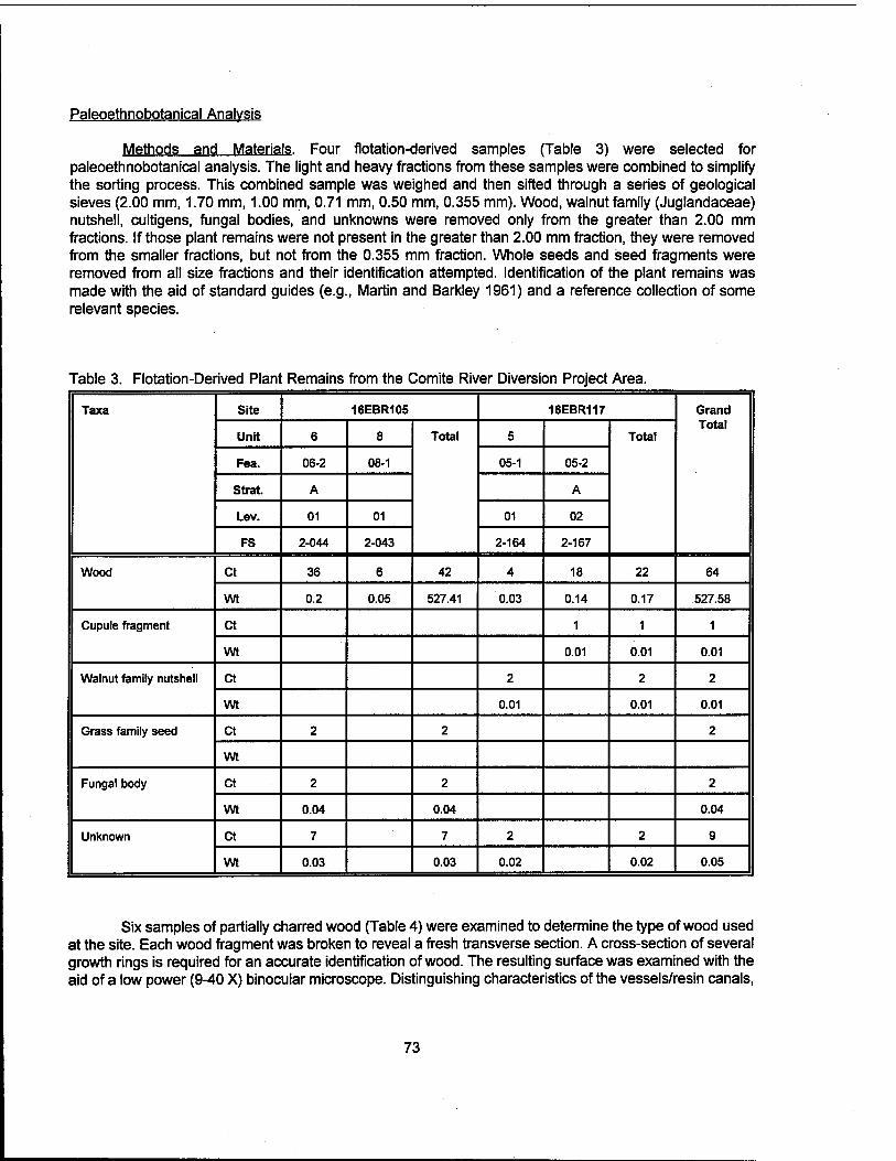
Paleoethnobotanical Analysis
Methods and Materials. Four flotation-derived samples (Table 3) were selected for paleoethnobotanical analysis. The light and heavy fractions from these samples were combined to simplify the sorting process. This combined sample was weighed and then sifted through a series of geological sieves (2.00 mm, 1.70 mm, 1.00 mm, 0.71 mm, 0.50 mm, 0.355 mm). Wood, walnut family (Juglandaceae) nutshell, cultigens, fungal bodies, and unknowns were removed only from the greater than 2.00 mm fractions. If those plant remains were not present in the greater than 2.00 mm fraction, they were removed from the smaller fractions, but not from the 0.355 mm fraction. Whole seeds and seed fragments were removed from all size fractions and their identification attempted. Identification of the plant remains was made with the aid of standard guides (e.g., Martin and Barkley 1961) and a reference collection of some relevant species.
Table 3. Flotation-Derived Plant Remains from the Comite River Diversion Project Area.
Taxa Site 16EBR105 16EBR117 Grand Total
Unit 6 8 Total 5 Total
Fea. 06-2 08-1 05-1 05-2
Strat. A A
Lev. 01 01 01 02
FS 2-044 2-043 2-164 2-167
Wood Ct 36 6 42 4 18 22 64
wt 0.2 0.05 527.41 0.03 0.14 0.17 527.58
Cupule fragment ct 1 1 1
wt 0.01 0.01 0.01
Walnut family nutshell ct 2 2 2
wt 0.01 0.01 0.01
Grass family seed ct 2 2 2
wt
Fungal body ct 2 2 2
wt 0.04 0.04 0.04
Unknown ct 7 7 2 2 9
wt 0.03 0.03 0.02 0.02 0.05
Six samples of partially charred wood (Table 4) were examined to determine the type of wood used at the site. Each wood fragment was broken to reveal a fresh transverse section. A cross-section of several growth rings is required for an accurate identification of wood. The resulting surface was examined with the aid of a low power (9-40 X) binocular microscope. Distinguishing characteristics of the vessels/resin canals,
73
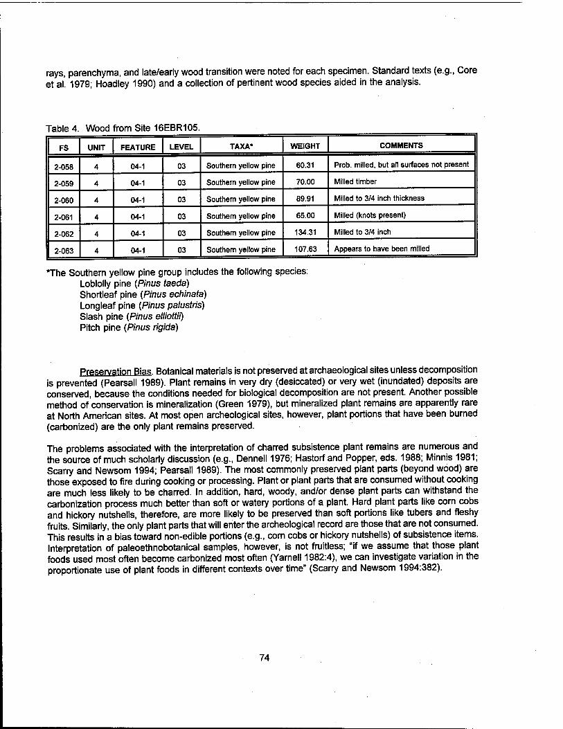
rays, parenchyma, and late/early wood transition were noted for each specimen. Standard texts (e.g., Core et al. 1979; Hoadley 1990) and a collection of pertinent wood species aided in the analysis.
Table 4. Wood from Site 16EBR105.
FS UNIT FEATURE LEVEL TAXA* WEIGHT COMMENTS
2-058 4 04-1 03 Southern yellow pine 60.31 Prob, milled, but all surfaces not present
2-059 4 04-1 03 Southern yellow pine 70.00 Milled timber
2-060 4 04-1 03 Southern yellow pine 89.91 Milled to 3/4 inch thickness
2-061 4 04-1 03 Southern yellow pine 65.00 Milled (knots present)
2-062 4 04-1 03 Southern yellow pine 134.31 Milled to 3/4 inch
2-063 4 04-1 03 Southern yellow pine 107.63 Appears to have been milled
The Southern yellow pine group includes the following species: Loblolly pine (Pinus taeda) Shortleaf pine (Pinus echinata) Longleaf pine (Pinus palustris) Slash pine (Pinus elliottii) Pitch pine (Pinus rigida)
Preservation Bias. Botanical materials is not preserved at archaeological sites unless decomposition is prevented (Pearsall 1989). Plant remains in very dry (desiccated) or very wet (inundated) deposits are conserved, because the conditions needed for biological decomposition are not present. Another possible method of conservation is mineralization (Green 1979), but mineralized plant remains are apparently rare at North American sites. At most open archeological sites, however, plant portions that have been burned (carbonized) are the only plant remains preserved.
The problems associated with the interpretation of charred subsistence plant remains are numerous and the source of much scholarly discussion (e.g., Dennell 1976; Hastorf and Popper, eds. 1988; Minnis 1981; Scarry and Newsom 1994; Pearsall 1989). The most commonly preserved plant parts (beyond wood) are those exposed to fire during cooking or processing. Plant or plant parts that are consumed without cooking are much less likely to be charred. In addition, hard, woody, and/or dense plant parts can withstand the carbonization process much better than soft or watery portions of a plant. Hard plant parts like corn cobs and hickory nutshells, therefore, are more likely to be preserved than soft portions like tubers and fleshy fruits. Similarly, the only plant parts that will enter the archeological record are those that are not consumed. This results in a bias toward non-edible portions (e.g., corn cobs or hickory nutshells) of subsistence items. Interpretation of paleoethnobotanical samples, however, is not fruitless; "if we assume that those plant foods used most often become carbonized most often (Yarnell 1982:4), we can investigate variation in the proportionate use of plant foods in different contexts over time" (Scarry and Newsom 1994:382).
74
CHAPTER VII
RESULTS OF FIELD INVESTIGATIONS
Introduction
The Comite River Diversion Project included a Phase I cultural resources survey of approximately 60 ac (24.2 ha), intensive re-survey of a tract of land near Magnolia Grove Baptist Church which included previously recorded Site 16EBR115 (Ryan et al. 1994), and investigation of a tract of land adjacent to Profit Island Chute that was thought to be part of Site 16EBR149 (Springfield Landing; Figure 14, Sheet 1). This project also included the delineation of the southern boundary of an unmarked cemetery located near Area 16 (Figure 1, Sheet 1).
In addition to these tasks, intended to identify and delineate potential cultural resources within the project corridor, Phase II investigations were conducted at two previously identified sites (16EBR105 and 16EBR117). These evaluatory investigations included archival and documentary research, additional shovel testing, and unit excavation. Because of its probable association with the Penny Plantation (16EBR117), previously recorded Site 16EBR118 also was tested and evaluated during the Phase II testing of Site 16EBR117. Research and documentation of the development of the dairy industry in East Baton Rouge Parish also was conducted in order to evaluate two dairy complexes in the project area. One of these, the Carney dairy complex, was associated with the current occupation of Site 16EBR117. The other, the Bourque dairy complex, was located a short distance from the Carney farm. Both had been identified during previous research conducted by Coastal Environments, Inc. (Ryan et al. 1994).
Phase I Investigations
Phase I cultural resources investigation in Areas 1, 3, 6, 9-16, and Magnolia Grove Baptist Church (MGC; Figure 1, Sheet 1), included pedestrian survey augmented by the systematic excavation of shovel tests. The intensity of survey and the interval of shovel testing was based on determinations made after examination of historic cartographic overlays, and after initial reconnaissance of the survey areas was completed.
During Phase I investigations, 483 shovel tests were excavated; of these, only 12 shovel tests produced cultural material. Although the area near Magnolia Grove Baptist Church already had been surveyed by Coastal Environments, Inc. (Ryan et al. 1994), additional testing was conducted because of the area's high probability for Civil War activity. In addition, the site of the historic Pipkin Chapel was reputed to be in the vicinity of the Magnolia Grove Church. In this additional survey, a metal detector operated by an experienced technician was used along selected transects in the immediate vicinity of Magnolia Grove Church and the adjacent previously recorded Site 16EBR115 (Figure 14, Sheet 1).
In Area SL (Springfield Landing), located south of Cooper Bayou and east of Profit Island Chute (Figure 1, Sheet 1), testing included the excavation of five backhoe trenches and systematic, intensive bankline reconnaissance. Historic maps suggested that a portion of the Civil War era Federal supply depot and encampment of Springfield Landing (Site 16EBR149) was located here (Figure 15; see Chapter V of this report). Previous bankline survey, resulting in the recordation of Site 16EBR149, had located Civil War era artifacts approximately 1,500 m (4,921 ft) south of the mouth of Cooper Bayou. While this evidence was recorded outside of the current project boundaries, cartographic evidence suggested that the site
75

76

extended along Profit Island Chute as far as the mouth of Cooper Bayou; the current project area includes approximately 375 linear meters (1,230 linear ft) of this frontage.
These Phase I investigations resulted in the identification of nine cultural resources loci; only two of these warranted archeological site status (Locus 16-2 [16EBR153] and Locus SL-1 [part of Site 16EBR149]). The remainder of the recorded loci consisted either of modern debris or of fewer than five artifacts. These loci are summarized below and in Table 5; recovered artifacts are summarized in Table 6.
Locus 3-1
Locus 3-1 was located along Transect 1, in the approximate center of Area 3 (Figure 1, Sheet 1). This locus consisted of a single basal shard of colorless, machine-made glass, and a centerfire, brass, shotgun shell with the inscription, "WESTERN / [ No. ] 12 " This shell was manufactured by the Western Cartridge Co., a division of the Winchester Repeating Arms Company, and represents a modern artifact. Both of these artifacts were recovered from a single shovel test. Because these modern artifacts were confined to a single shovel test, this locus was not delineated, and no additional testing of Locus 3-1 is recommended.
Loci 6-1 and 6-2
Both of these loci were recorded in Area 6, originally assessed as a high probability area because of the proximity of Civil War activity (Figure 1, Sheet 1 and Figure 16; see Chapter V of this report). Located near the probable site of the late eighteenth and nineteenth century Pipkin Chapel, at the intersection of the old Springfield Landing Road and the Bayou Sarah Road (Figure 1, Sheet 1 and Figure 16), cartographic evidence indicated that in 1863 temporary Federal military encampments were located in the area during the siege of Port Hudson (Figure 16). Because of the potential for historic remains in Area 6, it was surveyed at 20 m (65.6 ft) intervals. In addition, the southern quarter of Area 6 was subjected to systematic metal detector survey, along transects spaced 20 m (65.6 ft) apart. Metal detector coverage incorporated an area approximately 40 x 175 m (131.2 x 574.1 ft) in dimension. Only modern metals were recovered; these artifacts were not collected.
Locus 6-1. Locus 6-1 consisted of an isolated fragment of amethyst glass, recovered from Shovel Test 1, on Transect 1, in the southeastern corner of the survey area. Although it was recovered from a depth of 20 - 26 cmbs (7.87 - 10.23 inbs), the proximity of this locus to the road and its isolated nature, suggest that it is not associated with a larger site. The locus was not recommended for site status, and no additional testing is recommended.
Locus 6-2. Locus 6-2 also was situated in the southeastern quadrant of Area 6. This locus consisted of an isolated fragment of amber colored, blown-in-mold glass, recovered from a depth of 0 - 20 cmbs (0 - 7.87 inbs). Because of its isolated nature and its presence in the disturbed plow zone of the pasture, Locus 6-2 was not recommended for site status, and no additional testing of this locus is recommended.
Loci 16-1. 16-2. and 16-3
Area 16 (Figure 1, Sheet 1 and Figure 17) was assessed as a high probability area; its location in the vicinity of the historic Springfield Landing Road (Figure 16), the Penny Plantation (Site 16EBR117), and Civil War activities (Figure 16) made this a likely spot for the discovery of historic remains. Pedestrian
77

78

a> i» TJ CD
TJ c CD
E
TJ CD TJ C CD E
■Q co
*| o iS
.. CD
CO
° c 1 o
co Q. £
TJ c co
£ TJ CD TJ c CD
E E o u £
4-« o c
TJ" co p
03" o>ro
CO z o
1 z UJ
TJ » c (D E E
E o o £
*-» o c CO 3
s
E 8 £ ** o c CO 3
to
^ c co ä 8l O Q.
o c ** co .& O)
111 8.1.1 §18 O CD £
£ «» * <S CO 3 c 8 c
c CO 3
to
10
c o
■s 3
CO c o Ü
£
il 0. c .. CD
E E
o ü £
to &
to £
'El g s CD S> co .5
■2 3 O TI £ co CO o _ '•= o V. ■a — £ CD -a T>
CD S 'S ~ COTJ
CD
E CO
3 x: U CO
l_
CO c g 8 0 CD
O CO 'cö CD ■£ CD o> £ x; S o x: .. u UJ
o c co 3
c CD TJ
E CD
TJ
E V CD
ill la* CO » = '= j> C $ 8 8
'5 TJ £
c £
Si CO S co TJ CD CD Ä
CO
.10 'EZ XI
■55 «2 'S '■£'5 8 SEE
(0
1-
0)
IS to
£ CO
O
| 'CZ O
.2
O E
S CO
CD TJ 'co c o ü
o Z
CO
ü
■a o c CO CO
to «» o * °> TI
CD TJ c k_ CD TJ O
i Is
^ 0) » »-co <" £ TI 4 g. £ £ co CD if
XI 0) TJ
9) TO
x: £
■g co c x: co
|£8 £ CD« UL O -IOC
Hi ° c? = *ii JB » -n 5*1
TJ TI C <D O TJ C C
CO c 'C CD ■° p TI E
CD CL CO CD F c 188 'E D>"S
i3 eg IS CD
E a> TJ o S
TI £ CD
o _co
TJ
CD
O JO
TI
3 XI
"Ö E t§ E ^ 8 M CD
E 8 CD !D
il IS CO .ts -1 CO
< ** JO o __
Q. 10 c 3
to >. f
CD
E CO
c
TJ C CO
CD D) c
'5 c
JO c
c o
'co D UJ
o CO
to x> o
co" CO
E •fc CO
CD E co co ii CD o CO
» en CO iS CD O)
CD >
i = CD <D
i CD > b
ir:
UJ
g u Ul a: _i < UJ
CD c o co" CO
o> c a> TI O
CO CO CD
O) *J CO >. x: to E
CO CO CO
O)
CD XI E
E CD
£ CD c o
"E CD f CO
c JS ■£
Sg 9 °> Q. co
«I S £ (0 "—
4^ c CD
E at CO
£«■0
m CD Ö CO
O CO
°'§ Ä to
u
CO $
iS o o> 3 CD -0
I • . CD co a.
c w E o Ü i E
c a>
CD *^ c CD
CD *-» C CD
£ CO S .is
CD* °*
Q.
S CD v
1 ". D> CD co co
CD E E E CD CO E c fc TJ o> O) o> c co to c S 'S co o c £
SI £ CD
£ CD
£ 4>
o % CO CD CO
S >< CD £ 5 ^> •2 E
CO co
£ CD
* 3 CD i= CD CO c c
CO j_. « CD
9> io il §
8s T3 CD
c O
c O
c O
C CO O o>
c O i^8 0 £5 ^c co
c CD 2 3 18
CD ,-.
?8 CD
TJ O J
o o _J
< os os CD O CO
ul co CO CO CO CO CD CO ^^
1-g CD ~^
=5« □>« 3 .E co 0
»IS co -1
co CD CJ
3 CO
as «c 11 3 o co CD a. co a> cc m ^,
UJ K
co§ z
CD CD CD CD r- CD CD CD s c c c C 0. C c c CD o o o o m o o o m 3 z Z Z Z tu
CO
z Z Z LU CO
3 *- T~ t-\
in CO 3 o o
© o CM O o
CM O
CO o
1
Ü CM
■ Ü 0
CD 1 co
1 CO CO CD CO CO O o j
jQ o o o *~ T— 5 s CO
£
79

UJ H CO CO
o o -1
8 o t-
- - *— - - T— CM ^- - - CM - CM - CO T— - - ■*
■* - - - CM CM - - co <- - - - l>- O
s m -1 UJ CO CO
o o o ^— o O O o o o O o CO CM
o o O o o 5 o T- o CM CM *- 0 CO
CM i o o
£
o o o o o O o o o o o O o o CO o o - o o o o 0 O 0 0 0 0 O O 0 to
ro
1
U CD E
o o o o o o CM - o o o o o o o o o o o o o o 0 O 0 0 0 0 O O 0 CO
< ■s
"2"
co ■ tp o o o o o o O o o o o o o o o o o o o - o o 0 O 0 0 0 0 O O 0 ^
a. c o 52 >
CO in
£Q ID 111 *" <o
- o - o - - O o o - CM *^ o o o o T— o o o o - 0 O 0 0 0 0 O O 0 0
Q
CO > a: <D *^ 'E o Ü <D x: *-* »•— o >.
■ to o - o o o o O o o o O o o o *— o o o o o o o 0 O 0 0 0 0 O O 0 CM
CM i
to o o o o o o O o o o O o o - o o o o o o o o 0 O 0 0 0 0 O O 0 ^
■ to o o o o o o o o o o O o o o o - o o o o o o 0 O 0 0 0 0 O O 0 ^
1
»0 o o o o o o o o - o O o o o o o o o o o o o 0 O 0 - 0 0 O O 0 CM
CO (O <D fj 3 O CO Q)
cr:
3
3 Ü
3 m c o V N 10
o TJ £ o o O
3 ffi c o <D N CO O)
TJ 01 a> _l
it 3 m c o a> N CO
o a> 3 CT ID a. O
a> N cs O TO s o o Ü
TJ £ £ 8 <D TJ C 3
s a> Q » N CO
2> a> > O
CO 1-
CO 3
ID
CO CO CD
■tz o o Ü
CD 3
CD
TO .O o Ü
f v E <
CO >. JCZ
a> E <
TO 3
□)
CD
E <
1 f a> E <
CO >. f a> E <
CO CO TO o
S
£
CD 3 CX TO O. O
co Ü c s
CO
w c s
2 c CD
E o>
.g CD
c s
c CD
E O) CO
LL ■5 £ CO c s £ CO
D.
t* TO a. CD T3 c CD a. CO 3
CO
c 0 E E 0 ü
£ 5
CO co
CD D)
TJ *L_ •e co Ü
£ ■E £ c CD Ü
2 "CD f CO c 3
CO
£
£ c CD Ü
2 0)
ID 0. O) c
'co CO O TJ TO 2
c
3 TJ TI g) (D > O U a>
2 1 CD c o w o to (D E o Q
CD c o to c 2
c TO
O a.
co TO
£ TO S o CO
I
TJ o E E o *s o
CD a. 3 Ü
CD CO TO
CO CD TJ TO s
1 CD c 'E u CO
S
CD
o m CD TJ TO S
■ CD c IE u CO
E
CO CO TO o TJ CD CO CO CD
a.
a. ID TJ CD o ß
TJ O E c ' 1 c %
CD . CD
2 £ c o 3 CO
CD
*3 O m TJ CD
c CD TJ 'E 3
CO CO CO
o TJ CD E c CD
TJ E 3
CO CO TO o 3 o TJ c
CO
E
CD o> CO
o (0
s> co 3 'S CO X CO 3 o CD c TO 8 CO
E
a> S CO CO
II c —
TO O»
11 10 Ö
I 5
c £
TO z
TO 0. O
■s CD
'£" 0.
03 £ CO c S
TJ CD !E c CD TJ E 3
CD Q. Q. O Ü TJ CD IE
CD TJ 'E D
c CD
E O) £ Li. TO O Ü
c CD
E O) s u. J= 'S Ü
42
< CD <U Si CD 1-
in u
I s a O
c o u S in c o o
w TO CD
3 CD s
CD C
S co
CO CD
1 8 0 1-
80

I * MIM
§l§§SfefefejS}ü
4 ^ 0°xx*xh
Cfl
(0 Ä CD > o
•o c CO
u <u w c CO
c g
8
c ■s Q. CD
(O
(0
Ü O
■o c co
CD «c—
(0 3 U O
co to Cd m UJ CD
CD
in <•— o c ro Q.
2
Li.
81

reconnaissance was conducted along transects spaced 20 m (65.6 ft) apart, augmented by shovel testing at 20 m (65.6 ft) intervals. Three loci (16-1, 16-2, and 16-3) were identified; Loci 16-1 and 16-2 may be expressions of the same historic occupation.
Locus 16-1. Locus 16-1 is positioned just north of Carney Road (Figure 17), and consisted of a single buff-bodied domestic stoneware sherd and an amethyst colored, blown-in-mold glass fragment. Both artifacts were recovered from plow zone contexts, at a depth of between 0-19 cmbs (0 - 7.4 inbs). The nature of the recovered material and the proximity of this locus to Locus 16-2, made it likely that the two recovered artifacts were outlying materials from the larger late historic Locus 16-2. No further investigation of Locus 16-1 was recommended.
Site 16EBR153 (Locus 16-21 Site 16EBR153 is located to the north of Carney Road (Figure 17) and consisted of a surface scatter of glass, ceramics, brick, mortar, and metal (Table 6). Shovel tests did not indicate the presence of a subsurface component, and there was no evidence of subsurface features. A sample collection was made, including two amethyst colored pressed glass fragments, one amethyst colored tooled bottle lip fragment, one cobalt colored, machine-made bottle glass sherd, and one piece of milk glass. Also collected were two domestic brown stoneware sherds, one undecorated white ironstone fragment, and one undecorated, hard-paste porcelain sherd. A single metal artifact was collected; this was a fragment of iron plate with the numeral "8" on one side. The tooled bottle lip is diagnostic of the period between the 1820s and the 1920s, while the machine-made bottle suggests a post ca. 1920 date; Amethyst glass is diagnostic of the period between ca. 1875 and 1920 (Table 7). These date ranges suggest a late nineteenth to early twentieth century occupation date for Site 16EBR153 (Locus 16-2).
The landowner, Mr. Adrian Decker, indicated that the cultural remains found at Site 16EBR153 (Locus 16-2) were from an abandoned tenant cabin that had stood on the property in the early 1930s. Mr. Decker had demolished the foundation and standing brick chimney, and removed the debris to a field located east of the site (A. Decker, personal communication, November 1995) (Figure 17). While Locus 16-2 contained sufficient cultural evidence to warrant its recordation as an archeological site, it does not appear to have retained significant integrity. No architectural remains are intact; artifactual remains exist solely in the plow zone stratum and on the surface of the plowed field. It is unlikely that this probable tenant site from the late nineteenth and early twentieth century will yield significant information relevant to its type or temporal period. No further investigations are warranted at Site 16EBR153.
Locus 16-3. This locus consisted of an isolated historic metal fragment recovered from Transect 7, Shovel Test 5 of Area 16 (Figure 1, Sheet 1). This single iron strap fragment was located within the upper 20 cm (7.8 in) of the shovel test. No other materials were found in the vicinity. Because of the isolated, non-diagnostic nature of the artifact, and its proximity to the south side of Carney Road, this locus was not delineated. The locus was not deemed worthy of archeological site status, and no additional testing of Locus 16-3 is recommended.
Delineation of the Cemetery in Area 16. An unmarked cemetery is located on the northern edge of Area 16 (Figure 1, Sheet 1), and immediately east of Bayou Baton Rouge; it is located to the east of a small, marked cemetery associated with the 19th century occupation of the Penny Plantation. This unmarked cemetery is reputed to have been a slave and Free Black burial ground. Only fragments of headstones remain, but grave shafts are apparent in the cemetery area (Figure 18). Erosion associated with the bayou has created deep erosional gullies at its edge; these gullies extend for approximately 70 - 80 m (229.6 - 262.4 ft) along each side of the water course. Erosion may have already impacted some
of the graves.
Comite River Diversion Project plans proposed clearance and dredging in this portion of the project area. To determine the apparent boundaries of the unmarked cemetery, and to ensure that it does not
82
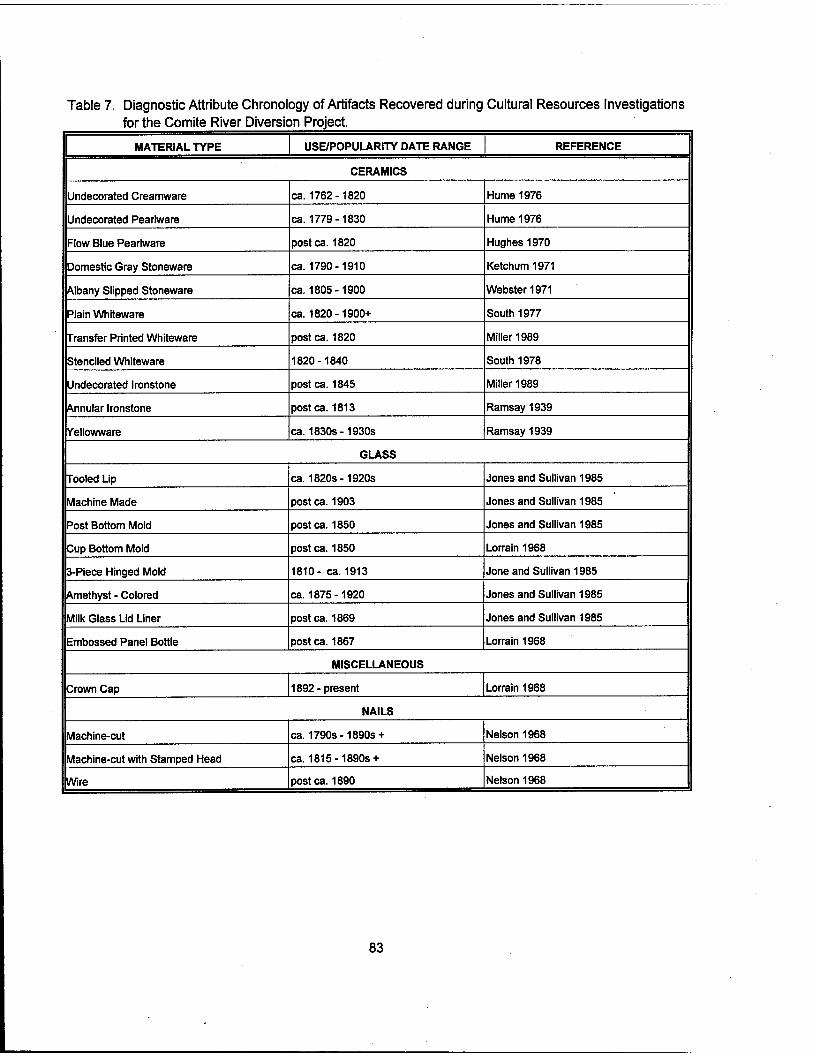
Table 7. Diagnostic Attribute Chronology of Artifacts Recovered during Cultural Resources Investigations for the Comite River Diversion Project.
MATERIAL TYPE USE/POPULARITY DATE RANGE REFERENCE
CERAMICS
Undecorated Creamware ca. 1762-1820 Hume 1976
Undecorated Pearlware ca. 1779-1830 Hume 1976
Flow Blue Pearlware postca. 1820 Hughes 1970
Domestic Gray Stoneware ca. 1790-1910 Ketchum 1971
Albany Slipped Stoneware ca. 1805-1900 Webster 1971
Plain Whiteware ca. 1820-1900+ South 1977
Transfer Printed Whiteware postca. 1820 Miller 1989
Stenciled Whiteware 1820-1840 South 1978
Undecorated Ironstone postca. 1845 Miller 1989
Annular Ironstone postca. 1813 Ramsay 1939
Yellowware ca. 1830s-1930s Ramsay 1939
GLASS
Tooled Lip ca. 1820s-1920s Jones and Sullivan 1985
Machine Made postca. 1903 Jones and Sullivan 1985
Post Bottom Mold postca. 1850 Jones and Sullivan 1985
Cup Bottom Mold postca. 1850 Lorrain 1968
3-Piece Hinged Mold 1810- ca. 1913 Jone and Sullivan 1985
Amethyst - Colored ca. 1875-1920 Jones and Sullivan 1985
Milk Glass Lid Liner postca. 1869 Jones and Sullivan 1985
Embossed Panel Bottle postca. 1867 Lorrain 1968
MISCELLANEOUS
Crown Cap 1892-present Lorrain 1968
NAILS
Machine-cut ca. 1790s-1890s + Nelson 1968
Machine-cut with Stamped Head ca. 1815-1890s + Nelson 1968
Wire postca. 1890 Nelson 1968
83
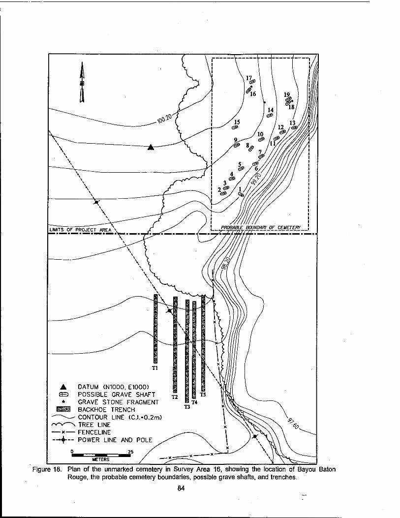
Figure 18. Plan of the unmarked cemetery in Survey Area 16, showing the location of Bayou Baton Rouge, the probable cemetery boundaries, possible grave shafts, and trenches.
84
extend into the project area, all visible depressions were marked and plotted, and a series Of five shallow trenches were excavated on the northern border of the project area, i.e., south of the visible grave shafts. A small strip between the trenches and the presumed southern boundary of the cemetery was not tested; a large oak tree with dense overhanging branches precluded excavation in this location. The tested area had been frequently plowed; trenching removed the plowzone to subsoil, a depth of approximately 25 - 45 cm (9.8 -15.7 in). Trenches measured approximately 0.75 m (2.46 ft) in width, were spaced between 2 - 5 m (6.6 -16.4 ft) apart, and were oriented north-south. A total of 205 linear m (672.5 ft) was excavated.
No evidence of grave shafts or other cultural activity was apparent in any of the trenches.
The area east of the trenches was intensively surveyed, and no evidence of burial was found; because of the steep erosional gullies adjacent to the bayou, the recovery of any intact burials would be extremely unlikely in this area. The areas immediately west of Trench 5, and on the eastern side of a barbed wire fence (Figure 18), were visually surveyed, but no trenches were placed in these locations at the request of the landowner, who was concerned about additional erosion from excavation.
A total of 19 potential grave shafts were mapped within the cemetery area. All visible depressions were marked and plotted, but none of these was tested to determine their nature. Observation of regularities in the depressions suggest that approximately half represent graves; it was deemed safer to map all surface anomalies, than to omit possible burials through a judgmental error. No depressions or surface anomalies were apparent within the project area.
Magnolia Grove Baptist Church Survey Area. Loci MGC-1 and MGC-2. and Site 16EBR115
The Magnolia Grove Baptist Church survey area (Figure 1, Sheet 1 and Figure 19) originally had been surveyed in 1993 during the initial cultural resources investigations conducted by Coastal Environments, Inc. (Ryan et al. 1994). However, survey had been conducted at 50 m (164 ft) intervals, and survey did not take into account the potential for Civil War era remains (Figure 16). In addition to the potential for Civil War materials, the remains of Pipkin Chapel, a late eighteenth century and early nineteenth century church, were considered likely to be found in the project area. Magnolia Grove Baptist Church had an approximate 100 year history, with the current structure having been built during the mid- twentieth century on the site of its nineteenth century predecessor. The original cornerstone from the nineteenth century church is incorporated into the interior of the present structure (Rev. J. Snowden, personal communication, December 1995).
Because of the high potential for historic cultural resources in the Magnolia Grove Baptist Church area, and despite the fact that changes in the configuration of the project area had rendered Magnolia Grove Church and its immediate environs outside of the project area and its impacts, a new survey and reconnaissance was undertaken. The new survey included pedestrian reconnaissance along survey transects spaced at 20 m (65.6 ft) intervals. Shovel tests were excavated at 20 m (65.6 ft) intervals along these survey transects. In addition, a metal detector survey was conducted in selected portions of the project area (Figure 19). During survey in the Magnolia Grove Baptist Church area, two cultural resources loci (MGC-1 and MGC-2) were recorded, and additional investigations were conducted at previously recorded Site 16EBR115 (Figure 19).
Locus MGC-1. This locus of cultural activity was located adjacent to Highway 964, in the western portion of the survey area (Figure 1, Sheet 1 and Figure 19). Consisting of a very light scatter of concrete fragments, tar, coal fragments, and a single aqua colored bottle glass shard, this locus may represent a structure or outbuilding associated with the Magnolia Grove Baptist Church. A transect through the locus was surveyed with a metal detector, with negative results (Figure 19). The proximity to the road and the presence of fill in this area, indicate a fair amount of disturbance; all observed and recovered artifacts
85

86

originated from a depth of 0 -18 cmbs (0-7.1 inbs). This locus appears to be of modern origin, and does not merit archeological site status. No further investigations are warranted at Locus MGC-1.
Locus MGC-2. This locus was recorded north of the current Magnolia Grove Baptist Church (Figure I, Sheet 1 and Figure 19). The locus boundaries were defined by positive shovel tests on Transects 7 and 8, and by surface remains and metal detector finds along transects 9 and 10. The remains of a circular, concrete foundation were noted along Transect 10, and brick, charcoal, and cement fragments were noted in shovel tests and on the surface. Artifacts observed during the metal detector survey included a "19[-]9" penny, a roller skate key, wire, and an iron pipe fragment. Five amethyst colored, blown-in-mold bottle glass fragments, all from the same vessel, and one window glass fragment, were recovered from a shovel test excavated on Transect 8, at a depth of 0 -15 cmbs (0 - 5.9 inbs). The nature of the remains identified at Locus MGC-2 suggests a twentieth century association with the church; this locus may represent picnic grounds and/or a baptismal area. The locus was not recommended for site status, and no further investigations are warranted.
Site 16EBR115. Site 16EBR115, previously recorded during a 1993 cultural resources survey conducted by Coastal Environments, Inc., is located a short distance southwest of the present Magnolia Grove Baptist Church (Figure 14, Sheet 1 and Figure 19). The site had been characterized as the remains of a mid-twentieth century outbuilding; artifacts were recovered from the plow zone and included primarily brick fragments, metal, and glass. The site had been evaluated by Coastal Environments as not historically or archeologically significant, and no additional testing was recommended (Ryan et al. 1994:129).
Despite this evaluation, an 1863 Civil War map (Figure 16), depicted a strong potential for cultural resources associated with the Civil War and with the nineteenth century Pipkin Chapel. A limited portion of Site 16EBR115 was re-examined. An area approximately 40 x 70 m (131 x 229.6 ft) in size was surveyed using a metal detector to locate sub-plow zone deposits (Figure 19).
During the metal detector survey, 11 positive hits were recorded. These hits were recorded by location in relation to Metal Detector Test #1 (N1000 E1000; Figure 19). A total of 27 metal and glass artifacts were recovered from this cluster of positive tests (Table 8); none was closely dateable, although the wire nails and the lamp part were indicative of a post-1890s occupation. Two of the metal detector tests (MDT 1 and MDT 6) were excavated as shovel tests, and the stratigraphy was recorded. Stratum I was a 10YR 3/2 very dark grayish brown clay loam, which extended from 0-30 cmbs (0 -11.8 inbs). This corresponded to the plowzone reported by Ryan et al. (1994), in their previous survey of the site. Stratum II, a 10YR 5/4 yellowish brown clay, extended from 30 - 50 cmbs (11.8 - 19.7 inbs). This stratum was undisturbed, but included cultural material in only two tests (MDT 6 and MDT 9). The majority of the recovered material originated from the base of the plow zone stratum, and was not inconsistent with the previous identification of the site as an outbuilding. The material does indicate, however, that the site may date from the late nineteenth century, with continuation into the twentieth century. No indication of either the remains of the Pipkin Chapel, or of Civil War era occupation at Site 16EBR115 were uncovered. No additional testing of Site 16EBR115 is recommended.
Springfield Landing/Cooper's Bayou Survey Area fSLl
The final area of cultural resources survey included in the Comite River Diversion Project was at the intersection of Profit Island Chute and Cooper's Bayou (Figure 1, Sheet 1 and Figure 20). Testing in this area was intended to determine the presence or absence of cultural material associated with the Civil War site of Springfield Landing (16EBR149), and to delineate this site if present. Investigations consisted of the mechanical excavation of a series of five backhoe trenches and intensive bankline survey. One cultural resource locus was identified (Locus SL-1 of Site 16EBR149; Figure 20) during these investigations.
87
_l
! f« - - T* ■* CM CM CM m CM - - 0
CM
V"
* 1- Q s
in m e o O o o Z 111
o o o o o O - O o O o 0 *"
o
* a s
S ° o o z w
o o o o o o o O *- O o 0 *—
o
1- D s
u> u> 2 "*' o o o o *- T- Z UJ
o o o o o o o o - O o 0 T"
eo § H O s
IO CO o> o> o> o> Z UJ
o o o o o o o o o - o 0 -
o
D £
«0 CO o o o o Z UJ
o o o o o o o o T— o o 0 -
o
O £
n in © o o o Z 5
o o o o o o o o " o o 0 -
id
m
in o * H a S
o> CO en en en en Z UJ
o o o o o o o o o - o 0 -
in CO
3 <7>
o * t- a E
in
So o o Z UJ
o o o o - o - o o o - 0 CO
o >» Q>
3 CO 1-
%
ro o
Q s
o o o o Z UJ
o o o o CO CM o CM - o o 0 00
CM o * 1- o E
O) o> en en Z UJ
o o o 1— o o o O o o o 0 -
<D Q 8
H O E
5 ° o o o o z UJ
I«- - - o o o o o o o o - 0
C
3 TJ TJ £ Q)
o CD a: (A CO
JB CO 5
_i < a. UJ
< s
co CO
w o
8 co" CO CO
CD CD
*s o
CD •D CD E C CD
■a
'E 3
ID a. a. E ID -1
CD
CO
1
c CD
E o> 2 u. 2 co
i CO X •o CD lf=
c CD ■a
"E D
JO
'5 z c o E E o o 2
JO
'CD z ■o a>
"E CD
■D 'c 3
2"
■ffi
£ c 2 ■a CD g 'S CD
■o
C
ts CD
5" O L. CD Q. Q. O
o ■o CD IC
t: CD
■o
"c
"in ■s CD
3" O c 2
■u CD IC
c CD TJ °e
"in
CD S" o x> co CD _l T> CD IE
C CD ■a °E
■5 E E CO
2 CD g> CO _i
■a CD IE "c CD
■O 'E ID
0 0 ID E *c D.
£ ID u. ■e CD J=
Ü
eo 0) .Q
v> en CD
0 a> S
CD c 0 m
Ü
'3 3 0 1-
88
Figure 20. Plan of the Springfield Landing/Cooper Bayou survey area, depicting the location of previously identified Site 16EBR149 (Springfield Landing), Locus SL-1, and exploratory trenches.
89

Site 16EBR149 (Springfield Landing). Site 16EBR149 originally was recorded in 1995 by Dr. Kenneth Ashworth of the U.S. Army Corps of Engineers, New Orleans District, and Dr. Ann Markell (Figure 14, Sheet 1). Located along Profit Island Chute, the site was identified as the probable location of the Union army supply depot and encampment at Springfield Landing (See Chapter V of this report). Artifacts noted in the area included a brass bugle (infantry) hat badge, a forged campfire andiron, and two Civil War era "bulls-eye" canteens; several in-situ wooden planks with square nails were observed at a depth of approximately 1.8 - 2.4 m (6 - 8 ft) below the present ground surface. Based on the presence and content of these deposits, and on the historical significance of Springfield Landing during the Civil War siege of Port Hudson, Site 16EBR149 was considered a potentially significant cultural resource. The site was estimated to be 1,500 x 200 m (4,921 x 656 ft) in size based on a contemporary etching from Harper's Weekly, and on informant data suggesting that the site extended to the mouth of Cooper's Bayou. Additional testing at Site 16EBR149 was recommended.
The original Scope of Work recommended backhoe or auger testing and bankline survey within an area approximately 15 ac (6.1 ha) in size. A revised Scope of Work specified a series of trenches to be used for the location and subsequent delineation of Site 16EBR149 within the project area.
Trenches 1 - 3. Of the five trenches excavated, the first three produced no cultural material, and no evidence of any activity in the area. Each trench was approximately 10 m (32.8 ft) in length, between 1.5 - 3 m (4.9 - 9.8 ft) in width, and excavated to a depth of 1.8 - 2.4 mbs (6 - 8 ftbs); a 2 m (6.6 ft) deep auger test was placed in the floor of each trench, extending the final depth to 3.8 - 4.4 mbs (12.5 -14.4 ftbs; (Figures 21 - 23). The soils encountered were alluvial silts and clays; banding that was evident in the stratigraphic sequence may represent episodes of flooding. At a depth of approximately 2 m (6.6 ft), a dense gray clay was apparent that continued to the base of excavations.
Trenches 4 - 5 and Locus SL-1. Trenches 4 and 5 (Figures 20, 24, and 25) were located at the juncture of Profit Island Chute and Cooper's Bayou. Trench 4 was located perpendicular to Cooper's Bayou and approximately 20 m (65.6 ft) from the bank of the Chute, while Trench 5 was excavated perpendicular to the Chute.
A buried "A" horizon was encountered at a depth of 1.48 -1.50 mbs (4.8 - 4.9 ftbs) in Trench 4, and 1.12-1.18 mbs (3.7 - 3.9 ftbs) in Trench 5 (Figures 24 and 25). The discrepancy in depth from surface resulted from the position of Trench 4 on top of the natural levee of Cooper's Bayou.
Cultural material recovered from this deeply buried cultural locus included 23 lip, neck, body, and basal shards from a panel medicine bottle. The embossure on the front and side panels reads "ONE [MINUTjE / COU[GH CU]RE // [E.C. DEWITT & Co.] // [CHICAGO,] U.S.A."; there is a "1" on the base. This has been dated from post ca. 1894 (Fike 1987:103). Also recovered were 44 fragments of iron cans, one ironstone sherd, an iron wire fragment, two wire nails (post ca. 1898), two suspender buckles, a brass 38 cal. Smith & Wesson centerfire cartridge casing, dated post 1877 (Speer 1979:355), three lead shotgun pellets, and unidentified copper and iron fragments (Table 6; Appendix I).
Based on the recovered material, Locus SL-1 is presumed to date from the late nineteenth/early twentieth centuries, and has been characterized as a small fishing or hunting camp. The extremely light density and the nature of the recovered material makes it unlikely that these remains represent a long, continuous period of occupation at the site. It is not likely that this component of Site 16EBR149 will provide information significant to our understanding of the time period or the region, and no additional testing at this locus is recommended.
Testing in the portion of Site 16EBR149 (Springfield Landing) that lies within the current project boundaries failed to recover any evidence of Civil War activity. Extremely heavy erosion along the banks of Profit Island Chute has claimed between 500 - 600 m (1,640 -1,969 ft) of land since 1883 (Figure 4);
90

NW NORTH WALL PROFILE OF TRENCH 1 NE
f 120-
160-
180-
200-
2*0-
IX
PROFILE OF AUGER TEST
FROM CENTER OF TRENCH 1
180
200
«260- 1
320-
XV
STRATUM I STRATUM II STRATUM III
STRATUM IV
STRATUM V: STRATUM VI: STRATUM VII
STRATUM VII:
STRATUM IX:
STRATUM X:
STRATUM Xh
STRATUM Xla: STRATUM XII:
STRATUM XIII:
STRATUM XIV: STRATUM XV:
10YR 4.5/3 BROWN SILTY SAND WITH IRON OXIDE STAINS. 10YR 3/2 VERY DARK GRAYISH BROWN SILTY CLAY LOAM. 10YR 4.5/2 DARK GRAYISH BROWN SILTY CLAY MOTTLED WITH IRON OXIDE STAINS. 10YR 3/2 VERY DARK GRAYISH BROWBN SILTY CLAY. 10YR 5/2.5 GRAYISH BROWN SANDY SILT. 10YR 4/2 DARK GRAYISH BROWN CLAY. 10YR 4.5/2 DARK GRAYISH BROWN SILTY CLAY MOTTLED WITH IRON OXIDE STAINS. 2.5Y 5/3 LIGHT GRAYISH BROWN FINE SAND LAMINATED WITH 10YR 5/2.5 GRAYISH BROWN SAND. 10YR 4.5/2.5 GRAYISH BROWN SANDY SILT MOTTLED WITH IRON OXIDE STAINS. 10YR 4.5/3 BROWN SANDY CLAYEY SILT MOTTLED WITH 7.5YR 4/6 STRONG BROWN SANDY CLAYEY SILT AND CAPPED WITH A THIN LENSE OF 10YR 3/1.5 DARK GRAY SILTY CLAY. 10YR 4.5/3 BROWN SILTY SAND MOTTLED WITH 7.5YR 4/6 STRAONG BROWN SILTY CLAY. 10YR 5/3 BROWN SILTY SAND. 10YR 4.5/2 DARK GRAYISH BROWN SILTY SAND LAMINATED WITH 10YR 5/2 GRAYISH BROWN SILTY SAND. 10YR 5.5/2 LIGHT GRAYISH BROWN SANDY SILT MOTTLED WITH 10YR 4/3 BROWN SANDY SILT AND 7.5YR 4/4 DARK BROWN SANDY SILT. 10YR 4.5/1.5 DARK GRAYISH BROWN FINE SANDY CLAY. 10YR 5/2 GRAY CLAY MOTTLED WITH 7.5YR 4/6 STRONG BROWN SANDY SILT.
Figure 21. Profile of Trench 1 in Springfield Landing/Cooper Bayou survey area.
91

sw WEST WALL PROFILE OF TRENCH 2 NW
20
40
W0-
120
KO-
III
PROFILE OF AUGER TEST
FROM BOTTOM OF TRENCH 2
180
200
220
240-
260-
280-
300-
IV
STRATUM I: STRATUM II:
STRATUM Ha STRATUM III
STRATUM IV:
DISTURBANCE:
CENTIMETERS
10YR 3/2 VERY DARK GRAYISH BROWN CLAY LOAM. 2.5Y 5/4 LIGHT OLIVE BROWN SILTY SAND BANDED WITH 2.5Y 5/3 LIGHT OLIVE BROWN SILTY CLAY. 2.5Y 5/3 LIGHT OLIVE BROWN SILTY SAND. 2.5Y 5/4 LIGHT OLIVE BROWN SILTY CLAY. 10YR 5/2 GRAY CLAY MOTTLED WITH 7.5YR 4/6 STRONG BROWN CLAY.
2.5Y 5/4 LIGHT OLIVE BROWN SILTY SAND MOTTLED WITH 10YR 4/3 BROWN SILTY SAND, 2.5Y 5/2 GRAYISH BROWN SILTY SAND AND 2.5Y 4/2 DARK GRAYISH BROWN SILTY CLAY.
Figure 22. Profile of the west wall of Trench 2 in the Springfield Landing/Cooper Bayou survey area.
92

NORTH WALL PROFILE OF TRENCH 3
220
400-
4»'
III
IV
STRATUM I: STRATUM II:
STRATUM
STRATUM IV:
10YR 3/2 VERY DARK GRAYISH BROWN CLAY LOAM. 2.5Y 5/4 LIGHT OLIVE BROWN SILTY SAND LAMINATED WITH THIN LENSES OF 10YR 4/3 BROWN SAND. 2.5Y 5/2 GRAYISH BROWN SILTY SAND AND 2.5Y 4/2 DARK GRAY SILTY CLAY. 2.5Y 5/1 GRAY SANDY CLAY MOTTLED WITH 7.5YR 5/6 STRONG BROWN IRON OXIDE STAINS. 2.5Y 5/1 GRAY CLAY MOTTLED WITH 7.5YR 5/6 STRONG BROWN IRON OXIE STAINS.
100
CENTIMETERS
Figure 23. Profile of the north wall of Trench 3 in the Springfield Landing/Cooper Bayou survey area.
93
EAST WALL PROFILE OF TRENCH 4 NE SE
20- 1
40-
«0-
80-
II 100-
120-
HO-
«0-
180-
III
——
6 200-
220- IV
240-
280-
- V 280-
300-
- 320-
340-
. VI 360- 0 100
8^t^Mt^U~"'' *""* "^~^^^^^^
CENTIMETERS
380-
3»0J
STRATUM h 10YR 3/2 VERY DARK GRAYISH BROWN CLAY LOAM. STRATUM II: 2.5Y 5/4 LIGHT OLIVE BROWN SILTY SAND LAMINATED WITH THIN LENSES OF
10YR 4/3 BROWN SAND. 2.5Y 5/2 GRAYISH BROWN SILTY SAND AND 2.5Y 4/2 DARK GRAY SILTY CLAY.
STRATUM III: 2.5Y 5/3 LIGHT OLIVE BROWN SILTY CLAY. STRATUM IV= 2.5Y 5/3 LIGHT OLIVE BROWN SILTY SANDY CLAY. STRATUM V: 2.5Y 4/3 OLIVE BROWN CLAY MOTTLED WITH
10YR 5/1 GRAY CLAY. STRATUMVI: 10YR 5/1 GRAY CLAY MOTTLED WITH
7.5YR 5/6 STRONG BROWN IRON OXIDE STAINS.
Figure 24. Profile of the east wall of Trench 4 in the Springfield Landing/Cooper Bayou survey area.
94

SOUTHWEST WALL PROFILE OF TRENCH 5 S w
20- I
60-
80-
II
100-
120-
I - MO-
160- III
180-
200-
220-
240-
IV
V
260- VI 0 50 ^^^^^H ^^^^^H ^^^^^H
CENTIMETERS 280-
300-1
STRATUM 1: 10YR 3/2 VERY DARK GRAYISH BROWN CLAY LOAM. STRATUM II: 2.5Y 5/4 LIGHT OLIVE BROWN SILTY SAND LAMINATED WITH THIN
10YR 4/3 BROWN SAND, 2.5Y 5/2 GRAYISH BROWN SILTY SAND AND
LENSES OF
STRATUM III: 2.5Y 4/2 DARK GRAY SILTY CLAY. 2.5Y 5/3 LIGHT OLIVE BROWN SILTY CLAY.
STRATUM IV: 10YR 5/1.5 GRAYISH BROWN SANDY SILT LOAM MOTTLED WITH 7.5YR 5/6 STRONG BROWN IRON OXIDE STAINS.
STRATUM V: 10YR 5/1.5 GRAYISH BROWN SILTY CLAY LOAM MOTTLED WITH 7.5YR 5/6 STRONG BROWN IRON OXIDE STAINS.
STRATUMVI: 10YR 5/1.5 GRAYISH BROWN SILTY CLAY MOTTLED WITH 7.5YR 5/6 STRONG BROWN IRON OXIDE STAINS.
Figure 25. Profile of the southwest wall of Trench 5 in the Springfield Landing/Cooper Bayou survey area.
95
this was all land that would have been associated with the Federal occupation of Springfield Landing. Cartographic overlays showing the ca. 1863 positions of roads and of Federal troop movements in the project vicinity are shown in Figures 15 and 16. Figure 15 suggests that the majority of the intensive troop activity at Springfield Landing was slightly south of the current project area. This is consistent with the remains recorded at Site 16EBR149 (Springfield Landing). While there was certainly some use of the project area during the Federal occupation, severe bankline erosion may have erased much of the evidence.
Phase II Investigations at Site 16EBR117 (Penny Plantation)
Site Background
Site 16EBR117 first was occupied by James Penny, who gained title to 500 arpents in Section 70 in 1798. By 1802, court records indicate that a one-room house and a stable were present on the land (see Chapter V of this report). In 1806, Penny gained title to a portion of Section 89, north of the original grant, and built a two-story home, in approximately the same location as the present Carney home (Figure 26). The property remained in the Penny family until 1841, when it passed to the Reverend James Smylie, and then to James Knox in 1854. By 1916, the land had been purchased by James Bowman Carney, Sr., father to the present owner. In 1863, during the Civil War, the plantation was the site of Federal troop encampments (Figure 16).
Oral testimony from Bowman Carney, Jr., indicates that the second Penny house remained in use until the 1940s, when he demolished it to build the present structure, using timber from the nineteenth century house. He also provided a description of the nineteenth century house; it had eleven rooms, with a kitchen and two privies in the back of the house. Mr. Carney, Jr. described a number of outbuildings in addition to the house. The present dairy barn (SS-39; see Appendix III) was constructed ca. 1927, from timber salvaged from a two-story hay barn that stood on the same land. Mr. Carney, Jr., his father, and three laborers demolished the old barn, poured the concrete foundation, and constructed the dairy barn from the old timbers. Also built at the same time were a still extant dairy milk shed (SS-40) and a livestock bam (SS-41). According to Mr. Carney, Jr., there were, at one time, four additional agricultural buildings east of SS-39, arranged linearly between the present barn and Bayou Baton Rouge (Bowman Carney, Jr., personal communication, November, 1995).
The Penny Plantation site (16EBR117; Figure 1, Sheet 1 and Figures 26 and 27) first was recorded in 1993 during cultural resources survey conducted by Coastal Environments, Inc. (Ryan et al. 1994). Shovel tests excavated during that investigation had established the presence of late eighteenth and early nineteenth century occupation at the site, probably associated with the original owner, James Penny (see Chapter V). Additionally, there was ample material evidence of continuous occupation through the nineteenth century to the present (Ryan et al. 1994). Based on these investigations, Phase II evaluatory investigations at Site 16EBR117 were recommended. Testing at this site included the excavation of shovel tests, a systematic metal detector survey, and the excavation of 15 1 x 1 m (3.3 x 3.3 ft) units (Figure 26).
Topography and Expected Soils
Site 16EBR117 is located on an upland terrace and adjacent to Bayou Baton Rouge. Soils are permeable, well drained loams, with typical hues ranging between 10YR 3/3 (very dark brown) in Stratum I humic levels to 10YR 5/6 or 5/8 (yellowish brown) clay silts in Strata III and IV subsoils. The major cultural stratum was Stratum II, a yellowish brown silty loam that varied in color depending on site area and type and intensity of activity. Because of the variation in stratigraphic integrity in the different areas of the site, taphonomic influences and effects will be discussed with the results of excavation.
96

<D

h<

w CD CD
E o
CO LU CD
CO
O
5 <D >
CN CD 3
98

Results of Excavation
Excavation units measured 1 x 1 m (3.3 x 3.3 ft) in size and were placed in three general areas. These included the avenue of oaks to the north of the present house (Units 1, 4, 11-13, and 17), the immediate environs of the present house (Units 5-10 and 18), and the area east of the present dairy complex (Units 2-3; Figure 26).
Unit excavation at Penny Plantation (Site 16EBR117) resulted in the characterization of several areas of the site through the recovery of cultural material and the identification of six features (Table 9). Shovel tests also were excavated in areas not surveyed during the original delineation (Ryan et al. 1994) (Figure 26). Shovel testing between Bayou Baton Rouge and the avenue of oaks showed no evidence of intensive cultural activity in that area. Additionally, shovel testing near Bayou Baton Rouge, to the southeast of the Carney house and barn complex, did not result in the identification of cultural material. Finally, systematic metal detector survey was conducted in an area immediately east of the avenue of oaks (Figure 26)., and in an area south of the Carney house and north of Site 16EBR118 (Figure 26).
Table 9. Features Recorded at Sites 16EBR117 and 16EBR118.
FEATURE PROVENIENCE DEPTH DESCRIPTION
5-1 16EBR117 Unit 5 N1032 E1008
26-29cmbd Shallow rectangular concentration of architectural debris (16EBR117
5-2 16EBR117 Unit 5 N1032 E1008
30-35 cmbd Shallow linear depression (16EBR117
7-1 16EBR117 Unit 7 N1013 E1005
35-47 cmbd Unidentified pit/ possible posthole (16EBR117)
10-1 16EBR117 Unit 10 N1020 E983
35-96 cmbd Drainage ditch with evidence of late nineteenth and twentieth century fill (16EBR117)
14-1 16EBR118 Unit 14 N662 E971
50-55 cmbd Basal portion of posthole at Site 16EBR118
18-1 16EBR117 Unit 18 N1001 E986
56-108 cmbd Posthole (16EBR117)
18-2 16EBR117 Unit 18 N1001 E986
58-76 cmbd Probable posthole (16EBR117)
Avenue of Oaks Area. The results of a magnetometer survey and shovel testing conducted by Coastal Environments, Inc. in 1993 (Ryan et al. 1994) indicated that the front yard of the Carney home (Figure 28), west of the avenue of oaks, may have been the location of the eighteenth century Penny homestead. Material recovered during that survey included Albisola slip trailed ceramics, El Moro ware, and creamware; these artifacts can all be attributed to a late eighteenth century or very early nineteenth century occupation. Additionally, later nineteenth and twentieth century materials also were recovered during this survey (Ryan et al. 1994). Historic cartographic evidence (Figure 16) also indicated that the area in the vicinity of the avenue of oaks had been intensively used by Federal troops in 1863, during the siege of Port Hudson (see Chapter V).
Because of the potential demonstrated by this earlier testing and by the cartographic evidence, four 1 x 1 m (3.3 x 3.3 ft) units were excavated on the western side of the avenue of oaks (Units 1,4, 11, and
99

*,,-»
V) cu 5
E o
5 CU
>
CD 111 CD
Q)
CO CD W .*: CO o
cu tz CU > <
oo CM
3
a.
100
17), and two units were excavated on the eastern side (Units 12 and 13). Units 1 and 4 were located within the bounds of the original 1993 magnetometer survey conducted by Coastal Environments, Inc. (Figure 26).
In the front yard area, a disparity was noted between the soils on the eastern and western sides of the avenue of oaks. Neither of these areas appeared to have been subject to widespread plow disturbance, but evidence of minor turbation of the upper levels from planting and gravel driveway construction was apparent on the western side (Units 1, 4, and 17), and Unit 11, located in the pasture west of the oaks (Figure 26), showed evidence of plowing. On the eastern side, erosion had impacted the natural stratigraphy (Units 12 and 13).
Unit 1 (Figure 29) was representative of the western side of the avenue of oaks. Stratum I consisted of a 10YR 3/2 very dark grayish brown silt, with a high gravel content, probably the result of driveway metaling. Material recovered from this stratum was a mixture of nineteenth and twentieth century ceramics, glass, nails, and metal (Appendix I). Temporally diagnostic material included pearlware, whiteware, machine-made bottle glass, and machine-cut and wire nails (Table 7). Brick fragments were noted but not collected. In Unit 1, Stratum I measured approximately 5 - 10 cm (1.96 - 3.93 in) in thickness, and ranged 10-20 cmbd (3.93 - 7.87 inbd).
Stratum II, a 10YR 4/4 dark yellowish brown silt, contained the majority of artifactual remains. Diagnostic material included creamware, pearlware (Figure 30), whiteware, and both machine-cut and wire nails. In Unit 4, Stratum II also produced a fragment of a thin-bodied, salt-glazed gray stoneware, with incising and cobalt decoration; while it is reminiscent of eighteenth century, imported Westerwald stonewares, the sherd is too small for definitive identification. Also recovered from Unit 4 were a gold- plated, brass button, and a white, ball clay tobacco pipe fragment (Figure 31). While Stratum II exhibited some disturbance from rodents and roots, it appeared to be largely intact, and mixing of nineteenth and twentieth century artifacts was minimal. The stratum measured approximately 15 cm (5.9 in) thick, although a disturbance originating in Stratum II created a final depth of 59 cmbd (23.2 inbd; Figure 29).
Unit 17, the southernmost of the western avenue of oaks units, produced no cultural material from Stratum I; however, 45 artifacts were recovered from Stratum II. This material included redwares, pearlware, whiteware, stoneware, non-diagnostic bottle glass, a shoe buckle, and an iron button with gold or brass overlay, similar to that from Unit 4 (Table 10; Figure 32d).
Strata III and IV in Units 1, 4, and 17 were primarily sterile. Stratum III ranged in color and texture from a 10YR 6/6 brownish yellow silt mottled with a 10YR 4/4 dark yellowish brown silt in Unit 1, to a 10YR 5/6 - 5/8 yellowish brown silty clay in Units 4 and 17. Stratum III was approximately 10 cm (3.93 in) in depth, and was underlain only in Unit 1 by Stratum IV. Stratum IV was very similar to Stratum III, but had a slightly lighter hue (10YR 5/8) and a heavier clay content than the overlying soils.
Unit 11 was placed in the pasture west of the avenue of oaks (Figures 26 and 33), an area that had been plowed. Stratum I included both nineteenth and twentieth century materials that had been mixed during plow disturbance. Stratum II corresponded to Stratum III in the other units of this area and was primarily sterile. Stratum I contained single sherds of creamware, pearlware, and whiteware; non-diagnostic bottle glass, a single amethyst bottle glass sherd, and machine-cut and wire nails.
In the area east of the avenue of oaks (Units 12 and 13), the stratigraphy was confined to two strata; Unit 13 typified this sequence (Figure 34). Unit 12 is positioned on a rise that slopes gradually east (Figure 26) and had been subject to slope wash and erosion; this has affected both the stratigraphic sequence and artifact density.
101

o a: a.
5
o
Ld
2 5 Z Ld
o a: a.
5f 5 i-
Ld
Z
UJ I-
3
1
I
I 3 s 1- Q _l Ld 55 -"F^
<7> §
ml x a: to m
o
ÜJ
o a: m
o
50S z
a: a o Q CD
Z
o EC m x in
o Ld o
III
O CN
CN ■* <o ■* oo <fl •». >. V V» V. Q ro ■«(• <o •* m
pqaio
or CD UJ CD
CO
c r) *♦- o JU IC 2 a.
CJ> CN
3
102
I tt)
gib
1! 0) ro ro o
.-2 §
ST £ *- ro VI CM ~ CM a) CO Q. U. —« —--a co "-^
'S tM 0 CO "° "T &CM O CO rot o W 0)
0 <u ~
a) V c ro 0 ™ 5 äj «*" != "- «M S 9} V Q..2 CM ^-.i -
£ 00
£'*CM
CD > II UJ -c V CD TO CM »- «m £ °-t£
E °> o ^"o
OT °> 0 9 V .2 j= CM _Q ro CO .e *— ii -t^ 0 tb 5 o >
TJ 0 0 JS rate 2^1 o >- o "o ro 0 TO 0
■S 0 a. 0^~ U)T3 sz
T3 0 ' <U P 0
<u E -^ 0 a3 ro
CO CM
o CO 0
103

Figure 31. Selected miscellaneous artifacts from site 16EBR117: (a) brass fork (FS 2-182); (b) hand- painted porcelain doll leg (FS 2-143); (c) white ball clay tobacco pipe stem fragment (FS 2- 125); (d) hexagonal glass furniture knob (FS 2-182); (e) brass furniture hinge (FS 2-128).
104

Table 10. Historic Material Recovered during Investi gatic )ns atS te 1 6EE !R11 7.
UNIT 1 2 4 5 6 7 8 9 10 11 12 13 17 18 OTHER TOTAL
Ceramics Architectural Drain-pipe Earthenware 1 0 0 \ 0 i 0 0 0 0 0 0 0 0 0 3
Stoneware 0 0 0 0 0 0 0 0 0 0 0 0 0 0 1 1
Earthenware Buff-bodied 0 0 0 0 0 0 0 0 1 0 0 0 0 0 0 1
Coarse Redware
Lead Glaze 0 0 1 0 2 1 0 0 0 0 0 1 0 0 0 5
Unglazed 0 0 0 0 0 2 0 0 0 0 0 0 1 1 0 4
Cream- Colored
Undecorated 0 0 0 0 0 3 0 0 8 3 0 1 1 2 0 18
Creamware Undeco rated 2 0 0 0 0 0 0 0 0 0 0 0 0 0 0 2
Refined Redware
Lead Glaze 0 0 0 0 0 0 0 1 0 0 0 0 1 0 0 2
Tin Glazed Undecorated White
0 0 0 0 0 0 0 0 0 0 0 0 0 1 0 1
Unidentified Burned 1 0 0 0 0 1 0 2 2 0 0 0 0 3 0 9
Undecorated 0 0 0 0 0 0 0 0 1 0 0 0 0 0 0 1
Pearlware Annular 1 0 0 0 0 0 0 0 0 0 0 0 0 0 0 1
Flow Blue 0 0 0 0 0 1 0 0 0 0 0 0 0 0 0 1
Impressed 1 0 0 0 0 0 0 0 0 0 0 0 0 0 0 1
Relief-molded 3 0 1 0 0 0 1 0 0 0 0 0 0 0 0 5
Scalloped Rim
0 0 2 1 0 1 0 0 3 0 0 1 0 0 1 9
Transfer- printed
4 0 3 0 0 1 1 0 3 2 0 0 1 0 1 16
Undecorated 3 0 2 0 0 1 0 3 4 0 1 1 5 5 2 27
Underglaze Hand-painted
4 0 0 0 1 0 0 0 1 0 0 0 0 0 0 6
Unidentified Decoration
1 0 0 0 0 0 0 0 0 0 0 0 0 0 0 1
Ironstone Relief-molded 0 0 0 0 0 0 1 0 0 0 0 0 0 0 0 1
Undecorated 0 1 0 0 0 0 0 3 0 0 0 0 1 1 0 6
Porcelain Porcelain Overglaze Decal
0 0 0 0 0 3 0 0 2 0 0 0 0 1 0 6
Relief-molded 0 0 0 0 0 1 0 0 1 0 0 0 0 0 0 2
Undecorated 0 0 0 0 0 0 1 4 2 0 0 0 0 0 0 7
Unidentified Decoration
0 0 0 0 0 0 0 0 0 0 0 1 0 1 0 2
Stoneware Domestic Brown 0 1 1 0 0 1 0 1 1 2 0 1 0 0 0 8
Gray 0 0 0 0 0 1 0 1 2 0 0 0 2 0 0 6
Imported Westerwald type
0 0 1 0 0 0 0 0 0 0 0 0 0 0 0 1
20th Cent. 0 0 0 0 0 0 0 0 1 0 0 0 0 0 0 1
Whiteware Transitional Undecorated 0 0 0 0 0 0 1 0 0 0 0 0 0 0 0 1
Annular 2 0 0 0 0 0 0 1 0 1 0 0 2 2 0 8
Decal 0 0 0 1 0 2 0 1 1 0 0 0 0 0 0 5
Finger- painted
1 0 0 0 0 1 0 0 0 0 0 0 1 0 0 3
Flow Blue 0 0 0 0 0 0 1 0 0 0 0 0 0 0 0 1
105
Table 10, continued
UNIT 1 2 4 5 6 7 8 9 10 11 12 13 17 18 OTHER TOTAL Mocha '{" 0 6 0 6 6" "(T HT 6 6' 6 6 T T" 1 2
Relief-molded 1 0 0 0 0 0 1 4 0 0 0 1 0 1 1 9
Scalloped Rim
0 0 0 0 0 0 0 0 0 0 0 0 0 1 0 1
Sponged/Spat tered
0 0 0 0 0 0 0 0 0 0 0 1 0 0 0 1
Stenciled 0 0 0 0 0 0 0 0 1 0 0 0 0 0 0 1
Transfer- printed
4 0 1 1 0 4 4 2 1 1 0 5 0 3 2 28
Undecorated 5 2 6 3 2 7 2 9 5 5 0 4 3 8 4 65
Underglaze Hand-painted
1 0 0 0 0 0 1 2 0 0 0 1 1 1 0 7
Unidentified 0 0 0 0 0 0 0 1 0 0 0 0 0 3 0 4
Yellowware Undecorated 0 0 0 0 0 0 0 1 1 0 0 0 0 0 0 2
Construction Material
Brick Fragment 0 0 0 2 0 0 0 2 2 0 0 0 0 0 0 6
Mortar Fragment 0 0 0 0 0 0 0 1 1 0 0 0 0 0 0 2
Slate Roof Tile Fragment 0 0 0 0 0 0 0 0 1 0 0 0 0 0 0 1
Glass Bottle Applied String Lip
Aqua 0 0 0 0 0 0 0 0 0 0 0 0 0 1 0 1
Blown-in- mold
Amethyst 0 0 0 0 0 0 0 0 2 4 0 0 0 0 0 6
Aqua 0 0 1 0 1 2 0 1 1 1 0 0 0 2 1 10
Colorless 3 0 0 4 0 3 1 1 20 3 0 0 0 5 2 42
Dark Green 2 1 1 0 1 0 1 0 0 0 2 0 0 0 0 8
Light Amber 0 0 0 0 0 0 0 0 2 0 0 0 0 0 0 2
Light Aqua 0 2 0 1 2 0 0 2 3 0 0 0 0 0 0 10
Light Green 1 1 1 0 0 0 2 0 1 0 1 0 0 0 0 7
Purple 0 0 0 0 0 0 0 1 0 0 0 0 0 0 0 1
Unidentified 0 0 0 0 0 0 1 0 0 0 0 0 0 0 0 1
Cup Bottom Mold
Amber 0 0 0 0 0 1 0 0 0 0 0 0 0 0 0 1
Amethyst 0 0 0 0 0 1 0 0 0 0 0 0 0 0 0 1
Aqua 0 0 0 0 0 1 0 0 0 0 0 0 0 0 0 1
Colorless 1 0 0 0 0 0 0 0 3 0 0 0 0 0 0 4
Machine- made
Amber 0 2 0 0 0 0 0 0 2 0 0 0 0 0 0 4
Applied Decal 0 2 0 0 0 0 0 0 0 0 0 0 0 0 0 2
Colorless 1 1 0 0 0 0 0 0 20 0 0 0 0 0 0 22
Machine- made Lip
Colorless 2 0 0 0 0 0 0 0 6 0 0 0 0 1 0 9
Medicine Colorless 0 0 0 0 0 0 0 0 1 0 0 0 0 0 0 1
Molded Amber 0 1 0 0 0 0 1 0 0 0 0 0 0 0 0 2
Amethyst 0 4 0 1 1 0 1 0 0 0 0 0 1 0 0 8
Aqua 0 1 0 0 0 0 1 0 0 0 0 0 0 0 0 2
106
Table 10, continued UNIT 1 2 4 5 6 7 8 9 10 11 12 13 17 18 OTHER TOTAL
Colorless '6" "6" \ T \ '\ 3" 0 13 0 0 u 6 \ u 26
Light Amber 0 0 0 0 0 0 0 0 2 0 0 0 0 0 0 2
Light Aqua 0 2 0 0 0 0 0 0 0 0 0 0 0 0 0 2
Light Blue 0 2 0 0 0 0 0 0 0 0 0 0 0 0 0 2
Solid Rod Pontil
Aqua 0 0 0 1 0 0 0 0 0 0 0 0 0 0 0 1
Tooled Lip Aqua 0 0 0 0 0 0 0 2 0 0 0 0 0 0 0 2
Colorless 0 1 0 0 0 0 0 0 0 0 0 0 0 0 0 1
Turn Mold Dark Green 0 0 0 0 0 0 0 0 0 0 0 0 0 1 0 1
Unidentified Amber 0 0 0 0 0 2 0 1 1 1 0 0 0 0 0 5
Amethyst 0 0 0 2 0 1 0 0 4 3 0 0 1 0 0 11
Aqua 0 0 0 0 0 4 0 3 1 3 0 0 1 1 0 13
Cobalt 0 0 0 0 0 0 0 0 1 0 0 0 0 0 0 1
Colorless 4 0 0 3 0 4 1 5 13 3 0 3 1 4 2 43
Dark Green 1 0 0 0 0 1 2 5 3 1 0 5 2 3 3 26
Light Amber 0 0 0 0 0 0 0 0 3 0 0 0 0 0 0 3
Light Aqua 0 0 0 1 0 2 0 1 3 0 0 0 0 0 1 8
Light Green 5 0 0 0 0 3 0 2 2 1 0 1 4 1 0 19
Olive Green 0 0 0 0 0 0 0 0 1 0 0 1 2 2 0 6
Lamp Chimney Amber 0 0 0 0 0 0 0 0 3 0 0 0 0 0 0 3
Amethyst 0 0 0 0 0 0 0 0 1 0 0 0 0 1 0 2
Colorless 0 2 2 0 0 1 1 3 4 0 0 0 1 0 0 14
Lid Liner Milk Glass 0 0 0 0 0 1 0 0 3 0 0 0 0 0 0 4
Mirror Shard 0 0 1 0 0 0 0 1 0 0 0 0 0 0 0 2
Stopper Ground Glass
Amethyst 0 1 0 0 0 0 0 0 0 0 0 0 0 0 0 1
Tableware 3 Part Dip Mold
Amethyst 0 0 0 0 0 0 0 0 0 0 0 0 1 0 0 1
Free Blown Amber 0 0 0 0 0 0 0 0 2 0 0 0 0 0 0 2
Molded Colorless 1 0 0 0 0 0 0 4 1 0 0 0 0 0 0 6
Pressed Amethyst 0 3 0 0 0 0 0 0 0 0 0 0 0 0 0 3
Colorless 0 1 0 0 0 0 0 0 1 0 0 0 0 1 0 3
Milk Glass 0 0 0 0 0 0 0 0 2 0 0 0 0 0 0 2
Opaque Black 0 1 0 0 0 0 0 0 0 0 0 0 0 0 0 1
Unidentified Amethyst 0 0 0 0 0 0 0 0 1 0 0 1 0 0 0 2
Aqua 0 0 0 0 0 0 0 0 1 1 0 0 0 0 0 2
Colorless 1 0 0 1 0 1 0 4 16 0 0 1 1 3 0 28
Light Amber 0 0 0 0 0 0 0 0 2 0 0 0 0 0 0 2
Light Green 0 0 0 1 0 0 0 0 0 0 0 0 0 0 0 1
Milk Glass 0 0 0 0 0 0 0 0 1 0 0 0 0 0 0 1
Window Plate 0 0 0 0 1 0 0 1 2 0 0 0 0 0 0 4
Safety 0 0 0 0 0 0 0 0 1 0 0 0 0 0 0 1
Clear Colorless 3 2 0 2 2 2 3 2 6 0 1 2 1 4 2 32
107

Table 10, continued
UNIT 1 2 4 5 6 7 8 9 10 11 12 13 17 18 OTHER TOTAL
Metal Band Iron Unidentified T T "o" T1 6 6 0 6 6 6 6 0 0 ö 6 1
Bedsprings Iron 0 0 0 0 0 0 0 0 1 0 0 0 0 0 0 1
Bolt Iron Carriage 0 0 0 0 0 1 0 0 1 0 0 0 1 2 0 5
Buckle Brass Shoe 0 0 0 0 0 0 0 0 0 0 0 0 1 0 0 1
Can Iron 0 0 0 0 0 0 0 1 3 0 0 0 0 0 0 4
Tin 0 0 0 0 0 0 1 0 0 0 0 0 0 0 0 1
Can Opener Iron Key 0 0 0 0 0 0 0 0 1 0 0 0 0 0 0 1
Chain Iron Link 0 0 0 0 0 0 0 0 1 0 0 0 0 0 0 1
Crown Cap Iron 0 0 0 0 0 0 0 0 1 0 0 0 0 0 0 1
Eyelet Brass Clothing Hook and Eye
0 0 0 0 0 0 0 0 1 0 0 0 0 0 0 1
Fence Part Iron 0 0 0 0 0 0 1 0 0 0 0 0 0 0 0 1
Hinge Brass/ Copper
Furniture 0 0 0 0 1 0 0 0 0 0 0 0 0 0 0 1
Iron 0 0 0 0 0 1 0 0 0 0 0 0 0 1 0 2
Hook Brass Clothing Hook and Eye
0 0 0 0 0 0 0 0 1 0 0 0 0 0 0 1
Iron Coathook 0 0 0 0 0 0 0 0 1 0 0 0 0 0 0 1
0 0 0 0 0 0 0 0 1 0 0 0 0 0 0 1
Lid Iron Unidentified 0 0 0 0 0 0 0 0 1 0 0 0 0 0 0 1
Nail Iron Machine Cut 4 1 3 6 2 5 4 5 15 4 1 1 5 8 9 73
Unidentified 0 1 0 0 0 0 0 0 7 2 0 0 0 0 1 11
Wire 6 1 0 3 4 8 3 3 9 4 0 0 0 6 6 53
Nut Iron Unidentified 0 0 0 2 0 0 0 0 0 0 0 0 0 0 0 2
Pin Iron Machine Pin 0 0 0 0 0 0 0 0 0 0 0 0 0 1 0 1
Pipe Iron Sewer 0 0 0 0 0 0 0 0 0 0 0 1 0 0 0 1
Plumbing Fixture
Brass 0 0 0 0 0 0 0 0 1 0 0 0 0 0 0 1
Ring Iron Unidentified 0 0 0 0 0 0 0 0 0 1 0 0 0 0 0 1
Screw Iron 0 0 0 0 0 0 0 0 1 0 0 0 0 0 0 1
Brass 0 0 0 1 0 0 0 0 0 0 0 0 0 0 0 1
Snap Brass Clothing 0 0 0 0 0 0 0 0 1 0 0 0 0 0 0 1
Staple Iron Fence 1 0 0 1 0 1 2 2 0 0 0 0 0 3 0 10
Stove Part Cast Iron 1 0 0 0 0 0 0 0 0 0 0 0 0 0 1 2
Strap Iron Unidentified 0 0 0 0 0 1 0 0 0 1 0 0 0 0 0 2
Tack Brass Upholstery 0 0 0 0 0 1 0 0 0 0 0 0 0 0 0 1
Iron Machine Cut 0 0 0 0 0 1 0 1 3 0 0 0 0 1 0 6
Unidentified Brass Fragment 0 0 0 0 0 0 0 0 3 0 0 0 0 0 0 3
Cast Iron 1 0 0 1 0 0 0 0 0 0 0 0 1 0 0 3
Iron Fragment 0 0 0 4 0 0 1 1 3 0 0 0 1 2 0 12
Hardware 2 0 0 0 0 0 0 1 3 0 0 0 0 0 0 6
Sheet 0 0 0 0 0 0 0 2 3 0 0 0 0 0 1 6
Zinc Fragment 0 0 0 0 0 0 0 1 0 0 0 0 0 0 0 1
Unidentified Iron 0 0 0 1 0 3 0 1 2 1 0 0 0 2 1 11
Lead 0 0 0 0 0 0 1 0 1 0 0 0 0 0 0 2
108
Table 10, continued
UNIT 1 2 4 5 6 7 8 9 10 11 12 13 17 18 OTHER TOTAL
Utensil Fork Brass 0 6 6 6 0 0 0 0 \ 6 6 6 0 6 0 1
Washer Iron 0 0 0 0 0 0 0 0 1 0 0 0 0 0 0 1
Wire Iron 1 0 0 1 0 2 1 0 1 0 0 0 0 0 0 6
Miscellaneous Ammunition Bullet .32 Caliber 0 0 0 0 0 0 0 0 0 0 0 1 0 0 0 1
Lead Shot 6mm 1 0 1 0 0 0 0 0 0 0 0 0 0 0 0 2
Minie Ball 0 0 0 0 0 0 0 1 0 0 0 0 0 0 0 1
Rimfire Cartridge
.22 Caliber 0 0 0 0 0 0 1 0 0 0 0 0 0 0 0 1
Shotgun Shell
Centerfire 0 0 0 0 0 0 1 0 1 0 0 0 0 0 0 2
Battery Part Graphite 0 0 0 0 0 1 0 0 6 0 0 0 0 1 0 8
Metal 0 0 0 0 0 0 0 0 1 0 0 0 0 0 0
Button Black Glass Four-hole 0 0 0 0 0 0 0 0 1 0 0 0 0 0 0
Porcelain Two-hole 0 0 0 0 0 0 0 0 1 0 0 0 0 0 0
Brass Embossed 0 0 0 0 0 0 0 0 0 0 0 0 0 0 1
Gold Overlay 0 0 0 0 0 0 0 0 0 0 0 0 1 0 0
Soldered Loop
0 0 1 0 0 0 0 0 0 0 0 0 0 0 0
Comb Vulcanite Tine 0 0 0 1 0 0 0 0 0 0 0 0 0 0 0
Doll Porcelain Hand-painted leg
0 0 0 0 0 1 0 0 0 0 0 0 0 0 0
Drawer Pull Glass Colorless 0 0 0 0 0 0 0 0 1 0 0 0 0 0 0
Electrical Part Brass Fuse 0 0 0 0 0 0 0 0 2 0 0 0 0 0 0
Steel Terminal 0 0 0 0 0 0 0 0 1 0 0 0 0 0 0
Figurine Milk Glass Body 0 1 0 0 0 0 0 0 0 0 0 0 0 0 0
Glass Lens Magnifying Colorless 0 0 0 0 0 0 0 0 1 0 0 0 0 0 0
Key Iron Skeleton 0 0 0 0 0 0 0 0 1 0 0 0 0 0 0
Light Bulb Filament Copper 0 0 0 0 0 0 0 0 1 0 0 0 0 0 0
Clear Glass 0 0 0 0 0 0 0 0 2 0 0 0 0 0 0
Purple Glass 0 0 0 0 0 0 0 0 2 0 0 0 0 0 0
Pencil Eraser Rubber 0 0 0 0 0 0 0 0 1 0 0 0 0 0 0
Rubber Ball 0 0 0 0 0 0 0 0 1 0 0 0 0 0 0
Suspender Part
Brass Clothing 0 0 0 0 0 0 0 0 2 0 0 0 0 0 0
Tobacco Pipes
Ball Clay Stem Fragment
0 0 1 0 0 0 0 0 0 0 0 0 0 0 0
Toy Plastic Horse Legs 1 0 0 0 0 0 0 0 0 0 0 0 0 0 0
Unidentified Clay Fragments 0 0 0 0 0 0 0 0 1 0 0 0 0 0 0
Shell Oyster 0 0 0 0 0 1 0 0 0 0 0 0 0 0 0
Rangia 0 0 0 1 0 0 0 0 0 0 0 0 0 0 0
Synthetic Belt Rubber Belt 0 0 0 0 0 0 0 0 0 0 0 0 0 0 1
Container Plastic 0 0 0 0 0 0 0 0 1 0 0 0 0 0 0
Unidentified Plastic 0 0 0 1 0 1 0 0 0 0 0 0 0 0 0 2
Grand Total 80 44 31 49 21 91 48 97 295 48 6 35 45 92 45 1027
109

O)
ra
;-= c <
i to X i CM CD LU CM
(0 Q-O W
c ~~ o
X)
CO
2<3 CO
XI °S
IE *-> CO c o
c o Q. O O
3 g C^ .o *- o W Q. W O ro o
■g 2 (0 0)
oo 5 «
d)
o eo
■a c ro T3 CD
c ro
V o fflJS (N|S
2 ?o g£5* « -- E c 5 ro a) co x.= E
two
hole
18
2);
(d)
utto
n w
it "A
Wey
cö"
.ecN-eg So) | 5
1 CM
en 8 it" «= IX
a) b
isqu
e po
-p
earl
cent
er
) br
ass
plat
e te
d iro
n bu
tt r C7) CO <D
■o (U Q.
E >— <*^ w co . ■ O '—' -=: CO I- ° ^°- (/> ■«"" cu ^- w T: X: CM in
EB
R
mot
2-
1 br
a 5 Cl)
£-§2:s ü5^.. 3
O
55 § Äoo (1) g CO LO
E 3 D-V o X
O XI ^j CM CO
*" CÜ o CO c n
(0 -a 0>U_ 1*.
•^ c >- ■— a § °^ T5
ro >t Q. to O •f <0 (0 CO ro g 2^ CL
ted
ass
blyb
"o
n
10 (0 ro
Sel
ec
(c)b
r po
ssi
RIC
H
X)
3
CM CO
13 ai
110

TEST UNIT 11 NORTH WALL PROFILE N1070 E994
On
N1070 E995
20- ■D
E o
40-
60-1
STRATUM I: STRATUM II:
10YR 5/3 BROWN CLAYEY SILT LOAM. 10YR 5/8 YELLOWISH BROWN SILTY CLAY MOTTLED WITH 10YR 7/6 YELLOW CLAY.
50
CENTIMETERS
Figure 33. Profile of Unit 11 at Site 16EBR117.
111

TEST UNIT 13 SOUTH WALL PROFILE N1128 E1043
O-i
N1128 E1042
T3
| 20- o
40-
STRATUM |: 10YR 4/3 BROWN CLAY LOAM. STRATUM ||: 10YR 4/4 DARK YELLOWISH BROWN CLAY.
NW NE
50
CENTIMETERS
igure 34. Profile of Unit 13 at Site 16EBR117.
112
In general, Stratum I contained less organic material on the eastern side than on the western side of the avenue of oaks; colors ranged from a 10YR 4/3 brown clay loam in Unit 13, to a 10YR 5/3 brown clay loam in Unit 11. In Unit 12, although a very dark topsoil (10YR 2/1) was apparent, it appeared to be a localized occurrence. The majority of artifactual materials were retrieved from Stratum I and the interface of Strata I and II.
In Unit 12, Stratum II was similar in nature to Stratum III on the western side of the avenue of oaks. Unit 13 produced artifacts from both Stratum I and Stratum II, although Stratum II contained the majority of ceramics. These ceramics included pearlware, whiteware, and redware. Glass from both strata was non-diagnostic. Stratum II also produced a single cut nail. Artifact density was low compared with the units on the western side of the avenue of oaks; only 35 artifacts were recovered (Table 10).
Creamware (1762 -1820) and pearlware (1779 -1830) are diagnostic of the late eighteenth and early nineteenth centuries; the cobalt decorated stoneware and the white, ball clay tobacco pipe stem recovered from Unit 4 also would be consistent with a late eighteenth century occupation. These recovered materials suggest an earlier occupational period in this area than in other portions of the site, where creamwares either were not present, or were present in smaller numbers. The presence of later artifacts, however, indicate that this area continued in use throughout the nineteenth century (Figure 35).
On the western side of the avenue of oaks, soils were relatively undisturbed, although Stratum I displayed mixing of nineteenth and twentieth century materials. The eastern side of the avenue of oaks had been impacted by slope wash and erosion; while early nineteenth century materials were present in this area, density was far lighter. Metal detector survey in this area failed to indicate any artifact concentrations, and no features were identified. Evidence of Civil War activity was expected in this area, but was not found.
Area of the Carney House. The area around the Carney house included the backyard, the western yard, the vegetable garden, and the yard of the house trailer behind the house (Figure 26). Shovel testing and surface collections conducted by Coastal Environments, Inc. in 1993 (Ryan et al. 1994) produced cultural material indicative of nineteenth century occupation; oral testimony suggested that the nineteenth century house built by James Penny had been in this area (Mr. Bowman Carney, Jr., personal communication, November 1995). Material recovered during the 1993 survey and testing also had included two Albisola Slip Trailed ware sherds, recovered from a shovel test west of the trailer (Ryan et al. 1994:136). Because of the potential for subsurface remains associated with the occupation of the nineteenth century house, seven units were excavated in the immediate environs of the Carney house (Units 5-10, and 18; Figure 26).
The six features identified during investigations at the Penny Plantation (Sites 16EBR117) were recorded in the area immediately surrounding the Carney house (Table 9). In this area, the main cultural deposit was contained in Stratum I, a 10YR 3/2 - 3/3 dark brown silty loam; it ranged in thickness from approximately 5 - 25 cm (1.96 - 9.84 in). The unit stratigraphy and the position of recovered material suggested that the destruction of the nineteenth century house, construction of the present house, gardening activities, and general leveling and filling activities had impacted the integrity of this primary stratum, causing some mixing of nineteenth and early twentieth century materials. However, intact features were present at the base of Stratum I.
Stratum II was a lighter, 10YR 4/6-5/6 yellowish brown silty clay, and was equivalent to Stratum III in the area of the avenue of oaks. In most cases, disturbance to the lower levels of Stratum I and to Stratum II was minimal. Stratum II ranged between 15 - 55 cm (5.9 - 21.65 in) in thickness and was primarily sterile; the few recovered artifacts originated from the interface of Strata I and II, or were attributed to minor disturbance within the units.
113

v^ I ^ <■ ^T.
«*.
o
r.:f Müi.M 1! w>
Figure 35. Selected ceramic sherds from Site 16EBR117: (a) whiteware handle sherd with underglaze hand-painted black floral pattern (FS 2-132); (b) whiteware body sherd with underglaze hand- painted polychrome floral decoration (FS 2-134); (c, d) pearlware with underglaze hand-painted polychrome floral decoration (FS 2-116 and 2-117); (e, f) engine-turned whiteware bowl sherds with annular polychrome decoration (FS 2-116); (g, h) engine-turned, annular whiteware (FS 2-195 and 2-117); (i, j, k) mocha decorated whiteware (FS 2-109 and 2-116); (I) finger-painted "common-cable" whiteware (FS 2-116).
114

Unit 5 (Figure 36) was located in the backyard of the Carney house (Figure 26); 48 artifacts were recovered during excavation of Stratum I. Ceramics included a single pearlware sherd and five whiteware fragments. Other material recovered included amethyst colored blown-in-mold glass, window glass, machine-cut and wire nails, and a tine from a vulcanite comb.
Two features (Features 5-1 and 5-2) were identified during excavation of this unit (Table 9; Figure 36). Feature 5-1 was characterized as a shallow (3 cm [1.2 in]), amorphously shaped concentration of brick and mortar fragments; four unidentified iron fragments were recovered from this feature. Feature 5-2 was described as a shallow linear depression with gently sloped sides; the final depth was approximately 5 cm (1.96 in; Table 9; Figure 36). No artifacts were recovered during excavation of this unidentified feature. Both features in Unit 5 were identified at the interface between Strata I and II, at a depth of approximately 25-30cmbd(9.8-11.8inbd).
The location of Unit 5 coincided with the position of the rear of the nineteenth century house, as described by Mr. Bowman Carney, Jr. (personal communication, November 1995). The configuration and nature of the two features located in Unit 5 suggest that they may be architectural in nature. Brick and mortar fragments, as well as the recovered window glass, probably relate to the destruction of the nineteenth century house.
Units 7-9 were located west of a small trailer home and south of the present Carney house (Figure 26). Deposits in these units were suggestive of a more intensive nineteenth century domestic refuse disposal. Units 8 and 9 contained denser midden deposits than did Unit 7, located a greater distance from the nineteenth century house site.
In Units 8 and 9 (Figures 37 and 38), brick and mortar fragments were noted throughout Stratum I, although concentrations of this probable destruction debris were recorded in the western half of Unit 8 (Figure 37). Ceramics recovered from these two units included pearlware, ironstone, redware, stoneware, porcelain, yellowware, and whiteware; use dates for these types span the nineteenth century (Table 7). Also recovered from Stratum I were amethyst colored bottle glass fragments (post ca. 1875) and both machine-cut and wire nails (post ca. 1890). These materials suggest deposition throughout the nineteenth century, with mixing of the depositional layers possibly occurring during the destruction of the nineteenth century house, or during the construction of the Carney house. Faunal material recovered from Unit 9 included 42 bone fragments; identified species included cow, pig, and gar. Unit 8 contained a lower density of faunal material; turkey and white-tailed deer were represented in the four recovered fragments (Table 11).
Unit 7 (Figure 39) also contained material suggestive of a nineteenth century kitchen midden, including redware, pearlware, porcelain, stoneware, whiteware, 18 bone fragments, and oyster shell (Tables 10 and 11). Other temporally diagnostic artifacts included a milk-glass lid liner (post ca. 1869), amethyst bottle glass (post ca. 1875), and a cup-bottom molded bottle fragments (post ca. 1850; Table 7).
Unit 7 contained a denser sod layer than Units 8 or 9, and this received the designation of Stratum I. In Unit 7, Stratum II was equivalent to Stratum I in Units 8 and 9, and contained the main cultural deposit (Figure 39). Twentieth century disturbance was more apparent in Unit 7 than in Units 8 or 9. This disturbance had accompanied the installation of a subsurface telephone cable, that crossed the unit (Figure 39). Feature 7-1, an unidentified depression, contained only one iron wire fragment and may have been a result of recent disturbance in this area.
East of the trailer, Unit 6 appeared to be located outside of the dense kitchen midden deposit (Figures 26 and 40). The unit also had been impacted by cultivation of a vegetable garden and by recent artifact hunting by Mrs. Carney. Only 21 artifacts were recovered from Stratum I; these included coarse
115

00 |
O Ol ml 1 in
UJ CM 1 a. 1
m < ^ I
3 5 to
or UJ Lü UJ
UJ
or or 1 i i-
i- 1 \ = ? * < < ■ \ l ^ UJ ui 1 \ 1 i— u.
- in U- 1 \
z UJ
u. 1 u. 1 o o UJ o 1 — 1
UJ 1 =1 I / >- UJ 1
_l 1/ < _l 1 / 1 u. o
/ UJ Li- ■ J ol 1
0T "■ 1 1 or 1
0. 1 1 1 0- . o o o o ex to *
pquis
o _J
1- _l
03 i | 1 I >-' o o < 3 C 3 >- < "- CN t 0 ^ 1- UJ
•>- _l o
pqoiD
BR
OW
N
CLA
' lA
MY
C
LAY
.
SIL
T
LOA
M.
< o _J
d OD
fO O) IO o
CM 0> to O
z 5
2 O
o o o o 3 > o UI z UJ z UJ x -1 £ <£2 >-
or 00 5
< 5 —i X O S° o </) UJ
°m z £x *
5 o _J
t- V) _l
o ÖQ Q 3: en
_l UJ t/5 z
O CM
ÜJ \
K \ 3 CM \ < m \
>- 1- z UJ
UI or _i or
UI UJ < or <
in o UJ \ ^^r u. \ -^ > >- Q Q or
3 2
t- < CM ■* to •* < -~ *v "^ \ N.
__ \
to in to or or or >- >- >■
to or >-
UI 2
_J I o o o o <
or o / 5 =5 to ^,0^
UJ *Z >u5 <&yS^ 1 CM UJ
5" Q.
UJ
ST
RA
TU
M
ST
RA
TU
M
FE
AT
UR
E
5 m UJ or Z3
1—
O z m
< •Y I— < UJ u.
ID 5 M x£^ X u. W m 3 o \ x
to 00 <N 03 to o to o o o o o z ui z ui
CM i
in •o c
CO
in CO CD
CO a>
Li- ra c
1 CO
▼-
0£ CD UI CO
CO
co m
'c
i*— o
o Q.
TD C CO
c
Q.
co co
ra
116

TEST UNIT 8 SOUTH WALL PROFILE N1020 E1009
On
N1020 E1008
20-
.o E o
40-
BRICKS
/;-..».;
MORTAR—li"" {Y
60-1
STRATUM |: 10YR 2/2 VERY DARK BROWN CLAY LOAM. STRATUM II: 10YR 5/6 YELLOWISH BROWN CLAY.
50
CENTIMETERS
Figure 37. Profile of Unit 8 at Site 16EBR117.
117
TEST UNIT 9 SOUTH WALL PROFILE N1021 E999
On
N1021 E998
20-
E ü
40-
NAIL
\
BRICK FRAGMENTS
60-
STRATUM I: 10YR 3/3 DARK BROWN SILT. STRATUM II: 10YR 4/6 DARK YELLOWISH BROWN SILTY CLAY.
50 NW NE
CENTIMETERS
Figure 38. Profile of Unit 9 at Site 16EBR117.
118

o - T— CM T— *— - CM CO CM CO - CO T CM o CM CM - co <r* - CM CM 1— T— CM Tf
W UJ Ü CO a.
<0
«A
-i
o o o o o o o o o o o o o o - - o o o o o o o o o o o CM
< o CO 3 _1 -1
o s
2 "E 3
- - o o o o o o o o o o o o o o o o o o o o o o o o o CM
< < £ S <
2 1 51
o o - - T- *— o - o - o o o o o o o o o o o o o o o o o CO
2 "o 51 o o o o o o CM CO o in - - CM CM co o
CM o o o o o o o o o o o s
2 «5 55 o o o o o o o ■* - m o o o o co CO CM o CM o o - CO
CM
•o c 3
o o o o o o o o V *■* o o o o T- - o - - o o o o o - o - co CM
* 'S n> 3 S ~ co o {-.
o o T"* o o o o in o CO o o o o - - o o o o o o o o o CM CM co
3 Si
o •> g.
o o o o o o o o o o o *— - o o o o o o o o o o o o o o CM
m
3« g or J3 O Ul «I
o o o o o o o o o o o o o o o o o o o o o - - o o o o CM
UJ CD
<D
to E
ID
»Si O
CD
o o o o o o o o o o o o o o ■* *■ o o o o o o o o o o o CO
CD
d2 =>2
■o c 3
o o o o o o o o o o o o o o CM CM o o o o o o o o o o o •*
U
a: co Ul > <
2 c 3
o o o o o o o o o o o o o o o o o o o o o o o o o o o o
75
(0 :> (0
tfl O _ ■c > >» a n 0 ™ S-« a> o S=
E o) w
o o o o o o o o o o o - T— o o o o o o o o o o o o o o CM
3 CO
Li.
_i Ul > Ul _l
co o
CM o CM o CM o CO o o o CM o o
CM o o CM o CM o CO o o
CM o CO o
CD
X)
Ul a. Ul a.
m 3 co
1- z 3
To 1- z 3
re ID 1- z 3
re 1«.
t- z 3
re |2
CO
1- z 3
75 0> 1- z 3
re ß
o 1- z 3
75 1- z 3
"re ß
1- z 3
To
CO
z 3
re o -i z 1- < 3
119
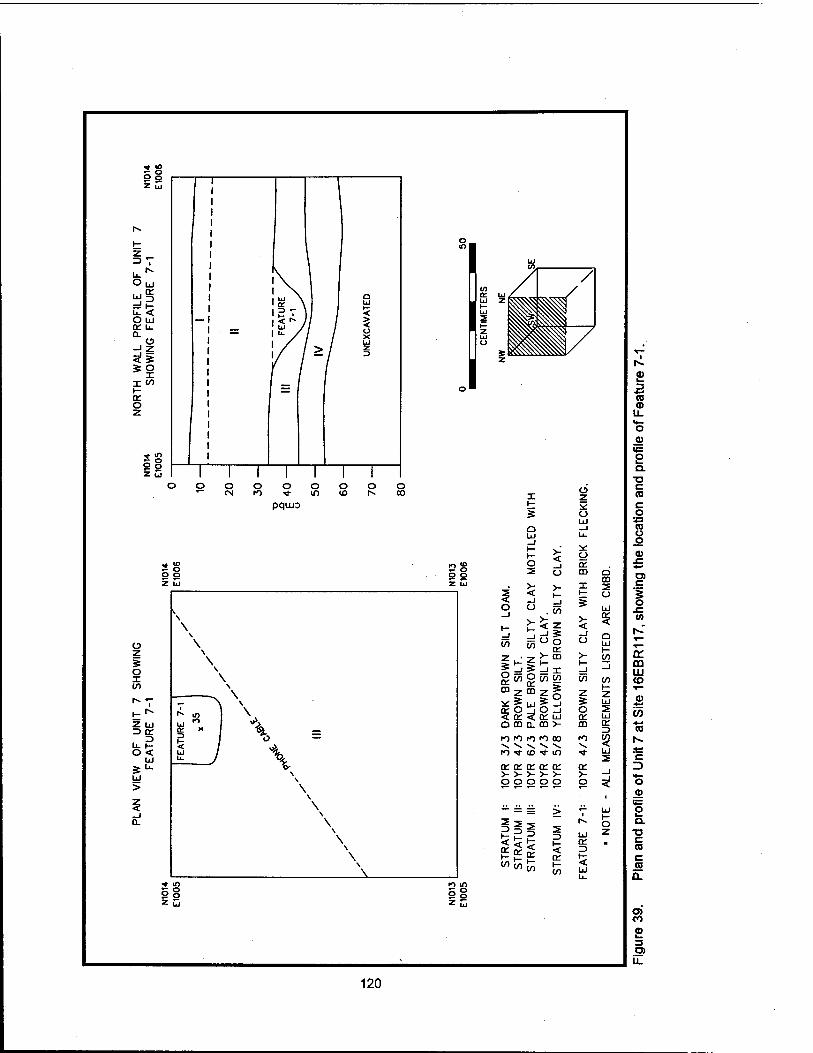
5§ o o
a5 =! r- u. < O Id ce L. a.
o
11 i- CC o
e°
<
1 I III
ÜJ
o O O O o o o CM ro •«I- m ID r^ 0Ü
pquo
Q Ul
o o Z üj
2S o o
>- < Ü
Ü
o
S O X
z UJ o ce b- r- o <
3 ^
5 UJ
> \
\
ce Q m
ro ro ro ■*
s. t
5§1 -, V CD
S =! x O iy) (rt
m5§
CO Q CO
t: o 5 ... >- < %
</> V)
% bJ Ä —' _l O _l < ce bj CL CO >-
ro ro 00 ^v "v -^ io •* tn
z
o ce m
z bJ
UJ ce to <
ce ce ce ce ce ce o o o o o o ^
III si? 2 I— < ce
i- UJ
^ «5 bJ z ce . 3
§8 2 S
3 *■»
CO a> u. »*- o a>
o Q. •a c (0 c
CO u o
c
o
OH m UJ (O
(0 CD
o
o Q.
T3 C (0 c CO
O) CO
9
u_
120

X}
E o
N1016 E1037
0-
20-
40-
TEST UNIT 6 SOUTH WALL PROFILE N1016 E1036
ROOTS
STRATUM |: STRATUM II:
10YR 3/3 DARK BROWN SILTY CLAY. 10YR 4/6 DARK YELLOWISH BROWN CLAY.
0 50
CENTIMETERS \ SW \SE
\
wM
Figure 40. Profile of Unit 6 at Site 16EBR117.
121
redware, a single pearlware sherd, two whiteware sherds, amethyst colored bottle glass, window glass, and both machine-cut and wire nails. No faunal material was recovered, and no features were identified.
Unit 10 (Figure 41) was located on the western side of a fence that divides the Carney yard from the adjacent pasture (Figure 26), and approximately 25 m (82 ft) southwest of the Carney house. Stratum I in Unit 10 was described as a 10YR 4/3 brown clayey loam that measured approximately 20 - 25 cm (7.87 - 9.84 in) in thickness. This upper stratum contained a high density (n=156) of nineteenth and twentieth century domestic artifacts. This cultural material included pearlware, whiteware, porcelain, stoneware, blown-in-mold and cup bottom molded bottle glass, machine-made bottle glass (post ca. 1903), milk glass lid liners, iron cans, and lamp glass. Architectural debris included brick and mortar fragments, iron and brass fasteners, machine-cut and wire nails, window glass, and a plumbing fixture.
Feature 10-1 (Figure 41) was identified directly beneath Stratum I, originating at a depth of 30 - 35 cmbd (11.8 -13.8 inbd). This feature originally functioned as an east - west oriented drainage ditch that had gradually filled; after this natural process had lessened its effectiveness, the ditch served as a trash disposal. Evidence of trash burning was apparent in the upper Level A (Figure 41). Level B represented the natural fill in the ditch; artifact density was far lower in Level B (n=11) than in either Level A (n=128) or Stratum I.
Feature Level A materials included pearlware, porcelain, stoneware, whiteware, both machine-made and molded bottle glass, window glass, cans, bedspring fragments, and machine-cut and wire nails. Evidence of burning included melted glass, burnt ceramics, and moderate amounts of charcoal. Both nineteenth and twentieth century materials were included in this feature level, suggesting that this material was deposited no earlier than the first decades of the twentieth century. Feature Level B contained only II artifacts, none of which was closely dateable. Only five machine-cut nails, no wire nails, were recovered, suggesting a depositional date prior to ca. 1890.
The last unit excavated in the immediate area of the Carney house was Unit 18, located approximately 40 m (131 ft) southwest of the Carney house (Figures 26 and 42). Stratum I of Unit 18 was similar to that identified in other units in this area, containing a range of nineteenth century materials in addition to some twentieth century artifacts; 88 artifacts were recovered from Stratum I. Ceramics included redware, whiteware, tin-glazed ware, pearlware, and porcelain. Bottle glass included a machine-made lip (post ca. 1898) and turn-paste molded bottle glass (1870-1920; Table 7). Window glass, machine-cut nails, and wire nails were present. Only four fragments of bone were recovered; one was identifiable as Sus scrofa (pig).
Stratum II contained two whiteware fragments, an iron staple, and one glass fragment. All of these were recovered from the interface zone between Strata, at approximately 55 - 60 cmbd (21.7 - 23.6 inbd). The majority of Stratum II was a sterile, 10YR 5/6 yellowish brown silty clay.
Two features were identified in Unit 18 (Figure 42). Feature 18-1 was a circular posthole measuring approximately 26 cm (10.23 in) at its widest point. The feature was apparent at the interface of Strata I and II, at a depth of 56 cmbd (22.04 inbd); it continued to a depth of 108 cmbd (42.51 inbd), a total of 52 cm (20.47 in). The feature contained only a single wire nail, and an iron fence staple, suggesting that it may have been a filled fence posthole with a twentieth century association.
Feature 18-2 was a shallower, square depression, measured 22 x 20 cm (8.66 x 7.87 in) in size (Figure 42); it was extended only 19 cm (7.48 in) in depth, originating at the interface of Strata I and II. No artifacts were recovered from this feature, which may be related to the twentieth century activity represented by Feature 18-1.
122

WEST WALL PROFILE OF UNIT 10 SHOWING FEATURE 10-1
UNEXCAVATED
STRATUM l: 10YR 4/3 BROWN CLAYEY LOAM. STRATUM II: 7.5YR 5/6 STRONG BROWN CLAY.
FEATURE 10-1 A: B:
10YR 4/4 DARK YELLOWISH BROWN CLAYEY SILT. 10YR 6/4 LIGHT YELLOWISH BROWN SILTY CLAY MOTTLED WITH 10YR 5/8 YELLOWISH BROWN SILTY CLAY.
50
CENTIMETERS
Figure 41. Profile of Unit 10 at Site 16EBR117, showing Feature 10-1.
123
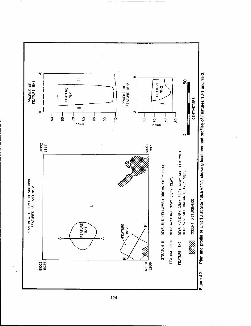
u. A O $9 UJ UJ =J a: u. o Oi- OT < 0. UJ
pqtua pqiuo
I
o SS Z UJ
o
CO o
Z i 3 CO
oft
UJ I-
■* Ul
>- < o
o z s >- O l- or =J aa to
i VI
o _J _l UJ >- ID
If)
a: >- o
X
5 o UJ
o 2
>- < or o
or o
o or m UJ
<! a.
or or >- >-
o z
m or (- (/} Q
a o or
5 *!
< or
CM <o O 00 O O)
Z UJ
or
< UJ u.
or
< UJ
oo
■D C 03
03
(0 <D
(0
u_
c 03 to c g 13 o .o a c '5 o x: to
a: m LU <o
a)
(0
03
00
O
o
o I—
Q. T3 C 03 c 03
(M
a> 3
124
Barn and Utility Building Area. Units 2 and 3 were located east of the barn and utility buildings to test for intact deposits in these areas (Figure 26). The stratigraphy of these units was similar, but Unit 3 reflected its greater distance from the domestic portion of the site in an extremely low artifact density.
In Unit 2, Stratum I was characterized as a 10YR 5/4 yellowish brown silty loam, extending from 10-20 cmbd (3.93 - 7.87 inbd; Figure 43). Stratum II consisted of a 10YR 5/2 silt loam, that extended approximately 20 - 28 cmbd (7.87 -11.02 inbd). Stratum III, a 10YR 4/6 dark yellowish brown silty clay, extended from 28 - 53 cmbd (11.02 - 20.86 inbd).
Artifact density in Unit 2 was low, only 44 historic artifacts were recovered. Of these, 23 originated from Stratum I, 18 from Stratum II, and three artifacts were recovered from the interface of Strata II and III; however, the bulk of Stratum III was culturally sterile. Stratum I included only a single ironstone sherd and one stoneware fragment; the rest of the recovered historic artifacts were bottle, window, and lamp glass, and a single wire nail. Included in this total was a machine-made bottle glass shard. Stratum II artifacts consisted of whiteware, bottle glass, a tooled bottle lip, window glass, a single cut nail, and a fragment of a milk glass figurine. The undisturbed appearance of Strata I and II (Figure 43) suggests either that mixing by plowing occurred long enough in the past to allow soils to begin to stratify, or that the two strata both are twentieth century in origin. In addition, four unmodified chert flakes and a small utilized flake tool fragment also were recovered from Strata I and II.
The stratigraphy of Unit 3 was similar to that of Unit 2 (Figure 44); except for some iron chain fragments observed in Stratum I, the unit was culturally sterile. Stratum I, a 7.5YR 5/4 light olive brown silty clay, extended from 10-25 cmbd (3.93 - 9.84 inbd). Stratum II, a 10YR 6/8 brownish yellow silty clay, ranged in depth from 25 - 45 cmbd (9.84 -17.71 inbd). Stratum III was similar, but had a Munsell value of 2.5Y 6/8, an olive yellow silty clay. Unlike Unit 2, Unit 3 appeared to have been undisturbed; this may have been due to its proximity to Bayou Baton Rouge and its distance from major activity areas of the plantation.
In summary, investigations at Site 16EBR117 (Penny Plantation), fifteen 1 x 1 m (3.3 x 3.3 ft) excavation units were excavated. These excavations have indicated that stratigraphic integrity and the potential for significant subsurface features exist in most portions of the site. Cultural material recovered during these excavations suggests that the earliest, late eighteenth century occupation of the site was in the front yard of the present Carney Farm, in proximity to the avenue of oaks. In addition, units excavated in the rear yard of the present Carney house suggest that deposits of household midden and architectural features related to the nineteenth century occupation of the plantation are present. While destruction of the nineteenth century house and construction of the present dwelling have impacted these deposits to some extent, lower stratigraphic levels and subsurface features remain intact.
Site 16EBR117 retains its integrity as a working farm. It presents an excellent opportunity for research into the effects of broader social and economic events on the development and layout of a typical nineteenth and twentieth century farmstead. Because the farm boundaries remain largely intact, and because it has been little impacted by outside development, it presents an opportunity to study agricultural enterprise during the antebellum, postbellum, early modern, and modern periods. Specific research questions and suggestions for mitigation efforts at Site 16EBR117 will be presented in Chapter VIII of this report.
Phase II Investigations at Site 16EBR118
Site 16EBR118 also had been recorded in 1993 (Figure 1, Sheet 1 and Figure 26) (Ryan et al. 1994). Both magnetometer survey and shovel testing during the initial Phase I investigations failed to produce evidence of nineteenth century habitation, but oral testimony by local collectors suggested that the
125

TEST UNIT 2 SOUTH WALL PROFILE N939 E1036
On
N939 E1035
20- X>
E o
40-
eo-*
STRATUM I: STRATUM II: STRATUM III:
10YR 5/4 YELLOWISH BROWN SILTY LOAM. 10YR 5/2 GRAYISH BROWN SILT LOAM. 10YR 4/6 DARK YELLOWISH BROWN SILTY CLAY.
NW
50
CENTIMETERS
Figure 43. Profile of Unit 2 at Site 16EBR117.
126

TEST UNIT 3 SOUTH WALL PROFILE N927 E1147
N927 E1146
STRATUM I STRATUM II STRATUM III
7.5YR 5/4 LIGHT OLIVE BROWN SILTY CLAY. 10YR 6/8 BROWNISH YELLOW SILTY CLAY. 2.5Y 6/8 OLIVE YELLOW SILTY CLAY.
NW NE
50
CENTIMETERS
Figure 44. Profile of Unit 3 at Site 16EBR117.
127

area was a likely locale for structures associated with the Penny Plantation site (Ryan et al. 1994:140). Site 16EBR118 is located at the far southern end of a pasture, approximately 335 m (1100 ft) south- southeast of the Carney house (Site 16EBR117), and in direct line with the avenue of oaks at that site. Site 16EBR118 may have been associated with Penny Plantation's slave and laborer population during the nineteenth century (Ryan et al. 1994).
The majority of the site had been plowed during the twentieth century, and currently is in use as pasture (Figure 26). During Phase II investigations, three units (Units 14-16) and 16 shovel tests were placed within, or in the immediate vicinity of Site 16EBR118. Systematic metal detector tests were conducted within the site area and on the western side of the fenceline between the Carney livestock barn and Site 16EBR118. A concentration of metals was recorded within the previously identified site (Figure 26); based on this information, the placement of three units was determined (Units 14-16).
At Site 16EBR118, the stratigraphy varied, depending on the location of the unit. In Unit 14 (Figure 45), there was stratigraphic evidence for recent plowing; Unit 15 (Figure 46) displayed some evidence of less recent plowing, and Unit 16 (Figure 26) seemed unaffected by agricultural activity. Stratum I of Unit 14 was characterized as a 10YR 5/3 brown loamy silt, extending from 0-20 cmbd (0 - 7.87 inbd). This stratum had been affected by plow activity, but underneath was a thin deposit of potentially undisturbed cultural material (Figure 45). Labeled as Stratum la, this soil was described as a 10YR 6/3 pale brown, slightly clayey silt, with ferruginous concretions. Stratum II consisted of undisturbed subsoil, a 2.5Y 6/4 light yellowish brown silty clay with mottling of 2.5Y 6/6 olive yellow clay.
Feature 14-1, a remnant posthole, was recorded at the interface of Strata la and II, but because of root activity and soil mottling, it was not clearly defined until a depth of approximately 50 cmbd (19.68 inbd; Figure 45). The feature measured approximately 16 x 20 cm (6.2 x 7.9 in) in plan; the fill was culturally sterile.
Artifacts recovered from Unit 14 were indicative of domestic activity in this area during the late nineteenth or early twentieth centuries. No closely dateable material was recovered, and density was light (n=17; Table 12). Stratum I contained three whiteware sherds, blown-in-mold bottle glass, including amethyst colored fragments, a brass button, a machine-cut nail, a tack, and iron fragments. Nail and glass fragments were recovered from Stratum la. Brick fragments and charcoal fragments were present throughout both levels; at the interface of Stratum la and Stratum II, the density of brick and charcoal increased. The bulk of Stratum II was sterile subsoil.
Unit 15 showed more evidence of relatively undisturbed domestic deposits (Figure 46); its placement coincided with a concentration of metal detector hits (Figure 26). In this unit, Stratum I was a developing humic layer and was recorded as a 10YR 4/2 dark grayish brown loamy silt that extended from 0-15 cmbd (0 - 5.9 cmbd). The stratum contained three glass fragments and a concentration of small brick fragments. Stratum II, a 10YR 5/4 yellowish brown loamy silt, produced the bulk of the cultural material. This included whiteware, blown-in-mold amethyst colored and other non-diagnostic bottle glass, lamp chimney glass, machine-cut nail fragments, and a piece of window glass. The interface of Strata II and III occurred at approximately 35 cmbd (13.7 inbd). Stratum III was a sterile, 10YR 5/3 brown silty clay. The top of Stratum III showed no evidence of plowscars, but the homogeneity and depth of Stratum II suggests that the area had been plowed in the past. No subsurface features were noted in Unit 15.
Unit 16 (Figure 26) was placed in closer proximity to Bayou Baton Rouge to determine the extent of the plowed soils. Stratum I, a 10YR 4/2 dark grayish brown loamy silt, extended 0-20 cmbd (0 - 7.87 inbd) and exhibited no signs of plowing. Stratum II consisted of a 10YR 4/3 brown silty clay. Only five artifacts were recovered from Unit 16 (Table 12); these were recovered from the interface between Strata I and II, at a depth of approximately 20 - 21 cmbd (7.87 - 8.26 inbd). Artifacts included a whiteware
128

to r^ ID O) Z U
2 3
O or
=3 o
CM CM to rv CO Ol Z LJ
CD
\ \
;
o m
pquio
o CM
o o o
pquuo
to 0> z UJ
CM CM CO 1^ CO Ol
O Z
o X to
3 a: 3
Li- H- O <
UJ
UJ >
< _l a.
o m
o m
X
i— _J (/) > ÜJ >- <
I
ss I— _J
cy>
>- LÜ >- <
X
Q UJ
>- < O
>-
5 o o or >- CD I-
mi z P o o 5 UJ -^ ->
(DZ ^ ^
UJO££
Q-D JO
to i° CD 3
n° ^ 7^ ^ 7^ ^ ^* U-) O to O to CD
a: a: UJ
~ U_ >- F, m LO Q UJ . . i= U_ C\| CM
CO Z
co p> z ^
2 3 < \- tn
i— < a: (/)
< or i— c/i
>- < o >- i— _J
m
x o
CD
>- o
UJ or 3 t- < UJ
1 I
li
I
or UJ
5 o o QT UJ m £ X CO Q
UJ
(/)
en
UJ
a: 3 < UJ
£ 3 *-» CO a> li- ra c '5 o
oo
CO UJ (O
CD
'co *^ (0
c
o .2 is: o I— a.
■a c CO e ra 0.
to <«!• a> 3
u.
129
Table 12. Historic Material Recovered during Investigations at Site 16E BR118
UNIT 14 15 16 SHOVEL TESTS TOTAL
Ceramics Stoneware Domestic Brown 1 0 0 0 1
Whiteware Relief-molded 1 0 0 0 1
Sponged/ Spattered 0 1 0 0 1
Transfer-printed 0 1 0 0 1
Undeco rated 2 8 1 0 11
Underglaze Hand-painted 0 1 0 1 2
Construction Materials
Brick Fragment 0 0 1 0 1
Glass Bottle Blown-in-mold Amber 0 1 1 0 2
Amethyst 1 0 0 0 1
Light Aqua 0 2 0 0 2
Unidentified Amber 1 0 0 0 1
Amethyst 0 3 0 0 3
Cobalt 1 0 0 0 1
Colorless 1 2 0 0 3
Dark Green 2 2 0 0 4
Light Aqua 1 4 0 0 5
Light Green 1 1 0 0 2
Olive Green 1 0 0 0 1
Lamp Chimney Colorless 0 1 0 0 1
Unidentified Colorless 0 1 0 0 1
Light Green 0 2 0 0 2
Window (blank) Colorless 0 1 0 0 1
Metal Button Brass Stamped 1 0 0 0 1
Frame Iron Door 0 0 0 1 1
Lamp Part Brass Kerosene 0 0 0 1 1
Nail Iron Machine Cut 1 3 0 0 4
Unidentified 1 1 1 0 3
Stove Part Cast Iron 0 0 0 1 1
Tack Iron Machine Cut 1 0 0 0 1
Tool Axe Iron 0 0 0 1 1
Unidentified Iron 0 2 1 0 3
Miscellaneous Ammunition Percussion Ball .36 Caliber 0 0 0 2 2
Coin Nickel Buffalo 0 0 0 1 1
Total 17 37 5 8 67
130

N737 E982
CD-
TEST UNIT 15 SOUTH WALL PROFILE N737 E981
20- X> .a E o
40-
III
STRATUM I: 10YR 4/2 DARK GRAYISH BROWN LOAMY SILT. STRATUM II: 10YR 5/4 YELLOWISH BROWN LOAMY SILT. STRATUM III: 10YR 5/3 BROWN SILTY CLAY.
NW NE
50
CENTIMETERS
Figure 46. Profile of Unit 15 at Site 16EBR118.
131

fragment, a glazed brick fragment, one non-diagnostic bottle fragment, and two iron fragments; other brick fragments were noted but not recovered.
Excavation in the three units placed in Site 16EBR118 suggest a small, late nineteenth to early twentieth century occupation. Although the bulk of the site area has been plowed, the presence of Feature 14-1 indicates that at least partially intact subsurface features remain. Other features may be present in closer proximity to the bayou where Unit 16 showed no evidence of plowing. Although artifact density was low in this area, there was evidence of a former occupational plane at a depth of approximately 20 cmbd (7.87 inbd). Despite the presence of a partially intact feature, it is likely that the majority of Site 16EBR118 has been negatively impacted by agricultural activities. In addition, the low density of artifactual material at this site make it unlikely to yield significant information related to nineteenth and early twentieth century occupation.
The Carney and Bourque Farms and the Twentieth Century Dairy Industry
During the initial survey of the Comite River Diversion Project right-of-way, a number of standing structures were recorded. Seven of these were originally agricultural structures located on the Carney and the Bourque Farms; all had been associated with the early twentieth century dairy industry in East Baton Rouge Parish. Historical research on this industry focused on its significance in the regional economy; the standing structures at the Carney and the Bourque farms were evaluated in light of the historical context and their current integrity.
The Development of the Dairy Industry in East Baton Rouge Parish
The developmental trajectory of the dairy industry in East Baton Rouge Parish was similar to that of neighboring parishes and states. Pasteur's discoveries of the mid-nineteenth century were accepted as fact by the late nineteenth century (Garland 1949:163-175), and by 1891, the Department of Agriculture organized the Dairy Division to disseminate information about "modern" dairy practices and the prevention of disease transmission (Pirtle 1926:142-143). By 1895, machinery to pasteurize milk consistently was perfected; this coincided with the development in that same year of the first milking machine (Campbell and Marshall 1975:29).
Pasteurization of milk was federally mandated in 1907, and national pasteurization standards were established (Pirtle 1926). Processing plants specializing in the production of sanitary milk products arose, and relieved the individual producers of the responsibility for pasteurization; these industrial dairies were established on the edges of urban areas throughout the country.
In East Baton Rouge Parish, the climate and conditions were recognized as favorable for dairying activities as early as 1889, when a promotional brochure distributed by the City of Baton Rouge stated:
". . . every farmer has his Jersey or Holstein heifer, which is to form the basis of a fine herd in the near future. The Jersey has shown herself especially adapted to our climate and local conditions and will, no doubt, prove a prime factor in the growth of a new system of dairy farming. Having, as we do, cheap and abundant pasturage and a climate which does not require a tax on the food consumed in merely keeping up animal warmth, enjoying greedy and never failing markets right at hand, there is no assignable limit to the development of the dairy interest in this parish" (City Council of the City of Baton Rouge and Police Jury of East Baton Rouge 1889:9).
132

Despite this description, only 875 farms in East Baton Rouge Parish were producing dairy products in 1899, and the majority of the production was at the subsistence level (Table 13). By the end of the first decade of the twentieth century, however, losses to the cotton crop caused by weevil attacks had encouraged a shift to dairy and livestock (Bergeron and Jackson 1989:40). This economic change was probably aided by the technological improvements and broader developments in the dairy industry in the first decades of the twentieth century. World War I, and the accompanying market loss for agricultural products, encouraged further movement towards a localized dairy industry.
By 1919, the amount of milk produced in the parish had increased 23 percent over the 1899 figures (Table 13). The largest increase, however, was evident in the 1929 agricultural census, which indicated that milk production had increased four-fold during the first three decades of the century, and had tripled in the prior decade (Table 13). Most of this huge increase in production appears to have been due to improvements in technology and marketing, since the census indicates only a slight increase in the number of farms and dairy cattle (Table 13).
Table 13. Dairy Production in East Baton Rouge Parish, 1899 -1939.
1899 1910 1919 1929 1934 1939
Number of Farms 875 - - 1302 1437 1328
Dairy Cattle - 2565 5273 4724 5295 6629
Milk Produced (gallons) 443,810 404,926 579,132 1,746,676 1,327,481 2,783,387
Milk Sold (gallons) 44,795 20,242 281,986 1,001,372 - 1,952,293
*Data from U.S. Agricultural Census Reports
The Carney Dairy Complex
The Carney dairy complex is located on the Penny Plantation site (16EBR117), but is associated with the twentieth century farming activities conducted by the Carney family (Ryan et al. 1994). These structures consist of a dairy barn (SS-39; Figures 47 and 48), a milk shed (SS-40), and a livestock barn (SS-41; see Appendix III). Because of their association with the continued occupation and development of Site 16EBR117 as an agricultural and domestic complex, and because of their association with the broad pattern of agricultural development in the region, these structures were recorded and evaluated during the course of investigations at the site. The dairy structures at Site 16EBR117 are significant representatives of the architecture of the dairy industry in East Baton Rouge Parish in the early part of the twentieth century. Perhaps more importantly, they are integral elements of the continuous agricultural activity that has marked the occupation of Site 16EBR117.
According to Mr. Bowman Carney, Jr., present owner of the farm, the dairy barn and the milk shed (SS-39 and SS-40) were constructed in 1927 by Mr. Carney, Jr., Mr. Carney, Sr., and three laborers. Mr. Carney stated that a two-story hay barn, located where the dairy barn (SS-39) now stands, was dismantled by his father's crew. The concrete floor for the dairy barn was poured, and the upper, wood frame and siding of the barn was constructed with lumber salvaged from the dismantled hay barn. The milk shed was built at the same time, using similar methods (Bowman Carney, Jr., personal communication, November
133

m UJ CD
CD
CO CO
c I—
CO
CO ■o
CO c l_ CO Ü
CD ■a CO ü CO
CD JZ.
o
3
134
en OÜ ui CD
CD ■ES to *-» CO
c CO 12
CO
>> CO c CO o
o _o
c
o
>
oo
CO i— 3 Ö)
135
1995). Mr. Carney did not recall the construction of the livestock barn (SS-41), which could suggest an earlier construction date.
The dairy barn was designed to accommodate 50 cows at a time. The poured concrete floor incorporated a feed trough and a waste gutter. These features were common to plans for dairy plant construction that were widely disseminated by local cooperatives and dairy boards; the use of concrete and other non-porous construction materials were intended to improve sanitation (Harvey et al. 1936; Dr. L. Hannaman, personal communication, April 1996). Similar plans were in use in the 1950s (Louisiana State University and A & M College 1957).
The exterior configuration of the dairy barn is similar to barns recorded in St. Helena Parish (Newton 1981) and Point Coupee Parish. The Point Coupee barn was constructed ca. 1931; unfortunately, the recorders did not describe the interior floor plan or the internal framing, rendering comparison with the Carney structure difficult. No comparable structures are recorded in East Baton Rouge Parish.
Based on descriptions of nineteenth century barn construction in southeastern Louisiana (Comeaux 1989:47-62), the Carney dairy barn may have combined modern dairy plans with vernacular building methods. No details of interior framing were available for southeastern Louisiana barns. Exterior details like vertical board siding seem comparable to the Carney barn. The floor plan of the Carney barn, with two aisles for cattle, is similar to the layout of the typical Cajun barn, which often stabled mules and horses on one side and cattle on the other (Comeaux 1989:50).
The Carney complex included a milk shed for the storage of dairy products (SS-40). This was a development attributed to twentieth century dairy practice, permitting the cold storage of raw milk prior to its collection by the processor. According to Mr. Carney, the milk shed was cooled with block ice (Bowman Carney, Jr., personal communication, November 1995).
These structures are in poor condition, and the milk shed has undergone significant interior renovation subsequent to its use as a dairy structure. Their significance stems from their integrity of location and setting on the Penny/Carney farmstead, and from the integrity of structural material and workmanship. These structures are not only examples of structures closely associated with the regional development of dairying in East Baton Rouge Parish; they also maintain a clear and specific association with the economic development of the Carney farm as an agricultural enterprise during the nineteenth and twentieth centuries. They are a part of the economic fabric of the site, and are excellent examples of the adaptation of the vernacular form to modern needs and conditions. Full recordation of these structures has been included in the suggested mitigation plans for Site 16EBR117 (see Chapter VIII of this report).
The Bourque Dairy Complex
Also recorded during initial cultural resources survey of the Comite River Diversion project area (Ryan et al. 1994) was a complex of four standing structures associated with the twentieth century dairy industry in East Baton Rouge Parish. These were located less than 1.6 km (1 mi) from Site 16EBR117, on the property of Leonce Bourque (Figure 27). Consisting of a livestock/hay barn (SS-38), a cow pen (SS- 35), a dairy barn (SS-37), and a milk shed (SS-36), this complex was constructed during the 1930s and 1940s. While these structures retain integrity of location, the structural integrity of some of these buildings has been compromised by later renovation and remodeling. The dairy barn, for example, has recently been converted into a garage, a process that involved rebuilding the exterior walls with brick. The hay barn was considered to be the only one of the buildings in good structural condition, and was the only one still in use as a farm structure.
136

Additional examination of these structures was attempted during the current phase of the Comite River Diversion Project, but access to the property and additional information about the structures was firmly denied by the owner. Based on the available information (Ryan et al. 1994), although the Bourque structures reflect broad trends in the regional agricultural economy, deterioration of most of these structures and their original agricultural context has compromised their integrity of feeling and association. The lack of both structural and contextual integrity would preclude their qualification for listing in the National Register of Historic Places.
Summary
Historical research on the twentieth century development of the dairy industry in East Baton Parish suggests that it was significant both economically and socially in the history of the Parish. The complex of dairy structures at the Carney farm retains contextual and structural integrity, despite some later twentieth century alteration. As the twentieth century manifestation of two centuries of agricultural development at this site, the Carney dairy complex is a significant representative of the development of agriculture in East Baton Rouge Parish. The structures in this complex are also significant examples of the evolution of a unique vernacular form to modern conditions.
The Bourque dairy complex of four standing structures did not display structural or contextual integrity. Three of these structures have undergone significant alterations, and the buildings are no longer associated with a working farm. The Bourque dairy complex lacks structural and contextual integrity, and is not considered to be eligible for listing in the National Register of Historic Places.
Phase II Investigations at Site 16EBR105 (John A. McHugh House)
Site Background
Site 16EBR105 (Figure 49) first was identified during initial cultural resources survey conducted by Coastal Environments, Inc. in 1993 (Ryan et al. 1994). Located on McHugh Road (Figure 1, Sheet 2), the site was identified as the homestead of John A. McHugh; the house was built ca. 1859. The house was described as a transitional Louisiana French Colonial style cottage that was wood framed with a central chimney and tin roof (Ryan et al. 1994:108). It was unoccupied by the mid-twentieth century, but stood until the early 1980s, when it was destroyed by fire (Ryan et al. 1994). The property is still owned by the McHugh heirs, and currently is leased by Mr. Francis Jackson for use as pasture for cattle.
Material recovered during initial investigations included whiteware, ironstone, porcelain, bottle glass, window glass, and other nineteenth and twentieth century domestic debris. Architectural debris, including nails and brick were evident throughout the immediate vicinity of the house. Magnetometer testing was conducted in the vicinity of the house; a subsurface midden deposit was identified to the southwest of the house, producing late nineteenth and twentieth century domestic debris (Ryan et al. 1994). The site was assessed as significant for inclusion in the National Register of Historic Places because of its integrity of location, setting, and associations (Ryan et al. 1994:109). Data recovery excavations were recommended if adverse impacts were likely from the Comite River Diversion Project. Because only shovel testing had been conducted at the site, a Phase II investigation was stipulated in the current Scope of Work; this was intended to delineate more fully the site, to identify the extent and character of archeological remains, and to establish the integrity and significance of those remains.
137

138

Topography and Expected Soils
Site 16EBR105 is located on a terrace adjacent to a tributary of White Bayou, in the central portion of the project area (Figure 1, Sheet 2). Soils at the site are part of the Oliver - Loring - Terrace association. These are characterized as level to gently sloping, poor to moderately well-drained silt loams. Typical subsoils are brown silty clays, while the upper strata are gray to brown silty loams. Taphonomic factors affecting the site were varied, and included disturbance from rodents, flora, and historic events such as plowing and building construction and destruction. Perhaps the most significant disturbance at the site has been the construction and maintenance of a farm pond; much of the rear yard area of the former house has been severely impacted by this construction. These factors will be covered in more detail in the discussion of excavation results.
Results of Excavation
During delineation of Site 16EBR105, 23 additional shovel tests were excavated in the vicinity of the John A. McHugh house (Figure 50). These were intended to determine the extent of the architectural remains, and to locate any outbuildings, midden deposits or artifact concentrations, or other significant archeological remains associated with the nineteenth century McHugh occupation. Six shovel tests were positive; two of these (ST #12 and #19) produced only single machine-cut nails, while ST #20 produced two whiteware sherds, a piece of bottle glass, and a cut nail. Shovel Tests #1, #9, and #18 produced only isolated brick fragments (Figure 50). No other deposits of architectural or occupational debris were located during shovel testing.
A total of eight 1 x 1 m (3.3 x 3.3 ft) excavation units were placed in the immediate area of the McHugh house at Site 16EBR105. Two additional units (Units 9 and 10) were minimally excavated to expose fully the surface of brick pier features (Features 9-1 and 10-1) that were partially visible prior to excavation (Figure 50). Excavation Units 1 - 8 were intended to reveal the stratigraphic sequence and architectural features, and to test for the presence of intact deposits of debris associated with the occupation of the house. Seven features were identified and recorded during excavations (Table 14).
Table 14. Features Recorded at Site 16EBR105.
FEATURE PROVENIENCE DEPTH DESCRIPTION
2-1 Unit 2 N1041 E963 25 - 80+ cmbd Concrete pipe and hole; probable 20th century well shaft; continues beyond 80 cmbd.
4-1 Unit 4 N1038E974 Unit 3 N1039E974
32 - 93 cmbd Brick chimney foundation; includes northern firebox
6-1 Unit 6 N1043E969 8-23 cmbd Brick pier from house
6-2 Unit 6 N1043E969 18-52 cmbd Post mold associated with feature 6-1
8-1 Unit 8 N1052E968 38 - 90 cmbd Possible post hole
9-1 Unit 9 N1038E969 visible at surface Brick pier from house; not excavated
10-1 Unit10N1034E968 visible at surface Brick pier from house; not excavated
139

DATUM (N1000, E1000) EXCAVATION UNIT (1m x 1m)
POSITIVE SHOVEL TEST NEGATIVE SHOVEL TEST EXPOSED FEATURE SITE BOUNDARY CONTOUR LINE (C.I. ■ 0.5m)
WATERLINE TREE LINE FENCELINE UNIMPROVED ROAD STRUCTURE
Figure 50. Plan of Site 16EBR105 (John A. McHugh House), showing the locations of shovel tests and excavation units.
140

Unit 1. The placement of Unit 1 (Figure 50) was intended to permit investigation of the area to the southeast of the McHugh house site, in the subsurface midden area previously delineated by Coastal Environments, Inc. (Ryan et al. 1994). In Unit 1, Stratum I extended from 18 - 31 cmbd (7.08 -12.2 inbd); the matrix was described as a 10YR 5/4 yellowish brown clayey silt. Stratum II was a sterile lens of 5Y 8/2 white clay extending from 31 - 37 cmbd (12.2 - 14.56 inbd). This lens may be the residue from dredging of the artificial pond at the western edge of the site. Stratum III contained the major artifact- bearing levels in the unit; the matrix consisted of a 10YR 3/2 very dark grayish-brown loam with brick, charcoal, and coal slag fragments. This midden stratum measured approximately 17 cm (6.69 in) in depth, extending from 37 - 54 cmbd (14.56 - 21.25 inbd). Stratum IV, a 2.5YR 5/6 light olive brown silty clay soil, extended from 54 - 74 cmbd (21.25 - 29.13 inbd); this was characterized as a transitional stratum between the midden deposit and the subsoil. Stratum V, the subsoil, was characterized as a 2.5YR 5/6 light olive brown silty clay.
Cultural material recovered from Stratum I was minimal; the nine recovered artifacts included a stoneware sherd, whiteware, and machine-made bottle glass. The midden stratum (Stratum III) contained 300 artifacts comprising ceramics, bottle glass, window glass, nails, and miscellaneous items. Temporally diagnostic material included machine-made bottle glass (post ca. 1903), a crown cap (post ca. 1892), both cut nails (1790s - 1890s) and wire nails (post ca. 1890; Table 7), and a 1944 Lincoln penny (Appendix I). While some artifacts with a potential use date in the mid-nineteenth century were included in the sub- assemblage (Tables 15 and 16), the ample presence of twentieth century material from the lowest level of the midden suggests a probable post-occupational deposition date.
Unit 2. Unit 2 was located in the western portion of the house lot (Figure 50), in what would have been the rear yard of the east-facing house. The current tenant of the property, Mr. Francis Jackson, identified the area as the location of a well associated with the house. During excavation, Feature 2-1 was recorded (Table 14) and identified as a twentieth century concrete pipe used as a well-shaft (Figure 51). The stratigraphy in much of the unit remained undisturbed by the excavation of the well; the basic depositional sequence was similar to that in Unit 1. The uppermost Stratum was characterized as a 10YR 5/3 loamy silt, contained relatively few artifacts; it extended from 10-15 cmbd (3.93 - 5.9 inbd). Stratum II, a 10YR 5/6 yellowish brown loamy silt, continued to a depth of 19 cmbd (7.48 inbd); this stratum, a continuation of the topsoil layer, contained a moderate concentration of cultural material. The majority of cultural material was recovered from Stratum III, which measured approximately 19 cm (7.48 in) in thickness. Subsoil, Stratum IV, consisted of a 2.5Y 6/6 olive yellow clayey silt that contained only a few artifacts in the upper transitional zone.
Feature 2-1 originated at the top of Stratum III and continued beyond the final depth of the unit. The fill of the excavated portion of the feature (Feature 2-1 A) consisted of a 10YR 5/3 brown silty loam that contained a moderate density of cultural material. Recovered material included whiteware, stoneware, ironstone, porcelain, machine-made and 3-piece hinge molded bottle glass, machine-cut and wire nails, and a single stoneware tobacco pipe fragment. The diagnostic attributes of this sub-assemblage (Table 7) suggest a construction date for the well no earlier than the beginning of the twentieth century, and possibly later. Material recovered from Stratum II, overlying the well shaft, included tin can fragments, wire nails, machine-made bottle glass, and brick and concrete fragments (Table 15).
Cultural material recovered from the midden deposit in Unit 2 included material diagnostic of the late nineteenth or early twentieth century (Table 15). Machine-made, embossed panel, hinge-molded, and tooled-lip bottle glass (Table 7) were suggestive of this time period. The presence of machine-made bottle glass implies some deposition after ca. 1903.
141

Table 15. Cultural Material Recovered during Phase I Investigations atSite16EBR105.
UNIT 1 2 3 4 5 6 7 8 SHOVEL TESTS TOTAL
Ceramics Earthenware Cream- colored Annular 4 0 0 0 0 0 0 0 0 4 Refined Redware
Refined Red ware 0 0 0 0 0 1 0 0 0 1
Unidentified Burned 0 0 0 0 0 1 0 1 0 2 Ironstone Annular 1 1 0 0 0 0 0 0 0 2
Overglaze Decal 2 0 0 0 0 0 0 0 0 2
Undeco rated 1 8 0 0 2 0 0 0 0 11
Pearlware Transfer- printed 0 0 0 1 0 0 0 0 0 1
Undecorated 0 0 0 0 0 0 0 3 0 3
Porcelain Overglaze Decal 0 0 0 0 0 0 0 2 0 2
Overglaze Hand-painted 2 1 0 0 0 0 0 1 0 4
Relief Molded 1 2 0 0 0 1 0 0 0 4
Undecorated 3 4 0 0 0 1 0 5 0 13
Unidentified 0 0 0 0 0 1 0 0 0 1
Stoneware Domestic Brown 4 1 2 0 1 1 0 1 0 10
Gray 1 4 0 0 3 0 2 2 0 12
Whiteware 20th Century Opaque Blue Glaze 0 1 0 0 0 0 0 0 0 1
Annular 0 0 0 0 1 0 1 1 1 4
Applique 0 15 0 0 0 0 0 0 0 15
Decal 1 0 0 0 0 2 0 1 0 4
Relief Molded 2 0 0 0 1 1 1 3 0 8
Stenciled 0 2 0 0 0 1 0 0 0 3 Transfer- printed 0 1 0 0 0 4 0 0 0 5
Undecorated 23 35 4 5 14 28 7 37 1 154
Yellowware Annular 0 0 0 0 0 1 0 0 0 1
Undecorated 0 0 0 0 0 1 0 2 0 3
Construction Materials Brick Fragment 0 1 1 6 0 0 0 2 0 10
Whole 0 0 0 2 0 0 0 0 0 2
Cement Fragment 0 3 0 0 0 0 0 0 0 3
Mortar Fragment 1 1 0 1 0 2 0 0 0 5
Tar Fragment 0 0 0 0 0 1 0 0 0 1
Glass Bottle Blown in Mold Amber 0 1 0 0 0 0 0 1 0 2
Amethyst 0 0 0 0 1 1 0 1 0 3
Aqua 2 1 0 0 0 1 1 0 0 5
Colorless 0 0 2 1 1 9 2 8 0 23
Dark Green 0 1 0 0 0 0 0 1 0 2
Light Aqua 3 3 3 0 1 2 1 3 0 16
142

Table 15, continued
UNIT 1 2 3 4 5 6 7 8 SHOVEL TESTS TOTAL
Light Green 0 2 0 0 0 0 0 0 0 2
Olive Green 0 0 1 0 0 0 0 0 0 1
Crown Finish Aqua 1 0 0 0 0 0 0 0 0 1
Dip Molded Dark Green 0 2 0 0 0 0 0 0 0 2
Folded Lip Light Green 0 2 0 0 0 0 0 0 0 2
Hinge Mold Colorless 0 1 0 0 0 0 0 0 0 1
Light Aqua 0 2 0 0 0 0 0 0 0 2
Machine- made Amber 0 1 2 29 1 0 0 0 0 33
Colorless 2 65 1 55 53 2 0 0 0 178
Decal 0 0 0 0 0 0 0 1 0 1
Green 0 0 43 0 6 0 0 0 0 49
Light Aqua 0 0 0 1 19 0 0 0 0 20
Milk Glass 0 0 0 0 0 1 0 0 0 1
Molded Amber 1 6 1 0 7 0 0 0 0 15
Amethyst 2 2 0 0 1 0 0 0 0 5
Aqua 3 0 0 0 0 0 0 0 0 3
Cobalt 0 1 0 0 0 0 0 0 0 1
Colorless 8 23 13 81 15 0 1 0 1 142
Dark Green 0 4 0 0 6 0 0 0 0 10
Green 1 4 0 0 1 0 0 0 0 6
Light Aqua 0 3 0 0 5 0 0 0 0 8
Light Green 0 5 0 0 2 0 0 0 0 7
Milk Glass 0 2 0 0 0 0 0 0 0 2
Olive Green 1 0 4 0 0 0 0 0 0 5
Perfume/ Cosmetic Milk Glass 0 0 0 0 0 0 3 0 0 3
Tooled Lip Colorless 0 1 0 0 0 0 0 0 0 1
Light Amber 0 0 0 0 2 0 0 0 0 2
Light Aqua 0 0 0 0 0 0 0 1 0 1
Unidentified Amber 0 0 2 0 0 2 0 2 0 6
Amethyst 0 0 0 0 0 3 0 0 0 3
Aqua 0 0 0 0 0 2 1 1 0 4
Colorless 0 0 7 0 0 37 5 31 0 80
Dark Green 0 0 0 0 0 0 0 2 0 2
Light Amber 0 0 0 0 0 2 0 1 0 3
Light Aqua 0 0 0 0 0 6 5 8 0 19
Light Green 0 0 0 0 0 0 0 1 0 1
Milk Glass 0 0 0 0 0 1 0 0 0 1
Lamp Colorless 3 0 1 2 1 30 2 4 0 43
Lid Liner Milk Glass 0 0 0 0 0 0 0 6 0 6
Tableware Fire Polished Lip Colorless 0 1 0 0 0 0 0 0 0 1
Molded Colorless 0 0 0 0 0 1 0 1 0 2
143
Table 15, continued
UNIT 1 2 3 4 5 6 7 8 SHOVEL TESTS TOTAL
Post-Bottom Mold Light Amber 0 1 0 0 0 0 0 0 0 1
Pressed Colorless 0 1 0 0 0 0 0 1 0 2
Light Amber 1 5 0 0 1 1 0 0 0 8
Light Green 0 0 0 0 0 0 0 31 0 31
Milk Glass 0 10 0 0 0 0 0 0 0 10
Unidentified Burned Amethyst 0 2 0 0 0 0 0 0 0 2
Aqua 0 0 1 0 0 0 0 0 0 1
Cobalt 0 1 0 0 0 0 0 0 0 1
Colorless 0 11 10 32 0 0 4 0 0 57
Green 0 0 1 1 0 0 0 0 0 2
Light Aqua 0 0 0 0 0 0 1 0 0 1
Purple 0 1 0 0 0 0 0 0 0 1
Amber 0 0 0 4 0 0 0 0 0 4
Colorless 0 2 20 1 3 34 3 2 0 65
Green 0 0 0 0 0 0 1 0 0 1
Light Aqua 1 0 0 0 0 0 0 0 0 1
Light Green 0 0 0 0 0 2 0 1 0 3
Milk Glass 0 0 1 0 0 0 0 0 0 1
Window Plate 0 0 0 0 1 0 1 7 0 9
Safety 0 0 0 0 0 1 0 0 0 1
Stained 2 0 0 0 0 0 0 0 0 2
Clear 82 45 32 54 235 169 46 4 0 667
Metal Bolt Iron 0 0 0 0 1 0 0 0 0 1
Buckle Iron 0 0 0 0 2 0 0 0 0 2
Can Iron 0 35 3 0 0 0 0 0 0 38
Can Opener Iron Key 0 0 0 0 0 0 2 0 0 2
Carriage Part Iron 0 0 0 1 17 0 0 0 0 18
Cotter Pin Iron 0 0 0 0 0 0 1 0 0 1
Crown Cap 2 0 0 0 0 7 0 0 0 9
Engine Part Iron Unidentified 0 0 0 0 0 0 2 0 0 2
Hinge Iron Pin 0 0 0 0 0 1 0 0 0 1
Iron 1 0 2 0 0 1 0 0 0 4
Hook Iron 0 0 0 0 0 1 0 0 0 1
Horseshoe Nail Iron 0 0 0 0 0 8 0 0 0 8
Lid Zinc Canning Jar 0 0 0 0 0 0 0 1 0 1
Nail Iron Machine-cut 34 160 146 46 11 96 10 6 4 513
Unidentified 42 0 0 0 2 10 2 6 0 62
Wire 73 138 95 18 4 83 48 2 0 461
Nut Iron 0 0 0 0 1 0 0 0 0 1
Pipe Iron 1 1 0 0 0 0 0 0 0 2
Rivet Brass 0 0 0 0 0 0 1 0 0 1
Copper 1 0 0 0 0 0 1 0 0 2
Snap Brass 0 0 0 0 0 1 0 0 0 1
144
Table 15, continued
UNIT 1 2 3 4 5 6 7 8 SHOVEL TESTS TOTAL
Spike Iron 0 0 1 0 0 0 0 0 0 1
Staple Iron 0 6 2 5 0 5 2 0 0 20
Strap Iron 1 0 1 2 0 0 0 0 0 4
Tack Iron Wire 0 0 0 0 0 4 0 1 0 5
Tool Iron File 0 0 1 0 2 0 0 0 0 3
Unidentified Alloy 0 1 0 0 0 0 0 0 0 1
Aluminum 1 1 0 5 0 0 0 0 0 7
Copper 0 1 0 0 7 0 0 1 0 9
Iron 5 84 7 9 8 27 14 11 0 165
Lead 0 0 0 0 0 0 1 0 0 1
Washer Brass 0 0 0 0 0 1 0 0 0 1
Copper 0 0 0 0 0 0 1 0 0 1
Wire Barbed 0 0 2 11 0 0 0 0 0 13
Iron 1 3 0 0 0 4 1 0 0 9
Miscellaneous Ammunition Centerfire Cartridge .38 Caliber 0 0 0 0 0 0 1 0 0 1
Lead Shot 0 1 0 0 0 0 0 0 0 1
Rimfire Cartridge .22 Caliber 0 1 0 0 0 0 0 0 0 1
Battery Part Graphite 0 0 0 0 0 1 0 0 0 1
Bead Pearl 0 0 0 0 0 1 0 0 0 1
Button Aluminum 1 0 0 0 0 0 0 0 0 1
Bone Four-hole 0 0 0 0 0 1 0 0 0 1
Iron 0 0 0 4 0 0 0 0 0 4
Porcelain Four-hole 0 1 0 0 0 0 0 0 0 1
Coin Penny 1944 1 0 0 0 0 0 0 0 0 1
Comb Plastic Tine 0 0 0 0 0 1 0 0 0 1
Vulcanite Tine 0 0 0 0 0 0 1 0 0 1
Cosmetic Compact Copper 0 0 0 0 0 1 0 0 0 1
Doll Part Porcelain 1 0 0 0 0 0 0 0 0 1
Figurine Glass Pink 0 2 0 0 0 0 0 0 0 2
Jewelry Glass Cobalt 0 0 0 2 0 0 0 0 0 2
Knob Epoxy Resin 0 0 0 0 0 0 1 0 0 1
Linoleum Fragment 0 0 0 0 0 0 0 1 0 1
Marble Glass Colorless 0 1 0 0 0 0 0 0 0 1
Orange 1 0 0 0 0 0 0 0 0 1
Polychrome 0 1 0 0 0 0 1 0 0 2
Slate Pencil 0 1 0 0 0 1 0 0 0 2
Slate Tablet Fragment 0 0 0 0 1 0 0 0 0 1
Tobacco Pipe Mouthpiece Bone 0 0 1 0 0 1 0 0 0 2
Stoneware 0 1 0 0 0 0 0 0 0 1
Shell Oyster 0 5 0 0 0 0 0 0 0 5
Total 325 736 413 379 440 610 178 209 7 3297
145

5"> oje zu
I— V)
o Id
O (X 0.
s
3 o
X
s o Ld
o 2
>-
to
-J z to* o >- a:
O X ^
O j o ce u ce m >- co to <o to ^ ~^ x in in in
:* o
si 31
z*
§^ ce — m to
x >-
<3 or -J
Q Ld
O 2
x
s Q a z
LJ <
a m
o CO CO
si? <"oo
—' ce ce — CD m ">
O to to 2 or c >: < T- DC DC -J
WÜOZ
b * * 5 < or K o or < -3 or u o a oo
CM tO CM CM CM tO V v. v ^ ^ ^ ■<*-■* m ■*■»(- *■
O 00
_! 5 to o
_J
O m to
S x K
_l >- ^
ujce _i >oz id * 5 > ceo _i < ce O o co tD CM fO V >. V CO ■* ■*
S o
o 2
to
>- . Id I- >- J
. < to
So>- tO -, Id
Ld O _l V Ce O < CO
<2 o
00°3 Z^x LdLdl" ws Ldl-0.
O -J V ID ■* CO v. v. ^ ID CD m
to '"n 9 CO 2 o
cececeora:cecea:ce>-a:ce>->-o: >->->->->->->->->-m>->-inm>- 2°P.°O°°°°CM"2P.CMCM'2
?3 5
£ O CO
to K
°£ 2 or or LJ CO Ld or
> 3 to >- to ^ -» < in to id
2 ce a: >■ >• H 22 ^.
to
o (O
pquio
o <°
££ < to
2 I- < DC
I I < Ce <
ce
2
< or
u >
< ce
< co o z
Id or o < Ld
O
Ld >
O. ml
to ce
CM tO •* CD O O g CD
ZLd
CD
3 (0 © u_
c g
*-» «3 U O
a» c $ o .c (0
10 o
m UJ CO
CO
*■*
CO
CM
O
©
g a.
T3 c CO
c m
Q.
m CD
L-
146

Table 16. Faunal Material Recovered from Site 16EBR105.
TYPE LEVEL AVES UNIDENTIFIED MAMMALIA TOTAL
SUBTYPE Unidentified Unidentified Sus
scrofa Unidentified
Large Unidentified
Medium Unidentified
Small
Unitl 04 0 0 2 4 0 0 6
05 0 0 0 9 7 0 16
06 0 1 2 2 0 0 5
Total 0 0 4 15 7 0 27
Unit 2 02 0 0 0 8 5 0 13
03 3 0 2 3 10 0 18
04 0 0 8 5 9 1 23
05 0 0 1 3 0 0 4
Total 3 0 11 19 24 1 58
Unit 5 01 0 0 0 0 1 0 1
Total 0 0 0 0 1 0 1
Unit 6 03 3 4 1 8 3 0 19
04 0 0 0 0 1 0 1
Total 3 4 1 8 4 0 20
Unit 8 02 0 0 0 0 1 0 1
Total 0 0 0 0 1 0 1
Total All Units 6 5 16 42 37 1 107
Units 3 and 4. Units 3 and 4 were excavated as a 1 x 2 m (3.3 x 6.6 ft) unit, oriented north-south over a pile of brick rubble from the demolition of the McHugh house chimney (Figures 50 and 52). The stratigraphy of these units reflected the destruction of the structure, and displayed ample evidence of the ca. 1980 fire; brick rubble and charcoal were evident throughout most of the strata. Strata I and II were post-destruction deposits overlying the chimney foundation (Feature 4-1). Stratum III, layer sand that showed evidence of heat-reddening, contained a low density of artifacts. Intact wood from structural beams was embedded in the sand (Figure 52). All of this wood has been identified as Southern Yellow Pine; the timbers retain marks from milling. The subsoil was similar to that found throughout the site; it was described as a 10YR 4/4 - 5/4 yellowish brown clayey silt, containing few to no artifacts.
The fireplace foundation was constructed of brick, with nine courses still intact. The firebox measured approximately 55 x 35 cm (21.6 x 13.77 in) in size (Figure 52); cursory examination indicated that it was the northern portion of an H-shaped fireplace located in the central portion of the house. There was no evidence present to indicate use of this lower area of the feature during occupation. Evidence of burning was associated with the destruction of the house in the late twentieth century.
147

2UJ
a 5
in
z
o o: 0.
m m
is 3£ 3* £3 S3
li a in
X * v) o ? o: < m
5 5 w Q O Z
< C/l
5* ■*.
</> £ i- o
o e >- o IE * UJ <£
3*l3 > o CM CM . v ^ m n ■* n: a. >- >- >• m o o
. J K b - ) uj < a: ui >- o m >-
< <o ^ IO •* ~ V >. *v V
or O; Q: V >- >- V o o o o y U p^ t? t_» t* Ü
5 o UJ
w -J
Ig £ Id £ I- 3 UJ UJ 2 §
UJ s
> > — = a
S < 2 5 = ^ =>
«" «" w w w
Is i i i r i i i i—r oooo oooooooo
pquia
o z S o X in
a z
UJ > 5 _J a
C o *■»
CO ■o c 3 a c £ x: o A: o •c n <D
£ 3 ♦^ CO
u.
c o
*-» CD Ü ,o CO c
1 JC CO
in o ▼"
CO 111 <o
CD +^
W •4-* CO
c CO
CO
to.
o
IB o a
T3 c CO
c TO a.
CM in CD
CO il
148
No ceramics were present in Strata I and II; cultural debris consisted of brick and charcoal, machine-made bottle glass, wire nails and cut nails, and miscellaneous metal fragments. The upper level of Stratum IV showed some disturbance; this appears to have predated the fire and razing of the house. Recovered material included whiteware, cut nails, wire nails, machine-made bottle glass, and embossed panel bottle fragments. These can be dated from the end of the nineteenth and beginning of the twentieth centuries (Tables 7 and 15).
Unit 5. This 1 x 1 m (3.3 x 3.3 ft) excavation unit was located approximately 12 m (39.4 ft) south of the McHugh house site (Figure 50). Shovel tests to the south of the house had produced positive results; the placement of Unit 5 was intended to investigate this area (Figure 53). Three strata were identified in this unit. Stratum I was described as the plowzone, and continued to a depth of approximately 19 cmbd (7.4 inbd). Stratum II, a 10YR 6/2 light grayish brown silt loam, appeared to retain integrity, and produced the greatest number of artifacts; this stratum continued to a depth of 41 cmbd (16.14 inbd). Stratum III, a 10YR 6/6 brownish yellow silty clay, was the subsoil.
Stratum I, the plowzone, yielded a total of 40 artifacts, including machine-cut nails, blown-in-mold and machine-made bottle glass, plain and relief-molded whiteware, domestic brown stoneware, and a fragment of a Depression Glass bowl. Artifacts recovered from Stratum II included stoneware, whiteware, machine-made bottle glass, both cut and wire nails, a slate fragment, and a large quantity of window glass (n=234). The upper level of Stratum III, a transitional zone, produced only 11 artifacts, including ironstone, annular whiteware, brick, and charcoal fragments. While the deposit in Unit 5 possessed a relatively high density, the subassemblage consisted of materials similar to those from other areas of the site. Some earlier nineteenth century material was mixed with early twentieth century material, and the general character of the deposit appeared to be twentieth century (Table 7). The presence of large quantities of window glass, brick, and charcoal suggest a destruction-related origin for this deposit.
Unit 6. Unit 6, measuring 1 x 1 m (3.3 x 3.3 ft), was located on the northern side of the former McHugh house site. Its placement was intended to permit investigation of a brick pier (Feature 6-1) associated with the house and located during site reconnaissance. Also identified during excavation of the unit was Feature 6-2, a posthole probably associated with the McHugh house (Figure 54).
Four strata were apparent in Unit 6. Stratum I, the topsoil layer, contained a heavy concentration of artifacts (n=584). This material included redware, porcelain, stoneware, whiteware, yellowware, various types of bottle glass including machine-made glass, machine-cut and wire nails, pig and bird bone, large amounts of window glass, a crown cap, a pearl bead, a slate pencil, a bone button, and graphite battery parts (Tables 15 and 16). Stratum I was apparent both above and next to the brick pier (Feature 6-1; Figure 54), suggesting a deposition period post dating final destruction of the house during the late twentieth century. The material recovered from Stratum I was found throughout the stratum; depths did not appear to correlate with type or density.
Stratum II, at the base of this high density deposit, was described as a 10YR 6/6 brownish yellow clayey silt extending from 23 - 33 cmbd (9.05 -12.99 inbd). Artifact density dropped sharply; only eight items were recovered. These included non-diagnostic bottle glass, a wire nail and a cut nail, and a single whiteware sherd. Strata III and IV were effectively sterile, subsoil strata, although Stratum III contained three artifacts in the upper levels.
The brick pier (Feature 6-1) was shallow and rested on top of Stratum II soils. It had been severely damaged during destruction, razing, and later activities in the area. The surviving brick courses had been displaced, and many of the bricks were fragmentary (Figure 54). Feature 6-2, a probable posthole associated with the foundations of the house, first was visible at the base of Stratum I, approximately 18 cmbd (7.08 inbd). The upper portions of the post had been disturbed, probably by efforts to remove it after destruction of the house. The base of the posthole was at a depth of 52 cmbd (20.47 inbd). The fill of
149

SOUTH WALL PROFILE OF UNIT 5
N1019 E965
N1019 E964
STRATUM I: STRATUM II:
STRATUM III:
10YR 5/4 YELLOWISH BROWN LOAMY SILT. 10YR 6/2 LIGHT GRAYISH BROWN CLAYEY SILT LOAM MOTTLED WITH 10YR 4/6 DARK YELLOWISH BROWN SILTY CLAY. 10YR 6/6 BROWNISH YELLOW SILTY CLAY MOTTLED WITH 10YR 5/8 VERY PALE BROWN SILTY CLAY.
50
CENTIMETERS
Figure 53. Profile of Unit 5 at Site 16EBR105.
150

SOUTH WALL PROFILE OF UNIT 6 WEST WALL PROFILE OF UNIT 6
PLAN VIEW OF UNIT 6 SHOWING FEATURES 6-1 AND 6-2
PROFILE OF FEATURE 6-2
E969 .20
NX>« E969
NW44 »18 E970
NM4J E970
50
CENTIMETERS
STRATUM I: 10YR 4/2 DARK GRAYISH BROWN SILT LOAM MOTTLED WITH 10YR 4/2 BROWN SILT LOAM.
STRATUM II: 10YR 6/6 BROWNISH YELLOW CLAYEY SILT MOTTLED WITH 10YR 5/3 BROWN CLAYEY SILT.
STRATUM III: 10YR 6/6 BROWNISH YELLOW CLAYEY SILT. STRATUM IV: 10YR 6/6 BROWNISH YELLOW CLAYEY SILT MOTTLED WITH
10YR 5/8 YELLOWISH BROWN CLAY.
FEATURE 6-2 A: 10YR 3/1 VERY DARK GRAY SILT LOAM. B: 10YR 3/1 VERY DARK GRAY SILT LOAM MOTTLED WITH
10YR 6/6 BROWNISH YELLOW CLAYEY SILT AND 10YR 5/3 BROWN CLAYEY SILT.
NOTE - ALL MEASUREMENTS LISTED ARE CMBD. WkM*
Figure 54. Plan and profile of Unit 6 at Site 16EBR105, showing the brick pier (Feature 6-1), and posthole (Feature 6-2).
151
Feature 6-2 was described as a 10YR 3/1 very dark gray silt loam, that contained non-diagnostic glass fragments, four wire nails, and four cut nails.
The features and stratigraphy of Unit 6 suggest that the house had not been substantially supported, and may have required auxiliary support posts (Feature 6-2) during its lifespan. The artifactual material recovered did not retain any stratigraphic integrity; rather, the deposit was composed of a mixture of artifacts from the nineteenth and twentieth centuries. It is likely that this mixing occurred both during the destruction and razing of the house and during agricultural activities since the 1980s.
Unit 7. Unit 7 was placed on the eastern side of the house site, approximately 5 m (16.4 ft) from the chimney fall (Figure 50). Attempts to locate piers associated with the front (eastern) side of the house were unsuccessful in this area.
The stratigraphic sequence in Unit 7 was expected to show similarities to that of Unit 6, but instead displayed substantial differences (Figure 55). Stratum I was composed of a 10YR 4/2 dark grayish brown silt loam with a relatively low artifact density (n=21). While some of the material was potentially of late nineteenth century origin, most was probably deposited post-destruction (Appendix I). Stratum II was similar to the corresponding stratum in Unit 6, but contained a much higher density of cultural material (n=93; Appendix I). While some soil mottling was apparent in Stratum II, and not in Stratum III, these two strata were probably related. Both strata were characterized as a 10YR 6/6 brownish yellow clayey silt, and Stratum III contained only a slightly lower artifact density (n=52). Similar materials were recovered from both soils. These included wire and cut nails, window glass, and non-diagnostic bottle glass. A key from a tin can (post ca. 1890) was recovered from Stratum II. Stratum IV was a transitional subsoil layer, with only non-diagnostic glass, wire nails, and two fragments of whiteware recovered. Stratum V consisted of a 10YR 5/6 yellowish brown sandy silt; no cultural material was present.
Excavations in Unit 7 failed to indicate the presence of any intact deposits of occupational debris associated with the occupation of the house. Instead, the recovered materials spanned the late nineteenth and early twentieth century periods; high densities of nails and window glass suggested that much of the deposit was associated with the destruction of the house.
Unit 8. Excavation Unit 8 was located approximately 8 m (26.24 ft) to the north of the house site (Figure 50). Feature 8-1, a possible posthole, was located in this unit (Figure 56). Impact from plowing was apparent, and the majority of artifacts recovered were temporally mixed.
Stratum I was characterized as a 10YR 4/3 brown silty clay loam plow zone, with a high density of artifactual material (n=166). This included annular whiteware (1820 -1840), decal decorated whiteware (1880 - present), porcelain, stoneware, yellowware, machine-made bottle glass (post ca. 1903), cut and wire nails, window glass, and a single unidentified mammal bone.
Stratum II was divided into Ha and lib, based on slightly different soil colors (Figure 56), and the presence of a few artifactual materials in Stratum Ha. Stratum lib was sterile. It is likely that Stratum II corresponds to Strata III and IV in Unit 7, but plowing in Unit 8 has combined the original Strata I and II, creating a single Ap horizon.
Feature 8-1, a possible posthole, or perhaps a naturally occurring feature, i.e., a tree root or animal burrow, was apparent at the interface of Strata I and II, at a depth of approximately 38 cmbd (14.94 inbd). The feature fill was a 10YR 4/2 dark grayish brown silt, with a very light density of non-diagnostic glass, whiteware, and brick fragments. The base of the feature was at approximately 90 cmbd (35.43 inbd).
152
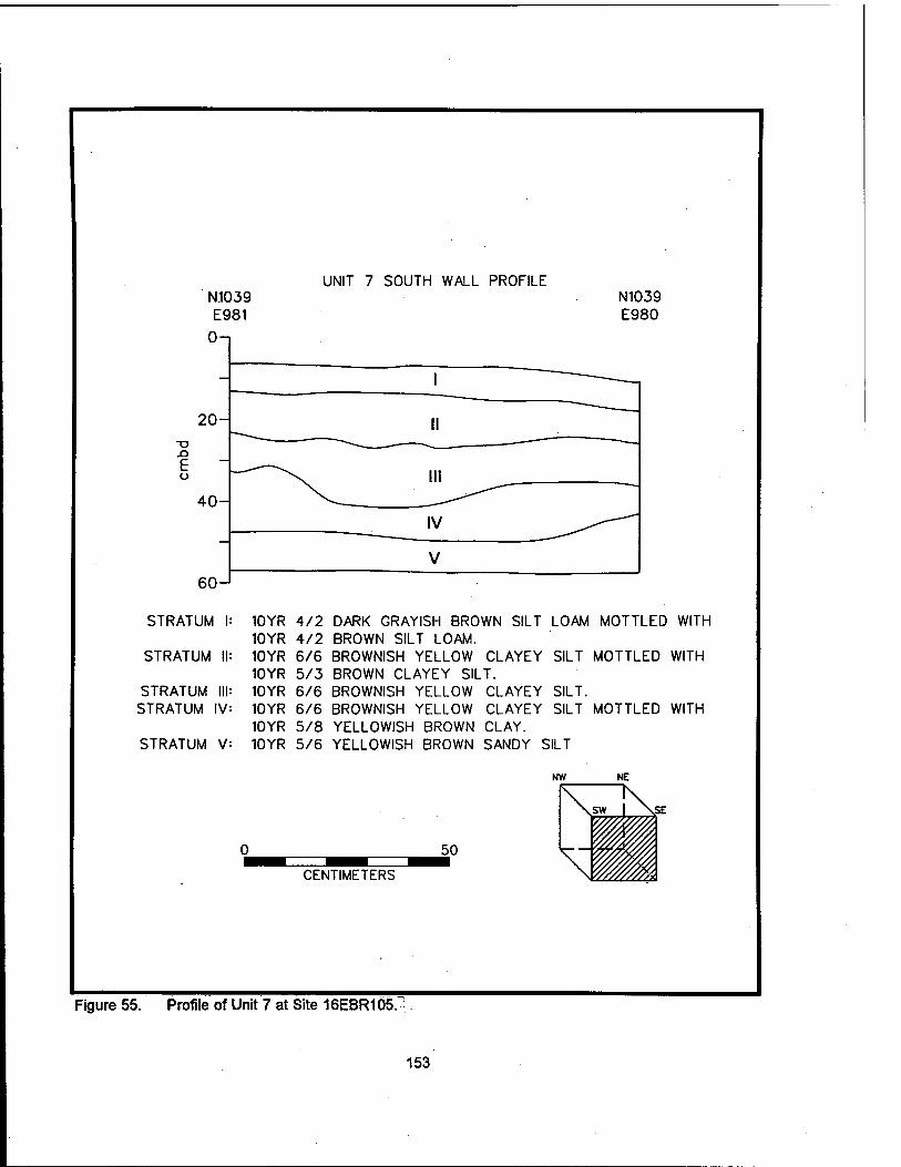
UNIT 7 SOUTH WALL PROFILE
20-
XI E o
40-
eo-J
STRATUM I:
STRATUM II:
STRATUM III: STRATUM IV:
STRATUM V:
N1039 E980
10YR 4/2 DARK GRAYISH BROWN SILT LOAM MOTTLED WITH 10YR 4/2 BROWN SILT LOAM. 10YR 6/6 BROWNISH YELLOW CLAYEY SILT MOTTLED WITH 10YR 5/3 BROWN CLAYEY SILT. 10YR 6/6 BROWNISH YELLOW CLAYEY SILT. 10YR 6/6 BROWNISH YELLOW CLAYEY SILT MOTTLED WITH 10YR 5/8 YELLOWISH BROWN CLAY. 10YR 5/6 YELLOWISH BROWN SANDY SILT
50
CENTIMETERS
Figure 55. Profile of Unit 7 at Site 16EBR105.
153
NORTH WALL PROFILE OF UNIT 8 SHOWING FEATURE 8-1
N1053 E968
N1053 E969
u —
10 —
20- I
30-
Ha
lib I A \
40- Ha
lib | 50- o
60- FEATURE I 8-1
70-
80-
90-
inn — UNEXCAVATED
STRATUM I: 10YR 4/3 BROWN SILTY CLAY LOAM. STRATUM HQ: 10YR 4/3 BROWN CLAYEY SILT MOTTLED WITH
10YR 6/6 BROWNISH YELLOW CLAYEY SILT. STRATUM lib: 10YR 5/6 BORWNISH YELLOW CLAYEY SILT.
FEATURE 8-1 A: 10YR 4/2 DARK GRAYISH BROWN SILT.
Figure 56. Profile of Unit 8 at Site 16EBR105, showing Feature 8-1.
154

Based on the results of the excavation of Unit 8, the area to the north of the house appears to have been seriously impacted by post-occupational plowing. The primary deposits of occupation period material have been mixed with destruction debris, although the lower portions of Feature 8-1 remain intact.
Units 9 and 10. Units 9 and 10 were placed to permit the surface exposure of Features 9-1 and 10-1. These brick pier features associated with the John A. McHugh house were partially visible on the surface prior to excavation; the units were excavated only enough to expose completely the surface of the bricks for recordation. No artifacts were recovered during excavation, and no stratigraphy was exposed or recorded in these units.
Summary of Investigations at Site 16EBR105. Investigations at Site 16EBR105 have pinpointed the location of the McHugh house, built ca. 1859, and present until ca. 1980. Excavations in the house and yard areas have located a number of architectural features associated with the McHugh house (Table 14), and have identified concentrations of cultural material associated with both the occupation of the house and with the destruction and final razing of the structure. None of these deposits appears to retain stratigraphic integrity; nineteenth and twentieth century materials are mixed throughout (Figures 57 - 59). A sheet midden located southwest of the house, identified by Coastal Environments, Inc. in 1993 (Ryan et al. 1994), appears to date from the mid twentieth century, after the house was abandoned.
Four architectural brick features associated with the John A. McHugh house were recorded (Features 4-1, 6-1, 9-1, and 10-1). Feature 4-1 was an H-shaped chimney foundation, and Features 6-1, 9-1, and 10-1 were brick foundation piers. In addition to these architectural features, three subsurface features were recorded; only one of these (Feature 6-2) appears to be associated and contemporary with the main period of occupation of the house. Feature 2-1, a concrete pipe used as a well shaft, was associated with the terminal stages of occupation, and Feature 8-1 was likely a fencepost, not closely associated with the structure.
Areas more than a few meters north or south of the remains of the central chimney foundation (Feature 4-1) have been cleared and plowed. This has severely impacted the integrity of these areas. Dredging of the pond to the west of the house site is likely to have impacted any outbuildings and primary trash deposits from the nineteenth century occupation of the site.
Because of these factors, it is unlikely that significant data about the nineteenth century in East Baton Rouge Parish will be forthcoming from this site. Architectural data also have been seriously compromised by fire, razing, and cattle. For these reasons, no additional testing at Site 16EBR105 is recommended.
155
*«*-« 35»
llltlii
*
i o>|
lili
i^«-<>
TO
Q>
IN- CD
(D
CO
- C\l CD
^ © rr CC CD CD 3 Q-CNI
'S" *•—' ^"S = .. £ o **> ^ 3 r n CO .*! Jr
> Ü (0 © CO ^
w© m ■n ra o c ^ CD CD := -o «Eg — *D <= $ © 2 ■8"!€
CD <D ^ ~ <*-» rt
CM CO
CC
CD S C ^'cö
191 Cm© c © o. CO O) «=j
o E m
u. <? WCM £ w co u. 5 w at = III CD 00
CO ~ ss- ^ ^ 111 0) ^O A -o Q: . OT » O © £ "Ö 111 C\| £ ©O™
« "-K £ »A© o co .. £ o CO «—v (D
CNI °3S^ CO
©8 E -o
CO CO
O u- •E wx: CD
SgSg © _. © £ ° E g-g CD 4: co o
© fc.ix: © J=C--5 CO
m ©
156 D>

c <D Ü
co
CO m
ü w
JZ
k. •2. CD c 'c c CO o Ü c N
CO*
CM (0
^ 0)
(0 (0 n CO
I
o a: m HI
©
w E
%
■■c a c a> £ U
(0 3 O
IS CM <D (\l Ü OT CO
00 m
CO
157
.^ 1? i
\
■*'#S'C'.- i
iO,
i<Df
m
use ''.>•**'*>• «? »« _•>' JK"
fc^:""""' |§1?' •'•:;i'%;£. Bp'.jpA'^;;;"-'"' p|v"ii .'■:■! j«i Rl?"..: *" *• 't:i ".i Kj' "''•'"' ETv ':
w m:-\'"-'-' 0£ &;.-v ■■ UJ ^KV'^"' '■ " :
§«*& jnüüüüüüfül $11 2 »- 111111111 Z UJ O r. ^■■■■■■■i Ö^^^^B
mi
158
to s. -g. U. : -c
M X — 00 vJ CD T- < O
1 Q '"C NH5 a> : > 00 • _
es £ co .*= £ o
.2> CO © £ o .e fil i« ® © J2 ® c co o .a c -° •- o © is "* .E 3 .JJj O O) CT3 S to © iS
tt> iS c
co £ jS u!
.&r? 8 — CO CN J2
ro\9-E £ - h5 &
o 4-< x: >-^
ID c c« si ü^ T- O -o CO
Ȥpo)
i--Js P ©"- ■«-
i2 © co E .2 CO M " S «,E o °> a> *- Q- » — "O 5_ jo p — »
Ä WV "©
(0 eg fc-F
a> w ©
u.

CHAPTER VIII
SUMMARY AND RECOMMENDATIONS
Introduction
During the current cultural resources survey and testing in the Comite River Diversion Project area, a total of 28.28 ha (60 ac) were subjected to Phase I pedestrian reconnaissance and shovel testing. These areas were surveyed because of changes in project alignment after the original corridor survey (Ryan et al. 1994). One new site (16EBR153) was identified during this Phase I testing, and limited metal detector survey was conducted at previously identified Site 16EBR115. In addition to this survey, testing to aid in site delineation was undertaken at previously identified Site 16EBR149 (Springfield Landing). During this testing, a later component of the site, Locus SL-1, was recorded. Delineation testing also was conducted at the site of an unmarked cemetery to the north of the project area in the vicinity of Bayou Baton Rouge.
Phase II excavations included work at Sites 16EBR105,16EBR117, and 16EBR118. The data from this testing permitted evaluation of the eligibility of these sites for nomination to the National Register of Historic Places. Of the three sites, only Site 16EBR117 (Penny Plantation) was considered eligible. Finally, this project included research on the development and nature of the dairy industry in East Baton Rouge Parish, and an assessment of the significance of the standing structures related to the Carney and Bourque dairy complexes. Table 17 lists all recorded sites located within the project area, along with their current status.
Phase I Testing and Delineation
Site 16EBR153 (Locus 16-21
Site 16EBR153 (Locus 16-2) was located in a plowed field in Area 16, adjacent to Carney Road (Figure 17). The site yielded stoneware, ironstone, porcelain, both cobalt and amethyst colored glass, and a single iron fragment. All but the amethyst colored glass was recovered from the surface of the site. According to the landowner, this material originated from a late nineteenth century/twentieth century tenant cabin that stood near this site, and was demolished and bulldozed ca. 1940 -1950. Because of the severe disturbance from bulldozing and later plowing, this site no longer retains stratigraphic integrity; it is not likely to possess potential for significant research, and is not eligible for inclusion in the National Register of Historic Places under Criteria a - d (36 CFR 60.4 [a-d]). No additional testing at Site 16EBR153 is recommended.
Site16EBR115
Previously recorded Site 16EBR115, a small scatter of late nineteenth and twentieth century artifacts, is located adjacent to the Magnolia Grove Baptist Church in an area with a high probability for Civil War era remains. The site was originally evaluated as not eligible for the National Register, and no additional testing was recommended. Because of the site's location, a limited survey by an experienced metal detector operator was conducted. No additional evidence was recovered that would alter the original interpretation of the site (Ryan et al. 1994), or that would add to its significance. Site 16EBR115 is not considered eligible for inclusion in the National Register of Historic Places, and no further work is recommended here.
159
'S
(0 UJ o z UJ a UJ U. UJ a:
a> a>
TO to c TO
•* O) o>
TO CO
c TO
O) a>
re t5 c at
4"
O a>
TO CD
c CD
CJ) .
ra -55 <» I >> is
o> CJ)
TO ^< CD
C CO
1- O) 0
TO «^ CD
C CO
a>
TO CD
c TO
o> o>
TO 0) c TO
o> 0)
co
CD
c TO
O) O)
TO *^ CD
C co
s 0 <r-
CO
a> c co
O) O)
TO *-* CD
c TO $
0. c o
Q) > b l_ 0) >
üä 'E o Ü
(0 z o
Z UJ E S O Ü UJ re
c o TO O)
to > c
TO C o
TJ TJ TO O z
C o TO
.S> to CD > c
TO c o
TJ TJ TO O z
c o TO ,g> Io §
"TO c .o ** TJ TJ CO
O z
>. SI TJ CD
.2 E « 8 Jfi «
8 | 81
3i2 e TJ g s a> ~ ra ^ £ °> p TO -J3 ♦= -K <o c u a> o «J > ü E .£
XI TO TJ £ CD TJ ^i "Ö =
S.i.i TJ >< "5 •E £ E c? §1 8 1S §f AS?? 8^l| > TJ - .E .£ CO O) N ~ J= C CO
CD .ti CO 2 co *- JB CO -. -r « £ 2 £ TO
■s . .2, &■
—: '5" TO £ ™ ^-Ää l?o8 * £ t; <» co 5. £ c
3= .. S c TO CD U) O O) .*t= 0) 33 S3 CO CO CO
.Ir? E = CO ^ TJ
81 £ ■ x: 3 P t)
5 lit
c 0
to .0»
to CD >
TO C O
TJ TJ TO O z
c 0
to CJ)
to SJ c
TO c 0
3-* TJ TJ TO O z
c .0 33 TO .2* to CD > c
tö c 0
TJ TJ TO O z
c .0
to ,□) 3^ CO CD > ,c
15 c 0
TJ TJ CO O z
c 0
to .O)
to CD > c
to c 0
TJ TJ TO O Z
c 0
to .2> to CD > c
to c 0
TJ TJ a 0 z
C O 33 TO .□) 3-* CO CD > c
"5 c 0
TJ TJ CO O z
(0 c o '■*-*
CO
w
< UJ CO z •- 2 O jo t H O £
CD
£i '5> Ö) ■«-* o Z
a> xt !s> a) •s z
a> xi o) 03 o z
TO C
1 £ TJ
CD
■s z
£•1= CO CO 33 O c «= «J "c O O) Q. '»
CD
X) O)
05
0 z
CD
X)
!2> ■55 0 Z
CD
X) '5> Ö) 'S z
CD
XI
» O Z
CD
XI o> 05 ■4-f 0 z
CD X) o>
"55 'S z
CD
XI 'o>
0 z
>
0) (0 (0
0- T3
S o UJ t- z
2.8 iff c C CO fie o 3 o to 0. =5
.2.8 C 01 r: € o 3 o to 0. =5
.2.8
fie o 3 O CO
Q. =6
.2.8 C CO £.€ o 3 o CO 0. =5
•ffi 2 * CD 0
■5 c
2 co E -e ._ *-» TO .CO U. TJ
.2.8
0 CO 0. TJ
.2.8 i S P.-e °^ 0 to Q. TJ
.2.8 i S r. € 0 3 0 CO Q. =5
.2.8 cF c C TO F.-s 0 3 0 CO a TJ
.2.8 C CO
fie 0 3 0 CO 0. TJ
.2.8 E S fi-e 0 3 0 10
GL TJ
.2.8 eff c C TO fi€ c5 3 0 CO a. TJ
08 i S 0 3 0 CO Q. TJ
(0
0) CO (0
Q. O) C
3 ■o TJ <U ■E o o 0)
z o
o CO UJ > z LL o _1 UJ
Si _l
c 2 TO O) c T~- .2 TO
8 5L
f f (0 m
CO o
a. io
t» c TO £ O) c
33 to 3
> o c to
— 5" o> 2 to o> TO *- x: _: 0. TO
(U c TO tf o> c to 3 CD
§ to
— ?■ <■> s to °> TO *~ f _; a. TO
"55 c CO
TO c to CD «^
"CD
g f to
—" 5" CD O) « CJ> co *- .c _; a. co
O) *cÖ *-■ c _: » 3= -g
»^ > TO CJ) 0 S
CO = 0 ■2 «> i CD TO S
|£S ■g ^0) — ■* m J| 01 c CO O) = p TO ■"" TJ 0> f ^ cm 0- co co T-
•s c co
CJ) .c to OJ
g 10
—" ^ co o> TO *- f _: D. CO
c s TO O) C ^ .2 TO
?* 8 1 8& |f f-I CD ■5
re 0 if x: Q. to
CD O)
c ^ .2 CO
»1 8 1
•g ? 3 3=
"1 CD "öS
CO 0
Q. co
'S c TO
o> c
to J) CD > 0 x: CO
—• Zt CD O) « o> TO ■"- x: _; 0. TO
'S c CO
0 c to 3 CD > 0 -C CO
— ?■ 0 s CO o> TO *- x: _: 0. a
CD
C TO
CJ) c to 3 CD > O x: CO
CD CJ) ifl O) CD ■«- x: _; 0. co
CD
c TO
c|
CJ) .c to 3 CD
g x: CO
— ?■ v S CO O) CO «- x: _: Q. TO
c co
D> c 3^ CO CD ** CD > O x; CO
— ^~ <D S to 0 TO *- x: _; Q. TO
CO
.8 (0
15 u
o o a> .c 2 <
z o H a. S ü CO UJ a UJ H
CO
I TO Ü 10 Ü !e
,o 'CZ o to x: £
3 CO
CD
3
■s 3
to O
*CZ o CO
X
a> 'tö
£ 3
■s 3
to _u o
•4-« CO
X
1- a> a s CO
0
IE
ü TZ O ^^ CO
£ a.
'tö
£ 3 ■s 3
»
O to X
<D" g>
• 5 «IT 2 TJ w t5 eg a, .2 .2 3 •£• 0 g 'S » 1 »II I TO 05 X
1 8 CO
■d & '•e TO 0 *c 0 *-• CO
X
1 8 CO
'S
CO
0 'iZ O to if
£
£ 3 s 3
to 0
0
CO
X
1—
CD
8 CO
■5
t: TO O
(0 if
1 8 CO
0
x:
ü 'CZ 0
to !E CD
a.
CD
to
tj 3 '■S TO O
CO
X
1 8 CO
'S 3 '•e TO 'C 0 to X
a> .O (0 1-
UJ 1-
co
p m HI
Ico
CM O
£ m UJ CO
o
£ m UJ CD
s £ m UJ CO
in 0
m UJ
2
CO 0
£ m UJ
0
£ CD UJ CO
CO 0
£ m UJ CO
CJ) 0
£ m UJ CO
0
£ m UJ CO
£ CO UJ CO
CM
£ ffl UJ co
CO
£ m UJ CO
160
■D
0 Si
co UJ u z UJ a. ui u. UI a.
O) TO
0) c (0
if °>
*"! "5 re -JD
s TO *^
■(5
CD
c re
i£ CJ>
TO . *"! re re "55
if- °> i* TO T re re -55
TO TO
re « c re
TO TO ^~
ro «5 c re &
TO TO
to «^ CD
c re 3* cc
in z o < a z UJ S s o u UJ Of
c o re g> to CD > c
«5 c g
TJ to o z
0» -D .a*
3 £ £ o O C g ° E § I g fc C TJ -K IS K 3 2 3 & J= to *- .c ■« TO is cu
I = § " 1 «
i 83 IS2- « o > >. 2 CD ti>
.«= CD « .2 > x: ,2* 1- TJ E > CD O IE
c o
'•4-t re TO «3 CD >
_c
"re e ,o
TJ TJ re o Z
TJ
€ CD
£11 re —
o = '§> §
® ~ to is » o Q CD T3 8Eä re E ^ n " »w
tz o to TO to CD >
re c o
TJ TJ CO O z
c _o to TO to CD > c
to c o
TJ TJ CO O Z
c o re UI
% CD > c
re c o
TJ TJ re o Z
c o 33 CO
.TO 33 CO CD > c
re c o
TJ TJ CO
O z
NA
TIO
NA
L
RE
GIS
TE
R
ST
AT
US
TO
o z
TO 13 *-* o Z
<D n TO CD
o z
CD S "o D
|o. 4? ^o: •= UJ z o
CD
.n TO to o z
CD
.O
TO ä> 'S z
CD -Q
TO
o Z
CD
.£>
TO a) o z
DC O UJ 1- Z
.2.8 ST c C CO fc. € o 3 o co 0. TJ
3 S «B cu O "2 c 9 re E € !-- 3 re .2 u_ TJ
° 8
F.-e o 3 o CO 0. =5
2
CD 8 'S c o Q
E € i-" 3 re .<» U. TJ
.2.8 1= <o fl€ o 3 o co 0. TJ
.2.8 i S r.-e o 3 o CO
Q. TJ
.2.8 i S o 3 o CO a. =5
.2.8 cF c c re fc.-e o 3 o CO 0. TJ
Z o
o 1- co UJ > Z
u. O _i UJ
Si _J
tu c en
£ O) c
to Jg <5 > o CO
co o> re *- £ _; 0. re
'S 5"
1 = i?2 »— o TO tj .E ffl ^
» ® TO
■B S T § 1- w - CD
— ■* ^5 • s JS to TO -J£ re *- ra 0. To §-
•55 c re
TO c to
CD > o f CO
— 5" <D 2 CO °> re ■"-
0. re
« CO CD I
■D "to "2 c ir CD E rat,*™ 5> ><~P >, .E $ > CD ^i
iHiS 6 o <" t3 m
•g E 5 Ä «
<D g ^Z S « 2* ä -st w fisls
„ -co tS « la c <° E S; CD -^ re js __
CD „. 3 TO — CD to TO
— ^ Ä = «D TO ^ jg CO TO (,, ■£ ra T~ "5« co
a. co E e-
c s CO TO
c ^
.2 re
i- 8 2. 8K- 4! ? 3 33 CO CO
i." 3
CD "Ö)
0. to
re TO c ^ .2 re
?1 8 1 8S. 41 g
"-3
re o iF x: 0. co
CO TO c H .2 re S| 8 1 8K- 1.E f-I CO > re 6 ■F x: D. co
z o p 0.
IX U (0 UI Q
UI 1- (0
CD « re o 10
t3 co
re o
o to X
I 8 CO
13
■•e to Ü
1 X
1 s CO
'•e re o o to X
E TJ fD ^
= £ 8 Ö 3 | E
ü^re"-Sre<B"s o re S c ■ - o x: 3^ .2 t: co CD « w o c XrareQ-COrecMco
.. «B 8 «»= ^
1 ?! 3 »1°: ■§ 8 13 '5 fe CD «° 3 J? fi 3 ■■= >c IS
Isliii "5 S 'S 3 m 2 3 co o c uj ♦= » g 8 js «D 8 X a ra 0. C a
1 S CO
o IE
o o •** CO
!c s> a.
1 s CO
o IE
o 'L_ o .•^ CO
£ a.
1 s CO
u !E
o
CO
£ a.
UI 1-
CO
s DO HI ID
CO ^-
5 m UJ
Is
CD
5 m Ui CD
5 m UJ CD
co
Q£ CQ UJ CO
IT—
TO T-
m UJ CD
o CN
m UJ CO
CN
a: m m CD
161
co UI o z
•* Ti- ^- <* -* T TT •<t ■* •»r ■* Tf ra ro o> 0) o> ra ra ra ra ra ra ra ro o> o> ra a> o> ra ra ra ra ra ra 111 DC UJ
*~ *■" *~ ,~ T_ '" ,~ ,~ T~ v- *■ *-
CO ra CO co ra ra ro ra ro ra ra ro L_ 4-> ** 4-> •*-» 4-> ■*-»
UJ 0) at CD CD CD CD CD CD CD CD CD CD or c c c c c C C cz c c c c ra ra ra a co ra CO ro ra ra ra ra >. >» >» >. >. >. >. >. >» >. >. >,
o. a: o. a: a: tt tr a: tc a. a: OL
a. a. a Q. 0. 0. X i X X X X a: ce or Q: a. a.
to z o P <
z z z z z c z a> CD CD CD CD CD CD
II c .o 11 li c
.o c o
c o
c o
E CD ■1 -D E CD o i -S
P c5 E S a> g ra 'S g 'S g ra ro to to to S £ "CD fD £ % 2 z ■D E ra ■D E ■a E ro ra ra .ro ra ■a E ■o E £ -o E UI s E O Ü UJ
o | O) u
4-« CO CD >
o E ra 8
o E ra u CD >
to CD >
*3 CO CD >
to CD >
to o |
ra u
o | O) o
c o E ra 0) 8
ü s c .E g> c _c c c c .E CD % £ C ~ 1)
S3 CO C
I S
it
ra c o
TO
1 s
Eg
ro c o
'•&
ro c o
'•B
ra c o
'•5
ra c o
'■£
15 c .2
£ ra
St onal
tes
n
of th
e lit
y w
as
*s ID
S5 ra o 31
'& '3 S5
ra o
ro o
ro o
ra o
ro o S5
si !Q
3 1» :■= .2 s
< © Z < CD < CD Z z Z Z Z < CD < CD < O. CD
-J D. a> CD U CD < uj co ZI-3
(0 c CD CO
c >> <-■ CD CD CD CD CD >> *-> to c
to c
P O £ 35BS
i 0)
J3 = c JD X) JD J3 JD = c i CD
'5) «5
CD
•S 8 C IE £ c
3>
4-<
ra «5 •**
ro ID 4^
]5> "CD
ra «5
■S 8 £ CD
"O o "O o ra o o o O o o ra "D 73 c z c Q. '5> Z Z z z z 0. 'S £ c
0. O UI (-
2.8 .2.8 5T c
.2.8 ST c
.2.8 5T c
.2 8 .2.8 ro c
.2.8 ST c
.2.8 ° 8 5T c
.2.8 5? c
.2.8 ra c
.2.8 c ra c J3
p ra F. €
P ra P. -e
P ra F.-e
P ro P ro P ro F. € P c
• - k.
P «> P <o F.-e
P ra F.€
P ro c ja
z S3 o 3 o 3 o ^ o 3 o 3 o 3 o 3 o 3 o 3 o 3 b" 3 o co o co o CO o CO o co o CO o CO o CO o CO o co O CO o CO 0. =5 0- =0 Q. =ö 0- =D tt. =5 0- =0 0- =5 a. =5 Q. =5 0- =0 Q. =5 0. =5
z o ra *-« CD >
■D 3 ?«£ a> ■o S f S ■D S ■o S ■a a ■o S CD ■a S" o c o> c ra c ra c ra c ra c o> c ra c c ra JZ
P < o P
CO ro ra ro c co o> co ra CO O) ra o> ro ra co ra ro ro ra CO
.2 ro .2 ra •a co co a:
c I] .2 ra .2 ro .2 ro
c 3 .2 ra .2 ra .2 ro
c 23 .2 co
s* S*. ?* I » 3* I* 1« 1« ra 1 » — CD* 2 CO = c = c S3 CD = c = c = c = c = c = c = c
UI > z
8 51 8 5. Ä = _ CO CD i-
8 g. 8 SL 8 SL 8 5. 85. 8 5, 8 5. "5 > . u a rö CD CO «^ Out) gS- g£ g£ 8& g£ g£ g£ g£ "CD g£
LL O
,55 o> i? ra > CD S ro J5 ra jo ra J5 ra i5 ro j? ra > J? ra 45 iä c = c? ™
t c t c co E
t c t c t c t c t c t c o t c 3 S3 3 S3 3 •«= 3 »s 3 33 3 = 3 = 3 S3 x: 3 S3
-1 UI
CO CO CO CO CO CO CO CO CO CO CO CO CO CO CO CO CO CO CO
--,- Ä s_- £ . - o .. CD .. CD .. CD .. CD i? Ä is £ _;_. j) ■■» *J ^ *J ^ ** — +•* —" ?" — S3 ^^
ul a> "5 co 5
CD m co S
CD 1 _ CD m co 5
CD lü <2 >
CD m <2 >
CD a; co 5
CD "53 2 >
CD öS 10 g co S3 co ra
CD ä> co 5
CD £ ra "> 5. .E
_l co g ra 5 ra g> eh ra o ro o ro o ro o ro o ra o co ■«- ra o <° 5? -5 £ ^ J= £ S. f S f ^ :F ^ JC £ iF J= f j= :F ^ J= _; J= j= f- CO CO
S E B □. CO 0- co 0. co Q. co Q. co 0. co 0. co Q. co Q. ra Q. co
z o i-
B to
CD *3
8 CO
o
o o
e< o *
o •c o
£ o3 £ CD e> CD
ra
k. CD
8 CO
Ü !E
o *P 0 to
CD
p a. E u CO UI Q UJ
o CO
u !c
ü 'k. o to
3 C 8 -
8 8 *5
CM g ■o CO
CO t)
£ -2 ra '€ *- ro
= 1"
.2 '■5 ro ü
'CZ
co S
.2 ■■E ro u
*k_ o to fe
to
C (I) ro £ •2 8 o » to t3
CN [J "O CO
CO t} J= .s s; ? ■«- CO
'= 1
CN CO
TO (0
ro t3 £ >2 ra HE *- ra
= 1
3 C 8 -
CD
£ £ 5 8 c o
o 10 ü !E
.2 o to
C i- j= j= £ 3 o 3 £ £ E B 1 -2 o 3 o 3 £ & !c !c o Ü
co 2 a. a. X ra 1 8 2 8
Q. co s 8 D- co a. co X g !§ X a
CD
0. CD
0. |s_ CN co ** IO CO r^ oo ra o T- CM co
CM CN CN CN CN CN CM CM co co CO co UI v T- f— *—
0) ce o. CC a. a. cc a: cc ce Q: a: C£ JO (0 1-
DQ m m m m m m m m m CD m CO LU UI UI LU UI LU LU LU Ul LU Ul LU
CO co CO CO co co CO CO CO CO CO CO
162
(0 HI o z Ul Of UJ u. Ul a.
OJ OJ
CO
'S c CO
OJ o>
re *-* 0) c re >>
ce
•* o> o>
re *-» CD
C re
a> O)
re a> c co
CJ) O)
CO
'S c co
O) O)
co S c co
o> o
CD
s c CO
O) OJ
CO
s c re
OJ OJ
re S c co
s OJ
co
S c re
T CJ) OJ
re S c co
t OJ o>
re 4-* CD
c re
OJ OJ
CD
S c re
reco
rded
by
Ash
wor
th
and
Mar
kell
1995
; M
arke
lleta
l. 19
97
OJ OJ
to S t5 ■S re 5
CO z o F < a z Ul E S O o Ul a.
c o to ,OJ
to CD > c
re cz o
TJ TJ CO
o Z
o is 'CZ l_ O TJ CJ CD
«2 ?
Si ° I 2 o CO 0)
§8 co 3 CD
li r§ 1- CO
LT O ;o
8 CD
»? £ 0> — E
2 ü 10 CD
3{8 co 3 CD *
i§ CO ™
1- re
LT O
TJ
1 TJ S CD * 1 £ a)
° 1 2 o CO CD
38 co 3 CD *
!§ CO 3,
|o
1- CO
LT O
TJ •c O TJ O CD «1 £ 0) ••- E ° E S 8 CO CD
iS co a CD '
SS CO ™
11 H re
c o re ,g) 1o CD > c
CD c o «-* TJ TJ re o Z
c o
re .2> *-• CO CD > c
re c o
TJ TJ CO O z
c o
re .OJ
CO CD > c
re c o *-<
TJ TJ CO O z
c o re u> tn CD > c
CO c o
TJ TJ re o Z
c o
re .g>
S CD > c
re c o
TJ TJ CD O z
c o re .gj
CO CD > c
CO c 2
TJ TJ re o Z
c o
re S> ^3 CO CD > c
CO c o
TJ TJ CD o Z
c o
to ,OJ
to s c
CO c o
TJ TJ CO o Z
re ■_ m CD J= OL ra
O CO
851 © o — s » {? s?g ü CD si IE "x c
Q. CD O
5 CD fc TJ nj ±s ^-» CD
o» ä « ^ CO □> <D
83 §>§- CD i2 *J ■— CO CO _- CD 2 <■> 2 -o n ra o _ a s><s CD 3 CO ,
CD co CD .«2
CZ o
S3 CO O) v^ CO CD > c
to cz .2
TJ TJ ca o Z
-> a. < Ul CO Z H 3 O «0 H
<ajfe
XJ
to o Z
•s s C IE 3 C O O) 0- to
re c
1 S TJ
B co
.cz
B S TJ c
B CO
3 CD TJ C
CD
'5> CD ♦^ o Z
CD ^3
'c3J
CD
S z
CD XI '5J
CD
o z
CD S3 '5J
CD
o z
CD
XI '5J
CD
o z
CD
XI CT CD
o Z
CD
X>
"OJ
CD
O Z
CD X» CD
ID
o z
>. «- ^ cz CO CO zs u C CC 3 = O O) 0. °cö
CD
XI
2> 05 S Z
a: o Ul i- z
2 8 CO cz C CD
P.-e o 3 O CO
a. =6
2 8 re c P re P. € o 3 o CO
a. =5
3 re CD 3 2 c o co E -e i_- 3
re .2 U. TJ
CD
S * CD ö
'S = o n E € '*-' 3 'rä » U- TJ
.2.8 E » 153 O CO
D. TJ
o 8 E « o 3 O CO
0- TJ
°8 i « P. € 6 3 o CO
a. T5
°8 E » PL-e o 3 o co a. T1
.a 8 P co P.€ o 3 o CO
a. T5
° 8 E « o 3 o CO
a. TJ
.2.8 E » P.-e o 3 o CO
a. T5
3.8
P.€ o 3 o CO
0. T»
.2.8 re c P re
o 3 o CO
a. Ti
cz o
■» 2 CD
£
CD to
2 8 cF cz p <D P.-E o 3 o CO
CL =5
z o p <
i- V) Ul > z u. o _l Ul
ft -1
c o
is a> ö o
8 4! 3 CO
a> en CO sz CL
c o
ts CD
8 8 « 3 CO
CD CO re
sz a.
o c
>; CD
£ 3 CO
cz CO
« 'S CD <S TJ E 8.» —- o CD '■«
CO«
£ 8
o cz
CD
£ 3 CO
c re
CD <S TJ E 8.» — o CD '■«
Sol ä: 8
CD
c CO
ot O) c
CO CD
CD > o
CO
— 5" ai o> to o> re '-
SZ _j 0. re
CD
c CO >.
CC
at c CO CD
s o f CO
— 5" o> S co o> co '- £ _. CL CO
CD
c re >. CC
OJ c
CO CD
§ o sz CO
— 5" CD 2 CO o> CO ▼- .E _; 0. re
CD
c CD
o> c
CO CD
% o sz CO
— ?■
co o> re «- f _; 0. CD
CD
C re >. a: OJ c
CO CD
I sz CO
— ^ CO OJ CO *- sz _; 0. re
CD
c CD
£ o> c
CO CD
O SZ CO
— ?■
CO OJ ca *- sz _; CL CO
CD
C co >> a. OJ c
10 CD
CD
§ x: CO
— 5" o> S CO OJ re »- x: _j Q. re
CD
C CD
at c
CO CD
o sz CO
— ?■ o> S CO OJ CO *- x: _j 0. co
CD
C CD
o> c
CO CD
CD > o sz CO
— ? »> SB CO OJ CO *- x: _; D. re
x: 2 CO CD
m <o o £
■s -0- g, g o c -E -•
TJ oj JO CO
O- CO - CD
•HI co {= o -c CO P. CZ CO
o. £ £ &
TJ cz CO _:
CZ «D
«2 CD CD
° £ u ca
8^ 4! I? 3 S CO CO
J_- 3 CD "Ü) ^^
CD o OJ J= x: OJ D. co 1-
TJ CD
C
c o u
z o p a. 02 U (0 Ul a Ul i-
55
ü 'k_ o
"So x:
2 •- CZ a) CO £ o co
■£Z Ü o » to "S 'B SI e^ CL re
sz 55
TJ S c re CD
5 1
2 3 to <=
if 8
£• 3
h ? c o-S 'fe <o 3 'S » re X "5.
3 CD
E CD Ü
_o *cz o «3 if
£> 3 'S 8 -
CD
8 8 5 T5 3 3 JBC X co
TJ 3 re o CO
_ü
3 u
■£ E ■S 15 tt 8
TJ 3 CO
o CO
Ü
o o
|l ■S s £ 8
ü 'sz
TJ 3 re o CO
o o «5 !E £ a.
o 'sz
TJ 3 CD
o CO
ü ■c
CO
£ a.
TJ 3 CO
O CO
o
3 u
* 2 tt 8
o sz
TJ 3 re o CO
o *c o to J=
s a.
u !E
TJ 3 re o CO
ü *c o S !c & a.
u sz ££
TJ 3 CO
o CO
Ü 'ZZ o to sz CD
0.
If if x: _i OJ TJ "- Ö) o «: 'E OJ 0 cz .2 a. 1 W
£• 3
8 - £ * °2 S
5 o 3 3
X co
r^
0) .a (D f-
Ul i-
55
CO
CD UJ co
in co
DC m Ul CO
CO co
a: m Ul CO
CO
a. m Ul CO
CO co
a. m Ul CO
CO
a m Ul CO
o
cr: m Ul CO
^■
m Ul co
CM
cn m ui CD
co
a. m Ul CO
I-
a. m Ul CO
UJ
tr: m Ul CO
CO
CC m Ul CO
OJ ^>
an m Ul CO
CO
£ m Ul CO
163

Site 16EBR149 (Springfield Landing)
The Springfield Landing site (16EBR149), recorded in 1995, is located south of the project area, adjacent to Profit Island Chute. Springfield Landing served as a Federal supply depot, and was occupied during the siege of Port Hudson. Previously recorded material recovered from the Springfield Landing site (16EBR149) consisted of in-situ nailed planks, Federal issue canteen fragments, and a bugle-shaped infantry emblem; these artifacts were found eroding from the cutbank of Profit Island Chute, at a depth of approximately 1.8 - 2.4 m (6 - 8 ft) from the present surface, and approximately 1,500 m (4,921 ft) south of the project area. When first recorded, it was presumed that the site continued into the current project area. This assumption was based on the estimated size of Springfield Landing as shown in contemporary engravings, and on oral testimony from local residents who claimed that they had retrieved Civil War era material from the banks of Cooper Bayou.
Testing included five trenches, each approximately 10 m (32.8 ft) in length that were excavated by back-hoe between the southern boundary of the project area to the banks of Cooper Bayou. These trenches were excavated with a backhoe to a depth of 2.4 m (8 ft); auger tests from the base of each trench extended another 2 m (6.56 ft). None of these trenches or auger tests displayed any evidence of Civil War era activity. The only evidence of cultural activity was found at the confluence of Cooper Bayou and Profit Island Chute, where a late nineteenth/early twentieth century fishing or hunting camp site (Locus SL-1) was recorded. Intensive bankline survey along Profit Island Chute and Cooper Bayou also failed to produce any evidence of cultural activity.
Locus SL-1. This locus was recorded on the southern natural levee of Cooper Bayou, at the confluence of Cooper Bayou and Profit Island Chute (see Figure 1, Sheets 1 and 2 and Figure 20). Cultural material recovered from this site included iron can fragments, fragments from a clear glass embossed panel medicine bottle dating from post ca. 1894, wire nails, suspender buckles, a brass 38 caliber Smith & Wesson centerfire cartridge casing, dated from post 1877, three lead shotgun pellets, and unidentified fragments of copper and iron (see Table 6 and Appendix I). Based on the recovered material, Locus SL-1 is presumed to date from the late nineteenth/early twentieth centuries, and has been characterized as a small fishing or hunting camp. The extremely light density and the nature of the recovered materials make it unlikely that these remains represent a long, continuous period of occupation at the site. It is not likely that SL-1 will provide information significant to our understanding of the time period or the region, and it is not considered significant in terms of the Criteria for Significance for the National Register. No additional testing at Locus SL-1 is recommended.
Recommendations for Site 16EBR149. While no evidence of Civil War era activity was located within the immediate project area at Site 16EBR149, the site remains potentially eligible for inclusion in the National Register of Historic Places. The most intensively occupied sections of the site appear to lie outside of the project area, however. Project impact on Site 16EBR149 primarily will consist of erosion at the mouth of Cooper Bayou, in the general location of Locus SL-1. This locus is not considered eligible for inclusion in the National Register of Historic Places. Backhoe testing and bankline survey in this area did not reveal any other evidence of intensive occupation here. While there is little likelihood of significant Civil War data being recovered from this portion of Site 16EBR149, it is recommended that the area be periodically inspected to determine if erosion has revealed any evidence of Civil War era occupation in this portion of the site.
Cemetery Delineation in Area 16
During the current project, an unmarked cemetery located north of the project area (see Figure 1, Sheets 1 and 2 and Figure 18) was mapped. A series of trenches excavated within the project area and supplemented by a thorough pedestrian reconnaissance both within and slightly north of the project area,
164

were used to ensure that the southern boundary of the cemetery did not fall within the proposed project right-of-way. Five trenches, totaling 205 linear m (672.5 linear ft), were oriented north-south on the northern edge of Area 16, and immediately east of Bayou Baton Rouge. No evidence of burials, grave shafts, or other cultural activity was identified within the project area during these excavations.
Within the known portion of the cemetery, only fragments of headstones remain, but a number of grave shafts are apparent. Erosion associated with the bayou has created deep erosional gullies extending for approximately 70 - 80 m (229.6 - 262.4 ft) along each side of the water course. This area, located directly east of the cemetery, was intensively surveyed; no evidence of burials was identified. The steep erosional gullies adjacent to the bayou would make any intact burials extremely unlikely in this area. The Comite River Diversion Project plans are to clear and dredge along Bayou Baton Rouge. Based on the results of trenching south of the cemetery, and on the severe erosion present east of the cemetery, it has been determined that the cemetery does not extend into the current project area, or into the area of direct project effect.
Phase II Testing and Evaluation
Site 16EBR105
Site 16EBR105 originally was recorded during investigations conducted by Coastal Environments, Inc. (Ryan et al. 1994). At that time, the site was assessed as a significant resource, based on integrity of location, setting, and associations (Ryan et al. 1994:109). To assess more clearly the importance and the integrity of this site, the current Scope of Work stipulated that additional shovel testing and excavation units be placed at the site. Current investigations included 23 additional shovel tests and eight 1 x 1 m (3.3 x 3.3 ft) excavations units.
Excavations in areas of the post ca. 1859 house and yard succeeded in locating a number of architectural features associated with the McHugh house (Table 14). In addition, excavations identified concentrations of cultural material associated with both the occupation of the house and with the destruction and final razing of the structure in ca. 1980. Unfortunately, none of these deposits appear to retain stratigraphic integrity, and there is a general mixing of nineteenth and twentieth century materials. A sheet midden located southwest of the house, identified by Coastal Environments, Inc. in 1993 (Ryan et al. 1994), appears to date from the mid twentieth century, after the abandonment of the house ca. 1920 (Ryan et al. 1994).
Four above-grade, brick features and three subsurface features were recorded; of the subsurface features, only Feature 6-2, a posthole, appeared to be contemporary with the main period of occupation of the house. Areas north and south of the central chimney foundation (Feature 4-1) have been cleared and plowed, severely impacting their integrity. Dredging of a farm pond immediately west of the house site would have impacted any outbuildings and primary trash deposits from the nineteenth century occupation of the site. Architectural data have also been seriously compromised by fire, razing, and later cattle grazing activities. Because of these factors, it is unlikely that significant data related to nineteenth century East Baton Rouge Parish will be forthcoming from this site. This site is not judged eligible for nomination to the National Register of Historic Places, and no additional testing at Site 16EBR105 is recommended.
Site 16EBR117 (Penny Plantation^
Site 16EBR117, the core of the late eighteenth and nineteenth century Penny Plantation, originally was recorded in 1993 by Coastal Environments, Inc. First established by James Penny ca. 1798, the farm has remained largely intact as an agricultural enterprise; it currently is owned by Mr. Bowman Carney, Jr.
165
The Penny Plantation (Site 16EBR117) has been the site of three main dwellings, constructed ca. 1798, 1806, and 1940. A ca. 1927 dairy complex is still extant; it was built from timbers salvaged from a nineteenth century hay barn that stood on the same site. Some evidence remains of associated labor quarters that stood at Site 16EBR118 (Figure 26). Finally, exploratory excavations conducted during the current project produced evidence of intact deposits of late eighteenth and nineteenth century materials associated with the occupation of the plantation.
Phase II testing at Site 16EBR117I included the excavation of shovel tests, systematic metal detector survey in one portion of the site, and the excavation of 15 1 x 1 m (3.3 x 3.3 ft) units. A total of six features included postholes and drainage ditches associated with the nineteenth century and early twentieth century occupation (Table 9).
Based on recovered data, the earliest structure, built by James Penny post ca. 1798, was likely to have been located in the area of the avenue of the oaks, adjacent to the present Carney Road. Carney Road was built in the 1920s in the approximate location of the old Springfield Landing Road. Deposits in this area yielded late eighteenth/early nineteenth century ceramics, a white ball clay pipe stem fragment, buttons, and other artifacts indicative of an early nineteenth century occupation. While areas currently in pasture have been plowed, those lands that presently are in the front yard of the Carney home are substantially undisturbed; early deposits retain stratigraphic integrity. No architectural features were encountered during testing, but brick in course was noted at the northern end of the Carney graveled drive.
The present backyard of the Carney house, constructed ca. 1940 on the site of the earlier 1806 house, shows evidence of stratified domestic deposits from the nineteenth century. In some cases, these deposits have suffered minor disturbance from twentieth century gardening and other activities; in other cases, however, these deposits appeared to have been sealed by debris from the 1940s house construction. A drainage ditch feature (Feature 10-1) to the west of the present house contains stratified fill from the nineteenth century.
The Penny Plantation site (16EBR117) possesses intact domestic deposits associated with its occupation between the late eighteenth and the twentieth centuries; it is an excellent example of the development of agricultural enterprise in East Baton Rouge Parish. Because the site appears to retain intact deposits from antebellum, postbellum, late historic, and early modern occupations, it is expected to provide significant data about nineteenth and twentieth century occupation, and developmental patterns in East Baton Rouge Parish. Site 16EBR117 is eligible for nomination to the National Register of Historic Places under Criterion D of the National Register Criteria for Evaluation of Significance (36 CFR 60.4 [a-d]).
Recommendations for Site 16EBR117 (Penny Plantation). The Penny Plantation offers an excellent opportunity to track occupational and economic patterns over a span of almost two centuries of continuous occupation at the site. Comprising extant structures, domestic middens, and architectural features that range from the beginning of the nineteenth century to the present, the site encompasses the entire breadth of domestic and agricultural occupation in the parish.
Potential foci of research include a study of changes in intrasite patterning over the intervening years. Changes in the economic base and political climate of the parish may have affected not only agricultural methods, but also domestic arrangements, labor requirements, foodways, and material choices. The development and expansion of Baton Rouge has gradually exerted a stronger influence over the economy of the rural hinterlands, and today the Penny Plantation area is quickly becoming a suburban enclave. Effects of this gradually increasing urban influence may be discernable in the material goods in use at the plantation. The development of the dairy industry at Penny Plantation and in the neighboring area during the early twentieth century was directly influenced by this growing proximity to Baton Rouge; dairy products found a ready market in the city.
166

A comparison of plantation layout and activity patterns during antebellum and postbellum periods should also be addressed. Comparison of these patterns with those of other plantation types also can be made. In what way is the land-locked Penny Plantation similar to the sugar, rice, and cotton plantations with immediate access to the river? Are status differences apparent in recovered ceramic data? Was the plantation's proximity to Springfield Landing Road adequate for maintaining close market contact during the nineteenth century, or is isolation apparent as market lag?
To address questions of this nature, any future mitigation plans should include investigation of at least three major areas of the Penny Plantation site. These areas are 1) the front yard (avenue of the oaks), containing intact late eighteenth/early nineteenth century deposits; 2) the back and side yards of the existing Carney house, containing stratigraphically intact domestic debris from the nineteenth century house; 3) the area surrounding and to the east of the dairy barn complex, which formerly contained agricultural support structures like a smithy.
Because the areas immediately surrounding the Carney house have never been plowed, and are largely stratigraphically intact, investigations will require the excavation of controlled 1 x 1 m (3.3 x 3.3 ft) and 1 x 2 m (3.3 x 6.6 ft) units. In some areas, units should be combined into block or area excavations, to provide wide area visibility of subsurface features.
In addition to these archeological strategies, mitigation investigations at the Penny Plantation should include detailed, HABS/HAER recordation of the dairy barn (SS-39) and the associated milk house (SS-40). Systematic oral interviews with Mr. Bowman Carney, Jr., should be conducted; he was born on the farm, and he and his father performed much of the twentieth century renovations. His ability to supply temporal data, details on construction techniques, locational information, and historical context could prove invaluable to the documentation of the twentieth century portion of this study.
Site16EBR118
Previously recorded Site 16EBR 118 lies outside of the current project corridor, but was examined because of its likely association with Site 16EBR117. Site 16EBR118 has been identified as a small scatter of late nineteenth - early twentieth century domestic debris, and is the probable location of former labor/tenant quarters for the Penny Plantation. During Phase II examination, shovel testing, metal detector testing, and excavation of three 1 x 1 m (3.3 x 3.3 ft) units was completed. Results of this testing indicated that agricultural activities had adversely impacted the majority of the site. One recorded feature (Feature 14-1) was identified as a posthole, possibly related to a structure at the site; the upper portion of the feature had been truncated by plow disturbance. No other features were recorded, but evidence of an undisturbed, subsurface occupational plane was recorded in Unit 16, located in the wooded area adjacent to Bayou Baton Rouge.
The widespread nature of agricultural disturbance at the site, and the light density of artifactual materials recovered from Site 16EBR118, suggest that this site is unlikely to provide significant research data. The site does not meet the necessary criteria for eligibility for nomination to the National Register of Historic Places (36 CFR 60.4 [a-d]). This site lies outside of the proposed project corridor, and no further work is recommended at Site 16EBR118.
The Carney and Bourque Dairy Complexes
Two groups of standing structures associated with the early twentieth century dairy industry in East Baton Rouge Parish were recorded by Coastal Environments, Inc. during the initial survey of the project area (Ryan et al. 1994). In order to assess the significance of these two complexes, and to establish their
167
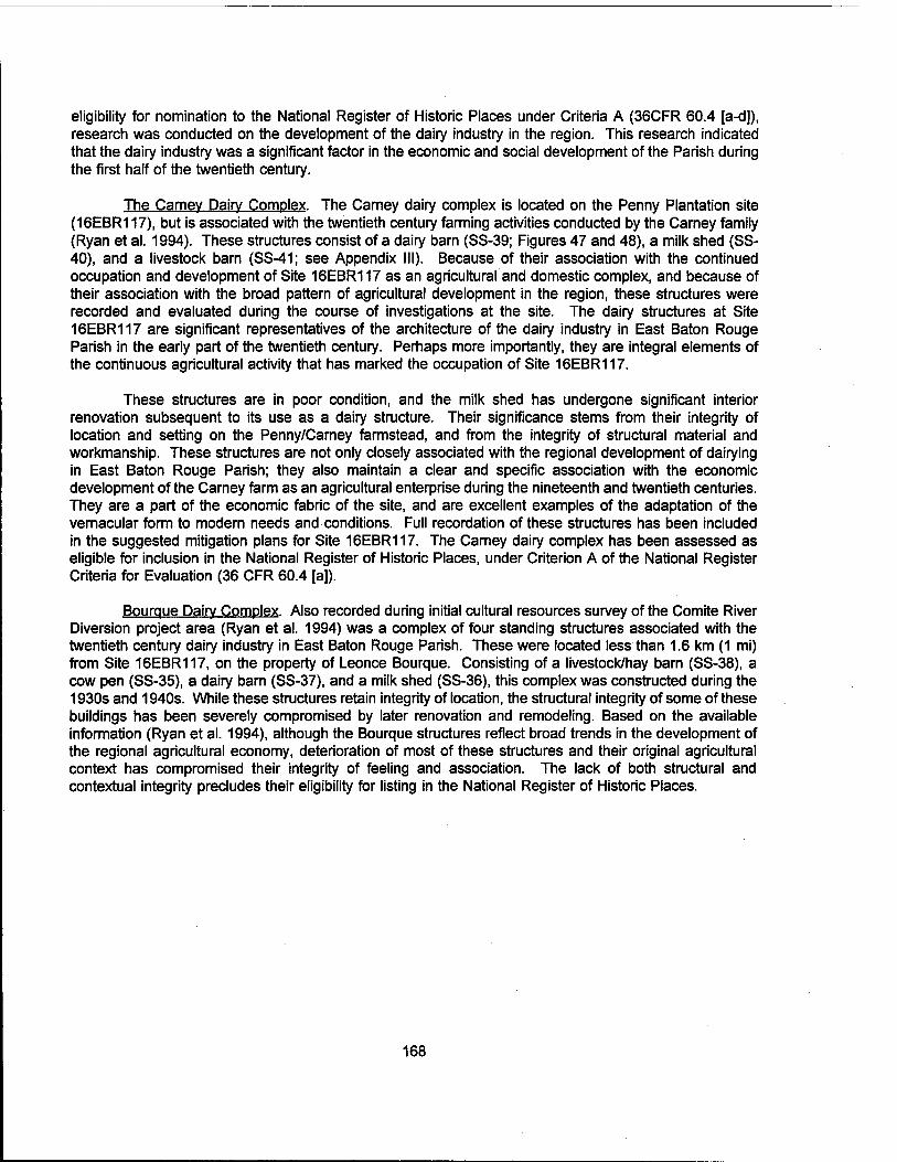
eligibility for nomination to the National Register of Historic Places under Criteria A (36CFR 60.4 [a-d]), research was conducted on the development of the dairy industry in the region. This research indicated that the dairy industry was a significant factor in the economic and social development of the Parish during the first half of the twentieth century.
The Carney Dairy Complex. The Carney dairy complex is located on the Penny Plantation site (16EBR117), but is associated with the twentieth century farming activities conducted by the Carney family (Ryan et al. 1994). These structures consist of a dairy barn (SS-39; Figures 47 and 48), a milk shed (SS- 40), and a livestock barn (SS-41; see Appendix III). Because of their association with the continued occupation and development of Site 16EBR117 as an agricultural and domestic complex, and because of their association with the broad pattern of agricultural development in the region, these structures were recorded and evaluated during the course of investigations at the site. The dairy structures at Site 16EBR117 are significant representatives of the architecture of the dairy industry in East Baton Rouge Parish in the early part of the twentieth century. Perhaps more importantly, they are integral elements of the continuous agricultural activity that has marked the occupation of Site 16EBR117.
These structures are in poor condition, and the milk shed has undergone significant interior renovation subsequent to its use as a dairy structure. Their significance stems from their integrity of location and setting on the Penny/Carney farmstead, and from the integrity of structural material and workmanship. These structures are not only closely associated with the regional development of dairying in East Baton Rouge Parish; they also maintain a clear and specific association with the economic development of the Carney farm as an agricultural enterprise during the nineteenth and twentieth centuries. They are a part of the economic fabric of the site, and are excellent examples of the adaptation of the vernacular form to modern needs and conditions. Full recordation of these structures has been included in the suggested mitigation plans for Site 16EBR117. The Carney dairy complex has been assessed as eligible for inclusion in the National Register of Historic Places, under Criterion A of the National Register Criteria for Evaluation (36 CFR 60.4 [a]).
Bourque Dairy Complex. Also recorded during initial cultural resources survey of the Comite River Diversion project area (Ryan et al. 1994) was a complex of four standing structures associated with the twentieth century dairy industry in East Baton Rouge Parish. These were located less than 1.6 km (1 mi) from Site 16EBR117, on the property of Leonce Bourque. Consisting of a livestock/hay barn (SS-38), a cow pen (SS-35), a dairy barn (SS-37), and a milk shed (SS-36), this complex was constructed during the 1930s and 1940s. While these structures retain integrity of location, the structural integrity of some of these buildings has been severely compromised by later renovation and remodeling. Based on the available information (Ryan et al. 1994), although the Bourque structures reflect broad trends in the development of the regional agricultural economy, deterioration of most of these structures and their original agricultural context has compromised their integrity of feeling and association. The lack of both structural and contextual integrity precludes their eligibility for listing in the National Register of Historic Places.
168
REFERENCES CITED
Addington, Lucille R. 1986 Lithic Illustration: Drawing Flaked Stone Artifacts for Publication. Prehistoric Archeology and
Ecology, University of Chicago Press, Chicago, Illinois.
Anderson, Aubrey L, William R. Bryant 1990 Gassy sediment occurrence and properties: northern Gulf of Mexico. Geo-Marine Letters
10:209-220.
Athens, William P., Susan Barrett Smith, Charlotte Donald, Paul Heinrich, Jennifer Cohen, and Thomas Neumann
1993 Phase I Cultural Resources Investigation of the Louisiana Portion of the Florida Gas Transmission Company Phase III Expansion Project. Prepared by R. Christopher Goodwin & Associates, Inc., New Orleans, for Florida Gas Transmission Company, Houston.
Austin and Hunt 1991 A Cultural Resources Evaluation of the Proposed Landfill Areas at the Georgia Pacific
Corporation Port Hudson Operations in East Baton Rouge Parish, Louisiana. Prepared by Geo-Marine, Inc., submitted to Georgia Pacific Corporation.
Autin, W.J., AT. Davison, B.J. Miller, and F.E. Lindfors-Kearns 1989 Mount Pleasant Bluff, in Quaternary Geomorphology and Stratigraphy of the Florida Parishes,
Southeastern Louisiana, J. Mossa and W.J. Autin, eds., 25-32. Guidebook Series No. 5, Louisiana Geological Survey, Baton Rouge.
Autin, W.J. 1985 Alluvial Morphology and Stratigraphy of a Meandering Segment of the Amite River,
Southeastern Louisiana. Southeastern Geo/ogy26(2):95-110.
Autin, W.J., S.F. Burns, B.J. Miller, R.T. Saucier, and J.I. Snead 1991 Quaternary Geology of the Lower Mississippi Valley, in Quaternary Nonglacial Geology:
Coterminous U.S., R. B. Morrison, ed., pp. 547-582. Geological Society of America, Boulder, Colorado.
Bergeron, Maida Owens and Joyce Jackson 1989 "East Baton Rouge and Livingston Parishes", in Folklife in the Florida Parishes, Louisiana
Folklife Program, Office of Cultural Development, Department of Culture and Tourism, and the Center for Regional Studies, Southeastern State University, Baton Rouge, Louisiana.
Blitz, John H. 1991a Community Organization in a Small-Scale Mississippian Society: Implications for Chiefdom
Formation. PhD. dissertation, City University of New York. University Microfilms, Ann Arbor.
1991b Choctaw Archaeology in Mississippi. Paper presented at the 1991 Conference on Historical and Underwater Archaeology, Florida.
169

Brain, Jeffery P. 1971 The Lower Mississippi Valley in North American Prehistory. In Arkansas Archaeological
Survey, Fayetteville.
1983 Paleo-lndian in the Lower Mississippi Valley. Proceedings of the 33rd Southeastern Archaeological Conference, Bulletins 20 and 21.
Brookes, S. O., and C. Taylor 1986 Tchula Period Ceramics in the Upper Sunflower Region. In The Tchula Period in the Mid-
South and Lower Mississippi Valley. Proceedings of the 1982 Mid-South Archaeological Conference. Archaeological Report No. 17, Mississippi Department of Archives and History, Jackson, Mississippi.
Brown, C.A. 1980 Wildflowers of Louisiana and Adjoining States. Louisiana State University Press, Baton Rouge.
Brown, C.L. and L.K. Kirkman 1990 Trees of Georgia and Adjacent States. Timber Press, Portland.
Brown, Ian 1981 The Southeastern Check Stamped Pottery Tradition: A View from Louisiana. Midcontinental
Journal of Archaeology, Special Papers No. 4, The Kent State University Press.
Brunsden, D., and R.H. Kesel 1973 Slope Development on a Mississippi River Bluff in Historic Time. Journal of Geology 81:576-
597.
Bruseth, J. E. 1991 Poverty Point Development as Seen at the Cedarland and Claibome Sites, Southern
Mississippi. In The Poverty Point Culture: Local Manifestations, Subsistence Practices, and Trade Networks, p.7-25, Edited by Kathleen M. Byrd, Geoscience & Man 29, Louisiana State University.
Burns, Francis P. 1932 West Florida and the Louisiana Purchase: An Examination into the Question of Whether It
Was Included in the Territory Ceded by the Treaty of 1803. The Louisiana Historical Quarterly 15:391-416.
Byrd, Kathleen Mary 1976 The Brackish Water Clam (Rangia cuneata): A Prehistoric "Staff of Life" or a Minor Food
Resource. Louisiana Archaeology, Vol. 3:1-22. (1977)
1994 Tchefuncte Subsistence Practices at the Morton Shell Mound, Iberia Parish, Louisiana. Louisiana Archaeology 16:1-128. (For 1989)
Caillouet, Eiida (compiler) 1976 Baker The First 200 Years, 1776-1976. Project of The Heritage 76 Committee of the
American Revolution Bicentennial Commission. Moran Industries, Baton Rouge.
Caldwell, Joseph R. 1958 Trend and Tradition in the Prehistory of the Eastern United States. American Anthropological
Association Memoir 88, American Anthropological Association, Washington, D.C.
170

Callahan, Errett 1979 The Basics of Biface Knapping in the Fluted Point Tradition: A Manual for Flintknappers and
Lithic Analysts. Archaeology of Eastern North America 7:1-180.
Campbell, J. and P. Marshall 1975 The Science of Providing Milk for Man. McGraw-Hill Book Co., New York.
Campbell, J. L, J. R. Morehead, and A. F. Servello 1990 Data Recovery at 16VN791: A Multi-Component Prehistoric Site in the Birds Creek Drainage,
Fort Polk Military Reservation, Fort Polk, Louisiana. Report of Investigations No. 188, New World Research, Inc.
Cantley, C. E. and J. R. Kern 1984 Cultural Resources Evaluations: Ft. Polk, Louisiana. Submitted by Gilbert/Commonwealth Inc.
to Archaeological Services Branch, National Park Service Southeast Region Office, Atlanta.
Carmena, Lena (compiler) 1951 The McHugh Family. Typescript on file, Genealogy Room, Bluebonnet Regional Branch, East
Baton Rouge Parish Public Library, Baton Rouge.
Chambers, Henry E. 1898 West Florida and Its Relation to the Historical Cartography of the United States. In Anglo-
American Relations and Southern History, pp. 2-59. Johns Hopkins University Studies in Historical and Political Science, vol. XVI, No. 5. The Johns Hopkins Press, Baltimore.
Champomier, P. A. 1860 Statement of the Sugar Crop Made in Louisiana (1844-1862). Cook, Young, and Company.
New Orleans, Louisiana.
Chapman, J., and J. Adavasio 1977 Textile and Basketry Impressions from Icehouse Bottom, Tennessee. American Antiquity
42:620-25.
Chapman, J. and A. B. Shea 1981 The Archaeobotanical Record: Early Archaic Period to Contact in the Lower Little Tennessee
River Valley. Tennessee Anthropologist 6:61-84.
City Council of the City of Baton Rouge and Police Jury of East Baton Rouge 1889 The Parish of East Baton Rouge, Its Resources and Attractions; Also a Sketch of the City of
Baton Rouge.
Clendenin, W.W. 1892 The Florida Parishes of East Louisiana and the Bluff Prairie, and Hill Lands of Southwest
Louisiana, in Louisiana Geological Survey, pt. 3, p. 186-200.
Coates, Earl J. and Dean S. Thomas 1990 An Introduction to Civil War Small Arms. Thomas Publications, Gettysburg, Pennsylvania.
Comeaux, Malcolm L. 1989 The Cajun Barn. The Geographical Review 79(1 ):47-62.
171
Connaway, J. M., S. O. McGahey, C. H. Webb, and R. T. Saucier 1977 Teoc Creek: A Poverty Point Site in Carroll County, Mississippi. Archaeological Report No. 3,
Mississippi Department of Archives and History, Jackson, Mississippi.
Core, H.A., W.A Cote, and AC. Day 1979 Wood Structure and Identification. Syracuse University Press, Syracuse.
Crabtree, Don E. 1972 An Introduction to Flintworking. Occasional Papers of the Idaho State University Museum No.
28, Pocatello, Idaho.
Dance, R.E., B.J. Griffis, B.B. Nutt, AG. White, S.A. Lytle, and J.E. Seaholm 1968 Soil Survey of East Baton Rouge Parish, Louisiana. U.S. Department of Agriculture, Soil
Conservation Service in cooperation with Louisiana Agricultural Experiment Station.
Davis, Edwin Adams 1971 Louisiana, A Narrative History. 3rd ed. Claitor's Publishing Division, Baton Rouge.
DeJarnette, D. L, E. B. Kurjack, and J. W. Cambron 1962 Stanfield-Worley Bluff Shelter Excavations. Journal of Alabama Archaeology 8(1,2): 1 -124.
Dennell, R.W. 1976 The Economic Importance of Plant Resources Represented on Archaeological Sites. Journal
of Archaeological Science 3:229-247.
Deshotels, M. 1983 Cultural Resources Survey of LA 19, Baker-Zachary Highway, East Baton Rouge Parish.
Submitted to the Louisiana Department of Transportation and Development.
Doering, J.A. 1956 Review of Quaternary Surface Formations of the Gulf Coast Region. American Association of
Petroleum Geologists Bulletin 40:1816-1862.
Doering, J.A. 1935 Post-Fleming Surface Formations of Southeast Texas and South Louisiana. American
Association of Petroleum Geologists Bulletin 19:651-688.
Duhe, Brian J. 1976 Preliminary Evidence of a Seasonal Fishing Activity at Bayou Jasmine. Louisiana Archaeology,
Vol. 3:33-74.(1977)
Durham, CO., Jr., OH. Moore, Jr., and B. Parsons 1967 An Agnostic View of the Terraces: Natchez to New Orleans, in Geological Society of America
Field Trip Guidebook Annual Meeting, p. E1-E22.
East Baton Rouge Parish Courthouse, Baton Rouge (Conveyance Records - Conveyance Books, Conveyance Indices, Original Notarial Acts Books, Originals/Bundles, Parish Judges Books, Plan Books, Sheriffs Sales Books - Clerk of Court)
1995 Tax Assessment Records - Tax Assessor and Map Room
172

Edmonds, David C. 1983 The Guns of Port Hudson, Volume One: The River Campaign. Acadiana Press, Lafayette,
Louisiana.
Ellis, Frederick S. 1981 St. Tammany Parish, L'Autre C6t§ du Lac. Pelican Publishing Company, Gretna, Louisiana.
Ensor, H. Blaine 1987 San Patrice and Dalton Affinities on the Central and Western Gulf Coastal Plain. Bulletin of
the Texas Archeological Society, Vol. 57.
Fenton, Carroll Lane and Mildred Adams Fenton 1940 The Rock Book. Doubleday, New York.
Fike, Richard E. 1987 The Bottle Book: A Comprehensive Guide to Embossed Medicine Bottles. Gibbs M. Smith,
Inc. Peregrine Smith Books, Salt Lake City.
Fisk, H.N. 1938a Geology of Grant and LaSalle Parishes. Bulletin No. 10, Louisiana Geological Survey, Baton
Rouge.
1938b Pleistocene Exposures in Western Florida Parishes, Louisiana, in Contributions to the Pleistocene History of the Florida Parishes of Louisiana, H.N. Fisk, ed., 3-26. Geological Bulletin 12, Louisiana Department of Conservation, Baton Rouge.
Florence, Gene 1990 The Collector's Encyclopedia of Depression Glass. Collector Books, Paducah, Kentucky.
Ford, J. A. and G. I. Quimby 1945 The Tchefuncte Culture, an Early Occupation of the Lower Mississippi Valley. Memoirs of the
Society for American Archeology, No. 2.
Ford, Janet L. 1988 An Examination of the Twin Lakes Phase. In Middle Woodland Settlement and Ceremonialism
in the Mid-South and Lower Mississippi Valley. Proceedings of the 1984 Mid-South Archaeological Conference, Archaeological Report No. 22:61-67. Mississippi Department of Archives and History, Jackson.
Gagliano, S.M. 1963 A Survey of Preceramic Occupations in Portions of South Louisiana and South Mississippi.
The Florida Anthropologist 16:105-132.
Gagliano, S. M., and H. F. Gregory 1965 A Preliminary Survey of Paleo-lndian Points from Louisiana. Louisiana Studies 4(1):62-77.
Gagliano, Sherwood M., and Roger T. Saucier 1963 Poverty Point Sites in Southeastern Louisiana. American Antiquity 28:320-327'.
Garland, R. 1949 The Story of Medicine. Houghton Mifllin Co., Boston.
173
Gibson, Jon L. 1974 The Rise and Decline of Poverty Point. Louisiana Archaeology, No. 1:8-36.
1979 Poverty Point Trade in South Central Louisiana: An Illustration from Beau Rivage. Louisiana Archaeology, Vol. 4:91-116.
1984 The Troyville-Baytown Issue. The Troyville-Baytown Period in Lower Mississippi Valley Prehistory: A Memorial to Robert Stuart Neitzel. Louisiana Archaeology 9:31-64. (For 1982)
1985a An Evaluatory History of Archaeology in the Ouachita Valley of Louisiana. Louisiana Archaeology, Vol.10:25-102.(For 1983)
1985b Mounds on the Ouachita. Prehistory of the Ouachita River Valley, Louisiana and Arkansas. Louisiana Archaeology 10:171-270. (For 1983)
1994 Lower Mississippi Valley Exchange at 1100 B.C., Exchange in the Lower Mississippi Valley and Contiguous Areas in 1100 B.C., Louisiana Archaeology 17:1-11. (For 1990)
Gibson, Jon L., and J. Richard Shenkel 1988 Louisiana Earthworks: Middle Woodland and Predecessors. In Middle Woodland
Ceremonialism in the Mid-South and Lower Mississippi Valley. Proceedings of the 1984 Mid- South Archaeological Conference, pp. 7-18. Mississippi Department of Archives and History, Jackson.
Gilbert, B. Miles 1980 Mammalian Osteology. Missouri Archaeological Society, Inc.: Columbia, Missouri.
Gilbert, B. Miles, Larry D. Martin, and Howard G. Savage 1985 Avian Osteology. B. Miles Gilbert: Flagstaff, Arizona.
Goodwin, R. Christopher, William P. Athens, Stephen Hinks, Lawrence L. Hewitt, and William A. Morgan 1990 Literature Search and Research Design Amite River and Tributaries project, Ascension, East
Baton Rouge, and Livingston Parishes, Louisiana. Prepared by R. Christopher Goodwin & Associates, Inc. Submitted to the U.S. Army Corps of Engineers, New Orleans District.
Goodyear, Albert C. 1974 The Brand Site: A Techno-functional Study of a Dalton Site in Northeast Arkansas. Arkansas
Archaeological Survey Research Series No. 7.
1982 The Chronological Position of the Dalton Horizon in the Southeastern United States. American Antiquity 47:382-395.
Graham, R. W., C. V. Haynes, D. L. Johnson, and M. Kay 1981 Kimmswick: A Clovis-Mastodon Association in Eastern Missouri. Science 213:1115-1117.
Gramly, Richard Michael and Robert E. Funk 1991 Olive Branch: A Large Dalton and Pre-Dalton Encampment at Thebes Gap, Alexander County,
Illinois. The Archaic Period in the Mid-South: Proceedings of the 1989 Mid-South Archaeological Conference. Mississippi Department of Archives and History, Archaeological Report No. 24, Jackson, Mississippi.
174
Gregory, Hiram F., Jr. 1979 Delson Chevalier, 1919-1978. Louisiana Archaeology, Vol. 4:123-126.
Green, F.J. 1979 Phosphatic Mineralization of Seeds from Archaeological Sites. Journal of Archaeological
Science 6:279-284.
Green, James A., Jr. 1991 Calcasieu Point: A Formal Description. Central States Archaeological Journal. Central States
Archaeological Societies, Inc., Kirkwood, Missouri.
Greenwell, Dale 1984 The Mississippi Gulf Coast, in Perspectives on Gulf Coast Prehistory, edited by Dave D. Davis,
pp. 125-155. Gainesville: University of Florida Press.
Griffin, John W. 1974 Investigations in Russell Cave. Publications in Archaeology 13. National Park Service,
Department of the Interior, Washington, D.C.
Guevin, B. L, R. A. Weinstein, and S. T. Duay 1988 Preliminary Analysis of the 1987 L.A.S. Field School Investigations at Fontainebleau State
Park, St. Tammany Parish, Louisiana. Louisiana Archaeological Society Newsletter 15(3):5-10.
Guy, John and Joel Gunn 1983 Settlement Pattern Hypothesis for West Central Louisiana. Manuscript on file.
Haag, William G. 1971 Louisiana in North American Prehistory. Melanges 1. Baton Rouge: Louisiana State University.
Hahn, Thurston H.G, III 1994 Archaeological and Historical Investigations of the Price-Williams Cemetery and the Mahier
Building, Rosehill Plantation, West Baton Rouge Parish, Louisiana. Submitted by Coastal Environments, Inc. to the U.S. Army Corps of Engineers, New Orleans District.
Harris, G.D., and AC. Veatch 1899 A Preliminary Report on the Geology of Louisiana. Louisiana Geological Survey, Baton Rouge.
Harvey, William Clunie, M.D., D.P.H., M.R.San I., and Harry Hill, M.R., San I., A.M.I.S.E., M.S.I.A. 1936 Milk: Production and Control. H.K. Lewish & Co., Ltd., London.
Hastorf, C.A. and V.S. Popper (editors) 1988 Current Paleoethnobotany. The University of Chicago Press, Chicago.
Haynes, C. V., Jr. 1991 Geoarchaeological and Paleohydrological Evidence for a Clovis Age Drought in North America
and its Bearing on Extinction. Quaternary Research 35:438-450.
Hilgard, E.W. 1866 On the Quaternary Formations of the State of Mississippi. American Journal of Science
91:311-325.
175

Hilgard, E.W. 1869 Geology of Lower Louisiana. American Journal of Science 47:77-88.
Hillard, S.B. 1972 Hog Meat and Hoecake: Food Supply in the Old South, 1840-1860. Southern Illinois
University Press, Carbondale, Illinois.
Hillman, M. 1990 Paleoindian Settlement on the Macon Ridge, Northeastern Louisiana. Louisiana Archaeology
12:203-218. (For 1985)
Hillson, Simon 1986 Teeth. Cambridge Manuals in Archaeology, Cambridge University Press, Cambridge.
Hinks, Stephen, Paul V. Heinrich, Ralph Draughon, Jr., Jennifer Cohen, and William P. Athens 1993 Supplemental Cultural Resources Investigations and Site Testing for the Pointe Coupee to
Arbroth Levee Enlargement and Seepage Control Project, West Baton Rouge Parish, Louisiana. Submitted by R. Christopher Goodwin & Associates, Inc. to the U.S. Army Corps of Engineers, New Orleans District.
Hoadley, R.B. 1990 Identifying Wood: Accurate Results with Simple Tools. Taunton Press, Newtown, CT.
Hudson, Charles 1978 The Southeastern Indians. The University of Tennessee Press.
Humphrey, R.L. and D. Stanford 1979 Pre-Uano Cultures of the Americas: Paradoxes and Possibilities. The Anthropological Society
of Washington, Washington, D.C.
Hunter, CG. 1989 Trees, Shrubs, and Vines of Arkansas. The Ozark Society Foundation, Little Rock, AR.
Jackson, Joy J. 1989 The Piney Woods - Tangipahoa, St. Helena, and Washington Parishes. In Folklife in the
Florida Parishes, pp. 51-60. Louisiana Folklife Program, Division of the Arts, Office of Cultural Development, Department of Culture, Recreation, and Tourism, Baton Rouge, and Center for Regional Studies, Southeastern Louisiana University, Hammond, Louisiana.
Jenkins, Ned J. 1974 Subsistence and Settlement Patterns in Western Middle Tennessee Valley during the
Transitional Archaic-Woodland Period. Journal of Alabama Archaeology 20:183-193.
1979 Miller Hopewell of the Tombigbee Drainage. In Hopewell Archaeology: The Chillicothe Conference, edited by David S. Brose and N'omi Greber, pp. 171-180. Kent State University Press, Kent, Ohio.
Jennings, Virginia Lobdell 1974 The Plains and the People: A History of Upper East Baton Rouge Parish. Third Edition. Land
and Land Printers. Baton Rouge, Louisiana.
176

1989 The Plains and the People, A History of Upper East Baton Rouge Parish. 3rd ed., rev. Land and Land Printers, Baton Rouge. (Originally published in 1974).
Jeter, M. D., and H. E. Jackson 1990 Poverty Point Extraction and Exchange: The Arkansas Lithic Connections. Exchange in the
Lower Mississippi Valley and Contiguous Areas in 1100 B.C., Louisiana Archaeology 17:133- 206.
1994 Poverty Point Extraction and Exchange: The Arkansas Lithic Connections. Exchange in the Lower Mississippi Valley and Contiguous Areas in 1100 B. C., Louisiana Archaeology 17:133- 206. (For 1990)
Jones, Dennis, and Malcolm Shuman 1986 Archaeological Atlas and Report of Prehistoric Indian Mounds in Louisiana. Submitted to the
Division of Archaeology. Report on file at the Division of Archaeology.
1988 Atlas and Report on Prehistoric Aboriginal Mound Sites in Livingston, St. Helena, St. Tammany, Tangipahoa, and Washington Parishes, Louisiana. Submitted by Louisiana State University Museum of Geoscience to the U.S. Department of the Interior and the Louisiana Division of Archaeology, Department of Culture, Recreation and Tourism, Baton Rouge.
Jones, Olive, and Catherine Sullivan 1985 The Parks Canada Glass Glossary. Studies in Archaeology, Architecture, and History, National
Historic Parks and Sites Branch, Parks, Canada.
Kidder, T. R. 1988 Protohistoric and Early Historic Cultural Dynamics in Southeast Arkansas and Northeast
Louisiana, A.D. 1542-1730. Print in 1995 by U.M.I. Dissertation Information Service, Ann Arbor, Michigan.
1992 Timing and Consequences of the Introduction of Maize Agriculture in the Lower Mississippi Valley. North American Archaeology 13(1): 15-41.
Kidder, Tristram R., and Gayle J. Fritz 1993 Investigating Subsistence and Social Change in the Lower Mississippi Valley: The 1989 and
1990 Excavations at the Reno Brake and Osceola Sites. Journal of Field Archaeology 20(3):281-297.
Kisatchie Regional Environmental Management Group, Inc. (KREMG) 1982 The Cultural Resources along Louisiana Highway 16 Between Watson and Amite: The
Intensive Survey. Submitted by Kisatchie Regional Environmental Management Group, Inc. to the Louisiana Department of Transportation and Development, Baton Rouge.
1984 CRMP Level II Cultural Resources Investigations along Route La. 16 Between Watson and Amite. Submitted by Kisatchie Regional Environmental Management Group, Inc. to the Louisiana Department of Transportation and Development, Baton Rouge.
Kniffen, F. B., H. F. Gregory, and G. A. Stokes 1987 The Historic Indian Tribes of Louisiana: From 1542 to the Present. Louisiana State University
Press, Baton Rouge.
177
Knight, Vernon J. 1984 Late Prehistoric Adaptation in the Mobile Bay Region, in Perspectives on Gulf Coast
Prehistory. Edited by Dave D. Davis, pp. 198-215. University of Florida Press/Florida State Museum, Gainesville.
Kolb, C.R., F.L. Smith, and R.C. Silva 1975 Pleistocene Sediments of the New Orleans-Lake Pontchartrain Area. U.S. Army Engineer
Waterways Experiment Station, Vicksburg, Mississippi.
Kovel, Ralph and Terry Lovel 1986 Kovels'New Dictionary of Marks. Crown Publishers, Inc., New York.
Krieger, Alex D. 1953 New World Culture History: Anglo-America. In Anthropology Today, edited by A.L. Kroeber.
University of Chicago Press, Chicago.
Largent, F. B., M. R. Waters, and D. L. Carlson 1991 The Spatiotemporal Distribution and Characteristics of Folsom Projectile Points in Texas.
Plains Anthropologist 36(137):323-341. Plains Anthropological Society.
Lee, F.N. 1985 Floods in Louisiana, Magnitude and Frequency (4th ed.). Water Resources Technical Report
No. 36, Office of Highways, Louisiana Department of Transportation and Development, Baton Rouge.
Lehmann, G. R. 1982 The Jaketown Site Surface Collections from a Poverty Point Regional Center in the Yazoo
Basin, Mississippi. Archaeological Report No. 9, Mississippi Department of Archives and History, Jackson, Mississippi.
Lentz, David L. 1986 Archaeobotanical Remains from the Hester Site: The Late Paleo-lndian and Early Archaic
Horizons. Midcontinental Journal of Archaeology 11 (2):269-279.
Lord, Francis A. 1995 Civil War Collector's Encyclopedia, Vol. I and II. Blue & Grey Press, Edison, New Jersey.
Louisiana State University & A & M College 1957 Floor plan and cross section of a two cow dairy barn designed. Cooperative design done with
the U.S. Department of Agriculture.
Lowerie, Walter, and Walter S. Franklin 1834 Document Number 234: Reports of the Land Commissioners East and West of Pearl River on
Private Land Claims, January 5, 1816. American State Papers. Public Lands: Documents, Legislative and Executive.... Volume 3. Gales and Seaton. Washington, D.C.
Lowery, G.H. 1974 The Mammals of Louisiana and Its Adjacent Waters. Louisiana State University Press, Baton
Rouge.
Lowrie, Walter, and Walter S. Franklin (editors) 1834 American State Papers, Class VIII, Public Lands, vol. III. Gales and Seaton, Washington, D.C.
178

Mainfort, Robert C. 1986 Pre- and Early Marksville Ceramics and Chronology in the Mid-South: A Perspective from
Pinson Mounds. In The Tchula Period in the Mid-South and Lower Mississippi Valley. Proceedings of the 1982 Mid-South Archaeological Conference, Archaeological Report No. 17:52-62, Mississippi Department of Archives and History, Jackson, Mississippi.
Martin, A.C. and W.C. Barkley 1961 Seed Identification Manual. University of California, Berkeley.
Marshall, R. 1976 An Archaeological Site Survey of Four Proposed Pipeline Construction Sites in Louisiana.
Submitted to Florida Gas Transmission Company.
Mason, Ronald J. 1962 The Paleo-lndian Tradition in Eastern North America. Current Anthropology 3:227-278.
Matson, G.C. 1916 The Pliocene Citronelle Formation of the Gulf Coastal Plain, in United States Geological
Survey, Professional Paper, p. 167-92.
McGee, W.ü. 1891 The Lafayette Formation, in U.S. Geological Survey 12th Annual Report, p. 347-521.
McHugh Family File n.d. Collection of McHugh family information. Information on file, Genealogy Room, Bluebonnet
Regional Branch, East Baton Rouge Parish Public Library, Baton Rouge.
Mclntire, William G. 1958 Prehistoric Indian Settlements of the Changing Mississippi River Delta. Louisiana State
University, Coastal Studies Series Ho A, Baton Rouge, Louisiana.
Menn, Karl 1964 The Large Slaveholders of Louisiana, 1860. Pelican Publishing Company. New Orleans,
Louisiana.
Meyers, Rose 1976 A History of Baton Rouge, 1699-1812. Louisiana State University Press, Baton Rouge.
Miller, George L. 1980 Classification and Economic Scaling of 19th Century Ceramics. Historical Archaeology 14:1-
40. Society for Historical Archaeology.
1991 A Revised Set of CC Index Values for Classification and Economic Scaling of English Ceramics from 1787 to 1880. Historical Archaeology 25( 1): 1 -25.
Minnis, P.E. 1981 Seeds in Archaeological Sites; Sources and Some Interpretive problems. American Antiquity
46(1):143-152.
Moerman, D.E. 1986 Medicinal Plants of Native America. University of Michigan Museum of Anthropology Technical
Reports, No. 19. Ann Arbor, Michigan.
179
Mossa, J. 1989 Present Terrace Concept, in Quaternary Geomorphology and Stratigraphy of the Florida
Parishes, Southeastern Louisiana, J. Mossa and W.J. Autin, eds., 10-20. Guidebook Series No. 5, Louisiana Geological Survey, Baton Rouge.
Mossa, J., and W.J. Autin, eds. 1989 Quaternary Geomorphology and Stratigraphy of the Florida Parishes, Southeastern Louisiana.
Guidebook Series No. 5, Louisiana Geological Survey, Baton Rouge.
Muller, Jon 1978 The Southeast. In Ancient North Americans, edited by J. D. Jennings, pp. 373-420. W. H.
Freeman and Company, New York.
Napier, John Hawkins, III 1985 Lower Pearl River's Pineywoods, Its Land and People. Center for the Study of Southern
Culture, University of Mississippi, University, Mississippi.
Neitzel, Robert S. and J. Stephen Perry 1978 A Prehistory of Central and North Louisiana. Manuscript on file at R. Christopher Goodwin &
Associates, Inc., New Orleans.
Nelson, Lee H. 1968 Nail Chronology as an Aid to Dating Old Buildings. History News, Volume 24, No.
11.
Neuman, Robert W. 1984 An Introduction to Louisiana Archaeology. Louisiana State University Press, Baton Rouge.
Newton, Milton B., Jr. 1981 The Comprehensive Plan for St. Helena Parish, Louisiana; Historic Preservation Study, Volume
I.
1989 The Material Cultural Landscape of the Florida Parishes in Historical Perspective. In Folklife in the Florida Parishes, pp. 20-32. Louisiana Folklife Program, Division of the Arts, Office of Cultural Development, Department of Culture, Recreation, and Tourism, Baton Rouge, and Center for Regional Studies, Southeastern Louisiana University, Hammond, Louisiana.
New World Research 1980 A Cultural Research Survey of a Proposed Transcontinental Gas Pipeline Project in East
Feliciana and East Baton Rouge, Parishes, Louisiana. Prepared by New World Research, Inc. for EMANCO, Inc.
Nichols, L. 1978 Cultural Resources Survey of 19 Microwave Tower and Substations in Louisiana, Cajun Electric
Power Cooperative, Inc. Prepared by Espey, Huston and Associates, Inc., for Cajun Electric Power Cooperative, Inc.
Norman, Benjamin Moore 1858 Plantations on the Mississippi River from Natchez to New Orleans.
180
Olsen, Stanley J. 1964 Mammal Remains from Archaeological Sites: Part I, Southeastern and Southwestern United
States. Papers of the Peabody Museum of Archaeology and Ethnology, Vol. LVI, No. 1. Harvard University, Cambridge.
1979 Osteology for the Archaeologist. Papers of the Peabody Museum of Archaeology and Ethnology, Vol. 56, Nos. 3, 4, & 5. Harvard University, Cambridge.
Parmalee, P. W. 1962 Faunal Remains from the Stanfield-Worley Bluff Shelter. Journal of Alabama Archaeology
8:112-114.
Parmalee, P. W., R. B. McMillian, and F. B. King 1976 Changing Subsistence Patterns at the Rogers Shelter. In Prehistoric Man and His
Environments: A Case Study in the Ozark Highlands, edited by W. R. Wood and R. B. McMillian, pp. 141-62. Academic Press, New York.
Parsons, B.E. 1967 Geological Factors Influencing Recharge to the Baton Rouge Ground-Water System, with
Emphasis on the Citronelle Formation. Unpublished M.S. thesis, Louisiana State University, Baton Rouge.
Pearsall, D.M. 1989 Paleoethnobotany. Academic Press, New York.
Peebles, Christopher S., and Susan M. Kus 1977 Some Archaeological Correlates of Ranked Societies. American Antiquity 42:421-448.
Peebles, Christopher S., and Cyril B. Mann, Jr. 1983 Culture and Chronology in the Lubbub Creek Archaeology Locality. In Excavations in the
Lubbub Creek Archaeological Locality, edited by C. S. Peebles, pp. 64-78, vol. 1, Prehistoric Agricultural Communities in West Central Alabama. Report Submitted to the U.S. Army Corps of Engineers, Mobile District.
Perino, Gregory 1985 Selected Preforms, Points and Knives of the North American Indians. Volume 1. Pointsand
Barbs Press, Idabel, Oklahoma.
Perrault, S.L. 1993 Cultural Resource Survey of Exxon Pipeline Company's Proposed Pipeline Route, East Baton
Rouge and East Feliciana Parishes, Louisiana. Prepared by Coastal Environments, Inc., for Exxon Pipeline Corporation.
Perrault, S. L, and R. A. Weinstein 1994 National Register Eligibility Testing at the Sarah Peralta Site, East Baton Rouge Parish,
Louisiana. Prepared for the Division of Archaeology, Office of Cultural Development, Louisiana Department of Culture, Recreation and Tourism, Coastal Environments, Inc., Baton Rouge.
Phillips, Phillip 1970 Archeological Survey in the Lower Yazoo Basin, Mississippi, 1949-1955. Papers
of the Peabody Museum, Vol. 60. Harvard University, Cambridge.
181

Phillips, P., J. A. Ford, and J. B. Griffin 1951 Archaeological Survey in the Lower Mississippi Alluvial Valley, 1940-1947. Papers of the
Peabody Museum of American Archaeology and Ethnology Vol. 25, Harvard University, Cambridge.
Pirtle, Thomas 1926 History of the Dairy Industry. Mijonnier Brothers Co., Chicago.
Quimby, George I., Jr. 1951 The Medora Site, West Baton Rouge Parish, Louisiana. Field Museum of Natural History,
Anthropological Series, Vol. 24, No. 2, pp. 81-135. Chicago.
Police Jury of East Baton Rouge 1889 East Baton Rouge: Its Resources and Attractions. Brandao & Gill. New Orleans, Louisiana.
Ramenovsky, John 1987 Vectors of Death: The Archaeology of European Contact. University of New Mexico Press,
Albuquerque.
Ransom, J.E. 1981 Harper and Row's Complete Field Guide to North American Wildlife, Eastern Edition. Harper
and Row, New York.
Ritchie, William A. 1935 The Lamoka Lake Site, the Type Station of the Archaic Algonkian Period in New York.
Researches and Transactions, New York State Archaeological Association 7.
Rivet, Philip, G. 1976a Scotlandville - Alsen Highway (North Section), Route U.S. 61 and Alsen - Port Hudson
Highway Route U.S. 61, East Baton Rouge Parish. Prepared for the Louisiana Department of Transportation and Development.
1976b Comite River Bridge and Approaches, Route LA64, East Baton Rouge Parish. Prepared for the Louisiana Department of Transportation and Development.
1978 Junction LA 67 - Indian Mound Highway, Route LA 64, East Baton Rouge Parish. Prepared for Louisiana Department of Transportation and Development.
Rosen, N.C. 1969 Heavy Mineral and Size Analysis of the Citronelle Formation of the Gulf Coastal Plain. Journal
of Sedimentary Petrology 39:1552-1565.
Round Table Club 1980 Historic Markers of East Baton Rouge Parish Louisiana. Louisiana Federation of Women's
Clubs. Baton Rouge, Louisiana.
Ryan, Joanne, Wayne Lawrence Coco, Whitney J. Autin, and William D. Reeves 1994 Cultural Resources Survey of the Proposed Comite River Diversion Alignment, East Baton
Rouge Parish, Louisiana. Prepared for the U.S. Army Corps of Engineers, New Orleans District. Coastal Environments. Baton Rouge, Louisiana.
182
Saucier, R.T. 1963 Recent Geomorphic History of the Pontchartrain Basin, Louisiana. Coastal Studies Series No.
9, Louisiana State University Press, Baton Rouge.
1974 Quaternary Geology of the Lower Mississippi Valley. Research Series No. 6, Arkansas Archeological Survey, Fayetteville.
1981 Current Thinking on Riverine Processes and Geological History as Related to Human Settlement in the Southeast. Geoscience and Man 22:7-18.
1994 Geomorphology and Quaternary Geologic History of the Lower Mississippi Valley. U.S. Army Engineer Waterways Experiment Station, Vicksburg, Mississippi.
Scarry, CM., and L.A. Newsom 1992 Archaeobotanical Research in the Calusa Heartland. In Culture and Environment in the
Domain of the Calusa, edited by W.H. Marquardt, pp. 375-401. Institute of Archeology and Paleoenvironmental Studies, Monograph 1. University of Florida, Gainesville.
Schornak, J. L. 1964 Civil War Bullets. The American Rifleman 112(10):62-63.
Servello, Frank 1983 University of Southwestern Louisiana Fort Polk Archaeological Survey and Cultural Resources
Management Program. Submitted by the University of Southwestern Louisiana to the U.S. Army Corps of Engineers, Fort Worth Division.
Shenkel, J. Richard 1974 Big Oak and Little Oak Islands: Excavations and Interpretations. Louisiana Archaeology, Vol.
1:37-65.
1981 Pontchartrain Tchefuncte Site Differentiation. Louisiana Archaeology 8:21-35.
Sibley, J.A., Jr. 1972 A Study of the Geology of Baton Rouge and Surrounding Southeast Louisiana Area. Claitor's
Publishing Division, Baton Rouge.
Smith, Steven D. 1986 Salvage Excavation at 16EBR64. Prepared for the Louisiana Division of Archaeology.
Smith, B.D. 1986 Archaeology of the Southeastern United States: From Dalton to de Soto, 10,500 B.P. - 500
B.P. In Advances in World Archaeology 5:1 -92, edited by F. Wendorf and A. Close. Academic Press, New York.
1987 The Independent Domestication of Indigenous Seed-Bearing Plants in Eastern North America. In Horticultural Economies of the Eastern Woodlands, edited by William Keegan, pp. 3-48. Southern Illinois University, Carbondale. Center for Archaeological Investigations Occasional Paper 7.
183
Smith, Steven D., Philip G. Rivet, Kathleen M. Byrd, and Nancy W. Hawkins 1983 Louisiana's Comprehensive Archaeological Plan. State of Louisiana, Department of Culture,
Recreation and Tourism, Office of Cultural Development, Division of Archaeology, Baton Rouge.
Snead, J.I., and R.P. McCulloh, compilers 1984 Geologic Map of Louisiana. Louisiana Geological Survey, Baton Rouge. Scale 1:500,000.
South, Stanley 1977 Method and Theory in Historical Archaeology. Academic Press, New York.
Speaker, John Stuart, Joanna Chase, Carol Poplin, Herschel Franks, and R. Christopher Goodwin 1986 Archeological Assessment of the Barataria Unit, Jean Lafitte National Historical Park.
Submitted by R. Christopher Goodwin & Associates, Inc., to the National Park Service, Southwest Region, Santa Fe.
Speer 1979 Reloading Manual Number Ten for Rifle and Pistol. Developed and edited by the research
staff of Speer, Omark Industries, Inc., Lewiston, Idaho.
Spencer, William H. 1980 Cultural Resources Survey of a Proposed Right-of-Way Near Port Hudson, East Baton Rouge
Parish, Louisiana. Prepared by Southern Archaeological Research, Inc., for Mid-Louisiana Gas Company.
Springer, James W. 1974 The Bruly St. Martin Site and its Implications for Coastal Settlement in Louisiana. Louisiana
Archaeology, Vol. 1:75-82.
Steponaitis, Vincas P. 1986 Prehistoric Archaeology in the Southeastern United States, 1970-1985. Annual Review of
Anthropology 15:363-404.
1991 Contracting Patterns of Mississippian Settlement. In Chiefdoms: Power, Economy, and Ideology, edited by Timothy Earle, pp. 193-228. Cambridge University Press, Cambridge.
Story, D. A. 1990 Cultural History. In The Archeology and Bioarcheology of the Gulf Coastal Plain: Volume 1 by
Story, D. A, J. A. Guy, B. A. Burnett, M. D. Freeman, J. C. Rose, D. G. Steele, B. W. Olive, and K. J. Reinhard, Research Series 38, Arkansas Archeological Survey.
Story, D. A., J. A. Guy, B. A. Burnett, M. D. Freeman, J. C. Rose, D. G. Steele, B. W. Olive, and K. J. Reinhard
1990 The Archeology and Bioarcheology of the Gulf Coastal Plain: Volume 1. Arkansas Archeological Survey Research Series No. 38.
Stuart, David R. and J.A. Greene 1983 An Archeological Survey of the Proposed Pointe Coupee - Arbroth Levee Enlargement (M-270
to 249.5-R). Pointe Coupee and West Baton Rouge Parishes, Louisiana. Submitted by the National Park Service, Denver Service Center, to the U.S. Army Corps of Engineers, New Orleans District.
184
Swanton, J. R. 1946 The Indians of the Southeastern United States. Smithsonian Institution Bureau of American
Ethnology Bulletin 137. Reprinted 1979. Washington, D.C.
Switzer, Ronald R. 1974 The Bertrand Bottles: A Study of 19th Century Glass and Ceramic Containers. National Park
Service, U.S. Department of the Interior, Washington D.C.
Toth, Edwin Alan 1988 Early Marksville Phases in the Lower Mississippi Valley: A Study of Culture Contact Dynamics.
Archaeological Report No. 21. Mississippi Department of Archives and History, Jackson, Mississippi in cooperation with The Lower Mississippi Survey, Harvard University.
Toulouse, Julian Harrison 1971 Bottle Makers and Their Marks. Thomas Nelson, Inc., Camden, New Jersey.
Turner, Ellen Sue and Thomas R. Hester 1985 A Field Guide to Stone Artifacts of Texas Indians. Texas Monthly Press, Austin.
U.S. Government n.d. Abstract of U.S. Land Entries and Selections, Parish of East Baton Rouge. Manuscript on file,
East Baton Rouge Parish Clerk of Court, Baton Rouge.
United States Department of Commerce 1988 Local Climatological Data, Annual Summary with Comparative Data, Baton Rouge, Louisiana.
United States Department of Commerce, National Oceanic and Atmospheric Administration, National Climatic Data Center, Asheville, North Carolina.
United States Army Corps of Engineers 1984 Amite River and Tributaries, Louisiana Initial Evaluation Report on Flood Control. United
States Army Corps of Engineers, New Orleans District.
United States Army Corps of Engineers 1989 Amite River and Tributaries, Louisiana, Comite River Basin Feasibility Study. United States
Army Corps of Engineers, New Orleans District.
United States Department of the Interior 1989 August 1989 River Stage Data from Station No. 07378500, Denham Springs, Louisiana (30-
minute Intervals); and Station No. 07380120, Port Vincent, Louisiana (15-minute Intervals). Unpublished records subject to revision. United States Department of the Interior, Geological Survey, Water Resources Division, Baton Rouge.
Walthall, John A. 1980 Prehistoric Indians of the Southeast: Archaeology of Alabama and the Middle South. The
University of Alabama Press, University of Alabama, Tuscaloosa, Alabama.
Webb, Clarence H. 1977 The Poverty Point Culture. Geoscience and Man Vol. XVII, School of Geoscience, Louisiana
State University, Baton Rouge.
1981 Stone Points and Tools of Northwestern Louisiana. Special publication of the Louisiana Archaeological Society, No. 1.
185

1982 The Poverty Point Culture. Geoscience and Man Vol. XVII, Second Edition Revised, School of Geoscience, Louisiana State University, Baton Rouge.
Webb, Clarence H., F. E. Murphey, W. E. Ellis, and H. R. Green 1969 The Resch Site 41HS16, Harrison County, Texas. Bulletin of the Texas Archeological Society,
Vol. 40:3-106.
Webb, Clarence H., Joel L. Shiner and E. Wayne Roberts 1971 The John Pearce Site (16CD56): A San Patrice Site in Caddo Parish, Louisiana. Bulletin of
the Texas Archeological Society, Vol. 42. '
Webb, D. S., J. T. Milanich, R. Alexon, and J. Dunbar 1983 An Extinct Bison Kill Site, Jefferson County, Florida. Florida Anthropologist 36(1 & 2):81-82.
Weinstein, R. A. 1986 Tchefuncte Occupation in the Lower Mississippi Delta and Adjacent Coastal Zone. In The
Tchula Period in the Mid-South and Lower Mississippi Valley. Proceedings of the 1982 Mid- South Archaeological Conference, Archaeological Report No. 17:102-127, Mississippi Department of Archives and History, Jackson, Mississippi.
Weinstein, Richard A., and Philip G. Rivet 1978 Beau Mire: A Late Tchula Period Site of the Tchefuncte Culture, Ascension Parish, Louisiana.
Anthropological Report 1. State of Louisiana, Department of Culture, Recreation and Tourism, Baton Rouge.
Weinstein, Richard, Wayne Glander, Sherwood Gagliano, Eileen Burdena, and Kathleen McCloskey 1979 Cultural Resources Survey of the Upper Steele Bayou Basin, West-Central Mississippi. Coastal
Environments, Baton Rouge. Submitted to the U.S. Army Corps of Engineers, Vicksburg District. Copies available from the Mississippi Department of Archives and History, Jackson.
Welch, Paul D. 1990 Mississippian Emergence in West-Central Alabama. In The Mississippian Emergence (Bruce
D. Smith, editor). The Smithsonian Institute, Washington, D.C.
Whitten, D. G. A. and J. R. V. Brooks 1972 A Dictionary of Geology. Penguin Books, Great Britain.
Willey, Gordon R. 1949 Archaeology of the Florida Gulf Coast. Smithsonian Miscellaneous Collections, Vol. 113.
Washington D.C.
Willey, Gordon R., and Phillip Phillips 1958 Method and Theory in American Archaeology. The University of Chicago Press, Chicago.
Williams, Stephen and Jeffrey P. Brain 1983 Excavations at the Lake George Site: Yazoo County, Mississippi, 1958-1960. Papers of the
Peabody Museum of Archaeology and Ethnology.
Willis, Henry A. 1889 The Fifty-Third Regiment, Massachusetts Volunteers, comprising also a History of the Siege
of Port Hudson. Blanchard & Brown. Fitchburg [Massachusetts].
186

Wilson, Rex L. 1981 Bottles on the Western Frontier. The University of Arizona Press, Tucson.
Winters, John D. 1963 The Civil War in Louisiana. Louisiana State University Press. Baton Rouge, Louisiana.
Works Progress Administration of Louisiana, Women's and Professional Projects Division (translators and transcribers)
1936 Archives of the Spanish Government of West Florida. 19 vols. Survey of Federal Archives -1940 in Louisiana, project sponsored by Louisiana State University. Volumes on file, East Baton
Rouge Parish Clerk of Court, Baton Rouge.
Yakubik, Jill Karen 1994 Cultural Resources Survey of Mississippi River Levee and Revetment Projects, M-270.2 to
246.0-R. 2 vols. With contributions by Howard Earnest, Jr., Kenneth R. Jones, and Benjamin Maygarden. Submitted by Earth Search, Inc. to the U.S. Army Corps of Engineers, New Orleans District.
Yarnell, R.A. 1982 Problems and Interpretations of the Archaeological Plant Remains of the Easter Woodlands.
Southeastern Archaeology 11-7.
Zachary Bicentennial Committee (editors) 1975 Zachary Faces and Places, A History of the City of Zachary, Louisiana. Land and Land
Printers, Baton Rouge.
MAPS
Harwood, F. (approved) 1863 Baton Rouge to Port Hudson; Showing Position of 19th Army Corps, Maj. Gen. N. P. Banks
Cm'd'g. On the 14th March 1863. Map on file, Civil Works Map File, National Archives.
Kaiser, A., and J. A. Swensson 1895 Map of the Parish of East Baton Rouge, Louisiana. Map on file, Cartographies Branch, Library
of Congress, Washington, D.C.
La Tourette, John 1845 Reference Map of the State of Louisiana from the Original Survey of the United States. Map
on file, Cartographies Branch, Library of Congress, Washington, D.C.
Louisiana State Land Office 1852a Copy of 1796 plat [David Ross tract] supporting claim of R. D. Richardson. Microfilm copy on
file, Division of Archives, Records Management, and History, Louisiana Secretary of State, Baton Rouge.
187

1852b Copy of 1799 plat [Dr. Pedro Favrot tract] supporting claim of Israel Smith et al. Microfilm copy on file, Division of Archives, Records Management, and History, Louisiana Secretary of State, Baton Rouge.
1852c Copy of 1799 plat [Samuel Steer tract] supporting claim of Samuel Steer heirs. Microfilm copy on file, Division of Archives, Records Management, and History, Louisiana Secretary of State, Baton Rouge.
1854 Copy of 1806 plat [James Penny tract] supporting claim of James Penny. Microfilm copy on file, Division of Archives, Records Management, and History, Louisiana Secretary of State, Baton Rouge.
1860 Plat and survey description of James Penny tract, Claim "B" No. 269, confirmed 1819, Certificate No. 337. Microfilm copy on file, Division of Archives, Records Management, and History, Louisiana Secretary of State, Baton Rouge.
Louisiana Surveyor General 1835 T5S, R1E, Land District East of the Island of New Orleans and West of Pearl River. Draft
township plat. Microfilm copy on file, Division of Archives, Records Management, and History, Louisiana Secretary of State, Baton Rouge.
1855 T. 5 S.-R. 1 E., Greensburg District, Louisiana. Resurveyed township plat. Map on file, Division of State Lands, Department of Natural Resources, Baton Rouge.
Monget, J. W. 1905 Map of Part of McHugh Estate, Showing Portions Owned by Heirs of Mrs. A. J. McHugh
Situated in East Baton Rouge Parish, La., T. 5 S., R. 1 E. Microfilm copy on file, Plan Book 2:11, East Baton Rouge Parish Clerk of Court, Baton Rouge.
Morales, Don Juan Bentura 1799 Mapa de las Locaciones del Distrito de Baton Rouge. Microfilm copy on file, Pintado Papers,
Historic New Orleans Collection, New Orleans.
Mundinger, A. G. 1944 Map Showing Survey for Partition of Lands ofJ. B. & Mrs. Emma Graham Carney. Microfilm
copy on file, Original 46/Bundle 1641, East Baton Rouge Parish Clerk of Court, Baton Rouge.
Pintado Papers ca. 1810a Manchac and Baton Rouge Districts. Microfilm copy on file, Pintado Papers, Historic New
Orleans Collection, New Orleans.
Pintado Papers ca.1810b Mississippi River: Rio Iberville to Thompson's Creek. Microfilm copy on file, Pintado Papers,
Historic New Orleans Collection, New Orleans.
Tobin, Edgar 1939 Aerial survey of East Baton Rouge Parish. Map on file, Cartographies Branch, Library of
Congress, Washington, D.C.
188
PERSONAL COMMUNICATION
Ken Ashworth 1995
Bowman Carney, Jr. 1995
Mr. Decker 1995
Joseph Anthony Giliberti 1995
Dr. L. Hannaman 1996
Rev. Snowden 1995
189