Cultural Resources Desktop Review - St. Joseph County, IN
10
www.orbisec.com Project #1804002.01 Orbis Environmental Consulting P.O. Box 10235 • South Bend, Indiana 46680 Phone: (574) 635-1338 Cultural Resources Desktop Review Indiana Enterprise Center – Site 2 Olive Township, St. Joseph County, Indiana February 16, 2022 Prepared for: Christopher B. Burke Engineering
-
Upload
khangminh22 -
Category
Documents
-
view
0 -
download
0
Transcript of Cultural Resources Desktop Review - St. Joseph County, IN
www.orbisec.com
Project #1804002.01
Orbis Environmental Consulting P.O. Box 10235 • South Bend, Indiana 46680
Phone: (574) 635-1338
Cultural Resources Desktop Review
Indiana Enterprise Center – Site 2 Olive Township, St. Joseph County, Indiana
February 16, 2022
Prepared for: Christopher B. Burke Engineering
CULTURAL RESOURCES DESKTOP REVIEW INDIANA ENTERPRISE CENTER – SITE 2
2022 P A G E | i #1804002
INTRODUCTION
Christopher B. Burke Engineering (CBBE) contracted, Orbis Environmental Consulting (Orbis) to perform a cultural resources desktop review for the Indiana Enterprise Center (IEC) Site Certification Project in Olive Township, St. Joseph County, Indiana. This project is part of due diligence review under Certified Sites programs for the State of Indiana, American Electric Power (AEP) and CSX Railroad.
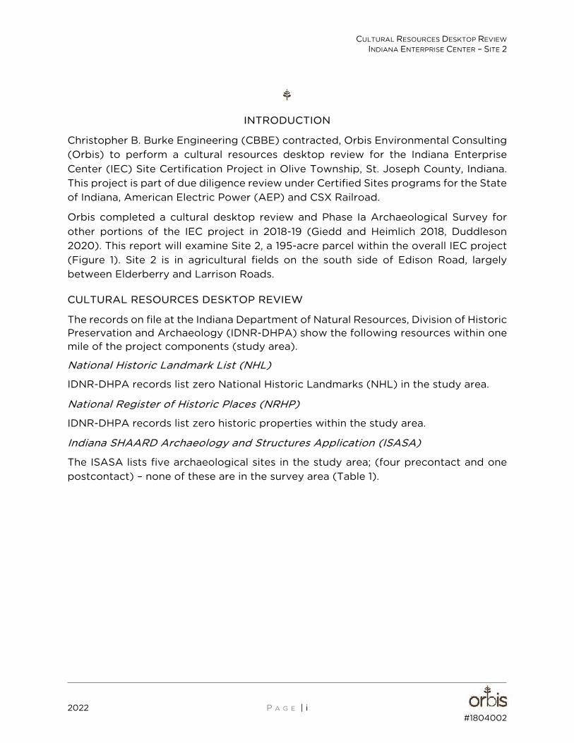
Orbis completed a cultural desktop review and Phase Ia Archaeological Survey for other portions of the IEC project in 2018-19 (Giedd and Heimlich 2018, Duddleson 2020). This report will examine Site 2, a 195-acre parcel within the overall IEC project (Figure 1). Site 2 is in agricultural fields on the south side of Edison Road, largely between Elderberry and Larrison Roads.
CULTURAL RESOURCES DESKTOP REVIEW
The records on file at the Indiana Department of Natural Resources, Division of Historic Preservation and Archaeology (IDNR-DHPA) show the following resources within one mile of the project components (study area).
National Historic Landmark List (NHL)
IDNR-DHPA records list zero National Historic Landmarks (NHL) in the study area.
National Register of Historic Places (NRHP)
IDNR-DHPA records list zero historic properties within the study area.
Indiana SHAARD Archaeology and Structures Application (ISASA)
The ISASA lists five archaeological sites in the study area; (four precontact and one postcontact) – none of these are in the survey area (Table 1).
Figure #1
Project Location
#1804002.01
Cultural Resources Desktop ReviewIndiana Enterprise Center – Site 2
Olive Township, Saint Joseph County, IN
�������������������������� �������� �������
������������������������������
����������� �!��"�#��
� �������
$��%����&���
��'�
�
��
�
CULTURAL RESOURCES DESKTOP REVIEW INDIANA ENTERPRISE CENTER – SITE 2
2020 P A G E | 3 #1804002
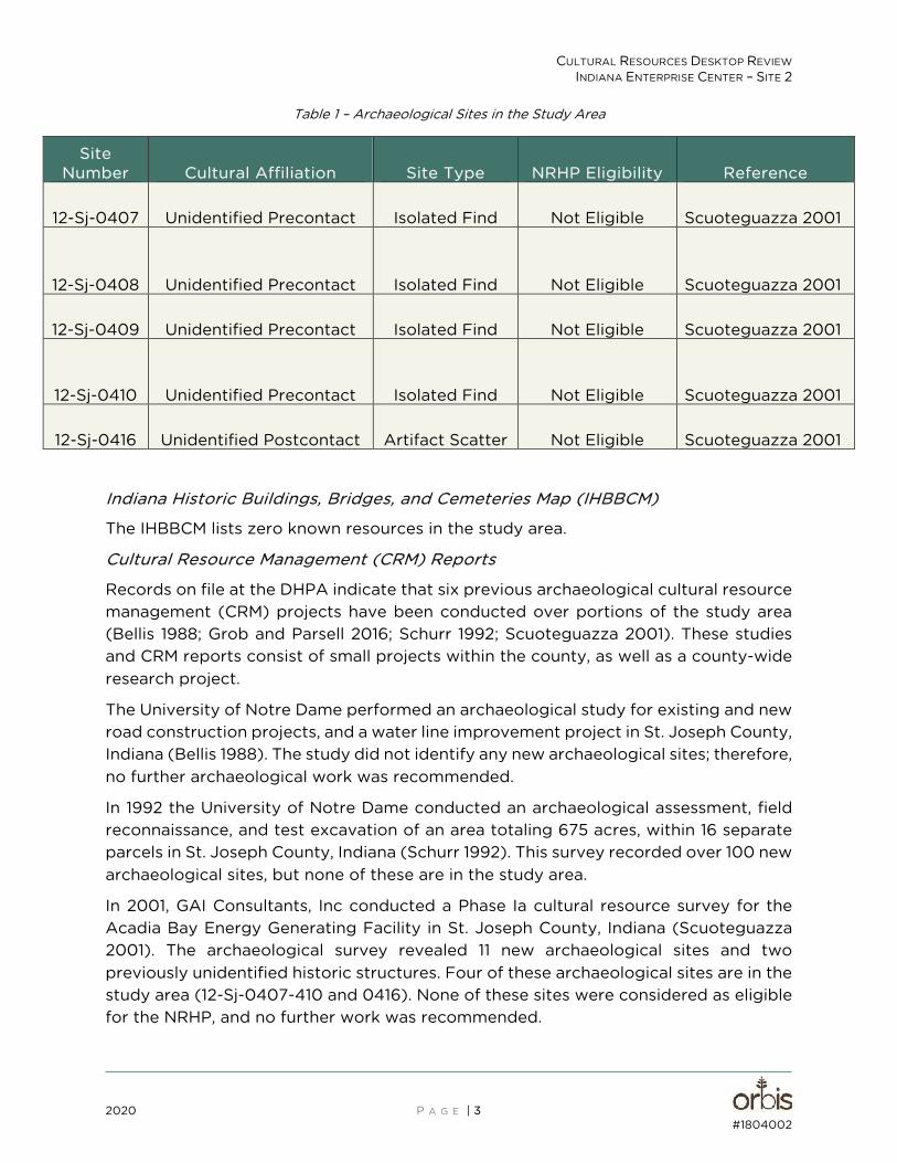
Table 1 – Archaeological Sites in the Study Area
Site Number Cultural Affiliation Site Type NRHP Eligibility Reference
12-Sj-0407 Unidentified Precontact Isolated Find Not Eligible Scuoteguazza 2001
12-Sj-0408 Unidentified Precontact Isolated Find Not Eligible Scuoteguazza 2001
12-Sj-0409 Unidentified Precontact Isolated Find Not Eligible Scuoteguazza 2001
12-Sj-0410 Unidentified Precontact Isolated Find Not Eligible Scuoteguazza 2001
12-Sj-0416 Unidentified Postcontact Artifact Scatter Not Eligible Scuoteguazza 2001
Indiana Historic Buildings, Bridges, and Cemeteries Map (IHBBCM)
The IHBBCM lists zero known resources in the study area.
Cultural Resource Management (CRM) Reports
Records on file at the DHPA indicate that six previous archaeological cultural resource management (CRM) projects have been conducted over portions of the study area (Bellis 1988; Grob and Parsell 2016; Schurr 1992; Scuoteguazza 2001). These studies and CRM reports consist of small projects within the county, as well as a county-wide research project.
The University of Notre Dame performed an archaeological study for existing and new road construction projects, and a water line improvement project in St. Joseph County, Indiana (Bellis 1988). The study did not identify any new archaeological sites; therefore, no further archaeological work was recommended.
In 1992 the University of Notre Dame conducted an archaeological assessment, field reconnaissance, and test excavation of an area totaling 675 acres, within 16 separate parcels in St. Joseph County, Indiana (Schurr 1992). This survey recorded over 100 new archaeological sites, but none of these are in the study area.
In 2001, GAI Consultants, Inc conducted a Phase Ia cultural resource survey for the Acadia Bay Energy Generating Facility in St. Joseph County, Indiana (Scuoteguazza 2001). The archaeological survey revealed 11 new archaeological sites and two previously unidentified historic structures. Four of these archaeological sites are in the study area (12-Sj-0407-410 and 0416). None of these sites were considered as eligible for the NRHP, and no further work was recommended.
CULTURAL RESOURCES DESKTOP REVIEW INDIANA ENTERPRISE CENTER – SITE 2
2022 P A G E | 2 #1804002.01
In 2016 Cardno, Inc. performed a Phase I archaeological reconnaissance for the St. Joseph Lateral project, in St. Joseph County, Indiana (Grob and Parsell 2016). The fieldwork documented one previously unidentified archaeological site (12-Sj-0500), which is outside the study area.
Orbis performed a Phase Ia archaeological reconnaissance for this project in 2019 (Duddleson 2020). This survey examined areas associated with anticipated 401/404 Wetland Permitting including two proposed retention basins and along existing and proposed ditches. This survey identified six new archaeological sites. Three are isolated precontact artifacts (12-Sj-0536, 539, and 540). One is a scatter of late nineteenth century artifacts (12-Sj-0538). The remaining two are associated with Late nineteenth – Mid twentieth century farmsteads, one occupied (12-Sj-0537) and one abandoned (12-Sj-0541). These are all outside the study area.
Historic Maps and Atlases
Research examined atlas maps dating from 1875, 1876, 1895, and 1911, for information pertaining to the historic use of the project area in St. Joseph County (Higgins Belden & Co. 1875; Indiana Historical Society 1968; Geo A. Ogle 1895; Higgins Belden & Co 1895; Geo A. Ogle 1911). The 1875, 1895, and 1911 maps show the natural features, roads, railroads, structures, and associated landowners in Olive Township. The 1876 map shows the area at a county level, illustrating structures like schools, but not individual homes or landowners.
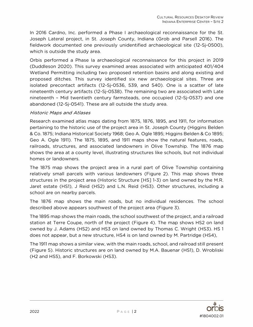
The 1875 map shows the project area in a rural part of Olive Township containing relatively small parcels with various landowners (Figure 2). This map shows three structures in the project area (Historic Structure [HS] 1-3) on land owned by the M.R. Jaret estate (HS1), J Reid (HS2) and L.N. Reid (HS3). Other structures, including a school are on nearby parcels.
The 1876 map shows the main roads, but no individual residences. The school described above appears southwest of the project area (Figure 3).
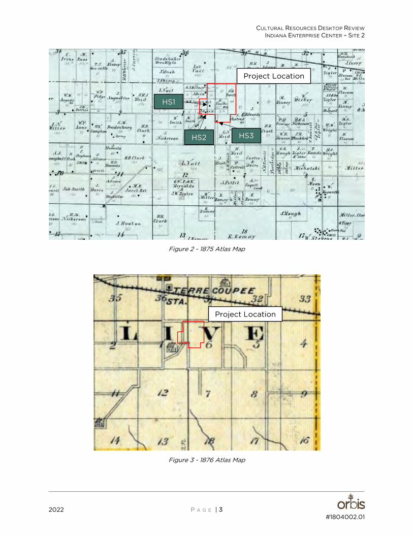
The 1895 map shows the main roads, the school southwest of the project, and a railroad station at Terre Coupe, north of the project (Figure 4). The map shows HS2 on land owned by J. Adams (HS2) and HS3 on land owned by Thomas C. Wright (HS3). HS 1 does not appear, but a new structure, HS4 is on land owned by M. Partridge (HS4),
The 1911 map shows a similar view, with the main roads, school, and railroad still present (Figure 5). Historic structures are on land owned by M.A. Bauenar (HS1), D. Wrobliski (H2 and HS5), and F. Borkowski (HS3).
CULTURAL RESOURCES DESKTOP REVIEW INDIANA ENTERPRISE CENTER – SITE 2
2022 P A G E | 3 #1804002.01
Figure 2 - 1875 Atlas Map
Figure 3 - 1876 Atlas Map
Project Location
HS3 HS2
HS1
Project Location
CULTURAL RESOURCES DESKTOP REVIEW INDIANA ENTERPRISE CENTER – SITE 2
2022 P A G E | 4 #1804002.01
Figure 4 - 1895 Atlas Map
Figure 5 - 1911 Atlas Map
Project Location
HS3
HS2
HS4
HS3
HS2
HS4
HS5
Project Location
CULTURAL RESOURCES DESKTOP REVIEW INDIANA ENTERPRISE CENTER – SITE 2
2022 P A G E | 5 #1804002.01
In addition to the historic atlas maps, research also reviewed the 1932 archaeological map "Indiana: influence of the Indian upon its History..." (Guernsey 1932). Like other historic archaeological maps of its time, this map depicts archaeological resources at a county-wide scale. This provides an overview of sites across the county but limits the locational accuracy of these features. This map shows the Chicago to Detroit trail traveling through western St. Joseph County, but no other sites in or near the project.
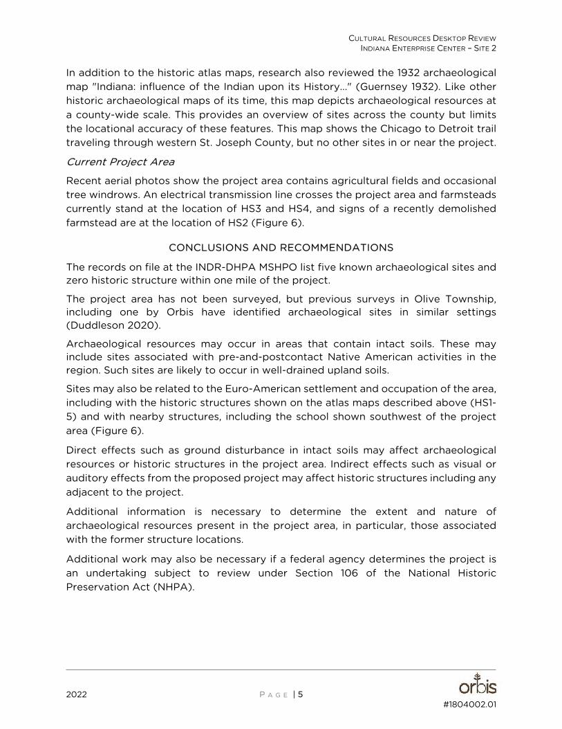
Current Project Area
Recent aerial photos show the project area contains agricultural fields and occasional tree windrows. An electrical transmission line crosses the project area and farmsteads currently stand at the location of HS3 and HS4, and signs of a recently demolished farmstead are at the location of HS2 (Figure 6).
CONCLUSIONS AND RECOMMENDATIONS
The records on file at the INDR-DHPA MSHPO list five known archaeological sites and zero historic structure within one mile of the project.
The project area has not been surveyed, but previous surveys in Olive Township, including one by Orbis have identified archaeological sites in similar settings (Duddleson 2020).
Archaeological resources may occur in areas that contain intact soils. These may include sites associated with pre-and-postcontact Native American activities in the region. Such sites are likely to occur in well-drained upland soils.
Sites may also be related to the Euro-American settlement and occupation of the area, including with the historic structures shown on the atlas maps described above (HS1-5) and with nearby structures, including the school shown southwest of the project area (Figure 6).
Direct effects such as ground disturbance in intact soils may affect archaeological resources or historic structures in the project area. Indirect effects such as visual or auditory effects from the proposed project may affect historic structures including any adjacent to the project.
Additional information is necessary to determine the extent and nature of archaeological resources present in the project area, in particular, those associated with the former structure locations.
Additional work may also be necessary if a federal agency determines the project is an undertaking subject to review under Section 106 of the National Historic Preservation Act (NHPA).
Figure #6
Aerial Map
#1804002.01
��������������������� �������� �������
������������������������������
����������� �!��"�#��
���� ����
$��%����&���
'����(�
�
��
�
Cultural Resources Desktop ReviewIndiana Enterprise Center – Site 2
Olive Township, Saint Joseph County, IN
ajduddleson
Text Box
HS 1
ajduddleson
Text Box
HS 2
ajduddleson
Line
ajduddleson
Line
ajduddleson
Text Box
HS 3
ajduddleson
Text Box
HS 4
ajduddleson
Text Box
HS 5
ajduddleson
Line
ajduddleson
Text Box
Former Schoolhouse
ajduddleson
Line
CULTURAL RESOURCES DESKTOP REVIEW INDIANA ENTERPRISE CENTER – SITE 2
2022 P A G E | 7 #1804002.01
REFERENCES CITED
Bellis, James O. 1988 Report of the Archaeological Study of the Following Projects Associated with the I/N
Tek Steel Plant St. Joseph County, Indiana. Department of Anthropology, University of Notre Dame, Notre Dame, Indiana.
Duddleson J Ryan 2020 Phase Ia Archaeological Reconnaissance Proposed Indiana Enterprise Center, Olive
Township, Saint Joseph County, Indiana.
Geidd, Alycia and James L. Ingermann Heimlich 2018 Cultural Desktop Review for the Indiana Enterprise Center Project Located in St.
Joseph County, Indiana.
Geo. A. Ogle 1895 Standard Atlas of St. Joseph County Indiana. Geo. A. Ogle & Co., Chicago.
1911 Standard Atlas of St. Joseph County Indiana. Geo. A. Ogle & Co., Chicago.
Grob, Kaye and Veronica Parsell 2016 Phase Ia Literature Review and Reconnaissance for the St. Joseph Lateral, St. Joseph
County, Indiana. Cardno, Inc. Indianapolis, Indiana.
Guernsey, E.Y. 1932 Indiana: The influence of the Indian upon its History with Indiana and French names
for Natural and Cultural locations. Department of Natural Resources, State of Indiana.
Higgins Belden & Co. 1875 Historical Atlas of St. Joseph Co. Indiana. Higgins Belden & Co., Chicago.
Indiana Historic Bridges, Buildings, and Cemeteries Map (IHBBCM) 2022 Indiana Historic Bridges, Buildings, and Cemeteries Map. Indiana Department of
Natural Resources, Division of Historic Preservation and Archaeology. Electronic database, https://indnr.maps.arcgis.com/home/item.html?id=1593429c17c34942a0d1d3fac03c4a80. Accessed January 2022.
Indiana Historical Society 1968 Maps of Indiana Counties in 1876 - Reprinted from Illustrated Historical Atlas of the
State of Indiana. Baskin, Forester & Co., Indiana Historical Society, Indianapolis.
Schurr, Mark R. 1992 An Archaeological Assessment, Field Reconnaissance, and Test Excavation in St.
Joseph County, Indiana, Part 1: Field Reconnaissance and Assessment. Department of Anthropology, University of Notre Dame, Notre Dame, Indiana.
Scuoteguazza, Eric P. 2001 Phase Ia Cultural Resource Survey Acadia Bay Energy Generating Facility New
Carlisle, St. Joseph County, Indiana. GAI Consultants, Inc., Monroeville, Pennsylvania.