Cultural Impact Assessment for the Honouliuli/Waipahu/Pearl ...
190
O‘ahu Office P.O. Box 1114 Kailua, Hawai‘i 96734 Ph.: (808) 262-9972 Fax: (808) 262-4950 www.culturalsurveys.com Maui Office 16 S. Market Street, Suite 2N Wailuku, Hawai‘i 96793 Ph: (808) 242-9882 Fax: (808) 244-1994 Cultural Impact Assessment for the Honouliuli/Waipahu/Pearl City Wastewater Facilities, Honouliuli, Hō‘ae‘ae, Waikele, Waipi‘o, Waiawa, and Mānana, and Hālawa Ahupua‘a, ‘Ewa District, O‘ahu Island TMK: [1] 9-1, 9-2, 9-4, 9-5, 9-6, 9-7, 9-8, 9-9 (Various Plats and Parcels) Prepared for AECOM Pacific, Inc. Prepared by Brian Kawika Cruz, B.A., Constance R. O’Hare, B.A., David W. Shideler, M.A., and Hallett H. Hammatt, Ph.D. Cultural Surveys Hawai‘i, Inc Kailua, Hawai‘i (Job Code: HONOULIULI 35) April 2011
-
Upload
khangminh22 -
Category
Documents
-
view
3 -
download
0
Transcript of Cultural Impact Assessment for the Honouliuli/Waipahu/Pearl ...
O‘ahu Office P.O. Box 1114 Kailua, Hawai‘i 96734 Ph.: (808) 262-9972 Fax: (808) 262-4950
www.culturalsurveys.com
Maui Office 16 S. Market Street, Suite 2N Wailuku, Hawai‘i 96793 Ph: (808) 242-9882 Fax: (808) 244-1994
Cultural Impact Assessment for the Honouliuli/Waipahu/Pearl City Wastewater Facilities, Honouliuli, Hō‘ae‘ae, Waikele, Waipi‘o, Waiawa, and Mānana, and Hālawa Ahupua‘a, ‘Ewa District, O‘ahu
Island
TMK: [1] 9-1, 9-2, 9-4, 9-5, 9-6, 9-7, 9-8, 9-9
(Various Plats and Parcels)
Prepared for
AECOM Pacific, Inc.
Prepared by
Brian Kawika Cruz, B.A.,
Constance R. O’Hare, B.A.,
David W. Shideler, M.A.,
and
Hallett H. Hammatt, Ph.D.
Cultural Surveys Hawai‘i, Inc
Kailua, Hawai‘i
(Job Code: HONOULIULI 35)
April 2011


Cultural Surveys Hawai‘i Job Code: HONOULIULI 35 Prefatory Remarks on Language and Style
CIA for the Honouliuli/Waipahu/Pearl City Wastewater Facilities, Multiple Ahupua‘a, ‘Ewa District, O‘ahu i
TMK: [1] 9-1, 9-2, 9-4, 9-5, 9-6, 9-7, 9-8, 9-9 (Various Plats and Parcels)
Prefatory Remarks on Language and Style
A Note about Hawaiian and other non-English Words:
Cultural Surveys Hawai‘i (CSH) recognizes that the Hawaiian language is an official language of the State of Hawai‘i, it is important to daily life, and using it is essential to conveying a sense of place and identity. In consideration of a broad range of readers, CSH follows the conventional use of italics to identify and highlight all non-English (i.e., Hawaiian and foreign language) words in this report unless citing from a previous document that does not italicize them. CSH parenthetically translates or defines in the text the non-English words at first mention, and the commonly-used non-English words and their translations are also listed in the Glossary of Hawaiian Words (Appendix A) for reference. However, translations of Hawaiian and other non-English words for plants and animals mentioned by community participants are referenced separately (see explanation below).
A Note about Plant and Animal Names:
When community participants mention specific plants and animals by Hawaiian, other non-English, or common names, CSH provides their possible scientific names (Genus and species) in the Common and Scientific Names of Plants and Animals Mentioned by Community Participants (Appendix B). CSH derives these possible names from authoritative sources, but since the community participants only name the organisms and do not taxonomically identify them, CSH cannot positively ascertain their scientific identifications. CSH does not attempt in this report to verify the possible scientific names of plants and animals in previously published documents; however, citations of previously published works that include both common and scientific names of plants and animals appear as in the original texts.
Cultural Surveys Hawai‘i Job Code: HONOULIULI 35 Management Summary
CIA for the Honouliuli/Waipahu/Pearl City Wastewater Facilities, Multiple Ahupua‘a, ‘Ewa District, O‘ahu ii
TMK: [1] 9-1, 9-2, 9-4, 9-5, 9-6, 9-7, 9-8, 9-9 (Various Plats and Parcels)
Management Summary
Reference Cultural Impact Assessment (CIA) for the Honouliuli/Waipahu/Pearl City Wastewater Facilities, Honouliuli, Hō‘ae‘ae, Waikele, Waipi‘o, Waiawa, Mānana, and Hālawa Ahupua‘a, ‘Ewa District, O‘ahu Island, TMK: [1] 9-1, 9-2, 9-3, 9-4, 9-6, 9-7,9-8, 9-9. (Various Plats and Parcels)
Date April 2011
Project Number (s) CSH Job Code: HONOULIULI 35
Project Location ‘Ewa, Central and a portion of the Primary Urban Center Districts, O‘ahu, Hawaii
Land Jurisdiction City and County of Honolulu (CCH) – Department of Environmental Services (ENV)
Agencies Department of Land and Natural Resources/State Historic Preservation Division (DLNR/SHPD), Office of Environmental Quality Control (OEQC)
Project Description The proposed action consists of various long-term improvements to the wastewater collection, treatment and disposal system for the Honouliuli Wastewater Treatment Plant service area.
Project Acreage The study area includes areas with current wastewater flows to the Honouliuli Wastewater Treatment Plant, as well as potential future flows from areas including but not limited to Hālawa, ‘Aiea, Pearl City, Waipi‘o, Waikele, Waipahu, ‘Ewa, Kapolei, and Mililani.
Area of Potential Effect
The Area of Potential Effect (APE) for this CIA includes Honouliuli, Hō‘ae‘ae, Waikele, Waipi‘o, Waiawa, Mānana, and Hālawa Ahupua‘a.
Document Purpose The Project requires compliance with the State of Hawai‘i environmental review process (Hawai‘i Revised Statutes [HRS] Chapter 343), which requires consideration of a proposed Project’s effect on cultural practices and resources. At the request of AECOM and the City and County of Honolulu, CSH is conducting this draft CIA. Through document research and ongoing cultural consultation efforts, this report provides preliminary information pertinent to the assessment of the proposed Projects’ impacts to cultural practices and resources (per the Office of Environmental Quality Control’s Guidelines for Assessing Cultural Impacts) which may include Traditional Cultural Properties (TCP) of ongoing cultural significance
Cultural Surveys Hawai‘i Job Code: HONOULIULI 35 Management Summary
CIA for the Honouliuli/Waipahu/Pearl City Wastewater Facilities, Multiple Ahupua‘a, ‘Ewa District, O‘ahu iii
TMK: [1] 9-1, 9-2, 9-4, 9-5, 9-6, 9-7, 9-8, 9-9 (Various Plats and Parcels)
that may be eligible for inclusion on the State Register of Historic Places, in accordance with Hawai‘i State Historic Preservation Statute (Chapter 6E) guidelines for significance criteria (HAR §13-284) under Criterion E. The document is intended to support the Project’s environmental review and may also serve to support the Project’s historic preservation review under HRS Chapter 6E-42 and Hawai‘i Administrative Rules (HAR) Chapter 13-284.
Community Consultation
CSH attempted to contact Hawaiian organizations, agencies, community members and cultural practitioners of Honouliuli, Hō‘ae‘ae, Waikele, Waipi‘o, Waiawa, Mānana, and Hālawa Ahupua‘a in order to identify individuals with cultural expertise and/or knowledge of the Project area and the vicinity. The organizations consulted include the SHPD, the Office of Hawaiian Affairs (OHA), the O‘ahu Island Burial Council (OIBC), and community and cultural organizations including Hui Mālama I Nā Kūpuna O Hawai‘i Nei and the ‘Ahahui Sivila O Kapolei Hawaiian Civic Club.
Results of Background Research
Background research of the Project area indicates:
1. The Project area traverses through 12 of the 13 ahupua‘a (land division usually extending from the uplands to the sea) located in the ‘Ewa District. They are (from west to east) Honouliuli, Hō‘ae‘ae, Waikele, Waipi‘o, Waiawa, Mānana, Waimano, Waiau, Waimalu, Kalauao, ‘Aiea, and Hālawa. Pu‘uloa Ahupua‘a, located on the western portion of the Pearl Harbor entryway, is the only ahupua‘a in the ‘Ewa District that is not located in the Project area.
2. The ‘Ewa District had more fishponds than any other district on O‘ahu, indicating that agricultural and aquacultural intensification was a direct link to the chiefs who resided there and to the increasing needs of the population. The Project area transects at least nine former fishponds.
3. According to an account in the Hawaiian newspaper Ka Loea Kālai‘āina (June 10, 1899), several of the fishponds in the Pu‘uloa area were made by the brother gods, Kāne and Kanaloa. A fisherman living in Pu‘uloa, named Hanakahi, prayed to unknown gods, until one day two men came to his house. They revealed to him that they were the gods to whom he should pray. Kāne and Kanaloa then built fishponds at Ke‘anapua‘a, but were not satisfied. Then they built the fishpond, Kepo‘okala, but were still not satisfied. Finally they made the pond Kapākule, which they stocked with all manner of fish. They gifted all of these fishponds to Hanakahi and his descendants (Handy and Handy 1972:473; Ka Loea Kālai‘āina,

Cultural Surveys Hawai‘i Job Code: HONOULIULI 35 Management Summary
CIA for the Honouliuli/Waipahu/Pearl City Wastewater Facilities, Multiple Ahupua‘a, ‘Ewa District, O‘ahu iv
TMK: [1] 9-1, 9-2, 9-4, 9-5, 9-6, 9-7, 9-8, 9-9 (Various Plats and Parcels)
July 8, 1899).
4. ‘Ewa was famous for the many limestone caves, also known as the “Caves of Honouliuli,” formed in the uplifted coral, called the “Ewa Karst.” This Pleistocene limestone outcrop, where not covered by alluvium or stockpiled material, has characteristic dissolution “pit caves” (Mylroie and Carew 1995), which are nearly universally, but erroneously, referred to as “sink holes” (Halliday 2005).
5. A famous cave of Hālawa was Keanapua‘a, opposite Waipi‘o Peninsula, which means “the pig’s cave,” so named because Kamapua‘a (Hawaiian demi-god known as the pig god) once slept there (Pukui et al. 1974:103). This cave was one of the places that the high king of O‘ahu, Kahahana, hid after he had killed the priest Ka‘opulupulu, thus angering the high chief of Maui, Kahekili.
6. Oral tradition tells of Hālawa as the home of Papa, where she lived in the uplands with her parents, Kahakauakoko and Kūkalani‘ehu. Papa is known for her generative role as the “earth mother”. Together with her husband, Wākea, they are the progenitors of the Hawaiian race.
7. The heiau (place of worship, shrine) of Keaīwa in ‘Aiea was the site of a medicinal herb garden and training area for traditional healers.
8. The eastern section of ‘Ewa was largely developed by the Honolulu Plantation Company. Commercial sugar cane cultivation began in Waimalu and Hālawa in the 1850s, on the estate of Mr. J.R. Williams (Condé and Best 1973:327). The plantation was first known as the Honolulu Sugar Company
9. In 1852, the first Chinese contract laborers arrived in the Hawaiian Islands, many of which worked in the former rice fields and fishponds of Honouliuli (Char and Char 1988:176). Contracts were for five years, and pay was $3 a month plus room and board. Upon completion of their contracts, a number of the immigrants remained in the islands, many becoming merchants or rice farmers.
10. In 1897, B. F. Dillingham established the Oahu Sugar Company (OSC) on 12,000 acres leased from the estates of John Papa ‘Ī‘ī, Bishop, and Robinson. The coastal portions of this leased land overlaped the the current Project area. The Oahu Sugar Co. had over 900 field workers, composed of 44 Hawaiians, 473 Japanese, 399 Chinese, and 57 Portuguese. The first sugar crop was harvested in 1899, ushering in the sugar

Cultural Surveys Hawai‘i Job Code: HONOULIULI 35 Management Summary
CIA for the Honouliuli/Waipahu/Pearl City Wastewater Facilities, Multiple Ahupua‘a, ‘Ewa District, O‘ahu v
TMK: [1] 9-1, 9-2, 9-4, 9-5, 9-6, 9-7, 9-8, 9-9 (Various Plats and Parcels)
plantation era in Waipahu (Ohira 1997).
11. The U.S. Navy began a preliminary dredging program for Pearl Harbor in 1901, which created a 30-foot deep entrance channel measuring 200 ft wide and 3,085 ft long. In 1908, money was appropriated for five miles of entrance channel dredged to an additional 35 ft down (Downes 1953).
12. In 1909, the government appropriated the entire Waipi‘o peninsula from the ‘Ī‘ī Estate for the Pearl Harbor Naval Station and Shipyard. Additional dredging to deepen and widen the channel was conducted in the 1920s.
Results of Community Consultation
CSH attempted to contact 44 community members (government agency or community organization representatives, or individuals such as residents and cultural practitioners) for this draft CIA report; of those, seven responded and five participated in formal interviews for more in-depth contributions to the CIA. Presented below are salient themes and concerns that emerged from participants’ interviews regarding the proposed Project:
1. Mr. Tin Hu Young describes the area of Pearl Harbor during his youth as a “bread basket” of food. He recalls an abundance of mullet, clams, bananas, taro and other varieties of food in his neighborhood for subsistence.
2. Mr. Kāne’s mother tells of lo‘i kalo (irrigated terraces of taro) in the Waipi‘o Peninsula area. His father gathered oysters, clams, crab and limu (see Appendix B for common and scientific plant and animal names mentioned by community participants) from the waters of Pearl Harbor.
3. Mr. Young states that after the December 7, 1941 bombing of Pearl Harbor, the U.S. military set up a camp at the Pearl City Tavern bar on Farrington Highway in Pearl City, which included searchlights to look for enemy airplanes.
4. In his youth, Dr. Stagner hiked the mauka (towards the mountain) regions in ‘Ewa with his Boy Scout troop and discovered several petroglyphs and heiau. Dr. Stagner explained that there had been an influenza epidemic in the 1920s and many Hawaiians were buried in the mauka area, which was abandoned and eventually taken over by the ‘Aiea Sugar Mill. Many of the plantation workers moved rocks, not knowing the cultural significance of the rocks that could have been associated with Hawaiian burials or other cultural sites.
5. Dr. Stagner believes ‘Ewa’s most important feature is its watershed. This fact is highlighted by the naming of the
Cultural Surveys Hawai‘i Job Code: HONOULIULI 35 Management Summary
CIA for the Honouliuli/Waipahu/Pearl City Wastewater Facilities, Multiple Ahupua‘a, ‘Ewa District, O‘ahu vi
TMK: [1] 9-1, 9-2, 9-4, 9-5, 9-6, 9-7, 9-8, 9-9 (Various Plats and Parcels)
ahupua‘a with the term wai (fresh water of any kind), including Waiawa, Waiao, Waikele, and Waipahu. Mirroring the ahupua‘a boundaries, water flows from the Ko‘olau mountains down to the waters of Pu‘uloa throughout a network of streams and an underwater system of tunnels. These contribute heavily to the Hālawa Aquifer, which now supplies the majority of the drinking water for the island of O‘ahu.
6. Dr. Stagner’s main concern is the management of the ‘Ewa watershed. The kūpuna (elders) from his youth told him that the upland regions must be conserved to prevent excessive runoff and lowland flooding. Historically, surplus water was channeled toward the ‘Ewa plain. Dr. Stagner advocates protecting agricultural and conservation lands of Waiawa in particular, as they are the most vulnerable to future development.
7. Mr. Kāne states that the “cultural layer” that includes archaeological features of ‘Ewa still exists today; however, it has been buried or filled in by the Navy and the Department of Defense.
8. Mr. Kalahiki is concerned that the water tables below surface of the Project area may be adversely impacted during the boring/excavating phase of construction.
9. Mr. Young is concerned that potential future flooding in the lowland areas of ‘Ewa may cause the proposed Project’s sewer system to backup and spill into Pearl Harbor.
10. Mr. Kāne feels that the likelihood of inadvertent burials at the points of deep excavation is low and that the cultural layers will not be disturbed during construction phases of this Project.
Cultural Impacts and Recommendations
Based on information gathered from the community consultation effort as well as archaeological and archival research presented in this report, the evidence indicates that the proposed Project may have minimal impact on potential burials and other cultural sites within the Project area due to underground tunneling and boring at debths below known cultural sites. However, concerns raised by community participants include protection of water tables in the area and possible sewer backups due to flooding the lower areas of ‘Ewa. A good faith effort to address the following recommendations would help mitigate potentially adverse effects the proposed Project may have on Hawaiian cultural practices, beliefs and resources in and near the Project area:
1. The Project may have a direct impact on as-yet undiscovered burials located in subsurface contexts along the Project area

Cultural Surveys Hawai‘i Job Code: HONOULIULI 35 Management Summary
CIA for the Honouliuli/Waipahu/Pearl City Wastewater Facilities, Multiple Ahupua‘a, ‘Ewa District, O‘ahu vii
TMK: [1] 9-1, 9-2, 9-4, 9-5, 9-6, 9-7, 9-8, 9-9 (Various Plats and Parcels)
corridor. Personnel involved in development activities of the Project should be informed of the possibility of inadvertent cultural finds, including human remains. Should cultural and/or burial sites be identified during ground disturbance, all work should immediately cease, and the appropriate agencies notified pursuant to applicable law.
2. In the event of discoveries of iwi kūpuna (ancestral bone remains) during Project construction activities, recognized cultural and lineal descendants should be notified and consulted on matters of burial treatment.
3. Hydrological studies should be conducted prior to excavation/underground boring begins to prevent damage to aquifers and water tables in the proposed Project area.
4. Flooding concerns should be addressed in the lower areas of the ‘Ewa District to prevent sewer backups of the proposed Project’s new sewer system.
5. Archaeological monitoring should be conducted during ground-disturbance activities that affect layers likely to contain burials and/or cultural layers.

Cultural Surveys Hawai‘i Job Code: HONOULIULI 35 Table of Contents
CIA for the Honouliuli/Waipahu/Pearl City Wastewater Facilities, Multiple Ahupua‘a, ‘Ewa District, O‘ahu viii
TMK: [1] 9-1, 9-2, 9-4, 9-5, 9-6, 9-7, 9-8, 9-9 (Various Plats and Parcels)
Table of Contents
Prefatory Remarks on Language and Style ............................................................................ i
Management Summary ........................................................................................................... ii
Section 1 Introduction ............................................................................................................. 1
1.1 Project Background ....................................................................................................................... 1 1.2 Scope of Work ............................................................................................................................. 10 1.3 Environmental Setting ................................................................................................................. 10
1.3.1 Natural Environment near the Alternate Wastewater Tunnels and Facilities ....................... 10 1.3.2 Built Environment near the Alternate Wastewater Tunnels and Facilities ........................... 13
Section 2 Methods .................................................................................................................. 16
2.1 Archival Research ........................................................................................................................ 16 2.2 Community Consultation ............................................................................................................. 16
2.2.1 Sampling and Recruitment .................................................................................................... 16 2.2.2 Informed Consent Protocol ................................................................................................... 17 2.2.3 Interview Techniques ............................................................................................................ 18
2.3 Compensation and Contributions to Community ........................................................................ 18
Section 3 Wahi Pana (Place Names) of ‘Ewa ....................................................................... 20
3.1 Place Names along the Main Trails through the ‘Ewa District .................................................... 23 3.2 Place Names in the Chants for Kūali’i and Kaumuali‘i ............................................................... 26 3.3 Place Names in the Ahupua‘a of ‘Ewa ........................................................................................ 27
3.3.1 Honouliuli Place Names ....................................................................................................... 27 3.3.2 Hō‘ae‘ae Place Names .......................................................................................................... 29 3.3.3 Waikele Place Names ........................................................................................................... 29 3.3.4 Waipi‘o Place Names............................................................................................................ 33 3.3.5 Waiawa Place Names............................................................................................................ 33 3.3.6 Mānana Place Names ............................................................................................................ 38 3.3.7 Waimano Place Names ......................................................................................................... 38 3.3.8 Waiau Place Names .............................................................................................................. 38 3.3.9 Waimalu Place Names .......................................................................................................... 41 3.3.10 Kalauao Place Names ......................................................................................................... 43 3.3.11 ‘Aiea Place Names .............................................................................................................. 46 3.3.12 Hālawa Place Names .......................................................................................................... 47
Section 4 Stories (Mo‘olelo) of ‘Ewa .................................................................................... 50
4.1 Pearl Harbor (Pu‘uloa) Mo‘olelo ................................................................................................. 50 4.2 Mo‘olelo (Stories) of Honouliuli and Hō‘ae‘ae ........................................................................... 51
4.2.1 The Caves of Honouliuli ....................................................................................................... 51 4.2.2 The Inland Plain of Keahumoa ............................................................................................. 52
4.3 Stories (Mo‘olelo) of Central and Eastern ‘Ewa .......................................................................... 54 4.3.1 The Kapa Board at Waikele Spring ...................................................................................... 54 4.3.2 Stories of the Gods in Waipi‘o ............................................................................................. 55 4.3.3 Stone Markers on the Trail through Waiawa ........................................................................ 55 4.3.4 Maihea and the Cultivation of ‘Awa in Waiawa, Waiau, Waimalu, and Hālawa ................. 56
Cultural Surveys Hawai‘i Job Code: HONOULIULI 35 Table of Contents
CIA for the Honouliuli/Waipahu/Pearl City Wastewater Facilities, Multiple Ahupua‘a, ‘Ewa District, O‘ahu ix
TMK: [1] 9-1, 9-2, 9-4, 9-5, 9-6, 9-7, 9-8, 9-9 (Various Plats and Parcels)
4.3.5 The Eel Boy of Pilimo‘o in Mānana ..................................................................................... 56 4.3.6 Pearl City Stone in Mānana .................................................................................................. 57 4.3.7 Pōhaku Anae in Mānana ....................................................................................................... 58 4.3.8 The Dog Kū‘īlioloa on the Plain of Kaluahole in Waiau ...................................................... 58 4.3.9 The Kahuawai Bathing Place of Chiefs at Kalauao .............................................................. 59 4.3.10 Keahiakahoe in Kalauao ..................................................................................................... 59 4.3.11 Pōhaku o Ki‘i (Stone of Ki‘i) in ‘Aiea ................................................................................ 60 4.3.12 Keaiwa, the Healers’ Heiau in ‘Aiea .................................................................................. 60 4.3.13 Leilono, then entrance to Milu, the Underworld, in Hālawa .............................................. 62 4.3.14 The Gods in Hālawa ........................................................................................................... 63
Section 5 Historical Background .......................................................................................... 64
5.1 Pre-Contact to the Mid-Nineteenth Century ................................................................................ 64 5.1.1 Traditional Settlement and Agricultural Patterns ................................................................. 64 5.1.2 Mā‘ilikūkahi and the Battle of Kīpapa.................................................................................. 64 5.1.3 The Battle of Kūki‘iahu in Kalauao and Refuge in Hālawa ................................................. 65 5.1.4 Kamehameha’s Conquest of O‘ahu ...................................................................................... 67 5.1.5 Observations of Early Explorers and Visitors ...................................................................... 67
5.2 Mid-Nineteenth Century and The Māhele ................................................................................... 69 5.3 Mid-Nineteenth Century to the Present ....................................................................................... 83
5.3.1 Early Ranching ..................................................................................................................... 83 5.3.2 Rice Cultivation in Former Taro Fields ................................................................................ 86 5.3.3 Pineapple Cultivation ............................................................................................................ 88 5.3.4 History of the Oahu Railway and Land Company (OR&L) ................................................. 90 5.3.5 History of the Sugar Plantations of ‘Ewa ............................................................................. 92 5.3.6 The Military Development of ‘Ewa ...................................................................................... 96 5.3.7 Residential and Commercial Development in ‘Ewa ........................................................... 102
Section 6 Community Consultation .................................................................................... 105
6.1 Community Consultation Effort ................................................................................................ 106 6.2 State Historic Preservation Division .......................................................................................... 110 6.3 Office of Hawaiian Affairs ........................................................................................................ 110
Section 7 Interviews ............................................................................................................. 114
7.1 Acknowledgements .................................................................................................................... 114 7.2 Shad Kane .................................................................................................................................. 114
7.2.1 Family Background ............................................................................................................ 114 7.2.2 Agriculture, Fishing and Gathering .................................................................................... 115 7.2.3 Cultural Landscape of ‘Ewa ............................................................................................... 115 7.2.4 Mo‘olelo of the Battle of Kūki‘iahu ................................................................................... 117 7.2.5 Mauka and Makai Waters and the Mana of Moku‘ume‘ume ............................................. 118 7.2.6 Mo‘olelo of ‘Ōlohe O Lua at the ‘Ewa-Wai‘anae Gate ...................................................... 119 7.2.7 Recommendations ............................................................................................................... 120
7.3 Arlene Eaton .............................................................................................................................. 120 7.3.1 Family Background ............................................................................................................ 121 7.3.2 Agriculture and Gathering .................................................................................................. 121 7.3.3 Freshwater and Marine Resources ...................................................................................... 122 7.3.4 Wahi Pana of Hoakalei ....................................................................................................... 122 7.3.5 World War II ....................................................................................................................... 123
Cultural Surveys Hawai‘i Job Code: HONOULIULI 35 Table of Contents
CIA for the Honouliuli/Waipahu/Pearl City Wastewater Facilities, Multiple Ahupua‘a, ‘Ewa District, O‘ahu x
TMK: [1] 9-1, 9-2, 9-4, 9-5, 9-6, 9-7, 9-8, 9-9 (Various Plats and Parcels)
7.3.6 Ka‘ōnohi and Kalauao ........................................................................................................ 123 7.3.7 Mo‘olelo of Ka‘ahupāhau and ‘Aumākua of Pu‘uloa ......................................................... 123 7.3.8 Mo‘olelo of Hāpu‘u Tree Fern ............................................................................................ 124
7.4 Ishmael Stagner ......................................................................................................................... 127 7.4.1 Family Background ............................................................................................................ 128 7.4.2 ‘Ewa Watershed .................................................................................................................. 128 7.4.3 World War II ....................................................................................................................... 129 7.4.4 Sugar Plantation and Baseball ............................................................................................ 129 7.4.5 Mo‘olelo of Po‘o Hilo......................................................................................................... 130 7.4.6 Mo‘olelo of Ma‘ilikukahi ................................................................................................... 130 7.4.7 Cultural Properties .............................................................................................................. 130 7.4.8 Concerns and Recommendations ........................................................................................ 130
7.5 Tin Hu Young and Helen Kealiiwahineulawenaokola He‘eia Colburn ..................................... 131 7.5.1 Family Background ............................................................................................................ 131 7.5.2 Marine and Freshwater Resources ...................................................................................... 134 7.5.3 Pearl City ............................................................................................................................ 136 7.5.4 World War II ....................................................................................................................... 137 7.5.5 Agriculture .......................................................................................................................... 137 7.5.6 Mo‘olelo of the ‘Aumākua of Pu‘uloa ................................................................................ 138 7.5.7 Mele of Pa‘ahana and the Pā‘au‘au Waltz .......................................................................... 138 7.5.8 Cultural Properties .............................................................................................................. 139 7.5.9 Historical Development ...................................................................................................... 140 7.5.10 Concerns and Recommendations ...................................................................................... 140
7.6 Mel Kalahiki .............................................................................................................................. 142 7.6.1 Family Background ............................................................................................................ 142 7.6.2 World War II ....................................................................................................................... 142 7.6.3 Concerns and Recommendations ........................................................................................ 143
Section 8 Cultural Landscape ............................................................................................. 144
8.1 Overview .................................................................................................................................... 144 8.2 Wahi Pana and Mo‘olelo ........................................................................................................... 144 8.3 Traditional Settlement and Agricultural Patterns ...................................................................... 145 8.4 Marine and Freshwater Gathering and Cultivation .................................................................... 146 8.5 Burials ........................................................................................................................................ 147
Section 9 Summary and Recommendations ...................................................................... 148
9.1 Results of Background Research ............................................................................................... 148 9.2 Results of Community Consultation .......................................................................................... 149 9.3 Cultural Impacts and Recommendations ................................................................................... 150
Section 10 References Cited ................................................................................................ 152
Appendix A Glossary of Hawaiian Words ......................................................................... A-1
Appendix B Common and Scientific Names for Plants and Animals Mentioned by Community Participants .......................................................................................................... B-1
Appendix C Authorization and Release Form .................................................................. C-1

Cultural Surveys Hawai‘i Job Code: HONOULIULI 35 List of Figures
CIA for the Honouliuli/Waipahu/Pearl City Wastewater Facilities, Multiple Ahupua‘a, ‘Ewa District, O‘ahu xi
TMK: [1] 9-1, 9-2, 9-4, 9-5, 9-6, 9-7, 9-8, 9-9 (Various Plats and Parcels)
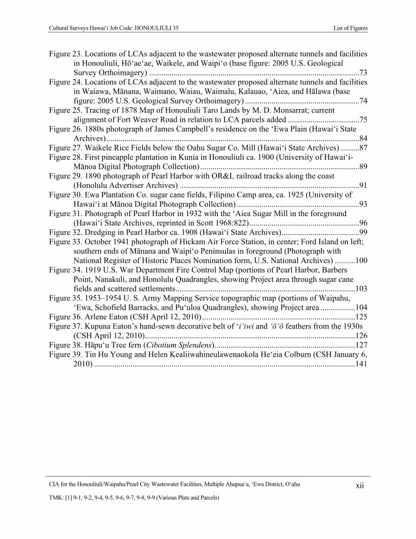
List of Figures
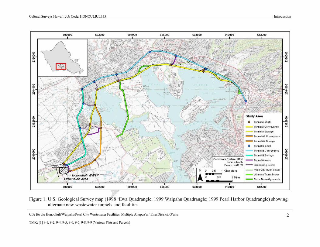
Figure 1. U.S. Geological Survey map (1998 ‘Ewa Quadrangle; 1999 Waipahu Quadrangle; 1999 Pearl Harbor Quadrangle) showing alternate new wastewater tunnels and facilities .2
Figure 2. 2005 aerial photograph of ‘Ewa, showing the alternate wastewater tunnels and facilities (2005 U. S. Geological Survey Orthoimagery) ...................................................................3
Figure 3. Existing Honouliuli/ Waipahu/ Pearl City Facilities Plan, with outline of study area (‘Ewa District) (map provided by client) .............................................................................4
Figure 4. Honouliuli/ Waipahu/ Pearl City Facilities Plan, with Tunnel Alternatives (map provided by client) ...............................................................................................................5
Figure 5. Tax Maps [1] 9-1 and 9-4 showing alternate wastewater tunnels and facilities from Honouliuli to Waikele ..........................................................................................................6
Figure 6. Tax Maps [1] 9-6 and 9-7, showing alternate wastewater tunnels and facilities from Waiawa to Manana ..............................................................................................................7
Figure 7. Tax Maps [1] 9-8 and 9-9, showing alternate wastewater tunnels and facilities from Waiau to Hālawa ..................................................................................................................8
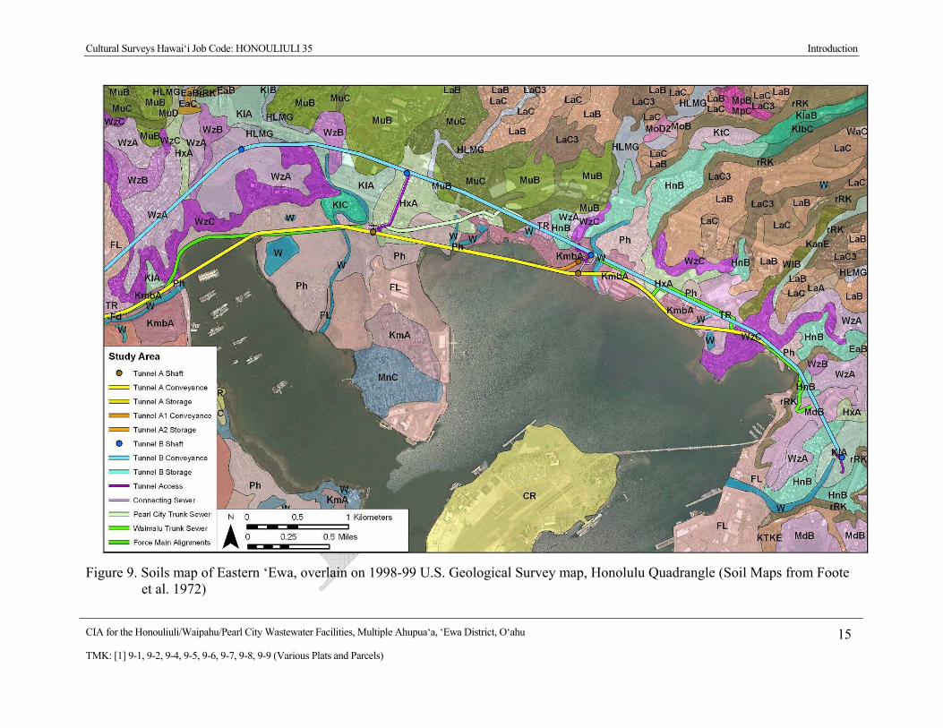
Figure 8. Soils map of Western ‘Ewa, overlain on 1998-99 U.S. Geological Survey map, Honolulu Quadrangle (Soil maps from Foote et al. 1972) .................................................14
Figure 9. Soils map of Eastern ‘Ewa, overlain on 1998-99 U.S. Geological Survey map, Honolulu Quadrangle (Soil Maps from Foote et al. 1972) ................................................15
Figure 10. Map of Pearl Harbor, ‘Ewa by S.M. Kanakanui (1894) showing the twelve ahupua‘a in the moku of ‘Ewa ...........................................................................................................21
Figure 11. 2005 aerial photograph of ‘Ewa, showing the numerous fishponds of the ‘Ewa District (2005 U. S. Geological Survey Orthoimagery) .................................................................22
Figure 12. Map of trails in ‘Ewa by Paul Rockwood (not to scale) to show O‘ahu trails ca. 1810, as described by John Papa ‘Ī‘ī (1959:96) ...........................................................................25
Figure 13. Place Names of Honouliuli and Hō‘ae‘ae (base map: 1927 U.S. Geological Survey, ‘Ewa, Barbers Point, Wai‘anae, and Waipahu Quadrangles) ............................................28
Figure 14. 1875 Map of the makai portion of Waikele, by W. D. Alexander, with place names added; fishponds in blue ....................................................................................................31
Figure 15. 1877 Map of Waipi‘o and upper portion of Waikele Ahupua‘a (Waikakalaua) by J. F. Brown, with place names added ........................................................................................32
Figure 16. 1927 U. S Geological Survey topographic map, with place names of Waiawa ...........36 Figure 17. 1887 map of the lower lands of Waiawa, Mānana, and Waimano, by S. E. Bishop,
with place names added .....................................................................................................37 Figure 18. 1887 map of lower lands of Waimano and Waiau by S. E. Bishop, with place names
added ..................................................................................................................................40 Figure 19. Portion of map of Pearl Harbor, ‘Ewa by S.M. Kanakanui (1894) with place names of
the coastal portions of Waimalu, Kalauao, ‘Aiea, and Hālawa added ...............................42 Figure 20. 1927 U.S. Geological Survey map (Pearl Harbor Quadrangle), showing place names
of Kalauao; large ‘ili of Ka‘ōnohi outlined in magenta .....................................................44 Figure 21. Tracing of 1913 Land Court Application Map No 334, for the Applicant, The
McGrew Estate, with LCA parcels, topographic points, and ‘ili names ............................45 Figure 22. 1874 map of ‘Aiea by C. J. Lyons, with place names added .......................................48
Cultural Surveys Hawai‘i Job Code: HONOULIULI 35 List of Figures
CIA for the Honouliuli/Waipahu/Pearl City Wastewater Facilities, Multiple Ahupua‘a, ‘Ewa District, O‘ahu xii
TMK: [1] 9-1, 9-2, 9-4, 9-5, 9-6, 9-7, 9-8, 9-9 (Various Plats and Parcels)
Figure 23. Locations of LCAs adjacent to the wastewater proposed alternate tunnels and facilities in Honouliuli, Hō‘ae‘ae, Waikele, and Waipi‘o (base figure: 2005 U.S. Geological Survey Orthoimagery) .......................................................................................................73
Figure 24. Locations of LCAs adjacent to the wastewater proposed alternate tunnels and facilities in Waiawa, Mānana, Waimano, Waiau, Waimalu, Kalauao, ‘Aiea, and Hālawa (base figure: 2005 U.S. Geological Survey Orthoimagery) ........................................................74
Figure 25. Tracing of 1878 Map of Honouliuli Taro Lands by M. D. Monsarrat; current alignment of Fort Weaver Road in relation to LCA parcels added ...................................75
Figure 26. 1880s photograph of James Campbell’s residence on the ‘Ewa Plain (Hawai‘i State Archives) ............................................................................................................................84
Figure 27. Waikele Rice Fields below the Oahu Sugar Co. Mill (Hawai‘i State Archives) .........87 Figure 28. First pineapple plantation in Kunia in Honouliuli ca. 1900 (University of Hawai‘i-
Mānoa Digital Photograph Collection) ..............................................................................89 Figure 29. 1890 photograph of Pearl Harbor with OR&L railroad tracks along the coast
(Honolulu Advertiser Archives) ........................................................................................91 Figure 30. Ewa Plantation Co. sugar cane fields, Filipino Camp area, ca. 1925 (University of
Hawai‘i at Mānoa Digital Photograph Collection) ............................................................93 Figure 31. Photograph of Pearl Harbor in 1932 with the ‘Aiea Sugar Mill in the foreground
(Hawai‘i State Archives, reprinted in Scott 1968:822) ......................................................96 Figure 32. Dredging in Pearl Harbor ca. 1908 (Hawai‘i State Archives) ......................................99 Figure 33. October 1941 photograph of Hickam Air Force Station, in center; Ford Island on left;
southern ends of Mānana and Waipi‘o Peninsulas in foreground (Photograph with National Register of Historic Places Nomination form, U.S. National Archives) ..........100
Figure 34. 1919 U.S. War Department Fire Control Map (portions of Pearl Harbor, Barbers Point, Nanakuli, and Honolulu Quadrangles, showing Project area through sugar cane fields and scattered settlements ........................................................................................103
Figure 35. 1953–1954 U. S. Army Mapping Service topographic map (portions of Waipahu, ‘Ewa, Schofield Barracks, and Pu‘uloa Quadrangles), showing Project area .................104
Figure 36. Arlene Eaton (CSH April 12, 2010) ...........................................................................125 Figure 37. Kupuna Eaton’s hand-sewn decorative belt of ‘i‘iwi and ‘ō‘ō feathers from the 1930s
(CSH April 12, 2010) .......................................................................................................126 Figure 38. Hāpu‘u Tree fern (Cibotium Splendens) .....................................................................127 Figure 39. Tin Hu Young and Helen Kealiiwahineulawenaokola He‘eia Colburn (CSH January 6,
2010) ................................................................................................................................141
CIA for the Honouliuli/Waipahu/Pearl City Wastewater Facilities, Multiple Ahupua‘a, ‘Ewa District, O‘ahu xiii
TMK: [1] 9-1, 9-2, 9-4, 9-5, 9-6, 9-7, 9-8, 9-9 (Various Plats and Parcels)
List of Tables
Table 1. Honouliuli/Waipahu/Pearl City Wastewater Facilities ......................................................9 Table 2. Soil Types ........................................................................................................................11 Table 3. Results of Community Consultation ..............................................................................106

Cultural Surveys Hawai‘i Job Code: HONOULIULI 35 Introduction
CIA for the Honouliuli/Waipahu/Pearl City Wastewater Facilities, Multiple Ahupua‘a, ‘Ewa District, O‘ahu 1
TMK: [1] 9-1, 9-2, 9-4, 9-5, 9-6, 9-7, 9-8, 9-9 (Various Plats and Parcels)
Section 1 Introduction
1.1 Project Background At the request of AECOM Pacific, Inc., Cultural Surveys Hawai‘i, Inc. (CSH) has prepared
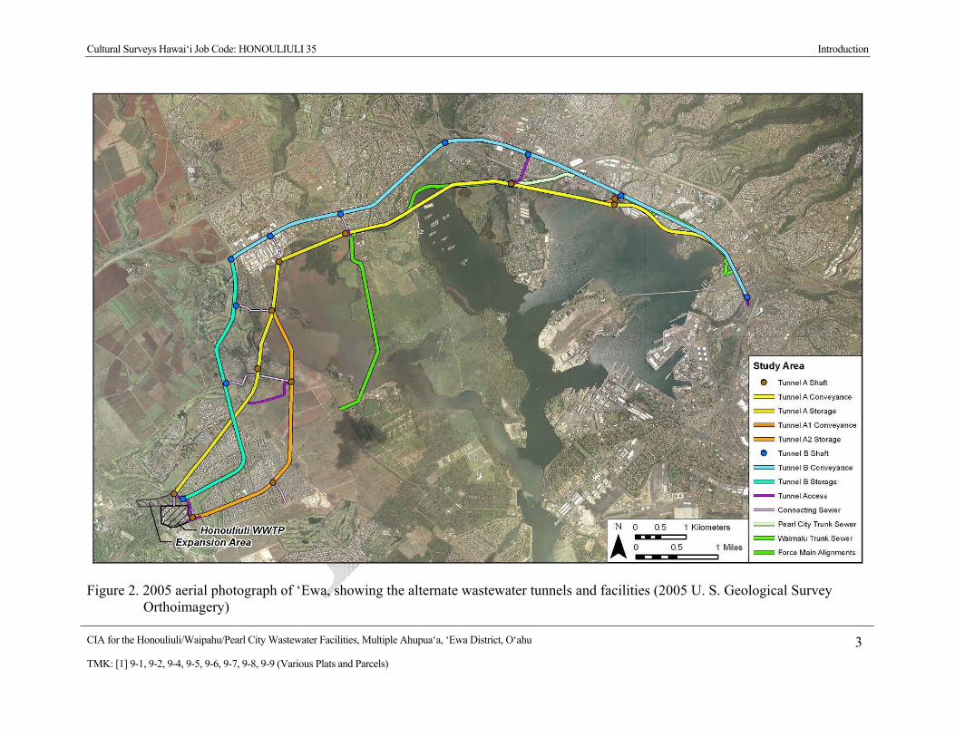
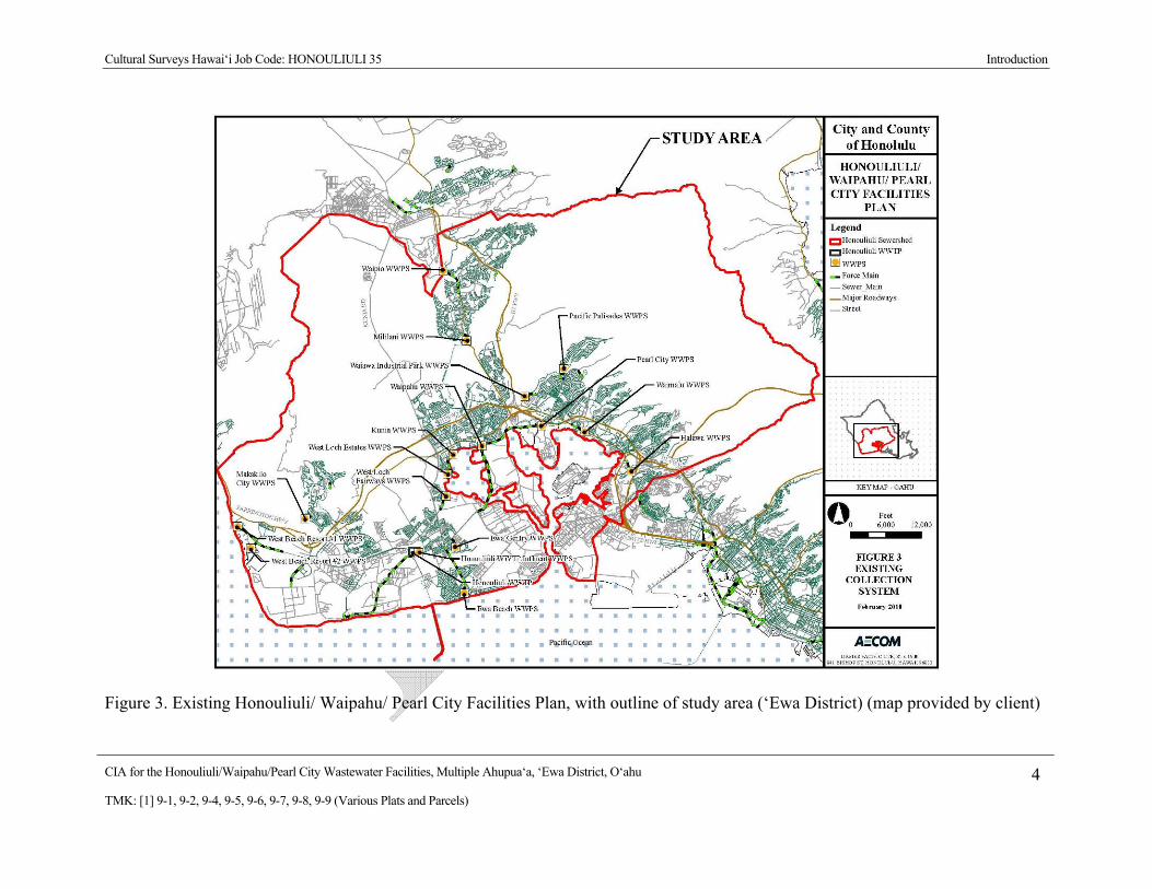
this Cultural Impact Assessment (CIA) for the proposed Honouliuli/Waipahu/Pearl City Wastewater Facilities Project, ‘Ewa District, O‘ahu Island. The Project area is shown on a U. S. Geological Survey map (Figure 1), on a U.S. Geological Survey aerial photograph (Figure 2), on an existing wastewater facilities map (Figure 3), on a planned (showing alternate tunnels) wastewater facilities map (Figure 4), and on Hawai‘i tax maps Plats [1] 9-1, 9-4, 9-6, 9-7, 9-8, and 9-9 (Figure 5 to Figure 7). The West Mamala Bay Facilities Plan Environmental Impact Statement (EIS) describes the Project:
The proposed action consists of various long-term improvements to the wastewater collection, treatment and disposal system for the Honouliuli Wastewater Treatment Plant service area. The purpose of the proposed improvements, including alternative collection system improvement is to accommodate wastewater flows Project through 2020. (Wilson Okamoto & Associates 2000:S-1)
AECOM Pacific, Inc. describes their involvement in the Project:
The City & County of Honolulu (CCH) Department of Environmental Services (ENV) is in the process of updating three wastewater facilities plans: Honouliuli, Kailua-Kaneohe and Sand Island. AECOM has been contracted to prepare the Honouliuli/Waipahu/Pearl City Facilities Plan and is preparing a preliminary engineering report (Pukui & Elbert 1986R) as part of the facilities plan. The Honouliuli/Waipahu/Pearl City Wastewater Facilities Plan is an update to the existing West Mamala Bay Facilities Plan (2001). The Pukui & Elbert 1986R will provide engineering planning for the sanitary sewer system served by the Honouliuli Wastewater Treatment Plant (HNWWTP). The study encompasses the Honouliuli sewershed (study area) from West Beach to Hālawa. (AECOM 2010:5)
The Project area includes areas from which current wastewater flows to the HNWWTP as well as potential future flows from area in the ahupua‘a (land division usually extending from the uplands to the sea) of Honouliuli, Pu‘uloa, Hō‘ae‘ae, Waikele, Waipi‘o, Waiawa, Manana, Waimano, Waiau, Waimalu, Kalauao, ‘Aiea, and Hālawa.
Cultural Surveys Hawai‘i Job Code: HONOULIULI 35 Introduction
CIA for the Honouliuli/Waipahu/Pearl City Wastewater Facilities, Multiple Ahupua‘a, ‘Ewa District, O‘ahu 2
TMK: [1] 9-1, 9-2, 9-4, 9-5, 9-6, 9-7, 9-8, 9-9 (Various Plats and Parcels)
Figure 1. U.S. Geological Survey map (1998 ‘Ewa Quadrangle; 1999 Waipahu Quadrangle; 1999 Pearl Harbor Quadrangle) showing alternate new wastewater tunnels and facilities
Cultural Surveys Hawai‘i Job Code: HONOULIULI 35 Introduction
CIA for the Honouliuli/Waipahu/Pearl City Wastewater Facilities, Multiple Ahupua‘a, ‘Ewa District, O‘ahu 3
TMK: [1] 9-1, 9-2, 9-4, 9-5, 9-6, 9-7, 9-8, 9-9 (Various Plats and Parcels)
Figure 2. 2005 aerial photograph of ‘Ewa, showing the alternate wastewater tunnels and facilities (2005 U. S. Geological Survey Orthoimagery)
Cultural Surveys Hawai‘i Job Code: HONOULIULI 35 Introduction
CIA for the Honouliuli/Waipahu/Pearl City Wastewater Facilities, Multiple Ahupua‘a, ‘Ewa District, O‘ahu 4
TMK: [1] 9-1, 9-2, 9-4, 9-5, 9-6, 9-7, 9-8, 9-9 (Various Plats and Parcels)
Figure 3. Existing Honouliuli/ Waipahu/ Pearl City Facilities Plan, with outline of study area (‘Ewa District) (map provided by client)

Cultural Surveys Hawai‘i Job Code: HONOULIULI 35 Introduction
CIA for the Honouliuli/Waipahu/Pearl City Wastewater Facilities, Multiple Ahupua‘a, ‘Ewa District, O‘ahu 5
TMK: [1] 9-1, 9-2, 9-4, 9-5, 9-6, 9-7, 9-8, 9-9 (Various Plats and Parcels)
Figure 4. Honouliuli/ Waipahu/ Pearl City Facilities Plan, with Tunnel Alternatives (map provided by client)

Cultural Surveys Hawai‘i Job Code: HONOULIULI 35 Introduction
CIA for the Honouliuli/Waipahu/Pearl City Wastewater Facilities, Multiple Ahupua‘a, ‘Ewa District, O‘ahu 6
TMK: [1] 9-1, 9-2, 9-4, 9-5, 9-6, 9-7, 9-8, 9-9 (Various Plats and Parcels)
Figure 5. Tax Maps [1] 9-1 and 9-4 showing alternate wastewater tunnels and facilities from Honouliuli to Waikele

Cultural Surveys Hawai‘i Job Code: HONOULIULI 35 Introduction
CIA for the Honouliuli/Waipahu/Pearl City Wastewater Facilities, Multiple Ahupua‘a, ‘Ewa District, O‘ahu 7
TMK: [1] 9-1, 9-2, 9-4, 9-5, 9-6, 9-7, 9-8, 9-9 (Various Plats and Parcels)
Figure 6. Tax Maps [1] 9-6 and 9-7, showing alternate wastewater tunnels and facilities from Waiawa to Manana

Cultural Surveys Hawai‘i Job Code: HONOULIULI 35 Introduction
CIA for the Honouliuli/Waipahu/Pearl City Wastewater Facilities, Multiple Ahupua‘a, ‘Ewa District, O‘ahu 8
TMK: [1] 9-1, 9-2, 9-4, 9-5, 9-6, 9-7, 9-8, 9-9 (Various Plats and Parcels)
Figure 7. Tax Maps [1] 9-8 and 9-9, showing alternate wastewater tunnels and facilities from Waiau to Hālawa
Cultural Surveys Hawai‘i Job Code: HONOULIULI 35 Introduction
CIA for the Honouliuli/Waipahu/Pearl City Wastewater Facilities, Multiple Ahupua‘a, ‘Ewa District, O‘ahu 9
TMK: [1] 9-1, 9-2, 9-4, 9-5, 9-6, 9-7, 9-8, 9-9 (Various Plats and Parcels)
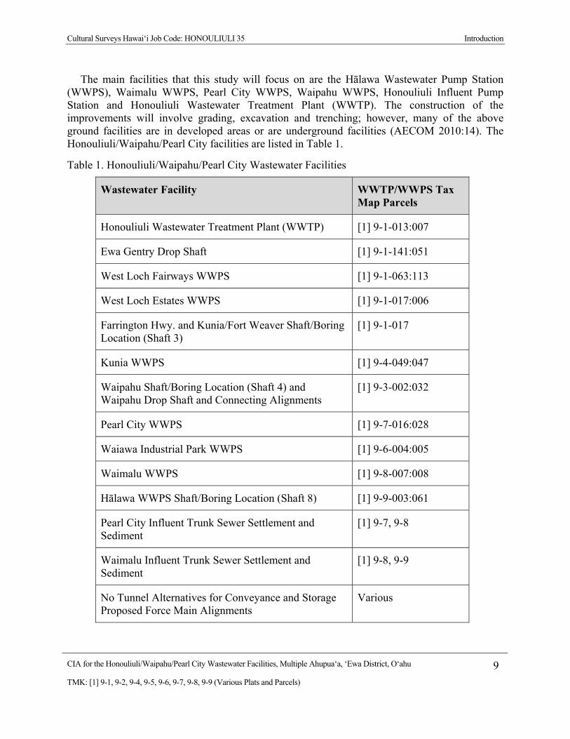
The main facilities that this study will focus on are the Hālawa Wastewater Pump Station (WWPS), Waimalu WWPS, Pearl City WWPS, Waipahu WWPS, Honouliuli Influent Pump Station and Honouliuli Wastewater Treatment Plant (WWTP). The construction of the improvements will involve grading, excavation and trenching; however, many of the above ground facilities are in developed areas or are underground facilities (AECOM 2010:14). The Honouliuli/Waipahu/Pearl City facilities are listed in Table 1.
Table 1. Honouliuli/Waipahu/Pearl City Wastewater Facilities
Wastewater Facility WWTP/WWPS Tax Map Parcels
Honouliuli Wastewater Treatment Plant (WWTP) [1] 9-1-013:007
Ewa Gentry Drop Shaft [1] 9-1-141:051
West Loch Fairways WWPS [1] 9-1-063:113
West Loch Estates WWPS [1] 9-1-017:006
Farrington Hwy. and Kunia/Fort Weaver Shaft/Boring Location (Shaft 3)
[1] 9-1-017
Kunia WWPS [1] 9-4-049:047
Waipahu Shaft/Boring Location (Shaft 4) and Waipahu Drop Shaft and Connecting Alignments
[1] 9-3-002:032
Pearl City WWPS [1] 9-7-016:028
Waiawa Industrial Park WWPS [1] 9-6-004:005
Waimalu WWPS [1] 9-8-007:008
Hālawa WWPS Shaft/Boring Location (Shaft 8) [1] 9-9-003:061
Pearl City Influent Trunk Sewer Settlement and Sediment
[1] 9-7, 9-8
Waimalu Influent Trunk Sewer Settlement and Sediment
[1] 9-8, 9-9
No Tunnel Alternatives for Conveyance and Storage Proposed Force Main Alignments
Various
Cultural Surveys Hawai‘i Job Code: HONOULIULI 35 Introduction
CIA for the Honouliuli/Waipahu/Pearl City Wastewater Facilities, Multiple Ahupua‘a, ‘Ewa District, O‘ahu 10
TMK: [1] 9-1, 9-2, 9-4, 9-5, 9-6, 9-7, 9-8, 9-9 (Various Plats and Parcels)
1.2 Scope of Work The scope of work for this CIA includes:
1. Examination of cultural and historical resources, including Land Commission documents, historic maps, and previous research reports, with the specific purpose of identifying traditional Hawaiian activities including gathering of plant, animal, and other resources or agricultural pursuits as may be indicated in the historic record.
2. Review of previous archaeological work at and near the subject parcel that may be relevant to reconstructions of traditional land use activities; and to the identification and description of cultural resources, practices, and beliefs associated with the parcel.
3. Consultation and interviews with knowledgeable parties regarding cultural and natural resources and practices at or near the parcel; present and past uses of the parcel; and/or other practices, uses, or traditions associated with the parcel and environs.
4. Preparation of a report that summarizes the results of these research activities and provides recommendations based on findings.
1.3 Environmental Setting
1.3.1 Natural Environment near the Alternate Wastewater Tunnels and Facilities
The western section of the Project area extends through the ‘Ewa Plain, the central section of Honouliuli Ahupua‘a, and Hō‘ae‘ae Ahupua‘a. The ‘Ewa Plain is a Pleistocene (>38,000 years old) reef platform overlain by alluvium. The terrain consists of limestone and alluvial deposits, which overlie flows of the Wai‘anae volcanic series (MacDonald et al. 1983:423). In pre-Contact Hawai‘i, this Project section would have been covered by lowland dry shrub and grassland, but this area has been extensively disturbed and transformed by human activity; it is now dominated by a variety of exotic grasses, weeds, and shrubs. Elevations within the Honouliuli section vary between approximately 20 and 80 ft, and the area receives an average of 24 inches of rain annually (Giambelluca et al. 1986). The only major stream running through this western section phase is Honouliuli Stream.
The eastern section of the Project area is between 0.4 and 1.2 miles inland of the West and Middle Lochs of Pearl Harbor. Terrain is fairly level with elevations between 20 and 40 ft above sea level, rising to 100 to 200 ft above sea level toward the eastern end. The eastern section receives an average of 24 to 31 inches of annual rainfall (Giambelluca et al. 1986). There are six perennial streams in this section, Waikele, Waiawa, Waimalu, Kalauao, ‘Aiea, and Hālawa Stream. Three smaller, non-perennial streams intersect this section: Hō‘ae‘ae Stream at the ‘Ewa end and Kapakahi and Makalena Streams between West and Middle Lochs. These streams drain a “large expanse of lateritic soils of fine particle size (and therefore) the water would have appeared muddy in prehistoric times even during periods of normal flow” (Hammatt and Borthwick 1988).
According to the United States Department of Agriculture (USDA) soil survey data (Foote et al. 1972), sediments near the alternate wastewater facilities and tunnels, listed in Table 2 and shown on Figure 8 and Figure 9 are soils of the ‘Ewa (EmA and EmB), Helemano (HLMG),
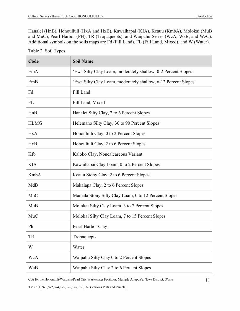
Cultural Surveys Hawai‘i Job Code: HONOULIULI 35 Introduction
CIA for the Honouliuli/Waipahu/Pearl City Wastewater Facilities, Multiple Ahupua‘a, ‘Ewa District, O‘ahu 11
TMK: [1] 9-1, 9-2, 9-4, 9-5, 9-6, 9-7, 9-8, 9-9 (Various Plats and Parcels)
Hanalei (HnB), Honouliuli (HxA and HxB), Kawaihapai (KIA), Keauu (KmbA), Molokai (MuB and MuC), Pearl Harbor (PH), TR (Tropaquepts), and Waipahu Series (WzA, WzB, and WzC). Additional symbols on the soils maps are Fd (Fill Land), FL (Fill Land, Mixed), and W (Water).
Table 2. Soil Types
Code Soil Name
EmA ‘Ewa Silty Clay Loam, moderately shallow, 0-2 Percent Slopes
EmB ‘Ewa Silty Clay Loam, moderately shallow, 6-12 Percent Slopes
Fd Fill Land
FL Fill Land, Mixed
HnB Hanalei Silty Clay, 2 to 6 Percent Slopes
HLMG Helemano Silty Clay, 30 to 90 Percent Slopes
HxA Honouliuli Clay, 0 to 2 Percent Slopes
HxB Honouliuli Clay, 2 to 6 Percent Slopes
Kfb Kaloko Clay, Noncalcareous Variant
KIA Kawaihapai Clay Loam, 0 to 2 Percent Slopes
KmbA Keauu Stony Clay, 2 to 6 Percent Slopes
MdB Makalapa Clay, 2 to 6 Percent Slopes
MnC Mamala Stony Silty Clay Loam, 0 to 12 Percent Slopes
MuB Molokai Silty Clay Loam, 3 to 7 Percent Slopes
MuC Molokai Silty Clay Loam, 7 to 15 Percent Slopes
Ph Pearl Harbor Clay
TR Tropaquepts
W Water
WzA Waipahu Silty Clay 0 to 2 Percent Slopes
WaB Waipahu Silty Clay 2 to 6 Percent Slopes
Cultural Surveys Hawai‘i Job Code: HONOULIULI 35 Introduction
CIA for the Honouliuli/Waipahu/Pearl City Wastewater Facilities, Multiple Ahupua‘a, ‘Ewa District, O‘ahu 12
TMK: [1] 9-1, 9-2, 9-4, 9-5, 9-6, 9-7, 9-8, 9-9 (Various Plats and Parcels)
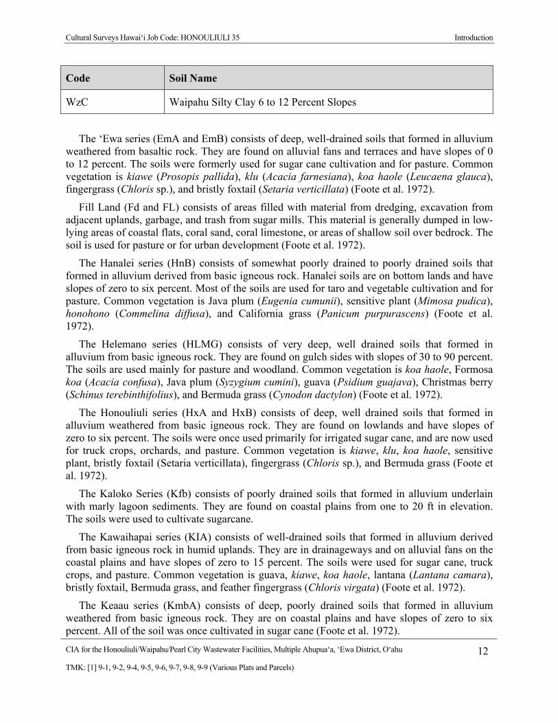
Code Soil Name
WzC Waipahu Silty Clay 6 to 12 Percent Slopes
The ‘Ewa series (EmA and EmB) consists of deep, well-drained soils that formed in alluvium weathered from basaltic rock. They are found on alluvial fans and terraces and have slopes of 0 to 12 percent. The soils were formerly used for sugar cane cultivation and for pasture. Common vegetation is kiawe (Prosopis pallida), klu (Acacia farnesiana), koa haole (Leucaena glauca), fingergrass (Chloris sp.), and bristly foxtail (Setaria verticillata) (Foote et al. 1972).
Fill Land (Fd and FL) consists of areas filled with material from dredging, excavation from adjacent uplands, garbage, and trash from sugar mills. This material is generally dumped in low-lying areas of coastal flats, coral sand, coral limestone, or areas of shallow soil over bedrock. The soil is used for pasture or for urban development (Foote et al. 1972).
The Hanalei series (HnB) consists of somewhat poorly drained to poorly drained soils that formed in alluvium derived from basic igneous rock. Hanalei soils are on bottom lands and have slopes of zero to six percent. Most of the soils are used for taro and vegetable cultivation and for pasture. Common vegetation is Java plum (Eugenia cumunii), sensitive plant (Mimosa pudica), honohono (Commelina diffusa), and California grass (Panicum purpurascens) (Foote et al. 1972).
The Helemano series (HLMG) consists of very deep, well drained soils that formed in alluvium from basic igneous rock. They are found on gulch sides with slopes of 30 to 90 percent. The soils are used mainly for pasture and woodland. Common vegetation is koa haole, Formosa koa (Acacia confusa), Java plum (Syzygium cumini), guava (Psidium guajava), Christmas berry (Schinus terebinthifolius), and Bermuda grass (Cynodon dactylon) (Foote et al. 1972).
The Honouliuli series (HxA and HxB) consists of deep, well drained soils that formed in alluvium weathered from basic igneous rock. They are found on lowlands and have slopes of zero to six percent. The soils were once used primarily for irrigated sugar cane, and are now used for truck crops, orchards, and pasture. Common vegetation is kiawe, klu, koa haole, sensitive plant, bristly foxtail (Setaria verticillata), fingergrass (Chloris sp.), and Bermuda grass (Foote et al. 1972).
The Kaloko Series (Kfb) consists of poorly drained soils that formed in alluvium underlain with marly lagoon sediments. They are found on coastal plains from one to 20 ft in elevation. The soils were used to cultivate sugarcane.
The Kawaihapai series (KIA) consists of well-drained soils that formed in alluvium derived from basic igneous rock in humid uplands. They are in drainageways and on alluvial fans on the coastal plains and have slopes of zero to 15 percent. The soils were used for sugar cane, truck crops, and pasture. Common vegetation is guava, kiawe, koa haole, lantana (Lantana camara), bristly foxtail, Bermuda grass, and feather fingergrass (Chloris virgata) (Foote et al. 1972).
The Keaau series (KmbA) consists of deep, poorly drained soils that formed in alluvium weathered from basic igneous rock. They are on coastal plains and have slopes of zero to six percent. All of the soil was once cultivated in sugar cane (Foote et al. 1972).
Cultural Surveys Hawai‘i Job Code: HONOULIULI 35 Introduction
CIA for the Honouliuli/Waipahu/Pearl City Wastewater Facilities, Multiple Ahupua‘a, ‘Ewa District, O‘ahu 13
TMK: [1] 9-1, 9-2, 9-4, 9-5, 9-6, 9-7, 9-8, 9-9 (Various Plats and Parcels)
The Makalapa series (MdB) consists of moderately deep, well-drained soils that formed in material weathered from volcanic tuff. They are found in uplands at slopes of two to 20 percent. These soils areas have been used for military reservations, urban development, and pasture. Common vegetation is kiawe, koa-haole, lantana, dwarf koa (Acacia koaia), fingergrass, and bermudagrass.
The Mamala series (MnC) consists of shallow, well-drained soils that formed from alluvium deposited over coral limestone and consolidated calcareous sands. They are found on coastal plains at slopes of zero to 12 percent. The soils were used for the cultivation of truck crops and irrigated sugarcane, and for pasture. Common vegetation is kiawe, koa-haole, klu, bristly foxtail, and fingergrass.
The Molokai series (MuB and MuC) consists of very deep, well-drained soils that formed in material weathered from basic igneous rock. They are found on uplands and have slopes of zero to 25 percent. The soils were used for the pineapple cultivation, irrigated sugar cane and pasture. Common vegetation is kiawe, lantana, ‘ilima (Sida cordifolia), pitted beardgrass (Bothriochloa barbinodis perforatus), feather fingergrass, and buffelgrass (Cenchrus ciliaris) (Foote et al. 1972).
The Pearl Harbor series (PH) consists of deep, very poorly drained soils that formed in alluvium worked from material weathered from basic igneous rock and deposited over and mixed with muck. They are found on coastal flats and have slopes of zero to 2 percent. Most of this soil area is now urbanized or in pasture, but some is used for taro, bananas, and sugar cane cultivation. Common vegetation is panicum, sedges, cattails, and mangrove trees (Foote et al. 1972).
Tropaquepts (TR) are poorly-drained soils that are periodically flooded by irrigation in order to grow crops that thrive in water. They occur as nearly level flood plains on the islands of Oahu and Maui. Elevations range from sea level to 200 ft. Tropaquepts are used for production of taro, rice, and watercress on flooded paddies
The Waipahu series (WzA, WzB, and WzC) consists of deep, well drained soils that formed in old alluvium weathered from basic igneous rock. They are on dissected terraces and have slopes of zero to 12 percent. The soils are now used mainly for urban development, with some areas once used for irrigated sugar cane (Foote et al. 1972).
1.3.2 Built Environment near the Alternate Wastewater Tunnels and Facilities
The alternate tunnels generally follow or parallel major roads in the ‘Ewa District, such as the north/south Fort Weaver Road in Honouliuli and the east-west Farrington High along the northern shores of Pearl Harbor. As these are major thoroughways, the areas adjacent to the roads are densely developed, with residential neighborhoods, large shopping complexes, hospitals and schools, office buildings, military installations, and other structures/areas.

Cultural Surveys Hawai‘i Job Code: HONOULIULI 35 Introduction
CIA for the Honouliuli/Waipahu/Pearl City Wastewater Facilities, Multiple Ahupua‘a, ‘Ewa District, O‘ahu 14
TMK: [1] 9-1, 9-2, 9-4, 9-5, 9-6, 9-7, 9-8, 9-9 (Various Plats and Parcels)
Figure 8. Soils map of Western ‘Ewa, overlain on 1998-99 U.S. Geological Survey map, Honolulu Quadrangle (Soil maps from Foote et al. 1972)
Cultural Surveys Hawai‘i Job Code: HONOULIULI 35 Introduction
CIA for the Honouliuli/Waipahu/Pearl City Wastewater Facilities, Multiple Ahupua‘a, ‘Ewa District, O‘ahu 15
TMK: [1] 9-1, 9-2, 9-4, 9-5, 9-6, 9-7, 9-8, 9-9 (Various Plats and Parcels)
Figure 9. Soils map of Eastern ‘Ewa, overlain on 1998-99 U.S. Geological Survey map, Honolulu Quadrangle (Soil Maps from Foote et al. 1972)
Cultural Surveys Hawai‘i Job Code: HONOULIULI 35 Methods
CIA for the Honouliuli/Waipahu/Pearl City Wastewater Facilities, Multiple Ahupua‘a, ‘Ewa District, O‘ahu 16
TMK: [1] 9-1, 9-2, 9-4, 9-5, 9-6, 9-7, 9-8, 9-9 (Various Plats and Parcels)
Section 2 Methods
2.1 Archival Research Historical documents, maps and existing archaeological information pertaining to Honouliuli,
Hō‘ae‘ae, Waikele, Waipi‘o, Waiawa, Mānana, and Hālawa Ahupua‘a, ‘Ewa District, and the Project area vicinity were researched at the CSH library and other archives including the University of Hawai‘i at Mānoa’s Hamilton Library, the State Historic Preservation Division (SHPD) library, the Hawai‘i State Archives, the State Land Survey Division, and the archives of the Bishop Museum. Previous archaeological reports for the area were reviewed, as were historic maps and photographs and primary and secondary historical sources. Information on Land Commission Awards (LCAs) was accessed through Waihona ‘Aina Corporation’s Māhele Data Base (www.waihona.com) as well as a selection of CSH library references.
The definitive source for Hawaiian place names is Pukui et al.’s (1974) Place Names of Hawai‘i, but additional place-name translations and interpretations were also gleaned from Soehren’s “Hawaiian Place Names” database on the internet (http//www.ulukau.org), historical maps, Land Commission documents available at the Hawai‘i State Archives or on the internet at www.waihona.com, and from other place-name texts such as Clark (1977) and Thrum (1922). Some place names in this report—discussed in the next section—were also gathered from U.S. Geological Survey 7.5-Minute Series topographic maps.
For cultural studies, research for the Wahi Pana section centered on Hawaiian activities including: religious and ceremonial knowledge and practices; traditional subsistence land use and settlement patterns; gathering practices and agricultural pursuits; as well as Hawaiian place names and mo‘olelo (story, tale, myth), mele (songs), oli (chants), ‘ōlelo no‘eau (proverbs) and more. For the Historical Background section research focused on land transformation, development and population changes beginning in the early post–European Contact era to the present day (see Scope of Work above).
2.2 Community Consultation
2.2.1 Sampling and Recruitment
A combination of qualitative methods, including purposive, snowball, and expert (or judgment) sampling, were used to identify and invite potential participants to the study. These methods are used for intensive case studies, such as CIAs, to recruit people that are hard to identify, or are members of elite groups (Bernard 2006:190). Our purpose is not to establish a representative or random sample. It is to “identify specific groups of people who either possess characteristics or live in circumstances relevant to the social phenomenon being studied….This approach to sampling allows the researcher deliberately to include a wide range of types of informants and also to select key informants with access to important sources of knowledge” (Mays and Pope 1995:110).
We began with purposive sampling informed by referrals from known specialists and relevant agencies. For example, we contacted the SHPD, OHA, OIBC, and community and cultural
Cultural Surveys Hawai‘i Job Code: HONOULIULI 35 Methods
CIA for the Honouliuli/Waipahu/Pearl City Wastewater Facilities, Multiple Ahupua‘a, ‘Ewa District, O‘ahu 17
TMK: [1] 9-1, 9-2, 9-4, 9-5, 9-6, 9-7, 9-8, 9-9 (Various Plats and Parcels)
organizations in and around Honouliuli, Hō‘ae‘ae, Waikele, Waipi‘o, Waiawa, Mānana, and Hālawa Ahupua‘a, for their brief response/review of the Project and to identify potentially knowledgeable individuals with cultural expertise and/or knowledge of the Project area and vicinity, cultural and lineal descendants, and other appropriate community representatives and members. Based on their in-depth knowledge and experiences, these key respondents then referred CSH to additional potential participants who were added to the pool of invited participants. This is snowball sampling, a chain referral method that entails asking a few key individuals (including agency and organization representatives) to provide their comments and referrals to other locally recognized experts or stakeholders who would be likely candidates for the study (Bernard 2006:192). CSH also employs expert or judgment sampling which involves assembling a group of people with recognized experience and expertise in a specific area (Bernard 2006:189–191). CSH maintains a database that draws on over two decades of established relationships with community consultants: cultural practitioners and specialists, community representatives and cultural and lineal descendants. The names of new potential contacts were also provided by colleagues at CSH and from the researchers’ familiarity with people who live in or around the Project area. Researchers often attend public forums (e.g., Neighborhood Board, Burial Council and Civic Club meetings) in or near the Project area to scope for participants. Please refer to Table 3, Section 6, for a complete list of individuals and organizations contacted for this CIA.
CSH focuses on obtaining in-depth information with a high level of validity from a targeted group of relevant stakeholders and local experts. Our qualitative methods do not aim to survey an entire population or subgroup. A depth of understanding about complex issues cannot be gained through comprehensive surveying. Our qualitative methodologies do not include quantitative (statistical) analyses, yet they are recognized as rigorous and thorough. Bernard (2006:25) describes the qualitative methods as “a kind of measurement, an integral part of the complex whole that comprises scientific research.” Depending on the size and complexity of the Project, CSH reports include in-depth contributions from about one-third of all participating respondents. Typically this means three to 12 interviews.
2.2.2 Informed Consent Protocol
An informed consent process was conducted as follows: (1) before beginning the interview the CSH researcher explained to the participant how the consent process works, the Project purpose, the intent of the study and how his/her information will be used; (2) the researcher gave him/her a copy of the Authorization and Release Form to read and sign (Appendix C); (3) if the person agreed to participate by way of signing the consent form or by providing oral consent, the researcher started the interview; (4) the interviewee received a copy of the Authorization and Release Form for his/her records, while the original is stored at CSH; (5) after the interview was summarized at CSH (and possibly transcribed in full), the study participant was afforded an opportunity to review the interview notes (or transcription) and summary and to make any corrections, deletions or additions to the substance of their testimony/oral history interview; this was accomplished primarily via phone, post or email follow-up and secondarily by in-person visits; (6) participants received the final approved interview, photographs and the audio-recording and/or transcripts their interview if it was recorded. They were also given information

Cultural Surveys Hawai‘i Job Code: HONOULIULI 35 Methods
CIA for the Honouliuli/Waipahu/Pearl City Wastewater Facilities, Multiple Ahupua‘a, ‘Ewa District, O‘ahu 18
TMK: [1] 9-1, 9-2, 9-4, 9-5, 9-6, 9-7, 9-8, 9-9 (Various Plats and Parcels)
on how to view the draft report on the OEQC website and offered a hardcopy of the report once the report is a public document.
2.2.3 Interview Techniques
To assist in discussion of natural and cultural resources and cultural practices specific to the Project area, CSH initiated “talk story” sessions with (unstructured and semi-structured interviews as described by Bernard 2006) asking questions from the following broad categories: gathering practices and resources, burials, trails, historic properties and wahi pana (storied place). The interview protocol is tailored to the specific natural and cultural features of the landscape in the Project area identified through archival research and community consultation. These interviews and oral histories supplement and provide depth to consultations from government agencies and community organizations that may provide brief responses, reviews and/or referrals gathered via phone, email and occasionally face-to-face commentary.
2.2.3.1 In-depth Interviews and Oral Histories
Interviews were conducted initially at a place of the study participant’s choosing (usually at the participant’s home or at a public meeting place) and/or—whenever feasible—during site visits to the Project area. Generally, CSH’s preference is to interview a participant individually or in small groups (two–four); occasionally participants are interviewed in focus groups (six–eight). Following the consent protocol outlined above, interviews may be recorded on tape or a digital audio device and in handwritten notes, and the participant photographed. The interview typically lasts one to four hours, and records the “who, what, when and where” of the interview. In addition to questions outlined above, the interviewee is asked to provided biographical information (e.g., connection to the Project area, genealogy, professional and volunteer affiliations, etc.).
2.3 Compensation and Contributions to Community Many individuals and communities have generously worked with CSH over the years to
identify and document the rich natural and cultural resources of these islands for cultural impact, ethno–historical and, more recently, TCP studies. CSH makes every effort to provide some form of compensation to individuals and communities who contribute to cultural studies. This is done in a variety of ways: individual interview participants are compensated for their time in the form of a small honorarium and/or other makana (gift); community organization representatives (who may not be allowed to receive a gift) are asked if they would like a donation to a Hawaiian charter school or nonprofit of their choice to be made anonymously or in the name of the individual or organization participating in the study; contributors are provided their transcripts, interview summaries, photographs and—when possible—a copy of the CIA report; CSH is working to identify a public repository for all cultural studies that will allow easy access to current and past reports; CSH staff do volunteer work for community initiatives that serve to preserve and protect historic and cultural resources (for example in, Lāna‘i, Waimānalo, and Kaho‘olawe). Generally our goal is to provide educational opportunities to students through internships, share our knowledge of historic preservation and cultural resources and the State and Federal laws that guide the historic preservation process, and through involvement in an ongoing
Cultural Surveys Hawai‘i Job Code: HONOULIULI 35 Methods
CIA for the Honouliuli/Waipahu/Pearl City Wastewater Facilities, Multiple Ahupua‘a, ‘Ewa District, O‘ahu 19
TMK: [1] 9-1, 9-2, 9-4, 9-5, 9-6, 9-7, 9-8, 9-9 (Various Plats and Parcels)
working group of public and private stakeholders collaborating to improve and strengthen the Chapter 343 environmental review process.
Cultural Surveys Hawai‘i Job Code: HONOULIULI 35 Wahi Pana (Place Names) of ‘Ewa
CIA for the Honouliuli/Waipahu/Pearl City Wastewater Facilities, Multiple Ahupua‘a, ‘Ewa District, O‘ahu 20
TMK: [1] 9-1, 9-2, 9-4, 9-5, 9-6, 9-7, 9-8, 9-9 (Various Plats and Parcels)
Section 3 Wahi Pana (Place Names) of ‘Ewa
Hawaiians recognize several land divisions in varying scales, including the moku (district), the kalana (smaller land division than a moku), the ahupua‘a, and the ‘ili (land section, next in importance to ahupua‘a and usually a subdivision of an ahupua‘a) (Malo 1976:16). S.K. Kuhano wrote in 1873 (cited in Kame‘eleihiwa 1992:330) that O‘ahu was divided into six kalana (although later scholars refer to these same divisions as moku)—Kona, ‘Ewa, Wai‘anae, Waialua, Ko‘olau Loa and Ko‘olau Poko—that were further divided into 86 ahupua‘a. Within ‘Ewa, there were 12 ahupua‘a including (from west to east) Honouliuli, Hō‘ae‘ae, Waikele, Waipi‘o, Waiawa, Mānana, Waimano, Waiau, Waimalu, Kalauao, ‘Aiea, and Hālawa (Kame‘eleihiwa 1992:330) (Figure 10). Modern maps and land divisions still generally follow the ancient system and use the same land divisions. This report covers all twelve of the ahupua‘a of ‘Ewa, from Honouliuli east to Hālawa (Figure 10).
‘Ewa is depicted as an abundant and populated land where chiefs of distinguished lineages were born and resided. The land was fertile and well-fed by mountain streams that helped sustain the agricultural lifestyle needed to support the elaborated social systems of chiefs, their households, and their people. An examination of the place names reveals that water was a very important factor in this district. Six of the twelve ahupua‘a in ‘Ewa—Waikele, Waipi‘o, Waiawa, Waimano, Waiau, and Waimalu— begin with wai, the Hawaiian word for water. The fact that there were so many fishponds in ‘Ewa (Figure 11), more than any other district on O‘ahu, indicates that agricultural and aquacultural intensification was a direct link to the chiefs who resided there and to the increasing needs of the population.
Place names, or wahi pana, are an integral part of Hawaiian culture. “In Hawaiian culture, if a particular spot is given a name, it is because an event occurred there which has meaning for the people of that time (McGuire 2000:23).” The wahi pana were then passed on through language and the oral tradition, thus preserving the unique significance of the place. Hawaiians named all sorts of objects and places, points of interest that may have gone unnoticed by persons of other cultural backgrounds. Hawaiians named taro patches, rocks and trees that represented deities and ancestors, sites of houses and heiau (place of worship, shrine) canoe landings, fishing stations in the sea, resting places in the forests, and the tiniest spots where miraculous or interesting events are believed to have taken place. (Pukui et al. 1974:x).
Place names and their meaning in this section are compiled from a number of sources. The primary compilation source is the online database of Lloyd Soehren’s “Hawaiian Place Names.” Soehren has compiled all names from mid-nineteenth century land documents, such as Land Commission Awards (LCA) and Boundary Commission (BC) reports. The database also includes place names meaning from the definitive book on Hawaiian place names, Pukui, Elbert, and Mookini’s, Place Names of Hawai‘i (Pukui et al. 1974). In the general text, all place name meanings are from this definitive source, unless otherwise noted.

Cultural Surveys Hawai‘i Job Code: HONOULIULI 35 Wahi Pana (Place Names) of ‘Ewa
CIA for the Honouliuli/Waipahu/Pearl City Wastewater Facilities, Multiple Ahupua‘a, ‘Ewa District, O‘ahu 21
TMK: [1] 9-1, 9-2, 9-4, 9-5, 9-6, 9-7, 9-8, 9-9 (Various Plats and Parcels)
Figure 10. Map of Pearl Harbor, ‘Ewa by S.M. Kanakanui (1894) showing the twelve ahupua‘a in the moku of ‘Ewa
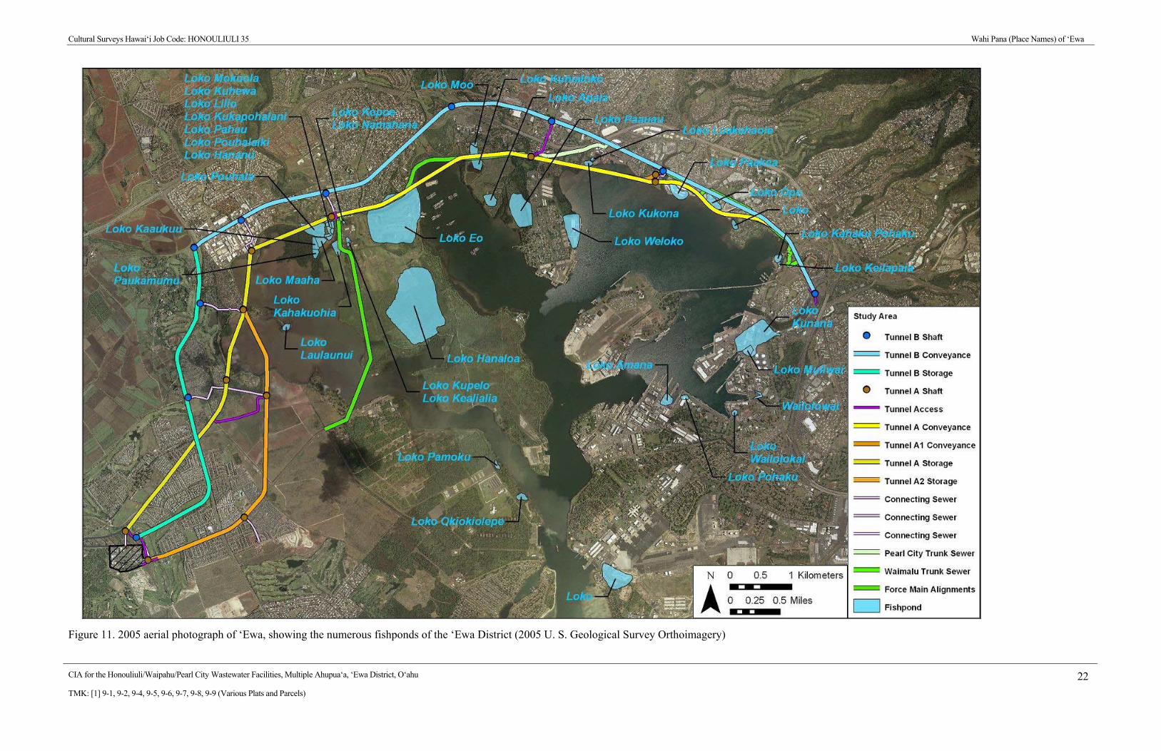
Cultural Surveys Hawai‘i Job Code: HONOULIULI 35 Wahi Pana (Place Names) of ‘Ewa
CIA for the Honouliuli/Waipahu/Pearl City Wastewater Facilities, Multiple Ahupua‘a, ‘Ewa District, O‘ahu 22
TMK: [1] 9-1, 9-2, 9-4, 9-5, 9-6, 9-7, 9-8, 9-9 (Various Plats and Parcels)
Figure 11. 2005 aerial photograph of ‘Ewa, showing the numerous fishponds of the ‘Ewa District (2005 U. S. Geological Survey Orthoimagery)
Cultural Surveys Hawai‘i Job Code: HONOULIULI 35 Wahi Pana (Place Names) of ‘Ewa
CIA for the Honouliuli/Waipahu/Pearl City Wastewater Facilities, Multiple Ahupua‘a, ‘Ewa District, O‘ahu 23
TMK: [1] 9-1, 9-2, 9-4, 9-5, 9-6, 9-7, 9-8, 9-9 (Various Plats and Parcels)
When Pukui et al. 1974 did not give a meaning to a place name, Soehren sometimes suggests a possible meaning for simple (non-compound) words using Pukui and Elbert’s, Hawaiian Dictionary. The tables on place names in this report list all of the important topographic and land division place names in Soehren’s list, plus additional place names found on historic maps in the CSH library. Additional meanings were added from a 1922 list of place names compiled by Thomas Thrum, which was published in the 1922 edition of Lorrin Andrew’s, A Dictionary of the Hawaiian Language.
3.1 Place Names along the Main Trails through the ‘Ewa District There were several pre-Contact/early historic trails across ‘Ewa: a cross-ahupua‘a trail that
crossed ‘Ewa and connected Honolulu to Wai‘anae; a mauka-makai (mountain to the sea) trail that branched off from the first trail, and followed the boundary between Honouliuli and Hō‘ae‘ae to the Pōhākea Pass and to Wai‘anae; and, a second branching mauka-makai trail that generally followed the path of Waikele Stream in Waikele Ahupua‘a. This trail eventually led through the Kolekole Pass to Wahiawā and to Waialua District on the windward side of the island (Figure 12).
‘Ī‘ī described the main cross-ahupua‘a trail from west to east, beginning with the boundary of the Kona and ‘Ewa Districts at the Moanalua/Hālawa border. This trail was just mauka (towards the mountain) of the floodplains near Pearl Harbor, skirting the inland edges of the productive taro fields. The trail then dipped down toward the coast towards a prominent hill and landmark, Pu‘uokapolei. The trail crossed into Wai‘anae at the coast near Pili o Kahe, the stone that marked the boundary of the ‘Ewa and Wai‘anae districts:
From there the trail went to Kaleinakauhane [Moanalua Ahupua‘a in the Kona District], then to Kapukaki [Red Hill on the Moanalua/Hālawa boundary], from where one could see the irregular sea of Ewa [Pearl Harbor]; then down the ridge to Napeha [in Hālawa], a resting place for the multitude that went diving there at a deep pool. This pool was named Napeha [Lean Over], so it is said, because Kaulii, a chief of ancient Oahu, went there and leaned over the pool to drink water.
The trail began again on the opposite side of the pool and went to the lowland of Halawa, on to Kauwamoa, a diving place and a much-liked gathering place. It was said to be the diving place of Peapea, son of Kamehamehanui of Maui who was swift in running and leaping. The place from which he dove into the water was 5 to 10 fathoms above the pool.
There the trail led to the taro patches in Aiea and up the plain of Kukiiahu. Just below the trail was the spot where Kaeo, chief of Kaua‘i, was killed by Kalanikupule. From there the trail went along the taro patches to the upper part of Kohokoho and on to Kahuewai [in Kalauao], a small waterfall. On the high ground above, a little way on, was a spring, also a favorite gathering place for travelers. From there it continued over a small plain down the small hill of Waimalu, and along the taro patches that lay in the center of the land…
Cultural Surveys Hawai‘i Job Code: HONOULIULI 35 Wahi Pana (Place Names) of ‘Ewa
CIA for the Honouliuli/Waipahu/Pearl City Wastewater Facilities, Multiple Ahupua‘a, ‘Ewa District, O‘ahu 24
TMK: [1] 9-1, 9-2, 9-4, 9-5, 9-6, 9-7, 9-8, 9-9 (Various Plats and Parcels)
…The trail went down to the stream and up again, then went above the taro patches of Waiau, up to a maika [game with rolling stones] field, to Waimano, to Manana and to Waiawa; then to the stream of Kukehi and up to two other maika fields, Pueohulunui and Haupuu [in Waiawa]. At Pueohulunui [on the border of Waiawa and Waikele] was the place where a trail branched off to go to Waialua and down to Honouliuli and on to Waianae. (‘Ī‘ī 1959:95, 97)
Of the first mauka-makai trail, located in Honouliuli, ‘Ī‘ī (1959:97) noted “From Kunia the trail went to the plain of Keahumoa, on to Maunauna [peak], and along Paupauwela [‘ili], which met with the trails from Wahiawā [District] and Waialua [District].” ‘Ī‘ī places the area called Kunia east of Pōhākea Pass in the ahupua‘a of Honouliuli and Hō‘ae‘ae, makai (seaward, toward the sea) of the modern town of Kunia, and places the plain of Keahumoa between Kunia and Paupauwela, the most mauka portion of Honouliuli. The trail passed near the peak called Maunauna in upper Honouliuli.

Cultural Surveys Hawai‘i Job Code: HONOULIULI 35 Wahi Pana (Place Names) of ‘Ewa
CIA for the Honouliuli/Waipahu/Pearl City Wastewater Facilities, Multiple Ahupua‘a, ‘Ewa District, O‘ahu 25
TMK: [1] 9-1, 9-2, 9-4, 9-5, 9-6, 9-7, 9-8, 9-9 (Various Plats and Parcels)
Figure 12. Map of trails in ‘Ewa by Paul Rockwood (not to scale) to show O‘ahu trails ca. 1810, as described by John Papa ‘Ī‘ī (1959:96)
Cultural Surveys Hawai‘i Job Code: HONOULIULI 35 Wahi Pana (Place Names) of ‘Ewa
CIA for the Honouliuli/Waipahu/Pearl City Wastewater Facilities, Multiple Ahupua‘a, ‘Ewa District, O‘ahu 26
TMK: [1] 9-1, 9-2, 9-4, 9-5, 9-6, 9-7, 9-8, 9-9 (Various Plats and Parcels)
3.2 Place Names in the Chants for Kūali’i and Kaumuali‘i The ahupua‘a of the ‘Ewa District are mentioned in a chant for the chief Kūali‘i. Each phrase
usually contains a play on words, as the place name and one meaning of the word, or portion of the word, appears on each line (e.g. kele in Waikele means “slippery”). These word plays are not necessarily related to the actual place name meaning.
Uliuli ka poi e piha nei—o Honouliuli; Blue is the poi [cooked taro] which appeases [the hunger] of Honouliuli;
Aeae ka paakai o Kahuaiki—Hoaeae, Fine the salt of Kahuaike—Hoaeae; Pikele ka ia e Waikele—o Waikele; Slippery the fish of Waikele—Waikele; Ka hale pio i Kauamoa—o Waipio; The arched house at Kauamoa—Waipio; E kuu kaua i ka loko awa—o Waiawa; Let us cast the net in the awa-pond—of Waiawa; Mai hoomanana ia oe—o Manana. Do not stretch yourself at—Manana. He kini kahawai, Many are the ravines, He lau kamano—o Waimano; Numerous the sharks, at Waimano; Ko ia kaua e ke au—o Waiau; We are drawn by the current of Waiau; Kukui malumalu kaua—Waimalu; In the kukui grove we are sheltered—in Waimalu; E ala kaua ua ao-e—o Kalauao; Let us arise, it is daylight—at Kalauao; E kipi kaua e ai-o Aiea; Let us enter and dine-at Aiea; Mai hoohalawa ia oe—O Halawa. Do not pass by—Halawa.
(Fornander 1917:400–401)
Place names of the ‘Ewa District are also mentioned in a chant for the Kaua‘i chief of Kaumuali‘i, a rival of Kamehameha I. In a portion of this chant the wind that blows from one end of ‘Ewa to the other is compared to love.
Kupuni ula ka ea o Ewa i ke ala, Filled was the air of Ewa with the report, Me he puakai la i ka lau laau. Like the sea-spray on the forest trees. Ka laau i ka ilima o Ulihale, Even reddening the outside of the house; Ula no mawaho o ka hale. The forest of the ilima plain at Ulihale, Ka ea ula, ke pili ka lau o ka weuweu. The redness extends and covers the leaves of the field. Haki ke kaupaku o ka hale ia ka ea, The ridge covering of the house is broken by the whirlwind. Ka ea no mai Halawa a Honouliuli. Which flows from Halawa to Honouliuli. He uli ke kanaka haalele i ke‘loha Unfit is the man who forsakes love, Me he mea la hala ke ‘loha aiai. How can he propagate love! (Fornander 1920:474–475)
Cultural Surveys Hawai‘i Job Code: HONOULIULI 35 Wahi Pana (Place Names) of ‘Ewa
CIA for the Honouliuli/Waipahu/Pearl City Wastewater Facilities, Multiple Ahupua‘a, ‘Ewa District, O‘ahu 27
TMK: [1] 9-1, 9-2, 9-4, 9-5, 9-6, 9-7, 9-8, 9-9 (Various Plats and Parcels)
3.3 Place Names in the Ahupua‘a of ‘Ewa
3.3.1 Honouliuli Place Names
Honouliuli is the largest ahupua‘a in the moku of ‘Ewa. One translation of the name for this district is given as “unequal” (Saturday Press, Aug. 11, 1883). Others translate the word as “strayed” and associate it with the legends of the gods, Kāne and Kanaloa:
When Kane and Kanaloa were surveying the islands they came to Oahu and when they reached Red Hill saw below them the broad plains of what is now Ewa. To mark boundaries of the land they would throw a stone and where the stone fell would be the boundary line. When they saw the beautiful land lying below them, it was their thought to include as much of the flat level land as possible. They hurled the stone as far as the Waianae range and it landed somewhere, in the Waimanalo section. When they went to find it, they could not locate the spot where it fell. So Ewa (strayed) became known by the name. The stone that strayed. (Sterling and Summers 1978:1)
Honouliuli means “dark water,” “dark bay,” or “blue harbor” and was named for the waters of Pearl Harbor (Jarrett 1930:22), which marks the eastern boundary of the ahupua‘a. The Hawaiians called Pearl Harbor, Pu‘uloa (lit. long hill). Another explanation for the names comes from the “Legend of Lepeamoa,” the chicken-girl of Pālama. In this legend, Honouliuli is the name of the husband of the chiefess Kapālama and grandfather of Lepeamoa. The land district Honouliuli was named for the grandfather of Lepeamoa (Westervelt 1923:164–184).
It seems likely the boundaries of the western-most ahupua‘a of ‘Ewa were often contested with Wai‘anae people. The ‘Ewa people could cite divine sanction that the dividing point between Wai‘anae and ‘Ewa was between two hills at Pili o Kahe:
The ancient Hawaiians said the hill on the ‘Ewa side was the male and the hill on the Wai‘anae side was female. The stone was found on the Waianae side hill and the place is known as Pili o Kahe [Pili=cling to, Kahe=flow]. The name refers, therefore, to the female or Waianae side hill. And that is where the boundary between the two districts runs. (Sterling and Summers 1978:1)
Honouliuli has a number of topographic features, peaks, streams, gulches, coastal points, and a number of ancient villages. The locations of the place names, when known, are shown on Figure 13. Besides the topographic points, there are 21 ‘ili names listed in Māhele documents. It is possible that there were more ‘ili in Honouliuli (and other ahupua‘a), but if no lands were claimed or awarded in these ‘ili, they are not present in the Māhele records.
The 21 ‘ili in Honouliuli were all ‘ili ‘āina lands, which is a land in which the chief of the ‘ili owed tribute to the chief of the ahupua‘a. There was a second type of common ‘ili in other ahupua‘a, called an ‘ili kū, short for ‘ili kūpono. This type of ‘ili was nearly independent of any specific ahupua‘a (although it was usually within the boundary of a specific ahupua‘a). Tribute for this type of land was usually owed directly to the king, not to the chief of the ahupua‘a.

Cultural Surveys Hawai‘i Job Code: HONOULIULI 35 Wahi Pana (Place Names) of ‘Ewa
CIA for the Honouliuli/Waipahu/Pearl City Wastewater Facilities, Multiple Ahupua‘a, ‘Ewa District, O‘ahu 28
TMK: [1] 9-1, 9-2, 9-4, 9-5, 9-6, 9-7, 9-8, 9-9 (Various Plats and Parcels)
Figure 13. Place Names of Honouliuli and Hō‘ae‘ae (base map: 1927 U.S. Geological Survey, ‘Ewa, Barbers Point, Wai‘anae, and Waipahu Quadrangles)

Cultural Surveys Hawai‘i Job Code: HONOULIULI 35 Wahi Pana (Place Names) of ‘Ewa
CIA for the Honouliuli/Waipahu/Pearl City Wastewater Facilities, Multiple Ahupua‘a, ‘Ewa District, O‘ahu 29
TMK: [1] 9-1, 9-2, 9-4, 9-5, 9-6, 9-7, 9-8, 9-9 (Various Plats and Parcels)
3.3.2 Hō‘ae‘ae Place Names
Hō‘ae‘ae is bound by the shoreline on the makai side by the north shore of Pearl Harbor’s West Loch, by a trail running along the eastern edge of Honouliuli Gulch on the west side, and by the western side of Waikele Gulch and a trail on the east side. The mauka edge does not extend to the Ko‘olau Mountains, but is “cut off” by Honouliuli to the west and Waikele to the east. The boundary between Hō‘ae‘ae and Honouliuli at the shore was at a place called Ka‘ulu (Hawai‘i. Boundary Commission 1:537) and the boundary along the trail was marked by a pōhaku (rock) called Pōhaku Palahalaha. There are references to a Hō‘ae‘ae Stream in traditional literature. Pre-Contact and early post-Contact agriculture focused on the spring-fed floodplains adjacent to West Loch. Hō‘ae‘ae means “to make soft or fine” (Pukui et al. 1974:47). Pukui et al. do not explain why the ahupua‘a is called this name. Thrum (1922:632) says Hō‘ae‘ae means, “to pulverize.”
The coastal point, Ka‘ulu, was named for a Puna chief named Ka‘uluhuaikahapapa, whose name means “the breadfruit bearing fruit on the flats” (Pukui et al. 1974:93). Hō‘ae‘ae and Waikele at the shore was marked with a “pile of stones by Kalahina Bay” (Hawaii Boundary Commission AB 1:536), and the boundary on the trail between the two ahupua‘a was marked by a rock called Pōhaku Pili (“to cling”). There were at least seven ‘ili ‘āina in Hō‘ae‘ae, Ka‘ai‘iole, Kahui, Kaloko‘eli, Kamolokala, Koipu (also called Koipuiki), and Waihi.
3.3.3 Waikele Place Names
The next ahupua‘a to the east is Waikele, which extends from the north and eastern shore of West Loch to a boundary point between the District of Wahiawā and the ahupua‘a of Waipi‘o on the mauka side (Figure 14 and Figure 15). It is at this boundary point where Sterling and Summers (1978:137) believe was the former location of a famous pōhaku called O‘ahunui, a stone shaped like the island of O‘ahu. Waikele is watered by Waikele Stream—the ridge on the east side of the stream marks the boundary with Waipi‘o. In upper Waikele, the stream is fed by two tributary streams, from the west Wai‘eli (possibly “dug water”) and from the east Waikakalaua (“water [rough] in rain”). Waikele means “muddy water,” probably a reference to this long stream. There were other names for the lower part of the stream, shown as Kapakahi Stream (“crooked”) on some maps, and referred to as Poniohua Stream (possibly, “anointed on the night of Hua; Thrum 1922:667) in some legends (Mauricio 1997:9).
The most famous location in Waikele is Waipahu Spring (“bursting water”); the waters of this spring were used to irrigate many of the ancient taro patches on the Waikele flood plain and later the rice and sugar cane crops. It was originally spelled Waipahū, and was the home of the shark goddess Ka‘ahu‘pāhau. As a town and sugar mill expanded around the spring, the entire makai area of Hō‘ae‘ae and Waikele became known as Waipahu, and the older names were no longer used.
A resident clarified this change in names:
“Waipahu” … is not a tract of land, but only a spring located in Waikele. The Oahu Railway Company is the culprit responsible for misuse and confusion, when it built its station at Kaohai and called [it] “Waipahu Station.” The Oahu [Sugar Plantation] Mill is situated on the plateau of “Keonekuilimalaulaoewa” (the arm-
Cultural Surveys Hawai‘i Job Code: HONOULIULI 35 Wahi Pana (Place Names) of ‘Ewa
CIA for the Honouliuli/Waipahu/Pearl City Wastewater Facilities, Multiple Ahupua‘a, ‘Ewa District, O‘ahu 30
TMK: [1] 9-1, 9-2, 9-4, 9-5, 9-6, 9-7, 9-8, 9-9 (Various Plats and Parcels)
in-arm-plateau of ewa [‘Ewa]), Waikele. (Simeon Nawaa, in Honolulu Star Bulletin Oct. 16, 1956, cited in Sterling and Summers 1978:1)
Above the spring was a rock face called Pōhaku pili (clinging stone), which was said to have been placed there by the Hawaiian pig-god, Kamapua‘a (Mauricio 1997:7). There were two heiau in Waikele, both just north of the present Interstate H-1 Freeway. The two heiau, Mokoula and Hapupu, had been completely destroyed by the time of McAllister’s survey in the early 1930s.
The taro lands along Waipahu Spring and the coast were divided among at least 34 ‘ili, 14 ‘ili ‘āina, and 20 ‘ili kū. The large number of ‘ili, especially the large number of ‘ili kū, which were often associated with high ali‘i or the king, emphasize the richness and importance of the fertile taro lands and fishponds of Waikele.
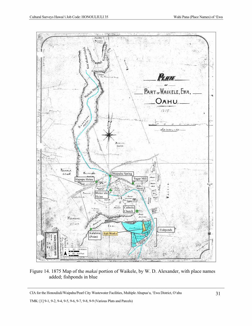
Cultural Surveys Hawai‘i Job Code: HONOULIULI 35 Wahi Pana (Place Names) of ‘Ewa
CIA for the Honouliuli/Waipahu/Pearl City Wastewater Facilities, Multiple Ahupua‘a, ‘Ewa District, O‘ahu 31
TMK: [1] 9-1, 9-2, 9-4, 9-5, 9-6, 9-7, 9-8, 9-9 (Various Plats and Parcels)
Figure 14. 1875 Map of the makai portion of Waikele, by W. D. Alexander, with place names added; fishponds in blue

Cultural Surveys Hawai‘i Job Code: HONOULIULI 35 Wahi Pana (Place Names) of ‘Ewa
CIA for the Honouliuli/Waipahu/Pearl City Wastewater Facilities, Multiple Ahupua‘a, ‘Ewa District, O‘ahu 32
TMK: [1] 9-1, 9-2, 9-4, 9-5, 9-6, 9-7, 9-8, 9-9 (Various Plats and Parcels)
Figure 15. 1877 Map of Waipi‘o and upper portion of Waikele Ahupua‘a (Waikakalaua) by J. F. Brown, with place names added

Cultural Surveys Hawai‘i Job Code: HONOULIULI 35 Wahi Pana (Place Names) of ‘Ewa
CIA for the Honouliuli/Waipahu/Pearl City Wastewater Facilities, Multiple Ahupua‘a, ‘Ewa District, O‘ahu 33
TMK: [1] 9-1, 9-2, 9-4, 9-5, 9-6, 9-7, 9-8, 9-9 (Various Plats and Parcels)
3.3.4 Waipi‘o Place Names
To the east of Waikele is Waipi‘o, which means “curved, winding water” (Sterling and Summers 1978:1), probably a reference to the curving shorelines of the middle loch of Pearl Harbor, with its many adjacent fishponds. The loch waters were extensively used for gathering limu (seaweed), shellfish and other invertebrates, and fish. After Honouliuli, Waipi‘o is the next largest ahupua‘a in ‘Ewa, extending all the way from the tip of Waipi‘o peninsula between the west and middle lochs up to the boundary with the Ko‘olau Mountains. The major stream/gulch is called Kīpapa (“placed prone”), but there are two other gulches in the upland area, Panahakea, and Pānakauahi (“touched by the smoke”). Keakua‘ōlelo was the name of a heiau in Pānakauahi Gulch. Pu‘u Ka‘aumakua is the highest peak; it marks the boundary point between Waipi‘o, Wahiawā District, and the Ko‘olaupoko District at the mauka western corner of the ahupua‘a. A secondary peak on the Waipi‘o/Waiawa border was called Pu‘u Kamana (“hill [of] the supernatural power”). There was once a heiau in the area between Farrington Highway and the coast, called Ahu‘ena (“red hot heap”). When Thrum (1907:46), listed it in 1907, he noted that only the foundations remained. McAllister noted two heiau in Waipi‘o, Moa‘ula and Heiau o ‘Umi along the main coastal trail. He said both were “covered” in cane, and provided no further information on their condition. John Papa ‘Ī‘ī was once the custodian of the idols in the heiau. There were several loko (fishponds) in Waipi‘o; two of the largest were Loko ‘Ēo (“a filled container”) and Loko Hanaloa (“long bay”). A total of 43 ‘ili are mentioned in Māhele documents, comprised of 39 ‘ili ‘āina and four ‘ili kū.
3.3.5 Waiawa Place Names
The meaning and correct pronunciation of Waiawa is in dispute. It is variously spelled Waiawa or Wai‘awa, which leads to different interpretations. Awa is both the word for milk fish or a harbor, cove, channel or passage (Pukui and Elbert 1986:33). In a portion of a chant for Kūali‘i, documented by Fornander (1917:394–400), Waiawa is noted for its awa fish, E ku‘u kaua i ka loko awa—o Waiawa. Fornander offers the translation as “Let us cast the net in the awa-pond—of Waiawa.” This would be no surprise, as there were numerous fishponds in Waiawa. With an alternate spelling, ‘awa is the word for the native plant used to make a mild-sedative drink by the Hawaiians. Traditional accounts suggest that Waiawa may have been acknowledged in early times as the site of a special variety of the ‘awa plant:
I ka wa i hiki mai ai ua eueu nei a ku ma ka puka o kahi e komo ai i loko o ua kuahiwi nei o Konahuanui, aia noi na makana a pau ma ka lima o Keanuenue, oia hoi ka puaa-pukoa, he puaa ehu keia o ka hulu, a he pu awa popolo, aole i laha nui keia awa ma keia pae aina, aia nae keia awa e ulu nei i keai wa ma uka o Waiawa ma Ewa ae nei.
When the wondrous maiden [Keaomelemele] arrived at the entrance to the mountain of Konahuanui, all the offerings were in charge of Ke-anuenue, a puko‘a or reddish brown pig, a clump of dark ‘awa [pu ‘awa pōpolo] which was not common in these islands. This variety of ‘awa now grows in the upland of Waiawa, down here in ‘Ewa. (Manu 2002:50, 138)
A kūpuna (elder) who grew up in Waiawa and lives there still, Tin Hu Young, suggested a different origin of the name Waiawa. During his interview, he gave this explanation:
Cultural Surveys Hawai‘i Job Code: HONOULIULI 35 Wahi Pana (Place Names) of ‘Ewa
CIA for the Honouliuli/Waipahu/Pearl City Wastewater Facilities, Multiple Ahupua‘a, ‘Ewa District, O‘ahu 34
TMK: [1] 9-1, 9-2, 9-4, 9-5, 9-6, 9-7, 9-8, 9-9 (Various Plats and Parcels)
In fact, the name ‘Wai‘awa’ means water and ‘awa. You know the meaning of ‘awa? ‘Awa is that kava root that you drink, Hawaiians call it ‘awa. I kind of didn’t like the idea they called it ‘bitter water’. Because ‘awa is a little bitter when you drink it, so Wai‘awa—Wai‘awa Valley was an area known in the ancient days of harvesting ‘awa root. It was a ceremonial drink that they had. Of course in the old days only the royalty used that root, until later on, and then the commoners would use it. Then you could sell it in the market and go buy it, like other things. So, Wai‘awa was a source of that. But, I like to think that the meaning of ‘bitter water’ for the name Wai‘awa, to me, could come from— because the area is the farther lot, the bottom on the lowland, mauka of Pearl Harbor. And when I used to watch the water, the rivulets would come twisting and turning like little ‘awa roots, twisted. If you ever harvest that ‘awa root, you got to see, it’s like a big root coral. It’s all tangled into each other. And it reminds me, when it flooded down in the lowland, all these little rivulets, twisting and turning, like the ‘awa root. But it’s just my romantic – it’s just because I live there. I don’t want them to say, Ehh you live in bitter water? (Laughter). (Interview w/ T. H. Young, October 9, 2002 in Bushnell et al. 2003:10)
In addition to the milkfish (Chanos chanos), awa, and the ‘awa root (Piper methysticum), the Hawaiian word awa has a third meaning: of harbor, cove or channel or passage (Pukui and Elbert 1986:33). This suggests there may be some link between the rivulets described by Mr. Young and the awa or channels which reach the sea.
Waiawa is bound by the shore of the Middle Loch of Pearl Harbor on the makai side, the Ko‘olau Mountain Range on the mauka side, by Waipi‘o Ahupua‘a to the west, and by Mānana Ahupua‘a to the east (Figure 16 and Figure 17). Waiawa Ahupua‘a is watered by Waiawa Stream, which in the upper portion splits into Waiawa and Mānana streams. The point of the ridge was called Lae Pōhaku (stone point), a boundary point between Waiawa and Mānana. At this junction, McAllister (1933:105) recorded a heiau called Puoiki, which was built on a knoll. According to McAllister (1933:105), the ceremonies at this heiau were performed at the base of the knoll. Makai of the ridge was another boundary point, called Pohakea (“white rock”).
Three boundary points on the west are Pu‘u Kamana (hill of the supernatural power), Pu‘u Pōhaku (stone hill), and Laehopu. Panahakea Gulch extends from the summit of Pu‘u Kamana makai towards Waipi‘o, and the east ridge of Pānakauahi Gulch (touched by the smoke) in Waipi‘o, defines the makai western border of Waiawa. Laehopu marks the coastal point (lae) that divides Waiawa and Waipi‘o on the Middle Loch shore. The mid-nineteenth century Māhele documents concerning LCAs indicate that there were at least 15 ‘ili in Waiawa, all of them ‘ili ‘āina. The greatest resource of Waiawa was the many fishponds. Twelve are mentioned in mid-nineteenth century Māhele documents.
There are several other topographic points listed in mid-nineteenth century documents (Soehren 2009), but these could not be found on any available historic maps. A hill called Kanukumanu (the bird’s beak) served as a boundary point for Māhele award (LCA 9372, ‘āpana (lot) 2; near the intersection of Waiawa Stream and the Government Road). In his discussion of trails through Waiawa, ‘Ī‘ī (1959) mentions the stream Kukehi (another name for the makai end of Waiawa Stream) and the maika fields of Haupu‘u and Pueohulunui.
Cultural Surveys Hawai‘i Job Code: HONOULIULI 35 Wahi Pana (Place Names) of ‘Ewa
CIA for the Honouliuli/Waipahu/Pearl City Wastewater Facilities, Multiple Ahupua‘a, ‘Ewa District, O‘ahu 35
TMK: [1] 9-1, 9-2, 9-4, 9-5, 9-6, 9-7, 9-8, 9-9 (Various Plats and Parcels)
Pueohulunui was on the border between Waiawa and Waikele at the “crossroads, where one leads to Waialua and the other branches off to Honouliuli” (Sterling and Summers 1978:18).

Cultural Surveys Hawai‘i Job Code: HONOULIULI 35 Wahi Pana (Place Names) of ‘Ewa
CIA for the Honouliuli/Waipahu/Pearl City Wastewater Facilities, Multiple Ahupua‘a, ‘Ewa District, O‘ahu 36
TMK: [1] 9-1, 9-2, 9-4, 9-5, 9-6, 9-7, 9-8, 9-9 (Various Plats and Parcels)
Figure 16. 1927 U. S Geological Survey topographic map, with place names of Waiawa
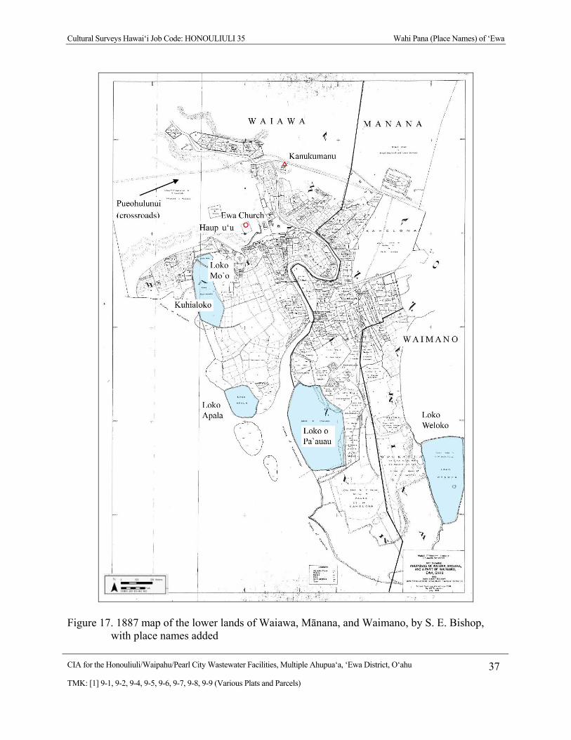
Cultural Surveys Hawai‘i Job Code: HONOULIULI 35 Wahi Pana (Place Names) of ‘Ewa
CIA for the Honouliuli/Waipahu/Pearl City Wastewater Facilities, Multiple Ahupua‘a, ‘Ewa District, O‘ahu 37
TMK: [1] 9-1, 9-2, 9-4, 9-5, 9-6, 9-7, 9-8, 9-9 (Various Plats and Parcels)
Figure 17. 1887 map of the lower lands of Waiawa, Mānana, and Waimano, by S. E. Bishop, with place names added
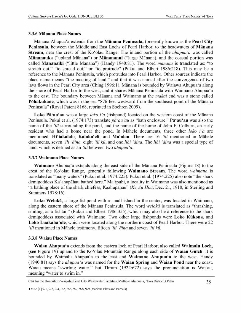
Cultural Surveys Hawai‘i Job Code: HONOULIULI 35 Wahi Pana (Place Names) of ‘Ewa
CIA for the Honouliuli/Waipahu/Pearl City Wastewater Facilities, Multiple Ahupua‘a, ‘Ewa District, O‘ahu 38
TMK: [1] 9-1, 9-2, 9-4, 9-5, 9-6, 9-7, 9-8, 9-9 (Various Plats and Parcels)
3.3.6 Mānana Place Names
Mānana Ahupua‘a extends from the Mānana Peninsula, (presently known as the Pearl City Peninsula, between the Middle and East Lochs of Pearl Harbor, to the headwaters of Mānana Stream, near the crest of the Ko‘olau Range. The inland portion of the ahupua‘a was called Mānanauka (“upland Mānana”) or Mānananui (“large Mānana), and the coastal portion was called Mānanaiki (“little Mānana”) (Handy 1940:81). The word manana is translated as: “to stretch out,” “to spread out,” or “to protrude” (Pukui and Elbert 1986:218). This may be a reference to the Mānana Peninsula, which protrudes into Pearl Harbor. Other sources indicate the place name means “the meeting of land,” and that it was named after the convergence of two lava flows in the Pearl City area (Ching 1996:1). Mānana is bounded by Waiawa Ahupua‘a along the shore of Pearl Harbor to the west, and it shares Mānana Peninsula with Waimano Ahupua‘a to the east. The boundary between Mānana and Waimano at the makai end was a stone called Pōhakukane, which was in the sea “876 feet westward from the southeast point of the Mānana Peninsula” (Royal Patent 8168, reprinted in Soehren 2009).
Loko Pā‘au‘au was a large loko i‘a (fishpond) located on the western coast of the Mānana Peninsula. Pukui et al. (1974:173) translate pā‘au‘au as “bath enclosure.” Pā‘au‘au was also the name of the ‘ili surrounding the pond, and the name of the home of John F. Colburn, an early resident who had a home near the pond. In Māhele documents, three other loko i‘a are mentioned, Hi‘iakalalo, Kaloko‘eli, and Mo‘olau. There are 16 ‘ili mentioned in Māhele documents, seven ‘ili ‘āina, eight ‘ili kū, and one lihi ‘āina. The lihi ‘āina was a special type of land, which is defined as an ‘ili between two ahupua‘a.
3.3.7 Waimano Place Names
Waimano Ahupua‘a extends along the east side of the Mānana Peninsula (Figure 18) to the crest of the Ko‘olau Range, generally following Waimano Stream. The word waimano is translated as “many waters” (Pukui et al. 1974:225). Pukui et al. (1974:225) also note “the shark demigoddess Ka‘ahupāhau bathed here.” Ma‘ipuhi, a locality in Waimano was also mentioned as “a bathing place of the shark chiefess, Kaahupahau” (Ke Au Hou, Dec. 21, 1910, in Sterling and Summers 1978:16).
Loko Welokā, a large fishpond with a small island in the center, was located in Waimano, along the eastern shore of the Mānana Peninsula. The word welokā is translated as “thrashing, smiting, as a fishtail” (Pukui and Elbert 1986:355), which may also be a reference to the shark demigoddess associated with Waimano. Two other large fishponds were Loko Kūkona, and Loko Luakaha‘ole, which were located along the northern coast of Pearl Harbor. There were 22 ‘ili mentioned in Māhele testimony, fifteen ‘ili ‘āina and seven ‘ili kū.
3.3.8 Waiau Place Names
Waiau Ahupua‘a extends from the eastern loch of Pearl Harbor, also called Waimalu Loch, (see Figure 19) upland to the Ko‘olau Mountain Range along each side of Waiau Gulch. It is bounded by Waimalu Ahupua‘a to the east and Waimano Ahupua‘a to the west. Handy (1940:81) says the ahupua‘a was named for the Waiau Spring and Waiau Pond near the coast. Waiau means “swirling water,” but Thrum (1922:672) says the pronunciation is Wai‘au, meaning “water to swim in.”
Cultural Surveys Hawai‘i Job Code: HONOULIULI 35 Wahi Pana (Place Names) of ‘Ewa
CIA for the Honouliuli/Waipahu/Pearl City Wastewater Facilities, Multiple Ahupua‘a, ‘Ewa District, O‘ahu 39
TMK: [1] 9-1, 9-2, 9-4, 9-5, 9-6, 9-7, 9-8, 9-9 (Various Plats and Parcels)
The two fishery grounds of Kai o Kalua‘o‘opu and Kai o Ka‘akauwaihau were named for their associated ‘ili. Cordy (1996:5) has noted that Waiau had the smallest floodplain and the smallest of offshore fisheries of all the ‘Ewa ahupua‘a. This lack of resources probably explains why Waiau was not listed as a separate ahupua‘a in the Māhele. This may also explain why there are few known place names for gulches, peaks, and coastal points. The only labeled peak, Waimalu, is shown on a 1947 U.S. War Department map. As this is not shown on any earlier map, this may be an historic surveyor’s station rather than a traditional name.
McAllister (1933:105) noted a heiau on the ridge between Waiau and Waimalu Gulches named Kolokukahau Heiau, but it had been destroyed before his survey in the 1930s. A favorite bathing spot of the ‘Ewa shark goddess, Ka‘ahupāhua was at Puhikani in Waiau (Ke Au Hou, 1910b, in Sterling and Summers 1978:16). The location of this spring or pond could not be found on any available maps.
Eleven ‘ili are mentioned for Waiau in nineteenth century Māhele land documents (Soehren 2009; Thrum 1922), Hahapo, Honokōwailani, Ka‘ākauwaihau, Kalua‘ōlohe, Kalua‘o‘opu, Kaluapālolo, Kauhihau, Kumu‘ulu, Nālima, Nāono, and Waikowaha. Only three were ‘ili ‘āina; the other eight were ‘ili kū.
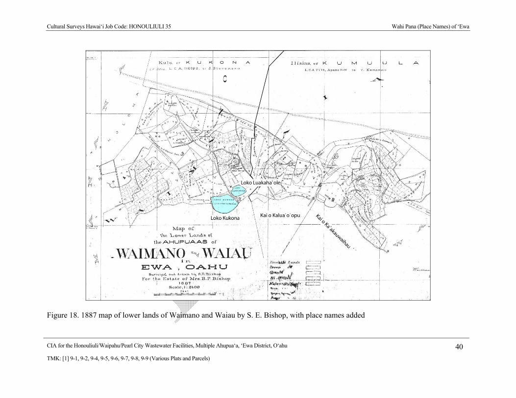
Cultural Surveys Hawai‘i Job Code: HONOULIULI 35 Wahi Pana (Place Names) of ‘Ewa
CIA for the Honouliuli/Waipahu/Pearl City Wastewater Facilities, Multiple Ahupua‘a, ‘Ewa District, O‘ahu 40
TMK: [1] 9-1, 9-2, 9-4, 9-5, 9-6, 9-7, 9-8, 9-9 (Various Plats and Parcels)
Figure 18. 1887 map of lower lands of Waimano and Waiau by S. E. Bishop, with place names added
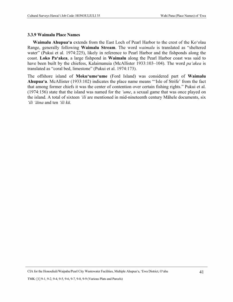
Cultural Surveys Hawai‘i Job Code: HONOULIULI 35 Wahi Pana (Place Names) of ‘Ewa
CIA for the Honouliuli/Waipahu/Pearl City Wastewater Facilities, Multiple Ahupua‘a, ‘Ewa District, O‘ahu 41
TMK: [1] 9-1, 9-2, 9-4, 9-5, 9-6, 9-7, 9-8, 9-9 (Various Plats and Parcels)
3.3.9 Waimalu Place Names
Waimalu Ahupua‘a extends from the East Loch of Pearl Harbor to the crest of the Ko‘olau Range, generally following Waimalu Stream. The word waimalu is translated as “sheltered water” (Pukui et al. 1974:225), likely in reference to Pearl Harbor and the fishponds along the coast. Loko Pa‘akea, a large fishpond in Waimalu along the Pearl Harbor coast was said to have been built by the chiefess, Kalaimanuia (McAllister 1933:103–104). The word pa‘akea is translated as “coral bed, limestone” (Pukui et al. 1974:173).
The offshore island of Moku‘ume‘ume (Ford Island) was considered part of Waimalu Ahupua‘a. McAllister (1933:102) indicates the place name means “‘Isle of Strife’ from the fact that among former chiefs it was the center of contention over certain fishing rights.” Pukui et al. (1974:156) state that the island was named for the ‘ume, a sexual game that was once played on the island. A total of sixteen ‘ili are mentioned in mid-nineteenth century Māhele documents, six ‘ili ‘āina and ten ‘ili kū.
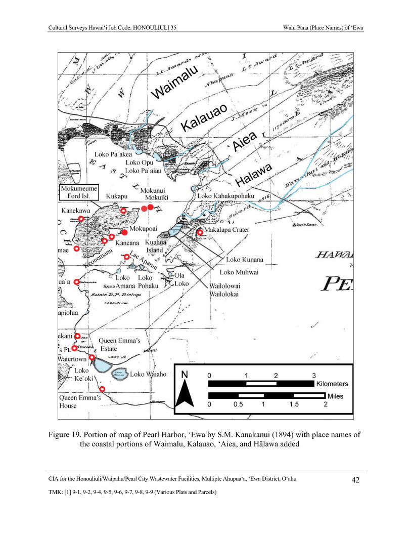
Cultural Surveys Hawai‘i Job Code: HONOULIULI 35 Wahi Pana (Place Names) of ‘Ewa
CIA for the Honouliuli/Waipahu/Pearl City Wastewater Facilities, Multiple Ahupua‘a, ‘Ewa District, O‘ahu 42
TMK: [1] 9-1, 9-2, 9-4, 9-5, 9-6, 9-7, 9-8, 9-9 (Various Plats and Parcels)
Figure 19. Portion of map of Pearl Harbor, ‘Ewa by S.M. Kanakanui (1894) with place names of the coastal portions of Waimalu, Kalauao, ‘Aiea, and Hālawa added
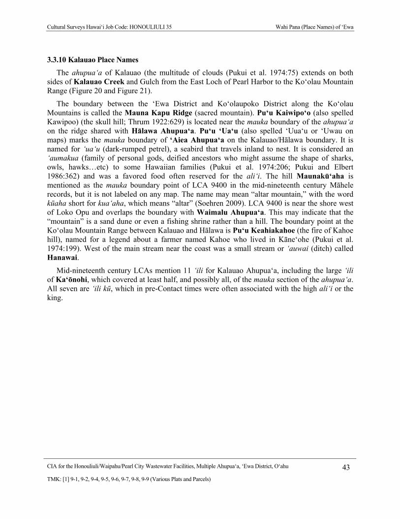
Cultural Surveys Hawai‘i Job Code: HONOULIULI 35 Wahi Pana (Place Names) of ‘Ewa
CIA for the Honouliuli/Waipahu/Pearl City Wastewater Facilities, Multiple Ahupua‘a, ‘Ewa District, O‘ahu 43
TMK: [1] 9-1, 9-2, 9-4, 9-5, 9-6, 9-7, 9-8, 9-9 (Various Plats and Parcels)
3.3.10 Kalauao Place Names
The ahupua‘a of Kalauao (the multitude of clouds (Pukui et al. 1974:75) extends on both sides of Kalauao Creek and Gulch from the East Loch of Pearl Harbor to the Ko‘olau Mountain Range (Figure 20 and Figure 21).
The boundary between the ‘Ewa District and Ko‘olaupoko District along the Ko‘olau Mountains is called the Mauna Kapu Ridge (sacred mountain). Pu‘u Kaiwipo‘o (also spelled Kawipoo) (the skull hill; Thrum 1922:629) is located near the mauka boundary of the ahupua‘a on the ridge shared with Hālawa Ahupua‘a. Pu‘u ‘Ua‘u (also spelled ‘Uua‘u or ‘Uwau on maps) marks the mauka boundary of ‘Aiea Ahupua‘a on the Kalauao/Hālawa boundary. It is named for ‘ua‘u (dark-rumped petrel), a seabird that travels inland to nest. It is considered an ‘aumakua (family of personal gods, deified ancestors who might assume the shape of sharks, owls, hawks…etc) to some Hawaiian families (Pukui et al. 1974:206; Pukui and Elbert 1986:362) and was a favored food often reserved for the ali‘i. The hill Maunakū‘aha is mentioned as the mauka boundary point of LCA 9400 in the mid-nineteenth century Māhele records, but it is not labeled on any map. The name may mean “altar mountain,” with the word kūaha short for kua‘aha, which means “altar” (Soehren 2009). LCA 9400 is near the shore west of Loko Opu and overlaps the boundary with Waimalu Ahupua‘a. This may indicate that the “mountain” is a sand dune or even a fishing shrine rather than a hill. The boundary point at the Ko‘olau Mountain Range between Kalauao and Hālawa is Pu‘u Keahiakahoe (the fire of Kahoe hill), named for a legend about a farmer named Kahoe who lived in Kāne‘ohe (Pukui et al. 1974:199). West of the main stream near the coast was a small stream or ‘auwai (ditch) called Hanawai.
Mid-nineteenth century LCAs mention 11 ‘ili for Kalauao Ahupua‘a, including the large ‘ili of Ka‘ōnohi, which covered at least half, and possibly all, of the mauka section of the ahupua‘a. All seven are ‘ili kū, which in pre-Contact times were often associated with the high ali‘i or the king.
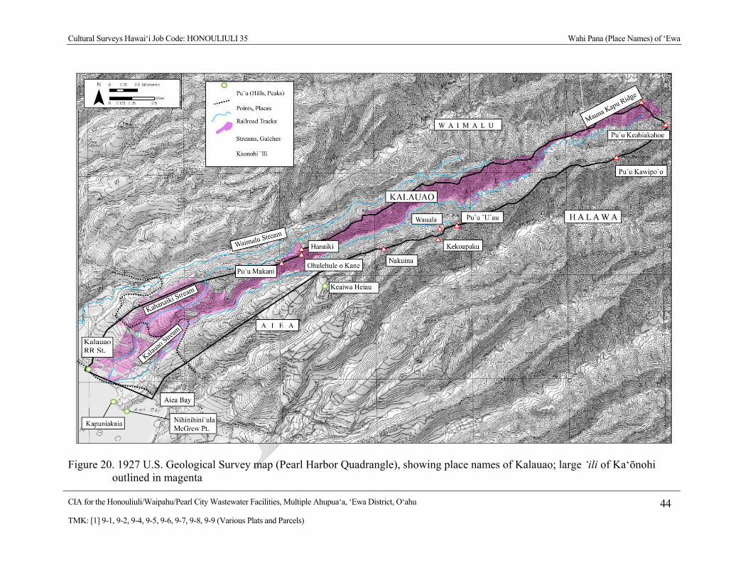
Cultural Surveys Hawai‘i Job Code: HONOULIULI 35 Wahi Pana (Place Names) of ‘Ewa
CIA for the Honouliuli/Waipahu/Pearl City Wastewater Facilities, Multiple Ahupua‘a, ‘Ewa District, O‘ahu 44
TMK: [1] 9-1, 9-2, 9-4, 9-5, 9-6, 9-7, 9-8, 9-9 (Various Plats and Parcels)
Figure 20. 1927 U.S. Geological Survey map (Pearl Harbor Quadrangle), showing place names of Kalauao; large ‘ili of Ka‘ōnohi outlined in magenta
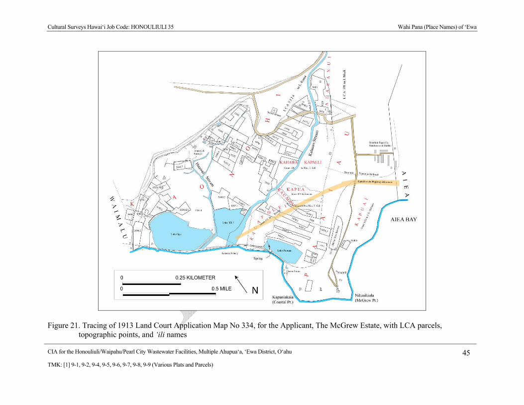
Cultural Surveys Hawai‘i Job Code: HONOULIULI 35 Wahi Pana (Place Names) of ‘Ewa
CIA for the Honouliuli/Waipahu/Pearl City Wastewater Facilities, Multiple Ahupua‘a, ‘Ewa District, O‘ahu 45
TMK: [1] 9-1, 9-2, 9-4, 9-5, 9-6, 9-7, 9-8, 9-9 (Various Plats and Parcels)
Figure 21. Tracing of 1913 Land Court Application Map No 334, for the Applicant, The McGrew Estate, with LCA parcels, topographic points, and ‘ili names
Cultural Surveys Hawai‘i Job Code: HONOULIULI 35 Wahi Pana (Place Names) of ‘Ewa
CIA for the Honouliuli/Waipahu/Pearl City Wastewater Facilities, Multiple Ahupua‘a, ‘Ewa District, O‘ahu 46
TMK: [1] 9-1, 9-2, 9-4, 9-5, 9-6, 9-7, 9-8, 9-9 (Various Plats and Parcels)
Along the coastal trail connecting Honolulu to Wai‘anae was a small waterfall called Kahuawai (or Kahuewai) (water gourd container; Soehren 2009) along Kalauao Stream, which ‘Ī‘ī (1959:95) stated was once a favorite resting place for travelers, exclusively for chiefs. The eastern coastal portion of Kalauao is a promontory on the west side of ‘Aiea Bay. The western promontory point is labeled as Kapuniakaia on a map of ‘Aiea by Lyons (1873a) and the eastern point is labeled as Nihinihini‘ula on a map of Pearl Harbor by Lyons (1873b). The Hawaiian word “nihinihi” means “edge,” or “part jutting out” (Lucas 1995:79), so this name may refer to the “jutting” coastal point. On nineteenth and twentieth century maps, this last point is labeled as McGrew Point. The latter name came from Dr. John S. McGrew, a Honolulu resident who owned a house and a large estate in Kapuai ‘Ili of Kalauao Ahupua‘a next to ‘Aiea Bay.
McAllister (1933:103) refers to three archaeological sites in Kalauao Ahupua‘a. All three are connected with Kala‘imanuia, a chiefess and mō‘ī (king) of O‘ahu who lived ten generations before Ka‘ahumanu in the sixteenth century (Kame‘eleihiwa 1992:80). Following in her mother’s (Kūkaniloko’s) footsteps, Kala‘imanuia lived most of the time in Kalauao. No foreign or domestic wars appear to have occurred during her reign (Fornander 1996:269). McAllister (1933) noted that the foundation of her houses at Kūki‘iahu stood in Kalauao until recent times. The name of her house complex may derive from the Hawaiian words kūki‘i (standing image) and ahu (cairn, mound; Pukui and Elbert 1986). Kala‘imanuia was credited with having built the fishponds of Kapa‘akea in Waimalu and Loko Opu and Loko Pā‘aiau in Kalauao. Sterling and Summers place the house complex of Kūki‘iahu somewhere near Huawai Steam, possibly near LCA 9400:2 just mauka of Loko ‘Opu and Loko Pā‘aiau. According to Kamakau (1992:169–170), when a battle was fought near the former residence of Kala‘imanuia in 1794, the dead were placed in a large pile in Pā‘aiau. It is unclear if this is a reference to the fishpond Loko Pā‘aiau or to the ‘ili of Pā‘aiau in which the fishpond is located, however, the statement suggests that Kala‘imanuia’s residence was close to Pā‘aiau ‘Ili.
Loko Pā‘aiau was a roughly 190 by 600 foot rectangular pond surrounded by land on three sides with walls two ft high (Soehren 2009). McAllister (1933:103) describes it as if it was still in good condition in the 1930s. On the other hand, McAllister (1933:103) describes Loko Opu as partially filled in. It was once about ten acres in size, with a wall 270 ft long that surrounded the entire perimeter. Three other ponds are mentioned in the Māhele testimony, but are not labeled on any available maps.
3.3.11 ‘Aiea Place Names
‘Aiea Ahupua‘a was named after the shrub ‘aiea (Pukui et al. 1974:7; Thrum 1922:626), which was used for thatching sticks and for fire-making (Pukui and Elbert 1986:10). ‘Aiea Ahupua‘a extends from the eastern loch of Pearl Harbor at ‘Aiea Bay inland along each side of ‘Aiea Stream and Gulch, as shown on an 1874 map of ‘Aiea (Figure 22). The ahupua‘a does not extend to the Ko‘olau Mountain Range, but is “cut off” by Kalauao Ahupua‘a to the west and Hālawa Ahupua‘a to the east. At the point where these three ahupua‘a adjoin, there is a hill called Pu‘u ‘Uua‘u. Pu‘u ‘Uua‘u is named after the ‘ua‘u, or dark-rumped petrel (Pterodroma phaeopygia sandwichensis), a seabird that travels inland to nest (Pukui et al. 1974:206). The eastern boundary with Hālawa Ahupua‘a is marked by the peaks Pu‘u Auwahine, Pu‘u Kaulainahe‘e, Pō‘ohōlua and the “legendary rock” (Hawai‘i. Boundary Commission, 24, 1:335, cited in Soehren 2009) Pōhaku‘ume‘ume. The correct spelling of Kaulainahe‘e may be
Cultural Surveys Hawai‘i Job Code: HONOULIULI 35 Wahi Pana (Place Names) of ‘Ewa
CIA for the Honouliuli/Waipahu/Pearl City Wastewater Facilities, Multiple Ahupua‘a, ‘Ewa District, O‘ahu 47
TMK: [1] 9-1, 9-2, 9-4, 9-5, 9-6, 9-7, 9-8, 9-9 (Various Plats and Parcels)
Kaula‘ināhe‘e, meaning “dry the octopi” (Soehren 2009). The name pō‘ohōlua refers to the head of a hōlua (sledding) course (Soehren 2009; Pukui and Elbert 1986). The boundary with Kalauao Ahupua‘a at the coast was marked at Kapuniakaia and the boundary with Hālawa Ahupua‘a was at the wall that separated Loko Kahakupōhaku and Loko Keilapeia. The wall of Loko Kakupōhaku, a large fishpond in ‘Aiea along the Pearl Harbor coast, marked the boundary between ‘Aiea and Hālawa Ahupua‘a.
Napoka (1994) collected the mo‘olelo of John Ka‘imikaua on the historical significance of Pōhaku o Ki‘i, or the Stone of Ki‘i. This boulder was situated near the intersection of Moanalua Road and Nalopaka Place. Due to a widening of Moanalua Road in 1994, Pōhaku o Ki‘i was moved to the ‘Aiea post office and situated between two palm trees. This place was originally the site of a sacred pond named Waiola‘a, which was reserved for royalty, but it has since been filled in. ‘Aiea was a small ahupua‘a and had only ten ‘ili listed in mid-nineteenth century Māhele documents, nine ‘ili ‘āina and one ‘ili kū.
3.3.12 Hālawa Place Names
Hālawa Ahupua‘a extends along the eastern shore of the Pearl Harbor mouth and along the East Loch of Pearl Harbor inland to the crest of the Ko‘olau Range, along both banks of Hālawa Stream. Hālawa Stream forks in the uplands into two tributary streams, Kamananui (North Hālawa Stream), and Kamanaiki (South Hālawa Stream). The word hālawa is translated as “curve” (Pukui et al. 1974:36). The boundary between the ‘Ewa District and Ko‘olaupoko District along the Ko‘olau Mountains is called the Mauna Kapu Ridge (sacred mountain).
On the west, Pu‘u Kaiwipo‘o (also spelled Kawipoo) (the skull hill; Thrum 1922:629) is located near the mauka boundary of Kalauao Ahupua‘a on the ridge shared with Hālawa Ahupua‘a. Pu‘u ‘Ua‘u (also spelled ‘Uua‘u or ‘U‘wau on maps) marks the mauka boundary of ‘Aiea Ahupua‘a on the Kalauao/Hālawa boundary. It is named for ‘ua‘u (dark-rumped petrel), a seabird that travels inland to nest. The western ‘Aiea/Hālawa boundary is marked by the peaks Pu‘u Auwahine, Pu‘u Kaulainahe‘e, Pō‘ohōlua and the “legendary rock” (Boundary Commission 24, 1:335, cited in Soehren 2009) Pōhaku‘ume‘ume. The wall of Loko Kakupōhaku, a large fishpond in ‘Aiea along the Pearl Harbor coast, marked the coastal boundary between ‘Aiea and Hālawa Ahupua‘a.
Along the coastal trail connecting Honolulu to Wai‘anae, ‘Ī‘ī (1959:95) mentioned two resting places in Hālawa for travelers, Napehā and Kauwamoa. Napehā, translated as “bend over breath” (Pukui et al. 1974:163), was a pool and resting place where people went diving. The pool was said to have been named for the chief, Kūali‘i, who stopped and bent over the pool to take a drink (‘Ī‘ī 1959:95). Sterling and Summers (1978:10) give the literal meaning as “out of breath”. Kauwamoa was also a diving place where people liked to gather, said to be a favorite diving spot of Pe‘ape‘a, son of Kamehamehanui of Maui (‘Ī‘ī 1959:95). Near the trail, on the high eastern rim of Aliamanu (Salt Lake) at a peak called Pu‘ukapu along Kapukaki Ridge (Red Hill Ridge), were several large terraces recorded by McAllister (1933:97; Site 88) in his survey of O‘ahu sites. C. J. Lyons, an early surveyor, noted that the peak marked not only the boundary between Hālawa and Moanalua, but also the boundary between the ‘Ewa and Kona (Honolulu) Districts (citation as reprinted in Sterling and Summers 1978:335).
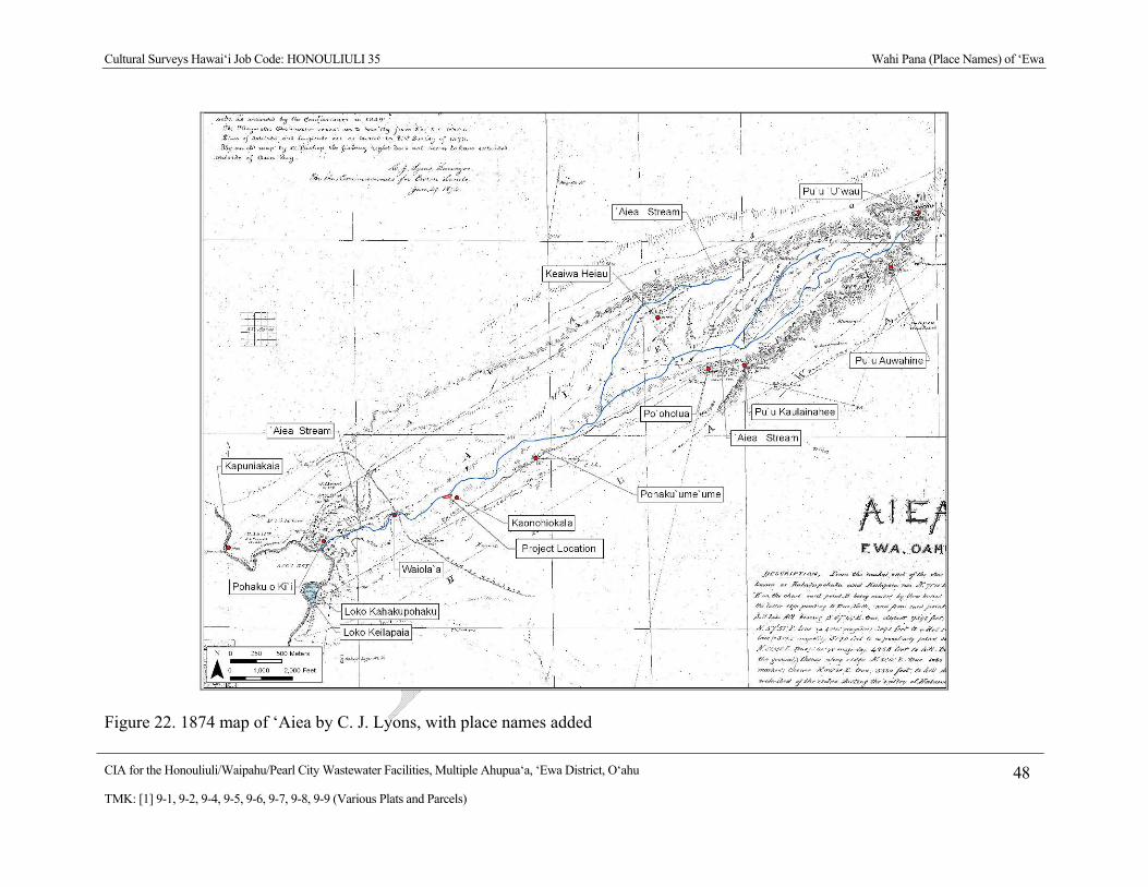
Cultural Surveys Hawai‘i Job Code: HONOULIULI 35 Wahi Pana (Place Names) of ‘Ewa
CIA for the Honouliuli/Waipahu/Pearl City Wastewater Facilities, Multiple Ahupua‘a, ‘Ewa District, O‘ahu 48
TMK: [1] 9-1, 9-2, 9-4, 9-5, 9-6, 9-7, 9-8, 9-9 (Various Plats and Parcels)
Figure 22. 1874 map of ‘Aiea by C. J. Lyons, with place names added

Cultural Surveys Hawai‘i Job Code: HONOULIULI 35 Wahi Pana (Place Names) of ‘Ewa
CIA for the Honouliuli/Waipahu/Pearl City Wastewater Facilities, Multiple Ahupua‘a, ‘Ewa District, O‘ahu 49
TMK: [1] 9-1, 9-2, 9-4, 9-5, 9-6, 9-7, 9-8, 9-9 (Various Plats and Parcels)
Kūāhua, a small offshore islet, considered a part of Hālawa Ahupua‘a, is translated as “standing heap” (Pukui et al. 1974:118). Kūāhua was attached to the coast via the Loko Kūnana fishpond. Lloyd Soehren (2009) translated this name as Kūnana, a possible variant of kūlana, the Hawaiian word for “position.” However, a long time resident stated the fishpond was named after Kūanānā (‘child of Nānā), the mother of Ka‘ahupahau, the shark chiefess of Pu‘uloa, who liked to fish there (Sterling and Summers 1978:10). Makalapa Crater is a prominent geological feature located inland of Loko Kūnana. The word makalapa is translated as “ridge features” (Pukui et al. 1974:140). Leilono, located on the hill of Kapukaki (Red Hill) at the boundary between Hālawa and Moanalua Ahupua‘a, “was a place said to be the opening, on the island of O‘ahu, for mankind to enter eternal night” (Ka Nūpepa Ku‘oko‘a Aug. 11, 1899, in Sterling and Summers 1978:9). There was a healing pool called Waiola in the uplands near the boundary with Moanalua. McAllister (1933:99) reported that the pool is said to have medicinal qualities. The old Hawaiian came here to bathe when they were recuperating from illness.”
Hālawa had numerous fishponds (from south to north). Loko Waiaho, also known as Queen Emma’s Pond and Loko Ke‘oki, were both located near the mouth of the Pearl River near the nineteenth century village called Watertown. Papiolua was opposite the tip of Waipi‘o Peninsula. Loko A Mano (Amana), Loko Pōhaku, Ola Loko, Wailolokai and Wailolowai were all inland of Kūāhua Island, in the bay now called the South East Loch, while Loko Kūnana and Loko Muliwai were between the east side of the island and the Hālawa shore. Loko Kahakupōhaku and Kealipaia were near the northeastern corner of the East Loch of Pearl Harbor. Sixteen ‘ili are mentioned in Māhele documents, 15 ‘ili ‘āina and one ‘ili kū.

Cultural Surveys Hawai‘i Job Code: HONOULIULI 35 Stories (Mo‘olelo) of ‘Ewa
CIA for the Honouliuli/Waipahu/Pearl City Wastewater Facilities, Multiple Ahupua‘a, ‘Ewa District, O‘ahu 50
TMK: [1] 9-1, 9-2, 9-4, 9-5, 9-6, 9-7, 9-8, 9-9 (Various Plats and Parcels)
Section 4 Stories (Mo‘olelo) of ‘Ewa
The mo‘olelo of ‘Ewa invoke the deep Hawaiian past. Some mo‘olelo make connections with Kahiki, the traditional homeland of Hawaiians in central Polynesia. Most notably, the chief Kaha‘i left from Kalaeloa (coastal area in Honouliuli Ahupua‘a) for a trip to Kahiki, and on his return to the Hawaiian Islands, brought back the first breadfruit (Kamakau 1991a:110) and planted it near the waters of Pu‘uloa (long hill), now known as Pearl Harbor (Beckwith 1940:97). In addition, several mo‘olelo associate places in ‘Ewa with the gods Kāne and Kanaloa, the pig god Kamapua‘a, the Hina family, and with the sisters of the Hawaiian volcano goddess Pele, all of whom have strong connections with Kahiki (Kamakau 1991a:111; Pukui et al. 1974:200).
‘Ewa literally means “crooked” or “unequal” (Pukui and Elbert 1986:42). Others interpret it as “strayed” in association of a story about the gods Kāne and Kanaloa, who threw a stone to determine the boundary of the district.
When Kane and Kanaloa were surveying the islands they came to Oahu and when they reached Red Hill saw below them the broad plains of what is now Ewa. To mark boundaries of the land they would throw a stone and where the stone fell would be the boundary line. When they saw the beautiful land lying below them, it was their thought to include as much of the flat level land as possible. They hurled the stone as far as the Waianae range and it landed somewhere, in the Waimanalo section. When they went to find it, they could not locate the spot where it fell. So Ewa (strayed) became known by the name. The stone that strayed. (Told to E. Sterling by Simeon Nawaa, March 22, 1954; cited in Sterling and Summers 1978:1)
4.1 Pearl Harbor (Pu‘uloa) Mo‘olelo
4.1.1.1 Kāne and Kanaloa and the Loko I‘a of Pu‘uloa
According to an account in the Hawaiian newspaper Ka Loea Kālai‘āina (June 10, 1899), several of the fishponds in the Pu‘uloa area were made by the brother gods, Kāne and Kanaloa. A fisherman living in Pu‘uloa, named Hanakahi, prayed to unknown gods, until one day two men came to his house. They revealed to him that they were the gods to whom he should pray. Kāne and Kanaloa then built fishponds at Ke‘anapua‘a, but were not satisfied. Then they built the fishpond, Kepo‘okala, but were still not satisfied. Finally they made the pond Kapākule, which they stocked with all manner of fish. They gifted all of these fishponds to Hanakahi and his descendants (Handy and Handy 1972:473; Ka Loea Kālai‘āina, July 8, 1899).
According to Mary Pukui (1943:56-57), who visited Kapākule fishpond when she was young, the pond was built by the legendary little people of Hawai‘i, the menehune, under the direction of the gods Kāne and Kanaloa. Pukui describes several unique aspects of this pond:
On the left side of the pond stood the stone called Hina, which represented a goddess of the sea by that name. Each time the sea ebbed, the rock became gradually visible, vanishing again under water at high tide. Ku, another stone on
Cultural Surveys Hawai‘i Job Code: HONOULIULI 35 Stories (Mo‘olelo) of ‘Ewa
CIA for the Honouliuli/Waipahu/Pearl City Wastewater Facilities, Multiple Ahupua‘a, ‘Ewa District, O‘ahu 51
TMK: [1] 9-1, 9-2, 9-4, 9-5, 9-6, 9-7, 9-8, 9-9 (Various Plats and Parcels)
the right, was never seen above sea level. This stone represented Ku‘ula, Red Ku, a god for fish and fishermen. From one side of the pond a long wall composed of driven stakes of hard wood, ran toward the island [Laulaunui] in the lochs. When the fish swam up the channel and then inside of this wall, they invariably found themselves in the pond. A short distance from the spot where the pond touched the shore was a small koa or altar composed of coral rock. It was here that the first fish caught in the pond was laid as an offering to the gods. (Pukui 1943:56)
The fishpond contained many fish, especially the akule (scad fish, Trachurops crumenophthalmus), thus its name, “the enclosure for akule fish” (Pukui 1943:56-57). The pond was destroyed when the channel to Pearl Harbor was dredged in the early twentieth century. The caretaker of the pond took the stones Kū and Hina to a deep place in the ocean and sunk them so “none would harm or defile them.” Cobb (1903:733) says the pond was used to catch the larger akule (goggler), ‘ōpelu (mackerel scad), weke (goat fish), kawakawa (bonito), and sharks. It was unusual for having walls made of coral. This contradicts much of the legendary material that says that sharks were not killed within Pearl Harbor; however, Kamakau does relate that Kekuamanoha and Kauhiwawaeono, two conspirators against Kamehameha I, lived at Pu‘uloa. The chief Kauhiwawaeono was known to murder people and use their bodies as shark bait (Kamakau 1992:182, 232).
Samuel Kamakau adds more information on the pond Kapākule, and a second one called Kepo‘okala.
At Pu‘uloa on Oahu were two unusual ponds [fish traps]—Kapakule and Kepoolala. Kapakule was the better one. The rocks of its walls, kuapa, could be seen protruding at high tide, but the interlocking stone walls (pae niho pohaku) of the other pond were still under water at high tide…. It [Kapakule] was said to have been built by the ‘e‘epa people [mysterious people] at the command of Kane ma….
This is how the fish entered the pond. At high tide many fish would go past the mauka side of the pond, and when they returned they would become frightened by the projecting shadows of the trunks, and would go into the opening. The fish that went along the edge of the sand reached the seaward wall, then turned back toward the middle and entered the anapuna (the arched portion of the trap). A man ran out and placed a “cut-off” seine net (‘omuku lau) in the opening, and the fish shoved and crowded into it. The fish that were caught in the net were dumped out, and those not caught in the net were attacked with sharp sticks and tossed out, or were seized by those who were strong. (Kamakau 1976:88)
4.2 Mo‘olelo (Stories) of Honouliuli and Hō‘ae‘ae
4.2.1 The Caves of Honouliuli
‘Ewa was famous for the many limestone caves formed in the uplifted coral, called the “Ewa Karst.” This Pleistocene limestone outcrop, where not covered by alluvium or stockpiled material, has characteristic dissolution “pit caves” (Mylroie and Carew 1995), which are nearly universally, but erroneously, referred to as “sink holes” (Halliday 2005). These pit caves, or
Cultural Surveys Hawai‘i Job Code: HONOULIULI 35 Stories (Mo‘olelo) of ‘Ewa
CIA for the Honouliuli/Waipahu/Pearl City Wastewater Facilities, Multiple Ahupua‘a, ‘Ewa District, O‘ahu 52
TMK: [1] 9-1, 9-2, 9-4, 9-5, 9-6, 9-7, 9-8, 9-9 (Various Plats and Parcels)
sinkholes, vary widely in areal extent and depth, with some of the more modest features comparable in volume to five-gallon buckets, while some of the larger features, although usually irregularly shaped, are several meters wide and several meters deep. In traditional Hawaiian times, the areas of exposed coral outcrop were undoubtedly more extensive.
Some of these caves, called ka-lua-ōlohe were inhabited by the ōlohe, a type of people that looked like other humans but had tails like dogs (Beckwith 1940:343). These people were skilled in wrestling and bone-breaking and often hid along narrow passes to rob travelers. They were also reputed to be cannibals. One famous cannibal king, Kaupe, who lived in Līhu‘e in upland Honouliuli, was an ōlohe.
The caves of Pu‘uloa were sometimes also used as burial caves. In 1849, Keali‘iahonui, son of Kaua‘i’s last king, Kaumuali‘i, died. He had once been married to the chiefess Kekau‘ōnohi, who had stayed with him until 1849. She wanted to bury her ex-husband at sea.
It seems that by Kekauonohi’s orders, the coffin containing her late husband’s remains was removed to Puuloa, Ewa, with the view of having it afterwards taken out to sea and there sunk. It was temporarily deposited in a cavern in the coral limestone back of Puuloa, which has long been used for a burial place, and has lately been closed up. (Alexander 1907:27)
After some initial objections by the niece of Keali‘iahonui, the body was removed from the outer coffin, the rest was sunk, and the coffin was later buried somewhere in Pu‘uloa.
4.2.2 The Inland Plain of Keahumoa
In several legends of ‘Ewa, mention is made of the “plain of Keahumoa.” John Papa ‘Ī‘ī (1959:96) has this plain opposite the trail to Pohakea Pass, stretching across the ahupua‘a of Honouliuli and Hō‘ae‘ae. McAllister (1933:107) states that the plain was west of Kīpapa Gulch in Waikele, It is also mentioned in legends of Waipi‘o. Thus, this is probably a general name for the flat plain mauka of the productive floodplain area directly adjacent to Pearl Harbor. This plain would have been mauka of the present corridor alignment.
4.2.2.1 Legend of Nāmakaokapao‘o
Nāmakaokapao‘o was a Hawaiian hero of legendary strength. Nāmakaokapao‘o’s mother was Pokai and his father was Kaulukahai, a great chief of Kahiki, the ancestral home of the Hawaiians. The two met in Hō‘ae‘ae and conceived their child there. The father returned to his home in Kahiki before the birth of his son, leaving his O‘ahu family destitute. A man named Puali‘i saw Pokai and married her. The couple then resided on the plains of Keahumoa, planting sweet potatoes. Nāmakaokapao‘o was a small, brave child who took a dislike to his stepfather, and pulled up the sweet potatoes Puali‘i had planted at their home in Keahumoa. When Puali‘i came after Nāmakaokapao‘o with an axe, Nāmakaokapao‘o delivered a death prayer against him, and slew Puali‘i, hurling his head into a cave in Waipouli, near the beach at Honouliuli (Fornander 1919:274–276).
Cultural Surveys Hawai‘i Job Code: HONOULIULI 35 Stories (Mo‘olelo) of ‘Ewa
CIA for the Honouliuli/Waipahu/Pearl City Wastewater Facilities, Multiple Ahupua‘a, ‘Ewa District, O‘ahu 53
TMK: [1] 9-1, 9-2, 9-4, 9-5, 9-6, 9-7, 9-8, 9-9 (Various Plats and Parcels)
4.2.2.2 Legend of Pikoi
Pikoi was a legendary hero, the son of a crow (‘alalā) and brother to five god-sisters in the form of rats. He was famous for his ability to shoot arrows, and often made bets that he could hit rats from a long distance (Fornander 1917:450–463). Pikoi’s skill was commemorated in a saying (Pukui 1983:200):
Ku aku la i ka pana a Shot by the arrow of Pikoi-[son] Pikoi-a-ka-‘alalā, keiki pana of-the-crow, the expert rat-shooter ‘iole o ke kula o Keahumoa. Of the plain of Keahumoa.
4.2.2.3 Story of Palila
In the legend of the hero Palila, the famous warrior had a supernatural war club. He could throw the club a long distance, hang on to the end of it, and fly along the club’s path. Using this power, he touched down in several places in Honouliuli, Waipi‘o, and Waikele. One day he used his supernatural war club to carry himself to Ka‘ena Point at Wai‘anae, and from there east across the district of ‘Ewa.
Ha‘alele keia ia Ka‘ena, hele mai la a Kalena, a Pōhākea, Maunauna, Kānehoa, a ke kula o Keahumoa, nana ia ‘Ewa. Kū kēia i laila nānā i ke kū a ka ea o ka lepo i nā kānaka, e pahu aku ana kēia i ka la‘au palau aia nei i kai o Honouliuli, kū ka ea o ka lepo, nu lalo o ka honua, me he olai la, makau nā kānaka holo a hiki i Waikele. A hiki o Palila, i laila, e pa‘apu ana nā kānaka i ka nānā lealea a ke ‘li‘i o O‘ahu nei, oai o Ahuapau.
After leaving Ka‘ena, he came to Kalena, then on to Pōhākea, then to Manuauna [a peak in Honouliuli], then to Kānehoa [a peak in Honouliuli], then to the plain of Keahumoa [upland plain from Honouliuli to Waipi‘o] and looked toward ‘Ewa. At this place he stood and looked at the dust as it ascended into the sky caused by the people who had gathered there; he then pushed his war club toward Honouliuli. When the people heard something roar like an earthquake they were afraid and they all ran to Waikele. When Palila arrived at Waikele he saw the people gathered there to witness the athletic games that were being given by the king of O‘ahu, Ahupau by name. (Fornander 1918:142–143)
4.2.2.4 The Demi-god Māui
In the stories of the demi-god Māui, Keahumoa is the home of Māui‘s grandfather, Kuolokele (Kū-honeycreeper). One day, Māui’s wife, Kumulama, was stolen by the chief Peapeamakawalu, called eight-eyed-Pea-Pea, who is identified in the creation chant, Kumulipo, as the octopus god (Beckwith 1951:136). The chief disappeared with Kumulama in the sky beyond the sea, and escaped so quickly that Māui could not catch him. To recover his wife, Māui’s mother advised him to visit the hut of his grandfather at Keahumoa:
Maui went as directed until he arrived at the hut; he peeped in but there was no one inside. He looked at the potato field on the other side of Poha-kea, toward Hono-uli-uli, but could see no one. He then ascended a hill, and while he stood there looking, he saw a man coming toward Waipahu with a load of potato leaves,
Cultural Surveys Hawai‘i Job Code: HONOULIULI 35 Stories (Mo‘olelo) of ‘Ewa
CIA for the Honouliuli/Waipahu/Pearl City Wastewater Facilities, Multiple Ahupua‘a, ‘Ewa District, O‘ahu 54
TMK: [1] 9-1, 9-2, 9-4, 9-5, 9-6, 9-7, 9-8, 9-9 (Various Plats and Parcels)
one pack of which, it is said, would cover the whole land of Keahumoa. (Thrum 1923:253–254)
Kuolokele made a moku-manu (“bird-ship”) for Māui, who entered the body of the bird and flew to Moanaliha, the land of the chief Peapeamakawalu. This chief claimed the bird as his own when it landed on a sacred box, and took it with him into the house he shared with Māui’s wife. When Peapeamakawalu fell asleep, Māui killed him, cut off his head, and flew away back to O‘ahu with his wife and the chief’s head (Thrum 1923:252–259).
4.2.2.5 Hi‘iaka, sister to the Hawaiian volcano goddess, Pele
The goddess, Hi‘iaka, sister of the volcano goddess Pele, passed through ‘Ewa and met women stringing ma‘o (Gossypium tomentosum) flowers to make lei. Hi‘iaka offered a chant, making known her wish for a lei around her own neck.
E lei ana ke kula o Ke‘ahumoa i ka ma‘o The plains of Keahumoa are garlanded with ma‘o ‘Ohu‘ohu wale nā wāhine kui lei o The lei-stringing women of the forest ka nahele are festively adorned (Ho‘oumāhiehiemalie 2006a:287; 2006b:268)
4.3 Stories (Mo‘olelo) of Central and Eastern ‘Ewa
4.3.1 The Kapa Board at Waikele Spring
The most famous wahi pana in Waikele is the legend of the kapa (tapa, cloth made from wauke or māmaki bark) board of Waipahu Spring. Tapa was placed on a wooden board (also called an anvil), and beaten by women with tapa sticks to smooth out the fibers. This pounding made a resonant sound, and women could often identify the owner of the board by the sound that was made. One day a woman in Kahuku on O‘ahu took her favorite tapa board to a pool to clean it and left it at the side of the pool. The next day the board was missing. The woman first searched the windward districts of the island, but never heard the distinctive ringing sound of her own favorite board. After several months without finding her board, she traveled to the leeward side of O‘ahu.
She went from Kahuku on the Koolau side to Kaneohe where she spent the night. There was no sign of the anvil in Koolau, because the sign she sought was the sound it made…. She went on and spent the night at Wailupe but did not find hers. She heard other anvils but they were not hers. The night turned into day and she went on to Kapalama where she slept but did not hear what she sought till she came to Waipahu. (Ka Loea Kalaiaina, June 10, 1899; English translation in Sterling and Summers 1978:25)
At Waipahu Spring in the ‘Ewa District, she finally heard the sound of her own board. She followed the sound to the uplands of Waikele and found a woman beating tapa on her board. The woman claimed that she had found the board one day floating on the water at a spring near her house. This legend illustrates the belief by the ancient Hawaiians that there were underground streams and passages that led from one side of the island to the other. In one version of this story,

Cultural Surveys Hawai‘i Job Code: HONOULIULI 35 Stories (Mo‘olelo) of ‘Ewa
CIA for the Honouliuli/Waipahu/Pearl City Wastewater Facilities, Multiple Ahupua‘a, ‘Ewa District, O‘ahu 55
TMK: [1] 9-1, 9-2, 9-4, 9-5, 9-6, 9-7, 9-8, 9-9 (Various Plats and Parcels)
the people of ‘Ewa followed the woman back to Kahuku so that she could prove that the board was the same one she had lost. They wrapped a bundle of ti or kī (Cordyline terminalis) leaves and cast them into the pool near the house of the Kahuku woman. Then returning to ‘Ewa, they saw the same bundle of ti leaves a few days later in Waipahu at the spring. Because of this, the Waipahu spring was called Ka-puka-na-wai-o-Kahuku, which means “Outlet of water from Kahuku.”
4.3.2 Stories of the Gods in Waipi‘o
There was a cave named Kapuna on Waipi‘o Peninsula that was associated with a famous riddle. No Kapuna ka hale noho ia e ke kai, or “To Kapuna belongs the house, the sea dwells in it.”
This cave is on the Waipio side and a sea passage separates Waipio and Waikele and Waikele and Honouliuli. The passage is obstructed by three small islands, a middle one and Manana and Laulaunui. These small islands in the middle of the passage to Honouliuli and inside and outside of these small islands is the sea of Kaihuopalaai [Hawaiian name for West Loch] where mullet lived till they whitened with age. (Ka Loea Kālai‘āina, Oct. 7, 1899, translation in Sterling and Summers 1978:24)
Another famous cave of the area was Keanapua‘a, in Hālawa, opposite Waipi‘o Peninsula, which means “the pig’s cave,” so named because Kamapua‘a once slept there (Pukui et al. 1974:103). This cave was one of the places that the high king of O‘ahu, Kahahana, hid after he had killed the priest Ka‘opulupulu, thus angering the high chief of Maui, Kahekili.
In Waipi‘o, ‘Ewa, ‘Ai‘ai, the son of the fishing god, Kū‘ula, was said to have established a pōhaku i‘a (fish stone) at Hanapouli and a ku‘ula (stone god used to attract fish) named Ahu‘ena (Manu 1902:127).
4.3.3 Stone Markers on the Trail through Waiawa
Along the coastal trail through ‘Ewa described by John Papa ‘Ī‘ī were several stone markers, called Nāpōhaku-luahine. These are described as old women who were changed into stones:
The names of these royal stones were Kahoaiai (also the name of an ‘ili in Waiawa), Waiawakalea, Piliaumoa, Kahe‘ekuluaikamoku, all chiefesses. Their four servants were Nohoana, Kikaeleke, Piliamo‘o, Nohoanakalai. These were the guardians of the trail. (Ka Loea Kālai‘āina, June 29, 1899, translation in Sterling and Summers 1978:6)
The writer describes the location of the stones:
Here is how the traveler can locate them. When you leave the bridge of Waiawa, for Honolulu, go up and then down an incline. The hill standing on the seaward side is Nuku-o-ka-manu. The next incline is Waiawa. Go up the ascent till you reach the top and above that, about two chains from the road you will find the stones. (Ka Loea Kālai‘āina, June 29, 1899, translation in Sterling and Summers 1978:6)
Cultural Surveys Hawai‘i Job Code: HONOULIULI 35 Stories (Mo‘olelo) of ‘Ewa
CIA for the Honouliuli/Waipahu/Pearl City Wastewater Facilities, Multiple Ahupua‘a, ‘Ewa District, O‘ahu 56
TMK: [1] 9-1, 9-2, 9-4, 9-5, 9-6, 9-7, 9-8, 9-9 (Various Plats and Parcels)
4.3.4 Maihea and the Cultivation of ‘Awa in Waiawa, Waiau, Waimalu, and Hālawa
There were many places in ‘Ewa associated with the cultivation of the ‘awa, (Piper methysticum) which was used to make a slightly intoxicating drink. The first ‘awa plant was brought from Kahiki, the Hawaiian ancestral lands, by Oilikukaheana, who planted it in Kauai. His wife discarded the plants, and some were pulled up by a man named Mō‘īkehā, who took them to Oahu and planted them at Hālawa:
Noho o Moikeha a ulu ua laau nei a nui, no ka pohihihi iaia o ka inoa hele oia ia Ewa, oiai e noho kaawale ana o Ewa me Halawa, aole no hoi e ike wale ia o Halawa, oia ka mea i olelo ia ai: “Ike ole ia aku Halawa la; Aina i ka mole o Ewa la,” a plea aku.
O ko ia nei hele aku la no ia ia Ewa, o ko Ewa olelo mai la no ia e kii i ua laau nei. O ko ia nei kii aku la no ia ua kolo ke a-a, ko ianei huhuki mai la no ia o ke kumu o ka lau, ku ana imua o Ewa, a olelo aku o Ewa: “E ai mua au i keia laau a i make au, alaila, mai kanu oe aohe waiwai, aka ina aole au e make, alaila, waiwai kaua.” I ka ai ana a ua o Ewa, ona iho la ia a po ka la, ala mai la ia a kapa mai la i ka inoa li‘i.
Moikeha waited until the plants grew large, and because he had forgotten the name, he west to Ewa. This was the time when Ewa and Halawa were living separately; Halawa was not available to everyone, hence the saying: “Halawa is not to be seen; ‘tis a land at the end of Ewa,” etc.
He went to Ewa, and she told him to go and get the plant. So he went for some, and found that the roots had grown large. So he pulled up the plants, roots and leaves, and brought them to Ewa. Ewa said: “Let me first eat of this plant, and should I die, do not plant it for it would be valueless; but should I not die, then we will be rich.” When ‘Ewa ate it she became drunk and was intoxicated all day. When she awoke she called the plant “awa”; from thence forward this plant was called ‘awa, the awa of Kaumaka‘eha, the chief. (Fornander 1919:606–609)
The story talks of ‘Ewa and Hālawa as if they were two people separated and living apart. Fornander suggests that these sentences refer to a time when Hālawa was not an ahupua‘a of ‘Ewa, but was “apart” and at “end of ‘Ewa.” After this, Hālawa was one of the noted places for the cultivation of ‘awa (Fornander 1919:610).
4.3.5 The Eel Boy of Pilimo‘o in Mānana
The following is the story of the “Eel Boy of Pilimo‘o,” a pool in Pearl City, Mānana Ahupua‘a:
This pool had an underground tunnel that led to the sea. For a long time there was no danger to the children that came to swim in the pool until a man-eating shark discovered the tunnel and slipped in and out at will.
One day, a boy went to the pool and disappeared. No trace of him was found. His father was so worried that he went to consult a Makaula or prophet. The makaula asked his gods, who told him that it was the will of the gods to change him into a
Cultural Surveys Hawai‘i Job Code: HONOULIULI 35 Stories (Mo‘olelo) of ‘Ewa
CIA for the Honouliuli/Waipahu/Pearl City Wastewater Facilities, Multiple Ahupua‘a, ‘Ewa District, O‘ahu 57
TMK: [1] 9-1, 9-2, 9-4, 9-5, 9-6, 9-7, 9-8, 9-9 (Various Plats and Parcels)
small eel, so that he could live in the depth of the pool and warn the children of danger.
The father of the boy went to the pool to see if it were so. He sat there for a long time and neither saw nor heard anything. Then the children gathered at the opposite side of the pool from him and began to dive and play.
Suddenly he heard a whistle which sounded so like the whistling of his son when he went home every day after playing. “That sounds very much like my son’s whistling,” he said to himself. He looked around and saw nothing. The whistling was repeated. Then looking toward a ledge under some hau trees, he noticed the head of an eel. Every now and then it whistled. He drew closer to it and spoke to it, “Can it be that you are my son? How did your human body change to an eel?” The boy replied, “Yes I was once a boy, now I am an eel because the gods have willed it, so that I may save human lives from the wicked sharks of the deep that come here. Go and tell those children to go home. Tell them to listen and if they hear whistling that it is a warning that they are in danger.”
The man went as he was told to do. He told them to listen for a shrill whistle every now and then. That was a signal to go away at once.
The eel whistled again so loudly that the children heard him and went away. The father remained to see if a shark would appear. A little while later he saw the dark form of a big shark swim about in the pool.
So it was that ever after, a whistle was a signal of danger.
This is the story of Pilimoo pool. (Namau 1940a, in Sterling and Summers 1978:16–17)
4.3.6 Pearl City Stone in Mānana
The “Pearl City Stone” myth tells of a “supernatural” rock that was located at the site of the Pearl City Mormon Church:
When the church was built the stone remained undisturbed until some of the Hawaiians began to talk about it and call the attention of the visitors to this “female” rock. True, it was regarded as a sacred rock by the ancients but no one was worried about it in particular except to stare at it in curiosity and think what it must have meant to their ancestors.
Then some of the “higher ups” in the church heard it. These were Hawaiians who looked upon anything that the ancients revered as detrimental to their own faith when brought in such close contact as this. They insisted that it be thrown out to the road side.
Waiwaiole, a man who lived in the neighborhood and knew the legend of this rock was assigned the work of removing it to the roadside. He put it off from week to week as he hoped that his friends would forget about it, but they did not. They became more insistent until he found someone to help him to carry it out. At first he tried to lift it but it would not move until he talked to it. He told it that it
Cultural Surveys Hawai‘i Job Code: HONOULIULI 35 Stories (Mo‘olelo) of ‘Ewa
CIA for the Honouliuli/Waipahu/Pearl City Wastewater Facilities, Multiple Ahupua‘a, ‘Ewa District, O‘ahu 58
TMK: [1] 9-1, 9-2, 9-4, 9-5, 9-6, 9-7, 9-8, 9-9 (Various Plats and Parcels)
was unwelcome in the church yard and it would be better for it to be by the roadside. After that, the two men had no trouble in moving it.
Some years later the road was widened where the stone stood and it was blasted. Part of it is gone and a part remains to this day.
Waiwaiole, the man who removed it fell sick and gradually grew worse until he was brought to the Queen’s Hospital where he died.
The man who helped him also became sick with a disease that made him look bloated and dark. He became an inmate of the Mino‘aka Home until death took him. Waiwaiole’s beautiful home was burned down with fire. No one knew what caused it. His widow is still at Pearl City and expects to build a new home ere long. (Naumau 1940b, in Sterling and Summers 1978:17)
4.3.7 Pōhaku Anae in Mānana
The following story describes a famous stone in Pearl City associated with the mullet of Pearl Harbor:
I saw the beauty and charm of the broken currents at Moanalua and also heard the tooting of the whistle at the turn of Kauwahipouli. I heard it three and four times and asked the person sitting on my left, “What place is this?” Answer—“This is Pearl City.” It was here that mullets were bred in the ancient times and that flat stone there was called Mullet Rock or Pōhaku ‘Anae. It lies near the beach by Ewa mill. (Ka Nūpepa Ku‘oko‘a, Oct. 2, 1908, translation in Sterling and Summers 1978:53)
4.3.8 The Dog Kū‘īlioloa on the Plain of Kaluahole in Waiau
The high chief Kūali‘i conquered the Kona and ‘Ewa District chiefs in the early eighteenth century, ruling as mō‘ī of O‘ahu from 1720 to 1740 (Cordy 2002:19). According to a source from a Hawaiian language newspaper (Ka Loea Kālai‘āina 1899f), Kūali‘i’s father was a chief of the Ko‘olau District, but his mother was raised in Waiau in ‘Ewa, and Kūali‘i himself was born in Waiau, which was noted as a favored place for the Waiau royal high chiefs. The plain of Kalua‘ōlohe was the noted residence of the dog Kū‘īlioloa, who was also of the royal lineage of Waiau.
There was a pit where the hairless dog, seen in the olden days, lived. The name of the dog was Ku-ilio-loa and he was hairless. He often met with those who went on the plain at night and he changed his colors from black to brown, to white or to brindle. He showed himself when something was going to happen, such as the death of a ruling chief or other things pertaining to the government such as disagreements and so on. (Ka Loea Kālai‘āina July 29, 1899, translation in Sterling and Summers 1978:15)
Cultural Surveys Hawai‘i Job Code: HONOULIULI 35 Stories (Mo‘olelo) of ‘Ewa
CIA for the Honouliuli/Waipahu/Pearl City Wastewater Facilities, Multiple Ahupua‘a, ‘Ewa District, O‘ahu 59
TMK: [1] 9-1, 9-2, 9-4, 9-5, 9-6, 9-7, 9-8, 9-9 (Various Plats and Parcels)
4.3.9 The Kahuawai Bathing Place of Chiefs at Kalauao
Hawaiian language newspapers give us accounts of a bathing place reserved for ali‘i named Kahuawai in Kalauao. The summary translations for each account below are from Sterling and Summers (1978:13–14):
Here is another thing. I went to see the diving place of the chiefs where they used to bathe. It is very close to the pump at Kalauao. It is cemented and deep. The name of this pool is Kahuawai. On the eastern side are some taro patches that are somewhat like ponds. They were deep in the olden days and these were the taro patches owned by Kaho, in which he planted all the time. (Apuakehau, Ka Nūpepa Kū‘oko‘a July 18, 1919, translation in Sterling and Summers 1978:13)
Kahuawai was a noted bathing place since ancient times and was guarded so that any one did not bathe in it except the chiefs. Later it was used by all. Kakuhihewa’s daughters and the hero Kalelealuaka (their husband) bathed in this pool. Kaeokulani, the chief of Kauai also bathed here when he came to war here on O‘ahu. He was killed at Kukiiahu. Many visitors from Hawaii to Kauai that came to see this pool and it was well known to Ewa’s inhabitants. (Ke Au Hou 1910, translated in Sterling and Summers 1978:13)
They went to the taro patches of Aiea, up the plain of Kukiiahu, below the road where Kaeo, chief of Kauai, was killed by Kalanikupule. From there they went along the taro patches on the upper side of Kohokaho, til they came to Kahuewai, a little waterfall. A little way above it was a spring, a place where travelers sat and rested. They went up a little way to a small plain and ascended the low cliff of Waimalu and went along between the taro patches of that land. (Ka Nūpepa Kū‘oko‘a, January 1, 1870, translated in Sterling and Summer 1978:13–14)
4.3.10 Keahiakahoe in Kalauao
Pu‘u Keahiakahoe is a peak that divides Kalauao from Hālawa Ahupua‘a along the Ko‘olau Mountain Range. On the other side of the mountains at this point is the ahupua‘a of Kāne‘ohe. In a condensed mo‘olelo, Catherine Summers (Sterling and Summers 1978:206) explains that the peak was named for sibling quarrels that took place between two farmers, Kahoe and Kahuanui, living in or near Kāne‘ohe, their brother, a fisherman named Pahu, and their sister, Lo‘e, who lived on Moku o Lo‘e (Coconut Island) in Kāne‘ohe Bay. Pahu traveled to his brother’s inland taro fields to exchange fish for poi. Kahoe generously gave him all he needed, but Pahu only gave his brother the less desirable bait fish from his catch. Lo‘e told Kahoe of their brother’s deception, and although Kahoe continued to give his brother vegetables, he let Pahu know that he was aware of his lack of generosity. In time, a famine occurred. People cooked their vegetables in imu (earth ovens) at night so their neighbors could not see the smoke and come to ask for part of the food. Kahoe cleverly masked his fire so that the smoke traveled a half a mile inland, seeming to come from the mountain range summit. Pahu could not figure out where the imu was located. As he was gazing at the mountains, Lo‘e saw him, and said:
“So, standing with eyes gazing at Ke-ahi-a-Kahoe (Kahoe’s fire.)” Pahu, thinking of his past deeds had nothing to reply. This peak has been called Ke-ahi-a-Kahoe to this day. (Catherine Summers, cited in Sterling and Summers 1978:206)
Cultural Surveys Hawai‘i Job Code: HONOULIULI 35 Stories (Mo‘olelo) of ‘Ewa
CIA for the Honouliuli/Waipahu/Pearl City Wastewater Facilities, Multiple Ahupua‘a, ‘Ewa District, O‘ahu 60
TMK: [1] 9-1, 9-2, 9-4, 9-5, 9-6, 9-7, 9-8, 9-9 (Various Plats and Parcels)
4.3.11 Pōhaku o Ki‘i (Stone of Ki‘i) in ‘Aiea
There are very few specific mo‘olelo about the ahupua‘a of ‘Aiea. One story, told by John Ka‘imikaua shared a mo‘olelo, tells of Pōhaku o Ki‘i, or the Stone of Ki‘i. According to Mr. Ka‘imikaua, a beautiful woman of chiefly rank named La‘a fell in love with a handsome commoner named Ki‘i. Her father, a high chief, forbade the marriage, but would relent if Ki‘i could fulfill his wish. The high chief instructed Ki‘i to go into the Ko‘olau mountains and make a lei from the rare white lehua (Metrosideros polymopha) blossoms. If he returned before sunrise on the third day with the lei he could marry La‘a. Ki‘i gathered the lehua blossoms and rushed down to the high chief’s home near a sacred bathing pond on the third day. He was within sight of the pond when the first rays of the sun rose over the Ko‘olau mountains. He was turned to stone just above the pond, Pohaku o Ki‘i. La‘a never married. She became the mo‘o wahine (demi-goddess) of the pond, which was named Waiola‘a, or the waters of La‘a. She would pull down and drown any commoner who swam in the waters—only male chiefs could use the sacred pond, including Kakuhihewa and Kuali‘i, as well as the god Kamapua‘a. The last chief to bathe here was David Kalakaua while on his way to Honouliuli. Two palms were planted in historic times to mark the sacred pond, which now mark the entrance to the post office in ‘Aiea (paraphrased from Napoka 1994:2).
Pōhaku o Ki‘i was moved to the entrance of the ‘Aiea post office due to the widening of Moanalua Road in 1994. This final resting place of Pōhaku o Ki‘i is near the historic site of Waiola‘a pond. Thus, the two lovers Ki‘i and La‘a have finally been reunited (Aiea High School and Alumni and Community Association 2009).
4.3.12 Keaiwa, the Healers’ Heiau in ‘Aiea
In ancient times, Keaiwa Heiau in ‘Aiea was the site of a medicinal herb garden and training area for traditional healers:
At the time the Keaiwa heiau at the top of Aiea Heights was discovered in 1951 to be the ruins of an ancient medical center, few Hawaiians knew of its ancient usage.
Eminent anthropologists acknowledged that they had never heard of such centers but were convinced when several Hawaiians independently told of them.
In telling of these centers, Mrs. Mary Kawena Pukui, associate in Hawaiian culture at the Bishop Museum, translated the name Ke-a-iwa as “Incomprehensible.”
The thought being that no one could explain the powers of the priests or the herbs used in healing.
She said Ke-a-iwa came from an obsolete word aiwa-iwa which means the mysterious or the incomprehensible.
Further confirmation of the use of Ke-a-iwa has lately been given me by Paul Keliikoa, a Hawaiian living in Aiea.
Mr. Keliikoa has the story from his grandmother Kamoekai.

Cultural Surveys Hawai‘i Job Code: HONOULIULI 35 Stories (Mo‘olelo) of ‘Ewa
CIA for the Honouliuli/Waipahu/Pearl City Wastewater Facilities, Multiple Ahupua‘a, ‘Ewa District, O‘ahu 61
TMK: [1] 9-1, 9-2, 9-4, 9-5, 9-6, 9-7, 9-8, 9-9 (Various Plats and Parcels)
In her day Ke-a-iwa was interpreted as “a period of fasting and meditation” and the heiau was so named because novitiates in the art of healing spent long hours in fasting, praying and meditation.
Kamoekai also told her grandson that the very young were taken to Ke-a-iwa to be trained as kahuna lapaau. There they were taught the prayers needed to compound medicines and heal the sick.
They cared for the great herb garden which lay beyond the heiau walls.
After the novice learned his first steps in the art of the kahuna lapaau, he was sent out to other medical centers to learn the advanced art of diagnosis and other treatments.
Mr. Keliikoa’s interpretation of the name means a change in the pronunciation. Not Ke-a-iwa, but Ke-ai-wa.
Ke-ai is the Hawaiian word for fasting. (Taylor 1959, reprinted in Sterling and Summers 1978:11–12)
Most early references in the traditional literature are one-line passages that merely mention Hālawa in passing with little attention to detail. People traveled through Hālawa from ‘Ewa to Honolulu or vice versa, but most of these travels seem to have taken place inland of the Āliamanu and Salt Lake (Āliapa‘akai) craters. Once the trail left the northeast margin of Pearl Harbor, it could have been traversed quickly across the one mile (1.6 km) width of Hālawa Ahupua‘a by a traveler heading to Kona District.
A fourteenth century account speaks of the reign of Mā‘ili-kūkahi, an ali‘i who was born at Kūkaniloko in Wahiawā around the fourteenth century (Pukui et al. 1974:113). After consenting to become mō‘ī at the age of 29, Mā‘ili-kūkahi was taken by the chiefs to live at Waikīkī. The story tells that he was probably one of the first chiefs to live there. Up until this time, the chiefs had always lived at Wai‘alua and ‘Ewa. Under his reign, the land divisions were reorganized and redefined. In reference to the productivity of the land and the population (including at Hālawa) during Mā‘ili-kūkahi’s reign Kamakau writes:
In the time of Mā‘ili-kūkahi, the land was full of people. From the brow, lae, of Kulihemo to the brow of Maunauna in ‘Ewa, from the brow of Maunauna to the brow of Pu‘ukea [Pu‘u Ku‘ua] the land was full of chiefs and people. From Kānewai to Halemano in Wai‘alua, from Halemano to Paupali, from Paupali to Hālawa in ‘Ewa the land was filled with chiefs and people. (Kamakau 1991a:55)
Oral tradition tells us that Hālawa was the home of Papa, where she lived in the uplands with her parents, Kahakauakoko and Kūkalani‘ehu. Papa is known for her generative role as the “earth mother”. Together with her husband, Wākea, they were the progenitors of the Hawaiian race. The Hale o Papa Heiau and ritual, which is the female component of the ancient luakini ritual, probably takes its name from her. The Hale o Papa was the heiau for the female deities. Only chiefesses of the highest ranks were allowed to enter and partake of the specially-dedicated foods. (Valeri 1985:245; ‘Ī‘ī 1959:39; Kamakau 1992:179, 380)
Mention is made of the travels of Kamapua‘a (the famous pig-god) through Hālawa and of the cave, Keanapua‘a, where he slept (Kame‘eleihiwa 1992:131): “In the name chant for

Cultural Surveys Hawai‘i Job Code: HONOULIULI 35 Stories (Mo‘olelo) of ‘Ewa
CIA for the Honouliuli/Waipahu/Pearl City Wastewater Facilities, Multiple Ahupua‘a, ‘Ewa District, O‘ahu 62
TMK: [1] 9-1, 9-2, 9-4, 9-5, 9-6, 9-7, 9-8, 9-9 (Various Plats and Parcels)
Kaumuali‘i, reference is made to “ka ea nō mai Hālawa a Honouliuli” (the whirlwind which blows from Hālawa to Honoulili) (Fornander 1920:475).
In traditional lore, Hālawa was one of several places noted and remembered for its ‘awa (Piper methysticum) (Fornander 1916:610). One account tells us that the first ‘awa plant was brought to Hawai‘i by Oilikūkaheana from Kahiki (possibly Tahiti) and planted on Kaua‘i. He brought it to Hawai‘i for use in fishing. The use of ‘awa as an offering to a shark guardian by fishermen is noted in Handy and Handy 1972:192. Mō‘īkehā, brought some ‘awa plants with him to O‘ahu and planted them at Hālawa. When they grew, he mentioned it to Oilikukaheana who told him the name of these ‘awa plants was called Paholei. Mō‘īkehā forgot the name and later, when the plants were much larger, he went to ‘Ewa and told her about the plants. ‘Ewa sent Mō‘īkehā to get some plants. ‘Ewa said:
Let me first eat of this plant, and should I die, do not plant it for it would be valueless; but should I not die, then we will be rich.” When ‘Ewa ate it she became drunk and was intoxicated all day. When she awoke she called the plant “awa”; from thence forward this plant was called ‘awa, the awa of Kaumaka‘eha, the chief. (Fornander 1916:608)
On the December 12, 1794 the decisive battle of Kūki‘iahu took place at Kalauao (lit. “the multitude of clouds”) approximately a mile (1.6 km) northwest of the current Project area. It was there that the O‘ahu ruling chief, Kalanikūpule, killed and defeated the invader Ka‘eokūlani. It is said that the dead bodies were gathered up and taken to Pa‘aiau where they were piled in a great heap. Among the piled-up bodies was Kahulunuika‘aumoku, daughter of Kū‘ohu, a Kaua‘i kahuna (priest) who had been slain with Ka‘eokūlani. Late at night an owl woke her up by flying over and beating its wings on her head. The owl flew makai, and she crawled after it until reaching the sea. She then swam to the other side at ‘Aiea where the owl appeared once more and led her up to the mountains in Hālawa valley. There, she took shelter in a cave and fell into an unconscious sleep. The owl flew to a former kahu (caretaker) of hers who “knew the country well around Hālawa.” This kahu brought her food and nursed her back to health. (Kamakau 1992:169–70)
The following mo‘olelo are accounts regarding people and events that took place in or near Hālawa. These accounts are what have been preserved through the oral and written record of times long past.
4.3.13 Leilono, then entrance to Milu, the Underworld, in Hālawa
Leilono was a supernatural breadfruit tree (‘Ulu o Leiwalo) whose branches appeared through a hole or crater in the ground. This hole (also called Leilono) was said to be the entrance whereby wandering spirits could enter the afterworld of Milu (pō pau ‘ole), the ao kuewa or realm of wandering spirits, or the ao ‘aumakua (ancestral spirit realm). The tree had two branches which were deceiving to look at, one on the east side of the tree and one on the west side. If a spirit climbed onto the west branch, it would wither and break off and he would plunge into the realm of Milu. If a spirit climbed onto the branch on the east, he would be able to see the ‘aumākua realm and receive help from his ancestors. This hole is described as being round and approximately two ft wide, on a piece of pāhoehoe lava. Leilono is in the neighboring district of Moanalua. However, very specific boundaries are given for it. Kamakau says it was:

Cultural Surveys Hawai‘i Job Code: HONOULIULI 35 Stories (Mo‘olelo) of ‘Ewa
CIA for the Honouliuli/Waipahu/Pearl City Wastewater Facilities, Multiple Ahupua‘a, ‘Ewa District, O‘ahu 63
TMK: [1] 9-1, 9-2, 9-4, 9-5, 9-6, 9-7, 9-8, 9-9 (Various Plats and Parcels)
Close to the rock Kapūkakī and easterly of it … directly in line with the burial mound of Āliamanu and facing toward the right side of the North Star…. The boundaries of Leilono were Kapapakōlea on the east, [with] a huge caterpillar (pe‘elua nui) called Koleana as its eastern watchman, and the pool Napeha on the west, with a mo‘o [water spirit, lizard] the watchman there. If the soul was afraid of these watchmen and retreated, it was urged on by the ‘aumakua spirits, then it would go forward again and be guided to the ‘aumakua realm. If a soul coming from the Ālia (Āliapa‘akai) side was afraid of the caterpillar, whose head peered over the hill Kapapakōlea, and who blocked the way, it would wander about close to the stream by the harness shop. This was not the government road (alanui aupuni) of former times, but was a trail customarily used by “those of Kauhila‘ele” [figuratively, the common people; the la‘ele, old taro leaves, as contrasted with the liko, the new and choicer leaves — that is, the chiefs]. It was said that if a wandering soul entered within these boundaries it would die by leaping into the pō pau ‘ole; but if they were found by helpful ‘aumākua souls, some wandering souls were saved. Those who had no such help perished in the pō pau ‘ole of Milu. (Kamakau 1991b:48–49).
4.3.14 The Gods in Hālawa
The Hawaiian pig-god, Kamapua‘a, made a stop in Hālawa and spent the night in a cave in Hālawa opposite Waipi‘o Peninsula at a place now called Hospital Point. He woke and then urinated in the sea, which “is why the fish of Pu‘uloa [Pearl Harbor] have such a strong odor.” The cave Keanapua‘a, which means “the pig’s cave” was named for this incident (Sterling and Summer 1978:10). The strong odor of fish only applied to fish caught on the eastern side of Pearl Harbor. In contrast, the fish from the western shore, at Pu‘uloa, were renowned for their good fragrance. All the market man had to say was, “these are from Ke Ahi [coastal point in Pu‘uloa/Honouliuli] and his supply would vanish in a short time” (Sterling and Summer 1978:44). Fishermen once used Keanapua‘a Cave for temporary habitation (Sterling and Summers 1978:59).
The gods Kāne and Kanaloa also came to Hālawa to visit a fisherman named Hanakahi. They built a fishtrap along the shore at Keanapu‘a Point in Hālawa, but “found it unsatisfactory.” They moved west across East Loch to the southern tip of Waipi‘o Peninsula at Po‘okala and built a second fishtrap, but also found it unsatisfactory. They then moved to the western shore at Pu‘uloa and built the fishtrap called Ka Pakule. They were pleased with this fishtrap, and they stocked it with every kind of fish. They returned to the house of Hanakahi and “told him of the enclosure they built for fish for him, that he and his descendants might be benefited” (Ka Wahi Pana o Ewa, Ka Loea Kalaiaina July 8, 1899, translation in Sterling and Summers 19788:43). The “tabu enclosure” was dedicated to Kū‘ulakai (a Hawaiian fishing deity) and seems to have had a resident kahuna until 1891 (Stokes 1908:211). Pu‘uloa was symbolic of the blessing and bounty of the gods and of the successful transactions between men and the gods. In each of these stories, the superiority of the marine resources and ceremonial importance of the western shore at Pearl River mouth at Pu‘uloa is contrasted favorably with the less pleasant central section (Waipi‘o Peninsula) and the eastern shore (Hālawa).
Cultural Surveys Hawai‘i Job Code: HONOULIULI 35 Historical Background
CIA for the Honouliuli/Waipahu/Pearl City Wastewater Facilities, Multiple Ahupua‘a, ‘Ewa District, O‘ahu 64
TMK: [1] 9-1, 9-2, 9-4, 9-5, 9-6, 9-7, 9-8, 9-9 (Various Plats and Parcels)
Section 5 Historical Background
5.1 Pre-Contact to the Mid-Nineteenth Century
5.1.1 Traditional Settlement and Agricultural Patterns
Various Hawaiian legends and early historical accounts indicate that ‘Ewa was once widely inhabited by pre-Contact populations, including the Hawaiian ali‘i. Other attractive subsistence-related features of the district include irrigated lowlands suitable for wetland taro cultivation, as well as the lower forest area of the mountain slopes for the procurement of forest resources. Handy and Handy (1972:429) report:
The lowlands, bisected by ample streams, were ideal terrain for the cultivation of irrigated taro. The hinterland consisted of deep valleys running far back into the Ko‘olau range. Between the valleys were ridges, with steep sides, but a very gradual increase of altitude. The lower part of the valley sides were excellent for the cultivation of yams and bananas. Farther inland grew the ‘awa for which the area was famous.
In addition, breadfruit, coconuts, wauke (paper mulberry, Broussonetia papyrifera, used to make kapa for clothing), bananas, and olonā (Touchardia latifoli, used to make cordage) and other plants were grown in the interior. ‘Ewa was known as one of the best areas to grow gourds and was famous for its māmaki (Pipterus spp.; used to make kapa for clothing). It was also famous for a rare taro called the kāī o ‘Ewa, which was grown in mounds in marshy locations (Handy and Handy 1972:471). The cultivation of this prized and delicious taro led to the saying:
Ua ‘ai i ke kāī-koi o ‘Ewa. He has eaten the Kāī-koi taro of ‘Ewa.
Kāī is O‘ahu’s best eating taro; one who has eaten it will always like it. Said of a youth of a maiden of ‘Ewa, who, like the Kāī taro, is not easily forgotten. (Pukui 1983:305)
The lochs of Pearl Harbor were ideal for the construction of fishponds and fish traps. Forest resources along the slopes of the Wai‘anae Range probably acted as a viable subsistence alternative during times of famine and/or low rainfall (Handy 1940:211; Handy and Handy 1972:469–470). The upper valley slopes may have also been a resource for sporadic quarrying of basalt used in the manufacturing of stone tools. At least one probable quarrying site (SIHP site 50-80-12-4322) is present in Makaīwa Gulch at 152 m (500 ft) above mean sea level (Hammatt et al. 1990) in Honouliuli.
5.1.2 Mā‘ilikūkahi and the Battle of Kīpapa
The rich resources of Pu‘uloa—the fisheries in the lochs, the shoreline fishponds, the numerous springs, and the irrigated lands along the streams—made ‘Ewa a prize for competing chiefs. Battles were fought for the ‘Ewa lands, sometimes by competing O‘ahu chiefs and invading chiefs from other islands.
Mā‘ilikūkahi, who was born ali‘i at the birthing stones of Kūkaniloko (Kamakau 1991a:53), became mō‘ī of O‘ahu between 1520–1540 (Cordy 2002:19). Mā‘ilikūkahi was popular during
Cultural Surveys Hawai‘i Job Code: HONOULIULI 35 Historical Background
CIA for the Honouliuli/Waipahu/Pearl City Wastewater Facilities, Multiple Ahupua‘a, ‘Ewa District, O‘ahu 65
TMK: [1] 9-1, 9-2, 9-4, 9-5, 9-6, 9-7, 9-8, 9-9 (Various Plats and Parcels)
his reign and was remembered for initiating land reforms, which brought about peace, and for encouraging agricultural production, which brought about prosperity. He also prohibited the chiefs from plundering the maka‘āinana (commoner), a prohibition that was punishable by death (Kamakau 1991a:55).
Upon consenting to become mō‘ī at the age of 29, Mā‘ilikūkahi was taken to Kapukapuākea Heiau at Pa‘ala‘akai in Waialua to be consecrated. Soon after becoming king, Mā‘ilikūkahi was taken by the chiefs to live at Waikīkī. He was probably one of the first chiefs to live there, as the chiefs had previously always lived at Waialua and ‘Ewa. Under his reign, the land divisions were reorganized and redefined (Pukui et al. 1974:113).
In reference to the productivity of the land and the population during Mā‘ilikūkahi’s reign, Kamakau writes:
In the time of Mā‘ili-kūkahi, the land was full of people. From the brow, lae, of Kulihemo to the brow of Maunauna in ‘Ewa, from the brow of Maunauna to the brow of Pu‘ukea [Pu‘u Ku‘ua] the land was full of chiefs and people. From Kānewai to Halemano in Waialua, from Halemano to Paupali, from Paupali to Hālawa in ‘Ewa the land was filled with chiefs and people. (Kamakau 1991a:55)
Mā‘ilikūkahi’s peaceful reign was interrupted by an invasion which would change ‘Ewa forever. Fornander describes the Battle of Kīpapa (to be paved [with the corpses of the slain]) at Kīpapa Gulch in Waipi‘o Ahupua‘a by Fornander:
I have before referred to the expedition by some Hawaii chiefs, Hilo-a-Lakapu, Hilo-a-Hilo-Kapuhi, and Punaluu, joined by Luakoa of Maui, which invaded Oahu during the reign of Mailikukahi. It cannot be considered as a war between the two islands, but rather as a raid by some restless and turbulent Hawaii chiefs…. The invading force landed at first at Waikiki, but for reasons not stated in the legend, altered their mind, and proceeded up the Ewa lagoon and marched inland. At Waikakalaua they met Mailikukahi with his forces, and a sanguinary battle ensued. The fight continued from there to the Kīpapa gulch. The invaders were thoroughly defeated, and the gulch is said to have been literally paved with the corpses of the slain, and received its name “Kīpapa,” from this circumstance. Punaluu was slain on the plain which bears his name, the fugitives were pursued as far as Waimano, and the head of Hilo was cut off and carried in triumph to Honouliuli, and stuck up at a place still called Poo-Hilo. (Fornander 1996:89–90)
5.1.3 The Battle of Kūki‘iahu in Kalauao and Refuge in Hālawa
Kahekili and the Maui chiefs retained control of O‘ahu until the 1790s. In 1794, Kahekili died at Waikīkī. His heir and son, Kalanikūpule, retained supremacy over Maui and O‘ahu, but Kā‘eokulani, the half brother of Kahekili, ruled Kaua‘i. After fighting against the Hawaiian chief Kamehameha on Hawai‘i, Kā‘eokulani began sailing his canoe fleet to Kaua‘i, but dissension among his followers made him to decide to land on O‘ahu and challenge his brother’s rule by joining with the Waialua and Wai‘anae chiefs. In this battle, Kalanikūpule gained the support of a foreign ship captain named Captain Brown. On the opposing side, Kā‘eokulani was aided by a foreign gunner called Mare Amara. Fornander has suggested that the last name is actually the
Cultural Surveys Hawai‘i Job Code: HONOULIULI 35 Historical Background
CIA for the Honouliuli/Waipahu/Pearl City Wastewater Facilities, Multiple Ahupua‘a, ‘Ewa District, O‘ahu 66
TMK: [1] 9-1, 9-2, 9-4, 9-5, 9-6, 9-7, 9-8, 9-9 (Various Plats and Parcels)
Hawaiian corruption of the English title “Armourer” (Fornander 1996:241). Four battles were fought in ‘Ewa, and in the fourth, the Kaua‘i chief was defeated.
The Hawaiian historian Samuel M. Kamakau gives the following account of the battles in ‘Ewa fought in 1794, including the last, which was fought in Kalauao:
A battle was fought on the plains of Pu‘unahawele in which some foreigners were killed by Mare Amara. Natives also fell, and Ka-lani-ku-pule was forced to retreat. Some six days later another battle was fought in which Ka-‘eo was again victorious. This gain he followed up by approaching further upon ‘Ewa, hoping to push on to Waikiki which was at that time the center of government. On December 12, 1794, a great battle was fought on the ground of Ka-lani-manuia between Kalauao and ‘Aiea in ‘Ewa. The heights of Kuamo‘o, Kalauao, and ‘Aiea were held by the right wing of Ka-lani-ku-pule’s forces commanded by a warrior named Koa-lau-kani; the shore line of Malie [was held] by the left wing under the command of Ka-mohomoho, Ka-lani-ku-pule himself with the main army held the middle ground between ‘Aiea and the taro patches; Captain Brown’s men were in boats guarding the shoreline. Thus surrounded Ka‘eo found his men fighting at close quarters and cut off by Koa-lau-kani between Kalauao and Kuamo‘o, he was hemmed in on all sides and compelled to meet the onset, which moved like the ebb and flow of the tide. Shots from guns and cannon, thrusts of the sword and spear fell upon his helpers. Ka‘eo with six of his men escaped into a ravine below ‘Aiea and might have disappeared there had not the red of his feather cloak been seen from the boats at sea and there shots drew attention to those on land. Hemmed in from above, he was killed fighting bravely. His wives were killed with him, and his chiefs and warriors. This war called Kuki‘iahu, was fought from November 16 to December 12, 1794 at Kalauao in ‘Ewa. (Kamakau 1992:169)
The battle was given the name of Kūki‘iahu as the battle was fought near the former residence (called Kūki‘iahu) in Kalauao of the chiefess Kala‘imanuia, who ruled O‘ahu in the seventeenth century. Kamakau (1992:169–170) states that the dead from the battle were taken to Pā‘aiau and piled into a large heap.
Kamakau (1992:169–170) stated that the dead bodies were gathered up and taken to Pā‘aiau (an ‘ili and fishpond in Kalauao) where they were piled in a great heap. Among the piled-up bodies was Kahulunuika‘aumoku, daughter of Kū‘ohu, a Kaua‘i kahuna who had been slain with Ka‘eokūlani. Late at night an owl woke her up by flying over and beating its wings on her head. The owl flew makai, and she crawled after it until reaching the sea. She then swam to the other side at ‘Aiea where the owl appeared once more and led her up to the mountains in Hālawa valley. There, she took shelter in a cave and fell into an unconscious sleep. The owl flew to a former kahu (caretaker) of hers who “knew the country well around Hālawa.” This kahu brought her food and nursed her back to health. (Kamakau 1992:169–70)
During the construction of the Interstate H-3 Freeway, Mālama o Hālawa protesters used this story as basis for claiming Hālawa’s importance to women. They maintained that Hālawa was an important and special healing site for women in times past and that it was also home of the protective ‘aumakua, the pueo.
Cultural Surveys Hawai‘i Job Code: HONOULIULI 35 Historical Background
CIA for the Honouliuli/Waipahu/Pearl City Wastewater Facilities, Multiple Ahupua‘a, ‘Ewa District, O‘ahu 67
TMK: [1] 9-1, 9-2, 9-4, 9-5, 9-6, 9-7, 9-8, 9-9 (Various Plats and Parcels)
5.1.4 Kamehameha’s Conquest of O‘ahu
Kalanikāpule was defeated the following year at the battle of Nu‘uanu when the Hawaiian chief, Kamehameha, invaded O‘ahu and conquered the opposing forces. Kamehameha distributed the O‘ahu lands among his favorite followers, which resulted in the displacement of many families: “Land belonging to the old chiefs was given to strange chiefs and that of old residents on the land to their companies of soldiers, leaving the old settled families destitute” (Kamakau 1992:376–377).
The main battle was fought from the Honolulu shore past the forts of Pūowaina (Punchbowl) and into the valley of Nu‘uanu. By tradition, one warrior with Kamehameha fought a series of one-man battles from Honolulu to Wai‘anae. This individual, Makaioulu, killed a champion of O‘ahu in Waikīkī by standing in front his own companion, who threw a spear at the other champion, Makaioulu dodging at the last second so the spear killed his opponent instead. In Kalauao, he met a party of men, and shamed them into fighting him one at a time rather than as a group. He defeated and killed each warrior. He then killed a robber at Kapolei in Honouliuli and two women famed for bone-breaking in Makua in the moku of Wai‘anae (Fornander 1919:488).
5.1.5 Observations of Early Explorers and Visitors
Captain James Cook landed in the Hawaiian Islands in 1778, and ten years later the first published description of Pearl Harbor appeared. Captain Nathaniel Portlock, observing the coast of Honolulu for Great Britain, recorded the investigation of a “fine, deep bay running well to the northward” around the west point of “King George’s Bay” in his journal (Portlock 1789:74). Portlock’s description matches the entire crescent-shaped shoreline from Barber’s Point to Diamond Head.
Captain George Vancouver made three voyages to the Hawaiian Islands between 1792 and 1794. In 1793, the British captain recorded the name of the harbor opening as “O-poo-ro-ah” and sent several boats across the sand bar to venture into the harbor proper (Vancouver 1798:884). The area known as “Pu‘u-loa” was comprised of the eastern bank at the entrance to Pearl River. George Vancouver anchored off the entrance to West Loch in 1793, and the Hawaiians told him of the area at “a little distance from the sea, [where] the soil is rich and all the necessaries of life are abundantly produced” (Vancouver 1798, in Sterling and Summers 1978:36). Mr. Whitbey, one of Vancouver’s crew, observed, “from the number of houses within the harbor it should seem to be very populous; but the very few inhabitants who made their appearance were an indication of the contrary” (Vancouver 1798, in Sterling and Summers 1978:36).
Captain Vancouver sailed by Kalaeloa (Barbers Point) in 1792, and recorded his impression of the small coastal village of Kualaka‘i and the arid Honouliuli coast.
The point is low flat land, with a reef round it…. Not far from the S.W. point is a small grove of shabby cocoa-nut trees, and along these shores are a few struggling fishermen’s huts. (Vancouver 1798:167)
From the commencement of the high land to the westward of Opooroah [Pu‘uloa], was composed of one very barren rocky waste, nearly destitute of verdure, cultivation or inhabitants, with little variation all the way to the west point of the island…. (Vancouver 1798:217)
Cultural Surveys Hawai‘i Job Code: HONOULIULI 35 Historical Background
CIA for the Honouliuli/Waipahu/Pearl City Wastewater Facilities, Multiple Ahupua‘a, ‘Ewa District, O‘ahu 68
TMK: [1] 9-1, 9-2, 9-4, 9-5, 9-6, 9-7, 9-8, 9-9 (Various Plats and Parcels)
This tract of land was of some extent but did not seem to be populous, nor to possess any great degree of fertility; although we were told that at a little distance from the sea, the soil is rich, and all necessaries of life are abundantly produced… (Vancouver 1798:361–363)
During the first decades of the nineteenth century, several western visitors described the ‘Ewa landscape near Pearl Harbor. Archibald Campbell, an English sailor, spent some time in Hawai‘i between 1809–1810. He had endured a shipwreck off the Island of Sannack on the northwest coast of America. As a result, both his feet became frost-bitten and were amputated. He spent over a year recuperating in the Hawaiian Islands. His narrative is considered noteworthy because it describes life before the missionaries arrived. During part of his stay, he resided with King Kamehameha I, who granted him 60 acres in Waimano Ahupua‘a in 1809. Campbell described his land:
In the month of November the king was pleased to grant me about sixty acres of land, situated upon the Wymummee [traditional Hawaiian name for Pearl River], or Pearl-water, an inlet of the sea about twelve miles to the west of Hanaroora [Honolulu]. I immediately removed thither; and it being Macaheite time [Makahiki], during which canoes are tabooed, I was carried on men’s shoulders. We passed by footpaths winding through an extensive and fertile plain, the whole of which is in the highest state of cultivation. Every stream was carefully embanked, to supply water for taro beds. Where there was no water, the land was under crops of yams and sweet potatoes. The roads and numerous houses are shaded by cocoa-nut trees, and the sides of the mountains are covered with wood to a great height. We halted two or three times, and were treated by the natives with the utmost hospitality. My farm, called Wymannoo [Waimano], was upon the east side of the river, four or five miles from its mouth. Fifteen people with their families resided upon it, who cultivated the ground as my servants. There were three houses upon the property; but I found it most agreeable to live with one of my neighbours, and get what I wanted from my own land. This person’s name was William Stevenson a native of Borrowstouness. (Campbell 1967:103–104)
Of the Pearl River area, Campbell wrote:
Wymumme, or Pearl River, lies about seven miles farther to the westward. This inlet extends ten or twelve miles up the country. The entrance is not more than a quarter of a mile wide, and is only navigable for small craft; the depth of water on the bar, at the highest tides, not exceeding seven feet; farther up it is nearly two miles across. There is an isle in it, belonging to Manina, the king’s interpreter, in which he keeps a numerous flock of sheep and goats. (Campbell 1967:114) The flat land along shore is highly cultivated; taro root, yams, and sweet potatoes, are the most common crops; but taro forms the chief object of their husbandry, being the principal article of food amongst every class of inhabitants. (Campbell 1967:115)
The botanist, F. J. F. Meyen, visiting in 1831, confirms the abundant vegetation described by Campbell in the vicinity of Pearl Harbor:

Cultural Surveys Hawai‘i Job Code: HONOULIULI 35 Historical Background
CIA for the Honouliuli/Waipahu/Pearl City Wastewater Facilities, Multiple Ahupua‘a, ‘Ewa District, O‘ahu 69
TMK: [1] 9-1, 9-2, 9-4, 9-5, 9-6, 9-7, 9-8, 9-9 (Various Plats and Parcels)
At the mouth of the Pearl River the ground has such a slight elevation, that at high tide the ocean encroaches far into the river, helping to form small lakes which are so deep, that the long boats from the ocean can penetrate far upstream. All around these water basins the land is extraordinarily low but also exceedingly fertile and nowhere else on the whole island of Oahu are such large and continuous stretches of land cultivated. The taro fields, the banana plantations, the plantations of sugar cane are immeasurable. (Meyen 1981:63)
A contrasting picture of ‘Ewa is recorded in the missionary William Ellis’ description from 1823–1824 of the ‘Ewa lands away from the coast:
The plain of Eva is nearly twenty miles in length, from the Pearl River to Waiarua, and in some parts nine or ten miles across. The soil is fertile, and watered by a number of rivulets, which wind their way along the deep water-courses that intersect its surface, and empty themselves into the sea. Though capable of a high state of improvement, a very small portion of it is enclosed or under any kind of culture, and in travelling across it, scarce a habitation is to be seen. (Ellis 1963:7)
5.2 Mid-Nineteenth Century and The Māhele In 1845, the Board of Commissioners to Quiet Land Titles, also called the Land Commission,
was established “for the investigation and final ascertainment or rejection of all claims of private individuals, whether natives or foreigners, to any landed property” (Chinen 1958:8). This led to the Māhele, the division of lands between the king of Hawai‘i, the ali‘i, and the common people, which introduced the concept of private property into the Hawaiian society. Kamehameha III divided the land into four categories: certain lands to be reserved for the king and the royal house were known as Crown Lands; lands set aside to generate revenue for the government were known as Government Lands; lands claimed by ali‘i and their konohiki (headman of an ahupua‘a land division under the chief) were called Konohiki Lands; and habitation and agricultural plots claimed by the common people were called kuleana (Native land rights) (Chinen 1958:8-15).
In 1848, the crown and the ali‘i received their land titles, known as LCA. Members of the royal family were awarded entire ahupua‘a, while high-ranking ali‘i were awarded entire ‘ili, and lesser konohiki were awarded half of an ‘ili (Kame‘eleihiwa 1992:269, 279). Title to an ahupua‘a or ‘ili typically included ownership of the area’s fishpond and offshore fishing rights (Devaney et al. 1982:143). The lands awarded as Crown Lands and Konohiki Lands, as well as lands designated as Government Lands, were “subject to the rights of native tenants.” The Kuleana Act of 1850 “authorized the Land Commission to award fee simple titles to all native tenants who occupied and improved any portion of Crown, Government, or Konohiki Lands” (Chinen 1958:29). It is through records for LCAs generated during the Māhele that the first specific documentation of life in ‘Ewa, as it had evolved up to the mid-nineteenth century, come to light. The LCA parcels adjacent to the proposed tunnels for the current Project area are outlined on two 2005 aerial photographs (Figure 23 and Figure 24), and the numbers of the adjacent LCA parcels are typed in bold in the following LCA award tables for each ahupua‘a.
Cultural Surveys Hawai‘i Job Code: HONOULIULI 35 Historical Background
CIA for the Honouliuli/Waipahu/Pearl City Wastewater Facilities, Multiple Ahupua‘a, ‘Ewa District, O‘ahu 70
TMK: [1] 9-1, 9-2, 9-4, 9-5, 9-6, 9-7, 9-8, 9-9 (Various Plats and Parcels)
5.2.1.1 Honouliuli
In A. D. 1795, seventeen years after Captain James Cook made the first Western contact with the Hawaiian Islands, the great Hawaiian warrior Kamehameha completed his conquest of the island of O‘ahu and then went on to consolidate his rule over all of the Hawaiian Islands. He gave the ahupua‘a of Honouliuli to Kalanimōkū, an early supporter, as part of the panalā‘au, or conquered lands, with the right to pass the land on to his heirs rather than having it revert to Kamehameha (Kame‘eleihiwa 1992:58, 112). Kalanimōkū subsequently gave the ahupua‘a to his sister, Wahinepi‘o.
In 1855 the Land Commission awarded all of the unclaimed lands in Honouliuli, 43,250 acres, to Miriam Ke‘ahikuni Kekau‘ōnohi (LCA 11218), a granddaughter of Kamehameha I, and the heir of Kalanimōkū, who had been given the land by Kamehameha after the conquest of O‘ahu (Indices of Awards 1929; Kame‘eleihiwa 1992). Kekau‘ōnohi was one of Liholiho’s (Kamehameha II’s) wives, and after his death, she lived with her half-brother, Luanu‘u Kahalai‘a, governor of Kaua‘i (Kelly 1985:21). Subsequently, Kekau‘ōnohi ran away with Queen Ka‘ahumanu’s stepson, Keli‘iahonui, and then became the wife of Chief Levi Ha‘alelea. Upon her death on June 2, 1851, all her property was passed on to her husband and his heirs. In 1863, the owners of the kuleana lands deeded their lands back to Ha‘alelea to pay off debts owed to him (Frierson 1972:12). In 1864, Ha‘alelea died, and his second wife, Anadelia Amoe, transferred ownership of the land to her sister’s husband John Coney.
During the Māhele of 1848, 96 individual claims were made and 72 individual claims in the ahupua‘a of Honouliuli were registered and awarded by King Kamehameha III to commoners (Tuggle and Tomonari-Tuggle 1997:34). The 72 kuleana awards were almost all made adjacent to Honouliuli Gulch, which contained fishponds and irrigated taro fields (Figure 25). The awards ranged in size from 0.1 to 5.5 acres in size. The alternate storage corridor along Fort Weaver Road extends through the middle of this former rich taro land, from Laulaunui Road, south of Old Fort Weaver Road. Fort Weaver Road was constructed over sixteen LCA parcels (including the ahupua‘a award to Kekau‘ōnohi). A total of 16 LCA parcels, including the ahupua‘a award to Kekau‘ōnohi), are adjacent to the wastewater proposed alternate tunnels and facilities in Honouliuli.
This map also indicates that Fort Weaver Road was built over an old church yard and near an old school yard. There are two land applications that make reference to a Catholic Church near the town of Honouliuli. Kaohai, in April of 1850, (LCA 5670B) claimed a house site in the ‘ili of Polapola “adjoining the Catholic Chapel yard.” Hilinae (LCA 1720) in November of 1847 made a house lot claim in the ‘ili of Polapola bounded on the west by the Kapalani Church. Little is known about the Kapalani Roman Catholic Church. It is clearly annotated on Monsarrat’s 1878 map. Even the name is uncertain, as Kapalani probably means “the Frenchmen’s” church. Efforts to start a Catholic Mission in Hawai‘i were initially met with hostility until the issuing of an edict of toleration in 1839. The establishment of the Catholic Mission in Hawai‘i in May of 1849 initiated an active period of building churches and schools. The Kapalani church (and school house) cited in the Land Court Application of Hilinae in November of 1847 must have been constructed within the previous seven years. Father Raymond Delande was pastor of the Leeward District of the church from 1857 to 1885 and, operating out of Honouliuli, he covered
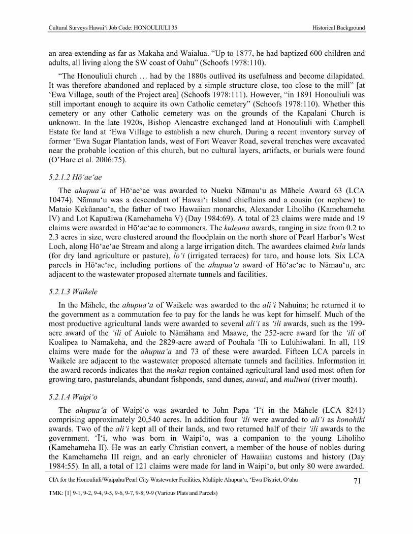
Cultural Surveys Hawai‘i Job Code: HONOULIULI 35 Historical Background
CIA for the Honouliuli/Waipahu/Pearl City Wastewater Facilities, Multiple Ahupua‘a, ‘Ewa District, O‘ahu 71
TMK: [1] 9-1, 9-2, 9-4, 9-5, 9-6, 9-7, 9-8, 9-9 (Various Plats and Parcels)
an area extending as far as Makaha and Waialua. “Up to 1877, he had baptized 600 children and adults, all living along the SW coast of Oahu” (Schoofs 1978:110).
“The Honouliuli church … had by the 1880s outlived its usefulness and become dilapidated. It was therefore abandoned and replaced by a simple structure close, too close to the mill” [at ‘Ewa Village, south of the Project area] (Schoofs 1978:111). However, “in 1891 Honouliuli was still important enough to acquire its own Catholic cemetery” (Schoofs 1978:110). Whether this cemetery or any other Catholic cemetery was on the grounds of the Kapalani Church is unknown. In the late 1920s, Bishop Alencastre exchanged land at Honouliuli with Campbell Estate for land at ‘Ewa Village to establish a new church. During a recent inventory survey of former ‘Ewa Sugar Plantation lands, west of Fort Weaver Road, several trenches were excavated near the probable location of this church, but no cultural layers, artifacts, or burials were found (O’Hare et al. 2006:75).
5.2.1.2 Hō‘ae‘ae
The ahupua‘a of Hō‘ae‘ae was awarded to Nueku Nāmau‘u as Māhele Award 63 (LCA 10474). Nāmau‘u was a descendant of Hawai‘i Island chieftains and a cousin (or nephew) to Mataio Kekūanao‘a, the father of two Hawaiian monarchs, Alexander Liholiho (Kamehameha IV) and Lot Kapuāiwa (Kamehameha V) (Day 1984:69). A total of 23 claims were made and 19 claims were awarded in Hō‘ae‘ae to commoners. The kuleana awards, ranging in size from 0.2 to 2.3 acres in size, were clustered around the floodplain on the north shore of Pearl Harbor’s West Loch, along Hō‘ae‘ae Stream and along a large irrigation ditch. The awardees claimed kula lands (for dry land agriculture or pasture), lo‘i (irrigated terraces) for taro, and house lots. Six LCA parcels in Hō‘ae‘ae, including portions of the ahupua‘a award of Hō‘ae‘ae to Nāmau‘u, are adjacent to the wastewater proposed alternate tunnels and facilities.
5.2.1.3 Waikele
In the Māhele, the ahupua‘a of Waikele was awarded to the ali‘i Nahuina; he returned it to the government as a commutation fee to pay for the lands he was kept for himself. Much of the most productive agricultural lands were awarded to several ali‘i as ‘ili awards, such as the 199-acre award of the ‘ili of Auiole to Nāmāhana and Maawe, the 252-acre award for the ‘ili of Koalipea to Nāmakehā, and the 2829-acre award of Pouhala ‘Ili to Lūlūhiwalani. In all, 119 claims were made for the ahupua‘a and 73 of these were awarded. Fifteen LCA parcels in Waikele are adjacent to the wastewater proposed alternate tunnels and facilities. Information in the award records indicates that the makai region contained agricultural land used most often for growing taro, pasturelands, abundant fishponds, sand dunes, auwai, and muliwai (river mouth).
5.2.1.4 Waipi‘o
The ahupua‘a of Waipi‘o was awarded to John Papa ‘I‘ī in the Māhele (LCA 8241) comprising approximately 20,540 acres. In addition four ‘ili were awarded to ali‘i as konohiki awards. Two of the ali‘i kept all of their lands, and two returned half of their ‘ili awards to the government. ‘Ī‘ī, who was born in Waipi‘o, was a companion to the young Liholiho (Kamehameha II). He was an early Christian convert, a member of the house of nobles during the Kamehameha III reign, and an early chronicler of Hawaiian customs and history (Day 1984:55). In all, a total of 121 claims were made for land in Waipi‘o, but only 80 were awarded.
Cultural Surveys Hawai‘i Job Code: HONOULIULI 35 Historical Background
CIA for the Honouliuli/Waipahu/Pearl City Wastewater Facilities, Multiple Ahupua‘a, ‘Ewa District, O‘ahu 72
TMK: [1] 9-1, 9-2, 9-4, 9-5, 9-6, 9-7, 9-8, 9-9 (Various Plats and Parcels)
Including the ahupua‘a award to John Papa ‘I‘ī, 17 LCA awards in Waipi‘o are adjacent to the wastewater proposed alternate tunnels and facilities.
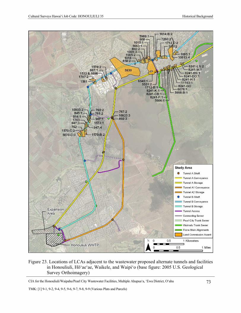
Cultural Surveys Hawai‘i Job Code: HONOULIULI 35 Historical Background
CIA for the Honouliuli/Waipahu/Pearl City Wastewater Facilities, Multiple Ahupua‘a, ‘Ewa District, O‘ahu 73
TMK: [1] 9-1, 9-2, 9-4, 9-5, 9-6, 9-7, 9-8, 9-9 (Various Plats and Parcels)
Figure 23. Locations of LCAs adjacent to the wastewater proposed alternate tunnels and facilities in Honouliuli, Hō‘ae‘ae, Waikele, and Waipi‘o (base figure: 2005 U.S. Geological Survey Orthoimagery)

Cultural Surveys Hawai‘i Job Code: HONOULIULI 35 Historical Background
CIA for the Honouliuli/Waipahu/Pearl City Wastewater Facilities, Multiple Ahupua‘a, ‘Ewa District, O‘ahu 74
TMK: [1] 9-1, 9-2, 9-4, 9-5, 9-6, 9-7, 9-8, 9-9 (Various Plats and Parcels)
Figure 24. Locations of LCAs adjacent to the wastewater proposed alternate tunnels and facilities in Waiawa, Mānana, Waimano, Waiau, Waimalu, Kalauao, ‘Aiea, and Hālawa (base figure: 2005 U.S. Geological Survey Orthoimagery)
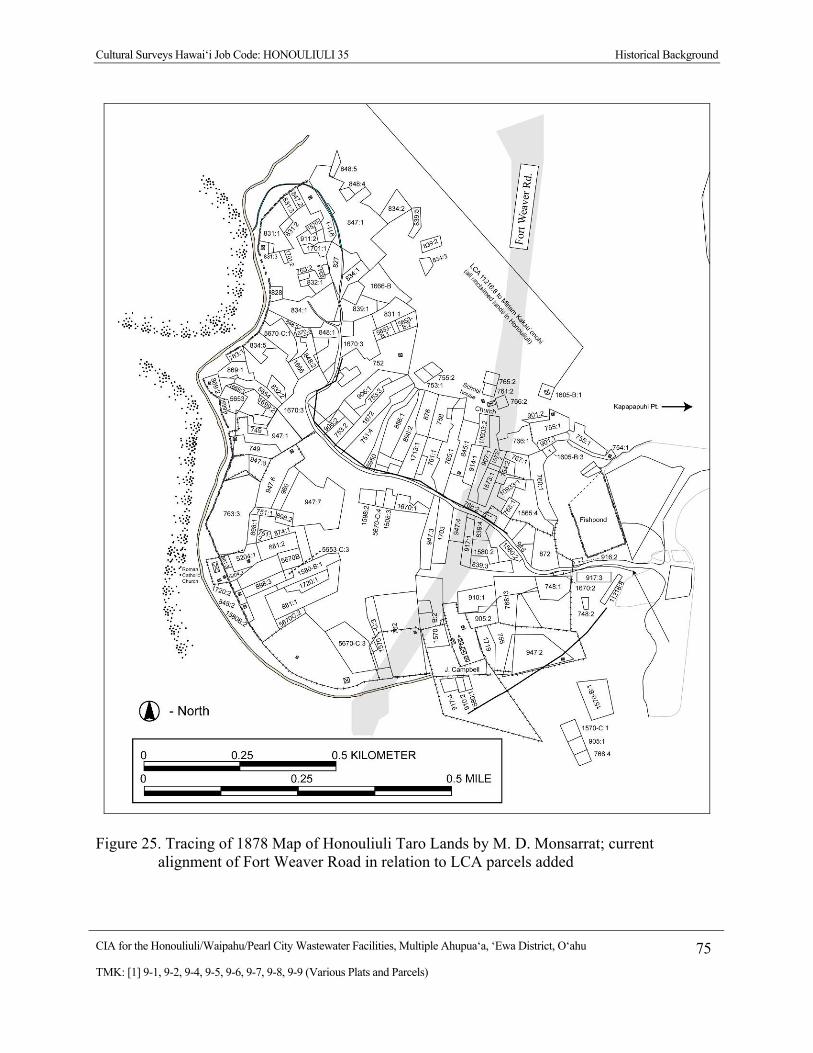
Cultural Surveys Hawai‘i Job Code: HONOULIULI 35 Historical Background
CIA for the Honouliuli/Waipahu/Pearl City Wastewater Facilities, Multiple Ahupua‘a, ‘Ewa District, O‘ahu 75
TMK: [1] 9-1, 9-2, 9-4, 9-5, 9-6, 9-7, 9-8, 9-9 (Various Plats and Parcels)
Figure 25. Tracing of 1878 Map of Honouliuli Taro Lands by M. D. Monsarrat; current alignment of Fort Weaver Road in relation to LCA parcels added
Cultural Surveys Hawai‘i Job Code: HONOULIULI 35 Historical Background
CIA for the Honouliuli/Waipahu/Pearl City Wastewater Facilities, Multiple Ahupua‘a, ‘Ewa District, O‘ahu 76
TMK: [1] 9-1, 9-2, 9-4, 9-5, 9-6, 9-7, 9-8, 9-9 (Various Plats and Parcels)
The remaining land claims documented in the Land Commission records, a total of 99 (not all of which were awarded), are kuleana claims, where the commoners of Waipi‘o worked and lived. The majority of awarded land parcels were located in the makai portions of Waipi‘o, at or just above the Waipi‘o Peninsula. Predominant among the claimed land usages in Waipi‘o are 312 lo‘i of various sizes. Wetland taro cultivation was the primary agricultural pursuit within the ahupua‘a at the mid-nineteenth century, and likely reflects a long history of taro farming. At the coast, four fishponds were claimed.
In the mauka reaches of Waipi‘o, 53 claims were made for portions of kula (pasture land) and 25 for “okipu” (forest clearings). The fact that several claims were made in the mauka regions suggests that Waipi‘o residents had particular locales that they traveled to regularly. This also confirms other accounts, suggesting this area had especially abundant and diverse uplands (Handy and Handy 1972:469–470). Kula land is a general term for open fields, pastures, uncultivated fields, or fields for cultivation, and upland (drier), which is distinct from meadow or wetland (Lucas 1995:60). Kula lands were often used for opportunistic plantings such as bananas, sugar cane, sweet potatoes, dry land taro, and other crops that did not depend on a consistent source of water. Okipu is defined as a forest clearing, a place that was presumably used to gather forest products and medicinal herbs or for pasture (Lucas 1995:82).
In contrast to the well-populated makai lands of Waipi‘o, the mauka regions were often described in nineteenth century accounts as virtually uninhabited. The missionary William Ellis described the interior regions of ‘Ewa in 1823–1824:
The plain of Eva is nearly twenty miles in length, from the Pearl River to Waialua, and in some parts nine or ten miles across. The soil is fertile, and watered by a number of rivulets, which wind their way along the deep water-courses that intersect its surface, and empty themselves into the sea. Though capable of a high state of improvement, a very small portion of it is enclosed or under any kind of culture, and in traveling across it, scarce a habitation is to be seen. (Ellis 1963:7)
Despite Ellis’ impressions, there is evidence that during the early nineteenth century, the Waipi‘o population was not solely focused on the fertile coast. In an inventory of advances in education during the reign of Kamehameha III (from 1825 to 1854), “schools were built in the mountains and in the crowded settlements. Waipi‘o had school houses near the coast and in the uplands” (Kamakau 1992:424). The placement of a school “in the uplands” of Waipi‘o suggests that some portion of the ahupua‘a population had settled there.
During the 1830s, cattle grazing began in the mauka regions of Waipi‘o (Bishop 1901:87). In 1847, residents of more makai land petitioned the Minister of the Interior, John Young, to resolve the problem of stray animals. These stray animals may have been from herds of cattle and goats grazing on Waipi‘o’s kula lands. In addition to damage from stray animals on the lands of Waipi‘o, the impact of grazing animals was noted several kilometers away at Pearl Harbor and likely near the present Project area. Stray cattle continued to be a problem until large-scale agriculture was introduced just prior to the beginning of the twentieth century. The occupation of the uplands by cattle denuded the countryside of ground cover, and caused vast quantities of earth to be washed down by storms into the lagoons, shoaling the water for a long distance seaward (Bishop 1901:87).

Cultural Surveys Hawai‘i Job Code: HONOULIULI 35 Historical Background
CIA for the Honouliuli/Waipahu/Pearl City Wastewater Facilities, Multiple Ahupua‘a, ‘Ewa District, O‘ahu 77
TMK: [1] 9-1, 9-2, 9-4, 9-5, 9-6, 9-7, 9-8, 9-9 (Various Plats and Parcels)
John Papa ‘Ī‘ī was placed in the household of Liholiho (Kamehameha II) when he was ten years old; he became Liholiho’s personal attendant and also maintained records of life in the Hawaiian Kingdom. He was born in Waipi‘o Ahupua‘a at the beginning of the nineteenth century; an account of his birth details the establishment of ‘Ī‘ī’s family at Waipi‘o after the ascendancy of Kamehameha on O‘ahu:
John Papa ‘Ī‘ī was born in Kūmelewai, Waipi‘o, in ‘Ewa, O‘ahu , on the third day of August (Hilinehu in the Hawaiian calendar) in 1800, on the land of Papa ‘Ī‘ī, whose namesake he was. Papa [‘Ī‘ī’s uncle] was the owner of the pond of Hanaloa and two other pieces of property, all of which he had received from Kamehameha, as did others who lived on that ahupua‘a, or land division, after the battle of Nu‘uanu. He gave the property to his kaikuahine, or cousin, who was the mother of the aforementioned boy. Her names were Wanaoa, Pahulemu, and Kalaikane. (‘Ī‘ī 1959:20)
‘Ī‘ī’s writings provide glimpses of life within Waipi‘o Ahupua‘a during ‘Ī‘ī’s lifetime. ‘Ī‘ī mentions the “family [going] to Kīpapa from Kūmelewai by way of upper Waipi‘o to make ditches for the farms” (‘Ī‘ī 1959:28) and recalls that, during the visit to O‘ahu by the Kaua‘i chief Kaumuali‘i and his entourage, the chief's attendants were provided with gifts: “From Waipi‘o in ‘Ewa and from some lands of Hawai‘i came tapa made of mamaki bark” (‘Ī‘ī 1959:83). ‘Ī‘ī notes how a period of famine was managed in Waipi‘o and what resources were available during the famine:
Here is a wonderful thing about the land of Waipi‘o. After a famine had raged in that land, the removal of new crops from the taro patches and gardens was prohibited until all of the people had gathered and the farmers had joined in thanks to the gods. This prohibition was called “kapu ‘ohi‘a” because, while the famine was upon the land, the people had lived on mountain apples [‘ohi‘a ‘ai], ti, yams, and other upland foods. On the morning of Kane, an offering of taro greens and other things was made to remove the ‘ohi‘a prohibition, after which each farmer took of his own crops for the needs of his family. (‘Ī‘ī 1959:77)
The end of the eighteenth century and beginning of the nineteenth century marked Hawai‘i’s entry into world trade networks. One of the chief exports at this time was sandalwood (Santalum sp.) or ‘iliahi, which was prized in China for its unique fragrance and used in the manufacture of household items, as incense, as perfume, and as medicine (St. John 1947:13). The central plains of ‘Ewa supplied the Hawaiian Kingdom with ‘iliahi. One of the first generation missionaries, Sereno Bishop (1901), described his memories of the central O‘ahu region in the 1830s:
Our family made repeated trips to the home of Rev. John S. Emerson at Waialua during those years. There was then no road save a foot path across the generally smooth upland. We forded the streams. Beyond Kīpapa Gulch the upland was dotted with occasional groves of Koa trees. On the high plains the ti plant abounded, often so high as to intercept the view. No cattle then existed to destroy its succulent foliage. According to the statements of the natives, a forest formerly covered the whole of the then nearly naked plains. It was burned off by the natives in search of sandalwood, which they detected by its odor burning. (Sterling and Summers 1978:89)

Cultural Surveys Hawai‘i Job Code: HONOULIULI 35 Historical Background
CIA for the Honouliuli/Waipahu/Pearl City Wastewater Facilities, Multiple Ahupua‘a, ‘Ewa District, O‘ahu 78
TMK: [1] 9-1, 9-2, 9-4, 9-5, 9-6, 9-7, 9-8, 9-9 (Various Plats and Parcels)
After John Papa ‘Ī‘ī’s death in 1870, his estate—including the Waipi‘o lands—was inherited by his daughter Irene ‘Ī‘ī Brown. Shortly after, small parcels within the ahupua‘a were sold off (Barrerè 1994:75).
5.2.1.5 Waiawa
During the Māhele land division of Hawai‘i in 1848, Waiawa Ahupua‘a was awarded to Princess Victoria Kamāmalu (sister of Kamehameha IV and V) as part of LCA 7713. During the second half of the nineteenth century, Waiawa was passed on to successive members of the ali‘i: Victoria Kamāmalu died in 1866 at the age of twenty-seven. Her entire estate was inherited by her father, Mataio Kekūanao‘a died two years later and the estate went to Kekūanao‘a’s son Lota Kapuāiwa, who by that time reigned as Kamehameha V. Kapuāiwa died intestate in 1872, whereupon Ruta Ke‘elikōlani, Kapuāiwa’s half-sister, petitioned for and received in 1873 the entire estate. By 1883, Ruta Ke‘elikōlani died, leaving all of her estate to her cousin Bernice Pauahi Bishop (Kame‘eleihiwa 1992:309–310). The Kamehameha Schools (Bernice Pauahi Bishop Estate) presently retains ownership of most of the ahupua‘a.
A total of 57 kuleana claims were made and 31 were awarded, ranging in size from 0.2 to 3.9 acres in size. One of these was an award to the American Board of Commissioners for Foreign Missions (ABDFM): LCA 387 comprised 4.13 acres in the makai portion of Waiawa and included a salt pond, a land strip for the church, and a house lot. Making the application was Artemis Bishop, the Protestant missionary stationed at ‘Ewa from 1836–1856. Another claim by a non-Hawaiian was made by William Wallace in LCA 10942, which comprised 3.2 acres including a house lot, 2 mo‘o (narrow strip of land), and 6 lo‘i. The remaining 50 claims (for individual ‘āpana) by 29 claimants in Waiawa were for kuleana; the claims included: 28 house lots, 176 taro lo‘i, 20 fishponds, 23 kula or pasture, 8 paukū ‘auwai [length of ditch], and 7 banana kula. Modern tax maps show the 31 claims actually awarded all located in the makai portion of the ahupua‘a. While the uplands of Waiawa were probably used for the procurement of resources, we have no evidence anyone actually lived there permanently in traditional Hawaiian times. Five LCA parcels in Waiawa, including the ahupua‘a award to Victoria Kamāmalu, are adjacent to the wastewater proposed alternate tunnels and facilities.
5.2.1.6 Mānana
Prior to the Māhele, it was documented that Mānana was retained as one of the few O‘ahu ‘āina (land holdings) of Ruth Ke‘elikōlani, a great-granddaughter of Kamehameha. Ke‘elikōlani became one of the largest landholders up to the time of her passing in 1883. Subsequently her heir, Bernice Pauahi Bishop, endowed Kamehameha Schools (Kame‘eleihiwa 1992:246).
The productivity of the land of Mānana is indicated in the Māhele records, as a large number of ‘ili were awarded to various ali‘i for Konohiki Lands. The ‘ili of Kaholona, Kalanihale, Paauau, Weloka, and Keahua were all awarded and retained to members of the ali‘i, in addition to the large awards of the entire ‘ili of Poupouwela to Victoria Kamāmalu (sister of Kamehameha IV and V) and the entire ‘ili of Mānana Nui to Ruth Ke‘elikōani, the great-granddaughter (or great grandniece) of Kamehameha I and half-sister of Kamāmalu.
Cultural Surveys Hawai‘i Job Code: HONOULIULI 35 Historical Background
CIA for the Honouliuli/Waipahu/Pearl City Wastewater Facilities, Multiple Ahupua‘a, ‘Ewa District, O‘ahu 79
TMK: [1] 9-1, 9-2, 9-4, 9-5, 9-6, 9-7, 9-8, 9-9 (Various Plats and Parcels)
A total of 48 claims were made for land in the Māhele, and 33 were awarded, including the seven ‘ili awards to the ali‘i, as shown in Table 20. Ten of these awards in Mānana are adjacent to the wastewater proposed alternate tunnels and facilities.
5.2.1.7 Waimano
The ahupua‘a of Waimano was awarded to Victoria Kamāmalu during the Māhele as part of LCA 7713. The ‘ili of Kūkona was awarded to John Stevenson (LCA 11029) as a konohiki award, but he returned a portion to the government. Only 12 claims were made in Waimano (including the konohiki awards) and only nine were awarded (Table 21). LCA 5662 and portions of the awards of Kamāmalu and Stevenson in Waimano are adjacent to the wastewater proposed alternate tunnels and facilities.
5.2.1.8 Waiau
Victoria Kamāmalu (LCA 7713, ‘āpana 35) was awarded almost all of the land in Kumu‘ulu, a large ‘ili which seems to include the entire inland section of Waiau from the government road to the Ko‘olau Mountains. Originally the ‘ili of Kauhihau, Nāono, Nālima, and Ka‘ākauwaihau in Waiau were all awarded to the ali‘i Puhi as part of LCA 3834, but he returned three of the ‘ili to the government to pay the commutation fees for the Waiau land he kept, which was an 11.94-acre ‘ili of Ka‘ākauwaihau (Barrerè 1994:542). Another Māhele award (MA 18) was to the konohiki Paewahine, who claimed the ‘ili of Kalua‘ōlohe, kept half (3.25 acres; R.P. 4526), and returned the remaining half to the government. The largest claim of 35.7 acres went to Iona (Jonah) Pi‘ikoi, a high Kaua‘i chief who was a childhood retainer to Liholiho (Kamehameha II). He had first married the Hawaiian chiefess Kekahili, which made him the brother-in-law to the father of the future monarch David Kalākaua. His second wife was the chiefess Kamake‘e, with whom he shared LCA 10605. This award included a claim in the ‘ili of Kalua‘o‘opu in Waiau and large awards in other sections of O‘ahu, Kaua‘i, and Maui. The remaining land in Waiau became government land. Twenty-three claims by commoners were made for Waiau, and 17 were awarded. Including the Kumu‘ulu ‘Ili claim to Victoria Kamāmalu, eight LCA parcels in Waiau are adjacent to the wastewater proposed alternate tunnels and facilities.
5.2.1.9 Waimalu
Waimalu was awarded to the ali‘i Miriam Kekau‘ōnohi in the Māhele (LCA 11216). Biographical information on this ali‘i was discussed in the Honouliuli Māhele section of this report. Fifteen other ‘ili (or half an ‘ili) were awarded to ali‘i as konohiki awards, but only ten were retained. In all, 93 people claimed land in Waimalu, and 63 claims were awarded (Table 23). Including the ahupua‘a award to Kekau‘ōnohi, seven LCA awards in Waimalu are adjacent to the wastewater proposed alternate tunnels and facilities.
5.2.1.10 Kalauao
In the Māhele land division of 1848 and the subsequent Kuleana Act, a total of 36 LCAs were granted within Kalauao Ahupua‘a (Table 24). Seven of these were konohiki awards to ali‘i, some of them for half or an entire ‘ili. Virtually all of the konohiki and kuleana LCAs were located within 500 meters of the coast. The awards ranged from 0.1 to 5.0 acres in size. Ten LCA awards in Kalauao are adjacent to the wastewater proposed alternate tunnels and facilities.
Cultural Surveys Hawai‘i Job Code: HONOULIULI 35 Historical Background
CIA for the Honouliuli/Waipahu/Pearl City Wastewater Facilities, Multiple Ahupua‘a, ‘Ewa District, O‘ahu 80
TMK: [1] 9-1, 9-2, 9-4, 9-5, 9-6, 9-7, 9-8, 9-9 (Various Plats and Parcels)
The largest award in Kalauao (LCA 5524; 1603 acres), for half of the ‘ili of Ka‘ōnohi, went to Laura Konia, the ninth largest landholder in the Kingdom. She was a daughter of Pā‘uli Ka‘ōleiokū, reputed po‘olua (child with “two fathers”) son of Kamehameha I and Kalaniōpu‘u by Kānekapolei (Kame‘eleihiwa 1992:228). Thus, she was either a granddaughter or grandniece of Kamehameha the Great. She was also the mother of Bernice Pauahi Bishop, who inherited the lands at her mother’s death.
She received 22 ahupua‘a-sized lands in the Hawaiian Islands, of which she relinquished 11 back to the Kingdom by way of taxes. She was given the west side of the large ‘ili of Ka‘ōnohi (Barrerè 1994:372), which stretched from the coastal trail to the mauka boundary of Kalauao at the Ko‘olau Mountains. The fact that she retained her Kalauao lands suggests she may have regarded them as particularly good lands.
The second largest landholder at Kalauao was John Meek, an important merchant involved in the early sandalwood trade, who was awarded a long narrow strip of 1300 acres on the east side of Kalauao Ahupua‘a (Kuykendall 1967:435). This is presumably the eastern section of the large ‘ili of Ka‘ōnohi, although this is not labeled on any available historic map. Little data are supplied in association with Meek’s claim, but it appears he resided there from 1824 to 1853. The Native Register account supporting his Kalauao lands claim is given below:
N.R. 768v3 No. 591, John Meek, Parcel 6
I, Kamehameha III, the King of the Hawaiian Islands, do hereby give a certain parcel of land, bounded as follows: The stream in the middle of Kalauao is the boundary on the west, there also it adjoins the leased land of John Meek. The division between Kalauao and Aiea is the boundary on the east. The highway is the makai boundary and the mountain is the mauka boundary. The length measured from the highway is one hundred and ninety six fathoms. To John Meek and his heirs born under the King of Hawaii and living in these islands. This land shall not be conveyed to a foreigner, nor shall spirit be distilled or vended on said land, but he shall live on it in righteousness under the law of the land. In witness whereof I set my hand in Honolulu on this day.
KAMEHAMEHA III (seal)
The Foreign Testimony account supporting John Meek’s Kalauao lands claim is given below:
F.T. 468v3 No. 591, John Meek, July 11th, 1853, Sec. 6 part 1 Chief Justice Lee, states that he called this day on His Majesty, the King, with the Grant presented by claimant for the land called "Kalauao" and that His Majesty reaffirmed the said grant and stated that it was executed sometime in the year 1839.
John Ii, sworn by the Word of God and stated, … 3. "There is another (land) at Kalawao in Ewa. Kamehameha had given (land) in the year 1824 and residence was since then to the present time…
Only one other land award at Kalauao was greater than five acres. This land, LCA 5365, was awarded to Colonel William Stevens. His claim follows:
No. 5365, K.U. Giwini/William Stevens/ February 2, 1848 N.R. 44–45v5 To the Honorable and Esteemed Land Commissioners, Greetings: I, Colonel William

Cultural Surveys Hawai‘i Job Code: HONOULIULI 35 Historical Background
CIA for the Honouliuli/Waipahu/Pearl City Wastewater Facilities, Multiple Ahupua‘a, ‘Ewa District, O‘ahu 81
TMK: [1] 9-1, 9-2, 9-4, 9-5, 9-6, 9-7, 9-8, 9-9 (Various Plats and Parcels)
Stevens, have thought of telling you correctly of my claim for land, in accordance with the law which designated Ministers for the Government and which says for claimants to petition for their land claims. Therefore, I hereby petition for my land claim which was from King Kamehameha III, as follows: Paaiau ‘Ili in the Ahupua‘a of Kalauao, Ewa, Island of Oahu, described as follows: North, Kauapooli and Keahua, along the Muliwai, south, the edge of the sea of Kapaeli and the edge of the sea of Kapuai, east, Kauapoi and the kula from thence to the far upland of the pali [cliff] of Koolau, south, the edge of the kula of Aiea, north, the edge of the kula of Kalauao. The nature of the kula on the west of Paaiau, is that the people must wade in the sea outside the western boundary of this ‘ili. Colonel William Stevens N.T. 428v10 No. 5365, Wm. E. Stevens (he is U.K. Guvini) Wm. Stevens land distribution. Paaiau ‘Ili for Kalauao, Ewa, Oahu [Kalauao] True Copy Honolulu, 11 November 1854 A.G. Thurston, Chief Clerk [Award 5365; R.P. 5687; Paaiau Kalauao Ewa; 1 ‘āp.; 62.15 Acs]. (Native Testimony 1847)
William Poomuku Stevens claimed Pā‘aiau, an ‘ili of Kalauao, as his Māhele award. Kame‘eleihiwa (1992:280) lists Stevens as a mid-level ali‘i. Of his award, Stevens notes, “The nature of the kula on the west of Paaiau is that the people must wade in the sea outside the western boundary of this ili” (Barrerè 1994:554).
Most of these early landowners probably planted taro and other crops along the streams and springs and used the kula as pasture. It has already been noted that John Meek used his land in Kalauao as a cattle ranch. In addition, Lincoln McCandless imported Angora goats to Hawai‘i in 1898 and put them with some other goats to improve his stock on some land he owned in Kalauao, but “his purpose was foiled by the destruction brought about by dogs, who used to get into the pens at night, as many as 50 goats being killed in one night” (Marques 1906:52).
5.2.1.11 ‘Aiea
The ahupua‘a of ‘Aiea was initially awarded to Charles Kana‘ina, a friend of Kamehameha I and the father of Lunalilo (Kamehameha IV). He returned this land to the Crown. A total of 30 claims were made in ‘Aiea, and 20 were awarded (Table 25). All of these were small claims ranged from 0.56 to 2.67 acres in size. Five LCA parcels in ‘Aiea are adjacent to the wastewater proposed alternate tunnels and facilities.
5.2.1.12 Hālawa
Sometime after Kamehameha conquered O‘ahu in the battle of Nu‘uanu in 1795, he gave his most trusted foreign advisors, Isaac Davis and John Young, land as a reward for their loyal service to him. As part of this award, each one received half of the ahupua‘a of Hālawa. As was the usual custom at the time, the king divided the land among his chiefs, who supported him throughout his conquests of the islands.
Young and Davis were allowed to work the land as long as they lived. But, as was the traditional custom, upon their death the land reverted back to the ali‘i nui (high chief). This rule held true even for these two most faithful advisors. John Young tried to make his lands inheritable by requesting that his children, and those of Isaac Davis whom he adopted, be
Cultural Surveys Hawai‘i Job Code: HONOULIULI 35 Historical Background
CIA for the Honouliuli/Waipahu/Pearl City Wastewater Facilities, Multiple Ahupua‘a, ‘Ewa District, O‘ahu 82
TMK: [1] 9-1, 9-2, 9-4, 9-5, 9-6, 9-7, 9-8, 9-9 (Various Plats and Parcels)
allowed to retain the lands given to him by the king upon his death. Even by the late date of 1834, Kamehameha III refused to honor Young’s request. It is interesting to note that even though his request was denied, in the Māhele, John Young’s children were allowed to keep lands as ‘āina ho‘olina or inherited lands. Lilikalā Kame‘eleihiwa notes that in all of the Buke Māhele, these were the only lands given under this designation. (Kame‘eleihiwa 1992:60)
Prior to John Young’s death in 1835, he attempted to make his lands inheritable by willing Hālawa to his daughter, Grace Kama‘iku‘i. His will states:
In behalf of my deceased friend Isaac Davis and for his children as he died without will, the King Kamehameha gave me all the said Isaac Davises [Davis’] lands to take care of them and his children until the children came of age, and now they are come of age so I think it right to leave my last wishes and will that the King, Ka‘ahumanu, Adams and Rooke and all the Chiefs will let Isaac Davises children keep their father’s lands that King Kamehameha gave to him as a reward for assisting the King in his wars in conquering the islands of Hawai‘i, Maui, Molokai, and O‘ahu, and which we have an undoubted right to leave to our children, which I hope in God our young king will fulfill the wishes of his honored father. My own lands, I wish my children to enjoy as I have done, likewise my wife. (Claim: #595 F.R. 67–72 V2)
Kekūanaō‘a ended up with Davis’ Hālawa portion (LCA 7712) at the end of the Māhele and Grace Kama‘iku‘i Young Rooke (John Young’s daughter) retained the John Young portion (LCA 8516-B). Isaac Davis’ portion of Hālawa passed from Kekūanaō‘a to Ruth Ke‘elekōlani and on to Bernice Pauahi Bishop. Upon Ruth’s death, her lands become part of the Bishop Estate Trust.
In 1852, Kekūanaō‘a wrote a letter to the Minister of Interior requesting that a list of the kapu (taboo) fish for Victoria Kamāmalu’s lands on O‘ahu be published in the newspaper. The kapu fish for Hālawa was the ‘anae or full-sized mullet. (Kekūanaō‘a August 12, 1852) In 1862, Mataio Kekūanaō‘a and Kama‘iku‘i Rooke (John Young’s daughter) leased a portion of ahupua‘a of Hālawa to a Manuel Paiko of Honolulu for the purpose of cattle ranching. (Boundary Commission 9:174–179) In 1866, Kama‘iku‘i willed to her sister, Fanny Na‘ea, her interest in her portion of Hālawa.
In 1879, Fanny gave her interest of Hālawa to her daughter, Emma Kaleleonālani Na‘ea Rooke, Queen of Kamehameha IV, by way of a deed, which stated: “The undivided ½ interest of and in to the ahupua‘a of Hālawa situate in ‘Ewa, Island of Oahu, and more fully described in Royal Patent 6717 to Grace Kamaikui and being the same premises devised to me the said Fanny Young Kaleleonalani by the said Grace Kamikui” (Boundary Commission 59:285).
Fanny died one year later in 1880. A listing of konohiki lands on the island of O‘ahu reflects the joint tenancy of Hālawa. Both Ruth Ke‘elikōlani and Queen Emma are listed as owners. The document also lists the lands on O‘ahu that abut the ocean, including the length and whether the land is a lagoon, reef or open sea. The length of the land abutting the sea at Hālawa is 8.52 miles and it is listed as being a reef and a lagoon. (Interior Dept. Letters, Document No. 15). Five years later, Queen Emma died in 1885, leaving no heirs. All of her lands became part of the Queen Emma legacy.
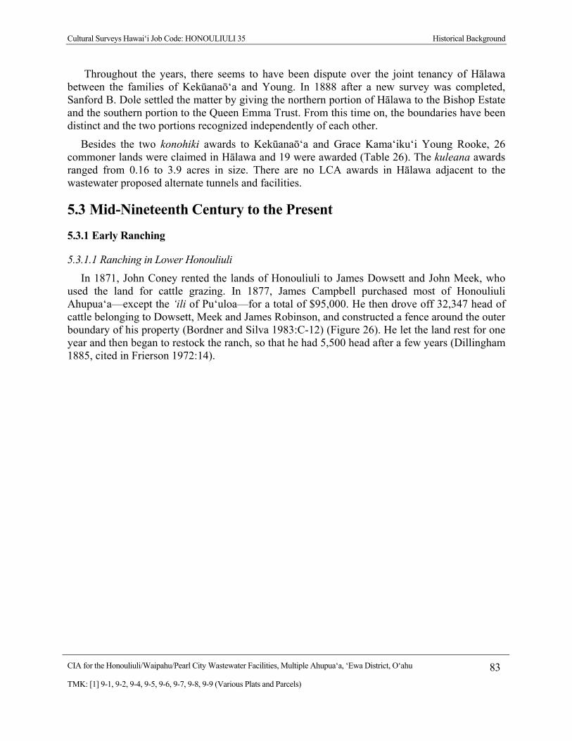
Cultural Surveys Hawai‘i Job Code: HONOULIULI 35 Historical Background
CIA for the Honouliuli/Waipahu/Pearl City Wastewater Facilities, Multiple Ahupua‘a, ‘Ewa District, O‘ahu 83
TMK: [1] 9-1, 9-2, 9-4, 9-5, 9-6, 9-7, 9-8, 9-9 (Various Plats and Parcels)
Throughout the years, there seems to have been dispute over the joint tenancy of Hālawa between the families of Kekūanaō‘a and Young. In 1888 after a new survey was completed, Sanford B. Dole settled the matter by giving the northern portion of Hālawa to the Bishop Estate and the southern portion to the Queen Emma Trust. From this time on, the boundaries have been distinct and the two portions recognized independently of each other.
Besides the two konohiki awards to Kekūanaō‘a and Grace Kama‘iku‘i Young Rooke, 26 commoner lands were claimed in Hālawa and 19 were awarded (Table 26). The kuleana awards ranged from 0.16 to 3.9 acres in size. There are no LCA awards in Hālawa adjacent to the wastewater proposed alternate tunnels and facilities.
5.3 Mid-Nineteenth Century to the Present
5.3.1 Early Ranching
5.3.1.1 Ranching in Lower Honouliuli
In 1871, John Coney rented the lands of Honouliuli to James Dowsett and John Meek, who used the land for cattle grazing. In 1877, James Campbell purchased most of Honouliuli Ahupua‘a—except the ‘ili of Pu‘uloa—for a total of $95,000. He then drove off 32,347 head of cattle belonging to Dowsett, Meek and James Robinson, and constructed a fence around the outer boundary of his property (Bordner and Silva 1983:C-12) (Figure 26). He let the land rest for one year and then began to restock the ranch, so that he had 5,500 head after a few years (Dillingham 1885, cited in Frierson 1972:14).

Cultural Surveys Hawai‘i Job Code: HONOULIULI 35 Historical Background
CIA for the Honouliuli/Waipahu/Pearl City Wastewater Facilities, Multiple Ahupua‘a, ‘Ewa District, O‘ahu 84
TMK: [1] 9-1, 9-2, 9-4, 9-5, 9-6, 9-7, 9-8, 9-9 (Various Plats and Parcels)
Figure 26. 1880s photograph of James Campbell’s residence on the ‘Ewa Plain (Hawai‘i State Archives)
In 1881, a medical student, touring the island to provide smallpox vaccinations to the population, viewed Campbell’s property, called the Honouliuli Ranch:
I took a ride over the Honouliuli Ranch which is quite romantic. The soil is a deep, reddish loam, up to the highest peaks, and the country is well-grassed. Springs of water abound. The ‘ilima, which grows in endless quantities on the plains of this ranch, is considered excellent for feeding cattle; beside it grows the indigo plant, whose young shoots are also good fodder, of which the cattle are fond. Beneath these grows the manieizie grass, and Spanish clover and native grasses grow in the open; so there is abundant pasturage of various kinds here. As I rode, to the left were towering mountains and gaping gorges; ahead, undulating plains, and to the right, creeks and indentations from the sea. A wide valley of fertile land extends between the Nuuanu Range and the Waianae Mountains and thence to the coast of Waialua. There are many wild goats in this valley, which are left more or less undisturbed because they kill the growth of mimosa bushes, which would otherwise overrun the country and destroy the pasturage for cattle. (Briggs 1926:62–63)

Cultural Surveys Hawai‘i Job Code: HONOULIULI 35 Historical Background
CIA for the Honouliuli/Waipahu/Pearl City Wastewater Facilities, Multiple Ahupua‘a, ‘Ewa District, O‘ahu 85
TMK: [1] 9-1, 9-2, 9-4, 9-5, 9-6, 9-7, 9-8, 9-9 (Various Plats and Parcels)
In 1880–81, the Honouliuli ranch was described as:
Acreage, 43,250, all in pasture, but possessing fertile soils suitable for agriculture; affords grazing for such valuable stock. The length of this estate is no less than 18 miles. It extends to within less than a mile of the sea coast, to the westward of the Pearl River inlet….. There are valuable fisheries attached to this estate…. (Bowser 1880:489)
From Mr. Campbell’s veranda, looking eastward, you have one of the most splendid sights imaginable. Below the house there are two lochs, or lagoons, covered with water fowl, and celebrated for their plentiful supply of fish, chiefly mullet…. Besides Mr. Campbell’s residence, which is pleasantly situated and surrounded with ornamental and shade trees, there are at Honouliuli two churches and a school house, with a little village of native huts. (Bowser 1880:495)
Most of Campbell’s lands in Honouliuli were used exclusively for cattle ranching. At that time, one planter remarked “the country was so dry and full of bottomless cracks and fissures that water would all be lost and irrigation impracticable” (Ewa Plantation Co. 1923:6–7). In 1879, Campbell brought in a well-driller from California to search the ‘Ewa plains for water, and the well, drilled to a depth of 240 ft near Campbell’s home in ‘Ewa, resulted in “a sheet of pure water flowing like a dome of glass from all sides of the well casing” (The Legacy of James Campbell n.d., cited in Pagliaro 1987:3). Following this discovery, plantation developers and ranchers drilled numerous wells in search of the valuable resource.
Between the years of 1861 and 1873, parcels of Waiawa were leased to Valdemar Knudsen for use as grazing lands for live stock. A fifty-year lease and leaseholds were granted to James Robinson in 1868. After James Robinson’s death in 1890, his son, Mark P. Robinson, acquired a twenty-five year lease. Overwritten on the lease was the “permission granted to assign the lease to the Oahu Railway and Land Company” (Hawai‘i Bureau of Land Conveyances 1915:496). This lease was subleased from Oahu Railway and Land Company to the Oahu Sugar Company for forty-three years on January 1, 1897. It is probable that much of the upper grasslands of Hō‘ae‘ae, Waikele, Waipi‘o and Waiawa were all used for cattle pasture.
5.3.1.2 Ranching in Hālawa
In 1862 Kama‘iku‘i Rooke and Mataio Kekūanaō‘a leased much of Hālawa to a Manuel Paiko, a Portuguese rancher. (Klieger 1995:76) The lease document reads that the boundaries begin at “a small brook which forms the boundary between Hālawa and Moanalua” and continue “along the ridge of the mountain bordered on the north by ‘Aiea and Kalauao, and on the west by Ko‘olau, to the top of a peak called Aloheo; which forms the boundary between Moanalua and Hālawa.” The leased area consisted of approximately 10,000 acres. However, excluded from the lease was the “sea, the lagoons, the fish and all ponds, the enclosed kalo lands, all kuleanas awarded by the Land Commission, and so much of the kula lands adjoining the pond Ka Waiaho.” The lease was taken out for fifteen years with a rent of $500 per year (Boundary Commission 9:174–179). Manuel Paiko took on a business partner, James Dowsett of ‘Ulupalakua Ranch fame. By 1870, their herd consisted of 1,400 head (Boundary Commission 29:239). James Dowsett and another partner, J. R. Williams tried unsuccessfully to raise sugar. Due to lack of a railroad to haul cane and the mill burning down three times, they gave up trying
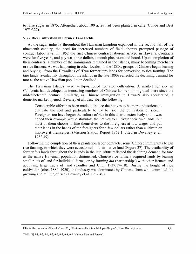
Cultural Surveys Hawai‘i Job Code: HONOULIULI 35 Historical Background
CIA for the Honouliuli/Waipahu/Pearl City Wastewater Facilities, Multiple Ahupua‘a, ‘Ewa District, O‘ahu 86
TMK: [1] 9-1, 9-2, 9-4, 9-5, 9-6, 9-7, 9-8, 9-9 (Various Plats and Parcels)
to raise sugar in 1875. Altogether, about 100 acres had been planted in cane (Condé and Best 1973:327).
5.3.2 Rice Cultivation in Former Taro Fields
As the sugar industry throughout the Hawaiian kingdom expanded in the second half of the nineteenth century, the need for increased numbers of field laborers prompted passage of contract labor laws. In 1852 the first Chinese contract laborers arrived in Hawai‘i. Contracts were for five years, and pay was three dollars a month plus room and board. Upon completion of their contracts, a number of the immigrants remained in the islands, many becoming merchants or rice farmers. As was happening in other locales, in the 1880s, groups of Chinese began leasing and buying—from the Hawaiians of ‘Ewa former taro lands for conversion to rice farming. The taro lands’ availability throughout the islands in the late 1800s reflected the declining demand for taro as the native Hawaiian population declined.
The Hawaiian Islands were well-positioned for rice cultivation. A market for rice in California had developed as increasing numbers of Chinese laborers immigrated there since the mid-nineteenth century. Similarly, as Chinese immigration to Hawai‘i also accelerated, a domestic market opened. Devaney et al., describes the following:
Considerable effort has been made to induce the natives to be more industrious to cultivate the soil and particularly to try to [sic] the cultivation of rice…. Foreigners too have begun the culture of rice in this district extensively and it was hoped their example would stimulate the natives to cultivate their own lands, but most of them choose to hire themselves to the foreigners at low wages and put their lands in the hands of the foreigners for a few dollars rather than cultivate or improve it themselves. (Mission Station Report 1862:1, cited in Devaney et al. 1982:49)
Following the completion of their plantation labor contracts, some Chinese immigrants began rice farming, to which they were accustomed in their native land (Figure 27). The availability of former lo‘i lands throughout the islands in the late 1800s reflected the declining demand for taro as the native Hawaiian population diminished. Chinese rice farmers acquired lands by leasing small plots of land for individual farms, or by forming hui (partnerships) with other farmers and acquiring large tracts of land (Coulter and Chun 1937:17–18). During the height of rice cultivation (circa 1880–1920), the industry was dominated by Chinese firms who controlled the growing and milling of rice (Devaney et al. 1982:49).
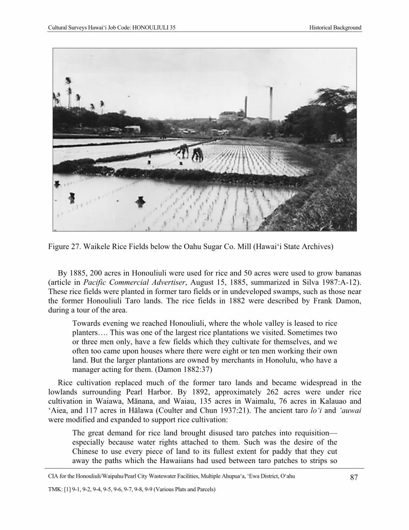
Cultural Surveys Hawai‘i Job Code: HONOULIULI 35 Historical Background
CIA for the Honouliuli/Waipahu/Pearl City Wastewater Facilities, Multiple Ahupua‘a, ‘Ewa District, O‘ahu 87
TMK: [1] 9-1, 9-2, 9-4, 9-5, 9-6, 9-7, 9-8, 9-9 (Various Plats and Parcels)
Figure 27. Waikele Rice Fields below the Oahu Sugar Co. Mill (Hawai‘i State Archives)
By 1885, 200 acres in Honouliuli were used for rice and 50 acres were used to grow bananas (article in Pacific Commercial Advertiser, August 15, 1885, summarized in Silva 1987:A-12). These rice fields were planted in former taro fields or in undeveloped swamps, such as those near the former Honouliuli Taro lands. The rice fields in 1882 were described by Frank Damon, during a tour of the area.
Towards evening we reached Honouliuli, where the whole valley is leased to rice planters…. This was one of the largest rice plantations we visited. Sometimes two or three men only, have a few fields which they cultivate for themselves, and we often too came upon houses where there were eight or ten men working their own land. But the larger plantations are owned by merchants in Honolulu, who have a manager acting for them. (Damon 1882:37)
Rice cultivation replaced much of the former taro lands and became widespread in the lowlands surrounding Pearl Harbor. By 1892, approximately 262 acres were under rice cultivation in Waiawa, Mānana, and Waiau, 135 acres in Waimalu, 76 acres in Kalauao and ‘Aiea, and 117 acres in Hālawa (Coulter and Chun 1937:21). The ancient taro lo‘i and ‘auwai were modified and expanded to support rice cultivation:
The great demand for rice land brought disused taro patches into requisition—especially because water rights attached to them. Such was the desire of the Chinese to use every piece of land to its fullest extent for paddy that they cut away the paths which the Hawaiians had used between taro patches to strips so

Cultural Surveys Hawai‘i Job Code: HONOULIULI 35 Historical Background
CIA for the Honouliuli/Waipahu/Pearl City Wastewater Facilities, Multiple Ahupua‘a, ‘Ewa District, O‘ahu 88
TMK: [1] 9-1, 9-2, 9-4, 9-5, 9-6, 9-7, 9-8, 9-9 (Various Plats and Parcels)
narrow that a man could walk along them only with difficulty…. As the demand for rice continued, it became profitable to bring into use land hitherto unused. The land most easily rendered fit for rice cultivation was swamp or marsh land of which there was a large amount in the islands. Most of such land was at or near sea level-undrained areas at the mouths of streams: lowlands, which could be reclaimed without great expense … lands hitherto unused became fields of waving grain (Coulter and Chun 1937:11)
The following account describes a visit to the rice fields of ‘Aiea, circa 1904:
On the morning of June 2nd, for instance, our destination was Aiea. At ten minutes past seven we boarded the first passenger train going towards Honolulu. For a distance of eight miles the road skirts the shore and then turns landwards or mauka through rice and sugar plantations, Ewa Mill, Waipahu, Pearl City. We reached Aiea at eleven minutes past eight. Like all rice fields in Hawaii, this one is worked entirely by Chinamen, they alone being able to endure the conditions of location and climate necessary for the cultivation of this cereal. On one side of the railroad track was the broad, muddy inland lake or bay of salt water, Pearl Harbor; on the other side were the terraced plots or fields, flooded to a depth of several inches with water and separated by narrow raised earthen ridges on which the careful Chinaman doubtless succeeded in walking, but which many times proved treacherous to our unsteady feet. A rice plantation, laid out as it generally is on the low flats at the foot of a valley, where mountain streams empty into the sea, is an ideal collecting ground for certain kinds of algae. (Tilden 1905:134)
By the early decades of the twentieth century rice farming in the Hawaiian Islands was in decline, beset by crop diseases and cheaper prices for mainland-grown rice. Commercial agriculture in ‘Ewa became dominated by sugar with the development of the three sugar companies of ‘Ewa (Nedbalek 1984:13).
5.3.3 Pineapple Cultivation
In the early decades of the twentieth century, lands in the mauka portion of the central and eastern sections of ‘Ewa were being acquired for pineapple cultivation. There is a record of attempted pineapple irrigation utilizing water from shallow wells in Waiawa Gulch in 1893. Later attempts were made in Waiawa and Honouliuli (Figure 28). James Dole founded the Hawaiian Pineapple Company in 1901. The previous year, Dole had purchased 61 acres of land in Wahiawa for growing pineapple. Prior to 1913, most of the upland plateau areas in Waiawa were planted in pineapple (Goodman and Nees 1991:59) and small plots along gullies. Those not appropriate for sugar cane cultivation, in several ‘Ewa ahupua‘a, were planted in cane. Many of these small plots were cultivated by independent farmers, who sold the crops at markets or to larger companies. In 1901, the Hawaiian Pineapple Company obtained 61 acres in Waiawa through public auction. Initially, most pineapple was shipped to California for packing. In an attempt to speed up processing, save money and produce a fresher product, a cannery was constructed in Waiawa. This cannery was constructed by the Pearl City Fruit Company but became a part of the Hawaiian Pineapple Company operations after the Pearl City Fruit Company went bankrupt. The cannery was in operation from 1905 to 1935.
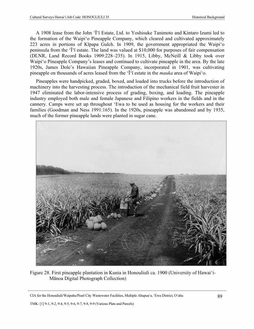
Cultural Surveys Hawai‘i Job Code: HONOULIULI 35 Historical Background
CIA for the Honouliuli/Waipahu/Pearl City Wastewater Facilities, Multiple Ahupua‘a, ‘Ewa District, O‘ahu 89
TMK: [1] 9-1, 9-2, 9-4, 9-5, 9-6, 9-7, 9-8, 9-9 (Various Plats and Parcels)
A 1908 lease from the John ‘Ī‘ī Estate, Ltd. to Yoshisuke Tanimoto and Kintaro Izumi led to the formation of the Waipi‘o Pineapple Company, which cleared and cultivated approximately 223 acres in portions of Kīpapa Gulch. In 1909, the government appropriated the Waipi‘o peninsula from the ‘Ī‘ī estate. The land was valued at $10,000 for purposes of fair compensation (DLNR, Land Record Books 1909:228–235). In 1915, Libby, McNeill & Libby took over Waipi‘o Pineapple Company’s leases and continued to cultivate pineapple in the area. By the late 1920s, James Dole’s Hawaiian Pineapple Company, incorporated in 1901, was cultivating pineapple on thousands of acres leased from the ‘Ī‘ī estate in the mauka area of Waipi‘o.
Pineapples were handpicked, graded, boxed, and loaded into trucks before the introduction of machinery into the harvesting process. The introduction of the mechanical field fruit harvester in 1947 eliminated the labor-intensive process of grading, boxing, and loading. The pineapple industry employed both male and female Japanese and Filipino workers in the fields and in the cannery. Camps were set up throughout ‘Ewa to be used as housing for the workers and their families (Goodman and Ness 1991:165). In the 1920s, pineapple was abandoned and by 1935, much of the former pineapple lands were planted in sugar cane.
Figure 28. First pineapple plantation in Kunia in Honouliuli ca. 1900 (University of Hawai‘i-Mānoa Digital Photograph Collection)
Cultural Surveys Hawai‘i Job Code: HONOULIULI 35 Historical Background
CIA for the Honouliuli/Waipahu/Pearl City Wastewater Facilities, Multiple Ahupua‘a, ‘Ewa District, O‘ahu 90
TMK: [1] 9-1, 9-2, 9-4, 9-5, 9-6, 9-7, 9-8, 9-9 (Various Plats and Parcels)
5.3.4 History of the Oahu Railway and Land Company (OR&L)
In 1886, Campbell and B. F. Dillingham put together the “Great Land Colonization Scheme,” which was an attempt to sell Honouliuli land to homesteaders (Thrum 1887:74). This homestead idea failed. Two factors for the failure were the lack of water and the distance from ‘Ewa to Honolulu. The water problem was solved by the drilling of artesian wells, and Dillingham decided that the area could be used instead for large-scale cultivation (Pagliaro 1987:4). The transportation problem was to be solved by the construction of a railroad, which B. Franklin Dillingham soon began to finance under the company name of the Oahu Railway and Land Company (OR&L).
During the last decade of the nineteenth century, the railroad would reach from Honolulu to Pearl City in 1890, to Wai‘anae in 1895, to Waialua Plantation in 1898, and to Kahuku in 1899 (Kuykendall 1967:III, 100). This railroad line eventually ran across the center of the ‘Ewa Plain at the lower boundary of the sugar fields (Figure 29). To attract business to his new railroad system, Dillingham subleased all land below 200 ft to William Castle, who in turn sublet the area to the newly-formed Ewa Plantation Company (Frierson 1972:15). Dillingham’s Honouliuli lands above 200 ft that were suitable for sugar cane cultivation were sublet to the Oahu Sugar Company). Throughout this time, and continuing into modern times, cattle ranching continued in the area, and Honouliuli Ranch—established by Dillingham was—the “fattening” area for the other ranches (Frierson 1972:15).

Cultural Surveys Hawai‘i Job Code: HONOULIULI 35 Historical Background
CIA for the Honouliuli/Waipahu/Pearl City Wastewater Facilities, Multiple Ahupua‘a, ‘Ewa District, O‘ahu 91
TMK: [1] 9-1, 9-2, 9-4, 9-5, 9-6, 9-7, 9-8, 9-9 (Various Plats and Parcels)
Figure 29. 1890 photograph of Pearl Harbor with OR&L railroad tracks along the coast (Honolulu Advertiser Archives)
Operations at the OR&L began to slow down in the 1920s when electric streetcars were built for public transportation within the city of Honolulu and automobiles began to be used by families for transportation outside the city (Chiddix and Simpson 2004:185). The build-up to World War II turned this decline around as the U.S. military utilized the OR&L lines to transport materials for building defense projects around the island. Historians have noted that one of the most serious mistakes made by the Japanese in their 1941 attack on Pearl Harbor was their decision not to bomb the railway infrastructure. Soon after the attack, the OR&L operated 24 hours a day, transporting war materials and troops from Honolulu to the new and expanded army, naval, and air bases. The huge navy base at Pearl Harbor had its own rail lines that connected to the OR& L rail lines.
In August of 1945, the war ended, and so did OR&L’s heyday as a military transport line. Chiddix and Simpson writes:
She had served her country well and proudly during the war, but operating round-the-clock on what little maintenance could be squeezed in, had taken a prodigious hit on the locomotives and track. Traffic stayed steady for a short time, but soon
Cultural Surveys Hawai‘i Job Code: HONOULIULI 35 Historical Background
CIA for the Honouliuli/Waipahu/Pearl City Wastewater Facilities, Multiple Ahupua‘a, ‘Ewa District, O‘ahu 92
TMK: [1] 9-1, 9-2, 9-4, 9-5, 9-6, 9-7, 9-8, 9-9 (Various Plats and Parcels)
dropped precipitously as soldiers and sailors went home, military posts were shrunk or razed, and civilians could again get tires, gasoline and new cars. (Chiddix and Simpson 2004:257)
There was no choice but to abandon the OR&L main line, and in 1946 Water F. Dillingham, son of B.F. Dillingham, wrote:
The sudden termination of the war with Japan changed not only the character of our transportation, but cut the freight tonnage to a third and the passenger business to a little above the pre-war level. With the increased cost of labor and material and the shrinkage in freight tonnage and passenger travel, it was definite that the road could not be operated as a common carrier. With no prospect of increased tonnage, and the impossibility of increasing rates against truck competition, your management has applied to the Interstate Commerce for authority to abandon its mainline. (Walter Dillingham, cited in Chiddix and Simpson 2004:257)
After the war, most of the 150+ miles of OR&L track were pried up, locomotives were sold to businesses on the US mainland, and railway cars were scraped. In 1947, the U.S. Navy took over a section of the OR&L track for their own use, to transport bombs, ammunition, and torpedoes from the ammunition magazines at Lualualei, West Loch in Pearl Harbor, and Waikele on OR&L’s Wahiawā Branch to Pearl Harbor Naval Base (Treiber 2005:25–26). The track to Waipahu was abandoned in the 1950s, but the line from the magazines in Lualualei to the wharves in West Loch at Pearl Harbor remained open until 1968.
5.3.5 History of the Sugar Plantations of ‘Ewa
Although sugar cane was already being grown as far back as the early 1800s, the industry revealed its economic potential in 1879 when the first artesian well was drilled in ‘Ewa (Ellis 1995:22). The availability of subsurface water resources enabled greater irrigation possibilities for expanding plantations besides the use of water diversions from the surrounding stream systems. This prompted the drilling of many other wells amongst the Hawaiian Islands, thereby commencing the Hawai‘i sugar plantation era. By the early 1900s, the entire main Hawaiian Islands had land devoted to the production of sugar cane.
Agricultural field systems, railroads, and residential areas in ‘Ewa were developed by three sugar cane companies: the Ewa Plantation, located largely in the ahupua‘a of Honouliuli and Hō‘ae‘ae in the western section of the ‘Ewa; the Oahu Sugar Company, extending in the areas upland of the Ewa Plantation in central ‘Ewa, including a portion of the uplands of Waiawa; and the Honolulu Plantation Company, with fields extending through Mānana to Hālawa in the eastern section of the ‘Ewa.
5.3.5.1 The Ewa Plantation Company
The Ewa Plantation Company was incorporated in 1890 for sugar cane cultivation (Figure 30). The first crop, 2,849 tons of sugar, was harvested in 1892 at the Ewa Plantation. ‘Ewa was the first all-artesian plantation, and it gave an impressive demonstration of the part artesian wells were to play in the later history of the Hawaiian sugar industry (Kuykendall 1967:III, 69). As a means to generate soil deposition on the coral plain and increase arable land in the lowlands, the

Cultural Surveys Hawai‘i Job Code: HONOULIULI 35 Historical Background
CIA for the Honouliuli/Waipahu/Pearl City Wastewater Facilities, Multiple Ahupua‘a, ‘Ewa District, O‘ahu 93
TMK: [1] 9-1, 9-2, 9-4, 9-5, 9-6, 9-7, 9-8, 9-9 (Various Plats and Parcels)
Ewa Plantation Company installed ditches running from the lower slopes of the mountain range to the lowlands. When the rainy season began, they plowed ground perpendicular to the slope to the lowlands. When the rainy season began, they plowed ground perpendicular to the slope so that soil would be carried down the drainage ditches into the lower coral plain. After a few years, about 373 acres of coral wasteland were reclaimed in this manner (Immisch 1964:3). By the 1920s, Ewa Plantation was generating large profits and was the “richest sugar plantation in the world” (Paradise of the Pacific, December 1902:19-22, cited in Kelly 1985:171).
Figure 30. Ewa Plantation Co. sugar cane fields, Filipino Camp area, ca. 1925 (University of Hawai‘i at Mānoa Digital Photograph Collection)
Cultural Surveys Hawai‘i Job Code: HONOULIULI 35 Historical Background
CIA for the Honouliuli/Waipahu/Pearl City Wastewater Facilities, Multiple Ahupua‘a, ‘Ewa District, O‘ahu 94
TMK: [1] 9-1, 9-2, 9-4, 9-5, 9-6, 9-7, 9-8, 9-9 (Various Plats and Parcels)
During the twentieth century, the Ewa Plantation would continue to grow and, by the 1930s, would encompass much of the eastern half of Honouliuli Ahupua‘a. This growth impelled the creation of plantation villages to house the growing immigrant labor force working the fields. After the outbreak of World War II, which siphoned off much of the plantation’s manpower, along with the changeover to almost complete reliance on mechanical harvesting in 1938, there was little need for the large multi-racial (Japanese, Chinese, Okinawan, Korean, Portuguese, Spanish, Hawaiian, Filipino, European) labor force that had characterized most of the early history of the plantation. The Oahu Sugar Company took control over the Ewa Plantation lands in 1970 and continued operations until 1995, when they decided to shut down sugar cane production in the combined plantation areas (Dorrance and Morgan 2000:45, 50).
5.3.5.2 The Oahu Sugar Co. and the Waiahole Ditch
In 1889, Benjamin Dillingham organized the Oahu Railway and Land (OR&L) Company. The railroad connected the outlying areas of O‘ahu to Honolulu. By 1890, the railroad reached from Honolulu to Pearl City and continued on to Waianae in 1895, to Waialua Plantation in 1898, and to Kahuku in 1899 (Kuykendall 1967:100).
In 1897, B. F. Dillingham established the Oahu Sugar Company (OSC) on 12,000 acres leased from the estates of John Papa ‘Ī‘ī, Bishop, and Robinson. The Oahu Sugar Co. had over 900 field workers, composed of 44 Hawaiians, 473 Japanese, 399 Chinese, and 57 Portuguese. The first sugar crop was harvested in 1899, ushering in the sugar plantation era in Waipahu (Ohira 1997).
Prior to commercial sugar cultivation, these lands were described as being “of near desert proportion until water was supplied from drilled artesian wells and the Waiahole Water project” (Condé and Best 1973:313). Dillingham had successfully promoted the Ewa Plantation Company in 1890; the sprawling sugar company was just south of and adjacent to the OSC. Artesian wells had converted those arid Eva lands into a thriving plantation, and Dillingham recognized the same potential in the northern area.
Water to irrigate the upper cane fields was initially pumped to levels of 500 ft by some of the “largest steam pumps ever manufactured” (Dorrance and Morgan 2000:49). The expense of pumping water to the high elevations of the plantation led to the proposal to transport water from the windward side of the Ko‘olau Mountains. The Waiahole Water Company was formally incorporated in 1913 and was originally a subsidiary of the Oahu Sugar Company. The Waiahole Ditch was designed by engineer Jorgen Jorgensen, with recommendations by engineer J.B. Lippencott and assisted by W.A. Wall. The original system, when completed, included 27 tunnels connecting with 37 stream intakes on the north side of the Ko‘olau, with the main bore through Waiāhole Valley, then connecting it to the 14 tunnels on the southern side of the Ko‘olau at Waiawa, and thence by ditch westward to Honouliuli, covering a total of 13.6 kilometers (Condé and Best 1973:37). Upon its completion in 1916, the Waiahole Ditch was 21.9 miles long (35 kilometers) and cost $2.3 million. The 32 million gallons of daily water enabled the O‘ahu Sugar Company to grow to “some 20 square miles … ranging in elevation from 10 ft at the Waipio Peninsula … to 700 ft at the Waiahole Ditch” (Condé and Best 1973:313). The ditch system, with some modifications is still in use. It is included on the state inventory of archaeological sites as Site no. 50-80-09-2268.
Cultural Surveys Hawai‘i Job Code: HONOULIULI 35 Historical Background
CIA for the Honouliuli/Waipahu/Pearl City Wastewater Facilities, Multiple Ahupua‘a, ‘Ewa District, O‘ahu 95
TMK: [1] 9-1, 9-2, 9-4, 9-5, 9-6, 9-7, 9-8, 9-9 (Various Plats and Parcels)
This ditch complex first passed through Hō‘ae‘ae, bringing much needed water to the area. Kluegel describes the area:
West of Waikakalaua Gulch, through Hoaeae and to the upper boundary of Oahu Plantation in Honouliuli, the conduit consists of 12,650 feet of cement-lined ditches, and three redwood pipes 5 feet in diameter, having an aggregate length of 2,830 feet. (Kluegel 1917:96)
The Waiahole Water Co. has taken over from the Oahu Sugar Co. the Ahrens Ditch in Waiawa, the Kipapa Ditch, the Waikakalaua Ditch in Waipio, and the Hoaeae Ditch. Two redwood pipes having a total length of 1,223 feet have been laid across two gulches on the line of Hoaeae Ditch, cutting out 21/4 miles of ditch. The water delivered by the Waiahole System is chiefly used on newly planted cane on land above the lift of the pumps. (Kluegel 1917:107)
5.3.5.3 The Honolulu Sugar Plantation
The eastern section of ‘Ewa was largely developed by the Honolulu Plantation Company. Commercial sugar cane cultivation began in Waimalu and Hālawa in the 1850s, on the estate of Mr. J.R. Williams (Condé and Best 1973:327). The plantation was first known as the Honolulu Sugar Company. In 1900, along with a change in ownership, the name of the company was changed to the Honolulu Plantation Company. The plantation’s mill and refinery were located in ‘Aiea, with the plantation’s fields stretching across the plains and foothills mauka of Pearl Harbor (Figure 31). The expanse of the Honolulu Plantation Company lands seems to extend from ‘Aiea westward as far as Mānana and Waiawa Streams. Additionally, several land sections lay southeast of Pearl Harbor where the present Honolulu International Airport and Hickam Air Force Base are located. In 1914, the company harvested 19,000 tons of sugar. It was taken over by the Oahu Sugar Company in 1947 (Condé and Best 1973:313).
The increased productivity of the sugar cane industry relied heavily on transporting the raw product from the field to the mills, including the ‘Aiea sugar mill, as well as then taking the processed sugar to port for loading onto ships (or to storage facilities). Railway lines, which were established in the Honolulu Plantation Company fields by OR&L in 1901, provided a means to transport material, workers, and goods in an adequate amount of time. By 1910, the network of railways circumnavigated the plantation with over 36 miles of main railroad, utilizing four locomotives and 500 cane cars. This transportation system greatly enhanced the plantation’s product output and economic growth, having taken in 900 tons of raw sugar per week and producing 1100 tons of processed sugar daily (Condé and Best 1973:328).
Despite its economic promise and gains, gradual land condemnation of Honolulu Plantation lands by the government caused declines in production and removal of rail lines. Continued pressure by the U.S. military proved to be too much. Large shares of Honolulu Plantation land were gradually turned over to the government for military use. In 1907, a sizeable portion was used for the expansion of the U.S. Naval Facilities at Pearl Harbor. In 1935, all of the Pu‘uloa lands (approximately 15 percent of the plantation) were handed over for the construction of Hickam Air Field. The plantation lands were given up during World War II and post-war urbanization brought an end to the Honolulu Plantation Company in 1947. The plantation equipment and remaining land were sold to the neighboring Oahu Sugar Company, and the mill
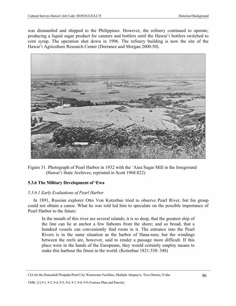
Cultural Surveys Hawai‘i Job Code: HONOULIULI 35 Historical Background
CIA for the Honouliuli/Waipahu/Pearl City Wastewater Facilities, Multiple Ahupua‘a, ‘Ewa District, O‘ahu 96
TMK: [1] 9-1, 9-2, 9-4, 9-5, 9-6, 9-7, 9-8, 9-9 (Various Plats and Parcels)
was dismantled and shipped to the Philippines. However, the refinery continued to operate, producing a liquid sugar product for canners and bottlers until the Hawai‘i bottlers switched to corn syrup. The operation shut down in 1996. The refinery building is now the site of the Hawai‘i Agriculture Research Center (Dorrance and Morgan 2000:50).
Figure 31. Photograph of Pearl Harbor in 1932 with the ‘Aiea Sugar Mill in the foreground (Hawai‘i State Archives, reprinted in Scott 1968:822)
5.3.6 The Military Development of ‘Ewa
5.3.6.1 Early Evaluations of Pearl Harbor
In 1891, Russian explorer Otto Von Kotzebue tried to observe Pearl River, but his group could not obtain a canoe. What he was told led him to speculate on the possible importance of Pearl Harbor to the future:
In the mouth of this river are several islands; it is so deep, that the greatest ship of the line can lie at anchor a few fathoms from the shore; and so broad, that a hundred vessels can conveniently find room in it. The entrance into the Pearl Rivers is in the same situation as the harbor of Hana-rura; but the windings between the reefs are, however, said to render a passage more difficult. If this place were in the hands of the Europeans, they would certainly employ means to make this harbour the finest in the world. (Kotzebue 1821:338–348)
Cultural Surveys Hawai‘i Job Code: HONOULIULI 35 Historical Background
CIA for the Honouliuli/Waipahu/Pearl City Wastewater Facilities, Multiple Ahupua‘a, ‘Ewa District, O‘ahu 97
TMK: [1] 9-1, 9-2, 9-4, 9-5, 9-6, 9-7, 9-8, 9-9 (Various Plats and Parcels)
The early missionary, Levi Chamberlain, took an outrigger canoe trip to Pearl River and noted the difficulty of access for larger ships:
Kawaa took passage in our canoe to go down the harbor to a place where oysters are abundant to give orders to his people to gather a mess. The sail down the harbor was delightful…. The passage down the creek for a number of miles was very pleasant till we got down near the reef and our course altered. We then could sail no longer as the wind was against us. The sail was lowered the mast taken down and secured across the outrigger and the rowers plied their paddles. (Chamberlain 1822–1849, reprinted in Sterling and Summers 1978:51)
The first foreign attempt to survey Pearl Harbor was made in 1840 during the U.S. Exploring Expedition, led by Charles Wilkes. Wilkes describes the area:
In this district is a large inlet of the sea, into which the river Ewa empties; at the entrance of this inlet is the village of Laeloa (at Kalaeloa Pont): the shore is known by the name of Pearl River or harbour, from the circumstance that the pearl oyster is found here; and it is the only place in these islands where it occurs.
The inlet has somewhat the appearance of a lagoon that has been partly filled up by alluvial deposits. At the request of the king, we made a survey of it: the depth of water at its mouth was found to be only fifteen feet; but after passing this coral bar, which is four hundred feet wide, the depth of water becomes ample for large ships, and the basin is sufficiently extensive to accommodate any number of vessels. If the water upon the bar should be deepened, which I doubt not can be effected, it would afford the best and most capacious harbour in the Pacific. (Wilkes 1970:79)
Although Wilkes was impressed by the harbor, he was not at this time thinking of how this survey could benefit the American government in the future. In fact, Wilkes (1970:79) concluded, “As yet there is no necessity for such an operation, for the port of Honolulu is sufficient for all the present wants of the islands, and the trade that frequents them.”
The low impression of Wilkes for the use of Pearl Harbor had changed in less than 30 years. The U.S. Navy had tried to make a coaling station on Midway Island in 1869 by blasting through the coral reef to make a harbor, but the plan failed. In 1873, General Schofield presented a confidential report to the U.S Secretary of war, recommending that Pearl Harbor should be available to the U.S. Navy. Schofield wrote:
In case it should become the policy of the Government of the United States to obtain the possession of this harbor for naval purposes, jurisdiction over all the waters of Pearl River with the adjacent shores to the distance of 4 miles from any anchorage should be ceded to the United States by the Hawaiian Government….
The cession of Pearl River could probably be obtained by the United States in consideration of the repeal of the duty of Sandwich Island sugar. Indeed, the sugar –planters are so anxious for a reciprocity treaty, or so anxious rather for free trade in sugar with the United States, that many of them openly proclaim themselves in favor of annexation of these islands of the United States. (Sen. Ex. Docs, 52nd Cong. 2nd Sess. No. 77, pp. 150–154, reproduced in Judd 1971:Appendix 3)

Cultural Surveys Hawai‘i Job Code: HONOULIULI 35 Historical Background
CIA for the Honouliuli/Waipahu/Pearl City Wastewater Facilities, Multiple Ahupua‘a, ‘Ewa District, O‘ahu 98
TMK: [1] 9-1, 9-2, 9-4, 9-5, 9-6, 9-7, 9-8, 9-9 (Various Plats and Parcels)
5.3.6.2 The U.S. Military and the Development of Pearl Harbor
The reciprocity treaty was concluded in 1876 with the provision that Hawai‘i would not “lease or relinquish sovereignty to another country or any harbor, etc.” In 1887, the treaty was renewed and amended and allowed the United States the “exclusive right to enter the harbor of Pearl River, in the Island of Oahu, at to establish and to maintain there a coaling and repair station for the use of vessels of the United States” (Judd 1971:128).
The most dramatic change affecting both the use of Pearl Harbor and the growth of the sugar industry in Hawai‘i occurred July 7, 1898. Following years of diplomatic pressure from delegates to Washington, the Congress of the United States approved a joint resolution of annexation that established the Republic of Hawai‘i as a Territory of the United States. On April 30, 1900, President William McKinley signed the Organic Act for the Territory of Hawai‘i, which provided a government whose leaders were appointed by the United States and otherwise defined the political structure and powers of the newly established government (U.S. Department of the Interior 1900).
The U.S. Navy began a preliminary dredging program for Pearl Harbor in 1901, which created a 30-foot deep entrance channel measuring 200 ft wide and 3,085 ft long. In 1908, money was appropriated for five miles of entrance channel dredged to an additional 35 ft down (Downes 1953) (Figure 32). Money for the funding of the construction of dry docks and other support facilities was also approved in 1908. In 1909, the government appropriated the entire Waipi‘o peninsula from the ‘Ī‘ī estate for the Pearl Harbor Naval Station and Shipyard. Additional dredging to deepen and widen the channel was conducted in the 1920s. In 1931, the Navy built an ammunition depot at West Loch on a 213-acre parcel that it had bought from the Campbell Estate. Construction of a new depot in Lualualei Valley and at West Loch Harbor began in 1931.
In the early 1930s, the U.S. Navy leased 700 acres of the Campbell Estate to build ‘Ewa Field in Honouliuli, a base with a mooring mast for Navy dirigibles. Although the mast was completed, the program was abandoned before the Akron, the designated airship for the mast, was built. In 1937, 18 miles of roads were built in the coastal Honouliuli area, and in 1939 to 1940 the U.S. bought 3,500 acres of land in this area (Landrum et al 1997:62–67), to build several other military camps and installations, including Barbers Point Naval Air Station, at the site of the old mooring mast.
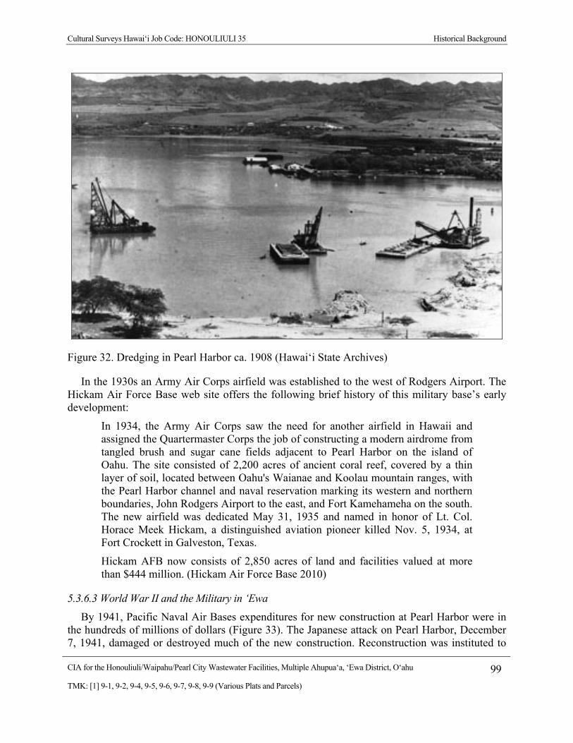
Cultural Surveys Hawai‘i Job Code: HONOULIULI 35 Historical Background
CIA for the Honouliuli/Waipahu/Pearl City Wastewater Facilities, Multiple Ahupua‘a, ‘Ewa District, O‘ahu 99
TMK: [1] 9-1, 9-2, 9-4, 9-5, 9-6, 9-7, 9-8, 9-9 (Various Plats and Parcels)
Figure 32. Dredging in Pearl Harbor ca. 1908 (Hawai‘i State Archives)
In the 1930s an Army Air Corps airfield was established to the west of Rodgers Airport. The Hickam Air Force Base web site offers the following brief history of this military base’s early development:
In 1934, the Army Air Corps saw the need for another airfield in Hawaii and assigned the Quartermaster Corps the job of constructing a modern airdrome from tangled brush and sugar cane fields adjacent to Pearl Harbor on the island of Oahu. The site consisted of 2,200 acres of ancient coral reef, covered by a thin layer of soil, located between Oahu's Waianae and Koolau mountain ranges, with the Pearl Harbor channel and naval reservation marking its western and northern boundaries, John Rodgers Airport to the east, and Fort Kamehameha on the south. The new airfield was dedicated May 31, 1935 and named in honor of Lt. Col. Horace Meek Hickam, a distinguished aviation pioneer killed Nov. 5, 1934, at Fort Crockett in Galveston, Texas.
Hickam AFB now consists of 2,850 acres of land and facilities valued at more than $444 million. (Hickam Air Force Base 2010)
5.3.6.3 World War II and the Military in ‘Ewa
By 1941, Pacific Naval Air Bases expenditures for new construction at Pearl Harbor were in the hundreds of millions of dollars (Figure 33). The Japanese attack on Pearl Harbor, December 7, 1941, damaged or destroyed much of the new construction. Reconstruction was instituted to
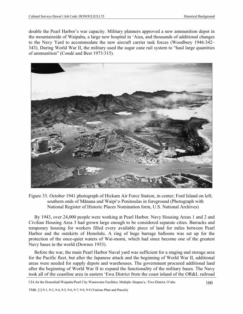
Cultural Surveys Hawai‘i Job Code: HONOULIULI 35 Historical Background
CIA for the Honouliuli/Waipahu/Pearl City Wastewater Facilities, Multiple Ahupua‘a, ‘Ewa District, O‘ahu 100
TMK: [1] 9-1, 9-2, 9-4, 9-5, 9-6, 9-7, 9-8, 9-9 (Various Plats and Parcels)
double the Pearl Harbor’s war capacity. Military planners approved a new ammunition depot in the mountainside of Waipahu, a large new hospital in ‘Aiea, and thousands of additional changes to the Navy Yard to accommodate the new aircraft carrier task forces (Woodbury 1946:342–343). During World War II, the military used the sugar cane rail system to “haul large quantities of ammunition” (Condé and Best 1973:315).
Figure 33. October 1941 photograph of Hickam Air Force Station, in center; Ford Island on left; southern ends of Mānana and Waipi‘o Peninsulas in foreground (Photograph with National Register of Historic Places Nomination form, U.S. National Archives)
By 1943, over 24,000 people were working at Pearl Harbor. Navy Housing Areas 1 and 2 and Civilian Housing Area 3 had grown large enough to be considered separate cities. Barracks and temporary housing for workers filled every available piece of land for miles between Pearl Harbor and the outskirts of Honolulu. A ring of huge barrage balloons was set up for the protection of the once-quiet waters of Wai-momi, which had since become one of the greatest Navy bases in the world (Downes 1953).
Before the war, the main Pearl Harbor Naval yard was sufficient for a staging and storage area for the Pacific fleet, but after the Japanese attack and the beginning of World War II, additional areas were needed for supply depots and warehouses. The government procured additional land after the beginning of World War II to expand the functionality of the military bases. The Navy took all of the coastline area in eastern ‘Ewa District from the coast inland of the OR&L railroad
Cultural Surveys Hawai‘i Job Code: HONOULIULI 35 Historical Background
CIA for the Honouliuli/Waipahu/Pearl City Wastewater Facilities, Multiple Ahupua‘a, ‘Ewa District, O‘ahu 101
TMK: [1] 9-1, 9-2, 9-4, 9-5, 9-6, 9-7, 9-8, 9-9 (Various Plats and Parcels)
tracks (Ching 1996:24). Waipi‘o Point, Waiawa Gulch, Pearl City (Mānana) Peninsula, Iroquois Point in Hālawa, and small areas in Honouliuli and Hō‘ae‘ae were taken over as supply depots and storage areas. The OR&L railroad had built a spur from the coast to Wahiawa in 1905, to haul cane and pineapples down to the coast and later to haul men and supplies from Pearl Harbor to Schofield Barracks in Wahiawa through Waikakalaua Gulch in Waikele. During the war, the military built a “secret railroad” from the railroad terminus at Waikakalaua Gulch to join the OR&L railroad coming around Ka‘ena Point at Hale‘iwa, thus providing a short cut from Pearl Harbor to Army facilities at Kahuku on the north shore of O‘ahu (Kneiss 1957:11–12). By 1944, the Navy had claimed close to 2,400 acres of land in the Pearl Harbor and Pearl City areas within Mānana, Waiawa, and Hālawa for use as military staging areas in the war effort (Allen 1999:234).
There were four main portions of Waiawa that were used by the military—the Pearl City Peninsula makai of Kamehameha Highway, a storage area along Waiawa Stream mauka of the highway, a diesel drum storage area at ‘Ewa Junction, and a military reservation in upland Waiawa used for communications and training (Allen 1999:234). The military reservation in Waiawa was 650 acres consisting of both gulch and plateau lands. From 1941 to 1945, the reservation was used as a training area for tanks and personnel and as an artillery impact area. The area was also used for the storage of munitions and supplies. The primary structure built by the military was a communications center. This center consists of four buildings and a tunnel system. The communications center is currently being used by the State of Hawai‘i as a minimum security prison (Waiawa Correctional Facility).
On the Pearl City Peninsula in Mānana, three large warehouses were built for a storage area. Other sections of the peninsula, including the Waiawa portion, were used for supply depot warehouses and spare part distribution centers. One of these was the U.S. Navy Mānana Supply Center, now known as the U.S. Navy Mānana Storage Area. A 25-acre portion of the former Supply Center on the Waiawa side of Mānana Peninsula was set aside in 1972 as a portion of the Pearl Harbor National Wildlife Refuge. This refuge for endangered wetland water birds was set up in the former area of Loko Kuhialoko and Loko Mo‘o. A non-contiguous section of the U.S. Navy Mānana Storage Area was located mauka of Kamehameha Highway. It began as an aviation supply depot on the border between Waiawa and Mānana. The Navy built 50 wood-frame structures and spaced open-storage areas along the banks of Waiawa Stream for two miles (Allen 1999:238).
The Ewa Junction Fuel Drumming Facility was built on a 44-acre site in 1943 as a fuel drumming and transportation terminal at the site of the old OR&L railroad junction. Thus, it had railroad lines to the Pearl Harbor Shipyard and Hickam Air Field to the east, to Barbers Point Naval Air Station and other bases in Waianae to the west, and to Schofield Barracks and Wheeler Air Field Base to the north. The facilities consist of two 585,000-gallon fuel storage tanks, a fuel drumming building, and associated piping. The site has been inactive since the 1970s (Allen 1999).
Following World War II, much of the lower lands of Waiawa and Mānana remained part of the Naval Reservation and were used mainly as housing for military families and also sites for military warehousing. To this day, much of the Pearl City peninsula remains in the custody of the
Cultural Surveys Hawai‘i Job Code: HONOULIULI 35 Historical Background
CIA for the Honouliuli/Waipahu/Pearl City Wastewater Facilities, Multiple Ahupua‘a, ‘Ewa District, O‘ahu 102
TMK: [1] 9-1, 9-2, 9-4, 9-5, 9-6, 9-7, 9-8, 9-9 (Various Plats and Parcels)
U.S. Navy; however, in the late 1990s, much of the rest of the previous Pearl City regions were released to the State for public use (Allen 1999:239).
A supply depot for fuel drums was also set up along the coast called the Waiau Drum Storage. This site is actually in Waimalu Ahupua‘a. It was built on land that the U.S. Navy purchased from the OR&L in 1942, and it was used to clean and store empty fuel drums. Between 1943 and 1963, waste oils were destroyed at the site (Dega and O’Rourke 2003:15). In 1963, the U.S. Navy gave the land to the City and County of Honolulu on which the Neal Blaisdell Park now located.
The peninsula on the west side of ‘Aiea Bay is used for military housing. It currently consists of 140 single-unit, single story homes, most of which were built in 1960. Upper ‘Aiea, adjacent to the western border of Kalauao, was used as a base for the ‘Aiea Anti-Aircraft Battery during World War II. ‘Aiea Heights developed into a residential area in the 1930s, and the former battery area was converted into Nāpuanani Park (Dega and O’Rourke 2003:16).
5.3.7 Residential and Commercial Development in ‘Ewa
Three topographic maps show the extensive changes in commercial and residential development in the twentieth century. On a 1919 map U. S. War Department map (Figure 34), the proposed Honouliuli/ Waipahu/ Pearl City Wastewater Facilities Project area crosses mainly through undeveloped sugar cane fields, crossed only by the OR&L railroad and its stations, and the numerous railroad track sections of the Ewa Plantation Co., the Oahu Sugar Co., and the Honolulu Sugar Co., which extended from the inland fields to the sugar mills.
On the 1953 to 1954 topographic map (Figure 35), the criss-cross of railroad tracks is missing, replaced by numerous roads and dense residential neighborhoods at ‘Ewa Villages, Waipahu, Pearl City, and ‘Aiea. Many areas are blocked off for military installations and housing, such as the Makalapa Crater Naval Reservation in Hālawa, and the Naval Reservation sections at McGrew Point on ‘Aiea Bay, on Pearl City (Mānana) Peninsula, along Middle Loch coast through Waiawa and Mānana, on Waipi‘o Peninsula, and on the shores of West Loch in Honouliuli. On the 1998 topographic map, many of these naval reservation lands have shrunk, replaced by golf courses, large shopping complexes, and new neighborhoods that extend inland along the ‘Ewa ridgelines.

Cultural Surveys Hawai‘i Job Code: HONOULIULI 35 Historical Background
CIA for the Honouliuli/Waipahu/Pearl City Wastewater Facilities, Multiple Ahupua‘a, ‘Ewa District, O‘ahu 103
TMK: [1] 9-1, 9-2, 9-4, 9-5, 9-6, 9-7, 9-8, 9-9 (Various Plats and Parcels)
Figure 34. 1919 U.S. War Department Fire Control Map (portions of Pearl Harbor, Barbers Point, Nanakuli, and Honolulu Quadrangles, showing Project area through sugar cane fields and scattered settlements
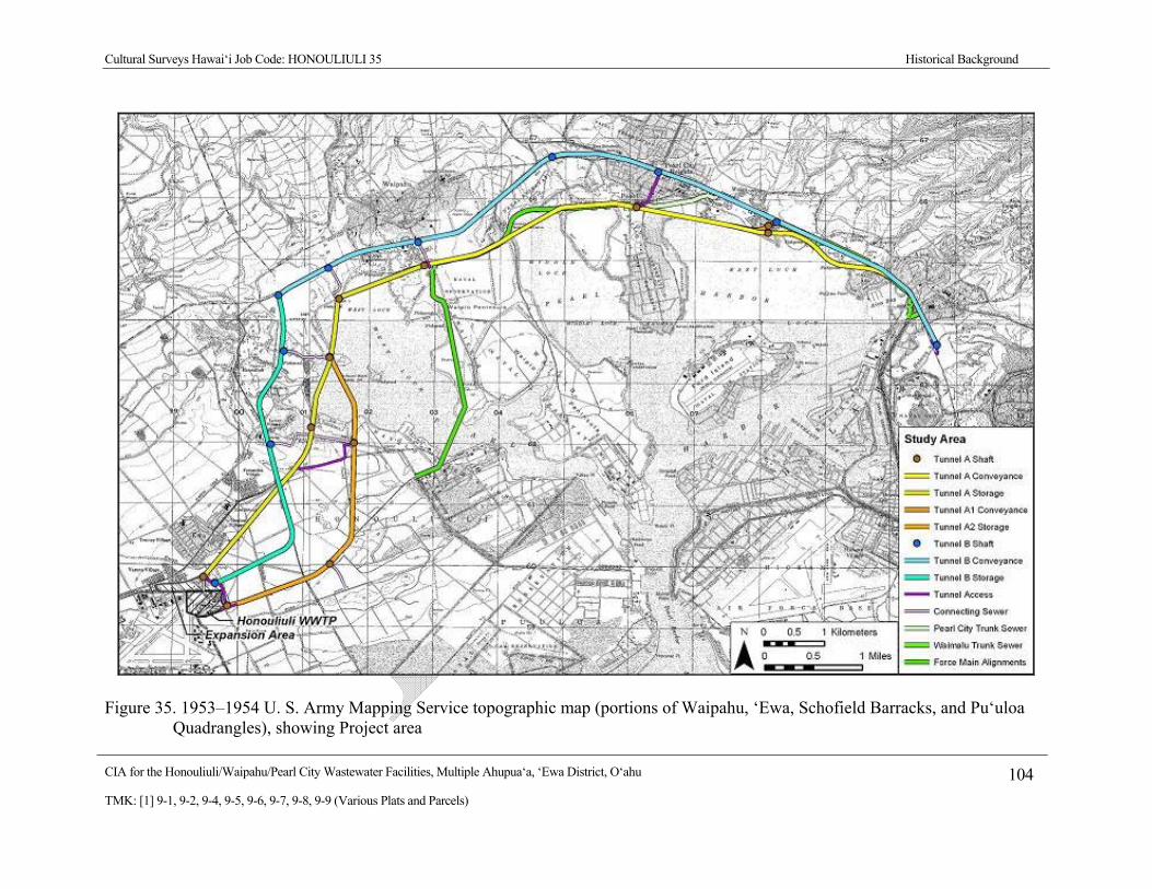
Cultural Surveys Hawai‘i Job Code: HONOULIULI 35 Historical Background
CIA for the Honouliuli/Waipahu/Pearl City Wastewater Facilities, Multiple Ahupua‘a, ‘Ewa District, O‘ahu 104
TMK: [1] 9-1, 9-2, 9-4, 9-5, 9-6, 9-7, 9-8, 9-9 (Various Plats and Parcels)
Figure 35. 1953–1954 U. S. Army Mapping Service topographic map (portions of Waipahu, ‘Ewa, Schofield Barracks, and Pu‘uloa Quadrangles), showing Project area
Cultural Surveys Hawai‘i Job Code: HONOULIULI 35 Community Consultation
CIA for the Honouliuli/Waipahu/Pearl City Wastewater Facilities, Multiple Ahupua‘a, ‘Ewa District, O‘ahu 105
TMK: [1] 9-1, 9-2, 9-4, 9-5, 9-6, 9-7, 9-8, 9-9 (Various Plats and Parcels)
Section 6 Community Consultation
Throughout the course of this assessment, an effort was made to contact and consult with Hawaiian cultural organizations, government agencies, and individuals who might have knowledge of and/or concerns about traditional cultural practices specifically related to the Project area. This effort was made by letter, email, telephone and in person contact. The initial outreach effort was started in November 2010. Community consultation was completed in February 2011. In the majority of cases, letters along with a map and an aerial photograph of the Project area were mailed with the following text:
At the request of AECOM and the City and County of Honolulu (CCH), Cultural Surveys Hawai‘i Inc. (CSH) is conducting a Cultural Impact Assessment (CIA) for the proposed Honouliuli/Waipahu/Pearl City Wastewater Facilities Project, Multiple Ahupua‘a, ‘Ewa District, O‘ahu Island, Multiple TMK. This study will be an update to the West Mamala Bay Facilities Plan (2001) for the Honouliuli Sewershed. The Honouliuli Sewershed encompasses the areas from which current wastewater flows into the Honouliuli Wastewater Treatment Plant (Honouliuli WWTP) including Hālawa, ‘Aiea, Pearl City, Waipi‘o, Waikele, Waipahu, ‘Ewa, Kapolei and Mililani.
The CCH is conducting a planning and engineering study for improvements to the Honouliuli/Waipahu/Pearl City Wastewater Facilities that is aimed at minimizing sanitary sewer overflows, to comply with regulatory mandates from the State of Hawaii, Department of Health (DOH), and the United States Environmental Protection Agency (EPA) and to meet the future needs for wastewater management. The study will cover potential future flows up to the year 2030.
Alternatives being considered include but are not limited to:
Increased capacity and/or additional gravity sewers.
Peak flow storage tanks at Hālawa, Waimalu and/or Pearl City pump stations.
Increased capacity and/or additional pump station force mains for the Pearl City and/or Waipahu pump stations.
Pump station modification, capacity expansion, and/or relocation of the Pearl City pump station and capacity expansion or a second Waipahu pump station.
Deep tunnel conveyance and storage system to minimize or replace pump stations and provide peak flow storage.
Modification, upgrade and/or expansion of the Honouliuli WWTP.
We are seeking your input on any of the following aspects of this study:
General history and present and past land use of the project area.

Cultural Surveys Hawai‘i Job Code: HONOULIULI 35 Community Consultation
CIA for the Honouliuli/Waipahu/Pearl City Wastewater Facilities, Multiple Ahupua‘a, ‘Ewa District, O‘ahu 106
TMK: [1] 9-1, 9-2, 9-4, 9-5, 9-6, 9-7, 9-8, 9-9 (Various Plats and Parcels)
Knowledge of cultural sites- for example, historic sites, archaeological sites, and burials.
Knowledge of traditional gathering practices in the project area, both past and ongoing.
Cultural associations of the project area, such as legends and traditional uses.
Referrals of kūpuna or elders and kama‘āina who might be willing to share their cultural knowledge of the project area and the surrounding ahupua‘a lands.
Any other cultural concerns the community might have related to Hawaiian cultural practices within or in the vicinity of the project area.
6.1 Community Consultation Effort Several attempts were made by mail, email and telephone to contact individuals,
organizations, and agencies apposite to the subject CIA. The summary of consultations is presented in Table 3 below.
Table 3. Results of Community Consultation
Name Affiliation, Background Comments
Alaka’i, Robert Cultural Practitioner, Nā Koa member
CSH sent community outreach letter and figures on November 13, 2010 and December 23, 2010
Alegado, Dean Filipino Community Center member, Waipahu kama‘āina
CSH sent community outreach letter and figures on November 13, 2010 and December 23, 2010
Amaral, Annelle ‘Ahahui Sivila Hawai‘i O Kapolei Hawaiian Civic Club
CSH sent community outreach letter and figures on November 13, 2010 and December 23, 2010
Bise, Tony ‘Ewa Federal Credit Union; Historian
CSH sent community outreach letter and figures on November 13, 2010 and December 23, 2010
Brown, Kenneth F. Cultural Descendent CSH sent community outreach letter and figures on November 13, 2010 and December 23, 2010
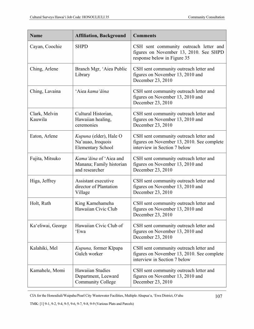
Cultural Surveys Hawai‘i Job Code: HONOULIULI 35 Community Consultation
CIA for the Honouliuli/Waipahu/Pearl City Wastewater Facilities, Multiple Ahupua‘a, ‘Ewa District, O‘ahu 107
TMK: [1] 9-1, 9-2, 9-4, 9-5, 9-6, 9-7, 9-8, 9-9 (Various Plats and Parcels)
Name Affiliation, Background Comments
Cayan, Coochie SHPD CSH sent community outreach letter and figures on November 13, 2010. See SHPD response below in Figure 35
Ching, Arlene Branch Mgr, ‘Aiea Public Library
CSH sent community outreach letter and figures on November 13, 2010 and December 23, 2010
Ching, Lavaina ‘Aiea kama‘āina CSH sent community outreach letter and figures on November 13, 2010 and December 23, 2010
Clark, Melvin Kauwila
Cultural Historian, Hawaiian healing, ceremonies
CSH sent community outreach letter and figures on November 13, 2010 and December 23, 2010
Eaton, Arlene Kupuna (elder), Hale O Na’auao, Iroquois Elementary School
CSH sent community outreach letter and figures on November 13, 2010. See complete interview in Section 7 below
Fujita, Mitsuko Kama‘āina of ‘Aiea and Manana; Family historian and researcher
CSH sent community outreach letter and figures on November 13, 2010 and December 23, 2010
Higa, Jeffrey Assistant executive director of Plantation Village
CSH sent community outreach letter and figures on November 13, 2010 and December 23, 2010
Holt, Ruth King Kamehameha Hawaiian Civic Club
CSH sent community outreach letter and figures on November 13, 2010 and December 23, 2010
Ka‘eliwai, George Hawaiian Civic Club of ‘Ewa
CSH sent community outreach letter and figures on November 13, 2010 and December 23, 2010
Kalahiki, Mel Kupuna, former Kīpapa Gulch worker
CSH sent community outreach letter and figures on November 13, 2010. See complete interview in Section 7 below
Kamahele, Momi Hawaiian Studies Department, Leeward Community College
CSH sent community outreach letter and figures on November 13, 2010 and December 23, 2010
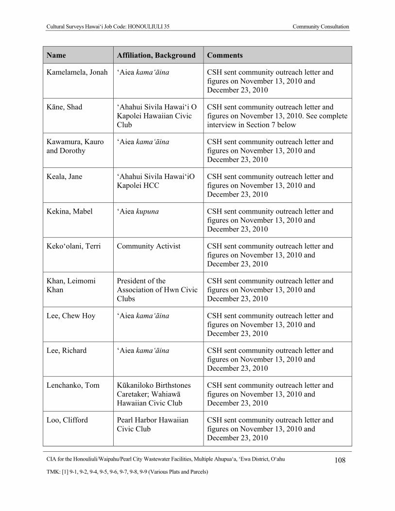
Cultural Surveys Hawai‘i Job Code: HONOULIULI 35 Community Consultation
CIA for the Honouliuli/Waipahu/Pearl City Wastewater Facilities, Multiple Ahupua‘a, ‘Ewa District, O‘ahu 108
TMK: [1] 9-1, 9-2, 9-4, 9-5, 9-6, 9-7, 9-8, 9-9 (Various Plats and Parcels)
Name Affiliation, Background Comments
Kamelamela, Jonah ‘Aiea kama‘āina CSH sent community outreach letter and figures on November 13, 2010 and December 23, 2010
Kāne, Shad ‘Ahahui Sivila Hawai‘i O Kapolei Hawaiian Civic Club
CSH sent community outreach letter and figures on November 13, 2010. See complete interview in Section 7 below
Kawamura, Kauro and Dorothy
‘Aiea kama‘āina CSH sent community outreach letter and figures on November 13, 2010 and December 23, 2010
Keala, Jane ‘Ahahui Sivila Hawai‘iO Kapolei HCC
CSH sent community outreach letter and figures on November 13, 2010 and December 23, 2010
Kekina, Mabel ‘Aiea kupuna CSH sent community outreach letter and figures on November 13, 2010 and December 23, 2010
Keko‘olani, Terri Community Activist CSH sent community outreach letter and figures on November 13, 2010 and December 23, 2010
Khan, Leimomi Khan
President of the Association of Hwn Civic Clubs
CSH sent community outreach letter and figures on November 13, 2010 and December 23, 2010
Lee, Chew Hoy ‘Aiea kama‘āina CSH sent community outreach letter and figures on November 13, 2010 and December 23, 2010
Lee, Richard ‘Aiea kama‘āina CSH sent community outreach letter and figures on November 13, 2010 and December 23, 2010
Lenchanko, Tom Kūkaniloko Birthstones Caretaker; Wahiawā Hawaiian Civic Club
CSH sent community outreach letter and figures on November 13, 2010 and December 23, 2010
Loo, Clifford Pearl Harbor Hawaiian Civic Club
CSH sent community outreach letter and figures on November 13, 2010 and December 23, 2010
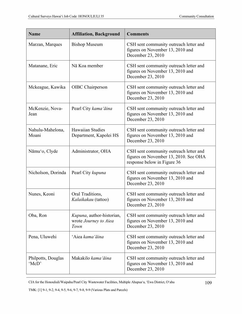
Cultural Surveys Hawai‘i Job Code: HONOULIULI 35 Community Consultation
CIA for the Honouliuli/Waipahu/Pearl City Wastewater Facilities, Multiple Ahupua‘a, ‘Ewa District, O‘ahu 109
TMK: [1] 9-1, 9-2, 9-4, 9-5, 9-6, 9-7, 9-8, 9-9 (Various Plats and Parcels)
Name Affiliation, Background Comments
Marzan, Marques Bishop Museum CSH sent community outreach letter and figures on November 13, 2010 and December 23, 2010
Matanane, Eric Nā Koa member CSH sent community outreach letter and figures on November 13, 2010 and December 23, 2010
Mckeague, Kawika OIBC Chairperson CSH sent community outreach letter and figures on November 13, 2010 and December 23, 2010
McKenzie, Nova-Jean
Pearl City kama‘āina CSH sent community outreach letter and figures on November 13, 2010 and December 23, 2010
Nahulu-Mahelona, Moani
Hawaiian Studies Department, Kapolei HS
CSH sent community outreach letter and figures on November 13, 2010 and December 23, 2010
Nāmu‘o, Clyde Administrator, OHA CSH sent community outreach letter and figures on November 13, 2010. See OHA response below in Figure 36
Nicholson, Dorinda Pearl City kupuna CSH sent community outreach letter and figures on November 13, 2010 and December 23, 2010
Nunes, Keoni Oral Traditions, Kalaikakau (tattoo)
CSH sent community outreach letter and figures on November 13, 2010 and December 23, 2010
Oba, Ron Kupuna, author-historian, wrote Journey to Aiea Town
CSH sent community outreach letter and figures on November 13, 2010 and December 23, 2010
Pena, Uluwehi ‘Aiea kama‘āina CSH sent community outreach letter and figures on November 13, 2010 and December 23, 2010
Philpotts, Douglas ‘McD’
Makakilo kama‘āina CSH sent community outreach letter and figures on November 13, 2010 and December 23, 2010
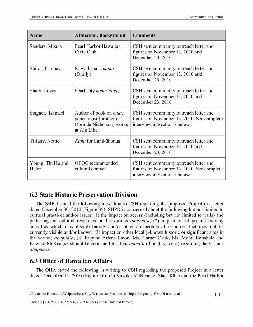
Cultural Surveys Hawai‘i Job Code: HONOULIULI 35 Community Consultation
CIA for the Honouliuli/Waipahu/Pearl City Wastewater Facilities, Multiple Ahupua‘a, ‘Ewa District, O‘ahu 110
TMK: [1] 9-1, 9-2, 9-4, 9-5, 9-6, 9-7, 9-8, 9-9 (Various Plats and Parcels)
Name Affiliation, Background Comments
Sanders, Moana Pearl Harbor Hawaiian Civic Club
CSH sent community outreach letter and figures on November 13, 2010 and December 23, 2010
Shirai, Thomas Kawaihāpai ‘ohana (family)
CSH sent community outreach letter and figures on November 13, 2010 and December 23, 2010
Slater, Lovey Pearl City kama‘āina; CSH sent community outreach letter and figures on November 13, 2010 and December 23, 2010
Stagner, Ishmael Author of book on hula, genealogist (brother of Dorinda Nicholson) works at Alu Like
CSH sent community outreach letter and figures on November 13, 2010. See complete interview in Section 7 below
Tiffany, Nettie Kahu for Lanikūhonua CSH sent community outreach letter and figures on November 13, 2010 and December 23, 2010
Young, Tin Hu and Helen
OEQC recommended cultural contact
CSH sent community outreach letter and figures on November 13, 2010. See complete interview in Section 7 below
6.2 State Historic Preservation Division The SHPD stated the following in writing to CSH regarding the proposed Project in a letter
dated December 30, 2010 (Figure 35): SHPD is concerned about the following but not limited to cultural practices and/or issues (1) the impact on access (including but not limited to trails) and gathering for cultural resources in the various ahupua‘a; (2) impact of all ground moving activities which may disturb burials and/or other archaeological resources that may not be currently visible and/or known; (3) impact on other locally-known historic or significant sites in the various ahupua‘a; (4) Kupuna Arlene Eaton, Ms. Garnet Clark, Ms. Momi Kanahele and Kawika McKeague should be contacted for their mana‘o (thoughts, ideas) regarding the various ahupua‘a.
6.3 Office of Hawaiian Affairs The OHA stated the following in writing to CSH regarding the proposed Project in a letter
dated December 13, 2010 (Figure 36): (1) Kawika McKeague, Shad Kāne and the Pearl Harbor
Cultural Surveys Hawai‘i Job Code: HONOULIULI 35 Community Consultation
CIA for the Honouliuli/Waipahu/Pearl City Wastewater Facilities, Multiple Ahupua‘a, ‘Ewa District, O‘ahu 111
TMK: [1] 9-1, 9-2, 9-4, 9-5, 9-6, 9-7, 9-8, 9-9 (Various Plats and Parcels)
Hawaiian Civic Club should be contacted for their mana‘o; (2) various neighborhood boards in the Project may be appropriate forums to seek input on the CIA.
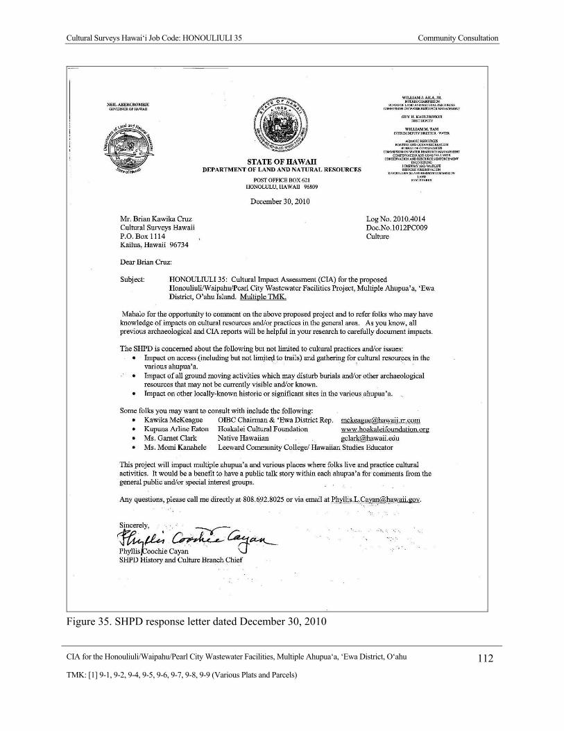
Cultural Surveys Hawai‘i Job Code: HONOULIULI 35 Community Consultation
CIA for the Honouliuli/Waipahu/Pearl City Wastewater Facilities, Multiple Ahupua‘a, ‘Ewa District, O‘ahu 112
TMK: [1] 9-1, 9-2, 9-4, 9-5, 9-6, 9-7, 9-8, 9-9 (Various Plats and Parcels)
Figure 35. SHPD response letter dated December 30, 2010

CIA for the Honouliuli/Waipahu/Pearl City Wastewater Facilities, Multiple Ahupua‘a, ‘Ewa District, O‘ahu 113
TMK: [1] 9-1, 9-2, 9-4, 9-5, 9-6, 9-7, 9-8, 9-9 (Various Plats and Parcels)
Figure 36. OHA response letter dated December 13, 2010
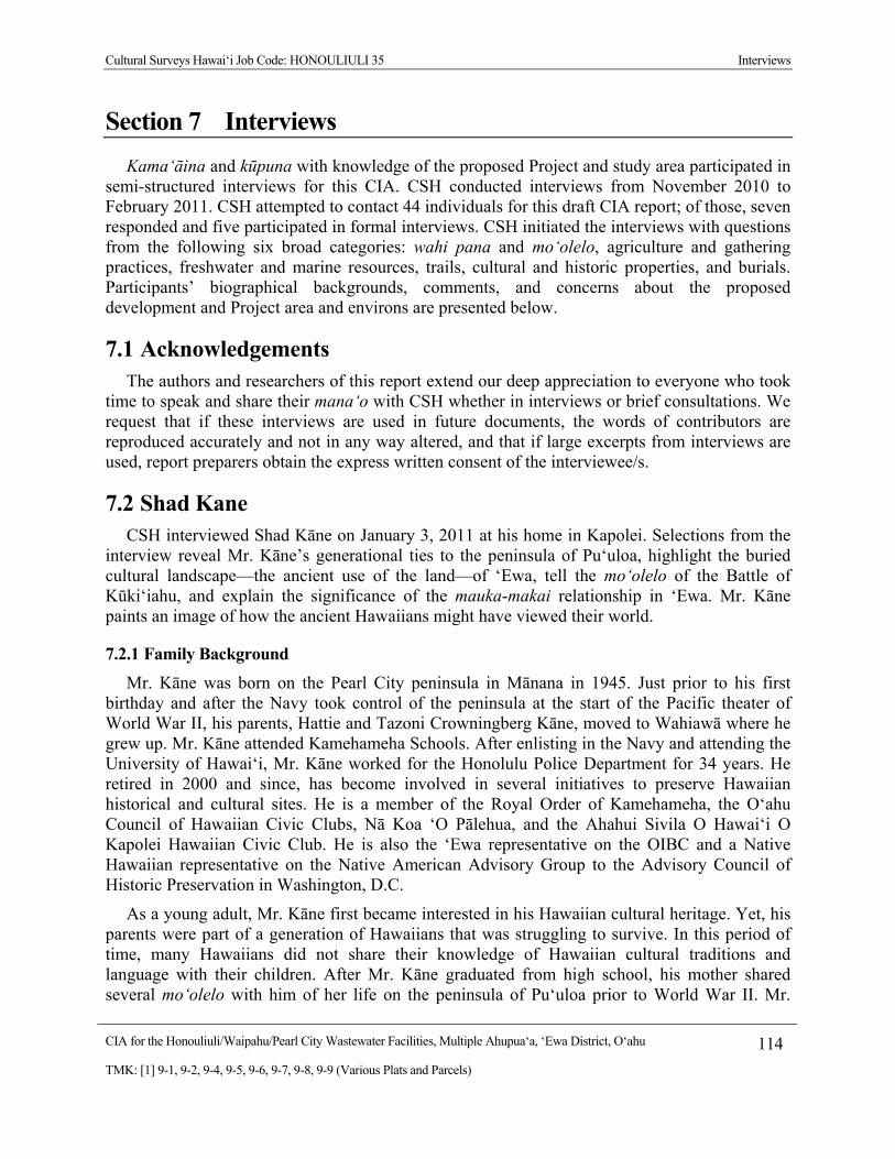
Cultural Surveys Hawai‘i Job Code: HONOULIULI 35 Interviews
CIA for the Honouliuli/Waipahu/Pearl City Wastewater Facilities, Multiple Ahupua‘a, ‘Ewa District, O‘ahu 114
TMK: [1] 9-1, 9-2, 9-4, 9-5, 9-6, 9-7, 9-8, 9-9 (Various Plats and Parcels)
Section 7 Interviews
Kama‘āina and kūpuna with knowledge of the proposed Project and study area participated in semi-structured interviews for this CIA. CSH conducted interviews from November 2010 to February 2011. CSH attempted to contact 44 individuals for this draft CIA report; of those, seven responded and five participated in formal interviews. CSH initiated the interviews with questions from the following six broad categories: wahi pana and mo‘olelo, agriculture and gathering practices, freshwater and marine resources, trails, cultural and historic properties, and burials. Participants’ biographical backgrounds, comments, and concerns about the proposed development and Project area and environs are presented below.
7.1 Acknowledgements The authors and researchers of this report extend our deep appreciation to everyone who took
time to speak and share their mana‘o with CSH whether in interviews or brief consultations. We request that if these interviews are used in future documents, the words of contributors are reproduced accurately and not in any way altered, and that if large excerpts from interviews are used, report preparers obtain the express written consent of the interviewee/s.
7.2 Shad Kane CSH interviewed Shad Kāne on January 3, 2011 at his home in Kapolei. Selections from the
interview reveal Mr. Kāne’s generational ties to the peninsula of Pu‘uloa, highlight the buried cultural landscape—the ancient use of the land—of ‘Ewa, tell the mo‘olelo of the Battle of Kūki‘iahu, and explain the significance of the mauka-makai relationship in ‘Ewa. Mr. Kāne paints an image of how the ancient Hawaiians might have viewed their world.
7.2.1 Family Background
Mr. Kāne was born on the Pearl City peninsula in Mānana in 1945. Just prior to his first birthday and after the Navy took control of the peninsula at the start of the Pacific theater of World War II, his parents, Hattie and Tazoni Crowningberg Kāne, moved to Wahiawā where he grew up. Mr. Kāne attended Kamehameha Schools. After enlisting in the Navy and attending the University of Hawai‘i, Mr. Kāne worked for the Honolulu Police Department for 34 years. He retired in 2000 and since, has become involved in several initiatives to preserve Hawaiian historical and cultural sites. He is a member of the Royal Order of Kamehameha, the O‘ahu Council of Hawaiian Civic Clubs, Nā Koa ‘O Pālehua, and the Ahahui Sivila O Hawai‘i O Kapolei Hawaiian Civic Club. He is also the ‘Ewa representative on the OIBC and a Native Hawaiian representative on the Native American Advisory Group to the Advisory Council of Historic Preservation in Washington, D.C.
As a young adult, Mr. Kāne first became interested in his Hawaiian cultural heritage. Yet, his parents were part of a generation of Hawaiians that was struggling to survive. In this period of time, many Hawaiians did not share their knowledge of Hawaiian cultural traditions and language with their children. After Mr. Kāne graduated from high school, his mother shared several mo‘olelo with him of her life on the peninsula of Pu‘uloa prior to World War II. Mr.

Cultural Surveys Hawai‘i Job Code: HONOULIULI 35 Interviews
CIA for the Honouliuli/Waipahu/Pearl City Wastewater Facilities, Multiple Ahupua‘a, ‘Ewa District, O‘ahu 115
TMK: [1] 9-1, 9-2, 9-4, 9-5, 9-6, 9-7, 9-8, 9-9 (Various Plats and Parcels)
Kāne’s family lived on Laniwai Street, which was not far from where his mother worked as a hula dancer for Pan American. Pā‘au‘au, a fishpond, was also located nearby. Mr. Kāne recalls with fondness that he sang the Pā‘au‘au Waltz as a student at Kamehameha Schools.
7.2.2 Agriculture, Fishing and Gathering
Mr. Kāne’s mother also spoke to him of lo‘i kalo, although Mr. Kāne cannot say with certainty that these lo‘i kalo were on the peninsula. Family photographs of lo‘i kalo from this time period could be from the surrounding area. The region’s agricultural base also included watercress farms and rice fields. In addition, Mr. Kāne’s father fished, hunted for crabs, collected oysters and clams, and gathered limu in the waters of Pu‘uloa in the specific area of Pōhaku O Kāne on the peninsula. Growing up, Mr. Kāne recollects how he and his father fished at the mouths of rivers that flowed into the ocean, such as Waimea Bay. While he has photographs of many of the fishing areas, most of these rivers no longer flow.
7.2.3 Cultural Landscape of ‘Ewa
Mr. Kāne discusses the dramatic alterations to the land within the moku of ‘Ewa. Most significantly, the land of Pu‘uloa, which connects to all 13 ahupua‘a in ‘Ewa, has been filled in through a growing partnership between business interests and federal agencies. However, the cultural landscape—the ancient use of the land for such activities as fishing, gathering, collecting medicinal plants, and worshipping—remains intact underground:
There are a lot of interesting things regarding all of Pu‘uloa. Much of this area in ‘Ewa Moku has been altered a lot. Compared to other places it is has been altered significantly by, and grew out of, a partnership between business interests, land owners and federal agencies. We’ve seen this history in other places, like Manifest Destiny, moving and expanding land ownership. The federal agency provided security for the business interests, and ultimately to provide for the expansion of large numbers of people. In these Hawaiian Islands, it happened more in ‘Ewa more than anywhere else. Twenty-five percent of all lands belong to federal agencies, such as the Department of Defense [DOD]. Much of that is on O‘ahu, and much of that is in ‘Ewa. Think of all the military bases. I’m not trying to be judgmental—I’m just trying to share what I’ve learned over the years. I don’t blame the children of today for the decisions their parents made. It is a different time and we have to move on.
‘Ewa is critical. It is at the very nature of that partnership, of agriculture and the support of federal agencies, and the erosion of our Hawaiian culture. The nature of agriculture is to bulldoze. An archaeologist’s job is to find things [that] are identifiable and draw conclusions from something that can be seen. You can’t do that if you can’t see anything. It is a challenge.
The ancient Hawaiian resources, due to the very nature of the alteration in the region, have not been removed. It has all been filled in. In other words, the cultural landscape within all of ‘Ewa is still there. It is just buried. The stuff that was on the high ground, where they planted sugar cane and pineapple is gone.
Cultural Surveys Hawai‘i Job Code: HONOULIULI 35 Interviews
CIA for the Honouliuli/Waipahu/Pearl City Wastewater Facilities, Multiple Ahupua‘a, ‘Ewa District, O‘ahu 116
TMK: [1] 9-1, 9-2, 9-4, 9-5, 9-6, 9-7, 9-8, 9-9 (Various Plats and Parcels)
Within the valleys, the low-lying areas, the wetlands adjacent to Pearl Harbor, from ‘Ewa Beach to ‘Aiea, much of that cultural landscape—the cultural layer—is still in place. The Navy and the DOD are beginning to understand the importance of preservation and our history. They are realizing it is not just a history of the DOD within Pearl Harbor; it is a history of all the many cultures that live here. No better place than ‘Ewa because there is a lot here. These guys, Tin Hu Young, the Colburns, and Don Francisco de Paula Marin, were a big part of this history. They were from other places, making it a very colorful place that tries to integrate many histories into one.
When you see Pearl Harbor, you see nothing Hawaiian. But in reality, that Hawaiian cultural history is still there. Much of what was on the surface is no longer there. But the cultural landscape is still beneath it. The Navy simply filled in everything. Much of Pearl Harbor was fishponds and salt ponds. All of those are still there, they are just filled up. I am constantly saying that this is part of a traditional cultural landscape, but the Navy disagrees with me. The Navy doesn’t see anything. To show that the traditional cultural landscape still exists, I have to speak about the ancient Hawaiian land use, and not in terms of physical structures. We are talking about land that was used for specific purposes by Native Hawaiians. We can talk about it in terms of gathering resources, fishing. We can talk about in terms of a place to gather salt. We can speak of it in terms of a place of worship and pray. We can speak of it in terms of a place to gather medicinal plants. A traditional cultural landscape is that. It is land that was used for a specific cultural purpose. If you speak of it in that respect the Navy must understand that it is a traditional cultural landscape. This is a challenge in ‘Ewa, more so than anywhere else. If you go anywhere else, you’ll see something above the ground and exposed. You go to ‘Ewa, it is not exposed. It’s underground.
Mr. Kāne is not aware of any visible evidence of such an ancient cultural landscape in the ahupua‘a of Waiawa, Waiau or Kalauao. However, he suggests that there would have been other structures similar to Keaīwa Heiau in the mountainous region of ‘Aiea. In particular, he read about a large heiau on a ridge at the intersection of the Mānana and Waiawa Rivers. This area was never cleared for agriculture, yet the area remains heavily forested, which has prevented Mr. Kāne from locating it on horseback. In addition, Mr. Kāne asserts that the ancient canoes are still near the shores of Pu‘uloa. He suggests that over time sediment and mud from the rivers flowing into Pu‘uloa have buried the canoes that were once left abandoned on the shores, and in doing so, the deposits preserved the organic materials in anaerobic conditions. To visualize what the ancient cultural landscape would have looked like, Mr. Kāne suggests looking today at Sumida Watercress Farm:
The best place to get an idea of what it might have looked like is through Sumida Farms. If you see the way the way they have the little grass hut sitting on the high ground between two irrigated areas, is how I picture all that land. I’m not saying that is exactly what it looked like, but it should give us a sense of what that whole area looked like in terms of irrigated lo‘i kalo or fishponds, and it should also give us a sense of how people lived on the lowlands. My understanding is that there
Cultural Surveys Hawai‘i Job Code: HONOULIULI 35 Interviews
CIA for the Honouliuli/Waipahu/Pearl City Wastewater Facilities, Multiple Ahupua‘a, ‘Ewa District, O‘ahu 117
TMK: [1] 9-1, 9-2, 9-4, 9-5, 9-6, 9-7, 9-8, 9-9 (Various Plats and Parcels)
would not have been a lot of people living on the wetlands. The only people living there would have been the people farming. In an area such as this, the lowland wetland area was used for agricultural purposes; lands from ‘Aiea to Mānana to Waipahu. Most of the people would be living in the high grounds, such Kalauao right where McGrew Point is, or Kūki‘iahu. If you go to McGrew Point and turn and look mauka, that ridge is Kūki‘iahu. People would have lived in such places as that, the high grounds. If you read Sites of O‘ahu, that is where the heiau were, and the people would have lived there. From an archaeological perspective, the habitation and trash sites would be on the high ground. The sad part today is where much of the disturbance has taken place. The low ground is buried. I am sharing this so we get a picture, a blurred picture of what it might have been like.
7.2.4 Mo‘olelo of the Battle of Kūki‘iahu
Mr. Kāne draws from the writings of Samuel Kamakau and John Papa ‘I‘ī to explain the Battle of Kūki‘iahu in the ahupua‘a of Kalauao:
At that time Kalanikūpule was mō‘ī of the island of O‘ahu and Moloka‘i. At that time, the island of O‘ahu was already Kalanikapule; Kahekili already passes away. Kalanikapule was mō‘ī in 1784. Between 1784 and 1794 the island of O‘ahu was under control of Kalanikapule. During that same period, the mō‘ī of Kaua‘i and Moloka‘i was Kaeokulani. He was struggling with his men. He had to have the respect of the men. They set the direction of what you were going to do. If your men were with you, you could do what you want to do. If your men were not with you, there is nothing you can do. Kaeokulani was having a hard time with his men, apparently they were not happy. They were trying to get back to Kaua‘i but didn’t make it. Kaeokulani tried to appease his men by finding battles over here. He didn’t need to fight but he figured a few small battles would get his men under control again. This was the Battle of Kūki‘iahu between the forces of the Kaeokulani and Kalanikapule. This was the first time a British Ship, the H.M.S. Jackal, under the command of Captain Brown entered the waters of Pu’uloa. How did they get those ships in there? The draft on those ships…pretty heavy ships that sit low in the water. The question is how he got them in. Up to that point I was always of the understanding that there was no way to get in. It was dredged, but for large canoes—not for ships. My thinking is that it was only around 10 to 15 feet at the entrance of Pearl Harbor. Those three-masted ships would have needed more clearance. Brown was able to get his two ships into the harbor and out safely. It is an interesting part of that battle, because they got into the area by ‘Aiea. His part, his role in the battle between Kaeokulani and Kalanikapule that decided the outcome. Kaeokulani was wearing his red cape, and you can’t miss a red cape! Brown provided cannon support for the ground forces of Kalanikapule. It served as a decisive defeat of Kaeokulani and a victory for Kalanikapule. Kaeokulani, his wife and his army all died in this battle. Their bodies were buried where they fell and that of Kaeokulani was taken and sacrificed.
Cultural Surveys Hawai‘i Job Code: HONOULIULI 35 Interviews
CIA for the Honouliuli/Waipahu/Pearl City Wastewater Facilities, Multiple Ahupua‘a, ‘Ewa District, O‘ahu 118
TMK: [1] 9-1, 9-2, 9-4, 9-5, 9-6, 9-7, 9-8, 9-9 (Various Plats and Parcels)
7.2.5 Mauka and Makai Waters and the Mana of Moku‘ume‘ume
Mr. Kāne notes that ancient Hawaiians perceived their world in terms of relationships. According to Mr. Kāne, one of the most elementary relationships is the mauka-makai relationship. From a Hawaiian perspective, the shoreline out to the ocean is connected to the tallest mountain peak within an ahupua‘a. Mr. Kāne elaborates on how the ancient Hawaiians would have viewed the fresh water mountain streams of ‘Ewa flowing into Pu‘uloa, mixing with the ocean water and depositing sediments, and building, over a long period of time, Moku‘ume‘ume:
Why ‘Ewa? Freshwater. What makes ‘Ewa really unique is the wetlands. All 13 ahupua‘a center on Pu‘uloa. If you consider the geographical area of Pu‘uloa, it is the only place in all the Hawaiian Islands where all 13 ahupua‘a, from the mountain to the sea, have water that all comes here, Pu‘uloa.
If you read the mo‘olelo associated with this region, the two gods that play a big part are Kāne and Kanaloa. Why? It is the relationship and marriage between freshwater and salt water. Here, in Pu‘uloa, is the mixing. If you can understand that, you can understand everything that happened on the low ground and on the high ground. It is the relationship between the mountains to the sea, and the path that the fresh water follows. Every one of these high grounds, all of that freshwater went in one direction; all ended up in Pearl Harbor.
In trying to understand the symbolic meaning of a name with respect to the place, consider the name Moku‘ume‘ume. It is a perfect place for such an understanding. We are talking about the relationship between Kāne and Kanaloa, salt water and fresh water. We’re also talking about the mauka-makai relationship—water travels from the top of the mountains to the ocean. Hawaiians’ world was full of those relationships. We’re just talking about two here. The name Moku‘ume‘ume comes from an understanding that you have 13 ahupua‘a with the waters of Kāne all coming to a particular area. In the Hawaiian belief, when fresh water brushes up, the island was formed through sediment. Think of the waters of Kāne, sacred waters of Kāne. All of the water from these 13 ahupua‘a brushes up against an island. This symbolic brushing of fresh water gives the island spiritual significance and mana (supernatural or divine power). Moku‘ume‘ume is a place of spiritual mana. The water is a life-giving force that provides life to that island. This is an example of how a name manifests the significance of the surrounding region. Moku‘ume‘ume is not one island; Moku‘ume‘ume is the whole region, and the island is in the very center. ‘Ume‘ume [to draw, pull, attract] in Hawaiian, I think, is pushing and pulling. It’s the action of the fresh water and the tides, pushing and pulling, that builds the island from a Hawaiian cultural perspective.
Mana is real in Hawaiian culture. Mana permeated all aspects of ancient Hawaiian life. It played a big part in their daily lives, but also a part in their sculptures and the way they designed. Look at the hoaka [crescent]. The crescent is a symbol that is on the back of the chief’s ‘ahu [cape]. It replicates itself in everything. Every mahiole [feather helmet] has a mahina [crescent shape of
Cultural Surveys Hawai‘i Job Code: HONOULIULI 35 Interviews
CIA for the Honouliuli/Waipahu/Pearl City Wastewater Facilities, Multiple Ahupua‘a, ‘Ewa District, O‘ahu 119
TMK: [1] 9-1, 9-2, 9-4, 9-5, 9-6, 9-7, 9-8, 9-9 (Various Plats and Parcels)
moon], the mana carried within the person. In other words, his po‘o [head] is the receptacle. Think of the hoaka symbol, it is a receptacle of the spiritual power of the bearer, the person who carries it. This spiritual power can be seen in people today. In ancient Hawai‘i, they realized that certain individuals had different levels of spiritual power. You can take that away from somebody. Today, President Obama is a person who has plenty of mana. Because he was able to do what he did, from a Hawaiian perspective, this guy has plenty of spiritual power. But it manifests itself in what has become of him. We all possess it. Some of us nurture it and some of us ignore it. Some of us have different levels of it. So it depends, from a Hawaiian perspective. You can take mana from someone else. And you take it by discrediting them. You destroy him in a certain way, and now you have that mana. Although I am giving examples, it is much broader than what I am sharing. For example, different shapes in the geography gave different places different power, which is why they built certain structures in certain places. Mountain tops are very powerful places—places close to the gods.
We are talking about the water of Kāne, the freshwater, and the water of Kanaloa, the salt water. We are talking about the relationship between the mountains and the sea, about the heavenly place. In the Hawaiian cultural perspective, it is the brushing of the waters against a specific place that gives it the spiritual power. In the case of Moku‘ume‘ume, this mana builds the island. Their perspective was real world. What you see and what you observe. You see an island growing.
The name Moku‘ume‘ume has two stories. The missionaries associated pushing and pulling with sexual activity. One of the stories that came out of the monarchy period was that the name Moku‘ume‘ume was a place where they used to have sexual games. But there wasn’t any such thing as a sexual game. Since there are so few physical things around, we rely on traditions. Finding a story in its purist form without missionary thoughts being inserted is hard.
The challenge today is get people to have an understanding of the Hawaiians’ worldview. It is totally different from how we see things today. I should really say all indigenous peoples’ view of the world, which is that people were part of the natural world and that the gods were manifested in the natural world. They made this idea part of the naming process. It is very significant. I always try to reflect on how they might have seen things. When reading Kamakau and others, who are part of the missionary era, I try to see the purity of their thoughts. To see things today through their eyes is hard. So the role fresh water played in this whole region, the relationship between Kāne and fresh water and Kanaloa and salt water, and how it manifests itself in the name of this place and everything associated with it.
7.2.6 Mo‘olelo of ‘Ōlohe O Lua at the ‘Ewa-Wai‘anae Gate
Mr. Kāne shares a mo‘olelo of the ‘ōlohe o lua (skilled practitioners of a type of dangerous hand-to-hand fighting) practitioners at the gateway between the moku of ‘Ewa and Wai‘anae to
Cultural Surveys Hawai‘i Job Code: HONOULIULI 35 Interviews
CIA for the Honouliuli/Waipahu/Pearl City Wastewater Facilities, Multiple Ahupua‘a, ‘Ewa District, O‘ahu 120
TMK: [1] 9-1, 9-2, 9-4, 9-5, 9-6, 9-7, 9-8, 9-9 (Various Plats and Parcels)
illustrate how the use of the term ‘ōlohe has changed through time, and, in doing, so, highlights the significance of the moku divisions:
Pukaua is where Honokai Hale is today, just Makakilo and Ko‘olina Resort. The high ground, Pukaua, was associated with Hawaiian warriors, the lua [a type of dangerous hand-to-hand fighting in which the, fighters broke bones, dislocated bones at the joints, and inflicted severe pain by pressing on nerve centers] practitioners. The stories that came out during the missionary period used the name ‘ōlohe, as if they were robbers. In the mid-1800s, a lot of visitors traveled from Honolulu to Wai‘anae. They bought nice pieces of land in the Pearl City peninsula, and that was their summer retreat. Some tourists were getting robbed along Farrington Highway, which was a trail then. They used the name ‘ōlohe, but it was referred to as a robber. The ancient stories of Pukaua used ‘ōlohe, but with a different meaning. It references a lua practitioner. These training areas were for the guardians of security. They provided security at the borders. When you leave one district, there would be ‘ōlohe o lua practitioners. They were like the National Guard; not full-time soldiers. Their kuleana was the borders. I can use Wai‘anae as an example. The Wai‘anae mountain is a wall. Stories with ‘ōlohe associated with Pukaua, the eastern gate to Wai‘anae. Other areas of ‘ōlohe were Mākua-Ka‘ena Point—the western gate. Mākua were the guardians to Wai‘anae from the western gate. The eastern gate was Kolekole Pass at Schofield Barracks. If you left your moku you left your home. If you go over the Ko‘olau I am in a foreign land. Everybody knew each other. It was the same if you went from one moku to another.
7.2.7 Recommendations
Mr. Kāne was asked about his concerns for the proposed Honouliuli/Waipahu/Pearl City Wastewater Facilities Project and the potential impacts it may have on Hawaiian culture:
I’ve had an opportunity to review the proposed expansion and conveyance lines within ‘Ewa Moku. It is also my understanding the nature of the design and the depth of the transmission lines is to minimize impact to the surface cultural and burial layers. The likelihood of inadvertent burials at the points of deep excavation should be of a low probability. However it is also important to understand that there is never a certainty regarding burials. Your Project should have no effect to the cultural layer within the footprint of the proposed expansion and conveyance lines.
7.3 Arlene Eaton CSH interviewed Arlene Wainaha Ku‘uleialoha Nakihei Rayleen Brede Eaton (Figure 36) on
February 22, 2011, near her home at the Iroquois Point Elementary School. Selections from this and previous CSH interviews (Cruz and Hammatt 2008; Vogeler et al. 2009) reveal a window into the traditional Hawaiian past on the western shores of Pu‘uloa.
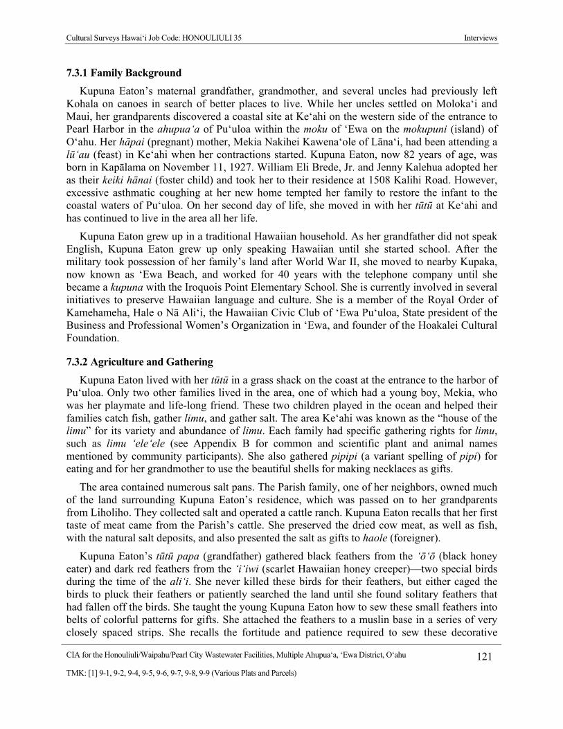
Cultural Surveys Hawai‘i Job Code: HONOULIULI 35 Interviews
CIA for the Honouliuli/Waipahu/Pearl City Wastewater Facilities, Multiple Ahupua‘a, ‘Ewa District, O‘ahu 121
TMK: [1] 9-1, 9-2, 9-4, 9-5, 9-6, 9-7, 9-8, 9-9 (Various Plats and Parcels)
7.3.1 Family Background
Kupuna Eaton’s maternal grandfather, grandmother, and several uncles had previously left Kohala on canoes in search of better places to live. While her uncles settled on Moloka‘i and Maui, her grandparents discovered a coastal site at Ke‘ahi on the western side of the entrance to Pearl Harbor in the ahupua‘a of Pu‘uloa within the moku of ‘Ewa on the mokupuni (island) of O‘ahu. Her hāpai (pregnant) mother, Mekia Nakihei Kawena‘ole of Lāna‘i, had been attending a lū‘au (feast) in Ke‘ahi when her contractions started. Kupuna Eaton, now 82 years of age, was born in Kapālama on November 11, 1927. William Eli Brede, Jr. and Jenny Kalehua adopted her as their keiki hānai (foster child) and took her to their residence at 1508 Kalihi Road. However, excessive asthmatic coughing at her new home tempted her family to restore the infant to the coastal waters of Pu‘uloa. On her second day of life, she moved in with her tūtū at Ke‘ahi and has continued to live in the area all her life.
Kupuna Eaton grew up in a traditional Hawaiian household. As her grandfather did not speak English, Kupuna Eaton grew up only speaking Hawaiian until she started school. After the military took possession of her family’s land after World War II, she moved to nearby Kupaka, now known as ‘Ewa Beach, and worked for 40 years with the telephone company until she became a kupuna with the Iroquois Point Elementary School. She is currently involved in several initiatives to preserve Hawaiian language and culture. She is a member of the Royal Order of Kamehameha, Hale o Nā Ali‘i, the Hawaiian Civic Club of ‘Ewa Pu‘uloa, State president of the Business and Professional Women’s Organization in ‘Ewa, and founder of the Hoakalei Cultural Foundation.
7.3.2 Agriculture and Gathering
Kupuna Eaton lived with her tūtū in a grass shack on the coast at the entrance to the harbor of Pu‘uloa. Only two other families lived in the area, one of which had a young boy, Mekia, who was her playmate and life-long friend. These two children played in the ocean and helped their families catch fish, gather limu, and gather salt. The area Ke‘ahi was known as the “house of the limu” for its variety and abundance of limu. Each family had specific gathering rights for limu, such as limu ‘ele‘ele (see Appendix B for common and scientific plant and animal names mentioned by community participants). She also gathered pipipi (a variant spelling of pipi) for eating and for her grandmother to use the beautiful shells for making necklaces as gifts.
The area contained numerous salt pans. The Parish family, one of her neighbors, owned much of the land surrounding Kupuna Eaton’s residence, which was passed on to her grandparents from Liholiho. They collected salt and operated a cattle ranch. Kupuna Eaton recalls that her first taste of meat came from the Parish’s cattle. She preserved the dried cow meat, as well as fish, with the natural salt deposits, and also presented the salt as gifts to haole (foreigner).
Kupuna Eaton’s tūtū papa (grandfather) gathered black feathers from the ‘ō‘ō (black honey eater) and dark red feathers from the ‘i‘iwi (scarlet Hawaiian honey creeper)—two special birds during the time of the ali‘i. She never killed these birds for their feathers, but either caged the birds to pluck their feathers or patiently searched the land until she found solitary feathers that had fallen off the birds. She taught the young Kupuna Eaton how to sew these small feathers into belts of colorful patterns for gifts. She attached the feathers to a muslin base in a series of very closely spaced strips. She recalls the fortitude and patience required to sew these decorative

Cultural Surveys Hawai‘i Job Code: HONOULIULI 35 Interviews
CIA for the Honouliuli/Waipahu/Pearl City Wastewater Facilities, Multiple Ahupua‘a, ‘Ewa District, O‘ahu 122
TMK: [1] 9-1, 9-2, 9-4, 9-5, 9-6, 9-7, 9-8, 9-9 (Various Plats and Parcels)
patterns. Sewing for half a day resulted in a single strip of feathers about 1.5 inches wide. To complete one belt took several years of diligent work. She shows several perfectly preserved decorative feather belts that she made in her childhood in the 1930s (Figure 37).
Kupuna Eaton remembers that her tūtū papa, a lawai‘a (fisherman), built a two-man canoe and paddled it with her to Duke Kahanamoku’s residence in Kou (Waikīkī) and into the lochs of Pu‘uloa to trade their fish, limu, pipipi, salt, and bird feathers for other food items. She also walked as far as the lighthouse on Kalaeloa (Barber’s Point) to share their food. Her family exchanged their marine resources for taro and poi from the vast lo‘i kalo of the mauka regions of Pu‘uloa.
7.3.3 Freshwater and Marine Resources
The ‘Ewa side of Pu‘uloa contains freshwater springs and loko wai (fresh water ponds) but no rivers. The growth of limu on the coast signaled the presence of small sources of brackish water to Kupuna Eaton. As a young girl, she gathered water that seeped out of the ground with gourds, boiled the water, and then buried the containers deep in the sand so that the underground movement of ocean water would keep the water cold. In addition, the area contained some coconut trees and the fallen coconuts offered sweet juice.
Kupuna Eaton especially enjoyed catching he‘e (squid). Rather than using the traditional cowry shell-baited octopus lure, she lured the he‘e by shaking a cowry shell with her hand. She allowed the octopus’ tentacles to wrap around her arms. Once the body was within her grasp, she quickly and deftly ripped out its single pincer to avoid harm. She still has scars on her hands to show her mistakes of avoiding the sharp teeth. Sometimes she would catch a he‘e with each arm and walk ashore with their tentacles wrapped around her arms while continuing to gather limu. Rather than being frightened, she enjoyed the massages she received from the he‘e. On shore a touch of salt released the grasp of the he‘e.
Kupuna Eaton shares a story from her childhood that centers on the ae‘o (Hawaiian stilt bird) of the wetlands:
My grandparents would punish me, but their way of punishing me was not hitting me at all. They would say to me, “You’re not to go in the kai.” Of course, even one day is like the end of the world. Maybe one week I couldn’t go into the water. And it’s only 25 to 30 minutes away from the water. So the next best place is to go into the loko wai, where the wetlands are. I called my friend to go over there. But he’s kolohe [mischievious]. He teases the ae‘o stilt birds. He can go because he has short hair and he teases them and runs. But when I turn around to run, I have braids and the ae‘o would grab my hair.
7.3.4 Wahi Pana of Hoakalei
Kupuna Eaton noted that a woman named Hi‘iaka swam in a pond in Honouliuli Ahupua‘a and saw her reflection. Her response to the splendor of her reflected image, “Hoakalei” (lei reflection), served to name the pond.

Cultural Surveys Hawai‘i Job Code: HONOULIULI 35 Interviews
CIA for the Honouliuli/Waipahu/Pearl City Wastewater Facilities, Multiple Ahupua‘a, ‘Ewa District, O‘ahu 123
TMK: [1] 9-1, 9-2, 9-4, 9-5, 9-6, 9-7, 9-8, 9-9 (Various Plats and Parcels)
7.3.5 World War II
On the morning of December 7, 1941, Kupuna Eaton and her family watched the start of the attack on Pearl Harbor. They moved to a coral cove near their house and observed the ensuing battle:
When World War II broke out, we were out fishing early in the morning. You know, you could hear the planes. I said to my grandfather, “I wonder what’s going on?” So he went to look outside because we used to take care of the ranch outside. All the paniolo [cowboys] outside were talking. I wasn’t supposed to be listening, but I could hear my grandfather say to them to take care of the animals then go in the cave. There were different caves. I was in one with my grandfather and my tūtū was in another cave with the men. We were watching the thing that was going on. It was only later we found out what was happening. We didn’t have a ka‘a [car].
As the war progressed, the military escorted Kupuna Eaton to her school in Kalihi. She soon discovered that her Japanese friend, Fusae, was not attending school. She (Fusae) and her family had been placed in a detention camp. Kupuna Eaton’s father walked near the camp to obtain fresh water from an artesian well and spoke to the Japanese prisoners with his daughter by his side:
I ran up to her and then she came to me. Even when I talk about it now… I asked her, “Fusae, what are you doing here?” And we hugged each other. Then I realized that my dad told me that we were at war with the Japanese. I always thought [she] was Hawaiian because she’s like me. But my Daddy said they put her in with her mother and the rest of them. The Japanese stuck them over in the prison. I don’t how he did it, but my dad got them out. But she had changed, wasn’t so close to me anymore.
7.3.6 Ka‘ōnohi and Kalauao
Kupuna Eaton distinguishes between Ka‘ōnohi and Kalauao. She describes Kalauao as the name of a stream and Ka‘ōnohi as the name of a chief from Moloka‘i who first dredged the waters of Pu‘uloa.
7.3.7 Mo‘olelo of Ka‘ahupāhau and ‘Aumākua of Pu‘uloa
Kupuna Eaton recalls a mo‘olelo about Ka‘ahupāhau, the shark goddess of Pu‘uloa. According to the legend, she and her brother entered a cave while playing, and a shark took them and transformed them into sharks. Their parents called out to them from the shore, and one day saw two small sharks—their children. Kupuna Eaton shares a gripping story of riding the sharks of Pu‘uloa. While paddling, her grandfather talked and chanted to the sharks in Hawaiian. As they became more docile and approached the canoe, he ventured to ride them. One time he brought his granddaughter, the young Kupuna Eaton, with him. She recalls that the roughness of the shark’s skin enabled her to ride the shark:
Cultural Surveys Hawai‘i Job Code: HONOULIULI 35 Interviews
CIA for the Honouliuli/Waipahu/Pearl City Wastewater Facilities, Multiple Ahupua‘a, ‘Ewa District, O‘ahu 124
TMK: [1] 9-1, 9-2, 9-4, 9-5, 9-6, 9-7, 9-8, 9-9 (Various Plats and Parcels)
I’ve ridden that thing. My tūtū used to ride that, the shark. When I tell them, people don’t believe me. I feel close to Ka‘ahu Pahau. My tūtū would get on the sharks, on the back. It is not easy riding those sharks, you can get cut with the skin. There were certain ones that would come up, and he would call them, hit the side of the canoe, feed them, talk to them in Hawaiian, and pretty soon he would jump over and ride away. They understand what he was saying. I never tried on my own for the simple reason that you cannot just do it if you don’t know the oli, and it must be done right. As time went on I did get to know the oli, but by that time, it was like God saying, it is not your time. So I stopped.
7.3.8 Mo‘olelo of Hāpu‘u Tree Fern
In a previous CSH interview, Kupuna Eaton shared a mo‘olelo of the hāpu‘u (Figure 38) tree fern:
My mo‘opuna (grandchild) called me. She teaches and is going to graduate from UH this year. Her brother Makana needed a story about hāpu‘u for a project.
“Why didn’t you go library?”
“We looked, nothing.”
I gave her a story about my Tūtū when she was young about hāpu‘u. This boy took it down and took it to kula [school] and he got an A+. People don’t understand that this area we had all this hāpu‘u. We had all these different kinds of plants that people never thought of. They think it’s too dry. My Tūtū was born and raised here. She never left this area. Not even to go on a canoe or anywhere else. She stayed here. I remember her telling me, it was raining. The wetlands were a forest. She had gone to get kalo [taro]. Then it started pouring. She saw the hāpu‘u. She imagined it to be big enough for her to get under but she realized “Auwē [oh no]! I can’t go under here, the rain will come through!” It was too rainy for her to get home and the only thing there was the hāpu‘u. Pretty soon she oli [chant] and kāhea [to call out] and asked for a place she could go under. One hāpu‘u opened its branches and another one opened over the little one and it covered right over her just like an umbrella. It rained and she sat under there. It was all pau [finished]; she was ready to go home. She went like that [motions hugging the hāpu‘u]. When she got home, my great grandmother said to her, “How come you not wet?” She said, “I gotta tell you something!” She said the story all over again. She said she’d never forget.
I told my mo‘opuna he could add anything he wanted but don’t exaggerate but what I said was the truth. It’s such a small little thing, but imagine what had been in the forest. (Cruz and Hammatt 2008)

Cultural Surveys Hawai‘i Job Code: HONOULIULI 35 Interviews
CIA for the Honouliuli/Waipahu/Pearl City Wastewater Facilities, Multiple Ahupua‘a, ‘Ewa District, O‘ahu 125
TMK: [1] 9-1, 9-2, 9-4, 9-5, 9-6, 9-7, 9-8, 9-9 (Various Plats and Parcels)
Figure 36. Arlene Eaton (CSH April 12, 2010)
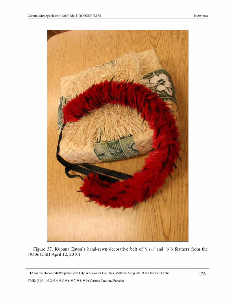
Cultural Surveys Hawai‘i Job Code: HONOULIULI 35 Interviews
CIA for the Honouliuli/Waipahu/Pearl City Wastewater Facilities, Multiple Ahupua‘a, ‘Ewa District, O‘ahu 126
TMK: [1] 9-1, 9-2, 9-4, 9-5, 9-6, 9-7, 9-8, 9-9 (Various Plats and Parcels)
Figure 37. Kupuna Eaton’s hand-sewn decorative belt of ‘i‘iwi and ‘ō‘ō feathers from the 1930s (CSH April 12, 2010)
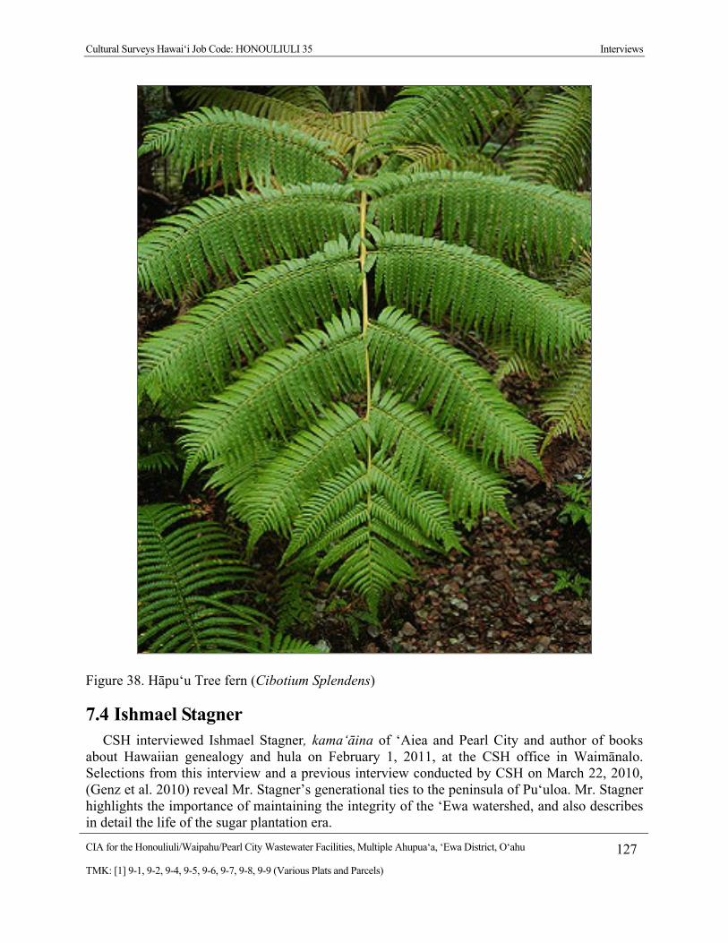
Cultural Surveys Hawai‘i Job Code: HONOULIULI 35 Interviews
CIA for the Honouliuli/Waipahu/Pearl City Wastewater Facilities, Multiple Ahupua‘a, ‘Ewa District, O‘ahu 127
TMK: [1] 9-1, 9-2, 9-4, 9-5, 9-6, 9-7, 9-8, 9-9 (Various Plats and Parcels)
Figure 38. Hāpu‘u Tree fern (Cibotium Splendens)
7.4 Ishmael Stagner CSH interviewed Ishmael Stagner, kama‘āina of ‘Aiea and Pearl City and author of books
about Hawaiian genealogy and hula on February 1, 2011, at the CSH office in Waimānalo. Selections from this interview and a previous interview conducted by CSH on March 22, 2010, (Genz et al. 2010) reveal Mr. Stagner’s generational ties to the peninsula of Pu‘uloa. Mr. Stagner highlights the importance of maintaining the integrity of the ‘Ewa watershed, and also describes in detail the life of the sugar plantation era.
Cultural Surveys Hawai‘i Job Code: HONOULIULI 35 Interviews
CIA for the Honouliuli/Waipahu/Pearl City Wastewater Facilities, Multiple Ahupua‘a, ‘Ewa District, O‘ahu 128
TMK: [1] 9-1, 9-2, 9-4, 9-5, 9-6, 9-7, 9-8, 9-9 (Various Plats and Parcels)
7.4.1 Family Background
Dr. Stagner, now 72 years old, was born to Ishmael Worth Stagner, Sr. and Pansy Akona Ka‘ula in Wahiawa in 1939. He was raised in Pearl City where his family had a home since 1935 until they moved to Hālawa Heights in ‘Aiea in 1950. In his youth prior to entering Kamehameha Schools, Dr. Stagner learned about the history and culture of Pu‘uloa, O‘ahu, and the other Hawaiian Islands through several kūpuna, including Sarah Nakoa, who was a writer of cultural traditions for KS, and Alice Kamokila Campbell.
7.4.2 ‘Ewa Watershed
The single most important feature of ‘Ewa, according to Dr. Stagner, is its watershed. This fact is highlighted by the naming of the ahupua‘a with the term wai, including Waiawa, Waiao, Waikele, and Waipahu. Mirroring the ahupua‘a boundaries, water flows from the Ko‘olau mountains down to the waters of Pu‘uloa throughout a network of streams and an underwater system of tunnels. These contribute heavily to the Hālawa Aquifer, which now supplies the majority of the drinking water for the island of O‘ahu.
Sugar cane was grown on the lands of Pu‘uloa mauka of the present-day Kamehameha Highway. The upland streams were channeled to nourish the sugar cane. In 1957, the O‘ahu Sugar Company began to clear the upper sugar fields in Mānana, severely disturbing the ground cover. Harsh rains in 1958 caused severe flooding, as there was no more upland vegetation to absorb the overflowing streams and excessive rainfall. Fast water flowing down Waiawa Stream caused the drowning of several people in Pearl City.
Makai of the present-day Kamehameha Highway was a floodplain that had formerly been dense with taro fields and rice paddies, and eventually watercress ponds. Dr. Stagner highlights the fact that each region had its own special variety of taro. With over 300 kinds of taro throughout the Islands, the freshwater taro of Pu‘uloa was particularly productive. The Pu‘uloa variety yielded four crops each year, enough to supply taro for one-third of the island of O‘ahu. There were freshwater aquifer springs all over the region and mo‘o ‘aumakua guarded these tunnels of water.
The waters flowing down the streams and up through the aquifers eventually entered Pu‘uloa. Loko i‘a once occupied the intersection of land and sea. Small fish would enter these nutrient-rich waters, feed, and become too big to escape through the narrow channels. Hawaiians used to catch and feast on these fish.
Prior to Dillingham’s dredging at the beginning of the twentieth century and the Navy’s later occupation of Pearl Harbor, the channel to Pearl Harbor was narrow, and this restricted the movement of ocean water into the freshwater basin. Dr. Stagner’s earliest recollections of his childhood life on the peninsula center on swimming and paddling canoes in the mostly fresh water. In fact, several people that grew up swimming in the Pu‘uloa went on to compete in the Olympics. Dr. Stagner explains that one of the residents of the Pearl City peninsula, Clarence “Buster” Crabbe, won the 1928 Olympics by swimming faster than Johnny Weissmuller and Duke Kahanamoku. In addition, Dr. Stagner is aware of chants that describe how Queen Lili‘uōkalani and King Kalākaua swam in Pu‘uloa. In his youth he also hunted crabs and harvested clams in the wai momi, or the “pearl waters,” that was a rich resource of pearls. According to Dr. Stagner, these waters were guarded by the shark ‘aumakua Ka‘ahupāhau.

Cultural Surveys Hawai‘i Job Code: HONOULIULI 35 Interviews
CIA for the Honouliuli/Waipahu/Pearl City Wastewater Facilities, Multiple Ahupua‘a, ‘Ewa District, O‘ahu 129
TMK: [1] 9-1, 9-2, 9-4, 9-5, 9-6, 9-7, 9-8, 9-9 (Various Plats and Parcels)
In a previous interview (Golin et al. 2007), Dr. Stagner depicts how the waters of Pu‘uloa envelop Moku‘ume‘ume, the “island of attraction/strife,” now commonly referred to as Ford Island. The term ‘ume ‘ume refers to a partner-swapping game played by maka‘āinana. Couples who were childless would go to the island and play the game during the full moon—switching possibly infertile partners for potentially fertile ones in hopes of becoming pregnant.
7.4.3 World War II
Dr. Stagner was only two and a half years old at the time of the attack on Pearl Harbor on December 7, 1941. Years later as a young child, Dr. Stagner began to stutter and the family physician hypnotized him to determine whether his stuttering was psychological in nature. Indeed, Dr. Stagner had experienced and remembered a traumatic event. The hypnosis brought him back to the morning of December 7, 1941, and the young Dr. Stagner recalled dramatic images of the battle that had ensued, especially the sights of the torpedo planes, which had to fly very low and slow to drop their heavy loads. The military had blocked the only road leaving the peninsula, so Dr. Stagner and his family could not leave until later in the afternoon. That evening, they were placed in the social hall of the Waipahu Sugar Mill.
7.4.4 Sugar Plantation and Baseball
“The plantations were the fabric of life until the 1960s,” according to Dr. Stagner. In particular, he draws out a connection between the growth of American baseball and the sugar plantations on O‘ahu. He states that “One of the things I don’t think anybody understands is that without the plantation system in Hawai‘i, we would never had American baseball as we know it today.” In 1849, Alexander Cartwright, who is credited with inventing the modern game of baseball, came to Honolulu en route to California to search for gold. Mr. Cartwright stayed on O‘ahu to start several businesses and served as the fire chief on Honolulu. Significantly, he also introduced baseball to the sugar plantation communities, which gave the workers something to do so as to not fight amongst themselves. Competitive leagues quickly formed along ethnic lines, with Hawaiian, Japanese, Filipino, Chinese, Portuguese, and haole teams. Dr. Stagner did not work in the plantations himself, but he played for the Rural Redsocks in Pearl City and became envious of the workers’ growing collective enthusiasm for baseball. Each plantation camp constructed its own baseball field, which became one of the central arenas for social interaction. Island-wide games were held, and several local plantation teams integrated their ethnicities to strive toward the championship game. Each plantation community, such as the ‘Aiea Sugar Mill, recruited their nine best players to form a strong multiethnic team. A strong interest in baseball arose from these plantation teams, such that the best leagues today on O‘ahu are descendents from the former plantation communities in the ‘Ewa plain. Dr. Stagner makes another connection between the plantation baseball and the Japanese internment camps of World War II:
What makes this even more interesting is when we had World War II and we sent our island Japanese over to internment camps, one of the ways they were allowed to recreate was by playing baseball in the camps. Later on, many of them joined the military. They are still playing baseball and become forces of occupation in Japan. So there were Japanese-Americans playing baseball in Japan, and they recruit Japanese players. Now you have an entire generation of Japanese playing the American major leagues who are the direct descendents of those Japanese who
Cultural Surveys Hawai‘i Job Code: HONOULIULI 35 Interviews
CIA for the Honouliuli/Waipahu/Pearl City Wastewater Facilities, Multiple Ahupua‘a, ‘Ewa District, O‘ahu 130
TMK: [1] 9-1, 9-2, 9-4, 9-5, 9-6, 9-7, 9-8, 9-9 (Various Plats and Parcels)
went over as American soldiers whose grandparents played baseball for the Hawai‘i plantations.
7.4.5 Mo‘olelo of Po‘o Hilo
Dr. Stagner shared several mo‘olelo, including a description of night marchers. The district is famous for night marchers, Dr. Stagner commented, referring to the belief that following the lunar calendar, on certain nights (the nights of the gods—Kū, Akua, Lono, Kāne and Kanaloa) a procession of ghosts known as huaka‘i pō or pō kāne (night marchers) can be seen and heard as they travel to familiar places they once frequented when they were alive. Long before the mass deaths from the epidemic of the influenza epidemic of the 1920s, and the WWII attack on Pearl Harbor, a major battle fought in the 1500s led to legions of night marchers in the Pearl Harbor region. He told the story of Po‘o Hilo (Hilo’s Head) about a chief, who came from Maui to conquer O‘ahu. A resistant force awaited the chief at East Loch and overcame his forces, decapitating the chief’s head and urinating on the head of their adversary. Hilo’s head was placed on a staff for all to see as a cautionary message to any potential conquerors. The area remained untouched until the 1700s when Kamehameha came and took over Pearl Harbor.
7.4.6 Mo‘olelo of Ma‘ilikukahi
Dr. Stagner also shares the story of the sixteenth century chief Ma‘ilikūkahi from the ‘Ewa plain. He decides to develop O‘ahu into seven self-sustaining moku along with the smaller ahupua‘a subdivisions. The idea was that anyone coming to O‘ahu to invade would be defeated because the armies from each moku could defend the entire island. Dr. Stagner clarifies that the armies mainly defended their water. Dr. Stagner stresses that O‘ahu has the greatest amount of underwater reserves of all the Hawaiian Islands.
7.4.7 Cultural Properties
In his youth, Dr. Stagner hiked in the mauka regions in ‘Ewa with his Boy Scout troop, and discovered several petroglyphs and heiau. Dr. Stagner explained that there had been an influenza epidemic in the 1920s and many Hawaiians were buried in the area that was abandoned and eventually taken over by the ‘Aiea Sugar Mill. Many of the plantation workers moved rocks, not knowing the cultural significance of the rocks that could have been associated with Hawaiian burials or other cultural sites.
7.4.8 Concerns and Recommendations
Dr. Stagner’s main concern is the management of the ‘Ewa watershed. The kūpuna from his youth told him that the upland regions must be conserved in order to prevent excessive runoff and lowland flooding. Historically, surplus water was channeled toward the ‘Ewa plain. Dr. Stagner advocates protecting agricultural and conservation lands of Waiawa in particular, as they are the most vulnerable to future development. In other regions in ‘Ewa, there are already documented cases of lowland flooding during times of heavy rains due to inadequate drainage of the water. Dr. Stagner draws upon the historic flood of 1958, which occurred after the sugar cane was cleared, to highlight that the disturbed ground cover prevented adequate absorption of the overflowing streams and excessive rainfall. Similarly, recent floods in the more developed
Cultural Surveys Hawai‘i Job Code: HONOULIULI 35 Interviews
CIA for the Honouliuli/Waipahu/Pearl City Wastewater Facilities, Multiple Ahupua‘a, ‘Ewa District, O‘ahu 131
TMK: [1] 9-1, 9-2, 9-4, 9-5, 9-6, 9-7, 9-8, 9-9 (Various Plats and Parcels)
regions, such as the Palisades, have occurred due to heavy urbanization with inadequate drainage. Hence, the mauka regions of Waiawa and neighboring ahupua‘a must not be developed and the highland streams must be regularly cleared and maintained to prevent future lowland flooding.
7.5 Tin Hu Young and Helen Kealiiwahineulawenaokola He‘eia Colburn
CSH met with Tin Hu Young and his wife, Helen Kealiiwahineulawenaokola He‘eia Colburn (Figure 39), on January 26, 2011, at their home in Waiawa near the shores of Pu‘uloa. In addition, CSH previously interviewed Mr. Young at the Kawaiaha‘o Church on January 6, 2010 (Genz et al. 2010). Selections from these two interview transcripts reveal Mr. Young’s generational ties to the area and the deep history of Waiawa and the waters of Pu‘uloa.
7.5.1 Family Background
Mr. Young was born in 1927 and has lived his entire life in Waiawa near the shores of Pu‘uloa. Mr. Young traces his family background through two distinct ancestral lines of descent—his mother’s Hawaiian and Portuguese ancestry and his father’s Chinese ancestry. Mr. Young’s Chinese background has been chronicled for 24 generations by tracing the generations from father to son. Two generations ago within this familial timeline, Mr. Young’s grandfather, Young See Hop, migrated to Hawai‘i from China. Despite this deep family history, Mr. Young calls attention to his Hawaiian heritage.
Mr. Young’s mother was Elizabeth Kahiku Johnson. She was the daughter of Pedro Manini Johnson (born about 1871 and died May 28, 1925) and Pa‘ahana (born about 1860 and died 1927). Pedro Johnson—Mr. Young’s maternal grandfather—worked as a cowboy with the O‘ahu Railway and Land Company for his brother—Mr. Young’s granduncle—Johnny Johnson, who was a ranch foreman for the Dillingham family. Another brother, Enoka Johnson (born May 3, 1857) served as secretary to Prince Jonah Kūhiō Kalanianaole. Their parents were Ambrose Johnson (born about 1832) and La‘amaikahiki Wahine (born about 1834), who was born in Mānoa Valley.
The La‘amaikahiki family traces their lineage to the first settlers that landed on the shores of Pu‘uloa. Today, Mr. Young continues to reside at this location at the mouth of the Waiawa River, which is also referred to as the Pearl River. Mr. Young elaborates on the connections between La‘amaikahiki and Kamehameha, and the family’s land at the mouth of the Pearl River:
The interesting thing about all this is on my mom’s father’s side, my grandfather’s mom was La‘amaikahiki Wahine. And her family actually lived at the mouth of the Waiawa River here, right here in Pearl Harbor, Pu‘uloa.
Well here, this land here belonged to my side of the family, through the La‘amaikahiki. As you know, he was one of the earlier settlers in Hawai‘i. La‘amaikahiki, that is where he landed. One of his four wives is from here. That’s us, our family. The original migration, right here at the mouth of the river. That’s also the area where the Colburns settled, the descendents of Don Francisco Marin.
Cultural Surveys Hawai‘i Job Code: HONOULIULI 35 Interviews
CIA for the Honouliuli/Waipahu/Pearl City Wastewater Facilities, Multiple Ahupua‘a, ‘Ewa District, O‘ahu 132
TMK: [1] 9-1, 9-2, 9-4, 9-5, 9-6, 9-7, 9-8, 9-9 (Various Plats and Parcels)
My great-grandmother, La‘amaikahiki Wahine, was born in Mānoa Valley in about 1834 where Queen Ka‘ahumanu resided. Queen Ka‘ahumanu had died two years earlier. So La‘amaikahiki Wahine’s father, Timoteo La‘amaikahiki was considered like a kaukau ali‘i [class of chiefs of lesser rank than the high chief]. Kaukau ali‘i was the ones you captured. That side of the family lived at the mouth of the Waiawa River and that’s the area where the Colburn family occupied. John Colburn, who was the Secretary of Interior for Queen Lili‘uokalani, resided nearby. That particular spot was next to Pāu‘au‘au, a sacred pond. Our family originally lived there and Kūkaniloko [on the Big Island], where the sacred heiau was located. So when Kamehameha invaded our lands of the family we became subjects of Kamehameha. The family really dispersed and went into hiding. Then Kamehameha died in 1819. Next, the missionaries came over after we went underground. We ended up supporting the missionaries through Ka‘ahumanu. She was the one that got the Hawaiian chiefs and herself to give up lands in Mānoa so that the missionaries could establish themselves in Hawai‘i. Through her, she did the same thing, Ka‘ahumanu did the same thing in Lāhainā for Lahainaluna High School.
Mr. Young continues to describe his family connections to Queen Ka‘ahumanu, the arrival of the missionaries, and the founding of the Kawaiaha‘o Church:
Part of my ‘ohana was Thomas Hopu that landed with the missionaries in Kawaiaha‘o, was told that the royal entourage was in Kailua-Kona probably where the Hulihe‘e Palace is now in Kona, might have been around the King Kamehameha Hotel in Kona. He went there to get an audience with the Queen Mother, or Queen Ka‘ahumanu, of course you know the story of Queen Ka‘ahumanu. She was just one of the wives of Kamehameha, but she was beautiful and strongest at that time. Although she couldn’t have children, she ended up taking care of Kamehameha’s two sons, Liholiho and Kauikeaouli. So, you know Hawaiians sometimes have this knack for, there’s this place for you in society. Look at Ka‘ahumanu, she was the favorite of Kamehameha, was kept kapu at a young age at 13 on for Kamehameha to become his wife, yet he was smart enough to marry actually the enemies’ side, the highest ranking wahine [woman] to have his children. Of course he wanted them to be born at Kūkaniloko so they have this extra mana, from this special spot, but somehow they were never born there at Kūkaniloko. There is a lot of history connected here. When my Hawaiian side was dispersed and went into hiding somehow, they came out hiding when Kamehameha died and came under the protection of Ka‘ahumanu. And that was Timoteo La‘amaikahiki, he’s even listed as one of the early people who joined the Kawaiaha‘o Church. Of course at the top of that list was Ka‘ahumanu herself. She died in 1832 and Timoteo officially joined the church two years later. After that time it was just kaukau ali‘i, whatever she said and wanted him to do, he did it.
See when the missionaries landed at Kawaihae [Big Island] and went to see that Queen Ka‘ahumanu was there with the Queen Mother and other royalty, they
Cultural Surveys Hawai‘i Job Code: HONOULIULI 35 Interviews
CIA for the Honouliuli/Waipahu/Pearl City Wastewater Facilities, Multiple Ahupua‘a, ‘Ewa District, O‘ahu 133
TMK: [1] 9-1, 9-2, 9-4, 9-5, 9-6, 9-7, 9-8, 9-9 (Various Plats and Parcels)
went there to get permission for the missionaries to go to Honolulu to start preaching the gospel of Jesus Christ. Of course, they are from the Calvinist line, they were Protestants. At that time, there Protestants of many different sects. So John Calvin out of England went to Holland but couldn’t settle there and ended up coming in to Plymouth Rock, so those people there were the ones who started America. A lot of people don’t realize these same families that started America at Plymouth Rock were part of the same family that came over to Hawai‘i to spread the gospel of Jesus Christ. So we really have deep ties to way back. When they sent Thomas Hopu to Kawaihae to get the attention of the queen, he was taking a chance. They could have killed him. Who was he, right? But he did get to speak to Ka‘ahumanu but she didn’t know what they were up to. Ka‘ahumanu was a beautiful woman. In ancient Hawai‘i, big was beautiful and she was big. But not only that, she was strong too. She could surf, very athletic. She was beautiful not only physically but mentally too. She knew what to do. She was very skeptical about the missionaries. So she told them you can stay on the Big Island for one year, to see what you guys are up to. So when she got to learn about the gospel and Jesus Christ and so forth, she really, pardon the expression, saw the light. ‘Cause you got to remember at that time the wars of Kamehameha was over, the place was in chaos. The people’s heiau was desecrated. The people needed a new religion. And the funny thing was their kahuna were told they would get one way ahead before the missionaries came. Then Hiram Bingham landed with all these young missionaries who had to get married before they came on this trip because they had to be serious about spreading the gospel of Jesus Christ. So prior to that, during the wars of Kamehameha, Henry Opukaia had lost his mother and father during the wars of Kamehameha so his uncle was one of the kāhuna of the heiau and he was just a teenager and he had asked his uncle if he could start a new life somewhere else. So he somehow got onboard an American vessel that probably went to China and ended up in Boston. Thomas Hopu came from this area too. This land, in the back here, where we live right now, is part of that Hau‘upu land. See, his name was really from the Hau‘upu family, but the missionaries wrote it HOOPOO cause they didn’t know the correct pronunciation, but it really Hau‘upu and that ended up Hopu.
Mr. Young describes his wife’s family’s connections to Kamehameha:
Of course in the past that whole area was taken over by Kamehameha, you know, and also amazingly by my wife’s side through the Marin family. Don Francisco Marin was originally a Spanish trained cadet in the Navy and ended up in Hawai‘i with a ship of his own, and he became allied with Kamehameha since he had such good knowledge of warfare and especially how to use firearms. The key to all that was keeping the gun powder dry and of course the Hawaiian way with grass huts and thatch roofs wasn’t good enough to store gun powder, so he had men who were expert in masonry. In a way, he and his son eventually even had a decision in using the type of material that would be used in constructing Kawaiaha‘o Church, using coral as the base material to construct a large building. When they
Cultural Surveys Hawai‘i Job Code: HONOULIULI 35 Interviews
CIA for the Honouliuli/Waipahu/Pearl City Wastewater Facilities, Multiple Ahupua‘a, ‘Ewa District, O‘ahu 134
TMK: [1] 9-1, 9-2, 9-4, 9-5, 9-6, 9-7, 9-8, 9-9 (Various Plats and Parcels)
used sailing vessels, it wasn’t practical to ship bricks here to Hawai‘i and even lumber was costly, you couldn’t do that too much.
Going back to the Spanish Don Francisco Marin that my wife is related to, his eldest child was Maria Cruz and Mr. Marin was a very good family man that kept very good records of his children. Of course, he was a Catholic. His first daughter Maria Cruz married a ship’s captain by the name of Maughan, sounded like that pirateer Morgan, but it is actually spelled MAUGHAN, that kind of Maughan. They had two children, a boy and a girl, I forgot what the boy’s name was, the girl’s was Elizabeth. She married a Colburn, and that is where the Colburn side comes in, my wife is a Colburn. Of course when Don Francisco Marin was allied with Kamehameha at the time Kamehameha was consolidating the islands into one kingdom, Kamehameha assigned Don Marin all this area of Pu‘uloa, Pearl Harbor, Waiawa, Waikele, Mānana, Kalauao, all the way to Hālawa. All this area here.
7.5.2 Marine and Freshwater Resources
Mr. Young speaks of the intense productivity of the marine and freshwater resources in and near Pu‘uloa:
Before that if you read excerpts from Kamakau and other writers, this particular area here, La‘amaikahiki was from Tahiti and had a Tahiti connection, so the people of this area would always thank our patron saint, wahine from Tahiti, for their wealth. In fact this was a breadbasket in the ancient times. It had fish, crab, oysters, clam, it had everything. It was a rich area to live, you would never starve. I can remember my mom saying when she got the place on the Big Island she noticed how harsh the people had to live there with the lava flows and no running streams. They had to plant dryland taro. Over here they had wetland taro, which was ‘ono [delicious]. It’s like that the good tasting poi going to Hanalei, fresh water.
Of course at that time Hawaiians had developed pearls in Pearl Harbor, what was growing naturally. The Hawaiian pearl was a source of income and although the pearls weren’t as well cultivated they were colorful and a little smaller though.
But, the real wealth of this place here, Pu‘uloa, was because, this whole area that surrounds Pearl Harbor, they are called like Waipahu, Waikele, Waiawa, Waiau, tells you that the source of water here is great. Everything pours into Pearl Harbor. According to old Hawaiian legends and stories, in reality Hawaiians considered waiwai [wealth], water is wealth, not oil, not gold, not silver, but water was the wealth of our place here, in Waiawa. Although Waiwa might refer to the water, the ‘awa that’s growing up in the mountains. And with the water source, Waipahu might be related to the pounding of the water like the drum, you know, so that’s the wealth here, the water.

Cultural Surveys Hawai‘i Job Code: HONOULIULI 35 Interviews
CIA for the Honouliuli/Waipahu/Pearl City Wastewater Facilities, Multiple Ahupua‘a, ‘Ewa District, O‘ahu 135
TMK: [1] 9-1, 9-2, 9-4, 9-5, 9-6, 9-7, 9-8, 9-9 (Various Plats and Parcels)
In a previously recorded interview, Mr. Young elaborates on the meaning of Waiawa, the cultural salience of ‘awa, and the imagery of flowing water that the ‘awa roots evoke for him:
In fact, the name ‘Waiawa’ means water and ‘awa. You know the meaning of ‘awa? ‘Awa is that kava kava root that you drink, Hawaiians call it ‘awa. I kind of didn’t like the idea they called it ‘bitter water.’ Because ‘awa is a little bitter when you drink it, so Waiawa—Waiawa Valley was an area known in the ancient days of harvesting ‘awa root. It was a ceremonial drink that they had. Of course in the old days only the royalty used that root, until later on, and then the commoners would use it. Then you could sell it in the market and go buy it, like other things. So, Waiawa was a source of that. But, I like to think that the meaning of ‘bitter water’ for the name Waiawa, to me, could come from—because the area is the farther lot, the bottom on the lowland, mauka of Pearl Harbor. And when I used to watch the water, the rivulets would come twisting and turning like little ‘awa roots, twisted. If you ever harvest that ‘awa root, you got to see, it’s like a big root coral. It’s all tangled into each other. And it reminds me, when it flooded down in the lowland, all these little rivulets, twisting and turning, like the ‘awa root. But it’s just my romantic—it’s just because I live there. I don’t want them to say, Eh you live in bitter water? But, we do have good drinking water if you drill a well at the proper depth. All these little ‘āpana [land section], like Waiawa, Waikele, Waiau, Mānana, Hālawa, Kalauao—you know, they all have spring water, some natural. But if you dig too deep, you hit the salty water. And if you dig too shallow, you don’t get enough pressure. They like to dig their well deeper to get more pressure, but when you do that, you let more salt get into your water system. But there’s good water there.
In a previous interview, Mr. Young detailed the significance of the waters of Pu‘uloa to the ancient history of the settling of O‘ahu:
The reason why we chose that title for Arlene Ching’s, The Pathway to Mānana, the Pathway to Pearl City, was the fact that in the ancient days when the Hawaiians settled on O‘ahu, one of the pathways was through Pu‘uloa, Pearl Harbor. That was the perfect place for the canoes to come in. And later on, the sailing vessels came in, and then that lead to the Pearl Harbor we know today.
Pearl City proper, where Lehua Avenue runs down to the peninsula, in the very old days that wasn’t considered a very good place to live. Why? ‘Cause there was no springs around there. They wanted to live in this kind of area like Waiawa with all the springs. Even up to today, all these houses up here makai of the Gardens have their own wells. They still relying on the old springs.
Prior to the taro patches, most of this land all the way from Waipahu High School down to the peninsula where the Colburns lived, was actually a giant fishpond, two fishponds in one.
Cultural Surveys Hawai‘i Job Code: HONOULIULI 35 Interviews
CIA for the Honouliuli/Waipahu/Pearl City Wastewater Facilities, Multiple Ahupua‘a, ‘Ewa District, O‘ahu 136
TMK: [1] 9-1, 9-2, 9-4, 9-5, 9-6, 9-7, 9-8, 9-9 (Various Plats and Parcels)
Mr. Young reminisces about fishing for mullet as a child. In doing so, he explains the ecology of mullet, which involves traveling from the ocean through the brackish waters of Pu‘uloa and upstream to the spring-fed taro patches:
You needed the ocean to flush the harbor out. We had a lot of fish like the mullet that were accustomed to the salty and brackish water. You have to have the mix of brackish water. Pearl Harbor was ideal. When we were kids it was almost the same as when I read some of the readings by Kamakau. He would say Pearl Harbor and this area was so rich that when the mullets went upstream, it wouldn’t be just one school, but [saying rapidly] school after school after school after school, like that. Then as a young boy [saying slowly] school after school after school. In other words, in the ancient days was constant, but when I was a kid not that constant, started to diminish. Today, lucky to ever see a school of mullet, right here in this river.
What we do when we kids, after school run down to the bridge, so much mullet going by all you have to do is jerk up and have a fish. Just jerk it, forget bait. That’s how good it was. In those days the river was clear. You don’t have these sewer lines. The mullet would come upstream when it was clear and come up to these areas cleared off. If this stream from this land went to this bridge, the mullet would come all the way up through the lock through west lock through the stream and into your little taro patch. And breed, even if no taro just swampy land, it was still okay ‘cause the water was coming from the stream. Then breed and go back out again, a constant replenishment of your fish. Guess what, the crabs get good eat. And when we were kids it was common to go out and get a gunny sack full of crabs. In the old days if you had one of these little streams running through your property, the guys at the top couldn’t put all this crap or stop it, has to let it down so your taro patch gets filled and the water goes back to Pearl Harbor.
7.5.3 Pearl City
Of course, when I grew in this area, like I told you originally, I was born in the peninsula area, the area bounded by Lanakile, Lehua Avenue today, in that particular area in 1927. I grew up there and when the war broke out, we didn’t move out right away until the Navy bought up all the property and moved downtown to the Makiki area. My mom also got property on the other islands, away from the target area, you know Pearl Harbor during the war. In fact from our place you could see the Oklahoma from where we lived. It wasn’t too far from, right across the street in our area there, was where Mr. Fuller, who was a good friend of FDR, Franklin Delano Roosevelt, so I think they were classmates at one time, knew each other well. He came down to Pearl City in 1934 and I can remember when we were young children we had to go out and gather flowers so when the President went by we sprinkle them on the road, garlands. And I remember Mr. Fuller down in Pearl City not too far from where we lived, and where Mrs. Guigni lived, and she was asked by Mr. Fuller to decorate his house to give it a Hawaiian feeling to make President Roosevelt welcome, so that’s what
Cultural Surveys Hawai‘i Job Code: HONOULIULI 35 Interviews
CIA for the Honouliuli/Waipahu/Pearl City Wastewater Facilities, Multiple Ahupua‘a, ‘Ewa District, O‘ahu 137
TMK: [1] 9-1, 9-2, 9-4, 9-5, 9-6, 9-7, 9-8, 9-9 (Various Plats and Parcels)
they did. Mrs. Guigni’s son, Henry, became sergeant-of-arms of the United States Congress. Of course he, for years he worked with Senator Inouye and we were childhood friends, good neighbors. We really enjoyed living down at the peninsula area, it was like a miniature suburb when I was a kid. A lot of the kids there, their families worked for the military or worked at Pearl Harbor, or other military installation on O‘ahu. My dad was a plumber, a pipe fitter really. He worked on the Navy ships, the Navy yard. My oldest brother also worked in the machine shop in the boat division.
7.5.4 World War II
Mr. Young describes how his life on the peninsula of Waiawa changed with World War II:
Prior to the war, somehow when we were kids there, we could ride the ferry from the peninsula to Ford Island. All the kids that lived there could do that with their fishing poles at the coal docks and all these other facilities they had there at Ford Island. That was prior to the war. When the war broke out, it was very strict, couldn’t do that. By that time we still had our place on the peninsula but my mom wanted to get away from the target area so we lived on Kewalo Street in Makiki, from there I went to Kamehameha School. But we still had our home on the peninsula, when the Navy bought everybody out, we had to go. But I remember when we got home after the December 7 bombing; there was so much shrapnel in our yard. We were so close to the battle site. Soon after the bombing, the military set up a camp at the Pearl City Tavern. They also had these big search lights set up at Pearl City Tavern looking for enemy aircrafts.
7.5.5 Agriculture
Mr. Young has seen tremendous land use changes in Waiawa. He notes that before he was born, the land mauka of Kamehameha Highway was heavily forested, but then it shifted to grazing land during his childhood and later to sugar cane. Farther makai, the lowland regions were used primarily for taro and rice cultivation. Mr. Young describes the cultivation of taro and rice on his family’s land near Pu‘uloa and the growing of sugar cane farther mauka:
Yeah, right behind me [is Hā‘upu land]. Yeah, and my cousin and aunt used to reside there. That part of the family resides now in San Diego. My family and I on this side, my dad and I have always taken care of this property. This is a flood zone, a flood zone area. When I was a kid, all this area was lowland for taro patches, all this area here. And later on when rice became profitable it was rice. And up on the hill was all sugar cane where Leeward College is.
Mr. Young describes an interesting connection between his wife’s family, who operated the sugar mill, and his father’s family, who grew the rice:
When I was a child it just switched over from taro to rice. My grandfather was actually was a rice grower, on my Chinese side. He was a rice grower in this particular area. My dad married my mom, who was from here, so they had a lot of

Cultural Surveys Hawai‘i Job Code: HONOULIULI 35 Interviews
CIA for the Honouliuli/Waipahu/Pearl City Wastewater Facilities, Multiple Ahupua‘a, ‘Ewa District, O‘ahu 138
TMK: [1] 9-1, 9-2, 9-4, 9-5, 9-6, 9-7, 9-8, 9-9 (Various Plats and Parcels)
property to grow rice. My wife’s side, the Colburns, owned the mill and my grandfather would lease it to thrash the rice. In those days, they had water buffalos all over to cultivate the rice. The family joke is I had to marry a Colburn to get our land back [laughs]. But that’s just a joke.
Mr. Young describes how the area around Pearl Harbor had an abundance of food:
This area around the Pearl Harbor was known as our “bread basket” of food. As a kid here, you could never starve. You could fish off the eighteenth bridge and catch mullet using bread as bait. You could dig up clams enough to stuff a bag in no time. On the land we had bananas, papayas and taro. When Wai‘anae had famines, they would come to Pearl Harbor and raid our food and take it back to Wai‘anae. Our place was known to be stocked with food.
7.5.6 Mo‘olelo of the ‘Aumākua of Pu‘uloa
Mr. Young shared a mo‘olelo about the ‘aumākua of Pu‘uloa—the manō (shark) and pueo (owl)—and in doing so, reemphasizes the intense productivity of Waiawa and surrounding lands of Pu‘uloa:
Pu‘uloa was the home of the shark, that’s our ‘aumakua. We have two, the shark and owl, pueo. The interesting thing about this when I went to school at Chaplain College in New York after the war, my engineering teacher, Dean Canon, was a young engineer at Pearl Harbor building Drydock 1. At that time the local people were saying they better make a dedication or lū‘au to celebrate that ‘cause where they are digging is the home of the shark god. The moment they open the doors to the drydock, it collapsed. Number 1 drydock. When they went to rebuild it they found a huge cave with a whole skeleton with a shark.
This area was like a breadbasket in the old days. Our ‘aumakua used to warn our people here in this area of the raiders, like Wai‘anae, Nānākuli, when they had a drought or hard time, they would come over on the canoes and raid the Pearl Harbor area and raid our people. Our people knew what was going on. The owl warned us, but we knew that these people over there needed food, so we would all lay low, we didn’t fight them, we let them have it because we had so much here, and we might be ‘ohana. That is the story I heard from my parents. The older stories that came through chants and mele were about this area being so fruitful.
7.5.7 Mele of Pa‘ahana and the Pā‘au‘au Waltz
Mr. Young and his wife mention two songs that connect directly to their family—Pa‘ahana, and the Pā‘au‘au Waltz. The Pā‘au‘au Waltz was composed by John U. Iosepa for the Colburn family, who lived next to the sacred pond Pā‘au‘au on the peninsula of Pu‘uloa. Mr. Young briefly outlines the mo‘olelo of Pa‘ahana, his maternal grandmother. His maternal grandfather, Pedro Manini Johnson, found Pa‘ahana in the Ko‘olau mountains, and this moment was captured in an enduring song. Although Mr. Young and his wife could not recall the lyrics of the song in

Cultural Surveys Hawai‘i Job Code: HONOULIULI 35 Interviews
CIA for the Honouliuli/Waipahu/Pearl City Wastewater Facilities, Multiple Ahupua‘a, ‘Ewa District, O‘ahu 139
TMK: [1] 9-1, 9-2, 9-4, 9-5, 9-6, 9-7, 9-8, 9-9 (Various Plats and Parcels)
full, its importance to the history of their families warrants reproducing it from Elbert and Mahoe’s (1970) Nā Mele O Hawai‘i Nei:
He inoa keia no Pa‘ahana This is a name song for Pa‘ahana Kaikamahine noho kuahiwi The girl who lived in the hills Mele he inoa no Pa‘ahana Namesong for Pa‘ahana Na‘u i noho aku ia wao kele I lived in the rain forests in Ia uka ‘iu‘iu Wahiawa The distant uplands of Wahiawa Mele he inoa no Pa‘ahana Namesong for Pa‘ahana ‘Opae ‘oeha‘a o ke kahawai Clawed shrimps of the streams and ‘O ka hua o ke kuawa ka‘u ‘ai ia Guava fruits my food Mele he inoa no Pa‘ahana Namesong for Pa‘ahana Mai kuhi mai ‘oe ka makuahine Don’t think about the mother A he pono keia e noho nei I live here and am glad Mele he inoa no Pa‘ahana Namesong for Pa‘ahana ‘O kahi mu‘umu‘u pili i ka ‘ili A single mu‘umu‘u clings to my skin ‘O ka lau la‘i ko‘u kapa ia My blankets are ti leaves Mele he inoa no Pa‘ahana Namesong for Pa‘ahana Pilali kukui kau la‘au Kukui gum on the trees Lau o ke pili ko‘u hale ia And pili grass my home Mele he inoa no Pa‘ahana Namesong for Pa‘ahana I hume iho au ma ka puhaka I bind my loins I nalo iho ho‘i kahi hilahila And hide my private parts Mele he inoa no Pa‘ahana Namesong for Pa‘ahana I ho‘i iho ho‘i au e pe‘e I came and hid but was ‘Ike ‘e ‘ia mai e ka ‘enemi Seen by the enemy Mele he inoa no Pa‘ahana Namesong for Pa‘ahana Lawa ‘ia aku au a i Manana I was taken to Manana Maka‘ika‘i ‘ia e ka malihini And visited by strangers Mele he inoa no Pa‘ahana Namesong for Pa‘ahana Ha‘ina ‘ia mai ana ka puana Tell the refrain He mele he inoa no Pa‘ahana A song, a name for Pa‘ahana Mele he inoa no Pa‘ahana Namesong for Pa‘ahana
7.5.8 Cultural Properties
When asked specifically about cultural properties in Waiawa and surrounding areas, Mr. Young describes Pā‘au‘au, a sacred pond on the peninsula that has been filled in, and he talks of a heiau near the waters of Pu‘uloa:
The only thing up mauka there [on the hill by Leeward College] are stone formations that look like they came from somewhere else, maybe a heiau. Of course this hill here was an old heiau where the housing is, right up here where you park the cars at Leeward College. I think there was an ancient heiau there. My grandmother was buried there, right next to the surveyor’s bench mark. That’s where the first church was built in this area.
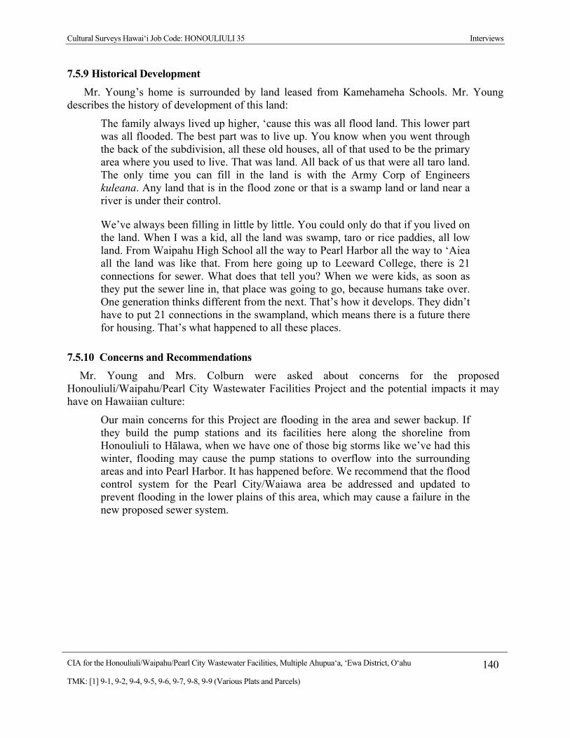
Cultural Surveys Hawai‘i Job Code: HONOULIULI 35 Interviews
CIA for the Honouliuli/Waipahu/Pearl City Wastewater Facilities, Multiple Ahupua‘a, ‘Ewa District, O‘ahu 140
TMK: [1] 9-1, 9-2, 9-4, 9-5, 9-6, 9-7, 9-8, 9-9 (Various Plats and Parcels)
7.5.9 Historical Development
Mr. Young’s home is surrounded by land leased from Kamehameha Schools. Mr. Young describes the history of development of this land:
The family always lived up higher, ‘cause this was all flood land. This lower part was all flooded. The best part was to live up. You know when you went through the back of the subdivision, all these old houses, all of that used to be the primary area where you used to live. That was land. All back of us that were all taro land. The only time you can fill in the land is with the Army Corp of Engineers kuleana. Any land that is in the flood zone or that is a swamp land or land near a river is under their control.
We’ve always been filling in little by little. You could only do that if you lived on the land. When I was a kid, all the land was swamp, taro or rice paddies, all low land. From Waipahu High School all the way to Pearl Harbor all the way to ‘Aiea all the land was like that. From here going up to Leeward College, there is 21 connections for sewer. What does that tell you? When we were kids, as soon as they put the sewer line in, that place was going to go, because humans take over. One generation thinks different from the next. That’s how it develops. They didn’t have to put 21 connections in the swampland, which means there is a future there for housing. That’s what happened to all these places.
7.5.10 Concerns and Recommendations
Mr. Young and Mrs. Colburn were asked about concerns for the proposed Honouliuli/Waipahu/Pearl City Wastewater Facilities Project and the potential impacts it may have on Hawaiian culture:
Our main concerns for this Project are flooding in the area and sewer backup. If they build the pump stations and its facilities here along the shoreline from Honouliuli to Hālawa, when we have one of those big storms like we’ve had this winter, flooding may cause the pump stations to overflow into the surrounding areas and into Pearl Harbor. It has happened before. We recommend that the flood control system for the Pearl City/Waiawa area be addressed and updated to prevent flooding in the lower plains of this area, which may cause a failure in the new proposed sewer system.
Cultural Surveys Hawai‘i Job Code: HONOULIULI 35 Interviews
CIA for the Honouliuli/Waipahu/Pearl City Wastewater Facilities, Multiple Ahupua‘a, ‘Ewa District, O‘ahu 141
TMK: [1] 9-1, 9-2, 9-4, 9-5, 9-6, 9-7, 9-8, 9-9 (Various Plats and Parcels)
Figure 39. Tin Hu Young and Helen Kealiiwahineulawenaokola He‘eia Colburn (CSH January 6, 2010)

Cultural Surveys Hawai‘i Job Code: HONOULIULI 35 Interviews
CIA for the Honouliuli/Waipahu/Pearl City Wastewater Facilities, Multiple Ahupua‘a, ‘Ewa District, O‘ahu 142
TMK: [1] 9-1, 9-2, 9-4, 9-5, 9-6, 9-7, 9-8, 9-9 (Various Plats and Parcels)
7.6 Mel Kalahiki CSH interviewed Mel Kalahiki on February 22, 2011 at his home in Kāne‘ohe. He was also
interviewed in 2008, 2009 and 2010. Mr. Kalahiki, now 85 years old, was born on June 25, 1925 to Kamaka Kalahiki of Kahalu‘u and Elisabeth Akau of Kohala. He worked within the Council of Hawaiian Organizations to establish legislation that formed OHA. Mr. Kalahiki also formed ‘Ahahui Mālama o Kaniakapūpū to help preserve the summer home of Kamehameha III in Nu‘uanu on the island of O‘ahu.
7.6.1 Family Background
Tracing his lineage to Kamehameha, Mr. Kalahiki carries a deep responsibility to “carry on Kamehameha’s wishes,” including the preservation and perpetuation of Kamehameha’s knowledge and accomplishments. In 1995, Mr. Kalahiki conceptualized and organized a bicentennial commemoration of the 1795 battle of Nu‘uanu. The Council of Chiefs of Pu‘ukoholā Heiau led about 1000 people on the general path of the battle, starting at Kapi‘olani Park and Waikīkī Beach to symbolically commemorate the arrival of the canoes, and then up Nu‘uanu Valley to reach the precipice of the Nu‘uanu Pali.
As a child in the early 1930s, Mr. Kalahiki spent several years at Kawaihae living with his grandfather, William Paul Mahi-nauli Akau, at the foot of Pu‘ukohalā Heiau (which Kamehameha built between 1790 to 1791) on the Big Island, so his memories and ties to the heiau are very strong. He understood then the legacy of Kamehameha—when he saw Pu‘ukohalā Heiau, he “saw things through the eyes of Kamehameha,” as the structure of the heiau had become “the essence of Hawaiian wisdom.”
7.6.2 World War II
When Pearl Harbor was attacked in 1941, Mr. Kalahiki, a high school student at the time, left school to work for the United States Engineering Department (U.S.E.D.) based at Fort Shafter in Kalihi, O‘ahu. During his tenure with U.S.E.D., he participated in the excavation project for the military bunkers in Kīpapa Gulch in 1942:
I remember working in Kīpapa Gulch after the war; it was during the “Blackout” period. I was a truck driver and I was getting $1.50 an hour and that was big bucks. One of my uncles was working on the docks and he was getting $1.00 an hour and I used to brag about my $1.50. There was only one way to get in Kīpapa and that was Kamehameha Highway. We were working right on the bridge in the gulch. The engineers would stick dynamite in these holes and they would blast them off and I would back my truck in there and they would load the muck into my truck. I would take the muck a short ways away to unload and then go back for more. As I remember each of the bunkers were 25 yards in and about 10 feet wide by 10 feet high. None of the bunkers connected together because if one blew up, they didn’t want the others to be affected.
The military bunkers Mr. Kalahiki is referring to are still present today in Kīpapa Gulch. There are over 30 bunkers approximately 100 meters apart along the sides of Kīpapa Gulch. These bunkers are sealed shut with metal brackets welded to the doors to keep people out. When

Cultural Surveys Hawai‘i Job Code: HONOULIULI 35 Interviews
CIA for the Honouliuli/Waipahu/Pearl City Wastewater Facilities, Multiple Ahupua‘a, ‘Ewa District, O‘ahu 143
TMK: [1] 9-1, 9-2, 9-4, 9-5, 9-6, 9-7, 9-8, 9-9 (Various Plats and Parcels)
asked about the sealed doors to the bunkers and its possible contents, Mr. Kalahiki shared this story:
When I was working in the Kīpapa area excavation, I had been there for about a year and a half. My coworker, his name was Jim Albertini, and I were standing on the bridge over Kīpapa stream and we were watching the military load and unload equipment in the bunkers. As we watched them from above, we saw what we believed was an Atomic bomb. Jim had heard rumors circulating in the area that the atomic bomb was being stored in the bunkers that we built. I was convinced that what we were seeing was an atomic bomb. Of course by now, the talks around the job site was all about the Atomic bomb in the bunker. Everyone believed on our job site was a serious weapon stuffed in the bunker we built. The sad part about this whole thing was that when we bomb Japan and we heard about all the people that died, we felt bad for the people who had lost their lives. It was as if we were a part of the bombing because we had it stored in our bunkers. It was a real uneasy feeling.
7.6.3 Concerns and Recommendations
Mr. Kalahiki was asked about his concerns for the proposed Honouliuli/Waipahu/Pearl City Wastewater Facilities Project and the potential impacts it may have on Hawaiian culture:
I am concerned for the water tables as the boring machines dig the underground tunnels. I do not believe they will harm any Hawaiian cultural sites during this Project but in the event there is a cultural find, please contact the appropriate organizations and individuals representing that area.
Cultural Surveys Hawai‘i Job Code: HONOULIULI 35 Cultural Landscape
CIA for the Honouliuli/Waipahu/Pearl City Wastewater Facilities, Multiple Ahupua‘a, ‘Ewa District, O‘ahu 144
TMK: [1] 9-1, 9-2, 9-4, 9-5, 9-6, 9-7, 9-8, 9-9 (Various Plats and Parcels)
Section 8 Cultural Landscape
8.1 Overview Discussions of specific aspects of traditional Hawaiian culture as they may relate to the
Project area are presented below. This section examines cultural resources and practices identified within or in proximity to the subject Project area in the broader context of the encompassing Honouliuli, Hō‘ae‘ae, Waikele, Waipi‘o, Waiawa, Mānana, and Hālawa Ahupua‘a landscape. Excerpts from interview sessions from past and the present cultural studies are incorporated throughout this section where applicable.
8.2 Wahi Pana and Mo‘olelo The western most ahupua‘a in the ‘Ewa District is Honouliuli. Honouliuli means “dark
water,” “dark bay,” or “blue harbor” and was named for the waters of Pearl Harbor (Jarrett 1930:22), which marks the eastern boundary of the ahupua‘a. The Hawaiians called Pearl Harbor, Pu‘uloa (lit. long hill). Another explanation for the names comes from the “Legend of Lepeamoa,” the chicken-girl of Pālama. In this legend, Honouliuli is the name of the husband of the chiefess Kapālama and grandfather of Lepeamoa. The land district Honouliuli was named for the grandfather of Lepeamoa (Westervelt 1923:164–184).
It seems likely the boundaries of the western-most ahupua‘a of ‘Ewa were often contested with Wai‘anae people. The ‘Ewa people could cite divine sanction that the dividing point between Wai‘anae and ‘Ewa was between two hills at Pili o Kahe:
The ancient Hawaiians said the hill on the ‘Ewa side was the male and the hill on the Wai‘anae side was female. The stone was found on the Waianae side hill and the place is known as Pili o Kahe [Pili=cling to, Kahe=flow]. The name refers, therefore, to the female or Waianae side hill. And that is where the boundary between the two districts runs. (Sterling and Summers 1978:1)
Mr. Shad Kāne shares a mo‘olelo of the ‘ōlohe o lua (skilled practitioners of a type of dangerous hand-to-hand fighting) practitioners at the gateway between the moku of ‘Ewa and Wai‘anae to illustrate how the use of the term ‘ōlohe has changed through time, and, in doing, so, highlights the significance of the moku divisions:
Pukaua is where Honokai Hale is today, just Makakilo and Ko‘olina Resort. The high ground, Pukaua, was associated with Hawaiian warriors, the lua practitioners. The stories that came out during the missionary period used the name ‘ōlohe, as if they were robbers. In the mid-1800s, a lot of visitors traveled from Honolulu to Wai‘anae. They bought nice pieces of land in the Pearl City peninsula, and that was their summer retreat. Some tourists were getting robbed along Farrington Highway, which was a trail then. They used the name ‘ōlohe, but it was referred to as a robber. The ancient stories of Pukaua used ‘ōlohe, but with a different meaning. It references a lua practitioner. These training areas were for the guardians of security. They provided security at the borders. When you leave one district, there would be ‘ōlohe o lua practitioners. They were like the National
Cultural Surveys Hawai‘i Job Code: HONOULIULI 35 Cultural Landscape
CIA for the Honouliuli/Waipahu/Pearl City Wastewater Facilities, Multiple Ahupua‘a, ‘Ewa District, O‘ahu 145
TMK: [1] 9-1, 9-2, 9-4, 9-5, 9-6, 9-7, 9-8, 9-9 (Various Plats and Parcels)
Guard; not full-time soldiers. Their kuleana was the borders. I can use Wai‘anae as an example. The Wai‘anae mountain is a wall. Stories with ‘ōlohe associated with Pukaua, the eastern gate to Wai‘anae. Other areas of ‘ōlohe were Mākua-Ka‘ena Point—the western gate. Mākua were the guardians to Wai‘anae from the western gate. The eastern gate was Kolekole Pass at Schofield Barracks. If you left your moku you left your home. If you go over the Ko‘olau I am in a foreign land. Everybody knew each other. It was the same if you went from one moku to another.
8.3 Traditional Settlement and Agricultural Patterns Various Hawaiian legends and early historical accounts indicate that ‘Ewa was once widely
inhabited by pre-Contact populations, including the Hawaiian ali‘i. This would be attributable for the most part to the plentiful marine and estuarine resources available at the coast, along which several sites interpreted as permanent habitations and fishing shrines have been located. Other attractive subsistence-related features of the district include irrigated lowlands suitable for wetland taro cultivation, as well as the lower forest area of the mountain slopes for the procurement of forest resources. Handy and Handy (1972:429) report on ‘Ewa:
The lowlands, bisected by ample streams, were ideal terrain for the cultivation of irrigated taro. The hinterland consisted of deep valleys running far back into the Ko‘olau range. Between the valleys were ridges, with steep sides, but a very gradual increase of altitude. The lower part of the valley sides were excellent for the cultivation of yams and bananas. Farther inland grew the ‘awa for which the area was famous.
In addition, breadfruit, coconuts, wauke (paper mulberry, Broussonetia papyrifera, used to make kapa for clothing), bananas, and olonā (Touchardia latifoli, used to make cordage) and other plants were grown in the interior. ‘Ewa was known as one of the best areas to grow gourds and was famous for its māmaki (Pipterus spp.; used to make kapa for clothing). It was also famous for a rare taro called the kāī o ‘Ewa, which was grown in mounds in marshy locations (Handy and Handy 1972:471).
Mr. Young has seen tremendous land use changes in Waiawa. He notes that before he was born, the land mauka of Kamehameha Highway was heavily forested, but then it shifted to grazing land during his childhood and later to sugar cane. Farther makai, the lowland regions were used primarily for taro and rice cultivation. Mr. Young describes the cultivation of taro and rice on his family’s land near Pu‘uloa and the growing of sugar cane farther mauka:
Yeah, right behind me [is Hā‘upu land]. Yeah, and my cousin and aunt used to reside there. That part of the family resides now in San Diego. My family and I on this side, my dad and I have always taken care of this property. This is a flood zone, a flood zone area. When I was a kid, all this area was lowland for taro patches, all this area here. And later on when rice became profitable it was rice. And up on the hill was all sugar cane where Leeward College is.

Cultural Surveys Hawai‘i Job Code: HONOULIULI 35 Cultural Landscape
CIA for the Honouliuli/Waipahu/Pearl City Wastewater Facilities, Multiple Ahupua‘a, ‘Ewa District, O‘ahu 146
TMK: [1] 9-1, 9-2, 9-4, 9-5, 9-6, 9-7, 9-8, 9-9 (Various Plats and Parcels)
Mr. Young describes an interesting connection between his wife’s family, who operated the sugar mill, and his father’s family, who grew the rice:
When I was a child it just switched over from taro to rice. My grandfather was actually was a rice grower, on my Chinese side. He was a rice grower in this particular area. My dad married my mom, who was from here, so they had a lot of property to grow rice. My wife’s side, the Colburns, owned the mill and my grandfather would lease it to thrash the rice. In those days they had water buffalos all over, to cultivate the rice. The family joke is I had to marry a Colburn to get our land back [laughs]. But that’s just a joke.
Mr. Young describes how the area around Pearl Harbor had an abundance of food:
This area around the Pearl Harbor was known as our “bread basket” of food. As a kid here, you could never starve. You could fish off the eighteenth bridge and catch mullet using bread as bait. You could dig up clams enough to stuff a bag in no time. On the land we had bananas, papayas and taro. When Wai‘anae had famines, they would come to Pearl Harbor and raid our food and take it back to Wai‘anae. Our place was known to be stocked with food.
8.4 Marine and Freshwater Gathering and Cultivation The fact that there were so many fishponds in ‘Ewa, more than any other district on O‘ahu,
indicates that agricultural and aquacultural intensification was a direct link to the chiefs who resided there and to the increasing needs of the population.
There were several loko (fishponds) in Waipi‘o; two of the largest were Loko ‘Ēo (“a filled container”) and Loko Hanaloa (“long bay”). Loko Pā‘au‘au was a large fishpond located on the western coast of the Mānana Peninsula. Pukui et al. (1974:173) translate pā‘au‘au as “bath enclosure.” Pā‘au‘au was also the name of the ‘ili surrounding the pond, and the name of the home of John F. Colburn, an early resident who had a home near the pond.
Loko Welokā, a large fishpond with a small island in the center, was located in Waimano, along the eastern shore of the Mānana Peninsula. The word welokā is translated as “thrashing, smiting, as a fishtail” (Pukui and Elbert 1986:355), which may also be a reference to the shark demigoddess associated with Waimano. Two other large fishponds were Loko Kūkona, and Loko Luakaha‘ole which were located along the northern coast of Pearl Harbor. Loko Pa‘akea, a large fishpond in Waimalu along the Pearl Harbor coast was said to have been built by the chiefess, Kalaimanuia (McAllister 1933:103–104). The word pa‘akea is translated as “coral bed, limestone” (Pukui et al. 1974:173).,
Hālawa had numerous fishponds (from south to north). Loko Waiaho, also known as Queen Emma’s Pond and Loko Ke‘oki, were both located near the mouth of the Pearl River near the nineteenth century village called Watertown. Papiolua was opposite the tip of Waipi‘o Peninsula. Loko A Mano (Amana), Loko Pōhaku, Ola Loko, Wailolokai and Wailolowai were all inland of Kūāhua Island, in the bay now called the South East Loch, while Loko Kūnana and Loko Muliwai were between the east side of the island and the Hālawa shore.
Cultural Surveys Hawai‘i Job Code: HONOULIULI 35 Cultural Landscape
CIA for the Honouliuli/Waipahu/Pearl City Wastewater Facilities, Multiple Ahupua‘a, ‘Ewa District, O‘ahu 147
TMK: [1] 9-1, 9-2, 9-4, 9-5, 9-6, 9-7, 9-8, 9-9 (Various Plats and Parcels)
Loko Kahakupōhaku and Kealipaia were near the northeastern corner of the East Loch of Pearl Harbor.
Kupuna Eaton shared her enjoyment of catching he‘e in Pu‘uloa. Rather than using the traditional cowry shell-baited octopus lure, she lured the he‘e by shaking a cowry shell with her hand. She allowed the octopus’ tentacles to wrap around her arms. Once the body was within her grasp, she quickly and deftly ripped out its single pincer to avoid harm. She still has scars on her hands to show her mistakes of avoiding the sharp teeth. Sometimes she would catch a he‘e with each arm and walk ashore with their tentacles wrapped around her arms while continuing to gather limu. Rather than being frightened, she enjoyed the massages she received from the he‘e. On shore a touch of salt released the grasp of the he‘e.
Kupuna Eaton shares a story from her childhood that centers on the ae‘o of the wetlands:
My grandparents would punish me, but their way of punishing me was not hitting me at all. They would say to me, “You’re not to go in the kai.” Of course, even one day is like the end of the world. Maybe one week I couldn’t go into the water. And it’s only 25 to 30 minutes away from the water. So the next best place is to go into the loko wai, where the wetlands are. I called my friend to go over there. But he’s kolohe [mischievious]. He teases the ae‘o stilt birds. He can go because he has short hair and he teases them and runs. But when I turn around to run, I have braids and the ae‘o would grab my hair.
8.5 Burials The caves of Pu‘uloa, located on the western portions of Pearl Harbor, were sometimes also
used as burial caves. In 1849, Keali‘iahonui, son of Kaua‘i’s last king, Kaumuali‘i, died. He had once been married to the chiefess Kekau‘ōnohi, who had stayed with him until 1849. She wanted to bury her ex-husband at sea.
It seems that by Kekauonohi’s orders, the coffin containing her late husband’s remains was removed to Puuloa, Ewa, with the view of having it afterwards taken out to sea and there sunk. It was temporarily deposited in a cavern in the coral limestone back of Puuloa, which has long been used for a burial place, and has lately been closed up. (Alexander 1907:27)
After some initial objections by the niece of Keali‘iahonui, the body was removed from the outer coffin, the rest was sunk, and the coffin was later buried somewhere in Pu‘uloa.

Cultural Surveys Hawai‘i Job Code: HONOULIULI 35 Summary and Recommendations
CIA for the Honouliuli/Waipahu/Pearl City Wastewater Facilities, Multiple Ahupua‘a, ‘Ewa District, O‘ahu 148
TMK: [1] 9-1, 9-2, 9-4, 9-5, 9-6, 9-7, 9-8, 9-9 (Various Plats and Parcels)
Section 9 Summary and Recommendations
At the request of AECOM and the City and County of Honolulu (CCH), CSH is conducting a CIA for the proposed Honouliuli/Waipahu/Pearl City Wastewater Facilities Project, Honouliuli, Pu‘uloa, Hō‘ae‘ae, Waikele, Waipi‘o, Waiawa, Manana, Waimano, Waiau, Waimalu, Kalauao, ‘Aiea, and Hālawa Ahupua‘a, ‘Ewa District, O‘ahu Island, TMK [1] 9-1, 9-2, 9-3, 9-4, 9-6, 9-7,9-8, 9-9 (Various Plats and Parcels). This study will be an update to the West Mamala Bay Facilities Plan (2001) for the Honouliuli Sewershed. The Honouliuli Sewershed encompasses the areas from which current wastewater flows into the Honouliuli Wastewater Treatment Plant (Honouliuli WWTP) including Hālawa, ‘Aiea, Pearl City, Waipi‘o, Waikele, Waipahu, ‘Ewa, Kapolei and Mililani.
The CCH is conducting a planning and engineering study for improvements to the Honouliuli/Waipahu/Pearl City Wastewater Facilities that is aimed at minimizing sanitary sewer overflows, to comply with regulatory mandates from the State of Hawaii, Department of Health (DOH), and the United States Environmental Protection Agency (EPA) and to meet the future needs for wastewater management.
9.1 Results of Background Research Background research of the Project area indicates:
1. The Project area traverses through 12 of the 13 ahupua‘a located in the ‘Ewa District. They are (from west to east) Honouliuli, Hō‘ae‘ae, Waikele, Waipi‘o, Waiawa, Mānana, Waimano, Waiau, Waimalu, Kalauao, ‘Aiea, and Hālawa. Pu‘uloa Ahupua‘a, located on the western portion of the Pearl Harbor entryway, is the only ahupua‘a in the ‘Ewa District that is not located in the Project area.
2. The ‘Ewa District had more fishponds than any other district on O‘ahu, indicating that agricultural and aquacultural intensification was a direct link to the chiefs who resided there and to the increasing needs of the population. The Project area transects at least nine former fishponds.
3. According to an account in the Hawaiian newspaper Ka Loea Kālai‘āina (June 10, 1899), several of the fishponds in the Pu‘uloa area were made by the brother gods, Kāne and Kanaloa. A fisherman living in Pu‘uloa, named Hanakahi, prayed to unknown gods, until one day two men came to his house. They revealed to him that they were the gods to whom he should pray. Kāne and Kanaloa then built fishponds at Ke‘anapua‘a, but were not satisfied. Then they built the fishpond, Kepo‘okala, but were still not satisfied. Finally they made the pond Kapākule, which they stocked with all manner of fish. They gifted all of these fishponds to Hanakahi and his descendants (Handy and Handy 1972:473; Ka Loea Kālai‘āina, July 8, 1899).
4. ‘Ewa was famous for the many limestone caves, also known as the “Caves of Honouliuli,” formed in the uplifted coral, called the “Ewa Karst.” This Pleistocene limestone outcrop, where not covered by alluvium or stockpiled material, has characteristic dissolution “pit caves” (Mylroie and Carew 1995), which are nearly universally, but erroneously, referred to as “sink holes” (Halliday 2005).

Cultural Surveys Hawai‘i Job Code: HONOULIULI 35 Summary and Recommendations
CIA for the Honouliuli/Waipahu/Pearl City Wastewater Facilities, Multiple Ahupua‘a, ‘Ewa District, O‘ahu 149
TMK: [1] 9-1, 9-2, 9-4, 9-5, 9-6, 9-7, 9-8, 9-9 (Various Plats and Parcels)
5. A famous cave of Hālawa was Keanapua‘a, opposite Waipi‘o Peninsula, which means “the pig’s cave,” so named because Kamapua‘a once slept there (Pukui et al. 1974:103). This cave was one of the places that the high king of O‘ahu, Kahahana, hid after he had killed the priest Ka‘opulupulu, thus angering the high chief of Maui, Kahekili.
6. Oral tradition tells of Hālawa as the home of Papa, where she lived in the uplands with her parents, Kahakauakoko and Kūkalani‘ehu. Papa is known for her generative role as the “earth mother”. Together with her husband, Wākea, they are the progenitors of the Hawaiian race.
7. The heiau of Keaīwa in ‘Aiea was the site of a medicinal herb garden and training area for traditional healers.
8. In 1852, the first Chinese contract laborers arrived in the Hawaiian Islands. Contracts were for five years, and pay was $3 a month plus room and board. Upon completion of their contracts, a number of the immigrants remained in the islands, many becoming merchants or rice farmers.
9. The eastern section of ‘Ewa was largely developed by the Honolulu Plantation Company. Commercial sugar cane cultivation began in Waimalu and Hālawa in the 1850s, on the estate of Mr. J.R. Williams (Condé and Best 1973:327). The plantation was first known as the Honolulu Sugar Company.
10. In 1897, B. F. Dillingham established the Oahu Sugar Company on 12,000 acres leased from the estates of John Papa ‘Ī‘ī, Bishop, and Robinson. The Oahu Sugar Co. had over 900 field workers, composed of 44 Hawaiians, 473 Japanese, 399 Chinese, and 57 Portuguese. The first sugar crop was harvested in 1899, ushering in the sugar plantation era in Waipahu (Ohira 1997).
11. The U.S. Navy began a preliminary dredging program for Pearl Harbor in 1901, which created a 30-foot deep entrance channel measuring 200 ft wide and 3,085 ft long. In 1908, money was appropriated for five miles of entrance channel dredged to an additional 35 ft down (Downes 1953).
12. In 1909, the government appropriated the entire Waipi‘o peninsula from the ‘Ī‘ī Estate for the Pearl Harbor Naval Station and Shipyard. Additional dredging to deepen and widen the channel was conducted in the 1920s.
9.2 Results of Community Consultation CSH attempted to contact 44 community members (government agency or community
organization representatives, or individuals such as residents and cultural practitioners) for this draft CIA report; of those, seven responded and five participated in formal interviews for more in-depth contributions to the CIA. Presented below are salient themes and concerns that emerged from participants’ interviews regarding the proposed Project:
1. Mr. Tin Hu Young describes the area of Pearl Harbor during his youth as a “bread basket” of food. He recalls an abundance of mullet, clams, bananas, taro and other varieties of food in his neighborhood for subsistence.

Cultural Surveys Hawai‘i Job Code: HONOULIULI 35 Summary and Recommendations
CIA for the Honouliuli/Waipahu/Pearl City Wastewater Facilities, Multiple Ahupua‘a, ‘Ewa District, O‘ahu 150
TMK: [1] 9-1, 9-2, 9-4, 9-5, 9-6, 9-7, 9-8, 9-9 (Various Plats and Parcels)
2. Mr. Kāne’s mother tells of lo‘i kalo in the Waipi‘o Peninsula area. His father gathered oysters, clams, crab and limu from the waters of Pearl Harbor.
3. Mr. Young states that after the December 7, 1941 bombing of Pearl Harbor, the U.S. military set up a camp at the Pearl City Tavern bar on Farrington Highway in Pearl City, which included searchlights looking for enemy airplanes.
4. In his youth, Dr. Stagner hiked the mauka regions in ‘Ewa with his Boy Scout troop and discovered several petroglyphs and heiau. Dr. Stagner explained that there had been an influenza epidemic in the 1920s and many Hawaiians were buried in the mauka area, which was abandoned and eventually taken over by the ‘Aiea Sugar Mill. Many of the plantation workers moved rocks, not knowing the cultural significance of the rocks that could have been associated with Hawaiian burials or other cultural sites.
5. Dr. Stagner believes ‘Ewa’s most important feature is its watershed. This fact is highlighted by the naming of the ahupua‘a with the term wai (fresh water of any kind), including Waiawa, Waiau, Waikele, and Waipahu. Mirroring the ahupua‘a boundaries, water flows from the Ko‘olau mountains down to the waters of Pu‘uloa throughout a network of streams and an underwater system of tunnels. These contribute heavily to the Hālawa Aquifer, which now supplies the majority of the drinking water for the island of O‘ahu.
6. Dr. Stagner’s main concern is the management of the ‘Ewa watershed. The kūpuna from his youth told him that the upland regions must be conserved to prevent excessive runoff and lowland flooding. Historically, surplus water was channeled toward the ‘Ewa plain. Dr. Stagner advocates protecting agricultural and conservation lands of Waiawa in particular, as they are the most vulnerable to future development.
7. Mr. Kāne states that the cultural layer of ‘Ewa still exists today, however, buried or filled in by the Navy and the Department of Defense.
8. Mr. Kalahiki is concerned that the water tables below surface of the Project area may be adversely impacted during the boring/excavating phase of construction.
9. Mr. Young is concerned that potential future flooding in the lowland areas of ‘Ewa may cause the proposed Project’s sewer system to backup and spill into Pearl Harbor.
10. Mr. Kāne feels that the likelihood of inadvertent burials at the points of deep excavation is low and that the cultural layers will not be disturbed during construction phases of this Project.
9.3 Cultural Impacts and Recommendations Based on information gathered from the community consultation effort as well as
archaeological and archival research presented in this report, the evidence indicates that the proposed Project may have minimal impact on potential burials and other cultural sites within the Project area due to underground tunneling and boring at debths below known cultural sites.
Cultural Surveys Hawai‘i Job Code: HONOULIULI 35 Summary and Recommendations
CIA for the Honouliuli/Waipahu/Pearl City Wastewater Facilities, Multiple Ahupua‘a, ‘Ewa District, O‘ahu 151
TMK: [1] 9-1, 9-2, 9-4, 9-5, 9-6, 9-7, 9-8, 9-9 (Various Plats and Parcels)
However, concerns raised by community participants include protection of water tables in the area and possible sewer backups due to flooding the lower areas of ‘Ewa. A good faith effort to address the following recommendations would help mitigate potentially adverse effects the proposed Project may have on Hawaiian cultural practices, beliefs and resources in and near the Project area:
1. The Project may have a direct impact on as-yet undiscovered burials located in subsurface contexts along the Project area corridor. CSH recommends that personnel involved in development activities in the Project area should be informed of the possibility of inadvertent cultural finds, including human remains. Should cultural and/or burial sites be identified during ground disturbance, all work should immediately cease, and the appropriate agencies notified pursuant to applicable law.
2. CSH recommends that, in the event of discoveries of iwi kūpuna during Project construction activities, recognized cultural and lineal descendants should be notified and consulted on matters of burial treatment.
3. Hydrological studies should be conducted prior to excavation/underground boring begins to prevent damage to aquifers and water tables in the proposed Project area.
4. Flooding concerns should be addressed in the lower areas of the ‘Ewa District to prevent sewer backups of the proposed Project’s new sewer system.
5. Archaeological monitoring should be conducted during ground-disturbance activities that affect layers likely to contain burials and/or cultural layers.
Cultural Surveys Hawai‘i Job Code: HONOULIULI 35 References Cited
CIA for the Honouliuli/Waipahu/Pearl City Wastewater Facilities, Multiple Ahupua‘a, ‘Ewa District, O‘ahu 152
TMK: [1] 9-1, 9-2, 9-4, 9-5, 9-6, 9-7, 9-8, 9-9 (Various Plats and Parcels)
Section 10 References Cited
Alexander, W. D. 1875 Plan of Part of Waikele, Ewa, Oahu. Registered Map 1739. On file at the State of
Hawai‘i Department of Accounting and General Services Land Survey Division, 1151 Punchbowl St., Room 210, Honolulu.
1907 The Funeral Rites of Prince Kealiiahonui. Annual Report of the Hawaiian Historical Society for 1906, pp. 26–28. Hawaiian Historical Society, Honolulu.
Allen, Gwenfread 1999 Hawaii‘s War Years 1941-1945. Pacific Monograph, Kailua, Hawai‘i.
Barrerè, Dorothy B. 1994 The King’s Mahele: The Awardees and Their Lands. Dorothy B. Barrerè,
Compiler, Hilo, Hawai‘i. Ms. on file, Historic Preservation Division, State of Hawaii Department of Land and Natural Resources, Honolulu.
Beckwith, Martha 1940 Hawaiian Mythology. University of Hawai‘i Press, Honolulu.
1951 The Kumulipo, A Hawaiian Creation Chant. University of Chicago Press, Chicago.
Bernard, Russell H. 2006 Research Methods in Anthropology: Qualitative and Quantitative Approaches,
Fourth Edition. AltaMira Press, Walnut Creek, California.
Bishop, Sereno E. 1887 Bishop Estate lands at Waiawa, Manana, and a Part of Waimano. By S. Bishop
1887, Traced C.K. Tananonaka 1951 [map]. Registered Map 1258. On file at the State of Hawai‘i Department of Accounting and General Services, Land Survey Division, 1151 Punchbowl St., Room 210, Honolulu.
1887 Map of the Lower Lands of the Ahupuaas of Waimano and Waiau in Ewa, Oahu. By S.E. Bishop 1877 [map]. Registered Map 1147. On file at the State of Hawai‘i Department of Accounting and General Services, Land Survey Division, 1151 Punchbowl St., Room 210, Honolulu.
1901 Ewa, O‘ahu. Old Memories. The Friend, May 1901.
Bordner, Richard, and Carol Silva 1983 Archaeological Reconnaissance and Historical Documentation for Waimanalo
Gulch and Ohikiloko Valley, TMK: [1] 9-2-003:002,040,013 (por). Richard Bordner. Copy on file at Department of Land and Natural Resources, State Historic Preservation Division, Kapolei, Hawai‘i.
Boundary Commission 1864–1935 Commission on Boundaries, 1864–1935. Hawai‘i (Kingdom, Republic,
Territory). Hawai‘i State Archives, Honolulu.
Cultural Surveys Hawai‘i Job Code: HONOULIULI 35 References Cited
CIA for the Honouliuli/Waipahu/Pearl City Wastewater Facilities, Multiple Ahupua‘a, ‘Ewa District, O‘ahu 153
TMK: [1] 9-1, 9-2, 9-4, 9-5, 9-6, 9-7, 9-8, 9-9 (Various Plats and Parcels)
Bowser, George 1880 The Hawaiian Kingdom Statistical and Commercial Directory. Geo. Bowser &
Co., Honolulu and San Francisco.
Briggs, L. Vernon 1926 Experiences of A Medical Student in Honolulu, and on the Island of O‘ahu 1881.
David D. Nickerson Co., Boston.
Brown, J.F. 1877 Map of Waipio, Ewa, Oahu. Compiled by J.F. Brown 1977 [map]. Registered
Map 799. On file at the State of Hawai‘i Department of Accounting and General Services, Land Survey Division, Honolulu.
Bureau of Land Conveyances 1915 Commissioner of Public Lands. Territory of Hawai‘i, Honolulu. Copy available at
Hawai‘i State Archives, Honolulu.
Bushnell, K. S., David W. Shideler, and Hallett H. Hammatt 2003 A Cultural Impact Assessment for 3,600 acres in Waiawa and Waipi‘o Ahupua‘a,
O‘ahu, (TMK [1] 9-4-006:011, [1] 9-6-004:004 and [1] 9-6-005:003). Cultural Surveys Hawai‘i, Inc., Kailua, Hawai‘i.
Campbell, Archibald 1967 A Voyage Round the World from 1806 to 1812. University of Hawai‘i Press,
Honolulu.
Chamberlain, Levi 1822-1849 Journal of Levi Chamberlain 1822-1849. Hawaiian Mission Children’s
Society Archives, Storage Case 4, p. 899, Honolulu.
Char, Tin-Yuke and Wai Jane Char 1988 Chinese Historic Sites and Pioneer Families of the Island of Hawaii, University
of Hawaii Press, Honoulu.
Chiddix, Jim, and MacKinnon Simpson 2004 Next Stop Honolulu! The Story of the Oahu Railway & Land Company. Sugar
Cane Press, Honolulu.
Chinen, Jon J. 1958 The Great Mahele: Hawaii's Land Division of l848. University of Hawai‘i Press,
Honolulu.
Ching, Arlene 1996 Mānana, Pathway to Pearl City. Pearl City Local History Project, Pearl City,
Hawai‘i.
Clark, John R. K. 1977 The Beaches of O‘ahu. University of Hawai‘i Press, Honolulu.
Cobb, John N. 1903 Commercial Fisheries of the Hawaiian Islands—1903. Bulletin of the U.S. Fish
Commission, Vol. IIII, Part 2.
Condé, Jesse, and Gerald M. Best
Cultural Surveys Hawai‘i Job Code: HONOULIULI 35 References Cited
CIA for the Honouliuli/Waipahu/Pearl City Wastewater Facilities, Multiple Ahupua‘a, ‘Ewa District, O‘ahu 154
TMK: [1] 9-1, 9-2, 9-4, 9-5, 9-6, 9-7, 9-8, 9-9 (Various Plats and Parcels)
1973 Sugar Trains: Narrow Gauge Rails of Hawaii. Glenwood Publishers, Felton, California.
Cordy, Ross
1996 The Great ‘Ewa Lands of La'akona 1840-1850 Settlement Patterns in the 'Ewa Lands Located Around Pearl Harbor: A Look at where Houses, Irrigated Taro Fields, Fishponds, and other Types of Sites were Located. Department of Land and Natural Resources, State Historic Preservation Division, Kapolei, Hawai‘i.
2002 The Rise and Fall of the O‘ahu Kingdom. A Brief Overview of O‘ahu’s History. Mutual Publishing, Honolulu.
Coulter, John Wesley., and Chee Kwon Chun 1937 Chinese Rice Farmers in Hawaii. University of Hawai‘i Research Publications,
Number 16, University of Hawai‘i, Honolulu.
Cruz, Brian, and Hallett H. Hammatt 2008 Cultural Impact Assessment for the Makakilo Drive Extension Project, Honouliuli
Ahupua‘a, ‘Ewa District, Island of O‘ahu, TMK: [1] 9-2-002:006, 9-2-003:079. Cultural Surveys Hawai‘i, Inc., Kailua, Hawai‘i.
Damon, Frank 1882 Tours Among the Chinese, No. 1. The Friend, April 1882, Honolulu.
Day, A. Grove 1984 History Makers of Hawaii: A Biographical Dictionary. Mutual Publishing,
Honolulu.
Dega, Michael, and Laura C. O`Rourke 2003 Archaeological Evaluation Report of Additional Environmental Focused Site
Inspection Date at Blaisdell Park (Former Waiau Drum Storage Facility), Pearl City, and Archival Research on Napunani Park (Former ‘Aiea Anti-Aircraft Artillery (AAA) Command Post) O‘ahu Island, Hawai`i, Blaisdell Park, TMK:[1] 9-8-007 & 008; Napuanani Park TMK [1] 9-9-060:020. Scientific Consultant Services, Inc., Honolulu.
Devaney, Dennis M., Marion Kelly, Polly Jae Lee, and Lee S. Motteler 1982 Kane‘ohe - A History of Change. Dept. Anthropology, Departmental Report
Series 76-2, Bernice P. Bishop Museum, Honolulu.
Dillingham, B.F. 1885 Memos concerning Honouliuli, Kahuku, and Hawailoa ranches. B.F. Dillingham,
Honolulu.
Dorrance, William H., and Francis S. Morgan 2000 The 165-Year Story of Sugar in Hawai‘i. Mutual Publishing, Honolulu.
Downes, Cornelius D., (editor) 1953 History of Pearl Harbor. Pearl Harbor Shipyard Log Vol. VII No. 27, July 3,
1953. Pearl Harbor, Hawai‘i.
Ellis, Sheila Nonaka (editor)
Cultural Surveys Hawai‘i Job Code: HONOULIULI 35 References Cited
CIA for the Honouliuli/Waipahu/Pearl City Wastewater Facilities, Multiple Ahupua‘a, ‘Ewa District, O‘ahu 155
TMK: [1] 9-1, 9-2, 9-4, 9-5, 9-6, 9-7, 9-8, 9-9 (Various Plats and Parcels)
1995 Where Pearls Flourished: Mo‘olelo o Mānana—The Story of Pearl City. Pearl City High School Heritage Learning Center, Pearl City Local History Project, Pearl City, Hawai‘i.
Ellis, William
1963 Journal of William Ellis: Narrative of a Tour of Hawai‘i with Remarks on the History and Traditions. Reprint of 1917 edition. Advertising Publishing Co., Honolulu.
Emerson, Nathaniel B. 1993 Pele and Hi‘iaka. Original published in 1919. ‘Ai Pōhaku Press, Honolulu.
1998 Kalelealuaka. In, Hawaiian Folk Tales, compiled by Thomas G. Thrum, pp. 74-106. Mutual Publishing, Honolulu.
Ewa Plantation Company 1923 Ewa Plantation Company Annual Report. Microfilm at University of Hawai‘i at
Mānoa, Hamilton Library, Honolulu.
Foote, Donald E., E.L. Hill, S. Nakamura, and F. Stephens 1972 Soil Survey of the Islands of Kauai, Oahu, Maui, Molokai and Lanai. State of
Hawai‘i, U.S. Dept. of Agriculture, U.S. Government Printing Office, Washington, D.C.
Fornander, Abraham 1917 History of Kualii. In, In, Fornander Collection of Hawaiian Antiquities and
Folklore Vol. IV, Part II. Memoirs of the Bernice P. Bishop Museum, Bishop Museum Press, Honolulu.
1917 Story of Pikoiakaalala. In, Fornander Collection of Hawaiian Antiquities and Folklore Vol. IV, Part III. Memoirs of the Bernice P. Bishop Museum, Bishop Museum Press, Honolulu.
1918 Legend of Palila. In, Fornander Collection of Hawaiian Antiquities and Folklore Vol. V, Part I. Memoirs of the Bernice P. Bishop Museum, Bishop Museum Press, Honolulu.
1918 Legend of Opelemoemoe. In, Fornander Collection of Hawaiian Antiquities and Folklore Vol. V, Part I. Memoirs of the Bernice P. Bishop Museum, Bishop Museum Press, Honolulu.
1919 Legend of Maikoha. In, Fornander Collection of Hawaiian Antiquities and Folklore Vol. V. Memoirs of the Bernice P. Bishop Museum, Bishop Museum Press, Honolulu.
1919 Legend of Namakaokapaoo. In, Fornander Collection of Hawaiian Antiquities and Folklore Vol. V. Memoirs of the Bernice P. Bishop Museum, Bishop Museum Press, Honolulu.
1919 Legend of Kamapuaa. In, Fornander Collection of Hawaiian Antiquities and Folklore Vol. V, Part II. Memoirs of the Bernice P. Bishop Museum, Bishop Museum Press, Honolulu.

Cultural Surveys Hawai‘i Job Code: HONOULIULI 35 References Cited
CIA for the Honouliuli/Waipahu/Pearl City Wastewater Facilities, Multiple Ahupua‘a, ‘Ewa District, O‘ahu 156
TMK: [1] 9-1, 9-2, 9-4, 9-5, 9-6, 9-7, 9-8, 9-9 (Various Plats and Parcels)
1919 Famous Men of Early Days. In, Fornander Collection of Hawaiian Antiquities and Folklore Vol. V, Part II. Memoirs of the Bernice P. Bishop Museum, Bishop Museum Press, Honolulu.
1919 History of the Awa. In, Fornander Collection of Hawaiian Antiquities and Folklore Vol. V, Part III. Memoirs of the Bernice P. Bishop Museum, Bishop Museum Press, Honolulu.
1919 A Story of Kawelo. In, Fornander Collection of Hawaiian Antiquities and Folklore Vol. V, Part III. Memoirs of the Bernice P. Bishop Museum, Bishop Museum Press, Honolulu.
1919 The Story of Kahahana. In, Fornander Collection of Hawaiian Antiquities and Folklore Vol. VI, Part II. Memoirs of the Bernice P. Bishop Museum, Bishop Museum Press, Honolulu
1919 A Lamentation for Kahahana. In, Fornander Collection of Hawaiian Antiquities and Folklore Vol. VI, Part II. Memoirs of the Bernice P. Bishop Museum, Bishop Museum Press, Honolulu.
1920 Song for Kaumualii. In, Fornander Collection of Hawaiian Antiquities and Folklore Vol. VI, Part III. Memoirs of the Bernice P. Bishop Museum, Bishop Museum Press, Honolulu.
1996 Fornander’s Ancient History of the Hawaiian People to the Times of Kamehameha I. Mutual Publishing, Honolulu.
Frierson, Barbara 1972 A Study of Land Use and Vegetation Change: Honouliuli, 1790-1925, Manuscript
prepared for Graduate Seminar in Geography (750). University of Hawai‘i, Honolulu.
Genz, Joseph J., and Hallett H. Hammatt 2010 Ethnohistoric Study of Kamehameha Schools’ Lands in Waiawa, Waiau, and
Kalauao (Ka‘ōnohi ‘Ili) Ahupua‘a, ‘Ewa District, Island of O‘ahu, TMK: [1] 9-4;9-6;9-8 (various plats and parcels). Cultural Surveys Hawai‘i, Inc., Kailua, Hawai‘i.
Giambelluca, Thomas W., Michael A. Nullet, and Thomas A. Schroeder 1986 Rainfall Atlas of Hawai‘i, Department of Land and Natural Resources, Honolulu.
Goodman, Wendy, and Richard C. Nees 1991 Archaeological Reconnaissance and Inventory Survey of 3,600 Acres in Waiawa,
‘Ewa, O‘ahu. Public Archaeology Section, Applied Research Group, Bernice P. Bishop Museum, Honolulu.
Halliday, William R. 2005 Current Status of the ‘Ewa Karst, Honolulu County, Hawai‘i. The Cave
Conservationist. February 1998. Electronic File at http://www.caves.org/section/ccms/wrh/, accessed December 22, 2005.
Hammatt, Hallett H. and Douglas F. Borthwick
Cultural Surveys Hawai‘i Job Code: HONOULIULI 35 References Cited
CIA for the Honouliuli/Waipahu/Pearl City Wastewater Facilities, Multiple Ahupua‘a, ‘Ewa District, O‘ahu 157
TMK: [1] 9-1, 9-2, 9-4, 9-5, 9-6, 9-7, 9-8, 9-9 (Various Plats and Parcels)
1988 Archaeological Reconnaissance and Subsurface Testing in Upper and Lower Kipapa Gulch, Waipi‘o, O‘ahu, for U.S. Army Corps of Engineers. Cultural Surveys Hawai‘i, Inc., Kailua, Hawai‘i.
Hammatt, Hallett H., David W. Shideler, and William H. Folk
1990 Archaeological Reconnaissance of the Ewa Villages Project Site, Honouliuli, 'Ewa, O‘ahu. Cultural Surveys Hawai‘i, Inc., Kailua, Hawai‘i.
Handy, E.S. Craighill 1940 The Hawaiian Planter, Volume 1. His Plants, Methods and Areas of Cultivation.
Bernice P. Bishop Museum Bulletin 161. Bishop Museum, Honolulu.
Handy, E.S. Craighill, and Elizabeth G. Handy 1972 Native Planters in Old Hawaii: Their Life, Lore, and Environment. Bishop
Museum Bulletin 233. Bishop Museum, Honolulu.
Hawai‘i Land Survey Division 1913 Land Court Application Map No. 334. Map and Description with Petition No.
334, The McGrew Estate Limited Petitioner. Being a portion of … Kalauao, Aiea, Ewa, Oahu, T. H. On file at Hawai‘i Land Survey Division, Department of Accounting and General Services, Honolulu.
Hawai‘i State Archives n.d. Photograph of Waikele Rice Fields below the Oahu Sugar Co. Mill. Original at
Hawai‘i State Archives, Honolulu.
1880s Photograph of James Campbell’s residence on the ‘Ewa Plain. Original at Hawai‘i State Archives, Honolulu.
1908 Photograph of Dredging in Pearl Harbor. Original at Hawai‘i State Archives, Honolulu.
1932 Photograph of Pearl Harbor with the ‘Aiea sugar mill in the foreground. Original at Hawai‘i State Archives, Honolulu.
Hawai‘i TMK Service 2009 Tax Map Key [1] 9-1, 9-4, 9-6, 9-7, 9-8, and 9-9. On file at Hawai‘i TMK
Service, Honolulu.
Hickam Air Force Base 2010 Hickam Air Force Base. Electronic document, http://www2.hickam.af.mil/library/
historyofhickam/index.asp, accessed Jan. 23, 2010.
Honolulu Advertiser 1890 Photograph of Pearl Harbor with OR&L Railroad Tracks along the Coast.
Honolulu Advertiser Archives, Honolulu.
‘Ī‘ī, John Papa 1959 Fragments of Hawaiian History. Pukui translation. Bernice P. Bishop Museum
Press, Honolulu
Immisch, George B.
Cultural Surveys Hawai‘i Job Code: HONOULIULI 35 References Cited
CIA for the Honouliuli/Waipahu/Pearl City Wastewater Facilities, Multiple Ahupua‘a, ‘Ewa District, O‘ahu 158
TMK: [1] 9-1, 9-2, 9-4, 9-5, 9-6, 9-7, 9-8, 9-9 (Various Plats and Parcels)
1964 Land Reclamation and the Role of the Hydroseparator at Ewa Plantation: A Case Study of Some of the Effects of Mechanized Harvesting in the Hawaiian Sugar Industry. Master’s Thesis, University of Hawai‘i, Honolulu.
Indices of Awards
1929 Indices of Awards Made by the Board of Commissioners to Quiet Land Titles in the Hawaiian Islands. Commissioner of Public Lands, Territory of Hawaii. Star-Bulletin Press, Honolulu.
Jarrett, L. 1930 A Source Book in Hawaiian Geography. Masters Thesis, University of Hawai‘i,
Honolulu.
Judd, Walter F. 1971 Hawaii’s Military Heritage, Polynesian to Annexation. Unpublished manuscript.
Copy on file at Cultural Surveys Hawai‘I, Inc., Kailua, Hawai‘i.
Ka Loea Kālai‘āina 1899 Na Wahi Pana o Ewa. Ka Loea Kālai‘āina, June 10, 1899.
1899 Na Wahi Pana o Ewa. Ka Loea Kālai‘āina, June 29, 1899.
1899 Na Wahi Pana o Ewa. Ka Loea Kālai‘āina, July 8, 1899.
1899 Na Wahi Pana o Ewa. Ka Loea Kālai‘āina, July 29, 1899.
1899 Na Wahi Pana o Ewa. Ka Loea Kālai‘āina, Oct. 7, 1899.
Ka Nūpepa Kū‘oko‘a 1870 Na Hunahuna no ka Mo‘olelo Hawaii. Ka Nūpepa Kū‘oko‘a, January 1, 1870,
Honolulu.
1919 ‘Āpuakēhau. Ka Nūpepa Kū‘oko‘a, October 2, 1908, Honolulu.
Kamakau, Samuel M. 1976 The Works of the People of Old, Nā Hana a Ka Po‘e Kahiko. Bernice P. Museum
Special Publication 61. Originally published 1869-1870. Bishop Museum Press, Honolulu.
1991a Tales and Traditions of the People of Old; Nā Mo‘olelo a Ka Po‘e Kahiko. Originally published 1865-1869. Bishop Museum Press, Honolulu.
1991b Ka Pō‘e Kahiko; The People of Old. Originally published 1869-1870. Bishop Museum Press, Honolulu.
1992 Ruling Chiefs of Hawaii. Revised Edition. Originally published 1867-1870. Kamehameha Schools Press, Honolulu.
Kame‘eleihiwa, Lilikala 1992 Native Land and Foreign Desires. Pehea La E Pono Ai? Bishop Museum Press,
Honolulu.
Kanakanui, S. M.

Cultural Surveys Hawai‘i Job Code: HONOULIULI 35 References Cited
CIA for the Honouliuli/Waipahu/Pearl City Wastewater Facilities, Multiple Ahupua‘a, ‘Ewa District, O‘ahu 159
TMK: [1] 9-1, 9-2, 9-4, 9-5, 9-6, 9-7, 9-8, 9-9 (Various Plats and Parcels)
1894 Pearl Harbor and Ewa. Traced by H.E. Newton 1901 [map] Registered Map 1739. On file at the State of Hawai‘i Department of Accounting and General Services Land Survey Division, 1151 Punchbowl St., Room 210, Honolulu, Hawai‘i.
Ke Au Hou 1910 Kaehuiki Mano o Puuloa. Place Names – O‘ahu. Ke Au Hou, Dec. 14, 1910.
Kekūanaō‘a, M.
1852 Letter to Minister of Interior, Keoni Ana. Interior Department Land Letters (Incoming). Letter of August 12. Hawai`i State Archives, Honolulu.
Kelly, Marion 1985 Notes on the History of Honouliuli. Appendix A IN An Archaeological Survey of
the Naval Air Station, Barber’s Point O‘ahu, Hawai‘i, by A. E. Haun. Department of Anthropology, Bishop Museum, Honolulu.
Klieger, P. Chistiaan 1995 Nā Maka o Hālawa: A History of Hālawa Ahupua‘a, O‘ahu. Bernice P. Bishop
Museum Technical Report 7, Bishop Museum Press, Honolulu.
Kluegel, Chas. H. 1917 Engineering Features of the Water Project of the Waiahole Water Company.
Hawaiian Almanac and Annual for 1916, pp. 93–107. Thos. G. Thrum, Honolulu.
Kneiss, Gilbert H. 1957 Pineapples, Sugar, and War. Reprinted from Railway and Locomotive Historical
Society Bulletin No. 96.
Kotzebue, Otto 1821 Voyage of Discovery into the South Seas and to the Bering Straits, Aboard the
Kamchatka in the Years 1815-1818. Translated and published by Longman and Hurst, London.
Kuykendall, Ralph S. 1967 The Hawaiian Kingdom: l874–l893. Volume 3. University Press of Hawai‘i,
Honolulu.
Landrum, James, Robert Drolet, and Katharine Bouthillier 1997 Cultural Resources Overview Survey, Naval Magazine Lualualei, Island of
O‘ahu, Hawai‘i. Ogden Environmental and Energy Services Co., Inc, Honolulu.
Lucas, Paul F. 1995 A Dictionary of Hawaiian Legal Land-Terms. Published by Native Hawaiian
Legal Corporation, Honolulu, and the University of Hawai‘i Committee for the Preservation and Study of Hawaiian Language, Art and Culture, Honolulu.
Lyons, C. J. 1874 Aiea, Ewa, Oahu. Registered Map 323. On file at the State of Hawai‘i Department
of Accounting and General Services Land Survey Division, 1151 Punchbowl St., Room 210, Honolulu.
Macdonald, Gordon A., Agatin T. Abbott, and Frank L. Peterson 1983 Volcanoes in the Sea. Second Edition. University of Hawai‘i Press, Honolulu.
Cultural Surveys Hawai‘i Job Code: HONOULIULI 35 References Cited
CIA for the Honouliuli/Waipahu/Pearl City Wastewater Facilities, Multiple Ahupua‘a, ‘Ewa District, O‘ahu 160
TMK: [1] 9-1, 9-2, 9-4, 9-5, 9-6, 9-7, 9-8, 9-9 (Various Plats and Parcels)
Malo, David 1976 Hawaiian Antiquities. Bishop Museum Special Publication, No. 1, 3rd printing,
Honolulu.
Manu, Moses
1902 Aiai, son of Ku-ula, Beeing Part of Ku-ula, the Fish God of Hawaii. Hawaiian Almanac and Annual for 1902. Translation by N. B. Emerson. Thos. G. Thrum, Honolulu.
2002 Keaomelemele. Translated by Mary Kawena Originally published in serial form in the Hawaiian language newspaper, Ka Nūpepa Kū‘oko‘a, September 6, 1884 to June 27, 1885. Translated by Mary Kawena Pukui. Bishop Museum Press, Honolulu.
Marques, A. 1906 Goats in Hawaii. In, Thrum’s Hawaiian Almanac and Annual for 1906. Thos. G.
Thrum, Honolulu.
Mauricio, Michael (editor) 1997 Waipahu: Its People and Heritage. Waipahu Centennial Committee, Waipahu,
Hawai‘i.
Mays, Nicholas, and Catherine Pope 1995 Rigour and qualitative research. British Medical Journal 311.
McAllister, J.G. 1933 Archaeology of Oahu. Bernice P. Bishop Museum Bulletin 104, Honolulu.
McGuire, Ka‘ohulani 2000 A Traditional Practices Assessment for the Proposed Faulkes Telescope on 1.5
Acres of the University of Hawai‘i Facility at Haleakalā, Papa‘anui Ahupua‘a Makawao District, Island of Maui (TMK [1] 2-2-007:008). Cultural Surveys Hawai‘i, Inc., Kailua, Hawai‘i.
Meyen, F .J. F. 1981 A Botanist's Visit to Oahu in 1831. Being the Journal of Dr. F.J.F. Meyen's
Travels and Observations about the Island of Oahu. Edited by A. Jackson and translated by M.A. Pultz. Press Pacifica, Ltd., Kailua, Hawaii
Monsarrat, M. D. 1878 Map of Honouliuli Taro Lands, Ewa, Oahu. Registered Map 630. On file at the
State of Hawai‘i Department of Accounting and General Services Land Survey Division, 1151 Punchbowl St., Room 210, Honolulu.
Mylroie, John E., and James L. Carew 1995 Karst Development on Carbonate Islands. Chapter 3, in D. A. Budd and A. Saller,
eds. Unconformities and Porosity in Carbonate Strata. American Association of Petroleum Geologists Memoir 63.
Namau, Makahonu
Cultural Surveys Hawai‘i Job Code: HONOULIULI 35 References Cited
CIA for the Honouliuli/Waipahu/Pearl City Wastewater Facilities, Multiple Ahupua‘a, ‘Ewa District, O‘ahu 161
TMK: [1] 9-1, 9-2, 9-4, 9-5, 9-6, 9-7, 9-8, 9-9 (Various Plats and Parcels)
1940a The Eel Boy of Pilimoo. Hawaiian Ethnological Notes, HEN 1:1595. Bernice P. Bishop Museum Archives, Honolulu.
National Register of Historic Places 1985 National Register of Historic Places Inventory – Nomination Form for Hickam
Field, Honolulu, Hawai‘i. Filed on April 1, 1985. Online at http://www.nps.gov/nr/. Access on June 17, 2010. United State Department of the Interior, National Park Service, National Register of Historic Places, 1849 C Street, NW, Washington, D. C., 20240.
Nedbalek, Lani 1984 Waipahu: A Brief History. Wonder View Press, Mililani, Hawai‘i.
O’Hare, Constance R., David W. Shideler, and Dr. Hallett H. Hammatt 2006 An Archaeological Inventory Survey for the Ho‘opili Project, Honouliuli
Ahupua‘a, ‘Ewa District, Island of O‘ahu, TMK: [1] 9-1-010:001, 9-1-017:004, 059, 072; 9-1-018:001, 004, 9-2-002:004, 005 Cultural Surveys Hawai‘i, Inc., Kailua, Hawai‘i.
Ohira, Rod. 1997 “Waipahu Turns 100. One Sweet Century.” Honolulu Star Bulletin, June 12,
1997.
Pacific Commercial Advertiser 1885 Pacific Commercial Advertiser, August 15, 1885, Honolulu.
Pagliaro, Penny 1987 Ewa Plantation: An Historical Survey 1890 to 1940. Manuscript, Historic
Preservation Program, University of Hawaii at Mānoa, Honolulu.
Paradise of the Pacific 1902 Ewa Plantation Company. Paradise of the Pacific, December 1902. Vol. 15:19-22.
Portlock, Capt. Nathaniel 1789 A Voyage Round the World, but More Particularly to the North-west Coast of
America: Performed in 1785, 1786 and 1788 in the King George and Queen Charlotte by Captains Portlock and Dixon. Second edition. George Goulding, London.
Pukui, Mary Kawena 1943 Ke Awa Lau o Pu‘uloa: The Many-Harbored Sea of Pu‘uloa. Hawaiian Historical
Society Report 52:56-62, Honolulu.
1983 ‘Ōlelo No‘eau: Hawaiian Proverbs and Poetical Sayings. Bishop Museum Special Publication No.71, Bishop Museum Press, Honolulu.
Pukui, Mary Kawena, and Samuel H. Elbert 1986 Hawaiian Dictionary. 2nd Edition. University of Hawai‘i Press, Honolulu.
Pukui, Mary K., Samuel H. Elbert, and Esther Mookini 1974 Place Names of Hawai‘i. University of Hawai‘i Press, Honolulu.
Rockwood, Paul 1959 Maps depicting trails in O‘ahu ca. 1810. In, Fragments of Hawaiian History, by
John Papa ‘Ī‘ī, 1959, p. 96. Bishop Museum Press, Honolulu.
Cultural Surveys Hawai‘i Job Code: HONOULIULI 35 References Cited
CIA for the Honouliuli/Waipahu/Pearl City Wastewater Facilities, Multiple Ahupua‘a, ‘Ewa District, O‘ahu 162
TMK: [1] 9-1, 9-2, 9-4, 9-5, 9-6, 9-7, 9-8, 9-9 (Various Plats and Parcels)
Saturday Press 1883 Dictionary of Hawaiian Localities. Saturday Press, Aug. 11, 1883.
Schoofs, Robert 1978 Pioneers of the Faith: History of the Catholic Mission in Hawaii, 1827-1840.
Edited by Louis Boeynaems. Sturgis Printing, Honolulu.
Scott, Edward B. 1968 The Saga of the Sandwich Islands, Vol. 1: A Complete Documentation of
Honolulu’s and Oahu’s Development Over One Hundred and Seventy Five Years. Sierra-Tahoe Publishing Co., Crystal Bay, Lake Tahoe, Nevada.
Silva, Carol 1987 Appendix A: Historical Documentary Research. IN, Archaeological
Reconnaissance Survey for Environmental Impact Statement, West Loch Estates - Golf Course and Parks, Land of Honouliuli, Ewa District, Island of Oahu, by A. Merrill Dicks, Alan E. Haun, and Paul H. Rosendahl. Paul H. Rosendahl, Ph.D., Inc., Hilo, Hawai‘i.
Soehren, Lloyd J. 2009 A Catalog of Hawaiian Place Names. Compiled for the Records of the Boundary
Commission and The Board Commissioners to Quiet Land Titles of the Kingdom of Hawaii. Collected and annotated by Lloyd J. Soehren. Online at the Ulukau Website, http://ulukau.org/cgi-bin/hpn?l=en. Downloaded May 15, 2010.
St. John, Harold 1947 The History, Present Distribution, and Abundance of Sandalwood on Oahu,
Hawaiian Islands. Pacific Science 1(1):5-20, January 1947.
Sterling, Elspeth P., and Catherine C. Summers (comp.) 1978 Sites of O‘ahu. Bernice P. Bishop Museum, Department of Anthropology,
Honolulu.
Taylor, Clarice 1959 Tales About Hawaii. The Saturday Star-Bulletin, Feb. 28, 1959.
Thrum, Thomas G. 1887 Great Land Colonization Scheme. Hawaiian Almanac and Annual for 1887:73-
80. Thos. G. Thrum, Honolulu.
1907 Heiau and Heiau Sites throughout the Hawaiian Islands. Hawaiian Almanac and Annual for 1907:36-47.
1922 Hawaiian Place Names. In, A Dictionary of the Hawaiian Language, by Lorrin Andrews, pp. 625-674. Originally published in 1865. Revised by Henry Parker, 1922. Board of Commissioners of Public Archives of the Territory of Hawai‘i, Honolulu.
1923 More Hawaiian Folk Tales. A.C. McClurg & Co., Chicago. Further Exploits of Maui, pp. 248-260. Story of Ka-ehu-iki-mano-o-Pu‘u-loa (The small blonde shark of Puuloa), pp. 293-306.
Tilden, Josephine E.

Cultural Surveys Hawai‘i Job Code: HONOULIULI 35 References Cited
CIA for the Honouliuli/Waipahu/Pearl City Wastewater Facilities, Multiple Ahupua‘a, ‘Ewa District, O‘ahu 163
TMK: [1] 9-1, 9-2, 9-4, 9-5, 9-6, 9-7, 9-8, 9-9 (Various Plats and Parcels)
1905 Algae Collecting in the Hawaiian Islands. Hawaiian Almanac and Annual for 1905, pp. 131-145. Thos. G. Thrum, Honolulu.
Treiber, Gale 2005 Oahu’s Narrow Gauge Operations in Hawaii Since WWII. The Railroad Press
66:10-29.
Tuggle, H. David, and M. J. Tomonari-Tuggle
1997 Synthesis of Cultural Resource Studies of the ‘Ewa Plain, Task 1a: Archaeological Research Services for the Proposed Cleanup, Disposal and Reuse of Naval Air Station Barbers Point, O‘ahu, Hawai‘i. International Archaeological Research Institute, Inc., Honolulu.
University of Hawai‘i-Mānoa ca. 1900 Photograph of First Pineapple Plantation in Kunia in Honouliuli.
University of Hawai‘i-Mānoa Digital Photograph Collection. Online at http://library.manoa.hawaii.edu/research/digicoll.html. Downloaded March 12, 2010. Archived at the University of Hawai‘i, Honolulu.
ca. 1925 Photograph of Ewa Plantation Co. sugar cane fields, Filipino Camp area. Online at http://library.manoa.hawaii.edu/research/digicoll.html. Online at http://library.manoa.hawaii.edu/research/digicoll.html. Downloaded March 12, 2010. Archived at the University of Hawai‘i, Honolulu.
U.S. Army Mapping Service 1953–54 U.S. Army Mapping Service 7.5 minute topographic map, Waipahu, Ewa,
Schofield Barracks, and Puuloa Quadrangles. Available at U.S. Geological Survey Maps/ U.S. Department of War Maps. Available at USGS Information Services, Box 25286, Denver.
U.S. Department of the Interior 1900 Reconciliation Report page 31, citing An Act to Provide for a Government for the
Territory of Hawaii (Organic Act) 31 Statute 141, 56th Congress, Session 1, 1900.
U.S. Geological Survey 1927 U.S. Geological Survey 7.5 minute topographic map, Ewa, Barbers Point, Pearl
Harbor, Waianae, and Waipahu Quadrangles. Available at U.S. Geological Survey Maps/ U.S. Department of War Maps. Available at USGS Information Services, Box 25286, Denver.
1998 U.S. Geological Survey 7.5 minute topographic map, W1998 Ewa, 1999 Waipahu and 1999 Pearl Harbor Quadrangles. Available at USGS Information Services, Box 25286, Denver.
2005 U.S. Geological Service Orthoimagery (Aerial photograph) Available at USGS Information Services, Box 25286, Denver.
U.S. War Department 1919 U.S. War Department 7.5 minute Fire Control Map, Pearl Harbor, Barbers Point,
Nanakuli and Honolulu Quadrangles. Available at USGS Information Services, Box 25286, Denver.
Cultural Surveys Hawai‘i Job Code: HONOULIULI 35 References Cited
CIA for the Honouliuli/Waipahu/Pearl City Wastewater Facilities, Multiple Ahupua‘a, ‘Ewa District, O‘ahu 164
TMK: [1] 9-1, 9-2, 9-4, 9-5, 9-6, 9-7, 9-8, 9-9 (Various Plats and Parcels)
Waihona ‘Aina Corporation 2002 The Māhele Database and the Boundary Commission Database. Electronic
document, http://www.waihona.com, accessed April. 11, 2010.
Valeri, Valerio 1985 Kingship and Sacrifice: Ritual and Society in Ancient Hawaii. University of
Chicago Press, Chicago.
Vancouver, George l798 A Voyage of Discovery to the North Pacific Ocean...performed in the years 1790,
1791, 1792, 1793, 1794, and 1795, in the Discovery . . . and . . . Chatham . . Vols. 1-3. Amsterdam, N. Israel, London.
Vogeler, Kūhiō, Todd Tulchin, and Hallett H. Hammatt 2009 Cultural Impact Assessment of the Proposed ‘Ewa Mahiko District Park Project,
Honouliuli Ahupua‘a, ‘Ewa District, Island of O‘ahu (TMK: [1] 9-1-126:001 por. and 008 por.). Cultural Surveys Hawai‘i, Inc., Kailua, Hawai‘i.
Westervelt, William D. 1923 Lepe-a-moa (The Chicken Girl of Palama). In, More Hawaiian Folk Tales,
compiled by Thomas G. Thrum, pp. 154-184. A. C. McClurg and Co., Chicago.
Wilkes, Charles 1970 Narrative of the U.S. Exploring Expedition, Volume IV. Republished by The
Gregg Press, Upper Saddle River, New Jersey.
Wilson Okamoto and Associates 2000 Draft Environmental Impact Statement for the West Mamala Bay Facilities Plan,
‘Ewa, and Central O‘ahu, and Primary Urban Center Districts, O‘ahu, Hawai‘i. Wilson Okamoto & Associates, Inc., Honolulu.
Woodbury, David O. 1946 Builders for Battle, How the Pacific Naval Air Bases were Constructed. E. P.
Dutton and Company, New York.

Cultural Surveys Hawai‘i Job Code: HONOULIULI 35 Appendix A Glossary of Hawaiian Words
CIA for the Honouliuli/Waipahu/Pearl City Wastewater Facilities, Multiple Ahupua‘a, ‘Ewa District, O‘ahu A-1
TMK: [1] 9-1, 9-2, 9-4, 9-5, 9-6, 9-7, 9-8, 9-9 (Various Plats and Parcels)
Appendix A Glossary of Hawaiian Words To highlight the various and complex meanings of Hawaiian words, the complete translations
from Pukui and Elbert (1986) are used unless otherwise noted. In some cases, alternate translations may resonate stronger with Hawaiians today; these are placed prior to the Pukui and Elbert (1986) translations and marked with “(common).”
Diacritical markings used in the Hawaiian words are the ‘okina and the kahakō. The ‘okina, or glottal stop, is only found between two vowels or at the beginning of a word that starts with a vowel. A break in speech is created between the sounds of the two vowels. The pronunciation of the ‘okina is similar to saying “oh-oh.” The ‘okina is written as a backwards apostrophe. The kahakō is only found above a vowel. It stresses or elongates a vowel sound from one beat to two beats. The kahakō is written as a line above a vowel.
Hawaiian Word English Translation
ahupua‘a Land division usually extending from the uplands to the sea, so called because the boundary was marked by a heap (ahu) of stones surmounted by an image of a pig (pua‘a), or because a pig or other tribute was laid on the altar as tax to the chief.
ali‘i Chief, chiefess, officer, ruler, monarch, peer, headman, noble, aristocrat, king, queen, commander.
‘aumakua Family of personal gods, deified ancestors who might assume the shape of sharks, owls, hawks…etc. A symbiotic relationship existed; mortals did not harm or eat ‘aumakua, and ‘aumakua warned and reprimanded mortals in dreams, visions, and calls.
‘auwai Ditch, canal
haole Foreigner, white person (common).
hāpai Pregnant.
hau Beach Hibiscus.
heiau Place of worship, shrine; some heiau were elaborately constructed stone platforms, others simple earth terraces. Many are preserved today.
hoaka Crescent.
‘ili Land section, next in importance to ahupua‘a and usually a
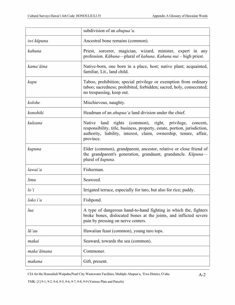
Cultural Surveys Hawai‘i Job Code: HONOULIULI 35 Appendix A Glossary of Hawaiian Words
CIA for the Honouliuli/Waipahu/Pearl City Wastewater Facilities, Multiple Ahupua‘a, ‘Ewa District, O‘ahu A-2
TMK: [1] 9-1, 9-2, 9-4, 9-5, 9-6, 9-7, 9-8, 9-9 (Various Plats and Parcels)
subdivision of an ahupua‘a.
iwi kūpuna Ancestral bone remains (common).
kahuna Priest, sorcerer, magician, wizard, minister, expert in any profession. Kāhuna—plural of kahuna. Kahuna nui – high priest.
kama‘āina Native-born, one born in a place, host; native plant; acquainted, familiar, Lit., land child.
kapu Taboo, prohibition; special privilege or exemption from ordinary taboo; sacredness; prohibited, forbidden; sacred, holy, consecrated; no trespassing, keep out.
kolohe Mischievous, naughty.
konohiki Headman of an ahupua‘a land division under the chief.
kuleana Native land rights (common), right, privilege, concern, responsibility, title, business, property, estate, portion, jurisdiction, authority, liability, interest, claim, ownership, tenure, affair, province.
kupuna Elder (common), grandparent, ancestor, relative or close friend of the grandparent's generation, grandaunt, granduncle. Kūpuna—plural of kupuna.
lawai‘a Fisherman.
limu Seaweed.
lo‘i Irrigated terrace, especially for taro, but also for rice; paddy.
loko i‘a Fishpond.
lua A type of dangerous hand-to-hand fighting in which the, fighters broke bones, dislocated bones at the joints, and inflicted severe pain by pressing on nerve centers.
lū‘au Hawaiian feast (common), young taro tops.
makai Seaward, towards the sea (common).
maka‘āinana Commoner.
makana Gift, present.
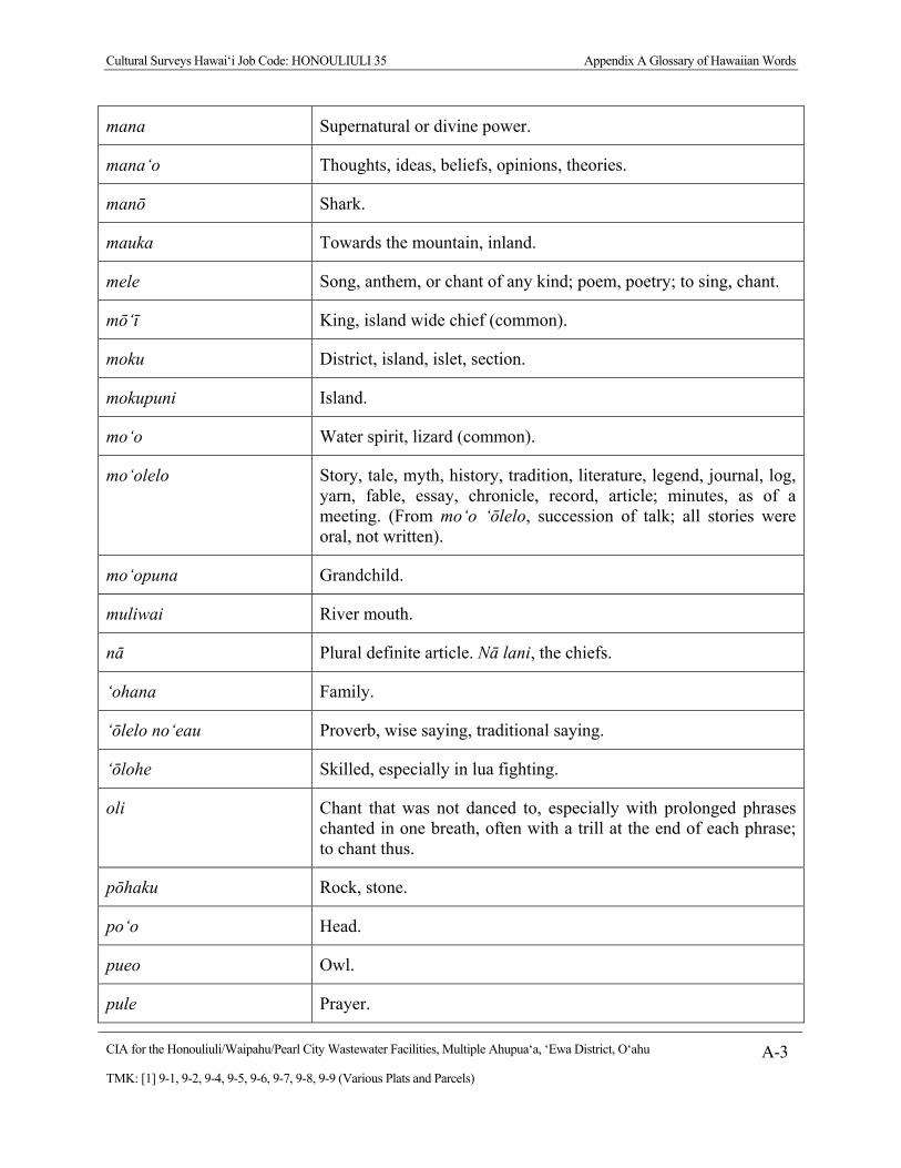
Cultural Surveys Hawai‘i Job Code: HONOULIULI 35 Appendix A Glossary of Hawaiian Words
CIA for the Honouliuli/Waipahu/Pearl City Wastewater Facilities, Multiple Ahupua‘a, ‘Ewa District, O‘ahu A-3
TMK: [1] 9-1, 9-2, 9-4, 9-5, 9-6, 9-7, 9-8, 9-9 (Various Plats and Parcels)
mana Supernatural or divine power.
mana‘o Thoughts, ideas, beliefs, opinions, theories.
manō Shark.
mauka Towards the mountain, inland.
mele Song, anthem, or chant of any kind; poem, poetry; to sing, chant.
mō‘ī King, island wide chief (common).
moku District, island, islet, section.
mokupuni Island.
mo‘o Water spirit, lizard (common).
mo‘olelo Story, tale, myth, history, tradition, literature, legend, journal, log, yarn, fable, essay, chronicle, record, article; minutes, as of a meeting. (From mo‘o ‘ōlelo, succession of talk; all stories were oral, not written).
mo‘opuna Grandchild.
muliwai River mouth.
nā Plural definite article. Nā lani, the chiefs.
‘ohana Family.
‘ōlelo no‘eau Proverb, wise saying, traditional saying.
‘ōlohe Skilled, especially in lua fighting.
oli Chant that was not danced to, especially with prolonged phrases chanted in one breath, often with a trill at the end of each phrase; to chant thus.
pōhaku Rock, stone.
po‘o Head.
pueo Owl.
pule Prayer.
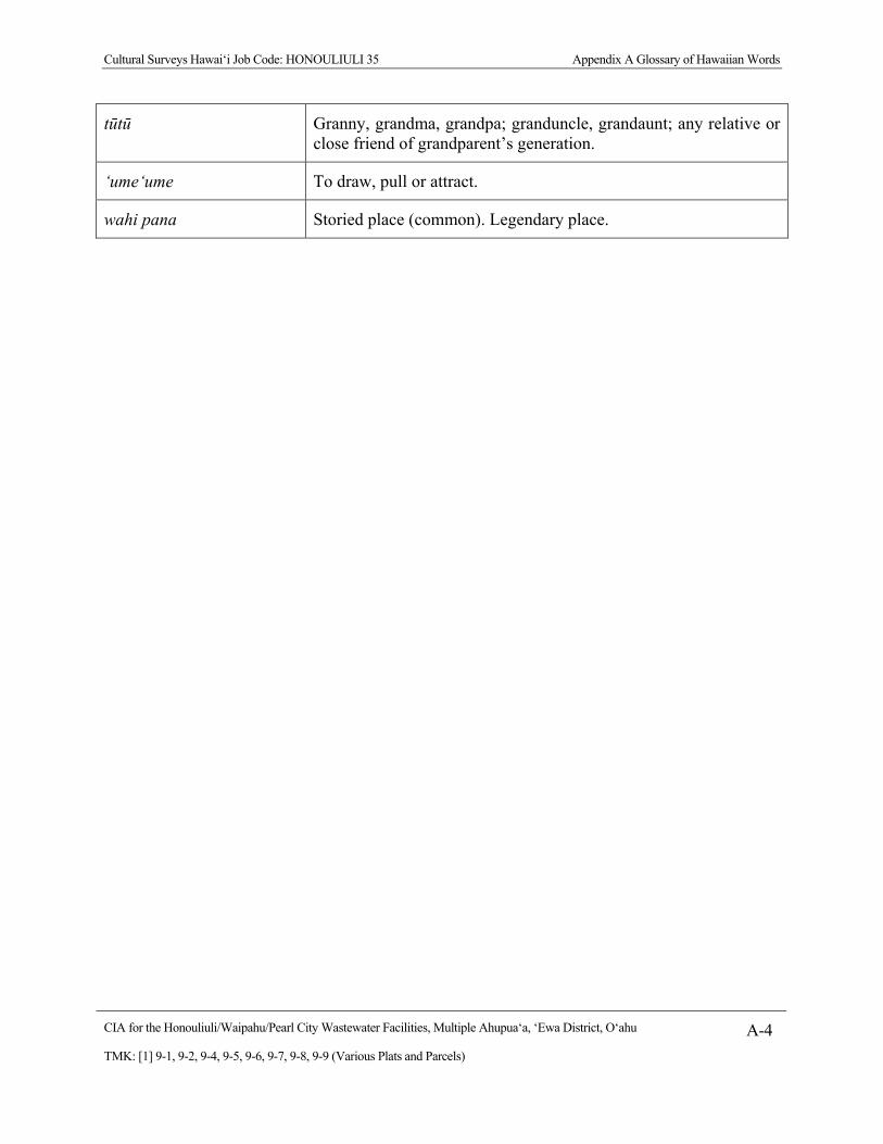
Cultural Surveys Hawai‘i Job Code: HONOULIULI 35 Appendix A Glossary of Hawaiian Words
CIA for the Honouliuli/Waipahu/Pearl City Wastewater Facilities, Multiple Ahupua‘a, ‘Ewa District, O‘ahu A-4
TMK: [1] 9-1, 9-2, 9-4, 9-5, 9-6, 9-7, 9-8, 9-9 (Various Plats and Parcels)
tūtū Granny, grandma, grandpa; granduncle, grandaunt; any relative or close friend of grandparent’s generation.
‘ume‘ume To draw, pull or attract.
wahi pana Storied place (common). Legendary place.

Cultural Surveys Hawai‘i Job Code: HONOULIULI 35 Appendix B Common and Scientific Names for Plants and Animals Mentioned by Community Participants
CIA for the Honouliuli/Waipahu/Pearl City Wastewater Facilities, Multiple Ahupua‘a, ‘Ewa District, O‘ahu B-1
TMK: [1] 9-1, 9-2, 9-4, 9-5, 9-6, 9-7, 9-8, 9-9 (Various Plats and Parcels)
Appendix B Common and Scientific Names for Plants and Animals Mentioned by Community Participants
Common Names Possible Scientific Names Source
Hawaiian Other Genus Species
ae‘o Hawaiian stilt bird Himantopus mexicanus Pukui and Elbert 1986
‘anae mullet Mugil cephalus Pukui and Elbert 1986
‘awa kava Piper methysticum Wagner et al. 1999
hāpu‘u tree fern Cibotium spp.* Wagner et al. 1999
he‘e octopus, squid multiple families and species
i‘iwi scarlett Hawaiian honey creeper Vestiaria coccinea Pukui and Elbert 1986
kalo taro Colocasia esculenta esculenta Wagner et al. 1999
limu ‘ele‘ele seaweed, algae Entermorpha prolifera Abbott and Williamson 1974
manō shark multiple families and species
‘ō‘ō black honey eater Moho nobilis Pukui and Elbert 1986
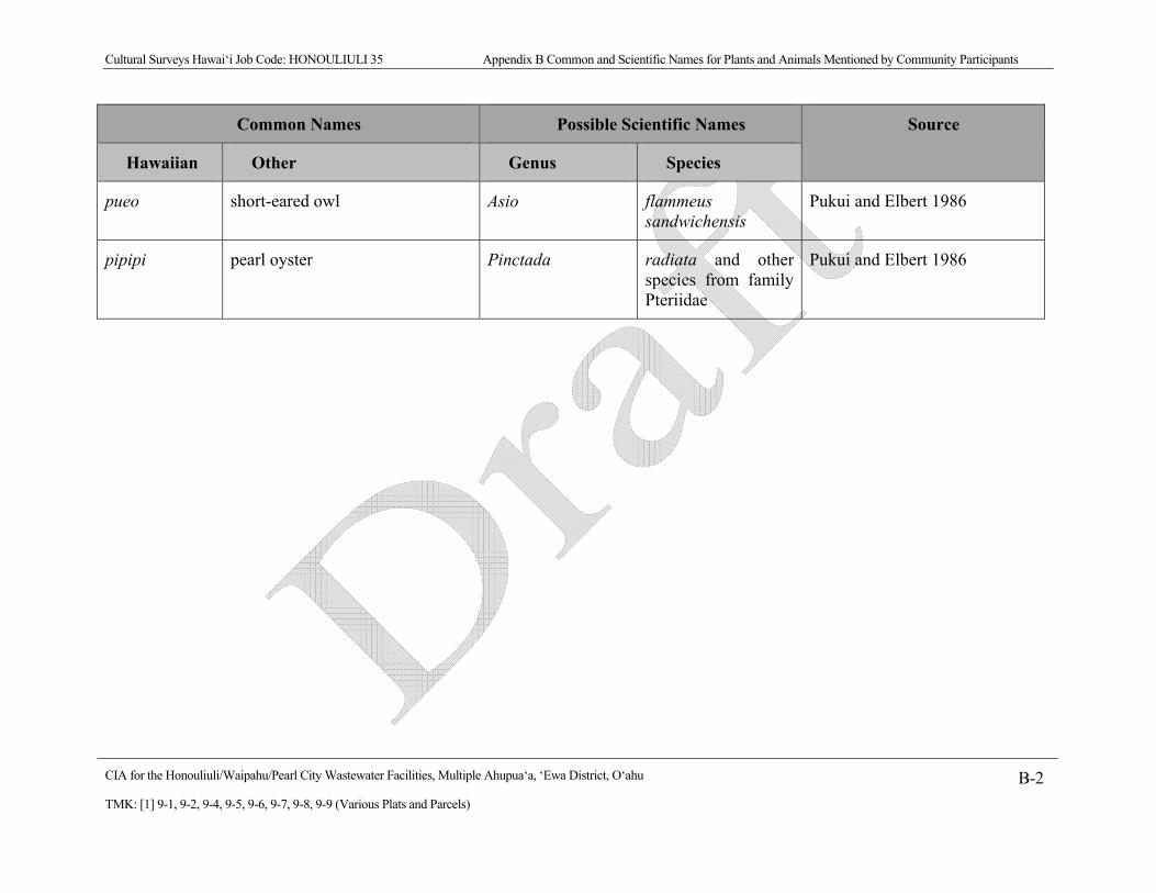
Cultural Surveys Hawai‘i Job Code: HONOULIULI 35 Appendix B Common and Scientific Names for Plants and Animals Mentioned by Community Participants
CIA for the Honouliuli/Waipahu/Pearl City Wastewater Facilities, Multiple Ahupua‘a, ‘Ewa District, O‘ahu B-2
TMK: [1] 9-1, 9-2, 9-4, 9-5, 9-6, 9-7, 9-8, 9-9 (Various Plats and Parcels)
Common Names Possible Scientific Names Source
Hawaiian Other Genus Species
pueo short-eared owl Asio flammeus sandwichensis
Pukui and Elbert 1986
pipipi
pearl oyster
Pinctada radiata and other species from family Pteriidae
Pukui and Elbert 1986
Cultural Surveys Hawai‘i Job Code: HONOULIULI 35 Appendix C Authorization and Release Form
CIA for the Honouliuli/Waipahu/Pearl City Wastewater Facilities, Multiple Ahupua‘a, ‘Ewa District, O‘ahu C-1
TMK: [1] 9-1, 9-2, 9-4, 9-5, 9-6, 9-7, 9-8, 9-9 (Various Plats and Parcels)
Appendix C Authorization and Release Form