critical analysis of shyambazar traffic intersection area, kolkata
110
CRITICAL ANALYSIS OF SHYAMBAZAR TRAFFIC INTERSECTION AREA, KOLKATA: A STUDY OF VISUAL APPROPRIATENESS by NIBEDITA DAS B.Arch Birla Institute of Technology, India, 2001 A REPORT Submitted in partial fulfillment of the requirements for the degree MASTER OF REGIONAL AND COMMUNITY PLANNING Department of Architecture College of Architecture, Planning and Design KANSAS STATE UNIVERSITY Manhattan, Kansas 2006 Approved by: Major Professor Ray Weisenburger
-
Upload
khangminh22 -
Category
Documents
-
view
0 -
download
0
Transcript of critical analysis of shyambazar traffic intersection area, kolkata
CRITICAL ANALYSIS OF SHYAMBAZAR TRAFFIC INTERSECTION AREA, KOLKATA: A STUDY OF VISUAL APPROPRIATENESS
by
NIBEDITA DAS
B.Arch Birla Institute of Technology, India, 2001
A REPORT
Submitted in partial fulfillment of the requirements for the degree
MASTER OF REGIONAL AND COMMUNITY PLANNING
Department of Architecture College of Architecture, Planning and Design
KANSAS STATE UNIVERSITY Manhattan, Kansas
2006
Approved by:
Major Professor
Ray Weisenburger
ii
ABSTRACT
This research explores the challenges related to the visual image of a city situated in a
developing country. Originated as the colonial capital of British India, Kolkata faces
new urban challenges in the post colonial world. This report intends to answer questions
of imageability of the city as relevant to the Third World countries. Empathizing on the
issues of scarcity of land, traffic congestion, accumulation of the urban poor,
inadequacies in infrastructure and the organic expansion of fluid city boundaries under
the neo-ideological globalization and liberal economic policies – Kolkata faces a host
of urban problems. Imageability of the city usually tries to define the positive image of a
city. The question here is, should the notions of imageability be confined to cities that
inherently have succeeded in maintaining an appealing public image or should it be
applied to the potential qualities of visual appropriateness to cities that have historically
remained unattractive?
This research intends to explore the visual quality of an area surrounding the five point
intersection at Shyambazar, Kolkata, India. This study will be based on a number of observations
and the different visual analysis techniques applicable in critically analyzing the visual conditions
of an urban street pattern of a megacity in India. The main objective of this study is to find an
appropriate visual quality for Kolkata, a megacity in the tropics – considering various related
factors like – historical significance, demographic trends, geographical and climatological
influences, transportation pattern, existing land use, socio-economic structure and inherent or
associated urban problems of planning in developing nations.
iii
TABLE OF CONTENTS
Table of Contents ..........................................................................................................iii
List of Figures.................................................................................................................. v
List of Tables................................................................................................................. vii
Acknowledgements ...................................................................................................viii
Chapter 1: Objective and Significance of the Study ................................................ 1
introduction and significance of study.................................................................................................. 1 structure of the report .............................................................................................................................. 3
Chapter 2: Background and Significance of the Study ............................................ 5
Kolkata........................................................................................................................................................ 5 emergence of the global city from the colonial city.......................................................................... 8 streets and transportation planning in the CITY: Past, present and future .................................... 17 important street Intersections in the city ............................................................................................. 24
Chapter 3: Essay – impressions of the study area.................................................... 36
sense and sensibilities ............................................................................................................................. 37 SEEING ........................................................................................................................................................................................... 37 HEARING........................................................................................................................................................................................ 38 SMELLING....................................................................................................................................................................................... 39 TOUCHING..................................................................................................................................................................................... 39 TASTING.......................................................................................................................................................................................... 40
urban planning issues ............................................................................................................................. 41 The Place-ballet ...................................................................................................................................... 44
Chapter 4: Research Methodology – Literature review .......................................... 47
Urban Planning and Design in the Twenty-First Century ................................................................... 48 Key Elements in the Creation of Public Urban Places – of streets, sidewalks and urban nodes..................................... 49 Contemporary Planning Issues for Cities in Developing Nations.......................................................................................... 51
Tools for Critical Urban Analysis Focusing on Visual Assessment...................................................... 56 Image of the City – Kevin Lynch, 1960 ..................................................................................................................................... 57 The Concise Townscape – Gordon Cullen, 1961.................................................................................................................... 59 Responsive Environments: A Manual for Designers – Ian Bentley, Alan Alcock, Paul Murrain, Sue McGlynn, Graham Smith, 1985 .................................................................................................................................................................................... 61 Foundations for Visual Project Analysis – Richard C. Smardon, James F. Palmer, John P. Fellemen,1986 .................... 62
Chapter 5: Methodology Adopted for Study Area .................................................. 65
iv
Chapter 6: critical analysis of Study Area ................................................................ 71
Permeability – ............................................................................................................................................................................... 79 Variety –......................................................................................................................................................................................... 81 Legibility –...................................................................................................................................................................................... 82 Robustness –.................................................................................................................................................................................. 84 Richness – ...................................................................................................................................................................................... 85 Personalization –........................................................................................................................................................................... 86 Visual Appropriateness – ............................................................................................................................................................ 88
Chapter 7: conclusion ................................................................................................ 91
Appendix ..................................................................................................................... 95
v
LIST OF FIGURES
Figure 2.1: Political Map of India showing a detail map of Kolkata......................................5
Figure 2.2: Map of Kolkata showing the study area……………………………………………..7
Figure 2.3: Skyline of Kolkata showing impressions of Colonial and Globalization imprints
on the city……………………………………………………………………………………………….10
Figure 2.4: View of the historical colonial city……………………………………………………13
Figure 2.5: View of new apartment complexes in Kolkata today…………………………...17
Figure 2.6: Picture of a street in North Kolkata in 1910………………………………………....20
Figure 2.7: View of busy street life in Kolkata today………………………………………….....23
Figure 2.8: Photograph of Dalhousie Square 1920………………………………………………26
Figure 2.9: Photograph of Dalhousie Square today…………………………………………....26
Figure 2.10: Schematic map of the B.B.D Bag central business district…………………….27
Figure 2.11: View of Bhupen Bose Avenue……………………………………………………….28
Figure 2.12: View of Bidhan Sarani…………………………………………………………………28
Figure 2.13: Schematic map of Shyambazar Crossing…………………………………………29
Figure 2.14: View of Dalhousie Square today………………………………………………...….30
Figure 2.15: Schematic map of Dharmatala crossing………………………………………….31
Figure 2.16: Photograph of the Gariahat Junction……………………………………………..32
Figure 2.17: Photograph of approach to Gariahat……………………………………………..32
Figure 2.18: Photograph of Gariahat Junction…………………………………………………..32
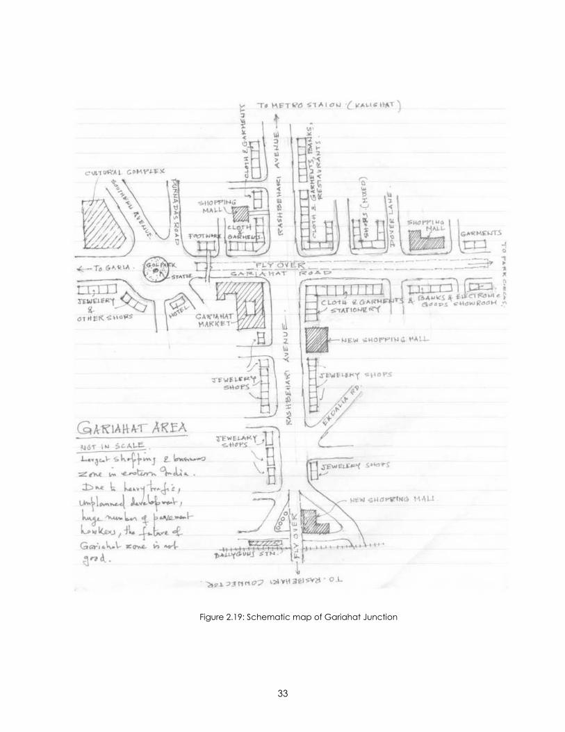
Figure 2.19: Schematic map of Gariahat Junction……………………………………………..33
Figure 2.20: View of E.M Bypass Intersection……………………………………………………..34
Figure 2.21: View towards the Kasba Junction………………………………………………….34
Figure 2.22: Schematic map of E.M. Bypass junction………………………………………….35
vi
Figure 3.1: Messy environment with no segregation between pedestrian and vehicular
traffic…………………………………………………………………………………………………….38
Figure 3.2: Study area in the night buzzing with life and activities…………………………..39
Figure 3.3: Shops along the edge of the pavement with hawker stalls on the
pavement……………………………………………………………………………………………….40
Figure 3.4: Schematic diagram of the study area………………………………………………42
Figure 5.1: The proposed three layered model for visual study………………………………67
Figure 5.2: Visual inventory model………………………………………………………………….68
Figure 5.3: Model for identification of visual elements…………………………………………69
Figure 5.4: Visual qualities model…………………………………………………………………...70
Figure 6.1: Assigning visual control points to determine different visual elements………..72
Figure 6.2: Identification of paths in the study area…………………………………………….74
Figure 6.3: Identification of street edge in the study area…………………………………….75
Figure 6.4: Identification of landmarks in the study area………………………………………75
Figure 6.5: Identification of districts in the study area………………………………………….76
Figure 6.6: Identification of vista in the study area……………………………………………..76
Figure 6.7: Identification of entrances in the study area………………………………………77
Figure 6.8: Application of the visual quality of permeability………………………………….79
Figure 6.9: Application of the visual quality of variety………………………………………….81
Figure 6.10: Application of the visual quality of legibility………………………………………83
Figure 6.11: Application of the visual quality of robustness……………………………………84
Figure 6.12: Application of the visual quality of richness………………………………………85
Figure 6.13: Application of the visual quality of personalization………..……………………87
Figure 6.14: Application of the visual quality of visual appropriateness……………………88

vii
LIST OF TABLES
Table 2.1: Showing the population statistics of Kolkata, India as per the records of United
Nations……………………………………………………………………………………………………6
Table 2.2: Showing the historical hybrid nature of the city…………………………………….8
Table 6.1: Matrix created as a critical visual analysis tool for Shyambazar Intersection
area………………………………………………………………………………………………………79
viii
ACKNOWLEDGEMENTS
This report is a combination of many contributions. First of all, I would like to show my
gratitude to my Master’s Report advisor Prof. Ray Weisenberger, whose patience and
encouragement has helped me find direction in this study. I have enjoyed listening to
his accounts on Chicago and Malaysia as we sat at Radina’s trying to figure the
applicability of this work. I thank him whole heartedly for his support and for being there
always whenever I needed his advice.
I would also like to take this opportunity to thank Prof. Gary Coates and Prof. Selfridge
who have also helped me to refine this study with their holistic understanding of the
subject.
As the study was based on Kolkata, India, it is important to mention some of the names
without whom this report would have been practically impossible to compile. I am
immensely grateful to Subrata Kaku for helping me to gather data about the study area
even in the scorching summer heat of Kolkata afternoons and sharing his thoughts and
sketches about the study areas. I am really thankful to Abhi for compiling the video
about the study area, which has been a key resource for this analysis.
There are many others whom I would like to thank but perhaps without the friendship
and support of Subhrendu and Dipanwita, it would have been difficult to either work or
keep my calm under the tremendous pressure the last few months have seen.
Subhrendu’s critical comments and passion for the subject helped me to rethink and

ix
reorient the direction of my study many times. Fortunately for me the list of sincere
friends around me seems long, but some of them have been particularly helpful in this
research, like Diptansu, Devdeep and Pragyadipta. Special thanks to Porus for
compelling me to find the inner strength I had to accomplish this study. Finally, I am
grateful to my parents, sister and brother to whom I owe everything in my life. Thank you
God for blessing me with such a loving family and great friends who have helped me
see through everything in life.
1
CHAPTER 1: OBJECTIVE AND SIGNIFICANCE OF THE STUDY
INTRODUCTION AND SIGNIFICANCE OF STUDY
Living and studying in a developed country has many benefits. As a person with strong
cultural roots to a rapidly growing developing nation, I feel the most beneficial aspect is
the completely new lens and new perspective attained through this experience to view
the surrounding world. Sitting in the comfort of a centrally air-conditioned classroom,
learning and arguing about the current issues of sustainability and urban design
patterns much different from one’s own birthplace sometimes overshadows one’s
identity or search for a relevant planning order for a nation under diametrically
opposite conditions. This research is a sincere effort to try to link these two vastly
different worlds of design, knowledge and life experiences. The research explores the
essentiality, appropriateness and, most importantly, the understanding and relevance
of urban visual quality in global cities in developing nations based on the case study of
the city of Calcutta in India.
The modern day Calcutta, or Kolkata as it has been recently renamed, began as a
group of three villages which were united under the British to give birth to the colonial
capital until 1911. Kolkata, gained her supremacy politically, economically and socially
mainly under the British. Like most other “Third World primate cities”, as Correa suggests,
Kolkata was developed to serve the colonial scale reflecting the colonial economic
and physical structure. Since independence, the city has witnesses a phenomenal
growth as a result of rapid urbanization. Ironically, Correa observes that as in most
2
cases, “…the new national governments have paid little or no attention to adjusting the
obsolete city structures. Hence their holding capacity has no relation to the scale of
demands being made on them” (Correa, p.25).1
Kolkata, since her birth, has never been considered as a rural area; therefore, the fact
of her being a victim of rapid urbanization may seem ambiguous. The city‘s growth
and concentration of population has been caused by in-migration and globalization.
This unintentional and unrestricted growth has led to numerous political and
infrastructural problems. At one point the city came to be synonymous with poverty and
urban decay. At present, Kolkata is once again making conscious efforts to change her
image from that of a decaying city; major urban reforms are being introduced to
improve conditions and heighten her image. In fact, in December 2001, a high ranking
United States Government official described West Bengal as leading the way in India in
the field of urban planning reforms2. A consistent effort may be noticed in the city
today, especially while developing new townships like Rajarhat, suburbs in Haora to
project the city’s pro-growth scenario. However, I believe that, in this ongoing operation
of remaking the city image, Kolkata is unfortunately not relying on its inherent historical
and cultural assets but adopting strictly Western measures. Today, while there seems to
be a tendency of rejoicing with the new land and capitalizing on future growth
potential, the city tends to avoid reflecting and reanalyzing its present strengths as well
as identifying the inherent weaknesses.
1 Correa, C. 1989. The New Landscape: Urbanization in the Third World. Butterworth Architecture, Sevenoaks. 2 http://www.usaid.gov/in/UsaidInIndia/Articles26.htm
3
This critical – analysis study is intended to specifically explore the visual quality of the
older northern parts of the city, taking the five point intersection area at Shyambazar as
a precedent example. The study area was built during colonial period. The objective of
the analytical study is to evaluate the appropriateness or challenges of urban design in
older parts of the city – integrating the different stratus of society, preserving the
colonial architectural monuments, mixed use neighborhoods, courtyard type dwelling
units, compact and high density planning.
STRUCTURE OF THE REPORT
The report is mainly divided into three different levels, namely – the introduction and
background of the study, the research methodology adopted for the study and finally
the critical analysis of the study area concluding with speculations about the future
growth proposals for traffic intersections of the city.
The first part of the report dealing with introduction and background study of the thesis
has been further sub-divided into three chapters. The first chapter deals with the
significance of the study and report structure. The second chapters deals more deeply
with the background study of the city in general, the evolution of the city urban
planning over the past centuries and finally recognizing the importance of city streets,
transportation and identifying five important traffic intersections of the city. The third
chapter, which is in the form of an essay, attempts to sketch an image of the study
area purely from the recollections of the researcher.
4
The second phase of the report deals with the research methodology adopted in the
critical analysis study. This portion has been sub-divided into two chapters. The fourth
chapter accounts the different visual analysis methods suggested by different authors
and the different planning principles and theories underlying the urban design pattern
of the city. The fifth chapter discusses in detail the research method and analytical tool
chosen for the purpose of the present study.
The third or final phase is again sub-divided into two chapters. The sixth chapter
discusses the critical analysis study of the Shyambazaar area with reference to the data
collected through diagrammatic sketches, photographs and audio-video recordings of
the area. The seventh chapter lays out the conclusions that can be drawn from the
critical study and speculates different solutions appropriate for consideration in future
proposals of the area.
5
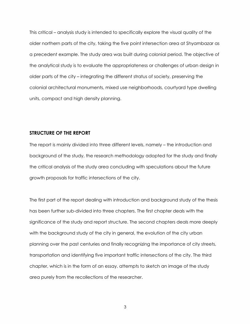
CHAPTER 2: BACKGROUND AND SIGNIFICANCE OF THE STUDY
KOLKATA
Figure 2.1: Political Map of India showing a detail map of Kolkata
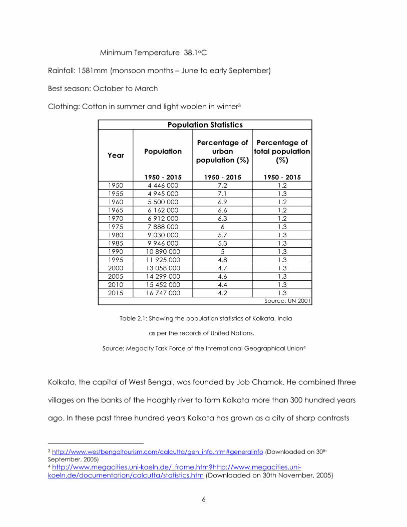
Longitude : 88o 20’E
Latitude: 22° 32’N
Area : 187 sq.km (city)1380.12 sq.km (Kolkata Metropolitan area)
Population: as per 1991 census - 4.39 million(city)
9.2 million (Kolkata Metropolitan area)
Altitude: 6.4m (20 ft.) above sea level
Climate: Winter – Maximum Temperature 36.3oC
Minimum Temperature 9.6oC
Summer – Maximum Temperature 41.7oC
6
Minimum Temperature 38.1oC
Rainfall: 1581mm (monsoon months – June to early September)
Best season: October to March
Clothing: Cotton in summer and light woolen in winter3
1950 - 2015 1950 - 2015 1950 - 20151950 4 446 000 7.2 1.21955 4 945 000 7.1 1.31960 5 500 000 6.9 1.21965 6 162 000 6.6 1.21970 6 912 000 6.3 1.21975 7 888 000 6 1.31980 9 030 000 5.7 1.31985 9 946 000 5.3 1.31990 10 890 000 5 1.31995 11 925 000 4.8 1.32000 13 058 000 4.7 1.32005 14 299 000 4.6 1.32010 15 452 000 4.4 1.32015 16 747 000 4.2 1.3
Year
Source: UN 2001
Population Statistics
Percentage of urban
population (%)
Percentage of total population
(%)Population
Table 2.1: Showing the population statistics of Kolkata, India
as per the records of United Nations.
Source: Megacity Task Force of the International Geographical Union4
Kolkata, the capital of West Bengal, was founded by Job Charnok. He combined three
villages on the banks of the Hooghly river to form Kolkata more than 300 hundred years
ago. In these past three hundred years Kolkata has grown as a city of sharp contrasts
3 http://www.westbengaltourism.com/calcutta/gen_info.htm#generalinfo (Downloaded on 30th September, 2005) 4 http://www.megacities.uni-koeln.de/_frame.htm?http://www.megacities.uni-koeln.de/documentation/calcutta/statistics.htm (Downloaded on 30th November, 2005)
7
and contradictions. On one hand it has been referred to as the ‘City of joy’ while on the
other as the ‘Dying city’( Rajiv Gandhi, Former prime minister of India). However the
truth remains that even in the most conflicting pictures of Kolkata, the city remains a
thriving and “alive” city accepting every aspect of culture from the wide range of
ethnic groups settled in the city and evolving its unique hybrid identity. This is probably
the reason why it has been termed as the ‘Cultural Capital of India’.
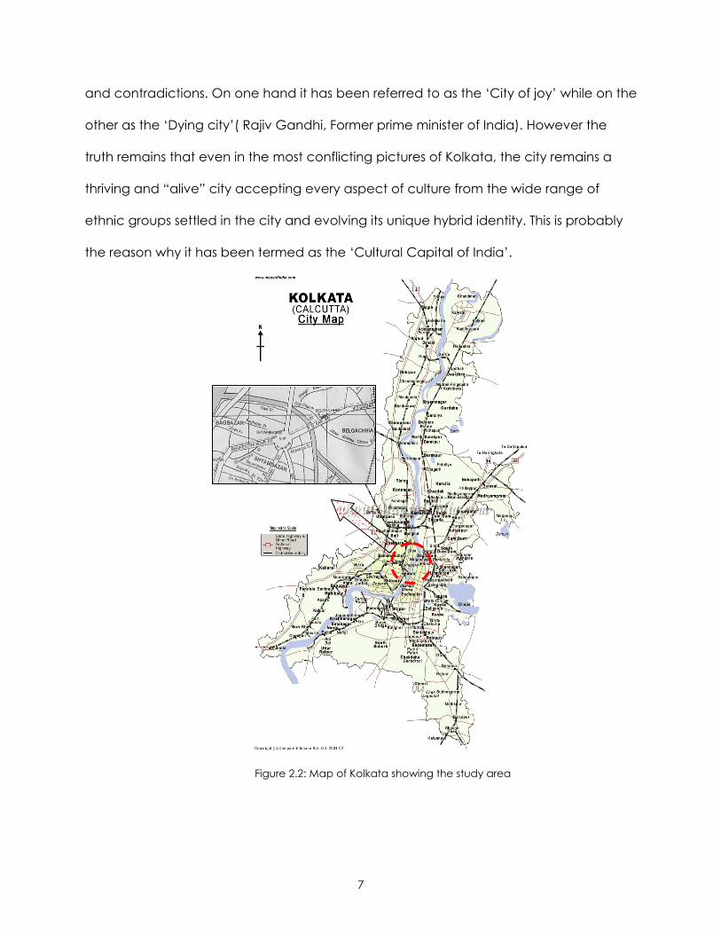
Figure 2.2: Map of Kolkata showing the study area
8
EMERGENCE OF THE GLOBAL CITY FROM THE COLONIAL CITY
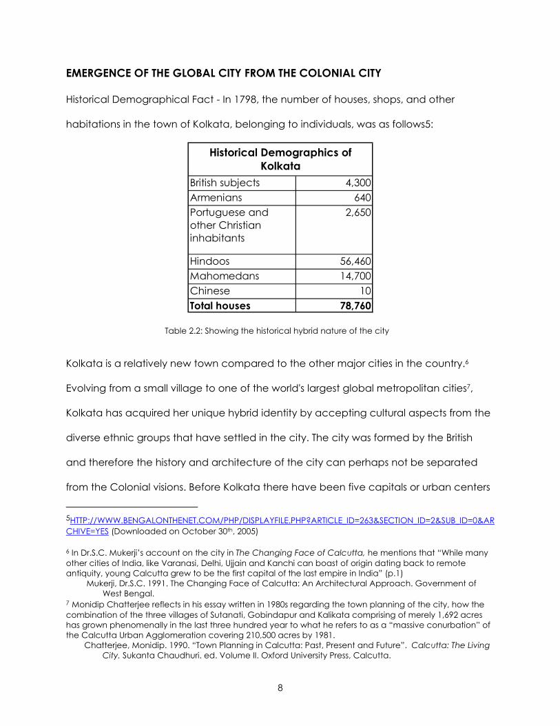
Historical Demographical Fact - In 1798, the number of houses, shops, and other
habitations in the town of Kolkata, belonging to individuals, was as follows5:
British subjects 4,300Armenians 640Portuguese and other Christian inhabitants
2,650
Hindoos 56,460Mahomedans 14,700Chinese 10Total houses 78,760
Historical Demographics of Kolkata
Table 2.2: Showing the historical hybrid nature of the city
Kolkata is a relatively new town compared to the other major cities in the country.6
Evolving from a small village to one of the world's largest global metropolitan cities7,
Kolkata has acquired her unique hybrid identity by accepting cultural aspects from the
diverse ethnic groups that have settled in the city. The city was formed by the British
and therefore the history and architecture of the city can perhaps not be separated
from the Colonial visions. Before Kolkata there have been five capitals or urban centers
5HTTP://WWW.BENGALONTHENET.COM/PHP/DISPLAYFILE.PHP?ARTICLE_ID=263&SECTION_ID=2&SUB_ID=0&ARCHIVE=YES (Downloaded on October 30th, 2005) 6 In Dr.S.C. Mukerji’s account on the city in The Changing Face of Calcutta, he mentions that “While many other cities of India, like Varanasi, Delhi, Ujjain and Kanchi can boast of origin dating back to remote antiquity, young Calcutta grew to be the first capital of the last empire in India” (p.1) Mukerji, Dr.S.C. 1991. The Changing Face of Calcutta: An Architectural Approach. Government of West Bengal. 7 Monidip Chatterjee reflects in his essay written in 1980s regarding the town planning of the city, how the combination of the three villages of Sutanati, Gobindapur and Kalikata comprising of merely 1,692 acres has grown phenomenally in the last three hundred year to what he refers to as a “massive conurbation” of the Calcutta Urban Agglomeration covering 210,500 acres by 1981. Chatterjee, Monidip. 1990. “Town Planning in Calcutta: Past, Present and Future”. Calcutta: The Living City. Sukanta Chaudhuri. ed. Volume II. Oxford University Press, Calcutta.
9
in Bengal owing to its historical importance in trade and commerce. However, once the
city was formed, it surpassed the political supremacy of all the others in Bengal,
especially after being named as the capital of the British Empire.8 Historically, Kolkata’s
architecture may perhaps be divided into two main phases – pre-independence and
post independence. Chakravorty9, on the other hand, has mentioned a third emerging
phase in the economic developmental history of the city – the phase that he calls
“post-command/ reform economy, during the second global period”. Though this
formative phase is largely integrated within the discussion of post –independence
urban planning and design of Kolkata, it is marked by the sudden change in outlook
and attitude of the city to change its reference from the dying or decaying city to the
global progressive city. In the abstract of his essay on The Unintended City, Jai Sen
wrote, “This vernacular, self made city is shaped by forces of rejection and affinity:
rejection by urban centre and the affinity of traditions”.10 It is essentially this eternal
tension between rejection and affinity that has been explicitly integrated with the
urban planning and architecture of the city. From the day of her conception to this
day, this dramatic contrast has been expressed time and over both visually and
physically in the buildings and urban layout of Kolkata. One of the objectives of this
report is to determine whether the traditional pre-independence domestic urban
design still bears any relevance to post-independence global hybrid culture and
8 Based on Monidip Chatterjee’s observation in his essay on “Before Calcutta”, that “Before Calcutta, there were at least five other capitals or urban centers in Bengal at different times: Gour, Rajmahal, Dhaka, Nadia and of course, Murshidabad, the seat of the Nawabs in Bengal” (p.5). Chatterjee, Monidip. 1990. “Before Calcutta”. Calcutta: The Living City. Sukanta Chaudhuri. ed. Volume II. Oxford University Press, Calcutta. 9 Chakravorty, Sanjoy. 2000. “From Colonial City to Globalizing City? The Far –from- complete Spatial Transformation of Calcutta”. Globalizing Cities: A New Spatial Order. Marcuse, Peter and Kempen, Ronald Van. ed. Blackwell Publishers,Oxford. 10 Sen, Jai. 1975. The Unintended City: an essay on the city of the poor. Cathedral Relief and Social Services, Calcutta.
10
society. It is particularly important to understand this evolutionary path of urban
planning in the city associated with the social and cultural attitude to appreciably
analyze the chosen intersection study area which may definitely be considered as the
juxtaposition of the historic Colonial city being ravaged under the pressures of the up-
and-coming Global city.
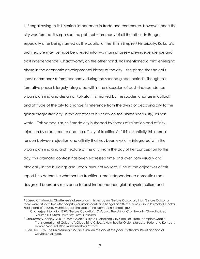
Figure 2.3: Skyline of Kolkata showing impressions of Colonial and Globalization imprints on the city
(Source: home.att.net/ ~dakku/calsky.jpg)
The pre-independence era of the city is largely characterized by British Colonial
influences, which is evident in the architecture and planning of the city. Before the
Battle of Plassey11 in 1757, as per the accounts of Mukerjee12, the city could be divided
into four different sub-areas – European Kolkata (Dihi Kolkata), a residential village with
some sacred spots (Gobindapur), a traditional Indian market (Bazar Kalikata or
Burrabazar) and a riverine mart concentrating on cloth trade (Sutanati). It was only
11 The Battle of Plassey was the final battle fought between Siraj-ud-daula the then Nawab of Bengal and the British. Anthony D. King remarks that, “The defeat of the Nawab of Bengal and his French allies at Plassey in 1757 is usually taken as symbolic beginning of the British Empire in India. Where the operations of the East India Company in the 17th century had been those of trade, though increasingly armed trade at that, after Plassey, the rapidly turned to plunder” (p.23). King, Anthony D. 1995. The Bungalow: The Production of a Global Culture. Oxford University Press, New York. 12 Mukerji, Dr.S.C. 1991. The Changing Face of Calcutta: An Architectural Approach. Government of West Bengal.
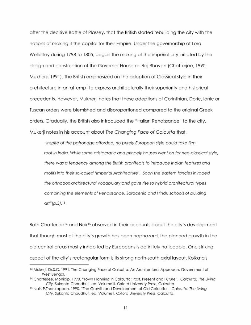
11
after the decisive Battle of Plassey, that the British started rebuilding the city with the
notions of making it the capital for their Empire. Under the governorship of Lord
Wellesley during 1798 to 1805, began the making of the imperial city initiated by the
design and construction of the Governor House or Raj Bhavan (Chatterjee, 1990;
Mukherji, 1991). The British emphasized on the adoption of Classical style in their
architecture in an attempt to express architecturally their superiority and historical
precedents. However, Mukherji notes that these adoptions of Corinthian, Doric, Ionic or
Tuscan orders were blemished and disproportioned compared to the original Greek
orders. Gradually, the British also introduced the “Italian Renaissance” to the city.
Mukerji notes in his account about The Changing Face of Calcutta that,
“Inspite of the patronage afforded, no purely European style could take firm
root in India. While some aristocratic and princely houses went on for neo-classical style,
there was a tendency among the British architects to introduce Indian features and
motifs into their so-called ‘Imperial Architecture’. Soon the eastern fancies invaded
the orthodox architectural vocabulary and gave rise to hybrid architectural types
combining the elements of Renaissance, Saracenic and Hindu schools of building
art”(p.3).13
Both Chatterjee14 and Nair15 observed in their accounts about the city’s development
that though most of the city’s growth has been haphazard, the planned growth in the
old central areas mostly inhabited by Europeans is definitely noticeable. One striking
aspect of the city’s rectangular form is its strong north-south axial layout. Kolkata's 13 Mukerji, Dr.S.C. 1991. The Changing Face of Calcutta: An Architectural Approach. Government of West Bengal. 14 Chatterjee, Monidip. 1990. “Town Planning in Calcutta: Past, Present and Future”. Calcutta: The Living City. Sukanta Chaudhuri. ed. Volume II. Oxford University Press, Calcutta. 15 Nair, P.Thankappan. 1990. “The Growth and Development of Old Calcutta”. Calcutta: The Living City. Sukanta Chaudhuri. ed. Volume I. Oxford University Press, Calcutta.
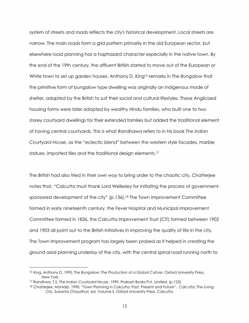
12
system of streets and roads reflects the city's historical development. Local streets are
narrow. The main roads form a grid pattern primarily in the old European sector, but
elsewhere road planning has a haphazard character especially in the native town. By
the end of the 19th century, the affluent British started to move out of the European or
White town to set up garden houses. Anthony D. King16 remarks in The Bungalow that
the primitive form of bungalow type dwelling was originally an indigenous mode of
shelter, adapted by the British to suit their social and cultural lifestyles. These Anglicized
housing forms were later adopted by wealthy Hindu families, who built one to two
storey courtyard dwellings for their extended families but added the traditional element
of having central courtyards. This is what Randhawa refers to in his book The Indian
Courtyard House, as the “eclectic blend” between the western style facades, marble
statues, imported tiles and the traditional design elements.17
The British had also tried in their own way to bring order to the chaotic city. Chatterjee
notes that, “Calcutta must thank Lord Wellesley for initiating the process of government-
sponsored development of the city” (p.136).18 The Town Improvement Committee
formed in early nineteenth century, the Fever Hospital and Municipal Improvement
Committee formed in 1836, the Calcutta Improvement Trust (CIT) formed between 1902
and 1903 all point out to the British initiatives in improving the quality of life in the city.
The Town Improvement program has largely been praised as it helped in creating the
ground axial planning underlay of the city, with the central spinal road running north to
16 King, Anthony D. 1995. The Bungalow: The Production of a Global Culture. Oxford University Press, New York. 17 Randhwa, T.S. The Indian Courtyard House. 1999. Prakash Books Pvt. Limited. (p.123) 18 Chatterjee, Monidip. 1990. “Town Planning in Calcutta: Past, Present and Future”. Calcutta: The Living City. Sukanta Chaudhuri. ed. Volume II. Oxford University Press, Calcutta.
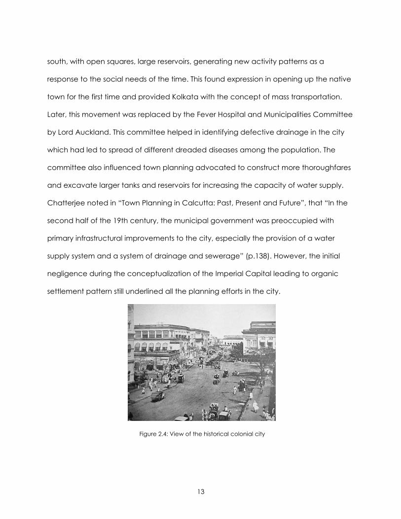
13
south, with open squares, large reservoirs, generating new activity patterns as a
response to the social needs of the time. This found expression in opening up the native
town for the first time and provided Kolkata with the concept of mass transportation.
Later, this movement was replaced by the Fever Hospital and Municipalities Committee
by Lord Auckland. This committee helped in identifying defective drainage in the city
which had led to spread of different dreaded diseases among the population. The
committee also influenced town planning advocated to construct more thoroughfares
and excavate larger tanks and reservoirs for increasing the capacity of water supply.
Chatterjee noted in “Town Planning in Calcutta: Past, Present and Future”, that “In the
second half of the 19th century, the municipal government was preoccupied with
primary infrastructural improvements to the city, especially the provision of a water
supply system and a system of drainage and sewerage” (p.138). However, the initial
negligence during the conceptualization of the Imperial Capital leading to organic
settlement pattern still underlined all the planning efforts in the city.
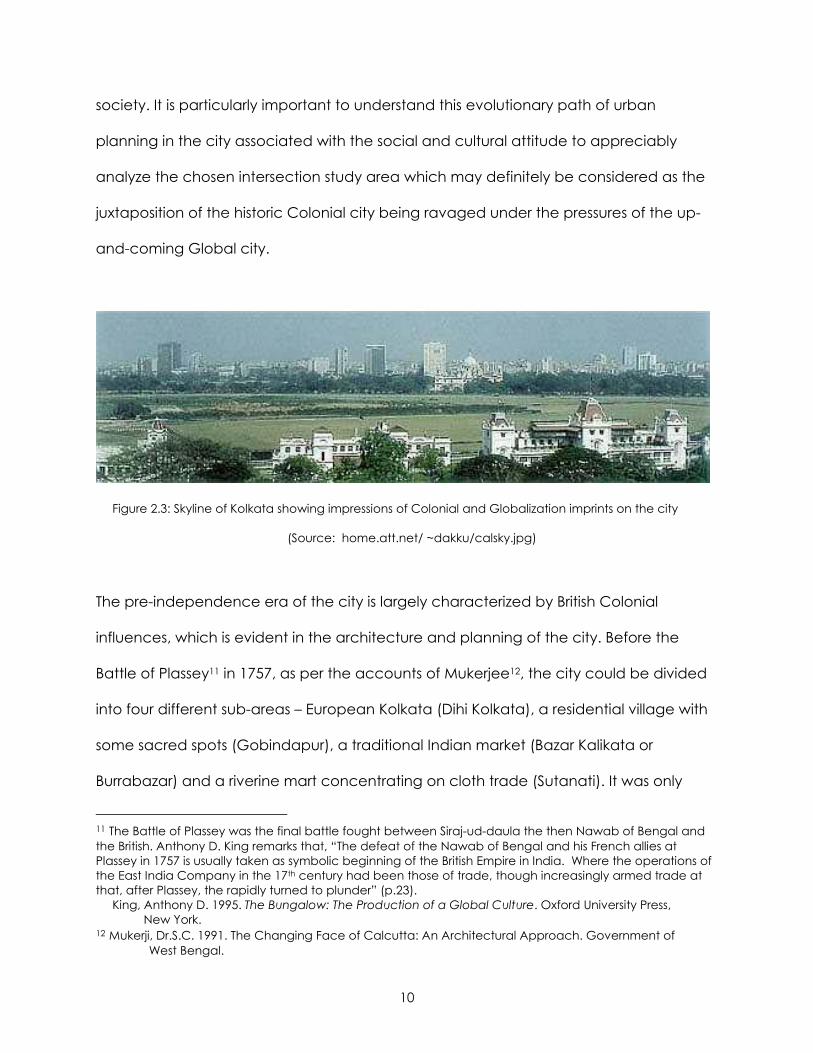
Figure 2.4: View of the historical colonial city
14
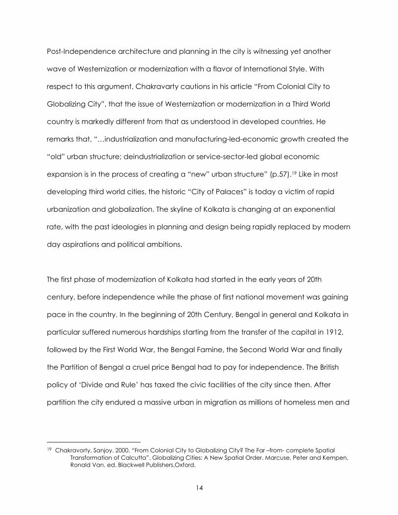
Post-Independence architecture and planning in the city is witnessing yet another
wave of Westernization or modernization with a flavor of International Style. With
respect to this argument, Chakravarty cautions in his article “From Colonial City to
Globalizing City”, that the issue of Westernization or modernization in a Third World
country is markedly different from that as understood in developed countries. He
remarks that, “…industrialization and manufacturing-led-economic growth created the
“old” urban structure; deindustrialization or service-sector-led global economic
expansion is in the process of creating a “new” urban structure” (p.57).19 Like in most
developing third world cities, the historic “City of Palaces” is today a victim of rapid
urbanization and globalization. The skyline of Kolkata is changing at an exponential
rate, with the past ideologies in planning and design being rapidly replaced by modern
day aspirations and political ambitions.
The first phase of modernization of Kolkata had started in the early years of 20th
century, before independence while the phase of first national movement was gaining
pace in the country. In the beginning of 20th Century, Bengal in general and Kolkata in
particular suffered numerous hardships starting from the transfer of the capital in 1912,
followed by the First World War, the Bengal Famine, the Second World War and finally
the Partition of Bengal a cruel price Bengal had to pay for independence. The British
policy of ‘Divide and Rule’ has taxed the civic facilities of the city since then. After
partition the city endured a massive urban in migration as millions of homeless men and
19 Chakravorty, Sanjoy. 2000. “From Colonial City to Globalizing City? The Far –from- complete Spatial Transformation of Calcutta”. Globalizing Cities: A New Spatial Order. Marcuse, Peter and Kempen, Ronald Van. ed. Blackwell Publishers,Oxford.
15
women encamped on the vacant plots of the city. By 1950’s, Chatterjee20 observes
that the city’s civic facilities were under “severe strain and grossly inadequate”. At the
same time, Calcutta was beset by cholera epidemics which drew the attention of the
World Health Organization.21 Under the initiation of the WHO, in 1961 a planning
organization for Greater Calcutta called the Calcutta Metropolitan Planning
Organization (CMPO) was formed by the West Bengal Government. Assisted by
international experts the CMPO prepared and published the “Basic Development Plan
for the Calcutta Metropolitan District (1966 -1986). However, in spite of all the effort,
commitment and honest endeavor, very little could be achieved by the plan due to
the gap between planning and decision-making. In 1971, in yet another attempt to
bring order to the unsettled, organic city growth, the Calcutta Metropolitan
Development Authority (CMDA) was created. Then came the period of communist
government which has been continuing to this time causing West Bengal to be referred
to as “…home to the world’s longest surviving democratically elected communist
government, the Left Front”.22
The Leftist has also had their share of visions for the city expressed in the Perspective
Plan of CMDA: Vision 2025, the Master Plan for Traffic and Transportation in Calcutta
Metropolitan Area (2001-2025) and similar various other plans to remake the city. Roy
reflects in her essay on “The Gentlemen’s City” that,
“The remaking of Calcutta looks ahead to the city of the future, the bhadralok city. 20 Chatterjee, Monidip. 1990. “Town Planning in Calcutta: Past, Present and Future”. Calcutta: The Living City. Sukanta Chaudhuri. ed. Volume II. Oxford University Press, Calcutta. 21 Chatterjee, Monidip. 1990. “Town Planning in Calcutta: Past, Present and Future”. Calcutta: The Living City. Sukanta Chaudhuri. ed. Volume II. Oxford University Press, Calcutta. 22 Roy, Ananya. “The Gentlemen’s City: Urban Informality in the Calcutta of New Communism”. Urban Informality: Transnational Perspectives from the Middle East, Latin America and South Asia. Al- Sayyad,Nezar and Ananya Roy. ed. 2003. Lexington Books, New York.
16
This is the gentlemen’s city – gentlemanly in its sensibilities, and housing the gentleman
and his family. But this moment also gestures to the past, as in the content of
developmental projects, in the attempt to recover a lost city grace and charm” (p.151).
She further notes that today the imperatives of economic liberalization and
globalization have forwarded a city management model based on economic interests.
This is perhaps what can be expressed as the second phase of our national movement,
starting around the new millennium, distinguished by the political ambition of uplifting
the city image and again placing its name among the progressive metropolitans of the
country. Present day Kolkata is witnessing an active group of supporters and
beneficiaries especially among the business, industry and upper middle class income
groups. Roy suggests that if these plans and visions are materialized successfully it will
lead to an extension and improvement of quality of the formal city. However, it appears
that it is under this pressure of rapid economic liberalization, the city’s history, urban
planning and design remains largely neglected. There is a general tendency of
expressing development in the city by the mushrooming growth of high-rise apartments
and condoville development throughout the city surface. Many of these new sprawling
developments are rewriting the territorial boundaries of the city edges and recreating
the skyline but at the cost of replacing the historic buildings from the city ground. The
emphasis in this analytical study is not just related to the preservation of these traditional
structures or urban areas, but it is to try and learn from these traditional spaces to
determine if they can still be developed to reflect the uniqueness of the colonial
influence yet generating the sense of modernity of its global paradigm. The question is
whether it is possible to appropriately design for the duality of historical versus modern,
17
traditional versus global and express that through the concept of planning of streets
and intersections in today’s Kolkata.
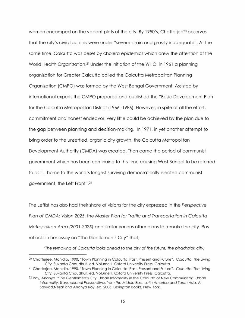
Figure 2.5: View of new apartment complexes in Kolkata today
STREETS AND TRANSPORTATION PLANNING IN THE CITY: PAST, PRESENT AND FUTURE
City streets and the transportation network have played a vital role in the growth in
cities worldwide. Kolkata did not vary from this tradition. Though the initial organic
planning under the British manifests itself even today in the city transportation network,
the city has come a long way in the past 300 years, in recognizing the importance and
accommodating the need for a proper transportation plan and street layout.
PAST – When the British built their capital by combining the three villages of Sutanati,
Gobindapur and Kalikata, there were virtually no roads except for the Chitpur Road
connecting Halisahar in North 24 Parganas with Kalighat. Tracing the history of road
construction, Nair23 quoted from A.K. Ray’s table in A Short History of Calcutta (1901),
that – between 1706 to 1756 the number of street constructions in the city rose from 2 to 23 Nair, P Thankappan. “Civic and Public Services in Old Calcutta”. Calcutta: The Living City. Sukanta Chaudhuri. ed. Volume I. Oxford University Press, Calcutta.
18
27; after 1757, the colonial visions in Bengal strengthened nearly 163 streets, 520 lanes
and 517 by lanes which were built by the British. Nair notes that before the Battle of
Plassey in 1757, most of the streets in Kolkata were referred to by phrases rather than
names, for example - “Road to Dum Dum”, “Avenue leading Eastward”; whereas, as
the empire started getting footage in the city and state most of the later streets were
named after prominent Englishmen. The number of roads built after Plassey were built
initially to connect the suburbs to the growing city. The new streets built by 1766,
included “Shyambazar Road”, “Dullendaw Road” (now Bhowanipore Road),
“Manikchurn Road” (now Maniktala), “Gopalnagar Road” and “Beliaghata Road”. In
the 19th Century, after the commission of the Lottery Committee, some major arterial
roads were built, for example – Cornwallis Street (now Bidhan Sarani), Wellington Street
(Nirmal Chandra Street), Wellesley Street (now Rafi Ahmed Kidwai Road). Nair in his
account about the “Civic and Public Facilities in Old Calcutta”, acknowledged that
the major roads built in southern parts of the city as in the Phulbagan- Kankurgachi area
in the north, were the contribution of the Calcutta Improvement Trust (CIT).The Central
Avenue from Esplanade to Shyambazar and other streets like Vivekanda Road, B.K.Pal
Avenue and Girish Avenue built during this period helped in relieving the congested
areas in North Calcutta. Chatterjee in his account of “Town Planning in Calcutta: Past,
Present and Future” observes that after the Calcutta Improvement Act of 1911, another
surge of need to connect the city to its suburbs and contiguous areas was felt again;
under the directions of E.P. Richards different layouts realigning the streets of the city
were conceived. In his schemes, Richards bounded the urban area of Kolkata by the
Upper circular (Acharya Prafullachandra) and Lower Circular (Acharya J.C. Basu)
roads. Richards report and schemes identified striking deficiencies in the street planning
19
of the city and “concluded by presenting nine alternative schemes, with estimates of
cost, for the improvement of intra-city main roads” (p.141).24
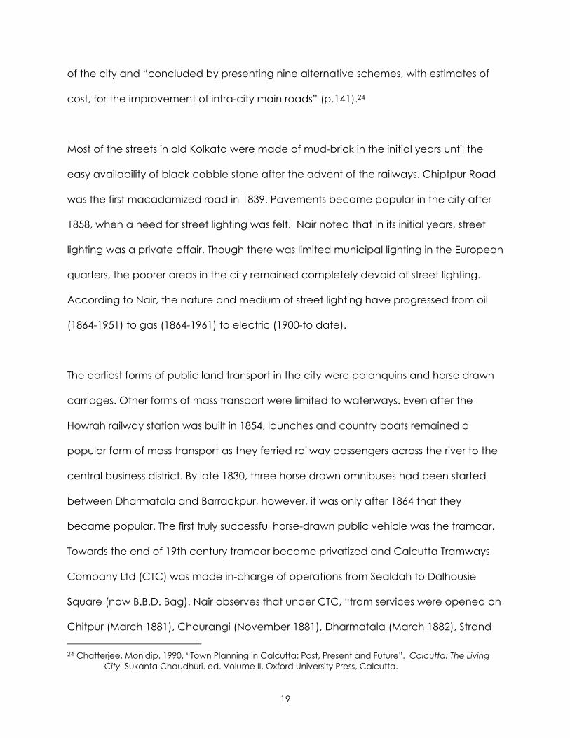
Most of the streets in old Kolkata were made of mud-brick in the initial years until the
easy availability of black cobble stone after the advent of the railways. Chiptpur Road
was the first macadamized road in 1839. Pavements became popular in the city after
1858, when a need for street lighting was felt. Nair noted that in its initial years, street
lighting was a private affair. Though there was limited municipal lighting in the European
quarters, the poorer areas in the city remained completely devoid of street lighting.
According to Nair, the nature and medium of street lighting have progressed from oil
(1864-1951) to gas (1864-1961) to electric (1900-to date).
The earliest forms of public land transport in the city were palanquins and horse drawn
carriages. Other forms of mass transport were limited to waterways. Even after the
Howrah railway station was built in 1854, launches and country boats remained a
popular form of mass transport as they ferried railway passengers across the river to the
central business district. By late 1830, three horse drawn omnibuses had been started
between Dharmatala and Barrackpur, however, it was only after 1864 that they
became popular. The first truly successful horse-drawn public vehicle was the tramcar.
Towards the end of 19th century tramcar became privatized and Calcutta Tramways
Company Ltd (CTC) was made in-charge of operations from Sealdah to Dalhousie
Square (now B.B.D. Bag). Nair observes that under CTC, “tram services were opened on
Chitpur (March 1881), Chourangi (November 1881), Dharmatala (March 1882), Strand 24 Chatterjee, Monidip. 1990. “Town Planning in Calcutta: Past, Present and Future”. Calcutta: The Living City. Sukanta Chaudhuri. ed. Volume II. Oxford University Press, Calcutta.
20
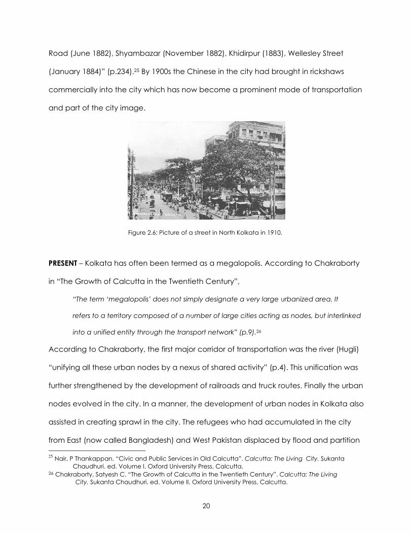
Road (June 1882), Shyambazar (November 1882), Khidirpur (1883), Wellesley Street
(January 1884)” (p.234).25 By 1900s the Chinese in the city had brought in rickshaws
commercially into the city which has now become a prominent mode of transportation
and part of the city image.
Figure 2.6: Picture of a street in North Kolkata in 1910.
PRESENT – Kolkata has often been termed as a megalopolis. According to Chakraborty
in “The Growth of Calcutta in the Twentieth Century”,
“The term ‘megalopolis’ does not simply designate a very large urbanized area. It
refers to a territory composed of a number of large cities acting as nodes, but interlinked
into a unified entity through the transport network” (p.9).26
According to Chakraborty, the first major corridor of transportation was the river (Hugli)
“unifying all these urban nodes by a nexus of shared activity” (p.4). This unification was
further strengthened by the development of railroads and truck routes. Finally the urban
nodes evolved in the city. In a manner, the development of urban nodes in Kolkata also
assisted in creating sprawl in the city. The refugees who had accumulated in the city
from East (now called Bangladesh) and West Pakistan displaced by flood and partition 25 Nair, P Thankappan. “Civic and Public Services in Old Calcutta”. Calcutta: The Living City. Sukanta Chaudhuri. ed. Volume I. Oxford University Press, Calcutta. 26 Chakraborty, Satyesh C. “The Growth of Calcutta in the Twentieth Century”. Calcutta: The Living City. Sukanta Chaudhuri. ed. Volume II. Oxford University Press, Calcutta.

21
slowly secured their positions in the city in the vast vacant lands between the urban
nodes. Therefore, though the concept of urban sprawl is common in both First and Third
world countries, it must be understood in the light of its differential impacts on the
dissimilar urban economies. For example, in the United States a sprawling community
witnesses interstitial areas between urban nodes marked by low density population.
However, in Kolkata, the interstitial tracts as well as the peripheral areas are densely
populated, supporting intensive agriculture and supporting the metropolis with diverse
agricultural products including rice and vegetables. Today, understanding this
difference in the concept of sprawl is primary in conceiving the importance of urban
nodes and transportation planning in the urban economy of Kolkata.
Two chief aspects of importance in Kolkata’s traffic and transportation planning are –
the state of the roads and traffic control management; and provision of vehicles for
public transport. Until the 1990s the city roads occupied about 6.5% area of the total
land as compared to 16% in Bombay (now Mumbai) and 23% in Delhi. The
administration has long recognized this inadequacy in street facilities, with massive
traffic congestions in especially in B.B.D Bag office area and bazaar areas in the north.
The first effort to absorb rush-hour traffic which can avoid the central business district by
moving traffic flow towards the periphery materialized in the form of the Eastern
Metropolitan Bypass augmenting the Nazrul Islam Road (also known as VIP Road). Older
corridors along Acharya Prafullachandra Road (A.P.C. ) and Acharya J.C. Basu Road
(A.J.C. Basu) have been strengthened by building of Sealdah flyover. Since then, roads,
expressways, bypasses and flyovers have been added and are still being added
throughout the city in an aggressive effort to further strengthen traffic quality and flow
22
pattern.27 However, in-city construction has been both challenging and frustrating as it
has not only brought up political issues of acquisition of land but also caused increased
traffic congestion as construction work extended over a lengthy period of time. Some
of the newer flyovers built to relieve traffic are near Gariahat and Park Circus, while
some others that are under construction are on Chowringhee, Kasba etc.
Observing the nature of easy going slow moving traffic in 1980, Saswati Mitter28 wrote in
Living in Calcutta that, “Deaths from road accidents are far fewer in Calcutta than in
European countries. This is mainly because it is difficult to drive in Calcutta streets at any
speed. Roads are filled with rickshaws, pedestrians, dogs, cats and even sleeping
bullocks or holy Hindu cows” (p.16). Kolkata has an acute shortage of parking spaces.
This has led to cars being habitually parked on the streets. This has further aggravated
the cause of traffic congestion, complemented by the range of slow moving traffic in
the streets (handcarts, hand-drawn or cycle rickshaws, auto-rickshaws etc) and by the
ever increasing number of encroaching street hawkers. Chaudhuri29 notes in his 1990
article on “Traffic and Transport in Calcutta” that, “There are said to be some 60,000
street hawkers. Their stalls tend to cluster at road junctions, which should be kept clear
most of all: hence in Calcutta, intersection delays make up 82% of all traffic delays – far
above the world average” (p.149). Though an effort was made to solve this problem by
27 Sukanta Chaudhuri notes in his article on “Traffic and Transport in Calcutta” that the trunk roads (barracker trunk Road and Jessore Road from north and Diamond Harbor Road from south) carry a good chunk of traffic to and from the port and core of the city. Three bridges on Hugli – Howrah bridge, 2nd Hooghly bridge and Bali bridge – try to connect the city to its hinterland. Chaudhuri, Sukanta. “Traffic and Transport in Calcutta”. Calcutta: The Living City. Sukanta Chaudhuri. ed. Volume II. Oxford University Press, Calcutta. 28 Mitter, Saswati. 1980. Living in Famous Cities: Living in Calcutta. Wayland Publishers Ltd. 29 Chaudhuri, Sukanta. “Traffic and Transport in Calcutta”. Calcutta: The Living City. Sukanta Chaudhuri. ed. Volume II. Oxford University Press, Calcutta.
23
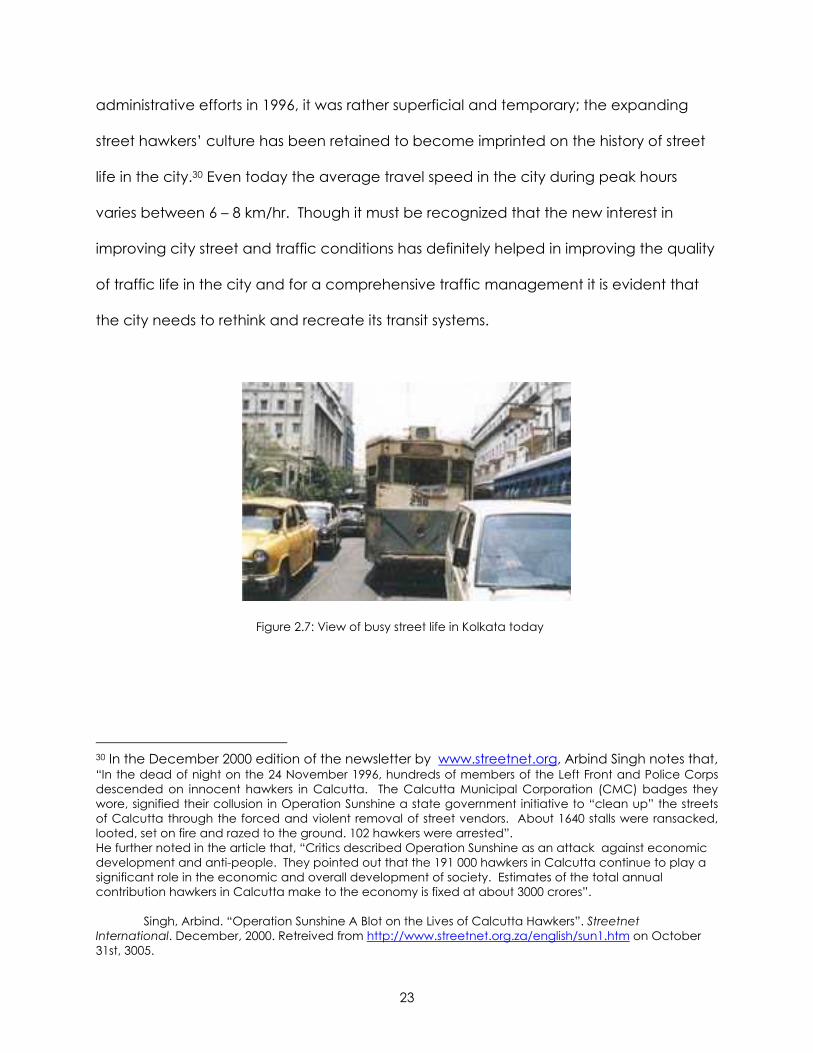
administrative efforts in 1996, it was rather superficial and temporary; the expanding
street hawkers’ culture has been retained to become imprinted on the history of street
life in the city.30 Even today the average travel speed in the city during peak hours
varies between 6 – 8 km/hr. Though it must be recognized that the new interest in
improving city street and traffic conditions has definitely helped in improving the quality
of traffic life in the city and for a comprehensive traffic management it is evident that
the city needs to rethink and recreate its transit systems.
Figure 2.7: View of busy street life in Kolkata today
30 In the December 2000 edition of the newsletter by www.streetnet.org, Arbind Singh notes that, “In the dead of night on the 24 November 1996, hundreds of members of the Left Front and Police Corps descended on innocent hawkers in Calcutta. The Calcutta Municipal Corporation (CMC) badges they wore, signified their collusion in Operation Sunshine a state government initiative to “clean up” the streets of Calcutta through the forced and violent removal of street vendors. About 1640 stalls were ransacked, looted, set on fire and razed to the ground. 102 hawkers were arrested”. He further noted in the article that, “Critics described Operation Sunshine as an attack against economic development and anti-people. They pointed out that the 191 000 hawkers in Calcutta continue to play a significant role in the economic and overall development of society. Estimates of the total annual contribution hawkers in Calcutta make to the economy is fixed at about 3000 crores”. Singh, Arbind. “Operation Sunshine A Blot on the Lives of Calcutta Hawkers”. Streetnet International. December, 2000. Retreived from http://www.streetnet.org.za/english/sun1.htm on October 31st, 3005.
24
The other forms of popular mass transport modes in the city are suburban trains,
launches, circular railways, public and private buses, trams and metro31 or subway
trains. The brunt of population explosion and urban sprawl mainly due to refugees are
borne by suburban trains, which daily bring in thousands of passengers to work in
Kolkata. The three train systems at Howrah, Sealdah and inner city Metro try to relieve
traffic from roads but there is still a long way to go.
FUTURE – Recognizing the phenomenal growth rate in the city and its surrounding areas
and its possible escalating impact on future transportation needs, the Calcutta
Metropolitan Development Authority (CMDA) crafted a “Master Plan for Traffic and
Transportation in Calcutta Metropolitan Area” in 2001. The future travel demand was
estimated on the basis of the analysis of growth trends of the elements of the traffic and
transportation system and on the consideration of the major travel generating
parameters such as the population, economic activities and land use. The plan outlines
the future transportation strategies that will be adopted by the administration to solve
potential transportation crisis that may occur in the 25 year period (2001 – 2025) due to
present growth rate.
IMPORTANT STREET INTERSECTIONS IN THE CITY
There are a number of important streets intersections or urban nodes in Kolkata.
Identifying the five most important urban nodes from them is a challenging task.
31 As per the accounts of Tathagata Roy in his articale on “The Calcutta Metro”, the metro railways were conceived as early as 1949 by Dr. Bidhanchandra Roy but the plans got finally funded and built only in 1984. It is the first of its kind in India and now Delhi is following Kolkata’s example in an effort ot curb its traffic problems. Roy, Tathagata. “The Calcutta Metro”. Calcutta: The Living City. Sukanta Chaudhuri. ed. Volume II. Oxford University Press, Calcutta.

25
However, for the purpose of the report I have identified five important traffic
intersections in modern day Kolkata based on the impact of these intersections in
properly channeling traffic throughout the city and the evolution of these traffic
intersections with respect to the cultural and socio-political history and development of
the city. The five most active traffic conglomerations or urban nodes in the city have
been identified as –
1. B.B.D. Bag area
2. Shyambazaar “Panch Matha More” (Five point intersection)
3. Dharmatala – Esplanade crossing
4. Gariahat Crossing
5. EM Bypass and Rashbehari Connector
Though it is perhaps difficult to pinpoint the exact dates of design of these areas,
especially the first three which existed from the Colonial period, this order may be taken
as primarily based on the chronological evolution of each urban area as they gained
importance within the city. My intention in this section is to briefly describe these traffic
intersection areas, supported by photographs, schematic sketches and explain the
design and significance of such areas.
The B.B.D Bag area is perhaps as old as the White Town in the Colonial City. The present
name, given after independence, recognizes three freedom fighters – Benoy, Badal
and Dinesh. It is arguably the most important business district of the city. Built around the
historical Lal Dighi which still exists, this area was first named as Tank Square and then
Dalhousie Square. Today the tank is still there, surrounded by public and corporate
offices, bus terminus, post office and banks. The Colonial presence is still evident in the
26
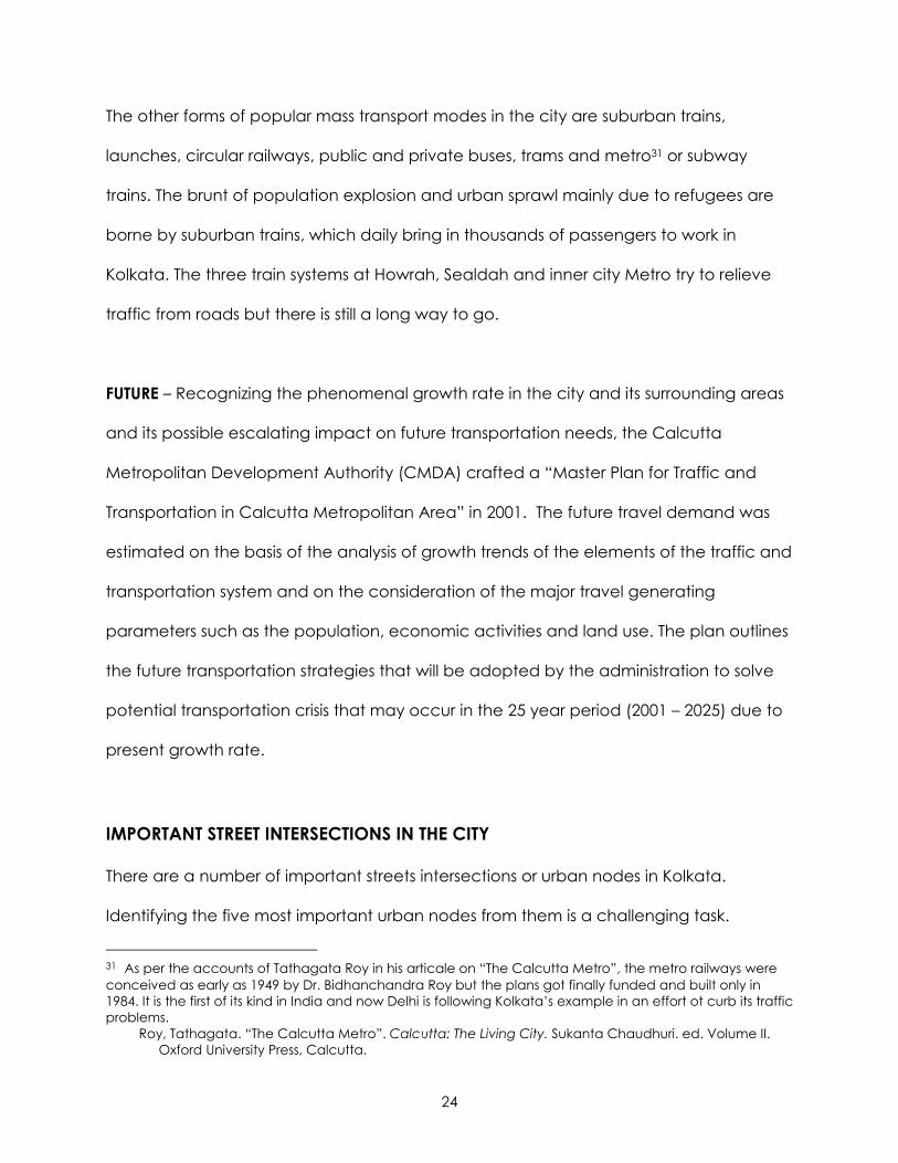
number of historic public buildings and churches in the area. The Writer’s Building,
General Post Office and the Raj Bhavan or Governor’s Palace are among of the finest
examples of Colonial architecture in the city. In fact a strong vista is created on the Old
Court House Street with the St. Andrews Church at the end. Though the scope of
shopping and trading facilities is not diverse the importance of the area magnifies due
to the presence of the heritage buildings.
Figure 2.8: Photograph of Dalhousie Square 1920
(Source:
http://66.235.208.173/picture/1920_bbd_bag.jpg)
Figure 2.9: Photograph of Dalhousie Square today
(Source:
http://homepage2.nifty.com/sial/india/picture/bb
dbag.jpg)
27
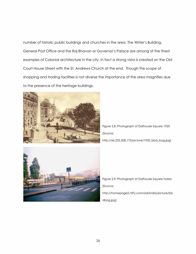
Figure 2.10: Schematic map of the B.B.D Bag central business district
28
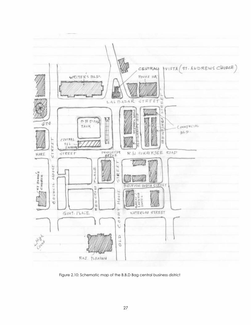
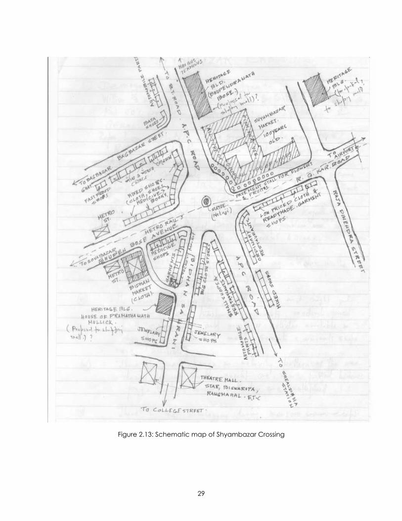
The Shyambazar five point crossing, on the other hand is more diverse in its nature with
a mixture of different types of uses such as residential, commercial and institutional.
According to Nair in “The Growth and Development of Old Calcutta”, Shyambazar
existed even during 1757, Battle of Plassey. As per his account, the main market was
founded by Shobharam Basak but named after a renowned devotee of Kali (at
Kalighat) called Shyam Ray. Though the British named it “Charles Bazar” the old name
of Shyambazar continues till date. The traditional shops in the area have a varied range
of commodities for sale – from garments to jewelry to food. This helps in creating a all
day activity pattern around the intersection. The area is well served by different modes
of mass transportation from public and private buses to underground rail and is
connected to the different parts of the city, the airport, the river and the State
highways. This particular intersection provides the present case of interest for research.
In fact, this urban node will be detailed and analyzed further in later chapters.
Figure 2.11: View of Bhupen Bose Avenue Figure 2.12: View of Bidhan Sarani
29
Figure 2.13: Schematic map of Shyambazar Crossing
30
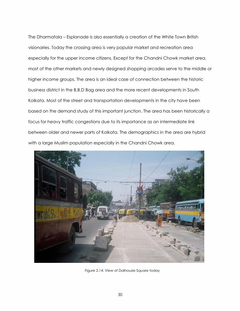
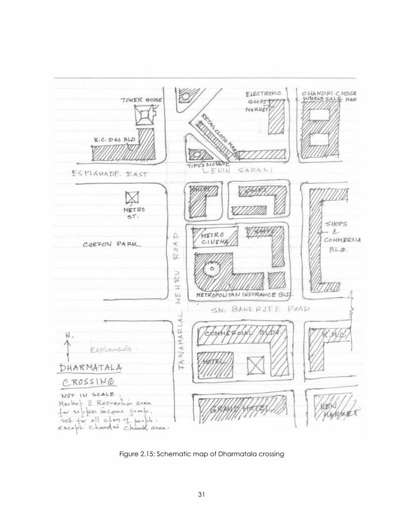
The Dharmatala – Esplanade is also essentially a creation of the White Town British
visionaries. Today the crossing area is very popular market and recreation area
especially for the upper income citizens. Except for the Chandni Chowk market area,
most of the other markets and newly designed shopping arcades serve to the middle or
higher income groups. The area is an ideal case of connection between the historic
business district in the B.B.D Bag area and the more recent developments in South
Kolkata. Most of the street and transportation developments in the city have been
based on the demand study of this important junction. The area has been historically a
focus for heavy traffic congestions due to its importance as an intermediate link
between older and newer parts of Kolkata. The demographics in the area are hybrid
with a large Muslim population especially in the Chandni Chowk area.
Figure 2.14: View of Dalhousie Square today
31
Figure 2.15: Schematic map of Dharmatala crossing
32
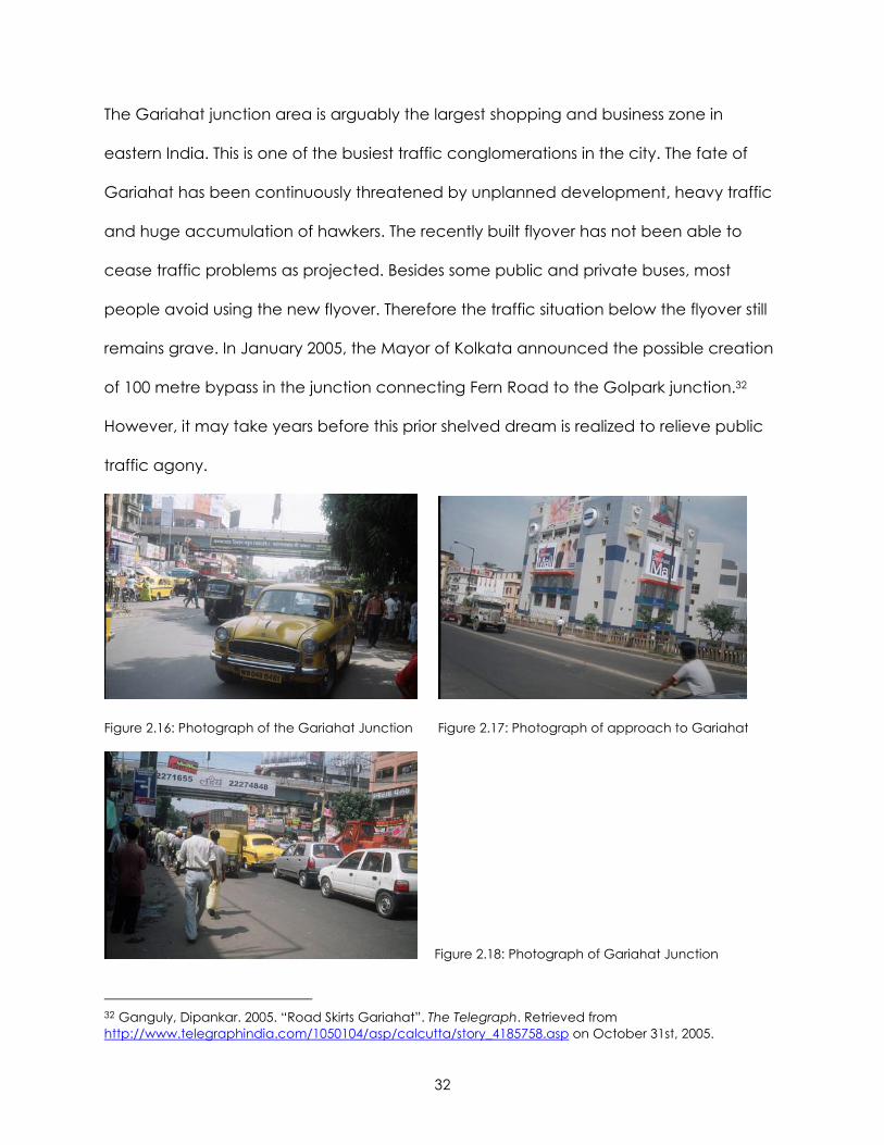
The Gariahat junction area is arguably the largest shopping and business zone in
eastern India. This is one of the busiest traffic conglomerations in the city. The fate of
Gariahat has been continuously threatened by unplanned development, heavy traffic
and huge accumulation of hawkers. The recently built flyover has not been able to
cease traffic problems as projected. Besides some public and private buses, most
people avoid using the new flyover. Therefore the traffic situation below the flyover still
remains grave. In January 2005, the Mayor of Kolkata announced the possible creation
of 100 metre bypass in the junction connecting Fern Road to the Golpark junction.32
However, it may take years before this prior shelved dream is realized to relieve public
traffic agony.
Figure 2.16: Photograph of the Gariahat Junction Figure 2.17: Photograph of approach to Gariahat
Figure 2.18: Photograph of Gariahat Junction
32 Ganguly, Dipankar. 2005. “Road Skirts Gariahat”. The Telegraph. Retrieved from http://www.telegraphindia.com/1050104/asp/calcutta/story_4185758.asp on October 31st, 2005.
33
Figure 2.19: Schematic map of Gariahat Junction
34
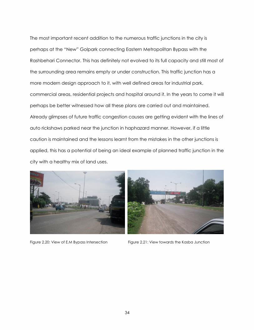
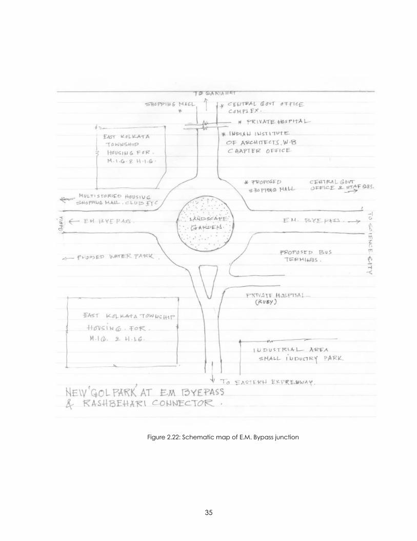
The most important recent addition to the numerous traffic junctions in the city is
perhaps at the “New” Golpark connecting Eastern Metropolitan Bypass with the
Rashbehari Connector. This has definitely not evolved to its full capacity and still most of
the surrounding area remains empty or under construction. This traffic junction has a
more modern design approach to it, with well defined areas for industrial park,
commercial areas, residential projects and hospital around it. In the years to come it will
perhaps be better witnessed how all these plans are carried out and maintained.
Already glimpses of future traffic congestion causes are getting evident with the lines of
auto rickshaws parked near the junction in haphazard manner. However, if a little
caution is maintained and the lessons learnt from the mistakes in the other junctions is
applied, this has a potential of being an ideal example of planned traffic junction in the
city with a healthy mix of land uses.
Figure 2.20: View of E.M Bypass Intersection Figure 2.21: View towards the Kasba Junction
35
Figure 2.22: Schematic map of E.M. Bypass junction
36
CHAPTER 3: ESSAY – IMPRESSIONS OF THE STUDY AREA
The Shyambazaar Five Point intersection more popularly known as Panch Mathar More
(where the heads of the five streets meet), is probably one of the most significant
intersections in Kolkata, connecting the northern older parts of the city to the southern
newer and growing areas. As mentioned earlier, there are a number of important traffic
intersections in Kolkata; however, I have always observed this particular area as an
excellent example of a focal point or urban node. It is a place where different people
from different stratas of society meet and part while continuing with their daily activities;
a place where they all share the same theatrical platform while in most cases being
completely oblivious of each other. By the mere virtue of its physical form and visual
qualities, it is probably difficult to associate this place with “pleasing” memories of a well
designed urban and public space. Yet, as I rummaged through my recollections and
personal impressions of the area, one image became rather prominent - an image of
“an area vibrant with life”. This study area has the potential to become a prime
example of the celebration of life-activities. Today negligence and poor-maintenance
has turned this area shackled with an image of the pains of living in a Third World
megalopolis suppressed under the challenges of globalization in rapidly transforming
adjoining areas. Arguably, this is an area with significant character – good and bad. It is
a place where time stands still on the roads during every traffic jam, while life goes on in
the adjacent sidewalks; a place where hundreds and thousands of people hurry past
each other everyday continuing their daily activities apparently unperturbed by the
slow decay of the surroundings or the ills of traffic.
37
This chapter is in the form of an essay attempting to construct an image of the chosen
study area in the minds of the readers through “my personal impressions and
recollections” about it. The challenge of sitting and writing about an area half way
across the globe is that the only data to rely on is rather ephemeral. I have used some
pictures and sketches from memory, supported by relevant photographs and video
documentations of the area. In my view there are quite a few urban design principles
that are embedded in the area that hold potential for the area, though they are
definitely misplaced or displaced by the growing political ambitions of the hybrid global
city and the citizens. I intend to break up the essay into three broad categories – sense
and sensibilities; land use and traffic; place ballet. The underlying concept is that once
the area is described on the basis of three diverse categories the reader will be able to
form a comprehensive perceptual image of the Shyambazaar crossing.
SENSE AND SENSIBILITIES
This section discusses my response to the area as per the five senses of seeing, hearing,
smelling, touching and tasting. The idea is to create some snapshots of images that
describe these responses. Many of these images perhaps will seem familiar to the
perception of a “densely populated, poor and confusing urban node in developing
nations” to many.
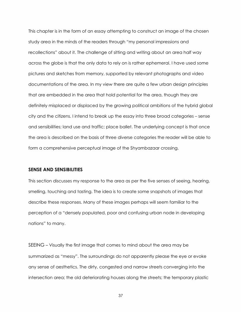
SEEING – Visually the first image that comes to mind about the area may be
summarized as “messy”. The surroundings do not apparently please the eye or evoke
any sense of aesthetics. The dirty, congested and narrow streets converging into the
intersection area; the old deteriorating houses along the streets; the temporary plastic
38
sheds of the hawkers or street vendors encroaching the pavements; and thousands of
people walking in all directions ignoring the presence of other passerby’ or regulated
traffic mannerisms are some of the visual images that come to mind instantly.
Figure 3.1: Messy environment with no segregation between pedestrian and vehicular traffic
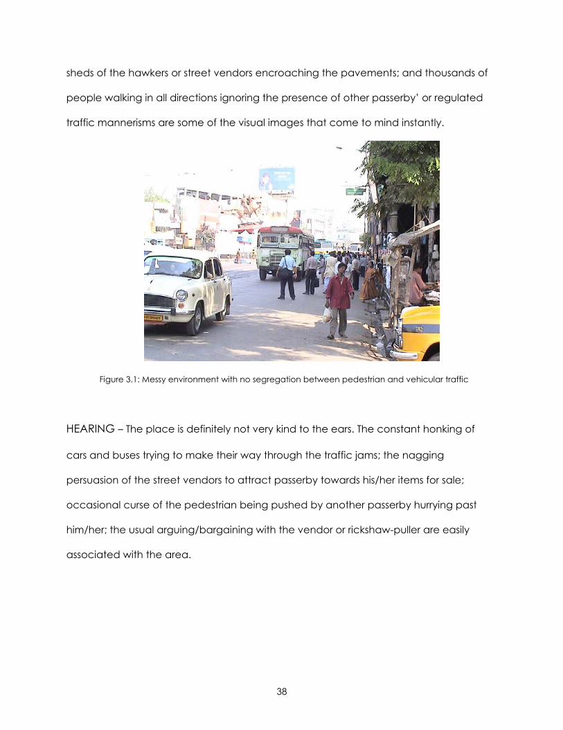
HEARING – The place is definitely not very kind to the ears. The constant honking of
cars and buses trying to make their way through the traffic jams; the nagging
persuasion of the street vendors to attract passerby towards his/her items for sale;
occasional curse of the pedestrian being pushed by another passerby hurrying past
him/her; the usual arguing/bargaining with the vendor or rickshaw-puller are easily
associated with the area.
39
Figure 3.2: Study area in the night buzzing with life and activities
SMELLING – Numerous kinds of smells get mixed in the area. The stinking smell of fish or
the sweetened smell of the vegetables or fruits in the morning markets on the
pavement; the suffocating smells of burnt petrol and diesel or the stink of human sweat
as the day drags along; the smell of fresh flowers especially during the different festive
and marriage seasons; mouthwatering smells of frying of samosas33 and other
delicacies from the sweet and confectionery shops at the periphery of the crossing.
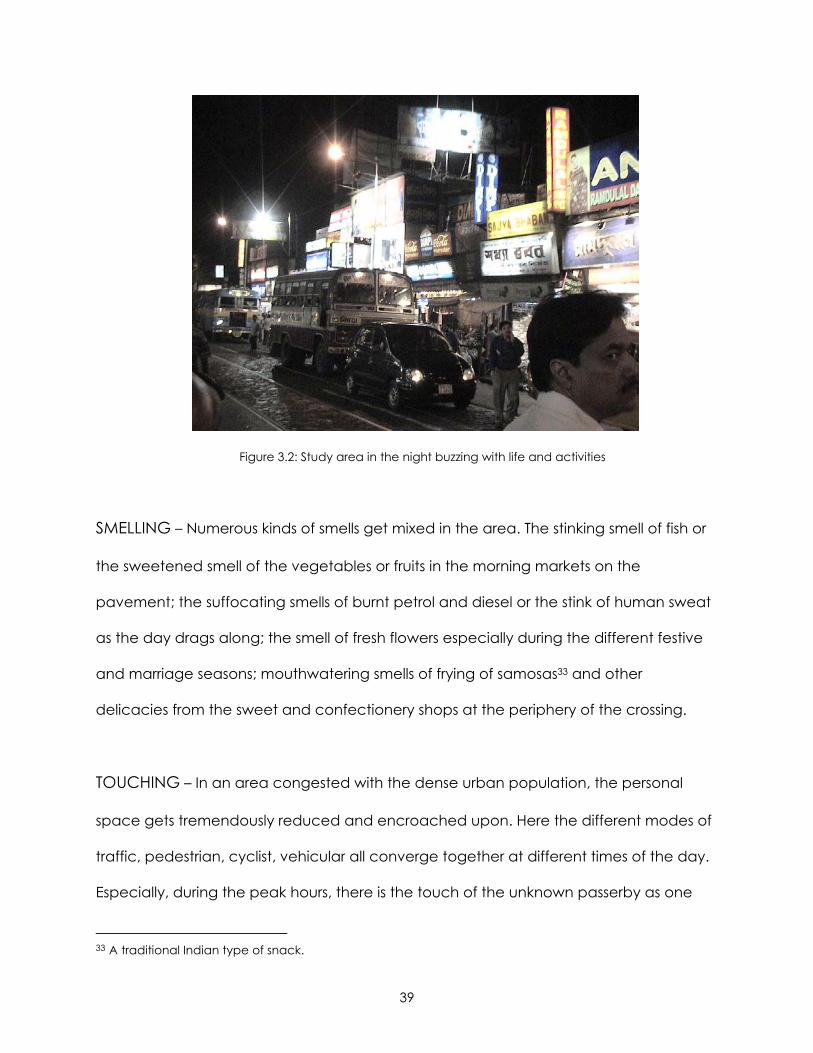
TOUCHING – In an area congested with the dense urban population, the personal
space gets tremendously reduced and encroached upon. Here the different modes of
traffic, pedestrian, cyclist, vehicular all converge together at different times of the day.
Especially, during the peak hours, there is the touch of the unknown passerby as one
33 A traditional Indian type of snack.
40
nudges through the crowd to make way to their destination; the occasional nauseating
feeling of being touched by the passing drunkard or even the innocent looking but
perverted office goer; the touch of the encroached vendors on the pavements as they
try to attract passerby’s attention towards their wares.
Figure 3.3: Shops along the edge of the pavement with hawker stalls on the pavement.
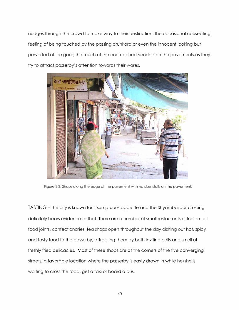
TASTING – The city is known for it sumptuous appetite and the Shyambazaar crossing
definitely bears evidence to that. There are a number of small restaurants or Indian fast
food joints, confectionaries, tea shops open throughout the day dishing out hot, spicy
and tasty food to the passerby, attracting them by both inviting calls and smell of
freshly fried delicacies. Most of these shops are at the corners of the five converging
streets, a favorable location where the passerby is easily drawn in while he/she is
waiting to cross the road, get a taxi or board a bus.
41
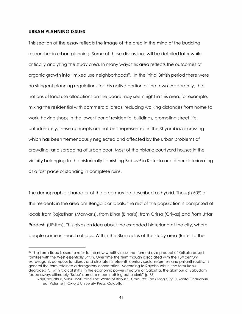
URBAN PLANNING ISSUES
This section of the essay reflects the image of the area in the mind of the budding
researcher in urban planning. Some of these discussions will be detailed later while
critically analyzing the study area. In many ways this area reflects the outcomes of
organic growth into “mixed use neighborhoods”. In the initial British period there were
no stringent planning regulations for this native portion of the town. Apparently, the
notions of land use allocations on the board may seem right in this area, for example,
mixing the residential with commercial areas, reducing walking distances from home to
work, having shops in the lower floor of residential buildings, promoting street life.
Unfortunately, these concepts are not best represented in the Shyambazar crossing
which has been tremendously neglected and affected by the urban problems of
crowding, and spreading of urban poor. Most of the historic courtyard houses in the
vicinity belonging to the historically flourishing Babus34 in Kolkata are either deteriorating
at a fast pace or standing in complete ruins.
The demographic character of the area may be described as hybrid. Though 50% of
the residents in the area are Bengalis or locals, the rest of the population is comprised of
locals from Rajasthan (Marwaris), from Bihar (Biharis), from Orissa (Oriyas) and from Uttar
Pradesh (UP-ites). This gives an idea about the extended hinterland of the city, where
people came in search of jobs. Within the 3km radius of the study area (Refer to the
34 The term Babu is used to refer to the new wealthy class that formed as a product of Kolkata based families with the West essentially British. Over time the term though associated with the 18th century extravagant, pompous landlords and also late nineteenth century social reformers and philanthropists, in general the term retained a derogatory connotation. According to Raychoudhuri, the term Babu degraded “…with radical shifts in the economic power structure of Calcutta, the glamour of Babudom faded away: ultimately ‘Babu’ came to mean nothing but a clerk” (p.75) RayChaudhuri, Subir. 1990. “The Lost World of Babus”. Calcutta: The Living City. Sukanta Chaudhuri. ed. Volume II. Oxford University Press, Calcutta.
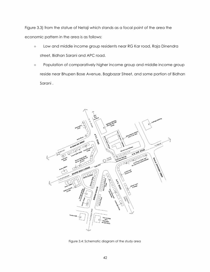
42
Figure 3.3) from the statue of Netaji which stands as a focal point of the area the
economic pattern in the area is as follows:
Low and middle income group residents near RG Kar road, Raja Dinendra
street, Bidhan Sarani and APC road.
Population of comparatively higher income group and middle income group
reside near Bhupen Bose Avenue, Bagbazar Street, and some portion of Bidhan
Sarani .
Figure 3.4: Schematic diagram of the study area
43
Higher income group population in the area is comprised of mostly Rajasthani families
except for a few traditional Bengali families residing near Bagbazar and Bidhan Sarani
area. The low income group families are mainly consists of the laborers, vendors etc
from Bengal and other states in India who have migrated to the city in search of easy
opportunity for jobs. The middle income group is comprised of mainly Bengali families
who are either office-goers or shop owners in the area.
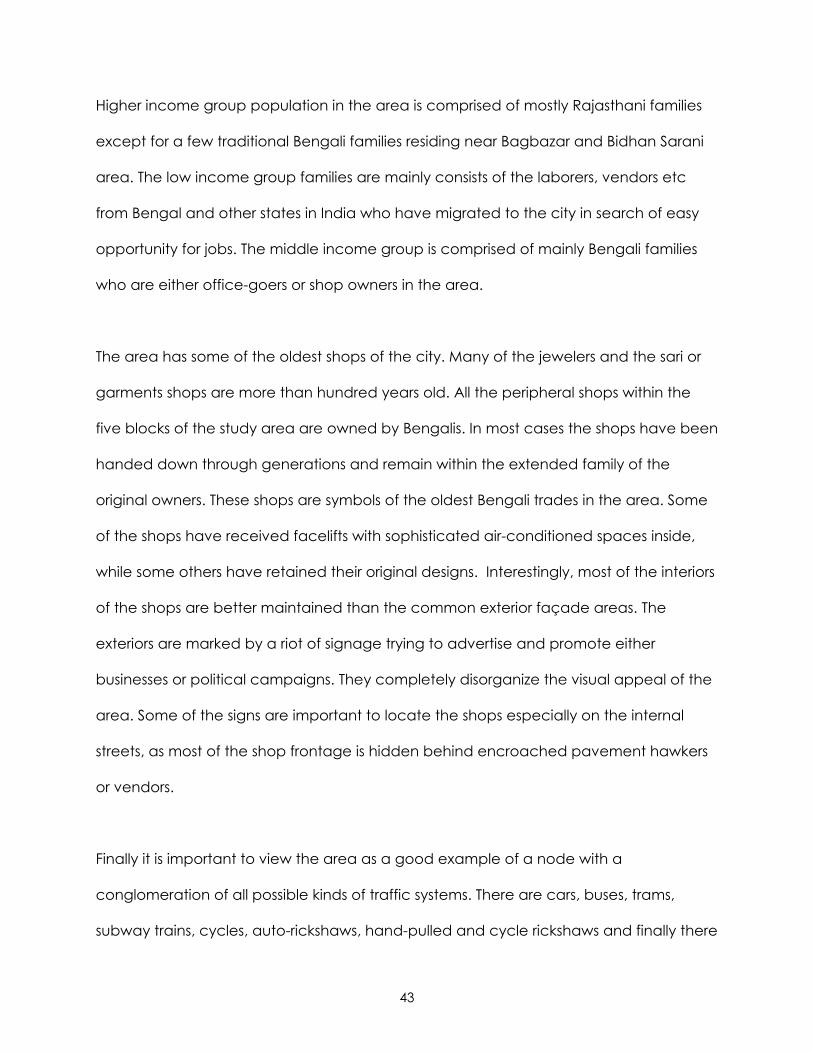
The area has some of the oldest shops of the city. Many of the jewelers and the sari or
garments shops are more than hundred years old. All the peripheral shops within the
five blocks of the study area are owned by Bengalis. In most cases the shops have been
handed down through generations and remain within the extended family of the
original owners. These shops are symbols of the oldest Bengali trades in the area. Some
of the shops have received facelifts with sophisticated air-conditioned spaces inside,
while some others have retained their original designs. Interestingly, most of the interiors
of the shops are better maintained than the common exterior façade areas. The
exteriors are marked by a riot of signage trying to advertise and promote either
businesses or political campaigns. They completely disorganize the visual appeal of the
area. Some of the signs are important to locate the shops especially on the internal
streets, as most of the shop frontage is hidden behind encroached pavement hawkers
or vendors.
Finally it is important to view the area as a good example of a node with a
conglomeration of all possible kinds of traffic systems. There are cars, buses, trams,
subway trains, cycles, auto-rickshaws, hand-pulled and cycle rickshaws and finally there
44
are thousands of pedestrians using the area daily. Traffic jams are a way of life here.
However, in spite of all the confusion and distress caused by traffic it is quite curious to
observe that every jam gets cleared and people still manage to reach their
destinations. To an outsider it may seem that the traffic is literally self regulated, where
no one stops for the other and the pedestrians take liberty in stopping the already slow
moving cars to cross the road. The traffic congestion has benefited from the subway
system in the area, which has helped to relieve some of the pressures during peak
hours. The area is well connected by bus routes to the rest of the city and therefore is a
popular mass transportation junction.
THE PLACE-BALLET
In this section my intent is to give a phenomenological description of a typical day in
the study area. This description will try to unite all the snapshots or issues discussed earlier
in this chapter. One important aspect of this area is that “life never stops here” no
matter what. The area keeps buzzing with activity throughout the day and night. The
easy transportation availability, moderate prices of commodities, variety of consumer
goods available, delicious food serving restaurants, number of theatre and cinema
halls, and perhaps most importantly the general sense of safety in the self-policed high
density area all contribute to the popularity of this urban node. Interestingly, the activity
in the area remain mostly unchanged annually, whether rain or shine, the area is always
busting with street activity. In fact, except for some areas in the southern part of Bidhan
Sarani, the area does not have much water logging problem. During the festive
seasons, especially Durga Puja, these activities multiply as people shop more
45
aggressively for the festival preparations, buying new clothes, jewelry, home furnishings,
utensils, sweets etc.
The day starts early around 5:30 am in the morning, with the private buses starting their
first round of their route. Soon the pavement gets filled with vendors selling fresh
vegetables, poultry, fruits and flowers to the early risers. As the day goes on this
temporary pavement market becomes busier, as officegoers try to finish their daily
marketing or parents stop to buy groceries after dropping their children at school. The
food shops open early to serve breakfast to those who did not have time to eat before
leaving for work or school. By this time the streets become busy too, as school buses,
private buses, cars, and rickshaws, in short every type of vehicle comes out as people
go about their daily routine. The humdrum of traffic never really ceases after this as
more and more vehicles and pedestrians start flocking.
As noon approaches, all the peripheral shops open their shutters and the pavement
fresh grocery market transforms into a diverse array of consumer goods market sold by
the encroached hawkers. The streets start feeling narrower as the number of
pedestrians increase phenomenally with the opening of the shops. The nudging,
pushing and cursing in the crowded streets also starts increasing. Just after noon, there
is a time when activity seems a little slow as people retreat to their homes either for a
small nap or to their office for work. At this time business is also slow as often the
shopkeepers and their assistants especially of small food shops can be seen lazing
around or taking rest spreading on the table or by joining chairs. However, this is for a
short duration as activity starts picking up again as schools and college classes dissolve
46
and students return home or are on their way to tutorial classes, stopping at the local
shops to take a quick snack.
Around 5:00 pm the traffic gets nasty again as people start returning from their work.
The cinema or theatre lovers also come out during this time to catch a matinee or
evening show at the various halls in the area. The pavements are again filled with
people and a new type of group emerges – the unemployed or the eve-teasers as they
group around the pavement either passing comments on the passerby or indulging in
great length of political arguments. The evening shoppers also start crowding. Most of
the shops in the area are open till 9:00 or 10:00pm so the activity continues till then.
After that the activity starts ceasing in the area, as people start retiring to their homes
for dinner or sleep. The noises in the streets change from the annoying honking to the
distant humming of the televisions at home. As the night thickens the trucks and the
pavement dwellers are the main performers on the street. The trucks carry on their daily
service loading and unloading activities for the morning market or pass through the
intersection on their way to the State highways. And then as the day begins life starts
again.
47
CHAPTER 4: RESEARCH METHODOLOGY – LITERATURE REVIEW
Literature review for the report has been an extensive resource for understanding the
different contemporary urban analysis techniques that can be applied in this research.
The choice of relevant literature from the vast resource has been a challenge. The main
intent underlying the choice of literature is to be able to choose an appropriate
research methodology that can be applied to the current study. For a comprehensive
grasp of the topic the literature review has been divided into three sub-parts:
1. To conceive the broader framework for the report, terms like urban design and
city planning has been queried with a focus on the concepts of public place,
streets, sidewalks and urban nodes.
2. The study being located in a developing nation’s city, it is important to recognize
some contemporary planning issues that distinguish planning between First and
Third World cities.
3. Finally, it is necessary to perform an inventory into the different analytical tools for
urban design and form with an emphasis on visual analysis methods.
48
URBAN PLANNING AND DESIGN IN THE TWENTY-FIRST CENTURY
“ The city in its complete sense, then, is a geographic plexus, an economic organization,
an economic organization, an institutional process, a theater of social action, and an
aesthetic symbol of collective unity” (p.185)
- Lewis Mumford, Architectural Record (1937), republished in The City Reader 35
Cities represent human civilization and its progress. LeGates, and Stout36 observe that
though the formal evolution of urban civilizations took nearly ten thousand years, ever
since the inception of the first city, city-based urban cultures and the increase in urban
population has been central to human progression. Urban form studies have probably
gained the present momentum since the second half of the twentieth century. Today
our theories about urban design face new challenges brought in with the ‘information
age’ which are expanding the realm of our urban experience and creating fluid
boundaries between global urban cultures. Concepts of sustainability, globalization,
transnational perspectives, and cultural hybridity are the raging topics emerging in the
planning domain of the 21st Century. Amidst the concept of transforming cities the
challenge of maintaining one’s own identity and space reign supreme. This has formed
a “new (spatial) world order” or disorder that struggles to mask matters of “poverty,
social exclusion and environmental degradation, but presents the solutions as either
technical fixes to the operation of the market or without hard choices” (p.2).37
35 Mumford, Lewis. 1937. “What is a City?” The City Reader. LeGates, Richard T. and Frederic Stout. Ed.
1996. Routledge, London. 36 LeGates, Richard T. and Frederic Stout. Ed. 1996. The City Reader. Routledge, London. 37 Allmendinger, Philip and Michael Chapman. ed. 1999. “Planning in the Millennium”. Planning
Beyond 2000. John Wiley and Sons, New York.
49
The scope of this report is to introduce some of these contemporary planning
discussions as the basis of a critical understanding of an urban place in a Third World
metropolis, Kolkata. This is definitely a vast task and perhaps a comprehensive
understanding of these issues is the task of a lifetime. Therefore, to limit the scope of the
report, I have chosen to study a particular intersection area in Kolkata and emphasize
only the visual quality as understood on the basis of the larger framework of political
debates.
KEY ELEMENTS IN THE CREATION OF PUBLIC URBAN PLACES – OF STREETS, SIDEWALKS AND URBAN
NODES
While introducing her The Death and Life of Great American Cities, Jane Jacobs38 wrote
that -
“Cities are an immense laboratory of trial and error, failure and success, in city
building and city design” (p.6)
This is true. Every action or decision of the public as a whole and planning body in
particular affects the city form, design and life. City may be broadly zoned into public
and private places. As planners, our designs and decisions affect the nature of public
places the most in urban design. Public places in the city are like breathing areas
dissolving the social attributes of the participants to a great extent. As the Lennards’39
have noted in their account on Public Life in Urban Places, “social life is always
embedded in a meaningful arrangement of buildings; their function, use and historic
significance all influence the kinds of public life possible” (p.2). Most urban designers 38 Jacobs, Jane. 1961. The Death and Life of Great American Cities. Random House, Inc., New York. 39 Lennaerd, S.H and H.L. Lennard. 1984. Public Life in Urban Places. Gondolier Press, New York.
50
and city planners today perceive city as a process, a theatrical art, where each
element is interconnected and interlinked to create the “sense of place” for it.
While discussing the theatric outlook of an urban place, it is almost impossible to
neglect the importance of streets and sidewalks that are the most vital organs of public
life in a city. Recognizing the importance of streets in the public image of a city, Jacobs
has clearly said that the image of the city is directly proportional to public perception of
the quality of the streets. In Streets and the Shaping of Towns and Cities, Southworth
and Ben-Joseph40 observe that though each era of urban civilizations had their
individual concept in city and building design, the universal element in all their designs
have been the city streets –
“A key element in the shaping of cities has been ideas of what the residential street
network should be, since streets are the public framework that structures neighborhood
and city life” (p.1).
Interestingly, while most developed countries like United States are trying to fight back
to recreate and relive the street experience which is threatened by their automobile
fleet, primate cities like Kolkata, in Third World countries have retained their pedestrian
oriented vibrant life. Today, the pressures of ever-increasing population, neo-economic
conditions are slowly trying to obliterate their existence. However, with proper
community vision and effort these potential urban places can be regenerated while still
maintaining the essence of the historical “everydayness” as applicable to the socio-
40 Southworth, Michael and Eran Ben-Joseph. 2003. Streets and the Shaping of Towns and Cities. Island Press, London.
51
cultural environment. This is underlined by the faith in Jacobs41 words, that, “Under the
seeming disorder of the old city, wherever the old city is working successfully, is a
marvelous order for maintaining the safety of the streets and the freedom of the city”
(p.50).
The main objective of this report is to critically analyze and suggest ways in which the
importance of the Shyambazar traffic intersection area may be recognized and
applied to improve the visual quality of the public place. This public place – formed by
a nexus of streets, sidewalks, neighborhoods and most important cultures converging at
the urban junction or urban node, is an investigation into the good and bad attributes
of the area. In his discussion of the Image of the City, Lynch acknowledges the urban
nodes as a juxtaposition of paths, an important element in attributing the visual quality
of the urban place. He maintains that, “The junction, or place of a break in
transportation, has compelling importance for the city observer. Because decisions
must be made at junctions, people heighten their attention at such places and
perceive nearby elements with more than normal clarity” (p.72).42 It is this notion that
encouraged the conception of this study focusing on the critical elements of the urban
node at Shyambazar Panch Matha More (Five Point Intersection).
CONTEMPORARY PLANNING ISSUES FOR CITIES IN DEVELOPING NATIONS
In 1965, Kingsley observed in his article in Scientific American that, “Urbanized societies,
in which a majority of people live crowded together in towns and cities, represent a
41 Jacobs, Jane. 1961. The Death and Life of Great American Cities. Random House, Inc., New York. 42 Lynch, Kevin. 1960. Image of the City. MIT Press, Massachusetts.
52
new and fundamental step in man’s social evolution” (p.2).43 This is perhaps most
applicable today in relation to understanding of high density megacities in the
developing nations. Modern urbanization all over the globe is best understood in terms
of economic growth and its implications. Much later, in 1990, in an article about the
“The Growth of Calcutta in the Twentieth Century”, Chakraborty44 notes that, “In
developing economy, urbanization of a society can commence before the built-up
area manifests itself, since the construction of building follows investment secured from
sizeable savings” (p.6). Today any typical third world megacity is undergoing a vast
transformation under the pressures of ideological globalization and the neo-liberal
economic policies. City form and design not only reflects the inherent economic status
but also in a way helps to attract more economic activities. Pursuing this basic notion it
is important to discuss certain urban planning theories that form the framework in
planning and design for these cities, with an emphasis on theories relevant to Kolkata.
Contemporary planning in developing nations is plagued by a number of urban
problems such as limited land area, rapid urbanization, outburst of population and
accumulation of the urban poor. Kolkata is a not an exception from this fact. To have a
comprehensive idea about the planning issues integral with the Third World
metropolitan, it is necessary to clarify some issues that are underlining and restructuring
contemporary transnational urban studies. The discourse of globalization, hybridity, and
urban informality and transformation seem to be important in understanding the
planning implications in the search for identity for a postcolonial Kolkata. The
43 Kingsley, David. 1965. “The Urbanization of the Human Population”. The City Reader. LeGates, Richard T.
and Frederic Stout. Ed. 1996. Routledge, London. 44 Chakraborty, Satyesh. 1990. “The Growth of Calcutta in the Twentieth Century”. Calcutta: The Living City. Sukanta Chaudhuri. ed. Volume II. Oxford University Press, Calcutta.
53
explorations of these terms seem even more imperative in identifying the significance of
the present study area which is apparently struggling to balance the colonial nostalgia
and pressures of new liberal global economy superimposed on a vastly neglected core
of the old parts of the city.
To begin the discourse it seems appropriate to start with the dictionary meanings of
these words. In this case, I have opted to choose the web dictionary to see how the
meanings of these words are defined by arguably the greatest communication
medium of our “information age”.
GLOBALIZATION
According to the web dictionary, there are essentially two contexts in which the word
“globalization” may be comprehended, as given below:
Globalization (technology): Operating around the world. Although many large
companies have globalized for decades, the Web, more than any other phenomenon,
has enabled the smallest company to have a global presence.
Globalization (investment): The tendency of investment funds and businesses to move
beyond domestic and national markets to other markets around the globe and thereby
increase the interconnectiveness of different markets.45
In the planning perspective, ‘globalization’ may be assumed to be the product of the
dynamic interplay between cultural turn and political economy. Our concern with
identity, borders and hybridity in the postcolonial cities may be analyzed by
45 Meaning retrieved from Answer.com. From the following web link: http://www.answers.com/globalization&r=67 on November 2nd, 2005.
54
understanding the social and cultural dimensions of globalization. Eade and Mele
observe in Understanding the City that, “Flows of information capital, and people
heighten the indeterminacy of social relations at the local level” (p.10).46
“Entrepreneurialism” is the new mantra for the Communist government - by shifting from
agrarian reformism to urban developmentalism and by moving prime development
land from the core of the city to the metropolitan periphery.47 This attitude may be
understood as a direct effect of globalization and in pursuit of the “new vision” the
older parts of the city as represented by the Shyambazar intersection area are paying
the price of natural decay and degeneration due to ill maintenance.
HYBRIDITY
The word “hybridity” has evolved from the generic term “hybrid” which has been
defined in the web dictionary as follows:
Genetics. The offspring of genetically dissimilar parents or stock, especially the
offspring produced by breeding plants or animals of different varieties, species,
or races.
Something of mixed origin or composition.
Something, such as a computer or power plant, having two kinds of
components that produce the same or similar results.
A word whose elements are derived from different languages.48
46 Eade, John and Christopher Mele. Ed. 2002. Understanding the City: Contemporary and Future Perspectives. Blackwell Publishers Ltd., Oxford. 47 Roy, Ananya. “The Gentlemen’s City: Urban Informality in the Calcutta of New Communism”. Urban Informality: Transnational Perspectives from the Middle East, Latin America and South Asia. Al- Sayyad,Nezar and Ananya Roy. ed. 2003. Lexington Books, New York. 48 Meaning retrieved from Answer.com. From the following web link: http://www.answers.com/hybrid&r=67
on November 2nd, 2005.
55
With respect to the planning discussion, hybridity is a complex concept relating to the
interbreeding and mixing of different people, cultures and societies. In the editorial
prologue to Hybrid Urbanism Nezar Al Sayyad49 noted that, though historically the
notion of hybridity was more associated with scientific racism, but today the meaning
has shifted more towards the concept of cultural intermixing. In the case of Kolkata, the
demographic study of the Shyambazar area, show that though there is a relatively high
numbers of Bengali Hindu families there are also other ethnic groups living in the area
such as from Rajasthan, Bihar, UP etc. This accumulation of multifaceted cultural groups
within the area has led to the hybrid character and lifestyle in the area.
URBAN TRANSFORMATION AND INFORMALITY
As per the Web dictionary, the word transformation relates to the following meaning:
The act or an instance of transforming.
The state of being transformed.
A marked change, as in appearance or character, usually for the better.50
Contemporary urban studies have argued about the emergence of what Jane Jacobs
has referred to as “dynamic cities”. Supporting this notion Taylor51 observes in World City
Network, that it is the Third world cities which are continuously under this tension of rapid
transformation within the city. He further noted how this dynamicity is projected through
the transformation of space economy within the city structure from core to semi –
49 Al Sayyad, Nezar. Ed. 2001. Hybrid Urbanism: On the Identity Discourse and Built Environment. Praeger
Publications, Connecticut. 50 Meaning retrieved from Answer.com. From the following web link: http://www.answers.com/transformation&r=67 on November 2nd, 2005. 51 Taylor, Peter J. 2004. World City Network: A Global Urban Analysis. Routledge Taylor and Francis Group,
London.
56
periphery to peripheral regions. Thorns also identified this transitional character of the
city from Walterstein arguments made more than thirty years ago in Modern world
Systems:
“Globalization is a misleading concept since what is described as globalization has
been happening for 500 years. Rather what is new is that we are entering an age of
transition” (p.80)52
Kolkata is a classic example of this dynamism reflected in city politics due to world
economic flows. As observed by Roy53 in her article on the “The Gentleman’s City”, the
New Communism has creatively yet informally promoted the city urban transformation
– by moving the urban poor especially on the fringes and forging developmental
alliances as a new vision for their capitalist approach. However, in this scurry of
developments, even without proper mapping of the city areas, the administration is
indirectly supporting the decadence of the primate cores in the city as exemplified by
the present study area.
TOOLS FOR CRITICAL URBAN ANALYSIS FOCUSING ON VISUAL ASSESSMENT
The importance of visual assessment study in urban analysis or environment review has
been long recognized. Blair54 has rightly observed that, “Because visual experience is a
compound of physical stimulus and psychological response, some aspects of visual
52 Thorns, David C. 2002.The Transformation of Cities: Urban Theory and Urban Life. Palgrave Macmillan,
New York. 53 Roy, Ananya. “The Gentlemen’s City: Urban Informality in the Calcutta of New Communism”. Urban Informality: Transnational Perspectives from the Middle East, Latin America and South Asia. Al- Sayyad,Nezar and Ananya Roy. ed. 2003. Lexington Books, New York. 54 Blair, William GE. 1986. “Visual Impact Assessment in Urban Environment”. Foundations for Visual Project
Analysis. Smardon, Richard C, James F. Palmer and John P. Fellemen. Ed. John Wiley and Sons, New York.
57
impacts are undeniably subjective” (p.224). Acknowledging this perspective it is
evident why there has been and can be many different ways of conducting an urban
analysis. No one method is probably correct or indispensable. For a proper
understanding of some approaches that has been forwarded by experts in urban
design, it is perhaps useful to discuss some of the methods in light of its significance to
the present study. In chapter 5 the final research methodology adopted will be
discussed in detail.
IMAGE OF THE CITY – KEVIN LYNCH, 1960
“At every instant, there is more than the eye can see, more than the ear can hear, a
setting or a view waiting to be explored. Nothing is experienced by itself, but always in
relation to its surroundings the sequences of events leading up to it, the memory of past
experiences” (p.1)
SYNOPSIS –
This 1960 book is one of the foremost to discuss concepts of urban analysis. In this book
Lynch proposed some of the best known urban visualization tools to date. Lynch
argued that a distinctive, clear, visible and coherent environment heightens the
potential depth of human experience and imageability of the city. He introduced the
concepts of environmental image, physical and visual legibility in understanding how
humans perceive their environment and cities. Lynch recognized three important sub-
parts as identity, structure and meaning as key to the formation and quality of these
subjective mental images. Lynch also acknowledges that planners are primarily
interested in the external elements that help initiating these mental images in the city
58
observer. After extensive survey55 of citizens from Boston, Jersey City and Los Angeles,
studying their mental maps Lynch proposed five key elements that constitute the image
of any city. According to Lynch, the content of city image may be classified into –
Paths – along which the movement flows.
Edges – boundaries defining and differentiating each urban fabric from another.
Districts – two dimensional sections recognizable by common identifying characters.
Nodes – intensive foci to and from which an observer travel.
Landmarks – points of reference
Lynch recommended that it is the relation between these five elements, their
arrangements at different levels and scales that create interesting set of images. He
stressed that in isolation the elements are incomplete to the comprehensive
understanding of the city. Finally, in the endnote he also discussed the possibly
negativity of an imageable city when the landscape loaded with magical meanings
may become impractical for activities.
SIGNIFICANCE –
Lynch’s acceptance that no city is perfect, but even within its defect it has an
underlined feeling of satisfaction, presence and rightness that arises at its mere sight for
an observer – both resident and stranger, is an interesting note to start analyzing cities in
the third world, while trying to see beyond what the eyes directly see. In the analysis of
the study area, the Lynch-ian five components of urban analysis may be helpful
55 Lynch employed mainly two methods of research and survey: one of systematic field reconnaissance by a trained observer, and lengthy interviews with a sample from city residents in order to ascertain their images.
59
especially the elements of path and node seem important. The reference of the area
as an urban node with the five converging streets and sidewalks as the paths are two
critical components of the critical analysis. The concept of edge may be fruitfully
discussed by observing the street’s peripheral shops or walls. However, considering the
scale of the intersection – study area, it may be difficult to distinguish different districts
under similar analogy as Lynch recommended. It may also be useful to identify
landmarks in the area to help integrate with the greater design image.
THE CONCISE TOWNSCAPE – GORDON CULLEN, 1961
“The value of incident in a street – tower, belfry, silhouette feature, vivid color and so on –
is to entrap the eye so that it does not slide out into the beyond with resulting boredom”
(p.44).
SYNOPSIS –
Cullen recognized that cities are usually popular for living. Instead of living in isolation
people enjoy to live in places that provide visual pleasure, public contact and basic
amenities. Understanding the art of relationships in city design, Cullen’s urbanscape
analysis suggests that there are mainly four different aspects that concern our
emotional reaction to immediate surroundings. These aspects of concern are related to
optics, place, content and functional tradition. Cullen’s approach towards urban
analysis is mainly based on seeing and reporting in form of on-the-spot sketches,
diagrams and photographs along with commentaries. His first analytical tool
acknowledges the usefulness of vision in evoking our memories and responses to the
environment. He first coined the idea of “serial vision” as a significant approach
60
towards urban analysis. According to Cullen, “…although pedestrian walks through the
town at a uniform speed, the scenery of towns is often revealed in a series of jerks or
revelations” (p.9), this is what he has termed as serial vision. This concept underlines all
the other analysis of place, content and functional tradition. Cullen noted that people
use places in the manner that suits irrespective of the design intent of the place. His
commentary on the different elements of place or space follows this notion.
SIGNIFICANCE –
Cullen’s urbanscape analysis addresses the issues of looking, analyzing and extracting
information pertinent to the design process. One important characteristic of Cullen’s
urban analysis is that he does not try to identify any rigid type or elements under his
general broad aspects. Therefore there are qualitative terms which are not definitive
but rather generated from observation of the place, for example: hereness, thereness,
narrows to name a few. This is both a virtue and a limitation of his analysis. While this
gives freedom to an observer to report on basis on subjective judgment, it may be too
broad as a comprehensive template for research. The inability to actually visit the site
while studying may be a challenge for this type analytical. The concept of seeing and
reporting is a good tool to analyze the study area though it would be seeing through
the lens of camera or depend on memory. Therefore there cannot be any on-site
reporting or sketches as Cullen conducts, but only reporting based on reproduced
visual images available.
61
RESPONSIVE ENVIRONMENTS: A MANUAL FOR DESIGNERS – IAN BENTLEY, ALAN ALCOCK, PAUL
MURRAIN, SUE MCGLYNN, GRAHAM SMITH, 1985
“…the idea that the built environment should provide its users with an essentially
democratic setting, enriching their opportunities by maximizing the degree of choice
available to them. We call such places responsive” (p.9)
SYNOPSIS –
This book discusses a more contemporary urban analysis method. The book is a
culmination of a series of projects, seminars and lectures in which the authors were
actively involved. The main idea is to identify the qualities of a place or built
environment that provided a user with democratic choices enriching and maximizing
their experience of the place. The authors propose that design affects a user’s response
to it in the following manner:
• Where they can go – the quality of permeability
• Range of uses available – the quality of variety
• How easily the opportunities may be understood – the quality of legibility
• The degree in which a given place may be used for different purposes – the quality
of robustness
• The choice of sensory experiences – the quality of richness
• Does the detailed appearance of the place make the users’ aware of the possible
choices – the quality of visual appropriateness
• Extent to which a user can put their individual stamp on the place – the quality of
personalization
62
SIGNIFICANCE –
This book discusses a more contemporary and in-depth template to base the critical
analyses study of the intersection area. All the qualities may be adopted in the analysis
to check the design strength and weaknesses. The template may also be useful in
making suggestions for improvements in the physical and visual design or layout of the
study area. Most of the qualities are broad and therefore can be broken down to
different sub-parts as applicable to the context of Kolkata. The British design
perspective of the book also seems relevant in analyzing the urban node created
during Colonial times in Kolkata.
FOUNDATIONS FOR VISUAL PROJECT ANALYSIS – EDITED BY- RICHARD C. SMARDON, JAMES F.
PALMER, JOHN P. FELLEMEN, 1986
“Underlying assumption of all scenery analysis is that population share common basis in
how they ‘see’ and subsequently respond to various landscapes” (p.37)
SYNOPSIS –
This book is sub-divided into five sections – the first section defining different resources
for visual analysis; the second section outlines the various inventory resources for visual
analysis; the third section discusses different assessment effects; the fourth section
appraises the effects of visual assessment; and finally in the fifth section different
international perspectives in visual analysis is discussed. The book includes chapters
from different contributors based on the different aspects of visual impact study. The first
63
section introduces the different landscape values with respect to history, concepts and
applications. The second section outlines the basic visual process relying on behavioral
psychology – discussing the different neurophysiologic processes of vision anatomy,
defining cognition, perception and introducing different environmental models (for
example generic environmental performance prediction model, concepts of field
simulations, and iconic two and three dimensional models). The third section goes into
more detailed analysis of how to perform visual studies based on the resources
discussed in earlier chapters and different theories given by experts in the past. The
fourth section recognizes the importance of visual impact assessments and discusses
major issues related to it. In the final sections, the chapters discuss the effects of
cybernetics and computer simulations as visual-aesthetic components in planning.
SIGNIFICANCE –
The most useful chapters from the book were perhaps the two discussing methods of
urban analysis and affects of visual impact assessment namely, “Urban Visual
Description and Analysis” by Richard C Smardon, Tony Costello and Harry Eggink; and
“Visual Impact Assessment in Urban Environment” by William GE Blair. Smardon,
Costello and Eggink argue in their article about the complexity of urban visual analysis
due to multilayered interfaces and interactions of the built components. Their approach
of analyzing different urban analysis theories before implementing a critical study
approach seems most relevant to my research methodology. Their outline of critical
steps for urban analysis are appropriate for this particular research – for example:
determining the visual control points for the video and photographic documents,
establishing visual elements to be studied and representing visual environment to
64
evaluate its visual quality seem a good approach that may be adopted for the report.
In the visual impact assessment chapter by Blair, major issues have been identified –
such as determining the context of visually affected area; visual study being based on
representative views chosen from a realm of illustrations of actual views of the area to
narrow the scope of analysis; defining the visual resources in the study area as visual
stimuli for viewing the area; recognizing viewer’s sensitivity especially as the
photographs and video were taken by an observer other than the primary researcher.
65
CHAPTER 5: METHODOLOGY ADOPTED FOR STUDY AREA
It is evident from the discussions in the earlier chapter that applying visual analysis may
be assumed to be a critical approach to understanding and evaluating city image.
Lynch emphasized in his book, Image of the City that –
“imageability” is the quality of a physical object that usually tends to evoke a strong
sense of image in the observer. This I believe is universally true if we observe the city as a
physical object. All around the world, irrespective of the economic status of cities, they
create images in the human mind – good or bad. Emphasizing this aspect of universality
of visual image in The Evaluative Image of the City Nasar wrote:
“Visual quality can have powerful effects on our experience and the delight we take in
our surroundings”
City form is dynamic, changing over time as a result of a multitude of changes brought
in by the daily actions and activities of the residents, the transients and the visitors.
Although shaped mainly as a socio-cultural response of the residents the aggregate of
individual decisions may yield a disagreeable community character for the millions of
commuters, shoppers, visitors and others who experience the city landscape.56 This
problem is intensified in the cities of the developing nations like India. Limited land area,
rapid urbanization, an outburst of population and accumulation of the urban poor
raises questions about not only the visual quality of the city, but the implications of these
challenges in the sustainability of the mega cities. City landscape has the value to be
56 Nasar, J. L. 1998. The Evaluative Image of the City: Thousand Oaks, CA: Sage.
66
the source of delight and unifying sense of community. Therefore, it is becoming
increasingly necessary for urban planners in developing nations to reevaluate their
cityscapes. Correa57 points out in The New Landscape that “to find the new landscape,
we must start with an overview; we must examine the entire system we call ‘city’ and try
to identify those living patterns, those life styles, which are optimal in their totality –
including roads, services, schools, transportation systems, social facilities and of course,
the housing units themselves. Only then will we be able to perceive how one can, in
Buckminster Fuller’s ineffable phrase ‘rearrange the scenery’” (p.24).
In the previous chapter, different methods for urban analyses has been discussed, of
which Smardon etal.’s approach in Foundations for Visual Project Analysis has been
chosen as a template for creating a three-layered model for the critical analysis of the
study area. Smardon etal.’s approach of investigating different urban analysis and
applying their methods in conjunction to create a unique model for their final analysis
seemed a relevant contemporary urban study tool. According to the authors of the
article “Urban Visual Description and Analysis”58 in this book the critical steps for urban
analysis are:
Determining what observation points to use to inventory the urban visual
environment
How to describe the visual landscape?
57 Correa, C. 1989. The New Landscape: Urbanization in the Third World. Butterworth Architecture, Sevenoaks. 58 Smardon, Richard C, Tony Costello and Harry Eggink. 1986. “Urban Visual Description and Analysis”. Foundations for Project Analysis. Smardon, Richard C, James F. Palmer and John P. Felleman. Ed. John Wiley and Sons.
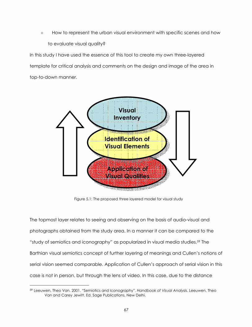
67
How to represent the urban visual environment with specific scenes and how
to evaluate visual quality?
In this study I have used the essence of this tool to create my own three-layered
template for critical analysis and comments on the design and image of the area in
top-to-down manner.
Figure 5.1: The proposed three layered model for visual study
The topmost layer relates to seeing and observing on the basis of audio-visual and
photographs obtained from the study area. In a manner it can be compared to the
“study of semiotics and iconography” as popularized in visual media studies.59 The
Barthian visual semiotics concept of further layering of meanings and Cullen’s notions of
serial vision seemed comparable. Application of Cullen’s approach of serial vision in this
case is not in person, but through the lens of video. In this case, due to the distance
59 Leeuwen, Theo Van. 2001. “Semiotics and Iconography”. Handbook of Visual Analysis. Leeuwen, Theo Van and Carey Jewitt. Ed. Sage Publications, New Delhi.
Visual Inventory
Identification of Visual Elements
Application of Visual Qualities
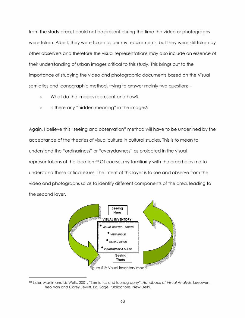
68
from the study area, I could not be present during the time the video or photographs
were taken. Albeit, they were taken as per my requirements, but they were still taken by
other observers and therefore the visual representations may also include an essence of
their understanding of urban images critical to this study. This brings out to the
importance of studying the video and photographic documents based on the Visual
semiotics and iconographic method, trying to answer mainly two questions –
What do the images represent and how?
Is there any “hidden meaning” in the images?
Again, I believe this “seeing and observation” method will have to be underlined by the
acceptance of the theories of visual culture in cultural studies. This is to mean to
understand the “ordinariness” or “everydayness” as projected in the visual
representations of the location.60 Of course, my familiarity with the area helps me to
understand these critical issues. The intent of this layer is to see and observe from the
video and photographs so as to identify different components of the area, leading to
the second layer.
Figure 5.2: Visual inventory model
60 Lister, Martin and Liz Wells. 2001. “Semiotics and Iconography”. Handbook of Visual Analysis. Leeuwen, Theo Van and Carey Jewitt. Ed. Sage Publications, New Delhi.
Seeing Here
VISUAL INVENTORY
• VISUAL CONTROL POINTS
• VIEW ANGLE
• SERIAL VISION
• FUNCTION OF A PLACE
Seeing There
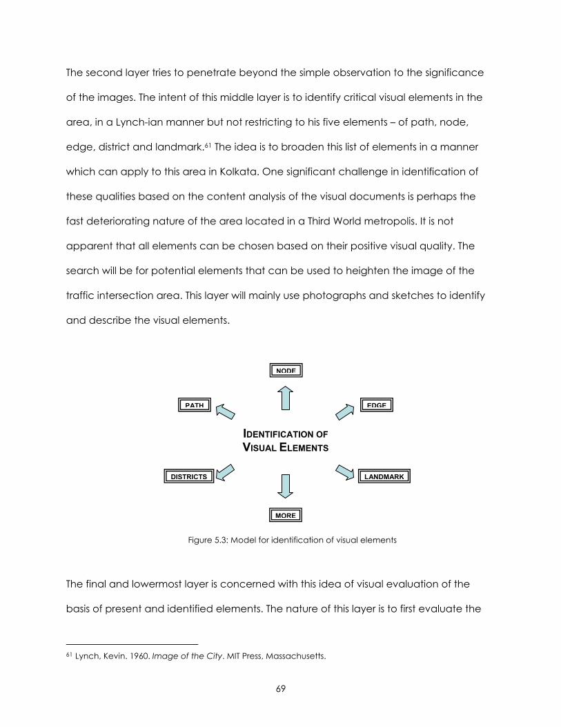
69
The second layer tries to penetrate beyond the simple observation to the significance
of the images. The intent of this middle layer is to identify critical visual elements in the
area, in a Lynch-ian manner but not restricting to his five elements – of path, node,
edge, district and landmark.61 The idea is to broaden this list of elements in a manner
which can apply to this area in Kolkata. One significant challenge in identification of
these qualities based on the content analysis of the visual documents is perhaps the
fast deteriorating nature of the area located in a Third World metropolis. It is not
apparent that all elements can be chosen based on their positive visual quality. The
search will be for potential elements that can be used to heighten the image of the
traffic intersection area. This layer will mainly use photographs and sketches to identify
and describe the visual elements.
Figure 5.3: Model for identification of visual elements
The final and lowermost layer is concerned with this idea of visual evaluation of the
basis of present and identified elements. The nature of this layer is to first evaluate the
61 Lynch, Kevin. 1960. Image of the City. MIT Press, Massachusetts.
IDENTIFICATION OF VISUAL ELEMENTS
MORE
LANDMARK
EDGEPATH
DISTRICTS
NODE
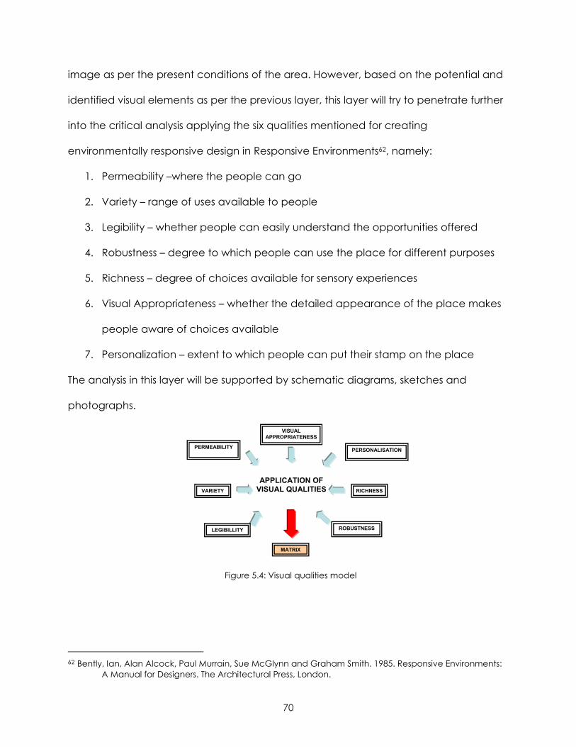
70
image as per the present conditions of the area. However, based on the potential and
identified visual elements as per the previous layer, this layer will try to penetrate further
into the critical analysis applying the six qualities mentioned for creating
environmentally responsive design in Responsive Environments62, namely:
1. Permeability –where the people can go
2. Variety – range of uses available to people
3. Legibility – whether people can easily understand the opportunities offered
4. Robustness – degree to which people can use the place for different purposes
5. Richness – degree of choices available for sensory experiences
6. Visual Appropriateness – whether the detailed appearance of the place makes
people aware of choices available
7. Personalization – extent to which people can put their stamp on the place
The analysis in this layer will be supported by schematic diagrams, sketches and
photographs.
Figure 5.4: Visual qualities model
62 Bently, Ian, Alan Alcock, Paul Murrain, Sue McGlynn and Graham Smith. 1985. Responsive Environments: A Manual for Designers. The Architectural Press, London.
APPLICATION OF VISUAL QUALITIES
MATRIX
ROBUSTNESS LEGIBILLITY
VISUAL APPROPRIATENESS
RICHNESS
PERSONALISATION PERMEABILITY
VARIETY
71
CHAPTER 6: CRITICAL ANALYSIS OF STUDY AREA
VISUAL INVENTORY
“The city is by no means perfect…But there seems to be a simple and automatic
pleasure, a feeling of satisfaction, presence, and rightness, which arises from the mere
sight of the city, or the chance to walk through its streets.”
- Kevin Lynch in Image of the City63
The main challenge interpreting the video and photographs of the study area is the
inherent consciousness of knowing and association with the place yet seeing it though
the camera. The other challenge is visually interpret an area that apparently looks in a
visual chaos. A careful visual inventory was required to identify potential and inherent
qualities of the area.
The visual inventory included a reading of the video taken of the study area after
identifying certain control points in the video. Snapshots of video were taken to help in
identifying different visual elements. The video being taken along the path of
movement accommodated the notion of serial vision, the photographs helped in
capturing the snapshots of the place at different times of the day while the schematic
map helped in superimposing the visual qualities on the identified elements.
63 Lynch, Kevin. 1960. Image of the City. MIT Press, Massachusetts.
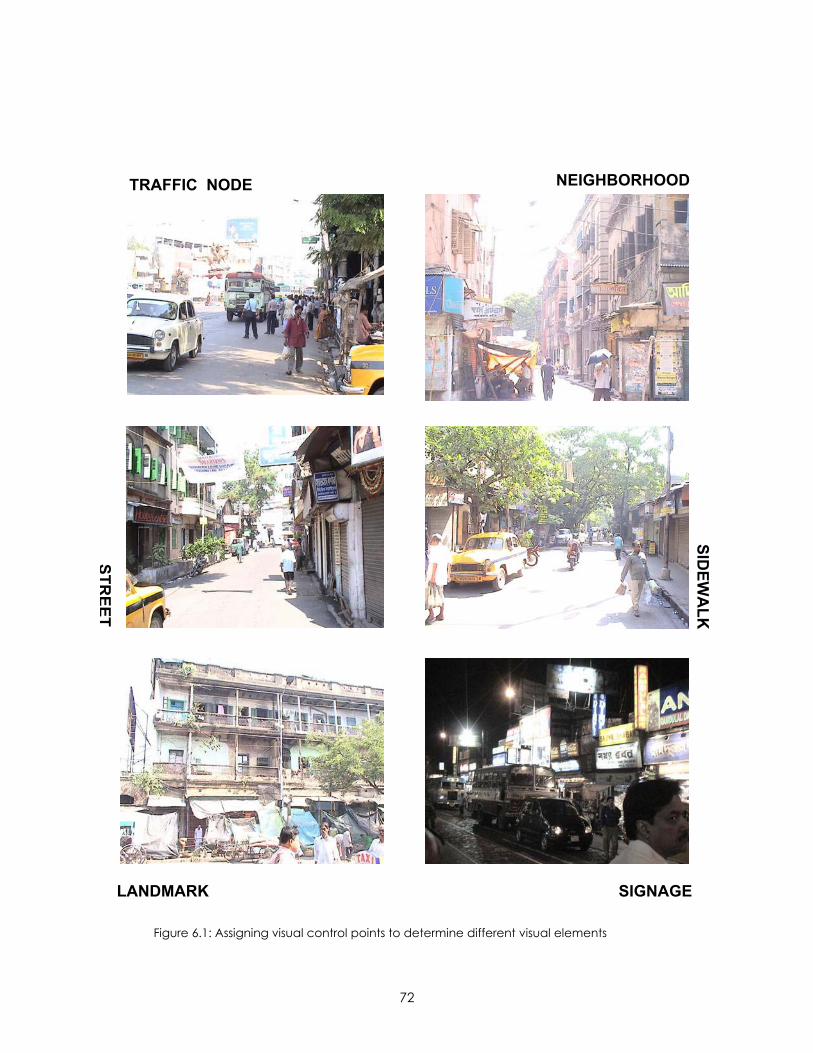
72
Figure 6.1: Assigning visual control points to determine different visual elements
TRAFFIC NODE NEIGHBORHOOD
SIDEW
ALK
SIGNAGELANDMARK
STREET
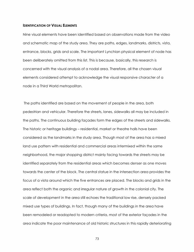
73
IDENTIFICATION OF VISUAL ELEMENTS
Nine visual elements have been identified based on observations made from the video
and schematic map of the study area. They are paths, edges, landmarks, districts, vista,
entrance, blocks, grids and scale. The important Lynchian physical element of node has
been deliberately omitted from this list. This is because, basically, this research is
concerned with the visual analysis of a nodal area. Therefore, all the chosen visual
elements considered attempt to acknowledge the visual responsive character of a
node in a Third World metropolitan.
The paths identified are based on the movement of people in the area, both
pedestrian and vehicular. Therefore the streets, lanes, sidewalks all may be included in
the paths. The continuous building façades form the edges of the streets and sidewalks.
The historic or heritage buildings – residential, market or theatre halls have been
considered as the landmarks in the study area. Though most of the area has a mixed
land use pattern with residential and commercial areas intermixed within the same
neighborhood, the major shopping district mainly facing towards the streets may be
identified separately from the residential areas which becomes denser as one moves
towards the center of the block. The central statue in the intersection area provides the
focus of a vista around which the five entrances are placed. The blocks and grids in the
area reflect both the organic and irregular nature of growth in the colonial city. The
scale of development in the area still echoes the traditional low rise, densely packed
mixed use types of buildings. In fact, though many of the buildings in the area have
been remodeled or readopted to modern criteria, most of the exterior façades in the
area indicate the poor maintenance of old historic structures in this rapidly deteriorating
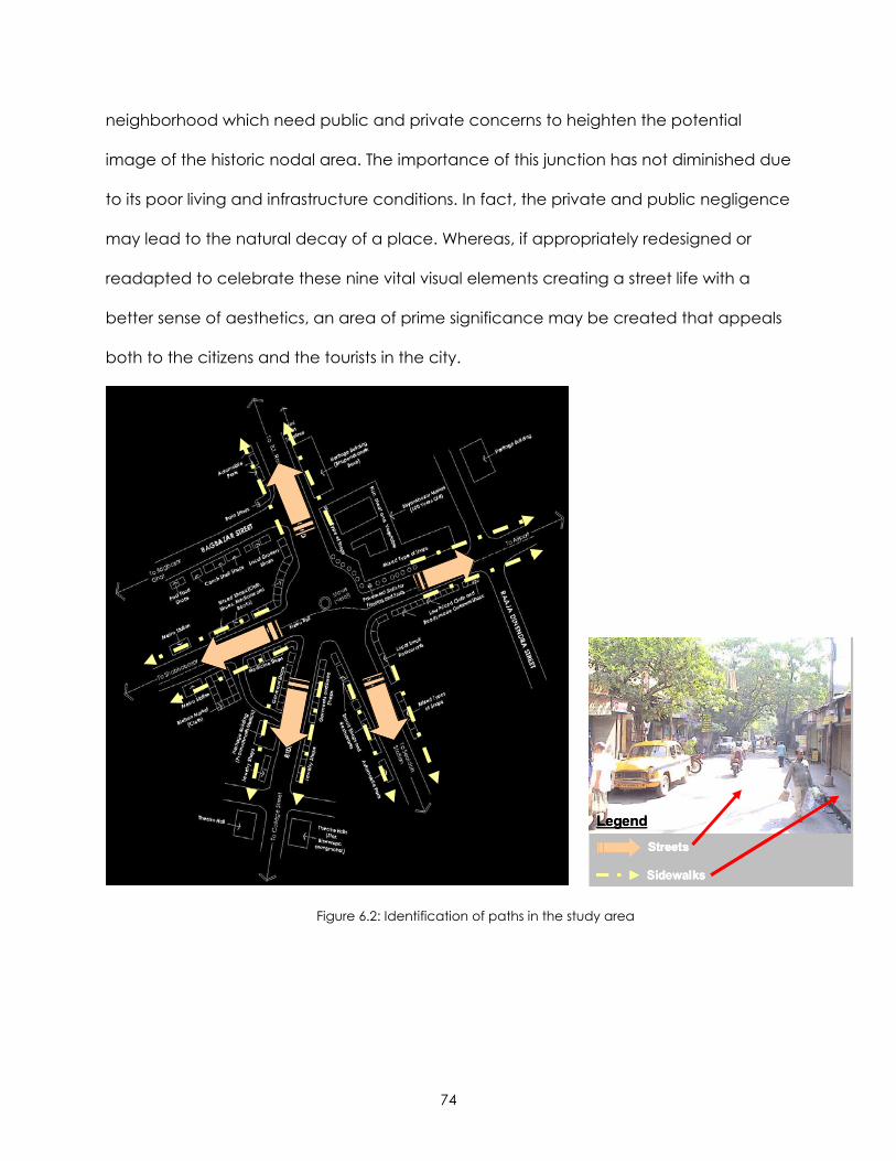
74
neighborhood which need public and private concerns to heighten the potential
image of the historic nodal area. The importance of this junction has not diminished due
to its poor living and infrastructure conditions. In fact, the private and public negligence
may lead to the natural decay of a place. Whereas, if appropriately redesigned or
readapted to celebrate these nine vital visual elements creating a street life with a
better sense of aesthetics, an area of prime significance may be created that appeals
both to the citizens and the tourists in the city.
Figure 6.2: Identification of paths in the study area
Streets
Sidewalks
Legend
Streets
Sidewalks
Legend
Streets
Sidewalks
Legend
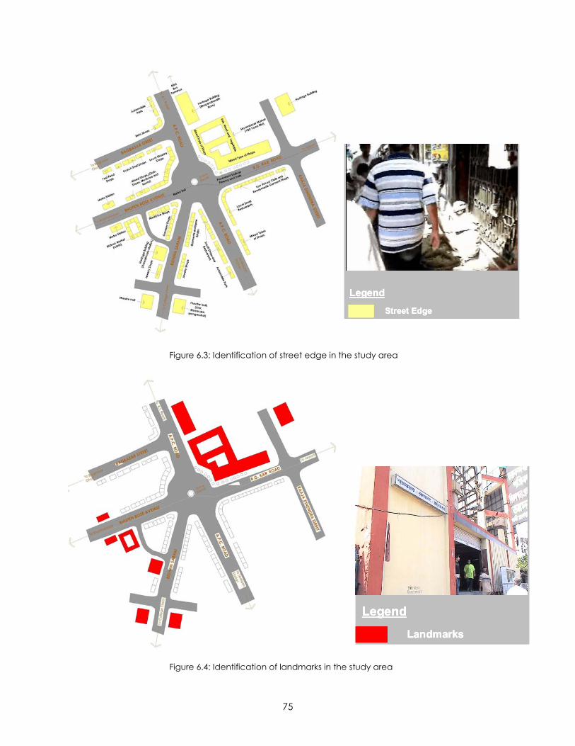
75
Figure 6.3: Identification of street edge in the study area
Figure 6.4: Identification of landmarks in the study area
Street Edge
Legend
Street Edge
Legend
Street Edge
Legend
Landmarks
Legend
Landmarks
Legend
Landmarks
Legend
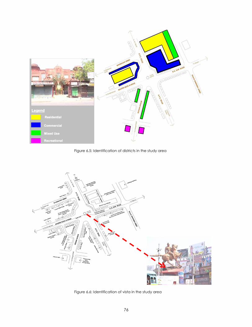
76
Residential
Legend
Commercial
Mixed Use
Recreational
Residential
Legend
Commercial
Mixed Use
Recreational
Figure 6.5: Identification of districts in the study area
Figure 6.6: Identification of vista in the study area
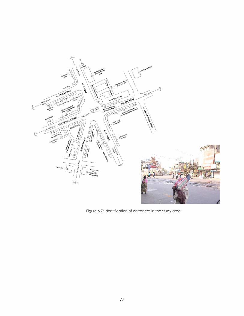
77
Figure 6.7: Identification of entrances in the study area
78
APPLICATION OF VISUAL QUALITIES
“If it is desirable that an environment evoke rich vivid images, it is also desirable that
these images be communicable and adaptable to changing practical needs, and that
there can develop new groupings, new meanings, new poetry. The objective might be
an imageable environment which is at the same time open-ended”.
- Kevin Lynch, Image of the City, p 139.64
It is essentially the attempt to create an open-ended visual analytical tool that
prompted the critical analysis by applying visual qualities to the study area. The seven
visual qualities explained in the Responsive Environments namely – permeability, variety,
legibility, robustness, richness, personalization and visual appropriateness - have been
adopted in this research as they were found relevant in the reading of the study area.
For the purpose of applying the seven visual qualities to the nine visual elements
identified earlier a matrix has been created for the comprehensive understanding of
the Shyambazar traffic intersection area. This section explores the study area with the
help of the mnemonics created by the superimposition of the visual qualities to the
visual elements. It must be noted that all the cells of the matrix have not been filled. This
is because some of the superimpositions did not generate any relevant meaning to the
study area. The other cells where the superimposition has created a particular
connotation relevant to the historic urban node in Kolkata have been discussed in
detail below.
64 Lynch, Kevin. 1960. Image of the City. MIT Press, Massachusetts.
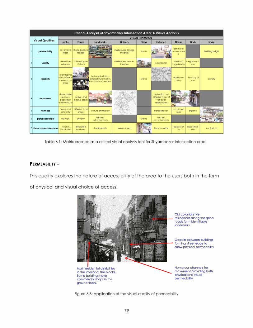
79
paths Edges Landmarks Districts Vista Entrance Blocks Grids Scale
1 permeability pavements, roads
shops, building façade
markets, residences, theatres statue
perimeter development
sbuilding height
2 variety pedestrian, vehicular
different types of shops
markets, residences, theatres 5 entrances small and
large blocksirregularity in
size
3 legibility
overlapping vehicular and non vehicular
areas
heritage buildings, colonial style market,
metro station, theatres statue economic
statushierarchy of
size density
4 robustness
shared street spaces -
pedestrian and vehicular
active and passive areas
pedestrian and different types of
vehicular approaches
5 richness sense and sensibility
different food shops culture and history transportation mix of land
uses organic
6 personalisation hawkers poverty signage, advertisements statue signage,
advertisements
7 visual appropriateness hybrid population
diversified land uses traditionality maintenance transformation legibility of
uselegibility of
form contextual
Critical Analysis of Shyambazar Intersection Area: A Visual AnalysisVisual Elements
Visual Qualities
Table 6.1: Matrix created as a critical visual analysis tool for Shyambazar Intersection area
PERMEABILITY –
This quality explores the nature of accessibility of the area to the users both in the form
of physical and visual choice of access.
Gaps in between buildings forming street edge to allow physical permeability
Numerous channels for movement providing both physical and visual permeability
Old colonial style residences along the spinal roads form identifiable landmarks
Main residential district lies in the interior of the blocks. Some buildings have commercial shops in the ground floors.
Figure 6.8: Application of the visual quality of permeability
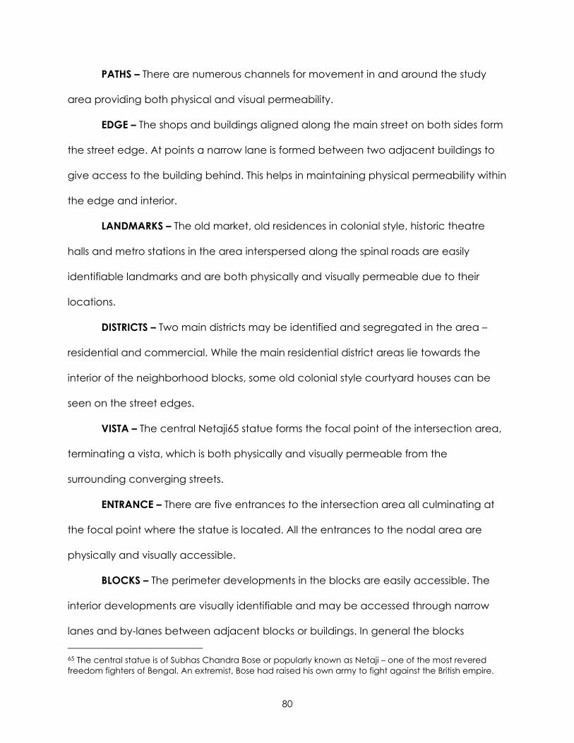
80
PATHS – There are numerous channels for movement in and around the study
area providing both physical and visual permeability.
EDGE – The shops and buildings aligned along the main street on both sides form
the street edge. At points a narrow lane is formed between two adjacent buildings to
give access to the building behind. This helps in maintaining physical permeability within
the edge and interior.
LANDMARKS – The old market, old residences in colonial style, historic theatre
halls and metro stations in the area interspersed along the spinal roads are easily
identifiable landmarks and are both physically and visually permeable due to their
locations.
DISTRICTS – Two main districts may be identified and segregated in the area –
residential and commercial. While the main residential district areas lie towards the
interior of the neighborhood blocks, some old colonial style courtyard houses can be
seen on the street edges.
VISTA – The central Netaji65 statue forms the focal point of the intersection area,
terminating a vista, which is both physically and visually permeable from the
surrounding converging streets.
ENTRANCE – There are five entrances to the intersection area all culminating at
the focal point where the statue is located. All the entrances to the nodal area are
physically and visually accessible.
BLOCKS – The perimeter developments in the blocks are easily accessible. The
interior developments are visually identifiable and may be accessed through narrow
lanes and by-lanes between adjacent blocks or buildings. In general the blocks 65 The central statue is of Subhas Chandra Bose or popularly known as Netaji – one of the most revered freedom fighters of Bengal. An extremist, Bose had raised his own army to fight against the British empire.
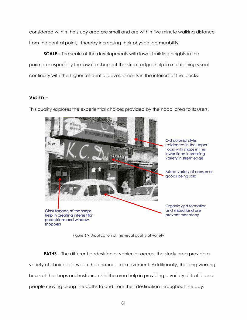
81
considered within the study area are small and are within five minute walking distance
from the central point, thereby increasing their physical permeability.
SCALE – The scale of the developments with lower building heights in the
perimeter especially the low-rise shops at the street edges help in maintaining visual
continuity with the higher residential developments in the interiors of the blocks.
VARIETY –
This quality explores the experiential choices provided by the nodal area to its users.
Mixed variety of consumer goods being sold
Organic grid formation and mixed land use prevent monotony
Old colonial style residences in the upper floors with shops in the lower floors increasing variety in street edge
Glass façade of the shops help in creating interest for pedestrians and window shoppers
Glass façade of the shops help in creating interest for pedestrians and window shoppers
Figure 6.9: Application of the visual quality of variety
PATHS – The different pedestrian or vehicular access the study area provide a
variety of choices between the channels for movement. Additionally, the long working
hours of the shops and restaurants in the area help in providing a variety of traffic and
people moving along the paths to and from their destination throughout the day.
82
EDGE – The shops defining the edge of the street help in providing variety as
they sell different types of products. In fact, each of the main street is marked with some
special type of consumer goods – for example while A.P.C. Road mainly consists of
local restaurants, automobile parts shops; R.G. Kar Road has number of wholesale cloth
traders and affordable readymade garment shops.
LANDMARKS – The old houses of renowned Babus in the area, new metro
stations, old market and historic theatres in the area provide a variety of landmarks.
DISTRICTS – The area has a variety of districts such as commercial, recreation and
entertainment and residential.
VISTA – Besides the Netaji statue forming the focal point of the nodal area there
are not much variety in formation of vistas.
ENTRANCE – The five streets converging into the traffic intersection area bringing
in traffic from all over the city provide a variety of entrances to the Shyambazar
intersection area.
blocks – The different smaller and larger blocks formed around the node within
five minute walking distance from the center help in providing variety in size.
GRIDS – The study area has irregular organic grid patterns thereby preventing
monotony.
LEGIBILITY –
This quality explores the area on the basis of easy reading of the place. Legibility may
be achieved at two levels according to physical form and user activity pattern.
PATHS – The pedestrian and vehicular paths are not distinctively segregated. This
nature of developing country culture with dense population and lax traffic rules poses a
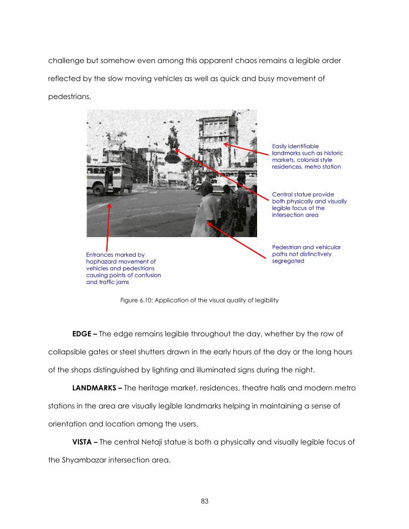
83
challenge but somehow even among this apparent chaos remains a legible order
reflected by the slow moving vehicles as well as quick and busy movement of
pedestrians.
Central statue provide both physically and visually legible focus of the intersection area
Pedestrian and vehicular paths not distinctively segregated
Easily identifiable landmarks such as historic markets, colonial style residences, metro station
Entrances marked by haphazard movement of vehicles and pedestrians causing points of confusion and traffic jams
Figure 6.10: Application of the visual quality of legibility
EDGE – The edge remains legible throughout the day, whether by the row of
collapsible gates or steel shutters drawn in the early hours of the day or the long hours
of the shops distinguished by lighting and illuminated signs during the night.
LANDMARKS – The heritage market, residences, theatre halls and modern metro
stations in the area are visually legible landmarks helping in maintaining a sense of
orientation and location among the users.
VISTA – The central Netaji statue is both a physically and visually legible focus of
the Shyambazar intersection area.
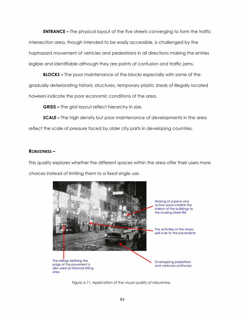
84
ENTRANCE – The physical layout of the five streets converging to form the traffic
intersection area, though intended to be easily accessible, is challenged by the
haphazard movement of vehicles and pedestrians in all directions making the entries
legible and identifiable although they are points of confusion and traffic jams.
BLOCKS – The poor maintenance of the blocks especially with some of the
gradually deteriorating historic structures, temporary plastic sheds of illegally located
hawkers indicate the poor economic conditions of the area.
GRIDS – The grid layout reflect hierarchy in size.
SCALE – The high density but poor maintenance of developments in the area
reflect the scale of pressure faced by older city parts in developing countries.
ROBUSTNESS –
This quality explores whether the different spaces within the area offer their users more
choices instead of limiting them to a fixed single use.
The activities of the shops spill over to the pavements
Overlapping pedestrian and vehicular pathways
Sharing of passive and active areas interlink the interior of the buildings to the buzzing street life
The railings defining the edge of the pavement is also used as informal sitting area
The activities of the shops spill over to the pavements
Overlapping pedestrian and vehicular pathways
Sharing of passive and active areas interlink the interior of the buildings to the buzzing street life
The railings defining the edge of the pavement is also used as informal sitting area
Figure 6.11: Application of the visual quality of robustness
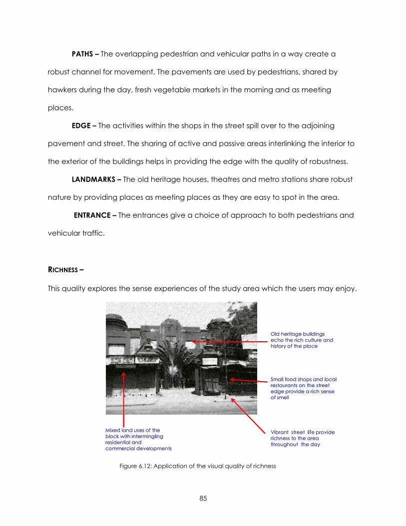
85
PATHS – The overlapping pedestrian and vehicular paths in a way create a
robust channel for movement. The pavements are used by pedestrians, shared by
hawkers during the day, fresh vegetable markets in the morning and as meeting
places.
EDGE – The activities within the shops in the street spill over to the adjoining
pavement and street. The sharing of active and passive areas interlinking the interior to
the exterior of the buildings helps in providing the edge with the quality of robustness.
LANDMARKS – The old heritage houses, theatres and metro stations share robust
nature by providing places as meeting places as they are easy to spot in the area.
ENTRANCE – The entrances give a choice of approach to both pedestrians and
vehicular traffic.
RICHNESS –
This quality explores the sense experiences of the study area which the users may enjoy.
Small food shops and local restaurants on the street edge provide a rich sense of smell
Vibrant street life provide richness to the area throughout the day
Old heritage buildings echo the rich culture and history of the place
Mixed land uses of the block with intermingling residential and commercial developments
Figure 6.12: Application of the visual quality of richness
86
PATHS – The sense of motion and touch is heightened in the pavements as
people hurry past each other on their way to work. Again the sense of smell and taste is
heightened by the food stalls or vendors or fresh vegetable and fruit markets on the
pavement. The vibrant life provides richness to the area throughout the day.
EDGE – The different small food shops and restaurants on the edge provide the
rich sense of smell to the area, inviting passersby into the restaurants for a quick snack
throughout the day.
LANDMARKS – The old heritage buildings, market and theaters echo the rich
culture and history of the place. Constant negligence has allowed natural decay of
these places. Some attention has been recently given to remodel and rehabilitate
these buildings.
ENTRANCE – The entrances accommodate different modes of transportation into
the intersection area.
BLOCKS – The mixed land uses of the block with intermingling between residential
and commercial developments provide richness to the block layout.
GRID – The organic grid layout heighten the rich variety in the area.
PERSONALIZATION –
This quality explores how the sense of the study area has been personalized by the
different users to suit their needs.
PATHS – The plastic sheds encroaching the pavement areas has helped the
illegal hawkers to create their own personal space on the pavements with sometimes
their activities spilling on to the roads. This encroachment has also forced the
pedestrians to personalize the streets as their domain especially during busy hours when
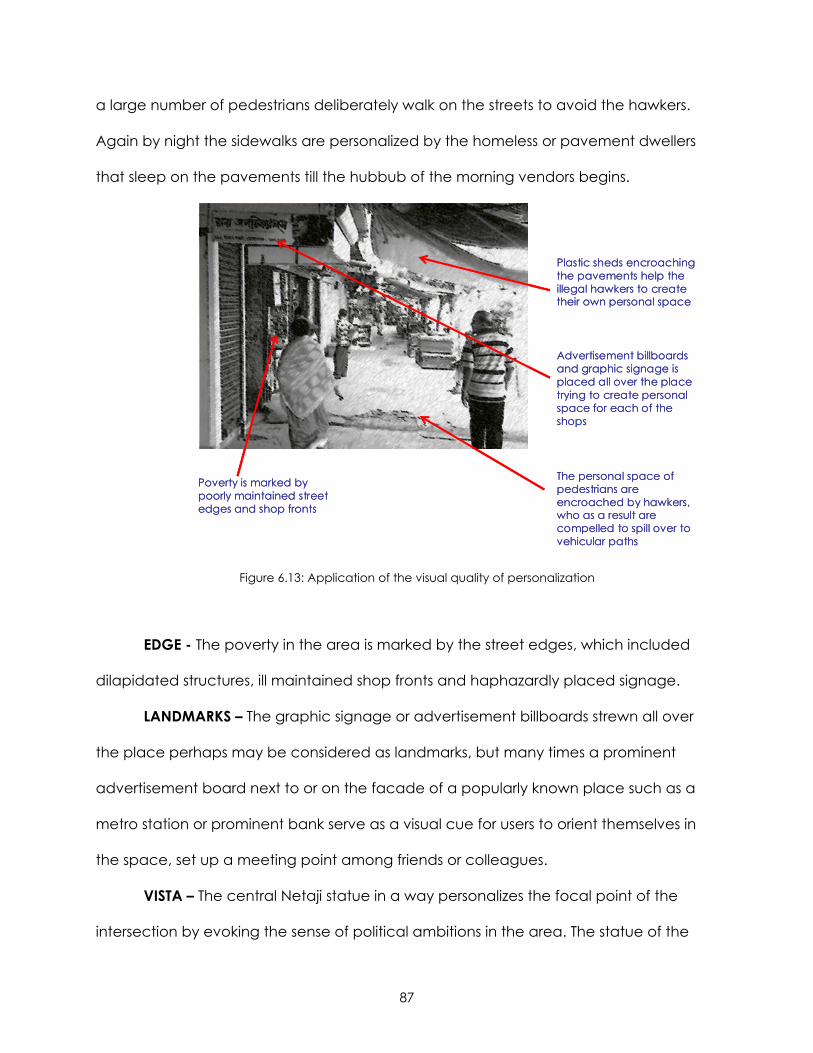
87
a large number of pedestrians deliberately walk on the streets to avoid the hawkers.
Again by night the sidewalks are personalized by the homeless or pavement dwellers
that sleep on the pavements till the hubbub of the morning vendors begins.
Advertisement billboards and graphic signage is placed all over the place trying to create personal space for each of the shops
The personal space of pedestrians are encroached by hawkers, who as a result are compelled to spill over to vehicular paths
Plastic sheds encroaching the pavements help the illegal hawkers to create their own personal space
Poverty is marked by poorly maintained street edges and shop fronts
Figure 6.13: Application of the visual quality of personalization
EDGE - The poverty in the area is marked by the street edges, which included
dilapidated structures, ill maintained shop fronts and haphazardly placed signage.
LANDMARKS – The graphic signage or advertisement billboards strewn all over
the place perhaps may be considered as landmarks, but many times a prominent
advertisement board next to or on the facade of a popularly known place such as a
metro station or prominent bank serve as a visual cue for users to orient themselves in
the space, set up a meeting point among friends or colleagues.
VISTA – The central Netaji statue in a way personalizes the focal point of the
intersection by evoking the sense of political ambitions in the area. The statue of the
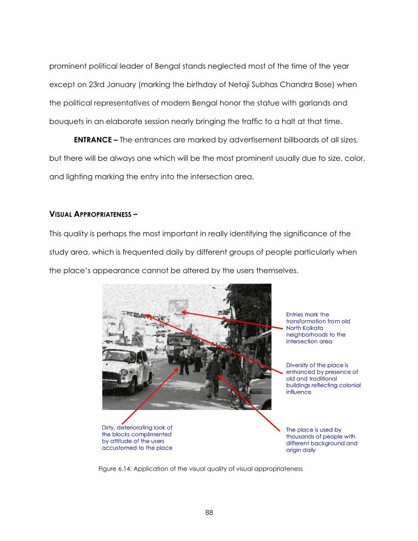
88
prominent political leader of Bengal stands neglected most of the time of the year
except on 23rd January (marking the birthday of Netaji Subhas Chandra Bose) when
the political representatives of modern Bengal honor the statue with garlands and
bouquets in an elaborate session nearly bringing the traffic to a halt at that time.
ENTRANCE – The entrances are marked by advertisement billboards of all sizes,
but there will be always one which will be the most prominent usually due to size, color,
and lighting marking the entry into the intersection area.
VISUAL APPROPRIATENESS –
This quality is perhaps the most important in really identifying the significance of the
study area, which is frequented daily by different groups of people particularly when
the place’s appearance cannot be altered by the users themselves.
Diversity of the place is enhanced by presence of old and traditional buildings reflecting colonial influence
The place is used by thousands of people with different background and origin daily
Entries mark the transformation from old North Kolkata neighborhoods to the intersection area
Dirty, deteriorating look of the blocks complimented by attitude of the users accustomed to the place
Figure 6.14: Application of the visual quality of visual appropriateness
89
PATHS – The place is regularly used by thousands of people with different
background and origin. Though demographically the area has a predominance of
Bengalis the population is largely hybrid, combining people from different states in India
as part of the workforce or as traders. Therefore, the paths, both streets and sidewalks,
echo the interpretations of the place by this hybrid population.
EDGE - The diversity of the place is also represented by the mix of land uses in the
area as evident from the variety of shops marking the street edge.
LANDMARKS - The diversity of the place is enhanced by the presence of the old
traditional buildings reflecting influences of the colonial style.
DISTRICTS - The mingling of the shopping, residential and recreational districts
seem appropriate for the organic nature of growth in developing countries.
ENTRANCE - The entries mark the transformation from the old North Kolkata
neighborhoods to the intersection area. One traveling from the newer modern
peripheral regions of the city experiences the transformation to an old, traditional city
intersection.
BLOCKS – The dirty, deteriorating look of the blocks is complimented by the
attitude of the users who have become familiar and accustomed to the place as it is
and in their acceptance of this ordinariness, the blocks gain strength of order in their
minds making it legible for their daily use.
GRIDS – The organic grid pattern has also gained a sense of everyday life due to
its legibility of the forms in the minds of its thousands of usual daily users.
SCALE – The study area when scrutinized closely evokes the sense of context as
may be assumed for a rapidly developing city where poverty reigns, scarcity of land
and resources is magnified by the ever increasing number of population. The scale of
90
development is still slow in this area, where the effects of globalization are felt by the
pressure of negligence of the area by authority while developing newer areas in the
city.
91
CHAPTER 7: CONCLUSION
“Design is the most misunderstood aspect of the planning process. It is thought of as a
decoration that can be applied after the important decisions have been made. In fact,
design is the physical manifestation of any prescription and therefore, is integral to its
success or failure from the time of inception. Design is not just a matter of architectural
style or aesthetics; successful planning has to survive for decades, when styles become
outdated. Each element affects a project’s utility, cost and attractiveness”.
- Alexander Garvin
Though Garvin66 based this observation on his understanding of the American cities, this
seems rather universally true, even for planning and design in developing countries. At
the heart of our community whether in the First or the Third World we have carried our
image and concepts of a good city form. In all our concepts, processes and standards
we have acknowledged streets as fundamental to the framework for an imageable
city. Through the course of this research the primary objective has been to evaluate the
visual importance and appropriateness of a good city form. The case study of a street
intersection in Kolkata, a tropical megalopolis in India, has served as a medium to test
this process of evaluation. The focus of this research has been to identify potential visual
qualities in a poverty stricken, neglected core of the city such that it may be developed
in future by continuing the spirit of the city’s life and growth. Kolkata’s spontaineity and
diversity of the natural economics, politics of and for the poor, social imbalance and
66 Garvin, Alexander. 1996. Shaping the American City. McGraw Hill Publications.

92
cultural hybridity has guided the analysis to reach a conclusion viable for the
developing country.
“It is clear that the form of a city or of a metropolis will not exhibit some gigantic, stratified
order. It will be a complicated pattern, continuous and whole, yet intricate and mobile. It
must be plastic to the perceptual habits of thousands of citizens, open-ended to change
of function and meaning, receptive to the formation of new imagery. It must invite its
viewers to explore the world”.
- Kevin Lynch, Image of the City, p 119.
It is this notion of open-endedness in visual studies that influenced the development of
this research methodology. The three layered model approach of visual inventory,
identification of visual elements and application of visual qualities has been the most
important contribution of this research. The critical analysis matrix formed by applying
visual qualities to identified visual elements is an approach I developed from the three
layered model. The basic model adopts Smardon et.al’s approach of accommodating
the visual analysis theories of other experts. In the attempt, the matrix evolves as a
critical tool for visual analysis of any place where we can intersect and extrapolate the
meanings and visual significance of a place by applying various visual qualities to the
same visual element. The traffic intersection area in Kolkata has been considered as a
good case for testing this analytical tool, however, the approach may be easily used
for other cities and places. The important thing to remember is that the matrix is not
constant but rather dynamic and flexible; it is just a start and can be further developed
and enhanced by using different visual elements or visual qualities that may be more
relevant to other cases. The matrix also does not attempt to diminish the value of other
93
methods of urban visual studies as provided by Lynch, Cullen, Nasar or other experts in
visual analysis. Lynch visual study approach was structural by identifying critical
elements that form the city; Cullen followed the approach of self identification of a
place through the process of moving through it; Nasar developed a survey approach
for his visual study to evaluate the image of a city. The matrix approach taken in this
research acknowledges the importance of all these methods and borrows the essence
of visual study by these experts. This research specifically tries to bring together the
approaches of Cullen, Lynch and the authors of Responsive Environments. However,
the terms used are subjective and can be modified or developed as applicable. The
matrix therefore grows with the shifting images of a city.
The matrix used in this case is particularly applicable to degenerating cities in
developing countries especially the ones undergoing the immense stress of rapid
globalization. Therefore, the terms evolving from this matrix recognizes the issues faced
in such conditions. The matrix is perhaps the first step to design for such a city. In a way
the matrix helps us to take apart and dissect the fabric of a place. It is no doubt that
the familiarity to the place of study helps in maintaining the sense of the place.
However, in the end it must be remembered that similar to the Gestalt philosophy the
sum of all parts do not equal to the whole. The philosophy of design also needs to
accept the behavioral psychology of the users. In this case, a number of times the
image of the area may not have been particularly visually stimulating however, there is
a sense of acceptance among the community which can not be neglected. Inspite of
all kinds of detrimental visual cues gathered from this place, in the end it works, it
survives and maintains the spontaneity of street life. Thousands of people use it daily on
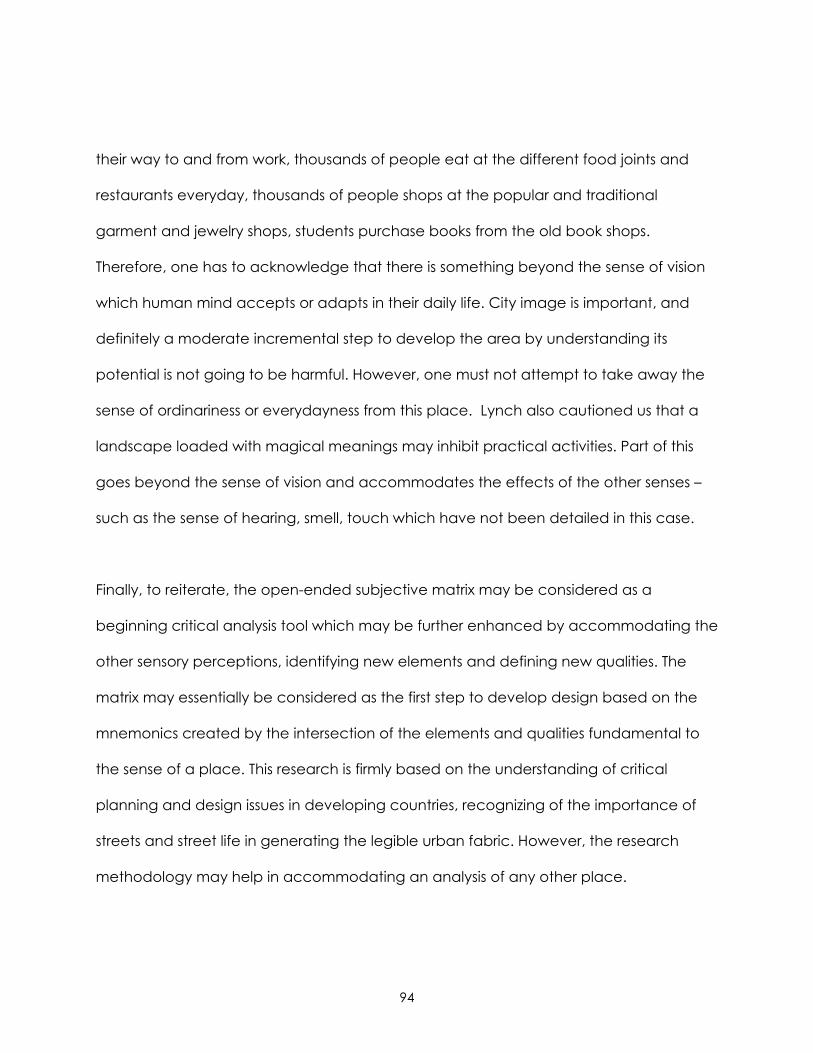
94
their way to and from work, thousands of people eat at the different food joints and
restaurants everyday, thousands of people shops at the popular and traditional
garment and jewelry shops, students purchase books from the old book shops.
Therefore, one has to acknowledge that there is something beyond the sense of vision
which human mind accepts or adapts in their daily life. City image is important, and
definitely a moderate incremental step to develop the area by understanding its
potential is not going to be harmful. However, one must not attempt to take away the
sense of ordinariness or everydayness from this place. Lynch also cautioned us that a
landscape loaded with magical meanings may inhibit practical activities. Part of this
goes beyond the sense of vision and accommodates the effects of the other senses –
such as the sense of hearing, smell, touch which have not been detailed in this case.
Finally, to reiterate, the open-ended subjective matrix may be considered as a
beginning critical analysis tool which may be further enhanced by accommodating the
other sensory perceptions, identifying new elements and defining new qualities. The
matrix may essentially be considered as the first step to develop design based on the
mnemonics created by the intersection of the elements and qualities fundamental to
the sense of a place. This research is firmly based on the understanding of critical
planning and design issues in developing countries, recognizing of the importance of
streets and street life in generating the legible urban fabric. However, the research
methodology may help in accommodating an analysis of any other place.
95
APPENDIX
paths
Edge
sLa
ndma
rksDis
tricts
Vista
Entra
nce
Block
sGr
idsSc
ale
1pe
rmea
bility
pave
ment
s, roa
dssh
ops, b
uildin
g fa
çade
marke
ts, re
siden
ces,
thea
tres
statu
epe
rimet
er de
velop
ment
sbu
ilding
heigh
t
2va
riety
pede
strian
, ve
hicula
rdif
feren
t typ
es
of sh
ops
marke
ts, re
siden
ces,
thea
tres
5 ent
ranc
essm
all a
nd
large
bloc
ksirre
gular
ity in
siz
e
3leg
ibility
overl
appin
g ve
hicula
r and
no
n veh
icular
ar
eas
herita
ge b
uildin
gs,
colon
ial st
yle m
arke
t, me
tro st
ation
, thea
tres
statu
eec
onom
ic sta
tus
hiera
rchy o
f siz
ede
nsity
4rob
ustne
ss
shar
ed st
reet
spac
es -
pede
strian
an
d ve
hicula
r
activ
e an
d pa
ssive
area
s
pede
strian
and
dif
feren
t typ
es of
ve
hicula
r ap
proa
ches
5ric
hnes
sse
nse a
nd
sens
ibility
diffe
rent f
ood
shop
scu
lture
and
histo
rytra
nspo
rtatio
nmi
x of la
nd
uses
organ
ic
6pe
rsona
lisatio
nha
wkers
pove
rtysig
nage
, ad
vertis
emen
tssta
tue
signa
ge,
adve
rtisem
ents
7vis
ual a
pprop
riaten
ess
hybr
id po
pulat
iondiv
ersifie
d lan
d us
estra
dition
ality
maint
enan
cetra
nsfor
matio
n leg
ibility
of
use
legibi
lity of
fo
rmco
ntex
tual
Critic
al An
alysis
of Sh
yamb
azar
Inters
ectio
n Area
: A Vi
sual
Analy
sisVis
ual E
lemen
tsVis
ual Q
ualitie
s
96
REFERENCES
Al Sayyad, Nezar. Ed. 2001. Hybrid Urbanism: On the Identity Discourse and Built
Environment. Praeger Publications, Connecticut.
Blair, William GE. 1986. “Visual Impact Assessment in Urban Environment”. Foundations
for Visual Project Analysis. Smardon, Richard C, James F. Palmer and John P.
Fellemen. Ed. John Wiley and Sons, New York.
Bently, Ian, Alan Alcock, Paul Murrain, Sue McGlynn and Graham Smith. 1985.
Responsive Environments: A Manual for Designers. The Architectural Press,
London.
Chakraborty, Satyesh C. “The Growth of Calcutta in the Twentieth Century”. Calcutta:
The Living City. Sukanta Chaudhuri. ed. Volume II. Oxford University Press,
Calcutta.
Chakravorty, Sanjoy. 2000. “From Colonial City to Globalizing City? The Far –from-
complete Spatial Transformation of Calcutta”. Globalizing Cities: A New Spatial
Order. Marcuse, Peter and Kempen, Ronald Van. ed. Blackwell Publishers,
Oxford.
Chatterjee, Monidip. 1990. “Before Calcutta”. Calcutta: The Living City. Sukanta
Chaudhuri. ed. Volume II. Oxford University Press, Calcutta.
97
Chatterjee, Monidip. 1990. “Town Planning in Calcutta: Past, Present and Future”.
Calcutta: The Living City. Sukanta Chaudhuri. ed. Volume II. Oxford University
Press, Calcutta.
Chaudhuri, Sukanta. “Traffic and Transport in Calcutta”. Calcutta: The Living City.
Sukanta Chaudhuri. ed. Volume II. Oxford University Press, Calcutta.
Correa, Correa. 1989. The New Landscape: Urbanization in the Third World. Butterworth
Architecture, Sevenoaks.
Eade, John and Christopher Mele. Ed. 2002. Understanding the City: Contemporary and
Future Perspectives. Blackwell Publishers Ltd., Oxford.
Garvin, Alexander. 1996. Shaping the American City. McGraw Hill Publications.
Jacobs, Jane. 1961. The Death and Life of Great American Cities. Random House, Inc.,
New York.
King, Anthony D. 1995. The Bungalow: The Production of a Global Culture. Oxford
University Press, New York.
Kingsley, David. 1965. “The Urbanization of the Human Population”. The City Reader.
LeGates, Richard T. and Frederic Stout. Ed. 1996. Routledge, London.
98
Leeuwen, Theo Van. 2001. “Semiotics and Iconography”. Handbook of Visual Analysis.
Leeuwen, Theo Van and Carey Jewitt. Ed. Sage Publications, New Delhi.
LeGates, Richard T. and Frederic Stout. Ed. 1996. The City Reader. Routledge, London.
Allmendinger, Philip and Michael Chapman. ed. 1999. “Planning in the
Millennium”. Planning Beyond 2000. John Wiley and Sons, New York.
Lennard, S.H and H.L. Lennard. 1984. Public Life in Urban Places. Gondolier Press, New
York.
Lister, Martin and Liz Wells. 2001. “Semiotics and Iconography”. Handbook of Visual
Analysis. Leeuwen, Theo Van and Carey Jewitt. Ed. Sage Publications, New Delhi.
Lynch, Kevin. 1960. Image of the City. MIT Press, Massachusetts.
Mitter, Saswati. 1980. Living in Famous Cities: Living in Calcutta. Wayland Publishers Ltd.
Mukerji, Dr.S.C. 1991. The Changing Face of Calcutta: An Architectural Approach.
Government of West Bengal.
Mumford, Lewis. 1937. “What is a City?” The City Reader. LeGates, Richard T. and
Frederic Stout. Ed.1996. Routledge, London.
99
Nair, P Thankappan. “Civic and Public Services in Old Calcutta”. Calcutta: The Living
City. Sukanta Chaudhuri. ed. Volume I. Oxford University Press, Calcutta.
Nair, P.Thankappan. 1990. “The Growth and Development of Old Calcutta”. Calcutta:
The Living City. Sukanta Chaudhuri. ed. Volume I. Oxford University Press,
Calcutta.
Nasar, J. L. 1998. The Evaluative Image of the City: Thousand Oaks, CA: Sage.
Randhwa, T.S. The Indian Courtyard House. 1999. Prakash Books Pvt. Limited.
RayChaudhuri, Subir. 1990. “The Lost World of Babus”. Calcutta: The Living City. Sukanta
Chaudhuri. ed. Volume II. Oxford University Press, Calcutta
Roy, Ananya. “The Gentlemen’s City: Urban Informality in the Calcutta of New
Communism”. Urban Informality: Transnational Perspectives from the Middle East,
Latin America and South Asia. Al-Sayyad,Nezar and Ananya Roy. ed. 2003.
Lexington Books, New York.
Roy, Tathagata. “The Calcutta Metro”. Calcutta: The Living City. Sukanta Chaudhuri.
ed. Volume II. Oxford University Press, Calcutta.
100
Sen, Jai. 1975. The Unintended City: an essay on the city of the poor. Cathedral Relief
and Social Services, Calcutta
Smardon, Richard C, Tony Costello and Harry Eggink. 1986. “Urban Visual Description
and Analysis”. Foundations for Project Analysis. Smardon, Richard C, James F.
Palmer and John P. Felleman. Ed. John Wiley and Sons.
Southworth, Michael and Eran Ben-Joseph. 2003. Streets and the Shaping of Towns and
Cities. Island Press, London.
Taylor, Peter J. 2004. World City Network: A Global Urban Analysis. Routledge Taylor and
Francis Group, London.
Thorns, David C. 2002.The Transformation of Cities: Urban Theory and Urban Life.
Palgrave Macmillan, New York.
Websites
http://www.westbengaltourism.com/calcutta/gen_info.htm#generalinfo (Downloaded
on 30th September, 2005)
101
http://www.megacities.uni-koeln.de/_frame.htm?http://www.megacities.uni-
koeln.de/documentation/calcutta/statistics.htm (Downloaded on 30th November,
2005)
HTTP://WWW.BENGALONTHENET.COM/PHP/DISPLAYFILE.PHP?ARTICLE_ID=263&SECTION_I
D=2&SUB_ID=0&ARCHIVE=YES (Downloaded on October 30th, 2005)
Singh, Arbind. “Operation Sunshine A Blot on the Lives of Calcutta Hawkers”. Streetnet
International. December, 2000. Retreived from
http://www.streetnet.org.za/english/sun1.htm on October 31st, 3005.
Meaning retrieved from Answer.com. From the following web link:
http://www.answers.com/globalization&r=67 on November 2nd, 2005.
Meaning retrieved from Answer.com. From the following web link:
http://www.answers.com/hybrid&r=67
on November 2nd, 2005.
Meaning retrieved from Answer.com. From the following web link:
http://www.answers.com/transformation&r=67 on November 2nd, 2005.