Crielaard, J.P., Barbetsea, L., Charalambidou, X., Chidiroglou, M., Groenhuijzen, M., Kosma, M. &...
24
PHAROS Phar s JOURNAL OF THE NETHERLANDS INSTITUTE AT ATHENS VOLUME XIX.2 2013 PEETERS Fieldwork Reports & Studies
Transcript of Crielaard, J.P., Barbetsea, L., Charalambidou, X., Chidiroglou, M., Groenhuijzen, M., Kosma, M. &...
PH
AR
OS
V
OLU
ME X
IX.2 2013
Phar sJOURNAL OF THE NETHERLANDS INSTITUTE AT ATHENS
VOLUME XIX.2 2013
PEETERS
Fieldwork Reports & Studies
97016_Pharos_19_2_Cover.indd 2-497016_Pharos_19_2_Cover.indd 2-4 13/03/14 11:2513/03/14 11:25

CONTENTS
John Bintliff, Bart Noordervliet, Janneke van Zwienen, Keith Wilkinson, Bozidar Slapsak, Vladimir Stissi, Chiara Piccoli & Athanasios Vionis The Leiden-Ljubljana Ancient Cities of Boeotia Project, 2010-2012 seasons ....................................................................................... 1
Jan Paul Crielaard, Elisabeth Barbetsea, Xenia Charalambidou, Maria Chidiroglou, Mark Groenhuijzen, Maria Kosma & Filiz Songu The Plakari Archaeological Project. Preliminary report on the second field season (2011) .............................................................................................. 35
Torsten Mattern Theisoa (Lavdha). Vorbericht über die Arbeiten 2011 und 2012 ................. 57
Joanita Vroom Digging for the ‘Byz’. Adventures into Byzantine and Ottoman archaeo - logy in the eastern Mediterranean .............................................................. 79
Stuart MacVeagh Thorne, Mieke Prent, Athanassios Themos & Eleni Zavvou Kastraki Keratitsas: preliminary results of the architectural study of an Early Helladic fortification in Laconia ....................................................... 111

Pharos 19(2), 35-56. doi: 10.2143/PHA.19.2.3015345© 2013 by Pharos. All rights reserved.
The Plakari Archaeological Project
Preliminary report on the second field season (2011)
JAN PAUL CRIELAARD, ELISABETH BARBETSEA, XENIA CHARALAMBIDOU, MARIA CHIDIROGLOU, MARK GROENHUIJZEN, MARIA KOSMA & FILIZ SONGU
Abstract
An initial campaign of mapping the archaeological site of Plakari (southern Euboia) and its immediate surroundings was carried out in 2010 by VU University Amsterdam and the 11th Ephorate of Prehistoric and Classical Antiquities. This was followed in the summer of 2011 by a season of excavations that brought to light large quantities of pottery and small finds that were part of an Early Iron Age sacrificial deposit, a small building for sacrificial feasting located within the perimeter of the sanctuary and dating to the late Classical period, and part of a building that was used for the storage of amphoras of roughly the same chronological phase. A first step was made with the systematic study of the thousands of Early Iron Age sherds, and geo-archaeological research was conducted in two areas to the south-west and north-east of the site in order to reconstruct the landscape formation processes of the coastal area.
Keywords
Karystos-Plakari – southern Euboia – Early Iron Age – Classical period – excavations – geo-archaeology.
Introduction
The site of Plakari is located on a low ridge of schist stone (maximum elevation 85 m.a.s.l.), about 2.5 km west of modern-day Karystos in southern Euboia, Greece.1 Early Iron Age occupation started in the 11th or 10th century BC when a cult place was established on the hilltop. This cult place probably catered for a settlement located on the flanks of the hill. In the 8th to 5th centuries BC, a settlement of considerable size developed to the north-east of the hill, near the
1 Crielaard et al. 2010-2011 provide an outline of the project and a preliminary report on the 2010 season, as well as an introduction to the site and its regional contexts, and a brief history of research at the site.
97016.indb 35 13/03/14 10:50

36 JAN PAUL CRIELAARD ET AL.
mouth of the Rigia (also Rhigias) river, as indicated by surface finds in this area.2 It is most likely that this is the site of Archaic Karystos, which used the hilltop of Plakari as its acropolis. Inscriptional and archaeological testimony suggests that from at least the late Classical period onwards, the main civic nucleus was situated south of Castel Rosso, at Kokaloi-Palaiochora.3
Since 2010, fieldwork has been carried out at Plakari as a collaboration between VU University Amsterdam and the 11th Ephorate of Prehistoric and Classical Antiquities at Chalkis. The fieldwork is conducted under the direction of Jan Paul Crielaard and Amalia Karapaschalidou, who is represented in the field by Maria Kosma, the 11th Ephorate’s archaeologist responsible for southern Euboia. Crielaard is also director of the Plakari Archaeological Project, the aim of which is to stimulate and coordinate other research activities related to the fieldwork at Plakari. The overall objective of the project is to understand the character of the human occupation of the Plakari hilltop and its immediate surroundings, and to investigate how Plakari functioned in various periods within its wider geographical setting. One of the main research foci is the Early Iron Age occupation of the site with its sanctuary and associated cult and settlement, and the site’s position and functioning within local, regional and inter-regional contexts. Research at Plakari is urgent, since past and future building developments pose a threat to the site.4
During the first field season in 2010, a detailed digital map and 3D-elevation of the hilltop and the surrounding area were made. Find locations known from previous surveys, along with ancient walls and other visible archaeological remains, were plotted on the map.5 In addition, a study was undertaken in the Karystos museum of earlier finds from surveys, site visits and rescue excavations.6 The digital site map provided a good basis on which to plan further excavations at the site from 2011 onwards.
The 2011 season lasted from 20 July to 19 August. The first four weeks were dedicated to archaeological excavations in three trenches on two terraces on the west side of the hilltop, followed by a week of studying the excavated material in the Karystos museum. At the same time, a start was made with the systematic study of the thousands of sherds dated to the Early Iron Age, especially the Geo-metric period, which came to light in the excavation of the sacrificial deposit on
2 Future excavations in the area of the Rigia river could corroborate or refute this assumption. 3 Crielaard et al. 2010-2011, 91-95; Chidiroglou 2012, 56-102 (topography), 308-330 (epigraphic testi-mony), 533-539 (sculpture) – both with further references. For an overall picture of site distribution per period in the region around Karystos Bay including the Palaiochora sites, see Keller 1985, passim. 4 Crielaard et al. 2010-2011, 95-98. 5 Crielaard et al. 2010-2011, 98-100. 6 Crielaard et al. 2010-2011, 100-102.
97016.indb 36 13/03/14 10:50

THE PLAKARI ARCHAEOLOGICAL PROJECT 37
the south flank of the hilltop.7 Finally, a small team of geo-archaeology students examined the subsurface in the coastal plain to the south-west and north-east of Plakari by means of coring, in order to study landscape formation processes and the influences of the maritime environment.8
Excavations
Traces of walls that are visible on the surface and that had been mapped in 2010 suggested that on the west side of the Plakari hilltop two ancient terraces were present (Figure 1).9 A long terrace wall (TW1) crosses the western hill slope; at both its northern and southern end it makes a sharp turn and both stretches continue into an eastern direction. This terrace wall may also have functioned as a temenos wall,10 defining the area of the sanctuary west of the summit. All three 2011 trenches were located within the confines of this area (Figure 1).
Trench 1
Trench 1 is located on the south slope of the summit (Figure 1: 1). This is the area where the southern section of TW1 can be traced over a distance of several metres until it reaches the point where it has partly collapsed due to the bulldozing of a modern road (labelled A2) to its south. As a result of this collapse, a large deposit of pottery, bone and other finds had become visible in the scarp of the road.11 This deposit has been interpreted as an apothetes or bothros (sacrificial refuse pit, containing votive material and remains of sacrificial meals) that had been dug in
7 Jan Paul Crielaard acted as project coordinator and, together with Maria Kosma, as field director. During the earlier part of the campaign, Evita Kalogiropoulou was the Ephorate’s representative in lieu of Maria Kosma. The trench supervisors were Maria Chidiroglou (National Archaeological Museum), Alline Sinke, Ruben Brugge and Sam Leeflang (students at VU University). Jaap Fokkema (VU University) was responsible for survey work and for mapping and drawing the architectural remains. Anne van Hilst (VU University) acted as field assistant. The work in the museum was coordinated by Filiz Songu (VU University), who was also responsible for recording the finds and studying the pottery and small finds. Dr Xenia Charalambidou (Fitch Laboratory, British School at Athens) coordinated and conducted the research project on the EIA pottery. Bert Brouwenstijn (VU University) was responsible for drawing and photographing the archaeological finds. A team of seven VU University students assisted in the field and the museum. 8 The geo-archaeological investigations were carried out by Elisabeth Barbetsea and Mark Groen-huijzen, Master students at the Institute for Geo- and Bioarchaeology, VU University. Geophysical prospection, using electrical resistivity, on the summit and the ridge to its west (Ridge B) was to be carried out during this campaign, but had to be postponed to a later season, due to health problems of the researcher in question. 9 Crielaard et al. 2010-2011, 85 fig. 2. 10 Crielaard et al. 2010-2011, 99. 11 Crielaard et al. 2010-2011, 89-90, with fig. 8.
97016.indb 37 13/03/14 10:50

38 JAN PAUL CRIELAARD ET AL.
Fig
ure
1. P
lan
of P
laka
ri h
illto
p, s
how
ing
loca
tion
of
terr
ace
wal
ls a
nd 2
011
tren
ches
(ou
tlin
e of
tre
nche
s in
dica
ted
in r
ed)
97016.indb 38 13/03/14 10:50

THE PLAKARI ARCHAEOLOGICAL PROJECT 39
this peripheral spot of the sanctuary, against TW1.12 The apothetes has long suffered from erosion and from visitors who illegally collected material, although there have been some notable exceptions of people handing in finds to the author-ities at the local museum.
Trench 1, which in the south was bordered by the road scarp, was relatively small (4 x 2 m), but it fitted our purposes: the primary aim of our activities in this location was to retrieve as much pottery and as many small finds and animal bones and botanical macro-remains as possible in order to solve three important questions:
– what sort of cult activities were performed (e.g. sacrifices, ritual meals, ritual breakage of objects, votive practices, etc.)?
– what kind of people were involved in what sort of ceremonies (e.g. ceremo-nies related to social status, gender, or personal or group identity)?
– what is the precise chronological range of these cultic activities?
We also wanted to find out whether a stratigraphy within this deposit could be established and, if so, whether it would correspond to different actions of deposit-ing material. The area of the trench was therefore excavated in two halves in order to create a section that would make stratigraphical observations possible. The collection of finds was maximized with the help of dry-sieving (mainly aimed at retrieving small artifacts and relatively large ecofacts) and wet-sieving with the help of a flotation machine (aimed at collecting archaeobotanical macroremains).
Within a few days, however, it became clear that the identification of this area as the original location of an apothetes or bothros was only partly correct. Although large quantities of broken pottery, bones and small finds were uncovered, all were found within a thick layer of gravel. The position of this gravel layer shows that much of the deposit had slid down from an area higher up the hill, to be halted first by a pocket formed by natural rock folds and then by TW1. This confirms that TW1 must have been a free-standing temenos wall rather than a terrace wall in the narrow sense of the word. No stratigraphy could be detected within this layer of gravel and finds, which could be an indication that its re-deposition had taken place within a limited time span.
Trench 1, which was excavated almost down to bedrock, has yielded more than 6,500 sherds and 112 small finds. Table 1 provides a first indication of the types of artifacts that are represented and the materials they are made of. The preliminary study of the ceramics shows that the contents of this deposit were rather uniform: it contains a disproportionally large quantity of painted fine wares, most of which
12 Keller 1985, 105-106, 180-181; Chidiroglou 2003-2004, 70-71.
97016.indb 39 13/03/14 10:50

40 JAN PAUL CRIELAARD ET AL.
can be linked to eating and, above all, drinking (Figure 2). The number and the nature of the small finds are also in accordance with what one would expect to find in a sanctuary rather than in a settlement context (Figures 3-4 and Table 1). The chronological range of the pottery suggests that cultic activities spanned the period from the 10th to the 7th century BC, with a peak in the deposition of ceramics during the Middle Geometric (MG) and Late Geometric (LG) periods. Our preliminary studies also show that, along with pottery that was probably locally made, there were imports from Attica (Figure 2: 9), central Euboia, the Cyclades and even the eastern Aegean (Figure 2: i-j), indicating that the sanctuary fulfilled a regional or even supra-regional function.
Trench 2
Trench 2 is situated to the north of Trench 1, immediately to the west of the highest point of the summit. This is the area of the smallest of the two terraces, Terrace 2 (T2), which is delineated on three sides by TW2. Perhaps TW2 set apart the section of the sanctuary that was more sacred and that gave access to the area of the rock-cut niches a little further to the east.13 Trench 2 was laid out on both
13 Crielaard et al. 2010-2011, 100.
Small findsTrench 1
Pendants
Bronze sheet
Rngs
Pins / nails
Fibulae
Knives / blades
Figurine frs.
Mniature vases
Beads
Other
Total
Gold 1 1
Bronze 3 10 8 5 2 28
Iron 22 3 20 7 52
Lead ?1 ?1
Glass 2 2
Stone 1 1 2
Terracotta 18 3 5 26
Total 1 3 ?11 30 8 20 18 3 3 15 112
Table 1. Overview of small finds from Trench 1
97016.indb 40 13/03/14 10:50

THE PLAKARI ARCHAEOLOGICAL PROJECT 41
sides of TW2 and was divided into three parts (see Figure 1: 2a-c): Trench 2a and its north-eastern extension Trench 2c were located within the boundaries of T2, while Trench 2b was laid out at a lower level, to the west of TW2.
The aim of excavating in this particular spot was to find out whether T2 con-tained any architectural features or other archaeological remains that could pro-vide insights into the internal organization of the sanctuary and that could be compared with the findings in Trench 3 on Terrace 1 (see below). Trench 2b in particular was designed to establish the preserved size and height of TW2. How-ever, in the end Trench 2b remained unexcavated, while in Trench 2a only the topsoil was removed, as most of the work was concentrated in Trench 2c.
Figure 2. Early Iron Age pottery from Trench 1: a.-j. painted fine wares; k. coarse wares with incised decoration
97016.indb 41 13/03/14 10:50

42 JAN PAUL CRIELAARD ET AL.
Figure 3. Metal objects from Trench 1: a. bronze fibula; b. fragment of bronze diadem; c. bronze finger ring; d. iron knife; e. unknown iron object; f. gold pendant
Figure 4. Terracotta figurines from Trench 1: a. dog (?); b. horse; c. helmeted (?) figure
97016.indb 42 13/03/14 10:50

THE PLAKARI ARCHAEOLOGICAL PROJECT 43
Very soon after beginning the excavations, Trench 2c appeared to be the most informative and deserved most of our attention. After removing topsoil and layers containing gravel and medium-sized stones, a rectangular building of dry-stone masonry came to light. For its construction local schist stone were employed, shaped into irregular or trapezoidal, medium sized blocks; smaller schist slabs were used to fill the spaces between these blocks, following a construction technique that is known to have first appeared in the 5th century BC but became popular especially in the 4th century BC. This building (Building A; see Figure 5) is set almost directly against the north section of TW2, suggesting that the walls were constructed in conjunction.
Building A measures approximately 4.65 m (N-S) by 5.21+ m (W-E; its eastern wall, however, remains unexcavated, as in this part of the trench a strip of soil was left in place for stratigraphical observations). Parts of the natural rock were incor-porated in the western and southern walls of the building, while its beaten earth floor was set directly upon the partly levelled living rock. A 1.4 m wide entrance was found in the south. The remains of burnt mud-brick and charred wood not only provided information about the building’s superstructure and roofing, but
Figure 5. Plan of Building A (hestiatorion) in Trench 2c
97016.indb 43 13/03/14 10:50

44 JAN PAUL CRIELAARD ET AL.
Figure 6. Interior of Building A in Trench 2c: limestone slabs used as low tables or shelves and pottery found in situ against north wall
Figure 7. Interior of bowls with incised monograms from hestiatorion
97016.indb 44 13/03/14 10:50

THE PLAKARI ARCHAEOLOGICAL PROJECT 45
Figure 8. Interior of one-handled bowl bearing the name of Nikè
97016.indb 45 13/03/14 10:50

46 JAN PAUL CRIELAARD ET AL.
Figure 9. Head of female figurine of terracotta
Figure 10. Large bronze object (collar?) found against north wall of hestiatorion
97016.indb 46 13/03/14 10:50

THE PLAKARI ARCHAEOLOGICAL PROJECT 47
also indicate that it was destroyed by fire and subse-quently collapsed. As a result, a large part of the building’s contents was in an excellent state of pres-ervation. A series of fine limestone slabs were uncov-ered against its northern wall (Figure 6), serving as low tables or shelves.14 A host of plain or black-glazed pottery wares were found on, around and under-neath these slabs. Most of these vessels are complete or restorable; they include drinking vessels, cooking pots, a brazier and a number of lamps. Some of the drinking vessels bear incised monograms (Figure 7a: AP; Figure 7b: LG?); one bears the name of Nikè (Figure 8). A fragment of a stone slab inscribed with the letters …] KH might refer to the same goddess. These furnishings with their emphasis on the prepa-ration and consumption of food and drink (probably at night-time, hence the lamps, see Figure 11b), in combination with the presence of a hearth in the cen-tre of the room, allow us to interpret it as a hestiato-rion. Other finds include a lekythos of the early 5th century BC, the head of a terracotta female figurine attributable to the mid-4th century BC (Figure 9), and a number of bronze items, such as a large bronze object that looks like a collar (Figure 10), a bronze fixture for a door or piece of furniture (Figure 11a), a miniature wheel (Figure 11c) and four fibulae.
The bulk of the material found in association with this building can be tentatively dated to the end of the 5th and the first half of the 4th century BC. Although no cult buildings or cult installations have yet been found, it can be concluded that rituals related to ceremonial dining were performed in or close to this building. Apparently, the sanctuary was still (or again) functioning during the Classical period – a phase that had not been represented in the surface and salvage material found earlier at the site.
14 Cf. inventory of kitchen of house 1B in Eretria’s West Quarter (first half 2nd century BC), consist-ing of (intact) pottery amidst stone slabs; Kaltsas et al. 2010, 142 fig. 2.
Figure 11. Finds from hestiatorion: a. bronze fixture
for door or furniture; b. terracotta lamp;
c. bronze miniature wheel
97016.indb 47 13/03/14 10:50

48 JAN PAUL CRIELAARD ET AL.
Trench 3
Trench 3 is located on the north slope of the hilltop, in the north-west corner of Terrace 1, where the western and northern sections of TW1 meet (see Figure 1: 3a-b). The location of this trench was selected in order to be able to investigate the raison d’être, character and date of Terrace 1 and the associated TW1, and to compare these data with the finds from Terrace 2, establish the preserved size and height of TW1, and find out more about the erosion (and potential loss of archae-ological information), which is particularly strong on this side of the hill.
In Trench 3a, the remains of a building (Building B; see Figure 12) were detected under layers of colluvium, gravel and stone tumble. Two rooms belong-ing to this building were excavated. The southern room was entered from the east and delineated in the south by a sturdy wall (unit 151), preserved in four to five courses. In the northern wall of this room, a passage with two steps led up to the northern room. The building’s western and northern walls lay outside the area that was excavated. It might be that the two sections of TW1 functioned as the external walls of Building 2, although the excavated walls of Building B are not at right angles to TW1. Both rooms had a cobbled floor; these floors form the natu-ral point where we ended our excavations. The two rooms yielded a total of almost 5,500 amphora fragments (over 70 kg) attributable to the second half of
Figure 12. Trench 3a: storage rooms of Building B dating to the late Classical period
97016.indb 48 13/03/14 10:50

THE PLAKARI ARCHAEOLOGICAL PROJECT 49
the 4th century BC, indicating that the part of the building that we excavated functioned as a store room. Apart from a bronze arrowhead found in an ashy deposit and a flat, round object of bronze that may be interpreted as a scale pan, no other finds were encountered. Trench 3b was excavated almost to rock bottom. It appeared that the division wall between the northern and the southern room of Building B (unit 151) continues in an easterly direction (unit 167) and was founded on bedrock.
Although only a part of the building was excavated, the finds in this location confirm the information from Trench 2, namely that during the Classical period Plakari was occupied (or: re-occupied) and accommodated buildings with very different functions. Building B seems to have provided storage of a large number of containers. Although this could indicate that it had a commercial function, the fact it was located within the perimeter of temenos wall TW1 may be taken as an indication that it was somehow related to the sanctuary. Although we do not yet have a precise chronology for TW1 and TW2, it is hypothesized that TW2 is roughly contemporary with Building A (late Classical). Building B uses TW2 as its exterior wall, which could suggest that in the north-western part of Terrace 1, TW1 is contemporary with Building B (second half of the 4th century BC), although in the southern part of the same terrace (the area of Trench 1) TW1 seems to be near contemporary with the Early Iron Age sacrificial deposit. If these dates are correct, this means that during the Classical period the Plakari hilltop underwent substantial rearrangements in architectural layout.
Early Iron Age Pottery Project
The study of the Early Iron Age pottery from the Plakari sacrificial refuse pit (Trench 1) is carried out by Dr Xenia Charalambidou. The first phase in this on-going project focuses on the macroscopic, typological examination of such variables as fabric and manufacturing technology, vessel shape, surface treatment and decoration. The information gathered in this phase will be vital in forming a detailed picture of the distinguishing features of the local and imported pottery. This will allow us to perform an archaeometric study of the ceramic material in the coming years.
The following explains in more detail what the above variables entail:
a) Fabric and manufacturing technology: fabric groups in the Plakari ceramic material are classified and described primarily according to macroscopic observation and will be further refined through archaeometric analysis. In addition, evidence concerning forming techniques, surface treatment, and decoration and firing technology is systematically recorded.
97016.indb 49 13/03/14 10:50

50 JAN PAUL CRIELAARD ET AL.
b) Forms and functions: classification of pottery according to differences in form (vessel shapes and their typology), examined with reference to period and region as well as in relation to possible function(s) within the context of the site, can offer information about the production and consumption of local and imported wares and provide chronological controls for the Plakari assemblage.
Subsequent steps in the analysis consist of:
c. Quantitative analysis: vessel shapes and their typological classification will be quantified primarily to reveal degrees of homogeneity or variability in production and consumption practices. The methodology used for the quantitative analysis is based on the principle of the minimum number of individuals (= vessels in our case).
d. Petrographic analysis will be one of the two analytical techniques used in this study (applied to semi-fine, semi-coarse and coarse fabric categories), since petrography can provide information regarding the provenance of the macroscopically identified ‘local’ and ‘imported’ groups as well as details of pottery technology. Chemical analysis will also be used (in connection with the petrographic analysis) to further investigate the compositional associa-tions among the samples, as in the case of the fine fabrics. The selection of archaeological samples (pottery and figurines) and local raw materials for the petrographic and chemical analyses will be carried out in Karystos in 2013 and 2014.
e. Interpretation: deployment of science-based archaeological methods alongside approaches such as the chaîne opératoire and contextual analysis will lead to a holistic interpretation of production, consumption and deposition practices in a pivotal period and region of the Early Iron Age Mediterranean.
Geo-archaeological research at Plakari
In conjunction with the archaeological research on the Plakari hilltop, geo-archae-ological research was conducted in the coastal valleys to the south-west and north-west of the site (Figure 13: Livadaki bay and Rigia river) by Elisabeth Barbetsea and Mark Groenhuijzen. The field research consisted of geo-archaeological corings carried out with a 7 cm Dutch (Edelmann) screw-type hand auger and, when applicable, a 3 cm gauge, to depths up to 4-5 metres below the surface, as well as surface soil sampling. A total of 110 soil samples were taken from a number of cor-ings for further laboratory research in the Netherlands, along with 24 surface soil samples from the Livadaki valley and the sea and the hilltops around the valley.
97016.indb 50 13/03/14 10:50

THE PLAKARI ARCHAEOLOGICAL PROJECT 51
A total of 33 corings were carried out along two transects in the Livadaki valley, to the south-west of Plakari (Figure 14). Here, the main research aims are to inves-tigate whether this area could have served as a natural harbour (contemporary with the site of Plakari) and where the coastline in the past was located,15 and to establish the speed of the deposition of sediments in this valley, which is possibly linked to the degradation of the terraced landscape further inland from the flood-plain.
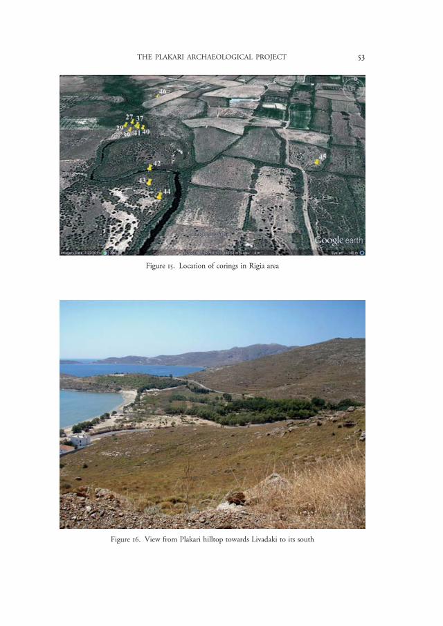
A further 13 corings were carried out in the larger valley of the Rigia river, distributed over a number of locations north-west of Plakari (Figure 15). Unfortu-nately, the number of possible coring locations was limited due to the poor acces-sibility of the terrain and the fact that much of it is private property. Research in this area focused on the formation processes of deposits encountered in the area, and on the character of the stream flowing through the floodplain – more in particular, on the question whether the Rigia river had been canalized in the past.16 A last element of the field research was to find a suitable location for obtaining samples for pollen analysis as a contribution to landscape reconstruction – or, rather, to test whether pollen analysis is possible at all in this landscape.
The interpretation of the corings is still in a preliminary phase, as the soil sam-ples that will be studied as part of our further research are still being analysed in the laboratories of the VU University’s Faculty of Earth and Life Sciences. As a first interpretation, we can say that the stratigraphy found in the Livadaki valley transects indicates that there indeed was a phase during which the sea occupied the area of the transect parallel to the shoreline. Sediments deposited in this mar-itime environment were found at a depth of at least 1.5 metres below the present sea level, but it is currently unclear where exactly the upper border is located. Many conditions may have contributed to the process of silting up the bay until a floodplain was formed. It might be that during the regression of the coastline, dunes were continuously formed in the vicinity of the coastline, maintaining a situation that is still visible today (Figure 16). However, we do not yet know to which archaeological period the sedimentary phases can be attributed, as not enough archaeological indicators were found to produce a reliable date. Further-more, according to information provided by local inhabitants, since the 1980s the Forestry Department has been planting trees in the valley and along the coastline, thus changing the natural development of this floodplain and possibly creating the sand dunes that are now visible in the landscape.
In the Rigia river valley, only a few corings could be carried out to address the research questions. However, it was found that the deposits in the northern
15 Cf. Crielaard et al. 2010-2011, 87. 16 Cf. Keller 1985, 185-186.
97016.indb 51 13/03/14 10:50

52 JAN PAUL CRIELAARD ET AL.
Figure 13. Overview of Livadaki and Rigia areas
Figure 14. Location of corings in Livadaki area
97016.indb 52 13/03/14 10:50
THE PLAKARI ARCHAEOLOGICAL PROJECT 53
Figure 16. View from Plakari hilltop towards Livadaki to its south
Figure 15. Location of corings in Rigia area
97016.indb 53 13/03/14 10:50

54 JAN PAUL CRIELAARD ET AL.
cluster of corings (Figure 15) are of a fairly recent date, as they overlie a structure that is likely to be man-made. It is not yet clear to which period this structure can be dated, but a link to earlier finds (Archaic?) by Dr Donald Keller in this vicinity is not unlikely.17 The subsurface presence of a structure in this location might also explain the rather angulated character of the stream here. Finally, some corings were carried out to find a suitable location to obtain pollen samples, although the question remains whether the soil conditions are favourable to the preservation of good-quality pollen material.
Further laboratory research will consist of a micropalaeontological analysis, with an emphasis on the foraminifera content, as well as grain size analysis and thermogravimetric analysis (TGA). The grain size analysis and TGA are aimed chiefly at facilitating the correlations between the various corings and providing information about the depositional history, while the micropalaeontological anal-ysis might give us indications about the ecological environment at the time of the deposition, including the impact of human activity. Lastly, some samples from the Rigia corings will be prepared and investigated in order to clarify whether a palynological analysis can be conducted in the future.
Preliminary conclusions
As a preliminary conclusion, it seems fair to say that Plakari is a multi-period site that offers an opportunity to study long-term developments, for instance in the sphere of cult and settlement dynamics. The excavated material suggests that dur-ing the Early Iron Age, Plakari housed a sanctuary of regional and supra-regional importance, with Karystos playing a role in overseas networks that also included parts of Attica, central Euboia, the Cyclades and the eastern Aegean. The Archaic period is not well represented in the finds that have so far come to light, even though Karystos seems to have flourished during this period.18 The unexpected finds from the 5th and 4th centuries BC show not only that Plakari remained (or again became) an important locus of settlement and cult, but also that in the late Classical period, as in the Early Iron Age, ceremonial feasting was a significant element of the religious festivities, as evidenced by the sacrificial remains from the two periods.
The discovery of finds attributable to the late Classical period also opens new venues for research. They urge us, for instance, to reconsider Plakari’s position within the wider cultic landscape of the Karystia – which includes sanctuaries in
17 Keller 1985, 185-186. 18 Crielaard et al. 2010-2011, 94.
97016.indb 54 13/03/14 10:50

THE PLAKARI ARCHAEOLOGICAL PROJECT 55
the Kampos and on Karababa and the Paximadi peninsula19 – and its relations with the other settlement nuclei at Palaiochora and Karystos Town. Moreover, after the mid-4th century BC, the Karystia started to recover from the warlike conflicts, destructions and subordination to Athens that marked the preceding Classical period. This is also the period when Palaiochora (the site of the Hel-lenistic and Roman city) rose to importance and probably became the new civic centre. The occupation or reoccupation of Plakari during the 4th century BC might be seen as a sign that the Karystians still held the site and its cult in esteem.
J.P. CRIELAARD E. BARBETSEA
VU University Amsterdam VU University [email protected] [email protected]
X. CHARALAMBIDOU M. CHIDIROGLOU
British School at Athens National Archaeological Museum, [email protected] [email protected] [email protected]
M.R. GROENHUIJZEN M. KOSMA
VU University Amsterdam 11th Ephorate of Prehistoric [email protected] and Classical Antiquities
Hellenic Ministry of Culture and Tourism
[email protected]@culture.gr
F. SONGU
VU University [email protected]
Acknowledgements
We wish to express our sincerest thanks to Mrs Amalia Karapaschalidou, director of the 11th Ephorate, for her support to our project. We are also very grateful to Dr Donald Keller, director of the Southern Euboea Exploration Project (SEEP), for giving us all kinds of practical assistance and advice. We also wish to thank
19 Locations: see Crielaard et al. 2010-2011, 84 fig.1 Kampos: Tankosic & Chidiroglou 2010; Archaic-Classical sanctuaries at Vounou and Karababa: Keller 1985, 98-99, 114. Classical sanctuaries on Paxi-madi: ibid. 81-82, 88; also Keller 1985, 187-190 (Archaic cult sites).
97016.indb 55 13/03/14 10:50

56 JAN PAUL CRIELAARD ET AL.
Evita Kalogiropoulou who during the first weeks of the excavations was willing to act as a representative of the 11th Ephorate, and Evangelia Athanassiou and Sofia Stambelou, guards of the Archaeological Museum of Karystos, for their practical assistance and hospitality. Last but not least, we thank the staff of the Netherlands Institute at Athens and in particular its director, Dr Kris Tytgat, for their assis-tance, support and advice in all kinds of matters.
We wish to acknowledge the Faculty of Arts of VU University Amsterdam, the 11th Ephorate of Prehistoric and Classical Antiquities of the Hellenic Ministry of Culture and Tourism, and the Institute for Aegean Prehistory (INSTAP), Philadelphia (USA), for their financial support; Alline Sinke, Ruben Brugge and Sam Leeflang for taking the responsibility to work as trench supervisors, and all the students for their hard work in the field and the sherd yard; and Bert Brouwenstijn (object drawing and photography) and Jaap Fokkema (Total Station survey) for their good company and (as always) outstanding work.
References
CRIELAARD, J.P., F. SONGU, M. CHIDIROGLOU & M. KOSMA 2010-2011. The Plakari Archaeological Project. Project outline and preliminary report on the first field sea-son (2010), Pharos. Journal of the Netherlands Institute at Athens XVII.2, 83-106.
CHIDIROGLOU, M. 2003-2004. J Kárustov katá touv prÉimouv istorikoúv xrónouv: Porísmata tjv anaskafikßv éreunav stjn Plakarß, Arxeíon EuboflkÉn MeletÉn 35, 69-80.
CHIDIROGLOU, M. 2012. J arxaía Karustía. Sumbolß stjn istoría kai arxaiología tjv perioxßv apó tj gewmetrikß éwv kai tjn autokratorikß epoxß, Diss. University of Athens.
KALTSAS, N. et al. (eds.) 2010. Erétria. Matiév se mia arxaía pólj. Eqnikó Arxaiologikó Mouseío, 27 Aprilíou – 24 Augoústou 2010, Aqßna.
KELLER, D.R. 1985. Archaeological Survey in Southern Euboea, Greece. A Reconstruction of Human Activity from Neolithic Times Through the Byzantine Period, Diss. Indiana University.
TANKOSIC, Z. & M. CHIDIROGLOU 2010. The Karystian Kampos Survey Project: methods and preliminary results, Mediterranean Archaeology and Archaeometry 10-3, 11-17.
97016.indb 56 13/03/14 10:50


![Khirbet al Khalde Archaeological Salvation Project [With J. M. Scott]](https://static.fdokumen.com/doc/165x107/63190721d4191f2f9307695c/khirbet-al-khalde-archaeological-salvation-project-with-j-m-scott.jpg)