
Correlation of topography, soil properties and spatial variability of biomass – application of the...
10
Correlation of topography, soil properties and spatial variability of Correlation of topography, soil properties and spatial variability of biomass – application of the self-organizing map method biomass – application of the self-organizing map method Antje Heuer, Markus C. Casper, Marcus Herbst Antje Heuer, Markus C. Casper, Marcus Herbst with 4 figures and 1 table with 4 figures and 1 table Summary. Summary. Correlation of topography, soil properties and spatial variability of biomass – application of the self-organizing Correlation of topography, soil properties and spatial variability of biomass – application of the self-organizing map method. map method. Interactions of various geogenic factors and processes have a lasting effect on topography Interactions of various geogenic factors and processes have a lasting effect on topography and vice versa on the development of biomass. This is obviously detectable in an agricultural plot, consid- and vice versa on the development of biomass. This is obviously detectable in an agricultural plot, consid- ering the spatial variability of biomass, here specified in terms of yield. The aim of the present study is to ering the spatial variability of biomass, here specified in terms of yield. The aim of the present study is to identify relationships among topography, chemical and physical soil properties and yield. We realized the identify relationships among topography, chemical and physical soil properties and yield. We realized the analysis using the method of self-organizing maps (SOM), an unsupervised neural network method. The analysis using the method of self-organizing maps (SOM), an unsupervised neural network method. The output of the SOM analysis provided a strong correlation between soil moisture and the amount of yield. output of the SOM analysis provided a strong correlation between soil moisture and the amount of yield. Additionally, a relationship among soil depth and yield could be noted. The availability of plant nutrients, Additionally, a relationship among soil depth and yield could be noted. The availability of plant nutrients, however, can positively affect the amount of yield, especially for zones with shallow soils. An inverse cor- however, can positively affect the amount of yield, especially for zones with shallow soils. An inverse cor- relation was detected for soil depth and inorganic carbon content of the upper soil. Topographic proper- relation was detected for soil depth and inorganic carbon content of the upper soil. Topographic proper- ties expressed by the Topographical Index show a similar behaviour towards target variable yield, while ties expressed by the Topographical Index show a similar behaviour towards target variable yield, while exposition is of secondary importance. These results form a coherent image, which allows applying the exposition is of secondary importance. These results form a coherent image, which allows applying the SOM approach for further investigations. SOM approach for further investigations. Zusammenfassung. Zusammenfassung. Der Zusammenhang von Topographie, Bodeneigenschaften und kleinräumlicher Der Zusammenhang von Topographie, Bodeneigenschaften und kleinräumlicher Variabilität der Biomasse – Anwendung selbstorganisierender Merkmalskarten (SOM). Das Zusam- Variabilität der Biomasse – Anwendung selbstorganisierender Merkmalskarten (SOM). Das Zusam- menspiel verschiedener geogener Faktoren und Prozesse hat entscheidenden Einfluss auf das Relief; menspiel verschiedener geogener Faktoren und Prozesse hat entscheidenden Einfluss auf das Relief; gleichzeitig wird auch die Biomassenentwicklung von geogenen Faktoren und Prozessen gesteuert. Dies gleichzeitig wird auch die Biomassenentwicklung von geogenen Faktoren und Prozessen gesteuert. Dies ist anhand der räumlichen Variabilität der Biomasse, hier spezifiziert durch den Ertrag, innerhalb einer ist anhand der räumlichen Variabilität der Biomasse, hier spezifiziert durch den Ertrag, innerhalb einer agrarisch genutzten Parzelle deutlich zu erkennen. Ziel der vorliegenden Studie ist es, Zusammenhänge agrarisch genutzten Parzelle deutlich zu erkennen. Ziel der vorliegenden Studie ist es, Zusammenhänge zwischen Relief, chemischen und physikalischen Bodeneigenschaften und dem Ertrag zu identifizieren. zwischen Relief, chemischen und physikalischen Bodeneigenschaften und dem Ertrag zu identifizieren. Hierfür wurde auf die Methodik der selbstorganisierenden Merkmalskarten (SOM) zurückgegriffen. Die Hierfür wurde auf die Methodik der selbstorganisierenden Merkmalskarten (SOM) zurückgegriffen. Die Auswertung der SOM-Karten zeigte eine deutliche Korrelation zwischen den Variablen Bodenfeuchte Auswertung der SOM-Karten zeigte eine deutliche Korrelation zwischen den Variablen Bodenfeuchte und Ertrag. Zudem wurde ein Zusammenhang zwischen Bodentiefe und Ertrag festgestellt. Ein erhöhtes und Ertrag. Zudem wurde ein Zusammenhang zwischen Bodentiefe und Ertrag festgestellt. Ein erhöhtes Angebot an Pflanzennährstoffen kann den Ertrag positiv beeinflussen, dies gilt insbesondere für flach- Angebot an Pflanzennährstoffen kann den Ertrag positiv beeinflussen, dies gilt insbesondere für flach- gründige Böden. Eine negative Korrelation besteht hingegen für die Variablen Bodentiefe und dem gründige Böden. Eine negative Korrelation besteht hingegen für die Variablen Bodentiefe und dem C anorg anorg -Gehalt der obersten Bodenschicht. Topographische Eigenschaften, die in den Topographischen -Gehalt der obersten Bodenschicht. Topographische Eigenschaften, die in den Topographischen Index einfließen, zeigen ein ähnliches Verhalten wie die Zielvariable Ertrag; dagegen ist die Exposition Index einfließen, zeigen ein ähnliches Verhalten wie die Zielvariable Ertrag; dagegen ist die Exposition von untergeordneter Bedeutung. Die gewonnenen Ergebnisse beschreiben ein kohärentes Bild und erlau- von untergeordneter Bedeutung. Die gewonnenen Ergebnisse beschreiben ein kohärentes Bild und erlau- ben somit die Übertragbarkeit der Methode auf weitere Fragestellungen. ben somit die Übertragbarkeit der Methode auf weitere Fragestellungen. Keywords: Keywords: self-organizing map, topography, soil properties, soil depth, soil moisture, spatial variability, self-organizing map, topography, soil properties, soil depth, soil moisture, spatial variability, yield yield 1 1 Introduction Introduction Interactions of various geogenic factors and processes have a lasting effect on topography, on Interactions of various geogenic factors and processes have a lasting effect on topography, on one hand. On the other hand, in agricultural ecosystems, the development of biomass is closely one hand. On the other hand, in agricultural ecosystems, the development of biomass is closely linked to prevailing geogenic conditions, neglecting anthropogenic interventions like fertiliza- linked to prevailing geogenic conditions, neglecting anthropogenic interventions like fertiliza- Zeitschrift für Geomorphologie Vol. 55, Suppl. 3, 169-178 Article Stuttgart, April 2011 ©2011 Gebrüder Borntraeger Verlagsbuchhandlung, Stuttgart, Germany www.borntraeger-cramer.de DOI: 10.1127/0372-8854/2011/0055S3-0057 0372-8854/11/5503-0057 $ 2.50
Transcript of Correlation of topography, soil properties and spatial variability of biomass – application of the...

169169Correlation of topographyCorrelation of topography
Correlation of topography, soil properties and spatial variability ofCorrelation of topography, soil properties and spatial variability ofbiomass – application of the self-organizing map methodbiomass – application of the self-organizing map method
Antje Heuer, Markus C. Casper, Marcus HerbstAntje Heuer, Markus C. Casper, Marcus Herbst
with 4 figures and 1 tablewith 4 figures and 1 table
Summary.Summary. Correlation of topography, soil properties and spatial variability of biomass – application of the self-organizingCorrelation of topography, soil properties and spatial variability of biomass – application of the self-organizingmap method.map method. Interactions of various geogenic factors and processes have a lasting effect on topographyInteractions of various geogenic factors and processes have a lasting effect on topographyand vice versa on the development of biomass. This is obviously detectable in an agricultural plot, consid-and vice versa on the development of biomass. This is obviously detectable in an agricultural plot, consid-ering the spatial variability of biomass, here specified in terms of yield. The aim of the present study is toering the spatial variability of biomass, here specified in terms of yield. The aim of the present study is toidentify relationships among topography, chemical and physical soil properties and yield. We realized theidentify relationships among topography, chemical and physical soil properties and yield. We realized theanalysis using the method of self-organizing maps (SOM), an unsupervised neural network method. Theanalysis using the method of self-organizing maps (SOM), an unsupervised neural network method. Theoutput of the SOM analysis provided a strong correlation between soil moisture and the amount of yield.output of the SOM analysis provided a strong correlation between soil moisture and the amount of yield.Additionally, a relationship among soil depth and yield could be noted. The availability of plant nutrients,Additionally, a relationship among soil depth and yield could be noted. The availability of plant nutrients,however, can positively affect the amount of yield, especially for zones with shallow soils. An inverse cor-however, can positively affect the amount of yield, especially for zones with shallow soils. An inverse cor-relation was detected for soil depth and inorganic carbon content of the upper soil. Topographic proper-relation was detected for soil depth and inorganic carbon content of the upper soil. Topographic proper-ties expressed by the Topographical Index show a similar behaviour towards target variable yield, whileties expressed by the Topographical Index show a similar behaviour towards target variable yield, whileexposition is of secondary importance. These results form a coherent image, which allows applying theexposition is of secondary importance. These results form a coherent image, which allows applying theSOM approach for further investigations.SOM approach for further investigations.
Zusammenfassung.Zusammenfassung. Der Zusammenhang von Topographie, Bodeneigenschaften und kleinräumlicherDer Zusammenhang von Topographie, Bodeneigenschaften und kleinräumlicherVariabilität der Biomasse – Anwendung selbstorganisierender Merkmalskarten (SOM). Das Zusam-Variabilität der Biomasse – Anwendung selbstorganisierender Merkmalskarten (SOM). Das Zusam-menspiel verschiedener geogener Faktoren und Prozesse hat entscheidenden Einfluss auf das Relief;menspiel verschiedener geogener Faktoren und Prozesse hat entscheidenden Einfluss auf das Relief;gleichzeitig wird auch die Biomassenentwicklung von geogenen Faktoren und Prozessen gesteuert. Diesgleichzeitig wird auch die Biomassenentwicklung von geogenen Faktoren und Prozessen gesteuert. Diesist anhand der räumlichen Variabilität der Biomasse, hier spezifiziert durch den Ertrag, innerhalb einerist anhand der räumlichen Variabilität der Biomasse, hier spezifiziert durch den Ertrag, innerhalb eineragrarisch genutzten Parzelle deutlich zu erkennen. Ziel der vorliegenden Studie ist es, Zusammenhängeagrarisch genutzten Parzelle deutlich zu erkennen. Ziel der vorliegenden Studie ist es, Zusammenhängezwischen Relief, chemischen und physikalischen Bodeneigenschaften und dem Ertrag zu identifizieren.zwischen Relief, chemischen und physikalischen Bodeneigenschaften und dem Ertrag zu identifizieren.Hierfür wurde auf die Methodik der selbstorganisierenden Merkmalskarten (SOM) zurückgegriffen. DieHierfür wurde auf die Methodik der selbstorganisierenden Merkmalskarten (SOM) zurückgegriffen. DieAuswertung der SOM-Karten zeigte eine deutliche Korrelation zwischen den Variablen BodenfeuchteAuswertung der SOM-Karten zeigte eine deutliche Korrelation zwischen den Variablen Bodenfeuchteund Ertrag. Zudem wurde ein Zusammenhang zwischen Bodentiefe und Ertrag festgestellt. Ein erhöhtesund Ertrag. Zudem wurde ein Zusammenhang zwischen Bodentiefe und Ertrag festgestellt. Ein erhöhtesAngebot an Pflanzennährstoffen kann den Ertrag positiv beeinflussen, dies gilt insbesondere für flach-Angebot an Pflanzennährstoffen kann den Ertrag positiv beeinflussen, dies gilt insbesondere für flach-gründige Böden. Eine negative Korrelation besteht hingegen für die Variablen Bodentiefe und demgründige Böden. Eine negative Korrelation besteht hingegen für die Variablen Bodentiefe und demCCanorganorg-Gehalt der obersten Bodenschicht. Topographische Eigenschaften, die in den Topographischen-Gehalt der obersten Bodenschicht. Topographische Eigenschaften, die in den TopographischenIndex einfließen, zeigen ein ähnliches Verhalten wie die Zielvariable Ertrag; dagegen ist die ExpositionIndex einfließen, zeigen ein ähnliches Verhalten wie die Zielvariable Ertrag; dagegen ist die Expositionvon untergeordneter Bedeutung. Die gewonnenen Ergebnisse beschreiben ein kohärentes Bild und erlau-von untergeordneter Bedeutung. Die gewonnenen Ergebnisse beschreiben ein kohärentes Bild und erlau-ben somit die Übertragbarkeit der Methode auf weitere Fragestellungen.ben somit die Übertragbarkeit der Methode auf weitere Fragestellungen.
Keywords:Keywords: self-organizing map, topography, soil properties, soil depth, soil moisture, spatial variability,self-organizing map, topography, soil properties, soil depth, soil moisture, spatial variability,yieldyield
11 IntroductionIntroduction
Interactions of various geogenic factors and processes have a lasting effect on topography, onInteractions of various geogenic factors and processes have a lasting effect on topography, onone hand. On the other hand, in agricultural ecosystems, the development of biomass is closelyone hand. On the other hand, in agricultural ecosystems, the development of biomass is closelylinked to prevailing geogenic conditions, neglecting anthropogenic interventions like fertiliza-linked to prevailing geogenic conditions, neglecting anthropogenic interventions like fertiliza-
Zeitschrift für Geomorphologie Vol. 55, Suppl. 3, 169-178 ArticleStuttgart, April 2011
©2011 Gebrüder Borntraeger Verlagsbuchhandlung, Stuttgart, Germany www.borntraeger-cramer.deDOI: 10.1127/0372-8854/2011/0055S3-0057 0372-8854/11/5503-0057 $ 2.50

170170 Antje Heuer et al.Antje Heuer et al.
tion or irrigation. These geogenic conditions can be, among others, topography, geology, soiltion or irrigation. These geogenic conditions can be, among others, topography, geology, soilchemical and physical properties or microclimate. Taking this interaction into consideration, thechemical and physical properties or microclimate. Taking this interaction into consideration, thequestion arises, which of the topographical and soil properties are responsible for spatial vari-question arises, which of the topographical and soil properties are responsible for spatial vari-ability of biomass, or even more precisely, of yield. The aim of the present study is to identifyability of biomass, or even more precisely, of yield. The aim of the present study is to identifyrelationships among topography, chemical and physical soil properties and yield within an agri-relationships among topography, chemical and physical soil properties and yield within an agri-cultural plot, even if the considered parameters move in a small range.cultural plot, even if the considered parameters move in a small range.
Several approaches exist; those examine and describe spatial relationships among differentSeveral approaches exist; those examine and describe spatial relationships among differenttypes of data. In a brief summarytypes of data. In a brief summary FORTINFORTIN et al. (2002) mention semivariance analysis, trendet al. (2002) mention semivariance analysis, trendsurface analysis, kriging, Moran’ssurface analysis, kriging, Moran’s II und Mantel-test for spatial analysis of ecological data. Addi-und Mantel-test for spatial analysis of ecological data. Addi-tionallytionally MCBRATNEYMCBRATNEY et al. (2003) discuss various methods, like linear regression, regressionet al. (2003) discuss various methods, like linear regression, regressiontrees, discriminant analysis, principal component analysis, clustering and classification, for fit-trees, discriminant analysis, principal component analysis, clustering and classification, for fit-ting quantitative relationships between soil properties and their environment.ting quantitative relationships between soil properties and their environment. KRAVCHENKOKRAVCHENKO etetal. use cross-correlograms (al. use cross-correlograms (KRAVCHENKOKRAVCHENKO et al. 2003) and variography (et al. 2003) and variography (KRAVCHENKOKRAVCHENKO et al. 2005)et al. 2005)to explain topographical effects on spatial variability of crop grain yield, whereasto explain topographical effects on spatial variability of crop grain yield, whereas GREENGREEN et al.et al.(2007) refer to a spatial analysis neuronal network algorithm for relating crop yield to topo-(2007) refer to a spatial analysis neuronal network algorithm for relating crop yield to topo-graphic attributes.graphic attributes. BEHRENSBEHRENS et al. (2005) developed a methodology based on artificial neuralet al. (2005) developed a methodology based on artificial neuralnetworks and digital analysis of topography to spatially predict soil units within a forested areanetworks and digital analysis of topography to spatially predict soil units within a forested areanearby the study area. An efficient approach that is recently being used for visualization ofnearby the study area. An efficient approach that is recently being used for visualization ofcomplex high-dimensional environmental data is the Kohonen self-organizing map (complex high-dimensional environmental data is the Kohonen self-organizing map (KOHONENKOHONEN
2001). The self-organizing map (SOM) is an effective instrument to extract information from2001). The self-organizing map (SOM) is an effective instrument to extract information frommulti-dimensional data as it is capable of discerning and clustering the range of data patternsmulti-dimensional data as it is capable of discerning and clustering the range of data patternsthat are present in a data set. SOM is recently also being used to analyze complex environmentalthat are present in a data set. SOM is recently also being used to analyze complex environmentaldata sets (data sets (KOHONENKOHONEN 2001,2001, HERBSTHERBST et al. 2009,et al. 2009, MELEMELE et al. 2008,et al. 2008, RECKNAGELRECKNAGEL 2006,2006, REUSSERREUSSER et al.et al.2008). Its properties render SOM a very useful tool for the visualisation of interrelationships2008). Its properties render SOM a very useful tool for the visualisation of interrelationshipsin large data sets. But apart from that it is important to note that SOM has concrete statisticalin large data sets. But apart from that it is important to note that SOM has concrete statisticalproperties as it can be seen as equivalent to a discretised form of principal curves (properties as it can be seen as equivalent to a discretised form of principal curves (KASKIKASKI 1997,1997,HAYKINHAYKIN 1999).1999).
22 MethodsMethods & MaterialsMaterials
2.12.1 DataData
This study was conducted in the area of Newel which is located in the Bitburger Gutland inThis study was conducted in the area of Newel which is located in the Bitburger Gutland inWestern Rhineland-Palatinate, Germany (see Fig. 1). The geology of the study area is domi-Western Rhineland-Palatinate, Germany (see Fig. 1). The geology of the study area is domi-nated by middle Triassic sediments. The soil is clayey with substantial amounts of calcium andnated by middle Triassic sediments. The soil is clayey with substantial amounts of calcium andfrequently of low depth (frequently of low depth (MEYNENMEYNEN 1962,1962, RICHTERRICHTER 1984). The long-term mean annual precipita-1984). The long-term mean annual precipita-tion is around 780 mm ytion is around 780 mm y–1–1, the mean annual temperature is 9.1 °C (DWD 2008). For the present, the mean annual temperature is 9.1 °C (DWD 2008). For the presentinvestigation, two plots of cropland were chosen, each with an extent of about 5 ha. They forminvestigation, two plots of cropland were chosen, each with an extent of about 5 ha. They formpart of a cuesta landscape and show a different curvature, convex or concave, an altitude risingpart of a cuesta landscape and show a different curvature, convex or concave, an altitude risingfrom 330 to 390 m MSL and an inclination varying between 2° and 11°. The sample points arefrom 330 to 390 m MSL and an inclination varying between 2° and 11°. The sample points arefacing from east-southeast (110°) to west-northwest (300°). The plots had been conventionallyfacing from east-southeast (110°) to west-northwest (300°). The plots had been conventionally

171171Correlation of topographyCorrelation of topography
and uniformly cultivated with a crop rotation of winter rape, winter wheat and spring barley. Asand uniformly cultivated with a crop rotation of winter rape, winter wheat and spring barley. Asthe information about yield (here: spring barley) concerns two different years, the data has beenthe information about yield (here: spring barley) concerns two different years, the data has beennormalized, resulting in a meannormalized, resulting in a mean x = 0= 0 and a varianceand a variance σ = 1 (= 1 (BAHRENBERGBAHRENBERG et al. 1999).et al. 1999).
Fig. 1. Location of test site.Fig. 1. Location of test site.
To detect spatial variability within the plots, data was i) collected in the field at the nodes of aTo detect spatial variability within the plots, data was i) collected in the field at the nodes of a30 m by 60 m grid, resulting in 68 sample points, and ii) derived from a digital elevation model30 m by 60 m grid, resulting in 68 sample points, and ii) derived from a digital elevation model(5 m resolution). Accordingly, in-situ information was gathered on soil depth, soil moisture,(5 m resolution). Accordingly, in-situ information was gathered on soil depth, soil moisture,organic and inorganic carbon (Corganic and inorganic carbon (Corgorg, C, Cinorginorg) as well as total nitrogen (N) as well as total nitrogen (Ntt) content of the upper) content of the uppersoil and as target variable the amount of yield. Based on the digital elevation model, exposition,soil and as target variable the amount of yield. Based on the digital elevation model, exposition,slope and flow accumulation were determined using the tool TauDEM byslope and flow accumulation were determined using the tool TauDEM by TARBOTONTARBOTON (1997) in(1997) incombination with ArcGIS (ESRI 2002). Slope and flow accumulation were combined by thecombination with ArcGIS (ESRI 2002). Slope and flow accumulation were combined by theTopographical Index (Topographical Index (BEVENBEVEN && KIRKBYKIRKBY 1979) to account for spatial soil moisture distribution in1979) to account for spatial soil moisture distribution inrelation to topography. The elevation has to be expressed as cosine of the determined elevation,relation to topography. The elevation has to be expressed as cosine of the determined elevation,to guarantee that numerically dissimilar but logically related values (e.g. 359° and 1°) are treatedto guarantee that numerically dissimilar but logically related values (e.g. 359° and 1°) are treatedsimilarly. An overview of the considered data is given in Tab. 1.similarly. An overview of the considered data is given in Tab. 1.
2.22.2 Self-Organizing-Maps (SOMs)Self-Organizing-Maps (SOMs)
SOM is an unsupervised learning neural network algorithm that performs a non-linear mappingSOM is an unsupervised learning neural network algorithm that performs a non-linear mappingof the dominant structures present in a high-dimensional input data field onto a lower-dimen-of the dominant structures present in a high-dimensional input data field onto a lower-dimen-sional grid; most commonly a two-dimensional, rectangular grid with hexagonal topology issional grid; most commonly a two-dimensional, rectangular grid with hexagonal topology isused. An advantage of SOM is that it is topology preserving, i.e. nearby locations on thisused. An advantage of SOM is that it is topology preserving, i.e. nearby locations on thismapping are attributed to similar data patterns.mapping are attributed to similar data patterns. LIULIU et al. (2006) demonstrate that the SOMet al. (2006) demonstrate that the SOM

172172 Antje Heuer et al.Antje Heuer et al.
extracts essential patterns even from noisy data. Moreover, it has a strong visualization capa-extracts essential patterns even from noisy data. Moreover, it has a strong visualization capa-bility. However, specific shortcomings exist applying the basic self-organizing map algorithmbility. However, specific shortcomings exist applying the basic self-organizing map algorithmaccording toaccording to KOHONENKOHONEN ((KOHONENKOHONEN 2001), that mainly refer to the question of the best topology2001), that mainly refer to the question of the best topologyto choose (to choose (FRITZKEFRITZKE 1995). This leads to the development of related models with modified algo-1995). This leads to the development of related models with modified algo-rithms, summarised as ‘growing SOM variants’, ‘multilevel SOM variants’, ‘growing hierarchicalrithms, summarised as ‘growing SOM variants’, ‘multilevel SOM variants’, ‘growing hierarchicalSOM variants’, ‘adaptive subspace SOM’ and ‘alternative SOM variants’ (SOM variants’, ‘adaptive subspace SOM’ and ‘alternative SOM variants’ (MAURERMAURER 2009). For2009). Forthe present study a basic, two-dimensional SOM, which is described in the following, is fullythe present study a basic, two-dimensional SOM, which is described in the following, is fullysufficient and provides a set of properties which are very useful in data exploration (see alsosufficient and provides a set of properties which are very useful in data exploration (see alsoKASKIKASKI (1997)): The ordered display facilitates the understanding of structures and correlations(1997)): The ordered display facilitates the understanding of structures and correlationspresent in the data set and the same way, clusters and clustering density can be visualized. Mostpresent in the data set and the same way, clusters and clustering density can be visualized. Mostnotably, however, the data is being represented by a smaller set of reference vectors which pre-notably, however, the data is being represented by a smaller set of reference vectors which pre-serve important statistical properties of the input data set.serve important statistical properties of the input data set.
Each input data itemEach input data item xx of the training data setof the training data set XX is considered as a vectoris considered as a vector
,,
withwith nn being the dimension of the input data space; in our studybeing the dimension of the input data space; in our study nn = 8 which is the number= 8 which is the numberof variables according to Sect. 2.1. A fixed number of neurons are arranged on a regular gridof variables according to Sect. 2.1. A fixed number of neurons are arranged on a regular gridwhose dimensions can be determined by means of heuristic algorithms, if no other preferenceswhose dimensions can be determined by means of heuristic algorithms, if no other preferencesare made. Note that, generally, the number of neurons is much smaller than the number of dataare made. Note that, generally, the number of neurons is much smaller than the number of data
Tab. 1. Overview of considered variables.Tab. 1. Overview of considered variables.
variablevariable unitunit originorigin method / materialmethod / material
yieldyield t/hat/ha automated yield, GPS controlled,automated yield, GPS controlled,30m x 60m grid30m x 60m grid
normalized (Bahrenberg et al. 1999)normalized (Bahrenberg et al. 1999)
soil depthsoil depth cmcm soil sample, 30m x 60m gridsoil sample, 30m x 60m grid single gouge auger, length: 1msingle gouge auger, length: 1m
soil moisturesoil moisture %% soil profile, 30m x 60m gridsoil profile, 30m x 60m grid normalized (Bahrenberg et al. 1999)normalized (Bahrenberg et al. 1999)
C organicC organic %% topsoil layer, 30m x 60m gridtopsoil layer, 30m x 60m grid difference of total C, obtained withdifference of total C, obtained withEURO EA elemental analyzerEURO EA elemental analyzer
C inorganicC inorganic %% topsoil layer, 30m x 60m gridtopsoil layer, 30m x 60m grid LECO RC-412 carbon analyzerLECO RC-412 carbon analyzer
N totalN total %% topsoil layer, 30m x 60m gridtopsoil layer, 30m x 60m grid EURO EA elemental analyzerEURO EA elemental analyzer
ccosine of expositionosine of exposition -- DEM, 5m x 5m gridDEM, 5m x 5m grid ArcGIS spatial analyst tool (ESRI,ArcGIS spatial analyst tool (ESRI,2002)2002)
slope / inclinationslope / inclination degreedegree DEM, 5m x 5m gridDEM, 5m x 5m grid ArcGIS spatial analyst tool (ESRI,ArcGIS spatial analyst tool (ESRI,2002)2002)
flow accumulationflow accumulation -- DEM, 5m x 5m gridDEM, 5m x 5m grid TauDEM (Tarboton, 1997)TauDEM (Tarboton, 1997)
Topographical IndexTopographical Index -- DEM, 5m x 5m gridDEM, 5m x 5m grid integrating slope & flow accumulationintegrating slope & flow accumulation(Beven & Kirkby 1979)(Beven & Kirkby 1979)

173173Correlation of topographyCorrelation of topography
items used for the training. Each neuron, in turn, is associated to a weight vector (also called aitems used for the training. Each neuron, in turn, is associated to a weight vector (also called areference vector)reference vector)
with the same dimensionality as the input vectorswith the same dimensionality as the input vectors xx ∈∈ XX..
In the course of the iterative training the reference vectors are “tuned” to the differentIn the course of the iterative training the reference vectors are “tuned” to the differentpatterns contained in the input data: At each iteration step, the Euclidean distances betweenpatterns contained in the input data: At each iteration step, the Euclidean distances betweena randomly chosen input data itema randomly chosen input data item xx and the reference vectorsand the reference vectors mmii are calculated (see Fig. 2).are calculated (see Fig. 2).The neuron with minimal Euclidean distance to this data item is called the best-matching unitThe neuron with minimal Euclidean distance to this data item is called the best-matching unit(BMU). Subsequently, the reference vectors in the neighbourhood of this BMU are updated(BMU). Subsequently, the reference vectors in the neighbourhood of this BMU are updatedsuch that the correspondingsuch that the corresponding mmii move towards the data itemmove towards the data item x.x. The mapping “self-organizes”The mapping “self-organizes”upon repeated cycling through the input data sets. Finally, each neuron on the map holds a refer-upon repeated cycling through the input data sets. Finally, each neuron on the map holds a refer-ence vector that represents the centroid of the subset of input data that project to it. Althoughence vector that represents the centroid of the subset of input data that project to it. Althougha rigorous mathematical treatment of the SOM algorithm has so far only been accomplisheda rigorous mathematical treatment of the SOM algorithm has so far only been accomplishedfor a simplified case (for a simplified case (KASKIKASKI 1997,1997, ROJASROJAS 1996),1996), KASKIKASKI (1997, p. 19), referring to the work of(1997, p. 19), referring to the work ofMULIERMULIER && CHERKASSKYCHERKASSKY (1995) and(1995) and RITTERRITTER et al. (1992) point out that SOMs are “essentiallyet al. (1992) point out that SOMs are “essentiallyequivalent” to a discretised form of principal curves (which have been introduced byequivalent” to a discretised form of principal curves (which have been introduced by HASTIEHASTIE &&STUETZLESTUETZLE (1989), i.e. seven years after publication of the SOM algorithm). Consequently, the(1989), i.e. seven years after publication of the SOM algorithm). Consequently, thereference vectors provide local conditional estimates of the input data manifold. Thus, whenreference vectors provide local conditional estimates of the input data manifold. Thus, whenconnecting the reference vectors according to their neighbourhood relationship they formconnecting the reference vectors according to their neighbourhood relationship they form aasmoothed (multidimensional) surface that describes the mean properties of the input datasmoothed (multidimensional) surface that describes the mean properties of the input datamanifold. Conversely, the SOM can be used as well to display and quantify the residuals andmanifold. Conversely, the SOM can be used as well to display and quantify the residuals andeven probability density functions (PDFs) of input patterns. Accordingly, variances of a giveneven probability density functions (PDFs) of input patterns. Accordingly, variances of a givenPDF on the SOM are equivalent to the variance of the corresponding subset in the input space.PDF on the SOM are equivalent to the variance of the corresponding subset in the input space.Various authors, (Various authors, (GUTIERREZGUTIERREZ et al. 2005,et al. 2005, KIMKIM et al. 2006,et al. 2006, MORADKHANIMORADKHANI et al. 2004), amonget al. 2004), amongothers) have successfully extracted statistical data properties using SOM. A short descriptionothers) have successfully extracted statistical data properties using SOM. A short descriptionof the algorithm and its properties is given inof the algorithm and its properties is given in HERBSTHERBST et al. (2008) andet al. (2008) and HERBSTHERBST et al. (2009). Foret al. (2009). Formore detailed information on SOM please seemore detailed information on SOM please see KOHONENKOHONEN (2001) or(2001) or HAYKINHAYKIN (1999).(1999).
To avoid that high input variable values exert a disproportionate influence on the training,To avoid that high input variable values exert a disproportionate influence on the training,or, in other words to guarantee the variables to be equally important, all input variables haveor, in other words to guarantee the variables to be equally important, all input variables havebeen normalized prior to the SOM training so that the variance of each input variable is equalbeen normalized prior to the SOM training so that the variance of each input variable is equalto one and the mean is equal to zero.to one and the mean is equal to zero.
2.32.3 Evaluation of SOM resultsEvaluation of SOM results
As a consequence of the SOM training each neuron represents the mean properties of a smallAs a consequence of the SOM training each neuron represents the mean properties of a smallsub-set of data used for the training. The data items which are grouped and represented by asub-set of data used for the training. The data items which are grouped and represented by aneuron, or node, have similar properties with regard to the eight input variables that constituteneuron, or node, have similar properties with regard to the eight input variables that constitutethe elements of each data set that has been used for the training.the elements of each data set that has been used for the training.
Colour coding of the variable values is used in which the same map grid is reproduced eightColour coding of the variable values is used in which the same map grid is reproduced eighttimes with a colouring corresponding to the distribution of the individual variables (so calledtimes with a colouring corresponding to the distribution of the individual variables (so calledcomponent planes). The relationships between each of the variables are detected by comparingcomponent planes). The relationships between each of the variables are detected by comparing

174174 Antje Heuer et al.Antje Heuer et al.
Fig. 2. Stepwise cycling through self-organizing process.Fig. 2. Stepwise cycling through self-organizing process.
Fig. 3. Component planes representing topography, chemical and physical soil properties and amount ofFig. 3. Component planes representing topography, chemical and physical soil properties and amount ofyield.yield.
175175Correlation of topographyCorrelation of topography
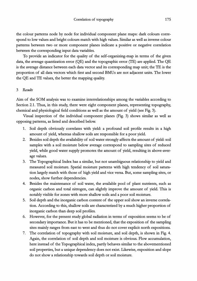
the colour patterns node by node for individual component plane maps: dark colours corre-the colour patterns node by node for individual component plane maps: dark colours corre-spond to low values and bright colours match with high values. Similar as well as inverse colourspond to low values and bright colours match with high values. Similar as well as inverse colourpatterns between two or more component planes indicate a positive or negative correlationpatterns between two or more component planes indicate a positive or negative correlationbetween the corresponding input data variables.between the corresponding input data variables.
To provide an indicator for the quality of the self-organizing-map in terms of the givenTo provide an indicator for the quality of the self-organizing-map in terms of the givendata, the average quantization error (QE) and the topographic error (TE) are applied. The QEdata, the average quantization error (QE) and the topographic error (TE) are applied. The QEis the average distance between each data vector and its corresponding map unit; the TE is theis the average distance between each data vector and its corresponding map unit; the TE is theproportion of all data vectors which first and second BMUs are not adjacent units. The lowerproportion of all data vectors which first and second BMUs are not adjacent units. The lowerthe QE and TE values, the better the mapping quality.the QE and TE values, the better the mapping quality.
33 ResultsResults
Aim of the SOM analysis was to examine interrelationships among the variables according toAim of the SOM analysis was to examine interrelationships among the variables according toSection 2.1. Thus, in this study, there were eight component planes, representing topography,Section 2.1. Thus, in this study, there were eight component planes, representing topography,chemical and physiological field conditions as well as the amount of yield (see Fig. 3).chemical and physiological field conditions as well as the amount of yield (see Fig. 3).
Visual inspection of the individual component planes (Fig. 3) shows similar as well asVisual inspection of the individual component planes (Fig. 3) shows similar as well asopposing patterns, as listed and described below.opposing patterns, as listed and described below.
1. Soil depth obviously correlates with yield: a profound soil profile results in a high1. Soil depth obviously correlates with yield: a profound soil profile results in a highamount of yield, whereas shallow soils are responsible for a poor yield.amount of yield, whereas shallow soils are responsible for a poor yield.
2. Besides soil depth the availability of soil water strongly affects the amount of yield: soil2. Besides soil depth the availability of soil water strongly affects the amount of yield: soilsamples with a soil moisture below average correspond to sampling sites of reducedsamples with a soil moisture below average correspond to sampling sites of reducedyield, while good water supply promotes the amount of yield, resulting in above-aver-yield, while good water supply promotes the amount of yield, resulting in above-aver-age values.age values.
3. The Topographical Index has a similar, but not unambiguous relationship to yield and3. The Topographical Index has a similar, but not unambiguous relationship to yield andmeasured soil moisture. Spatial moisture patterns with high tendency of soil satura-measured soil moisture. Spatial moisture patterns with high tendency of soil satura-tion largely match with those of high yield and vice versa. But, some sampling sites, ortion largely match with those of high yield and vice versa. But, some sampling sites, ornodes, show further dependencies.nodes, show further dependencies.
4. Besides the maintenance of soil water, the available pool of plant nutrients, such as4. Besides the maintenance of soil water, the available pool of plant nutrients, such asorganic carbon and total nitrogen, can slightly improve the amount of yield. This isorganic carbon and total nitrogen, can slightly improve the amount of yield. This isnotably visible for zones with more shallow soils and a poor soil moisture.notably visible for zones with more shallow soils and a poor soil moisture.
5. Soil depth and the inorganic carbon content of the upper soil show an inverse correla-5. Soil depth and the inorganic carbon content of the upper soil show an inverse correla-tion. According to this, shallow soils are characterized by a much higher proportion oftion. According to this, shallow soils are characterized by a much higher proportion ofinorganic carbon than deep soil profiles.inorganic carbon than deep soil profiles.
6. However, for the present study global radiation in terms of exposition seems to be of6. However, for the present study global radiation in terms of exposition seems to be ofsecondary importance. But it has to be mentioned, that the exposition of the samplingsecondary importance. But it has to be mentioned, that the exposition of the samplingsites mainly ranges from east to west and thus do not cover explicit north expositions.sites mainly ranges from east to west and thus do not cover explicit north expositions.
7. The correlation of topography with soil moisture, and soil depth, is shown in Fig. 4.7. The correlation of topography with soil moisture, and soil depth, is shown in Fig. 4.Again, the correlation of soil depth and soil moisture is obvious. Flow accumulation,Again, the correlation of soil depth and soil moisture is obvious. Flow accumulation,here instead of the Topographical index, partly behaves similar to the abovementionedhere instead of the Topographical index, partly behaves similar to the abovementionedsoil properties, but a unique dependency does not exist. Likewise, exposition and slopesoil properties, but a unique dependency does not exist. Likewise, exposition and slopedo not show a relationship towards soil depth or soil moisture.do not show a relationship towards soil depth or soil moisture.

176176 Antje Heuer et al.Antje Heuer et al.
The quantitative measures for mapping quality show satisfactory results, that is QE = 1.518,The quantitative measures for mapping quality show satisfactory results, that is QE = 1.518,TE = 0.015 and QE = 0.850, TE = 0.045 for SOM Fig. 3 (yield, soil properties and topography)TE = 0.015 and QE = 0.850, TE = 0.045 for SOM Fig. 3 (yield, soil properties and topography)and SOM Fig. 4 (specific soil properties and topography) respectively.and SOM Fig. 4 (specific soil properties and topography) respectively.
Fig. 4. Component planes representing specific soil properties and topography.Fig. 4. Component planes representing specific soil properties and topography.
44 Discussion and conclusionDiscussion and conclusion
The SOM analysis provides a means for enhancing the ability to examine relationships betweenThe SOM analysis provides a means for enhancing the ability to examine relationships betweenvariables. Visual inspection of the component planes showed, that there are common as well asvariables. Visual inspection of the component planes showed, that there are common as well asinverse patterns between specific sets of variables. Besides the relationship of single variables,inverse patterns between specific sets of variables. Besides the relationship of single variables,an interaction of multiple variables, a conditional multi-dependency, exists.an interaction of multiple variables, a conditional multi-dependency, exists.
In this study we can summarize, that the available pool of water is mainly responsible forIn this study we can summarize, that the available pool of water is mainly responsible forthe spatial variability of yield. This observation was also supported by considering the Topo-the spatial variability of yield. This observation was also supported by considering the Topo-graphical Index and soil depth. Since soil water (and indirectly nutrient) competition of thegraphical Index and soil depth. Since soil water (and indirectly nutrient) competition of theplant is closely linked to soil depth, both have an important impact on the development ofplant is closely linked to soil depth, both have an important impact on the development ofbiomass, and finally to yield.biomass, and finally to yield.
Interestingly, the availability of water derived by measurements in the fields (30 m x 60 mInterestingly, the availability of water derived by measurements in the fields (30 m x 60 mgrid) leads to a clearer correlation with yield than by calculating the flow accumulation (notgrid) leads to a clearer correlation with yield than by calculating the flow accumulation (notshown) or topographical index, both based on a digital elevation model with a much highershown) or topographical index, both based on a digital elevation model with a much higherresolution (5 m x 5 m). This is mainly due to areas without distinct pathways that show anresolution (5 m x 5 m). This is mainly due to areas without distinct pathways that show anindefinite flow direction or inconsistent flow accumulation.indefinite flow direction or inconsistent flow accumulation.
Furthermore, according to our study, inorganic carbon can be used as a proxy for soilFurthermore, according to our study, inorganic carbon can be used as a proxy for soildepth, as the corresponding component planes show an inverse pattern. This is of particulardepth, as the corresponding component planes show an inverse pattern. This is of particularimportance, as the inorganic carbonate content (CaCOimportance, as the inorganic carbonate content (CaCO33) of the topsoil layer can be derived) of the topsoil layer can be derivedfrom remotely sensed data (near-infrared reflectance spectroscopy) (from remotely sensed data (near-infrared reflectance spectroscopy) (CHANGCHANG && LAIRDLAIRD 2002,2002,BROWNBROWN et al. 2006,et al. 2006, MCCARTYMCCARTY et al. 2002) that in fact is available area-wide.et al. 2002) that in fact is available area-wide.

177177Correlation of topographyCorrelation of topography
As for variables related to topography, exposition does not show a clear influence whileAs for variables related to topography, exposition does not show a clear influence whilethe relationship of local catchment size (flow accumulation) and inclination (slope) does have athe relationship of local catchment size (flow accumulation) and inclination (slope) does have adetectable influence on the spatial variability of yield.detectable influence on the spatial variability of yield.
Summarizing, the spatial patters of yield detected in the natural system can mainly, butSummarizing, the spatial patters of yield detected in the natural system can mainly, butnot completely, be explained by the chosen properties. The strong effect of soil water and soilnot completely, be explained by the chosen properties. The strong effect of soil water and soildepth on spatial variability of biomass is a reliable source for a first estimation of yield. Thedepth on spatial variability of biomass is a reliable source for a first estimation of yield. TheTopographical Index can help to distinguish spatial patterns of poor or productive yield. InTopographical Index can help to distinguish spatial patterns of poor or productive yield. Incase of a pronounced but not extreme range of topographical attributes, like in the presentcase of a pronounced but not extreme range of topographical attributes, like in the presentstudy, further topographical information is of secondary relevance.study, further topographical information is of secondary relevance.
The application of the SOM approach proved valuable for identifying relationships betweenThe application of the SOM approach proved valuable for identifying relationships betweensingle variables, an adequate data basis assumed. In addition, individual results can be summa-single variables, an adequate data basis assumed. In addition, individual results can be summa-rized to final findings, like the multi-dependency of yield. Hence, the gained information couldrized to final findings, like the multi-dependency of yield. Hence, the gained information couldallow to derive and justify spatial patterns for further plots close to the test site.allow to derive and justify spatial patterns for further plots close to the test site.
AcknowledgementsAcknowledgements
The authors gratefully acknowledge the members of Remote Sensing Department, UniversityThe authors gratefully acknowledge the members of Remote Sensing Department, UniversityTrier, Germany, for contributing the digital elevation data. We further appreciate the SOM tool-Trier, Germany, for contributing the digital elevation data. We further appreciate the SOM tool-box team, Helsinki University of Technology, for the implementation of SOM Toolbox in thebox team, Helsinki University of Technology, for the implementation of SOM Toolbox in theMatlab TM computing environment.Matlab TM computing environment.
ReferencesReferences
BAHRENBERG, G., GIESE, E.BAHRENBERG, G., GIESE, E. && NIPPER, J.NIPPER, J. (2010): Statistische Methoden in der Geographie. – Univariate(2010): Statistische Methoden in der Geographie. – Univariateund bivariate Statistik, Bd.und bivariate Statistik, Bd. 11, 5. Auflage: 282 pp., 5. Auflage: 282 pp.
BEHRENS, T., FÖRSTER, H., SCHOLTEN, T., STEINRÜCKEN, U., SPIES, E.-D.BEHRENS, T., FÖRSTER, H., SCHOLTEN, T., STEINRÜCKEN, U., SPIES, E.-D. && GOLDSCHMITT, M.GOLDSCHMITT, M. (2005): Digital(2005): Digitalsoil mapping using artificial neural networks. – J. Plant Nutr. Soil Sci.soil mapping using artificial neural networks. – J. Plant Nutr. Soil Sci. 168:168: 21–33.21–33.
BEVEN, K.J.BEVEN, K.J. && KIRKBY, M.J. (KIRKBY, M.J. (19791979):): A physically-based, variable contributing area model of basin hydrology.A physically-based, variable contributing area model of basin hydrology.– Hydrol. Sci. Bull.– Hydrol. Sci. Bull. 24:24: 43–69.43–69.
BROWN, D.J., SHEPHERD, K.D., WALSH, M.G., MAYS, M.D.BROWN, D.J., SHEPHERD, K.D., WALSH, M.G., MAYS, M.D. && REINSCH, T.G.REINSCH, T.G. (2006): Global soil characteriza-(2006): Global soil characteriza-tion with VNIR diffuse reflectance spectroscopy. – Geodermation with VNIR diffuse reflectance spectroscopy. – Geoderma 132:132: 273–290.273–290.
CHANG, C.-W.CHANG, C.-W. && LAIRD, D.ALAIRD, D.A. (2002): Near-infrared reflectance spectroscopic analysis of soil C and N. –. (2002): Near-infrared reflectance spectroscopic analysis of soil C and N. –Soil Sci.Soil Sci. 167167 (2): 110–116.(2): 110–116.
DWD,DWD, Deutscher WetterdienstDeutscher Wetterdienst (2008): Tageswerte der Station Trier-Petrisberg. – DWD online, http://(2008): Tageswerte der Station Trier-Petrisberg. – DWD online, http://www.dwd.de, 01.01.2008www.dwd.de, 01.01.2008..
ESRI (ed.) (2002): Using ArcGIS Spatial Analyst. – ESRI, Redlands, California: 232 pp.ESRI (ed.) (2002): Using ArcGIS Spatial Analyst. – ESRI, Redlands, California: 232 pp.FORTIN, M.-J., DALE, M.FORTIN, M.-J., DALE, M. && VER HOEF, J.VER HOEF, J. (2002): Spatial analysis in ecology. – In:(2002): Spatial analysis in ecology. – In: EL-SHAARAWI, A.H.EL-SHAARAWI, A.H. &&
PIEGORSCH, W.W.PIEGORSCH, W.W. (ed.): Encyclopedia of environmetrics(ed.): Encyclopedia of environmetrics 4:4: 2051–2058.2051–2058.FRITZKE, B.FRITZKE, B. (1995): Growing Grid – a self-organizing network with constant neighborhood range and(1995): Growing Grid – a self-organizing network with constant neighborhood range and
adaptation strength. – Neural Proc. Lett.adaptation strength. – Neural Proc. Lett. 22 (5): 9–13.(5): 9–13.GREEN, T.R., SALAS, J.D., MARTINEZ, A.GREEN, T.R., SALAS, J.D., MARTINEZ, A. && ERSKINE, R.H. (ERSKINE, R.H. (20072007):): Relating crop yield to topographicRelating crop yield to topographic
attributes using spatial analysis neural networks and regression. – Geodermaattributes using spatial analysis neural networks and regression. – Geoderma 139:139: 23–37.23–37.GUTIÉRREZ, J.M., CANO, R., COFIÑO, A.S.GUTIÉRREZ, J.M., CANO, R., COFIÑO, A.S. && SORDO, C.SORDO, C. (2005): Analysis and downscaling multi-model sea-(2005): Analysis and downscaling multi-model sea-
sonal forecasts in Peru using self-organizing maps. – Tellus A,sonal forecasts in Peru using self-organizing maps. – Tellus A, 5757 (3): 435–447.(3): 435–447.HAYKIN, S. (HAYKIN, S. (19991999):): Neural networks – a comprehensive foundationNeural networks – a comprehensive foundation 2:2: 842 pp.842 pp.HASTIE, T.HASTIE, T. && STUETZLE, WSTUETZLE, W. (1989): Principal curves. – J. Amer. Stat. Assoc.. (1989): Principal curves. – J. Amer. Stat. Assoc. 84:84: 502–516.502–516.

178178 Antje Heuer et al.Antje Heuer et al.
HERBST, M.HERBST, M. && CASPER, M.C.CASPER, M.C. (2008)(2008):: Towards model evaluation and identification using Self-OrganizingTowards model evaluation and identification using Self-OrganizingMaps, Hydrol. – Earth Syst. Sci.Maps, Hydrol. – Earth Syst. Sci. 12:12: 657–667.657–667.
HERBST, M., GUPTA, H.V.HERBST, M., GUPTA, H.V. && CASPER, M.C. (CASPER, M.C. (20092009):): Mapping model behaviour using Self-Organizing Maps. –Mapping model behaviour using Self-Organizing Maps. –Hydrol. Earth Syst. Sci.Hydrol. Earth Syst. Sci. 13:13: 395–409.395–409.
KASKI, S.KASKI, S. (1997): Data Exploration Using Self Organizing Maps. – Helsinki Univ. Technol.: 57 pp.(1997): Data Exploration Using Self Organizing Maps. – Helsinki Univ. Technol.: 57 pp.KIM, T., EOM, I.KIM, T., EOM, I. && KIM, Y.KIM, Y. (2006): Texture Segmentation Using SOM and Multi-scale Bayesian Estima-(2006): Texture Segmentation Using SOM and Multi-scale Bayesian Estima-
tion, Advances in Neural Networks. – ISNNtion, Advances in Neural Networks. – ISNN 2006:2006: 661–668.661–668.KOHONEN, T. (KOHONEN, T. (20012001):): Self-Organizing Maps. – Inf. Sci.Self-Organizing Maps. – Inf. Sci. 3:3: 501 pp.501 pp.KRAVCHENKO, A.N., THELEN, K.D., BULLOCK, D.G.KRAVCHENKO, A.N., THELEN, K.D., BULLOCK, D.G. && MILLER, N.R. (MILLER, N.R. (20032003):): Relationship among crop grainRelationship among crop grain
yield, topography and soil electrical conductivity studied with cross-correlograms. – Agron. J.yield, topography and soil electrical conductivity studied with cross-correlograms. – Agron. J. 95:95:1132–1139.1132–1139.
KRAVCHENKO, A.N., ROBERTSON, G.P., THELEN, K.D.KRAVCHENKO, A.N., ROBERTSON, G.P., THELEN, K.D. && HARWOOD, R.R. (HARWOOD, R.R. (20052005):): Management, topographicalManagement, topographicaland weather effects on spatial variability of crop grain yields. – Agron. J.and weather effects on spatial variability of crop grain yields. – Agron. J. 97:97: 514–523.514–523.
LIU, Y., WEISBERG, R.H.LIU, Y., WEISBERG, R.H. && MOOERS, C.N.K.MOOERS, C.N.K. (2006): Performance evaluation of the self-organizing map(2006): Performance evaluation of the self-organizing mapfor feature extraction. – J. Geophys. Res.for feature extraction. – J. Geophys. Res. 111:111: C05018, doi:10.1029/2005JC003117.C05018, doi:10.1029/2005JC003117.
MAURER, H.MAURER, H. (2009): Die Architekturtypen des ‘Self-organizing(feature) map (SO(F)M)’ nach Teuvo(2009): Die Architekturtypen des ‘Self-organizing(feature) map (SO(F)M)’ nach TeuvoKohonen. – Books On Demand: 96 pp.Kohonen. – Books On Demand: 96 pp.
MCBRATNEY, A.B., MENDONÇA SANTOS, M.L.MCBRATNEY, A.B., MENDONÇA SANTOS, M.L. && MINASNY, B.MINASNY, B. (2003): On digital soil mapping. – Geoderma(2003): On digital soil mapping. – Geoderma117:117: 3–52.3–52.
MCCARTY, G.W., REEVES, J.B., REEVES, V.B., FOLLETT, R.F.MCCARTY, G.W., REEVES, J.B., REEVES, V.B., FOLLETT, R.F. && KIMBLE, J.M. (KIMBLE, J.M. (2002): Mid-infrared and near-2002): Mid-infrared and near-infrared diffuse reflectance spectroscopy for soil carbon measurements. – Soil Sci. Soc. Amer. J.infrared diffuse reflectance spectroscopy for soil carbon measurements. – Soil Sci. Soc. Amer. J. 66:66:640–646.640–646.
MELE, P.M.MELE, P.M. && CROWLEY, D.E. (CROWLEY, D.E. (20082008):): Application of self-organizing maps for assessing soil biologicalApplication of self-organizing maps for assessing soil biologicalquality. – Agricult., Ecosys. and Environ.quality. – Agricult., Ecosys. and Environ. 126:126: 139–152.139–152.
MEYNEN, E. (MEYNEN, E. (19621962):): Bitburger Gutland. –Bitburger Gutland. – InIn: MEYEN, E.: MEYEN, E. && SCHMITHÜSEN, J.SCHMITHÜSEN, J. (ed.): Handbuch der Natur-(ed.): Handbuch der Natur-räumlichen Gliederung Deutschlandsräumlichen Gliederung Deutschlands 1:1: 378–380.378–380.
MORADKHANI, H., HSU, K.-L., GUPTA, H.V.MORADKHANI, H., HSU, K.-L., GUPTA, H.V. && SOROOSHIAN, S.SOROOSHIAN, S. (2004): Improved streamflow forecasting(2004): Improved streamflow forecastingusing self-organizing radial basis function artificial neural networks. – J. Hydrol.using self-organizing radial basis function artificial neural networks. – J. Hydrol. 295295 (1–4): 246–262.(1–4): 246–262.
MULIER, FMULIER, F && CHERKASSKY, V.CHERKASSKY, V. (1995), Selforganization as an iterative kernel smoothing process. – Neural(1995), Selforganization as an iterative kernel smoothing process. – NeuralComput.Comput. 7:7: 1165–1177.1165–1177.
RECKNAGEL, F.RECKNAGEL, F. (2006): Ecological informatics: Scope, Techniques and Applications. – Springer, 496 pp.(2006): Ecological informatics: Scope, Techniques and Applications. – Springer, 496 pp.REUSSER, D.E., BLUME, T., SCHAEFLI, B.REUSSER, D.E., BLUME, T., SCHAEFLI, B. && ZEHE, E:ZEHE, E: (2008): Analysing the temporal dynamics of model(2008): Analysing the temporal dynamics of model
performance for hydrological models. – Hydrol. Earth Syst. Sci. Discuss.performance for hydrological models. – Hydrol. Earth Syst. Sci. Discuss. 5:5: 3169–3211.3169–3211.RICHTER, G.RICHTER, G. (1984): Der Landschaftsraum Trier. – In:(1984): Der Landschaftsraum Trier. – In: JÄTZOLD, RJÄTZOLD, R. (ed.): Der Trierer Raum und seine. (ed.): Der Trierer Raum und seine
Nachbargebiete. Exkursionsführer anlässlich des 19. Deutschen Schulgeographentages Trier 1984. –Nachbargebiete. Exkursionsführer anlässlich des 19. Deutschen Schulgeographentages Trier 1984. –Trierer Geogr. Studien. Sonderh.Trierer Geogr. Studien. Sonderh. 66..
RITTER, H., MARTINETZ, T.RITTER, H., MARTINETZ, T. && SCHULTEN, K.SCHULTEN, K. (1992): Neural computation and self-organizing maps - An(1992): Neural computation and self-organizing maps - Anintroduction. – Addison Wesley, Reading: 350 pp.introduction. – Addison Wesley, Reading: 350 pp.
ROJAS, R.ROJAS, R. (1996): Neural Networks – A systematic introduction. – Springer, 502 pp.(1996): Neural Networks – A systematic introduction. – Springer, 502 pp.TARBOTON, D.G. (TARBOTON, D.G. (19971997):): A new method for the determination of flow directions and upslope areas in gridA new method for the determination of flow directions and upslope areas in grid
digital elevation models. – Water Resour. Res.digital elevation models. – Water Resour. Res. 3333 (2): 309–319.(2): 309–319.
Addresses of the authors:Addresses of the authors:Dr. Antje Heuer, Trier University, Behringstr. 21, 54286 Trier, Germany, Tel.: +49(0)651-2014524,Dr. Antje Heuer, Trier University, Behringstr. 21, 54286 Trier, Germany, Tel.: +49(0)651-2014524, Fax:Fax:+49(0)651-2013976, [email protected].+49(0)651-2013976, [email protected]. Dr.-Ing. Markus C. Casper & Dr. rer. nat. Marcus Herbst, Trier University, Behringstr. 21, 54286Prof. Dr.-Ing. Markus C. Casper & Dr. rer. nat. Marcus Herbst, Trier University, Behringstr. 21, 54286Trier, Germany.Trier, Germany.
Paper submitted: 30. 01. 2009Paper submitted: 30. 01. 2009Paper accepted:Paper accepted: 09. 08. 201009. 08. 2010