control, negotiation and form of - CORE
317
CONTROL, NEGOTIATION AND FORM OF MIGRANTS’ URBAN HOME SHEIKH SERAJUL HAKIM [B. Arch (BUET, Dhaka)] [MSc (IHS, Rotterdam)] A THESIS SUBMITTED FOR THE DEGREE OF DOCTOR OF PHILOSOPHY DEPARTMENT OF ARCHITECTURE NATIONAL UNIVERSITY OF SINGAPORE 2013
-
Upload
khangminh22 -
Category
Documents
-
view
0 -
download
0
Transcript of control, negotiation and form of - CORE

CONTROL, NEGOTIATION AND FORM OF
MIGRANTS’ URBAN HOME
SHEIKH SERAJUL HAKIM
[B. Arch (BUET, Dhaka)]
[MSc (IHS, Rotterdam)]
A THESIS SUBMITTED
FOR THE DEGREE OF
DOCTOR OF PHILOSOPHY
DEPARTMENT OF ARCHITECTURE
NATIONAL UNIVERSITY OF SINGAPORE
2013

ii
DECLARATION
I hereby declare that the thesis is my original work and it has been written by
me in its entirety. I have duly acknowledged all the sources of information
which have been used in the thesis.
This thesis has also not been submitted for any degree in any university
previously.
Sheikh Serajul Hakim
12 August 2013

iii
ACKNOWLEDGEMENTS
First and foremost, I would like to convey my utmost gratitude to National University
of Singapore (NUS) whose Graduate Scholarship Program allowed me to begin this
journey back in 2009. My study would not have been possible had the Dean’s office
of the School of Design and Environment (SDE) chosen me. My gratitude goes to
Department of Architecture (DoA) and its administrative stuff, each of whose support
has been essential during the challenging years of my PhD candidature. I am also
indebted to my employer in Bangladesh, i.e. Khulna University, for granting me the
study leave in the first place and hence allowing me to elevate my skills, expertise
and knowledge. I wish to thank all the associated stuff of Khulna University, whose
support has been crucial for a smooth completion of this quite demanding pursuit
abroad.
In terms of academic support, I can only convey my sincerest of gratitude to my
supervisor, Dr Joseph Lim Ee Man. He has certainly been the father figure to me –
way beyond I have ever expected of a supervisor. Starting from my early
communication with him while I was writing my MSc dissertation in Rotterdam in
2008, Dr Joseph has been the most eager, supportive, compassionate, often critical
but always insightful. Whatever level of achievement I would possibly accomplish
through this research, I would owe primarily to his constant engagement with my
work process, to his commitments to patiently listening to everything I had to say,
and to his relentless encouragement to dig deeper into the socio-spatial issues of
migrant habitats in Khulna. He saw potentials in my initial proposal, he believed in
me and in my abilities, and he indeed knew how to extract the gem out of this
apparently ordinary. It is through him, I have learnt how to do a research as
demanding as mine has been. There were times, when I was initially upset by some of

iv
his decisions. But at the end of the day, all of Dr Joseph’s decisions brought along
outcomes which only added value to my research and helped me become a better
academic.
I am also indebted to another few academic personnel at NUS. In that, Dr Johannes
Widodo must be mentioned first. He deserves a mention not only because of his role
as my co-supervisor or because he has been the most contributing member of my
Thesis Committee (TC). I, in fact, have not found many at NUS, who has been as
inspirational as Dr Widodo has been. He has inspired me to pursue this apparently
tricky domain of informal settlements while I was doing the Independent Study
Modules under him in 2009 and 2010. He has been equally encouraging during the
one-year absence of Dr Joseph in his guidance of my work along the appropriate
track. He helped my work to focus on where it should have focused and hence retain
its disciplinary affiliation. In addition, Dr Wong Yunn Chii’s most valuable critiques
during my Qualifying Examinations helped shape the theoretical grounding of my
thesis and orient it to the right direction initially. Wong Chong Thai Bobby’s
comments and his patience presence during my numerous presentations before the
Thesis Committee also helped a lot. The theoretical module on ‘domesticity’ under
Dr Lilian Chee certainly helped me change the way I used to look at architecture
before. Her ‘discourse-like’ methodology had left great influence on me in terms of
viewing architectural space rather as a product of socio-politics. And finally, Dr Lai
Chee Kien and the many serendipitous encounters with him at different niches of
NUS at the most crucial of moments during my candidature certainly gave me timely
confidence and imparted the essential sense of control over whatever I was trying to
present or write.
I would like to particularly mention the contributions from my fieldwork teams. I
begin so by thankfully acknowledging the two groups of undergraduate students from

v
the Disciplines of Architecture and Urban and Rural Planning from Khulna
University, who helped me, collect spatial/architectural data and socio-economic data
respectively from the selected migrant settlements. In addition, my cousins, Planner
Raiyan Al Mansur and ‘to-be-architect’ Sheikh Ataour Rahman have been
instrumental in their efforts of accompanying me and helping me particularly during
my fieldworks every possible way they could. These two were always there whenever
I was in need of them. My colleagues – Hafizur Rahaman and Rashed Bhuiyan from
NUS, and Apurba Podder from Cambridge, who are also akin to my brothers, have
been inspirational above anything. There have also been a number of key informants,
mostly residents from different migrant settlements in Khulna, who have been
essential for easing up my field work tasks. Particularly Zinnat Ara from Rupsha
Char, Shamsunnahar from Matiakhali and Kader Sardar from Runner Math have
been the most cooperative in the ways they have helped me access these informal
settlements and find the appropriate personnel and households for my research. I must
also thank the UPPRP office in Khulna, Bangladesh and particularly Toslima Khatun
(SIA) for letting me access their information, guiding me to and through the
appropriate places and introducing me to the right people – all of which proved most
useful eventually.
Words are not enough to describe my family’s contribution not only to my PhD but
also toward my academic career so far. The family members’ inspiration and
encouragement to pursue the academic path have remained the key driving force for
me. This translated into their selfless support and understanding of my particular way
of life over the years. My parents always wanted me to attain the highest academic
ranks, and they did everything possible to make it into a reality. They have continued
to look after my wife and our two children, particularly during the stretch of months
when I had to be away from home. It is also during these times, my brother Sheikh
Munirul Hakim, although he lives in Dhaka himself, continued to extend his mental

vi
and financial support to my wife and children every occasion I needed him to.
Although younger than me, he had become my guardian angel during these long
demanding years. Another of my cousins, Shaikh Motiur Rahman, who although a
busy government office himself, kept taking care of many of my interests back home
while I was away. My family members tried their best to fill in the vacuum I left for
my wife and kids.
Finally, I must thank the one person, who has been the constant source of confidence
in my life. Shaila, my wife, has remained the sole inspiration throughout my entire
married (hence professional) life. Whether in Singapore or in Bangladesh, or whether
present physically or virtually, she has been always there for me even if it has
generally been the contrary from my end. She kept the house, single-parented my kids
while I was absent, took care of their schooling and medical needs, and still found
some time everyday to keep me assured that everything was all right. One does not
thank his/her loved ones in Bangladeshi culture; I would not do that either. Instead, it
is through this writing, I would rather convey my unrelenting appreciations and
deepest of gratefulness toward her for whatever she has done for me to help me
become what I have become till date.
Finally, it is the so-called ‘slum-dwellers’, or ‘once-migrants’ as I have continued to
call them in my research, whom I am grateful to above all else. I am still uncertain of
the level of contribution my research is going to make. But whatever that has been
achieved through this research, it must remain profoundly indebted to these so called
‘poor’ who gave me their precious time, sacrificed their privacy by letting me in and
hence allowed me to explore the socio-political richness of their built environment.
The amount of cordiality and help I have come to receive from each of these migrant
families, and their intent for participating in my interviews made my task easier than I
could ever expect. I cannot but feel privileged for getting this opportunity to work and

vii
get related with a number of these people who represent the bulk of Khulna’s urban
population. This, I believe, has remained one of the most significant achievements in
my life.
All praise for Allah almighty for everything I was bestowed upon till today.

viii
TABLE OF CONTENTS
Page
Declaration ii
Acknowledgements iii
Table of contents viii
Summary xiii
List of Tables xv
List of Figures xvi
Glossary of Terms xx
Chapter 1: Introduction
1.1 Introduction 1
1.2 Background 3
1.3 Problem statement 5
1.4 Operationalized terminologies 7
1.5 The broad question and objectives 9
1.6 Scopes and limitations 9
1.7 Significance of research 11
1.8 Contributions from research 12
1.9 Research framework 12
1.10 Structure of dissertation 14
Chapter 2: Literature review and conceptual framework
2.1 Introduction 15
2.2 Preliminary literature review framework 15
2.2.1 Bangladesh and Khulna 17
2.2.2 Population displacement and urbanization 21
2.2.3 Slums and informal settlements 24

ix
2.2.3.1 Informality 29
2.2.3.2 Subaltern studies 33
2.2.3.3 Assemblage 37
2.2.3.4 Settlement process 39
2.2.4 Migrancy and built environment 46
2.3 Summary: threads and gaps in knowledge 52
2.4 Conceptual framework: justification 54
2.5 The social construction of home: a review of literature 57
2.6 Privacy, control and territoriality 68
2.7 Control and the social construction of home: the framework 76
Chapter 3: Methodology
3.1 Introduction 78
3.2 Research questions 78
3.3 Research location 82
3.4 Settlement selection and settlement types 84
3.5 Research considerations 87
3.5.1 Context of research method 87
3.5.2 Strategy: combination of synchronic and diachronic 88
3.5.3 Types and levels of settlements 88
3.5.4 Assessing spatio-physical to understand socio-political 90
3.5.5 A perspective from below 90
3.6 Research population and sampling design 91
3.6.1 Permanent migrant as subject 91
3.6.2 Units of analysis and sampling quantum 92
3.7 Data collection: strategy and tools 93
3.7.1 Literature review 94
3.7.2 Life history and everyday life 94

x
3.7.3 Mapping and architectural drawings 95
3.7.4 Community-level group discussion 96
3.7.5 Key informant interview 97
3.8 Data analysis and interpretation 97
3.8.1 Settlement morphology (history) 98
3.8.2 Behavioural regularities in everyday life 99
3.8.3 Social world analysis 100
3.9 Study framework 101
Chapter 4: Urban form in Khulna
4.1 Introduction 103
4.2 Modern doctrines of transformation 104
4.2.1 Bengal under East India Company (1757-1947) 104
4.2.2 Bengal under British Raj (1858-1947) 109
4.2.3 Bengal as East Pakistan (1947-1970) 110
4.2.4 Post-liberation Bangladesh (1972-mid 1980s) 116
4.2.5 Post-SAP Bangladesh (1990-present) 120
4.3 Summary 125
Chapter 5: Settlement history and spatial practices
5.1 Introduction 127
5.2 History of settlement 128
5.2.1 History of tenure 128
- Freehold 128
- Registered leasehold 131
- Public rental 134
- De facto secure tenure 136
- Official recognition 145
- Land rental 154

xi
- Use rights 156
5.2.2 Threads of themes: settlement tenure, control & spatial boundaries 162
5.2.3 Problem with categorization 163
5.3 Spatial practices and control of boundaries 167
5.3.1 ‘Everyday’ spatial occupation and personalization 167
5.3.1.1 Personal space and primary territory 167
5.3.1.2 Territorial practice and public territories 169
5.3.1.3 Boundaries between settlement and outside world 173
5.3.2 Need for territorialization 177
5.3.2.1 Contextual aspirations 178
5.3.2.2 Facilitate incremental growth 181
5.3.2.3 Income generation 183
5.3.2.4 Social gains (renting) 188
5.3.3 Dynamics of territorial boundary 192
5.4 Decision-making 195
5.4.1 Actors 195
5.4.2 Rules 197
5.4.3 Territorial hierarchy 202
5.4.4 Decision-making structure 204
5.5 Summary: threads of themes 208
Chapter 6: Scarcity, control and negotiations
6.1 Introduction 211
6.2 Three workings of scarcity 212
6.2.1 Scarcity as a ‘constructed condition’ 213
6.2.2 Scarcity as a ‘political tool’ for validation 216
6.2.2.1 The ‘politics of in-between-ness’ 217
6.2.2.2 The ‘politics of control’ 222

xii
6.2.2.3 The ‘politics of infrastructure’ 225
6.2.3 Scarcity or alternative materiality: ‘density’ question revisited 227
6.2.3.1 Benefit from ‘crowding’ 230
6.2.3.2 Obscured boundaries 232
6.2.3.3 Spatial compromises 233
6.2.3.4 ‘Becoming’ brick-by-brick 237
6.2.3.5 Redundancy and micro-adaptability 238
6.2.3.6 Less is more 240
6.2.4 Scarcity under modernity: the urbanism of negotiations 242
6.3 Home and scarcity 246
6.3.1 Everyday negotiation 246
6.3.2 Compromised boundary 248
6.3.3 Re-construction of Samaj 250
6.3.4 The Home-Scarcity framework 253
6.4 Conclusion 254
6.5 Scopes for further work 256
Bibliography 259
Appendix 275

xiii
SUMMARY
This research aims to understand rural-to-urban migrants’ home-making processes in
a mid-sized third world city. The subjects are the ‘successful’ city-living migrants,
who, once homeless in their rural place of origin, could actually accomplish some
form of ownership of land or dwelling after migrating to the city. The underlying
processes of ‘acquiring and maintaining ownership’ become particularly interesting
under post-WWII modernist conditions in the third world industrializing cities, as
both public and private formal sectors grossly failed to deliver housing for these sheer
volume of migrant populations. Here, the primary question remains, “What socio-
spatial mechanisms explain once homeless rural migrants’ re-making of home in the
city?”
Depending on literature review, while drawing empirical evidences from Khulna,
Bangladesh, this research explores both social and spatio-physical processes
underlying ordinary migrants’ home-making efforts. It hence begins with a
‘deductive’ stance and proposes a conceptual framework. Using this, it seeks to
explain the socio-spatial control mechanisms – the essential constituent of ‘home’,
underlying migrants’ dwelling environments. A two-part study is designed, in which
a review of available secondary information on Khulna’s urban spatial transformation
is carried out first. This shows that ordinary migrants’ home-making (hence urban
form) has historically been subject to the influence of often detrimental top-down
policies. What began with British colonization of Bengal in 1757, it shows that land
(and related economic) policies for a predominantly agrarian society have till now
continued to negatively affect the home-making of rural peasant and the city-living
peasant-turned-migrant. Land scarcity has often been deliberately constructed and
maintained by the elitist regimes (e.g. governments, affluent class) for fulfilling their
own politico-economic objectives and hence controlling the masses. In that, binary

xiv
concepts (e.g. formal-informal, legal-illegal) have become frequently used categories
to define rural-migrants’ socio-spatial status and practices.
The second part of the study – an in-depth architectural-biographic account of 34
households and neighbourhood tissues across 10 migrant-settlements show otherwise.
Using the same conceptual framework, it shows that permanent migrants living in
Khulna’s ‘informal’ and ‘illegal’ ‘slums’ and ‘squatters’ have devised for themselves
‘alternative’ socio-spatial practices that compensate for their scarceness of space and
resources. Space-making by various negotiation of socio-spatial boundaries have over
the years become customary, where these practices have all been based on openness,
flexibility, adjustments and manipulations of the available; in no way these conform
to the ‘standard’ or ‘formal’, yet help them cope with urban contingencies.
Using a more ‘inductive’ stance, findings from these two parts are synthesized, while
Scarcity – a second theoretical thread becomes apparent. The concept of Scarcity
hence seeks to explain how under ‘modern’ conditions the various formally-defined
conditions (e.g. illegality or informality) have been dealt with by the migrants’
everyday socio-spatial acts of negotiation. It is here that all involved parties continue
to play with socio-spatial control mechanisms as a number of socio-spatial
compromises and adaptations are made in the processes. This is how, this research
suggests, the more ‘successful’ amongst the migrants could actually make home in
the city and ensure a sustained stay. The ‘scarcity-control-negotiation’ framework, it
suggests, provides an alternative way of viewing this particular sort of ‘urbanism’,
only to be further tested and refined against other similar contexts.
Keywords: Rural-to-urban migrant, home, control, negotiation, scarcity, urban form

xv
LIST OF TABLES
Chapter 1
Table 1.1 Research contribution 12
Table 1.2 Chapter objectives and chapter arrangement in the
dissertation
14
Chapter 2
Table 2.1 Literature review framework 17
Table 2.2 A typology of slums 39
Table 2.3 A classification of land tenure types 43
Table 2.4 A classification of informal tenure types 44
Table 2.5 Indicators for ‘architectural patterns of displacement’ 48
Table 2.6 Indicators for ‘architecture-migrancy’ pairing 51
Table 2.7 Threads and gaps in knowledge 52
Chapter 3
Table 3.1 Study framework for proposed research 102
Chapter 4
Table 4.1 Moments of scarcity and urban form (1972-1990) 117
Table 4.2 Moments of scarcity for urban poor and urban form: post-
SAP Bangladesh
122
Chapter 5
Table 5.1 Threads of themes: settlement tenure, control and spatial
boundaries
162
Table 5.2 Settlements and influential actors involved 196
Table 5.3 Threads and themes from primary data analysis 208

xvi
LIST OF FIGURES
Chapter 1
Figure 1.1 Actual population in Chandigarh 1998; informal settlements
in 2000
6
Figure 1.2 Disciplinary affiliation of research 10
Figure 1.3 Research framework 13
Chapter 2
Figure 2.1 A typology of informal settlement locations 41
Figure 2.2 Relation between Privacy, Control and Territory 55
Figure 2.3 The “Social Phenomenology” framework 62
Figure 2.4 Conceptual model 77
Chapter 3
Figure 3.1 Problem statement in graphics 80
Figure 3.2 Khulna in relation to Bangladesh and India; administrative
boundaries of Khulna
82
Figure 3.3 Present Khulna characterized by mosaic-like distribution of
‘poor’ migrant settlements within formal developments
83
Figure 3.4 KCC jurisdiction map 85
Figure 3.5 Growth of migrant settlements 86
Figure 3.6 Correlation between ‘social’ and ‘spatial’ in the analysis of
collected data
98
Figure 3.7 Interrelation between various dimensions of temporality 100
Figure 3.8 A typology of informal relationships 101
Chapter 4
Figure 4.1 Khulna urban-form: pre-colonial and under EIC 107
Figure 4.2 BIWTA rest-house built on the remains of Mr. Charlie’s
residence and office; Colonia-influenced house owned by
Mr. Shailen Ghosh
108
Figure 4.3 Khulna Master Plan 1961; Khulna under British Raj 113
Figure 4.4 Khulna urban-form: post-1971; post-1990 to present 121
Chapter 5
Figure 5.1 Location of Motiakhali area; built-form distribution in space 129
Figure 5.2 Mr. Ziarul’s house plan in Motiakhali; photograph showing 131

xvii
Mr. Ziarul’s house and rented Katcha units
Figure 5.3 Location of Runner Math; built-form distribution in space 132
Figure 5.4 Location of Railway Guard’s Colony ; built-form
distribution in space
134
Figure 5.5 Typical ‘row-house’ unit transformation in Railway Guard’s
Colony; single storey row-house like arrangement of
Railway employee’s housing; fencing used to mark property
line as in private estates; ‘informal house’ on Railways land
inhibited by outsiders
135
Figure 5.6 Location of Rupsha Char Bastee; built-form distribution in
space
137
Figure 5.7 Settlement transformation phases in Rupsha Char Bastee 138
Figure 5.8 Actual location of Rupsha Char Bastee, with the riverside
Ghats, shrimp industries and other enterprises along the
riverside on its right; (left) same area as projected on KDA’s
Master Plan 2002
139
Figure 5.9 Location of Panch No. Ghat settlement; built-form
distribution in space (location of Harijan-para is seen on the
north of settlement 3); satellite image
141
Figure 5.10 Location of Sath No. Camp; built-form distribution in space 144
Figure 5.11 Two Bangali-owned houses within Bihari refugee camp 145
Figure 5.12 Location of Bakkar Bastee; built-form distribution in space 147
Figure 5.13 Bakkar Bastee: (1) location of TDP office; (2) houses on
encroached lakeside land under control of Mr. Bakkar and
his associates; (3) newer lakeside encroachments by other
people; (middle) building under construction within the TDP
office compound; (right) lakeside view of TDP office, and
lakeside encroachments
149
Figure 5.14 Location of People’s Panch Tala; built-form distribution in
space
151
Figure 5.15 Panoramic view of People’s Panch Tala showing buildings
and spaces
153
Figure 5.16 Location of Quaium Shaheb er Gola; built-form distribution
in space
155
Figure 5.17 Panoramic view of Quaium Shaheb er Gola showing
buildings and spaces
156

xviii
Figure 5.18 Location of Vastuhara; built-form distribution in space 157
Figure 5.19 Three plans showing three different realities of Vastuhara;
remains of one of the first Katcha house prototype; photos of
Mr. Dipu and the pond on area 3, which he is lease-holding
159
Figure 5.20 Land allotment slip given to Vastuhara residents in 1977; a
meeting proceeding from 15 April 2011; Vastuhara
institutional buildings
165
Figure 5.21 Personal space and primary territory 168
Figure 5.22a Territorial analysis 1 170
Figure 5.22b Territorial analysis 2 and 3 171
Figure 5.23 Christian group’s claimed area within settlement; Christian
migrant’s building on the grey-water pond
172
Figure 5.24 Village forming around Vastuhara’s south and west
periphery; vacant land on Runner Math; and, high boundary
wall with barbed wire on the western boundary of settlement
2
174
Figure 5.25 Boundary condition of the studied settlements 175
Figure 5.26 Non-dwelling and non-commercial functions within
settlements; locations of religious buildings
176
Figure 5.27 Houses where both landlord and tenants live alongside 180
Figure 5.28 Village-like spatio-physical organization of households 180
Figure 5.29 Datum-like structures; phases of physical transformation of
dwelling units; adjacent plots purchased and built on
182
Figure 5.30 Households with various income generating activities 185
Figure 5.31 Institutional buildings and income generation spaces 187
Figure 5.32 Negotiated territorial boundary 192
Figure 5.33 Norms of building practices 198
Figure 5.34 Rules and norms of construction 200
Figure 5.35 Add-ons as building norms 201
Figure 5.36 Customary spatial/building practices 202
Figure 5.37 Landlord’s territory, tenants’ territory and negotiated
territory
203
Figure 5.38 Community leaders’ household spaces compared 205
Figure 5.39 Decision-making structures of migrant settlements 206

xix
Chapter 6
Figure 6.1 Typical ‘Land Allotment Slip’ for Vastuhara; brick-built
house with wooden floor and CI sheet roof
219
Figure 6.2 Compromised control mechanisms 224
Figure 6.3 Infrastructure politics 226
Figure 6.4 Settlement 10 – building 1 undergoing renovation works
overseen by building representatives from Mayor’s party and
of his same regional origin; ex-office building is claimed by
the same supporters, to be used as ‘clubhouse’
232
Figure 6.5 Shared functional space leading to social exchange between
landlord and her tenants in settlement 5; territorial
encroachment of public street during dry seasons; spiritual
corner in ‘bed room’ space in settlement 3
233
Figure 6.6 NGO signboard describing the nature of their involvement in
settlement 5; house interior transformed to workspace for
producing export-oriented commodities
235
Figure 6.7 Two adjacent ‘formal’ plots of land stitched together to form
a single plot in settlement 6; house accommodates
community school in settlement 6; transformation of
dwelling unit according to changing situations
239
Figure 6.8 Less is more – examples of spatial management instead of
newer constructions
241
Figure 6.9 The home-scarcity framework 253

xx
GLOSSARY OF TERMS
A
ADB Asian Development Bank
B
BAL Bangladesh Awami League – one of the two main
political parties in Bangladesh. It is credited for its key
role in liberating Bangladesh from Pakistan during
Bangladesh’s War of Independence in 1971
Bangali People who are ethnically from the region of Bengal
(within Indian Subcontinent) and whose primary
language is Bangla
Bapari/Mahajan Traditional trader/merchant class who became wealthy
after being appointed by the British East India Company
during colonial times for supplying raw materials and
marketing mainland European products
Bari Although often denotes to the physical house, it indicates
to a sense of rootedness and closely resembles the
western notion of ‘home’
Bariwala Literally meaning ‘the house-owner’
Barrios In all Spanish-speaking Latin American nations, these
are dense settlements and dilapidated building structures
built on steep mountainsides, having socio-physical
conditions akin to ‘slums’
Basha Literally meaning nest, referring to the transience and
temporary-ness associated with urban lives
Bastee Derived from the root bashati, meaning a place for
human living; however, in Bangla it is curiously used to
designate similar places such as slums
Bastee-bashi People who live in a Bastee
Bengal Refers to the Mid- and South-Eastern deltaic locations of
the undivided Indian subcontinent – formed at and
around the estuarine confluence of the great Ganges-
Brahmaputra river system. This area, following the
partition between India and Pakistan in 1947 was again

xxi
divided into two separate provinces for these two nations
assuming the names West-Bengal and East- Pakistan
respectively. Following a bloody war, East-Pakistan got
liberated from Pakistan in 1971, which now is known as
Bangladesh
Bhadralok The westernized Indians who since the 1820s started
acquiring their education based on English language and
emulate English culture, and had served the colonial
machine accordingly
Bigha A local unit for land area measurement;
1 Bigha = 1340m2, or 14,400sft
Bihari A particular refugee groups originating from the Indian
state of Bihar
BIWTA Bangladesh Inland Water Transport Authority
BNP Bangladesh Nationalist Party, one of the two main
political parties in Bangladesh formed by President Zia
(an ex-Army General and one of the key sector
commanders during Bangladesh’s War of Independence
in 1971). Zia’s tenure saw Bangladesh’s first Martial
Law (army-backed government), but also an
unprecedented development drive not seen in post-
independence Bangladesh before
BRAC One of the largest NGOs in Bangladesh and in the world
C
Camp and Colony Derived primarily from English, these are two local
expressions referring mainly to refugee settlements and
low income government-funded housing areas
respectively
CDC Community Development Committee – community sub-
groups formed by a small groups of inhabitants from
informal settlements; mainly composed of female
members, CDC structure is designed by the UNDP-led
UPPRP project
Char Low-lying lands that are formed on the river edge due to
siltation
xxii
CI sheet Corrugated Iron sheet – the most popular roof and wall
material now a day for low income population groups
CSS Christian Service Society
CUS Center for Urban Studies
D
Dalil Formal title deed
Desh A word meaning both country and countryside,
signifying a sense of belonging through a bond with the
land (either a nation or a particular region or locality)
Deshi Of or from desh
Deshi manush Kinship networks, e.g. family members, friends or even
known persons from same regional origin
E
EIC East India Company
F
Favelas In Brazil, these are similar low income settlements as the
Barrios
FGD Focused group discussion
Freedom Fighter (Muktijoddha in Bangla) refers to those civilian
personnel who fought against the Pakistan Army during
Bangladesh’s War of Liberation in 1971. The term
Freedom Fighter, which has an emotional connotation,
however is also used in Bangladesh to gain financial and
political (read ‘unfair’) advantages
G
GATT General Agreement on Tariffs and Trade
Gecekondu Literally means “it happened at night” in Turkish – low
income settlements that consist of both slum-like and
consolidated forms of housing environment
Ghar The physical house/dwelling unit in Bangla
Ghat Loading-unloading quay
GIS Geographic information system
Godown Government-owned silo for storing food grains
Gola A privately owned depot (e.g. for firewood)
Goli Narrow ‘public’ alleyways

xxiii
H
Haat A temporary marketplace that usually takes place on two
particular days in a week (as in open-markets in Europe)
Harijan A lower caste Hindu population group usually engaged
in works such as cleaners or sweepers
HBE Home-based enterprise
Hukou A Chinese ‘internal’ VISA system
I
Imam Bara Shia Muslim’s religious shrine containing a symbolic
grave of their religious leader
IMF International Monetary Fund
IOM International Organization for Migration
ISI Import Substitution Industrialization – a post-WWII
economic policy targeting especially the developing
nations, advocating for the replacement of major
consumer imports by promoting their domestic industries
(textiles, household appliances etc.) aided by protective
tariffs and quotas to help new/infant industries
J
Jotedar Rich raiyats who held large chunks of rural land through
long-term lease from the city-living absentee Zamindar
Jute Mills Suffix used for any jute industry in Bangladesh
K
Kampong Village-like settlements in South-East Asia; also refers to
informal living places such as slums
Katcha Non-permanent houses
KCC Khulna City Corporation – the public agency headed by
elected Mayor and represented by 31 Ward Councillors
in the city of Khulna, Bangladesh; it is responsible for
collecting local holding taxes and provisioning all urban
services (e.g. roads, drainage, sewerages etc.) but not
utilities (e.g. electricity)
KDA Khulna Development Authority – responsible for
Khulna’s spatial planning and physical development.
KDA operates under the direction of central government,

xxiv
and is headed by appointed bureaucrats or army officials.
KDA has a higher statutory power to control larger areas
than KCC and thus greater scope to plan and implement
projects that directly influence the physical growth of
Khulna
Khas land Central government-owned ‘public’ land, intended to be
leased for both agricultural and non-agricultural
purposes. The most eligible for Khas land are the
landless poor, and other significant contributors
(persons/groups/institutes) to society and/or economy
L
LGED Local Government Engineering Department
LPUPAP Local Partnerships for Urban Poverty Alleviation Project
M
Maath Playground or any public open field
Madrasah Muslim religious school
Mandir Hindu temple
Manush Person or people
Marwari Rich immigrant businessmen from Rajasthan
Mastan Mafia boss or violent person
Mathbar Rural community leader
MNC Multinational Company
Mughal The most influential Muslim rulers of the Indian
Subcontinent
Muktijoddha See Freedom Fighter earlier
Murubbi Community/family elder
Muslin A high-quality cotton-based fabric produced by East-
Bengal weavers that were worn even by the European
royalty
N
Nagor Town or township
Neta Leader (political)
NHA National Housing Authority
O
OECD Organization for Economic Cooperation and
Development

xxv
P
Panchayet Traditional community-borne body of social elites
responsible for community-level decision-making and
dispute resolutions – an ‘imported’ concept from North
India
Para (As in Harijan-para), a suffix denoting a particular space
and place (usually in villages) where a particular group
of professional people (e.g. weavers, fishermen) reside
PRSP Poverty Reduction Strategy Paper
Pucca Any construction that makes use of permanent materials
R
Raiyat Cultivator peasants in undivided India, who were mostly
Muslims
REHAB Real Estate and Housing Association of Bangladesh
RMG Readymade garment (industries)
S
Samaj The social setting of which one’s ‘Bari’ is part of;
literally meaning ‘society’, in the Bangladeshi context
Samaj implies more ‘a community’ – an immediate
social milieu constituted primarily by neighbours,
relatives, friends and deshi manush within a larger socio-
spatial setting
SAP Structural Adjustment Program – restructuring economy
and reducing government intervention as part of a
Neoliberal market expansion policy. SAP policies
include currency devaluation, managed balance of
payments, reduction of government services through
public spending cuts/budget deficit cuts, reducing tax on
high earners, reducing inflation, wage suppression,
privatization, lower tariffs on imports and tighter
monetary policy, increased free trade, cuts in social
spending, and business deregulation. Third world
governments were also encouraged (read forced) to
reduce their role in public spending by privatizing state-
owned industries – including the health sector, and

xxvi
opening up their economies to foreign competition
Sardar Labour leader
SPGRC Stranded Pakistanis General Repatriation Committee
T
TDP Town defence party
Thana Smallest administrative jurisdiction in Bangladesh
U
UN United Nations
Unnayan Development
UNDP United Nations Development Program
Upazila Alternative name for the smallest administrative
jurisdiction in Bangladesh
UPPRP Urban Partnerships for Poverty Reduction Project
V
Vaidya A traditional river-faring snake charmer nomad group
Veri Bandh Embankment or dyke
Vita Literally plinth; but allegorically it refer to the ‘root’ or
‘anchorage’ where one originates from; is the piece of
land, often ancestral, on which ‘Ghar’ is grounded
W
Ward Councillor Selected public representatives from each of KCC’s 31
administrative wards
Waaz Open-air Islamic program
WB World Bank
WTO World Trade Organization
WWII World War 2
Y
Yatimkhana A residential facility (generally for orphan boys) that
occurs simultaneously with an educational institute
Z
Zamin Land
Zamindar &
Zamindari
To raise revenue base for EIC, a new breed of land
revenue collectors selected from elite Hindu families;
Zamindari refers to the land constituency under a
Zamindar’s control

1
Chapter 1: Introduction
1.1 Introduction
Humans are perhaps one of those species which is capable of making itself ‘at home’
by negotiating with almost any condition of extremity, dearth and nothingness. This
has always fascinated me. Raised in a typically third world urban society, and having
a background of working in and studying on the urban slums (Bastee as they are
called locally), I have had numerous encounters of varying degrees with these
spatialities and the inhabitants who live there (Bastee-bashi in Bangla). As numerous
socio-anthropological accounts of urban slums across continents and times suggest
(e.g. Gans 1962; Perlman 1976; Neuwirth 2005; Nijman 2010), these places of the
poor, or more specifically those of the migrant poor, are often places of hope, of
production, of refuge and retreat, and above all, places of residence amid many
extremities. I have always wondered about the socio-spatial processes through which
these migrant poor, once homeless and resource-less in their rural places of origin,
still manage to re-make home in the city. Coming from an architectural background, I
have remained interested in finding out how do various shortages and lacks coupled
with volatile tenure status go on to produce useful forms, spaces and eventually
communities. This personal urge has been further strengthened by a few numbers as
they follow.
Globally, urban population increased around 800% to 1200% during years 1950-
2007, compared with a rural growth of 100% to 300% during the same period. In less
developed nations, compared with a mere 18% in 1950, currently 44% of their entire
population is urban. It has been rural to urban migration above all that has contributed
to such phenomenal growth (UN 2008: 7). It is widely believed that mass rural-urban
migration during these post-WWII decades was instigated mainly by the top-down
western policies, which promoted the ideas of modernization and industrialization for
2
the developing nations (Leys 2005). Slums and urban ‘informal settlements’ have
since continued to proliferate in the cities of these nations, and have remained the
most occurring form of accommodation/housing option for these ‘urban poor’
constituted primarily by these migrant populations (Neuwirth 2005; Dovey 2012).
This trend, however, remains ever-mounting; UN-HABITAT (2007) suggests that by
2030, slum-dwelling population in the world would double and reach 2 billion. Yet,
in the gross failure of third world governments in housing provisioning, and in the
dominance of an elite-oriented housing market there, these so called slums have
‘somehow’ continued to become more permanent in a “brick-by-brick” manner
(Peattie 1999: 137). This is also what my PhD is about. Simply speaking, the aim
here is to understand the home-making processes by these ‘successful’ permanent
migrants living in the selected third world city’s many slums, squatters and informal
locations. By using the term ‘successful’, I refer particularly to those migrants who
despite their dubious tenure status1 and without any formal sector support have still
managed some sense of ownership and possession of a piece of land, or of a dwelling
unit or both. For having a focus on ownership process, this research therefore
explores migrants’ spatial control mechanisms at the different levels of his/her
dwelling environments. It hence maintains reference with the underlying socio-
political processes that helped migrants acquire and maintain land- and/or house-
ownership in their efforts to becoming permanent in the city. These mechanisms and
processes are further assessed in relation with ‘scarcity’ – a constructed condition
under modernity, which this research argues, has been used by both poor migrants
and elitist actors to fulfil their own politico-economic-spatial objectives.
1. As illustrated in the literature review (Chapter 2), most of the slums and squatter
settlements in which these migrants reside have either illegal or unresolved tenure status.

3
1.2 Background
This research is premised on these observations and also on a contextual analysis of
the conditions arising in Khulna (Hakim 2009) - a mid-sized city2 in Bangladesh. The
area this research is interested in is the permanent rural-urban migrants’ home-
making in Khulna, centred on a number of low income settlement types produced
during the post-WWII decades when Khulna’s urban form experienced significant
spatio-physical transformation. These decades are also of particular interest since it is
during this period of time when the government’s role in delivering important
constituents of home-making (e.g. land and/or dwelling) had been systematically
reduced by market(profit)-oriented policy thinking. Hype for modernization and
industrialization enticed the national think-tank during this period, while alternative
forms of socio-political (and formal) agencies3 emerged by replacing many
traditional ones. To further clarify the broad assumption that ordinary people produce
their ‘own physical environment’ in their ‘own informal ways’ by using their ‘own
means’, this study seeks to look at the production and control of migrants’ spatio-
physical environments in relation with the socio-political contribution from all social
actors/agents4 including members of their own communities. This socio-spatial
mechanism, that often takes advantage of the in-between-ness of the informal-formal
or illegal-legal dilemma and hence explains the aforesaid conclusive model, has not
been properly understood in the study of ordinary built environments (discussed
2. Cohen (2004: 25) argues that “most urban growth over the next 25 years will not take
place in mega-cities at all but will occur in far smaller cities and towns”. UN (2008: 15)
also confirms that it is the medium-sized cities (with populations >5million but
<1million) in which the second highest number of people (23% of overall global
population; most will be in the smaller towns) are expected to reside by year 2025.
3. Agency “is the capability, the power, to be the source and originator of acts; agents (or
actors) are the subjects of action, deployed in debates over the relationship between
individuals and social structure...(and) pertain...to the nature of individual consciousness,
its ability to constitute and reconstitute itself, and...the extent of its freedom from exterior
determination” (Rapport and Overing 2003: 1).
4. This has been stressed by Keivani and Werna (2001: 69) in their work on the Modes of
housing provision in developing countries that “systems or modes of housing provision
can be defined by the processes through which such provision is achieved...based on the
identification of social relations and interactions of agents involved in all aspects of
housing provision, i.e. production, exchange and consumption”.

4
elaborately in Chapter 2). The need to realizing, and the intention to contributing to
this knowledge niche is what inspires this research.
The proposition, on which this problem statement is based on, hence is that the built
environment may be seen as a product of many forms of interaction between various
actors or agents inhabiting it (Habraken 1998: 28). Thus interactions take place
between agents irrespective of social class in order to control spaces. As in the
context of Khulna, the home- (and land-)less peasant, who once migrated and started
living here permanently hence symbolizes a very important agent since they
constitute more than one-third of the entire urban population (CUS-UNDP-KCC
2011). Ironically, most of the peasant-turned-migrant worker – the essential
component of ‘market triumph’, has still remained a homeless subject in the city.
Neither governments, nor the proponents of the market (e.g. industrialists, foreign
donors, NGOs etc.) had to offer any mechanism to reinstate the migrant into any
(sense of) home. Therefore, in order to make home and attain a sense of permanence,
the migrants had (and still have) to engage into interactions with agents mostly higher
in terms of social class, power and authority. Interaction between them as such is
what determines the spatial control mechanisms and hence the physical form of
Khulna’s migrant settlements. Traditionally, these higher-level agents were
represented by community level elite-bodies or socio-economically influential
individuals. Later, as ‘modern’ public sector agencies such as KDA and KCC5 were
formed, many of the traditional agents were replaced.
5. KDA (Khulna Development Authority) is formed in 1961 to manage spatial planning and
physical development of Khulna. KDA works under the central government and headed
by appointed bureaucrats. In contrast, Khulna municipality was heightened to the rank of
Khulna City Corporation (KCC) in 1984. Its jurisdiction is divided into 31 administrative
wards. KCC is headed by an elected Mayor while its 31 wards are represented by elected
representatives. The main task of KCC is to deliver services, and collect holding and
utility taxes, with very little power to control the physical development of Khulna
(Ahmed 2003). KDA, on the other hand, has the statutory power to control larger areas
than KCC and thus greater scope to plan and implement projects that directly influence
its physical growth. Although a severe co-ordination problem persists, roles of both KDA
and KCC still remain vital with regard to the building practice of migrants.

5
However, as none of the formal/public-sector actors was successful in delivering
migrants the most important ingredient of home-making - i.e. land (tenure), migrants
still managed some form of ownership (although informal and illegal mostly) using
his/her own personal relation, much in a way of a patron-client, with higher-level
agents constituted largely by local political leaders related to KCC, businessmen,
social elites, religious bodies, NGOs etc. The processes involved in getting land for
house building, permanent construction of buildings, or illegal squatting of
government land – had all been benefitted by this key socio-political relationship. A
constant process of reciprocity – a situation, in which both ordinary migrant and the
elite are mutually benefitted considering their own intents, has always underscored
this relationship.
1.3 Problem statement
Ideally, a typically modern democratic city’s built environment can be viewed as a
product of the interaction between rule-making (and implementing) bodies and
people on the receiving end. How ‘things’ are usually ‘done’ in the developed world
cities hence remains simple. Both public sector and formal private sector decide what
and how things (e.g. housing) are to be constructed and delivered, while the citizens,
although through greater participation, conform to (and eventually consume) what is
being decided. The respective roles of the formal sectors and the citizen do not
change much. This model thus remains largely linear. Compared to this, affairs in
third world cities are rather curious. Albeit ‘modern’ in the way these cities seem to
operate, rules seldom take effect. It is also here the public/formal-sector agencies
grossly fail to perform the roles they are supposed to perform in conceiving,
producing and delivering housing6. ‘Paper plans’ and ‘shadow governments’ remain
6. Keivani and Werna (2001: 66) informs that less than 10% of the total housing stock is
actually delivered by third world governments; this includes all sorts of provisioning,
chief amongst which are housing for public servants, middle-class housing and low-
income housing (excluding housing for the lowest-income groups or homeless people).

6
plenty but lacking validity and legitimacy altogether. Yet, even amongst this absence
and failure of the ‘formal’, the most ordinary of the citizen still devise ways to get
access to dwelling and/or land as outlined previously. Such ‘informal’ places of
residence can even be found amongst the most planned of grids as in ‘third world’
Chandigarh (Figure 1.1). Informalization has also been reported in the depiction of
Brazilianization by James Holston (1989: 289-313).
In these societies as in Khulna, through what processes then this formal-informal co-
existence continues to grow and mature? How does, for example, a poor migrant get
access to land or dwelling in the sheer absence of public-provisioning during the
modern times? What may be the alternative models for explaining such ownership of
an ‘informal’ residence compared with the ‘linear delivery model’ of modern
Western societies? How are these material lacks compensated and through what
socio-spatial-economic practices? Is there any particular ‘element of common
interest’ that makes all the actors assume a negotiated stance? What role these
Figure 1.1: (Left): actual population in Chandigarh 1998. (Right): informal settlements in
2000 – red circles show the existing slums and the dark dots show homeless squatters’
locations (Source: Sarin 2009: 111).

7
different actors/agents play in this compensation process? What are the spatio-
physical outcomes of these processes at the different levels of the urban form?
1.4 Operationalized terminologies
The following terminologies frequently appear throughout this research. Unless
otherwise re-defined, the associated definitions and explanation should be used rather
as ‘working definitions’ for these terminologies as used here.
Migrant and migration: the term migrant applies to persons, and family members,
moving to another country or region for the betterment of their material or social
conditions and improve the prospect for themselves or their family at origin (IOM
2004: 40).
Migration refers to a process of population movement either across an international
border or within a state. It encompasses any kind of movement of people, whatever
its length (permanent, temporary, circular etc.), composition and causes and includes
migration of refugees, displaced persons, uprooted people, and economic migrants
(Ibid: 41). Internal migration refers to movements of people from one area of a
country to another “for the purpose or with the effect of establishing a new
residence”. Internal migrants move but remain within their country of origin. Rural to
urban (rural-urban) migration is one form of internal migration (Ibid: 32).
Migrant settlements: refers primarily to the low-income residential locations within
the city, i.e. the city’s slums, squatters and various ‘informal settlements’ where the
permanent rural-urban migrants have been living during the post-WWII decades of
modernization. Although no clear definition is available, ‘migrant settlements’ has
been used in contemporary works without clearly defining it (e.g. Wu 2008).
Generally, migrants can be found living in all the slums, squatters and informal

8
settlements7. But as will be demonstrated in Chapter 2, many settlements both large
and small may also be found that lack the necessary physical and legal attributes to be
qualified as slums, squatters and informal settlements. ‘Migrant settlements’ hence is
used throughout this dissertation as a broader and more ‘generic’ terminology that
encompasses mainly the residential activities of the migrants in the city. A more
detailed critique of the associated concepts (slum, squatter and informal settlements)
is also provided in Chapter 2 by outlining their conceptual shortcomings for this
research. In some occasions in this dissertation, the terms ‘slum’ and ‘informal
settlement’ are used rather interchangeably, but essentially indicating to these
settlements where migrants reside.
Urban form: is an all-encompassing term implying the emergence of form in two or
three dimensions, ranging from the scale of courtyards to cities. It may often be
represented by specific properties (e.g. ‘density’). Urban form may also refer to the
overall size or shape of the urban area, or its degree of articulation into discrete
settlement units (villages, blocks etc.). In this dissertation, urban form refers to the
more ‘zoomed-in’ versions of spaces and forms at the household-settlement level of
low-income migrant settlements. In that, urban form manifests in two associated
concepts; one, built form (implying urban form in three dimensions and at the scale-
level of dwelling units; and two, settlement form (the form of discrete units –
individual migrant settlements or settlement clusters) (Marshall 2005: 696-697).
Home: the idea of ‘home’ can be viewed as a co-construct of three essential
dimensions: (1) Spatial and temporal dimensions: formal structural properties across
diverse geographic scales and time periods; (2) Societal dimensions: ideological,
political and socio-economic factors; and (3) Experiential dimensions: emotions and
7. The Challenge of Slums recognizes various migrants as the residents of slums, but
continue to use ‘slums’ as their places of residence (UN-HABITAT 2003: 10).

9
values related to the residential biography of individuals and households (Lawrence
1995: 58). ‘Home’ is also relative and place-specific. In Bangladesh, the meaning of
‘home’ is rather ambiguous and complex. The Bangla word ‘bari’, although often
denotes the physical house, also indicates to a sense of rootedness, and closely
resembles the western notion of ‘home’. On the other hand, ‘ghar’ denotes the
physical house/dwelling unit(s) built on the ‘vita’, i.e. the piece of land, often
ancestral, on which ‘ghar’ is grounded. ‘Samaj’, however, is the social setting of
which one’s ‘bari’ is part of. To be ‘at home’ means to be part of the ‘samaj’ within a
highly stratified yet ‘connected’ Bangladeshi society (Ghafur 2004: 268).
1.5 The broad question and objectives
The primary question this research asks and seeks to answer is: what socio-spatial
mechanisms explain many homeless rural migrants’ successful re-making of home in
the urban context of Khulna, despite the failures of Governments and formal private
sectors to provide housing for the poor during modernization and industrialization?
The objectives are:
1. To underscore the effects of politics (of land and housing),
production (industrialization) and population (migration) in the
evolution of Khulna’s urban form shaped by modernist policy
thinking.
2. To find out about the permanent migrants’ socio-spatial practices of
territorial control for a sustained ownership of his/her dwelling
environments during these modernization-industrialization decades.
3. To examine the spatio-physical consequences of these various
practices of territorial control particularly at the level of dwelling.
1.6 Scopes and limitations
Disciplinary boundaries are slippery and theoretical discussions on migrants’ home
frequently overlap each other’s domains. This problematizes the question of

10
Figure 1.2: Disciplinary affiliation of research.
Socio-spatial construction of
home under conditions of
modernity
Sociology Geography
Urban planning
Behavioral studies Architecture
Anthropology
Po
st-c
olo
nia
l stu
die
s
Sub
alte
rn s
tud
ies
Info
rmal
ity
Dem
ograp
hy stu
dies
UN
do
cum
ents
Co
un
try stud
ies
disciplinary boundary. In addition, the sheer volume of available scholarly works8
makes the construction of a conceptual framework rather tricky. Yet, in order to
outline a disciplinary boundary for this research, it can be said that works of four
interrelated subject areas have been primarily considered (Figure 1.2). The key
threads of the conceptual framework, i.e. ‘home’, ‘privacy’ ‘territoriality’ and
‘control’ – are drawn and discussed with reference to works done in behavioural
studies, architecture, anthropology and geography. In order to comprehend the socio-
political components of the migrants’ spatio-physical environments, literatures on
post-colonial-studies, subaltern-studies and informality are also cited. These works,
supported by the country-specific
studies on Bangladesh (and
Khulna), the various literary works
on demography (migration,
urbanization, population etc.) and
UN documents (mainly those by
UN and UN-HABITAT) provide
necessary empirical basis for the
formation of the conceptual
framework.
In terms of primary data, socio-political history (morphology) of 10 migrant
settlements has been studied on the basis of their respective tenure types. A total of
89 households are surveyed while amongst them, a representative 34 household-
neighbourhood ‘tissues’ being studied and documented using architectural tools and
techniques. In addition, 10 focussed group discussions have been carried out during a
8. A Google Scholar search on 11 May 2013, using the keywords ‘slum’, ‘squatter’,
‘informal settlements’, ‘housing’ and ‘home’ returned with figures 5,120; 1,780; 1,020;
176,000; and 3,880 for scholarly literatures respectively.
11
three-phased fieldwork (detailed in methodology chapter 3). Another 6 key
informants were also interviewed.
The strength of multi-disciplinarity is also probably the main limitation of this
research. The frequent referencing to non-architectural works/theories from allied
disciplines may sometimes appear unfamiliar to and burdensome for some readers. A
comparative study, with reference to other national and/or international contexts
could have been more useful. And as in most academic research, inclusion of
additional study subjects and quantitative figures would have made generalization of
the identified phenomenon more reliable and consistent.
1.7 Significance of research
Drawing examples from a mid-sized city in Bangladesh, this research demonstrates
how, under modern conditions, the many forms of population displacement
(including rural-urban migration) have contributed to the transformation of urban
spatio-physical environments in transitioning societies. In a time that necessitates the
understanding of the ‘New mobilities paradigm’ and its spatial implications (Sheller
and Urry 2006), this research outlines a particular context and hence aims to grasp the
diversities associated with this context by analyzing its urban physical spaces
(especially the dwelling environments of once-homeless migrants) in relation with the
policy environments across a range of scales.
This research also illustrates how the deliberately constructed and maintained scarcity
of resources (especially land) by influential elitist agents has lead to the creation of a
number of binary conditions (e.g. formal-informal or legal-illegal) historically. The
research further shows how these binary conditions have been exploited by the elitist
actors and successful migrants alike, in order to construct and maintain control over
their individual territories, leaving significant consequences for third world urban

12
form. It also reveals how the material manifestations of these contradictory
coexistences, particularly evident at the many different levels of migrants’ dwelling
environments, have over the years established these environments as critical spatio-
physical sites for socio-political interplays between the ordinary migrant and
authoritative actors – both seeking legitimacy in their own rights.
1.8 Contributions from research
With reference to the levels/areas of contribution, Table 1.1 summarizes the possible
contributions that this research aims to make.
Table 1.1: Research contribution.
Levels/areas Possible contribution Contextual
understanding
- A framework to understand the combined effect of ‘industrialization-
migration-politics’ trinity in the production of built environments in the
transitioning ‘third world’ city
Knowledge,
theories
- Contribution to the literature on ‘home’ by identifying home as a socially
(externally) constructed entity beyond its traditional ‘internal’ focus
- Elaboration of the concept of scarcity in a threefold way; (1) scarcity as a
deliberately constructed backdrop; (2) scarcity as a political tool for
controlling spatial boundaries; and (3) scarcity as an instigator of various
spatial negotiations
- Hinting of a plausible lens called ‘Negotiated Urbanism’ (other than
‘resistance’) in understanding the migrant spaces and their everyday life
Policy,
practice
- Advance the hypothesis by Keivani and Werna (2001: 69) that home-
making, instead of direct physical provisioning, may also be defined by
the processes through which they are achieved. In this case, the processes
entail the various socio-spatial negotiations practiced in response to
scarce conditions, and also the interactions between contextually
significant agents involved in all aspects of the provisioning of home (i.e.
production, delivery, exchange and consumption)
1.9 Research framework
The framework (Figure 1.3: overleaf) phases out the key components for this
research:

13
Figure 1.3: Research framework.
14
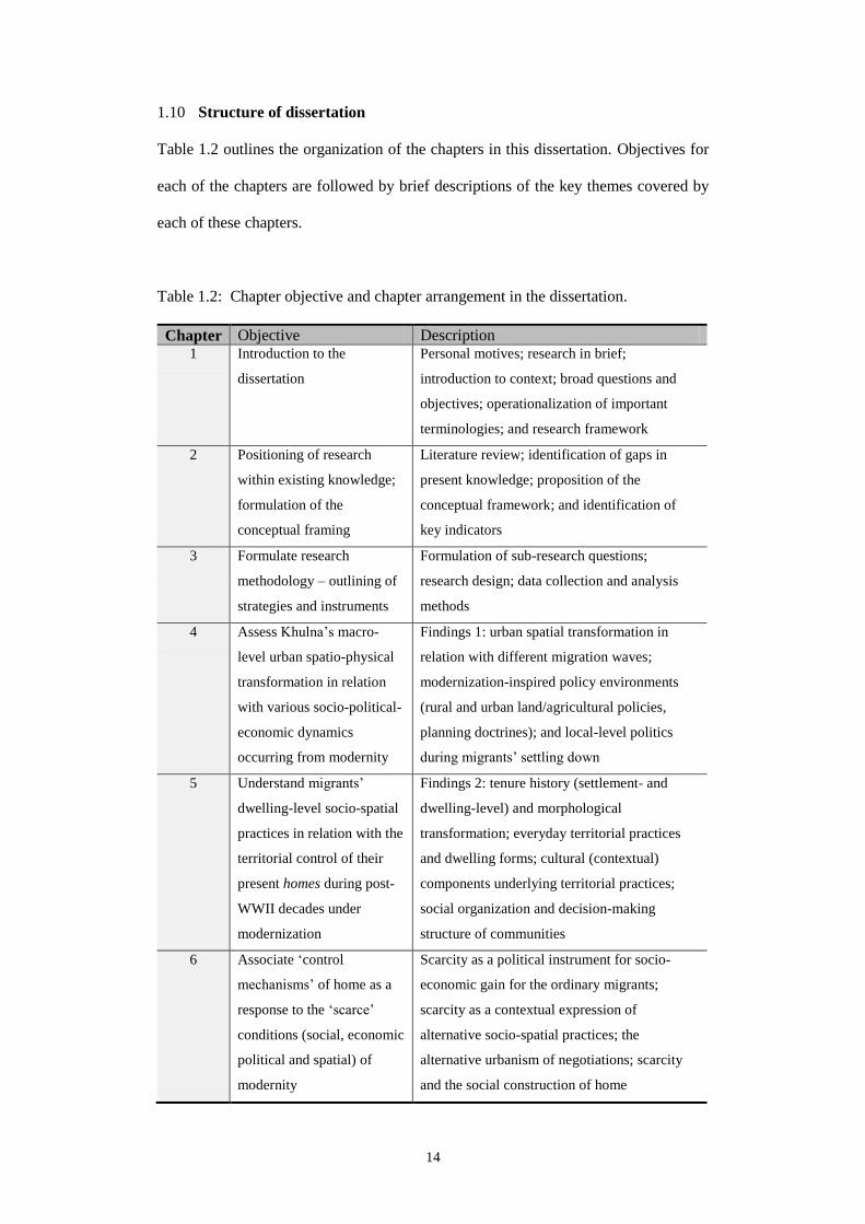
1.10 Structure of dissertation
Table 1.2 outlines the organization of the chapters in this dissertation. Objectives for
each of the chapters are followed by brief descriptions of the key themes covered by
each of these chapters.
Table 1.2: Chapter objective and chapter arrangement in the dissertation.
Chapter Objective Description 1 Introduction to the
dissertation
Personal motives; research in brief;
introduction to context; broad questions and
objectives; operationalization of important
terminologies; and research framework
2 Positioning of research
within existing knowledge;
formulation of the
conceptual framing
Literature review; identification of gaps in
present knowledge; proposition of the
conceptual framework; and identification of
key indicators
3 Formulate research
methodology – outlining of
strategies and instruments
Formulation of sub-research questions;
research design; data collection and analysis
methods
4 Assess Khulna’s macro-
level urban spatio-physical
transformation in relation
with various socio-political-
economic dynamics
occurring from modernity
Findings 1: urban spatial transformation in
relation with different migration waves;
modernization-inspired policy environments
(rural and urban land/agricultural policies,
planning doctrines); and local-level politics
during migrants’ settling down
5 Understand migrants’
dwelling-level socio-spatial
practices in relation with the
territorial control of their
present homes during post-
WWII decades under
modernization
Findings 2: tenure history (settlement- and
dwelling-level) and morphological
transformation; everyday territorial practices
and dwelling forms; cultural (contextual)
components underlying territorial practices;
social organization and decision-making
structure of communities
6 Associate ‘control
mechanisms’ of home as a
response to the ‘scarce’
conditions (social, economic
political and spatial) of
modernity
Scarcity as a political instrument for socio-
economic gain for the ordinary migrants;
scarcity as a contextual expression of
alternative socio-spatial practices; the
alternative urbanism of negotiations; scarcity
and the social construction of home

15
Chapter 2: Literature review and conceptual framework
2.1 Introduction
In order to understand ‘once-homeless’ migrant’s ‘home-making’ process in a third
world city, this chapter begins by outlining a literature review framework. With
regard to the broad question and objectives stated in Chapter 1, this framework
identifies key scholastic materials from various allied disciplines interested in the
built environment. A review of these works originating particularly in the disciplines
of urban planning, architecture, anthropology, sociology and geography are
assembled under five main threads. Through this review, a few niches appear within
existing knowledge, which are summarized under ‘gaps’ later in the chapter. On the
basis of the reviews and the knowledge gaps, a conceptual framework is proposed
that helps frame the specific objectives, identify variables and select indicators.
2.2 Preliminary literature review framework
Among scholars, there is a growing interest in the processes, products or process-
product models regarding the spatial environments of various mobile population
groups1. A review of selected literatures across allied disciplines
2 reveals that
academics historically have been putting together efforts to comprehend the socio-
cultural components underlying these rather ‘informal’ dwelling environments, in
order to identify the elements and mechanisms that bring about spatio-physical
1. Sheller and Urry (2006) coins the term “New Mobilities Paradigm” to point to this
contemporary era of numerous movements.
2. Herbart Gans (1962)’s “The Urban Villagers Group and Class in the Life of Italian-
Americans”; Turner (1976)’s “Housing by People”; Rapoport (1988)’s “Spontaneous
Settlements as Vernacular Design”; Serageldin (1990)’s “The Development and
Morphology of Informal Housing”; Heynen and Loeckx (1998)’s “Scenes of
Ambivalence: Remarks on Architectural Patterns of Displacement”; UN-HABITAT
(2003)’s “The Challenges of Slums”; Roy (2004)’s “The Gentleman’s City: Urban
Informality in the Calcutta of New Communism”; Kellett (2005)’s "The Construction of
Home in the Informal City"; Dayaratne and Kellett (2008)’s “Housing and home-making
in low-income urban settlements”; Datta (2009)’s “Home, Migration, and The City,
Spatial Forms And Practices in a Globalising World”; Nijman (2010)’s “A Study of
Space in Mumbai’s Slums”; and Kim Dovey (2012)’s “Informal Urbanism and complex

16
transformation at the many levels of migrant settlements. Likewise, with regard to the
broad research question, the key object here is to work out a theoretical-conceptual
structure that helps identify the context-specific social and spatial components
underlying the migrant environments. These benefit migrants to retain some form of
ownership to material property (land and/or house) and become permanent in the city.
However, studies are almost non-existent which provide any comprehensive
framework that to help the study of host environments in relation with historically
significant waves of population movement (in- and out-migration). Research on
migration and urban form, though not plenty, thus remain confined within certain
timelines and referring only to an in-situ context of the host city. Studies on migrant
spaces, at least those in the ‘third world’ urban context also do not maintain reference
with the many forms of rural-urban interactions3. A diachronic reading of the spatial
impacts of top-down politico-economic doctrines (e.g. modernization)4 on pre- and
post-migration ways of life needs to be conducted as well. Impact-study of these
micro-level policies on the shaping of rural and urban spaces, particularly considering
an agrarian context such as Bangladesh, hence is felt necessary. Any appraisal of
‘modern’ third world urban form thus necessitates the inclusion of all the ‘forces of
modernity’ including population (migration), policies (politics) and production (e.g.
industrialization).
The micro-level studies on migrants’ dwelling spaces and forms in this research thus
make sense as it is assessed with reference to a specific timeline. In consideration of
adaptive assemblage” – are a few amongst a host of scholarly literature that looks at
various migrant’s everyday socio-spatial environments.
3. Lynch (2005: 6) identifies five ways in which rural and urban may be linked: food,
natural flows, money, people and ideas. As later chapters reveal, people’s social network
(discussed here under “People” category, p. 106) and ‘hybrid’ spatial practices and socio-
cultural customs and behaviour (discussed under “Natural flows” category, p. 92) remain
important components in the shaping of physical dwelling environments. A home in the
city, in many cases, hence retains reference with the long lost rural home.
4. This includes the broader ‘structural’ conditions formulated by supra-national institutions
(World Bank, IMF etc.) and implemented by national and local governments.

17
the required variables as stressed in the earlier paragraphs, five key theoretical-
empirical areas are chosen and reviewed subsequently. Table 2.1 outlines these
phenomena which are of interest to this research, disciplinary areas where the
reviewed literature originate from, and explanations why they have been chosen and
how they contribute to the conceptual framework:
Table 2.1: Literature review framework.
Key area Discipline Contribution to framework Bangladesh,
Khulna
Sociology,
Planning
Local context of Bangladesh and Khulna often in relation
with global
Population
displacement,
urbanization
Sociology,
Planning,
UN
documents
Correlation between migration and urbanization in the
third world context. The relationship between the global
forces and the local consequences is also highlighted in
many of these works
Slums,
informal
settlements
Geography,
Sociology,
UN
documents
Theories and empirical works on slum formation.
Theories of informality, silent encroachment, informal
economics, informal urbanism and assemblage, subaltern
studies (subaltern urbanism, politics of the governed)
Migrancy and
built
environment
Architecture,
Anthropology,
Geography
Architectural patterns of displacement, architecture and
migrancy
Home,
privacy,
territoriality
Environment-
Behaviour
Studies,
Architecture,
Geography,
Anthropology
Home-making through the manipulation of various socio-
spatial control-mechanisms; understand how control over
one’s own environment is practiced in relation with
different actors as a process of physical home-making
2.2.1 Bangladesh and Khulna
In the context of Bangladeshi cities, studies that seek to investigate migrants’ settling-
down process in relation to urban spatio-physical transformations are scarce. This is
particularly true of the research conducted in and about Khulna. Apart from a very
small number of studies supervised in local universities (mostly unpublished), three
works can be mentioned, which, to some extent, discuss the spatio-physical

18
transformation in Khulna in relation with various socio-political forces historically.
Devoid of any particular focus on migration and its consequences at the ‘lower level
spatial form’5, these studies provide partial accounts of: (1) spatial distribution of
migrant settlements (termed as slums mostly) analyzed according to demographic
variables (Hasan 2003); (2) urban morphological transformation following two
significant phases of in-migration (Dudek and Van Houtte 2008: 39, 45); and (3) a
comprehensive and updated database on “poor settlements” in Khulna, according to
variables such as settlement location, number, size and age; residents’ demographic
characteristics and economic information (CUS-UNDP-KCC 2011). Clearly, all three
of these studies provide a ‘bird’s eye view’ of the situation, and suffer from not
having a complex analytical framework to examine urban spatio-physical changes in
relation to socio-economic-political forces.
In the context of Dhaka, similar dearth of research is also found. Works (such as
Kemper 1989, D’Costa 1994 or Ghafur 2010’s) amongst many things, mention of the
contribution by migration and refugee-movements in the shaping of urban form. Yet
they are all generalized studies as none focuses solely on the phenomenon of
migration as a driver for urban form6. These are not architectural studies either, since
they have lesser interest in the spatio-physical transformation of settlements. Instead,
they outline frameworks and suggest of a methodology useful for discussing urban
spatio-physical transformation in a historical manner. However, the need to
incorporating both global and local forces (e.g. colonialism, economic doctrines,
industrialization and globalization) in the analysis of urban form is stressed in all of
these works.
5. Adapted from Habraken (1998); it states that lower the level of spatial form, lesser is the
participation from agents, hence is their public character.
6. Although ‘migration as a contributor to urbanization’ has been identified on several
places; see Kemper 1989: 380; D’Costa 1994: 702; Ghafur 2010: 7.

19
As scholars discuss urbanization in relation to migration, urbanization is discussed
mostly in terms of population increase and demographic changes in the city (Afsar
2003; Khan 1982; Islam 1999). When “consequence” of migration-driven
urbanization is discussed, they are discussed in terms of environmental outcomes
(e.g. water and air pollution) and socio-economic outcomes (e.g. increased violence
and crime, economic gain and empowerment etc.). When spatial outcomes are
discussed, they remain limited within the discussions of ‘encroachment of land,
growth of slums and pressure on housing’ (Islam 1999: 13-14). These studies provide
only a top-down view, focusing on the ‘breadth’ of the socio-spatial problems arising
from urbanization – not the depth. Ghafur (2010)’s study on ‘urbanism’, however,
appears most useful, as he discusses how housing provisioning in Dhaka under
neoliberal conditions has become subject to the market forces. He shows, with a
theoretical inclination, how present neoliberal condition has for its own gain led to an
overall privatization of the housing sector. With the help of planning bureaucrats and
with active political patronage, here private formal sector (developers) grabs land and
develops/builds informally, while ‘privatization of slums’ remain the only home-
making option for growing number of urban poor (migrants). Although not directly
relevant to the present research objectives, Ghafur’s work stresses the importance of
situating any research within a broader framework of analysis (here a modern
phenomenon, the politics of Neoliberalism). It also argues that as neoliberal
conditions lead to the blurring of formal-informal boundaries, studies rather should
aim at and assess the “alternative dwelling perspectives” in order to grasp the in-
depth understanding of “lived lives in space…in its hierarchical relation to the urban
totality” (Ibid: 13).
In the studies of dwellings and households, researchers interested in the process of
how the migrant populations manage to survive and (occasionally) prosper in the
destination city, have seek to investigate the livelihood (and survival) strategies of the

20
city living migrant chiefly (Huq-Hussain 1996; Siddiqui 2003; Hakim 2010; Hossain
2011). While defining these migrants’ living places as ‘slums and squatters’, many
demonstrate a methodological inclination toward a longitudinal study. Thus many
seem to assume a ‘biographic approach’ to trace the various adjustments in migrants’
social, political and economic strategies at different intervals ranging between pre-
migration and present times. A few amongst such works have dedicated special
sections of their analysis only describing the spatio-physical dimensions of slum-
living migrant’s dwelling environments (Huq-Hussain 1996: 99-104; Shakur and
Madden 1992: 80-81; Hossain 2011: 112-114).
Attempts as these, however, remain largely unsuccessful considering the interest of
this research. Although some architectural/spatial analyses are there, yet they mostly
fail to provide any analysis of spatio-physical transformation (at least) at the level of
dwellings in relation with their changing socio-economic-political circumstances. For
example, Huq-Hussain’s article implicitly mentions about the need for privacy
particularly amongst female migrants (Ibid: 97). Yet she still does not follow this up
with spatial evidences that show how this particular need is eventually being
mediated, using which socio-spatial-economic means/mechanisms, and with what
socio-spatial consequence. Similar is found in the other articles. Although there are
mentions about the importance of kinship-networks (Shakur and Madden 1992: 75)
and active political participation (Hossain 2011: 9), their spatio-physical analysis
appear to be mere descriptions of inert house forms and spaces, construction materials
and tenure status. It is hard to comprehend the role of such socio-political or
economic forces in the shaping of urban form at the level of the concerned dwelling
environments. Generally, for understandable reasons, these works are also
unsupported by graphical analysis of any sort. But notwithstanding the shortcomings,
there is a common important lesson these studies seem to offer. They all highlight the
need for including a ‘temporal’ dimension for studying migrants’ urban adaptation

21
process; this is akin to the need for a morphological study as frequently used in the
study of built environments. This approach certainly allows tracing back various
phases of once-homeless migrants’ settling down process (becoming permanent) in
the host city. It helps understand the occasions for transformation of spatial practices,
behaviours, spatial needs, customs and habits and hence the overall urban form in
response to changing circumstances. This approach also helps compare the possible
evolution in permanent migrants’ social identity – the uplift from a mere ‘rootless’
status to that of a citizen in the particular context of Bangladesh.
2.2.2 Population displacement and urbanization
Globally, a number of studies have been carried out during the post-WWII decades
addressing the correlation between internal-migration and urbanization (Abu-Lughod
1973; Halpern 1966; Roberts 1978; Wu 2010), or more recently on international
migration in relation with the socio-cultural-spatial aspects of the host-city (Blunt
2007; Colombijn and Erdentug 2002; Davis 2003; Eriksen 2001; Fenster 1996;
Lozanovska 2003; Pieterse 2000). Within the Western scholarship, the latter has
found most attention compared to the former, as scholars tend to show more interest
in the assimilation/integration process of the international immigrant within the
western urban environments. Efforts are given to comprehend the driving forces and
processes underlying this quite extraordinary influx of immigrants in recent decades7.
Tensions arising from this radical influx of immigrants mostly from former European
colonies have led to the publication of critical works8. It hence comes to no surprise
that spatial segregation, ghettoization or ethno-racial discrimination have become the
most recurring of themes among the mobility/displacement scholarship in the
postcolonial discourse.
7. In comparison to 1990’s, percentage of immigrant-inflows has fallen a bit in recent years
(due to economic crisis) (OECD 2009: 12); yet the net quantity of in-coming immigrants
are on a constant rise for these countries of the developed world (OECD 2010).

22
Although scarce, some authors have actually aimed to analyze the relation between
internal migration and the socio-cultural-spatial transformation of the host
environment. For example, Janet Abu-Lughod (1973) provides an ethnographic
account of rural migrants’ adjustment-efforts in the Egyptian city. Here, migrants’
economic, social and ideological perspectives have been analyzed in relation to city’s
physical growth and overall fabric. Similarly, Kezer (1998: 11) talks about Ankara,
where “structural changes within the state and its institutions triggered unprecedented
contestations over space by opening it to new uses and users while displacing the
old”. Zheng et al. (2009), in the Chinese context, also analyzes how the city living
migrant-workers’ housing preference for the fringe (rural) areas is increasingly being
challenged by urban expansion. Shao et al. (2008) examine the spatial clustering of
migrants in Bangkok and analyze that on the basis of various social networks.
Weiping Wu, through her two versions on rural migrants’ spatial distribution in the
reform-era Chinese city (Wu 2008; Wu 2010) highlights how these migrants are,
being subject to ‘hukou’, are spatially ‘trapped’ within a few particular locations in
and around the city.
Arif Hasan (2010b), in his “Migration, small towns and social transformations in
Pakistan” gives an elaborated account of three Pakistani small-towns where various
forms of migration (rural-urban migration, in-coming foreign refugees and
international emigration) have had both positive and negative effects on the urban
environment. Urban form, he informs, is being shaped by poor rural-urban migrants’
and refugees’ illegal subdivision of land on the city’s fringe areas as local
governments prove inept to project and deliver housing for these groups.
Simultaneously, the older city core becomes more crowded with the growth of
informal businesses after the affluent class gradually moved out to peripheral new
8. Please refer to, Ashcroft B., G. Griffiths and H. Tiffin 1989, The Empire writes back:
theory and practice in post-colonial literatures, Routledge, London and New York.

23
towns (fuelled by foreign remittance flows). This same remittance that has kept
contributing to national GDP growth has also led to the creation of socio-spatial
inequality. Without public spending, urban spatio-physical transformation has
remained concentrated largely around private dwellings, constructed by both affluent
and poor belonging to both informal and formal sectors. All these processes,
however, have continued to receive sustained political patronage by a landholding
elite class (Ibid: 49). This group’s political influence on both informal ‘voter’
population and bureaucracy (including municipalities and planning departments), as
Hasan recognizes, is conceivably the most important social component that underlies
the physical transformation of these smaller towns in Pakistan.
Now, in terms of the studies on immigrants’ assimilation in the West, they only cover
a certain (and very exclusive and) affluent portion of the ‘third-world mobile
population’, leaving the bulk of the ‘others’, i.e. the rural to urban movers, to be
discussed under different threads. It is therefore, even if the studies on rural-urban
migration in the third world city has remained one of the most cultivated areas of
research during the past 5-6 decades, these have been interested solely in the socio-
economic processes and consequences. These scholars have continued to demonstrate
their interest in the impacts of macro-level socio-economic policies on ‘slum-
dwelling objects’ at the receiving end (Chan and Zhang 1999; Deshingkar and Grimm
2004; van der Hoeven 2000), with focus on, for example, employment and income
(Todaro 1969). And when these migrants have been studied as research objects,
issues such as migration-motives (Skeldon 2003), vulnerability context (Moser 1998),
poverty (Lall et al. 2006) etc. have dominated the literature.
On the other hand, as rural migrants in the city are looked at as subjects, i.e. as actual
people as they are, micro-level studies here actually attempted to understand their
livelihood (or survival) strategies (regarding migration decision-making and settling

24
down process) (Hakim 2010; Kuhn 1999), gender (Fan 2003), effect of remittance to
origin (Fletcher 1997) etc. Similar have already been seen in the works on
Bangladesh as well. Other available theoretical threads that are concerned with
internal migration, mostly focus on issues pertaining to climate change9 (Black 2001),
rural-urban continuum (Tacoli 1998) or labour market (Betcherman 2002) – to name
just a few.
As in the literatures on Bangladesh, most of these global-level studies also look at
migration and urban form from ‘above’ – not through migrants’ own ‘eyes’. In a few
cases when such studies tend to focus on the migrants’ actual day to day space-
making practices as in Abu Lughod (1973)’s, they originate in disciplines other than
architecture. These works therefore do not comprise of any architectural analysis of
urban form and spaces; neither these aim to measure the spatio-physical
consequences of migration using architectural variables10
. None of these studies
provide any theoretical direction either, which helps comprehend the spatial practices
by the migrant population for claiming a sense of ownership over their dwelling
environment.
2.2.3 Slums and informal settlements
Settlements where migrants live in the city are commonly referred to as slums,
squatters or informal settlements. Migrant settlements, i.e. their places and spaces are
often categorized, rather crudely, as ‘poor-settlements’, ‘informal settlements’, ‘slum’
or ‘squatters’ (Gilbert 2007, UN-HABITAT 2003: 1111
). This homogenization
9. Migrants, when compelled to live outside their places of origin (due to war, climatic
disasters or political views), assume the title of a ‘refugee’ (IOM 2004: 53).
10. For example, diachronic study of formal and spatial transformation of migrant
settlements, their neighbourhood characteristics and dwelling environments in relation to
changing levels of density.
11. Interestingly, UN-HABITAT recognizes the potential heterogeneous and spatial qualities
in slums and with its dwelling communities; yet, it is probably due to their interest in
indicating a more global picture and stressing on the stature of this ‘great problem’ that
led to their usage of the term ‘slum’ in the first place.

25
reduces the scope for grasping the possible heterogeneity and multi-layered meanings
associated with and manifested in these spaces. As Roy (2011: 226) cites Echanove
and Srivastava (2009) to portray life in Dharavi12
, places like Dharavi, these authors
claim, are perhaps amongst the most active and lively parts of any city that have
developed without any public funding or support. These are also places of intense
economic activities – manufacturing products for even the global market. So
“understanding such a place solely by the generic term ‘slum’ ignores its complexity
and dynamism”.
Labelling migrant dwellings as ‘spontaneous’ (Rapoport 1988) or ‘vernacular’
(Kellett and Napier 1994) also does not help much. Although these concepts are
appreciative, these still appear ‘ahistorical’ and ‘apolitical’ without asking for any
particular reference to the dweller’s past and for not considering dwellers’ many
responses to everyday socio-economic-spatial constraints. Considering third-world
urbanization, scholars and research organizations easily approve of internal migration
as the number one force behind it13
(Abu-Lughod 1973; Correa 1989; Halpern 1966;
Neuwirth 2007; UN 2008; Wu 2010). Yet, even the most provoking of all UN
documents to date, THE CHALLENGES OF SLUMS (UN-HABITAT 2003) keeps
calling these spaces as ‘slums’ and its inhabitants as slum-dwellers, and thus take the
agency away from the latter. So a clarification on the concepts of slum, squatter and
informal settlements becomes imminent.
The terms ‘slum’, ‘squatter’ and ‘informal settlements’ share a few common threads.
Although there are clear conceptual differences14
, they all indicate to an actual
12. Located in Mumbai, it is considered as the “largest slum” in South Asia, housing more
than half a million population at a density of 3000persons/ha (Nijman 2010: 8).
13. UN (2008) summarizes this; Table 1 in Appendix provides a comparative matrix.
14. For example, UN and other agencies argue that the ideas of ‘informal’ and ‘slum’ are not
the same as informality can exist in areas which do not have conditions akin to slums and
vice versa (Jenkins and Andersen 2011: 2).

26
physical space that suffers from various sorts of lacks. A slum, according to UN-
HABITAT (2003: 12), is defined as an area that suffers from various ‘inadequate’
levels of physical and legal characteristics (e.g. poor structural quality, inadequate
space for decent living, overcrowding, inadequate access to safe water, sanitation and
infrastructure, insecure residential status etc.). A squatter, on the other hand, is seen
as an area having illegal land tenure, accumulated through organized land invasion or
gradual accretion. ‘Informal settlements’, on the other hand, are residential areas
which may have “dubious” land tenure; these are also officially recognized (planned)
areas where housing regulations have not been maintained while house constructions
are largely carried out without the help of professionals (Willis 2009: 403). The
sharing of a common negative attribute by these three, i.e. ‘the lack of something’ one
assumes, has led to their interchangeable use by even the global level agencies (as in
UN-HABITAT 2003: 9).
However, the term ‘migrant’ has often been interchangeably used, for example, with
‘slum-dweller’ (Mangin 1967; Karan et al. 1980; Mukhopadhyay and Dutt 1993;
Rapoport 1988; UN-HABITAT 2003). They have also been found described as
informal (Serageldin 1990; AlSayyad 2004; Brillembourg et al. 2005 as in Beardsley
2007; Kellett 2005; Kudva 2009; Roy 2005), indigenous (UN 2007), peasants
(Halpern 1966), urban poor (Noe 1981; Roberts 1978; UN-HABITAT 2003; UN
2005), and floating population (Li 2006) when considered in the less developed
nations’ context. Migrants are generally considered as ‘ethnic’ or ‘minority’ (Eriksen
2001; Fenster 1996; Gallagher and Tucker 2000; Hutchison and Krase 2007; Pieterse
2000) and belonging to a particular ‘race’ (Mercuse and van Campen 2000) when
discussed in a developed nation’s context. Scholars from the housing sector in
Bangladesh also commonly identify that migrants’ constitute the most of the ‘slum
dwellers’ (Ahmed 2007: 8; Angeles et al. 2009: 11; Miah and Weber 1990: 145;

27
Rahman 2001: 49; Shakur and Madden 1991: 69); yet they go for frequent labelling
similar to that of the previous parties.
Labelling migrant spaces crudely as slums and squatters also does not allow
understanding the ‘proper’ background of these people under investigation15
. It
overlooks the all important time-space continuum16
that migrants remain part of
notwithstanding their spatial implications. This, similar to Datta (2009: 4)’s assertion,
indicates to a “dualism” that leads to the conceptual limitations toward understanding
migrants’ different place-making efforts.
The tag of ‘slum-dweller’ also has deep political implications primarily for
authorities in control. Therefore, I argue in favour of a disinterested investigation into
migrants’ everyday lived spaces. Rather than devising a taxonomy based solely on
their legal status (as squatters) or physical-infrastructural conditions (as slum-
dwellers) of their places of living, this research aims to look at their ‘ordinary’
dwelling environments – more as an alternative way of living compared to the
mainstream city dwellers. However, the migrant needs to be identified because he/she
can be found actively practicing and belonging to similar socio-cultural-economic
elements in the city, much in the same way during his/her rural times. Even if these
people have been away from their places of origin for many years while their new
‘urban-born generations’ would probably never return to the rural homes (Hakim
2009; Hakim 2010), it is still not hard to find, even amongst these apparent slums, the
15. For example, Kellett and Napier (1994) frequently use the term ‘squatter’; this however
leads to the question, “Who exactly they are talking about here?” and “Isn’t it reducing
scopes for incorporating at least all the ethno-cultural differences these squatter-people
may actually have amongst themselves?”
16. This remains one of the major threads of debates regarding the international immigrants
in western cities; referring to the previous section, one may recall terms such as multiple
belonging; transnationality, juxtaposition and overlapping; flow, porosity and
connectivity; layered structures of nodes and networks etc, all used to ascertain that
migrants’ sense of belonging has much to do with their past and places they used to
reside previously.

28
clear existence of village-like zoning and other land-use17
on the basis of religion,
language and regional origin (Hakim 2009; Nijman 2010). So when studies
homogenize the origin and history of these migrants by labelling them as ‘slum-
dwellers’ or ‘urban poor’, the possibility of a ‘fair’ and ‘unbiased’ research is
fundamentally compromised.
Moreover, there could be different groups of non-migrant urban poor, whose poverty
could be attributed to reasons other than that of the migrants’. Satterthwaite (2005:
22) criticizes equating the poor or illegal settlers with ‘migrants’ this way, since many
migrants probably have attained the stature of a ‘mainstream’ citizen through decades
of upward socio-economic mobility. Classifications such as ‘informal’ and ‘slum-
dweller’ essentially indicate to the present legal and material aspects with regard to
the migrant citizenry while keep ignoring their history, a definite past (of the first
generation migrant), and migrants’ gradual socio-economic-spatial efforts to
‘becoming’ a true citizen. In most cases, describing the places and spaces of the
migrant as ‘squatters’ or ‘slums’ thus appear to be a refusal of migrants’ spatio-
political existence; it also overshadows their efforts to ‘becoming’ during their long
years of city living. This refusal becomes a case of an ‘authoritative misinterpretation
of common people’s history’ of urbanization in the global south. Such acts also
resemble the denial of these migrants’ politico-economic contribution to these cities.
So for research purposes at least, a need is felt toward using terminologies that look at
the settlements exactly as what they mean within their local context18
. Rather than
17. During fieldworks, I came across interesting concentration of people and equally
interesting ‘village-like’ zoning on the basis of race, profession etc. within the same low-
income settlements – akin to any typical Bangladeshi village.
18. Local expressions often provide clues about what these settlements mean actually in that
particular context. For example, in Turkish, Gecekondu is a somewhat equivalent
expression to that of slum in English, where this word literally means “it happened at
night”. For years Turkey's low income residents (who currently constitute about half of
Istanbul’s entire population) have continued to build at night to take advantage of an
ancient law stating that if such constructions start at dusk and people could move in by

29
investigating these settlements and their inhabitants in terms of ‘what they lack’, an
alternative view in terms of ‘what they have’ may also prove useful here. For this
reason, this research prefers using a less prejudiced term – ‘migrant settlements’ to
identify these particular dwelling environments. To understand the underlying socio-
political forces responsible for these settlements’ spatial transformation, four
empirical-theoretical areas are further discussed in the following sections.
2.2.3.1 Informality
According to Castells and Portes (1989), the idea of the ‘informal’ must be viewed in
congruence with three aspects. One, ‘informal’ is only conceivable in the presence of
‘formal’ – informal sector is an integral component of the national (read ‘formal’)
economy. Economy, in any country, works in a “two-tier” system where boundaries
and interactions adapt to variable shapes depending on its social conditions and the
political orientation of the government. In any country, for example within a closed
market system, small businesses often operate as extensions of larger firms. So there
is no clear-cut distinction between formal and informal19
. Rather, a series of complex
interactions between the state and the informal is what operates there. Two, the labour
employed in the informal activities have “special characteristics”. This involves
personnel, such as migrant workers, ethnic minorities and women, who, for both
social and demographic reasons, are not able to access formal economy and its labour
sunrise without being discovered by the authorities, they would gain legal standing and
could not be evicted without a court fight (Neuwirth 2005: 8). Similar is with the Bangla
version of the slum. Bastee in Bangladesh is the most frequently used expression for
slums. Yet, Bastee is derived from the root bashati, meaning a place for human living
(Rahman 2001: 50). Camp and Colony, derived primarily from English are another two
local expressions referring mainly to refugee settlements and low income government-
funded housing areas respectively (Hakim 2009).
19. Although defined as a binary, the notion of formal and informal are grounded in particular
cultural, social, institutional, economic and political realities of particular contexts.
Moreover, “what are formally classified as informal settlements, are not a concept that
residents recognize or apply to their reality” (Jenkins and Andersen 2011: 1). Formal
standardization as urban planning was primarily meant for the benefit of colonial elites.
Yet in present post-colonial conditions, urban planning mainly benefits the new elites. In
all formal situations, some form of informality should be present. Formal and informal are
not separate sectors but “co-exist in complex inter-penetrated manners” (Ibid: 3).

30
market. Informal economy hence evolves through a process of social struggle and
involves “weaker” people who are similar in socio-economic status. Informal
economic activities by these people are also often characterized by “stamina and
surrogate entrepreneurship”. Three, government has an invariable attitude toward the
non-regulated sector. Governments tolerate or sometimes even stimulate informal
economic activities “as a way to resolve potential social conflicts or to promote
political patronage”. Squatter settlements, which flourish on public land, can be seen
as one such example (Ibid: 26). The process of “informalization” hence can be
viewed not as a social process. Rather, it is the “expression of a new form of control
characterized by the disenfranchisement of the state”. For the latter, the loss of a
formal control mechanism over all informal activities is compensated by short term
acts of legitimation and renewed economic growth they offer (Ibid: 27).
Informality therefore operates on the “margins of rules and organizational
arrangements that no longer fit these people’s real condition and experience”.
Informal economic acts tend to be flexible and ad hoc, while they make use of more
“primitive (modes of) exploitation”. These acts are more small-scale, face-to-face,
decentralized and predominantly social-network based. Benefit occurs from a
significant reduction in overhead costs (for not having a bureaucratic structure) as in
large-scale organizations (Ibid: 29-30). The process of informalization may reinforce
some particular social groups that differ from the mainstream in any prevailing
society. For example, migrant communities may frequently be found living in ghetto-
like enclaves. Informal economic activities thus may take place as the migrants, for
being confined within this enclave, would often combine residential functions with
income-generating activities. With the development of informal economy, an added
sense of autonomy also develops within the social sphere (Ibid: 32).

31
Nezar AlSayyad discusses informality in the neoliberal urban (spatial) context. The
current era of market liberalization and globalization, he says, has given rise to a new
form of informality. Informality has created a situation in which an individual may
belong to both formal and informal sector at once. In spatial terms, informality has
assumed new forms and new geographies in terms of developments that may serve as
a key avenue to property ownership. Informality hence acts as an “organizational
logic” which emerged under the context of liberalization (AlSayyad 2004: 24-25).
The processes of urban informality also vary greatly between contexts and in
response to conditions. For example, whereas in Latin America urban informality
culminates into organized political affiliation and establishment of a reciprocal
relation between squatter groups and the state, in the Middle East the similar groups
assume a more covert stance by deliberately making themselves invisible from
political processes (Ibid: 14).
Ananya Roy (2004) discusses how in neoliberal Kolkata, the ruling communist
government used to make strategic use of both formal and informal spatio-political
mechanisms to transform Kolkata into a marketable “Gentleman’s city”. In order to
accomplish both political objectives (ensure vote and loyalty) and to serve the interest
of large-scale developers, Roy shows how the same government machines (formal)
and party cadres (informal) were used in combination. A number of events were
“choreographed” and implemented in a synchronized manner through the
establishment, eviction and re-establishment of migrant and refugee populations in
the city’s peripheral lands. These urban poor’s need for remaking home in the city
was exploited by the ruling regime to prove the regime’s legibility and power. This
home-making also helped develop agricultural land into sellable plots; promises were
given to these populations for their wellbeing and eventual settlement. In this, the
homeless population was first ‘rehabilitated’ on peripheral agricultural land, which,
without proper land records (maps or a master plan) was left alone for decades as

32
disputed properties. Government then would engage its party workers on a day-to-day
basis to ‘look after’ this large number of people by managing for them the gradual
access to urban services and infrastructure. With the absence of any formal/legal
document (e.g. title deed) whatsoever, a persistent sense of uncertainty was
deliberately maintained with regard to people’s land tenure. This in turn, would
ensure their absolute loyalty.
A lack of policies and regulations regarding land development on these disputed sites
was also maintained quite strategically. These migrants, left without a choice and for
being promised of future service provisioning cleared up these sites using their own
‘free’ labour, and turned these into habitable places. Yet this very land which they
were once allowed to live on would only be appropriated back later by the same
provider (government) in the name of public interest (actually to give way for large-
scale private-sector development projects for the upper-middle class). This tactic
proved to be quite successful; migrants again found themselves on similar new
frontier plots of land and putting in the same efforts, knowing they might be evicted
once again.
The power of the state therefore was derived from certain regulatory manipulation,
including ‘unmapping’ (an intentional maintenance of a lack of land records and
maps). Coupled this with the activities of ever-present party workers and cadres, this
would keep options open for relentless negotiations between government and other
actors on matters related to land right, proper title and land use. This territorialized
uncertainty thus would guarantee the flexibility of the state to retain its grip on the
grass roots as it would be required periodically. This strategy by the higher power
hence gave rise to grass-root politics by the minor groups, even if their part was
insignificant initially.

33
2.2.3.2 Subaltern studies
Works done by the Subaltern Studies Group, particularly on post-colonial Indian
history is another interesting track that again shows a theoretical insight for this
research. Proposed mainly by expatriate Indian scholars and later followed closely by
other Asian scholars, these works emphasize the fundamental relationships of power,
domination and subordination in a post-colonial society set within apparently modern
democratic conditions. Here “subalternity” comes to be seen as “the condition of
people, those who did not and could not belong to the elite class” (Roy 2011: 227,
citing Guha 1988). The subaltern politics hence means micro-level politics of
‘disenfranchised’ grassroots people outside that of the civil society in order to claim
habitation and livelihood. Needless to say, these efforts for claiming habitation or
livelihood involve violation of state law. In that, “subaltern urbanism” essentially
involves two key qualities: opportunistic entrepreneurism and political agency (Ibid).
Similar has been echoed in Partha Chatterjee (2004)’s concept of ‘political society’,
in which the latter is seen as a construct between the political relation between ruling
elites and urban subaltern population groups. Although most citizens in recently
modernized countries like India are “rights-bearing citizens” constitutionally, in
reality they are not part of the civil society whatsoever. Yet they are not outside the
reach of the state machines nor are they excluded from the political domains. As part
of territorial jurisdictions of the state, this subaltern population needs to be looked
after and controlled (Ibid: 38). Politics emerge out the “developmental policies of the
government aimed at specific population groups”. Many of these groups although
organized, exist by transgressing the boundaries of legality to manage their livelihood
and habitation. So to deal with them, authorities do not treat them similarly as they do
with other legitimate groups. Yet, as they remain important for their sheer number in
terms of clientele value, both governments and non-government organizations deal

34
with these groups as “convenient instruments for the administration of welfare to
marginal and underprivileged population groups” (Ibid: 40).
On the other hand, these groups accept their illegal activities, but continue to claim
habitation, livelihood and government welfare as matters of right. They also conform,
for example, they would move out if provided with suitable alternative sites for
resettlement. Although some welfare claims are met, the other claims are not regarded
by officials as justifiable, in the fear there would only invite further violation of
public property and civic laws. So negotiations with regard to these claims take place
on a political landscape. Government agencies give selective attention to particular
population groups on the basis of their political importance. To buffer such
uncertainties, groups in political society maintain numerous connections outside the
group – with similar groups, with more privileged and influential groups, bureaucratic
personnel and with political parties and leaders. However, for their power to vote in
elections, subaltern groups demand significant attention. This is where, Chatterjee
(Ibid: 40-41) argues, “The field of citizenship overlaps with that of governmentality”.
Considering this rather ‘political relation’ between the subaltern and the elite, another
concept requires attention here. Put forward by Asef Bayat, and developed mainly in
the context of the Middle East, it discusses the silent, compromised and hidden acts
of the subaltern population that is used for getting access to livelihoods and housing.
In his “From ‘Dangerous Classes’ to ‘Quiet Rebels’: Politics of the Urban Subaltern
in the Global South”, Bayat (2000: 542-543) critiques20
the typical association of the
20. He also critiques contemporary studies, and their ideas of “the passive poor” (for
portraying the urban poor as a ‘marginal man’ and also for generalizing and disregarding
the various ways in which the poor in different cultures deal with poverty; see Bayat
2000: 538); “the surviving poor” (for portraying them as merely as victims and hence
denying them of any agency – thus such people’s resistance efforts, advancements,
opportunistic endeavours and many social associations are neglected; see Ibid: 539); “the
political poor” (for being Latin America-centric and hence failing to grasp again that
apart from mainstream political associations, urban poor may also have other social
networks and culture-specific ties that could help them achieve their aims; see Ibid: 540).

35
term ‘resistance’ with urban poor’s effort in third world cities. For him, the term
“resisting poor” lacks a clear conceptualization, and also overemphasizes the
‘resistance’ phenomena and therefore undermines the more quiet and incremental
strategies assumed by the poor21
.
By definition, ‘negotiation’ implies a process “in which two or more parties seek a
mutual agreement through an explicit or implicit exchange of views” (Aggarwal and
Dupont 2009: 10473). A successful negotiation ends up with an agreement, where
“both sides have a stake in ensuring a deal comes out right. Deals are put together.
Deals are worked out together” (Low 2010: 3). These considered, the idea of
‘negotiation’ finds its best expression probably in the discussions on “quiet
encroachment by the ordinary” by Bayat (2000: 545) in the third world Asia’s
context. Quiet encroachment, hence represents the silent, persistent yet pervasive
advancement of the ordinary on the propertied and powerful that helps the former to
survive and improve their lives. Marked equally by quiet, largely atomized and
prolonged mobilization, and by episodic collective actions – these are open and
fleeting struggles without clear leadership, ideology or structured organization. Here
the struggles and gains of the agents take place not at the cost of fellow poor or
themselves, but of the state, the rich and the powerful. These grassroots activism are
neither necessarily defensive nor resisting but cumulatively encroaching as the actors
tend to expand their territory by winning new positions.
This is also how the notions of order, modern city and urban governance are
challenged. Often whole communities emerge as a result of such intense struggles
and negotiations between the poor and the authoritative elites in their everyday lives.
21. It comes as no surprise that in many disciplinary areas, and in the understanding of
diverse acts, the idea of ‘resistance’ is equally pronounced alongside the idea of
‘negotiation’ (as in Mondal 2006: 153).

36
Their actions may be collective and hence viewed as political only when they are
confronted by those who threaten their gains (Bayat 2000: 546-547). For example,
“the poor do not directly challenge the effect of globalization. Rather, in their quest
for security, they get involved in constant negotiations with globalization to maintain
or seek autonomy in any space remained unaffected. At the same time, (through this
process) unintended consequences of their daily encroachments and negotiations
beget significant social changes in urban structures and processes” (Ibid: 553).
Two goals drive this quiet form of action. One, redistribution of social goods and
opportunities (such as land, shelter, supply-water, electricity, roads) in the form of
unlawful and direct acquisition of collective consumption of public space (street
pavements, intersections, street parking places); opportunities (favourable business
conditions, locations and labels), and other life chances essential for survival and
minimal standards. Two, there is a need for attaining autonomy, both culturally and
politically, from the regulations, institutions and discipline imposed by the state and
modern institutions. The poor tend to function as much as possible outside the
boundaries of the state and modern bureaucratic institutions. They base their
relationships on more traditional modes including reciprocity, trust and negotiations
rather than on modern notions of individual self-interest, fixed rules and contracts.
This remains the most practiced mode of relationship not because these people are
essentially non- or anti-modern, but because the conditions of their existence compel
them to assume this informal mode of life (Ibid: 548-549).
Such entrepreneurism is best evident in the ways the subaltern populations continue
to engage in activities in many visible forms and spaces (see, for example, Tunas
2008). In many cases, such activities run parallel to official developments – in both
overt and covert forms, and by taking advantage of ‘loose’ official systems and its
spatio-political cracks and niches (Kudva 2009; Perara 2009). Or, as Koolhaas (2002:

37
179, 184) tells of Lagos, the formal infrastructure of planning – seemingly useless
and restricting to the intensions of the subaltern, also provide the all important ‘grid’,
within and through which these people’s entrepreneurial activities take place while
affecting urban spaces and forms. This is also akin to ‘occupancy urbanism’ through
which the urban subalterns assert territorial claims, practice vote-bank politics and
penetrate the lower, porous reaches of state bureaucracy (Roy 2011: 228).
2.2.3.3 Assemblage
Kim Dovey (2012: 353)’s “Complex adaptive assemblage” has a particular
significance in understanding the “processes, identity formation and becoming” of
informal settlements. It is probably one of the very few examples of conceptual
models that have ever been used in the architectural analysis of ‘informal’ forms and
spaces. This framework has its roots in the works of Gilles Deleuze and Felix
Guattari (1987), while it was later developed into ‘assemblage’ theory by DeLanda
(2006). The term ‘assemblage’ is a translation of agencement in French, which means
‘layout’, ‘arrangement’ or ‘alignment’. It suggests at once a “dynamic process and a
diagrammatic spatiality”. An assemblage can be seen as a whole, formed from the
interconnectivity and flows between its constituent parts”. It is more like an organism
in real life – a socio-spatial cluster of interconnections between parts where identities
and functions of parts and wholes emerge from the flows among them. It is not a
structural set of predetermined parts which are organized to work a particular way. It
is more a whole that expresses identity and claims territory. For example, a street may
be viewed not as a thing or as a collection of things. Instead, the buildings, shops,
signs, police, shoppers, cars, hawkers, rules, footpaths, goods, trolleys – all come
together as it they are parts of a single organism to become the street as we know it.
Yet the relation between these components, for example, the relations between
footpaths and roads or between the interconnections between public and private

38
spaces, remain crucial. In that, assemblage is a dynamic phenomenon, which is
dependent on flows (Ibid).
The key quality of assemblage theory hence lies in its ability to use acts of
territorialization and de-territorialization to explain the ways social and spatial
boundaries are “inscribed and erased”, and the ways “identities are formed, expressed
and transformed”22
. In the territorialization process, wholes form from parts and
identities occur from differences. Territory hence can be seen as a “stabilized
assemblage – a zone of order, a sense of home, and a stable space”. In present urban
world, focus is given on the processes of (re)territorialization (e.g. invasion of urban
interstices, construction of house, inscription of boundaries etc.) and de-
territorialization by which stable territories are eroded (demolition, slum eviction etc.)
(Ibid: 354-355). Assemblage theory is particularly useful for its ability to explain a
number of twofold concepts associated with informal settlements. For example, in the
twofold concept of formal-informal, formal resembles a tree-like framework23
of
regulations such as urban planning, while informal practices resemble a rhizomic
form – involving minor adaptations and tactics in contrast to the fixed ideals of
Master Planning. These two, therefore can only be explained when the dynamic
relation between them are understood. They cannot be seen as separate nor as
dialectic but rather as overlapping – creating an assemblage (Ibid: 355).
22. AbdouMaliq Simone (2004)’s “People as Infrastructure” is a similar piece of work, where
he discusses ordinary people’s open ended, unpredictable, flexible, mobile and
provisional acts in order to sustain the changing politico-economic realities of the
megacity. In his words, people engage into a conjunction of heterogeneous activities that
take place in the presence of seemingly incompatible institutional rationalities and modes
of production. Connection between places, people, action and things remain inseparable,
as tactics are formed in the interstices of complex set of constrains. People seem to derive
maximum outcomes from a minimum of elements; rules are formed form processes of
endless convertibility – turning commodities, found objects, resources and bodies into
uses previously unimaginable or constrained.
23. This reminds of Christopher Alexander (1966: 3)’s “A City is not a Tree”, where he talks
about Berkeley street corner. Here he highlights the interdependence of various designed
and non-designed (natural) components of the socio-physical environment, which, in
combination creates an overall system. “It is the unchanging receptacle in which the

39
2.2.3.4 Settlement process
Raharjo (2010: 10)’s PhD outlines a useful framework for understanding informal
settlements in terms of their tenure types, spatio-physical formation process and types
of built environment that result from such formations24
. His research, although
somewhat different in terms of objectives compared to this present research25
, begins
with a simplified ‘review framework’ that provides useful benchmarks for a number
of key variables. These variables are: type of settlement process; settlement location;
actors involved; nature of ownership; transformation and morphology. Depending on
Raharjo’s thorough reviews (Ibid: 15-36), the following paragraphs summarize each
of his sections. These sections are used later to contribute to the research findings and
analysis scheme for this present research. To keep the discussions concise, only the
summaries are presented without citing the many different authors. Additional
references are only used as felt necessary for further explanations of the variables.
Table 2.2: A typology of slums (Davis 2003: 30).
Location Tenure category Settlement type Metro core Formal Tenements: (1) hand-me-down; (2) built for poor
Public housing
Hostel
Informal Squatters: (1) authorized; (2) unauthorized
Pavement dwellers
Periphery Formal Private rental
Public housing
Informal Pirate subdivision: (1) owner occupied; (2) rental
Squatters: (1) authorized; (2) unauthorized
Refugee camps
changing parts of the system – such as people, newspapers, money, and electrical
impulses – can work together”.
24. Please refer to Table 2.2 for a typology of ‘slums’.
25. Focusing mainly on urban Indonesia context, his primary research question is, “How do
continuity and changes of the built environment mediate the process of tenure attainment
in Kampung development?” (Raharjo 2010: 4).

40
Types of settlement process: looks at how informal settlements develop with respect
to time and in terms of the (formal) influence of the state. As such, informal housing
follows a reverse pattern to that of formal housing, as tenure security is only ensured
once the buildings are constructed initially. Informal development follows two paths;
one, invasion – a planned communal act, carried out in a participatory manner
involving sudden and simultaneous arrival of invaders and occasional clashes with
authorities. Here the invaders remain well aware of their responsibilities, posses a
sound understanding of the political situation, and tend to have good time
management. Sometimes civil society groups may also be involved in the process. In
terms of land invasion, three types can be characterized: organized, collective and
scattered. Organized type is a planned invasion resulting in organized settlements,
while collective invasion results in semi-informal settlements with some degree of
formality since land being mostly legal. The last type – scattered invasion, usually
occurs in the form of unorganized squatting on the government owned land.
Accretion, on the other hand, refers to the more gradual settlement process. For
example, initial house construction by workers may take place informally beside the
factories where they work, while the factory-owner may remain silent for these
workers being of his/her interest. However, non-workers may join in later in the
house construction process without seeking consent from the factory-owner. Various
negotiations may take place later between these groups and the owner regarding their
stay and claims they make.
Settlement process may also be categorized according to the ways it is practiced
socio-economically. For example, Post-occupancy territorial control of accreted
property may occur in two ways: traditional and modern. In the traditional model,
control is practiced by conforming to the rules made by respected community elders.
Permissions and consents of these elders are sought for by potential occupants before

41
Figure 2.1: A typology of informal settlement
locations (Source: Dovey and King 2011: 20).
they move in. The modern form of control, however, takes place in a more developer-
like manner as illegally subdivided land is allowed to be occupied for a fee. There is
also a third model where landowners build without state authorization on titled
property mainly for the purpose of rent and seldom for sale.
Location of settlements: there can be
several locations in the city (Figure
2.1), mainly in the gaps and cracks
between the formal zones where
informal settlements can be found.
These are: waterfronts, escarpments,
infrastructure margins, inner urban
blocks, construction sites,
cemeteries, and abandoned
buildings. Waterfronts are typical of
South Asia and South-East Asian
cities; they are prone to floods and
other hazards yet job locations remain nearby. Escarpments are common to Latin
America; Favelas in Brazil or Barrios in Venezuela are two such examples. These are
mostly dense settlements and dilapidated permanent structures built on steep
mountainsides. These settlements do not have any streets or paved roads; people
move up and down on foot using steep stairs. The third location is the infrastructure
margin – the unused space between infrastructure facilities and used public or private
lands (e.g. space underneath the bridge, gaps between railway line and boundary wall
of adjacent property or sidewalk encroachment). Another location for informal
settlement formation is inner urban block – pockets of vacant land behind formal
commercial or residential blocks lining main streets. The formal facades keep these
informal ones invisible and protect them from thoroughfares. Construction sites and

42
cemetries are another two locations frequently subject to encroachment. In both cases
however, people who were once building construction workers and cemetery keepers
respectively, refused to give up claim.
Actors and roles they play: seven groups of actors could be identified each of whom
having a stake in informal settlement process. These are: providers, operators,
customers, suppliers, regulators, facilitators, and funding agencies. Providers are
landowners who put their land up for sale. The operators – actually the informal
speculators and developers, who after buying land from the providers illegally
subdivide land for sale targeting particularly the low-income customers. Suppliers are
brokers and contractors for customers; this group mediate transactions and construct
buildings for a fee. The state is the regulator; but as discussed in the earlier sections,
their role is often compromised and many regulations are systematically negotiated.
Facilitators are public and private formal sector organizations who would often
provide assistance/support to socio-physical development of settlements. Funding
agencies are formal sector organizations (e.g. banks) that fund land purchase.
Tenure security: can be defined as the right of all individuals and groups to effective
protection by the state against forced evictions, where land and house remain the
most important and inseparable components. Land tenure, on the other hand, is a
mode by which land is held or owned, or the set of relationships among people
concerning the use of land and its products. Land tenure is influenced by social and
political context of a certain locality. Yet, a complete tenure security imply neither
complete nor any right to sell, develop or sublet land and vice versa. Table 2.3
summarizes a classification of tenure types that UN-HABITAT has prepared.
Depending on global practices, this table consists of both formal and informal, and
traditional and modern tenure practices. Here, ‘traditional’ refers to the type falling
outside state-defined tenure system. These are customary practices or religion-based

43
rules and laws, which may concern the whole community other than some individual.
Within these systems, tenure security and subsistence opportunity arise out of kinship
amongst and membership of the community group. Here land remains a social
resource; an individual’s relationship with land gives him a sense of place and
relationship. Non-formal tenure hence is complex, inexplicit and context-based.
Table 2.3: A classification of land tenure types (Source: UN-HABITAT 2004: 8).
No. Tenure system Attributes 1 Freehold Ownership in perpetuity.
2 Delayed freehold Conditional ownership. Title granted on the completion of
payments or when development has been completed.
3 Registered
leasehold
Ownership for a specified period (from a few months to many
years).
4 Public rental Occupation by rent on publicly-owned land or house.
5 Private rental Occupation by rent on privately-owned land or house.
6 Shared equity Combination of delayed freehold and rental in which residents
purchase a stake in their property (up to even 50%) and pay rent
on the remainder to other stakeholders.
7 Co-operative
tenure
Residents are co-owners; ownership is at a group level and vested
in the co-operative which owners are member of.
8 Customary
ownership
Ownership is vested in the tribe or in the group; land is allocated
by traditional authorities like the tribe chief.
9 Religious
(Islamic) tenure
system
For example, four main types of land tenure: (1) religious trust
land; (2) individual full ownership protected by law; (3) state
owned land with usufruct rights; (4) collective/tribal ownership.
10 Non-formal
tenure system
A wide range of systems with varying degrees of legality and
illegality including regularized and non-regularized squatting,
illegal subdivision of legally owned land, and various forms of
official rental arrangements. Often, different forms of tenure may
co-exist on the same plot of land with each stakeholder is entitled
for a certain type of right.
Geoffrey Payne (1997)’s classification of informal tenure is also an important one for
understanding informal settlement processes. These are summarized in Table 2.4
overleaf. What becomes evident from this discussion on various tenure types is that

44
types of tenure and tenure-security are not necessarily related. For example, so called
house owners in informal settlements might well be able to buy and sell ‘properties’,
while a formal-sector renter of an apartment may not have the rights to do the same.
So integration of informal tenants with a formal land/housing market may not serve
the purpose of these tenants at all. It is more likely that as formalization would take
place through the granting of legal tenure, the tenants would sell their property and
return to another space of informality.
Table 2.4: A classification of informal tenure types (Source: Payne 1997).
No. Tenure type Attributes 1 De facto
secure tenure
No legal status for residents; sense of tenure security differs between
cultures (e.g. Gecekondu in Turkey). This type of tenure may be
attained through state intervention, recognition (of residency) and
provisioning of utilities and infrastructure.
2 Official
recognition
Although illegal, tenure recognition is eventually achieved with
efforts from residents, developers and politicians. This idea is
promoted through international agencies that dwellers’ autonomy in
decision-making on their housing needs should stimulate the
improvement of life qualities, and it should be viewed as a key force
behind official recognition process (e.g. slum-upgrading projects
using participation and self-help). Gentrification is common to these
projects once land is developed and land price increases.
3 Land rental Found in areas where private or traditional landowners wish to derive
profit from undeveloped land by renting. Renters’ tenure position,
remain vulnerable since agreements remain unofficial and unwritten.
4 Use rights A level of tenure between full, formal title and de facto tenure; this
type is intended to retain long term control over land by the owners,
usually the state, while providing the tenant with sufficient security to
stimulate improvements.
5 Cooperative
ownership
Collective ownership instead of individual; land is collectively owned
and managed by the concerned community.
6 Customary
tenure
Initially derived from agrarian practices; locally derived unwritten
rules, yet ‘known’ to members in such societies. So by nature, this is
also an informal-extralegal tenure type.

45
Transformation: occurs as a result of socio-spatial interventions from both dwellers
and external actors (e.g. the state, NGOs, influential personnel etc.). However, it is
the latter’s intervention that leads to two opposing consequences: either improvement
of tenure condition or displacement of tenants. Different forms of negotiation also
take place between the tenants and external actors during either of the processes. For
the purpose of this research, discussions are made only about the improvement and
negotiation processes. Settlement improvement through state involvement takes place
in two ways: physical upgradation and regularization. For the former, various utility
provisioning and infrastructure upgrading take place gradually, provided mainly by
government agencies and NGOs. In regularization, as seen mostly in Latin American
nations, legalization plays the key role behind the conversion of extralegal property
into liquid capital. It also involves infrastructure improvement as part of its holistic
nature. Indeed, not all informal settlements are feasible for regularization. Also,
regularization does not always take place on the present site; relocation can be viewed
as another type of regularization when current site is deemed unsuitable for future
growth (by external actors mostly).
Many acts of negotiation and resistance may underlie both settlement upgradation
and eviction by external authorities. Such acts prove essential for preventing eviction
and/or stabilize and extend illegal tenants’ tenure. Intermediaries may be used;
government officials may be approached, and money can be spent during a prolonged
and persevering negotiation processes. Thus negotiation stabilizes the physical
environment and hence strengthens tenants’ community’s identity formation. This
process of negotiation has already been discussed in the previous sections on
‘subaltern politics’. All these socio-spatial interplays, that involve negotiation, hence
influence the way built environments transform and evolve.

46
2.2.4 Migrancy and built environment
Compared to the prior socio-economic studies regarding migrancy and urbanization
in the third world, little has been contributed to knowledge in the built environment
disciplines (Fenster 1996; Cairns 2009); such works are hard to find with regard to
urbanization in the western world also. For example, Roberts (1978), Karan et al.
(1980), Bapat (1981) and Hardie (1989) represent a generation of researchers who
had attempted to describe migration-induced urbanization in the global south but with
a more top down approach. Only a handful of works (such as Perera 2009; Kudva
2009; Treadwell 2003), although partially, have in fact tried to show how the
presence of different migrant population has contributed to the physical shaping of
the ‘host’ built environment. And as most of these studies do not, works such as
Nabeel Hamdi’s outlines a useful framework. His analysis of low income housing’s
spatial environment departs from the subsequent understanding of the actors, politics
(i.e. various interests that people bring into a particular scenario) and place (Hamdi
1995: 109-111). His ‘frame-fabric-function’ triad as an analytical framework also
proves useful for measuring the nature of ‘ownership’ one enjoys in a low income
settlement (Ibid: 113). Yet, Hamdi’s work is more intervention-oriented rather
explanatory. Despite its provisioning of useful tools for comprehending the
underlying socio-political structures of these settlements, the framework informs only
to the extent required for an efficient and methodically sound professional practice in
such settlements. In that, it does not seem to delineate any theoretical thread and clear
variables. Housing literatures in general also do not study it’s users (here the
migrants) in relation with a larger context – maybe with some other spatialities in the
city, or with some other people or kinship network outside his physical house in the
slums, or perhaps with some well-retained rural customs and traditions.
‘Mainstream’ studies in architecture are also often criticized for being myopic and for
not having interest to relate their studies with the ‘larger picture’ (Knox 1987). For

47
example, Kostof (1989) draws a superb account on why and how settlements should
be seen as a continuum beyond the rural-urban divide, yet very seldom talks of the
role and intension of people (actors and agents) driving it. Architectural studies by
this particular generation can be criticized for not being eager to count the actual
‘agents’, i.e. the people and their socio-political-economic acts behind the processes
of urbanization. To answer the present research question, there is a similar lack of any
comprehensive framework. There is also a lack of working knowledge and data
regarding internal migrants’ contribution to urbanization (Hogan and da Canha 2001).
When compared with the ‘in-depth’ works done in the allied disciplines (e.g.
geography, planning and anthropology), architectural scholars are rarely found
working in the migrant settlements and with the migrant population. Kim Dovey, a
prominent architectural scholar with his expertise on working with the informal
settlements affirms that, “the complexities of informality remain under-researched
and under-theorized at micro-spatial scales”. Even if insightful studies of informal
settlements and urban informality are available (he mentions Turner 1976; Davis
2006 and Neuwirth 2005), “we do not have any well-developed theories of how such
urbanism works” (Dovey 2012: 351). On the other hand, “research on slums is often
aspatial, as if the ways in which they have been designed – the detailed materiality,
spatiality, density, amenity and spatial structure – are of interest only to the degree
that they affirm the idea of poverty and disadvantage as a prelude to transformation”
(Ibid: 365). Study on permanent rural migrants’ spaces, the social and spatial means
they deploy for home-making and the resulting spaces and built forms thus have been
found relatively unattended, taken for granted, or confused with something else.
There is however two important works that have seek to investigate the correlation
between migrancy and architecture. First, “Scenes of Ambivalence: Remarks on
Architectural Patterns of Displacement” puts forward a framework and hence
explains displacement (usually associated with keywords such as dislocation,

48
disruption, deconstruction, and otherness) as an instigator of creative practices and of
cultural change (Heynen and Loeckx 1998: 100). Referring to the architectural
implications of “poetics of everyday reality26
”, and yet admitting that there is a
significant lack of its recognition in mainstream artistic and architectural scholarly
works, the authors hypothesize that the intricate and complex practices of
“negotiation, negation, shifting and disjunction” as parts of the everyday reality of
‘others’ must have some architectural implications (Table 2.5). In a world provoked
by numerous structural conditions such as instant urbanism and globalization, this
framework aims to explain the aforesaid architectural implications with regard to
various forms of displacement (Ibid).
Table 2.5: Indicators for ‘architectural patterns of displacement’ (prepared in light of
Heynen and Loeckx 1994).
26. Generally refers to the works of Pierre Bourdieu, Henri Lefebvre and Michel de Carteau.
Implications Indicators Condition and
consequence of
displacement
- Pre-displacement conditions: critical moments in life – un-balance and
confusion; destabilization and disruption of a normal order of life;
appropriation, confrontation, tension and contestation over same space.
- Post-displacement consequences: variable meaning and ambiguity in
host fabric that cannot be understood with existing wisdom: semantic
gaps (lack of meaning or illegibility of prior meaning – e.g. new use of
public as private); semiotic gaps (lack of presence of meaning – hidden
existence and practice), and praxeological gaps (absence of well-
defined practices to guide movers’ behaviour); juxtaposition of forms,
habits and conventions in host environment.
- Improvisation, intuition, risk and creativity involved for adjusting to
present situation; new signifying practices, creativity and re-
codification of signs (using imitation, mimesis or traditional form and
spatial practices even alien to the host society).
- Unstable and contradictory forms, spaces and practices (conflict with
meaning in an oppressive, such as in a racist environment); creation of
a closed system against an existing forceful and oppressive system;
self-contained nature impeding hybridization and mediation.

49
In “Drifting: Architecture and Migrancy”, Stephen Cairns (2003) views architecture
and acts of migration as a coexistence of the binaries. His analysis entails the
international immigrants’ building practices within the Western urban realm. He
argues, whereas architecture is associated with “the ‘ground-ness’ (of essentially
Process of
settling down - Borrowed signifiers (image and form); meaning and practices from
other fields to produce new layers of meanings; metaphoric expression
of architecture using multiple external references including icons,
formal citation, and typological links from outside; metaphorical
transfer of architecture in ordinary practices (e.g. dwelling and
building).
- New situation leading to new practices, technology, forms and
meanings; borrowed and displaced building elements; contradictory
environment leading to ambivalent meanings; metaphoric transposition
(e.g. squatters inhibiting a city that does not exist on the master plan).
- Bricolage (combination of experiences belonging to different and not-
coherent whole such as rural forms in the city or vice versa, or colonial
architecture with local-influenced façade and western luxurious
interior).
- Problem-solving strategy to bridge reality with imagination; hybrid
architecture (architectural ambivalence, such as colonial architecture).
Role of
architecture
- Architecture as receptacle/medium (architecture bear, represent and
manifest imprints of socio-culture due to conditions of displacement).
- Architecture as instrument (built environment as instigator of cultural
change – architecture used as spatial tool for regulating behaviour and
discipline as did the Colonial rulers; new laws, new spatial regime and
territory, new philosophy, destruction, replacement, abolition;
demonstration of authority, purpose-serving).
- Building/dwelling as stage (creating theatrical space of negotiation –
people try out new roles, new text, new costume and body language,
new social relation; active and passive roles).
Identity
formation
(cultural)
- Constructed as a ‘process’ resulting from displacement; identity is
formed by identifying with roles, names and behaviour offered by
social environment; mimetic appropriation produces shift, selection,
recombination and interpretation – yet ever-dissatisfaction leads to
ever-search in outside sources; transformation and multiple
interpretation; ever-evolving and relative.

50
buildings), constitution of places and the delimitation of territories”, migrancy is
mostly about “uprootedness, mobility and transience”. The situation gets complicated
as migrants, instead of settling down27
, continue to search for a sense of permanence
and go on to create home. In so doing, a number of consequences arise.
Architecture’s capacity for “grounding, delimiting, and accommodating” are
constantly challenged through the material, social, cultural and emotional re-
territorialization of homeless migrants. Such reterritorialization also takes various
architectural forms ranging from the creation of segregated enclaves to the
construction of exotic or alien dwelling units scattered around the host built fabric. A
range of adaptive, syncretistic and hybridized architectural edifices may also be
found. Here architecture functions as a specific “isomorphic technology and
imaginary” for conveying migrants’ home-making efforts as “acts of claim”. The
signs of a migrant's origin continue to be reshaped and morphed according to the
cultural norms and forms that operate within the host society. For the migrant to
dwell in these times requires “negotiation of increasingly forceful flows - of capital,
ideas, images, goods, technology, and people” (Ibid: 1-3).
Within a multicultural environment, immigrants’ home-making efforts using their
own architectural signs can be affected by governments’ efforts to assimilate them
with the host environment. Rather than acting as an acknowledgement of difference,
27. This notion can be explained with the concept of ‘Multiculturalism’; “the expectation that
immigrants would simply arrive, settle, and assimilate, has been tempered by an
assumption that immigrants might settle in their new destinations in ways that openly
acknowledge and express their own cultural origins, even in ways that sustain links to
their places of origin. Under a multicultural conception of national or metropolitan life,
the split loyalties that accompanied migrant dislocation are given public expression.
Architecture and migrancy accommodate each other in an altered way...Architectural
reterritorialization takes place not according to the dominant territorial logic of the host,
or according to some universally assumed principle of settlement. Rather, it is expected to
articulate the diverse styles of settlement that distinctive immigrant cultures bring. Under
the logic of multiculturalism, national and metropolitan citizens take comfort In the Image
of a reconstituted architecture of places, regions and territories. These are places that have
been rearranged and disturbed perhaps, but they are also places that are understood to
have been culturally enriched and enlivened, and are consequently celebrated” (Cairns
2003: 7).

51
architecture is made to operate as a defensive mechanism (Ibid: 7). “If contemporary
dwelling is co-constituted with migrancy, then this sets challenge for architecture's
traditional investment in statics, foundations, groundedness, and stability...migrancy
means...not only changing places; it also means changing the nature of places” (Ibid:
8). When architecture and migrancy are juxtaposed, one can expect “an unwieldy
stream of associations...from the obvious to the cryptic, the significant to the trivial,
the reliable to the anecdotal, the threatening to the comforting” (Ibid: 17). Altogether,
architecture and migrancy can be correlated and work for each other as Table 2.6
outlines.
Table 2.6: Indicators for ‘architecture-migrancy’ pairing (prepared in light of Cairns
2003).
Relations Indicators Architecture-
by-migrants
Exotic architectural forms, styles and motifs and their interaction with
everyday life (Chinatowns); less articulated forms (expat-towns in non-
Western world); settler (colonial) territories; politics of cultural
production; vernacular form (Bungalow); hybridity; out-of-place-ness;
unorthodoxy; ever-evolving agency of migrants; informal architecture.
Architecture-
for-migrants
Marginalized architecture of refugee camps and shantytowns; overlooked
agency of migrants; architecture of emergency and poverty; large-scale
and bureaucratic operations; coded with economic, logistic, structural and
material efficiencies; portable architecture, architects as migrants.
Architecture’s
migrancy
Optimism, enthusiasm and possibility of enrichment against nationalism
and territoriality – essentially promotes humanism; architectural
typological logic over social needs – disarticulation of form and function;
macroeconomic forces of globalization; home instead of housing since the
former associates mobility while the latter does not; mobility and
settlement.
Drifting Instability of language; slippage of meaning; memory/anxiety of displaced;
intersection of migrancy and its diverse languages; denaturalized bond
between being and place; agent in relation to its productions, its laws and
the world that it creates; a capacity to see oneself somewhere else;
entrapped between the place of birth and the place of desire; pluri-local
places; ongoing, multiple, intermittent and intensified investment in place.

52
2.3 Summary: threads and gaps in knowledge
The literature review provides important directions for comprehending rural-urban
migrants’ home-making process in the city. It also helps identify a number of key
areas that are necessary for framing the research methodology. Table 2.7 summarizes
these important directions and looks at the gaps that appear. Depending on these, a
framework is proposed at the final section of this chapter, aiming to facilitate this
study and contribute to filling in many of these gaps.
Table 2.7: Threads and gaps in knowledge (derived from literature review).
Key area Important threads Gaps in knowledge Population
displacement,
urbanization
- Socio-spatial consequences
of (im)migration-driven
urbanization is studied with
reference to global-level
economic and political forces
- Studies carried out in the Western
context, focusing on the assimilation
and/or integration process of the
immigrants
- Primary focus on socio-economic
outcomes in relation to migration; no
spatial consequences discussed
Bangladesh,
Khulna - Diachronic research carried
out for investigating both
migrant livelihoods and
urbanization trends
- Important historical contexts
are established that facilitate
grounding of micro-level
studies and preparation of a
comprehensive framework
for analysis
- Despite some demographic data, their
meaningful interpretation in relation
with socio-spatial components are
scarce
- Migration studies have not been
conducted with spatio-physical focus
- Birds’ eye view of built environment
studies; actual ground-level processes,
mechanisms and methods ignored
Slums,
informal
settlements
- Ethnographic investigation of
slum spaces and social
structure
- Effect of global market
forces on slum formation
- Lack of in-depth architectural studies
similar to ethnographic works
- Focus shifts when migrant spaces are
viewed as slums (and migrants as
slum-dwellers)
- Formal-informal is a
continuum (rather binary)
- Structural forces (market
liberalization, globalization)
- There is no oxymoron to denote the
formal-informal continuum
- Most focus on structural conditions;
grassroots-level architectural

53
discussed as conditions
leading to informality, while
informality remains the
mechanism to resist and/or
negotiate with these
processes are ignored. Studies such as
‘forms/spaces of informality’ are
scarce and inadequate28
for grasping
‘how’ question on ‘micro-processes’
- Subaltern studies identify key
economic resources, and
explain how in modernized
third world nations various
actors engage in persistent
political acts to access those
- Draws examples from India mainly
- No architectural studies actually use
any subaltern studies frameworks to
investigate the spatial consequences of
‘the politics of the governed’ or ‘silent
encroachment of the ordinary’– both
focusing on power relations and space
- Assemblage theory explains
twofold concepts (formal-
informal)
- Shows how social and spatial
boundaries are inscribed and
erased, and expressed and
transformed using
territorialization and de-
territorialization
- Theory is mainly for studying twofold
concepts (e.g. formal-informal); but
lacks a clear analytical framework;
generally conceptual and less tested
(and hence less developed)
- Requires supplementary theoretical
support to be optimized for particular
studies (e.g. Dovey 2012, adds
“complex adaptive systems”)
- Nature of tenure and
ownership identified as key
components for informal
settlement process
- Framework to study settlements only
down to the level of morphology; not
developed enough to study dwelling-
level transformations
Migrancy and
built
environment
- Well-developed methods for
studying ordinary
environments
- In relation to migrancy,
architecture is used by
migrants both as an arena and
a means to achieving
permanence and identity
- Theories, though only a handful, are
developed with reference to Western
context chiefly
- Theories are not adequately tested
- No direct relevance with the question
asked in this PhD; there are variables
developed by these theories that might
be useful only
28. Akin to earlier architectural studies, Dovey and King (20011)’s “Forms of Informality”
discusses form-making at the urban level (and in terms of urban morphology). It however
does not discuss the ‘informal’ people’s space-making practices at the lower-level of
settlements in relation with possible socio-spatial compromises, and also in consideration
of the obvious constraints (spatial, economic) that ‘informality’ is prone to.

54
2.4 Conceptual framework: justification
Notwithstanding their lacks, the literature review certainly clarifies one thing. Any
form of transformation of the built environment, including accommodation,
construction of dwelling units, securing land tenure in whatever temporary forms that
may be, or even provisioning of infrastructure – these all require ‘being in control’.
People, who use these functions, need to have a sense of ownership and hence the
ability to be in control of the processes these ownerships involve. The nature of
ownership, as realized through various control (mechanisms), actually determines the
allowable limits to transformation of any spatio-physical setting29
. This is particularly
true of the migrant settlements where tenure status is ambiguous while the meaning of
tenure is slippery. Yet, to measure the nature of ‘control’ in relation to socio-spatial
practices and consequences, there is no framework which is readily available. For
this, the research begins with a theoretical thread called Home, which focuses on the
social dimensions of built environment in relation with the spatial. Later, the concept
of Privacy, the key variable of home is further elaborated. This exploration leads to
the realization that privacy is a goal, for whose attainment various control
mechanisms are used by actors who seek for it. In the interest of architecture, focus is
given on the environmental control mechanism called ‘territoriality’. The concept of
territoriality is used throughout this research to demonstrate how the various actors
have been involved in different spatial practices for retaining control of their
boundaries within a context characterized by a severe shortage of resources.
The diagram as in Figure 2.2 (overleaf), which is further developed in the later
sections, demonstrates the conceptual relation between privacy, control and
territoriality as an elaboration of the home framework.
29. This is discussed elaborately in the next section under ‘conceptual model’.

55
Crudely, as in the ‘housing’ literature, the word home is used, for example, to indicate
something that needs to be possessed (Turner 1976: 81). Home is also used
interchangeably with (the acts of) abode/dwelling (Ibid: 103; 146). Other housing
scholars from both worlds, such as Patton (1998: 268), Payne (1984: 120), and Singh
(1992: 200) associate home with ‘tenure’, ‘affordability’ and ‘building’ respectively.
What all these studies commonly imply is that for home-making, there is a need for
acquiring a ‘sense of control’ by claiming and occupying a piece of land, a dwelling
unit or an overall settlement. With regard to the research question that aims to
understand the underlying conditions, mechanisms and consequences of home-
making in the low-income migrant settlements, ‘control’ appears to be the
independent variable.
The theories of home, as will be seen in the next section, have the qualities to
comprehend historic conditions. As mentioned in Chapter 1, this research is
Figure 2.2: Relation between Privacy, Control and Territory (framework borrowed from
Altman 1975: 7).

56
interested particularly in post-WWII conditions, during which the ‘global mindset’
has been dominated by a need for modernization and hence industrialization.
However, in the interest of this research, the home framework focuses on conditions
particularly prevalent in the developing nations. The key role of this framework is to
aid a critical understanding of ‘the production of home’ under modern conditions. As
seen in the reviewed literature and also in the problem statement, the crucial role of
various actors in the many stages of tenure acquisition process demands of a
framework that enables the measure of these actors’ role in the production of
migrants’ home in the city. In that, the chosen home framework has been further
tailored and elaborated to aid the measure of spatial control mechanism of migrants’
physical home environments, with reference to all the actors involved. On the basis
of the literature review summary, following arguments aims to justify the selection of
home as a theoretical premise for this research:
a. All individual actors in social systems are, among others, physical
organisms that are related in physical space. The physical nature of
organisms is significant with regard to the actual residential location,
i.e. home – the base of operations of the actions of an individual
(Werlen 1988: 189).
b. Home is the sphere of the daily life and the arena in which
fundamental restructuring of society is materialized (Buchli 2002:
210-211, on Soviet society). As seen in European cities, changes in
the layout, meaning and use of domestic space is revealed in the
changes in ideology, economics, social organization and the
morphology of particular urban quarters at the scale of the city
(Lawrence 1995: 59).
c. Home refers both to a product and a process (Rapoport 1995: 29).
d. A geographic perspective shows that home is a construct that spans
across different scale-levels: dwelling, settlement, city and nation

57
(Lawrence 1995: 65); in fact, it spans across the body to
transnational space (Blunt and Dowling 2006: 27-29).
e. Home is also a multi-dimensional construct; it has, (1) Spatial and
temporal dimensions which include formal structural properties
across diverse geographic scales and times; (2) Societal dimensions
which include ideological, political and socio-economic factors; and
(3) Experiential dimensions which include emotions and values
related to the residential biography of individuals and households
(Lawrence 1995: 58).
f. In a recent conference titled “Home, Migration and the City”, the
flyer reads, “...at the heart of migration lies a fundamental
transformation in spaces and places that are linked to the social and
cultural meanings of home and belonging...Migration brings about a
material change in the places and locations through which notions of
identity, individual expressions and belonging are transformed.
Through the movement of people...cities, homes and localities
become re-narrated...Home can be described as translocal,
transnational and diasporic – shaped by consumption, remittances
and social networks. The domestic spaces inhabited by migrants are
especially important for their roles in constructing attitudes and
behaviours towards ‘others’” (ESF-LiU Conference 2010).
g. Unlike the usage of ‘slum’ or ‘informal’ for example, which are
mostly evaluated and labelled by externals (other than the so-called
slum-dwellers) and quiet often have a prejudiced overtone,
‘migrants’ home’ appears to be a more neutral terminology.
2.5 The social construction of home: a review of literature
Migrants’ home-making efforts, as Saunders and Williams (1988: 81) put it, open up
a range of crucial and interrelated issues beyond its material dimensions, and thus
beyond the primary levels of the dwelling. If named, “household structures and
relationships, gender implications, property rights, questions of status, privacy and
autonomy, and consumption” would only be a few amongst them. Within the

58
developing world – characterized by resource-scarce governments and bureaucratic
planning regimes, rural migrants’ home-making thus necessitates the strategic use of
all the spatio-political niches, loopholes and cracks within the formal system. As
highlighted in ‘A home in the city’ (UN 2005), it is exactly in these cracks and niches,
spatio-political boundaries between the migrant and external elitist agencies are
constantly being negotiated. Such negotiations, to a large extent, determine what sort
of ‘home’ is made.
Nevertheless, home-making as such is (and has been) also influenced by modern
conditions. The transition from village living to city dwelling comes as a ‘trauma’ for
many of the neo-urbanites. Drawing examples from urban Mexico, Stea (1995: 194-
196) shows that these ‘newly urban’ population commonly lacked the necessary
coping mechanisms to adjust to the modern ways of life once they were suddenly
exposed to it. As found, the initiation of the modern idea of a “citizen” had actually
left a levelling effect on the predominantly agrarian (hierarchical) community
structure in terms of how social responsibilities are exercised at the public spatial
environments. The notion of an intermediary ‘community elite’ that once abridged
the level of family to the local municipality became largely absent. For any such
need, households started clinging more to the friends and family network. A similar
effect may also be found in modern apartment house interiors, where a conflict
between cultural needs and modern needs lead to a fundamental transformation of the
spatial organization of the house interior (Ibid: 191). This discussion, however, points
to the way in which personal and social identities are found being shaped under
modern conditions, and through sets of relationships between members of a society in
the contextual conditions of a place (Lawrence 1995: 56-57). Considering these, the
concept of home and its spatial practices seem correlated with the sets of complex
and inter-dependent relations (e.g. formal-informal, patron-client, master-servant
etc.) between individual and larger society, and mediated by sets of affiliations.

59
Collectively, these affiliations define and are defined by ‘duties and claims’, ‘rights
and obligations’, and ‘social status and role of persons and groups’. These influence
self, social and place identities, and shape how the notion of home is interpreted in
specific situations in a given time (Rapoport 1995: 28). Altogether, this particular
construct of home hints of a framework that accommodates both tangible and
intangible constituents of interpersonal relationships involving the family,
community, government, education, employment, religion and recreation in the daily
lives of individuals and groups (Lawrence 1995: 65). Given the historic socio-
political context of Khulna, and considering the significant relation between the
societal and physical dimensions of home, the ‘home framework’ necessitates the
study of residential biography of migrant individuals and groups (as in Lawrence
1995: 66).
The Weberian idea of “action” relates “to the physical world; it subjectively links
objective social meanings with an activity, which involves the physical world as a
condition of action” (Werlen 1988: 183). Houses and settlements for someone like
the migrant thus become very important signifiers of their socio-psychological-
economic circumstances. Since the social components of built environment are
expressed through social actions and interactions (Herbert and Thomas 1990: 261),
social relations greatly affect the physical components (namely house-/settlement-
layout and house-/settlement-form). This reminds Rapoport (1995: 45)’s fundamental
question about home-making: “What kinds of relationships link which people to what
attributes of which setting30
, why and through which mechanism?” It emphasises the
fact that a sense of home only emerges when certain sets of relationships between
people and their system of settings in which the physical house becomes “the primary
setting or anchoring point”. Yet, many studies of home, conducted primarily in the
western context, emphasize only the individualist and family-centric conditions of
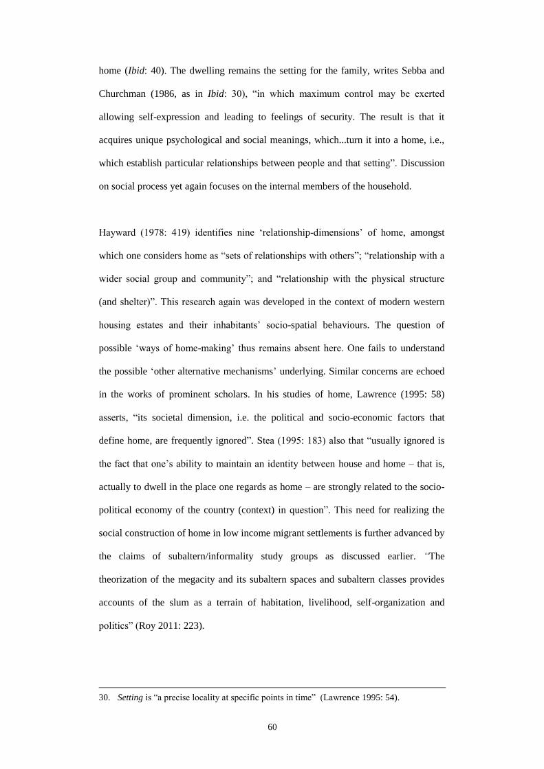
60
home (Ibid: 40). The dwelling remains the setting for the family, writes Sebba and
Churchman (1986, as in Ibid: 30), “in which maximum control may be exerted
allowing self-expression and leading to feelings of security. The result is that it
acquires unique psychological and social meanings, which...turn it into a home, i.e.,
which establish particular relationships between people and that setting”. Discussion
on social process yet again focuses on the internal members of the household.
Hayward (1978: 419) identifies nine ‘relationship-dimensions’ of home, amongst
which one considers home as “sets of relationships with others”; “relationship with a
wider social group and community”; and “relationship with the physical structure
(and shelter)”. This research again was developed in the context of modern western
housing estates and their inhabitants’ socio-spatial behaviours. The question of
possible ‘ways of home-making’ thus remains absent here. One fails to understand
the possible ‘other alternative mechanisms’ underlying. Similar concerns are echoed
in the works of prominent scholars. In his studies of home, Lawrence (1995: 58)
asserts, “its societal dimension, i.e. the political and socio-economic factors that
define home, are frequently ignored”. Stea (1995: 183) also that “usually ignored is
the fact that one’s ability to maintain an identity between house and home – that is,
actually to dwell in the place one regards as home – are strongly related to the socio-
political economy of the country (context) in question”. This need for realizing the
social construction of home in low income migrant settlements is further advanced by
the claims of subaltern/informality study groups as discussed earlier. “The
theorization of the megacity and its subaltern spaces and subaltern classes provides
accounts of the slum as a terrain of habitation, livelihood, self-organization and
politics” (Roy 2011: 223).
30. Setting is “a precise locality at specific points in time” (Lawrence 1995: 54).

61
Referring back to the problem statement and literature review, the most interesting
attribute of migrant settlements is their predominantly loose-fit and unorthodox
dwelling form, which can also be viewed as creative and often autonomous. The
flexibility of these forms owes to the ‘manageable presence’ of external elitist actors
and hence is shaped by the reciprocal decisions these actors and the migrants make.
Here constraints are used as advantages, while the distinct presence of many forms of
silent interactions continues to drive all forms of spatio-physical transformation at the
different levels of these settlements. It is the migrant-inhabitants, who’s compromises
and negotiations with both horizontal and vertical actors – both formal (governments
– central and local, NGOs) and informal (political leaders, businessmen, landlords),
which is maintained generally in socially amicable ways, becomes the most essential
of all social components determining the spatio-physical (i.e. planological)
transformation of migrant settlements.
These considered I refer to “THE SOCIAL CONSTRUCTION OF HOME” by Peter
Somerville (1997). This framework helps understand the societal processes of home-
making in relation with the spatial and phenomenological components. This
integrated framework examines the meaning of home in terms of a ‘socio-
phenomenological trinity’ namely: privacy, identity and familiarity as they make
sense of each other by complementing each other and combining variables from
allied disciplines (Figure 2.3). Here, privacy suggests mainly of the spatial notions,
identity refers to the psychological notions and familiarity to the social (relational)
notions. Since studies of home are commonly carried out with a phenomenological
focus, Somerville argues that a social dimension is also essential to comprehend the
meaning of home since a mere phenomenological dimension of home runs the risk of
neglecting the economic and material meanings and hence of becoming inept to
recognize the social relations behind the process of meaning making. A social
dimension, in addition to phenomenological dimensions, is capable of determining

62
social relations and/or tenure issues as in here, for example, as an essential social
process underlying home-making (Ibid: 231).
According to this framework, “each household makes its own world within
boundaries which it erects against the world outside. At this level, familiarity is most
strongly linked with privacy, because the power to exclude others is essential for
securing a place for one’s own (close kin), with shared personal activities, lifestyles,
furnishings, decorations etc. Success in creating such domestic familiarity however
requires certain economic resources and legal rights which act as the means to
support and manage a household; this also requires security of possession of a
dwelling for that household. Lack of such means or security results in homelessness,
and in such conditions domestic familiarity and privacy tend to break down, and the
identity of the household unit is also weakened. A reasonable level of household
income and security of tenure are therefore essential for domestic privacy, identity
and familiarity” (Ibid: 236). To forward this argument, focus is given on the ‘Privacy-
Identity’ pairing, since they link spatial with social – which is also the focus of this
Figure 2.3: The “social phenomenology” framework – showing three essential dimensions
for a “Social Construction of Home” (prepared in accordance with Somerville 1997).

63
research. Identity can be seen as a formation by the interplay of privacy practices
through social relations. The three components of the framework are:
Privacy is manifested in private specialized space – a sort of separation from rest of
the society leading to demands for privacy. Privacy is constructed through a dialectic
interaction between the inside and outside of a boundary of a particular type (e.g. as
room within a house or dwelling within the settlement etc.). The ability to remain
‘private’ demonstrates the power to decide for both individuals and households
whether or not to engage with strangers and to what extent. This ability guarantees
anchorage – a status mandatory for maintaining membership to a social network by
continuing economic and legal relations to gain economic benefits and legal rights.
For example, in modern day Europe privacy practices involve both physical and
psychological construction of boundaries.
Physical construction of boundaries takes place according to familial
and cultural ideology. It is due to the change in political and familial
structures in response to economic and social changes, rather than
physical or psychological ones that determine the meaning of home.
Privacy practices may be manifested in the creation of ‘front’ and
‘back’ areas of house, and through the different layout/spatial
arrangements (and subsequent rise and decline) of house spaces.
Semi-public or semi-private areas are used as contact zones, i.e. the
permissible/penetrable depth of space. Gendered spaces are
demarked according to gender or master-servant roles. Privacy is
about maintaining distance from neighbours and surroundings. In
some countries, public display and public recognition of household’s
private identity and social status is common; it demonstrates that the
extent of being private is also variable. For boundary control,
dialectic negotiation between ‘insider’ and ‘outsider’ takes place,
where both ‘insider’ and ‘outsider’ maintain their own roles and
contribute to create boundaries to achieve the desired level of

64
privacy. Privacy may also be achieved through the psychological
establishment of personal space (Ibid: 232-234).
Identity is formed through a process of “dialectic between self and other” for
individuals and households alike. It essentially involves ‘dialectic of boundary
control’ as works from allied disciplines show.
In social terms, identity is a product of ‘negotiation of boundaries’
between actors with different power status; identity is constructed
through the “articulation of pre-existing social relations, especially
those of class, status and power”. It thus remains more ‘external’,
while domestic privacy is required to ensure self identity. Identity
may also be constructed at the level of groups; it can be measured in
terms of relationship between one’s own (e.g. ethnic) social group
and others. Although not dialectical, yet the way boundary is
demarked and maintained is same as in phenomenological accounts
of self identity; social closure is required for group identity. At this
level of groups, the common identity stems “as a consequence of the
operation of a complex dialectics of appropriation within core ethnic
communities” with a shared historical experience and shared
association with a specific origin/homeland. Identity of a human
being as an autonomous individual is bound up with his membership
of a body of citizens who all own property (material and/or
intellectual) according to the same set of rules and laws. Identity,
however, stems essentially from the notion of ‘individualism’.
In phenomenology, identity forms from the “dialectic of
appropriation”, concerning “the acquisition of symbolic meaning
through changing transaction (interaction and interrelation) over
time”; identity is constructed from the viewpoint of the “conscious
subject”, thus making it more ‘internal’ in nature (Ibid: 234-235).
Familiarity is the maintenance of identity through “continuity and stability of
experience”; it is the loss of the familiar (for refugees or migrants driven out of home)
65
is a loss of identity to a considerable extent. Domestic relations are dominated by
familial structures; “the process of domestication involves familiarization – “the
process of creating and maintaining permanent relationships of caring, sharing, and
solidarity of feeling and action”.
Phenomenology – people, as individuals or as groups, feel at home
(private, familiar) if they are in control of their own boundary where
they can be themselves and they are being able to (re)produce the
world within this boundary they make.
Sociology – links between domestic and family relations create a
sense of familiarity; familiar are those locations in space where
regular activities are performed; time of regular activity also create a
sense of ‘place’. Stable kinship and other wider social relations as
part of a ‘network membership’ leads to “mutual familiarity”.
Frequency and regularity of intra-network transactions throughout
life is the key determinant of familiarity.
Anthropology – familiar is seen as a natural opposition to foreign,
alien, exotic while dialectic is understood in structural terms,
primarily determined by “structures of kinship”; familiarity is
produced by ritual (repeated acts) and by myth (inter-generationally
transmitted interpretive records or narratives) and essentially by
culture (a combination of practices, customs and traditions particular
to a certain group). However, at the level of groups it is
comparatively difficult to maintain boundary which is much easier at
individual and household levels.
Heterophenomenology – familiarity is produced by repeated
voluntary transactions within groups. Subjects make themselves at
home by “marking and safeguarding their own boundaries and they
manage this partly through repetitive behaviour and story-telling”.
Familiarity implies regularity of appearance. Exclusion of others (i.e.
ensure privacy by creating various forms of ‘boundary’ between ‘self
and the other’) is prerequisite to secure a place of its own at the level

66
of households; within households, it is the “shared activities,
lifestyles, furnishings, decorations etc.” amongst close kin”.
Successful creation of familiarity hence requires “certain economic
resources (income) and legal rights (tenure security) – means to
support and manage a household and the security of possession of a
dwelling”. Without these, “domestic familiarity and privacy tend to
break down and identity of the household unit is also weakened”
(Ibid: 235-237).
Going back to Somerville (1997)’s model, few mentions of an external force behind
the shaping of ownership is found. And when the issue of ownership in relation to
external forces is discussed, the experiences of the western democratic society (hence
‘formal’) does not help much toward the understanding of complex social processes
(politics) present in the pseudo-democratic and essentially class-based societies in the
developing world. It is therefore, even if “the sociological literature interprets the
meaning of home through sociological categories such as class, gender and tenure”
(Ibid: 229), they mostly use concepts of domestic (in-house) relations and household
structure rather explaining how in the developing world external (elitist) actors and
their networks fundamentally influence the process of ownership of land and houses.
Although many contemporary literatures discuss the effect of socio-political factors
in the shaping of home they again depend too heavily on western experiences (as in
Mallett 2004; Blunt A. and R. Dowling 2006). In other cases, they share experiences
from the global south but without any discussions on the influences of external social
relations on form-making (as in Dayaratne and Kellett 2008).
Adapting a Western model for the proposed research has other downsides too. Since
the life priorities of the western subjects are different compared to the slum-living
migrants from the developing world, any research on the meaning (and process)
associated with home demands for a change of priority while choosing variables.
While focus on psychological and phenomenological notions (e.g. security, status,
67
feminism etc.) dominate home research in the western context (Somerville 1997:
229), the issues of basic needs (e.g. ownership, accessibility, economic/livelihood
dimensions) find greater significance in the research framework for studying rural
migrants’ home and its spaces in the non-Western context. The nature of democracy
that is practiced in the developing world is also questionable compared to that of the
west; Rapoport’s question on “mechanism” hence probably bears greater significance
as in the cases of Khulna or in Kolkata (Roy 2004) than in western societies. It is in
these places social relations exogenous to the immediate level of the house tend to
play a key role in determining successful home-making. From a migrants’ perspective
and with reference to the context of class-based third world societies, Rapoport
(1995: 45)’s initial question could be further elaborated. Given the circumstances, it
should be asked: “What sort of social relationship link which classes of people to
what attributes of which setting, and through which (informal) mechanism and to
what effect (on the built environment)?”
This relationship, in which the urban poor in the developing world engages with the
powerful elite, is more complex and informal compared with its counterparts of the
west. The persistent acts of negotiation, resistance or compromise involved in such
processes hence demands for the further development of Somerville (1997)’s
framework. Even in the dearth of economic resources and considering the market-
turn of western societies, a typical western citizen is still benefitted by the
governments’ welfarist principles and rule of law. In the absolute presence of the
“formal” in western societies, the question of “possible mechanisms outside formal
means” hence is not an essential component, and understandably is difficult to find
out in the numerous frameworks of home proposed by western scholars.
On the basis of Somerville’s framework and in light of the literature review, it can
now be argued that the notion of privacy, i.e. the idea of being in a decision-making

68
position of one’s own environment, by being in control of tenure (an anchorage)
remain the most important ‘start-up component’ for home-making especially
considering the poor migrants’ socio-economic status. For the same reason, scholars
have viewed home tantamount to ‘ownership’, and affirmed its key role for security,
family and continuity of any household (Dupuis and Thorns 1996). These
deliberations also coincide with ‘the’ prime objective of home-making as found
earlier in the reviewed housing literature. Nevertheless, how one acquires the
ownership outside the formal mechanisms and hence continues to enjoy his/her claim
has not been elaborated and incorporated in Somerville’s model. This requires further
elaboration of the concept of Privacy in relation with the notion of ‘control’.
2.6 Privacy, control and territoriality
Privacy: is essentially an interpersonal boundary-control process that paces and
regulates interaction with others (Altman 1975: 10). Similar to the way the boundary
properties (permeability) in cell membranes adjust and shift to achieve a
desired/viable level of functioning, physical, social and psychological boundaries and
barriers are also used by persons and groups in response to changing circumstances to
control other’s access (Ibid: 27). Privacy hence can be defined as a “selective control
of access to the self or to the one’s group”. The following characterize privacy:
1. Privacy is of two types: “desired” and “achieved”. ‘Desired privacy’
is a subjective statement about how much or how little contact is
‘ideally’ desired at a given moment in time, while ‘achieved privacy’
is the actual degree of contact that results from the interaction with
external actors (Ibid: 10). If the achieved level of privacy is higher
than desired, a person or group can be seen isolated from the society.
If the achieved level is lower (as can be hypothesized of slums), the
situation can be termed ‘crowded’. Different reactions may occur
from the person or group to counter these situations. Attempts may
be made to reinforce the existing boundary or assume additional

69
boundary control mechanisms to address crowding. A person or
group may increase distance from others. He/she may use more
vigorous nonverbal behaviours to communicate undesired intrusion,
or may even put in clear territorial boundaries (Ibid: 8).
2. There are three reoccurring themes of privacy. One, the desire for
privacy – the most essential component of home-making involving
multiples social units or actors (e.g. the permanent migrant and other
elitist actors with varying interests, in this research). Two, analysis of
privacy and its boundary-control mechanisms need to be viewed as a
“bidirectional process”, (e.g. involving both inputs from external
actors to the migrants, and vice versa). Three, the definition implies
selective control (a dynamic process), where privacy practices
assume different forms in response to different circumstances over
variable periods of time (Ibid: 18).
3. There are also the “behavioural mechanisms” used by actors to
achieve their desired level of privacy. These mechanisms, which act
as an “integrative system”, are a combination of four components;
these are: verbal behaviour, nonverbal use of the body,
environmental behaviour (personal space and territory), and
culturally defined norms and practices. In many cases, these
components may substitute for each other (Ibid: 32). A framework
for understanding the nature of boundary control (for achieving
privacy) requires a focus on the ‘environmental mechanisms’. These
different levels, however, operate as a “coherent system” (Figure 2.1,
earlier) where one may substitute for another (e.g. appropriation of
roadside space using objects rather claiming it verbally). This
operation of the coherent system however shapes and is being shaped
by the concerned socio-physical environment (Ibid: 4).
Control: as a concept, control is related to dominance; yet it has a much broader
implication. It accommodates the influence that a person can have on other people, on
spaces, and even on ideas in both active (initiating or offensive) and passive (resistive
and defending) ways (Edney 1975: 1109). In the built environment, the key to

70
perceiving change rests in the idea of control. Control then can also be defined as the
ability of the actors (interested in the built environment) to transform parts of the
environment. Actors exercise control by many acts of inhabitation exerting formal
control means transforming. Alternatively, behind all transformation underlie the
intension to control. Any addition, subtraction, displacement or removal of physical
parts with or off the built environment involves some form of controlling actors – a
person, a group, an organization or an institution (Habraken 1998: 8). This invariably
brings on the discussion on territoriality, which involves “ownership or possession
and occasional active defence” by actors in control. Territorial behaviour as an
“interpersonal boundary-mechanism” is not simply confined within “keeping out”
somebody from one’s own ‘turf’ (Altman 1975: 104). Actors who territorialize the
environment bring individual interest to the field, and transform it to their likings,
using acts of personalization. These actors in control may contest for a particular
territory, while simultaneous communication, negotiation and cooperation take place
– keeping the environment in ‘equilibrium’ (Habraken 1998: 29).
Territoriality: the relation between territoriality and control can be outlined in
different ways. A territory may be viewed as an area controlled by an individual, a
family, or a collective body. Personal territory may be a private claim on space,
where the individual develops some form of comfort, control and tacit rights. Yet in
all cases, actors use their territories to increase power and control. Thus territoriality
can be defined as an act of achieving and retaining control over a particular segment
of space; for the latter, control is essential for achieving a fundamental goal of
humans, i.e. the freedom of choice in their environments (Edney 1975: 1109). If
territory provides control (i.e. desired level of privacy), people act tolerantly to crowd
and shorter interpersonal distances (Ibid: 1110).

71
Built environment can then be viewed essentially as a “territorial organization”, as a
space under the control of various actors/agents. In order to control form, the agents
must possess the capacity (read power) to transform space which is constructed by the
form under consideration. Transforming a “material configuration”, i.e. controlling of
form is a prerequisite for controlling space. “Control of space denotes the ability to
defend that space against unwanted intrusion. Space under control is territorial, and
distinguishing such territory is fundamental to inhabiting”. Territorial control,
primarily as an instinctive act is the ability to close a space for restricting entry
(Habraken 1998: 126). The very act of inhabitation i.e. that of occupying space and
selecting what comes in and what stays out is essentially territorial. Territory hence
can be recognized as space into which only certain items may enter. Following are the
typical attributes that associate territoriality:
1. A few common themes underlie the many definitions of
territoriality. One, territoriality is always referred to certain places
or geographical areas. Two, territorial behaviour serves a number of
socio-physical needs and motives. Three, all definitions convey the
idea of ownership of a place. Four, there are processes of
occupation and personalization (e.g. by spatial marking device
such as signs or fences) involved in all territorial behaviour.
Movement by outsiders across such boundaries take place with
caution and subject to permission only. Five, a territory may be a
domain of social units of varying sizes (a person’s place as a
bedroom, or a group’s place as house) (Altman 1975: 105). Six, in
the presence of territories, intrusion and defence is also natural;
preventive and marking behaviour is used to set up territories (and
hence personalize and symbolize ownership). Reactive or defensive
behaviours occur in response to actual or potential moments of
invasion (Ibid: 107).
2. Rules determine how parts are admitted or excluded from territorial
space (Ibid: 127). Various territorial acts, norms and customs, and

72
legal deeds are used to keep boundaries under control (Altman 1975:
128). Local enforcements, whether formal or informal, establish (the
allowable) territorial depth within broader urban fabric (Ibid: 145).
Form hierarchies eventually reflect the common values of agents
who within certain accepted constraints, mutually interact with
external material, technical and economic conditions.
3. Depending on the degree of control as practiced by occupants, and
also considering the relative duration of users’ claim to the space,
three types of territories are identified (Ibid: 111):
a. Primary Territories: owned and used exclusively by individual
social units (individuals or groups), and are clearly recognizable by
others. These are controlled on a “relatively permanent basis”, and
are central to the day-to-day lives of the occupants. One’s house is a
good example of a primary territory where “the identity of the owner
is salient, invasion or unpermitted entry by outsiders is a serious
matter, and control over access is highly valued”. These territories
are powerful privacy-regulation mechanisms, violation of which lead
to the (re)adjustment of boundaries. Unsuccessful readjustments for a
longer time lead to a lack of self-esteem and self-identity (Ibid: 112).
These territories are ‘places’, which evolve through gradual
personalization and control as practiced by its users. As an important
boundary-regulation process, this links privacy regulations, territorial
mechanisms and self-identity.
The idea of “interactional territory”, on the other hand, explains
how a social group’s “personal spaces” are formed and maintained,
surrounded by “an invisible membrane” rather than having
boundaries associated with objects and areas. These spaces have
elements of public access but also a degree of control by occupant
social groups. The restricted use of an area by individuals and groups
are ensured by a certain framework of rules. These are public level
personalization by groups rather than individuals that benefit the
group rather the individual (Ibid: 117). There is a greater mixture of
use of privacy-regulation behaviours, as people constantly adjust and
73
readjust to ensure adequate understanding of others’ boundary
processes and ensure proper communication of their own.
b. Secondary Territories: less central, less pervasive and less
exclusive. In ‘home territories’ as they are widely known, regular
users have relatively free access and a certain amount of control over
others’ use of space. Ownership and possession sometimes extend to
specific objects such as seats or tables in a public space, with certain
rules limiting the users from certain acts. Secondary territories act as
a bridge between the absolute control of primary territories and
almost-free use of public territories by all users. As boundaries are
continuously being established, tested and violated, confusion
regarding its threshold (and possible conflict between actors) may
arise (Ibid: 114).
c. Public Territories: are temporary spaces where almost everyone has
free access and occupancy rights. Occupancy of places such as
streets and parks is generally available without restrictions as long as
certain rules are adhered to. Although the individual has freedom of
access, he must refrain from certain actions and behaviours –
restricted by laws, regulations and cultural customs. Their access and
use are usually limited in time. Public jurisdictions, for example, do
not usually involve ownership or possession; rather, they control
only the right to access for a brief period of time facilitating a
particular purpose (Ibid: 119). In the absence of efficient boundary-
control mechanism in a public domain, people rely heavily on
alternative mechanisms to attain some degree of privacy (Ibid: 120).
The concept of “defensible space” explains how some undesignated
and ambiguous territories within a public realm generate social ills.
These places are not controlled by the residents – they are not
personalized and could not be easily watched by the occupants.
Secondary territories, because of their semi-public quality, thus often
have unclear rules regarding their use and are susceptible to
encroachment by a variety of actors with the use of a variety of
techniques. Studies show that a lack of surveillance, territorial

74
control and a less-than-evident territorial ownership or marking of
the place lead to cases of heightened crime rates (Ibid: 116).
Territorial encroachment has a negative connotation with regard to
territorial acts. These are spatial acts of violating a territorial
boundary by persons or groups for varying time periods aiming at
disrupting ongoing activities or literally conquering the place and
changing its owner. Thus Violation involves unwarranted use of or
entry into a territory. No specific territory owner remains in this case
except for only a culturally defined class of permissible users.
Invasion involves bypassing boundaries and interrupting someone or
taking over a territory of another person or group either on a
temporary or a more permanent basis. Obtrusion occurs when a
claimant exhibits territorial demands in excess of what is socially
acceptable. Although primary territories are not given up readily,
public territories are often given up in response to encroachment
especially if alternatives exist (Altman 1975: 121).
In all cases, boundary crossings produce situations in which achieved
sense of privacy remains less than desired. This leads to the possible
readjustment to the boundary system. As encroachment occurs,
reactive responses may range from repetition of the markings to
warnings and physical defence. Preventive markers can involve
symbolic or actual physical barriers and boundaries (e.g. fences,
hedges, signs, controlled access and guards etc.). Houses may often
be designed and sites planned to prevent physical and visual
encroachment, while objects may be used to mark the threshold of
public territories. Both verbal and non-verbal means are deployed in
their various mixes; hostile or questioning looks, glances and
gestures serve to warn outsiders. Cultural mechanisms, such as local
dialect may also be used to keep off potential intruders (Ibid: 123). If
continuous or serious violation into primary territories does tend to
occur repeatedly, rapid escalation or reactive responses may take
place culminating into aggression (Ibid: 125).
4. Territorial hierarchy is experienced as territories situate themselves
within larger territories. Through diverse inhabiting acts by different

75
actors, two or more territories may be housed under one large
territory without affecting the physical form. In addition, actors who
inhabit a particular territory maintain the right to control the
movements in and out of that territory as in a landlord-tenant
situation (Habraken 1998: 136).
5. Territorial depth is an important social indicator; it demonstrates
the underlying processes about how decisions are made on the
transformation of the built environment in the particular context of a
society. Two processes underscore these transformations. First, a
territorial power, subdivides its own space in a top-down manner to
create increased depth in order to enable more intensive use hence
leading to an increased density. Second, action is bottom-up, where a
number of “included territories” join together and appropriate their
own ‘personal’ space from more public space and hence increase
depth (Altman 1975: 214). Vernacular forms, which may also be
viewed as an outcome of communal preferences, also explain this
bottom up process. Although individual actors exercise individual
preferences, their acts typically conform to a socially determined
framework of rules and norms (Ibid: 227).
6. Depending on duration, territories may also be dynamic and its
territorial depth may cyclically increase and decrease with time (e.g.
a roadside stall) (Ibid: 160). Environmental order, regardless of its
particular form, is always a continuous chain of public spaces of
increasing territorial size (Ibid: 178). Territoriality is a complex
process that changes with time and circumstances. While certain
well-defined territories may exist, their boundaries may be flexible
and may shift and evolve in response to changing situations.
Territorial behaviours are also adjusted and readjusted over time and
work in combination with other behaviours (Ibid: 104).
7. Agents: In form hierarchies, physical parts and their configurations
are controlled by actors or agents. In territorial hierarchies, space is
controlled where form remains part of the controlled space. “Agents
controlling higher levels dominate agents controlling lower levels.
When higher-level agents control what goes into included territories,

76
included agents must, as a rule, accept the imposed limitations on
what filters through the higher level” (Habraken 1998: 139).
Eventually, dwelling proves to be a territorial act of occupation. It may involve a
single house or a room. House-building, however remains a “form-making act within
acquired territory. The resulting house form always remains open to territorial
interpretation”. It is therefore, various interpretation of a single house type, such as
shops, bakeries, and other residential scale commercial activities are common
(Habraken 1998: 154). Extreme changes in social organization following initial
occupancy may also trigger unforeseen variations in the original use and form (Ibid:
155). Once form is present, just as a container, “life makes use of it, adjusting it and
adjusting to it, offering ever-changing territorial interpretations within it’s relatively
constancy”. Territorial interpretation of a given form hence may lead to new forms
and new meanings (Ibid: 156). Given a fixed territorial structure, different forms may
also be placed in it. Various built forms and variable “control distributions” may go
with the same territorial structure. The building may operate in either territorial depth
but may also be controlled by outside actors (Ibid: 171).
2.7 Control and the social construction of home: the framework
In light of prior discussions, a framework is proposed here that aims to explain how
(and with what spatio-physical implication) a segment of permanent migrants in the
third world city have continued to enjoy ownerships of land and dwellings amongst
widespread resource scarcities and even without any formal/legal title. In that, a ‘five-
stage’ literature review has been carried out, in which: (1) contextual works (in
Bangladesh and Khulna) have been reviewed; (2) global-level theoretical and
empirical works from allied disciplines were studied; (3) discussions have been made
about how home is socially constructed with further elaboration of the concept of
privacy; (4) the concept of control has been discussed as both an object and subject of

77
privacy needs and practices; and (5) empirical-theoretical discussion on ‘territoriality’
has been used to establish ‘territorial practices’ as a way to studying various control
mechanisms. Figure 2.4 (overleaf) illustrates the conceptual derivation of ‘home as an
arena for various social controls’. It also identifies necessary indicators, depending on
which, a detailed study framework is proposed in the ‘Methodology’ chapter.
Figure 2.4: Conceptual model – “Control and Social Construction of Home” (prepared mainly
in accordance with Altman 1975, Habraken 1998 and Somerville 1997).

78
Chapter 3: Methodology
3.1 Introduction
This chapter details out the strategies and instruments for carrying out the research.
Initially, it begins with the further elaboration of the stated problem in Chapter 1 that
helps a better substantiation of the primary research question. The sub-questions are
then derived in line with the stated objectives and with the help of the conceptual
framework. Each of the sub-questions is followed by a brief discussion about their
respective aims and field of data that each covers. This is followed by an introduction
to the context, here Khulna, the third largest urban agglomeration in Bangladesh.
Immediately follows an introduction to the particular migrant settlements to be
studied and rationale for their selection. Discussions on research type and strategy
come next, succeeded by a brief discussion on research subjects (and their selection
rationale). The next two sections briefly discuss the research instruments and data
analysis framework respectively. After that, a ‘study framework’ is prepared which
outlines indicators and the concerned variables essential for data collection.
3.2 Research questions
This research, depending on the earlier theoretical and empirical studies, is premised
on the fact that rural migrants’ home-making occurs at the interstices of the formally
planned city (Dovey 2012), as the particular socio-economic-spatial realities of the
third world city lead them to assume a unique ‘informal’ way of life (AlSayaad
2004). Considering the fact that many of these migrants have been living in Khulna
for more than two generations now and many have managed to ‘own’ a house or a
plot of land even in the absence of the formal sector, this research begins by assuming
that the building and spatial habits demonstrated by them are in fact manifestations of
their unrelenting negotiations with other socio-economic-political actors. Such
negotiations have remained vital in compensation for the formal sector’s absence in

79
the delivery of land and dwelling units. Over the years, as demonstrated by Walton
(1992:132) and Watson (2009: 176) in similar third world contexts, the top down
policies have been implemented mainly to serve the formal sector economy and its
elitist proponents. This has been observed even in the ‘modern’ policies of the
European Colonia across the human settlements of the global south1. Yet, it is the
ordinary migrants marginalized by various forms of domination who still retain some
command to re-construct habitats (e.g. in the so called slums and informal
settlements), and play with and manipulate space to negotiate with authorities (as
described by Cupples 2009: 371 in similar contexts). In the present day, these
migrants have continued to influence the spatio-physical environments of the planned
city by transforming forms and spaces of their apparently ‘illegal’ habitats in a
manner described by Bayat (2000) as ‘silent encroachment’. These migrants may also
be engaged in activities in many visible forms and spaces (as in Tunas 2008) that
typically take place alongside formal sector developments and take advantage of the
‘loose’ formal system (Kudva 2009; Perara 2009). Ordinary people such as these
migrants make use of the apparently useless formal infrastructure of planning in
various imaginative and alternative ways which was not considered by the planners
initially (as highlighted by Koolhaas 2002: 179 and 184 in the case of Lagos).
Given these, a number of binary conditions (e.g. legality-illegality or formality-
informality) have come to coexist over the years, while it is the many spatio-political
manipulations of these binaries by both migrants and the elitist actors that have
guaranteed an urban home for the former and a greater political control of the
ordinary masses (e.g. migrants) by the latter. For this, often the formal bodies (e.g.
government offices, NGOs) act and operate informally, while the ‘informal’ migrants
try to obtain authorization from as many formal sector organizations as possible. A
1. Nahiduzzaman (2003) discusses a similar case of Bangladesh as elaborated in Chapter 4.

80
mutually beneficial socio-political arrangement between ordinary migrants and socio-
economic-political elites thus remains at work. This contributes to the spatio-physical
transformation of migrants’ homes (Figure 3.1). To avail public/formal sector urban
services and amenities (e.g. housing) in their absolute deficiency in the context of
Khulna, socio-political relation with influential elites hence has remained crucial.
Both synchronic and diachronic studies are therefore required that aim to investigate
the different forms of negotiation between the actors, their spaces, of the rules, and
the way they affect the built environment of the concerned settlements during
modernization and industrialization in Khulna.
This understanding is what led to the
formation of the primary question in
Chapter 1: what socio-spatial
mechanisms explain many homeless
rural migrants’ successful re-
making of home in the urban
context of Khulna, despite the
failure of Governments and private
formal sectors to provide low-income
housing during modernization and
industrialization in the third world
nations? This requires a historical
research; which has already been
identified in Chapter 2. A deeper understanding of the larger socio-economic-political
context thus becomes essential to fully appreciate the settlement- and household-level
spatio-physical transformation. It is realized that this transformation of Khulna’s
urban form needs to be looked at and assessed in relation with the ‘modern’ socio-
political doctrines to enable a better understanding of the processes underlying the
Figure 3.1: Problem statement in graphics;
showing the social-relation (with elites) – access
to land/housing – built environment triangle.

81
spatio-physical transformation at the level of migrant settlements. These considered,
the two sub-questions could be stated as in the following paragraphs:
Q1. In what ways have the ‘modern’ policy regimes contributed to the spatio-
physical transformation of Khulna’s urban form?
This question addresses the consequences of modernist land-related policies (and
politics) on the predominantly agrarian society of Bangladesh with a focus on
Khulna’s spatio-physical transformation. Here, ‘modern’ refers to the particular time
period that began with the post-Enlightenment England’s colonization of the Indian
Subcontinent in the mid-18th Century. It shows how a succession of top-down policies
targeting the agrarian countryside of Bengal (hence peasantry) had left grave
consequences for both its rural and urban areas. These transformations have also been
addressed in the case of Khulna. ‘Modern’ however also includes the postcolonial
policy environments in Bangladesh to date, which have all been influenced by global
neoliberal policy thinking focusing on economic growth, rational planning,
industrialization and need for modernization of the former European colonies. This
question therefore aims to assess how in the predominantly agrarian context of
Bangladesh, the market-driven land and housing policies by successive authoritative
regimes have deliberately created different forms of scarcity in the lives of peasant-
turned-migrants in Khulna. A premise becomes apparent where Khulna’s urban form
manifests as the outcome of the co-working of modernization-industrialization,
migration and politics triad.
Q2. What socio-spatial practices by the permanent migrant help control (hence
maintain ownership of) the spatio-physical boundaries of home during the
modernization-industrialization decades of Khulna?
This question is answered using a three-stage analysis of settlement history, spatial
practices and decision-making structure pertaining to the particular nature of spatial
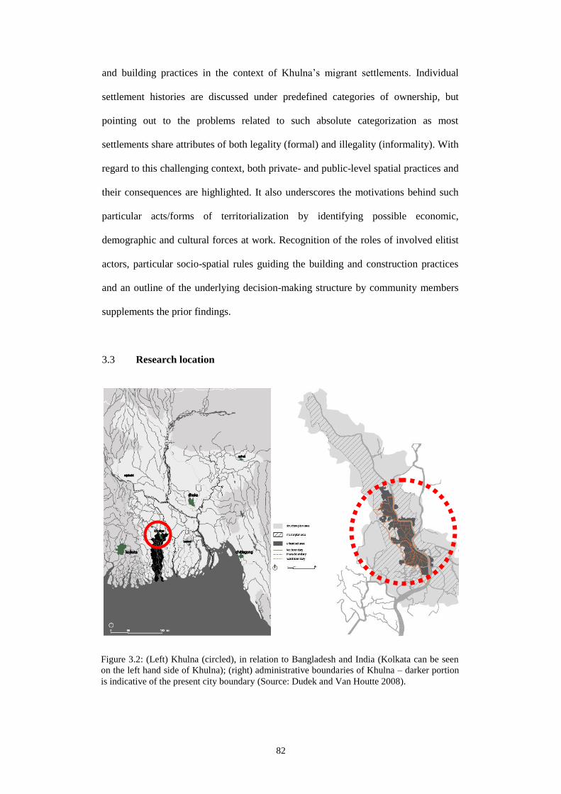
82
and building practices in the context of Khulna’s migrant settlements. Individual
settlement histories are discussed under predefined categories of ownership, but
pointing out to the problems related to such absolute categorization as most
settlements share attributes of both legality (formal) and illegality (informality). With
regard to this challenging context, both private- and public-level spatial practices and
their consequences are highlighted. It also underscores the motivations behind such
particular acts/forms of territorialization by identifying possible economic,
demographic and cultural forces at work. Recognition of the roles of involved elitist
actors, particular socio-spatial rules guiding the building and construction practices
and an outline of the underlying decision-making structure by community members
supplements the prior findings.
3.3 Research location
Figure 3.2: (Left) Khulna (circled), in relation to Bangladesh and India (Kolkata can be seen
on the left hand side of Khulna); (right) administrative boundaries of Khulna – darker portion
is indicative of the present city boundary (Source: Dudek and Van Houtte 2008).

83
This research has been carried out in Khulna, the third largest city in Bangladesh with
a population of around 2million and with a density of 67,944/km2 within 45.65km
2 of
its municipal area alone (KCC 2010). With its 37th ranking amongst the world’s
fastest growing cities (Citymayors 2007), it also has the highest concentration of
urban poor amongst all the coastal towns and cities in Bangladesh (Ahmad 2005: 16).
Khulna has one of the largest concentrations of “poor settlements” in the country as
well (5080 of varying size and classes), with half a million people living there
presently (CUS-UNDP-KCC 2011; Figure 3.3). Most of these ‘poor’ however are
recognized as ex-migrants (KCC-LGED-UNDP 2009). Following statistics give a
contextual understanding of the economic status of these ‘informal’ poor in Khulna
(and in Bangladesh) with regard to their home ownership2.
1. More than 20% of the
urban dwellers are landless
slum-dwellers in Khulna
(KCC-LGED-UNDP
2009); amongst, 27% ‘own’
a house of some sort while
66% remain as tenants
(Ahmed 2005: 10).
2. More than 60% of the total
national stock is owned
property – rest belong
mostly to the central
government; more than
90% of these owned
properties are built by the
informal sector (GoB-ADB
1993: 2-4).
2. National level data is used where local level data was unavailable.
Figure 3.3: Present
Khulna characterized
by mosaic-like (dots)
distribution of ‘poor’
migrant settlements
within formal
developments, home to
half a million migrants
(KCC-LGED-UNDP
2009).

84
3. Low income groups constitute around 70% of the entire population
in larger cities like Dhaka but manage to enjoy only around 20% of
its total land area (Hoek-Smit 1998: 15-16 citing Islam 1986); in
terms of national average, less than 30% of these poor people are
actually owners of some kind of land. Other forms of tenure include
tenancy in private house and government housing, sub-tenancy, rent-
free stay, illegal occupation and pavement dwelling (WB 2007: 36).
The trend however is that the more expensive living in a city,
diminishing is the rate of ownership. In cities like Dhaka, around
53% of the migrants live in private slums, while the other 44% squat
on public land. Commonly, about 14m2 space is being enjoyed by a
family of five members (Afsar 2003: 4).
4. Average income for a migrant slum dweller in a typical Khulna slum
is between BDT3000-4000 (USD42-55) (Hasan 2003: 43); the
informal sector provides 85-90% of national urban employment
(ADB 2009: 13; 20); the contribution of informal sector to GDP is
around 63% (Ibid: 22).
3.4 Settlement-selection and settlement types
Considering the perspectives of the disciplines of economics and politics, the tenure
status of land or house, with its implications for personal control, is considered as the
most critical element that defines “what makes a house a home” (Johnson 1971, as
cited in Lawrence 1995: 55). Differences occur within and between cultures in terms
of ownership of houses (Ibid: 56). For example, the term home is used by Turner
(1976: 81) to indicate something to possess, while Hamdi (1991: 165), uses
‘ownership’ as an adjective to home. Similar can be said of other prominent scholars
such as Habraken (1998: 79) and Patton (1998: 268), who associate the terms
‘ownership’ and ‘tenure’ respectively to designate home. Similar has been echoed in
the works of De Soto (2001: 7-8). The conceptual model in Chapter 2 also identifies
‘control’ as the key element for home-making – pointing essentially to the need for a
secured tenure and hence the need for ownership as the key prerequisite for home-

85
making and continuity. This research remains interested in the migrant-dwellings and
settlements that have been owned, formed and maintained by the ordinary ‘ex-
peasant-turned-migrants’. Ten (10) migrant settlements (Figure 3.4: numbered dots)
of varying population size and land area (Figure 3.5) are hence selected based mainly
on the nature of ownership each of these settlements and their inhabiting migrant-
owners enjoy. The key area of interest remains in the ways each of these settlements
has succeeded to attain the present form of ownership using various socio-spatial
negotiations during the post-WWII years of modernization and industrialization in
Khulna.
The preference for this phase
of urbanization history is
simple. It is during these
particular years, two
significant global economic
doctrines (ISI and SAP) have
fundamentally affected the
spatio-physical environment
of this once little town of
Khulna by initiating
industrialization through the
establishment of a number of
large-scale public and private-
sector industries, chief
amongst which were Jute and
Shrimp processing industries
respectively (Figure 3.4:
Figure 3.4: KCC jurisdiction map; green dots
(numbered) show locations of 10 migrant settlements.
Red and yellow dots show locations of post-partition
(public sector, mainly jute) and post-SAP (private sector
export-oriented, mainly shrimp) industries respectively
(Source: Map courtesy KCC 2012).
Migrant Settlements
Post-partition industries
SAP-industries
4
2
1
5
3
6
7
9 8
10
0 1km

86
smaller dots). It is during this particular period of time, massive inflow of rural to
urban migrants (mainly as factory workers and industry-related ‘support’ workforce)
to Khulna surpassed all previous instances of urbanization. From 1961 to 1974,
during the first phase of industrialization when public-sector industries (mainly Jute)
were thriving, Khulna’s population grew from 60,000 to 420,000. The population
further rose to 850,000 in 1998 (from 550,000 in 1981) (KDA 2002: 40) owing
mostly to setting up of private sector shrimp processing industries (export oriented).
As discussed, it was during these two phases when most of these selected settlements
matured and became home to half a million low-income migrant population in
Khulna.
Figure 3.5: Growth of migrant settlements: alongside industries (post-partition: 1, 2, 4; post-
SAP: 7, 8, 9); on Bangladesh Railways land (3, 10); on site and service plot (6); on private
property of city periphery (5) (Source: Image courtesy Google Earth 2012).
1 6
2 7
3 8
4 9
10 5

87
3.5 Research considerations
This section outlines the strategies and instruments intended for this research. As part
of this proposed methodology, it covers the research type, research strategy and the
key considerations for data collection and analysis.
3.5.1 Context of research method
The research is essentially exploratory as it seeks to understand the ‘compensatory’
(and often alternative) socio-spatial processes underlying migrants’ home-making in
the ordinary third world city, and hence reveals the un-anticipated. In that, it assumes
a qualitative stand, using qualitative means for data collection and analysis and an
overall qualitative methodology. In a few occasions during analysis, some numbers
are referred to. But these numbers are not claimed to be representative; rather, these
are generated from the different phases of the fieldwork, and are intended only to
supplement the arguments and findings. The strategy for this research is a
combination of deduction and induction3, although it commences with the former.
Relying initially on a range of theoretical and empirical reviews from
multidisciplinary sources, it defines the ‘problem’ and proposes its own framework
(control-social construction of home framework in Chapter 2) to facilitate data
collection from the particular context of Khulna’s migrant settlements. With regard to
this framework, the systematic analysis of the initial findings in Chapters 4 and 5 lead
to the identification of a number of themes and threads, which are further analyzed
and refined to propose (inductively) a new theoretical area (Scarcity-negotiation) in
Chapter 6. This however, contributes to the original conceptual framework as well.
Eventually this research proposes a framework (Home-negotiated control) consisting
of a number of hypotheses – only to be tested further and hence to be developed into
a potential theoretical premise.

88
3.5.2 Strategy: combination of synchronic and diachronic
This research is both diachronic and synchronic. It relies on historical data for
constructing the backdrop against which the effects of various land-related policies
on ordinary peasants’ (and later migrants’) lives are assessed. A five-phased analysis
of historical trends (beginning with British colonization of Indian subcontinent in
1757 by the East India Company) is carried out using secondary sources. At the level
of settlements and households, histories of both dwelling- and settlement-
transformations are collected and accounted for. Focus is given on post-WWII
decades because this is when modern urban planning and industrialization started
taking place in Khulna. Historical information remains necessary for understanding
the various socio-spatial negotiations between different actors at these two levels of
migrant settlements. In both cases, primary and secondary sources are used
simultaneously to complement each other. Particularly at the level of households,
present spatial practices for territorial control by migrant-owners are also recorded
and analyzed in-depth. In some cases, migrant-landlords’ tenants’ spatial practices
are also collected and analyzed. Information is collected more in a biographic-
ethnographic manner using both architectural and non-architectural instruments. A
combination of these two approaches allows for a comprehensive understanding of
both depth and breadth of ordinary migrants’ home-making efforts and its associated
socio-spatial processes.
3.5.3 Types and levels of settlements
Investigations in Khulna’s migrant settlements, in-depth studies on households and
dwelling units, and their spatial transformation are used in this research to
demonstrate a correlation between land/housing politics and more successful
migrants’ socio-spatial negotiations. This research is hence scoped for studying types
3. Qualitative, open-ended, circular, iterative (generating and continually testing working
hypothesis), rooted in lived experience, flexible, changing design, knowledge generating

89
of migrant settlements at their different scale levels. As discussed earlier, it
commences by identifying a number of available types of low-income settlements in
Khulna, as these different types are considered as the centre of different home-
making efforts. Types are defined according to tenure status of the resident migrant.
Since ‘tenure-status’ is the ‘essential’ element for home-making, it remains, in this
research, the primary criteria for initially selecting and later categorizing of the
selected settlements. This different ownership types also benefit a comparative study
and reveal how different settlements facilitate home-making differently. For example,
a tenure-secured settlement, when compared against another with unsecured tenure
reveals of a different socio-spatial negotiation process. When assessed historically,
such comparative study between settlements reveals different forms of home-making
using different processes and with different spatio-physical consequence. This also
makes organization and categorization of similarities, differences and unique socio-
spatial attributes of each of the settlements and individual dwelling units possible.
Generally, socio-spatial aspects of migrants’ dwelling environments in Khulna are
assessed in relation to three hierarchical levels of home: ‘house’, ‘house-
neighbourhood’, and ‘settlement-city’. This is facilitated by the theoretical discussion
on home, which establishes home as a larger system beyond the mere level of the
house. There is however another level beyond the city (migrants’ rural home), which
is also referred to in a number of occasions; the primary aim of making reference to
this particular level is to observe whether or not and to what extent migrants’ present
socio-spatial practices are correlated with the practices of their rural place of origin.
Since migrancy associates multiple-belonging (e.g. migrants’ remain influenced by
both their place of origin and present domicile), spatio-physical outcome of migrants’
home-making efforts should therefore display some sort of ‘hybrid’ forms, spaces and
spatial practices. Considering the migrant as a ‘vehicle’ of multiplicity and
and participatory (Jennings 2005: 29).

90
movement, it seeks for the spatial-physical manifestations of a possible relation
between migrants’ rural places and practices within their present dwelling
environments.
Additionally, literature reviews are carried out to understand the national-level land
and housing policy environments in relation with dwelling-level spatio-physical
transformations – thus maintaining a constant reference with supra-national (global)
socio-economic policies and their consequences.
3.5.4 Assessing spatio-physical to understand socio-political
Although this research does not assume his methodology, it shares the same
‘environment first’ position of Hillier (2008: 216), which views “social processes” as
evidence of spatial forms in the built environment. Based on the conceptual model
and its spatio-physical variables, it commences initially by collecting
data/information on the spatio-physical attributes and looks into the above mentioned
levels of built environment that migrants produce. It is only simultaneously or later,
the social mechanisms (social activities, interactions and structures) are assessed
against these already recognized spatio-physical attributes. Data collection and
analysis focuses on spatio-physical and socio-political aspects (Figure 3.6).
3.5.5 A perspective from below
The research assumes a more ‘bottom-up’ approach that takes account of migrants’
interpretation of their own socio-spatial environments pertaining to their home-
making. Although additional information on urban history, policy environments and
elite actors’ roles are gathered using both primary and secondary sources and
methods, migrant spaces and their physical forms remain areas of primary interest.
For an understanding of migrants’ lived spaces and forms, their own versions of their
home environments become crucial. And particularly considering the contextual
91
factors (local cultural aspects, mid-sized city, Muslim majority locality etc.) and a
lack of research on rural migrants’ dwelling environments in the third world city, a
bottom-up approach is assumed appropriate for this research.
3.6 Research population and sampling design
3.6.1 ‘Permanent migrant’ as subject
This research is primarily interested in the dwelling environments of the more
successful and permanent of the migrants in Khulna. The subjects for this research
are the migrants who were once-homeless in their rural home, and later migrated to
Khulna and have been living with their families in this mid-sized third world city for
at least two generations. By using the term ‘successful’, particular reference is made
to those migrants who despite their dubious tenure status (illegal or lease-holding
without documents) currently enjoy some form of ownership and possession of a
piece of land, or a dwelling unit (preferably constructed using permanent materials)
or both. Especially considering that these particular segment of the migrated
population is unlikely to go back to their villages since many of them does not have
any land or homestead to return to, their selection for this research gives an
opportunity to understand their inevitable home-making efforts in Khulna.
Other forms of less-permanent migrants are not of interest to this research
considering their variable presence, lack of belonging, non-availability of data and
time constraint. And albeit many nature-driven forced migration (IOM 2009: 260-
262) and seasonal ‘pushes’ continue to send people to cities like Khulna, such
movements do not necessarily imply that these ‘neo-movers’ would stay permanently
(especially considering the recent developments in transport/communication
networks; see Hakim 2010: 72). All these short term or iterative movements however
demand for additional research.

92
Since there are no established parameters to define ‘permanent’ in relation to
migrancy, the criteria of the ‘two generations’ in fact places a useful bracket to
include the significant decades for this research – belonging to global socio-economic
policy thinking under Neoliberal conditions. This becomes particularly important
because it is during these decades under market economy when most notable rural-to-
urban exodus in history took place in the third world cities. As the pace of rural-
urban migration is believed to have decelerated (Hogan and da Cunha 2001: 7736), it
becomes crucial to find out about this particular generation of migrants’ assimilation
process, who came to Khulna in response to a particular phase under market
economy, yet denied of any residence by the proponents of it (i.e. formal authorities
who decided to go for market economy instead of retaining a welfarist stance).
3.6.2 Units of analysis and sampling quantum
The primary unit of analysis for this research is the individual migrant household. For
that, 34 dwelling units (4-5persons/household) are studied. These are selected from
10 different settlements, categorized according to the nature of tenure enjoyed by the
resident migrants living there. Individual history of each of these settlements is
collected focusing on their spatio-physical transformation in relation with the socio-
political forces. An additional 57 households (4-5persons/household) were surveyed
during the pilot fieldwork that helped refine the final data collection framework and
also the triangulation of the finally collected data for better validity. Another 10 focus
group discussions were also conducted in each of the settlements. Finally, a total of 6
key personnel were interviewed that includes a KDA Urban Planner, an Ex-
Councillor from present opposition party (BNP), a UPPRP personnel (Settlement
Improvement Assistant or SIA), an urban historian, one senior resident of Khulna (an
Ex-refugee from Kolkata, and later Jute Mills employee), and one shrimp industry-
owner.

93
For selecting particular migrant owners, targeted sampling has been used4. Initially,
snowballing technique was used by establishing contact with one migrant and later to
reach other migrants from his/her same regional origin using his/her social network.
While selecting migrant-owners and their households, variety was maintained. For
example, migrant owners were selected according to religion (Muslim, Hindu and
Christian), gender (male or female headed households), or headship (leader of the
community) and ethnicity (Bihari or Bangali). It was ensured that households with
variable in-house income generation sources (e.g. presence of tenants, shop-houses
etc.) are also included in the study of individual dwelling units.
3.7 Data collection: strategy and tools
Considering the units of analysis and the sorts of data required, this research
primarily makes use of a biographic approach (using a combination of social and
architectural methods) for collecting in-depth information on selected households. In
addition to this, a number of supplementary instruments are also used for collecting
both architectural and social data/information. Phased-out and sequenced fieldtrips
remained the main strategy for data collection. A total of 12 months out of a total 48-
months PhD candidature were used for data collection through a number of fieldtrips
to the aforementioned migrant settlements in Khulna. In terms of the fieldtrips, a
reconnaissance fieldwork was initially carried out in the first year of PhD
candidature. A second exploratory survey was conducted in the second year; Annex:
Tables 5, 6, 7 give details of all of these field-trips. In all cases, different settlements
(according to tenure types) were looked for, resident migrants were discussed with
and social networks were established. These trips also helped identify a few threads
and themes, which, during the final phase of data collection appeared useful as they
4. Targeted sampling is a prescriptive sampling procedure, and to some extent purposive as
well, which is used in the field as a means of systematic targeting to reach specific
subjects (Wilson 2005: 49-50) as required for this present research (i.e. permanent
‘successful’ migrants).

94
provided with necessary directions to further modify and amend the preliminary data
collection framework. Two more field trips (5-months each) were carried out in the
final two years of candidature. A 6-months evaluation period between these two
phases was planned and carried out. This helped assess the quality and quantity of the
collected data, and also the appropriateness of the data collection instruments for the
first phase of the final fieldwork. This helped make necessary adjustments for the
final phase. Following sections briefly outline the data collection methods and the
tools/instruments used in this research.
3.7.1 Literature review
A number of relevant literatures were reviewed initially for problem identification. In
addition, further reviews were conducted to construct the conceptual model in
Chapter 2. To facilitate the understanding of national and international policy regimes
particularly concerning the land and housing sectors in Bengal and Bangladesh, a
review of historic documents and relevant literature were used as secondary sources
in Chapter 4. Archived materials (e.g. historical maps of Khulna) were also used as
necessary.
3.7.2 Life history and everyday life
Biographic research “seeks to understand the changing experiences and outlooks of
individuals in their daily lives, what they see as important, and how to provide
interpretations of the accounts they give of their past, present and future” (Roberts
2002: 1). Biographic method particularly involves life stories and oral history (Miller
2008: 61), which this research used mainly for household-level and settlement-level
data collection respectively. Considering migrancy (whose both past and present
home-making efforts are essential), both methods proved useful since both of them
seek to provide accounts of “how people make sense of their lived experiences in the
construction of individual and social identity”. The contextual location of a life story

95
also allows exploring “the generative interplay between individuals and culture that
characterize a life history”. By positioning descriptions of everyday life within the
contexts in which they occur, life history narratives convey a sense of how individual
lives are socially constructed (Gough 2008: 484).
Everyday life techniques hence seek to understand “social experience based on how
people do and experience social life”. It studies social interaction in a natural
environment, and provides a “realistic reflection of life rather than an oversimplified
and generalized version” (Boylorn 2008: 306). It focuses on details and seemingly
insignificant occurrences that collectively contribute to the understanding of how a
situation, a phenomenon or an occurrence is interpreted and experienced. This
method is particularly chosen because it encourages “diversity”. It is widely used
“among marginalized groups to privilege their personal perspectives and viewpoints
that might otherwise be silenced and misinterpreted” (Ibid: 307). For this research,
information on everyday practices for personal space and territorial control was both
collected using thematic semi-structured interviews, field notes and non-participant
observation (no active participation by researcher)5.
3.7.3 Mapping and architectural drawings
The locations of migrant settlements noted for spatial practices in the migrant
households were mapped in Khulna. Other sites, which are of importance for
migrants’ everyday livelihoods (e.g. sites with religious significance or sites for
economic production), are also identified in the settlement-level maps. With
reference to the indicators identified in Chapter 2, migrants’ building activities and
spatial practices at household-neighbourhood sections and individual settlements are
also recorded. Zeisel (1984: 89-90)’s techniques for “observing physical traces” are
5. This method is particularly highlighted by Altman (1975: 127) for territoriality studies.

96
hence used for particularly studying the house interiors and the house-neighbourhood
sections to find out the spatio-physical ‘traces’ of migrants’ various territorial
behaviours, practices and rules – that have rather consciously or unconsciously been
“left behind”. These are both identified and documented. A number of questions such
as “how an environment got to be the way it is”, “what decisions its decision-makers
and builders made about the place”, “how people actually use it”, “how that
particular environment meets the needs of its users” – were considered while
illustrations and detailed architectural drawings were prepared particularly for the
house-neighbourhood sections of migrant settlements. In addition, annotated
diagrams and field notes were taken alongside the architectural drawings. Ample
photographs and video recordings were taken equally of house interiors and house
forms, neighbourhood sections and of the overall settlements. These proved
beneficial (supplementary) later during the off-site refinement and finalization of
architectural drawings and diagrams.
3.7.4 Community level group discussion
Focus Group Discussions (FGD), which capture real-life (qualitative) data in a
participatory social environment, are conducted in the presence of a small group.
FGDs help “learn about the biographies and life structures of group participants”; in
the presence of a ‘moderator’ (here the researcher), information from the participants
are drawn out on topics which are of interest to the research (Berg 2001: 111). FGDs
were used for collecting settlement history mainly, although some helped understand
the spatial practices as well. FGDs were conducted with the non-participating
households. For this particular research, FGDs helped draw out the same information
on settlement history (oral history), social relations and community (decision-
making) structure but from a group’s perspective, which individuals (household)
provided later. Thus it helped better triangulation of the same household-level data on
various socio-spatial aspects.

97
3.7.5 Key informant interview
As discussed in the previous section, a number of informants (other than the
migrants) were interviewed using a thematic semi-structured questionnaire. KDA’s
Urban Planner was interviewed to understand the actual planning process by KDA
and grasp KDA’s ‘real’ motivation behind the way they plan. The Ex-Councillor
from present opposition party (BNP) was also interviewed since in many occasions
his name came up as a patron while working in settlements 2 and 3. His interview
was also necessary to understand a mainstream politician’s view of these settlements
and his role in their decision-making structure. Similar remains true of the shrimp
industry-owner whose socio-political role in the operation and sustainability of
settlements 2 and 3 was of interest. The UPPRP official (SIA) was interviewed to
collect initial working information on various tenure types and cross check the
validity of the primary findings following the pilot surveys. The urban historian was
interviewed to cross check the validity of secondary data on Khulna, which are used
particularly in Chapter 4. Finally, the senior resident was interviewed to understand
the context of post-WWII refugee movement, his settling down process in Khulna as
part of a refugee family from Kolkata and also to understand the housing condition of
the public sector Jute Mills where he was an employee.
3.8 Data analysis and interpretation
Data on Khulna’s migrant settlements is analyzed covering three spatio-physical
levels (household, neighbourhood and settlement), while the findings span across
chapters 4 and 5. For initial analysis and categorization of data/information, three
particular methods are used in this research. These are descriptive morphology (focus
on socio-political-spatial history of settlement transformation), everyday spatial
practices and social world analysis. Commonly recurring themes and threads in
chapters 4 and 5 are finally interpreted in Chapter 6, using common and disparate
codes, categories, similar phrases, and patterns of relationships in terms of spatial

98
practices. In all analysis however, reference is
constantly maintained with the roles of involved
agents/actors, social practices, customs, rules and
decision-making structures (Figure 3.6). The term
socio-spatial is used frequently throughout this
research much like an oxymoron. All spatio-
physical indicators for grasping the territorial
practices by the migrants therefore are
supplemented by social indicators.
3.8.1 Settlement morphology (settlement history)
In built environment studies, Urban Morphology is defined as a science of studying
“the material built-form of urban landscapes and…explaining variations in urban
form through historical processes and social agency” (Bauer 2006: 316). Urban form
and its processes of formation and transformation are therefore defined by the acts of
‘agents’6. The interest here is then in those who have agency in the urban landscape,
and how much influence they exert in matters of decision-making, both individually
and as groups. Urban transformation is traced here by examining the nature of
everyday changes occurring to built environment (e.g. incremental expansions over
time) rather than by authoritative plans. In the historical studies of urban form, the
concern for agency also prove vital as it recognizes cultural and social processes
shaping urban landscapes in the past and also as it links particular periods of urban
formation and transformation to certain agents (as in Ibid: 67). Considering that urban
morphology aims to “explain the mechanisms of evolution or creation and
transformation of urban forms” (Levy 1999: 81), the recognition of agents’
contribution and the diachronic reading into the spatio-physical transformation of
6. The ‘direct’ agents are the landowners, developers, architects/planners, and whose
activities can be examined by using documentary sources.
Figure 3.6: The correlation
between ‘social’ and ‘spatial’ in
the analysis of collected data.

99
individual migrant settlements and house-neighbourhood fabric in Khulna seem
appropriate.
This leads to the preparation of maps, plans and sections, and a description of
settlement/household transformation history (descriptive morphology). A descriptive
approach, although supplemented by present analytical maps and photographs, makes
sense because of a lack of historic morphological maps of these settlements. Analysis
of Khulna’s overall urban transformation helps identify the historical land/housing
policy environments and show how they can be viewed as deliberate constructions by
powerful regimes with political implications. An analysis of individual settlement
histories, which classifies them according to existing tenure categories, also advances
this claim; a further analysis identifies problems with this categorization.
3.8.2 Behavioural regularities of everyday life
There is the individual lifeworld and the collective structure of shared meanings that
are derived from the lived experience of everyday practice (Knox 1995: 217). It is
through the actual day to day activities and strategies that people negotiate “shared
everyday realities, routines and ideas” (Gurney 1999). In terms of the research
question on ‘territorial practices’, the built form may suggest of a territory, but it is
the ongoing acts of occupation that fix and maintain the actual extent of claim. The
actual boundary is indicated less by the acts of building but more by the lower-level
configurations and parts by the everyday acts of individuals or groups (Habraken
1998: 130). In addition to descriptive morphology, Everyday life method is also
chosen for this research because of its focus on details, and on the sameness and
difference. It also makes connections and associations between emergent and
repetitive themes, and make comparisons between existing theories and territorial
practices by the migrants to control various boundaries of their urban home. Everyday
life approach is also useful for analyzing qualitative data since it enables the
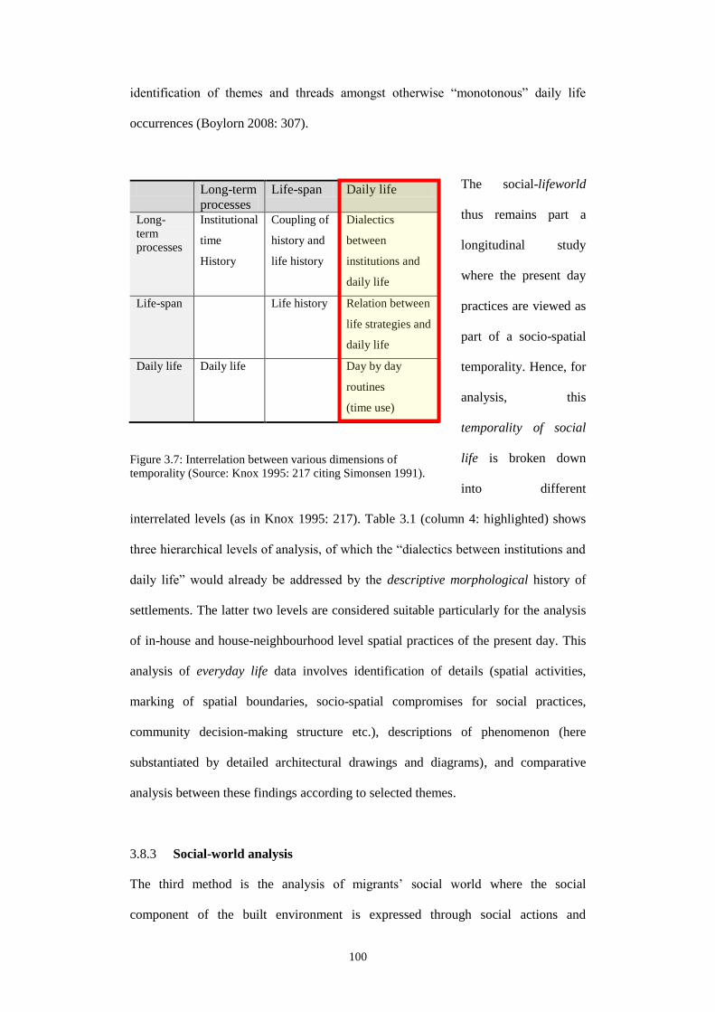
100
identification of themes and threads amongst otherwise “monotonous” daily life
occurrences (Boylorn 2008: 307).
The social-lifeworld
thus remains part a
longitudinal study
where the present day
practices are viewed as
part of a socio-spatial
temporality. Hence, for
analysis, this
temporality of social
life is broken down
into different
interrelated levels (as in Knox 1995: 217). Table 3.1 (column 4: highlighted) shows
three hierarchical levels of analysis, of which the “dialectics between institutions and
daily life” would already be addressed by the descriptive morphological history of
settlements. The latter two levels are considered suitable particularly for the analysis
of in-house and house-neighbourhood level spatial practices of the present day. This
analysis of everyday life data involves identification of details (spatial activities,
marking of spatial boundaries, socio-spatial compromises for social practices,
community decision-making structure etc.), descriptions of phenomenon (here
substantiated by detailed architectural drawings and diagrams), and comparative
analysis between these findings according to selected themes.
3.8.3 Social-world analysis
The third method is the analysis of migrants’ social world where the social
component of the built environment is expressed through social actions and
Long-term
processes
Life-span Daily life
Long-
term
processes
Institutional
time
History
Coupling of
history and
life history
Dialectics
between
institutions and
daily life
Life-span Life history Relation between
life strategies and
daily life
Daily life Daily life Day by day
routines
(time use)
Figure 3.7: Interrelation between various dimensions of
temporality (Source: Knox 1995: 217 citing Simonsen 1991).

101
Figure 3.8: A typology of informal relationships (Source: Herbert and Thomas 1990: 262).
interactions. As Herbert and Thomas (1990: 261)’s model (Figure 3.7) points out, a
study into such interactions takes account of a number of origins and destinations and
also of the flows (e.g. past influence from rural times in the migrants’ lives).
Theoretically, sociable relationships are purposeful and voluntary; they exclude
business or contractual transactions, while relations are based on systems of exchange
and familial/kinship ties. Attention is given to the different roles (of the involved
agents) that bring into play varying levels of social interaction. Some of these roles
may be separated from another as others may well overlap but each contributing to
the multiplicity of social relationships which form the base of interaction (Ibid: 262).
For the present research, ideas are taken from this above model considering the
presence of a number of agents/actors in the different migrant settlements and the
way these agents have been contributing to settlement sustainability even if most of
them are viewed as ‘illegal’. This method of analysis is used to identify particular
actors/agents and their particular nature/level of influence in community’s decision-
making structure and their diverse forms across different migrant settlements (as in
Chapter 5, Section 5.4).
3.9 Study framework
Table 3.2 summarizes the overall methodology for this research in light of the earlier
discussions. Necessary indicators and variables are also mentioned.

102
Table 3.1: Study framework for proposed research
Questions
Socio-spatial practices at different levels of migrant
settlements to control spatio-physical boundaries of
home (hence maintain ownership) during post-
WWII decades under modernization and
industrialization
Khulna’s spatio-
physical
transformation under
modernity
Indicators
Variables
Sub-
variables
Subjects
Analysis
method
Sampling
quantum &
unit(s)
Instruments
Territorial practices for
boundary control
Decision-making
processes
Settlement
transformation T
erri
tori
al o
ccup
atio
n
and
per
son
aliz
atio
n
Nee
d f
or
terr
ito
rial
izat
ion
Dy
nam
ics
of
terr
ito
rial
bo
un
dar
y
Act
ors
Ru
les
Ter
rito
rial
hie
rarc
hy
Dec
isio
n m
akin
g
stru
ctu
re
Urb
an l
evel
sp
atio
-
ph
ysi
cal
tran
sfo
rmat
ion
Ind
ivid
ual
set
tlem
ent
lev
el s
pat
io-p
hy
sica
l
tran
sfo
rmat
ion
Per
sona
l sp
ace
and
pri
mar
y t
erri
tory
Ter
rito
rial
pra
ctic
e an
d p
ub
lic
terr
ito
ries
Boun
dar
ies
bet
wee
n s
ettl
emen
ts a
nd
ou
tsid
e w
orl
d
Con
textu
al a
spir
atio
ns
Incr
emen
tal
gro
wth
Inco
me
gen
erat
ion
So
cial
gai
ns
Neg
oti
atio
n o
f te
rrit
ori
al b
oun
dar
ies
(Acc
ord
ing t
o t
ime,
chan
gin
g d
emog
raph
ic
circ
um
stan
ces
and c
ult
ura
l cu
sto
ms)
Set
tlem
ents
, nat
ure
of
ten
ure
and
inv
olv
ed a
cto
rs
Rule
s fo
r n
ewer
co
nst
ruct
ion
Rule
s fo
r ex
ten
sion
of
exis
ting
buil
din
gs
Rule
s fo
r co
mm
un
ity l
evel
co
nst
ruct
ion a
nd s
pac
e u
se
Cu
stom
ary n
orm
s an
d c
ult
ura
lly
app
roved
pra
ctic
es
Typ
e o
f le
ader
ship
/hea
dsh
ip &
lev
el o
f sp
atia
l co
ntr
ol
Hie
rarc
hic
al d
ecis
ion
mak
ing
str
uct
ure
Var
iati
on
s in
dec
isio
n m
akin
g s
tru
ctu
re
Evo
luti
on
of
sett
lem
ents
(Mig
ran
t-te
nan
ts’
arri
val
an
d d
emog
raph
y;
nat
ure
of
ten
ure
; p
atro
niz
ing
act
ors
and
thei
r co
ntr
ibu
tion
)
Gro
wth
tre
nd
(Set
tlem
ent
size
an
d s
pat
ial
dis
trib
uti
on
; sp
atia
l
rela
tio
n w
ith i
ndu
stri
al/e
cono
mic
pro
duct
ion
sit
es
Pla
nnin
g a
nd
po
licy
env
iro
nm
ent
(Po
licy
; m
aste
r pla
n;
by
-law
s)
Migrant households; migrant community (settlement-wise)
groups; political leaders; NGO personnel
Political leaders, NGOs,
urban historian, planning bureaucrats
Settlement and dwelling history; everyday territorial practices;
social world analysis
Urban history; descriptive
morphology
- 10 migrant settlements
- 10 FGDs (7-8persons/group) - 55 households
- 34 house-neighbourhood tissue
- Urban Khulna
- 10 migrant settlements
- 6 key informants
Architectural drawings, maps,
diagrams, illustrations,
photographs, videos
Structured and semi-
structured interviews,
FGDs, diagrams
Literature review,
structured interviews,
maps, diagrams
Po
st-C
olo
nia
l
Ea
st-B
eng
al
&
Ban
gla
des
h
(19
48
-Pre
sen
t)
√ √ √
Pre
-Co
lon
ial
Ben
ga
l un
der
Bri
tish
Ru
le
(17
57
-194
7)
X X √
Theoretical
threads
Negotiated control of the boundaries of urban home
as a response
Scarcity as a
constructed condition

103
Chapter 4: Urban form in Khulna
4.1 Introduction
The primary aim of this chapter is to situate migration-driven urban spatio-physical
transformation of Khulna within the wider politico-economic context. This chapter
describes how various policy ideas, conceived at the global level, have continued to
influence local level policy thinking, leaving grave consequences particularly for the
land administration sector in agrarian Bangladesh. This chapter hence focuses on
understanding this historical backdrop, i.e. the local (municipal and national)
economic and political circumstances in relation with the global, which eventually
resulted in mass emigration and became the key driver for the evolution of third
world urban form as experienced in Khulna.
Based on both primary and secondary data, discussions begin with an examination of
the impacts of post-enlightenment Europe’s modern socio-economic policies (to
promote trade and maximize their own economic gains) on the predominantly
agrarian socio-spatial structure of Bengal1. The following section highlights the
socio-spatial consequences of ‘modernization doctrines’ on the landscapes of a
decolonized (post-WWII) East Pakistan (pre-independence name of Bangladesh).
These doctrines, however, were again promoted by the western think-tank as a ‘cure’
for their economically ailing former colonies. Discussions on a post-liberation
Bangladesh make up the final sections, where impacts of globalization and the free
market on the rural and urban socio-spatial structures are highlighted. For all of these
phases, national-level consequences are supplemented by evidences of Khulna’s
spatio-physical transformation. Finally, the summary section draws upon the
1. Bengal refers to the Mid- and South-Eastern deltaic location of the undivided Indian
subcontinent – formed at and around the estuarine confluence of the great Ganges-
Brahmaputra river system. This area, following the partition between India and Pakistan
in 1947 was divided into two separate provinces for these two nations assuming the

104
argument that urban spatial transformation in Khulna (and indeed in Bangladesh) can
be seen as a consequence of deliberately manufactured policy environments where
resources were unevenly distributed, and where specific groups of people or their
settlements were denied access to scarce resources (chief amongst which is land)
while prioritizing and often fulfilling the objectives of various top-down projects of
elitist actors (both local and global). Population displacement of various forms
(including rural-urban migration) and their settling down process can also be seen as
a product of such unevenness, inequalities and manipulation of insufficiencies.
4.2 Modern doctrines of transformation
4.2.1 Bengal under East India Company (1757-1947)
In order to maximize British commercial expansion across Europe, market-oriented
consumerist policies were conceived in Great Britain following ‘industrial revolution’
(Xenos 1989: 8). It is through the East India Company (EIC), this policy was infused
into its Indian colony (which Bengal was part of) leading to a systematic replacement
of its traditional agricultural products (silk and cotton). Cropping pattern was altered;
cultivation of ‘cash crops’ such as indigo and jute were prioritized to feed British
mainland industries and benefit their export to European markets (D’Costa 1994:
701-702). British planters, to maximize production of indigo, forced the local
peasants to reduce the cultivation of rice and cotton (Nahiduzzaman 2003: 58). EIC,
which initially monopolized Muslin2 trade, later preferred creating a new market for
British textile products following industrial revolution by replacing the same Muslin.
Hundreds of handloom factories were force-closed while those who resisted had their
fingers and arms amputated (Ibid: 48). EIC’s reversal of trade policy – from buying
export-oriented finished products to buying raw agricultural materials for being
names West-Bengal and East- Pakistan respectively. Following a bloody war, East-
Pakistan once again got liberated from Pakistan in 1971, which now is Bangladesh.
2. A high-quality cotton-based fabric produced by East-Bengal weavers that were worn even
by the European royalty.

105
processed in Kolkata and to be sent to Britain later – led to the “de-urbanization at the
periphery3 and overcrowding at the old core” as experienced in larger urban centres
like Dhaka. Heavy duties were also levied by the Company on locally manufactured
agriculture-based products (Ghafur 2010: 3-4).
Role of smaller urban centres, which were once producing cotton- or silk-based
products themselves through the efforts of traditional craftsmen and artisans, hence
were reduced to raw material collection and export-oriented processing. “Instead of
serving as nodes for stimulating growth in peripheral areas, cities in Bengal served as
satellites to the ports that were themselves satellites to the metropolitan economy”.
Port-oriented suction process thus had distorted urbanization of the Eastern part of
Bengal (D’Costa 1994: 702). A more exploitative relation, as in a centre and
periphery was created replacing the long established symbiotic one. Railways
connected only those parts of East Bengal to Kolkata that used to produce products of
British interest. These deliberate acts of “supply chain disruption” and “dislocation of
industries” in most parts of the country created a disjuncture between raw materials
and their local industrial base (Opcit.).
Meanwhile in the rural hinterlands, further socio-economic disruptions were also
taking place. To raise revenue base for EIC, a new breed of revenue collectors called
the Zamindar was officialised through ‘Permanent Settlement Act’ in 1793 (Ray and
Ray 1975: 82-83). Although Zamindars acted similarly as local-level tax collectors
for the earlier Mughal rulers, their roles and territories had now been re-defined under
EIC in the shape of British ‘estate and landlord’ system. The idea was to raise the
‘productivity’ of land by identifying all land as taxable property. Permanent
Settlement Act thus dispossessed peasants of their ancestral land that they were in
3. Nahiduzzaman (2003: 48) also reports that shutting down of Muslin factories left
hundreds of associated artisans and traders jobless; most of them went back to agriculture

106
control for generations; ‘land’ suddenly became a commodity – the “property of the
Zamindar (while) the landlord became the landowner; land now was bourgeois
landed property” (Bose 1986: 4). This act also led to the situation of “endless
exploitation and repression” in terms of relation between Zamindari and its subjects
(peasants). Although Permanent Settlement Act fixed a maximum revenue collection
slab for the Zamindar, it did not do so for the peasants. The revenue collection right
of the Zamindar hence left him free to charge any amount of rent from his peasant
subjects (Nahiduzzaman 2003: 51). The EIC also abolished the village Panchayet
system and other traditional social institutions, which the Mughal rulers effectively
used “to promote social stability and perpetuate the existing order” (Ibid: 48).
Through the inaction of Permanent Settlement Act, class division was also elevated to
a new height in an already predominantly class-based society. Most Zamindars came
from former Hindu royalty or from the ritually high-ranking literati of Hindu priests,
scribes or physicians (Bose 1986: 84). On the other hand, most of the Raiyats
(cultivator peasants) were Muslim (Nahiduzzaman 2003: 49). Two other important
groups also became important: Jotedar and Bapari/Mahajan, and Bhadralok. The
Jotedar were the rich Raiyats who held large chunks of land through long-term lease
from the city-living Absentee Zamindar4; who would later sub-lease this land to
peasants and sharecroppers, and lend money to peasants in high interest. The Bapari
and Mahajan were the traditional trader/merchant class5 who became enormously
wealthy after being appointed by the EIC to supply raw products and marketing
European commodities. Since EIC had never allowed this class to become their
competitors by setting up industries themselves, later in the early 19th century many
amongst these wealthy merchants purchased portions of Zamindari from the
while the rest had to take up other related jobs in crowded urban centres.
4. Who would actually live in the city/towns and visit his estate in selected times of a year.
5. Some were also the former Nayabs, i.e. the local administrators for absentee Zamindars.
There were also the Mathbars – the local community leaders (Ray and Ray 1975: 84).

107
declining larger ones, and became petty Zamindar themselves (Ibid: 49). However,
the situation of common peasant remained unchanged, if not declined.
Khulna, once a small trading centre for wood, fish, honey and salt, grew in
importance after EIC first set up a riverside ‘guard post’. It was followed by the
setting up an Indigo factory near the existing bazaar, re-named later as ‘Charlie’s
haat’ after the EIC official Mr. Charlie (Figure 4.1: left). This officer brought along
with him from India, a tribal group called the Harijan6 – a lower Hindu caste, who
formed the main labour force for him as locals were not willing to engage into indigo
farming initially.
The growing importance of Khulna drew in a batch of rich immigrants from
Rajasthan known as Marwari who soon became the key driver for Khulna’s economy
and patron to many of Khulna’s spatio-physical transformations (e.g. by making
donations to erect academic and religious buildings, public parks; building housing
6. Harijans can still be found living in clusters in different areas of Khulna employed mostly
in locally perceived ‘lower-level works’ such as sweepers and cleaners. One such group
has been identified by this research, who are living in one of the 10 studied settlements
(Pach No. Ghat – Harijan Para).
of
Figure 4.1: Khulna urban-form: (left) pre-colonial; (right) under EIC
(Source: Reconstructed after Miah 2002).

108
Figure 4.2: (Left & middle) BIWTA rest-house built on the remains of Mr. Charlie’s
residence and office; (right) Colonia-influenced house once owned by Mr. Shailen Ghosh, an
affluent Hindu Zamindar who left Khulna after partition; house was later taken over by
Muslim League leader Mr. Khan-E-Sabur (Source: left & middle – Apurba Kumar Podder;
right – Hafizur Rahaman).
for their own etc.). The Marwari, located mainly in Boro Bazaar and Daulatpur
(Figure 4.1: right), controlled most businesses in Khulna, and followed their own
traditional way of life. It was these people, who also introduced Panchayet (a
community body of elites) to existing Khulna society (Miah 2002). Khulna’s
proximity to Kolkata (capital of British East India: 1772-1911) turned it into
Kolkata’s most important hinterland.
With Kolkata’s industrialization, Khulna became its key supply centre for raw
agricultural products including jute. As Figure 4.1 (left) shows, the initial
introduction to modernization by then had already instigated different forms of
population movement and subsequent spatial transformation in Khulna. Rural
landless peasants had already started forming small village-like clusters on this
flourishing town’s periphery, while Marwari enclaves, shop-houses and warehouses
were erected near river-side trading locations (Ghats). Non-white elite class (traders
and Zamindars) were also erecting lavish ‘Bungalow hybrids’ along the colonial
enclave to demonstrate their intimacy with the colonial masters. These also helped
them express their newly acquired socio-economic supremacy over the rest both
spatially and materially (Reza 2008: 15; Figures 4.1 and 4.2).

109
4.2.2 Bengal under British Raj (1858-1947)
The taking over of India from EIC by the British Empire led to some other significant
moments of scarcity in the lives of the ordinary. Following industrial revolution,
towns and cities were to be reconceptualised as distribution centres for mainland
industrial products while “docile city dwellers (to) becoming potential consumers”
(Ghafur 2010: 4-5). Again, ‘improvements’ were uneven at the level of the city; only
the economically and politically suitable centres (such as Kolkata, Dhaka, and later
Khulna) were under consideration. However, this mode of thinking about the city
dweller and driven by the “Victorian zeal for cleaner habitat” led the colonial rulers to
a feeling that the Indian society, now living in towns and cities, need to be sanitized
through “sanitation-taxation-pacification”. This of course enhanced security and
surveillance for the elite class while eventually creating a deeply divided
(Chakravorty 2000: 65) ‘dual’ city7 (as in ‘white city’ and ‘black town’; see Bissell
2011: 210). These division lines or the ‘cleavages’ of duality was characterized by
differences of settlements’ physical quality, services, used technology, social
structure and way of life in general (Ibid: 209). This duality was evident in Khulna
too (Figures 4.1 and 4.2: right). A fortified colonial enclave could by now be noticed
along the riverside, in contrast with a number of village-clusters on the faraway
western side of the city.
As Miah (2002) reports, these ‘informal’ villages were home to most of the city
dwellers. Essential for Khulna’s economy, these villages housed the service people
for the colonial masters and wage labourers for river-based trading. Yet municipal
services were never extended to them. However, at the first half of the nineteenth
century, another new class of English educated (westernized) government officials
7. See Figures 4.2 and 4.3; they show how the scheme of a ‘divided city’ was articulated
even in Khulna during Colonial rules.

110
emerged who were called the Bhadralok8 (read ‘gentlemen-class’) (Nahiduzzaman
2003: 50). This group, attuned to colonial doctrines, also called for an improved and
western-style living condition (e.g. planned residential areas) prompting a Master
Plan adoption for major cities (Ghafur 2010: 4). They mimicked British Master’s and
Zamindar’s bungalows and erected them alongside the ‘white enclave’. In 1884,
Khulna was declared a municipality, while a rail network was laid out to connect it
with Kolkata promoting further riverside trading activities and formation of newer
habitats9.
4.2.3 Bengal as East Pakistan (1947-1970)
Decolonization of Indian subcontinent led to the formation of Muslim-majority
Pakistan. The separation from India in 1947 was based on the claim that the Muslim
minority had never got their fair share of social, political or economic fruits by being
discriminated by Indian Hindus, and neither would they if things stay as it was. So
Pakistan was born with two ethno-geographically distant parts: East- (now
8. It refers to those Indians who since the 1820s started acquiring their education based on
English language and culture. This neo middle-class “formed an autonomous social
group, (and) was internally consistent and differentiated from the other component parts
of the social body”. These “westernized” elitist Indians came mostly from the traditional
high casts (e.g. Brahmins) and “filled the bureaucracies of any existing Indian state”.
However, questions were raised about how much westernized these class could become
with regard to the “British standards of fairness and justice” (Torri 1990: 2).
9. This was also probably prompted by the ever declining socio-economic conditions of
rural peasants. Nahiduzzaman (2003: 60) reports that although the Permanent Settlement
Act was abolished and tenancy rights (opening up of a rural land market – ability of
peasants to sell or mortgage land that they previously leased from Zamindars) were given
to the Rayats through the Tenancy Act of 1885, the situation still benefitted the Zamindars
and Jotedars more than the Rayats. The enactment of Tenancy Act was in fact a more
‘political response’ to many events of peasant protests and resistance movements in
Bengal that were ongoing for decades. In reality, most Rayats were poor; to deal with
sudden hardships, borrowing money from or selling/mortgaging lands to Jotedars were
the only options available. Eventually, many of these Rayats became landless and turned
into the former’s agricultural slaves. Zamindars, on the other hand, were still given the
authority to collect rent from Rayats. Tenancy Act, although clearly gave them power to
increase rent in certain situations, left no provision as such for the Rayats. The obvious
reason this policy was biased because Zamindars had their representatives in the policy-
formulation process while peasants had none. So as this systematic exploitation
continued, it was by the first half of 20th
C, most of these Rayats would become heavily
indebted to the moneylenders while 74.6% of them downgraded to landless farmers (only
7.7% held land of 10 acres or more). In 1930s-1940s Khulna, 51% of the peasantry was
either sharecroppers or agricultural labourers (Ibid: 61-62).

111
Bangladesh) and West-Pakistan. In the East, Muslim peasants were the majority,
while a vacuum in leadership was still there as the educated elite class was
represented by the Hindu Zamindars, who, after partition had already migrated to
India. In the West however, the already existing Muslim landlordship was joined in
by rich Muslim immigrants from India following partition. Thus the West Pakistan’s
predominantly elitist political leadership, bureaucracy and business class continued to
dominate and exploit the resources of the agrarian East – much in the same way the
Hindu elite were doing prior to partition (Choudhury 1972: 243-244). Thus, this
period akin to prior times, had once again already started experiencing a scenario of
unequal socio-political relation between East- and West-Pakistan.
The policy thinking during Pakistan was also influenced by post-WWII global hype
for modernization and industrialization, and a subsequent shift of focus away from
agriculture. During this, it was widely held that transformation of former European
colonies from traditional to modern would enhance the latter’s productivity and help
global (read Anglo-European) economy to thrive (Leys 2005: 109-110). There were
imperatives to promote industrialization (both state-led and private sector driven) by
the military-backed national government of Pakistan in order to fulfil its own needs
for revenue, to create an ally with business elites, and also to satisfy important foreign
donors. Again, it was the East’s agrarian social system that was affected and became
subject to exploitation. West-Pakistani businessmen used to invest in the
industrialization of the East (e.g. Jute) and take the profits back to the West and
invest in West’s infrastructure development and industrialization. Reminiscent of
colonial times, raw agricultural products were exported to West Pakistan to support
its own industries, while East Pakistani businessmen were only allowed to market the
products produced by the West. Revenue collected from the Eastern industries was
used mainly to finance military expenses and industrialization in the West
(Naziduzzaman 2003: 70-72). Importance of rural agriculture and various livelihood

112
needs of its tenets were again systematically overlooked by the ruling regime.
Although 55% of the nation’s entire population lived in East-Pakistan, central
government’s development expenditure (and the bulk of foreign donations) here
seldom crossed the 30% mark. While East-Pakistan typically earned 50-70% of
Pakistan’s total export revenue, its share of import remained around 25%; the net
transfer from East to West during the 20+ years of nationhood was worth USD2.6
billion only (Morris-Jones 1972: 198-199). It is because of this largely one-way
transaction, revenue generated from agriculture and agriculture-based industries once
again failed to benefit the actual producers – the peasants and the ‘modern’ factory
worker respectively. Particularly, the urban factory worker continued to remain
homeless although industries were making good profits10
. On the other hand, without
any real incentive from agriculture turned into ‘surplus labour’ in his own home, and
assumed the name of ‘homeless migrant’ while in the city.
Immediately following the partition of Pakistan and India, Khulna experienced two
significant forms of population movement in addition to its already familiar rural-to-
urban labour movements. The partitioning was both preceded and followed by violent
communal riots11
on both sides of the border, prompting mass exile of both Hindu
and Muslim population (later termed as refugees) in and out of both Pakistan and
India. The bordering districts of East Pakistan (as Khulna was) received most Muslim
refugees who came mainly from the Indian states of West Bengal and Bihar. Oral
histories collected during fieldwork (Hakim 2012) suggest that two types of Muslim
10. As early as in 1950’s, East Pakistani Jute mills were supplying 75% of total global
demand for Jute (Sengupta 1971: 2279).
11. Riots were politically fuelled, particularly by the Muslim leaderships of undivided India
leading eventually to the massacre of tens of thousands of people each side of the border.
The key intension was to demonstrate to the British Viceroy of India (who was also in
charge of a peaceful British exit from India following the post-WWII crisis in Britain) that
Muslims and Hindus would never be able to live alongside each other peacefully and a
partitioning of India according to religious lines was inevitable. As the dominant Hindu
leadership opted for an undivided India, it was the socially and politically oppressed
Muslim populations, whose voice was politically exaggerated, used and later culminated
into massive acts of violation involving both parties.

113
refugees settled in Khulna. The first type was the Bangla-speaking and better
educated ones who could easily mix with the locals. As they settled in, they would
spread out all over the older core area of the city. Many of these in-coming refugees
exchanged houses and properties with the outgoing Hindus, while many others were
able to make a claim on the abandoned Hindu properties through the ‘help’ of local
political figures12
(Figure 4.3). The second type of refugees was the non-Bangali
Bihari. Despite Muslim, it was due to their different cultural background (e.g.
different dialect), the Biharis could not mix easily with the locals like the Bangla-
speaking ones could. They were also less educated and came mostly from rural Bihar.
Similar to some of the rural migrants in Khulna, nearly 15,000-20,000 of them came
in quickly and suddenly, and hence had to settle themselves in clusters of slums and
squatters near the city centre (Miah 2002: 66).
12. This informal process was further helped by the enactment of a curious law called Enemy
Property Law, which gave the state absolute power to confiscate or appropriate any
landed property in the ‘interest of the Muslim state’ owned (previously or presently) by
any Hindu personnel. The term ‘Enemy’, quite obviously, pointed to any existing or
exiled Hindu personnel. The informal processes of obtaining abandoned properties, it is
locally believed, were benefitted by the inaction of this law.
Figure 4.3: (Left) Khulna Master Plan 1961 (industrial area in yellow) (KDA 2002a: 11);
(Right) Khulna under British Raj (in accordance with Miah 2002).

114
By 1947, Khulna would already become the major jute trading centre for Kolkata,
where trading houses and processing industries were mostly owned by the Hindu
Marwari. However, after partition, most Marwaris left Khulna, while their businesses
were taken over by the state. Basing on Khulna’s reputation and its well established
trading network, the first state-owned Jute Mills was established in Khalishpur area in
1952. An additional 11 of such mills followed while other heavy industries – owned
by both public and private sectors, such as Jute Mills, Newsprint Mills, the
Hardboard Mills and the Shipyard also started operating under state ownership (Miah
2002: 67; Figure 4.3). A few other private-sector industries were also established – all
along the either sides of the river.
By this time however, Khulna had already earned its name as ‘the industrial town’ of
East Pakistan. The second sea port of the country was also established near Khulna.
With the establishment of each of these industries and a simultaneous inattention to
rural agriculture and agricultural peasants led only to the increase of rural to urban
exodus. Setting up of the formal sector industries in response to ISI13
thus pulled in a
large number of rural landless peasants to Khulna. What were only 42,000 in 1947,
Khulna’s population grew to almost 100,000 in 1961 (KDA 2002a: 40). It is during
this phase of rapid urbanization in Khulna, the 1961 Master Plan14
was prepared. The
plan was designed in the manner similar to those schemed for British towns during
late 1940s to 1960s (Chaudhury Undated: 1-2; Figure 4.3 - left). In 1961, Khulna
13. Import Substitution Industrialization was a neoliberal economic policy that advocated for
the replacement of major consumer imports by promoting domestic industries (textiles,
household appliances etc.) aided by protective tariffs and quotas to help new/infant
industries (Ahmed and Sattar 2004).
14. Master plans were ‘imported’ both in the newly independent states of India and Pakistan,
and were viewed by their respective political leaders as a key instrument for modern city
development (it was also during this same time when Chandigarh was planned in India).
In East Pakistan, they were initially designed by a British consortium of consultants for
three fastest urbanizing cities in the 1950s and 1960s (Dhaka, Chittagong and Khulna).
Master plans however, were statutory tools introduced by the British with the aim to re-
construct Europe from the rubbles of WWII. They were the physical interventionist
instruments and often with political implication, which made use of zoning, density
control, building regulation and planning standards for projecting development.

115
Development Authority (KDA) was established with their stated aims of “Urban
Planning; City Development; and Development Control” (KDA 2012). KDA was also
in-charge of executing the Master Plan.
Noteworthy about KDA’s Master Plan was the fact that it completely failed to project
the rate of urbanization and sort out the type of housing that would be mostly needed
for a rapidly industrializing Khulna. Rural landless peasants to Khulna15
started
settling down in numerous slum-like settlements in and around the city. A new
township was also laid out in Khalishpur in 1962 – alongside the industrial
establishments (Figure 4.3: right). Semi-permanent houses on small plots of land
(140m2) were constructed and allotted to more than 2,329 Bihari families in a
subsidized price (Miah 2002: 68). A number of larger plots were also developed in
anticipation of accommodating an upcoming affluent class of white collar migrants
employed mostly as officials in the nearby industries.
Altogether, another created condition of scarcity becomes evident here. Housing,
which in modern conditions was considered a state-responsibility and the
precondition for welfare and social control (Ghafur 2010: 5) thus remained elusive
for those who deserved it most. Neither the central government nor their local
administrators or political machinery did anything effective to house the key force i.e.
the migrants behind a labour-based economy. As it appears, the planning and laying
out of Khalishpur Township not at any point was prompted by the need for housing
these mass of migrants who were the essential workforce for Khulna’s industries.
Rather, it appears more as a political project of the pro-Muslim central government
(and its local political leaders), which, driven by the newly acquired zeal of a Muslim
15. Most of these migrants actually originated from three particular coastal and riverside
locations, which until now have remained the exclusive hinterlands to Khulna in terms of
migrant-sending (Angeles et al. 2009: 18).

116
nationhood laid out Khalishpur rather eagerly to house the Bihari refugees instead of
the poor local migrants (Figure 4.3: right). The laying out also had uprooted the local
residents of Charerhat and Khalishpur villages as local stories suggest. And even if
Khalishpur Housing Estate - a concern of National Housing Authority (NHA),
developed small-sized apartments for the lower-income groups at a later stage, the
supply and affordability was always on the shorter side compared with the actual
demand from the lowest-income groups (e.g. the migrants).
Although state-owned, the nearby Jute Mills did not provide much accommodation
for their workers either. Only around 528 rentable ‘flats’ were constructed in
Khalishpur during 1961-1964 targeting the low-income industrial workers (Miah
2002: 112). But these numbers were far from adequate when compared against the
actual demands from another few thousands lowest ranking factory workers and other
migrant population employed in the ‘informal sector’ all over the city. ‘Informal
settlements’ therefore had developed within the ‘planner’s grid’ of Khalishpur to
accommodate these thousands of migrant workforce. Migrants who could not manage
a job in these formal sector industries used to settle in other riverside (and most cases
peripheral low-lying) locations such as Boro Bazaar (Figure 4.3: right) and in
peripheral villages such as Tootpara, from which other informal job locations (e.g.
riverside wood business) were nearer.
4.2.4 Post-liberation Bangladesh (1972-mid 1980s)
The politico-economic landscape of Bangladesh during the decade following 1971’s
War of Liberation can be viewed as a clear case of failed Governmentalism and an era
of unfulfilled promises from an otherwise idealist regime. In terms of housing
provisioning for the masses of migrants, the situation remained unchanged if not
worse. Globally, 1970s was a time of economic downturn (most prominent was oil
crisis), growth in international financial transactions and rise of MNCs (Gleeson and

117
Low 2000: 270). In planning terms it was time that saw the “...rise of neoliberal
ideology (which) challenge(d) the notion of ‘the Plan’ as superior rationality”. All
forms of regulation (e.g. zoning) were questioned, while the benevolent role of
governments “as a provider” was severely criticized. It was a “world of continuing
change” where localities would be shaped by global forces (Castells 1992: 76).
In a debt-ridden Bangladesh of 1976-1990, World Bank and IMF continued to press
governments to adapt to the free trade environments for setting up export-oriented
(e.g. RMG, shrimp etc.) sectors, even if their establishment in certain locations could
be illegal in Urban Planning terms. They demanded of the governments to become
more market-oriented by relaxing tariff barriers and hence ease imports. De-
nationalization of state-owned industries and trading; de-regularization (removal of
government’s presence from price control), and liberalization of agricultural sector
(now agricultural goods could be imported even if at the cost of sacrificing local
agricultural sector) was also experienced (Ahmed and Sattar 2004: 11). Compared to
the earlier episodes, a much greater number of landless peasants therefore made their
way in to the Bangladeshi cities including Khulna. Table 4.1 summarizes the
correlation between various policy environments of this period and their impacts on
rural peasants’ and city-living migrants’ lives, and hence to the general urban form in
Bangladesh (Khulna’s case is referred where available).
Table 4.1: Moments of scarcity and urban form (1972-1990) (Prepared in accordance
with Afsar 1999: 237; Ahmed 2003: 298-299; Ahmed 2007; Choguill 1993; D’Costa
1994; Karim 2007; KDA 2007; Khanam 2004; Miah 2002; Rahman 2007; WB 2007).
Time
period,
regime
Key idea and
intension
Impact on
peasant/migrant
Urban spatial
impact and
Bangladesh/Khulna

118
Post-
liberation
1972-1973
- Idealistic but
whimsical
development scenario,
without required
resources and without
any realistic plan for
implementation
- Urban authorities
aimed to control
squatter settlement
growth
- Public delivery of
multi-storied
‘cooperative’ flats
targeting the neediest
emulating, but quite
superficially, the
‘Singapore model’ of
hosing for all
- Mass in-migration
after 1971 war of
liberation and 1974
floods added to
existing housing
shortage
- Inadequate job in
public and private
industries
- insufficient housing
even for formal
sector workers
- Flawed tenant
selection process:
invasion and project
abandonment
- Creation of housing
cooperatives failed
in the absence of
follow ups, control
and incentives
- Squatter settlements
formed at both city
centres and peripheral
areas
- 27,000 low cost
housing units built
nation-wide, although
most were
concentrated in
Dhaka
First Five
Year Plan
1973-1978
- Housing subsidization
considered (by
provisioning low cost
land and rentable
tenement blocks)
- Experiments with
‘low cost’ ideas such
as minimum shelter,
nucleus shelter, site-
and-service projects,
workers’ housing and
temporary settlements
- Subsidy proved
unfeasible in the
presence of a large
number of claimants
and for a resource-
scarce government
- Funds directed to
prestigious sectors as
ministers’ housing,
conference centres,
flood embankments,
Thana head-quarters
and tourism
infrastructure
development
1975 - Squatter
Rehabilitation
project; at odds with
already prevailing
global experiences
and practices; this
was politically
- Forced resettlement
of squatting
migrants to
peripheral low-lying
areas of the city,
away from informal
places of income
- Clearance of slums
and squatters from
city centres
- Many migrants
sold/exchanged the
land they received as
part of rehabilitation

119
motivated, and
prompted by urban
elites (including
media personnel)
generation and
without affordable
means of
communication
project and kept
coming back to the
city centre
- New slums formed
Two Year
Plan
1978-1980
- Township models and
site and services
schemes continue to
be considered as
solution to housing
shortage
- Serviced plot price
was 2.4 to 7.8 times
higher than the
affordable range of
the average income
households; it was
way beyond rural
migrant’s affordable
range
- Nationally,
government delivered
an estimated 8,500
low cost units and
1,200 plots for the
urban poor
- In Khulna, around
713 plots were given
to the landless
squatters for a fees
Second
Five Year
Plan
1980-1985
- Shift in housing
policy thoughts –
lower standards set in
place of high-quality
housing/land delivery
- Decentralization
considered; goal was
to shift development
activities to newer
urban centres to
reduce pressure off
bigger cities and
promote local growth
- Labour unions from
public-sector
industries abolished;
more informality
created
- No government
policy obliged
private sector
industrialists to
provide basic safety
nets to migrant
workers including
housing
- Public sector
programs remain
limited to a few land
development and
infrastructure
improvement projects
- Export oriented
shrimp industries
start to grow in
Khulna (Figure 4.4:
right)
- ‘Support’ settlements
(slums) grow along
Third Five
Year Plan
1985-90
- Civic facilities for all;
building low-cost
semi-permanent
housing units using
own resources and
increase stock by
providing plots,
utilities and easy
finance
- Encouragement to
private-sector
investment
- Low-income blocks
could not address
the needs of a few
million of least
income population
- Incomplete steps fail
to improve situation
- Transfer of
government-owned
housing stock to
private owners
- KDA allotted a total
of 2984 land plots in
the six residential
areas it developed
- Of these, around
1000 were targeted
for lower-income
employed in formal
sector – not for
lowest income rural-
urban migrants

120
4.2.5 Post-SAP Bangladesh (1990-present)
Market mechanisms have continued to affect this ongoing phase of urbanization in
Khulna. First, the proponents of market liberalization and free trade (World Bank and
IMF) had successfully convinced the central government that a lack of
industrialization is what holds back sustained growth. WTO, as a party to MNCs (and
their local partners) hence had influenced the governments to shift its focus away
from agriculture to urban industrialization to produce non-traditional export-oriented
items16
. As an outcome of implemented SAP policies, a number of private sector
shrimp processing industries were established along the riverside zones of Khulna
(Figure 4.4: right). Supporting businesses related to shrimp industry (freezing,
scaling, packaging, construction etc.) had also started to grow alongside these
factories and in Khulna’s rural hinterlands. As Table 4.2 suggests, with declining
benefits from agriculture and drastic change in livelihoods17
Khulna as in other
Bangladeshi cities had also become a major destination for jobless peasantry (or
‘surplus labour’ according to economists) off its hinterlands.
16. This closely resembles the ‘Chile model’ of 1970s’ which was the first test-case for the
Neoliberal doctrines (Murray 2009: 380-381).
17. From 1990’s onwards, aided by supportive government policies (tax reduction for export-
oriented items’ production and setting up of export oriented industries), shrimp farming
boomed particularly in the South-Western coastal zones of Bangladesh. Low investment
and high return lured millions of agricultural farmers to give up their traditional way of
double or triple cropping (per annum) and assume shrimp farming instead. Currently,
more than 1.5million people are employed in this sector in greater Khulna region alone;
this has led to the reduction of peasants’ involvement in traditional crop-based agriculture
from 80% to 25% (Datta et al. 2010: 230-231). This drastic social-environmental-
economic transformation, however, had left its adverse consequence as well. Amongst the
most immediate outcomes, a gradual decline in rice yield and increase of soil salinity has
remained most prominent. Farming by obstructing and confining the natural water flow
(by digging and constructing shrimp rearing ponds of various sorts and sizes) has often
led to sudden outbreak of diseases. Water stagnation and sedimentation, decrease of
grazing fields for livestock, loss of fish stock in rivers due to shrimp fry collection also
remained the common reasons behind the adverse affect on coastal peasants’ livelihoods.
In social terms, newfound affluence invited social stress in many cases leading to court-
cases to resolve land disputes even amongst family members. It has also invited large-
scale land grabbers to the remotest of rural areas, often from distant urban areas, to use
their political powers to get hold of state-owned Khas land, which were once enjoyed by
landless rural farmers. Many peasants, even with legal title, were evicted forcefully from
their ancestral lands to make way for large-scale farming and their politically connected

121
Newfound prosperity also gave rise to new elites and deeper spatial segregation; in
KDA’s townships for the middle class (e.g. Sonadanga R/A; green circle Figure 4.4:
left), land price multiplied within a single decade. As older migrant settlements have
become more crowded, many newer and smaller settlements formed to accommodate
the influx of new migrants. And as more of these private industries were erected, the
informal settlements mushroomed alongside. Although these industries belonged to
the formal sector, none provided accommodation for its workers or furnished any
fiscal incentives for workers’ housing (Hakim 2012). The promoters of market
liberalization, i.e. World Bank also has struggled with devising a suitable strategy on
how the masses of so called ‘surplus labour’, who are now serving the interests of the
market economy18
, were to be housed. Instead, they would now focus on advocating
for private sector’s involvement in providing housing, and hence transferring
musclemen-owners. As agricultural lands were turned to shrimp ponds, many
sharecroppers and landless wage labourers lost their livelihoods (Ibid: 234-236).
18. Bangladesh accounts for around 3% of global production of commercial shrimp; it is the
seventh largest shrimp exporting country in the world (Datta et al. 2010: 232). Shrimp is
the second major industry-based export item in Bangladesh. More than 70% of national
production of shrimp is produced in Khulna (Ibid: 229). Most of Bangladesh’s 124
export-oriented shrimp factories are located in and around Khulna that employ, mostly
informally, thousands of informal migrant workers (Ahmed and Sattar 2004: 21).
Figure 4.4: Khulna urban-form: (left) post-1971; (right) post 1990-present (Source: Miah 2002)

122
responsibility from state to poor households in order to reduce public sector’s
economic inefficiency and ineffectiveness (Ramsamy 2006: 171). Influenced by this,
governments (local and central) also failed to produce policies that oblige these
industries to provide accommodation for its workers. Eventually, “the state…ought to
withdraw from the direct production and provision, and facilitate or enable the private
sector, formal and informal, to provide land, housing and services” (Ghafur 2010:
10). In reality, the only ‘private sector’ apart from the ‘illegal’ informal settlements
that have remained involved, for at least during the last three decades in providing
affordable accommodation has been the poor landlords (once-migrants themselves)
living in the fringe areas of the city. The role of mainstream formal private sector19
,
quite unsurprisingly, has remained limited in the provisioning of land plots for
middle- and higher-class housing.
Table 4.2: Moments of scarcity for urban poor affecting urban form: post-SAP
Bangladesh (prepared in accordance with: Ahmed 2007; Ahmed and Sattar 2004;
Choguill 1993; D’Costa 1994; Karim 2007; Khan 1999: 171-172; Khanam 2004;
Rahman 2007; UNDP 2007; WB 2007).
Time
period,
regime
Key idea and
intension
Effect on
peasant/migrant
Urban spatial
impact and
Bangladesh/Khulna Fourth
Five Year
Plan
1990-95
- Government realizes
its resource
inadequacy; role shifts
from housing provider
to enabler of policies
to improve urban
poor’s economic
- Relocation of slums
from city centre
continues; migrants
had to live far away
from their work place
without affordable
transport; hazardous
- Earth filling, illegal
subdivision on city
periphery continues
19. REHAB (Real Estate and Housing Association of Bangladesh), which comprises of 1081
member farms and claims to have delivered around 200,000 apartment units and have
developed 120,000 land plots during the past two decades after their inception
(http://www.rehab-bd.org/rehab_at_a_glance.php), are not known for their deliverance of
affordable apartments or plots of land to the urban poor.

123
National
Housing
Policy
1993
condition
- Involvement only in
planning and
developing land,
infrastructure and
services
- Stimulate environment
conducive for private
sector involvement
locations (e.g. low-
lying fringe areas)
- NGO involvement
accelerates
- On-site upgrading,
renovation and
development with
conferment of
occupancy rights;
commitment for
service and utility
provisioning
- Community
participation and
involvement of NGOs
become accepted
norms
- Home-lending
program by
Bangladesh Bank
announced for funding
poor’s housing; NGOs
to act as intermediaries
- Eviction of slum
dwellers continues and
brutal means being
regularly used
- NGO run and
government approved
poverty alleviation and
environment upgrading
projects also get
affected
- Lack of commitment
and coordination
between agencies
- No further progress to
disburse housing loans
for urban poor
Fifth Five
Year Plan
1995-
2000
- Intention to improve
quality of poor’s life
by providing adequate
infrastructure;
envisioned
development of low-
cost multi-storied
buildings for
resettlement
- WTO and inclusion of
agriculture into
GATT; government to
- De-agrarianization
continues:, peasants’
involvement to crop-
based agriculture
reduces to 18% from
33% in the previous
decade
- Landless condition of
peasants worsens
owning to both natural
disasters and man-
made causes
- Nothing substantial
is accomplished
except from the
introduction of a
few small-scale
housing credit
schemes and low-
cost plots

124
significantly cut
involvement in
agriculture and
subsidy
Revised
National
Housing
Policy
1999
- Urban poor is
recognized an essential
part of economy and
issues regarding their
tenure security and
access to basic
services were to be
addressed
- In-situ slum upgrading
programs received in-
principle approval
- Governments unwilling
to provide housing
services fearing it
would encourage
further in-migration
- Policy not fully
realized; unclear policy
leading to
misunderstanding and
lack of coordination
between different
government agencies
- Very little
upgrading takes
place
Draft
National
Housing
Policy
2004
- The Poverty Reduction
Strategy Paper (PRSP)
is proposed for
Bangladesh, persuaded
again by World Bank
and IMF
- PRSP includes policy
agenda for
provisioning housing
for challenged groups
(e.g. single working
women, elderly and
the disabled)
- UNDP and
Government funded
Local Partnerships for
Urban Poverty
Reduction Project
(LPUPAP) launched
on 2000 in 11 towns
and cities for the
improvement of
services, utilities and
empowerment of poor
- PRSP does not mention
migrant’s housing
- Policy remains
unapproved due to
deadlocks arising from
volatile political
situations
- Although LPUPAP’s
impact was significant,
yet in its seven-year
tenure (2000-2007), it
could only manage
around USD1million
grant money, and
generate a meager
USD0.1million from
the savings of its
members. Despite
having a good idea, it
suffered from lack of
funds and could not
contribute more
- Slum eviction
without
resettlement
continues; but
slums continue to
form and exist in
city centres
- LPUPAP had its
effect on
settlements’ built
environment
through upgrading
of services and
utilities; it also
sanctioned small
loans for house
construction and
improvement
- In Khulna’s
migrant
settlements, 133
CDC and 1226
groups (23,000
persons; 92%

125
community members female) had
completed more
than 200 ‘slum
improvement’
projects
Present
times
- Advocacy for
innovative policy;
allows advocacy
groups to engage in
negotiation with
governments and seek
funds from donors
- UNDP and
UNHABITAT funded
Urban Partnerships
for Poverty Reduction
project (UPPRP)
launched on 2008
- Impact of these
policies yet to be
evaluated
- Despite local
government and
UNDP’s involvement
in settlement upgrading
works, eviction and
displacement threats
are ongoing mainly
from land-grabbers and
supported by
bureaucracy (e.g.
KDA, police etc.)
- UPPRP is having
similar effect as
LPUPAP had;
although confined
in the settlement
level,
improvements of
drainage, streets,
service areas and
even house-forms
are evident in many
of the settlements
(although many
remained the same)
4.3 Summary
This chapter has looked at the structural insufficiencies and imbalances as a product
of modern conditions. This chronological review of the political and economic
doctrines reveal that little has changed in terms of top-down policy formulation and
their impact on ordinary peasants’ and peasant-turned migrants’ ways of life in
Bangladesh. Pertaining mainly to the land administration sector in the context of this
predominantly agrarian society and starting with the early colonization of Bengal, the
deliberately implemented policies by the authoritative regimes have historically
contributed to the creation of homeless-ness (including loss of livelihoods) in rural
peasants lives, and a constant dearth of housing-provisioning for peasant-turned-
migrants’ in Khulna. In order to fulfil both economic and political objectives, this
discussion reveals, these many modernist policies have been used by the ruling

126
regimes and their elite collaborators leaving dire consequences for Bengal’s (and later
Bangladesh’s) agrarian socio-spatial structure in general.
It is therefore, through these examples and evidences, a thread becomes apparent.
These deliberately constructed conditions, characterized historically by only the
opposing components of the ideal situations, such as unevenness, discrepancy,
shortage, inequality and segregation – hence asks for adapting to an alternative
perspective. Such a perspective should also delineate a larger context to allow a
deeper understanding of the links between migrants’ home-(re)making efforts in
relation with the new socio-spatial binaries in the city (e.g. standard-nonstandard,
formal-informal, permanent-temporary or legal-illegal). The concept of Scarcity, as
have been found with the cases in this chapter, can hence be viewed as a means to
fulfilling politico-economic objectives (e.g. control) by authoritarian regimes by
creating imbalance of systems or by unevenly distributing human and non-human
resources. Scarcity, a condition synonymous with ‘a presence of lacking’ but
authoritatively practiced even in the presence of ‘having enough’ hence provides a
useful perspective of elite’s strategies for control. Supplemented by the identified
threads and themes through the socio-spatial analysis of migrant homes in Chapter 5,
which shows how the aforesaid binary co-existences are deliberately constructed,
maintained and used by various actors (including the migrants themselves) in the
shaping of migrants’ dwelling environments in Khulna, the concept of Scarcity is
further advanced in Chapter 6.

127
Chapter 5: Settlement history and spatial practices
5.1 Introduction
Following the discussion on ‘modern’ Khulna’s urban spatial transformation in
relation with migrants’ settling down process in Chapter 4, this chapter focuses more
on the socio-spatial practices as prevailing in migrants’ dwelling environments. In
view of the selected variables in Chapter 3, the following sections describe
respectively: (1) settlement history (tenure, ownership and control, and spatial
boundaries), (2) household spatial practices (transformation, spatial organization,
territorial practices and structure, contextual aspirations), and (3) decision-making
structure (type and nature, actors and rules). All sections are prepared using the most
recurring of themes from migrants’ spatio-physical practices by maintaining constant
reference with external actors’ role in their present status of land tenure and house
ownership. In order to explain the spatio-physical phenomena as outlined in the data
analysis framework in Chapter 3, household- and settlement-level information and
drawings are organized in a way which makes use of only the required number of
examples. Not all the instances and evidences from all 10 settlements and 34 dwelling
units are analyzed simultaneously for describing each of the phenomena. The idea is
not to generalize findings. Rather, efforts are given to identify and explain these
phenomena and combine them to construct particular threads of themes. The
summary concludes by mentioning the common themes which emerge from the
particular socio-spatial practices at both dwelling and settlement levels. These
themes, along with those from Chapter 4 are carried forward to Chapter 6 where they
are analyzed and synthesized in tandem.
(From here on, a particular household within particular a settlement, for example the
surveyed house 1 in settlement 5 is referred to as S1H5).

128
5.2 History of settlement
5.2.1 History of tenure
This section begins with the discussions on tenure history (and spatio-physical
transformation) of the selected migrant settlements. For that, a categorization of these
settlements is exercised according to their present tenure status. However, tenure
history also discusses the earlier forms of ownership that the migrant residents from
each of these settlements have enjoyed previously. Roles of various influential
actors/policies are also highlighted in the discussion of the spatio physical
transformation of these settlements. Drawing mainly on the tenure classifications
provided by Payne (1997) and UN-HABITAT (2004: 8) as discussed in Chapter 2, a
total of seven types are identified in the context of Khulna.
Freehold
Settlement 5:
Motiakhali
Household/plot: 3-10; Density: 550-900 persons/ha
(approx.)
This settlement type, in general, can be understood as privately developed small
informal settlement clusters on city periphery (Figure 5.1). In most cases, the
migrant-turned-landlord lives alongside tenants on the same site (residence of 3 to 10
families are common on a single plot of land) (Figure 5.2). This, however, is the most
emerging type amongst all low-income migrant settlement types in Khulna. Many of
these are often unidentifiable as slums. Although ‘poor’ people live here, there are
certain attributes of these settlements for which they are hard to be categorized as
slums. In many cases, rented dwelling units are brick-built. The tenants also share the
same utilities as those of the landlord – on-site source of water, electricity, sanitary
toilet, separate space for cooking and bathing etc. In most cases, government funded
free community clinic and primary school could also be found nearby. Settlement 5
hence refers to a private property, acquired through the purchasing of land during
Khulna’s initial industrialization in the 1960s and 1970s. Which were originally low

129
lying agricultural lands (for paddy cultivation mainly) in Khulna’s South-Western
fringe areas, were later subdivided ‘illegally’ (without any clear land use map or
detailed area plan) by owners and sold to incoming migrants.
These plots of land were originally purchased for a very cheap price by people with
small informal jobs or by third/fourth class employees (and migrant workers) working
in nearby formal-sector industries (Khulna Shipyard Limited, Dada Match Factory
etc.). Cultivation and cropping was carried out with the help of peasant-migrants from
Satkhira (a South-Western coastal district in Bangladesh) mainly. But during the
1990s, when many government-owned industries were closed down in Khulna while
private sector shrimp industries boomed – both retired employees (from government
industries) and newly wealthy class (from shrimp business) started purchasing land in
this peripheral location. These two group’s investment in land led to the sudden
escalation of land price and drew in more speculators. Many other people, who were
not originally from Khulna, also started purchasing land in this area. This is also
when Khulna’s rural hinterlands were experiencing a sharp decline in agricultural
production (Chapter 4). So as peasants started making their way in to Khulna and
kept looking for affordable accommodation, most landowners of these peripheral
Figure 5.1: (Left) KCC jurisdiction map showing location of Motiakhali area (Source: KCC
2012); (middle) built-form distribution in space; (right) Satellite image (Source: Google Earth
2012).
5

130
lands took this opportunity and constructed portions of their agricultural land into
more profitable rentable units. Some migrants were also allowed to stay rent-free – in
exchange of their service to look after the property and help the landlord with his/her
everyday activities (e.g. business, agriculture, household works etc.). In all cases,
non-permanent (called ‘Katcha’) houses were initially constructed using bamboo,
thatching and mud. Permanent houses are only (re)constructed later through a gradual
(and incremental) consolidation process. Since the older migrant settlements
(particularly those close to city centre) were already crowded and high-priced, this
type quickly became the most popular mode of accommodation for the bulk of the
newer in-migrants. It was during the latter half of the 1990s, population density
escalated while people’s demand for utilities and services became ‘important
enough1’. It was hence to draw the attention of local Ward Councillor, as some form
of infrastructure (particularly laying out brick-paved roads) was provisioned by KCC.
In terms of social relation, this co-living of the landlord and his/her tenants is
reminiscent of a customary form of master-servant way of life typical of the rural
Bangladeshi society2. Generally a single room is rented by one migrant family, while
services and utilities are commonly shared between the tenants, and often also with
the landlord’s family (Figure 5.2). In this, the tenant benefits financially from sharing
everyday services, utilities and spaces with the ‘on-site’ landlord. Tenants’ social
world also extends beyond his/her personal network; benefit occurs from getting
immediate access to the local social network of the landlord for getting access to jobs
and other livelihood opportunities (e.g. healthcare, education etc.). This accepted
subordination to the landlord also helps receive important institutional support (e.g.
1. As density increases, so does the number of voters; so with the increase of density (and
through persistent lobbying) local public representatives (e.g. Ward Councillor)
commonly extend their activities in such areas.
2. Indra and Buchignani (1997: 26) discusses how in rural Bangladesh, landless people
“make innovative use of kinship and other ideologies legitimating reciprocity and mutual
aid to re-establish themselves rent-free on the land of others”.

131
NGO loans become easily available for having a ‘legal’ address rather than living
anonymously in the Bastee). Alternatively, the landlord also benefits socially in
addition to the rent money received from the tenants. For example, the landlord’s
political importance increases as the Ward Councillor now gives him/her importance
during election times. As a ‘guardian’ of his/her tenants instead of approaching the
individual tenants to vote for him, the Councillor recognizes that if the landlord
certifies him/her as a competent candidate, it would earn him/her vote (voters’
confidence) much easily compared to any other forms of campaign.
Registered leasehold
Settlement 4:
Runner Math
Area: 1 Acre (approx.); Household: 200+;
Population: 1000+; Density 2500p/ha
Once agricultural land on Khulna’s north-western fringe becomes ‘abandoned
property’ as Hindu businessman-owner emigrates to India during War of
Independence in 1971. Vacant ‘abandoned property3’ continues to be used as a
playground (Maath) for surrounding villages while a small sporting club building
(named Runner Club) was erected ‘illegally’ by a group of local youth. An ex-refugee
Figure 5.2: (Left) Mr. Ziarul (landlord)’s house plan
at Motiakhali. Brick-built house on top-left corner is
his dwelling unit, while highlighted areas are
locations of shared kitchen, toilet and tube-well areas;
remaining are 10 rented units (rooms) for 10 tenant-
families; (above) photograph showing Mr. Ziarul’s
house on right and rented Katcha units on left.

132
government official (from Kolkata) later leases it from Government and starts
cultivating it for agricultural farming. In 1972, the migrant farmer working for the
leaseholder constructs house and starts living on this land as a caretaker and ‘bribe’
the club away. In the following year, after a dispute with the leaseholder regarding
‘harvest sharing’, this migrant farmer issues an injunction to current leaseholder with
the help of an influential businessman. Following injunction, this leaseholder
although a government official, never came back to reclaim this land’s possession4.
As it becomes an ‘abandoned property’, now many start showing their interest in this
land. So as in 1976, a local political leader eyes on this land, and sends two of his
political hands – i.e. ‘Labour Sardars’ (leader) working in a nearby government
Godown (silo for storing food grains) to start residing here (Figure 5.3: right).
All of these three migrants (the Sardar brothers and the farmer) happened to be from
the same district of Barishal5. Hence they would invite a few more families to live
3. It, by law, becomes government’s Khas land, which the Government can lease to anyone
it deems ‘eligible’.
4. Since this official was a refugee himself, he feared local resistance and possible clash
with this farmer who is now backed by locally influential personnel.
5. One amongst the three particular coastal and riverside locations in Bangladesh, which
until now has remained the exclusive hinterland to Khulna in terms of migrant-sending
(Angeles et al. 2009: 18). Generally, people refer to other people from his/her same
Figure 5.3: (Left) KCC jurisdiction map showing location of Runner Math (Source: KCC
2012); (middle) built-form distribution in space; (right) Satellite image showing location of
Runner Math in relation with the location of Government Silo (Source: Google Earth 2012).
5

133
with them – all having their roots in Barishal. In 1979, during the tenure of army-
backed President Zia, a local college was established (read ‘in his admiration’).
Political leaders from Zia’s party (BNP6) used this occasion to appropriate Runner
Math by evicting the squatters and erect a students’ hostel there. The earlier lease by
now was cancelled; Runner Maath land was now allocated to Zia College through a
long-term lease. But knowing through ‘insiders’ that this was actually a plot to evict
them and a hostel would never be erected at Runner Math, these three migrants now
aggressively start inviting their known people (relatives, friends etc.) – all landless
ex-migrants like they themselves from different corners of the city to live alongside
them. They would also set the criteria that everyone who comes here must be from
the Barishal region. During the next regime of the military dictator President Ershad
in early 1980s, a ‘vacant order’ was decreed by locally influential people interested in
Runner Math. But the migrants, now led primarily by the Sardar brothers, again use
their power to mobilize the Godown labour to neutralize the eviction threats. Another
eviction threat from the local MP was again resisted in early-1990s; although the MP
proposed that all Runner Math inhabitants would be rehabilitated to a new site, the
Sardar brothers declined his proposal. Instead, they went on to convey a strong
message to this MP that a relocation would lead only to the reduction of votes in the
upcoming national election. Knowing that their group role would be decisive for any
MP and Ward Councillor during elections, each new threat therefore was invariably
followed by the arrival of more migrant families. By 1995, Runner Maath becomes
‘full’ with houses. In 2008, during another ‘non-political’ military regime, the local
land administrator was finally ‘reached’ after several months of lobbying. As he was
now convinced and his office was bribed, leasehold for 25 years was finally obtained.
regional origin (e.g. from same village, or who speak the same dialect) as ‘Deshi
Manush’.
6. BNP stands for Bangladesh Nationalist Party, which is one of the two major political
parties in Bangladesh formed by President Zia (an ex-Army General and one of the key
sector commanders during Bangladesh’s War of Independence in 1971). Zia’s tenure saw
Bangladesh’s first Marshal Law (army-backed government).

134
Figure 5.4: (Left) KCC jurisdiction map showing location of Railway Guard’s Colony (Source:
KCC 2012); (middle) built-form distribution in space; (right) Satellite image showing the
housing area, and the riverside Ghats on right (Source: Google Earth 2012).
5
Public rental
Settlement 10:
Railway Guard’s Colony
Area: 14.34 Acre; House: 600+; Pop.
3,000+; Density 520p/ha
This settlement is a part of Bangladesh Railways staffs’ planned residential quarters
in central Khulna – designed and executed in a ‘row-house’ manner in the 1960s
(Figure 5.4). Both house interiors and adjacent land have since been ‘illegally’
modified by the Railways staff themselves. Such modification and construction
practices were further compounded by the gradual occupation of the entire Railways
estate and nearby Ghat (loading-unloading quay) by a local Mastan (mafia boss) in
the mid 1980s. This migrant-turned-Mastan (who would be later elected as a Ward
Councillor) continued to erect slum houses within the vacant spaces of this planned
settlement until 1999. It was generally the migrant population from his home district
that were allowed to settle in those houses. Railways authority was unable to do
anything about it because this Mastan was supported by the local politicians from
successive ruling regimes.
It was this Mastan’s ‘unofficial’ approval that was also required even for an officer to
move in to an ‘officially allotted’ formal housing unit. After his fall in early 2000s,

135
most slum-households were relocated to another nearby site7 (settlement 3). But by
now, this newly reclaimed territorial control encouraged railway staffs to construct
even more informal/illegal houses, roads, plantations and other structures within this
planned housing estate (Figure 5.5).
However, getting access to Railways housing remains highly contested since this
government-provided (subsidized and hence affordable) housing for the third- and
fourth-class employees in Bangladesh has been scarce. The number of housing units
supplied has always been on the shorter side compared with the actual demand. Thus
many officers kept staying in these houses for decades, even after they got transferred
to other posts. This also led to curious ‘situated’ practices amongst the realm of
public housing including renting, subletting, re-territorializing, developing and even
7. Although a few such houses can still be found in the settlement (Figure 5.5: bottom-
right); it has been learnt that some new ‘arrangements’ have already been made between
Figure 5.5: (Left) plan showing typical ‘row-house’ unit transformation in Railway Guard’s
Colony – (1) Verandah transformed into master sleeping area; (2) open yard becomes semi-
covered space used for cooking, water storage, bathroom and toilet, and entrance; (3) Katcha
building attached with permanent structure as family size increases; (top right) single storey
row-house like arrangement of Railway employee’s housing (Source: Google Earth 2012);
(bottom middle) fencing used to mark property line as in private estates (see plan) – Katcha
house is in the background; (bottom right) ‘informal house’ still on Railways land inhibited by
outsiders – remains of Mafia boss’s legacy.
2
3
1

136
‘selling out possession rights’ of the dwelling units to new incoming officers.
Although owned by the Railways, it has been the tenants’ investments in these
properties over the years8 that made them behave like ‘private’ property owners. For
getting allotment and extend their stay (e.g. after being transferred), officers actually
have to bribe their own colleagues (office staff from Railways’ Internal Welfare
Department, in-charge of housing allotment). In addition, knowing which unit is
vacating soon and would be ready for moving in – require a constant tapping of social
networks amongst their colleagues and residents.
De facto secure tenure
Settlement 1:
Rupsha Char Bastee
Area: 3.44 Acre; Household: 1,600+; Pop.
11,000+; Density 3200p/ha
Settlement 3:
5 No. Ghat Bastee
Area: 5.11 Acre; Household: 1,500+; Pop.
10,000+; Density 1960p/ha
Settlement 7:
7 No. Camp
Area: 0.7 Acre; Household: 160; Pop. 1,000+;
Density 1430p/ha
These three settlements, in the traditional sense, are all ‘squatters’. It is their de facto
status in terms of land ownership that brings them together under this particular
category. However, there are subtle differences in the ways they have been developed
through squatting on government land and public housing. Variations can also be
noticed in the way they have continued to make socio-political ‘arrangements’ for
securing their present occupancy.
Settlement 1 (Rupsha Char Bastee) is located on a government-owned Char9 (Figure
5.6). Habitation begun on this southern peripheral land of Khulna in the early 1960s,
tenants and Railway officials in charge
8. From fixing house-front roads and drainage canals to construction, repair and
modification of house.
9. Chars are low-lying lands that are formed on the river edge due to siltation. This is a
natural process of land formation in the deltaic geological conditions as in Bangladesh.
Any land developed through this process is considered as Khas land, meaning such land
(including islands) would automatically be considered as central Government’s property.
‘Khas land’ is central government-owned land, intended to be leased for both agricultural
and non-agricultural purposes. The most eligible for Khas land are: the landless poor

137
and has even since been developed gradually. A local Ward Councillor (called Ward
Commissioner then) started settling in migrants coming in mostly from Khulna’s
coastal hinterlands. As businesses grew along the riverside, this settlement continued
to pass through the ‘classic’ phases of spatio-physical transformation as observed in
other global-level examples of squatter settlements. Platform houses were first
erected followed by gradual landfill; later came the construction of roads and other
infrastructure and eventually services and utilities were provided. Self-help, support
from local traders and industry-owners, KCC and more recently NGOs and the
UNDP-led UPPRP-project – have all been the means through which this gradual
development became possible (Figure 5.7).
This settlement is located right alongside one of Khulna’s oldest riverside locations
that consist of numerous Ghats supporting the wholesale fish markets (Notun
Bazaar), wood trading and river transport stations (Figure 5.6: right). Migrant
settlements such as Rupsha Char have actually been developed over the years as
‘support’ to these traditional riverside enterprises. So it came as no surprise when in
the mid-1980s a number of export-oriented shrimp processing industries were erected
(both urban and rural), significant contributors to society and economy, or
Figure 5.6: (Left) KCC jurisdiction map showing location of Rupsha Char Bastee (Source:
KCC 2012); (middle) built-form distribution in space; (right) Satellite image showing the
settlements area and the industrial/trading area along the river (Source: Google Earth 2012).
5

138
in and around Rupsha Char area – turning it into one of the most bustling (and
densely populated) trading zones of Khulna. Many supporting businesses for the
industries (e.g. ice factories to support shrimp trading, or saw-mills to support wood
trading) also grew alongside. Similar to the Shrimp industries, the abundance of
cheap labour also influenced the gradual development of other ‘new’ businesses
along the river (related to construction industry, these are: storage and supplying of
building materials such as brick, sand, brick chips etc.).
Land in and around this area is therefore highly priced and contested amongst all the
parties mentioned. Because of the Char character of land and devoid of a definite
boundary (as Chars are always shifting and morphing), land tenure status of all
parties (including the fishery giants) remain dubious and subject to the
interpretation/manipulation of influential actors10
. Naturally, a settlement as large as
Rupsha Char Bastee also includes disputed areas within its boundary. Eviction threats
persons/groups/institutes who wish to use it for public benefit (Hossain 2010: 77).
10. For example, the shrimp industries and all other present enterprises along the river-edge
are located on the even newly formed Char land (hence Khas land). Yet, eviction drives
Phase 1: Pre-Liberation (pre-1971) Key actors involved: Christian Missionary, Ward Councillor
Phase 2: Post-Liberation (post-1971) Key actors involved: Christian Missionary, Ward Councillor
Phase 3: Pre-SAP (pre-1980) Key actors involved: Christian Mayor, Foreign NGOs
Phase 4: During SAP (1980s-1990s) Key actors involved: Ward Councillor, Donors and NGOs, Industrial owners
Figure 5.7: Showing settlement transformation phases in Rupsha Char Bastee (the most
influential actors involved in each phase is also mentioned).

139
Figure 5.8: (Right) Satellite image showing the actual location of Rupsha Char Bastee
(marked), with the riverside Ghats, shrimp industries and other enterprises along the riverside
on its right (Source: Google Earth 2012); (left) same area is projected on KDA’s Master Plan
2002; this designates the marked (Rupsha Char Bastee) area as mixed-use and commercial
location. Riverside Ghats and enterprises are shown as parks (Source: KDA 2002a).
are also frequent11
. Around 40% of its 26 Bigha12
land area is a highly contested
terrain between migrants13
, a Christian community14
and the industry owners (i.e.
elites). Tenants are not landowners here; but a few amongst the 2000+ households on
the southern part of the settlement have been granted temporary leasehold, while the
rest on the northern and middle part of the settlement (disputed) live without any
form of tenure security.
never target them. In addition, KDA (Khulna’s planning authority)’s Master Plan 2002
designates this area for parks and major arterial ways (Figure 5.8).
11. The latest threat came in August 2012 during the third phase of my fieldwork; a local
fishery mogul, who has been interested in this disputed land for many years, once again
had made an attempt to evict the migrants using his bureaucratic connections. In this
particular instance, an ‘eviction notice’ was served through the local Police
Commissioner (prompted by this influential businessman) although police do not have
any legal authority to do so. This threat, as in earlier cases, was eventually neutralized by
mass protests, persuasion and the political intervention by the Mayor.
12. A local unit for land area measurement; 1 Bigha = 1340m2, or 14,400sft.
13. The older migrants claim that this portion of land was actually a paddy-field owned by a
Hindu Zamindar. This Zamindar, before his emigration to India after partition in 1947,
had donated this land for the welfare of poor people. Since the Christian Missionary in
Khulna was amongst the most active philanthropic organization (and also a non-Muslim
organization), the Hindu Zamindar is believed to had trusted this missionary more than
the land administrators of the Muslim state of East Pakistan. Devoid of any land
ownership record (due to its being a Char land) or without any official document that
shows if any declaration of donation was made by the Zamindar, the migrants claim that
the successive heads of this Missionary have since acted partially and favoured only the
Christian migrants rather the migrant community as a whole
14. Christian migrants (converts), on the other hand, claim that this land belongs to CSS
(Christian Service Society – the local Missionary, and a descendent of a European Baptist
Mission set up in the south-eastern riverside of Khulna in 1860 following the
140
Due to its sheer population size (hence very important as voters of national/local
elections), and for its economic importance to local industries, migrants however
could develop a negotiated relation with the land authorities during these 50+ years.
Although documents in black and white do not exist, it is the verbal promises
particularly from the Mayors and Ward Councillors from different political regimes
that assure migrants to carry on with activities such as invest in permanent houses,
rent them and even ‘sell possession rights’15
to willing buyers. Migrants frequently
mention of and associate all KCC Mayors, and a particular Ward Councillor
belonging to BNP behind whatever progress (and resilience16
) they could produce till
date towards Rupsha Char Bastee’s sustenance and fight for legalization.
The migrant settlements at Panch (5) No. Ghat (settlement 3) is believed to be located
on a site which is more than one hundred and fifty years old. The reason being that it
is located right next to the CBD of Khulna – the Boro Bazaar, a trading place around
which Khulna’s urbanization begun after EIC’s establishment of trading activities in
Early 19th C (elaborated in Chapter 4). The suffix Ghat with the settlement’s name
also refers to its proximity of Khulna’s main water transport station near Boro
Bazaar. A truck/lorry stand and the central railway station17
are also located adjacent
to this Ghat area (Figure 5.9: right). It is also within 15-20minutes walking distance
of Khulna’s most affluent housing area and the central bus station. The present
settlement 3, home to more than 1,600 migrant families, is in fact located on
establishment of salt and indigo business by EIC; see Miah 2002: 591), and they are
allowed to settle here by CSS and given the guardianship to protect this land.
15. Since no formal title exists, people who move out basically sell out their ‘claim’ on the
possession of land/dwelling unit that they developed throughout years of occupation.
Often the whole homestead (land plot and house)’s claim is sold out together.
16. This ex-Councillor, who now holds a key post in Khulna BNP, is said to have been the
most essential of allies for these Char-living migrants’ socio-spatial sustenance. In
addition to his important role as an ‘everyday’ anti-eviction activist, migrants mention of
episodic ‘hard times’, such as of a post-fire hazard period in 1994 when he had fed the
entire fire-affected community for around a month using fund collected through
donations.
17. This is the same railway station which during British rule, was used for travelling
between Khulna and Kolkata.

141
Bangladesh Railways’ underutilized land at the periphery of its sprawling housing
area18
near the city centre (Figure 5.9). Although it is believed that a village-like
settlement had existed earlier – right next to the thriving Boro Bazaar area, it was the
establishment of the Ghats and the stations that heightened the demand for cheap
labour and had constantly invited additional migrant population. Following the War
of Independence in 1971, the sudden in-flow of thousands of homeless peasants saw
the mushrooming of makeshift shacks around this area since this was the only place
in the city where informal jobs were readily available. It is widely held that the
present location of settlement 3 – a low-lying paddy field originally, was first
inhibited by some of this particular batch of ‘new’ migrants. It is through their efforts,
this low-lying land was developed gradually. As this was a low-lying land, these
people had to raise the courtyards and build houses on high plinths. Thus a number of
ponds were dug out over the years, while the paddy field had gradually been
developed into an elevated land for habitation.
18. Part of which is settlement 10 – as discussed earlier.
Figure 5.9: (Left) KCC jurisdiction map showing location of Panch No. Ghat settlement
(Source: KCC 2012); (middle) built-form distribution in space (location of Harijan-para is
seen on the north of settlement 3); (right) Satellite image – selections showing respectively
(from top to bottom) – settlement 3, Panch No. Ghat, Railways housing, Khulna Railway
Station, ferry terminal and truck/lorry station. Glimpses of Boro Bazaar can also be found near
the truck/lorry station (Source: Google Earth 2012).
5
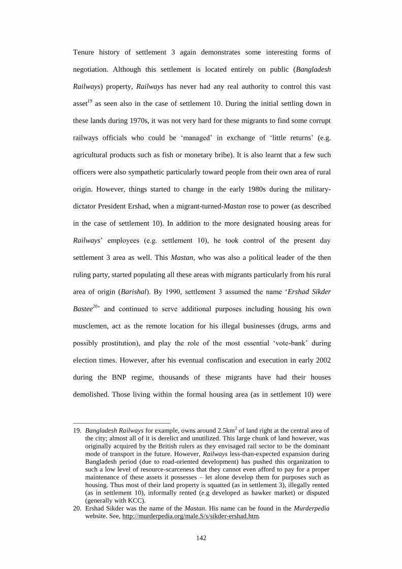
142
Tenure history of settlement 3 again demonstrates some interesting forms of
negotiation. Although this settlement is located entirely on public (Bangladesh
Railways) property, Railways has never had any real authority to control this vast
asset19
as seen also in the case of settlement 10. During the initial settling down in
these lands during 1970s, it was not very hard for these migrants to find some corrupt
railways officials who could be ‘managed’ in exchange of ‘little returns’ (e.g.
agricultural products such as fish or monetary bribe). It is also learnt that a few such
officers were also sympathetic particularly toward people from their own area of rural
origin. However, things started to change in the early 1980s during the military-
dictator President Ershad, when a migrant-turned-Mastan rose to power (as described
in the case of settlement 10). In addition to the more designated housing areas for
Railways’ employees (e.g. settlement 10), he took control of the present day
settlement 3 area as well. This Mastan, who was also a political leader of the then
ruling party, started populating all these areas with migrants particularly from his rural
area of origin (Barishal). By 1990, settlement 3 assumed the name ‘Ershad Sikder
Bastee20
’ and continued to serve additional purposes including housing his own
musclemen, act as the remote location for his illegal businesses (drugs, arms and
possibly prostitution), and play the role of the most essential ‘vote-bank’ during
election times. However, after his eventual confiscation and execution in early 2002
during the BNP regime, thousands of these migrants have had their houses
demolished. Those living within the formal housing area (as in settlement 10) were
19. Bangladesh Railways for example, owns around 2.5km2 of land right at the central area of
the city; almost all of it is derelict and unutilized. This large chunk of land however, was
originally acquired by the British rulers as they envisaged rail sector to be the dominant
mode of transport in the future. However, Railways less-than-expected expansion during
Bangladesh period (due to road-oriented development) has pushed this organization to
such a low level of resource-scarceness that they cannot even afford to pay for a proper
maintenance of these assets it possesses – let alone develop them for purposes such as
housing. Thus most of their land property is squatted (as in settlement 3), illegally rented
(as in settlement 10), informally rented (e.g developed as hawker market) or disputed
(generally with KCC).
20. Ershad Sikder was the name of the Mastan. His name can be found in the Murderpedia
website. See, http://murderpedia.org/male.S/s/sikder-ershad.htm.
143
also evicted of their houses21
. Yet again, the Mayor and local Ward Councillor
appeared on the scene realizing the political importance of this large number of
migrant populations (read ‘voters’). There was also a push from UNDP-led settlement
upgradation project (LPUPAP). Now, a more ‘formal’ negotiation took place wherein
a segment of the actors (e.g. Mayor, UNDP) acted as intermediaries between the
Railways authority and the evicted migrants. A ‘new plan’ was laid out in 2002 for
housing particularly this batch of migrant population, evicted from the formal housing
areas. New locations within the settlement were selected, while gaps within existing
areas were also filled in. Depending on family size, each household was allotted either
one or two (12’X15’) sized plots. A new name to this settlement (Greenland) was also
given by LPUPAP. Later in 2008 in the most recent effort by KCC, another process of
rehabilitating members of Harijan22
community was initiated after evicting them from
other KCC lands in Khulna. A newer site on the northern part of this settlement was
chosen by Mayor’s office and local Ward Councillor23
and named ‘Harijan-para’
(Figure 5.9: middle). Although railway authority was not keen to turn their land into a
‘rehabilitation site’, the Mayor (backed by ruling regime) ‘insisted’ to make use of
this otherwise under-utilized land for ‘public purpose’. However, for all residents of
settlement 3, the tenure status still remains de facto; migrants are neither allowed to
construct any permanent structure, nor any assurance is given about the maximum
duration they might be able to stay.
Settlement 7, which is locally known as Sath (7) No. Camp is originally a Bihari
Refugee Camp located right at the centre of Khulna’s oldest and largest planned
township of Khalishpur. The Muslim Biharis, who took refuge in post-liberation East
21. A few such houses can still be found in settlement 10, who could still sort out some
‘mechanism’ to stay back (Figure 5.5: bottom right).
22. A lowest caste Hindu community, who are generally found involved in perceived ‘lower-
level works’ such as sweeping and cleaning; a number of them work at KCC as well.
23. Although elected public representatives are not ‘theoretically’ authorized to decide on any
operational issue of public-sector organization such as Bangladesh Railways.

144
Pakistan after riots in India, turned into refugees once again as Bangladesh got
liberated from Pakistan in 1971. The Biharis, who came to Pakistan and became
Pakistani citizen, naturally supported West Pakistan instead of the native Bangali in
the latter’s War of Liberation. So after the war was over and East Pakistan became
Bangladesh, the Biharis would immediately be looked at as ‘state enemies’. Many
were murdered during the war, while even more took place after the war was over.
The Bihari houses were ransacked and seized, while Biharis were forced out of their
houses/plots of land and placed in small, super-dense makeshift arrangements known
as ‘Bihari Camps24
’ (Figure 5.10: right).
For Sath No. Camp, it was the International Red Cross, who came to protect the
Biharis from the violation and gathered them on this present site that used to be an
open public space previously. Around 40 tents were set up, in which these families
24. In addition to the three camps in Khalishpur there are another two Bihari Camps that exist
in Khulna. A number of similar camps also exist in other major cities in Bangladesh. As
these people still dream of a return to Pakistan (although they never lived in the Pakistan
mainland), the latter has never been keen to recognize them as its citizen. Although
Muslim the Biharis are, they differ ethnically and culturally from Pakistani ethnicities
and culture as they did with Bangladeshis. Pakistan also considers them as potential
burden since the Biharis are mostly illiterate and unskilled for any formal sector job. Thus
this whole issue has since remained ‘political’ between the successive governments of
Bangladesh and Pakistan, while the Biharis remained stranded in these ‘camps’.
Figure 5.10: (Left) KCC jurisdiction map showing location of Sath No. Camp (Source: KCC
2012); (middle) built-form distribution in space; (right) location of Sath No. Camp and other
two refugee ‘Camps’ within Khalishpur township (Source: Google Earth 2012).
5

145
continued to live until 1978. Around this time, President Zia’s pro-Muslim BNP
government would already have assumed power; this made access of Islamic NGOs
(such as Rabeta Al Islam) easier into this ‘politically sensitive’ settlement and
construct permanent house-plinths for the inhabitants. Other NGOs also joined in and
continued to operate with similar rehabilitation works (e.g. Concern and Caritas
provided sanitary latrines). Later in the 1990s, KCC’s first intervention saw the
construction of permanent roads and erection of light posts here. By this time
however, additional refugee population came in and filled in the gaps between
existing plots of lands – increasing the number of plots to 135 and families to 162.
Gradual encroachment of the adjacent lake also took place – both to extend present
household space and to house new refugees. Now as settlement 7 has continued to
consolidate over the past five decades and many Biharis has left25
, some Bangladeshi
(rural-urban) migrants also moved in (by buying possession rights) and started living
alongside the Bihari refugees within this settlement or adjacent to it (Figure 5.11).
25. It has been widely reported that although Pakistan did not recognize Biharis as their own
citizens, many registered themselves as Bangladeshi nationals, managed a Bangladeshi
Passport and eventually left Bangladesh for Pakistan. Some Biharis also left these camps
once they became affluent. Some previously affluent ones never actually had to leave in a
camp. Because of their better educational and social status they could already integrate
with the pre-liberation Bangladeshi society and escape violation.
Figure 5.11: Two Bangali-owned houses within Bihari refugee camp – the ‘fortified’ nature of
both these houses is noticeable; right: location of Mrs. Nurjahan’s house; left (red dotted) Mrs.
Nurjahan’s house on Khalishpur Central Mosque property but entry to her house is through
settlement 7; (left – green dotted) house location of another newly gentrified Bangladeshi
(rural-to-urban) migrant.
5

146
Presently, the political importance of the Bihari population and their claim to this
settlement have both been reinforced as most of these refugees were issued a
Bangladeshi ‘Voter ID’ card during the elections of 2005-2006 – allowing them to
participate in all local and national polls.
Official recognition
Settlement 8:
Bakkar Bastee
Area: 0.23 Acre; Household: 35; Population: 200+;
Density 2220p/ha
Settlement 9:
People’s Panchtala
Area: 4.6 Acre; Household: 750+; Pop.: 4,000+;
Density 2160p/ha
Settlement 8 or Bakkar Bastee is a unique example of a relatively small-scale land
invasion that took advantage of the host community’s needs and eventually
culminated into acquiring an official recognition. As the name suggests, this small
Bastee within the Khalishpur Township was erected and controlled by Mr. Bakkar, a
formerly prominent Labour Sardar from the nearby Crescent Jute Mills. This gradual
process of encroachment began in 1974, as the inhabitants of this particular section of
Khalishpur housing area felt the need for enhanced vigilance and security due to a
national-level decline of law and order situation. Following their complaints to
Khalishpur Housing Society’s Chairman, and having discussed with the local Ward
Councillor, a decision was taken to erect a semi-government guard post called TDP26
(Town Defence Party) in this area. Since provision for no such space was originally
considered in Khalishpur Master Plan, a small lakeside patch of open land was
instead chosen for this purpose in the central zone of Khalishpur township (Figure
5.12: overleaf). The committee also decided that Mr. Bakkar should head this defence
26. TDP can be seen as something similar to ‘community police’; but its key difference with
community policing is that setting up a TDP post requires approval from central
Government’s ANSAR and VDP Department. So even if setting up a TDP post is
community’s need driven and run by community’s chosen members and paid by the
community, it requires prior approval from local public representatives and
administrators.

147
and patrol activities since he was a proven Freedom Fighter27
(Muktijoddha in
Bangla) and also because of his reputation as a formidable Labour Sardar during his
Jute Mills days.
Although this was a demanding duty (generally night-shift works involved, with risks
of fighting dacoits), the remuneration from being a TDP employee was scant. The
expenses of the whole process were borne exclusively by the community; financial
contribution from government was negligible. Such demanding work also required
adequate manpower. All these made Mr. Bakkar think opportunistically. He therefore
asked for additional members for additional members to be included in his team for
TDP to work properly. He also proposed to the committee (consisting of Housing
Authority Chairman, Ward Councillor and local community representatives) that
dwelling units needed to be erected around the TDP office to house the families of the
27. Freedom Fighter is used to refer particularly to those civilian personnel who fought
against the Pakistan Army during Bangladesh’s War of Independence. Freedom fighters
enjoy a host of state welfare benefits. The term Freedom Fighter, which has an emotional
connotation, however has also been used in Bangladesh to gain financial and political
(read ‘unfair’) advantages. Although not all, many influential individuals use their
Freedom Fighter status to acquire state benefit, influence public-level decision making
processes, and receive political attention – often far beyond the levels they are otherwise
entitled to.
Figure 5.12: (Left) KCC jurisdiction map showing location of Bakkar Bastee (Source: KCC
2012); (middle) built-form distribution in space; (right) Satellite image (Source: Google Earth
2012).
5
148
TDP employees (including his own) considering the nature of work involved. This
proposition was agreed upon eventually, and a total of 25 houses were built on the
lakeside using bamboo platforms. Mr. Bakkar, who was an ex Sardar, had by now
also become the undisputed leader of this small but important settlement. His TDP
colleagues were all his ‘own men’ – some of them used to be his co-workers in the
Jute Mills, while the rest were either his relatives or deshi manush from Faridpur.
Outside, this settlement began to be identified with his name while the makeshift
nature28
of dwelling units here led to its identification as a Bastee.
Now as the TDP office became a permanent (and important) establishment for this
community, and Mr. Bakkar and his team have long been serving this community,
they made an approach to the local Ward Councillor in 2000, requesting if these
small parcels of land (approximately 10,000sft) could be officially allocated to the
respective occupants. Although the Ward Councillor and KCC were interested, titling
was not possible since Khalishpur Housing Authority is controlled by National
Housing Authority (NHA) – which again is under a different central government
ministry (Ministry of Housing). Mr. Bakkar and his affiliates then went on to bribe
one of Khalishpur Housing Authority personnel to make him lobby for them in the
Ministry of Housing office in Dhaka. This effort failed since at that particular time
government was not allotting land plots to any individual. They however, kept
lobbying through their ‘known’ political channels and during different political
regimes. Through all these, by 2002, they could only manage to include their names
in the official book of ‘land records’ as present occupants (hence claimants) of this
28. The makeshift nature of dwellings owed to three factors; one, these houses were needed
to be erected quickly; two, these migrants were not allowed by Khalishpur Housing
Authority to build permanent buildings here since they did not have any legal land title;
and three, they were generally poor migrants who before coming here were living in
shacks and shanties generally – they did not have financial capacity to build otherwise.

149
land. As lobbying for a formal title is ongoing still, a ‘Holding number29
’ has been
approved by KCC for each of these households – ensuring some form of recognition
at least from one government agency.
Presently 35 families live in Bakkar Bastee. Older houses (that are based on land
through years of earth-filling) are constructed mostly of brick and roofed with CI
sheet30
. The newer houses on water however are still being built on floating bamboo
platforms. Some homesteads also have small gardens – which again has become
possible through the partial filling up of lakesides. Many original TDP workers left
this settlement and new replacements came along by ‘purchasing’ the ‘possession
right’ of the vacant house/land. It is also believed that Mr. Bakkar himself still owns
at least four houses. It has also been learnt that with every transaction related to
‘possession right’ between leaving and incoming tenants, Mr. Bakkar receives some
amount of money. Neighbours say that Bakkar Bastee is in fact a good business
29. A ‘Holding number’ allows KCC to include particular households to its municipal tax-
base. It also helps determine the amount of municipal tax for that household. A ‘Holding
number’ holder has to pay yearly tax to KCC.
Figure 5.13: (Left) Bakkar Bastee: (1) location of TDP office; (2) houses on encroached
lakeside land under control of Mr. Bakkar and his associates; (3) newer lakeside
encroachments by people not residents of Bakkar Bastee (Source: Google Earth 2012);
(middle) new semi-permanent building under construction within the TDP office compound;
(right) lakeside view of TDP office, and lakeside encroachments as seen over the lake.
1
2
3

150
proposition for Mr. Bakkar, and that new plots of land would continue to be created
by earth-filling the lakeside and would be sold to new buyers. Location 3 (Figure
5.13: left) is said to have been filled in and sold in the same manner, although Mr.
Bakkar denies it. Some neighbours seem sceptical about the new building within the
TDP office (Figure 5.13: middle) assuming that it is not actually an extension of the
present office as the TDP workers claim it is. They say ‘possession right’ of this
building would again be sold to some new intent buyers as in the earlier cases. But
since Mr. Bakkar has aged and become politically disconnected so, he does not
himself decide things (hence enjoy the monetary outcome) entirely anymore. There is
a TDP ‘committee’ now a day that remain involved in all decision-making. It is
possible that they also claim their stakes from any ‘benefits’ that accrue from any
possible transactions that are made within this little settlement.
Settlement 9 is locally known as People’s Panch-tala. It is also located in the
Khalishpur area, on one of Government-owned Jute industry’s (Peoples Jute Mills
Ltd.) land. It is one of the very few examples in Khulna where multi-storied buildings
and vacant land have been simultaneously invaded by both Jute Mills workers and
non-workers, and yet has been able to manage some form of official recognition.
However, this process of invasion of industry-sites could be related back to the events
that began in the 1960s. As highlighted in Chapter 4, massive industrialization and a
disproportionately scant housing supply by the public sector industries at that time
made even many of the ‘formal sector’ Jute Mills workers to assume ‘informal’
modes of dwelling. It is within this context, when jute production reached its peak in
late 1960s and early 1970s and was yielding a fair amount of foreign revenue,
numerous full time and part time workers still could not find their place in the Jute
30. TDP employees are not allowed by the Housing Authority to construct any permanent
roof since they do not posses any formal land title.

151
Mills owned workers’ housing31
. This particular housing area, once owned by
People’s Jute Mills (Figure 5.14) which still is considered as one of Khulna’s largest
jute industries, therefore became a key location for these many workers’ eventual
place of refuge.
Although many of the workers were already living on this site ‘informally’, it was the
post-War of Independence era of early 1970s, which saw even more migrants to make
their way in to Khulna from the war-torn country sides. As reported, a few political
leaders from the ruling regime and Jute Mills’ labour union helped these migrants to
initially ‘settle down’ within this formal (planned) housing estate. Jute Mills
authorities were ‘kept quiet’, while compromises were made between the ‘politically
appropriate’ decisions and their ‘administratively right’ laws. People – both workers
and non workers also used their own social networks (kin, friends, people from same
rural region) to find a place within this walled-up premise. This process, therefore,
has gradually turned this area into a site for low-income migrant population’s refuge
– for who have been related to the nearby Jute industries for their livelihoods but yet
have not been able to find a suitable place for habitation.
31. Even in its ailing state (many employees have had their jobs cut to reduce expenditure)
People’s Jute Mills still employs a total of 3905 third- and fourth-class employees. Yet it
Figure 5.14: (Left) KCC jurisdiction map showing location of People’s Panch Tala (Source:
KCC 2012); (middle) built-form distribution in space; (right) Satellite image – showing both
the studied location and the rest of the site (Source: Google Earth 2012).
5

152
The ‘construction, invasion and consolidation’ of these five-storied buildings32
for
which settlement 9 is called People’s Panch-tala, has a rather curious history. The
initial construction of this subsidized building complex may actually be seen as a
‘political project’ by the then military government that aimed to compensate for the
housing shortage particularly for the sheer number of third- and fourth-class
government employees including the Jute Mills workers. This particular site was
selected because of its central location and relative distance from other government-
owned industrial establishments in this area. This comparatively underutilized Jute
Mills tract of land was also the only available parcel, which was suitable for any
large-scale housing. The project was financed by the central government, and
designed and built in the late 1970s by NHA as a rentable five-storied (Panch-tala)
apartment-complex. Yet this building site and its adjacent vacant lands have
experienced waves of invasions during successive political regimes. Due to a lack of
continuous funding and a regime change, these buildings also took more time to be
completed. In fact, after construction works were finished, none of these buildings
was actually delivered to its originally targeted groups. The whole complex was left
in a ‘parentless state’ until late 1980s. These buildings neither got connected with the
municipal services nor to other public utilities. Since the buildings were not owned by
the People’s Jute Mills authority and this portion land was already appropriated from
them by the NHA, the former was reluctant to provide any of these services to
operationalize the buildings. Thus the buildings were left abandoned until a large
nationwide flood broke in 1988. To immediately rehabilitate, a number of people
living in the shacks and huts in and around the Jute Mills area (and also within this
new housing area) moved in to these vacant buildings.
provided a merely 385 housing units for them (less than 10%) (Shahed 2006: 31).
32. The site was first appropriated and then separated from People’s Jute Mills area using a
boundary wall. Later, a total of four ‘bachelor quarters’ and another four ‘family quarters’

153
Political support was also plenty at that particular time, and this was probably the
opportunity that these already squatting migrants were looking for. Once they moved
in and more shacks mushroomed after the flood was over, many eviction- and
demolition-drives would take place throughout the next two and a half decades. Yet,
the migrant workers kept coming back and resettled both in the buildings and on the
vacant lands outside the buildings – making particular use of political ties and labour
union movements.
At present, around 400 units of 15’X12’ bachelor rooms (in four buildings) are
occupied and inhabited either by families or used as shared accommodation by
multiple individuals. On the other hand, there are another 80 family units (in four
buildings) used in the same ways. Originally, a Mosque, a canteen, and at least four
small play grounds and some vacant area for future extension on the northern part
was planned. The dining halls and kitchens of this complex have already been
converted into dwelling units. Only the playgrounds and the Mosque are left un-
were designed and constructed (Figure 5.14: right), all using double-loaded corridors and
maintaining a Corbusian simplicity (Figure 5.15: 3).
1
5
7
9
6
2
4
3
Figure 5.15: Panoramic view of People’s Panch Tala showing: (1) Non-permanent Katcha
buildings on its east boundary wall; (2) Playground kept uninhabited through a decision taken
by political elites in the community – annual Waaz (open-air Islamic program) takes place
here; (3) Paintwork on Building 2 of the Bachelor type quarters – cost borne by tenants of this
building; (4) Small vegetable garden developed by the ‘owner’ of the adjacent unit on
Building 2; (5) Ongoing renovation work on the ‘toilet block’– funded by an environmental
NGO (Concern Bangladesh); (6) brick building erected by political elite (in control of
Building 2) for storage of building materials (used for business); (7) building materials to be
used for constructing a new semi-permanent (Pucca) house on the other side of the road; (8)
an earlier toilet complex built previously by another NGO for the roadside Katcha house
dwellers; (9) both Katcha and Pucca houses constructed on the western boundary wall that
separates Jute Mills land from People’s Panch Tala.
8

154
encroached presently. In addition, approximately 150 units of semi-permanent houses
can also be found in this settlement – distributed in a rather organized manner33
(Figure 5.15: 2). Above all, under the present ruling regime, the KCC Mayor has
issued holding numbers for each of these households giving them some sort of
official recognition and legitimacy.
Land rental
Settlement 2:
Quaium Shaheb er Gola
Area: 0.2 Acre; Household: 29; Population:
190+; Density 2375p/ha
This is a frequently occurring settlement type in the South-Eastern riverside of
Khulna (Figure 5.16). Since older settlements (e.g. settlement 1) could not alone
provide accommodation for all the migrants, settlements such as ‘Quaium Shaheb er
Gola’ came to provide affordable and ‘customizable’ housing for migrants for whom
settlement 1 was either expensive, or who simply needed a bigger house. Quaium
Shaheb in Bangla translates as ‘Mr. Quaium’. However, the word ‘Shaheb’ should
rather be read as a ‘gentleman’. During colonial times, ‘Shaheb’ was used to
designate the British/white people. ‘Gola’ on the other hand means a depot; this word
is used since this site, before it was converted into rentable settlement in the 1990s
had been used for wood storage and trading for about 20 years. The entire name of
this settlement therefore translates as “(honourable) Mr. Quaium’s depot”. Settlement
2 nevertheless, differs from settlement 5 in the sense that it is a privately owned land
and much bigger in size than settlement 5 land plots, and it is is rented to migrant
tenants who build their own house according to their individual needs. Tenants here
are also economically better positioned (earn at least 50% more) having a bigger
family size (hence a greater number of income-earning members) compared to the
tenants in settlement 5. In terms of site location, this one is much nearer to the city
33. As mentioned in Chapter 3, studies have been conducted on these non-permanent
buildings and on the Bachelor Type quarters; generally these are the two types that have
experienced most forms and phases of transformation over the years.

155
centre compared with the peripheral location of settlement 5. Migrants use temporary
building materials34
here, since such a construction could easily be dismantled and re-
used as they move on to another similar site. Depending on the size of the ‘built area’,
rent is paid to the ‘businessman’ landlord (Mr. Quaium).
Although the landlord lives in the same site, he lives in a separate two-storied
building near the roadside front of this settlement (Figure 5.17). Contrary to
settlement 5, the landlord does not share services and utilities with his tenants here;
therefore the day to day interaction between them is limited and so is their belonging
with the tenanted space (Figure 5.17). Tenants are either already known to the
landlord, or they are someone who had to come through the landlord’s known
kinship/regional network to be qualified to live here. The landlord hence does not rent
land plots to strangers. Preference is given to migrants from a particular South-
western coastal Upazila (sub-district) of Bangladesh (Koyra) because the landlord’s
family also originates from this same Upazila35
. The activities of local merchants and
34. Generally bamboo structure, floating bamboo-plinth and CI sheet roof and walls.
35. The landlord is actually a descendent of a rural elite family; so renting out spaces to his
deshi manush also confirms the continual conveyance of information about the landlord
(and his family)’s urban affluence and elevated social status. Although not true for this
Figure 5.16: (Left) KCC jurisdiction map showing location of Quaium Shaheb er Gola
(Source: KCC 2012); (middle) built-form distribution in space; (right) Satellite image
(Source: Google Earth 2012).
5

156
fishery industrialists mentioned in the discussion of settlement 1 provide similar
income generation opportunities for the tenants in settlement 2. Several NGOs and
the UNDP-led UPPR project also operates here providing microcredit and
health/hygiene related services36
respectively. In early 2000s, funded mainly by the
LPUPAP project, a toilet complex (4 units) was constructed.
Use rights
Settlement 6:
Vastuhara
Area: 15.8 Acre; Household: 1,200+; Population:
8,000+; Density 1250p/ha
It was during the rapid urbanization of the Post-Independence 1970s, ‘squatter
cleansing’ began to take place in all major Bangladeshi cities 37
. Later in 1974, the
government would initiate a ‘site and service scheme’ by handing over small parcels
landlord, this rural-linkage is a very common and tested mechanism that many affluent
persons (particularly politicians) practice in Bangladesh. Many local-level public
representatives typically live in the city but maintain a persistent linkage with their rural
constituency (where they get elected during national poles). This resembles of the
‘absentee Zamindar’ phenomenon as discussed in Chapter 4, where the Zamindar would
actually live and build in the city but would maintain a strong tie with his rural assets
(rural property and peasant subjects) for his social, political and financial gains
36. UPPRP however, does not invest in infrastructure projects because of the unsecured
nature of tenure here due to private ownership.
Figure 5.17: Panoramic view of Quaium Shaheb er Gola showing: (1) landlord’s house on the
left of site entry – behind this was the original wood ‘Gola’, which now is the site for
toilet/bath area; (2) houses built on rented plots; (3) low-lying land with stagnant water – less
maintained because tenants are not allowed to use it for any purpose; (4) Rafiq er Dokan – a
small grocery cum firewood shop owned by Mr. Rafiq, who is also a resident in this
settlement; (5) riverside embankment cum road (Rupsha Veri Bandh Road) and logwood
trading along the road.
1
2 4
5
3

157
of land free to the homeless in the city38
. Government’s party machine39
was used to
select ‘eligible’ squatters from a few locations of Khulna, including the Dukbangla
(Khulna’s city centre) area, Bangladesh Railways land and Daulatpur. These people
were later relocated to the newly acquired low-lying site on Khulna’s North-Western
periphery40
. Referring to their homeless status, this settlement (and a few more in
major Bangladeshi cities) was given the generic name Vastuhara41
(Figure 5.18). A
Master Plan was prepared by NHA (Figure 5.19), while in 1978, ‘semi-formal’ title
of a total 713 plots of land (30’X15’ size) was handed over to this destitute
population group in a rather curious manner42
.
37. Resulting from the pressure exerted on the government by the political elite and the press
(Choguill 1993: 329-330).
38. This attempt however contributed less to solve the actual problem of low-income
housing; it was rather designed more to justify government’s socialist idealism. Of course
low-cost land was the number one reason why this remote area was chosen in the first
place; yet, in a country, characterized by pseudo class-discrimination, this effort could
also be depicted as ‘clearing of streets from dirt’.
39. Mr. Sufian - a prominent labour-leader in Khulna and local government representative
(both from the then ruling party) were ‘in charge’ of this relocation process.
40. Almost 6km away from the city centre even in present conditions, this Vastuhara site
used to be a derelict land, now under the jurisdiction of Government’s Ministry of
Housing. Presently, it is looked after by one of ministry’s wings, the NHA and Khulna’s
city planning and regulatory authority, KDA.
41. Vastu means ‘to reside’ or the act of dwelling while hara means ‘devoid of’; together they
state of a condition of ‘homeless-ness’ or ‘uprooted from home’.
Figure 5.18: (Left) KCC jurisdiction map showing location of Vastuhara (Source: KCC
2012); (middle) built-form distribution in space; (right) satellite image showing Vastuhara in
relation with the urbanizing city all around it; highlighted areas immediately around
Vastuhara are all formal sector developments prominent amongst them are middle- and
higher-class housing projects implemented by KDA (Source: Google Earth 2012).
5

158
Some families were also allotted more than one plot of land due to their larger family
size. Many, however, were allotted multiple allotments due to their better ‘relation’
with the party leaders. Nevertheless, not all the recipients of land stayed back in
Vastuhara. Since it was quite far away from job locations, some would already sell
these plots and go back to the city centre slums. The situation was further
compounded by its remote location characterized by unavailability of drinking water,
absence of nearby markets and the fear of vandalism. Vastuhara’s low-lying
condition (water logging was common) also made clear that an overall earth filling
would be required should any building or construction works were to take place.
During the following months, these few thousand people therefore would continue to
live in the makeshift shacks, and engage in earth-filling the whole site. Several
months later, semi-permanent houses (brick plinth, wooden structure and CI roof)
were erected in each of these 713 plots of land with NGO (CURITAS)’s financial
support (Figure 5.19: bottom-left). But unlike that in the original land use plan, only
about 16 acres of land (out of a total 33) was actually delivered in the form of these
713 plots. Although public spaces and amenities such as ‘parks’ and ‘graveyards’
were provisioned in the first Master Plan, those were never provided. In contrast, a
number of others who were also relocated alongside these fortunate 713 households
were not allotted any plot of land whatsoever. They would now start squatting on the
northern park site (area 2) and the southern graveyard site (area 3) of this formally
planned settlement (Figure 5.19: above).
Later between 1983 to1987 under military-backed President Ershad, the ‘park site’
was cleared of the migrants for making space for third and fourth class government
employee’s (mainly defence officers) housing. Being driven out from the construction
site, these migrants now resettled on all possible vacant spaces of Vastuhara; this led
42. Actually a paper called ‘allotment slip’ was initially handed-over – signed by the
government’s land administrator (DC), and witnessed by NGO representatives. This ‘slip’

159
to the further densification of the 42 plots of land where some migrant families were
already residing. On the other hand, 68 semi-permanent rentable units were
constructed through government funding while 42 plots of land (each 2,500sft) were
created and sold out to external buyers. These buyers, however, never returned to
claim possessions of their purchased land plots because these purchased plots were
already being squatted by non-allotted migrants. Some parts were also being
controlled by a few politically influential tenants of Vastuhara; in most of these areas,
it was their ‘own men’ who were in claim and possession.
however does not resemble any formal title document in Bangladesh.
Figure 5.19: (Above) three plans showing three different realities of Vastuhara: (above-
middle) Vastuhara’s original Master Plan showing location of 713 plots on area 3, while a
park on north (area 2) and a graveyard cum Mosque area on south (area 3); (above-right)
Vastuhara as of today, where area 2 being completely transformed in the same way as in a
formal sector housing; (above-left) 2011’s proposed Master Plan by NHA – it shows a
complete replacement of present dwelling environments with 58 ‘Corbusian blocks’ (5-storied
- 200’X22’), each meant for housing 60 families; (bottom-left) remains of one of the first
Katcha house prototype, built by CARITAS in 1978; (bottom-middle) new middle-class multi-
storey house on area 2; (bottom-right) Mr. Dipu, the second generation of one of Vastuhara’s
original inhabitants and a local level political leader of Bangladesh Awami League (current
ruling party) showing the pond on area 3, which he is lease-holding presently.
2
1
3
2
1
3
2
1
3
160
In the latter half of 1990s, the entire area constituted by these 42 unclaimed plots was
given the ‘politically fitting’ name ‘Muktijoddha Colony’ (Freedom Fighters’
Colony) (Figure 5.19). These inhabitants were never evicted since. Meanwhile, the
western fringe Khulna city would already close in on Vastuhara. By early 2000s,
KDA would already lay out grids of a new site and services township (Figure 5.18:
right); the plots were later sold out to the middle class clients. This made land price in
Vastuhara to escalate further. In fact all of Vastuhara’s land is better developed
(through the many years of efforts by the inhabitants) than those developed by KDA.
This made KDA to develop (by land-filling the lake) another 37 plots of land on the
northern periphery of Vastuhara and again sell them to external buyers. These plots
of land could not be invaded as in the earlier 42 plots; these were middle-class buyers
who would quickly erect buildings akin to any typical middle class housing areas
(Figure 5.19: bottom-middle). Various modes of gentrification and politicization
however are still ongoing in Vastuhara. During a recently held meeting on
Vastuhara’s future involving the local land administrator (DC), Mayor (from the
same political party that is in power presently), city-level political leaders of the same
party and the particular Vastuhara residents, who are also leaders and supporters of
this party – propositions were made for a change in Vastuhara’s name43
. Possibility
of a Corbusian mass-housing type development of this settlement to house ‘more’
urban poor was also discussed here (Figure 5.19: above-left). This politically
‘charged’ decision and its top-down (and exclusionary) nature however makes any
prediction about Vastuhara’s further spatio-physical transformation quite tricky.
43. The proposed name is “Bongobondhu Nagor”; Bongobondhu (meaning ‘friend of
Bengal’) however is an alias to Mr. Sheikh Mujibur Rahman – the first Prime Minister of
independent Bangladesh, and father of present Prime Minister (Chairperson of
Bangladesh Awami League – one of the two major political parties in Bangladesh). It was
during his tenure as a PM in 1974, this idea of a ‘site and services’ scheme for the poor
was originally conceptualized. Nagor, on the other hand, means town or township. So,
this current proposal basically aims to officially rename this settlement after
Bongobondhu.
161
Many in Vastuhara are actively involved in party-politics, which often yields a
certain level of personal gain44
. Yet, despite the political difference there may exist
between the inhabitants45
, they also remain closely bonded and move strategically
together when it comes to the question of existence for Vastuhara as a whole. The
inhabitants speaks of a community organization (Vastuhara Samaj Unnayan
Committee) in which committees are formed through selection (composed mostly of
elders) and used mainly for arbitration, decision-making and management of the
community resources, institutions and infrastructure. But when political lobbying is
required for decision-making on Vastuhara’s future, committees are formed in a way
where some ruling-party people’s involvement is always ensured (someone like Mr.
Dipu46
). This constant affiliation with political parties seems to have helped
Vastuhara’s sustained growth and development over the years. This is evident in the
example of the 2011 meeting as mentioned earlier. In order to formalize their claim
on Vastuhara land, migrants’ ability to arrange a meeting involving the local land
administrator, key leadership of the ruling party and also the persistent lobbying of
the concerned ministers – all tell of the political capacity of these once-destitute
group of migrants, who now boast themselves as a community. Needless to say, such
politics, involving both everyday and episodic events, are carried out in order to
harness the ‘best possible’ level of sustainability for their place of habitation.
44. I came across Mr. Dipu who belongs to the current ruling party; one assumes that this
association with the larger power has played an important part in giving him the needed
opportunity to leasehold a large pond for fisheries (Figure 5.19: bottom-right).
45. During early 1990s, events of severe violence in Vastuhara could be noted; supporters of
each of the two main political parties are said to have engaged against each other
regarding the political control of Vastuhara. Violence also led to the killing of residents
and eviction.
46. Amongst others, Mr. Dipu actually was invited to the 2011 meeting on the future of
Vastuhara (discussed earlier) as a ‘community representative’. Although it was a
‘political meeting’ since no local BNP leaders or BNP-supported Vastuhara residents

162
5.2.2 Threads of themes: settlement tenure, control and spatial boundaries
The following table summarizes the key threads and themes in terms of settlement
tenure, ownership and control, and spatial boundaries as they occur in the prior
discussions on tenure history.
Table 5.1: Threads of themes: settlement tenure, control and spatial boundaries
Name ‘Actual’ tenure status Important themes
Set
tlem
ents
1,
3,
7
De
fact
o t
enu
re - For settlement 1, KCC and
other public-sector
organizations extend their
services; not recognized by
KDA.
- For settlement 3, migrants are
allowed to settle against
Railways (owner)’s will;
tenure is secured as long as
politicians want.
- Tenure status is likely to
remain unsettled due to the
political nature of Bihari
issues.
- Socio-political ‘arrangement’ with land
owner (Government, and its other agencies)
for securing present occupancy; formal
actors (chief amongst them being KCC)
acting positively as ‘negotiators’ between
migrants and Government (agencies).
- Dubious land tenure however, remain
subject to the interpretation of influential
agents.
- Global-level companies form alongside
‘slum’ locations – opposite to present say
- Often new name of the settlement is desired
by migrant communities to form a new
identity, while erasing the previous.
Set
tlem
ent
2
Lan
d r
enta
l - Planning and construction of
rentable units not approved by
KDA.
- Regional/kinship network seems necessary
to manage a place in the city; strangers are
not allowed to come and start living
immediately.
- ‘Connections’ with city-living ex-rural elite
to secure a place; a more Master-Servant
(traditional) relation becomes evident.
Set
tlem
ent
4
Reg
iste
red
lea
seh
old
- Many fear of eviction once the
25 year lease period would be
over (for land price hike).
- Emigration, incoming refugees and migrant
farmer affecting urbanization
- Concentration of a certain regional group to
claim and control secure settlement spaces,
and ensure tenure security.
were invited, Mr. Dipu’s presence even amongst his own party leaders ensured some level
of community participation to the least.

163
Set
tlem
ent
5
Fre
eho
ld - Planning and construction of
rentable units not approved by
KDA.
- Most emerging type driving urbanization at
the city fringe area.
- Urbanization by peasants and migrants; and
through Master-Servant interactions.
- Hard to categorize settlement as slum due to
its access to services and utilities.
Set
tlem
ent
6
Use
rig
hts
- ‘Allotment slip’ is yet to be
converted into a proper title
deed. Chances are waning as
government considers new
(experimental) schemes.
- Informalization of formally planned housing
area (for low income migrants) by official
bodies themselves.
- ‘Political use’ of settlement and its spaces
through: (re)naming, allotment,
(re)territorialization and decision-making.
Set
tlem
ents
8,
9
Off
icia
l re
cog
nit
ion
- KCC and other public-sector
organizations extend their
services; not recognized by
Khalishpur Housing Authority.
- In 2013, all tenants in
possession have been allotted
‘Allotment slips’ akin to
Settlement 6.
- Relatives, Deshi-Manush and Jute Mills
worker-leaders contributing to the
transformation (and remaking) of urban
form.
- ‘Informalized’ settlements provide housing
to low income people working in and for
Jute Mills who were never formally housed
by Jute Mills themselves.
Set
tlem
ent
10
Pu
bli
c re
nta
l - Informal construction by
tenants (addition, repairing
etc.), renting, subletting and
possession selling; known but
not approved by Railways IW
department.
- Densification of public housing by illegal
renting, subletting, re-territorializing,
developing, construction, modification and
even ‘selling out possession right’; migrant
worker-turned-Mastan and corrupt Railways
officials ‘in-charge’ of these ‘development’.
5.2.2 Problem with categorization
The theoretical classification of tenure types (based on Chapter 2 categories) as in the
first column of Table 5.1, however, is in no way absolute. As the second column
suggests, the ‘actual’ tenure status has in fact remained unsettled for most of these
settlements47
. This seems particularly true for those large-scale settlements
categorized under ‘de facto’ and ‘officially recognized’ types – whose tenure is
neither formal nor absolutely informal. One therefore questions the meaning of the
47. Apart from the privately owned properties as in settlements 2 and 5, and the official
leaseholders such as settlement 4.

164
term ‘official’ and the role ‘official’ plays in the upgrading and sustenance of these
settlements. As observed, there are two forms of ‘official’ that are commonly at work
in the context of these rather ‘speculative settlements48
’. One, the bureaucratic
organizations under central government (such as Department of Land Administration,
NHA, KDA and Khalishpur Housing Authority etc.); and two, the Local Government
institution – the Khulna City Corporation (KCC). So as seen in most cases, it is the
second amongst the ‘official’ organizations – which is KCC, has proved more
‘useful’ so far. For understandable reasons (e.g. legitimacy and local accountability
that counts during poll times), the Mayor and the Ward Councillors have remained
the key actors playing important roles in officially recognizing these settlements and
helping migrant groups to obtain de facto security (by issuing holding numbers). On
the contrary, for there has been no need for local-level accountability and legitimacy,
the role of other bureaucratic departments has remained the opposite49
. And when
these departments were actually involved, their activities generally remained
embroiled with corruption and ineptness. This, for example, has been seen in the case
of settlement 10, which is mentioned under ‘Public rental’ category, yet allowed to
operate and grow informally by the Railways officials. Similar was the role of
Khulna’s Land Administration Authority’s activities as they approved the leasehold to
settlement 4 only after being bribed.
Here, Vastuhara’s example can particularly be used to demonstrate the ultimate
making of an ‘in-between’ tenure situation even in the extensive presence of public-
sector organizations (NHA). Figure 5.20 (above-left) shows the typical ‘Land
Allotment Slip’, which was issued by NHA in 1977. However, this is the only official
48. I borrow this term from Raharjo (2010).
49. A third type of central Government organization, such as Bangladesh Power
Development Board (responsible for electricity supply) has been supportive of the
Mayor’s office since it has continued to provide electricity connections to all these
‘apparently illegal’ settlements against the given holding numbers provided by the
Mayor’s office (KCC).

165
document that each of the allotted households possesses till date. What makes this
document interesting is that it does not mention anything about the type of ownership
the migrant recipients are entitled to. No supporting document was provided by NHA
either, which would explain the relevant terms and conditions for inhabiting the land-
plots of Vastuhara. Talking to Vastuhara’s migrant residents, it would naturally occur
that they are the owners of this land. A walk through this settlement would also
certainly support this claim because most areas within this settlement clearly assume
such a ‘permanent’ appearance (particularly due to these once-destitute inhabitants’
heavy investments in the various permanent constructions) that one would never be
cynical about its tenure status (Figure 5.20: bottom). Yet, it is only in 2011, it became
clear that NHA had actually rented the land at a rate of 10 Taka/month/plot (Figure
5.20: above-right).
Figure 5.20: (Above-left) Land Allotment Slip given to Vastuhara residents in 1977; (above-
right) portions of page 2 from proceeding from a 15 April 2011 meeting; this formal meeting
was held between NHA officials, Khulna’s land administrator, local political leaders from
present ruling regime, and Vastuhara’s elders. The meeting was intended to update the current
land tenure situation in Vastuhara, and discuss a government proposal for replacing present
land tenure with government funded mass apartment blocks; (bottom – from left to right)
Vastuhara High School, Vastuhara Central Mosque and permanent house replacing the Katcha
house.

166
One only wonders why tenure details were not clearly articulated on the Government
allotted slip or stated to the recipients while land was being ‘allotted’ initially. One
also becomes sceptical about the true intension of the then government (and its
associated political machinery). Given the circumstances, three particular reasons can
be hypothesized. First, it is through the partial deliverance of this ‘site and services’
scheme, the government could actually demonstrate (its political idea) to the public
and to its donors (e.g. World Bank). Second, this unsettled tenure status kept the
migrant settlers interested in the Government (hence its local level political leaders) –
a permanent title would actually have liberated the former. Third, in-between-ness
was also important for NHA and Land Administration departments alike, since they
would have realized that these people’s tenure status needed to be kept just as
obscure; in their bureaucratic interest50
, such a decision was important because it
would have left options ‘open’ for future interpretation and manipulation of the
tenure terms and conditions if deemed necessary.
How does, then, one comprehend the actual nature of tenure for each of these
settlements since the definitions associated with the theoretical categories appear less
meaningful in the day to day affairs of Khulna’s migrant settlements? This is exactly
why, UN-HABITAT (2004: 8)’s “Non-formal tenure system”, which attempts to
combine all sorts of extra-legal tenure types under a general category, does not help
much. It does not facilitate a clear understanding of the tenure status of settlements
which have partial recognition from some government agencies while others, quite
paradoxically, does not recognize their existence. Although “land rental” from private
owners may be seen as a formal tenure as in settlement 2, KDA clearance is not
sought for building activities here. From this, one fails to understand the exact sort of
land tenure type under which these two could be categorized.
50. Land administration is one of the most corrupt public sectors in Bangladesh (CARE
2003).
167
On a similar note, Payne (1997)’s classification – although having a more detailed
definition of tenure types compared to UN-HABITAT’s, suffers from a lack of
mention of involved actors/agents, and their ‘political’ role in the ‘actual’ state of
tenure and its changing parameters. The rather complex and shifting nature of tenure
for each of these settlements, which, to a large extent depends on the interpretation
and intension of the involved elitist actors/agents, hence is a rarity in the aforesaid
classifications. The everyday and sporadic acts of negotiation, both socio-political
and spatio-physical – in which the ordinary migrants engage in order to sustain their
claim on the piece of land or dwelling unit – remain generally absent from both of
these classifications. Although Raharjo (2010: 15-36)’s review mentions of different
acts of negotiation between tenants and owners during and following the “settlement
process”, the understanding of how settlement boundaries at its many levels are
controlled still becomes an area of interest for a further and deeper understanding of
these various tenure classification models.
5.3 Spatial practices and control of boundaries
This section highlights the spatial activities in which the permanent migrant engages
in order to control the spatial boundaries of his/her dwellings and neighbourhoods.
This includes those spatial activities, which can be viewed as responses to and in
relation with the aforementioned created conditions by the authoritative regimes.
5.3.1 Everyday spatial occupation and personalization
5.3.1.1. Personal space and primary territory
Figure 5.21 (overleaf) compares between the spatial organization of household
spaces, which are selected from three different settlements. House-spaces are marked
and outlined in terms of ‘front and back’ and ‘contact zones’ (private and semi-
private areas). Photographs are used also to show the nature of ‘display’ that each of
these house-forms offers to the public realm.

168
Figure 5.21: Personal space and primary territory – (left to right) S4H4, S1H3 and S3H4
house plans compared: (Row 1) house-front areas; (Row 2) private zones including female
areas; (Row 3) semi-private zones; (Row 4) photos showing ‘public front’ of the houses.
Street
Street
Street
Street
Street
Street Street
Street
Street

169
Figure 5.21 shows that in all of these households, there are zones which could
certainly be identified as ‘front-house’ and ‘back-house’ (female areas) in the
traditional sense, yet the same zone also falls under the semi-private or more public
category as well. The same space that is used for an entry to the house is also often
used for cooking and dining. A clear distinction between private and public zones is
hard to delineate. Often the most private of spaces (toilet and bathing space) are
found located outside the house. In fact, for around 80% of the studied households,
this finding remains constant as private and public space often overlap into a single
space. The opposite is also evident where the neighbours are allowed to use private
functions (bathing and water collection) located within the private house (Figure
5.34: middle). On the other hand, the photographs show that a desire for maintaining
a conventional level of privacy still remains strong. None of these houses actually
provides any direct opening on the front streets (except for the Goat-house on S4H4)
to retain privacy – although sacrificing lighting, ventilation and view. Yet,
compromises are made between ‘insider’ and ‘outsider’, and between ‘public’ and
‘private’ zones of spaces. In the particular ‘scarce’ context of these settlements, these
findings show that privacy practices (hence, boundary control) remain a ‘negotiated’
concept, and the adjustments and readjustments of socio-spatial boundaries contribute
to a desired level of territorial control and hence to households’ identity formation.
5.3.1.2. Territorial practices and public territories
In everyday processes of territorial occupation and personalization, household
boundaries and areas adjacent to the house are marked, maintained and protected by
the migrants. A variety of techniques, including both territorial behaviour (rules,
norms or particular practices such as surveillance) and non-verbal means (e.g. signs,
marking device, moveable objects etc.) are deployed51
. Particularly the ‘public’
51. Rules and norms are discussed in section 5.4; surveillance is discussed in Figure 5.22:
analyses 1 and 2. Other non-verbal means are shown in all three analyses in Figure 5.22

170
alleyways within informal settlements (called Goli locally), on which the houses are
situated, become something similar to secondary territories. These alleyways with
their surrounding households remain under community surveillance and subject to
both personal and group encroachment on the basis of neighbours’ approval. For
boundary demarcation, small trees or little shrubs of vegetable are used instead of
boundary walls, fences or other barriers. Thus a territory is claimed more in a
compromised manner, and without truly conveying a strong sense of physical
‘defence’ as in typical middle class neighbourhood. The three examples in Figure
5.22 further highlight these territorial practices.
Landlord’s verandah; she looks over to the Goli entry and on to
the street, to her poultry cage and to the bathing area
Additional
construction of wood and bamboo over
KCC drain; this
could be removed if KCC protests. The
removal thus would
not affect building structure and present
use
Drain-cover made of
wood planks; used
for tenants’ entry,
bathing and cooking
Stone blocks to
control entry for unwanted vehicles;
strangers are asked
or informed before entering the Goli
Doorstep on the common area
marks household territory;
women gossip on doorsteps and look after each other’s
playing children on the street
Windows and doors on
ground level, perforated surface, very close walls
made of thin wood help see
and listen to street activity
Ever-bustling space for water collection and bathing; time
and gender managed.
Maintenance cost shared by residents. Mutually respected
privacy.
Dulal’s carton shop; cartons
supplied to ice factories &
other fish-supply activities. Dulal, a resident of this Goli
is mostly present including
holidays & in the midnight. He also takes account of the
people coming in or going
out. The shop can be seen on left of the two standing
women
Entry to Ranga Miah
Goli from main road
KCC built rented
shops; most shop-owners live in the
settlement; they can
watch who goes in and who comes out.
This also helps them
earn trust and
maintain good
relation with
community
Moveable objects (landlord’s poultry cage and Dulal’s
carton boxes placed during
different times in a day);
these also help claim territory
1
Allah, inscribed in Arabic on both side
of landlord’s door;
sign conveys this is a
Muslim house
Clothe-drying
poles located
in front of every house
also claims
the house-front space
Figure 5.22a: Territorial analysis 1 – house-neighbourhood section of S1H1.

171
Figure 5.22b: (Above) territorial analysis 2 – house-neighbourhood section of S7H2; (current
page: below) territorial analysis 3 – house-neighbourhood section of S10H1.
‘Informal’ line of control
extends beyond the road and up to the public
sewer drain; drain
maintenance cost borne by tenants
Bamboo fencing used by tenants to mark personal
‘control line’ of the Railways
land as in a privately owned property (photo below right)
Katcha (non-permanent) house added on with original
brick-built Railways quarters
House-front open-space used by the
adjacent tenant for
vegetable garden
Water collection
and washing
area; used only by the
subletting
tenants
Trees, both large and
small, are used to mark
edges and corners of the ‘property boundary’
(photo: above left)
Thoroughfare not possible
using this road for its twisting
‘village-like’ nature; only the known personnel can make
their way through
Outdoor cooking pit
used during dry winter months;
partially enclosed
area using palm
leaves (left side
photo); privacy is
not affected because of known/predictable
movements on the
adjacent streets No window provided on
the roadside
shows desire for privacy
3
2 Kalloo’s hotel; landmark restaurant and
busy tea-stall where all letter to this
otherwise anonymous settlement are
addressed to and delivered; Kalloo is one of the oldest residents of settlement 7
New steel gate (photo
below) funded by Ward Councillor; road started
to be used by outsiders
(particularly bikers) for thoroughfare; gate
installed to retain privacy
of the bathing space
Imam Bara (Shia
Muslim’s religious shrine); yearly festivals
take place here; used &
maintained by Bihari community (photo below)
Steel-
gateway for entry
and exit
to house; adjacent
photo
shows it
High boundary wall
on the Mosque side
Mosque property, a pond
earlier – now a playground; Bangali landlord is a tenant of
this property but has to use
the Bihari colony for entrance
Small grocery shop cum house; shop
remains open in night times also
Small steel-door to ‘informally’ exit to
the playground area also used for clothe
drying
Ruling party leader’s
photo on house wall
conveying landlord’s political power; this
reduces eviction threat
from Mosque committee & helps
stay ‘safe’ in this non-
Bangali community
Small grocery shop cum shop-owner’s residence
Newly ‘gentrified’ Bangali migrant-
house within this Bihari settlement; enclosed courtyard; invisible activity
Day-school built and
run by a local NGO; both rooms used by
other NGOs and
UPPRP committee for meetings as well
Water tank, washing,
bathing and toilet area; space bustle with
activities; space is
managed respecting the female user’s time
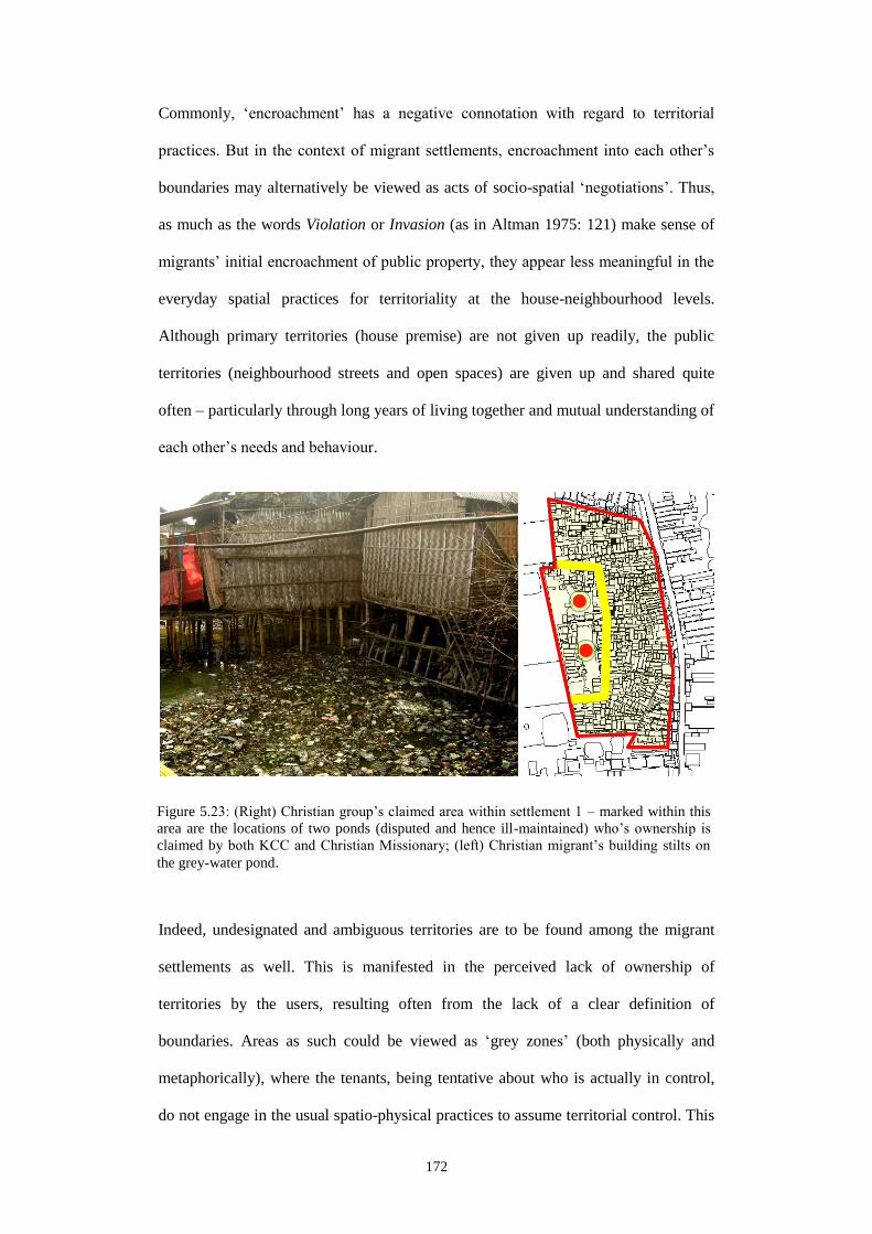
172
Commonly, ‘encroachment’ has a negative connotation with regard to territorial
practices. But in the context of migrant settlements, encroachment into each other’s
boundaries may alternatively be viewed as acts of socio-spatial ‘negotiations’. Thus,
as much as the words Violation or Invasion (as in Altman 1975: 121) make sense of
migrants’ initial encroachment of public property, they appear less meaningful in the
everyday spatial practices for territoriality at the house-neighbourhood levels.
Although primary territories (house premise) are not given up readily, the public
territories (neighbourhood streets and open spaces) are given up and shared quite
often – particularly through long years of living together and mutual understanding of
each other’s needs and behaviour.
Indeed, undesignated and ambiguous territories are to be found among the migrant
settlements as well. This is manifested in the perceived lack of ownership of
territories by the users, resulting often from the lack of a clear definition of
boundaries. Areas as such could be viewed as ‘grey zones’ (both physically and
metaphorically), where the tenants, being tentative about who is actually in control,
do not engage in the usual spatio-physical practices to assume territorial control. This
Figure 5.23: (Right) Christian group’s claimed area within settlement 1 – marked within this
area are the locations of two ponds (disputed and hence ill-maintained) who’s ownership is
claimed by both KCC and Christian Missionary; (left) Christian migrant’s building stilts on
the grey-water pond.
5
5

173
is further exacerbated by the presence of other contesting actors. As seen in
settlement 1 (Figure 5.23), the central ponds are located on the decade-old disputed
portion of land which both Christian Missionary and KCC claims to be theirs52
. Since
KCC does not have the necessary resources to regularly monitor this property, while
CSS keeps sending Christian population groups to settle down on the ponds’
peripheral locations, the remaining of the pond area have gradually turned into a
household ‘dumping site’ for garbage and discharge. A somewhat tentative
encroachment is also common around the pond-sides, where the users commonly
extend particularly the service (kitchen, toilet) areas of their house.
5.3.1.3 Boundaries between settlement and outside world
For settlements 1, 2, 4, 8, 9, at least one of their physical boundaries is demarked by
high (commonly 7’ to 8’) boundary walls (Figure 5.24: right). All such walls are
constructed by owners of neighbouring properties53
; this includes both individual
(private) and institutional (public) owners. For a non-permeable nature of these walls,
neither visual nor physical access is possible; walls here play the role of a separator.
On the other hand, the remaining of the settlements has rather permeable boundary
conditions through which they could grow horizontally. In the case of Vastuhara, for
example, a small village is already forming on its west and south-west corner (Figure
5.24: left), which were, not many years ago, a paddy field owned by distant villagers.
New roads are being constructed and connected with Vastuhara’s grid iron streets,
while a possibility to ‘plug-in’ with a ‘serviced settlement’ such as Vastuhara is
attracting potential new buyers every day. A similar finding characterizes settlement
4 where the present dwellers are already considering a purchase of adjacent land right
52. Discussed earlier in the Settlement history under section 5.1.
53. Boundary walls are a common way to demark one’s property in this part of Bangladesh.
Both private and public bodies, located in both rural and urban areas, show this tendency
to secure land property as soon as they acquire its ownership. Construction of a
permanent boundary wall may even take place years before the actual building
construction take place on that site.

174
outside its western boundary (Figure 5.24: middle). The purchase is a likely prospect
due to the under-developed nature of this land and also for its low price for being
located on the city fringe area.
Figure 5.25 summarizes the boundary condition for each of these settlements. As the
illustrations show, although a few are bounded with or being separated by high
boundary walls of adjacent properties, these settlements also have developed an
interesting ‘public interface’ in the way the many non-dwelling functions are being
distributed along their main approach roads. Among 9 out of the 10 settlements
(except for settlement 5 due to its scattered and sprawling nature), even if the
dwelling environment is generally hidden from the public eye, the roadside secondary
functions (e.g. grocery shops, restaurants, tea-stalls, political offices, storage
facilities, wet markets, firewood stalls etc.) commonly draw in people from both
neighbouring and distant parts of Khulna city. Complementary to Dovey and King
(2011: 20)’s “Inner urban block” category where the formal facades keep the informal
ones invisible and protected from thoroughfares, here in Khulna the spatio-physical
permeability of settlement boundaries is certainly heightened through this
reciprocated exchange on the public facade of settlements.
Figure 5.24: (Left) village forming around Vastuhara’s south and west periphery; (middle)
CDC leader showing vacant land on Runner Math periphery – house building has started
taking place already; (right) high boundary wall with barbed wire on the western boundary of
settlement 2; walls are built by CARITAS, LGED, BIWTA and Bangladesh Bank Housing.

175
is
7 8 9 10
4 5 6
1 2 3
Figure 5.25: Boundary conditions of settlements.
Road
Potential areas of expansion
Boundary walls
Middle/lower-middle class neighbourhood
Location of trade, commerce and institutions
Location of Industries and production

176
There are also religious, educational and health facilities that can frequently be found
within these settlements (Figure 5.26). All of the religious institutions in and around
these settlements are run by the donations and various contributions made by
Figure 5.26: (Above) non-dwelling and non-commercial functions within settlements; (below)
locations of religious buildings (from left to right): ‘Baptist Church’ on the grey water pond in
settlement 1; Harijan-para ‘Kali Mandir’ in settlement 3 (upper view is from 2011, and lower
is from 2012); second Masjid (mosque) in settlement 6.
3 4
6 7 8 9
5
5
5 5
5
5 5
5
5
5
5
5 5
5
5
5
5
5
1
Road
Settlement boundary (tentative)
Places of religious significance
Educational and health facilities
5

177
respective migrant communities. On the other hand, the educational and health
facilities are commonly funded and managed by NGOs54
. In addition to their spiritual
and functional (and developmental) significance however, these institutional facilities
also serve another important purpose. Presence of these rather ‘positive’ functions
within these otherwise negatively attributed settlements (typical of slums and
Bastees) helps ‘earn a good name’ for these communities. As outsiders send their
children to study in the schools within these settlements (settlement 6), or as people
come for their daily prayers in the Mosques of these settlements (settlement 1), more
opportunities are created for the migrant communities to mix with outsiders having
different socio-economic backgrounds. In the extreme case, people from different
faiths might even come and join in; Figure 5.26 (middle-circled) shows a Muslim
woman waiting before the Harijanpara Hindu temple at settlement 3 for a spiritual
healing session to commence. In addition to the permeability of spatio-physical
boundaries, this example shows evidences of a fusion of social boundaries as well.
Such fusion thus appears to be a deliberate construct by migrant communities where
particular buildings and spaces are used in a way to facilitate their social
‘mainstreaming’ and hence identity formation.
5.3.2 Need for territorialization
With reference to the theoretical discussions in Chapter 2, this section discusses the
raison d’être of the territorial practices and activities that have been highlighted so
far. Three particular forces can be identified; these are: context-based aspirations,
incremental growth and income generation. Where appropriate, discussions are also
made about the associated social, spatial, and/or political gains.
54. Only in the case of settlement 6 (Vastuhara), a secondary school is run by the community.

178
5.3.2.1 Contextual aspirations
According to Ghafur (2004: 268), home is the centre of a holistic existence of any
individual or a social group in Bangladeshi culture and tradition. In addition to
providing a place for living, home is where people are grounded socially – to the
extent that it gives them social identity (e.g. a boy is called the son, or a woman is
called the wife – of a certain home). However, the concept of home in the traditional
sense becomes meaningful only when home is viewed as a part of the Samaj55
. To
belong to a home in the Bangladeshi social setting, Ghafur asserts, is essentially to be
part of the Samaj (Opcit.). In his discussions however, Ghafur does not elaborate on
the ‘aspirations’ that underlie the ownership of ‘home’ he mentions of. Therefore,
home-ownership makes sense only when discussed in relation with the contextually
significant concepts namely: Zamin, Vita, Ghar, Bari, Basha, Bariwala and Desh. As
all of these terms have been frequently mentioned by the migrants, there is a need to
view migrants’ home-making efforts in relation to these.
Desire to become ‘middle-class’ (both socially and materially) is what drives
migrants’ home-making efforts in Khulna. In the city, any house-owner would be
called a Bariwala – literally meaning ‘the house-owner’. In common sense, Bari-wala
refers to that middle-class urbanite whose social status has been upgraded by a
number of urban accomplishments chief amongst which is the ownership of a house
in the city. In view of the vast majority of tenants compared to (land/house) owners in
Khulna56
, being a Bari-wala is clearly an economically advantageous position. In
addition, there are significant social benefits from this pertaining to someone’s social
55. Although literally means ‘society’, in the Bangladeshi context Samaj implies more to ‘a
community’ – an immediate social milieu constituted primarily by neighbors, relatives,
friends and deshi manush within a larger socio-spatial setting.
56. More than 20% of the city dwellers are landless slum-dwellers in Khulna (almost all of
them are considered ex-migrants) (KCC-LGED-UNDP 2009); amongst these slum
dwellers, 27% own a house while 66% are tenants (Ahmed 2005: 10).
179
status within the Samaj57
. For example, for the migrant landlord whose house is
rented to the NGO for a school (as in Figure 5.35: right), the house now becomes a
symbol of her socio-spatial elevation. It now expresses the migrant’s upgraded social
status to that of a Bari-wala within her Samaj, and continues to act as a physical
landmark at the level of the overall settlement.
The term Bari, in Bangla, means both a homestead and place of origin (village) –
referring essentially to a sense of rootedness. A Bari consists of Zamin (land), a Ghar
(house) and the Vita58
. Having none of these, the city house, however, is naturally
called a Basha (meaning bird’s nest), referring to the opposite – the transience and
temporary-ness associated with city life. No rented house in the city is called Bari.
The urban house becomes anonymous and un-contextual due its lack of connection
with Desh. Roy (2004: 149) refers to desh as “a word meaning both country and
countryside, signifying a sense of belonging through a bond with the land”. So, it
comes as no surprise that in the particular cultural context of Bangladesh, someone as
in the condition of a migrant would like to become a Bari-wala (and possess a piece
of Zamin and Ghar) in the city any way possible. It is only this particular status that
would re-induce a sense of rootedness in the lives of these otherwise uprooted
migrants. A new identity thus would eventually be created within a new Samaj.
Additionally, this process of identity formation would be further enhanced in the
presence of and comparison with his/her deshi manush as his/her tenants or as
members of Samaj59
(Figure 5.27). Figure 5.28 also shows the occurrence of village-
57. For example, being a Bari-wala also plays an important part during ‘marriage talks’
between families. Men or women, whose parents own an urban house are ranked socially
higher, and deemed more eligible over those who do not own any (e.g. renter).
58. The literal meaning of Vita is plinth; but allegorically it refer to the ‘root’ where one
originates from, to the grounded-ness of the particular household with this particular piece
of land in the agrarian society, to the memories of the ancestors associated with this piece
of land, and to the sense of identity that occurs from these phenomenon in combination.
59. Discussions on Settlements 2 and 5 in Section 5.1 underscore similar issues with other
socio- political gains from being a Bari-wala.

180
like microcosms with dispersed arrangements60
even within the land-scarce
settlements – bringing along additional socio-political benefits particularly for the
settlement elites61
.
60. Please refer to Muktadir and Hasan (1985) and Ahmed (2006) for similar discussions.
61. Dispersed arrangement of houses (Figure 5.28) also helps claim larger portions of vacant
land. Concentrating house forms on a single location would have allowed others to make
Figure 5.27: Houses where both landlord and tenants live alongside (from left to right): S5H1,
S1H1, S6H4 and S8H2.
Figure 5.28: Village-like spatio-physical organization of households; larger forms are living
areas while the smallest ones are the locations of toilets and baths. Kitchen locations are
shown by the mid-sized forms; (from left to right) – S6H1, S3H4 and S4H3.
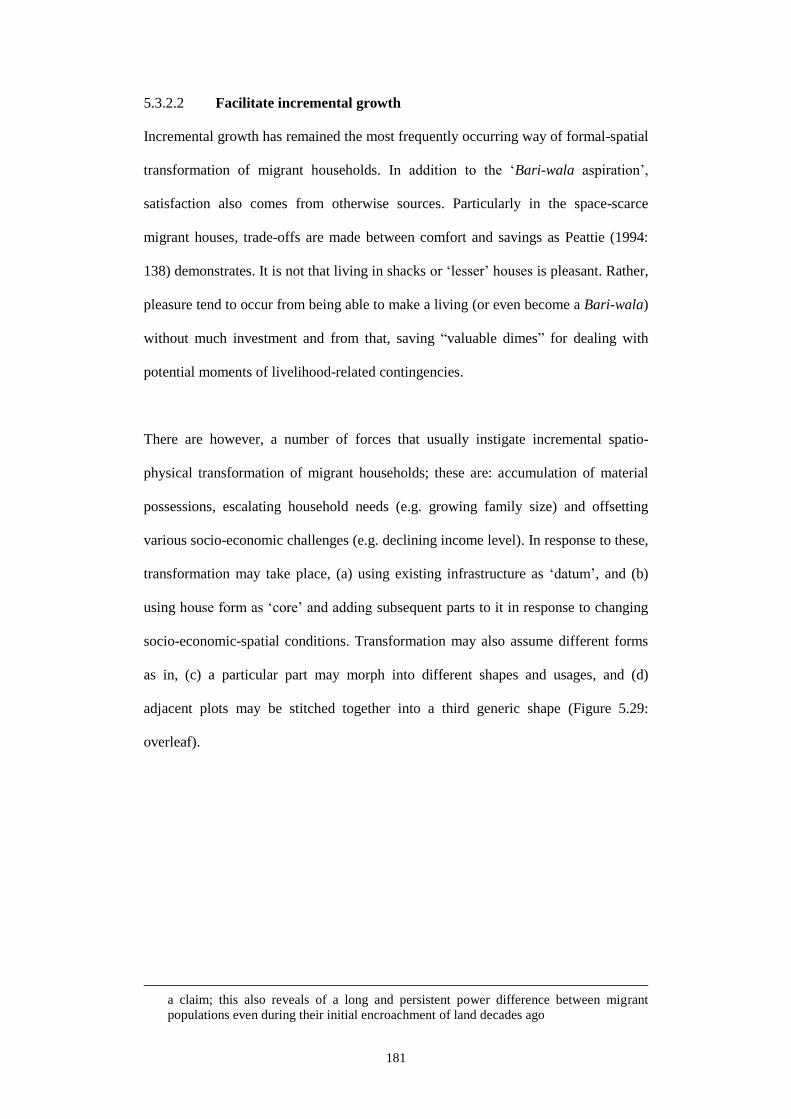
181
5.3.2.2 Facilitate incremental growth
Incremental growth has remained the most frequently occurring way of formal-spatial
transformation of migrant households. In addition to the ‘Bari-wala aspiration’,
satisfaction also comes from otherwise sources. Particularly in the space-scarce
migrant houses, trade-offs are made between comfort and savings as Peattie (1994:
138) demonstrates. It is not that living in shacks or ‘lesser’ houses is pleasant. Rather,
pleasure tend to occur from being able to make a living (or even become a Bari-wala)
without much investment and from that, saving “valuable dimes” for dealing with
potential moments of livelihood-related contingencies.
There are however, a number of forces that usually instigate incremental spatio-
physical transformation of migrant households; these are: accumulation of material
possessions, escalating household needs (e.g. growing family size) and offsetting
various socio-economic challenges (e.g. declining income level). In response to these,
transformation may take place, (a) using existing infrastructure as ‘datum’, and (b)
using house form as ‘core’ and adding subsequent parts to it in response to changing
socio-economic-spatial conditions. Transformation may also assume different forms
as in, (c) a particular part may morph into different shapes and usages, and (d)
adjacent plots may be stitched together into a third generic shape (Figure 5.29:
overleaf).
a claim; this also reveals of a long and persistent power difference between migrant
populations even during their initial encroachment of land decades ago

182
c
Figure 5.29: (a – left to right) an overhead Water Tank, a boundary wall and community
defense office used as reference, against and around which all incremental constructions took
place in Settlements 3, 10 and 8 respectively; (b) phases of physical transformation of S1H1;
(c – left to right) verandah transformation in S8H2, S10H1, S2H1 and S7H4; (d – left to right)
adjacent plots purchased and built on in S1H3, S6H3 and S6H4.
TDP (Town
Defence Party)
office
Boundary wall
separating People’s Jute
Mills and
housing area
Railways
Water
Tank
a
d
b
KCC Shop
1972 1992 2004
Road widened;
shops converted to rentable
rooms as KCC
shops are erected in front
Katcha
house on platform;
low
marshy land by
riverside
Front road
developed; house built
with brick;
shop added on roadside
house front
Construction of an
additional storey using NGO loans;
needed for extra
income and status upgradation before
daughter’s
marriage
183
Examples in Figure 5.29 demonstrate how the various manipulations of house form
(and its spatial components) have continued to help the migrant dwellers to cope with
changing socio-economic-spatial conditions. Particularly the examples under
categories ‘b’ and ‘c’ highlight how some culturally ‘constant’ spatial elements had to
be compromised (and even modified) as a response to livelihood necessities, which
however has eventually facilitated incremental growth. In S1H1 for example, the
archetypical ‘rural vernacular form’ – i.e. ‘the hut with a verandah’ has been
completely transformed into a rather ‘hybrid form’ within a span of four decades.
Likewise, in the four cases under ‘c’ (S8H2, S10H1, S2H1 and S7H4), particularly
the ‘verandah’ had to give way to a house-front firewood shop, a master bed room,
the elder son’s bed room and a public water collection/bathing area respectively. As a
consequence of these spatial adjustments, a middle-class inspired hanging verandah
now appears on the upper floor in S1H1 (b - circled); likewise in S8H2 (c), again a
middle-class inspired ‘drawing room’ appears on the north-west corner of the house
(circled). In other examples of adjustments, as in S10H1 and S2H1, functions which
were once carried out in the verandah (cooking and living), now take place in the
courtyard and in the master sleeping area respectively (circled). These are all acts of
spatial negotiation and tradeoffs that migrants had to make for coping with essential
livelihood issues. Here, form and space have been used as the key instruments for
attaining it.
5.3.2.3 Income generation
Income-generation and employment can be viewed as the two main reasons why
home-based enterprises (HBE) are frequently found in Khulna’s low income migrant
settlements. Depending on the nature of enterprise, contribution from such works
ranges between 20% to almost the entire household’s income. Household members,
particularly the women (who are also illiterate and conservative), gets an opportunity
to stay at home, fulfil their domestic responsibilities and still earn some very

184
important sums of money. In most cases, it is the female members of the family who
would run a little business and continue funding her ‘incremental’ house building
efforts using, now a days, one or a multiple of NGO loans. Although there has been
mixed reports about the usage of NGO loans62
, yet the ones who could productively
use this loan, for example to finance an ongoing business, tended to possess a ‘better
house’ made of brick and CI sheet. This however supplements an earlier assumption
that in-house income generation activities lead to better housing environments, e.g.
ownership of better quality houses63
(e.g. made of permanent materials).
Approximately in 10% all migrant households, some forms of in-house income
generating activities are to be found that contribute to household’s overall income.
Although in most cases it is quite hard to distinguish income-generating spaces from
living and other functional spaces, commonly it is around one-fifth to a half of the
house space that is used for some sort of income generation depending on the nature
of income generating activity performed (Figure 5.30). Higher percentage of income
generating space is normally associated with houses that have rentable rooms (Figure
5.37). Generally, these findings remain consistent for all ten settlements surveyed. In
addition to the economic return from renting of whatever small space available in the
dwelling unit, manufacturing of economically valuable products are commonly
observed. In many cases, manufacturing is reported as being more profitable than
renting. Often, both renting and non-renting activities (e.g. shop) are both found
within a single house. However, the occurrence of a particular sort of income
generation activity in settlements chiefly depends on the location of and the demands
62. In numerous cases, NGOs have either pushed or tricked women to borrow for starting a
business, where the women were clearly unwilling to borrow (for some does not like
borrowing while many did not have any ‘running business’). Although aware of the fact
that such a loan would not be used for businesses, NGO operators still lend these women
since the former’s ‘job description’ makes him/her to disburse as many loans as possible.
63. This substantiates the hypotheses mentioned in Tipple (1993: 530) and Mahmud (2003:
322). But again, this is too uncritical a claim; many inhabitants amongst the surveyed
settlements cling to home-based works because they simply cannot afford to find a work

185
that are created by these businesses or economic production functions. This has
already been seen, for example, in the discussions on settlement 1 and its surrounding
industrial and trading zones (Figure 5.6: right).
Income from renting may assume two forms; one, in which the landlord could be
living in the same dwelling unit or in a separate unit immediately alongside the
tenant’s unit (Figure 5.2: left and Figure 5.30: S8H2); and two, the landlord may be a
prior resident of the settlement but now an absentee who lives outside the settlement
particularly because of his/her improved economic status. In terms of tenants, they
could also be of two types generally. One, tenants are low-income individuals, who
elsewhere, and he/she does not possess any resources apart from the house that he/she can
use for income generation.
Figure 5.30: Households with various income generating activities, starting clockwise from
top left corner are: S3H1, S1H2, S1H4, S8H2, S7H1 and S6H3.
Shop/shop-related activities (e.g. storage)
Rented space
5 Handicraft (e.g. sewing)
Poultry/livestock
5 5
5 5
5

186
are either permanent migrants or circular/seasonal migrants. Their preference for
particular types of rentable space depends on their ‘migrancy’ status. It has been
found that most of the permanent ones are older, and live with their families (wife,
children and some with grandchildren) in the city since they do not have any asset
(land, house or livelihood) left in their rural place of origin. On the other hand, the
seasonal or circular migrants are younger individuals in their 20’s and 30’s (both
male and female). They do not have their families living with them because they are
generally single, and they have their families and some sort of asset back home. They
only move between their village home and the city to compensate for the lack of
income during ‘dull’ cropping seasons (e.g. when there is no job available in the rainy
season) or following a hazard (e.g. mega-cyclones, which occurs in every 2-3 years in
Khulna and severely affect its rural coastal hinterlands). These migrant groups often
look for small rentable rooms, as seen in the case of S1H1 tenants (Figure 5.37).
However, in both cases, it is mostly through the kinship network i.e. family members
and deshi manush that rentable houses and rooms are searched for. ‘To-let’ signs are
common in middle-class neighbourhoods in Khulna but not in these migrant
settlements. In case of the permanent migrants with families, they have tended to
settle down after 2 to 3 initial movements commonly during the first decade of their
stay in Khulna. They choose locations and units which suit them most, first socially
(e.g. deshi manush lives alongside) and then economically. On the other hand, for the
‘mobile’ types of migrants, and particularly for the newer ones, there are not many
spaces available in the older settlements. They tend to live, as a sublet (paying or non-
paying) with their city living relatives or friends or in the newer, and ‘low quality’
settlements in the peripheral locations. For the older ones of this category however,
who have established for themselves a pattern of visiting Khulna during certain times
in a year, some forms of accommodation are generally available. It may even be

187
reserved by the house-owner – in many cases the same deshi manush, whose house
this mobile-migrant is used to rent in the previous years.
In case of the institutional renters, it is usually the NGOs now a day, who would rent
a room for a particular duration in a day, or a full-time room, or a whole house for
purposes such as setting up a community school or a community clinic (Figure 5.35:
right). Generally, rent money is paid on a monthly basis, while the migrant
community members and their children remain the exclusive users of these facilities.
Similar facilities which are run by governments, however, are not to be found within
these settlements because by doing that government most likely fears it would
legitimize migrants’ illegal tenure status.
On the other hand, NGOs, who are government-approved formal sector organizations,
are not known for running similar facilities in the middle- or higher-class
Figure 5.31: Locations of primary school in settlement 1 (left); and community centre in
settlement 3 where income generating activities take place (right – with photo of embroidery
work being done inside). Noteworthy is the relative locations of respective community
leaders’ house in each case (house plans). Although both funded by NGOs and Donor
projects, it is only by these leaders’ approval one could use these otherwise public spaces for
personal income generation.
Primary
School
room
Community
centre cum
elementary
school

188
neighbourhoods in Khulna either. They act this way partly due to their foreign
donors’ budget-spending guidelines (for donors’ focus on ‘slum improvement’ etc.),
and partly because government officials (and their bureaucratic procedures) would
not like to be compared with them on the same grounds.
Among the non-renting income-generation sources, which consist generally of
various production activities64
, two types could be named in the way space is utilized
in each. One, production takes place using a ‘third space’, where the space is neither
part of the household nor owned by the migrant landlord. Such space may be part of a
public building, such as a room from a community building or verandah from a
community school (Figure 5.31). No rent is paid for using this space as well because
these buildings are not owned by any individual. Rather, access to this space and its
continued use is maintained by the ‘controlling power’ some particular persons hold
over the community65
. In the second form of income generation activities, generally
the migrant owner is engaged since it happens within the realm of his/her own house.
Often a room can be partially or flexibly used for these purposes (settlement 2).
Although rare, a whole upper floor may be constructed for production activities
(settlement 7). In particular occasions, the whole plot may be used for this purpose
(as in settlement 6) while the migrant owner living elsewhere. In addition, shops
either in the form of a ‘shop-house’ or as a detached unit located elsewhere in the
settlements are also two frequently occurring types (Figure 5.30).
5.3.2.4 Social gains (from renting)
In addition to the financial gain the migrant landlord enjoys from renting, there is also
a social gain that both landlord and renter enjoy. For example, in the case of the
64. This typically includes stitching and embroidery, raising poultry and livestock, tailoring,
food-items preparation, fish scaling, wood workshops, storages, and above all operating
shops, restaurants and stalls.
65. This person (e.g. the community leader/elite) has been further discussed in Section 5.4.

189
individual renters and their relation with the migrant landlord, both economic and
social gains are yielded. Although generalization is not possible, yet income from
renting remains a major source of earning for many of these migrant households.
Contribution ranges from 30% to 90% of entire household’s income depending on
plot size and hence how much space is available for renting. However, in large
‘illegal’ settlements (e.g. settlements 1 or 3) where plot size is smaller, income from
renting counts much below 30% of average household’s income. Interestingly, these
settlements are also home to the more ‘well-off’ compared with all the other studied
settlements because of their proximity to job locations (for settlement 1, shrimp and
settlement 3, proximity to Ghat) and hence having multiple earning members in most
of the households.
In contrast, in the smaller and more ‘legal’ settlements with a larger plot size
(particularly those at Khulna’s peripheral areas such as settlement 5) income from
renting may count from 50% to 90% of household’s overall income. Yet, it is not the
monetary return alone that remains the only gain from renting; there are associated
social gains for both landlord and tenant as well. This can be seen, for example, in
settlement 4, which consists of 10-15 rentable units within a total of 200+ households.
Within this settlement, it is generally maintained by the community elders that houses
could be rented to the deshi manush only. Initially, it seems very harsh and to some
extent, irrational. But a closer inspection reveals that this settlement’s very sustenance
depends on the strength of the community being ‘tight’ and ‘communal’. As
suggested in the settlement history, all migrants living in settlement 4 originate from
the greater district of Barishal. This homogeneity, further aided by their closed ‘rent
policy’ however has allowed this community to remain united particularly during
numerous eviction threats. The community leaders, who are also residents of this
community, realized through many struggles the importance of an absolute control
over the entire resident population. The construction of this socio-political

190
mechanism in some way seemed more beneficial compared to the financial outcome
from renting.
In the case of settlement 5, social benefit from renting occurs in a different way.
Although the tenants here are not necessarily from the same rural origin of the
landlord, their intermingling culminates into a ‘third space’ (Figure 5.37: left). A few
shared zones emerge, such as cooking, bathing, washing, toilets and children’s play
area within the single-storey house compound, where particularly the female
members engage in their everyday domestic activities and exchanges. Events of
dissent and loud quarrels amongst tenants are indeed frequent; this is also expected
because the numbers of tenant-households often surpass the number/quantity of
service points66
. Yet, on the following day, same interactions and exchanges start
taking place as usual, forgetting yesterday’s squabbles. Indeed a sense of solidarity
can be sensed here due to the homogeneous socio-economic status of the tenants. In
terms of social benefit, this ‘owner status’ also puts the ‘poor’ landlord often in the
position of a ‘master’. What spawns through the many informal exchanges67
culminates in a more ‘family-like’ bond between the two parties. This reveals of the
tenants’ similar social status with that of the landlord’s as well. In addition, this
landlord now assumes the guardianship of this few families’ social worlds. Therefore,
it is not uncommon that during national or local polls, campaigns aim to convince
more the landlords and less the tenants. This has also been highlighted under
settlement history in section 5.2.
66. For example, in S5H1, there are 4 families that occupy the household premise using a
single toilet, a single bathing area, and a single water collection point on a daily basis;
while in S5H2, 11 families share the similar number of facilities
67. Such as sharing of spaces, inter-borrowing and lending of money and other stuff (e.g.
cooking oil, rice etc.) and solely trust-based transactions (no written documents
maintained for any kind of financial transaction – e.g. for paying rent or borrowing).
191
In many cases, home-based enterprises in low income settlements have been
described as sites for exploitation
(as in Tipple 1993: 531) since mainstream
industries tend to subcontract works at a significantly lower rate while workers
remain unable to bargain for any additional benefit because of their ‘informal’ status.
Similar can be said of settlements 1 and 2, which are located adjacent to the main
shrimp-processing industrial zones in Khulna. Not only these settlements remain
home to the essential worker population for these industries and trading posts, a
variety of supporting works to these facilities, such as fish scaling, box making,
parking for rickshaw-vans etc. are also commonly carried out using the home-spaces
of these settlements. On a different note however, these settlements then can also be
viewed as ‘support settlements’ for the industries and trading activities. These
migrants and the sustainability of these settlements depend, to a large extent, on the
economic-political support that these industry owners offer them quite often. Political
supports by this elite class, particularly to neutralize eviction threats, or for financial
support during social events (marriage, death and medical treatment) therefore
establish these two parties as close allies. So in the global marketplace, when Khulna
Shrimp sells at a competitive price, the economic benefit must be viewed in light of
the roles these social relations play. Over the years, such relationships have also been
established between the migrant producers and other customers68
of their products
that also have helped the former to ‘soften’ their ‘illegal’ tenure status. Such
relationships thus also have earned migrants the essential external recognition of
these apparently ‘illegal’ settlements. This, the migrants feel, would lead to the
gradual replacement of the negative image usually associated with these settlements
(e.g. ‘places of crime and social ills’) by more positive attribute like ‘places of
production’.
68. These customers can be the subcontractors and suppliers for offices or industries, NGOs,
and people from neighbouring middle-class communities

192
5.3.3 Dynamics of territorial boundary
Figure 5.32 demonstrates the dynamic nature of the territorial boundary manifested in
the everyday spatial ‘negotiations’ at both household and public levels of the studied
settlements. In the instances of Figure 5.32 (above: a), a portion of the interior space
School cum
storage b c d
School
Work
Previous
Verandah Landlord’s
area
a
Figure 5.32: Negotiated territorial boundary: (above – a, b) time-based use of interior space in
Settlements 4 and 1; (above – c, d) multiple use of interior spatial organization due to changed
demographic circumstances at S2H1 and S1H1; (middle – left to right) house-neighbourhood
‘tissue’ showing time-based use of public territories at settlements 10, 3 and 4 respectively;
(bottom – left to right) photographs of the same public territories at settlements 10, 3 and 4.
a b c
Tea stall
seat
Shop
Tea
stall
Shop
Playground
Bath

193
of the community building is used particularly in the afternoon hours for embroidery
works carried out by female members of neighboring houses. The same space
however is used for an elementary school in the morning. In the example of S1H2
(above: b), a NGO-run elementary school runs in the morning while the same space is
used in the afternoons for fish basket storage. In (above: c and d), the original spatial
organization of house interiors have been adjusted according to changing family
needs. For S2H1 (above: c), verandah has been turned into elder son’s bedroom after
he got married, while cooking (circled), dining and living now take place within the
master sleeping area. In S1H1 (above: d), her personal bedroom (north-west corner)
is sacrificed by the widow landlord for accommodating the newly married daughter
and son-in-law; her new space is now used also as a living area, a space for running a
Saree business (upper circled) and for dressing (lower circle). Similar fluidity of
territorial practice may also be noticed in the public level examples (above: middle
and bottom). The playground in settlement 10 (middle and bottom: a) is also a sacred
place which is not to be encroached. Every year a number of religious gatherings take
place here. In settlement 3 (middle and bottom: b), household premise of S3H4 is
bifurcated by cross-movements of neighbours who do not have other access points to
their houses. So this apparently private property and its boundaries also have a public
dimension to them. The concept of boundary thus appears fluid and slippery once
again. Similar can be seen in the example of settlement 4 (middle and bottom: c),
where spaces around roadside shops and tea stalls are appropriated and used by the
community members during most parts in a day. Removable furniture is used to claim
territory, as shops continue to operate day-long.
These findings however substantiates Altman (1975: 160)’s theory that territoriality
is a complex process that changes with time and circumstance. While certain well-
defined territories may exist, their boundaries may be flexible and may shift and
evolve in response to changing situations (Ibid: 104). But as these examples

194
demonstrate the ‘scare’ circumstances (such as the lack of space or a lack of
accessibility), there are other social benefits that occur from these practices as well.
In the household level examples, the sacrificing of bedroom or verandah certainly
prioritizes the view that a ‘joined family’ must be retained at any cost. In addition to
this cultural preference for ‘joined family’, parting of the elder son would obviously
have caused financial hardships for both parents and the son. In the example of the
widow landlady, her daughter is the only child she has. So having no other earning
member and owing to another cultural preference69
, it is for her son-in-law and
daughter’s stay this woman was prepared to make any sort of sacrifice/compromise.
In the example of the playground in settlement 10, the need to retain the playground
in its original state (un-encroached) is both religious and political. Although such
religious gatherings a few times a year help spiritual fulfilment, organization of such
gatherings (where people from both neighbouring and distant communities are free to
take part) once again helps reduce the settlement’s ‘bad name’ as discussed with
other cases previously. Instead of being viewed as invaders, people living in
settlement 10 now thus gets an opportunity to be viewed by outsiders as ‘religious
community’ as well.
In the case of sacrificed territorial claim for public use as in settlement 3, the notion
of ownership becomes a negotiated concept in the interest of communal living. Even
if the plot boundary is clearly outlined and the landlord is free to construct any
building within the boundary70
, some vacant space around the middle of the plot is
still retained, allowing it to be used as entry to different households including
landlord’s own. For neighbours being well known to this particular landlord, this
loosening of territorial claim benefits ‘social surveillance of private property’ as well.
69. In Bangladeshi society, a widowed mother would typically reside with any of her elder
sons after her husband passes away. A woman is not preferred to live on her own in the
conservative Muslim family system.
70. Please take note of how structures are constructed on each of the edges of this plot.

195
In terms of settlement environment, home-based enterprises and particularly those
which encroach and make use of public spaces and streets (as in the example of
settlement 4) also offer a twofold contribution. First, the shops and stalls become
places of everyday encounter between community members. For having a pubic
nature, these apparently small establishments become important locations where
social behaviours are displayed and constantly being shaped (and mostly positively
modified). In addition, these establishments located at the thresholds of settlements
and Public Streets become sources of constant social surveillance. Both outgoing
(e.g. playing children without parents) and incoming activities (e.g. strangers to the
settlements) thus become subject to surveillance and scrutiny of the users of these
spaces. Since most of these shops and stalls operate all day long (and some even deep
into the night), someone is expected to be present always and play that vital role of a
‘social eye’.
5.4 Decision-making
This section discusses the actors, rules, territorial hierarchies and territorial depth –
pertaining to the spatial decision-making structure in these settlements.
5.4.1 Actors
Actors, or Agents as Habraken (1998: 7) puts them, are the individuals, groups or
institutions that inhabit the built environment, and have the ability to transform it by
making sure “things stay as they choose within the territory they claim”. “The goal”,
Habraken says hence “is not to observe how agents interact, but to understand the
structure and behaviour of the form that is the cause and goal of their interaction”
(Ibid: 30). So in light of the discussions on the history of settlement-tenure and
migrants’ territorial practices so far, Table 5.2 (overleaf) summarizes the identity of
actors who have remained influential and most essential during settling down and in
everyday acts of habitation.

196
Table 5.2: Settlements and influential actors involved.
Settlement
name
Influential Actors involved
Household level Settlement level Settlement 1
Landlord (for tenants), UPPRP
leaders, Community elders, CSS,
Shrimp-factory owners.
Mayor, Ward 22 Councillor, CSS,
UPPRP leaders, Shrimp-factory
owners.
Settlement 2
Landlord, NGOs, UPPRP
personnel.
Local traders and businessmen,
BNP Ward 22 office.
Settlement 3
UPPRP leaders, elders (Sardars)
in minority communities (e.g.
Harijan,Vaidya).
Mayor, Ward 21 Councillor,
Railways IW department, UPPRP
leaders.
Settlement 4
Sardar brothers, 3-4 other elders,
UPPRP leaders, internal political
workers.
Sardar brothers, Local MP, Ward
1 Councillor.
Settlement 5
Landlord (for tenants), UPPRP
personnel, NGOs.
KCC, UPPRP personnel (local
elites), NGOs, Landlord,
Religious bodies.
Settlement 6
4-5 community elders (originally
allotted and supporters of same
political party), NGOs.
Mayor, Ward 9 Councillor,
Central Minister for labour,
community elders (and supporters
of political parties).
Settlement 7
UPPRP leaders, Bihari
community elders, NGOs, Baitul
Falah Mosque Committee.
SPGRC, Ward 12 Councillor,
International Red Cross,
Khalishpur Housing Authority.
Settlement 8
Mr. Bakkar and his 3-4 affiliates. Khalishpur Housing Authority,
KCC, Mr. Bakkar and his 3-4
affiliates.
Settlement 9
Jute Mills labour leaders, political
leaders, Building Committees,
NGOs, KCC.
Mayor, Ward 10 Councillor,
Labour (and political) leaders,
Building Committee.
Settlement 10
Allotted employees, community
members, Railways IW
Department.
Railways IW department,
Community members.
As shown, a number of actors have been identified in Table 5.2. If compared with
Raharjo (2010: 23)’s mentioned categories, two variations can be particularly noted
of Khulna’s migrant settlements. First, actors do not have a fixed or discrete role

197
pertaining to the physical development of settlements; often it is difficult to delineate
an exact role for each. For example, in many cases in Khulna, Raharjo’s mentioned
provider and operator appear to be the same person (e.g. the landlord). Likewise, the
supplier may often be a Deshi Manush, who would play the role of the middle man
for free – not for a fee; the associated social gain that have been discussed earlier
often remains the only remuneration. The regulator, or concerned government offices
such as KDA, as seen earlier, may often play the exact opposite role; some offices
(NHA, Land Revenue Office) may even extend its support for a fee (illegal) that it is
not supposed to receive. In addition, when these organizations are lobbied by
politicians and tenants, the former’s role become similar to that of the suppliers. The
role of the facilitators (UNDP, UPPRP, NGOs), on the other hand, is often that of the
negotiator. In addition to supporting the socio-spatial development activities in the
migrant settlements, often also involve in negotiation between the illegal tenants and
concerned government offices.
Second, a presence of a new category of actors can also be noted in the context of
Khulna’s migrant settlements. In addition to the seven types suggested by Raharjo, a
new eight category can be suggested. This can be given a more ‘fitting’ name
‘negotiators’, considering the roles of all the influential actors who for social,
economic and political reasons have continued to support, solicit and negotiate issues
for the migrants in numerous occasions. This category however should include all the
actors – both formal and informal, who have proved most essential for migrant
settlements’ sustenance so far. In that KCC, UPPRP (personnel), political figures and
influential businessmen may all be viewed as negotiators.
5.4.2 Rules
Rules determine how (physical) parts are admitted or excluded from territorial space
(Altman 1975: 127). Rules are manifested in the customary practices of

198
territorialization, socially accepted norms and in the legal (formal) deeds. These are
all used to ensure actors’ desired level of control over the spatio-physical boundaries
(Ibid: 128). Local enforcements, whether formal or informal, help establish (the
acceptable) territorial depth within the broader urban fabric (Ibid: 145). In the
particular context of the ‘informal’ migrant settlements, which commonly suffer from
an acute lack of physical space and legality, rules are manifested in alternative
practices, norms and enforcements pertaining to many territorial control mechanisms.
Chief amongst these practices remain a number of permanent and non-permanent
building activities.
Without secured tenure, formal deeds either for ownership transfer (e.g. through
possession rights selling) or for other types of transaction (e.g. rent payment or
borrowing/lending), are almost non-existent in the context of migrant settlements.
Across all the studied settlements (including the Bihari settlement 7), a common
practice prevails. This practice, which is based on primarily on trust – gives high
importance on the immediate community’s involvement in any sort of transaction
Figure 5.33: (Left) S8H2 plan; (middle) S8H2 photo shows how it maintains distance (set
back) from adjacent sewer drain and street; (right) Bakkar Bastee front – again showing its
maintained set back from the Public street.

199
between parties involved. For example, in the case of ‘possession right transfer’
between an ‘owner’ and a buyer, the community elders and the neighbours who share
this property boundary are asked by the present ‘owner’ to witness the transaction and
show the plot boundaries to this newcomer. Although the seller, the buyer and the
witnesses jointly sign a paper to keep record of the transaction, the document remains
worthless because of the ‘illegal’ tenure status of this plot/dwelling unit. Rather, what
remains most important is the mutual trust between the parties involved emerging
primarily from the fact that these parties all share the same kinship network. In most
cases, this newcomer would be a known person to the seller – may be a relative, or a
friend or his/her deshi manush. Either way, a potential buyer needs to be ‘known’ to
the seller before the actual selling of the possession rights. In many instances, the
seller would in fact mention (and positively certify) about this buyer to his/her
neighbours and community elders prior to actually transferring the rights.
Encroachments of public land and housing areas have been the prevalent way of
territorialization for 8 out of the 10 studied settlements. However, these acts of
encroachment also come with a principle. Common to all these settlements is a
certain form of respect for government ‘boundaries’ where the encroaching migrant
makes sure that no permanent building/construction activity ‘spills over’ to the
adjacent public domains (Figure 5.33). It is done precisely to convey that although
their existence is solely dependent on the invasion of public property, such illegal
means are sought after only to the extent it is required for provisioning a mere shelter
for themselves, and are in no way at the cost of greater public life. When such
invasions of public infrastructure actually take place, non-permanent materials
(bamboo, wood etc.) are commonly used (Figure 5.34: left and right) – demonstrating
once again that it is done solely to compensate for the lack of house space, and not
intended to permanently infringe any of the public infrastructure.

200
At the household-neighbourhood level, when there is a need to erect a new house or
carry out major modifications to the existing house, the neighbours would always be
notified. In many cases, depending on the nature of construction, community elders
would be called upon to give their verdict on the actual threshold of construction (plot
outline and limits to vertical extension) which the owner might take advantage of (as
in S1H1, Figure 5.34: middle).
For public use (and also for own social and financial gain), migrant dwellers might
often allow structures to be added on to their own buildings or allow modifications to
their own house form (Figure 5.35). However, in many cases (as in S7H4), this
process of giving away such precious little space for public purpose remains complex.
Local enforcements such as constant lobbying, convincing and even exertion of social
pressure by community elders are common. These acts of construction hence
manifest as socially determined practices in the presence of a clear leadership. There
are also certain spatial practices in the migrant settlements, which have become
Figure 5.34: Rules and norms of construction: (Left) addition of a non-permanent portion
with the otherwise brick-built house S1H1; ground level – cover on public sewerage drain to
make way for ground-level tenants’ entry; this space behind the street-front shops is also used
for cooking and bathing; (middle) 2004 construction of new brick-built house and verandah
extension over street (marked); this projection over the road was approved by the elders for
allowing the female owner (also one of the oldest residents on this lane) a clear view of the
settlement entry from the main road; (right) S1H1 photo with non-permanent add-ons.
Water collection
and bathing
point for Ranga
Miah Goli
Drain cover

201
accepted social norms. First are the events of compromised privacy for dealing with
household’s lack of space – already outlined in the discussions of home-based
enterprises in section 5.3. However, as in the cases of Figure 5.34 (middle and right)
for example, similar compromises also bring about further social gains equally for the
community and the landlord. The landlord’s reputation as a ‘sacrificing leader’ is
enhanced. The house now becomes a ‘landmark’ – having a heightened identity
amongst the settlement. Relation between the different parties (such as between the
landlord and the concerned NGOs who generally fund such projects) is also
strengthened. Second, in most settlement streets, architectural ‘surveillance elements’
are frequently found, which ensure both privacy and safety of neighbourhood spaces.
For example, the cantilevered verandah in Figure 5.34 equally keeps ‘an eye’ on the
entry to the lane, on the lane space itself and also on the bathing space (which is also
very close to the main road and where a number of female also take their bath). Even
if the female landlord is not present there, the presence of the verandah itself
discourages the potential intruder. NGO-funded and community-managed bathing
and water collection spaces of this sort are however plenty amongst all of the
settlements studied (Figure 5.36).
Figure 5.35: (Left) community water collection point and bath added on to S4H4 building
wall; (middle) community water collection point and bath replaces front verandah of house
S7H4; (right) elementary school erected within the household premise of S1H2.

202
In addition to the architectural elements as the verandah which helps ensure privacy
of the spaces where mostly the female members congregate during particular times in
a day, most male members are also aware of those and generally avoid these times for
their own use. Similar mutual respect is also evident in the frequent events of
‘thoroughfare’, as people living in backward properties (whose house does not have
an approach road) frequently make use of front-owner’s property to enter or exit
theirs (Figure 5.36: right). It is a more negotiated spatial activity and also a customary
spatial behaviour that can be traced back to the rural practices where immediate
neighbours and kin are often allowed to do the similar. The neighbours’ crossing-over
of front-owner’s property line is not considered trespassing as long as latter’s privacy
is respected.
5.4.3 Territorial hierarchy
Actors who inhibit a particular territory maintain the right to control the movements
in and out of that territory, even that of the actual landlord as in a landlord-tenant
situation (Habraken 1998: 136). “Agents controlling higher levels dominate agents
controlling lower levels. When higher-level agents control what goes into included
territories, included agents must, as a rule, accept the imposed limitations on what
filters through the higher level” (Ibid: 139). Although many instances in support of
Figure 5.36: (Above – starting clockwise from left)
locations of bathing points in settlements 3, 4, 1, 9 and 7;
(right) thoroughfare over another’s property in S3H4
premise – grey outline shows property boundary and red
lines show neighbour’s path across S3H4 territory.

203
this premise are on hand, alternative practices are worth mentioning as well in the
context of Khulna’s migrant settlements. In the examples of Figure 5.37, there are
certain ‘negotiated territories’ (area 3), which are hard to designate as a clearly
controlled zone either by the landlord or by the tenants. Although the service areas
(yard, kitchen, toilets, washing, bathing etc.) are generally under the landlord’s
control, the landlord in many cases shares these facilities with his/her tenants for both
social and economic gains (discussed under section 5.3).
The extent of sharing varies depending on the size of land-plots and settlements. In
the cases of S5H1 and S6H4, these shared territories are more elaborated and
comprise of a higher number of functions. Due to the horizontal distribution of all the
territories, interactions between the landlord and his/her tenants are more frequent. In
S1H1, due to the compact nature of the land-plot (and settlement) and for the vertical
separation of territories (between landlord and tenant), only the toilet is shared
between the landlord and her two female tenants (the male tenant is not allowed to
use the ground-level toilet). The frequency of interaction therefore is also lower
compared to that of the S1H1.
Figure 5.37: Showing (from left to right) house plans for S5H1, S6H4 and S1H1; landlord’s
territory, tenants’ territory and negotiated territory (shared service areas) are marked with
numbers 1, 2 and 3 respectively; for S1H1, there is an upper floor where the landlord lives.
3
1
2
1
2
2
3
2
3
204
At the level of settlements, territorial hierarchy depends on the nature of
leadership/headship prevailing in each of these settlements. As in settlement 4 and 8,
or in Vaidya Para71
in settlement 3, territories are controlled by community elite (an
individual leader or a group of individuals) who possess the decision-making power
regarding any socio-spatial issues of the settlement. As discussed in the settlement
history section, this person in most cases is the ‘undeclared’ community leader – an
elder (settlement 8) or traditional leader (Vaidya Para in settlement 3), or someone
with better income sources (e.g. multiple earning members in the family), a tested
leader who previously have fought for community’s well being (settlement 4), or
someone who has a good political connection outside the settlement (settlement 4).
For these communities being ‘closed’ and settlements being smaller, interpersonal
relations remain stronger. If a house has to be modified or rebuilt in any of these
settlements, it would require approval of the respective leadership. It is by his
approval, anyone (in or outside the family) can continue to use any space for
economic production (as in Figure 5.31). Any NGO intervention at the community
level would also require this person’s prior approval. However, in the larger
settlements (e.g. settlement 1) no such clear individualist control of territories has
been observed. Although community elders are present and remain an important part
of the socio-spatial decision-making body, the territorial ‘control mechanism’
remains rather negotiated and consensual. This is elaborated in the following section.
5.4.4 Decision-making structure
In the smaller of the studied settlements, the community elites (leaders) clearly enjoy
the possession of a much larger property compared with other migrant residents
(Figure 5.38: above). In most cases, such larger parcels of land have been in
71. Vaidya is a traditional river-faring snake charmer nomad group, known for their magic-
healing capabilities particularly in the rural areas of Bangladesh. However, with time, this
particular group has become sedentary and has been living on the western periphery of

205
possession of these leaders ever since they have started inhabiting these settlements.
Their supremacy is demonstrated by the unchallenged possession of their quite
unusually large share of land within these land-scarce settlements.
This spatial supremacy further validates these leaders’ socio-political superiority over
the rest, and hence on the community’s decision-making structure as a whole (Figure
5.39: right). This makes the decision-making structure authoritative, linear, and
clearly hierarchical. The community leader here assumes all the responsibility of
settlement 3. As in many other traditional societies, each Vaidya group is headed by a
Figure 5.38: (Above) floor areas of four houses compared in settlement 4; one with bold blue
outline belongs to one of the community elites (Sardar Brothers), while the ordinary ones
being outlined in red; (middle-left) portions of Vaidya Para in settlement 3 - Sardar’s house
compared with the neighbors’; (middle-right) Mr. Bakkar’s house area compared with the
adjacent ones.
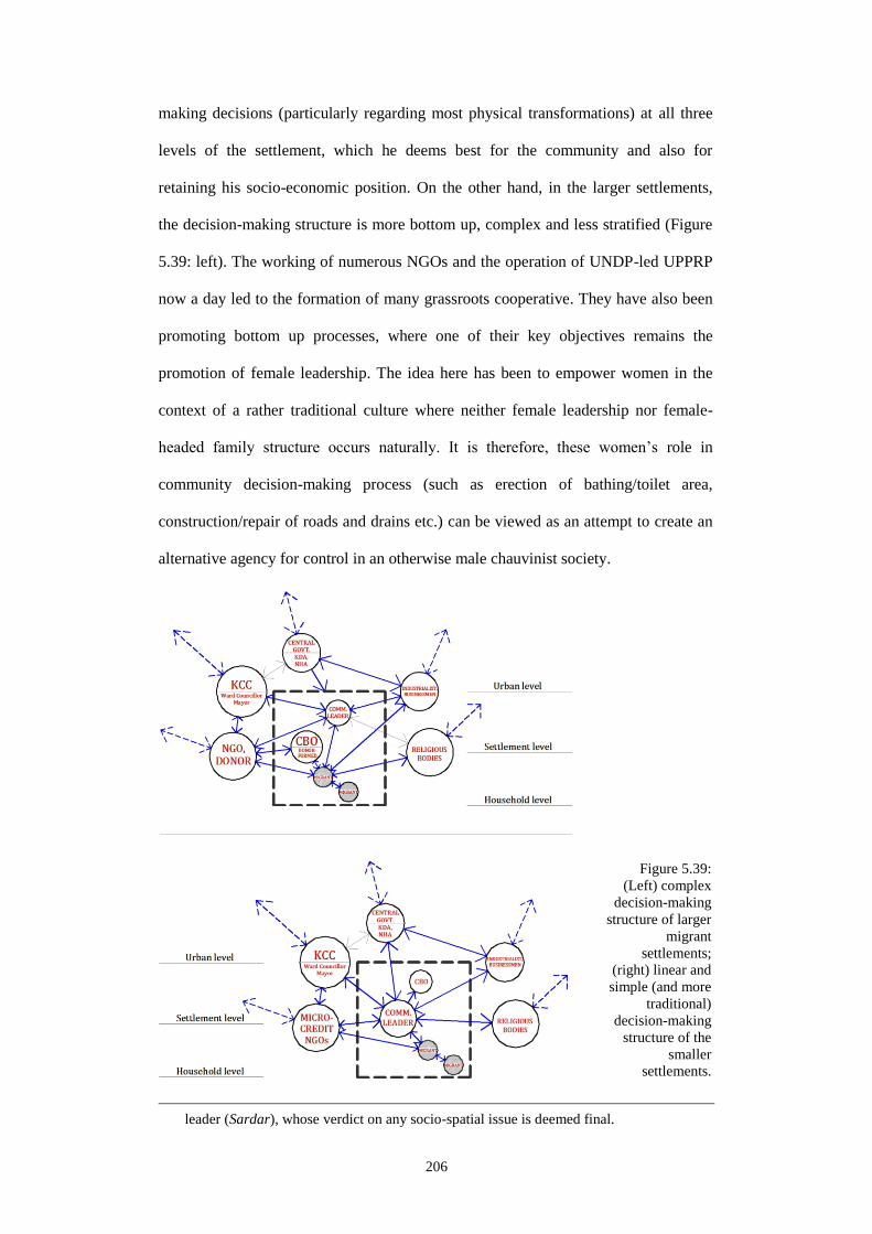
206
making decisions (particularly regarding most physical transformations) at all three
levels of the settlement, which he deems best for the community and also for
retaining his socio-economic position. On the other hand, in the larger settlements,
the decision-making structure is more bottom up, complex and less stratified (Figure
5.39: left). The working of numerous NGOs and the operation of UNDP-led UPPRP
now a day led to the formation of many grassroots cooperative. They have also been
promoting bottom up processes, where one of their key objectives remains the
promotion of female leadership. The idea here has been to empower women in the
context of a rather traditional culture where neither female leadership nor female-
headed family structure occurs naturally. It is therefore, these women’s role in
community decision-making process (such as erection of bathing/toilet area,
construction/repair of roads and drains etc.) can be viewed as an attempt to create an
alternative agency for control in an otherwise male chauvinist society.
leader (Sardar), whose verdict on any socio-spatial issue is deemed final.
Figure 5.39:
(Left) complex
decision-making
structure of larger
migrant
settlements;
(right) linear and
simple (and more
traditional)
decision-making
structure of the
smaller
settlements.

207
Indeed, this ‘bottom-up’ process involves some sort of ‘local’ leadership from within
the community particularly regarding building construction. This same leadership is
also capable of mobilizing the mass of the population for example, if a need arises for
resisting eviction threats. Yet, none of these two decision-making structures involves
a clear bottom up process. For example, the present female leadership structure in t
these settlements is often challenged by their male counterparts (in many cases the
male members of their family). In addition, this idea of a female leadership is after all
an ‘imposed idea’ – something which had been conceived by people and
organizations often divorced from the everyday socio-spatial realities of the low
income migrant settlements. Thus the ‘true’ nature and extent of ‘bottom up’ – both
in terms of problem identification and decision-making process pertaining to the
concerned community, remains questionable. So as Habraken (1998: 214) mentions
of two clear decision-making processes (i.e. top-down and bottom-up) underlying the
transformation of built environments, it is either a community-defined top down
process or a combination of top-down and bottom-up that can be identified in
Khulna’s migrant settlements. Settlement forms thus may be viewed as an outcome
of this permutation between two processes. Here different actors get involved in
taking decisions at different levels and about different components of the built
environment, and yet retain connections between them. This has been depicted in
Figure 5.39. In both cases however, problems and solutions are found to be
community-defined and community-driven respectively, while a community elite
(nowadays mostly represented by the female leadership of UPPRP) often leading
such initiatives. This nevertheless substantiates Habraken (Ibid: 227)’s assertion that
even if individual actors might exercise individual preferences, their acts typically
conform to a “socially determined” framework.

208
5.5 Summary: threads of themes
Analysis of the fieldwork data, as presented in the previous sections identifies a
number of interesting threads. These are briefly summarized in Table 5.3 below.
These themes and threads, together with the ‘structural’ findings in Chapter 4 are
carried forward to Chapter 6.
Table 5.3: Threads of themes from data analysis on migrants’ spatial practices
Areas Theme/threads Problems with
categorization
- Boundaries between contradictory co-existences such as legal-illegal
or formal-informal remain problematic. It is quite tricky and risky to
clearly distinguish between such binaries and hence categorize them
in absolute terms of ‘legal’ or ‘illegal’.
- These ‘in-between’ situations in most occasions are created and
maintained by authorities in power. Even if some form of legality or
formality is approved and allowed by these authorities, not all the
issues pertaining to legality have been resolved; chief amongst these
remains the issue of land tenure and hence the issue of building
construction.
- Settlement process of the migrants then can historically be looked at
as a distinctive ‘mechanism’ where room for bargain, negotiation and
compromises are intentionally maintained. These settlements and their
very existence thus can also be viewed as ‘negotiated’.
209
Spatial
occupation and
personalization
- At the household level, spatial boundaries remain flexible and
slippery; primary territories are maintained but can also be given up or
compromised depending on social or economic circumstances.
- At the public level, meaning of space and spatial boundaries shifts and
changes constantly. This largely depends on the social negotiations
that are made between the migrant dwellers. At this level, a number of
non-dwelling functions are used by migrants toward fulfilling a
number of ‘political’ objectives. Both religious and non-religious
buildings remain important physical components that help improve
settlement image by establishing and maintaining social relations with
people external to these settlements.
- Although the dwelling environment remains generally hidden, spatial
interfaces between migrant settlements and the outside world remain
places of interaction between migrant dwellers and other citizen. This
also helps migrant communities and settlements to soften their ‘bad
names’ by promoting their positive image as ‘places of production’
and ‘places of religious population’.
Need for
territorialization
- A number of cultural factors affect the way in which migrants go
about their everyday territorial practices. This particular sort of
practice also facilitates incremental growth and creates provision for
various income generation activities. Both incremental growth and
income generation however require a significant compromise with the
culturally ‘desired’ spatial environment. Despite incremental growth
and home-based enterprises’ significant contribution to the ‘crowding’
of settlements, there are associated social gains that also result from
this particular form of territorial practice.
Dynamics of
territorial
boundary
- Territorial boundaries cannot be clearly defined and they remain
subject to constant change and interpretation by the migrant dwellers.
In many cases, multiple use of a single space by a multiple of actors is
frequent. In response to changing demography and/or socio-economic
conditions – boundaries of both private and public space thus assume
different forms and shapes. This adjustment of boundaries however
leads to the adjustment of spatio-physical configurations as well. So
the dynamic and accommodative nature of spatio-physical
configurations of migrant settlements could again be viewed as
negotiated forms which are produced in response to changing socio-
economic situations.

210
Decision-
making
- A number of influential elitist actors are identified who prove to be
important for the sustenance of migrant settlements. Such actors are
both formal and informal, and are both insiders and externals.
- There remain less formal (written) rules but more norms and
customary practices that act as rules as far as the spatial environment
of these settlements are concerned. For property (possession) transfer,
building, construction and modification (and even for renting in some
of the settlements) – communities abide by these unwritten rules that
impart order to these settlements socio-physical structure.
- There remain two particular models for decision-making; the
configurations of these models however depend on the size of the
settlement and demographic composition in it. These models are
neither top-down nor bottom-up. Rather, it is community-driven and a
combination of these two work together. In many cases, decision-
making is further facilitated by kinship networks and the presence of
deshi manush.
211
Chapter 6: Scarcity, control and negotiations
6.1 Introduction
With the emergence of the politically ‘constructed’ socio-economic deficiencies and
socio-spatial binaries as in chapters 4 and 5 (e.g. formal-informal, permanent-
temporary and legal-illegal), understanding migrants’ home-making raises the
necessity of the formulation of a comprehensive framework; it also holds that it must
be formulated in consideration of these constructed conditions. Assuming migrant
habitats in the third world city as socio-physical outcomes of the workings of the
aforesaid binaries, this chapter outlines a framework that aims to comprehend the key
socio-spatial-political mechanisms underlying migrants’ home-making. For that, it
makes use of the threads of themes from Chapters 4 and 5. It holds that the proposed
conceptual framework (Control and social construction of home) is acontextual and
the addition of the concept of ‘Scarcity’ imparts a better contextualization capability
to this framework. An assessment of Home (as a social construct) in relation with the
socio-political, economic and spatial responses that Scarcity elicits also establishes
the Home-Scarcity relation more meaningfully.
This chapter begins with a brief discussion on scarcity. Scarcity is discussed as a
constructed circumstance rather than a real condition that have been apparent in the
works of different (levels of) authoritative regimes. This is followed by discussions
on how the scarce (binary) conditions have been used by the migrants for sustaining
their present tenure status in Khulna. The next section highlights a number of socio-
political-spatial mechanisms and their physical outcomes as found in Khulna’s
migrant settlements. The following section argues that scarcity – a constructed
condition under modernity, may also be seen culminating into an environment where
this imaginary condition finds an alternative expression and hence is compensated by
everyday acts of negotiation over territorial control mechanisms. It also proposes that

212
the ‘scarcity-control-negotiation’ framework may be used to comprehend the spatio-
physical transformation processes of these settlements during a period which to a
large extent embodies the modern. Finally, it is argued that the ‘social construction of
home’ becomes meaningful only when it’s spatial thresholds and migrant peoples’
many acts of negotiation are viewed in relation with the wider socio-political
circumstances (e.g. scarcity) associated with Khulna’s migrant settlements. The last
section, which is also the last of this dissertation, underscores a few areas that I
believe would advance the present deliberations.
6.2 Three workings of scarcity
Scarcity, a condition opposed to abundance (having), and synonymous with ‘a sense
of lacking’ provides a useful perspective on how binary co-existences are constructed
and reconstructed by various actors in the shaping of urban form. Scarcity can hence
be seen as a means to fulfilling political objectives (e.g. control) which the
authoritarian regimes construct through the creation of imbalance of systems or
through the uneven distribution of human and non-human resources. Under
modernity, scarcity is a constructed condition rather a mere period of dearth (Xenos
1989: Introduction). Scarce conditions are created through uneven distribution of
resources or by denying specific population groups or settlements from accessing
certain resources to serve eventually the interest of many – prominent among which is
the interest of the market. The idea of scarcity then can be used to understand how in
a third world city, resource allocation (e.g. housing, land) and resource accessibility
are enabled through the systematic construction of binary opposites1. Material
manifestation of these binaries – both at the levels of larger settlements and at the
dwelling units unveil these environments as physical sites of socio-political interplays
1. Similar can be found in Roy (2004)’s discussion of the ‘choreographed creation’ of urban
informality or Chatterjee (2004)’s concept of the ‘political society’ in the context of
Kolkata.

213
between the ordinary migrant and authoritative actors – both seeking legitimacy in
the context of scarcity.
Here it is argued that the idea of scarcity is found operating in three different ways in
migrants’ home-making process. First, scarcity is used as an authoritative construct in
socio-politics. A review of land-related administrative policies in Bangladesh reveals
how these have had grave consequences for its agrarian socio-spatial structure,
displacing populations, forming socio-spatial inequalities, and resulting in major
urban spatial transformations (this has been discussed in Chapter 4 and in Hakim and
Lim 2013). Second, scarcity is used as a ‘validating tool’ by both migrants and
external elitist actors (e.g. political leaders, formal private sector, NGOs etc.). As the
authorities remain in control of the allocation of scarce resources (e.g. land and
housing services), the migrants tend to exploit the conditions of scarcity to negotiate
with authorities for space and infrastructure while legitimizing the role of the latter.
Third, the acute scarceness of space and resources are compensated by a range of
socio-spatial practices. Space-making by various negotiations of socio-spatial
boundaries (e.g. obscuring public-private delineation or adapting to domestic
practices for economic gain) have become customary in the particular reality of
Khulna’s migrant settlements. These practices, as found, are all based on flexibility,
adjustments and manipulations of the available and the affordable, and in no way
conform to the ‘standard’ or to the ‘formal’.
6.2.1 Scarcity as a ‘constructed condition’
Scarcity has essentially remained a constructed condition; this has been evident
during the tenure of all ruling regimes irrespective of them being foreign or domestic.
Manipulation of various forms of scarcity has been obvious for all ‘modern’ ruling
regimes (and elitist actors during each of their tenures) starting from the early
colonization of Bengal. The ruling elite class ranging from the higher level central

214
governments down to that of the village Jotedar have often attempted to control this
section of the ordinary population to earn themselves legitimacy. So in the context of
this agrarian society, this comes as no surprise that it is the distribution of land and its
accessibility above all, which were systematically exploited to control populations
(and economy) in both rural and urban areas. This, for example, is what has been seen
in EIC’s profit-oriented manipulation of land policies that had immediately turned
thousands of peasants into landless sharecroppers on their own lands, and made them
alter their cropping/production pattern to benefit EIC’s trades. Similar was evident
during the British Raj, when, through some derogatory land use ‘planning’, divided
cities were purposely created while leaving the most of ‘ordinary’ population outside
the ‘sanitized zone’. With an intension to conveying the supremacy of the ruling
class, this exclusion left this main mass of Khulna’s population outside the
classification of a citizenry.
Narratives on the post-decolonization period also reveal of the ethno-geographical
discriminations between the Eastern and Western parts of the same idealist Muslim
state of Pakistan. Imbalances were again created and retained through the harnessing
of geo-demographic advantages of the East yet leaving it to suffer severely from an
inequitable distribution of resources. At the level of the city, modern mechanisms of
control, such as town planning was adapted, often at the cost of uprooting indigenous
populations to make way for the politically and economically ‘fitting’ housing
schemes targeting particular population groups. Industrialization in this period, whose
success was designed and dependent on the availability of low cost migrant labour
was promoted by authorities without promoting the livelihoods needs (including
housing) of this working class. During SAP (market liberalization), unprecedented
urbanization took place owing primarily to SAP’s impact on rural agriculture and
mass exodus from rural areas. Yet, neither governments nor other formal-sector
actors did provide any housing for these ex-peasants in the city. Again, the very

215
system that had created an initial imbalance by upsetting the rural agrarian socio-
economic structure has been found acting inconsistently in the city by not being able
to solve the problem of housing for the ordinary migrants.
These instances hence refer back to the etymological root of ‘scarcity’ – in the French
word escarsete, meaning insufficiency of supply (Bronfenbrenner 1962: 265). This
insufficiency of supply, one realizes, also forms the base-work for present day market
economy and drives our ‘growth-oriented’ society. These also conform that scarcities
are eventually produced and upheld by capitalism as stimulants to consumption by
creating a rather ‘false’ sense of need or desire. Examples particularly from post-
liberation period in Bangladesh justify this hypothesis. It is the “restlessness of
capital” that continually shifts to exploit new opportunities, and with this manipulates
scarcities (Till 2011: 4). Governments, as caretakers of modern-day nation-states
exist to play the arbiter’s role to establish a system of rules and manage the scarce
resources for its entire citizenry (Bronfenbrenner 1962: 265). Yet, the regulatory
frameworks from government’s part (e.g. urban planning) aims to control and limit
activities without taking into account the “interconnectivity of limits which, when
accumulated, tend to shut down opportunity” (Till 2011: 8). In undivided Bengal and
in Bangladesh for example, there was surplus of land. But their distribution and
accessibility was highly selective and characterized by complex ownership and
control mechanisms. Scarcity thus manifested itself as a deliberate construction of
‘power and meaning’. As analyzed, it can now be viewed more as an outcome of
political objectives by all the authoritarian regimes by creating imbalance of systems
or by unevenly distributing human and non-human resources.
In terms of modernity, and under ‘modernity-consumerism’ dyad, scarcity hence
appears as a constructed condition rather a mere period of dearth (as in Xenos 1989:
Introduction). In case of Bengal, scarcity was created by denying specific groups of

216
people or settlements from accessing certain resources to serve the interest of the
market (e.g. trades by EIC). As far as the prior evidences under ‘modern’ conditions
are concerned, scarcity did not occur naturally. Scarcity was often manifested as an
outcome of exclusion and unequal power relations in a society that legitimized
asymmetrical access to, and control over, finite and limited resources (here land).
6.2.2 Scarcity as a ‘political tool’ for validation
In an agrarian context as in Bangladesh, it is only natural that scarcity of land would
ultimately be used as a political tool for people who seek to control the agrarian
masses, and thus retain power at their disposal (Harris 1989). In addition to its value
as a scarce natural resource, land is also an essential component of economic
production, a base-work for anchorage and home-making, and also an ever-shifting
physical entity constantly shaped by the deltaic river-system. Land therefore has
always been an elusive cultural component in rural Bangladeshi society, and has
continued to do so even in the present urban context. Despite very few permanent
migrants could actually manage a piece of land while settling down in Khulna,
getting access to the currently possessed land and housing – in whatever temporary
form they may be, have been the outcomes of a constant persuasion process with, and
loyalty to certain influential individuals. These individuals, one way or another, have
remained very important for the migrant’s everyday livelihood activities (Hakim
2012). And when land/housing was meant to be delivered by government agencies, it
has always required the bargaining and the mediation of ‘powerful’ actors – a
political figure, a rich businessman, a government official, a religious institution or in
the recent days, a number of NGOs and UNDP-led projects. This is exactly what has
been found in the case of the migrant settlements (Chapter 5).

217
6.2.2.1 The ‘politics of in-between-ness’
As a continuum to the prior moments of land scarcity and the eventual uprooting of
the rural peasant, possibility of post-migration land ownership for them in the city
became even more impracticable. Land scarcity has been the result of it being
curtailed and hoarded by the public agencies2 and the gentry to manipulate land price
for profit3. No loan is made available for the urban poor for land purchasing or house
building – neither from government banks nor from NGOs. Although more than
16,000 NGOs have been operating in Bangladesh in sectors allied to housing4, the
immediate return from the involvement with socio economic issues of the slums
prompt these NGOs to set a low priority on housing issues. NGOs also look for a
safer return from their investments, which the landless migrant does not guarantee.
So, as early as in 1997, 97% of the Bangladeshi urban poor did not own any land, as
private developers were serving exclusively the upper and middle classes (WB 2007:
35). Government agencies like KDA has also acted like a private developer,
developing fringe lands for profit and selling them to middle and higher class buyers.
A review of nine ‘completed housing projects’ (KDA 2007), shows that at least six
amongst these are currently the most expensive plots of land in Khulna. The
remaining three identified as “for low income residential areas” (KDA 2012), are in
fact 150m2 land-plots for the lower-middle income groups in Khulna – not the lowest.
2. Public agencies continue to occupy large quantities of underutilized land (approximately
10% in Khulna City; Bangladesh Railways for example, owns 2km2 of unutilized land).
Similar is seen in Dhaka, where “the real scarcity (of land) is compounded by an artificial
scarcity stemming primarily from the lack of utilization of public land within the city”
(WB 2007: 38).
3. Bangladesh is amongst the most densely populated nation in the world (1125person/km2)
(CIA 2012). Yet land-grabbing elites illegally hold 1.3million hectares of government-
owned khas land, ignoring the official maximum allowable slab (Islam 2010).
4. Rahman (2002: 435) informs of the NGOs working in Dhaka slums that apart from their
involvement in poverty reduction, education, health, family planning and gender issues,
their works in housing has remained limited to infrastructure and utility provisioning.
Recently, BRAC is putting in efforts to create a housing fund for assisting Dhaka’s
female industrial workers by building dormitories, and acting as intermediaries between
female tenants and private slum landlords (WB 2007: 46).

218
Land-plot distribution and dissemination of ongoing structural plans still privilege the
rich who indulge in speculative markets5.
The ‘near-absence of formal agencies’ in public infrastructure provisioning is also
glaring; a failure to realize local socio-political-economic realities becomes evident in
Khulna’s 1961 Master Plan. Whilst large portions of land were zoned for industry and
housing, the British planner ignored cultural tradition, affordability and the nature of
housing required for industrial workers. This left little choice for migrants except to
settle in areas between these industries, in violation of the Master Plan intentions
(Chaudhury undated: 5). None of the nationalized jute industries in Khulna were
designed to provide adequate accommodation for its migrant workers either; not even
during their prosperous years6. Studies on three oldest and largest nationalized jute
mills in Khulna show that housing was available only to less than 10% of the entire
jute mills workers (Shahed 2006: 31, 33, 35); of these 10% however, most relied on
their ‘deshi manush’ or political connections (with labour leaders or petty leaders of
political parties) to gain access to housing (Hakim 2012). In the later industrial
developments like the private-sector shrimp industries that fuelled Khulna’s economy
since 1990s, still no workers’ accommodation or housing subsidy was provided for.
Squatting on Khas land thus has continued to produce rhizomic growth within the
formal ‘grid’. Tenanted shelters of varying size and configurations adjacent to these
industries has become the only recourse for (re)making home. When government
officials were to be involved in the settlement process, ‘bribing to maintain stay’ was
frequent (Settlements 4, 8, and 10). Even for those with formal recognition
(Settlements 3, 5, 6), political patronage is still required; local-level politicians, from
5. Ghafur (2010) similarly shows how Dhaka’s planning and development agency (RAJUK)
has formed a syndicate with land developers, politicians and the affluent higher middle
class.

219
both ruling and opposition parties, are persistently lobbied by migrant-tenants. These
politicians assure the migrants by visiting settlements regularly and taking care of
their immediate needs (e.g. repair roads and construct public baths). Yet even in cases
where disputes about land ownership appear resoluble, the process is intentionally
lingered and delayed by the same politicians and influential personnel irrespective of
their political affiliation. As in settlement 6 - the government-provided low income
site and service project originally allotted to the homeless migrants of Khulna in mid
1970s, formalization of title has still been deliberately kept unresolved for almost four
decades now. It was only the ‘Land Allotment Slip’ (Figure 6.1: left) that was issued
to migrants for 45m2 plots in 1977 instead of a formal title deed (or ‘Dalil’ in
Bangla). Although entitled for such a Dalil by Government decree, the holders of
these land allotment slips (i.e. the actual owners) are still kept in a state of dilemma
with a tenure status that is at once formal and informal.
This situation is further compounded by the contradictory ‘acts of recognition’ by
various public sector organizations. While migrants without a Dalil continue remain
outside the tax roll of central government’s land revenue office, Khulna City
Corporation (KCC), i.e. the Mayor’s office continue to put holding numbers on each
of these ‘illegal’ dwelling units and collect holding tax from their owners. Lobbying
6. Between early- to mid-1970s, Jute export contributed around 80% to national export
revenue (Rahman and Khaled 2011: 2).
Figure 6.1: (Left) typical ‘Land Allotment Slip’ for Vastuhara; (middle and right) brick-built
house with wooden floor and CI sheet roof.

220
and political pressure from reigning Mayors7, Ward Councillors and party cadres on
other central government offices (e.g. postal, electricity and water supply services)
also ensures that these essential services are extended to these illegal settlements,
which would otherwise have not been possible8.
The creation of uncertainty though such ‘quasi recognition’ of the migrant
populations, however, gives Mayor and Ward Councillors crucial political
imperatives. For them, partial legalization of Khulna’s 1million population living in
its 5080 settlements9 would improve the latter’s confidence in them and ensure
obedience. Provisioning of land, although unsecured, still provides the essential
anchorage-element for home-making and augments migrant’s reliance on the political
machinery as the provider. Thus, as observed so far, the initial formation of 9 out of
the 10 settlements have occurred through the direct patronization of political actors
and their associates (e.g. businessmen or labour leaders). Migrant population in these
settlements residing even for 4 to 5 decades still rely heavily on these patrons for all
infrastructure/utility provisioning, and for potential formalization of land title (Hakim
2012). A systematic and dawdling disbursement of infrastructure through
strategically prolonged promises also help sustain these interests and obedience. In
Roy (2004: 154)’s terms, this “choreographed unevenness”, deliberately devised and
maintained by the powerful actors lead to the curious construction of ‘in-between-
ness’ in these settlements characterized by a number of ‘neither-nor’ scenarios of
uncertainty. Both social and physical boundaries between legal and illegal, and
differentiations between formal and informal hence appear blurred and ambiguous –
7. KCC’s history suggests that each of its Mayors typically got elected from the same party
that formed the central government; thus central government organizations had to respond
to the Mayor’s and his party workers’ (including the ward councillors) political
persuasions even if they were illegitimate or extra-legal.
8. This is coined as “the coupling of party and state, the combining of informal party tactics
of mobilization with the formal state apparatus of infrastructure provision” (Roy 2004:
149).
9. 58.9% of Khulna’s urban population currently live in these so called “poor settlements”
(CUS-UNDP-KCC 2011: ii).
221
benefitting the political actors to control this large demography yearning for
legitimization of their present land-tenure.
The tale of the ‘Allotment Slip’ also speaks of the various motives of the political
actors in nations like Bangladesh. The unresolved case of ownership therefore
sustains conditions that impart a sense of rootless-ness10
amongst the tenant migrants.
In a similar way, Ananya Roy’s seminal work on Kolkata in relation to its
Communist government’s manipulation of informality suggest that party politics
there has been an “everyday business” which ran parallel to government works.
Panchayet in the villages and party cadres in the urban informal settlements have
often played an active brokerage role between the central power and grassroots
migrants in order to maintain a systematic political control of the latter’s spaces. To
further strengthen this control “every detail of daily life from clogged toilets to
domestic disputes” and infrastructure provisioning was taken care of by these
brokers. Threatened by similar moves by opposition parties, there was also a
persistent “search” for new territories of support (read ‘voters’) through a “constant
recharging of patronage” (Roy 2004: 149). The “territorial flexibility”11
as practiced
by the Communist government was facilitated by the absence of a Master Plan, a
detailed land record and the simplification of land bureaucracy (by the government
itself) to formulate any such plan or land record (Ibid: 154-156). In addition, as in
Bangladesh, a legal provision called ‘vested property law’ was put in place in order to
facilitate the ruling regime to ‘informally’ acquire and expropriate any land in the
name of public interest (Ibid: 158).
10. In Bangladeshi context, ‘rootless-ness’ is defined by Ghafur (2006: 45) as “loss of
identity, privacy, comfort and protection enjoyed at home by default”.
11. Formation of numerous informal settlements on the city fringes, their eviction and
relocation, the illegal subdivision of peripheral agricultural land, their development using
the relocated informal population and their eventual selling off to large-scale private
sector projects (Opcit.).

222
Such in-between-ness can also be found in another form that may be termed as the
‘politics with plinths and roofs’. ‘Plinths and roofs’, as an axiom, here portrays a
symbolic category that has crucial spatio-physical implications for migrant
settlements and their rather ‘slippery’ tenure status (e.g. settlements 1 and 7, Figure
4). Although not recognized on KDA maps as residential areas, these settlements
have physically expanded during the last six decades in a manner that many ‘formal’
townships and settlements of Khulna have not. Many buildings (some two-storied) in
these settlements were constructed using brick and other permanent materials, while
gentrification and property transfer remains part of everyday practice. Also, both
settlements have a long history of negotiation with elites. Settlement 1 with fish
merchants and shrimp factory owners, Christian Service Society (CSS) and KCC
Mayors and Ward Councillors from successive political regimes; settlement 7
initially with International Red Cross, and later with Stranded Pakistanis General
Repatriation Committee (SPGRC) and Ward Councillors and local MPs. Here,
migrants are allowed to do anything a normal owner is able to do: buy and sell
property, construct permanent building etc. Most urban infrastructure and utility
services are also available in both. Yet what makes their case interesting is the way
the permanent and temporary are made to work as a combination as migrants are not
allowed to construct permanent (concrete) roofs (Figure 3: middle and right).
Permanent roofs, as locally perceived, are culturally approved symbols of
permanence. So as roofless-ness is maintained to accentuate the condition of rootless-
ness, politics of in-between-ness makes its claim as an essential tool for authorities.
6.2.2.2 The ‘politics of control’
In many cases, the migrant dweller may compromise or give up portions of spatio-
territorial claim, for example, of his dwelling unit in order to strengthen household’s
privacy and social control at a higher level. In the context of severe deficiency of
space as in the (28’X11’) house in Figure 6.2 (left), a (6’X6’) verandah space has

223
been given up for constructing a community bathroom cum water collection point
(circled). Although none of the inhabitants of settlement 7 are ‘owners’ in usual
sense, yet giving up of a tenth of what is already scarce according to most definitions
of ‘standard’, is certainly indicative of a different set of life priorities for this owner.
In black and white, this addition ensured her family a better privacy and for her
adolescent daughter in particular – who can now take her bath in the house without
having to go to the community bathroom. It also has saved the owner time that was
normally lost waiting in a water collection queue. However, the true intension of hers
is to be manifested in other gains. The female owner of this house, who is also a
cluster-leader for UNDP-run community improvement project (UPPRP) that operates
in settlement 7, was ready to make this apparently costly sacrifice on the ground that
this would eventually reinforce her social position. Although not willing to give in
initially, her ultimate compliance with the community’s decision for constructing this
service area within her home certainly has earned her added reputation in the eyes of
non-household actors such as community elders, neighbours (potential users of the
new bathing/water collection space) and other UPPRP project personnel.
This apparent sacrifice of valuable space, culminating in the construction of a very
small physical structure, therefore has had a much broader social implication. For this
owner, it legitimizes her position as a giving leader, and a competent woman for her
house premise has now become the centre-point of many everyday social activities.
For the community, this construction legitimizes community’s position as the key
decision-making body and re-affirms its authority over the control of socio-spatial
activities within the settlement. It also demonstrates the community’s strength to the
external actors (UPPRP officials, NGOs and local Ward Councillor) by
demonstrating its solidarity and preparedness for any sacrifice for community’s
betterment. The external actors, considering their individual intents, thus receive the

224
message that any intervention (positive or negative) from their part must satisfy a
complex and hierarchical decision-making process.
Such ‘negotiated control’ in a different form may also be noticed in another dwelling-
level example (Figure 6.2 left). Here the Christian owner has allowed the Christian
Missionary-led NGO (CSS) to construct a pre-school in her house compound. Despite
being on a bigger plot of land compared with the previous case (50’X22’), running a
school (although very small in terms of space) certainly makes the owner to
compromise household’s privacy and loosen territorial control of the domestic space
to relax by sharing it with outsiders. Yet, the spiritual importance of the missionary in
the owner’s life, the economic gain that comes out from the small rent received, and
also the continuance of social relation with the NGO (for small loans, free healthcare
etc.) – have all made this owner to decide rather strategically. It led her subscribing to
an alternative control mechanism by opening up household spatial boundaries for
public use. Unlike the previous case with a complex decision-making structure, only
Figure 6.2: Compromised control: (left) part of house premise given up for community bath in
settlement 7; (right) previously vacant in-house space transformed into NGO-run pre-school
in settlement 1.

225
two parties were involved here. But it is the greater socio-political gain that transpires
from the erection of a very small non-permanent structure (13’X11’ school-room) is
what hints of its commonality with the other case. In these settlements where people
are ever more anonymous than an average urban citizen, such territorial compromises
can only be seen as pieces of a persistent effort toward the formation of some sort of
identity. Any form of structure manifesting such negotiated control mechanisms, even
if they are made of bamboo and thatch, thus can be seen as landmarks that essentially
benefit identity formation for these poor migrants in the city.
6.2.2.3 The ‘politics of infrastructure’
With the aim to validate their present status and in order to become ‘visible’, migrants
engage in a ‘politics of infrastructure’ as well. These can be identified particularly at
the settlement level – in the realm of public. Irrespective of the hidden nature of all
these settlements, migrants put in efforts to legitimize their ‘illegality’ by trying and
getting recognized by as many formal public- (such as utilities boards, postal service
etc.) and private-sector institutions (e.g. NGOs) as they can. Construction of physical
infrastructure hence becomes the most practiced means towards achieving senses of
anchorage and claim. Infrastructure of any size, quantity or quality, even if unfit or
less required, are all accommodated. Infrastructures, which are at once visible and
permanent investments from the part of official bodies, are believed to leave a ‘formal
stamping’ on these otherwise informal and illegal spaces. All forms of exogenous
interventions, including NGO- or Donor-led infrastructure projects hence are
welcomed and enthusiastically pursued. NGOs having their own objectives (such as
Donor-defined so called Slum Upgrading Projects), also make use of this opportunity
and continue funding for schools and community buildings, communal and individual
baths and toilets, water distribution points, sewer drains and internal roads. Through
these interventions, different interests of both parties converge onto a single point – a
project of mutual interest and mutual claim.

226
Infrastructures with political implication may also be self-financed. In large
settlements as in settlement 6, secondary schools, Madrasah and Yatimkhana12
are
built, managed and promoted by the community itself where outsiders can also send
their children to (Figure 6.3). Likewise, in the Harijanpara Kali Mandir in settlement
3 – self-financed by the Harijan community, where a Muslim woman from a distant
district is seen sitting before this Hindu temple (circled, Figure 6.3) waiting for a
spiritual healing session to begin. Although the Mandir primarily serves the ritual
purpose of the Harijan, outsiders even from other faiths are also invited to join. The
spiritual healing session that takes place every Tuesday afternoon on the temple
12. Arabic terms referring to a Muslim religious school and an orphanage respectively. These
are both religiously significant institutions. A Yatimkhana is a residential facility
(generally for orphan boys) that occurs simultaneously with an educational institute. It is
a particularly sensitive institution in any Muslim society since Prophet Muhammad (SM)
was himself an orphan, while he repeatedly stressed the importance of taking good care of
the orphans. Madrasahs and Yatimkhanas are very common in Bangladeshi villages and
towns; they are run by different forms (and sums) of donation from both wealthy and
poor, and from both landlord and tenant. Any acts that benefit the erection, management
and continuity of these institutions are widely perceived as acts of divinity.
Figure 6.3: Infrastructure politics (clockwise, from top left corner): electricity meter at
settlement 1; less used toilet structure at settlement 3; school, Madrasah and orphanage at
settlement 6; community building at settlement 4; Hindu Mandir in settlement 3.

227
premise and is conducted by the priest, is actually a more secular event that draws in
people from different faiths and from different areas of Khulna. The non-monetary
transactions and information flows between migrant communities and outside
societies by making use of the sites of both modern and traditional (religiously
sensitive) institutions and edifices again help earn a good name for the community.
Still unable to make any permanent claim on the land, migrant community’s
establishment of these apparently ‘neutral’ public infrastructures then start to make
sense. One realizes how their many socio-financial investments in these
infrastructures are aimed to elevate their status to the level of any other ‘mainstream
citizen’ and hence reinforce their claims for the ‘volatile’ lands they are holding
presently. As widely held by tenant migrants, these interventions are also acts of
‘territorial compromise’, which allow outsiders to penetrate and help them positively
transform their spatio-physical environment. In the naive eyes, these are simply
outside assistances, merely donations made to compensate for the lacks. Yet a critical
reading into this strategic loosening of territorial control shows it is also a means of
sanitizing these settlements’ present negative image of a ‘Bastee’ or a ‘Colony’.
6.2.3 Scarcity or alternative materiality: ‘density’ question revisited
In the hunter-gatherer society of the “uneconomic man”, human wants are limited and
few; people enjoy material abundance with lower standard of living by being free
from the market-creation of scarcity (Bronfenbrenner 1962: 266). Likewise,
Australian aborigines prosper on what is considered ‘insufficient’ in modern
definitions. Although their access to material, edible and instrumental resources is
limited, “it still allows them to open up to an astonishingly abundant set of mythical
and human horizons. Scarcity only makes sense in relation to the context (physical,
material or conceptual) which it is part of” (Till 2011: 1). Taking account of this
context-dependent character of scarcity and basing on the premise that migrants’
wants, as in pre-modern societies, are limited without options, and conditioned by

228
manufactured scarcities, the apparently ‘slum-like’ migrant spaces then can also be
viewed as “alternative ideal environments” (Ghafur 2010: 12). Characterized by
“mobility, resilience and adaptiveness”, these spaces suggest of underlying ‘synthetic
processes’ where “social and spatial boundaries are inscribed, erased (and) identities
are formed, expressed and transformed” (Dovey 2012: 353). Here I emphasize
primarily on one of his ‘slow variables’ i.e. ‘density’, which he believes, could
potentially “push the system accorss a threshold into a new regime or identity” (Ibid:
355). Based mainly on Amos Rapoport (1975)’s ‘Redefinition of Density’, the idea of
density as a complex formation of ‘alternative’ socio-spatial practices and principles
is analyzed in the context of Khulna’s migrant settlements.
Simple quantitative derivative of population density however does not reveal the
‘limits to density’ – the threshold beyond which density begins to feel like crowding.
Density is thus a “perceived experience” and “should be seen as more than the
number of people per unit area”. To understand how the apparently ‘crowded slums’
continue to work just fine as “effective living environments” for the migrants, one
must understand “how individuals respond to other members under specific
conditions, previous experiences, and social organization” (Rapoport 1975: 134). The
core components that construct both the idea of crowding and density hence is the
awareness about ‘others’. This awareness is formed using all the senses, and a
consciousness based on direct interaction or spatio-physical mechanisms about the
“sharing of spaces and facilities, as well as cultural and physical defences which help
control this awareness about others” (Ibid: 135). So to understand how migrant
population go about ‘others’, there is a need to understand the context of Khulna’s
migrant settlements in comparative numerical terms of density.
Desired densities can vary significantly across cultures and between places within the
same culture or setting. The gross population density of New York is

229
32persons/hectare; in Manhattan it is 215persons/hectare (UN-HABITAT 2013: 34),
while in Lower East side 11th Ward it is 4680 persons/hectare (Demographia 2013).
In Hong Kong’s public sector neighbourhoods, population density may count as high
as 4000 persons/hectare (Wong 2010: 323). In the studied settlements, population
density came out very high, and significantly similar to local and international
standards. In settlements 1, 3, 4 and 6 (larger ones) the net density counts
approximately at 3140, 1380, 1550 and 1260 persons/hectare respectively13
(Hakim
2012). Similar numbers also emerge from mega-city settlements such as in Dhaka’s
private informal settlements (3400persons/hectare; KDA 2002a: 61); Mumbai’s
Dharavi and Karachi’s Nawalane (3000 and 3400 persons/hectare respectively; see
Hasan 2010a: 267-268).
Comparing New York with Hong Kong or Karachi hence is risky. As 215
persons/hectare works very well for Manhattan, a gross density of up to 3500
persons/hectare still provides good housing environments14
with low- to mid-rise
buildings in Mumbai’s Dharavi or Karachi’s Orangi Project (Hasan 2010a: 268).
Numbers, as inconsistent as above also substantiate Rapoport (1975: 149)’s claim that
high, medium, and lower density can only be evaluated in terms of particular socio-
culturally and spatially implicit norms and the way they are perceived by the
‘insiders’. Notwithstanding the many lacks15
associated with Khulna’s migrant
13. Khulna’s planning documents project an ‘overall density’ for its old core areas at 286
persons/hectare for year 2010 (KDA 2002a: 15), and 500persons/hectare for year 2020
(KDA 2002b: 54). A recent study (CUS-UNDP-KCC 2011: 36), however, concludes that
the overall density in many migrant settlements located in and around the core area have
already reached those levels if not exceeded. In the wards 22, 21, 1 and 9 in which
settlements 1, 3, 4 and 6 are located respectively, the net population density already
recorded are: 513, 134, 55 and 178persons/hectare.
14. Density is one aspect what the idea of the ‘city’ is all about; the contemporary reappraisal
of ‘compact city’ discourse also highlights this. On a similar note, David Satterthwaite
(2003: 34) writes, “world’s current 3 billion urban population would fit into an area of
200,000 km2, at densities similar to those of high class, much valued inner city residential
areas of European cities”.
15. Theoretically, these settlements lack legal status of ownership (as squatter); lack ‘ideal’
physical qualities (e.g. space, durability, water, sanitation and other infrastructure

230
settlements, following ‘threads of alternative socio-spatial principles’ demonstrate
how the idea of density might have a different meaning there.
6.2.3.1 Benefit from ‘crowding’
In the studied settlements, potential behavioural unpredictability associated with
close-by living with heterogeneous population groups has been overcome by a sense
of solidarity realized through a ‘shared common fate’. One man’s household-level
(personal) issues are viewed as a problem for the overall commune and dealt with, in
many cases, at the community level. Because resources are limited, and choices are
crippled by a lack of alternatives, only a sustained relation ensures synergy and hence
ensures access to those resources as if they are meant for all (e.g. usage of the street
space without conflict). Problem solutions are eventually quiet and negotiated,
although might be loud and contested initially. Illicit issues, such as drug trades (in
settlement 1) and human-trafficking (from settlement 3) are not commonly disclosed
to outsiders. It is not because it might lead to personal danger, but it is because
discussing might earn a bad name for the community at large and would potentially
endanger any future claim for legitimacy. Problems are hence retained within the
settlement, and efforts are given to resolve them by the help of community elites
mostly. Long years of socio-cultural exchange (e.g. inter-marriage between regional
groups) and introduction of new settlers through regional or personal networks ensure
predictable socio-spatial behaviour (that Somerville 1997 calls “mutual familiarity”;
p. 236), reduce the ‘elements of uncertainty’. This eases the need for constant
communication and hence the need for maintaining greater physical distance. This
explains Rapoport (1975: 143)’s assertion that a need for constant communication is
reduced when there are fixed and recognized relationships, agreed-upon rules,
appropriate cues, symbols and markers, and also defences. The prevailing form of
necessary for a ‘comfortable’ human habitation as in a slum), and/or lack formal control
over planning, design and construction (as informal settlement) (Dovey 2012: 351).

231
social organization in these settlements also elaborates Altman (1975: 80)’s
hypothesis that “positive relationships between people are associated with closer
interpersonal distances while people located at close distances (tend to) have good
interpersonal relationships”. The more favourable the social relations are, closer is the
distance between people (Ibid: 36).
Heterogeneity, which is said to increase unpredictable behaviour, reduce redundancy
and lead to inappropriate actions (Rapoport 1975: 140), is also used rather
constructively in the context of these settlements. In fact, the overall resilience of
these settlements depends to a large extent, on how the presence of culturally
heterogeneous elements16
are politically used to retain an amicable social relation that
serve a number of purposes including the support for vulnerable tenure situation. It is
true for both ‘illegal’ settlements (e.g. 1, 3, or 9) and legal settlements (4, 6), where
migrants’ regional identity is used to liaise and coalesce with the political (and
seldom bureaucratic) personnel having the same regional identity. For example, as in
the mid-rise slums of settlement 9, two representatives from each building are
selected who would negotiate and bargain with the Mayor in times of crisis. Although
these representatives belong to the Mayor’s party, their regional origin is what
matters above all. For having the same regional origin that of the Mayor, these
representatives bargain and negotiate with assurance, with trust and also with an
additional sense of bonding going even beyond the party’s interest. This socio-
political mechanism, however, is generic. As regime changes and a different Mayor
from a different party takes office, new representatives replace the earlier. The
migrant inhabitants, beyond their political prejudice, would now extend their
unconditional support to these new key personnel. The presence of heterogeneous
population groups in each of these apparently crowded settlements and their
16. For example, diversity according to a particular regional dialect and geographic location,
or according to religious affiliations.

232
involvement in an unrelenting political process therefore ensure financial support by
Mayor’s office (through KCC and NGOs) for example, for carrying out renovation
works (Figure 6.4).
6.2.3.2 Obscured boundaries
Perception of density and its evaluation depends on both desired and actual level of
interaction between people and their socio-spatial environment – hence the way
socio-spatial boundaries are defined and maintained by the inhabitants of the
settlement concerned (Rapoport 1975: 142). Typically, migrant settlements are high-
density agglomerations where conditions are often exacerbated by ‘intricate’ physical
conditions such as minimum greenery and maximum man-made features, lack of
public space and shortage of land for non-residential use, more forms than spaces etc.
Both individually and collectively, all these add up and lead to a negative
construction of density (Ibid: 138-140). Yet, an underlying mechanism of synthesis
has been intently devised and gradually converted into practice. To overcome the
constraints of fixed private-public, communal and state boundaries, the definition and
implications of density statistics appear insignificant when social and spatial
boundaries are made to work flexibly, permeably, sometimes ambiguously and by
even serving dual purposes. Through these means nevertheless, forms, spaces and
associated social exchanges find alternative usage and meaning.
Figure 6.4: (Left) settlement 10, People’s Panchtala mid-rise squatter – Building 1
undergoing renovation works overseen by building representatives belonging to Mayor’s
party and of his same regional origin; circled is a signboard by the ruling regime (Mayor)’s
supporters claiming this building as a memorial club; (Right) another ex-office building is
claimed by the same supporters, to be used as another ‘clubhouse’.

233
Figure 6.5: (Left) shared functional space leading to social exchange between landlord and her
tenants in settlement 5; (Middle) territorial encroachment of public street during dry winter
seasons; (Right) spiritual corner (with deity) in ‘bed room’ space in settlement 3.
Here, as in settlement 3, a room for rest and retreat equally performs as a place for
spiritual fulfilment; a public street temporally becomes a living, child-rearing, or
seasonally, a cooking space (Figure 6.5: middle and right). Church or Mosque
premises continue to serve as children’s play area or other domestic purposes in
settlement 3 and 5 respectively; while within the privately owned migrant-house in
settlement 5, the conventional landlord-tenant distinction becomes as blurred. It is
also here a solitary space for social exchange and domestic cohort is created between
the landlord and his/her tenants, and remains negotiated (Figure 6.5: left). This
substantiates a prior proposition that in small-scale housing markets, resident owners’
relationship with tenants remain personal and is enforced by social exchange. Small
owners as such are also able to achieve greater social efficiency at a lower cost and
are benefitted socially and economically (Peattie 1994: 140-141).
6.2.3.3 Spatial compromises
The urban dwelling unit of the rural migrant is often used as a space for retail and
production. Indeed, practices of using the entire household premise as a space for
economic production is only natural in the context of a predominantly agrarian

234
Bangladeshi society17
(Hakim 2010). In the rural context, household space also has its
multiple uses (e.g. sleeping room also used for storage). Due to the agrarian nature of
production, open spaces are often required around which house forms are arranged
(Ali 2005; Hakim and Ahmed 2007). In the presence of homestead income-
generating sources, renting or other commercial/production-oriented use of space is
not felt as well. In the context of the urban house, however, similar practices cannot
be expected because of the non-agrarian nature of livelihoods, and also considering
the space scarcity compared to rural households. Yet driven by the need to
supplement livelihoods, the unregulated dwelling spaces are often used for income
generation (as in Peattie 1994: 136). And quite evidently, the domestic realm – the
only spatial resource available at the personal level is often allowed to be permeated
to incite economic return. In addition to income generation through the engagement
of household members (mostly women), various associations are established and
alliances are maintained with the actors (e.g. NGOs, local businessmen) whom the
migrants deem ‘important’. This allows both parties to gain materially and socially as
the following paragraph illustrates.
In settlement 1 for example, works, particularly related to backward linkages of
nearby export-oriented industries (e.g. fish scaling, carton making) are done within
the confines of one’s house (Figure 6.6). These works benefit both; the industrialist
elite benefits from saving factory space, supply and utility cost, and most of all
crucial ‘labour hours’, while the migrant worker benefits from a flexible time
schedule (particularly for women members in a family), minimum travel cost and
easier marketability. Also through these ‘primarily economic transactions’, a
symbiotic social relation with the industrial-elite is also established. These
17. Although a typology exists (Ali 2005: 253), a typical rural homestead includes open land,
multiple dwelling units shared amongst members of the extended family, orchards and
vegetable gardens, cowsheds and poultry house, and at least a pond (Ahmed 2006: 10-
11).

235
arrangements provide the migrants considerable leverage in retaining their occupancy
of settlement territories and leading to a more intense and vibrant mix of activities.
The elite support thus remains crucial especially to neutralize eviction threats or
during times when some financial assistance is required (e.g. donation for the medical
treatment of an ailing member of community, during marriage or funeral etc.).
On the other hand, NGO intervention in built environment is also noteworthy. They
prompt for trading of domestic privacy for migrants’ economic (and also their own)
gains (e.g. Saree making, as in settlement 6). Similar is found at the settlement level.
Space, although scarce, is often sacrificed for accommodating community level
infrastructure upgradation by NGOs. This is an opportunity that both would take with
relative ease. Again a sense of synergy underlies these transactions in anticipation of
continuing social gains. For the migrant, NGOs remain the only government they
have ever known; NGOs, although not loved always, are still considered as ‘the key
providers’ of livelihood issues including education, healthcare, sanitation,
infrastructure and instant credit. So things initially seen as the negative components
of density i.e. enhanced activities, movements and ‘information flows’, and also the
domestic encroachments, are not in fact crowding per se. The same conditions of
round-the-clock activities (as in settlements 1 and 10), which are feared would
worsen the perception of density (Rapoport 1975: 139) becomes the most important
factor behind household’s financial gain, women’s empowerment and economic
Figure 6.6: (left to right) NGO signboard describing the nature of their involvement in
settlement 5; house interior transformed into workspace for producing export-oriented
commodities (Saree at settlement 6, and shrimp at settlement 1).

236
security, settlement’s reputation and hence a bargaining tool for safeguarding it, and
also a key driver for economic growth of the city.
The situated practices of privacy in Khulna’s migrant settlements are of socio-spatial
compromises and negotiations; a crude example of this may be the frequent
occurrence of bathing and cooking in public space. According to Dovey (2012: 358),
such fluidity of form, practices and meaning essentially suggest of “slippages”. Yet in
this predominantly Muslim society, the notion of privacy is clearly defined with
implications for a gendered distinction of space18
. This was stressed by both male and
female members of Muslim migrant households. Hindu (settlement 3) and Christian
(settlement 1) migrants have also expressed the need for similar level of privacy –
revealing that privacy is culturally desired rather defined solely by religion. So when
slippages as above occur, scarcity of space is naturally held responsible. But a deeper
look also reveals that once such slippages have become customary through decades of
residence within the familiar context19
, they cannot be viewed as consequences of
scarcity merely. Instead, these slippages may also be seen as deliberate acts of socio-
spatial compromise made by migrant populations to establish territorial claims over
neighbourhood level spaces for conducting particular ‘private’ activities. The usage
of spatio-behavioural means hence helps retain a desired level of privacy within the
limits of scarcity. Familiarity with rules of spatial encounter patterns (e.g. particular
male and female time-slots for using community baths), and knowing and respecting
each other’s boundaries (e.g. street-level cooking stall in Figure 6.5: middle) actually
allow these people to maintain privacy within the realm of the public.
18. Considering migrant’s rural origin, a review of rural house forms and spaces further
substantiate that a variety of spatio-physical mechanisms, including zoning and
sequencing of open, semi-open and enclosed spaces, use of barriers (vegetation and
screen), and time-zoning are all traditionally used for ensuring a desired level of privacy
(Ahmed 2007: 12; Muktadir and Hasan 1985: 82, 84).
19. Positive outcome of a desired level of density is related to familiar patterns of interaction
between migrant dwellers and other actors who use that public space equally. Privacy is
seen as the ability to control unwanted interactions (Rapoport 1975: 140).

237
On the other hand, the feeling of crowdedness also depends on the types of income
generation activities that are performed in these settlements and in relation to their
location within a particular settlement. Since both types of home-based income-
generating activities (renting and producing) require space, both contribute to the
perception of crowdedness equally at the household level and the public level of these
already ‘crowded’ settlements. This can be observed in the subdivision of a house
into multiple rentable rooms, leading to the feeling of crowdedness at the dwelling
level. This can also be found in the extension of dwelling-level income generating
activities on the public level or in the public level encroachment for income
generation. This feeling of crowdedness however becomes tolerable as a number of
synergistic social, political and economic benefits are yielded from home-based
works and enterprises; this has already been elaborated in Chapter 5.
6.2.3.4 ‘Becoming’ brick-by-brick
Micro-accumulation and harnessing of social and human capitals to the fullest
epitomize the resource accumulation mechanism for migrants; rather paying for a
house in instalments, it is more like building a house in instalments (Peattie 1994:
136) involving a process of inhabitation20
. Rather than housing that put common
people into disadvantage as seen during recent economic downturn in the US, this
mode of self-reinstatement actually suits the economic circumstances of someone like
the migrant. A lack of housing finance21
has also been a ‘good thing’ after all; with
their irregular income, committing to fixed monthly payments would have actually
imperilled the possibility of a house at all (similar has been stressed by Peattie 1994:
136). In Khulna settlements, it is only the people with some form of regular income
(shop-owners, contracted labourers etc.) who actually seem to do well to renew their
20. This process based on customary practices and everyday activities by the agents, contrasts
the static and program-based modern building practices (Habraken 1998: 134-135).

238
loans by being able to pay back instalments in time. Illegal occupancy also implies
immediate home-making for the migrant in his preferred locations. As a result they
have to spend less for housing. Whereas global average spending for accommodation
is around 40%-50% of monthly income, the squatter-owners tend to spend only 10-
15% for maintaining the otherwise non-permanent buildings. This is how the ‘illegal’
tenant could save on rent and could use that savings for upgrading their settlements22
.
6.2.3.5 Redundancy and micro-adaptability
Redundancy is defined as the capacity of a system to perform in diverse (alternative)
ways to adopt to change by moving forms, functions and flows around, while its parts
performing different functions (Dovey 2012: 356). The migrant settlements and
particularly the dwelling units can be viewed as redundant forms, which are flexible
enough to cope with the changing conditions. In response to space and monetary
lacks, micro-adaptability of spatial elements help form to operate redundantly by
producing alternative choices right at the very site where form is faced with
constraints. In addition to the examples of density, transformation of form, space and
usage to cope with changing needs can be traced here (Figure 6.7). In settlement 6,
multiple examples can be found where government-provided 15’X30’ plots of land
under a site and services scheme have been transformed to cope with a myriad of
situations. Growing family needs or economic decisions led to ‘stitching’ of adjacent
plots as an extended family house, as rentable units, as a school or even as a small-
scale food industry (Figure 6.7: top). Similarly in S1H1, its 32-year long
morphological history reveals its redundant character; Figure 6.7 (bottom) shows how
in response to successive socio-spatial challenges that include top-down
21. Though small loans for house building (equivalent to US$100-150) can now be taken
from NGOs and UPPRP cooperatives, NGOs still do not officially admit that they provide
loans for house building; yet again, both parties benefit by being ‘informal’.
22. Although not adequate, UNDP-led settlement improvement projects operating in
Khulna’s migrant settlements (LPUPAP) could still make the migrant communities to

239
interventions, the house-form has morphed and thus has been able to withstand those
challenges. The process of transformation, which might look expensive initially, has
also been benefitted by the usage of locally available non-permanent (replaceable and
affordable in nature) materials.
Redundancy also
manifests in the
entrepreneur-like
opportunist responses
during moments of
crises. In the events of
incidents, migrants
seem to take advantage
of the situation by
adapting swiftly and
claiming even more
than that has been lost.
Following hazards,
natural calamities or
eviction drives, large-
scale protests and
lobbying take place.
Particularly in larger
settlements (e.g. 1 and 6), these movements are to be dealt with by Mayor, Ward
Councillor or opposition leaders with utmost care. Although these movements seldom
bring about material compensations, yet they create other prospects. Example of a fire
save more than 100,000USD between 2000 to 2007 by saving 0.5USD per month by a
single cooperative group of 10-12 people (UNDP 2007: 7).
Figure 6.7: (Top-left) – two adjacent ‘formal’ plots of land
stitched together to form a single plot in settlement 6; (top-right)
– house accommodates community school in settlement 6;
(bottom) floating dwelling unit first transforms into shop-front
house after landfill in settlement 1 (P2); when widening of road
takes shop away and house front becomes the back of new
roadside shop, previous shop-space becomes rentable rooms
while house-form extends vertically (P3).

240
hazard in 2004, which burnt down a significant portion of settlement 1, shows how
this incident was used as an excuse to build back permanent houses. Using this rather
relevant cause that permanent houses are less prone to fire, and subsequently
negotiating with the local Ward Councillor, a number of both burnt and un-burnt
Katcha houses were quickly rebuilt into brick buildings. Thus the power of
collectivism was demonstrated while tenure claims got reinforced by using the hazard
as a bargaining tool for permanent construction.
6.2.3.6 Less is more
As homelessness has become pervasive even in the most developed of nations,
activism about ‘micro houses’ in Tokyo or ‘small house movement’ in the US
(Ferraro 2009) demonstrates the reinvigorated belief in the essentials under
contemporary global downturn in economy. People have started questioning the
limits of so called ‘standards of living’ and aiming to redefine them using newer real-
life standards23
. People remain engaged in search for certain qualities in certain places
where they are not expected to be found. Proponents of the concept of sustainability
are asking to do more with less and revert to the Miesian axiom of “less is more” in a
conceptual level. Spatial-tactics are often being considered better than actually
building while ‘doing things’ have become a question of degrees with the right dose
(Bouman 2006: 115). Migrant forms and spaces, looked at through this lens are more
about maximizing potentials of the existing forms and spaces rather creating new
forms which are more resource consuming. Indeed, one might view this ‘less building
– more managing of the existing’ mode of transformation as ‘slum romanticism’ and
criticize this bypassing the ‘real problem of slum formation’. Yet, given the space
constraints and other challenges, many of which are constructed, these are ‘lived’
forms and spaces that came out of decades-long bottom up efforts and practices. For a

241
large number of these permanent migrants, the rhizomic development of their
dwelling units have given them a sense of accomplishment which certainly has
followed an upwardly direction over the years. This has been done by harnessing the
‘on-hand’ spatio-physical resource potentials (e.g. maximize usage of house-interior,
house-form, house-front road space etc.) to their fullest.
Among these settlements, for example, at dwelling-neighbourhood intersections, each
‘apparently insignificant’ spatial element is deemed valuable. There is practically no
space – not even a small niche, which goes without a use. Space also remains flexible
in the sense that it readily accommodates alternative usage should demands change.
This can be seen in how a small vegetable garden is developed on top of a pigeon-
cage (upper floor), behind which a temporary poultry-shed is erected (Figure 6.8:
left). However, what now is the garden and the poultry-shed were originally
conceived as the first floor verandah and a future extension space of sleeping room
respectively. Currently, however, the owner has a different idea. Now, he is
23. Saha (2011) reports of an architect-activist (who is also a University lecturer) who, with
an aim to finding out how to live only on essentials, has been living in one of Dhaka’s
Figure 6.8: (Left) spatial management - less by newer permanent constructions but more by
accommodating needs; effective performance of house-form even having formal and
functional incongruence (between upper and lower floors) and unplanned additions (pigeon
housing, elevated vegetable garden etc. (settlement 6). (Right) street accommodating all
additional purpose - clothe drying, playing, moving about, enjoying the winter morning sun
and rearing livestock (settlement 1).

242
considering a modification of the front part of the upper floor into a small rentable
unit. Since street-facing upper units are typically lucrative amongst rent-seekers, he
expects to receive higher monetary return as it would be required in the coming days.
In addition, the Mosque loudspeaker for Azan (call for prayer) has also found its place
on this private house facade for it is the tallest building around. It shows that the
‘core’ characteristic of this small house-form is used for social service (and for
strengthening social relations) as well. There is a similar trend of multiple usage in
the streets of Khulna (Figure 6.8: right), where the same narrow space is optimized
for a number of everyday activities while still serving its original purpose. So
harnessing the spatial potentials of a meagre 30’X30’ house-form, or of a 5’ wide
public street hence point out to the maximization of the ‘less’ at hand. Alongside this
maximization process of the ‘less’, however, various socio-spatial negotiations are
made (see how the bicycle is making its way through!) while a much greater sum of
socio-economic gains are acquired.
6.2.4 Scarcity during modernity: the urbanism of negotiations
“And so if scarcity is a product, then there is space for all of us to consider
ourselves as part of that production and do something about it”
(Henri Lefebvre quoted in Till 2011: 10).
There indeed is social, cultural and spatial room for manoeuvre; and as both ‘real’
and ‘constructed’ scarcities are worked out through the negotiation of spatial claims
and hence in the ‘quiet interplay’ between the elite and the subaltern, low income
settlement forms continue to evolve. Opportunist tactics from all actors in response to
waves of scarcities also influence form-making. The politics of in-between-ness is
therefore mediated by politics of infrastructure at the level of communities, and by
the manipulation of density structure at the level of the migrant dweller. The
perceived deficiencies and densities, at least what is presumed from outside, turns out
largest slums for about four years now.

243
to be something not in need of external fix. Successful migrants’ socio-spatial
mechanisms have particular and proven ‘ways of fixing’ things, which also enhance
solidarity. For a sustained stay, strategic construction of a social-network with elites24
thus seems inventive, where settlement configurations to a certain extent are allowed
to be controlled by individual elites or by a combination of them. The personal
interactions with the elite thus may be viewed as a usual episode in agrarian
Bangladeshi society. Even under modern democratic condition as of today, identical
hierarchical class-structure is still to be found in rural Bangladesh. Elites there still
play an “active brokerage role between villagers and wider institutions” (Lewis and
Hossain 2008: 48-49). So in the prevailing urban context, this may be viewed as a
revival of traditional social structure in response to the modern (post-agrarian)
episodes of land/housing scarcity in the city25
. But either way, this present-day
occurrence of an elite regime that in many ways resembles the pre-colonial
hierarchical (land)-ruling class26
demonstrates that Khulna’s is a highly stratified
social structure, and for someone ordinary like the migrants, compliance to these elite
is a time-tested tactic for overcoming material inadequacies.
Therefore, as the Khulna Master Plan of 2002 proves to be highly theoretical, it
becomes subject to the manipulation of successive Mayors and Ward Councillors,
influential actors (e.g. fishing businessmen), and migrant community groups (such as
CDC groups in UPPRP projects) on a day to day basis; this also determines the
ultimate configuration of the settlements. Social networks (e.g. kinship, regional and
political) also play a key role behind the shaping of these settlements as the way they
grow. The various negotiations that are made between different actors on these
networks hence determine the eventual spatio-physical outcome. The notion of
24. Murubbi (community elder), Neta (political leader), NGO in-charge, Mayor and Ward
Councillor, religious institutions namely Masjid, Church or Mandir committees.
25. This is pointed out in Raharjo (2010)’s review of “Traditional and modern” in Chapter 2.
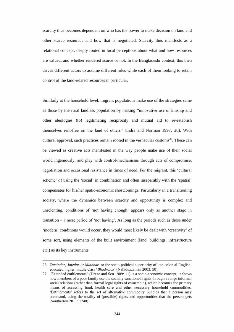
244
scarcity thus becomes dependent on who has the power to make decision on land and
other scarce resources and how that is negotiated. Scarcity thus manifests as a
relational concept, deeply rooted in local perceptions about what and how resources
are valued, and whether rendered scarce or not. In the Bangladeshi context, this then
drives different actors to assume different roles while each of them looking to retain
control of the land-related resources in particular.
Similarly at the household level, migrant populations make use of the strategies same
as those by the rural landless population by making “innovative use of kinship and
other ideologies (to) legitimating reciprocity and mutual aid to re-establish
themselves rent-free on the land of others” (Indra and Norman 1997: 26). With
cultural approval, such practices remain rooted in the vernacular customs27
. These can
be viewed as creative acts manifested in the way people make use of their social
world ingeniously, and play with control-mechanisms through acts of compromise,
negotiation and occasional resistance in times of need. For the migrant, this ‘cultural
scheme’ of using the ‘social’ in combination and often inseparably with the ‘spatial’
compensates for his/her spatio-economic shortcomings. Particularly in a transitioning
society, where the dynamics between scarcity and opportunity is complex and
unrelenting, conditions of ‘not having enough’ appears only as another stage in
transition – a mere period of ‘not having’. As long as the periods such as those under
‘modern’ conditions would occur, they would most likely be dealt with ‘creativity’ of
some sort, using elements of the built environment (land, buildings, infrastructure
etc.) as its key instruments.
26. Zamindar, Jotedar or Mathbar, or the socio-political superiority of late-colonial English-
educated higher middle class ‘Bhadrolok’ (Nahiduzzaman 2003: 50).
27. “Extended entitlements” (Dreze and Sen 1989: 11) is a socio-economic concept; it shows
how members of a poor family use the socially sanctioned rights through a range informal
social relations (rather than formal legal rights of ownership), which becomes the primary
means of accessing food, health care and other necessary household commodities.
‘Entitlements’ refers to the set of alternative commodity bundles that a person may
command, using the totality of (possible) rights and opportunities that the person gets
(Southerton 2011: 1248).

245
Nevertheless, these events of reciprocity are nothing new. The discussions hitherto
also substantiate the two hypotheses that in a non-market society, people still tend to
satisfy their wants using alternative logics that incorporate reciprocity, redistribution
and exchange (Bronfenbrenner 1962: 265). People also cooperate with each other in
times of adversity to avoid high transaction costs associated with their failure to
comply (Southerton 2011: 1247). Castells and Portes (1989: 26) similarly noted that
“(informalities are) flexible, ad-hoc form of economic activity that, while reviving
old methods of primitive exploitation, also provides room for personal interaction.
The small-scale and face-to-face features of these activities make living through crisis
a more manageable experience than waiting in line for relief from impersonal
bureaucracies”. Under the constructed conditions of scarcity during today’s modern
third world context, these ‘revival of old methods’, and ‘cooperation’ hence can be
likened with the ongoing reciprocal relation between the elite and the ordinary
migrant. In addition, terms such as ‘flexibility’ and ‘alternative logic’ emerge as
expressions in response to a particular context, which in Khulna, are the spatio-
physical compromises that migrants make in response to the manifold scarce
conditions produced by modernity.
Ananya Roy (2011: 223) wrote that “the theorization of the megacity and its
subaltern spaces and subaltern classes provides accounts of the slum as a terrain of
habitation, livelihood, self-organization and politics”. In the present reign of
modernity therefore, a study that combines historic events of constructed scarcities
ranging from top-down to grass-root levels, their socio-political implications as
manifested in the many moments of negotiation, and their spatial consequences hence
hint of a framework to grasp urban transformation in cities like Khulna. The roles of
different actors inform about their agency28
in this framework.
28. Agency “is the capability, the power, to be the source and originator of acts; agents are
the subjects of action, deployed in debates over the relationship between individuals and

246
6.3 Home and scarcity
Most literatures on ‘home’ as reviewed in Chapter 2 can be criticized for being
acontextual; they suffer from not being able to delineate any clear indicators to
explain ordinary migrants’ home-making in an ordinary third world city. Works are
also limited which examine ‘home’ in relation to wider socio-political-economic
conditions that historically prevails in a particular society – as in the concept of
land/resource ‘scarcity’ in modern Bangladesh context. How then the concept of
home culminates in the idea of scarcity in the particular context of Khulna? How does
this pair of concepts help comprehend each other? Referring back to the conceptual
model and the indicators for measuring territorial practices in Chapter 2 (Figure 2.3),
some key themes have been identified in Chapter 5 (Table 5.2). Indeed, these themes
have been used in other spatial analyses (e.g. under the rhetoric of ‘politics’) in this
Chapter. This section, however, rather briefly aims to establish a more direct
correlation between conditions of scarcity and spatial practices for boundary control
as the key variables of home. It demonstrates that the notions of both ‘real’ and
‘constructed’ scarcity manifested in the many lacks, and also in the legal-illegal
dilemma or in the formal-informal impasse affect the way in which people go about
their everyday spatial acts; scarcity also affects the way they claim and control their
personal space and public territories, get familiar with it, and become able to identify
themselves both as an individual and also as a group within the urban context.
6.3.1 Everyday negotiation
At the higher-level of migrants’ urban home, i.e. at the level of settlements, the notion
of ownership remains the most important component for home-making. As seen, the
policy-process necessary for obtaining any sense of ownership, i.e. upgradation from
illegal/informal to legal/formal, however, have intentionally been kept complicated
social structure...(and) pertain...to the nature of individual consciousness, its ability to
constitute and reconstitute itself, and...the extent of its freedom from exterior

247
and prolonged. This can be viewed as one form of scarcity – a ‘neither-nor’
condition, which is curable, yet constructed by national-level politicians and
persistently maintained by their local level party officio (e.g. Mayor, Ward
Councillors, party cadres etc.) and government bureaucracies (e.g. Planning machine
such as KDA). Although migrants living in different ‘illegal’ settlements (as in
Settlement 1, 3 or 4) have continued to convey their preparedness for paying off any
sort of fees or instalments for acquiring a formal ownership, little has changed over
the years. The same politicians (e.g. rule-makers such as MPs) who could have solved
the problem by implementing favourable bylaws for settling the ownership issue for
the hundreds of thousands of these ‘slum-living’ migrant dwellers, rather prefers
leaving options open for an on-site negotiation of issues chief amongst which is the
issue of land ownership. Although it has been observed that with a more ‘settled’
state of ownership, migrant inhabitants tend to show a greater sense of belonging to
their dwelling environments and hence to the overall physical environment it is part
of, the process of acquiring a more formal ownership in most settlement has remained
subject to everyday negotiations with both political and bureaucratic machinery.
Indeed, this leaves a certain amount of power to the disposal of this apparently
ordinary and powerless group of citizens as the migrants are. This day to day
encounter imparts them with certain know-how about how the government and its
political-bureaucratic machinery works, who hold the decision-making positions, and
how things are ‘done’ even if informally.
This process, through which one acquires and maintains the ownership outside the
formal mechanisms as in Western societies has been largely unspoken of in
Somerville (1997)’s theory of home. On the other hand, although Rapoport (1995:
45) views home as a manifestation of sets of relationships between people and system
of settings, ‘setting’ nevertheless does not necessarily comprehend a ‘man-made’
determination” (Rapport and Overing 2003: 1).

248
condition that scarcity instills. Yet at large, scarcity as a socio-political creation of
modern times appears to be a successful concept that aids the authorities to control
ordinary migrants’ tenure and ownership situations, hence home-making in the larger
of the illegal/informal migrant settlements. Scarcity thus promotes and upholds
‘informality’, and it is the informal and ‘unsettled’ status of home that serves best the
purposes of scarcity in the particular ‘setting’ of Khulna’s migrant settlements. Since
informality persistently seeks to become formal and thus scarcity prevails, this
negotiated form of relationship continues to remain an unrelenting process that
underlies all home-making efforts by the migrant.
6.3.2 Compromised boundary
Similar ‘neither-nor’ status of ownership may also manifest in migrants’ many acts
culminating into the ‘politics of in-between-ness’ and the ‘politics of infrastructure’
as discussed earlier in this chapter. Although these two have their influence on
migrants’ home-making, it is the ‘politics of control’ and its associated spatial
compromises and negotiations that actually translate into the way people satisfy their
everyday privacy needs and gain socio-economically at the level of migrant
dwellings. In addition, the constructed conditions of scarcity that base on a vulnerable
tenure status hence also hinder growth. The small size of plots and restriction on
building construction (e.g. height, construction of roof etc.) also restrict individuals to
grow socio-economically. This actual scarcity of space that originates from the
constructed condition of scarcity (of ownership) hence leads to an even more
constraining situation for this particular group of ex-rural people. Primarily due to
cultural reasons29
, these migrants who used to depend heavily on their home premise
29. Traditionally rural homesteads in agrarian Bangladesh used to provide essential
livelihood means and used to serve economic production (Ahmed 2006; Hakim and
Ahmed 2007; Hakim 2010) – required for every household’s sustenance. This somehow
resonates Stea (1995: 194-196)’s example of urban Mexico where the ‘newly urban’
population were lacking the necessary coping mechanisms to adjust to the modern ways
of life once they were suddenly exposed to it.

249
for fulfilling their livelihood- and privacy-needs, now find themselves severely
constrained by the lack of space and material resources. This is exactly where the
various spatial boundaries are redefined by people in their everyday territorial acts
while newer (and often multiple) meanings become associated with spaces and forms
found in these settlements. Not only are various spatial negotiations made within the
house interior spaces as privacy is profoundly compromised30
, secondary (public)
territories (e.g. neighbourhood streets and alleyways) are often used in ways as in
primary territories. What could be easily considered as acts of territorial
encroachment or invasion in typical middle-class neighbourhoods thus only appears
as simple every-day acts of negotiation over the public spaces in the realm of these
settlements. This sharing of public space for personal use, yet retaining a strong
mutual respect for each other’s use lead to a situation in which individual gain
becomes possible only when there is a simultaneous collective gain. A collective
control of a house-front alleyway, for instance, certainly ensures that every individual
living adjacent to that alleyway would also be able to claim a certain territory from it
during certain times in a day or night. Such maximization of public space usage is
essential in terms of both household and livelihood needs since available house-space
for satisfying both these purposes is always going to be inadequate for most
inhabitants.
In terms of home-making, these findings remain significant. First, the slippery31
nature (and meaning) associated with privacy practices substantiates Somerville
(1997: 234)’s initial claim that the “extent of being private is variable”. It equally
conforms to Altman (1975: 18)’s suggestion that the definition of privacy implies
selective control, where privacy (practices) assume different forms in response to
different circumstances over certain periods of time. In that, however, findings from
30. Although a strong urge for an orthodox level of privacy is stressed by migrants across
different regional origin and with different religious orientation.

250
Khulna’s migrant settlements impart the essential context, i.e. the idea of scarcity that
occurs from the migrants’ lack of ‘ownership’ of their dwelling environments – to
the initial concept of privacy practices (hence home-making) as in Somerville’s and
Altman’s rather acontextual and universal frameworks. Second, ‘politics of control’
and its associated spatial negotiations produce interesting “architectural patterns of
displacement” (Heynen and Loeckx 1994). In terms of post-displacement
consequence under modern (globalized) conditions, “new use of public as private”,
“juxtaposition of forms, habits and conventions in host environment”, “re-
codification of signs” and “creation of a closed system” become immediately evident
of the migrants’ spatial practices. One finds “ambivalent meanings” associated with
the architectural forms and spaces of migrant dwelling units and settlements, where
Bricolage (e.g. rural forms in the city) and Hybridity (Cairns 2003) often become
manifest. Dwelling units and settlements are used commonly as a stage, where they
become spaces and forms for mediation and negotiation while leading to the
formation of new social relations (Heynen and Loeckx 1994).
6.3.3 Re-construction of Samaj
The situated conditions of scarcity prioritize collectivism over individualism. So in
terms of identity formation, which is one of the three main pillars of Somerville
(1997)’s ‘home framework’, migrant population identify themselves not as
individuals but as constituent parts of a certain group residing in a certain location32
.
Shaped by the prevailing conditions of scarcity, home-making for individual migrants
therefore gains essential socio-economic-political impetus as part of a collective
31. “Slippage of meaning” has been used by Cairns (2003).
32. If any individual, for example, from Settlement 1 (Rupsha Char Bastee) is asked about
his/her identity and whereabouts, he/she would immediately recognize him/herself as
“Char er lok” and say “Char e thaki” – meaning he/she is one who is part of the Char
community and that is where he/she resides. When needed, this self-recognition with a
10,000 strong population group provides him/her with an immediate socio-political
benefit compared to any other ‘mainstream’ citizen albeit the former’s stay at that
government-owned land is ‘illegal’ according to official terms.

251
process, which would otherwise have not been possible through the migrant’s solitary
effort. Different territorial acts also come coupled with added social gains, which
subsequently go on to produce conditions that help home-making. What at first
appears as acts of encroachment (e.g. street vending or footpath-shops) due mainly to
a lack of business space, eventually end up being proven as sources of constant social
surveillance and security for the whole community. Such sense of security, Rapoport
(1995: 30) writes, helps acquire psychological and social meanings, which turns these
spaces into homes by establishing particular relationships between people and these
particular settings. Such findings further advance Somerville (1997: 235)’s
hypothesis that “Identity of a human being as an autonomous individual is bound up
with his membership of a body of citizens who all own property according to the
same set of rules and laws”. Once again, the scarce condition pertaining to ownership,
i.e. the particular unresolved and negotiated state of tenure and an actual lack of space
are what lead migrants to adopt this particular ‘collective’ manipulation of a number
of territorial thresholds for their identity formation. It is also through this adoption to
specific space-making traits that a sense of security is established, communities are
formed and eventually home is made in an ever evolving and relative form (Heynen
and Loeckx 1994).
Scarcity of space thus contributes to the particular way in which a new Samaj (sense
of identity as part of a community) is being re-created amongst the typically super-
dense migrant settlements. As contextual notions such as ‘becoming a Bariwala’ (as
in Section 5.3.2.1) aspires migrants to own a house in the city, it is the migrants’
many manipulations and compromises with the spatial boundaries of home that
culminates incrementally to an eventual (in all possibility informal/illegal) ownership
of a dwelling unit. With time, more partitions are made or a whole new floor may be
added to create new rooms for familial use or for income generation. This is how
settlement density keeps increasing while in many such cases, this increased density

252
keeps contributing in a positive manner by giving rise to everyday socio-spatial
encounters amongst heterogeneous population groups in their sharing of the same
public space. A common ownership over public space by the concerned community
thus converge the community’s interest on to a single issue. On the other hand, the
sets of spatio-physical constraints, such as unresolved ownership status of land,
building restrictions and lack of material/financial means to carry out newer
construction lead to the assumption of alternative spatio-physical practices (e.g.
incrementality, adaptability, sharing of common functions etc.) at dwelling-
neighbourhood levels of migrant settlements. These acts of collective
territorialization that span across a certain period of time again create a sense of
belonging and attachment to the environment that migrants create with their own
efforts and using their own resources. Familiarity, the third pillar of Somerville
(1997)’s home framework thus is attained by maintaining (both individual and
collective) identity through “continuity and stability of experience” (Ibid: 235).
Although it is said that success in creating such domestic familiarity requires
economic resources and legal possession rights to support and manage a household
(Ibid: 236), in Khulna’s migrant settlements, the scarcity of both economic resources
and possession rights to land are compensated by collective use of space and
resources and collective socio-political negotiations respectively33
. All these conform
to Ghafur (2004: 268)’s assertion that in Bangladeshi context, the concept of home in
the traditional sense becomes meaningful only when it is viewed as an integral part of
the Samaj. The various conditions of scarcity hence also influence the re-creation of
Samaj as found in the studied settlements in Khulna, and hence aids home-making by
providing the latter a desired grounding.
In addition, examples of various spatio-physical compromises such as the ‘politics of
control’ demonstrate that if scopes for physical growth is constrained, there is still
33. These have been discussed elaborately in Chapter 5 and earlier sections of this chapter.

253
Figure 6.9: The home-scarcity framework.
room for economic and social gain by making adjustments to the existing spatial
boundaries of home. On the other hand, the ‘politics of infrastructure’ or the
development of a ‘social interface’ at the settlement-outside world boundary reveal
that room for socio-economic gain also exists on the higher level of settlements even
if social and spatial scarcity prevails. All these socio-spatial acts however attempt to
ground the ‘migrant Samaj’ into the larger Samaj outside the settlement (i.e. urban
mainstream socio-economic-political context). Migrant populations, through these
acts, hence aim to identify themselves as part of the mainstream citizenry.
6.3.4 The Home-Scarcity framework
The discussion on “urbanism of negotiations” in Section 6.2.4 also helps understand
the association between home-making and scarcity further. Thus the situated
territorial practices as in Chapter 5 can be viewed as socio-spatial negotiations that
came out as a response to
particular scarce conditions
prevailing in Khulna’s migrant
settlements. Figure 6.9 shows
how the situated conditions of
scarcity potentially deserve a
place in the initial conceptual
framework from Chapter 2.
The inclusion of Scarcity,
which affects the various
territorial practices and
mechanisms, and hence the
way spatial boundaries are
controlled (and allowed

254
externals to control) by the migrants at the many different levels of their settlements,
influence the latter’s privacy practices. And it is the desire for privacy that according
to prior definitions is the primary goal of all spatial control mechanisms. In view of
this, it is only through such control over one’s spatial environment, identity is formed
for ‘anonymous’ migrants and their home is made.
6.4 Conclusion
In Khulna, migrants’ home-making and the associated socio-spatial processes ‘prior
to’ migration, ‘during’ migration and ‘following’ migration – may all be viewed as
responses to the many real and constructed conditions of scarcity in a context
characterized by the different challenges posed by modernity. Particularly in their
post-migration phase in Khulna, evident ‘lacks’ and ‘deficiencies’ such as lack of
resources, lack of legality (e.g. illegal status of tenure) or lack of formal recognition
(e.g. informal economic activities and building) thus have been worked out by the
migrants to remake themselves a home. The socio-spatial negotiations for controlling
territorial boundaries therefore come only as a realistic outcome to many constructed
conditions of land/housing/resource shortages. These conditions made various actors
to assume different paths of negotiation and compromises. The discussion on
‘mechanisms’ against this particular backdrop hence imparts a deeper understanding
of home-making in Khulna settlements over the ones with no context or in different
contexts.
On the other hand, for a better understanding of the concept of scarcity (e.g.
particularly the way land shortage is defined/maintained by Governments and other
authorities particularly during post-WWII decades), examples from Khulna
settlements show that issues pertaining to land scarcity can alternatively be resolved
by particular social mechanisms that the ‘social construction of home’ framework
helps identify. For example, without understanding how in response to spatial
255
scarcity, the issues of household privacy are compromised and compensated with
greater social gains, the concept of scarcity also sounds vague and acontextual. The
‘socially focused’ home framework in this case certainly helps since the generalized
description of scarcity tells least “about what exactly scarcity means, who creates it,
who it affects most, and who benefits from this state of scarcity” (Southerton 2011:
1249). These descriptions that occur from the discussions on home also tell about
how such scarcities are mediated and neutralized using the premise of home and with
what socio-spatial outcome. These findings also resonate with Jeremy Till (2011: 5)
claim that “a scarcity of stuff” may not necessarily be dealt with the provision of
more “stuff” because “stuff” is “neutral” and hence is made to work in the ways the
actors want them to work. The lack of food or hunger, he says, is not best provided by
food aid only. Doing that should essentially overlook the real causes such as
“inequitable distribution, poverty and other inequalities”. In the field of the built
environment, Jeremy Till criticizes, that scarcity is mostly associated with stuff and
the reaction is limited to “material and technical fixes”, rather than understanding
“stuff” in its social context (Ibid: 7). Similarly, the concept of scarcity, only after
being reviewed against a particular context as Khulna is, demonstrates how “room for
bargain” is left open by the powerful elites, while the same “room for bargain” is
used by the grassroots migrant for a sustained stay, and hence make home in the city.
The pairing of the concept of scarcity with the concept of home therefore aids a
further understanding of this social setting under a particular context. It shows how
the scarcities of space at both household and community levels are compensated by
accepted re-definitions of, and culturally approved negotiations and compromises
with territorial boundaries. Physical spaces and forms here are routinely allowed to
transform at various levels of home by complex social mechanisms involving the
migrants and other often elitist actors in and out of the settlements. Spatial (and
physical) is made to work inseparably with the social. A lack of ‘stuff’ (space and

256
space-making resources) is often dealt not with form but rather through a process
where “neutral form” is viewed equally as a tool, a stage and an outcome of the
process. Scarcity and home thus complement each other both socially and spatially
and make sense of the context where home is being made. Buchli (2002: 210-211)
commented on Soviet society that Home is the sphere of the daily life and the arena in
which fundamental restructuring of Soviet society were materialized. Clinging to this
same note, while drawing contextual examples it can be argued that Scarcity, both
actual and constructed, remains a negotiable concept. The premise of migrant’s home
in Khulna at its many different levels remains the exclusive arena where socio-spatial
strategies for boundary control symbolize the acts of negotiation that migrants have
been using for dealing with the historical conditions of Scarcity.
6.5 Scopes for further work
As developed and proposed by this research, a further testing of the hypotheses (and
the framework) may also be carried out in other ‘third world’ contexts to check their
validity against these particular socio-spatial settings. It is believed, there are also
other key areas where further contributions can be made considering them as
continuation of this research. These areas are highlighted below.
- This framework can be tested in the context of other Bangladeshi cities
and may be in the context of other developing nations. The idea would be
to observe how the different land prices may possibly affect the type of
social relations and its spatio-physical outcomes as observed in Khulna.
Cities where land price is much higher than Khulna, for example in
Dhaka, a negative effect of land price on social relations and forms of
such migrant settlements is expected. Probably this is why both eviction
threats and rates in Dhaka are much higher than in Khulna. This is also
probably for the same reason, even within the studied settlements in

257
Khulna, settlement 1 (Rupsha Char) faces the most eviction threats. For
being located on a potentially prime location for new shrimp industries
or expanding the existing ones, this settlement territory remains the most
contested amongst all those studied. City size and hence land price is
thus expected to influence the type of social relation and hence to the
spatio-territorial practices. Similar correlations may be tested in Khulna
context – with regard to settlement scale and practiced types of
negotiations (considering the number of voters, and hence received
political attention).
- Studies similar to this present research have the scope to focus more on
the issues of migrancy in relation to architecture, and hence contribute to
the ‘less tested’ architectural frameworks/conceptual models such as
“Architectural pattern of displacement” by Heynen and Loeckx (1994) or
“Drifting” by Stephen Cairns (2003). Focusing on ordinary migrant
spaces and forms and finding out their implication on these rather
theoretical premises would certainly provide ample insight and
knowledge toward a better understanding of our present world
characterized by various forms of mobilities.
- As in mainstream studies carried out in middle- or higher-class
neighbourhoods and using concepts such as New Urbanism, studies can
be dedicated to understand the density (and height) structure of these
low-income settlements. A ‘social threshold test’ can be conducted to
understand the optimal level of perceived density (threshold between
density and crowding) even amongst the present accepted level of super-
density. In a world whose major share of housing future lies in similar
258
low-income settlement systems, socio-demographic indicators generated
though such studies should help all sorts of ‘planning’ activities.
- Purely qualitative studies as this present research must be complemented
with more quantitative studies, for example, using city-level mapping
and modelling of all low-income settlements (e.g. GIS). These statistical
studies should certainly complement the qualitative findings by
providing additional quantitative data and settlement-level growth
models for a much better understanding/grounding of the threads and
themes that have already been outlined. Additional in-depth drawings
(similar to those prepared and used already in this research) can be
prepared and used for facilitating more generalized
statements/hypotheses.
- There may be other forms of rural-urban migration that are now on the
increase particularly in cities like Khulna (such as Circular or Seasonal
Migration, or temporary Climate Refugees). Socio-spatial implications of
these emerging forms of migration (with different economic status) and
the possible patterns of negotiations involved may also be an interesting
prospect for further research. In addition, there are numerous
unaccounted cases of middle-class and higher-middle class rural-urban
migration that are taking place in cities like Khulna. Their socio-
economic implications on urban spatio-physical environment may also
be another useful topic for further research.
- A research focusing on the concept of Social Network Analysis can be
carried out to investigate their implication on the production of migrant
spaces.

259
Bibliography
Abu-Lughod J. 1973, “Migrant Adjustment to City Life: The Egyptian Case”, in: J.
Walton and D. E. Carns (eds.), Cities in change: studies on the urban condition,
Allyn and Bacon, Boston, pp. 112-127
ADB 2009, “Informal Employment in Bangladesh”, ADB Economics Working Paper
Series No. 155, Asian Development Bank, Metro Manila
Afsar R. 1999, “Rural-urban dichotomy and convergence: emerging realities in
Bangladesh”, Environment and Urbanization, Vol. 11(1), pp. 235-246
Afsar R. 2003, Internal Migration and the Development Nexus: The Case of
Bangladesh, Paper presented at Regional Conference on Migration, Development,
and Pro-Poor Policy Choices in Asia, Refugee and Migratory Movements Research
Unit and DFID, Dhaka, 22-24 June
Aggarwal V. K. and C. Dupont 2009, “Negotiation and Bargaining: Organizational
Aspects”, in: R. Kitchin and N. Thrift (eds.) INTERNATIONAL ENCYCLOPEDIA
OF HUMAN GEOGRAPHY, Vol. 7 (1st ed.) Elsevier, Amsterdam and Oxford, pp.
10473-10477
Ahmed K. I. 2006, “THE RURAL BANGLADESHI COURTYARD”, BRAC
University Journal, Vol. 3(1), pp. 9-15
Ahmed K. I. 2007, Urban Poor Housing in Bangladesh and Potential Role of ACHR,
Asian Coalition for Housing Rights (ACHR). Retrieved from:
http://www.achr.net/Download%20Library/Urban%20Poor%20Housing%20in%20B
angladesh%2001.pdf
Ahmed M. 2003, “A Critical Evaluation of Approaches to Urban Development in
Bangladesh: Case Study of Khulna”, in: L. F. Girard, B. Forte, M. Cerreta, P. De
Toro and F. Forte (eds.) The Human Sustainable City: Challenges and Perspectives
from the Habitat Agenda, Ashgate, Surrey and London, pp. 297-311
Ahmed M. 2005, “Living in the Coast URBANIZATION”, Living in the Coast Series
4, Integrated Coastal Zone Management Plan, Government of the People’s Republic
of Bangladesh, Ministry of Water Resources, PDO-ICZMP, Dhaka
Ahmed S. and Z. Sattar 2004, TRADE LIBERALIZATION, GROWTH AND
POVERTY REDUCTION: THE CASE OF BANGLADESH, The World Bank.
Retrieved from:
http://siteresources.worldbank.org/INTSARREGTOPINTECOTRA/34004324-
1120490724746/20926223/TradeLiberalization.pdf
Alexander C. 1966, “A city is not a tree”, Design, Vol. 206
Ali M. S. 2005, “Homegardens in Smaller Farming Systems; Examples from
Bangladesh”, Human Ecology, Vol. 33(2), pp. 245-270
260
AlSayyad N. 2004, “Urban Informality as a ‘New’ Way of Life”, in: A. Roy and N.
AlSayyad (eds.) Urban informality: transnational perspectives from the Middle East,
Latin America, and South Asia, Center for Middle Eastern Studies, University of
California at Berkeley, Lexington Books; Berkeley, California, pp. 7-32
Altman I. 1975, Environment and social behavior: Personal space, privacy, crowding
and territory, Brooks Cole, Monterey
Angeles G., P. Lance, J. Barden-O'Fallon, N. Islam, A. Q. M. Mahbub and N. I.
Nazem 2009, “The 2005 census and mapping of slums in Bangladesh: design, select
results and application”, International Journal of Health Geographics, Vol. 8, pp. 1-
19
Bapat M. 1981, “Shanty Town and City: The Case of Poona”, Progress in Planning
Vol. 15, pp. 151-269
Bauer L. 2006, “Morphology”, Encyclopaedia of Language and Linguistics, Elsevier,
pp. 316-318
Bayat A. 2000, “From ‘Dangerous Classes’ to ‘Quiet Rebels’ Politics of the Urban
Subaltern in the Global South”, International Sociology, Vol. 15(3), pp. 533-557
Beardsley J. 2007, “A Billion Slum Dwellers and Counting”, HARVARD DESIGN
MAGAZINE, Fall 2007/Winter 2008, No. 27, pp 1-4
Berg B. L. 2001, Qualitative research method for the social sciences (4th ed.), Allyn
and Bacon, Massachusetts
Betcherman G. 2002, An overview of labour markets world-wide: key trends and
major policy issues, Social Protection Unit, World Bank, pp. 1-32
Bissell W. C. 2011, “Between Fixity and Fantasy: Assessing the Spatial Impact of
Colonial Urban Dualism”, Journal of Urban History, Vol. 37(2), pp. 208-232
Black R. 2001, Environmental refugees: myth or reality? NEW ISSUES IN
REFUGEE RESEARCH, Working Paper No. 34, University of Sussex.
Retrieved from:
http://www.unhcr.org/cgibin/texis/vtx/research/opendoc.pdf?tbl=RESEARCH&id=3a
e6a0d00
Blunt A. 2007, “Cultural geographies of migration: mobility, transnationality and
diaspora”, Progress in Human Geography, Vol. 31(5), pp. 684-694
Blunt A. and R. Dowling 2006, HOME, Routledge, London and New York
Bose S. 1986, Agrarian Bengal Economy, Social Structure and Politics1919-1947,
Cambridge University Press, Cambridge
Bouman O. 2006, “Doing Most with Less”, NL ARCHITECTS, p. 115.
Retrieved from: http://nlarchitects.files.wordpress.com/2010/07/doing-most-with-
less_ole-bouman.jpg
Boylorn R. M. 2008, “Everyday Life”, in: L. M. Given (ed.) The Sage encyclopaedia
of qualitative research, California, pp. 306-307

261
Bronfenbrenner, M. 1962, “The Scarcity Hypothesis in Modern Economics”,
American Journal of Economics and Sociology, Vol. 21(3), pp. 265-270
Buchli V. 2002, “Architecture and the Domestic Sphere”, in: V. Buchli (ed.) The
Material Culture Reader, Berg, Oxford, pp. 207-213
Cairns S. 2003, “Introduction” in: S. Cairns (ed.) Drifting: Architecture and
Migrancy Routledge, London and New York, pp. 1-16
Cairns S. 2009, “Migrancy and the Dislocation of Architecture”, in: T. Rieniets, J.
Sigler and K. Christiaanese (eds.) Open City: Design Coexistence, Martien de Vletter
SUN, Amsterdam, pp. 73-80
CARE 2003, LAND POLICY AND ADMINISTRATION IN BANGLADESH: A
LITERATURE REVIEW [online], CARE RURAL LIVELIHOODS PROGRAMME,
CARE SDU Reports and Studies. Retrieved from:
http://www.carebd.org/Land%20Policy%20and%20Administration.pdf
Castells M. 1992, “The world has changed: can planning change?” Landscape and
Urban Planning, Vol. 22, pp. 73-78
Castells, M. and Portes A. 1989, “World Underneath: The Origins, Dynamics, and
Effects of the Informal Economy”, in: Manuel Castells et. al (eds.) The Informal
Economy: studies in advanced and less developed countries, The Johns Hopkins
University Press, Baltimore, pp. 11-40
Chakravorty S. 2000, “From Colonial City to Globalizing City? The Far-from-
complete Spatial Transformation of Calcutta”, in: P. Mercuse and R. van Campen
(eds.) Globalization cities: a new spatial order? Blackwell, Oxford, pp. 56-77
Chan and Zhang 1999, “The Hukou System and Rural-Urban Migration in China:
Processes and Changes”, The China Quarterly, Vol. 160, pp. 818-855
Chatterjee P. 2004, THE POLITICS OF THE GOVERNED: REFLECTIONS ON
POPULAR POLITICS IN MOST OF THE WORLD, Columbia University Press, New
York
Chaudhury A. H. (Undated), METROPOLITAN PLANNING IN BANGLADESH
WITH REFLECTIONS ON KHULNA CITY MASTER PLAN 1961 AND THE
CURRENT TREND. Retrieved from:
mapbangla.com/mapadmin/publications/6_Metropolitan%20Planning.pdf, accessed
on November 2012
Choguill C. L. 1993, “Housing policy trends in Bangladesh”, Cities, November
Choudhury G. W. 1972, “Bangladesh: Why It Happened”, International Affairs, Vol.
48(2), pp. 242-249
CIA 2012, Bangladesh (online). Retrieved from:
https://www.cia.gov/library/publications/the-world-factbook/geos/bg.html
Citymayors 2007, The world’s fastest growing cities and urban areas from 2006 to
2020, Citymayors Statistics.
Retrieved from, http://www.citymayors.com/statistics/urban_growth1.html

262
Cohen B. 2004, “Urban Growth in Developing Countries: A Review of Current
Trends and a Caution Regarding Existing Forecasts”, World Development, Vol.
32(1), pp. 23-51
Colombijn F. and Erdentug A. 2002, “Introduction”, in: A. Erdentug and F.
Colombijn (eds.) Urban Ethnic Encounters The spatial consequences, Routledge,
London and New York, pp. 1-23
Correa C. 1989, THE NEW LANDSCAPE URBANISATION IN THE THIRD WORLD,
Concept Media, Singapore
Cupples J. 2009, “Resistance”, in: R. M. Kitchin and N. J. Thrift (eds.) Encyclopedia
of Human Geography, Elsevier, Oxford, pp. 370-375
CUS-UNDP-KCC 2011, MAPPING URBAN POOR SETTLEMENTS AND VACANT
LANDS IN UPPR PROJECT TOWNS (KHULNA), Centre For Urban Studies, Dhaka
D’Costa J. 1994, “CHANGES IN URBAN STRUCTURE IN BANGLADESH”, in
Urban Geography, Vol. 15(8), pp. 698-719
Datta A. 2009, “HOME, MIGRATION, AND THE CITY, SPATIAL FORMS AND
PRACTICES IN A GLOBALISING WORLD”, Open House International, Vol.
34(3), pp. 4-7
Datta D. K., K. Roy and N. Hassan 2010, “Shrimp Culture: Trend, Consequences and
Sustainability in the South-western Coastal Region of Bangladesh”, Management and
Sustainable Development of Coastal Zone Environments, Springer Netherlands, pp.
227-244
Davis M. 2003, “La Frontera’s Siamese twins”, in: S. Cairns (ed.) Drifting:
Architecture and Migrancy, Routledge, London and New York, pp. 239-251
Davis M. 2006, Planet of Slums, Verso, London and New York
Dayaratne R. and P. Kellett 2008, “Housing and home-making in low-income urban
settlements: Sri Lanka and Colombia”, Journal of Housing and the Built
Environment, Vol. 23, pp. 53-70
De Soto H. 2001, THE MYSTERY OF CAPITAL, Black Swan, London
Demographia 2013, Selected Current and Historic City Densities (Online).
Retrieved from: http://www.demographia.com/db-sierradensctxt.htm
Deshingkar P. and S. Grimm 2004, VOLUNTARY INTERNAL MIGRATION AN
UPDATE [online], Overseas Development Institute, London. Retrieved from:
http://www.odi.org.uk/plag/resources/reports/0509_voluntary_internal_migration_up
date.pdf
Dovey K. 2012, “Informal urbanism and complex adaptive assemblage”,
International Development Planning Review, Vol. 34(4), pp. 349-367
Dovey K. and King, R. 2011, “Forms of Informality: Morphology and Visibility of
Informal Settlements”, Built Environment, Vol. 37(1), pp. 11-29
Drèze J. and A. Sen 1989, Hunger and Public Action, Clarendon Press, Oxford
263
Dudek P. and E. Van Houtte 2008, “The riverfront of Khulna (Bangladesh) A
designerly investigation”, Undergraduate Dissertation Report (published),
Department of Architecture, Urbanism and Planning (ASRO), Katholieke Universiteit
Leuven
Dupuis A. and Thorns D. C. 1996, “Meanings of Home for Older Home Owners”,
Housing Studies, Vol. 11(4), pp. 485-501
Edney J. J. 1975, “Territoriality and Control: A Field Experiment”, Journal of
Personality and Social Psychology, Vol. 31(6), pp. 1108-1115
Eriksen T. H. 2001, “Some Current Priorities for Ethnicity Studies”, Ethnicities, Vol.
1, pp. 17-19
ESF-LiU Conference 2010, Home, Migration and the City: New Narratives, New
Methodologies, Linköping University, Sweden, 6-10 August.
Retrieved from: http://www.esf.org/conferences/10317
Fan C. C. 2003, “Rural-urban migration and gender division of labor in transitional
China” International Journal of Urban and Regional Research, Vol. 27(1), pp. 24-47
Fenster T. 1996, “Ethnicity and citizen identity in planning and development for
minority groups”, Political Geography, Vol. 15(5), pp. 405-418
Ferraro C. 2009, “Small but perfectly formed”, FINANCIAL TIMES, February 21.
Retrieved from: http://www.ft.com/cms/s/0/799d9338-fe1c-11dd-932e-
000077b07658.html#axzz2auJDDpls
Fletcher P. L. 1997, “Building from Migration: Imported Design and Everyday Use
of Migrant Houses in Mexico”, in: B. S. Orlove (ed.) THE ALLURE OF THE
FOREIGN IMPORTED GOODS IN POSTCOLONIAL LATIN AMERICA, University
of Michigan Press, pp. 185-201
Gallagher J. J. and P. N. J. Tucker 2000, “Aussiedler migration and its impact on
Brasov’s ethnic German population and built environment”, GeoJournal, Vol. 50, pp.
305-309
Gans H. J. 1962, The Urban Villagers Group and Class in the Life of Italian-
Americans (Updated and expanded edition), THE FREE PRESS, New York
Ghafur S. 2004, “Home for human development Policy implications for homelessness
in Bangladesh”, International Development Planning Review, Vol. 26(3), pp. 261-
286
Ghafur S. 2006, “Situating Practice within Diversity: Homelessness and Human
Development in Bangladesh”, The Journal of Social Studies, Journal of Centre for
Social Studies, Dhaka, October-December 2006, pp. 44-64
Ghafur S. 2010, “Imprints of the Changing Doctrines on Housing in Dhaka”,
International Conference The History Heritage and Urban Issues of Capital Dhaka,
17-19 February, Dhaka
Gilbert A. 2007, “The Return of the Slum: Does Language Matter?” International
Journal of Urban and Regional Research, Vol. 31(4), pp. 697-713

264
Gleeson B. and N. Low 2000, “IS PLANNING HISTORY?” in: R. Freestone (ed.)
Urban Planning in a changing world: the twentieth century experience, Routledge
New York, pp. 269-284
GoB-ADB 1993, Study of Urban Poverty in Bangladesh, Final Report, Government
of Bangladesh (GoB) and Asian Development Bank (ADB), Dhaka
Gough N. 2008, “Life Stories”, in: L. M. Given (ed.) The Sage encyclopaedia of
qualitative research, California, p. 484
Gurney C. M. 1999, “Lowering the Drawbridge: A Case Study of Analogy and
Metaphor in the Social Construction of Home Ownership”, Urban Studies, Vol.
36(10), pp. 1705-1722
Habraken N. J. 1998, The Structure of the Ordinary, Form and Control in the Built
Environment, Jonathan Teicher (ed.), MIT Press, Cambridge and London
Hakim S. S. 2009, Interview survey at six types (according to ownership) of migrant-
settlements, Khulna, Bangladesh (unpublished), conducted on November-December
2009 with financial support from the National University of Singapore
Hakim S. S. 2010, Of the Rough Waters and onto the City: Livelihood-biographies of
the rural migrant from the coasts of Bangladesh, LAP LAMBERT Academic
Publishing, Saarbrücken
Hakim S. S. 2012, Interview survey at ten types (according to ownership) of migrant-
settlements, Khulna, Bangladesh (unpublished), conducted on August-November,
funded by the National University of Singapore
Hakim S. S. and J. L. Ee Man 2013, “Scarcity, Control and Third World Urban
Form”, PhD Conference: Scarcity and Creativity in the Built Environment, HERA
(Humanities in European Research Area), 26-28 February, University of Westminster
London
Hakim S. S. and S. K. Ahmed 2007, “Search for sustainability in challenging rural
scenarios: A study on income generation and its effect on households adjacent to the
Sundarbans”, International seminar on Architecture for the Economically
disadvantaged (AED), 23-24 March, Department of Architecture, Bangladesh
University of Engineering and Technology, Dhaka
Halpern J. 1966, “PEASANT CULTURE AND URBANIZATION”, EKISTICS, Vol.
21 (122) January, pp. 21-23
Hamdi N. 1991, Housing without houses: participation, flexibility, enablement, Van
Nostrand Reinhold, New York
Hardie G. J. 1989, “Environment and Behavior Research for Developing Countries”
in: H. Zube and G. T. Moore (eds.), Advances in Environment, Behavior,
and Design Vol. 2, Plenum, New York, pp. 119–157
Harris M. S. 1989, “Land, Power Relations, and Colonialism: The Historical
Development of the Land Systems in Bangladesh”, Urban Anthropology and Studies
of Cultural Systems and World Economic Development, Vol. 18(3-4), pp. 265-279

265
Hasan A. 2010a, “Can urban density be made to work for everyone? Exploring
options for Karachi’s low- and lower-middle-class settlements”, Environment and
Urbanization, Vol. 22(1), pp. 267-268
Hasan A. 2010b, “Migration, small towns and social transformation in Pakistan”,
Environment and Urbanization, Vol. 22(1), pp. 33-50
Hasan M. K. 2003, SPATIAL ANALYSIS OF THE INFORMAL SETTLEMENTS IN
KHULNA CITY: CASE STUDY ON WARD 20 IN KHULNA CITY CORPORATION,
Unpublished BURP Dissertation, URP Discipline, Khulna University, Bangladesh
Hayward D. G. 1978, “THE MEANINGS OF HOME IN RELATION TO
ENVIRONMENTAL AND PSYCHOLOGICAL ISSUES” Conference on
PRIORITIES FOR ENVIRONMENT DESIGN RESEARCH ENVIRONMENTAL
DESIGN RESEARCH ASSOCIATION, Washington, pp. 418-419
Herbert D. T. and C. J. Thomas 1990, CITIES IN SPACE CITY AS PLACE, David
Fulton, London
Heynen H. and A. Loeckx 1998, “Scenes of Ambivalence: Concluding Remarks on
Architectural Patterns of Displacement”, Journal of Architectural Education, Vol.
52(2), pp. 100-108
Hillier B. 2008, “Space and spatiality: what the built environment needs from social
theory”, Building Research & Information, Vol. 36(3), pp. 216-230
Hoek-Smit M. C. 1998, Housing Finance in Bangladesh, Ministry of Local
Government, Rural Development and Co-operatives, The Government of Bangladesh,
and UNDP/UNCHS (Habitat), December
Hogan D. J. and Pinto da Cunha 2001, “Internal Migration: Developing Countries”,
in: N. J. Smelser and P. B. Baltes (eds.) International Encyclopedia of Social &
Behavioral Sciences, Elsevier, Amsterdam and London, pp. 7733-7737
Holston J. 1989, The modernist city: an anthropological critique of Brasilia, The
University of Chicago Press, Chicago and London
Hossain M. A. 2010, Upazila Land Management, Sakib Offset Press, Khulna
Hossain S. 2011, Urban Poverty in Bangladesh: Slum Communities, Integration and
Migration, I. B. Tauris, London and New York
Huq-Hussain S. 1996, “Female Migrants in an Urban Setting – the Dimensions of
Spatial/Physical Adaptation: The Case of Dhaka”, Habitat International, Vol. 20(1),
pp. 93-107
Hutchison R. and J. Krase 2007, “INTRODUCTION: ETHNIC LANDSCAPES IN
AN URBAN WORLD”, in: R. Hutchison and J. Krase (eds.) ETHNIC LANDSCAPES
IN AN URBAN WORLD, Elsevier, Amsterdam, pp. ix-xix
Indra D. M. and N. Buchignani 1997, “Rural landlessness, extended entitlements and
inter-household relations in south Asia: A Bangladesh case”, Journal of Peasant
Studies, Vol. 24(3), pp. 25-64

266
IOM 2004, GLOSSARY ON MIGRATION, International Migration Law, International
Organization for Migration, Geneva
IOM 2009, Migration, Environment and Climate Change: ASSESSING THE
EVIDENCE, International Organization for Migration, Geneva
Islam N. 1999, URBANISATION, MIGRATION AND DEVELOPMENT IN
BANGLADESH: RECENT TRENDS AND EMERGING ISSUES, Centre for Policy
Dialogue (CPD), Dhaka
Islam S. 2010, “Land disputes choke up Bangladesh’s courts - is help at hand?”
AlertNet, Thomson Reuters, 8 July
Jenkins P. And J. E. Andersen 2011, “Developing Cities in Between the Formal and
Informal”, ECAS 2011 - 4th European Conference on African Studies, Uppsala, 15-
18 June
Jennings M. 2005, “Little white pebbles: getting the questions right and getting the
right data”, in: J. Holland and J. Campbell (eds.) Methods in Development Research:
Combining Qualitative and Quantitative Approaches, ITDG, Warwickshire: pp 27-35
Karan P. P., W. A. Bladen and G. Singh 1980, “Slum Dwellers’ and Squatters’
Images of the City”, Environment and Behavior, Vol. 12, pp. 81-100
Karim T. 2007, “Dis-advantaging the Disadvantaged”, in: F. Nilufar (ed.),
Architecture for the Economically Disadvantaged, Proceedings of the International
Seminar, 23-24 March, BUET, Dhaka
KCC 2010, BASIC STATISTICS, Official website of Khulna City Corporation,
Bangladesh.
Retrieved from:
http://www.khulnacity.org/Content/index.php?pid=30&id=32&page=About_KCC
KCC 2012, Map. Official website of Khulna City Corporation, Bangladesh.
Retrieved from:
http://www.khulnacity.org/Content/index.php?pid=30&id=22&page=About_KCC
KCC-LGED-UNDP 2009, Interviews with Settlement Information Assistants, UPPRP
Project, Khulna City Corporation
KDA 2002a, MASTER PLAN, Khulna Development Authority, Government of
Bangladesh, Dhaka: Ministry of Housing and Public Works
KDA 2002b, STRUCTURE PLAN, Khulna Development Authority, Government of
Bangladesh, Dhaka: Ministry of Housing and Public Works
KDA 2007, Khulna Development Authority (online), The Official Website of KDA,
Khulna. Bangladesh. Retrieved from: http://www.kda.gov.bd/
Keivani R. and E. Werna 2001, “Modes of hosing provision in developing countries”,
Progress in Planning, Vol. (55), pp. 65-118

267
Kellett P. 2005, “The Construction of Home in the Informal City", in: F. Hernández,
M. Millington and I. Borden (eds.) Transculturation: Cities, Spaces and
Architectures in Latin America, Editions Rodopi B. V., Amsterdam and New York,
pp. 22-42
Kellett P. and M. Napier 1994, “SQUATTER ARCHITECTURE AS
VERNACULAR: EXAMPLES FROM SOUTH AMERICA AND SOUTH
AMERICA”, in: N. AlSayyad (ed.) SQUATTER SETTLEMENTS AS
SPONTANEOUS TRADITION, Vol. 60, Center for Environmental Design Research,
University of California, Berkley
Kemper R. V. 1989, “Urbanization in Bangladesh: Historical Development and
Contemporary Crisis”, Urban Anthropology, Vol. (18: 3-4), pp. 365-392
Kezer Z. 1998, “Contesting Urban Space in Early Republican Ankara”, Journal of
Architectural Education, Vol. 52(1), pp. 11-19
Khan, A. A. 1982, “Rural-Urban Migration and Urbanization in Bangladesh”,
Geographical Review, Vol. 72(4), pp. 379-394
Khan M. A. 1999, “Trade Liberalization: Impacts and Implications for Bangladesh
Agriculture”, in: Michio Kanai et al. (eds.), Effects of Trade Liberalization on
Agriculture in Asia. Proceedings of a Workshop Held in Bogor, Indonesia, October 5-
8
Khanam S. 2004, “Increasing access to housing for low income people in Bangladesh
through income and employment generation”, World Urban Forum, Barcelona, 12 -
17 September
Knox P. L. 1987, “The social production of the built environment: architects,
architecture and the post-Modern city”, Progress in Human Geography, Vol. 11, pp.
354-378
Knox P. L. 1995, URBAN SOCIAL GEOGRAPHY, An Introduction [3rd
ed.],
Longman Scientific & Technical, Essex; Wiley, New York
Koolhaas R. 2002, “Africa Comes First”, in: J. Brouwer, P. Brookman and Arjen
Mulder (eds.) TransUrbanism, NAi Publishers, Amsterdam, pp. 161-192
Kostof S. 1989, “JUNCTIONS OF TOWN AND COUNTRY”, in: J.-P. Bourdier and
N. AlSayyad (eds.) Dwellings, Settlements, and tradition: cross-cultural perspectives,
International Association for the Study of Traditional Environments (IASTE),
University of California Berkley, pp. 107-134
Kudva N. 2009, “The everyday and the episodic: the spatial and political impacts of
urban informality”, Environment and Planning A, Vol. 41, pp. 1614-1628
Kuhn R. 1999, The Logic of Letting Go: Family and Individual Migration from
Matlab, Bangladesh (Manuscript), Graduate Group in Demography, University of
Pennsylvania, Philadelphia. Retrieved from:
http://www.swadhinata.org.uk/misc/Khun-emigration%20from%20Bdesh.pdf

268
Lall S. V., H. Selod and Z. Shalizi 2006, RURAL-URBAN MIGRATION IN
DEVELOPING COUNTRIES: A SURVEY OF THEORETICAL PREDICTIONS
AND EMPIRICAL FINDINGS, World Bank Policy Research Working Paper 3915,
Development Research Group, The World Bank, Washington DC
Lawrence R. J. 1995, “Deciphering Home: An Integrative Historical Perspective”, in:
D. N. Benjamin (ed.) THE HOME: WORDS, INTERPRETATIONS, MEANINGS,
AND ENVIRONMENTS, Avebury, England, pp. 53-68
Levy A. 1999, “Urban morphology and the problem of the modern urban fabric: some
questions for research”, Urban Morphology, Vol. 3(2), pp. 79-85
Lewis D. and A. Hossain 2008, “A Tale of Three Villages: Power, Difference and
Locality in Rural Bangladesh”, Journal of South Asian Development, Vol. 3(1), pp.
33-51
Leys, C. 2005, “The Rise and Fall of Development Theory”, in: M. Edelman and A.
Haugerud (eds.), The anthropology of development and globalization: from classical
political economy to contemporary Neoliberalism, Blackwell, Oxford, pp. 109-125
Li B. 2006, “Floating Population or Urban Citizens? Status, Social Provision and
Circumstances of Rural–Urban Migrants in China”, SOCIAL POLICY &
ADMINISTRATION, Vol. 40(2), pp. 174-195
Low P. K. C. 2010, “What is Negotiation?” in: Successfully Negotiating in Asia,
Springer-Verlag Berlin, Heidelberg, pp. 1-10
Lozanovska M. 2003, “Emigration/immigration”, in: S. Cairns (ed.) Drifting:
Architecture and Migrancy, Routledge, London and New York, pp. 184-202
Lynch K. 2005, Rural-Urban Interaction the Developing World, Routledge London
and New York
Mahmud S. 2003, “Women and the transformation of domestic space for income
generation in Dhaka bustees”, Cities, Vol. 20(5), pp. 321-329
Mallett S. 2004, “Understanding home: a critical review of the literature”, The
Sociological Review, pp. 62-89
Marshall S. 2005, “URBAN FORM”, in: R. W. Caves (ed.), Encyclopaedia of the
City, Routledge, London and New York, pp. 696-698
Mercuse P. and R. van Campen 2000, “Introduction”, in: P. Mercuse and R. van
Campen (eds.) Globalization cities: a new spatial order? Blackwell, Oxford, pp. 1-21
Miah M. A. Q. and K. E. Weber 1990, “Feasible Slum Upgrading for Dhaka”,
HABITAT INTL., Vol. 14(1), pp 145-160
Miah S. G. 2002, MAHANAGAR KHULNA – ITIHASHER ALOKE (Translation:
METROPOLITAN KHULNA – IN LIGHT OF HISTORY), Ali Hafez Foundation,
Khulna
Miller J. L. 2008, “Biography”, in: L. M. Given (ed.) The Sage encyclopaedia of
qualitative research, California, pp. 61-63

269
Mondal A. 2006, “Nationalism and Ethnicity Studies”, in: P. Childs and R. Fowler
(eds.) The Routledge DICTIONARY of Literary Terms, Oxon and New York, pp. 152-
154
Morris‐Jones, W. H. 1972, “Pakistan Post‐Mortem and the Roots of Bangladesh”,
The Political Quarterly, Vol. 43(2), pp. 187-200
Moser C. 1998, “Reassessing Urban Poverty Reduction Strategies: The Asset
Vulnerability Framework”, World Development, Vol. 26 (1), pp 1-19
Mukhopadhyay A. and A. K. Dutt 1993, “Slum Dweller's Daily Movement Pattern in
a Calcutta Slum”, GeoJournal, Vol. 29(2), pp. 181-186
Muktadir M. A., and D. M. Hassan 1985, “Traditional house form in rural
Bangladesh: a case study for regionalism in architecture”, Conference Proceedings:
Regionalism in Architecture, The Aga Khan Award for Architecture, pp. 81-89
Murray 2009, “Neoliberalism and Development” (Neoliberal economic strategies),
in: R. Kitchin and N. Thrift (eds.) INTERNATIONAL ENCYCLOPEDIA OF HUMAN
GEOGRAPHY, Vol. 7 (1st ed.), Elsevier, Amsterdam and Oxford, pp.379-385
Nahiduzzaman M. 2003, Peripheral Social Resistance to Neoliberal Globalization: A
Study on Bangladesh, PhD Dissertation, University of Alberta, Edmonton
Neuwirth R. 2005, Shadow Cities: A Billion Squatters, a New Urban World,
Routledge, New York
Neuwirth R. 2007, “Squatters and the cities of tomorrow”, City, Vol. 11(1), pp. 71-80
Nijman J. 2010, “A STUDY OF SPACE IN MUMBAI’S SLUMS”, Tijdschrift voor
Economische en Sociale Geografie, Royal Dutch Geographical Society KNAG, Vol.
101(1), pp. 4-17
Noe S. V. 1981, “URBAN DEVELOPMENT AND REDEVELOPMENT IN THE
THIRD WORLD: THE COLLISION OF WESTERN APPROACHES AND
TRADITIONAL FORM”, Studies in Comparative International Development (SCID)
Vol. 16(2), pp. 3-23
OECD 2009, International Migration Outlook SOPEMI 2009, ORGANISATION
FOR ECONOMIC CO-OPERATIONAND DEVELOPMENT, OECD Publishing,
Paris
OECD 2010, International Migration Outlook 2010 (online), ORGANISATION FOR
ECONOMIC CO-OPERATIONAND DEVELOPMENT.
Retrieved from: http://www.oecd.org/dataoecd/26/14/45594696.xls
Patton C. V. 1998, Spontaneous shelter: international perspectives and prospects,
Temple University Press, Philadelphia
Payne G. K. 1984, Low-income housing in the developing world: the role of sites and
services and settlement upgrading, Wiley, Chichester and New York
Payne G. 1997, Urban Land Tenure and Property Rights in Developing Countries: A
Review, IT Publications/ODA, London

270
Peattie L. 1999, “An Argument for Slums”, Journal of Planning Education and
Research, Vol. 13, pp. 136-143
Perera N. 2009, “People's Spaces: Familiarization, Subject Formation and Emergent
Spaces in Colombo”, Planning Theory, Vol. 8, pp. 51-75
Perlman J. 1976, The Myth of Marginality: Urban Poverty and Politics in Rio De
Janeiro, University of California Press, Berkeley
Pieterse J. N. 2000, “Globalization and human integration: we are all migrants”,
Futures, Vol. 32, pp. 385-398
Raharjo W. 2010, SPECULATIVE SETTLEMENTS: BUILT FORM/TENURE
AMBIGUITY IN KAMPUNG DEVELOPMENT, PhD Dissertation (published),
Melbourne School of Design, The University of Melbourne
Rahman M. M. 2001, “Bastee eviction and housing rights: a case of Dhaka,
Bangladesh” Habitat International, Vol. 25, pp. 49-67
Rahman M. M. 2002, “Problems of the NGOs in housing the urban poor in
Bangladesh”, Habitat International, Vol. 26 (2002), pp. 433-451
Rahman M. M. 2007, “Politics of Housing in Bangladesh”, in: F. Nilufar (ed.),
Architecture for the Economically Disadvantaged, Proceedings of the International
Seminar, 23-24 March, BUET, Dhaka
Rahman M. and N. Khaled 2011, “GLOBAL MARKET OPPORTUNITIES IN
EXPORT OF JUTE”, Occasional Paper 93, Dhaka: Centre for Policy Dialogue
(CPD)
Ramsamy E. 2006, World Bank and Urban Development: From Projects to Policy,
Taylor & Francis
Rapoport A. 1975, “Toward a Redefinition of Density”, Environment and Behavior,
Vol. 7(2), pp. 133-158
Rapoport A. 1988, “Spontaneous Settlements as Vernacular Design”, in: C. V. Patton
(ed.) Spontaneous Shelter International Perspectives and Prospects, Temple
University Press, Philadelphia, pp. 51-77
Rapoport A. 1995, “A Critical Look at the Concept Home”, in: D. N. Benjamin (ed.)
THE HOME: WORDS, INTERPRETATIONS, MEANINGS, AND ENVIRONMENTS,
Avebury, pp. 25-52
Ray R. and R. Ray 1975, “Zamindars and Jotedars: a study of Rural Politics in
Bengal”, Modern Asian Studies, Vol. 9(1), pp. 81-102
Reza, A. T. M. M. 2008, Study of the Development of Zamindar House, Dhaka
Division (unpublished M. Arch dissertation), Department of Architecture, BUET,
Dhaka
Roberts B. 2002, “Introduction: biographical research”, in: Biographical research,
Open University Press, Buckingham and Philadelphia, pp. 1-17

271
Roberts B. R. 1978, Cities of peasants: the political economy of urbanization in the
Third World, E. Arnold, London
Roy A. 2004, “The Gentleman’s City: Urban Informality in the Calcutta of New
Communism”, in: A. Roy and N. AlSayyad (eds.) Urban informality: transnational
perspectives from the Middle East, Latin America, and South Asia Center for Middle
Eastern Studies, University of California at Berkeley, Lexington Books, Berkeley,
California, pp. 147-170
Roy A. 2005, “Urban Informality. Toward an Epistemology of Planning”, Journal of
the American Planning Association, Vol. 71(2), pp. 147-158
Roy A. 2011, “Slumdog Cities: Rethinking Subaltern Urbanism”, International
Journal of Urban and Regional Research, Vol. 35(2), pp. 223-238
Saha, M. 2011, “Ashar Macha (Platform of Hope)”, TV interview of Khondaker
Hasibul Kabir telecasted on ATN Bangla. Retrieved from:
http://www.youtube.com/watch?v=NdbxwPOAzJo
Sarin M. 2009, “Socio-Economic Change and the Poor”, in: H.-U. Khan, J. Beinart
and C. Correa (eds.) Le Corbusier Chandigarh and the Modern City, Mapin
Publishing, Ahmedabad, pp. 108-120
Satterthwaite D. 2003, The ten and a half myths that may distort the urban policies of
governments and international agencies, International Institute for Environment and
Development (IIED), London, pp. 1-34
Satterthwaite D. 2005, Understanding Asian Cities: A synthesis of the findings from
the city case studies, Asian Coalition for Housing Rights (ACHR), Bangkok
Saunders P. and P. Williams 1988, “The Constitution of the home: Towards a
Research Agenda”, Housing Studies, Vol. 3(2), pp. 81-93
Sengupta A. 1971, “Regional Disparity and Economic Development of Pakistan: II:
Some Hypotheses to Explain Growth of Disparity”, Economic and Political Weekly,
Vol. 6(46), pp. 2315-2322
Serageldin M 1990, “The Development and Morphology of Informal Housing” In:
Robert Powell (ed.) The Architecture of Housing Concept Media, The Aga Khan
Award for Architecture, Singapore, pp. 55-73
Shahed M. I. 2006, Housing Problems for Industrial Workers in Khulna City,
(unpublished BURP Dissertation), Urban and Rural Planning Discipline, Khulna
University, Khulna
Shakur T. and M. Madden 1991, “Resettlement Camps in Dhaka: A Socio-Economic
Profile of Squatter Settlements in Dhaka”, HABITAT INTL., Vol. 15(4), pp. 65-83
Shao Y., S. J. Walsh, B. Entwisle and R. R. Rindfuss 2008, “Spatial clustering and
urban settings of rural migrants in Bangkok, Thailand”, Geocarto International, Vol.
23(1), pp. 35-52
Sheller M. and J. Urry 2006, “The new mobilities paradigm”, Environment and
Planning A, Vol. 38, pp. 207-226

272
Siddiqui T. 2003, “MIGRATION AS A LIVELIHOOD STRATEGY OF THE
POOR: THE BANGLADESH CASE”, Regional Conference on Migration,
Development, and Pro-Poor Policy Choices in Asia, Refugee and Migratory
Movements Research Unit and DFID, Dhaka, 22-24 June
Simone A. 2004, “People as infrastructure: Interesting Fragments in Johannesburg”,
Public Culture, Vol. 16(3), pp. 407-429
Singh H. 1992, Housing in the Third World: analyses and solutions, Concept
Publishing, New Delhi
Skeldon R. 2003, Migration And Poverty, Paper presented at the conference on
“African Migration and Urbanization in Comparative Perspective, Johannesburg,
South Africa, June 4-7.
Retrieved from: http://pum.princeton.edu/pumconference/papers/6-Skeldon.pdf
Somerville P. 1997, “THE SOCIAL CONSTRUCTION OF HOME”, Journal of
Architectural and Planning Research, Vol. 14(3), pp. 226-245
Southerton D. 2011, “Scarcity”, Encyclopedia of Consumer Culture, London: Sage,
pp. 1247-1249
Stea D. 1995, “House and Home: Identity, Dichotomy, or Dialectic?” in: D. N.
Benjamin (ed.) THE HOME: WORDS, INTERPRETATIONS, MEANINGS, AND
ENVIRONMENTS, Avebury, England
Tacoli 1998, “Rural-urban interactions: a guide to the literature”, Environment and
Urbanization, Vol. 10(1), pp. 147-166
Till J. 2011, “CONSTRUCTED SCARCITY”, SCIBE Working Paper No. 1.
Retrieved from: www.scibe.eu/wp-content/uploads/2010/11/01-JT.pdf
Tipple A. G. 1993, “Shelter as workspace: A review of home-based enterprise in
developing countries”, International Labour Review, Vol. 132(4), pp. 521-539
Todaro M. P. 1969, “A Model of Labor Migration and Urban Unemployment in Less
Developed Countries”, The American Economic Review, Vol. 59(1), pp. 138-148
Torri M. 1990, “Westernized Middle Class, Intellectuals and Society in Late Colonial
India”, Economic and Political Weekly, Vol. 25(4), pp. PE2-PE11
Treadwell S. 2003, “Earthquake weather”, in: S. Cairns (ed.) Drifting: Architecture
and Migrancy, Routledge, London and New York, pp. 203-223
Tunas D. 2008, SPATIAL ECONOMY IN THE URBAN INFORMAL SETTLEMENT,
Katholieke Universiteit Leuven
Turner J. F. C. 1976, HOUSING BY PEOPLE (1st ed.), Marion Boyars, London
UN 2005, A Home in the City, Task Force on Improving the Lives of Slum Dwellers,
Earthscan, London and Sterling, VA
UN 2007, Indigenous peoples and urban settlements: spatial distribution, internal
migration and living conditions, Latin American and Caribbean Demographic Centre
(CELADE), Population Division, Santiago

273
UN 2008, AN OVERVIEW OF URBANIZATION, INTERNAL MIGRATION,
POPULATION DISTRIBUTION AND DEVELOPMENT IN THE WORLD UNITED
NATIONS. Expert Group Meeting on POPULATION DISTRIBUTION,
URBANIZATION, INTERNAL MIGRATION AND DEVELOPMENT, Population
Division, Department of Economic and Social Affairs, New York: United Nations
Secretariat, 21-23 January
UN-HABITAT 2003, THE CHALLENGES OF SLUMS, EARTHSCAN, London and
Sterling, VA
UN-HABITAT 2004, Urban Land for All, United Nations Human Settlements
Programme, Nairobi
UN-HABITAT 2007, “Slum Dwellers to Double by 2030”, 21st Session of the
Governing Council, United Nations Human Settlements Programme, Nairobi.
Available from:
UN-HABITAT 2013, Urban Planning for City Leaders (2nd
ed.), Nairobi
UNDP 2007, FINAL REPORT. Retrieved from:
http://www.undp.org.bd/projects/prodocs/UPPR/LPUPAP%20Final%20Report%202
007.pdf
Van der Hoeven R. 2000, Poverty and Structural Adjustment. Some remarks on
Tradeoffs between Equity and Growth, Employment paper 2000/4, ILO, Geneva
Walton D. 1992, “Urban Planning in the Developing World: a Review of
Experience”, HABITAT lNTL., Vol. 16(2), pp. 127-134
Watson V. 2009, “‘The planned city sweeps the poor away. . .’: Urban planning and
21st century urbanisation”, Progress in Planning, Vol. 72, pp. 151–193
WB 2007, “Dhaka: Improving Living Conditions for the Urban Poor”, Bangladesh
Development Series Paper No. 17, The World Bank Office, Dhaka, June
Werlen B. 1988, Society, Action and Space (translated from German by G. Walls),
Routledge, London and New York
Willis K. D. 2009 “Squatter Settlements” In: R. M. Kitchin and N. J. Thrift (eds.)
Encyclopedia of Human Geography Elsevier, Oxford, pp. 403-408
Wilson I. 2005, “Some practical sampling procedures for development research”, in:
J. Holland and J. Campbell (eds.) Methods in Development Research: Combining
Qualitative and Quantitative Approaches, ITDG, Warwickshire, pp. 37-51
Wong S.-K. 2012, “Designing for High-Density Living: High Rise, High Amenity
and High Design”, in: E. Ng. (ed.) Designing high-density cities for social and
environmental sustainability, Earthscan, London, pp. 321-329
Wu W. 2008, “Migrant Settlement and Spatial Distribution in Metropolitan
Shanghai”, The Professional Geographer 60(1), pp.101-120

274
Wu W. 2010, “Drifting and getting stuck: Migrants in Chinese cities”, CITY, Vol.
14(1), pp. 13-24
Xenos N. 1989, Scarcity and Modernity, Routledge, London and New York
Zeisel J. 1984, INQUIRY BY DESIGN: TOOLS FOR ENVIRONMENTAL-
BEHAVIOR RESEARCH, Cambridge University Press, Cambridge
Zheng S., F. Long, C. C. Fan, and Y. Gu, 2009, “Urban Villages in China: A 2008
Survey of Migrant Settlements in Beijing”, Eurasian Geography and Economics,
Vol. 50(4), pp. 425-446

275
Appendix
1. Table1: The evolution of urban and rural population, the world and major
regions, 1950-2050; source UN (2008: 7)
2. Form 1 (overleaf): Questionnaire for household survey; pilot survey phase 1
(2011)

276
Negotiation and Form of Urban Migrant Homes Questionnaire for household survey, Khulna, Bangladesh Research team no.____; Interviewers________________________________
This questionnaire is part of an academic work, which aims at gaining comprehensive
understanding of the livelihoods of families who migrated to Khulna city from
_______________________________________________ and are now living at
______________. The interviewer assures that the respondent will be kept anonymous, and
the results will be used solely for the purposes of this academic research. Thank you for your
cooperation.
A. What are the spatio-physical transformations that have taken place at the level of
low-income migrant dwellings (and settlements) in Khulna during ISI and SAP
respectively?
- Referring back to the possible roles played by elitist agencies, transformations to the
dwelling units (and settlements) will be graphically illustrated in terms of: Ownership of
land and dwelling units (type of ownership, history); Use of space (indoor and outdoor –
alteration and control); Building mass (addition and subtraction, and control); System of
threshold and boundary (physical); Construction technique and material (permanent,
semi-permanent or non-permanent); and Services, infrastructure and utilities
(provisioning and delivery)
B. How this spatio-physical transformation of the dwelling/settlement may have been
influenced by changes to the socio-political relation between the tenant-migrant and
the elite (including the landowner) throughout ISI and SAP?
‒ Changes in social relation in accordance with spatio-physical transformation will be
measured in terms of: Type of elitist agency affecting change (politician – local and
national, NGO/CBO, public sector personnel); Type of interaction (compromising or
conflicting); Nature of interaction (mutually benefitting and/or exploitative); Type of
negotiation (Master-servant or Patron-client); and Community’s decision-making
(structure, hierarchy of leadership)
Tenure - right to hold property (land and/or house)
Nature of Tenure
1. What are the different land-tenure types which this migrant household held during its
stay in Khulna?
Tenure Types of Land
1 Type of agency
involved
2 Decision-
making level
3
Nature of interaction
(contribution &
pay-back)
4 Type of
Basic information Description
Date of interview
Duration From To
Name of respondent
Sex of respondent (M/F) Male Female
Village address of origin
Duration of stay in Khulna till date
Religious affiliation
Present address

277
Influence
Timeline
2. What were the reasons behind choosing different types of tenure during different phases? N
Reasons 1 Financial Gains
2 Closer to
Workplace
3 Change of occupation
4 Presence of Kin
(friend, relative)
5 Benefit of living close to an Elite
6 Forced Eviction
7 Voluntary
Relocation
Timeline
3. Which persons and/or organizations provide for and/or maintain infrastructure and utility
issues? N Indicators Infrastructure (road, drainage etc.) Utilities (water, electricity etc.)
1 Type of Agency
2 Decision-
Making Level
3
Nature of
Interaction
(contribution & pay-back)
4 Type of
Influence
Timeline
4. What sorts of public service/utility bills are paid regularly? Water (W); electricity (E); telephone (T); garbage collection/sewerage (G)
Services & utilities
whose bills are paid regularly (use codes)
Agencies to whom
bills are addressed
Timeline
5. Is it needed for you to pay any property or holding tax or any other tax? What sorts are
paid? To whom? Codes: land tax (H); building tax (B); informal tax (e.g. bribe - B)
Taxes (use codes) Agencies to whom
bills are addressed or
taxes given to
Timeline
6. Any memorable event of resentment and/or conflict regarding tenure of land/house? Please use recording device to record conversation
Tenure History 7. In which phase of industrialization a land title or a sense of ownership was acquired? Any
special help needed while transitioning from non-permanent to present status of tenure?
What is the form of return by the migrants in response to this help from the elite with
regard to tenure-disputes or tenure-settlements? Codes: purchased ownership (P); lease (L); other informal arrangement (I)
Timeline
Form of ‘permanent’ ownership
Agency involved in
helping transition
Form of return

278
8. Is there any religious bylaw in practice (e.g. Muslim) that influence tenure? Descriptions/indicators
Detail of bylaw Religious Agencies
concerned (individuals,
NGO, institutions etc.)
Timeline 1 2 3
Sense of Ownership
Control
9. Social relation with which powerful class helped retain tenure status of land and building?
Q.1 10. Is there any particular community decision-making body that affects building or other
physical construction and transformation? What sort of role does it play?
N
Members of
body
Roles/Functions
Names & details of Community decision-making body affecting
construction
1 Protects interest of members (e.g. against KDA, NHA etc.)
2 Lobbies and negotiates for
infrastructure upgrade or repair
3 Manages funds for community- level construction or modification
4 Approves outdoor space usage
5 Approves new construction
6 Approves in-house modification
7 Approves outdoor modification
8 Takes decisions on non-
residence buildings
9 Arbitrates disputes regarding property (land or house)
10 Facilitates household entrepreneurship
11. Who are the five most important persons and organizations within and outside the
settlement? Describe the situation during which their helps/assistances/influences are
required most? Timeline Persons & Organizations within settlement Persons & Organizations outside settlement
12. Who does the community (leader) resort to when disputes cannot be settled internally? Elitist agency
Central
Govt.
(CG)
Local
Govt.
(LG)
NGO Dono
r
(D)
Formal
private sector
(FP)
Informal
private sector
(I-P)
Local
Politician
(P)
Urban
Affluent
(A)
Religious
Institutions
(R)
Communi
ty leader
(CL)
Personalization 13. What is the tenure (and ownership) status of present permanent building(s) and other
construction(s)? N Indicators Put tick mark (√)
1 Owned (by purchase)
2 Co-owned (by purchase)
3 Rented
4 Squatted (arrangements made)
5 Squatted (no arrangement)
14. Whose approval is needed (within/outside settlement) for outdoor space/building
usage/alterations? Does house modifications require out-house authorization? Q.10
15. What is the average amount of money spent on housing annually (i.e. house rent,
maintenance expenses, utility bills, services, taxes etc.)? What percentage it represents
when compared against the total income? Q.19

279
N Indicators Paid to Yearly expenditure in BDT1
1 House rent
2 Maintenance expenditure
3 Utility bills
4 Service bills
5 Property taxes
6 Informal fees, bribes, gifts
Other
Total
16. Who gives labour for upgrading or maintaining the house? N Indicators Put tick mark (√)
1 Self (family members)
2 Members of the extended family
3 Community members and neighbours
4 Hired professionals
5 Government or other formal agencies
6 NGO and/or Donor
Other
17. What non-monetary resources (material or non-material) are used for house construction
and maintenance? N Indicators Put tick mark (√)
1 Collected (& used) building materials
2 Donated building materials
3 Materials purchased in credit
4 Friends & family labour for construction
5 NGO’s or other’s technical advice
6 Creditor (Elite)’s advices
Other
Access to Resources
Access to Income 18. What are the sources of income for the household at the present time?
N Sources Contribution by Amount in BDT
1 Wages/salaries
2 Own business
3 Pension
4 Social assistance/donation
5 Casual/part-time work
6 Day-labour
7 Contribution from other
members (esp. wife)
8 Contribution from children
9 Remittances
10 Income from rent
11 Raised poultry/livestock
11 Urban agriculture
12 Supplements from rural household/land
Other
Total
19. Who are the elitist agencies that contributed to income generation and resource
accumulation in the past? N Indicators Elitist agency influencing income generation during different timelines
1 Type of Agency
involved
2 Decision-Making Level
3
Nature of
Interaction (assistance)
4
Type of
Interaction (assistance)
Timeline
1. Bangladesh Taka; Conversion rate 1 USD = 75 BDT as in September 2011

280
20. Do households receive any kind of donation that helps their basic housing needs (e.g.
purchasing of or accessing to land, house, utilities, infrastructure etc.)? Elitist agency
Central
Govt.
(CG)
Local
Govt.
(LG)
NGO Dono
r
(D)
Formal
private sector
(FP)
Informal
private sector
(I-P)
Local
Politician
(P)
Urban
Affluent
(A)
Religious
Institutions
(R)
Communi
ty leader
(CL)
Access to Credit 21. In which situation one has to borrow? Which amongst the elitist agencies you borrow
regularly? In which (material and intangible) forms fiscal borrowings are paid back?
Which amongst the agencies provide formal fiscal borrowing (that requires written
documentations)? Which of agencies offer informal borrowing (no documentation
needed)? Can building materials be purchased in credit? N Indicators Situations, lending Elitist agency and forms of pay-back
1
Situations/
sectors of
borrowing
2
Type of
Agency
involved
Formal
Informal
3 Decision-Making
Level
4
Nature of Interaction
(lending)
5 Type of Interaction (lending)
6 Forms of ‘Pay-
back’
Timeline
22. Does religion play any particular role to facilitate access to credit? Indicators Roles of religion
Purposes for borrowing Lending Religious
Agencies (individuals,
NGO, institutions etc.), & their name/titles
Healthcare & Education 23. How is hospital admission managed during an emergency? How are monthly medical
expenses paid for? How are children’s educational expenses (e.g. examination fees) paid
for? What role religion (and religious institutions) plays to facilitate healthcare and
education? N Indicators Situations and assisting Elitist agency
1 Situations/
sectors of assistance
2 Type of Agency involved
3 Decision-Making
Level
4
Nature of Interaction
(assistance & pay-
back story)
5 Type of Interaction
Timeline
Boundary & Threshold
Boundary and Threshold: Dwelling Level (drawings, maps or diagrams to complement each
answer)
24. How the notion of ‘private’ is manifested at the house-settlement interface? What sort of
household (domestic) activities are performed outside the household and at the level of
the streets and in similar public spaces? PHOTO

281
Private activities as performed at the level of ‘public’
Bathing
or
Toilets
Cooking Resting or
sleeping
Meeting
guest
Holding
family
events
Children
playing
Cottage
industry
Parking Dispute
resolution
25. Is there any functional and/or spatial relation between any elite houses/properties and
migrants’ dwelling? N Functional/Spatial relation √
1 Sharing of common function (e.g. toilet, bathroom, kitchen etc.) with adjacent elite households
2 Borrowing of item (e.g. food, money etc.) from adjacent elite household
3 Usage of ‘elite’ (or landlord’s) space for own purpose (e.g. agriculture or poultry)
4 Proximity to elite benefitting income generation
5 Proximity to elite providing other social benefit (e.g. sense of security etc.)
26. What functional and/or physical transformation of the house affects street fabric? N Functional/physical transformation of house that affects street fabric √
1 Change of building material (e.g. permanent construction)
2 Change in construction technique (e.g. traditional to modern)
3 Modified layout
4 Addition of income generating functions (e.g. roadside shops, small/cottage industries etc.)
5 Addition of non-income generating functions (e.g. extension or additional use of existing building and spaces)
27. What social functions occur at the physical interface of houses and larger settlements?
DRAWING Social function at the physical interface
Meeting and gathering through the usage of public functions (e.g. shops)
Usage and sharing of common public space (e.g. street or open
space for water collection)
Personal usage for household reasons
Boundary and Threshold: Settlement Level 28. What is the geographic location of the concerned settlement at the level of Khulna map?
MAP 29. What are the functional properties (of land use) of this present settlement? What are the
functional properties surrounding this settlement? DRAWING, MAP & PHOTO
N Types of land use Within settlement
(√)
Surrounding
settlement (√)
1 Informal residential
2 Formal residential
3 Mixed use (residential cum income generating activities)
4 Informal trade and commerce
5 Formal sector industry
6 Formal sector business and commerce
7 Agriculture
8 Rural-urban fringe
9 Derelict land/property (private-owned)
10 Derelict land/property (government-owned)
11 Rivers or natural waterways
Other
30. What social function occurs at the physical interface of the settlement and the city
outside? DRAWING, MAP & PHOTO Social function at the physical interface
Meeting and gathering
(e.g. shops, markets)
Shared common public space
(e.g. street or location for water
collection)
Barren
walls
Income generating
activities of migrant-
residents
Patronizing
elite’s
domicile
Spatial Layout and Usage: Personalization (through alteration and transformation)
31. What are the indoor usages of space beside regular living functions? In which ways the
physical house (and its spaces) benefit income generation? DRAWING & PHOTO N Other use of space Put tick mark (√)
1 Cottage industry and handicrafts
2 Selling of commodities/Shops
3 Commercial storage
4 Community’s informal usage (gathering, meeting, mourning etc.)

282
5 Community’s formal usage (school, clinic etc.)
6 Religious gatherings
32. Who are the consumers and other beneficiaries of the (social and/or material) products
produced in the house? N Consumers & beneficiaries Timeline (√)
1 Ordinary local-level residents
2 Local elitist residents
3 City-level consumers
4 National-level consumers
5 International consumers
Timeline
33. What social and/or economic circumstances led to this certain other usage (and alteration)
of domestic space? N Circumstances Timeline (√)
1 Sudden fall of income level
2 Loss of job or occupation
3 Add to present income
4 Enlargement of family (marriage)
5 Uplift social status/image
6 External influence (e.g. NGO)
Timeline
34. Which space of the house has been subject to alteration? DRAWING & PHOTO Spaces of house subject to alteration
Verandah Living Sleeping Eating & Kitchen Outdoor/courtyard Roof Toilet
35. What sort of alteration has taken place? When were these various alterations carried out
(do these changes signify or coincide with any particular phase of rise or decline of the
industries)? Was there a facilitator required or involved in each phase of alteration? In
what particular situation his/her/its involvement was required? What was his/her/its
particular form of contribution? What form of relation migrant retain with the
contributing individual and/or organization? DRAWING & PHOTO N Indicators Situations and assisting Elitist agency
1 Forms of alteration
and/or modification
2 Type of Agency
involved
3 Decision-Making Level
4
Nature of
Interaction (take note of
situation)
5 Type of Interaction
Timeline
36. What is the proportion of alteration compared to total area prior to each addition?
DRAWING Percentage of alteration
Extent of alteration in sq. feet
Built Form: Personalization (through alteration and transformation)
37. What are the various phases of construction evident in the built form of the house? Which
portion of the house form has been subject to construction and alteration? What are the
evidences of personalization at the different levels (plinth, wall and roof) of house form?
DRAWING & PHOTO Indicators Describe or put tick mark (√) as needed
Portion of house form subject
to alteration Plinth Wall Roof
Evidence of personalization
Type of elite’s contribution
Type of Agency involved
Decision-Making Level
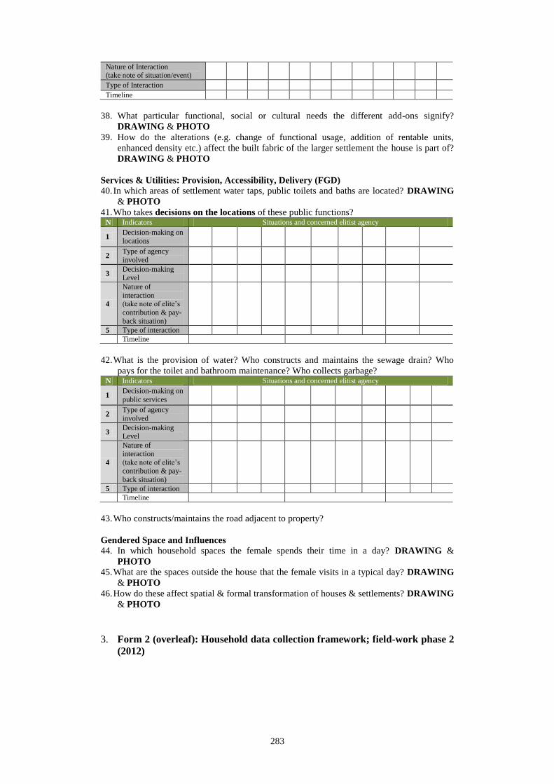
283
Nature of Interaction (take note of situation/event)
Type of Interaction Timeline
38. What particular functional, social or cultural needs the different add-ons signify?
DRAWING & PHOTO
39. How do the alterations (e.g. change of functional usage, addition of rentable units,
enhanced density etc.) affect the built fabric of the larger settlement the house is part of?
DRAWING & PHOTO
Services & Utilities: Provision, Accessibility, Delivery (FGD) 40. In which areas of settlement water taps, public toilets and baths are located? DRAWING
& PHOTO
41. Who takes decisions on the locations of these public functions? N Indicators Situations and concerned elitist agency
1 Decision-making on
locations
2 Type of agency
involved
3 Decision-making Level
4
Nature of
interaction (take note of elite’s
contribution & pay-
back situation)
5 Type of interaction
Timeline
42. What is the provision of water? Who constructs and maintains the sewage drain? Who
pays for the toilet and bathroom maintenance? Who collects garbage? N Indicators Situations and concerned elitist agency
1 Decision-making on
public services
2 Type of agency
involved
3 Decision-making Level
4
Nature of
interaction (take note of elite’s
contribution & pay-
back situation)
5 Type of interaction
Timeline
43. Who constructs/maintains the road adjacent to property?
Gendered Space and Influences 44. In which household spaces the female spends their time in a day? DRAWING &
PHOTO 45. What are the spaces outside the house that the female visits in a typical day? DRAWING
& PHOTO
46. How do these affect spatial & formal transformation of houses & settlements? DRAWING
& PHOTO
3. Form 2 (overleaf): Household data collection framework; field-work phase 2
(2012)

284
Sub-question 1: On form and space
a. Who uses which part of the physical units of home for what purpose, and
under what condition?
Sub-question 2: On control
b. How does the migrant exercise control over the spatio-physical boundaries of
the home’s many ‘parts & configurations’?
Variables How is ‘everyday’ privacy
practiced?
What sorts of compromises
(spatial and social) are made to
realize what benefit?
In which way a sense of
‘territorial control’ is
maintained?
How does property
ownership manifest
in the practiced
control over various
spaces?
Levels Indicators
Variables What functional
preferences
explain the
space-making
practices and the
resulting layout
of rooms &
spaces?
How do the
values and
ideals of a
‘good
environment’
manifest in the
layout?*
What specific
qualities are
mostly valued?
What are the
more significant
‘changeable’
elements
compared to the
‘core’ elements?
What explains
the changed
against the
unchanging?
How does
dwelling
function
correlate the
functions of
other higher
level units?
How do they
influence each
other?
What are
the
contextual
definitions
of space
categories
that signify
property
ownership
& control?
Levels Indicators
Rooms &
partitioned
space
House
Street-
settlement
Use of space:
- Front-back
- Specialized-
multiple-dual
- Sacred-profane
- Clean-dirty
- Served-service
- Plan-non plan
Priority
functions
Important
possessions
Latent needs
Formal-
functional
incongruence
Notion of
ownership
Spatial
organization of
functional
needs
Formal
expression
Privacy
practices
Group
membership
Environmental
preferences:
- Climate
- Lighting
Construction
techniques &
materials
Partitioning &
segmentation
Economic
production
Building
material &
structure
Absorption
Conventions &
style
Built form in
horizontal &
vertical
Sites with
‘everyday
significance’:
- Income
producing
- Service &
utility
provisioning
- Religiously
significant
- Educational &
other
institutional
- Supplies
- Recreational
Ghar-Bari-
Basha
Bariwala
Gram-
Shohor

285
Rooms &
partitioned
space
House
Street-
settlement
Rules & zones:
- Male-female
- Insider-outsider
- Owner-member
- Master-servant
- Landlord-tenant
Partitioning
Time management
Common control as a larger unit
Socially permitted level of:
- Functional overlaps
- Accessibility
Appropriation of space:
- Individual & group
levels
- Right-based practice
Personalization:
- Fixed objects
- Moveable objects
- Symbols & signs
Surveillance:
- Eyes on the streets
- Habitual practices
Levels of
transformation
Sub-question 3: On actors and agents
c. Which other agencies also share control of boundaries?
d. What are the perceived benefits from controlling
Variables What socio-economic-political forces brought
about the spatio-physical transformation?
How did they influence
transformation?
Levels Indicators
Rooms &
partitioned
space
House
Street-
settlement
Demographic variables:
- Race, regional identity, gender, institutional affiliation, socio-economic status
within community
Decision making process:
- Structure, hierarchy of leadership
Role played by decision makers:
- Kinship network, KDA, KCC, migrant elite, religious bodies, NGO, donors,
elected public representative, businessman, political figures
Nature of interaction
4. Table 2: List of Interviewed migrant households2 (family heads): field-
work 2011
Settlements
(local
names)
Interviewee’s list
(local names used)
Gender/
Religion
Address details
(local addresses used)
1 Rupsha Char Bastee
Tereja Biswas F/Chris End of Ranga Mia Goli
Hamida Parvin F/Musl Mosharef Goli
Hamida Begum
(Sattar’s mom)
F/Musl BRAC School Goli
Md Moksed Ali M/Musl Kashem Goli
Md Montaz Ali M/Musl Sat Bhai Goli
Md Afzal Hossain
Mridha
M/Musl Mosjid Goli
Amjad Ali M/Musl Kashem Goli
Jibon Babu M/Hind Nirmala Goli
2. Names and address details are provided with all interviewees’ kind consent

286
2 Rupsha Char
– private
Md Jala Gazi M/Musl 2 No. Custom Ghat, United Saw Mill,
C/O Quaium Shaheb
Parvin F/Musl 2 No. Custom Ghat, Rajon Shaheb er Gola
Shahida Begum F/Musl 2 No. Custom Ghat, Suja Shaheb er Gola
Runu Begum F/Musl WAPDA Veri Bund Road, Rafiq Shaheb er Gola
Md Chan Mia M/Musl WAPDA Veri Bund Road, Abdur Rahman Shaheb er Gola
Md Shah Jahan M/Musl Notun Bazar, Bablu Mollar Gola
Md Elahi Boks M/Musl WAPDA Veri Bund Road, Rafiq Shaheb er Gola
Waresh Sardar M/Musl WAPDA Veri Bund Road, Rafiq Shaheb er Gola
3 5 No. Ghat
Parvin F/Musl Near Kabarkhana Mosque, CDC Netri
Rehana Begum F/Musl
Shahida Begum F/Musl Near main Mosque
Subhas Chandra Shawjal M/Hind
Mr Mansur Sardar M/Musl
Mohan Sardar M/Musl
Md Anwar Hossain
Patwari
M/Musl
Aklima Begum F/Musl
4 Ranar Math
Rokeya F/Musl Purba Banik Para, Ranar Math, Community Center
Md Ismail Khan M/Musl Road no. 3
Md Sultan Khan M/Musl Road no. 2
Fatema F/Musl Road no. 1
Shamsul Haq M/Musl Road no. 1
Siddique Molla M/Musl Road no. 3
Kader Sardar M/Musl Road no. 2
Monwara Begum F/Musl Road no. 2
5 Dakshin
Tootpara,
Motiakhali
Momtaz Begum F/Musl Taltala Hospital Road, Holding No. 77
Ashish Babu M/Chris Dakshin Tootpara Christian Para
Tohmina Begum F/Musl Christian Para (On the other end of Bridge)
Shahida F/Musl Baitul Aman Moholla
Amena Begum F/Musl Monsur Khan Sarak, Dakshin Tootpara
Sheikh Ali Akbar M/Musl Baitul Aman Moholla
Md Jomir Hossain M/Musl Dakshin Tootpara Christian Para
Rustam Ali M/Musl Dakshin Tootpara
6 Vastuhara
Siddiqur Rahman M/Musl Road 4, House 211
Abdul Mannan Sharif M/Musl Road 1, House 2
Syed Shamsuzzaman M/Musl Road 3, House 142
Merezan Begum F/Musl Muktijoddha Colony
Chan Boru F/Hind Road 1, House 7
Abdul Mannan M/Musl Road 2, House 36
Asya Khatun F/Musl Road 11
Anwarul Islam M/Musl Road 1, Muktijoddha Colony
Hasina Banu F/Musl Muktijoddha Colony
Mohammad Ali Sheikh M/Musl Road 3, House 59, Semi-pucca Colony
7 Khalishpur 7 No. Camp
Nasir Uddin M/Musl
Ishak M/Musl
Asma Begum F/Musl CDC Netri
Jubaida F/Musl
Nurjahan F/Musl
Jainul Abedin M/Musl
Zumrati F/Musl
5. Table 3: List of Interviewed migrant households3 (family heads): field-
work 2012
Settlements
(local
names)
Interviewee’s list Gender/
Religion
Address details
1 Rupsha Char
Bastee
Tereja Biswas F/Chris End of Ranga Mia Goli
Hamida Parvin F/Musl Mosharef Goli
3. Names and address details are provided with all interviewees’ kind consent

287
Mansura Begum F/Musl Sattar Boro Mia’s Goli
Md Afzal Hossain
Mridha
M/Musl Mosjid Goli
Jibon Babu M/Hind Nirmala Goli
2 Rupsha Char
– private
Md Abdul Khaleque
Gazi
M/Musl WAPDA Veri Bund Road, Rafiq Saheb er Gola
Shahida Begum F/Musl 2 No. Custom Ghat, Suja Shaheb er Gola
3 5 No. Ghat Abdul Malik Sardar M/Musl Baidda Para
Gol Banu alias ‘Hasan
er Ma’
F/Musl Panir Tank
Mira Rani Raut F/Hind Harijan Para
Shahida Khatun F/Musl Near main Mosque, CDC leader
4 Ranar Math Israil Chunnu M/Musl Road 1
Lutfor Hossain
Haolader
M/Musl Road 3
Abdul Kader Haolader
alias ‘Sardar’
M/Musl Road 2
Md Sultan Khan M/Musl Road 2
5 Dakshin
Tootpara,
Motiakhali
Md Ziarul M/Musl Baitul Aman Moholla
Momtaz Begum F/Musl Near Catholic Church
Shamsunnahar Begum F/Musl Bridge Road
Ashish Babu M/Chris Dakshin Tootpara Christian Para
6 Vastuhara Mohammad Ali Sharif M/Musl Road 1, House 2
Merezan Begum F/Musl Muktijoddha Colony
Md Alauddin alias
‘Dulal’
M/Musl Road 4, House 1
Sufia Khatun F/Musl Road 7, House 11
Munira Motizan F/Musl Road 1, House 7 (AL leader)
7 Khalishpur 7
No. Camp
Md Shamsu M/Musl Corner of Pond
Nurjahan Begum F/Musl Mosque trust land
Nurjahan F/Musl Pond side
Asma Khatun F/Musl CDC Netri
8 Bakkar
Bastee
Bakkar Jomaddar M/Musl Pond side
Md Mazhar Hossain Azad
M/Musl Pond side
Rahima Khatun F/Musl Housing Bazar Road, Khalishpur
9 People’s
Pachtala
Shampa Akter F/Musl Beside People’s Jute Mills bachelor’s quarters,
Khalishpur
Md Anisur Rahman M/Musl People’s Jute Mills bachelor’s quarters, Khalishpur
10 Railway Guard’s
Colony
Md Bodiuzzaman Haolader
M/Musl Railway Guard’s Colony
6. Table 4: List of Interviewed key personnel: field-work 2012
Institution/designation (and
description)
Interviewee’s name Address details
1 KDA (Khulna Development Authority) Mujibur Rahman Chief Planning Officer, KDA
2 General Secretary, Khulna City BNP
(Bangladesh Nationalist Party) – one of
the major patrons of Rupsha Char
Bastee
Shafiqul Alam Mona Munshipara 2nd Lane
3 UPPRP/Settlement Improvement
Assistant (SIA)
Toslima Khatun UPPRP (UNDP-KCC project working in
Khulna slums
4 Ex employee of Crescent Jute Mills
Ltd. – a senior resident of Khulna, and an ex-refugee from Kolkata during
1947 riot
Habibur Rahaman Farazipara Lane
5 Owner, Chhobi Fish Industries Ltd. – a
patron of Rupsha Bastee
Bikki Kazi WAPDA Veri Bund Road, Notun Bazar
6 Ex-Professor of History
Author: Metropolitan Khulna – In
Light of History (trans.)
Sheikh Ghaus Miah Sheikh Para Lane

288
7. Table 5: Reconnaissance field-survey schedule (07.12.2009 to 08.01.2010)
Key Issues
07.12.09-
11.12.09
14.12.09-
18.12.09
21.12.09-
25.12.09
28.12.09-
01.01.10
04.01.10-
08.01.10
Broad areas to
cover weekly
Daily schedule
regarding core tasks
Site
selection
and
discussions
with co-
researchers
Site visit
and
individual
household
survey
Site visit
and
individual
household
survey
Key
informant
interview
(planning
background)
Data
compilation
and feedback
Selection of
migrant-
settlements
H
oli
day
Ho
liday
Tra
vel
bac
k t
o S
ing
apo
re
Testing/adjusting questionnaire/sch
edule
Discussions with
research assistant(s)
Survey
(settlement morphology)
Survey
(individual
households)
Key informant interview
(planning
authority)
Key informant
interview
(professional planner)
Data
documentation
Feedback (from
research assistant)
Secondary data
collection
(documents/literature)

289
8. Table 6: Pilot field-survey schedule (07.02.2011 to 21.04.2011)
Key issues
07.02.11-
14.02.11
15.02.11-
14.03.11
15.03.11-
25.03.11
28.03.11-
14.04.11
15.04.11-
21.04.11
Broad areas to cover
weekly
Daily schedule
regarding core tasks
Development
of initial
questions
and
hypotheses
Amendment
to previous
research
proposal
Revision of
amended
proposal and
finalization
Field visit to
migrant
settlements
in case study
area
Data
compilation
and
travelling
back
Selection of
migrant-settlements
H
oli
day
Ho
liday
Tra
vel
bac
k t
o S
ing
apo
re
Testing/adjusti
ng
questionnaire/schedule
Discussions
with research
assistant(s)
Survey (settlement
morphology)
Survey (individual
households)
Key informant
interview (planning
authority)
Key informant
interview (professional
planner)
Data documentation
Feedback
(from research
assistants)
Secondary data collection
(documents/lite
rature)

290
9. Table 7: Final field-work schedule 2011-2012
Month Week Tasks accomplished
September
2011
1+2 Visit UPPRP (UNDP project on poverty reduction) in Khulna
Meeting with NGOs working in Khulna’s low income settlements
Talk to Khulna University (and other local) researchers
Finalize selection of study settlements (at least 7 types) and prepare
preliminary database on each type
Co-researcher selection (KU architecture students)
Team formation: 4 teams of two (1 male+1 female)
3
4
October
2011
1 Co-researcher training
Focus Group Discussion (FGD) in each of the selected settlements
(1 day/settlement)
Selection of initial respondents (and later snowballing for finalizing
pool of respondent households)
Creation of contact database for all respondents
Questionnaire testing in each of the selected settlements; PI will
accompany each team to their initiation of survey
Feedback from all teams of co-researchers
Necessary adjustments to questionnaire
First phase of data collection at dwelling/household level (expected
data collection rate: 1 household/day by a team)
2+3
4
November
2011
1+3+4 First phase data collection at dwelling/household level continues
An expert (architectural background) will be employed for
November and December for finalizing drawings (and if possible,
sketches and 3-D figures)
Simultaneous search for secondary materials/information from
Khulna/Dhaka/Kolkata sources
December
2011
1+2 First phase data collection at dwelling/household level finishes
Second phase of data collection and drawing preparation at
settlement level (expected data collection rate and drawing
preparation: 1 settlement/week by a team of 4)
3+4
January
2012-July
2012
29 Come back to Singapore
Compilation of accumulated data from first phase of fieldwork
Presentation to and feedback from Supervisors
Refinement to questions to be asked and data to be collected
Work simultaneously on seminar papers and journal articles
Engage in Department’s academic and research activities
August
2012
1 Come back to Khulna
Check back and finalize data collection at household level
Interview of Key personnel by PI – phase 1: (local politicians, long
living Khulna residents, local businessmen)
Dhaka visit for one week to collect national-level information
2
3+4
September
2012
1+2 Finalization of data collection and drawing preparation at settlement
level (expected data collection rate and drawing preparation is 1
settlement/week by a team of 4)
Interview of Key personnel by PI – phase 2: (urban historians,
planners, public sector bureaucrats dealing with housing) 3+4
October
2012
1+2+3 Third phase of data collection (at the city level) from secondary
sources (KDA, KCC, Satellite images etc.) (expected data collection
rate: 1 settlement/week by a team of 4)
Starting of data compilation (drawing finalization; coding of semi-
structured interview data) 4
November
2012
1 Site re-visits to compensate for possibly missing data
Finalization of drawings and coding respectively
Preparation of a preliminary report (summary)
2
3+4

291
List of publications during PhD candidature
Book
- Hakim S. S. 2010, Of the Rough Waters and onto the City: Livelihood-
biographies of the rural migrant from the coasts of Bangladesh, LAP
LAMBERT Academic Publishing, Saarbrücken
Journal
- Hakim S. S. and J. L. Ee Man 2013, “Scarcity, control and negotiations: An
interpretation of urban form in Khulna”, Planum. The Journal of Urbanism
(selected and under final review)
Seminar/Conference paper
- Hakim S. S. 2011, “The rural face of urban constraints: coastal migrants
livelihood vulnerabilities beyond the climate question”, Bangladesh Urban
Research Forum, GIZ Good Urban Governance, 26-27 May, Khulna
University, Khulna
- Hakim S. S. and J. L. Ee Man 2013, “Scarcity, Control and Third World Urban
Form”, PhD Conference: Scarcity and Creativity in the Built Environment,
HERA (Humanities in European Research Area), 26-28 February, University of
Westminster, London