contributions of the university. of california archaeological ...
248
CONTRIBUTIONS OF THE UNIVERSITY OF CALIFORNIA ARCHAEOLOGICAL RESEARCH FACILITY Number ( October 1979 AN ARCHAEOLOGICAL ASSAY ON DRY CREEK, SONOMA COUNTY, CALIFORNIA UNIVERSITY OF CALIFORNIA Department of Anthropology rkeley Available Open Access at: http://escholarship.org/uc/item/2rr5421p
-
Upload
khangminh22 -
Category
Documents
-
view
1 -
download
0
Transcript of contributions of the university. of california archaeological ...
CONTRIBUTIONS
OF THE
UNIVERSITY. OF CALIFORNIA
ARCHAEOLOGICAL RESEARCH FACILITY
Number 40 October 1979
AN ARCHAEOLOGICAL ASSAY ON DRY CREEK,
SONOMA COUNTY, CALIFORNIA
UNIVERSITY OF CALIFORNIA Department of Anthropology
Berkeley
Available Open Access at:http://escholarship.org/uc/item/2rr5421p

CONTRIBUTIONSOF THE
UNIVERSITY OF CALIFORNIAARCHAEOLOGICAL RESEARCH FACILITY
Number 40 October 1979
AN ARCHAEOLOGICAL ASSAY ON DRY CREEK,
SONOMA COUNTY, CALIFORNIA
Martin A. Baumhoff and Robert I. Orlins
UNIVERSITY OF CALIFORNIADepartment of Anthropology
Berkeley
TABLE OF ODNTENTS
Preface * .................... ............................. viii
Introduction ................ * * * * * * * * ......... 1
Geography ................. ....... ......... . ..........**** 1
Archaeology ......***************************************** 2
Site Description ....**@*************9********eee................ 9
Western Group .......... .9
Western Group Chronology ......... *....*.. . ............... .. 38
rEaK-stern Group . . . ............................... 43
Eastern Group Chronology .... .............. 43
Yorty Creek Group .. *..... ... .......................... 79
Yorty Creek Group Chronology .......101
Cherry Creek Group ......................................... 105
Cherry Creek Group Chronology ............................... 112
Central Grout)................................ 115
Central Group Chronology .. *0 * * *** ..................... ... 122
Lower Warm Springs Group . . . . .. . . . .. . . . . .. . . . . . 125
Lower Warm Springs Chronology ............................... 150
Upper Warm Springs Group ... ..................... .. ... ....... 157
Upper Warm Springs Chronology .... ............ ............... 181
Summary and Discussion
Chronology and Debitage . .......... ................. . .. 185
Territory and Population ..... .......................... 191
Site Specialization sees............................. 195
Bibliography ................................. 211
I

Appendix A.
Apperndix B.
Appendix C.
Explanation
Possible PreBorax Lake Ccmponents
Auxiliary Techniques
A Typological Study of the Reworked Bifaces of the
Warm Springs Archaeological Project.
by Nancy Whitney .......................
of Illustrations .....................................
It
215
219
223
231
LIST OF ILUUSTRATIONS
Figures
1. North Coast Rarne Chronology ................................
2. Legered for Site Maps
3. Son-567 Profile
4. Son-571 Profile
5. Son-568 Profile
6. Son-593, Unit 1
7. Son-593, Unit 2
8. Son-582 Profile
9.
10.
11.
12.
13.
14.
15.
16.
17.
180
19.
20.
Son-608
Son-597
Son-576
Son-577
Son-584
Son-583
Son-603
Son-601
Son-556
Son-553
Son-544
Son-547
Profile
Profile
Profile
Profile
Profile
Profile
Profile
Profile
Profile
Profile
Profile
Profile
0000*@.. 0@000 0000.6 ooeooee e~g.... 000 @ 060 00 0a
Profile
Pr.o.0 le06. . . a.0..000a0........000 0000.a0.......0.0.
*.......... ....a.. 0 00 00 0060 000 0 @6 *0 0a0 00 0 0 00 6w
* a.... ... a6 0* .....................a......aa0 00 00 0a
O 6@6@ @0 000600 ~00 0 0 0 a0 0 0 0 0.0
21. Son-551 Profile ..........................................060
22. Projectile Points, Son-568, 571
23. Projectile Points, Son-572, 575............................
iii
3
5
14
28
34
46
47
57
65
69
82
88
93
98
109
111
131
143
160
167
178
236
237

24. Projectile Points, Son-582, 592, 593, 597, 601 .............. 238
25. Projectile Points, Son-576, 583, 584 239
26. Projectile Points, Son-542, 553, 600 * 240
27. Projectile Points, Son-556, 559 *****,*************..........* 241
28. Projectile Points, Sonr-544, 547 ....... 242
29. Projectile Points, Sonr-545, 550, 551 .243
30. Artifacts from Yorty Creek Gravels 244
iv

Maps
1. Archaeological Site Groups .................................. 1
2. Western Site Group 10
3. Son-567 . . .. . .a a@***@ 060a000a0@. *0@*@6 *** ......... 13
4. Son-572 ***,**,****a.....* ***.*.....a..a....................... 20
5. Son-571, Second Terrace 25
6. Son-571, First Terrace 26
7. Son-568 . 32
8. Eastern Site Group . *0***e****.. .................... ......... 42
91. Son-593 ...........*.......................S.......0 0 .0@@06 44
10. Son-582 ..... ..................56
11.4 Son-608 e e e. e. ein. e a. .e a. e. .e .ee e. e e .e . e 63
12. o-9 .................................. 68
13. Cherry and Yorty Creek Site Groups .......................... 77
15. Son-577 . 87
16. Son-584 ........................... ..................... 92
17. Son-583 97
18. Son-601 . ...... 0.................................... 110
19. Central Site Group West ....................***............ 113
20. Central Site Group East .............. . ........ 114
21. Sonm-600 .... ........120
22. Lower Warm Springs Site Group 123
23. So~n-556 130
24. Sor-553 142
25. Son-554 147v

26. Upper Warm Springs Site Group ............................. 155
27. Son-544 . ............ 159
28. Sont547 166
29. Son--551 177
30. Settlement Pattern Chronology .,, 204
vi

PREFACE
In Spring, 1974 the Corps of Engineers approached us about doing a verysmall archaeological reconnaisance in the Warm Springs Dam project. Thesituation had arisen in the following way. The Warm Springs Dam had beenplanned for many years by the Corps as a flood control project related to theannual or least biennial floods on the Russian River (the dam in on atributary). In 1964 in accordance with then current practice the Corps ofEngineers, through the National Park Service, contracted with A. E. Treganzaof San Francisco State College for an archaeological survey. Not much time ormoney was allocated to this survey so that it was quite minimal - only a fewdays were devoted to it and only in areas adjacent to the road. A total ofeleven sites was located arn none was recammerKded for excavation.
In the years that followed a considerable national outcry on the subjectof environmental degradation developed which resulted in several laws andexecutive orders relating, among other things, to preservation ofarchaeological resources, a subject long ignored by all levels of governmentard also by private enterprise. Locally the interest in environmentalpreservation manifested itself in concern for the damage that would resultfran building Warm Springs Dam. At that moment, in Spring, 1974, theparticular concern was for archaeological site Sor-600 which was thought bysome to be the ethnographic village of Tako-ton, ard therefore of interest toPamo Indians now living on Dry Creek.
Col. James Lammie of the Corps of Engineers, desiring an evaluation ofthis situation, asked us to make a determination. A minor amount ofexcavation there suggested that whatever the ethnographic identity of the sitemight be, farming operations had so badly disturbed it, that itsarchaeological potential had virtually disappeared. This was reported to theCorps of Engineers.
In the meantime it had been determined that the original survey byTreganza was inadequate according to the starndards mandated by recent changesin Federal rules. The Corps of Engineers therefore provided the money for acomplete survey, and a contract by the National Park Service with theUniversity of California was entered into ard work was begun October 24, 1974with a crew of 6 under the field direction of Orlins. The survey continuedfor two months, arn luckily there was fine weather during most of that period.A total of 55 archaeological sites was recorded including 10 which had beenfound by Treganza in the original survey (one of the original 11 turned outnot to be a site). The survey covered 85% of the project area (the other 15%was done later), and we now consider that although a few small sites may havebeen missed that virtually every surface site is now known. There may ofcourse be subsurface archaeology that has not come to light particularly alongYorty Creek as discussed in the description of that group.
Having completed the survey, negotiations were begun in February, 1975concerning the next phase of the project-testing and evaluation. Field workwas begun in late May, 1975 with Orlins again field director and a crew of 10.Test excavations were performed into mid-July when the field crew dispersed,
viii

and three persons returned to Davis to assist in completing the report. Afterexcavations had beeen under way a short time, it became apparent thatinsufficient time had been allocated to preparation of the final report. Thiswas therefore delayed, and as a consequence the Corps of Engineers becameincreasingly uneasy. They were required to appear in court, and while itwould have been possible to obtain a postponement, the project had alreadybeen delayed more than a year and inflationary factors, particularly at thattime, were increasing to the cost of the dam considerably. It is possible toargue that they should have begun thorough archaeological evaluation muchearlier, and in fact it has been so argued, but on the whole we fiind itdifficult to place blame in view of the fluctuating nature of the legal andregulatory requirements. In general we found the San Francisco Office of theCorps of Engineers very reasonable to deal with and not at all obstructive.
In any case because of the delay and because of internal confusion withinthe National Park Park Service, the contract between the University and theService was terminated in February, 1976. At that time our draft report wasin their hands, and they performed an act which they call "assembling" whichso far as we can see consists of retyping, reproducing, and omitting certainportions. The Park Service gives the following statement "...any errors ofomission or content are to be attributed to the contractor." These authorsrefuse to accept such responsibility since they did not even see the finalcopy until after it was issued.
It is instructive at this point to outline some of the difficulties facedin dealing with interlocking bureaucracies. About a half dozen differentbureaus, depending on how you count them, were involved in this effort. TheU.S. Army Corps of Engineers primary charge, as we understand it, is withflood control and inland waterways. In addition they are required to observeenvironmental regulations imposed by Congress and/or executive order. In ourexperience there are three ways they can do this in the case of archaeology:by hiring their own archaeologists; by contracting other individuals ororganizations; or by working through Inter-Agency Archaeological Services, anagency of the National Park Service. Inter-Agency Archaeological Serviceshave had a longish history but a rather uneven one because the level ofprofessionalism has been uneven. As is the case, we suppose, with mostgovernmental organizations the persons responsible have been better bureau-crats than professionals (archaeologists). Inter-Agency ArcheologicalServices do not, or at least did not in this case, undertake thearchaeological investigations themselves but contracted them to otherorganizations retaining for themselves more-or-less the position of overseer.
In the present case the contractor was the University of California andthis is another level of bureaucracy we will deal with below. But first letus deal with a heirarchy tangential to this Federal maze. There exists inWashington something called the National Register of Historic Places.Nominally the function of this is to identify places important or uniquehistorically or archaeologically which can then be preserved or otherwisedealt with appropriately. Perhaps more important is the provision that onFederal land such places must be dealt with appropriately. The office thatdeals with this seems also to be related to the Inter-Agency ArcheologicalServices but only at a higher level than we dealt with on the project. Also
ix

tconneted with this tangent is the Historic Preservation Office of the Stateof California. As we understand it the naninations for the National Registerof Historic Places are (when Californian) first assessed by this office.Another function of the State organization is to pass judgement on allenviromental impact reports even if they refer to Federal lard. The legality-of this seems questionable to us, but in any case it provides another level ofinterference.
Finally the contractor was the University of California, and it is initself a formidable bureaucracy. One has innumerable difficulties herecarrying out archaeological obligations, difficulties in the form of approvalof contracts, accounting procedures, purchasing procedures, use of Universityvehicles aid the like. These, however, are ones we deal with every day asmembrs of the University. In the case of this project we came up against aparticularly formidable obstacle in University hiring policy. There are twoaspects of this, one having to do with racial aid other kinds of illegaldiscrimination and the other relating to prior rights of University employeesor students to University jobs (however funded). The first part hinges onwhat is called an affirmative action program undertaken in response to actionby the Department of Health, Education aid Welfare under anti-discriminatorylegislation. The effect of the program is that in addition to eliminatingdiscrimination it eliminates speed. This was most unfortunate in the presentcase since speed was all-important to the Corps of Engineers. It seemed mostunfair to us that, frcm what we could observe, both the Corps of Engineers aidthe Inter-Agency Archeological Services could hire virtually anyone theywanted within days while the University, because of the action of yet anotherFederal agency, was hamstrung in the same activity. The University's ownhiring policies also slowed us up at a time when speed was of the utmostimportance.
The result of this concatination of agencies, Corps, Offices, Registers,Departments, and Campuses as well as laws, orders, policies, rules andprograms, was to make it seem at times impossible to do archaeology at all.One spends full time dealing with these problems and no time doing archaeologyor any other kind of scholarship. The difficulties of the situation aretwofold. In the first place it is in the nature of bureaucracies to deal inabstract requirements and policies usually not related to the particularproblem at hand--thus the well-known inflexibility of these institutions.But even if this were not the case, the objectives of these organizations isat best different fran and at worst contradictory to the objectives ofscholarship or science, namely to discover the nature of the world. Thus theCorps of Engineers is interested in flood control, not in how Paom Culturecame to be the way it was. The National Register is interested in registeringthings. Even the Inter-Agency Archeological Services, which one might imaginehad some basic interest in the problem, seems more interested in purely formalrequirements, whether or not they have anything to do with the particularissue.
We do not know how to deal with the difficulties mentioned here or evenwhether it is particularly useful to mention them. They are outlined here asa matter of personal and ethnographic interest rather than as a proposal fororganizational reform or anything of the sort.
x

What follows is the result of the archaeological reconnaissance in theWarm Springs area. It is basically a descriptive report, necessary because solittle descriptive archaeology for the North Coast Range has appeared inpr int.
Acknowledgements
A great many individuals contributed time and efforts to this project.The official field crew was the following: Peter Banks (Assistant FieldSupervisor), David Devey, Joan Hellen (also photographer and artist),Elizabeth Honeysett, (also ecologist), Willian Lindenau, Donald McGeachy, JaneMelville, Scott Patterson, Pamela Roberts, Miriam Stafford, Sonia Tamex, NancyWhitney (laboratory supervisor), and Terry Zontek. Terry Zontek and JaneMelville also did floatation studies. Nancy Whitney and Joan Hellen were mosthelpful in canpiling material for the report.
Roderick MacDonald and Elizabeth Honeysett prepared an ecological surveyfor the project. Melva Orlins served as project secretary.
A good deal of time was contributed gratis by the following: SariFredrickson, Jonathan Borah, Thomas Clancy, Roxie Towe, Linda Bell, RandyMason, and Andrew Devey. We think it fair to single out Sari Fredrickson andLinda Bell as having been especially generous with their time and effort.
Sonana State College generally, David Fredrickson and David Peri inparticular, made generous contributions to the project.
Our relations with the U.S. Goverrment were not always friendly duringthis project so it is worthwhile noting that we felt and still feel thatfriendly and willing cooperation was given us by Mr. Garland Gordon of thePark Service and Dr. Richard Lerner of the Corps of Engineers. We aregrateful to them both.
The Department of Anthropology of the University of California, Davis wasmost supportive throughout. We wish particularly to thank James West, D. L.True, Jeanie Anderson, Barbara Beckman, and Gayle Bacon.
xi

INTRODUCTION
GeographyThe area under consideration is in California's North Coast Range in
Northern Sonama County about 20 miles southwest of Lakeport on Clear Lake. Itis in gently rolling to low mountainous country with elevation fram about 400to over 1000 ft. elevation. Mean annual rainfall here is over 50 inches andis quite variable, ranging fran below 30 to over 100 inches per year. Thebulk of the rainfall falls between the first of November and the last ofMarch. The temperature is indicated by data fran nearby Healdsburg wher8 themean annual temperature is 590 F, ranging fran 400 in January to 70 inJuly and August. Overall the topographic and climatic conditions can bedescribed as salubrious and pleasant.
It has always been our contention that the most inmortant aspect of theenvironment for a hunting-gathering people like the Pomo is the native flora.This is true not only because they relied directly upon plants for theirresources but also because the nor-aquatic fauna upon which they also reliedis itself intimately related to floral patterning. Fortunately this matterhas been taken up in some detail in an ecological survey of the project area(MacDonald and Honeysett 1975). This report was prepared for the presentproject and is available for consultation. We rely upon that report in thefollowing summary.
The vegetation is intimately related to soils and the above report reliesupon that to divide the areas into four soil-vegetation types as follows:
1. Mixed Evergreen and oak forest soils. "These important timber soilssupported a mixture of Doug-fir, Redwood, and hardwoods." This constitutesabout 19,000 acres or 36% of the project area. The soils are in the Hugo,Josephine, Hugo-Josephine and Sites series. On soils of this category thereseem to have been a considerable amount of redwood and Douglas fir growth andmay therefore have supported some elk population. This is on the edge of theRoosevelt elk distribution (McCullough 1971:10) and this would have been thekind of country they would have preferred. The hardwoods included black oak,tan oak, and coast live oak, in that order. The first two figure importantlyin the production of acorns for human use. Overall one would say that whilethis land was very important to the aboriginal inhabitants it was slightlyless so than the next category.
2. Woodland - Grassland soils. Three soils also comprise about 36% ofthe total acerage. This actually seems to us to be two separate groups. TheLaughlin and Suther series both have large areas of open grass (more than 50%)but also dense woodlands significant components of which are Oregon oak andblack oak, both important acorn producers. The second sub-group consists ofthe Yorkville, Montara, and Sobrante series on which there are widelyscattered small patches or individual trees. It would appear that noeconomically important tree crop occurs in the latter sub-groups unless it isthe digger pine. Digger pines produce good crops of pine nuts but we havenever heard that these were in any way important in the North Coast Range.Possibly there occur here also examples of lone standing oaks of relevantspecies (particularly valley oak). These might be important because such

2
trees far outproduce, tree for tree, individual trees found in groves.
We feel that the Group 2 soils have the most important nut production tobe found in the area. In addition it is the most important feeding ground fordeer. This therefore may be the most important land from the standpoint ofaboriginal econanics in the Warm Springs Project area.
3. Woodland-Chapparal Soil. This is the Los Gatos soils seriescanprising about 12,000 acres or 22% of the project area. We quote franMacDonald and Honeysett (1975:24). "80% Brush and hardwoods with sparsegrass. Shallower soils support a diverse 'high' chaparral mixture. Smallredwood clumps occur in ravines. A grass-woodland develops on the deepestphases." The oaks that occur here are mostly coast aid interior live oak,both inferior in acorn production. The primary importance of this land musthave been in producing deer feed. It was probably less important than eitherof the two preceeding.
4. Chaparral Soils. There are a little over 3,000 acres of these or 6%of the total and the comprise the Stonyford, Maymen, and Hennebe series. Thesedense chaparral areas were only important on their margins where importantdeer feed was found. They were probably the least important in the area.
The distribution of these soil-vegetation types is shown on maps witharchaeological sites plotted on them accanpanying each site groups below. Thesignificance, if any, of the relationships shown there will be considered asthe sites are described and discussed.
Besides vegetation it is important to consider location and abundance ofgame animals and fish. Deer and elk have both been discussed in connectionwith vegetation zones above. The other important question relates to theavailability in aboriginal times of game fish in Dry Creek and Warm SpringsCreek. There seems no doubt that there was a salmon run in Dry Creek inaboriginal times, at least we have been told this by Fish and Game people, butit seems very unlikely that it was a large one. Apparently silver salmon andsteelhead trout both run up the Russian River (Baumhoff 1963:174) and a smallpart of these went up this tributary. In addition there must have been troutand other native freshwater fish. The fishery then may have been asignificant element of native subsistance but probably not a major ordefinitive element.
These geographic factors in aboriginal life will be considered in thediscussion of archaeological sites.
ArchaeologyIt is important that in addition to providing descriptive material we
also outline our ideas of the broad outline of North Coast Range archaeology.For present purposes we present a cultural sequence which relies basically onthat of Fredrickson (1973, 1974) but also incorporates additional typologicalfeatures fran the Borax Lake site (Harrington 1948; Meighan and Haynes 1968,1970) and fran the Willits site (Meighan 1955). Fredrickson's sequence givesa total of five periods for the chronology of the region summarized asfollows:

Borax Lake Pattern
Borax Lake Aspect
Early L
CM
000
Late
arm-I- Il
3
cD
0
0
(I00
Berkeley Pattern
Houx Aspect
Early Late
02ax
0
North Coast Range Chronology.
3
ma.
Post Pattern
a)000o
4-
5P00
01000
Figure 1.
d
*-wQ OD
14 -E D -_*4
4-&..-. I

4
Post Pattern. This is tiought to date fran 10,000 to 6,000 BC. Thiscomplex is positively identified by Fredrickson only at the Borax Lake site.It has fluted points and crescent stones illustrated by Harrington (1948) ardby Meighan and Haynes (1968). Only one canponent fran Warm Springs iproposed as being fran this period but there may be others undiscovered simplybecause we have not excavated sufficiently the deeper portions of some sites.
Early Borax Lake Pattern. This follows a possible haitus lasting fran6,000 to 5,000 BC. and persists until 3,000 BC. It is characterized accordingto Fredrickson, by the large, square stemped Borax Lake point and by the useof milling stones. We have found none of the square stemmed points but webelieve the large side-notch points and large concave based points also datefrom this period. At the Borax Lake site the concave base points occur withBorax Lake points (Meighan and Haynes 1970: Figure 4). Neither Fredrickson(1974:45) or Meighan and Haynes (1970: note 3) place the concave based pointsin early Borax Lake but into the next one. However Fredrickson notes theearly obsidian hydration readings from Borax Lake and says "Lak-261 may wellrepresent sampling error [i.e., concave base points may be early]'(Fredrickson 1973:198). In any case we tentatively include this concave basedtype in early Borax Lake Pattern though it may begin earlier in that periodthan square stemmed Borax Lake points. We place the large side notched pointsin the same because they are stratigraphically, equivalent at the Willits site(Meighan 1955: types 11 and 7).
Late Borax Lake. In this phase two new projectile point types areintroduced. The mortar and pestle is also introduced although the hardstone -milling stone canplex persists. The time span of the phase is fran 3000 to500 BC. The two new projectile points are, we believe, variants of oneanother and are called here the Excelsior point and the leaf shaped point.Fredrickson (1973:199) says "The defining characteristics of the Excelsiorpoint are a triangular, straight-edge body and a convex base which isfrequently ogival in outline; that is, it resembles a pointed arch. Afrequent but not necessary attribute of the Excelsior series point is thepresence of a definite shoulder at the junction of the body and the base."These points probably would not have been recognized except for Fredrickson'sexcavation of the Houx site (Lak-261) where there were a great many of them(see Fredrickson 1973:201). At the Houx site these are all large points butin Warm Springs and also in Indian Valley all of them are smaller and becaneeven more reduced later in time. That these are variants of a leaf shapedwith curvate rather than straight sides seems obvious fran the Willits site(canpare Ileigham 1955: P1. 4B with P1. 4C and D). These also are reduced insize later in time.
Early Houx Aspect.. The time period here is roughly fran 500 BC to A.D.1200. In this phase grinding tools are mortar and pestle only. Smallerversions of the Excelsior and leaf shaped point continue. A sall sidenotched point begins here; this may be simply a smaller version of earlierlarge side notched point but aside fran the noth there is no greatresemblance.
Late Houx Aspect. This runs fran A.D. 1200 to historic times.Typological content of the early Houx Aspect catinoms but with the additionof Gunther barbed points. These were defined by Treganza (1958:13-16) and

5
Midden i;i§iii Surface Scatter
@"~-4$ Oak Woodland BrushBoulders
mh~Jz%& Rock . . . . Sand, Gravel
'fiit~- Swamp a Test Unit
* Datum oAuger Hole
* Cupule Rock 0 Fire Hearth
-. Housepit .-...*.11....-Suggested Extent of Midden
J ASlope or Embankment Creek
....-.-.Spring -- Tributary, Seasonal Stream
Roodway- Paved Roadway-Dirt, Unimproved
Trees
FO Oak El Bay
® Maple © Cottonwood
E Buckeye © Box Elder
* Madrone 0 Alder
LA Manzanita
Figure 2. Legend for Site Maps.

6
seem always to be late in Northern California.
This outlines the basic sequence in the area and gives the primary typeswe will be using to determine the chronological placenent components (Fig. 1).In determining what is or is not a component (a single phase within a site) wehave had recourse to yet another device: the ratio of chert to obsidian chipswithin a 10 an level of a one meter pit. Since the criterion is likely to becontroversial we will attempt some justification here.
The testing of the sites in the Warm Springs project was done by diggingone or, infrequently, two one meter pits (nine units were dug in Son-600 butthat was a special case irrelevant to the present discussion). That meantthat the time diagnostic artifacts occurred at the very low frequency for anyone site - the greatest number of diagnostic projectile points is 6 fran Son-547 and 2 or 3 is the usual number. If we had put, say, 10 units in each sitewe could make component divisions based upon diagnostic artifacts but this wasimpossible in the circumstances. Waste chips, however, cane not singly but in10's or 100's per level ard we concluded that our best irdicator of change wasa change in the ratio of chert to obsidian chips - we discuss the inferences,other than that of change, that can be made fran this in our concludingsection. One of the dangers of using these ratios stems fran the possibilityof a single flint knapper working one or a few pieces of raw material in oneplace at one time thus greatly changing a culturally determined ratio locally.For that reason we accept as an indicator of cultural change a ratio whichchanges not just once but over several levels in the same direction.
We recognize that this method is imperfect but regard it as the best thatcan be done in the circumstances.

7
ICREEK
o 3000ft.
0 M.
.1'ARCHAEOLOGICAL SITE GROUPS
WARM SPRINGS DAM PROJECT
Map 1.

9
SITE DESCRIPTION
The foregoing geographic and archaeological information we will use inthe following pages in the organization and analysis of archaeological datarecovered in survey and testing in the Warm Springs Dam project area. Forconvenience of presentation the area is divided into 7 site groups forconvenience of presentation (Map 1). In some ways the 4 northern groups standas a unit as opposed to the two southern groups on Warm Springs Creek. Franthis point of view the Central Group is a no-mans-laid -- almost no sites ofsignificance occur in most of it while in the eastern part what were onceprobably important sites have been virtually destroyed by agriculture.Beginning with the Western Group we describe these in order down Dry Creek arnup Warm Springs Creek. Twenty-one maps of individual sites are contained inthe following descriptions. It is not possible to show many features on thesemaps other than symbolically. The symbols are explained in Figure 2.
Western Site Group
Dry Creek northwest of the mouth of Warm Springs Creek flows through abroad flat valley nowadays well adapted to the cultivation of grapes. Abcwethis the valley narrows progressively until in the Western Group the sidesdrop off on quite a steep slope with only a narrow terrace above flood levelsuitable for habitation. This means that there was very little land suitablefor a large compact village - any large village would have to have been strungout along the terrace. It turns out that none of the sites has much area, allbeing snall and evidently specialized. Thus we seen to have an areaperipheral to the main activity centers but one which, as we shall see, was ofconsiderable importance. All sites in this Group are on the north side of thecreek (except Son-566 which is on a tributary). We see two possible reasonsfor this. One is the usual one that a north slope is warmer in the winter.The other relates to the phenomena of slumping or land slippage which iscamon along this section of the creek and occurs only on the south slope.The occupants of the valley may have avoided the south slope to prevent theslippage coming down on their villages or, alternatively, there may bevillages now buried under the talus. It might be thought that the slippage isdue to erosion produced subsequent to logging ard in part this may be true butat least part of it is old (see discussion under site Son-593 in Eastern Groupbelow). It would be desirable to auger the talus piles although it would bequite difficult and expensive.
The site descriptions of the Western Group begin with Son-265 on RailCreek and proceed in order downstream.
Site Son-565 (Rail Creek)This is a rather promising midden site ard was recaomerKded for excavation
in the Phase I report. It turned out to be outside the project area, however,and was therefore not tested. It appears to have some importance as a largesite rather far up in the drainage.

-*e **v liI Iii H-0,1. . - . ' , , . ''I lll ii -i0, 711111111.... ....................
.......... .... .. -
:. l _
,,,,, ',,:~~.,'. wN1111llllllll**eeev* ; J II >
* 06
........................ X ~11 1111' 1i
XIw
11~~~~H._11/) - 11~~~~~1111
2111 qllllllllll[@@@1111111111 I1I
IC , i S);°
0 0~1II1IIllllI
0~~~~~~~~
Map 2. Western Site Group
10

11
Site Son-564 (Slump)
Sor-564 is located at the extreme western edge of both Dry Creek Canyonand the Project Area boundaries. It is adjacent to and just north of thebridge where Hot Springs Road crosses Dry Creek. The site is situated on thenorth bank of Dry Creek, on a second terrace, 10 m above the creek. Two otherhigh terrace sites are located near Son-564, on the north bank of Dry Creek;Sor-565 (midden) is 120 m north of this site, and Sor-567 (midden) is 1 kmsouth.
The site is in an open oak/woodland vegetation cammunity on the edge of apranontory that has been intensively eroded by Dry Creek. Heavy slumpingoccurs on the bank of this pranontory. The promontory faces east and is cutoff fram Hot Springs Road on the west by a modern wire fence.
During the survey phase this site was located aix] described as a middensite remnant. It was indicated at that time that most of the site had erodedby the destructive forces of Dry Creek. A test unit was placed in the centerof the 20 m by 20 m midden area on the promontory. Cnly 20 an were excavatedin this unit. The excavations revealed that no midden now remains on thispranontory.
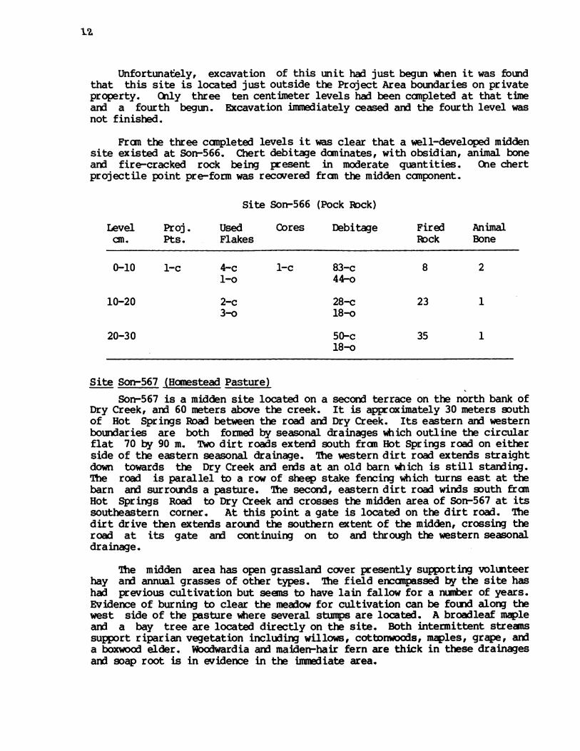
Site Son-566 (Pock Rock)Son-566 is one of four sites found in the extreme northwestern corner of
the Project Area. Unlike the other three sites in this area, Son-566 is notsituated directly on the banks of Dry Creek, but is located on an intermittenttributary of Dry Creek, about 350 m west of that creek.
The site is an open flat on the south bank of this intermittent stream,at the confluence of this stream anx] a second intermittent stream. The secondstream forms the eastern boundary of Sor-566, the primary intermittent streamthe northern boundary, and the sloping hills form the southern and westernlimits of the site, caupletely enclosing the flat. This -site measures 50 m by60 m.
The flat has open grassland covered with bay/oak woodland vegetation onboth sides of the intermittent streams. The streams themselves support canmonriparian plants, and are actively running nearly year-round. The soil of thesite is black clayey silt with talus gravels and cobbles fran the southern andwestern slopes surrounding the flat. The soil on the other banks of theintermittent streams are dark brown silty clay and contrast with the darkmidden soil of the site. Very little historic or modern disturbance isevident on the terrace.
Sorr-566 is a midden site with an associated cupule rock. The cupule rockis located on the east central of the flat, near the second intermittentstream. It is a low, flat rock measuring 4.5 meters by 3 meters and bearsscores of ground cupules. During surface reconnaisance in Phase I aconcentration of chert and obsidian flakes, a grooved hammerstone, hoppermortar fragments, and fire-cracked rocks was found approximately 30 metersnorth and west of this cupule rock. These Unit I was placed one meter dueeast of datum in this concentration.
1%
Unfortunately, excavation of this unit had just begun when it was foundthat this site is located just outside the Project Area boundaries on privateproperty. Only three ten centimeter levels had been canpleted at that timeand a fourth begun. Excavation immediately ceased arn the fourth level wasnot finished.
Fran the three canpleted levels it was clear that a well-developed middensite existed at Son-566. Chert debitage dcminates, with obsidian, animal boneard fire-cracked rock being present in moderate quantities. One chertprojectile point pre-form was recovered fran the midden canponent.
Site Son-566 (Pock Rock)
Level Proj. Used Cores Debitage Fired Animalan. Pts. Flakes Rock Bone
0-10 1-c 4-c 1-c 83-c 8 2l-o 44-o
10-20 2-c 28-c 23 13-o 18-o
20-30 50-c 35 118-o
Site Son-567 (Homestead Pasture)Son-567 is a midden site located on a second terrace on the north bank of
Dry Creek, arn] 60 meters above the creek. It is approximately 30 meters southof Hot Springs Road between the road and Dry Creek. Its eastern and westernboundaries are both formed by seasonal drainages which outline the circularflat 70 by 90 m. Two dirt roads extend south fran Hot Springs road on eitherside of the eastern seasonal drainage. The western dirt road extends straightdown towards the Dry Creek and ends at an old barn which is still standing.The road is parallel to a row of sheep stake fencing which turns east at thebarn and surrounds a pasture. The second, eastern dirt road winds south franHot Springs Road to Dry Creek aid crosses the midden area of Son-567 at itssoutheastern corner. At this point a gate is located on the dirt road. Thedirt drive then extends around the southern extent of the midden, crossing theroad at its gate arn continuing on to and through the western seasonaldrainage.
The midden area has open grassland cover presently supporting volunteerhay aid annual grasses of other types. The field encanpassed by the site hashad previous cultivation but seens to have lain fallow for a nurber of years.Evidence of burning to clear the meadow for cultivation can be found along thewest side of the pasture where several stumps are located. A broadleaf mapleand a bay tree are located directly on the site. Both intermittent streanssupport riparian vegetation including willows, cottonwoods, maples, grape, arda boxwood elder. Woodwardia and maiden-hair fern are thick in these drainagesarnd soap root is in evidence in the iumnuiate area.

13CA Sons 567Map
N -
sss- _ _,.0J>
0 5 10
Meters
Map 3. Son-567 (legend p. 5).
0
.0

- 0 -
- 20
30
40
50 -
60 -
70 -
o80
90 -
- 100 -
-110
ktill- v vQ u
II:l: 10A~d1!r 11 A
00 303 330333303330ID0 33333 3 33 333330 0030~ 3 33 3 33 3 I
33333 3333333333'K 3 0 a 33333333333 0 333333 3 31330 3300303333333333 0 a33-a 30 0 3
,
A. Midden; dry; very dark gray to black; silty loam with rootsfran annual grasses. Cultivation zone. Small gravels.
B. Midden; black; silty loam with small gravels. Friable. Fire-cracked rock.
C. Transitional zone. Dark grayish brown; sand with silt ardgravels. Moderately compact.
D. Sub-midden; dark grayish brown to brown; sandy gravels; cobbles.Moderately canpact.
E. Yellowish brown; ashy clay lens. Moderately canpact.
Figure 3. Son-567 Profile.
14
--
-I) wII-I .-) ."-q
. *-P....
---- - V-,.l
0000000000100.000.
a
0
a
D

15
Site Sorn-567 (Hanestead Pasture)
Level Proj. Bifaces Reworked Scrapers Retouch Used Cores Debitagecm. Pts. Biface Flakes Flakes
0-10 19-c1-o 4-o
10-20 l-o 2-o 34-c8-o
20-30 2-c 1-c 3-c 54-c4-o 28-o
30-40 1-c 57-c1-o 1-o 2-o 26-o
40-50 3-c 41-c1-o 1-o 1-o 10-o
50-60 1-c 1-c 33-c1-o 8-o
60-70 17-c1-o 1-o 7-o
70-80 17-c1-o 1-o 1-o 3-o 8-o
80-90 7-c1-o
90-10 0 1-c 2-c
Total 2-c 1-c 11-c 1-c 281-c4-o 1-o 2-o 1-o 5-o 12-o 99-o
Grand 6 1 2 1 4 23 1 380Total

16
Site Sor-567 (Homestead Pasture)
Level Milling Bonecm. Stone Tool
0-10
10-20
20-30
30-40
40-50
50-60
60-70
70-80
80-90
90-100
1
FiredRock
1
86
80
110
56
71
1 40
26
Animal Shell Historic ObjectsBone (square nails)
4
15
41
87
75
46
32
22
8
2
3
3
5
1x
x
1 444 332Total 1
17
The soil of the midden is dark grey brown to black sandy silt, and caneasily be distinguished fram the surrounding light brown silts. Augering ofthe pasture revealed that the midden covers most of the meadow area ardextends under the dirt road and to the east of it. Tess Unit 1 was placed inthe darkest part of the midden, 11 meters south and 15 west of site datum,and 15 meters due west of the broadleaf maple tree on the site.
Excavation of this midden canponent showed a well-developed midden zonecontinuing to 80 an. It consisted of black silty loam for the first 40 an, atwhich point a shallow (5 an) ashy, clay lens intruded into the midden (Feature1). Below this level, the soil became more clayey but was still midden-likein quality and texture. A shallow sub-midden component follows for twentycentimeters and over-lies sterile soil. The last excavated level (100-110 an)involved only the western half of the unit since it was dug into sterile soil.
Artifacts were spread evenly throughout the midden canponent. Threediagnostic projectile points were found, two at 20-30 an, and one at the 70-80an level, (chert arn obsidian), all representing a late time period. Afragmentary point at 60-70 an may represent an earlier period. Four burins, abiface, a scraper, four retouched flakes arnd a core were also recovered. COesandstone millingstone was also recovered in the 30-40 an level. One piece ofincised bone was recovered. Chert debitage was continually found in greaterquantities than obsidian ard both were recovered in moderate amounts. A verylarge amount of fire-cracked rock arn animal bone also came fran this unit.
It is of interest that evidence of historic contact (square nails and aceramic sherd) continued to the 40 an level. Since the upper maddenrepresents a very late canponent, this site is very important in terms ofunderstanding late prehistoric-early historic contacts.
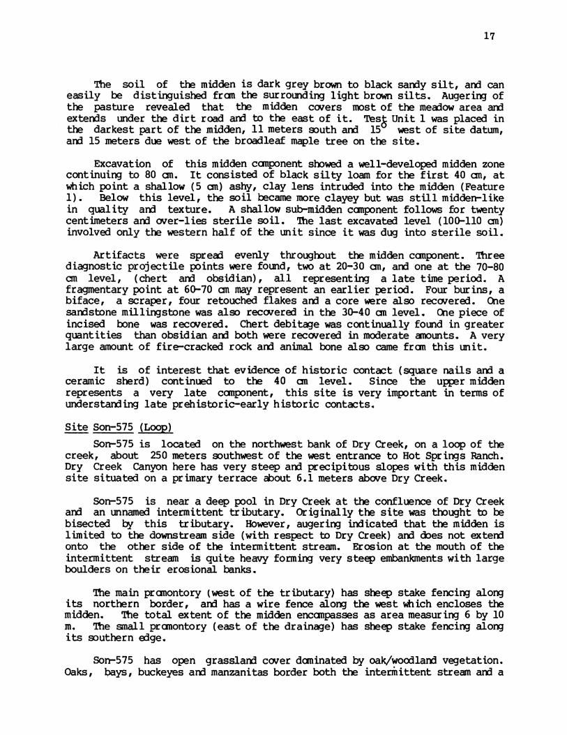
Site Son-575 (Loop)Sor-575 is located on the northwest bank of Dry Creek, on a loop of the
creek, about 250 meters southwest of the west entrance to Hot Springs Ranch.Dry Creek Canyon here has very steep and precipitous slopes with this middensite situated on a primary terrace about 6.1 meters above Dry Creek.
Son-575 is near a deep pool in Dry Creek at the confluence of Dry Creekand an unnamed intermittent tributary. Originally the site was thought to bebisected by this tributary. However, augering indicated that the midden islimited to the downstream side (with respect to Dry Creek) and does not extendonto the other side of the intermittent stream. Erosion at the mouth of theintermittent stream is quite heavy forming very steep embankments with largeboulders on their erosional banks.
The main pranontory (west of the tributary) has sheep stake fencing alongits northern border, and has a wire fence along the west which encloses themidden. The total extent of the midden encanpasses as area measuring 6 by 10m. The small pranontory (east of the drainage) has sheep stake fencing alongits southern edge.
Sorr-575 has open grassland cover dominated by oak/woodland vegetation.Oaks, bays, buckeyes and manzanitas border both the intermittent stream arn a
18
Site Son-575 (Loop)
Level Proj.aC. Pts.
Biface ReworkedBiface
Scraper RetouchFlakes
Used DebitaeFlakes
Fired AnimalRock Bone
0-10 1-c2-o
10-20 1-c
20-30
30-40 1-c
1-c
1-c
6-c 32-c15-o
1-c 1-c
1-c
2-c 33-c5-o
26-c5-o
2-c 8-c6-o
40-50 3-c
ToLtal 1-c 1-c 3-c 1-c 5-c 8-c 102-c 73 42-o 31-o
GrardTotal
3 1 3 1 5 8 133 73 4
3
20 2
30
20
2

19
steep sided ephemeral stream on the western boundary of the main terrace. Thepromontory also has oaks and buckeyes on the primary terrace. The large oaklocated on the easternmost edge of the promontory is presently covered by wildgrape. Heavy slumping occurs along the steep cuts, especially on the banks ofthe site, the outside curve of this 'loop' in the creek. There is a largeamount of sub-angular serpentine rocks naturally occuring in the area and Son-575 is covered with these rocks. Most of this site has been lost to streamerosion aid at present only an edge of the original area of habitationremains.
Test Unit 1 was placed three meters south of the datum stake, on thedarkest area of the midden and in the area of least rock coverage. Excavationof this unit revealed a shallow but well-developed midden, followed by atransitional zone aid very shallow sub-midden component.
The midden (0-30 an) contained two obsidian projectile points, one aside-notched point of the latest phase (Fig. 23a). Besides these tools, aknife, three reworked bifaces, a scraper aid two retouched flakes, all ofchert, were found. Fire-cracked rock was found in moderate quantities,reaching an apex in the 30 an level Very few pieces of burnt animal bonewere recovered.
The next ten centimeters represent a transitional zone between the middenand sub-midden components. Mottling by clay patches riddled the dark brown,sandy, silty, midden soil, aid at 40 an the bottom of the unit was covered byan extensive root system. What is probably a late chert, straight basedprojectile point was found in this zone (Fig. 23b), as well as two retouchedchert flakes. The amount of debitage, in general, greatly declined from themidden component.
The mottling continues in the sub-midden component (40-50 an), aid seemsto suggest some type of old disturbance. The major root system found in thetransitional zone continues to expand with depth. At this point the soil hasbecome mostly brown silty clay. Only three pieces of unutilized chert werefound in this last excavated level.
The unit was augered in the center from the 50 an to 140 an level, andcontinued until auger refusal by roots at 140 an. These 90 an containedbrown, sandy silt with charcoal flecks throughout. The last ten centimetersof augering contained charcoal lumps and small water-worn stream gravels inabmdance.
Site Son-572 (Banded Rock Pool)Son-572 is located about a mile ard a half west of the east entrance to
Hot Springs Road aid 600 meters south of the west entrance to Hot SpringsRanch off Hot Springs Road. It is a second terrace site in a sloping area onthe north bank of Dry Creek.
The site is 400 meters upstream from Son-571 and is geographicallysimilar to that site. Both sites are located on second terraces on the northstream bank near a deep pool in Dry Creek. Both have first terrace extensionswhich seem to have been utilized as a grinding areas. The extension at Son-

CASon-572Map
0 20
Meters
A
AA
AA&A
0
A
0
_0 ~ ~ ~ ~ ~
ta ':
% ..*..-
Map 4. SSm-572 (1egend p. 5).
II* * .
I * *
I1* . .* ....II* . .
I* * 6
I * .
I * 0 S.
lI* * *5
l *
l* 5
l* 0
**
*
*
*
*
*
*
*
*
*
X* X X 0 5
* * 0 0 0
*
*
* ** 0 5 0 0
*** 0 5 0 0
b.* * *
* * * **
** 0 5 5 5 5
** 0 0 5 0 0
* 0 0 0
I * 0 0 5.
I 0@ 5 S 0.
* 0 * *
I 0 *0
0 0 * 0
* 5 0 0
0 0
0
0
S0
S0
SO0
20

21
572 is located 80 meters upstream fran the second terrace midden in an area ofopen grassland subject to heavy slumping, directly on the bank of Dry Creekand across fran a deep pool in the creek. Surface finds fran this lower areaconsisted of chert and obsidian flakes (75% chert; 25% obsidian), many fire-cracked rocks and a large (30 by 15 cm) hopper mortar fragment shaped withpecked cupules on the bottom surface. This surface scatter covers a 60 meterby 20 meter area, surrounded by sheep stake fencing.
The midden at Son-572, on the second terrace, is cut off fran the slopeto the creek by a modern wire fence which forms the southern boundary of thissite. It is located in a deep basin and has sloping hills forming thenorthern, eastern and western boundaries of the midden area. This basinencompasses approximately 25 meters by 12 meters in areal extent.
Sorr-572 has open grassland cover (unlike the sheltered terrace at Sor-571) with a few isolated oaks, bays and manzanitas in the basin. Scatteredoak stands are found on the surrounding slopes. Tree cutting activities haveslightly disturbed the surface of this site.
The basin is horse-shoe shaped and the midden seems to follow the contourof this area. The midden is very dark brown gravelly sand and can be visuallydistinguished fran the surrounding alluvial sands. One auger hole was placedin the lighter sands in the center of this horse-shoe shaped midden area tosee if buried midden could be distinguished. It was found that no middenoccurred here and that the midden does accurately follow the countour of thisbasin.
Test Unit 1 was placed in the definite midden area 1 meter north aid 1meter east of the site datum stake. Excavation of this unit revealed a well-developed midden canponent extexding to 130 an. This component is followed bya shallow sub-midden zone which overlies sterile alluvium.
Stratigraphically, the midden appears to be one continuous deposit ofcultural material. It consists of dark brown silt with snall angular gravels,hundreds of madrone anx oak tree roots, and larvae extending to 100 an. At60-70 an there is an increase in the sand content of the soil an consequentlya lightening of soil color. Gravels begin to decrease in quantity at thissame level. No soil profile is given for this site since there is no sharpdemarcation showing this change. The lithic debitage also slnws a change inthe midden component at about this level. The upper levels of the midden weredominated by obsidian debitage with moderate quantities of chert debitage anx]animal bone appearing. Large amounts of fire-cracked rock were also presentindicating a well-formed midden deposit. However, chert completely dominatesthe debitage remains of the lower levels. Obsidian counts begin to decreaseabruptly after their peak in the 50-60 an. level. Correspondingly, chertflakes increase in quantity in the same point, reach their peak at 90-100 an,and retain very high counts until the end of the midden canponent at 135 an.Fire-cracked rock continues at high quantities until the end of the midden.Obsidian flakes and animal bone remains, on the other hand, were recovered invery small amounts fran these lower levels.
The midden at Son-572 has two separate tool concentration corresponding

22
Site Son-572 (Barded Rock Pool)
Level Proj.cm. Pts.
Bifaces ReworkedBiface
Scrapers Retouch Used CoresFlakes Flakes
0-10 1-c1-o
10-202-o
20-30
30-40
40-50
50-60
60-70
1-o
1-c
1-c
1-c
2-o
1-o
1-c1-c1-o
1-c
1-o
2-c1-o
1-c
1-c
1-c1-o1-o
5-c9-o
1-c2-o
2-c3-o
6-c2-o
1-c6-o
2-c2-o
1-c
70-80 1-c 1-c
80-90 1-c
90-100
1-c2-o
1-c2-o
3-c1-o
1-c 3-c 5-c1-c
1-c 16-c50-o
30-c45-o
23-c54-o
(56-c) *59-o
(1-c) *80-o
1-c 24-c85-o
35-c68-o
1-c 65-c58-o
82-c28-o
168-c17-o
100-110
110-1201-o
120-130 1-c
3-c 1-c 120-c4-o
1-c 1-c
1-c
130-140
8-c 2-c 113-c
3-c
1-c 1-c 1-c
123-c3-o
76-c
ToLtal 4-c 8-c 9-c 5-c 42-c 7-c 932-c3-o 2-o 5-o l-o 2-o 29-o 551-o
10 5 10 7 71 7 1483
*Chert fran 30-40 an] 40-50 ina3vertantly canbined
Debitage
Grarnd 7Total

23
Site Sor-572 (Barded Rock Pool)
Level Milling Hamner Net Fired Animalcm. Stone Stone Weight Rock Bone
0-10 7 1
10-20 134 9
20-30 100 9
30-40 98 7
40-50 1 65 9
50-60 70 4
60-70 100 5
70-80 1 97 7
80-90 76 9
90-100 77 2
100-110 57 1
110-120 1 1 58 -
120-130 92 1
130-140 24 2
1 1 1075Total 2 66

24
to the two midden levels. Within the upper levels, two small, side-notchedprojectile points were found (obsidian and chert) which are diagnostic of thelatest phase. Eleven reworked bifaces (7 obsidian), four bifaces, threescrapers, arn one chert core were found with these and two other projectilepoint fragments within the first half meter of excavations. One millingstonefragment was also recovered in this concentration. The second toolconcentration extends fran 70 an to the end of the midden component and alsocontained two diagnostic projectile points. Both points are large chert sidenotched points and correspond to Meighan's Mendocino Ccmplex, Type 11,(Meighan, 1955), and thus to the Borax Lake aspect. These points areassociated with six biface (five chert), two buins, five scrapers, and fourcores, all of chert. Also, a millingstone, a basalt hammrstone, and apossible net weight came fran the lower levels. these tool concentrationscorrelate nicely with the debitage change noted above, and suggest that atleast two separate cultural canponents existed within the midden zone. Wediscuss the chronological implications in more detail in the group summary.
The shallow sub-midden zone at Son-572 is characterized by a greatdecrease in cultural material of all types. Both animal bone and fire-cracked rock disappeared in the lower levels of the midden and do not re-appear in this lower zone. Very few pieces of chert or obsidian debitaewere recovered. This component overlies sterile soil.
Site Son-571 (Poolside)Son-571 is located approximately 1 mile west of the east entrance to Hot
Springs Ranch off Hot Springs Road ard approximately 250 meters south of thatroad. It is on a small secondary terrace on the north bank of Dry Creek in adeep canyon.
This terrace is approximately 12 meters above Dry Creek in a small flatclearing in an otherwise boulder-strewn wooded slope. The site is tightlydelineated on the north, east and west by talus slope covered with largeboulders. The southern boundary of this site is the steep cut bank above DryCreek. Burnt logs are found on the site and many madrone, bay and oak treescanpletely shelter this small terrace. The entire terrace is covered withblack midden and measures 35 m by 15 meters in its widest parts. Historicactivity on this terrace is indicated by a possible firepit (ca. 5 m southand 1/2 m west of datum) and by sheep stake fencing which runs parallel tothe creek, ca. 6 meters north of datum, bisecting the terrace. Surface findson this terrace include an obsidian mid-section of a projectile point and anobsidian leaf-shaped point base fragment.
About a meter northwest of this second terrace is a very small clearingamong the large boulders that fringe Son-571. This clearing has yellow-brownsilty talus soil but contains a surface scatter of chert and obsidiandebitage. Soap root, wild white and purple irises, and bunch grass coverthis area. Mariposa lilies are also present in this small northern area andon the northern edge of the midden covered terrace. Poison oak is abundantamong the boulders between these two open sections.
Approximately 20 meters east of and below this second terrace are theremnants of a first terrace. This lower area has two sections, a grassyslope and a clay/cobble area next to the gravel of Dry Creek. The

CA Son 571Second TerraceMap
0 5 10a a
-.
Meters
I7 O.
Map 5. Son-571, Second Terrace (legend p. 5).
25

CA-Son*571First TerraceMap
0 5 10I1 I
-
.0 V
Map 6. Son-571, First Terrace (leend p. 5).
26

27
clay/cobble zone has numerous ground stone tools still lying on the surfaceincluding milling stones arid a maul. The northerrinost section of this zonehas the heaviest concentration of artifacts. These artifacts may have erodedout of the grassy slope or may have been lowered as soil fran the area waswashed away by Dry Creek. On the first terrace are madrones, oaks, bays, arttwo alders. The clay/cobble zone is located approximately 1 1/2 meters aboveDry Creek. 20 meters south and 20 meters west of this zone, Dry Creek backsup against a rock spur on the opposing bank ard forms a deep pool of water,after which this site was named.
Test Unit 1 was placed 2.5 meters due east of the site datum in thecenter of the black midden on the second terrace. Excavation of this unitrevealed a well-developed midden extending to approximately 85 an. Atransitional zone (85-110 cm) followed the midden canponent ard wascharacterized by mottling due to increased clay content of the soil.Finally, a shallow sub-midden canponent exterded to 130 an.
The midden component was characterized by very black, greasy, slightlysardy, silty, loam. This canponent contained huge quantities of obsidian,unparalleled by any other site investigated. The lowest count of obsidiandebitage in the entire 85 an of midden was 364 pieces, ard the peak wasreached in 50-60 an at 713 pieces. Chert debitage consistently renainedunder 40 pieces per level until obsidian began to decline (70-80 an), atwhich point the chert count jumped to 64 pieces. Larger quantities of animalbone than recovered fran the usual site were found at Son-571 (up to 71 burntpieces per level), an] animal bone count seem to rise and fall with obsidian.Unfortunately, the area of this site is so littered with angular rocks thatdifficulties were encountered in trying to separate out fire-cracked rock.Only unquestionable pieces were recorded in the level records. Thus, thequantities of fire-cracked rock recorded (unusually small for a midden site)may be misleading.
Twenty-one projectile point fragments were recovered fran the middencanponent, three of which are canplete. Two small, possibly late specimenswere found in tne 0-10 and 10-20 cm levels of the midden zone. The thirdcanplete point is a side notched chert projectile point we date in the BoraxLake aspect. This point was recovered fran the 60-70 an level, just at thepoint when the high obsidian counts are declining ard chert debitage isincreasing. A bowl mortar rim fragment was found with the late points; apossible handstone below the late points; and a definite hardstone one levelbelow the side notched projectile point.
It is important to note that preference for certain types of lithicmaterial can be seen at Son-571. This site has a unusually high quantity ofretouched flakes, (26 were recovered fran the midden canponent), only four ofwhich were chert. 20 reworked bifaces came fran the midden zone ard all ofthese were manufactured fran obsidian and eleven bifaces (ten obsidian) wererecovered. However, despite all of the obsidian debitage, retouched flakes,and tools, no obsidian cores were found. Four chert cores and two chertscrapers were recovered implying that chert was still preferred for theheavy-duty tools.
The transitional zone fran Unit 1 was characterized by an increase inthe clay content of the soil producing subtle mottling and lighter soil

28
A. Midden; dark brown to black; silty loam with sand. Root zone.Friable. Rock intrusion: mainly angular.
B. Greasy midden; black to very black; silty loam with sand.Very friable. Rock as in "A".
C. Transitional zone. Very dark grayish brown to dark brown;silt with sard ard clay. Moderately friable. Rock as above.
D. Sub-midden; brown to dark yellowish brown; gravels with sandand clay mix. Compact. Rock as above.
E. Rock.
Figure 4. Son-571 Profile.

Proj.Pts .
2-o
1-o
4-o
1-o1-c
2-o
3-o1-c
4-o
Site Son-571 (Poolside)
Bifaces Reworked Scrapers RetouchBiface Flakes
1-o 2-o
1-o 1-o
2-o
2-o
1-o
1-c
1-o
90-100 1-c
100-110 l-o
110-120
120-130
Totals 18-o3-c
Grand 22Total
10-o1-c
11
4-o
4-o
3-o
4-o
3-o
1-o
1-c
2-o
1-o
1-c
1-o
1-o
23-o
23
3-o2-c
5
1-o
5-o2-c
1-o
9-o
3-o
1-o
2-o
2-c
22-o4-c
26
Used CoresFlakes
14-o4-c
1-o1-c
4-o
ll-o
7-o2-c 1-c
7-o2-c
7-o2-c
19-o3-c
5-o
5-o
3-o2-c
1-o
84-o
13-c 4-c
97 4
29
Levelcms.
0-10
10-20
20-30
30-40
40-50
50-60
60-70
70-80
80-90
Debitage
785-o39-c
506-o14-c
366-o26-c
544-o20-c
364-o32-c
713-o13-c
516-o69-c
416-o31-c
251-o64-c
265-o36-c
95-o23-c
42-o10-c
2-o3-c
4865-o380-c
5245

30
Site Son-571 (Poolside)
Level Hard Mortar Fired Animalan. Stones Pock Bone
0-10 4 44
10-20 1 17 14
20-30 14 43
30-40 1 11 47
40-50 11 71
50-60 14 66
60-70 6 57
70-80 1 7 34
80-90 4 30
90-100 3 20
100-110 2 5
110-120 1 2
120-130 1
95 433Tobtal 2 1

31
colors. With this clay increase large rock concentrations of cobbles andboulders began to fill the unit. The transitional component continued untilapproximately 110 an when a definite stratigraphic change to a lighter soilcolor became apparent. Lithic material fran this camponent included 2undiagnostic obsidian projectile point fragments, 1 obsidian burin on asnapped biface, anx] two retouched pieces of chert. Animal bone, fire-crackedrock, anx] both obsidian and chert debitage counts declined.
The shallow sub-midden canponent at Son-571 consists of flakes only; notools being apparent. Further, only two fire-cracked rocks and two pieces ofburnt animal bone were recovered. It is highly probable that these piecesare only partially representative of the material fran this component, sinceheavy rock concentrations prohibited excavations. Both the transitional andsub-midden zones were deposited on talus slope soil with boulders fran a rockslide that may have been contemporaneous with the large boulderconcentrations that now surround Son-571 on three sides.
It should be noted that a large quantity of obsidian fell through the1/4" screen used to dry screen the site. Only small bits of charcoal werefound in while excavating. This latter may correlate with the small numberof fire-cracked rocks found in the midden or may be influenced by the factthat roots and rootlets continued to the 130 an level.
Site Son-570 (Flat Iron)Son-570 is a petroglyph site located 280 meters upstream fran site Son-
568. It consists of two large boulders 30 meters apart with hundreds ofcupules in them. Detailed descriptions of these petroglyphs, as with mostothers in the project have not yet been made.
Site Son-568 (Smiley)Son-568 is located on a first terrace on the north bank of Dry Creek,
approximately 200 m south of the Hot Springs Road. It is 3/4 of a mile westof the east entrance to Hot Springs Ranch and approximately 200 m west ofwhere Hot Springs Road climbs away fran Dry Creek. Son-568 has threeserpentine rocks with cupules apparently associated with the midden. Theyare located 91.70 m southeast fran the Son-568 site datum.
Sort-568 is a well-developed midden site bordered on the north by aseasonally intermittent stream. A second intermittent stream, 15-30 m southof the first, bisects the midden area of Son-568. The area of this sitecontinues approximately 15 m south of the second intermittent stream on itsfirst terrace. Both of these seasonal streams empty into Dry Creek, which islocated 10 m to the west of the midden, down an abrupt cut bank.
This abrupt cut bank forms the eastern boundary of Son-568. The westernsection of the midden has been disturbed by an historical roadbed which runsthe full extent of both first terraces and crossed the two intermittentstreams by two wooden bridges. The north bridge that crosses the firstintermittent stream is more or less intact. The south bridge across thesouthern, second intermittent stream has collapsed sections. The area ofSon-568 passes under this old roadbed arn at least 5 m west of it.
Son-568 has open grassland vegetation with oak/woodlarnd cover. The site
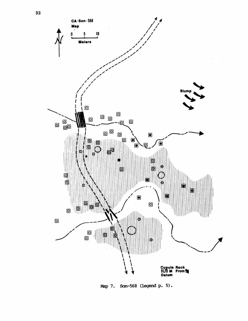
32
CA Son * 568Map
0 5 ID
meters
Slump
; CU ule RockA 91.1M From%
Datum
Map 7. Son-568 (legend p. 5).
111% -%
9 EcP
9 9 no
Eg 9
9
9
33
is heavily populated wih oaks arn bay laurels, vegetation especiallyinteresting because the species of oak present is black oak, which has notbeen noticed on other sites in the Project area. The small terrace betweenthe two intermittent streams is campletely enclosed by these oaks, screeningit fram the surrounding slopes arK terraces. A large fallen oak lies acrossthe western edge of this terrace ard extends onto the historic roadbed. Themidden is canposed of black, silty, gravelly, alluvial sand. A series ofseven auger holes was dug into the site. These test holes revealed that thedarkest part of the madden is located within the highest contour, between thetwo intermittent streams, ani between the steep cut bank ard the old historicroadbed. The midden continues *west of the roadbed, east beyond the 400'contour, and south of the second stream, but is slightly lighter in color andseems to be fanning out fram the central area. Lithic material was recoveredfran the two auger holes near the site datum, just east ard just west of theroadbed. Test Unit 1 was placed on the darkest part of the midden area, 13meters east of the site datum stake.
Excavation of Text Unit 1 revealed a well-developed midden, followed byfour more components consisting of transitional, sub-midden, gravels ardclay. The unit was excavated to 170 an where the few flakes recovered werefran a disturbed area.
These camponents should be described as stratigraphic changes and notcultural components. The 0-90 cm level is broken into three zones on thebasis of rodent disturbance which produced increasing mottling arn increasedclay content in successively lower levels. The soil appears to get onechrana lighter approximately every 30 cm. However, the cultural layercontinues to approoximately 90-100 cm where it gives way to relatively sterileclay gravels.
The midden zone is characterized by a high artifactual content whichremains without marked deviation in quantity, at least down to 110 or 120 anFire-cracked rock alone rapidly decreases fram the top of the midden to itslowest points. Chert is by far the most canmon material found in thedebitage, although numerous artifacts were maie fran obsidian as well. Ofthe ten projectile points recovered in the midden, two are diagnostic: asmall obsidian Excelsior point (40-50 an) and a red chert Gunther barbedprojectile point (60-70 an). Animal bone fragments consistently stayed below20 pieces recovered per level. Two pestle fragments were found.
At a meter depth, animal bone remains and fire-cracked rock cease;utilized pieces of either chert or obsidian are rare, arn] only one actualtool were recovered in the full 70 an excavated in the gravel zone. Debitagecounts remain at less than 10 pieces per level. Stratigraphically, this zoneis divided into two canponents. The first consists of clay with a highgravel content (perhaps suggesting stream flooding), ard the lower canponentis relatively gravel-free. No diagnostic chipped or ground stone tools arefound below 1 meter.
Test Unit 1 was dry screened until 30 an when both dry and wet screeningwere introduced to facilitate sorting. At 90 an the clay content of the soilbegan to increase rapidly ard wet screening was solely employed.

34
- 0
140 _ 3 0
1-40
1507 _ 4_ _
160 _a _ -
I _ _ _ _ _ _ _ _ _ _ _ _ _ _ _ _ _ _
A. Midden; very dark gray to black; silty loam with sand. Root zone.Friable to very friable. Fire cracked rock.
B. Transitional zone. Very dark gray; silt with sand and clay.Moderately compact.
C. Sub-Midden; very dark grayish brow to grayish brown silty claywith sand. -Decrease in armont of fire-cracked rock.
D. Dark brown clay with sand and gravels. No fire-cracked rock.Compact.
E. Brown to dark yellowish brown clay; sticky. Comact to very compact.
K. Krotovina andi/or heavy disturbance.
Figure 5. Son-568 Profile.

Site Son-568
Bifaces ReworkedBiLfaces
1-c
(Smiley)
RetouchFlakes
1-c
1-o
1-o
1-o
1-o
1-c1-c
Used CoresFlakes
3-c 1-c
1-c1-o
2-c1-o
3-c 1-c1-o
2-o
4-c
2-c
1-c1-o
2-o
2-c
35
Proj .
Pts.
1-c2-o
2-o
1-c
1-c1-o
Levelcm-
0-10
10-20
20-30
30-40
40-50
50-60
60-70
70-80
80-90
90-100
1-c
Debitage
60-c15-o
50-c16-o
41-c13-o
54-c17-o
63-cl1-o
82-c16-o
50-c12-o
75-cl1-o
47-c5-o
42-c4-o1-o

36
Site Son-568 (Smiley)
Level Proj. Bifaces Reworked Retouch Used Cores Debitagecm. Pts. Biface Flakes Flakes
100-110 2-c 16-c
110-120 9-c1-o
120-130 6-c
130-140 3-c1-o
140-150 7-c
150-160 1-c 2-c
160-170 1-c 3-c
Level Pestle Fired Animalan. Rock Bone
0-10 121 1
10-20 1 251 3
20-30 300 6
30-40 95 12
40-50 175 14
50-60 105 18
60-70 1 66 1
70-80 90 4
80-90 32 1
90-100 10 2
(None below 100 an)
37
(Summary)
Site Son-568 (Smiley)
Level Proj. Bifaces Rework RetouchBiface Flakes
Used CoreFlakes
Debitage Fired AnimalRock Bone
Totals 4-c 2-c 2-c 22-c 2-c 610-c 1245 62
6-o 2-o 2-o 6-o 122-o
10 2 2 4 28 2 732 1245 62GrandTotals

38
Besides . the midden area, two cultural features are present at Son-568.Three housepits are located on the midden; one within the 400' contour,approximately 5 meters northwest of Test Unit 1; a secord, 20 m southeast ofthe unit on a lower contour; ard the largest housepit (ca. 5 m diameter) islocated approximately 20 m south of Test Unit 1 on the terrace south of thesecond intermittent stream.
Three cupule rocks are found approximately 92 m southeast of site datumarn 100 m east of an old shed. These rocks are 5 m by 5 m ard 4 m high ardhave numerous cupules and at least one grove. Test Unit 2 was placed 20 cmeast of the northerrinost petroglyph in an attempt to find associated culturalmaterial. Excavation of Unit 2 revealed no midden ard only one artifact inthe full 40 an. Stratigraphically, two canponents were distinguished. Thefirst (0-25 an) was characterized by dark brownish yellow alluvial sard withdisturbed areas by possibly pig rooting activity. No cultural constituentswere noted. The final zone (25-40 an) consisted of darker brown soil andproduced a reworked obsidian biface. Excavation ceased at 40 an because oflack of cultural material. All material excavated fran this unit was dryscreened.
Western Site Group Chronology
They are 8 sites in this group and 6 of these have enough informationto attempt chronological placement. There are noted as follows.
Son-566
There are hopper mortar fragments here so the site probably belongs tothe Houx aspect but whether early or late we cannot tell.
Son-567There is a possible milling stone fragment at 30-40 an but the
projectile point fragments are so small and delicate arn] the milling stonefragment so doubtful that we are inclined to attribute the entire deposit tothe Houx aspect. There is a slight break in the chert-obsidian ratio at 20an so we assign the top 20 an to late Houx and the remainder to early Houx.Square nails were found as in the top 40 an but these must be due to earlywhite settlers rather than to historic Indian occupation.
Son-575
This is probably at least partially late Houx because of the small sidenotched point (Fig. 23a) and may also be early Houx as well. We assign it toHoux generally.
Son-572This site presents some stratigraphic difficulty. We are certain that
the upper portions are Houx aspect because of small side notched points onthe surface and the 0-10 an level (Fig. 23d, e). We are also sure that thereare Borax Lake components here because of the presence of 2 milling stonefragments and the large side notched points in the lower levels (Fig. 23g,

39
i). The first obvious break in the chippage ratios caneslevel but there is a milling stone fragment at 40-50 cm.conclude that the Houx components go down to the 70 an levelmilling stone fragment is out of place.
at the 70-80 anReluctantly weard the (small)
We divide the deposit as follows: 0-20 late Houx (arbitrary division),20-70 early Houx (chippage break), 70-100 late Borax Lake (chippage break),100-140 early Borax Lake.
Son-571There is no definite evidence of late Houx but the upper midden must be
Houx because of the small Excelsior point at 10-20 an (Fig. 22e). We areassigning the deposit fran 0-80 an, where there is a break in the chippageratio, to early Houx. Levels below that we attribute to late Borax Lake.This leaves a large side notched projectile point (Fig. 22h) out of positionin Houx aspect context although not by very much.
Son-568There are two pestles (one at 10-20
this site must be Houx Aspect. There is a70-80 an and we are therefore assigning thethe rest to early Houx.
an andx the other at 60-70 an) sobreak in chert-obsidian ratio atlevels down to 80 an to late and

western Site Group
Chert-Obsidian Debitage Ratios by Site ard Level
Site CA-Son
575
2.13(47)6.60(38)5.20(31)1.33(14)* ( 3)
572
0.32(66)0.67(75)0.43(77)0.41(87)#0.41(109)0.28(109)0.49(103)1.12(123)2.93(110)9.88(185)
30.00(124)* (131)
41.00(126)* ( 76)
571
0.05(824)0.03(520)0.07(392)0.04(564)0.09(396)0.02(726)0.13(585)0.07(447)0.28(315)0.14(301)0.24(118)0.24( 53)1.50( 5)
568
4.00(75)3.13(66)3.15(54)3.18 (71)5.73(74)5.13(98)4.17 (62)6.82 (86)9.40(52)
10.50(48)* (16)
9.00(10)* ( 6)
3.00( 4)* ( 7)* ( 2)* ( 3)
debitage frequencyinfinity, or all chert30-40 ard 40-50 levels inadvertantly canbined in this site
40
Level
566
1.89(127)1.56( 46)2.78( 68)
567
4. 75(23)6.75(42)1.93(82)2.19(83)4.10(51)4.13(41)2. 43(24)2.13 (25)* ( 7)* ( 2)
CM.
0-1010-2020-3030-4040-5050-6060-7070-8080-9090-100
100-110110-120120-130130-140140-150150-160160-170
( ) :*

41
Western Site Group
Chert-Obsidian Ratios by Site ard Phase
567
0-204.42(65)
575Site CA-Son
572 571
0-20.48
(141)
568
0-804.28(586)
0-503.29(133)
20-100Ha 2.62
(315)
Blb
BLa
20-70.40
(485)70-1003.06(418)100-4061.71(439)
0-80.06
(4454)80-130.21
(791)
80-13012.27(146)
2.84 3.29 1.69(380) (133) (1483)
.08 5.00(5245) (732)
: Houx Aspect: Early Houx Aspect: Late Houx Aspect: Early Borax Lake Aspect: Late Borax Lake Aspect
Hb
H
HHaHbBLaBLb

X.0~~~~~~~~~0
rn~~ ~ ~ ~~~c
z
N~~~ ~ ~ ~
w
01.1 ~~~~~~~~~~~~~-J
0 00
06 ~ ~ ~ ~
> ~ ~~ ~ ~ ~ ~ ~ ~ ~ ~ O
x 0 ~ ~~~~~~
O ~ ~
C~~~~~~~~~~~~C
Map 8. Eastern Site Group
42

43
Eastern Site Group
The valley of Dry Creek is wider along this stretch than it is eitherabove or just below Where it is pinched between two low mountain ranges. Itwidens especially on the NW around site Son-593 and again toward the SE atthe mouth of Cherry Creek. Perhaps because of the availability of this flatbottom lard we have the densest accumulation of sites and also the twolargest sites in our area. We argue elsewhere that this area was a tribeletcenter and had been for many centuries. Perhaps the reason wastopographical; they simply had more roam for large winter groups to gather.It is also thanks to topography that this area has occasionally been thoughtsuitable for cultivation and as a consequence one of the two largest sites(Son-593) has been partially destroyed.
Another peculiarity of this area is that it is virtually all surroundedby soil types which have been determined as having been mixed evergreen andoak forest (Map 8). This contrasts with other parts of the project wheredifferent supposed vegetation patterns prevail. We indicated earlier that weconsidered mixed oak-evergreen land as slightly less valuable than woodlard-grasslard territory. In view of the apparently high population density hereit may be that our assessment was wrong aix that the oak-evergreenenvironment is the most favorable. Alternatively it may have been the casethat immediate environment was of less importance than that of the tribeletterritory a whole and that location of principal villages deperded more uponother factors such as centrality or on topography as previously mentioned.
A total of 13 sites was recorded for this group beginning with Son-593in the northwest anx] continuing downstream to Son-597 at the confluence ofBrush Creek and Yorty Creek.
Site Son-593 (Treganza 3 and 4)As irdicated by the title this site was recorded as two separate sites
in Treganza's survey. The separate midden deposits were originally one sitewith the central portion having been disturbed by agricultural acitvity asshown on Map 9. The north midden area is south of Hot Springs Road at theentrance to Hot Springs Ranch. Datum stake 2 was placed on the western edgeof this midden. The south midden is about 150 m southwest of this anx] lies15 or 20 m north of Dry Creek. This midden was deposited on a low mound ameter or two high. Datum stake 1 is at the highest point of the mound. Bothmiddens are on a flat extensive stream terrace exterding about 150 m north-south aix] 300 m east-west. It is bounded by steepening hillsides to thenorth and west, by Dry Creek on the south ard by a spring fed stream on theeast. Directly opposite this flat, across Dry Creek, is an extensive area oflard-sliding on a steep slope made up of a part of the Franciscan formationreferred to as "melange," an easily weathered, serpentine derived metamorphicrock. Mr. Richard Thompson, a Corps of Engineers geologist, theorized thatthe mound on which the south midden is located was deposited by an older,more massive landslide which at the same time dammed Dry Creek, forcing itnorth of this mound. After a short time, perhaps 10 to 20 years, Dry Creekeroded through the landslide ard re-assumed its present channel. The

CA-Son-593
14II
fig*~~~~~~...~\
|| ..._"...... Possible Former Mildden Boundary
)0
*0
II9
**
a'**
L*A
Map 9. Son-593 (legend p. 5).
44
g
J
A:
:'1
::1
>.#
::
!:
]X
I
45
landslide left behind the low, uneven mound on an otherwise flat terrace andan old stream channel that has since becane filled in and plowed over and isnow poorly defined.
As previously mentioned, agricultural land leveling has removed much ofthe midden, especially just west of the north midden. Plowing of the terraceflats has further buried or obscured the midden that still exists. Wien theland leveling took place and where the midden was taken could not bedetermined. There is a possibility that the midden sown in the southeast onMap 9 is re-deposited midden fran the area north of it.
The vegetation in the flat around the site is now open grassland with afew isolated Oregon oaks, live oaks, and buckeyes. The surface must havebeen more heavily wooded in aboriginal times and may have been an openparkland with the usual riparian suite of laurel, alder, and willow along thefringes of Dry Creek. The slopes north and south of the flat are heavilywooded in oak and madrone with Douglas fir and laurel more prevalent south ofDry Creek.
The soil sequence on the terrace around the south midden is 1.0 to 1.5 mof fine grained alluvial deposit underlain by about a meter of sandy alluvialgravel containing many boulders. Shale bedrock nrderlies this bed. Themidden is very dark brown soil with considerable fire-cracked rock and someanimal bone. It generally runs to a depth of 30-40 an, but goes as deep as50 an in one place. A single small side-notched projectile found in the 0-10cm level, the low chert-obsidian ratio of debitage, and the well developedhousepits on the surface identify this as a late midden; we believe a singlecanponent midden.
There are 11 well defined housepits on this south midden. They measurebetween 2.2 and 6.0 m in diameter and were 40 an to 1.5 m deep. Two areoblong and may be sweat houses while the rest are circular.
There are at least 36 petroglyph rocks on or close to the south midden.All but one of these has cupules as the only design element. The exceptionis a wedge shaped rock with cupules on its south face and apex and someshallow grooves on its north face. The grooves are not well defined but aresimilar to other, definitely man-made examples found elsewhere in the NorthCoast Range. The petroglyphs are on medium sized boulders ranging fran 50 anto 2.0 m (avg. 1 m) in largest dimension. Almost all these boulders arefound along the front edge of the terrace just along Dry Creek. They arescattered fran the south midden about 300 m downstream. There are also twocupule rocks on the south midden itself and an isolated one on a higherterrace 150 m to the northwest.
The north midden is located on a secondary terrace 80 to 100 m fram DryCreek. A large amount of midden has been removed by land leveling so thatthe northern section is now represented by two small remnants. In the northmidden the excavated deposit can be divided into four units which constituteat least three cultural components. The topmost (A and B in the profile)consist of dark grey to dark brown midden with a large amount of fire-crackedrock and animal bone. It extended fran 0 to 70 cm in depth. There aresquare nails and bottle glass near the surface. Diagnostic artifacts include

46
CA Sons 593Test Unit 1Soil ProfileNorth Wall
-o
10 -
i20
30
-40
50
60cm
A. Midden; very dark gray; sardy silt.Root zone. Friable.
B. Decaposing shale. Friable.
C. Decacposing shale and gravels; brownto dark brown silt with sand. Friable.
D. Rock.
Figure 6. Son-593, Unit 1 Profile.

47
,oOOO-*
0 . ~ ~ ~ ~ ~ ~ ~ ~
'*o;"oo~oo"'OO).- - *..-.**.*
~~~~~~6 lb..*
C)OOO.OC) OOOOC)CC(C)ooooO()()oo o0CCOO cC) C))
) (C ) )( (C )) )) C)C() (CoO CCC C) (OOo C) (OO0)()(()o~o()o( ooo ,),oooC()oooooloooooooC
lo(Coo 0)()o(CCC ) ooC ooooooUCocC0C C)CCoooo 0CCo 0CCO Co 0000000
CC)() C)00)C)()( C)C)0)C)C) O0C))C)i )OOCC )CO OOOOOOO)OOOO'C O~nOOOOOOO)OOOOC)OOOC() )(())CC)C)C)CCCC )C C)C)C ( C) OOOOO OoC)oo CCoooo o
OCC)O) OCCC)COCOOCOC O)OCCOCC)CC)C 0CCCOCCOOO )00000000 0CC)00O00 000 0000 00 000
OCCCI )() ()O()oC)0)o0)()C(C)C()() oooooo oooooof o00CCo00000000o0000o
)o(oo() ()o(ooo oooo() 0ooo0o()oc0o oooot0 ooo()ooo()00 0 0of0ooooooc00ooo'(o()ooo()oo()o()O())()o((((()()oooooc)oooooo()ooooooooooooooo)o()(()o(o()o()oooooooooooooo(ooOo(')()oooooooooooooo0
C) 00 CO OO 0 OO O Cr0 nnn)0 O
CO)) ))O)O C))) (CO00 00C C)0 C) 0CC0000000000000
A. Midden; dark gray tovery dark grayishbrown; silty loam.Annual grass roots.Fr iable.
B. Midden; very darkbrown to very darkgray; silt with sand.Friable to moderatelycanpact.
C. Burnt living surface;very dark grayishbrown; silt with clayand sand; canpact tovery canpact.
D. Transition Zone; siltwith clay and sand;dark brown; friable tomoderately compact.
E. Sub-midden; dark brownto brown; silt withclay and sand; smallgravels. Compact tomoderately compact.
F. Sand and gravels;brown; very loose andfriable.
G. Fire hearth; brown,sandy silt with char-coal and gravels.Friable.
Figure 7. Son-593, Unit 2 Profile.
10
20
30
40
50
60
-70
90-loo-
110 -
120-
-130w
-140-
-150-
160-
-170-
-180-
-190-
-200
-210
-220cm
( () ( ( () () () () () () 00 () C) ( ( () () 0 0 0 () 0 0 0 0 0 0 0 0 O 0 0 0 0 0 0 0 0 0 0 0 0 00 0 0 Oa O 00 (L
4
p11
a
4
c
F
-d
L

48
Site Son-593 (Treganza 3 & 4), Unit 1
Scrapers UsedFlakes
1-c
1-c
1
3-o
1-c2-o
1-c
1-c5-o
6
Debitage FiredRock
12-c 5012-o
14-c 10022-o
2-c 10012-o
1-c 1203-o
1-c 80
30-c 45049-o
79 450
Levelan.
0-10
10-20
20-30
30-40
40-50
Total
GrandTotal
Proj.Ptso
1-c
1-c
2-c
2
AnimalBone
36
57
32
10
5
130
130

49
Site Son-593 (Treganza 3 & 4), Unit 2
Level Proj. Bifacecm. Pts.
ReworkBiface
Scraper Retouch UsedFlakes Flakes
Cores Debitage
0-10
10-20
20-30
30-40
40-50
2-c3-c
1-c4-o
1-c3-o
1-o
1-o2-c
1-o
1-o
1-o 1-o
1-o
50-602-o
60-70 1-c
70-80
5-o
3-c4-o
2-c8-o
4-o
1-c
80-901-o 1-o
90-100
100-110
5-o
3-c2-o
1-c12-o
1-c
11-c71-o
13-c71-o
20-c122-o
1-c 13-c125-o
1-c 14-c196-o
22-c191-o
1-c 21-c153-o
25-c70-o
30-c40-o
14-c37-o
17-c24-o
Level Used Debitage Level DebitageFlakes c 0 c 0
110-120
120-130
130-140
140-150
150-160
1-c 12
8
8
2
3
1
3
1
160-170
170-180
180-190
190-200
200-210
4
8
8
4
9
1
3

50
Tlotals
Pr. Pts Biface Rework ScraperBiface
Retouch Used CoresFlakes Flakes
Debitage
1-c 2-c 15-c 3-c 266-c5-o 3-o 1-o 2-o 50-o 1109-o
6 2 3 1 2 65 3 1375

51
Site Son-593 (Treganza 3 & 4), Unit 2
AnimalBone
2
28
93
67
109
135
91
41
12
8
7
3
HIstoricalMaterial
145 nails
4 nails
2
5
1
3
Total 2
Levelcmn
Pestles
2
FiredRock
50
90
80
40
20
25
75
30
38
11
3
1
14
22
7
0-10
10-20
20-30
30-40
40-50
50-60
60-70
70-80
80-90
90-100
100-110
110-120
120-130
130-140
140-150
150-160
160-170
170-180
180-190
190-200
200-210
210-220
2
508 607 149

52
two pestles at 10-20 an aid a Gunther Barbed projectile point at 60-70 an.The latter indicates a very late time period (perhaps 1200 to 1300 AD) sothat it may well be out of place at that depth. This represents the latestphase of this part of the project aid correspords to the entire deposit ofthe south midden.
The next unit (C anx] D of the profile) is fran 70 to 110 an arn consistsof dark brown silty midden with much clay anx] sand and is sealed at the topby a layer of burned and compact soil which may have been living surface.There are no diagnostic artifacts in this level but the chert-obsidian ratioincreases markedly. We feel this is a component of an earlier phase.
The third level exterds fram 110 to 180 an (level E of profile) and islike the previous level but is more canpact and has a larger component ofgravel. Again there are no diagnostic artifacts but the chert-obsidian ratioincreases to the point that obsidian nearly disappears altogether. This, andpossibly the fourth level below, we assign to yet earlier phases.
The lowest level, fran 180 to 210 cm (level E on profile) consists ofbrown sandy gravel. Cultural renains consist of a few chert flakes and someanimal bone. Augering of this level irdicated only 10 an more of thismaterial before refusal in very coarse yellow brown gravel.
In addition to the above we should point out that the area around SiteSon-593 has a considerable history of Euro-American habitation. According tothe Historical Atlas Map of Sonana County published by H. Thanpson aid Co. in1877 there were at least three homesteads in the immediate area. The ScottDistrict School was located very close to Son-593 ard may have been thesource of the nails and other historic materials in the north midden.
Site Son-579 (Henry Moore)Son-579 is a site with a very sparse surface scatter or artifacts over
a 20 by 80 meter area. Associated with this site aid 50 meters down DryCreek fran it, are two petroglyph rocks. During the survey of this area fourauger holes were made in the area of the flake scatter aid close to theterrace bank where dark soil was seen under 15 to 20 an of overburden. Theaugerings showed 10 to 25 an of very dark grey brown silt which wasconsidered midden. A unit was excavated here to determine if this burieddark soil was midden, but no artifacts were found below the plow zone.
The site is located on the north side of Dry Creek on a secordaryterrace that is 2 m above and 5 m north of the gravel strean bed. The streanbed is 50 m. wide at this point; the unusual width is probably the result ofrecent erosion that washed away the primary terrace that was here, as shownby a remnant of the primary terrace remaining on the stream bed. Localresidents report that a site rich in artifacts was in this general area andwas located on or next to a "sand bar". The sani bar referred to may havebeen the primary terrace now eroded away anx the surface scatter above may bea peripheral remnant of the site.
The soil of the site is a 2 to 3 m alluvial deposit of silt anx sandunderlain by a .5 to 1 m boulder bed (i.e. very course strean gravel withmany boulders) ard finally by shale bedrock. The site is now in open

53
grassland with riperian vegetation along the front edge of the terrace. Thisvegetation includes laurel, live oak, Oregon oak, willow, ard wild grape.There are also two stands of sedges, the kind used by the Pano in basketry,along the front edge of the terrace near the site.
The petroglyphs, which are on two sandstone boulders now located on thegravel stream bed, probably were once on the now-vanished terrace. Theseboulders have been subjected to heavy stream erosion and some of thepetroglyphs are now very worn arKn faint. The petroglyph motifs are uniquefor the project area ard consist of pecked circular grooves and cupules--atleast one is a cupule within a pecked circle.
Site Son-578 (Sniffles)Son-578 is located on the south bank of Dry Creek arnd 300 m across Dry
Creek from Hot Springs Road. It is approximately 900 m east of the eastentrance of Hot Springs Ranch on Hot Springs Road. It is a weakly formedmidden site on the west edge of a large flat. This flat is bordered on thenorth by Dry Creek ard on the south by an unnamed intermittent tributary.The flat is triangular in shape ard is canpletely surrounded by sheep stakefencing. The flat and most of the site have been disced. Directly south ofthe intermittent stream is a steep hillside covered with mixed oak/conifervegetation. Directly north of the flat (between Dry Creek and Hot SpringsRoad) is a first terrace remnant arn] Son-579 (Henry Moore), a surface sitewith associated petroglyph.
The area of the site is open grasslarnd with riparian vegetation alongboth the intermittent stream ard Dry Creek. A large bay laurel is located inthe middle of the south edge of the midden area ard live oaks are foundbordering both water sources. An area of sedge, the type used by the Panofor basketry, is located along the eastern boundry of this flat and isbisected by the stake fencing. This sedge growth encompasses a 30 by 5 marea, 80 m east of the midden.
The soil of Son-578 is very dark brown sandy gravel. The limits of themidden are defined by the dark brown/brown alluvial sand of the surroundingareas. A series of four auger holes within arK outside the midden areaconfirmed the extent of the midden as an area measuring 60 m by 40 m ar]limited to the south west edge of the flat.
Test Unit 1 was placed in what was thought to be the deepest section ofthe midden, 21 m south and 20 m west of the site datum stake. This unit issouth of the sheep stake fencing arn north of the intermittent stream.
Excavation of Test Unit 1 revealed a shallow, weakly formed middenoverlying sterile gravels. The midden exterded in depth fran 0 to 30 m arnconsisted of dark grayish brown silt. No projectile points or ground stonetools were recovered. Among the few artifacts fran the midden levels were areworked biface of chert and one retouched chert flake. No animal bone wasfound ard there was little fire-cracked rock. Charcoal flecks ard ash werescattered lightly throughout the midden. Gravels began to intrude in the 10-20 cm level arK] became more abundant with increased depth. The finalexcavated level, 30-40 an, consisted canpletely of gravels ard roots. Upon

54
canpietion of this level, the center of the unit was augered to a depth of 90an and found to be devoid of midden.
Site Son-578 (Sniffles)
Level Rework Retouch Used Debitage Firedan. Biface Flakes Flakes Fock
0-10 l-c 5-c 144-o
10-20 1-c 3-c 321-c
20-30 1-c 1-c
Site Son-609 (2 Cups)Son-609 is located approximately 1.4 miles northwest of Cherry Creek
Bridge, and approximately 25 meters south of Hot Springs Road. It is on theedge of the north bank of Dry Creek ten meters east of a garbage dump. Thesite is a petroglyph site consisting of one rock with 2 large cupules on itsupper surface and is about 300 meters upstrean fran Son-607, a petroglyphsite of several boulders with associated surface finds.
Son-609 is located in a riparian envirorunent on brown alluvial sards.Augering was not possible at this site. It is of interest that this rock islocated near an historic dump. It is suggested that this dump be excavatedin the future for possible proto-historic material. This site as well asSon-607 (petroglyph) and the nearby habitation sites may be important sitesfor understarding the purpose and location of petroglyph rocks anx may alsohelp suggest dates for petroglyph decoration.
Site Son-581 (Madrone Point)Son-581 is located on a first terrace on the south bank of Dry Creek at
the confluence of an intermittent stream and that Creek. This terrace isapproximately 300 m south of Hot Springs Road anx 150 m south and upslope ofDry Creek. It is canpletely sheltered on the north, south aid west sides bymadrones, oaks, anx conifers. An old road bed runs across the entire eastside of the promontory at the base of a grassy slope that has been heavilylogged anx] has tree stumps scattered on its surface. The site itself hasbeen logged anx at present has a fallen log on its northern edge.
A chert scatter, including a chert scraper, was found during the surveyphase so the site was augered to test for possible midden. The soil of thispramontory consists of red-brown gravely loam. Five auger holes were placedat the tip of the pranontory and on its neck and no buried middens or othercultural deposits of any kind were found. Thus this is evidently a strictlysurface deposit anx future work may be confined to surface collection.
55
Site Son-582 (Cherry Creek)
Site Son-582 lies on a promontory just back fran the confluence ofCherry Creek arnd Dry Creek, about 100 m NW of the former ard 80 m NE of thelatter. The site consists of two separate midden deposits lying on eitherside of a gully which carries water only in wet weather. The midden depositon the east measures 80 m by 30 m while the smaller one on the west is about30 m in diameter.
The site lies on the secornd terrace above Dry Creek. The second terracehere does not necessarily correspond to that on which other sites nearby arelocated--most of these occur 2-5 m above the stream bed while this one is atabout 15 m. The soil is typical terrace soil with fine textured sediments ontop grading into coarser sediments below. The fine textured sediments run 50to 100 an in depth before reaching gravel. Thus the soil is well drained.
Two test units were excavated in Son-582. Unit 1 was located on the SEedge of the site and was dug to a depth of 90 an. The soil there is darkbrown, friable loam only marginally classifiable as midden. The evidence ofhuman occupation consists of a single projectile point plus a few chert ardobsidian flakes.
Unit 2 was placed near the center of the site ard proved considerablyricher. It was excavated to a depth of 110 an. Down to 80 an it was black,sandy midden with considerable quantities of pebbles, cobbles, arnd angularrock. As irndicated in the table there were large quantities of culturalmaterial in this level. Two of the projectile points recovered are of thetype called Excelsior (see Fig. 24 a, b). One of them was in the 20-30 anlayer while the other was fram 50 to 60 an.
Below 80 cm a change is indicated by an increase in alrge, percussionflaked artifacts and debitage. It is also notable that the ratio of chert toobsidian changed markedly at that level. In addition to this it is the casethat animal bone ard fired rock no longer occur below that level arn ittherefore seems likely that the deposit below 80 an represents a differentcultural component fran that above.
Map 8 shows Son-582 to be a central site with smaller sites arn isolatedhousepits surrounding it. This, together with suggestions of its suitabilityas a winter village, raises the possibility that it was a headquarters sitefor the surrounding territory. In that case one would expect that itcontained many houses, one or more sweat houses, arn a dance house during theperiod of its prime occupancy.
This clearly is an important site ard future excavation should have asits goal (1) an estimate of the size ard number of dwellings at any giventime and (2) identification of ceremonial structures. Let us suppose we takea sample of 5% of the site. There is a total of 1700 sq. m so the samplewould be 85 one meter units. For the dance house let us assume a diameter of10 m, giving an area of 79 sq. m or 4.6% of the total site area. If the 85units were located at randmn then the probability of at least one beinginside the dance house area would be the same as one minus the pro bility ofall of them being located outside the dance house or 1-(.954) . This
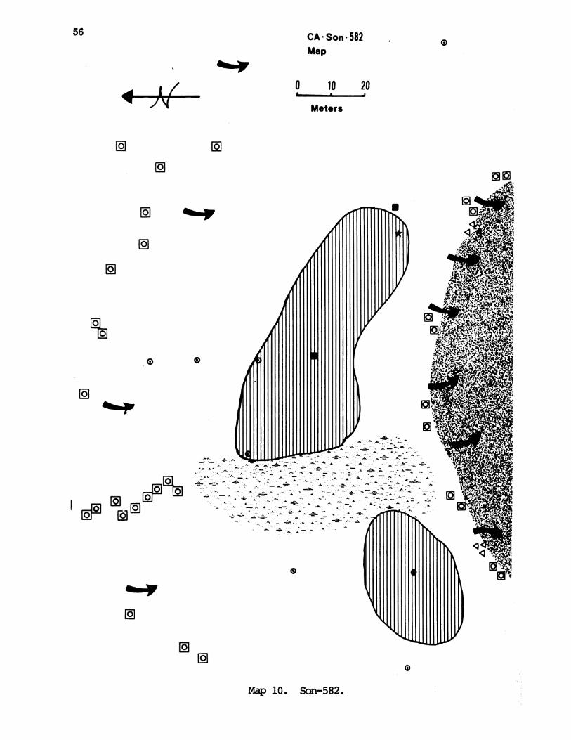
56 CA*Son 582Map
0 20
Meters
9m~
0
Io
; - A-, "7vAth
',,Al
Map 10. Son-582.
0
I /0
JN

57
10
-20-
-30
-40-
-50~
- 60 ...
-10-~~~~~~~~~~~~~~~~~~~~~~~~~~~C., OOO() 0000 (C 00)0000000(0000 0 0000000rC 00 00(COO0 0000000000 (0
-)()() 8() (!0(r) ) ())()(()_)(OCO00CCCOO 0000 COCO( 000(0OOC ) 00 0 00
00000((C )()()OOCOOOOOOC (,C (O)() (0 C00 (C 0( 0 0( C( 0 0 0000CoO00000000()) (0CC (((()COC)0( ()00(C)()(000CC 00 C0C O C OCC (00000 0CCOCC) CO )
_fl 000000())CC!OOC)OCC C.)OC()000CCCCOOOCOCCOOCOO CO - 00000CCvOCC)0000000 0000000000o)O(O(C'( ')( (;)( (( )~ C ()CC C (C CO O OOO O O CO O O 0() C CO O 000 OO )0000(C C CC 000000~~~()CO 000C ()CoC00(C)C 0 00000C(C00000( )000000000000(00
0000 ( 0 CC 00()()( )() () ( O(0 (C C()C 0 C f(CC ) () (CC OC) C00000 o ()(0)0 O
90 00000000(JOOOOO;)0CCC0C0(C0000C0 00( C 0000OC)CC)OOOCCC )(0)OO(0OO0)0000000000000000000)t7__00()0 0) ()0M7Roo C(C CC)oCoo CC) OOOn OOCCC(CCOOOOCC00 O o000CC0000000000)000(0D ))(f(()()()()0( (,()()(()()()()L()(()()()()((O ()()O(O~i ()OOCOCOfr(C)O >)(O(())00(~)(C)O)OfDOOCOOOOOOC)OCvOf))f O()f
0 0 0 0 0C )((1)()O)(O((,(() C) C0(" ()00000 (C00(0CC()(CCC(CCCC0C(0000 C,,)
CCCCCCCCCCCCCC0CC)CC ((((CrOCOC()CCCC O)(000CC OCOOOOOOOC OC)00COCCOOCOOOOCOCOOCCOfD00(0CC) CCC C'((C( CCC (CCC000000CC( C(C)( CCC0 000( CCC0(()OO)000000COO
CC) oC, CC( CCC(C(C'C CCCO C)C(CCCCCo C 00C C ((00CC (O00000 0000C 0)oC )000( 0000000C(OrooocC )O((
-((CCC 7CCC0()0CC(C' ((\(CCCC(<OCOOOCOCOOOOCvC)OCC COOOOCOOCOOgcCOOOOOC)OOCDC)OCOCOOCrOCCOCOOOO((C(((C( CCCC CCC C CCCCCCC(CC (C(((0C (CC (C C((C000000 000O(0000000000000000C0000_1C(C C )()C(C()()CC()()C ( ()(C)( 0CC)0()CC(()C)C()CC CCCO CC O OOOO(CC)OCOOO(COOOOC)OCCO(000 0000)00CC(00C()
CCCCC CCC CC CC CC OCCCCCC (C )C)CCo(oCCCC 00 (C C) ( CCCCC CC C)OOOOOCOCCOC)OO 00000 OOCC0 CCCCCC000 C)~o~o()(()O()("()OC)0000(Ooocf)()foOOOc)OOooOOKoooo0000o0oo00(OOOOo0o0oooOcOOOOO(O()f~t) ()OO ()(()()() C()CCDOOO OO O
OOOO (i o)0(0(000o o)
(( )o000000000000000000OO(nOO OO~ O OO( (),(,o0C(f((,ooocCoCCoCooCoC) C(CC)OCCOOOOCCOO0CCCC)CCOOCC)CCC00000C)0C0 )C(9OC
jo(),(!)o(o(;oo('oloo(,()oc01c0 0 (000001 f(()C000c)rOcOOc~c)ocrooOOOcrOo~ooorOOIiooo000(rO(({Ua~^|cM()((}{)C)Ct~i~ooC) 00(000Ct) (oC( 0 00C) )C0 0 O C)C ooo)(0 0 ( ) C) C)
)O .P (~noooooo ('
110~C
cm
A. Midden; cultivation zone; black; silt with sandand rounded gravels. Moderately conpact.
B. Midden; black; sandy silt with gravels and cobbles.Friable to moderately compact.
C. Sandy gravels; cobbles and pebbles; dark brown todark yellowish brown. Friable to moderately compact.
Figure 8. Son-582 Profile.

58
Site CA-Son-582 (Cherry Creek)
Level Proj. Biface Rework Used Debitage Milling Animal Firedan. Pts. Biface Flakes Stones Bone Rock
0-10 3-c 30-c 15-o 30-o
10-20 6-c 67-c 1047-o
20-30 4-c 55-c 4 602-o 2-o 44-o
30-40 4-c 65-c 10 8050-o
40-50 3-c 121-c 1? 15 401-o 45-o
50-60 3-c 63-c 1? 2 501-o 2-o 1-o 54-o
60-70 1-c 1-c 80-c 3 301-o 2-o 41-o
70-80 2-c 50-c 601-o 1-o 3-o 25-o
80-90
90-100
100-110
Totals 1-c6-o
Grard 6Total
1-o
3
26-c26-c13-o
2 39
134-cl1-o
13-c1-o
1-c
579-c348-o
927
2
2
36
36
330
330

59
figure is .999...hence one is nearly certain of finding the dance house giventhat the floor once encountered could in fact be detected. Similarily a fairestimate could be made of the number of dwellings, again given that theremains could be identified.
Accordingly we propose that a 5% sample be taken fran the site in thefollowing fashion. Along the long axis of the site ard along the short axisperpendicular to this dig one four meter unit every four meters. This wouldbe 20 units NW-SE and 8 units NE-SW. Let the remaining 57 units be placed atrandom over the area outside these two "trenches." If no house floors areencountered (this would be only because of poor preservation) then these 85units would constitute the total sample. If house floors are encountered theexcavations would be expanded to expose up to one half the total structure ofuntil such time as the main features of the structure are determined. In the85 units of the original sample the excavation would be canpleted to the baseof the cultural deposit. In expanded excavations to expose house floorsexcavation would continue only down to the floor itself. Thus we would havedug between 5 and perhaps 10 percent of the site. Our experience thus far inthe area makes it seem unlikely that any floors would be encountered so the 5percent figure is the more likely.
Site Son-607 (Riffles)Son-607 is located on a first terrace remnant on the north bank of Dry
Creek, 1.2 miles northwest of Cherry Creek Bridge and 30 meters south of HotSprings Road. It consists of a grooved petroglyph rock with an associatedsurface flake scatter. Also, petroglyph rocks with at least one cupule or afew grooves are scattered upstream on the north bank of Dry Creek for thenext 300 meters.
The first terrace remnant on which this site is located consists of along narrow strip (20 meters by 5 meters) situated between Hot Springs Roadanx Dry Creek. An old road bed runs due west off Hot Springs Road towardsDry Creek, bisecting the area of the surface scatter.
The site has riparian vegetation with oaks, madrones and ash treescovering most of the site. The soil of this entire terrace is brown alluvialsand anxd shows no sign of midden deposits. Four auger holes were placed onboth sides of the old dirt road in the area of surface scatter arK revealedno buried midden or other cultural materials. A fifth auger hole was placedapproximately 80 meters north of the surveyor's stake (on the eastern edge ofthis site and used as site datum), and next to one of the petroglyph rocksseemingly associated with this site. Again, no midden deposits were found.
Site Son-595 (Treganza 5)Son-595 is located on a primary terrace on the south bank of Dry Creek,
200 meters north of the confluence of Cherry and Dry Creeks. This flatterrace is 6 meters above the stream bed of Dry Creek. An old dirt road oncecrossed Dry Creek arnd ran along the northern perimeter of the site. It forksat the northwest corner of the site and one section of the road forms thewestern boundary of Son-595. An old wooden bridge, at the southwest cornerof the site crosses an intermittent stream which delimits the southern edgeof Son-595.

60
Site Son-595 (Treganza 5)
Level Rework Biface Debitage Fired Animalan. Biface Fock Bone
0-10 16-c 748-o
10-20 5-c 1851-o 18-o
20-30 4-c 100 27-o
30-40 1-c 84 212-c
40-50 2-c 52 313-o
50-60 1-o 18-o
60-70 1-o 3-o 2
Totals 28-c 495 101-o 1-o 69-o
1 2 97 495 10

61
This site has open grassland cover with apreponderance of live oaksboth along the intermittent stream and the bank above Dry Creek. Onemanzanita is located on the eastern edge of the site ard one scrub oak growsnear the wooden bridge. It was noted that most of the live oaks were fairlyrecent in age-ca. 40-50 years.
The matrix of Son-595 is midden consisting of grey-brown gravelly silt.Four auger holes placed around the perimeter of the midden area showed it islimited to the 15 m by 25 m area bordered by the old dirt road and theintermittent stream. No housepits or other cultural features are evident onthis terrace. Test Unit 1 was placed in the center of the middenconcentration, 14 m due east of the site datum, on the north side of theeast/west transect passing through this datum.
Excavation of Test Unit 1 revealed a weakly developed midden, atransitional zone between this midden ard underlying gravels, and a finalgravel canponent. The midden component consisted of grey-brown silt withgravels (0-50 cm). Few artifacts were recovered fran this cultural zone;nearly all were small water flakes. Twice as much obsidian as chert wasconsistently recovered. Animal bone remains were found in very smallquantities. Most of the fire-cracked rock came fran the 20-40 cm levels.the only tool fran the midden component was a rework biface of obsidian.
The transitional canponent at this site consisted of a mixture of grey-brown silty loam and yellowbrown sandy gravels (50-60 an). In thiscanponent fire-cracked rock disappears entirely, animal bone ard chert areminimal, and obsidian declines slightly. No tools were recovered.
The gravel component at son-595 is characterized by a yellow-browngravelly clay matrix surrounding massive rocks arn cobbles (65-70 an).Excavation of this level was difficult due to the large amount of rock.Screening was also difficult because of the increased clay content. Arti-factual material was minimal. For these reasons, excavation of Test Unit 1was terminated at 70 an.
Besides the obvious disturbance by the building of the old dirt roadand by the erosion of both Dry Creek arn the seasonally intermittent stream,there is evidence of historic occupation of Son-595. In the 0-20 cm levels,nails, strands of wire, glass fragments, and a bolt were found. Also, in the50-60 cm level one rusty nail was recovered. A piece of glass was alsorecovered in auger hole "c", on the extrene western part of the alluvialterrace, near the fork in the dirt road.
Site Son-596 (Treganza 6)Son-596 is located on a secondary terrace on the south bank of Dry
Creek, approximately 200 meters west of the confluence of Cherry ard DryCreeks arn 250 meters west of Hot Springs Road. The site is at the east ernof a large second terrace, approximately 300 meters east of Sor-596, which islocated at the west erd of the same terrace. An old dirt road runs thelength of this terrace ard connects both sites. The road leads to threedilapidated summer cabins, a pool, arn] a rock garden situated on the site ofSon-596. The cabins are located in a bay laurel grove and the area issurrounded by a wire fence.
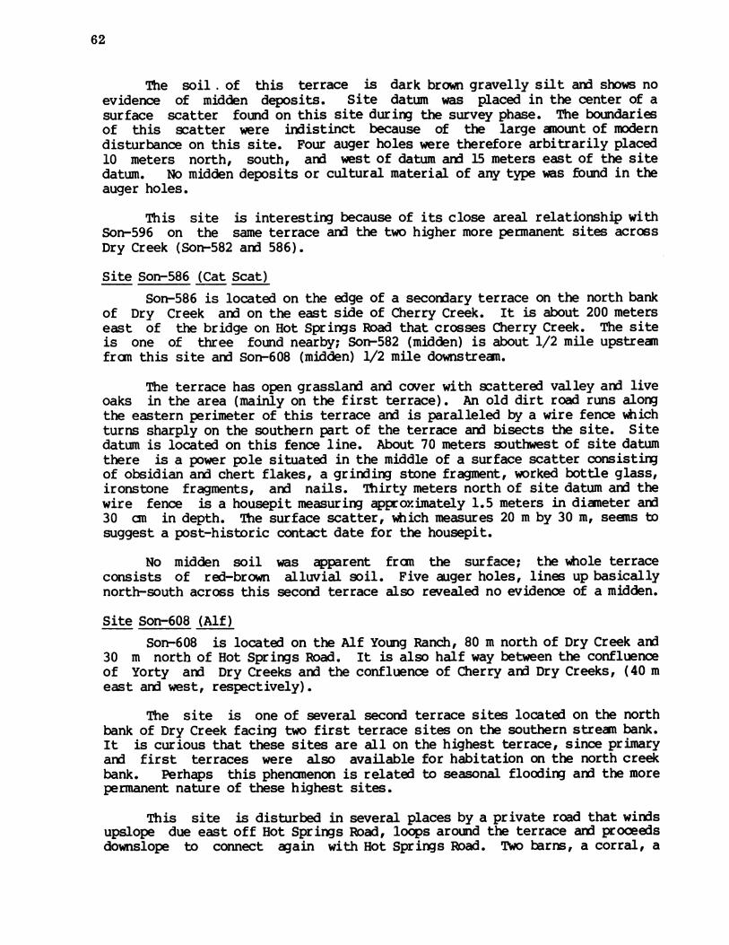
62
The soil . of this terrace is dark brown gravelly silt and shows noevidence of midden deposits. Site datum was placed in the center of asurface scatter found on this site during the survey phase. The boundariesof this scatter were indistinct because of the large anount of moderndisturbance on this site. Four auger holes were therefore arbitrarily placed10 meters north, south, and west of datum and 15 meters east of the sitedatum. No midden deposits or cultural material of any type was found in theauger holes.
This site is interesting because of its close areal relationship withSon-596 on the same terrace and the two higher more permanent sites acrossDry Creek (Son-582 ard 586).
Site Son-586 (Cat Scat)Son-586 is located on the edge of a seconxdary terrace on the north bank
of Dry Creek arn on the east side of Cherry Creek. It is about 200 meterseast of the bridge on Hot Springs Road that crosses Cherry Creek. The siteis one of three found nearby; Son-582 (midden) is about 1/2 mile upstreanfran this site ard Son-608 (midden) 1/2 mile downstream.
The terrace has open grassland and cover with scattered valley arn liveoaks in the area (mainly on the first terrace). An old dirt road runs alongthe eastern perimeter of this terrace ard is paralleled by a wire fence whichturns sharply on the southern part of the terrace arn bisects the site. Sitedatum is located on this fence line. About 70 meters southwest of site datumthere is a power pole situated in the middle of a surface scatter consistingof obsidian and chert flakes, a grinding stone fragment, worked bottle glass,ironstone fragments, arn nails. Thirty meters north of site datum and thewire fence is a housepit measuring approximately 1.5 meters in diameter and30 an in depth. The surface scatter, which measures 20 m by 30 m, seems tosuggest a post-historic contact date for the housepit.
No midden soil was apparent fran the surface; the whole terraceconsists of red-brown alluvial soil. Five auger holes, lines up basicallynorth-south across this secorn] terrace also revealed no evidence of a midden.
Site Son-608 (Alf)Son-608 is located on the Alf Young Ranch, 80 m north of Dry Creek and
30 m north of Hot Springs Road. It is also half way between the confluenceof Yorty and Dry Creeks and the confluence of Cherry ard Dry Creeks, (40 meast and west, respectively).
The site is one of several second terrace sites located on the northbank of Dry Creek facing two first terrace sites on the southern strean bank.It is curious that these sites are all on the highest terrace, since primaryarn first terraces were also available for habitation on the north creekbank. Perhaps this phenanenon is related to seasonal flooding aid the morepermanent nature of these highest sites.
This site is disturbed in several places by a private road that windsupslope due east off Hot Springs Road, loops around the terrace and proceedsdownslope to connect again with Hot Springs Road. Two barns,, a corral, a

CA -Son * 608Map
N'
63
0
0
0 5 10
Meters
I
l l1
*~~~~~//
IIIIIII IIII I/I
/ II'I
/// ~ I/ ~ ~ I
//~~~
To Hot Springs Road
Map 11. Son-608 (legend p. 5).
4
0
4
92
* * * fi
0 92URWAGO
A /./ N
* * 0a * *
* * 0

64
shed and a house are also located directly on the site. The southern barn isfound in the center of the terrace and has a fence enclosing a ten metercorral of its western side. This fence extenxds north fran the northeasterncorner of the corral for approximately 25 meters and then connects with thesoutheastern edge of the northern barn. East of the stake fence (connectingthe two barns) is a large pasture which includes the entire eastern half ofthis second terrace. A firepit, (Son-606), seeningly of historic Indian age,is located approximately ten meters east of the southern barn in thispasture. Twenty meters west of the northern barn and separated fran it bythe road, is the Young farmhouse.
The vegetation of this area is open oak/woodlard. In the large pastureis a bay laurel anx a large live oak. All along the private road and on thesouthern slope to Hot Springs Road are stands of Oregon oaks. Most of thesite has been heavily grazed, thus destroying most perennials. However,soaproot is found in abundance over the site.
The midden of this site consists of black sandy silt anx can bevisually distinguished fran the surrounding brown saidy silt in most areas.However, humus from the oaks ard the animals have made the pasture very darkin color and difficult to distinguish fran the midden. A series of nineauger holes test the whole second terrace indicated that the midden exterdsover an area measuring 50 m by 25 m anxd is covered in part by the firepit,southern barn aix adjacent corral, arn by a shed located 10 m west of thecorral fence. The private road also cuts through the extreme western edge ofthis midden area. Augering showed a possibly buried midden extenxing atleast 30 more meters to the north of the southern barn/midden area. Inauguering hole D located 35 meters northeast of datum, a chert chip wasrecovered 55 an below surface and auger hole I near the bay laurel in thepasture revealed a similar midden at 35-55 cm. This buried midden maycorresporx] to the basal canponent uncovered in Test Unit 1, and indicates anextension of the site to the northeast in its earlier stages.
A large outcrop of basalt boulders is located approximately 10 metersupslope fran Hot Springs Road on the eastern edge of the terrace, and has noapparent markings of any type.
Test Unit 1 was placed three meters east of the site datum stake inwhat was thought to be the deepest part of the midden. This places the unitwithin the corral. Excavation of this test unit revealed a well-formedmidden extezxding 70 an in depth. At that point a basal component consistingof sandy clay and a few artifacts was reached.
A large quantity of artifacts was recovered fran the midden with chertdominating the debitage counts. Large amounts of obsidian aid fire-crackedrock were found and also small amounts of animal bone. The midden sees tohave two clusters of tools. The 0-40 an level contained six reworkedbifaces, two scrapers aid seven retouched flakes, but only one projectilepoint. Fran 40-60 an two obsidian projectile point mid-sections wererecovered. Both chert anx obsidian debitae peak between 40-60 an as well.It is interesting to note that in these same lower levels a large quantity ofvesicular basalt was encountered. This type of basalt has not been seen on-any previous sites in the Project Area and, in fact, is not known to be

65
10
-20
-30 00
-40-
-70)(J(.()f? x)(O~jOO(!J()0() *()(} ):'()) Df)(noooo)OI)n()()( ()f '") 00)>0f )(0000f0000 (00( _00()(00o
-80 ) I0 0 ,(0( C) C)(0 r0C) r0()0 COO C 0 000 (0)000C)O0of) 0 0000()000000o000)Oo()(C((or)Cof) o)() O( 0
cm
A. Midden; dark brown; granular loam withgravels; annual grass roots; heavy grazingcaused surface compaction. Moderately friable.
B. Midden; silty loam; dark brown; friable.
C. Gravels and sand with cobbles; dark yellowishbrown; friable.
Figure 9. Son-608 Profile.

qw f r q'-I qw -i
0n (N 0 N 10%D %O r- Lnlr _I
O01 1NOO co
C O
N co
0) 0
Un o%II4
0 0CN'
u001 1
r-q DLOCN
-4
0) 0 Q0 0 000 0.4 rI r1 -4L
0
0)(N4
0
0
u-
0v-I
0
(N
FIQ
r-
0
m0
(N
0
4-
0Co1n'
Pb
66
co
0
0
~ ar8 .9
E4- a;
DW
U1)._lI
U).rN;8Tq
?co aO
0)Orl, I0
10
0i-
I49m
I0
U)
CO
(ar1f
u ?
LO
CM
Ct)
N
(C
U-4U-Il
v-I(Nqwj
Lrn
(N
N
Ltnrfn
COD
UN
o
0
F-
u00
(N
c)otQ
w-I
w
*,-l0
r;.
0
(I*u-

67
erdemic to this area. Rather, it has been noted as beirn common in the ClearLake Region of Lake County, one of the sources of obsidian used by the localPono, suggesting that this basalt was obtained at the same time as theobsidian fran that area.
The basal canponent at Sot-608 is nearly sterile in artifactual content.For this reason, only 10 am were excavated into the sandy clay. The bottomof this unit was then augered to a final depth of 150 an. The 70 an coreconsisted of water-worn gravelly sand and contained no artifacts of any type.
No diagnostic artifacts were recovered fran the entire depth of TestUnit 1. However, several surface finds were previously collected by Alf andAnn Young, owners. These artifacts have been drawn and photographed aidinclude five Excelsior and leaf-shaped points aid point fragments, and asteatite bead. It should be noted that a small unworked piece of steatitewas also recovered in the first level excavated in Test Unit 1.
Site Son-597 (Treganza 7)
Son-597 is located on the first terrace at the confluence of Yorty andBrush Creeks. The site is divided into two sections. The main part of thesite is bordered by Hot Springs Road aid Yorty Creek to the north aid byBrush Creek to the south. The secoid, smaller section of the site isdelimited by Brush Creek to the north aid by the old stream bed to BrushCreek aid Kelly Road to the south. The present course of Brush Creek hasdestroyed at least a five meter wide strip through the original site.
The area of the main section measures approximately 50 by 30 meters aidincludes most of the promontory left by the convergence of the two creeks.This promontory has open grassland and coverage, with oaks aid bay laurelsbordering Brush Creek. Wild irises are found on both the eastern aid westernextremities of the site. A faint jeep trail passes through the center of themain section.
The midden consists of a lower section of a knoll one aid a half metershigh. On the knoll, two housepit depressions are visible. The largerdefinite housepit is located on the western part of the knoll, just south ofthe site datum, aid measures approximately 5.5 meters in diameter. Thesmaller, less distinct housepit is located two meters east of the largehousepit aid site datum aid measures approximately 1.6 meters in diameter.Test Unit 1 was placed 15 meters south of the site datum stake to investigatethe area near the housepits.
Excavation of Test Unit 1 revealed three stratigraphic componentsconsisting of dark midden, a transitional zone, aid sub-midden levels. Thesoil from 0-50 an ranged from black to dark brown and contained the greatestamount of cultural material. Animal bone, fire-cracked rock aid obsidiancounts reached their peak in the 30-40 an level, aid chert steadily increasedto reach its highest quantity in the 40-50 an level. At their highestpoints, at least five times as much chert was recovered as obsidian. In thisstratigraphic component two possible Excelsior bases (obsidian aid quartz)were recovered as well as one triangular straight base chert projectilepoint.
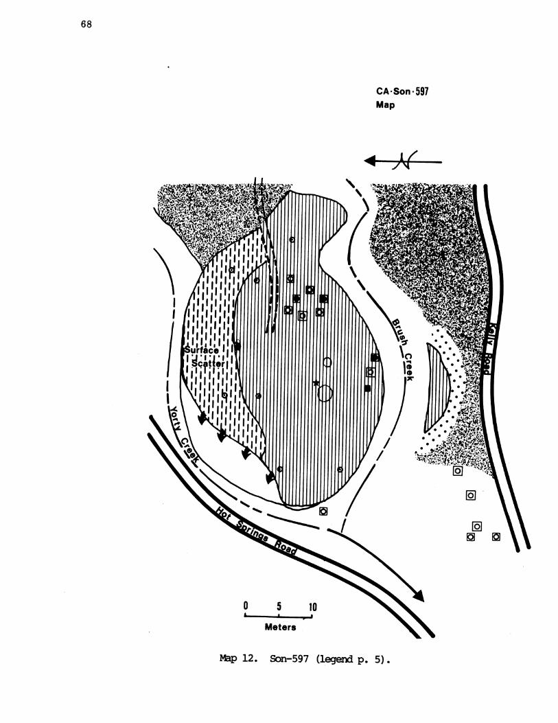
68
CA* Son * 597Map
Mp 12. Son-597 (legend p. 5).
444- N&

-o-
-10
-20-
30
"40-
10
-,00-so-
- go-
H10-
-12ir
-13-
-150
c1m1-cm
A. Midden; annual grass roots;ard clay; very dark gray tobrown. Moderately compact.
silt with sandvery dark grayish
B. Midden; brown to dark brown; clayey silt.Moderately compact.
C. Transitional zone. Dark yellowish brown; siltwith sand and clay; small gravels. Moderatelycompact.
D. Sub-midden. Yellowish brown;sand and silt; small gravels.
clay with someCompact.
E. Dark yellowish brown; clay; no gravels. Compactto very campact.
F. Gravels and shale. Friable .
Son-597 Profile.
69
Figure 10 -

Level Projcan. Pts.
0-10
10-201-o
20-30
30-40 1-c
40-50 1-c
50-60
60-70 1-c
70-80
80-90
90-100
100-110 1-c
. Biface
1-c
110-120
120-130
130-140
140-150
150-160.
Site Son-597 (Treganza
Scraper Used DebitageFlakes
1-c 1-c 142-c2-o 41-o
1-c 63-c2-o 26-o
1-c 37-c19-o
3-c 87-c1-o 24-o
2-c 131-c15-o
2-c 121-c5-o
3-c 81-c5-o
1-c 43-c1-o 2-o
2-c 59-c2-o
1-c 33-c1-o
2-c 22-c
1-c
2-c
1-o
6-c2-o
9-c1-o
17-c
11-c1-o
5-c
70
AnimalBone
4
4
2
5
7)
FiredRock
165
77
20
40
24
10
12
5
3
6
-

Totals 4-c1-o
Grard 5Total
1-c
1
1-c
1
22-c 867-c6-o 145-o
28 1012
71
362 15
362 15

72
In the 50-100 an levels the soil gradually changed fran brown to darkyellow brown and cultural material decreased in quantity. A few gravels beganto permeate the otherwise clayey soil in the 80-100 an levels. The only toolsfound in these levels were projectile point tip and one bifacially retouchedchert knife tip.
The 100-150 an levels again showed a lightening in soil color, changingfram dark yellow brown to brown. In this sub-midden canponent a heavy gravellens intruded at the 120-140 an levels, after which gravels nearly disappear.Also, at 120-130 an the clay content of the soil greatly decreased perhapsindicating a division within the component. Animal bone, fire-cracked rockand obsidian all but disappear in the gravel intrusion. Chert, on the otherhand, seems to peak briefly at the end of the gravels and continues topredominate down to the 160 an. level. Unfortunately, diagnostic tools of anytype are absent fran this sub-midden component. The last excavated level,160-170 an, was sterile.
Site Son-592 (Treganza 2)Son-592 is located on a primary terrace on the east bank of Dry Creek,
approximately 220 meters south of the confluence of Yorty and Dry Creeks. Itis a surface site located approximately 300 m upstream fran Son-541, anothersurface site on the west bank.
This site was relocated using Treganza's San Francisco State CollegeSurvey notes during the survey phase of the Warm Springs Archaeology Project.The site was listed as a surface site located on a terrace with open grasslandcover and consisting of a sparse scatter of chert and obsidian flakes coveringan area measuring 40 by 20 meters. The alluvial silt covering this terraceremained consistent in the area of surface scatter and in the surroundingareas. A series of five auger holes were placed on this terrace to test thesite for possible subsurface midden. The holes were placed 20 meters south ofsite datum; 20, 40, and 80 meters north of datum and 20 meters west of datum.None of the five auger holes revealed sub-surface midden of any kind.
This site remains then, a surface site which has been greatly disturbedby both modern activity and erosional activities of Dry Creek. The site stillhas evidence of discing and five apple trees are located approximately 60meters due east of site datum. A modern wire fence runs perpendicular to HotSprings Road 2 meters west of these apple trees and forms the eastern boundaryof this site. Just west of the apple trees and the wire fence are sheep pensenclosed by wire fencing. A gate leading onto the terrace is locatedapproximately 10 meters north of the sheep pens. A second wire fence runsparallel to the creek and is located on the cut bank of that creek. Thisfence forms the western boundary of this site. A small intermittent tributaryruns parallel to Hot Springs Road, connecting the two wire fences and formingthe northern boundary of Son-592. Oak trees line both this intermittentstream and Dry Creek, just west of the second wire fence.
Site Son-541 (Terry's Terrace)Son-541 is located on a second terrace on the west side of Dry Creek,
approximately 120 meters downstream and southwest of the confluence of Yorty

73
and Dry Creeks. It is located on the part of Dry Creek that connects theUpper Dry Creek drainage with the Lower Dry Creek drainage and is justdownstream fran Son-592, another surface site on the east bank of this samecentral section of Dry Creek.
This site has open grassland cover with isolated oaks and willows bothon the site and on the bank of the terrace above Dry Creek. Dry Creek curvesaround the site and forms the northern and eastern boundaries of thisterrace. A jeep trail runs parallel to Dry Creek (eastern part), bisectingthis terrace. This jeep trail forms the western boundary of Son-541, andprobably did some damage to the site during its construction. A furtherindication of modern disturbance is evidenced by a small corral locatedapproximately 5 m northwest of site datum.
During survey the site was located and found to contain both middenindications and a housepit, approximately 2 meters in diameter. A scatter ofartifacts enclosed an area 10 meters square around the housepit a]d middenarea. A 20 meter square area on the bank of this terrace seemed to have aconcentration of chert flakes. A series of seven auger holes were placed onthis terrace to test the extent and depth of the midden canponent. It wasfound that only one hole (C) contained cultural material and flakes fran thisauger testing only extended in depth to 20 cm. The rest of the terrace seensto have only surface scatter.
Eastern Group Chronology
We follow procedures similar to that of the Western Group here and inaddition we have two radiocarbon determinations here which we evaluate indiscussing the following site.
Site Son-593We evaluate the two sections of this site separately. The south,
actually southwest, midden to judge fran the one small side notchedprojectile point (Fig. 24c) and fram the well-preserved housepits on thesurface is very late and we attribute it all to the late Houx Aspect.
The north or northeast midden is more canplicated. There are two breaksin the chert-obsidian ratios, one at 70 an and the other at 110 cm depths.These two points also coincide with changes in the character of the midden(see profile). The top 70 cm has the following artifacts: a Gunther point at50-60 (Fig. 24f), a large Excelsior point at 30-40 (Fig. 24e), and 2 largepestle fragments in the 10-20 an level. The Gunther point, which indicateslate Houx, is thus below the large Excelsior point which would be early Houxat latest; thus one of the two is out of place. We are inclined to attributethe top 70 cm to late Houx (we were so inclined even before our radiocarbondeterminations came in). This puts the 70 to 110 cm level in early Houx andmaterial below that in the Borax Lake Aspect.
We have two radiocarbon dates fram this site as follows:
UCR-352 Charcoal lump fran the 90-100 an level 1710 + 150AD 200
UCR-351 Charcoal fran hearth in 160-170 an level 4720 + 2402770 BC

74
Thus the 160-170 cm hearth is on the borderline between early and lateBorax Lake and we therefore feel the very bottom of the site (but we don' tknow how much) represents early Borax Lake Aspect. If this analysis iscorrect then all four of Fredrickson's late phases are present in this site.Incidentally these two radiocarbon dates corroborate or at least do notconflict with, Fredrickson's scheme.
Site Son-582Both the chert-obsidian ratios anx] other changes in chipping waste (see
site description) indicate a possible cultural change at the 80 cm level.The upper 80 cm seems definitely attributable to the late Borax Lake Aspecton the basis of the two large Excelsior points (Fig. 24a, b) and the twopossible milling stone fragments. We therefore attribute the bottom portionto early Borax Lake.
Site Son-608
There is no noticeable break in chert-obsidian ratios nor any in themidden at this site. The excavated portion therefore seems to be onecomponent which, on the basis of large Excelsior points fran the surface weattribute to late Borax Lake. The surface finds mentioned in the sitedescription suggest that the site may have other components distinct fromthis.
Site Son-597There is a break in debitage ratio and also in the midden at 50 an
depth. On the basis of the single large Excelsior point in the 40-50 anlevel (Fig. 24i) we attribute the top 50 an to late Borax Lake and thereforethe bottom to early Borax Lake.

75
Eastern Site Group
Chert to Obsidian Ratios of Debitage (by period)
Period593-1 593-2
Site CA-Son582 608 597
0-50 0-70Hb 0.61 0.12
(79) (1043)
70-110Ha 0.50
(257)
110-180 0-80 0-80 0-50BLb 7.50 1.58 1.40 4.47
(51) (867) (1122) (711)
180-220 80-110 50-160BLa 7.00 4.00 19.07
(24) (60) (301)

Eastern Site Group
Chert - Obsidian Debitage Ratios by Site and Level
Site CA-Son593-1 593-2 582 608 597
0.15(82)
0.18(84)
0.16(142)
0.10(138)
0.07(190)
0.12(213)
0.13(174
0.36(95)
0.70(73)
0.38(51)
0.71(41)
12.00(13)
2.67(11)
8.00(9)
* (2)* (3)
4.00(5)
* (8)
2.67(11)
* (4)* (9)* (5)
1.03(59)
1.43(114)
1.25(79)
1.30(115)
2.14(166)
1.17(117)
1.95(121)
2.00(75)
3.09 (45)
1.29 (135)
1.59(149)
1.15(172)
1.44(212)
1.62(254)
1.64(116)
1.96(77)
0.17(7)
13.00(14)
* (1)
3.46(183)
2.42(89)
1.95(56)
3.63(111)
8.73(146)
24.20(126)
16.20(86)
21.50(45)
29.50(61)
33.00(34)
22.00(23)
3.00(8)
9.00(10)
* (17)
11.00(12)
* (5)
76
Levelan.
1.00(24)
0.64(36)
0.17(14)
0.33(4)* (1)
0-10
10-20
20-30
30-40
40-50
50-60
60-70
70-80
80-90
90-100
100-110
110-120
120-130
130-140
140-150
150-160
160-170
170-180
180-190
190-200
200-210
210-220

77
~~~~~~~I.. ~ ~ ~~ ~ ~ ~ ~ ~ ~ ~ ~ ~ ~ a
( 0 ? .. ......wU)
(0 I ~~~ ~.. .J... CD.gll .::::~'l
* ..... ~ ~ ~ ~ ~ ~ ~ ~ ~ ~ ........
*... ~~~~~~~~~~~~~CD
.................U)
........... .. .......
. I-
U) aCL~~~~~~~~~~~UC~~~~~~~~~C
0 00 a~~~~~~
0 0~~~~~~~~
Map 13.m0
t I

79
Yorty Creek Group Description
This small group of seven sites is one of considerable importance - ithas deep gravel canponents which potentially are of great antiquity.Unfortunately we have been unable to date them as yet; there is no charcoalfran them arx] geologists have not studied them intensively.
Yorty Creek is a minor tributary of Dry Creek and therefore the valley ithas excavated is narrower arn less suitable to habitation. It widens slightlywhere site Son-576 is located arn] then again upstream at Son-584 and 583. Thereconstructed vegetation here is virtually all woodlard-grass or woodland-chaparral, mostly the latter (Map 13). This presumably makes this prime lardfor deer but no specialization toward hunting is evident in the archaeology.We again find the situation that the total area is so small that topographymay be the most important element of the immediate environment.
Site Son-585 (Yorty Cupule Rock)Son-585 is located in the creek bed of Yorty Creek on a gravel bar,
approximately 20 meters north of Hot Springs Road. It is about 150 meterswest of the sheep shearing station and pens near the midden site of Son-576.Both these sites seem to be isolated in the central section of the Yorty Creekdrainage that is encanpassed in the Project Area.
Son-585 is a petroglyph site consisting of a single large rock withapproximately 98 pecked cupules on its surface ard sides. A great amount ofstream erosion has taken place in the area of this boulder. It is located onthe very tip of a small gravel bar in the center of Yorty Creek, which reachesa maximum width of 4-5 meters arK externds upstream approximately 25 meters.Yorty Creek runs to the north of this bar. The terrace to the south arK eastof the cupule rock has been eroded to three separate levels. No midden isapparent in the cut banks.
During the field reconnaissance phase, a chert biface fragment was foundjust west of the petroglyph in the stream gravels. Two large chert cores werealso found both upstream and downstream fran the petroglyph. At that time aseries of five auger holes were placed on each of the first terraces aroundthe petroglyph. No midden or cultural material of any type was recovered franthis testing.
Site Son-576 (Sheep Shearing Station)Son-576 is located on the north bank of Yorty Creek, 120 meters north of
Hot Springs Road. It covers the lower terrace of a pranontory formed by theerosive and depositional patterns of Yorty Creek. The site is bisected by anunnamed intermittent tributary which drains west of this main pranontory. Themidden is on a first terrace which slopes steeply down to a gravel bed at thefoot of the promontory.
A steep stream cut bank is located on the south side of Yorty Creek arKis bordered by a wire fence. Just west of the promontory Yorty Creek runssharply south, towards Hot Springs Road. On its western bank a wooden fenceencloses a sheep shearing station with several corrals arK out buildings (50meters south of the site). Between this sheep station ard Hot Springs Road,

CA-Son- 576Map
pq90 0 0 0* 120 Meters
To Hot Springs Road
0 0 a
00 5 10Mer -
Meters
(I
Map 14. Son-576 (legend p. 5).
80
ShepBarn
92 aI--- 92

81
Yorty Creek swings along an east/west line again. A bridge crosses the creekat this point and allows a dirt road to connect the sheep station and HotSprings Road.
The area of Son-576 has open parkland vegetation with scattered clustersof live oaks. It is-> notable that in this area there is a preponderance ofvalley oaks found around the central section of the Yorty Creek drainage.
The midden consists of black gravelly loam and can be visuallydistinguished fran the dark tan gravelly loam of the surrounding areas. Aseries of 19 auger holes were placed both near Son-576 and in the neighboringfields to test the extent of the known midden and to explore for areas ofburied midden. Only one of these borings definitely produced midden; an augerhole located just west of the intermittent drainage and approximately 2 metersupslope fran Yorty Creek had evidence of midden. Fran 32-102 an fire-crackedrocks and heavy charcoal concentrations were noted iidicatirg well-formedmidden deposits within those depths. However, those placed west and north ofthis proved to contain only alluvium with slight traces of charcoal. Thus, itis known that the intermittent stream bisects the midden, but that this middendoes not extend as far west as a second seasonal drainage (15 to 30 m west ofthe first drainage).
Test Unit 1 was placed 3 meters south of the site datum stake, in thecenter of the promontory. Excavation of this unit revealed that 20-30 cm ofrecent overburden covers this promontory. The first 20 cm of soil is red/brownand shows signs of disturbance. At the 20 an level a transitional zone isapparent. The next ten centimeters seem to be basically midden-like with somemottling aid rodent activity. Fran the recent aid transitional levels only onetool was recovered, a small leaf-shaped green chert projectile point dated to alate period. Moderate amounts of lithic debitage, animal bone aid fire-crackedrock were also found.
A well-developed midden deposit underlies the recent overburden (30-140cm). This midden has been stratigraphically divided into two different zoneson the basis of the clay content of the soil, which greatly increased withdepth. However, both zones consisted of black, greasy silt and differed incolor only by one half of a chrana.
Heavy concentrations of gravelly clay began to appear at 130 Ac; by thenext level the entire eastern half of the unit consisted of this material; aidby 150-160 an gravelly clays dominate the whole unit, with only small pocketsof midden. Thus, 140-180 an has been called a transitional zone aid representsthe bottom of the second midden component. No diagnostic tools were recoveredfram these levels, but two separate hearths of some size were found. Feature Imeasured 25 a by 32 an, was located in the southwest corner of the unit, andwas surrounded by several fire-cracked rocks. The lowest depth of this fire.pit was 165 an. Feature II, the larger of the two hearths, measured 33 an by38 mn. It was found in the center of the east wall and consisted of many firecracked rocks although it was not surrounded by them. The bottom of this pitwas at a depth of 175 an. Fire unutilized chert aid obsidian pieces came franthis second hearth as well as six pieces of burnt bone. A charcoal sample franthis hearth was submitted for radiocarbon dating.
The last component at Son-576 consists of gravelly clays aid is nearly
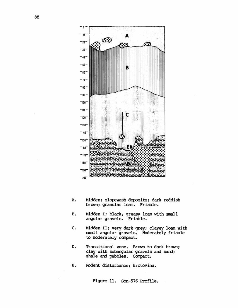
82
~0
--,
-30-
-40-
-50
-60-
-so -
~90
o-
A. 0-waaidn aaps deois dar reddish
-170 - monsoonaI
brown; granular loam. Friable.
B. Midden I; black, greasy loam with smallangular gravels. Friable.
C. Midden II; very dark grey; clayey loam withsmall angular gravels. Moderately friableto moderately campact,.
D. Transitional zone. Brown to dark brown;clay with subangular gravels and sand;shale and pebbles. Compact.
E. Rcdent disturbance; krotovina.
Figure 11. Son-576 Profile.

83
Site Son-576 (Sheep Shearing Station)
Level Proj. Bifaces Retouch Scrapers Retouch Used Cores Debitagecm. Pts. Biface Flakes Flakes
0-10 2-c 47-c1-o 7-o
10-20 1-c 1-c 17-c1-o 10-o
20-30 1-c 44-c1-o 12-o
30-40 1-c 3-c 60-c1-o 14-o
40-50 3-c 3-c 57-c12-o
50-60 1-c 1-c 1-c 47-c23-o
60-70 2-c 1-c 1-c 2-c 31-c1-o 2-o 16-o
70-80 1-c 20-c1-o 1-o 23-o
80-90 1-c 27-c27-o
90-100 2-c 53-c3-o 7-o

Level Proj.CM. Pts.
100-1101-o
110-120
120-130
130-140
140-150
150-160
160-170
170-180
180-190
Site Son-576 (Sheep Shearing Station) cont.
Bifaces Rework Scrapers Retouch Used CoresBiface Flakes Flakes
1-c 2-c1-o
2-c
2-c 2-c1-o
1-o 2-o
1-o 1-o 3-o
1-c
1-o
1-o
1-c
Debitage
5-c1-o
18-c37-o
36-c51-o
20-c26-o
10-c
29-o
9-c9-o
8-c3-o
2-c
1-c
3-o
Total 1-c 1-c 2-c 3-c 24-c 8-c 512-c3-o 2-o 1-o 19-o 310-o
Grard 4 1 2 2 4 43 8 822Total
84

85
Site Son-576 (Sheep Shearing Station)
Level Pestle Fired Animal Historicalcm. Rock Bone Material
0-10 30 1 shell casing
10-20 40 10
20-30 18
30-40 1 200 21
40-50 200 31
50-60 70 15
60-70 70 45
70-80 100 21
80-90 130 41
90-100 130 61
100-110 145 78
110-120 90 45
120-130 110 76
130-140 40 72
140-150 20 36
150-160 15 20
160-170 20 37
170-180 7 8
180-190 1 2

86
sterile. There were no tools among the few specimens recovered here, onlydebitage, fire rock, animal bone, an] one used flake. Heavy rodent activity inthe two levels excavated into the clay obscured the unit and madie it impossibleto tell if the debitage and other items were intrusive. At two metersexcavation of this unit ceased. An auger boring was made to the water table at270 am. The auger showed that charcoal flecks were present at least to a depthof 265 an.
Site Son-588 (Live Oak Housepit)Son-588 is located on a low secorndary terrace on the south bank of Yorty
Creek, approximately 1/2 mile fran wdhere the eastern edge of the Project Areaboundary crosses Yorty Creek. It is on a pranontory formed by the confluenceof Yorty Creek and] an unnamed intermittent stream. It is also approximately150 meters southwest of site Son-577.
The site is a housepit site consisting of a well-defined housepit with alarge live oak growing fran the back wall. It is located on a gently slopinggrassy slope that has evidence of deforestation. This housepit measures 8meters by 7 meters by 1.5 meters in depth, and] has a distinct square entranceoff its northwestern side. A chert scraper, an obsidian flake, a chert flake,3 square nails, wind~ow glass fragments, 1 wire nail, 44 caliber shell casings,an old ceramic bottle cap and] window glass pieces were all found on the surfaceof the housepit. Trowel exploration of this surface and augering around thehousepit revealed no evidence of midden.
This site is extremely interesting because of its close proximity to Son-577 which has no housepits bu.t is a deep midden site. It undoubtedlyrepresents a house of very late, probably historic or even late historic(1850's?) date. It is a possible indication of Indian presence in the NorthSection into the American period, a presence for Which there is no historic orethnographic evidence.
:Site Son-577 (Touchdown)Son-577 is located on the first alluvial terrace on the west bank of Yorty
Creek, east of Hot Springs Road. A large turnout area adjacent to Hot SpringsRoad is about equal in size to the area of the site aix] entirely covers thewestern section of Son-577. This site has also suffered fran intense streamerosion along its entire eastern perimeter. Durinxg survey, chert debitage wasfound approximately 15 m northeast of the main site area on the opposite streambank in the gravels. It was thought that this cultural material may haveeroded out of the eastern bank of Yorty Creek and that the creek actuallybisected Son-577. Erosion by Yorty Creek in this area is so intense that theseartifacts have now disappeared.
The site has open grassland cover with a sparse scattering of oaks and baylaurels on its eastern edge, along Yorty Creek. The midden of Son-577 is ablack sandiy loam. The extent of this midden is delineated by the dark brownalluvium of the surrounding areas. Toauger holes placed north anx] south ofthe midden area revealed no buried midden canponents, thus, delimiting the areaof midden to a 20 m by 40 m section of the terrace.

87
Map 15. Son-577 (legend p. 5).

88
A. Midden; very dark gray; loam with angularpebbles and small cobbles. Friable.
B. Dark grayish brown; coarse sandy gravelswith clay; rounded pebbles and cobbles.Friable to ccipact.
C. Dark brown to dark yellowish brown; sandyclay; friable.
D. Krotovina disturbance.
E. Ash and charcoal deposit.
F. Dark grayish brown; sand without gravels;friable.
Figure 12. Son-577 Profile.

89
Site Son-577 (Touchdown)
Level Biface' Scraper Retouchcm. Flakes
Used CoreFlakes
Debitage Fired AnimalRock Bone
0-101-o
10-201-o
2-c20-30
30-40
40-50
50-60
60-70
70-80
80-90
90-100 1-c
100-110
110-120
120-130
130-140
140-150
150-160
160-170
170-180
1-c
2-c
2-c
2-c
3-c
1-c1-c
5-c
1-c
1-c
1-c
4-c
7-c
4-c
4-c
1-c
33-c6-o
2-c 47-c3-o
47-c2-o
21-c1-o
15-c
13-c
5-c
6-c
5-c
1-c 7-c
1-c 3-c
9-c
9-c
6-c
1-c 12-c
3-c
1-c
1-c
Totals 1-c 2-c 7-c 33-c 5-c 243-c 325 351-o 1-o 12-o
2Grard 1Totals
8 34 5 255 325 35
50 1
75 3
90 20
? 7
460
30
10
10

90
No housepits or other cultural features are evident on this terrace. Thetest Unit was, therefore, placed in the center of the midden concentration 2 meast of the site datum stake, on the north side of the east/west transectpassing through the datum.
Excavation of Test Unit 1 revealed a well-developed but shallow middenoverlying more than a meter of gravels with cultural material. The soil toabout 30 an was a dark grayish-brown midden with subtle lighter mottling.Animal bone, fire-cracked rocks and chert all reached their highest quantitiesin this canponent. Obsidian artifacts were rare. No projectile points orground stone tools were recovered fran Test Unit 1.
In levels 30-50 an mottling by lighter soils became much more distinct andprevalent. Since midden pockets were still continuing into the mottled soil,these two 10 an levels were called transitional. However, it is now clear franthe stratigraphic profile that much of the mottling in this canponent and below50 cm was due to krotovinas and an isolated sari intrusion. Thus, 30-80 anshould be considered as transitional canponent between the midden and thegravels. This transitional zone, then, contains mottled brown soil with middenpockets and a high proportion of gravels. In this stratigraphic zone allartifacts decrease in quantity. At 50 an obsidian disappears aid at 60 ananimal bones do the same. Chert renaims continuous in small amounts, as doesfire-cracked rock.
At the 80 an level, all intrusions described above are absent and it issafe to say that a pure gravel canponent begins. Also at this level, the soilbecames slightly lighter and the clay content noticably increases. The gravelcanponent at Son-577 is quite extensive, continuing at 210 ans. This gravelzone is characterized by a distinct change in artifacts. Nearly every piece ofchert recovered is large scale, percussion flaked, aid exhibits some form ofretouch or utilization. Tools tend to be quite informal consisting mostly ofheavily retouched flakes; two scrapers aid seven retouched flakes wererecovered fran this gravel component. 18 flakes were heavily utilized aidthree of the four cores recovered had at least one edge retouched.
Soil fran the 0-20 an levels was dry screened next to the unit. At thislevel, however, the clay content of the soil made sorting difficult.Therefore, fran 30 an to the eid of the unit, the soil was wet screened. Thematerial was washed in 1/4" screens next to the unit by using water pumped franYorty Creek aid spray nozzles attached to the hoses. The 170-180 an levelconsisted of excavation only fran the eastern half of the unit. At this pointexcavation became difficult because of ground water percolation. The unit wasthen augered to 210 ans. Gravels continued at least to that depth.
Site Son-590 (Grindstone)Son-590 is a petroglyph site consisting of two rocks with approximately 20
shal low, 5-10 an long grooves. These rocks are located in the stream bed ofYorty Creek, 10 meters west of, aid 7 meters below Hot Springs Road. They are70 meters north of the point where Hot Springs Road first crosses Yorty Creek,and are located in a v-shaped canyon, almost in the actual flowing creek. Therocks cover an area measuring approximately 3 meters square, aid is on alluvialsaidy silt.
91
This site is about 300 m downstream fran Son-584 (quarry, midden). It'sactual association with either of these sites is questionable at present. Noartifacts were found with these rocks aid no augering of the imediate area waspossible due to the position of Son-590. These petroglyphs are extremelyinteresting because of their decorations. Ethnographic information hasindicated that petroglyphs with cupules ground on their surface and sides wereused by the Pono wamen as fertility rocks.
Site Son-584 (Yorpy Quarry)
Son-584 is a midden site associated with a quarry. It is located on aprimary terrace on the north bank of Yorty Creek and bisected by anintermittent tributary of Yorty Creek. Even though there are two midden areasseparated by the tributary, and also a quarry, only one unit was excavated atthis site due to the pressure of time.
The artifact bearing strata, as exemplified by the excavated unit aidstream cuts, are 80-90 an deep. As shown by the excavation, there are twodefinite components at this site, and there may be three. Fram 0-40 cm, thereis a late ccnponent that is defined by two small corner notched points, apestle fragment, and a much higher ratio of chert artifacts to obsidianartifacts. There is also in this late canponent a possible living surface onwhich were found many chert tools. This surface was at a depth of 23 cm to 32cm in the east wall of the unit. This reading corresponds to the present slopeof the ground.
There may be a middle component at Son-584 but it was very poorly definedin Test Unit 1. It may extend framn 40 cm to as much as 80 an and is defined atUnit 1 only by an increase in the use of obsidian so that there is nearly a 1to 1 ratio between chert and obsidian.
The lowest cultural camponent was also poorly developed in this unit. Wewould have expected a gravel layer here to judge fran nearby sites but thegravel was found only in the west third of the unit ard was replaced elsewhereby nearly sterile clay. The industry in this gravel canponentcharacteristically consists of large, percussion flaked chert artifacts.Elsewhere in the immediate area of Son-584, the gravel layer may be seen nearbyin stream cuts where it averages 50 an in thickness. There was an especiallyrich concentration of chert artifacts in the gravel layer on the NW side of theconfluence of Yorty Creek and the tributary which cuts through Sor-584,including two cores, two flakes, one of which was retouched, and a bifaciallyworked tool. None of the artifacts found in this gravel layer is water wornand there is no evidence of their having been redeposited. Auqering in thearea just S of the quarry showed the aravels at 70-110 an indicating the gravelcanponent is well represented at the site, although there were only traces inthe stratigraphic sequence in Test Unit 1.
Son-584 has a geographic setting similar to Son-583 and Son-576, i.e., itis on a primary terrace on the N bank of Yorty Creek and situated right on theconfluence of Yorty Creek and an intermittent tributary. Son-584 is located onthe last wide, flat expanse of land along Yorty Creek, before that creeknarrows and steepens up to its headwaters. It is then similar to Son-576 inbeing adjacent to a large, flat area of floodplain

92
CA-Son * 584Map
0 10 20
Meters
I II I
I I9\11
0
92
4/
*
To Hot Springs Road
Map 16. Son-584 (legend p. 5).
N
'9

no
20
50 _. _O-30-
-40-
50-
-10-
- 70-~~ ~ ~ ~ ~~~~~- ~ '
100~~~~~~~~~~~~~~~~~~~~~~~~~~~~~~~~~~~1A. Brown to dark brow; sl cla_ A. a grPss_ A
rootzone. Compac~~~~~t.A4 <>L-1& VA A4
C. Dark brown; clAy g compat.__A, _ _
D_ Dar gra to ver dar grys brwn silty_+__ _._
cla wit gravels__ _. Compact __.-
silt. Verycompact.__ _ _ _ _ _ _ _ _ _ _ _ _ ___A_ __AA____
F. Bedrock;to decomposing shaly.c a grass
root~~~~~~~~~~~~~~~i zone. CaA actA
clay~~~~~~~~~ ~~~~~~wit4rves Cadet.E. Very dark gray; sandy gr~~~~~~~~~avlwit cla an
silts~~~~~~~~~~~~~~~~~A4A1Ver aatF. Bedrock; decanposirlg shale.~~~~~~~~~~A A V
Figure 13. Son-584 Profile.

r-q % o ao Lr-I q q
0) Ll 0D 0 0D 0DNl 0 %O N N CN4
Cy o
CN m
v? 1° ?%O O CO
C4 r-i r--
tIIA AI
0
0NC0 o
CO
u ao00 00
I IIqw (%~~
0
oa'
CO
000r-1
46aN
0
1-I
94
0m
*-.0.4
CM
a)
nCO
a1),14a)
w
4-I
.0U
U)
oYU)
Co) -4
X a}; m)
)00I o
oCN
o V00
u(0
0
U00
0
>1
1-
4J0
>4
a)
>-I
.,,IUn
0
A I1-I40
0m
00
0
0
004 Pi4U)04-
U 01-I
a)0
0
0C4
0
CN
ON
yLoL
en)-I
40
0
0
0
0
Anr-
N(0e
r-N)0n
(N
c-o
waDE
95
I
(N
IN-
0
0
C)CN
0
96
The stratigraphic sequence for this area consists of 1-2 m of finetextured sands and silts which include midden deposits, underlain by less thana meter of sandyy, clayey, coarse well-rounded stream gravels, then shalebedrock.
The quarry associated with Son-584 is found on the hillslope just 20 mnorth of the surface midden area. The greatest concentration of cores, flakesand chunks in the quarry are found in an area of recent slumping where theseburied artifacts are now exposed and appear to be emerging fram the hillside.The chert is a locally derived red and green banded chert but the actualsource of the quarry has not been found yet, and may also, along with most ofthe artifacts, be buried.
The area of Son-584 is one of open oak woodland, with Oregon oak and liveoak being the dominant trees. Recent deforestation has reduced the number oftrees which would naturally occur here. A hundred meters down Yorty Creekfran the site, the valley of Yorty Creek steepens and narrows for the next 400meters. In this steep valley the vegetation is open of dense oak-madroneforest with a few Douglas fir present.
Yorty Creek and the unnamed tributary running through the site provideeasily accessible water sources. However, both these streams probably dry upduring some sumner months.
There is very little historic impact on the area of Son-584. The area ofthis site has been grazed fairly heavily but does not appear to have beenplowed. It also has not been disturbed by roads or buildings and localresidents did not know of the existence of an Indian site at this location.However, recent heavy stream erosion has cut away a portion of the middenalong both Yorty Creek and the intermittent tributary, and recent slumping inthe quarry area has not only exposed the artifacts but has moved them.
Son-584 is an important site for three reasons: one, the extent of themidden which contains the late and middle components indicate that it may bethe central habitation site for upper Yorty Creek since it is larger than anyof the other nearby sites; two, the gravel component, an important andunexpected addition to the archaeology of the project area, is found in allstream cuts around the site with an especially rich concentration just 60 mfran the site. A deep and thick buried midden, which may be analogous to thegravel, has been found on the site - all of which indicates this is the primearea for exporing the gravel canponet; and thirdly, the presence of the quarrymakes Son-584 an important site since it is the only quarry found in thenorthern portion of the project area.
Site Son-583 (Yorty Hollow)
Son-583 is located on a small primary terrace on the north bank of YortyCreek. It is approximately 150 m north of Hot Springs Road and can beapproached by the first dirt road upon entering the Yorty Creek drainage. Anabandoned cabin and several farm buildings are located at the northern end ofthis dirt road on the south bank of Yorty Creek. Son-583 is 250 m upstreamfran these buildings.
Geographically, this site is very similar to Son-576 in that they are

97
CA- Son - 583Map
'iil il ti'i i'i!jipi ji ji jii ji ji ji'ji ji jij,I j I sj I j|j I j I j I j I j I j' I j I 'j I j I !j I j I j ,j j j Ij Sj | ffi ffi18181§1|1 1 1 181g1§181|1§1|1 1118181g1810181|I 1 | 1 ,1.1,1, 1 1 1 1 | I 11, | I I 1 | 1 1 II| I | * 1 l 1 1 1 1 * I @ I | I | I | I §1 I | I | I | I w I | I | I | I | I | I | kN,| | | *l | * I | | * | *, | I * I * I * | I | * | §, l, §, * | | | | l, l, l, l, | F_:|ll - |||1 .1.|.||8 l l lB llll le1||||||s | 1wll lll1sU _l | l, | lllllllllllllW ,|,gllllllllllllW ,1||l 11llle1|1|1|l lll llllll 1|1|1||||l lllllI 'S M W1sls l|"1"|s1ffi|Xl l 1s 1 llla &1s1"11g11 1|l s1 l R I|1|1|1|11"|911|1|1|1|"|1|1|1|||||1|1|1|1|||M1 lwlllllllllllllllllllllllullllllll&||lllllllul 9|||.1||l ll"191||"1,111 l l l sl|& 1||||||||s 11l, l' - ||l1|1,l@|sl|sl.1ffi1s1s1,1,|,|,1,1,1,11111 1|1|l 11|1 j||111121@lslxl@glllgllllulllulsllllBlululwl|lll .
!i!i!,!,!ifi'l'i'i'i'i'i'i'i',','ili'i'i!i!,'';
/I/IIrI,II
I,
I I'III I'III II,
III II II'II II'II I
I II'
I I
0 5 10Meters
Map 17. Scn-583 (legend p. 5).
I
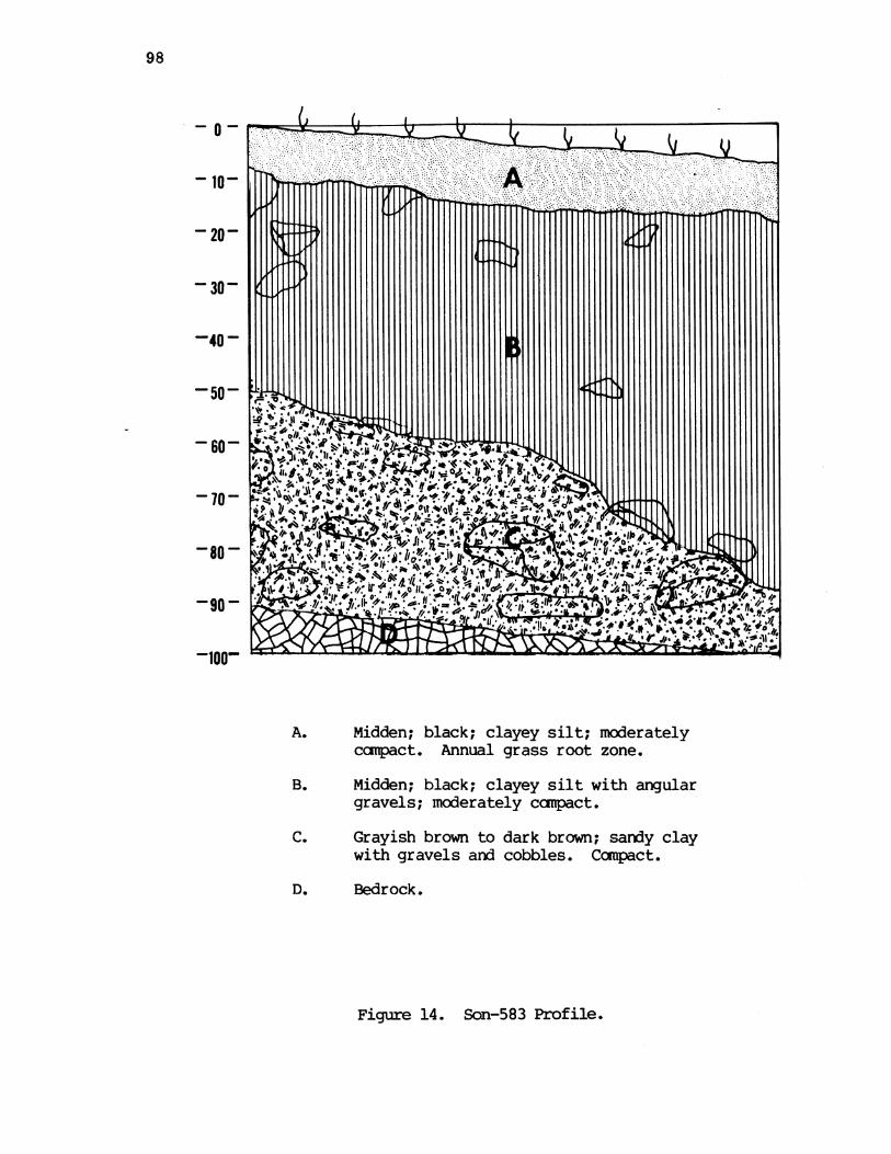
98
207
-10-40 -0
compact. Annualgrassrootzo
..Q~~~~~~~~~~~~.
gravels; moeatl omat
-20~~~~~~~~~~~~
100
C. Grayish brown to dark brown; sandy claywith gravels and cobbles. Compact.
D. Bedrock.
Son-583 Profile.Figure 14.

99
Site Son-583
Proj. Scraper RetouchPts. Flakes
1-c
1-o
1-o
1-o
1-o
1-c
1-c
1-c 1-c 1-c
1-c1-2
2
1-c1-2
2
1-c2-o
3
(Yorty Hollow)
Used Cores DebitageFlakes
1-c 93-c1-o 16-o
1-c 166-c1-c 5-o
1-c 40-c9-o
2-c 42-c12-o
3-c 85-c1-c 17-o
2-c 62-c2-o 21-o
2-c 24-c
2-c
3-c 3-c
1-c
15-c 3-c4-o 1-o
19 4
8-o
13-c2-o
3-c
17-c
24-c
31-c
600-c90-o
690
Fired AnimalRock Bone
50
150 10
215 5
230 4
largequant ity
n
2
2
smallquant ity
23
23
Levelan.
0-10
10-20
20-30
30-40
40-50
50-60
60-70
70-80
80-90
Gravel
Gravel
Gravel
Totals
1
2
3
GrardTotals

100
both located on the confluence of an intermittent tributary and Yorty Creek,and they both have a deep, well-developed midden limited to a relatively smallarea, Both sites seem to have been inhabited by a small group of people on aseasonal basis for a long period of time.
The area of Son-583 shows evidence of historic use. An old redwood sheepstake fence passes through the extrene eastern edge of the pranontory and anold road cut can be found 50 m south of the site, running parallel to and 50 mnorth of Hot Springs Road. Recent disturbance is indicated by a powerlinelocated just south of the old road cut.
Son-583 is in an open oak/woodland canmunity consisting of live oak,Oregon oak, and a scattering of buckeyes and madrones. The surrounding slopesand terraces sIhw signs of heavy deforestation in the form of numerous stumpsand fallen trees. Intensive sheep grazing and rapid stream erosion haveproduced slumping in the area and have otherwise disturbed the site.
The soil sequence in the immediate area consists of 10 an of overburden,then approximately 1 m of fine-textured alluvial soil, and finally 20-50 ac ofcoarse gravel overlying shale bedrock.
The midden of Yorty Hollow encompasses nearly all of its pranontory,measuring 8 m by 15 m, arxn averages 50-60 an in depth. An associated flakescatter extends across Yorty Creek, south to the historic road and includes apossible housepit near this road, (50 m southeast of the midden).
Test Unit 1 was placed in the area where the stream cut indicated thedeepest part of the midden: 8 m south, 450 east of the site datum.Excavation of the unit indicated that this area was the edge of an ancientstream cut that eroded onto the shale bedrock, was subsequently overlain bygravels and then filled in by midden and recent overburden.
There are at least two separate components at this site: midden andgravel. The midden is black clayey soil with some angular gravel extending toa depth of 50 cm at the west edge of the unit and 89 cm on the east. Thismidden overlies at least 40 an of grey-brown clayey gravels. Within this zoneanimal bone, fire-cracked rock and obsidian are not present. Only chertdebitage survives and increases in quantity with continuing depth. Thisdebitage is characterized by large, informal, percussion flaked tools andflakes, and represents a distinct change fran the midden component. Thesegravels continued to bedrock at 80 cm in the southwest corner of the unit and102 ams in the middle of the east wall. The midden was first cleared off thetop of these sloping gravels in less than canplete levels, and then thegravels were excavated in three separate levels. The clay content of thislower zone necessitated wet screening fran 50 cm to the end of the unit.
Son-583 will not be subject to inundation. This site, however, has ahigh potential for destruction by natural erosional processes, and will belocated near a proposed recreation area.

101
Yorty Creek Group Chronology
Our chronology here is based primarily upon typology but again we havetwo radiocarbon dates (Son-576) for cross checking.Son-576
This site presents some difficulty in dating. It will be seen fran thetable of chert-obsidian ratios that there is very little consistency in thisstatistic throughout the nearly two meters of depth. Even adjacent levels areinconsistent in most cases so there are no natural breaks to be discoveredhere. In our earlier report we distinguished three ccmponents in the site asfollows:
0-30 an. Late Houx30-50 an. Early Houx50-190 an. Late Borax Lake
Since then we have obtained two radiocarbon determinations fran this site.
UCR-353 Charcoal fran hearth at 40-50 cm. 675+ 140 AD 1325UCR-354 Charcoal fran midden at 170-180 an. 2300+ 160 350 BC
There are only three diagnostic artifacts from the site: a very smallExcelsior point fran 10-20 an (Fig. 25g), a large Excelsior point fran 70-80an (Fig. 25i), and a pestle fran 30-40 an. The large Excelsior point coulddate Late Borax Lake but it could also be fran Early Houx. The small pointprobably canes fran Late Houx while the pestle is most probably fran HouxAspect. These items together with radiocarbon dates suggest that the entiremidden should be attributed to the Houx Aspect, part early and part late. Butwhich part. The later radiocarbon date indicates that the top 50 an. shouldbe Late Houx so we will tentatively assign the remainder to Early Houx.
Son-577, 584 and 583
The chronology of these sites must be dealt with together because at thebase of each of them is an artifact bearing layer of gravel which appears tobe the same both chronologically and culturally aid must be interpreted beforethe superimposed middens are placed in context. The gravel layer in questionis found also away fran the numbered sites being exposed by stream cutting inYorty Creek fran about Son-576 at least to the edge of the project. Thestream cutting is presumed to be recent and due to changed stream flowconditions since denudation of hillside vegetation in historic times. In anycase the gravel banks of Yorty Creek occasionally included flakes aid coresapparently modified by man with a few undeniable artifacts such as scrapersaid bifaces. Although a few of these items seem a little waterworn none ofthem could be called "rolled" so we cannot believe they are redeposited fransome midden site upstream. The flakes and cores are heavier aid cruder thananything fran the middens aid all are of chert - there is no obsidian at all.We illustrate in Fig. 30 the unquestionable pieces. It will be seen thatthere is nothing there of diagnostic value fran the point of view of eitherNorth Coast Range chronology or that of any nearby area.
Thus we are faced with a situation (like that of the Farmington canplex)of a crude chert industry in an undated gravel deposit. We feel certain that

102
the industry is old but we are unable to give it a more precise date. Nearlyall the diagnostic material fran superimposed middens seems to date fran theHoux Aspect. The principal exception is the single large side notchedprojectile point shown in Fig. 25c. This was fran Son-583 and was foundembedded in the stream bank 45 an below surface and well above the gravels.This type we indicate as being (most probably) part of Early Borax Lake. Ifthis is accepted then the gravel layers must be earlier than the Borax LakeAspect. At the same time there is no evidence of any relationship to the PostPattern. We therefore are canpelled to place them in sane pre-5000 BC limbo.We will call them Yorty gravels for present purposes. Clearly a great dealmore work needs to be done on these gravels fran a geological as well as anarchaeological standpoint.
For the midden components of these sites we will make the followingchronological placements. Son-577 has nothing diagnostic - we attribute it tothe Borax Lake Aspect since it immediately overlies the gravels. Son-584 has3 stratigraphic levels, the top one (0-40 an) being attributed to Late Houxbecause of small barbed projectile point (Fig. 25d, e) and the pestle at 20-30-an while the bottan layer is Yorty gravels. This leaves the middle level (40-80 an) either as Early Houx or Borax Lake. Son-583 must also be late Houx inits upper levels (0-30 an) because of the small point shown in Fig. 25b whilethe middle levels 30-90 an must be Borax Lake for reasons discussed above.

103
Yorty Creek Site Group
Chert-Obsidian Debitage Ratios by Site and Level
Site CA-Son
584
* (1)7.67(52)5.05(127)1.74(107)1.52(53)0.88(62)1.68(42)2.83(27)1.75(22)1.50(10)2.00(3)0.00(1)
583
5.81(109)33.20(171)4.44(49)3.50(54)5.00(102)2.95(83)3.00(32)6.50(15)* (3)* (17)* (29)* (31)
( ) : debitage frequency
* : infinity, or all chert
Level
cm.
0-1010-2020-3030-4040-5050-6060-7070-8080-9090-100100-110110-120120-130130-140140-150150-160160-170170-180180-190
576
6.71(54)1.07(27)3.67(56)4.29(74)4.75(69)2.04(70)1.94(47)0.87(43)1.00(54)7.56(60)5.00(6)0.49 (55)0.71(87)0.77(46)0.34(39)1.00(18)2.67(11)* (2)
0.33(4)
577
5.50(39)15.67(50)23.50(49)21.00(22)
* (15)* (13)* (5)* (6)* (5)* (7)* (3)* (9)* (9)* (6)* (12)* (3)* (1)* (1)

104
Yorty Creek Site Group
Chert-Obsidian Debitage Ratios by Site ard Period
Period
576
Site CA-Son577 584 583
0-504.09(280)
50-1901.13(542)
0-9016.00(204)
90-180all chert(51)
0-403.35(287)
40-801.36(184)
80-1251.77(36)
0-30 *9.97(329)
30-903.81(289)
Gravelsall daert(72)
Late Houx
Early Houx
Early Borax Lake
Late Borax Lake
Hb
BLb
BLb
BLa
Hb:
Ha:
BLb:
BLa:

105
Cherry Creek Group Description
This small group does not seen to be of great importance. Aside fram thesurface site Son-552 the sites of the group occur well up Cherry Creek wherethe valley becomes narrow and steep-sided. These sites are separated somedistance fram what would appear to be the main activity centers on Dry Creekand Yorty Creek and we speculate that they may be given over to somespecialized activity, perhaps hunting. The supposed prehistoric vegetationcover here is woodland-grass or woodland-chaparral either of which wouldsuggest deer habitat.
Site Son-552 (Cherry Creek Crossing)Son-552 is located on the east bank of Cherry Creek, approximately 30
meters south of the point where an old jeep trail crosses Cherry Creek. Itextends NE-SW along a terrace located on the 400' contour. This site is inthe center of the Cherry Creek drainage, all of which is encompassed by theProject Area boundaries, and is more than a mile away fran the nearest site tothe north or south.
Son-552 is a surface site located beneath a large spreading oak tree witha marsh area east of it. It appears to be an early homestead site withevidence of still earlier Indian occupation. The jeep trail runs a half milenorth of Hot Springs Road and bisects the terrace on the north. South of thistrail, just above Cherry Creek, is an historic dump with many glass and chinasherds, (ca. 25 meters north of datum). A brick lined well is locatedapproximately 30 meters south of the dump and an old rusty plow disc was found15 meters north of the jeep trail. A basalt pestle fragment was found on theeastern edge of the dump and next to the road. A second pestle was locatedapproximately 8 meters due south of the western part of the dump area, and anobsidian flake was located on the edge of the road north of this same dumpsection.
The terrace has open oak woodland and grassland cover. The soil seems tobe a brown sandy, silty loam with no obvious dark midden showing. Two augerholes were sunk on this terrace, one in the center of the historic dump and asecond, located 2 meters west of datum stake. The one in the dump recoveredclear and opalized glass fragments and charcoal chunks; the second augeringwas sterile.
Site Son-587 (Two Housepits)Son-587 is located in the northern section of Cherry Creek approximately
225 m south of Son-604 and 270 m south of Son-589. It is a housepit siteconsisting of two circular housepits approximately 2 meters in diameter, 40 cmdeep and 10 meters apart. The terrace on which these are located has twoseasonal drainages. The northern drainage is located about 90 meters north ofthe housepits, and the southern drainage, 30 meters south, bisects theterrace. The housepits are approximately 10 meters west of the base of ahill, and about 50 meters east of Cherry Creek.
The terrace seens to have supported an old homestead, witnessed by oldfruit trees (just north and south of the southern drainage) 12-18" in
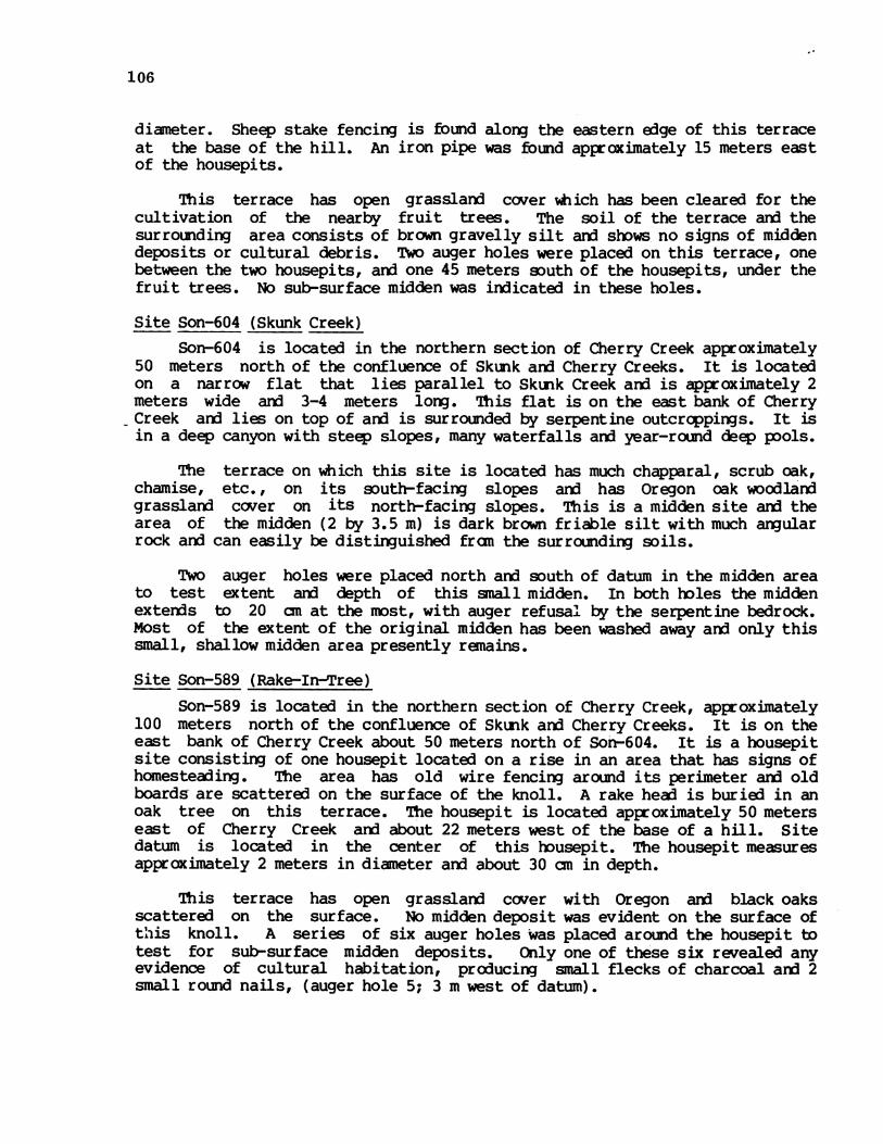
106
diameter. Sheep stake fencing is found along the eastern edge of this terraceat the base of the hill. An iron pipe was found approximately 15 meters eastof the housepits.
This terrace has open grasslard cover which has been cleared for thecultivation of the nearby fruit trees. The soil of the terrace and thesurrounding area consists of brown gravelly silt and shows no signs of middendeposits or cultural debris. 'No auger holes were placed on this terrace, onebetween the two housepits, arn one 45 meters south of the housepits, under thefruit trees. No sub-surface midden was indicated in these holes.
Site Son-604 (Skunk Creek)Son-604 is located in the northern section of Cherry Creek approximately
50 meters north of the confluence of Skunk arn Cherry Creeks. It is locatedon a narrow flat that lies parallel to Skunk Creek and is approximately 2meters wide ard 3-4 meters long. This flat is on the east bank of CherryCreek arn lies on top of ard is surrounded by serpentine outcrcppings. It isin a deep canyon with steep slopes, many waterfalls and year-round deep pools.
The terrace on which this site is located has much chapparal, scrub oak,chamise, etc., on its south-facing slopes and has Oregon oak woodlandgrassland cover on its north-facing slopes. This is a midden site and thearea of the midden (2 by 3.5 m) is dark brown friable silt with much angularrock and can easily be distinguished fran the surrounding soils.
Two auger holes were placed north and south of datum in the midden areato test extent and depth of this small midden. In both holes the middenexterds to 20 an at the most, with auger refusal by the serpentine bedrock.Most of the extent of the original midden has been washed away ard only thissmall, shallow midden area presently remains.
Site Son-589 (Rake-In-Tree)Son-589 is located in the northern section of Cherry Creek, approximately
100 meters north of the confluence of Skunk and Cherry Creeks. It is on theeast bank of Cherry Creek about 50 meters north of Son-604. It is a housepitsite consisting of one housepit located on a rise in an area that has signs ofhomesteading. The area has old wire fencing around its perimeter aid oldboards are scattered on the surface of the knoll. A rake head is buried in anoak tree on this terrace. The housepit is located approximately 50 meterseast of Cherry Creek and about 22 meters west of the base of a hill. Sitedatum is located in the center of this housepit. The housepit measuresapproximately 2 meters in diameter aid about 30 an in depth.
This terrace has open grassland cover with Oregon and black oaksscattered on the surface. No midden deposit was evident on the surface ofthis knoll. A series of six auger holes was placed around the housepit totest for sub-surface midden deposits. Only one of these six revealed anyevidence of cultural habitation, producing small flecks of charcoal and 2small round nails, (auger hole 5; 3 m west of datum).

107
Site Son-603 (Salmon Hole)Son-603 is located on the west bank of Cherry Creek on the northern part
of its drainage. It is approximately 750 meters south of the confluence ofSnow and Cherry Creeks and a half mile north of the confluence of Skunk andCherry Creeks. The site is on a terrace measuring about 35 meters by 15meters which runs north-south, parallel to Cherry Creek. This terrace is oneof only a few openings in a heavily wooded, steep sided canyon. Son-603 islocated approximately 250 meters south of Son-601 and about a half mile northof Son-589.
This site is a shallow midden encanpassing most of the open terrace. Theterrace is bordered on the north aid west by steep sided, heavily woodedslopes covered with wild iris. The entire eastern edge of the terrace isdelimited by the cut bank formed through erosion by Cherry Creek. The terraceitself has semi-dense oak woodlard cover consistent of Oregon, canyon, anxdcoast live oaks with grassland beneath. Some buckeyes, bays, madrones andmanzanitas are scattered around the perimeter of the site.
The midden is easily distinguishable from the surrounding lighter soilson this terrace. The entire site is covered with naturally formed augularrocks, making identification of fire-cracked rocks difficult. Test Unit 1 wasplaced N 30° W, 10.55 meters fran site datum in the area which seemed to havedarkest midden and the least amount of rocks.
The shallow midden component at Son-603 exteixded to 50 anwith snallmidden pockets continuing into the sterile sub-midden gravels below. Obsidiandominated the lithic debitage counts throughout the entire midden depth. Afew pieces of chert debitage aid animal bone fragments were also recovered.Three obsidian projectile point fragments (all tips) came from this middencomponent. Singley these are undiagnostic but their general shape and sizeindicate that they are not of a late phase. We assign the site to the BoraxLake Aspect.
This site is very similar in geographic position to the other four siteslocated in the northern extreme of the Cherry Creek drainage, (Son-601, 604,589, 587). This cluster of sites is important geographically because it maybe a link to sites of another tribelet in the next drainage. There is adistinct hiatus between these sites and the rest of the sites located in thenorthern section of the Project Area. This cluster is approximately threemiles north of the Yorty Creek/Dry Creek confluence on which creeks thenorthern sites are located. Two sites located further north, (outside theProject Area on this drainage), probably part of this cluster, have producedinteresting surface finds which are part of the Moretti collection. Amongthese finds is the only charm stone known to exist from this area.
Site Son-601 (Eel Pit)Son-601 is one of five sites located in the northern section of the
Cherry Creek drainage within the boundaries of the Project Area. All fivesites are found on the only available open terraces within this heavilywooded, steep canyon. The two northerrinost sites, Son-601, and Son-603, arelocated on the west bank cf Cherry Creek and the three southern sites are onthe east bank of this creek.

108
Site Son-603 (Salmon Hole)
Level Proj. Reworked Retouch Used -Debitage AnimalcM. Pts. Biface Flakes Flakes Bone
0-10 6-c 71-c 38-o
10-20 1-c 72-o 30-o
20-30 2-c 61-o 35-o
30-40 112-o 46-o
40-50 l-o 14-o 4
50-60 3-o
Totals 2 2 2 1 175 35

109
-o~sit anua .ras root zon. Friable
10
-20
40 -~~~~~~~~~~~~~~~~~~~~~~~~~~~~~~~~~~~~~
60~~~~~~~~~~~~~~~~~~~~~~~~~~~~~~~~~~~~
siltanualras roo zon. Friable
B. Midden; very dark grayish brown; gravellysilt; friable to very friable.
C. D~ark yellowish brown; gravels with sariaid silt; crumbly.
Figure 15. Son-603 Profile.
a~
0 5 10L a I
Meters
Map 18. Son-601 (legend p. 5).
110

lo m
20
30
40
50cm
I L I
A. Midden; dark brown, silt and sard;Friable to moderately canpact.
B. Midden; darkcanpact.
annual grass root zone.
brown; silty gravels; friable to moderately
C. Brown; silty clay; canpact.
Figure 16. Son-601 Profile.
ll

112
Son-601 is located approximately 500 meters south of the confluence ofSnow and Cherry Creeks arn approximately 1000 meters north-northwest of theconfluence of Skunk arn Cherry Creeks. This terrace is oriented north-southarn runs parallel to Cherry Creek, approximately 3 meters above the creek.The terrace measures 30 meters by 15 meters with the midden concentrationlocated within the northern 20 meters of the terrace.
The site has semi-open oak/woodlarn] cover with black oaks, canyon liveoaks, bays, buckeyes, and broadleaf maples. Annual grasses and Brodeia arefound over the entire terrace. The northern perimeter of the site isdelimited by a large bedrock outcrop; the western by stew oak/grasslandslopes; anx] the eastern by the cut bank eroded by Cherry Creek. The area ofthe midden is easily distinguishable fran the surrounding lighter soils onthis terrace.
Test Unit 1 was placed in the darkest midden area, 2' meters east of sitedatum. The area is heavily covered with rocks. The unit was placed in thearea of least rock cover, but despite this, the unit was very difficult toexcavate. Areas of rock concentrations began to occur in the first levelexcavated aix continued to 30 an. Roots were equally heavy in these initiallevels. Fire-cracked rock could not be visually separated fran the otherrocks in the unit aix] was, therefore, not recorded. At 30 an large areas ofkrotovina dominated a major portion of the unit. Excavations ceased at 50 anwhen the 12 flakes recovered all came fram disturbed areas.
The shal low midden component at Son-601 extended to 40 an with smallmidden pockets continuing into the sterile suknidden clays below. Obsidiandominated the lithic debitage counts throughout the entire midden depth. Afew pieces of chert debitage ard animal bone fragments were also recovered.One chert projectile point, a rounded base fragment came fran this middencomponent, (Fig. 24j), suggesting that this site was not late in date.
Cherry Creek Group Chronology
There is insufficient evidence here to warrent extensive chronologicaltreatment but a couple of observations about the two excavated sites seem inline. Firstly there is no evidence in either of these sites of material framLate Houx so on this basis they must be attributed to Early Houx or BoraxLake. This suggests that the specialized hunting or local plant gatheringactivities hypothesized for these sites was abandoned in this latest period.We are inclined to doubt this aix] attribute our lack of late evidence to smallsample size. The other point worthy of note is the very small chert-obsidianratios, 0.05 for Son-603 aix] 0.23 for Son-601. The other sites showingsimilar obsidian domination are Son-571 in the Western Group and Son-556 inthe Lower Warm Springs group. Both these sites have large parts of theirdeposits attributed to the Early Houx. It may be then that this is also trueof the two sites on Cherry Creek.

0
0 (a~~0).0- a
b-. b-e 0 1~0
00 0x ~~0
I-
0
0
C.)
Map 19. Central Group West.
113
(I)wa.I-
z
CD4
wz
n
I
w
-j
000w
X:
4
040
I-
zwC)
06 4-
000N

*b** ................................... -*-***@@*X* *@@....................................................... .................................. -@*@*X**@************ ..... *................................... ....... _! .. i..... ... a, .... s. v >*@@ @@-sss***X***X@* *@@*@@@ * *** >......................*********@@@@***s**-.* .. XX.*X¢****-***....................********X*X **** v..................... ........................... .............................................................*v v@@@* *@@@** ***v @e***............................................................................. ....................... *^........................ ............................... *.
* *@o....................................................................... .................... ***.* ** ............... * *.**............................................................................. ................................. *
vv*v* ... * ******@@ ..... @-............................*..................................................................... .............................. *e* * *-.........................*e e .... * ***-*........................* *-X-X X**-.................................................................. . *.*........................s ^, . ...78s , . ,................ % _,..... .. s , o ., s...... _ z , z .. . . . . . . Di. . . . . . . * * ,........ \ ,., * ' :......... ....... , ,, ........... ........ _ . , ,............ .............. _ o ............ - , .@........... o# S............. ............. ,o 1........... ., * w.s . X,..... .. f***- * t @b............. ................ . ............. ........ ,%.,5 >.............. , *,^, ,,............ ............... , .o -\.............. , . # 4 4 t @ O............. ............... . .* *............. ............ ,4., c ,.............. * r.............. .......... : , §. . . § @ @ - @ @ @ v * * * ! 2:::::::::::::::M' IL - l-::: -'5?S;: ;s: > # '.tv
'''' 1i XS;'g , :' . N
,* ..
,.......... _:,: . l-
,. .
0.~~~~~~~0
1 1
4,e 4-L O YtTn
Map 20. Central Group East.
114
'J.
,,... .......................
. ..* 0.
r..............
cn)Cl)wa-
I-
z4
cn
w
LI
w
0z
Cl)w
I-
CD00w
0..0CD-J
Ir-zwC-
/
2V-10
4
CY

115
Central Group Description
The Central Group is on the stretch of Dry Creek fram Prichett Peaks onthe west to the mouth of Warm Springs Creek on the east. The first half ofthis stretch is rather narrow ard steep sided while the lower half widens outconsiderably. The first part contains only a few small sites, as one mightexpect; the second part, which one would have expected would be more favorableto native settlement, was also favorable to orchards and vineyards so that itseems apparent that at least two excellent archaeological sites were almosttotally destroyed by agricultural activity.
On the whole, though, art even assuming that there were formerly moresites here the total amount of archaeological remains in this group seems muchsparser than elsewhere in the project. As discussed in the conclusions we arehypothesizing that this was a boundary area between tribelets and may havebeen less densely settled for that reason. There is no obvious ecologicalreason for the lack of settlement in the distribution of vegetation types asshown on Maps 19 aid 20.
Site Son-562 (Oak Point)Son-562 is in the extreme western part of the Central Section. It
consists of a single housepit on a small first terrace on the north bank ofDry Creek. The tergace is five meters upslope from Dry Creek, has opengrassland cover, aid is encircled by heavy riparian vegetation. Several largestands of oak, bay, manzanita aid madrone, with an occasional fir, caopletelyshelter the terrace, which measures 50 meters by 30 meters.
The housepit, two meters in diameter aid 80 an in depth, is in the centerof the eastern part of the terrace. During survey the area around thishousepit was searched for petroglyphs aid cultural evidence, but none wasfound. A series of 12 auger holes were placed randcmly over the entiresurface of this terrace, aid although charcoal flecks were in evidence in manyof the holes, only one obsidian flake was found. This flake was recoveredfrcn auger hole 10 at a 55 an depth aid was associated with a few charcoalchunks. However, auger hole ll, two meters north of 10, contained a fewflecks of charcoal on the surface and did not reveal buried midden or culturalmaterial. Both of these auger holes were located at the western end of theterrace, at the point furthest away fran the housepit.
Site Son-574 (Purple Blind)Son-574 is a probable hunting blind found on the south bank of Dry Creek,
a mile and a half upstream from the Old Rockpile Road Bridge, aid directlybelow Pritchett Peaks. The blind is on a small terrace, 110 meters south ofaid 15 meters above Dry Creek. It overlooks a gently sloping, grass-coveredclearing in a steep, densely-wooded terrain. The clearing is bordered to thenorth by a barbed wire fence that is on the cut bank of Dry Creek, to the eastby a barbed wire aid stake fence, aid to the south aid west by a steepeninghillslope. Above the terrace. with the blind is another oen, grassy clearing.
The vegetation of the site is open grassland with a few scattered staidsof oak and manzanita. The surrounding area is a dense oak/madrone forest withsome redwood aid fir.

116
The hunting blind consists of a circular depression measuring 2.5 metersin diameter and 60 centimeters in depth. The grassy clearings above ard belowthis blirx] form a natural path to Dry Creek, making the position of this blindexcellent for ambushing game. No midden or cultural artifacts were found inor around the blind.
Site Son-598 (Treganza 10)Son-598 is a non-midden site with 14 well-defined housepits and a cupule
petroglyph rock. It is situated on the south bank of Dry Creek directly belowPritchett Peaks. The site is on a primary terrace, measuring 150 meters by 80meters, arn is two meters above the stream bed of Dry Creek. The terrace isbordered to the north by the Dry Creek stream bed, to the east by anintermittent drainage, and to the south arn west by the increasing hillslope.
The vegetation of the terrace consists of open grasslarxn cover withscattered stards of oak, buckeye arnd manzanita. There is riparian vegetationof laurel and willow along the drainages. The surrounding slopes are coveredwith a dense oak/bay/mairone forest with sone redwood an] fir.
The soil around the housepits is the same as the soil of the rest of theterrace; a moderately canpact, brown to dark brown, alluvial gravelly sandsilt. No midden is in evidence on the surface nor was any uncovered in thefive auger holes made in the vicinity of the housepits.
The housepits are clustered on the eastern half of this extensive terraceand cover an area measuring 70 meters by 30 meters. The 14 housepits are verywell defined, range fran three meters to six meters in diameter, and are asdeep as one meter.
The cupule rock is located on the northwest edge of the terrace and thestreambed. The rock is a small, low-lying serpentine boulder that waspartially buried in the terrace slope. It contains six shallow cupules fourto six centimeters in diameter.
There were no artifacts found during an intensive search of the surfaceof the site during the initial phase of the Warm Springs Archaeology Project.A one meter square test excavation unit was placed in the area of thehousepits, between the largest of the 14 housepits and a small one 10 metersto the west, 15 meters due west of site datum. This unit ended at 30 an afterthree levels of sterile alluvium. A five centimeter thick burnt layer of soilwas uncovered at ten centimeters below surface, which contained no culturalmaterial. This carbonized layer is probably due to natural causes.
Site Son-548 (Turtle Stink)This is a shallow, weakly developed midden site on the north bank of Dry
Creek, three quarters of a mile upstream fran the Old Rockpile Road Bridge, atthe south base of Pritchett Peaks. The site is located on the western side ofa primary terrace, measuring 70 meters by 25 meters, in a steep, fairly narrowvalley. The vegetation of the terrace is moderately dense oak/bay woodland,with some buckeye and madrone. There is a dense grass groundcover on thesite. The slopes around the site have roughly the same vegetation type, withthe lower slopes on the south bank of Dry Creek being more densely wooded and
117
having occasional redwoods.
The soil of the site is the same as the surrounding terrace soils; amoderately caopact, brown, alluvial sandy silt to silt. Three auger holeswere made on this terrace in the area of the site but no sub-surface middendeposits were found. The area of the site measures 10 meters by 15 meters aidis defined by a sparse scatter of artifacts aid fire-cracted rock. The firstfive to ten centimeters of the surface of the site is disturbed by the rootingof feral pigs, who feed on the acorns fran the many oaks on the site. Thiswas the only disturbance of this site; erosion by Dry Creek was minimal.
A one meter square test excavation unit was placed in the area ofheaviest artifact scatter, 90 ac due east of site datum. The unit ended at 30ac in a nearly sterile layer of brown, alluvial silt. An auger hole in thebottom of this level exteided to 65 cm aid revealed no midden.
Excavation revealed that this is a weakly developed midden site, withonly one zone of occupation, and few artifacts, none of them diagnostic:
Level Scraper Debitage Shell Fire Rock Bone
0-10 an 3-c 1 7 56-o
10-20 an 6 -1-o 6-o
20-30 1 -2-o
Site Son-542 (possibly "Oak Ball Drifts Out")This is a disturbed site with a shallow, weakly developed midden located
on the north bank of Dry Creek about a mile upstrean fran the confluence ofDry and Warm Springs Creeks. The site is on the edge of a 9-12 m high firstterrace, 150 meters south aid east of Old Rockpile Road. The weakly developedmidden covers an area measuring 50 meters by 25 meters. It is bordered on thesouth by Dry Creek, on the east by an intermittent tributary, aid it gradesinto non-midden soil to the west aid north. There is an associated flakescatter which is confined to the front of the terrace aid measures 120 metersby 40 meters.
Dry Creek is now 300 meters south of this site and is separated fran thesite by a wide gravel streambed which has been used in the past as a gravelborrow area. Directly below the site there is a year-round pool which isprobably the result of mining operations.
The original vegetation on the site was, according to knowledgeable localresidents, open grasslaid with scattered staids of Oregon aid valley oak.Riparian vegetation was once quite abundant in the seasonal drainages, aidredwoods, which are still found in the uper parts of these drainages, onceexterded over the terraces to Dry Creek. The natural vegetation has long

118
since been replaced by cultivated crops starting with hops, plums aid finallythe present vineyard. This site has been cultivated for at least the past 80years aid the midden is now very disturbed. Artifacts found in the largerarea of the flake scatter may have originally been in the midden area butbecame more widely distributed by agricultural activities.
The soil of the midden is only slightly darker than the surrounding soildeposits on the terrace. It is a loose, dark gray to dark brown, silty gravelwith many pebbles aid cobbles. The rock content aid looseness of the soil didnot permit augering.
Two one meter square test excavation units were dug on this site. Thefirst unit was located 450 south aid 8 meters west of site datum in thecentral part of the midden. This unit ended at 20 cm in a sterile, yellowbrown, sandy coarse gravel. No artifacts were found in either of the twolevels. The second unit was excavated at 590 west aid 35 meters south of thesite datum, where four chert aid obsidian flakes had been seen on the surface.This unit also extended to 20 an aid ended in a sterile, brown, sandy gravel.One chert side-notched point aid two utilized obsidian flakes were the onlytools recovered in excavation. Surface finds were also few, but included anobsidian corner-notched projectile point fragment, two chert scrapers and achert core, as well as 20-30 flakes and chips. Fran this inventory, it isclear that the weak midden at Son-543 has been so disturbed as to reiderintensive excavation of limited value.
Site Son-599 (Jackson's Blind)This site is an isolated, well-defined huntirn blind located on a minor
tributary of Dry Creek, 200 meters upstream from its mouth on Dry Creek. Theblind is situated at the southeast dege of an open, flat clearing in a verysteep, moderately forested terrain. It is 50 meters west of aid 35 metersabove the steep-banked tributary. The blind overlooks both the tributary aidthe clearing. The clearing is bordered on the east by the intermittentstream, on the north by a densely forested slope continuing down to Dry Creek,aid on the south and west by a moderately forested steep hillslope.
The vegetation of the clearing is open grasslaid with very dense grassgroundcover. The dense forest north of the blind aid clearing consists ofpredominately oak aid madrone with some bay present. The forest to the southaid west includes chaparral/oak woodlaid with some pine on a thin, serpentine-derived soil.
This is the best preserved hunting blind in the Project Area. It is astone-lined, rectangular depression which measures 2 meters by 1.2 meters aidis 80 an deep. Approximately 40 stones line this pit, some of which stillremain in courses. The highest remaining row of courses is oriented towardsthe southwest.
No midden or cultural material was found at this site. However, Son-600,a late midden site, lies on the north bank of Dry Creek approximately 400meters below this site. The sharply defined nature of this blind indicatesthat it is a relatively late feature aid may be contemporaneous with the lateparts of site, Son-600.

119
Site Son-600 (possibly "Takoton")This is a disturbed midden site with a shallow, weakly developed midden
located on the north bank of Dry Creek 750 m upstream fran the confluence ofDry and Warm Springs Creeks. The site is on a high first terraceapproximately 40 meters north of Dry Creek. This site, like Son-542, is a lowmound on the edge of the terrace.
The vegetation of the terrace is now vineyard. Prior to cultivation,this area was in open oak woodland with thick groves of bay, willow, andcottonwood along the fringes of Dry Creek. The slopes tQ the north arethickly forested with madrone, oak, and pine and remnants of large redwoodstands are in evidence in the drainages.
The soil of the site is loosely compacted, dark gray to dark gray brown,gravelly silt. The surrounding soil is brown to dark brown, gravelly silt.Five backhoe trenches were excavated in the vicinity of Son-600 before testingby the Warm Springs Archaeologgy Project, but none showed any signs of midden,(see Map 21 T-18, T-19, T-20, T-21 and T-29). Nine auger holes were boredthroughout the entire area of possible midden. These borings demonstratedthat the extent of the midden covered the same area as indicated by thesurface finds. The midden in the auger holes on the perimeter bottomed out at20 cm and towards the center at 50 ca. Those outside the darker, midden areawere sterile. Although the flake sqatter measures 140 by 60 meters, themidden only encaopasses an area 100 by 40 meters.
The midden at Son-600, like that of Son-542, is nQt ntact. The previousowner of the land, Mr. Edward Mauritson, stated that there has been muchagricultural activity that would have disturbed the site. In the late 1880'sall of the oak trees that were growing on the site were pulled out. Grapeswere planted, then replaced by hops, which were in turn replaced by plumtrees. The plum trees remained for many years until, in 1947, Mr. Mauritsonpersonally bulldozed them out and planted grapes which are still present.While removing the plum trees, four foot deep trenches were dug every 25 feetand new topsoil was deposited in these trenches,
Nine units were excavated at Son-600 to test the depth of the midden, todetermine the amount of disturbance, and to delineate the boundaries of thesite. Their provenience is as follows:
Unit Grid Location Excavator
1 N9 E20 Midden Larry Banks; Richard Lerner(1974)
2 N10 E19 Outside ZSAP (1975)Midden
3 NlI E19 Outside WSAP (1975)Midden
Midden %SAP (19754 N8 E19

120
CA-Son 600 -aMap O
ZV_~~~~~~~~~~~~~~~~~~~~~
0O~4
0 0~~~~~~~I.00~ ~ 1~/
/1f
lit i
//Jill I I I I 1111111lii IIIIJI I I11III
itlir) 0 2liii IaI ----
MetersC=T-18
C=T-19
Map 21. Son-600 (legend p. 5).
4

iSAP (1975)
WAP (1975)
EAP (1975)
WSAP (1975)
USAP (1975)
There was no evidencethe above units. There isin each unit excavated.caused by tree roots eitherburned in situ.
of the trenching described by Mauritson in any ofample evidence, however, of extensive disturbanceThe disturbance in most cases seens to have been
^ having been renoved fran the soil or having been
In unit 4 soil disturbance associated with tree removal externis frqn 20an to over 100 an and is fran 50 an to over a meter in width. The burning oftrees is evident in units 7 and 9. Unit 7 contained a charcoal filled pit,50 an in depth which extended over half the unit. Unit 9 also had largeareas where burning was evident, involving over 60% of the entire unit.
The soil of all nine units was disturbed even though the disturbance wasnot always clearly illustrated in the unit wall profiles. The earth wassplotchy in color, differentially canpacted, aid the disturbed areas, unlikekrotovinas, were discontinuous. Many of the units showed extensive rodentactivity, as evidenced by the sharply defined krotovinas.
The surface indications of the midden extent were borne opt by the testexcavations. The three units within the midden, units 4, 5, 6 averaged 20-25artifacts in the first four levels while the other units averaged ten or lessper level. Almost all of the tools came fran the units within the midden.
Site Son-560 (New Bridge Flat)This is a shallow midden site on the east bank of Warm Springs Creek,
175 miles upstream fran its confluence with Dry Creek. The site is 120meters west aid 22 meters below the Stewart's Point-Skaggs Springs countryroad. It is approximately a quarter mile upstream fran the New Rockpile RoadBridge which spans Warm Springs Creek canyon.
The site is on anmeters, in a very steep,Warm Springs Creek. Iteither direction.
open primary terrace, measuring 120 meters by 40constricted valley approximately 50 meters west ofis the only inhabitable area for nearly a mile in
The terrace vegetation includes openwyethia, wild iris, lupine, aid much poisonare covered with a stunted, moderately denseaid poison oak.
oak woodland,, sane buckeye,oak. The slopes on both sidesforest of madrone, Oregon oak,
The midden covers a small area, 15 meters by 20 meters on the eastern
5
6
7
8
9
121
N7 E19
N8 E22
N8 E23
N8 E25
N10 E17
Midden
Midden
OutsideMidden
OutsideMidden
OutsideMidden

122
edge of the terrace at the base of the hillslope. It is south of anintermittent stream which bisects the terrace. The midden is weaklydeveloped, being only a shade darker than the surrounding soil. Both themidden and terrace soil are dark brown, alluvial gravelly silt. Four augerholes were placed on this terrace but no sign of buried midden was found.
A one meter square test excavation unit was placed in the midden threemeters due north of site datum and two meters south of the cut bank of theintermittent stream. The unit ended at 20 an in a sterile yellow brown, sardygravel.
During the survey a scraper and several chert flakes were found in thebank of the intermittent stream, and a few flakes on the weakly developedmidden. Test excavations showed that there was only 10 to 18 an of midden.This single occupation zone contained six chert flakes and one obsidian chip.No diagnostic artifacts were found at Son-560.
Central Group Chronology
It is possible to deal (partially) with the chronology of three sites inthis group. Site Son-598 has 14 housepits so well defined that they must dateto a very late period. Since there is no midden it is impossible that it canhave any time depth. Therefore we date it entirely Late Houx. Site Son-542,now destroyed, at one time had a Late Houx component arK] also a Borax Lakecanponent to judge by the projectile points shown in Figure 26a an: 26b.
Site Son-600 apparently also had both Houx and Borax Lake components(Fig. 26c ard 26e). The chert-obsidian ratio in the 9 units excavated thereis 1.50 (based on 620 flakes) and variation in this was not great fran unit tounit. We will not tabulate the material excavated at this site since it wasso evidently mixed.
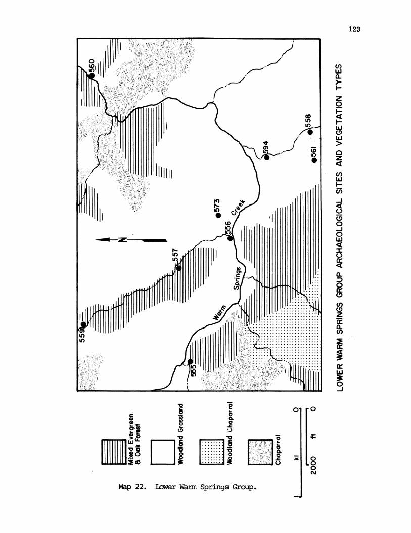
75
o~ a
0~~~~~~~~~0
*0~~~7o .
LiCSLlBE
Map 22. Iter Warm Springs Group.
123
Cf)w0a
z0
w
CD)
w
0z
w
-J
Cf)
4
C.)
00
so
w4
a-0
C,)
z
4r
-J
0.00N

125
Lower Warm Springs Group
Warm Springs Creek forms a narrower, more restricted canyon, by andlarge, than does the larger Dry Creek. The exception to this is around themouth of Little Warm Springs Creek (or Hot Creek) where it opens out a bit forabout a half mile along Warm Springs Creek and it is here that we find theimportant sites. There seems no doubt that ethnographically both lower andupper Warm Springs Creek areas were auxiliary to the larger, more importanttowns which were further down Dry Creek (Barrett 1908) the sites of which arenow under cultivation. The villages in this area may thus have had somespecialized function relative to those below. We will discuss this whereappropriate but no overall specialization is apparent. Probably this regionwas more densely wooded and forested than was the open valley of Dry Creekalthough even this is not certain. In any case a substantial part of lowerWarm Springs Creek was apparently given over to woodland grass vegetation.The sites of this group are shown on Map 22 and the eastern part of Map 26.
Site Son-594 (Skaggs Springs)Son-594 is at present a surface scatter site in the vicinity of the site
of the old Skaggs Springs Resort. It is in an area of several naturallyoccurring hot springs that flow fran the west bank of Little Warm SpringsCreek (also known as Hot Springs Creek), about 300 m up the creek fran itsconfluence with Warm Springs Creek. Foundations of the hotel, several cabins,and a concrete swimming pool remain to define the site of the old resort. Thehot springs are still used by many people and access roads and campsites arenunerous. The surface scatter covers a 200 m N-S by 50 m E-W area on thenorth edge of the extensive, open valley that is 150 m south of the presenthot springs. Most artifacts were found along the dirt road that passes overthis site. Only half a dozen chert and obsidian flakes were found here.
The surface of this area is covered with a very dense grass ground-cover.The area of Skaggs Springs in general was in open oak woodland but is nowdominated by such introduced species as eucalyptus and locust trees. -Theslopes on both sides of the valley in which Skaggs Springs is located arecovered with dense oak madrone forest. Near this site and about 250 mdownstream fran the confluence of the two creeks already mentioned, is one ofthe few gathering areas for Angelica, a plant held in high esteem by the Pcnosand used both as a spice and a medicine.
There is no midden to be seen anywhere on the surface around SkaggsSprings, the prolonged exploitation of the area by those who use the hotsprings (the resort dates fran the 1860's), as well as historic cultivationand recent .innabar mining having totally obscured any midden that is here.Both local residents and ethnographic information collected by Barrettindicated that the area of Skaggs Springs was once a major occupation site.Barrett (1908:220) gives the following account. "Kaho'wani, fran ka oraba, water, ho, hot or fire, and wa'ni, ?, at Skaggs SpIirsion the east bankof Hot Springs Creek, an affluent of Warm Springs Creek. Mr. Mulgrew, theproprietor of Skaggs Springs, has found on this site a number of mortars,pestles, and other large stone implements as well as many arrowheads andsmaller implements."

126
Additional ethnographic evidence was collected by David Peri and ScottPatterson. There were told by a Pono (Kashia) informant that different bandsused to meet on the terrace on the SW side of the confluence of Little WarmSprings Creek and Warm Springs Creek. As a result of this information, a unitwas excavated in this area and 5 m south of the concrete steps that mark thelocation of the old resort hotel. This unit ended after 20 an because theextensive disturbance caused ..by the hotel had obliterated most evidence ofIndian occupation. Seventeen augerholes were made in. the area of SkaggsSprings. Four were made on the east side of the confluence of the two creeks.Thirteen were made in the extensive valley in which the surface scatter wasfound and extending fran the hot springs up or south to Son-558, a seasonalcamp site at the end of the valley. However, in none of these augerholes wasfound evidence of any midden.
Site Son-558 (Bob-l)Son-558 is a shallow midden site found on the West bank of Little Warm
Springs Creek about a half mile up the creek form its confluence with WarmSprings Creek and at the SW end of the extensive, open valley in which SkaggsSprings is located.
The site is located approximately 50 m up Little Warm Springs fran theconfluence of this creek and the first major intermittent stream that entersit. It is on an open, flat primary terrace that is immediately west of and2.5 meters above Little Warm Springs Creek. There are dirt roads on bothsides of Little Warm Springs Creek which continue up the creek. A secondarydirt road passes over the midden deposit at the site and crosses the creek,connecting the two larger dirt roads.
The midden is approximately 40 meters north south by 15 meters east westand south west, and the madden extends approximately halfway to the hillslopeand grades into non-midden alluvial soil in other directions. The midden isfound on both sides of the connecting dirt road that passes over the site,although most is south of this road.
The soil of Son-588 is a very dark gray brown, loose gravelly silt. Thesurrounding soil is a dark gray brown to gray brown gravelly silt. There areseveral areas in the vicinity of this site that contain dark-colored soil, butonly at Son-588 were artifacts found. These other dark soils may be caused bythere being more organic constituents, such as leaf litter, in their soilsthan the surrounding soils. Auger holes were made in these darker soils butthey indicated only 10-20 an of dark color, underlain by the general alluvium.Auger holes were also put in the extensive terraces to the north and east, butno midden was found.
The vegetation of the site is a mixed riparian/open oak woodland'.Daminant trees are bay, Oregon oak, alder, and maple with wild grape anbuckeye along the creek.
Little Warm Springs Creek probably maintains a year round flow. The hotsprings of Skaggs Springs are, approximately 500 meters downstream.
This site has been disturbed recently only by the aforementioned road

127
which passes over its northern edge. The flat terrace upon which this site islocated doesn't appear to have been disturbed by plowing. The site is on theouter periphery of the major historic site of Skaggs Springs Resort, a hoteland spa which was active fran the 1860's on. However, the site does notappear to have been disturbed by any resort activities. Erosion is fairlysevere along the cut bank of Little Warm Springs Creek.
A 1 x 1 meter test unit was located at 5 m east of the site datum stakein what appeared to be the center of the midden. The unit ended at 50 ans ina sterile, loose sandy gravel. No augering could be done in the floor of thisunit because of the looseness of the soil. The nearby cutbank showed noburied midden below 50 cms.
Son-558 contained only 20 an of a loose, dark gray brown, gravelly siltymidden. The first level of this midden was richer than the following levelsand included a small obsidian side notched, wide stemme-d projectile point, achert biface, a chert retouched flake, an obsidian retouched flake and aquartz core. The debitage count, after a high of 12 chert and 15 obsidian inthe first level, rapidly diminished with depth, and chert and obsidiandebitage were found in roughly equal amounts in all levels. Son-558 alsocontained a relatively large amount of firecracked rock in the first twolevels, i.e., 31 lbs. and 23 lbs. respectively. None was found below 20 cm.Animal bone was found in a moderate amount in the first level, 26 fragments,after which only a few pieces occured in each level.
The only diagnostic artifacts from the excavation is the small sidenotched proj. point fran the 0-10 an level. This was inadvertently anittedfran the illustrations but undoubtedly is a late Houx specimen.
Site Son-561 (Buzzard Flap Blind)Son-561 is an isolated hunting blind site that is situated approximately
300 m south of, and approximately 60 m upslope fran, Skaggs Springs. It is ona sall ridge between two well watered clearings about half-way up the hillson the west side of Skaggs Springs valley.
Son-561 is on the north facing brow of a small transverse ridge betweentwo gently sloping clearings that are watered by apparently year-roundsprings. The blind is about 40 m fran the west clearing, and about 60 m fromthe east clearing. Two intermittent drainages trend north fran theseclearings for approximately 250 m to the area of the Skaggs Springs thermalpools. The area of the site, which is approximately 6 x 6 m is surrounded onthe north, east, and west sides by mixed, open oak/madrone woodland, with somemanzanita, bay laurels, and buckeye. T[o the south, the slope becanes moresteep and much more heavily wooded with predominantly Oregon oak and madrone,and with Douglas fir increasing upslope.
The soil of this area, including that of the site, is a brown to red-brown silty sand with much colluvial gravel. Logging roads have made somechanges in thae original land contours in the general area of Son-561, but theImmediate area of the site is undisturbed. There was, however, muchdisturbance throughout the blind because of a thick matting of bay laurelrootlets fran the nearby tree.

128
The pit of the hunting blind at Son-561 was measured at 1.5 m N-S by 1.05m E-W, and was as deep as 42 cm. There were many large and mediun sizedrocks, some of which were placed on others, found along the northern ardwestern, or downslope, perimeter of the blind. There were many other rocksthat were either within the pit or downslope, apparently having fallen franthe rocks that once lined the north and west sides of the blind. These rocksneed not have formed a continuous wall, but may have been used to anchor brushscreening.
At the present time there are game trails on the east side and on thewest side of the blind, both being within 7 m of the blind. There is also agame trail below, and 20 m north of, the blind that goes between the twoclearings. The alignment of rocks on the north and west isde of the blind mayindicate that aboriginal hunters expected deer and other game would approachthe blind fran these directions where even now game still passes.
The general procedure used in testing a blind was to first clear thegrass ground cover. After the grass was removed, the ground was scraped witha trowel to a hard, undisturbed surface and this detritus was screened in aquarter inch mesh screen. All large rocks were left in situ. This clearingmethod was continued outside the actual pit to encompass the rocks that hadscattered downslope fran the rocks lining the perimeter of the blind. Thepurpose at this time was to remove the soil and leaf litter that had filled inand obscured the original pit contours, and to find any artifacts that mightoccur in this soil.
The clearing of this blind expanded and deepened the dimensions observedearlier so that the pit now measured 3.8 by 3.1 by 54 cm deep. The thickmatting of roots throughout the pit loosened the soil and made it difficult tobe fully certain of the hunting blind's original dimensions. No artifactswere found and no other large rocks fran the perimeter of the blind werefound.-
Son-561 will not be subject to innundation. However, because so littleis known about hunting blinds, more excavation should take place. The blindcould perhaps be trenched to better determine Ltratigraphically the originaldimensions and contours of the pit. In addition, intensive surfacecollections should be done on the surrounding slopes in order to recover anypossible artifacts.
Son-573 (Blue Blind Site)Son-573 is a possible blind site situated on the north bank of Warm
Springs Creek. It is on a flat shoulder that is 250 m north of and 45 m aboveWarm Springs Creek. It is up the second intermittent drainage below theconfluence of Little Soda Creek and Warm Springs Creek at Son-556. The blindis on a gently sloping, 30 x 40 m open, flat clearing in an-otherwise steep,moderately wooded terrain. The blind is on the southern edge of this clearingand is oriented towards the rest of the clearing. The blind is arectangularly shaped, rock-lined depression that measures 2.4 m by 1 m and is30 cm deep. There are several rocks lining its north and east sides which mayhave been used to anchor brush screening.
The vegetation of the site is open grassland with a thick ground-cover of

129
annual grasses and scattered live oak, madrone, and a few digger pines. Alongthe intermittent drainage are scattered bay, Oregon oak, and live oak. Noartifacts and no midden were found at this site.
Site Son-556 (Mrs. Walker's Mortar)Son-556 is a deep midden site with a housepit ard an associated surface
scatter on the north bank of Warm Springs Creek and on the northwest isde ofthe confluence of Warm Springs Creek and Little Soda Creek, the latter being alocal name for a major intermittent tributary a half mile up stream franSkaggs Springs. Son-556 is located on an open, extensive primary terrace thatis 100 m north-south by 40 m east-west. Across the intermittent creek isanother large primary terrace of 40 m north south by 100 m east west. Thesite is adjacent to and 3-4 m above Warm Springs Creek. It is north of, andacross Warm Springs Creek fran the Stewarts Point - Skaggs Springs countyroad. Three dirt roads pass directly over the midden. The first and largestcontinues up the north bank of Warm Springs Creek, while the dirt road caningdown fran Little Soda Creek form a Y about 35 m before its junction with thelargest of these roads.
The midden covers an area of 40 by 35 m. It is bordered to the south bythe cutbank of Warm Springs Creek, to the east by the bank of Little SodaCreek, to the west by the steepening hillslope, and grades into non-middensoil just past a point where two dirt roads meet and continue up Little SodaCreek. The housepit is within the midden area and about 5 m north west of thesite datum stake.
There is a surface scatter of chert, obsidian, and homestead artifactscovering nearly the whole surface of the primary terrace upon which the siteis found. This scatter measures about 100 by 35 m.
The soil of this site is a dark gray brown, loose gravelly silt. Thesurrounding soil is a brown gravelly silt. Six augerholes were made in thevicinity of the site. Three were put in the extensive terrace across LittleSoda Creek fran Son-556. There was no midden found. Two were put in-theterrace north of the site. The first, about 15 m north of Unit 1, indicatedonly weak midden until 75 an, then darker colored probable midden until atelast 110 cm where the auger bottomed out on rocks. The second of these two,located 70 m north of Unit 1, also found what may be weakly developed, buriedmidden fran 30-110 an. No artifacts were found in this buried midden,although a firecracked rock fragment was found in the first of theseaugerholes at 100 an. The sixth augerhole, 100 m north of Unit 1, found nomidden.
The vegetation of this site is now open grassland with riparianvegetation along both drainages. The dominant trees around the site are coastlive oak, bay laurel, and Oregon oak, with some wild grape. On the slopes tothe north, there is open oak woodland with Oregon oak, and live oak. On theopposite bank of Warm Springs Creek is a dense oak-bay forest.
The surface of Son-556 has been subject to much disturbance. Asmentioned, three roads pass over the midden. The largest has been recentlybulldozed 10-20 an into the midden. There has also been a 1 m diameter fire

130
I
0 0 0
.0 .0
. .00 **000*0 .0
* *000 0 0
.0 *00 0 0 0 0
00 0 00 * 0
1J00 0. *0 0 g00 0 0 0 ** * 0 0.0 00 .0 * 0
0. 00** o o o * . 0 .0 * * 0 0
.
0 00 0 0 0* 0 0.0 0
.0000* o . . 0 * .0.0 00* 0 o* *0 0
.0 .0 o*0 * 0 0 .0 *.0 *00 .0 . * . 0 00
0
0. 0
0 0t 0 00
00 0 0 00. 0 0.00 00000 00* .0
..0 * 00*0 0 * ..0 * *0
O 0 0 0 0
.0 0 .0 *00 0 &
0 * 0 .0 0 00* 0~~~~* 0 0 0 a
@0 **o0 .0 000*0 *0 0
* 0000 0 *e 0.00 .0 0*
0** .
0
0 0 0 ~~~00 0.0 O
- 0 *0000*
0 0 0 .0 0
*0 . 0 0O O
O00 00O 0 000*0*aC 0 00 * \%
.00.0 0 o
e~~~~~~~~ I'00 00
* 00
00 *0*0
. 0
0
.0* 0 NZ W0 0 000 0
00 0.0 000 *.o 0
0 0 00
.0 II0O 0
O I 0 1/0
0 *0 /10
CA Son 556MAP
4,
0 10 20
Meters
0 /II1
II'II II I
0
Map 23. Son-556 (legend p. 5).
I.

131
A. Midden; dark grayishbrown; dry silt withgravels; friable.Annual grass rootzone.
B. Yellowish brown; sardyclay lens; ccznpact.
C. Midden; dark grayishbrown to very dark gray;dry silt with gravels;moderately friable.
D. Kortovina disturbance.
E. Midden; very dark grayto very dark brown;sandy silt with gravelsarn cobbles;moderately caopact tofriable; slightly moist.
F. Rock ard charcoal concentration.
G. Transitional zone; darkgrayish brown to darkyellowish brown; siltwith sand and clay;moist; campact.
H. Sub-midden; dark brown;clayey silt; moist;campact.
-220-
Figure 17. Son-556 Profile.

132
Site Son-556 (Mrs. Walker's Mortar)
Level Proj. Bifaces Reworked Scraper Retouch Used Debitagean. Pts. Bifaces Flakes Flakes
0-10 1-c 1-c 6-c12-o
10-20 1-c 19-c26-o
20-30 1-c 5-cl-o 1-o l-o 20-o
30-40 1-c 6-c1-o 10-o
40-50 1-c 8-c1-o 21-o
50-60 1-c 8-cl-o l-o 33-o
60-70 1-c 2-c 10-c1-o 1-o 2-o 33-o
70-80 4-cl-o l-o 30-o
80-90 1 drill 6-ctip-o l-o l-o 37-o
90-100 4-c2-o 2-o 1-o 2-o 55-o
100-110 1-c 9-c2-o 2-o 1-o 1-o 65-o
110-120 1-c 3-c 14-c1-o 1-o 90-o
120-130 1-c 1-c 20-c5-o 64-o
130-140 1-c 17-c3-o 2-o 1-o 63-o
140-150 1-o l-o 1-o 40-o

133
Proj .Pts.
Site Son-556 (Mrs. Walker's Mortar)
Bifaces Reworked Scraper RetouchBifaces Flakes
1-o1-o
1-c1-o
1-o
1-c
1-o
Totals 3-c12-o
Graix] 15Totals
1-c
1
l-o
11
3-c
3-c4-o
7
3-c13-o
16
Used DebitageFlakes
16-c2-o 55-o
12-c5-o 54-o
1-c 21-c1-o 27-o
14-c18-o
14-c17-o
18-c10-o
7-c1-a 5-o
11-c 238-c19--o 785-o
30 1623
'Levelan.
150-160
160-170
170-180
180-190
190-200
200-210
X210-220
-

134
Site Son-566 (Mrs. Walker's Mortar)
1-c1-o
1-c
1-o
1
Level Cores Handan. Stone
0-10
10-20
20-30
30-40
40-50
50-60
60-70
70-80
80-90
90-100
100-110
110-120
120-130
130-140
140-150
150-160
160-170
170-180
180-190
190-200
200-210
Total 2-c2-o
1
MilliwgStone
Mortar FiredRock
15
31
5
11
1
11
1
1
3 2
25
10
13
108
36
37
16
24
23
33
65
45
22
22
23
5
6
575
AnimalBone
9
24
2
4
11
14
13
20
17
15
45
31
26
50
10
29
19
8
4
7
6
364

135
pit recently dug into the midden about 3 m north of Unit 1. Additionally,there was probably a homestead located in the vicinity and the extensiveterraces have certainly been plowed, although not recently. Homesteadactivity on the site is indicated by numerous ceramic and bottle glass sherdsfound scattered over the terrace. Also, an historic dump was found in acutbank of Little Soda Creek about 100 m north of the midden. Erosion on thesite is fairly severe at the point of confluence of the two creeks andmoderate along the cut bank of Warm Springs Creek.
A 1 x 1 m test unit was located on the least disturbed, darkest part ofthe surface midden at south 650 west, 9 m. from the site datum stake. No wetscreening was done. The unit ended at 220 cm because the thpe allotted forthe test excavation phase of the Warm Springs Project had elapsed. Theartifact count had greatly decreased by 220 an, but the dozen artifacts foundin the last level gave reason to believe that this unit would have gonedeeper. An augerhole was made in the floor of the unit. It continued for 50more cm in the same soil as found in the last level, i.e., a dark brown clayeysilt. There followed a lighter colored, coarse silt until the end of theauger at 35 cm. No artifacts were recovered from the augered soil.
Son-556 at 220 an was the deepest site excavated in the south section ufthe project. The midden was rich in artifacts and especially so in the stratacontaining Houx Aspect artifacts. Another significant fact was that obsidianartifacts consistently, and sometimes greatly, outnumbered chert artifacts.
Tentatively, there were five canponents identified at Son-556 after testexcavation. There was an upper midden component extending from 0-50 ancanposed of a moderately loose, dark gray brown, gravelly silt. In the northquarter of the unit, it ended on a yellow brown, canpact, sandy clay lens.This lens may have been the floor of a dwelling. This stratum contained fewtools and only two diagnostic artifacts. The latter included a corner notchedopsidian projectile point fran the surface, aid a fragment of anotherprojectile point from 40-50 cm (probably a Gunther barb). Other toolsincluded a chert biface fran 0-10 an, a nosed chert scraper from 10-20 ant anobsidian scraper fran 20-30 an, and four retouched and four utilized flakes.The debitage in this component generally numbered under 40 artifacts per leveland chert to obsidian ratios generally were.60 or less. There was a sparse tomoderate amount of fire-cracked rock with the highest amount, 31 lbs.,occurring at 10-20 an level. Animal bone, which was consistently found in alllevels fran 0-200 an, was also present in this component in sparse amountsexcept at the 10-20 an level where there were 24 pieces.
The next tentative component is fran 50-110 an in a stratum of lessloosely compacted, very dark gray to very dark gray brown, sandy gravelly siltwith many rocks. This contained a possible Excelsior point base from 70-80an, and either an aberrant form Qf, or a presursor to, a Gunther point at 60-70 an (Fig. 27b). There were numerous other, less diagnostic tools in thisstratum including two reworked bifaces (a chert and an obsidian core from 70-80 aid 80-90 an respectively. There were also five grinding stone tools whichwere concentrated around the 70-80 an level. These include two milling stonefrag., a hand stone frag., and two bowl mortar frag. Fran this same level,there were 108 lbs. of fire-cracked rock, the highest amount of fire found in

136
this unit and indicative of the concentration of rock at this level.
The next component occurs fran 110-170 an in a stratum of moderatelycanpact, very dark brown to very dark gray brown, sandy gravelly silt. Thiscanponent also contains many tools and is differentiated fran the previouscomponent by the presence of serrated projectile points. Serration is seen byFredrickson "as an attribute that becanes less frequent" as one moves forwardin time (Fredrickson 1973:99). Two Excelsior point bases fran 120-130 an and160-170 an were found as well as a medial fragment and two point tips, aserrated point base fran 100-110 an, and a serrated tip and a serrated medialfragment fran 130-140 an. Other tools include 8 reworked bifaces, 7 scrapers,and 8 retouched flakes (including 5 fran one level, 120-130). No definitegrinding stone implements occurred in this canponent. The debitage countincreased in this canponent to an average of over 70 pieces per level with ahigh of 104 pieces at 110-120 an. The chert to obsidian ratios remain aboutthe same as previous levels. There were moderate anounts (i.e., 20-40 lbs.)of fire-cracked rock per level except for the 140-150 an level which contained65 lbs. Animal bone was also present in consistant, moderate amounts.Finally, at 140-150 an there was an ananalous sliver of bottle glass found,but this probably fell into the unit fran above.
The fourth tentative canponent is in the "transitional zone" fran 170-200 an, a canpact, dark gray brown to dark brown clayey sandy silt. The onlydiagnostic artifacts are an Excelsior point base, a serrated Excelsior point,and a milling stone fragment all of which are fran 170-180 an, and a reworked,small sharply shouldered point fran 190-200 cm. All other constituentsdiminish fran previous levels and with depth. The chert-obsidian ratioincreases rather markedly.
The last component is poorly defined and extends fran 200 an to the endof the unit at 220 an. As augering showed, this component could continue asmuch as 50 an deeper since the same soil continued to that depth and artifactswere still occurring at 220 an. This component is in a dark brown, clayeysilt. The only distinguishing factor in this stratum is that chert for thefirst time outnumbered obsidian debitage.
As seen fran the preceding description, Son-556 is a very rich andcanplicated site and potentially the most important site in the southern areaof the project. Its deep, well developed midden will aid in establishing astratigraphic sequence covering the past three thousand years or more. Thehousepit on the surface and the possible sandy clay floor may provide valuableinformation about settlement patterns. The site can also help in answeringwhy a site like Son-551, which, at least in part, is contemporaneous with Son-556, would consistently have much more chert than obsidian artifacts whereasSon-556 contained much more obsidian than chert.
Site Son-557 (Pig Skull Dump)Son-557 is a disturbed, shallow midden site on the south bank of Little
Soda Creek (which is a major intermittent tributary to Warm Springs Creek,located a half mile upstream fran Skaggs Springs) 600 meters up fran itsconfluence with Warm Springs Creek. At the present time a dirt road whichproceeds up fran Warm Springs Creek at Son-556 along the south bank of Little

137
Soda Creek stops at this site. A bulldozed garbage pit is located here and isstill used by a local inhabitant. This pit, and the subsequent bulldozingmade in the area to cover up the garbage, has destroyed most of this site an]disturbed the remainder.
The midden was situated on a flat, open terrace 10 meters south of and1.5 meters above Little Soda Creek. The midden covered an area of 9 by 9meters when found in the initial survey. At the time of test excavation, some6 months later, the midden was half that size and the pit had became larger.The midden was bounded to the north by Little Soda Creek, to the south by thehillslope, to the west by an ephemeral drainage ard to the east by the garbagepit and bulldozing.
The area of Son-557 is densely forested. The slopes to the south of thesite are covered in a dense oak-bay-madrone woodland. Just to the north,along Little Soda Creek, is a dense riparian growth of bay, live oak with somebuckeye and wild grape. The site is now open grassland, but scattered stumpsindicate that this was once open oak woodland. At the time of excavation, inlate June, all the streams in the area had dried up except Little Soda Creek,which maintained a slight flow. This creek also probably dries up by August.
The soil on the site was a weakly developed midden of dark gray-brown,loose silty gravel. The surrounding soil was a shade lighter - a gray-brown,loose silty gravel to gravelly silt. Augering was impossible in this soilbecause the soil was too loosely packed to stay in the auger.
A 1 by 1 meter test unit was located 5 meters west of the garbage pitand 2 meters due east of the site datum stake, in an area that was lessdisturbed than the surrounding area. This unit ended at 40 an in a sterileyellow-brown loose gravel.
Son-557 was a shallow midden site with very few artifacts.Unfortunately, most of the midden deposit had been destroyed and the test unithad to be located on the periphery. The result was that only one chert core,8 chert flakes, 3 obsidian flakes and 3 animal bone fragments were found in20-25 an of midden.
Son-557 was probably a seasonal camp site, located 14 miles up LittleSoda Creek fran a major occupation site, Son-556. Approximately a mile upLittle Soda Creek fran Son-557 is another seasonal camp site with shallow,weakly developed midden, Son-559. The econamic function of this site isunknown and its present state of disturbance preclude3 further excavation fordiscovering it.
Site Son-559 (Little Soda Creek)Son-559 is a shallow midden site situated on the north east side of
Little Soda Creek, a major intermittent tributary to Warm Springs Creek, andis about a mile and a half up this tributary fram Warm Springs Creek. Thesite is roughly midway between Warm Springs Creek and the top of the ridgewhcih divides Warm Springs Creek and Dry Creek. It is on a 50 x 20 m flatshoulder surrounded by steep hillsides. It is between Little Soda Creek tothe west and south, an intermittent drainage to the east and south, and is

138
limited to the north by the increasing hillslope. It is about 75 m below ard250 m southeast of a large flat meadow on which an old house foundationstands. A dirt road proceeding down fran the top of the ridge passes throughthis meadow.
Most of the midden has been eroded away and there appears to be only asmall 8 by 10 m remnant left on the north west edge of the flat shoulder andimmediately next to Little Soda Creek. The rest of the flat has a sparse tomoderate surface flake scatter on a very thin, rocky soil covering serpentinebedrock.
The midden here is a very dark gray brown, rocky, sandy silt withangular serpentine rocks which increase with depth. The surrounding soil is alighter gray brown, sandy silt colluvium with many serpentine rocks. Augeringcould not be done due to the extreme rockiness of the soil.
The vegetation of this site is open grassland with sparse groundcoverand scattered shrubs such as toyon, spice bush, scrub oak and manzanita.There is a narrow growth of riparian vegetation along Little Soda Creek withbay, some madrone and coast live oak. In the surrounding area, the vegetationis open oak woodland with Oregon oak and live oak dominant and some buckeyeand madrone.
Little Soda Creek appears to be a year round stream at this elevation.There was a steady flow of water in it during the time of excavation, earlyJuly. This evidently canes fran a spring in the meadow above the site.
There appears to be no man-made disturbance at the site. Excavationhere showed there was some root disturbance within the midden. Erosion is andhas been severe, and it seems most of the midden, which surface scatterindicates once covered this flat, has been washed away.
A 1 x 1 m test unit was located on the midden remnant at 15 m due westof the site datum stake aix 3 m northeast of the bank of Little Soda Creek.The unit ended at 40 cns on serpentine bedrock in the western half of the unitand in a decanposing serpentine soil in the eastern half.
Son-559, initially thought to be a surface site, had 40 cm of fairlyrich midden. A surface collection made during the initial survey of this siteincluded an obsidian tip of a projectile point, a chert concave baseprojectile point, a chert side-notched triangular projectile point, and achert Excelsior point. Despite the pranising surface collection, testexcavation found no diagnostic tools. The only other tools found were amedial fragment of an obsidian projectile point at 20-30 ac, three utilizedchert flakes fran 0-10 an and 2 utilized obsidian flakes fran 20-30 an.Debitage was 21 obsidian and 7 chert at 20-30 an, and 13 obsidian and 3 chertat 30-40 an.
There was no obvious fire-cracked rock found in the excavation. 3 shellfragments were found in the first level and there were several bone fragmentsfound in each of the 0-30 an levels. Charcoal flecks were present in 0-30 cmlevels and were abundant in the first level.

139
Site Son-555 (oody Woodpecker)Son-555 is a shallow midden site situated on a primary terrace on the
south bank of Warm Springs Creek at the confluence of this creek and SevenOaks Creek. The site is about 20 m south of the Stewarts Point - SkaggsSprings county road on an open, flat area that once was a homestead site. Adirt road goes through the site fron the county road to a man-made, damn1]-uppond 50 m to the southwest. The foundation of a homestead was found 30 msouth of the datum stake, and an old redwood fence encloses the 50 x 70 m openterrace on which this site is located. There are also numerous introducedspecies of trees such as eucalyptus, fig, lilac, anx] apple found in thefenced-in flat.
The surface midden of this site was approximately 35 x 30 m in area. Itis bordered to the south by a thick growth of fig trees, to the west by a wirefence, to the east by several small fruit trees, and exterded to within 10 mof the county road to the north.
The vegetation of the area of Son-555 is mixed riparian anix oak/madronewoodland. The dominant native trees on the site are Oregon and live oaks,bay, madrone, and maple with some manzanita. The slopes in back of, or southof, the site are in a dense oak/bay/madrone woodland. Wyethia, a plant whoseseeds were used as a food source, was abundant on the site. Basketry sedgesare found 50-100 m down Warm Springs Creek and on the opposite bank from thissite.
The soil of Son-555 is a dark gray brown, loose, sarxny gravelly silt.The surrounding soil is a much lighter brown sandy silt. Four auger holeswere made on the site and indicated the site boundaries already mentioned. Inthe east part of the midden where it was possible to auger deeply, there was30-50 an of weakly developed midden.
Son-555 is one of many sites that were first occupied by theaboriginies, and then by the homesteaders. Other sites in the South Sectionthat show this double occupation are Son-544, Son-556, aix Son-594. Themidden is considerably disturbed both by the homesteading activities aix] bymore recent road building. There are recent bulldozer tracks on and aroundthe midden.
A 1 x 1 m test unit was located in the least disturbed part in theapproximate center of the surface midden at N 100 W, 8 m from the site datumstake. No wet screening was done at this site. The unit erned at 50 an in asterile sandy cobble layer.
Son-555 was a shallow site with weakly developed midden that showed aheavy admixture of homestead artifacts along with aboriginal artifacts in thefirst two levels. The looseness and occasional ashiness of the soil inxdicatethat the first two levels were heavily disturbed. Artifacts from these firsttwo levels include a round bottomed projectile point base (probably anExcelsior point), 3 retouched flakes, 3 utilized chert flakes, 1 obsidianutilized flake, and a chert core as well as square and round nails, a shellbutton, glass and ceramic sherds, and an iron crank hardle from 10-20 an. Thedebitage count was 23 chert and 2 obsidian from 0-10, 26 chert anid 6 obsidianfrom 10-20 an.

140
Site Son-555 (Woody Woodpecker)
Level Proj. Retouch Used Core Debitage Fired Animalan. Pts. Flakes Flakes 1bck Bone
0-10 1-c 1-c 1-c 1-c 23-c 6 21-o 2-o
10-20 2-c 2-c 26-c 5 16-o
20-30 3-c 40-c 4 13-o
30-4 0 2-c 1-c 16-c
40-50
2-o
2-c
Totals 1-c 5-c 6-c 1-c 107-c 15 4l-o 13-o
Grand 1 5 7 1 120 15 4Total
141
The levels fran 20-50 an were much less disturbed and only one historicartifact was found. Very few tools were found (2 retouched and 4 utilizedflakes) aid the debitage count, after a high of 40 chert and 3 obsidian in thefirst level, decreased rapidly. Very little fire-cracked rock or bone werefound at any level.
Son-555 is one of the few sites that is located on the south, or shadyside, of Warm Springs Creek. This site's location may indicate that is was aspecial-use site, aid not necessarily an occupation site. It could have beenpsed as a camp site for gathering and processing either basketry sedge orWyethia, both of which occur locally, or used as a camp site while the chertquarry was being used.
Site Son-553 (Double Black Dirt Delta)Son-553 is a deep midden site with one well-developed housepit on the
north bank of Warm Springs Creek a mile downstream fran its confluence withRancheria Creek. The site is 500 m down Warm Springs Creek fran the BaxterRanch. It is on a primary terrace located in the only substantial widening ofWarm Springs Creek Valley in the general area. For almost a mile upstream andfor over a mile downstream Warm Springs Creek is in a steep, V-shaped valleywith no floodplain. T'o hundred and fifty meters downstream fran Son-553 thecreek flows throuah a very constricted canyon formed by a resistant facies ofFranciscan graywacke aid by numerous large boulders of this formation. Thereis now a waterfall in this canyon. It is very likely that a rockslide at onetime dammed up the creek, forming a lake in the area of the extensiveterraces. These terraces, which are found on both sides of the creek, are 1.5m above the creek and on the north side, cover an area of 150 m NE-SW by 70 mNW-SE.
The midden occurs in two separate ateas; the largest aid darkest middenis 40 x 40 m aid is found on the SE edge of the terrace. It is bordered onthe SW by the steep hillslope, on the SE by the cutbank of Warm Springs Creek,on the NE by an intermittent drainage, and imperceptibly grades into non-midden soil to the NW. The secoid midden is smaller and lighter in color. Itis 20 m NE of, and across the intermittent stream fran, the darker middenarea. This midden covers an area of 32 x 20 m. It is limited on the NE by anephemeral drainage, on the SE by a barbed wire fence, on the SW by theintermittent stream, and, as in the larger midden, grades into non-midden soilto the NW. On this smaller midden is found a housepit that measures 4.5 m indiameter and 40 cm in depth.
The soil in the larger darker midden is a brown to dark brown, loose,gravelly silt. In the smaller midden with housepit, the soil is a gray brown,compact, clayey gravelly silt. Over the rest of this extensive terrace, thesoil is a brown, gravelly, clayey silt to silty sand. Three auger holes weremade in the area of Son-553. Two of these were made NE of the midden areasand near the cutbank. Neither showed midden present. A third auger hold wasmade 1 m south of the large housepit. It indicated 25 an of weakly developedmidden, then non-midden terrace deposits.
Son-553 and the surrounding terraces are in an area of mixed riparianvegetation and open oak woodlaid. Bay laurel, live oak, Oregon oak,cottonwood, aid manzanita are found here. On the north slopes of Warm Springs

* 0 0 0
* 0 0
* 0 0 0* 0 0
* 0 0 00* 0 0
0 0 10 20410 fp
i . * Meters* 0 0
0
* 0 DMI7~0 0
0
a
0
* 0
I..,0. 0
* 0*
0*
*0 0
* 0
*0
**9 0he .I
CA-Son- 553MAP
jI
0
Map 24. Son-553 (legend p. 5).
142
fri*
f1. .10 0 0-0* *
j0 *
a.
.1110
0--.%,oll'o

-10-
~20
630
40
100~~~~~~~~~~~~~~~~~~~~~~~~~~~~~~~~~~~~~~~~~~~~~~
Ridden; brown to dark brown dry; fine-grained silt with gravels; friabletQ very friable. Annual grass root zone.
5idden; dark brown; silt with gravels; moist; moderately canpact.
Dark yellowish brown; moist; canpact.
Ridden; brown to dark brown; silt with sar~i arx] gravels; moist; canpact.
Transitional zone; dark yellowish brown; silt with sard aix] gravels;moist; ccmapact.
Sub-midden; yellowish brown; clay with silt, sarx] aix] gravels; moist;very canpact.
Yellowish brown sard; moist; moderately cCmpact.
Irotovina disturbance.
Daccinposing sarxdstone.
Figure 18. Son-553 Profile.
i v V v 0 0 0 u 1) 1AQdta

ao Ln 00aN v LA LA
CN* HI N
(NI
U) U)
Ui) U)
H 0) OH QUMAAL¢nr-,~Uo)to 0me rH
)00A A
0m C
0OLUI~UV o
LU C OLA (N N
Y LA co 0
ko (N (NI
In mto() 2
6or0 lor uI Im L A
0
(I0
0 0 0III,(NI H4r1
Q00IIH.LAH-
0H-
0II1
H(, NI0Hl
0A.
01.
U(U)oHH
0H
04r-I
.-I
0oIIHNI
0
HD
0H1 (N
InN
Q
r-
(A
00
144
U)
co
.I-CZ..
0D(N(N
%O
'0
H
r-I
a)U)
a)
Y
4)
U) H
a)co Y~8
wrz
a)
H4a)
r-i
4)
U)
01N
0HI
'n
LA
NI
V.,
5i
(N
(NI
Eq.
Ln
(N
LA
(NI
(00I
CN(NI
0H
0 0
0
(00
)00(NI
0Uc)
¢;m
.rqoU
0H.
00H
0
11.A
I
145
Creek, an open oak woodlard of Oregon oak and live oak, with some madroneoccurs. On the shadier south slopes, a denser forest of madrone, bay, Oregonand live oak is found.
The dammed-up lake which was present at some point during theoccupation of this site would have been used as a fishing source, andpossibly some of the many shell fragments found during excavation may havebeen fresh-water mussels gathered here. There exist now several large, deeppools in the general vicinity of Son-553, most notably the plunge poolsformed by the waterfall downstream in which are found a large number oftrout.
The only modern man-made disturbance found on the site is a barbed wirefence passing through the larger midden area. Farm buildings and a corralare found only on the NE erd of the extensive terrace. There was veryconsiderable rodent disturbance found during excavations. Erosion on thesite is minimal.
Two test units were excavated on Son-553. Unit 1, a 1 x 1 m unit, wasplaced on what looked to be the center of the large, dark midden area at 2 mdue south of the site datum stake. The unit ernded at 100 an in a sterileyellow brown sanx that was honey-combed with krotavina. An auger hole wasplaced in the middle of the floor of the unit arn went to 230 ans. Itcontained only alluvial sands and had no cultural material.
Test Unit 2 was a 50 x 250 an unit that was located in the largehousepit in the smaller, more northerly midden. The unit externded from thecenter of the housepit eastward to beyond the rim. It was located at 24 m N60 W of the site datum stake. An attempt was made to excavate this unitstratigraphically, and to search for housepit floors. Unfortunately, thisexcavation took place in July when the ground had become dry arn compact.There was little differentiation between soils so stratigraphic excavationwas impossible and floors could not be differentiated from the normal soil.Therefore, excavation at this unit was stopped after 20 a.
Son-553 is a deep, rich midden site that contained two constituents notfound in large amounts at other sites. It contained a relatively largenumber of artifacts made of 19th Century bottle glass, and the largest amountof shell found at any site. Bone was also abundant at this site.
Excavations at Unit 1 indicate that there may be two or more separatecultural components found at this site, an upper midden component ani] a lowermidden component. The upper midden component, from 0-20 an is characterizedby the co-existence of while anid Indian artifacts. There were found in thesefirst two levels, an obsidian corner notched projectile point, as well as twoother point fragments, an obsidian burin, an obsidian scraper, a scraper madefrom bottle glass, 4 retouched flakes, 20 obsidian utilized flakes anx 3bottle glass utilized flakes, ard 3 square nails. The debitage from thesefirst two levels included 7 glass flakes and had nearly equal amounts ofchert and obsidian.
This component was further characterized by a very large amount ofanimal bone, with 220 pieces in 0-10 an, and 98 in 10-20 an. It alsocontained a large amount of charcoal, arn a moderate amount of fire-cracked

146
rock, and a small amount of shell. Stratigraphically, this camponentoccurred in a loose, brown to dark brown silt with some gravel.
The lower midden component, from 20-80 an, contained two differentstrata; one, a dark brown, slightly compact, gravelly silt that extendedabout 50 an, and the second, a lighter brown, more canpact, sandy gravellysilt. Stratigraphic relationships were obscurred because there was a greatdeal of rodent disturbance in these strata.
The lower midden component contained only one diagnostic artifact, anobsidian corner notched projectile point fran 70-80 an. Other tools franthis component include a chert drill tip fran 50-60 cm, a chert biface fran20-30 an, 5 chert retouched flakes, and 2 bone awl tips from 70-80 an. Twoflakes fran bottle glass were found at 50-70 an, but this low position wasalmost certainly due to rodent disturbance. The debitage in this canponentshowed that chert consistently out-numbered obsidian. In the 20-50 anlevels, the ratio of chert to obsidian averaged 3:1; in the 50-80 an levelsthe ratio was 9:1.
There was less charcoal arn less bone in these strata, although thebone consistently numbered 45 to 70 pieces per level fran 20-70 an. Thisincluded a dog maxilla, 3 deer teeth, and the distal erd of a right humanfemur from 50-60 cm.
There are also a large amount of shell found in this lower middencomponent. Most of the shell was concentrated in the 40-60 an levels andconsisted mainly of marine shells such as Mytilus, ard Saxidanus. It is notknown whether shell was preserved at this site because of the soil chemistryor simply because the site was so late in time that the shell had not yetdeteriorated.
The transitional stratum between midden and sterile, fran 80-100 an,has also been extensively disturbed by rodents. The only tool found was asmall straight based projectile point, found in a krotovina at 100 cm. Thislayer contained a rapidly diminishing quantity of all constituents until thesterile sand at 100 an was reached.
Site Son-554 (Warm Springs Lapidary Center)Son-554 is a chert quarry site with an associated surface scatter found
on the south side of Warm Springs Creek along both sides of an intermittentstream tributary to Warm Springs Creek. The site is at approximately 550feet elevation. The quarry which extends along both banks of theintermittent stream is in a large, open, flat area in an otherwise hilly,wooded terrain. This flat was once the site of a homestead and thefoundations of the homestead and several large eucalyptus trees are found 15m south of the center of this quarry. There are several old redwood stakefences in the area, one of which passes through the major chert source ofthis site. Son-554 is bordered to the east by another of these fences, andto the west, 250 m up the intermittent stream, by a more modern wire fence.The site extends 20-25 m on both the north and south sides of theintermittent stream. On the SW edge of this area, there was a small, sparsesurface scatter of fire-cracked rocks and 3 retouched chert flakes located

"'a
I I
I''l l Red..
II ~Qua.
'I
f
yij
k, " . -
Chert
CA-Son- 554 IiMAP lI
Extent Of Site Area
0 20 40
Meters
uarry Area
~~~~~~~~~~ ZMap 25. Son-554 (legend p. 5).
147
#'
I,.kMi. j/ /
I /
I
..%, A ...,-
.... .1,k4 -=-
A I.,.-6...,
A..
toild.-:h-.... .1.

148
about 35 m south of the intermittent stream and along the wire fence. Thesurface scatter was about 10 x 15 m. The total area covered by this site isabout 250 m E-W by 50 m N-S.
The quarry occurs in a shale menber of the Franciscan Coastal Beltsequence which includes graywacke, shale arn conglomerate facies. The shalecontains veins arn rafted boulders of chert. At this site, the chert is adense, uniform material that knaps well. Two major sources of this highquality chert, with an accompanying concentration of tools and flakes, werefound at this site. The largest occurs 15 m north of the old homestead in anamphitheatre-shaped depression on the north bank of the intermittent stream.It covers an area of approximately 20 x 30 m. The chert here ispredominantly red brown with occasional bands of green and light yellow. Thesecond source occurs on the south bank and approximately 50 m upstream franthe larger source. The chert here is a light green to gray green chert thatcovers an area of 15 x 15 m. On either side of these two sources, there is asparse to moderate surface scatter of chert waste flakes covering the area ofthe site.
The soil of the site, as well as the surrounding soil, is a dark graybrown, clayey silt to silty clay. There is no midden on this site. Fourauger holes were made, but no buried midden was found. An auger hole was putnear the chert source on the south bank and although the soil was a canpact,brown clayey silt and was not midden-like, it contained a flake and a corefran 0-45 an.
The area of Son-554 is in open grassland with a few scattered oaks.There is a ribbon of riparian vegetation along the intermittent stream. Theriparian trees are bay, buckeye, madrone, and live oak. The lower slopeseast of the site are covered with dense forests of mairone/oak/bay woodland.The higher slopes on the other three sides of the site are in less dense oakwoodland.
The stream which flows along the length of the quarry wouldleast 3 months of the year. There are two springs, however, onbank of the stream that probably maintain a year-round flow.
be dry atthe south
Son-554 seems to have suffered some recent distrubance. As mentioned,a homestead was located in the general area. A fence line passed through thelarger of the chert concentrations. The open, fairly flat field to the northof the site is known to have been plowed. There may have been a trail thatwent fran the homestead across the stream to the plowed field, and this trailgoes directly over the larger of the chert concentrations, and may havepartially caused the amphitheater-shaped depression here. The disturbance onthe rest of the site is minimal. Erosion by the intermittent stream isfairly active and the stream seens to be down-cutting rapidly.
A 1 x 1 m testconcentrations. It wasexposed concentration ofdatum stake.
unit was located on the larger of the chertlocated on a gently sloping area just above thechert tools and flakes at 4 m N 700 E of the site

149
The unit was dry-screened fran 0-40 an. The increasing clay ardmoisture content of this soil after 40 an made washing imperative. A pumpwas brought in ard the soil was washed for the rest of the unit. Theqanpactness arid high clay content of the soil made excavation arnd washingslow ard tedious. The unit ended at 90 an in a nearly sterile gravelly clay.An auger hole in the center of the unit went through 60 an of non-artifactbearing gravelly clay to shale bedrock at 151 an.
The two chert sources found at Son-554 are accompanied by anextraordinarily large number of chert artifacts. These artifacts includemany cores, some retouched and utilized flakes, scrapers, ard a few bifaces.
When wet-screening began, a surface collection of the area ofConcentration chert debris between Unit 1 and the intermittent strean wasmade because of the disturbance wet-screening would cause. The area ofcollection measured 10 x 10 m ard was biased in that only tools werecollected. Surface finds included a medial fragment of a chert projectilepoint, 6 bifaces, 2 scrapers, 7 cores, and 4 retouched flakes, as well as afragment of a basalt pestle ard a sandstone hammerstone.
Excavation of Unit 1 demonstrated that this quarry site had much moredepth than was expected. Unfortunately, since this was a quarry and alltools were rudimentary, no diagnostic artifacts were found ard no date can beassigned to this site.
Stratigraphically, the unit can be roughly divided into two strata;one, fran 0-40 cm, consisting of dark gray brown compact silt to clayey siltwith some gravel. The second stratum, fran 40-90 gn, had a higher clay andgravel content.
Excavations uncovered many more cores than were found at any othersite, as well as 2 scrapers, 4 bifaces, ard a hammerstone. The debitagecount was consistently high fran 0-60 an, after which it rapidly diminished.
There were several pieces of redwood fencing found in the 0-10 an levelwhich is not surprising since a redwood fence once stood in this area. Also,an hexagonal shell casing (possibly fran a muzzle loaded gun) was found from10-20 an. This historic artifact may have been buried by rodent disturbanceor could indicate rapid colluvial deposition.
The only signs of aboriginal living debris, as opposed to work debris,on or around the site occurs at the surface scatter on the SW edge on Son-554. Here there were a few fire-cracked rocks and 3 retouched chert flakes,but no midden.
This quarry site was fully exploited by the local aboriginies. Theamphitheater-like depression was probably caused by digging out the highquality chert which exists in veins fairly close to the surface. The chertwas then knapped on the spot. Subsequent erosion fran the stream below andcolluvial deposition from the field above reburied some of the artifacts andexposed others.
Son-554 will not be flooded but should be excavated because of its

150
great archaeological significance. It is the only quarry site known in thesouthern area of the area of the project, which ethnographically was theterritory of the Dry Creek Pono. The northern area, in different tribeletterritory, has a quarry at Sor-582. Although some rare natural resourceswere shared by different bands, and even different tribes, chert quarrieswere probably camon enough to be considered the sole property of the localbard. There exists a unique opportunity to canpare the quarrying and flakingtechniques of one bank with another. It may also be possible to do sourceanalyses of the chert frai the two quarries and canpare- that with chertartifacts fran various sites.
Lower Warm Springs Chronology
While no charcoal for radiocarbon determination was recovered in thisgroup a large number of index artifacts is available to construct a richchronological picture.
Son-594 had no midden left to excavate. Barrett's (1908) statementsheds some light on the subject. He says there were a large number ofmortars and pestles so this together with its identification as a nanedvillage indicates that the Houx Aspect right up to the historic period. Healso says there are other large stone implements which I think can be takento be, in part at least, milling stones and hand stones. Thus the Borax LakeAspect was also present there.
Son-558 had a projectile point that as noted earlier is a late Houxtype. It was such a skimpy deposit that this period may be all that wasrepresented.
Site Son-556 has sufficient index artifacts to make its stratigraphicinterpretation rather canplex. The persons excavating the site note a middenchange at 50 an depth, a change fram dark gray brownto very dark gray brownand fran moderately loose to less loose. However this was not sufficient toindicate in the profile but only a canpact sandy dense at this depth. On theother hand there is a slight but definite decrease in relative anount ofchert (relative to obsidian) at the 70 an level and we feel this is a morereasonable place to indicate a break. Three index artifacts cane fran above70 cm: a small side notched point fran the surface that could easily be late(Fig. 27a); a crude Gunther barbed point fran 60-70 an (Fig. 27b); and afragment from 40-50 an, that appears to be the barb of a Gunther point (notillustrated). These identify the top canponent as late Houx.
The next midden break occurs at 110 an depth and this coincides with abreak in the chert-obsidian ratio at 120 an. We assign the levels fran 70 to110 an to the early Houx Aspect. Within this the levels fran 70 to 90 anhave a mortar fragment occurring with two milling stone fragments and ahandstone fragment. This would date those levels right around the time ofChrist and would imply a considerable time difference between those levelsand the ones immediately above, a difference for which there is no physicalevidence. We leave this ananily to be dealt with through future excavation.

151
Next below this is a component fran 110 to 170 an where another miAddenbreak coincided with a break in chippage ratios. There are three quitedefinite large Excelsior points in this component (Figs. 27c, d, e) so it isassigned to Late Borax Lake Aspect.
The renainder we assign to early Borax Lake with the possibility thatsomething yet earlier is at the bottam of the site unassayed. A projectilepoint found at a depth of 190-200 cm seens to have been shaped with definiteintent arnd is almost identical to one recovered fran the Willits site arnd wetherefore feel it must represent a definite and presumably early type as yetundefined (compare Fig. 27f with Meighau 1955:Pl. 4H).
Site Son-559 has no midden to speak of but three diagnostic projectilepoints were found on the surface. The smallest Excelsior point shown in Fig.27g would seen to date from early Houx while the other two (Fig. 27h arn 27i)are from Borax Lake. We assign the site to these two periods but make nodifferentiation with respect to stratigraphic levels.
We are assigning site Son-553 entirely to the Houx Aspect ard thehistoric period. The top 20 an we consider historic because of the glasschippage. Below that we consider it late Houx down to about 50 an wherethere is soil and debitage ratio. We consider it early Houx below that.

152
Chronology of Lower Warm Springs
Site Son-
594 558 556 559 553
Historic 0-20
Hb X 0-70 20-50
H X
Ha 70-110 X 50-100
BLb 110-170
BL X X
BLa 170-220
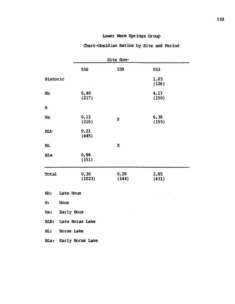
153
Lower Warm Springs Group
Chert-Obsidian Ratios by Site and Period
556
Site Son-
559
0.40(217)
0.12(210)
0.21(445)
x
553
1.03(126)
4.17(150)
6.38(155)
x
0.96(151)
0.30(1023)
0.29(144)
2.85(431)
Late Houx
Houx
Early Houx
Late Borax Lake
Borax Lake
Early Borax Lake
Historic
Hb
H
Ha
Bib
BL
BLa
Total
Hb:
H:
Ha:
BLB:
BL:
BLa:
-

Lower Warm Springs Site Group
Chert-Obsidian Debitage Ratios by Site and Level
Site CA-Son
556
0.50( 18)0.73( 45)0.25( 25)0.60( 16)0.38( 29)0.24( 41)0.30( 43)0.13( 34)0.16( 43)0.07( 59)0.14( 74)0.16(104)0.41( 84)0.27( 80)0.00( 40)0.29( 71)0.22( 66)0.78( 48)0.78( 32)0.82( 31)1.80( 28)1.40( 11)
559
0.71(36)0.17(49)0.19(43)0.23(16)
555
11.50(25)4.33(32)13.33(43)8.00(18)* ( 2)
( ) : debitage frequency* : infinity, or all chert
154
Level
CM.
0-1010-2020-3030-4040-5050-6060-7070-8080-9090-100100-110110-120120-130130-140140-150150-160160-170170-180180-190190-200200-210210-220
553
0.96(88)1.24(38)3.44(40)4.50(55)2.50(35)
10.00(44)8.00(63)9.00(30)2.20(16)0.00( 2)

155
0
w
z
Cf)w
)~~~~~~~~~C CDI
Cbib~. 0w
Z;~~~~~~~~~LE O~~~~~~~
v0S
K[2lE 13 332°Na
Map 26. Upper Warm Spring Group.

157
Upper Warm Spring Creek Group
The sites of this group are found on Warm Springs Creek at the mouth ofRancheria Creek and above and in the drainage of Rancheria Creek thetopography here is dominated by the narrow canyons of the two streams so wewould not expect large sites and indeed we do not find sites that are reallyextensive but several are deep and chronological significant.
The land here is dominated by an area between the two streans on whichthe vegetation reconstructs as mixed evergreen and oak forest which we believehad considerable stands of redwood. This makes it a fringe area fran thestandpoint of Mahikaune or Dry Creek Pamo habitat and most probably makes it aspecialized area from the standpoint of the people of the tribelet. It alsostraddles the trail between Dry Creek and the Pacific Coast at Stewart'spoint, an important trail ethnographically and probably earlier as well in theexchane and transport of goods between the coast and interior.
The area is shown on Map 26 but the group does not include sites Son-553and 554 on the eastern part of the map.
Site Son-543 (Days End Blind)
Thts is an isolated hunting blind site at the extrene western end of theUpper Warm Springs Group. The blind is 300 m downstrean from the confluenceof Warm Springs Creek and Strawberry Creek and approximately eight metersnorth of the Skaggs Springs-Stewart's Point road.
It is situated on the north side of Warm Springs Creek, at the beginningof the hill sloping out of the valley of Warm Springs Creek. The blind is ina ten by five meter, fairly flat, shallow basin along an epheneral drainage.It is bordered to the north, northeast and west by the hillshope of WarmSprings Valley. To the south and southeast the blind has a good view of thelower terraces of Warm Springs Creek.
The vegetation of the area consists of open oak woodland with very thickgrass groundcover. Oregon oak, coast live oak and black oak dominate, withsane madrone and Douglas fir.
There is no appreciable modern man-made disturbance within the immediatearea of Site 543. There was, however, considerable rodent disturbance on thebottom of the hunting blind as well as slumping along the sides of it.
It is known ethnographically that the Pano used blinds when hunting deerand birds (Barrett 1952:127, 133). Five hunting blinds were found during thefield survey. All of these blinds are found in the south, or Dry Creek Pomopart of the Project Area. It is interesting that these seen to be confined toone of the two area tribelets. Since very little is known about huntingblinds, the clearing of two blinds was initiated. Site 543 was cleaned andstudied because of its easy accessibility fran the country road.
Before cleaning, the depression of the hunting blind measured 139 an by

158
129 an and 36 an deep. There were eight large rocks, two of which formedcourses along the northern edge of the perimeter. Several other large rockswere scattered in the immediate area and had apparently fallen fram thenorthern wall of the blind. These rocks may not have formed a continuous wallbut may have been used to anchor brush screening.
The blind was first cleared of grass groundcover and then scraped with atrowel to a hard undisturbed surface. All rocks both within and outside theactual pit were left in situ but were exposed and drawn to scale. This methodof clearing the bliiO exposed a number of rocks that had scattered downslopefran the original wall perimeter. It, also, expanded andd deepened the blinddepression to, measure 3.5 meters by 2.8 meters and to a depth of 47 an. Thecleared ground and loose earth were screened ,with a 1/4" mesh but no artifactswere recovered.
No discernable animal trails were observed in the immediate area of Site543, but the ephemeral drainage to the east affords easy access to WarmSprings Creek.
Site Son-544 (Serene Flat)This is a rich, deep midden site in the extreme western end of the Upper
Warm Springs Group. The site is found between Skaggs Spring-Ste'wart's Pointcountry road and Warm Springs Creek about a half mile west of the confluenceof Rancheria and Warm Springs Creeks.
The site is situated on a secondary terrace about.15 meters above and 30meters northwest of Warm Springs Creek. This flat open terrace is bordered onthe southeast by the creek, on the northwest by the canyon slope, on thenortheast by a year-round spring-fed tributary, and on the southwest by.-anephemeral drainage. It is in an area of open oak woodland vegetationdominated by Oregon, Coastal and Black Oaks with some firs present on thehigher -slopes. Along both drainages bordering the site is a well-developedriparian vegetation with bays, willows, and oaks as well as thick, dense areasof woodwardia. Several species of Brodeia covered the site at the time ofexcavation.
The soil of Son-544 is a very dark gray gravelly silt. This contrastssharply with the pale brown gravelly silt in the surrounding area whichcontains many angular, talus-derived pebbles. Three auger holes were placedto determine the extent of midden, all on the southwest side of the site.This is the only open side which is not bordered by tributaries or hillslope.Augering revealed that the midden continued onto the open, flat terrace up to75 meters southwest of the spring-fed tributary, but did not extend over theentire terrace.
Site 544 is known to be an historic homestead site, and was called"Serene Flat" by the original homesteaders. A small wooden house with a brickchimney once stood about 20 meters northwest of the Test Unit 1. Itsfoundation has been obscured by recent plowing and bricks are scattered in theimmediate area. In addition to plowing, the site has been disturbed furtherby bottle-hunters who have dug several small shallow pits in search of 19thcentury relics. It is probable that at least the first 20 to 30 an of this
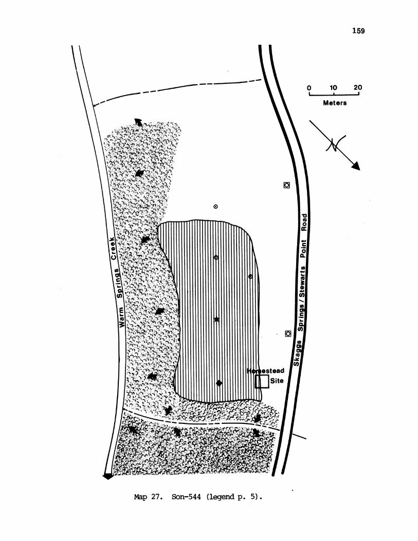
_ -ON
0 10 20
Meters
Map 27. Son-544 (legend p. 5).
159

160
~0
-20-
-30 -
140 -
-50 -'
- 60-0
-100 f
cm
A. Midden; dark brown to very dark grayish brown;gravelly silt with cobbles; dry; friable. Annualgrass root and plow zone.
B. Midlden; very dark grayish brown; gravelly silt withcobbles and fire-cracked rock; dry friable.
C. Transitional zone; very dark grayish brown to brown;silt with sand and clay; subangular gravels; ccompact;slightly moist.
D. Sub-midden; brown to dark yellowish brown; siltysand with gravels; moderately friable to canpact;slightly moist.
E. Kortovina disturbance.
Figure 19. Son-544 Profile.

161
Site Son-544 (Serene Flat)
Scraper Retouch UsedFlake Flake
2-c 3-c1-o
4-c1-o
Cores Debitage
89-c69-o
1-c 1-c 68-c69-o
75-c57-o
73-c59-0
67-c61-o
3-c 1-c 99-clsro 46-o
5-c 1-c 169-c1-o 49-o
5c1-o
l-o
2-c
1-c
3-c 162-c47-o
70-c21-o
73-c18-o
49-c11-o
29-c5-o
39-c7-o
1-o
Totals 4-c 10-c 12-c 21-c 6-c 1062-c3-o 5-o l-o 7-o 4-o 1-o 520-o
25 1 1582
Levelan.
Proj.Pts.
ReorkedBiface
0-101-o
2-o l-o 1-o10-20
20-30
30-40
40-50
50-60
60-70
70-80
1-c2-o
1-c1-o
1-c
1-c
4-c1-c
80-90
1-c
90-100
1-o
1-c
100-1101-o
1-c
1-c2-o
4-c1-o
110-120
1-c
1-o
120-130
130-140
1-c
GrarnTotal
7 5 11 19
IlTo

162
Site Son-544 (Serene Flat)
Level Pestle Shell Fired Animal Historicalan. Bead Fock Bone
0-10 24 100 1 sq. nail
10-20 1 30 46 1 sq. nail
20-30 1 62 124 1 glass frag.
30-40 65 45
40-50 83 19
50-60 76 9
60-70 118 10
70-80 49 8
80-90 18
90-100 24 3
100-110 5 3
130-140 2
Totals 1 1 554 369

163
site has bene seriously disturbed by either plowing, historic foundations orpot-hunter holes.
Test Unit 1 was placed at 25 meters north, 450 east of datum in thedarkest part of the midden. The unit continued to 140 an with the last 50 anbeing riddled by krotovina disturbance.
Excavations revealed that this was an important, rich midden site. Itnot only contained a high quantity of lithic debris, but also one of thehighest amounts of animal bone found at any site in the Project Area.Moreover, the only shell bead found during excavations came fran this site.
Physically site Son-544 can be divided into four strata, the top 20 anbeing differentiated fran the next 40 an only because it is a plow zone.These two are evidently equivalent and because of various index artifacts,particularly a clam shell disc bead, we attribute the 0-60 an levels to thelatest time period.
A lower midden component exteids from 60-90 an aid includes the remainingvery dark gray gravelly silt and a mottled transitional zone. The amount ofanimal bone rapidly drops off in this canponent, but conversely, the fire-cracked rock count triples in quantity. This suggests that the very largequantity of faunal remains in the upper midden zone can be attributed tofairly recent deposition rather than to preservation by burning. Theproposition of chert to obsidian debitage increases in these lower levels.tbe diagnostic artifacts fran this component are a small side-notchedprojectile point, a small Excelsior point aid a milling stone.
The final, sub-midden canponent (90-140 an) includes a dark yellow brownsilty clayey sand with heavy rodent disturbance. It is characterized by lowquantities of both animal bone aid fire-cracked rock, and a decrease in lithicremains. The ratio of chert to obsidian, however, steadily increases,reaching 5:1 in this component. Although no diagnostic artifacts wererecovered fran this final zone, the chert to obsidian debitage ratios suggeststhat this sub-midden level is an earlier component than any represented above.
Site Son-545 (Horseshoe Flat)This is a weakly developed midden site which is one of five habitation
sites located within the Rancheria Creek drainage. The site is 3/4 mileupstream fran the confluence of Rancheria aid Warm Springs Creeks, aid is thefurthest upstream of the five Rancheria sites. It is about 40 meters north ofaid directly across Rancheria Creek fran the junction of Rancheria Creek Roadand Wickersham Road.
Site 545 is situated on a first terrace on the north bank of RancheriaCreek, delineated by the confluence of Rancheria Creek aid an unnamedintermittent tributary. The promontory consists of an outcrop of resistantgraywacke aid is surrounded by large boulders dam deep pools of water in thecreek. The site has open grassland vegetation with a scattering of oakstands. The slopes on the northeast side of Rancheria Creek are now openoak/madrone woodland, and the opposite bank is in dense mixed oak/evergreen

164
forest with redwood, oak and laurel dominant.
The soil of the site is a dark brown sandy silt which contrasts with thesurrounding lighter soils. Three auger holes were placed both east and westof the seasonal drainage, which is on the upstrean side of the terrace. Theserevealed no buried midden deposits so the midden at this site is evidentlyconfined to the ten meter square terrace.
Test Unit 1 was placed on the first terrace in what appeared to be thedarkest part of the midden, south 800 west, 4.3 meters fran datum. It wasquickly discovered that the midden was very weakly developed aid continuedonly to 30 an. The soil became saidier and full of cobbles aid pebbles as theunit continued in depth. Only small pockets of midden remained in the 20-30an level, and the 30-40 an level was sterile.
The single cultural component at Site 545 contained only a few artifacts.
Scraper Retouch UsedFlakes Flakes
Cores Debitage
0-10 1-c 1-c 2-c 1-c 17-c2-o 3-o
10-20 4-c1-o 1-o 1-o
20-30 1-c 4-c
30-40
One diagnosticpossibly indicating
artifact was a chert straight baseda Houx canponent.
projectile point
Site Son-546 (Farmer's Path)
This is a surface site situated on a primary terrace on the north bank ofRancheria Creek. It is about a half mile upstream fran the confluence ofRancheria and Warm Springs Creeks. The site is almost certainly an extensionof the well-developed midden site just 90 meters downstream, Son-547.
The area of the site encompasses a flat, open terrace measuring 40 by 20meters. An old corral and two abandoned farm buildings are located north aidwest of the midden area. The area is on a footpath which was previously usedas a road and presently connects Sites 546 and 547. The site is bordered onthe south by Rancheria Creek, and on the north, west and east by the hillslopeand the farm buildings.
Site 546Oregon Oak isnorth of the
is in open oak woodland with very thick grass groundcover.the dominant tree both on the terrace aid on the slopes to thesite. Ma~rone aid coast live oak staids are present on the
LevelCM.
Proj.Pt.

165
terrace. The lower an] opposite slope of Rancheria Creek is now a boggy, opengrassland with a dense mixed redwood forest above it. Numerous specimens ofseveral Brodeia species, Mariposa lily, and soaproot were seen on all openareas of both slopes during the spring months. Along Rancheria Creek, theusual riparian vegetation of bay, willow, and cottonwood are present.
The soil of the surface site and the surrounding area is a dark yellowbrown alluvial sandy silt. Two auger holes were bored in this area todetermine if any midden might be buried. In neither case was middendiscovered, the alluvial sandy silt continuing the length of the auger (1.5meters).
There was a very sparse scatter of chert and obsidian flakes concentratedin a three by five meter area between the corral and Rancheria Creek. Farmingactivities have obscured, if not destroyed, traces of aboriginal utilization.
No diagnostic artifacts were recovered during surface surveyreconnaisance. However, the presence of the collapsed, abanxdoned farmhouse,outbuilding and corral suggest a date in the homesteading period, e.g., 1850-1900. This site undoubtedly represents a late use of the Rancheria drainageani] could be instructive in understanding interrelationships between Europeansand Pono Indians during that time period.
Site Son-547 (Broken Bridge)This is an important well-developed midden site situated on the north
bank of Rancheria Creek. It is about a half mile upstream fram the confluenceof Rancheria and Warm Springs Creeks, aix] is the deepest of five sites locatedwithin this drainage.
The site is on a triangularly shaped primary terrace which is at theconfluence of Rancheria Creek anx its first major tributary. The terrace ison the upstream side of the unnamed tributary ax] has its apex pointingsoutheast. The site is bordered to the east by this year-round tributary, tothe south and west by the creek itself, and to the north and west (at the baseof the triangle) by the hillside. The triangle measures approximately 30meters to a side.
Fifteen meters to the east of datum and across the tributary is anextension of the primary terrace on which this site is located. It measures40 by 10 meters and is a flat shaded area. This extension contained a sparseflake scatter, but no midden.
The vegetation in and around the site is open oak woodland with oak andbay dominating and allowing moderate grass groundcover. On the slopes to thenorth, Oregon oak continues to dominate, with some madrone an] coast live oak.On the opposite side of Rancheria, the oak forest slowly gives way to a densemixed redwood cover. Numerous specimens of brodeia, wild onion and soaprootwere found growing on or around the site. A well-developed riparian system isabsent along the drainages and we find oak woodland growing up to the edges ofthe stream banks.
The soil of the site is dark gray brown gravelly sandy silt with many

166
CALSon 547MAP
N 0
'/
AAX
0 15 30
Meters
Map 28. Son 547 (legend p. 5).
. 0

167
- 20
-40
50
- 60 ~ 4 ~ ~ 4
a70 d fb Annua grass
0V 414 & 7g
A ~~~~~~~ ~ ~ ~ ~~~~~~*4?44~~~~~~~~~~~~~~Vs
rooAt. 1 9 v v P A z4oAVI4\\V~ '9''q 4C P-110 A ? (4 1E'C& A9~'. A4P.
B. MiddAen; very~'A~t%dark:Qgrais bro&bitylom
A. Midden; vrdark grysbrown;sad siltywithsubanua rvl;dry;fribe Annual grs
D. Troostizone. zn;vrydr ryihbontB. Midn;veydarkgrayoishbrown;srd siltylotgam;ls
dry;tlfriable Heiavyerotodisturbane.ycn
C. SuMidden;very bow tdarkgrayoishbrown;sitlom
dryelwsbrw;sandysilt with gravels;lgtymit opc.
F. Gravels; yellowish brown to dark yellowish brown;sandy clay; moist; mo~derately canpact.
G. Krotovina disturbance.
Figure 20. Son-547 Profile.

168
Site Son-547 (Broken Bridge)
Level Proj.cm. Pts.
Biface ReworkedBiface
Scraper Retouch Used CoresFlake Flakes
0-10 1-c
10-20 1-c2-c
2-c1-o
1-c
20-30 2-c
1-o2-c
8-o
1-o
5-c
1-c9-o
1-c2-o1-o
30-40 1-c1-o
40-50
1-o5-c4-o
7-c5-o1-o
50-60 1-c 8-c9-01-o
60-70 2-c4-o
70-802-o
42-c16-o
85-c41-o
44-c21-o
75-c23-o
1-c 107-c18-o
91-c27-o
35-c12-o
25-c10-o
80-90 18-c5-o
90-100 3-c7-o
100-110 8-c15-o1-o
110-120 1-o
120-130 1-o
7-o
2-o
Totals 6-c 1-c 4-c 29-c 1-c 533-c3-o 3-o l-o 3-o 46-o 204-o
9 1 3 5 3 75 1 737
Debitage
GrandTotals

169
Site Son-547 (Broken Bridge)
Level Hand Pestle Fired AnimalCM. Stone Rock Bone
0-10 7 1
10-20 1 1 45 11
20-30 62 21
30-40 52 12
40-50 32 4
50-60 15 7
60-70 19 5
70-80 4 3
80-90 11 6
90-100 6 1
100-110 1 1
110-120 1
120-130 3
Total 1 1 258 72

170
sub-angular cobbles and gravels. The surrounding soil is much lighter, beinga yellow brown silt. This entire section of Rancheria Creek is underlain withmassive beds of sedimentary rock of the Franciscan sequence. A resistantgraywacke outcrop is 20 meters north of the site, up the tributary. Thisoutcrop can be seen in a series of snall, shallow bedrock pools.
Four auger holes were placed in the vicinity of the site. The first wasplaced to the east of the site in the flake scatter, and found no midden. Twoholes were bored to the west of Test Unit 1 but were uninformative becausethey bottomed out on rocks. The fourth auger hole was made 20 meters north ofthe unit just at the beginning of the hillslope. This hole contained 30 an ofsilt slopewash, arn then 40 an of midden. This boring showed that the middenextends over the entire terrace on the northwest side of the confluence. Anexamination of the stream cuts bordering the site showed that the deepest partof the site was in the southwest section. The midden there apeared to beabout a meter deep.
Unfortunately, Site 547 has had much disturbance. The site is adjacentto an old fallen, wooden bridge. At one time a road passed over this bridgeand continued through the site up to the buildings and corral of Son-546, 90meters upstream. As much as 20% of the site has been disturbed by this road.A salt lick was located on the site stimulating heavy sheep grazing, furtherdisturbing the surface. Being situated at a confluence, this site is subjectto heavy stream erosion, especially on the tributary side of the promontory.Finally, excavation has shown there to be heavy root disturbance in the upper40 an. The nearby bay trees formed a thick matting of roots and rootlets(much more than at any other site) making excavation slow and difficult andstratigraphy uncertain.
Test Unit 1 was placed on the south edge of the site, (south 220 east 10m from datum), just two meters fran the cutbank of Rancheria Creek. The unitwas placed so as to avoid the disturbance caused by the road and yet toexcavate in the darkest, most central part of the midden. The unit revealedthat this site contained a rich midden deposit which continued to 130 cm,ending in sterile stream gravels. An auger hole in the center of the lastlevel continued to 185 an but encountered no further cultural constituents.
Four cultural components are present at Son-547 which roughly correlatewith the stratigraphic levels shown in the profile. The midden componentseems to be separated into two distinct periods. The upper midden levels fallbetween 0-30 an. Unfortunately, heavy root disturbance has obscured thestratigraphy and made correlation with artifacts difficult. Large amounts ofanimal bone, fire-cracked rock anx] lithic debitage were recovered fran thiszone. The debitage is characterized by a 2:1 chert to obsidian ratio.
Diagnostic artifacts consist of two medium size aix one smallcornernotched projectile points. One of the larger pieces was found sub-surface in the auger; the other two pieces were recovered in the excavations.
The lower midden component basically continues to 60 an and consists ofdark gray brown sandy silt. This canponent has fewer tools than the uppermidden zone, less animal bone ard smaller amounts of fire-cracked rock. Thechert to obsidian debitage ratio has increased to over 4:1.

171
Tools of a diagnostic form include one chert concave based piece, onesmall obsidian Excelsior point arn one possible Desert Side-notched point andin any case very late. Unfortunately, this zone has ha] very heavy rootdisturbance. This must account for the side-notched piece which is very latein nature if our interpretation is correct.
The next thirty centimeters encompasses a transitional stratum,characterized by dark yellow brown sarndy silt. It lacks any diagnosticartifacts and contains no tools. The chert to obsidian ratio is roughly thesame as that of the lower midden component and we include it in the same mixedcanponent. Both animal bone and fire-cracked rock continue to decrease withdepth.
The sub-midden zone (90-130 an) consists of dark yellow brown sandy clay.Few artifacts and nothing diagnostic were recovered fran this stratum. Themost interesting fact about this component is that the obsidian debitageconsistently outnumbers the chert for these last four levels. This reversalis a unique occurrence among the Warm Springs sites.
Site 547 is the richest, deepest site in the Rancheria Creek drainage,and as such was probably the focal site for the other four that surround it.It may have been the primary habitation site in the area with the other usedas seasonal camps for fishing, acorns and food collecting. In the lateperiod, this small terrace would not accanodate all of its inhabitants and itis likely that, at least by the protohistoric period, they spread out toinclude the larger area of Son-546.
Site Son-550 (Fallen Oak)Son-550 is a shallow midden site with three possible housepits--it is on
the bank of the first major tributary of Rancheria Creek and is 280 m up fromits confluence with Rancheria Creek. The site is situated on a flat shoulderof the surrounding hills that shelter it from the north, west, and south. Theflat covers an area of 50 by 30 meters and the midden covers almost the entirearea, measuring 45 m E-W by 28 m N-S. The midden is bordered by gullys northand south, by a hillside on the west, and on the east by the stream formingthe major drainage for this small valley.
The site is in open oak woodlaix] with moderate grass groundcover. Thedominant trees are Oregon oak anxd coast live oak with some madrone aid blackoak. On higher north-facing slopes is found a denser, mixed forest of Douglasfir and oak. At the time of excavation (early June) numerous Brodeia aidsoaproot were in bloom. The nearest water is the small stream to the east.This flows fran the beginning of Novemiber to the ern of June. In the summerit contains only isolated pools and a trickle of water.
The soil of the site is dark brown gravelly silt with few rocks andpebbles. The surrounding soil was a light brown sandy soil. Two auger holeswere placed on the east and west edges of the flat aid in each case 15 to 20an of midden was recorded, indicating that the midden covers nearly the entireflat.
There is no man-made disturbance in or around Son-550. However

172
Site Son-550 (Fallen Oak)
Proj. RetouchPts. Flakes
Cores Debitage Shell AnimalBone
0-10 1-c 2-c 1-c 41-c 1 181-o 10-o
10-20 1-c 1-c 34-c 2 41-o 1-o 5-o
20-bottom 1-c 1-c 2-c 16-c 23-o
Totals 3-c 4-c 3-c 91-c 5 221-o 2-o 18-o
GrardTotals
4 6 3 109 5 22
Levelan.

173
excavation showed some root and rodent disturbance within the midden. Erosionon the site is minimal.
A meter square test unit was located at S 450 E, 6 m from the site datumstake. The unit was placed here because it appeared to be the deepest andmost central part of the site. No wet screening was done. The unit wasexcavated to bedrock which was fran 20 to 40 an (average 28 an) below surface.
The unit produced 4 projectile points all indicating that this is asingle component site to be attributed to late Houx Aspect. There are threeshallow, circular depressions in the site which appear to be housepits. Theyhave diameters of 3, 2.2, and 2.1 meters respectively. Thus we have hamlet ofperhaps 20 people occupied only during the winter (because of water supply)anx only during the latest aboriginal period. This is an unusual degree ofspecificity anx] merits further investigation of its association with tools andother midden components.
Site Son-549 (Sunshine Flat)Son-549 is a midden site on the east bank of Rancheria Creek upstream
from its confluence with Warm Springs Creek. The site is found on the firstinhabitable, flat, open area up Rancheria Creek from Warm Springs creek. Theflat is 10 m east aix 2 m above Rancheria Creek anx is about 50 by 60 m inarea. It is sheltered on all sides by steep hills. The midden covers an areaof 55 m E-W by 40 m N-S. It is limited on the west by the cutbank ofRancheria Creek, on the east anid north by a small drainage that is dry atleast half the year, and to the south by a hill. It is in open grasslanxd witha few scattered Oregon oaks. The hills in back or east of the site are inopen oak woodland with Oregon oak, coast live oak, aix madrone. AcrossRancheria Creek to the west is a dense forest of redwood, bay laurel, aid oak.
Water can be found year round in Rancheria Creek, although betterdrinking water is available at the spring across Rancheria Creek some 70 mwest of the site.
The soil of the site is a gray brown sandy silt with few rocks aidpebbles. The surrounding soil is lighter in color, being a light brown sandysoil. There is a large, high outcrop of rock 50 m east of the site over whichan ephemeral stream occasionally flows. Six augerholes were made on the flat.There showed that a layer of at least 25 an of midden was present over most ofthe flat, but deepest and darkest on that part of the flat closest toRancheria Creek. The only disturbance found at Son-549 is the extensiverodent disturbance of the midden. There is minor erosion taking place alongthe cutbank of Rancheria Creek.
Surface finds discovered during the initial survey of this site gaveindications that this might be a rich site. Unit 1, located in what surfacefeatures indicated was the center of the site, at S 300 E, 3 m from the datumstake, proved to be uninformative. Therefore, after augering had betterdefined the midden extent, a second excavation unit was located at S 250 E, 10m from the site datum stake.

174
Site Son-549 (SSmshine Flat)
Unit 1
Level Proj. Reworkedan. Pts. Biface
0-10
10-20
Scraper Used RetouchFlakes Flakes
2-o 1-o
1-c1-o
20-30
1-c
2-c1-o
30-40
1-o
1-c1-o
40-50 1-c1-o
50-60
60-701-o
70-80
Totals 1-c 4-c 1-c 46-cl-o l-o 3-o 4-o 23-o
Grand 1 1 1 7 5 69Total
Debitage
lo-c5-o
5-c7-o
7-c3-o
6-c4-o
13-c2-o
2-c1-o
2-c1-o
1-c
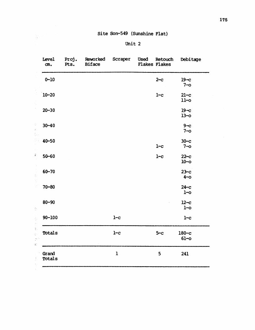
Site Son-549 (Sunshine Flat)
Unit 2
Proj. Reworked Scraper Used RetouPts. Biface Flakes Flake
Ichs
2-c
1-c
1-c
1-c
1-c
1-c 5-c
175
DebitaeLevelan.
0-10
10-20
20-30
30-40
40-50
50-60
60-70
70-80
80-90
90-100
Totals
19-c7-o
21-c11-o
19-c13-o
9-c7-o
30-c7-o
22-cl0-o
23-c4-o
24-c1-o
12-c
1-o
1-c
180-c61-o
Grard 1 5 241Totals

176
In the first three levels of Unit 1, wet screening was used. However,dry screening proved to be an effective and wet screening was dropped afterthe 30 an level. No wet screening was used in Unit 2. Unit 1 ended at 80 anin nearly-sterile, compact, yellow brown sand. Unit 2 ended at 110 an in thesame sterile sand.
Surface finds at Son-549 included two pestle, a mortar fragment, and aleaf shaped chert projectile point. Unfortunately, the point has been lost.
Unit 1, as mentioned, turned out to be located a little off the center ofthe midden. Artifact count was less than 20 pieces per level, virtually nobone was present, and fire-cracked rock occurred only in minor amounts. Only4 retouched flakes, 1 scraper, 1 reworked biface, 1 biface, and a medialfragment of a projectile point were found, and all in the first three levels.Chert artifacts outnumbered obsidian by at least 2:1 in most levels, except inthe 10-40 an levels where obsidian nearly equaled chert.
Unit 2, located more within the midden, did have a higher debitage countper level (averaging 30), but contained fewer tools. Only 6 retouched flakeswere found. As in Unit 1, chert outnumbered obsidian by at least 2:1 exceptfran the 20-40 an levels where the ratio was more nearly equal. Fire-crackedrock was present in low quantities except fran 50-70 an, where a rockconcentration occurred. This could not be called a feature however, becausethe rocks were randomly distributed, and neither charcoal, bone, nor artifactswere found in any concentration.
This is perhaps the least productive site in the Project in spite of itsconsiderable depth of midden. It would be of some interest to test this sitefurther just because it is so unproductive. There may be unique activitypatterns or other conditions which would be important to understand in termsof total lifeways of the Pano or their predecessors.
Son-551 (Monday Morning Terrace)Son-551 is a midden site with an associated surface scatter on a
secondary terrace on the NW bank of Warm Springs Creek 200 m below itsconfluence of Rancheria Creek. It is on a flat secondary terrace 60 m northof Warm Springs Creek and 6 m above it. The terrace faces SW and is protectedon other sides by the surrounding hills. The midden occurs on the SE boundaryof the terrace and on the west side of an ephemeral drainage. The middencovers an area of about 45 m E-W by 30 m N-S. It is bordered on the east bythe ephemeral drainage, on the south by the slope of the secondary terrace,and imperceptibly grades into non-midden terrace deposits to the west.
The soil of the site is a brown to dark brown alluvial gravelly silt.The midden is not very much darker than the surrounding soil which is a brorocky gravelly sand. The midden's light color - it is lighter in color thanthat encountered at any other site - can possibly be explained by its havingbeen leached by groundwater percolating through the porous alluvial depositsof the site.
Nine augerholes were made in and around the site. Two augerholes were

177
VCAL Son * 551MAP
0
0 5 10
Meters
BedrockOutcrop
Map 29. Son-551 (legend p. 5).
7%1L-J,
I / bk.l./V

178
- 10-
-20- 4
-30-
40
-50
60 01
O0000000000000000 O0000000000000000 000 oooooooooooooo00ooooooooooooooo ooooooooooooooooooooooooooo)OO 0oo o000 0000000000000000 00000000 0000000000000o00ooooo0ooo)OOO 000
000000 0000OOOOOOOOOOOOOOOOOOOOCOOC0OOOOz00 0 O DCoo0000 00000000(000 00000 0OOOOOOOOOOOOOOOOOOOOOsDOOOOOOOOOOOC 0 0 0 000000 000000O 0000OOooooooooooooo000000000oc000000000000 00000000000000 000000000000000000000000000000000000000000o00 0 00 00000000000000o000000 000000000000 00000000o0000000000000000 00 OO OOOOOOOOOOOOO 00000 00000000000000000000000OOOoOooooo00000OOOOOOOOOOOOO 0000000 0000000 OOOOOOOOOOOOOO0000
80 OOoOoooooooooooooooooooooooooo %o~OO, O~O~O~OOo~o~~O!o~o~o~o~o~~Oo~o~~OoCo000 O00000000000000000000000000000000000(000 OOOOOOOOOOOO000000000000C
._ _ OOOOOtOOOOOOOOOOOOOOOOO OOOOO000000000000O 0OOOOO OOO0tDOOOOOOOOOOOOOOOOOO(
0000000000000000000Q0000000000000oooooooooo 0000000000000000000000000," 0000000000000o0o00000000000000o0ooo COOOOOOOooooooooooooooooooooooc00000000000000000 0000000000000000 O 0000000000000000000000000C)QoOOOOOOOO0000000000OOO00000000000000000 OOOO0000000o0ooooo0ooo00o0 0c)
-90-ooqoooooooooooooocooooooooooo0o00000000 oo oooooooooooooo0oo0ooooooooo0000000000000000 00000000000000000OOOC-OOOOOooooooooooooooooooooooooooz(
0000000000 00000000000000000000000000000000000000000000000000000000
OOOOOOOOOugDOOOOOOOOOOOOOOOO0000000000000000000000000000000tDoooooto
90 000000000000000000000000000000000000000000000000000000000000
0000000000000000000000000000000000000000000000000000 000000
110 0O09: 0000 J(00000()0000000 00000000000000000
)000000000(000 000000000000000 0000000000ooooooo0000000000 00000000000)000000000000000000000000000000000000000 0000000000000000000000000*000000.000000000o
ooooooooooooooooooooo000000000000000000000000000000000000000000000000000OO00000000000000000000000000000000000000 00000000000000000000000000000000000
_4 00000000000000000000oooooocooooCoooooo~oooooo0000D 000
00000000000000000000000000000000000000300000 - -*. .----°00 0000 _00000000 0 00 0 nroooooooooooot~v>ODOg<*-}vw \ V@OAO
00000000N*°°°n^vfvO~vOO~tvOO00000000000000 *ur:0 :-
110 00L&()tV{V (VOOVOC)O(O(Ot OOOC)'()O .,..^}- ---
120~~~~~~C (ICOj OC0 Poe~, Oooooo~cOO00oof<) r i O-120-
A. Midden; brown; gravelly silt; dry; canpact.Annual grass root zone.
B. Midden; brown to dark brown; gravelly silt;slightly moist; friable to moderately canpact.
C. Transitional zone; brown to yellowish brown;silt with sand ard gravels; moist; moderatelycanpact to canpact.
D. Sub-midden; yellowish brown; sandy gravels;moist; canpact.
Figure 21. Son-551 Profile.

179
Site Son-551 (Monday Morning terrace)
Level Proj. Biface Reworked Scraper Retouch Used Debitagecm. Pts. Biface Flakes Flakes
0-10 2-c 1-c 5-c 5-c 195-c1-o 1-o 12-o
10-20 1-c 6-c 124-c2-o 1-o 10-o
20-30 4-c 168-c11-o
30-40 1-c 1-c 1-c 120-c1-o 2-o 12-o
40-50 2-c l-c 1-c 1-c 7-c 215-c16-o
50-60 l-c 1-c 1-c 4-c 190-c2-o 15-o
60-70 4-c 6-c 231-c6-o
70-80 3-c 67-c4-o
80-90 1-c 29-c2-o
90-100 19-c1-o
100-110 9-c
110-120 4-c
Totals 4-c 5-c 3-c 11-c 37-c 1371-c3-o 2-o 1-o 1-o 3-o 89-o
Grand 7 5 2 4 12 40 1460Totals
I-

180
Site Son-551 (Monday Morning Terrace)
Level Cores Pestle Hammeran. Stone
0-10
10-20
20-30
30-40
40-50
50-60
60-70
1-c
1
1
1-c
1-c
2-c
Fired AnimalRock Bone
1
63
25
23
61
29
28
1
Total 5 1 1 230 1

181
done in the first terrace below Son-551. Both showed 70 to 110 an of brownalluvial silts and sands but no midden. The augerholes on the second terraceseemed to indicate that the midden covered the SE side of the terrace andextended about 45 m to the west. However, with the soil colors so similar,and with the augering having been done in June when the soil was dried out, itwas difficult to be sure of the precise extent of the midden.
Son-551 is in open grassland with a moderately thick grass groundcoxver.There is a scatter of small Oregon oak, coast live oak, ma3rone, andmanzanita. COn the first terrace below the site are large valley and Oregonoaks. At the time of excavation (early June), numerous mariposa lilies, afood plant gathered by the Pono, were in bloan on and around the site.
During most of the year, the nearest water is 60 m to the south at WarmSprings Creek. There are several large pools in the ervirons of theconfluence of Rancheria and Warm Springs Creeks that could have been used forfishing.
Son-551 has almost no disturbance and erosion here is minimal. A 1 x 1 mtest unit was excavated at N 300 E 10 m fran the site datum stake. The unitwas located here because surface features indicated it to be the richest partof the site. No wet screening was done. The unit ended at 120 an in a nearlysterile, yellow brown, compact sandy gravel. An augerhole was put in thefloor of the finished unit. It continued to 182 an in the same yellow brownsandy gravel before bottoming out on rocks. No cultural material was found inaugering.
The midden may be divided into two physical layers. Fran 0-70 an it is adark brown to dark gravelly silt while from 70-110 an it is a compact brown toyellow brown gravelly sandy silt. The cultural divisions do not coincide withthis. On the basis of a small corner notched point found on the surface and apestle fragment fran the 20-30 an level we consider the upper portion tobelong to the Houx Aspect, presumably early Houx since there is nothingextremely late from any part of the site. There is a largish Excelsior pointfrom 40-50 an level which may be attributable to late Borax Lake. Chertdebitage shows a marked increase at this level as does fire cracked rock.Presumably the late Borax Lake component begins here and continues to thebottom of the site although there may be something earlier which we have notidentified simply for lack of evidence.
Chronology of Upper Warm Springs
It is possible to interpret the chronology at site Son-544 in severalways. The clam disc bead in the 10-20 an levels makes it clear that late Houxis represented. There has also been some thought that the site was occupiedduring the historic period (some historic Indian site must have existed toaccount for the name Rancheria Creek). This possibility is rejected on thegrounds that such sites always contain quantities of chipped glass and otherhistoric objects which this does not. The first real physical break comes at60 cm and coincides with a break in the chippage ratios. The question is

182
Upper Warm Springs Creek Group
Chert-Obsidian Debitaje Ratios by Site arnd Period
Period
Hb
H
Ha
BLb
BL
BLa
Post
Total
HbHHaBLbBLBLaPost
544 547
0-201.14(295)
Site CA-Son550 549 551
0-405.05(109)
0-302.19(249)
0-1002.69(310)
20-601.41(537)
60-903.43(518)
0-4013.49(652)
40-12017.36(808)
30-903.69(446)
90-1304.52(232)
90-1300.35(42)
2.04(1582)
2.61(1737)
5.05(109)
2.64(310)
15.40(1460)
Late HouxHouxEarly HouxLate Borax LakeBorax LakeEarly Borax LakePost Pattern

183
Upper Warm Springs Creek Site Group
Chert-Obsidian Debitage Ratios by Site and Level
Site CA-Son547
2.63(58)2.07(126)2.10(65)3. 26(98)5.94(125)3.37(118)2.92(47)2. 50(35)3.60(23)0.43(10)0. 53(23)0.00(7)0.00(2)
549-1
3.00(15)0.71(12)2.32(10)1.50(10)6.50(15)2.00(3)2.00(3)* (1)
549-2
2.71(26)1.91(32)1.46(32)1.28(16)4.29(37)2.00(32)5.75(27)
24.00(25)12.00(13)
* (1)
551
16.25(207)12.40(134)15.27(179)10.00(132)13.44(231)12.67(205)38.50(237)16.75(71)14.50(31)19.00(20)
* (9)* (4)
( ) : debitae frequency* : infinity, or all chert
Levelan.
0-1010-2020-3030-40-40-5050-6060-7070-8080-9090-100100-110110-120120-130
544
1.29(158)0.98(137)1.32(132)1.24(132)1.10(128)2.15(145)3.45(218)3.45(209)3.33(91)4.06(91)4.45(60)5.80(34)5.57(46)

184
whether to assign the entire 0-60 an late Houx or to make an arbitrary breakassigning part of it to early Houx; the projectile points shown in Figs. 28band 28c at 40 to 50 and 50 to 60 an respectively could be in either. We arechoosing the second option mainly because the Excelsior point sIhwn in Fig.28c seems slightly large for a late Houx canponent. This gives us 0-20 an aslate Houx aid 20-60 an as early Houx.
The lower portions of the site have both physical ard chippage ratiobreaks' at 90 an so we are attributing 60-90 an to late Borax Lake aix 90-130an to early Borax Lake.
Site Son-547 must be mixed to some extent because of the heavy rootinfestation. Because of physical and debitage changes we are assigning thetop 30 an to the Houx Aspect and fran 30 to 90 an to the Borax Lake Aspect.This would have the large leaf shaped piece shown in Fig. 28h fran the 20-30an level too high. The piece shown in Fig. 28k and identified as a possibleDesert Side-notched fragment would be much too deep, but then if it is indeeda Desert Side-notched point it would be far out of range geographically aswell.
For the portion of the site fran 90-130 an we are going out on a limb aidpropose it as belonging to the Post Pattern. It is our experience here aidelsewhere that in early portions of sites when a change of chipping materialoccurs it is always obsidian that disappears (except where obsidian is localas at Borax Lake). Here we find just the reverse and we associate this with apattern earlier than the others observed here, thus the Post Pattern. Weshall discuss the implications of this proposal in the concluding section.
Site Son-550 we attribute entirely to late Houx for reasons given in thesite description.
Site Son-549 can be classified as belonging to the Houx Aspect on thebasis of the pestles and mortar fragments found on the surface. The bottom ofthe site may belong to an earlier period but further excavation will berequired to make the attribution definite.
As discussed in the site description earlier we consider that for Son-551the top 40 an is early Houx while the bottom of it is late Borax Lake.
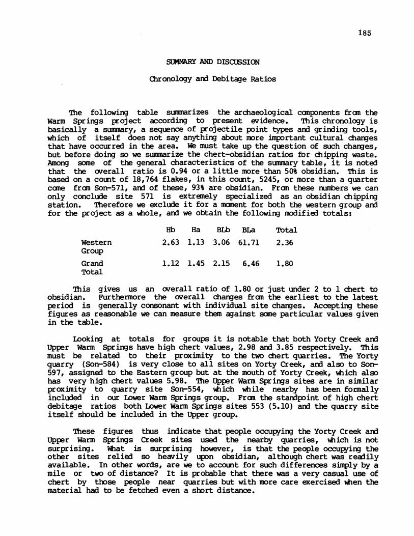
185
SUMLRY AND DISCUSSION
Chronology and Debitage Ratios
The following table summarizes the archaeological canponents fran theWarm Springs project according to present evidence. This chronology isbasically a summary, a sequence of projectile point types and grinding tools,which of itself does not say anything about more important cultural changesthat have occurred in the area. W must take up the question of such changes,but before doing so we summarize the chert-obsidian ratios for chipping waste.Among some of the general characteristics of the summary table, it is notedthat the overall ratio is 0.94 or a little more than 50% obsidian. This isbased on a count of 18,764 flakes, in this count, 5245, or more than a quartercane fran Son-571, and of these, 93% are obsidian. Fran these numbers we canonly conclude site 571 is extremely specialized as an obsidian chippingstation. Therefore we exclude it for a moment for both the western group andfor the project as a whole, and we obtain the following modified totals:
Hb Ha BLb BLa Total
Western 2.63 1.13 3.06 61.71 2.36Group
Grand 1.12 1.45 2.15 6.46 1.80Total
This gives us an overall ratio of 1.80 or just under 2 to 1 chert toobsidian. Furthermore the overall changes fram the earliest to the latestperiod is generally consonant with individual site changes. Accepting thesefigures as reasonable we can measure them against some particular values givenin the table.
Looking at totals for groups it is notable that both Yorty Creek andUpper Warm Springs have high chert values, 2.98 and 3.85 respectively. Thismust be related to their proximity to the two chert quarries. The Yortyquarry (Son-584) is very close to all sites on Yorty Creek, and also to Son-597, assigned to the Eastern group but at the mouth of Yorty Creek, which alsohas very high chert values 5.98. The Upper Warm Springs sites are in similarproximity to quarry site Son-554, which while nearby has been formallyincluded in our Lower Warm Springs group. Fram the standpoint of high chertdebitage ratios both Lower Warm Springs sites 553 (5.10) and the quarry siteitself should be included in the Upper group.
These figures thus indicate that people occupying the Yorty Creek andUpper Warm Springs Creek sites used the nearby quarries, which is notsurprising. %tat is surprising however, is that the people occupying theother sites relied so heavily upon obsidian, although chert was readilyavailable. In other words, are we to account for such differences simply by amile or two of distance? It is probable that there was a very casual use ofchert by those people near quarries but with more care exercised when thematerial had to be fetched even a short distance.

186
4iNSIII
LAco
C-
84 co ( N N (')
U ) ec C 0 O OA~
tn Ln in LA LA
~ 44- CN4miJC
0 N%4N Oi O LA8 O
co r- On co r- co kinoS%
4-m4- 1 un u nI n LOunLIL IO LO LA LAL54 Cl'.~~~~~~~~~~~qwC
&4 NsJ4 M '0q co ON
wB m @ I N r- ON coX I u we1oln I oaton 1 IN ° n LA
44 L Ani nLA LA L A LALAnL LA nLA L |3)
0~~~~~~~~~~~~~~~~~~~~~~~~~
'3) 08 > s1 ".1 5i 0O8! 1 la> 0)
0 4 0 r-r--%O Ch (0 0 0 L
f% CD CA IV4C)

Sites
Chert-Obsidian Ratios by Component
Hb Ha BIb BLa Total
567 4.42 2.64 2.84572 .48 .40 3.06 61.71 1.69
Western 571 .06 .21 .08568 4.28 12.27 5.00
total 2.63 .16 .59 61.71 .39
593-1 .61593-2 .14 .49 7.50 7.00 .24
Eastern 582 1.40 4.00 1.66608 1.40 1.40597 4.47 19.07 5.98
total .15 q49 1.93 11.83 1o16
576 4.09 1.03 1.65577 16.00 16.00
Yorty Cr. 584 3.35 3.35583 9.97 3.81 5.87
total 4.93 1.03 5.85 2.98
Lower 556 .40 .12 .21 .96 .30Wn. Spr. 553 4.17 6.38 5.10
total .99 .75 .21 .96 .58
544 1.14 1.41 3.43 4.52 2.04Upper 550 5.05 5.05dn. Spr. 551 13.49 17.36 15.04
total 1.59 3.44 7.24 4.52 3.85
GrandTotal 1.12 .40 1.58 6.46 0.94
Hb: late Houx; Ha: early Houx; Bib: late Borax Lake;BLa: early Borax Lake.
187

188
If we consider site totals, it will be seen that they can be placed inthree categories: (1) high obsidian sites (ratio < 1.0); (2) high chert sites(ratio > 5.0); and (3) intermediate, or "normal" sites. According to thisbreakdown three sites specialize in obsidian technology, sites 571(preeminent), 593 and 556. Only one component fram these has been attributedto early Borax Lake, the bottom of Son-556. That component is on theborderline of the ratio category, has only a small number of chips, and may beof doubtful attribution anyway. We can therefore conclude that obsidianspecialization and its high frequency use began in late Borax Lake times,indicated also by the (unadjusted) grand totals which show a jump in obsidianuse at this time with yet further increases in early Houx.
The importance of these figures is two-fold. First, the long rangetrend toward the greater use of obsidian is a measure of the increasingimportance of trade in later periods. This will came as no surprise toCalifornia archaeologists who have long seen trade as a definingcharacteristic for the later periods in Central California, (differentiatingthem fram earlier periods). In this case, though, the measure is rather moreprecise than we have seen in the past. Thus the grand totals indicate almostno trade in early Borax Lake, a sharp jump in each-of the two succeedingperiods, followed by a decrease in late Houx. If we take this last trend atface value, it is an occasion for surprise. The late Houx period correspondsroughly to what has been called Phase II of the Central California LateHorizon. The phase marker for Phase II has always been the clam shell discbead which was thought to have been a sort of currency, "the life-blood oftrade." If this is so, then surely we should see more trade in this period,not less. Thus, the evidence from these Warm Springs Sites will be regardedwith some skepticism. Nevertheless it is evidence, and we should consider thepossibility that trade peaked at an earlier period and was actually decliningjust prior to the historic period.
The second important aspect of high frequency obsidian counts relates toparticular sites. It would appear that, when obsidian cane into heavy use inlate Borax Lake times, site Son-571 immediately became specialized in thatindustry and was the only site to do so in Upper Dry Creek. It continued thisdominance in the next period (early Houx), but in late Houx it was replaced bysite Son-593, the tribelet center, as the obsidian center as well. This meansthat in late Borax Lake and early Houx the obsidian specialists were living ata small site detached fram the chief tribelet village. In late Houx the chiefvillage became the center for obsidian manufacture. To see this we camparenot just ratios but total numbers.
Hb Ha Blb BLaSon-571 - 244-c 136- c
4210-o 655-oSon-593-2 114-c 86-c 45-c 21-c
929-o 171-o 6-o 3-o
So far as present evidence is concerned, the switch is conclusive. Iffurther excavation supports this conclusion, we have evidence of a change insocial organization. For the two middle periods the situation would seem

189
analogous to certain African tribes in which iron workers were of a differentcaste than that of the group as a whole and might therefore keep some distancefran them. This distinction would then have been obliterated in late Houxwhen obsidian specialists were included in the village center. we mightwonder whether in the earlier period the obsi pecialists were not alsothe obsidian traders going from group to gr up carrying their raw materialwhich they chipped locally (to order?) at a place reserved for them. Thisintriguing possibility seems worth considerable investigation.
If we turn now to the other debitage ratio categories, as notedpreviously, the high chert sites, with one exception, are all located near oneor the other of the two chert quarries. The exception is Son-568, not nearany known quarry and surrounded by sites with medium or high obsidian use.This is all the more remarkable because its two Houx components date to aperiod of increased obsidian use. It is almost as if obsidian was shunned.The remaining sites are in no way remarkable with regard to chert-obsidianratios.
In connection with chipping waste ratios we will discuss another problemmentioned only incidentally above. This concerns a category of artifact wehave called reworked bifaces in the tables for individual site and which aredescribed below in an appendix by Nancy Whitney. This category of artifactsis made fran a leaf shaped piece, almost always of obsidian, snapped off ortruncated and then further modified in various ways. One of the most canmonways of modification was to use the snapped end as a striking platform for ablow along the long axis of the piece. Thus a long narrow flake would betaken off the edge of the piece which could then be described in Europeanterminology as a burin. Fredrickson (1974:44) is, so far as we know, thefirst to discuss this in the North Coast Range. He attributes a burinindustry to late Borax Lake Aspect and indicates that it continues into earlyHoux, this on the basis of his excavation at site Lak-261.
In the following table we give the provenience of 66 specimens. Theseconstitute all reworked bifaces and debitage identified as having cane franreworked bifaces and which can be attributed to dated components. Thecomponents are as determined fran stratigraphic considerations given for eachsite group. The summary shows frequencies of 13 for late Houx, 38 for earlyHoux, 14 for late Borax Lake, and 1 for early Borax Lake. The single specimenfran early Borax Lake is fran a component of doubtful attribution and itspresence there makes the attribution even more doubtful. On the whole we feelthat our data support Fredrickson's conclusion that the industry begins inLate Borax Lake times and continues into Houx.
There are sane other aspects of this chronology that are not quite soclear. If we take the numbers 13, 38 and 14 as representative frequencies ofthe three phases, we must conclude that the full flowering of the industry isconfined to early Houx. The difficulty with this is same one encountered inconsidering chert-obsidian debitage ratios, namely that overall frequenciesare dominated by those of a single site--Son-571. If we exclude that site,the relevant frequencies becane 13, 15, and 11--pretty much the same. Thequestion canes down to this: we have found a major manufacturing center forearly Houx at Son-571, have we missed comparable centers for late Houx and

190
Occurrence of Reworked Bifaces by Site arn Component
Site CompnentH~b Ha BLb BLa
23 3
232
3
3
22
2
1 4 61
3 1 1 14
13 38 14 1 66
Group
Western
Eastern
Yorty
LowerWr. Spr.
UpperWr. Spr.Total
567572571568
593582608
576556553
544551
Total
25
262
322
2
11164

191
early Borax Lake? If we did miss them, it would be because of insufficientsampling at the sites in the project or because they were at sites outsidethe project. Our tentative conclusion is that we did not miss them, that infact, this specialized industry is to be identified primarily with earlyHoux. This should be easy to test with further excavation.
We have not been able to go into the question of the function of thesetools. The answer to this important question may be the key to a lot of thearchaeology of the region. It will have to await micro-analysis of thesetools and other analyses based on association.
If we turn to chronological summary of components, we see totalcomponents numbering 14, 11, 9 and 9 for the four periods latest to earliest.This indicates a stable population during this time--we would always expectmore components of the latest periods because of accidents of preservationand excavation. Considering only the Western, Eastern ard Yorty Creek groupsthe comparable figures are 7, 6, 6, and 6 so that for the Upper Dry Creektribelet we have even more stability. Taken together these figures indicatethat the situation regarding tribelet territory and population, outlined inthe next section, can be projected back through time as far as the earlyBorax Lake period. This argues really basic stability of subsistance patternand social organization for many thousands of years in this part ofCalifornia. This is in conflict with the conclusions of some others on thissubject, notably Fredrickson (1974: Fig. 3), a point we will discuss furtherbelow. Whatever general validity the point has it is none the less in accordwith the data of this limited area.
Territory and Population
The situation with respect to boundaries is complicated by reports ofseveral ethnographers with sometimes conflicting statements. To begin withwe should discuss the nature of Central California political units. Theclassic definition of these groups is by Kroeber (1932:258):
"Each of these [tribelets] seemed to possess a small territory usuallydefinable in terms of a drainage; a principal town or settlement, oftenwith a chief recognized by the whole group; normally, minor settlementswhich might or might not be occupied permanently; and sometimes aspecific name, but more often none other than the designation of theprincipal town. Each group acted as a homogeneous unit in matters oflard ownership, trespass, war, major ceremonies, ard the entertainmententailed by them."
There has been considerable discussion of the political units of nativeCalifornia in recent years especially by Kunkel (1974) and Bean (1974). Boththese authors seem basically to accept Kroeber's definition. Kunkel'sdiscussion is especially relevant to us. In general we are quite sympatheticto his point of view, which is that native California social organization maybe more typical of preagricultural peoples situated in favorableenviroments, more typical than "peripheral badlands wanderers" who are

192
supposed by some to be analogous to paleolithic man. However, one aspect ofhis argument we do not find supported and disagree with it. Kunkel sees thetribelet as being made of more fundamental political divisions which he callsresidential kin groups (which may be patrilocal, matrilocal or amnbilocal).He says, furthermore, that "Tribelets were important but somewhat fragilepolitical entities, breaking up fairly often into their component parts--thekin groups--which then combine in new ways." while it may be true thatvarious kin groups changed tribelets fran time to time, our reading of theliterature indicates that the tribelet, based on specified territory and witha central town, was the fundamental unit. The degree of attachment ofCalifornia Indians to their home territory is extraordinary. We have heardof informants who would know the name of virtually every tree and rock withintheir tribelet territory while nothing less significant than, say, Mt. Shastaoutside their territory would warrant their attention. R. F. Heizer(1966:26-30) has fully documented this attachment.
Our point of view, then, is that the tribelet, territorily at least,was a relatively fixed entity regardless of whether persons might shift in orout of it. This is the important point archaeologically since it is only theterritory we can identify, not the people.
When we began archaeological testing at Warm Springs, we more less fellheir to the notion that the project area was divided between the Mahilkauneor Dry Creek Pano, called Mehinkownah by Merriam, and the Mahakamotcemei orCloverdale Paono, called Makahmochumi by Merriam. This is essentially thedivision presented by Stewart (1943). As our investigations progressed, itbecame apparent that Dry Creek Valley above Pritchett Peak containedarchaeological resources of what could only be regarded as a tribelet center(especially Son-593 and Son-582), not as an area subsidiary to the Cloverdalecenter over the hills in another drainage to the east. The ethnogeographicmaterial of C. Hart Merriam indicates support for this judgement. Heizer's(1966) compilation of this material gives as inhabitants of Upper Dry Creekthe Sha-kow-we-chum-mi and for Middle Dry Creek the Me-hin-kownah (Stewart'sMahilkaune). There is a problem with the boundary between these two groups.Heizer's map has it running along Warm Springs Creek (the boundary betweenhis 12s aid 12u). This conflicts with Barrett's place names (evidentlyobtained fram informants of Middle Dry Creek) and with Stewart's boundary aswell. We therefore place it further north so that the drainage of WarmSprings Creek is in Mahalkaune territory.
In caning to this conclusion then we are putting the West, East, CherryCreek and Yorty Creek groups in Shakowe territory while Upper Warm Springsand Lower Warm Springs Groups go into Mehinkownah lands. Looking at thearchaeology of the boundary zone (Map 1 and Maps 19 anid 20) we see no sitesof considerable consequence. Sites 542 and 600 may have been ethnographicsites and are the only sites in the Central Group for which we haveindications of substantial midden. These two may have been significantvillages, but they are at the eastern end of the Central Group, far below ourproposed boundary. They have been destroyed so even that degree ofimportance is questionable. The other site indicating considerablepopulation is Son-598. This site has 14 well defined house-pits indicating a
population of perhaps 70. There is, however, absolutely no midden deposithere, indicating that the village must have existed for the briefest possible

193
time. O0ne wonders if this is not one of Kunkel's residential groups whichsplit off temporarily fran one or the other of the tribelets to settle herein no-mans-land.
Between the mouth of Yorty Creek and the cluster of sites at the mouthof Warm Springs Creek we have a housepit (562), a hunting blind (574) a largebut ephemeral village site (598), and a minute midden (548). It is true thatthere may once have been sites here near Dry Creek that have been eroded away(see the gravels on Maps 19 and 20), but we doubt this because there are noteven remnants there. Thus, the near blank here indicates a buffer zonebetween two tribelets and furthermore indicates its existence for a longtime, perhaps thousands of years. This suggests that tribelet boundaries, orsome of them, may last a very long time indeed.
Fran the above we conclude that the Upper Dry Creek or Shakowe tribeletincluded the drainage of Dry Creek fran Pritchetts Peak most of the way up toYorkville, the sites recorded herein constituting only the southern half.There appears to be an excellent settlement area just north of the projectarea but it has not been surveyed.
The sites on Warm Springs Creek and just above its mouth on Dry Creekwe attribute to Mahalkaune tribelet which had its chief village perhaps atthe mouth of Pena Creek to the south. Thus, the sites we have fran thistribelet are peripheral and perhaps subsidiary.
We turn now fran the consideration of the tribelet territory to thequestion of demography. A point of considerable importance, originallyraised by Gifford (1918, 1926), is that of the nature and development of thecorporate kin group in California and the relationship of these groups todemography. This was brought out by Goldschmidt in 1948 and has beenrecently discussed by Kunkel (1974) with reference to the Pono in particular.Goldschmidt's point was that lineages and clans arose because of large or atany rate locally dense population. While Kunkel believes the pertinentelements are not precisely lineages or clans, he would probably agree thatpopulation was a crucial factor. The burden of the argument concerns thenumber of persons with whan an individual has regular face-to-face contact,that when this number reaches a certain but unspecified point, it becanesnecessary to form social categories for purposes of interaction. Fran ourpoint of view the question is simply how many people are in a tribelet theregular face-to-face group.
The tribelet we are most concerned with here is the Shakowe or UpperDry Creek Pano because we believe we have the princil village of that groupwhereas the sites of Mahilkaune on Warm Springs Cree are peripheral and willnot help us with that group.
The problem can be dealt with either by means of individual site countsor by the area density method (Cook, 1976). The site count method involvesdetermination of how many persons lived at each site and which sites wereoccupied simultaneously. On this first question we can do no better thanconsult the data of Cook and Heizer (1968) concerning house numbers andvillage size in California. The data fran their Table 2 contain the

194
following information for the surrounding groups.
Aboriginal Group Village Spaceper House (sq. m)
Yuki 73Pano, coast 79Pono, interior 158Wappo, valley 120Wappo, hill 190
We take the Pano of the interior as our best figure ard then take thetotal extent of midden as the size of the village and calculate the number ofhouses represented. If we assume an average of 6 persons per house, we thenhave a population per village estimate.
As regards the point of simultaneous occupation, we want to consideronly sites occupied regularly each winter. It is our opinion that only siteswith considerable midden deposit should be so considered and surface sites aswell such special sites as petroglyphs, hunting blerds, quarries, should beexcluded from our calculations. Incidently, it should be pointed out thatthese opinions are actually hypotheses which should be tested in a variety ofways.
Finally, we must deal with the question of chronology. We will presentour data assuming that all sites identified as late Houx were occupied at thesame time. We are aware that the question of micro-chronology is beingignored here, that if, for example, it was customary for one village tochange sites every ten years, a custom gone undetected by us, then ourcalculation would be in error by a considerable factor. We might point outin this connection that the denigration of chronology by some persons whoconsider themselves theoreticians is entirely misplaced. If a factabsolutely fundamental to inferences regarding social organization, ardpopulation is such a fact, deperds on micro-chronology then we simply mustdeal with it. Fran this stardpoint J. A. Bennyhof is more than justified inhis concern for typological minutia and perhaps we can dispense with suchremarks as "Good grief, yet another paper on California Indian beads!"
In any case, we present our data as late Houx considering these thebest approximations available. The following sites we consider to bepermanent villages of the relevant time period:
Late Houx PopulationComponent
567 26572 12568 20593 150-240 (depending on site size)576 12584 12583 20

195
Site Son-593 has a variable estimate because it has been partiallydestroyed and we are uncertain about its former boundary. Thus the estimateis 102 persons for the small sites making the total of 252 or 342 depending onthe Son-593 figure. Our judgement is that in the area above the projectboundary there is one more locality about as well suited for habitation asthose we have surveyed. This would mean we would expect about as many sitesagain as are already recorded for a total population about twice the above orbetween 504 and 684.
The population question can also be approached fran the angle of areadensity. Considering that the northern boundary of the tribelet would be atthe bend of Dry Creek downstream fran Yorkville and include the drainages ofthe tributaries fran there down to Pritchett Peak, this is an area of about 65square miles. After considerable manipulation, Cook (1956) has decided that 8persons per square mile is reasonable for this kind of territory. This givesus a total of 520, the same as our smaller figure above.
Thus, our figures are quite similar though derived by distinct methods.The question now is whether 500 is enough people to initiate the processoutlined by Goldschmidt (1948). In any case, it is a large figure consideringthat the valley seans to support only about a dozen people today.
Site Specialization
We have already discussed the subject of site specialization to someextant in relation to chippage ratios and now turn to the general questionespecially fran the standpoint of land use. In some ways this subject is themost important one in a study of this sort in which many sites are tested butnone is excavated extensively. Our breakdown of sites yields the followingbroad categories: hunting blinds, quarries, petroglyphs, living sites.Living sites include both surface sites and midden sites and can be furtherbroken down as shwn below.
Hunting BlindsA single hunting blind (site Son-605) was located outside the project
boundary was not included in the site descriptions. Four other blinds werefound in the Warm Springs project, one each in the Warm Spring Creek groupsand two in the Central Group. These blinds are simply rock rings 2 to 3meters in diameter located away fran streams in places commanding actual orpossible game trails. Unfortunately there seems very little hope of beingable to date hunting blinds since they characteristically have no midden orother cultural refuse associated with them. Two of the blinds were clearedand excavated but even then nothing was found. One supposes that they cannothave been of great antiquity since they renained more or less intact but eventhis is not very convincing.
The area surveyed at Warm Springs, centered as it was on the pool ofproposed Lake Sonana, contained very little upland away from the streams.Such uplands would be the places one would expect to find hunting sites (andthose we did find were so located), hence we believe our present sample leaves
196
this category of site badly under represented, as compared with, for example,midden sites. We feel that if the entire tribelet territory of Upper DryCreek were surveyed as thoroughly as the project area there might be, ten,twenty, or fifty hunting blinds located.
Quarries
Just two quarry sites were recorded in the Warm Springs project, siteSon-584 on Yorty Creek and Son-554 on a small tributary of Warm Springs Creek.Site 584 is associated with a midden which we have attributed to late Houx.The quarry itself may have been used earlier as well. Site 554 we have notbeen able to date at all. Nearby sites are heavy chert users in all periodsso the quarry may have been used many thousands of years.
In the nature of things a reconnaissance of a dam project, while it islikely to discover most valley bottom occupation sites, will find the quarriesonly if suitable outcroppings also occur in these areas; quarries are aslikely or even likelier to be outside the area as within it. Thus ourinventory of tribelet areas is as incomplete in quarries as it is in huntingblinds. All we can say is that the quarries we did find were used by nearbysites predominantly (see under chronology). No source analysis for materialswas attempted and this should be done in the future.
PetroglyphsPetroglyphs are quite an important element of the archaeological
resources of the Warm Springs area. All petroglyph sites were in theterritory of the tribelet above Pritchett Peak, none in the Central and WarmSprings Creek site groups. All petroglyphs here consist of small pits orcupules with an occasional groove, pecked into the faces of boulders ofvarious sizes.
It may be worthwhile to discuss briefly the absence of petroglyphs inthe southerly groups. In the section on tribelet boundaries we concluded thatsites of these groups were subsidiary to a tribelet center located down DryCreek, out of the project area. In the course of our field work, we hadoccasion to conduct a site survey several miles downstream. This took usthrough what was presumably the center of the tribelet to which our southernsites belonged. However, we found not a single petroglyph site among thosesites either. This might indicate that the people living there were notmaking petroglyphs and never had. Although that may be true, we are inclinedto doubt it. All the sites located south of the project area were in fieldslong cultivated, and hence places in which suitable petroglyph boulders wouldhave been removed. In any case, the downstream survey was only a hundredyards or so on either side of Dry Creek on alluvial fill with little or nonatural rock. Thus there could very well be many unrecorded petroglyphs backtoward the hills where there are suitable boulders. One petroglyph we didnote in the territory of this tribelet was discovered by Dr. D. W. Ritter ofChico, California. It was at the confluence of Little Strawberry Creek andWarm Springs Creek-it consisted of pits and grooves on a small rock outcrop.There may well be other such petroglyphs.
The petroglyphs upstream can be summarized briefly. A total of nine of

197
our numbered sites exhibit petroglyphs: site 566, 570, 568 in the Westerngroup; sites 593, 579, 609 and 607 in the Eastern group; and sites 585 and 590on Yorty Creek. These can be put in four groups for present purposes. (1)Site 566 is outside the project area ard may be associated with other sites upDry Creek. It is apparently a considerable petroglyph on a flat rock 3 by 4.5m with scores or hundreds of pits. We have not been able to assign theassociated midden to a phase, and it otherwise isolated as well. (2) The twosites on Yorty Creek are also more or less isolated. Site 585 is a largeboulder in a gravel bar in the stream ard has a total of 98 pits in it. It isonly 300 m downstream from site 576 (Houx Pattern) but there is no clearassociation. Site 590 consists of two large rocks, also in the streanbed,with about 20 shallow grooves in them. There is no association here eitherbut there are sites nearby of many phases.
The other two categories require some additional ccnment. The sites inthe Western Site Group category (3), consist of two petroglyph occurrenceswhich are remarkable for size and number of cupules. Site 570 consists of twovery large boulders covered with pits. The petroglyphs at 568 are on threesimilarly large rocks. These boulders are several meters in greatestdimension ard have hundreds or thousands of pits. The inference is unmistak-able that these were very important places to the inhabitants over a longperiod of time. The petroglyphs at site 568 are not actually with the middenbut rather are 90 m upstream from it. Site 570, also without midden, is 280 mfarther upstream. These large and important petroglyphs are evidentlyassociated with a group of 3 midden sites which are in any case special sites.The situation is this: the midden sites 572, 571, ard 568 are very close toeach other (300 m airline) on the north bank of Dry Creek on shallow terraces.Furthermore, there are other particular features (e.g. site 571 has atremerdous amount of chipping waste) which we will discuss in followingsections. The two groups of petroglyphs are found between sites 571 ard 568,and we feel therefore that they are associated with the site specialties ofthe little cluster.
If we are correct in the association of these sites, then some effort atchronology can be made. The three midden sites contain components of all fourof our later phases, thus the petroglyphs could belong to any or all of them.A test excavation was made just beside the petroglyph at site 568. We hopedto recover artifacts in direct association to help date the glyphs itself.However, we found none, not even the hammerstones which must have been used inmaking the pits. Indeed in the excavation of the three associated middensites we found only a single specimen that could be described as ahammerstone. The nature of the glyphs is such that a great many hammrstonesmust have been used. We believe that the petroglyphs may have hadconsiderable ritual or religious importance. If this is so the implementsused in making them may also have had sacred significance and consequentlywere not left around casually but rather cached or otherwise secured in such away as to make them now difficult to find.
The last category of petroglyphs (4) is on the edge of Dry Creek, oreven in it, beginning at Son-593 and then continuing sporadically downstreamfor about a kilometer at sites 579, 609 and 607. At site 593 we found a totalof 36 small boulders (.5 to 1 m diameter) with one or more cupules in them.
198
Two of the boulders are on the south midden aid the remainder are on the sideof the creek over a distance of about 300 m downstream. The other examplesare probably an extension farther downstream of this same scatter. One site,Son-579, is now in midstream but was probably once on a midden since eroded byflooding. It is unusual in having circular grooves, one of which has a pit inits center.
Of this group it would appear that at least the two on the midden atSon-593 are attributable to the very latest phase of prehistoric occupation.Just how much earlier they were being made is difficult to say.
Perhaps it would be well to discuss now the general problem ofpetroglyph chronology in the North Coast Range. It is known fran ethnographicaccounts that the people of this region made a sort of petroglyph of the typereported here which are called baby rocks. There are several accounts ofthese among which is one obtained by Barrett (1952:386-87) fran a man whoclaimed to have personally proved the merits of two cup and groove rocks inKnights Valley, six miles north of Hoplaid.
"The procedure was said to be as follows: the sterile pair wentto the rock and there first a prayer for fertility was made. Then, bymeans of a pecking stone, some small fragments were chipped fran one ofthe grooves or cuppings in the surface. These were then ground to avery fine powder which was wrapped in some green leaves and taken to asecluded spot. Here the powder was made into a paste and with it thewoman's abdomen was painted with two lines, one running fran the top ofthe sternum to the pubes, the other transversely across the middle ofthe abdomen. Same of this paste was also inserted in the female.Intercourse at this time positively assured fertility, due to the magicproperties of this rock."
These "baby-rocks" were similar in form to others known further northwhere they are used for weather control aid are known as "rain-rocks" (Heizer1953). Heizer aid Clewlow (1973:30) have argued that fram a stylisticstandpoint the two types of petroglyphs are the same. These authors are ofthe opinion that it is a very recent style (30-31). They seem to base theiropinion on the fact that since it is known to be late, and since there arevery few examples in their sample, then it cannot go back much in time. Weagree with them that these are equivalent styles and that they were maderecently but not that they are only recent. The scarcity of reported exampleswe feel is from a lack of field work rather than a lack of petroglyphs. Ourexperience in the Warm Springs area indicates that camplete on-foot survey ofan area does in fact reveal many petroglyphs. That this experience is notunique is shown by that of others (Fredrickson, personal caununication) in thearea. The principal reason North Coast petroglyphs are not widely known isthat they have not been reported by the general public (this is the mainsource of information for scholars of this subject). The reason they have notbeen so reported is two-fold: (1) many or most are obscured -by dense NorthCoast vegetation and (2) they are so unspectacular that they go unrecognizedby the general public (and even some professionals). This latter reason isthe most important one - petroglyphs and pictographs elsewhere are easily seento be the work of man aid are fascinating to amateurs hence became well known,whereas those of the North Coast range are not so recognized or are easily

199
forgotten. Thus in disagreement with Heizer ard Clewlow, we believe there areactually very many of these petroglyphs in the North Coast Range and that theyhave been made for a long time in the area.
The petroglyphs of Warm Springs would seem to us, in fact, to be verygood examples of what has been termed the pit-and-groove petroglyph style.This style was first named by one of us (Baumhoff, Heizer and Elsasser 1958)arn] described in detail by Heizer arx] Baumhxff (1962:208, 234-238). It wasmaintained there that this was an ancient and widespread style andspecifically included the examples from Lake and Soncma counties. This styleis precisely the equivalent of those at Warm Springs. Heizer and Baumhoffindicated a belief that in the Great Basin the style dated about 5000 to 3000BC (1962:234). The evidence for that dating was admittedly rather flimsy butit still seems clear that an early beginning date is not out of the question.The fundamental questions on this subject concerns the unity of the style andwhether these particular examples are correctly attributed to it. We quoteHeizer and Baumhoff (1962:237) on this.
"These California petroglyphs differ fran the Nevada specimens in that,for the most part, they are simply pitted boulders; they do not alsohave grooves. This differentiates them slightly, but the pitsthemselves are so similar and at the same time so arbitrary that onecannot help thinking they must be part of the same tradition."
We agree with this and also accept the earlier finding of 5000 BC as abeginning date for the style hence we conclude that they were being madeduring all four phases of our sequence.
It seems possible that this petroglyph style is a fundamental part of anancient and widespread culture of speakers of the Hokan languages. So far aswe know this notion of such a cultural group was first advanced by Kroeber(1923:130) when he said that in the "first period" (undated) of man inCalifornia "people....almost certainly camprise the ancestors of the modernHokans,..." aiding "perhaps the Penutians." This notion was apparently neverabandoned by Kroeber although later discussions are more about the languageitself than other aspects of their culture (cf. Kroeber 1955, 1959). Sanetime ago one of us took up this notion of Kroeber's and suggested that certainarchaeological traits were part of this basal Hokan culture (Baumhoff andOlmsted 1963:280). We would like to propose here the pit-and-groovepetroglyphs as an element of that ancient culture. Our feeling is that it wasan important part of the ritual of these early Hokan speakers, that theparticular ritual declined in the latest period, perhaps replaced by the Kuksucult of the ethnographic period, but was retained as a survival in itsfertility context (weather control farther north). We would say that thelarge and impressive petroglyphs upstream were made as part of the earliermore fundamental ritual while the smaller ones near Son-593 and downstream mayhave been later and residual. This hypothesis obviously leaves plenty of roanfor testing. We will have more to say about this in discussing overall siteconfiguration. At this point it is sufficient to say that while the evidencefor the above case is thin, we nevertheless have a considerable intuitiveconfidence in it. What we need most here is a method of dating petroglyphs.We know fran experience that this is an extremely difficult business, but itis quite basic to a whole range of prehistoric behavior because petroglyphs

200
are perhaps the most important and abundant ritual relics left to us.
Living Sites
The living sites will be considered in two categories. Sites abovePritchett Peak will be considered as a unit (Western, Eastern, Yorty Creek,and Cherry Creek site groups), an integral tribelet territory centered onlarge winter village site(s) associated with smaller sites specialized in avariety of ways. In the southern part of our area, thought to be peripheralto another tribelet, sites will be dealt with idividually on an ad hocbasis.
Living Sites: Southern
These are the sites of the Central Group and the two groups on WarmSprings Creek. With respect to the Central group, the long stretch of DryCreek between Pritchett Peak aid the mouth of Warm Springs Creek, we can saythat there are 3 small surface sites (562, 548 and 560) and one large surfacesite (598). In addition, two other sites were destroyed by agriculture.The destroyed sites may have been a 5 house village (542) and a large village(600) but we feel certain from having tested the rennants that they werenever very rich and probably not important.
In the two site groups on Warm Springs Creek there is a total of 14living sites. Of these, 8 fall in the categories including small or mediumin area, mostly poor aid either very shallow or surface. They must have beentemporary camps for small groups. These sites include the following: Son-558, 557, 559, 555, 545, 546, 550, 549). The remainder include the SkaggsSprings site (594) which is entirely destroyed but which, according toBarrett (1908:220), may once have been an important site and site Son-547,which is dealt with in Appeidix A.
The other four sites may be characterised as 5 house hamlets - they aredeep, rich, and of moderate size. TNo of these sites have canponents of allfour phases (576 and 544), one is early and late Houx (553), and the other(551) canbines late Borax Lake aid early Houx.
A striking feature of the Warm Springs Creek groups is the large number.of hamlet size sites (some of the shallower sites are that size too) asopposed to the fact that there are none of the minute but rich stations thatare so evident in the Northern Groups (see below). We do not know what tomake of this aid simply leave it for further research.
Living Sites: NorthernFor the northern area, it is possible to establish clusters of sites
according to trichotomous criteria. The first category is size, dividingsites into small (one to two houses), medium (four or five houses), aid large(20 or more houses). The second division is depth according to which a siteis surface, shallow (20-80 an depth), or deep (a meter or more). Finallysites can be categorized as rich (199 flakes per 10 an aid abundantartifacts), poor (10 or 20 flakes per 10 an aid few artifacts), orintermediate. Applying this trichotomy, the data on the following table areobtained.

201
Warm Sprirgs Sites Catagorized byArea, Depth, and Richness of Midden
Largerich med poor
Medimarich med poor
Smallrich med poor
593 582 597 566 572 576567 571568584
608 578 583 577 575603 604
589601595
579 586 564541 581
596592588587
Deep
Shallow
Surface

202
The sites shown there segregate fairly well into five groups. Thefirst group consists of the large, deep sites 593 and 582. These areundoubtedly the large winter villages or headquarters sites. Site 582 isentirely Borax Lake while 593 is largely Houx. Thus during Borax Lake timesthe bulk of the population lived at 582 (593 was probably a minor villagethen) and moved to 593 during the later period.
The second group consists of the sites which are deep and of mediumsize into which we assimilate site 608 which is formally categorized asshallow but at 80 an only just barely so. Of these six sites 597 and 608 areBorax Lake while the other four are Houx. W see these sites as beingsatelite hamlets attached to the major towns in the first group. Thisprobably argues a larger population in Houx than Borax Lake times althoughnot necessarily so since later components are generally identified morereadily than earlier ones. Just what these "satelite hamlets" representedsociologically is far from clear. A casual persual of Barrett (1908) andKroeber (1932) does not reveal much about such places. Kroeber (1932:257)says there are "minor settlements which might or might not be occupiedpermanently". These are evidently those occupied permanently. There is nota lot to indicate that they were specialized fran what we have been able todiscover archaeologically although more might well be found with additionalexcavation. One change through time can be noted--the two earlier sites inthis group are "rich" while the later ones are only "medium." This meansthat there was a relatively large amount of chipping debris and otherartifact material at the two earlier sites which in turn may very well meanthat artisans, particularly stone chipping specialists, were found at the 4to 5 house hamlets during Borax Lake times but not later.
The third group consists of the small, deep sites. Again it seemsreasonable to assimilate site 583 to this group since it is within 10 an ofbeing "deep." These four sites do sort neatly chronologically. They aredivided as follows: 572 has caupnents of all four phases, 571 the middle 2phases, 576 the last 2 phases, and 583 the first and last. In analyzing thiswe begin with the fact that Son-571, particularly its early Houx canponent,is a chipping station pa excellence--nearly a quarter of the obsidiandebitage from the entire projecF is fthere. Furthermore about a third ofthe products fran the specialized reworked biface industry are fran there..Thus, for the early Houx period, we can say that this is a specialist site.To a lesser extent the same can be said of Son-572 and 583 in regard to theirearly Houx and Borax Lake components. However, the same is not true of Son-576, which represents the last phase. This site hai every appearance of arich site during excavation--dark, rich, deep midden with much perserved boneand charcoal (very unusual). It hai every external appearance of beingunusual as well--a tiny, deep site on a small point of land just big enoughfor a house or two. Yet the midden content is very slight as canpared withother sites. If this site was special, then it was so in non-material orperishable goods.
Fran the above evidence we may conclude that during the Borax Lakeperiod certain single house sites as well as 5 house hamlets were occupied byspecialists, that during the early Houx period only the one house sites wereso occupied, and that during the late Houx period the specialists moved tothe main village (Son-593).

203
The two final site categories include those sites which are usuallypoor, always small, and are either surface sites or have very shallowmiddens. These sites appear to differ from those above in displaying anoccupancy of the most intermittent character; the others, while they may nothave been occupied year round, must have been occupied year-after-year over avery long period of time. Unfortunately it is impossible (with fewexceptions) to sort these surface sites chronologically. Probably they wereinhabited by one or a few families for special purposes, such as acorngathering or deer hunting, for a few weeks once every several years. Thedetermination of such functions requires reconstruction of micro-envirornentsin detail which is impossible at the monent but is not necessarily impossibleas a long range goal.
In addition to the sites in the five categories above there are twosites which do not group at all. These are a large surface site (579) and amedium sized, shallow midden site (578). They are on opposite sides of DryCreek fran each other about a quarter mile downstream fran Son-593 which weconsider to be the major winter village of the Houx period. As noted in thesite description site 579 may have once been more extensive ard been washedout by flooding. One conjecture is that these two sites were adjuncts to themain village at Son-593.
The considerations presented above for the living sites of the northernarea (above Pritchett Peak) can at this point be canbined with earlierdiscussions to present an overall scheme for the development of the tribeletthere. During early Borax Lake times site 582 at the confluence of CherryCreek and Dry Creek was the major winter village. At this time site 597,near the confluence of Yorty Creek arn Dry Creek was a 5-house hamlet. One-house sites were at 583 up Yorty Creek ard 572 up Dry Creek. There is slightevidence of occupation at 593 (destined to become the major village later).The only evidence of specialization in this period is the large quantity ofchert debitage at site 572 indicating a heavy emphasis on chipping there. Weknow of no quarry nearby but there could easily be one outside our surveyarea. Obsidian is very scarce in deposits of this period. Given theimprecise nature of our stratigraphy we suggest the possibility that obsidianmay not have been used at all during early Borax Lake times here and that thefew pieces we have recorded are due to accidents of deposition, recording, orinterpretation.
In the late Borax Lake period the same principal village site iscontinued at site 582 but the satellite configuration changes. Downstreamoccupation continues at 597 (at the mouth of Yorty Creek) with an increase ofdebitage and general richness. Between these two a new hamlet (Site 608) isestablished now and continues only during this period and leaves quite therichest remains of the period; one wonders if it was not a chief's orshaman's residence or something of the sort. Upstream from the principalvillage occupation continues at 593 (still minimal) while another mileupstream a complex of sites begins which in the following period is to flowerspectacularly. At this time the complex consists of sites 571 and 572. Site572 hai already been occupied in early Borax Lake times and had already shownsigns of specialization in chert manufacture.
It is time now to discuss these two sites which together form the

204
N~~~~~~~~~~~~
._.._*> 4 I3 ~o'-4
4
N
'. o + . _ I \ L . _
No <! o >p-x
Map 30. Settlement Pattern Chrorxzlogy.0 Q0
'~~~~~~~~~~~~~~~~~~~~~~~~~~~~~~~~~~~~N
N NN~~~~~~~~~~~~~~~~~~~~~~~~~~~~~~~~~~~~~~~~~~~~~~~l
U ,~~~~~~~~~~~~~~~~~~~~~~~~~~~~~~~~~~~~~~~~~~~~~~~~~~~U
Ma 0 KSeteet atr irnl*v
205
nucleus the canplex just mentioned. In many ways they are twin sites. Only aquarter mile apart, the middens are found on a very narrow terrace just abovethe north bank of Dry Creek heavily overgrown by oak and madrone. Both sitesare on beautiful, deep pools in the creek. The middens are both very smalland could not have accacodated more than two houses (one house is morelikely). Perhaps most importantly we find that both sites have areas onterraces below the middens imnediately adjacent to the creek which have anabundance of grinding tools. We have designated these as grinding areas butit may be that they were in fact also occupied as living sites and that theevidence of that has been washed away by floods, leaving only the heaviergrinding tools remaining. Whatever the explanation of these lower areasmaybe, it is evident that these two sites are remarkably similar in externalfeatures. The middens, however are not the same. Site 572 has components ofall four periods while 571 has only the middle two. Site 572 is categorizedas a rich site arK] with justice, especially at the bottom,, but notoutstandingly so. Site 571, on the other hard, is by far the richest site we
tested on this project, arK is particularly so in its late component (earlyHoux).
Thus we find in late Borax Lake times the beginning of rather extremespecialization at these tiny living sites. It is also at this time that we
find a very great increase in the use of obsidian rather than chert (perhapsit is even the beginning of the use of obsidian, as conjectured previously),and here too we find the beginning of the specialized reworked bifaceindustry. Finally, the Excelsior point, which is to typify this and thesucceeding phase, begins here. This is an impressivenumber of changes. Onething striking about these is that they seem to prefigure the florescencewhich occurs in the next phase; they are, so to say, formative.
In the early Houx period there are very substantial changes insettlement. The first of them is that the main village at site 582 was
abandoned and the bulk of the population moved to site 593 which hadpreviously been only a hamlet. In the description of that site earlier we
mentioned a possible occurrence which may have been related to this move.
This suggested that a landslide at one time forced Dry Creek to the northslightly, against what is now the north portion of Son-593 and only after thecreek had cut through this was the present large flat available forsettlement. If this event occurred shortly before the time of Christ, it may
have been what prompted the move to this inviting place. If this is so,however, it is a remarkable coincidence because it happened simultaneouslywith great changes upstream.
Upstream, at the complex around 571 and 572, where we had 2 one-housestations, we now find in addition a hamlet of houses just below at site 568and another about a mile above at site 567 so that the population of thelittle enclave changes from about a dozen to 75 or more. At the same time thehamlets south of Cherry Creek (608 on Dry Creek and 597 on Yorty Creek are
abandoned.Another remarkable change that occurs at this time is shown in themidden content of site Son-571. This component yielded a total of 4210obsidian flakes. The next highest count in our digging is 929 and that comesfrom the late Houx component of Son-593 (also significant); no other is more
than in the 400's. Thus there is evidence of overwhelming specialization atthis site. Further evidence is found in the distribution of reworked bifaces;

206
23 specimens of a total of 66 for the whole project cane from this componentwhile the next highest figure for the canponents considered here is 3. We canonly conclude from the above that tremendous things were happening at the 571-572 canpiex in the early Houx period.
We suggested earlier that we believe the large petroglyphs nearby (onedesignated Son-570 and the other included with the description of Son-568)were associated with this complex of specialist sites. We also indicated thatwe were unable to date these glyphs. If the glyphs are part of the sitecomplex, as they seen most clearly to be, then we would argue that some ofthem were made in Borax Lake times and the bulk of them in early Houx. Wehave earlier argued that these petroglyphs constitute the principal remainingevidence of what was once a set of fundamental Hokan religious observances.We do not know the nature of this religion, studies of comparative Hokan havenot approached anything of this sort yet, but, if it was as important as wethink, then it must have been deeply embeded in local social organization. Byanalogy with North American ethnographic examples we can believe there musthave been specialists, priests or shamans, associated with it.
Consider this with what we have said previously; we have living at thetwo stations and associated hamlets (1) the traders, since the obsidian isthere, (2) the artisans, because of the obsidian chips and reworked bifaces,and (3) the priests. We have all these things present to sane degree in lateBorax Lake, and they came to a peak of intensity in early Houx. In the faceof this we can only cane to the conclusion that the rich and powerful lived atthe 571-572 canplex while the canmon people lived downstream at Son-593. Theevidence here is obviously not conclusive, and the notion needs a lot offurther testing, nevertheless it is the most convincing case for such socialstratification we have seen in California archaeology.
One other thing happened in the early Houx period that requiresdiscussion and that is the introduction of the mortar and pestle as theprincipal grinding tools. Fredrickson (1974:46) indicates the introduction ofthis canplex into California earlier than we find it (3000 to 2500 BC), and hepresumes that it is associated with acorn processing technology. As a generalstatement, we have no quarrel with this, but it is evidently not true for oursmall area; the mortar and pestle complex seems much later. It may be thatour evidence is faulty, the sample of grinding stones is regretably small, butwhat we have is consistent with Fig. 1. On the other hand the number and sizeof late Borax Lake components is such that there seems no possibility they didnot have the remainder of acorn processing technology--it is inconceivablethat the number of people represented could have been supported without reallylarge scale recourse to the acorn crop. This aspect of subsistencedevelopment seems to us to be a really major question for Warm Springsarchaeology for which the answer is not even suggested by the testing thus farcarried out.
In the final period, the late Houx, we again find major changes insettlement pattern. Site 593 continues as the major village but the middenchanges--the debitage changes fran moderate to abundant and, as noted, has thesecond highest frequency of obsidian in the project. At the same time ourupstream canplex sites 571-2, site 571 isabandoned and 572 has only 20an ofdeposit. The hamlets continue to be occupied at sites 567 (slightly) and 568

207
(extensively) but now there is no specialization to be associated with them;also there is a hamlet once again on Yorty Creek at site 584.
As indicated in the discussion of petroglyphs above, we believe that whenthe 571-2 complex was for all practical purposes abandoned in late Houx times,then the petroglyphs associated with it were also abandoned. We believe thesmall petroglyph boulders near site 593 are survivals fran the earlier periodnow used as in the ethnographic period in connection with fertility rituals.We think that one of the events of this period was the acquisition of theKuksu cult. The Kuksu or "big heal" religion was centered on a men's secretsociety which conducted dances or other performances in which the initiatesimpersonated the god Kuksu. These performances took place in a large earthcovered lodge. Kroeber believed that this was a very late developmentoriginated by the Patwin and spread rapidly fran there to nearby areasincluding the one under discussion here. Kroeber's argument was presented in1925 and was reiterated as late as 1948 (564-568). Kroeber's argument wasbased essentially on an age-area notion. Such notions are not nowfashionable, and we agree that a great deal skepticism is most alvisable inapplying them. However, one of us recalls a statement once made by R. H.Lowie the burden of which was that while Kroeber's large scale conjectureswere apt to be suspect, small ones that he male about material with which hethoroughly conversant were usually correct. We agree with Lowie's assessmentgenerally, and furthermore, since Kroeber's conjecture about the Kuksu cultbeing very recent among the Pano seems inherently probable, we believe itmarks the beginning of late Houx, and the attendant demise of the earlierreligion, the Hokan cult, which was associated with the massive petroglyphboulders.
We might mention in passing two ways in which the above conjectures mightbe tested. For one thing, if we could find a way to date the petroglyphs, wewould be on much firmer grounds. This will probably have to be done eitherthrough associated artifacts (doubtful but possible) or by means of relativepatination (not yet feasible but perhaps so in future). The other test wouldbe by identifying archaeologically the large earth covered lodges whichKroeber said were associated with Kuksu. In this area, the latter willrequire extremely fine micro-stratigraphy, if our experience is any guide, andeven that might not be good enough. We were unable to identify house floorseven when housepits were present.
In any case, if we are correct that the earlier religion with segregatedpriests broke down and that the traders and artisans moved back to the mainvillage, then this suggests that the stratification that we saw in the earlierperiod had now broken down into a more egalitarian situation. Wtether theinception of the Kuksu cult was a causative agent in this or whether it wasjust one part of a more general change we cannot say. The archaeologicalinventory does change slightly. A new point type is introduced (Guntherbarbed, is this also fran the Patwin?) and the reworked biface industrydeclines to its late Borax Lake level. Generally speaking late Houx seemspoorer than early Houx.
The foregoing discussion is further summarized in the table that follows.

208
Site Characteristics by Type and Phase
Late Houx
Site Depth Cht-Obs No.an Ratio Flakes
Rework Proj.Biface Points
Village 593 70 0.14 1043 3 6
567 20 4.42 65 - 1Hamlet 568 80 4.28 586 2 9
584 40 3.35 287 - 2
572 20 0.48 151 3 4Station 576 50 4.09 280 - 1
583 30 9.79 329 - 2
Early Houx
Village 593 40 0.49 257
567 80 2.64 315 2 5Hamlet 568 50 12.27 146 - 1
571 80 0.06 4454 23 19Station 572 50 0.40 485 2 2
576 140 1.03 542 2 3
Late Borax Lake
Village 582 80 1.40 867 2 6
593 70 7.50 51 - -Hamlet 608 80 1.40 1122 2 2
597 50 4.47 711 - 3
Station 571 50 0.21 791 3 2572 30 3.06 418 - 2
Early Borax Lake
Village 582 50 4.00 60 - -
Hamlet 593 30 7.00 24 - -
597 110 19.02 301 - 2Station 583 60 3.81 289 - -
572 40 61.71 439 - 2

209
It is possible, and for some purposes useful, to view the situation asa developmental sequence in which we would call early Borax Lake incipient,late Borax Lake formative, early Houx, classic and late Houx post-classic.The incipient period would be the first development of tribelet organization,the formative would see beginnings of trade arn specialized industries whichculminate in the classic period anx] finally tail off in the post-classic.This would define the cultural growth of the Southern Pono in theirdistinctness up to eight hundred or a thousanxd years ago when they becamemore closely affiliated with other Central Californians, especially thePatwin and Miwok.
To look at this sequence in another way we can see it as progressivePenutianization of the Hokan peoples. Kroeber says that Kuksu is a basicallyPenutian cult. This means that the postulated Kuksu spread in our post-classic or late Houx period was in fact the Penutianization of Pamo religion.But this was only the last of a series of changes brought about upon what weregard as the basic California culture of the Hokan people. At some time inthe distant past, probably Fredrickson's 2500 to 3000 BC is as good adividing line as any, California was occupied almost entirely by Hokanspeakers (ard perhaps Yukian speakers as well). At this time ancestralPenutians came into the area ultimately occupying most of the favoredportions. They may have brought with them a good deal of acorn technology orthey may have developed it soon after they came. In any case there isapparently a great increase of population at this time which must have beendeperdent on acorn gathering. Soon after this the Penutians began toinfluence the native Hokans, pushing them out to the margins or isolatingthem there arx] at the same time exerting cultural influences on the remnantpopulations. The native Hokan culture apparently differed fran that of theintruders in using harxnstone and milling stone for grinding rather thanmortar and pestle, in making twined basketry rather than coiled, and inmaking pitted boulder petroglyphs while the early Penutians made petroglyphs,if any, more like those of the Great Basin. Fredrickson thinks the mortaranid pestle replaced the mano and metate by 2500 BC while we feel that thischange occurred 2000 years later at Warm Springs. Pitted boulderpetroglyphs we think remained very important until 1200 AD when they becamemere survivals. If bone were better preserved so that bone awls could berecovered in large numbers, we could probably date the introduction of coiledbasketry. Unfortunately this is not the case, and we remain in the dark onthis issue.
These are a few of the changes that came about through contact of thePono with Penutians. We think a similar series of changes may have takenplace among, for example, the Chumash and the Yana. In fact from this pointof view one might see the culture history of California in the last 5000years as the Penutianization of the Hokans, in some places earlier, in otherslater, and still others never complete at all. At the same time there was aprocess of adaptation of the Penutians to local conditions. Consideration ofboth processes will generate a whole series of hypotheses some of which havebeen outlined above.

211
BIBLIOGRAPHY
Barrett, S.1908
A.Whe Ethno-geography of the PawoUniversity of California Publ.Ethnology 6: 1-332.
ax] Neighboring Indians.in American Archaeology arn
1952 Material Aspects of Prno Culture. Bull. of the Milwaukee PublicMuseum, 20: 1-508.
Baumboff,1963
Martin A.Ecological Determinants of Aboriginal California Populations.University of California Publ. in American Archaeology andEthnology 49: 155-236.
Baumhoff,1958
Baumlff,1963
M. A., R. F. Heizer arn H. B. ElsasserLagomarsino Petroglyph Site, Storey CouLnty, Nevada.of California Arch. Survey Report, no. 43.
M. A. and D. L. OlmstedPalaihnahan: Radiocarbon SupportAmerican Anthropologist, 65: 278-284.
University
for Gloto-chronology.
Bean, L. J.1974 Social Organization in Native California. Antap: California
Indian Political and Social Organization. Bal Press.
Cook, S. F.1956 The Aboriginal
University of3.
Population of the North Coast of California.California Anthropological Records, vol. 16, no.
1976 The Population of the California Indians 1769-1970. Universityof California Press.
Cook, S. F.1965
aid Robert F. HeizerThe Quantitative Approach toSettlement Size. Universityno. 64.
the Relation between Population andof California Arch. Survey Reports,
1968 Relationships among Houses, Settlement Areas,Aboriginal California. IN: K. C. Charn,Archaeology.
Fredrickson,1973
and Population in(ed.), Settlement
David A.Early Cultures of the North Coast Rarnes, California.dissertation, University of California, Davis.
Ph.D.
1974 Cultural Diversity in Early Central California: A View frao the

212
North Coast Ranges. The Journal of California Anthropology 1:41-53.
Gifford, E. F.1918 Clans ard Moieties in Southern California. University of
California Publ. in American Archaeology, 14: 155-219.
1926 Miwok Lineages and the Political Unit in California. AmericanAnthropologist, 28: pp. 389-401.
Goldschmidt, W. R.1948 Social Organization in Native California ard the Origin of
Clans. American Anthropologist, 50: 444-456.
Harrington, Mark R.1948 An Ancient Site at Borax Lake, California. Southwest Museum
Papers, 16.
Heizer, R. F.1953 Sacred Rain-Rocks of Northern California. University of
California Arch. Survey Reports 20: 33-38.
1966 Languages, Territories, and Names of California Indian Tribes.University of California Press.
Heizer, R. F. and M. A. Baumhoff1962 Prehistoric Rock Art of Nevada and Eastern California.
University of California Press.
Heizer, R. F. and C. W. Clewlow, Jr.1973 Prehistoric Rock Art of California. Ballena Press.
Kroeber, A. L.1923 The History of Native Culture in California. University of
California Publ. in American Archaeology and Ethnology, 20: 125-142.
1932 The Patwin ard their Neighbors. University of California Publ.in American Archaeology arn Ethnology, 29:253-423.
1955 Linguistic Time Depths So Far and their Meaning. Int. JournalAmer. Ling., vol. 21: 91-104.
1959 Recent Ethnic Spreads. University of California Publ. inAmerican Archaeology ard Ethnology, 47: 259-281.
Kunkel, P. H.1974 The Pano Kin-Group arn] the Political Unit in Aboriginal
California. Journal of California Anthropology, vol. 12, no. 1.
Meighan, Clement W.1955 Archaeology of the North Coast Ranges, California. University
of California Arch. Survey Reports 30: 1-39.

213
Meighan, Clement W. ard C. Vance Haynes1968 New Studies on the Age of the Borax Lake Site. Masterkey 42: 4-
9.
1970 the Borax Lake Site Revisited.
MacDonald,1975
Science 167: 1213-1221.
IRderick ard Elizabeth HoneysettAn Ecological Survey of the Wann Springs Archaeological ProjectArea Sonana County, California. Report prepared for the U.S.Corps of Engineers.
McCullough, Dle R.1971 The Tule Elk, its History, Behavior, ard Ecology.
California Press.
Ritter, Eric W., Brian W. Hatoff, ard Louis A. Payen1976 Chronology of the Farmirngton Complex. American
334-341.
University of
Antiquity 41:
Stewart, 0. C.1943 Notes on Pano Geography. University of California Publ. in
American Archaeology anx] Ethnology, 40: 2942.
Treganza, A. E.1958 Salvage Archaeology in the Trinity Reservoir Area, Northern
California. University of California Arch. Survey Reports, 43:I.

215
APPENDIX A
POSSIBLE PRE-BORAX LAKE COMPONENTS
The four-phase sequence fran Early Borax Lake to Late Houx (Fig. 1) wehave argued represents a continuous occupation by the Pono or their ancestorsdating' fran 5,000 BC up to the historic period. In doing our field work wewere alive to the possibility that earlier material might also exist. Mostrecent work in the North Coast Range suggests that some categories of earlierremains may exist but were not found by us. The recent work referred to is atLake Berryessa, the reservoir behind Monticello Dam on Putah Creek some 50miles southeast of Warm Springs. The drought of 1976-77 was such that thelake level there had dropped about 50 feet by May, 1977. The sides of thelake thus exposed were largely devoid of vegetation and also been modified bythe action of the water, in some places covered with silts apparently theresult of lateral slope movement but in others eroded by beach action or bythe lateral movement itself.
One of the results of these processes was to expose archaeolgoicalremains of a very different nature than those found prior to the constructionof Monticello Dam. At this point we are conjecturing that these remains werecovered by a soil horizon making them impossible to discover and the lakeaction dissolved or otherwise moved this covering soil. It is entirelypossible that similar remains are present in the Warm Springs area but wentundiscovered because they are similarly covered by recent soils. Reallyextensive augering is the only way that these could be discovered.
Aside fran this possibility we know of only two possible candidates forpre-Borax lake components in the Warm Springs area: The Yorty Creek gravelsand the bottom layer of Site Son-597.
Yorty Creek GravelsWe noted earlier in the summary given for the Yorty Creek Group the
existence of a possible early component on this small creek.
Three sites there have a sub-midden gravel component, Son-593, 584, and577. These sites are all on Yorty Creek, in the northeastern part of theproject area. At 583 and 584 the gravels were encountered at 90 acis and 60acs below the surface, respectively, and extend to 120 ans and 135 axs wherethey overlie bedrock. At 577 the gravels were encountered at 100 axs andexcavated to 180 ams where water table percolation brought the excavation to ahalt.
In addition, we have found artifacts in the gravels in the stream-cutbanks of Yorty Creek, extending fram the eastern edge of the project area atSon-583 to just upstream of Sot-576, the site at the Sheep Shearing Station.These gravels generally are one to two meters below the surface overburden.Chert artifacts only have been found in the gravels exposed by the streamcuts.
At 583 and 577 the artifacts in the gravels are entirely of chert;

216
obsidian drops off canpletely. At 584 there are roughly equal amounts ofchert and obsidian. At all locales the chert industry can be characterized asconsisting of large percussion flaked informal tools made on locally availablered, brown, and green fine-grained siliceous rocks such as chert and jasper.No grinding stones or diagnostic artifacts such as projectile points have beenfound in association with this industry.
Approximately 140 artifacts (tools and flakes) have been found in thegravel component of the tree sites; of these about 60, or 43% show someevidence of having been water worn; the remainder are fresh appearing. In theopinion of Mr. Dick Thompson, geologist, Corps of Engineers, San FranciscoDistrict, who examined the sites and stream cuts, the artifacts in questionhave not been moved any great distance and then redeposited but have beenwater rolled locally with respect to their point of origin or original sitecontext. Six of the most convincing artifacts are shown in Fig. 30. We notedearlier that these must be earlier than Early Borax Lake. Just where it is tobe placed in this open ended time period is not now possible to say. Neitheris it possible. to define an "industry" or "culture" more precisely so as torelate to other early California manifestations. It is our estimate that alarge amount of excavation and additional observation of exposed gravelstogether with assistance from geological specialists will be required beforeany archaeological answer are obtained.
Site Son-547
Son-547 is stratigraphically one of the most interesting in the project.The top layer of the site is terribly enbeded with roots. Orlins finds thatthis is the heaviest root growth ever encountered by him in an archaeologicalsite. One expects that some mixture of artifacts would be caused by thischurning and since the roots were most abundant in the top 30an one wouldexpect the most confusion at this level. On the contrary, it is found thatthis level is consistent stratigraphically and also interms of chert-obsidianratios. The next zone (30-90 an), which has a smaller growth of roots,fluctuates strikingly in chert-obsidian ratios and has artifacts from threedifferent time periods. One can only hope that this represents nothing moreserious than a sampling problem which could be obliterate by additionalexcavation. Finally, in the deepest levels (90-140 an), we encounter theanomalous situation of debitage consisting almost totally of obsidian incontrast to the other sites in the Project which have chert as the principalor exclusive component of deep level debitage. We grant that a total of 55chips is a small sample but the consistency of the low chert-obsidian ratiosin the four levels adds sufficient weight so that its significance can hardlybe thought to be spurious (see Table p. 164).
What then is the explanation? At this depth it can scarcely be due toroot mixture and, in any case, root mix would have been more likely to bringdown chert than obsidian since chert is the dominant material in the site as awhole. We must look elsewhere for an explanation. We note that the nearestobsidian source, Mt. Konoci, is only about 25 airline miles distant so it isnot difficult to imagine people obtaining material from there either by tradeor transport (although we do not know that this was the source). The strikingfeature is the contrast with other early deposits both here and elsewhere inCalifornia in which only strictly local material is found whether it be chert,

217
obsidian, or sone other substance. In the usual case of early deposits wethus have evidence of extrene localism or, in other words, of tribeletorganization. The difference between this and later situations is that inaddition to tribelet organization we also have extensive trade networks. Thesituation at Son-547 indicates either a very early system of traderelationships or, alternatively, a pretribelet system of social organizationvery much more free ranging than has been present in California in more recenttimes. To assume the first alternative is to assume a once wide trade networksubsequently cut off entirely only to begin again at yet a later date. %tilethis is possible it seems to us that the second or per-tribelet, free ranginghypothesis is preferable and we therefore tentatively accept it. Admittedlythe present evidence is a rather slerner thread to support any considerablehypothesis but then it is, after all, only a hypothesis.

219
APPENDIX B
AUXILIARY TECHNIQUES
Because of the exigencies of court action against the Corps of Engineersa variety of archaeological aids which could have assisted in analysis of theWarm Springs materials were not performed. Among the most obvious of thesewere faunal analysis arn obsidian analysis (both source and hydration). Inthe North Coast Range the abundance of rainfall combines with acidity of soilto make preservation of bone almost impossible. Perusal of the tablesincluded with each site description reveals that this statement almost but notquite true. Several of the sites, notably Son-593 arn 576, produced fairishquantities of bone. Unfortunately nearly all the bone consists of tinyunidentifiable fragments so its usefulness will ultimately be derived throughtechniques different than those usually employed. However, there were a smallnumber of identifiable pieces arn a large excavation sample may yieldsufficient, quantities to be useful.
Obsidian source arn hydration analysis is another matter. This couldvery well be quite revealing with regard to trade patterns and chronology.This is being undertaken at present and we hope to make it available in thenear future.
We did perform both a palynological assay anx a water separation orfloatation project. The results are presented herewith.
PalynologySeveral samples fran one site (Son-582) were submitted for purposes of
pollen identification to Mr. James West of University of California, Davis.West centrifuged the samples and prepared slides (which are still available).He reports that no pollen remained in the samples. It may be that other siteshave superior pollen preservation qualities; we would think that Son-593 and576 would have the best chance in this regard.
Water SeparationA floatation analysis of five of our sites was carried out by Terry
Zontek ard Jane Melville. They report the following procedures and results.Their detailed site by site results are also available.
ProcedureAt each site tested a ten centimeter wide column sample was removed fran
one wall of the test unit excavated. The sample was taken out in tencentimeter depth increments, producing a ten centimeter cube, representing aone percent sample of each ten centimeter unit level. The vertical arndhorizontal boundaries of each sample were scratched on the wall with anicepick using a meter stick as a straight edge. In most cases the sampleswere removed beginning with the 0-10 an level, surface representing 0 an. Adustpan was placed along the bottom border of the sample as the sample was cutout of the profile with a square-nosed trowel. The samples were then bagged,

220
sealed, arni labeled with provenience data.
The tools for the water separation method were an ordinary fine mesh teastrainer ard a large galvinized washtub with the bottom replaced by a 1/16"mesh screen strengthened by braced metal cross bars. For each sampleprocessed by this procedure a place was chosen which had a pool of water atleast 18" in depth through which ran a moderately swift current. The depthwas important for subnersing the washtub and the current necessary to carrythe soil away form the work area. The washtub was placed on the bottom of thepool and the sample was poured in with one hard while the other produced amild turbulence. The light fraction was then scooped off the water surfacewith the tea strainer, the tub raised ard lowered to further release floatingmaterial, and that material collected. Both the light fraction ard the heavyfraction on the bottom of the screen was bagged, sealed, and labeled withprovenience data.
The first step of laboratory sorting was done with tweezers and a hardlens. The sorting categories for the light fraction were organic material(charcoal, seeds, seed husks), bone and other organic matter (roots, rootlets,etc.); for the heavy fraction, bone, lithic debris and rootlets. The organicmatter was then examined under a Bausch and Lomb variable power dissectingmicroscope. A clear plastic ruler with 1/4" markings was used to measurespecimens to insure that items that would have been recovered in a 1/4" screenwere eliminated. After sorting, tabulations were made of the items in eachcategory. The separate categories were then placed in film cannisters,sealed, ard labeled.
Results
Column samples for water separation-microanalysis were examined fram fivesites within the Warm Springs Dam Project Area. This material has not yetbeen analyzed; however, the following quantities of material were collectedfram the samples:
Site (CA-Son-) Lithics Bone Seeds
excavated levels W-s unit w-s unit Ws only
582 (11 levels) 51 746 20 35 24
% 6% 36% 100%
571 (13 levels) 680 5225 490 433 10
% 12% 53% 100%
576 (20 levels) 82 843 302 672 4
% 9% 31% 100%
553 (10 levels) 75 408 250 663 --
16% 27%

221
556 (22 levels) 181 1034 389 376 25
% 15% 51% 100%
Totals 1069 8256 1451 2179 63
% 11% 40% 100%
w-s (water separation)
% (w-s/unit + ws totals)
The quantity of seeds recovered through this program was disappointinglysmall; however, it should be emphasized that not a single seed was found intest unit excavations using 1/4" mesh screen. The low seed count may bepartly attributed to destruction of unburnt seeds by reaction to local soilchemistry. Water separation procedures will be potentially valuable forcollecting any remains that have been preserved in feature fills such ashearths.
On the other hand, over a thousand pieces of lithic debris were recoveredby water separation. This amounts to an average of 11% of the total lithiccount from these five sites. In a future study these additional pieces willbe extremely helpful in understanding the nature of the complex reworked toolindustry at Warm Springs.
Perhaps the most imnportant category of items recovered by themicroanalysis program was the faunal material. Over 1,400 small pieces ofanimal bone were collected, both burnt and unburnt, resulting in 40% of thetotal amount of bone found at these five sites! The fact that these piecesare small does not diminish their importance. Normal unit recovery with 1/4"mesh screening is biased towards collecting large ma-unalian remains. Througha water separation program it is possible to also recover reptile, rodent,bird and fish remains which may well have constituted a major part of theanimal food resources.
A program of this type coupled with regular excavation procedures isnecessary for any large-scale excavation of an archaeological site. Too muchis lost through 1/4" mesh screening providing biased ard partial recovery ofarchaeologically significant remains. For this reason we suggest that a waterseparation-microanalysis program accompany any future excavation plans in theWarm Springs Dam Project Area.

223
APPENDIX C
A TYPOLOGICAL STUDY OF THE REW)RKED BIFACES OF
THE WAM SPRINS ARCHAEOLOGY PROJECT
BY NANY WHITNEY
Complete BifacesFor the purpose of this study of the reworked bifaces of the lithic
industry at Warm Springs, all the projectile points, spear points, knives,blaes aid other symmetrical bifacially worked tools are collectively referredto as "bifaces," regardless of function. It is clear that all categoriesmentioned above were occasionally reworked; therefore, all bifacially workedtools are considered potential core pieces.
A tool was countedoriginal dimensions wereconsidered to be wholemissing.
and measured as a completepreserved on the piece.even if a small section of
biface if the maximumThus, a tool may bethe original piece is
Thirty-four canplete bifaces were found onthe test excavation units during Phases IArchaeology Project. These canplete bifaces maysix distinct shapes:
the surface or collected franand II of the Warm Springsbe divided typologically into
foliatesstraight basedconcave basedside-notchedcorner-notchedbarbed
4-o*1-o
9-c
2-c6-o 5-c1-o 3-c
3-c
12-o 22-c*o-obsidianc-chert
Note that 12 pieces were made of obsidian and 22 franof the total number were chert. It is interestingfive of the 89 reworked pieces were manufactured franwere clearly preferred for purposes of reworking.
chert, or well over halfin this regard that onlychert. Obsidian bifaces
Inccnplete Bifaces
This category includes all fragments of projectile points, spear points,blades, knives arnd other bifaces which cannot be shown to have been reworked.
The terms "base"proximal erd missing.
arK] "tip" were used for pieces with the distal orTherefore, a base fragment may include either a small,
13 total1 total2 total11 total4 total3 total
34 total

224
canplete base or the majority of a piece which is missing only its tip. Amidsection is missing both erds.
There were 146 biface fragments recovered fran surface surveyreconnaissance or test excavations. These incanplete bifaces fall into threecategories:
tips 30-o 18-c 48 totalbases 43-o 39-c 82 totalmidsections 10-o 6-c 16 total
83-o 63-c 146 total
Eighty-three (57%) of the total number of fragments were manufactured ofobsidian while 63 (43%) chert pieces were recovered. It is important torecall that only 35% of the cauplete bifaces were obsidian and to note that94% of the reworked bifaces were made frcm obsidian. It appears that mostobsidian bifaces were fragmented ard appear either as unworked fragments or asreworked pieces.
Fifty-six percent of the fragments occur in the form of obsidian ardchert bases. Many of these pieces had been broken at the thickest part of thebody. This suggested that the breakage may not have been accidental. Allincaoplete bifaces were then examined to see if there was clear evidence ofintentional breakage. It was postulated that if the fragment had a smallprojection or hinge on the break, then the piece was probably held against ahard edge arn snapped off. In fact, 120 of the 146 biface fragments, or 82%,contained this hinge. In the other 26 cases the hinge was either not presentor, in the case of some of the coarser cherts, could not be distinguished. Inaddition, it was found that 76 fragments, or over half (52%), of the exampleshad a punch mark directly opposite the hinge on the other surface. It seensclear that not only were most of the bifaces intentionally snapped, but alsothey were truncated by holding a punch in the center of one surface of thepiece.
When sub-divided into the fragment categories, we see that 58% of thetotal number of biface fragments that can be shown to have been intentionallytruncated are bases. For obvious reasons, one would expect to find may tipfragments but relatively few truncated bases, assuming that the breakage wasaccidental.
Hinge plus nch mark Hinge only Total
tips 20-o 2-c 8-o 7-c 37bases 25-o 17-c 9-o 19-c 70midsections 10-o 2-c 1-c 13
55-o 21-c 17-o 27-c 120
All of the figures suggest that the inhabitants of the Warm Springs areawere intentionally truncating the bifaces by removing the bases in order tocreate a striking platform for reworking their tools.

225
Six distinct shapes of incanplete bifaces can be recognized fram thefragments recovered:
foliates 37-o 19-c 56 totalstraight based 2-o 14-c 16 totalconcave based 1-c 1 totalside-notched 5-o 5-c 10 totalcorner-notched 4-o 5-c 9 totalbarbed 2-o 1-c 3 total
50-o 45-c 95 total
Note that over half (59%) of the types are leaf shaped arn] that most ofthese (67%) were of obsidian. Examination of foliates in terms of fragmentedsections revealed that nearly 80% of the foliate fragments are bases and that78% of these bases were made of obsidian:
tips 4-o 3-c 7 totalbases 30-o 14-c 44 totalmidsections, 3-o 2-c 5 total
37-o 19-c 56 total
As more camponents of the Warm Springs lithic industry were examined, itbecame increasingly clear that the inhabitants of this area were intentionallytruncating bifaces for the purpose of reworking them. In normalarchaeological contexts biface fragments are indicative of projectile points,spear points, knives anx blades which had been broken through use or duringmanufacture and discarded. However, many of these fragments may be regardedas the debitage of this industry. The base sections were snapped off of theoriginal piece to provide the widest striking platform possible for reworkingthe biface. Further, it seems that a particular kind of biface was preferredin this industry as well as a particular material; namely, obsidian foliates.
Reworked Bifaces: Technique of ManufactureThe eighty-nine reworked biface fragments recovered fram the surface and
the test excavation units at Warm Springs were examined with regard to aparticular hypothetical method of manufacture. It was found that by usingthis approach, all but eleven pieces could be categorized. Thus, 88% of thepieces can be interpreted within the framework of the system described below.
Figure 1 is a schematic representation of a foliate. Each step ofmanufacture involved in producing the final reworked form is labelled next toor on the piece.

226
FIGURE 1
The first step in the manufacturing process involved removing either abase or tip fram the biface in order to produce a platform fram which the restof the piece could be shaped. With the unworked bifaces short base fragmentsare numerous: bifaces were truncated at the basal end in order to obtain thewidest section of the biface for striking platform.
Next, on the thicker bifaces, a flake was removed fran the center of oneor both surfaces of the biface in order to thin the piece. This flake wasusually struck fran the platform towards the tip. Two of the actual"thinning" flakes were measured and examined. Many of these flakes remain inthe debitage level bags, uncounted, since they were originally unrecognized.
The third step was to remove an edge fran the side of the biface, whichwill be referred to as "truncating the edge longitudinally." As with the"thinning" flakes, this edge was removed by striking a blow fran the platformwhich had been formed by the initial transation. These longitudinallytruncated edges will be referred to as "spalls." Fifteen spalls of this typehave been recorded in the inventory records, most of these being fragments ofthe original longitudinal truncation.
A final step, in the case of the largest bifaces, involved removing theremaining tip fram the piece, giving the tool a rectangular rather than atriangular shape. With the smaller bifaces, this step was apparently notnecessary. It may be that the tips of the larger bifaces had to be removed inorder to decrease the length of the finished tool.
Completion of these steps yielded what must have been the desiredproduct. A complete tool, then, can be defined as a fragmented foliateresulting fran one or more transverse truncations, having one original edgewith the opposite edge truncated longitudinally. Fifteen canplete tools wererecovered as well as fifteen tool fragments. It is significant that fifteenspalls (or spall fragments) were also found.
The average dimensions of the fifteen complete tools were calculated; theaverage length is 3.0 an, the average width is 1.49 an, and the averagethickness is .92 am. Thirteen of the fifteen tools have a "hinge" on thetransverse truncation, and one-third of these thirteen have a pu.nch mark

227
opposite the hinge, indicating that these tools were intentionally truncated.The tools invariable exhibit secondary retouch. Both step and marginalretouch are consistently found on the remaining original biface edge and onthe negative flake scar left by the longitudinal truncation. Furthermore,one-third of the pieces have step retouch on one or both sides of thetransverse truncation. If sharp edges remain on the piece, either fran theremoval of the "thinning" flake or fran the truncations, these were removed.All fifteen of the tools bore at least some evidence of this process. Also,the spurs left on the various truncation scars were removed in many instances.
Naturally, the production of these tools created debitage. This debitagewas often retouched and utilized, aix can be organized into nine separatetypes. Figure 2 is a schematic representation of a leaf-shaped biface witheach type labelled next to or on the piece.
7
3
FIGURE 2
Type 1 comprises camplete bases that have been removed fram the bifaceand subsequently retouched. One of these has been found in the debitage. Thepiece has been heavily retouched on the transverse truncation.
In several cases it seems that these bases were further truncated inorder to form a number of snall triangles, which were subsequently retouched.Six of these were found in the reworked biface industry. These are labelled"step 2" on the base of the foliate in Figure 2.
The third type of retouched debitage involves reworking the flakesremoved fram the truncated biface as "thinning" flakes. Two of these flakeshave been retouched subsequent to their removal.
Type 4 includes midsections which have been thinned. Seven examples ofthis type of retouched debitage have been inventoried. Occasionally thispiece is further truncated as shown on the foliate in Figure 2. Thistruncated piece, type 5, is then retouched and used as a tool in its ownright. Six of these are known.
All fifteen of the spalls resulting from the longitudinal truncation ofthe biface show some retouch. They are generally very small pieces. Despite

228
their diminutive size these spells seem to have been utilized as tools. Theyare labelled "type 6" on the foliate in Figure 2.
Type 7 includes tips that have been longitudinally truncated or "spelled"before being removed fran the core piece. Subsequent to their removal, theyare retouched on their truncated edges and re-used. Six retouched tips wereincluded in the reworked biface industry. Of this total, five have been"spelled."
The eighth type of retouched fragment comprises midsections that areeither only retouched, or "spelled" and retouched. Of the five midsections inthis type, two have been truncated longitudinally and three have been onlyretouched. All five pieces have been retouched subsequent to their remvalfran the original biface.
The final type of retouched debitage comprises bases that have beenmodified into end scrapers. There are two examples in this category of whichone was formed on a base that had a "thinning" flake removed and the other ona base that was both "thinned" and "spelled." Both were formed on roundedbases that had been heavily retouched.
Of the fifteen complete tools only one was manufactured fran chert. Fourother chert reworked biface pieces were recovered; two are spalls and twobelong to the category of "miscellaneous" unidentified pieces. Three of thefive chert pieces have been burnt including the complete tool aid two spells.The small number of chert reworked bifaces indicates that obsidian waspreferred as the raw material in this industry. This preference may be due tothe fact that obsidian is substantially easier to work than chert.
Reworked Bifaces: Selection of Complete Bifaces to be Used as CoresThe complete and incomplete unworked biface fragments suggested that the
reworked biface industry utilized mostly obsidian foliates as core pieces.The measurements of the tools fram the reworked biface process were comparedto the measurements of the various camplete biface shapes to determine whichtype was most caommnly reworked. The following is a list of the averagelengths, widths and thicknesses for the six biface types as well as forcomplete reworked biface tools.
length width thickness
foliatesstraight basedconcave basedcorner-notchedside-notchedbarbedreworked tools
Only obsidianreworked bifacemeasurements are in
3.7 an5.5
2.601.90
(3.0) an
1.89 an .73 an 411.93 .60 3_
- 0
1.65 .40 41.35 .41 111.55 .35 2(1.49) an (.92) an 15
piecespiecespiecespiecespiecespiecespieces
pieces were considered in these averages since 94% of theindustry consists of obsidian fragments. Incampleteparentheses.
229
Transverse, longitudinal and facial truncations made it impossible torecord original measurements of the reworked pices. Of the 14 obsidianreworked biface tools, six were not thinned and retain conplete thicknesses.The average thickness of the unthinned pices is .96 an. As this is anincanplete thickness, it becanes significant that this measurenent is thickerthan that of the camplete pieces.
Comparing the reworked tools with the original biface shapes, it is clearthat the average thickness of the reworked biface tools is much larger thanany of the original bifaces, caning close only to foliates.
The width measurenents are incanplete on the reworked biface toolsbecause of the longitudinal truncation. Note, however, that even with thisincomplete width these tools are wider than side-notched pieces and came closeto the width of the barbed type. If one adds the average width of the fifteenspalls recovered to the average width of the fifteen reworked biface tools, itseems likely that an approximate width for the original piece can be attained.The average width of the tools is 1.49 an plus 1.00 an for the spells, or 2.49an for the average width of the original bifaces before reworking. This widthis, again, larger than any of the complete or incomplete unworked biface typesand only approximates straight based and foliate pieces.
The length is incomplete because of the one or more transversetruncations of the original piece. Even with this truncated length, thereworked tools are longer than either the corner-notched or side-notchedcomplete bifaces. The length closely approximates that of the canpletefoliate average length but is much lower than the straight based length. Onlythree straight based pieces were made of obsidian and, therefore, consideredin this canparison. Thus our sample for this category is snall.
All of these figures indicate that the reworked pieces are closest inshape (length, width, and thickness) to obsidian foliates or, possibly,straight based pieces. Assuming that the thicker the piece is, the larger thepiece, then, the largest obsidian bifaces were being reworked. In fact, itwould seem that the size that was preferred is so large that it is notrepresented among our complete biface pieces, foliate or straight based. Thelargest bifaces were reworked so caomonly that few fragments of the originalsare left.
The chart on the next page (Figure 4) plots average thickness to averagelengths of the complete and incanplete unworked obsidian obsidian foliates.In this way the shape of these pieces is reflected in a proportion ofthickness to length. kten the average thickness and length of the reworkedtools is placed on this graph (shaded area), it becomes clear that only a veryfew of the canplete or in complete unworked pieces cane close to the originalmeasurements of our bifaces. Obviously, the largest obsidian bifaces werereworked in this industry. These pieces measured over 3.0 an in length andwere more than .90 an thick.
This reworked biface industry is known fran two other locales in theNorth Coast Ranges: fran the Clear Lake region as found at Lak-261

230
(FredricksonLake County.relationshipthey have not
1973), and fran Little Indian Valley (Orlins 1971) is easternHowever, at this time it is not possible to understand the
between the Warm Springs industry arn the other industries sinceyet been adequately described.

231
EXPLANATION CF ILUBSTRATIONS
? = reconstructed dimension() = actual but partial dimension
SpecimenNumber Material 1. w. th. wt.
Fig. 22a 70-304
b 70-313
c 70-320
d 70-365
e 70-562
f 70-578
9 70-615
h 70-613
i 70-626
j 70-643
k 70-647
Fig. 23a 70-539
b 70-551
c 70-661
d 70-662
e 70-675
f 70-676
g 70-723
h 70-736
i 70-745
obsidian
obsidian
red chert
red & blackobsidian
obsidian
brown chert
obsidian
red chert
obsidian
lt. greychert
obsidian
obsidian
green chert
green chert
green chert
obsidian
grey chert
brown chert
obsidian
green chert
- 1.7
1.9? 0.9
2.0 0.8
- 1.6
0.2
0.5
0.3
0.8
2.6 1.5 0.6
- 1.6 0.9
- 0.7
4.5 2.3 0.8
- 2.0 0.6
3.8 - 0.8
2.3
1.6 1.1
2.6 1.9
3.2 1.7
2.1 1.5
2.3 1.3
- 1.2
- 1.9
5.7 2.5
6.0 1.9
0.8
0.3
0.3
0.6
0.5
0.3
0.4
0.7
0.8
0.7
(1.4)
3.0
1.5
(2.1)
2.6
(7.0)
Excelsior
Gunther
Excelsior
Excelsior
Cascade?
9.0 early side-notched
(2.0) Excelsior
- Excelsior
0.5 late side-notched
3.1
1.1 late side-notched
0.6 late side-notched
- late side-notched
(5.3) early side-notched
12.1
5.1 early side-notched
Type-- - & AD -
(

Fig. 24
SpecimenNumber
la 70-55
b 70-68
c 70-259
d 70-462
e 70-391
f 70-403
g 70-1547
h 70-163
i 70-233
j 70-1349
Fig. 25a 70-83
b 70-85
c 70-6
d 70-120
e 70-125
f 70-1527
g 70-171
h 70-212
i 70-218
j 70-252
Fig. 26a 70-5
b 70-1535
c 70-1051
d 70-1235
e 70-1236
Material
obsidian
obsidian
obsidian
obsidian
obsidian
obsidian
grey-greenchert
brown chert
quartzite
grey chert
tan chert
obsidian
tan chert
green chert
obsidian
obsidian
green chert
obsidian
obsidian
obsidian
obsidian
reddishchert
obsidian
tan chert
obsidian
1. w.
4.1 1.7
3.5? 2.3
1.4
2.6? 1.2
3.6? 2.0
1.5? 1.4
2.6? 2.0?
2.3? 1.2
- 2.2
- 2.0
2.4
- 1.5?
3.7 1.7
2.3 1.6
1.6 1.4
2.0 1.6
2.3 1.3
1.7
4.3 2.3
2.3
2.7 1.5
- 1.9
2.7 2.0
1.5
2.0 1.0
th.
0.9
0.8
0.3
0.8
0.9
0.4
0.3
0.5
0.8
0.4
0.7
0.3
0.6
0.3
0.3
0.3
0.5
0.8
0.8
0.9
0.4
0.7
0.6
0.5
0.3
wt.
7.8
(4.6)
(0.2)
(4.6)
(4.8)
(0.7)
(0.6)
(2.5)
(3.0)
(1.4)
(5.0)
(0.3)
3.4
0.8
0.3
0.4
1.1
(4.4)
6.8
(8.6)
0.7
(3.1)
2.9
(0.8)
(0.3)
Excelsior
Excelsior
Excelsior
Excelsior
Gunther
Gunther
Excelsior
Gunther
(in gravels)
Gunther
Gunther
late side-notched
Excelsior
Excelsior
Gunther (?)
early side-notched
early side-notched
late side-notched
232

Sp-ecimenNumber Material 1. w. th. wt.
70-1538
70-10
70-1053
70-1109
70-1145
70-12
70-1449
70-1491
70-1508
70-1515
70-1521
70-2*
70-1*
obsidian
obsidian
obsidian
obsidian
gr., stripedchert
obsidian
red chert
reddishchert
obsidian
greenishbrn. chert
obsidian
red chert
red chert
i 70-3* red & greenchert
Ia 70-1212 obsidian
b 70-1167 brn. chert
c 70-1174 red & greenchert
d 70-1182 reddishchert
e 70-8 whitechalcedony
f 70-950 obsidian
g 70-962 reddishbrn. chert
2.5?
2.5?
2.9
2.1?
2.8?
2.2?
1.8
2.4?
3.3?
4.5
2.5
2.5
4.1
3.7
1.6
2.0
3.2
1.6?
1.8
1.6
1.3
2.0
1.6
1.2
1.9
0.4
0.4
0.3
0.4
0.5
0.4
0.5
0.8
(1.0)
(1.0)
1.3
(0.7)
(2.0)
(0.8)
1.8
(3.6)
1.9 0.6 (2.5)
2.3 0.8 7.4
1.8 0.7
late side-notched
late side-notched
late side-notched
late side-notched
late side-notched
Excelsior
Excelsior
Excelsior
3.0
1.7 0.5 2.6 Excelsior
1.7 0.9 5.6 early concavebase
2.1 0.7 5.0 early side-notched
1.4
1.3
1.9
0.3
0.4
0.7
0.6
0.7
3.5
late side-notched
late side-notched
Excelsior
4.4? 1.8 1.0 (8.3) Cascade?
2.4? 1.7 0.3 (0.6)
2.8
1.7
1.5
1.4
0.3
0.3
1.3
0.4
233
Tvpe
Fig. 26f
g
h
i
Fig. 27a
b
c
d
e
f
g
h
Fig. 2E

234
SpecimenNumber Material
h 70-963 gr. & tanchert
i 70-968 reddishbrn. chert
Fig. 28j 70-973 obsidian
k 70-977 basalt or
Fig. 29a 70-919 gr. chert
1. w. th. wt. Type
- 2.3 0.9 (7.2) early leaf-shaped
- 2.1 0.7 (5.0) early concavebase
2.6? 1.8 0.9 (4.5) Excelsior
- - - (0.2) Desert Side-notched?
- 2.0 0.4 (1.2)
b 70-896 green trans- 2.3?lucent chert
1.7 0.3 (0.6) Gunther related
c 70-904 obsidian
d 70-905 gr. chert
2.0 1.4 0.3 (0.4) same
2.5? 2.0 0.4 (1.3)
e 70-912 green trans- 3.2lucent chert
1.7 0.4 0.9 Gunther related
f 70-830 obsidian 2.8?
g 70-855 tan chert 3.9?
Fig. 30A 70-277 Near site Son-584.
1.9 0.4 (1.3) late corner-notched
2.2 0.8 (5.5) Excelsior
In gravel creek bank north of theconfluence of Yorty Creek ard a small tributary. Thisis a large keeled piece of brown chert. It has secordaryflaking on its edges. Wt. 51 gr.
30B 70-274 In gravels below andLarge, thick scraperWt, 18 gr.
5 m SE of Unit 1 of site Son-576.of pink chert with yellow band.
30C 70-181
30D 70-931
30E 70-179
Site Son-577, 90-110 an depth. Green chert. The nibblingsiown at the top of the piece appears to be battering tomake a platform rather than retouching. Water rolled.Wt. 21 gr.
Site Son-585, in gravels. Reddish chert. Looks likehandaxe. Wt. 79 gr.
Site Son-577, 80-90 an depth. Dark grey chert. Chippingat top and top left is recent and probably not man made.Chipping at bottom aid on right edge is man made and hascortex formed over it--same cortex over entire pieceexcept areas at top and top left. Wt. 18 gr.

30F 70-280 Near Son-584. Same location as Fig. 30A.material but with white barding. Another80 gr.
30G 70-188
Also samehandaxe. Wt.
Son-577, 110-120 an depth. Green chert. A flake stuckfran top ard then trimmed with most of outside cortexleft. Wt. 38 gr.
*$pecimens shown in Fig. 27g, h, and i are clearly fran material quarriedat nearby Son-554.
235

236
WARM SPRINGS PROJECTILE POINTS
NORTH SECTION - WESTERN GROUP
CA-Son- 56820-30 cm 40- 50 cm 60-70cm 90-100cm
CA-Son-57110-20cm 30- 40 cm 60-70cm
CA-Son- 571
60-70cm 70-80cm 90-100cm 100-110cm
Figure 22. (Actual Size).

237
WARM SPRINGS PROJECTILE POINTS
NORTH SECTION - WESTERN GROUP
a
0-10cm
d
bCA- Son- 575
30 - 40 cm
i
e
CA-Son- 572
0-10cm
f
0-10cm
h
CA-Son-572
110 - 120 cm 120 130 cm
Figure 23. (Actual Size).
g
80-90cm

238
WARM SPRINGS PROJECTILE POINTS
NORTH SECTION-EASTERN AND CHERRY CREEK GROUPS
CA- Son- 582
20- 30 cm 50-60cm
CA- Son 593
30-40 cm 50- 60 cm
CA- Son- 592
Surface
CA- Son- 597
30- 40 cm
CA- Son 597
40-50 cm
HX ji
CA-Son- 601
20-30 cm
Figure 24. (Actual Size).
c
0- 10 cm Surface
f
It

239
WARM SPRINGS PROJECTILE POINTS
NORTH SECTION-YORTY CREEK GROUP
a
CA- Son-583
0-10 cm 10 20cm
d
20- 30 cm
h
10-20cm 60-70 cm
CA- Son 584
30- 40 cm
i s~~~~~~~~~~~~~~~~~
CA- Son- 576
70-80 cm
0-30 cm
100 - 110 cm
Figure 25. (Actual Size).

240
WARM SPRINGS PROJECTILE POINTS
SOUTH SECTION-CENTRAL AND LOWER WARM SPRINGS GROUPS
hakabCA-Son-542
Surface 0-10 cm
Tc
Surface
.I
Id
CA-Son- 600
0- 10 cm 20- 30 cm
. f
CA- Son - 5530- 10 cm
CA-Son-553
0-10 cm 70-80 cm
Figure 26. (Actual Size).
Surface 100 cm

241
WARM SPRINGS PROJECTILE POINTS
SOUTH SECTION- LOWER WARM SPRINGS GROUP
Surface
160 170 cm
IW bCA- Son - 556
60-70 cm
e
CA- Son - 556
170 180 cm
120-130 cm
190-200 cm
CA- Son- 559
Surface
Figure 27. (Actual Size).
Surface Surface
i

242
WARM SPRINGS PROJECTILE POINTS
SOUTH SECTION - UPPER WARM SPRINGS GROUP
CA-Son- 54440-50cm 50-60cm
AfCA-Son-547
10- 20 cm
60-70cm
20-30cm
CA-Son-547
30- 40 cm 40-50cm
Figure 28. (Actual Size).
Surface
0-10cm
20-30 cm
k
50- 60cm
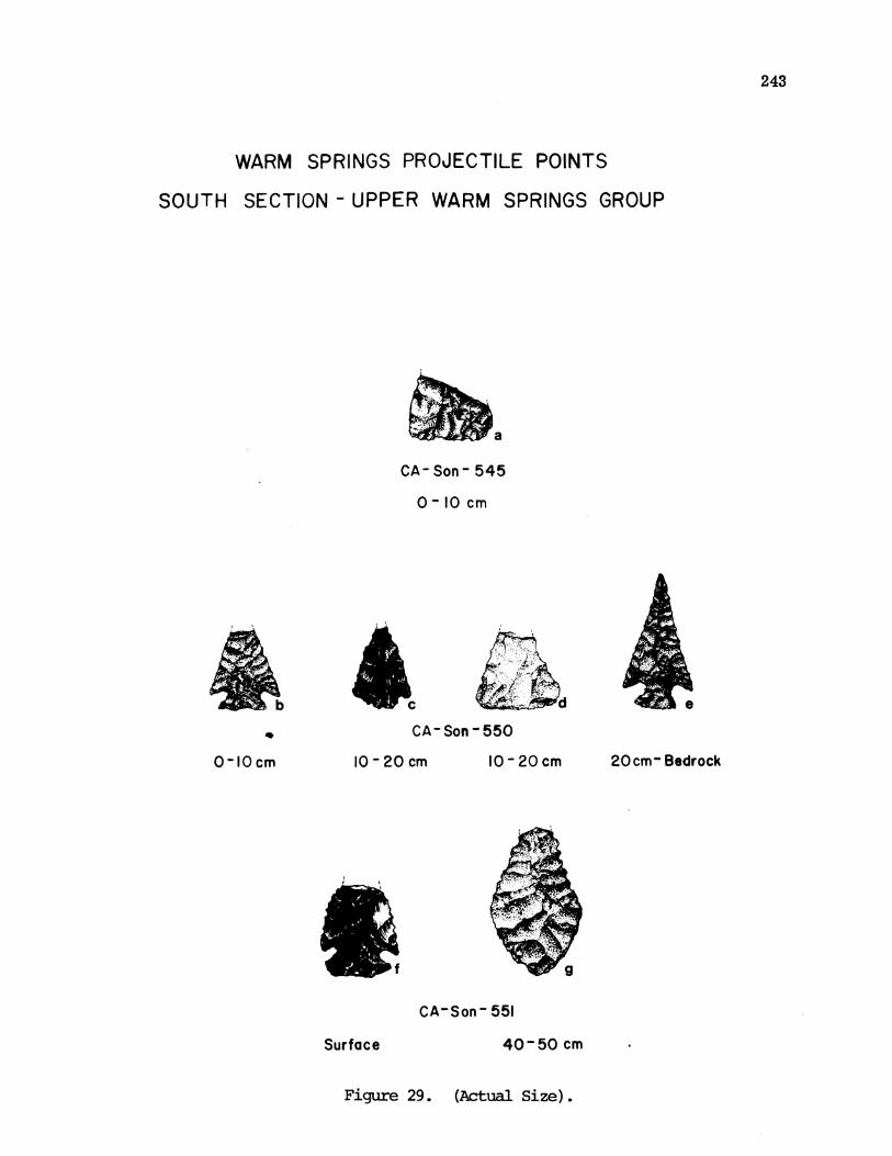
243
WARM SPRINGS PROJECTILE POINTS
SOUTH SECTION - UPPER WARM SPRINGS GROUP
M~~~a
CA- Son- 545
0-10 cm
CA-Son-550
10-20cm 10-20cm 20 cm- Bedrock
CA-Son- 551
40-50 cm
Figure 29. (Actual Size).
0-10cm
Surface

A
F
XB 0B
ACT~~
tE
cm
Figure 30. Artifacts fran Yorty Creek gravels.
244