CONTAMINATED MEDIA MANAGEMENT PLAN Salem ...
65
CONTAMINATED MEDIA MANAGEMENT PLAN Salem Riverfront Park West of Front Street SE Salem, Oregon DEQ ECSI Nos. 865 and 4427 For City of Salem Public Works April 10, 2020 GeoDesign Project: Salem-56-02-01
-
Upload
khangminh22 -
Category
Documents
-
view
1 -
download
0
Transcript of CONTAMINATED MEDIA MANAGEMENT PLAN Salem ...

CONTAMINATED MEDIA MANAGEMENT PLAN Salem Riverfront Park West of Front Street SE Salem, Oregon DEQ ECSI Nos. 865 and 4427 For City of Salem Public Works April 10, 2020 GeoDesign Project: Salem-56-02-01

9450 SW Commerce Circle, Suite 300 l Wilsonville, OR 97070 l 503.968.8787 www.geodesigninc.com
April 10, 2020 City of Salem Public Works 555 Liberty Street SE, Suite 325 Salem, OR 97301 Attention: Julie Titchbourne
Contaminated Media Management Plan Salem Riverfront Park
West of Front Street SE Salem, Oregon
DEQ ECSI Nos. 865 and 4427 GeoDesign Project: Salem-56-02-01
GeoDesign is pleased to submit this CMMP for the Salem Riverfront Park located west of Front Street SE in Salem, Oregon. This CMMP addresses the management of potentially contaminated media that could be encountered during site redevelopment. This document is intended to be used by the excavation contractor during earthwork activities and should be used in conjunction with any project specifications provided to the contractor by the project developer pertaining to the handling, segregation, management, characterization, re-use, and/or disposal of impacted soil, clean soil, debris, and/or groundwater at the Salem Riverfront Park site and the Park Parcel of the Boise Cascade Mill – Salem site.

2 Salem-56-02-01:041020
Please call if you have questions regarding this submittal. Sincerely, GeoDesign, Inc. Colby R. Hunt, C.H.M.M. Principal cc: Nitin Joshi, City of Salem (via email only) Aaron Kimsey, City of Salem (via email only) Aaron Edelman, City of Salem (via email only) Kyle Cochran, City of Salem (via email only) Chris Richardson, Oregon Department of Environmental Quality Don Hanson, Oregon Department of Environmental Quality (via email only) KJK:CRH:kt
Attachments
One copy submitted (via email only)
Document ID: Salem-56-02-01-041020-env-CMMP.docx
© 2020 GeoDesign, Inc. All rights reserved.

Salem-56-02-01:041020
TABLE OF CONTENTS PAGE NO. ACRONYMS AND ABBREVIATIONS 1.0 INTRODUCTION 1 2.0 PROJECT SITE DESCRIPTION 1 3.0 PLANNED EARTHWORK 1 4.0 ENVIRONMENTAL SITE ASSESSMENT AND CHARACTERIZATION 2 4.1 Bibliography 2 4.2 Project Site Development History 3 4.3 Subsurface Conditions 4 4.4 Previous Investigations and Remedial Actions 4 5.0 GROUNDWATER CONTAMINANT INFORMATION 12 5.1 Riverfront Park 12 5.2 Park Parcel 13 6.0 WORKER SAFETY 14 7.0 DEQ OVERSIGHT REQUIREMENTS 14 8.0 CONSTRUCTION STAGING AREAS 15 8.1 Preparing a Construction Staging Area 15 8.2 Construction Staging Area Observation and Repair 15 9.0 CONTAMINATED MEDIA MANAGEMENT 15 9.1 Soil Management 15 9.2 Groundwater Management 21 10.0 WHEEL WASH 22 11.0 EROSION AND DUST CONTROL 22 12.0 CULTURAL RESOURCES 22 13.0 UNFORESEEN CONDITIONS 22 14.0 EMERGENCY EXCAVATIONS 23 15.0 PROJECT COMPLETION 23 15.1 Excavation Backfill 23 15.2 Protective Cap Reconstruction 24 15.3 Construction Staging Area Removal 24 15.4 Contractor Reporting Requirements 24 16.0 CAP INSPECTION AND MAINTENANCE 24 17.0 ASSUMPTIONS AND LIMITATIONS 24 FIGURES Vicinity Map Figure 1 Site Plan Figure 2 Residual Soil Contamination Figures 3 – 13 Residual Groundwater Contamination Figure 14 Schematic – Protective Cap Figure 15 APPENDIX Cap Inspection and Maintenance Plan

Salem-56-02-01:041020
ACRONYMS AND ABBREVIATIONS BGS below ground surface BMP best management practice CFR Code of Federal Regulations CFSL Clean Fill Screening Level CMMP Contaminated Media Management Plan DEQ Oregon Department of Environmental Quality ECSI Environmental Cleanup Site Information EPA U.S. Environmental Protection Agency ESCP Erosion and Sediment Control Plan HCP Hazard Communication Plan HSP Health and Safety Plan mg/kg milligrams per kilogram mg/L milligrams per liter MGP manufactured gas plant ng/kg nanograms per kilogram NFA No Further Action OSHA Occupational Safety and Health Administration PAH polycyclic aromatic hydrocarbon PCB polychlorinated biphenyl PID photoionization detector ppm parts per million RBC risk-based concentration RCRA Resource Conservation and Recovery Act ROW right-of-way SSO site safety officer TCLP Toxicity Characteristic Leaching Procedure μg/L micrograms per liter UST underground storage tank VOC volatile organic compound

1 Salem-56-02-01:041020
1.0 INTRODUCTION This CMMP has been prepared by GeoDesign, Inc. on behalf of the City of Salem Public Works for the Salem Riverfront Park located west of Front Street SE in Salem, Oregon (project site). The project site consists of two DEQ cleanup sites, including the Salem Riverfront Park Project (DEQ ECSI No. 865) and a portion of the Boise Cascade Mill – Salem site (DEQ ECSI No. 4465) that is referred to as the Park Parcel. This document is intended to assist in field identification and management of contaminated media (soil and groundwater) as well as clean soil and debris that could be encountered at the project site during future earthwork. This CMMP includes field protocol for identification, response actions, communication, removal, segregation, temporary storage or stockpiling, transportation, treatment, and disposal of contaminated media, clean soil, and debris. Acronyms and abbreviations used herein are defined above, immediately following the Table of Contents. Section 2.0 through 7.0 include project site history and background information. Sections 8.0 through 15.0 include procedures to be followed by contractors or City of Salem (City) personnel conducting earthwork within the project site. 2.0 PROJECT SITE DESCRIPTION The Salem Riverfront Park site encompasses approximately 26 acres of downtown Salem waterfront west of downtown Salem and is currently developed with a municipal park, including greenspaces, walking paths, a carousel, and other park features. Riverfront Park is bound to the west by the Willamette River, to the south by the Willamette Slough and Pringle Creek, to the east by Front Street NE and a Portland & Western/Burlington Norther Santa Fe railroad ROW, and to the north by the Center Street bridge. The Park Parcel adjoins Riverfront Park, encompasses approximately 3.7 acres of downtown Salem waterfront south of the Riverfront Park site, and is currently vacant land. The Park Parcel is bound to the west and north by Riverfront Park, to the east by a Portland & Western/Burlington Northern Santa Fe railroad ROW, and to the south by Pringle Creek. The project site is shown relative to surrounding physical features on Figure 1. The layout of the project site is shown on Figure 2. 3.0 PLANNED EARTHWORK Earthwork is not currently planned at the Riverfront Park portion of the project site; however, earthwork may be periodically conducted at the Riverfront Park portion of the project site associated with utility repairs and/or future park modification. The 2018 Master Plan for the project site includes redeveloping the Park Parcel as an expansion of Riverfront Park, including constructing an overlook of the Willamette Slough/Pringle Creek confluence; adding a pedestrian bridge across the mouth of Pringle Creek; expanding the existing parking area currently located north of the Park Parcel; expanding an existing playground located north of the Park Parcel; and constructing an arrival plaza, walkways, greenspaces, a maintenance building/yard, and a covered stage and an additional proposed amphitheater.

2 Salem-56-02-01:041020
4.0 ENVIRONMENTAL SITE ASSESSMENT AND CHARACTERIZATION 4.1 BIBLIOGRAPHY The purpose of this section is to summarize available information related to the historical site development and subsurface conditions at the project site. Our knowledge of the project site is based on the following reports: Remedial Investigation Report, Salem Riverfront Park Project, prepared by GeoEngineers,
dated November 23, 1994 Record of Decision; Selected Remedial Action for the Phase 1 Portion of the Salem Riverfront
Park Site; Salem, Oregon, prepared by DEQ, dated May 9, 1995 Remedial Action Report; Phase 1 Portion; Salem Riverfront Park Project; Salem, Oregon,
prepared by GeoEngineers, Inc., dated April 12, 1996 Equitable Servitude and Easement, Salem Riverfront Park Project – Phase I, prepared by DEQ,
dated April 1, 1996 No Further Action Required; Salem Riverfront Park Project, Phase 1; Salem, Oregon, prepared
by DEQ, dated July 18, 1996 Record of Decision; Selected Remedial Action; Phase 2 Portion of the Salem Riverfront Park
Site; Salem, Oregon, prepared by DEQ, dated November 4, 1996 Equitable Servitude and Easement, Salem Riverfront Park Project – Phase II, prepared by DEQ,
dated September 29, 1997 Remedial Action Report; Phase 2 Area; Salem Riverfront Park Project; Salem, Oregon,
prepared by GeoEngineers, Inc., dated February 5,1998 Supplemental Site Investigation Report; Former Boise Cascade Mill; Site Location: Bleach
Plant; 315 Commercial St SE; Salem, Oregon 97301, prepared by Ktec Environmental Consulting, LLC, dated January 25, 2011
Phase I Environmental Site Assessment Report; Approximate 3.86-Acre Property; Former Boise Cascade Pulp and Paper Mill Property; 315 Commercial Street SE; Salem, Oregon 97301, prepared by Saga Environmental and Engineering, Inc., dated February 9, 2011
Supplemental Site Investigation Report; Former Boise Cascade Mill; Site Location: Park Parcel – Foundry; 315 Commercial Street SE; Salem, Oregon 97301, prepared by Ktec Environmental Consulting, LLC, dated December 19, 2011
Information Consolidation Report; Park Parcel; 230 Front Street SE; Salem, Oregon 97301, prepared by Ktec Environmental Consulting, LLC, dated April 26, 2013
Salem River/Park Parcel Prospective Purchaser Agreement Project Investigation Scope of Work Summary; Salem, Oregon, prepared by PNG Environmental, Inc., dated September 10, 2014
Technical Memorandum, September 2014 Soil Sampling, Salem Park Parcel, prepared by PNG Environmental, Inc., dated November 5, 2014
Salem River/Park Parcel Focused Soil Removal Work Plan; 315 Commercial Street SE (approximately); Salem, Oregon, prepared by PNG Environmental, Inc., dated January 19, 2015
Technical Memorandum; Salem River Park Parcel Soil Remediation – Wetland Determination West of Front Street, Trade Street, and Commercial Street, Salem, Oregon; Tax map 7 3W 27BA, tax lot 1700 (portion), Marion County, prepared by SWCA Environmental Consultants, dated February 17, 2015

3 Salem-56-02-01:041020
Consent Judgment, prepared by DEQ, dated February 23, 2015 Easement and Equitable Servitudes, prepared by DEQ, dated April 10, 2015 Technical Memorandum, September 2014 Soil Sampling, Salem Park Parcel, prepared by PNG
Environmental, Inc., dated December 14, 2015 4.2 PROJECT SITE DEVELOPMENT HISTORY 4.2.1 Riverfront Park The Riverfront Park site historically served as an industrial hub for the city of Salem between the mid-1800s and the 1980s. Former occupants of the project site include a coal gasification/MGP, a junkyard, a lumberyard/container plant, an acid plant, and portions of a pulp mill, among other industrial facilities. In 1984 the City purchased a portion of the project site and initiated planning for redevelopment activities, and Riverfront Park was subsequently listed on the DEQ ECSI database (ECSI No. 865). Primary contaminants identified by environmental investigations conducted at Riverfront Park between 1984 and 1992 included petroleum hydrocarbons, PAHs, benzene, and metals in soil. Low concentrations of some contaminants were also detected in groundwater beneath Riverfront Park; however, groundwater remediation was not required. Remedial actions at Riverfront Park were divided into two phases (Phase I and Phase II). Phase I of the remedial action addressed the north portion of Riverfront Park, and Phase II of the remedial action addressed the south portion of Riverfront Park. Phase I remedial actions were completed by 1995 and included excavation and off-site disposal of petroleum- and/or metal-contaminated soil from the former junkyard, former MGP area, former lumberyard/container plant, and riverbank areas. Phase II remedial actions were completed by 1998 and included excavation and off-site disposal of petroleum- and/or metal-contaminated soil from the former acid plant area, former UST area, former ammonia storage area, existing amphitheater site, and non-specific/general use area. A protective clean fill cap was placed across the project site to prevent direct contact to residual contaminated soil by future park users. A demarcation layer is reportedly present below the clean fill cap in areas where previous remedial excavations were completed. Some areas of soil contamination remain at concentrations greater than site-specific cleanup goals. In these areas, the City must notify DEQ prior to conducting excavation work. These areas include the west tar shed of the MGP area, the entire lumberyard/container plant site, the acid plant area, and the UST area. In May 2019 a sinkhole developed over a damaged sewer line in the vicinity of the former MGP area. Due to the environmental history of the project site and uncertain operational protocols, GeoDesign was contacted to assist with soil management during sewer repairs. GeoDesign personnel assisted City employees with pre-characterization of the soil above the damaged sewer line, which contained petroleum-related contaminants at concentrations greater than DEQ CFSLs, requiring disposal at a RCRA Subtitle D landfill or other DEQ-approved facility. 4.2.2 Park Parcel The Park Parcel site is an approximately 3.7-acre portion of the larger Boise Cascade Mill – Salem site, which was historically occupied by wood products mills, a flour mill, and a foundry and was occupied by a paper mill from 1950 to the early 1980s. By 1982 pulp production ceased, and

4 Salem-56-02-01:041020
the related buildings were demolished by 1985. Portions of the demolished buildings were reportedly used as fill on the south portion of the Park Parcel. Environmental investigations and cleanup have been conducted at the Boise Cascade Mill – Salem site under DEQ oversight since approximately 2004 (ECSI No. 4427). Based on information obtained from DEQ, the City purchased the Park Parcel under a Prospective Purchaser Agreement in 2014. In the Park Parcel, the City must notify DEQ prior to conducting excavation work. 4.3 SUBSURFACE CONDITIONS 4.3.1 Soil In general, subsurface conditions beneath the project site consist of a minimum of 2 feet of non-contaminated soil that serves as a protective cap. Demarcation fabric is present beneath some but not all portions of the 2-foot-thick protective cap. The protective cap overlies up to 40 feet of fill material overlaying native silt and gravel. The fill material consists of gravel, silt, sand, cobbles, boulders, demolition and manufacturing debris, and wastes from on-site manufacturing and industrial operations. Debris and wastes include glass, scrap metal, paper, cinders, bricks, stained soil, pockets of tar and oil-like substances, logs and milled lumber, and large pockets of wood waste including wood chips and sawdust. Native brown silt with varying amounts of sand, organic matter, and clay is present at depths between 2 and 20 feet BGS generally in the central portion of the project site. Native gravel is present beneath the north portion of the project site at depths of up to 40 feet BGS and the south portion of the project site at depths greater than 8 feet BGS. The gravel unit consists of brown to gray, fine to coarse, rounded gravel with varying amounts of silt, sand, and rounded cobbles and occasional boulders. Bedrock beneath the project site consists of black, fresh to weathered, fractured basalt. The basalt is present at depths between 13 feet BGS in the central portion of the project site and over 40 feet BGS in the northwest portion of the project site. 4.3.2 Groundwater Groundwater was encountered during previous environmental investigations completed on the project site at depths between 10 and 20 feet BGS. The depth to groundwater beneath the project site likely fluctuates in response to seasonal precipitation, fluctuation in nearby bodies of water, and other factors (including dewatering activities at nearby construction sites and/or permanent dewatering systems for below-grade levels of nearby structures). 4.4 PREVIOUS INVESTIGATIONS AND REMEDIAL ACTIONS Based on the remedial investigation results, Riverfront Park was divided into two areas (Phase I and Phase II) for remedial action purposes. Phase I encompassed approximately 14 acres of the north portion of Riverfront Park, and Phase II encompassed approximately 4.5 acres of the south portion of Riverfront Park. The Phase I and Phase II areas were further divided into areas of concern. A summary of previous environmental investigations, remedials actions conducted at the Riverfront Park and the Park Parcel by area of concern, and maximum detected concentrations of residual contaminants in soil are presented below. The areas of concern and the approximate limits of previous remedial excavations are shown on Figure 2. The maximum detected concentrations of these contaminants in soil samples are presented on Figures 3 through 13:

5 Salem-56-02-01:041020
4.4.1 Lumberyard/Container Plant During the remedial investigation and remedial action cleanup, PAHs were detected in a 1- to 3-foot-thick layer of gravel with a tar-like matrix located approximately 4 to 8 feet BGS within the lumberyard/container plant site. The detected concentrations of contaminants were higher than the remedial cleanup goals. Contaminated soil in the lumberyard/container plant site was not excavated or exposed during the remedial action cleanup. The placement of additional fill during construction activities was expected to raise the finished grade up to 4 feet higher than the pre-construction grade in the lumberyard/container plant site. The remedial action plan specified the implementation of the following controls within the lumberyard/container plant site: Implementation of institutional controls to restrict invasive work in the areas with residual
contaminant concentrations greater than remedial cleanup goals and require DEQ approval prior to future excavation activities.
The maximum detected concentrations of residual contaminants in soil in the lumberyard/container plant area are as follows: Oil-range hydrocarbons: 2,000 mg/kg Acenaphthene: 180 mg/kg Anthracene: 390 mg/kg Benz(a)anthracene: 57 mg/kg Benzo(a)pyrene: 230 mg/kg Benzo(b)fluoranthene: 99 mg/kg Benzo(k)fluoranthene: 65 mg/kg Benzo(g,h,i)perylene: 87 mg/kg Chrysene: 510 mg/kg Dibenz(a,h)anthracene: 56 mg/kg Fluoranthene: 1,100 mg/kg Fluorene: 310 mg/kg Indeno(1,2,3-cd)pyrene: 100 mg/kg Naphthalene: 1,000 mg/kg Phenanthrene: 2,200 mg/kg Pyrene: 1,200 mg/kg Acetone: 1.3 mg/kg Carbon disulfide: 0.11 mg/kg 1,1,1-trichloroethene: 0.065 mg/kg Benzene: 0.063 mg/kg Toluene: 0.069 mg/kg Ethylbenzene: 0.13 mg/kg Styrene: 0.26 mg/kg Total xylenes: 0.35 mg/kg Arsenic: 4.6 mg/kg Beryllium: 0.6 mg/kg Chromium: 16 mg/kg Copper: 25 mg/kg

6 Salem-56-02-01:041020
Lead: 33 mg/kg Nickel: 20 mg/kg Zinc: 78 mg/kg 4.4.2 MGP Area During the remedial investigation and remedial action cleanup, PAHs, metals, VOCs, and cyanide were detected in fill material at depths of up to 15 feet BGS in the vicinity of the MGP area. Specific areas of contamination included in the vicinities of the west tar shed, east tar shed, northern gas holder, tar well, and railcar barn site. The detected concentrations of contaminants were higher than the remedial cleanup goals. Activities conducted during the remedial action cleanup of the MGP area included the following: Excavation of soil with concentrations of PAHs greater than remedial cleanup goals from the
vicinities of the east tar shed, west tar shed, tar well, and northern gas holder. Excavation of soil with lead concentrations greater than remedial cleanup goals from the
vicinities of the northern gas holder and railcar barn locations. Segregation of possible RCRA characteristic hazardous waste material from the non-
hazardous waste material and transportation of hazardous waste material to an approved RCRA treatment, storage, or disposal facility.
Transportation of non-hazardous contaminated soil to an approved landfill for disposal. Placement of geotextile fabric marker over the base of the west tar shed and trench
excavation and backfilled with clean fill. Implementation of institutional controls in the vicinity of the west tar shed to restrict invasive
work in the areas with residual contaminant concentrations greater than remedial cleanup goals and require DEQ approval prior to future excavation activities.
Monitoring of groundwater quality for VOCs and PAHs on a semi-annual basis. Placement of a soil cap of clean fill and topsoil over the entire site and subsequent annual
soil cap inspections. The maximum detected concentrations of residual contaminants in soil in the MGP area are as follows: Acenaphthylene: 17 mg/kg Anthracene: 560 mg/kg Benz(a)anthracene: 460 mg/kg Benzo(a)pyrene: 270 mg/kg Benzo(b)fluoranthene: 200 mg/kg Benzo(k)fluoranthene: 150 mg/kg Benzo(g,h,i)perylene: 91 mg/kg Chrysene: 420 mg/kg Dibenz(a,h)anthracene: 0.39 mg/kg Fluoranthene: 1,700 mg/kg Fluorene: 620 mg/kg Indeno(1,2,3-cd)pyrene: 88 mg/kg Naphthalene: 930 mg/kg Phenanthrene: 2,500 mg/kg

7 Salem-56-02-01:041020
Pyrene: 1,100 mg/kg Lead: 484 mg/kg 4.4.3 Junkyard During the remedial investigation and remedial action cleanup, metals, oil-range hydrocarbons, and PCBs were detected in fill material at depths of up to 5 feet BGS in the vicinity of the former junkyard site. The detected concentrations of contaminants were higher than the remedial cleanup goals. Activities conducted during the remedial action cleanup of the junkyard site included the following: Excavation of soil with concentrations of metals and other contaminants greater than
remedial cleanup goals to depths between 2 and 6 feet BGS. Transportation of soil with RCRA characteristic hazardous waste concentrations of leachable
lead to an approved RCRA treatment, storage, and disposal facility for stabilization and disposal.
Transportation of non-hazardous contaminated soil to an approved landfill for disposal. The maximum detected concentrations of residual contaminants in soil in the junkyard are as follows: Lead: 352 mg/kg TCLP lead: <0.05 mg/L 4.4.4 Undocumented UST Excavation An undocumented 550-gallon UST was encountered on the northwest portion of the Phase I area during remedial activities. The UST was decommissioned by removal, and contaminated soil was excavated from the vicinity of the UST and transported off site for disposal. Confirmation soil samples indicated that concentrations of diesel- and oil-range hydrocarbons were below the remedial cleanup goals. The maximum detected concentrations of residual contaminants in soil in the undocumented UST excavation area are as follows: Diesel-range hydrocarbons: 310 mg/kg 4.4.5 UST Area During the remedial investigation, petroleum hydrocarbons were detected in soil and groundwater within the UST area between 10 and 20 feet BGS. The contamination consisted of diesel fuel and hydraulic oil. The detected concentrations of petroleum hydrocarbons in soil were greater than the remedial cleanup goals. Contaminated soil in the UST area was not excavated or exposed during the remedial action cleanup. The placement of additional fill during construction of the existing amphitheater was designed to raise the finished grade up to 4 feet higher than the pre-construction grade in the UST area. The remedial action plan specified the implementation of the following controls and actions in the vicinity of the UST area:

8 Salem-56-02-01:041020
Implementation of institutional controls to restrict invasive work in the areas with residual contaminant concentrations greater than remedial cleanup goals and require DEQ approval prior to future excavation activities.
Monitoring of groundwater for total petroleum hydrocarbons and PAHs on a semi-annual basis through the spring of 1998.
The maximum detected concentrations of residual contaminants in soil in the UST area are as follows: Gasoline-range hydrocarbons: 250 mg/kg Oil-range hydrocarbons: 27,000 mg/kg Arsenic: 6.4 mg/kg Beryllium: 0.7 mg/kg Chromium: 27 mg/kg Copper: 33 mg/kg Nickel: 35 mg/kg Selenium: 2.1 mg/kg Zinc: 56 mg/kg Anthracene: 0.088 mg/kg Benzo(b)fluoranthene: 0.023 mg/kg Dibenzo(a,h)anthracene: 0.052 mg/kg Fluoranthene: 1.4 mg/kg Fluorene: 0.11 mg/kg Indeno(1,2,3-cd)pyrene: 0.039 mg/kg Phenanthrene: 0.80 mg/kg Pyrene: 1.1 mg/kg 4.4.6 Non-Specific Use Area During the remedial investigation, MGP waste, primarily consisting of PAHs in tars, was detected in fill within the non-specific use area. The MGP waste was observed in a localized area at a depth of approximately 5 feet below the 1992 site grade. The detected concentrations of PAHs were higher than the remedial cleanup goals. Activities conducted during the remedial action cleanup of the non-specific use area included the following: Excavation of soil with concentrations of PAHs greater than remedial cleanup goals. Transportation of contaminated soil to an approved landfill for disposal. The maximum detected concentrations of residual contaminants in soil in the non-specific use area are as follows: Acenaphthene: 1.7 mg/kg Acenaphthylene: 3.1 mg/kg Anthracene: 5.8 mg/kg Benz(a)anthracene: 20 mg/kg Benzo(a)pyrene: 57 mg/kg Benzo(b)fluoranthene: 43 mg/kg

9 Salem-56-02-01:041020
Benzo(k)fluoranthene: 20 mg/kg Benzo(g,h,i)perylene: 51 mg/kg Chrysene: 29 mg/kg Dibenz(a,h)anthracene: 2.8 mg/kg Fluoranthene: 40 mg/kg Fluorene: 5 mg/kg Indeno(1,2,3-cd)pyrene: 15 mg/kg Naphthalene: 3 mg/kg Phenanthrene: 28 mg/kg Pyrene: 54 mg/kg 4.4.7 Acid Plant Area During the remedial investigation, lead was detected at concentrations greater than the remedial cleanup goal in soil up to 15 feet BGS in the vicinity of the former acid plant. Activities conducted during the remedial action cleanup of the former acid plant included the following: Excavation of soil with concentrations of metals greater than remedial cleanup goals to a
maximum depth of 2.5 feet BGS. Transportation of soil with concentrations of leachable lead greater than RCRA characteristic
hazardous waste standards to an approved RCRA treatment, storage, or disposal facility for stabilization and disposal.
Transportation of non-hazardous contaminated soil to an approved landfill for disposal. Placement of geotextile marker at the base of the excavation to demarcate the boundary with
contaminated soil and backfilled to existing grades with clean fill. Monitoring of groundwater quality for metals on a semi-annual basis. Implementation of institutional controls to restrict invasive work in the areas with residual
contaminant concentrations greater than remedial cleanup goals and require DEQ approval prior to future excavation activities.
The maximum detected concentrations of residual contaminants in soil in the acid plant area are as follows: Lead: 16,800 mg/kg TCLP lead: 7.80 mg/L 4.4.8 Former Ammonia Storage Area During the remedial investigation, high pH and concentrations of dissolved metals and organic and inorganic compounds were detected in groundwater west of the former ammonia storage area. Past spills of pulping liquor and caustics were the suspected sources of the groundwater contamination. Contaminated soil in the former ammonia storage area was not excavated or exposed during the remedial action cleanup. The remedial action plan specified the implementation of the following action and controls in the vicinity of the former ammonia storage area:

10 Salem-56-02-01:041020
Monitoring of groundwater for metals on a semi-annual basis. Implementation of institutional controls to prohibit installation of on-site groundwater supply
wells. The maximum detected concentrations of residual contaminants in soil in the former ammonia storage area are as follows: Oil-range hydrocarbons: 490 mg/kg Arsenic: 5.0 mg/kg Chromium: 38 mg/kg Copper: 99 mg/kg Lead: 58 mg/kg Nickel: 32 mg/kg Zinc: 150 mg/kg Benzo(a)pyrene: 0.077 mg/kg Benzo(g,h,i)perylene: 0.069 mg/kg Chrysene: 0.031 mg/kg Dibenzo(a,h)anthracene: 0.037 mg/kg Fluoranthene: 0.053 mg/kg Phenanthrene: 0.033 mg/kg Pyrene: 0.11 mg/kg 4.4.9 Existing Amphitheater Three isolated areas of contaminated soil were encountered during earthwork activities within the existing amphitheater site. Diesel- and oil-range hydrocarbons and PAHs were the detected contaminants of concern. Activities conducted during the remedial action cleanup of the existing amphitheater site included the following: Excavation of soil with concentrations of contaminants greater than remedial cleanup goals
to a maximum depth of between 1 foot and 2.5 feet BGS. Transportation of contaminated soil to an approved landfill for disposal. The maximum detected concentrations of residual contaminants in soil in the existing amphitheater are as follows: Diesel- and oil-range hydrocarbons: 840 mg/kg Anthracene: 0.023 mg/kg Benz(a)anthracene: 0.17 mg/kg Benzo(a)pyrene: 0.27 mg/kg Benzo(b)fluoranthene: 0.24 mg/kg Benzo(k)fluoranthene: 0.081 mg/kg Benzo(g,h,i)perylene: 0.16 mg/kg Chrysene: 0.17 mg/kg Dibenz(a,h)anthracene: 0.055 mg/kg Fluoranthene: 0.41 mg/kg Indeno(1,2,3-cd)pyrene: 0.15 mg/kg

11 Salem-56-02-01:041020
Phenanthrene: 0.21 mg/kg Pyrene: 0.60 mg/kg 4.4.10 Outdoor Science Park Explorations in the vicinity of the proposed outdoor science park detected lead and petroleum hydrocarbons in soil at concentrations greater than the remedial cleanup goals. Activities conducted during the remedial action cleanup of the outdoor science park included the following: Excavation of soil with concentrations of contaminants greater than remedial cleanup goals
to depths between 1 foot and 3 feet BGS. Transportation of contaminated soil to an approved landfill for disposal. Transportation of contaminated soil to an approved landfill for disposal. The maximum detected concentrations of residual contaminants in soil in the outdoor science park are as follows: Lead: 667 mg/kg TCLP lead: 0.44 mg/L 4.4.11 Park Parcel Contaminants of concern associated with the Park Parcel include metals, dioxins, diesel- and oil-range hydrocarbons, and PAHs. Previous investigations indicated that metals, dioxins, petroleum hydrocarbons, and PAHs were generally present at concentrations below human health and ecological risk-based screening levels in localized areas throughout the Park Parcel. DEQ issued an NFA determination for the Boise Cascade Mill site, including the Park Parcel, in June 2007. Additional soil sampling was conducted in September 2014 to evaluate for the presence of dioxins. Dioxins were detected at concentrations exceeding ecological screening levels and DEQ RBCs for occupational and urban residential exposure pathways in soil from a narrow strip of land near Pringle Creek. PAHs were detected in upland near-surface soil at concentrations exceeding DEQ RBCs for occupational receptors. Dioxins, petroleum hydrocarbons, and metals were detected in upland soil samples at concentrations below DEQ RBCs for occupational receptors. Institutional controls have been implemented to restrict invasive work in the areas with residual contaminant concentrations greater than remedial cleanup goals and require DEQ approval prior to future excavation activities, and the use of the Park Parcel has been restricted to a municipal park. The maximum detected concentrations of residual contaminants in soil in the Park Parcel are as follows: 2,3,7,8-TCDD (dioxin) equivalents: 0.15 ng/kg Antimony: 383 mg/kg Arsenic: 10.2 mg/kg Beryllium: 1.16 mg/kg Cadmium: 14.1 mg/kg

12 Salem-56-02-01:041020
Chromium III: 37.5 mg/kg Chromium VI: 0.405 mg/kg Copper: 929 mg/kg Lead: 37,000 mg/kg Nickel: 95.7 mg/kg Silver: 3.01 mg/kg Zinc: 4,490 mg/kg Mercury: 5.51 mg/kg TCLP barium: 0.832 mg/L TCLP chromium III: 0.036 mg/L TCLP lead: 20.4 mg/L Gasoline-range hydrocarbons: 18.1 mg/kg Diesel-range hydrocarbons: 496 mg/kg Oil-range hydrocarbons: 1,710 mg/kg Acenaphthene: 0.0627 mg/kg Acenaphthylene: 0.144 mg/kg Anthracene: 0.275 mg/kg Benz(a)anthracene: 0.599 mg/kg Benzo(a)pyrene: 0.625 mg/kg Benzo(b)fluoranthene: 1.26 mg/kg Benzo(k)fluoranthene: 0.353 mg/kg Benzo(g,h,i)perylene: 0.923 mg/kg Chrysene: 0.807 mg/kg Dibenz(a,h)anthracene: 0.289 mg/kg Fluoranthene: 1.81 mg/kg Fluorene: 0.121 mg/kg Indeno(1,2,3-cd)pyrene: 0.636 mg/kg Naphthalene: 0.271 mg/kg Phenanthrene: 0.703 mg/kg Pyrene: 2.14 mg/kg Aroclor 1248: 0.068 mg/kg Aroclor 1254: 0.256 mg/kg 5.0 GROUNDWATER CONTAMINANT INFORMATION Based on the results of previous investigations, low concentrations of petroleum hydrocarbons, metals, and PAHs are present in groundwater beneath the project site. The maximum detected concentrations of these contaminants in groundwater samples are presented on Figure 14 and summarized below: 5.1 RIVERFRONT PARK Antimony: 1.6 μg/L Arsenic: 21 μg/L Beryllium: 2.3 μg/L Cadmium: 2.5 μg/L Chromium III: 55 μg/L
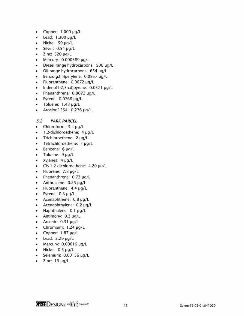
13 Salem-56-02-01:041020
Copper: 1,000 μg/L Lead: 1,300 μg/L Nickel: 50 μg/L Silver: 0.54 μg/L Zinc: 520 μg/L Mercury: 0.000389 μg/L Diesel-range hydrocarbons: 506 μg/L Oil-range hydrocarbons: 654 μg/L Benzo(g,h,i)perylene: 0.0857 μg/L Fluoranthene: 0.0672 μg/L Indeno(1,2,3-cd)pyrene: 0.0571 μg/L Phenanthrene: 0.0672 μg/L Pyrene: 0.0768 μg/L Toluene: 1.43 μg/L Aroclor 1254: 0.276 μg/L 5.2 PARK PARCEL Chloroform: 3.4 μg/L 1,2-dichloroethene: 4 μg/L Trichloroethene: 2 μg/L Tetrachloroethene: 5 μg/L Benzene: 6 μg/L Toluene: 9 μg/L Xylenes: 4 μg/L Cis-1,2-dichloroethene: 4.20 μg/L Fluorene: 7.8 μg/L Phenanthrene: 0.73 μg/L Anthracene: 0.25 μg/L Fluoranthene: 4.4 μg/L Pyrene: 0.3 μg/L Acenaphthene: 0.8 μg/L Acenaphthylene: 0.2 μg/L Naphthalene: 0.1 μg/L Antimony: 0.3 μg/L Arsenic: 0.31 μg/L Chromium: 1.24 μg/L Copper: 1.87 μg/L Lead: 2.29 μg/L Mercury: 0.00616 μg/L Nickel: 0.5 μg/L Selenium: 0.00136 μg/L Zinc: 19 μg/L

14 Salem-56-02-01:041020
6.0 WORKER SAFETY Except for total lead in the acid plant area and total lead and total dioxin equivalents in the Park Parcel, contaminants of concern were not detected at concentrations greater than the corresponding DEQ direct-contact RBCs for excavation workers in confirmation soil samples collected from the project site. In addition, contaminants of concern were not detected in groundwater samples at concentration greater than the corresponding DEQ direct-contact RBCs for construction/excavation workers. However, it is possible that higher concentrations of contaminants may be present in portions of the project site not previously explored. Prior to beginning earthwork activities, the City, the operator, or the contractor must prepare and implement a site-specific HCP. The HCP fulfills “worker right to know” requirements (29 CFR 1926.59). If completed by the contractor, a copy of the HCP must be submitted to the City of Salem Public Works prior to the start of work on the project. During work on the project, the HCP must be posted at the project site. The contractor is responsible for notifying subcontractors of pertinent environmental conditions. Subcontractors may either adopt the contractor’s HCP or must prepare their own HCP. This document should be used in conjunction with, not in place of, the HCP and the project specifications. Each contractor and subcontractor is responsible for the safety of its employees, including compliance with applicable OSHA regulations and compliance with all specifications in the technical specifications manual for the project. In addition to implementation of an HCP, the City of Salem Public Works, the operator, or the contractor should prepare and implement a site-specific HSP in accordance with OSHA requirements to ensure adequate protection for their workers while on site. The City and future contractors can use the maximum detected concentrations of contaminants presented in Sections 4.4 and 5.0 to develop future project-specific health and safety plans for excavation activities at Riverfront Park. 7.0 DEQ OVERSITE REQUIREMENTS Residual soil and groundwater contamination exists on the project site. As stated in the Easement and Equitable Servitudes established for the Salem Riverfront Park Phase I and Phase II sites and the Park Parcel of the Boise Cascade Mill – Salem site, DEQ notification and approval are required prior to commencing earthwork activities within the following areas: The vicinity of the west tar shed in the MGP area The entire lumberyard/container plant site The vicinity of the acid plant area The vicinity of the UST area The entire Park Parcel site DEQ may require the submittal of project-specific work plans prior to approving excavation activities in the five areas listed above, except in the event of emergency excavations (see Section 14.0). The five areas that require DEQ notification and approval prior to commencing earthwork activities are shown on Figure 2.

15 Salem-56-02-01:041020
8.0 CONSTRUCTION STAGING AREAS Construction staging may take place in Riverfront Park. Due to the historical environmental issues at Riverfront Park and placement of a protective cap constructed to eliminate human contact with subsurface contaminated soil, potential future construction staging areas should comply with the requirements described in this section. The existing protective cap is an integral part of the Riverfront Park remedial action. The capped areas are anticipated to be approximately 2 feet thick in unpaved portions of the park in the capped areas. Excavation or penetration of the cap within the staging areas is not permitted. 8.1 PREPARING A CONSTRUCTION STAGING AREA Prior to use of the unpaved portions of the project site for construction staging areas, the areas must be prepared for use by: placing demarcation material (high-visibility geotextile fabric or high-visibility construction
fencing) on the existing ground surface. placement of a minimum of 4 inches of gravel working pad on top of the demarcation
material. Areas with existing asphalt or concrete can be used without placement of a working pad. 8.2 CONSTRUCTION STAGING AREA OBSERVATION AND REPAIR Asphalt areas used for staging and unpaved staging areas where a working pad has been constructed within the capped areas should be monitored on a weekly basis during use to observe the surfaces for damage. Damage to asphalt resulting in exposure of base material or areas where the demarcation material has become visible in unpaved areas should be repaired immediately to ensure the cap remains in place and protective. The City should be notified of any damage to the existing cap. The damage and associated repair of the cap should be documented and reported to the City within 48 hours. 9.0 CONTAMINATED MEDIA MANAGEMENT This section describes the protocol to properly identify, segregate, manage, characterize, and dispose of contaminated media including soil, debris, and/or groundwater present beneath the project site outside of the five areas described in Section 7.0 that require DEQ notification prior to excavation activities, or during emergency excavations conducted anywhere in Riverfront Park. For planned earthwork conducted inside of the five areas described in Section 7.0 that require DEQ notification prior to excavation activities, DEQ may require more detailed project-specific work plans prior to excavation or, depending on the nature of the planned activity, may approve conducting future excavations inside of the five areas under the guidance of this CMMP. 9.1 SOIL MANAGEMENT Because unpaved portions of the Riverfront Park facility are covered with a minimum 2-foot-thick protective cap, excavations of less than 2 feet BGS in unpaved portions of the project site are not subject to the requirements of this CMMP. Regardless of the planned depth of excavations, all

16 Salem-56-02-01:041020
workers should be made aware of this CMMP and its associated requirements and should be prepared to encounter potentially impacted soil. Excavations greater than 2 feet BGS at Riverfront Park outside the five areas that require DEQ notification and approval prior to excavation will generally consist of the following elements: 1. Preparing project-specific HSPs and/or HCPs in accordance with Section 6.0. 2. Determining the final disposal location for soil that will be generated during excavation
activities. Soil can either be disposed of off site in accordance with Section 9.1.8 or re-used elsewhere on the project site in accordance with Section 9.1.10.
3. If necessary, constructing construction staging area(s) in accordance with Section 8.0. 4. Excavating soil and either (a) stockpiling excavated soil in accordance with Section 9.1.5
or (b) direct-loading soil for transport to final disposal location in accordance with Section 9.1.8. Soil intended for off-site disposal must be properly characterized in accordance with Section 9.1.6 and necessary permits must be obtained from the receiving facility prior to transport of the soil to the receiving facility.
5. If demarcation fabric denoting the bottom of the 2-foot-thick protective cap is encountered, soil from below the demarcation layer should be segregated and stockpiled separately from soil above the demarcation layer. Soil excavated from above the demarcation layer should be isolated for re-use during repair of the protective cap.
6. Backfilling the excavation in accordance with Section 15.1. 7. Reconstructing the protective cap in accordance with Section 15.2. 8. If a construction staging area was constructed, removing the construction staging area in
accordance with Section 15.3. Excavation activities inside the five areas will generally include similar elements. In addition to these elements, DEQ may require the submittal of project-specific work plans prior to approving excavation activities inside the five areas, except in the event of emergency excavations as described in Section 14.0. 9.1.2 Soil Pre-Characterization Soil in planned excavation areas can be pre-characterized to evaluate off-site soil management options prior to excavation. Soil pre-characterization should include collecting discrete subsurface soil samples using drilling equipment, hand tools (e.g., a hand auger), or excavation equipment. The discrete soil samples must be representative of the soil that will be disposed of off site during excavation activities (i.e., must be collected from appropriate depths at the location of the planned excavation). The discrete soil sample should be thoroughly homogenized into composite soil samples. The discrete soil sampling frequency and associated number of composite soil samples should be consistent with the sampling frequency described in Section 9.1.6. Depending on the location of the excavation, the composite soil samples should be analyzed for the contaminants described in Section 9.1.6. The composite sample analytical results can be used to obtain a disposal permit from the selected receiving facility in accordance with Section 9.1.8 prior to initiating excavation activities. Obtaining a disposal permit from the selected receiving facility prior to initiating excavation activities will allow excavated material to be directly loaded for transport to the receiving facility as described in Section 9.1.7.

17 Salem-56-02-01:041020
9.1.3 Identification and Management of Contaminated Soil During any excavation activities, workers should evaluate soil for staining, odors, or other obvious signs of contamination. The two primary indicators of petroleum-contaminated soil are staining and odor, as described below. Staining: Generally, soil that is contaminated with petroleum hydrocarbons exhibits gray or black staining, although other contaminants and natural conditions may also cause staining. Odor: Petroleum products, solvents, and other types of contaminated soil may release vapors when exposed to the atmosphere. If concentrated enough, these vapors will be interpreted as an odor. Odors may also be present in contaminated groundwater. Soil impacted with metals does not generally present visual indicators of contamination. It is possible that soil may appear to be clean based on the lack of staining but may need to be handled as contaminated soil based on the results of chemical analytical testing. If obvious signs of petroleum contamination are observed, excavation should stop, the City of Salem Public Works Department contacted, and soil should be continuously field screened as described in Section 9.1.4. 9.1.4 Soil Field Screening Protocol If obvious signs of petroleum contamination are observed, soil should be continuously field screened. If required, the Environmental Consultant will coordinate and perform field screening activities on behalf of the City. In addition to staining and odor described in Section 9.1.3, field screening should include water sheen testing and PID readings as described below. Sheen: Sheen is another indication of petroleum contamination. Soil with a sheen may appear shiny and reflective. Sheens from heavily impacted soil may appear iridescent with rainbow-like colors. Sheens may also be observed in contaminated groundwater. Sheen testing is performed by retaining a portion of soil (approximately the size of half a sugar cube) and dropping the soil into a black pan containing approximately 0.5 inch of water to observe the degree of sheen on the water (no sheen, slight sheen, moderate sheen, or heavy sheen). PID Readings: PID readings involve the measurement of headspace vapors originating from a soil sample. PID screening is performed by placing a soil sample in a plastic bag. Air is captured in the bag, and the bag is shaken to expose the soil to the air trapped in the bag. The probe of a PID is inserted into the bag, which measures VOC vapor (petroleum constituent) concentrations in units of ppm. A PID is designed to quantify VOC vapor concentrations in the range between 1 and 2,000 ppm. 9.1.5 Stockpiling Soil generated during excavation activities that cannot be directly loaded for transportation to an off-site receiving facility can be temporarily stockpiled on site. Excavated material that is placed in temporary stockpiles must be well maintained at all times. All stockpiled material must be placed on impermeable plastic sheeting (minimum 6-mil-thick) with a berm around the perimeter of the stockpile. The plastic sheeting and berm must be constructed to prevent the runoff of soil

18 Salem-56-02-01:041020
and contaminants to surrounding areas. The berm can be constructed with hay bales, dimensional lumber, or other equivalent methods. The bottom plastic sheeting should be lapped over the berm materials and the soil stockpile covered with plastic sheeting to prevent erosion or leaching of contaminants to underlying soil and prevent exposure to precipitation and wind. Plastic sheeting that covers the soil stockpile should be secured using sand bags or equivalent. If stockpiles are located in an unsecured portion of the project site, stockpiles must be secured with temporary fencing to prevent potential public access. Stockpiles must be clearly designated as to the nature of the stockpiled soil, either with signage or stakes with different colored flagging. The locations and nature of each stockpile should be discussed during daily work meetings. Following removal, the stockpile areas should be restored to a pre-stockpile condition. Residual plastic or debris should not be left unattended and must be properly disposed of following stockpile removal. 9.1.6 Stockpile Soil Sampling Soil sampling of stockpiled soil or other project soil identified to be contaminated is intended to support waste disposal characterization of material intended for off-site disposal in accordance with receiving facility requirements and applicable laws and regulations. Soil samples should be collected from stockpiled material requiring characterization for disposal purposes. Each composite soil sample will be comprised of three discrete samples collected from a particular portion of stockpiled material. For waste characterization purposes, the frequency of composite soil sampling on a unit volume basis will be completed in accordance with the receiving facility requirements. Each soil stockpile will be managed separately. The source area and depth from which the soil was generated should be recorded. Once a stockpile is tested, additional soil cannot be added. Composite soil samples will be collected from appropriate stockpiles as detailed in Table 2.
Table 2. Stockpile Sampling Frequency
Stockpile Volume (cubic yards)
Number of Composite Samples to Collect
0 - 10 1 11 - 50 2 51 - 100 3 101 - 500 5
501 - 1,000 7 Greater than 1,000 10
Each composite sample will be comprised of three sub-samples collected from a particular area of the stockpile. Stockpiles greater than 1,000 cubic yards will be sampled at a rate of 10 composites for the first 1,000 cubic yards, plus one composite for each additional 500 cubic yards.

19 Salem-56-02-01:041020
Composite soil samples should be analyzed for contaminants of concern identified by area in Section 4.4, as follows: Lumberyard/Container Plant: Diesel- and oil-range hydrocarbons by Method NWTPH-Dx, PAHs by EPA Method 8270D SIM, VOCs by EPA Method 8260B, and RCRA 8 metals by EPA Method 6020A. MGP Area: PAHs by EPA Method 8270D SIM and TCLP lead by EPA Method 6020B. Undocumented UST Excavation: Diesel- and oil-range hydrocarbons by Method NWTPH-Dx and PAHs by EPA Method 8270D SIM. UST Area: Gasoline-range hydrocarbons by Method NWTPH-Gx, diesel- and oil-range hydrocarbons by Method NWTPH-Dx, PAHs by EPA Method 8270D SIM, VOCs by EPA Method 8260B, and RCRA 8 metals by EPA Method 6020A. Non-Specific Use Area: Diesel- and oil-range hydrocarbons by Method NWTPH-Dx and PAHs by EPA Method 8270D SIM. Acid Plant Area: TCLP lead by EPA Method 6020B. Former Ammonia Storage Area: Diesel- and oil-range hydrocarbons by Method NWTPH-Dx, PAHs by EPA Method 8270D SIM, and RCRA 8 metals by EPA Method 6020A. Existing Amphitheater: Diesel- and oil-range hydrocarbons by Method NWTPH-Dx and PAHs by EPA Method 8270D SIM Outdoor Science Park: TCLP lead by EPA Method 6020B. Remainder of Riverfront Park: Outside of these 10 specific locations, waste characterization soil samples should be analyzed for PAHs by EPA Method 8270D SIM and RCRA 8 metals by EPA Method 6020A. Park Parcel: Dioxins and furans by EPA Method 1613B, gasoline-range hydrocarbons by Method NWTPH-Gx, diesel- and oil-range hydrocarbons by Method NWTPH-Dx, PAHs by EPA Method 8270D SIM, RCRA 8 metals by EPA Method 6020A, and PCBs by EPA Method 8082A. The specific analytical methods referenced above may change in the future based on the development of improved analytical methods for these contaminants. 9.1.7 Loading and Hauling Material intended for off-site disposal that has been pre-characterized in accordance with Section 9.1.2 can be loaded directly into trucks for transport to the receiving facility after appropriate permits have been obtained. Material intended for off-site stockpiling can be directly loaded into trucks for transport to the stockpile location. The contractor must exercise care during loading of the impacted material to help minimize spillage of the material onto the

20 Salem-56-02-01:041020
ground surface. All trucks leaving the work area will be free of loose soil on the exterior of the trucks and loads must be covered. Impacted soil loaded into trucks should be covered if weather conditions could cause soil to blow out (dry, warm, or windy conditions) during transport to the disposal facility. The contractor must use care not to track soil onto roads and must routinely wash down the roads if soil is being tracked onto them. Trucks should not be allowed to leave the project site if liquids are draining from the load. Transport tracking tickets may be required, which document the haul to the approved disposal facility for each truck leaving the project site. 9.1.8 Off-Site Transport and Disposal The excavation contractor is responsible for obtaining appropriate permits from the permitted landfill facility(s) prior to hauling the impacted soil or other materials to their facility. The earthwork contractor will likely need to provide a copy of the chemical analytical laboratory report to the selected disposal facility. Copies of the permit should accompany each load transported to the selected disposal facility. Disposal facilities often have the following requirements prior to accepting soil at their facility: Contaminated soil will not be received without first completing a soil profile sheet, obtaining
a permit (to be completed by the earthwork contractor), have an approval of credit application on file, and have pre-approval from the disposal facility.
Trucks will be permitted to weigh in as negotiated with the facility. Material may be sampled during delivery by the disposal facility. Comparisons may be made
between the submitted profile and on-site analysis. The profile of any material that does not compare to delivered material may be rejected.
Exported soil must not contain any free liquids or foreign material (i.e., rebar, fittings, cans, wood, etc.). Truck loads found with excessive foreign material may be reloaded and returned to the customer or screened, sorted, and disposed of by the disposal facility for an additional fee.
The City of Salem Public Works Department shall be notified and approve of all off-site soil disposal locations regardless of soil quality. 9.1.9 Debris The earthwork contractor should be prepared to encounter subsurface debris during excavation activities, including demolition and manufacturing debris and waste from on-site manufacturing and industrial operations such as glass, scrap metal, cinders, bricks, and wood. The City of Salem Public Works or the contractor may elect to segregate and recycle debris to reduce the volume of material for landfill disposal if a sufficient volume of recyclable debris is encountered during mass excavation. The specific processes and/or equipment used for screening/ segregation of debris will be determined by the City of Salem Public Works or the contractor. However, all screening and segregation should be completed on site. Care should be taken to remove soil that may be adhered to the debris prior to off-site transport. If screening/ segregation of debris occurs, the debris should be managed according to the requirements of this CMMP.

21 Salem-56-02-01:041020
9.1.10 Soil Re-Use In addition to re-using soil above 2 feet BGS that is underlain by demarcation fabric to reconstruct the protective cap in the excavation area, soil that is excavated from the Salem Riverfront Park Project (ECSI No. 865) can be re-used on the Salem Riverfront Park Project portion of the project site and soil that is excavated from the Park Parcel (ECSI No. 4465) can be re-used on the Park Parcel portion of the project site. Soil re-used on site must be placed in the same general areas from which it was excavated, and re-used soil cannot be placed below the anticipated seasonally high depth to groundwater (i.e., 10 feet BGS). Soil excavated from 1 of the 11 areas of concern described in Section 4.4 can only be re-used within the area of concern from which it was excavated. Soil that is determined to be a hazardous waste cannot be re-used and must be properly disposed of off site. All re-used soil must be covered by a protective cap consisting a layer of demarcation fabric underlying a minimum of 2 feet of clean soil as described in Section 15.2. Because of the different contaminants of concern, soil generated from the Salem Riverfront Park Project portion of the project site should not be re-used on the Park Parcel and soil generated from the Park Parcel should not be re-used on the Salem Riverfront Park Project portion of the project site. In addition, soil associated with unforeseen features or conditions should not be re-used on any portion of the project site. “Unforeseen” features or conditions are defined in Section 13.0. 9.2 GROUNDWATER MANAGEMENT Based on previous investigations, groundwater is anticipated to be present at depths between 10 and 20 feet BGS. Based on the anticipated depth to groundwater, it appears unlikely that significant volumes of groundwater will be encountered during most excavation activities. However, it is possible that dewatering may be required due to changes in development plans, unseasonably wet weather, or other considerations. If the quantity of water encountered merits dewatering, the contractor should arrange to have water generated during construction activities pumped to temporary storage tanks for management. If only a limited volume of groundwater or surface water requires removal during excavation, vacuum trucks can be mobilized to remove and dispose of the accumulated water. Groundwater intended for discharge must be analyzed in accordance with the receiving facilities requirements. If contaminants are present at concentrations exceeding the receiving facilities requirements, contingencies to address unacceptable contaminant levels in the effluent stream will be employed. A typical treatment system could include a series of 20,000-gallon storage tanks equipped with chitosan socks, carbon adsorption filters, sand filters, and/or bag filters to remove sediments and contaminants (if necessary). The excavation contractor is responsible for obtaining the necessary discharge permits; setup, maintenance, and modification of the treatment system; effluent testing; discharge metering; and agency reporting. If construction dewatering is anticipated, the City or contractor should contact the City to determine (1) what permits are required for discharge of water to the City’s sanitary or stormwater system, (2) the allowable discharge contaminant and volume limits, and (3) the available capacity for the proposed discharge rates.

22 Salem-56-02-01:041020
10.0 WHEEL WASH Standard site entry BMPs, including rock pads at the entrances/exits to the construction site and gravel filter berms, will be implemented at the project site in accordance with Section 3.2.1 of the City’s Erosion Prevention and Sediment Control Plan Technical Guidance Handbook, dated November 2003. If sediment is tracked off site during construction, additional BMPs shall be implemented, including washing wheels before vehicles leave the project site. Wheel washing will be completed on the rock pad or in an approved wheel wash structure, as specified in Section 3.2.1 of the City’s Erosion Prevention and Sediment Control Plan Technical Guidance Handbook, dated November 2003. The wheels will be washed before crossing the rock pad to leave the project site. 11.0 EROSION AND DUST CONTROL Exposed soil will become susceptible to erosion by wind and water; therefore, erosion control measures should be planned carefully and in place before excavation and stockpiling begin. Silt fences, hay bales, and/or granular haul roads will be used as required to reduce sediment transport during construction to acceptable levels. Measures to reduce erosion should be implemented in accordance with State of Oregon, City of Salem, and Marion County regulations regarding erosion control. In general, erosion control measures must limit sediment transport to less than 1 ton per acre per year, as calculated by the Universal Soil Loss equation. Erosion and dust control measures will be presented in an ESCP for on- and off-site portions of the project site. The anticipated erosion and dust control measures to be outlined in the ESCP include the use of sediment fences, inlet protection, gravel construction entrances, and biofilter bags where necessary. 12.0 CULTURAL RESOURCES The project site was historically used by Native Americans and, while considered unlikely based on the historical use of the project site, it is possible that Native American artifacts or other cultural or historical resources could be encountered during site-related earthwork. In the event that evidence of human burials (as defined by the National Historic Preservation Act) are encountered during earthwork, excavations that could cause further disturbance of the remains or resources should stop immediately and the area should be secured and protected from further disturbance. The protected area should provide a minimum 100-foot buffer around the discovery using caution tape, flagging, or other clearly visible markers, unless it is determined that using clearly visible markers may draw unwanted attention in an unsecured area. Reasonable steps should be taken to ensure confidentiality of the discovery and to restrict access to the discovery area, and the City of Salem Public Works Department should be immediately notified of the discovery. 13.0 UNFORESEEN CONDITIONS In the event that undocumented contamination or other potentially hazardous conditions are encountered that are not addressed in this CMMP, the excavation contractor shall cease work

23 Salem-56-02-01:041020
and notify representatives of the City of Salem Public Works. The excavation contractor will then barricade or otherwise isolate the area and avoid filling the area until authorized to do so by representatives of the City of Salem Public Works, who will determine the appropriate course of action to assess potential unknown conditions encountered during excavation. The earthwork contractor shall not replace any known or suspected contaminated soil in any excavation area without prior approval by representatives of the City of Salem Public Works. 14.0 EMERGENCY EXCAVATIONS It may be necessary at times for the City to conduct immediate excavations in one of the five areas that require DEQ notification and approval prior to excavation. These “emergency” excavations may include, but are not limited to, unanticipated emergency repair of physical damage to the protective cap and emergency utility repairs. In the event that emergency excavations are required in one of the five areas that require DEQ notification and approval prior to excavation, the City will immediately notify DEQ of the planned excavation activities and may proceed with the emergency excavations in accordance with the requirements of this CMMP prior to receiving formal DEQ approval. DEQ may require a closeout report describing the emergency excavation, soil management, and protective cap repair to document that the emergency excavation was conducted in a manner that is consistent with this CMMP and that the protectiveness of the existing protective cap was maintained. 15.0 PROJECT COMPLETION 15.1 EXCAVATION BACKFILL Depending on the nature of the backfill material, the City or the contractor may elect to install demarcation fabric along the limits of the excavation prior to backfilling. Excavation backfill can consist of either re-used soil generated from the project site or imported fill material. Soil generated at the project site that is re-used on the project site must be re-used in accordance with Section 9.1.10. If All fill material imported to the project site shall consist of either a manufactured rock product (e.g., ¾-inch-minus crushed rock from a permitted rock quarry) or must be free of contaminants at concentrations exceeding DEQ CFSLs and the laboratory detection limits must be below the corresponding DEQ CFSL. It is the contractor’s responsibility to ensure all imported fill material meets these criteria and provide the owner with the imported origin information and accompanying documentation demonstrating the material is clean fill, if not using a manufactured rock product. In addition, if evidence of contamination is observed in imported fill material, the contractor should reject the imported backfill and identify an alternate source. Excavations backfilled with re-used soil that is not clean fill should not include demarcation fabric along the limits of the excavation. Excavations backfilled with clean fill (either imported fill material or re-used on-site material) should include demarcation fabric along the limits of the excavation. All excavations in unpaved portions of the project site should be backfilled to within 2 feet of finished grade to allow for reconstruction of the protective cap as described in Section 15.2. In paved portions of the project site, excavations should be backfilled to a sufficient height to allow the placement of subgrade and new paving. Material imported as structural backfill should be evaluated and approved by a geotechnical engineer before placement on the project site.

24 Salem-56-02-01:041020
15.2 PROTECTIVE CAP RECONSTRUCTION In paved portions of the project site, the pavement should be replaced after the excavation is complete. In unpaved portions of the project site, the City or the contractor should install a demarcation layer consisting of high-visibility geotextile fabric or high-visibility construction fencing after the excavation has been backfilled to within no more than 2 feet of finished grade. The demarcation layer should be installed at the top of the excavation backfill regardless of whether demarcation fabric was installed along the limits of the excavation. Following installation of the demarcation layer, a minimum of 2 feet of clean fill should be placed over the demarcation layer to complete the protective cap. A schematic depicting a backfilled excavation and protective cap, including a demarcation layer and 2 feet of clean soil, is presented on Figure 15. 15.3 CONSTRUCTION STAGING AREA REMOVAL Upon completion of the project, if a construction staging area was constructed as part of the project the gravel working pad and demarcation material should be carefully removed. Damage to the cap identified during pad removal or damage caused during removal of the working pad should be repaired to pre-use conditions to the satisfaction of the City. Final inspection of the cap will be completed by the City or the City’s Environmental Consultant. 15.4 CONTRACTOR REPORTING REQUIREMENTS The contractor is responsible for keeping a detailed daily record of all soil excavation, stockpiling, export, and disposal. This includes the purpose, origin, destination, and volume of soil that is (1) loaded and hauled to the approved off-site disposal sites, (2) re-used on the project site, or (3) transported to temporary soil stockpile locations. The contractor is responsible for preparing a daily field report for distribution to representatives of the City of Salem Public Works Department that identifies the number of truckloads of soil transported off site and daily tonnage for each disposal location. All soil excavation, handling, and disposal activities should be documented in daily field reports by the contractor. 16.0 CAP INSPECTION AND MAINTENANCE The protective cap present at the project site consisting of either 2 feet of clean fill or hardscape surfaces must be inspected annually and properly maintained in accordance with the Cap Inspection and Maintenance Plan for the project site, which is presented in the Appendix of this CMMP and is considered a part of this CMMP. 17.0 ASSUMPTIONS AND LIMITATIONS This CMMP is designed to provide the project team with guidance for the proper handling and management of potentially contaminated media (soil and groundwater), as well as clean soil and debris. This document is intended to be used as a general overview document for the excavation contractors and the project team during the earthwork portions of planned and future projects. As discussed in Section 6.0 of this CMMP, the City, the operator, or the contractor must prepare and implement during the project a site-specific HCP. The HCP fulfills “worker right to know” requirements (29 CFR 1926.59). A copy of the HCP must be submitted to the City of Salem

25 Salem-56-02-01:041020
Public Works prior to beginning work on the project. During work on the project, the HCP must be posted at the project site. The contractor is responsible for notifying subcontractors of pertinent environmental conditions. Subcontractors may either adopt the contractor’s HCP or prepare their own HCP. This document should be used in conjunction with, not in place of, the HCP and the project specifications. Each contractor and subcontractor is responsible for the safety of its employees, including compliance with applicable OSHA regulations and compliance with all specifications in the technical specifications manual for the project. In addition to implementation of an HCP, the contractor is responsible for preparation and implementation of a site-specific HSP to ensure adequate protection for their workers while on site.

FIGURES

PROJECTSITE
Prin
ted B
y: m
mill
er
| Pr
int
Dat
e: 4
/10
/20
20
8:0
9:4
0 A
MFi
le N
ame:
J:\S
-Z\S
alem
\Sal
em-5
6\S
alem
-56
-02
\Sal
em-5
6-0
2-0
1 C
MM
P\Fi
gure
s\C
AD
\Sal
em-5
6-0
2-0
1-V
M0
1.d
wg
| La
yout:
FIG
UR
E 1
AN COMPANY
VICINITY MAP
SALEM RIVERFRONT PARKSALEM, OR
SALEM-56-02-01
APRIL 2020 FIGURE 1
0
(SCALE IN APPROXIMATE FEET)
N
2000 4000VICINITY MAP CREATED WITHTERRAIN NAVIGATOR PRO®V9.1 ©2012

2
3
ACID PLANT AREA
FORMER AMMONIASTORAGE AREA
UST AREA
EXISTING AMPHITHEATER SITE
LUMBERYARD/CONTAINER PLANT
MGP AREA
JUNKYARD
FRONT STREET NE
CO
UR
T S
TR
EET
NE
ST
AT
E S
TR
EET
CH
EM
EK
ET
A S
TR
EET
NE
CEN
TER
ST
REET
NE
FER
RY S
TR
EET
NE
COMMERCIAL STREET NE
NON-SPECIFIC USE AREA
PRIN
GLE C
REEK
WILLAMETTE SLOUGH
4
RAILCAR BARN SITE
UNDOCUMENTEDUST EXCAVATION
OUTDOORSCIENCE PARK
1
Prin
ted B
y: m
mill
er
| Pr
int
Dat
e: 4
/10
/20
20
8:0
9:5
0 A
MFi
le N
ame:
J:\S
-Z\S
alem
\Sal
em-5
6\S
alem
-56
-02
\Sal
em-5
6-0
2-0
1 C
MM
P\Fi
gure
s\C
AD
\Sal
em-5
6-0
2-0
1-S
P02
.dw
g |
Layo
ut:
FIG
UR
E 2
AN
CO
MPA
NY
SIT
E P
LA
N
SALE
M R
IVER
FRO
NT
PA
RK
SALE
M,
OR
SALE
M-5
6-0
2-0
1
APR
IL 2
02
0FIG
UR
E 2
0
(SCALE IN FEET)
N
200 400
SITE PLAN BASED ON AERIAL PHOTOGRAPHOBTAINED FROM GOOGLE EARTH PRO®,AUGUST 19, 2019
LEGEND:
WEST TAR SHED
TAR WELL
EAST TAR SHED
NORTHERN GAS HOLDER
SALEM RIVERFRONT PARK, PHASE I BOUNDARY
SALEM RIVERFRONT PARK, PHASE II BOUNDARY
PARK PARCEL BOUNDARY
REMEDIAL EXCAVATION BOUNDARY
AREA REQUIRES DEQ NOTIFICATION/APPROVAL PRIOR TO EXCAVATION
1
2
3
4

2
3
ACID PLANT AREA
FORMER AMMONIASTORAGE AREA
UST AREA
EXISTING AMPHITHEATER SITE
LUMBERYARD/CONTAINER PLANT
MGP AREA
JUNKYARD
FRONT STREET NE
CO
UR
T S
TR
EET
NE
ST
AT
E S
TR
EET
CH
EM
EK
ET
A S
TR
EET
NE
CEN
TER
ST
REET
NE
FER
RY S
TR
EET
NE
COMMERCIAL STREET NE
NON-SPECIFIC USE AREA
PRIN
GLE C
REEK
WILLAMETTE SLOUGH
4
RAILCAR BARN SITE
UNDOCUMENTEDUST EXCAVATION
OUTDOORSCIENCE PARK
1
Prin
ted B
y: m
mill
er
| Pr
int
Dat
e: 4
/10
/20
20
8:0
9:5
7 A
MFi
le N
ame:
J:\S
-Z\S
alem
\Sal
em-5
6\S
alem
-56
-02
\Sal
em-5
6-0
2-0
1 C
MM
P\Fi
gure
s\C
AD
\Sal
em-5
6-0
2-0
1-S
P02
.dw
g |
Layo
ut:
FIG
UR
E 3
AN
CO
MPA
NY
RESID
UA
L S
OIL
CO
NT
AM
INA
TIO
N - L
UM
BER
YA
RD
/CO
NT
AIN
ER
PLA
NT
SALE
M R
IVER
FRO
NT
PA
RK
SALE
M,
OR
SALE
M-5
6-0
2-0
1
APR
IL 2
02
0FIG
UR
E 3
0
(SCALE IN FEET)
N
200 400
SITE PLAN BASED ON AERIAL PHOTOGRAPHOBTAINED FROM GOOGLE EARTH PRO®,AUGUST 19, 2019
LEGEND:
WEST TAR SHED
TAR WELL
EAST TAR SHED
NORTHERN GAS HOLDER
SALEM RIVERFRONT PARK, PHASE I BOUNDARY
SALEM RIVERFRONT PARK, PHASE II BOUNDARY
PARK PARCEL BOUNDARY
REMEDIAL EXCAVATION BOUNDARY
AREA REQUIRES DEQ NOTIFICATION/APPROVAL PRIOR TO EXCAVATION
1
2
3
4
LUMBERYARD/CONTAINER PLANT•OIL-RANGE HYDROCARBONS: 2,000 MG/KG•ACENAPHTHENE: 180 MG/KG•ANTHRACENE: 390 MG/KG•BENZ(A)ANTHRACENE: 57 MG/KG•BENZO(A)PYRENE: 230 MG/KG•BENZO(B)FLUORANTHENE: 99 MG/KG•BENZO(K)FLUORANTHENE: 65 MG/KG•BENZO(G,H,I)PERYLENE: 87 MG/KG•CHRYSENE: 510 MG/KG•DIBENZ(A,H)ANTHRACENE: 56 MG/KG•FLUORANTHENE: 1,100 MG/KG•FLUORENE: 310 MG/KG•INDENO(1,2,3-CD)PYRENE: 100 MG/KG•NAPHTHALENE: 1,000 MG/KG•PHENANTHRENE: 2,200 MG/KG•PYRENE: 1,200 MG/KG•ACETONE: 1.3 MG/KG•CARBON DISULFIDE: 0.11 MG/KG•1,1,1-TRICHLOROETHENE: 0.065 MG/KG•BENZENE: 0.063 MG/KG•TOLUENE: 0.069 MG/KG•ETHYLBENZENE: 0.13 MG/KG•STYRENE: 0.26 MG/KG•TOTAL XYLENES: 0.35 MG/KG•ARSENIC: 4.6 MG/KG•BERYLLIUM: 0.6 MG/KG•CHROMIUM: 16 MG/KG•COPPER: 25 MG/KG•LEAD: 33 MG/KG•NICKEL: 20 MG/KG•ZINC: 78 MG/KG

2
3
ACID PLANT AREA
FORMER AMMONIASTORAGE AREA
UST AREA
EXISTING AMPHITHEATER SITE
LUMBERYARD/CONTAINER PLANT
MGP AREA
JUNKYARD
FRONT STREET NE
CO
UR
T S
TR
EET
NE
ST
AT
E S
TR
EET
CH
EM
EK
ET
A S
TR
EET
NE
CEN
TER
ST
REET
NE
FER
RY S
TR
EET
NE
COMMERCIAL STREET NE
NON-SPECIFIC USE AREA
PRIN
GLE C
REEK
WILLAMETTE SLOUGH
4
RAILCAR BARN SITE
UNDOCUMENTEDUST EXCAVATION
OUTDOORSCIENCE PARK
1
Prin
ted B
y: m
mill
er
| Pr
int
Dat
e: 4
/10
/20
20
8:1
0:0
2 A
MFi
le N
ame:
J:\S
-Z\S
alem
\Sal
em-5
6\S
alem
-56
-02
\Sal
em-5
6-0
2-0
1 C
MM
P\Fi
gure
s\C
AD
\Sal
em-5
6-0
2-0
1-S
P02
.dw
g |
Layo
ut:
FIG
UR
E 4
AN
CO
MPA
NY
RESID
UA
L S
OIL
CO
NT
AM
INA
TIO
N - M
GP A
REA
SALE
M R
IVER
FRO
NT
PA
RK
SALE
M,
OR
SALE
M-5
6-0
2-0
1
APR
IL 2
02
0FIG
UR
E 4
0
(SCALE IN FEET)
N
200 400
SITE PLAN BASED ON AERIAL PHOTOGRAPHOBTAINED FROM GOOGLE EARTH PRO®,AUGUST 19, 2019
LEGEND:
WEST TAR SHED
TAR WELL
EAST TAR SHED
NORTHERN GAS HOLDER
SALEM RIVERFRONT PARK, PHASE I BOUNDARY
SALEM RIVERFRONT PARK, PHASE II BOUNDARY
PARK PARCEL BOUNDARY
REMEDIAL EXCAVATION BOUNDARY
AREA REQUIRES DEQ NOTIFICATION/APPROVAL PRIOR TO EXCAVATION
1
2
3
4
MGP AREA•ACENAPHTHYLENE: 17 MG/KG•ANTHRACENE: 560 MG/KG•BENZ(A)ANTHRACENE: 460 MG/KG•BENZO(A)PYRENE: 270 MG/KG•BENZO(B)FLUORANTHENE: 200 MG/KG•BENZO(K)FLUORANTHENE: 150 MG/KG•BENZO(G,H,I)PERYLENE: 91 MG/KG•CHRYSENE: 420 MG/KG•DIBENZ(A,H)ANTHRACENE: 0.39 MG/KG•FLUORANTHENE: 1,700 MG/KG•FLUORENE: 620 MG/KG•INDENO(1,2,3-CD)PYRENE: 88 MG/KG•NAPHTHALENE: 930 MG/KG•PHENANTHRENE: 2,500 MG/KG•PYRENE: 1,100 MG/KG•LEAD: 484 MG/KG

2
3
ACID PLANT AREA
FORMER AMMONIASTORAGE AREA
UST AREA
EXISTING AMPHITHEATER SITE
LUMBERYARD/CONTAINER PLANT
MGP AREA
JUNKYARD
FRONT STREET NE
CO
UR
T S
TR
EET
NE
ST
AT
E S
TR
EET
CH
EM
EK
ET
A S
TR
EET
NE
CEN
TER
ST
REET
NE
FER
RY S
TR
EET
NE
COMMERCIAL STREET NE
NON-SPECIFIC USE AREA
PRIN
GLE C
REEK
WILLAMETTE SLOUGH
4
RAILCAR BARN SITE
UNDOCUMENTEDUST EXCAVATION
OUTDOORSCIENCE PARK
1
Prin
ted B
y: m
mill
er
| Pr
int
Dat
e: 4
/10
/20
20
8:1
0:0
7 A
MFi
le N
ame:
J:\S
-Z\S
alem
\Sal
em-5
6\S
alem
-56
-02
\Sal
em-5
6-0
2-0
1 C
MM
P\Fi
gure
s\C
AD
\Sal
em-5
6-0
2-0
1-S
P02
.dw
g |
Layo
ut:
FIG
UR
E 5
AN
CO
MPA
NY
RESID
UA
L S
OIL
CO
NT
AM
INA
TIO
N - J
UN
KY
AR
D
SALE
M R
IVER
FRO
NT
PA
RK
SALE
M,
OR
SALE
M-5
6-0
2-0
1
APR
IL 2
02
0FIG
UR
E 5
0
(SCALE IN FEET)
N
200 400
SITE PLAN BASED ON AERIAL PHOTOGRAPHOBTAINED FROM GOOGLE EARTH PRO®,AUGUST 19, 2019
LEGEND:
WEST TAR SHED
TAR WELL
EAST TAR SHED
NORTHERN GAS HOLDER
SALEM RIVERFRONT PARK, PHASE I BOUNDARY
SALEM RIVERFRONT PARK, PHASE II BOUNDARY
PARK PARCEL BOUNDARY
REMEDIAL EXCAVATION BOUNDARY
AREA REQUIRES DEQ NOTIFICATION/APPROVAL PRIOR TO EXCAVATION
1
2
3
4
JUNKYARD•LEAD: 352 MG/KG•TCLP LEAD: <0.05 MG/L

2
3
ACID PLANT AREA
FORMER AMMONIASTORAGE AREA
UST AREA
EXISTING AMPHITHEATER SITE
LUMBERYARD/CONTAINER PLANT
MGP AREA
JUNKYARD
FRONT STREET NE
CO
UR
T S
TR
EET
NE
ST
AT
E S
TR
EET
CH
EM
EK
ET
A S
TR
EET
NE
CEN
TER
ST
REET
NE
FER
RY S
TR
EET
NE
COMMERCIAL STREET NE
NON-SPECIFIC USE AREA
PRIN
GLE C
REEK
WILLAMETTE SLOUGH
4
RAILCAR BARN SITE
UNDOCUMENTEDUST EXCAVATION
OUTDOORSCIENCE PARK
1
Prin
ted B
y: m
mill
er
| Pr
int
Dat
e: 4
/10
/20
20
8:1
0:1
2 A
MFi
le N
ame:
J:\S
-Z\S
alem
\Sal
em-5
6\S
alem
-56
-02
\Sal
em-5
6-0
2-0
1 C
MM
P\Fi
gure
s\C
AD
\Sal
em-5
6-0
2-0
1-S
P02
.dw
g |
Layo
ut:
FIG
UR
E 6
AN
CO
MPA
NY
RESID
UA
L S
OIL
CO
NT
AM
INA
TIO
N - U
ST
EX
CA
VA
TIO
N
SALE
M R
IVER
FRO
NT
PA
RK
SALE
M,
OR
SALE
M-5
6-0
2-0
1
APR
IL 2
02
0FIG
UR
E 6
0
(SCALE IN FEET)
N
200 400
SITE PLAN BASED ON AERIAL PHOTOGRAPHOBTAINED FROM GOOGLE EARTH PRO®,AUGUST 19, 2019
LEGEND:
WEST TAR SHED
TAR WELL
EAST TAR SHED
NORTHERN GAS HOLDER
SALEM RIVERFRONT PARK, PHASE I BOUNDARY
SALEM RIVERFRONT PARK, PHASE II BOUNDARY
PARK PARCEL BOUNDARY
REMEDIAL EXCAVATION BOUNDARY
AREA REQUIRES DEQ NOTIFICATION/APPROVAL PRIOR TO EXCAVATION
1
2
3
4
UNDOCUMENTED UST EXCAVATION•DIESEL-RANGE HYDROCARBONS: 310 MG/KG

2
3
ACID PLANT AREA
FORMER AMMONIASTORAGE AREA
UST AREA
EXISTING AMPHITHEATER SITE
LUMBERYARD/CONTAINER PLANT
MGP AREA
JUNKYARD
FRONT STREET NE
CO
UR
T S
TR
EET
NE
ST
AT
E S
TR
EET
CH
EM
EK
ET
A S
TR
EET
NE
CEN
TER
ST
REET
NE
FER
RY S
TR
EET
NE
COMMERCIAL STREET NE
NON-SPECIFIC USE AREA
PRIN
GLE C
REEK
WILLAMETTE SLOUGH
4
RAILCAR BARN SITE
UNDOCUMENTEDUST EXCAVATION
OUTDOORSCIENCE PARK
1
Prin
ted B
y: m
mill
er
| Pr
int
Dat
e: 4
/10
/20
20
8:1
0:1
7 A
MFi
le N
ame:
J:\S
-Z\S
alem
\Sal
em-5
6\S
alem
-56
-02
\Sal
em-5
6-0
2-0
1 C
MM
P\Fi
gure
s\C
AD
\Sal
em-5
6-0
2-0
1-S
P02
.dw
g |
Layo
ut:
FIG
UR
E 7
AN
CO
MPA
NY
RESID
UA
L S
OIL
CO
NT
AM
INA
TIO
N - U
ST
AR
EA
SALE
M R
IVER
FRO
NT
PA
RK
SALE
M,
OR
SALE
M-5
6-0
2-0
1
APR
IL 2
02
0FIG
UR
E 7
0
(SCALE IN FEET)
N
200 400
SITE PLAN BASED ON AERIAL PHOTOGRAPHOBTAINED FROM GOOGLE EARTH PRO®,AUGUST 19, 2019
LEGEND:
WEST TAR SHED
TAR WELL
EAST TAR SHED
NORTHERN GAS HOLDER
SALEM RIVERFRONT PARK, PHASE I BOUNDARY
SALEM RIVERFRONT PARK, PHASE II BOUNDARY
PARK PARCEL BOUNDARY
REMEDIAL EXCAVATION BOUNDARY
AREA REQUIRES DEQ NOTIFICATION/APPROVAL PRIOR TO EXCAVATION
1
2
3
4
UST AREA•GASOLINE-RANGE HYDROCARBONS: 250 MG/KG•OIL-RANGE HYDROCARBONS: 27,000 MG/KG•ARSENIC: 6.4 MG/KG•BERYLLIUM: 0.7 MG/KG•CHROMIUM: 27 MG/KG•COPPER: 33 MG/KG•NICKEL: 35 MG/KG•SELENIUM: 2.1 MG/KG•ZINC: 56 MG/KG•ANTHRACENE: 0.088 MG/KG•BENZO(B)FLUORANTHENE: 0.023 MG/KG•DIBENZO(A,H)ANTHRACENE: 0.052 MG/KG•FLUORANTHENE: 1.4 MG/KG•FLUORENE: 0.11 MG/KG•INDENO(1,2,3-CD)PYRENE: 0.039 MG/KG•PHENANTHRENE: 0.80 MG/KG•PYRENE: 1.1 MG/KG

2
3
ACID PLANT AREA
FORMER AMMONIASTORAGE AREA
UST AREA
EXISTING AMPHITHEATER SITE
LUMBERYARD/CONTAINER PLANT
MGP AREA
JUNKYARD
FRONT STREET NE
CO
UR
T S
TR
EET
NE
ST
AT
E S
TR
EET
CH
EM
EK
ET
A S
TR
EET
NE
CEN
TER
ST
REET
NE
FER
RY S
TR
EET
NE
COMMERCIAL STREET NE
NON-SPECIFIC USE AREA
PRIN
GLE C
REEK
WILLAMETTE SLOUGH
4
RAILCAR BARN SITE
UNDOCUMENTEDUST EXCAVATION
OUTDOORSCIENCE PARK
1
Prin
ted B
y: m
mill
er
| Pr
int
Dat
e: 4
/10
/20
20
8:1
0:2
2 A
MFi
le N
ame:
J:\S
-Z\S
alem
\Sal
em-5
6\S
alem
-56
-02
\Sal
em-5
6-0
2-0
1 C
MM
P\Fi
gure
s\C
AD
\Sal
em-5
6-0
2-0
1-S
P02
.dw
g |
Layo
ut:
FIG
UR
E 8
AN
CO
MPA
NY
RESID
UA
L S
OIL
CO
NT
AM
INA
TIO
N - N
ON
-SPEC
IFIC
USE A
REA
SALE
M R
IVER
FRO
NT
PA
RK
SALE
M,
OR
SALE
M-5
6-0
2-0
1
APR
IL 2
02
0FIG
UR
E 8
0
(SCALE IN FEET)
N
200 400
SITE PLAN BASED ON AERIAL PHOTOGRAPHOBTAINED FROM GOOGLE EARTH PRO®,AUGUST 19, 2019
LEGEND:
WEST TAR SHED
TAR WELL
EAST TAR SHED
NORTHERN GAS HOLDER
SALEM RIVERFRONT PARK, PHASE I BOUNDARY
SALEM RIVERFRONT PARK, PHASE II BOUNDARY
PARK PARCEL BOUNDARY
REMEDIAL EXCAVATION BOUNDARY
AREA REQUIRES DEQ NOTIFICATION/APPROVAL PRIOR TO EXCAVATION
1
2
3
4
NON-SPECIFIC USE AREA•ACENAPHTHENE: 1.7 MG/KG•ACENAPHTHYLENE: 3.1 MG/KG•ANTHRACENE: 5.8 MG/KG•BENZ(A)ANTHRACENE: 20 MG/KG•BENZO(A)PYRENE: 57 MG/KG•BENZO(B)FLUORANTHENE: 43 MG/KG•BENZO(K)FLUORANTHENE: 20 MG/KG•BENZO(G,H,I)PERYLENE: 51 MG/KG•CHRYSENE: 29 MG/KG•DIBENZ(A,H)ANTHRACENE: 2.8 MG/KG•FLUORANTHENE: 40 MG/KG•FLUORENE: 5 MG/KG•INDENO(1,2,3-CD)PYRENE: 15 MG/KG•NAPHTHALENE: 3 MG/KG•PHENANTHRENE: 28 MG/KG•PYRENE: 54 MG/KG

2
3
ACID PLANT AREA
FORMER AMMONIASTORAGE AREA
UST AREA
EXISTING AMPHITHEATER SITE
LUMBERYARD/CONTAINER PLANT
MGP AREA
JUNKYARD
FRONT STREET NE
CO
UR
T S
TR
EET
NE
ST
AT
E S
TR
EET
CH
EM
EK
ET
A S
TR
EET
NE
CEN
TER
ST
REET
NE
FER
RY S
TR
EET
NE
COMMERCIAL STREET NE
NON-SPECIFIC USE AREA
PRIN
GLE C
REEK
WILLAMETTE SLOUGH
4
RAILCAR BARN SITE
UNDOCUMENTEDUST EXCAVATION
OUTDOORSCIENCE PARK
1
Prin
ted B
y: m
mill
er
| Pr
int
Dat
e: 4
/10
/20
20
8:1
0:2
7 A
MFi
le N
ame:
J:\S
-Z\S
alem
\Sal
em-5
6\S
alem
-56
-02
\Sal
em-5
6-0
2-0
1 C
MM
P\Fi
gure
s\C
AD
\Sal
em-5
6-0
2-0
1-S
P02
.dw
g |
Layo
ut:
FIG
UR
E 9
AN
CO
MPA
NY
RESID
UA
L S
OIL
CO
NT
AM
INA
TIO
N - A
CID
PLA
NT
AR
EA
SALE
M R
IVER
FRO
NT
PA
RK
SALE
M,
OR
SALE
M-5
6-0
2-0
1
APR
IL 2
02
0FIG
UR
E 9
0
(SCALE IN FEET)
N
200 400
SITE PLAN BASED ON AERIAL PHOTOGRAPHOBTAINED FROM GOOGLE EARTH PRO®,AUGUST 19, 2019
LEGEND:
WEST TAR SHED
TAR WELL
EAST TAR SHED
NORTHERN GAS HOLDER
SALEM RIVERFRONT PARK, PHASE I BOUNDARY
SALEM RIVERFRONT PARK, PHASE II BOUNDARY
PARK PARCEL BOUNDARY
REMEDIAL EXCAVATION BOUNDARY
AREA REQUIRES DEQ NOTIFICATION/APPROVAL PRIOR TO EXCAVATION
1
2
3
4
ACID PLANT AREA•LEAD: 16,800 MG/KG•TCLP LEAD: 7.80 MG/L

2
3
ACID PLANT AREA
FORMER AMMONIASTORAGE AREA
UST AREA
EXISTING AMPHITHEATER SITE
LUMBERYARD/CONTAINER PLANT
MGP AREA
JUNKYARD
FRONT STREET NE
CO
UR
T S
TR
EET
NE
ST
AT
E S
TR
EET
CH
EM
EK
ET
A S
TR
EET
NE
CEN
TER
ST
REET
NE
FER
RY S
TR
EET
NE
COMMERCIAL STREET NE
NON-SPECIFIC USE AREA
PRIN
GLE C
REEK
WILLAMETTE SLOUGH
4
RAILCAR BARN SITE
UNDOCUMENTEDUST EXCAVATION
OUTDOORSCIENCE PARK
1
Prin
ted B
y: m
mill
er
| Pr
int
Dat
e: 4
/10
/20
20
8:1
0:3
2 A
MFi
le N
ame:
J:\S
-Z\S
alem
\Sal
em-5
6\S
alem
-56
-02
\Sal
em-5
6-0
2-0
1 C
MM
P\Fi
gure
s\C
AD
\Sal
em-5
6-0
2-0
1-S
P02
.dw
g |
Layo
ut:
FIG
UR
E 1
0
AN
CO
MPA
NY
RESID
UA
L S
OIL
CO
NT
AM
INA
TIO
N - F
OR
MER
AM
MO
NIA
ST
OR
AG
E A
REA
SALE
M R
IVER
FRO
NT
PA
RK
SALE
M,
OR
SALE
M-5
6-0
2-0
1
APR
IL 2
02
0FIG
UR
E 1
0
0
(SCALE IN FEET)
N
200 400
SITE PLAN BASED ON AERIAL PHOTOGRAPHOBTAINED FROM GOOGLE EARTH PRO®,AUGUST 19, 2019
LEGEND:
WEST TAR SHED
TAR WELL
EAST TAR SHED
NORTHERN GAS HOLDER
SALEM RIVERFRONT PARK, PHASE I BOUNDARY
SALEM RIVERFRONT PARK, PHASE II BOUNDARY
PARK PARCEL BOUNDARY
REMEDIAL EXCAVATION BOUNDARY
AREA REQUIRES DEQ NOTIFICATION/APPROVAL PRIOR TO EXCAVATION
1
2
3
4
FORMER AMMONIA STORAGE AREA•OIL-RANGE HYDROCARBONS: 490 MG/KG•ARSENIC: 5.0 MG/KG•CHROMIUM: 38 MG/KG•COPPER: 99 MG/KG•LEAD: 58 MG/KG•NICKEL: 32 MG/KG•ZINC: 150 MG/KG•BENZO(A)PYRENE: 0.077 MG/KG•BENZO(G,H,I)PERYLENE: 0.069 MG/KG•CHRYSENE: 0.031 MG/KG•DIBENZO(A,H)ANTHRACENE: 0.037 MG/KG•FLUORANTHENE: 0.053 MG/KG•PHENANTHRENE: 0.033 MG/KG•PYRENE: 0.11 MG/KG
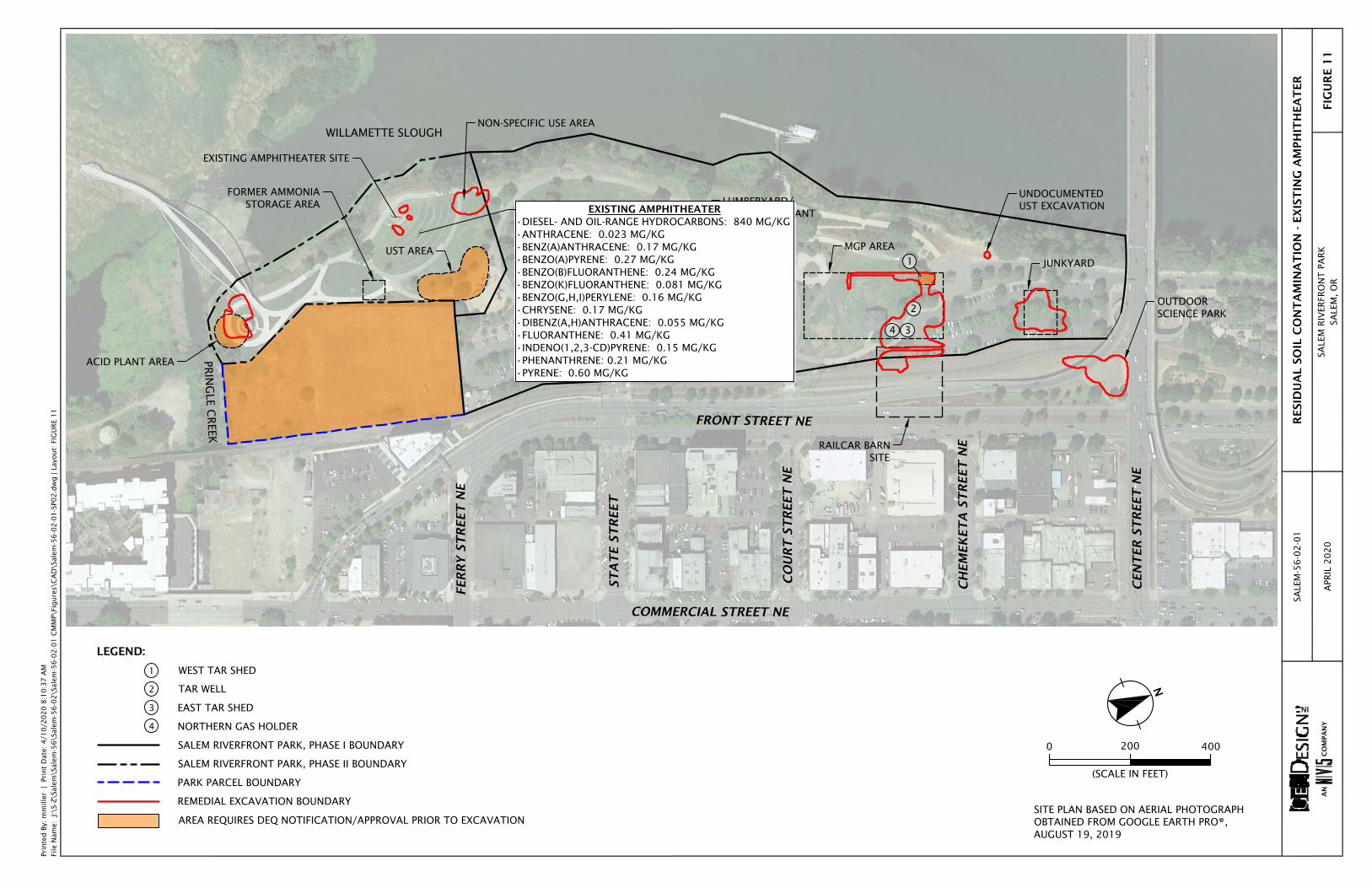
2
3
ACID PLANT AREA
FORMER AMMONIASTORAGE AREA
UST AREA
EXISTING AMPHITHEATER SITE
LUMBERYARD/CONTAINER PLANT
MGP AREA
JUNKYARD
FRONT STREET NE
CO
UR
T S
TR
EET
NE
ST
AT
E S
TR
EET
CH
EM
EK
ET
A S
TR
EET
NE
CEN
TER
ST
REET
NE
FER
RY S
TR
EET
NE
COMMERCIAL STREET NE
NON-SPECIFIC USE AREA
PRIN
GLE C
REEK
WILLAMETTE SLOUGH
4
RAILCAR BARN SITE
UNDOCUMENTEDUST EXCAVATION
OUTDOORSCIENCE PARK
1
Prin
ted B
y: m
mill
er
| Pr
int
Dat
e: 4
/10
/20
20
8:1
0:3
7 A
MFi
le N
ame:
J:\S
-Z\S
alem
\Sal
em-5
6\S
alem
-56
-02
\Sal
em-5
6-0
2-0
1 C
MM
P\Fi
gure
s\C
AD
\Sal
em-5
6-0
2-0
1-S
P02
.dw
g |
Layo
ut:
FIG
UR
E 1
1
AN
CO
MPA
NY
RESID
UA
L S
OIL
CO
NT
AM
INA
TIO
N - E
XIS
TIN
G A
MPH
ITH
EA
TER
SALE
M R
IVER
FRO
NT
PA
RK
SALE
M,
OR
SALE
M-5
6-0
2-0
1
APR
IL 2
02
0FIG
UR
E 1
1
0
(SCALE IN FEET)
N
200 400
SITE PLAN BASED ON AERIAL PHOTOGRAPHOBTAINED FROM GOOGLE EARTH PRO®,AUGUST 19, 2019
LEGEND:
WEST TAR SHED
TAR WELL
EAST TAR SHED
NORTHERN GAS HOLDER
SALEM RIVERFRONT PARK, PHASE I BOUNDARY
SALEM RIVERFRONT PARK, PHASE II BOUNDARY
PARK PARCEL BOUNDARY
REMEDIAL EXCAVATION BOUNDARY
AREA REQUIRES DEQ NOTIFICATION/APPROVAL PRIOR TO EXCAVATION
1
2
3
4
EXISTING AMPHITHEATER•DIESEL- AND OIL-RANGE HYDROCARBONS: 840 MG/KG•ANTHRACENE: 0.023 MG/KG•BENZ(A)ANTHRACENE: 0.17 MG/KG•BENZO(A)PYRENE: 0.27 MG/KG•BENZO(B)FLUORANTHENE: 0.24 MG/KG•BENZO(K)FLUORANTHENE: 0.081 MG/KG•BENZO(G,H,I)PERYLENE: 0.16 MG/KG•CHRYSENE: 0.17 MG/KG•DIBENZ(A,H)ANTHRACENE: 0.055 MG/KG•FLUORANTHENE: 0.41 MG/KG•INDENO(1,2,3-CD)PYRENE: 0.15 MG/KG•PHENANTHRENE: 0.21 MG/KG•PYRENE: 0.60 MG/KG

2
3
ACID PLANT AREA
FORMER AMMONIASTORAGE AREA
UST AREA
EXISTING AMPHITHEATER SITE
LUMBERYARD/CONTAINER PLANT
MGP AREA
JUNKYARD
FRONT STREET NE
CO
UR
T S
TR
EET
NE
ST
AT
E S
TR
EET
CH
EM
EK
ET
A S
TR
EET
NE
CEN
TER
ST
REET
NE
FER
RY S
TR
EET
NE
COMMERCIAL STREET NE
NON-SPECIFIC USE AREA
PRIN
GLE C
REEK
WILLAMETTE SLOUGH
4
RAILCAR BARN SITE
UNDOCUMENTEDUST EXCAVATION
OUTDOORSCIENCE PARK
1
Prin
ted B
y: m
mill
er
| Pr
int
Dat
e: 4
/10
/20
20
8:1
0:4
2 A
MFi
le N
ame:
J:\S
-Z\S
alem
\Sal
em-5
6\S
alem
-56
-02
\Sal
em-5
6-0
2-0
1 C
MM
P\Fi
gure
s\C
AD
\Sal
em-5
6-0
2-0
1-S
P02
.dw
g |
Layo
ut:
FIG
UR
E 1
2
AN
CO
MPA
NY
RESID
UA
L S
OIL
CO
NT
AM
INA
TIO
N - O
UT
DO
OR
SC
IEN
CE P
AR
K
SALE
M R
IVER
FRO
NT
PA
RK
SALE
M,
OR
SALE
M-5
6-0
2-0
1
APR
IL 2
02
0FIG
UR
E 1
2
0
(SCALE IN FEET)
N
200 400
SITE PLAN BASED ON AERIAL PHOTOGRAPHOBTAINED FROM GOOGLE EARTH PRO®,AUGUST 19, 2019
LEGEND:
WEST TAR SHED
TAR WELL
EAST TAR SHED
NORTHERN GAS HOLDER
SALEM RIVERFRONT PARK, PHASE I BOUNDARY
SALEM RIVERFRONT PARK, PHASE II BOUNDARY
PARK PARCEL BOUNDARY
REMEDIAL EXCAVATION BOUNDARY
AREA REQUIRES DEQ NOTIFICATION/APPROVAL PRIOR TO EXCAVATION
1
2
3
4
OUTDOOR SCIENCE PARK•LEAD: 667 MG/KG•TCLP LEAD: 0.44 MG/L

2
3
ACID PLANT AREA
FORMER AMMONIASTORAGE AREA
UST AREA
EXISTING AMPHITHEATER SITE
LUMBERYARD/CONTAINER PLANT
MGP AREA
JUNKYARD
FRONT STREET NE
CO
UR
T S
TR
EET
NE
ST
AT
E S
TR
EET
CH
EM
EK
ET
A S
TR
EET
NE
CEN
TER
ST
REET
NE
FER
RY S
TR
EET
NE
COMMERCIAL STREET NE
NON-SPECIFIC USE AREA
PRIN
GLE C
REEK
WILLAMETTE SLOUGH
4
RAILCAR BARN SITE
UNDOCUMENTEDUST EXCAVATION
OUTDOORSCIENCE PARK
1
Prin
ted B
y: m
mill
er
| Pr
int
Dat
e: 4
/10
/20
20
8:1
0:4
7 A
MFi
le N
ame:
J:\S
-Z\S
alem
\Sal
em-5
6\S
alem
-56
-02
\Sal
em-5
6-0
2-0
1 C
MM
P\Fi
gure
s\C
AD
\Sal
em-5
6-0
2-0
1-S
P02
.dw
g |
Layo
ut:
FIG
UR
E 1
3
AN
CO
MPA
NY
RESID
UA
L S
OIL
CO
NT
AM
INA
TIO
N - P
AR
K P
AR
CEL
SALE
M R
IVER
FRO
NT
PA
RK
SALE
M,
OR
SALE
M-5
6-0
2-0
1
APR
IL 2
02
0FIG
UR
E 1
3
0
(SCALE IN FEET)
N
200 400
SITE PLAN BASED ON AERIAL PHOTOGRAPHOBTAINED FROM GOOGLE EARTH PRO®,AUGUST 19, 2019
LEGEND:
WEST TAR SHED
TAR WELL
EAST TAR SHED
NORTHERN GAS HOLDER
SALEM RIVERFRONT PARK, PHASE I BOUNDARY
SALEM RIVERFRONT PARK, PHASE II BOUNDARY
PARK PARCEL BOUNDARY
REMEDIAL EXCAVATION BOUNDARY
AREA REQUIRES DEQ NOTIFICATION/APPROVAL PRIOR TO EXCAVATION
1
2
3
4
PARK PARCEL•2,3,7,8-TCDD (DIOXIN) EQUIVALENTS: 0.15 NG/KG•ANTIMONY: 383 MG/KG•ARSENIC: 10.2 MG/KG•BERYLLIUM: 1.16 MG/KG•CADMIUM: 14.1 MG/KG•CHROMIUM III: 37.5 MG/KG•CHROMIUM VI: 0.405 MG/KG•COPPER: 929 MG/KG•LEAD: 37,000 MG/KG•NICKEL: 95.7 MG/KG•SILVER: 3.01 MG/KG•ZINC: 4,490 MG/KG•MERCURY: 5.51 MG/KG•TCLP BARIUM: 0.832 MG/L•TCLP CHROMIUM III: 0.036 MG/L•TCLP LEAD: 20.4 MG/L•GASOLINE-RANGE HYDROCARBONS: 18.1 MG/KG•DIESEL-RANGE HYDROCARBONS: 496 MG/KG•OIL-RANGE HYDROCARBONS: 1,710 MG/KG•ACENAPHTHENE: 0.0627 MG/KG•ACENAPHTHYLENE: 0.144 MG/KG•ANTHRACENE: 0.275 MG/KG•BENZ(A)ANTHRACENE: 0.599 MG/KG•BENZO(A)PYRENE: 0.625 MG/KG•BENZO(B)FLUORANTHENE: 1.26 MG/KG•BENZO(K)FLUORANTHENE: 0.353 MG/KG•BENZO(G,H,I)PERYLENE: 0.923 MG/KG•CHRYSENE: 0.807 MG/KG•DIBENZ(A,H)ANTHRACENE: 0.289 MG/KG•FLUORANTHENE: 1.81 MG/KG•FLUORENE: 0.121 MG/KG•INDENO(1,2,3-CD)PYRENE: 0.636 MG/KG•NAPHTHALENE: 0.271 MG/KG•PHENANTHRENE: 0.703 MG/KG•PYRENE: 2.14 MG/KG•AROCLOR 1248: 0.068 MG/KG•AROCLOR 1254: 0.256 MG/KG

2
3
ACID PLANT AREA
FORMER AMMONIASTORAGE AREA
UST AREA
EXISTING AMPHITHEATER SITE
LUMBERYARD/CONTAINER PLANT
MGP AREA
JUNKYARD
FRONT STREET NE
CO
UR
T S
TR
EET
NE
ST
AT
E S
TR
EET
CH
EM
EK
ET
A S
TR
EET
NE
CEN
TER
ST
REET
NE
FER
RY S
TR
EET
NE
COMMERCIAL STREET NE
NON-SPECIFIC USE AREA
PRIN
GLE C
REEK
WILLAMETTE SLOUGH
4
RAILCAR BARN SITE
UNDOCUMENTEDUST EXCAVATION
OUTDOORSCIENCE PARK
1
Prin
ted B
y: m
mill
er
| Pr
int
Dat
e: 4
/10
/20
20
8:1
0:5
2 A
MFi
le N
ame:
J:\S
-Z\S
alem
\Sal
em-5
6\S
alem
-56
-02
\Sal
em-5
6-0
2-0
1 C
MM
P\Fi
gure
s\C
AD
\Sal
em-5
6-0
2-0
1-S
P02
.dw
g |
Layo
ut:
FIG
UR
E 1
4
AN
CO
MPA
NY
RESID
UA
L G
RO
UN
DW
AT
ER
CO
NT
AM
INA
TIO
N
SALE
M R
IVER
FRO
NT
PA
RK
SALE
M,
OR
SALE
M-5
6-0
2-0
1
APR
IL 2
02
0FIG
UR
E 1
4
0
(SCALE IN FEET)
N
200 400
SITE PLAN BASED ON AERIAL PHOTOGRAPHOBTAINED FROM GOOGLE EARTH PRO®,AUGUST 19, 2019
LEGEND:
WEST TAR SHED
TAR WELL
EAST TAR SHED
NORTHERN GAS HOLDER
SALEM RIVERFRONT PARK, PHASE I BOUNDARY
SALEM RIVERFRONT PARK, PHASE II BOUNDARY
PARK PARCEL BOUNDARY
REMEDIAL EXCAVATION BOUNDARY
AREA REQUIRES DEQ NOTIFICATION/APPROVAL PRIOR TO EXCAVATION
1
2
3
4
PARK PARCEL•CHLOROFORM: 3.4 G/L•1,2-DICHLOROETHENE: 4 G/L•TRICHLOROETHENE: 2 G/L•TETRACHLOROETHENE: 5 G/LBENZENE: 6 G/L•TOLUENE: 9 G/L•XYLENES: 4 G/L•CIS-1,2-DICHLOROETHENE: 4.20 G/L•FLUORENE: 7.8 G/L•PHENANTHRENE: 0.73 G/L•ANTHRACENE: 0.25 G/L•FLUORANTHENE: 4.4 G/L•PYRENE: 0.3 G/L•ACENAPHTHENE: 0.8 G/L•ACENAPHTHYLENE: 0.2 G/L•NAPHTHALENE: 0.1 G/L•ANTIMONY: 0.3 G/L•ARSENIC: 0.31 G/L•CHROMIUM: 1.24 G/L•COPPER: 1.87 G/L•LEAD: 2.29 G/L•MERCURY: 0.00616 G/L•NICKEL: 0.5 G/L•SELENIUM: 0.00136 G/L•ZINC: 19 G/L
RIVERFRONT PARK•ANTIMONY: 1.6 G/L•ARSENIC: 21 G/L•BERYLLIUM: 2.3 G/L•CADMIUM: 2.5 G/L•CHROMIUM III: 55 G/L•COPPER: 1,000 G/L•LEAD: 1,300 G/L•NICKEL: 50 G/L•SILVER: 0.54 G/L•ZINC: 520 G/L•MERCURY: 0.000389 G/L•DIESEL-RANGE HYDROCARBONS: 506 G/L•OIL-RANGE HYDROCARBONS: 654 G/L•BENZO(G,H,I)PERYLENE: 0.0857 G/L•FLUORANTHENE: 0.0672 G/L•INDENO(1,2,3-CD)PYRENE: 0.0571 G/L•PHENANTHRENE: 0.0672 G/L•PYRENE: 0.0768 G/L•TOLUENE: 1.43 G/L•AROCLOR 1254: 0.276 G/L
AutoCAD SHX Text
mG/L mG/L mG/L mG/L mG/L mG/L mG/L mG/L mG/L mG/L mG/L mG/L mG/L mG/L mG/L mG/L mG/L mG/L mG/L mG/L

RECENTLY BACKFILLED EXCAVATION
LIMITS OF RECENT EXCAVATION
SUSPECT NATIVE SOIL
NEW PROTECTIVE CAP
EXISTING PROTECTIVE CAP
EXISTINGPROTECTIVE CAP
DEMARCATION FABRIC(MAY OR MAY NOT BE PRESENT)
DEMARCATION FABRIC(MAY OR MAY NOT BE PRESENT)
NEW DEMARCATION FABRIC
Prin
ted B
y: m
mill
er
| Pr
int
Dat
e: 4
/10
/20
20
8:1
0:5
7 A
MFi
le N
ame:
J:\
S-Z\S
alem
\Sal
em-5
6\S
alem
-56
-02
\Sal
em-5
6-0
2-0
1 C
MM
P\Fi
gure
s\C
AD
\Sal
em-5
6-0
2-0
1-D
ET0
1.d
wg
| La
yout:
FIG
UR
E 1
5
AN COMPANY
SCHEMATIC PROTECTIVE CAP
SALEM RIVERFRONT PARKSALEM, OR
SALEM-56-02-01
APRIL 2020 FIGURE 15

APPENDIX

A-1 Salem-56-02-01:041020
APPENDIX CAP INSPECTION AND MAINTENANCE PLAN

Salem-56-02-01:041020
TABLE OF CONTENTS PAGE NO. ACRONYMS AND ABBREVIATIONS 1.0 INTRODUCTION 1 2.0 PURPOSE AND OBJECTIVES 1 3.0 EXISTING PROTECTIVE CAP CONDITIONS 1 4.0 DEQ NOTIFICATION REQUIREMENTS 1 5.0 PROTECTIVE CAP CONSTRUCTION 2 6.0 PROTECTIVE CAP MONITORING 2 7.0 PROTECTIVE CAP REPAIR 3 7.1 Routine Maintenance 3 7.2 Non-Routine Maintenance 3 8.0 RECORDKEEPING 3 9.0 LIMITATIONS 4 ATTACHMENTS Attachment A Cap Inspection Report Attachment B Project Site Photographs Figures B-1 – B-5

Salem-56-02-01:041020
ACRONYMS AND ABBREVIATIONS CFSL Clean Fill Screening Level CIMP Cap Inspection and Maintenance Plan CMMP Contaminated Media Management Plan DEQ Oregon Department of Environmental Quality ECSI Environmental Cleanup Site Information MGP manufactured gas plant RBC risk-based concentration UST underground storage tank

1 Salem-56-02-01:041020
1.0 INTRODUCTION This CIMP has been prepared for the Salem Riverfront Park located west of Front Street SE in Salem, Oregon (project site). The project site consists of two DEQ cleanup sites, including the Salem Riverfront Park Project (DEQ ECSI No. 865) and a portion of the Boise Cascade Mill – Salem site (DEQ ECSI No. 4465) that is referred to as the Park Parcel. Information regarding the developmental history and environmental conditions at the project site is presented in the CMMP that this CIMP is attached to and part of. The project site, including the Salem Riverfront Park Project, the Park Parcel, and 11 areas of concern is shown on Figures 2 through 13 of the CMMP. Acronyms and abbreviations used herein are defined above, immediately following the Table of Contents. 2.0 PURPOSE AND OBJECTIVES This CIMP was prepared to satisfy DEQ requirements for managing the protective caps present at the project site. The purpose of the CIMP is to present the recommended monitoring and maintenance activities to ensure the protective caps adequately protect human health and the environment. This CIMP is intended to be used by the City of Salem (the City) or designee in conjunction with the CMMP. The City is to employ or designate personnel with appropriate experience and qualifications to perform the activities described in this CIMP. 3.0 EXISTING PROTECTIVE CAP CONDITIONS A protective cap consisting of 2 feet of clean fill was placed across the Riverfront Park site to prevent direct contact to residual contaminated soil by park users. A demarcation layer is reportedly present below the clean fill cap in areas where previous remedial excavations were completed, which are shown on Figure 2 of the CMMP. The Park Parcel has been primarily capped with asphalt concrete and gravel as an intermediate measure to protect direct contact with residual contaminated soil. Landscaped areas are present on the west portion of the Park Parcel. Upcoming redevelopment of the Park Parcel includes constructing a new amphitheater that will encompass most of the Park Parcel and extend onto the Riverfront Park site. 4.0 DEQ NOTIFICATION REQUIREMENTS As stated in the Easement and Equitable Servitudes established for the Salem Riverfront Park Phase I and Phase II sites and the Park Parcel of the Boise Cascade Mill – Salem site, DEQ notification and approval are required prior to commencing earthwork activities within the following areas (see Figure 2 of the CMMP): The vicinity of the west tar shed in the MGP area The entire lumberyard/container plant site The vicinity of the acid plant area

2 Salem-56-02-01:041020
The vicinity of the UST area The entire Park Parcel site 5.0 PROTECTIVE CAP RECONSTRUCTION Major construction projects at the project site will likely require complete reconstruction of the protective cap present in the planned work area. The protective cap may consist of hardscapes (asphalt, concrete, or concrete or stone pavers), buildings, or a minimum of 2 feet of clean fill overlying a demarcation layer consisting of high-visibility geotextile fabric. The demarcation layer should be installed at the top of the excavation backfill regardless of whether demarcation fabric was installed along the limits of the excavation. A demarcation layer is not required beneath buildings or hardscapes. A schematic depicting a backfilled excavation and completed protective cap, including a demarcation layer and 2 feet of clean fill, is presented on Figure 15 of the CMMP. 6.0 PROTECTIVE CAP MONITORING The effectiveness of the caps is based on their ability to serve as engineering controls that limit human exposure to subsurface soil underlying the caps. Caps should be inspected annually and during improvements that could disturb the protective caps. Inspections should be conducted by adequately trained personnel appointed by the City. Inspections will consist of a walking survey of the protective caps to visually evaluate the surface (including landscaped areas, trees, shrubs, asphalt areas, concrete slabs/walkways, and other hardscapes) for signs of damage, failure, or disturbance. The inspector must note cracks, weathering, areas of apparent groundwater seepage, or other features that could indicate less than 2 feet of clean soil in softscape areas or conditions that would allow underlying soil to migrate through the cap and/or that could allow direct contact to soil beneath the cap. The results of each annual inspection (or inspections conducted during improvements) should be documented by the inspector on the Cap Inspection Report presented in Attachment A of this CIMP. The inspector should photograph suspect features observed during the inspection and include the photographs and photograph descriptions with the Cap Inspection Report. The inspector should also map areas of suspect features and associate the photographs with the noted locations on a site plan. Photographs of the condition of the project site as of the date of this CIMP are presented on Figures B-1 through B-5 (Attachment B of this CIMP). The Cap Inspection Report is intended to require the inspector to determine if maintenance is required and includes a requirement to record cap repair activities (if completed). Areas that the inspector identifies as having less than the required 2 feet of clean fill must be repaired immediately. The inspector should document areas that require repair in a written Early Action Report within 24 hours of the inspection. The City is responsible for repair of the areas identified in the Early Action Report within one week of completion of the Early Action Report. The City should also provide DEQ with a copy of the Early Action Report within one week of completion but may complete the cap repair before receiving a response from DEQ. See the following section for additional information on cap repair.
3 Salem-56-02-01:041020
7.0 PROTECTIVE CAP REPAIR Protective cap repairs should be completed in a manner that returns the cap to a level of protectiveness equivalent to its original design and construction. The City or appointed representative should evaluate the adequacy of repair or maintenance activities recommended in the annual Cap Inspection Report. 7.1 ROUTINE MAINTENANCE Disturbances to the protective caps observed during routine inspections will be repaired as part of routine maintenance. Such routine maintenance may include, but is not limited to, the following: Performing approved inspection repairs Repairing eroded surfaces necessary to restore the protective caps to their original condition Replacing damaged concrete surfaces with concrete, landscaping, or clean fill of an
equivalent thickness 7.2 NON-ROUTINE MAINTENANCE Activities that disturb the protective caps may include planned intrusive work. Before and after such events, the protective caps must be maintained to limit the potential of exposure to residual contamination. Such non-routine maintenance activities are described below: The demarcation layer, where present, must be replaced or restored to its original condition
if it is disturbed or damaged. Disturbing the demarcation layer should be avoided to the extent possible.
Restoration of the minimum 2-foot-thick protective cap or hardscapes must be included in any intrusive work plan that includes modification of the protective cap surfaces.
Because soil below the protective caps and underlying demarcation layer potentially contains contaminates at concentrations greater than DEQ RBCs and/or DEQ CFSLs, soil excavated from beneath the protective caps should be managed in accordance with the CMMP.
Best management practices should be followed to ensure that contaminated soil does not spread beyond the work area during soil removal, equipment decontamination, etc.
Eroded surfaces must be repaired as necessary to restore the protective cap to its original condition.
Damaged hardscape surfaces must be replaced with concrete and/or asphalt of an equivalent thickness.
8.0 RECORDKEEPING The inspector will document observations made during inspections on the Cap Inspection Report, which is presented in Attachment A of this CIMP. The Cap Inspection Report is intended to require the inspector to determine if maintenance is required and includes a requirement to record cap repair activities (if completed). Areas that the inspector identifies as having less than the required 2 feet of clean fill or damaged hardscape areas must be repaired immediately. The inspector will document areas that require repair in a written Early Action Report within 24 hours of the inspection. The City is responsible for repair of the areas identified in the Early Action

4 Salem-56-02-01:041020
Report within one week of completion of the Early Action Report. The City will also provide DEQ with a copy of the Early Action Report within one week of completion but may complete the cap repair before receiving a response from DEQ. The completed Cap Inspection Report will be submitted to DEQ by January 15 each year and should list suspect areas that require re-inspection the following year, include photographs taken during the inspection, document repairs recommended in Early Action Reports (if completed), and summarize recommended maintenance activities. Copies of the annual Cap Inspection Reports should be maintained for a minimum of five years after submittal to DEQ. 9.0 LIMITATIONS This CIMP has been prepared by GeoDesign Inc. on behalf of the City of Salem Public Works Department for use by the City of Salem or designee. GeoDesign makes no warranties or guarantees regarding the accuracy or completeness of information provided or compiled by others. The conclusions presented in this CIMP are based on professional opinions with regard to the subject matter. These opinions have been arrived at in accordance with the currently accepted hydrogeologic and engineering standards and practices applicable to this location. GeoDesign obtained, reviewed, and evaluated certain information used in this CIMP from sources that were believed reliable. GeoDesign’s conclusions, opinions, and recommendations are based in part on such information. GeoDesign’s services did not include verification of its accuracy or authenticity. Should the information upon which GeoDesign relied prove to be inaccurate or unreliable, GeoDesign reserves the right to amend or revise its conclusions, opinions, and/or recommendations. This CIMP is not intended for use by others, and the information contained herein is not applicable to other sites. Reliance on this CIMP by other parties is strictly at the risk of those parties, and GeoDesign will grant no third-party reliance unless specifically requested in writing by our client for whom this CIMP was prepared.

ATTACHMENT A

CAP INSPECTION REPORT Page 1 of 3
Salem Riverfront Park Inspector(s): Signature: Date and Time of Inspection: The following cap components were inspected. Areas of concern have been identified on the attached site map. Photographic documentation of each suspect feature observed during the cap inspection is also attached. Include a repair record, for those areas needing maintenance Condition of floor slab/landscaped areas (note cracks, suspect areas with less than 2 feet of clean fill, animal burrows, erosion, etc.): Any suspect features, such as major cracks, damage, settlement, or removed vegetation: Previous area of repair observations: Any observations of areas where soil is migrating through the cap or where soil beneath the cap could be contacted that warrant repair? Any observations of areas where maintenance is required to maintain the integrity of the cap?

CAP INSPECTION REPORT Page 2 of 3
Other Observations, Comments, Concerns, Etc.:

CAP INSPECTION REPORT Page 3 of 3
Photographic Log: (Please print out all photos as 3 x 5 or larger and attach to report)
Photo I.D.
Location Facing
Direction Description

ATTACHMENT B

SALEM-56-02-01 PROJECT SITE PHOTOGRAPHS
APRIL 2020 SALEM RIVERFRONT PARK
SALEM, OR FIGURE B-1
NORTHERN-MOST PORTION OF THE PROJECT SITE. PHOTOGRAPH TAKEN FACING SOUTH TOWARD THE FORMER JUNKYARD.
NORTHWEST PORTION OF THE PROJECT SITE. PHOTOGRAPH TAKEN FACING SOUTHEAST TOWARD THE FORMER MPG AREA AND THE FORMER LUMBERYARD/CONTAINER PLANT.
Sale
m-5
6-02
-01-
FB1_
B5-S
PH.d
ocx
Pr
int D
ate:
4/1
0/20

SALEM-56-02-01 PROJECT SITE PHOTOGRAPHS
APRIL 2020 SALEM RIVERFRONT PARK
SALEM, OR FIGURE B-2
WEST-CENTRAL PORTION OF THE PROJECT SITE. PHOTOGRAPH FACING SOUTH TOWARD THE FORMER LUMBERYARD/CONTAINER PLANT.
SOUTHWEST PORTION OF THE PROJECT SITE. PHOTOGRAPH TAKEN AT THE EXISTING AMPHITHEATER SITE FACING SOUTHEAST TOWARD THE FORMER UST AREA.
Sale
m-5
6-02
-01-
FB1_
B5-S
PH.d
ocx
Pr
int D
ate:
4/1
0/20

SALEM-56-02-01 PROJECT SITE PHOTOGRAPHS
APRIL 2020 SALEM RIVERFRONT PARK
SALEM, OR FIGURE B-3
SOUTHWEST PORTION OF THE PROJECT SITE. PHOTOGRAPH TAKEN FACING SOUTH TOWARD THE FORMER ACID PLANT AREA.
SOUTHWESTERN-MOST PORTION OF THE PROJECT SITE. PHOTOGRAPH TAKEN AT THE FORMER ACID PLANT AREA FACING NORTH TOWARD THE FORMER AMMONIA STORAGE AREA AND EXISTING AMPHITHEATER SITE.
Sale
m-5
6-02
-01-
FB1_
B5-S
PH.d
ocx
Pr
int D
ate:
4/1
0/20

SALEM-56-02-01 PROJECT SITE PHOTOGRAPHS
APRIL 2020 SALEM RIVERFRONT PARK
SALEM, OR FIGURE B-4
SOUTH-CENTRAL PORTION OF THE PROJECT SITE. PHOTOGRAPH TAKEN AT THE FORMER UST AREA FACING NORTH.
SOUTH-CENTRAL PORTION OF THE PROJECT SITE. PHOTOGRAPH TAKEN AT THE SOUTH PARKING LOT FACING NORTH.
Sale
m-5
6-02
-01-
FB1_
B5-S
PH.d
ocx
Pr
int D
ate:
4/1
0/20

SALEM-56-02-01 PROJECT SITE PHOTOGRAPHS
APRIL 2020 SALEM RIVERFRONT PARK
SALEM, OR FIGURE B-5
CENTRAL PORTION OF THE PROJECT SITE. PHOTOGRAPH TAKEN FACING SOUTH TOWARD THE FORMER LUMBERYARD/CONTAINER PLANT.
CENTRAL PORTION OF THE PROJECT SITE. PHOTOGRAPH TAKEN FACING NORTHWEST.
Sale
m-5
6-02
-01-
FB1_
B5-S
PH.d
ocx
Pr
int D
ate:
4/1
0/20
www.geodesigninc.com