conflict with adopted policies plans or programs regarding public ...
117
New More New Ability No Significant Severe to Substantial Impact Impacts Substantially Change Reduce from Significant Previous Impact Analysis conflict with adopted policies plans or programs regarding public transit bikeways or pedestrian facilities Therefore implementation of the proposed Project would not result in any new impacts or increase the severity of a previously identified significant impact as analyzed in EIR No 359 Mitigation No mitigation is required Monitoring No monitoring is required 44 Bike Trails Source Temescal Canyon Area Plan Project Application Materials Findings of Fact EIR No 359 Finding EIR No 359 did not identify any impacts to bike trails SMP 143R2 Finding No Substantial Change from Previous Analysis According to Figure 8 of the Temescal Canyon Area Plan two trail segments are planned in the immediate vicinity of the Project site including a Historic Trail along Temescal Canyon Road and a Community Trail located immediately adjacent to the eastern boundary of the Project site Riv County 2003b Figure 8 Neither of these trail designations includes or requires accommodations for bicycles In addition and as discussed under the analysis of Threshold 42 the designated trail alignments are not required to be improved as part of the Project The proposed Project also does not propose any new bike trails Accordingly the proposed Project would not conflict with any designated trail alignments and would not result in any significant environmental effects associated with the construction of bike trails Therefore implementation of the proposed Project would not result in any new impacts or increase the severity of a previously identified significant impact as analyzed in EIR No 359 Mitigation No mitigation is required Monitoring No monitoring is required UTILITY AND SERVICE SYSTEMS Would the project 45 Water I I a Require or result in the construction of new water treatment facilities or expansion of existing facilities the construction of which would cause significant environmental effects b Have sufficient water supplies available to serve I the project from existing entitlements and resources or are new or expanded entitlements needed Source Elsinore Valley Municipal Water District Urban Water Management Plan Project Application Materials Findings of Fact Page 84 of 113 EA 42714
-
Upload
khangminh22 -
Category
Documents
-
view
2 -
download
0
Transcript of conflict with adopted policies plans or programs regarding public ...
New More New Ability No
Significant Severe to Substantial
Impact Impacts Substantially ChangeReduce from
Significant Previous
Impact Analysis
conflict with adopted policies plans or programs regarding public transit bikeways or pedestrianfacilities Therefore implementation of the proposed Project would not result in any new impacts orincrease the severity of a previously identified significant impact as analyzed in EIR No 359
Mitigation No mitigation is required
Monitoring No monitoring is required
44 Bike Trails
Source Temescal Canyon Area Plan Project Application Materials
Findings of Fact
EIR No 359 Finding EIR No 359 did not identify any impacts to bike trails
SMP 143R2 Finding No Substantial Change from Previous Analysis According to Figure 8 ofthe Temescal Canyon Area Plan two trail segments are planned in the immediate vicinity of theProject site including a Historic Trail along Temescal Canyon Road and a Community Trail locatedimmediately adjacent to the eastern boundary of the Project site Riv County 2003b Figure 8Neither of these trail designations includes or requires accommodations for bicycles In addition andas discussed under the analysis of Threshold 42 the designated trail alignments are not required tobe improved as part of the Project The proposed Project also does not propose any new bike trailsAccordingly the proposed Project would not conflict with any designated trail alignments and wouldnot result in any significant environmental effects associated with the construction of bike trailsTherefore implementation of the proposed Project would not result in any new impacts or increasethe severity of a previously identified significant impact as analyzed in EIR No 359
Mitigation No mitigation is required
Monitoring No monitoring is required
UTILITY AND SERVICE SYSTEMS Would the project45 Water I I
a Require or result in the construction of new watertreatment facilities or expansion of existingfacilities the construction of which would cause
significant environmental effectsb Have sufficient water supplies available to serve
Ithe project from existing entitlements and
resources or are new or expanded entitlementsneeded
Source Elsinore Valley Municipal Water District Urban Water Management Plan Project ApplicationMaterials
Findings of Fact
Page 84 of 113 EA 42714

New More New Ability No
Significant Severe to Substantial
Impact Impacts Substantially ChangeReduce from
Significant Previous
Impact Analysis
a EIR No 359 Finding EIR No 359 concluded that there would be no net increase in demand forwater resources as compared to the baseline conditions that existed at the time EIR No 359 wascertified On the contrary EIR No 359 concluded that there would be a net positive impact on waterresources available in the region and that less water would be utilized due to the increased use ofwater reclamation equipment on the site as was proposed under the revised permits AccordinglyEIR No 359 concluded that there would not be a need for the construction of new water treatment
facilities or expansion of existing facilities the construction of which would cause significantenvironmental effects As such EIR No 359 concluded that no impact would occur Riv County1991 p 125
SMP 143 R2 No Substantial Change from Previous Analysis As indicated in Section 323B theproposed Project would not result in a net increase in demand for water resources as compared toexisting conditions or the conditions that were evaluated in EIR No 359 As such the proposedProject would not require or result in the construction of new water treatment facilities or expansion ofexisting facilities the construction of which would cause significant environmental effects and noimpact would occur Therefore implementation of the proposed Project would not result in any newimpacts or increase the severity of a previously identified significant impact as analyzed in EIR No359
b EIR No 359 Finding EIR No 359 concluded that there would be no net increase in demand forwater resources as compared to the baseline conditions that existed at the time EIR No 359 wascertified EIR No 359 concluded there would be a net positive impact on water resources available inthe region and that less water would be used as compared to the conditions that existed at the timeEIR No 359 was certified due to the increased use of water reclamation equipment proposed underthe revised permits Since no increase in demand for water resources was identified EIR No 359concluded that the EVMWD would have sufficient water supplies available from existing entitlementsand resources and that no new or expanded entitlements would be needed Accordingly EIR No359 concluded that no impact would occur Riv County 1991 p 125
SMP 143 R2 No Substantial Change from Previous Analysis Water to the Project site isprovided by the EVMWD which has prepared an Urban Water Management Plan UWMP dated May2011 that provides for the longrange planning efforts of water purveyance within its district Sincethe proposed Project represents an active mining operation that has been in existence since prior to2000 when the EVMWD prepared its first UWMP and since water usage would not increase underthe proposed Project the proposed Projectswater demand is fully accounted for in the EVMWDsUWMP Since the UWMP concludes that the EVMWD has sufficient water supplies available to serveall existing land uses within its service area and since the Project would not result in an increaseddemand for water resources it can therefore be concluded that the EVMWD would have sufficientwater supplies available to serve the Project from existing entitlements and resources and no new orexpanded entitlements would be needed as such and consistent with the conclusion reached in EIRNo 359 no impact would occur Therefore implementation of the proposed Project would not resultin any new impacts or increase the severity of a previously identified significant impact as analyzed inEIR No 359
Mitigation No mitigation is required
Monitoring No monitoring is required
46 Sewer u u n
Page 85 of 113 EA 42714
New More New Ability No
Significant Severe to Substantial
Impact Impacts Substantially ChangeReduce from
Significant Previous
Impact Analysis
a Require or result in the construction of newwastewater treatment facilities including septicsystems or expansion of existing facilities theconstruction of which would cause significantenvironmental effects
b Result in a determination by the wastewater treatn u
ment provider that serves or may service theproject that it has adequate capacity to serve theprojects projected demand in addition to theproviders existing commitments
Source Project Application Materials
Findings of Fact
a b EIR No 359 Finding EIR No 359 determined that the expansion and continuation of theexisting mining site would create approximately 24 jobs EIR No 359 concluded that sewage disposalat the site would be handled via two existing portable toilets that would continue to serve the existingand expanded operation As such EIR No 359 concluded there would be no increase in the sitesdemand for wastewater treatment facilities and found that there was adequate capacity to handle theprojected demand Accordingly EIR No 359 concluded that no impact would occur Riv County1991 p 127
SMP 143R2 Finding No Substantial Change from Previous Analysis The proposed Projectdoes not involve the construction of any new homes and would not increase the number of permittedemployees at the site As such there would be no increase in the sitesdemand for wastewatertreatment facilities or capacity as compared to existing conditions or the conditions evaluated in EIRNo 359 Furthermore wastewater generated at the site under existing conditions is handled viaportable toilets and there would be no need for additional portable toilets as a result of the ProjectWastewater would continue to be handled via a wastewater haul company and disposed of atpermitted facilities as occurs under existing conditions and the conditions evaluated in EIR No 359As such the proposed Project would not require the construction of wastewater treatment facilities orresult in a determination that the wastewater treatment provider does not have adequate capacity toserve the projects projected demand and no impact would occur Therefore implementation of theproposed Project would not result in any new impacts or increase the severity of a previouslyidentified significant impact as analyzed in EIR No 359
Mitigation No mitigation is required
Monitoring No monitoring is required
47 Solid WasteU LI
a Is the project served by a landfill with sufficientpermitted capacity to accommodate the projectssolid waste disposal needs
b Does the project comply with federal state andlocal statutes and regulations related to solidwastes including the CIWMP County IntegratedWaste Management Plan
Page 86 of 113 EA 42714

New More New Ability No
Significant Severe to Substantial
Impact Impacts Substantially ChangeReduce from
Significant Previous
Impact Analysis
Source Project Application Materials
Findings of Fact
a b EIR No 359 Finding EIR No 359 did not identify any impacts to landfill capacity or due toconflicts with federal state and local statutes and regulations related to solid wastes
SMP 143R2 Finding No Substantial Change from Previous Analysis The Project would notchange the amount of solid waste generated by the mining operation under existing conditions or theconditions assumed in EIR No 359 The proposed Project does not involve the construction of anynew homes and would not increase the number of employees permitted at the site However theproposed Project would extend the expiration date of the existing permits from December 31 2025 toDecember 31 2075 As a result the Project would result in an increased demand for landfill capacityassociated with site worker refuse However with operation of an IDEFO the Project also wouldresult in the diversion of a substantial amount of waste from area landfills thereby offsetting much ofthe increased demand for solid waste capacity that would occur under the Project Although existinglandfills have the capacity to handle solid waste generated by the site under existing conditions manyarea landfills would reach capacity prior to expiration of the Projects permits in 2075 Therefore theproposed Project may ultimately contribute incrementally to the need for a new or expanded landfillfacility However as it cannot be determined at this time whether new or expanded landfills would berequired nor is it possible to identify the location of any such new or expanded landfills any analysisof impacts associated with such landfill expansion or construction would be speculative CEQAGuidelines 15145 Moreover solid waste generated by the Project would only result from siteworkers and operations at the existing office complex and would not comprise a large amount ofrefuse Furthermore there is no evidence that solid waste generated by the Project would exceed thecapacity of any current or planned landfills Accordingly the Projects direct and cumulative impactsto landfill capacity are evaluated as less than significant Additionally there would be no new conflictwith any federal state or local statutes or regulations related to solid waste as a result of theproposed Project Therefore implementation of the proposed Project would not result in any newimpacts or increase the severity of a previously identified significant impact as analyzed in EIR No359
Mitigation No mitigation is required
Monitoring No monitoring is required
48 Utilities
Would the project impact the following facilities requiring or resulting in the construction of newfacilities or the expansion of existing facilities the construction of which could cause significantenvironmental effects
a Electricity n nb Natural gas I Ic Communications systems I 1d Storm water drainage I 1e Street lighting nf Maintenance of public facilities including roads n n
Page 87 of 113 EA 42714

New More New Ability No
Significant Severe to Substantial
Impact Impacts Substantially ChangeReduce from
Significant Previous
Impact Analysis
g Other governmental services n
Source Project Application Materials
Findings of Fact
a through g EIR No 359 Finding EIR No 359 did not identify any impacts to utilities that wouldrequire or result in the construction of new facilities or the expansion of existing facilities theconstruction of which could cause significant environmental effects
SMP 143R2 Finding No Substantial Change from Previous Analysis The proposed Projectwould involve the continuation of an existing mining operation and would not result in a substantialincrease in daily operational characteristics at the site All utilities needed to serve the proposedProject are currently in place As such the proposed Project would not require the physicalexpansion of utilities including the use of electricity natural gas communications systemsstormwater drainage street lighting public facilities including roads or other governmental servicesand no impact would occur Therefore implementation of the proposed Project would not result inany new impacts or increase the severity of a previously identified significant impact as analyzed inEIR No 359
Mitigation No mitigation is required
Monitoring No monitoring is required
49 Energy ConservationU
a Would the project conflict with any adopted energyconservation plans
Source Project Application Materials
Findings of Fact
EIR No 359 Finding EIR No 359 did not identify any impacts to any adopted energy conservationplans
SMP 143R2 Finding No Substantial Change from Previous Analysis The Project site wouldhave no increase in daily production and no change in the hours of operation is proposed The
Project would not create any new energy demand In addition there are no adopted energyconservation plans applicable to the proposed Project As such the proposed Project would notconflict with any proposed energy conservation plans and no impact would occur Therefore
implementation of the proposed Project would not result in any new impacts or increase the severityof a previously identified significant impact as analyzed in EIR No 359
Mitigation No mitigation is required
Monitoring No monitoring is required
Page 88 of 113 EA 42714

New More New Ability No
Significant Severe to SubstantialImpact Impacts Substantially Change
Reduce from
Significant Previous
Impact Analysis
MANDATORY FINDINGS OF SIGNIFICANCE50 Does the project have the potential to substantially
degrade the quality of the environment substantiallyreduce the habitat of a fish or wildlife species causea fish or wildlife population to drop below selfsustaining levels threaten to eliminate a plant oranimal community reduce the number or restrict therange of a rare or endangered plant or animal oreliminate important examples of the major periods ofCalifornia history or prehistory
Source Project Application Materials
Findings of Fact
SMP 143R2 Finding No Substantial Change from Previous Analysis As indicated throughoutthe analysis assuming incorporation of the mitigation measures specified in EIR No 359 asmodifiedsupplemented herein implementation of the proposed Project would not substantiallydegrade the quality of the environment substantially reduce the habitat of fish or wildlife speciescause a fish or wildlife populations to drop below selfsustaining levels threaten to eliminate a plant oranimal community or reduce the number or restrict the range of a rare or endangered plant or animalor eliminate important examples of the major periods of California history or prehistory
51 Does the project have impacts which are individuallylimited but cumulatively considerable Cumula
tively considerable means that the incremental
effects of a project are considerable when viewed inconnection with the effects of past projects othercurrent projects and probable future projects
Source Staff review Project Application Materials
Findings of Fact
SMP 143R2 Finding No Substantial Change from Previous Analysis In compliance with CEQAGuidelines 15130 et seq this section includes a discussion of the potential cumulative impacts ofthe proposed Project As defined by CEQA 15355
Cumulative impacts refer to two or more individual effects which when considered together areconsiderable or which compound or increase other environmental impacts
a The individual effects may be changes resulting from a single project or a number ofseparate projects
b The cumulative impact from several projects is the change in the environment which resultsfrom the incremental impact of the project when added to other closely related past presentand reasonably foreseeable probable future projects Cumulative impacts can result fromindividually minor but collectively significant projects taking place over a period of time
Page 89 of 113 EA 42714
New More New Ability No
Significant Severe to SubstantialImpact Impacts Substantially Change
Reduce from
Significant Previous
Impact Anal sis
If the cumulative impact is significant the Projectsincremental effect is analyzed to determine if itscontribution to the overall cumulative effect is cumulatively considerable A significant cumulativeimpact does not necessarily mean that the Project related contribution to that impact is alsosignificant Instead under CEQA a project related contribution to a significant cumulative impact isonly significant if the contribution is cumulatively considerable which as defined by CEQAGuidelines 15064h1means that the incremental effects of an individual project are significantwhen viewed in connection with the effects of past projects the effects of other current projects andthe effects of probable future projects
The discussion of cumulative impacts must reflect the severity of the impacts and the likelihood oftheir occurrence however the discussion need not be as detailed as the discussion of environmentalimpacts attributable to the Project alone Further the discussion is guided by the standards ofpracticality and reasonableness
Cumulative Impact Analysis
Aesthetics
Scenic HighwaysAs indicated in the analysis and discussion under Threshold 1a the Project site is locatedapproximately 072 mile southwest of Interstate 15 115 which is identified as a State EligibleScenic Highway Riv County 2003a Figure C9 However due to intervening vegetationtopography and existing development within the Sycamore Creek Specific Plan areas proposed fordisturbance or future reclamation efforts are not prominently visible from 115 As such the proposedProject would not result in changes in the existing environment which would have a substantial effectupon a scenic highway corridor and impacts would be less than significant on a direct and cumulativebasis
Scenic Resources
As discussed under the analysis of Threshold 1b the Project site is partially visible from residenceslocated east of the site The Joyce Deleo Regional Park sits above the Project site to the eastExisting and proposed berms and vegetation located east of the SMP 143R2 site act to reducevisibility of the site from the east Adjacent mining operations border the Project site to the north andthe northwest and the Cleveland National Forest borders the property to the south and the westtherefore visual buffering to the south and west is unnecessary because public access to these areasis limited As indicated in the Visual Simulation Analysis Appendix H reclamation of the Project sitewould remediate all deleterious visual effects associated with the site under both existing andproposed conditions As such the proposed Project would not result in the creation of anaesthetically offensive site open to public view Therefore impacts would be less than significant on adirect and cumulative basis
Mt Palomar ObservatoryAs discussed under the analysis of Threshold 2 the Project site is located approximately 4372 milesfrom the Mt Palomar Observatory The proposed Project would be required to comply with theCounty Light Pollution Standard Ord No 655 which is also applicable to the sitescurrent miningoperations and to surrounding mining operations Additionally changes to the existing miningoperations as proposed by the Project would not generate new sources of excessive light pollutionand lighting would not increase beyond what occurs under existing conditions Cumulative
developments similarly would be required to comply with Ord No 655 to ensure that they would not
Page 90of113 EA42714

New More New Ability No
Significant Severe to SubstantialImpact Impacts Substantially Change
Reduce from
Significant Previous
Impact Analysis
interfere with the nighttime use of the Mt Palomar Observatory Therefore the proposed Project hasno potential to result in cumulatively considerable adverse impacts to the Mt Palomar Observatory
Other LightingAs discussed under the analysis of Threshold 3 the proposed Project would not introduce any newsources of lighting beyond what was previously disclosed in EIR No 359 In addition the Project isrequired to operate in conformance with the County Light Pollution Standard Ord No 655Accordingly the proposed Project would not create a new source of substantial light or glare whichwould adversely affect day or nighttime views in the area nor would the Project expose residentialproperty to unacceptable light levels Cumulative developments similarly would be required to complywith Ord No 655 to ensure that they would not create a new source of light or glare or expose nearbyresidences to unacceptable Tight levels Therefore the proposed Project has no potential to result incumulatively adverse impacts to light or glare and a cumulative impact would not occur
Agriculture Forest Resources
Important FarmlandAs discussed under the analysis of Threshold 4athe proposed Project would not convert any PrimeFarmland Unique Farmland or Farmland of Statewide Importance Farmland to non agriculturaluses There are no components of the proposed Project that would result in an increase in impacts toImportant Farmlands beyond what was previously evaluated as part of the EIR No 359 Thus theProject has no potential to directly or cumulatively impact any Farmland types within the Project area
Conflicts with Agricultural Zoning and Williamson Act ContractsAs discussed under the analysis of Threshold 4b4c and 4d the Project site is not subject to anyWilliamson Act contracts and is not located within a Riverside County Agricultural Preserve SMP
143R1 and SMP 150R1 are currently zoned for Mineral Resources and Related Manufacturing MRA and SMP 182 is zoned for Natural Assets NA Although both of these zoning designationsallow for agricultural production they also allow for mining and mining related activities with approvalof a surface mining permit according to Ordinance No 555 Cumulative developments similarly wouldbe required to comply with Ord No 555 Surrounding zoning currently includes M RA to the northSP Zone and RR to the east RR to the south and RR and RA10 to the west Of these zoningdesignations only the R A10 zone comprises an agricultural zoning designation However sincemining uses are already permitted on site the proposed Project would not cause new development ofnon agricultural uses within 300 feet of agriculturally zoned property As such the proposed Projectwould not result in changes in the existing environment which due to their location or nature couldresult in conversion of Farmland to non agricultural use Accordingly the Project would not conflictwith existing agricultural zoning agricultural use or with land subject to a Williamson Act contract orland within a Riverside County Agricultural Preserve cause development of non agricultural useswithin 300 feet of agriculturally zoned property or result in the conversion of Farmland to nonagricultural use Therefore the Project has no potential to result in directly or cumulativelyconsiderable impacts
Forest Land Timberland and Timberland ProductionThere are no lands in the Project vicinity that are zoned for forest land or timberland and there are notimberlands zoned for Timberland Production Accordingly no impact to forest land would occur as aresult of the proposed Project or any cumulative development As such cumulative impacts to forestland timberland or timberland zoned Timberland Production would not occur
Page 91 of 113 EA 42714

New More New Ability No
Significant Severe to Substantial
Impact Impacts Substantially ChangeReduce from
Significant Previous
Impact Anal sis
Conversion of Forest Land to Non Forest Use
The proposed Project and cumulative developments would not result in the loss of forest land orconversion of forest land to non forest use as there are no forest lands within the Project vicinityAccordingly cumulative impacts have no potential to occur
Air Quality
Conflicts with or Obstruction of Implementation of Applicable Air Quality PlanAs indicated in the discussion and analysis of Threshold 6a the proposed Project represents thecontinuation of an existing mining operation which is in conformance with the Riverside CountyGeneral Plan land use and zoning designations Since the Project sites land use and zoningdesignations are consistent with the General Plan upon which the 2012 South Coast Air QualityManagement Plan SCAQMP was based the Project would therefore conform to the planningassumptions included in the 2012 SCAQMP As such the proposed Project would not conflict with orobstruct implementation of the 2012 SCAQMP Because the proposed Project would not conflict withthe SCAQMP the Project has no potential to cumulatively contribute to impacts due to conflicts withthe SCAQMP accordingly cumulative impacts would be less than significant
Air Quality Standard Violations and Contributions to Existing Air Quality ViolationsAs indicated in the discussion and analysis of Threshold 6b the Project does not propose anychanges in the amount of material annually mined on site or any changes in the operationalequipment or vehicles used on site EIR No 359 identified no conflict with the relevant policies of theRiverside County General Plans Air Quality Element which were designed to implement the policiesand control measures of the 1989 Air Quality Management Plan There are no components of theproposed Project that would result in new or more severe air quality emissions as compared to whatwas evaluated and disclosed by EIR No 359 because daily and annual operations and tonnage limitswould not increase under the proposed Project Furthermore since certification of EIR No 359 in1991 new federal and state air quality standards have reduced emissions associated with motorvehicles including construction equipment that would be operated under the proposed Project thusconstruction equipment that would be utilized under the proposed Project would yield a net reductionin criteria air pollutants as compared to what was evaluated and disclosed in EIR No 359 Thereforeall air quality effects associated with the proposed Project would be less than or equal to those thatwere analyzed and disclosed in EIR No 359 As such the Project would not violate any air qualitystandards or contribute to existing air quality violations Because the proposed Project would notviolate any air quality standards or contribute to existing air quality violations the Project has nopotential to result in cumulatively contribute to impacts due to conflicts with air quality standardsaccordingly cumulative impacts would be less than significant
Cumulatively Considerable Net Increase of Criteria Pollutants for which the Region is Non AttainmentThe proposed Project is a continuation of an existing mining operation As explained in Section 323the Project does not propose any changes in the amount of material mined on site nor does itpropose to increase the number of vehicle trips or increase the number of onsite equipmentassociated with the existing mining operation As such the emissions from the proposed miningoperation are already accounted for in the baseline air quality conditions within the Projects vicinityIn addition future mining operations under SMP 143R2 would be required to comply with morestringent state and federal emission control standards listed under the analysis of Threshold 6cabove Therefore taking into account the stringent air quality requirements presented in Threshold6c and the fact that the Project does not propose any increase in the intensity of the existing miningoperation ie no increased equipment or change to annual tonnage limit the proposed extension of
Page 92 of 113 EA 42714
J

New More New Ability No
Significant Severe to SubstantialImpact Impacts Substantially Change
Reduce from
Significant Previous
Impact Analysis
the expiration date of the permit would result lessthan significant air quality impacts and would notincrease any air quality effects beyond what was previously disclosed in EIR No 359 Accordinglycumulative impacts would be less than significant
Exposure of Sensitive Receptors to Substantial Pollutant ConcentrationsAs indicated in the discussion and analysis of Threshold 6d EIR No 359 concluded there were nosensitive receptors in the local area at the time EIR 359 was certified However EIR No 325 whichwas prepared in support of the Sycamore Creek Specific Plan and was certified by the County in1994 included an evaluation of impacts to residents within the Sycamore Creek community locatedadjacent and to the east of the Project site from the ongoing mining operations To mitigate thepotential adverse effect the Sycamore Creek Specific Plan SP 256 required that specializedlandscape buffers be installed and maintained along the property boundary with adjacent miningoperations Therefore any potential impacts to sensitive receptors have previously been mitigated forby design measures incorporated into the Sycamore Creek Specific Plan as documented in EIR No325 Accordingly impacts to nearby sensitive receptors would be less than significant Therefore theproposed Project would result in lessthan significant cumulative impacts due to the exposure ofsensitive receptors to substantial pollutant concentrations
Construction of a Sensitive ReceptorMining related land uses are not sensitive receptors Thus the proposed Project would not involvethe construction of a sensitive receptor located within one 1 mile of an existing substantial pointsource emitter As such cumulative impacts due to the construction of a sensitive receptor would notoccur
Odors
As discussed in the analysis under Threshold 6fmining operations are not typically associated withthe emission of objectionable odors Since the Project does not propose any changes in equipmentor vehicular use and there is no historical record of objectionable odor complaints it is reasonable toconclude that the proposed Project would not create objectionable odors affecting a substantialnumber of people In addition Project generated refuse would be disposed of by a licensed municipalwaste hauler on a weekly basis Accordingly odors generated during operation of the Project wouldbe less than significant on a cumulative basis
Biological Resources
Conflicts with Local Regional or State Conservation PlansAs discussed under the analysis of 7a the Western Riverside County Multiple Species HabitatConservation Plan MSHCP is the applicable habitat conservation planning program for WesternRiverside County As indicted on Figure EA1 MSHCP Overlay Map the Project site is not within anMSHCP criteria cell Although habitat conservation is not required on the Project site by the MSHCPall projects must demonstrate compliance with applicable MSHCP requirements pursuant to thefollowing sections of the MSHCP Section 612 Protection of Species Associated with
RiparianRiverine Areas and Vernal Pools Section 613 Protection of Narrow Endemic PlantSpecies Section 614Guidelines Pertaining to the UrbanWildland Interface and Section 632Additional Survey Needs and Procedures As indicated under Threshold 7a the Project fullycomplies with all applicable provisions of the MSHCP The proposed Project would not conflict withthe provisions of an adopted Habitat Conservation Plan Natural Conservation Community Plan orother approved local regional or state conservation plan Other cumulative developments would
Page 93 of 113 EA 42714

New More New Ability No
Significant Severe to SubstantialImpact Impacts Substantially Change
Reduce from
Significant Previous
Impact Analysis
similarly be required to demonstrate compliance with applicable MSHCP policies and requirementsAs such impacts would be less than significant on a cumulative basis
Effects on Endangered Threatened Candidate Sensitive or Special Status SpeciesAs discussed under the analysis of 7b and 7c no NEPSSA CASSA or other sensitive plantspecies were observed within the study area Alden 2014 p 5 In addition according to theProjectsbiologist Alden Environmental Inc no sensitive animal species were observed on siteAlden 2014 p 5 Furthermore as shown on Figure EA2 mining activities would largely becontained to the existing active mining area which is already disturbed As such the Project has nopotential to result in cumulatively significant effects to sensitive plant or animal species Thereforeimpacts to endangered threatened candidate sensitive or special status plant and animal specieswould be less than significant on a cumulative basis
Wildlife Corridors and Nursery SitesAs discussed under the analysis of 7d the Project site is not located within an area identified as anexisting or proposed core or linkage for wildlife movement by the MSHCP Furthermore MitigationMeasure 493 has been revised to ensure that vegetation clearing activities would not impactmigratory birds during the nesting season Other cumulative developments would likewise berequired to implement measures to avoid impacts to nesting birds As such impacts to wildlifemovement and nursery sites would be less than cumulatively significant
Riparian Habitat and Sensitive Natural CommunitiesAs indicated in the analysis of Threshold 7e 2384 acres of the Project site are already disturbed ordeveloped In addition as indicated on Figure 3 2 SMP 143R2 would decrease the existing mininglimits on site by approximately 41 acres This reduction in mining limits would reduce the effects onthe vegetation communities listed in the analysis of Threshold 7e As such the proposed Projectwould result in a lessthan significant cumulative impact to riparian habitat and other sensitive naturalcommunities
Wetlands
Two wetland riparian vegetation communities occur within the study area southern sycamorewoodland and alluvial fan scrub Both of these drainages have been cut off by the previouslyapproved and permitted mine activities and as such are no longer connected to downstream waterbodies As designed the proposed mining limits would not impact either of these drainages therebyavoiding the need for agency permits As such the Project would result in lessthan significantcumulative impacts to wetlands
Local Policies
The only local policyordinance protecting biological resources within the Project area is the In theRiverside County Oak Tree Management Guidelines which requires surveys of individual trees andthe minimization andor avoidance of oak trees where feasible In order to demonstrate compliancewith the CountysOak Tree Management Guidelines a site specific Oak Tree Survey was conductedfor the Project site The proposed Project would impact 19 individual coast live oak trees treenumbers 1 19 in Table EA1 However Mitigation Measure493hhas been imposed on the Projectto ensure that impacts to oak trees would be mitigated in accordance with County requirements andimpacts would therefore be less than significant Other cumulative developments would similarly berequired to demonstrate compliance with the Oak Tree Management Guidelines As such withincorporation of Mitigation Measure493himpacts to oak trees would be less than cumulativelysignificant
Page 94 of 113 EA 42714

New More New Ability No
Significant Severe to SubstantialImpact Impacts Substantially Change
Reduce from
Significant Previous
Impact Anal sis
Cultural Resources
Historical Sites and Resources
As discussed above in Threshold 8a and 8b the Project site has been disturbed for over 35 yearsand as such there is a very low likelihood that any historic sites or historical resources as defined inCalifornia Code of Regulations Section 150635 would be found onsite Mitigation measuresidentified in EIR No 359 would continue to apply to the proposed Project and have been incorporatedinto the Projects conditions of approval The proposed Project would not result in any adverseimpacts to any historic sites or historical resources assuming implementation of the requiredmitigation Other cumulative developments would be required to incorporate measures asappropriate to address the potential for impacts to historical sites and resources Accordinglyimpacts to historic resources or sites would be less than significant on a cumulative basis
Archaeological Sites and ResourcesThe Project site has been disturbed for over 35 years and no archaeological resources havepreviously been identified in the course of mining activities Grading also was previously conductedalong Maitri Road the eastwest oriented access roadway located at the northern boundary of theProject site indicating there is no potential for uncovering archaeological resources in this area In
addition according to the Riverside County General Plan EIR the Project site is not identified withinan area containing sensitive archaeological resources Riv County 2003a Figure 471 Mitigationmeasures as modified herein from EIR No 359 would continue to apply to the proposed Project andhave been incorporated into the Projectsconditions of approval The proposed Project would notresult in any adverse impacts to any archaeological sites or resources assuming implementation ofthe required mitigation Other cumulative developments would be required to incorporate measuresas appropriate to address the potential for impacts to archaeological sites and resourcesAccordingly impacts to archaeological resources or sites would be less than significant on acumulative basis
Human Remains
As indicated under the analysis of Threshold 8c under existing conditions and consistent with theconditions that existed at the time the EIR No 359 was certified the Project site is fully disturbed dueto on going mining operations As such the potential for the discovery of human remains is highlyunlikely However if human remains were encountered on site or on the site of any cumulativedevelopments mandatory compliance with California Health and Safety Code Section 70505andPublic Resources Code Section 509798 included as part of Mitigation Measure 4103bwouldensure that impacts remain below a level of significance Compliance with applicable Stateregulations and the mitigation measures from EIR No 359 would ensure that impacts associated withthe discovery of human remains would be less than significant on both a direct and cumulative basis
Religious or Sacred UsesBecause the Project site has been mined for over 35 years there is no potential for religious or sacreduses to occur onsite As such implementation of the proposed Project would not result in anyadverse impacts to any religious or sacred uses on a direct or cumulative basis
Paleontological ResourcesThe Project site has been mined for over 35 years and the potential for new paleontologicalresources sites or geological features to be uncovered on site is highly remote Portions of the siteare nonetheless categorized by Riverside County as areas of high paleontological sensitivity Riv
Page 95 of 113 EA 42714

New More New Ability No
Significant Severe to Substantial
Impact Impacts Substantially ChangeReduce from
Significant Previous
Impact Analysis
County 2014a Although no new impacts are anticipated Mitigation Measure4103cwould ensurethat potential impacts associated with the discovery of paleontological resources would be less thansignificant Compliance with MM4103cwould ensure that impacts associated with the discovery ofpaleontological resources would be less than significant on both a direct and cumulative basis
Geology and Soils
Due to the site specific nature of potential impacts associated with geology and soils there is nopotential for the Project to contribute to cumulatively significant impacts associated with the sitesgeology and soil conditions All development in the County is required to comply with the CaliforniaBuilding Standards Code and follow the recommendations of project specific geotechnical reportsadherence to which would preclude cumulatively significant impacts
Greenhouse Gas Emissions
As indicated in the discussion and analysis of Greenhouse Gas Emissions under Issue 21 Projectrelated GHG emissions would be below the County and SCAQMD screening threshold of 10000MTCO Additionally the Project would not conflict with any applicable plan policy or regulationadopted for the purpose of reducing greenhouse gas emissions Other cumulative developmentswould similarly be required to demonstrate consistency with applicable plans policies or regulationsand must also demonstrate that emissions would be below the County and SCAQMD thresholds ofsignificance Accordingly Project impacts due to GHG emissions would be less than significant on acumulative basis
Hazards and Hazardous Materials
Transport Use and Disposal of Hazardous MaterialsAs part of the proposed Project explosives used for blasting would continue to be transported to thesite as needed In addition oils and fuels for mining related equipment would be shipped to theProject site on an asneeded basis Equipment is fueled from two above ground storage tankslocated on the property that are housed in a structure with secondary containment measures which isdesigned to reduce the potential for spills Waste oil is hauled offsite by a licensed hazardous wastetransporter for disposal in accordance with local state and federal regulations When spent oil filterand antifreeze drums are full or reach the maximum 90day accumulation period they are closed andtransferred onto trucks and hauled offsite by a licensed hazardous waste transporter Furthermorethe mining operation is inspected on an annual basis by the County of Riverside Department ofEnvironmental Health DEH for any hazardous materials problems No prior violations have beenidentified by the DEH In addition Mitigation Measures identified in EIR No 359 would continue toapply to the proposed Project Therefore the routine transport of aggregate materials would notresult in any significant hazards to the public or the environment and impacts would be less thansignificant on a cumulative basis
Upset and Accident ConditionsAs concluded in the discussion and analysis under Threshold 22bthe Project would not create asignificant hazard to the public or the environment through the release of hazardous materials Dieselfuel is stored in two 2000 gallon above ground tanks and a concrete pad surrounds the fueling areaThe tanks sit within a secondary containment area and a hose and nozzle are used to pump fuel fromthe tanker truck into the storage tank Each fuel pump is equipped with an automatic shutoff valveIn addition oil grease solvents oxygen nitrogen and acetylene are stored inside the maintenance
Page 96 of 113 EA 42714

New More New Ability No
Significant Severe to SubstantialImpact Impacts Substantially Change
Reduce from
Significant Previous
Impact Analysis
shop which is completely enclosed with a concrete pad surrounding it Spent oil filters and wasteantifreeze drums are stored in drums behind the maintenance shop Waste oil is stored in a 950gallon above ground storage tank located behind the maintenance shop A concrete pad surroundsthe opening to the tank Waste oil is deposited into the tank by a drum nozzle and hose to reduce thepossibility of a spill Furthermore waste generated onsite is limited to non hazardous waste pilesand refuse from site workers In addition all hazardous materials would be disposed of in accordancewith all applicable local state and federal regulations as discussed under Threshold 22aTherefore the Project would not result in a significant hazard to the public or the environmentinvolving the release of hazardous materials into the environment Accordingly impacts would beless than significant on a cumulative basis
Emergency Evacuation and Response PlansThe Project site is not located within any adopted emergency response plans or emergencyevacuation plans Furthermore there are no residential structures or businesses that would requireaccess through the area during an emergency as the area is accessed by a private roadway Assuch the Project would not impair implementation of or physically interfere with an adoptedemergency response plan or an emergency evacuation plan and impacts would be less thansignificant Accordingly impacts would be less than significant on a cumulative basis
Hazardous Materials Impacts to SchoolsAs discussed under the analysis of Threshold 22d the existing SMP 143R1 mining site is locatedapproximately 03 mile southwest of Todd Elementary School In addition the Project would involveaggregate mining activities which are not associated with the emission or storage of acutelyhazardous materials substances or waste Accordingly impacts due to the storage or use ofhazardous materials within one quarter mile of an existing or proposed school would be less thansignificant on a cumulative basis
Hazardous Materials Site
The Project site is not included on any list of hazardous materials sites compiled pursuant toGovernment Code Section 659625 Accordingly no impact would occur on a direct or cumulativebasis
AirportsThe Project site is not located within any Airport Master Plans airport influence areas or airportcompatibility zones and would not require review by the Airport Land Use Commission In additionthe Project site is not located within the vicinity of any public or private airports or heliports GoogleEarth 2013 As such the proposed Project would not result in any cumulative impacts to airportfacilities
Wildfire Hazards
As noted under the analysis of Threshold 24a the Project site is located within an area that ismapped as having a high susceptibility to wildland fire hazards Riv County 2014a However theProject does not propose to construct any structures on the property that could expose people to asignificant risk of loss injury or death associated with wildland fires Moreover the Project site andareas to the north and northwest are fully disturbed and contain very little vegetation under existingconditions that could be susceptible to wildfire Existing residential areas to the northeast areprotected by fuel management zones and no activities proposed by the Project would increase therisk of wildfire to this area Furthermore following reclamation the site would be planted with plantspecies that are not considered to pose a threat of wildland fire hazards As such the proposed
Page 97 of 113 EA 42714
New More New Ability No
Significant Severe to Substantial
Impact Impacts Substantially ChangeReduce from
Significant Previous
Impact Analysis
Project would not expose people or structures to a significant risk of loss injury or death involvingwildland fires Accordingly impacts would be less than significant on a cumulative basis
Hydrology and Water Quality
Alteration of Drainage PatternsAs concluded under the analysis of Threshold 25aall drainage from the Mayhew Creek and othertributaries located to the southwest of the Project site would be retained onsite within the excavatedpits and would not discharge to downstream conveyances receiving waters In addition the proposedProject would not impact the existing drainage feature located along the eastern perimeter of theProject site The proposed Project would result in changes to the sites drainage patterns by allowingfor mining in the setbacks between the existing mining pits onsite Additionally as part of theproposed Project the 30foot concrete down drain structure currently designed to convey runoff downthe slope of SMP 139R1 would be relocated to connect the existing earthen channel near thesouthern Project limits to a proposed retention basin within the Project site However such changeswould not alter the course of a stream or river in a manner that would result in substantial erosion orsiltation on or offsite because all drainage would continue to be retained onsite In additionbecause all runoff would be retained on the property and allowed to infiltrate into the ground theProject would not result in any increase in the amount of runoff discharged from the site Moreoverthe Project shall be required to comply with the best management practices BMPs identified in thesite specific WQMP which are similar to those that occur under existing conditions which wouldfurther preclude the potential for increased erosion Other cumulative developments would similarlybe required to demonstrate compliance with site specific BMPs Therefore cumulativelyconsiderable impacts would be less than significant
Water Quality StandardsWaste Discharge RequirementsAs discussed in the analysis of Threshold 25b pursuant to California Water Code Section 13269the California Regional Water Quality Control Board RWQCB Board adopted Resolution No R820130015 waiving waste discharge requirements for specific types of discharges including theproposed IDEFO and mining activities In addition on May 13 2014 the California Regional WaterQuality Control Board RWQCB Santa Ana Region issued a waiver of waste dischargerequirements for the proposed Project The waiver indicates that operations proposed as part of theProject including aggregate mining activities and IDEFO operations are waived from the
requirements of Section 13263 of the California Water Code subject to certain conditions listed under25b In order to ensure compliance with the above described requirements Mitigation Measure4103c has been identified to ensure compliance with the waiver of waste discharge requirementsOther cumulative developments would similarly be required to demonstrate compliance with therequirements of Section 13263 of the California Water Code Therefore cumulatively considerableimpacts would be less than significant
Groundwater Supplies and RechargeWater used at the Project site is obtained by one of the EVMWD wells in the Temescal Valley Nowells are located on site The proposed Project would not result in a net increase in the amount ofimpervious surfaces onsite and would not result in a net increase in the amount of water used onsiteas compared to existing conditions In no case would water from Mayhew Creek be utilized duringsite operations Accordingly the proposed Project would not substantially deplete groundwatersupplies or interfere substantially with groundwater recharge and there would be no net deficit inaquifer water volumes or groundwater table levels as a result of the Project Therefore direct andcumulative impacts would be less than significant
Page 98 of 113 EA 42714

New More New Ability No
Significant Severe to Substantial
Impact Impacts Substantially ChangeReduce from
Significant Previous
Impact Analysis
Stormwater Runoff
As indicated under the evaluation of Threshold 25a the proposed Project would retain all runoffwater on the property and would not discharge to downstream conveyances receiving waters withexception of the existing runoff that occurs along the eastern perimeter of the SMP 143R1 site whichwould be retained as part of the Project Because no changes to the rate or amount of runoff alongthe sites eastern perimeter are proposed as part of the Project the Project would have no potential tocreate or contribute runoff water that would exceed the capacity of existing or planned stormwaterdrainage systems or provide substantial additional sources of polluted runoff Moreover the Projectwould be required to comply with the BMPs identified in the WQMP refer to Appendix F which wouldensure that the Project would not result in the creation of substantial amounts of polluted runoffOther cumulative developments would similarly be required to demonstrate compliance with sitespecific BMPs Therefore cumulatively considerable impacts would be less than significant
Flood Hazards
As noted in the discussion of Threshold 25e and 25f the Project does not propose to build housingon site nor does the Project propose to construct any new structures that would impede or redirectflood flows Furthermore according to Riverside County General Plan Figure S9 100 and 500 YearFlood Hazard Zones the Project site is not located in a flood hazard zone In addition the Project siteis not located in a dam failure inundation zone Riv County 2003a Figure S10 As such noimpacts due to flooding would occur on a direct or cumulative basis
Other Effects on Water QualityMandatory compliance with the BMPs specified in the Projects WQMP refer to Appendix F wouldensure that the Project does not result in any other impacts to water quality As such no water qualityimpacts would occur on a direct or cumulative basis
Vectors and Odors
As discussed in the analysis and discussion of Threshold 25dthe existing and planned retentionbasins are designed to allow for infiltration of runoff thereby precluding the potential for vectors iemosquitoes and odors There are no other BMP devices associated with the Project that could resultin significant environmental effects As such the proposed Project would not result in changes toBMPs which could result in significant environmental effects Therefore cumulatively considerableimpacts would be less than significant
Alteration of Drainage Patterns Increased RunoffAs discussed under the analysis of Threshold 26a peak flows from the site would not change underthe proposed Project as all runoff would be detained on site JEBA 2014b p 18 JEBA 2014aAppendix 6 except for existing flows along the eastern perimeter of the site that would remainunchanged by the Project Accordingly the mining and ultimate reclamation of the SMP 143R2 sitewould not substantially alter the existing drainage pattern of the site or area and impacts due toflooding on or offsite would be less than significant on a direct and cumulatively considerable basis
Absorption RatesThe proposed Project would alter areas subject to mining activities by allowing for mining in thesetbacks between the existing mining pits However the Project would decrease the overall miningand disturbance limits on site Proposed mining activities would have no adverse effect on absorptionrates relative to existing conditions as the Project would not result in an increase in impervioussurfaces As indicated under the evaluation of Threshold 25a with exception of the existing
Page 99 of 113 EA 42714

New More New Ability No
Significant Severe to SubstantialImpact Impacts Substantially Change
Reduce from
Significant Previous
Impact Analysis
drainage in the eastern portion of the site that would not be affected by the Project the Project wouldretain all runoff water onsite and would not discharge to downstream conveyancesreceiving watersTherefore all rain water falling on the property would continue to percolate into the ground as occursunder existing conditions and there would be no change in the rate or amount of surface runoff Assuch the Project would not result in any changes in absorption rates or the rate and amount ofsurface runoff and impacts would be less than significant on a cumulative basis
FloodingAs discussed under Threshold 26cthe Project would not expose people or structures to a significantrisk of loss injury or death involving flooding According to Riverside County General Plan Figure S9 100 and 500 Year Flood Hazard Zones the Project site is not located in a flood hazard zone Inaddition the Project site is not located in a dam failure inundation zone Riv County 2003a Figure S10 As such no cumulative impacts due to flooding would occur
Surface Water
As indicated under the evaluation of Threshold 25awith exception of the existing drainage in theeastern portion of the site that would not be affected by the Project the Project would retain all runoffwater on the property and would not discharge water to any downstream conveyances receivingwaters The Project site would continue to retain the 100year 24hour runoff volume in an off or onsite retention basin Temporarily ponded water that is retained in the basin would percolaterecharging the groundwater table As such Project implementation would not result in a change inthe amount of surface water in any water body Accordingly impacts due to a change in the amountof surface water would be less than significant on a cumulative basis
Land Use and Planning
Land Use
As indicated under the analysis of Threshold 27a new areas proposed for mining primarily liebetween existing mining pits and already are associated with the existing mining operations No newland uses are proposed on the site following completion of reclamation activities and any new landuses other than mining or open space would require an amendment to the General Plan Land UseElement and Zoning Ordinance There are no conditions associated with the proposed Project thatwould result in a substantial alteration of the present or planned land use of the area As suchimpacts would be less than significant on a cumulative basis
Sphere of InfluenceThe Project site is located in unincorporated Riverside County within the sphere of influence for theCity of Corona The proposed Project is consistent with the zoning and General Plan designationsapplied to the property by Riverside Countyie Open Space Mineral Resources and Mineral
Resources and Related Manufacturing M RA respectively According to Figure 12 of the City ofCorona General Plan the Project site is prezoned for General Industrial land uses which allows formining activities Although the Project site may be annexed by the City of Corona at some point in thefuture the land uses proposed by the Project would not conflict with the Citys proposed General Planland use designation for the site Corona 2004 Accordingly the proposed Project would notadversely affect land use within the City of Corona sphere of influence or unincorporated RiversideCounty Accordingly impacts to land uses within a city sphere of influence or adjacent city boundarywould be less than significant on a cumulative basis
Page 100 of 113 EA 42714
New More New Ability No
Significant Severe to Substantial
Impact Impacts Substantially ChangeReduce from
Significant Previous
Impact Analysis
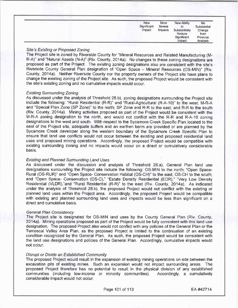
Sites Existing or Proposed ZoningThe Project site is zoned by Riverside County for Mineral Resources and Related Manufacturing MRA and Natural Assets NA Riv County 2014a No changes to these zoning designations areproposed as part of the Project The existing zoning designations also are consistent with the sitesRiverside County General Plan designation of Open Space Mineral Resources OS MIN RivCounty 2014a Neither Riverside County nor the property owners of the Project site have plans tochange the existing zoning of the Project site As such the proposed Project would be consistent withthe sites existing zoning and no cumulative impacts would occur
Existing Surrounding ZoningAs discussed under the analysis of Threshold 28b zoning designations surrounding the Project siteinclude the following Rural Residential RR and RuralAgricultural RA10 to the west M RAand Special Plan Zone SP Zone to the north SP Zone and RR to the east and RR to the southRiv County 2014a Mining activities proposed as part of the Project would be consistent with theM RA zoning designation to the north and would not conflict with the RR and RA10 zoningdesignations to the west and south With respect to the Sycamore Creek Specific Plan located to theeast of the Project site adequate buffers and an earthen berm are provided or are planned by theSycamore Creek developer along the western boundary of the Sycamore Creek Specific Plan toensure that land use conflicts would not occur between the existing and proposed residential landuses and proposed mining operations Accordingly the proposed Project would be compatible withexisting surrounding zoning and no impacts would occur on a direct or cumulatively considerablebasis
Existing and Planned Surrounding Land UsesAs discussed under the discussion and analysis of Threshold 28a General Plan land usedesignations surrounding the Project site include the following OSMIN to the north Open SpaceRural OSRUR and Open Space Conservation Habitat OSCH to the east OS CH to the southand Open Space Conservation OSC Estate Density Residential EDR Very Low DensityResidential VLDR and Rural Residential RR to the east Riv County 2014a As indicated
under the analysis of Threshold 28b the proposed Project would not conflict with the existing orplanned land uses within the Project area Accordingly the proposed Project would be compatiblewith existing and planned surrounding land uses and impacts would be less than significant on adirect and cumulative basis
General Plan ConsistencyThe Project site is designated for OS MIN land uses by the County General Plan Riv County2014a Mining operations proposed as part of the Project would be fully consistent with this land usedesignation The proposed Project also would not conflict with any policies of the General Plan or theTemescal Valley Area Plan as the proposed Project is limited to the continuation of an existingcondition recognized by the General Plan As such the proposed Project would be consistent withthe land use designations and policies of the General Plan Accordingly cumulative impacts wouldnot occur
Disrupt or Divide an Established CommunityThe proposed Project would result in the expansion of existing mining operations onsite between theexcavation pits of existing mines Such an expansion would not impact surrounding areas The
proposed Project therefore has no potential to result in the physical division of any establishedcommunities including lowincome or minority communities Accordingly a cumulativelyconsiderable impact would not occur
Page 101 of 113 EA 42714

New More New Ability No
Significant Severe to Substantial
Impact Impacts Substantially ChangeReduce from
Significant Previous
Impact Anal sis
Mineral Resources
Loss ofMineral Resources
The Project site is comprised of an existing mining operation that has been in operation for over 35years According to the Riverside County General Plan the Project site is located within a MineralResources Zone 2 MRZ2 area pursuant to the Surface Mining and Reclamation Act of 1975SMARA Riv County 2003a Figure OS5 The proposed Project would involve the continuation ofan existing mining operation which would result in the continued commercial extraction andproduction of the propertysmineral resources Therefore the Project would allow continued use ofthe propertysaggregate resources As such the Project would not result in any adverse impacts dueto the loss of availability of a known mineral resource that would be of value to the region or theresidents of the State nor would the Project result in any impacts due to the loss of availability of alocally important mineral resource recovery site delineated on a local general plan specific plan orother land use plan As such the Projects impact would be less than significant on a direct andcumulative basis
Incompatible Land UsesAs discussed under the analysis of Threshold 29c surface mining operations exist to the north andnorthwest of the Project site Google Earth 2013 The mining activities proposed as part of theProject would be inherently compatible with these existing operations As such the proposed Projectwould not be an incompatible land use located adjacent to a State classified or designated area orexisting surface mine Accordingly the Project has no potential to result in or contribute tocumulatively considerable effects associated with incompatible land uses
Mining HazardsAs discussed under the analysis of Threshold 29dthe Project site is accessed by a private roadwayMaitri Road which would be controlled by security guards to prevent people from trespassing intoactive mining areas In addition fencing would be maintained around active mining pits Likewisethe Project site would be sufficiently marked with signage as required under existing conditions Inaddition the Project site would be locked when not in operation or open for sales to preventunauthorized access Site workers would have the potential to be exposed to hazards inherent tomining operations but such hazards would be addressed through mandatory compliance with federalstate and local regulations governing working conditions in mines Moreover mining activities to beundertaken as part of the Project would be no more hazardous to people or property than the miningactivities that occur on the property under existing conditions Accordingly the proposed Projectwould have a less than significant cumulative impact resulting from the exposure of people of propertyto hazards from proposed existing or abandoned quarries or mines
Noise
Airport NoiseThe Project site is not located within an airport land use plan and there are no public or privateairstrips located within two miles of the Project site Google Earth 2013 Riv County 2003a FigureS19 As such the proposed Project would not expose people residing or working in the Project areato excessive noise levels Therefore a cumulatively considerable impact would not occur
Page 102 of 113 EA 42714

New More New Ability No
Significant Severe to SubstantialImpact Impacts Substantially Change
Reduce from
Significant Previous
Impact Anal sis
Railroad Noise
The Project site is not located near any railroads Additionally no aspect of the proposed Projectinvolves railroad use or rail transport Riv County 2003a Figure C1 Google Earth 2013Accordingly no cumulative railroad related noise impacts would occur
Highway NoiseAs noted in the discussion and analysis of Threshold 32 SMP 143R2 does not propose to increasethe truck traffic to or from the Project site beyond recent levels or the levels evaluated in EIR No 359Therefore because the level of truck traffic would remain consistent with the levels analyzed in EIRNo 359 there would be no increase in the amount of highway noise produced by the ProjectTherefore highway noise effects associated with the proposed Project are within the scope ofanalysis of EIR No 395 which indicated that such noise impacts would be less than cumulativelyconsiderable
Other Noise
The proposed Project involves a mining operation which is not a noise sensitive receptor As suchthere is no potential for the Project to be impacted by other noise generators As such no cumulativeimpacts would occur
Ambient Noise Levels
As concluded under the discussion and analysis of Thresholds 34a and 34b the proposed Projectwould extend the life of an existing mine and allow mining to take place within the setbacks betweenexisting mining pits The Project does not propose any operational changes to the processing plant orits location at this time At some point in the future mining operations may transition to the westernedge of the mining area but this would locate processing activities farther away from residences orother receptors thereby decreasing any ambient noise effects as compared to existing conditionsFurthermore as concluded in EIR No 325 the Sycamore Creek Specific Plan located to thenortheast of the Project site was designed to incorporate a buffer zone between the residences andmining operations which was determined to reduce noise levels below a level of significance On sitemachine use would not increase beyond recent levels or the levels evaluated in EIR No 359Therefore the ambient noise effects from Project related equipment would not increase as a result ofthe Project Mining and blasting operations would continue as part of the proposed Project Howeverthe permitted tonnage would remain capped at an annual rate of 20 mtpy indicating that future miningor blasting activities would be similar to previous efforts As such ambient noise effects from Projectrelated mining or blasting activities would not increase as a result of the Project beyond the levelsevaluated and disclosed by EIR No 359 to be less than significant on both a direct and cumulativebasis In addition the Project would comply with Riverside County Ordinance No 555 the CountysNoise Ordinance and applicable policies within the Riverside County General Plan Accordinglyimpacts due to a substantial increase in ambient noise levels would be less than significant on acumulative basis
Applicable StandardsAs noted in the discussion and analysis of Thresholds 34a and b and consistent with the findings ofEIR No 359 near and longterm operations at the Project site would not generate noise levels inexcess of the standards established in the Riverside County General Plan or the Countys NoiseOrdinance and impacts would be less than significant with implementation of the mitigation measuresidentified in EIR No 359 Project related traffic mining and blasting activities would occur at levelssimilar to those that occur under existing conditions and that were assumed in EIR No 359Furthermore mitigation incorporated into the Sycamore Creek Specific Plan was determined to
Page 103 of 113 EA 42714

New More New Ability No
Significant Severe to Substantial
Impact Impacts Substantially ChangeReduce from
Significant Previous
Impact Analysis
reduce noise levels to below a level of significance Accordingly impacts resulting from the exposureof persons to or the generation of noise in excess of standards established in the local general plan ornoise ordinance would be less than significant on a cumulative basis
Groundborne Vibration or Noise Levels
Although the Project proposes to mine the setbacks between the existing mining pits the permittedtonnage would remain capped at an annual rate of 20 mtpy indicating that any future mining orblasting activities would be similar to previous efforts and fully within the scope of analysis of EIR No359 Any impacts to ground borne vibration or ground borne noise levels as a result of on site miningor blasting activities were mitigated to a level below significance by Mitigation Measure 453renumbered herein as Mitigation Measures453athrough453fwhich would continue to apply tothe proposed Project As such and consistent with the conclusion reached by EIR No 359 theProject would not cumulatively contribute to excessive groundborne vibration or groundborne noiselevels and a less than significant impact would occur
Population and Housing
Displacement of Residents or HousingAs discussed under the analysis of Threshold 35a and 35c the Project site does not contain anyhousing under existing conditions Accordingly the proposed Project would have no potential todisplace housing or people necessitating the construction of replacement housing elsewhere As
such the Project has no potential to result in cumulatively considerable effects associated with thedisplacement of people or housing which could necessitate the construction of replacement housingelsewhere
Housing and Population GrowthThresholds 35b 35e and 35f above address the Projectspotential effects on housing demandand population growth The proposed Project involves the continuation of an existing miningoperation and would not result in an increase in the number of people employed onsite The samenumber of people are expected to be employed by the Project as are employed at the site underexisting conditions In addition the Project would not require the extension of any new infrastructureor roads and would not involve the creation of new homes or a new business As such the proposedProject would not create a demand for additional housing and would have no potential to cumulativelyexceed official regional or local population projections In addition the Project would also not inducesubstantial population growth either directly or indirectly Accordingly implementation of the proposedProject would result in a lessthan significant cumulative impacts due to a demand for additionalhousing or substantial population growth
County Redevelopment Project AreaAs discussed under Threshold 35d the Project site is not located within or adjacent to any CountyRedevelopment Project Areas As such the Project has no potential to result in cumulativelyconsiderable effects associated with a County Redevelopment Area
Public Services
Fire Services
As discussed under the analysis of Threshold 36 the proposed Project involves the continuation andexpansion of an existing mining operation which is provided fire protection services under existingconditions by the Riverside County Fire Department The Project does not propose the construction
Page 104 of 113 EA 42714

New More New Ability No
Significant Severe to Substantial
Impact Impacts Substantially ChangeReduce from
Significant Previous
Impact Anal sis
of any new structures and does not propose any changes to its operational characteristics that wouldrequire an expansion of fire protection services As such the proposed Project would not result in asubstantial increase in demand for fire protection or police services as compared to what wasevaluated and disclosed in EIR No 359 Accordingly the proposed Project would result in a lessthan cumulatively considerable impact associated with the need for new or expanded fire protectionfacilities
Sheriff Services
As discussed under the analysis of Threshold 37 the proposed Project involves the continuation andexpansion of an existing mining operation which is provided law enforcement services under existingconditions by the Riverside SheriffsDepartment The Project does not propose any change in thescope of operations or number of employees hours of operation or truck traffic that would require anexpansion of law enforcement services As such the proposed Project would not result in asubstantial increase in demand for sheriff services as compared to what was evaluated and disclosedin EIR No 359 Accordingly the proposed Project would result in a lessthan cumulativelyconsiderable impact associated with the need for new or expanded fire protection facilities
Schools
As concluded in the analysis and discussion of Threshold 38 the proposed Project does not involvethe construction of any new homes would not affect local demographics and would not increase thepermitted number of employees at the site As such there would be no increase or decrease indemand for school services resulting from Project implementation and no need for physical alterationsto school facilities Therefore impacts to school facilities would be less than cumulativelyconsiderable
Libraries
The proposed Project does not involve the construction of any new homes would not affect localdemographics and would not increase the number of employees permitted at the site As such therewould be no increase or decrease in demand for library services resulting from Project implementationand no need for physical alterations to library facilities As such the proposed Project would notresult in a substantial increase in demand for library facilities as compared to what was evaluated anddisclosed in EIR No 359 Accordingly the proposed Project would result in a lessthan cumulativelyconsiderable impact associated with the need for new or expanded library facilities
Health Services
As discussed under the analysis and discussion of Threshold 40 the proposed Project does notinvolve the construction of any new homes would not affect local demographics and would notincrease the number of employees permitted at the site As such there would be no increase or
decrease in demand for health services resulting from Project implementation and no need forphysical alterations to public or private health facilities Therefore impacts to health services wouldbe less than cumulatively considerable
Recreation
Parks and Recreational Facilities
As noted in the discussion and analysis of Threshold 41aand 41bthe proposed Project does notinvolve or require the construction or expansion of any recreational facilities which might have anadverse physical effect on the environment The proposed Project does not involve the constructionof any new homes would not affect local demographics and would not increase the number of
Page 105 of 113 EA 42714

New More New Ability No
Significant Severe to SubstantialImpact Impacts Substantially Change
Reduce from
Significant Previous
Impact Analysis
employees permitted at the site As such there would be no increase or decrease in demand forrecreational facilities resulting from Project implementation and no need for physical alterations topublic or private recreational facilities In addition there would be no increase in the use of existingneighborhood or regional parks or other recreational facilities such that substantial physicaldeterioration would occur or be accelerated Therefore impacts to parks and recreational facilitieswould be less than cumulatively considerable
Community Service Area Community Parks and Recreation PlanThe proposed Project is not located within a CSA or recreation and park district with a CommunityParks and Recreation Plan and because the Project is limited to the continuation and expansion of anexisting mining operation no Quimby fees would be required for the Project As such the Project hasno potential to result in direct or cumulatively considerable impacts associated with a CSA orCommunity Parks and Recreation Plan
Recreational Trails
As discussed in the analysis and discussion of Threshold 42 two trail segments are planned in theimmediate vicinity of the Project site including a Historic Trail along Temescal Canyon Road and aCommunity Trail located immediately adjacent to the eastern boundary of the Project site RivCounty 2003b Figure 8 However the proposed Project does not abut Temescal Canyon Road andwould not result in any new residents that would generate a demand for recreational trails In
addition the Community Trail planned along the siteseastern boundary is accommodated within theadjacent Sycamore Creek Specific Plan Furthermore no recreational trails are planned as part of theProject Accordingly the proposed Project would not conflict with any designated trail alignmentsand would not result in any significant environmental effects associated with the construction ofrecreational trails As such the Project has no potential to result in direct or cumulativelyconsiderable impacts associated with recreational trails
Transportation and Traffic
Conflicts with Measures of Effectiveness
Under the proposed Project total annual tonnage would remain capped at a maximum of 20 mtpy Inaddition the IDEFO would utilize existing truck trips to deliver fill materials when possible As suchthere would be no increase in traffic from the site with implementation of the Project as compared toexisting conditions or the conditions that were evaluated in EIR No 359 Because EIR No 359
concluded impacts to traffic would be less than significant on both a direct and cumulative basis andbecause the amount of truck traffic from the site would not increase and would be within the scope ofanalysis of EIR No 359 cumulative impacts due to a conflict with an applicable plan ordinance orpolicy establishing a measure of effectiveness for the performance of the circulation system would beless than significant and no new mitigation would be required
Conflicts with Congestion Management PlanAs noted under the discussion of Threshold 43b within the Projectsvicinity only Interstate 15 1 15is identified as a CMP facility Riv County 2011 Exhibit 41A The Project would not increase theamount of truck traffic to or from the site beyond existing conditions or the conditions evaluated in EIRNo 359 because permitted levels would remain capped an annual rate of 20 mtpy In addition theIDEFO would utilize existing truck trips to deliver fill materials when possible potentially resulting in anet decrease in traffic associated with the site Consistent with the conclusion of EIR No 359 theProject would not contribute more than 50 peak hour trips to the 1 15 or any CMP facility Riv County1991 Figure 46 Accordingly the Project has no potential to conflict with the level of service
Page 106 of 113 EA 42714

New More New Ability No
Significant Severe to Substantial
Impact Impacts Substantially ChangeReduce from
Significant Previous
Impact Analysis
standards as specified in the 2011 Riverside County CMP nor would the Project interfere with theCMPs travel demand measures Furthermore the proposed Project would not conflict with any otherstandards established by the RCTC for designated roads or highways As such the proposed Projectwould not adversely impact the applicable CMP and cumulatively considerable impacts would notoccur
Impacts to Air Traffic PatternsAlteration of Waterborne Rail and Air TrafficAs indicated in the discussion and analysis if Threshold 43cand 43d the Project site is not locatedwithin close proximity to any public or private airports and is not located within any AirportComprehensive Land Use Plans ACLUP In addition there are no existing waterborne routes in theProject vicinity nor are any railroads located near the Project site Accordingly the proposed Projectwould have no cumulatively considerable impacts on waterborne rail or air traffic
Hazards
The proposed Project represents the continuation of an existing mining operation and would notresult in the introduction of any new incompatible uses to the site that could pose a traffic safetyhazard for surrounding land uses No roadway improvements are planned as part of the ProjectAccordingly the proposed Project would not substantially increase hazards due to a design featurecumulatively significant impacts would not occur
New or Altered Roadway MaintenanceImplementation of the proposed Project would extend the life of the existing mining permit by 50years Since the Project would increase the duration over which Project related traffic would utilizeCounty roadways the Project would over time result in an increased need for the County to maintainroadway facilities in the local area However maintenance of nearby roadway facilities would befunded through taxes generated by the Project and the increased length of demand for roadwayfacility maintenance would not result in the Countys inability to fund other improvements such thatsignificant environmental impacts would result As such the Project would have a lessthansignificant cumulative impact on the need for new or altered maintenance of roads
Construction Circulation
As discussed under the analysis of Threshold 43g since the proposed Project represents thecontinuation of an existing operation and would not involve a construction phase there would be noimpacts to the circulation network associated with construction activities Although portions of MaitriRoad may be relocated as a reasonably foreseeable consequence of the proposed Project MaitriRoad is a private roadway facility and the relocation of this facility would have no adverse impact onthe areas circulation system As such the Project would have no direct or cumulative impacts on theneed for new or altered maintenance of roads
Emergency AccessAs discussed under the analysis of Threshold 43hthe Project site is not identified as an emergencyaccess route under any local or regional plans and roadways serving the Project site do not provideaccess to any other land uses except for adjacent mining sites Accordingly there would be no director cumulatively considerable impact due to inadequate emergency access or due to obstruction ofaccess to nearby uses
Policies Promoting Non Vehicular TransportationThe Riverside County General Plan does not identify the Project site for any public transit facilitiesbikeways or pedestrian facilities In addition there are no components of the proposed Project that
Page 107 of 113 EA 42714

New More New Ability No
Significant Severe to SubstantialImpact Impacts Substantially Change
Reduce from
Significant Previous
Impact Analysis
would substantially decrease the performance or safety of such facilities Accordingly there would beno direct or cumulatively considerable impact due to a conflict with adopted policies plans orprograms regarding public transit bikeways or pedestrian facilities
Bike Trails
As discussed under the analysis of Threshold 44 two trail segments are planned in the immediatevicinity of the Project site and offsite impact areas including a Historic Trail along Temescal CanyonRoad and a Community Trail located immediately adjacent to the eastern boundary of the Project siteRiv County 2003b Figure 8 Neither of these trail designations includes or requiresaccommodations for bicycles In addition and as discussed under the analysis of Threshold 42 thedesignated trail alignments are not required to be improved as part of the Project The proposedProject also does not propose any new bike trails Accordingly the proposed Project would notconflict with any designated trail alignments and would not result in any cumulatively significantenvironmental effects associated with the construction of bike trails
Utility and Service Systems
Water Treatment Facilities
As discussed under the analysis of Threshold 45a the proposed Project would not result in a netincrease in demand for water resources as compared to existing conditions or the conditionsevaluated in EIR No 359 As such the proposed Project would not require or result in theconstruction of new water treatment facilities or expansion of existing facilities the construction ofwhich would cause significant environmental effects Accordingly the Project would have no potentialto result in any cumulatively considerable impacts associated with the construction of new watertreatment facilities
Sufficient Water SuppliesWater to the Project site is provided by the EVMWD Since the proposed Project represents an activemining operation that has been in existence since prior to 2000 when the EVMWD prepared its firstUrban Water Management Plan and since water usage would not increase under the proposedProject the proposed Project is accounted for in the EVMWDsUWMP Since the UWMP concludesthat the EVMWD has sufficient water supplies available to serve all existing land uses within itsservice area and since the Project would not result in an increased demand for water resources itcan therefore be concluded that the EVMWD would have sufficient water supplies available to servethe Project from existing entitlements and resources and no new or expanded entitlements would beneeded Accordingly the Project would have no potential to result in any cumulatively considerableimpacts associated with the need for new or expanded entitlements
Sewer
As discussed under the analysis of Threshold 46a and 46b the proposed Project does not involvethe construction of any new homes and would not increase the number of permitted employees at thesite As such there would be no increase in the sites demand for wastewater treatment facilities orcapacity Furthermore wastewater generated at the site under existing conditions is handled viaportable toilets and no new portable toilets would be required in support of the Project As such theproposed Project would not require the construction of wastewater treatment facilities or result in adetermination that the wastewater treatment provider does not have adequate capacity to serve theprojectsprojected demand Accordingly impacts would be less than significant on a direct andcumulative basis
Page 108 of 113 EA 42714

New More New Ability No
Significant Severe to Substantial
Impact Impacts Substantially ChangeReduce from
Significant Previous
Impact Analysis
Solid Waste
The Project would not change the amount of solid waste generated by the mining operation ascompared to existing conditions or the conditions evaluated in EIR No 359 The proposed Projectdoes not involve the construction of any new homes and would not increase the number ofemployees permitted at the site However the proposed Project would extend the expiration date ofthe existing permits from December 31 2025 to December 31 2075 As a result the Project wouldresult in an increased demand for landfill capacity Existing landfills have the capacity to handle solidwaste generated by the site under existing conditions but many area landfills would reach capacityprior to expiration of the Projectspermits in 2075 Therefore the proposed Project may ultimatelycumulatively contribute to the need for a new or expanded landfill facility However as it cannot bedetermined at this time whether new or expanded landfills would be required nor is it possible toidentify the location of any such new or expanded landfills any analysis of impacts associated withsuch landfill expansion or construction would be speculative CEQA Guidelines 15145 Moreoversolid waste generated by the Project would only result from site workers and operations at the existingoffice complex and would not comprise a large amount of refuse Furthermore there is no evidencethat solid waste generated by the Project would exceed the capacity of any current or plannedlandfills Additionally there would be no new conflict with any federal state or local statutes orregulations related to solid waste as a result of the proposed Project Accordingly the Projects directand cumulative impacts to landfill capacity are evaluated as less than significant
Utilities
As discussed under the analysis and discussion of Threshold 48a through 48g the proposedProject would involve the continuation of an existing mining operation and would not result in asubstantial increase in daily operational characteristics at the site All utilities needed to serve theproposed Project are currently in place As such the proposed Project would not require the physicalexpansion of utilities including the use of electricity natural gas communications systems stormwater drainage street lighting public facilities including roads or other governmental servicesAccordingly the Projectscumulative impacts to utilities would be less than significant
Energy ConservationThe Project site would have no increase in daily production and no change in the hours of operationis proposed The Project would not create any new energy demand In addition there are no
adopted energy conservation plans applicable to the proposed Project As such the proposed Projectwould not conflict with any proposed energy conservation plans and impacts would be less thansignificant on a direct and cumulative basis
52 Does the project have environmental effects that willcause substantial adverse effects on human beingseither directly or indirectly
Source Project Application Materials
Findings of Fact
SMP 143R2 Finding No Substantial Change from Previous Analysis As indicated throughoutthe preceding analysis the proposed Project would not result in environmental effects which wouldcause substantial adverse effects on human beings either directly or indirectly
Page 109 of 113 EA 42714

New More New Ability No
Significant Severe to Substantial
Impact Impacts Substantially ChangeReduce from
Significant Previous
Impact Analysis
VI EARLIER ANALYSES
Earlier analyses may be used where pursuant to the tiering program EIR or other CEQA process aneffect has been adequately analyzed in an earlier EIR or negative declaration as per California Codeof Regulations Section 15063 c 3D In this case a brief discussion should identify the following
Earlier Analyses Used if anyEIR No 359 SCH No 1990020302 which was prepared in support of SMP 143R1 SMP150R1 and SMP 182 and was certified by the Riverside County Board of Supervisors 1991
EIR No 325 which evaluated impacts associated with the buildout of the Sycamore CreekSpecific Plan and was certified by the Riverside County Board of Supervisors in 1994
EIR No 441 SCH No 2002051143 which evaluated impacts associated with buildout of theGeneral Plan and was certified by the Riverside County Board of Supervisors in 2003
Mitigated Negative Declaration MND No 42476 SCH No 2013091018 which evaluatedimpacts associated with SMP 139R1 and was adopted by the Riverside County Board ofSupervisors on November 22 2013 MND No 42476 evaluated impacts associated withexpanded mining limits that resulted from the elimination of a 50 foot setback along thesouthern boundary of SMP 139 and also evaluated impacts to offsite areas inclusive of theProject site that would be a reasonably foreseeable consequence of the Project Althoughmining within the SMP 139R1 site would be a reasonably foreseeable consequence of theproposed Project such impacts were fully evaluated and disclosed by MND No 42476 Assuch impacts and mitigation measures associated with this offsite area will be incorporatedby reference in this EIR Addendum and
Draft EIR No 521 SCH No 200904105 which evaluates impacts associated with theCountyscomprehensive update to the General Plan and the CountysClimate Action PlanCAP Draft EIR No 521 was circulated for public review in May and June 2014 and isexpected to be considered by the Riverside County Board of Supervisors in late 2014 or early2015
Location Where Earlier Analyses if used are available for review
County of RiversidePlanning Department4080 Lemon Street 12 FloorRiverside CA 92501
VII AUTHORITIES CITED
Authorities cited Public Resources Code Sections 21083 and 2108305 References CaliforniaGovernment Code Section 650884 Public Resources Code Sections 21080c210801 210803210821 21083 2108305 21083321093 21094 21095 and 21151 Sundstrom v County ofMendocino 1988 202 CalApp3d 296 Leonoff v Monterey Board of Supervisors 1990 222 CalApp3d1337 Eureka Citizens for Responsible Govt v City of Eureka 2007 147 CalApp4th 357 Protect theHistoric Amador Waterways v Amador Water Agency 2004 116 CalApp4that 1109 San FranciscansUpholding the Downtown Plan v City and County of San Francisco 2002 102 CalApp4th656
Page 110 of 113 EA 42714

New More New Ability No
Significant Severe to Substantial
Impact Impacts Substantially ChangeReduce from
Significant Previous
Impact Analysis
VII REFERENCES
The following documents were referred to as information sources during the preparation of this document
Cited As
Alden 2014 General Biological Resources Assessment for the Glen Ivy Mine Project SMP143R2 Alden Environmental Inc August 1 2014
Associates Greenhouse Gas Evaluation Report for SMP00142R2 Associates EnvironmentalEnvironmental December 9 20142014
Bulot Inc 2012 Hydrologic Characterization of the Coldwater Basin BULOT Inc March 2012
Corona 2004 City of Corona General Plan City of Corona March 17 2004 Available online athttpwwwdiscovercoronacomCity Departments CommunityDevelopmentPlanninqDivisionFINALGPaspx
EVMWD 2011 Elsinore Valley Municipal Water District Urban Water Management Plan Elsinore
Valley Municipal Water District July 2011 Available online athttp wwwwatercaqovurbanwatermanagement2010uwmpsElsinore 20Vallev20Municipal20Water20DistrictEVMWD20UWMP202010 Finalpdf
GLA 2013 Biological Technical Report for the Mayhew Aggregates and Mine ReclamationProject SMP 139 R1 Glenn Lukos Associates Inc February 4 2013
Google Earth Site Imagery Google Earth 20132013
Hamilton Biological Study Michael P Hamilton and Associates January 1990 TechnicalAssociates 1990 Appendix F to EIR No 359
Hilltop Report of Slope Stability Evaluation Werner Corporation Aggregate Quarry HilltopGeotechnical Geotechnical January 30 20142014
JEBA Inc Project Specific Water Quality Management Plan Joseph E Bonadiman
2014a Associates Inc April 2014
JEBA Inc Preliminary Hydrology Study Drainage Analysis Joseph E Bonadiman
2014b Associates Inc April 2014
JEBA Inc Preliminary Hydrology Study Drainage Analysis Joseph E Bonadiman
2011 Associates Inc August 2011
Riv County Riverside County Ordinance No 655 Regulating Light Pollution June 7 19881988
Riv County EIR No 359 J F Davidson Associates Inc June 11 19911991
Page 111 of 113 EA 42714

New More New Ability No
Significant Severe to Substantial
Impact Impacts Substantially ChangeReduce from
Significant Previous
Impact Analysis
Riv County EIR No 325 Douglas Wood Associates19941994
Riv County Riverside County Ordinance No 555 Implementing the Surface Mining and1995 Reclamation Act of 1975 August 1995
Riv County Riverside County General Plan County of Riverside October 20032003a
Riv County Temescal Canyon Area Plan County of Riverside October 20032003b
Riv County Riverside County Ordinance No 847 Regulation Noise July 19 20072007
Riv County Riverside County Ordinance No 460 Subdivision Regulations June 3 20102010
Riv County 2010 Riverside County Congestion Management Program Riverside County2011 Transportation Commission March 10 2010
Riv County TLMA GIS Riverside County 2014 Available online at
2014a http tlmabld5 agencytlma coriversidecauswebsiterclis
Riv County Riverside County Ordinance No 348 Land Use Planning and Zoning June 3 20102014b
SARWQCB Waiver of Waste Discharge Requirements for Glen Ivy Mine Inert Landfill Santa Ana2014 Regional Water Quality Control Board May 12 2014
SCAG 2012 Regional Transportation Plan 20122035 Sustainable Communities StrategyTowards a Sustainable Future April 2012 Available online athttprtpscsscagcagovDocuments2012finalf2012RTPSCSpdf
SCAQMD 2005 Guidance Document for Addressing Air Quality Issues in General Plan and LocalPlanning South Coast Air Quality Management District May 6 2005 Available onlineat
http wwwagmdgovhomelibrarydocuments supportmaterialplanninqcuidanceguidancedocument
SCAQMD 2008 Interim CEQA GHG Significance Threshold for Stationary Sources Rules and PlansSCAQMD Board Meeting December 5 2008 Agenda No 31 Available online athttp wwwagmdgovdocsdefaultsourcecegahandbookgreenhouse gasesghgcegasignificance thresholdsghgboardsynopsis pdfsfvrsn2
SCAQMD 2013 Final 2012 Air Quality Management Plan South Coast Air Quality ManagementDistrict February 2013 Available online at http wwwagmdgovhomelibrarycleanairplans air qualitymqtplanfinal2012 air quality manaqementplan
USDA 1971 Soil Survey Western Riverside Area California United States Department of
Page 112 of 113 EA 42714

New More New Ability No
Significant Severe to SubstantialImpact Impacts Substantially Change
Reduce from
Significant Previous
Impact Anal sis
Agriculture 1971
CREED v City CREED v City of San Diego 2011 Super Ct No 37 2009 00085307 CUMCofSan Diego CTL
Laurel Heights Laurel Heights Improvement Assnv Regents of Univ of Cal 1993 6 C4th 1112v Regents of 1130 26 CR2d 231Univ ofCal
Moss v County Moss v County of Humboldt 2008 162 CalApp4th1041 1049 1050ofHumboldt
File SMP 143R2 2nd DRAFT EIR Addendum 2014 1210docx Revised 1132015 134PM
Page 113 of 113 EA 42714
1

GLEN IVY MINE
ADDENDUM ro EIR No 359
APPENDIX BMITIGATION MONITORING AND REPORTING PROGRAM
SMP 139R1

OL 9 o inC c s c N0 o o oZ
E y MF w w e
Ct w d cU
W W gO w s
a a roo a as
CI ateW
g cd o0
z cc
O Uz v E
ao a c cg o o
IQ cicos
et o C o oCL
7 4fl OG y C 73i to
O iY y p d
O Z 0 CUscEiZO Z
1
oo 0444C 0V
Z Z a 8 0 w C 5Z z
Z O 0W1U
F y o
O OQC dJ V F o
RJ
o w
C77 G7t O
z id o0
3 3 on N S o7
Jad U E O
N y oT L n N aH N 00
G V O rg N H O d0 V1 4 w w b O A 4 cy GW g
y7 C t
U r7 4 C y t O N G o w e 0
W d o o a c ti 3 y o oti
2 aa 0 e EN E ov 3awa y y
O 0 E w o o
R U R 7 E N C y0OA N CCZw zz d E yLI c 0
z co
zO a O a O 5 a or
9 ia o
f V Z IZ V1 2 L y eJ co

LO 5
15c 5 c c c c c
0 z c c c 2 c c E c NO
c E E E E E E E E
Z F W O O O O O O O OU
i 44 W 44 w w i4W
O C O O C O 0 O O 1 O CO a L O L t t L O t s 0O
a
cc c n s a o srZ o o o F01 F of F o F o F o H
W
5 c c c c 5 c c
CZ
E
vsEes
Ecs
a a a a a a a a a
V
cd
FO v U U U U U U U Uc c c c c 5
Z N N N 0 N N 0 y N y
Ey N
O a E5 b lz E b E 10 E E 70 E g E z E
ao a an am ol
A A a
aYi i d c 2 4 d c c v
a ro c td c a c s YE O
T p C O O 1 LO 8 O a
W L a dc 11 a S oN N
R ti p
O v V M E M w v w
y O w 0 V V v EZ ri O k O vi d v O 3 ri y t 1 V O
Hn N
U i C 0 7 T V O yte N d wit c wi O 14 V b b0
O i E 2av1z LD aai 2Sy i c L L L o L0
q N GO dx E yy
X CC Od 1 O m g O ate O Y
C a w ay ay am a as g ate
Zo o E o w
a ai E eo
E o 0 C aIO m cb bo m 2
5 i 8 bL mu
m c m5a v coo q c o a
y oa
z ra X 8Xz 2 n o 3 5 1s1
7
CWC Q O V YO U
O0 Co ZS
W 2
Z
r 3 3 O s cOc0
o s o o w w
1 AY
l0 6 7
p rid 4 2 cck
Z0
za0O m
z E mocED d 610 @ c M as
0 IT Ctz z tic o ro z 05 41v M
Er
J W E E0 y M id 6
0 cA z v v 2 y g aE0

Os w m rM c c Al N
E E
Z o o aid 2E m 0SpZ V w w 5W L
W ms wu R
O O L O L E N t0tiCEL O FLO y
o 0 G ro O
Z E O F OIHow F O H 2
WO
h ro
0 oa c c cm d m a Uv c c
a CO a ro a cqR
a
A O
O 5 cd E U U UE 3Z 0lQ U
0 y
3 0 3 0 ov 0aU aU n rx c0
I N G N T G N U a L c m D N N O
0D C E N Y O i ca L a cd C p C
OL1 y 0
O Lw d 3
ac ai Ca O fl F O N Oc m
m E c3 o HF1 ti Ly b W O 80 U m O O G N
C9 Lc R o o om O co n 0v
Z 0
m y 0 3 i a aoE v O0d a R wg 3 a o c o E E a z is c Y 2 0 Eb 0c G
2E 0 0
Ic c E U O
O O y OCCcnm 3ac oo L E 0
c 0 roc g0 0
a oC0 8 N 0 5 y s 0 u Y 0
mc R E
LLI
CX WO
oC 0 cO T 3 c a5 ri
O 8 cC e3 7 iy Om
C N q11150 y
m
N 0p U c4
k Y c 7 a O C d 0 U ma d
a QE L m
Y3 c c 3 O m U c3 q y
m
OZ r Ym3 se H cmd
pE 0 O0875O c 0 E3
M X L V o 0 u 0 U C c0 L a 0 L 03 lil 0 y C s C Y cu ZZa d
C70 U a
M c ro8 2 d N o ooN ri41
17E508o
Z ao3 Az o 0 E ro ac o U
arc Hwy 3m 4on to4oYo w0 ft
L O N tL O U y q b iE O W i id 5 O 5 cCC zO 3 q va8 0 0 N O N c c E u m E 0 bym c
2 mro Ewo d 43o
02vc
G2 N N
1Hh drroYano5 nO a o 0 m Ec
Lc a LU o C c o p y c a oL 3 d L E
tig ow o c o 0 ow 0 R 00
0m
E
O pm
e
Y pz To V gt N M 7
V
8 8 V 2au g0 y iG Ow 0 0 0
gz
wv
flJ3 u
2 0v C
cC 3 E 3 C w
cAtza0o arc y1 Ev4
p iL M
z o oEcc
m ro E aro a O o o7 3 70 ao a o y p a y dta y o E 0
a vI5 D N m wp c vz c m oo c
g Dm
0 m
L E O C c0 7 O Co b qm E a ro O
o L v d 3 O a d y V s ww
N
06 OM
aio o Eow
U a Ev d tiRow o o 0 a 0 2 g y o O m04
Z a p o am F oR g c 55 wRO y m
cv es o c
m
E Tab o EEr R 0 o c o o m 4 m
o 3 c o 4 L 0 Rog o cNI
o mLc
as c4 o Lm ro 3 c v a c c c
L E LL7c Emocg E z va acicZ
O
aTEJ 3w v op c R 4 0 4 a0 Rw ItwE
t y 8 N Oo W ro o
U 33 E O t G o g j pv E 0E4s o2oroc w E roc
v0 3 aN 0 3 CI u 2L ro
ti

Os I LO1 c c c
Ic c c
M E E c c E c NO E E E E E E
Oe
W c o 0 0 0 0 cvi
CX w Q a w w w
W
Q o o o o oF a d co o c tO O
o o o o oU a U a L aQ aca F CI 4 OI OI F O H of H O
ZImO C C C C C C C
I c10 g g g ca a a a a a a aZ4z E E E E E E E
0c7e U U U U U U U
c c c c c c cz a d y m y y y y y
p of of E a nE roE oE
a nn o o a a
aA C4A aA aA a aA aA
cc vw o0o0Y oar v v ya oNal
CU to rLn y
G 95 N 3 C C y L3L O
Op
c0 v C C o 00 C o0 00y
s U N p y Rg O D W C
a ro c x c obEy ya a N U OMo a E d E
y0 c o as A2 E
0 o c b to ow O0d
UYE 0Z iy 4 0 g CE
W to 7 N O o C N o N a2 C OCX W C
yid oa Y 0 g O C C n C N
O5 wo r n n c d a cco a2 vi a
nE C
3ai
Nr141 c
0a ak
aN E y
a d c aUO c d 7 N b y O y 6 d
z a Wa4
a dc yEN aau 7NO coYO ep p L N y O G
C
CU U 3 y dz
V Q y a Mf y a M C Mp ea C Mc
C M 0 3 f Oc
a 0 aT 0 c11 Os cC as y N p 4 cO O O d0 y V v O a co
yyO L 2rV c L d Ld L rNq c0 L O L L y a
6 y E R7
rd
CjF G
y D c U L N y 7 a O Wc C C O O
L c 4v CO o ac d Q y ooie as c c 4ocaao c 3
0 as g an o H oo m E oa a aayc aEc aaoa a d o
v ac O Ee o s8 o o rooEowZ as 2 a ea8 E adac aEmaE aaE a UO In t e D d v 5 m 00 o m @ Es c c c00 y p v d d c a
yo Z
c ti G v E
zr cO u 0 ro
i y O F v w u tC
s aU 4 td4V 0 b Cw a C
Q
D y 0 L N 0w C O C t5 7 U U O 0D a 7 U O y 7 UO 3 o E Vi z y y rn
3V
U aDo o m a w it c N
c EE c
W Q 0 y c n dm aF m c a
Z a O R 0g E
C A C E 5 4 7 NU
C Y cC roN
G v caci orouro yrov N
E c E cCt
C O t y Nc O C y O Cr
Z N O idbe
EYi R
CC C
V

o a1 o
MO E N
Z 44 0 r
Ww
O o
F 0 o
o
p FEOiZW
FFyC td
a
a
Vz EO U
zo
F
a o o
Q NN
OO dsaica oa ocao Jaaa a
0 cus 000 omcls dram y82C 0 y
N N mU N U Y w E 4 N N dZ
0croJac0ywd2 o 0 a Ki 4 vi 66 t COh N fl E 0 zU N C ti C U O
y O N G O wy b O L
C N C O V
O coy oEE8 oo8S Yz G 9Wy O y
O y C 7 tiD MO U E N C d O iC D b
d nww y 0F ai d 3 owo olli E C dca CA i
ti 0 oc Oz o E o N
t7 t
ti
71 Ez btC U c0 O L O 3 E V
0 E w 73 tcam Eao Ey
V N 0 o o 0 3 m o E o ro 3 U ao
ei Fr o o a o y c am sya
OG
o Y V4w
aU C Y t 7 Co L v 2 E 4 u
Q 8 036 t p O C O C C0
U 4 O O v C 2 N O L O i0 ti O U y o w0 b o C N 40
Z c N C cC o C nH U E E 3 v 0 M yrH 0 0 0 0 0 03
Zem 0 P 5 6
14
P pO m E d c 7
2 oi E ra0
r
w FJ R 0 Cz gU F dw
c7tIE
00v o a O N
F v dvo
NE R 2 O Q 192 O
24323v
W Q i U U b a cZ oosE2 107sr
2 d a a NCt
a al y w
1Y c
0
Z EEiv105i
e
J 0 u G a
CD 3 0 8 8 2 2 8 y

to c y c cM z
roc c
N0 0 U E N
z F o d w w M
F w U c c c cg o o e
cx Z V c
130 i o ro a sc sc
o o o d 06 o f
ZW
c c c
lgQ c c c EF ro
x a as nz
a
Uz 0
p L U U Uc c c c
2N U
N O N N y d O
7 o
CGA oCA WA cYA
wro o 24O N 4 10 ro c to L 7 C C0 d 3 v y v c c go c c Y End c 3 cro o p
ck c y y E a x c o o d N u o cna yro Ycc U dw 572
z 1 g v rod u yo oof O L OO o E 3 i 3 c7 c t axi 490000
Z ti c c 3w ep w U o C 07 V ro O G y
w b wYUt c x c ro
owO o c o rod d roc aEi E Eti cwm28W z rnocc00 g c c us o o f o c d E cica o V
Ct w n c oo0 o izo w N E oU o
5 ao aa c y y y7a a2 0 ccZ E0 ro a c y
U t k dc7100 o
roe c 3
a E ro a ai E0 a a Es d o a n 7 3 aMb v s ydExAcD
Q M s y oo 05 5 ita
V El i i E R3 E Aaft
1
asmti E o a acazcaO
3wsi a
c
d aaci or
ro roiv mc g3 c Y
o co s N w E wv oU c00
Uc
o ti roo a ca y wmssZ ro c v c c v c U o
Z t d C y a U9 1184O C C O ro 0
E rot rovc 3sno ca X 3d0ti
cr E E ds cF
Z
iU F y
22 ro o
67 F 1v vk cC au cE
W E z cczt
d
via O N O NU cl
w cE O cc9 Y O G c V C G O9 O C C c0 O gNO
N O A V N ro ro 0
iC roO 44 ro N O 77 O U 7 tO N4 Ao N
aro Ev a tE o4oo og o 7ic n a s o cEgM 04 d
cA YE rn a E c y
F V c y G O 0 Os
dO
i w oMO O c rN c v ai G N N Oro
w Q s o Ev E u y Yn3 o o 3 y c N
3 5yZ y E a y 4 E 8 v u a
0 3 E Hw y F cc
co cXd v c F4 N c ti U 3 O c c 0 s a
E E 3 N N O c C p R v ro ro b O sM y U c b M E y O
R ro 3 E 003 000 0710 8 Nct
togo g J S c ro ro a aci c E 8 zoddE 0
y tc6 M
E E c o o E w m E o cE a
w 5 ox 2 A c0 Y E c td 4R4845 t ro ro a
n @ 3 2Cn 013
g E 0 E E 3 U s E cC 8 8 vci aci U y
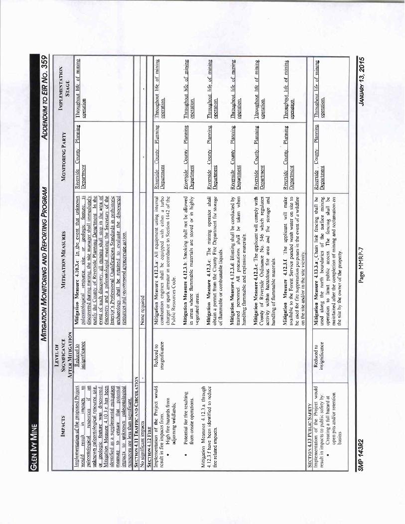
a aN c c c c c
lcE
M c c c c E NC E E E E E E
Z F Wo 0 0 0 0 0 0 r
Ct 4V w w w w wF
O O 0 E E E E E E1 o 0 0 0 0 L Ot0 0
p of of of H of F of ofZW
p c E c c c c EE
J o 1 C C
iT ro I I cCtl
a
zc c E c cO O 3 3
U U U UE
J N N N
E E of E aE E7 0 y n O
c4o o a c i la zca c4 a
3 L o 0co0 b 0 y
0 7w C y y T3 U E fl O OE 7 bq E3 y roa ro 0 o c c E c 3 A
E c Y c o w c 1 E o as a1
oco LwEEc g a o a csiS 3y cw 5Z U y 2 N 0 c 9 O N y y
Ly
C C 7 U
ce A o y u ro a 1 ton a 33sL 3 wv
O a A vroc a3v1 s3 Egt Evb 5 d cY a
W n r c50 i ro a001
Eqti 3v0 5c op ai E
a Q oc a111 1 a eH E a b m En
p n E o g E o 0 0 c QyQ s r ywSv y E c o c 3 c 30 C u CE J 8 c
cc
0 y we a 0 E r pUo dw1 ri 7 n r000 Zo d c a ri 1 aZ d a1
O O b el c ri U rU L G X1 O
7 N O 42 BM UCD
c7 ofX
cet g ro 0S DoE a
y 0E ov
i oE 4 A E Lt ti y g a1E L a
Qwv 01 ma y d C c aO E o om E E p E E i7 21 o 8 LEA L oy ai
F y y o v c U y o o LE aew cc
Z dcie 0 C y
La 00 e N a y U
A71
GC d d p y N
c 5 3 3To 0 v nE x E ce s o r
C obV Aga ro ecyy es e w you9
z ots0y
o 8 J y a3
0 E p 300 0y g o tO u o 0 0 m 5iv 2 a2 a rt d C c5 c eD a a0
m 2 5 yi 1 9 v N vu O E E c a 0 1 c v
Zrov
ter t 3 o E N
V
C N O E c ZtE
41 O O G t A U dc CU E 0 O
Ua o 081
z
U EQ V O U O co
u F U PEU
3 E S w
U a y ribC4 b
w 5 F Ev E
zO
Oy YO i r d a U Q E U a
60E E
c c3
E G Y o 3 v c1 8 7 Hc U v N WC0 N N
o 3 E N U o o a c wW
eZ a w o2 d isc elct m o00G o isw00 E pE a E a c vc5
0fn
oa i zc c w
1Z
co
2 41LIJ aV
3 ogv E VZ WI P v vl 5 a

Os LO
Mz c co c c c E
OD
Ovi
ZF O O O
D L L L
W c e
CX Z C7 w w inid
W 7F ao c5 a a
o c c o tir
o o o w E E 1 c EN o o 0 0 0
Z
c c EE ro ca t s s s s sQ 7 n a v v v v v v
a
aO U U U U u 1i Ut c c c c c cZ 0 O O O O O O N 5 5 0
0 E E bE E oE
a a d yA rxA A oGA cGA pCA C40 ii
by
boo yo a sa cap
c c E c y E3 ya v o 3 H a
0y u 38 0Lo a 84 E o a r o a d ao
Z a 3 z E o co c0 y ca v 9v
2 o nng o ar n cv
a c c E o O W
g
aiv v o5 5 o
ow 73 C 0 y N c O E N U
w N
Gy
y N
W cn yo c As 0 c 2 o o G c u c ti
CC d y E d v o ro 00
5y O o o
8U w G c Q X
d 0 2 ro d 5 oo d o 2 s 02 O e4 c o2 8 W w cc
O dd u73 Mrc ti ou 3 c c c
Nw E T a y
M e or 5 onU M c c el L g a ei I Eo
y ra 4 c d 4 y a ey r v o a v E roL C L E
w L OO L E d L y
3 t0 3 L No L 7O C Rt Q
a L L 0
O 7 0 a O CV
c v a ro 7 Y 4F
71
Nt OI
C oDj
ra 0 n e Vt7
o g d a m C w g y v C mar m OD m
4 N OO U d L 2 E Y F L w n c Y Y K iG
vi Y y
E L E
aaO L
O N 0 O c0 y 24
0 CO CO
O td 2 N N g C y a C
Z d 5 a 5y
ti v cvi 0 a eo o cd c Ey
O up b en 3 m9 V 9 ti 4Do m c V 3 aC p
tfrp c
c UN Cr3 cQ 1 5 cC G a lA O G E t a O 5 A g E O g LF2 g a cC X U aXi C c Ll O N L w
Z O
WU E
w F
r WQ
tNMog
W aOy ro
c0 M N5 M W
F G N 4w Q w yvtZ Pm Ecy
U
os cz aM U t
w

LO c c c c cw yc c 0
w 0O r
CC zv Ew F m 3 m ro R c
c
W X E o
O 1 v N d NO
N N y L c Vivi
tO o om 00
O8 CI 8 C 8 in 8 CI 6 a oo a a g of w 0
Z
C
a t t s s s s td
cn cn rn c cn v cn VI
a
0o
a U U U U U U U UOc c c c c e c c
z oE oE E bE oE oE bE aE
y 0 0 0 y 0 0o a a a a a act
U Y T0 b w a y O N bG a 0 n7
CD9 U Y ctl al pp O E cy O a a Y
y
CO
V U g y 6 alJ y a Env O E a t v c c
Ca 4vaot280 80 p0 00o a0 0
C9 t 2 a 0 5 0 cc V c c g 0aOgV 8 saZ c f1 0 tc o
sx ac
Eo c c ctoN d y o o
g 0 xg
E c E Wt w5ys 0 a m s 3Ct m Ew a o s d oY 0w 5 ti
to s c oO E o x oc h
q 8w c 3 Y c c on 2O a c ppO T T c c d 0 o co 8W CO y c OO E v LL U 0 a c O U O O N@ y 2 OD 0 3 a
w 0 Q 8 8 5 E o 0 0 c o 36 o 8 E c o N5 dO i2 30
0 m c0 Ca 822 I c
z o o EE8 5 s ZGy 4 Et 14 kmb d
O lac rYa3 fo a c vcwa is N8 or 3 M so o T8 8 a W r y M g 0 o el 2 5Z V e4a ij 4 o
cW c4o 1 ro W at V 90 5 o a w a c o mo
O0 rL p C0 V L o n W
O 6 SN V Q L N GG
c
tw C
a2 CaCi V N c7 V 7 y d 8 v TNy a y 0O J O8 O 2 5 0 0 O O O C OD to
2 U aQ c Cy y y R M R
Z o a 3 0 32
aU as as 9c 0
0 a as H 0
fl d
U Y UO s v o v
v c a nay as U O y U v 3 as 1o Ds Ts o 5 6g 7v 0 7 0 2 ob a o i 0 E
U o 3 00 P ca oo Yc 8 e o o o c g
s
g8 N g o 0 0 o v s wZ 0a 0
a E o o o a c I as o 0 a o Vas 0 a as 8 Td y
a m mE Z o 8 K 2 rub ita L 2 S A 2 wo E
fi E 2 7 yto 72 8 2 o c y o 72 8 7y y N 8 g ZE g a9 2 Y mw
z
W FUOe04 U P
V
V1 E2
FUw Q
Z a
N
MV
Z v
JV Cl
C

O ac c g e c c e
M z c c c 2 NO 3 3 E E E Eo F w w w w 05
dw
o 0 0 o r
E
Q w w ww
W 2 cn
ro
5 5
0 n o 0 0 0 0 0 0 0Q v
o
o L O tc s p
Zo
oC n va0
cn v7 ti cn
d0C7
O J
ilU
F c c c c c
0 v0E vE E vF
G a 6 G
aA rxG1 cL ab N0 N C bT y nom y O y 11 y C N y a 0 c ate
ca s g Q W A g D O i g N l OD N c3 04 3 i0o C 0 y c a E c 0 co 0 0
ad o C yEocQ saNiIe0 ca0op 0aE 030a
Z b R S 2 a N
O 8 w G V cc 2 2
U
c y OEO c O 2 G 4 c
g 71a
cnw on oot o o v on c 0 p N y oc02E 3 o E c 6 o 2 Oc5a aOn oHa
g a0i w E a0i E c g E 0 eW
5S 8 o c
0 o 3 c Y n 0 8 ro m E o Ow E co 0o Q
c po c T 0 c oo c 0 o a c 3 nO
0 c3 0c E us 0 cgs32O j E g 0 x 0 c a
O o E os c E o Nw3 0 0 5 5 M o yE 0 t
W 0ce
O F p o a el Uc v x el s0 Ern
Z dCA a 0 0 7
v c qE c M O m y o0t d M Cr a
rs0 0 r 0 o y s 0 p Y 465 0 Yv os E 0 00
O x 6 TE 8 o o3Q c L3 p 1t0x 4c g E c a
0 E 3030 aA U2 Eonl a6 w 0
a as y do oh E a aEgc 0 cg0 3 75 3551 E 0a 00 4vpOct 0TaC g 5O 3 s b y 01 0
0 3 0 0 c cv j 0 t0 0 5
Z9 d oddc vv gc oc o oHyCbti
Z7 a 8 rs 8 E O O 9c pN 1 002 v 0 aaO N N C
y 0 4 w0 e8c42 re2 oE 50
wE 0w o i3 C C O O v5 E tc3
w
10 6 T1 of 0 0 aat X d b bX EwW 7 E y E aaw 7 E ti tia7 I A a 0 OAQ o 7 m 2Qd
CDT
wO
U FO UW U FF z La0T
a
FUw Q
Z
r N
Mer
Z CJ C
V1
y

o c rOs
M z ro o 0O
cs E
Z Orj
F w c r
fluIoM w
vvw 5
O o 0 o
Z
O c c v3
c c O aci0Y
i4
ro
z rO
w
OU Cce
O U 0 cC
w Ccdz u V 0
Y L Q 4 O U
C O E Y O 73 oo
C
V
H
CCEE 2
o eO
aE N c
Z oU N
Z c cQ g s EOowe E
3 m c
rZ o e
IQ H oV
QE N 0 N E m E o
O M c Sc4V tyv 3occ
O F a4 p5pz zZ V 4 6 0
G cd L C b0
FF d p p 4 N C td d
O g E c c ao
Z a M o
0O
o
f
O W C dR A
0 a cO
rN CO
O OZ y 0 E N b Vy yO LiE U Q O eu x 7izz E o i30 r d GgI 7 E E d Evc4 E
z
O
LT z a y o c
g 23 N C4 N
t Fx
L oc
c oc c
7O N c O G
W O y G N CbD
A y y ay O
F y P 2 U e O
L tli Ewa E v w
57 w
Z a Cgo 0 0 o is a
L
y U c 6ti C iS
oQ a a o a oo c o
cya E e c E o el
ZC d 4aEi c r
111 G Cu a d aV
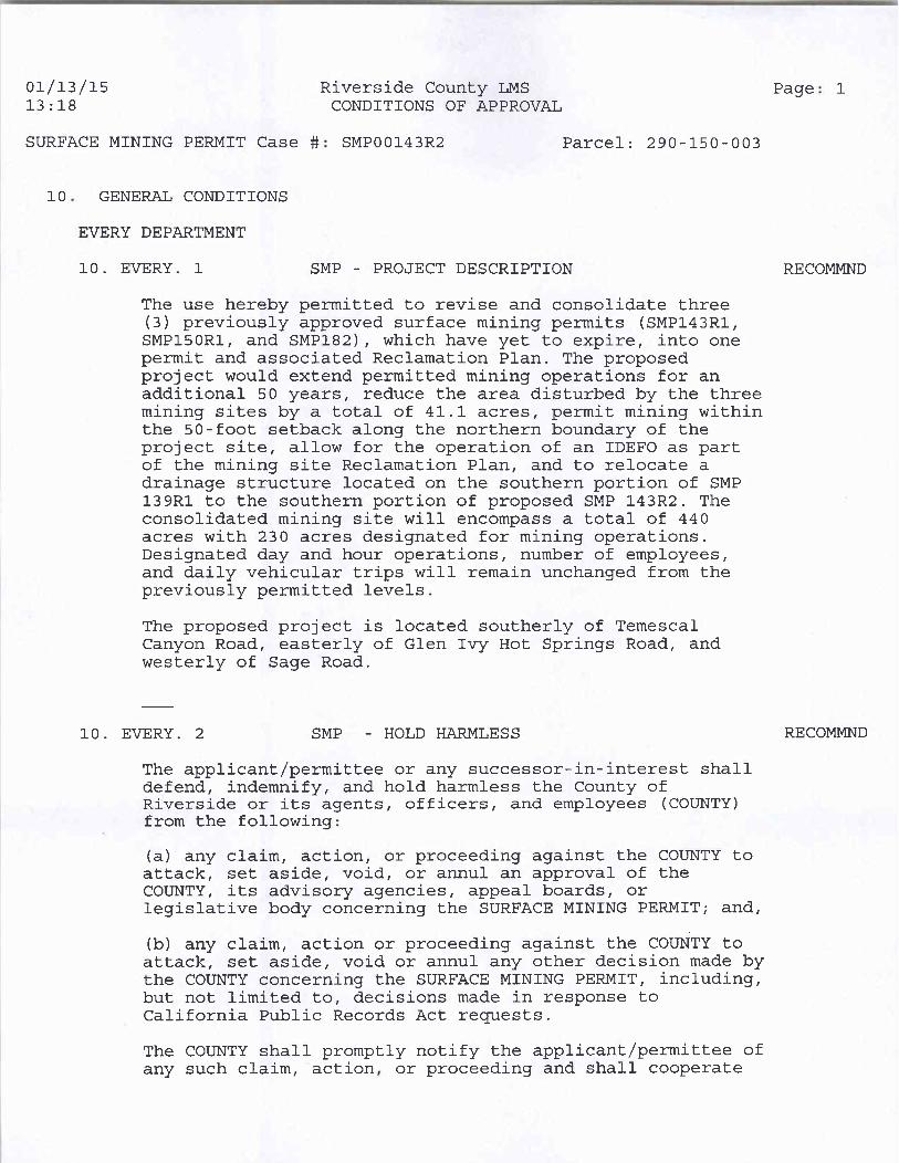
011315 Riverside County LMS Page 1
1318 CONDITIONS OF APPROVAL
SURFACE MINING PERMIT Case SMP00143R2 Parcel 290 150 003
10 GENERAL CONDITIONS
EVERY DEPARTMENT
10 EVERY 1 SMP PROJECT DESCRIPTION RECOMMND
The use hereby permitted to revise and consolidate three3 previously approved surface mining permits SMP143R1SMP150R1 and SMP182 which have yet to expire into one
permit and associated Reclamation Plan The proposedproject would extend permitted mining operations for anadditional 50 years reduce the area disturbed by the threemining sites by a total of 411 acres permit mining withinthe 50 foot setback along the northern boundary of theproject site allow for the operation of an IDEFO as partof the mining site Reclamation Plan and to relocate a
drainage structure located on the southern portion of SMP139R1 to the southern portion of proposed SMP 143R2 The
consolidated mining site will encompass a total of 440acres with 230 acres designated for mining operationsDesignated day and hour operations number of employeesand daily vehicular trips will remain unchanged from thepreviously permitted levels
The proposed project is located southerly of TemescalCanyon Road easterly of Glen Ivy Hot Springs Road and
westerly of Sage Road
10 EVERY 2 SMP HOLD HARMLESS RECOMMND
The applicantpermittee or any successor ininterest shalldefend indemnify and hold harmless the County ofRiverside or its agents officers and employees COUNTY
from the following
a any claim action or proceeding against the COUNTY toattack set aside void or annul an approval of theCOUNTY its advisory agencies appeal boards or
legislative body concerning the SURFACE MINING PERMIT and
b any claim action or proceeding against the COUNTY toattack set aside void or annul any other decision made bythe COUNTY concerning the SURFACE MINING PERMIT includingbut not limited to decisions made in response toCalifornia Public Records Act requests
The COUNTY shall promptly notify the applicant permittee ofany such claim action or proceeding and shall cooperate
011315 Riverside County LMS Page 2
1318 CONDITIONS OF APPROVAL
SURFACE MINING PERMIT Case SMP00143R2 Parcel 290 150003
10 GENERAL CONDITIONS
10 EVERY 2 SMP HOLD HARMLESS cont RECOMMND
fully in the defense If the COUNTY fails to promptlynotify the applicant permittee of any such claim actionor proceeding or fails to cooperate fully in the defensethe applicantpermittee shall not thereafter be
responsible to defend indemnify or hold harmless theCOUNTY
The obligations imposed by this condition include but arenot limited to the following the applicant permitteeshall pay all legal services expenses the COUNTY incurs inconnection with any such claim action or proceedingwhether it incurs such expenses directly whether it is
ordered by a court to pay such expenses or whether it
incurs such expenses by providing legal services throughits Office of County Counsel
10 EVERY 3 SMP DEFINITIONS RECOMMND
The words identified in the following list that appear inall capitals in the attached conditions of SurfaceMining Permit No 143R2 shall be henceforth defined asfollows
APPROVED EXHIBIT NO A Mining Plan Approved Exhibit NoA SMP Case No 143R2 dated
APPROVED EXHIBIT NO B Reclamation Plan ApprovedExhibit No B SMP Case No 143R2 dated
APPROVED EXHIBIT NO C Project Description ApprovedExhibit No C SMP Case No 143R2 Dated
BS GRADE DEPARTMENT
10BS GRADE 1 SMP GENERAL INTRODUCTION RECOMMND
Improvements such as construction related grading fillingover excavation and recompaction and base or paving whichrequire a grading permit are subject to the includedBuilding and Safety Department Grading Division conditionsof approval

011315 Riverside County LMS Page 3
1318 CONDITIONS OF APPROVAL
SURFACE MINING PERMIT Case SMP00143R2 Parcel 290150 003
10 GENERAL CONDITIONS
BS PLNCK DEPARTMENT
10BS PLNCK 1 USE BUILDING PERMITS RECOMMND
The applicant shall obtain the required building permitsfrom the building department prior to any construction onthe property All building plans and supportingdocumentation shall comply with current adopted CaliforniaBuilding Codes Riverside County Ordinances and California
Title 25 regulations in effect at the time of building plansubmittal and fee payment to the Building Department AllBuilding Department plan submittal and fee requirementsshall applyNOTE The new updated 2013 California Building Codes willbe in effect as of January 1st 2014 as mandated by thestate of California Any building plan and fee paymentsubmitted to the building department on or after January1st 2014 will be subject to the new updated CaliforniaBuilding Codes
E HEALTH DEPARTMENT
10E HEALTH 1 SMP TRASH OILSLUBRICANTS RECOMMND
Owners to contact Mike Walling for disposal of oils andmachinery lubricants and Robert Hunt for Solid wastetrash removal at 9519558980
FLOOD RI DEPARTMENT
10FLOOD RI 1 SMP FLOOD HAZARD REPORT RECOMMND
Surface Mining Permit 00143 Revised Permit No 2 is a
proposal for a revision and consolidation of 3 existingmining operations in the Glen Ivy area of Temescal Canyonwest of Interstate 15 between Indian Truck Trail and
Trilogy Parkway The proposal would consolidate SMP 143R1SMP 150R1 and SMP 182 into SMP 143R2 Once consolidated
into a single mining operation the site will be
approximately 440 acres in size with 233 acres used for themining operation A single reclamation plan is alsoproposed with the consolidation of the 3 mines The Inert
Debris Engineered Fill Operation IDEFO is incorporatedinto the reclamation plan The proposal would also extendthe life of the operation by 50 years
North and northwesterly of the site are several othermining operations Residential development is located

011315 Riverside County LMS Page 4
1318 CONDITIONS OF APPROVAL
SURFACE MINING PERMIT Case SMP00143R2 Parcel 290 150003
10 GENERAL CONDITIONS
10FLOOD RI 1 SMP FLOOD HAZARD REPORT cont RECOMMND
easterly of the site The Cleveland National Forest withsteep hilly terrain is located south and southwest of thesite A major tributary from these hills is Mayhew Canyonwith a drainage area of approximately 2200acres Storm
runoff originating from this canyon impacts the site in thevicinity of the southwest corner of the mining operationFlows then proceed northerly in an earthen channel MayhewCanyon Creek along the edge of the mining operation forabout 3000 feet The earthen channel collects additionalrunoff from several other smaller watersheds as flows
proceed northerly Within this earthen channel a coupleof small debris basins have been constructed and culverts
have been placed in the earthen channel to providevehicular access At the northerly boundary of the siterunoff enters a large rectangular concrete downdrainchannel which discharges flows into the SMP 139R1 miningpit
This proposal includes eventually 10 20 years afterissuance of this permit relocating this downdrain channelor other conveyance facility southerly toward the mouthof Mayhew Canyon and discharging flows into SMP 143R2 The
mining operation would excavate material starting in theeasterly portion of the site and proceed westerly throughthe mining site When it is determined that the excavationin the vicinity of the earthen channel is imminent a new
downdrain channel would be constructed While a conceptuallocation of the new downdrain channel is shown on theexhibit due to geological factors bedrock slopestability etc the exact location of this new downdrainchannel cannot be known at this time
In order to capture the flows coming out of Mayhew Canyonthe District recommends that the inlet to the downdrain
channel be located as close as possible to the mouth of thecanyon The downdrain channel should be able to collect
and convey the Q100 flow rate plus 50 bulking for debrisBased on the document titled Hydrology Study and DrainageAnalysis Surface Mining Permit SMP00139R1 County ofRiverside CA by Joseph E Bonadiman and Associates dated
August 2011 a 1 hour 100 year peak flow rate of 3648 cfscan be expected near the point where flows from MayhewCanyon enter this property site Using a 50 debrisloading factor the District recommends the inlet structure
and downdrain channel be designed using a minimum flow rateof 5472 cfs Provisions to prevent headcutting and scour

011315 Riverside County LMS Page 51318 CONDITIONS OF APPROVAL
SURFACE MINING PERMIT Case SMP00143R2 Parcel 290150003
10 GENERAL CONDITIONS
10FLOOD RI 1 SMP FLOOD HAZARD REPORT cont cont RECOMMND
at the inlet may be needed High velocity flows can beexpected as runoff enters the mining pit The channel and
the outlet will need to be designed to withstand these highvelocity flows and to minimize scarifying the concretechannel surface and prevent undermining the downdrainchannel
Once the construction of the downdrain channel is completeand material is removed from the earthen channeladditional drainage facilities may be needed to collect andconvey any tributary runoff Existing concrete Vditchesalong the southerly easterly and northerly edges of themining operation will remain to collect nuisance offsiterunoff and prevent these flows from entering the pit
The District does not object to this proposal
10FLOOD RI 2 SMP FLD CNTRL DOWNDRAIN REVIEW RECOMMND
If requested by the County the Flood Control District maybe consulted on the design of the downdrain primarily theinlet structure A separate plan check fee for the reviewof submitted plans may be required
PLANNING DEPARTMENT
10PLANNING 1 SMP COMPLY W ORD EXHIBITS RECOMMND
The development of these premises shall comply with thestandards of Ordinance Nos 348 and 555 and all other
applicable Riverside County ordinances and state andfederal codes The development of the premises shallconform substantially with that as shown on the Mining andReclamation Plans and Project Description unless otherwise
amended by these conditions
10PLANNING 3 SMP CONDITION REVIEW FEE RECOMMND
All subsequent submittals required by these conditions ofapproval including but not limited to a revegetation planor mitigation monitoring shall be reviewed with paymenttherefore made on an hourly basis as a research fee orother such fee as may be in effect at the time ofsubmittal as required by Ordinance No 671

011315 Riverside County LMS Page 6
1318 CONDITIONS OF APPROVAL
SURFACE MINING PERMIT Case SMP00143R2 Parcel 290 150 003
10 GENERAL CONDITIONS
10PLANNING 4 SMP SLOPE STABILITY RECOMMND
During the life of the permit the permittee shall complywith the recommendations concerning slope stability made inthe report entitled GEO02280 by Hilltop GeotechnicalInc dated September 6 2011 which are on file at the
Riverside County Planning Department
10PLANNING 5 SMP SPARK ARRESTOR REQUIRED RECOMMND
During the life of the permit the permittee shall complywith spark arrestor requirements of the Public ResourcesCode Section 4422 for all equipment used on the premisesother than turbocharger vehicles designed and licensed forhighway use
10PLANNING 6 SMP DUST PREVENTION MEASURE RECOMMND
During the life of the permit all roads driveways andmining areas shall be kept continuously wetted while beingused and shall be treated with EPA approved dustsuppressants to prevent emission of dust Nonhazardous soil
stabilizers shall be applied to all inactive urface miningareas andpr stockpiles previously mined areas whichremain inactive for 96 hours or more
10PLANNING 7 SMP COMPLY W SAFETY REQ RECOMMND
During the life of the permit mining operations andpractices shall comply with the Safety requirements ofMSHA OSHA the State Division of Industrial Safety and
California Mine Safety Orders
10PLANNING 8 SMP RUNOFF OUTLETS RECOMMND
The permitted shall during the proposed mining operationsensure that off site storm runoff through the propertyoutlets are in substantially the same location as existsunder the natural conditions and that the existingwatercourses do not pond or stagnate at any time during themining except as shown on the Mining Plan Exhibit A and
the Recamation Plan Exhibit B
10PLANNING 9 SMP OPERATING HOURS RECOMMND
On site operating hours other than maintenance or
emergencies shall be limited to the hours between 6 AM
and 10 PM for any operation within 300 ft of Boundary

011315 Riverside County LMS Page 7
1318 CONDITIONS OF APPROVAL
SURFACE MINING PERMIT Case SMP00143R2 Parcel 290 150003
10 GENERAL CONDITIONS
10PLANNING 9 SMP OPERATING HOURS cont RECOMMND
Operations located more than 300 ft from the outside
Boundary may opperate 24 hours a day
10PLANNING 10 SMP LOADED TRUCK CARE RECOMMND
All loaded trucks gressing from the subject property shallbe properly trimmed with a two 2 foot freeboard heightandor covered and sprayed with water so as to minimizedust and prevent spillage onto the public roadway In theevent that spillage onto the road does occur said spillageshall be removed immediately within one hour of the
spillage from the road rightofway
10PLANNING 11 SMP FIRE PREVENTION RECOMMND
All work areas and parking areas shall be maintained freeof flammable vegetation and debris at all times No openfires shall be allowed
10PLANNING 13 SMP STOCKPILE PROTECTION RECOMMND
Stockpiles shall be protected against water and winderosion by covering with burlap or other Riverside Countyapproved material wetting andor temporary hydroseedingwith native plant species
10PLANNING 19 SMP SUSPEND OPER FOR WIND RECOMMND
All surface mining operations including excavatingcrushing screening and related material loading andhauling shall be suspended when wind speeds asinstantaneous gusts exceed 20 miles per hour All
surface mining operations shall be suspended during firstand second stage smog alerts
10PLANNING 20 SMP SIGNS NEED PERMIT RECOMMND
No signs are approved pursuant to this use Prior to the
installation of any onsite advertising or directionalsigns a signing plan shall be submitted to and approved bythe Riverside County Planning Department pursuant to therequirements of Section 1830a1 of Riverside CountyOrdinance No 348 Plot Plans not subject to the CaliforniaEnvironmental Quality Act and not subject to review by anygovernmental agency other than the Planning Departmentand all necessary building permits shall be obtained

011315 Riverside County LMS Page 81318 CONDITIONS OF APPROVAL
SURFACE MINING PERMIT Case SMP00143R2 Parcel 290 150 003
10 GENERAL CONDITIONS
10PLANNING 20 SMP SIGNS NEED PERMIT cont RECOMMND
from the Riverside County Department of Building andSafety
10PLANNING 21 SMP RESPONSIBLE TO RECLAIM RECOMMND
The permittee line operator andor land owner shall
accept responsibility for reclaiming the mine lands inaccordance with the reclamation plan and within the timelimits of said plan and in conformance with reclamationrequirements and standards according to State ofCalifornia Surface Mining and Reclamation Act andRiverside County Ordinance No 555 guidelines
10PLANNING 22 SMP ANNUAL REPORT RECOMMND
During the life of this permit the permittee shallannually prepare and submit a written report to thePlanning Director of the County of Riverside demonstratingcompliance with all the conditions of approval andmitigation for this SMP No 143R2and EIR No 359 The
Planning Director andor Building Director may requireinspection or other monitoring to insure such compliance
10PLANNING 23 SMP BLASTING OPERATIONS RECOMMND
Blasting shall only be conducted between the hours of 1000AM and 400 PM Monday through Friday except Federallyrecognized holidays If an emergency situation related to
safety or weather conditions should occur blasting mayoccur outside of these hours Blasting shall be performedin accordance with the following specifications and in
such a manner that noise ground and air vibrations anddust are maintained at levels which satisfy Federal State
and County standards
a Blasting shall be conducted by a trained and licensedblaster
b The explosive used for blasting work will be standardcommercial products specifically designed for mineapplicationsc Blasting shall be performed using electric ornon electric blasting systemsd All blasts shall be detonated with a millisecond delaysystem to limit the quantity of explosive denoted per delayperiod and to provide for sequential control of the blastdetonation

011315 Riverside County LMS Page 9
1318 CONDITIONS OF APPROVAL
SURFACE MINING PERMIT Case SMP00143R2 Parcel 290150003
10 GENERAL CONDITIONS
10PLANNING 23 SMP BLASTING OPERATIONS cont RECOMMND
e The explosives shall include bulk ANFO suitably primedfor blast hole conditionsf Water resistant explosive shall be used where wet blasthole conditions existsg Explosive supplies shall be used in accordance with thetechnical recommendations of the manufacturer and theInstitute of Markers of Explosivesh All blast holes shall be carefully stemmed with inertgranular material and individual blast holes will be
loaded with due recognition of instant rock fracture andburden conditions
i Seismic monitoring of each blast shall be performed byan independent qualified consultantj The mining operator shall inform the County FireDepartment and Sheriff Department prior to 430 PM of the
intention to blast the following dayk Notify neighbors within 1000 feet prior to a blastingepisode1 Prior to a blasting episode the site shall be clearedof people all vehicles shall be either stored undercoveror at a safe distance all surplus explosives shall bestored in a safe place warning signals shall be soundedand visual inspection of the site shall be made to assurethere are no unauthorized people in the vicinity of theblast
m Blasting signals shall be posted at one or moreconspicuous locations on the mining site and all employeesshall be familiar with the signals and instructed as to thesafety proceduresn Following a blasting episode the area shall be
inspected to assure that the blast went as planned The
all clear signal shall not be sounded until the licensedblaster has made a thorough visual inspection of the blastarea for misfires
o Design of blasting configurations iedrill hole
pattern diameter depth explosive types quantities anddelay systems shall be determined by the location of theblast rock conditions of the area to be blasted and
distance to neighboring improvements Determinations shallbe made by drilling and visual observations mine
development plans and allowable explosive quantities perdelay secondp The initial mine development and mine production blastsshall be limited to 2000 pounds of explosive pereightmillisecond blast increment Seismic monitoring atthe site of mining operations shall be performed to
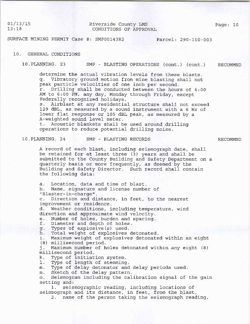
011315 Riverside County LMS Page 101318 CONDITIONS OF APPROVAL
SURFACE MINING PERMIT Case SMP00143R2 Parcel 290150 003
10 GENERAL CONDITIONS
10PLANNING 23 SMP BLASTING OPERATIONS cont cont RECOMMND
determine the actual vibration levels from these blastsq Vibratory ground motion from mine blasting shall notpeak particle velocities of one inch per secondr Drilling shall be conducted between the hours of 600AM to 600 PM any day Monday through Friday exceptFederally recognized holidayss Airblast at any residential structure shall not exceed129 dBL as measured by a sound instrument with a 6 Hz oflower flat response or 105 dBL peak as measured by aAweighted sound level metert Acoustic blankets shall be used around drillingoperations to reduce potential drilling noise
10PLANNING 24 SMP BLASTING RECORDS RECOMMND
A record of each blast including seismograph date shall
be retained for at least three 3 years and shall besubmitted to the County Building and Safety Department on aquarterly basis or more frequently as deemed by theBuilding and Safety Director Such record shall contain
the following data
a Location data and time of blastb Name signature and license number ofBlaster inchargec Direction and distance in feet to the nearest
improvement or residenced Weather conditions including temperature wind
direction and approximate wind velocitye Number of holes burden and spacingf Diameter and depth of holesg Types of explosives used
h Total weight of explosives detonatedi Maximum weight of explosives detonated within an eight8 millisecond periodj Maximum number of holes detonated within any eight 8millisecond periodk Type of initiation system1 Type of length of stemmingm Type of delay detonator and delay periods usedn Sketch of the delay patterno Seismogram including the calibration signal of the gainsetting and
1 seismographic reading including locations ofseismograph and its distance in feet from the blast
2 name of the person taking the seismograph reading

011315 Riverside County LMS Page 111318 CONDITIONS OF APPROVAL
SURFACE MINING PERMIT Case SMP00143R2 Parcel 290 150 003
10 GENERAL CONDITIONS
10PLANNING 24 SMP BLASTING RECORDS cont RECOMMND
3 name of the person and firm analyzing theseismographic record
10PLANNING 25 SMP PREBLAST INSPECTION RECOMMND
Preblast inspections shall be made by a civil engineerlicensed by the State of California of all residences and
facilities existing at time of permit approval locatedwithin 1000 feet of potential blasting areas
10PLANNING 26 SMP BLASTING COMPLAINTS RECOMMND
Any blasting complaints shall be recorded by the permitteeas to complainant address date time nature of the
complaints the complaints that investigation conductedComplaint records shall be made available to the publicagencies regulating blasting
10PLANNING 27 SMP 90 DAYS TO PROTEST RECOMMND
The project applicant has 90 days from the date of approvalof these conditions to protest in accordance with theprocedures set forth in Government Code Section 66020 the
imposition of any and all fees dedications reservations
and or other exactions imposed on this project as a resultof this approval or conditional approavl of this project
10PLANNING 28 USE ORD 810 0 S FEE 1 RECOMMND
In accordance with Riverside County Ordinance No 810 this
mitigation fee will not apply as referred to under MSHCPResolution 2004 223 Section 3a indicating AThe fee shall
be paid only on the gross acreage of the project site thatwas previously vacant and built subsequent to the effectivedate of this ordinance Recognizing that the revised usearea under SMP00143R2 is a manufactured slope and that thisrevision will allow further disturbance into that areatherefore this acreage is exempt from payment
10PLANNING 29 SMP GEO02280 RECOMMND
County Geologic Report GEO No 2280 submitted for this
site SMP00143S1 originally and now for SMP00143R2 was
prepared by Hilltop Geotechnical Inc and is entitled
Report of Slope Stability Evaluation Werner CorporationAggregate Quarry SMP 143 APN 290 120 005 South of

011315 Riverside County LMS Page 12
1318 CONDITIONS OF APPROVAL
SURFACE MINING PERMIT Case SMP00143R2 Parcel 290 150 003
10 GENERAL CONDITIONS
10PLANNING 29 SMP GEO02280 cont RECOMMND
Temescal Canyon Road and East of Maitri Road Glen Ivy Areaof Riverside County California dated September 6 2011
In addition Hilltop Geotechnical prepared the following
Report of Slope Stability Evaluation Werner CorporationAggregate Quarry SMP00143R2 South of Temescal Canyon Roadand at the end of Maitri Road Glen Ivy Area of RiversideCounty California dated February 20 2014
Response to Riverside County Planning Department SecondReview of Slope Stability Evaluation Report SMP00143R2South of Temescal Canyon Road and East of Maitri Road Glen
Ivy Area of Riverside County California dated May 52014
Response to Riverside County Planning Department Review ofSlope Stability Evaluation Report SMP00143R2 South ofTemescal Canyon Road and East of Maitri Road Glen Ivy Areaof Riverside County California dated September 8 2014
These documents are herein incorporated as a part ofGEO02280
GEO02280 concluded
1The active North Glen Ivy fault crosses to the northwestof the subject quarry in a northwesterly direction
2The South Glen Ivy fault also trends toward the
northwest and may also be active is located immediatelysouthwest of the south edge of the Werner Corporation pitsouth of the subject site3An unnamed fault crosses the west edge of the WernerCorporation property trending toward the northwest This
fault lies within the upper portion of the proposed westernpit slope This fault is likely to be potentially active
4Earth materials encountered on the subject site duringthe field exploration were identified a near surfacemanmade fills Af middle alluvial fan deposits QofCretaceous heterogeneous granitic rocks Khg and Bedford
Canyon formation Mzbc
5Groundwater is estimated to have the potential to rise toan elevation of 970 Mean Sea Level MSL

011315 Riverside County LMS Page 131318 CONDITIONS OF APPROVAL
SURFACE MINING PERMIT Case SMP00143R2 Parcel 290 150 003
10 GENERAL CONDITIONS
10PLANNING 29 SMP GEO02280 cont cont RECOMMND
6Gross slope stability analysis resulted in adequatefactors of safety for both static and pseudostaticconditions to the ultimate proposed depth of elevation 800MSL and with a groundwater elevation of 970 MSL
7Analyses for deep seated wedge failures indicated suchfailures are highly unlikely on the proposed slopes
8Exposed cuts in the Bedford Canyon formation are likelyto exhibit localized shallow wedge failures resulting inrelatively small amounts of rock sliding down the face ofthe cut slope
9It is the professional opinion of Hilltop GeotechnicalInc that the use of a 015g seismic coefficient wasappropriate and reasonable for use in the pseudo staticslope stability analysis for this site and is inconformance with current standards of practice for seismicdesign and appropriate for use in their calculations
10Surficial slope stability analyses indicated Factors ofSafety of 38and 33 respectively for the lower and
upper slopes in the alluvial materials
GEO02280 recommended
1Surface water should not be allowed to flow over the
existing andor proposed mining slopes other thanincidental rainfall
2Alterations of manufactured or natural slopes terracestop of slope berms etc should not be allowed that will
prevent runoff from being expediently directed to approveddisposal areas and away from the tops of slopes
3Surface drainage should be positively maintained in anon erosive manner
4Top of slope berms should be constructed and compacted aspart of any grading of the property and should bemaintained by the property owner
5The drainage patterns should be maintained throughout thelive of the proposed mine

011315 Riverside County LMS Page 141318 CONDITIONS OF APPROVAL
SURFACE MINING PERMIT Case SMP00143R2 Parcel 290 150 003
10 GENERAL CONDITIONS
10PLANNING 29 SMP GEO02280 cont cont cont RECOMMND
6Concentrated surface waters entering the property fromoff site sources should be collected and directed to apermanent drainage system and away from the top of miningslopes
7The property owner is responsible for the maintenance andcleaning of the interceptor ditches drainage terracesdowndrains and other drainage devices that have beeninstalled to promote slope stability
8The property owner should establish a program for theelimination of burrowing animals This should be an
on going program to protect slope stability
9The property owner should observe the drainage patternsduring heavy precipitation periods as this is often whentrouble occurs Problems such as gullying or pondingshould be corrected as soon as practicable
10High moisture content in slope earth materials is amajor factor in slope erosion and slope failuresTherefore precautions should be taken to minimize earthmaterial saturation
GEO02280 satisfies the requirement for a slope stabilityassessment for SMP00143R2 for planning purposes Final
approval of GEO02280 is hereby granted for SMP00143R2Further slope stability analysis will be required on anongoing basis as mining operations proceed Reporting ofslope stability analysis will be required annually as apart of the required annual mine inspection pursuant toSMARA regulations and as described elsewhere in thisconditions set
10PLANNING 30 SMP DIF AND TUMF FEES RECOMMND
Pursuant to Ordinance No 659 this mitigation fee will notapply as indicated under DIF Resolution 2008 160 Sections
2B which states The DIF fee shall be paid only on thegross acreage of the project site that was previouslyvacant and built subsequent to the effective date of theordinance Section 4A H also states DIF fees for surface
mining operations will be determined by the total acreageof the Intensive Use Area DIF fees shall not be assessed
on the area designated as the Mineral Extraction Areawithin the surface mining operation The area proposed as

011315 Riverside County LMS Page 15
1318 CONDITIONS OF APPROVAL
SURFACE MINING PERMIT Case SMP00143R2 Parcel 290150 003
10 GENERAL CONDITIONS
10PLANNING 30 SMP DIF AND TUMF FEES cont RECOMMND
revised use under SMP00143R2 is a manufactured slope anddesignated as Mineral Extraction Area and thereforeexempt Be sure this area is noted as Mineral Extraction
Area on the approved Exhibit A
Pursuant to Ordinance 824 this mitigation fee will notapply as there are no buildings or additions to existingbuildings purposed under this SMP00143R2 Please note that
if new buildings or structures that qualify for WTUMFpayment are proposed a further review will be required andWTUMF may apply
10PLANNING 31 SMP HUMAN REMAINS RECOMMND
In the event that human remains are uncovered during miningoperations such remains shall be treated with respect anddignity and treatment of the remains shall occur in full
conformance with the California Native American Graves
Protection and Repatriation Act California Health andSafety Code Section 8010 8011 California Health and
Safety Code Section 70505 California Public Resources
Code Section 509798b and any other applicable laws
10PLANNING 32 SMP IDEFO RECOMMND
Throughout the life of operation of the Inert DebrisEngineered Fill Operation IDEFO the following conditionsshall apply
oNo greenwaste woodwaste gypsum or drywall are allowedas inert waste
oControls sufficient to contain all surface runoff from theIDEFO areas shall be installed where necessary and
oThe site shall be adequately secured to preventunauthorized disposal by the public
20 PRIOR TO A CERTAIN DATE
EPD DEPARTMENT
20EPD 1 MBTA RECOMMND
Prior to mining in previously undisturbed areas or areaswhere vegetation has reestablished itself with more that

011315 Riverside County LMS Page 161318 CONDITIONS OF APPROVAL
SURFACE MINING PERMIT Case SMP00143R2 Parcel 290 150 003
20 PRIOR TO A CERTAIN DATE
20EPD 1 MBTA cont RECOMMND
505 cover initial vegetation clearing and grounddisturbance shall be prohibited during the migratory birdnesting season February 1 through September 15 unless a
migratory bird nesting survey is completed in accordancewith the following requirements
1 A migratory nesting bird survey of the Projectsimpact footprint shall be conducted by a qualifiedbiologist within three 3 days prior to initiatingvegetation clearing or ground disturbance
2 A copy of the migratory nesting bird survey resultsreport shall be provided to the County If the surveyidentifies the presence of active nests then the qualifiedbiologist shall provide the County with a copy of mapsshowing the location of all nests and an appropriate bufferzone around each nest sufficient to protect the nest fromdirect and indirect impact The size and location of allbuffer zones if required shall be subject to review andapproval by the County and shall be no less than a 300 footradius around the nest for non raptors and a 500 footradius around the nest for raptors The nests and buffer
zones shall be field checked weekly by a qualifiedbiological monitor The approved buffer zone shall bemarked in the field with construction fencing within which
no vegetation clearing or ground disturbance shall commenceuntil the qualified biologist and the County verify thatthe nests are no longer active
20EPD 2 OAK TREE AVOID AND MITIG RECOMMND
Prior to any new disturbance within 100 meters of an oaktree signage and staking shall be installed to ensureavoidance of the oak trees drip line Prior to
commencement of mining activities that would impact any oaktrees individual oak trees subject to removal must bemitigated through replacement based on a ratio relative tothe diameter at breast DBH of the impacted treesImpacted trees shall be replaced with 5gallon trees of thesame species at the replacement ratios presented in theGeneral Biological Resources Assessment for the Glen IvyMine Project SMP143R2 dated August 1 2014 and preparedby Alden Environmental Inc Tree replacement shall occurat a location determined by the Project proponent which
shall be subject to approval by the County of RiversideThe limits of the area to be mined shall be staked a

011315 Riverside County LMS Page 17
1318 CONDITIONS OF APPROVAL
SURFACE MINING PERMIT Case SMP00143R2 Parcel 290 150003
20 PRIOR TO A CERTAIN DATE
20EPD 2 OAK TREE AVOID AND MITIG cont RECOMMND
minimum of every 200 feet to protect the mature oaks on thesites of SMP 143R2
20EPD 3 RIP RIV AVOIDANCE RECOMMND
Prior to any new disturbance within 100 meters ofRiparianRiverine features identified as Southern SycamoreWoodlands Alluvial Fan Scrub or Potential Waters ofthe US on Figure 2 4 of Addendum No 1 to EIR No 359all such areas shall be staked and marked with signageindicating that no disturbance shall occur within theseareas Riverside County must sign off on the staking andsignage prior to any disturbance within the 100 meterbuffer
PLANNING DEPARTMENT
20PLANNING 2 SMP LIFE OF PERMIT RECOMMND
This permit shall become null and void fifty 50 yearsafter the date this permit became effective issuance offirst Special Inspection Permit or upon mining of67500000 tons whichever comes first Annual miningtonnage shall not exceed2000000 tons Extensions of time
to the life of this permit shall require submission of arevised permit application in accordance with RiversideCountysOrdiance No 555
60 PRIOR TO GRADING PRMT ISSUANCE
PLANNING DEPARTMENT
60PLANNING 1 SMP YR BLASTING NOTICES RECOMMND
A letter containing a general description of the blastingoperations and precautions including the blast warningwhistle signals that are required by the State ofCalifornia Construction Safety orders shall be sent to all
residents within a one half mile radius of the surface
mining operations The notification will occur a minimumof once a year Evidence that notification has been done
shall be included in the annual report submitted prior tothe issuance of the annual Special Inspections Permit

011315 Riverside County LMS Page 18
1318 CONDITIONS OF APPROVAL
SURFACE MINING PERMIT Case SMP00143R2 Parcel 290 150003
60 PRIOR TO GRADING PRMT ISSUANCE
60PLANNING 2 SMP 1ST LANDSCAPE PLAN RECOMMND
Prior to issuance of the Special Inspection Permit six 6copies of a Landscaping Plan shall be submitted to thePlanning Department for approval The landscaping shallprovide the necessary details for interim revegetation andfinal revegetation of mined slopes The plan shallinclude but not be limited to the following
a minimum amount of soil required for revegetationb amount and type of fertilizers and amendments to beusedc design standards for irrigation systemd optimum time of year to hydroseede size of species to be attained over a specificmonitoring periodf amount of vegetation cover or densityg diversity of species to be attained over a specificmonitoring periodh length of monitoring periodsi issues to be addressed in annual report
60PLANNING 3 SMP 1ST BERM LANDSCAPE PLAN RECOMMND
Prior to issuance of the Special Inspection Permit ten 10copies of a Berm and Landscaping Plan shall be submitted tothe Planning Department for approval This landscapingshall provide a visual barrier between the project andnearby residences as delineated on the Mining Plan Exhibit
A The location number genus species and container sizeof the plants shall be shown Plans shall meet all
requirements of Ordinance 348 Section 1812 The
Landscaping Plan shall include usage of a variety of typeand size of plan species native to the site and surroundingarea At least 25 percent of the plant materials shall bemature specimens and in 15 gallon or larger containers
60PLANNING 5 SMP RCL RECLAMATION PLAN RECOMMND
The permittee shall comply with the Reclamation PlanExhibit B and the Surface Mining and Reclamation ProjectDescription Exhibit C all on file with the Riverside
County Planning Department Approval of the ReclamationPlan does not grant approval of any planned future use ofthe site

011315 Riverside County LMS Page 191318 CONDITIONS OF APPROVAL
SURFACE MINING PERMIT Case SMP00143R2 Parcel 290 150 003
60 PRIOR TO GRADING PRMT ISSUANCE
60PLANNING 6 SMP YR RECLAMATION REPORT RECOMMND
The permittee shall submit a final reclamation completionreport prior to the completion of mining and expiration tothe Building and Safety Director and Planning Director forreview and approval This report shall indicate thecompletion of reclamation in accordance with the approvedplan including final contours slope configuration of 21horizontalvertical resoiled areas erosion control
structures and successful revegetation This report shallbe submitted at least 30 days prior to completion of eachphase and expiration of this permit This report shall beaccompanied by a stamped and wetsigned substantialconformance letter from an independent licensed engineerlandscape architect geologist or other appropriateprofessional stating that the project was reclaimedpursuant to the approved Reclamation Plan
60PLANNING 7 SMP 1ST INSPECTION REPORT RECOMMND
Prior to commencement of any surface disturbance or
construction of any processing plant surface
minning operation or issuance of the first SpecialInspection Permit the permittee shall apply for a SpecialInspection Permit from the Riverside County Department ofBuilding and Safety which will be accompanied by theappropriate filing fee set forth in Riverside CountyOrdinance No 671 The Special Inspection Permit shall beaccompanied by a written report which specifiesconformance with these conditions of approval
60PLANNING 8 SMP 1ST FINANCIAL ASSURANCE RECOMMND
Prior to commencement of any surface disturbanceconstruction of any processing plant surface miningoperation or issuance of the first Special InspectionPermit the permittee shall establish financial assurancesto ensure reclamation of the surface mining operation withthe Riverside County Department of Building and Safety
a The financial assurance shall take the form of a
surety bond irrevocable letter of credit trust fund or
other form of financial assurance as approved by theDirector of Building and Safety
b The amount of the financial assurance required forthis permit shall be updated annually Pursuant to SMARAregulations

011315 Riverside County LMS Page 201318 CONDITIONS OF APPROVAL
SURFACE MINING PERMIT Case SMP00143R2 Parcel 290 150 003
60 PRIOR TO GRADING PRMT ISSUANCE
60PLANNING 8 SMP 1ST FINANCIAL ASSURANCE cont RECOMMND
c The financial assurance shall include but not
necessarily be limited to costs for the removal ofequipment structures and derelict machinery removal ofwaste materials landscaping stabilization of slopesand land restoration compatible with the topography andgeneral environment of surrounding property in accordancewith the approved Reclamation and Mining Plans
d The financial assurance shall remain in effect fora twenty one 21 year period andor shall be released bythe Building and Safety Director on approval of the finalReclamation Plan inspection by the Department of Buildingand Safety
e The financial assurance shall be made payable toRiverside County and the State of California Department ofConservation
60PLANNING 13 SMP YR REPORT REQUIREMENTS RECOMMND
The permittee shall provide the following information aspart of the annual report required by Condition No 51
This report shall be prepared by a qualified licensed
professional
a Indicate the mined areasproximity to the permitboundaries by topography and details on an approved anExhibit A
b Show the annual and total change in topographygenerated by the mining excavation by cross sections andtopographic maps Compare original previous contours andcross sections with current cross sections and contours
c Maximum depth of excavation
d Provide the quantity in cubic yards and tons minedduring the previous year
e Certify that the excavations are within the limitsof the permit
f Provide data indicating the area reclaimed for theyear concluding and for the total amount reclaimed to dateCertify that reclamation is complete in these areas

011315 Riverside County LMS Page 21
1318 CONDITIONS OF APPROVAL
SURFACE MINING PERMIT Case SMP00143R2 Parcel 290 150 003
60 PRIOR TO GRADING PRMT ISSUANCE
60PLANNING 13 SMP YR REPORT REQUIREMENTS cont RECOMMND
g A Certified Engineering Geologist or GeotechnicalEngineer shall inspect all excavated slopes within thesurface mining area at least once per year for slopestability The results of this inspection and anyrecommendations for slope remediation shall be includedwith the annual report
h The permittee shall report the discovery of anyfossil vertebrate animal remains in the annual reportUpon discovery of such fossil remains the permittee shallcause a paleonotologist to be retained for the project toimmediately evaluate the fossils to determine theirsignificance and develop a collection and study plan inconformance with the Paleontological Survey prepared forthe site a copy of which is on file at the RiversideCounty Planning Department The report of findings shall besubmitted with the annual report
60PLANNING 14 SMP YR TEST DUST EMISSIONS RECOMMND
The permittee shall have an independent air qualityprofessional approved by the Planning Department performtesting for project generated fugitive dust emissionswithin 90 days after commencement of surface miningoperations The intent of this testing is to confirm thatproject generated fugitive dust emissions are in compliancewith South Coast Air Quality Management District SCAQMDRules and Regulations regarding fugitive dust and PM10
a The permittee shall perform particulate mattermonitoring when the surface mine is in operations on fourdays per quarter during the first year of operations andshall prepare a fugitive dust emissions control plan The
SCAQMD Rule 403 Implementation Handbook PM10 shall be
utilized as the guidance for particulate matter monitoringas well as plan preparation The particulate mattermonitoring program shall include upwind and downwindsampling stations adjacent to the surface miningoperations Annual air quality monitoring after the firstyear of operations shall be based upon the previousyears compliance with SCAQMD rules and regulations as
determined by the Planning Director
b The results of the air quality testing shall meetor not exceed SCAQMD standards for PM10 upwinddownwind

011315 Riverside County LMS Page 221318 CONDITIONS OF APPROVAL
SURFACE MINING PERMIT Case SMP00143R2 Parcel 290 150 003
60 PRIOR TO GRADING PRMT ISSUANCE
60PLANNING 14 SMP YR TEST DUST EMISSIONS cont RECOMMND
PM10 differences shall not exceed 50 micrograms per cubicmeter If the air quality testing results indicatenon compliance with the SCAQMD standards State and Federalrules and regulations including but not limited to SCAQMDRule 403 for fugitive dust and State and Federal
regulations pertaining to crystalline silica dustemissions the permittee shall cease surface miningoperations until further fugitive dust emission mitigationmeasures are included and implemented with the fugitivedust emissions control plan Further testing shall then beperformed to confirm compliance with the SCAQMD standardsand State and Federal rules and regulations describedabove The mitigation measures and further testing shallbe submitted to the Planning Director for review andapproval prior to commencement of further surface miningoperations
c The results of air quality testing monitoringandor new mitigation measures shall be included with theannual report required by Condition No 51
60PLANNING 15 SMP YR ADJUST ASSURANCES RECOMMND
The amount of reclamation financial assurance shall be
adjusted annually for new lands disturbed by surface miningoperations completed reclamation in conformance with theapproved Reclamation Plan Exhibit B andor by adjustmentsto the US Department of Labor Consumer Price Index forthe Los Angeles Long Beach Metropolitan Area
60PLANNING 18 SMP FEE BALANCE RECOMMND
Prior to issuance of grading permits the PlanningDepartment shall determine if the deposit based fees forSMP No 143R2 are in a negative balance If so any
outstanding fees shall be paid by the applicantdeveloper
60PLANNING 19 SMP CI SWPPP BMP REQD RECOMMND
The permit holder shall provide written proof of compliancewith the California Regional Water Quality Control BoardSanta Ana Regions Wateshed wide waste discchargerequirements as follows
The management and maintenance of the common area shall
be in accordance with the projects approved Storm Water

011315 Riverside County LMS Page 231318 CONDITIONS OF APPROVAL
SURFACE MINING PERMIT Case SMP00143R2 Parcel 290 150 003
60 PRIOR TO GRADING PRMT ISSUANCE
60PLANNING 19 SMP CI SWPPP BMP REQD cont RECOMMND
Pollution Prevention Plans SWPPPs Monitoring Programsand Post Construction Management Plans to include thefollowing best management practices BMPs to reduce storm
water pollution
Initial residents occupants or tenants of this site shall
receive educational materials on good house keepingpractices which contribute to the protection of storm waterquality These Educational materials shall be provided bythe Riverside County Flood Control and Water ConservationDistrict and shall be distributed by the Property OwnersAssociation These materials shall address goodhousekeeping practices associated with the sitess land useand or uses eg good housekeeping practices for officecommercial retail commercial vehicle related commercialor industrial land use Employers at this site shalladapt these materials for training their employees in goodhousekeeping practices BMP N1 N13
Only pesticide applicators who are certified by the Stateof California as Qualified Applicators or who are directlysupervised by a Qualified Applicator shall apply pesticidesto common area landscaping The applicator shall apply allpesticides in strict accordance with pesticide applicationlaws as stated in the California Food and AgriculturalCode Fertilizer shall be applied to common arealandscaping in accordance with the manufacturersrecommendations Application to hardscape surfaces shallbe avoided BMP N3
The catch basinsmore particularly described on ExhibitA shall be inspected and if necessary cleaned by theProperty Owners Association no later than October 15th ofeach year ONLY RAIN IN THE DRAIN and NO DUMPING
stencils shall be repainted as necessary to maintainlegiblity BMP N4 S12
The Property Owners Association shall keep the commonareas free of litter Litter shall be removed from the
common area and litter receptacles shall be emptied atleast once a month Where improper disposal of trash hasoccurred the Property Owners Association shall take
corrective action within fortyeight hours of discoveryBMP N5
The water quality inlets oilwater seperators and

011315 Riverside County LMS Page 241318 CONDITIONS OF APPROVAL
SURFACE MINING PERMIT Case SMP00143R2 Parcel 290 150003
60 PRIOR TO GRADING PRMT ISSUANCE
60PLANNING 19 SMP CI SWPPP BMP REQD cont cont RECOMMND
trash racks more particularly described on ExhibitA shall be inspected and if necessary cleaned by theProperty Owners Association no later that October 15th ofeach year BMP S4 S13
The Property OwnersAssociation shall keep the commonareas free of litter Litter shall be removed from thecommon area and litter receptacles shall be emptied atleast once a month Where improper disposal of trash hasoccurred the Property Owners Association shall takecorrective action within fortyeight hours of discoveryBMP N5
The Streets and parking lots more particularlydescribed on Exhibit A shall be swept by the PropertyOwnersAssociation at least once a year and shall be sweptno later than October 15th of each year BMP N6
The Property OwnersAssociation shall keep loading docksin a clean and orderly condition through a regular programof sweeping litter control and the immediate cleanup ofspills and broken containers In accordance with theRiverside County Ordinance No 754 Establishing StormWaterUrban Runoff Management and Discharge Controlsillicit discharges and nonstorm water discharges egwash water from loading docks to storm water drains shallnot be allowed BMP N12
The Property Owners Association shall maintain anup todate list identifying the party or partiesresponsible for the implemenation and maintenance of eachof the BMPs described herein The list shall include the
partys name organization address a phone number atwhich the party may be reached 24 hours a day and a
description of the partysresponsibility forimplementation and maintenance of a particular BMP BMPN14
60PLANNING 20 SMP ORD 810 OS FEE SMP 2 RECOMMND
In accordance with Riverside County Ordinance No 810 this
mitigation fee will not apply as referred to under MSHCPResolution 2004 223 Section 3a indicating The fee shall
be paid only on the gross acreage of the project site thatwas previously vacant and built subsequent to the effectivedate of this ordinance Recognizing that the revised use

011315 Riverside County LMS Page 251318 CONDITIONS OF APPROVAL
SURFACE MINING PERMIT Case SMP00143R2 Parcel 290 150 003
60 PRIOR TO GRADING PRMT ISSUANCE
60PLANNING 20 SMP ORD 810 OS FEE SMP 2 cont RECOMMND
area under SMP00143R2 is a manufactured slope and that thisrevision will allow further disturbance into that areatherefore this acreage is exempt from payment
60PLANNING 21 SMP MAYHEW SETBCK RECOMMND
The permittee shall establish and observe a 100 miningsetback from the centerline of Mayhew Creek to protect thestreambed from erosion prior to the construction of thestormwater inlet structure downstructure This
downstructure would replace the SMP139R1 inlet structurecurrently located immediately downstream This setback
shall run the entire length of Mayhew Creek within theSMP143R2 property and be staked with white PVC every 250
Mining within this setback area can occur after substantialcompletion of the SMP143R2 downstructure and drainage fromMayhew Creek has been addressed
60PLANNING 22 SMP COAST LIVE OAK MM RECOMMND
Prior to any new disturbance within on site Coast Live OakWoodland Habitat the Project Applicant shall place 13acres of Coast Live Oak Woodland located onsite and
outside of the proposed mining and impact limits into apermanent conservation easement
70 PRIOR TO GRADING FINAL INSPECT
PLANNING DEPARTMENT
70PLANNING 7 SMP YR TEMPORARY SLOPES RECOMMND
Temporary slopes created during mining operations shall beexcavated no steeper than 11 horizontalvertical and no
higher than 30 feet in vertical height or in compliancewith MSHA and CALOSHA requirements
80 PRIOR TO BLDG PRMT ISSUANCE
BS GRADE DEPARTMENT
80BS GRADE 1 SMP NO B PMT WO GPMT RECOMMND
Prior to the issuance of any building permit the propertyowner shall obtain a grading permit andor approval to

011315 Riverside County LMS Page 261318 CONDITIONS OF APPROVAL
SURFACE MINING PERMIT Case SMP00143R2 Parcel 290 150003
80 PRIOR TO BLDG PRMT ISSUANCE
80BS GRADE 1 SMP NO BPMT WO GPMT cont RECOMMND
construct from the Building and Safety Department
80BS GRADE 2 SMP ROUGH GRADE APPROVAL RECOMMND
Prior to the issuance of any building permit the applicantshall obtain rough grade approval andor approval toconstruct from the Building and Safety Department The
Building and Safety Department must approve the completedgrading of your project before a building permit can beissued Rough Grade approval can be accomplished bycomplying with the following
1Submitting a Wet Signed copy of the Soils CompactionReport containing substantiating data from the SoilsEngineer registered geologist or certified geologistcivil engineer or geotechnical engineer as appropriate for
his her certification of the project
2Submitting a Wet Signed copy of the Rough Gradecertification from a Registered Civil Engineer certifyingthat the grading was completed in conformance with theapproved grading plan
3Requesting a Rough Grade Inspection and obtaining roughgrade approval from a Riverside County inspector
4Rough Grade Only Permits In addition to obtaining allrequired inspections and approval of all final reports all
sites permitted for rough grade only shall provide 100percent vegetative coverage to stabilize the site prior toreceiving a rough grade permit final
Prior to release for building permit the applicant shallhave met all rough grade requirements to obtain Buildingand Safety Department clearance
E HEALTH DEPARTMENT
80E HEALTH 1 SMP SEPTIC PLAN COPIES INEFFECT
A set of three3 copies of a detailed scaled 1 40maximum plot plan showing all fixtures serving theexisting subsurface sewage disposal system The completesubsurface sewage disposal system plus 100 expansionareas must also be plotted and certified by a C 42 that itis in good working condition on the DEH form for this type

011315 Riverside County LMS Page 271318 CONDITIONS OF APPROVAL
SURFACE MINING PERMIT Case SMP00143R2 Parcel 290 150 003
80 PRIOR TO BLDG PRMT ISSUANCE
80E HEALTH 1 SMP SEPTIC PLAN COPIES cont INEFFECT
of certification and pay the fee of 9690
PLANNING DEPARTMENT
80PLANNING 2 USE FEE BALANCE RECOMMND
Prior to issuance of building permits the PlanningDepartment shall determine if the deposit based fees forproject are in a negative balance If so any outstandingfees shall be paid by the applicant developer
90 PRIOR TO BLDG FINAL INSPECTION
BS GRADE DEPARTMENT
90BS GRADE 1 SMP REQD GRADING INSPS RECOMMND
The developer applicant shall be responsible forobtaining the following inspections required by Ordinance457
1Precise grade inspection of entire permit area
90BS GRADE 2 SMP PRECISE GRDG APPROVAL RECOMMND
Prior to final building inspection the applicant shallobtain precise grade approval andor clearance from theBuilding and Safety Department The Building and SafetyDepartment must approve the precise grading of your projectbefore a building final can be obtained Precise Grade
approval can be accomplished by complying with thefollowing
1Requesting and obtaining approval of all required gradinginspections
2Submitting a Wet Signed copy of the Precise Final
Grade Certification for the entire site from a RegisteredCivil Engineer certifying that the precise grading wascompleted in conformance with the approved grading plan
Prior to release for building final the applicant shallhave met all precise grade requirements to obtain Buildingand Safety Department clearance

011315 Riverside County LMS Page 281318 CONDITIONS OF APPROVAL
SURFACE MINING PERMIT Case SMP00143R2 Parcel 290 150 003
90 PRIOR TO BLDG FINAL INSPECTION
PLANNING DEPARTMENT
90PLANNING 3 USE ORD 810 0 S FEE 2 RECOMMND
Prior to the issuance of a certificate of occupancyoruponbuilding permit final inspection rior to use or occupancyfor cases without final inspection or certificate ofoccupancy such as an SMP whichever comes first the
applicant shall comply with the provisions of RiversideCounty Ordinance No 810 which requires the payment of theappropriate fee set forth in the Ordinance The amount of
the fee will be based on the Project Area as defined inthe Ordinance and the aforementioned Condition of ApprovalThe Project Area for Plot Plan Conditional Use PermitPublic Use Permit Surface Mining Permit No 143R2 iscalculatecd to be 44000 net acres In the event Riverside
County Ordinance No 810 is rescinded this condition willno longer be applicable However should Riverside CountyOrdinance No 810 be rescinded and superseded by asubsequent mitigation fee ordinance payment of theappropriate fee set forth in that ordinance shall berequired

LAND DEVELOPMENT COMMITTEEINITIAL CASE TRANSMITTAL
RIVERSIDE COUNTY PLANNING DEPARTMENT RIVERSIDE
PO Box 1409
Riverside CA 925021409DATE October 1 2014
TORiv Co Transportation Dept Riv Co Sheriffs Dept South Coast Air Qlty MgtRiv Co Environmental Health Dept Riv Co Waste Management Dept California Dept of Fish Game
Riv Co Fire Department 1st District Supervisor US Fish Wildlife Service
Riv Co Building Safety Grading 1st District Planning Commissioner Army Corp of Engineers ACOERiv Co Building Safety Plan Check City of Corona OMR
Riv Co Environmental Programs Dept Southern California Edison
PDGeology SectionD Jones CALTRANS District8
PDArchaeology SectionHThompson Santa Ana Regional Water Ctrl Brd
SURFACE MINING PERMIT NO 143 REVISED NO 2 EA42714 Applicant Werner Corp FirstFirst
Supervisorial District Location Southerly of Temescal Canyon Road easterly of Glen Ivy Hot Springs Roadwesterly of Sage Road Size 440 acres total 233 of which will be mined REQUEST The project is proposing arevision and consolidation of 3 existing contiguous surface mining permits Previously approved and not expiredSMP143R1 SMP150R1 and SMP182 are proposed to be consolidated into SMP143R2 The project site will nowbe 440 acres total 233 of which will be mined The revision proposes to extend the life of the current permit 50years reduce the amount of disturbed area formerly permitted under the three mines propose a single reclamationplan which is proposed to be revised to include IDEFO infill and allow the mining of reserves located between thesubject property and adjacent mining operation SMP139R1 to the north Day and hours of operation number ofemployees and daily vehicle trips will remain unchanged from previously permitted levels All three mines werepreviously permitted for2500000 tons per year of production together The annual production is not proposed tochange with this application however the overall tonnage will increase because the life of the permit is proposed toextend The maximum reserves now proposed to be mined on the site are 67500000 tons APNs 290 120002003 005 006 007 290 150002 003
Please review the attached map andor exhibit for the above described project This case has beenrevised slightly to address comments from the August 28 2014 LDC meeting
This project will not be scheduled for a new LDC comment meeting
Should you have any questions regarding this project please do not hesitate to contact Matt StraiteContract Planner at 951 955 8631 or email at mstraitecrctImaorqMAILSTOP 1070
COMMENTS
DATE SIGNATURE
PLEASE PRINT NAME AND TITLE
TELEPHONE
If you do not include this transmittal in your response please include a reference to the case number and projectplannersname Thank youYPlanning Case Files RiversideofficeSMP00143R2Admin DocsLDC Transmittal FormsSMP00143R2LDC Initial Transmital Form Reviseddocx

LAND DEVELOPMENT COMMITTEEINITIAL CASE TRANSMITTAL
RIVERSIDE COUNTY PLANNING DEPARTMENT RIVERSIDEPO Box 1409
Riverside CA 925021409DATE August 5 2014
TORiv Co Transportation Dept PDArchaeology SectionHThompson CALTRANS District 8Riv Co Environmental Health Dept Riv Co Sheriffs Dept Santa Ana Regional Water Ctrl BrdRiv Co Fire Department Riv Co Waste Management Dept South Coast Air Qlty MgtRiv Co Building Safety Grading 1st District Supervisor California Dept of Fish GameRiv Co Building Safety Plan Check 1st District Planning Commissioner US Fish Wildlife ServiceRiv Co Environmental Programs Dept City of Corona Army Corp of Engineers ACOEPDGeology Section DJones Southern California Edison
SURFACE MINING PERMIT NO 143 REVISED NO 2 EA42714 Applicant Werner Corp FirstFirstSupervisorial District Location Southerly of Temescal Canyon Road easterly of Glen Ivy Hot Springs Roadwesterly of Sage Road Size 440 acres total 233 of which will be mined REQUEST The project is proposing arevision and consolidation of 3 existing contiguous surface mining permits Previously approved and not expiredSMP143R1 SMP150R1 and SMP182 are proposed to be conso lidated into SMP143R2 The project site will nowbe 440 acres total 233 of which will be mined The revision proposes to extend the life of the current permit 50years reduce the amount of disturbed area formerly permitted under the three mines propose a single reclamationplan which is proposed to be revised to include IDEFO infill and allow the mining of reserves located between thesubject property and adjacent mining operation SMP139R1 to the north Day and hours of operation number ofemployees and daily vehicle trips will remain unchanged from previously permitted levels All three mines werepreviously permitted for2500000 tons per year of production together The annual production is not proposed tochange with this application however the overall tonnage will increase because the life of the permit is proposed toextend The maximum reserves now proposed to be mined on the site are67500000tons APNs 290 120002003 005 006 007 290 150 002 003
Please review the attached maps andor exhibits for the above described project This case is
scheduled for a LDC meeting on August 28 2014 All LDC Members please have draft conditions inthe Land Management System on or before the above date If it is determined that the attached mapsandor exhibitsare not acceptable please have corrections in the system and DENY the routing on orbefore the above date Once the route is complete and the approval screen is approved with or withoutcorrections the case can be scheduled for a public hearing
All other transmitted entities please have your comments questions and recommendations to thePlanning Department on or before the above date Your comments recommendationsconditions are
requested so that they may be incorporated in the staff report for this particular case
Should you have any questions regarding this project please do not hesitate to contact Matt StraiteContract Planner at 951 9558631 or email at mstraiterctImaorq MAILSTOP 1070
COMMENTS
DATE SIGNATURE
PLEASE PRINT NAME AND TITLE
TELEPHONE
If you do not include this transmittal in your response please include a reference to the case number and projectplannersname Thank youYPlanning Case FilesRiverside officeSMP00143R2Admin DocsLDC Transmittal FormsSMP00143R2 LDC Initial Transmital Formdocx
I
RIVERSIDE COUNTY
PLANNING DEPARTMENT
Juan C PerezInterim Director
January 13 2015
Mr Pat Perez
California Department of ConservationOffice of Mine Reclamation801 K St MS 0906
Sacramento CA 95814
RE Response to OMRsComments and 30Day Prior Notice of Public HearingGlen Ivy 1 CA Mine ID 91 330001Mining Permit and Reclamation Plan AmendmentSMP00143R2
Riverside County is in receipt of the Office of Mine Reclamation OMR April 14 2014comments on the referenced amendment SMP00143R21 Thank you for OMRstimelysubmittal of these comments
Pursuant to SMARA Section 2774d2this letter shall serve as notice that RiversideCounty and the mine operatorowner agree to incorporate all of OMRs comments intothe final approved reclamation plan as indicated in the attached response to OMRscomments
Public Hearing
SMARA Section 2774d2this letter shall also serve as notice that Riverside Countyhas scheduled this case for public hearing before the Countys Planning Commission onFebruary 18 2015 at the following address
Riverside County Administrative Center1 Floor Board Chambers4080 Lemon Street
Riverside CA 92502
The hearing for SMP00143R2 is expected to begin at 900am or as soon as possiblethereafter The intent of the hearing is to present the proposed mining permit andreclamation plan amendments to the Planning Commission for their consideration ofapproving the revisions
Riverside Office 4080 Lemon Street 12th Floor Desert Office 77588 El Duna CourtPO Box 1409 Riverside California 925021409 Palm Desert California 92211
951 9556892 Fax 951 9551811 760 8638277 Fax 760 863 7555
Planning Our Future Preserving Our Past

We look forward to receiving any comments you may have on this amended reclamationplan Please call me at 951 9556863 if you have any questions
Sincerely
RIVERSIDE COUNTY PLANNING DEPARTMENTJuan C Perez Interim Planning Director
lD i Jones Chief Engineering Geologist
LMA LANNING
cc Todd Pendergrass PO Box 77850 Corona CA 92877OMR Beth Hendrickson email Beth Hendrickson@conservationcagovSMP00143R2 File
YPlanning Case FilesRiverside officeSMP00143R2Response to OMR Comments and 30 day Notice of Hearingdocx

NATURAL RESOURCES AGENCY EDMUND G BROWN JR GOVERNOR
DEPARTMENT OF CONSERVATIONOFFICE OF MINE RECLAMATION
801 K STREET MS 0906 SACRAMENTO CALIFORNIA 95814
RECLAMATION
OFFICE
A I oN
NE
aecwManPHONE 916 3239198 FAX 916 4456066 TDD 916 3242555 WEB SITE conservationcogov
December 24 2014
VIA EMAIL mstraite @rtclmaorqORIGINAL SENT BY MAIL
Mr Matt Straite
Riverside County Planning DepartmentPO Box 1409Riverside CA 925021409
Dear Mr Straite
GLEN IVY MINEAMENDED RECLAMATION PLANCALIFORNIA ID 91 330001 0010 AND 0075SMP 143R2
The Department of ConservationsOffice of Mine Reclamation OMR has reviewed theamended reclamation plan for the Glen Ivy Mine The applicant Werner Corporation isproposing to consolidate three existing contiguous surface mining permits and continuemining aggregate on 233 acres of a 440 acre project site for a period of 50 years Therevision will bring all three mines under a single permit and reclamation plan reduce thetotal amount of disturbed acreage currently permitted and allow mining of reservesbetween the adjacent operations to continue The applicant estimates that a maximumof2500000 tons of material will be removed annually The project site is located in theTemescal Canyon area near Corona
The Surface Mining and Reclamation Act of 1975 SMARA Public Resources CodeSection 2710 et seq and the State Mining and Geology Board Regulations CaliforniaCode of Regulations CCR Title 14 Division 2 Chapter 8 Subchapter 1 require thatspecific items be addressed or included in reclamation plans The following commentsprepared by a restoration ecologist and an engineering geologist are offered to assist inyour review of this project The reclamation plan should be revised andorsupplemented to fully address these items Additionally the County will need to workwith OMRsReporting and Records Unit to close out mine numbers 91 330010 and 91330075 to finalize the consolidation of the three mines under the single mine number of91 330001
The Department of Conservationsmission is to balance todaysneeds with tomorrowschallenges and foster intelligent sustainableand efficient use of Californias energy land and mineral resources

Mr Matt StraiteDecember 24 2014Page 2
Mining Operation and Closure
Refer to SMARA Sections 2770 2772 2773 CCR Sections 3502 3709 3713
SMARA Section 2773astates that the reclamation plan shall establish sitespecificcriteria for evaluating compliance with regard to topography and sediment and erosioncontrol The engineered drawings prepared by Bondiman and Associates Bondimanneed to be supplemented to include detailed topography and cross sections thataccurately depict how Mayhew Creek will be conveyed into the proposed concretedowndrain structure which will be a permanent diversion structure
End Land Use
Refer to SMARA Section 2772 CCR Sections 3707 3708
SMARA Section 2772c7requires that the reclamation plan include a description ofthe proposed use or potential uses of the mined lands after reclamation There is adiscussion on page 25 of possible end uses titled Post Reclamation OMR
recommends inserting a sentence to clarify this such as The end use for the propertyafter the completion of mining will be open space readily adaptable to other uses to bedetermined in the future
Hydrology and Water Quality
Refer to SMARA Sections 2772 2773 CCR Sections 3502 3503 3706 3710 3712
CCR Section 3706drequires berms and other erosion control methods to protectagainst gullying The reclamation plan maps prepared by Bondiman show a typicalsection for a VDitch but it is unclear on the map exactly where these VDitches bothexisting and proposed are or will be situated at the mine The reclamation plan shouldbe revised to include a discussion regarding the location of the VDitches and alsodescribe how they will be constructed and maintained The reclamation plan mapsshould be revised to clearly show where all VDitches are or will be constructed at themine
CCR Section 3706dalso requires berms and other water conveyance structures likeculverts and the concrete downdrain to be designed to handle runoff from not less thanthe 20year1 hour intensity storm event These calculations for the proposed reclaimedconditions were not included in the electronic version of the Preliminary HydrologyStudy and Drainage Analysis submitted to OMR Attachment 8 which is supposed toinclude proposed conditions and calculations on an attached compact disk CD wasnot included in the submittal to OMR The final version of the Hydrology Study andDrainage Analysis including all attachments must be submitted to OMR for review
CCR Section 3706e states that where natural drainages are rerouted by surfacemining activities mitigating alternatives shall be proposed and specifically approved in
Mr Matt Straite
December 24 2014Page 3
the reclamation plan to assure that runoff shall not cause increased erosion orsedimentation The proposed reclamation plan includes the relocation of anapproximately 30footwide by 900foot long concrete downdrain structure that willconvey flow from Mayhew Creek down into the approximately 500 footdeep mining pitThe Bondiman maps currently show the downdrain structure in an area where MayhewCreek will have to make a 90degree turn and flow uphill in order to enter thedowndrain The reclamation plan must be revised to include design specificationsincluding detailed topography and cross sections that accurately depict how MayhewCreek will be conveyed into the proposed concrete downdrain structure
CCR Section 3706fstates that when stream diversions are required they shall beconstructed in accordance with the Stream and Lake Alteration Agreement between theoperator and the California Department of Fish and Wildlife DFW and therequirements of the Federal Clean Water Act The reclamation plan indicates that theserequirements have been met and it includes the specific agreement numbers OMRrecommends including these documents as an appendix to the reclamation plan toensure reclamation activities are carried out in accordance with these additionalregulatory requirements
Environmental Setting andProtection of Fish and Wildlife Habitat
Refer to CCR Sections 3502 3503 3703 3704 3705 3710 3713
Potential adverse effects from the mining operation will be identified and mitigation willbe proposed during the environmental review process Due to the fact that the projectis in the early stage of environmental review under CEQA it is recommended that theamended reclamation plan not be finalized or approved until mitigation is determinedsince mitigation measures recommended under CEQA may substantially change themanner in which mining and reclamation are accomplished
Planting 110 5gallon coast live oak trees as mitigation for impacts to oak trees isproposed in the General Biological Resources Assessment for the Glen Ivy MineProject by Alden Environmental Adjusting for some expected mortality will requireplanting additional trees Oak tree mitigation requirements with planting methods andperformance standards need to be added to the reclamation plan once mitigation isdetermined through the CEQA process Public Resources Code PRC 210834allowsreplanting to account for no more than half the mitigation requirements for the ProjectAdditional mitigation may be required such as purchasing an offsite conservationeasement
CCR Section 3705arequires that the density cover and speciesrichness of naturallyoccurring habitats shall be documented in baseline studies in order to establish a selfsustaining vegetative cover similar to the surrounding habitat Baseline studies of

Mr Matt Straite
December 24 2014Page 4
reference areas must be collected and success criteria for revegetation must becalculated from this data prior to project approval The reclamation plan must berevised to include this data
Resoilinq and Revegetation
Refer to SMARA Section 2773 CCR Sections 3503 3704 3705 3707 3711
CCR Section 3711 establishes mandatory standards for topsoil salvage maintenanceand redistribution There is inadequate detail provided regarding topsoil managementto satisfy the minimum requirements of this section The reclamation plan must berevised to address subsections a through e of Section 3711
On page 22 it states that there is no topsoil on the project site and on page 29 it statesthat the expansion will result in very little additional salvage of topsoil However it alsostates that topsoil will be spread to a thickness of 6 inches which seems infeasibleconsidering the lack of available topsoil It will be extremely important to salvage asmuch topsoil as possible during the expansion of the mining footprint It will also beimportant to experiment in the test plots with different blends of topsoil and the silts andclays resulting from the washing process that are to be utilized as growth media as wellas with additional amendments and fertilizers It may be more appropriate to changethe terminology used in the reclamation plan to growth media if what is meant bytopsoil is actually a blend of soil and wash fines
CCR Section 3705mrequires that the reclamation plan include success criteria thatcan be quantified by cover density and species richness The success criteria givenunder Monitoring and Maintenance on page 29 state that The success criteria for therevegetation plan is 35 percent cover density and diversity of perennial species onsiteat the end of reclamation compared to the reference areas on adjacent landsWhereas 35 cover compared to baseline is a reasonable percentage for aridecosystems the target values for density and diversity should be higher than 35 ofbaseline Quantitative performance standards derived from baseline data must beprovided in the plan prior to approval An example of a table summarizing performancestandards is included below
Revegetation Performance Standards exampleCover 40 cover of native perennialsDensity XX native perennials per 50 meter by 1 meter transectSpecies richness X species of native erennials er 50meter b 1 meter transect
CCR Section 3705mrequires that the sampling methods should be set forth in theplan and the sample size should provide an 80 percent confidence level at a minimumMonitoring should be carried out annually until success criteria have been achieved Adescription of monitoring and sampling methods must be added to the plan and the plot

Mr Matt StraiteDecember 24 2014Page 5
size such as 50meter by 1 meter transects should be incorporated into theperformance standards as shown in the table above
The reclamation plan includes a seed mix on page 28 to be applied by hydroseedingHowever there is ho description of planting the 110 5gallon coast live oak trees asspecified in the General Biological Resources Assessment for the Glen Ivy MineProject by Alden Environmental Adjusting for some expected mortality will requireplanting additionaltrees Oak tree planting methods and performance standards needto be addedlo the reclamation plan
CCR Section 3705krequires that noxious weeds be managed when they threaten thesuccess of the proposed revegetation spread to nearby areas or produce a fire hazardWeed control is discussed under Monitoring and Maintenance on page 29 but it isinadequate An effective weed control program must include a monitoring program withspecific threshold values weed cover or density per unit area that trigger control andabatement procedures In order to be effective weed control should be conducted bothduring operations and final reclamation The plan should be revised to include theseadditional details OMR noted abundant presence of the following noxious weedsduring the site visit castor bean Ricinus communis tamarisk Tamarix spp and treetobacco Nicotiana glauca Weed control measures should be implemented as soon aspossible to minimize the presence of these plants and to prevent their further invasion ofthe site
ExampleA weed management program shall be implemented including monthly monitoringNoxious weeds will be eradicated by mechanical or chemical methods when coverreaches 10 of any 100 squarefoot area
Administrative Requirements
Refer to SMARA Sections 2772 2773 2774 2776 2777 Public Resources Code Section 211517
SMARA Section 2774 addresses the requirements with respect to lead agencyapprovals of reclamation plans plan amendments and financial assurances OnceOMR has provided comments a proposed response to the comments must besubmitted to the Department at least 30 days prior to lead agency approval Theproposed response must describe whether you propose to adopt the comments If youdo not propose to adopt the comments the reasonsfor not doing so must be specifiedin detail At least 30 days prior notice must be provided to the Department of the timeplace and date of the hearing at which the reclamation plan is scheduled to beapproved If no hearing is required then at least 30 days notice must be given to theDepartment prior to its approval Finally within 30 days following approval of thereclamation plan a final response to these comments must be sent to the DepartmentPlease ensure that your agency allows adequate time in the approval process to meetthese SMARA requirements

Mr Matt StraiteDecember 24 2014Page 6
If you have any questions on these comments or require any assistao ei6ittbr inereclamation issues please contact Beth at 916 4456175
6 v4
Sincerely c joHeNeNsoce
t
E9iiossTLO14 o
OF C NVBeth Hendrickson Manager John R WestingEnvironmental Services Unit Senior Engineering Geologist
Engineering Geology Unit
cc Alexandra Borack OGER
nr1 Werner CorporationSince 1920
January 7 2015
Mr Matt Straite
Riverside County Planning Department4080 Lemon Street 12 FloorPO Box 1409
Riverside California 92502 1409
Re SMP00143R2 Response to CommentsDepartment of Conservation Office of Mine Reclamation Dated December 24 2014
The Department of ConservationsOffice of Mine Reclamation OMR reviewed and provided comments on SurfaceMining Permit SMP143R2 on December 24 2014 Werner Corporation appreciates the Departmentstimely review andpreparation of comments as we prepare for public hearing
Presented below are responses to the individual comments Where necessary exhibits and plans have been updated toreflect these comments and corrections We are also providing the following updated exhibits and technical reports
Exhibits A and B Mining Plan and Reclamation Plan 1 CopyExhibit C Project Description including Reclamation Plan Text 1 CopyCD of above 1 Copy
We continue to appreciate your efforts in reviewing our project and look forward to completion of this applicationPlease forward these updated exhibits to the appropriate departments as necessary for their review As always if youneed any additional information please do not hesitate to call us at 951 277 3900
Res ectfully
Todd endergrassWerner Corporation
25555 Maitri Road Corona CA 92883PO Box 77850 Corona CA 92877 0122 phone 9512773900 fax 9512773339

Office ofMine Reclamation Comments Applicant Response12242014
Mining Operation and Closure
1 SMARA Section 2773a states that the 1 Exhibits A and B have been updated Exhibit Breclamation plan shall establish site specific now includes detailed topography and crosscriteria for evaluating compliance with regard to sections depicting how Mayhew Creek will betopography and sediment and erosion control conveyed into the proposed down structureThe engineered drawings prepared by Bondimanand Associates Bondiman need to besupplemented to include detailed topographyand cross sections that accurately depict howMayhew Creek will be conveyed into theproposed concrete downdrain structure whichwill be a permanent diversion structure
End Land Use
2 SMARA Section 2772c7 requires that the 2 The recommended language has been insertedreclamation plan include a description of the into Exhibit C the Reclamation Plan text on pageproposed use or potential uses of the mined 25
lands after reclamation There is a discussion onpage 25 of possible end uses titled PostReclamation OMR recommends inserting asentence to clarify this such as The end use forthe property after the completion of mining willbe open space readily adaptable to other uses tobe determined in the future

Hydrology and Water Quality Hydrology and Water Quality
3 CCR Section 3706d requires berms and other 3 Exhibit B has been updated to include VDitcherosion control methods to protect against locations and placement Exhibit C now includes agullying The reclamation plan maps prepared by discussion of the construction and maintenance ofBondiman show a typical section for a VDitch but the VDitches on page 22it is unclear on the map exactly where these VDitches both existing and proposed are or willbe situated at the mine The reclamation planshould be revised to include a discussionregarding the location of the V Ditches and alsodescribe how they will be constructed andmaintained The reclamation plan maps shouldbe revised to clearly show where all V Ditches areor will be constructed at the mine
4 CCR Section 3706d also requires berms and 4 No culverts are proposed The concrete downother water conveyance structures like culverts drain will be designed for the Q100 bulkedflowand the concrete downdrain to be designed to per the hydrology report Final design of the inlethandle runoff from not less than the 20year1 structure and down drain will be submitted tohour intensity storm event These calculations for Riverside County prior to constructionthe proposed reclaimed conditions were not Additionally the final version of the Hydrologyincluded in the electronic version of the Study and Drainage Analysis including allPreliminary Hydrology Study and Drainage attachments will be submitted to OMR asAnalysis submitted to OMR Attachment 8 which requestedis supposed to include proposed conditions andcalculations on an attached compact disk CDwas not included in the submittal to OMR Thefinal version of the Hydrology Study and DrainageAnalysis including all attachments must besubmitted to OMR for review
5 CCR Section 3706e states that where natural 5 Exhibit 8 has been updated to ensure thatdrainages are rerouted by surface mining Mayhew Creeks entrance into the proposedactivities mitigating alternatives shall be downstructure is accurately depicted The downproposed and specifically approved in the drain structure has been repositioned to avoid 90reclamation plan to assure that runoff shall not degree bend A cross section of the down drain hascause increased erosion or sedimentation The been added to Exhibit Bproposed reclamation plan includes therelocation of an approximately 30 footwide by900 foot long concrete downdrain structure thatwill convey flow from Mayhew Creek down intothe approximately 500 footdeep mining pit TheBondiman maps currently show the downdrainstructure in an area where Mayhew Creek willhave to make a 90 degree turn and flow uphill inorder to enter the downdrain The reclamation

plan must be revised to include designspecifications including detailed topography andcross sections that accurately depict howMayhew Creek will be conveyed into theproposed concrete downdrain structure
6 CCR Section 3706fstates that when stream 6 The referenced documents will be included asdiversions are required they shall be constructed an appendix to Exhibit Cin accordance with the Stream and Lake
Alteration Agreement between the operator andthe California Department of Fish and WildlifeDFW and the requirements of the Federal CleanWater Act The reclamation plan indicates thatthese requirements have been met and itincludes the specific agreement numbers OMRrecommends including these documents as anappendix to the reclamation plan to ensurereclamation activities are carried out in
accordance with these additional regulatoryrequirements

Office of Mine Reclamation Comments Applicant Response12242014
Environmental Setting and Environmental Setting andProtection of Fish and Wildlife Habitat Protection of Fish and Wildlife Habitat
7 Potential adverse effects from the mining 7 The projectsCEQA document is an Addendumoperation will be identified and mitigation will be to previously approved EIR00359 There are noproposed during the environmental review unresolved mitigation measures that wouldprocess Due to the fact that the project is in the change the manner in which mining andearly stage ofenvironmental review under CEQA reclamation are accomplished A final CEQAit is recommended that the amended reclamation document will be provided to OMR uponplan not be finalized or approved until mitigation completionis determined since mitigation measuresrecommended under CEQA may substantiallychange the manner in which mining andreclamation are accomplished
8 Planting 110 5gallon coast live oak trees as 8 Mitigation Measure493hfrom the EIRmitigation for impacts to oak trees is proposed in Addendum is intended to ensure projectthe General Biological Resources Assessment for consistency with the Riverside County Oak Treethe Glen Ivy Mine Project by Alden Management Guidelines Although impacts to 13Environmental Adjusting for some expected acres of Coast Live Oak Woodland would bemortality will require planting additional trees considered less than significant due toOak tree mitigation requirements with planting mandatory compliance with the provisions of themethods and performance standards need to be Western Riverside County Multiple Speciesadded to the reclamation plan once mitigation is Conservation Plan MSHCP new Mitigationdetermined through the CEQA process Public Measure493khas been imposed on the projectResources Code PAC 210834allows replanting to require that prior to anynew impacts to Coastto account for no more than half the mitigation Live Oak Woodland the project applicant mustrequirements for the Project Additional place13 acres of Coast Live Oak Woodlandmitigation may be required such as purchasing habitat located on site and outside of thean offsite conservation easement proposed mining and disturbance limits into a
permanent conservation easement inconformance with Public Resources Code
210834b1Implementation of thesupplemental mitigation would ensure Projectcompliance with Public Resources Code 210834

9 CCR Section 3705a requires that the density 9 Biological resources have been studied andcover and speciesrichness ofnaturally occurring identified during both EIR00359 and the Biologicalhabitats shall be documented in baseline studies Resources Assessment conducted by Aldenin order to establish a selfsustaining vegetative Environmental The seed mix density cover andcover similar to the surrounding habitat Baseline speciesrichness requirements for this project werestudies of reference areas must be collected and provided by OMR staff during the 2013 permittingsuccess criteria for revegetation must be of neighboring SMP139R1 An additional baselinecalculated from this data prior to project study will be conducted prior to final reclamationapproval The reclamation plan must be revised to ensure adequacyto include this data
Resoiling and Revegetation Resoiling and Revegetation
10 CCR Section 3711 establishes mandatory 10 Exhibit C on page 29 has been updated tostandards for topsoil salvage maintenance and provide additional details on topsoil managementredistribution There is inadequate detail that satisfies the requirements of3711 aeprovided regarding topsoil management to satisfythe minimum requirements of this section Thereclamation plan must be revised to addresssubsections a through e of Section 3711
11 On page 22 it states that there is no topsoil 11 Page 22 has been revised to include theon the project site and on page 29 it states that existing topsoil pile on site Additionally Exhibit Cthe expansion will result in very little additional has been updated to include both topsoil andsalvage of topsoil However it also states that growth media as terminology for revegetationtopsoil will be spread to a thickness of 6 inches soil
which seems infeasible considering the lack ofavailable topsoil It will be extremely importantto salvage as much topsoil as possible during theexpansion of the mining footprint It will also beimportant to experiment in the test plots withdifferent blends of topsoil and the silts and claysresulting from the washing process that are tobe utilized as growth media as well as with
additional amendments and fertilizers It may bemore appropriate to change the terminologyused in the reclamation plan to growth media ifwhat is meant by topsoil is actually a blend ofsoil and wash fines

12 CCR Section 3705m requires that the 12 Biological resources have been studied andreclamation plan include success criteria that can identified during both E1R00359 and the Biologicalbe quantified by cover density and species Resources Assessment conducted by Aldenrichness The success criteria given under Environmental The seed mix density cover andMonitoring and Maintenance on page 29 state speciesrichness requirements for this project werethat The success criteria for the revegetation provided by OMR staff during the 2013 permittingplan is 35 percent cover density and diversity of of neighboring SMP139R1 An additional baselineperennial species onsite at the end of study will be conducted prior to final reclamationreclamation compared to the reference areas on to ensure adequacyadjacent lands Whereas 35 cover comparedto baseline is a reasonable percentage for aridecosystems the target values for density anddiversity should be higher than 35 of baselineQuantitative performance standards derivedfrom baseline data must be provided in the planprior to approval
13 CCR Section 3705m requires that the 13 Monitoring and sampling methods whichsampling methods should be set forth in the plan incorporate OMRsRehabilitation of Disturbedand the sample size should provide an 80percent Lands A Manualfor Decision Making areconfidence level at a minimum Monitoring addressed under Monitoring and Maintenanceshould be carried out annually until success on page 29 of Exhibit C No further revision iscriteria have been achieved A description of necessary
monitoring and sampling methods must be addedto the plan and the plot size such as 50meter by1 meter transects should be incorporated intothe performance standards
14 The reclamation plan includes a seed mix on 14 Oak treeplanting will be in conformance withpage 28 to be applied by hydroseeding County of Riverside Oak Tree ManagementHowever there is no description ofplanting the Guidelines The County of Riverside will approve110 5 gallon coast live oak trees as specified in all planting locations and methods prior to actualthe General Biological Resources Assessment for planting utilizing the Countyscurrent standardsthe Glen Ivy Mine Project by Alden and methods
Environmental Adjusting for some expectedmortality will require planting additional treesOak planting methods and performancestandards need to be added to the reclamationplan

15 CCR Section 3705k requires that noxious 15 The weed control discussion in theweeds be managed when they threaten the Monitoring and Maintenance section ofExhibitsuccess ofthe proposed revegetation spread to C page 29 has been updated to includenearby areas or produce a fire hazard Weed additional measures from OMRsRehabilitationcontrol is discussed under Monitoring and of Disturbed Lands A Manual for DecisionMaintenance on page 29 but it is inadequate MakingAn effective weed control program must includea monitoring program with specific thresholdvalues weed cover or density per unit area thattrigger control and abatement procedures Inorder to be effective weed control should beconducted both during operations and finalreclamation The plan should be revised toinclude these additional details OMR notedabundant presence of the following noxiousweeds during the site visit castor bean Ricinuscommunis tamarisk Tamarix spp and treetobacco Nicotiana glauca Weed controlmeasures should be implemented as soon aspossible to minimize the presence of these plantsand to prevent their further invasion of the site

NATURAL RESOURCES AGENCY EDMUND G BROWN JR GOVERNOR
DEPARTMENT OF CONSERVATIONO F F I C E O F M I N E R E C L A M A T I O N
801 K STREET MS 09 06 SACRAMENTO CALIFORNIA 95814
OFFICE OF MINE PHONE 916 3239198 FAX 916 4456066 TDD 916 3242555 WEB SITE conservationcagovRECLAMATION
March 3 2015
VIA EMAIL mstraiteartclmaorqORIGINAL SENT BY MAIL
Mr Matt Straite
Riverside County Planning DepartmentPO Box 1409Riverside CA 925021409
Dear Mr Straite
GLEN IVY MINE
RESPONSE TO COMMENTSCALIFORNIA MINE ID 91 330001 SMP 143R2
The Department of ConservationsOffice of Mine Reclamation OMR has reviewed theapplicantsresponses to comments for the Glen Ivy Mine dated January 13 2015 Theletter responds to comments provided in OMRsletter dated December 24 2014regarding the proposed amendment to the mining and reclamation plan Exhibits A Band C have been revised to incorporate the responses
The applicant Werner Corporation is proposing to consolidate three existingcontiguous surface mining permits and continue mining aggregate on 233 acres of a440 acre project site for a period of 50 years The revision will bring all three minesunder a single permit and reclamation plan reduce the total amount of disturbedacreage currently permitted and allow mining of reserves between the adjacentoperations to continue The applicant estimates that a maximum of2500000 tons ofmaterial will be removed annually The project site is located in the Temescal Canyonarea near Corona OMR staff conducted a site visit on December 8 2014 to view siteconditions and discuss reclamation issues
The Surface Mining and Reclamation Act of 1975 SMARA Public Resources CodeSection 2710 et seq and the State Mining and Geology Board Regulations CaliforniaCode of Regulations CCR Title 14 Division 2 Chapter 8 Subchapter 1 require thatspecific items be addressed or included in reclamation plans While most of OMRscomments have been adequately addressed the following remain outstanding

Mr Matt Straite
March 3 2015Page 2
Comment 4 CCR Section 3706dalso requires berms and other water conveyancestructures like culverts and the concrete downdrain to be designed to handle runoff fromnot less than the 20year1 hour intensity storm event These calculations for theproposed reclaimed conditions were not included in the electronic version of thePreliminary Hydrology Study and Drainage Analysis submitted to OMR Attachment 8which is supposed to include proposed conditions and calculations on an attachedcompact disk CD was not included in the submittal to OMR The final version of theHydrology Study and Drainage Analysis including all attachments must be submitted toOMR for review
Response 4 No culverts are proposed The concrete downdrain will be designed forthe Q100 bulked flow per the hydrology report Final design of the inlet structure anddown drain will be submitted to Riverside County prior to construction Additionally thefinal version of the Hydrology Study and Drainage Analysis including all attachmentswill be submitted to OMR as requested
The concrete downdrain structure design and supporting hydrologic calculations mustbe included in the reclamation plan Pursuant to SMARA final designs for waterconveyance structures must be included in the submittal to OMR prior to approval of asurface mining operationsreclamation plan Therefore the proposed responseindicating that the final design of the inlet or downdrain structure will be submitted to theCounty before it is constructed is inconsistent with the requirements of SMARAAdditionally OMR has not yet received the requested Attachment 8 of the HydrologyStudy and Drainage Analysis Please ensure that the requested design documents aresubmitted to OMR and that the design for the downdrain structure accounts for flowfrom not less than a 20year1 hour intensity storm event
Comment 12 CCR Section 3705m requires that the reclamation plan includesuccess criteria that can be quantified by cover density and species richness Thesuccess criteria given under Monitoring and Maintenance on page 29 state that Thesuccess criteria for the revegetation plan is 35 percent cover density and diversity ofperennial species on site at the end of reclamation compared to the reference areas onadjacent lands Whereas 35 cover compared to baseline is a reasonable percentagefor arid ecosystems the target values for density and diversity should be higher than35 of baseline Quantitative performance standards derived from baseline data mustbe provided in the plan prior to approval
Response 12 Biological resources have been studied and identified during bothEIR00359 and the Biological Resource Assessment conducted by Alden EnvironmentalThe seed mix density cover and species richness requirements for this project wereprovided by OMR staff during the 2013 permitting of neighboring SMP139R1 Anadditional baseline study will be conducted prior to final reclamation to ensureadequacy

Mr Matt StraiteMarch 3 2015Page 3
OMR reiterates that baseline studies and performance standards must be included inthe reclamation plan prior to project approval While OMR staff did assist theneighboring mine in revising their seed mix we did not provide suggested values fordensity cover and species richness In fact OMRscomment letter for that reclamationplan also noted the need for baseline studies on which to base their revegetationperformance standards Without baseline data the term 35 of baseline ismeaningless
Comment 14 The reclamation plan includes a seed mix on page 28 to be applied byhydroseeding However there is no description of planting the 110 5gallon coast liveoak trees as specified in the General Biological Resources Assessment for the Glen IvyMine Project by Alden Environmental Adjusting for some expected mortality willrequire planting additional trees Oak tree planting methods and performancestandards need to be added to the reclamation plan
Response 14 Oak tree planting will be in conformance with County of Riverside OakTree Management Guidelines The County of Riverside will approve all planting locationand methods prior to actual planting utilizing the countyscurrent standards andmethods
OMR reiterates that the number of oak trees planting methods and performancestandards need to be added to the revegetation portion of the amended reclamationplan They are a required component of site reclamation and therefore must beincluded in the reclamation plan Otherwise there is no way to include them in theFinancial Assurance Cost Estimate or the revegetation monitoring program
If you have any questions on these comments or require any assistance with other minereclamation issues please contact Beth at 916 4456175
Sincerelyls JOHN R WESLING N
CC No 1719 4
CERTIFIED
cn ENGINEERING
GEOLOGISTaSBeth Hendrickson Manager ohn R Wesling 9T k Q
Environmental Services Unit Senior Engineering Geologist 0FCAvEngineering Geology Unit

40111110RIVERSIDE COUNTY
A1 PLANNING DEPARTMENT
Steve Weiss
Planning Director
March 11 2015
Mr Pat Perez
California Department of ConservationOffice of Mine Reclamation
801 K St MS 0906Sacramento CA 95814
RE Response to OMRs March 3 2015 Comments and 30 Day Prior Notice of PublicHearingGlen Ivy 1 CA Mine ID 91 33 0001Revised Mining Permit and Reclamation PlanSMP00143R2
Riverside County is in receipt of the Office of Mine Reclamation OMR March 3 2015Response to Comments letter with regard to the referenced revised mining permit andreclamation plan Thank you for your submittal of these comments in response to themine operatorsJanuary 13 2015 response to OMRs December 24 2014 commentletter
Pursuant to SMARA Section 2774d2this letter shall serve as notice that RiversideCounty and the m ne operatorowner agree to incorporate all of OMRs comments intothe final approved reclamation plan and will forward the revised reclamation plan toOMR within 30 days of the Countysfinal approval of same
Pursuant to SMARA Section 2774d2this letter shall also serve as notice thatRiverside County has scheduled this case before the CountysBoard of Supervisors onApril 14 2015 at the following address
Riverside County Administrative Center1 Floor Board Chambers4080 Lemon Street
Riverside CA 92502
The Board of Supervisors meeting for SMP00143R2 is expected to begin at 900 am oras soon as possible thereafter The intent of the meeting is to submit the proposedmining permit and reclamation plan amendments to the Board of Supervisors for theirconsideration of receive and file of the Planning Commissionsapproval of the miningpermit and reclamation plan amendments
Riverside Office 4080 Lemon Street 12th Floor Desert Office 77588 El Duna CourtP0 Box 1409 Riverside California 925021409 Paim Desert California 92211
951 9556892 Fax 951 955 760 863 8277 Fax 76C 8637555
Planning Our Future Preserving Our Past

Please call me at 951 9556863 if you have any questions
Sincerely
RIVERSIDE COUNTY PLANNING DEPARTMENT
Steve Weiss Planning Director
IDay L Jones Chief Engineering GeologistTLMA PLANNING
cc Applicant Werner Corporation Todd Pendergrass Fax 951 2773339OMR Beth Hendricksonemail Beth HendricksonconservationcagovSMP00143R2 File
YPlannirg Case FilesRverside office SMP00143R2Letters and CorrespondenceAgencyLettersResponse to OMR2nd Comments and 3CdayNotice of BOSdocx

0 South Coast
Air Quality Management District21865 Copley Drive Diamond Bar CA 917654178
south coast 909 3962000 wwwagmdgovACIMD August 21 2014
Matt Straite
County of RiversidePOBox 1409
Riverside CA 92502
Notice of Preparation of a CEQA Document for theSurface Mining Permit No 143 Revised No 2 Project
The South Coast Air Quality Management District SCAQMD staffappreciates the opportunity to comment on theabove mentioned document The SCAQMD staffs comments are recommendations regarding the analysis of potential airquality impacts from the proposed project that should be included in the draft CEQA document Please send theSCAQMD a copy of the CEQA Document upon its completion Note that copies of the CEQA Document that aresubmitted to the State Clearinghouse are not forwarded to the SCAQMD Please forward a copy of the CEQA Documentdirectly to SCAQMD at the address in our letterhead In addition please send with the CEQA Document allappendices or technical documents related to the air quality and greenhouse gas analyses and electronic versions ofall air quality modeling and health risk assessment files These include original emission calculation spreadsheetsand modeling files not Adobe PDF files Without all files and supporting air quality documentation theSCAQMD will be unable to complete its review of the air quality analysis in a timely manner Any delays inproviding all supporting air quality documentation will require additional time for review beyond the end of thecomment period
Air Quality AnalysisThe SCAQMD adopted its California Environmental Quality Act CEQA Air Quality Handbook in 1993 to assist otherpublic agencies with the preparation of air quality analyses The SCAQMD recommends that the Lead Agency use thisHandbook as guidance when preparing its air quality analysis Copies of the Handbook are available from theSCAQMDsSubscription Services Department by calling 909 3963720 More recent guidance developed since thisHandbook was published is also available on SCAQMDswebsite here http wwwagmdgovhomeregulationscegaairquality analysishandbookcegaair qualityhandbook 1993 SCAQMD staff also recommends that the lead agency usethe CaIEEMod land use emissions software This software has recently been updated to incorporate uptodate state andlocally approved emission factors and methodologies for estimating pollutant emissions from typical land usedevelopment CaIEEMod is the only software model maintained by the California Air Pollution Control OfficersAssociation CAPCOA and replaces the now outdated URBEM1S This model is available free of charge atwwwcaleemodcom
The Lead Agency should identify any potential adverse air quality impacts that could occur from all phases of the projectand all air pollutant sources related to the project Air quality impacts from both construction including demolition ifany and operations should be calculated Constructionrelated air quality impacts typically include but are not limited toemissions from the use of heavyduty equipment from grading earth loadingunloading paving architectural coatingsoffroad mobile sources egheavyduty construction equipment and onroad mobile sources egconstruction workervehicle trips material transport trips Operation related air quality impacts may include but are not limited to emissionsfrom stationary sources egboilers area sources egsolvents and coatings and vehicular trips egon and offroadtailpipe emissions and entrained dust Air quality impacts from indirect sources that is sources that generate or attractvehicular trips should be included in the analysis
The SCAQMD has also developed both regional and localized significance thresholds The SCAQMD staff requests thatthe lead agency quantify criteria pollutant emissions and compare the results to the recommended regional significancethresholds found herehttpwwwagmdgovdocsdefaultsourcecegahandbookscagmdair qualitysignificancethresholdspdfsfvrsn2In addition to analyzing regional air quality impacts the SCAQMD staff recommendscalculating localized air quality impacts and comparing the results to localized significance thresholds LSTs LSTscanbe used in addition to the recommended regional significance thresholds as a second indication ofair quality impacts

Matt Straite 2 August 21 2014
when preparing a CEQA document Therefore when preparing the air quality analysis for the proposed project it isrecommended that the lead agency perform a localized analysis by either using the LSTs developed by the SCAQMD orperforming dispersion modeling as necessary Guidance for performing a localized air quality analysis can be found athttpwwwagmdgovhomeregulationscegaquality analysis handbooklocalizedsignificance thresholds
In the event that the proposed project generates or attracts vehicular trips especially heavyduty diesel fueled vehicles itis recommended that the lead agency perform a mobile source health risk assessment Guidance for performing a mobilesource health risk assessment Health Risk Assessment Guidancefor Analyzing Cancer Risk from Mobile Source DieselIdling Emissionsfor CEQA Air Quality Analysis can be found at http wwwagmdgovhomeregulationscegaairqualityanalysishandbookmobile sourcetoxicsanalysis An analysis of all toxic air contaminant impacts due to the useof equipment potentially generating such air pollutants should also be included
In addition guidance on siting incompatible land uses such as placing homes near freeways can be found in theCalifornia Air Resources BoardsAir Quality and Land Use Handbook A Community Perspective which can be found atthe following internet address http wwwarbcagovchhandbookpdfCARBsLand Use Handbook is a generalreference guide for evaluating and reducing air pollution impacts associated with new projects that go through the landuse decision making process
Mitigation Measures
In the event that the project generates significant adverse air quality impacts CEQA requires that all feasible mitigationmeasures that go beyond what is required by law be utilized during project construction and operation to minimize oreliminate these impacts Pursuant to state CEQA Guidelines 151264a1Dany impacts resulting from mitigationmeasures must also be discussed Several resources are available to assist the Lead Agency with identifying possiblemitigation measures for the project including
Chapter 11 of the SCAQMD CEQA Air Quality HandbookSCAQMDsCEQA web pages at http wwwagmdgovhomeregulationscegaairqualityanalysishandbookmitigation measures and control efficienciesCAPCOAsQuanting Greenhouse Gas Mitigation Measures available herehttpwwwcapcoaorgwpcontentuploads201011CAPCOAQuantificationReport914FinalpdfSCAQMDsRule 403 Fugitive Dust and the Implementation Handbook for controlling constructionrelatedemissions
Other measures to reduce air quality impacts from land use projects can be found in the SCAQMDsGuidanceDocument for Addressing Air Quality Issues in General Plans and Local Planning This document can be foundat the following internet address http wwwagmdgovdocsdefault sourceplanningairqualityguidancelcompleteuidancedocumentpdfsfrsn4
Data Sources
SCAQMD rules and relevant air quality reports and data are available by calling the SCAQMDsPublic InformationCenter at 909 3962039 Much of the information available through the Public Information Center is also available viathe SCAQMDswebpage http wwwaqmdgov
The SCAQMD staff is available to work with the Lead Agency to ensure that project emissions are accurately evaluatedand mitigated where feasible Ifyou have any questions regarding this letter please contact me at Eeckerle@agmdgov orcall me at 909 3963128
Sincerely
Ed Eckerle
Program SupervisorPlanning Rule Development Area Sources
RVC14081206
Control Number
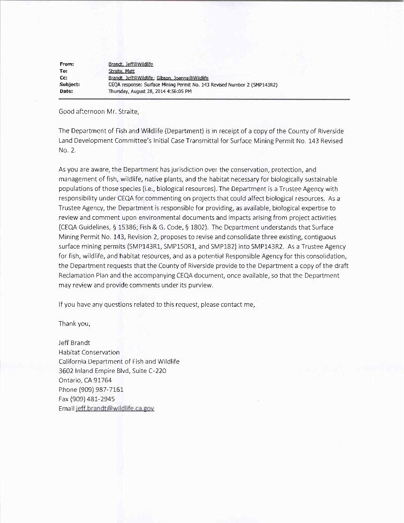
From Brandt JeffeWildlifeTo Straite MattCc Brandt JeffMildlife Gibson oannaMildlifeSubject CEQA response Surface Mining Permit No 143 Revised Number 2 SMP143R2Date Thursday August 28 201445605PM
Good afternoon Mr Straite
The Department of Fish and Wildlife Department is in receipt of a copy of the County of RiversideLand Development CommitteesInitial Case Transmittal for Surface Mining Permit No 143 RevisedNo 2
As you are aware the Department has jurisdiction over the conservation protection andmanagement of fish wildlife native plants and the habitat necessary for biologically sustainablepopulations of those species iebiological resources The Department is a Trustee Agency withresponsibility under CEQA for commenting on projects that could affect biological resources As aTrustee Agency the Department is responsible for providing as available biological expertise toreview and comment upon environmental documents and impacts arising from project activitiesCEQA Guidelines 15386 Fish G Code 1802 The Department understands that SurfaceMining Permit No 143 Revision 2 proposes to revise and consolidate three existing contiguoussurface mining permits SMP143R1 SMP150R1 and SMP182 into SMP143R2 As a Trustee Agencyfor fish wildlife and habitat resources and as a potential Responsible Agency for this consolidationthe Department requests that the County of Riverside provide to the Department a copy of the draftReclamation Plan and the accompanying CEQA document once available so that the Departmentmay review and provide comments under its purview
If you have any questions related to this request please contact me
Thank you
Jeff Brandt
Habitat Conservation
California Department of Fish and Wildlife3602 Inland Empire Blvd Suite C220Ontario CA 91764
Phone 909 987 7161Fax 909 481 2945EmailjeffbrandtPwildlifecagov

RIVERSIDE COUNTY
PLANNING DEPARTMENT
Juan C Perez
Interim Planning Director
October 22 2014
Mr Pat Perez
Assistant Director
California Department of ConservationOffice of Mine Reclamation801 K St MS 09 06Sacramento CA 95814
RE OMRs30 Day ReviewGlen Ivy 1 CA Mine ID 91 33 0001Reclamation Plan Amendment
County Reclamation Plan SMP00143R2
The above referenced reclamation plan amendment is enclosed for OMRs30dayreview pursuant to Public Resources Code Division 2 Chapter 9 Section 2774d1Riverside County certifies this submission is in compliance with the applicablerequirements of Article 9 of Chapter 8 of Division 2 of Title 14 of the California Code ofRegulations
We look forward to receiving any comments you may have on this amended reclamationplan Please call me at 951 9556863 if you have any questions
Sincerely
RIVERSIDE COUNTY PLANNING DEPARTMENTJuan C Perez Interim Planning Director
David L Jones Chief Engineering GeologistTLMA PLANNING
Enclosures SMP00143R2 Exhibits A B and CTechnical studies disc
cc woencl
Applicant Werner Corporation Attn Todd Pendergrass Fax 951 277 3339Planner Matt Straite hand deliveryFile SMP00143R2
Y Planning Case Files Riverside officeSMP00143R2 Letters and CorrespondenceAgency LettersOMR 30 day reviewletterdocx
Riverside Office 4080 Lemon Street 12th Floor Desert Office 38686 El Cerrito Road
POBox 1409 Riverside California 925021409 Palm Desert California 92211
951 9556892 Fax 951 955 1811 760 8638277 Fax 760 8637555
Planning Our Future Preserving Our Past

RECEIVEDPlanning DeptSOUTHERN CALIFORNIA
EDISON SEP022014An EDISON INTERNATIONAL Company
County of Riverside August 28 20144080 Lemon St 8 FloorRiverside CA 92501
Attention Planning
Subject Surface Mining Permit No 143 Revision No 2APN290120002 003 005 thru 007 and 290150002 003
Please be advised that the division of the property shown on Surface MiningPermit No 143 Revision No 2 will not unreasonably interfere with the free andcomplete exercise of any easements andor facilities held by Southern CaliforniaEdison Company within the boundaries of said map
This letter should not be construed as a subordination of the Companysrightstitle and interest in and to said easementsnor should this letter be construedas a waiver of any of the provisions contained in said easementsor a waiver ofcosts for relocation of any affected facilities
In the event that the development requires relocation of facilities on the subjectproperty which facilities exist by right of easement or otherwise the
ownerdeveloper will be requested to bear the cost of such relocation and provideEdison with suitable replacement rights Such costs and replacement rights arerequired prior to the performance of the relocation
If you have any questions or need additional information in connection with thesubject subdivision please contact me at 626 3024473
Steven D L r
Title and Real Estate Services
Corporate Real Estate Department
2131 Walnut Grove Avenue
Rosemead CA 91770

RIVERSIDE COUNTY
P L A N N I N G D E P A R T M E N T
Carolyn Syms LunaDirector 1
APPLICATION FOR SURFACE MINING PERMITCHECK ONE AS APPROPRIATE SMP143R1
SMP150R1
n Surface Mining Permit IiRevised SMP Original SMP NoSMP182 n Reclamation Plan
INCOMPLETE APPLICATIONS OR INACCURATE EXHIBITS WILL NOTBE ACCEPTED
CASE NUMBER DATE SUBMITTED June 11 2014
APPLICATION INFORMATION
Applicants Name Eric Werner Werner Corporation E Mail ewerner@wernercorpnet
Mailing Address PO BOX 77850Street
Corona CA 92877
City State ZIP
Daytime Phone No 951 277 3900 Fax No 951 2773339
Mine Operators Name Werner Corporation E Mail tpendergrass@wernercorpnet
Mailing Address PO BOX 77850Street
Corona CA 92877
City State ZIP
Daytime Phone No 951 2773900 Fax No 951 2773339
EngineerRepresentativesName Todd Pendergrass Werner Corporation E Mail tpendergrass@wernercorpnet
Mailing Address PO Box 77850Street
Corona CA 92877City State ZIP
Daytime Phone No 951 277 3900 Fax No 951 2773339
Werner Family Properties LLCProperty Owners Name Gerard L Werner Trust EMail ewerner@wernercorpnet
Mailing Address PO Box 77850Street
Corona CA 92877
City State ZIP
Riverside Office 4080 Lemon Street 12th Floor Desert Office 38686 El Cerrito RoadPO Box 1409 Riverside California 925021409 Palm Desert California 92211
951 955 3200 Fax 951 955 1811 760 8638277 Fax 760 8637555
Planning Our Future Preserving Our PastForm 2951033 080812

APPLICATION FOR SURFACE MINING PERMIT
Daytime Phone No 951 2773900 Fax No 951 2773339
Werner Family PropertiesMineral Rights Owners Name Gerard L Werner Trust E Mail ewerner@wernercorpnet
Mailing Address PO Box 77850Street
Corona CA 92877City State ZIP
Daytime Phone No 951 277 3900 Fax No 951 2773339
LesseesName EMail
Mailing AddressStreet
City State ZIP
Daytime Phone No Fax No
If the property is owned by more than one person attach a separate page that references the applicationcase number in the following manner Surface Mining Permit No and lists the names mailingaddresses and phone numbers of all persons having an interest in the real property or propertiesinvolved in this application
If the mineral rights are owned by more than one person attach a separate page that references theapplication case number in the following manner Surface Mining Permit No and lists the
names mailing addresses and phone numbers of all persons having an interest in the ownership of themineral rights involved in this application
The Planning Department will primarily direct communications regarding this application to the personidentified above as the Applicant The Applicant may be the property owner representative or otherassigned agent
AUTHORIZATION FOR CONCURRENT FEE TRANSFER
The signature below authorizes the Planning Department and TLMA to expedite the refund and billingprocess by transferring monies among concurrent applications to cover processing costs as necessaryFees collected in excess of the actual cost of providing specific services will be refunded If additional
funds are needed to complete the processing of your application you will be billed and processing of theapplication will cease until the outstanding balance is paid and sufficient funds are available to continuethe processing of the application The applicant understands the deposit fee process as describedabove and that there will be NO refund of fees which have been expended as part of the applicationreview or other related activities or services even if the application is withdrawn or the application isultimately denied
I certify that the above information in this Mining and Reclamation Plan application is correct to the bestof my knowledge and that all of the owners of possessory interest in the property in question have beennotified of the proposed uses or potential uses of the land after reclamation I also certify that Ipersonally accept responsibility for reclaiming the mined lands in accordance with the approvedreclamation plan and within the time limits of said plan
Form 295 1033080812
Page 2 of 17

APPLICATION FOR SURFACE MINING PERMIT
Eric Werner ZeiPRINTED NAME OFAPPLICANT SIGNATURE OF APPLICANT
Executed on 5 Vkonth Date Year
AUTHORITY FOR THIS APPLICATION IS HEREBY GIVEN
I certify that I am the owner of record and consent to the proposed Surface Mining Permit application forthis property I further certify that the information contained in this application is true and completeAll signatures must be originals wetsigned Photocopies of si natures are not acceptable
Werner Family Properties LLCPRINTED NAME OF PROPERTY OWNERS
ZNAIRE OF PROPERTY OWNERSGerard L Werner Trust Lk
PRINTED NAME OF PROPERTY OWNERS SIGNATURE OF PROPERTY OWNERS
If the subject property is owned by persons who have not signed as owners above attach a separatesheet that references the application case number and lists the printed names and signatures of allpersons having an interest in the property
PROPERTY INFORMATION
Name of Mine Werner Corporation Glen Ivy Mine
Assessors Parcel Numbers 290120002 003 005 006 007 290 150 002 003
Section2 11
Township5 South
Range6 West
Approximate Gross Acreage OGeneral location of Mine nearby or cross streets North of
Cleveland National ForestSouth of
Mayhew Aggregates Mine Reclamation Maitri Road Sycamore CreekEast of West of
Thomas Brothers map edition year page number and coordinates 2009 Page 804 E7 F7
Proposal describe the type of mining operation the days and hours of operation number of employeesnumber of daily vehicle trips etc
The applicant is proposing a revision and consolidation of 3 existing contiguous surface mining permits The revision
will extend the life of the current permit and allow the mining of reserves located between the subject property and adjacent
mining operation Mining operations will continue to be in compliance with County Ordinances 348 and 555 which govern surface mining
Day and Hours of operation number of employees and daily vehicle trips will remain unchanged from previously permitted levels
Form 2951033080812
Page 3 of 17

NOTICE OF PUBLIC HEARINGand
INTENT TO CONSIDER AN ADDENDUM TO AN
ENVIRONMENTAL IMPACT REPORT EIRA PUBLIC HEARING has been scheduled pursuant to Riverside County Land Use Ordinance No 348 beforethe RIVERSIDE COUNTY PLANNING COMMISSION to consider the project shown below
SURFACE MINING PERMIT NO 143 REVISED NO 2 Consider an Addendum to Certified EIR ApplicantWerner Corp FirstFirst Supervisorial District Location Southerly of Temescal Canyon Road easterly ofGlen Ivy Hot Springs Road and westerly of Sage Road Size 440 acres total 233 of which will be minedREQUEST The project is proposing a revision and consolidation of 3 existing contiguous surface miningpermits Previously approved and not expired SMP143R1 SMP150R1 and SMP182 are proposed to beconsolidated into SMP143R2 The project site will now be 440 acres total 233 of which will be mined Therevision proposes to extend the life of the current permit 50 years reduce the amount of disturbed areaformerly permitted under the three mines propose a single reclamation plan which is proposed to be revised toinclude IDEFO infill and allow the mining of reserves located between the subject property and adjacentmining operation SMP139R1 to the north Day and hours of operation number of employees and dailyvehicle trips will remain unchanged from previously permitted levels All three mines were previously permittedfor2500000 tons per year of production together The annual production is not proposed to change with thisapplication however the overall tonnage will increase because the life of the permit is proposed to extendThe maximum reserves now proposed to be mined on the site are67500000tons Legistative
TIME OF HEARING 900am or as soon as possible thereafterDATE OF HEARING February 18 2015PLACE OF HEARING County Administrative Center
First Floor Board Chambers4080 Lemon Street
Riverside CA 92501
For further information regarding this project please contact project planner Matt Straite at 951 9558631 oremail mstraiterctlmaorqor go to the County Planning Departments Planning Commission agenda webpage at http planninqrctlmaorqPublicHearingsaspx
The Riverside County Planning Department has determined that the above described project will not have asignificant effect on the environment and has recommended certification of an addendum to an EIR The
Planning Commission will consider the proposed project and the proposed addendum at the public hearing
The case file for the proposed project and the final environmental impact report may be viewed Mondaythrough Friday from 800 AM to 500 PM at the Planning Department office located at
4080 Lemon St 12th Floor Riverside CA 92501
Any person wishing to comment on the proposed project may do so in writing between the date of this noticeand the public hearing or may appear and be heard at the time and place noted above All comments
received prior to the public hearing will be submitted to the Planning Commission and the PlanningCommission will consider such comments in addition to any oral testimony before making a decision on theproposed project
If this project is challenged in court the issues may be limited to those raised at the public hearing describedin this notice or in written correspondence delivered to the Planning Commission at or prior to the publichearing Be advised that as a result of public hearings and comment the Planning Commission may amendin whole or in part the proposed project Accordingly the designations development standards design orimprovements or any properties or lands within the boundaries of the proposed project may be changed in away other than specifically proposed
Please send all written correspondence toRIVERSIDE COUNTY PLANNING DEPARTMENTAttn Matt StraitePO Box 1409 Riverside CA 925021409
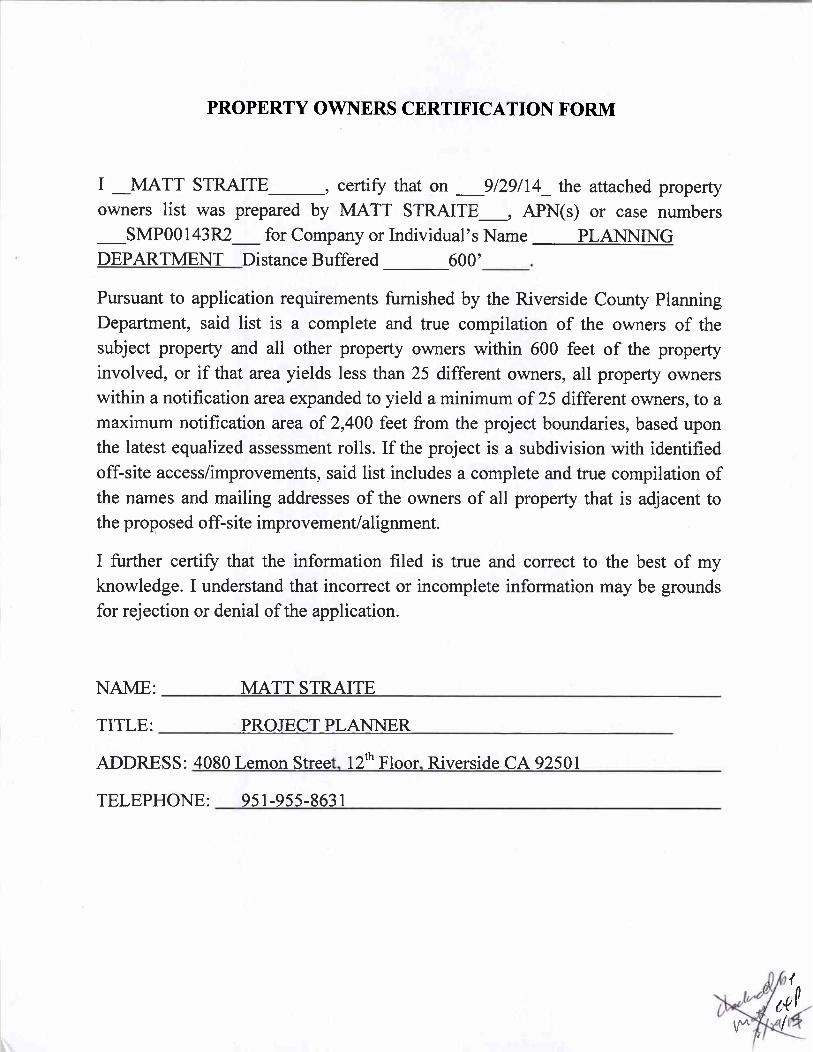
PROPERTY OWNERS CERTIFICATION FORM
I MATT STRAITE certify that on 92914 the attached propertyowners list was prepared by MATT STRAITE APNs or case numbers
SMP00143R2 for Company or Individuals Name PLANNING
DEPARTMENT Distance Buffered 600
Pursuant to application requirements furnished by the Riverside County PlanningDepartment said list is a complete and true compilation of the owners of thesubject property and all other property owners within 600 feet of the propertyinvolved or if that area yields less than 25 different owners all property ownerswithin a notification area expanded to yield a minimum of 25 different owners to amaximum notification area of2400 feet from the project boundaries based uponthe latest equalized assessment rolls If the project is a subdivision with identifiedoffsite accessimprovements said list includes a complete and true compilation ofthe names and mailing addresses of the owners of all property that is adjacent tothe proposed offsite improvementalignment
I further certify that the information filed is true and correct to the best of myknowledge I understand that incorrect or incomplete information may be groundsfor rejection or denial of the application
NAME MATT STRAITE
TITLE PROJECT PLANNER
ADDRESS 4080 Lemon Street 12 Floor Riverside CA 92501
TELEPHONE 951 955 8631
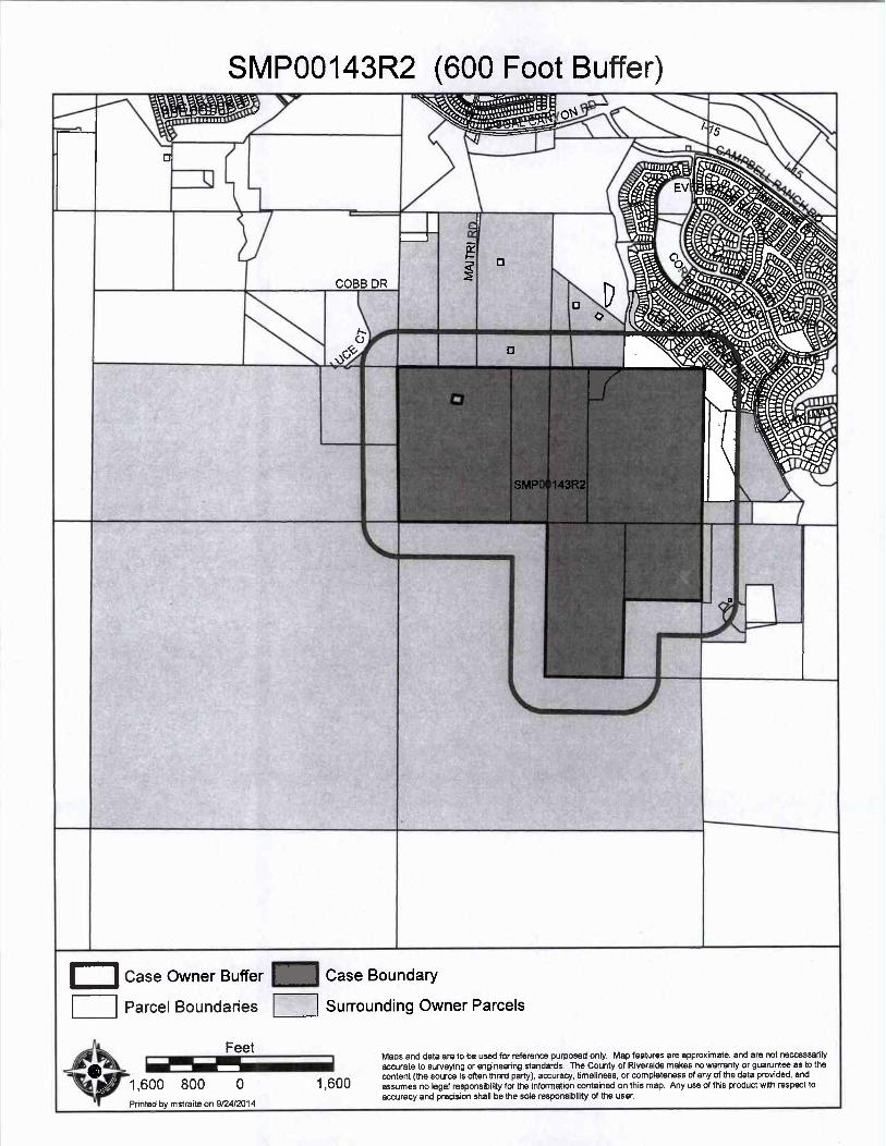
SMP00143R2 600 Foot Buffer
i0 iikNIr
4fiiit s ue
iO vn v eQ bins I
i
0
iii e0ii4 1 I
lkra rre44
i ii 1hh
SMP00143R2k
i
Lc
IV
Case Owner Buffer f4 Case Boundary
Parcel Boundaries Surrounding Owner Parcels
FeetMaps and data are to be used for reference purposed only Map features are approximate and are not neccessarily
y WEaccurate to surveying or engineering standards The County of Riverside makes no warranty or guaruntee as to the
1600 800 1 600content the source is often thrird party accuracy timeliness or completeness of any of the data provided andassumes no legal responsibility for the information contained on this map Any use of this product with respect to
Printed by mstraite on9242014accuracy and precision shall be the sole responsibility of the user

VICTORIA A ABANISE CHARLES ACHEE
25473 HYACINTH ST 10933 CLOVER CIRCORONA CA 92883 CORONA CA 92883
JOE ACHTEN ALI KADHIM ALSILAWI
CIO KILEY CHILDRENS TRUST 25465 HYACINTH ST
205 E 5TH ST CORONA CA 92883
CORONA CA 92879
AARON ALSTROM CHERYL M AOYS
25401 HYACINTH ST 10909 CLOVER CIR
CORONA CA 92883 CORONA CA 92883
WADE GERALD ARENS DEAN G ARMSTRONG
10906 CARAWAY LN 25491 FUCHSIA CT
CORONA CA 92883 CORONA CA 92883
JORGE M AVILA JACINTA A BALAGUER
CIO ANGELA AVILA 11019 CARAWAY LN
25438 HYACINTH ST CORONA CA 92883
CORONA CA 92883
KOFI BASS ANDREW BATSTONE
11066 KALMIA CT 11043 CARAWAY LN
CORONA CA 92883 CORONA CA 92883
DENIS BEAULIEU BRENT C BENSON
11016 CARAWAY LN 25577 HYACINTH ST
CORONA CA 92883 CORONA CA 92883
M
Page 1 of 9 on Sep 24 2014 1125AM
IP1
1

BLACK BOX SECRETS SEAN ROY BRYANT19 SNOWBERRY 10921 CLOVER CIRIRVINE CA 92604 CORONA CA 92883
DAVID A CARSTENSEN PATRICK D CAUSEY
10885 CLOVER CIR 10891 CLOVER CIR
CORONA CA 92883 CORONA CA 92883
JOY D CHAMP CHANDLER MINING PROP
11116JASMINE WAY P0 BOX 295CORONA CA 92883 LOMITA CA 90717
ADITYA CHAUDHARY DANIEL CHRISTENSEN
4901 CORSO CIR 25553 HYACINTH ST
CYPRESS CA 90030 CORONA CA 92883
JAMES G CLEVELAND JAMES J CLEVELAND
24585 TEMESCAL CANYON RD 25625 SANTIAGO CANYON RDCORONA CA 92883 CORONA CA 92883
COLDWATER AGGREGATES ISMAEL BANIASIA COLINA
COJIM DUCOTE 1315 EVERGREEN AVE NO H3
P 0 BOX 620 FULLERTON CA 92835ORANGE CA 92856
GILBERT CORONADO COUNTY OF RIVERSIDE
10924 CARAWAY LN CIO REAL ESTATE DIVISION
CORONA CA 92883 P 0 BOX 1180
RIVERSIDE CA 92502
Page 2 of 9 on Sep 24 2014 1125AM

MARK CURRIER MICHAEL DAY
25542 HYACINTH ST 25449 HYACINTH STCORONA CA 92883 CORONA CA 92883
JULIA Z DELCASTILLO ZENAIDA C DELEON
11069 KALMIA CT COALLAN DE LEONCORONA CA 92883 25425 HYACINTH ST
CORONA CA 92883
ERIK T ECKHOLM JIMMY S ESCALANTE25441 HYACINTH ST 25385 SAGE ST
CORONA CA 92883 CORONA CA 92883
ALIAKBAR ETESAMNIA FILENO S EVANGELISTA
24502 CREEKVIEW DR 25421 SAGE ST
LAGUNA HILLS CA 92653 CORONA CA 92883
EVMWD WILLIAM JOSEPH FISHER
P O BOX 3000 11058 KALMIA CT
LAKE ELSINORE CA 92531 CORONA CA 92883
JESUS GALINDO ALAN R GRAY
11059 CARAWAY LN 11011 INDIAN TRUCK TR
CORONA CA 92883 CORONA CA 92883
CHRISTOPHER GRIFFIN BRIAN GRUNTZ
25373 SAGE ST 10942 CLOVER CIR
CORONA CA 92883 CORONA CA 92883
Page 3 of 9 on Sep 24 2014 1125 AM

SAMIR HADDAD CURTIS HARTON11053 KALMIA CT 10918 CLOVER CIRCORONA CA 92883 CORONA CA 92883
JEREMY HEALEY OLVIN HERNANDEZ10930 CLOVER CIR 25625 HYACINTH STCORONA CA 92883 CORONA CA 92883
GEORGE HILL JOE HINOJOS10916 MARYGOLD WAY 10883 MARYGOLD WAY
CORONA CA 92883 CORONA CA 92883
EVA HIRAKAWA KAI M HUSEN
11008 CARAWAY LN 11035 CARAWAY LN
CORONA CA 92883 CORONA CA 92883
MIHEE JANG MABEL JARAMILLO
25521 HYACINTH ST 11100 JASMINE WAY
CORONA CA 92883 CORONA CA 92883
STEVEN A JOHNSON JI YOUNG KIM
7 N MIDDLERIDGE LN 1304 BRENTWOOD CIR NO DROLLING HILLS CA 90274 CORONA CA 92882
SCOTT KITE GERRY KODO
11017 CLOVER CIR 25481 HYACINTH ST
CORONA CA 92883 CORONA CA 92883
Page4of9on Sep242014 1125 AM

CHRISTOPHER M KRAUS WILLIAM K LAIRD11085 KALMIA CT 25505 HYACINTH STCORONA CA 92883 CORONA CA 92883
BRUCE EDWARD LECAIR LEE LAKE WATER DIST25417 HYACINTH ST 22646 TEMESCAL CANYON RDCORONA CA 92883 CORONA CA 92883
JAMES A LEOS JUSTIN C LEWIS
10895 MARYGOLD WAY 10906 CLOVER CIR
CORONA CA 92883 CORONA CA 92883
SUNGHEI LIM JAMES LIN
2595 REDROCK DR 604 EL VALLENITO DRCORONA CA 92882 WALNUT CA 91789
CHAO SHON LIU MICHAEL S LORBER
10951 CARAWAY LN 25561 HYACINTH STCORONA CA 92883 CORONA CA 92883
ARMIDA MARIN PRIVADO C MATILLA
11040 CARAWAY LN 25337 SAGE ST
CORONA CA 92883 CORONA CA 92883
ISSAM MAYASSI MAYHEW AGGREGATES MINE RECLAMATION
25569 HYACINTH ST P 0 BOX 295
CORONA CA 92883 LOMITA CA 90717
Page5of9on Sep 24 2014 1125 AM

ALAN J MCBROOM SAMUEL MCGEE10907 MARYGOLD WAY 11001 CLOVER CIRCORONA CA 92883 CORONA CA 92883
GEORGE MEJIA MATTHEW J MINCIO25325 SAGE ST 25518 HYACINTH STCORONA CA 92883 CORONA CA 92883
MONDO PROP ERIK M MORALES
260 NEWPORT CTR STE 100 10894 CLOVER CIRNEWPORT BEACH CA 92660 CORONA CA 92883
JOSE MOTA NOEL NABUA
10993 CLOVER CIR 25529 HYACINTH ST
CORONA CA 92883 CORONA CA 92883
DUY NGUYEN TRUNG D NGUYEN
11092 JASMINE WAY 11051 CARAWAY LN
CORONA CA 92883 CORONA CA 92883
MATTHEW EDWARD NOBLE KARLA NOGALES10904 MARYGOLD WAY 25454 HYACINTH ST
CORONA CA 92883 CORONA CA 92883
NICOLE OWENS RONALD N PALACIOS
10931 MARYGOLD WAY 10945 CLOVER CIR
CORONA CA 92883 CORONA CA 92883
Page 6 of 9 on Sep 24 2014 1125AM

YOUNG SUN PARK AMELIA PRADO11032 CARAWAY LN 10927 CARAWAY LNCORONA CA 92883 CORONA CA 92883
ROBERT H PRIZIO RAKAYLA PROP25457 HYACINTH ST 6250 N IRWINDALE AVECORONA CA 92883 IRWINDALE CA 91702
RICHARD RAMIREZ RICHMOND AMERICA HOMES OF MARYLAND INC11082 KALMIA CT 4350 S MONACO ST STE 400CORONA CA 92883 DENVER CO CA 90237
RICHMOND AMERICA HOMES OF MARYLAND INC H CHRISTOPHER RODRIGUEZCIO SUSAN M KLEID 25617 HYACINTH ST4350 S MONACO ST CORONA CA 92883DENVER CO 80237
KEVIN ROGERS JAMES J ROOT
10958 CLOVER CIR 25483 FUCHSIA CT
CORONA CA 92883 CORONA CA 92883
AMBROSE A RUSSO BEVERLY SAUDE
25633 HYACINTH ST 25361 SAGE ST
CORONA CA 92883 CORONA CA 92883
ABRAHAM SHAPIRA ISMAEL G SILVA
11093 KALMIA CT 25349 SAGE ST
CORONA CA 92883 CORONA CA 92883
Page 7 of 9 on Sep 24 2014 1125AM

STARFIELD SYCAMORE INV STARFIELD SYCAMORE INVCOSTEVEN C CAMERON CO STEVEN CAMERON14 CORPORATE PLAZA 14 CORPORATE PLZNEWPORT BEACH CA 92660 NEWPORT BEACH CA 92660
DANIEL STELUNG CLIFFORD J STOTTS12 ALBA W 25489 HYACINTH ST
IRVINE CA 92620 CORONA CA 92883
BRANDON STRATHMANN SYCAMORE CREEK COMMUNITY ASSN25513 HYACINTH ST 00 EDGAR GOMEZ
CORONA CA 92883 5171 CALIFORNIA AV NO 120
IRVINE CA 92617
SYCAMORE CREEK C UNITY ASSN LANCE TAPLEY
COEDGAR GOMEZ 25409 SAGE ST
5171 CALIFORNIA STE 120 CORONA CA 92883
IRVINE CA 92617
TAQUON T TAYLOR TEMESCAL VALLEY MINING
P 0 BOX 5531 00JOHN ROBERTSON
BUENA PARK CA 90622 P 0 BOX 295
LOMITA CA 90717
ALAN TIEU ROCKY TOMKA
10939 CARAWAY LN 11045 KALMIA CT
CORONA CA 92883 CORONA CA 92883
ARMANDO TORRES RAMIRO L TORRES
11077 KALMIA CT 11108 JASMINE WAY
CORONA CA 92883 CORONA CA 92883
Page8of9on Sep242014 1125AM

USA 290 JEREMY VANHEERDENONE s 11009 CLOVER CIR0
CORONA CA 92883
MIKE A VANWONTERGHEM MICHAEL J VESELY10936 CARAWAY LN 25609 HYACINTH STCORONA CA 92883 CORONA CA 92883
JOHN MINH DANG N VU HUSTON LEE WALKER25462 HYACINTH ST 11048 CARAWAY LN
CORONA CA 92883 CORONA CA 92883
JOSEPH WAYNE THOMAS M WEMHOFF10919 MARYGOLD WAY 10943 MARYGOLD WAYCORONA CA 92883 CORONA CA 92883
GERARD L WERNER WERNER FAMILY PROP00ASTOR PHILLIPS ATT G R PHILLIPS TR 00PATTY SCHULERP 0 BOX 77850 P 0 BOX 77850CORONA CA 92877 CORONA CA 92877
KINDRED M WHITE TARA LYNNE WILLEY
25545 HYACINTH ST 10966 CLOVER CIR
CORONA CA 92883 CORONA CA 92883
MARTIN D WOODS JASON E YACKS
11024 CARAWAY LN 25397 SAGE ST
CORONA CA 92883 CORONA CA 92883
Page9of9on Sep 24 2014 1125 AM

9292014 111118 AM
ATTN Leslie Mouriquand 1st Supervisor District ATTN Jon VasquezArchaeologist Kevin Jeffries Supervisor Building Safety DepartmentMail Stop 4035 Board of Supervisors Riverside County Riverside County
Mail Stop 1001 Mail Stop 2715
ATTN Dan kyCommunity Development East Sierra and Inland Deserts Reg 6
W 4thDistrictct 8
City of Corona California State Dept of Fish Game464464 W 4th St 6th Floor400 S Vicentia Ave 3602 Inland Empire Blvd C220Mail Stop 725Corona CA 92882 Ontario CA 91764San Bernardino CA 92401 1400
ATTN Division Manager ATTN Senior Public Health Engineer ATTN Carolyn SymsLunaEcological ServiceEnvironmental Health Environmental Programs DeptUSFish Wildlife ServiceRiverside County Riverside County6010 Hidden Valley RdMail Stop 3320 Mail Stop 2715Carlsbad CA 92011
Los Angeles DistrictOffice of Mine ReclamationATTN David Jones USArmy Corps of Engineers California Dept of ConservationGeologist 911 Wilshire Blvd801 K St Mail Stop 09 06Mail Stop 1070 PO Box 532711Sacramento CA 95814Los Angeles CA 90053 2325
ATTN Charissa LeachATTN Executive Officer
coMary Stark Planning CommissionReg Water Quality Control Board 8 ATTN Steve DiazSecretarySanta Ana Riverside County Fire DepartmentPlanning Commission Riverside3737 Main St Suite 500 Mail Stop 5036CountyRiverside CA 92501 3348
p
Mail Stop 1070
ATTN Steve SmithSouthern California EdisonATTN Stanley Sniff Sheriff South Coast Air Quality Mngmt Dist2244 Walnut Grove Ave Rm 312Sheriffs Department Riverside County Los Angeles CountyPO Box 600Mail Stop 1450 21865 E Copley DrRosemead CA 91770Diamond Bar CA 917654178
ATTN County SurveyorWaste Resources ManagementTransportation DepartmentRiverside CountyRiverside CountyMail Stop 5950Mail Stop 1080
dlct V
14 11iVvtN
01

RIVERSIDE COUNTY
PLANNING DEPARTMENTJ
Juan C Perez
Interim Planning Director
TO Office of Planning and Research OPR FROM Riverside County Planning DepartmentPOBox 3044 4080 Lemon Street 12th Floor 38686 El Cerrito Road
Sacramento CA 958123044 P O Box 1409 Palm Desert California 92211
County of Riverside County Clerk Riverside CA 92502 1409
SUBJECT Filing of Notice of Determination in compliance with Section 21152 of the California Public Resources CodeSMP00143R2Project TitleCase Numbers
Matt Straite 951 955 8631
County Contact PersonPhone Number
NA
State Clearinghouse NumberOf submitted to the State Clearinghouse
Werner Corporation POBox 77850 Corona CA 92877
Projact ApplicantAddress
The proposed project is located southerly of Temescal Canyon Road easterly of Glen Ivy Hot Springs Road and westerly of Sage RoadProject Location
Revision and consolidation of three 3 approved surface mining permits SMP143R1 SMP150R1 and SMP182 which have yet to expire into one permit andassociated Reclamation Plan The proposed project would extend permitted mining operations for an additional 50 years reduce the area disturbed by the threemining sites by a total of 411 acres allow mining within the 50 foot setback area along the northern boundary of the project site operation of an IDEFO as partof the mining site Reclamation Plan and to relocate a down drain structure located on the southern portion of SMP139R1 to the southern portion of proposedSMP143R2 The consolidated mining site will encompass a total of 440 acres with 230 acres designated for mining operations In addition day and houroperations number of employees and daily vehicle trips will remain unchanged from previously permitted levelsProject Descnpbon
This is to advise that the Riverside County Board of Supervisors as the lead agency has approved the above referenced project onand has made the following determinations regarding that project
1 The project WILL have a significant effect on the environment2 An Addendum to certified EIR No 359 was prepared for the project pursuant to the provisions of the California Environmental Quality Act 5000 and reflect
the independent judgment of the Lead Agency3 Mitigation measures WERE made a condition of the approval of the project4 A Mitigation Monitoring and Reporting Plan Program WAS adopted5 A statement of Overriding Considerations WAS adopted for EIR No 3596 Findings were made pursuant to the provisions of CEQA
This is to certify that the earlier EIR with comments responses and record of project approval is available to the general public at Riverside County PlanningDepartment 4080 Lemon Street 12th Floor Riverside CA 92501
Project Planner November 3 2014
SignatureTitle
Date
Date Received for Filing and Posting at OPR
DMdm Revised 11032014Y Planning Master FormsCEQA FormsNOD Form doc
Please charge deposit fee case ZEA 42714 ZCFG06101FOR COUNTY CLERKSUSE ONLY

COUNTY OF RIVERSIDE REPRINTED R1407661
SPECIALIZED DEPARTMENT RECEIPT
Permit Assistance Center
4080 Lemon Street 39493 Los Alamos Road 38686 El Cerrito Road
Second Floor Suite A Palm Desert CA 92211
Riverside CA 92502 Murrieta CA 92563 760 863 8277
951 955 3200 951 600 6100
Received from WERNER CORPORATION 5000paid by VI 00256C
paid towards CFG06101 CALIF FISH GAME DOC FEE
EA42714
at parcel 25050 MAITRI RD COR
appl type CFG3
By Jul 21 2014 1340
MGARDNER posting date Jul 21 2014
Account Code Description Amount
658353120100208100 CFG TRUST RECORD FEES 5000
Overpayments of less than 500 will not be refunded
Additional info at wwwrctlmaorg
COPY 1 CUSTOMER REPRINTED

JIl1AI UrtALIVONPJIATHE RESOURCES AGENCY E tSW AINa EDEPARTMENT OF FISH AND GATE
E RDNMEN AI DOCUMENT APPLECATIONFELING FEESCASES RECEIPT
ead Agency L Date d
ounty Agency R
d Document No qLt Title T 591P50glIl c
roject Applicant 141
CIIEKAPPLICABLE FEESEnvironmental Impact Report 85000Negative Declaration 125000Application Fee Water Diversion Water Resources Control Board Only 85000projects Subject to Certified Regulatory Programs DFG CDF Only 85000County Administrative Fee 2500 5
roject that requires fee not paid enter amount dueProject that is exempt from t
l
To RECEIVED U N
gnature ofpersotz receiving l C4 s
FIRST COPY PROIECTAP iCANr SECOND COPYDFGCEAH THIRD COPYLEAD AGENCY FOURTH COPY COUNTY
In compliance with the requirements of our recentlyapproved Surface Mining Permit 182 150R and 143R a filingfee to defray costs incurred by the County of Riversidein implementing the Department of Fish and Game filing feeprogram is enclosed
The amount is 85000 plus 2500 for documentaryhandling for a total of 87500 A check is enclosed
Copies of the applicable pages of the Surface Mining Permitare also enclosed
Kindly send a receipt of the payment for our records
Yours Truly
LMWerner
President
LMWpal
Encs