Dynamics of reference evapotranspiration in the Bolivian highlands (Altiplano
Upload
independentCategory
view
0download
0
2
Conceptual Elements and Heuristics from Complexity Paradigm Suitable to the Study of
Evapotranspiration at the Landscape Level Claudia Coronel, Omar Tapia Silva, Gilberto Hernández, José Manuel Madrigal, Edgar Rosales, Alejandro Toledo,
Mauricio Galeana, Alejandra López Caloca and José Luis Silvan Centro de Investigación en Geografía y Geomática “Ing. Jorge L. Tamayo”
Universidad Autónoma Metropolitana, Iztapalapa, Distrito Federal México
1. Introduction Due to the importance of the impacts from anthropogenic process on global change, there has been a growing interest in predicting climate variability on seasonal scales. In order to accomplish this, better knowledge about and modeling of earth surface energy exchanges and evaporation is required trough diverse scales, from local to continental extents. Recognizing this need, we state as general objective of this chapter to advance towards a conceptual and methodological framework that sustain a better representation of evapotranspiration at landscape scale. Along this chapter are discussed the reasons, why traditional schemes based on classical science fail in order to explain, emergent, convergent and highly dynamic behaviors observed in evapotranspiration process. On the application of more integrative approaches for modeling, the search for organizing principles regulating function response on evapotranspiration systems, is required. Emphasis on the structure-function relation, adaptation in social-ecological systems and the development of methodological strategies themselves appear to be the most relevant elements to the incorporation of resilience as an analogical model and of the complexity paradigm as a conceptual framework for the modeling of the evapotranspiration process.
2. Opportunities and challenges for modeling evapotranspiration from the classical perspective and the analogical model approach 2.1 Review of evapotranspiration models from hydrology and climatology Over the past three decades, there has been a growing interest in predicting climate variability on seasonal and interannual scales due to the recognition of the importance of anthropogenic processes on global change. This awareness process has led to the development of new experimental technologies and modeling for generalizing local and regional observations of mass and energy exchanges on the terrestrial surface. Such generalizations represent valuable data for general circulation models (Shuttleworth & Gash, 2005; Taylor et al., 1998). Major developments on evapotranspiration estimation
Evapotranspiration
50
include semi-distributed and semi-empirical models semi-distributed and semi-empirical models that represent energy or water balances on the land surface-atmosphere interface and incorporate local and regional effects of land cover heterogeneity on evapotranspiration (Norman et al., 1995; Xu et al., 1996; Bastiaanssen et al., 1998; Sandholt et al., 2002; Allen et al., 2005; Courault et al., 2005; Garatuza-Payan & Watts, 2005; Neale et al., 2005; Senay et al., 2007). For a general view about mentioned models, see equation 2 for water balance.
Rn = H + λLE + G0 (1)
SMt1 = (SMt0 + PRECt1) - (EVAPt1 + ROFFt1) (2)
In equation 1, from the total amount of available energy Rn (net radiation), a part is used to heat the air above the surface (H) (sensible heat flux), another part is used to heat the surface (G0) (soil heat flux) and one more is used for changes in state (λLE) (latent heat flux). Water balance at hydrological unit, or water storage available in the soil, for a period t1 (equation 2), resulting from the differential between the system input—given by the water storage available in the soil over a previous period, SMt0, plus the effective precipitation, PRECt1, minus the water interception produced by evapotranspiration, EVAPt1, plus run-off, ROFFt1. Standing out among these efforts is the use of remote sensing and in situ auxiliary data to represent the variability of evapotranspiration (Baldocchi et al., 2001; Boegh et al., 2002; Schmugge et al., 2002). In the area of methods for integrating data from diverse sources are assimilation procedures that use the application of atmospheric and surface models supplied with satellite data calibrated with in-situ data (Crow & Wood, 2003; McCabe & Wood, 2006; Cleugh et al., 2007; Pan et al., 2008). In summary, these efforts have enabled the generation of knowledge about earth surface energy exchanges and improvements in its modeling. Nevertheless, there continues to be uncertainty regarding how land surface operate land surface-atmosphere interactions in different spatial and temporal contexts (Callaghan et al., 2004; McCabe et al., 2008). Global studies on seasonal climate variability (Dan & Ji, 2007) establish that “the seasonal cycle of the exchanges of energy, mass and momentum between the land and atmosphere can be modified by vegetation through morphological change and carbon assimilation, and it plays a major role in the seasonal variations of local surface hydrology”. Meso-scale studies demonstrate significant differences in energy fluxes according to cover type through feedback mechanisms resulting in different cloud covers and differential rates in the development of the boundary convective layer (Taylor & Lebel, 1998; Mahrt et al., 2001; Clark et al., 2003). In turn, according to the temporal scale of observation, specific conductive processes are shown. For example, in zones with disperse vegetation the instantaneous evaporation rate is controlled by the rain pattern after precipitation events, while on a seasonal scale the evaporation patterns are highly correlated with the characteristics of the different types of cover (DOE, 1996). From this perspective, it is crucial to incorporate into the modeling of evapotransporation (Et), multi-scale effects of local conductive processes that result in emergent behavior on a regional scale, and which cannot be represented in a simple manner. In terms of the current theory on biophysical processes, the emphasis has been on establishing the behavior of the variables from a perspective of processes and modeling and not as a specific and joint response of features or objects on the earth’s surface. This means going beyond physical and complex models and an emphasis on calibration, and exploring those organizing rules that control the complexity of regional hydrology (Sivapalan, 2005; McDonnell et al., 2007). To answer the

Conceptual Elements and Heuristics from Complexity Paradigm Suitable to the Study of Evapotranspiration at the Landscape Level
51
“why” questions, a coherent theory must be advanced that directly incorporates the pattern-process relations that constitute the landscape and lead to the organization of systems with specific functions susceptible to observation—in this case, the coupling of water, energy and nutrient cycles. These functions are known as functional traits and are the result of slow co-evolution or memory processes (Schröder, 2006; De Bello et al., 2010). For example, the height of plants and the size of seeds have evolved as a result of selective evolutionary pressure and constitute a climate footprint of the past. Other processes—such as phenology, soil moiture, snow and ice cover, and even biodiversity—constitute the terrestrial memory processes that contribute to the complexity observed in the components of the hydrologic cycle (Sivapalan et al., 2001, Shuttleworth y Gash, 2005). All of these works agree that it is possible to significantly advance the knowledge about hydrologic processes—among them, evapotranspiration—through the recognition of regulatory principles that determine the rather complex behavior of the different components of the hydrologic cycle, especially in terms of the human role as a conductive element in very dynamic processes that alter the functioning of zones under management to such an extent and manner that exceeds our ability to control it. The following section explores the potential for incorporating conceptual elements of the complexity paradigm and those of landscape ecology in the modeling of evapotranspiration and other hydrologic processes.
2.2 Conceptual elements and heuristics from complexity paradigm and its application in modelling hydrologic processes First, the conceptual elements, attributes and general methodologies of complexity, chaos and systems theories are presented. Then, a review is provided of the most relevant advances in the application of these theoretical frameworks to modeling hydrologic processes—among them, evapotranspiration. In discussing a theory, the conceptual models of the theory itself and that represent the object of study can be used. With regard to the complexity paradigm, we shall discuss the concept of a complex system. This is composed of close interactions between its components in such a way that the events taking place significantly influence the probabilities of many types of subsequent events. Its functioning is the result of the confluence of multiple factors that interact in such a way that the system is not separable, but rather only semi-separable (Martin & Sunley, 2007). Complex systems present key generic properties (Holland, 1995; Holland, 2002), such as: a. Distributed representation: the functions and relations within the system are distributed
on all of the scales with a high degree of connectivity. The paradox of scale is a property of complex systems.
b. Openess: the boundary between the system and its environment is not fixed or easy to identify. Dynamic and diffuse limits.
c. Chaotic behavior: Nonlinear dynamics among the variables that interact with the components of the system. (Contigences).
d. Emergences: The macro-scale structures and functioning arise from interactions among micro-scale components (building blocks).
e. Adaptive behavior and self-organization: the systems adapt their structures and dynamics in response to changes in the external environment or to internal changes through co-evolution mechanisms and critical situations.

Evapotranspiration
52
These mechanisms are triggered in response to chaotic and highly unpredictable disturbances or messages. As a result of this large complexity framework, a series of approaches exist, such as Chaos Theory, Hierarchy Theory, Complex Adaptive Systems and Complex Social-ecological Systems (Valerie & Allen, 1996; Liu et al., 2007). The latter refers to integrated or coupled systems in which the population interacts with its natural components. Fundamental characteristics of Complex Social-ecological Systems are: the presence of nested hierarchies, or panarchies; their components interact reciprocally at diverse levels of organization as well as different spatial and temporal scales; their behavior is defined by the interactions among complex networks and; they present emergent properties (Cadenasso et al., 2006; Liu et al., 2007). See incises on figure 1. Complex systems are composed of heterogeneous elements that interact, which means that the subsystems belong to the domains of very diverse disciplines. A multi-discipline presumes the integration of different disciplinary approaches (García, 2008) and viewing any problematic as a system whose elements are inter-defined, the study of which requires the coordination of disciplinary approaches that need to be integrated into one common approach (Holland, 2002). What integrates a multidisciplinary team that studies a complex system is a common conceptual and methodological framework derived from a shared concept of the science-society relation. This conceptual framework may be connected by guides and hypotheses that provide the threshold reasoning for what is known as heuristics, validation and approximation schemes that make up the conceptual model, or what is called the analogical model (Holland, 1995; Wu, 1999).
Fig. 1. Generic properties of complex systems. Modified from http://www.idiagram.com/examples/complexity.html One last fundamental aspect of complex systems is the content of the information present in its components. The information contained in complex systems may be working

Conceptual Elements and Heuristics from Complexity Paradigm Suitable to the Study of Evapotranspiration at the Landscape Level
53
information, the result of feedback from the components of the system due to a message or flow of energy, mass or language (Brooks et al., 1989). This type of information is any kind of phenotype which is the product of previous exposure to a message or specific stimulus and is the result of a process of learning and of co-evolution of the components of a system with respect to its environment (Wiener, 1954). This means that communication is a fundamental process of a system’s self-organization; the final result is that the system both adapts to its medium and also modifies it (Günther & Folke, 1993). Latent information is that which is contained in a system and is not expressed because it has not been fundamental to contributing to the collective functioning of the system and to facilitating its current adaptation. Latent information can become working information if a specific message is produced that triggers a result. Some of the components of the system have this function and are fundamental to its survival; these are called history tellers (Wiener, 1954). Complex systems are found in an enclave on “the edge of chaos,” from which comes the notion of temporal-spatial contingency or convergence. Based on this point of view, Wiener develops his theory about cybernetics or message theory. His thesis is that the society can only be understood through the study of the communication messages and instruments that pertain to it. With respect to the application of the conceptual elements of the complexity paradigm and the practical methodologies corresponding to this discipline as it pertains to the study of hydrologic processes, the importance of functional raits is recognized as a joint response of the elements of a landscape, an area subject to management or a hydrologic unit. In relation to the development of a regional hydrologic theory, organizing rules of emergence and connectivity are identified at the conceptual level, as well as the organization of hierarchies based on functional traits or self-similarity, and the hypothesis behind the optimization and structuring of hydrologic networks (Sivapalan, et al., 2001; McDonnell et al., 2007). Also recognized is the importance of contingencies, extreme values and trigger values—elements that come from chaos theory (Wiener, 1954; Gunther & Folke, 1993). Since these heuristics must be test and the diverse disciplines have a wide range of experience with them, the theory of the hydrology of catchments—from the perspective of functional traits—has to be the result of the integration of multidisciplinary conceptual frameworks and the design of observation schemes for the experimentation and testing of hypotheses. Said theory should also incorporate a more real or phenomenological representation of the processes. With regard to a methodological proposal, some authors consider the integration of upward, downward approximations—although without theoretically offering a solution—and the definition of elemental units for the development of a classification scheme that supports the principles of scaling and based in functional aspects (Sivapalan, 2005; Schröder, 2006). Out of spatial modeling and Geomatics arise pattern discovery and the conceptualization of the geographic entities or components of a system, a methodological element indispensable to the development of classification and schemes of hierarchies in geographic processes (Haggett, 1965; Maceachren et al., 1999; Coronel, 2008). With the functional traits perspective, the social, cultural and economic nature of the managed areas or case studies is not made explicit, and although the definition of elemental units of analysis is recognized, it is not advanced in the conceptualization of hydrologic processes as the functioning of systems with complex behavior. Rather, this aspect is considered at the application level, with the definition of geospatial models for the characterization of run-off networks (Ruddell & Kumar, 2006) or in the simulation of scenarios for a management area (Parrott, 2009).

Evapotranspiration
54
An alternate approach to functional traits is provided by biology, landscape ecology, urban planning and the very science of complexity. This approach stresses the importance of developing methodological practices specific to the science of complex systems and then applying them to the specifics of a problem or case study. Several authors consider scaling as a fundamental issue in the development of a theory that transcends classical scientific thought, but they do not propose a general theory of scaling which would contradict the complex paradigm (Günther & Folke, 1993; Haila, 2002; Walker et al., 2006). Instead, they suggest analogical models, including paradoxes, puzzle models, and the recognition of uncertainty as an attribute of complex processes. The authors mentioned above agree that scaling behavior requires the identification of critical scales in order to understand the dynamics of a system as a whole. The scale of relevance is defined by the process and its context; what is relevant is to apply scaling rules to investigation practices. This point of view is similar to that proposed in the last section of this chapter, called phenomenon driven analysis. In order to put forth conceptual elements of a hydrologic theory, three definitions are proposed (Schröder, 2006), pattern, as structured spatial behavior that temporally differs significantly from a random process. Processes, understood as interactions among different objects in the environment. Function refers to the resulting response, or functioning, of a complete system based on its importance to maintaining the system itself. Besides these 3 basic elements, some additional elements that are suggested are simple fallible models and the science of place, or the temporal-spatial paradigm (McDonnell et al., 2007; Coronel, 2008). A large part of what underlies these proposals to develop a catchment hydrologic theory is learning from simulated experimentation, such as in the functional traits approach and the more applied approach of the science of complexity through analogical models. This learning about the functioning of complex social-ecological systems emphasizes our ability to adapt, especially in the context of global change and the crisis of natural resources (Cutter et al., 2008; Castree, 2010). The proposal hereins suggests moving toward a theory about the process of evapotranspiration through the application of analogical models while at the same time developing methodological practices. The strategy consists of capitalizing on multidisciplinary knowledge which offers integrating concepts related to eco-systemic capacities such as adaptability and transformability. There are important works that explore a similar strategy in a variety of hydrologic processes and highlight the importance of its adaptation. Among those are the nature of the heterogeneity of the earth’s surface that drives the run-off networks and rain fields, applying the heuristics of self-organization and self-similarity (Gorenburg et al., 2001; Veitzer & Gupta, 2001), the temporal spatial variability associated with the process of evapotranspiration, and identifying diverse control factors in relevant scales and patterns (Albertson et al., 2001; Katul et al., 2001; Mahrt et al., 2001; Coronel et al., 2008). Terrestrial memory processes that are fundamental to long-term water balance are identified, among them vegetation and soil adjustments that relate energy and water balances and nutrient cycling (Post & Jones, 2001; Mackay, 2001; Coronel & Mora, 2008a; Coronel & Mora, 2008b). The application of analogical models can be seen in various works applied to the management of hydrologic basins from a more comprehensive perspective, such models have been used to demonstrate characteristics reproduced at different scales (Haila, 2002; Pickett et al., 2004; Gunderson et al., 2006). In terms of an ecosystem’s capacity to adapt and transform, this chapter proposes the explicit inclusion of the role of some of the complex social-ecological systems as triggers of

Conceptual Elements and Heuristics from Complexity Paradigm Suitable to the Study of Evapotranspiration at the Landscape Level
55
chaotic processes or disturbances in their surroundings, without resulting in an increase in the system’s self-organization (Folke & Kautsky, 1992). The capacity of regional systems, as well as the system under management, to absorb such disturbances at different temporal scales is reduced; that is, their resilience is affected. The emphasis on resilience as an integrating concept lies in its importance to adaptation, especially with regard to complex social-ecological systems which have a very short evolutionary history compared to the evolution of the natural systems that support them. In the next section, the capacities of ecosystems as resilience, adaptability and transformability are defined in greater detail, basic elements that contribute to the resilience of complex social-ecological systems are summarized, and the fundamental conceptual elements that define evapotranspiration systems are established.
3. Ecosystem capacities: from concepts to representation models
3.1 Defining resilience, adaptability and transformability There is a established methodology to apply the concept of resilience as an analogical model, or metaphor for decision-making (Pickett et al., 2004). Most relevant when considering resilience in terms of analogy is making a direct connection between structure and function. The first step should be based on a clear and concise concept of resilience. The concept of resilience was proposed in 1973 by Holling as a way to assist in understanding the dynamic of ecosystems (Gunderson, 2000). Resilience is “the persistence of relationships within the system and is a measure of the ability of those systems to absorb changes in state variables, driving variables and parameters, and still persist.” Complementary to this, Holling defines stability as “the ability of a system to return to an equilibrium state after a temporal disturbance.” Later interpretations use this definition of stability as part of the definition of resilience in considering it as a measurement of how fast a system returns to a state of equilibrium after a disturbance (resilience engineering) (Pimm, 1991; Gunderson, 2000). While the concept of resilience refers to the structure and function relations that operate in ecosystems, concepts of adaptability and transformability, from the point of view of systems theory, refer to different degrees of change in social-ecological systems and are based on recognizing that humans influence resilience at different levels of organization. From Walker’s definition of adaptability as “the capacity of social components in a system to manage ecological resilience” (Gunderson et al., 2006), and considering that natural systems—through their history of co-evolution with the environment—have also adapted and altered the environment (Sivapalan et al., 2001; McDonnell et al., 2007), we propose the term adaptability as the capacity of the components of a complex social-ecological system to manage its resilience. The above also focuses on the capacity that we have to maintain the goods and services that contribute to ecosystems or to even restore an undesirable regimen to a desirable one. Transformability “is the capacity to create a fundamentally new configuration of the system” (Walker et al., 2006). Social-ecological systems, as agro-ecosystems, are susceptible to failure in state policies and actions and the principal forces that result in the creation of new systems are crises in key resources and changes in social values (Gunderson et al., 1995). There are some forms of interaction among different components of resilience—such as resistance, latitude, and precariousness—that occur in highly evolved systems by applying the principle of basins of attraction (Walker, et al., 2006). Resistance (R) refers to the ease or

Evapotranspiration
56
difficulty of a system to change into a new state of dynamic equilibrium; with regard to a basin of attraction, this corresponds to its depth (see figure 2). Latitude (L) refers to the amount of disturbance or change that can be exerted on a system without crossing the threshold value. This corresponds to the diameter of the basin and is related to the degree of variation in state variables that the system can manage. Precariousness (Pr) defines the current trajectory of the system in the basin of attraction and how close it is to a threshold value for its state variables. The position of the system (SEt) on the basin is indicated by the white dot. In highly evolved systems, these thee aspects of resilience have co-adapted and are often strongly interrelated. Technician agricultural systems and fisheries have short co-evolutionary histories (Walker et al., 2004). Therefore, we cannot rely on such selected systems with appropriate feedback controls, and the likelihood of crossing thresholds is much higher.
Fig. 2. Components of resilience as basin of attraction
There are more traditional examples of systems with a long history that show greater adaptation by permitting the natural recycling of nutrients and the accumulation of memory (Berkes & Folke, 1998). Panarchy, is the fourth aspect to be considered, since it involves a high degree of interdependence across scales. Losses, however, can be managed so as to be confined to smaller organizational scales, in order to minimize the loss of stability of the landscape (Ahern, 1999). To continue building towards the application of resilience as an analogical model, heuristics from natural and social science perspectives that support this capacity need to be sought and discussed (Walker et al., 2006).
3.2 Heuristics behind resilience in complex social-ecological systems An adaptability approach involves connecting structure and function, since the way in which processes and functions of systems are affected is mainly through changes in their structure. For there to be greater adaptability, as much should be known as possible about the resilience of managed systems. To this end, it is important to consider that slow

Conceptual Elements and Heuristics from Complexity Paradigm Suitable to the Study of Evapotranspiration at the Landscape Level
57
variables control the resilience of the natural components of a social-ecological system while controlling the resilience of social components, whether by slow or rapid processes (Walker et al., 2006). Accordingly, it is important to know the scale domains of the driving variables of the resulting function of evapotranspiration systems (defined in section 3.3). One possible cause of the loss of resilience is the lack of agreement among scales between social and ecological subsystems (Cumming et al., 2006). Some of the causes of this lack are population changes, food production, technology and transportation, human values and perceptions about nature. Over the long-term, a large part of this problem involves the development of flexible institutions that can adapt to the changing environment and the environmental experience being meaningful to social systems; that is, promoting more adaptable social systems (Szerszynsky, 2002). Several alternatives related to the above are presented in the following paragraphs. The application of the analysis of resilience, or the application of the analogical model of resilience, changes the approach from one of maximizing sustainable productivity to one of managing adaptive resources and adaptive governance, the latter being the process of creating adaptability and transformability in complex social-ecological systems (Lebel et al., 2006; Vilardy, 2009). An additional component for adaptability and co-responsible transformation is the creation of spaces for discussion that are essential for social networks to establish contact and promote learning (Gunderson et al., 2006). Several methodological and conceptual approaches exist that facilitate consensus in discussion spaces. Scenario planning—a bottom-up view—is a process of envisioning whether or not plausible transformations are desirable and bringing them into the social decision-making processes (Peterson et al., 2003). Participatory planning at regional or local scales by means of participatory cartography, mental maps or other techniques promote consensus about an issue in the geographic space (Martínez & Reyes, 2005; Romero & Farinós, 2006; Cataldo & Rinaldi, 2010) These approaches, based on social knowledge, are top-down methodological views and, together with bottom-up ones, contribute to an adaptation process. By making the ecological reality in which management conflicts operate explicit, social systems can then be adapted in order to implement adaptive governance. It is worth stating a cautionary principle related to multi-objective management at the landscape scale, which is that because social-ecological systems have multiple interacting thresholds, they lead to different options for management regimes, only a few of which are feasible (Kinzing et al., 2006). With regard to the behavior of social-ecological systems in general, certain evolutionary phases can be identified according to the adaptive cycle proposed by Holling in 1986. Said cycle undergoes abrupt changes involving creation or growth, conservation, release and reorganization phases. Although an adaptive approach has to be applied to all the phases of the adaptive cycle of a system, some authors especially emphasize the importance of the back loop, and in particular the flexible management needed to retain critical ecological resources (adaptive management), and the evolution of rules that influence resilience during self-organization (adaptive governance) (Abel et al., 2006; Gunderson et al., 2006). Maintaining critical resources and taking into account cross-scale linkages can increase the probability of desirable results during the release and reorganization phases; the possibility of this, depends on the systems in a large hierarchy being in a growth or stability phase and their having connections, such as memory and learning (heterogeneous landscapes can more efficiently stop the dispersion of fire and infestations at large scales) (Walker et al.,
Evapotranspiration
58
2006; Peterson, 1998). Thus, a relevant task in the application of resilience as an analogical model is to characterize the system under management in terms of the phase of the adaptive cycle in which it is found at the moment in which management decisions are made. The diversity of functions and responses are key elements to the resilience of social-ecological systems (Walker et al., 2006). The former is related to the performance, or functional effectiveness, of a system; the rule is the greater the diversity of functions, the more effectively a system will respond to disturbances. This does not occur in agricultural or pasture systems focused on maximizing the productivity of a few species and, thus, said systems will tend to be less resilient in the face of any disturbance. The diversity of responses refers to functional redundancy, that is, diverse groups fulfilling the same function. Apparent redundancy plays an important role in management and adaptive governance, while a focus on performance alone reduces apparent redundancy and, therefore, reduces resilience. In terms of functional diversity and the diversity of responses in different ecosystems, a direct connection has been established of the role of biodiversity in the functioning of complex social-ecological systems. In summary, adaptability is determined by absolute and relative amounts of social, human, natural, manufacturing and financial capital, as well as by the institutional system and governance (Lebel et al., 2006). In terms of social capital, there are three determinants of adaptive capacity: multiple leaderships consolidated social networks and networks that favor the flow of information and trust in institutions (Gunderson et al., 2006). Another very important component of human capital is knowledge, such that the presence of different superimposed knowledge approaches will lead to consensus and shared goals for handling conflict and favoring adaptability (Reyes & Martínez, 2005). Adaptive learning is facilitated by open social networks that apply ecological knowledge across social and natural scales (Anderies et al., 2006). Adaptation and transformation depend on the social-ecological memory and are limited by legal and cultural factors, as well as key vulnerabilities that determine resilience (Abel et al., 2006). Closed institutional systems change only when forced by social or ecological crises, since their primary approach is being isolated, filtering information and maintaining prevalent theories and paradigms (Kinzing et al., 2006). In terms of evapotranspiration systems, at the local level, systems tend to prefer management goals—whether urban or rural— such as agriculture or pasture production, forest management or conservation areas (Daily et al., 1997), each of which represent a basin of attraction with very different resource needs. The focus on maximizing the production of different components of the landscape can create conflicts due to the effects of certain systems over others. Added to this are effects at other scales that, together, result in the landscape having virtually no stability; for example, the problem of double exposure (Castree, 2010). The application of such a situation is shown with a case study in the agriculture zone of Bajío, in central Mexico where there are large agricultural areas that are inefficient in terms of the management of resilience. These zones are highly exposed to the production needs of the global market and all of the institutional, cultural and financial efforts are directed toward maintaining this production model, with a basin of attraction that is deep but highly precarious because of soil contamination, decreased aquifer recharge and excessive control of runoff (Soto & Soto, 1990; Alcocer et al., 2000; Maganda, 2004). Once the general heuristics that determine resilience in complex social-ecological systems are stated and discussed, it is necessary to proceed toward the application of the concept as an analogical model. This requires translating the concept into schematic, structural and quantitative representations so as to apply it to specific real or hypothetical situations or issues. The model is the representation of the systems, its components, the spatial and

Conceptual Elements and Heuristics from Complexity Paradigm Suitable to the Study of Evapotranspiration at the Landscape Level
59
temporal limits, the interactions among components and the possible degree of variation in the state variables and in the resulting function (Pickett et al., 1994; Pickett et al., 2004).
3.3 Toward the definition of evapotranspiration systems We shall begin with the previous works that suggest the characterization of the functional response on evapotranspiration systems at different scales, while not necessarily defining what an evapotranspiration system would be. In hydrologic modeling, the human factor is not explicitly incorporated but rather is suggested through land surface-atmosphere interactions driven by changes in land cover. Water and nutrient (C and N) cycles are related through the optimization principle; that is, with the minimization of the use of water and the maximization of CO2 exchange (Shuttleworth and Gash, 2005; Dan & Ji, 2007). Spatial-temporal variability implies the exchanges of water and energy between the land surface and the atmosphere, the context of which is fundamentally different that which regulates run-off processes. Evapotranspiration responds to the heterogeneity of all of the controlling factors, such as radiation, atmospheric conditions, soil properties, soil humidity, and vegetation conditions (Sivapalan et al., 2001). In terms of energy balance, it has also been observed that there is a radiation threshold that can trigger changes in the adaptive cycle of plants, for example, speeding up the senescence and loss of biomass (Zavaleta et al., 2003). In the temporal context, at fine scales of seconds to minutes, energy fluxes are governed by atmospheric turbulence; and at intermediate scales of hours to days, by diurnal variations in radiation, average wind, atmospheric humidity and soil moisture (Katul et al., 2001). Natural temperate forest systems seem to successively evolve toward maintaining a stable level of water use efficiency, regulated by local control over temperature differences between the surface and air provided by rough layer, and by a quasilinear regional control over evapotranspiration provided by the vertical structure of the vegetation in such as way that the resulting function is a balance of water, energy and nutrient cycles, even under unlimited water conditions (Albertson et al., 2001, Katul et al., 2001) . There is no history indicating that these strategies for the optimization and stability of efficiency in the use of water operate in adaptive cycles, such as those of loss and destruction, but rather there appears to be a tendency toward the conservation of critical resources (water, nutrients, genetic pool) (Abel et al., 2006; Walker et al., 2006). Interaction with the atmosphere is incorporated by the concept of the mixed layer, in which the influence of the heterogeneity of the surface becomes very small as the altitude increases. The altitude of the mixed layer reflects a gradual decrease in the influence of heterogeneity with altitude (Mahrt et al., 2001). Its effects depend on the spatial scale of the rough layer, with greater interaction when large areas of smooth surfaces are present (mono-crops, pastures and forests with little vertical structure) and practically zero effects when extensive zones with well-structured canopies are present. Interactions between the land surface and the atmosphere, that lack the effects of heterogeneity at small scales which are filtered, present patterns on the land surface that are driven by the middle wind (Sivapalan et al., 2001). Another relevant factor is interaction with slow and seasonal processes—such as precipitation, water available in the soil and snow, the phenology of plants and the adaptive cycles in which systems are found. At scales of weeks to years, surface fluxes are governed by the seasonal variation in the wetness of the soil, the physiology the plants and the seasonal dynamics of Rn. Only at these scales are there interactions between run-off

Evapotranspiration
60
processes and evapotranspiration. Also studied is the role of the climate, soil and vegetation on the long-term water balance and the hydrologic equilibrium (through which run-off patterns, climatic controls and biogeochemical cycles in the soil cause an adjustment in the forest canopy) (Mackay, 2001). This means the recognition of the evolutionary adjustments of the ecosystem and soils to cycles in water, energy and soil nutrients and the atmosphere (C cycle). Other authors examine the role of forests, snow and soil in the capacity of some sub-basins to store and provide humidity at different spatial-temporal scales (Post & Jones, 2001); that is, the application of the notion of learning and function as a result of an evolutionary-adaptive process.
3.4 Elements that define an evapotranspiration system The above works provide elements to define an evapotranspiration system. Such is the case for the rough layer, for which the principles of interaction or processes that control evapotranspiration are observed. A mixed layer can also be formed in which the boundary layer of the atmosphere exerts controls on state variables by humidity conditions in the atmosphere and wind (Albertson et al., 2001). The emergence of the mixed layer speaks to local controls (surface-air temperature difference, dt) and regional controls (vertical structure, LAI) on instantaneous and diurnal energy flows (see figure 3). The dotted line represents the altitude of the mixed layer, corresponding to the lower limit of the mixed layer in light gray. Under the mixed layer is the rough layer defined by the heterogeneity of the ground cover. The arrows indicate the system’s inputs and outputs and general interactions among the components of the system—soil, cover, atmosphere—through matter and energy flows; the clouds emanating from the land cover represent surface flows driven by evapotranspiration and the effect of the mixed layer. At temporal scales of days and weeks, significant interaction is observed in the adaptive and phenological cycles of the ecosystems, effective precipitation and available radiation (Shuttle worth & Gash, 2005; Coronel & Mora, 2006; Coronel & Mora, 2007). Soil moisture deserves special mention because it affects local and regional scales, first triggering the evaporation rate at the beginning of the humid season and then regulating the evapotranspiration rate during the different phases of the adaptive cycle by coupling the water and C cycles through principles of optimization and stability of efficiency in the use of water. The vertical limits are defined by the rough layer and/or the mixed layer in the upper and lower limits by the A and B soil horizons that regulate the flows of nutrients and water available to plants. At the local scale, the horizontal limits would be defined by the heterogeneity of the surface, the proportion of area with vegetation cover, the lack of vegetation or bare soil, impermeable surfaces or water bodies. At the regional scale—due to complex interactions between the canopy and the atmosphere, as well as soil controls—the limits would be defined primarily by the rates of efficiency in the use of water, since this function emerges from the local and regional processes mentioned and, in the temporal context, it is dependent on the system’s adaptive cycle, with controls exerted by the principles of optimization, stability and conservation according to the availability of critical resources. In summary, the limits of an evapotranspiration system are open, emergent, specific to the temporal-spatial context and highly interactive with the environment. The resulting function of the evapotranspiration system, or efficiency in the use of water, summarizes the interactions among components in the vertical and horizontal planes and can trigger emergent responses under disturbance conditions depending on the co-evolution
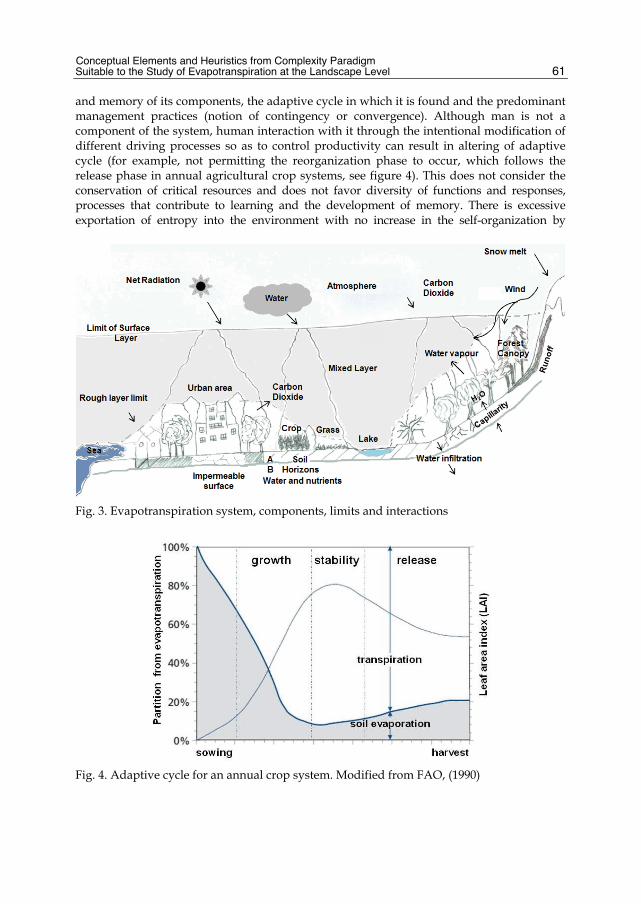
Conceptual Elements and Heuristics from Complexity Paradigm Suitable to the Study of Evapotranspiration at the Landscape Level
61
and memory of its components, the adaptive cycle in which it is found and the predominant management practices (notion of contingency or convergence). Although man is not a component of the system, human interaction with it through the intentional modification of different driving processes so as to control productivity can result in altering of adaptive cycle (for example, not permitting the reorganization phase to occur, which follows the release phase in annual agricultural crop systems, see figure 4). This does not consider the conservation of critical resources and does not favor diversity of functions and responses, processes that contribute to learning and the development of memory. There is excessive exportation of entropy into the environment with no increase in the self-organization by
Fig. 3. Evapotranspiration system, components, limits and interactions
Fig. 4. Adaptive cycle for an annual crop system. Modified from FAO, (1990)
Evapotranspiration
62
accumulating biomasa or recycling when significant controls are exerted on feedback mechanisms at local scales, such as the use of fertilizers and control measures for infestations and undergrowth (Günther & Folke, 1993). Although they satisfy certain societal needs, this type of local management affects a landscape’s regional and/or slow stability processes, such as aquifer recharge, soil enrichment, landscape connectivity and biodiversity. The development of generating heuristics of resilience and the emphasis on the structure-function connection in the modeling of evapotranspiration systems is fundamental to the adaptation of these systems, and thus it is important to validate them in terms of their role on driving configuration on evapotranspiration systems: panarchies, or interaction of processes across scales; emergences, results of feedback processes among the components of an evapotranspiration system; convergences or contingencies, primarily by management elements and meteorological disturbances and; changes in adaptive cycles. The emphasis on the scale of the landscape is established by its importance to its stability and to the strategy to decrease the effects at regional scales on the panarchy of evapotranspiration systems. The next section discusses certain methodological strategies that can be implemented which would be greatly useful to demonstrate the four heuristics of resilience considered. In addition, information requirements are established in terms of the relation of these strategies with driving processes in the functional response of evapotranspiration systems. These options do not exhaust the possible alternatives but rather summarize some of the advances in terms of observation schemes, methodologies based on discovering temporal-spatial patterns and modeling of complex processes with bottom-up approaches. In addition, the relevance of communication and learning elements are discussed and the role of tools such as participatory planning, regional planning, and cybercartography as constructive methodological strategies for social adaptation.
4. Perspective for modeling evapotranspiration at application levels 4.1 Methodological strategies for the application of elements of complexity Two approaches—bottom-up and top-down—stand out in the literature review of methodological strategies to incorporate the complexity paradigm at application levels (logical and computational) and epistemological levels. The former consists of applying generic systemic models to the process of interest, differentiating components, interactions at local scales, and establishing feedback rules at regional scales. At the same time, state variables are defined, or even better, threshold values or control mechanisms that trigger emergent behavior are established (Costanza & Maxwell, 1991; Parrott & Kok, 2000). This approach seeks to simulate behavior at more regional scales, which later are compared with observations at the same scale, or the simulated behavior is analyzed in terms of the degree to which the presumed behavior is represented (test of hypothesis). These exercises are based on prior knowledge about the process in question and use conceptual and geographic representation models—especially if the linkage between structure and function needs to be incorporated. Examples of this approach are complex object-based models and the geospatial pattern discovery (Parrott, 2009; Maceachren et al., 1999; Coronel, 2008). Bottom-up modeling is based on a phenomenological strategy, or driven by phenomena; in which logical and geocomputational models inherit the behavior of observed or simulated processes. The top-down application consists of producing analogical models, favoring the discussion of knowledge frameworks applied to the specific problems and the search for solutions and representation models according to heuristics discussed and agreed to at the conceptual

Conceptual Elements and Heuristics from Complexity Paradigm Suitable to the Study of Evapotranspiration at the Landscape Level
63
level. The application of cybernetic communication processes, such as participatory cartography and regional planning, are examples that well-illustrate this approach (Romero & Farinos, 2006; Cataldo and Rinaldi, 2010). These facilitate learning about a region or area from the perspective of the processes that comprise it and promote social participation at diverse levels of organization. Thus, adaptation is facilitated by the creation of consensus, the strengthening of networks and the comprehensive vision of a territory. Our proposal is to integrate both perspectives so as to take the modeling of evapotranspiration to representation and epistemological levels. This would involve reconsidering proposals that have been examined from the hydrology perspective, focusing on organizing principles, testing hypotheses by comparing case studies and characterizing functional traits. At the same time, geographic and representation models must be developed, based on which computational models would be implemented in order to simulate complex behaviors. In addition, it is necessary to promote the discussion of the application of analogical models other than those for basins of attraction, such as connectivity and self-similarity (McDonnell et al., 2007; Schröder, 2007), which are also relevant to the application of resilience for the modeling of evapotranspiration. Therefore, the use of cartographic contexts and models to assist learning and developing knowledge about the organizing principles of a landscape—as in the communication processes for geocybernetics and cybercartography—can benefit the adaptation and development of social knowledge networks (Reyes, 2005; Reyes et al., 2006). In order to progress toward the spatial-temporal representation of evapotranspiration systems, it is suggested that geospatial patterns discovery be applied in order to show the validity of certain heuristics, such as emergences, convergences, panarchies and adaptive cycles (Haggett, 1965; Coronel, 2008). Examples of this are applications of said process for discovering patterns in order to demonstrate the emergence of seasonal spatial-temporal structures in dt shown below in the figure 5. Each picture represents one stational period; numbers in black are julian days of the year. 8 days scenes from MODIS surface temperature were used along with air temperature from a meteorological network.
Fig. 5. Spatial-temporal structures on surface–air temperature differences dt (ºC), in México, 2007
Some studies at the landscape scale have shown that the surface-atmosphere interactions observed in the surface layer are the result of local and regional processes of heterogeneity and cover roughness, as well as the effects of atmospheric variables at the meso-scale, such as air humidity and wind speed (Coronel et al., 2008; Albertson et al., 2001). This clearly indicates that an important feedback process occurs between local and regional scales (multi-scale effects in the panarchy of evapotranspiration systems). It is worth emphasizing

Evapotranspiration
64
that these works incorporate methodological elements to discover spatial-temporal patterns, including aggregation and disaggregation methods, geostatistics and exploratory spatial statistics, all of which seek to formulate the relations of association among processes. In addition, documented cases exist of significant effects at the local and regional scales on hydrologic processes, such as increase in run-off and decrease in water recharge, which are directly caused by poor management of evapotranspiration systems based on a simple productivity approach. These effects are exacerbated by extreme regional precipitation events and by prolonged periods of drought or higher than normal air temperatures, which are considered convergences and are difficult to predict (Van Aalst, 2006; Cutter et al., 2008; Romero, 2010). Lastly, it is possible to characterize the phases of the adaptive cycle in which an evapotranspiration system is found based on functional responses, such as the efficiency in the use of water, or the production of entropy in relation to an increase in self-organization, such as the application of primary productivity to the accumulation of biomass (Günther & Folke, 1993; Goetz et al., 2009).
4.2 The potential of observation schemes for incorporating organizing principles in evapotranspiration modeling The design of observation schemes are largely based on the users’ need for information about the phenomenon to be observed (Jensen, 2007). Thus, it is relevant to precisely identify the characteristics that a datum should present in order to most adequately represent a process. The literature recognizes that there are different levels of precision in data that should be considered for designing observation schemes: spatial and temporal precisions, contents of information or level of representation, geometric and thematic precisions (Schmugge et al., 2002; Couturier et al., 2009). Even more important is recognizing that prior knowledge about a process is what enables its spatial and temporal domain scales to be determined, in which the main variability of the process is observed. Based on what has been discussed throughout this chapter, it is possible to recognize certain processes in evapotranspiration which directly relate to the previously discussed organizing principles: surface temperature difference, albedo (inversely proportional to the amount of energy that interacts with the surface or Rn) and primary productivity (related with the accumulation of biomass). It has been shown and discussed that these processes behave in a way that favors the specific behaviors of complexity that have been theoretically suggested. Thus, some of the potentials of remote sensing schemes are presented here, in terms of the representation of spatial and temporal behavior of these processes and their application to bottom-up procedures to show the validity of the emergences, convergences, panarchies and adaptive cycles, as heuristics of resilience. The difference between surface temperatures should be represented with adequate resolution, given its effect at the local scale on sensible heat flow. Thus, advances in the characterization of surface temperature, with the use of remote sensing data in the thermal infrared portion (~ 10 µm wavelength), has been directed toward the discriminating covers according to their brightness temperature (Gillespie et al., 1998). In terms of the air temperature, meteorological observation networks are normally used and are efficient in representing the behavior of this variable, which has a more regional behavior (Coronel, 2008). Nevertheless, to represent the surface fluxes on a more regional scale, it has been
Conceptual Elements and Heuristics from Complexity Paradigm Suitable to the Study of Evapotranspiration at the Landscape Level
65
shown that separating temperature according to cover does not contribute to the variation in latent flow and that dt tends toward middle or stable values for an area, as a control for the efficiency in the use of water through emergence behavior at the landscape scale (Albertson et al., 2001; Coronel & Mora, 2007). What has not yet been resolved is whether this behavior is a strategy of evapotranspiration systems in response to climatic variability. Albedo represents the portion of total incident solar radiation that is reflected or is transmitted through the atmosphere and, finally, registered by sensors. Net solar radiation, available for energy balance, is the remaining proportion and, thus, because of its relevance, albedo should be adequately characterized. Albedo is correlated with erosion and decrease with soil moisture, and the density of vegetation is an attenuating factor in this process (Robinove et al., 1981). Albedo is also an important indicator of desertification processes (Xu et al., 2000). These findings suggest that albedo presents behavior that is regulated by local processes such as fractional vegetation cover, and increased by transformation on land cover. One way to study the effects of feedback between the atmosphere and surface flows (multi-scale interactions in panarchy and convergences) may be relating albedo at regional, continental and seasonal scales, with energy fluxes (Baldocchi et al., 2001; Brauman et al., 2007). Primary productivity presents efficient control of water, carbon and nutrient cycles at local and regional scales. Along with albedo and dt, it should be observed and studied in detail and with precision, with an emphasis on those indicators of primary productivity that make up the vertical and horizontal structure of the canopy. Studies have been conducted of estimations of aerial biomass (leaves and branches) which have led to important debates about the main satellite components (Lu, 2006; Goetz et al., 2009). Lidar systems adequately represent the vertical structure of the canopy and, therefore, have great potential for estimating aerial biomass, although they present limitations in the observation of large areas due to maintenance and productions costs (Hyde et al., 2006). An alternative for mapping surface roughness is the integration of data from multiple sensors (Moghaddam et al., 2002; Coulibaly et al., 2008). This would enable characterizing both the horizontal structure of the cover (through optical sensors) as well as the vertical structure of the canopy (through radar and Lidar sensors). It is possible to find differences in the strategies for accumulation of biomass according to the adaptive cycle and to incorporate this information in complex models.
5. Conclusions and future considerations Emphasis on the structure-function relation, adaptation in social-ecological systems and the development of methodological strategies themselves appear to be the most relevant elements to the incorporation of resilience as an analogical model and of the complexity paradigm as a conceptual framework for the modeling of the evapotranspiration process. One of the most significant challenges for incorporating resilience in evapotranspiration systems is continuing to advance the definition of these systems, characterize their behavior and the criteria for organization that support classification systems, for the purpose of generating comparable information in different regions to advance learning and developing knowledge about evapotranspiration. This knowledge can be made available for regional planning in different areas, according to the information needs of decision-makers, within the application of participatory planning, and/or geocybernetics. In modeling evapotranspiration systems at application and epistemological levels, important information needs exist regarding nutrients present in the soil (water, C and N)

Evapotranspiration
66
that strongly control evapotranspiration rates, and possible connections between biodiversity and the function response need to be explored through a functional group approach and by integrating indicators of this process, such as Beta biodiversity (Whittaker, 1972; Qian et al., 2009). Adequate schemes should be advanced for evaluating data of different variables associated with evapotranspiration—at spatial and/or biophysical levels of precision—with emphasis on the representation of driving processes and the testing of hypotheses through object-based models and the discovery of spatial-temporal patterns.
6. Acknowledgements We have got valuable contribution and help on figure design by Cynthia Fabianna Galeana Pizaña and GabrielaLópez. Many thanks to Centrogeo by faciliting the work and supporting meetings and discussion spaces.
7. References Abel, N., D. H. M. Cumming, & J. M. Anderies. (2006). Collapse and reorganization in social-
ecological systems: questions, some ideas, and policy implications, Ecology and Society, 11,1, 17. ISSN:1708-3087
Ahern, 1999, Spatial Concepts, Planning Strategies and future Scenarios: a Framework Method for Integrating Landscape Ecology and Landscape Planning. In: Landscape Ecological Analysis. Issues and Applications. Klopatek & Gardner, New York. Springer-Verlag.175-201. ISSN:
Ahl, V.; Allen, T. F. H. & Lerner, P. (1996). Hierarchy Theory: A vision, vocabulary and epistemology. Columbia University Press. ISBN: 0231084803 , USA
Albertson, J.D., Katul, G.G., & Wiber, P.., 2001. Relative importance of local and regional controls on coupled water, carbon, and energy fluxes, Adv Water Resour, 24, 1103-1118, ISSN: 0309-1708
Alcocer, J., Escobar, E. & Lugo, A. (2000). Water use (and abuse) and its effects on the crater- lakes of Valle de Santiago, México. Lakes & Reservoirs: Research and Management. Vol. 5, pp. 145-149, ISSN: 1440-1770.
Allen R.G., Tasumi M., Morse A. & Trezza R., (2005). A Landsat-based energy balance and evapotranspiration model in Western US water rights regulation and planning. Irrigation and Drainage Systems, 19(3/4): pp. 251–268, ISSN: 0168-6291
Anderies, J. M., B. H. Walker, & A. P. Kinzig. (2006). Fifteen weddings and a funeral: case studies and resilience-based management. Ecology and Society, 11, 1, 21. ISSN: 1708-3087
Arai, T. & Kragic, D. (1999). Name of paper, In: Name of Book in Italics, Name(s) of Editor(s), (Ed.), page numbers (first-last), Publisher, ISBN, Place of publication
Baldocchi, D., Falge, E., Gu, L., Olson, R., Hollinger, D., Running, S., Anthoni, P., Bernhofer, C., Davis, K., Evans, F., Fuentes, J., Goldstein, A., Katul, G., Law, B.,Lee, X., Malhi, Y., Meyers, T., Munger, W., Oechel, W., K. T. Paw U, Pilegaard, K., H. P. Schmid, Valentini, R., Verma, S., Vesala, T., Wilson, K., & Steve W.(2001). FLUXNET: A new tool to study the temporal and spatial variability of ecosystem-scale carbon dioxide, water vapour and energy flux densities. Bulletin of the American Meteorological Society, 2001, 82, pp. 2415−2434, ISSN 1520-0477.

Conceptual Elements and Heuristics from Complexity Paradigm Suitable to the Study of Evapotranspiration at the Landscape Level
67
Bastiaanssen, W.G.M., Menenti, M., Feddes, R.A. & Holtslag, A.A. (1998). A remote sensing surface energy balance algorithm for land (SEBAL). International Journal of Hydrology 1998, pp. 212–213, ISSN: 2042-7808.
Berkes, F., & Folke, C. (1998) Linking Social and Ecological Systems Management Practices and Social Mechanisms for Building Resilience. ISBN: 0521591 1406, New York: Cambridge Univ. Press.
Boegh, E., Soegaard, H., & Thomsen, A. (2002). Evaluating evapotranspiration rates and surface conditions using Landsat TM to estimate atmospheric resistance and surface resistance. Remote Sensing of Environment. 2002, 79, pp. 329-343, ISSN:0034-4257.
Brauman KA, Daily GC, Duarte TK, & Mooney HA (2007) The nature and value of ecosystem services: an overview highlighting hydrologic services. Annual Rev Environ Resource , 32: 67–98, ISSN 1543-5938.
Brooks, D., Collier, J., Maurer, B., Smith, J. & Wiley, E. (1989). Entropy and information in evolving biological systems, Biology & Philosophy, Vol. 4, No. 4, 407-432, ISSN 0169-3867
Cadenasso, M., Pickett, S. & Grove, J. (2006). Dimensions of ecosystem complexity: Heterogenety, connectivity, and history, Ecological Complexity 3, 1-12. ISSN 1476-945X.
Callaghan, T.V., Björn, L.O., Chernov, Y., Chapin, T., Christensen, T.R., Huntley, B., Ims, R.A., Johansson, M., Jolly, D., Jonasson, S., Matveyeva, N., Panikov, N., Oechel, W., Shaver, G., Schaphoff, S., & S. Sitch (2004) Effects of Changes in Climate on Landscape and Regional Processes, and Feedbacks to the Climate System, Ambio, Vol. 33, No. 7, Climate Change and UV-B Impacts on Arctic Tundra and Polar Desert Ecosystems (Nov., 2004), pp. 459-468
Castree, N. (2010). Book review: Environmental change and globalization: double exposures. Progress in Human Geography, 34, 274-277. ISSN:0309-1325
Cataldo, A. & Rinaldi, A. (2010). An onthological approach to represent knowledge in territorial planning science, Computers, Environment and Urban Systems, Vol. 34, No. 2, 117-132, Marzo 2010, ISSN: 0198-9715
Clark, D.B., Taylor, C.M., Thorpe, A.J., Harding, R.J. & Nicholls, M.E. (2003) The influence of spatial variability of boundary-layer moisture on tropical continental squall lines, Quartely Journal of the Royal Meteorological Society, 129, 1101-1121, ISSN: 1477-870X
Cleugh, H.A., Leuning, R., Qiaozhen, M.,. & Running S.W. (2007). Regional evaporation estimates from flux tower and MODIS satellite data a CSIRO. Remote Sensing of Environment 106 (2007) 285–304, ISSN: 0034-4257.
Constanza, R., & T. Maxwell, (1991) Spatial Ecosystem Modelling Using Parallel Processors, Ecological Modelling, 58, 159-183. ISSN:0304-3800
Coronel, C. & F., Mora (2007) Spatial-temporal Patterns of Fractional Vegetation Cover and Land Surface Temperature for Monitoring the Water Balance, Proceedings of the 32th International Symposium of Remote Sensing of Environment, (junio 2007) Costa Rica .
Coronel, C. & F., Mora (2006) Dinámica de la fracción vegetal en la cobertura terrestre: Análisis subpixel en imágenes MODIS, Memorias del XII Symposium Internacional, Capitulo Colombia, pp. 79-85, ISBN: Centro Internacional de Alta Tecnología , SELPER, San Juan de Costa Rica
Coronel, C., (2008) Incorporación del proceso de descubrimiento de patrones geoespaciales en el estudio sobre componentes del balance hídrico, Master in Geomatics. Centrogeo, CONACYT, D.F., México.
Evapotranspiration
68
Coronel, C., E. Rosales, F. Mora, A.A. López-Caloca, Tapia-Silva, F.-O, & G., Hernández (2008) Monitoring evapotranspiration at landscape scale in Mexico: Applying the energy balance model using remotely-sensed data, Proceedings of SPIE Europe – Remote Sensing, pp. 1-12, 71040H, University of Wales Institute, SPIE Europe, Cardiff, Wales, UK
Coulibaly, L., Migolet, P., Adegbidi, H., Fournier, R. and Hervet, E. (2008) Mapping aboveground forest biomass from Ikonos satellite image and multisource geospatial data using Neural Networks and Kriging interpolations. Geoscience and Remote Sensing Symposium, 2008. IGARSS 2008. IEEE International. 3: 298-301.
Courault, D., Seguin, B., & A., Olioso (2005). Review on estimation of evapotranspiration from remote sensing data: From empirical to numerical modeling approaches. Irrigation and Drainage Systems, 19, 223-249, ISSN:1573-0654
Couturier, S., Mas J.-F., Cuevas G., Benítez J., Vega-Guzmán A., & Coria-Tapia V. (2009). An accuracy index with positional and thematic fuzzy bounds for land-use/ land-cover maps. Photogrammetric Engineering and Remote Sensing, 75, 7, 789-805, ISSN: 0099-1112
Crow, W.T., Wood, E.F.. (2003). The assimilation of remotely sensed soil brightness temperature imagery into a land surface model using Ensemble Kalman filtering: a case study based on ESTAR measurements during SGP97. Advances in Water Resources 26 (2003) pp. 137–149 ISSN 0309-1708.
Cumming, G., Cumming, D., & C. Redman. (2006). Scale mismatches in social-ecological systems: causes, consequences, and solutions. Ecology and Society 11(1):14. ISSN:1708-3087
Cutter, S.L, Barnes, L., Berry, M., Burton, C., Evans, E., Tate, E., & Webb, J. (2008) A place-based model for understanding community resilience to natural disasters, Global Environmental Change, 18, 598–606, ISSN: 0959-3780
Daily, G.C., Alexander, S., Ehrlich, P.R., Goulder, L., Lubchenco, J., Matson, P.A., Mooney, H.A., Postel, s., Schneider, S.H., Tilman, D., & G.M. Woodwell (997) Ecosystem Services: Benefits Supplied to Human Societies by Natural Ecosystems, Issues in Ecology, No. 2, 1-16, ISSN 1092-8987
Dan L., Ji J, & Li Y. (2007) The interactive climate and vegetation along the pole-equator belts simulated by a global coupled model, Advances in Atmospheric Sciences, 24(2): 239-249 ISSN 0256-1530.
de Bello, F., Lavorel, S, Dı´az, S., Harrington R., Cornelisse, J.H.C., Bardgett, R.D., Berg, M.P., Cipriotti, P., Feld, C., Hering, D., Martins da Silva, P Potts, S.G, Sandin, L., Sousa, J.P., Storkey, J., Wardle, D.A., & Harrison, P.A. (2010) Towards an assessment of multiple ecosystem processes and services via functional traits, Biodivers Conserv,. Received: 31 March 2010
DOE, (1996) Science Plan for the Atmospheric Radiation Measurement (ARM) Program, U.S. Department of Energy, Washington, DOE/ER-0670.
FAO. (1990). Evapotranspiración del cultivo, Guías para la determinación de los requerimientos de agua para los cultivos, FAO, ISBN 92-5-304219-2, USA
Folke, C. & Kautsky, N. (1992) Aqualcultural with its environment; prospects for sustanibility, Ocean and Coastal Management, 17, 1, pp. 5-24, ISSN: 0964-5691
Garatuza-Payan J. & Watts, C.J. (2005). The use of remote sensing for estimating ET of irrigated wheat and cotton in Northwest Mexico. Irrigation and Drainage Systems, 2005 19(3/4): pp 301–320, ISSN:1573-0654
Conceptual Elements and Heuristics from Complexity Paradigm Suitable to the Study of Evapotranspiration at the Landscape Level
69
García R. (2008). Sistemas complejos: Conceptos, métodos y fundamentación epistemológica de la investigación interdisciplinaria, Gedisa., ISBN: 8497841646 ISBN-13: 9788497841641, España.
Goetz, S., Baccini, A., Laporte, N., Johns, T., Walker, W., Kellndorfer, J., Houghton, R., and Sun, M. (2009) Mapping and monitoring carbon stocks with satellite observations: a comparison review. Carbon Balance and Management 2009, 4:2.
Gorenburg, I.P., McLaughlin, D.& Enterkhabi, D. (2001) Scale-recursive assimilation of precipitation data. Adv Water Resour, 24, 941-953, ISSN: 0309-1708
Gunderson L. H., C. S. Holling, and S. S. Light. (1995). Barriers and bridges to the renewal of ecosystems and institutions. Columbia University Press, ISBN 0-231-10102-3 New York, USA.
Gunderson, L. (2000). Ecological resilience –in Theory and application, . The human use of human beings, Da Capo Press, ISBN 0-306-80320-8, Boston, USA
Gunderson, L. H., S. R. Carpenter, C. Folke, P. Olsson, & G. D. Peterson. (2006). Water RATs (resilience, adaptability, and transformability) in lake and wetland social-ecological systems. Ecology and Society 11, ISSN: 1708-3087
Günther, F., & C. Folke, (1993) Characteristics of Nested Living Systems, Journal of Biological Systems, 1, 3, pp. 257-274, ISSN:
Haggett, P. 1965, Locational Analysis in Human Geography, London Edward Arnold, ISBN:071315179X, London, UK
Haila, Y. (2002) Scaling environmental issues: problems and paradoxes, Landscape and Urban Planning 61 2002 pp. 59–69 ISSN 0169-2046.
Helen A. Cleugh, Ray Leuning, Qiaozhen Mu, & Steven W. Running (2007). Regional evaporation estimates from flux tower and MODIS satellite data a CSIRO, Remote Sensing of Environment 106 (2007) 285–304, ISSN: 0034-4257
Holland, J.H. (1995). Hidden Order: How Adaptation Builds Complexity. M.A. Addison-Wesley. ISBN: 1064-5462
Holland, J.H. (2002). Complex adaptive systems and spontaneous emergence, In: Complexity and Industrial Clusters: Dynamics and Models in Theory and Practice (Contributions to Economics), Curzio, A.Q. and Fortis, M., pp. 25-34, Physica-Verlag HD, ISSN: 3790814717, Heidelberg
Holling, C. S. (1973). Resilience and stability of ecological systems. Annual Review of Ecology and Systematics, 4:1-23. ISSN: 1543-592X.
Hyde, P., Dubayah, R., Walker, W., Bryant, J., Hofton, M. & Hunsaker, C. (2006) Mapping forest structure for wildlife habitat analysis using multi-sensor (LiDAR, SAR/ InSAR, ETM+, Quickbird) synergy. Remote Sensing of Environment, 102, 63-73.ISSN: 0034-4257
Jensen, J. 2007. Remote Sensing of the Environment, An Earth Resource Perspective, Pearson Prentice Hall, ISBN 0-13-188950-8, NJ, USA
Katul, G., Lai, C.T., Schäfer, K., Vidakovic, B., Albertson, J., Ellsworth, D., & Oren, R. (2001) Multiscale analysis of vegetation surface fluxes: from seconds to years, Advances in Water Resources, Vol. 24, 2001, 1119-1132, ISSN 0309-1708
Kinzing, A. P., P. Ryan, M. Etienne, H. Allyson, T.Elmqvist, & B. H. Walker. (2006). Resilience and regime shifts: assessing cascading effects. Ecology and Society 11(1): 20. ISSN: 1708-3087
Lebel, L., J. M. Anderies, B. Campbell, C. Folke, S. Hatfield-Dodds, T. P. Hughes, & J. Wilson. (2006). Governance and the capacity to manage resilience in regional social-ecological systems. Ecology and Society 11(1): 19. ISSN:1708-3087

Evapotranspiration
70
Liu, J., Dietz, Th., Carpenter, S., Alberti, M., Folke, C., Moran, E., Pell, Al., Deadman, P., Kratz, T., Lubchenco, J., Ostrom, E., Ouyang, Z., Provencher, W., Redman, Ch., Schneider, S. & Taylor, W. (2007). Complexity of coupled human and natural systems. Science. 317: 2007, pp. 1513-1516. ISSN 0036-8075 (print), 1095-9203 (online)
Maceachren, Wachowicz, Edsall, Haug & Masters, 1999, Constructing knowledge from multivariate spatiotemporal data: integrating geographical visualization with knowledge discovery in database methods, Int. J. Geographical Information Science, 13, 4, 311–334, ISSN:
Mackay, D.S. (2001) Evaluation of hidrologic equilibrium in a mountainous watershed: incorporating forest canopy spatial adjustment to soil biogeochemical process, Advances in Water Resources, Vol. 24, 2001, 1211-1227, ISSN 0309-1708
Maganda, MC. (2004). Disponibilidad de agua un riesgo construido. Vulnerabilidad hídrica y crecimiento urbano-industrial en Silao, Guanajuato (México). Tesis Doctorado en Antropología. CIESAS, Septiembre, 2004. Distrito Federal, México
Mahrt L., Vickers, D., & Sun, J. (2001) Spatial variations of surface moisture flux from aircraft data. Advances in Water Resources 24 (2001) pp. 1133-1141. ISSN: 0309-1708.
Martin, R. & Sunley, P. (2007). Complexity Thinking and Evolutionary Economic Geography. Papers in Evolutionary Economic Geography. pp. 1—36, ISSN:
Martínez, E. & Reyes, M. (2005). Cybercatography and Society. In: Cybercartography: Theory and Practice, Taylor, F. (Ed.), 99-122, Elsevier, ISBN 978-0-444-51629-9, Amsterdam, The Netherlands
McCabe, M.F. & Wood, E. F. (2006) Scale influences on the remote estimation of evapotranspiration using multiple satellite sensors. Remote Sensing of Environment 105, (2006), pp. 271–285, ISSN: 0034-4257
McDonnell J.J., Sivapalan, M., Vaché, K., Dunn, S., Grant, G., Haggerty, R., Hinz, C., R. Hooper, Kirchner, J., Roderick, M. Selker, L.J., & Weiler, M. (2007). Moving beyond heterogeneity and process complexity: A new vision for watershed hydrology. Water Resources Research, 43, (july 2007), pp. 1-6, ISSN:0043-1397.
Moghaddam, M., Dungan, J. and Acker, S. (2002) Forest Variable Estimaion From Fusion of SAR and Multispectral Optical Data. IEEE Transaction on Geoscience and Remote Sensing. 40:10, 2176-2187, ISSN:0196-2892
Neale, C., Jayanthi, H.& Wright, J.L. (2005). Irrigation water management using high resolution airborne remote sensing, J. Irrigation and Drainage Systems, 19(3/4), 2005, pp. 321–336., ISSN:1573-0654
Norman, J. M., W. P. Kustas, & K. S. Humes (1995). A two-source approach for estimating soil and vegetation energy fluxes from observations of directional radiometric surface temperature, Agric. For. Meteorol., 77, 263-293 ISSN:0168-1923.
Parrot, L., (2009) Understanding and managing the landscape as a complex system: What can bottom-up modelling approaches contribute?., Applying Landscape science to Natural Resource Management. A Symposium of the Spatial Sciences Institute Biennial International Conference. pp. 1-15, Adelaide Convention Centre, Adelaide, (october 2009), Australia
Parrott, L. & Kok, R. (2000) Incorporating Complexity in Ecosystem Modelling, Complexity International, Vol. 7, (june, 2000) pp. 1-19, ISSN: 1320-0682.
Perry, Chris, (2005). Irrigation reliability and the productivity of water: a proposed methodology using evapotranspiration mapping, J. Irrigation and Drainage Systems, 19, 2005 pp 211-221, ISSN:1573-0654

Conceptual Elements and Heuristics from Complexity Paradigm Suitable to the Study of Evapotranspiration at the Landscape Level
71
Peterson, G. D., C. R. Allen, & C. S. Holling. (1998). Ecological resilience, biodiversity, and scale. Ecosystems 1:6–18, SSN:1435-0629
Peterson, G. D., G. S. Cumming, & S. R. Carpenter. (2003). Scenario planning: a tool for conservation in an uncertain world. Conservation Biology 17, 358–366, ISSN: 0888-8892
Pickett, S., Cadenasso, M., & Grove, J. (2004). Resilient cities: meaning, models and metaphor for integrating the ecological, socio-economic and planning realms. Landscape and urban planning, 69, 369–384, ISSN 0169-2046
Pickett, S., Jones, C., Kolasa, J., (1994). Ecological Understanding: The Nature of Theory and the Theory of Nature. Academic Press, San Diego, California. ISBN 0-12-554720-X
Pimm, S. L. (1991). The balance of nature?, University of Chicago Press, ISBN: 9780226668307 Chicago, Illinois, USA
Post, D.A. & Jones, J.A., 2001. Hydrologic regimes of forested, mountainous, headwater basin in New Hampshire, North Carolina, Oregon, and Puerto Rico. Adv Water Resour, 24, 1195-1210, ISSN: 0309-1708
Qian, H., Kissling, D.W.., Wang, X., & Andrews, P. (2009) Effects of woody plant species richness on mammal species richness in southern Africa, Journal of Biogeography, 36, 1685–1697, ISSN: 1365-2699
Reyes, M. (2005). Cybercartography from a Modeling Perspective.In: Cybercartography: Theory and Practice, Taylor, F. (Ed.), 63-98, Elsevier, ISBN:978-0-444-51629-9, Amsterdam, The Netherlands
Reyes, M. & Martínez, E. (2005). Technology and Culture in Cybercartography. In: Cybercartography: Theory and Practice, Taylor, F. (Ed.), 123-148, Elsevier, ISBN 978-0-444-51629-9, Amsterdam, The Netherlands
Reyes, M., Taylor, F., Martínez, E. & López, F. (2006). Geo-cybernetics: A New Avenue of Research in Geomatics. Cartographica, Vol. 41, No.1, 7-20, ISSN 0317-7173
Reyes, M., Taylor, F., Martínez, E. López, F. (2006). Geo-cybernetics: A New Avenue of Research in Geomatics. Cartographica, Vol. 41, No.1, 7-20, ISSN 0317-7173
Riobinove, C.J.; Chavez, P.S.; Gehring, D.; & Holmgren, R. (1981)Arid land monitoring using Landsat albedo difference images. Remote Sens. Envrion, 11, 133-156. ISSN:0034-4257.
Romero, J. & Farinós, J. (2006). Gobernanza territorial en España. Claroscuros de un proceso a partir del estudio de casos. Universitat de València, ISBN 84-370-6542-9, Valencia España
Romero, L.P. (2010) Water in Mexico City: what will climate change bring to its history of water-related hazards and vulnerabilities?, Environment and Urbanization, 22; 157-178. ISSN:0956-2478
Ruddell, B. & Kumar, P. (2006). The Modelshed Geodata Model, In: Hydroinformatics, Kumar, P, Alameda, J., Bajcsy, P., Folk, M. & Markus, M. (Ed.), 81-99, CRC Press, ISBN 0-8493-2849-2, Boca Raton, FL, USA
Sandholt I, Rasmussen K, & Andersen J., (2002). A simple interpretation of the surface temperature/vegetation index space for assessment of surface moisture status, International Journal of Remote Sensing, 2002, 79(2): pp. 213-224. ISSN 0143-1161, Online ISSN: 1366-5901
Schmugge T. J., Kustas W. P., Ritchie J. C., Jackson T. J. & Rango A., (2002). Remote sensing in hydrology. Advances in Water Resources, 25(2002), pp. 1367-1385 ISSN:0309-1708.

Evapotranspiration
72
Schröder, B. (2006). Pattern, process, and function in landscape ecology and catchment hydrology - how can quantitative landscape ecology support predictions in ungauged basins (PUB)? Hydrology and Earth System Sciences, 10, pp. 967-979. ISSN:1027-5606
Senay, G.B., Budde, M., Verdin, J.P., & Melesse, A.M. (2007). A coupled remote sensing and simplified surface energy balance approach to estimate actual evapotranspiration from irrigated fields. Sensors, 2007, 7, pp. 979-1000, ISSN1424-8220.
Shuttleworth, W.J., & J.H. Gash, (2005) The role of large-scale field experiments in water and energy balance studies, In: Encyclopedia of Hydrological Science, M. G. Anderson Jhon Wiley & Sons, Ltd.
Sivapalan, M. (2005) Pattern, Process and Function: Elements of a Unified Theory of Hydrology at the Catchment Scale, In: Encyclopedia of Hydrological Science, M. G. Anderson Jhon Wiley & Sons, Ltd.
Sivapalan, M., Kumar, P. & Harris, D. (2001). Nonlinear propagation of multi-scale dynamics through hydrologic subsystems. Advances in Water Resources, Vol. 24, No. 9, November, 2001, 935-940, ISSN 0309-1708
Soto, M. & Soto, F. (1990). Cambios recientes en el uso del suelo agrícola en la región del Bajío, Gto, Geografía y Desarrollo, 2, 5, 3–11. ISSN: 0187-6562.
Szerszynsky B., (2002). Wild times and domesticated times: the temporalities of environmental lifestyles and politics, Landscape and Urban Planning, Vol. 61, No. 4, November 2002, 181-191, ISSN 0169-2046.
Taylor, C.M., & Lebel, T. (1998). Observational evidence of persistent convective – scale rainfall patterns. Monthly Weather Review, 126 (6), 1998, pp. 1597 -1607, ISSN: 1520-0493
Van Aalst, M. (2006). The impacts of climate change on the risk of natural disasters. Disasters, Vol. 30, No. 1, 5-18, ISNN 0361-3666
Veitzer, S.A. & Gupta, V.K. (2001) Statistical self-similarity of width function maxima with implications to floods. Adv Water Resour, 24, 9, 955-965, ISSN: 0309-1708
Vilardy, Q.S.P. (2009). Estructura y dinámica de la ecorrregión Ciénaga Grande de Santa Marta: una aproximación desde el marco conceptual de los sistemas socio-ecológicos complejos y la teoría de la resilencia Tesis de Doctorado Departamento interuniversitario de Ecología p.296 Universidad Autónoma de Madrid, 2009.
Walker, B. H., L. H. Gunderson, A. P. Kinzig, C., Folke, S. R. Carpenter, & L. Schultz. (2006). A handful of heuristics and some propositions for understanding resilience in social-ecological systems. Ecology and Society, Vol. 11, No. 1: 13, ISSN 1708-3087.
Walker, B., C. S. Holling, S. R. Carpenter, & A. Kinzig. (2004). Resilience, adaptability and transformability in social–ecological systems. Ecology and Society Vol. 9, No. 2: 5, ISSN 1708-3087
Whittaker, R. H. 1972. Evolution and measurement of species diversity. Taxon, 21: 213-251. Wiener, N. (1954). The human use of human beings, Da Capo Press, ISBN 0-306-80320-8,
Boston, USA Wu, J. (1999). Hierarchy and Scaling: extrapolating information along a scaling ladder. Canadian
Journal or Remote Sensing. 4, pp. 367-380. ISSN: 1712-7971. Xu, C-Y, J. Seibert & S. Halldin, (1996). Regional water balance modelling in the NOPEX area:
development and application of monthly water balance models, Journal of Hydrology, 180, 1996, pp. 211-236, ISSN 0022-1694.
Zavaleta, E.S., Thomas, B.D., Chiariello. N.R., Asner, G.P., Shaw, M.R. & Field, C.B. (2003). Plants reverse warming effect on ecosystem water balance. Proceedings of the National Academy of Sciences, Vol.100, No 17, (august 2003),9892–9893, ISSN:0027-8424.
Copyright © 2022 FDOKUMEN