Concepts and science for coastal erosion management – An introduction to the Conscience framework
8
Concepts and science for coastal erosion management e An introduction to the CONSCIENCE framework Marcel Marchand a, * , Agustin Sanchez-Arcilla b , Maria Ferreira c , Jeremy Gault d , José A. Jiménez b , Marina Markovic e , Jan Mulder a , Leo van Rijn a , Adrian St anic a f , Wojciech Sulisz g , James Sutherland h a Deltares, P.O. Box 177, 2600 MH Delft, The Netherlands b Laboratori d’Enginyeria Marítima, Universitat Politècnica de Catalunya, C/ Jordi Girona, 1-3 Ed. D1 Campus Nord, 08034 Barcelona, Spain c EUCC Mediterranean Centre, Consorci El Far, C.Escar 6-8, Modulo 10a, 08039 Barcelona, Spain d Coastal and Marine Resources Centre, Environmental Research Institute, University College Cork, Naval Base, Haulbowline, Cobh, Co. Cork, Ireland e United Nations Environment Programme, Mediterranean Action Plan, Priority Actions Programme Regional Activity Centre (PAP/RAC), Kraj Sv. Ivana 11, HR-21000 Split, Croatia f Geoecomar, Dimitrie Onciul Street 23-25, Sector 2, Bucharest, Romania g Institute of Hydroengineering, Polish Academy of Sciences (IBW/PAN), Ul. Koscierska 7, Gdansk, Poland h HR Wallingford, Howbery Park, Benson Lane, Wallingford, United Kingdom article info Article history: Available online 6 July 2011 abstract The main objective of the CONSCIENCE project was to develop and test concepts, guidelines and tools for the sustainable management of erosion along the European coastline, based on the best available scientific knowledge and on existing practical experience. Four concepts are potentially capable of providing the nexus between scientific knowledge and management: coastal resilience, coastal sediment cell, favourable sediment status and strategic sediment reservoir. The project has tested the use of these concepts and found that they are useful, provided that they are positioned and linked within a logical structure that we shall call the CONSCIENCE “Frame of Reference”, defined in time and space and supported through data and monitoring. Practical experience in six coastal sites in Europe has shown that the use of this Frame of Reference together with these concepts can make management objectives explicit and transparent. It can therefore support the design of an appropriate, resilience based coastal erosion management practice. Ó 2011 Elsevier Ltd. All rights reserved. 1. Introduction Coastal erosion in Europe causes significant economic loss, ecological damage and societal problems. It was estimated that in 2004 about 20,000 km of the European coast (corresponding to 20% of coastline) faced serious impacts of coastal erosion (European Commission, 2004). Loss of property, infrastructure and beach width annually causes millions of Euros worth of economic damage, loss of valuable coastal habitat and presents significant management issues. At the same time coastal protection is expensive. Over the past decade Europe’s total expenses to coastal protection is estimated to amount to 0.88 billion Euros per year (European Commission, 2009). The magnitude of the problem of coastal erosion therefore justifies a closer look into the current practice of erosion control and possible ways to improve it. Furthermore, both the EU Recommendation on ICZM as well as the Protocol on ICZM in the Mediterranean that recently came into force (24th March, 2011) call for a proactive, strategic and inte- grated approach to the management of the coast, with explicit reference to the problem of coastal erosion and protection. Current practice regarding coastal erosion management in Europe shows that measures have generally been designed from a local perspective, often in a reactive way and with disregard to the larger time and space domains of sediment processes that are at the root of the problem (European Commission, 2004). In many countries a national coastal policy is weak or even non-existent. Without clear government policy, lack of sufficient funds and limited public understanding it is hardly surprising that the approach taken to erosion management is primarily through ad hoc arrangements. At the same time scientific knowledge of coastal processes is already well-developed when compared to previous decades and available models and monitoring systems are becoming more sophisticated. However, the scarcity of data and field observations * Corresponding author. Tel.: þ31 15 285 8558; fax: þ31 15 285 8582. E-mail address: [email protected] (M. Marchand). Contents lists available at ScienceDirect Ocean & Coastal Management journal homepage: www.elsevier.com/locate/ocecoaman 0964-5691/$ e see front matter Ó 2011 Elsevier Ltd. All rights reserved. doi:10.1016/j.ocecoaman.2011.06.005 Ocean & Coastal Management 54 (2011) 859e866
-
Upload
independent -
Category
Documents
-
view
0 -
download
0
Transcript of Concepts and science for coastal erosion management – An introduction to the Conscience framework
lable at ScienceDirect
Ocean & Coastal Management 54 (2011) 859e866
Contents lists avai
Ocean & Coastal Management
journal homepage: www.elsevier .com/locate/ocecoaman
Concepts and science for coastal erosion management e An introductionto the CONSCIENCE framework
Marcel Marchand a,*, Agustin Sanchez-Arcilla b, Maria Ferreira c, Jeremy Gault d, José A. Jiménez b,Marina Markovic e, Jan Mulder a, Leo van Rijn a, Adrian St�anic�a f, Wojciech Sulisz g, James Sutherland h
aDeltares, P.O. Box 177, 2600 MH Delft, The Netherlandsb Laboratori d’Enginyeria Marítima, Universitat Politècnica de Catalunya, C/ Jordi Girona, 1-3 Ed. D1 Campus Nord, 08034 Barcelona, Spainc EUCC Mediterranean Centre, Consorci El Far, C.Escar 6-8, Modulo 10a, 08039 Barcelona, SpaindCoastal and Marine Resources Centre, Environmental Research Institute, University College Cork, Naval Base, Haulbowline, Cobh, Co. Cork, IrelandeUnited Nations Environment Programme, Mediterranean Action Plan, Priority Actions Programme Regional Activity Centre (PAP/RAC), Kraj Sv. Ivana 11, HR-21000 Split, CroatiafGeoecomar, Dimitrie Onciul Street 23-25, Sector 2, Bucharest, Romaniag Institute of Hydroengineering, Polish Academy of Sciences (IBW/PAN), Ul. Koscierska 7, Gdansk, PolandhHR Wallingford, Howbery Park, Benson Lane, Wallingford, United Kingdom
a r t i c l e i n f o
Article history:Available online 6 July 2011
* Corresponding author. Tel.: þ31 15 285 8558; faxE-mail address: [email protected] (M.
0964-5691/$ e see front matter � 2011 Elsevier Ltd.doi:10.1016/j.ocecoaman.2011.06.005
a b s t r a c t
The main objective of the CONSCIENCE project was to develop and test concepts, guidelines and tools for thesustainable management of erosion along the European coastline, based on the best available scientificknowledge and on existing practical experience. Four concepts are potentially capable of providing thenexus between scientific knowledge and management: coastal resilience, coastal sediment cell,favourable sediment status and strategic sediment reservoir. The project has tested the use of theseconcepts and found that they are useful, provided that they are positioned and linked within a logicalstructure that we shall call the CONSCIENCE “Frame of Reference”, defined in time and space and supportedthrough data and monitoring. Practical experience in six coastal sites in Europe has shown that the use ofthis Frame of Reference together with these concepts can make management objectives explicit andtransparent. It can therefore support the design of an appropriate, resilience based coastal erosionmanagement practice.
� 2011 Elsevier Ltd. All rights reserved.
1. Introduction
Coastal erosion in Europe causes significant economic loss,ecological damage and societal problems. It was estimated that in2004 about 20,000 km of the European coast (corresponding to 20%of coastline) faced serious impacts of coastal erosion (EuropeanCommission, 2004). Loss of property, infrastructure and beachwidth annually causes millions of Euros worth of economicdamage, loss of valuable coastal habitat and presents significantmanagement issues. At the same time coastal protection isexpensive. Over the past decade Europe’s total expenses to coastalprotection is estimated to amount to 0.88 billion Euros per year(European Commission, 2009). The magnitude of the problem ofcoastal erosion therefore justifies a closer look into the currentpractice of erosion control and possible ways to improve it.
: þ31 15 285 8582.Marchand).
All rights reserved.
Furthermore, both the EU Recommendation on ICZM as well as theProtocol on ICZM in the Mediterranean that recently came intoforce (24th March, 2011) call for a proactive, strategic and inte-grated approach to the management of the coast, with explicitreference to the problem of coastal erosion and protection.
Current practice regarding coastal erosion management inEurope shows that measures have generally been designed froma local perspective, often in a reactiveway andwith disregard to thelarger time and space domains of sediment processes that are at theroot of the problem (European Commission, 2004). In manycountries a national coastal policy is weak or even non-existent.Without clear government policy, lack of sufficient funds andlimited public understanding it is hardly surprising that theapproach taken to erosionmanagement is primarily through ad hocarrangements.
At the same time scientific knowledge of coastal processes isalready well-developed when compared to previous decades andavailable models and monitoring systems are becoming moresophisticated. However, the scarcity of data and field observations

M. Marchand et al. / Ocean & Coastal Management 54 (2011) 859e866860
along many coasts, still make it very difficult for coastal managersto put this knowledge into practice. The EUROSION project, which wasexecuted on behalf of the EC Directorate General of the Environ-ment, recommended that any policy for coastal erosion shouldincrease coastal resilience by restoring the sediment balance andproviding space for coastal processes, using the coastal sedimentcell perspective. It also introduced the concepts of favourablesediment status and strategic sediment reservoir as elements fora coastal erosion policy (European Commission, 2004). Withinformation frommore than 60 study sites, the EUROSION project wasfirst to take stock of the situation of coastal erosion in Europe. Withits recommendations it provided an important impetus for imple-menting a truly sustainable coastal erosion policy. Questionsremained with respect to the scientific validity and applicability bycoastal managers of the EUROSION approach and concepts. Thisprompted the EU to co-fund the CONSCIENCE project with a view toenhancing the implementation of scientifically-based sustainablecoastal erosion management in Europe.
2. The CONSCIENCE project
The three year EU-FP6 CONSCIENCE project was launched in 2007and was executed by eight European research institutes anduniversities. It was coordinated by Deltares, the Netherlands. Theother partners were: The EUCC e Mediterranean Centre (Barce-lona, Spain); Coastal & Marine Resources Centre, National Univer-sity of Ireland (Cork, Ireland); International Centre for CoastalResources Research (CIIRC), Catalonia University of Technology(Barcelona, Spain); HR Wallingford Ltd (Wallingford, UnitedKingdom); National Institute for Marine Geology and Geo-ecology(GEOECOMAR e Bucharest, Romania); Institute of Hydro-engineering, Polish Academy of Sciences (Gdansk, Poland) andPriority Actions Programme Regional Activity Centre (PAP/RAC e
Split, Croatia).Coastal erosion management lies at the heart of ICZM, as it
addresses one of the major problems in the coastal zone. TheCONSCIENCE project contributed to the implementation of ICZMprinciples in coastal erosion management by operationalising theEUROSION recommendations. The project focused on an evaluation ofscientific validity and management applicability of the four keyconcepts of the EUROSION project, i.e. coastal resilience, favourablesediment status, coastal sediment cell and strategic sedimentreservoir. It used a generic framework to structure these fourconcepts into actual coastal management practices and tested thisframework in six pilot sites around Europe. As wewill show later inthis paper, from the pilot sites it became apparent that the appli-cability of the EUROSION concepts in practice is often hampered bya lack of explicit policy choices, based on general ICZM principlesthat should underlie actions in dealing with coastal erosion. Firstwewill describe the concepts themselves, introduce the frameworkused in the project and evaluate the concepts from a scientific,policy and management perspective.
3. The four concepts
The EUROSION project recommended that management plans forcoastal erosion should be based on the principle of working withnatural processes (European Commission, 2004). It proposed fourconcepts to assist in making this principle operational:
- coastal sediment cell,- coastal resilience,- favourable sediment status, and- strategic sediment reservoir.
3.1. Coastal sediment cell
The coastal sediment cell can be defined as a coastal compart-ment that contains a complete cycle of sedimentation includingsources, transport paths and sinks (European Commission, 2004).The cell boundaries delineate the geographical area within whichthe budget of sediment is determined, which is essential fora quantitative analysis of coastal erosion and accretion. In thisrespect, coastal sediment cells are supposed to constitute the mostappropriate units for achieving the objective of favourable sedi-ment status and hence coastal resilience.
3.2. Coastal resilience
Coastal resilience is defined by EUROSION as the inherent ability ofthe coast to accommodate changes induced by sea level rise,extreme events and occasional human impacts, whilst maintainingthe functions fulfilled by the coastal system in the longer term(European Commission, 2004).
Natural resilience varies between different coastal types:a beach dune coast can be more resilient than a cliff coast becauseof the self restoring capacity of dunes, provided there is enoughsediment and time for this natural process to take place.
Note that this definition does not require that a coastlineremains in an equilibrium state. Especially on longer time scalesmost coasts are evolving systems and are not necessarily in equi-librium (Klein et al., 1998). Coastal resilience therefore should alsorefer to coastal functions: adaptability of functions and uses tonatural fluctuations of the coastline increase coastal resilience.Permanent constructions close to the sea decrease coastal resil-ience. An example of how a coastal function can be compatible witha fluctuating coastline is beach recreation: during the storm season(autumn, winter) beach and dune erosion does not interfere withrecreation as long as during the calm seasons the beach regainssufficient width again. Flexibility in recreational facilities such assemi-permanent beach pavilions and restaurants is an adaptationstrategy to these natural variations well known to many coastalareas.
3.3. Favourable sediment status
EUROSION proposed the introduction of the concept of favourablesediment status as the cornerstone for sustainable shorelinemanagement to European legislation but the actual implementa-tion has not yet been realised. It can be defined as the situationwhere the availability of coastal sediments supports the objectiveof promoting coastal resilience in general and of preservingdynamic coastlines in particular. A neutral or positive sedimentbalance is usually required to arrive at this favourable status. It isexpected that a rise in sea level results in a higher demand, which -if not supplied - will lead to coastline retreat.
It was further stated that ‘a favourable sediment status for thecoastal zone shall be achieved for each coastal sediment cell prin-cipally through sediment management including nourishmentsand the designation of strategic sediment reservoirs in combinationwith traditional measures such as spatial planning, building regu-lations and environmental assessment procedures’ (EuropeanCommission, 2004).
3.4. Strategic sediment reservoirs
Strategic sediment reservoirs, as defined by EUROSION, aresupplies of sediment of ‘appropriate’ characteristics that are avail-able for replenishment of the coastal zone, either temporarily (tocompensate for losses due to extreme storms) or in the long term

M. Marchand et al. / Ocean & Coastal Management 54 (2011) 859e866 861
(at least 100 years). They can be identified offshore, in the coastalzone (both above and below low water) and in the hinterland.
It is recognised that many coastal erosion problems are causedby a human induced (directly, i.e. in the coastal zone, or indirectlyas for instance in river catchments) imbalance in the sedimentbudget. Natural sediment sources are depleted by sand miningactivities, trapped in river reservoirs or fixed by coastal engineeringstructures. Restoring this balance will require identifying areaswhere essential sediment processes occur, and identifying strategicsediment reservoirs from where sediment can be taken withoutendangering the natural balance.
4. Making the concepts operational
Although these concepts may sound rational and applicable,they are not commonly used as such in everyday practice. A smallscale questionnaire, executed by the CONSCIENCE project, revealedthat almost none of the interviewed coastal policy makers andpractitioners are familiar with these concepts. Even scientists whohave already used the coastal sediment cell concept for quite sometime are unfamiliar with the other concepts. Interestingly, theconcepts seem to appeal because of their hybrid character: there isa certain scientific connotation to each of them, but also hint atpolicy relevance. Words such as ‘favourable’, and ‘strategic’certainly ask for further clarification in a policy context. ‘Resilience’may refer to a factual property of a system (cf. Holling, 1973), butcan also be used in a strategic policy context (cf. De Bruijn, 2005).
Because of their hybrid character, there is a risk in the use of theconcepts. It is quite possible that after scrutiny, some of conceptsfail to be scientifically robust, because of their subjective character.On the other hand, it is possible that the concepts are useful inpolicy making because they are multi-interpretable.
In order to study the usefulness of the concepts, we have viewedtheir character from three different perspectives, each with its ownprompting questions to steer our work:
- Policy relevance: can the concepts be linked to coastal zonemanagement policy?;
- Scientific validity: does the concept relate to a theory? Is thereempirical evidence linked to the concept? Is there a body ofknowledge to refer to?;
- Practical usefulness in management: can the concept bemeasured? Can it be embedded in the management process?
Strategic objective
Tactical objective
2. Benchmarking procedure 3. Inter1. Quantitative State
Concepts
Desired state
Current state
Stra
tegi
cle
v el
Tac
tical
lev e
lO
pera
t ion a
lle
v el
Strategic objective
Tactical objective
2. Benchmarking procedure 3. Inter1. Quantitative State
Concepts
Desired state
Current state
Stra
tegi
cle
v el
Tac
tical
lev e
lO
pera
t ion a
lle
v el
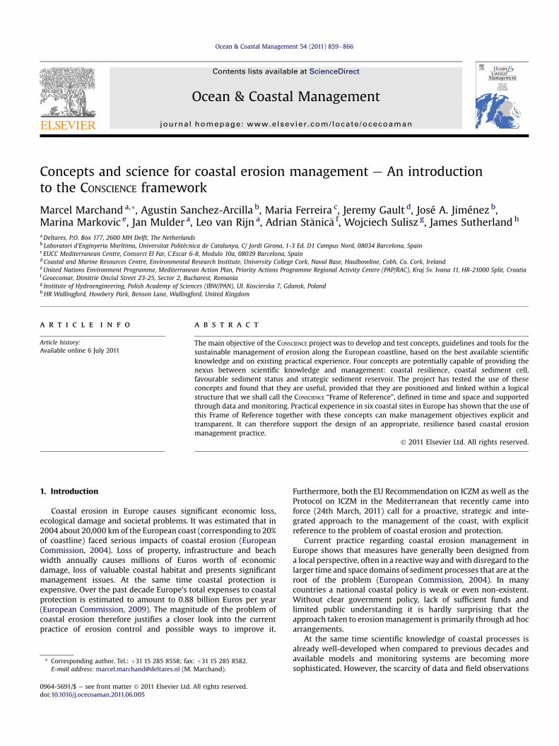
Fig. 1. Generic Frame of Referen
The reason why these three perspectives have been chosen isthat the presented concepts, which fit well in each of theseperspectives, are also likely to be very useful in coastal zonemanagement.
4.1. The policy relevance perspective
4.1.1. The frame of referenceInorder tounderstand the roleof these concepts inpolicymaking
and management, the CONSCIENCE project used the ‘Frame of Refer-ence’, as introducedbyVanKoningsveld (2003). This frameworkwasdeveloped especially to promote effective interaction betweencoastal science and coastal management. The Frame of Referencewas applied as a tool for communication about coastalmanagementproblems in several previous studies (Van Koningsveld and Mulder,2004; Davidson et al., 2007). Characteristics of the Frame of Refer-ence are the definition of clear objectives at strategic and tacticallevels andanoperational decision recipe involving four steps (Fig.1).At thehighest (policy) level a strategic objective is formulated, basedon the long-termvisionaboutdesireddevelopmentof the coast. Thisvision should be the outcome of a participatory process of allstakeholders framed in an ICZM process based on generic ideasabout sustainable development and should ideally reflect theinterdependency of the natural and socioeconomic coastal systems.
At the next level, one or more objectives are formulateddescribing in more detail what has to be carried out in order toachieve the strategic objective. As this implies a choice betweendifferent tactics, we call these the tactical objective(s). If, forinstance, at a strategic level the objective formulated is ‘sustainabledevelopment of coastal values and functions’, then at the tacticallevel we have to choose between different options, such as main-taining the coastline at its current position (i.e. not allowingerosion), or allowing a certain variability in coastline position.
The attempted application of the Frame of Reference at the sixpilot sites revealed that the principles of ICZM, (as identified underthe EU Recommendation (EU, 2002) and Box 1 below) remainrelevant to coastal managers and their respective stakeholdersfaced with the challenges of implementing management strategieson eroding coastlines. For the Frame of Reference to succeed itneeds to foster an inclusive approach and encourage a range ofstakeholders to participate in the planning of their coastal protec-tion strategy through the identification of specific objectives. Itpromotes the development of an understanding of the natural
vention 4. Evaluation procedure
OK?
OK?
WHY
WHAT
HOW
WHERE
WHEN
vention 4. Evaluation procedure
OK?
OK?
WHY
WHAT
HOW
WHERE
WHEN
WHO
ce for coastal management.

Box 1. Principles of Integrated Coastal Zone Management.
� Think ahead e by thinking beyond traditional planning
time frames, to plan for long-term issues such as
climate change.
� Try to see the bigger picture e by taking both the land
and marine dimensions of the coastal zone into
consideration in planning and management.
� Be flexible and adaptable e by taking a ‘learning by
doing’ approach to management.
� Work with nature rather than against it e by recognis-
ing the limitations of the coastal systems for assimi-
lating pollution and the negative impacts of
development and human activity.
� Use a combination of tools - by using techniques such
as awareness raising, technology, legal and policy
instruments to achieve management objectives.
M. Marchand et al. / Ocean & Coastal Management 54 (2011) 859e866862
processes that shape the coastline at specific locations. The Frameof Reference supports the establishment of continuous, structuredmonitoring programmes to assess local changes in order to developlong-term management plans. It can inform local populations ofthe type and scale (physical and economic) of adaptive manage-ment measures theymay have to put in place in order to reduce thepotential direct or indirect impacts of coastal erosion. It includesfeedback loops to assess the outcomes of any intervention andsuggests that local change be assessed in the wider context of theentire sediment cell. The application of the Frame of Reference canidentify the range of management instruments currently in placeand by iteration can highlight where these need to revised oraugmented by additional instruments. As a result, the Frame ofReference could be considered an essential tool to support theimplementation of an ICZM process at locations subject to erosion.
Once this tactical objective has been defined, the actualmanagement process regarding interventions can be formulatedthrough four steps, namely:
1. Quantitative state concept: a means of quantifying the problemin hand. Coastal state indicators (CSIs) (i.e. specific parametersthat play a role in decision-making) are relevant at this stage ofthe process.
2. Benchmarking process: a means of assessing whether or notaction is required. CSIs are compared to a threshold value atthis stage.
3. Intervention procedure: A detailed definition of what action isrequired if the benchmark values are exceeded.
4. Evaluation procedure: Impact assessment of the action taken. Ifthe action was not successful it may be necessary to revise thestrategic/operational objectives (hence the feedback loops inFig. 1).
Having formulated the strategic and tactical objectives, theoperational management is largely a matter for coastal practi-tioners and experts. In the benchmarking procedure the currentstate of the coast is compared with the desired state, after whichthe need for intervention is determined. The procedure describesthe kind of information that is needed and how it is collected.Ideally a monitoring programme should be in place which wouldenable a proactive response. Simulation models can be used topredict future coastal behaviour based on historic data.
4.1.2. How do the concepts fit in the frame of reference?Coastal resilience, in a normative way, can be used as a guiding
principle when formulating a strategic objective for coastal erosion
policy. It fits in the goal of sustainable development, under theassumption that enhancing coastal resilience implies working withnatural processes and thus is more efficient in the long run thanusing a strategy based on resisting the natural dynamics.
Examples of resilient objectives are ‘Managed realignment’ and‘Donothing’. However, evenanobjective suchas ‘Hold the line’ couldallow for some resilience, for instance by using nourishment toreplace losses and maintain a healthy beach. With the exception ofvery rigid coasts, it is oftennot necessary todemand that at anypointin time and space the coastline should be at a pre-defined position.Allowing someflexibility in this criterionwould enable the coastlineto fluctuate around an average position, which is much more effi-cient. For example, the Dutch definition of the ‘coastline’ relates toa volume of sand around the mean lowwater line, instead of a fixedline. This definition allows redistribution of sediment close to thecoastline without changing the formal coastline position.
The concepts of coastal sediment cell, strategic sedimentreservoir and favourable sediment status can be used for imple-mentation of erosion management at the operational level:
- The coastal sediment cell is the most logical unit to express thesediment situation. Therefore, the coastal cells concept can beused in definitions of the quantitative state of the coast (step 1).
- Favourable sediment status is an expression of the desired stateof our coast and can be used for the benchmarking procedure(step 2).
- The strategic sediment reservoir is an essential component ofthe quantitative state of the coast (step 1), and can also be usedas a sediment supply for nourishments as an interventionmeasure (step 3).
Hence, it seems that all EUROSION concepts have a logical niche inthe CONSCIENCE ‘Frame of Reference’. Assuming the Frame as a modelthat captures all the necessary steps for coastal erosion manage-ment we may conclude that the four concepts indeed have policyrelevance for coastal erosion management. Their role is especiallyrelevant in the implementation of a sustainable policy aimed atrespecting or working with natural processes.
4.2. The scientific validity perspective
A review of the main body of coastal scientific literature since2004 has provided little or no publication on the strategicmanagement of erosion. The majority of peer-reviewed papers oncoastal erosion is limited to operational responses primarily ata localised scale. What is clear is that there is a predominance ofsea-level rise/implications of climate change-type papers, whichemphasise the need for an integrated management approach toclimate change.
Our review revealed a limited number of publications usingsome of the EUROSION concepts. We did not find a reference tofavourable sediment status. With respect to the application of thecoastal sediment cell, we found several recent publicationsexplicitly referring to this concept. The concept has been widelyused in environmental impact studies and in developing coastalzone management plans, for instance in the United States (Collenet al., 2009) and the British Isles (Cooper and Pontee, 2006). Alsoin the Netherlands the concept is firmly rooted in the existingcoastal policy (Mulder et al., 2011). The concept dates back to the60s of the last century (e.g. Bowen and Inman, 1966; Inman andFrautschy, 1966; Davies, 1974). Orford (1987) considered the defi-nition of littoral cells and sediment budgets as one of themajor newcontributions in coastal geomorphology.
Cooper and Pontee (2006) provide a review of the historicapproach to coastal zone management and describe the reasons for

M. Marchand et al. / Ocean & Coastal Management 54 (2011) 859e866 863
the introduction of the littoral ‘sediment cell’ concept to shorelinemanagement planning in England and Wales. The adoption of thesediment cell approach in coastal management in England andWales has enabled a change from the historical reactive manage-ment philosophy to a forward planning proactive approach. Theyconclude that the limitations of using the cell concept stem fromthe need to consider the various elements that contribute to coastalsystems, the interactions between them over various spatial andtemporal scales and the different transport modes of differentsediment grain sizes.
With respect to the concept of strategic sediment reservoir noprecise matches have been found in the literature. The paper byFontolan et al. (2007) comes close to using the concept, although itdoes not name it explicitly. It concludes that “when coupled withsedimentological data, the sand stored in ebb delta may be classi-fied using GIS and catalogued following the volume, mean grainsize and sorting, thus providing a useful tool for a preliminaryassessment of sediment compatibility for possible re-nourishmentof neighbouring beaches subject to erosion.”
With respect to the concept of coastal resilience, several recentarticles focus on the ability of coastal ecosystems to respond toexternal stresses (e.g. Alongi, 2008; Long et al., 2006). In the liter-ature there is very limited reference to the geomorphologicalresilience. One of the most appropriate articles is that of Klein et al.(1998), that describes the self-organising ability of a coast torespond in a sustainable manner to morphological, biological and/or socioeconomic pressures. Long et al. (2006) use the definition ofKlein et al. and state that this concept is useful from a morpholog-ical perspective as it helps to understand the ability of a coastallandform to respond to external drivers that include relative sealevel (RSL) rise, an increase in storm magnitude/frequency, or a fallin sediment supply. “A morphologically resilient coast is one thatcan maintain its long-term form despite experiencing short-termvariations in the forcing processes, including sediment supply, onwhich it depends.”
In general we may conclude that these concepts can be madeoperational in a scientific manner, provided that the temporal andspatial dimensions are made explicit as boundary conditions.
4.3. Practical usefulness in management perspective
Besides the scientific connotation of the four coastal erosionconcepts, their practical usefulness depends on the operationalmanagement perspective: can they really help the coastal practi-tioner? This largely depends on the possibility to link data frommeasurements or models of the coastal system to the concepts.Once again the Frame of Reference provides a useful guidance. Byusing the Frame of Reference it becomes possible to identify whendata is key to informing coastal erosion management decisions.First of all data on the contemporary coastal condition is requiredfor benchmarking: i.e. comparing the current state of the coast witha preferred situation. Secondly, data is needed for the evaluation ofmeasures: do the measures bring the state of the coast closer to thedesired state? For these comparisons it is necessary to defineCoastal State Indicators (CSIs). CSIs can be described as a reduced setof parameters that can simply, adequately and quantitatively describethe dynamic-state and evolutionary trends of a coastal system. Inother words, CSIs relay a complex message in a simple and usefulmanner (Jiménez and Van Koningsveld, 2002). These indicatorsshould adequately describe the quantitative state of a coastalsediment cell, allowing a comparison with threshold conditions inthe benchmarking step.
Examples of CSIs found in the pilot sites of CONSCIENCE are beachwidth, dune strength, shoreline position and coastal slope. Generallythe choice of a CSI depends on the specific objective for
management, but also on the relative ease with which the indicatorcan be measured and how much data is already present, to enablehistoric analyses. These indicators are described using the coastalsediment cell as primary spatial unit, the delineation of which alsodepends on the time frame for management. In general one maysay that the longer the time horizon one is interested in, the largerthe coastal cell should be defined. For instance, for everyday safetywe need to zoom in to the condition of the coast up to metres orhundreds of metres. For adaptation to sea level rise we define thecoastal cell at the scale of tens to hundreds of kilometres (see alsothe example of the Dutch coast in Mulder et al, 2011).
Once CSIs have been defined also a favourable sediment statuscan be determined. In fact this summarises the status of a coastlinethat integrates both processes through CSIs and availability ofsediment within or outside the coastal cell into a single metric.
Besides data and indicators, coastal practitioners also requireforecasting skills. They will use their local knowledge and experi-ence in conjunction with the current status of the coast in order todecide when it is time to intervene. Should this intervention havesignificant financial and economic consequences, it is important tominimise uncertainty regarding its effectiveness and efficiency.Models play an increasingly important role in this respect. A varietyof modelling approaches for the evaluation of coastal morphologyhas been developed over the last decades and the resulting modelshave proven to be quite powerful in representing the dominantphysical processes in coastal cells with respect to various kinds ofhard and soft engineering measures (Capobianco et al., 2002). Inanother contribution to this special issue, Leo van Rijn discusses theuse of various numerical modelling techniques as well as experi-mental results of laboratory tests for predicting coastal erosion.
With respect to determining strategic sediment reservoirs datais required on the volume that is actually available for use, the grainsize, sorting and sometimes the level of pollution. Modern tech-niques allow for efficient stock assessments for sand nourishments,often used by major dredging companies.
Quantifying coastal resilience is not straightforward because ofthe different definitions used. In morphological terms, the conceptof coastal resiliencehas been used to describe the dynamics of theshorelines (Baan et al., 1997; Klein et al., 1998; Ruessink and Jeuken,2002). Generally, these descriptions use a ratio between the naturalvariation of the coastline and the ‘room to move’ as a measure ofresilience.
4.4. Conclusion
Based on the overview from the three perspectives we mayconclude that:
- coastal resilience can be used as an inherent property of thecoastline and can be measured, provided that it is clearlydefined in time and space. Generally speaking, soft coasts couldshow a resilient behaviour if they are in a dynamic equilibrium.But this is often true only on relatively short time frames. Onthe scale of decades to centuries, and especially geological timescales, coasts are evolving, and not in equilibrium. Coastalresilience is also useful in a normative way, as a guiding prin-ciple for formulating objectives and measures.- the coastal sediment cell is a useful concept and already used inscientific work. Because cells are never completely closed, theirspatial delineation depends on the time frame of the planningobjective.
- favourable sediment status has not been firmly rooted inscientific literature. It is primarily a concept that can be used inpolicy making. Its use needs a detailed analysis of sedimentbudgets.

M. Marchand et al. / Ocean & Coastal Management 54 (2011) 859e866864
- for a strategic sediment reservoir the volume, grain size, sortingand level of pollution are important aspects for labellinga reservoir as ‘strategic’. Probably also the distance, juridicalconnotations and spatial planning aspects require attention,but these aspects have up till now not been studied in thescientific literature.
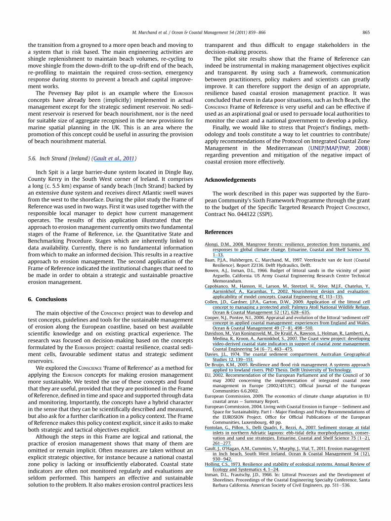
To what extent the CONSCIENCE ‘Frame of Reference’ and theEUROSION concepts are applicable in a practical management contextwas also tested in each of the six CONSCIENCE pilot sites (see Fig. 2). Inthis Special Issue of Ocean and Coastal Management the findingsfrom each of the sites are documented in separate articles. In thelast paper (Sánchez-Arcilla and Jiménez, 2011) the findings fromeach of these pilot sites are compared and summarised. Below thepilot sites and their experiences with the CONSCIENCE approach areintroduced.
5. Brief introduction to the pilot sites
5.1. The Dutch coast (the Netherlands) (Mulder et al., 2011)
The Dutch coast between Den Helder and Cadzand consists ofstraight sandy beaches and various large-scale tidal inlet coasts.Coastal erosion is a common feature along the Dutch sandyshorelines. Since 1990 a policy has been adopted that aims atcontrolling structural erosion mainly through sand nourishments.Development of this policy has implicitly been guided by a basicFrame of Reference. Also the four key concepts of EUROSION eachrepresent an important building stone in this policy.
5.2. Hel peninsula (Poland)
Built of sandy sediments, the Hel Peninsula is a lowland strip ofland at the northern part of Poland between the Baltic sea andGdansk Bay. It is relatively long (34 km) and at places very narrow(about 200 mwide at minimum) with a high risk of breaching. ThePeninsula constitutes a part of the coastal landscape park and isa famous recreational resort for the Polish and foreign tourists.Along the Peninsula, there is a railway and a road connecting 5small towns and villages. Erosion has been a problem since thebeginning of the last century and sand nourishment is currently the
Fig. 2. Pilot sites of the CONSCIENCE project (Map source: [1]) 1: Holland coast (theNetherlands), 2: Hel Peninsula (Poland), 3: Danube Delta coast (Romania), 4: CostaBrava (Spain), 5: Pevensey Bay (United Kingdom), 6: Inch Beach (Ireland).
most important controlling measure. Sources of sediment arelimited due to polluted sediment layers and ecological disturbance.
Past erosion management was hampered greatly by a shortageof field data on waves, currents and morphological processes. TheFrame of Reference has been used in this pilot to make manage-ment goals as well as data needs more explicit.
5.3. The Danube delta coast (Romania) (St�anic�a et al., 2011)
The pilot site is part of the Danube Delta Biosphere Reserve,which has a nature protection status. Its northern and central parthas been subject to historical erosion, due to the existing naturaltrend involving the Danube Delta evolution. Human interventionsresulted in an increase in the intensity of the erosion. For instance,the central part of the Sulina e Sf. Gheorghe coastal strip is subjectto the most severe erosion along the entire Romanian Black Seacoast with areas in retreat at a rate of about 20 m/yr. Coastalmanagers must now decide whether or not to protect the studiedcoastal strip from erosion, and, if yes, which is the most acceptableoption. The application of the CONSCIENCE Framework provideda useful and well organised tool to identify both the problems andthe steps to offer solutions to these problems.
5.4. Costa Brava Bays (Spain) (Jiménez et al., 2011)
The Costa Brava is located on the NE Spanish Mediterraneancoast. It is a highly indented coast with most of the coastlinecomposed of cliffs, especially in the northernmost area. Bayed andpocket beaches are the dominant beach type, with most of themcomposed of coarse sands which are represented in the CONSCIENCE
project by s’Abanell and Lloret de Mar beaches. The beaches havethe following profile: i) relatively narrow beaches backed bywaterfronts and ii) heavily used during the bathing season. Thetypical length scale of these beaches varies from hundreds ofmetres to few kilometres with one or two lateral obstacles (semienclosed and pocket beaches, respectively). The sites have beenused to test the Frame of Reference at the ‘beach’ scale anda favourable sediment status has been defined for these beachestaking into account their main functions, being recreation andprotection. Up till now the concept of favourable sediment statuswas neither defined nor used in the area, which resulted in a ratherreactive management. The introduction of this concept wouldfacilitate a long-term policy, which would enable estimations forlong-term sediment requirements. Due to the dominant recrea-tional use of the beaches, the need of good quality sediment is oneof the cornerstones of any measure to manage erosion. At theregional level this implies that a long-term erosion managementplan should include the identification of strategic sedimentreservoirs.
5.5. Pevensey Bay (United Kingdom) (Sutherland and Thomas,2011)
PevenseyBay sea defences consist of a 9 km long shingle (gravel)bank between Eastbourne and Bexhill in East Sussex, on the EnglishChannel coast of southern England. Immediately inland there is thePevensey Levels, an area of about 50 km2, which would be floodedat high spring tide if the sea defence becomes breached. Manyproperties have been constructed on the crest of the shingle bank.
The management of the Pevensey shingle barrier is a uniqueexample of a public-private partnership. The beach is managed inan adaptive manner by a private consortium, Pevensey CoastalDefence Ltd. (PCD). The main focus of the management is tostrengthen the shingle bank to provide a 400 year standard ofprotection against breaching. Themanagement issues are related to
M. Marchand et al. / Ocean & Coastal Management 54 (2011) 859e866 865
the transition from a groyned to a more open beach and moving toa system that is risk based. The main engineering activities areshingle replenishment to maintain beach volumes, re-cycling tomove shingle from the down-drift to the up-drift end of the beach,re-profiling to maintain the required cross-section, emergencyresponse during storms to prevent a breach and capital improve-ment works.
The Pevensey Bay pilot is an example where the EUROSION
concepts have already been (implicitly) implemented in actualmanagement except for the strategic sediment reservoir. No sedi-ment reservoir is reserved for beach nourishment, nor is the needfor suitable size of aggregate recognised in the new provisions formarine spatial planning in the UK. This is an area where thepromotion of this concept could be useful in assuring the provisionof beach nourishment material.
5.6. Inch Strand (Ireland) (Gault et al., 2011)
Inch Spit is a large barrier-dune system located in Dingle Bay,County Kerry in the South West corner of Ireland. It comprisesa long (c. 5.5 km) expanse of sandy beach (Inch Strand) backed byan extensive dune system and receives direct Atlantic swell wavesfrom the west to the shoreface. During the pilot study the Frame ofReference was used in twoways. First it was used together with theresponsible local manager to depict how current managementoperates. The results of this application illustrated that theapproach to erosionmanagement currently omits two fundamentalstages of the Frame of Reference, i.e. the Quantitative State andBenchmarking Procedure. Stages which are inherently linked todata availability. Currently, there is no fundamental informationfromwhich to make an informed decision. This results in a reactiveapproach to erosion management. The second application of theFrame of Reference indicated the institutional changes that need tobe made in order to obtain a strategic and sustainable proactiveerosion management.
6. Conclusions
The main objective of the CONSCIENCE project was to develop andtest concepts, guidelines and tools for the sustainable managementof erosion along the European coastline, based on best availablescientific knowledge and on existing practical experience. Theresearch was focused on decision-making based on the conceptsformulated by the EUROSION project: coastal resilience, coastal sedi-ment cells, favourable sediment status and strategic sedimentreservoirs.
We explored the CONSCIENCE ‘Frame of Reference’ as a method forapplying the EUROSION concepts for making erosion managementmore sustainable. We tested the use of these concepts and foundthat they are useful, provided that they are positioned in the Frameof Reference, defined in time and space and supported through dataand monitoring. Importantly, the concepts have a hybrid characterin the sense that they can be scientifically described and measured,but also ask for a further clarification in a policy context. The Frameof Referencemakes this policy context explicit, since it asks tomakeboth strategic and tactical objectives explicit.
Although the steps in this Frame are logical and rational, thepractice of erosion management shows that many of them areomitted or remain implicit. Often measures are taken without anexplicit strategic objective, for instance because a national coastalzone policy is lacking or insufficiently elaborated. Coastal stateindicators are often not monitored regularly and evaluations areseldom performed. This hampers an effective and sustainablesolution to the problem. It also makes erosion control practices less
transparent and thus difficult to engage stakeholders in thedecision-making process.
The pilot site results show that the Frame of Reference canindeed be instrumental in making management objectives explicitand transparent. By using such a framework, communicationbetween practitioners, policy makers and scientists can greatlyimprove. It can therefore support the design of an appropriate,resilience based coastal erosion management practice. It wasconcluded that even in data poor situations, such as Inch Beach, theCONSCIENCE Frame of Reference is very useful and can be effective ifused as an aspirational goal or used to persuade local authorities tomonitor the coast and a national government to develop a policy.
Finally, we would like to stress that Project’s findings, meth-odology and tools constitute a way to let countries to contribute/apply recommendations of the Protocol on Integrated Coastal ZoneManagement in the Mediterranean (UNEP/MAP/PAP, 2008)regarding prevention and mitigation of the negative impact ofcoastal erosion more effectively.
Acknowledgements
The work described in this paper was supported by the Euro-pean Community’s Sixth Framework Programme through the grantto the budget of the Specific Targeted Research Project CONSCIENCE,Contract No. 044122 (SSPI).
References
Alongi, D.M., 2008. Mangrove forests: resilience, protection from tsunamis, andresponses to global climate change. Estuarine, Coastal and Shelf Science 76,1e13.
Baan, P.J.A., Hulsbergen, C., Marchand, M., 1997. Veerkracht van de kust (CoastalResilience). Report Z2136. Delft Hydraulics, Delft.
Bowen, A.J., Inman, D.L., 1966. Budget of littoral sands in the vicinity of pointArguello, California. US Army Coastal Engineering Research Centre TechnicalMemorandum.
Capobianco, M., Hanson, H., Larson, M., Steetzel, H., Stive, M.J.F., Chatelus, Y.,Aarninkhof, A., Karambas, T., 2002. Nourishment design and evaluation:applicability of model concepts. Coastal Engineering 47, 113e135.
Collen, J.D., Gardner, J.P.A., Garton, D.W., 2009. Application of the littoral cellconcept to managing a protected atoll: Palmyra Atoll National Wildlife Refuge.Ocean & Coastal Management 52 (12), 628e635.
Cooper, N.J., Pontee, N.I., 2006. Appraisal and evolution of the littoral ‘sediment cell’concept in applied coastal management: experiences from England and Wales.Ocean & Coastal Management 49 (7e8), 498e510.
Davidson, M., Van Koningsveld, M., De Kruijf, A., Rawson, J., Holman, R., Lamberti, A.,Medina, R., Kroon, A., Aarninkhof, S., 2007. The Coast view project: developingvideo-derived coastal state indicators in support of coastal zone management.Coastal Engineering 54 (6e7), 463e475.
Davies, J.L., 1974. The coastal sediment compartment. Australian GeographicalStudies 12, 139e151.
De Bruijn, K.M., 2005. Resilience and flood risk management. A systems approachapplied to lowland rivers. PhD Thesis. Delft University of Technology.
EU, 2002. Recommendation of the European Parliament and of the Council of 30may 2002 concerning the implementation of integrated coastal zonemanagement in Europe (2002/413/EC). Official Journal of the EuropeanCommunities 6.6.2002.
European Commission, 2009. The economics of climate change adaptation in EUcoastal areas e Summary Report.
European Commission, 2004. Living with Coastal Erosion in Europe e Sediment andSpace for Sustainability. Part I - Major Findings and Policy Recommendations ofthe EUROSION Project. Office for Official Publications of the EuropeanCommunities, Luxembourg, 40 pp.
Fontolan, G., Pillon, S., Delli Quadri, F., Bezzi, A., 2007. Sediment storage at tidalinlets in northern Adriatic lagoons: ebb-tidal delta morphodynamics, conser-vation and sand use strategies. Estuarine, Coastal and Shelf Science 75 (1e2),261e277.
Gault, J., O’Hagan, A.M., Cummins, V., Murphy, J., Vial, T., 2011. Erosion managementin Inch beach, South West Ireland. Ocean & Coastal Management 54 (12),930e942.
Holling, C.S., 1973. Resilience and stability of ecological systems. Annual Review ofEcology and Systematics 4, 1e24.
Inman, D.L., Frautschy, J.D., 1966. In: Littoral Processes and the Development ofShorelines. Proceedings of the Coastal Engineering Specialty Conference, SantaBarbara California. American Society of Civil Engineers, pp. 511e536.

M. Marchand et al. / Ocean & Coastal Management 54 (2011) 859e866866
Jiménez, J.A., Van Koningsveld, M., 2002. Coastal State Indicators. A Bridge BetweenCoastal Science and Coastal Management. COASTVIEW-EU Mast Project No.EVK3-CT-2001-0054. Initial report on coastal state indicators. (available from.www.thecoastviewproject.org.
Jiménez, J.A., Gracia, V., Valdemoro, H.I., Mendoza, E.T., Sánchez-Arcilla, A., 2011.Managing erosion-induced problems in NW Mediterranean urban beaches.Ocean & Coastal Management 54 (12), 907e918.
Klein, R.J.T., Smit,M.J., Goosen,H.,Hulsbergen, C.H.,1998. Resilience andvulnerability:coastal dynamics or Dutch dikes? The Geographical Journal 164, 259e268.
Long, A.J., Waller, M.P., Plater, A.J., 2006. Coastal resilience and late holocene tidalinlet history: the evolution of dungeness Foreland and the Romney Marshdepositional complex (U.K.). Geomorphology 82 (3e4), 309e330.
Mulder, J.P.M., Hommes, S., Horstman, E.M., 2011. Implementation of coastal erosionmanagement in the Netherlands. Ocean & Coastal Management 54 (12),888e897.
Orford, J.O., 1987. An introduction to coastal geomorphology: J. Pethick EdwardArnold London, xþ260pp. Estuarine, Coastal and Shelf Science 25 (4), 485e488.
Ruessink, B.G., Jeuken, M.C.J.L., 2002. Dunefoot Dynamics Along the Dutch Coast,vol. 27. John Wiley & Sons, Ltd.. Earth Surface Processes and Landforms.
Sánchez-Arcilla, A., Jiménez, J.A., Marchand, M., 2011. Managing coastal evolution ina more sustainable manner. The Conscience approach. Ocean & CoastalManagement 54 (12), 951e955.
St�anic�a, A., Dan, S., Jiménez, J.A., Ungureanu, G.V., 2011. Dealing with erosion alongthe Danube Delta coast. The CONSCIENCE experience towards a sustainablecoastline management. Ocean & Coastal Management 54 (12), 898e906.
Sutherland, J., Thomas, I., 2011. The management of Pevensey shingle barrier. Ocean& Coastal Management 54 (12), 919e929.
UNEP/MAP/PAP, 2008. Protocol on Integrated Coastal Zone Management in TheMediterranean. Priority Actions ProgrammeRegional Activity Centre, Split,118 pp.
Van Koningsveld, M., 2003. Matching specialist knowledge with end user needs.PhD Thesis. Twente University.
Van Koningsveld, M., Mulder, J.P.M., 2004. Sustainable coastal policy developmentsin The Netherlands. A systematic approach revealed. Journal of Coastal Research20 (2), 375e385.