COMMUNIT'rPLAN AMEN ENT, PLANNED DISTRICT ...
221
City of San Di go Planning Department R ..... Environmental Quality Division Environmental Impact Report 236-5775 SUBJECT: E QD No. 81-1212 SCH No. 82010619 North City West Nei~borhoods 4, 5 and 6. PRE CI SE PLAN, COMMUNIT'rPLAN AMEN ENT, PLANNED DISTRICT ORDINANCE AMEND'1ENT and three TENTATIVE SUBDIVISION MAPS to develop 4,098 dwelling units, one neighborhood commercial center, one visitor c~111T1ercial center, a 34-acre employment center , two elementary schools/neighborhood park complexes and open space areas on approximately 840 acres. Located on the north side of Cannel Valley Road between El Camino Real and Black Mountain Road in the North City West community (Portions of Sections 17, 19 and 20, · Tl4S, R3W). Applicant : The Baldwin Company CONCLUSIONS: The proposed project could have potentially significant environmental impacts associated with hydrology/water quality, archaeology, transportation, air quality and noise. Impacts to the region's water and energy resources would not be significant. Mitigation measures have been incorporated into the project which would reduce impacts to hydrology/ water quality, archaeology, transportation and noise to a level of insignificance. Air quality impacts cannot be mitigated to insignif icance on the precise plan level, but the self-containment of the precise plan area reduces air quality impacts to an acceptable level . Further mitigation of air quality impacts is the responsibility of state and regional agencies, employers, and car manufacturers . The draft l~cal coastal program and the North City West Community Plan recommend retention of property within the floodplain south of Carmel Valley Road as open space. The off-site construction of Cannel Valley Road would result in encroachment into the existing 100-year floodplain of Cannel Creek. Th e encroachment is regarded as a significant impact but is unavoid able since the connection with the existing I-5/Cannel Valley Road interchange is fixed. Construction of the Cannel Valley Road extension to av oid the 100-year floodplain and still tie into t he existing interchange would be infeasibie from a road de si gn standpoint and would conflict with accepted ro· ad design standards; therefore, the impact is considered unmitigable. · The project would result in other significant unavoidable impa~ts to the environment. Implementation of the precise plan would change the visual character of t he site from that of a rural, heavily vegetated sl ope to that of an urban community. Topographic features such as canyons, hills and bluffs would be largely removed . Approximately 825 acres of wi ldlife habitat woul d be lost including 12 natur ally occurring iorrey pine trees. Suc h impacts are inherent with implementation of the community plan and
-
Upload
khangminh22 -
Category
Documents
-
view
0 -
download
0
Transcript of COMMUNIT'rPLAN AMEN ENT, PLANNED DISTRICT ...

City of San Di go Planning Department R
..... Environmental
Quality Division
Environmental Impact Report
236-5775
SUBJECT:
EQD No. 81-1212 SCH No. 82010619
North City West Nei~borhoods 4, 5 and 6. PRECISE PLAN, COMMUNIT'rPLAN AMEN ENT, PLANNED DISTRICT ORDINANCE AMEND'1ENT and three TENTATIVE SUBDIVISION MAPS to develop 4,098 dwelling units, one neighborhood commercial center, one visitor c~111T1ercial center, a 34-acre employment center , two elementary schools/neighborhood park complexes and open space areas on approximately 840 acres. Located on the north side of Cannel Valley Road between El Camino Real and Black Mountain Road in the North City West community (Portions of Sections 17, 19 and 20, · Tl4S, R3W). Applicant : The Baldwin Company
CONCLUSIONS:
The proposed project could have potentially significant environmental impacts associated with hydrology/water quality, archaeology, transportation, air quality and noise. Impacts to the region's water and energy resources would not be significant. Mitigation measures have been incorporated into the project which would reduce impacts to hydrology/ water quality, archaeology, transportation and noise to a level of insignificance. Air quality impacts cannot be mitigated to insignificance on the precise plan level, but the self-containment of the precise plan area reduces air quality impacts to an acceptable level . Further mitigation of air quality impacts is the responsibility of state and regional agencies, employers, and car manufacturers .
The draft l~cal coastal program and the North City West Community Plan recommend retention of property within the floodplain south of Carmel Valley Road as open space. The off-site construction of Cannel Valley Road would result i n encroachment into the existing 100-year floodplain of Cannel Creek. The encroachment is regarded as a significant impact but is unavoid able since the connection with the existing I-5/Cannel Valley Road interchange is fixed. Construction of the Cannel Valley Road extension to avoid the 100-year floodplain and still tie into t he existing interchange would be infeas ibie from a road desi gn standpoint and would conflict with accepted ro·ad design standards; therefore, the impact is considered unmitigable. ·
The project would result in other significant unavoidable impa~ts to the environment. Implementation of the precise plan would change the visual character of t he site from that of a rural, heavily vegetated sl ope to that of an urban community. Topographic features such as canyons, hills and bluffs would be largely removed . Approximately 825 acres of wi ldlife habitat woul d be lost including 12 naturally occurring iorrey pine trees. Such impacts are inherent with implementation of the community plan and

Page 2
have been addressed on the community plan level during preparation and adoption of the North City West Community Plan. Although regarded as significant conflicts with environmental objectives, such impacts are unavoidable.
MITIGATION MEASURES INCORPORATED INTO THE PROJECT:
Visual ualit, Landfonn Alterations, and Biolo Nei hborhood 4: Impacts to v1sua quality, lan fonn a terations, and 1ology would be reduced to an acceptable level with preservation of open space areas in Neighborhood 4, as described under Alternative C-2 . This Alternative would result in less grading in community plan designated open space areas , thus maintaining the visual quality of natural open space. Chaparral and scrub oak thicket habitat, as well as populations of coast barrel cactus , California adolphia and mesa club-moss, would be preserved under this alternative.
The project applicant will implement Alternative C- 2 as part of the project . Revised project plans for Neighborhood 4 reflect this alternative .
Hydrology/Water Quality: In order to protect downstream areas from erosion, siltation, and flooding, a specific grading sequence would be followed for construction within the precise plan area. In addition., erosion control measures would be implemented by the applicant to ensure that sedimentation as a result of development would not exceed predevelopment conditions. The specific gradin9 sequence and erosion control measures are outlined in the text of the EIR (pages 51-52).
Development plans for Neighborhoods 4 and 5 and Lots 2, 3, 4 and 5 in Neighborhood 6 include erosion control and landscaping plans which would further mitigate potential erosion and siltation impacts. The remainder of Neighborhood 6 would be developed in accordance with either the development plan process outlined in the PDO or with the City's planned development process. Development in accordance with these requirements would require City review of landscaping and erosion control plans in Neighborhood 6.
In order to avoid excessive disturbance of Cannel Creek, Carmel Creek would be fenced during construction to ensure that construction equipment would not encroach the creek bed.
Visual Quality : Mitigation measures proposed by the applicant would reduce impacts to the visual environment . Exposed areas would be hydroseeded immediately after grading. Adherence to the design element and development plans for the precise plan area would reduce potential adverse visual quality impacts of site development. In addition, the applicant proposes to require that Neighborhood 6 be developed via the development plan ordinance outlined in the PDQ or via the City's plan development process . These measures ensure site des ign and landscaping review and would reduce but not el iminate adverse visual qual ity impacts .
Page 3
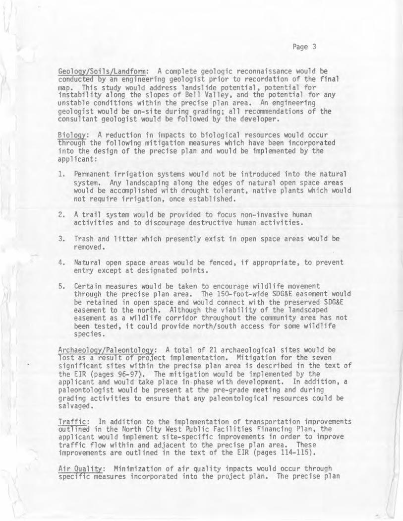
Geology/Soils/Landfonn: A complete geologic reconnaissance would be conducted by an engineering geologist prior to recordation of the final map. This study would address landslide potential, potential for instability along the slopes of Bell Valley, and the potential for any unstable conditions within the precise plan area. An engineering geologist would be on-site during grading; all recommendations of the consultant geologist would be followed by the developer.
Biology: A reduction in impacts to biological resources would occur through the following mitigation measures which have been incorporated into the design of the precise plan and would be implemented by the applicant:
1. Pennanent irrigation systems would not be introduced into the natural system. Any landscaping along the edges of natural open space areas would be accomplished with drought tolerant, native plants which would not require irrigation, once established.
2. A trail system would be provided to focus non-invasive human activities and to discourage destructive human activities.
3. Trash and litter which presently exist in open space areas would be removed.
4. Natural open space areas would be fenced, if appropriate, to prevent entry except at designated points.
5. Certain measures would be taken to encourage wildlife movement through the precise plan area. The 150-foot-wide SDG&E easement would be retained in open space and would connect with the preserved SDG&E easement to the north. Although the viability of the landscaped easement as a wildlife corridor throughout the community area has not been tested, it could provide north/south access for some wildlife species.
Archaeology/Paleontolog~: A total of 21 archaeological sites would be lost as a result of proJect implementation. Mitigation for the seven significant sites within t he precise plan area is described in the text of the EIR (pages 96-97). The mitigation would be implemented by the applicant and would take place in phase with development. In addition, a paleontologist would be present at the pre-grade meeting and during grading activities to ensure that any paleontol ogical resources could be salvaged.
Traffic: In addition to the implementation of transportation improvements outlined in the North City West Public Facilities Financing Plan, the applicant would implement site-specific improvements in order to improve traffic flow within and adjacent to the precise plan area. These improvements are outlined in the text of the EIR (pages 114-115).
Air Quality: Minimization of air quality impacts would occur through specific measures incorporated into the project plan. The precise plan

Page 4
calls for bicycle routes on all major internal streets. Neighborhood activity centers such as schools, parks, and commercial centers would all be located on these internal streets and therefore would be accessible by bicycle. All commercial centers and neighborhoods are readily accessible by pedestrians. Walkways would be provided within open space linkages; sidewalks would be constructed along all streets. The project is also consistent with several RAQS tactics, as outlined in the body of the EIR (pages 122-123). Further mitigation of air quality impacts is the responsibility of state and regional agencies, employers and car manufacturers.
Noise: Potential noise impacts to residential dwellings along Cannel Valley Road, Soledad Valley, Cannel Country Road, MC Road, and Del Mar Heights Road would be mitigated with the construction of noise reducing barrier walls placed along the affected areas. These walls would effectively block the path of sound from the noise source to the receiver, reducing exterior noise to acceptable levels. Locations of noise walls are shown on the tentative maps, along with recommended wall heights. Potential noise impacts from commercial air conditioning units and other equipment would be mitigated by installation of only low-noise generating equipment and by shielding the equipment with appropriate rooftop insulation structures.
or Date of Draft Report
lG\ 2'i:: 1 2,L Date o'f Fi~al Report
Analyst: RUGGELS:jm

Page 5
PUBLIC REVIEW
The following individuals, organizations, and agencies received a copy or notice of the draft EIR and were invited to comment on its accuracy and sufficiency:
City of Del Mar City of San Diego
City Attorney City Manager Councilman Mitchell Engineering and Development Department Park and Recreation Department Planning Department Water Utilities Department
County of San Diego Air Pollution Control District Department of Planning and Land Use Department of Sanitation and Flood Control
Del Mar Union School District San Dieguito Union High School District Solana Beach School District State of California
California Coastal Commission CALTRANS Department of Parks and Recreation Fish and Game Department San Diego Coast Region Commission San Diego Region Water Quality Control Board State Clearinghouse
San Diego Gas and Electric Metropolitan Transit Development Board San Diego Building Contractor's Association San Diego Chamber of Commerce Construction Industry Federation Citizens to Save Open Space San Diego Association of Environmental Biologists California Native Plan Society Archaeological Fellowship of SDSU San Di ego Museum of Man American Institute of Archaeology Archaeological Resource Management Society San Diego County Archaeological Society San Diego Museum of Natural History Citizen's Coordinate for Century II I San Diego League of Women Voters Torrey Pines Community Planning Group Torrey Pines Planning Group Torrey Pines Protective Association San Dieguito League of Women Voters Del mar Villagers Coalition for Responsible Planning

Dwight Worden, City Attorney, City of Del Mar Town Council President's Association Community Planners Committee Del Mar Terrace Property !Mners Association Torrey Pines Wildlife Association Torrey Pines Association San Dieguito Citizens Planning Group North City West Community Planning Group Newspapers
Daily Transcript Union/Tribune
San Diego City library, Downtown Branch Brian Smith
Page 6
Copies of the draft EIR and any technical appendices may be reviewed in the office of the Environmental ()Jality Division, or purchased for the cost of reproduction.
RESULTS OF PUBLIC REVIEW
( ) No comments were received during the public input period.
( ) Comments were received but the comments do not address the accuracy or completeness of the environmental report. No response is necessary and the letters are attached at the end of the EIR.
(X) Comments addressing the accuracy or completeness of the EIR were received during the public input period. Responses to these comments follow this section, and the letters are attached to the EIR.
1
]
I

•
Letters of Comment
State of California 1RE (;El~ i:. D The Re1ource1 Agency
Memorandum I : T .j 1982
To
From
1
2
1. James i.-. Burn s &lroll)NM[NTAl QU.Wll Assista nt Secretary for Resour'ces " · .);c·4
2 . Cit y of San Diego 20 2 11 C11 Street, 5th floor San Diego, c,, 92101
Attention : Karen Ruggels
Department of W ater Resources Los Angeles, CA 90055
Date "SlP Z 9 1982
File No.:
Subjec1, North City West Neighborhoods 4, 5, 6, SCH. 82010619
The Department of \{ater Resources' recommendations related to water c onservation and flood damage prevention on the subject document are attached.
Consideration should also be given t o a co~preheosive program to use recla imed water for irrigation purposes in order to free fresh water supplies for beneficial uses. requiring high qual i ry \,,a ter.
~
/~r-~'' t../ . / / "/,, . c:-~
Rober: T. D, Chu~, Chief Pl annin; Br anch South~rn District
Attachments
1
2
Responses to Comments
Low water use plants have been incorporated into the landscaping plan where appropriate. Erosion control measu res would be taken in conformance with the Leeds, Hill, and Jewett, Inc. study , as discussed on pages 50-52 of the EIR. Flooding was considered during project planning; all structures and road improvements would be located above the 100-year flood plain of Carmel Creek (EIR pages 53- 5~ ).
Water reclamation planning is a regional process and cannot be completely implemented on the scale of this project. The future use of reclaimed water on the pro ject site is not precluded by currertt pro ject plans. At this time, there is no nearby source of reclaimed water.

3
Patricia Ellen Horkan Df.,..ICT lt4..l~ilttHftNOIN'T
September 23, 1982
Mr. Tom Murphy Ci ty of San Diego Planning Department City Administration 202 •c• Street San Diego, CA 92101
Dear Mr: Murphy,
Vel frfar: Unwn Scliool Distr:ict
Building
225 NINTH STREET. DEL MAR,CA 112014
PHONE (714) 755-11301
Re: Environmental Impact Report: EQD No . 81 - 1212; SCH No. 82010619 Nor th City West - Neighborhoods 4, 5 and 6
The community plan calls for a ' t o tal of 13,970 dwelling units to be deve l oped throughout North City West. This wa s approved by the Council o f the City of San Diego on November 17, 1 981. Precise plans proposed and approved since that date 'have tended t o utilize maximum : _ dens ities outlineq i n the community plan. It is possible that a total of 15,000 dwelling units could be constructed in Nor th City West, exceeding the c ommunity plan by approximately 1,130 units. (Page S-10.)
A section should be inc luded in thi s document which stipulates that , as part of its annual evaluation, the Joint Power s Association will assess the student generation fa c tor and adjust the School Facilities Master Plan accordingly.
"The District would also like the assurance that, a s each school site
4 is completed, the playground and park fac ilities will be completed simultaneously by the City.
Sincerely,
~~~2 _/4/4;/µJ Patricia E. Barkan District Sup"'erintendent
PEH:pw
cc: The Baldwi n Company PRC Toups
3
4
Provisions for annual review of the School Facilities Master Plan are contained in the Master Plan and in the North C ity West Public Facilities Financing Plan. Any issues of concern, including assessment of student generation factors, can be considered during the annual review period.
The North City West Public Facilities Financing Plan contains provisions for construction of the neighborhood parks in conjunction with development of school facilities. The City Park and Recreation Department will be responsible for completing the playground and park facilities.

·1
·~,/
(i \ ·. ,_ cJ_.-:,:,,,..
,'
so\ana bead1 Sehoo\
BO"RO Of CO\ICATION
''""Hin,.. B llOO:,o:-. . ,...,.,or"' LNK 1 IC l[)C.I , \'.,-, l°l"n,,lrn, P.U.Ll.A R 11"110,._ , 0.-,• ClVDI A HOM"-f'i' . ,-,.,,,.,._., ~4Nl>M.A (.. r-'Hl:>H . ,..,,,.,-.,,
HA\'M0:'111 1 fl rl1'1A,. I t1 II .,.,,u,,,,,, ,,.,, ,_, . ~ '
.:' . --~- ,\ i1· ; '\ . -~\\'·
;fr 5fy-j e.f "'JU.,~ I ,\'. "·> J. f '~-j
•.· ~,:",•\ · . f\." , .. · ;, }. w~:-
'" . ''\
· Allen M. Jones, Deputy Director City Planning Department
Sep tember 20, 1982
,RECEIVED :> 2 2 1982
aJuulENTAl QUA!Jl't, • .. D1,1.;1:-:1
• 8
City of San Diego 202 C Street San Diego, CA 92101
Dear Mr. Jones,
This i~ a letter in response to your draft Environmental Impact Report regarding neighborhoods 4,5 and 6 in North City West precise plan. I h:id pre,·iously written to the Planning Commission and madetwo statements before the Planning Commission in workshops regardin!". on~ point th~t is important to the Board of Education of the Solana Beach School District. In the attached copy of page 15 I have pointed out a sentence which is highly objectionable to myself and the Board of Education.
Many months of study went into the development of the School Facilities Master Plan for North City West. Groups participating in this study were the three involved school districts, the City of San Diego st af f consultants and developers. Scho0 l sites we re selected at that time based upon the following data: demographics and topography which included student generation factors, types of products and yield, man-made and natural barriers.
It is our position that the sentence "An optional school/park site is shown in the southwestern portion of the ne ighborhood; such a site could be chosen if boundary adjustments are not agreed upon by the elementary school districts affected by development of the precise plan area." must be eliminated from the plan and the optional school site taken out of any future maps. No change in the location of school sites can be the result of unilateral action by one developer in a multi - developer master planned area such as North City West where schools will be serving students residing in more than one neighborhood or developer area. This is particularly true in this specific instance where the primary site and the optional site are in different school districts . Changes in either the priority of funding, number or location of school sites can only be accomplished in accordance with the provisions of the "North City West School Facilities Master Plan" which relate to the updating of that plan. Responsibility for such updating lies with the school districts and the City, not the developer.
309 North Rios Avenue, Solana Beach, California 92075-1298 (714) 755-8000
5
8
The North City West School Facilities Master Plan does not actually select school sites. A model site designation was undertaken using SANDAG's computers, but the locations ignored school district boundaries; those boundaries pose a major issue in school site location for North City West.
The designation of the optional school/park site is merely a recognition of the j act that three school sites are currently designated within the Solana Beach School District while one school site is designated within the Del Mar Union School District. Given this imbalance, and the inability of the school districts to agree upon a boundary line adjustment, the City and the applicant thought it appropriate to designate an optional school/park site within the Del Mar Union School District. Since Neighborhood 4 will develop after Neighborhoods 5 and 6, the final determination of the school site location can be made at some future date, probably after 1992. A decision regarding the location of the school site in Neighborhood 4 would be made in accordance with the North City West School Facilities Master Plan. The optional school/park site simply preserves the possibility of the school location at that site. A site location will actually be determined based upon school boundaries, growth in the districts, and an analysis of the impacts of development of North City West upon the school districts at the time Neighborhood I/ develops in the l 990's.
Allen M. Jon es 9/20/82 Page 2
If a developer desires to build a school not sanctioned by the Master Plan as amended from time to time, it will do so at its own expense and without any reduction of its financial obligations to fund the schools provided for in the Master Plan in the order of priority set forth in that plan. In the light of the lack of funds available for school construction, any diversion of such funds would be at best inappropriate.
,,.,.,.,,. 1,iJ~ ~- Edman, Ed.D.,
Dist ict Superintendent
ROE /e t

Fl:.,f NO. :
DATE
TO
FROM
SUBJECT :
CITY of 54N DIEGO
MEMORANDUM
S~ j , lc:r.i:·t · ! l "': , ! .:1.:.'
ldJt.·•1 !·1. J: :1(·:, , lk.· J..•~r ·,· l ,1rc- 1:: 1; :'.i ,111n i :1g ~pi.,rtr:K::1t
Jeff C\i lli r.gw,. ,,1, !·Jew Dcvc !0~:- •.: :1t, h :: ter Uti l it ie £ DC'pi!rtment
i< I:: C, l IV ED
:: , 1 1982 ftiWJ&.•·,·:! ._ •.:. : QU'.llTt
L. .. .. ... ,
DRAFT· r:!r.'l F:•) r-~::r::71\L H'.PACT ::l~ ? :• :=-:7 r :-.; tJ.:.)~TH CITY ,-:::sT !JEJGHBO~H0 CJ:•S -. , f,. (·,
~ :; ·.;e: rt" Vl e\\'(:; t.! ic Cr :: :"t r o;=- ; .·!· t iJ. :·,C :-,.-, ve t he f ,:Jll -:-,·.,;,i_:,g c omme nts:
1 . w~tcr - adequatel y st ~te i .
7 Se ·.,.- e: r - ~4=-:·:ti -:i:--1 t!~~ re:-• ·. :· t .
:- .:. £ ~ :'• _ _,, -'· 7 ~- ·::r•- - ' .· 17- C· ::: : :°-.;!'t:·.t::- := !:!: _: ~: -:: :>.: .
,· //// // ~ . ,! II {;t-{.l~---- ,,,,.,-:
:/ ;_:~~c~:::-~r -· -·. - ·. 7::·, .;~•·
: -:: ;?
7 As stated in the precise plan (Appendix B), sewer service in the prec ise plan area will be provided by the City of San Diego. Sewer facilities will be provided through the subdivision process in conformance with the North C ity West Community Plan, the North City West Public Facilities Financing Plan, and subdivision requirements. An 18- inch sewer main exists in El Camino Real and the Carmel Valley trunk sewer is located in Carmel Valley Road. Those facilities are adequate to serve development needs within the precise plan area. The adequacy of sewer service for all of North City West was addressed in detail in the supplement to the Carmel Valley Precise Plan ElR (EQD No. 76- 25- SP, S- 1).
October 11, 1982
Al I en M. Jones Deputy DI rector
BRIAN F . SMITH ARCHAEOLOGICAL/HISTORICAL CONSUL TANT
1 08 1 6 M ACOUBA Puce
SAN 0 1CGO, CALIF'ORNtA 92124
(7 1415608126
Environmenta l Qual lty Division City of San Diego Planning Department 202 C Street San Diego, Cal lfornla 92101
J< i: (, .:: i \ ..:: (j
( ~ T l ;:, 1982 .QIVIIIJOIENTAL QUALITY ' . ",-·:
Re: Environmental Impact Report, North City West Precise Plan, Development Units 4, 5, and 6
Dear Mr. Jones:
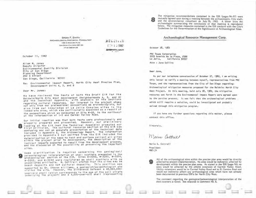
We have reviewed the texts of both the Draft EIR for the Baldwin/ North City west development (Neighborhoods 4, 5, and 6) and the Technical Appendix, with emphasis on the sections regarding cultural resources. Our Interest In the project stems not on ly from our professiona l occupat i ons as archaeolog i s ts, but also from our kn o wl edge o f La Jolla Complex s ite s In the Immediate area, whi ch was particularly expanded as a result of the excavations whi ch we cond ucted at Site W-20, to the northwest of the Inter sect i on of 1-5 and Carmel Valley Road.
Our lnltlal reaction was that both texts were professionall y and properly prepared and presented. However, our pre f Im I nary 8 r eading of the EIR (not the Technical Appendix) prompted our first cr iti cism. The cultural resource section of the EIR wa s confusing and not an accurate presentation o f the technical data In c l uded In Appendix E, the Archaeology Report. The Inf orma tion provided in Appendix E but omitted from the EIR Included the determination of the need to test and surface collect al I s ites within the project pr i or to development, the description of the Indirect Impacts expected to result from the development process, and the d isc ussion of the posslbl I lty of preserving the Important
9
sites.
Some clarlfl cat lon Is required concerning the geological/ paleontologlcal In t e rpretat ion of shell scatters presented In the archaeological section of the EIR. Sites W-3 202, W- 3203, W-3204, W- 3205, and W- 3242 were registered as s he I I scatters with no assoc I ated art I facts. M. Cottrel I stated that the sf tes may be beach deposits and not cultural deposits. This position was support ed by Dr. Steven Wll ll ams , a geologist/paleontologist who visited the site. However, the difference between a 40,000,000 -year - ol d shell (which corresponds to the age of the soil strata underlying the project) and a 4,000 - year -old she I I ( represen ti ng
8 The mitigation recommendations contained in the EIR (pages 96-97) were mutually agreed upon during a meeting between the archaeologist, City staff, and the environmental consultant on July 28, 1982. A letter from the archaeologist summarizing the conclusions of that meeting is reproduced below. The mitigation measures contained in the EIR conform with the City's Guidelines for the Determination of the Significance of Archaeo logical Sites.
Archaeological Resource Management Corp.
October 28, 1 982
PRC Toups Corporat i on 2223 Avenida de la Playa, #200 La Jolla, California 92037
Attn: June Coll ins
Dear June,
As per our telephone conversat i on of October 27, 1982 , I am writing
this letter to verify a meeting between myself, representatives from PRC
Toups, and the representatives from the City of San Diego regarding:
Archaeological mitigation measures proposed for the Ba ldwin: North City
West Project. At this meeting, held July 28 , 1982 , the mitigation
measures set forth i n the Environmenta l Impact Report were agreed upon
by the parties present. It was felt that the archaeological problems
which still require a solution, could be investigated and probably
solved through this mitigation program.
If you have any further questions regarding this matter, please
contact this office.
Sincerely,
h~~ Marie G. Cot trell
Pres ident MGC: jh
• All of the archaeological sites within the precise plan area would be directly affected by project implementation. No sites would be indirectly affected by development within the precise plan area. As stated in the EIR (page 96), no sites would be affected by the offsite extension of Carmel Valley Road. Utility extensions would be to Carmel Valley Road and to El Camino Real and would not indirectly affect any archaeological sites which have not already been documented in prev ious EIR's for North City West .
The comment regarding the geological/paleontological interpretation of the shell scatters is noted. See response to comment No. 8.

Brian F. Smith and Dr. James R. Moriarty October 1 1, 1982 Page 2
the period of the La Jolla Complex) should be readily apparent to these professionals. Although the sites probably do not offer a wealth of re searc h potent i al If, In fact, they prove to have a c ultural origin, that determination of provenience I s very Important. We do agree w ith the sugg e st ion found In Appendix E, but o m ltted f rom the E IR, that a rad i ocarbon sample be dated to settl e the que sti on of the age and origins of the shel I scatters.
to ln both the EIR and the Technical Appendix, the question of the potential historical significance o f the cemetery, or the persons burled there In, was not addressed. Before the cemetery Is removed or destroyed, an Inventor y of the gra11esltes shou l d be com plied and a hi s tory of the cemetery and Its re l ation to the Cath _ol l c Dioce se of San Diego should be researched.
11 The section of the E IR which provides a discussion of the mitigation of potential adverse Impacts does not reflect a ll o f the points made In the Technical Appendix. This appendix, which describes the need for a research design, a sampl Ing of minor s ite s, and other special studies, should be adopted as the mitigation plan to be Implemented prior to the Initiation of the development.
We th ank you for the opportunity to comment on these reports.
Sincerely,
;;/ '-,~ , /
/ Brian F. Smith
BFS , JRM:ks
c.::;,c_ . L
(
,-·
) ~I -I. t -/ M' 1,w - ' / ( V::llct-lt 7f1 Dr. James R. Morla~ty, ({,",
10
~
The cemetery is located within Neighborhood 5; this neighborhood will not be developed for several years. The applicant is working with the Catholic Church to determine the appropr iate method of removing the ce metery. An historical inventory will be part of the plan for cemetery removal.
11 See response to comment No. 8.

01ECO
,,:~ ., C o <.,
1-.,. >
~~► -s-~ ....
San Diego County Archaeological Society, Inc .
.. ~ ,"' Environmental Impact Report Review Committee P. 0, Box A- 81106 San Diego, CA 921J8
0( oc, oc , ct>-'-.,
October 20, 1982
To:
Subject:
Gentlemen:
Environmental Quality Division Planning Department City of San Diego 202 C Street San Diego, California 92101
Draft Environmental Impact Report North City West Neighborhoods 4, 5 and 6 EQ.I) No. 81 - 1212, SCH No. 82010619
11n:c.;~1~L:.o ( : T 2 2 1982
Vl'/IRONMENTAl QUAUl'I. L,~,s1ori
On behalf of this committee of the San Diego County Archaeological Society, I have reviewed the cultural resources aspects of the subject Draft Environmental Impact Report.
Based on the information provided to us, including the archaeological survey report and archaeological test report, both by the Archaeological Resource Management Corporation, and the DEIR by PRC Toups Corporation, we have concluded that numerous inadequacies exist in those documents. They are discussed below, in that order.
The archaeological survey report is difficult to follow, thare being no clear logic to the ordering of the discussion of the sites. Perhaps if the two maps, figures 2 and J,had been legible in their presentation of the site numbers there would have been such difficulty, although the report does not always follow the same order in each case. The whole presentation would benefit from a tabular form of presenting summarized results of the survey and the mitigation recommendations. It would not, however, resolve
2 the problems with various errors and omissions in the report, among them: 1 (1) Mitigation recommendations require impact analysis, which is absent from the report. What mitigation recommendations are made are only for direct impacts, with no consideration of indirect ones.
t 3 (2) Only archaeological resources are addressed. We believe the report needs to demonstrate that consideration has been given to historical resources. For example, is the cemetary at W-2078 historically significant?
- Or the old schoolhouse mentioned in connection with W- 2079?
t 4 (J) No records searches are included in the report, although they were obviously done. This item is relevant especially to the consideration of indirect impacts, such as road const ruction, utilities extensions, and
· population impacts to adjacent sites.
15 (4) Various sites are identified as requiring subsurface testing, but without any definition of the quantity and nature of t he tests.
1 2 See response to comment No. 8.
13 See response to comment No. 10. The schoolhouse is located in an area designated as "not a part" on the Baldwin tentative maps and will not be affected by precise plan implementation. It will be available for future historical research.
14 Records searches of the precise plan area were conducted by Mr. Brian F. Smith, archaeological/historical consultant, in December 1981 and February 1982 anil are documented in the "Preliminary Report of the Results of a
15
Cultural Resource Survey of the Baldwin: North City West Project Neighborhoods 4, 5, and 6" and in "Site Record Forms, Baldwin/North City West".
The nature of subsurface testing is clearly defined in the EIR (pages 96 clc 97) and in the archaeology report (Appendix E, pages 72-75). Such testing will consist of excavation of 2- meter square units, radiocarbon dating, and summarization of data recovered in a technical report.

-2-
San Diego County Archaeological Society, Inc.
To: Subject: Date:
Environmental Qµality Division, City of San Diego DEIR, North City West Neighborhoods 4, 5 and 6 October 20, 1982
18(5) The list at the top of page 46 identifies two sites as W-4615 and W-4614. The correct identification is SDi-4615 and SDi-4614. 17 (6) Site W- J2J7 has been omitted from the list of sites to be tested, on ~h bottom of page 46. ·
18 (7) In the table at the bottom of page 47, W-461J should be SDi-4613, and lf-3220 and W- 3227 have been omitted.
19 (8) The site listing on pages 48-49, of sites requiring no further investigations, includes W- J241 , which is not on the property and therefore should be included in the list on page 46, and omits w- 3226.
20 (9) Page 28 indicates that site W:32J6 was not field checked but that part of the site is or may be located (the report is contradictory on this point) on the project parcel. Mitigation for this site would therefore be to determine if it is or not, and then make specific recommendations. Indeed, the report says this on page 28, but simply lists the site among those which "should be tested if they become part of the Baldwin development project", on page 46 •
21 (10) On page 1 of the report, the western boundary is said to bisect Bell Valley. The eastern boundary is so bisected, not the western one.
The archaeological testing report repeats some of the above items, 1, 2, 4, 7 (except the mislabeling of SDi-461J), 8, 9 and 10. To clarify the latter four items:
2 2 (7) w- 3220 and W-3227 have been omitted from the list of sites to be micro-mapped, collected and given subsurface testing on page 6.
2 · ·(8) W- J226 has been omitted from the list on page 6 of sites requiring • no further investigations, and included W-3241 there instead of on page 4
in the list of sites to be tested if they become part of the project.
2 4 (9) W-J2J6 is erroneously listed as being outside the project boundaries when the survey report, page 28, does not flatly make this claim but rather calls for land surveying to be done and then the site to be checked
25 28
archaeologically. Note that, even if it is off the parcel, it may be subject to indirect impacts. (10) The same misstatement is made regarding Bell Valley, again on page 1.
In addition to the above, the list on page 4 of off-project sites includes SDi-4616. The correct number is SDi-4614.
The DEIR addresses archaeological resources on pages 94- 97, and
27 perpetuates most of the problems of the two technical reports. Some of these are editorial, and can be corrected by, for example, listing W-J241 with off-project sites and removing W-2078 from the list of off- project sites (where it is also shown, apparently erroneously, in the two ARMC reports) and listing it for mitigation measures as per page 28 of the archaeological survey report.
18 The comment is noted. These sites are accurately represented in the EIR (page 94).
17 The testing for Site W- 3237 is documented on page 97 o~ the EIR.
1 8 The comment is noted. These sites are accurately represented in the EIR (page 94).
1 9 The comment is noted. (page 94).
These sites are accurately represented in the EIR
20
21
As stated on page 94 of the EIR, Site W- 3236 is located on a private residence. This residence will not be disturbed as a result of precise plan implementation.
The comment is noted. bisected by Bell Valley.
The eastern boundary of the precise plan area is
2 2 The comment is noted. These sites are accurate ly represented in the EIR (page 94).
ft e The comment is noted. These sites are accurately represented in the EIR A•(page94).
2 4 See response to comment No. 20.
2 5 The comment is noted.
28
27
The comment is noted. (page 94).
The site is accurately represented in the EIR
The EIR (page 94) states that Site W-3241 is located significantly south of the project area. Site W-2078 is located on the site of the cemetery which is discussed in the response ;:o comment No. IO.

-J-
San Diego County Archaeological Society, Inc.
To: Subject:
Environmental Quality Division, City of San Diego DEI R, North City West Neighborhoods 4, 5 and 6 October 20, 1982 Ia.te:
There are, however, some fatal errors in the DEIR, which make it
28 unacceptable in its treatment of cultural resources . · These are: (1) Failure to address indirect impacts, as required by CEQA.
ft (2) Failure to address the consulting archaeologist's recommendation 2 w that W-JJ be preserved if poss ible. We believe W-JJ could and should be put in an open space easement, and possibly capped to mask the site.
30 (J) The recommendations of the consultant, who the City apparently accepts as qualified, have been changed with no contradictory professional opinions offered to justify the changes. Specifically, the following changes have been made:
(a) For the ten sites with surface scatters, ARMC called for micromapping, collection and subsurface testing. The DEIR has omitted all of these. (b) For W-2079, the consultant recommended 2- J units. The DEIR indicates only one. (c) For W- J2J5, the recommendation was for 5-8 units, this site being unusual in having a late prehistoric component. The DEIR changed this to only two units. (d) For W- J222, the consultant's recommendation of 2-J units was changed to one.
The failure of the DEIR to require the mitigation measures which a person acknowledged by the City as qualified has recommended, means that adverse impacts have not been properly mitigated. If conflicting opinion is available and formed the basis for the changes, it should be included in the DEIR or its technical appendices. If no such opinion is in existence, the IEIR must be changed to conform with the ARMC recommendations . The existence of any City policies, developed without scienti fic justification, cannot justify "writing- off" sites believed to be only surface sites, especially when testing is required and recommended to verify that the sites are, indeed, only surface ones. And, certainly, the judgement of the qualified archaeologist as to the number of test units requi red to obtain the. scientific information needed from the site should not be changed by unqualified persons, whether they be editors of IJEIR's or EQD staff persons.
Sincerely,
(~R~r&-: ~a1~=~on, EIR Review Committee
cc: Archaeological Resource Management Co:r;, . PRC Toups Corporation SDCAS President file
2 a See response to comment No. 8.
2 9 See response to comment No. 3.
30 See response to comment No. 8.

StctC of California Business an d Transpcrtc..tion Agency
Memorandum ,RECEIVED .
( ~T Li 1982 To t<on Bass
Director ~tate Clearinghouse Sacramento, CA 9581 ➔
Duh•. U<·loL, ·r 1~"'81ifu.QUAJ.fr, [, . ,)jr.•,
Fil ,:• · l 1- S n - r-, ldO. •I - IU c . rJ
from DEPARTMENT Of TRANSPORTATION - D~strict 11
Subje<t, SCH # 82010619, North City West Neighborhoods 4, 5, 6
31 1.
32 2.
One of the stated conclusions is that potentially significant traffic impacts can be mitigated to a level of insignificance. That conclusion, however, applies mainly to traffic within the proposed development. Figure 24 shows average daily traffic of 185,000 and 200,000 on Interstate 5. As pointed out in Caltrans comments of July 8, 1982, on the Baldwin Precise Plan, the congestion threshold of Interstate Route 5 in the vicinity of Del Mar Heights Roud is around 130,000 ADT. Caltrans has no present plans to i~crease freeway capacity in that vicinity and does not ½ave funds to carry out the regional improvements listed 1n Table 9.
Page 117 states that Park- N-Ride facilities will be financed through the facilities benefit assessment mechanism. If fee ownership can be transferred to the State of California, Caltrans can participate by maintaining and operating the sites.
~
??Z-~Z-r c~ es T. Cheshire, Chief
, ironmental Planning Branch
DP: jp
;~:-;-~ ........ ~i
·~ ~
31 The 1-5 volumes shown on Figure 24 (EIR, page I 05) are identical to the volumes shown in the City's adopted 1-15/North City Travel Forecast. Implementation of the precise plan would not cause trips to be generated onto 1-5 beyond those which have already been projected and approved by the City of San Diego.
32 The North City West Public Facilities Financing Plan (page 50) notes that Caltrans may participate in maintaining and operating the park-and-ride facilities.

,~ }tote of California ,RECEIVED
C CT Li 1982 Memorandum
To
from
l) JI.~ Burns, Project Coordinator Resources Agency
2) Ellen nosley
EXl'.bMEHTAl QW.Urr. Do•• , October 8, I '.f'clziic•,
City of San Diego 202 •c• S~reet, 5th Floor Sa.~ Diego, CA 92 101
Subic-ct = iiorth City ~:est !!i!lghborhoods 4,5,5 Draf't
f ::B~ ,
1,: ; .. ,
1, : ;::' ~~irorraental Ir.ipact Re;iort
1.. .c:'. •>· :•.,: _; ',1 1.• .· I ~j · ~:o. a201061g
,J OCT 1 9 1982 l~. Air l■aourc■1 loard sr:1U Cl.-. : ! ~ •i ;:!?' •: !-C"
The draft envirorvnental in.pact report (DEIR ) for tile proposed developcient of ;:orth City West tleighborhoods 4,5,6 has been reviewed. The project includes a PRECISE PLAN, PLANNED DISTRICT ORDINANCE A.'Ea»EtiT • CCi·MINITY PU .. 'i Al£1101·£NT • R~ZOllES, and THREE TEIITATIVE l'.APS for the develo;ir.ient of 840 rural acres east of Interstates. at South Can;iel Valley Road. Proposed land uses would include, 4,098 dwelling units, one neighborhood COllli'~rcial center, one visitor coi.Rercial center, a 34 acre ernploy:,ent center, two school/park c011;1lexes, and open areas.
Our primary concern is the complete lack of analyses of air quality i"1)acts of t~ls project and identification of mitigating r.ieas~-res to re<!uce the projected impacts to the lowest feasible l evel. The DEI~ estir.iates the project would generate approximately 53,000 dally vehicle tri?s. (page 113). Using regional figures for i::iode spli t and vehicle ~c:.ipar.cy, our preli~inary screening indicates the following vehicle emission would be generated upon buildout of the proposed project using em1ssion factors f or the year 2000: eel tens per year of carbon monoxide, 143 tons per year of react ive hydrocarbons and 120 ton5 per year of oxides of nitrogen.
The following concerns need to be addressed In the final environ .. ental impact report (FC:IR) illld resolved prior to a decision on this project:
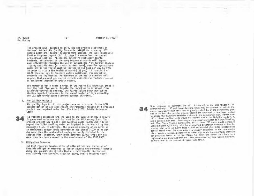
ss l. Project/RAQS Consistency We find the DEIR growth assur.,ptions and land use proposals are inconsistent witn those used in developing the 1979 Regional Air Quality St.1lldanfs (RAQS) for the San Diego Air Basin (SDAa).
·~
Guidelines for implementing the California Envl=tal Quality Act (CEQA) suggest a project description should include discussion of •any inconsistenci es between the proposed project and u;ipli cable general plans and reglcnal plans.• (Section 151~2 (~)) The Federal Clean Air Act requires State Implementati on Plans (SIPs) be adopted to insure that pri:..ary (health related) national a..lbient air ~uality standards be attained as expeditiously as poss1~le. (Cl~an Air Act, Section 110) An extension for attainment of ozone and carbon r::onoxice standards until 1987 was approved by the United States Envlroneiental Protection Agency as part of the 1979 RAQS f or t~e S~~-
33 As noted in the EIR (page 122), development of t_he North City West Community Plan Area has been incorporated into SANDAG's regional growth projections and into the Regional Air Quality Strategies (RAQS). Development within the precise plan area would be generally consistent with the land use assumptions contained in the community plan with the exception of the 34-acre employment center designated in the western portion of Neighborhood 6. The employment center would generate approximately 3,000 more daily trips than would a similar acreage of multi-family residential development; multi- family residential development is currently shown at that location in the commuity plan. As stated in the EIR, mobile emissions generated by these trips would incrementally increase air pollutant levels in the San Diego Air Basin and would contribute to a region-wide air pollutant problem.. The percentage increase would, however, be very small in the context of region -wide totals.
Mr. Burns Ms. Mos ley
-2- October 8, 1982
The present RAQS, adopted in 1979, did not project attainment of Na tional Ambient Air Quality Standards (NAAQS) for ozone by 1987 unless additional contro l measures were adopted. The 1981 Reasonable Further Progress report (Vol. I, page II) sunr.iarized the current projections stat ing : "Given the extensive stationary source controls, atttainment of the smog (ozone) standards will depend upon effectively reducing the use of automobiles." It further states: •using the 1978 data [with updated data base), reactive hydrocarbon
emissions in the region must be limited to 153 tons per day by 1987 in order to attain the hea lth standard -(.12 ppra].• A shortfall of 30-38 tons per day is forecast unless additional transportation controls are implemented. Maintenance of the health standard will require that current per capita vehicle emissions be further reduced as additional population growth occurs.
The nunter of daily vehicle trips in the region.has increased greatly over the last five years. Despite the reduction in emissions from catalytic-controlled engines, the nearby Solana Beach monitoring station reported increases in the annual number of days exceeding the .12 ppm hourly ozone standard between 1978-1981.
2. Air Quality Analysis
34
Air quality impacts of this project are not discussed in the DEIR. Identification of all significant environmental impacts of a proposed project are required under law. (Section 21002, Public Resources Code) ·
Two rezoning proposals are included in the DEIR which would result in generated emissions not included in the RAQS assumptions. The present project would add 1,000 dwelling units (9,000 daily trips) beyond the 3,098 dwelling units anticipated in the North City West Comnunity Plan. In addition, the proposed rezoni ng of 34 acres as an e~loyment center wou ld generate an additional 3,000 trips per day more than the residential zoning currently included in the adopted Plan. Together, they wou ld generate 12,000 trips per day 1110re than has been assumed in the development of the 1982 RAQS.
3. Mitigation Measures The CEQA requires consideration of alternatives and inclusion of feasible mitigation measures to lessen adverse environmenta l impacts where the project has effects that are individually limited but cumulatively considerable. (Secti on 21002 , Public Resoures Code)
34 Note response to comment No. 33. As stated in the EIR (pages 9 - 10), approximately 1,130 additional dwelling units may be constructed within the entire community plan area than originally called for in the community plan due to the fact that precise plans proposed and approved to date have tended to utilize the maximum densities outlined in the community plan. Fewer than 250 of these dwelling units would be located within the Neighborhoods 4, 5, and 6 precise plan area. Assuming a trip generation factor of 8 trips/dwelling unit (San Diego Traffic Generators, 1981), those 250 units would generate approximately 2,000 daily trips for a total trip generation increase within the precise plan area of 5,000 trips (2,000 residential plus 3,000 employment center trips) over the assumptions originally contained in the community plan. \labile emissions generated by these trips would incrementally increase air pollutant levels in the San Diego Air Basin and would contribute to a region-wide air pollutant problem. The percentage increase would, however, be very small in the context ol region-wide totals.

I-Ir. Burns Ms. Hos ley
- 3- October e, 19c2
35
38
37
38
Mitigation of internal vehicle trips is addressed in the DEIR through provision of bicycle and pedestrian access routes. A draft ordinance setting bicycle parking standards for cor.rnercial, industrial, multi-family residentia l and publi c facilities land uses should be also included.
The environmenta l analysis states the 3,000 added vehicle trips generated by the proposed 34 acre employment center would exceed RAQS projections, but work trips of some new employees would increase the percentage of interna l trips. (page 122) The feasibi lity of implementing an affordable housing-emp lo)fflent center mitigation measure should be discussed in the FEIR with appropri ate cor.r.iitments fr om the developer , if appropriate.
Additional mitigation of total emissions from the proposed project cou ld be achieved by r educ ing the average energy use per dwe lling unit through solar orientation, heavier insulati on standards and solar hot water and pool heatings. Energy conserv ing street lighti ng should be spec if ied. Highe~ density development of multi-family areas would make future bus serv ice more economically feasible.
The DEIR states street width will be adequate for internal bus service but contact wi th local transit providers concerning locat ion of bus shel ters and methods of fi nancing future service to the precise plan area is not discussed. A letter fr om local transit providers document ing feasibility of bus service expans ion should be included in the FEIR. Given the reduction in federa l support of trar.s it operations, some ongoing support by homeowner assoc iations may be needed f or extens ion of interna l bus serv ice. Employer support of high speed reg ional cor.r.iuter bus service should also be consicered as a mitigation measure f or the 34 acre employment center r ezon ing.
3 ft Cold start emissions f rom vehic les driven to park-and-r ide lots • limit their effectiveness as air quality mitigation measures. Shuttle
services to major transit stops and bicycle parki ng at expr ess bus stops would provide more effective mitigation of air quality impacts through dual -mode co1m1Uting. Bike racks on buses may be justified in some instances . Insta lation of ramp meters with high occupancy vehicl e bypass lanes shou ld be considered for high volume interchanges with Interstate 5.
If you have questions or comnents concerning the air qu~lity analysis or ~itigation measures, please contact Donna Lott of my staff at (916) 323-8405.
Sincerely, /
yr;.) .,,,,.-- 1 ·
r:.c: ~ y / -
Gary Agid , Chief local Projects Support Branch Regional Programs Division
35
38
37
38
39
Bicycle parking facilities would be provided at the school/park sites, at the neighborhood commercial centers, at the park-and-ride facilities, and within multi-family residential developments. Preparat ion of a draft bicycle i,rdinance would be the responsibility of the City of San Diego for c ity-wide application and is not needed for this project. in light of North City West bicycle transportation and parking requirements.
The North City West Community Plan contains provisions for the development of a ffordable housing within the community plan area. The affordable housing would be provided in accordance with Council Policy 600-19.
As stated in the EIR (pages 135, 136), individual residential developments would be designed to provide maximum solar access for both active and passive solar systems; no manufactured slopes or adjacent developments would preclude solar access. If so lar un its for hot water, pool heating, and space heating are not proposed to be constructed within residential units, the design o f such units would feature "stub-outs" to fac ilitate later addition of solar units. Street lighting would be provided in accordance with the requirements of the C ity of San Diego. Neighborhood 6 would be entirely developed with higher density mult i-family areas.
The San Diego Metropolitan Development Transit Board (MTDB) was consulted during preparation of the precise plan for Neighborhoods 4, 5, and 6. Metro Route 150 would provide direct service fro m North City West to north University City, Pac ific Beach, Midway, and Centre City San Diego. MTDB's San Diego Trolley may be extended to the North C ity area at some fut ure dat e, providing high speed regional commuter bus service to the area.
Bicycle parking facilities would be provided at the designated park-and-ride fac ilities. Bicycle racks are also provided on MTDB buses. High volume 1-5 interchanges adjacent to the community plan area would be signalized as required by the North City West Transportat ion Phasing Plan.

tlr. Burns K;. Mosley
cc : l. Hultgren - SAN DAG R. So;iJTlerville - San Diego APCD
-4-
T. larwin - San Diego Metropoli t an Development Board P. Sanford - City of San Diego Bicyc le Coordinator B. Dotson - Caltrans District II, DOTP
October 8, I 9!l2

s~c.te ef California 1, .REC E i-.., i:: D
( ~: T 2 ;j 1982 The ReaourcH Agenc.y
Memorandum
To
From
Svbj<-ct ,
40
41
42
1. Jim Burn, Projects Coordinator Resources Agency
2. City of San Diego Environmental Quality Division 202 "C" Street San Diego, CA 92101
Department of Fnh and Gome
IXi:IIIINMCNIAL QUAlll'I L .. ~~·,
Dote October 13, 1982
~ rs rt ;l ·; \ ~ ln0\ ~\;,--= y ~·- ILJI
0 CT 1 9 19S2 L-'J
~t:..\t'::' Cl •· _:: ~!JI·1i ·:,1 ::: r·
SCH 82010619 - North City West Neighborhoods 4, 5, and 6, San Diego County
We have reviewed the Draft EIR for the subject project that addresses a proposed Precise Plan, Community Plan Amendment, Planned District Ordinance Amendment, and three Tentative Subd,ivision Maps for a development of a mix of urban developments within an 840-acre site located on the north side of Carmel Valley Road between El Camino Real and Black Mountain Road .
The document provides an adequate assessment of biological resources and impacts to those resources. However, mitigative measures to offset significant adverse impacts to wildlife habitat within the project site are inadequate. Apparently, development of the project will eliminate practically all of the productive wildlife habitat and would retain only those areas which are considered undevelopable. As stated in the document on page 85, the mitigation measures proposed by the applicant would not reduce potential biological impacts to a level of insignificance. We believe this failure is inconsistent with the requirements of CEQA.
We could concur with a project alternative that would preserve all of the riparian woodland, freshwater marsh, and salt flat environments as dedicated natural open space and afforded protection from urban development and unmanaged intrusion by humans and domestic animals. We also recommend that the mitigation measures listed on page 49 of the Biological Survey Report be incorporated as Conditions of Approval for an.urban development project.
The project sponsor should be aware that any diversion of the natural flow or alteration of the bed, channel, or bank of any river, stream, or lake will require notification (with fee) to the Department of Fish and Game pursuant to Section 1603 of the Fish and Game Code. This notification and the subsequent agreement should be made a conditio~ of permit approval. This state law may require si~nificant changes in project features associated with streams or streambeds. For this reason, we strongly urge compliance with this code sec tion prior to finalization of the specific project design.
40 As stated in the EIR (page 81), compared to areas of similar size in the coastal portion of San Diego County, the precise plan area is of good, but not outstanding, resource value to wildlife. Other areas of North City West offer better habitat for wildlife such as the area adjacent to Carmel Creek and the northern portion of Neighborhood 3; these areas would be preserved in open space as part of community plan implementation. Preservation of the 82~ acre precise plan area as a wildlife sanctuary would not be consistent with the City's adopted goals for urbanization of the North City area.
41 A small area of riparian woodland habitat would be presi,rved in the natural open space area in Neighborhood 4. The majority of the remainder of the riparian woodland, freshwater marsh, and saltflat habitats are located adjacent to Carmel Valley Road; disturbance of these habitats is unavoidable
42
given the improvements to Carmel Valley Road called for in the North City West Transportation Phasing Plan. Carmel Creek would be fenced during road construction and would be preserved in open space following construction, thus possibly preserving some of the riparian woodland, freshwater marsh, and salt flat habitat. With the exception of Recommendation 2, all of the mitigation measures outlined on -page 49 of the biology report (Appendix D) would be implemented by the applicant. Implementation of Recommendation 2, preservation of a large open space area in the western portion of Neighborhood 4, is discussed in the EIR as an alternative. This alternative would not be consistent with the land use designations for that area outlined in the community plan.
No alteration of the natural course or direction of Carmel Creek would occur as a result of the proposed onsite improvements to Carmel Valley Road. A 1603 Permit may be required for the offsite extension of Carmel Valley Road and will be obtained, if necessary.

1. Jim Burns -2-2. City of San Diego
Thank you for the opportunity to review and comment on this proj~c t. If you have any questions, please contact Fred A. Worthley Jr ., Regional Manager, Region 5, at 350 Golden Shore , Long Beach , CA 90802; telephone (213) 590- 5113.
U-~~ Direct~:- - - - ~

PILI MO. ,
DATI
TO
fllOM
IUaJICT1
43
CITY ol SAN DIEGO
MEMORANDUM
81 - 12-12
October 25, 1982
Bill Schempers, Deputy Director, Tr~nsportation and Traffic Engineering Allen M. Jones, Deputy Director, Environmental Quality Division North City West Neighborhoods 4,5, and 6, Transportation Analysis
The public review period for the North City West Neighborhoods 4,5, and 6 draft EIR has ended, and no comments regarding traffic circulation impacts were received from your division. On October 22, 1982, our off ice contacted Tom Elder to determin e if there were any additional traffic circulation concerns beyond tho s e addressed in Hal Rose nberg 's memo of September 1, 1982 (memo attached). From consultation with Tom Elder, it is our understanding that yo ur d ivision's concerns have been adequately satisfied and that review of the North City West Neighborhoods 4,5, and 6 draft EIR does not alter the conclusi on ' s reached by Hal Rosenberg in his memo. Based on the information contained in the draft EIR and associated traffic studies, no additional impacts o r mitigation measures have been identified by you r division.
Should yo u have significant traffic ci rculation concerns which have not been presented to this division, please call Karen Ruggels, our analyst for this p roject, at ext. 6779. Thank you for your assistance.
1 '·- ( 'i • ' //.• I 11.1;t-z / 11//I/ ,, . • -<£,. ,
L,,~ c.,, ... , . ' , .· Allen M. 46nes. Deputy Directo r City Planning Department
Attachment cc: Tom Murphy, Current Planning
Debbie 1-!arsh, PRC Toups
J;R:At!J :sf
4 3 The comment is noted.

CITY •I lAN DI EGO
MEMORANDUM
PILI NO.,
DA T!
TO
September 1, 1982
Thomas Murphy, Pl ann i ng Depa rtment ~ ,_ IULlf CT,
Hal Rosenberg, Senior Traffic Engineer, Elll v11 W11111m Schempers, Jr., E,o
Addendum to the May 27 , 1982 Transportation An11ys1s of Baldwin Horth City We st Neigh borhoods 4, S, and 6
This 1s i foll ow-up memorandum t o our me1110randum of August 16, 1982 to Karen Ruggels in whi ch we expresjed concerns regarding t he traffic i mpact of the number of dwelling units proposed for North City West Neighbo rhoods 4, 5, and 6, and the designation of a lS~cre in dustr ial business park. We felt the resultant Increase 1n traffic generation needed to be addressed relat ive to 1ts c11111ul1tive effect, parti cularly at the raMp connect i ons to I-5 at Carmel Valley Road and Del Mar Heights Road. Since that time, we have received an addendum to the ori~lnal transportation analysis for Neighborhoods 4, 5, and 6 dated Hay 27 , 1982 (attache d) . We note that there have been additional changes in lan d use for these neighborhoods resulting in a re duct ion in the total amount of tr i ps generated . Spec ifi cal ly, the neighborhood colllllercia l use in Neig~,borhood 6 was changed to a convnunity co11111erc ial use whi ch had the effect of reducing the trip generation by 6680. This reduction in trip generat ion was enough to offset the increase in the number of tr i ps generated by the new des ignation of a 35- acre industrial business park and the addition of 84 dwelling units. The t ota l number of trips produced by Neighborhoods 4, 5, and 6 have been reduced from 60090 to 52904. This reduct i on in trip generation now matches the number of trips used in the original traffic forecast for Nor th Ci ty West. We therefore find the revised land use plan for Neighborhoods 4, 5, and 6 to be sat i sfactory relative to
jjf_'P'/J ;:J"' Hal Rot:?erg 'r" HR :pc
cc: Simpson Twomey
Attachment (not included) bee: Ho 1 den
Ruggel s McLaughlin RECEl'v'~D
L 2 1982 E!Mll)IIMEl!m OUA1ffi
t, . ~~•j

.. ,c .... r, ••~ oo .. : .. ,r,
.... c: .... c• ., .. u• •o•r • • 1 ... ,:;, .... ,1, • 0 11• • C. •• , .. "' . . ........... , .. 1,, .... -Ct.• • ., ... .,ot••o,. h•COOO•t: • G• •"'""' .. r,.•• .... 0 .. 110, oo•u,,o .. ,u;ao
LUCE, FORWARD, HAMILTON &. SCRIPPS
ro,c:.,,•• •uc, .. • ...... ... , ... , ' l:'"I .. U O .I °'
0,011•• • • o"o .. . ,. t .... , . ..... . . . 1• uc 1 .. ■ r •• · GC•.- •O 1, C.- , 11 ., •••• ""o • rt J l)NN. ■ •00• 1, • " • •H• ,.., t ,o(ll!I .. o .... oc:o .. , .. . , .. o ... , ... ........ .
THE B ANK Or CA LIFORNIA PLAZA
110 WES T A 5TAE (T
5Ar,j D• CG O. CALlf"ORNIA 92101
p1,) 236 • 1• 1 ...
•-"-••••c" -............... ,
1,ll "I" • ••U ,,,,.~,., • ••o•w • oo, ••D • •ous, • •H""""'° I C .. tNO •II: • "" ' "'" w .. o.,o ..
UI • •>O,, l C• (M40Ut S l .,, .. c • -C • .. , ..... o .. ••t t .. . .. C:.,4.ll t, ., ·••O ........... , ,I ..... , o .. o ,.., . ,c:. e&,.,.ou ... , .. ,,.• IC. • -CHU>.,
"°"'" • •o ....
RECEl•,ii:D ..> ~O,u. t,-.-C.._, 111•~:, ... G 1100 - o••cc: • ••• tr .. ,c ... .:. .. ... , . .. , ..
icon• , o ,.,,c 00 .. ,.. ;: • 1,ALI'" •oer•ru ., llH
: .: .> 1982 ..> ..o, ... . CM.,•o-..... 11 ,;11
:~;~~~:R,~~:~ :!:;~' c co-•o ••, coc:.c °"'"' l •u .. •o•c UWlll[<M£NTAl Q(IAUD, ~r.......ilal-orc.. •ca t •o•"" -' .;• -••c ..... ,, ... r . ...- , ,, o .,c...c:c oa · .. ,
c.,,a ,s.,.c.e,,,,,.,,o,,., ... ,1~'"' ,, ... .., • . ..,:-c
c ... ,,,c ... , . .. ..... .. .. .... , ... ... .... .. o .. ,c - "'"'" .. ,., ... ,., t1t1 t 0 ••tll1t•G , .., , ,. .,,, gu,11:•o-1>h• .. • c ... ,,,o .... , • ., - ·· Oto• • • •-•t•I
"°"' .. " 01,1 .. .. ca,co• • c ••· •t• .... , , , .. o •0---.... c ... ,,
tN LOS 4NC. t l f!o
~ . H•t• •r-•<• , .,o.,•so• .......... ,.,00,,1 _ ... .. . -a •OIi• ••• •••C• • •• , •. • ....... ,u .. , ... .
.. u: .. .-1:,, .. ,.c•c• J U ll ( 4 c;,a((.,.I• ~
oo<•••• tt" • C:•s•c• 11 J ••Ol t,I: a, .. o .... ""''"' • .,., .... u.••c .. ,," • t' • "' " ....... ,, , .... , :, .. October 22, 1982
H1u .Jc,rca, 1o1-. .. cns ••OC•WC•VCO, ,.,, ,,._.1,
l01 ... ,o1lU . C:41.••c• .. , .. , oo, , 1,u , ,c:,•~• .:
44
Ms. Karen Ruggels Enyirorunental Quality Division City of San Diego City Administration Building 202 "C" Street San Diego, California 92101
Re: Envirorunental Impact Report on North City West, EQD No. 81 - 1212
Dear . Ms. Ruggels:
Relating to the discussion of hydrology and water quality, the draft environmental impact report, at page 52, contains a statement that no grading will take place between October 15 and March 15. Given the requirements of construction of the detention basins prior to October 15 also set forth on page 52, it is unclear to us why this additional requirement is set forth.
Numerous studies have evaluated the mitigation of runoff. Rick Engineering Company completed a study which became a part of the EIR for Carmel Valley. Leeds,Hill also completed a study for the Pardee Construction Company. The Carmel Valley EIR, based upon the drainage plan and drainage study prepared by Rick Engineering contained no preclusion of grading between October 15 and March 15. While Leeds,Hill does contain a discussion of such a limitation, the concept was always that if the drainage basins were in place then there would be no further limitation upon grading since the
4 4 The comment is noted and the correction has been made to page 52 of the EIR.

LUCE, FORWARD, HAMILTON & SCRIPPS
Ms. Karen Ruggels October 22, 1982 Page Two
drainage basins would pick up any sedimentation which resulted from grading during the winter period.
The mitigation measure s set forth at pages 51 and 52 will preclude erosion and siltation even during · the rainy period. One of the initial steps is the construction of the detention basins followed closely by interim landscaping to preclude erosion. In light of these numerous mitigation measures the preclusion for grading between October 15 and Marc h 15 appears unnecessary and even if applied, should certainly be limited in scope to rough / grading and should not preclude precise lot grading or street grading following construction of the drainage basins.
We appreciate the opportunity to comment.
GTS :j r
Hand Delivered
V5!-_ry . t.Lul~-- --- - --- -
/ Gregory Tyler Smith for Luce, Forward·, Hamil ton & Scripps

TI/E CITY OF
SAN DIEGO CITY ,\DMINISTR1\TJON /lU/Lf)JNG • 202 <; STREf:T • SAN JJ/1:.'GO. CAUi,: !12J(}/
ENV IRONM ENTAL QUALITY DIVISION PLANNING DEPARTMENT 236-5775
45
October 25, 1982
Mr . Jim Fisk PRC Toups 2223 Avenida de la Playa, Suite 267 La Jolla, CA 92037
Dear Jim:
Subject: North City West Neighborhoods 4, 5, and 6, Drainage Study ·
When this di vision reviewed the preliminary draft EIR for North City West Neighborhoods 4, 5, and 6, the drainage study had not been completed, and it had not been determined how runoff from the Western portion of Neighborhood 6 would be captured . The draft EIR was circulated fo r public review with the understanding that this information would be available prior to finalizing the EIR . Thi s division would then r eview that information and decide if conclusions contained in the draft EIR would need to be altered.
We have recently been informed that the drainage study, has not been completed and the way in which runoff from the Western portion of Neighborhood 6 would be handled has not been determined. Therefore, the EIR will be accepted by this division as complete conditioned upon r eceipt and review of the drainage study. If this division determines that proposals in the drainage study could create o r exacerbate environmental impacts, further environme ntal analysis would be necessary and a supplement t o th e EIR may be r Pquired.
4 s The comment is noted.

Mr. Jim Fisk Pa~" 2
IJ you ilavc any question rei,:arding eo ndi tional aceeptanc,e of the EIH, please call.
Since rely. / J
/,/ti ;)_ (J/--{i,t,
Allen M. Jones, Deputy Director City Planning Department
cc: Debbie Harsh, PRC Toups Steve Tate, The 13aldwin Company Tom Murphy, Long Range Planning Jim Derrick, Subdivision Review lloard
l(R:/\MJ:,;f

(-~;}\;· :.i!-)·· :. ~• ... '~ .
f ~"•' d l 4/ , '3 8RC, ,•, •• _. 1-
"-<• .•Eqt,:)f,
Octaber 22, 1982
Karen Ruggels
~btr 11f I.L;difonri;1 GOV ERNO R"S OFFICE
O FF ICE OF PLANNING AND RESEARCH 140 0 TENl H S TREE"T
SACF-iAMENTO 95614
(916/445-0613)
City of San Diego Enviro!Jllental Quality Division 202 C Street, 5th. Floor San Diego, CA 92101
;RECEIVED
( : T 2 l i 1982 ~MENTAL QUALIT<
Uhi:.ION
SUBJECT: Draft Enviro!Jllental Impact Report (EIR) for North City West Neighborhoods 4, S, & 6 ·
Dear Ms. Ruggels:
State agencies have carvnented on your draft EIR (see attached) . If you woulci like to discuss their coocerns and recamnendations, please contact the staff person shown on each letter. For your convenience, state agency camnents are su:.r.arized below.
48 AIR R£SQJRCES BOMD (ARB)
ARB states that the doclJllent' s discussion of air quality impacts and project mitigation measures is not adequate. They provide estimates of air enissions fran the project , which stress the importance of a thorough air quality analysis. using regional figures for mode split and vehicle occup,ncy, ARB projects enissions for carbon monoxide, reactive hydrocarbons, and oxides of nitrogen that woulci be generated upon project buildout.
ARB says the project ' s land use proposals and growth assunptions are inconsistent -.,ith those used to develop the 1979 Regional Air Quality Standards (R.OQS) for the San Diego Air Basin. ARB discusses appropri ate re:iuirenents for acheiving national illlbient air quality standards.
ARB discusses the possibility of adopting a draft ordinance which would set bicycle parking standards at camnercial, industrial, multi-f.nily residential, and public facilities. ARB discusses other mitigations involving: reduced enissions fran dwelling units, shuttle service between major transit stops and park- and-ride facilities, bicycle parking at express bus stops, and r.np meters for I-5 with high occupancy vehicle bypass lanes.
According to ARB, the DEIR does not include evidence of contacts 1.ith local transit service providers regarding the location of bus facilities and methods of financing future service. A letter fran local transit providers regarding the feasibility of financing future developnent should be included in the
4 8 Please refer to responses to comments No. 33-39.

2
final EIR. Finally, employer sup,x>rt of high speed regional bus service should also be considered for the 34 acre employment center rezoning.
47 CALTAA'lS
Caltrans, District 11 refers to a statement in the docunent which concludes t.hat ,x>tentially significant traffic impacts can be mitigated to a level of insignificance. Caltrans indicates that this may apply to internal traffic impacts but not regional traffic impacts. Caltrans states that after the project is constructed, average daily traffic on I - 5 will be exceeded. They state that Caltrans has no plans to increase freeway capacity and does not have funds to carry out regional improvements shown in Table 9. Cal trans refers to the financing of park-and- ride facilities as discussed on page 117. They note that if fee ownership can be transferred to the State, Caltrans can maintain and operate the sites. ·
48 DEPARTMENI' CF FISH AND GAME (DFG)
DFG states that mitigation measures included in the docunent are inadequate. The project will eliminate practically all the productive wilcilife habitat except in those areas that are considered undevelopable. They refer to a discussion in the docll!lent that the mitigation measures proposed will not reduce biological impacts to an insignificant level.
DFG can concur with a project alternative preserving all the freshwater marsh habitat, riparian woodlands, and salt flat envirollllent as open space. They also recc:mTiend that mitigation measures listed on page 49 of the Biological Survey. Report be incorporated as Conditions of Approval for the project.
DFG concludes by mentioning the requirement for the developer to enter into a streclllbecl alteration agreement pursuant to Section 1603 of the Fish and G2111e Code if any alteration of the natural flow or alteration of the bed, channel, oi,_ bank of any river, streolTI or lake is planned.
49 DEPA.<n'MfNI' CF WATER RESCl.JRCES (CWR)
CWR has included their Cc:mTients on water conservation and flood damage prevention for the North City West proposal. According to CWR, the developer should consider the possiblility of us ing reclaimed water for irrigation purposes in order to conserve fresh supplies for beneficial uses requiring high quality water.
so srKrE Cl.EARINGHCl.JSE
In considering the loss of an east- west wildlife corridor due to developnent of the North City West Neighborhoods, the project states, "since no development has been proposed cy the applicant on property south of Carmen Valley Road, implementation of the precise plan would in no way preclude use of the property for that p~rpose". This statement does not consider the pos-
4 7 Please refer to responses to comments No. 31 and 32.
48 Please refer to responses to comments No. 40-42.
4 9 Please refer to responses to comments No. I and 2.
so The floodplain of Carmel Creek and property south of Carmel Valley Road are designated for open space in the North City West Community Plan. The community plan also limits growth on adjacent or nearby properties with in North City West.

3
sibility that the project will encourage growth on adjacent or nearby properties, thus making it more difficult to retain lands south of Carmen Valley Road in open space.
51 In relation to this discussion, the dcx:unent does not include a section on growth inducing impacts of the proposal as rE3:3uired by Section 15143 (g} of the CEQA Guidelines. A thorough discussion of growth inducing impacts is im-portant for the following reasons: 1) the scope of the project is large, and may generate significant secondary developnent offsite, 2) Carmel Creek and coastal habitats, located close to the project, may be impacted by off- site developnent, and, 3) the extention of Carmel Valley Road may induce growth into undeveloped areas. Also, extension of services across undeveloped areas can open than to intensified developnent pressures, thus any growth impacts that could occur due to service extensions must be discussed. It must not be assumed that growth in any area is necessarily beneficial;_ detrimental, or of little significance to the envirorrnent. The CEQA Guidelines, Section 15143 s tate, if growth inducanent is not disc ussed in a separate section, the EIR shall -include a table showing where it is discussed.
When preparing the final EIR, you must include all ccmments and responses (CE);)A Guidelines, Section 15146i. The certified EIR must be considere.<l in the decision-making process for the project. In addition, we urge you to respond directly to the agencies' ccmments by writing to than, including the State Clearinghouse number on all corres!X)ndence.
A 1981 Appellate Court decision in Cleary y. County of Stanislaus (118 Cal.f1W. 3d 348) clarified r0:3uiranents for res!X)nding to revi€\o/ canments. Specifically, the court indicated that camnents must be addressed in detail, giving reasons why the specific caaments and suggestions were not acceptea. The responses should indicate any factors of overriding significance which required the suggestions or ccmnents to be rejected. Responses to ccmnents must not be conclusory s tatanents but must be s upported by anpirical or experimental data, scientific authority or explanatory information. The court further said that the responses must be a good faith, reasoned analysis.
Section 15002 (f} of the CEQA Guidelines r0:3uires that a governnental agency take certain actions if an EIR shows s ubstantial adverse enviromental impacts could result fran a project. These actions include changing the project, impos ing conditions on the project, adopting plans or ordinances to avoid the problan, selecting an alternative to the project, or disapproving the project. In the event that the project is approved without adequate mitigation of significant effects , the lead agency must make written findings for each significant effect (Section 15088) and it must supp:,rt its actions with a written statanent of overriding considerations for each unnitigated significant effect (Section 15089).
If the project r0:3uires discretionary approval fran any state agency, the Notice of Determination must be filed with the Secretary for Resources, as well as with the County Clerk.
51 The growth inducing impacts of development of all of North City West were addressed in detail in the Carmel Valley Precise Plan EIR and its supplement (EQD Nos. 76 - 05-25P, 76 - 05 - 25P, S- 1).

Please contact Daniel Conaty at (916 ) 445-0613 if you have any questions .
Sincerely,
Charles E. Brandes Deputy Director Projects Coordination
CIB/ dc attachments
cc: Resources Agency
Daniel Conaty State ClearinghouSe

52
S t~:i L' o: C.1i!'.o r:1:.1. ~.,:-: ,_;,::.. -:..: Bro-.•:- .fr .. G· .,, : : .1 ••
C.a! i!orr-.::i Coa.~o?. '. Cc•:"-ir.i?S! -r. S:\n Die~c, D1s:r: c. ; 6!5~ M1ss;on Gnrgi.• Roa:: . 5·.: .:c 220 Sa,: D1~90 . Ca::llirnia 9'..?12(. i ;:~ , 28n 6°92 A TSS 630 5868
Oct obe r 25, 1982
Mr. Allen Jones City Planning Departnent 202 "C" Str ee t San Diego, CA 921 01
REC E iV ED ( - T 2 lJ 1982
ilfi'.IJiONMENTAl QUALITY [,, , .Ji,:1.~
Re : DEIR North Cit:· West Neighbor hoods 4, 5, and 6; EQD #81-1212
Dear Mr. Jones:
Thank you for the c~por tunit;· to comment on the DEIR for th i= North City v:est ne i ghborhoods. We !",:i.ve reviewed t hose se:ctions of the DE I R that r e: late to drainage and trar.s;c!"~ation, as we ll as to t he underlying land uses f or that portion of th.t? :~orth Ci ty West comrnuni t y in the coastal zone . It is our opinion that tr. ~ DEIR a~equate l y discusses the potentia l impac t s , their significancl?, 2.nd a;: ; rop ria~E: mitigation measures for those i t erns. HowevE·r. we have not noted ir. th !;! DEIR any detailed discussions of the potential effects of t he pro~~sed p r oject u pon the pattern and intensity of use of coastal beach and ~er~ lands locati on seaward from the p ro ject site.
As discussed in t h~ ~EIR t he Commission is expec ted t o review t hat portion of t he project wit!'".i:-: t he coastal zone under its coastal per mit issuing authority.
Sincerely ,
~ -. -"-•~ . • ..,,_.;t / Tom Crandall District Director
TAC:JFP:lsm
~~
52 The effects of development of all of North City West on ad jacent beaches and nearby coastal resources was addressed in detail •in the supplement to the Carmel Valley Precise Plan EIR (EQD No. 76-05- SP, S- 1; pages 53- 57).

DRAFT ENVIRONMENTAL IMPACT REPORT
FOR
NORTH CITY WEST PRECISE PLAN DEVELOPMENT UNITS 4, 5, &: 6
Prepared for:
The Baldwin Company 1401 Camino del Mar, Suite 201
Del Mar, California 92014
pre PRC Toups Corporation 2223 Avenida de la Playa La Jolla, California 92037 Telephone (714) 454-9162
A Planning RMearch Company
August 24, 1982

TABLE OF CONTENTS
CONCLUSIONS AND RECOMMENDATIONS PUBLIC REVIEW RECORD DISTRIBUTION LIST (Prepared by the City of San Diego Environmental Quality Division)
SUMMARY
I.
II.
III.
PROJECT DESCRIPTION
A. Location B. Background C. Project Description
ENVIRONMENTAL SETTING
A. Physical Characteristics B. Existing Land Use C. Anticipated Future Surrounding Land Uses
ENVIRONMENT AL ANALYSIS
Existing Conditions Issue Identification Potential Impacts Analysis of Significance Mitigation Measures
for each of the following environmental categories
A. Land Use B. Hydrology/Water Quality C. Visual Quality D. Geology/Soils/Landform E. Biology F. Archaeology /Paleontology
. G. Transportation H. Air Quality I. Noise J. Water and Energy Conservation K. Cumulative Effects
- i -
S-1
1
1 l 9
26
26 26 26
28
28 48 55 65 73 89 98
120 126 134 137

IV. ALTERNATIVES
A. No Project B. Reduced Scope/1,000 Fewer Units C. Eastern Neighborhood Alternatives D. Western Neighborhood Alternatives
VI. REFERENCES
VII. INDIVIDUALS AND AGENCIES CONSUL TED
VIII. CONSULTANT IDENTIFICATION
FINDINGS
APPENDICES (Under Separate Cover)
A. Precise Plan B. Biology Report C. Archaeology Report D. Letter from Consulting Geologist E. Notice of Preparation and Responses F. Transportation Analysis G. Noise Analysis
- ii -
142
142 142 143 146
147
149
151

LIST OF FIGURES
Figure 1 Regional Map 2
Figure 2 Vicinity Map 3
Figure 3 Location Map 4
Figure 4 Community Plan Boundaries 5
Figure 5 Precise Plan Development Units 6
Figure 6 North City West Community Plan 7
Figure 7 Precise Plan Neighborhood Concept 11
Figure 8 Neighborhood 4 - Precise Plan Map 12
Figure 9 Neighborhood 5 - Precise Plan Map 13
Figure 10 Neighborhood 6 - Precise Plan Map 14
Figure 11 Neighborhood 4 - Tentative Map 16
Figure 12 Neighborhood 5 - Tentative Map 17
Figure 13 Neighborhood 6 - Tentative Map 18
Figure 14 Neighborhood 4 - Proposed Zoning 20
Figure 15 Neighborhood 5 - Proposed Zoning 21
Figure 16 Neighborhood 6 - Proposed Zoning 22
Figure 17 Coastal Zone Boundary 32
Figure 18 Fault Map 66
Figure 19 Soils Map 68
Figure 20 Neighborhood 4 - Vegetation Map 74
Figure 21 Neighborhood 5 - Vegetation Map 75
Figure 22 Neighborhood 6 - Vegetation Map 76
Figure 23 Existing Average Daily Traffic Volumes 99
Figure 24 Ultimate Circulation System 105
Figure 25 Circulation System - Development Stage II 107
Figure 26 Circulation System - Development Stage III 108
Figure 27 Circulation System - Development Stage IV 109
Figure 28 Internal Street System 111
Figure 29 Cumulative 1995 Traffic Volumes (Includes Project-Generated Traffic) 11 2
Figure 30 Alternative Transportation Modes 11 8
Figure 31 Neighborhood 4 Redesign 144
- iii -

LIST OF TABLES
Table 1 Precise Plan Land Use Acreage Analysis 10
Table 2 Precise Plan Residential Unit Analysis 15
Table 3 Proposed Zoning 23
Table 4 Soil Classifications and Interpretations 69
Table 5 Vegetation Types of North City West Neighborhoods 4, 5 and 6 78
Table 6 Sensitive Plants Observed on the Property 80
Table 7 Potential Impacts to Biological Habitats and Sensitive Species Within the Precise Plan Area 83
Table 8 Cultural Resources 90
Table 9 North City West Transportation Phasing Plan 101
Table 10 City of San Diego Noise Standards 128
Table 11 Projected Future Noise Levels on the Project Site 129
Table 12 Neighborhood 4 Redesign Land Use Acreage Analysis 145
- iv -
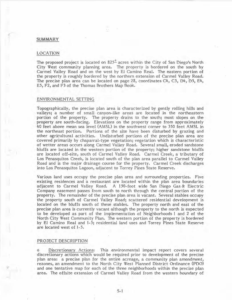
,r
SUMMARY
LOCATION
The proposed project is located on 825.:t acres within the City of San Diego's North City West community planning area. The property is bordered on the south by Carmel Valley Road and on the west by El Camino Real. The eastern portion of the property is roughly bordered by the northern extension of Carmel Valley Road. The precise plan area can be located on page 28, coordinates C4, C5, D4, D5, E4, E5, F2, and F3 of the Thomas Brothers Map Book.
ENVIRONMENT AL SETTING
Topographically, the precise plan area is characterized by gently rolling hills and valleys; a number of small canyon-like areas are located in the northeastern portion of the property. The property drains to t he south; most slopes on the property are south-facing. Elevations on the property range from approximately 40 feet above mean sea level (AMSL) in the southwest corner to 350 feet AMSL in the northeast portion. Portions of the site have been disturbed by grazing and other agricultural activit ies. Undist urbed portions of the precise plan area are covered primarily by chaparral-type vegetation; vegetation which is characteristic of wetter areas occurs along Carmel Valley Road. Several small, eroded sandstone bluffs are located in the western portion of the property; higher sandstone bluffs are located off-site , south of Carmel Valley Road. Carmel Creek, a tributary of Los Penasquitos Creek, is located south of the plan area parallel to Carmel Valley Road and is the major drainage course for the property. Carmel Creek discharges into Los Penasquitos Lagoon, adjacent to Torrey Pines State Reserve.
Various land uses occupy the precise plan area and surrounding properties. Five existing residences and a restaurant are located within the plan area boundaries adjacent to Carmel Valley Road. A 150- foot wide San Diego Gas & Electric Company easement passes from south to north through the central portion of the property. The remainder of the precise plan area is vacant . Several stables occupy the property south of Carmel Valley Road; scattered residential development is located on the bluffs south of these stables. The property north and east of the precise plan area is currently vacant although the property to the north is expected to be developed as part of the implementation of Neighborhoods 1 and 2 of the North City West Community Plan. The western portion of the property is bordered by El Camino Real and I- 5; residential land uses and Torrey Pines State Reserve are located west of l-5 .
PROJECT DESCRIPTION
o Discretionary Actions: This environmental impact report covers several discretionary actions which would be required prior to development of t he precise plan area: a precise plan for the entire acreage, a community plan amendment, rezones, an amendment to the North City West Planned District Ordinance (PDO) and one tentative map for each of the three neighborhoods within the precise plan area. The offsite extension of Carmel Valley Road from the western boundary of
S-1

the precise plan area to 1-5 is also addressed in this EIR. The City of San Diego is the lead agency involved in the approval of each of these actions.
Additional approvals or permits which may be required in conjunction with precise plan implementation include review of drainage and transportation plans by the California Coastal Commission. Such review would include the issuance of development permits to connect to an existing trunk sewer line in Carmel Valley Road and to realign Carmel Valley Road.
The proposed precise plan addresses three neighborhoods within North City West, Ne ighborhoods 4, 5, and 6. Development within t he precise plan area would consist of a variety of residential dwelling unit types as well as one neighborhood commercial center, one visitor commercial center, an employment center, two elementary school/ne ighborhood park complexes, and open space areas. The three proposed tentative maps would confor m with the land uses out lined in the precise plan. Table 1 is a land use acreage analysis of the entire precise plan area. Table 2 provides an analysis of the number and types of resident ial dwelling units proposed within the precise plan area. Four types of dwelling units would be constructed: single-family detached units on 60 x 100 foot lots; single-family detached units on lots approximately 50 x 100 feet in size; duplexes; and multifa mily units.
Table 1
Precise Plan Land Use Acreage Analysis
Neighborhood Neighborhood Neighborhood 4 5 6
Residential 303 . 02 210 . 8 163 . 35 Includes:
open space (37 . 17) (9.53) (63 . 55) detention basin (3 . 47) ( 1. 50) -0-recreation center (1.80) (0 . 90) -0-
Elementary School/ Park Site 18 . 84 15.70 -0-
Retail Commercial -0- -0- 10.40
Visitor Commercial -0- -0- 7 . 42
Major Streets 16.01 16 . 15 27 . 77
Employment Center -0- -0- 34 . 76
TOTAL 337.87 242.65 243 . 70
S-2

Table 2
Precise Plan Residential Unit Analysis
Single-Family Detached Product 1
(60' X 100') Product 2
(50 1 X 100')
Duplex
Multi-Family
TOTAL
Neighborhood 4
635
-0-
822
-0-
1,457
ENVIRONMENT AL ANALYSIS
Neighborhood 5
-0-
589
426
-0-
1,015
Neighborhood 6
-0-
-0-
-0-
1,626
1,626
o Land Use: The consistency of the proposed precise plan with the North City West community plan is addressed in detail in this EIR. Residential land uses proposed as part of the proposed precise plan would be consistent with the community plan. The developed park acreages proposed in the precise plan would be compatible with the acreages designated in the community plan although the number and location of these parks would differ from those shown in the community plan. This impact is not regarded as significant since the community plan park sites have been altered by the School Facilities Master Plan and since all future residents would have convenient and safe access to park facilities. The proposed neighborhood commercial center would be located adjacent to major streets but would be oriented toward internal streets and would be accessib le t hrough pedestrian/bicycle routes to be provided within open space linkages; no significant land use impacts would be associated with the commercial center location. The proposed visitor commercial center would be located adjacent to the visitor commercial area shown on the community plan. The proposed employment center would not be consistent with land uses shown in the North City West community plan but would be compatible with the designated employment center on the west side of El Camino Real. The employment center would be vertically buffered from residential development to the east by a 20-40 · foot slope. Development within the employment center would be limited by the design criteria set forth in the Neighborhood 2 Employment Center Precise Plan. Additional traffic generated by the employment center could be accommodated by widening El Camino Real to six lanes adjacent to the Carmel Valley Road/El Camino Real intersection.
The natural open space area in Neighborhood 4 would not be continuous as shown on the community plan but would be divided into several pieces; its northern portion would be developed, and several portions would contain fill material. This is a
S-3

significant adverse impact, particularly in view of the fact that the community plan states t hat, "· • • any deviation • •• (from nat ural open space shown on the community plan) • • • must be justified by favorable environmental impact analysis". The significance of this impact would be reduced by pedestr ian linkages proposed in Neighborhood 4. The proposed recreation area on Lot 1459 and a nature trail wou Id connect the open space areas. This would serve to partially mitigate t he identified impact. Complete mitigation could only occur t hrough a redesign of that area ; a redesign is addressed in t he Alternat ives section of this EIR.
Other land use issues addressed in this report include the self-containment of individua l neighborhoods, the compatibility of adjacent land uses, and t he rationale behind t he selection of open space areas. Although each ne ighborhood would not contain all of the facilities outlined in the community plan, t he precise plan as a whole would be a functionally self-contained area. The School Facilit ies Master Plan has also supplemented some of the community plan goals and objectives with regard to neighborhood self-containment. No land uses proposed by t he precise plan are inherently incompatible with adjacent land uses, although t he proposed school site location adjacent to Del Mar Heights Road, a six-lane major street, may have potential safety impacts in t he absence of adequate site planning. The 15-acre school site would be large enough to ensure that t he school could be set back far enough to avoid potential safety impacts. Where residential land uses abut commercial areas, landscaped earthen berms would be provided to reduce potential safety and visual conflicts. In addition, t he applicant has agreed to develop Neighborhood 6 in accordance with the development plan guidelines set forth in the PDO or with t he city's planned development process, which would ensure design review for individual projects within t he western portion of the plan area. Open space areas were selected to be consistent with t he community plan and to maximize t he ease of circulation t hroughout t he community. The design of the open space area in Neighborhood 4 may have significant impacts as discussed above.
o Hydrology/Water Quality: Three detention basins would be located within the precise plan area to ensure t hat runoff and sedimentation to Los Penasquitos Lagoon would not exceed predevelopment conditions. The development plans included as part of precise plan submittal would contain erosion control and landscaping strategies. Approximately 8 acre -feet of additional storage capacity would be required to accommodate runoff from the western portion of Neighborhood 6. Such capacity could be provided either in a detention basin to be located in t he southwestern corner of the precise plan area or in a large detention basin located at the Carmel Valley Road/El Camino Real intersection. A decision regarding t he provision of a detention basin to accommodate runoff from the western portion of Neighborhood 6 would be made prior to recordation of the final map.
The 100-year floodplain of Car mel Creek would be altered slightly by the proposed a lignment of Carmel Valley Road, although such alteration would be consistent with the city-adopted Local Coastal Progra m (LCP) goals for development within or adjacent to t he floodplain of Carmel Creek. This impact is a minor one, since much of t he road widening would occur to the nort h of t he existing alignment and
S-4

the floodplain boundary. Because the floodplain is wide in this portion of the valley, a slight constriction of it is not expected to have an appreciable effect upon the stream's hydraulic characteristics according to PRC Toups' engineers and hydrologists. Implementation of t he precise plan and tentative maps would have no significant impact on the natural course or direction of Carmel Creek.
The offsite extension of Carmel Valley Road would significantly encroach into the 100-year floodplain of Carmel Creek. Such encroachment is unavoidable since t he connection with the existing 1- 5/Carmel Valley Road interchange is fixed. The offsite extension of Carmel Valley Road would have no significant impact on t he natural course or direction of Carmel Creek and would have no flood -related impacts.
o Visual Quality: Implementation of the proposed precise plan would have significant long-term visual quality impacts in t he form of permanent alteration of topographic features such as valleys, bluffs, and canyons. Short-term adverse visual quality effects would be temporary in nature and would occur as a result of grad ing prior to development . Erosion control measures would be implemented for a ll graded areas in conformance with the city's grading ordinance.
Mitigation of potential adverse visual quality effects would occur through implementation of the development plans for Neighborhoods 4 and 5 and through the precise plan design element. These documents contain recommendations for enhancement of the site's visual character. They address all aspects of visual quality, including preservation of views, landscaping concepts, site design concepts, and street furniture and signage programs. The developer would strictly adhere to t he development plan and the design element. If construction does not occur immediately on graded areas, temporary landscaping would be installed to reduce erosion potential and to increase the visual quality of the disturbed areas. In addition, the applicant proposes to require Neighborhood 6 to be developed via t he development plan guidelines set forth in the PDO or the planned development process. This requirement ensures site design and landscaping review and would minimize the potential for adverse visual impacts.
The noise walls to be built along major roadways would have a visual impact on t he site as it is viewed from adjacent roadways. These walls would be only a small part of t he overall change in appearance and visual quality of the site resulting from plan development. The significance of this impact would be further reduced by t he use of landscaping on all slopes below these barriers. Adverse visual quali ty impacts assoc iated with the noise walls must be weighed against t heir beneficial use for noise attenuation.
Significant adverse visual quality effects would be associated with creation of large fill slopes in and adjacent to the natural open space areas in Neighborhood 4. These open space areas are intended to provide a unique pedestrian-or iented experience and the creation of manufactured slopes within them would represent a significant impact. Vegetation on manufactured slopes within these areas should be as similar as possible to native growth on undisturbed portions of the open space area. A list of plants to be used on manufactured slopes within natural open space areas has been included in the development plan for Neighborhoods 4 and 5; t hat list is included in the body of the EIR. In addition, manufactured slopes would be
S-5

rounded at their edges to blend into undisturbed land, as noted in t he development plan and required by the PDO.
o Geology/Soils/Landform: No hazardous geologic or soils conditions are present within t he precise plan area which would preclude development. The slopes of Bell Valley in t he western portion of t he precise plan area may require remedial grading in order to implement the development as proposed; that need has not yet been definitely established but would be prior to recordation of a final map. Eroded sandstone bluffs in the eastern portion of the precise plan area would be removed upon development which would eliminate potential geologic hazards associated with those bluffs. Landform alteration associated with precise plan implementat ion would be significant as described above under Visual Quality.
o Biology: A biological survey of the precise plan area was conducted by Mr. Harold A. Wier, biological consultant. Potential impacts to vegetation communities and sensitive plants considered to be significant include t he loss of approximately 150 acres of coastal mixed chaparral habitat and potential impacts to certain sensitive plant species including Del Mar manzanita, Del Mar mesa sandaster, coast barrel cactus, and mesa club-moss. Designated open space areas would preserve approximately 10 acres of coastal sage scrub habitat, 17 acres of chaparral habitat, and 45 coast barrel cactus plants. The designation of additional natural open space areas within the precise plan would preserve biologically useful a reas such as coastal mixed chaparral habitat, but is not proposed by the applicant.
Implementation of t he precise plan would result in a significant loss of 825.±. a~res of wildlife habitat. The precise plan area is considered t o be of value as a wi ldlife corridor and its loss for this purpose would be significant. The significance of this impact is reduced somewhat by t he fact that no wildlife corridors have been preserved in con junction with precise plan or tentative map approvals north of the precise plan area, effectively reducing the viability of the property as a north/sou th wildlife corridor to the San Dieguito River system. The area south of Carmel Valley Road may still serve as a viable east/west corridor to upper Carmel Valley and Los Penasquitos Canyon following precise plan implementation. Since no development has been proposed by t he applicant on property south of Carmel Valley Road by the applicant, implementation of the precise plan would in no way preclude use of t he property for that purpose. Both the city-adopted LCP and the North City West Community Plan recommend retention of property within the floodplain south of Car mel Valley Road as open space.
Improvement of the onsite portion of Carmel Valley Road would have no significant direct effects on biological resources since most of the construction would occur in disturbed field habitat . Development within the precise plan area could, however, indirectly affect significant coastal resources south of Carmel Valley Road and within Los Penasquitos Lagoon, unless adequate mitigation occurs. The key mitigation for protection of coastal zone resources is erosion and sedimentation control as discussed above under Hydrology/ Water Quality.
The offsite extension of Carmel Valley Road would disturb a small area (1,000 feet by 400 feet) of r iparian woodland habitat. This habitat was disturbed in December 1981 when willow trees were removed from the property and is presently in a degraded condition. The hab itat does , however, offer good potential for rehabilitation and its loss would be significant. A small area of maritime sage
S-6

scrub would also be disturbed as a result of construction of the Carmel Valley Road offsite extension. This loss is not considered to be significant, since maritime sage scrub is not considered to be a sensitive habitat.
o Archaeology: An archaeological survey of the precise plan area was conducted by Ms. Marie Cotrell of Archaeological Resource Management. The property within the precise plan area contains 20 archaeological sites which would be lost as a result of precise plan implementation. No significant paleontological resources were noted on the property. The archaeological sites appear to represent satellite campsites and resource collection areas, rather than remnants of major villages. While the size and significance of each individual site within the precise plan area may vary widely, the sites do represent a large cluster of cultural remains and their loss may be significant in a cumulative sense. As this and other development in the area occurs, the loss of archaeologic resources will be significant unless mitigation occurs through recordation and documentation where appropriate.
o Transportation: A transportation analysis of t he proposed precise plan was conducted by Mr. Andrew Schlaefli of Urban Systems Associates. Traffic generated by development of the precise plan area would be adequately served by the transportation improvements outlined in the North City West Public Facilit ies Financing Plan approved by the City Council in May 1982. No cumulative effects would occur in t he immediate vicinity of the community which have not been incorporated into adopted facilities phasing plans. Some short-term congestion of the Del Mar Heights Road bridge would occur during development of t he community plan area. This would be mitigated by signalization of the Del Mar Heights Road/I -5 offramps as required in Stage I of the phasing plan.
Certain site-specific improvements have been recommended by the traffic consultant to improve traffic flow within and adjacent to the precise plan area. These improvements are outlined below. They would be implemented by the applicant.
1. The community connecting road which intersects Soledad Valley Road and serves the neighborhood commercial a long the south edge would be constructed as a four-lane major (72'/92') road with provision for left turn lanes.
2. The external access road to El Camino Real in Neighborhood 6 would be constructed as a four-lane collector road (64'/84') with provisions for leftt urn lanes.
3. The external access road in Neighborhood 4, which connects to MC Road, would be constructed as a 40'/60' street with provisions for left-turn lanes.
4. El Camino Real would be constructed as a six-lane major road from Carmel Valley Road to the Neighborhood 6 connecting road just north of the visitor commercial development.
5. Left-turn improvements and signalization at the intersection of El Camino Real and the intersecting road along the north edge of the visitor commercial development must be provided when warranted or at the direction of the City Engineer.
S-7

6. Left-turn improvements and signalization at t he intersection of Soledad Valley Road and the intersecting road which links Neighborhoods 5 and 6 together along the south edge of the neighborhood commercial would be provided when warranted, or as directed by the City Engineer.
7. Project development would be coordinated with the North City West Cumulative Impact Study and Transportation Phasing Plan. If any differences in staging or phasing occur, the phasing plan would be updated.
The proposed project would not have a significant adverse impact on prov1s10n of future transit service or pedestrian and bicycle access in the vicinity of the precise plan area. Adequate park-and-ride transit opportunities would be available to future residents in accordance with the requirements outlined in the Public Facilities Financing Plan; major roadways within t he precise plan area would be wide enough to accommodate buses and bus stops at any point . Each major public facility, including schools, parks, and commercial centers , would be accessible to residential areas by both pedestrian and bicycle links; pedestrian and bicycle links would conform with or exceed those shown on the community plan.
o Air Quality: Development of t he precise plan area would contribute an increment to the significant cumulative increase in air pollutant emissions occurring in the San Diego Air Basin. The proposed project, however , would be generally consistent with the land use and development phasing assumptions in the Regional Air Quality Strategies (RAQS). The RAQS program has incorporated this and o_ther planned developments into the overall land use projections for the region and has designed various strategies to reduce air pollutant generation from these developments. The proposed locat ions of the school/park sites would be compatible with potential air pollutant levels.
The proposed employment center would generate approximately 3,000 more daily trips than assumed in t he RAQS. Mobile emissions generated as a result of these trips would make a cumulatively significant contribution to air pollutant emissions in the San Diego Air Basin.
o Noise: Each of the major roadways in and near the precise plan area would generate noise levels greater t han the City noise standard of 65 dB(A) in t he adjacent residential developments. These noise levels would affect primarily the first row of residential units adjacent to t he roadways, although in some cases additional units would be affected. Reduction of this noise to acceptable levels would be accomplished by t he placement of 4 to 6 foot high walls at appropriate locations along major roadways within the precise plan area. The locations and heights of these noise barrier walls are shown on the tentat ive maps reproduced in the body of t he EIR.
The traffic noise from Del Mar Heights Road may also have a signifkant impact at the school/park site to be located on this street. The school/park site is large enough to ensure that such impacts would be avoided. Careful review of site plans should take place to ensure t hat adequate setbacks are provided. Rooftop air conditioning equipment at the two commercial centers may significantly affect nearby resident ial units. None of t he remaining residential units within the plan area or t he second school/park site would be affected by noise levels exceeding
S-8

City standards. The two proposed commercial centers would not be affected by noise levels over City standards for that type of development .
o Water and Energy Conservation: Development of North City West and other northern urban communities has been incorporated into regional population forecasts and into regional water and energy conservation planning strategies. Anticipated increases in water and energy consumption would be average for the proposed type and intensity of development. Therefore, implementation of the precise plan would not significantly affect attainment of those goals, as long as state-of-the-art conservation measures are implemented. Such measures have been incorporated into the precise plan and are outlined in detail in the body of the EIR.
o Alternatives: The "no project" and "delayed project" alternatives would involve development of the precise plan area in accordance with existing zoning for the property which would allow large-lot subdivisions and/or agricultural use. Under these alternatives, site-specific impacts could occur, including removal of vegetation and disturbance of archaeological resources. Traffic, air quality, and noise impacts would, however, be avoided. Termination or delay of the project would cause demand for housing elsewhere in the city which could be accompanied by equal or greater environmental impact than would occur under t he proposed plan.
A reduced scope/1,000 - unit reduction alternative is addressed in this EIR. .This alternative would be compatible with the facilities benefit assessment district for North City West . As discussed in previous North City West EIR's, a reduction in project scope would be preferab le from an environmental standpoint, reducing population-dependent impacts such as trip generation and air pollutant emissions and lessening resource-based effects such as disturbance of natural habitats and archaeological resources.
Two alternative designs for Neighborhood 4 are addressed in this EIR. These include elimination of the large fill slope south of the Neighborhood 4 school/park site and redesign of that neighborhood to preserve all of Bell Valley. Elimination of the fill slope would facilitate access to the proposed open space system but would also remove the developed park adjacent to the school in Neighborhood 4. Preservation of all of Bell Valley would require substantial redesign of the circulation system and lot configurations within Neighborhood 4. Provision of an efficient loop road system would be difficult under this alternative; eastern portions of Neighborhood 4 would have to be separated from those to the west, and would be linked only by the external road network.
Two alternative designs for Neighborhood 6 are addressed in this EIR. These concern the designation of natural open space in the western portion of the neighborhood as recommended by the consulting biologist and use of the western superblock of Neighborhood 6 for multi- family residential development. Designation of natural open space in the western portion of Neighborhood 6 would require either an appreciably more dense development in the remainder of the neighborhood or a reduction in the number of units constructed. Designation of the western superblock of Neighborhood 6 for residential development would conform with the land uses shown on the community plan and with adjacent land uses. No adverse environmental impacts would be associated with this alternative.
S-9

o Cumulative Effects: This EIR contains a review of cumulative effects analyses contained in previous EIR's for North City West and discusses additional projects which have been proposed since those analyses were conducted. Since the proposed precise plan is consistent with the North Cit y West Community Plan in terms of overall land use and density, cumulative effects analyses contained in previous EIR's adequately addressed the cumulative effects of development of t he precise plan area. Recently, projects (such as Fairbanks Country Club) have been proposed and approved by t he City of San Diego which would initiate development in the future urbanizing areas of the San Dieguito River Valley. Insofar as t hese projects would have adverse cumulative effects, the cumulative effects of development of the precise plan area could be somewhat greater than those discussed in previous North City West EIR's. Such effects would, however, be the result of development of projects within the future urbanizing area and not the result of implementation of t he proposed precise plan.
The community plan calls for a total of 13,970 dwelling units to be developed t hroughout North City West. Precise plans proposed and approved to date have tended to utilize maximum densities outlined in t he co mmunity plan. For t his reason, it is possible that a total of 15,000 dwelling units could be constructed in North City West, exceeding t he community plan by approximate ly 1,130 units. This possible increase in units is not expected to have any cumulative effects beyond t hose previously identified.
ENVIRONMENTAL SUMMARIES
o Relationship Between Local Short-Term Uses of t he Environment and the Maintenance and Enhancement of Long-Term Product ivity: The proposed development of Neighborhoods 4, 5 and 6 of North City West would have certain long-term environmental effects. Implementation of the proposed precise plan would commit the site to residential and commercial use over the long ter m and would eliminate the potential for use of the site for open space or agricultural purposes. Implementation of t he proposed precise plan would result in increased traffic and air pollutant levels in t he vicinity, in significant disturbances to natural habitats, and would significantly increase the demand for water, energy, and other public services. For t hese reasons, the proposed project would narrow t he range of available beneficial uses of the e nvironment.
In the short term, implementation of the proposed precise plan, in conformance with applicable plans and policies, would help to satisfy the growing demand for housing in northern San Diego City. The employment center, commercial centers, and the school facil ities could also have economic benefits in the form of providing increased job opportunit ies within the region. The proposed precise plan would also serve to implement t he Nort h City West Community Plan within the time period outlined in the community plan.
o Significant Irreversible Environmental Effects: Implementation of the proposed precise plan wou ld require an irreversible commit ment of resources in the form of building mater ials and energy required for construc t ion. Irreversible increases in energy demand, traffic levels, and demand for public services would also be associated with precise plan implementation. The visual character of the precise plan area would be irreversibly changed. The cumulative effects of development of the precise plan area, of the remainder of North City West, and of other projects in the area would unavoidably alter the character of northern San Diego City. Mitigation measures proposed by the applicant and incorporated into t he precise plan would reduce adverse effects associated with these irrevers ible environmental changes but not to a level of insignificance.
S- 10

I I. PROJECT DESCRIPTION
A. LOCATION
This environmental impact report (EIR) addresses a community plan amendment, a precise plan, rezones, an amendment to the North City West Planned District Ordinance (PDO), and three tentative maps for 825.±. acres within the City of San Diego's North City West Community Planning Area. Development plans for Neighborhoods 4 and 5 and Lots 2, 3, 4, and 5 of Neighborhood 6, and a development agreement are also addressed in this EIR. The precise plan area encompasses the t hree precise plan development units (PDU's), as identified in the community plan, located north of Carmel Valley Road within the central port ion of the community planning area. The property is bordered on the south by Carmel Valley Road and on the west by El Camino Real; Interstate 5 0-5) is located west of El Camino Real. The designated town center for the North City West community, and "Carmel Valley", the designated first neighborhood of North City West, are located immediately north of the precise plan area. The eastern portion of the property is roughly bordered by the northern extension of Carmel Valley Road. The precise plan area can be located on page 28, coordinates C4, C5, D4, D5, E4, E5, F2, and F3 of t he Thomas Brothers Map Book. Figures 1 and 2 are a regional map and a vicinity map of the property. Figure 3 illustrates t he location of the property with respect to adjacent streets and jurisdictions.
B. BACKGROUND
North City West was firs t identified by the City of San Diego as an area for future growth and development in its Progress Guide and General Plan, adopted in 1967. Active planning for Nort h City West by the City of San Diego began in 1970 with t he completion of a document titled North City Study Area. On February 27, 1975 the San Diego Cit y Council adopted the North City West Community Plan. Figure 4 depicts the community plan area and locates t he precise plan area within the community plan boundaries. The community plan outlines t he conceptual development of North City West and calls for the orderly development of residential, commercial, and industrial land uses and public facilities on 4,286 acres of land generating an estimated populat ion of 40,200 housed in approximately 13,970 dwelling units.
In the North City West Community Plan, the City of San Diego identified t he specific process by which development in the precise plan area should take place. The community plan divides North City West into nine separate precise plan development units (PDU's), as shown in Figure 5, and requires the adoption of a precise plan for each POU prior to the approval of any subdivision maps, zoning changes, or grading plans. Figure 6 illustrates land uses designated for the entire community plan area in the North City West Community Plan.
- 1 -

./·~. ( . '-·--@ ·- ·.:,
l;i;r-' \ .'-. cf ~ "\ .l!!J
• . ./· oce.A,,v51oe
0
\ ·'1 .·. ~--/-~. ·, " :-: :::: ,, . • escave>1c:,c) :::_:: \ CAl<'t..5/!!a40 \ _½'
):)\: -~--_.).--~-, UUU\:f · · \ ·---~-" -, /. -~ ~ .@· <<<<<< 1 ·"5 . · PROJECT ·)· J'\6)· '-·.,j · . .,. r> ............ • T8 ' -:::::::::::::::::::::::::::: I SITE v·-' Jl./t../,dl\/ '\.
ALP/IV£
' -~ ·-., . ·---·-·""- _ _.) •....,/ -------------------- MEXICO
PRCTcq,1

+
--· ----. -- ...-----,,.. ,...---,. ~ r---"'I .,..._ ·~
USGS 7.5 MINUTE SERIES -~ :~~~\~~/_a,--/]01'.~~ _i(, ,.-,+f-+t,r.:+-,--,1f+r;~~~-+r>i??t-ufi~,t)fi~~7ft¢~~~~r;;t~~;
(~~(\',~ '--:~
., .. .. t,v:,.,·:fc::,. :. ~•··· ·
• ., . , ". - ., ,,, , , u ''-.lQ.!JL..:r~I\. ,,,._ 111 Ir ,J \ ·\·,J\\I\': .. -:-,· \~_i'Jl:;op-1· •1/ J · . . I i://;i1\)y~-\~ 1 . . v1rn¥nr1':ai~nnr.:"af1==in , , \( ... ·, ':\.'.~ . ({'., ,-?'/(1 f ·,-- 1,.jf_·.··. ·.;)) ',_ '1,
·.·., _:.:-~·:,":;':, · ,__e, . . ·.·.- ·-\._·(··V
iJffi .J, ... ..,..:_i"tl'-#, / SJ;!~ ,-• ~ , - ,~- .J ' Cb : 1 ,, .
• _' ,::J. < _,:,,r) · ~ r -- II ' '."-: • I y• . ·-· ~ • . • j__08
1,i~,-..f.;=~J/(J.l {6· ,, ~.:1)/~-l~,ei~.g.1 '-- ' ,I -· \/0(' · 'l.:LJJ!~[L/_r;::'J -'I(-·~ ~-:-:·~, ; ~-~~-,:--:•···,·
~;•::): (: ~' . : L:=- ~r l _.·: .. -~·i,:f:'·'~ tL_.:· -"'?. c ,.· L ,~ r.:._ N., e 7 . _ 2 _ ,l);J!§.\ . .1 ,, :r-;
, .,
l·s·· , ... ......,._.", - ''I · --- ~ - • ., . -\'. : - • '.: :,,; I . •\• ' \ ,~jV\ · V, · i .
~
' -: l,,f i\. ,~ : !I.•\, · .. . '-. . ·. ~- . ~ ' . '~ . , · \\ '-' ~ --,. ·, . ,. .
~~..J 'l. •"-' 2
. 4t..Lllll~~~~~~~~-~~~'LJ~=~-~~~~~~;©~~-~,=- ,- ·- -•--:- ·. :_·._. • --~,~-: -. '"'""'""-" ,~~} r~~ , '.·:!.'·>.---~/···.·. ::
I '-',-s, . 0 I .. -~ I' ·.,'{_••,i ~ f 1 _ ----~~ \r~ ~~ I .,. s ,,\ l -t1.:\_-'.'.;",:..,:•v~1 .: \ , :,. ,.,'l . O:. },1 ' j(\1, ','1.....:.,, .'~) . r ,·: • •
·_ .- ·. ')'- _..:.,,\ --~- !J.-~11, \i1\~~,;·1r.;;>" ::\l'l / -r ·, . •.. . ;:-.,~ , , .. ,•., r •·· • ~,\ 11,'~-- ' , · ' ( '· · ' ' -0 ., · . ' \ -'> " <> ·f . •• '' I ; ! ._ - ('I:) ' , . -- · &- .__ ~ -"'iY ·- -·- -·· • r. f._ _ .... i Ii~ ,t 'Bi . :--...;;:: _ - --. - . ' ' () ' . '
. :); - -~ - - '· .:<'.>': " ' . : ·, -- :~ \ ---~-"- \ '~ ..,. ':, 2·5:.:- ~\1
1
\\t,,..,,f8:~5J~~;;.r,~: &-_s"4l~.s~7 ~!) r.~J~?).J:/J,:;~ii\~<;:\J~l\ll I ),1 ~.~-'½---:- ·) -t~P ·<:;:_ · --- - i ·- · · - -
1~ 111\\\1 , > 1\\:."..:-il<'•i?✓~r~/1/41':)::L\-~V.- ·- !,-: -f;-.1·-~1)l(\\,; ·''"{~:11/ '.' / "- - ·-, t"' r--...
~ • ,~,-,~~i_\ft{f,r~r ----···II" I ~v - •-
\ #"«. ~ -~.j,;;,L,\~t :; ... ,h L/,5' ' - -- - - -~ - .. - - - - ~ ~· l\\~~~v;- ... ~ .,: 's' , _·
.., . . ,, . .. ' --SCALE: 1 • .. 2.000·
I Figure 2 11 VICINITY MAP I l]J
..... "~- --- -
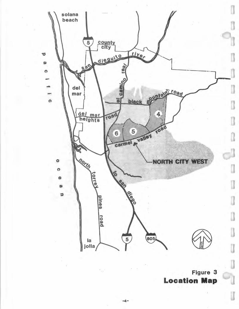
c»
C')
-· ..
0
C')
solana beach
la jolla
.. 0 c» 0.
Figure 3
Location Map

PACTOICIS
Figure 4 COll■UNI I Y PLA■ IIOUIIDARIES
....

NEIGHBORHOOD
EMPLOYMEN CENTER
Scale: 1 • 3,800'
3
p~:ll'~--,rr- /
--
*Numbers ref er to Neighborhood Designations.
-e-
Figure 5
Precise Plan Development Units

. .. zso~ \/, .. ~~• IIV~. "'-'I ,VQ ,,, '<, ~
\~I\ ,• Jf ,. - , \. (
. ~~-
,~
I','(
:s
~. ~ \,
I
I ,..
'
,S . . . " ._...,_·_' ·,'. ,.
·r ,) ··~,-- 01/l~f•· ~ ,,,..,· ✓,::;;; ,\ .• '\·• ~ ,. ,:~~1.--.. ~\ \ :;:,
(~~~·:,,-fil \If'\~//},~~ -;:-'.Ji I ~ ~~~=-'~>r~~~~~~ ' '-\:1:.- · ,--~ . eueuc 'fACILIIIES... , . . , fr~
DEN. ·11oui1111a1 ' . SCHOOt.s-:_ ./ ' ,1,-·;;f<j~ :,:J!f 11 '!':-j) ,;1t, ·1n 'itl;cu;·-•1i ~,Ii'. CC-ELEM £.!•JR. "'::-J'S• s,..-:-..1, ·~: ••• ~;
,, • ',• ·••· •r,,. ;if,'.1/, ,~t, . OAO""'S - ,/tr, 't ~~ .. ..._,::,< \,.:;_ •, '(.:, ,., .. .,, , CI ODU/NIIA I• f,1-J' f"4rTn, /;/11-• •··•·':lf ,-1..L'~- .. \, 1,'. t, 1 - tl
~ . /,.Tio'w~w.,:,·• .. ,\ CNP·N~iGHBORHOOD ,!i,-fr .. cowMUNITY .. ~ .
. ;fcoMMEBc1AL ~-~-: · !~,., .. 11 /:·~·-~ "oL1aRARY A""E, srAT ~oN ·_, ; __ • · ;--
c NEIGHIIO,.HOOD ~;' _'·,1• ,.:I' CS OPEN SPACE ;·. ;: ,,,. ''.'./ .. :J >'?_:: V 1/ISITO,. 1
~·')· i)V, ' Cl' fLOOD PLAIN ' I. , · ·. , \'I ~-Cl _JO_W~ -~ENTE~M' . TRANSPORTATION ;,::::-~ ~ .· \ .• , ~l;. i~·~-- ~;;j~U.1r;~~ =. ~~~~::fi;E:;~EE(c}' ·~\/
N , ffF.111{'1 -- BICYCLE PATH \""e~!!!!!!!!iiiif' /::1/,X- •JI, . .J!.J .... . : PEDESTRIAN _ :iz:::- _ --~~:,,_~~ *•~~\~AA,NSPORTATION T[l!MINAL
.._F_ig_u_re_s_____.J J North City West Community Plan I [ill PRCToups

At the present time, precise plans for three of the nine PD U's within North City West have been prepared and adopted by the City of San Diego. These three include the precise plan for Carmel Valley, the first neighborhood of North City West; the precise plan for the employment center, known as the second neighborhood of North City West; and the precise plan for t he t hird neighborhood of North City West (Figure 5).
The following documents have been prepared for the above projects as part of the North City West planning process and provide important background for this EIR. Each is herein incorporated by reference into this document .
North City West Community Plan (City of San Diego, 197 5), and accompanying EIR (EQD No. 73-06- 003C). Outlines conceptual development of the entire 4,286-acre community plan area.
Carmel Valley Precise Plan (City of San Diego, 1979b), and accompanying EIR (EQD No. 76-05-25P) and supplements (EQD No. 76-05-25P- Sl and 76-05-25P-S2). Describes the development of t he first North City West neighborhood in detail; supplemental EIR (S2) also addresses in detail the cumulative impacts of development of all of North City West. EIR 76- 05-25P addresses the precise plan and cumulative effects of North City West development; EIR 76-05-25P-S l updates that EIR and addresses the Planned District Ordinance and Financing Plan; EIR 76-05-25P-S2 addresses the first tentative subdivision map, minor precise plan amendments, and amendments to the North City West PDO.
Carmel Valley Precise Plan Design Element (City of San Diego, 198 la) . Describes design measures for all aspects of Carmel Valley precise plan implementation including landscaping, energy conservation, sign program, site design, and construction parameters. Analyzed in supplemental EIR EQD No. 76-05-25- S2 referenced above.
North City West Emplo1ment Center Prec ise Plan (City of San Diego, 1981), and accompanying EIR EQD No. 80-05-35). Addresses development of the 118-acre industrial site south of Del Mar Heights Road and west of El Camino Real.
North Cit West Planned District Ordinance (PDO) (Cit y of San Diego, l 98le, and amendments. Establishes t he procedures and standards for City rev iew of future plans for financ ing, development, and maintenance of public facilities within North City West; out lines grading guidelines and zoning criter ia; addressed in supple mental EIR EQD No. 76-05-25 P-S2 referenced above.
North Cit West Third Nei hborhood Precise Plan (Cit y of San Diego, 1981b), and accompanying EIR (EQD No. 80- 10-03 . Addresses development of t,160 dwelling units, an elementary school, park and commercial center on a 291-acre site.
- 8 -

School Facilities Master Plan (City of San Diego, 1981h). Revises school needs from those prescribed in the community plan; outlines school financing method.
Public Facilit ies Financing Plan (adopted) (Rick Engineering Co. e t al, 1982). Outlines facilities phasing plan and financing mechanism.
The precise plan analyzed in this document is a plan for t hree additional PDU's as shown on Figure 5; the complete text of the precise plan is included in the appendix to t his report. In November 1981 , the applicant, The Baldwin Company, requested t hat the City of San Diego Planning Commission author ize the preparation of a single precise plan covering t he three additional PDU's; t his authorization was granted on December 11, 1981 (Cit y Planning Department, Planning Reports, Report No. 81 - 662, Dece mber 11, 1981 ). These PDU's are referred to in t his document as Neighborhoods 4; 5, and 6.
C. PROJECT DESCRIPTION
Discretionary Actions Covered by This Document
This environmental impact report covers several discret iona ry actions which w.ould be required prior to development of t he precise plan area: a precise plan for the entire acreage, a community plan a mendment, rezones, an amendment to the North City West PDO, and one tentative map for each of the three PDU's. This EIR also analyzes offsite impacts associated with the extension of Carmel Valley Road from the western boundary of t he precise plan area to l-5. The Cit y of San Diego is the lead agency involved in the approva l each of these actions.
Additional approvals or per mits which may be required in conjunct ion with precise plan implementation include review of drainage and transportation plans by the California Coastal Commission. Such review would include the issuance of coastal development permits to connec t to an existing t runk sewer line in Carmel Valley Road and to realign Carmel Valley Road.
Project Description
o Precise Plan
The proposed precise plan addre sse s three ne ighborhoods within North City West, Neighborhoods 4, 5, and 6, as shown in Figure 5. Deve lopment within the precise plan area would consist of a var iety of residential dwelling unit types as well as one retail commercial center, one visitor commercial center, an employment center, two elementary school/neighborhood park comple xes, and open space areas. Additional information regarding t he funct ion and purpose of development proposed for the precise plan area is contained in Section III.A., Land Use. Table 1 is a land use acreage analysis of t he entire precise plan area; Figure 7 depicts the
- 9 -

neighborhood concept for the entire precise plan area. Figures 8, 9, and 10 illustrate the land uses proposed in the precise plan for each of the three neighborhoods. Table 2 provides an analysis of the number and types of residential dwelling units proposed within the precise plan area. Four types of dwelling units would be constructed: single-family detached units on 60 x 100 foot lots ; singlefamily detached units on lots approximately 50 x 100 feet in size; duplexes; and multi-family units.
Table 1
Precise Plan Land Use Acreage Analysis
Neighborhood Neighborhood 4 5
Residential 303.02 21 0 .8 Includes:
open space ( 37 . 17) (9.53) detention basin (3 .47) ( 1. 50) recreation center ( 1.80) (0.90)
Elementary School/ Park Site 18.84 15 .70
Retail Commercial -0- -0-
Visitor Commercial -0- -0-
Major Streets 16.01 16.15
Employment Center -0- -0-
TOTAL 337.87 242 . 65
- 10 -
Neighborhood 6
163 .35
(63.55) -0--0-
-0-
10 .40
7.42
27. 77
34.76
243.70

•f' .,,
: / '/,: ,,
i '!
·:1
10 i !
! i ~ .! a: i
• • :! • C
1
i
- I •• , ,,,:___-y-....._J 0 EMPLOYM / l . • CENTER ~
COMMUNITY / -~• ... PARK ... _., .
,l __ ..........L_ ~ _ .. .. I - • ~ / JUNIOR HIGH
1··,;
~ i . I
Ji. SCHOOL ~
... ,
/---'( SCHOOL7)
\::__}
SCHOOL/ PARK
Helflhte
COMMl:~CIAL
OPTIQNl'l SCHOOL
r-:w~
;?11-r JI ! ! i
-;- REC.
)/ AREA
; ! 1! :I !
------1 -_- nature j trail
i
~ ~~ /4~__:="~~
/4,J#~ ~,._.,,, ~ p
-z.:, --~~?,-~.-Y
\._ ....... .. SCHOO •••••••••
L/PARK ----- •-• -·-parkway pedestrian path
bike lanes combined pedestrian and bike path
·~······ -~~-~-~~--:.::----I??"°"' \_ ~~ ~~:RCIAL
Figure 7
Neighborhood Concept ( LINKAGES)
_,,_

oPTIONoe-PARK sct10
OPEN SPACE
N AREA RECREATIO
-~-""":-:-:-:.- -SINGLE FAMILY
::::i
\\1= ·. :•
] DUPLEX
:,•
OLLECTOR STREET
~oo' SCALE: 1
.,./ E .. :t,oN AREA RECR"
figure 8
rtaood 4 NelghbO Plan
Land use

• .. .. I
I •
RECREATION AREA
~ DUPLEX
SINGLE ~•u r-lLY / ✓· CARMEL . _,• ----··-··-··-~--
OPEN SPACE
.____ SINGLE FAMILY
@[ ftPEN SPACE
~ ~~ :,,-
ET. ASIN
COLLECTOR STREET
\ ..
/ -~_!2t~ ~
Q/Y' 1• == 600 SCALE:
Figure 9 Neighborhood 5
Land Use Plan

MPLOYM CENTER
Tl-FAM IDENT
.;.22 du/
MUL I-FAMILY* RES DENTIAL
MU LY* R AL
•••
_-,~>·:~~- ~
!~~r
I-FAMILY IDENTIAL 15 du/ec
lta/ max.
••
SCALE: 1" - csoo·
DET. BASIN
CARMEL •• .. ..-••-··-·..,.;;,,,--
* NOTE: Each pllinned realdentlal development muat provide 1800 aq. ft. of open epace per dwelllng unit and may contain a private recreation iaclHty. (900 eq. ft. of open epac• i,er dwelllag •It In lot 2).
Figure 10
Neighborhood 8 Land Use Plan

STRl!l!T Sl!CTIONS
CARMEL VALLEY neighborhood 4 ~&Uffi~
-r' . , "~-',;,:
.,... • .,. "r'·
..... ALIIOTWI
, ,_,, ,_t····
-~· -·.::,,:'!',' ':, .: t~~ ... , ., .. ,, ... . ,. '
~·· ., .... ",., .. ~···· . ' . ,_ .. .. ,, ,., , .... ... . . ...... ., ...... " .,.,., ., . .... .
0 ..... / .........
_1.,,- ... ·......... .~':!----~,: .. f:i:,.--
~--·] . F
R--1 ....,,.~7_!_ ...,
' - .,
>,/
/"~ - \ "-
'. / ,✓.>: ·~ / /4 y,
1/;,:7 ."-,' I/
.. A~/
71 · ~
• ', l ~
~ :- ~·~'••',;,~ ,::.:.:-.-~1"".:,: .:.~: '' I ·:; , .. .. ll .. !.~ .. J .. .'t~·!- 3.".i ~- '. ,
" -~f -~ ... ~ ... wl'd ....... 1
. , · . .:..r .. _ · ~· ·1 ... _ .. 'fll ,,,.,. • a,__i; ! 1· I ~ ~,I l ~ll..:__f. ~~-~ , . .. !~L ,::; ~)~;. .. ~,,, • . . · 1,, ~ YMr-:t:'.J. · .. - lJ i :...' . . {'I~,~.-, , , '
-. -!,7' .... : t . l ~--~ ,, t ~~ ~ ,_ -- ,. ~
--
--~-: • / .-,'-'-c-~ ,. -- - ''. . ~~ - ~ r ~ - - -- -------------" ~,,_,_;_-_ --> .:--_ .. ....__,__. --. --. . . . ·t:..-- • - - - - ~ "
/ ·,. . , ~,. ~ l'I.AIN - · · . -~~~ - -
I
UQIIND
~-..,l....,,,!1' F
.,... • .,. i J"!_
,., - ~ -- -~:::1.: ~ ·.--~-~ --~~ c:~- I H..i--..;;;;r---:; __ ,_ ~-:;o;,J
' ~,~: f. ,.:.: I ~r., - ,,,.. ----·--- 1--:; ,,, __ J -=--~TII~~-
~,:.::.:.!'~ ! S'•~f( 'f" • • • r I • ( I I
::;:if,fff -\ • , :,_ - - - 1 m~::.-i· ~g:•p,::::j:~ey:t:
r•• ·- i-1,. -P- _:._ .. =-= _,'"') -·· STIIDT~c"l
.--~;.~;.;~= ;-~ :·.~t~-t~~· "°"UM-•~-, ~ ~ ··-··~·-L}s...:·:-7r,i,_;_
ST11UT ,D'/ --•''"'
------- Ulll'T acuaDA•Y '--~:::., d ~::~;.;::l~ ~~:~: ':.:::, ' " ' ' I i Ll . ,.;,. 0 -- ..... ~:=., ~J 'L. ~.. #-6
_ -•• _ mt■IIT \'.1!7 I
---:::-"..;.' " . -·· ·;,... ::;;-, __ !_-1 h .--J
CAll■■L COUNTIIY IIOAD & ■AJOII STll■■T •■• ...
I J ♦ Scale: 1": 850'
~)' . - j
.. ,. ;;.:. •.
CAllll■L VALL■Y IIOAD a on IIAII H■IQHTS IIOAD
E 11

Table 2
Precise Plan Residential Unit Analysis
Single- Family Detached Product 1
(60 1 X 100') Product 2
(50' X 100')
Duplex
Multi-Family
TOTAL
0 Tentative MaQ_s
Neighborhood 4
(4.8 du/acre)
635
-0-
822
-0-
1, 457
Neighborhood 5
(4.8 du/acre)
-0-
589
426
-0-
1, 015
Neighborhood 6
(9 .95 du /acre)
-0-
-0-
-0-
1,626
1,626
In conjunction with the precise plan, tentative maps have been prepared to detail proposed development for The Baldwin Company ownership within each of t he three neighborhoods. Figures 11, 12, and 13 illustrate the tentative maps for Neighborhoods 4, 5 and 6.
Consisting of 337 .87 acres, Neighborhood 4 would be t he largest neighborhood within the precise plan area. It would primarily contain residential development, including 635 single-family detached dwelling units on 60 x 100 foot lots and 822 duplex dwelling units on lots approximately 60 x 100 feet in size. An 18.84-acre elementary school/neighborhood park site would be located in the north-central portion. An optional school/park site is shown in the southwestern portion of the neighborhood ; such a site could be chosen if boundary adjustments are not agreed upon by the elementary school districts affected by development of t he precise plan area. Approximately 37 acres of this neighborhood would be preserved in open space. Approximately 95 percent of t his open space would remain natural; 40-foot fill slopes would be required along the edges of the open space in order to create residential building pads along the periphery of the open space areas.
Neighborhood 5, consisting of 242.65 acres, would be bisected north to south by a San Diego Gas & Electric Co. (SDG&E) easement. The 150-foot wide easement contains 69 kv and 12 kv overhead lines ; it would remain accessib le for periodic pole cleaning and ma intenance. Neighborhood 5 would be devoted primarily to residential development , including 589 single-fa mily detached dwelling units on 50 x 100 foot lots and 426 duplex dwelling units. A 15.70-acre elementary school/
- 15 -

CARMEL VALLEY neighborhood 5
....,.Aa.llOfle
, . .. ,..., ..... ... , .... ,01, , .. , ..... _., .. , ...... •··
~-!!-~• -~-~.. ·~~- ..... :.. ;,: .
............... , ... ,,, .. , .. , ..
, .. 1 ... .. . .._ .... , ........ , ,.,, , H, ,_,._.,,,, ..... ,N .. , ..
-"""""' ............... , ... ,,,.,., ... . ...... . ,, ..... u, .. ,r, ,..,.,,...,, • .,_,H, ,., , .. .,.,. .... ...... . , ,.,., ,,., .................... .... .... ... - -................... .. ,.., .... , ....... ----, ''"" .
., .......... ,_,., ... ....... .... ... , .. , ,.,.,.. . ................ ,_, ,.. .......... . ...... .. ,,- ... , .. ,_,,.,."'' ... , ...... .. .. .. ,., ... ,. .. .. , ... .,
........... ... , ..... ..... . .... .. .. ... ..... . . .
OW'Nall/~
~ _1,..,..._. _:: -
~
W-::.h -
--- ----~ ' p<'C I~,--, ! ·- -.:..-______ ___
I'
-_.,-,··
.. .
-~
·: _-:~-~itE~~.t.r.:;~~.~: :·:
I
J ♦ Scale:
FLOOD
1": 650'
,/
STAEl!T Sl!CTIONS
~&um ~ ':
0
. 'j, . , ,-;,;.J .. ~ _,: .J . ,
LEGEND
UNrT •oUWDAR Y
VllrT NU■•■R
, t: "°)\ Ii
- ·-
_)
_._, - +-- - . .• :---t-:
-:111:,:·., .. -r~ ffll~aT ~ •• -....., ., ................ , __ .,. ..,.
.,.,, ,_,
- ..:. _ 1 i~ -~ ... -~t:z ... =-s:f a,.-:,,1e.,_ aTll■■T ~•, .. ....... , ~-,-.......
~.-~,;.;~; il!.imi r-·-:
~
· 1~
/ __,,,.. o----·-.... _,, LJ --.,- .,.-.
.r,i::-.-::;i ~_!TIIHT J.!l__
_ _, li,ifi(/;i,s":+'!r.• _,._,. - , 1 ... -==m .,,,. ,. .. ,,-) ~,-,.....-~,o ... :.. .. .
_. ... __,: P•u,,.o f _,,_.. '7f.!.,,.. ,,,_,, -J - ~ r"--1 --· t:,_~j
aTll~n ":'i~
J
1,/J;:;'-•r,.~ r!£f.= .;;.~, - - . - .,,_,. J;..;;;d ,. +8 ,_ •• ;,;;:;;:~ _;;;· ,E .•• · _, • ~ t.-:,_1,.---~-:;;,""" r --· w-• -· = . ~•-t-= aTIIHT '!CT
/ ... _ . -
-~ J-;~ ~ [
00 •~~ wm •:,'f.~-- -• • ., •·r.-:- , ,_ ,,.:. -·-
,' • ' ,. , ;;?i' , - ~P,":::;r.. ~ '" - an1••T iDJ' _ .... :;-'"
·= ~~.:,.,,,-=-1 ... •,,,cc ~ -~c. ··-r -· - "'=~t,,,,=-h-' t, , _,,
,,;r.;,;,~ t-1 • !,.:.':'
~-7-/ / ___ ,,,. ...
STIIHT "H"
I -- ~ --t
--- -·--::;:-~ .. , __ ,::. • . --.~- --~ !:,, ~ -
_,
I - ·:...- ·~ .. ... . _..,. ..... ·- :.::~~.:- ~-- - .,. _ _____ , .1..-.. .• IIAJOII ITRl:•T •A"
' ,:i; -
f'l,,•.;; ..:. ~ :y:;: b -F & CAIIMl:L COUNTRY IIOAD
FIGURE 12 CARlll:L YALLl:Y IIOAD - 17-

CARMEL VALLEY neighborhood 6
:··/' f~ . .
,.
j/, /., ·,, ~-// .
.t i ,,, . . _,. ·.·1 1(
.:.: .' 1 ,· :' . .
.~' ... '
. ::: :":£:'~;?J..:i~ :.;:.·· :----' .
"-: {' .. ,I ,-p('C __ :.,_·7· . I ;;;,-:.--:::." .,.. -e- ' ♦ Scale: 1": 650' l . --...:=:..._- , ,
---
'1.00D PLAIN'
u§uffif&Uffi~
·, . ., · ,
/
\ ~ \ --r~.: /. : ' •. ~ ·j ··-' ' {
' • I J ...,...,,--..., ! · --"'f· ') \, ·- .,.' _Li) :\ . y-; ~ ~ er It-
\ . ·. I
VICINITY'-""' ~
LEGEND •-------- UNIT aOUIIDAA'Y
0 UNIT •u■■■II
,,,,_..., _________ ..,. - . - -
~-Al9'0"98
l,•!At.__. · ••'" • ,,,., .. ,-.. ~ ....... ,.
~r ,u, " "' ' ' ' · '' .... , .. . ..,. •- • nu "'I• .. , ", • .,.,.,11 .. .. .. , ... n .... , . tfH•~• •• ... .. ·-•-"'"-· . ... ,,. •
,,.,_
......... -.c---,.--......... , ,,,., - • ..,._-=_,._,.,,., ~, .. ....... ....... 11, .,. ..... _. ,,,. .,. __
.... - ,:.,., ...... , .. • .,..-.c:~,,·• •t0•1r,
_..,..,.,, , 11,,r,1• ••• . .. ••<•U'-""'-................. ,, ... _ .. ., .. ,. ,, .......... , .. . c•1••t•,•.···•• •• "'
--~ ,.,.!,rf , ... .... ,~ ... -..c...-,
---~ _,,,, ..... -~ e-:
' ~ ... .!-·- - ·..L. • . "-0•·· ., .,_._,_ ~~-·- ·,
..... -., J:, ' c;;::~ - f--,-... - · ,,.r-;-:::. ... -..,;;;:.::';. .• '
ace-, llaAL TO an. ·a· •~ ~-- Y&LUY IIOM&-._~......,..____JJOU
~ •' ~•-"3 -\
STIIUT :i'. ,. ... ,.,. _,_....a..arata.
:_.;>~;:,;~;:~:):::: ..!_ T - "~~
STlll!KT •■•
I -1-+
~ , _____ ·--: .
§.~·,.:_ .•• ■ Tll ■ IT TO INT . a ·c· • . """'
. FIG!t~ . 1"3 - .- .

,.
neighborhood park complex would be located in the south-central portion of the neighborhood. Approximately 9.53 acres of Neighborhood 5 would be preserved in developed open space. The SDG&E easement would be landscaped and would serve as an additional open space feature for the neighborhood.
Approximately 243.70 acres in size, Neighborhood 6 would contain the highest density development within the precise plan area. The neighborhood would be devoted primarily to multi-family residential development and would contain 1,626 dwelling units at densities ranging from 7 to 22 dwelling units per acre within several separate large lots, or "superblocks". Each large lot would be utilized for an individual residential project. Each lot would be separated from adjacent lots by approximately 10-20 feet of elevation, in order to preserve and enhance available vie~to the south. The western superblock of Neighborhood 6 is designated as <a-31 70-acre employment cen~. The employment ce~ter would be developed in accordance ith-the-grridelmes set forth in the PDO and the Neighborhood 2 Employment Center Precise Plan. A 10.4-acre retail commercial center would be located in the east-central portion of the neighborhood. A 7.42-acre visitor commercial center would be located in the southwestern portion of the neighborhood adjacent to the Carmel Valley Road/El Camino Real intersection. Open space areas would be located throughout Neighborhood 6 to provide linkages between individual developments and schools, parks, and commercial centers outside the boundaries of the neighborhood. The specific dwelling unit count within Neighborhood 6 is shown below.
Number of Dwelling Total
Location Units Acres
Multi-family (7-15 du/acre) 1,450 152.60 Multi-family 03-22 du/acre) 176 10. 75
TOTALS 1,626 163 . 35
0 Development Plan
A "development plan" has been prepared for Neighborhoods 4 and 5 and for Units 1 and 2 of Neighborhood 6. Specific site plans have been prepared for Lots 2, 3, 4 and 5 of Neighborhood 6. The development plan is a requirement of the North City West PDO and illustrates landscape, architectural, and site design concepts to be incorporated into development of the plan area. The development plan must be approved by the Planning Commission.
- 19 -

-------- precise plan boundary
----------- zone boundary @ j,1anned dlatrlGl zc,nln!I
@. OP'l'IOMAL
9CMO()L/PARK
,,,,----·-
// -, .. I I I
ueHTA I H()OL •
aoR I I I I I
. .
. .
~ TTACHED y ----.__ smeHTIAL /'
' . v.#J-·· ~ 11►-"""_j.-◄"' -.. (
'lo4f.~O
~ ~(,·v· ~ /:,.
/
figure 14
Proposed zonin9 Neighborhood 4

I N .. I
IMF11
INC!
/2 7'-..J/ ,. ... I r
: I
/! ·1
.,,
IEPI
I SF3 J
INGLE FAMILY ATTACHED
Sl>ENTIAL
-- precise plan boundary
----------· zone boundary I E p I planned district zoning
',~ I SF3 I
I SF2 I SINGLE FAMILY
DETACtED RESl>ENTIAL
~ ~v/ .. ..
-· -------\'. - -\\ ~ - '4►-~-------\\ 1/
\\ - CARIIE /'/
EJGHBO .PARK/
ELEMENTARY
/ f\O~~ (fiJ
.. 0
SCALE: 1• = 900'
__ -->"'·-··-··-··..!:-••-··--Figure 15
Proposed Zoning Neighborhood 5

-------- preclae plan boundary
------------ zone boundary I EP I planned dlatrtct zoning
... j MF1 I
HIGHER DENSITY ATTACHED
:----------RESIDENTIAL
-------., I I
1 DENSrTY CH!D NTIAL
1ecl MF2 ' * [ GHER DENSrrf ® I EMPLOYMENT ATTACHED I \2j INCi I CENTER RESIDENTIAL/ I -~~
I RETAIL I COMMERCIA I ' ~~~~~
'
C \ \
ITOR \
I
HIGHER DENSrTY ATTACHED
RESIDENTIAL
ERCIAL \ ••
- ----- CARMEL --~ ... ~----··-··-·~ * NOTE: Each planned reeldentlal development muet
provide 1800 eq. fl. of open epace per dwelllng unit and may contain • privet• r•cr•atlon. faclNty. (900 aq. ft. of e•• apace per dwelling nit In lot 2).
ISF3 1
SCALE: , • - eoo·
Figure 16
Proposed Zoning Neighborhood 6

0 Zoning
Implementation of the precise plan requires the property to be rezoned from t he current A-1-1, A-1-5, and A-1-10 zones. For the implementation of the precise plan for Neighborhoods 4, 5 and 6, zoning is proposed as illustrated in Figures 14, 15, and 16, and as briefly described in Table 3. Each zone is described in detail in the North City West PDO.
Table 3
Proposed Zoning
Land Use Category Zoning Brief Description of Zone*
Single-Family Detached Minimum lot size Neighborhood 4 SF! of 6,000 sq. ft.
Duplex Neighborhoods 4&5 SF3 Minimum lot size of 3,000 sq. ft.
Single- Family Detached SF2 Minimum lot size Neighborhood 5 of 4,500 sq. ft.
Ele mentary School & EP School & park use Neighborhood Parks
Neighborhood Commercial NC Minimum lot size Neighborhood 6 of 10,000 sq. ft.
Low-Density Residential Maximum density Neighborhood 6 MFl to 12 units/acre
Medium Density Resident ial MF2 Maximum density Neighborhood 6 to 22 units /acre
Visitor Commercial RC Commercial recreation Neighborhood 6
Employment Center Minimum lot size Neighborhood 6 EC of 40,000 sq. ft.
*See North City West Planned District Ordinance for further description of specific zone district regulations.
The SFl, SF2, and SF3 zones would allow a maximum of 7.2, 9.7, and 14.5 du/acre, respectively. All three zones require that no building shall cover more than
- 23 -

60 percent of each lot. Maximum building height under each of the three zones is 35 feet .
The MFl zone allows a maximum density of 12 units per acre. Minimum lot size within the MFl zone is 6,000 square feet with a requirement of 1,800 square feet of usable open space per dwelling unit.
Use regulations associated with the NC zone are the same as t hose for t he city's CN zone. The CN zone permits neighborhood commercial activities, business and professional offices, and convenience goods and service operations. The minimum lot size within the NC zone is 10,000 square feet with a maximum floor area ratio of 1.0 and a 30- foot height limitation. Landscaping of a minimum area adjacent to public streets is also a requirement of the NC zone.
The employment center (EC) zone outlined in the North City West PDO is similar to the city's M- IP zone; the list of permitted uses is, however, more restrictive under the EC zone than under the M- IP zone. The M-IP zone is used for highquality industrial development, generally located adjacent to freeways and major streets, and requires offstreet parking, landscaping, and perfor mance standards. The minimum lot size is 40,000 square feet. The maximum floor area ratio is 2.0 . Development plans must be approved by the Planning Commission in t he EC zone.
o Community Plan Amendment
Approval of each precise plan amends the North City West Community Plan since a separate resolution is adopted by the City Council in conjunct ion with adoption of each precise plan. In addition, the School Facilities Master Plan and the Public Facilities Financing Plan have changed some of t he land use relationships recommended in the community plan. The community plan amendment incorporates the above changes for Neighborhoods 4, 5 and 6 and reflects the consolidation of retail commercial centers into one 10-acre commercial center.
0 Development Agreement
The applicant is requesting that the city enter into a development agreement in accordance with the provisions of Government Code 65864. The agreement would provide for development as shown in the precise plan and would guarantee that the applicant would be able to construct the number of units shown in the precise plan for Neighborhoods 4, 5, and 6.
o PDO Amendment
The North City West PDO (Municipal Code Nos. 103.600- 103.0614 ; Ordinance No. 0-15540) currently requires preparation of a development plan in conjunction with precise plan approval. The function of a development plan is to delineate specific site design, landscaping, and architectural treatments to be employed in the proposed development. The applicant proposes to amend the PDO to allow for
- 24 -

development pursuant to the development plan guidelines set forth in the PDO or in accordance with the city's planned development ordinances. Development plans or planned development applications (PRO, PCD, PIO) would be prepared for each superblock within Neighborhood 6 rather than for the entire neighborhood. The maximum number of units permitted for each superblock is specifically stated within the precise plan, thereby formally establishing densities for Neighborhood 6.
0 Phasing
Phasing of development within the precise plan area would take place as shown on the tentative maps for Neighborhoods 4, 5 and 6. The tentative maps for Neighborhoods 4 and 5 have been unitized and show the sequencing of development of each individual unit. Development would occur in conformance with the unit phasing shown on the tentative maps. Lot numbers and unit numbers have also been assigned to the superblocks within Neighborhood 6. Development in that neighborhood would occur in accordance with t he phasing shown on the tentative map.
According to City policy and the North City West Public Facilities Financing Plan, public facilities must be constructed concurrent with demand. The financing plan contains a detailed strategy for ensuring such facility availability and ties facilities implementation to certain thresholds or quantities of development for all of North City West north of Carmel Valley Road. This strategy essentially guides. the phasing of all development and facilities within the new community and will be adhered to by developers of this precise plan area.
- 25 -

II. ENVIRONMENT AL SETTING
A. PHYSICAL CHARACTERISTICS
Topographically, the precise plan area is characterized by gently rolling hills and valleys; a number of small canyon-like areas are located in t he northeastern portion of the property. The property drains to the south ; most slopes on the property are south-facing. Elevations on the property range from approximately 40 feet above mean sea level (AMSL) in the southwest corner to 350 feet AMSL in the northeast portion. Portions of t he site have been disturbed by grazing and other agricultural activities. Undisturbed portions of the precise plan area are covered primarily by chaparral-type vegetation; vegetation which is characteristic of wetter areas occurs along Carmel Valley Road. Several small, eroded sandstone bluffs are located in the western port ion of the property; higher sandstone bluffs are located off-site, south of Carmel Valley Road. Carmel Creek, a tributary of Los Penasquitos Creek, is located south of the plan area parallel to Carmel Valley Road and is the major drainage course for the property. Carmel Creek discharges into Los Penasquitos Lagoon, adjacent to Torrey Pines State Reserve.
B. EXISTING LAND USE
Various land uses occupy the precise plan area and surrounding properties. five existing residences and a restaurant are located within t he plan area boundaries adjacent to Carmel Valley Road. A 150-foot wide San Diego Gas & Electric Company easement passes from south to north t hrough the central portion of the property. The remainder of the precise plan area is vacant. Several stables occupy the property south of Carmel Valley Road; scattered residential development is located on the bluffs south of these stables. The property north and east of the precise plan area is currently vacant although the property to the north is expected to be developed as part of the implementation of Neighborhoods 1 and 2 of the North City West Community Plan. The western portion of the property is bordered by El Camino Real and I-5; residential land uses and Torrey Pines State Reserve are located west of 1-5. Torrey Pines High School is located approximately 0.5 miles north of the precise plan area.
C. ANTICIPATED FUTURE SURROUNDING LAND USES
An urban level of development is expected to occur within the northern portion of the City of San Diego and much of northern San Diego County in the next two or three decades. This development will affect existing environmental conditions within northern San Diego County, including existing traffic levels, air quality conditions, drainage patterns, landforms, and biological and archaeological resources. Full implementation of the North City West Community Plan will increase the population of northern San Diego City by approximately 40,000 persons. According to the City of San Diego's Progress Guide and General Plan, most future development in the vicinity of the precise plan area will consist of urban residential land uses of various densities with smaller land areas devoted to
- 26 -

limited industrial and commercial land uses. Large acreages of land in the vicinity of the precise plan area are expected to be devoted to park and open space uses; these include Torrey Pines State Reserve, Los Penasquitos Lagoon, San Dieguito Lagoon, and large portions of the San Pasqual Valley. The development proposed within the precise plan area, when considered in conjunction with anticipated development in other portions of northern San Diego (City and County), could result in cumulative adverse environmental effects. Development outside of North City West which could contribute to adverse environmental effects in the North City area has been incorporated into the assumptions underlying the North City West transportation studies. These studies form the basis for much of the analysis in this EIR and for the public facilities financing strategy for the overall community plan area.
- 27 -

III. ENVIRONMENT AL ANALYSIS
A. LAND USE
Existing Conditions
Existing land uses within the precise plan area were described in Section II, Environmental Setting. Essentially, the precise plan area and surrounding properties are currently vacant; some rural land uses and horse raising activities occur north, south, and east of the precise plan area. Agricultural use of the property in the past has been primarily confined to the raising of livestock (hogs and cattle). The potential for growing crops on the property is relatively low due to unsuitable soil conditions as noted in Section III .D., Geology/Soils/Landform. Higher density residential land uses occur west of I-5. Existing land uses within and around the precise plan area must, however , be seen in the context of the development of the North City West Community Plan Area as a whole; existing rural land uses are expected to be converted to more urban land uses as implementation of the community plan progresses.
Existing zoning on the proper ty includes the A-1- 1, A- 1- 5, and the A-1-10 zones. These are intended as holding zones, to be changed when future development plans are defined (City of San Diego, North City West Community Plan, 1975:46).
Various planning documents, ordinances, and regulations have been prepared to guide land use within the precise plan area and within the North City West community as a whole. These include the North City West Community Plan, the North City West Planned District Ordinance, the North City West School Facilities Master Plan, and the North City West Local Coastal Program Addendum. These documents, and their relationship to land uses within the precise plan area, are described below.
0 North City West Community Plan
The North City West Community Plan envisions the development of the community plan area as an essentially self-contained urban community consisting largely of residential land uses with appropriate levels of commercial and employment park development . The community plan also envisions the development of a town center to serve the needs of the entire community and outlines the methodology for ensuring the adequate provision of schools and other public facilities throughout the community plan area. During preparation of the North City West Community Plan, five general planning goals were developed specifically for North City West as follows :
1. To establish a physical, social, and economically balanced community.
2. To establish self-containment and a feeling of community identity among future residents of North City West.
- 28 -

3. To preserve the natural environment.
4. To establish a balanced transportation system which is used as a tool for shaping the urban environment.
5. To establish realistic phasing of development within the community based on maximum utilization of the privately financed public facilities.
Source: North City West Community Plan, 197 5:50.
In addition to these overall goals, more precise planning objectives are set forth for each land use element of the community plan. The planning objectives more clearly define the actions that will be necessary to carry out the broadly stated planning goals for North City West.
Environmental goals and objectives associated with community plan implementation were derived prior to preparation of the actual community plan map using a computer modeling approach. Essentially , three models of the community plan area were prepared: an open space model, an agricultural model, and a development model. Data regarding flood plain locations, slopes in excess of 25 percent, and areas containing hazardous geologic formations was utilized to determine which areas of the community plan area should be placed in open space. The agricultural model evaluated the potential of the designated open space areas- for the growth of cu t flowers , tomatoes, avocados, and citrus crops. Following preparation of these models, the development model was prepared. That model incorporated information from t he previous models in determining which areas of land were suitable for various development types and densities. Through the use of this computer modeling approach, certain environmental factors were incorporated into the final community plan land use map.
The background of the North City West Community Plan was described in Section I, Project Description. The North City West Community Plan places land use designations on the three PDU's within the precise plan area; it envisions development of the property with primarily residential land uses at densities ranging from 5.0 to 10.0 dwelling units per acre. The community plan also shows two neighborhood commercial centers within the precise plan area, one within Neighborhood 5 and another within Neighborhood 6. Open space within the precise plan area is shown on the community plan primarily in Neighborhood 4. A small area of open space is shown in the southeast portion of Neighborhood 5; no open space is designated on the com munity plan in Neighborhood 6. Land uses designated by the community plan for each of the three neighborhoods within the precise plan area were shown in Figure 6.
The North City West Community Plan provides specific guidelines for development within the precise plan area as descr ibed above. The community plan also recognizes the need for flexibility in t he design of individual neighborhoods within North City West . As noted in the community plan,
- 29 -

"It should also be recognized that the North City West Community Plan provides guidelines, proposals and concepts for future development. It does not determine precise density or dwelling unit design, precise road alignments or the precise location of community facility sites. These considerations are left to t he developer to work out as part of the precise plan for each development unit. The concepts and proposals of the Community Plan provide the framework within which the developer must work, but a great amount of flexibility remains in determining exactly how the development unit will take shape."
o Planned District Ordinance
The most recently amended version of the North City West Planned District Ordinance (PDO) (Municipal Code Nos. 103.0600-103.0614) was approved by the San Diego 'city Council in the fall of 1981. The PDO outlines specific -zoning regulations for the community plan area and requires preparation of development plans for each precise plan area. Zones which are applicable to the precise plan area include the single family (SF) zones, the multi-family (MF) zones, the neighborhood commercial center zone (NC), the employment center zone (EC), the school/park zone (EP), and the visitor commercial zone (RC).
These zones, in general, comply with the adopted zoning regulations for the city's R-1, R-2, and CN zones respectively. In the case of the NC zones, all regulations within the city's CN zone apply. In the case of the SF apd MF zones, all regulations within the R-1 and R- 2 zones apply with the exception of the property development regulations outlined in the R-1 and R-2 zones and the density regulations outlined in the R-2 zone. The PDO outlines specific property development regulations for the SF and MF zones; specific density regulations are also outlined for the MF zone. All regulations of the M-IP zone apply to t he EC zone; the list of permitted uses within the EC zone is, however, more restrictive than for the M-IP zone. Detailed descriptions of these zones are contained in Section I, Project Description.
o School Facilities Master Plan
The North City West School Facilities Master Plan was prepared by consultants in conjunction with the three school districts responsible for providing school service in the community plan area: the Del Mar Union School District, the Solana Beach School District, and the San Dieguito Union High School Distr ict. Portions of all three school dist ricts are located within the precise plan area. The School Facilities Master Plan establishes the school requirements for the entire community plan area. Those facilities include the following: (1) five elementary schools, to be placed in undetermined locations; (2) one junior high school, to be located in the town center area; and (3) one high school, Torrey Pines, already constructed.
The School Facilities Master Plan has supplemented the North City West Community Plan with regard to the number and location of schools wi~hin the precise
- 30 -

plan area. The community plan shows an e lementary school and adjacent neighborhood park within each PDU in order to promote the stated goal of "neighborhood self-containment." Since the School Facilities Master Plan has reduced the required number of elementary schools from 11 to 5, neighborhood identity must be achieved in other ways such as placement of internal streets, linkages with other neighborhoods, pedestrian and bicycle pathways, and landscape buffers. Two elementary school sites have already been designated within the community plan area, one within the first neighborhood of North City West, and the second within the third neighborhood.
Torrey Pines High School is presently operating beyond its rated capacity (Letter from Mr. William A. Berrier, Superintendent, San Dieguito Unified School District, January 18, 1980). Exhibit A, Attachment A of the School Facilities Master Plan outlines the methodology for expanding the capacity of the high school to meet the needs of development within North City West. Plans for the junior high school, to be located within the town center area, are currently being developed by Pardee Construction Company in conjunction with their consultants (Mr. Mark Steele, Dale Naegle and Associates, personal communication, February 1982). According to the School Facilities Master Plan, existing junior high schools within the district have no available capacity.
0 Local Coastal Program
The local coastal program (LCP) for t he precise plan area is outlined in the North City West Local Coastal Program Addendum to the City of San Diego's North City LCP. The relationship of the coastal zone boundary to the precise plan area is shown in Figure 17. The land use plan portion of the city's North City LCP was adopted by the San Diego City Council on March 31, 1981. It was subsequently reviewed by the regional and state coastal commissions but was not approved by either body. Land uses shown on the city's LCP for the precise plan area conform with those shown on the North City West Community Plan. The coastal commissions' primary concerns regarding the city's land use plan involve the definition of appropriate land uses within the floodplains of Carmel Creek, Los Penasquitos Creek, and the San Dieguito River. The city is currently in the process of preparing implementing ordinances for their council-adopted land use plan and anticipates that these ordinances will promote discussions with the coastal commission which will lead to a resolution of presently unresolved issues (primarily the definition of appropriate land uses within the flood plain) (Ms. Janet Fairbanks, Associate Planner, City of San Diego, personal communication, February 3, 1982). Until the coastal commission approves the city's LCP, the coastal commission will retain permit authority over development within the North City West coastal zone.
The scope of coastal review of development plans within the North City West coastal zone by the Coastal Commission was limited in 1980 by passage of Assembly Bill (AB) 2216 by the California State Legislature; AB 2216 defined the geographical area of the North City West coastal zone and required that issues subject to coastal review be limited to transportation and runoff /siltation. The bill did not, however, alter the coastal commission's permit authority over development within the coastal zone nor does it limit the City of San Diego's review of environmental issues.
- 31 -

w ~ u "'
'
► I a z B • Ill z 0 N ..I
~ = 0 CJ
,.._ .... Q) ~ ::::, 0) ·-LL

Environmental Analysis
Issue: Will the project be consistent with the North City West Community Plan in terms of the following: residential density and location, amount and location of open space areas, number and location of schools, location, quantity and size of commercial areas?'
Potent ial Impacts
o Residential Density and Location
The North City West Community Plan calls for "very low density" residential development (5 du/acre) in Neighborhoods 4 and 5 and "low density" residential deve lopment ( 10 du/acre) in Neighborhood 6. Densities proposed in the precise plan would generally conform with those outlined in the com munity plan for the precise plan area as shown below:
Residential No. Density Acreage Units (du/acres)
Neighborhood 4 303. 02 1, 457 4.8 Neighborhood 5 210.8 1,015 4.8 Neighborhood 6 163.35 1,626 9.95
The community plan calls for a total of 13 ,97 0 dwelling units to be developed throughout the community plan area but does not specify t he number of dwelling units to be assigned to each neighborhood. The communit y plan specifies ranges of dwelling unit densities for each dwelling unit type. The 13,970 total is an estimate of total units ; it is not based upon precise determinations of residential acreages at various densities within the com munity plan area.
Precise plans proposed and approved to date, including the precise plan for Neighborhoods 4, 5, and 6, have tended to utilize the maximum residential densities outlined in the community plan. Approximately 7,100 dwelling units have been proposed or approved to date in precise plan areas north of Carmel Valley Road. No precise plans have been prepared as yet for deve lopment south of Carmel Valley Road. Due to the utilization of maximum residential densities, the total dwelling unit count within North City West could exceed the number of units assumed under the community plan and t he Facilit ies Benefit Assessment (FBA). Utilizing the 7, 100 dwelling unit total proposed or approved in precise plans to date, a total of approximately 15 ,000 dwelling units could be developed within North City West resulting in approximately 1,130 units more than that recommended in the community plan and FBA. The total number of dwelling units cannot be definitively determined at this t ime, however, since precise plans have not yet been proposed for areas north of Del Mar Heights Road and south of Carmel Valley Road.
- 33 -

Assuming a worst case in dwelling unit totals, this dwelling unit increase is not expected to have any environmental impacts beyond those which have already been identified for development within North City West . Resource-based impacts such as geology, biology, and archaeology would be similar to those described in Sections 111.D, Geology; 111.E, Biology; and III.F, Archaeology, of this EIR. As described in Section 111.G, Transportation, the traffic study conducted for this EIR was a worstcase cumulative analysis and was based upon the worst-case dwelling unit totals; t hat study indicated that roadway requirements outlined in the North City West Transportation Phasing Plan would be adequate to serve the proposed development. School facilities have been proposed in conformance with the School Facilities Master Plan. Other public facilities, such as sewer and water lines, would be sized during development of individual precise plan areas.
Cumulative impacts associated with this possible dwelling unit increase would be similar to those identified in Section 111.K, Cumulative Effects. The additional units could also incrementally add to cumulative impacts addressed in previous EIR's for North City West.
The community plan allows considerable flexibility in product type. Most of Neighborhood 4 will be developed with single-family detached homes. A duplex area would be located south of that neighborhood's main loop road; it will be oriented to the south and will not conflict with the single-family area, which is oriented to the north. The neighborhood has been designed so that private driveways do not enter main collector streets; lots front on quieter roadways which end in cul-de-sacs. This applies to both the detached single-family area and the duplex area.
Residential development proposed for Neighborhood 5 consists of a single-family detached area east of the San Diego Gas&: Electric easement, a single-family detached area east and south of the school/park/open space complex, and a duplex area in the western and northern portion of the neighborhood. The tentative map shows that all bu t 27 lots will face cul-de-sac streets; no private driveways enter the main loop roads, except along the main collector route immediately west of its crossing of the SDG&:E easement.
Neighborhood 6 is the multi-family area, as designated in the community plan. These residential products are likely to be two-three-story structures, on several large lots (superblocks) which are vertically separated from each other by approximately 10- to 20-foot manufactured slopes. This neighborhood is proposed to be developed through either the development plan process outlined in the PDO or the planned development permit process.
At this time, development plans have been prepared for Lots 2, 3, 4, and 5 within Neighborhood 6 as called for by the PDO amendment addressed in this EIR. The type of product and number of units proposed for these lots is shown below. Each dwelling unit within these lots would be a maximum of two stories tall.
- 34 -

Lot Number of Number Product Type Units
2 Condominiums 176 3 Fourplexes 162 4 Townhouses 111 5 Fourplexes 276
Total 725
Each residential superblock within Neighborhood 6 would contain at least one private recreation center. In general, development within each superblock would be oriented toward the private recreation centers. Open space linkages between t he superblocks would provide pedestrian and bicycle access to the town center and community park located immediately north of Neighborhood 6. A typical superblock design for Neighborhood 6 is shown in the precise plan for Neighborhoods 4, 5, and 6 located in the appendix to this document.
Each of the proposed residential uses throughout the plan area is fully consistent with the intent of the community plan. As reviewed below, certain other land uses have been shifted in location from what is shown on the plan and residential or other uses are shown in their places. The plan does allow this type of flexibility and would be amended to show these uses upon approval of the precise plan. No adverse land use impacts would occur as a result of t he residential concepts shown in t he precise plan and on the tentative maps. The proposed zoning is also consistent with the intent of the community plan for each of the land uses.
0 Amount and Location of Open Space Areas
The community plan designates lateral canyons and areas with slopes exceeding 25 percent as open space. Flood plains and freeway buffer areas (adjacent to Carmel Valley Road and 1-5) are also designated as open space by the community plan. Bell Valley, a canyon area, occurs within the precise plan area in the eastern portion of Neighborhood 4. The community plan shows an irregularly shaped, continuous system of open space, connecting wit h steep areas east of North City West . The precise plan and tentative map preserve the majority of this open space . Rather than being continuous, however, it would be divided into four separate parcels by residential roads and a private recreat ion center (Lot l ,459)(Figure 11). The nort hernmost portion of the open space shown in the community plan would be graded and developed as a school/park. This represents approximately 28 percent of t he natural open space shown on the community plan for Neighborhood 4. Approximately 95 percent of the remaining open space would remain natural, except for a fill slope (approximately 70 feet high) needed to support the road immediately south of the school /park site. That open space area would also contain a 40-foot fill slope along its eastern margin. Additional fill would occur at t he back of residential Jots which would border t he two easternmost open space
- 35 -

areas. Because of the separations bet ween these open space areas, they would not provide for continuous open space linkage as called for in the community plan.
In Neighborhood 5, the community plan shows a small (2-3 acre) open space area in a small canyon east of the San Diego Gas & Electric easement. This would not be preserved upon implementation of the precise plan and tentative map. An additional open space net work has been designed, however, to provide linkages between the park/school and commercial areas. In addition, the 150-foot wide SDG&E easement in Neighborhood 5 would provide an additional open space amenity within the precise plan boundaries. The easement will serve as a visual open space buffer between various land uses within the development and provide a linkage to the Carmel Valley neighborhood. These two major linkages are intended to compensate for the small isolated natural open space area shown on the community plan map.
Both Neighborhoods 5 and 6 would contain major manufactured open space linkages to provide access between neighborhood facilities. They serve to provide improved pedestrian and bicycle access without conflicting with automobile traffic and provide a major neighborhood identity feature.
The community plan does not designate any open space areas within Neighborhood 6. As described above, open space linkages in the form of trails and pedestrian and bicycle pat hways, have been provided between the superblocks as landscaped, manufactured slopes. As required in the park, recreation, and open space element of the community plan, provision would be made for pedestrian ·and bicycle pathways within the open space network linking various neighborhoods and activity areas. The precise plan contains a comprehensive bicycle and pedestrian network, as shown in Figure 7.
o Schools
The community plan calls for a total of 11 elementary schools to be constructed within North City West, with one in each neighborhood. These were intended to be the focal point of each neighborhood, and were to be accompanied by a public park. Due to declining enrollments in recent years, however, 11 schools are no longer deemed necessary for the community. The most recently adopted definition of school needs for North City West is contained in the School Facilities Master Plan (1981h) which has been incorporated into this document by reference. It calls for a total of five school sites within the entire community. No locations were specified. That plan essentially supplements the community plan with regard to schools. This precise plan contains two elementary schools, one within the Solana Beach School District in Neighborhood 4 and one in the Del Mar Union School District in Neighborhood 5. An optional school site is shown on the precise plan within Neighborhood 4; selection of such an optional school site depends upon boundary adjustment discussions between the Solana Beach and Del Mar Union School Districts. Regardless of whatever two school sites are eventually selected, elementary school facilities within the precise plan area would conform with the School Facilities Master Plan. Pedestrian and bicycle linkages between residential areas and schools (including the optional school site) are adequate and are shown in Figure 7.
- 36 -
A junior high school is being planned by other property owners for t he town center ne ighborhood, located immediately north of Neighborhood 6. It will be located adjacent t o Carmel Country Road. The elementary school locat ions planned for this precise plan area would be compatible with t he junior high school location. The schools would be completely separated by resident ial deve lopment. Separation of junior high and elementary school students is generally regarded as desirable. The School Facilities Master Plan establishes a funding mechanism for construction of the junior high school and assigns the responsibilit y for school development to t he school district. The schools plan specifies t hat junior high school construction must be completed according to the following schedule :
First phase (Capacity: 600) at 200 students fro m North City West Second phase (Capacity to 900) at 600 students from North Cit y West Third phase (Capacity to 1,100) at 900 students fro m Nort h City West
The plan further specifies that,
"· • • as a condition of development plan approval, the project applicant must demonstrate the availability of school fac ilit ies pr ior to recordation of any subdivision map. This will be done by demonstrating t hat schools are being constructed through the primary mechanism, state school aid, or by obtaining a school letter from appropriate dis tricts which provides that fac ilities are available."
In addition, a project applicant may guarantee the availability of school facilities by entering into a development agreement imple ment ing the established deposit procedures or otherwise guaranteeing provision of schools.
o Parks
Since t he number and location of schools has changed from that shown in the community plan, the plan map no longer is an ideal guide to t he location of parks. The plan says that neighborhood parks and playgrounds should contain a minimum useable a rea of 5 acres when located adjacent to an e lementary school and 10 acres when not so located. The plan also st ate s t hat they should serve a resident population of 3,500 to 5,000 people within a 1/2- mile radius. The plan proposed 25 acres of park land within this precise plan area. The Public Facilities Financing Plan has updated the community plan land use maps and shows two neighborhood parks in Neighborhood 4, and one each in Neighborhoods 5 and 6, with a total park acreage of 30 acres. Upon approval of t his precise plan, t hese land use changes would be incorporated into the communit y plan.
The precise plan calls for two neighborhood pa rks, one adjacent to each of the elementary schools. Therefore, t he plan is not stric t ly consistent with either the community plan or the Public Facilities Financing Plan in terms of numbers of parks. The proposed parks, however, are larger ( 15±. acres versus 5 acres) and will provide a wider range of activities. Two acres within each of the proposed school/park sites would be occupied by an ele mentary school. (A portion of this
- 37 -

acreage would be occupied by school playgrounds; these facilities would be open to the public during non-school hours so are included in the total park acreage.) The 30.0 acres proposed for parks within the precise plan compares favorably with the acreage requirements of both the financing plan and the community plan for this portion of North City West. Both the City Park Development and Open Space Department and the Planning Department have indicated that the proposed park acreage would be adequate (City of San Diego Planning Department, Planning Reports No. 82-329, July 9, 1982). The proposed parks are in excess of 1 mile apart; the provision of direct bicycle and pedestrian access to the parks from all parts of the plan area compensates for this added distance.
A neighborhood school/park is not being proposed for Neighborhood 6. This neighborhood is adequately served by the proposed community park to be located within the town center area, by the neighborhood park adjacent to the elementary school within Neighborhood 5, and by recreational facilities to be located within each superblock. All of Neighborhood 6 is included within the attendance area of the school within Neighborhood 5 and the neighborhood park can likewise serve the same attendance area. Convenient bikeway and pedestrian access to both the neighborhood park and community park is provided. At this time, traffic projections do not appear to warrant installation of a signal at the crossing between Neighborhood 6 and the school/park complex.
o Commercial Areas
The community plan calls for two neighborhood commercial centers within the precise plan area, one in Neighborhood 5 and one in Neighborhood 6. The community plan calls for the neighborhood center to be located adjacent to the neighborhood parks, but that requirement has been superseded by the schools plan which altered the entire school/park/commercial center concept. The community plan also calls for each commercial area to be "reoriented away from major streets and placed within the neighborhood which it will serve".
The precise plan shows a 10-acre retail commercial center and a 7-acre visitor commercial center. Neighborhood 5 would not contain a commercial center which would differ from the commercial center concept outlined in the community plan. The retail commercial center would be located in the east-central portion of Neighborhood 6 adjacent to Soledad Valley Road and Neighborhood 5. It would be oriented toward internal streets and would have pedestrian and bicycle access from the interior of Neighborhoods 5 and 6. Automobile access to the neighborhood commercial center would be from Soledad Valley Road and from internal streets within Neighborhood 6. The 10- acre commercial center would be large enough to attract a supermarket and chain drugstore which would serve residents throughout the precise plan area.
The visitor commercial center would be located in the southwestern portion of Neighborhood 6 at the intersection of El Camino Real and Carmel Valley Road. It would be oriented toward major streets which conflicts with community plan objectives for neighborhood commercial centers but would be compatible with the visitor commercial center designated in the community plan. It would be
- 38 -

accessible by automobile from all portions of the precise plan a rea but would also be able to serve freeway travelers and other tourists.
With the location of the commercial centers as shown on the precise plan, each neighborhood center within North City West would be spaced approximately l mile apart and serve approximately 6,000 residents wit hin a 1/2-mile radius. It is expected that most residents of Neighborhood 4 would utilize t he designated commercial center in the southeastern portion of the first neighborhood. Because of this coverage, and because each is linked to the inter ior of the precise plan area by pedestrian and bicycle routes, t he number and location of commercial centers is adequate as proposed. The Planning Department has indicated that t he proposed commercial center configuration would be consistent with t he concept set forth in the community plan (City of San Diego Planning Department, Planning Reports No. 82 - 329, July 9, 1982).
0 Employment Center
A 34-acre employment center is shown on the precise plan in t he western superblock of Neighborhood 6; this employment center would be outside the Baldwin ownership but within the precise plan area. The employment center would be vertically buffered from residential land uses to the east by a 20- to 40 - foot slope. Such an employment center would not be consistent with t he Nort h City West Community Plan which specifies resident ial land uses at that locat ion,. but would be compatible with the designated employment center on t he west side of El Camino Real and with the proposed visitor commercial center to the south.
Employment center development would conform with the site design guidelines outlined in the Neighborhood 2 Employment Center Precise Plan (pp. 32- 47), which are herein incorporated by reference. These guidelines place limits on development within the employment center with regard to landscaping, lot coverage, height of buildings, bulk and scale of individual structures, signage, graphics and lighting, mater ials and colors used in building construction, and energy usage. All structures with in t he employment center would conform in area and height with the following maximum limitations as outlined in the employment center precise plan :
1. Total gross area of occupied building shall not exceed 30 percent of the gross site area.
2. Total site coverage of all enclosed structures shall not exceed 40 percent of the gross site area.
3. Total height shall not exceed 50 feet, excluding unoccupied appurtenances such as elevator shafts and mechanical equipment. Building height shall be measured from point of lowest finish grade at the exterior building wall .
Employment center deve lopment would also be consistent with the city's M- IP zone which requires that all lot areas not devoted to buildings, driveways, and similar areas shall be landscaped in accordance with plans approved by the Planning Commission. Architectural site plans must also be approved by the commission .
- 39 -

The proposed buffer between the employment center and residential development to the east would range in height from 20 to 40 feet. A 50-foot building could, therefore, be visible from some portions of the residential development which could have adverse visual quality impacts as discussed in Sect ion 111.C., Visual Quality. In terms of land use impacts, however, buffering would be provided by the proposed vertical separation since all residential and employment center structures would be at least 150-200 feet apart.
o SDG&E Easement
In response to the Notice of Preparat ion of t his EIR, SDG&E expressed concern regarding potential effects of future land uses on the company's easement. The easement would receive treatment under this precise plan similar to that prescribed in the approved precise plan for Carmel Valley. Upon plan implementation, continued access to this transmission line would be available for repair and maintenance. All encroachment into and secondary uses of the transmission rightof-way would be reviewed and approved by SDG&E. These include t he crossing of the easement by Carmel Country Road and the Neighborhood 5 main internal collector street. Adjacent uses would be compatible with the transmission line due to planned landscaping prescribed in the design element of the precise plan and shown on the development plan. As shown on t he tentative map for Neighborhood 5 (Figure 12), residential land uses east and west of the easement would be buffered by 5- to 10-foot slopes. The transmission easement would be utilized as an important visual open space feature and linkage to other parts of the community. This use would be compatible with continued operation and maintenace of t he line and no impact to the facility is foreseen as a result of precise plan development.
Analysis of Significance
The developed park acreage proposed in t he precise plan is compatible with that proposed in t he North City West Community Plan. The differences in park number and location between the precise plan and the community plan are not regarded as significant since the School Facilities Master Plan has altered the original school/park concept, and since all future residents would have convenient and safe access to both public and private park facilities. Both neighborhood parks would be readily accessible by bikeways on internal streets and open space linkages; travel on major collector routes would not be necessary to reach parks from the areas they are intended to serve.
The differences between the community plan's commercial designations and those proposed in the precise plan would not be significant. The proposed visitor commercial center would be compatible with the adjacent visitor commercial center shown on the community plan. The 10- acre commercial center in Neighborhood 6 would be readily accessible to all residents of the precise plan area via automobile and the pedestrian/bicycle routes to be provided within open space linkages. Residents of Neighborhood 4 would have access to both the neighborhood commercial center located in Neighborhood 6 and t he center located in the southwestern port ion of the first neighborhood (Figure 7).
- 40 -

The employment center in the western portion of Neighborhood 6 would not conform with land uses outlined in the community plan. Development within the employment center would be limited by the site design guidelines set forth in the Neighborhood 2 Employment Center Precise Plan. The proposed 20- to 40 - foot vertical separation between the e mployment center and residential development to the east would provide an adequate buffer from a land use standpoint. The height limitation outlined in the Neighborhood 2 Employment Center Precise Plan may not be adequate to prevent view blockage for residential development to the east. This is discussed in greater detail in Section III.C., Visual Quality. The employment center would also be compatible with the Neighborhood 2 employment center to the west.
The natural open space area in the eastern neighborhood would be divided into several pieces, its northern portion would be developed, and several portions would contain fill material. This is a significant adverse impact, particularly since the community plan states that,
"Design concepts for open space simply expressed revolve around t he necessity to keep open space in its natural state for conservation, biological and psychological reasons. Any dev iation, even for recreational or public fac ility purposes from this natural environment, must be justified by favorable environmental impact analysis."
Deletion of the open space area in Neighborhood 5 is less significant due to its small size and isolation fro m other open space areas. It cannot, in the configuration shown in t he community plan, function as a wildlife corridor or valuable pedestrian resource. Other open space linkages have been incorporated into Neighborhood 5 to implement t he intent of the community plan.
Mitigation Measures
The significance of t he open space impact in t he eastern portion of the plan area would be reduced by the pedestr ian linkages as proposed in Neighborhood 4. Complete mitigation could only occur through a redesign of that area, as addressed in Section IV , Alternatives. The proposed recreation center on Lot 1459 (Figure 11) would permit east-west pedestr ian access between open space areas along the eastern edge of Neighborhood Li . This would serve to partially mitigate the identified impac t.
The intersection of Soledad Valley Road and the internal street leading into Neighborhood 6 would be utilized by children walking or riding bicycles between the mult i-family residential area and t he school/park site. The traffic projected for this intersection does not warrant a signal. Because of this intersections probable use by pedestrians and bicyclists, it should be marked with appropriate signage and monitored by t he police department and the school district. When necessary , the school should provide a crossing guard at that point.
- 41 -

The proposed 20- to 40-foot slope between the employment center and residential development to the east and the 150- 200-foot linear separation between these two types of development would buffer the adjacent land uses. Potential visual quality impacts associated with the Neighborhood 6 employment center are discussed in greater detail in Section III.C., Visual Quality.
- 42 -

Issue: Will each neighborhood within the precise plan area be functionally selfcontained as envisioned in the community plan?
Potential Impact
The community plan envisioned 11 neighborhoods within North City West, each having an elementary school/park complex as its focal point. According to the plan, self-containment would further be achieved through provision of a commercial center near the school/park site. The concept of self-containment for each neighborhood has been altered by the School Facilit ies Master Plan which reduced the elementary schools requirement. Although each neighborhood within the precise plan area does not have both a commercial center and a school, the precise plan area as a whole has been designed to be functionally self-contained with schools, parks, resident ial areas, and commercial centers linked by a wellintegrated pedestrian and bicycle network. The town center, with its community facilities , would be readily accessible and further reduces the need for out-ofcommunity travel. Although a commercial center would not be located within each of the neighborhoods, a commercial center would be readily accessible to each resident.
Analysis of Significance
The precise plan area as a whole would be a functionally self-contained area which relies on the total North City West community for some essential services and facilities. Within the precise plan area, schools, parks, and commercial facilities have been provided to serve future res idents. The fact that Neighborhood 6 does not have an elementary school is not regarded as significant due to the requirements of the School Facilities Master Plan and due to the self-containment of the community as a whole. The school in Neighborhood 5 will be readily accessible to residents of the multi-family area. The fact that Neighborhood 5 does not have a commercial center is not regarded as significant since the Neighborhood 6 commercial center is large enough to serve the needs of residents of both Neighborhoods 5 and 6 and is readily accessible to Neighborhood 5.
Mitigation Measures
No mitigation would be required.
- 43 -

Issue: Will the parks, schools, and commercial areas be reasonably compatible with adjacent land uses?
Potential Impacts
In Neighborhood 4, the park/school complex would be located adjacent to Del Mar Heights Road to the north, single-family dwellings to the east, and an open space area across a street to the south. Location of the elementary school site adjacent to Del Mar Heights Road, a six-lane major street, could have potential safety impacts unless crossing guards are employed during school commuting hours ; some sort of fencing or other barrier in the school playgrounds could also be required to prevent children from running into the street during designated play periods. Traffic noise from Del Mar Heights Road could affect school children although the school site would be large enough to allow adequate setbacks to avoid potential noise impacts. Playground noise would be audible at nearby residences; this- would only occur during the day, however, when residents are less sensitive to noise. An optional school site is also shown in the southwestern portion of Neighborhood 4. This school site would also be located adjacent to a four-lane major street (MC Road). Potential safety impacts would, however, be less than those associated with the Del Mar Heights Road location since MC Road would carry less traffic than would Del Mar Heights Road (17,700 trips vs. 22,000 trips).
Neighborhood 5 would also contain a school/park site. The school site would be located in the interior of Neighborhood 5 and would be entirely surrounded by residential land uses. No land use incompatibilities would occur as a result of the school/park location in Neighborhood 5.
A 10- acre retail commercial area is designated for the east-central portion of Neighborhood 6. It is immediately adjacent to a multi- family area. The compatibility of this relationship would depend upon site plans for both of the land uses. The visitor commercial center in the southwestern portion of Neighborhood 6 would be compatible with the major roadways and the employment center located to the west, south, and north. The employment center would be compatible with the designated employment center on the west side of El Camino Real and with the visitor commercial and town center areas to the south and north, respectively. Buffering of multi-family residents to the east would be accomplished by the proposed 20- to 40- foot vertical separation between the western superblock of Neighborhood 6 and the central portion of the neighborhood.
Analysis of Significance
The location of t he school site in Neighborhood 4 adjacent to Del Mar Heights Road could have potentially significant safety impacts. Site plans are not yet available for the 15-acre school/park site. If the school site were located in the interior of the 15-acre property, potential safety impacts would be reduced.
- 44 -

The significance of the land use compatibility issue with regard to the remainder of the precise plan area depends to a large extent upon the site plans of t he facilities in question. If, for example, residential lots back onto parking areas, the visual and safety impact could be significant in the absence of adequate buffering. Since the precise plan requires development plans or PRD/ PID/PCD permit applications to be filed for all development within Neighborhood 6, design control would be available to maximize compatibility of adjacent uses.
Mitigation Measures
Site plans for the school site in Neighborhood 4 should be carefully evaluated with regard to potential safety impacts. Crossing guards should be provided during school commuting hours. Where residential lots abut commercial areas, buffers would be provided to reduce potential safety and visual conflicts. These buffers would consist of landscaped earthen berms. They are graphically depicted in the precise plan. In addition, the applicant has agreed to prepare development plans or PRD/PID/PCD applications for all development within Neighborhood 6 which will ensure design review for individual projects within the western portion of the plan area.
- 45 -

Issue: Have open space areas been selected and designed to optimize environmental features?
Potential Impact
Open space areas were selec ted through consideration of community plan requirements and the need to establish functional open space linkages throughout the plan area. The plan's differences regarding open space areas as shown on the community plan for Bell Valley within Neighborhood 4 and a portion of Neighborhood 5 have been discussed above. The property does not contain other distinctive environmental features, except the bluffs located in the western portion of the plan area. As explained in Section III.D., Geology /Soils/Landform, these bluffs are composed of highly erodible material. Large setbacks would be required if development were proposed adjacent to these bluffs in order to avoid potential safety hazards. The bluffs would be removed in conjunction with precis_e plan implementation. In addition, prime view areas were considered in siting the park in Neighborhood 4; views of all of Carmel Valley would be available from that point.
Analysis of Significance
Open space areas within the precise plan area would be similar to those shown on the community plan. From a resource and community plan consistency standpoint, alteration of certain environment al feat ures may be significant, as addressed elsewhere in this report. With respect to Neighborhood 4, t he open space area significantly differs from that shown in the community plan and cannot easily function as a linkage as currently designed. This is regarded as a significant impact.
From a cumulative standpoint, this and other developments in the northwest portion of the city would result in a significant and irreversible change in the environmental character of the area. The significance of this change is reduced by the precise plan's conformance with the development intensity recom mended by the adopted community plan. Although the bluffs in Neighborhood 6 are a visual resource, their loss is not considered to be significant due to t heir limited extent.
Mitigation Measures
Adjustments in the design of Neighborhood 4 to retain more of t he open space shown in the community plan is addressed in Section IV, Alternatives.
- 46 -

Issue: Will the project be consistent with the goals and objectives of the North City West Community Plan and the North City Local Coastal Program?
Potential Impacts
0 North City West Community Plan
In accordance with the goals of the North City West Community Plan, the precise plan area offers a variety of housing types and land uses which would contribute to a physically, socially, and economically balanced community. It is self-contained, since it offers schools, parks, and commercial centers in close proximity to residential development. The plan uses the community plan open space areas as a guide for preserving the environment; some environmental alteration would accompany implementation of the precise plan. The final two goals of the plan, establishment of a balanced transportation network and phasing according to facilities availability, would be achieved through implementation of the· Public Facilities Financing Plan and t he School Facilities Master Plan.
Conformance of the precise plan with the objectives outlined in the community plan has been addressed throughout this section. For the most part, the plan is consistent with all applicable object ives. In some cases, such as designat ion of open space areas, objectives conflicted and land uses were sited to maximize multi-modal access rather t han other objectives.
0 North City West Local Coastal Program
Land uses shown in t he City's draft LCP conform with those shown in the North City West Community Plan for the area wit hin the coastal zone. The overall LCP goals and objectives are similar to those outlined in the community plan. Land uses proposed in the precise plan are consistent with those in the LCP, except within Neighborhood 5, where the small area shown as open space in the community plan is partially within the coastal zone. That open space area would not be preserved under the precise plan, as discussed above. Review of North City West development by the Coastal Commission is limited to runoff/siltation and transportation. These issues are addressed in Sections III.B. and III.G., respectively.
Analysis of Significance
The precise plan is compat ible with the intent of the goals of the North City West Community Plan and the Local Coastal Program. Some land use relationships are not fully compatible with certain plan objectives; these issues have already been addressed in this section. The small area of open space shown in Neighborhood 5 would not be preserved.
Mitigation Measures
No additional mitigation is required.

B. HYDROLOGY /WATER QUALITY
Existing Conditions
The precise plan area is located within the Penasquitos Hydrographic Unit, a 170 square mile, t r iangular shaped drainage area which extends fro m Poway to La Jolla. No major streams are located within t he drainage area, although it is drained by numerous intermittent creeks. Miramar Reservoir, the only storage facility within the drainage area, is located upstream from the precise plan area and primarily contains imported Colorado River water (SANDAG, 1980). Runoff from the precise plan area drains southward down broad floodplains and eventually enters Carmel Creek, just south of the precise plan area. Carmel Creek discharges into Los Penasquitos Lagoon, approximately 0.5 miles west of the precise plan area.
Los Penasquitos Lagoon is a saltmarsh-lagoon complex occupying approximately 350 acres at t he seaward end of t he Penasquitos Hydrographic Unit. The lagoon contains approximately 200 acres of high marsh vegetation interspersed with approximately 40 acres of well-defined t idal channels that range in depth from 1 to 19 feet; t he remaining 100 acres of the lagoon are comprised of mudflats and saltflats which are inundated only during high spring t ides (SANDAG, 1978). The major natural resources of Los Penasquitos Lagoon are dependent upon continuous tidal action. In recent years, as a result of increased development adjacent to the lagoon and the construction of Pacific Coast Highway and the Santa Fe Railroad Bridge, t he entrance to the lagoon has been frequently blocked by a sandbar which restricts or eliminates tidal flow. This sandbar is growing and gradually filling the major lagoon channels. When the mouth of the lagoon is closed, the water body has a low capacit y to assimilate nutr ients carried by storm runoff and exhibits eutrophication problems such as periodic algae blooms, evidence of accelerated aquatic growth, vector breeding, and periodic unsightly conditions (SANDAG, 1980).
Several studies have been initiated by the California Coastal Commission and other responsible agencies to analyze t he potential adverse effects of increased development in the vicinity of the lagoon upon lagoon resources. These studies include a 1979 hydrology and sedimentation st udy by Karen L. Prestegaard and the North City West Drainage Study prepared by Leeds, Hill, and Jewett, Inc. (1981). An additional st udy, the Penasquitos Lagoon Watershed Management Plan, is currently being prepared by t he San Diego Association of Governments (SANDAG) with completion expected in mid- 1982 (Ruth Potter, SANDAG, personal communication, March 1, 1982). The Prestegaard study notes that the rate of sediment deposition within the lagoon may have decreased during the past few years, possibly due to a decrease in construction activities adjacent to the lagoon. The study also notes, however , that the ecological balance of the lagoon has been and will remain threatened until a program to restore tidal flushing is initiated.
The Leeds, Hill, and Jewett, Inc. study outlined drainage facility requirements associated with development of all of North City West. The purpose of the study -M was to ensure that rainfall runoff and sedimentation from the developed North City ~
- 48 -

West would not exceed that already occurring within the community plan area under natural condit ions, and t hat sedimentat ion from the developed community would not adversely affect Carmel Creek and Los Penasquitos Lagoon. The Leeds, Hill, and Jewett, Inc. study recommended installation of detention basins placed at key locations throughout the community plan area for control of rainfall runoff and sedimentation from the community plan area. During initial construction phases, the detention basins would act as silt traps. After construction, the basins would be cleaned to serve their primary function as runoff control devices. The detention basins discussed in the drainage study were designed to reduce the a mount of runoff exiting the basins to the existing 10-year storm peak flow rate; storage capacities within the detention basins were sized to accommodate rainfall runoff from a 25-year design storm without overtopping. These design storms were agreed to by the Coastal Commission during preparation of the Leeds, Hill, and Jewett, Inc. study. The study assumed that siting and sizing of the detention basins and spillways would be refined as final development and grading plans became available for individual development units within the community plan area. ·
In order to comply with the drainage study requirement contained in the North City West PDO, PRC Toups' engineers and hydrologists are conducting a site-specific drainage study for the precise plan area. It will be completed prior to recordation of the final maps for Neighborhoods 4, 5 and 6. PRC Toups has completed a preliminary computer analysis of the detention basins shown on the precise plan which involved use of the U.S. Soil Conservation Service's (SCS) TR - 20 computer program and manual calculations performed in accordance with the SCS's Technical Release No. 55. Using the TR- 20 program, the peak runoff levels were computed for the l 0-year storm under natural and developed conditions at five flow concentration points within the precise plan area. Manual calculations were performed to determine the storage capacity required within each detention basin to ensure that peak runoff flows under developed conditions would not exceed existing levels for the 10-year storm event.
- 49 -

Environmental Analysis
Issue: Will measures be incorporated into the project to prevent siltation of Los Penasquitos Lagoon?
Potential Impact
Drainage facilities within the precise plan area have been sized to conform with the facility requirements outlined in the Leeds, Hill and Jewett, Inc. study and with the preliminary computer analysis conducted by PRC Toups' engineers and hydrologists. The Leeds, Hill and Jewett, Inc. study recommended that 39.6 acre feet of storage capacity be provided in five detention basins located along Carmel Valley Road in the southern portion of the precise plan area (Leeds, Hill basins U, F, G, H, I). These five basins are proposed to be located at the concentration points of the five existing drainage subbasins located within the precise plan area. A sixth detention basin (basin V) is shown in the Leeds, Hill and Jewett, Inc. study immediately west of the southwestern border of Neighborhood 6. This basin would capture runoff from the western portion of Neighborhood 6. The precise plan calls for the installation of three detention basins within the precise plan area with a total storage capacity of 38.0 acre feet; one detention basin would be located within each of the three neighborhoods, as follows: (1) a 19 acre-foot detention basin would be located in Neighborhood 4 near the intersection of Carmel Valley Road and Carmel Country Road; (2) a 9 acre-foot detention basin would be located in Neighborhood 5 west of the intersection of Carmel Valley Road and the SDG&E easement; and (3) a 10 acre-foot detention basin would be located in/, Neighborhood 6 west of the intersection of Carmel Valley Road and Soledad Valley<...J; Road. PRC Toups' engineers and hydrologists have determined that the three ~ detention basins proposed would adequately serve the function of the five Leeds, Hill basins (U, F, G, H, I). This alteration is due to the fact that the existing fivesubbasin drainage pattern would be eliminated in conjunction with grading for the proposed project. The majority of runoff from the developed precise plan area would collect at three concentration points; such ruoff would be accommodated by the three proposed detention basins. A fourth runoff concentration point is to be located in the western portion of Neighborhood 6 as discussed below.
Runoff from the western portion of Neighborhood 6 would not be captured in any of the three detention basins described above. Several options exist for accommodating this Neighborhood 6 runoff. They include construction of an 8 acre-foot detention basin in the extreme southwestern portion of Neighborhood 6 (corresponding to Leeds, Hill basin V) or sizing of the designated detention basin near the intersection of Carmel Valley Road and El Camino Real (corresponding to Leeds, Hill basin E) to accommodate runoff from the western portion of Neighborhood 6 as well as from the Neighborhood 2 employment center. Under this option, a culvert would have to be constructed from the southwestern portion of the precise plan area to the Carmel Valley Road/El Camino Real drainage basin. The precise method of capturing runoff from the western portion of Neighborhood 6 has not been determined at this time; such a determination will be made prior to recordation of the final map for Neighborhood 6. Under either option, the total storage capacity for runoff from the precise plan area (38 acre-feet plus 8 acrefeet) would exceed the 39.6-acre foot requirement outlined in the Leeds, Hill and Jewett , Inc. study.
- 50 -

Drainage facilities within street rights-of-way or access easements will be constructed by the developer and maint ained by the City of San Diego. Special facilities, such as detention basins, would be maintained through an appropriate agreement with t he City of San Diego.
Runoff from the developed precise plan area would carry a greater concentration of urban pollutants than it does at present, although agricultural pollutants would be reduced. In urban areas, the rainwater runoff from streets often carries considerable quantit ies of harmful materials such as oil, rubber, metals (including lead), pathogens, tra sh, and ot he r solid wast e s.
Analysis of Significance
No significant siltat ion of Los Penasquitos Lagoon would occur with precise plan implementation due to erosion cont rol and drainage plans incorporated into the project. The drainage plan/detent ion basin plan is expected to control runoff fro m the 10-year storm peak flow; this threshold has been agreed to by the Coastal Commission. As addressed below, the plan must be accompanied by adequate erosion control and landscaping plans.
Implementation of the precise plan would contribute incrementally to the increase in dissolved urban pollutants entering Los Penasquitos Lagoon. The impact of these pollutants on the lagoon would be significant on a cumulative basis.
Mitigation Measures
Runoff from the western portion of Neighborhood 6 would not be captured by the three detention basins shown on the precise plan. The siting and sizing of a detention basins to accommodate such runoff would be determined prior to recordation of the final map for Neighborhood 6.
Since several property owners are involved in the development of North City West, construction is expected to begin at various times and in various locations throughout the plan area. The grading sequence during construction therefore becomes critical in order to protect downstream aras from erosion, siltation, and flooding proble ms. The following grading sequence would be followed for construction within the precise plan area:
1. Clear and grub t he site.
2. Rough grading.
3. Install temporary erosion control measures (including slope planting).
4. Excavate and construct detention basins (prior to October 15).
5. Install outlet and inlet st ructures for detention basins.
- 51 -

6. Construction of houses, streets, utilities.
7. Complete landscaping.
8. Continuous maintenance of detention basins (remove any sediment build-up).
Erosion control measures undertaken during and after the construction period would ensure that sedimentation as a result of development of the precise plan area would not exceed predevelopment conditions. The following erosion control measures would be implemented by the applicant:
1. Construction of detention basins would be completed prior to October 15 (normal onset of rainy season).
2. The tops of all slopes would be diked to prevent water from flowing over the crests of the slopes.
3. Sandbag check dams would be placed in unpaved streets with gradients in excess of 2 percent.
4. Flat-grade, blade ditches would be provided for entrapment of onsite silt during construction.
5. Adequate drainage would be provided at all times to prevent ponding of water on the site during construction.
6. All disturbed slopes would be planted for either temporary or permanent erosion control.
Initial maintenance of the detention basins would be the responsibility of the applicant. Long-term maintenance of the basins would be the responsibility of a maintenance district as outlined in the PDO. The developer would retain the fee tit le for the property; the City of San Diego would hold an easement over the area occupied by the detention basins.
In addition, development plans have been prepared for Neighborhoods 4 and 5 and Lots 2, 3, 4, and 5 in Neighborhood 6; these plans include erosion control and landscaping plans which would mitigate potential erosion and siltation impacts. According to the development plan, slope planting, hydroseeding, and mulching would take place during the appropriate seasons of late fall, winter, or very early spring (November through April).
The remainder of Neighborhood 6 would be developed in accordance with either the development plan process outlined in the PDO or with the city's planned development process. Development in accordance with these requirements would require city review of landscaping and erosion control plans in Neighborhood 6.
- 52 -

Issue: Will the construction of an east-west road along Carmel Valley or other improvements change the natural course or direction of Carmel Creek?
Potential Impact
The improvement of Carmel Valley Road proposed in this precise plan and tentative maps will not affect the natural course or direction of Carmel Creek. The cit y-adopted LCP for this area recognizes t hat t he widening of Carmel Valley Road may encroach onto the 100-year f loodplain of Carmel Valley Road and st ipulates that the "proposed alignment of Ca r mel Valley Road shall avoid , to the maximum extent possible, encroach ment into t he flood plain of Carmel Valley." As shown on t he tentative maps for Neighborhoods 4, 5 and 6 (Figures 11 , 12, 13), the roadway has been designed to follow the existing Car mel Valley Road very closely and does not encroach into the actual st reambed of Carmel Creek at any point. In areas where the streambed is close to the existing pave ment, a ll widening· would occur to t he north. In several area s, t he 100-year floodpla in of Carmel Creek, as delineated by the U.S. Army Corps of Engineers (1973), overlaps the proposed alignment of Carmel Valley Road. The largest overlaps would occur at Carmel Valley Road's intersection with El Camino Real (approximately 130 fee t of overlap) and Car mel Country Road (approximate ly 90 feet of overlap). A small area of overlap (approximately 30 feet wide) would occur at t he inte rsection with Soledad Valley Road. Throughout t he remainder of the plan area , t he 100-year floodplain boundary is e ither immediately adjacent to the proposed southern boundary of Carmel Valley Road or, as in the eastern portion of Neighborhood 4, is significantly south of the new alignment. When Carmel Valley Road is widened, it will be e levated 1 foot above the existing 100- year f lood contour and will thus form the northern boundary of the 100-year floodplain t hroughout much of its length south of the plan area. At no point within t he precise plan area will the 100-year floodplain line actually extend over t he roadway, once it is constructed. Potential impac ts associated with grading for Carmel Valley Road are discussed in Section III.E., Biology.
The off site extension of Carmel Valley Road would also overlap the l 00-year floodplain by a maximum of 300 feet midway bet ween the western boundary of the precise plan area and t he proposed a lignment of El Camino Real. The length of overlap would be approximately 600 feet . The 100-year floodplain would extend approximately 200 fee t beyond a portion of the offsite extension of Carmel Valley Road following construct ion. The 100-year floodplain of Carmel Creek, as mapped by the U.S. Army Corps of Engineers, follows the 30-foot contour in this area. When const ructed, t he Carmel Valley Road extension would have to be elevated at least 1 foot above the 30- foot level. Slope protection, probably in the form of rip rap, would have to be placed on eit her side of the elevated portion of Carmel Valley Road within the floodpla in. A single span bridge would also be constructed over an existing concrete channe l adjacent to the existing alignment of El Camino Real in conjunct ion with the Carmel Valley Road extension. The elevated Carmel Valley Road would then for m t he nort hern boundary of the floodplain in that area. Flood hazards associated wit h t he Carmel Valley Road extension would be avoided. The encroachment into t he existing floodplain of the offsite portion of Carmel Valley Road is regarded as a significant impac t . Such encroachment is necessary,
- 53 -

however, in order to make the connection bet ween the precise plan portion of Carmel Valley Road and the existing 1-5/Carmel Valley Road interchange.
Analysis of Significance
The 100-year floodplain of Carmel Creek, within the precise plan area, would be altered slightly by the proposed alignment of Carmel Valley Road but would be in conformance with the LCP goals for the widening of Carmel Valley Road. This impact is a minor one, since much of the road widening would occur to the north of the existing alignment. Because the floodplain is wide in this portion of the valley, a slight constriction of it is not expected to have an appreciable effect upon the stream's hydraulic characteristics. Implementation of the precise plan and tentative maps would have no significant impact on the natural course or direction of Carmel Creek.
The offsite extension of Carmel Valley Road would significantly encroach into the 100-year floodplain of Carmel Creek. Such encroachment is unavoidable since the connection with the existing 1- 5/Carmel Valley Road interchange is fixed. The offsite extension of Carmel Valley Road would have no significant impact on the natural course or direction of Carmel Creek and would have no flood -related impacts.
Mitigation Measures
No mitigation measures are available to avoid encroachment into the 100-year floodplain of Carmel Creek by the offsite extension of Carmel Valley Road since the tie-in to 1- 5 is fixed by the existing 1- 5/Carmel Valley Road interchange. Construction of the Carmel Valley Road extension to avoid the 100-year floodplain and still tie into the existing interchange would be infeasible from a road design standpoint and would violate accepted road design standards.
In order to avoid additional disturbance of Carmel Creek, construction equipment should remain on the roadbed itself or to the north. Carmel Creek would be fenced during construction to ensure that construction equipment would not encroach within the creek bed. No other mitigation would be required.
- 54 -

c. VISUAL QUALITY
Existing Conditions
The precise plan area is situated on the south facing slopes of Carmel Valley. Topographically, the property is characterized by gently rolling hills interspersed with valley and arroyo areas. Elevations on the property range from approximately 40 feet AMSL to 350 feet AMSL. A small number of vertical sandstone bluffs up to 20 feet in height are located in the western portion of the precise plan area and are visible from 1-5 and El Camino Real. Several north-south trending arroyos are located in the eastern portion of the precise plan area; the largest of these is known as Bell Valley. Drainage within the precise plan area is generally southward toward Carmel Creek, located south of the precise plan area. No significant drainage courses are located on the property itself. Carmel Creek discharges into Los Penasquitos Lagoon, adjacent to Torrey Pines State Reserve.
Visual resources within the precise plan area include views of the Pacific Ocean to the west, the southern portion of Carmel Valley to the south, and Black Mountain and other significant features along the 1-15 corridor to the east. From the higher areas in the western portion of the property, scenic views of the Pacific Ocean and Torrey Pines State Reserve are available. Additional views of the ocean, as well as views of Black Mountain, Rancho Bernardo, and Rancho Penasquitos are available from higher elevations in the eastern portion of the property. Observers in. the central portion of the property are afforded broad views of Carmel Valley to the south.
The visual environment immediately surrounding the precise plan area is essentially rural and is characterized by vacant land and horse raising activities. The visual environment of these surrounding areas will change markedly in conjunction with t he planned development of North City West which has already been approved. The existing rural environment will become more urban in nature and will take on more of t he characteristics of existing development west of 1-5.
Carmel Valley Road is recommended for designation as a "scenic route" in the City of San Diego's Progress Guide and General Plan (City of San Diego, 1979:61 ). Implementation of the recommendation has not yet occurred; review and implementation of the City's Scenic Highway System is expected to begin in late 1982 (Tim O'Connell, Planning Department, April 29, 1982). Interstate 5, adjacent to t he plan area, is recommended for designation as a state scenic highway but also has not yet been officially designated (Phil Oliveras, California Department of Transportation, April 29, 1982).
- 55 -

Environmental Analysis
Issue: How would the project affect the visual quality of the area, especially with regard to views from major roadways and existing residential areas (west of 1-.5)?
Potential Impacts
Implementation of the precise plan would change the visual character of the site from that of a rural, heavily vegetated slope to that of an urban community. The developed precise plan area would be readily visible to traffic travelling north on Interstate 5. It would be less visible to southbound traffic. The character of the view of the project site from Carmel Valley Road would change also; the rural character of that roadway would be changed along the length of the precise plan area.
Relatively few existing residences would have a direct view of the developed precise plan area. Only a very small number of homes are located on the south slopes of Carmel Valley. The closest residences with a view of the site are located on streets on an east-facing slope west of 1-5. These streets in Del Mar Heights (City of San Diego) include Portofino Circle, Portofino Drive, and short drives such as Cristobal, Eldorado, Cedars, Verdugo, San Marino, and San Pablo. The close range view from these homes is currently dominated by the freeway; the precise plan development would change their mid-range view. The views from these ho_mes would still retain their most attractive feature: the large hills and valley extending far inland.
The visual quality of the site would decrease significantly during t he construction period. This impact would be temporary and would be completely eliminated once construction is complete and landscaping installed. Also, the entire 825±. acre site would not be graded at once; only small portions would be graded and developed at any one time. The tentative maps for Neighborhoods 4- and 5 have been unitized and show the sequence of development of each unit. It is anticipated that 3- 4- units would be graded per development sequence in order to balance earthwork and provide for the most efficient grading operations. Duplex units shown on the tentative maps are an average of 5 acres in size; single-family units are approximately 10 acres each. The maximum graded area at any one t ime during development of Neighborhoods 4- and 5 would therefore range from approximately 20 to 4-0 acres. In Neighborhood 6, each unit shown on the tentative map would be graded and developed separately. In some cases, overlap grad ing into an adjacent unit may be required in order to balance earthwork. The largest unit within Neighborhood 6 is Unit 1, which is approximately 51 acres in size; this would represent the maximum graded area at any one time during development of Neighborhood 6. Development of the property is expected to occur in increments over a 10-to 20-year period. The PDO, which governs grad ing within the community, requires close phasing of grading operations, slope landscaping, and building construction.
- 56 -

Analysis of Significance
Implementation of the precise plan would have significant visual quality effects. In both t he short term and the long term, views of the property would change from the existing rural environment to that of an urban development. Existing visual amenities suc h as canyons, hills, bluffs, and trees would be permanently lost.
Mitigation Measures
Hydroseeding of exposed areas for erosion control would occur immediately after grading. This would reduce short-term visual quality effects of construction until ✓ the landscaping is in place.
The western port ion of the plan area would likely be the most visible section, since it is nearest to the heavily traveled 1-5 corridor. It would contain t he highest density development proposed within the plan area; this density would, however, be consistent with development at t he employment center and the town center, which would also be visible from 1-5. Because Neighborhood 6 is proposed to be developed via t he development plan or the planned deve lopment process, design review would occur to ensure a high degree of visual quality in the individual multifamily residential projects.
The design element of the precise plans and the development plans contain recommendations for enhancement of the site's visual character. Together they address all aspects of visual quality, including preservation of views, landscaping concepts, site design concepts, and street furniture and signage programs. The developer would strictly adhere to the design e lement and the development plans; this would reduce potential adverse visual impacts of site development . If construction does not occur immediately on graded areas, temporary landscaping ✓ would be installed to reduce erosion potential and to increase the visual qualit y of the disturbed areas in confor mance with the requirements of t he grading ordinance and the PDO. In addition, the applicant proposes to require Neighborhood 6 to be developed via the development plan process outlined in the PDO or the city's planned development process. These measures ensure site design and landscaping review and would minimize, but not e liminate, the adverse visual impacts.
- 57 -

Issue: What visual amenities, such as mature trees or natural canyons and bluffs, would be affected by the project?
Potential Impacts
Very few mature trees occur on the project site. As addressed in Section III.E., Biology, approximately 25 Torrey pines (of varying age) occur on the site and would be removed. A small cluster of eucalyptus occurs immediately adjacent to Carmel Valley Road, with a few scattered individual eucalyptus elsewhere on the property.
Topographic features would be altered by the proposed development, although none are prominent visual amenities. The 15-20 foot high exposed slopes in the western portion of the precise plan area would be removed, primarily due to their geologic instability and inco mpatibility with nearby development . These nearly vertical slopes are not as prominent a visual a menity as are the much larger bluffs, of similar geologic composition, across Carmel Valley. (The bluffs on the south s ide of Carmel Valley were recognized as visual amenities in the community plan and must be preserved.)
Bell Valley is a topographic feature noted on USGS mapping in the eastern portion of the plan area. It is not readily visible from the surrounding area, and is not considered a prominent visual landmark. It is designated for open space in the community plan, however, and portions of it would be disturbed as a result of precise plan implementation. This issue and its significance were addressed in Section III.A., Land Use.
Analysis of Significance
Loss of t he projec t area's mature trees is not regarded as visually significant since establishment of Torrey pine and eucalyptus groves are the prime objectives of the landscaping plan contained in the design element. Grading of the slopes in the western neighborhood is not regarded as significant due to their limited extent. Removal of small scale topographic features such as small valleys, knolls, and ridges would be significant in a cumulative sense. Placement of fill material in Bell Valley would be significant, as discussed later in this section.
Mitigation Measures
Implementation of the design element would partially mitigate the loss of open space in Neighborhood 4. Treatment of fill slopes in the eastern neighborhood is addressed below.
- 58 -

Issue: Where would major cut and fill slopes be located as determined by the infrastructure? How would these slopes be treated or revegetated?
Potential Impacts
Existing and finished elevations associated with development of the precise plan area are shown on the tentative maps for Neighborhoods 4, 5 and 6 (Figures 11, 12, 13). Manufactured slopes in the interior of the precise plan area would, in general, be less than 20 feet in height. Higher manufactured slopes would be located at the perimeter of the precise plan area, particularly adjacent to Carmel Valley Road.
In Neighborhood 4, south of the school/park site, the main collector street would cross Bell Valley. Creation of a large pad for the park /school site avoids the need for a manufactured slope to t he north, but to the south of the road a 70-foot fill slope is proposed within the designated natural open space area. On the eastern slope of that open space parcel, road construction necessitates a 40-foot fill slope. Along the eastern margin of development in Neighborhood 4, fill slopes of 30 to 60 feet in height are proposed, again within designated natural open space. This fill is necessary in order to support the development as proposed. Cut slopes 30 to 40 feet in height would be located adjacent to development in the southeastern portion of Neighborhood 4. The only other prominent manufactured slopes within Neighborhood 4 would be located on either side of Del Mar Heights Road. These slopes would be approximately 50 feet high (cut) to the north of the road. and approximately 60 feet high (cut) to the south.
In Neighborhood 5, cut slopes are required north of Carmel Valley Road in order to widen that facility while avoiding encroachment into Carmel Creek. These slopes range from approximately 10 to approximately 40 feet in height. A 30- to 35-foot fill slope would be located adjacent to the school/park site in Neighborhood 5. Five- to IO-foot fill slopes would be located on either side of the SDG&E easement to provide a step-up to the easement. Other internal manufactured slopes would be 20 feet or less in height.
In Neighborhood 6, 20- to 50-foot fill slopes would be located north of Carmel Valley Road. The most significant manufactured slope within Neighborhood 6 would separate the designated employment center and visitor commercial center within the neighborhood from the proposed multi-family residential development. The cut slope separating these land uses would range from 20 to 40 feet in height. A meandering 30-foot cut and fill slope would separate superblocks in the northcentral portion of the neighborhood. A 30-foot fill slope would be located on the west side of Carmel Country Road adjacent to the designated Neighborhood 6 commercial center. Other internal manufactured slopes would be 20 feet or less in height.
Grading associated with the construction of the offsite portion of Carmel Valley Road would involve the creation of 10- to 15-foot fill slopes north and south of the roadway. Such fill slopes are necessary since the roadway would extend over a small natural depression and to ensure that the roadway would be elevated above the 30-foot contour in order to avoid potential flood hazards.
- 59 -

The precise plan design element controls the treatment of manufactured slopes. To ensure compatibility between adjacent areas, the design element for this precise plan is identical to t hat for Neighborhood 1, Carmel Valley, which previously received environmental review (EQD No. 76- 05-25P, S-2) and which has been incorporated into this document by reference. The major e lements of the landscaping program outlined in the design element include :
o A eucalyptus/Torrey pine planting program in greenbelts and open spaces.
o Restricted plant selection throughout common areas; individual property owners will be encouraged to use similar plant materials.
o Tree planting patterns of informal "naturalized" character.
o Emphasis on free form bermed planting with lawn as ground cover.
o Exploitation of plant color to add interest to each neighborhood.
o Establishment of creative landscaping design at neighborhood facili t ies.
A major feature of the landscape plan is t he master plant list which must be utilized for plantings in all common areas. The design e lement stresses that each neighborhood should have a landscape "theme" characterized by a particular tree species, chosen from the master plant list, which will dominate landscaping t hroughout the neighborhood. The "theme" t ree is to be accompanied by shrubs, groundcover, and other plantings which are compatib le in terms of physical requirements, maintenance demands, and aesthetic character. The design element emphasizes that "drought-tolerant naturalized plantings should be used where possible and appropriate such as in open spaces, boundaries, and manufactured slopes". The design element contains the following specific guidelines for manufactured slopes:
o 100 percent of the manufactured slope t ree landscaping should ut ilize the required trees listed in the master plant list.
o Shrubs and trees should be installed at t he rate of one shrub per l 00 square feet of slope landscape area.
o Shrubs should be massed at t he top and toe of manufact ured slopes to mask transitional grading areas, except toe of slope adjacent to rear or side yard of dwelling units need to be planted.
o Tree placement on slopes should favor the bottom half . (This does not apply to the "ridge top" landscape areas. Trees planted in t he upper half of any given slope should be grouped in relation to where building site side property lines intersect the top of slope in order to provide views from the slope tops and minimize potential fire hazards.)
The development plans prepared for Neighborhoods 4 and 5 make t he following recommendations regarding the treatment of manufactured cut and fill slopes :
- 60 -

o The intent of the landscape plans for manufactured slopes will be to create slopes which are biologically and physically stable, blend aesthetically with the existing adjacent native or restored slopes, and ultimately reduce maintenance to a level similar to the undisturbed native open space areas.
o Slope planting, hydroseeding, and mulching process will take place during the appropriate seasons of late fall, winter or very early spring (November through April) for optimum results.
o All landscaped manufactured cut slopes will be horizontally serrated to reduce runoff velocity and provide optimum seed germination conditions.
o All landscaped manufactured fill slopes will be hydromulched to optimize seed germination and to minimize surface erosion.
Analysis of Significance
The manufactured slopes created within the precise plan area, particularly within the natural open space area in Neighborhood 4 would constitute a significant impact to visual quality. The planting program outlined in the design element and in the development plan would create visual character through landscaping which stresses regionally significant trees such as eucalyptus, sycamore, and Torrey pine. Large fill slopes along the perimeter of the natural open space areas in the eastern portion of the plan area would be a significant visual impact unless native plant materials, typical of other vegetation in the open space area, are utilized. (Fire susceptibility should also be a consideration in choosing plant material for these areas.) These open space areas are intended to provide a unique pedestrianoriented experience; vegetation on manufactured slopes within these areas should be as similar as possible to native growth on undisturbed portions of the open space area.
Mitigation Measures
Implementation of the landscaping aspects of the design element and the development plan would mitigate potential impacts associated with manufactured slopes in Neighborhoods 4 and 5. The use of the PDO development plan requirements or the planned development process in Neighborhood 6 would ensure design review of proposed landscaping plans.
The following recommendations contained in the development plan regarding treatment of the manufactured slopes in the open space area in Neighborhood 4 would be implemented by the developer.
o Plant material for open space manufactured slopes and disturbed open space _areas will be selected as native species or those that will readily naturalize. Leaf color and texture will be compatible with the native vegetation. Plant material will be selected to survive without irrigation and maintenance following an estabITshment period of 2-3 years.
- 61 -

o The hydroseed mix for naturalized slopes would include the follow ing plants :
Botanical Name
Atriplex semibacata Encelia californica Eriogonum fasciculatum
V., Eschscholzia californica Eucalyptus camaldulensis
, Eucalyptus cladocalyx Isomeris arborea Lotus scopar ius
_ Pinus torreyana
- 62 -
Common Name
Saltbush Encelia California buckwheat California poppy Red gum Sugar gum Bladderpod Deerweed Torrey pine

Issue: How will any noise mitigation measures or other facilities affect the views of the area from Carmel Valley Road, El Camino Real, and Del Mar Heights Road?
Potential Impacts
Noise barrier walls would be required in most sections along the major roadways in the precise plan area. The extent, location, and need for proposed noise walls are discussed in Section III.I., Noise. These walls would typically be from 4 to 6 feet in height along the tops of slopes adjacent to the roadway. They are likely to restrict views of the property currently available to motorists on Carmel Valley Road, Del Mar Heights Road, and El Camino Real. They would also restrict views of the property from the new roadways to be built in the plan area.
The potential adverse visual impact of these noise walls would be reduced by the landscaping program outlined in the precise plan design element. This landscaping would cover the slopes below these barriers and would provide some visual relief to the wall. This potential impact would also be reduced somewhat by the use of decorative materials on these barriers.
Other facilit ies visible from main roadways would include three detention basins to be located immediately north of Carmel Valley Road. The berms around these detention basins would be landscaped and mainta ined in accordance with the design element and the development plans; no adverse visual impact would occur due to these structures.
As discussed in Section III.A., Land Use, visual quality impacts could occur as a result of placing the employment center and residential development adjacent to each other in Neighborhood 6. The proposed 20- to 40- foot vertical buffer between these two types of development may not be adequate to visually buffer a 50-foot building, as permitted under the Neighborhood 2 Employment Center Precise Plan. Only the southern portion of the residential development located east of the employment center in Neighborhood 6 would have available views to the west. Observers in this portion of the superblock would have views of Penasquitos Lagoon and the ocean. The southern portion of the residential superblock wou Id be 44 feet higher than would the employment center (76 feet vs. 120 feet) . This elevation difference would ensure that the long range view of an observer 5 feet from ground level would not be blocked although some blockage of the mid-range view may occur. Residents on the second and third stories of the proposed residential structures would experience no view blockage.
The existing slopes of Del Mar Heights to the west would block ocean views for t he remaining residents of the residential superblock adjacent to the employment center . The prime views from these locations are of Carmel Valley to the south and the mountains to the east. Employment center development would not affect these views. The short-range western view of residents of the residential superblock could, however, be adversely affected by employment center structures.
- 63 -

Analysis of Significance
The noise walls to be built along major roadways would have a visual impact on the site as it is viewed from adjacent roadways. These walls would be only a small part of the overall change in appearance and visual quality of the site resulting from plan development. Such walls would provide privacy to residents and a uniform streetscape. The visual quality impacts which noise walls may have must be weighed by decision makers against their beneficial noise mitigation effects.
Construction of the employment center could cause some minor blockage of ocean views for residents of the southern portion of the adjacent residential superblock and could affec t the short-range view of all residents of the superb lock. The minimal blockage of ocean views is not regarded as significant since enough elevation distance exists between the employment center and the residential superblock to ensure that most views would be maintained. Short-range view blockage could be significanct in the absence of adequate site planning.
Mitigation Measures
The use of decorative wall materials in the noise barriers is recommended to reduce their visual impact. Such decoration would consist of appropriate color or feature for the walls' surface. Both the landscaped berms and the slopes below noise walls would be thoroughly landscaped with trees and shrubs according to -the precise plan design element. These landscaping treatments coupled with use of decorative wall treatments would reduce the visual impact of noise barriers to a level of insignificance. No other measures are recommended.
Although not proposed by t he applicant, the use of earthen berms rather than solid block walls would considerably reduce the visual impact of the noise barrier. These berms could be fully landscaped, screening the berm and visually blending it into the landscaped slopes below. Berms require a much greater area for construction, however, so may not be acceptable from the standpoint of site planning. Landscaped berms also add to the cost of landscape maintenance.
Orientation of the residential development in the northern portion of the residential superblock adjacent to the employment center should be toward the east in order to screen views of the employment center and take advantage of prime views to the east . Site plans for development in the southern portion of the residential superblock should be carefully reviewed to ensure that minimum blockage of western views occurs. Th is could be accomplished through use of the PDO development plan or the planned development process.
- 64 -

D. GEOLOGY /SOILS/LAND FORM
Existing Condit ions
0 Geology
The precise plan area is underlain by Eocene marine sandstone formations, approximately 40-50 million years old, of the La Jolla Group (Kennedy, 197 3; 197 5). Quaternary units (deposited wit hin t he past 2- 3 million years) overlay the Eocene deposits in certain port ions of the precise plan area. Rock formations which comprise the La Jolla Group include (in order of decreasing age) the Mission Valley formation, Stadium Conglomerate, Friars for mation, Torrey sandstone, and Del Mar formation . All of these formations are composed largely of erodible sedimentary materials. The Torrey sandstone is particularly erodible. The Quaternary units which overlay t he La Jolla Group include t he Linda Vista formation, stream terrace deposit s, and more recent undifferentiated alluvial material.
As noted in the Nort h City West Community Plan, landslides have been known to occur within the Friars format ion. These landslides generally occur in areas where the Friars formation overlays Stadium Conglomerate and are the result of erosional oversteepening created by the more resistant nature of the Stadium Conglomerate (Kennedy, 197 3). Until detailed geologic mapping is conducted within the precise plan area, it is unknown whether or not such potential landslide conditions are present within the precise plan area. It should be noted, however , that no such landslide conditions were discovered in t he Friars formation in conjunction with preparation of development plans for the first three neighborhoods of North City West.
Kennedy (197 5) records two faults within the precise plan area (Figure 18). The Carmel Valley fault, a northeast st riking fault which extends from the coast near the Torrey Pines Golf Course northeast to cross Carmel Valley Road, is located in the southern part of the plan area. A second fault trends northwestward into t he site from the east slope of Carmel Mountain, across Carmel Valley, and terminates just north of the precise plan area. According to Kennedy (197 5), both of these faults are considered to be inactive; neither has shown any activity in the last 10,000 years.
The closest known active fault in the vicinity of the precise plan area is the Elsinore fault zone, located approximately 30 miles northeast of the property. The active San Jacinto and San Andreas fault zones are located roughly 53 miles and 80 miles, respectively , northeast of the property. According to Pacific Soils Engineering, Inc. , which conducted a preliminary geotechnical study for the Carmel Valley Precise Plan area, the potential for ground acceleration in the vicinity of the precise plan area due to an earthquake generated by these fault zones is considered likely within the life of the North City West development. This likelihood is no different from that associated with other areas throughout San Diego County. The Rose Canyon fault zone, a potentially active fault, is located approximately 6 miles southeast of the precise plan area.
- 65 -

?/ "
::o •. ~...i✓ --?--------- -· f • • .... ,
....
co ... G) .. :, C) ·-IJ.

In order to assess the potential for geologic hazards within the precise plan area, a brief walkover of the property was conducted by Mr. Richard E. Lownes, registered engineering geologist, of Pacific Soils Engineering, Inc. in February 1982. A letter summarizing t he results of this walkover is included in t he appendix t o this document. The engineering geologist noted that two potentially unstable geologic features are located within the precise plan area. Natural slopes and laterals in Bell Valley in the eastern portion of the precise plan area (Neighborhood 4) will require careful exploration to determine if they contain unsupported bedding or other unstable conditions. If such conditions occur, remedial grading would be required to prepare residential pad areas adjacent to Bell Valley which would result in the loss of additional natural open space. Several steep, eroded bluff areas up to 15 feet in height and consisting primarily of highly erodible sandstone are located in the western portion of the precise plan area (Neighborhood 6); these bluffs would be a hazard to safety if left in their natural state in a developed community. The approximate locations of t hese bluff areas are shown on the vegetation map for Neighborhood 6 (Figure 22).
o Soils
According to the U.S. Soil Conservation Service, soils within the precise plan area consist primarily of loamy, alluvial sands. None of the soils within the precise plan area exhibit significant agricultural potential, except Salinas Clay Loam, which covers only 6 percent of the plan area. The predominant soil types on the property are Huerhuero loam and loamy alluvial land of the Huerhuero complex. ·The Huerhuero loam exhibits slight to moderate erosion susceptibility and high shrinkswell potential. The loamy alluvial land exhibits severe erosion susceptibility and low to high shrink-swell potential. Table 4 and Figure 19 document the soil types on the property as mapped by the U.S. Soil Conservation Service.
o Landform
The topography of the precise plan area is described in detail in Section Ill.C. , Visual Quality. The most striking landforms within the precise plan area are the small eroded sandstone bluffs, approximately 20 feet high, in the western portion of the property and the slopes of Bell Valley as described above.
- 67 -

0 C
e • ()
w
[ill Scale: 1•= 1,000•
PRC Toups
<Utlllty Eaeement
~~ CsB
r· I
\ ) LvF3
I
i I I
LvF3
SOILS MAP Figure 19
-ea-

Table 4
SOIL CLASSIFICATIONS AND INTERPRETATIONS
MAP STORIE CAPABILITY NATURAL SUB-SOIL RUNOFF EROSION SHRINK SWElL SYMBOL* SOIL NAME INDEX RATING DRAINAGE PERMEABILITY POTENTIAL SUSCEPTIBILITY POTENTIAL
CbC Carlsbad gravelly 21 llle-8(19) Moderately Moderately Slow to Slight to Low 1% loamy sand, 5-9% slopes good rapid medium moderate
CfB Chesterton fine 34 IVe-3(19) Slow to Very Slow Slight Moderate 1% sandy loam, 2-5% slopes medium slow
CsB Corralitos loamy sand 61 llls-4(19) Excessive Rapid Slow Slight Low 2% 0-5% slopes
CsC Corralitos loamy sand 61 llls-4-O 9) Excessive Rapid Slow to Slight to Low 7% 5-9% slopes medium moderate
CsD Corralitos loamy sand 52 IVs-4( 19) Excessive Rapid Medium Moderate Low 3% 9-1596 slopes
HrC Huerhuero Joa m 41 llle-3(19) Moderately Very Slow to Slight to High
I 1% 2-9% slopes well slow medium moderate
°' I.O HrC2 Huerhuero Joa m 38 IVe-3(19) Moderately Very Slow to Slight to High I 25% 5-9% slopes, eroded well slow medium moderate
HrD Huerhuero Joa m 36 IVe-3(19) Moderately Very Medium Moderate High 7% 9-15% slopes well slow
HrD2 Huerhuero loam 36 IV3-3(19) Moderately Very Medium Moderate High 796 9-15% slope, eroded well slow
HrE2 Huerhuero loam 32 Vle-3(19) Moderately Very Medium to Moderate to High 196 15-3096 slopes, eroded well slow rapid high
LeC Los Flores loamy 36 !Ve-3(19) Moderately Very Slow to Slight to High 4% fine sand, 2-9% slopes well slow medium moderate
LvF3 Loamy alluvial land 23 Vllls-1 ( I 9) Poor Very Rapid Severe Low to High 33% Huerhuero complex slow
9-5096 slopes, severely eroded
SbC Salinas clay loam 73 Ile-l{l 9) Good Moderately · . Slow to Slight to Moderate 696 2-9% slopes slow medium moderate
TuB Tujunga sand 39 IVs-4(19) Excessive Very Slow to Slight Low 296 0-596 slopes rapid very s low
* Percentages refer to percent of precise plan area covered by each soil type.

Environmental Analysis
Issue: Are there unstable geologic or soil conditions which would represent a constraint to development of the site and pose future hazards either on or off-site?
Potential Impacts
Two geologic conditions exist on the site which would not necessarily constrain development but could pose future hazards if they do not receive remedial treatment and/or additional investigation. According to the engineering geologist, a preliminary site survey indicated t hat the steep slopes of Bell Valley, designated as open space on the precise plan, will need to be analyzed to determine whether they contain unstable conditions which would not support the adjacent development as planned. In addition, the geologist concluded that the steep slopes in the western portion of the site would be haza rdous if left in their natural state due to their erosion potential. They are shown as graded areas within Neighborhood 6 of the precise plan. Aside from their erosion susceptibility, the soils on the property do not represent a constraint to development.
t,.nalysis of Significance
The slopes in Bell Valley may require remedial grading in order to implement. the development as proposed; that need has not yet been definitely established but would be prior to recordation of a final map. The significance of grading within the open space areas has been addressed previously in this document.
Since the precise plan and tentative map prescribe removal of the steep slopes in the western portion of the property, that potential erosion impact has essentially been mitigated to insignificance. The significance of the erosive character of the soils onsite is discussed in greater detail in Section III.B., Hydrology/Water Quality.
Mitigation Measures
A complete geologic reconnaissance would be conducted by an engineering geologist prior to recordation of the final map. This study will address landslide potential, potential for instability along t he slopes of Bell Valley, and the potential for any other unstable conditions within the precise plan area. An engineering geologist would be onsite during grading; all recommendations of the consulting geologist would be followed by the developer.
- 70 -

Issue: Will the project substantially change topographic features or affect unique or unusual landforms such as canyons, sandstone bluffs or steep hillsides?
Potential Impacts
Grading associated with implementation of the precise plan is shown on the tentative maps for Neighborhoods 4, 5 and 6 (Figures 11, 12, 13). With the exception of portions of Bell Valley, all of the topographic features such as canyons, hills, and bluffs, would be removed. The property's primary large-scale feature, its gentle slope south into Carmel Valley, would be retained.
Approximately 50,000 cubic yards of material would be moved during construction of the Carmel Valley Road extension. The following quantities of earthwork would be required for precise plan implementation:
Cut Fill
Neighborhood 4 3,390,957 3,477,155 Neighborhood 5 1,950,256 2,536,220 Neighborhood 6 3,866,962 3,258,370
TOTAL 9,208,175 9,271,745
In general, finished elevations within the precise plan area would be within 5-20 feet of the existing elevations. Slope gradients on slopes 25 feet and less in height would be a maximum of lY2:l; slope gradients on manufactured slopes greater than 25 feet in height would be a maximum of 2:1. In Neighborhoods 4 and 5, finished elevations would be similar to existing elevations, although small-scale topographic features within t hese neighborhoods would be altered. Much of Bell Valley, in Neighborhood 4, would remain undisturbed as a result of tentative map implementation, but it would be divided into several sections by residential streets with fill areas constructed to support the roadways and adjacent residential lots. Greater overall topographic alteration would occur in Neighborhood 6 where an existing hilltop in the central portion of the neighborhood would be lowered approximately 30 feet in order to provide buffering between proposed residential and employment center land uses.
Analysis of Significance
Proposed grading would alter many small-scale features such as canyons, hills, and bluffs. Such alteration is regarded as significant. Removal of exposed sandstone bluffs in Neighborhood 6 is not regarded as significant due to their limited extent. Because Bell Valley is designated as undisturbed open space in the community plan, its alteration by the proposed grading is regarded as significant.
- 71 -

Mitigation Measures
Overall alteration of small-scale topographic features is not mitigable within the context of the proposed project. Measures to mit igate potential visual impacts associated with grading are discussed in detail in Sect ion III.C., Visual Quality. Complete mitigation of the impact t o Bell Valley could only occur with redesign of Neighborhood 4, which is addressed in the Alternat ives section of this EIR.
- 72 -

E. BIOLOGY
A biological survey of the precise plan area was conducted by Mr. Harold A. Wier, Biological Consultant, in December 1981 and January and February 1982. Included within the survey boundaries was property outside the precise plan area which will be utilized to extend Carmel Valley Road from the western boundary of the precise plan area to I-5. A portion of Carmel Valley Road immediately east of I-5 has already been constructed along with an adjacent restaurant and gas stations. That portion of the roadway alignment has been previously disturbed and was not surveyed. The biological survey included an inventory of existing vegetation communities and wildlife populations within the precise plan area as well as an investigation of sensitive plant and animal species. The locations of vegetation communities and sensitive plant species were mapped and biologically productive areas on t he property were identified. The survey report, including complete lists of species observed or expected on the property, is included in the appendix to this document and is summarized below.
Existing Conditions
0 Vegetation
The acreages of various vegetation communities within the precise plan area· are shown on Table 5; Figures 20, 21, and 22 are separate vegetation maps of Neighborhoods 4, 5 and 6. Vegetation communities of interest within the precise plan area include coastal mixed chaparral, chamise chaparral, maritime sage scrub, southern California grassland, and riparian woodland. Coastal mixed chaparral is located primarily in the western portion of the precise plan area (Neighborhood 6); where this habitat has been disturbed, a field habitat exists. Chamise chaparral is located primarily in the eastern portion of the property (Neighborhood 4) and generally lacks the diversit y of the coastal mixed chaparral habitat. Riparian woodland is not well developed within the precise plan area; two small riparian woodland areas were mapped just north of Carmel Valley Road. Another riparian woodland area containing willow trees was mapped outside the boundaries of the precise plan area within the alignment of the proposed extension of Carmel Valley Road. This small riparian area offered good wildlife habitat but was disturbed the week of December 10, 1981 when the property owner removed the willows from the site. The property does offer potential for rehabilitation and could be good habitat, alt hough small in areal extent (H. A. Wier, Biological Consult ant, personal communication, July 14, 1982). A small area of maritime sage scrub is also located within the path of the proposed extension of Carmel Valley Road (Figure 22). Southern California grassland occurs on heavy soils on slopes and in draws within the precise plan area. This habitat is dominated by native perennials such as purple needle grass, blue-eyed grass, golden stars, and blue dicks. It is not well developed within the precise plan area.
- 73 -

I Kf I Scale: 1 •= 600'
PRC TOIC>O
LEGEND
~ So. Callf. Grauland
CHAP. Chaparral
D Flald
DIST. Dl ■ turbed
D CoHtal Sage Scrub
~ Trees
~ Ann/ Peren We11d Aaan.
AW Riparian Wood land
td!{j Scn1b OM Thicket
k;'-'/j Realelentla l / COfflfflercia l
(
I I ~ ~ .
- CHAP.
VEGETATION MAP Neighborhood 4
Figure 20

*
Cm PflCToupe
s .. ,., ,•aeoo· I / •• , ♦• ••
/ CHAP. '
t•'((\•'
...... ·"' ~ .
··•"-.. · .... . ••"•·
'"· ........ · ....... ...... _ ... , .....
r, . · ... - . ·"'"· .• ut_
~.,, ...
•• . /~ ......... _
~
I. Utility l!aHment
I I
., __
!: :>}'.)t::~:::t:;~·.:\.,::½-~.:~· . J::\}]4tJk¾ ' ........... ;, ·'1 ...... · .. ·~.-~ ... ··.·~~~AA CHAii.
.>:;r:1.;:t'.:\1:·~::::::::: ., .... -·· . _.,, •• · , ,.11 .... ,
~iiftif ,1,. ,.,. ·"'· · ··"·
I'll
ss TT
LEGEND Preehwater llereh
Seit Flat Succulent
Tr•• Tobacco Thicket
~ ao. Clal. GraHlend
CIIAP. ~•I
~ trleld l:2.:;;;;J
D19T. Dlat ... ed
~\W1 C.MIII lege Scrub .. Tree1
~ ..... AMJP.,• Weed Aaen.
~ . krua Olk TNcket
~ ha .. enttel /COfflfflerciel
118 llerNIMe Sage Scrub
V■Gl!TATION MAP Neighborhood 5
Figure 21

FM
I t'(J' I •ca••= 1·-eoo· ,,C"folcia
0 .£ E • u
iii
RW
~ So. d
f~fil) Co..W ........ j::::::::::::I F1eld
DIST. DletwbN
CHAP. C11••N1 .. ,.,... ~,~ ...,,.
-/J/IJIIUIUIJ1
< II-CNAP.
< II
FU'e
CHAP.
~ .. ?,! AAn/,.ren w .. d Aeen. 00 ..,_ Olk TNcket
~ -•ldelltlal./Com■ 1 rcie' IIW ._....._ Woodland
FIi Fnal*t I .. --•• ... 811cc.a.t
MS ■-•••••....., vao TATION IIAP Neighborhood 6
... ,.- Figure 2 2

0 Sensitive Plants and Vegetation Communities
Sensitive plants observed on the property are described in Table 6. The number and status of these plants on the the property are more fully described in the biology report, located in the appendix. None of these plants are listed by the federal government as threatened or endangered. None are listed as threatened by the State of California. All of the sensitive plants found on the property are endemic to the southern California/northern Baja California region. Most of the sensitive plant species within the precise plan area are considered sensitive in California because, although they are quite common in certain areas, their distribution is becoming more limited in developable coastal areas of the county. Only three plant taxa observed on the property are restricted to San Diego County. These include Del Mar manzanit a, Del Mar mesa sand-aster, and Torrey pine.
Several sensitive plant species have been found in the vicinity of the precise plan area and were searched for during the initial survey, but not observed ·on the property. Of these, the most significant species include Dudleya brevifolia, Chorizanthe orcuttiana, and Chorizanthe parryi. Likely habitat for these plant species is located adjacent to the sandstone bluffs in the western portion of the precise plan area (Neighborhood 6). A spring survey was conducted to determine the presence or absence of these plant species on the property; none of the plants were found during the spring survey. Although it is likely that these plants do not occur on the property, their presence cannot be ruled out entirely. Due to the somewhat irregular annual growth patterns of these species, the possibility e~ists that these plants could occur on the property but were not evident this year. Detailed results of the spring survey are described in the biology appendix to this document.
Within the precise plan area, the following vegetation communities could be considered to be sensitive: coastal mixed chaparral, and coastal sage scrub. These communities are important from both a botanical and wildlife resource standpoint; significant portions of these vegetation communities within the precise plan area have been identified as two separate biologically useful areas as described below.
1. Coastal Mixed Chaparral - Significant portions of this habitat are located in a 500-800 foot wide area east of El Camino Real (Neighborhood 6).
2. Coastal Sage Scrub - This habitat is less well developed within the precise plan area than is coastal mixed chaparral. Significant portions are located in the eastern canyons and Bell Valley (Neighborhood 4).
Some of the resources within the two biologically useful areas described above are preserved elsewhere in San Diego County. Coastal sage scrub habitat is also located in Los Penasquitos Canyon and at the Camp Pendleton Marine Corps Base. Torrey Pines State Reserve contains good examples of coastal mixed chaparral habitat as well as several sensitive plant species observed on the property including Torrey pine, Del Mar mesa sand-aster, and Del Mar manzanita. Large sloping areas south of Carmel Valley Road will also be preserved in open space in conjunction with implementation of the North City West Community Plan. These sloping areas have not been inventoried biologically but may contain some resources similar to those within the precise plan area.
- 77 -

Type
Coastal Mixed Chaparral
I Cha mise Cha parra l -...J co I
Mar itime Sage Scrub and Coast a l Sage Sc rub
Riparian Woodland
Freshwater Marsh
Approximate Acreage
150
300
55
4
7
Table 5
Veget at ion Types of Nort h City West Ne ighborhoods 4, 5 and 6
Locat ion-So ils Physical Characte r istics
Sandstone bluffs, slopes Dense, often impenetrable and valleys in western brush, 1.5 to 2.5 meters parts tall; usually there is
little understory
Ridges and slopes More open than mixed th roughout area chaparral and generally
lower
Ridges and slopes, Shrubby growth that principally in western may be equally dense to parts, a lso in north - Mixed Chaparral but eastern corner lower and less stiff
Narrow dra inages and Tree s ranging in height wider ones such as Carmel from 15-75 feet , unde r-Valley and along El st ory of shrubs may be Ca mino Real dense
Confined to narrow Rela tively d~nse, about drainages, seeps , and 2 met ers t a ll; Herbaceous artif icial ponds, so me enhanced by Car mel Valley Road impoundments
Charac te ristic Specie s
Adenostoma fasciculatum Ouercus dumosa Ceanothus verrucosus Arcostaphy los g!_andulosa
ssp. crassifolia Dendro mecon r igida
Adenostoma fasciculatum Quercus dumosa Ceanothus verrucosus Cneoridium dumosum
Arte misia californica Eriogonum fascicula tum Opunt ia prolifera Salvia mellife ra Opunt ia littora lis
Salix lasiolepis Salix gooddingii Nicot iana glauca Pla tan us race mosa
Typha la t ifolia Pluchea purpurascens Ror ippa nasturt ium-
~uaticum

Approximate Type Acreage Location-Soils Physical Characteristics Characteristic Species
Southern California 8 Uncommon, generally Occurs in small patches Variable: Grassland restricted to heavy usually less than a few Distichlis spicata
soils throughout area acres, made up of annual Muhlenbergia !:lgens and perennial low grasses Stipa pulchra and herbs Sisyrinchium bellum
Fields 161 Disturbed alluvial Annuals and short-lived Brassica genicula ta areas and old fields perennials, open Artemisia dracunculus
Heterotheca grandiflora
Annua I/Perennial 106 Disturbed alluvial Scattered tall shrubs with Baccharis pilularis Weed Association areas and old fields dense cover of annual Corethrogyne filaginifolia
"weeds" var. linifolia . Lotus scopar ius
I Heterotheca grandiflora
...... '° Coastal Salt-Flat 1 Restricted to small, low Low, succulent, salt- Frankenia grandifolia I
Succulent remnants of prior condi- tolerant shrubs Salicornia subter minalis tion; possibly extensive Jau mea carnosa in ear ly l 800's in Carmel Valley
Scrub Oak thickets 23 Alluvial valleys between Very dense vegetation Quercus du mosa ridges running north- practically prohibiting south human foot travel; up
to 6 feet tall
Residential 24 Generally on high points Highly variable, but Eucalyptus scattered among natural usually involves dwell- Pinus torreyana habitats ings and varJous trees Citrus
and ground covers, much Many others of area may be unvegetated
Disturbed 5 Variable; mesas, c reek Usually barren None bottoms, and around homesites

Table 6
Sensitive Plants Observed on the Property
Species Status*
Adol hia californica CNPS: Rare but not endangered 0 -2-1-1) California Adolphia) CDFG: None
FWS: None
Arctostaphy los glandulosa CNPS: Not included ssp. crassifolia* * CDFG: None
(Del Mar Manzanita) FWS: None
Artemisia palmeri CNPS: Rare in California 0 - 1- 1- 1) (San Diego Sagewort) CDFG: None
FWS: None
Ceanothus verrucosus CNPS: Rare in California 0-2-1-0 (Wart-stemmed Ceanothus) CDFG: None
FWS: None
Comarostaphylis diversifolia CNPS: Rare but not endangered 0 -2- 1-2) var . diversifolia CDFG: None
(Summer Holly) FWS: None
Corethrogyne filaginif olia CNPS: Rare and endangered (2- 1-1-3) var . linif olia CDFG: None
(Del Mar Mesa Sand-Aster) FWS: Category I
Ferocactus viridescens CNPS: Rare but not endangered 0-2-2-1) (Coast Barrel Cactus) CDFG: None
FWS: Category I
Iva hayesiana CNPS: Rare but not endangered 0 - 1- 1-(San Diego Poverty Weed) CDFG: None
FWS: None
Pinus torreyana ssp. CNPS: Rare and endangered (3-2-2-3) (Torrey pine) CDFG: None
FWS: Category I
Sela inella cinerascens CNPS: Rare in California, Mesa club-moss) common elsewhere 0 -2-1-1)
CDFG: None FWS: None
*See biology report for explanation of status list ing. CNPS - California Native Plant Society CDFG - California Department of Fish and Game FWS - U.S. Fish and Wildlife Service
)
**Sensitivity has not been firmly established. So me authorities feel it is very closely related to a common species; others maintain that it is a distinct subspecies.
- 80 -

o Wildlife
Compared to areas of similar size in the coastal portion of the county, the precise plan area is of good, but not outstanding, resource value to wildlife. Certain vegetation habit a t s are, however, continuous with similar habitats to the north and east, and lead eventually through unoccupied landscape to the San Dieguito River system and to the Los Penasquitos Creek system. Due to its location relative to these habitats, the precise plan area constitutes a useful wildlife corridor .
A relatively diverse wildlife population was observed on the property including 2 amphibian species, 2 reptile species, 51 bird species, and 9 mammal species. The lack of sizable aquatic resources within the precise plan area appears to have limited the number and kind of amphibians on the property and the scarcity of rock outcrops has likewise limited the reptile population. The mule deer population within the precise plan area appears to be large as evidenced by abundant fresh tracks and scat.
o Sensitive Animals
No sensitive animal species listed as threatened or endangered by the federal government or the State of California were observed on the property. In general, the property does not appear to be of great importance to sensitive animal spec:ies. This is primarily due to the lack of wetland habitat upon which most of the region's sensitive animal species depend.
- 81 -

Environmental Analysis
Issue: What sensitive species or limited habitats would be affected by the project? In particular, what proportion of the sensitive species or habitats would be preserved in natural open space areas? How do any proposed natural open space areas relate to open space areas off the site? Would it be feasible or desirable to establish wildlife corridors across the site?
Pot ent ial Impacts
Imple mentation of the precise plan for Neighborhoods 4, 5 and 6 would result in the loss of port ions of several vegetation communities and certain sensitive plant species wit hin the precise plan area. These impac ts are summarized in Table 7.
The offsite ext ension of Carmel Valley Road would result in disturbances to r ipar ian woodland and maritime sage scrub habitat . The ripar ian woodland habitat is approximatley 750 feet by 150 feet in a real extent. Although present ly in a degraded condit ion due to the removal of willow t rees, t he habita t does offer good potential for rehabilitation. Any loss of quality represent ative exa mples of riparian woodland habitat is considered to be significant since it is a habitat which supports diverse species of plants and animals and is declining in San Diego Count y.
Additional impacts associated with development wit hin t he precise plan area include t he loss of wildlife habitat support ing a large mule deer populat ion and othe r large mammals such as coyote and gray fox . So me ra ptor species could also cease to use the precise plan area following development, including northern harrier , white-tailed kite, Cooper's hawk, and red-shouldered hawk. Changes would a lso occur in both species composition and number of individuals of other resident birds within t he precise plan area. In general, those birds dependent upon re lat ively und isturbed scrub or riparian habitat would cease to use the proper ty. Bird species abundant in grassland habita ts such as killdeer and water pipit may persist in reduced numbers in parks and lawns. So me bird species may increase t he ir populations. These include Anna 's hummingbird, scrub jay, mockingbird, housefinch, star ling, robin, brown towhee, and house sparrow.
In the absence of adequate wildlife corr idors, development of t he 82ft precise plan area would reduce wildlife access between Torrey Pines State Reserve and the reserve extension, and the San Dieguito River syst e m. Such access is currently provided by Bell Valley and other lateral canyons in Ne ighborhood 4 which facilitates north/south movement between Torrey Pines State Reserve and t he San Dieguito River system. Upper Car mel Valley and Los Penasquitos Canyon could st ill be accessible if property adjacent to Carmel Creek, south of the precise plan area, is left undeve loped.
- 82 -

Table 7
Potential Impacts to Biological Habitats and Sensitive Species
Within the Precise Plan Area
Resource
Coastal Mixed Chaparral
Maritime Sage Scrub and Coastal Sage Scrub
Other scrub vegetations
Riparian Woodland
Freshwater Marsh
Salt- Flat Succulent
California Adelphia (Adelphia californica)
Del Mar Manzanita (Arctostaphy los glandulosa
ssp. crassifolia)
Palmer's Sagebrush (Arte misia palmer i)
Coast White Ceanot hus ( Ceanothus verrucosus)
Summer-Holly ( Comarostaphylis diversifolia
var . diversifolia)
Del Mar Mesa Sand-Aster ( Corethrogyne filaginifolia
var. linifolia)
Coast Barrel Cactus (Ferocactus viridescens)
Torrey Pine (Pinus torreyana ssp. torreyana)
Mesa Club-Moss (Selaginella cinerascens)
Woolly Blue-Curls (Trichostema lanata)
- 83 -
Amount Present
(approx.)
150 acres
55 acres
322 acres
t+ acres
7 acres
1 acre
509 shrubs
710 shrubs
59 shrubs
Scattered over several
hundred acres
6 shrubs
Several t housand plants over 200 acres
686 plants
About 25 plants
Throughout Chaparral
About 25 plants
Amount To be Lost
Directly (approx.)
150 acres
t+5 acres
322 acres
t+ acres
7 acres
1 acre
80%
All
All
All
Probably none
All
95%
All
90%
AU

Analysis of Significance
Potential impacts to vegetation communit ies and sensitive plants considered to be significant include the loss of approximately 150 acres of coastal mixed chaparral habitat and potential cumulative impacts to certain sensitive plant species including Del Mar manzanita, Del Mar mesa sand-aster, coast barrel cactus, and mesa club- moss. Due to their relatively small size and lack of development within the precise plan area, the loss of riparian, saltmarsh and freshwater marsh habitats north of Carmel Valley Road would not be significant. The riparian area associated with the extension of Carmel Valley Road west of the precise plan area does, however, offer potential for rehabilitation and its loss would be significant.
The loss of 825.±. acres of wildlife habitat would be significant. The precise plan area is considered to be of value as a wildlife corridor and its loss for this purpose would be s ignificant. The significance of this impact is reduced somewhat by the fact that no wildlife corridors have been preserved in conjunction with precise plan or tentative map approvals north of t he precise plan area, effectively reducing the viability of the property as a north/south wildlife corridor to the San Dieguito River system. The area south of Carmel Valley Road may st ill serve as a viable east/west corr idor to upper Carmel Va lley and Los Penasquitos Canyon following precise plan implementation. Since no development has been proposed by the applicant for property sout h of Carmel Valley Road, implementation of the precise plan would in no way preclude use of the property for that purpose. Both the draft Local Coastal Program and the North City West Com munity Plan recommend retention of property within the f loodplain south of Carmel Valley Road as open space.
Mitigation Measures
The following mitigation measures have been incorporated into the design of t he precise plan and would be imple mented by the applicant:
1. Natural open space areas designated within the precise plan area are shown in Figure 7. These open space areas are located within Neighborhood 4. The designated open space areas would preserve approximately 10 acres of coastal sage scrub habitat, approximately 17 acres of chaparral habitat, and approximately~ barrel cactus plants. These open space areas would be retained ~iri t he ir natural state. Some fill would occur in the open space area along t he main internal loop road in the eastern portion of the plan area and along the eastern margin of the developed area in a portion of the designated open space reserve as described in Section III.C., Visual Quality. The follow ing recommendations would also be implemented by the applicant or by a community open space maintenance district, as required by the precise plan and t he development plans, to ensure that natural open space areas would rema in biologically viable.
(a) Permanent irrigation syste ms would not be., iotrodqceg into the natural system. Any landscaping along the edges of nat ural open space a reas
- 84 -

would be accomplished with drou ht-tolerant native !ants which would not require irrigation, once established. (A list of proposed species is included in the development plan and reproduced in Section III.C., Visual Quality.)
(b) A trail syst em would be provided to focus non- invasive human activities and to discourage destructive human activities. (Such a trail system is shown on the precise plan map.)
(c) Trash and litter which Qresently exists in natural open space areas would be .removed. (This recommendation is shown on the development plan for Neighborhood 4.)
(d) Natural open space areas would be fenced, if appropriate, to prohibit entry except at designated points.
2. Certain measures would be taken to encourage wildlife movement throughout the precise plan area. The 150-foot-wide SDG&E easement would be retained in open space and would connect with the preserved SDG&E easement to the north. Although the viability of this landscaped easement as a wildlife corridor throughout the community plan area has not been tested, it could provide north/south access for some small wildlife species.
The following mitigation measure has not been incorporated into the precise plan but could further reduce potential impacts to existing vegetation communities and sensitive habitats:
The designation of additional natural open space extending approximately 500-800 feet east of El Camino Real within Neighborhood 6 would preserve coastal mixed chaparral habitat, sensitive plant populations, and wildlife habitat. Such an open space designation would not, however, be consistent with the North City West Community Plan and would require substantial redesign of Neighborhood 6. Additional clustering of approximately 600 dwelling units would be necessary in order to obtain densities allowable under the North City West Community Plan if such an open space a rea were designated.
In summary, feasible mitigation measures have been proposed by the applicant to reduce potential impacts to sensitive species or limited habitats. They would not, however , reduce potential biological impacts to a level of insignificance. The designation of additional natural open space areas within the precise plan area would preserve biologically useful areas such as coastal mixed chaparral habitat and is discussed in Section IV., Alternatives.
- 85 -

Issue: Would offsite or onsite road improvements to Carmel Valley Road adversely affect biological resources, especially resources in the coastal zone?
Potential Impacts
When realigned, Carmel Valley Road would essentially follow its exist ing alignment t hroughout the precise plan area. The current width of Carmel Valley Road is approximately 50 feet; it will be widened to accommodate six traffic lanes within a 122-foot right-of-way. Within the precise plan area, it will follow the existing Carmel Valley road very closely, although its relationship to t he existing centerline varies throughout the east-west extent. In the western portion of the plan area, most of t he widening occurs to the north of t he centerline of the existing alignment. East of the SDG&::E easement, the widening will occur farther south. The maximum southern extent (in relation to the existing centerline) would occur at t he intersection of proposed Carmel Country Road, where t he widening will extend approximately 110 feet south of t he existing pavement (this includes a small fill area as well as new pavement). East of this point, t he widening would occur approximately equally north and south of the existing roadway.
Habitats adjacent to the existing alignment of Carmel Valley Road would be disturbed during grading north and south of the exist ing roadway associated with the realignment process. Existing biological habitats immediately north of Carmel Valley Road include small areas of ripar ian, saltmarsh and freshwater marsh habitat whose loss would not be considered s ignificant due to t heir small size. Other areas north of Carmel Valley Road have been disturbed or consist of field habitat and are not of high value biologically.
In the westernmost neighborhood, most of t he disturbance south of Carmel Valley Road would be in the disturbed field area. A small portion of a riparian woodland area would also be disturbed. As Carmel Valley Road passes east, south of Neighborhood 5, all disturbance to the south would be in t he field area, including the point where the most southern disturbance would occur. A small freshwater marsh area was identified immediately south of Carmel Valley Road, but at that point all widening will be to the north; t he southern edge of t he new road will even be north of some existing pavement at that point. South of Neighborhood 4, most road-associated disturbance would again occur within disturbed fields . At the eastern end, portions of coastal sage scrub (approximately 600 feet linear extent, 50 feet in width), southern California grassland (approximately 600 feet in linear extent, 50 feet in width), and chaparral (550 feet linear extent, 60 feet wide) would be disturbed.
Riparian woodland habitat (7 50 feet linear extent, 150 feet wide) located between the western boundary of the precise plan area and the existing alignment of El Camino Real would be affected by the offsite extension of Car mel Valley Road. Grading within this habitat area would be required in order to make the connect ion between the precise plan portion of Carmel Valley Road and the existing Carmel Valley Road / I-5 interchange. The riparian habitat located within t his area was recent ly disturbed as described above but does offer good potential for rehabilitation.
- 86 -

Coastal resources south of Carmel Valley Road would be affected more by indirect effects of general development within the precise plan area than by roadway realignment. Although the precise plan does not place any land use designations on areas south of the existing Carmel Valley Road, and so would not directly affect any biological resources within those areas, increased runoff from the precise plan area in conjunction with development could indirectly affect resources adjacent to Carmel Creek and within Los Penasquitos Lagoon. Although existing biological resources adjacent to Carmel Creek are degraded, they offer good potential for restoration and enhancement and could be of high value to wildlife. The impact of development on the lagoon is addressed in Section 111.B., Hydrology/ Water Quality.
Analysis of Significance
Improvement of Carmel Valley Road within the precise plan area would have no significant direct effects on biological resources. The offsite extension of Carmel Valley Road would significantly affect a small area of riparian woodland. Development within the precise plan area could indirectly affect significant coastal resources south of Carmel Valley Road and within Los Penasquitos Lagoon, unless adequate mitigation occurs.
Mitigation Measures
No mitigation measures are available to preserve the offsite portion of riparian woodland within the context of the proposed project. The Carmel Valley Road alignment is fixed by the existing 1-5/Carmel Valley Road interchange.
The key mitigation for protection of coastal zone resources is erosion and siltation control. Measures to achieve this control are discussed in greater detail in Section 111.B., Hydrology/Water Quality.
- 87 -

Issue : Would the project affect any distinctive or mature trees?
Potential Impacts
Approximately 25 Torrey pine trees are located wit hin the precise plan area; approximately one half of the trees are in t heir native state and others, scattered t hroughout t he precise plan area, are cultivated trees adjacent to existing residences. All of t hese trees are likely to be removed in conjunction with precise plan implementa t ion.
Additional mature trees within t he precise plan area include a limited number of eucalyptus and silk-oaks which are distributed fa irly evenly throughout Neighborhoods 4, 5 and 6. With t he exception of a grouping of these trees located within the designa ted open space area in Ne ighborhood 4, all of these trees would be removed in conjunc tion with precise plan implementat ion.
Analysis of Signif icance
The loss of approximate ly 12 mature native Torrey pine t rees would be significant on a cumula t ive basis. Emphasis of Torrey pines and eucalyptus in the design e le ment reduces the regional c umulat ive effect of t ree removal.
Mit igat ion Measures
Preservation of t he 12 native Torrey pines within t he precise plan area is not possib le within the context of t he proposed pro jec t . Transplantation of the trees would not be feasible due to their large size. The design element which accompanies the precise plan does, however, call for the implementation of a eucalyptus/ Torrey pine tree plant ing progra m within greenbelts and open spaces. Such a tree planting program would serve to replace t hose trees which are lost as a result of development.
- 88 -

F. ARCHAEOLOGY/PALEONTOLOGY
Existing Conditions
The Carmel Valley area has been the site of numerous archaeological investigations. The most recent survey, covering the precise plan area, was conducted by Ms. Marie Cottrell of Archaeological Resource Management Corporation (ARMC) in April 1982 and is included in the appendix to this report. Phase 1 of that work effort consisted of a literature search to identify the site's geological and cultural history, records searches at San Diego State University and the San Diego Museum of Man, and a walkover field survey. Phase 2 of the work effort consisted of a limited posthole series which was designed to determine the areal extent of sites identified during the field survey and the presence or absence of any subsurface components. Both the Phase 1 and Phase 2 archaeological reports are included in the appendix to this document. Also used as an information source was a ·recent survey by Mr. Brian Smith, a rchaeological/historical consultant, for an area encompassing the precise plan area and some adjacent land.
Cultural Resources
Forty-three cultural resource sites were located within the precise plan area during the ARMC survey. Each of these sites had previously been recorded; the most recent survey did not locate any additional sites. The prehistoric sites appear to represent the La Jolla Tradition, which occupied southern California during the period from approximately 5000 B.C. until approximately 1 A.D. The La Jollan culture was oriented primarily toward gathering shellfish and plant material; hunting appears to have been of minimal importance. The heavy concentration of sites within the precise plan area is due to the favorable environmental characteristics of the area during the t ime of habitation, including abundant shellfish and edible vegetation. The sites include several villages, varied campsites, resource collection areas, and isolated artifact scatters. Table 8 is a list of the sites found on or immediately adjacent to the precise plan area.
- 89 -

Site Designat ion
W-27
W-3201
W-3243
W-2080
W-3240
W-2663
W-3239
W-3245
W-2079
W-3237
W-3236
W-2078
W-3235
W-3231
Table 8
Cultural Resources
Descript ion
Originally recorded as a ca mpsite with numerous artifacts; destroyed by church const ruction.
Light scatter of tools and flakes in four loci of concentration; surface remains of specialized campsites.
Very dispersed scatter of lit hic material; no function assigned; immediately south of precise plan area.
Thin scatter of fla ked and ground lithics; appears to have a depth of 40-60 cm; no funct ion assigned.
Small lithic scatter; probably part of W-2080.
Isolated find; split cobble.
Lithic scatter ; appears to be small temporary campsite.
Scattered artifacts surrounding historic Soledad schoolhouse; outside of Baldwin ownership.
Surface artifacts (monos, hammerstones, scrapers, flakes); approximately 25 meters wide, 40-50 cm of midden; may have been small village or base camp.
Surface artifact s (manos and flakes); shellfish remains; 70-90 c m of midden; approximately 20 x 30 meters.
Scatter of art ifac ts ; most outside Baldwin ownership.
Shell midden located in and around a historic Catholic cemetery; outside Baldwin ownership.
Scatter of art ifacts with traces of shell; some midden deve lopment.
Fossil oysters, other shellfish, no prehistoric deposit associated with human activity.
(continued next page)
- 90 -

Site Designation
W-3232
W-33
W-32
W-3228
W-3233
W-3227
SDi-4615
SDi-4614
W-3242
W-3241
W-3215
W-3219
W-3216
W-3217
W-3220
W-3218
Description
Surface artifacts scatter; may have been a temporarily occupied seasonal campsite.
Shell fragments, some artifacts; 50-60 cm of midden exposed in road cut of Carmel Valley Road.
Shell midden; outside Baldwin ownership.
Shell fragments; site has been graded and destroyed.
Two manos and shell fragments; shell fragments appear to be from Pleistocene beach deposits.
Various loci of shell scatters associated with farming fill; one locus with scattered artifacts.
Disturbed shell midden site; not in Baldwin ownership.
Disturbed shell midden site; not in Baldwin ownership.
Shell fragments; probably beach deposit; is south of the precise plan area.
Fire cracked rock, pottery fragments, scrapers, shellfish remains; outside of Baldwin ownership; south of the precise plan area.
Broken cobbles; no definitive indications that this is a quarry.
Lithic artifacts, pottery fragments, historic refuse.
Surface artifact scatter.
One mano.
Fire burned rock, few flakes, two mano fragments, charcoal.
Previously recorded as two-four hearths and tool scatter; most recent survey concluded that discolorations occurred naturally and that this is not an archaeological site.
(continued next page)
- 91 -

Site Designation
W-3206
W-3205
W-3204
W-3202
W-3203
W-3223
W-3226
W-3222
W-3225
SDi-4613
SDi-8050
W-2399
W-3214
W-3230
Description
Previously recorded as one and possibly two hearths; f ire evidence, no artifacts; most recent survey concluded that discoloration occurred naturally in the Torrey sandstone and that this is not a site.
Two eroding rock features wit h a scatter of flakes; shellfish remains which may be old beach deposits.
Previous survey located scatter of shells and lithic waste; most recent survey found shells but no cultural lithic material; could be an eroding beach deposit .
Previous survey located scatter of shells and artifacts; most recent survey found shells but not identifiable artifacts; shell may be eroding beach deposit.
Small shell scatter.
Previous survey recorded two artifacts and stone feature; most recent survey found no artifacts, only an eroding cobble outcrop; concluded that this is not a site.
Previous survey found shell fragments, possible artifacts , possible hearth features; most recent survey found shell fragments, no artifacts; concluded that t his was not a site.
Shell scatter in two areas, midden and some artifacts associated with one scat ter.
Shellfish remains ; previous survey found artifacts; most recent survey hampered by dense vegetation.
Small scatter of flakes , one groundstone fragment , adjacent t o historic refuse deposit.
Shell scatters with artifacts {W-2397 and W-2398).
Shellfish re ma ins , fire cracked rock, one flake, one metate fragment, two mano fragments.
Previously described as one mano fragment; not located in most recent survey.
Previously described as two mano fragments; not relocated in most recent survey.
- 92 -

Paleontology
The resource survey team from ARMC which surveyed the property in March 1982 included Dr. Steven Williams, geologist/paleontologist. Numerous shell fragments were observed on the property, which may have been deposited on the site when the property was submerged during prehistoric times.
Paleontological characteristics of the underlying rock units are outlined as follows in order of decreasing age (Kennedy, 197 5:22-29).
Del Mar formation: Contains middle Eocene mollusks.
Torrey sandstone: Contains only a few poorly preserved fossils and fossil casts.
Friars formation : May contain mammalian (east of the plan area), molluscan, and foraminiferan fossils .
Stadium conglomerate: May contain fossil nannoplankton, mammals (more likely east of the plan area), foraminifera.
Mission Valley formation: Often fossiliferous; contains molluscan fauna in western exposures (plan area) and land mammal fauna in eastern exposures.
Linda Vista formation: May contain molluscan fauna.
According to Kennedy (197 5:24-26), no major paleontological collection localities are located on the property. The most recent survey of the site revealed many shellfish deposits, which are likely to have occurred naturally during deposition of the geologic material. In order to conclusively determine whether the shells are of natural or cultural origin, they would have to be examined by an invertebrate paleontologist. No other fossil specimens were noted by the paleontologist.
Pleistocene fossils have been recorded at a site near the existing intersection of Carmel Valley Road and El Camino Real. Invertebrate fossils, consisting primarily of mollusks and foraminifera, have been observed in a road cut behind a service station near that intersection. Pleistocene deposits which may contain similar fossils occur south of the existing alignment of Carmel Valley Road (Tom Demere, Paleontologist, Natural History Museum, Balboa Park, personal communication, August 1982).
- 93 -

Environmental Analysis
Issue: Would the project, including any offsite improvements, adversely impact archaeological or paleontological resources?
Potential Impacts
Forty-four potential archaeological sites have been located within or very close to the precise plan area. Of t hese, 14 sites have either been destroyed, were concluded to be nat ural fea tures and not sites during t he most recent survey, were outside the precise plan area, or were stray finds which require no further detailed consideration. These are:
W-27 W-2663 W-3231 W-3228 W-3242 W-3241 W-3215 W- 3217 W-3218 W-3206 W-3223 W-3214 W-3230 W-3226
Destroyed Stray find Not a site Destroyed Not a site , sout h of precise plan area Significantly south of precise plan area Not a site Stray f ind Not a site Not a site Not a site Stray find Stray f ind Not a site
Six of t he sites are located with in the precise plan area but not within the Baldwin ownership. Therefore, t hey will not be directly disturbed as a result of the tentative maps considered in t his EIR. These sites are:
W-3245 W-3236 W-2078 W-32 SDi-4615 SDi-4614
Schoolhouse site Private residence Ce metery Pr iv a te residence Private residence Pr ivate residence
Four of the sites within t he precise plan area were shell scatters with no associated artifacts or midden. It is possible that these sites were not culturally deposited, but may be old beach deposits . These sites are: W- 3202, W- 3203, W- 3204, and W-3205.
Ten of the sites within the precise plan area were noted as light surface scatters of art ifacts or as rock feat ures wit h few associated artifacts and no subsurface component. Their importance lies in t heir abil ity to document the range of prehistoric settlements found on the property. These sites are: W-3201, W- 3243, W- 3239, W-3232, W- 3233, W- 3216, W- 3231, SDi - 4613 , W- 3227, and W- 3220.
- 94 -

Two of the sites within the precise plan area were tested by another firm, RECON, in the Spring of 1982. As a result of this previous testing, no further work is required for these sites. These sites are: W-2398 and W-2397. (These sites have been previously identified as a single site, SDi-8050.)
Of the 44 archaeological sites identified within the precise plan area, the 32 sites described above were determined to have no subsurface component in the initial field survey. The nine remaining sites within the precise plan area were determined to require testing to determine their areal extent, the presence or absence of subsurface deposits, and cultural contents. This testing, consisting of a limited posthole series, was conducted and the results are described below. Sites within this category include: W-2080 (includes W-3240), W-2079, W-3235, W-33, W-3222, W-2399, W- 3219, W- 3225, and W-3237.
W-2080: Identified as a small village site dating to the Early Millingstone or La Jollan period; areal extent 50 m. x 22 m.; maximum depth of midden 60-70 cm.; 19 lithic artifacts recovered as well as shellfish and fauna! remains.
W-2079: Identified as a seasonally reoccupied camp with a subsistence economy oriented toward hunting or trapping; areal extent 20 m. x 25 m; 8 small flakes recovered as well as large quantities of faunal remains.
W-3237: Identified as an undisturbed village site; areal extent 40 m. x 30. m.; depth of midden 50-60 cm.; 65 artifacts recovered as well as shellfish and faunal remains.
W-3235: Identified as a late prehistoric village; areal extent 20 m. x 50 m.; depth of midden 35 cm.; 30 artifacts recovered including one projectile point.
W-33: Identified as a large, significant prehistoric village; areal e.xtent 130 m. x 80 m.; maximum depth of midden 60 cm.; 61 artifacts recovered from a single 1 meter square test pit; ceremonial quartz crystal recovered.
W- 3219: Identified as a Yuman campsite; areal extent 60 m. x 25 m.; no welldeveloped subsurface deposits; plain brown ware pottery fragments recovered; surface collection completed.
W -2399: Identified as a seasonally reoccupied campsite; areal extent 15 m. x 10 m.; no well-developed subsurface deposits; surface collection completed.
W-3222: Identified as a seasonally reoccupied campsite; 60 m. x 40 m.; depth of midden 30 cm.; artifacts, shell and faunal remains recovered.
W-3225: Limited posthole series was sufficient to determine the presence of a deep, rich midden but could not identify site function; areal extent 50 m. x 60 m.; depth of midden 80 cm.; shellfish and fauna! remains recovered.
- 95 -

One site, W -19, has been previously ident ified outside t he boundaries of the precise plan area in t he vicinity of the offsite extension of Carmel Valley Road. That site has been described by ARMC as a shell midden with a number of artifacts visible on t he surface. The site appears to have a depth of 60-80 cm. as evidenced in a cut on the south side of the site (Memo from Marie Cottrell, ARMC, July 16, 1982). The site is located on a knoll on the south side of t he existing alignment of Carmel Valley Road. It would not be affected during construction of the offsit e extension of Carmel Valley Road.
0 Paleontologic Resources
The property was surveyed by a paleontologist and no significant paleontological features were noted. In addition, no major collection localities have been identif ied within the precise plan area in t he literature (Kennedy, 197 5:26- 28). While the underlying rock types are often fossiliferous, no significant finds such as large mar ine mammals would be likely from t hese part icular rock units at this location. Therefore, no significant impacts to pa leontologic resources are likely to occ ur as a result of precise plan and tentative map implement ation.
Ple istocene invertebrate fossils have been observed near the existing intersection of Car me l Valley Road and El Ca mino Real. These paleontological resources could be affected by the off-site extension of Carmel Valley Road.
Analysis of Significance
The property within the precise plan area cont ains 21 archaeological sites which would be lost as a result of tentative map imple mentation. Twelve of the sites consist of surface scatters which have no subsu rface component; two of these scatte rs have been collected. Two of t he s ites have been previously collected and mitigated by another firm, RECON. The seven re maining sites would require addit ional mit igation as described below. While the size and significance of each individua l site within t he precise plan area may vary widely, the sites do represent a large c luster of cultural remains and t he ir loss may be significant in a cumulative sense. As this and other development in t he area occurs, the loss of archaeological resources will be significant unless mit igat ion occurs through recordation and documentation where appropriate.
Mitigation Measures
Mitigation for t he seven significant sites wit hin t he precise plan area.is described below. The mit igat ion would be imple mented by the applicant and would take place in phase wit h development.
W-2080: Excavate at least 3-4, 2-mete r square units ; analyze and evaluate recovered material in a technical report; obtain at least t wo radiocarbon dates.
W-2079: Excavate one 2- meter square unit; analyze and evaluate recovered materials in a technical report; obtain one radiocarbon date.
- 96 -

W-3237: Excavate a mm1mum of 8-10, 2- meter square units; analyze and evaluate recovered materials in a technical report ; obtain at least two radiocarbon dates.
W-3235: Excavate two 2- meter square units; analyze and evaluate recovered materials in a technical report; obtain one radiocarbon date.
W-33: Conduct extensive surface collection; excavate a mm1mum of 8-1 O, 2-meter square units; analyze and evaluate recovered materials in a technical report; obtain 2-3 radiocarbon dates.
W-3222: Excavate one 2-meter square unit; analyze and evaluate recovered materials in a technical report; obtain one radiocarbon date.
W-3225: Excavate site with a backhoe to determine the presence of cultural remains; analyze and evaluate recovered material and make additional mitigation recommendations, if necessary.
In addition, a paleontologist would be present at the pre-grade meeting and during grading activities to ensure that any paleontological resources could be salvaged, if appropriate. This would mitigate potential impacts to paleontological resources.
- 97 -

G. TRANSPORTATION
A traffic analysis of the precise plan area was performed by Urban Systems Associates (USA) in May and August, 1982. That report is summarized in this section and is included in the appendix to this EIR.
Existing Conditions
Regional access from major metropolitan areas to the precise plan area is provided by Interstate 5 0-5). In the vicinity of the plan area, 1-5 has four lanes in each direction and carries a total of 104,000 vehicles per day. Additional north-south access for the site is provided by El Camino Real. That roadway provides access to freeway interchanges at Del Mar Heights Road and Carmel Valley Road. These interchanges provide good access with a split clover leaf at Del Mar Heights Road and a full diamond at Carmel Valley Road. Both Del Mar Heights Road (via Black Mountain Road) and Carmel Valley Road provide east-west access to the site. Existing traffic volumes on these streets are shown in Figure 23; additional details regarding existing street configurations are given below.
Del Mar Heights Road: A full service interchange occurs at the intersection of Del Mar Heights Road and 1-5. The bridge over the freeway is 32 feet wide and is striped for one lane of traffic in each direction. A 5-foot wide sidewalk has been provided on the north side of the bridge for pedestrian access. East of the freeway , Del Mar Heights Road is paved to a width of 44 feet, except one section which has been fully improved to 82 feet curb-to-curb where a gasoline station and telephone company facility front onto the street. The road is striped for one lane of traffic in each direction.
Carmel Valley Road: A full service interchange is provided where the freeway crosses over Carmel Valley Road. Carmel Valley Road is 67 feet wide in that area; it is striped for one lane of traffic in each direction. A painted median provides for left turns. Right turns can be made onto Carmel Valley Road without stopping. Between I-5 and El Camino Real, Carmel Valley Road is 70 feet wide and is striped for one lane of traffic in each direction. East of El Camino Real, the road is approximately 24 feet wide.
El Camino Real: El Camino Real is a 20-foot wide, paved rural road which passes from south of Carmel Valley Road to north of Del Mar Heights Road. The portion of roadway between Carmel Valley Road (west) and Carmel Valley Road (east) has been improved to a paved width of 50 feet where an existing gasoline service station fronts on t he road. Traffic is controlled on El Camino Real by stop signs at both Carmel Valley Road and Del Mar Heights Road.
Black Mountain Road: Black Mountain Road is a 20-foot wide, paved rural road that provides access east of El Camino Real connecting to Del Mar Heights Road via El Camino Real. This connection serves local residential and agricultural developments and Torrey Pines High School, which is located approximately 1/3 mile east of El Camino Real. Daily traffic volumes on Black Mountain Road vary considerably depending on high school activities.
- 98 -

Source: Sy•t•m• AHoc latH, 1982 (Traffic YoluaeeJ Donald Frl•cher & AHoc lat••• 1982 (B••• llap)
BLAC K MOUNTAIN ROAD
Z,000
NORTH CITY WEST
ill NOT TO SCALE:
EXISTING ~ L...--F-ig-ur_e _
2_3
__. ..__A_V_E_R_A_G_E_D_A_IL_~_T_R_A_F_F_IC_V_O_L_U_M_E_S___. ~ .... PACToups

Each of these routes is operating at an acceptable level of service (Level of Service "C" or better). The traffic report contains an explanation of levels of service.
According to accident data for the past 3½ years, no unusual safety problems exist in the vicinity of the precise plan area. The proportion of intersection to midblock accidents has remained constant since 1979; the intersection accidents occur primarily at the freeway ramp intersections with Carmel Valley Road (west). This will be partially mitigated by traffic control improvements which are part of t he North City West transportation phasing plan.
Future Facilities
Transportation planning has been a major focus of recent work by North City West developers. The most recent study (Donald Frischer and Associates, 1982) outlines the facilities needed for full buildout of North City West and recommends a phasing plan in which facilities implementation is tied to dwelling unit and employment center construction activity. The phasing plan is reproduced on the following pages (Table 9). These recommendations and the phasing plan have been incorporated into the North City West Public Facilities Financing Plan which was approved by the City Council in May, 1982. The USA study included a comparison of the traffic expected to be generated by the proposed project with the traffic assumptions for the precise plan area outlined in the Frischer study. The ultimate configuration and traffic projections for roadways in the precise plan area are shown in Figure 24. This street system is intended to be developed in five major stages, based upon specific levels of residential development within the community. Several substages of street improvements could occur within each major stage, based on where and when specific residential tracts are constructed. The construction schedule and scope of work for each substage will depend upon the sequence in which the various neighborhoods are developed within North City West. Specific street improvements will be included in the development permit conditions for each subdivision.
- 100 -

Table 9 North City West Tran s porta tion Phasing Plan
source : North city Wes t Public Faci liti e s F inancing Plan
No . o f Bu il d ing Pe r mits Not to be Exceeded Equ iva l e nt Emplo yme nt
Dwe lling Unit ■ Cen t er Acr e ag e
0 - 300 0 - 15
301 - 1 , 000 0- 15
1, 001 - 1 , 600 15 - 30
1 ,6 01 -2 , 0G0 1 5 - 30
Tr aff i c Facili t y I mp r o ve me nt s to be Unde r Constr uctio n Un l ess Noted
Ot herwise
STAG E I
Wi de n De l Mar Heig ht s Ro ad to si x l anes fro m Interstate Rou te 5 to Employment Center ac c e ss r oa d . I n st all traffic sign a ls at Del Mar He i g ht s Ro a d/ In t er s t a t e .Route 5 nor t hbound ra mp s and a t Del Mar He i ghts Road/ Emplo ym e n t ~ e nter acc e s s r oad.
Wide n Del Mar He ights Roa d to six lanes f r om Emp l o yme ~t Ce n t er acc es s r oad to El Ca mino Rea l. Constr uct De l Mar Height s Road with four la nes fr om El Ca mino Real to MC Road . Co n s t r u c t Gr een Valley Road with four lanes fr om De l Mar He ights Ro a d to MC Ro a d . Ins t all a tra ffic s i gnal at Del Mar Heig h ts Roa d/ Green Valley Road .
Realig n El Ca mi no Re al and con s t r uct two lanes fr om De vel opment Uni t 3 northern acce s s road to sou t hern end o f Emp lo ym e n t Ce nt er . Wi d en existi ng tw o lanes of El Camino Re a l fr om southern end of Employment Ce nter t o Ca r me l Valley Road (east). Wi d en exi s ti ng El Camino Real to f our la nes from Carm e l Valley Road (e ast) to Ca r me l Val le y Road (west). In st al l two traff i c signals on Carmel Valle y Roa d at the Interstate Route 5 ram p i nt ersec tions a nd install a traffic signal a t El Ca mi no Re al/Del Mar Heights Road.
Const r uct MC Road with two lanes from De l Mar Heig hts Road to Green Vall e y Road. In s tall traf f ic signals at Del Mar He i ghts Ro ad/ Torr e y Pines High School dr i v e way and a t De l Mar Hei ghts Ro a d/In te r s t ate Rout e 5 s outhbound off ra mp .
- 101-
1S

Table 9 (cont.)
No. of Building Permits Not to be Exceeded
Equivalent Employ~ent Dwelling Units Center Acreage
2,GOl - 2,500 15-30
2,501 - 3,000 15-30
3,001-3,500 15-30
Traffic Facility Improvements to be U~der Construction Unless Noted
Otherwise
STAGE II
Realign El Camino Real from southern end of Employment Center to Carmel Valley Road (west), and realign Carmel Valley Road (ea st) to eliminate offset intersections. Widen Carmel Valley Road to six lanes from El Camino Real to Interstate Route 5 • Widen El Camino Real to four lanes from Carmel Valley Road to North City West boundary. Install traffic signals at El Camino Real/Carmel Valley Road and at El Camino Real/Development Unit 3 southern access road.
Construct Green Valley Road with four lanes from MC Road to Carmel Valley Road. Realign Carmel Valley ~oad and construct four lanes from El Camino Real to MC Road. Install traffic signals at Carmel Valley Road/Green Valley Road and at Green Valley Road/MC Road. Award construction contract to widen onramps and off-ramps at Interstate Route 5/Carmel Valley Road Interchange.
Widen MC Road to four lanes from Del Mar He ig hts Road to Green Valiey Road. Install traffic signals at Del Mar Heights Road/MC Road and at Del Mar Heights Road/road east of Torrey Pines High School. Award construction contract to widen Del Mar Heights Road Bridge over Interstate Route 5 to seven lanes .
- 102-16

Table 9 (c6nt. )
No . of Buildin g Pe r mit s Not to be Exceeded
Equivalent Dwelling Units
3, 501 - 5, 2_00
5,201-6,450
6,451-9,900
Employment Center Acreage
3 0 -104
30 -10 4
3 0 -1 04
9,901 - 11,000 30-10 4
Traffic Facility Improvements to be Under Construction unless noted
Otherwise
STAGE II I
Constr uct Sole d ad Valley Road with four l anes f ro m Green Valley Road to Carmel Valley Road. Install traffic signals at Soledad Valle y Road/Carmel Valley .Road, at Soledad Valley Road/Green Va~ley Road, a nd on El Ca mino Real at t he Employment Ce nt er ac cess r oads.
Wide n Del Mar Heights Road to six lanes from El Camino Real to road east of Torrey Pi nes High School . Install traffic signal on El Camino Real at Dev elo pment Unit 3 northern access road.
STAGE IV
Construct four - lane road from North City West boundary to Interstate Route 15. (regional development). Realign Carmel Valley Road and construct six lanes from Green Valley Road to North City West boundary. Realign Del Mar Heights Road and construct four lanes from MC Road to Nor t h City West boundary.
STAGE V
Construct Mofeta Drive with four lanes from Carmel Valley Roa0. to Carmel Mountain Ro a d. Construct Car mel Mountain Road with four lanes f rom Mofeta Drive to Interstat e Rou te 5.
- 103-17

Table 9 (cont . )
No. of Building Perm i ts Not to be Exceeded
Equivalent Dwelling Units
Employm e nt Ce nt e r Acr ea ge
11,000 - 13,0UO 30 - 104
13,001-14,000 30 - 104
Tra f fi c Fa c il i ty Improvements to be Under Construction Unless Noted
Otherwise
STAGE V (Continued)
Construct direct freeway ramp connections (northbound off-ramp and s o u t h b o u n d o n - r a m p ) b e t :w e e fl I n t e r s t a t e Route 5 and Carmel Valley Road. (regional improvement) .· Construct Carmel Mountain Road with four lanes from Mofeta Drive to Soledad Valley Road. Construct Soledad Valley Road with four lanes from Carmel Valley Road to Carmel Mountain Road. Install traffic signals ·at Carmel Mountain Road/Mofeta Drive and at Soledad Valley Road/road north of Carmel Mountain Road.
Construct Carmel Mountain Road with four lanes from Soledad Valley Road to North City West boundary . Construct Green Valley Road with four lanes from Carmel Valley Road to Carmel Mountain Road. Install traffic signals at Carmel Mountain Road/Soledad Valley Road and at Carmel Mountain Road/Green Valley Road.
- 104-

/
I
/
/
SEV EN-LAN E
<,,v
Q-~
,,'< Source: Donald Frlacher a Aaaoclat••• 1982
------- -------7
/
... ___ __
NOT TO SCALE
0 Number o f lanes
(CW) Average Dally Traffic voi.me
4 \
Figure 24 I .__I _u_~_i-_1_M_A_T_E_c_1_R_c_u_L_A_T_1o_N_s_v_s_T_E_M_____.l@J
PRCToups
Environmental Analysis
Issues: What traffic improvements would be required with this project according to the North City West transportation phasing plan? Would the project contribute to any significant, cumulative traffic impacts? Explain the timing of road il"r1)rovements and discuss any facilities that would operate below a Level of Service "C". Would the project result in any site-specific traffic impacts?
Potential Impacts
Transportation system improvement requirements for the North City West community are delineated in the North City West Cumulative Traffic Study and Transportation Phasing Plan (Frischer, 1982). In that plan, specific improvements are tied to certain levels, or thresholds, of residential and employment center development. The thresholds are expressed in terms of the number of building permits not to be exceeded prior to start of construction of the various improvements. The geographical location of the dwelling units is not specified in the phasing plan; the plan calls for periodic City review of the phasing strategy in order to accommodate specific residential projects as building permits are actually issued.
Precise plan development is likely to occur within the phasing plan's Stages II, III, and IV. Road improvements, including traffic signals, required during those ph~ses are shown in Figures 25, 26, and 27. The timing of those improvements is very specifically tied to the number of building permits issued throughout North City West . This mechanism accommodates the cumulative traffic impact of the community and surrounding areas. The tentative maps for Neighborhoods 4, 5 and 6 show the full improvements delineated in the phasing plan for areas onsite . Offsite improvements outlined in the plan will be implemented in accordance with the timing and financing mechanisms specified in the Public Facilities Financing Plan.
Because detailed planning for the precise plan area yielded somewhat different land use placement and dwelling unit counts than those which formed the assumptions underlying the Frischer report, Urban Systems Associates (USA) conducted an analysis to determine whether these adjustments could be accommodated by the planned improvements without resulting in a significant cumulative impact. The USA study included analyses of the proposed employment center, retail commercial center, and visitor commercial center. The USA study assumed the maximum number of units permitted within the precise plan area as fixed by the precise plan and tentative maps.
Cumulative impacts were assessed by comparing the project land uses and trip generation with the data used in the City of San Diego 1-15 Corridor/North City Study Computer Forecast, which formed the basis of the Frischer study. Total differences are shown below; comparison by traffic sub-zone are included in the complete traffic study in the appendix to this report . The Neighborhood 6 totals include trips generated by the 34-acre employment center, the 7-acre visitor
- 106 -

,.........._ -
/
J
INTERCHANG E RAMPS
Source: Donald Frlacher a Aaaoclat••• 1982
Develo pm ent Stage 11
Cumulat ive Tota l
EQUIVAL ENT EMPLOYMENT
DWE LLI NG UNITS CENTER ACREAGE
1,500
3 ,500
0
30 *
*Build ing permi ts fo r Employment Center d evelopment exceeding 30 ac res may be issu ed a ft er .t he Del Mar Heights Road bridge widening cont ract is awarded.
NOT TO SCALE
- - New or improved arterial street
0 Number of lanes
• New traffic signal
Q Previously installed traffic signal
\
~F-ig-ur_e_2_s-~ L_ ___ c_1R_c_u_L_/4_T_IO_N_s_v_s_T_E_11 ___ ____J i.=rl _ _ D■YELOP■ENT STAGE D ~ •107- PRCToupa
I

- ..__ ____ _ - --- --7
I o
H IGH SCHOOL 6 6 ---•o---
4 NOT TO SCALE
I - - New or improved arterial street
0 Number of lanes
• New traffic signal
Q Previously installed traffic signal
/ ,
..._____
EQUIVALENT EMPLOYMENT DWELLING UNITS CENTER ACREAGE
Development Stage 111
Cumulative Total
2,700
6,200
74
104
Source: Donald Frlacller a Aaaoclat••• 1982 - -
CIRCULATION SYSTEM iJl .__ ___ ____, .______ ____ D_■_v_■_LO_P_■_■_N_T_n_a_G_l!_■ ____ __J ~
Figure 26
PRCToups

/
/ ,,
, I
SEVEN-LANE BRIDGE
0 z ~4 ~ u
EQU IVAL ENT
NOT TO SCALE
- - New or improved arteria l street
0
FOUR-LANE ROAD I • TO INTERSTATE : 0 ROUTE 15--------~
s ;; ; ;" / .,.,
EMPLOYMENT
Number of lanes
New traffic signa l
Previously installed traffic signal
---------
\
DWELLING UNITS CENTER ACREAGE
Development Stage IV
Cumulative Total
Source: Donald Frlecher a Aeeoclatea, 1982
2,800
9,000
0
104
, -F-igu_r_e _21-----'i '--I ___ c_,R_c_u_L_a_T_•_o_N_sv_sT_E_M ___ j i.ti _ _ _ . Dl!V■LOPll■NT ITAGI! IV _ ~ -109- PRC Toups

commercial center, and the 10-acre retail commercial development . The retail commercial development was designated as a community commercial center, having 100,000 or more square feet of floor space, and a trip generation factor of 800 trips per acre. This per acre trip generation estimate is more conservative than the per square foot trip generation estimate. If the employment center were designated for residential development as shown in the community plan, total trip generation would be reduced by approximately 3,000 trips as discussed in Section IV., Alternatives.
Neighborhood 4 Neighborhood 5 Neighborhood 6
TOTAL TRIPS
Trip Generation
Previous Assumption
12,718 18,350 22,422
53,490
As Proposed in Precise Plan
13,480 9,696
29,728
52 , 904
As can be seen on the above table, total trips generated by the precise plan area would be approximately 1 percent, or 586 trips, less than that assumed in_ the cumulative traffic study, even though the total number of dwelling units proposed is approximately 528 more than assumed in the Frisher study. This is primarily due to the fact that the proposed retail commercial development has a lower trip generation rate than does the previously assumed neighborhood commercial center. The transportation facilities outlined in the transportation phasing plan would be adequate to serve the proposed precise plan development with the exception of El Camino Real just north of Carmel Valley Road. El Camino Real would have to be constructed as a six- lane facility from Carmel Valley Road to the Neighborhood 6 connecting road just north of the visitor commercial development in order to accommodate the projected traffic volumes.
The USA study also included a comparison of all proposed North City West dwelling units north of Carmel Valley Road (including the precise plan area) with the overall dwelling unit assumptions contained in the Frischer cumulative study and the North City West transportation phasing plan. The comparison revealed that, even though the total number of dwelling units currently proposed overall is greater than originally assumed by approximately 1,540 dwelling units, all development north of Carmel Valley Road would generate 1,407 fewer trip ends (external trips) than originally assumed in the Frischer cumulative traffic study, resulting in fewer trips at critical community access points such as the Carmel Valley Road/I - 5 and the Del Mar Heights Road/I- 5 interchanges. This is due to the fact that many trips generated by the proposed employment center and retail commercial land uses would be internal trips and would occur during non-critical periods when commuter traffic is lightest (these off peak-hour work-travel relationships were accepted during preparation of the Frischer study and the transportation phasing plan). In addition, as noted above, the proposed retail commercial development would have a
- 110 -

I .. ■ ' -.. I
Source: USA
Figure 2a 11 INTERNAL TRAFFIC ASSIGNMENT: ~ Project Traffic Only LJ
PRC Toups

' .. .. .. '
I! f! .,. ii
.' \ .. - ,.. ~
i .!·
- ·--:- ---- ··-·-- -;.-:_
g 0 0-,..
7!·,:·'.-• ..j . ,,/
I o. ~ : . M :_,, ''!.I••• ' ,-, . • , ' ', ... ~, .. .... ----.,....J •·--::._ __ ~ . .!..-~ --. ,-· . __ ,_. -- :· ...... . ~. '•-··· .. . -,-'· ' ..
;; ·I -I ; I
/1
•1 : ~-~ ;,··-.-----.
.... --. ~, 's:l t;~
· -. ·~~ -
I
. . ·.· ., I- ,- -. , I . - . . ,.
·-. "--r- ·-1: - ..,,. .' . 1r· -.:~· 8 -. - , ' - ~ . -- ~
/.· - -•· ' . -. . ' . . ,i • ' . . ~ - -;
fl . I _,;.,· -~- .;._,;· " • _ _:_ : . -_, •• - ~ --~-----,- ,; ' '=---· __ , ·...!; . .· ~ . - r'- I ,.- . • - •
. . ;. . - :• ......,. -:- . -. - , I. ~ ' -,. --::, . . r,1 ,•- -·! i- -- ::--- --- -- ·- - , .J •-- a --
I
___ ,_ , I : •,··, _ .. ; , ··· -,--... '. ' .. I. • I·'/ J • . . : . . .-: ·.. ~ • ' :, ' . , .. · - . ' 'J ' : ' ' -- _,... . . _, - ---. f.:·> _/-;_~ ,._ :( - - -,;- - _.-•y-,-=0•. ·:_ ___ .:· . '.
, • ! .,. , . • ' • -c--- ' ✓• • I I l• IO •• . - . . . . '
j ' - •• . . . _ - .
. . I - •
t '
·c.
t·· -· --;---:::: - . ., , -~ ·- 1- ~·. .
. . . "::: 1· ·
0>.
1 ..._..,~•u• .~ - -
i._.., . ' --
' ! ~~ "') I • . • \ - ·- ·,-~ , ;
_, ' ·~---- : -~ ,.J.~- . ·; · . .: I· . -~ -; .. ,,q~
I I.~• ·-.:-.:.:1•~- - I I,--.-,
. . . . ,~ .·. , =~-< r fo. , ; : .
··1 .. ,, '-Qm¢> -~-- - ~ _(Js.s7-) (• 2.7J.)
------. . . . · - r
.,· - 1-· . • i --- - ·- ..... -
,,., ~ ,..
__ ...... ........ -
0
~ _;?:
I • , .. , . . ,)... : . . . ---=~.
:. ---.., ._ ;t. . . : I : I
Source: USA and North City W••t Community Plan
Figure 29 PROJECT AND CUMULATIVE TRAFFIC 1995 Traffic Volumes 0
PRC Toups

lower trip generation rate than would the previously assu med ne ighborhood commercial centers. It should be noted, however, that the phasing plan improvements are tied primarily to dwelling unit counts and not to various land use designations. Some refinements to the phasing plan may therefore be required as a result of the proposed employment center and retail commercial land uses, although these refinements would be minor and could be made during routine annual review of the phasing plan, according to t he USA study.
The USA study estimates that the precise plan area would generate approximately 53,000 daily trips. These trips would be distributed on the internal street system as shown in Figure 28. Figure 29 combines the project-generated traffic with the cumulative traffic on the major roads. "Cumulative" traffic includes traffic from other parts of North City West as well as from planned new developments such as San Dieguito Estates and Fairbanks Ranch.
o Levels of Service
Direct comparison of traffic data for the proposed internal street system with that shown in previous studies is not possible on a straight one-to-one basis. The reasons for this are:
1. Changes in the internal street system design. 2. Changes in land use allocations. 3. Changes in types of land uses.
However, when assessing the street system design and the type of facility required, the USA study found that the neighborhood level systems will function adequately with some minor mitigations to improve flow and capacity. These changes and mitigations are not significant in terms of the community circulation system or any cumulative impact. According to the traffic consultant, with those mitigations listed below, all streets and intersections in the plan area would operate a t level of service "C" or better. Some short-term congestion of the Del Mar Heights Road bridge would occur during development of t he com munity plan area, causing it t o operate at level of service "D". This would occur until signalization of the Del Mar Heights Road/1- 5 off-ramps as required in Stage I of t he phasing plan.
When comparing the volumes in the adjusted cumulative forecast with the previous forecast in the community plan, 100 percent of neighborhood traffic was assigned to the community street system (with the exception of Neighborhood 6 which retained 14 percent of total trips as internal because of the size and location of the retail commercial facility), thus testing the most conservative case. When these adjusted volumes are then evaluated in light of the North City West street classification and capacity map for the community plan, the significance of any "over" assignment on the conservative becomes apparent, as no volumes would exceed the planned community street system capacities. The recommended street classifications will not require any changes, even under the most conservative assignment assumption. The existing cumulative impacts and mitigations addressed in t he community transportation phasing plan will be adequate to address the cumulative impacts of this project.
- 113 -

o Peak Hour Travel
For analysis of the internal street system, particularly any intersections which warrant an intersection capacity utilization analysis, a peak hour factor of 10 percent for the p.m. peak period was utilized. For external traffic, estimates of peak hour traffic factors for residential development have been developed by Federhart & Associates (letter to the City of San Diego, dated July 9, 1980 re: Del Mar Heights Road Bridge) and applied in the cumulative impact study conducted by Frischer and Associates for the entire North City West Community Plan. According to these factors, each dwelling unit would generate 0.10 in-bound trips and 0.40 out-bound trips during the morning commuter peak hour and 0.38 in-bound trips and 0.14 out-bound trips in the afternoon commuter peak hour. According to the USA study, cumulative traffic analysis indicates that the existing phasing plans and impact mitigations are valid including peak hour analysis.
o Intersection Capacity Utilization
Key intersections were evaluated and based on entering volumes and location; only two intersections warranted analysis beyond that contained in the Frischer report. The intersection of the local collector roads at Green Valley Road and the intersection of the local collector (which serves the retail commercial in Neighborhood 6) with El Camino Real warranted further analysis based on entering volumes and network configuration. A peak hour factor of 10 percent was utilized. Both intersections would provide an adequate level of service ("C" and "B", respectively) and present no unmitigable problems. (Level of Service 11B11 represents stable operation; slight restriction may be experienced. Level of Service "C" also would have stable operation; occasionally drivers may have to wait through more than one red signal cycle.)
0 Site-Specific Impacts
All internal streets have been examined and determined to satisfy City street standards for sight distance and curve radii. No potential safety hazards have been identified. According to USA, a traffic signal would be required at t he intersection of El Camino Real and the street serving the commercial center in Neighborhood 6. Such a signal is now shown on the street improvement maps contained in the Public Facilities Financing Plan.
Analysis of Significance
Traffic generated by the development of North City West Neighborhoods 4, 5 and 6 would be adequately served by the transportation improvements program outlined in the Public Facilities Financing Plan and the site-specific mitigations outlined below. With the exception of a six-lane requirement on El Camino Real between Carmel Valley Road and the Neighborhood 6 connecting road just north of the visitor commercial development, all roadway requirements would be identical to those outlined in the phasing plan. Total trips generated by development within the
- 114 -

precise plan area would be 586 less than assumed in previous cumulat ive traffic studies; a ll of North City West development nort h of Carmel Valley Road would produce 1,407 fewer trip ends than previously assumed. Development of t he precise plan area would not have a signif icant impact upon t he local transport ation net work. Cumulative offsite impacts would, however, occur in the form of increased congestion to neighboring communities to the west , including the City of Del Mar.
Mitigation Measures
Cumulative impacts related to this pro ject are addressed by t he t raffic impact study and transportation phasing plan associated with t he North City West Community Plan. The plan provides for a staging of dwelling units and carefully defined improvements to mitigate transportation impacts in proportion to deve lopment as it occurs . The project traffic can be adequate ly and safely mitigated within t he framework of these improvements. If refine ments to t he transportation phasing plan are required as development of North City West progresses, t hey would be made as part of the annual updat e of the Public Facilit ies Financing Plan and t he Facilities Benefit Assessment Dist rict.
The USA study makes several additional recommendat ions which would be implemented by t he applicant:
1. The community connecting road which intersects Soledad Valley Road and serves the retail commercial a long the south edge would be constructed as a four- lane major (72'/92') road with provision for left t urn lanes.
2. The external access road to El Ca mino Real in Neighborhood 6 would be const ructed as a four-lane collector road (64'/84') with provisions for lef t t urn lanes.
3. The ext ernal access road in Ne ighborhood 4, which connec ts to MC Road, would be const ructed as a 40'/60' street with provisions for left -t urn lanes.
4. El Camino Real would be constructed as a six- lane major road from Carmel Valley Road to t he Neighborhood 6 connecting road just north of the visitor commercial development.
5. Left-turn improve ments and signalization at t he intersec t ion of El Camino Real and the intersecting road a long t he north edge of t he visit or commercial development must be provided when warranted or at t he direction of the City Engineer .
6. Left-turn improvements and signaliza t ion at t he intersec t ion of Soledad Valley Road and the intersecting road which links Neighborhoods 5 and 6 together along the south edge of t he ret ail co mmercial would be provided when warranted, or as directed by t he City Engineer.
- 115 -

7. Project development would be coordinated with the North City West Cumulative Impact Study and Transportation Phasing Plan. If any differences in staging or phasing occur, the phasing plan would be updated.
- 116 -

Issue: Would the project provide sufficient mass transit and park-and-ride facilities?
Potential Impacts
The Public Facilities Financing Plan calls for two park-and-ride faci lities within the North City West community. One of these would be located within t he Town Center and the second would be located at t he northwest corner of the intersection of El Camino Real and Carmel Valley Road as shown in the Public Facilities Financing Plan (Figure 15). The precise plan for the town center area, currently being prepared by Dale Naegle and Associates, will show the town center park-andride facility . They will be financed through the facilities benefit assessment mechanism, as explained in the Public Facilities Financing Plan (Rick Engineering, et al, 1982:41). The California Department of Transportation is expected to participate in the funding of these facilities. Funding will also be provided through the facilities benefit assessment program outlined in the Public Facilit ies Financing Plan. Each site will be approximately 1.5 acres in size, with 120 parking spaces. The locatio s of these facilities would be convenient for residents of the precise plan area; both are near major freeway interchanges which have been designated by Caltrans as appropriate for such transportation centers.
Since the transit operators do not currently serve the North City West area, transit routes and stops have not been established. The tentative map has been designed such that all main streets would be wide enough to accommodate bus routes and stops. Designation of the routes and stops is the responsibility of the local transit operators. A possible transit route through the precise plan area is shown in Figure 30.
Analysis of Significance
Adequate park-and-ride and transit opportunities would be available for future residents of the precise plan area. Implementation of t he park-and-ride sites must occur as outlined in the Public Facilities Financing Plan. As outlined in the financing plan, the town center park-and-ride fac ility would be constructed in 1988-89. The second facility would be constructed in 1996-97. As shown on the tentative map, major roadways within the plan area would be wide enough to accommodate buses and bus stops at any point . Therefore, the precise plan and tentative maps would not have a significant adverse impact on provision of future transit service in the area.
Mitigation Measures
No mitigation would be required.
- 117 -

...
• :, 0 a:
.. • . ~ •
!= t .
~·
_.,,-;,..--:, .•'/"~ \I ,,·
.-· , I IJ.-.f•"'~ -·- ,;, ,1 ' ,= \ ••• /,/ I '
,m, I - p l • "" I • // I I I -...._ ,f' ' 1
i I H111 L·b , : I .... -· ' • I
TOWN f - i'' I ' c,., . ,. ' . . E~ ·, ,,,. I I ,.
~ --· . I I - . ·' ' .. : ' I I ( . . « I I ' J / • . • I • _;/ \ I
EMPLOYMENT CENTER
I ,; , 1'
b fl \ , e I l. -· )f \ ; 1,1 \) '7: , • ' I
\ . . \ ~ . I
--- A I ; - / " . ~,,,__ ,:- , ,,.___ I ,,r- -- ' •'c . .
11 ./ , -~-= ~ - --- •' I , l /, I ,; ~ ~ ' I I--, .,, ... /
J I
I /) 'I 'lo ~ Z I ) .~ : ••
,z - -~ ~ .' ! ,,..,,_ I ' -- ~ (( @ ltrz ~ -,,• ~- • l~~~--
8 ~ .#°?
\
!1 ,: J . (@ ' ""- ' ~'?
'I I' jT . l ' ,.._ ~-
/~ · · \' ) .Y _,, I , ;; . ~\ ~✓ \ ,~Y ; ~··~~
~~___,.,;;-,,, ~~_?"- .. \ / /:_-r----· ~
. / -~ . . __ .. -· . ~-
. ·- -· -· . ' ,,· ------- --~
0 transportation terminal
·----• poaalble reglonal/aubreglonal transit routes
posslble local transit routes
slgnallzed crossing . ---.. , ..
--~ ---~-¢-·Y-··- ··-··~-~~
-~ Note: aee figure 5 for pedestrian
and bike paths
€f&
Figure 30
Alternative Transportation Modes
-118-

Issue: Would the project provide sufficient access for bicycles and pedestrians?
Potential Impacts
The precise plan and tentative map contain comprehensive bicycle and pedestrian systems. These systems are shown in F igure 7. Each major public facility, including schools, parks, and commercial centers, would be linked to residential areas by both pedestrian and bicycle links. In most cases, these linkages are in the interior of the neighborhoods; pedestrian and bicycle use of the busier traffic routes will be available but can be minimized or avoided for internal use.
Analysis of Significance
Proposed pedestr ian and bicycle access would be provided throughout the community and would conform or exceed those shown on the community plan. No significant adverse impacts would occur.
Mitigation Measures
Because adequate pedestrian and bicycle systems have been incorporated into project plans, no mitigation would be necessary.
- 119 -

H. AIR QUALITY
Existing Conditions
Meteorology
The precise plan area is located approximately 1.25 miles east of the Pacific Ocean within the maritime climate zone. This zone occupies a continuous strip of land extending from a few hundred yards to 6 or 8 miles inland from the Pacific Ocean. It is dominated day and night, winter and summer, by ocean conditions with relatively high humidity and narrow day /night temperature variations. Summer fog is characteristic; it usually occurs every night and dissipates during the morning hours. The maritime climate zone is confined to low ground, rarely extending above 300-400 feet in elevation ( Climates of San Diego County, 1970).
Winds are a critical factor in determining the effects of air pollutants generated in the San Diego area. Winds control both the initial rate of dilution near the pollution source as well as the regional trajectory of those emissions. During the daytime, prevailing westerly winds blow most pollutants generated in the vicinity of the precise plan area to the inland valleys. This strong onshore flow weakens as it moves inland and allows for pollutant stagnation in these inland valleys away from the coast . During the evening, these winds generally develop an offshore drift and carry pollutants from the inland areas toward the coastline. Frequent temperature inversions in the San Diego area also have an adverse effect on local air quality. Approximately 75 percent of all summer days in the area are characterized by inversions that may cause poor air quality. At night, especially during the winter, the air near the ground cools while the air aloft remains warm. This causes radiation inversions on approximately 70 percent of all winter nights. These inversions trap emissions near their source and may cause elevated levels ("hot spots") of locally-generated pollutants such as carbon monoxide (CO) or oxides of nitrogen (NOx) near freeways, major intersections, or in heavily used parking areas.
The Solana Beach Monitoring Station is located less than 5 miles from the precise plan area. Ozone is the only pollutant monitored at the Solana Beach station. In 1979 (the most recent year for which data is available), the federal standard for ozone was exceeded on 16 days. Six smog alerts were issued at the Solana Beach station during 1979; smog alerts are issued when ozone concentrations reach levels of 20 pphm or greater.
Regulatory Framework
Existing air quality conditions and impacts associated with new development are generally analyzed in terms of existing baseline levels of various pollutants and their relationship to ambient air quality standards (AAQS). These standards are the maximum pollutant levels considered to be consistent with the goal of protection of the public health and welfare. AAQS are designed to protect those people most
- 120 -

susceptible to respiratory distress such as asthmatics, the elderly, young children, hospital patients, or persons engaged in heavy exercise involving deep breathing. Most healthy adults can tolerate exposures at somewhat above the minimum standards before adverse effects are observed.
Clean air standards are an outgrowth of the Clean Air Act Amendments of 1970. As a result of this act, the Environmental Protection Agency (EPA) developed standards for seven types of pollutants with individual states retaining the right to establish more stringent standards, or AAQS, for other exposure periods or different types of pollutants. Since California standards predate the Clean Air Act Amendments of 1970, and because of unique California air quality problems, considerable diversity exists between state and federal standards.
A comprehensive Air Quality Maintenance Plan (AQMP) under the acronym RAQS (Regional Air Quality Strategies) was developed in the 1970's which predicted attainment of all federal AAQS by the required deadline. The technology for stationary source reductions has, however, not developed as fast as anticipated by the RAQS. New mobile source standards and the rate of county-wide growth has slightly exceeded original predictions. The revisions to the RAQS currently contemplated under the Reasonable Further Progress analysis (San Diego APCD, Annual Report, 1980, Preliminary) must therefore explore a number of new areas of emissions reductions. This task is further complicated by the fact that incursion of polluted air from the South Coast Air Basin occurs periodically into the San Diego Air Basin. Thus, even if the San Diego area pays the social and econo.mic price of clean air, there is no guarantee that the clean air goal will actually be achieved.
If the revised RAQS are to succeed, development such as the proposed project must be consistent with the AQMP. In other words, the rate and magnitude of growth anticipated as a result of the proposed development must be consistent with the demographic projections made by the San Diego Association of Governments (SANDAG) during preparation of the RAQS. In addition, proposed development projects should include appropriate strategies from the RAQS designed to reduce the air pollutants generated. These measures include complementary development of residential and commercial areas, carefully designed roadway systems to reduce congestion, and improved public transit facilities.
- 121 -

Environmental Analysis
Issue: Does the project conform with the land use intensities and t iming assumed in the Regional Air Quality Strategies?
Potential Impacts
The RAQS discussed above are based on a series of land use and population forecasts developed by SANDAG. These forecasts include both a designation for the type of land development to occur in an area and a timing schedule for t he period when this development will occur. The revised RAQS published in 1978 were based on the SANDAG Series IVb population forecasts . The Series IVb forecasts have now been superseded by the Series V forecasts adopted by SANDAG in 1980, and all new development pro jects are to be compared to the land use and timing assumptions of Series V (Alexander , SAND AG, April 20, 1982). A new edition of the RAQS, based entirely on Series V, is to be published in the next several months.
In the North City West area, the Series V population forecasts are based on t he land use and density designations in the North City West Community Plan. Thus, to be consistent with the RAQS, the precise plan area should be developed with residential neighborhoods at densities of 5 to 10 dwelling units per acre. With regard to the timing of development, the Series V population forecasts designate the community plan area for development during the period from 1978 to 1995. Development has not occurred, however, as originally anticipated in the community plan but will occur later than projected; the adopted North City West Public Facilities Financing Plan shows development taking place between 1982 and 2007. In this respect, air pollutants generated as a result of development within North City West will affect the San Diego Air Basin later than assumed in the RAQS. In order to be fully consistent with the RAQS the project should include appropriate strategies to minimize air pollutant generation as described below. The strategies contained in the RAQS are intended for this purpose.
The 34-acre employment center proposed to be located within the western superblock of Neighborhood 6 would generate approximately 3,000 more daily trips than would similar acreages of multi- family residential development as shown on the community plan. Such an increase in trip generation would not be consistent with the Series V forecasts or with the RAQS; t he increase would, however, be small in the context of regional trip generation totals considered in the RAQS. Mobile emissions generated by the increased trips would incrementally increase air pollutant levels in the San Diego air basin and would contribute to a region-wide a ir pollutant problem. The proximity of the employment center to residential development could, however, increase the percentage of internal trips within t he precise plan area which would help to implement the RAQS.
Analysis of Significance
Development of t he precise plan area would contribute an increment to the significant cumulative increase in air pollutant emissions occurring in the San
- 122 -

Diego Air Basin. The proposed project would be generally consistent with the land use and development phasing assumptions in the RAQS. The RAQS program has incorporated this and other planned developments into the overall land use projections for the region and has designed various strategies to reduce air pollutant generation from these developments. Air pollutants generated by the 3,000 additional trips created by the employment center have not been incorporated into the RAQS; these mobile emissions would contribute incrementally to regional air pollutant totals.
Mitigation Measures
The following RAQS tactics have been incorporated into the precise plan and tentative map:
T- 1 Regional Land Use Pattern: The project is consistent with th~ community plan which stresses short home-work trips by provision of a large employment center and commercial area.
T-2 Expanded Ridesharing: An easily accessible park and ride area would be available to future residents of the plan area at El Camino Real and Carmel Valley Road. Another park-and-ride facility would be located within the town center. Timing of construction of these facilities is specified in the Public Facilities Financing Plan as described in Section III.G., Transportation.
T-5 Expanded Transit: Proposed major roadways are wide enough for bus use; the nearby park and ride location would serve to make transit use more attractive for plan area residents.
T-7 Encourage Bicycle Travel: The precise plan calls for bicycle routes on all major internal streets. Neighborhood activity centers, such as schools, parks, and commercial centers, would all be located on these internal streets and therefore would be accessible by bicycle.
T- 14 Traffic Flow Improvements: As required by the community plan and the Public Facilities Financing Program, developers of the plan area would be responsible for significant road improvements. These will serve to avoid congestion, improving traffic flow and automobile engine efficiency.
T-24 Develop Park and Ride Facilities: Caltrans is responsible for development of the two park-and-ride facilities in the vicinity of the precise plan area. The plan has been designed to enhance the attractiveness of the park-and-ride area near Carmel Valley Road by providing a commercial center adjacent to its designated location.
T-25 Traffic Engineering for Transit: All major roadways would be wide enough for bus use and bus stops. Designation of the exact location of routes and stops would be the responsibility of transit providers.
- 123 -

T-27 Encourage Pedestrian Mode: All commercial centers and neighborhood parks are readily accessible by pedestrians. Walkways would be provided within open space linkages; sidewalks would be constructed along all streets.
Other RAQS tactics are beyond the control of individual developers. They are the responsibility of state and regional agencies, employers, and car manufacturers.
- 124 -

Issue: Would the school sites be adversely affected by any localized pollution conditions?
Potential Impacts
Neither of the school sites would be affected by localized buildup of air pollutants. The school site in Neighborhood 4 is surrounded on three sides by residential development and on the north by Del Mar Heights Road. Planned improvement of Del Mar Heights Road will ensure free-flowing traffic; localized pollutant buildup, which usually only occurs on very heavily congested roadways during stagnant air conditions, would not occur.
The school in Neighborhood 5 would be completely surrounded by residential development. No localized buildup of automobile pollutants would ocur in the vicinity of the school.
Analysis of Significance
The proposed locations of t he school/park sites would be compatible with potential air pollutant levels. No significant impact would occur.
Mitigation Measures
No mitigation would be required.
- 125 -

I. NOISE
Existing Conditions
Since the precise plan area is currently vacant, the existing noise levels on t he site are negligible. The most prominent noise source in the vicinity of the precise plan area is Interstate 5 0- 5) which is located approximately 400 feet west of Neighborhood 6 at its nearest point. l-5 is not a significant noise source on the site at the present time. The precise plan area is not significantly affected by noise from Miramar Naval Air Station (NAS) which is located approximately 8 miles to the southwest. The property is located just north of the Area of Influence boundary for Miramar NAS and is located well outside the nearest 60 decibel (dB(A)) noise contour from this airport (SANDAG, 1977:5). The property is not located near any other airports and is subject to only occasional aircraft overflights.
The City of San Diego, in the transpor tation element of the General Plan (1979:60-64), has established a complete set of community noise standards. These standards are reproduced on Table 10. These standards establish maximum allowable exterior noise levels for various types of land developments. The maximum acceptable exterior noise level for residential developments, schools, and parks is 65 dB(A) community noise equivalent level (CNEL). The maximum acceptable noise level for commercial developments is 70 dB(A) CNEL. If it appears that the exterior noise level at a new residential development will excee1:! 65 dB(A) CNEL, then measures should be included in the proposed project to reduce these noise levels at the project site.
In addition, the State of California, in Section 1092, Title -~~5 of the Adminh,trative Code, requires that any residential dwellings located within a 60 dB(A) CNEL noise contour from a transportation noise source be designed s:o that t he interior noise level in these dwellings does not exceed t~5 dB(A) CNEL wilth windows closed. This noise standard applies to all mult.i.-family residential dwe~llings. It is usually the case that in satisfying the City of San Diego exterior nois.e standard, the State of California interior noise standard is also satisfied. However, if a multi-family residential dwelling is built within a 60 dB(A) Ldn noise contour, and it is not possible to reduce the exterior noise level to acceptable :!eve.ls, the interior noise level must still be maintained at or below 45 dB(A) CNEL.
Projected Conditions
As development proceeds in the North City West Community Plan Area, the noise environment of the precise plan area will change. The project sit,~ will be aUected by increased noise on existing roadways such as 1-5, El Camino Real, Carmel Valley Road, Del Mar Heights Road, and by traffic noise on new roadways in the area. The projected future traffic volumes and resulting noise ccintour,s from the major roadways near the precise plan arcea are listed in Table l 1. The calculations leading to these values are discus~;ed in more detail in App,endix G t o this report. The last three columns of Tabl·e 11 show the estimated distnnces from each roadway to selected noise contours within the project site. The l"recise plan area
- 126 -

may also be affected by the noise from stationary noise sources such as rooftop air-conditioning equipment. The proposed project includes two retail commercial centers which would contain this type of equipment.
- 127 -

1
2
3
4
5
6
7
8
9
10
11
12
13
14
15
16
Table 10 LAND USE COMPATIBILITY WITH ANNUAL COMMUNITY NOISE EQU IVALENT LEVELS
Annual Community Noise Equivalent Level in Decibels
Land Use
Outdoor Amphitheaters (may not be su itable for'certain types of music.
Schools, Libraries
Nature Preserves, Wildlife Preserves
Residential-Single Family, Multiple Family, Mobile Homes, Transient Housing
Retirement Home, Intermediate Care Facilities, Convalescent Homes
Hospita ls
Parks, Playgrounds
Office Buildings, Business and Professional
Auditoriums, Concert Halls, Indoor Arenas, Churches
Riding Stables, Water Recreation Faci liti es
Outdoor Spectator Sports, Golf Courses
Livestock Farming, Animal Breeding
Commercial-Retail, Shopping Centers. Restaurants, Movie Theaters
Commercia l-Wholesale, Industrial Manufacturing, Utilities
Agricu lture (except Livestock), Extractive Industry, Farming
Cemeteries
50 55 60 65 70 75
COMPATIBLE The average noise level is such that indoor and outdoor act iviti es associated with the land use may be car• ried out with essenti· a lly no interference from noise.
INCOMPATIBLE The average noise level is so severe th at construct ion costs to make the indoor environmen t acceptable for performance of act iviti es would probably be prohibitive . The outdoor environment wou ld be intol erab le for outdoor ac• t ivi t ies assoc iated with the land use.
Source: City of San Diego 1979 :63 (Transportation Element).
-128-

Table 11
Projected Future Traffic Noise Levels on the Project Site 1
Estimated Distance (in feet) to
3 Selected Noise Contour
Roadway Number Traffic 70 65 60
Section of Lanes Volume 2 dB(A) dB(A) dB(A)
Interstate 5 (north of Carmel Valley Road) 8 185,000 350 650 1, 100
Carmel Valley Road 0 -5 to Carmel Country Road) 6 56,000 110 250 500
Carmel Valley Road (east of Carmel Country Road) 6 32,200 65 170 370
El Camino Real (north of Carmel Valley Road) 4 35,350 50 120 270
El Camino Real (north of N/A4 Employment Center) 4 31,000 110 250
Soledad Valley Road (north of Carmel Valley Road) 4 21,370 N/A 90 210
Soledad Valley Road (north of Commercial Center) 4 28,080 N/A 100 240
Carmel Country Road (north of Carmel Valley Road) 4 25,200 N/ A 100 240
Carmel Country Road (north of MC Road) 4 36,400 50 130 300
Carmel Country Road (south of Soledad Valley Road) 4 26,600 N/A 110 250
MC Road (east of Carmel Country Road) 4 18,300 N/A 75 190
Del Mar Heights Road (east of MC Road) 6 22,000 N/A 85 210
(continued next page)
- 129 -

Table 11 Notes:
1. Calculations from Development of Ground Transportation Systems Noise Contours for the San Diego Region (San Diego Association of Governments, 197 3:Appendix C).
2. ADT from North City West Community Plan (City of San Diego, 1973:106) and Trans ortation Anal sis for the Baldwin Com an Pro·ect Neighborhoods 4, 5, and 6 of North City West Urban Systems Associates, Inc., 1982).
3. Distance calculated from the centerline of nearest lane of each roadway to the selected noise contour. These are general estimates of the distances to the noise contours, assuming only straight-line attenuation of noise. Where a graded slope is found adjacent to the roadway, the actual distance to the noise contour will be considerably less than shown. ·
4. Not applicable, noise level less than 70 dB(A) at the reference distance of 50 feet from the centerline.
- 130 -

Environmental Analysis
Issue: Would any land uses within the precise plan area be adverely affected by noise levels exceeding state or city standards?
Potential Impacts
Based on the noise standards described above, t he traffic noise from each of the major roadways listed in Table 9 would have a potentially significant noise impact in the precise plan area. This impact would occur at all of t he resident ial dwellings and t he one school/park site located within the 65 dB(A) noise contours for these roadways. Along Soledad Valley Road, Carmel Country Road, MC Road, and Del Mar Heights Road, t he noise contour would extend from 90 to 130 feet into the ad jacent developments, affecting primarily the first row of dwelling units. Along 1-5, El Camino Real, and Carmel Valley Road, t his noise contour would ·extend considerably farther into the adjacent developments , affecting units one or two rows within t he site as well as those along the roadway. The noise from I- 5, in particular, would affect a great number of mult i-family units in Neighborhood 6 because t he freeway would be located approximately 20 feet above t he grade of El Camino Real and the adjacent developments in that area.
The traffic noise from Del Mar Heights Road would also have a potentially significant impact at the school/park site to be located on this street. As shown in Table 9, t he 65 dB(A) noise contour from Del Mar Heights Road would extend approximate ly 85 feet into this site. The re mainder of this school/park site would have noise levels less t han 65 dB(A). The other school/park site wit hin the precise plan area is not located adjacent to a major street and so would not be significantly affected by noise. That school/park site is located on a local street in the interior of Neighborhood 5. In addition, depending upon the local topography and site design, t he noise from schoolyards at these two school/park sites could have some impact on nearby residences. Although this noise would probably not exceed City noise standards, it may be considered a nuisance by t he residents of nearby homes.
None of the other internal streets would have a potentially significant noise impact in the precise plan area. The traffic volumes on each of these streets is expected to be 6,000 ADT or less , not high enough to generate significant noise levels. A two-lane local street with a traffic volume of 5,000 ADT, for example, would generate a noise level of only 62 dB(A) at the reference distance of 50 feet from t he centerline of the nearest traffic lane. This noise level should not exceed the Cit y noise standard at t he nearest resident ia l building site or school/park site.
Finally , the commercial centers within the precise plan area, one at t he intersection of Carmel Valley Road and El Camino Real, and the other on Soledad Valley Road in t he eastern port ion of Neighborhood 6, would have a potentially significant noise impact at nearby residential dwellings. This impact would result from t he noise of roof-top air condition units, fans, and condensers, and other commercial equipment at these sites. Neither of these commercial centers would t hemselves be affected by significant noise levels, however. As mentioned above , the City noise standard for commercial developments is 70 dB(A), rather than 65 dB(A) as
- 131 -
for residential areas. The 70 dB(A) noise contour from the adjacent streets would not extend very far into these sites and would, in most cases, affect only parking lots or other non-sensitive areas.
Analysis of Significance
Each of the major roadways in and near the precise plan area would generate noise levels greater than the City noise standard of 65 dB(A) in the adjacent residential developments. These noise levels would affect primarily the first row of residential units adjacent to the roadways, although in some cases additional units would be affected. If not properly mitigated, these noise levels would result in a significant impact at the affected sites. The traffic noise from Del Mar Heights Road may also have a significant impact at the school/park site to be located on this street. Rooftop air conditioning equipment at the two commercial centers may significantly affect nearby residential units. None of the remaining residential units within the plan area or the second school/park site would be affected by noise levels exceeding City standards. The two proposed commercial centers would not be affected by noise levels over City standards for that type of development.
Mitigation Measures
The potential noise impacts at the residential dwellings along Carmel Valley Road, Soledad Valley Road, Car mel Country Road, MC Road, and Del Mar Heights Road would be mitigated through the construction of noise reducing barrier walls along the affected development areas. These walls would effectively block the path of sound from the noise source to the receiver, reducing exterior noise to acceptable levels. Noise walls would not be needed along the entire length of each roadway onsite, but only in selected areas. In some places, the residential units nearest the adjacent major roadway are located outside the 65 dB(A) noise contour; in other places a graded slope between the roadway and the units would reduce exterior noise levels without any further measures. This would be the case at some locations on Carmel Valley Road, MC Road, and Del Mar Heights Road, where a tall graded slope alone would attenuate roadway noise to acceptable levels at the nearest lot. The selected locations where noise walls would be needed are shown on the tentative maps, along with the recommended height of each wall. In all cases, these walls would be from 4 to 6 feet in height, measured from the pad elevation to the top of the wall.
To be fully effective, these noise walls should be constructed of solid masonry block or other heavy material and should be continuous along the back lot lines or tops of slope at the affected sites. In order to improve their appearance, these walls could be built of material with a decorative surface, such as appropriately colored or textured walls. As an alternative to the use of walls as noise barriers, landscaped earthen berms could be built at the sites shown in Figures 11, 12 and 13. An earthen berm of the same height would reduce noise as effectively as a wall but would have a more appealing appearance when fully landscaped. The use of berms, however, is costly in terms of the additional lot area required and the installation
- 132 -

and maintenance of landscaping and is not proposed by the applicant. The use of noise barr ier walls would be made a condition of approval of each tentative map in the precise plan area and the walls would be shown in appropr iate locations on these maps.
The mitigation of potential noise impacts in Neighborhood 6 near 1- 5 is more complex t han for other sections of the precise plan area but also allows greater flexibility in t he design of mitigation measures. The use of noise barrier walls is not the only means available to reduce noise levels at the dwelling units along the roadways surrounding this site. Instead, it would be possible to mitigate potential noise impacts by locating non-sensitive land uses, such as garages, parking lots or recreation areas, immediately adjacent to these roadways and locating the dwelling units back from the street. Along El Camino Real, the required distance from th.e roadway would be approximately 120 feet, the distance to the 65 dB(A) noise contour, and for Soledad Valley Road, the distance would be approximately 100 feet . If it were not possible to locate t he proposed dwelling units back from these roadways, then noise barriers would also be required a long El Camino Real and Soledad Valley Road. These measures would be implemented through the PRO process. Standard R-11 and R-19 insulation required for energy conservation would also reduce interior noise levels.
The potential noise impact at the school/park site on Del Mar Heights Road should be mitigated by locating t he school buildings back from the roadway and outside the 65 dB(A) noise contour. The school buildings are the most sensitive land use at this site and should be completely protected from this noise source. Other ·1ess noise-sensitive land uses, such as the park site or parking lots for t he school, may be located immediately adjacent to the roadway. In addition, some consideration should be given to locating the playgrounds of both schools in t he precise plan area away from t he nearby residential developments. Although site plans , for the school/park complex are not available, the 15-acre size of t he site would make such setbacks feasible.
The potential noise impacts from commercial air conditioning units and other equipment would be mitigated by installation of only low-noise generating equipment at t he two commercial centers and by shielding t his equipment with appropriate rooftop insulation structures. Such low-noise equipment and insulating structures are readily available today, as are other types of noise reducing equipment such as special baffles and noise reducing vents. The use of this type of equipment at the commercial centers onsite would completely mitigate any potential noise impacts to nearby residences.
- 133 -

J. WATER AND ENERGY CONSERVATION
Existing Conditions
Water
Water service in the precise plan area would be provided by the City of San Diego. Water is delivered to the City of San Diego through the facilities of the Metropolitan Water District of Southern California (MWD). Water is delivered by the MWD from Skinner Reservoir in Riverside County to the San Diego County Water Authority (CWA). The CWA wholesales the water to participating agencies throughout the county.
Although the availability of water in Southern California could become a constraint to development in future years, the policy position of the CW A is that it is capable of providing potable water in the quantities required by its member agencies. This policy is implemented by augmenting supplies when necessary to meet the growing needs of the service area. In light of this policy, no specific allocations of flows to member agencies exists. An adequate supply of water to serve the precise plan area would be available from the CW A source.
Water distribution within the precise plan area would be accomplished in accordance with the North City West Community Plan and with the North City West Public Facilities Financing Plan. In addition to an existing pipeline in. Del Mar Heights Road, and a planned pipeline in El Camino Real, a 30-inch pipeline would be installed in Carmel Country Road before 7,000 units are constructed in North City West. Water would be distributed throughout the precise plan area through public water mains located within street rights-of-way.
Energy
Natural gas and electrical service within the precise plan area would be provided by the San Diego Gas and Electric (SDG&E). SDG&E imports a majority of t he energy used in the San Diego region with the exception of energy produced at the San Onofre Nuclear Power Plant. The imported energy is derived from oil, hydroelectric power, and natural gas. Electricity would be distributed within t he precise plan area through 60 KV and 12 KV overhead power lines which presently traverse neighborhoods. Gas service within the precise plan area would be provided through a high pressure gas line in Del Mar Heights Road.
- 134 -

Environmental Analysis
Issue: Would the precise plan or other project plans adequate ly encourage or require energy and water conservation? Explain what guidelines for energy and water conservation are contained in the precise plan. Specifically, are there recommendations or requirements for drought tolerant species?
Potential Impacts
Due to the region's dependence upon import ed water and energy, development of t he precise plan area would contr ibute to a cumulatively significant regional need to conserve those resources. Measures have been incorporated into the precise plan design element to reduce water and energy consu mpt ion as discussed below.
Analysis of Significance
Development of North City West and other northern urban communities has been incorporated into regional populat ion forecasts and into regional water and energy conservation planning strategies. Therefore, implementation of the precise plan would not significantly affect attainment of those goals, as long as state-of-the-art conservation measures are implemented as proposed.
Mit igat ion Measures
The following measures have been incorpora ted into the precise plan to minimize water and energy consumpt ion. No furt her mit igation is required.
1. Landscaping plans would include use of some drought-tolerant plant species as shown on the development plans for Neighborhoods 4 and 5.
2. Residential units would incorporate low-flow devices on plumbing and energyefficient appliances.
3. All irrigation in both common and private areas would use soil moisture override systems, to avoid sprinkling when the ground is already saturated.
4. New residents would be provided wit h infor mation regarding water and energy conservation measures at the time of purchase of residential units.
5. Low flush toilets would be installed as required by state law.
6. Individual residential developments would be designed to provide maximum solar access for both active and passive solar systems. This is greatly facilitated by the plan area's nat ural or ientat ion to the south; no manufact ured slopes or adjacent developments preclude solar access.
- 135 -

7. If solar units for hot water and/or space heating are not proposed to be included in the construction of residential units, the design of residential units would include "stubouts" to facilitate later addition of solar units.
8. Individual units would be designed to allow flow-through air circulation, which should be excellent within Carmel Valley.
In addition, the plan area is designed to minimize gasoline consumption by incorporation of commercial, recreational, and school facilities in close proximity to residential areas. The nearby town center and employment center would further satisfy the needs of North City West residents and would reduce their automobile travel~ Provision of a comprehensive pedestrian and bicycle system is another important component of the precise plan which would serve to reduce gasoline consumption.
- 136 -

K.CUMULA TIVE EFFECTS
Existing Conditions
Development of the northern portion of the City of San Diego and of all of northern San Diego County has proceeded rapidly during the past several years.
Actual development within North City West is also expected to begin in the near future. When considered in combination with each other, these proposed and approved developments could have adverse cumulative environmental effects. These effects have been evaluated in previous EIR's for North City West development.
Environmental Analysis
Issue: Are the effects of development of the precise plan area greater or less, in a cumulative sense, than the cumulative impacts identified in previous EIR 's for the North City West community? What are the cumulative impacts of this and other projects on the comrrunity and neighboring areas?
In order to evaluate the cumulative environmental impacts associated with precise plan implementation, a three-stage analysis was conducted. First, previous North City West EIR's were reviewed and the cumulative impacts identified in each were summarized. Second, an analysis was conducted to determine whether the background upon which the previous analyses were based has changed. Other projects in the area, regulatory policies, and community planning directions were all investigated to determine whether conditions have changed since other cumulative effects analyses were conducted. The relationship between the potential effects identified previously and those which can now be identified was then determined.
0 Previously Identified Cumulative Effects
The cumulative effects of development within North City West and surrounding areas have been addressed in detail in other EIR's prepared for development within the community plan area. These documents include the EIR for Carmel Valley, t he first neighborhood of North City West (EQD No. 76-05-25P) and its supplements (EQD No. 76-05-25P-Sl and 76-05-25P-S2), the EIR for the third neighborhood of North City West (EQD No. 80-10-03), and the EIR for the North City West employment center (EQD No. 80-05-35). The cumulative effects analyses in the previous EIR's for North City West assumed full build-out of the community plan area and thus included analysis of the precise plan area under consideration in this EIR.
The EIR for the first neighborhood of North City West and its supplements qualitatively addressed cumulative effects on an issue-by- issue basis. The EIR 's for the third neighborhood of North City West and for the employment center (EQD No. 80-10-03, pp. 15 &. 17; EQD No. 80-05-35, pp. 21 &. 23) established a study area
- 137 -

for the analysis of cumulative effects which encompassed all of North City West as well as 16 proposed development projects in the surrounding area as shown below:
Size Scope of Project Location (acres) Project
Fairbanks Ranch County of San Diego 1, 420 620 units
Highland Estates Count y of San Diego 28. 04 16 lots, presumes 16 units
Seawind-Del Mar Property County ·of San Diego 20.06 67 units
Multi-Purpose Transportation County of San Diego 5.85 6,000 sq. ft •. Facility
Sea Grove Park and Del Mar Bluff City of Del Mar 7 No structures Preserve proposed
San Dieguito Estates City of San Diego 418 39 units
Rancho La Zanja County of San Diego 166 73 lots, presumes Properties 73 units
Sea Breeze Estates City of San Diego 127 12 units
North City West Employment Center City of San Diego 11 8 1,500,000 sq. ft .
Carmel Valley Area Precise Plan City of Del Mar 2 . 2 18 units
Seabridge Restaurant City of Del Mar 2.29 10,01 l sq. ft.
Sierra Del Mar City of San Diego 66 .5 131 units
Torrey Pines Science Park 113 City of San Diego 93 400,000 sq. ft .
Sorrento Valley Industrial Park City of San Diego 16 . 8 120,000 sq. ft. Unit 8
Carmel Valley Precise P Ian City of San Diego 378 2,025 units
North City West Third Precise Plan City of San Diego 291 1,160 units Development Unit
- 138 -

The cumulative effects identified in these EIR's and still considered significant and applicable to this project are as follows:
Biology: Loss of 1,700 acres of natural habitat and loss of regionally significant sensitive plant species, including mesa club moss, Del Mar manzanita, Del Mar sand aster, Torrey pine, and coast white lilac; isolation of small areas of habitat, such as coast mixed chaparral, not large enough to support sensitive plant and animal species .
Archaeology: Specific archaeological resources confined within individual project sites; contribution to cumulative loss of archaeological resources, primarily cultural remains of the La Jollan people.
Geology/Soils: Minor cumulative loss of agriculturally productive soils.
Water Quality: Cumulative contribution of significant volumes of sediment to Los Penasquitos Lagoon; Leeds, Hill, Jewett drainage study did not include mitigation proposals for 16 projects within study area but outside of North City West. Cumulative introduction of dissolved urban pollutants to Los Penasquitos Lagoon.
Visual Quality: Irreversible alteration of the natural scenic value and existing open space character of all of North City West and other areas in northern San Diego County.
Topographic Alteration: Significant topographic alteration of the entire community plan area.
Land Use: Loss of open land; increased use of beaches and parking facilities which could impair the quality of coastal resources and the enjoyment of the recreation experience for users of these beaches.
Traffic: Overloading of 1-5 and potential traffic conflicts and safety hazards at Torrey Pines High School; potential congestion in communities west of 1-5 and short-term congestion on the Del Mar Heights Road bridge; 16 projects within the study area were included in the traffic analysis.
Energy: Total buildout of North City West constitutes a long-term significant impact on energy resources although the expected consumption rates are not excessive and would occur if development were to take place elsewhere.
0 New Projects, Policies, and Regulations
Since the preparation of the EIR's described above, several other projects have been proposed or approved in the vicinity of North City West. The most significant of these is the Fairbanks Country Club project (EQD No. 81-04-01-P) which was approved by the Cit4 of San Diego in April, 1982. That project would involve the development of 783- acres in the San Dieguito River Valley east of 1-5 with 341 attached residential units. It is estimated that, at full buildout, Fairbanks
- 139 -

Country Club would generate approximately 4,250 trips per day. Since Fairbanks Country Club is located in a future urbanizing area, trips expected to be generated by the project have not been incorporated into regional travel forecasts. Other recent projects in t he vicinity of North City West include the following:
Sorrento Hills Community Plan: Plan currently in preparation for a 600~ acre community plan area; land uses would be primarily industrial and open space.
La Jolla Carmel TM, PRD: Seventy-seven single-fa mily units on 309 acres at the eastern end of Shaw Valley.
Via del Mar: Five single-family units on 5 acres.
San Dieguito Recreation Park TM, CUP: Proposed 500-unit recreational vehicle park and some aquaculture activities at southeast intersection of I - 5 and Via de la Valle in the San Dieguito River Valley within the City of San Diego's· future urbanizing area.
Via de la Valle CUP: Expansion of t he existing Mary's Tack Shop at the intersection of El Camino Real and Via de la Valle. The tack shop would be moved across the street from its present location.
Although no new policies or regulations have been officially adopted by the City of San Diego to guide development in the vicinity of North City West, the approval of Fairbanks Country Club and the proposed San Dieguito Recreation Park do raise questions about city policy regarding development of the future urbanizing areas of the San Dieguito River Valley. Projects which are located within the future urbanizing areas have not been incorporated into regional plans and forecasts such as the RAQS and Series V population data and have not been examined in previous cumulative effects analyses of North City West . To the extent that these projects have adverse environmental effects, there would be incremental increases in cumulative effects.
0 Potential Cumulative Effects of Development of Neighborhoods 4, 5 and 6
The cumulative effects of development of the precise plan area would be similar to those described in previous EIR's. Since the proposed precise plan is consistent with the North City West Community Plan in terms of type and density of development proposed, development within the precise plan area has been adequately addressed in previous analyses of cumulative traffic and air quality effects. Effects on resource-based issue areas such as biology and archaeology would be similar to those described above. In some cases, the cumulative effects of development in the vicinity of North City West may be somewhat greater than those previously described since projects such as Fairbanks Country Club were approved after the completion of those previous analyses. Such an increase in adverse effects would not, however, be t he direct result of development of Neighborhoods 4, 5 and 6 but would be related to the approval of development within the city's future urbanizing area.
- 140 -

Analysis of Significance
Some cumulative effects are significant on a regional level as described above. The proposed development is, however, consistent with regional growth plans and policies.
Mitigation Measures
Cumulative impacts associated with precise plan implementation would be similar to those identified in previous EIR's for North City West. These impacts would be reduced, but not eliminated, through measures outlined in specific sections of t his EIR. These measures include preparation of erosion control and landscape plans, commitment to implementation of all recommendations outlined in future geology, soil, and drainage studies, and implementation of the North City West Transportation Phasing Plan.
- 141 -
IV. ALTERNATIVES
Numerous alternative site designs are available for this property. This section addresses two overall plan alternatives, and four site-specific alternatives designed to reduce or eliminate identified adverse environmental effects. In the final selection of project plans, decision makers must balance environmental issues with economic and social considerations.
A. "NO PROJECT"
If a precise plan for these North City West neighborhoods is not adopted, the property could be utilized according to the existing zoning. The existing zoning allows large-lot subdivisions, and allows agricultural use. Under this alternative, site specific resource impacts could occur, including removal of vegetation and disturbance of archaeological resources. Effects which could contribute to cumulative regional adverse impacts, such as air pollution, water and energy conservation, traffic congestion, and reduction of rural view areas, would not occur. If the plan is not implemented, however, the strong regional demand for housing would not be satisfied in the strictly controlled manner found in the context of North City West. The demand could be met by more piecemeal development, without the public facilities implementation mechanisms established for North City West. Disperson of the growth throughout the region could have a cumulatively greater impact with regard to certain environmental issue areas, such as traffic congestion, air quality, and water and energy conservation, t han would concentration of the development within the precise plan area.
B. REDUCED SCOPE / 1,000 FEWER UNITS
Under this alternative, the precise plan area would be developed with 3,098 dwelling units as opposed to the 4,098 dwelling units proposed by the applicant, a reduction of 1,000 units. The specific locations and product types for dwelling unit reductions are not specified under this alternative. Some environmental impacts associated with the proposed project would be reduced, but not eliminated, under this alternative. Public facility requirements such as roads, schools, and parks would be the same as for the proposed project.
Certain population-dependent environmental impacts, such as traffic congestion, air pollutant emissions, and water and energy consumption would be reduced under this alternative. Assuming an average of 9 trips per dwelling unit per day (based on the USA, Inc. traffic study which assumed 10 trips per dwelling unit per day for very low density development and 8 trips per dwelling unit per day for low density development ), approximately 9,000 fewer trips per day would be generated under this alternative than under the proposed project, with concomitant reductions in air pollutant emissions. Energy consumption would be reduced under this alternative by approximately 8,000,000 kWh per month and 50,000 therms per month (assuming an average per unit consumption of 800 kWh per unit per month and 50 therms per unit per month). Reductions in water consumption under this alternative would
- 142 -

amount to 375,000 gallons per day (assuming a consumption factor of 150 gallons per person per day and 2.5 persons per dwelling unit).
Other environmental impacts, such as removal of biological and archaeological resources, topographic · alteration, and adverse visual quality effects, would be altered, but not necessarily reduced, under this alternative. Such alteration would depend to a large extent upon the site plans for individual developments within the precise plan area. If cluster housing were proposed, for example, biological impacts could be reduced in the form of preservation of Bell Valley in its entirety or preservation of the bluffs in the western portion of the precise plan area; such clustered housing could have visual quality impacts, however, due to the bulk and scale of proposed residential structures. The provision of additional single-family development, as opposed to the more dense multi-family development proposed by the applicant, would have biological and archaeological effects similar to those associated with the proposed project. Topographic alteration could be lessened under this alternative but this would depend upon the design of the individual residential projects proposed.
C. EASTERN NEIGHBORHOOD ALTERNATIVES
As currently designed, the open space in the eastern neighborhood is divided into several separate portions; large fill slopes within the open space are shown on the tentative map. Several alternatives are available to reduce this impact.
1. Eliminate large fill slope south of the school/park site by allowing the road to descend into the canyon.
This alternative would facilitate access to the open space system and would eliminate t he large 70-foot fill area. In order to minimize grading to the north, the park site could be left in its natural state. This would have benefits from a biological and open space standpoint, but would eliminate the developed park in Neighborhood 4. Such a natural park could have walking trails and interpretive areas and would likely require less maintenance than a developed park . The stability of adjacent developed areas would have to be examined by an engineering geologist prior to the adoption of this alternative.
2. Redesign of Neighborhood 4 with an open space system which conforms more closely to the community plan.
Under Alternative C-1 discussed above and the proposed project, the open space system shown in Neighborhood 4 would differ somewhat from that shown in the community plan. Certain open space areas shown on the community plan would be omitted from Neighborhood 4, most specifically an area of open space in the northern portion of the neighborhood and the southeastern finger of open space shown in the east-central portion of the neighborhood on the community plan. Under this alternative, Neighborhood 4 would be redesigned, as shown in Figure 31, incorporating open space areas shown on the community plan but omiitted from the original Neighborhood 4 design. This alternative would contain approximately 12.27 more acres of open space than that shown on the original Neighborhood t+ design with an anticipated build-out of approximately 28 fewer dwelling units. Table 12 is a land use acreage analysis of the Neighborhood 4 redesign.
- 143 -

---··---.: --
/
LE FAMIL )i )\
144
i .:= •, ·. •, ·.
oPEM&~E
RECREA-nc>M AREA
GLEfA.MILY ~~~SIM
COLLECTOR 5T11E£T
~oo' SCALE: 1
.. :nOM AREA RECRE~
f\~ure 3 1
rtaood .i t1elghbO Plan
1.and U••

Proposed Land Use
Single Family (SF- 1) Duplex (SF-3)
*Open Space *Detention Basin * Recreation Centers School/Park Site
Table 12
Neighborhood 4 Redesign Land Use Acreage Analysis
Number of Lots
579 850
6 l 2 1
Major and Collector Streets
TOTALS 1,429 DU's
*Included within residential acreage.
Total Acres
277 . 30
(49 . 4lJ) (3 . 47) ( l. 80) 15 . 00 45 •. 57
337 . 87 Ac
Under t his alternative, the open space system would closely resemble t hat shown on the co mmunity plan. An open space area would be added to the northeastern portion of Neighborhood 4 and an additional finger of open space would be located in the east-central portion of the neighborhood. This finger of open space would connect with the open space area along the entire eastern border of Neighbor hood ll. Biological resources preserved under this alternative, in addition to those preserved by the original design of Neighborhood 4, include chaparral and scrub oak thicket habitat as well as populat ions of coast barrel cactus, California adolphia, and mesa club-moss.
The loop road system shown under this alternative would be the same as that proposed under the original design for Neighborhood 4. The loop road system would divide the open space system into several segments; a recreation center would, however , be constructed on Lot 1429 which would serve as a connection between the eastern and western open space areas. A nature tra il would be provided throughout t he open space system. Division of the open space system into several segments is considered to be unavoidable given the community plan stated goal of provision of an efficient open space system and the existing canyon-like topography of Neighborhood 4.
As a result of t he CEQA process, the applicant has elected to alter the Neighborhood 4 tentative map and the accompanying precise plan to conform to t he land use configuration shown on the Neighborhood 4 redesign described under this alternative. This has been done in response to concerns expressed by the City Planning Department and comments received during the public review period.
- 145 -

D. WESTERN NEIGHBORHOOD ALTERNATIVES
1. Natural Open Space Designation
Designation of natural open space in the western portion of Neighborhood 6 was suggested by the consulting biologist as a means of reducing the biological impact of precise plan development. This alternative would preserve chaparral habitat as well as small areas of riparian woodland and coastal sage scrub habitat. Torrey pine trees, coast barrel cactus, Del Mar manzanita, and coast white ceanothus would also be preserved under this alternative. Portions of the bluffs in Neighborhood 6, a visual amenity within the precise plan area, would be preserved under this alternative. Designation of such an additional large open space area would require either an appreciably more dense development in the remainder of the neighborhood or a reduction in the number of units constructed.
2. Alternate Land Use: Multi-Family Residential in Western Portion of Neighborhood 6
Under this alternative, the potential employment center in the western superblock of Neighborhood 6 would be changed to multi-family residential uses. Approximately 350 multi-family residences could be constructed under this alternative. Such a land use designation would be compatible with the North City West Community Plan.
Development of multi-family residences in the western superblock of Neighborhood 6 would have traffic impacts similar to those associated with the potential employment center. Loading of traffic from the western superb lock onto El Camino Real, which would relieve congestion in the central portion of Neighborhood 6, would occur under the proposed plan and under this alternative. Designation of the western superblock of Neighborhood 6 for residential development would, however, reduce the traffic assignment at El Camino Real and Carmel Valley Road by approximately 3,000 trips and would eliminate the six-lane requirement on El Camino Real in this location.
- 146 -

VI. REFERENCES
City of San Diego, 1975. North City West Community Plan and Environmental Impact Report. Adopted February 27, 1975 by Resolution /1212692.
City of San Diego, 1977. Environmental Impact Report: Carmel Valley - The First Neighborhood of North City West. EQD No. 76-05-25P. Finalized December 22, 1977.
City of San Diego, 1978. Revised Regional Air Quality Strategy.
City of San Diego 1979a. Progress Guide and General Plan.
City of San Diego, 1979b. Precise Plan: Carmel Valley: The First Neighborhood of North City West.
City of San Diego, 1979c. Supplemental Environmental Impact Report: Carmel Valley -The First Neighborhood of North City West. EQD No. 76-05-25P-Sl. Finalized September 20, 1979.
City of San Diego, 1981a. Carmel Valley Precise Plan - Design Element. March 23, 1981.
City of San Diego, 1981b. Environmental Impact Report: Carmel Valley - The First Neighborhood of North City West. EQD NO. 76-05-25P-S2. Finalized March 25, 1981.
City of San Diego, 198 lc. Precise Plan: North City West Employment Center, Development Unit Number Two.
City of San Diego, 1981d. Environmental Impact Report and Appendices: North City West Employment Center. EQD No. 80-05-35. Finalized September 18, 1981.
City of San Diego, 198le. North City West Planned District Ordinance (draft) . September 22, 1981.
City of San Diego, 198lf. Precise Plan: North City West Third Neighborhood.
City of San Diego, 1981g. Environmental Impact Report: North City West Third Neighborhood. EQD No. 80-10-03. Finalized October 6, 1981.
City of San Diego, 1981h. North City West School Facilities Master Plan. October 16, 1981.
City of San Diego, l 981i. Resolution No. R-254842. Adopted August 18, 1981.
City of San Diego, l 981j. North City West Local Coastal Program Addendum.
- 147 -

Frischer, Donald and Associates, 1982. North City West Cumulative Traffic Impact Study and Transportation Phasing Plan. April 13, 1982.
Kennedy, Michael P, 1973. "Bedrock Lithologies, San Diego Coastal Area, California". from Studies on the Geology and Geologic Hazards of the Greater San Diego Area, California, Arnold Ross, Ed. San Diego.
Kennedy, Michael P, 1975. Geology of the San Diego Metropolitan Area, California. California Division of Mines and Geology, Bulletin 200. Sacramento.
Leeds, Hill, Jewett, Inc., 1980. North City West Drainage Study.
Mudie, Peta J, 1974. The Natural Resources of Penasguitos Lagoon. Report 117 in t he Coastal Wetlands Series, California Department of Fish and Game.
Pacific Soils Engineering, Inc., 1979. Engineering Geologic and Soil Engineering Investigation, Carmel Valley Tentative Map, North City West, City of San Diego, California. Irvine: December 17, 1979.
Prestegaard, Karen L., 1979. Hydrology and Sedimentation, Study of t he Los Penasguitos Lagoon and Drainage Basin.
Rick Engineering Company, Criterion West, Inc., and Gregory T. Smith, 1982. North City West Public Facilities Financing Plan.
San Diego Association of Governments (SAND AG), 1977. Comprehensive Land Use Plan: NAS Miramar.
San Diego Association of Governments (SANDAG), 1973. Development of Ground Transportation Systems Noise Contours for the San Diego Region.
Smith, Brian F ., and Dr. James R. Moriarty, 1981. Preliminary Report of the Results of a Cultural Resource Survey of the Baldwin North City West Project, Neighborhoods 4, 5 and 6. December.
Smith, Brian F., 1982. Site Record Forms. Baldwin/North City West. February.
U.S. Department of Transportation, Federal Highway Administration, 1973. Funda mentals and Abatement of Highway Traffic Noise.
U.S. Army Corps of Engineers, 1973. Flood Insurance Study, City of San Diego, California. Flood Profiles, Carmel Valley Wash.
- 148 -

VII. INDIVIDUALS AND AGENCIES CONSUL TED
Archaeological Resource Management Corp. Marie G. Cottrell
The Baldwin Company Jim Baldwin Steve Tate
City of San Diego Planning Department
Allen Jones Tom Murphy Mary Lee Balko Bob Sawyer Janet Fairbanks Diana Dugan Tim O'Connell
Police Department Kimberly Timm Donna Jaeger
Engineering and Development Department Cal Chong William Schempers, Jr.
Water and Sewer Utilities Department Jeff Collingwood
Del Mar Union School District Patricia Horkan
Institutional Management Consultants Stephanie Austin
Leeds, Hill & Jewett, Inc. Tom McDonald
Luce Forward Hamilton & Scripps Gregory T. Smith
Natural History Museum Tom Demere
Pacific Soils Engineering, Inc. Richard E. Lownes
- 149 -
San Diego Association of Governments Rick Alexander
San Diego Gas & Electric Company Don L. Rose
San Dieguito Union High School District William A. Berrier Dr. Rodney Phillips
State of California Division of Mines and Geology
Esther Maser
Coatal Commission John Pedrorena
Department of Health Services A. E.Lowe
Department of Transportation James T. Cheshire Brad Williams Phil Oliveras
Air Resources Board Michael D. Redemer
Department of Water Resources Robert Y. D. Chun
Department of Fish and Game Fred A. Worthley, Jr.
Urban Systems, Inc. Andy Schlaefli Larry Wright
United States Army Corps of Engineers Carl F. Enson
University of San Diego Dr. James Moriarty Brian Smith
Wier, Harold A., Biological Consultant
- 150 -

VIII. CONSULTANT IDENTIFICATION
This document was prepared by PRC Toups, a division of PRC Engineering, Inc. Individuals directly responsible for its preparation include:
June S. Collins, B.S., Biology and Resource Conservation; Principal Investigator
Andrew T. Fagan, B.S., Conservation of Natural Resources; Noise Analysis
James Fisk, B.S., Urban Planning; Project Manager (Precise Plan)
Debra H. Marsh, B.S., Biology; M.S., Environmental Science; Project Manager (EIR)
Gary O'Mary, B.A., Communications; Technical Illustrator.
Karen Tessier, A.A., Business; Word Processing Secretary.
Susie Victa, B.F.A., Interior Design; Graphic Artist.
This report represents a full disclosure of the environmental effects of the proposed actions.
~Ii~~~ Debra H. Marsh
Director, Technical Studies Group
- 151 -

ENVIRONMENTAL IMPACT REPORT
FINDINGS FOR NORTH CITY WEST NEIGHBORHOODS 4, 5, AND 6
The following Findings are made relative to the conclusions
of the final environmental impact report (EIR) for the proposed
Baldwin North City West Neighborhoods 4, 5 and 6, Community Plan
amendment, Planned District amendment, three tentative maps,
Development Agreement and Precise Plans. These Findings have
been prepared pursuant to Sections 15088 and 15089 of Title 14 of
the California Administrative Code and to Section 21081 of the
California Public Resources Code.
FINDINGS
A. The City Council, having reviewed and considered the
information contained in the final EIR for the proposed Baldwin
North City West neighborhoods 4, 5 and 6, the record before the
Council and Council Resolution No. 250442, finds that changes or
alterations are being required in, or have been incorporated
into, the project which mitigate or avoid the significant
environment~! effects thereof, as identified in the final EIR.
Specifically:
l. Land Use.
Impact. Mitigation of open space impact can occur
only through the adoption of redesign of neighborhood 4 as
addressed in the alternative sections of the EIR (EQD No. 81-
1212:41).
Findins. The redesign of neighborhood 4 as a
project alternative has been adopted by the project applicant and

required by the City. This action will mitigate any land use
impact arising from the degradation of open space within
Neighborhood 4.
Impact. The project will result in irreversible
and unavoidable changes in the total range of the environment
(EQD No. 81-1212:28-32).
Finding. Mitigations of the impact of urbanization
on rural lands has been achieved to the extent feasible by the
preceding actions of the City of San Diego. By these actions,
the City of San Diego has determined that North City West is one
of the next logical locations for residential growth. Prior
actions include adoption, in 1967, of the first Progress Guide
and General Plan: adoption of the North City West Community Plan:
adoption of the Progress Guide and General Plan for the City of
San Diego: adoption of the Carmel Valley Precise Plan: adoption
of the North City West Planned District Ordinance: adoption of
North City West School Facilities Master Plan: and adoption of
the North City West Public Facilities Financing Plan. These
actions defining, focusing, shaping, and organizing planned
residential growth serve to only partially mitigate the land use
impacts associated with this project resulting from the
conversion of rural lands to urban uses.
Impact. The project may result in uses
incompatible with adjacent land uses (EQD No. 81-1212:44 ) .
Finding. Mitigation of the possibility of lack of
compatibility of adjacent land uses will be accomplished by the
use of landscaped earthen berms to serve as safety and visual
2

buffers between residential lots and commercial areas. The costs
of conflicts between the use of the school site and traffic from
adjacent streets is recommended to be mitigated by the use of
crossing gaurds during school commuting hours.
2. Hydrology/Water Quality.
Impact. The development of Precise Plan areas 4, 5
and 6 will unavoidably alter existing hydrological character
istics of the area. The actual grading and development phases
pose dangers of environmental imp,acts to Penasquitos Lagoon,
where exposed soil may be subject to runoff and subsequent
erosion (EQD No. 81-1212:50).
Finding. Several mitigation measures have been
incorporated into the Grading Regulations (Section 103.0605) of
the North City West Planned District Ordinance which will
minimize the production of sediment for the areas to be
developed. Chief among these is the establishment of compre
hensive drainage plans for each precise plan area. The environ
mental impact report recommends the following mitigation measures
which will be incorporated into the project:
The following grading sequence will be followed for
construction within each precise plan area:
1. Clear and grub the site.
2. Rough grading.
3. Install temporary erosion control
measures (including slope planning).
4. Excavate and construct detention basins
(prior to October 15).
3

S. Install outlet and inlet structures for
detention basins.
6. Construction of houses, streets and
utilities.
7. Complete landscaping.
8. Continuous maintenance of detention
basins ( remove any sediment buildup).
The following erosion control measures will
additionally be implemented by the applicant:
1. Construction of detention basins will be
completed prior to October 15.
2. The tops of all slopes will be dyked to
prevent water from flowing over the crests of the slopes.
3 .. Sandbag checkdams will be placed in
unpaved streets with gradiants in excess of 2%.
4. Flat-grade, blade ditches will be
provided for entrapment of on-site silt during construction.
5. Adequate drainage will be provided at all
times to prevent ponding of water on site during constructions.
6. All disturbed slopes will be planted for
either temporary or permanent erosion control.
These measures will reduce the total sediment yield
to pre-development conditions, thereby fully mitigating the
impacts.
3. Visual Quality.
Impact. The project will have significant visual
quality effects. In both the short term and the long term, views
4

of the property will change from the existing rural environment
to that of urban development. Existing visual amenities such as
canyons, hills, bluffs, and trees would be permanently lost ( EQD
No. 81-1212:57).
Finding. The hydroseeding of exposed areas
for erosion control will occur immediately after grading. This
will reduce short-term visual quality effects of construction
until the landscaping is in place. The Design Element contains
strict requirements relating to the development within each of
the precise plan areas which serve to mitigate any visual impacts
associated with development. The Design Element, together with
the precise plans and the development plans, address all aspects
of visual quality, including preservation of views, landscaping
concepts, site design concepts, street furniture and signage
programs. These measures insure design and landscaping review
and would minimize, but not eliminate the adverse visual impacts
associated with the project. Additionally the use of decorative
wall materials on noise barriers is recommended to reduce visual
impacts associated with berming. Earthen berms will additionally
be required to be landscaped.
4. Geology/ Soils / Landform.
Impact. The slopes in Bell Valley within Neigh
borhood 4 may require remedial grading in order to implement
development as proposed ( EQD No. 81-1212:70).
Finding. A complete geological reconnaisance will
be conducted by an engineering geologist prior to recordation of
the final map. This study will address landslide potential,
5

potential for instability along the slopes of Bell Valley, and
the potential for any other unstable conditions within the
precise plan area. Additionally it is required that an on-site
geologist be present during grading and that all recommendations
of the geologist be followed.
5. Biology.
Impact. The project will result in the loss of
portions of several vegetation communities and certain sensitive
plant species within each of the precise plan areas (EQD No. 81-
1212 : 82) .
Finding. Partial mitigation of the biological
impacts has been achieved through a design of the precise plans.
Natural open space areas located within Neighborhood 4 will
preserve more than ten acres of a coastal sage scrub habitat;
seventeen acres of the chaparral habitat and at least forty-five
coast barrel cactus plants. These open space areas would be
r etained primarily in their natural state. Additionally, the
SDG&E easement will be retained in open space and will connect
across the project site with areas to the north • . Additional
mitigation measures are also required to insure the vitality of
open space plantings. These measures include the planting of
native plants which will be drought-tolerant along open space
areas. The trail system will be provided to focus nonevasive
human activities and discourage destructive human activities.
Trash and litter will be removed from open space areas. Natural
open space areas will be fenced, where necessary, to prohibit
entry except at designated locations .
6 (

6. Archaeology .
Impact . Land alteration necessary for the con
struction of the proposed development will result in an adverse
direct impact to archaeological sites (EQD No . 81-1212:89-96).
Finding. Impacts to identified archaeological
sites deemed as significant will be implemented by the applicant.
In addition, a paleontologist will be present at pre-grade
meeting and during grading activities to insure that paleological
resources will be salvaged where appropriate. These measures
will mitigate the archaeological impacts .
7 . Transportation.
Impact. The project could r esult in transportation
impacts associated with traffic (EQD No. 81-1212:106- 114).
Finding. Cumulative and direct impacts related to
this project are addressed by the traffic impact study and trans
portation phasing plan associated with the North City West Public
Facilities Financing Plan . The Plan provides for staging and
dwelling units and carefully defined improvements to mitigate
transportat~on impacts in proportion to development as it occurs.
The project traffic can be adequately and safely mitigated within
the framework of these improvements. Additional recommendations
will be implemented by the project applicant. These include the
community connecting road which intersects Soledad Valley Road
and serves the retail commercial on the southern edge being con
structed as a four-lane major with provision for left turn lanes.
The external access road to El Camino Real in Neighborhood 6 will
be constructed as a four - lane collector road with provisions for
7

left turn lanes. The external access road in Neighborhood 4
which connects to MC Road will be constructed as forty foot/sixty
foot street with provisions for left turn lanes. El Camino Real
will be constructed as a six-lane major road from Carmel Valley
Road to Neighborhood 6 connecting road just north of the visitor
commercial development. Left turn improvements and signalization
at intersections with El Camino Real and the intersecting r oad
along the north edge of the visitor commercial development must
be provided when warranted or at the direction of the City
Engineer. Left turn improvements and signalizations at the
intersection of Soledad Valley Road and the intersecting road
which links Neighborhoods 5 and 6 together along the southern
edge of the retail commercial will be provided when warranted, or
as directed by the City Engineer . Project development will be
coordinated with the North City West Cumulative Impact Study and
the Transportation Phasing Plan. If any differences in staging
or phasing occur, the phasing plan will be updated.
8. Air Quality.
Impact. Development of the project will contribute
to the increment of significant cumulative increase in air pollu
tion emissions occuring in San Diego (EQD No. 81-1212:122).
Finding. The following mitigation measures have
been incorporated in the Precise Plan and tentative maps:
r~gional land-use pattern: expanded ridesharing: expanded
transit: encouragement of bicycle travel: traffic flow improve
ments: development of park and ride facilities: traffic
engineering for transit: and encouragement of the pedestrian
8

mode. Additionally neighborhood activity centers such as
schools, parks and commercial centers are located on internal
streets and are accessible by foot and bicycle and connected with
trail systems. These mitigation measures serve to significantly
reduce air quality impacts. However cumulative air quality
impacts remain significant.
9. Noise.
Impact. Each of the major roadways would generate
significant noise levels {EQD No. 81-1212:132) .
Finding. Potential noise impacts to residential
dwellings along Carmel Valley Road, Soledad Valley Road, Carmel
Country Road, MC Road and Del Mar Heights Road will be mitigated
to the construction of noise reducing barrier walls along the
effected developmental areas. Additional mitigation measures
imposed to potential noise impacts in Neighborhood 6 adjacent to
Interstate 5 will be developed in accordance with the PRD proce
dures and the requirements of the North City West Planned
District Ordinance as development occurs. Specifically, such
mitigation measures are designed to be site-specific and
dependent upon the type of units constructed within Neighborhood
6. Potential noise impacts to the school park site on Del Mar
Heights Road would be mitigated by locating the school buildings
outside of the noise corridor. Any noise impacts resulting from
commercial air conditioning units and other equipment at com
mercial sites will be mitigated by shielding equipment with
appropriate rooftop installation structures.
9

10. Water and Energy Conservation.
Impact. Development of the project along with
cumulative development, will result in impacts to regional water
and energy usage (EQD No. 81-1212:135).
Finding. The following mitigation measures have
been incorporated to require water and energy conservation:
Landscaping plans will included use of a drought-tolerant
species: residential units will incorporate low-flow devices in
plumbing and energy efficient appliances: all irrigation in
common and private areas will use soil moisture override systems:
new residents will be provided with information regarding water
and energy conservation measures: low flush toilets will be
installed: individual residential developments will provide
maximum solar access for both active and passive solar systems:
all construction will include stub-outs to facilitate addition of
solar units if not provided in initial construction: and
individual units will be designed to allow flow-through air
circulation. In addition, as a result of the North City West
Community Plan, gasoline and energy consumption is minimized by
the incorporation of commercial, recreational and school facili
ties in close proximity to residential areas. Provision of a
comprehensive pedestrian and bicycle system will also serve to
reduce reliance upon automobiles and reduce gasoline consump
tion. These measures will mitigate any impact.
10

11. Cumulative Effects .
Impact. The project, in conjunction with other
development projects located in the northern coastal area will
result in cumulative effects upon biology, archaeology, geology,
water quality, visual quality, topographical alteration, land
use, traffic and energy (EQD No. 81- 1212 : 139).
Finding. Cumulative impacts associated with the
precise plan implementation will be significantly reduced, but
not eliminated, through the measures outlined in the environ
mental impact report.
B. The City Council, having reviewed and considered the
information contained in the final EIR, the record and Council
Resolution No. 250442, finds that the following changes or
alterations which mitigate or avoid the significant environmental
effects of the project are within the responsibility and juris
diction of another public agency. Specifically:
1. Cumulative Impacts.
Impacts and Mitigation. The cumulative impact
analysis section, prepared pursuant to CEQA Guideline Section
15023.5, has identified a number of cumulative impacts associated
with this project and twenty-one other projects currently under
analysis in the area of this proposed project. The cumulative
impacts identified are to traffic, energy, biology, archaeology,
geology, water quality, visual quality, topographical alteration
and land use. With the exception of impacts upon traffic,
energy, air quality, hydrology, and urban services, which can be
11

mitigated by other jurisdictions in manners similar to the
mitigation measures proposed relating to this project and others
within the City of San Diego, the cumulative impacts identified
with the projects associated with the County of San Diego and
with the City of Del Mar are unmitigable cumulative impacts.
Finding. Cumulative impacts resulting from this
project and other projects can be significantly mitigated by the
requirements of mitigation measures similar to those applicable
to this project which reduce the impacts for each given project
to a level of insignificance. Accordingly, cumulative impacts to
traffic may be reduced by a traffic plan, dependent upon the
characterist ics of a given project, but designed to reduce to a
level of insignificance the traffic impacts associated with each
project. Similarly, hydrological impacts may be reduced by main
taining requirements similar to those proposed for the project
which require a drainage plan and grading limitations which
reduce any associated to those existing in a non-development
state. Cumulative air quality and energy impacts which may be
significantly reduced by requirements for a self-contained
community as well as requirements for non-automobile related
transportation alternatives. Other cumulative impacts identified
in the EIR, such as those to biological, visual aesthetics,
topographical, and land use remain essentially non-mitigable as a
result of cumulative consequences of growth in the North County
region. Mitigation measures may, be proposed for a given project
to a level of insignificance. However, each of these impacts
generally result in the conversion of raw land into developed
12

uses. The City of San Diego finds that as to those impacts which
are mitigable, the City of Del Mar and the County of San Diego
should adopt appropriate mitigation measures as addressed in the
Findings.
C. The City Council, having reviewed and considered the
information contained in the final EIR, the record, and Council
Resolution No. 250442, finds that specific economic, social or
other considerations make infeasible the mitigation measures or
project alternatives identified in be final EIR . Specifically:
1. Biology.
Impact and Mitigation. During the public comments
on the DEIR, a suggestion was made of preservation of all of the
riparian woodland, freshwater marsh and saltflat environment
dedicated as natural open space and affor ded protection from
urban development and unmanaged intrusion by humans and domestic
animals.
Finding. A small area of the riparian woodland
habitat will be preserved in natural open space in Neighborhood 4
under the Neighborhood 4 alternative. The majority of the
remainder of the riparian woodland, freshwater marsh and saltflat
habitats are located adjacent to Carmel Valley Road. Disturbance
,. of these habitats is unavoidable given the present location of
Carmel Valley Road and the need for a major east-west road for
both the project and ultimate connection with Interstate 15.
Relocation of Carmel Valley Road out of the Carmel Creek basin
would require substantial and major land form modification
13

to the adjacent ridges and is partially impossible as a result of
the location of the on-off ramps for Carmel Valley Road presently
located on Interstate 5. Most of Carmel Valley Creek will be
preserved pursuant to the Community Plan and therefore most of
the riparian woodland, freshwater marsh and saltflat habitats
will be preserved. Because relocation of Carmel Valley Road
outside of creekbed is an engineering impossibility, and because
the measure could necessitate elimination of the bluffs, the
suggested mitigation measure is not feasible.
2. Air Quality.
Impact and Mitigation. During the public comment
period, a suggested mitigation measure in the form of a city-wide
ordinance containing bicycle parking standards was suggested as
mitigation for air quality impacts.
Finding. Bicycle park facilities will be provided
at school/park sites, at neighborhood commercial centers, at park
and ride facilities and within multi-family residential develop
ments. In light of the existence of such requirements for North
City West, the project has mitigated this issue. A city-wide
ordinance would not enhance the mitigation for this particular
project. Because mitigation measures are appropriately contained
for this particular project, the project need not be tied to
adoption of a city-wide ordinance requiring a study at the staff
level, input from the community and a series of public hearings.
Impact and Mitigation. During the public comment
period a suggestion was made of requiring solar hot water and
pool heatings in all residential units.
14

Finding. Requirements of the plumbing for solar
water heater and pool heatings are required as a part of this
project. Because the project is part of massive phasing, and
actual development will occur over an approximate 15 year period,
a state-of-the-art application of energy conservation measures
will be applied at construction time for a given residential
unit. As previously identified in Resolution R-250442, rather
than providing energy conservation standards on a project by
project basis, administration is more efficiently provided by
insuring the building code and state regulations reflect the
existing state of technology for energy conservation.
Impact and Mitigation. During the public comments
it was suggested that the homeowners association fund internal
bus service and that employers within the industrial park fund
high speed regional computer bus services.
Finding. Because the financing of transit systems
has rapidly changed and will continue to rapidly change, the City
Council, for both social and economic reasons, does not wish to
"fix" the method of funding of transit services for the entire
lifetime of this particular project. The City Council also finds
that the requirement of this one project funding transit services
through a homeowners association fees or employer fees, would be
unfair since that standard does not exist for other residential
areas or other employers.
15

3. Alternatives.
Impact and Mitigation. Alternatives to the project
may generally reduce some of the anticipated environmental
impacts (EQD No. 81-1212:142-144}.
Finding. A no-project alternative would signi
ficantly reduce the environmental impacts. The no-project
alternative is infeasible because it defeats the long-range
planning efforts of the City of San Diego, as previously
addressed in Council Resolution No. 250442. Such findings
previously identified that acceptance of the no-project alter
native would result in increased growth and development in other
portions of the City of San Diego and the County of San Diego and
that a reduction in the buildable land within the City of San
Diego might result in increased housing prices. Selection of the
no-project alternative could reduce site-specific impacts,
however the cumulative impacts associated with air pollution,
water and energy conservation, traffic, and visual would occur
with or without this project.
The reduced project scope alternative would provide
incremental reductions of resulting impacts anticipated from the
buildout of the project. The applicant, as a result of the
environmental review process has substantially redesigned Neigh
borhood 4 and preserved larger amounts of open space within that
precise plan area. This was the only environmental impact which
could necessarily be associated with the reduced scope alterna
tive. Any other impact associated with the project would still
obtain from the reduced scope project alternative. Additionally,
16

as previously identified in Council Resolution No. 250442, a
reduced project scope alternative would place heightened pres
sures for growth in other areas of the City and County of San
Diego and would negatively impact long-range planning goals for
the City. Additionally, any reduction to the project scope or
density is likely to result in environmental impacts in other
locations within the region.
The goals of the eastern neighborhood alternatives
have been obtained as a result of a redesign of Neighborhood 4
stemming from the environmental review process. The redesign of
Neighborhood 4 has resulted in greater preservation of Bell
Valley as well as preservation of the habitat. Total elimination
of the roads from the open space areas within the eastern neigh
borhood is non-attainable as a result of the need for a circula
tion system providing several means of ingress and egress to the
homes. The health and safety of the citizens necessitate more
than one access and the elimination of lengthy cul-de-sacs. Thus
a redesign to totally eliminate roads into the open space area is
socially infeasible.
Western neighborhood alternatives designated the
retention of open space in the western portion of Neighborhood 6
or the use of the western portion of Neighborhood 6 as multi
family residential. Designation of the western portion of Neigh
borhood 6 as open space would eliminate considerable industrial
park acreage. Because this western portion fronts on El Camino
Real and is immediately adjacent to the North City West Indus
trial Park, the City Council finds, on the basis of social and
17

economic consideration that use of the land is best designated as
industrial park as opposed to natural open space designation.
The need within the City of San Diego for industrial locations
and employment opportunities is profound . A designation of this
parcel as industrial park also reinforces the goals of the North
City West Community Plan for self-containment by creating more
job opportunities within the community planning area. It is for
this reason that use of the site for multi-family residential
units is also rejected. Again, because of the need for employ
ment opportunities and the location of the site across from a
developing industrial park, the City of San Diego finds that jobs
and employment opportunities are preferable to the construction
of residential units.
E. Statement Of Overriding Considerations.
The City Council, having reviewed and considered the
information contained in the final EIR, the record, and Council
Resolution No. 250442, makes the following statement of over
riding considerations:
Although potential project's impacts have been sub
stantially avoided or mitigated as described in the preceding
Findings, there is no complete mitigation available for the
generalized population-induced impacts associated with residen
tial, commercial and industrial development. The project will
have significant non-mitigable impacts upon landform modifica
tion, visual aesthetics and biological resources. The project
will have significant cumulative non-miti gable impacts upon air
18

quality, biology, visual quality, topographical alteration,
traffic, and energy. Most of the impacts associated with this
project are cumulative impacts. As previously stated in these
Findings, many of the cumulative impacts could be substantially
mitigated by the imposition of mitigation measures similar to
those imposed on this project on other projects by other juris
dictions. However, cumulative impacts would occur to some extent
if any development were approved in the region and must be
accordingly recognized. Short of adopting a no-project alterna
tive, the provision of housing on undeveloped land results in
some environmental degradation.
The City Council has previously addressed the wider
aspects of the entire North City West planned community in
Resolution No. 250442. North City West represents one of the few
remaining areas in the City of San Diego with large amounts 6f
land topographically suited to residential development, adjacent
to coastal resources, and largely unused or unsuitable for other
purposes. The designation of North City West within the planned
urbanizing area of the City has been a careful and thorough
decision. In the 1967 Progress Guide and General Plan, develop
ment of North City West was anticipated prior to 1985. The
adoption of the North City West Community Plan in 1975 reaffirmed
the City of San Diego's position that North City West would
provide housing in a planned and concentrated format. The City
Council Resolution No. 218894 providing the conceptual strategy
for growth management reaffirmed the designation of North City
West in the planned urbanizing sector. Finally, the adoption of
19

the Progress Guide and General Plan of 1979 reaffirmed North City
West would be developed as a part of the growth management
strategy. Through a careful analysis of existing and projected
demand for housing in the region, as well as an examination of
the existing facility and service locations and transportation
corridor capacities, the City of San Diego designated North City
West in the planned urbanizing section.
As noted in Council Resolution No. 250442, only 18% of
the housing units expected pursuant to the Progress Guide and
General Plan are designated in the Interstate 5 corridor. Each
region of the City of San Diego, the County and the state must be
responsible for its fair share of housing. North City West is an
effort by the City of San Diego to best meet the housing needs of
the citizens of this region in a carefully planned, environ
mentally sensitive and fiscally responsible manner. The smaller
projects might result in fewer environmental impacts. However if
these impacts did not occur at the project site, the housing
supplied elsewhere within the City or the region will equally
incur the types of cumulative environmental impacts associated
with the proposed project.
These precise plans are a further step in the integrated
and self-contained North City West community. The City of San
Diego could accept independent subdivision plans within the North
City West community planning area as opposed to the careful
precise plan format. Such a process would result in haphazard
approvals, haphazard environmental effects and unplanned provi
sion of necessary public facilities. While on balance, each
20

individual project, because it was not a part of one larger
planned community, might have smaller environmental effects, the
composite effects of all of the projects together would clearly
be worse than those presented in the planned and integrated North
City West Community Plan.
Therefore, the City of San Diego finds that the need for
the provision of housing: the necessity of a self-contained
community of which Precise Plans 4, S, and 6 are an essential
part: and the need to direct and manage the provision and
location of housing so that no one area of the City and region is
over-burdened override the impacts which result from this
project.
21