10Be inventories in Alpine soils and their potential for dating land surfaces
Upload
independentCategory
view
0download
0
Geomorphology 112 (2009) 48–66
Contents lists available at ScienceDirect
Geomorphology
j ourna l homepage: www.e lsev ie r.com/ locate /geomorph
Combined use of relative and absolute dating techniques for detecting signals ofAlpine landscape evolution during the late Pleistocene and early Holocene
Filippo Favilli a, Markus Egli a,⁎, Dagmar Brandova a, Susan Ivy-Ochs a,b, Peter Kubik b, Paolo Cherubini c,Aldo Mirabella d, Giacomo Sartori e, Daniele Giaccai d, Wilfried Haeberli a
a Department of Geography, University of Zurich-Irchel, Winterthurerstrasse 190, CH-8057 Zurich, Switzerlandb Ion Beam Physics, ETH-Hönggerberg Zurich, CH-8093 Zurich, Switzerlandc WSL Swiss Federal Institute for Forest, Snow and Landscape Research, Zürcherstrasse 111, CH-8903 Birmensdorf, Switzerlandd Institute for Soil Study and Conservation, CRA-ISSDS, Piazza M. D'Azeglio 30, I-50121, Firenze, Italye Museo Tridentino di Scienze Naturali, Via Calepina 14, I-38100, Trento, Italy
⁎ Corresponding author.E-mail address: [email protected] (M. Egli).
0169-555X/$ – see front matter © 2009 Elsevier B.V. Adoi:10.1016/j.geomorph.2009.05.003
a b s t r a c t
a r t i c l e i n f oArticle history:Received 5 February 2009Received in revised form 30 April 2009Accepted 7 May 2009Available online 13 May 2009
Keywords:Soil organic matter14C10BeClay mineralsWeatheringDeglaciation
A combination of three relative and two absolute (numerical) dating techniques, applied on nine soil profilesin an Alpine environment located in Val di Rabbi (Trentino, Northern Italy), was used to improve theinvestigation methodology of Alpine sites in response to climate change and to reconstruct the chronology oflate Pleistocene and early Holocene landscape evolution. The degree of podzolisation, clay mineral evolutionand the element mass balances of each site were investigated. Furthermore, the stable fraction of the soilorganic matter (SOM) was extracted with 10% H2O2 and 14C-dated. The age of the organic residues wascompared with the age of charcoal fragments found in one of the studied soils and with the age of rockboulders obtained by surface exposure dating (SED) with cosmogenic 10Be. Numerical dating and weatheringcharacteristics of the soils showed a fairly good agreement and enabled a relative and absolute differentiationof landscape elements. The combination of 14C-dating of SOM and SED indicated that deglaciation processesin Val di Rabbi were already far advanced by around 14000 cal BP and that glacier oscillations affected thehighest part of the region until about 9000 cal BP. The development of clay minerals is time-dependent andreflects weathering intensity. We found a close link between secondary clay minerals like smectite orvermiculite and soil age as obtained by the dating of the organic residues after the H2O2 treatment.Calculated element mass balances strongly correlated with the ages derived from 14C measurements. Oldsoils have lost a major part of base cations (up to 75% compared to the parent material), Fe and Al, whichindicates a continuous high weathering intensity. Results of the chemical and mineralogical analyses were ingood agreement with numerical dating techniques, showing the dynamics of an Alpine landscape within arelatively small area. The combination of relative and absolute dating techniques is a promising tool for thereconstruction of landscape history in high-elevation Alpine areas on siliceous substrates.
© 2009 Elsevier B.V. All rights reserved.
1. Introduction
In the Alpine region the formation of the current landscape ismainly related to ice retreat and readvance phases at the end of thelast Ice Age (between 20000 and 11500 yr ago) and throughout theentire Holocene period. Glaciers are strong erosive agents and thusplay a dominant role in shaping landforms of the Alpine areas. Thepioneering work of Penck and Brückner (1901/1909) on Alpineglaciations and the structures formed by glacial retreat has raised agreat interest in ice decay during the Lateglacial period (e.g., Maisch,1981, 1987; Schoeneich, 1999; Kerschner et al., 1999; Ivy-Ochs et al.,2004, 2006a,b, 2007). Many authors have described glacier fluctua-tions in the Alps during the Holocene (e.g., Holzhauser 1984; Hormes
ll rights reserved.
et al., 2001; Holzhauser et al., 2005; Joerin et al., 2006, 2008).However, only few of these studies include reliable absolute ages(Heitz et al., 1982; Maisch 1987; Schlüchter 1988; Kerschner et al.,1999; Ivy-Ochs et al., 2006a,b, 2007, 2008) because of the variouslimitations of the dating methods and the rareness of suitablesampling sites. The chronology of the Lateglacial is at present poorlyestablished and is based on only a few and often questionableminimum dates (e.g., 14C on basal samples of peat bogs), selectedpollen profiles (Filippi et al., 2007) and the analysis of lake sediments(Larocque and Frinsinger, 2008) or morainic ridges (Baroni andCarton, 1990).
The movements of the ice resulted in the deposition of glacial till(Strahler and Strahler, 1987). When the ice retreats, the originallycovered landforms and deposits become exposed to the atmosphereand weathering and soil formation can start. The process of weath-ering is strictly linked to pedogenesis and both are difficult to examine
49F. Favilli et al. / Geomorphology 112 (2009) 48–66
discretely (Darmody et al., 2005). The accumulation of organicmaterial in fractures and microtopographic depressions facilitatesthe alteration of the bedrock and plant establishment, acceleratinglocal weathering rates (Phillips et al., 2008). Knowledge aboutweathering rates and mineral transformation processes is funda-mental for analysing the evolution dynamics of the correspondingecosystem (Egli et al., 2003a). Soil surfaces are strictly bound to theenvironment and the climate where they have developed and reflectthe impact of the soil-forming factors (Birkeland et al., 2003). For thisreason, soils are essential for detecting qualitative transformations ofan Alpine landscape (Egli et al., 2003a): they give the opportunity todate the retreat stages of the glaciers and to investigate thesubsequent geomorphological modifications that occurred duringthe late Pleistocene and early Holocene. Soils that developed on glacialand periglacial substrates can be used as archives of changingweathering conditions and landscape evolution (Munroe, 2008).The presence of a great variety of microenvironments leads to a highvariability in their morphology and taxonomy (Dixon and Thorn,2005). Several methods have been developed to distinguish palaeo-surfaces of different ages within soil profiles. Soil pH, translocation oforganic matter, and development of typical spodic horizons all seemto attain a steady state within a few hundred to thousands of years(Egli et al., 2003b). The podzolisation process involves verticaltranslocation of Al and Fe by means of mobile chelate complexes.This process is linked to the duration of soil evolution and was used asa relative indicator of surface age and stability (Briggs et al., 2006).Even if these methods are not all suitable in the Alps (Fitze, 1982; Veit,2002), they can help to provide a more detailed understanding of theglacial and periglacial processes which occurred during the latePleistocene and early Holocene.
Dating of soil organic matter (SOM) with 14C can be suitable undercertain circumstances. Organic substances like aliphatic macromole-cules (e.g., lipids, cutins, waxes) or aromatic substances (e.g., charcoal,lignin) can have a very long turnover time in soils especially whenthey are adsorbed onto mineral surfaces (Scharpenseel and Becker-Heidmann, 1992; Righi and Meunier, 1995; Favilli et al., 2008).Combining soil chemical and physical characteristics with the datingof resilient organic matter and boulders that are erratically trans-ported by the glacier to their present positions allows for a betterunderstanding of the natural history of the area.
The aim of this study was to use, test and compare three relativeand two absolute dating techniques to establish a better methodologyfor the investigation of Alpine sites in response to past climaticchanges. According to the obtained results we hypothesised thetiming of changes in an Alpine landscape and the geomorphologicalhistory of the area. We thus applied relative dating techniques usingpedogenetic and weathering parameters which are based on thepremise that soil development is time-dependent (Zech et al., 2003).In addition, we used numerical methods such as surface exposuredating (SED) with 10Be and dating of organic residues and charcoalfragments with 14C. This work was intended to be a continuation ofthe methodological investigation started by Favilli et al. (2008) andwas applied in the area investigated in Favilli et al. (2009). Weexpected to find a strong improvement in the investigation metho-dology by checking the reliability of 14C ages with 10Be exposure agesand subsequently calibrating the relative age dating of landforms inthe close vicinity. The use of all these methods allows an extendedinterpretation, mutual control and a more accurate determination ofpossible sources of error.
2. Regional setting and sampling
2.1. Investigation area
The investigation area is located in Val di Rabbi, a lateral valley ofVal di Sole, in the south Alpine belt in northern Italy (Fig. 1). The
climate of the whole valley ranges from temperate to alpine (abovethe treeline). Mean annual temperature ranges from 8.2 °C (valleyfloor—around 800 m asl) to around 0 °C (at 2400 m asl) and meanannual precipitation from c. 800 to 1300 mm (Servizio Idrografico,1959). Maximum precipitation occurs during the summer months.The altitudinal range of the investigation area is restricted to thealpine zone (2100–2600 m asl; Egli et al., 2008). The treeline is closeto 2100–2200 m asl and forests are dominated by the conifers Larixdecidua L. and Picea abies L. (Pedrotti et al., 1974). Areas above 2300 masl are covered with rocks, boulders and short-grass meadowsdominated by Carex curvula All. and Nardus stricta L. The soils andboulders investigated (Tables 1 and 2, Figs. 1 and 2) were situatedbetween 2083m asl and 2552m asl, i.e., close to the treeline and in thealpine zone. Thewhole landscape near the investigation area has beenstrongly influenced by former glaciers and all the soils developed onlateral and recessional moraines consist of paragneiss. According tothe geomorphological studies of Baroni and Carton (1990), Filippiet al. (2007) and Favilli et al. (2009), the surface exposure (afterglacier retreat) can be dated back to about 18000–11000 yr BP. Largelateral moraines extend down to 1700–2000m asl and glacial features,such as boulders and rockglaciers, can be found up to 2600 m asl.Large boulders (N2 m3) with prominent quartz veins in flat and stablepositions are present and widespread throughout this area. Theseboulders were chosen, where possible, near the investigated soils inorder to enable a direct comparison between the 14C ages (of the soils)with the 10Be ages (of the boulders—see below).
The soil types present are Entic Podzol, Umbric Podzol and HaplicPodzol at lower altitude (2000–2200 m asl), Protospodic Leptosol andBrunic Regosol (Cambisol) developed at around 2300 m asl and CambicUmbrisol and Umbric Podzol are found at the highest altitude (2500 masl) (World Reference Base, IUSS working group, 2007). According toSoil Taxonomy (Soil Survey Staff, 2006), the soil moisture regime isudic (humid conditions, b90 days/yr with a dry soil) at all sites and thesoil temperature regime is cryic (mean annual temperature b8 °C, nopermafrost).
2.2. Sampling
We investigated nine soil profiles developed in the alpine belt ondifferent morainic sediments estimated to have been depositedbetween the Oldest Dryas (Gschnitz/Clavadel/Daun readvance sta-dials; approx. 18000 yr ago) and the Boreal chronozone (10200–9000 yr ago; Maisch et al., 1999; Kaplan andWolfe, 2006) (Fig. 1). Thesoils were investigated with respect to the degree of podzolisation,content in clay minerals and element mass balances of the upperhorizons compared to the parent material. Furthermore, we comparedthe radiocarbon age of the resilient organic matter with that ofcharcoal fragments and with the 10Be age sequence from 10 erraticboulders. Soil material was collected from excavated pits andundisturbed soil samples were taken, where possible, down to theBC horizon. Two to four kilograms of soil material were collected persoil horizon (Hitz et al., 2002). The soils S1, S2 and S5 developed nearthe treeline inside a northeasterly-exposed glacial cirque defined byMonte le Pozze e Cima Tremenesca (Fig. 1). S3 and S4 developed at2370 and 2380 m asl respectively on a northwesterly-exposed end ofEgesen/Preboreal (estimated) morainic sediment in the southern partof the same glacial cirque. S6 and S7 can be found in the northerly-exposed side of the morainic sediments on which S1, S2 and S5developed. S8 and S9 are located in the eastern part of thetransfluence pass (Passo Cercèn) at the foot of a presumed inactiverockglacier and on the ridge of a recessional moraine (estimated asend Egesen/Preboreal), respectively.
Ten large boulders with volumes N2m3 located on lateral moraineswere sampled for surface exposure dating (see also Favilli et al.,2009). The lithology is granitic gneiss (Boulders B1–B7) andparagneiss, i.e. micaschists (Boulders/rock outcrops B8–B10). The
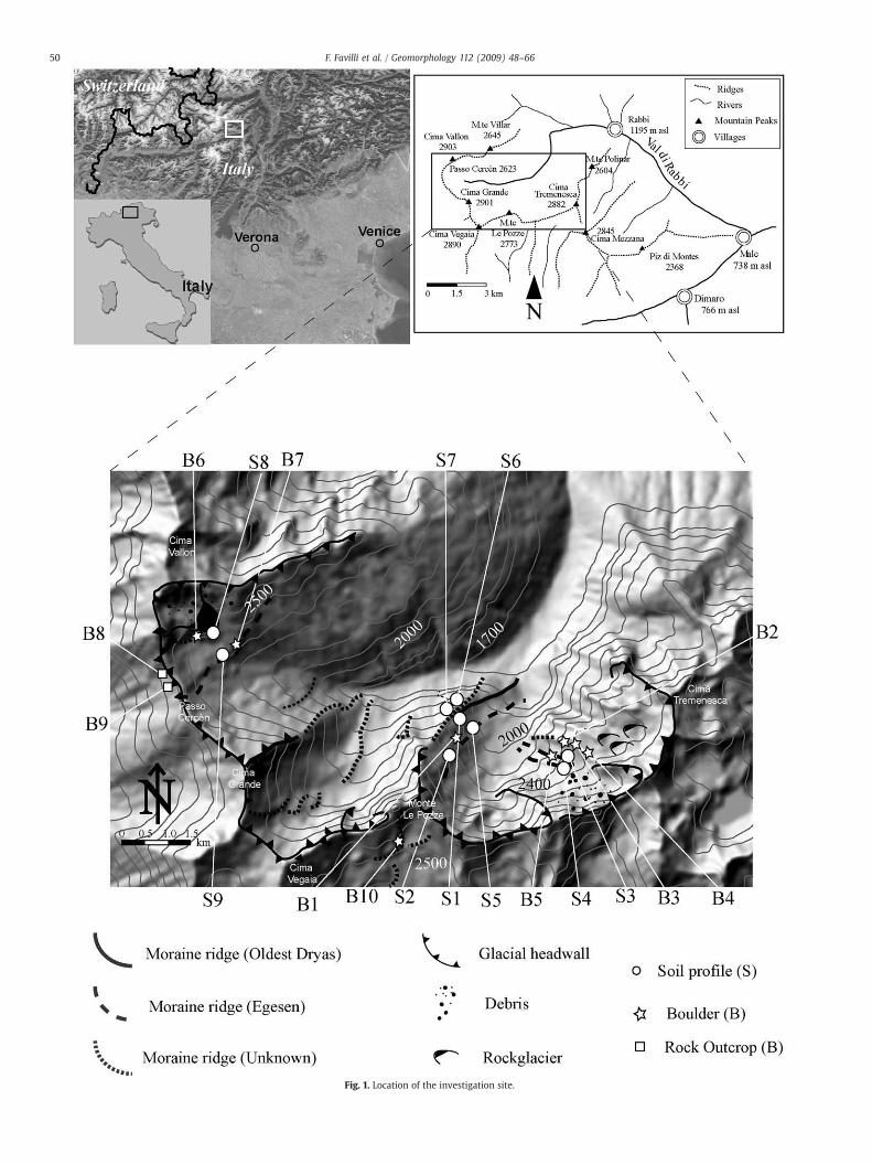
Fig. 1. Location of the investigation site.
50 F. Favilli et al. / Geomorphology 112 (2009) 48–66
Table 1Characteristics of the study sites.
Soilprofile
Elevation(m asl)
Aspect(°N)
Slope(%)
Parentmaterial
Location Estimated Lateglacialchronozone
Vegetation Land use WRB(IUSS WorkingGroup, 2006)
S1 2100 60 32 Paragneiss Lateral moraine Oldest Dryas Larix decidua/Juniperus cimmunis Natural forest Entic PodzolS2 2230 70 55 Paragneiss Lateral moraine Egesen Rhododendro-vaccinietum extrasilvaticum Natural grassland Haplic PodzolS3 2380 320 5 Paragneiss Lateral moraine Egesen Festucetum Natural grassland Protospodic LeptosolS4 2370 300 10 Paragneiss Solifluction Boreal Festucetum Natural grassland Brunic RegosolS5 2083 240 32 Paragneiss Lateral moraine Egesen Larix decidua/Juniperus communis Natural forest Entic PodzolS6 2076 5 38 Paragneiss Lateral moraine Egesen Larix decidua/Juniperus communis Natural forest Entic PodzolS7 2100 3 43 Paragneiss Lateral moraine Egesen Larix decidua/Juniperus communis Natural forest Umbric PodzolS8 2552 200 33 Paragneiss Inactive rockglacier Boreal Carex curvula/Nardus stricta Natural grassland Cambic UmbrisolS9 2449 90 0 Paragneiss Recessional moraine Preboreal Carex curvula/Nardus stricta Natural grassland Umbric Podzol
51F. Favilli et al. / Geomorphology 112 (2009) 48–66
boulders were transported by a glacier or a rockglacier (B6) and were,since the time of the last glacial retreat, exposed to cosmic rayswithout being moved from their present position (Gosse et al., 1995;Table 2). For dating purposes, these boulders were chosen in a stableposition in order to minimise the influence of boulder and slopeinstability (Table 2). As far as possible, boulders were taken in thevicinity of soil sites to enable comparison with 14C data. B8 and B9were rock outcrops andwere sampled in a small cirque to identify thecorresponding glacial retreat. Quartz samples were collected with ahammer and a chisel from the flat tops of the boulders (Ivy-Ochs etal., 2004). Boulder locations are shown in Fig. 1. Boulders B1 throughB5 are found in the cirque defined by Monte Le Pozze and CimaTremenesca. Boulder B1 is located on the distal side of a lateralmoraine along the western side of this cirque in close proximity tosoil sampling sites S1, S2 and S5. Boulder B2 is on the crest of anEgesen (estimated) lateral moraine along the south-eastern side ofthe same cirque. Boulders B3, B4, and B5 are located on differentlateral moraines at a slightly higher elevation than B2. Boulders B6and B7 are found in the cirque just to the east of Passo Cercen. B6 is atthe foot of a rock glacier where the soil S8 is also located; B7 is on afrontal (recessional ?) moraine ridge close to soil S9, while B8 and B9(both rock outcrops in a small cirque, west-facing) are below theformer transfluence pass (Passo Cercèn). B10 is located just south ofthe ridge line below Monte Le Pozze, close to a lateral morainicsediment of unknown age in the south-exposed side of theinvestigated area (Fig. 2). According to their geomorphologicalposition, the boulders were likely to have been deposited at differenttimes by glaciers and can be considered representative of thechronology of deglaciation of the investigated area.
3. Materials and methods
3.1. Soil chemistry and physics
The soil samples were air-dried, large aggregates were gentlycrushed by hand and sieved to b2 mm. Total C and N contents of thesoil were measured using a C/H/N analyser (Elementar Vario EL,Elementar Analysensysteme GmbH, Hanau, Germany) on oven-dried(105 °C) and ball-milled fine earth samples. Soil pH (in 0.01 M CaCl2)was determined on air-dried samples of fine earth using a soil solutionratio of 1:2.5. After a pre-treatment with 3% H2O2, the particle sizedistribution of the soils was measured by a combined methodconsisting of sieving the coarser particles (2000—32 µm) and themeasurement of the finer particles (b32 µm) by means of an X-raysedimentometer (SediGraph 5100, Micromeretics, Norcross, GA, USA).The dithionite- (Fed, Ald) and oxalate-extractable (Feo, Alo) iron andaluminium fractions were extracted according to McKeague et al.(1971) and analysed by AAS (Atomic Absorption Spectrometry—AAnalyst 700, Perkin Elmer, USA). Total element concentrations in thesoil and skeleton (material with a diameter N2 mm) (Na, Ca, Mg, K, Fe,
Al, Si, Mn and Ti) were determined by energy-dispersive X-rayfluorescence spectrometry (X-LAB 2000; SPECTRO, Kleve, Germany)on samples milled to b20 µm.
3.2. Fractionation of stable organic matter
Assuming that chemical oxidation mimics natural oxidativeprocesses, we treated the soils with 10% H2O2 to eliminate the morelabile organic material from the more refractory organic matter(Plante et al., 2004; Eusterhues et al., 2005; Helfrich et al., 2007; Favilliet al., 2008). The stable fraction left at the end of the treatment shouldbe part of the first organic matter formed in the sediment after glacialretreat (Favilli et al., 2009) and thus provide minimum ages for thedeposition of the moraine and of deglaciation. Air-dried and sieved(b2mm) soil was wetted for 10 minwith fewml of distilled water in a250 ml glass beaker. Afterwards, 90 ml of 10% H2O2 per gram of soilwere added. The procedure was run at a minimum temperature of50 °C throughout the treatment period. The beakers were closed withtwo layers of parafilm to avoid evaporation of the reagent. Peroxidetreatments were performed for 168 h (7 days). At the end of thetreatment the samples were washed three times with 40 ml ofdeionised water per gram of soil, freeze-dried, weighted, analysed fortotal C and N and 14C-dated. In addition to the stable fraction, also theage of the bulk soil organic matter was dated. Site S4 has a buried soil.To derive the age of burial, the remaining roots of the sample weretreated with hydrochloric acid, followed by a treatment with sodiumhydroxide to remove humic acids formed during the decompositionprocess.
3.3. Charcoal
Charcoal fragments were separated from the soil material by hand-picking and dried at 40 °C. The individual particles were analysedmicroscopically and separated into coniferous and broad-leaved treespecies (Schoch, 1986) with a stereomicroscope (magnification 6.4–40×, Wild M3Z Leica, Germany). The charcoal fragments from theconiferous trees were further divided at the genus level using areflected-light microscope (objectives 5×, 10×, and 20×, Olympus BX51, Japan). The observations were compared with a histological wood-anatomical atlas, using an identification key (Schweingruber, 1990).Charcoal identification was performed at the WSL Swiss FederalResearch Institute at Birmensdorf (Switzerland).
3.4. Radiocarbon dating
The CO2 of the combusted samples was catalytically reduced overcobalt powder at 550 °C to elemental carbon (graphite). Afterreduction, this mixture was pressed into a target and carbon ratioswere measured by Accelerator Mass Spectrometry (AMS) using thetandem accelerator of the Institute of Particle Physics at the Swiss
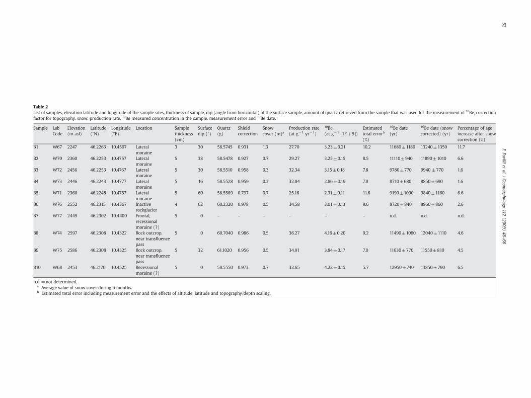
Table 2List of samples, elevation latitude and longitude of the sample sites, thickness of sample, dip (angle from horizontal) of the surface sample, amount of quartz retrieved from the sample that was used for the measurement of 10Be, correctionfactor for topography, snow, production rate, 10Be measured concentration in the sample, measurement error and 10Be date.
Sample LabCode
Elevation(m asl)
Latitude(°N)
Longitude(°E)
Location Samplethickness(cm)
Surfacedip (°)
Quartz(g)
Shieldcorrection
Snowcover (m)a
Production rate(at g−1 yr−1)
10Be(at g−1 [1E+5])
Estimatedtotal errorb
(%)
10Be date(yr)
10Be date (snowcorrected) (yr)
Percentage of ageincrease after snowcorrection (%)
B1 W67 2247 46.2263 10.4597 Lateralmoraine
3 30 58.5745 0.931 1.3 27.70 3.23±0.21 10.2 11680±1180 13240±1350 11.7
B2 W70 2360 46.2253 10.4757 Lateralmoraine
5 38 58.5478 0.927 0.7 29.27 3.25±0.15 8.5 11110±940 11890±1010 6.6
B3 W72 2456 46.2253 10.4767 Lateralmoraine
5 30 58.5510 0.958 0.3 32.34 3.15±0.18 7.8 9780±770 9940 ±770 1.6
B4 W73 2446 46.2243 10.4777 Lateralmoraine
5 16 58.5528 0.959 0.3 32.84 2.86±0.19 7.8 8710±680 8850±690 1.6
B5 W71 2360 46.2248 10.4757 Lateralmoraine
5 60 58.5589 0.797 0.7 25.16 2.31±0.11 11.8 9190±1090 9840±1160 6.6
B6 W76 2552 46.2315 10.4367 Inactiverockglacier
4 62 60.2320 0.978 0.5 34.58 3.01±0.13 9.6 8720±840 8960±860 2.6
B7 W77 2449 46.2302 10.4400 Frontal,recessionalmoraine (?)
5 0 – – – – – – n.d. n.d. n.d.
B8 W74 2597 46.2308 10.4322 Rock outcrop,near transfluencepass
5 0 60.7040 0.986 0.5 36.27 4.16±0.20 9.2 11490±1060 12040±1110 4.6
B9 W75 2586 46.2308 10.4325 Rock outcrop,near transfluencepass
5 32 61.1020 0.956 0.5 34.91 3.84±0.17 7.0 11030±770 11550±810 4.5
B10 W68 2453 46.2170 10.4525 Recessionalmoraine (?)
5 0 58.5550 0.973 0.7 32.65 4.22±0.15 5.7 12950±740 13850±790 6.5
n.d.=not determined.a Average value of snow cover during 6 months.b Estimated total error including measurement error and the effects of altitude, latitude and topography/depth scaling.
52F.Favilli
etal./
Geom
orphology112
(2009)48
–66
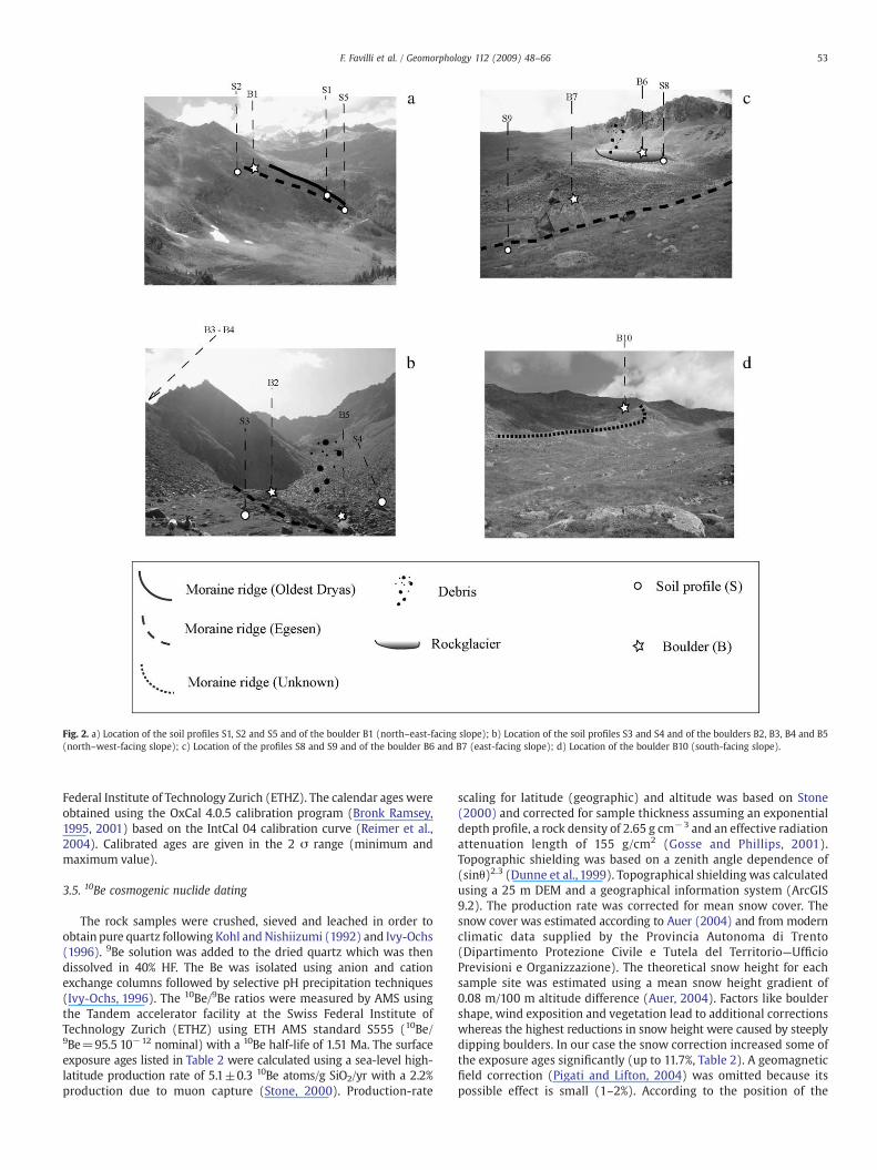
Fig. 2. a) Location of the soil profiles S1, S2 and S5 and of the boulder B1 (north–east-facing slope); b) Location of the soil profiles S3 and S4 and of the boulders B2, B3, B4 and B5(north–west-facing slope); c) Location of the profiles S8 and S9 and of the boulder B6 and B7 (east-facing slope); d) Location of the boulder B10 (south-facing slope).
53F. Favilli et al. / Geomorphology 112 (2009) 48–66
Federal Institute of Technology Zurich (ETHZ). The calendar ages wereobtained using the OxCal 4.0.5 calibration program (Bronk Ramsey,1995, 2001) based on the IntCal 04 calibration curve (Reimer et al.,2004). Calibrated ages are given in the 2 σ range (minimum andmaximum value).
3.5. 10Be cosmogenic nuclide dating
The rock samples were crushed, sieved and leached in order toobtain pure quartz following Kohl and Nishiizumi (1992) and Ivy-Ochs(1996). 9Be solution was added to the dried quartz which was thendissolved in 40% HF. The Be was isolated using anion and cationexchange columns followed by selective pH precipitation techniques(Ivy-Ochs, 1996). The 10Be/9Be ratios were measured by AMS usingthe Tandem accelerator facility at the Swiss Federal Institute ofTechnology Zurich (ETHZ) using ETH AMS standard S555 (10Be/9Be=95.5 10−12 nominal) with a 10Be half-life of 1.51 Ma. The surfaceexposure ages listed in Table 2 were calculated using a sea-level high-latitude production rate of 5.1±0.3 10Be atoms/g SiO2/yr with a 2.2%production due to muon capture (Stone, 2000). Production-rate
scaling for latitude (geographic) and altitude was based on Stone(2000) and corrected for sample thickness assuming an exponentialdepth profile, a rock density of 2.65 g cm−3 and an effective radiationattenuation length of 155 g/cm2 (Gosse and Phillips, 2001).Topographic shielding was based on a zenith angle dependence of(sinθ)2.3 (Dunne et al., 1999). Topographical shielding was calculatedusing a 25 m DEM and a geographical information system (ArcGIS9.2). The production rate was corrected for mean snow cover. Thesnow cover was estimated according to Auer (2004) and from modernclimatic data supplied by the Provincia Autonoma di Trento(Dipartimento Protezione Civile e Tutela del Territorio—UfficioPrevisioni e Organizzazione). The theoretical snow height for eachsample site was estimated using a mean snow height gradient of0.08 m/100 m altitude difference (Auer, 2004). Factors like bouldershape, wind exposition and vegetation lead to additional correctionswhereas the highest reductions in snow height were caused by steeplydipping boulders. In our case the snow correction increased some ofthe exposure ages significantly (up to 11.7%, Table 2). A geomagneticfield correction (Pigati and Lifton, 2004) was omitted because itspossible effect is small (1–2%). According to the position of the
Table 3Physical characteristics of the investigated soils.
Site Soilhorizon
Depth(cm)
Munsell colour(moist)
Skeletona
(%)Sandb
(g/kg)Silt(g/kg)
Clay(g/kg)
S1AE 0–4 10 yr 3/3 5 455 280 265BE 4–8 5 yr 4/4 11 515 280 205Bs1 8–20 7.5 yr 4/4 51 575 286 139Bs2 20–45 10 yr 4/4 45 671 275 54BC 45–60 10 yr 5/4 34 n.d. n.d. n.d.
S2AE 0–9 7.5 yr 2/1 3 397 398 205Bhs 9–20 7.5 yr 3/3 19 717 209 74Bs 20–40 7.5 yr 4/3 58 709 252 39
S3AE1 0–4 10 yr 2/3 8 457 223 320AE2 4–12 10 yr 3/2 21 576 212 212Bhs 12–20 10 yr 4/2 45 638 172 190
S4A 0–8 10 yr 3/2 0 352 496 152Bw1 8–20 10 yr 4/4 1 409 437 154Bw2 20–32 10 yr 4/4 32 692 258 50Ab 32–35 10 yr 3/3 2 309 498 193Bb 35–40 10 yr 4/4 49 839 136 25
S5AE 0–11 10 yr 4/3 7 437 302 261Bs1 11–26 5 yr 4/6 16 551 344 105Bs2 26–50 7.5 yr 4/6 47 663 258 79
S6AE 8–17 2.5 yr 5/1 54 438 417 145Bs1 17–38 5 yr 4/6 67 561 317 122Bs2 38–45 7.5 yr 4/6 68 561 317 122BC 45–60 10 yr 4/6 56 530 353 117
S7AE 5–10 10 yr 2/1 43 498 290 212Bs1 11–25 10 yr 3/3 63 544 323 133Bs2 25–50 10 yr 3/3 44 536 331 133BC 50–60 10 yr 3/3 60 532 333 135
S8AE 0–20 7.5 yr 3/2 37 486 374 140Bs 20–25 5 yr 2/4 59 599 360 41BC 25–48 10 yr 4/6 54 632 345 23
S9AE 0–11 7.5 yr 3/2 16 381 416 203Bs 11–23 7.5 yr 3/3 27 497 400 103BC 23–40 7.5 yr 4/4 46 654 310 36
n.d.=Not determined.a Skeleton=MaterialN 2 mm.b Size fractions: sand=2000–62 µm, silt=62–2 µm, clay=b2 µm.
54 F. Favilli et al. / Geomorphology 112 (2009) 48–66
selected boulders in the investigation area and based on results fromnumerous sites in the Alps, it is not likely that they were pre-exposedto cosmic rays before being deposited by the glacier (Ivy-Ochs et al.,2007).
3.6. Soil mineralogy
The clay fraction (b2 µm) was obtained from the soil after thedestruction of organic matter with diluted and sodium acetate-buffered 3% H2O2 (pH 5), dispersion with Calgon (Na6O18P6), andsedimentation inwater (Carnicelli et al., 1997). Oriented specimens onglass slides were analysed by X-ray diffraction (XRD) using Cu–Kαradiation from 2° to 15° 2θ with steps of 0.02° 2 θ at 2 s per step. Thefollowing treatments were performed: Mg saturation, ethylene glycolsolvation (EG) and K saturation, followed by heating for 2 h at 335 and550 ° C (Brown and Brindley, 1980). Clay mineral identification wasperformed at the Institute for Soil Study and Conservation in Florence(Italy). Digitised X-ray data were smoothed and corrected for Lorentzand polarisation factors (Moore and Reynolds, 1997). Peak separationand profile analysis were carried out by the Origin PFM™ using thePearson VII algorithm after smoothing the diffraction patterns by aFourier transform function. Background values were calculated bymeans of a non-linear function (polynomial second-order function;Lanson, 1997). The program reconstructs single peaks by fitting theenvelope curve of overlapping peaks. This procedure also outputs theposition and the integral intensity (area) of each single peak. On thebasis of these integrals, an estimate of sheet-silicate composition wasperformed. The sum of the areas between 2° and 15° 2θ, which wereattributed to HIV (hydroxy-interlayered vermiculites), smectite,vermiculite, mica, chlorite and kaolinite, were standardised to 100%.All treatments, including Mg saturation, ethylene glycol solvation(EG), K saturation and heating at 335 and 550 °C had to be consideredfor these calculations. The relative changes of the areas with respect tothe treatments, enabled the above mineral phases to be distinguished.For the Mg-saturated and for the ethylene glycol solvation treatment,the area of the following peaks (d-spacings) had to be corrected by aweighting factor F: 1.6 nm with F=0.453, 1.4 nm with F=0.478, and0.71 nm with F=0.16 (Niederbudde and Kussmaul, 1978; Schwert-mann and Niederbudde, 1993). This procedure allowed the estimationof the relative concentrations of sheet-silicates in the clay fraction. Inaddition to the XRD measurement, the identification of kaolinite wasconfirmed by infrared (FT-IR). Spectra for FT-IR (Bruker, Tensor 27)measurements were recorded from 4000 to 250 cm−1 on pelletsmade with 1 mg of sample and 250 mg of KBr heated at 150 °C.
3.7. Calculation of weathering rates
Long-term weathering rates of soils were derived from thecalculations of enrichment/depletion factors determined usingimmobile element content such as Ti, Zr or V. Weatherable elementsmust be ratioed against an inert component present in both the parentmaterial and the soil. We used Ti as a tracer. The derivation of massbalance equations and their application to pedologic processes werediscussed in detail by Brimhall and Dietrich (1987) and Chadwicket al. (1990), and revised by Egli and Fitze (2000).
Volumetric changes that occur during pedogenesis were deter-mined by adopting the classical definition of strain, εi,w (Brimhall andDietrich, 1987):
ei;w =ΔzwΔz
− 1 ð1Þ
with Δz as the columnar height (m) of a representative elementaryvolume of protore (or unweathered parent material) p, and Δzw is theweathered equivalent height (m) w. The calculation of the open-
system mass transport function τj,w was defined by Chadwick et al.(1990):
τj;w =ρwCj;w
ρpCj;pei;w + 1� � !
− 1 ð2Þ
where Cj,p (kg/t) is the concentration of element j in protolith (e.g.,unweathered parent material, bedrock), Cj,w is the concentration ofelement j in the weathered product (kg/t), and ρp and ρw representsthe bulk density (t/m3) of the protolith and the weathered soil,respectively.
With n soil layers, the calculation of changes in mass of element jwas given by (Egli and Fitze, 2000)
mj;flux zwð Þ =Xna=1
Cj;pρp1
ei;w + 1
!τj;wΔzw ð3Þ
where τj,w corresponds to the mass transport function, εi,w to thestrain, and Δz to theweathered equivalent of the columnar height (m)of a representative elementary volume.
55F. Favilli et al. / Geomorphology 112 (2009) 48–66
4. Results
4.1. Physical characteristics and chemical composition of the soils
The investigated soils developed on a morainic substratum over aparagneiss parent material. The proportion of rock fragments rangesfrom 0% up to 60% (Table 3), which is a typical value for Alpine soils(Egli et al., 2001a). All investigated soils have a loamy to loamy–sandtexture. The effect of weathering is clearly visible in the decrease ofthe proportion of sand towards the soil surface, and in thecorresponding increase in silt and clay (Table 3). Due to the siliceousparent material the soils show pronounced acidification (Table 4).Total C corresponds to organic C due to the absence of any carbonatesin the soil. The podzolised soils (S1, S2, S5, S6, S7, S9) show a typicaleluviation and illuviation of Fe and Al (Fig. 3). A distinct increase indithionate and oxalate iron and aluminiumwas observed in all spodichorizons (Table 4). S3 was rather shallow but showed the typicalcharacteristics of a developing podzol such as the translocation of Fe,Al and organic C into the Bhs horizon due to intense leachingconditions. Soil S4 has a polygenetic structure. At 32 cm depth, aburied soil appeared. Accordingly, a clear change in all physical andchemical characteristics was measurable due to this discontinuity(Tables 3 and 4). The soils S6 and S7 might have been influenced by
Table 4Chemical characterisation of the investigated soils.
Site Soil horizon pH (CaCl2) Org. C (g/kg) Total N (g/kg) C/N Fet (g/kg)
S1AE 3.7 103.7 5.7 18 27.12BE 3.6 61.0 2.9 21 33.63Bs1 4.1 39.4 1.8 22 62.44Bs2 4.4 17.0 0.7 24 52.50BC 4.5 7.5 0.6 12 49.28
S2AE 3.4 184.6 28.1 7 27.69Bhs 3.7 63.8 11.8 5 65.10Bs 4.1 25.4 8.8 3 64.46
S3AE1 3.4 124.9 6.8 18 17.41AE2 3.5 48.0 2.2 22 26.80Bhs 3.8 71.4 3.1 23 46.36
S4A 3.8 55.3 3.8 15 59.60Bw1 4.0 20.7 1.5 14 69.31Bw2 4.1 19.5 1.3 15 60.37Ab 3.9 62.0 3.9 16 48.38Bb 4.2 9.1 0.5 18 56.16
S5AE 3.5 56.9 2.7 21 35.31Bs1 3.8 35.3 1.7 21 69.36Bs2 4.3 22.8 1.1 21 56.78
S6AE 3.5 76.5 4.1 19 24.64Bs1 4.0 45.3 1.8 25 55.7Bs2 4.1 47.6 1.6 30 n.d.BC 4.2 35.5 1.1 32 44.24
S7AE 3.1 143.9 6.4 22 21.62Bs1 3.7 48.5 1.4 35 24.3Bs2 3.7 48.3 1.6 30 n.d.BC 3.7 48.7 1.5 32 22.7
S8AE 3.8 43.0 2.3 19 31.92Bs 4.2 29.5 1.4 21 n.d.BC 4.4 8.0 0.5 16 32.97
S9AE 3.2 56.4 3.8 15 18.6Bs 3.8 37.8 1.6 24 n.d.BC 4.1 17.9 0.7 26 41.02
n.d.=Not determined.t=Total content; o=Oxalate extractable content; d=Dithionite extractable content.
slope mass movements due to the high content of skeleton (materialN2 mm in diameter) towards the surface (Table 3). In these soils thedegree of podzolisation (i.e., migration of Fe and Al forms in theprofile) is much more pronounced at the S6 site. The soil S6 shows aclear horizon differentiation, as visible by the Munsell colour(Table 3). The amount of migrated sesquioxides is more than doublein the S6 site compared to S7. The amount of organic carbon in the S7site is constant within the profile, except in the topsoil. The topsoil ofS7 exhibits almost double the amount of OM compared to the topsoilof S6 (Table 4). Soil S7 does not show a clear horizon differentiation(Table 3). A first translocation of Fe and Al formswithin the soil profilewas also observed in the alpine soils (S8 and S9). The degree ofpodzolisation was more pronounced at the site S9 than at the site S8(Fig. 3 and Table 4).
In the investigated soils, the difference in the oxalate-extractable Albetween the spodic and the albic horizon [Alo(Bhs/Bs)−Alo(AE/BE)]reflects the amount of pedogenic and poorly crystalline Al (Birkeland,1999) that migrates and accumulates downward in the soil profile dueto acidification of the surface and the subsequent leaching. If thisdifference (ΔAlo) is plotted against the duration of soil development,using the oldest age calculated for each soil profile derived from 14Cdata of the resilient (H2O2 resistant) organic matter (OM) (Table 5),then a significant correlation is observed (Fig. 4a). Chemical criteria for
Sio (g/kg) Alo (g/kg) Feo (g/kg) Fed (g/kg) Ald (g/kg) Alo+0.5 Feo (%)
0.01 1.73 5.57 15.90 2.50 0.450.01 1.91 6.06 20.50 2.80 0.490.00 10.27 19.62 44.10 14.70 2.010.00 5.84 9.37 21.40 7.30 1.050.94 4.04 1.67 6.90 5.60 0.48
0.00 2.78 5.67 14.53 3.94 0.560.07 6.31 24.90 45.33 5.96 1.880.47 6.41 8.81 30.13 10.65 1.08
0.09 2.03 2.47 8.50 2.80 0.330.12 2.48 4.33 11.00 3.20 0.460.00 8.30 13.76 27.10 14.20 1.52
0.21 3.05 7.05 21.90 5.40 0.660.19 2.47 9.61 30.80 5.00 0.730.13 1.58 4.21 20.60 3.30 0.370.17 4.39 6.52 23.10 7.50 0.760.09 1.57 3.70 15.30 2.70 0.34
0.05 2.18 7.13 21.10 3.10 0.570.12 6.42 20.19 50.70 9.50 1.650.36 6.35 10.08 24.50 8.60 1.14
0.022 1.49 3.88 13.54 1.82 0.340.089 5.60 16.46 35.81 8.21 1.380.124 5.53 15.57 35.18 9.20 1.330.115 4.09 14.42 30.47 6.57 1.13
0.063 0.89 1.52 8.06 1.33 0.160.050 1.92 4.39 12.64 3.26 0.410.012 1.81 3.54 10.43 2.89 0.360.036 1.90 3.64 11.12 3.23 0.37
0.87 4.63 6.18 22.82 7.82 0.772.51 6.21 6.32 19.09 8.69 0.945.75 3.30 1.97 13.92 4.40 0.43
0.07 3.15 4.60 12.65 3.04 0.550.98 7.32 10.74 31.06 8.30 1.271.42 4.08 4.01 18.64 5.91 0.61
Fig. 3. Migration of Fe and Al (dithionite extraction) in the investigated soil profiles.
56 F. Favilli et al. / Geomorphology 112 (2009) 48–66
spodic material require that oxalate-extractable Alo+0.5 Feo is ≥0.5%and at least two times greater than in the overlying albic horizon (SoilSurvey Staff, 2006; Briggs et al., 2006). In our studied soils, the averageAlo+0.5 Feo value in the Bs1 (or Bhs) horizon is 1.31 (%wt) and in theAE (or BE) horizon 0.52 (%wt). The Alo+0.5 Feo values of the Bs (Bhs)horizon are 2.5–4 times greater than those of the overlying AE (BE)horizon. This criterion, too, is significantly related to the age of theresilient OM (Fig. 4b)
4.2. Radiocarbon age of soil organic matter
A decreasing age with soil depth was measured in the profiles S1,S5, S8 and S9 (Table 5). Soil profile S1, revealing an age of around16782–17839 cal BP, may represent the first stage of deglaciation thatoccurred in the studied area (Fig. 5). The younger ages found in thetopsoil in comparison to those in the subsoil of profiles S2, S3 and S7are probably due to the very high C content (N11%) and either to theincapability of H2O2 to oxidise all young OM or to an exchange of oldby younger OM. Young OMwas probably able to expel older C becauseof the high competition for mineral-adsorption sites. The measuredyoung age in the topsoil of S2 after the H2O2-treatment does notindicate the start of soil formation as the age would be much tooyoung. The podzolic characteristics as well as the clay mineralassemblage indicate that the soil must be older (see below). The agederived from the Bs horizon would be much more plausible (10825–11386 cal BP) andmay reflect a deposition of glacial sediments relatedto the Egesen glacial stage. The untreated soil organic matter from thesubsoil of site S3 (Table 5, Bhs horizon) has a very young age. Strong
leaching conditions, due to the very low pH, probably caused thedownward migration of soluble young-aged organic material com-pounds with soil percolating water into the subsoil. The H2O2-treatment, performed on the sample from the Bhs horizon of S3 gavean age of 10435–11073 cal BP of the resilient OM-fraction. Thepolygenetic structure of the site S4 was confirmed by the 14C results.Soil formation in the buried layer started around 13596–13991 cal BPand ended, due to an accumulation of eroded, unweathered material(slope deposits) between 2366 and 2743 cal BP (Table 5; Fig. 5). Plantgrowth, humus formation and weathering of the buried soil conse-quently stopped. This event was inferred from dating root residues inthe Ab horizon. Preweathered and mixed sediment, already containingorganic material (having an age of 8370–9073 cal BP, see Table 5 andFig. 4), was deposited on the top of the original soil (probably bysolifluction). The soil S5 has an age of around 10575–11099 cal BP.According to its age (Table 5), to its position (Figs. 1 and 2) and to thedevelopment of podzol features and clayminerals (Fig. 3; Tables 4 and 6)the sedimentonwhich the soil profile S5developed is of similarageas soilprofile S2. The age of the soils S2, S3, S5 and S9 (see below) refer to thesameperiod andgives a general overviewof the extent of glaciation at theend of the Younger Dryas (Egesen stadial).
The ages of the resilient organic fraction in the profiles S6 and S7were rather young and similar (between 2792–3076 cal BP in thetopsoil and 5320–5584 cal BP in the subsoil). These ‘young’ agescompared to S1, S2 and S5 could be due to mass movements(solifluction, slope instability) until about 5000 cal BP. The real ageof the sediment is likely to be much older (see the age derived from S1and 10Be dates of boulders; see below). Chemical and mineralogicaldata confirm the high degree of weathering these soils underwent(especially S6) during the last 5000 yr. The stability of the surface onwhich S6 evolved was inferred from the development of typicalpodzol features (Briggs et al., 2006). Soil S7, although showing thesame age as S6, was much more affected by slope instabilities, as seenby the physical and chemical characteristics (Tables 3 and 4).
The stable fraction of OM in the topsoil at the site S8 (2552 m asl)has an age of 9009–9397 cal BP. The age of this soil, together with itstopographical position (see Fig. 2c), gives a good insight into thetiming of deglaciation in this area. Probably the material onwhich soilS8 developed was deposited during the ‘Oberhalbstein-/Schams-Kaltphase’ (around 8700–9500 cal BP; Maisch et al., 1999). Soil S9,developed at 2449m asl, had an age in the topsoil of 10794–11600 calBP which would fit with deposition of glacial sediments during thelate Egesen glacial stage (Younger Dryas) or the early Preboreal (Ivy-Ochs et al., 2006a, 2008). In the same time range, the soils of the sitesS2, S3 and S5 also started to develop (Fig. 5).
4.3. Charcoal
Dating of charcoal fragments from the horizons of one of the mostwell-developed profile (S5) gave increasing 14C ages with soil depthwith 3081–3381 cal BP in the upper horizon to 10212–10509 cal BP inthe lower one (data shown in Favilli et al., 2008). The charcoalfragments could be identified as Larix, Picea and Pinus—the same kindof trees which currently dominate the forest. According to the plantsuccession model of Burga (1999), Larix trees are able to grow at suchan altitude after about 150–300 yr of soil formation. Themeasured ageof 10212–10509 cal BP of the charcoal and the minimum timenecessary for tree growthwould give a minimum age of soil formationof about 10500–10800 cal BP which corresponds very well with themeasured age of the resilient organic matter fraction after the H2O2
extraction (in the surface horizon).
4.4. 10Be exposure ages
The 10Be ages of the sampled boulders range between 13850±790 yr and 8850±690 yr (Table 2). Boulder B10 (Fig. 2d, Table 2) was
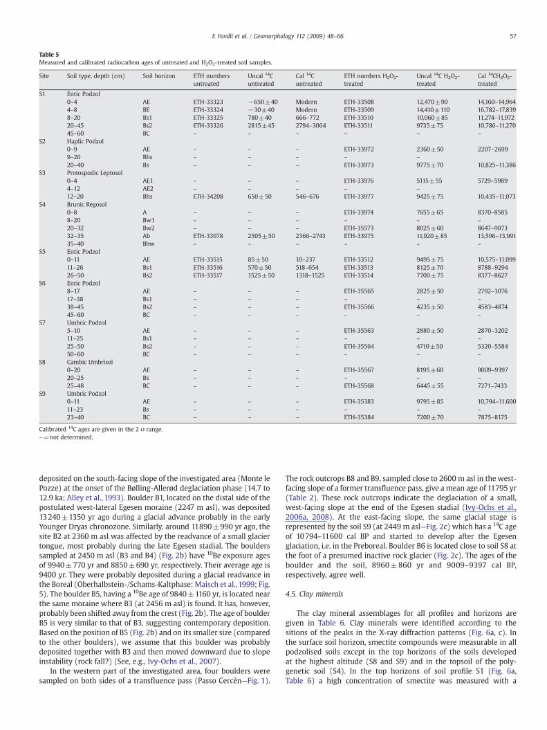
Table 5Measured and calibrated radiocarbon ages of untreated and H2O2-treated soil samples.
Site Soil type, depth (cm) Soil horizon ETH numbersuntreated
Uncal 14Cuntreated
Cal 14Cuntreated
ETH numbers H2O2-treated
Uncal 14C H2O2-treated
Cal 14CH2O2-treated
S1 Entic Podzol0–4 AE ETH-33323 −650±40 Modern ETH-33508 12,470±90 14,160–14,9644–8 BE ETH-33324 −30±40 Modern ETH-33509 14,410±110 16,782–17,8398–20 Bs1 ETH-33325 780±40 666–772 ETH-33510 10,060±85 11,274–11,97220–45 Bs2 ETH-33326 2815±45 2794–3064 ETH-33511 9735±75 10,786–11,27045–60 BC – – – – – –
S2 Haplic Podzol0–9 AE – – – ETH-33972 2360±50 2207–26999–20 Bhs – – – – –
20–40 Bs – – – ETH-33973 9775±70 10,825–11,386S3 Protospodic Leptosol
0–4 AE1 – – – ETH-33976 5115±55 5729–59894–12 AE2 – – – – –
12–20 Bhs ETH-34208 650±50 546–676 ETH-33977 9425±75 10,435–11,073S4 Brunic Regosol
0–8 A – – – ETH-33974 7655±65 8370–85858–20 Bw1 – – – – – –
20–32 Bw2 – – – ETH-35573 8025±60 8647–907332–35 Ab ETH-33978 2505±50 2366–2743 ETH-33975 11,920±85 13,596–13,99135–40 Bbw – – – – – –
S5 Entic Podzol0–11 AE ETH-33515 85±50 10–237 ETH-33512 9495±75 10,575–11,09911–26 Bs1 ETH-33516 570±50 518–654 ETH-33513 8125±70 8788–929426–50 Bs2 ETH-33517 1525±50 1318–1525 ETH-33514 7700±75 8377–8627
S6 Entic Podzol8–17 AE – – – ETH-35565 2825±50 2792–307617–38 Bs1 – – – – – –
38–45 Bs2 – – – ETH-35566 4235±50 4583–487445–60 BC – – – – – –
S7 Umbric Podzol5–10 AE – – – ETH-35563 2880±50 2870–320211–25 Bs1 – – – – – –
25–50 Bs2 – – – ETH-35564 4710±50 5320–558450–60 BC – – – – – –
S8 Cambic Umbrisol0–20 AE – – – ETH-35567 8195±60 9009–939720–25 Bs – – – – – –
25–48 BC – – – ETH-35568 6445±55 7271–7433S9 Umbric Podzol
0–11 AE – – – ETH-35383 9795±85 10,794–11,60011–23 Bs – – – – – –
23–40 BC – – – ETH-35384 7200±70 7875–8175
Calibrated 14C ages are given in the 2 σ range.–=not determined.
57F. Favilli et al. / Geomorphology 112 (2009) 48–66
deposited on the south-facing slope of the investigated area (Monte lePozze) at the onset of the Bølling-Allerød deglaciation phase (14.7 to12.9 ka; Alley et al., 1993). Boulder B1, located on the distal side of thepostulated west-lateral Egesen moraine (2247 m asl), was deposited13240±1350 yr ago during a glacial advance probably in the earlyYounger Dryas chronozone. Similarly, around 11890±990 yr ago, thesite B2 at 2360 m asl was affected by the readvance of a small glaciertongue, most probably during the late Egesen stadial. The boulderssampled at 2450 m asl (B3 and B4) (Fig. 2b) have 10Be exposure agesof 9940±770 yr and 8850±690 yr, respectively. Their average age is9400 yr. They were probably deposited during a glacial readvance inthe Boreal (Oberhalbstein-/Schams-Kaltphase: Maisch et al., 1999; Fig.5). The boulder B5, having a 10Be age of 9840±1160 yr, is located nearthe same moraine where B3 (at 2456 m asl) is found. It has, however,probably been shifted away from the crest (Fig. 2b). The age of boulderB5 is very similar to that of B3, suggesting contemporary deposition.Based on the position of B5 (Fig. 2b) and on its smaller size (comparedto the other boulders), we assume that this boulder was probablydeposited together with B3 and then moved downward due to slopeinstability (rock fall?) (See, e.g., Ivy-Ochs et al., 2007).
In the western part of the investigated area, four boulders weresampled on both sides of a transfluence pass (Passo Cercèn—Fig. 1).
The rock outcrops B8 and B9, sampled close to 2600 m asl in the west-facing slope of a former transfluence pass, give a mean age of 11795 yr(Table 2). These rock outcrops indicate the deglaciation of a small,west-facing slope at the end of the Egesen stadial (Ivy-Ochs et al.,2006a, 2008). At the east-facing slope, the same glacial stage isrepresented by the soil S9 (at 2449 m asl—Fig. 2c) which has a 14C ageof 10794–11600 cal BP and started to develop after the Egesenglaciation, i.e. in the Preboreal. Boulder B6 is located close to soil S8 atthe foot of a presumed inactive rock glacier (Fig. 2c). The ages of theboulder and the soil, 8960±860 yr and 9009–9397 cal BP,respectively, agree well.
4.5. Clay minerals
The clay mineral assemblages for all profiles and horizons aregiven in Table 6. Clay minerals were identified according to thesitions of the peaks in the X-ray diffraction patterns (Fig. 6a, c). Inthe surface soil horizon, smectite compounds were measurable in allpodzolised soils except in the top horizons of the soils developedat the highest altitude (S8 and S9) and in the topsoil of the poly-genetic soil (S4). In the top horizons of soil profile S1 (Fig. 6a,Table 6) a high concentration of smectite was measured with a
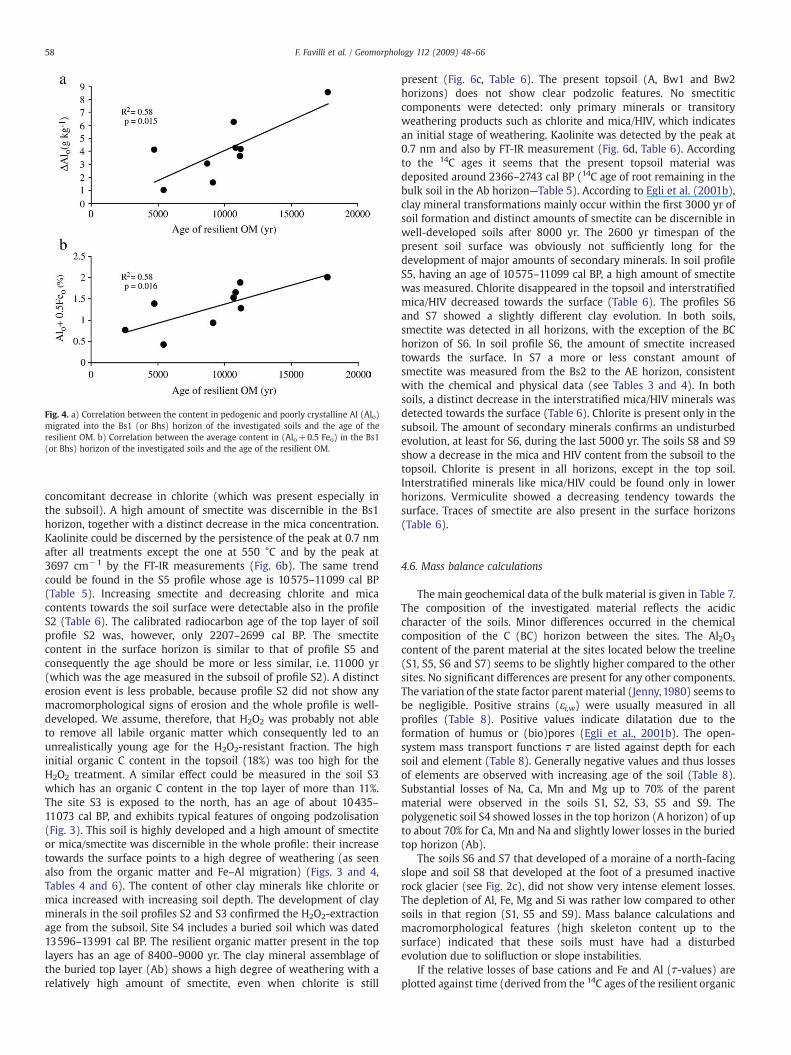
Fig. 4. a) Correlation between the content in pedogenic and poorly crystalline Al (Alo)migrated into the Bs1 (or Bhs) horizon of the investigated soils and the age of theresilient OM. b) Correlation between the average content in (Alo+0.5 Feo) in the Bs1(or Bhs) horizon of the investigated soils and the age of the resilient OM.
58 F. Favilli et al. / Geomorphology 112 (2009) 48–66
concomitant decrease in chlorite (which was present especially inthe subsoil). A high amount of smectite was discernible in the Bs1horizon, together with a distinct decrease in the mica concentration.Kaolinite could be discerned by the persistence of the peak at 0.7 nmafter all treatments except the one at 550 °C and by the peak at3697 cm−1 by the FT-IR measurements (Fig. 6b). The same trendcould be found in the S5 profile whose age is 10575–11099 cal BP(Table 5). Increasing smectite and decreasing chlorite and micacontents towards the soil surface were detectable also in the profileS2 (Table 6). The calibrated radiocarbon age of the top layer of soilprofile S2 was, however, only 2207–2699 cal BP. The smectitecontent in the surface horizon is similar to that of profile S5 andconsequently the age should be more or less similar, i.e. 11000 yr(which was the age measured in the subsoil of profile S2). A distincterosion event is less probable, because profile S2 did not show anymacromorphological signs of erosion and the whole profile is well-developed. We assume, therefore, that H2O2 was probably not ableto remove all labile organic matter which consequently led to anunrealistically young age for the H2O2-resistant fraction. The highinitial organic C content in the topsoil (18%) was too high for theH2O2 treatment. A similar effect could be measured in the soil S3which has an organic C content in the top layer of more than 11%.The site S3 is exposed to the north, has an age of about 10435–11073 cal BP, and exhibits typical features of ongoing podzolisation(Fig. 3). This soil is highly developed and a high amount of smectiteor mica/smectite was discernible in the whole profile: their increasetowards the surface points to a high degree of weathering (as seenalso from the organic matter and Fe–Al migration) (Figs. 3 and 4,Tables 4 and 6). The content of other clay minerals like chlorite ormica increased with increasing soil depth. The development of clayminerals in the soil profiles S2 and S3 confirmed the H2O2-extractionage from the subsoil. Site S4 includes a buried soil which was dated13596–13991 cal BP. The resilient organic matter present in the toplayers has an age of 8400–9000 yr. The clay mineral assemblage ofthe buried top layer (Ab) shows a high degree of weathering with arelatively high amount of smectite, even when chlorite is still
present (Fig. 6c, Table 6). The present topsoil (A, Bw1 and Bw2horizons) does not show clear podzolic features. No smectiticcomponents were detected: only primary minerals or transitoryweathering products such as chlorite and mica/HIV, which indicatesan initial stage of weathering. Kaolinite was detected by the peak at0.7 nm and also by FT-IR measurement (Fig. 6d, Table 6). Accordingto the 14C ages it seems that the present topsoil material wasdeposited around 2366–2743 cal BP (14C age of root remaining in thebulk soil in the Ab horizon—Table 5). According to Egli et al. (2001b),clay mineral transformations mainly occur within the first 3000 yr ofsoil formation and distinct amounts of smectite can be discernible inwell-developed soils after 8000 yr. The 2600 yr timespan of thepresent soil surface was obviously not sufficiently long for thedevelopment of major amounts of secondary minerals. In soil profileS5, having an age of 10575–11099 cal BP, a high amount of smectitewas measured. Chlorite disappeared in the topsoil and interstratifiedmica/HIV decreased towards the surface (Table 6). The profiles S6and S7 showed a slightly different clay evolution. In both soils,smectite was detected in all horizons, with the exception of the BChorizon of S6. In soil profile S6, the amount of smectite increasedtowards the surface. In S7 a more or less constant amount ofsmectite was measured from the Bs2 to the AE horizon, consistentwith the chemical and physical data (see Tables 3 and 4). In bothsoils, a distinct decrease in the interstratified mica/HIV minerals wasdetected towards the surface (Table 6). Chlorite is present only in thesubsoil. The amount of secondary minerals confirms an undisturbedevolution, at least for S6, during the last 5000 yr. The soils S8 and S9show a decrease in the mica and HIV content from the subsoil to thetopsoil. Chlorite is present in all horizons, except in the top soil.Interstratified minerals like mica/HIV could be found only in lowerhorizons. Vermiculite showed a decreasing tendency towards thesurface. Traces of smectite are also present in the surface horizons(Table 6).
4.6. Mass balance calculations
The main geochemical data of the bulk material is given in Table 7.The composition of the investigated material reflects the acidiccharacter of the soils. Minor differences occurred in the chemicalcomposition of the C (BC) horizon between the sites. The Al2O3
content of the parent material at the sites located below the treeline(S1, S5, S6 and S7) seems to be slightly higher compared to the othersites. No significant differences are present for any other components.The variation of the state factor parent material (Jenny,1980) seems tobe negligible. Positive strains (εi,w) were usually measured in allprofiles (Table 8). Positive values indicate dilatation due to theformation of humus or (bio)pores (Egli et al., 2001b). The open-system mass transport functions τ are listed against depth for eachsoil and element (Table 8). Generally negative values and thus lossesof elements are observed with increasing age of the soil (Table 8).Substantial losses of Na, Ca, Mn and Mg up to 70% of the parentmaterial were observed in the soils S1, S2, S3, S5 and S9. Thepolygenetic soil S4 showed losses in the top horizon (A horizon) of upto about 70% for Ca, Mn and Na and slightly lower losses in the buriedtop horizon (Ab).
The soils S6 and S7 that developed of a moraine of a north-facingslope and soil S8 that developed at the foot of a presumed inactiverock glacier (see Fig. 2c), did not show very intense element losses.The depletion of Al, Fe, Mg and Si was rather low compared to othersoils in that region (S1, S5 and S9). Mass balance calculations andmacromorphological features (high skeleton content up to thesurface) indicated that these soils must have had a disturbedevolution due to solifluction or slope instabilities.
If the relative losses of base cations and Fe and Al (τ-values) areplotted against time (derived from the 14C ages of the resilient organic
Fig. 5. Absolute ages of the investigated sites related to the chronology of the Lateglacial and Holocene glacier and climate variations (according to several authors, e.g., Maisch, 1987;Maisch et al., 1999; Kerschner et al., 1999; Ivy-Ochs et al., 2004). Question marks (“?”) are used to indicate the uncertainties in the extension of the cold phases in the investigatedarea.
59F. Favilli et al. / Geomorphology 112 (2009) 48–66
matter) then a significant correlation can be found (Fig. 7a, b). Ingeneral, the older the soil, the higher are the relative element losses.
5. Discussion
5.1. Relative dating techniques
Intense leaching conditions have favoured the downward move-ment of organic carbon, Fe and Al, which contribute to the develop-ment of podzol-like features. Podzolisation processes are operating in
these soils, even in those that do not show a clear albic and a spodichorizon (Table 4). Eluviation and illuviation of Fe and Al forms wereevident in most soils and can be seen as a function of the weatheringstage and thus the time since the start of soil formation (Figs. 3 and 4).With increasing time of soil development, more Al and Fe migrate andaccumulate in the spodic horizon. Therefore, the degree of podzolisa-tion (i.e., the migration of Fe and Al in the profile) seems to be a goodindicator of the soil age and of the slope processes occurring. Soilmineralogy reflects the development of the individual sites. Underundisturbed conditions for soil evolution (neither erosion nor
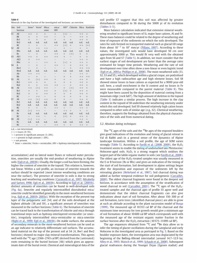
Table 6Minerals in the clay fraction of the investigated soil horizons: an overview.
Site Soilhorizon
Smeca Verma Mica/smec
mica/HIV
HIVa Chlorite Mica Kaolinite
S1 AE ++ + + + (+) − ++ +BE + + ++ − + − ++ +Bs1 + + + + + + ++ +Bs2 n.d. n.d. n.d. n.d. n.d. n.d. n.d. n.d.BC − + − ++ (+) + ++ (+)
S2 AE + ++ ++ − + − + +Bhs n.d. n.d. n.d. n.d. n.d. n.d. n.d. n.d.Bs − + − ++ + (+) + +
S3 AE1 ++ + ++ ++ + − + +AE2 + ++ − − − − ++ +Bhs + − ++ + (+) + ++ +
S4 A − + − ++ − + ++ +Bw1 − + − − − + ++ ++Bw2 n.d. n.d. n.d. n.d. n.d. n.d. n.d. n.d.Ab ++ ++ − − − + ++ +Bb − + − − + + ++ ++
S5 AE + (+) ++ + + − ++ +Bs1 ++ + + + + + ++ +Bs2 + + ++ ++ − + ++ +
S6 AE ++ (+) ++ − + (+) ++ +Bs1 + + ++ + (+) + ++ +Bs2 + + ++ + + + ++ +BC − ++ − + + + + +
S7 AE ++ (+) ++ + + − ++ +Bs1 n.d. n.d. n.d. n.d. n.d. n.d. n.d. n.d.Bs2 n.d. n.d. n.d. n.d. n.d. n.d. n.d. n.d.BC + + + ++ + − ++ +
S8 AE (+) ++ − − ++ + + +Bs n.d. n.d. n.d. n.d. n.d. n.d. n.d. n.d.BC − ++ − + (+) + ++ +
S9 AE (+) ++ − − − − ++ +Bs n.d. n.d. n.d. n.d. n.d. n.d. n.d. n.d.BC − + − ++ + + ++ +
n.d.=not determined.(+)=traces (0–5%).+=present in significant amount (5–20%).++=present in high amount (N20%).−=not present.
a Smec=smectite; Verm=vermiculite; HIV=hydroxy-interlayered vermiculite.
60 F. Favilli et al. / Geomorphology 112 (2009) 48–66
accumulation) and no lateral water fluxes or reduced water percola-tion, smectites are usually the end-product of weathering in Alpinesoils (Egli et al., 2003b). Usually, the longer a soil has been forming, thehigher the content of smectite in the topsoil. This relation is, however,not linear. Within a soil profile, an increase of smectite towards thesurface should be expected (most intense weathering conditions arenear the surface). The presence of smectite in soils is due to strongleaching and weathering conditions (Carnicelli et al., 1997; Mirabellaand Sartori, 1998; Egli et al., 2003b). According to Egli et al. (2001b),distinct amounts of smectites can be found in well-developed soils(Fig. 6a). Smectite and regularly interstratified dioctahedral mica/smectite could be identified generally in themost-weathered horizons(e.g., Egli et al., 2001b, 2003a). With the exception of the present toplayer of the polygenetic soil (S4) and of the soils developed at thehighest altitude (S8 and S9), a significant amount of smectites wasmeasured in the surface horizons (Table 6). The formation of smectitecan be traced back to the transformation of chlorite and mica throughtransitional steps such as hydroxy-interlayered vermiculite (or smec-tite), irregularly interstratified mica-vermiculite or mica-smectite(Righi et al., 1999; Egli et al., 2003b). On stable surfaces, the amountof secondary minerals in the most-weathered horizon can be used asan age indicator to relatively differentiate soil surfaces. The accumu-lated material on the top of the present soil at S4 (A, Bw1 and Bw2horizons) showed no major clay mineral transformations. This agreeswell with the 14C age (2366–2743 cal BP) derived from the (untreated)roots remaining in the buried horizon (Ab) which gives an approx-imate date of the burial event. Chemical and mineralogical data of the
soil profile S7 suggest that this soil was affected by greaterdisturbances compared to S6 during the 5000 yr of its evolution(Tables 3–5).
Mass balance calculation indicated that extensive mineral weath-ering resulted in significant losses of Si, major base cations, Al and Fe.These mass balances could be related to the degree of weathering andtime of exposure of the sediments on which the soils developed. Therates for soils formed on transported material such as glacial till rangefrom about 10−2 to 101 mm/yr (Pillans, 1997). According to thesevalues, the investigated soils would have developed 50 cm overapproximately 5000 yr. This would fit very well with the obtainedages from S6 and S7 (Table 5). In addition, we must consider that theearliest stages of soil development are faster than the average ratesestimated for longer time periods. Weathering and the rate of soildevelopment over time often show a non-linear or even logistic trend(Egli et al., 2001a; Phillips et al., 2008). The most-weathered soils (S1,S2, S3 and S5), which developedwithin a glacial cirque, are podzolisedand have a high radiocarbon age and high element losses. Soil S8showed minor losses in base cations as expected for a 9000 year-oldsoil; here, a small enrichment in the Si content and no losses in Fewere measurable compared to the parent material (Table 8). Thismight have been caused by the deposition of material coming from amountain ridge (rock fall?). The high amount of skeleton in the topsoil(Table 3) indicates a similar process. The high increase in the claycontent in the topsoil of S8 underlines the weathering intensity underwhich this soil developed. Soil S9 showed relatively high cation lossescompared to other soils of similar age (e.g., S2). Chemical weathering,therefore, supports the findings obtained from the physical character-istics of the soils and from numerical dating.
5.2. Absolute dating techniques
The 14C ages of the soils and the 10Be ages of the exposed bouldersgive good indications of the evolution and timing of glacial retreat inVal di Rabbi and—in a general sense—of the dynamics of Alpinelandscape formation. Within a soil profile, the age of SOM variesstrongly (Table 5). According to Favilli et al. (2008, 2009), the H2O2
treatment seems to enable the dating of undisturbed late Pleistocene/Holocene-aged soils. H2O2 is a strong reagent which oxidises thelargest part of the labile organicmatter in soils (see Favilli et al., 2008).The oldest age of the H2O2-treated samples was usually measured inthe E or B horizon (Bs or Bhs) and gives an indication of the timing ofthe start of soil formation. Soil development in alpine settings beganafter the deposition and exposure of the sediments left by theretreating glaciers (Birkeland et al., 1987). Soil charcoal dating wasadded as further temporal evidence for soil pedogenesis (Carcaillet,2000). The oldest charcoal fragments were found in the deepest soilhorizon, in accordance with the assumption of the stratification ofwood charcoal in soil (Carcaillet, 2001). The 14C ages of the H2O2-treated samples and the charcoal ages of profile S5 agree well anddemonstrate that the oldest charcoal fragments can also giveindications about start of soil formation. After about 150–300 yr ofsoil formation, Larix trees (identified charcoal piece) are able to growat such an altitude according to the plant succession model of Burga(1999). The measured age of 10353 cal BP of the charcoal and theminimum time necessary for tree growth would give a minimum ageof soil formation of about 10600 cal BP which corresponds well withthe measured age of the resistant organic matter fraction in thesurface horizon after the H2O2 extraction (10575–11099 cal BP).
The age sequences obtained from 14C and 10Be data allow us toinfer the timing of glacier oscillations during the Lateglacial and earlyHolocene in the investigated area as portrayed in Fig. 5. Based on theboulder exposure dates, the investigation area was deglaciated by thebeginning of the Bølling-Allerød interstadial (around 14.7–12.9 ka;Alley et al., 1993; Maisch et al., 1999; Schaub et al., 2008). Subsequentglacial readvances during the Younger Dryas (Egesen stadial) and
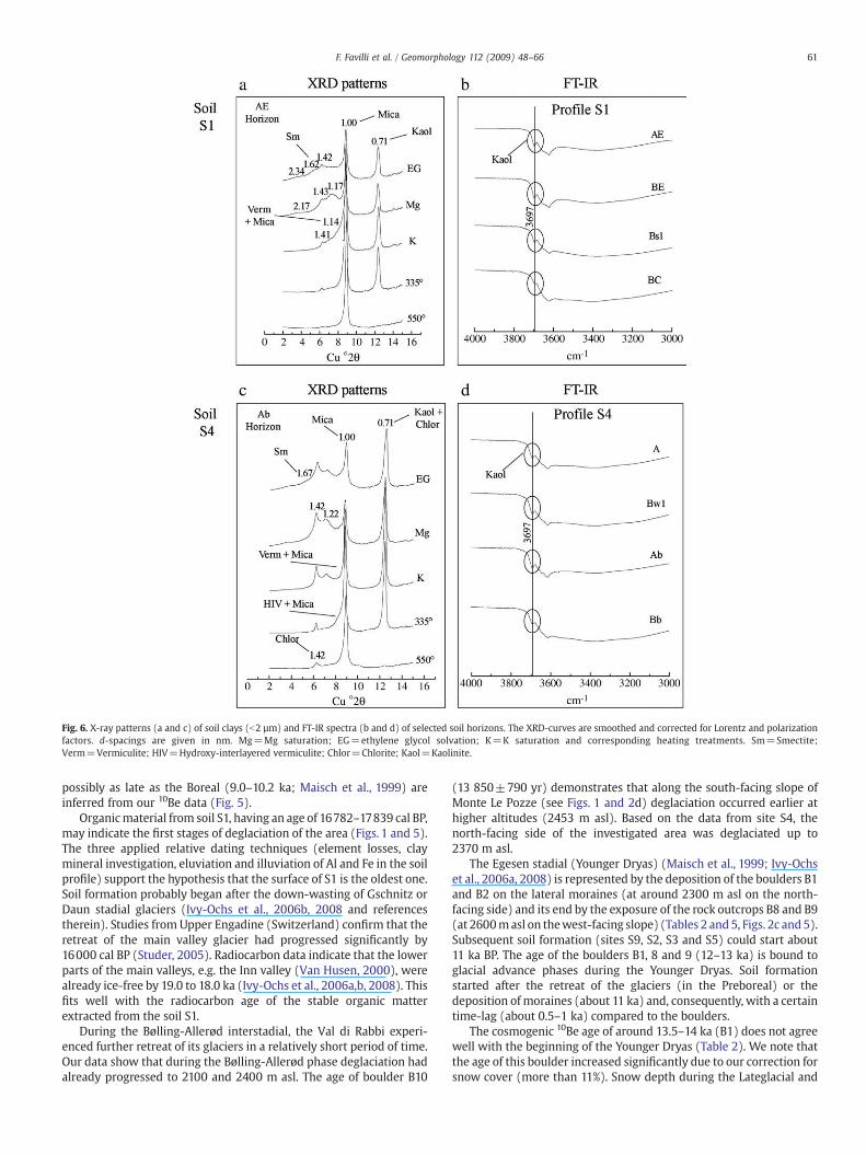
Fig. 6. X-ray patterns (a and c) of soil clays (b2 µm) and FT-IR spectra (b and d) of selected soil horizons. The XRD-curves are smoothed and corrected for Lorentz and polarizationfactors. d-spacings are given in nm. Mg=Mg saturation; EG=ethylene glycol solvation; K=K saturation and corresponding heating treatments. Sm=Smectite;Verm=Vermiculite; HIV=Hydroxy-interlayered vermiculite; Chlor=Chlorite; Kaol=Kaolinite.
61F. Favilli et al. / Geomorphology 112 (2009) 48–66
possibly as late as the Boreal (9.0–10.2 ka; Maisch et al., 1999) areinferred from our 10Be data (Fig. 5).
Organicmaterial from soil S1, having an age of 16782–17839 cal BP,may indicate the first stages of deglaciation of the area (Figs. 1 and 5).The three applied relative dating techniques (element losses, claymineral investigation, eluviation and illuviation of Al and Fe in the soilprofile) support the hypothesis that the surface of S1 is the oldest one.Soil formation probably began after the down-wasting of Gschnitz orDaun stadial glaciers (Ivy-Ochs et al., 2006b, 2008 and referencestherein). Studies from Upper Engadine (Switzerland) confirm that theretreat of the main valley glacier had progressed significantly by16000 cal BP (Studer, 2005). Radiocarbon data indicate that the lowerparts of the main valleys, e.g. the Inn valley (Van Husen, 2000), werealready ice-free by 19.0 to 18.0 ka (Ivy-Ochs et al., 2006a,b, 2008). Thisfits well with the radiocarbon age of the stable organic matterextracted from the soil S1.
During the Bølling-Allerød interstadial, the Val di Rabbi experi-enced further retreat of its glaciers in a relatively short period of time.Our data show that during the Bølling-Allerød phase deglaciation hadalready progressed to 2100 and 2400 m asl. The age of boulder B10
(13 850±790 yr) demonstrates that along the south-facing slope ofMonte Le Pozze (see Figs. 1 and 2d) deglaciation occurred earlier athigher altitudes (2453 m asl). Based on the data from site S4, thenorth-facing side of the investigated area was deglaciated up to2370 m asl.
The Egesen stadial (Younger Dryas) (Maisch et al., 1999; Ivy-Ochset al., 2006a, 2008) is represented by the deposition of the boulders B1and B2 on the lateral moraines (at around 2300 m asl on the north-facing side) and its end by the exposure of the rock outcrops B8 and B9(at 2600masl on thewest-facing slope) (Tables 2 and5, Figs. 2c and5).Subsequent soil formation (sites S9, S2, S3 and S5) could start about11 ka BP. The age of the boulders B1, 8 and 9 (12–13 ka) is bound toglacial advance phases during the Younger Dryas. Soil formationstarted after the retreat of the glaciers (in the Preboreal) or thedeposition of moraines (about 11 ka) and, consequently, with a certaintime-lag (about 0.5–1 ka) compared to the boulders.
The cosmogenic 10Be age of around 13.5–14 ka (B1) does not agreewell with the beginning of the Younger Dryas (Table 2). We note thatthe age of this boulder increased significantly due to our correction forsnow cover (more than 11%). Snow depth during the Lateglacial and
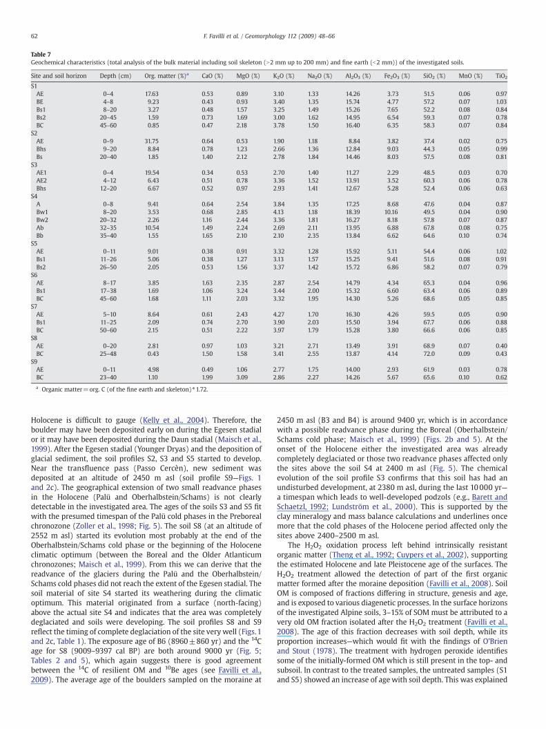
Table 7Geochemical characteristics (total analysis of the bulk material including soil skeleton (N2 mm up to 200 mm) and fine earth (b2 mm)) of the investigated soils.
Site and soil horizon Depth (cm) Org. matter (%)a CaO (%) MgO (%) K2O (%) Na2O (%) Al2O3 (%) Fe2O3 (%) SiO2 (%) MnO (%) TiO2
S1AE 0–4 17.63 0.53 0.89 3.10 1.33 14.26 3.73 51.5 0.06 0.97BE 4–8 9.23 0.43 0.93 3.40 1.35 15.74 4.77 57.2 0.07 1.03Bs1 8–20 3.27 0.48 1.57 3.25 1.49 15.26 7.65 52.2 0.08 0.84Bs2 20–45 1.59 0.73 1.69 3.00 1.62 14.95 6.54 59.3 0.07 0.78BC 45–60 0.85 0.47 2.18 3.78 1.50 16.40 6.35 58.3 0.07 0.84
S2AE 0–9 31.75 0.64 0.53 1.90 1.18 8.84 3.82 37.4 0.02 0.75Bhs 9–20 8.84 0.78 1.23 2.66 1.36 12.84 9.03 44.3 0.05 0.99Bs 20–40 1.85 1.40 2.12 2.78 1.84 14.46 8.03 57.5 0.08 0.81
S3AE1 0–4 19.54 0.34 0.53 2.70 1.40 11.27 2.29 48.5 0.03 0.70AE2 4–12 6.43 0.51 0.78 3.36 1.52 13.91 3.52 60.3 0.06 0.78Bhs 12–20 6.67 0.52 0.97 2.93 1.41 12.67 5.28 52.4 0.06 0.63
S4A 0–8 9.41 0.64 2.54 3.84 1.35 17.25 8.68 47.6 0.04 0.87Bw1 8–20 3.53 0.68 2.85 4.13 1.18 18.39 10.16 49.5 0.04 0.90Bw2 20–32 2.26 1.16 2.44 3.36 1.81 16.27 8.18 57.8 0.07 0.87Ab 32–35 10.54 1.49 2.24 2.69 2.11 13.95 6.88 67.8 0.08 0.75Bb 35–40 1.55 1.65 2.10 2.10 2.35 13.84 6.62 64.6 0.10 0.74
S5AE 0–11 9.01 0.38 0.91 3.32 1.28 15.92 5.11 54.4 0.06 1.02Bs1 11–26 5.06 0.38 1.27 3.13 1.57 15.25 9.41 51.6 0.08 0.91Bs2 26–50 2.05 0.53 1.56 3.37 1.42 15.72 6.86 58.2 0.07 0.79
S6AE 8–17 3.85 1.63 2.35 2.87 2.54 14.79 4.34 65.3 0.04 0.96Bs1 17–38 1.69 1.06 3.24 3.44 2.00 15.32 6.60 63.4 0.06 0.89BC 45–60 1.68 1.11 2.03 3.32 1.95 14.30 5.26 68.6 0.05 0.85
S7AE 5–10 8.64 0.61 2.43 4.27 1.70 16.30 4.26 59.5 0.05 0.90Bs1 11–25 2.09 0.74 2.70 3.90 2.03 15.50 3.94 67.7 0.06 0.88BC 50–60 2.15 0.51 2.22 3.97 1.79 15.28 3.80 66.6 0.06 0.85
S8AE 0–20 2.81 0.97 1.03 3.21 2.71 13.49 3.91 68.9 0.07 0.40BC 25–48 0.43 1.50 1.58 3.41 2.55 13.87 4.14 72.0 0.09 0.43
S9AE 0–11 4.98 0.49 1.06 2.77 1.75 14.00 2.93 61.9 0.03 0.78BC 23–40 1.10 1.99 3.09 2.86 2.27 14.26 5.67 65.6 0.10 0.62
a Organic matter=org. C (of the fine earth and skeleton)⁎1.72.
62 F. Favilli et al. / Geomorphology 112 (2009) 48–66
Holocene is difficult to gauge (Kelly et al., 2004). Therefore, theboulder may have been deposited early on during the Egesen stadialor it may have been deposited during the Daun stadial (Maisch et al.,1999). After the Egesen stadial (Younger Dryas) and the deposition ofglacial sediment, the soil profiles S2, S3 and S5 started to develop.Near the transfluence pass (Passo Cercèn), new sediment wasdeposited at an altitude of 2450 m asl (soil profile S9—Figs. 1and 2c). The geographical extension of two small readvance phasesin the Holocene (Palü and Oberhalbstein/Schams) is not clearlydetectable in the investigated area. The ages of the soils S3 and S5 fitwith the presumed timespan of the Palü cold phases in the Preborealchronozone (Zoller et al., 1998; Fig. 5). The soil S8 (at an altitude of2552 m asl) started its evolution most probably at the end of theOberhalbstein/Schams cold phase or the beginning of the Holoceneclimatic optimum (between the Boreal and the Older Atlanticumchronozones; Maisch et al., 1999). From this we can derive that thereadvance of the glaciers during the Palü and the Oberhalbstein/Schams cold phases did not reach the extent of the Egesen stadial. Thesoil material of site S4 started its weathering during the climaticoptimum. This material originated from a surface (north-facing)above the actual site S4 and indicates that the area was completelydeglaciated and soils were developing. The soil profiles S8 and S9reflect the timing of complete deglaciation of the site very well (Figs. 1and 2c, Table 1). The exposure age of B6 (8960±860 yr) and the 14Cage for S8 (9009–9397 cal BP) are both around 9000 yr (Fig. 5;Tables 2 and 5), which again suggests there is good agreementbetween the 14C of resilient OM and 10Be ages (see Favilli et al.,2009). The average age of the boulders sampled on the moraine at
2450 m asl (B3 and B4) is around 9400 yr, which is in accordancewith a possible readvance phase during the Boreal (Oberhalbstein/Schams cold phase; Maisch et al., 1999) (Figs. 2b and 5). At theonset of the Holocene either the investigated area was alreadycompletely deglaciated or those two readvance phases affected onlythe sites above the soil S4 at 2400 m asl (Fig. 5). The chemicalevolution of the soil profile S3 confirms that this soil has had anundisturbed development, at 2380 m asl, during the last 10000 yr—a timespan which leads to well-developed podzols (e.g., Barett andSchaetzl, 1992; Lundström et al., 2000). This is supported by theclay mineralogy and mass balance calculations and underlines oncemore that the cold phases of the Holocene period affected only thesites above 2400–2500 m asl.
The H2O2 oxidation process left behind intrinsically resistantorganic matter (Theng et al., 1992; Cuypers et al., 2002), supportingthe estimated Holocene and late Pleistocene age of the surfaces. TheH2O2 treatment allowed the detection of part of the first organicmatter formed after the moraine deposition (Favilli et al., 2008). SoilOM is composed of fractions differing in structure, genesis and age,and is exposed to various diagenetic processes. In the surface horizonsof the investigated Alpine soils, 3–15% of SOM must be attributed to avery old OM fraction isolated after the H2O2 treatment (Favilli et al.,2008). The age of this fraction decreases with soil depth, while itsproportion increases—which would fit with the findings of O'Brienand Stout (1978). The treatment with hydrogen peroxide identifiessome of the initially-formed OM which is still present in the top- andsubsoil. In contrast to the treated samples, the untreated samples (S1and S5) showed an increase of age with soil depth. This was explained
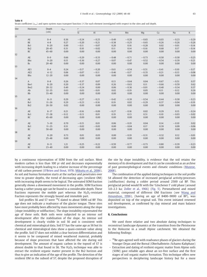
Table 8Strain coefficient (εi,w) and open-system mass transport function (τ) for each element investigated with respect to the sites and soil depth.
Site Horizons Depth(cm)
εi,w τ
Si Al Fe Mn Mg Ca Na K
S1AE 0–4 0.36 −0.24 −0.25 −0.49 −0.28 −0.65 −0.03 −0.23 −0.29BE 4–8 0.27 −0.20 −0.21 −0.38 −0.25 −0.65 −0.26 −0.26 −0.26Bs1 8–20 0.90 −0.11 −0.07 0.20 0.16 −0.28 0.02 −0.01 −0.14Bs2 20–45 0.31 0.10 −0.02 0.11 0.14 −0.16 0.68 0.17 −0.14BC 45–60 0.00 0.00 0.00 0.00 0.00 0.00 0.00 0.00 0.00
S2AE 0–9 0.66 −0.29 −0.33 −0.48 −0.71 −0.73 −0.50 −0.30 −0.25Bhs 9–20 0.15 −0.36 −0.27 −0.07 −0.47 −0.52 −0.54 −0.39 −0.21Bs 20–40 0.00 0.00 0.00 0.00 0.00 0.00 0.00 0.00 0.00
S3AE1 0–4 0.24 −0.17 −0.20 −0.61 −0.54 −0.51 −0.41 −0.10 −0.17AE2 4–12 0.06 −0.07 −0.11 −0.46 −0.17 −0.35 −0.21 −0.13 −0.08Bhs 12–20 0.00 0.00 0.00 0.00 0.00 0.00 0.00 0.00 0.00
S4A 0–8 0.26 −0.37 0.07 0.13 −0.64 0.04 −0.67 −0.51 0.57Bw1 8–20 0.20 −0.37 0.09 0.26 −0.63 0.11 −0.66 −0.59 0.62Bw2 20–32 0.49 −0.24 0.00 0.06 −0.36 −0.01 −0.40 −0.34 0.37Ab 32–35 0.63 0.03 −0.01 0.02 −0.19 0.05 −0.11 −0.12 0.26Bb 35–40 0.00 0.00 0.00 0.00 0.00 0.00 0.00 0.00 0.00
S5AE 0–11 0.29 −0.27 −0.21 −0.42 −0.39 −0.54 −0.44 −0.30 −0.23Bs1 11–26 0.29 −0.23 −0.16 0.19 0.02 −0.29 −0.37 −0.04 −0.19Bs2 26–50 0.02 0.00 0.00 0.00 0.00 0.00 0.00 0.00 0.00
S6AE 8–17 0.21 −0.16 −0.09 −0.27 −0.18 0.02 0.29 0.15 −0.24Bs1 17–38 −0.12 −0.13 0.01 0.19 0.13 0.51 −0.10 −0.03 −0.02BC 45–60 0.00 0.00 0.00 0.00 0.00 0.00 0.00 0.00 0.00
S7AE 5–10 0.70 −0.15 0.01 0.06 −0.19 0.04 0.14 −0.10 0.02Bs1 11–25 0.51 −0.02 −0.02 0.00 −0.04 0.17 0.39 0.09 −0.06BC 50–60 0.00 0.00 0.00 0.00 0.00 0.00 0.00 0.00 0.00
S8AE 0–20 0.73 0.01 0.03 0.00 −0.19 −0.31 −0.32 0.12 −0.01BC 25–48 0.00 0.00 0.00 0.00 0.00 0.00 0.00 0.00 0.00
S9AE 0–11 1.21 −0.25 −0.22 −0.59 −0.77 −0.73 −0.80 −0.39 −0.23BC 23–40 0.00 0.00 0.00 0.00 0.00 0.00 0.00 0.00 0.00
63F. Favilli et al. / Geomorphology 112 (2009) 48–66
by a continuous rejuvenation of SOM from the soil surface. Mostmodern carbon is less than 100 yr old and decreases exponentiallywith increasing depth leading to a relative increase of the percentageof old carbon present (O'Brien and Stout, 1978; Mikutta et al., 2006).As soil and humus formation starts at the surface and penetrates overtime to greater depths, the trend of decreasing ages (resilient OM)with increasing depth seems to be logical. The untreated SOM fractiongenerally shows a downward movement in the profile. SOM fractionshaving a rather young age can be found to a considerable depth. Thesefractions represent the mobile part whereas the H2O2-resistantfraction represents the strongly bound and immobile part.
Soil profiles S6 and S7 were 14C-dated to about 5000 cal BP. Thisage does not indicate a readvance of the glacier tongue. These siteshavemost probably been affected bymassmovements along the slope(slope instability or solifluction). The slope instability rejuvenated theage of these soils. Both soils were subjected to an intense soildevelopment after the stabilisation of the slope. An intense soildevelopment is clearly visible in soil S6 and is consistent withchemical and mineralogical data. Soil S7 has the same age as S6 but itschemical and mineralogical data show a quasi-constant value alongthe profile. Soil S7 does not exhibit a clear horizon differentiation andit seems to be composed of mixed weathered material, probablybecause of slope processes that have affected the site during soildevelopment. The amount of organic carbon in the topsoil of S7 isalmost double to that found in S6. The H2O2 technique was able toextract the resilient organic matter present in the Bs2 horizon andthus to give an indication of the age of the profile. The detection of theresilient OM in the subsoil of S7, despite the proposed disruption of
the site by slope instability, is evidence that the soil retains thememory of its development and that it can be considered as an archiveof past geomorphological events and climatic conditions (Munroe,2008).
The combination of the applied dating techniques in the soil profileS4 allowed the detection of increased periglacial activity/processes(solifluction) during a colder period around 2500 cal BP. Thisperiglacial period would fit with the ‘Göschener I’ cold phase (around3.0–2.3 ka; Zoller et al., 1966) (Fig. 5). Preweathered and mixedmaterial, composed of different OM fractions (see Wang andAmundson, 1996), (having an age of 8400–9000 cal BP), wasdeposited on top of the original soil. This event initiated renewedsoil development, as confirmed by clay mineral and mass balanceinvestigations.
6. Conclusions
We used three relative and two absolute dating techniques toreconstruct landscape dynamics at the transition from the Pleistoceneto the Holocene in a small Alpine catchment. We obtained thefollowing findings:
– 10Be ages agreed well with readvance phases of glaciers during theYounger Dryas and the Boreal (Oberhalbstein-/Schams-Kaltphase)
– Extraction and dating of resilient organic matter from Alpine soils(SOM) gave reliable ages about an ice-free surface and the firststages of soil organic matter formation. This technique offers newperspectives in deciphering landscape history but for a more
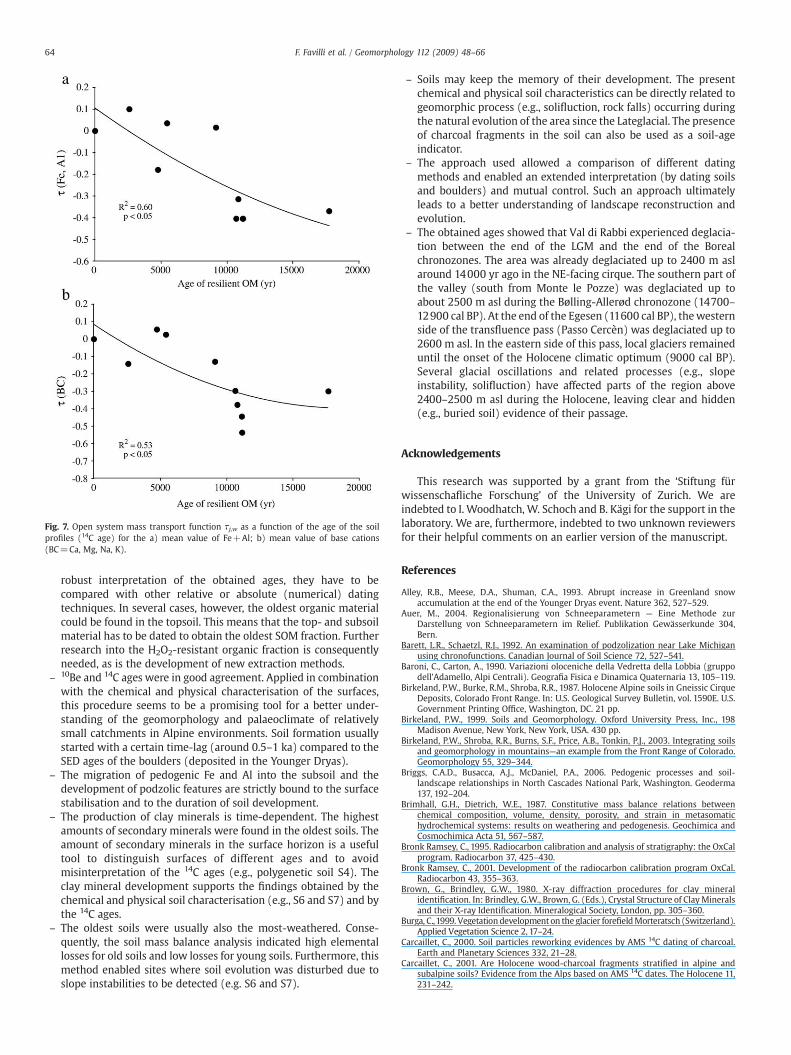
Fig. 7. Open system mass transport function τj,w as a function of the age of the soilprofiles (14C age) for the a) mean value of Fe+Al; b) mean value of base cations(BC=Ca, Mg, Na, K).
64 F. Favilli et al. / Geomorphology 112 (2009) 48–66
robust interpretation of the obtained ages, they have to becompared with other relative or absolute (numerical) datingtechniques. In several cases, however, the oldest organic materialcould be found in the topsoil. This means that the top- and subsoilmaterial has to be dated to obtain the oldest SOM fraction. Furtherresearch into the H2O2-resistant organic fraction is consequentlyneeded, as is the development of new extraction methods.
– 10Be and 14C ages were in good agreement. Applied in combinationwith the chemical and physical characterisation of the surfaces,this procedure seems to be a promising tool for a better under-standing of the geomorphology and palaeoclimate of relativelysmall catchments in Alpine environments. Soil formation usuallystarted with a certain time-lag (around 0.5–1 ka) compared to theSED ages of the boulders (deposited in the Younger Dryas).
– The migration of pedogenic Fe and Al into the subsoil and thedevelopment of podzolic features are strictly bound to the surfacestabilisation and to the duration of soil development.
– The production of clay minerals is time-dependent. The highestamounts of secondary minerals were found in the oldest soils. Theamount of secondary minerals in the surface horizon is a usefultool to distinguish surfaces of different ages and to avoidmisinterpretation of the 14C ages (e.g., polygenetic soil S4). Theclay mineral development supports the findings obtained by thechemical and physical soil characterisation (e.g., S6 and S7) and bythe 14C ages.
– The oldest soils were usually also the most-weathered. Conse-quently, the soil mass balance analysis indicated high elementallosses for old soils and low losses for young soils. Furthermore, thismethod enabled sites where soil evolution was disturbed due toslope instabilities to be detected (e.g. S6 and S7).
– Soils may keep the memory of their development. The presentchemical and physical soil characteristics can be directly related togeomorphic process (e.g., solifluction, rock falls) occurring duringthe natural evolution of the area since the Lateglacial. The presenceof charcoal fragments in the soil can also be used as a soil-ageindicator.
– The approach used allowed a comparison of different datingmethods and enabled an extended interpretation (by dating soilsand boulders) and mutual control. Such an approach ultimatelyleads to a better understanding of landscape reconstruction andevolution.
– The obtained ages showed that Val di Rabbi experienced deglacia-tion between the end of the LGM and the end of the Borealchronozones. The area was already deglaciated up to 2400 m aslaround 14000 yr ago in the NE-facing cirque. The southern part ofthe valley (south from Monte le Pozze) was deglaciated up toabout 2500 m asl during the Bølling-Allerød chronozone (14700–12900 cal BP). At the end of the Egesen (11600 cal BP), thewesternside of the transfluence pass (Passo Cercèn) was deglaciated up to2600 m asl. In the eastern side of this pass, local glaciers remaineduntil the onset of the Holocene climatic optimum (9000 cal BP).Several glacial oscillations and related processes (e.g., slopeinstability, solifluction) have affected parts of the region above2400–2500 m asl during the Holocene, leaving clear and hidden(e.g., buried soil) evidence of their passage.
Acknowledgements
This research was supported by a grant from the ‘Stiftung fürwissenschafliche Forschung’ of the University of Zurich. We areindebted to I. Woodhatch, W. Schoch and B. Kägi for the support in thelaboratory. We are, furthermore, indebted to two unknown reviewersfor their helpful comments on an earlier version of the manuscript.
References
Alley, R.B., Meese, D.A., Shuman, C.A., 1993. Abrupt increase in Greenland snowaccumulation at the end of the Younger Dryas event. Nature 362, 527–529.
Auer, M., 2004. Regionalisierung von Schneeparametern — Eine Methode zurDarstellung von Schneeparametern im Relief. Publikation Gewässerkunde 304,Bern.
Barett, L.R., Schaetzl, R.J., 1992. An examination of podzolization near Lake Michiganusing chronofunctions. Canadian Journal of Soil Science 72, 527–541.
Baroni, C., Carton, A., 1990. Variazioni oloceniche della Vedretta della Lobbia (gruppodell'Adamello, Alpi Centrali). Geografia Fisica e Dinamica Quaternaria 13, 105–119.
Birkeland, P.W., Burke, R.M., Shroba, R.R., 1987. Holocene Alpine soils in Gneissic CirqueDeposits, Colorado Front Range. In: U.S. Geological Survey Bulletin, vol. 1590E. U.S.Government Printing Office, Washington, DC. 21 pp.
Birkeland, P.W., 1999. Soils and Geomorphology. Oxford University Press, Inc., 198Madison Avenue, New York, New York, USA. 430 pp.
Birkeland, P.W., Shroba, R.R., Burns, S.F., Price, A.B., Tonkin, P.J., 2003. Integrating soilsand geomorphology in mountains—an example from the Front Range of Colorado.Geomorphology 55, 329–344.
Briggs, C.A.D., Busacca, A.J., McDaniel, P.A., 2006. Pedogenic processes and soil-landscape relationships in North Cascades National Park, Washington. Geoderma137, 192–204.
Brimhall, G.H., Dietrich, W.E., 1987. Constitutive mass balance relations betweenchemical composition, volume, density, porosity, and strain in metasomatichydrochemical systems: results on weathering and pedogenesis. Geochimica andCosmochimica Acta 51, 567–587.
Bronk Ramsey, C., 1995. Radiocarbon calibration and analysis of stratigraphy: the OxCalprogram. Radiocarbon 37, 425–430.
Bronk Ramsey, C., 2001. Development of the radiocarbon calibration program OxCal.Radiocarbon 43, 355–363.
Brown, G., Brindley, G.W., 1980. X-ray diffraction procedures for clay mineralidentification. In: Brindley, G.W., Brown, G. (Eds.), Crystal Structure of ClayMineralsand their X-ray Identification. Mineralogical Society, London, pp. 305–360.
Burga, C.,1999. Vegetationdevelopmenton the glacier forefieldMorteratsch (Switzerland).Applied Vegetation Science 2, 17–24.
Carcaillet, C., 2000. Soil particles reworking evidences by AMS 14C dating of charcoal.Earth and Planetary Sciences 332, 21–28.
Carcaillet, C., 2001. Are Holocene wood-charcoal fragments stratified in alpine andsubalpine soils? Evidence from the Alps based on AMS 14C dates. The Holocene 11,231–242.
65F. Favilli et al. / Geomorphology 112 (2009) 48–66
Carnicelli, S., Mirabella, A., Cecchini, G., Senesi, G., 1997. Weathering of chlorite to a low-charge expandable mineral in a spodosol on the Apennine mountains, Italy. Claysand Clay Minerals 45, 28–41.
Chadwick, O.A., Brimhall, G.H., Hendricks, D.M.,1990. From a black to a gray box—amassbalance interpretation of pedogenesis. Geomorphology 3, 369–390.
Cuypers, C., Grotenhuis, T., Nierop, K.G.J., Franco, E.M., de Jager, A., Rulkens, W., 2002.Amorphous and condensed organicmatter domains: the effect of persulfate oxidationon the composition of soil/sediment organic matter. Chemosphere 48, 919–931.
Darmody, R.G., Thorn, C.E., Allen, C.E., 2005. Chemical weathering and boulder mantles,Kärkevagge, Swedish Lapland. Geomorphology 67, 159–170.
Dixon, J.C., Thorn, C.E., 2005. Chemical weathering and landscape development in mid-latitude alpine environments. Geomorphology 67, 127–145.
Dunne, J., Elmore, D., Muzikar, P., 1999. Scaling factors for the rates of production ofcosmogenic nuclides for geometric shielding and attenuation at depth on slopedsurfaces. Geomorphology 27, 3–11.
Egli, M., Fitze, P., 2000. Formulation of pedologic mass balance based on immobileelements: a revision. Soil Science 165, 437–443.
Egli, M., Mirabella, A., Fitze, P., 2001a. Weathering and evolution of soils formed ongranitic, glacial deposits: results from chronosequences of Swiss Alpine environ-ments. Catena 45, 19–47.
Egli, M., Mirabella, A., Fitze, P., 2001b. Clay mineral formation in soils of two differentchronosequences in the Swiss Alps. Geoderma 104, 145–175.
Egli, M., Mirabella, A., Sartori, G., Fitze, P., 2003a. Weathering rates as a function ofclimate: results from a climosequence of the Val Genova (Trentino, Italian Alps).Geoderma 111, 99–121.
Egli, M., Mirabella, A., Fitze, P., 2003b. Formation rates of smectite derived from twoHolocene chronosequences in the Swiss Alps. Geoderma 117, 81–98.
Egli, M., Mirabella, A., Sartori, G., 2008. The role of climate and vegetation inweatheringand clay mineral formation in late Quaternary soils of the Swiss and Italian Alps.Geomorphology 102, 307–324.
Eusterhues, K., Runpel, C., Kögel-Knabner, I., 2005. Stabilization of soil organic matterisolated via oxidative degradation. Organic Geochemistry 36, 1567–1575.
Favilli, F., Egli, M., Cherubini, P., Sartori, G., Haeberli, W., 2008. Comparison of differentmethods of obtaining a resilient organic matter fraction in Alpine soils. Geoderma145, 355–369.
Favilli, F., Egli, M., Brandova, D., Ivy-Ochs, S., Kubik, P.W., Maisch, M., Cherubini, P.,Haeberli, W., 2009. Combination of numerical dating techniques using 10Be in rockboulders and 14C in resilient soil organic matter for reconstructing glacial andperiglacial processes in a high alpine catchment during the late Pleistocene andearly Holocene. Radiocarbon 51 (2).
Filippi,M.L., Arpenti, E., Heiri, O., Frisia, S., Angeli,N., vander Borg, K., Blockley, S., 2007. LakeLavarone Late-glacial to present palaeoenvirnomental changes: a unique multi-proxyrecord from Trentino, NE Italy. Geophysical Research Abstracts 9, 06639.
Fitze, P.F., 1982. Zur Relativdatierung von Moränen aus der Sicht der Bodenentwicklungin den kristallinen Zentralalpen. Catena 9, 265–306.
Gosse, J.C., Klein, J., Evenson, E.B., Lawn, B., Middleton, R., 1995. Beryllium-10 dating ofthe duration and retreat of the last Pinedale glacial sequence. Science 268,1329–1333.
Gosse, J.C., Phillips, F.M., 2001. Terrestrial in situ cosmogenic nuclides: theory andapplications. Quaternary Science Reviews 20, 1475–1560.
Heitz, A., Punchakunnel, P., Zoller, H., 1982. Zum Problem der 14C-Datierung im Veltlinund Oberengadin. Physische Geographie 1, 91–101.
Helfrich, M., Flessa, H., Mikutta, R., Dreves, A., Ludwig, B., 2007. Comparison of chemicalfractionations methods for isolating stable soil organic carbon pools. EuropeanJournal of Soil Science 58, 1316–1329.
Hitz, C., Egli, M., Fitze, P., 2002. Determination of the sampling volume forrepresentative analysis of alpine soils. Zeitschrift fuer Pflanzenernaehrung undBodenkunde 165, 326–331.
Holzhauser, H., 1984. Zur Geschichte der Aletschgletscher und des Fieschergletschers.Diss. Univ. Zürich.
Holzhauser, H., Magny, M., Zumbühl, H.J., 2005. Glacier and lake-level variations inwest-central Europe over the last 3500 years. The Holocene 15, 789–801.
Hormes, A., Müller, B.U., Schlüchter, C., 2001. The Alps with little ice: evidence for eightHolocene phases of reduced glacier extent in the Central Swiss Alps. The Holocene11, 255–265.
IUSS Working Group WRB, 2007. World reference base for soil resources 2006. Firstupdate 2007. World Soil Resources Reports No. 103. FAO (Food and AgricultureOrganisation of the United Nations), Rome.
Ivy-Ochs, S., 1996. The dating of rock surfaces using in situ produced 10Be, 26Al and 36Cl,with examples from Antarctica and the Swiss Alps. Ph.D. Thesys, ETH Zürich, No.11763, 196p.
Ivy-Ochs, S.D., Schäfer, J., Kubik, P.W., Synal, H.-A., Schlüchter, C., 2004. Timing ofdeglaciation on the northern Alpine foreland (Switzerland). Eclogae GeologicaeHelvetiae 97, 47–55.
Ivy-Ochs, S.D., Kerschner, H., Reuther, A., Maisch, M., Sailer, R., Schaefer, J., Kubik, P.W.,Synal, H.-A., Schlüchter, C., 2006a. The timing of glacier advances in the northernEuropean Alps based on surface exposure dating with cosmogenic 10Be, 26Al, 36Cl,and 21Ne. In: Siame, L.L., Bourlès, D.L., Brown, E.T. (Eds.), In Situ-producedCosmogenic Nuclides and Quantification of Geological Processes: GeologicalSociety of America Special Paper, vol. 415, pp. 43–60.
Ivy-Ochs, S.D., Kerschner, H., Kubik, P.W., Schlüchter, C., 2006b. Glacier response in theEuropean Alps to Heinrich Event 1 cooling: the Gschnitz stadial. Journal ofQuaternary Science 21, 115–130.
Ivy-Ochs, S., Kerschner, H., Schlücter, C., 2007. Cosmogenic nuclides and the dating ofLateglacial and Early Holocene glacier variations: the Alpine perspective.Quaternary International 164, 53–63.
Ivy-Ochs, S., Kerschner, H., Reuther, A., Preusser, F., Heine, K., Maisch, M., Kubik, P.W.,Schlüchter, C., 2008. Chronology of the last glacial cycle in the European Alps.Journal of Quaternary Science 23, 559–573.
Jenny, H., 1980. The Soil Resource. Springer, New York.Joerin, U.E., Stocker, T.F., Schlüchter, C., 2006. Multicentury glacier fluctuations in the
Swiss Alps during the Holocene. The Holocene 16, 697–704.Joerin, U.E., Nicolussi, K., Fischer, A., Stocker, T.F., Schlüchter, C., 2008. Holocene
optimum events inferred from subglacial sediments at Tschierva Glacier, EasternSwiss Alps. Quaternary Science Reviews 27, 337–350.
Kaplan, M.R., Wolfe, A.P., 2006. Spatial and temporal variability of Holocenetemperature in the North Atlantic region. Quaternary Research 65, 223–231.
Kelly, M.D., Kubik, P.W., Von Blackenburg, F., Schlüchter, C., 2004. Surface exposuredating of the Great Aletsch Glacier Egesen moraine system, western Swiss Alps,using the cosmogenic nuclide 10Be. Journal of Quaternary Science 19, 431–441.
Kerschner, H., Ivy-Ochs, S., Schlüchter, C., 1999. Paleoclimatic interpretation of the earlylate-glacial glacier in the Gschnitz valley, central Alps, Austria. Annals of Glaciology28, 135–140.
Kohl, C.P., Nishiizumi, K., 1992. Chemical isolation of quartz for measurement of in-situproduced cosmogenic nuclides. Geochimica et Cosmochimica Acta 56, 3583–3587.
Lanson, B., 1997. Decomposition of experimental X-ray diffraction patterns (profilefitting): a convenient way to study clay minerals. Clays and Clay Minerals 45,132–146.
Larocque, I., Frinsinger, W., 2008. Late-glacial chironomid-based temperature recon-structions for Lago Piccolo di Avigliana in the southwestern Alps (Italy).Palaeogeography, Palaeoclimatology, Palaeoecology 257, 207–223.
Lundström, U.S., van Breemen, V., Bain, D., 2000. The podzolization process. A review.Geoderma 94, 91–107.
Maisch, M., 1981. Glazialmorphologische und gletschergeschichtliche Untersuchungenim Gebiet zwischen Landwasser- und Albulatal (Kt. Graubünden, Schweiz). Ph.D.thesis, Univ. Zürich, Physische Geographie, vol. 3.
Maisch, M., 1987. Zur Gletschergeschichte des alpinen Spätglazials: Analyse undInterpretation von Schneegrenzdaten. Geographica Helvetica 42, 63–71.
Maisch, M., Wipf, A., Denneler, B., Battaglia, J., Benz, C., 1999. Die Gletscher der SchweizerAlpen. Gletscherhochstand 1850, aktuelle Vergletscherung, Gletscherschwund-Szenarien. Schlussbericht NFP 31 Projekt, vdf-Hochschulverlag ETH Zürich.
McKeague, J.A., Brydon, J.E., Miles, N.M., 1971. Differentiation of forms of extractableiron and aluminium in soils. Soil Science Society of America Proceedings 35, 33–38.
Mikutta, R., Kleber, M., Torn, M.S., Jahn, R., 2006. Stabilization of organic matter:association with minerals or chemical recalcitrance? Biogeochemistry 77, 25–56.
Mirabella, A., Sartori, G., 1998. The effect of climate on the mineralogical properties ofsoils from the Val Genova valley—Trentino (Italy). Fresenius Environmental Bulletin7, 478–483.
Moore, D.M., Reynolds, R.C., 1997. X-ray Diffraction and the Identification and Analysisof Clay Minerals, 2nd ed. Oxford Univ. Press, New York.
Munroe, J.S., 2008. Alpine soils on Mount Mansfield, Vermont, USA: pedology, historyand intraregional comparison. Soil Science Society of America Journal 72, 524–533.
Niederbudde, E.A., Kussmaul, H.,1978. Tonmineraleigenschaften und Umwandlungen inParabraunerde-Profilpaaren unter Acker und Wald in Süddeutschland. Geoderma20, 239–255.
O'Brien, B.J., Stout, J.D., 1978. Movement and turnover of soil organic matter as indicatedby carbon isotope measurements. Soil Biology and Biochemistry 10, 309–317.
Pedrotti, F., Orsomando, E., Francalancia, C., Cortini Pedrotti, C., 1974. Carta dellavegetazione del Parco Nazionale dello Stelvio, scala 1:50.000. Dip. Di Botanica.Università di Camerino, Italia.
Penck, A., Brückner, E., 1901/09. Die Alpen im Eiszeitalter, vol. 1–3, Tauchnitz.Phillips, J.D., Turkington, A.V., Marion, D.A., 2008. Weathering and vegetation effects in
early stages of soil formation. Catena 72, 21–28.Pigati, J.S., Lifton, N.A., 2004. Geomagnetic effects on time-integrated cosmogenic
nuclide production with emphasis on in situ C-14 and Be-10. Earth and PlanetaryScience Letters 226, 193–205.
Pillans, B., 1997. Soil development at snail's pace: evidence from a 6Ma chronosequenceon basalt in north Queensland, Australia. Geoderma 80, 117–128.
Plante, A.F., Chenu, C., Balabane, M., Mariotti, A., Righi, D., 2004. Peroxide oxidation ofclay-associated organic matter in a cultivation chronosequence. European Journalof Soil Science 55, 471–478.
Reimer, P.J., Baillie, M.G.L., Bard, E., Bayliss, A., Beck, J.W., Bertrand, C.J.H., Blackwell, P.G.,Buck, C.E., Burr, G.S., Cutler, K.B., Damon, P.E., Edwards, R.L., Fairbanks, R.G.,Friedrich, M., Guilderson, T.P., Hogg, A.G., Hughen, K.A., Kromer, B., McCormac, G.,Manning, S., Bronk Ramsey, C., Reimer, R.W., Remmele, S., Southon, J.R., Stuiver, M.,Talamo, S., Taylor, F.W., van der Plicht, J., Weyhenmeyer, C.E., 2004. IntCal04terrestrial radiocarbon age calibration, 0–26 cal kyr BP. Radiocarbon 46, 1029–1058.
Righi, D.,Meunier, A.,1995.Origin of claysby rockweathering and soil formation. In: Velde,B. (Ed.), Origin and Mineralogy of Clays. Springer-Verlag, Berlin, pp. 43–161.
Righi, D., Huber, K., Keller, C., 1999. Clay formation and podzol development from postglacial moraines in Switzerland. Clay Minerals 34, 319–332.
Scharpenseel, H.W., Becker-Heidmann, P.,1992. Twenty-five years of radiocarbon datingsoils: paradigm of erring and learning. Radiocarbon 34, 541–549.
Schaub,M., Büntgen, U., Kaiser, K.F., Kromer, B., Talamo, S., Andersen, K.K., Rasmussen, S.O.,2008. Lateglacial environmental variability from Swiss tree rings. Quaternary ScienceReviews 27, 29–41.
Schlüchter, C., 1988. The deglaciation of the Swiss Alps: a paleoclimatic event withchronological problems. Bulletin de l'Association Francaise pour l'étude duQuaternaire, 2/3, pp. 141–145.
Schoch, W., 1986. Wood and charcoal analysis. In: Berglund, B.E. (Ed.), Handbook ofHolocene, Palaeoecology and Palaeohydrology. JohnWiley and Sons Ltd, Chichester,pp. 619–626.
66 F. Favilli et al. / Geomorphology 112 (2009) 48–66
Schoeneich, P., 1999. Le retrait glaciaire dans les vallées des Ormonts, de l'Hongrin et del'Etivaz (Préalpes vaudoises). Thèse de la Faculté des lettres de l'Université deLausanne, Travaux et Recherche, 14, Vol. 1 & 2, 482pp.
Schwertmann, U., Niederbudde, E.A., 1993. Tonmineralbestimmung in Böden. In:Jasmund, K., Lagaly, G. (Eds.), Tonminerale und Tone. Struktur, Eigenschaften,Anwendung und Einsatz in Industrie und Umwelt. Steinkopff-Verlag, Darmstadt,pp. 255–265.
Schweingruber, F.H., 1990. Anatomie europäischer Hölzer. Anatomy of Europeanwoods.Eidgenössische Forschungsanstalt für Wald, Schnee und Landschaft, Birmensdorf.Haupt-Verlag, Bern. und Stuttgart.
Servizio Idrografico, 1959. Precipitazione medie mensili ed annue per il Trentino 1921–1950. Istituto Poligrafico dello Stato, Roma.
Soil Survey Staff, 2006. Keys to Soil Taxonomy, 10th ed. USDA-Natural ResourcesConservation Service, Washington, DC.
Stone, J.O., 2000. Air pressure and cosmogenic isotope production. Journal ofGeophysical Research 105, 23753–23759.
Strahler, A.N., Strahler, A.H., 1987. Modern Physical Geography. John Wiley and Sons(eds.) 3rd Edition. New York, New York. ISBN 0-471-85609-6, 544 pp.
Studer, M., 2005. Gletschergeschichtliche Untersuchungen und geomorphologischeKartierung im Raum Maloja-Val Forno. Ein Beitrag zur regionalen Landschafts-geschichte. Diplomarbeit, Geographisches Institut Universität Zürich.
Theng, B.G.K., Tate, K.R., Becker-Heidmann, P., 1992. Towards establishing the age,location and identity of the inert organic matter of a spodosol. Zeitschrift fürPflanzenernährung und Bodenkunde 155, 181–184.
Van Husen, D., 2000. Geological processes during the Quaternary. Mitteilungen derOsterreichchen Geologischen Gesellschaft 92, 135–156.
Veit, H., 2002. Die Alpen—Geoökologie und Landschaftsentwicklung. Verlag EugenUlmer GmbH & Co., Stuttgart.
Wang, Y., Amundson, R., 1996. Radiocarbon dating of soil organic matter. QuaternaryResearch 45, 282–288.
Zech, W., Glaser, B., Abrammowski, U., Dittmar, C., Kubik, P.W., 2003. Reconstruction ofthe Late Quaternary Glaciation of the Macha Khola valley (Gorkha Himal, Nepal)using relative and absolute (14C, 10Be, dendrochronology) dating techniques.Quaternary Science Reviews 22, 2253–2265.
Zoller, H., Schindler, C., Röthlisberger, H., 1966. Postglaziale Gletschstände undKlimaschwankungen im Gotthardmassiv und Vorderrheingebiet. Verhandlungender Naturforschungs Gesellschaft Basel, pp. 77–97.
Zoller, H., Athanasiadis, N., Heotz-Weniger, A., 1998. Late-glacial and Holocenevegetation and climate change at the Palü glacier, Bernina Pass, Grisons Canton,Switzerland. Vegetation History and Archaebotany 7, 241–249.
Copyright © 2022 FDOKUMEN