Solution of dynamic summation-difference equations by adaptive collocation
Upload
khangminh22Category
view
1download
0
Collocation of experiences with SGI Matrix based decision support tool
(MDST) within SAWA
© Statens Geotekniska Institut, SGI
Yvonne Andersson-Sköld
Investing in the future by working together for a sustainable and competitive region
www.sawa-project.eu
2
Title:
Collocation of experiences with SGI matrix based decision support tool (MDST) within SAWA
Publication:
Swedish Geotechnical Institute, SGI Varia 627
2012-02-15
www.swedgeo.se
Author: Yvonne Andersson-Sköld,
Contact: [email protected]
Reviewers of the content:
Bent C Braskerud and Oddrun S Waagø, Norwegian Water Resources and Energy Directorate (NVE),
Frida Björcman, Lidköping municipality (current Karlstad University/Essunga municipality),
Elin Alsterhag and Maria Dåverhög, Arvika municipality,
Ulf Moback, City of Göteborg
Ramona Bergman, Swedish Geotechnical Institute
3
CONTENT
1 FOREWORD ................................................................................................................................................................ 4
2 INTRODUCTION.......................................................................................................................................................... 5
3 BACKGROUND ........................................................................................................................................................... 6
4 THE MATRIX DECISION SUPPORT TOOL...................................................................................................................... 7
5 CASE STUDIES ............................................................................................................................................................ 9
5.1 LIDKÖPING ...................................................................................................................................................................... 10 5.2 GOTHENBURG ................................................................................................................................................................. 14 5.3 ARVIKA .......................................................................................................................................................................... 15 5.4 MELHUS ......................................................................................................................................................................... 16
6 SUMMARY AND CONCLUSIONS ............................................................................................................................... 17
7 REFERENCES ............................................................................................................................................................. 18
APPENDIX 1 - ARVIKA ........................................................................................................................................................ 20
APPENDIX 2 - MELHUS ...................................................................................................................................................... 34
4
1 Foreword
SAWA (Strategic Alliance for Integrated Water Management Actions) is an EU Interreg IVb project
with partners from the North Sea region in Norway, Sweden, UK, the Netherlands and Germany. The
aim of the project is to develop a strategy which will adhere to the European Water Frame Directive
(WFD) and which will also meet the requirements of the existing Flood Directive (FD) to act flexibly on
challenges arising from climate change issues. This will be achieved by development and testing
adaptive flood risk management plans, identify and deployment of cost-effective local scale adaptive
measures, information and education and the development and application of tools to be used in the
process.
In this report the results of applying a decision support tool that has been tested and developed within
SAWA are presented. The tool is a stepwise process consisting of a set of matrixes for evaluation of
Environmental, Social and Economic Aspects of strategies to reduce flooding, other natural hazards and
general water management strategies.

5
2 Introduction
There is at present a growing need for tools that could be used at an early stage of land use planning or
in the daily work with environmental objectives to incorporate a sustainability perspective, i.e. a holistic
approach of resources, health-, environmental-, social- and economic aspects. This report presents some
tests of a recently developed tool. The tool is constructed by a chain of matrices and, thus, denoted as
The Matrix Decision Support Tool (MDST).
Within SAWA the tool, originally developed in the framework of the Interreg IVB project CPA
(Climate Proof Areas) and the Formas funded project “Enhancing cities capacity to manage climate
change”, has been tested and further developed. The aim of the tool is to incorporate sustainability in a
simple manner in the planning process of land use management.
It is applicable for several different purposes, for example for comparisons of different measures
suggested for risk reduction of natural hazards such as flooding, erosion or landslides, mitigations of
risks associated with climate change or when evaluating any other land use alternatives or measures.
The aim with the tool is to provide a checklist and a methodology that promotes discussions in order to
facilitate the identification and compilation of potential measures or strategies and consequences related
to land use issues. In addition, it should contribute to a more transparent decision process and increase
the traceability of the reasoning behind the decisions taken.
The tool is based on classic technical risk- and vulnerability analysis, comprising all steps from
risk/hazard identification to appraisal of measures. The main difference, between this risk analysis tool
and many others is the allowance of comparisons of present risks and consequences of measures early in
the process. In addition, the methodology repeats the risk/consequence comparison in an iterative
manner during the full process until the final step (proposal for decision) has been reached. The tool is
intended to be used by both experts and policy makers (or persons who will present the alternatives for
the policy makers) in order to demonstrate all kinds of consequences and present them to the whole
group of stakeholders (experts, policy makers, the public etc.).
The tool (MDST) is constructed by a chain of matrices and the matrices can be found in Appendix 1 of
the report where the tool is described in more detail at
www.swedgeo.se/upload/publikationer/Varia/pdf/SGI-V613 (Andersson-Sköld et al., 2011)
or downloaded as an Excel spread sheet from:
http://www.swedgeo.se/upload/publikationer/Varia/pdf/SGI-V613.xls
Within the Interrreg IVB project SAWA (Strategic Alliance for integrated Water Management Actions)
the tool has been tested. The tool has been tested by SGI in in municipalities i.e. Lidköping, Göteborg
and Arvika in Sweden, and Melhus in Norway in cooperation with SAWA partners in Lidköping
municipality, NVE (Norwegian Water Resources and Energy Directorate) and Melhus municipality in
Norway. This report is a summary of the results from the test cases.
6
3 Background
There is at present a growing need for tools that could be used at an early stage of land use planning or
in the daily work with environmental objectives to incorporate a sustainability perspective, i.e. a holistic
approach of resources, health-, environmental-, social- and economic aspects (Andersson-Sköld et al.,
2006; Glaas et al, 2010; Johansson, 2008; Suer et al., 2009). Different land use alternatives are here
defined as e.g. alternatives to reduce the consequences of climate change or it can also for example
comprise suggestions of measures to prevent, or reduce, the impacts of natural hazards, such as flooding
and landslides, at present conditions.
There is also a need for tools that contributes to transparency, structure and discussions that will
promote an efficient and more robust decision making process. The need is that the method shall be easy
to use by private landowners, county administration boards or by officials at the municipal level (e.g.
Roth and Eklund 2005; Suer et al., 2009).
Such, “easy to use” tool, would be of great benefit in e.g. the municipalities' efforts to:
• analyse present risks,
• identify adaptive needs of, and adaptation measures for, flooding or other land use related impacts due
to current climate and in a changing climate
• evaluate different strategies for water management or risk management e.g. adaptation measures
related to climate change or measures to mitigate landslide or flooding.
Previous studies indicate that the involvement of all groups of stakeholder, affected by the decision, is
crucial to how well the decision is rooted, how easy it can be implemented and how sustainable it will
be.
The aim with the matrix based decision support tool (MDST) recently developed at SGI is to encourage
more stakeholders to take part of the process. When representatives of an organisation are working
together on the tool, either as a working group or in a form of a focus group, both better acceptance and
better decisions from a holistic perspective will be achieved. The work can be carried out individually
and then merged into the final results, but optimal it is carried out in discussion forums.
7
4 The Matrix decision support tool
The MDST is based on classic technical risk- and vulnerability analysis, comprising all steps from
risk/hazard identification to proposal for decision on measures:
• Risk/hazard identification
• Risk assessment
• Risk analysis - acceptance of risk and need for measures
• Suggestions of measures
• Prioritising of measures
• Proposal for decision on measure
The MDST is designed to incorporate sustainability in a simple manner in a decision making or planning
process. It is applicable for risk analysis of different alternatives and for comparison of different
potential measures to reduce the risk of flooding, landslides and other natural hazards, to mitigate and
manage the risks associated with climate change or when faced with other decisions related to land use
alternatives or measures. Various aspects, such as health risks, environmental- and socio-economic
conditions, can with this tool be considered in a perspicuous and transparent way at a very early stage of
the analysis.
Another aim with the MDST is to allow for subsequently implementation of new knowledge gained
during the work process. The aim is further to promote a discussion process. The goal is to combine
experiences and knowledge to achieve the most optimal solution or strategy available for the specific
conditions and context. Among the differences between this tool and other available risk analysis tools is
that it supports all steps in a multi criteria analysis from definition of task to proposal of measure, but
also that it takes into account:
1. The time perspective for all considered aspects
2. The consequences on different geographical scales (i.e. on local-, regional- and global scale).
3. The flexibility of the different measure alternatives.
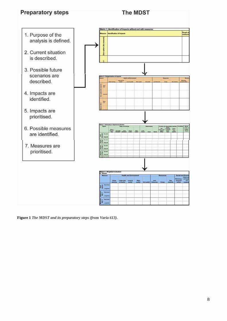
The work using the MDST is initiated with seven preparatory steps (Figure 1). Before starting the
preparatory work one can have a first look at the actual tool to get somewhat acquainted with the
matrices. However, we do recommend that the preparatory steps are conducted as separate steps before
any actual work with the matrices takes place. This is because the preparatory steps include actions
using the brain storm technique. This technique prescribes an open and free discussion, which can be
inhibited by the requirement of completing a matrix with a definite structure. The actual tool consists of
four matrices as shown in Figure 1.
8
Figure 1 The MDST and its preparatory steps (from Varia 613).
9
5 Case studies
In order to test the applicability of the tool it has been tested by desk based case studies in co-operation
with civil servants. It has been tested in the municipals Arvika, Göteborg and Lidköping in Sweden and
Melhus in Norway. Within the framework of SAWA partners in Lidköping municipality (Sweden),
NVE and Melhus municipality (Norway) have been involved. Within the framework of the Interreg
project CPA, co-operation partners from Arvika have been involved, and the tool has further been tested
in Göteborg municipality within the framework of the Formas funded project “Enhancing cities capacity
to manage climate change”.
In all case studies, the impact of flooding due to increased water levels and/or increased precipitation
has been taken into concern. Climate change is expected to profoundly influence the hydrology of
Sweden and northern Europe. The annual precipitation is expected to increase by 5–24% up to 2100
compared to the conditions for a reference period 1961-1990 (Andreasson et al., 2004). The river runoff
flows is in general expected to be higher in winter, followed by a less pronounced snowmelt peak and
lower summer flows. The changes will likely vary between different parts of Sweden (Olsson et al.,
2010).
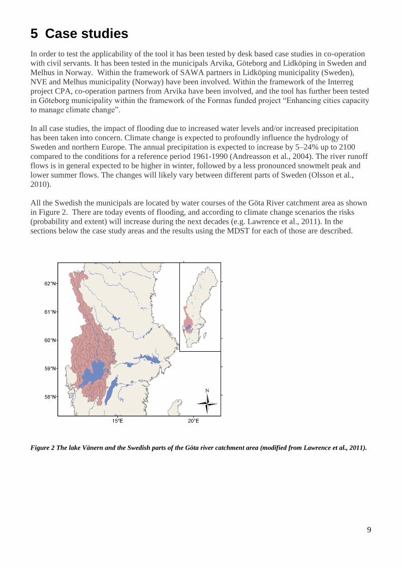
All the Swedish the municipals are located by water courses of the Göta River catchment area as shown
in Figure 2. There are today events of flooding, and according to climate change scenarios the risks
(probability and extent) will increase during the next decades (e.g. Lawrence et al., 2011). In the
sections below the case study areas and the results using the MDST for each of those are described.
Figure 2 The lake Vänern and the Swedish parts of the Göta river catchment area (modified from Lawrence et al., 2011).

10
5.1 Lidköping The case study area Lidköping municipality is located in the west of Sweden by the shore line of Lake
Vänern, the largest lake in Sweden and the third largest lake in Europe). Through the center of
Lidköping runs the river Lidan (Figure 3). Previous studies have shown that the river Lidan does not
pose any threats of flooding of the city center, neither today nor according to climate change scenarios
of the area (Erdahl, 2009). The major potential threat due to climate change, therefore are consequences
of flooding due to water level changes in the Lake Vänern (Hogdin et al., 2010).
Figure 3 The impact of a Lake Vänern water level of 46.5 m above sea level (RH70) at Lidköping. Lidköping is located at
the Lake Vänern and through the center river Lidan is running (by Jonas Andreasson, Länsstyrelsen Västra Götaland,
2010, based on data from © Lantmäteriet).
The water level of Lake Vänern may increase in future. For example in the flood risk assessment by the
county administration SAWA partners Västra Götaland and Värmland (Hogdin et al., 2010), the current
100 year level at Lidköping is 46.5 m above sea level (RH70), while in future the maximum level that is
regarded, is 47.4 m above sea level (i.e. +46.5m and +47.4m (RH 70)). Both levels were based on a
previous investigation (SOU 2006:94). A level of +46.5m is considered to have a 100-year recurrence
interval in today's climate, with a 60cm premium for high winds in an unfavorable direction. The impact
on Lidköping is shown in Figure 3. A water level of +47.4m is considered a worst case scenario which
takes into account climate change by 2100, and a wind effect of 0.5m. The impact on Lidköping is
shown in Figure 4.

11
Figure 4 The impact of a Lake Vänern water level of 47.4 m above sea level at Lidköping (by Jonas Andreasson,
Länsstyrelsen Västra Götaland, 2010, based on data from © Lantmäteriet).
5.1.1 Using the MDST
The use of the DST in Lidköping is based on information provided by Frida Björcman and her collogues
(civil servants) in the municipality. Within the framework of SAWA Björcman made a questionnaire.
The aim was to obtain information on the municipal’s different departments views, experience and
expectations of potential vulnerability due to potential flooding today and in a changing climate. The
questionnaire was made as part of SAWA, and as part of the test on how to work with parts of the
Floods Directive in Sweden in co-operation with the county administrative boards of Västra Götaland
and Värmland. Part of the results from the questionnaire is also presented in the SAWA report “Flood
risk and mapping” (Hogdin et al., 2010).
The DST was tested by Frida Björcman Lidköping Municipality and SGI staff (Yvonne Andersson-
Sköld and Ramona Bergman) at two occasions January 13 and February 3, both 2010. At the first
occasion also Jan Fallsvik and Stefan Falemo (SGI) attended.
The first meeting was a brainstorming activity. The aim was to summarize the consequences of the
current situation at the event of flooding, identify potential measures that could be taken to reduce the
negative consequences (and/or the probability of the event), and to identify consequences (proc and
cons) of the suggested measures.

12
5.1.2 Result and discussion
The brainstorm results were summarized into matrix 1. Examples of consequences of the current
situation at the event of flooding included flooded buildings, reduced, or stopped, activities of important
objects such as the water and sewage system, telecom, heating plant, waste disposal plant, rail, roads and
streets, cultural and natural values, due to direct consequences or due to power cuts and secondary
natural accidents such as landslides etc.
Both physical and non-physical measures were suggested. In Table 1 some suggested physical measures
are presented. The table also includes the pros and cons identified for those examples. Initially all
measures mentioned were physical, while by the end of the meeting also activities risk investigations
and risk mapping were presented as well as activities to increase the awareness including information,
education and communication with land owners. Some of the suggested measures were at once regarded
as to expensive and complicated for further considerations. These included to move the sewage
treatment plant and the heating/waste disposal plant to higher locations.
During this first meeting also the first attempts to start filling matrix 2 and 3 for two of the alternatives
was initiated. This step was thereafter done by SGI staff and at the second meeting the matrixes were
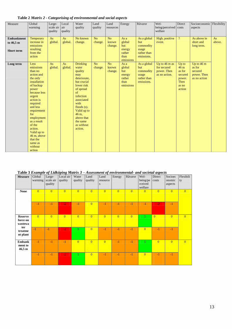
updated and finally agreed on. An example of the final result of Matrixes 2 and 3 are shown in Table 2
and Table 3 respectively.
Table1 Examples of physical measures suggested for reducing the flood risks in Lidköping and the identified
consequences of the measures.
Reserve force on wastewater treatment plant The measure would reduce the risk that the
treatment plant would stop functioning due to power
failure.
Embankment of the sewage plant to 46,5 m.
The measure would ensure the facility to manage a
water level “return time” in Vänern on a once every
100 years + 60cm for not favorable wind.
Impossible to barricade to 47.4 (10 000 year flood).
Landslide risk needs to be investigated at the
embankment.
Heating plant / waste disposal: dike with garbage and plastic
The business is managed (only the cellars have a
problem) as long as you have garbage and plastics
(46.5). Require geotechnical investigation. Risk to
barricade themselves and can then not accept
garbage for incineration and garbage from the city
will reach the heat plant. There is backup power
plant in the port using oil - today via car, but could
have a pipeline to both works. Waste is temporarily
stored or disposed elsewhere.
Measure alternatives 8 and 9 which at once were found to
expensive as manageable alternatives
• Water and sewage: Move the sewage treatment
plant: Central question - too expensive and require
many technical solutions. Would prevent blockage
in the sewerage system
• Heating plant / waste disposal: Transfer to a higher
altitude: Insanely expensive.
13
Table 2 Matrix 2 - Categorising of environmental and social aspects
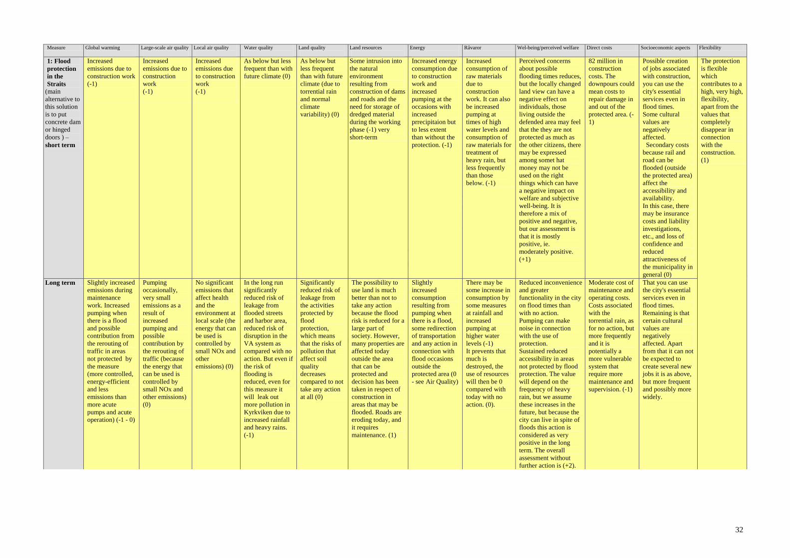
Table 3 Example of Lidköping Matrix 3 – Assessment of environmental- and societal aspects Measure Global
warming
Large-
scale air quality
Local air
quality
Water
quality
Land
quality
Land
resources
Energy
Råvaror Wel-
being/perceived
welfare
Direct
costs
Socioec
onomic aspects
Flexibili
ty
None 0 0 0 0 0 0 0 0 0 0 0 0
-1 -1 -2 -1 0 -1 -1 -1 -1 -2 -1
Reserve
force on
wastewa
ter
treatme
nt plant
0 0 0 0 0 0 0 0 1 0 0 0
-1 -1 -2 1 0 -1 -1 -1 0 -1 -1
Embank
ment to
46,5 m
-1 -1 -1 0 0 0 -1 -1 1 0 0 0
-1 -1 -2 1 0 -1 -1 -1 0 -1
-1
Measure Global warming
Large-scale air
quality
Local air
quality
Water quality
Land quality
Land resources
Energy
Råvaror Wel-being/perceived
welfare
Direct costs
Socioeconomic aspects
Flexibility
Embankment
to 46,5 m
Short term
Temporary
increase in
emissions resulting
from the
action
As
global.
As
global.
No known
change.
No
change.
No
known
change.
As a
global
but energy
rather
than emissions
As a global
but
commodity usage
rather than
emissions.
High, positive
event.
? As above in
short and
long term.
As
above.
Long term
Less
emissions than no
action and
the only installation
of backup
power because less
urgent
action is required
and less
requirement for
employment
as a result of the
action.
Valid up to 46 m, above
that the
same as without
action
As
global.
As
global.
Drinking
water quality
may
deteriorate, but crucial
lower risk
of spread of
infection
associated with
floods (s).
Valid up to 46 m,
above that
the same as without
action.
No
change.
No
known change.
As a
global but
energy
rather than
emissions
As a global
but commodity
usage
rather than emissions.
Up to 46 m as
for secured power. Then
as no action.
Up to
46 m as for
secured
power. Then
as no
action
Up to 46 m
as for secured
power. Then
as no action
14
One of the aims was to test the tool. The tool was found to encourage the discussion and was useful on
identifying measures and their consequences. The results indicated that the tool can be relevant and
applicable.
The step from Matrix 1 to Matrix 2 was found interesting but time consuming. It is an important step,
and it is important to take part of it, but the results indicate that it partly can be done in between two
consecutive meetings. As a result of the discussion and process of completing matrixes 2 and 3 new
suggestions of measures were formulated. This indicates that it is important to start the process on
matrixes 2 and 3 for doing nothing and one of the suggested actions/adaptation measures. It can,
however, be relevant to speed up the process and the progress of the second meeting prepare a
suggestion of the content of matrixes 2 and 3 in advance of the second meeting. In addition, to be able to
complete Matrixes 2 and 3, based on relevant level of information, the impacts on some aspects may
need expert or more deepened judgements. Through the course of the discussion, the need of further
information and knowledge for the impacts of alternatives were identified and documented. At the
moment of time there was no need to make any weighting of the different aspects in relation to each
other, i.e. all aspects were assigned the same vaule (1) and the result of Matrix 4 was identical to Matrix
3.
5.2 Gothenburg
The city of Gothenburg was also part of the test in a parallel national funded project, i.e. as part of a
R&D project investigating the vulnerability and adaptation to climate change using a case study area
Gullbergsvass, in Gothenburg, as a pilot (Glaas et al., 2010).
Gothenburg is located at the West coast of Sweden. Through the city center runs the River Göta älv. Due
to climate change the sea water level is expected to increase. In Gothenburg the MDST was applied on
the case study area Gullbergsvass. The area is located in the center of Gothenburg by the river Göta älv.
The pilot involves the renewal of an inner-city area to serve as the transportation and communication
hub for the city and region (in the comprehensive plan adopted 26 February 2009, the area is identified
as a future development area). The tool was applied at two occasions in a similar way as the Lidköping
case, by discussions with Ulf Moback head of the Gothenburg extreme weather and climate change
group and general planner in the municipality. The extreme weather group was assigned to assess the
potential impacts of extreme weather events, and consequently climate change. In 2005 a general risk
identification/analysis of the municipality was done. Thereafter the aim was to do more a more
comprehensive assessment of a case study area, Gullbergsvass, within the municipality which was the
reason for the choice of the area also for the R&D project.
The process was done by involving Moback in all assessments in all matrixes 1 to 3. Also here the
results of applying the tool indicate that the use of the tool encourages discussion, and that the
systematic view of sustainability increases awareness of the holistic perspective. The process is time
consuming if going through all aspects and alternatives. This was accepted when involving only one
person, but may be regarded as to time consuming in a large group. Therefore, the suggestion is to start
the filling of matrix 2 and 3 for one measure, as done in Lidköping, at the first occasion and prepare for
the other measures in advance. The results can thereafter be discussed and updated during the second
event. Also here initially physical measures were suggested and discussed, but as in Lidköping, the
discussion when applying the tool directed attention towards institutional adaptation measures as a
complement. The main identified negative impacts of the institutional measures were that they were
time consuming (municipal officials have very limited available time), may lie outside the mandate of

15
local administrators (e.g. may require national political decisions), and may require organizational
changes.
The activity showed that the MDST is applicable. The activity was, however, done late in the R&D
project as the MDST development was done in parallel to the other parts of the R&D project. Therefore,
the time to test and apply the tool was very limited and the application of the tool could not be part of
the R&D process.
5.3 Arvika
The municipality of Arvika, situated in Värmland County of Sweden, has got a population of
approximately 26,000 people, of which 14,000 live in the city itself. The Swedish Commission on
Climate and Vulnerability (SOU 2007:60) points out the area as one of the worst affected in Sweden
with respect to increase of the most intensive rainfall and extreme flows. This will pose a challenge for
the city of Arvika as the current capacity of the stormwater drainage system is insufficient even for the
climate of today, with basement flooding as result. Arvika has in the past experienced high water levels
in lake Glafsfjorden, with critical consequences for the economy, environment and delivery of services
(e.g. evacuation of people, damaged property, reduced industrial production, poor sewage treatment,
closed railway and roads). Predictions indicate that this kind of event will be more severe and more
frequent in the future.
The aim of the MDST activity in Arvika was the same as the municipalities aim within the CPA project,
i.e. to:
- Analyse impact of climate change in a local perspective
- Identify consequences for infrastructure and capacity to deliver basic services
- Identify and evaluate realistic adaptation alternatives
Independent of the Climate Proof Areas project, a barrier between the lagoon Kyrkviken and the lake
Glafsfjorden was already planned by the municipality. The aim of the barrier was to protect the city of
Arvika and the area surrounding the lagoon from damage caused by high water levels. Also this measure
was included in the Arvika MDST application.
The MDST activity in Arvika was done in spring 2011. SGI staff visited Arvika in 2011. At the meeting
CPA members participated, i.e. Elin Alsterhag, Maria Dåverhög, Anders Norrby from Arvika
municipality and Ramona Bergman and Yvonne Andersson-Sköld from SGI. After the meeting the
results of the activity were updated by information from the recent environmental risk assessment of the
barrier (Vectura 2010-06-30) was included and the matrix was reviewed and completed via e-mails. The
results are presented in Appendix 1.
The results from this activity showed that the most viable option is flood protection of the strait and then
to take further actions which consist of a mix increased the dimensions of existing pipes, new pipes and
detention basins. Also in this activity nonphysical measures appeared towards the end of the physical
meeting in Arvika, i.e. that the civil servants can actively provide information to land owners and to
make a water management plan.
Also in this case, the main identified negative impacts of the institutional measures were that they were
time consuming, may lie outside the mandate of local administrators and may require organizational
changes.
The activity showed that the MDST is applicable. The activity was, however, done late in the CPA
project as the MDST development was a major part of SGI work through the course of the CPA project.
Therefore, many of the results could be included in the matrix based on already available information
16
and assessments. The matrixes summarised those results and could visualise the impacts of the different
alternatives in Matrix 3. This is, of course, relevant, but the full aim of the tool, i.e. to identify climate
change adaption measures (or other land use actions), and their consequences, early in an iterative
process was not possible to test any further.
5.4 Melhus
NVE and Melhus municipality are SAWA partners, and are within SAWA, cooperating in developing a
flood risk management plan. The aim is to provide examples and experience that can be used for the
implementation of the flood directive in Norway.
The plan shall include actions to reduce the flooding and/or the consequences of flooding. In June 26,
2011, SGI, NVE and Melhus had a meeting in Melhus. The aim was to use the MDST to investigate
potential measures that can be taken.
At the meeting, Bent C. Braskerud and Oddrun Sunniva Waagø from NVE, Yvonne Andersson-Sköld,
from SGI, and Tove Hellem, Terje Fagernes, Jan Henrik Dahl, Arild Karlsen from Melhus municipality
attended.
The meeting was initiated by a presentation of potential measures by Bent C Braskerud followed by a
presentation by Yvonne Andersson-Sköld about the MDST. Thereafter the MDST was utilised in the
discussion on potential measures. The group worked through the process for the reference alternative
(doing nothing) and decided on two measures to start the MDST process, i.e. disconnection of water
drains and green roofs. The results are presented in appendix 2.
5.4.1 Expericence of the MDST by spontaneous response:
There is a need to have the explanations of the headings handy during the working process.
Some of the headings would gain from being changed. For example, Water quality could be
clarified that it rather is Ecological status and not only chemical quality. This fits in to the
requirements from the water frame directive.
Initially there was a request that the headings should be more in line with the flood and water
directives
The activity helps creating awareness on how one can include new measures in the spatial
planning and execution.
Change in attitude to how to manage surface water (storm water). What is needed for new
measures to be taken?
How and for what shall we use it? We can implement measures in Melhus, and most will have
the same proc and cons everywhere, but some will be site specific. Shall we do this with all
activities? (very time demanding).
Maybe a good idea to make the assessment in advance, while local adaption can be made locally
even if the matrix documents are pre-filled. As an alternative, or as a complement, a local expert
group could go through the list of more than 100 physical and organisatoric measures and pick
out the most interesting for the area.
There is a demand on fact sheets on relevant measures including information in general together
with information on the impacts on the different categories (global warming, ecological status
etc).
Fine (good/useful/) tool to show politicians, documentation on what civil servants in the
municipality have emphasized suggestions and recommendations.
Technical/ special day on flood issues for politicians.

17
5.4.2 The decision process
The group was very positive on raingardens as risk mitigation measure. The question arise if this was
due to the idea had been presented before or because it is a very good measure? Will the attitude change
as more alternative measures are being assessed?
After the test the aim is to follow up for subsequent use it in the flood risk plan. The follow up can be
more concrete suggestions on in which areas measures, and which type of measures, can be taken. At the
same time it is great if one can manage to include the municipality as a whole. The measures that will be
assessed can be used in other areas at later occasions.
6 Summary and conclusions
The MDST was found to be applicable and it is a new way of incorporating civil servants and experts in
evaluating alternative measures.
The discussions created awareness and the method encouraged structured discussions and
documentation of the discussions.
As a result of the Melhus MDST application process, the tool was developed to respond to the request
that the headings should be more in line with the flood and water directives. The resulting matrixes are
presented in appendix 2.
The process is time consuming and would gain from some preparatory work in between the meetings
and/or in advance. For example a local expert group could go through a brut list of physical and
organisatoric measures and pick out the most interesting for the area, some preparatory work can be
done by the one running the process on the matrixes between meetings etc.

18
7 References
Andersson-Sköld, Y., Helgesson, H., Enell, A., Suer, P., and Bergman, R., 2011. Matrix based decision-
support tool for assessment of environmental and socio–economic aspects. SGI Varia 613,
Linköping, Sweden.
Andersson-Sköld, Y., Norrman, J., and Kockum, K., 2006. Survey of risk assessment methodologies for
sustainable remediation. In: VALDOR 2006: Values in Decisions On Risk, 14–18 May 2006,
Stockholm. Stockholm: Congrex Sweden AB/Informationsbolaget, Nyberg & Co., 135–142.
Andréasson, J., Bergström, S., Carlsson, B., Graham, P.L., Lindström, G. (2004) Hydrological change -
climate change impact simulations for Sweden. Ambio, 33:4-5
Glaas, E., Jonsson, A.,Hjerpe, M., and Andersson-Sköld, Y., 2010. Managing climate change
vulnerabilities: formal institutions and knowledge use as determinants of adaptive capacity at the
local level in Sweden. Local Environment, 15, 525–539
Hogdin, S., Mannheimer, J., Andersson, J., Björcman, F., Moberg,J-O, Blumenthal, B., Näslund-
Landenmark, B., 2010, Flood and risk mapping according to the flood directive Scenarios in
Lidköping and Karlstad, Länsstyrelsen i Västra Götalands län (County administration of Västra
Götaland), Report number: 2010:69 (www.lansstyrelsen.se/vastragotaland/Sv/Publikationer)
Johansson, M. (2008). Barriers and bridges – communicative conditions in the Swedish environmental
objective performance (in Swedish). Linköping Studies in Arts and Science, Dissertation No 469,
PhD. Linköping University, Linköping, Sweden
D. Lawrence, D. Graham, L. P. , den Besten, J. Andréasson, J. Bergström, S., Engen-Skaugen, T.
Førland, E. Groen, R. Jespersen, M. de Jong, K. Olsson, J. 2011, Climate change impacts and
uncertainties in flood risk management: Examples from the North Sea Region, A report of Working
Group 1 – Adaptive flood risk management SAWA Interreg IVB Project, Norwegian Water
Resources and Energy Directorate, Report no. 05 – 2012
Olsson, J., Yang, W., Graham, L.P., Rosberg, J., and J. Andréasson (2011b) Using an ensemble of
climate projections for simulating recent and near-future hydrological change to Lake Vänern in
Sweden, Tellus, 63A, 126–137.
Roth, L.,Eklund, M. (2003). Environmental evaluation of reuse of by-products as road construction
materials in Sweden. Waste Management, 23, 107-116.
SOU 2006:94, Översvämningshot, risker och åtgärder för Mälaren, Hjälmaren och Vänern (Flood threat,
risks and measures for lakes Mälaren, Hjälmaren and Vänern
SOU 2007:60 (Swedish Government Commission Report), 2007. Sweden facing climate change: threats
and opportunities. The Commission on Climate and Vulnerability, Swedish Government Official
Reports. Stockholm: Edita, 679 pp
Suer, P., Andersson-Sköld, Y., Blom, S., Bardos, P. R., Track, T., Polland, M. (2009). Environmental
impact assessment of biofuel production on contaminated land – Swedish conditions in selected case
studies. Swedish Geotechnical Institute, Varia 600,
www.swedgeo.se/upload/publikationer/Varia/pdf/SGI-V600.pdf
Vectura,, 2010, MKB associated application for water activities regarding flood protection of Arvika
town, 2010-06-30

19
Appendix 1 - Arvika
Matrixes 1 and 3 for the case: "Adaptation to climate change impacts on urban storm water: a case study in Arvika. Sweden"

21
Climate change Arvika
Date:
Version: 1
Participants: Contact details:
Elin Alsterhag Arvika Municipality
Maria Dåverhög Arvika Municipality
Anders Norrby Arvika Municipality
Ramona Bergman Swedish Geotechnical Institute
Yvonne Andersson-Sköld Swedish Geotechnical Institute
Responsible:
Yvonne Andersson-Sköld, Swedish Geotechnical Institute
Earlier versions Responsible
None
General comments:
This study is a test of the MDST in the Arvika Pilot.
The test was done in co-operation with the Arvika Municipality and based on available information from CPA and previous investigations.
The test study includes both the impact on doing nothing and from adaptation measures to climate change including both the planned barrier and impacts on
urban storm water. The study was initiated 100413_and was continued until May 2011.
The results of the study are presented on the forthcoming pages and also in separate for Matrix 2 results. In the more formal presentation it will be part of the
report (august).

22
Workflow
Identify risks in today's conditions(enter them in matrix 1)
Identify measures, measure proposals
o Brainstorm (possible measures – save them with any comments attached to this document)
o Prioritise measures to further work with: Write the prioritised measures in matrix 1. NOTE Don’t forget to document what the priority is based on
and by who.
Identify risks, effects and consequences of the measure suggestions: write these in matrix 1.
Identify cost: write these in matrix 1.
Matrix 2 – categorise effects
Matrix 3 –assess the size of the categorized effects
Not involved in the test case but for generic use: Make a plan what you need to move forward with regarding the need for additional support or
expertise. If there is enough evidence one can go forward with a weighting and the final score.
Optional
o Weighting/valuation of the different categorised effects
o Assessment of overall performance, including weighting/rating (Matrix 4)
Make a plan for further work

23
Climate Change Arvika Matrix 1 – Identification of potential risks, effects and consequences
Measure Identification of potential risks, effects and
consequences
Possible costs
None. Taking no action means that current conditions are maintained, but
the environment is changing in the normal way. These changes may be, for example, changes due to climate change and changes already
planned or decided measures.
In addition the actions are taken at the municipal level and / or municipal initiatives. (Individual properties can themselves take
action)
Insecurity and anxiety for future high water levels.
Damage to buildings, major failure of the city's
electricity, water and sewage can occur at a major
flood situation. This may include, among other things
to health risks increases. Flooding and increased flows
could also result in increased emissions of pollutants
from port area where there are contaminated sites.
Availability and ability of transport will be hampered
by flooded roads and even some rail transport could
become impossible. For some groups, such as those
that depend on domestic help, this can lead to serious
consequences. There is also a risk that the church and
burial grounds are flooded. A flood situation will also
affect industrial output in the area. (WSP, 2005,
Vectura 2010)
In addition to acute flood risk that already ispresent
due to current climate variability, climate change can
lead to other consequences. These may include heat
stress, deteriorating water quality and changes in forest
and agricultural characteristics (SOU2007: 60).
Basement Flooding is a problem for the municipality
and property owners, there is a need of upgrading of
storm water network / alternative solutions for storm
water management. During heavy rains culverts can be
washed away.
The aggregated economic cost of Arvika was 313
million (2009 prices) (Bluhmentahl et al., 2010).
According to investigations the situation could have
been even worse. The water level might have risen to
48.90 m (RH00) instead of 48.36 m (RH00)), which
likely would have been devastating for Arvika town and
city infrastructure (Vectura 2010-06-30).
Insurance matters, liability investigations, may be
claims, negative publicity for the City (confidence
against the municipality as an organization can be
weakened and reduced attractiveness of the
municipality in general).
Costs associated with heavy rain can be 0,5-1 million.
Estimated standard value for the total cost per basement
SEK 50 000. (Maria Dåverhög, Arvika municipality,
2010-03-25

24
Flood protection in the Strait
The alternative is some form of permanent
protection in the Strait into the Kyrkviken
that can shut off the flow into Arvika in a
flood situation. The protection should protect
Arvika town to a water level of + 48.9 m,
with a margin of waves up to + 50 m.
The main choice is a concrete dam that
closes at flood risk. It is possible to raise the
barrier height, if necessary. Permanent crest
level + 47.5 m with an option to increase to
+50.0 m.
Psychosocially the flood protection may be important
to remove the insecurity and anxiety. The protection
involves a local change in the landscape of the Straits.
The construction requires excavation, dredging,
construction of temporary road, resources for the
construction (materials, fuel, etc). However, it requires
substantially less natural resources, and emissions will
be less, than if valuable parts are moved or if
embankment is used. Boat traffic is not possible when
the flood protection is closed. Pumping is necessary
when the it is closed (noise + resource). (WSP, 2005,
Vectura 2010)
The cost is big 82 million (Technical description Hydro
Terra Engineers, 2010)
High flows and water levels Glafsfjorden:
The measure protects Arvika´s buildings and
infrastructure in flood times. The most tangible effect
is that Arvika municipality may be able to control the
water level in Kyrkviken and can prevent the water
level to rise in the port area, flooding streets and
causing disruption on the city's electricity, water and
sewerage. The ability to limit high water levels will
also eliminate the risk of flooding to about 200
individual properties along Kyrkviken. (WSP, 2005,
Vectura 2010).
There will still be able to experience problems with
drinking water (raw water, turbidity), problems in the
treatment plant due to the arrival of more water and
overflow, flooding outside the bunded area, for
example sulviksbädden, Kyrkvikens water quality will
remain the same as under current conditions, road and
rail can be flooded (outside the bunded area) which
affects the accessibility and availability.
Costs of flooding outside the dam – the impacts outside
and costs outside the area protected by the dam will be
about the same as without the flood protection (ie as the
current situation).
25
Downpour
The measure does not provide protection against heavy
rain, which raises problems of storm water network.
).
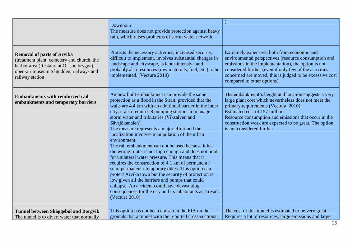
Removal of parts of Arvika (treatment plant, cemetery and church, the
harbor area (Restaurant Olsson brygga),
open-air museum Sågudden, railways and
railway station
Protects the necessary activities, increased security,
difficult to implement, involves substantial changes in
landscape and cityscape, is labor-intensive and
probably also resources (raw materials, fuel, etc.) to be
implemented. (Vectura 2010)
Extremely expensive, both from economic and
environmental perspectives (resource consumption and
emissions in the implementation), the option is not
considered further (even if only few of the activities
concerned are moved, this is judged to be excessive cost
compared to other options).
Embankments with reinforced rail
embankments and temporary barriers
An new built embankment can provide the same
protection as a flood in the Strait, provided that the
walls are 4.4 km with an additional barrier in the inner
city, it also requires 8 pumping stations to manage
storm water and tributaries (Viksälven and
Sävsjökanalen).
The measure represents a major effort and the
localization involves manipulation of the urban
environment.
The rail embankment can not be used because it has
the wrong route, is not high enough and does not hold
for unilateral water pressure. This means that it
requires the construction of 4.1 km of permanent /
semi permanent / temporary dikes. This option can
protect Arvika town but the security of protection is
low given all the barriers and pumps that could
collapse. An accident could have devastating
consequences for the city and its inhabitants as a result.
(Vectura 2010)
The embankment’s height and location suggests a very
large plant cost which nevertheless does not meet the
primary requirements (Vectura, 2010).
Estimated cost of 157 million.
Resource consumption and emissions that occur in the
construction work are expected to be great. The option
is not considered further.
Tunnel between Skäggebol and Borgvik The tunnel is to divert water that normally
This option has not been chosen in the EIA on the
grounds that a tunnel with the reported cross-sectional
The cost of this tunnel is estimated to be very great.
Requires a lot of resources, large emissions and large
26
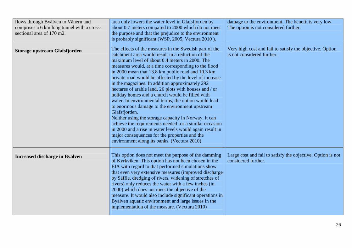
flows through Byälven to Vänern and
comprises a 6 km long tunnel with a cross-
sectional area of 170 m2.
area only lowers the water level in Glafsfjorden by
about 0.7 meters compared to 2000 which do not meet
the purpose and that the prejudice to the environment
is probably significant (WSP, 2005, Vectura 2010 ).
damage to the environment. The benefit is very low.
The option is not considered further.
Storage upstream Glafsfjorden
The effects of the measures in the Swedish part of the
catchment area would result in a reduction of the
maximum level of about 0.4 meters in 2000. The
measures would, at a time corresponding to the flood
in 2000 mean that 13.8 km public road and 10.3 km
private road would be affected by the level of increase
in the magazines. In addition approximately 292
hectares of arable land, 26 plots with houses and / or
holiday homes and a church would be filled with
water. In environmental terms, the option would lead
to enormous damage to the environment upstream
Glafsfjorden.
Neither using the storage capacity in Norway, it can
achieve the requirements needed for a similar occasion
in 2000 and a rise in water levels would again result in
major consequences for the properties and the
environment along its banks. (Vectura 2010)
Very high cost and fail to satisfy the objective. Option
is not considered further.
Increased discharge in Byälven
This option does not meet the purpose of the damming
of Kyrkviken. This option has not been chosen in the
EIA with regard to that performed simulations show
that even very extensive measures (improved discharge
by Säffle, dredging of rivers, widening of stretches of
rivers) only reduces the water with a few inches (in
2000) which does not meet the objective of the
measure. It would also include significant operations in
Byälven aquatic environment and large issues in the
implementation of the measure. (Vectura 2010)
Large cost and fail to satisfy the objective. Option is not
considered further.

27
Measures to reduce adverse impacts on rainfall
Action 2: Increased dimensions of existing
pipes, new pipes and detention basins
Reduced risk for basement flooding in buildings,.
Temporary interventions that disrupt traffic (negative),
temporary impacts in the city at construction
(negatively), can take the opportunity to arenew other
pipes (positive).
If all storm water areas in Arvika and Jössefors should
be addressed to the full to cope with a future ten-year
rain, this means enormous costs. Realistically is that
priorities are implemented and the most cost efficient
measures are choosen. A priority will be made in
connection with taking up a 5-year plan for VA.
Action 3: Back flow stop (ultimately - direct
dialogue between property owners and
municipalities)
(can be stand-alone measure, but in matrix 2
and especially in matrix 3 of this
compilation, we assume that there is a mix of
measure 2 and 3 for this alternative)
Must take interventions in individual properties -
requires dialogue with the property owner, a case-by-
case assessment on who is paying, more vulnerable
installation (management more robust) (= additional
elements are introduced).
Cost of the operation, the cost of further dialogue, more
vulnerable installation (management more robust)
Activity 4: Information for property owners
what they can do on their sites = self help
Property owners can influence their own situation
(positive), may be perceived as impositions (negative).
Can save money because of the effect of delaying the
water.
Write storm water policy for new areas for
both the purification and capacity (internal
working documents and information to the
municipality)
A well thought out and documented storm water policy
in itself is good for getting things right from the
beginning, good to optimize so that the cost could be
as low as possible, to have a documented policy
provides greater transparency for citizens in the
community and increase opportunities for
collaboration between departments and units within the
municipality.
.
A documented policy for both new and existing fields is
an important tool to optimize so that the cost could be
as low as possible and to avoid costs associated with
confusion, loss of synergy within the municipality and
the loss of confidence among citizens, and by being able
to be more pro-vision.

28
Comments:
Matrix 2 is available in a separate file.
Basis:
Vectura, 2010, MKB associated application for water activities regarding flood protection of Arvika town, 2010-06-30
Blumenthal et al , 2010, 10 years after flooding in Arvika. Karlstad University press.

29
Climate Change Arvika Matrix 3 – Assessment of environmental- and societal aspects Åtgärd Kategori
Hälsa och miljö Resurser Sociala och ekonomiska
aspekter
Global
uppvär
mning
Stor-
skalig
luftkvalitet
Lokal
luftkva
litet
Vatten
kvalite
t
Mark-
kvalite
t
Land
resurse
r
Energi
Råvaro
r Välbef
innand
e/upplevd
välfärd
Direkt
a
kostnader
Socioe
konom
iska aspekt
er
Flexibi
litet
Ingen
åtgärd
0 0 0 0 0 0 0 0 0 0 0 0
-1 -1 -2 -2 0 -1 -1 -2 -2 -2 -2
1 -1 -1 -1 0 0 -1 -1 -1 1 -1 0 1
0 0 0 -1 0 1 0 0 2 -1 1
2 0 0 -1 0 0 0 0 0 2 -2 1 2
0 0 0 1 0 1 0 0 2 0
1
3 0 0 -1 0 0 0 0 0 1 -1 1 2
0 0 0 1 0 1 0 0 1 0 1
30
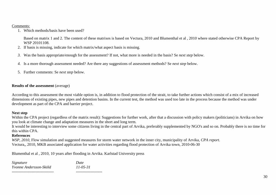
Comments:
1. Which methods/basis have been used?
Based on matrix 1 and 2. The content of these matrixes is based on Vectura, 2010 and Blumenthal et al , 2010 where stated otherwise CPA Report by
WSP 20101108.
2. If basis is missing, indicate for which matrix/what aspect basis is missing.
3. Was the basis appropriate/enough for the assessment? If not, what more is needed in the basis? Se next step below.
4. Is a more thorough assessment needed? Are there any suggestions of assessment methods? Se next step below.
5. Further comments: Se next step below.
Results of the assessment (average)
According to this assessment the most viable option is, in addition to flood protection of the strait, to take further actions which consist of a mix of increased
dimensions of existing pipes, new pipes and detention basins. In the current test, the method was used too late in the process because the method was under
development as part of the CPA and barrier project.
Next step Within the CPA project (regardless of the matrix result): Suggestions for further work, after that a discussion with policy makers (politicians) in Arvika on how
you look at climate change and adaptation measures in the short and long term.
It would be interesting to interview some citizens living in the central part of Arvika, preferably supplemented by NGO's and so on. Probably there is no time for
this within CPA.
References
WSP, 2010, Flow simulation and suggested measures for storm water network in the inner city, municipality of Arvika, CPA report.
Vectura,, 2010, MKB associated application for water activities regarding flood protection of Arvika town, 2010-06-30
Blumenthal et al , 2010, 10 years after flooding in Arvika. Karlstad University press
Signature Date
Yvonne Andersson-Sköld 11-05-31
-------------------------------- --------------------
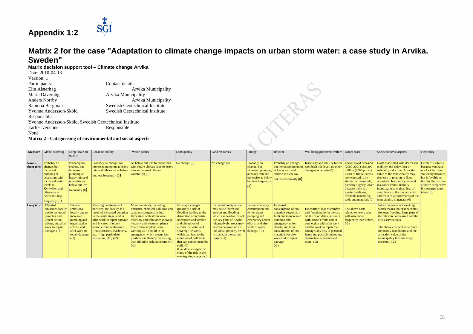
31
Appendix 1:2 Matrix 2 for the case "Adaptation to climate change impacts on urban storm water: a case study in Arvika. Sweden" Matrix decision support tool – Climate change Arvika Date: 2010-04-13
Version: 1
Participants: Contact details
Elin Alsterhag Arvika Municipality
Maria Dåverhög Arvika Municipality
Anders Norrby Arvika Municipality
Ramona Bergman Swedish Geotechnical Institute
Yvonne Andersson-Sköld Swedish Geotechnical Institute
Responsible:
Yvonne Andersson-Sköld, Swedish Geotechnical Institute
Earlier versions Responsible
None
Matrix 2 - Categorising of environmental and social aspects
Measure Global warming
Large-scale air
quality
Local air quality
Water quality
Land quality
Land resources
Energy
Råvaror Wel-being/perceived welfare Direct costs Socioeconomic aspects
Flexibility
None –
short term
Probably no
change, but increased
pumping at
occastions with increased water
levels in
Kyrkviken and otherwise as
below but less
frequently (0)
Probably no
change, but increased
pumping at
heavy rain and otherwise as
below but less
frequently (0)
Probably no change, but
increased pumping at heavy rain and otherwise as below
but less frequently (0)
As below but less frequent than
with future climate (due to heavy rain and normal climate
variability) (0)
No change (0) No change (0) Probably no
change, but increased pumping
at heavy rain and
otherwise as below but less frequently
(0)
Probably no change,
but increased pumping at heavy rain and
otherwise as below
but less frequently (0)
Insecurity and anxiety for the
next high tide level, no other change-s otherwise(0)
Earlier flood occasion
(2000-2001) cost 300 million (2009 prices).
Costs of future events
are expected to be similar in magnitude,
possibly slightly lower
because there is a greater readiness,
available machinery,
tools and materials (0)
Costs associated with decreased
mobility and delay, lost or reduced production. Attraction
value of the municipality may
decrease in relation to flood occasions. Insurance costs and
insurance issues, liability
investigations, claims, loss of confidence in the municipality
and reduced attractiveness of the
municipality in general (0)
Greater flexibility
because you have not lock into any
stationary measure,
but inflexible as the city limits from
a future perspective
if measures is not taken. (0)
Long term Elevated
emissions locally due to increased
pumping and
urgent action efforts, and after
work to repair damage. (-1)
Elevated
emissions locally due to
increased
pumping and urgent action
efforts, and after work to
repair damage.
(-1)
Very high emissions of
particles, etc. locally as a result of increased pumping
in the acute stage, and in
after work to repair damage and in cases of urgent
action efforts undertaken (transportation, machinery,
etc. - high particulate
emissions, etc.) (-2)
More pollutants, including
nutrients, chemical pollution and toxic microorganisms into
Kyrkviken with storm water,
overflow and tributaries (sewage network and treatment plant).
The treatment plant is not working as it should in an
emergency, which means less
purification, thereby increasing load (dilution reduces treatment).
(-2)
No major changes
(possibly a risk of flooding leading to the
disruption of industrial
operations and similar, and disruption of
electricity, water and sewerage network,
which can lead to the
emission of pollutants that can contaminate the
soil). (0)
(Can do a site-specific study of the risk in the
event-giving concerns.)
Increased precipitation
may cause increased erosion and flooding
which can lead to loss of
use key parts of Arvika (alternatively, steps may
need to be taken on an individual property level)
to maintain the current
usage. (-1)
Increased energy
consumption due to increased
pumping and
emergency action efforts, and after
work to repair damage. (-1)
Increased
consumption of raw materials (especially
fuel) due to increased
pumping and emergency action
efforts, and large consumption of raw
materials for after
work and to repair damage
(-2)
Discomfort, loss of comfort and functionality in the city
on the flood dates, nuisance
with action efforts and in connection with after work
and the work to repair the damage, any loss of personal
items and possibly including
destruction of homes and more. (-2)
The above costs related to heavy rain
will arise more
frequently than before. (-2)
Infrastructure is not working
which means that if it becomes frequent flooding, large parts of
the city can not be used and the
city's service fails.
The above cost will arise more frequently than before and the
attraction value of the
municipality falls for every occasion. (-2)
32
Measure Global warming
Large-scale air quality
Local air quality
Water quality
Land quality
Land resources
Energy
Råvaror Wel-being/perceived welfare Direct costs Socioeconomic aspects
Flexibility
1: Flood
protection
in the
Straits
(main
alternative to
this solution
is to put
concrete dam
or hinged
doors ) –
short term
Increased
emissions due to
construction work
(-1)
Increased
emissions due to
construction
work
(-1)
Increased
emissions due
to construction
work
(-1)
As below but less
frequent than with
future climate (0)
As below but
less frequent
than with future
climate (due to
torrential rain
and normal
climate
variability) (0)
Some intrusion into
the natural
environment
resulting from
construction of dams
and roads and the
need for storage of
dredged material
during the working
phase (-1) very
short-term
Increased energy
consumption due
to construction
work and
increased
pumping at the
occasions with
increased
prrecipitaion but
to less extent
than without the
protection. (-1)
Increased
consumption of
raw materials
due to
construction
work. It can also
be increased
pumping at
times of high
water levels and
consumption of
raw materials for
treatment of
heavy rain, but
less frequently
than those
below. (-1)
Perceived concerns
about possible
flooding times reduces,
but the locally changed
land view can have a
negative effect on
individuals, those
living outside the
defended area may feel
that the they are not
protected as much as
the other citizens, there
may be expressed
among somet hat
money may not be
used on the right
things which can have
a negative impact on
welfare and subjective
well-being. It is
therefore a mix of
positive and negative,
but our assessment is
that it is mostly
positive, ie.
moderately positive.
(+1)
82 million in
construction
costs. The
downpours could
mean costs to
repair damage in
and out of the
protected area. (-
1)
Possible creation
of jobs associated
with construction,
you can use the
city's essential
services even in
flood times.
Some cultural
values are
negatively
affected.
Secondary costs
because rail and
road can be
flooded (outside
the protected area)
affect the
accessibility and
availability.
In this case, there
may be insurance
costs and liability
investigations,
etc., and loss of
confidence and
reduced
attractiveness of
the municipality in
general (0)
The protection
is flexible
which
contributes to a
high, very high,
flexibility,
apart from the
values that
completely
disappear in
connection
with the
construction.
(1)
Long term Slightly increased
emissions during
maintenance
work. Increased
pumping when
there is a flood
and possible
contribution from
the rerouting of
traffic in areas
not protected by
the measure
(more controlled,
energy-efficient
and less
emissions than
more acute
pumps and acute
operation) (-1 - 0)
Pumping
occasionally,
very small
emissions as a
result of
increased
pumping and
possible
contribution by
the rerouting of
traffic (because
the energy that
can be used is
controlled by
small NOx and
other emissions)
(0)
No significant
emissions that
affect health
and the
environment at
local scale (the
energy that can
be used is
controlled by
small NOx and
other
emissions) (0)
In the long run
significantly
reduced risk of
leakage from
flooded streets
and harbor area,
reduced risk of
disruption in the
VA system as
compared with no
action. But even if
the risk of
flooding is
reduced, even for
this measure it
will leak out
more pollution in
Kyrkviken due to
increased rainfall
and heavy rains.
(-1)
Significantly
reduced risk of
leakage from
the activities
protected by
flood
protection,
which means
that the risks of
pollution that
affect soil
quality
decreases
compared to not
take any action
at all (0)
The possibility to
use land is much
better than not to
take any action
because the flood
risk is reduced for a
large part of
society. However,
many properties are
affected today
outside the area
that can be
protected and
decision has been
taken in respect of
construction in
areas that may be
flooded. Roads are
eroding today, and
it requires
maintenance. (1)
Slightly
increased
consumption
resulting from
pumping when
there is a flood,
some redirection
of transportation
and any action in
connection with
flood occasions
outside the
protected area (0
- see Air Quality)
There may be
some increase in
consumption by
some measures
at rainfall and
increased
pumping at
higher water
levels (-1)
It prevents that
much is
destroyed, the
use of resources
will then be 0
compared with
today with no
action. (0).
Reduced inconvenience
and greater
functionality in the city
on flood times than
with no action.
Pumping can make
noise in connection
with the use of
protection.
Sustained reduced
accessibility in areas
not protected by flood
protection. The value
will depend on the
frequency of heavy
rain, but we assume
these increases in the
future, but because the
city can live in spite of
floods this action is
considered as very
positive in the long
term. The overall
assessment without
further action is (+2).
Moderate cost of
maintenance and
operating costs.
Costs associated
with the
torrential rain, as
for no action, but
more frequently
and it is
potentially a
more vulnerable
system that
require more
maintenance and
supervision. (-1)
That you can use
the city's essential
services even in
flood times.
Remaining is that
certain cultural
values are
negatively
affected. Apart
from that it can not
be expected to
create several new
jobs it is as above,
but more frequent
and possibly more
widely.

33
Comments:
Proposal: Writing storm water policy for new areas for both the purification and capacity (internal working documents and information to the municipality)
Information activities is likely to have an impact, but because its contents could affect more than the aspects mentioned in the matrix above, we do not proceed with it in matrix 3.
Range is chosen based on the options we are discussing (ie maximum 2 and minimum -2 is used). If we had choosen the options we have not worked with further from matrix 1 the spectrum probably would have been
different.
Basis: Matrix 1
Working group: Anders, Maria, Elin, Ramona, Yvonne
Measure Global warming
Large-scale air quality
Local air quality
Water quality
Land quality
Land resources
Energy
Råvaror Wel-being/perceived welfare
Direct costs Socioeconomic aspects
Flexibility
2: Increased
dimensions of existing
pipes, new pipes and
retention basins
Short time
perspective: the
manufacture and
building
machines during
construction.
Very short
temporary
response (0).
Long-term (0)
Short time
perspective: the
manufacture and
building
machines during
construction.
Very short
temporary
response (0).
Long-term (0)
Dusting and
some
particulate
emissions at
construction (-
1) Long-term
(0)
Drinking water
has no effect,
reduced risk of
storm water
overflow, and
thereby potential
reduced load on
Kyrkviken ,
function in the
plant is
maintained.
Short term (0)
Long term:
reduced burden
on Kyrkviken
(compared with
no action) (1)
Not affected (may
possibly get some
contamination
increase due to
pollution of surface
waters, the scale
depends on the
degree of pollution,
and which pollutants
(degradation ability)
(0) (0)
Claims of land
for the
magazine +
construction
works (0)
short term (1)
long term.
The same
conditions
as for global
(0) (0)
The same
conditions
as for global
(0) (0)
Positive much
anxiety
disappear
(basement is
safe) city
picture is
improved,
awareness of
water +
beautiful
waterways (2),
(2)
According to Matrix
1:
(-2) short-term
In the long run (0)
Beautiful city more
attractive for
inhabitants (1), (1)
Very high. No "no-
regrets" solutions,
but the ability of
handling large
quantities of water
when there are
heavy rains
(2)
3: Back-flow stop (ultimately - direct
dialogue between
property owners and
municipalities) (can be
stand-alone measure,
but in this matrix and in
particular in matrix 3 of
previous compilation,
we assume that there is
a mix of measures 2
and 3 above)
The same
conditions as
above, the
otherwise
dominant of
alternatives 2
and 3 (0) (0)
The same
conditions as
above, the
otherwise
dominant of
alternatives 2
and 3 (0) (0)
The same
conditions as
above, the
otherwise
dominant of
alternatives 2
and 3 (0) (0)
The same
conditions as
above, the
otherwise
dominant of
alternatives 2 and
3 (0) (0)
The same conditions
as above, the
otherwise dominant
of alternatives 2 and
3 (0) (0)
The same
conditions as
above, the
otherwise
dominant of
alternatives 2
and 3 (0) (0)
The same
conditions
as global
(0), (0)
The same
conditions
as global
(0), (0)
Satisfied
property owner
with the cellar-
problem fixed
(1), (1)
The measure can be
costly for the
municipality,
because of the
number of
properties that must
be addressed and to
what extent
municipal / property
owner is responsible
for the cost (-1)
short, 0 long-term as
above
If the only measure
(0) (0)
Choose to work
with now as a
mixture with (2 / 3)
The contribution of
these individual
effort does not
affect the local
socio-economic
level, but large parts
of the municipality
is addressed in this
option as before
(action 2 and 3) if
the only action (0),
(0) otherwise (1),
(1)
Choose to work
with now as a
mixture with (2 / 3)
If individual action
remains flood risk
in heavy rain in
several places (1),
if accompanied by
measures (2 / 3)
remains the high
flexibility (2).
Choose to work
with now as a
mixture with (2 / 3)
4: Information for
property owners what
they can do on their
sites = self help
(0) only
individual
efforts that are
expected to be
small in the
context
(0) only
ndividual efforts
that are expected
to be small in
the context
(0) only
individual
efforts that are
expected to be
small in the
context
(0) only
individual efforts
that are expected
to be small in the
context
(0) only individual
efforts that are
expected to be small
in the context
(0) only
individual
efforts that are
expected to be
small in the
context
(0) only
individual
efforts that
are expected
to be small
in the
context
(0) only
individual
efforts that
are expected
to be small
in the
context
May be
perceived as
impositions (0)
but increased
awareness (1)
long-term
1 for the work
required by
municipal officials
in the short term,
long term 0
Not expected to
affect socio-
economic (0) (0)
If only this action
would be taken into
account so little
impact (1). if
accompanied by
measures (2 / 3)
remains the high
flexibility (2).
Choose to work
with now as a
mixture together
with (2 / 3)

34
Appendix 2 - Melhus
Matrix 1 for case Melhus.
Action: Identification of consequences Rough estimate of costs for action/consequenses
Zero alternative (no action)
Short time perspective: Little or no change in comparison to current situation. Lont time perspective: More sealed plains. CC: Increased run off and more intensive/heavy rain. This will cause basement flooding and flooding of infrastructure : Water and storm/sewage water, electricity (e.g transformation station at Strandveien, kote 6). Interuptions in telephone and internet. Flooding in Gaula, like risks: Flooding of houses and other areas and infrastructure. Increased erosion and landslide risk (9 out of 10 land slide occasions are said to be due to a combination of wrong filling and precipitaion events). Contaminataion will increase due to leaching from agricultural areas and mis-coupling of water/sewage pipings.
More frequent land slides and flood events. More frequent financial compensation and regress demenands from ensurance companies on the municipality, increased costs for house owners and in general. Social cost and worries about water damages, Reduced life qualtiy.
Action 1: Disconnecting water drains
Pros: Easy, cheap, reduces the amount of flood water and may also reduce some of the flood top (magnitude), takes away the need to upgrade (increase the pipe dimension) the water and sewage system in use today. Flexible system.Cons: Thre may be infiltration problems in claiy soils, new uncontrolled flood/water ways, rivers that need to be erosion secured, and/or rain beds, ie the measure may need further measures. Impact of ising during winter? Will the water still flow into the existing water and sewage system? Fredrikstad municipality (Ole Petter Skallebakke) can tell more on the pros and cons.
Short time perspectivet: OK. Technically low costs, but there will be a need to inform the ones that may be impacte, need to increase the knowledge base and awareness among politicians and the public.May demand new actions such due to or to prevent excavation and erosion.
Action 2: Rain garden
Pros: Reasonable establishment. Many can do it. Reduces the impact on the water system and reduces the flood top. Looks good, increase the biodiversity. Construction afterward is possible. Cons.: Need space (but creates green areas). Need to be loked after of estecial reasons, which demands interest among hte landowners. Fincincial contribution for establishment? Will need drainage and excavation to change clay, when the dominating soil, into gravel/sand - a cost.
Cost when establishing. Cost for municipal opretaion of municpal rain beds. Saving in relation to other actions that are avoided by this measure instead of more expensive measures.
Action 3 Retardation baisin, below surface
Action 4 FInancial insentives: Reduced muncipal fees (for what?)
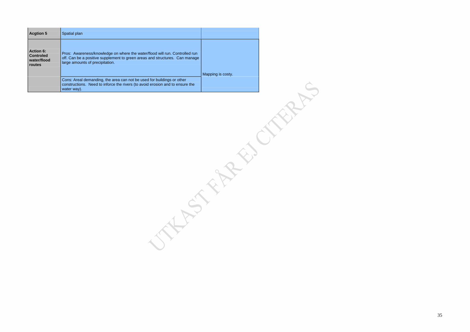
35
Acgtion 5 Spatial plan
Action 6: Controled water/flood routes
Pros: Awareness/knowledge on where the water/flood will run. Controlled run off. Can be a positive supplement to green areas and structures. Can manage large amounts of precipitation.
Mapping is costy.
Cons: Areal demanding, the area can not be used for buildings or other constructions. Need to inforce the rivers (to avoid erosion and to ensure the water way).

36
Matrix 2 for case Melhus.
Health and environment Resources Social and economic impacts Flexibility Risk Target
Contribution to global change
Air quality, (acidification, eutropfication, toxic gases and air borne particles)
Ecologic status in water and water coarses
Land use (plan and use) Energy
Raw material
Perrcieved welfare
Direct cost for measure/consequence
Sosio-economic impacts No regret
Status for risk due to flooding and consequences due to that.
Goal: 1. No mortalities (due to flooding). 2. Individual management and awareness. 3.Reduced ecomic losses.
Zero alternative (no action)
- -
Sea trout threatened. No good spawn conditions
More and more frequent seald plains
- -
Some unsafetey and uncertainty in comparison to nature damages
- - -
Some risk for flooding and landslides already today.
-
long time perspective
Possibly some negative impact due to acute actions at events with flooding/landslides (eg pumping and transportation).
Possibly some negative impact on particulates and NOx due to acute actions at events with flooding/landslides (eg pumping and transportation).
Sea trout may vanish. Increased risks for leaching of e-coli, phosfate and other nutrients to water courses.
Even more sealed plains. Faster run off. Some areas may not be able to be in use (eg Varegga)
Increase electricity costs, shorter pump life times
Some increased use of material
Increase unsafetey and uncertainty at home nad more unpleasant ground level flooding etc.
Likely increased costs for renovation and other acute measures due to flooding and landslides
Pros: Positive for entrepreneurs.Cons: Negative for the habitants in the municipality. Less attractive for new establishement. Moving inside/out of the municiapility.
More frequent acute situations. Less alternative solutions when acute siutations. Larger costs when large expansions in hazardous areas.
Increasing risk
1. Does not contribute to fulfil the goal. Increased risk for mortal events due to flooding and landslides. 2. Increased awareness due to more frequent events. The ability for private managment (self help) is related t o the financial status in the municipality and less service from the municipality. 3. Low fulfilment of the goal. Increased costs.
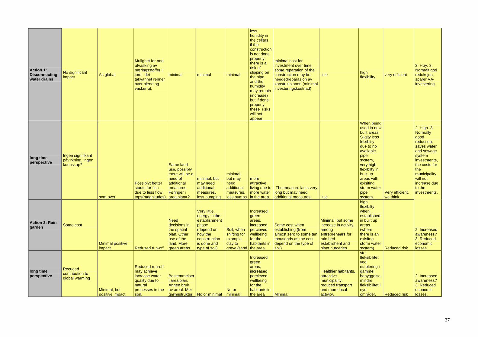
37
Action 1: Disconnecting water drains
No significant impact
As global
Mulighet for noe utvasking av næringsstoffer i jord i det takvannet renner over plene og vasker ut.
minimal minimal minimal
less hunidity in the cellars, if the construction is not done properly: there is a risk of slipping on the pipe and the humidity may remain (increase) but if done properly these risks will not appear.
minimal cost for investment over time some reparation of the construction may be neededreparasjon av konstruksjonen (minimal investeringskostnad)
little high flexibility
very efficient
2: Høy. 3. Normalt god reduksjon, sparer VA-investering.
long time perspective
Ingen signifikant påvirkning, ingen kunnskap?
som over
Possiblyt better stauts for fish due to less flow tops(magnitudes)
Same land use, possibly there will be a need of additional measures. Føringer i arealplan=?
minimal, but may need additional measures, less pumping
minimal, but may need additional measures, less pumps
more attractive living due to more water in the area.
The measure lasts very long but may need additional measures. little
When being used in new built areas: Sliglty less felxibitiy due to no available pipe system, very high flexibilty in built up areas with exisiting storm water pipe system.
Very efficient, we think..
2: High. 3. Normally good reduction, saves water and sewage system investments, the costs for the municipality will not increase due to the investments.
Action 2: Rain garden
Some cost
Minimal positive impact. Redused run-off
Need decisions in the spatial plan. Other use of the land. More green areas.
Very little energy in the establishment phase (depend on how the constrruction is done and type of soil)
Soil, when shifting for example clay to gravel/sand
Increased green areas, increased percieved wellbeing for the habitants in the area
Some cost when establishing (from almost zero to some ten thousends as the cost depend on the type of soil)
Minimal, but some increase in activity among entreprenears for rain bed establishent and plant nurceries
high flexibilty when established in built up areas (where there is an exisitng storm water system) Reduced risk
2. Increased awareness? 3. Reduced economic losses.
long time perspective
Recuded contribution to global warming
Minimal, but positive impact
Reduced run-off, may achieve increase water quality due to natural processes in the soil.
Bestemmelser i arealplan. Annen bruk av areal. Mer grønnstruktur No or minimal
No or minimal
Increased green areas, increased percieved wellbeing for the habitants in the area Minimal
Healthier habitants, attractive municipality, reduced transport and more local activity.
stor fleksibilitet ved etablering i gammel bebyggelse, mindre fleksibilitet i nye områder. Reduced risk
2. Increased awareness? 3. Reduced economic losses.
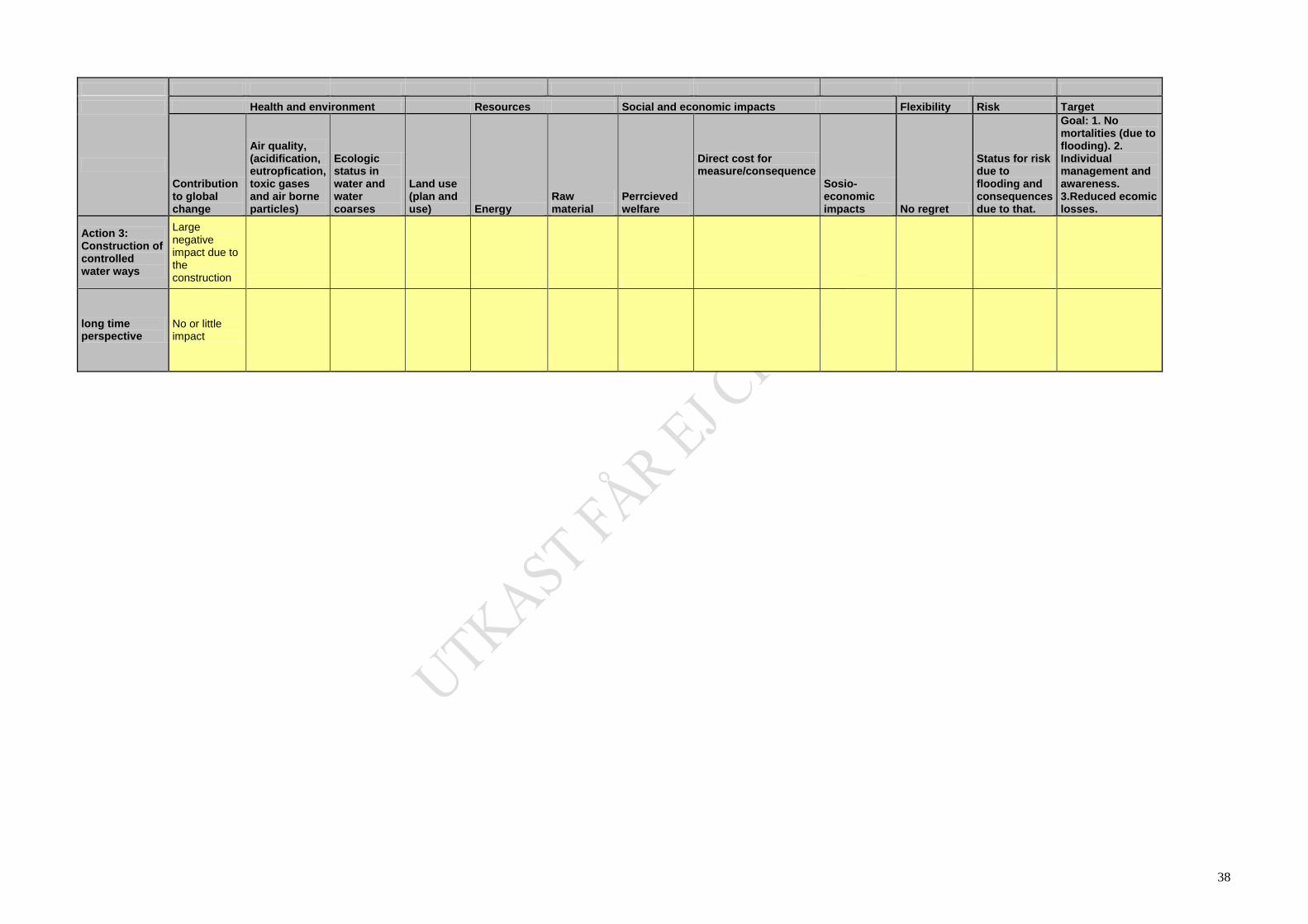
38
Health and environment Resources Social and economic impacts Flexibility Risk Target
Contribution to global change
Air quality, (acidification, eutropfication, toxic gases and air borne particles)
Ecologic status in water and water coarses
Land use (plan and use) Energy
Raw material
Perrcieved welfare
Direct cost for measure/consequence
Sosio-economic impacts No regret
Status for risk due to flooding and consequences due to that.
Goal: 1. No mortalities (due to flooding). 2. Individual management and awareness. 3.Reduced ecomic losses.
Action 3: Construction of controlled water ways
Large negative impact due to the construction
long time perspective
No or little impact

39
Matrix 3 for case Melhus.
Health and environment Resources Social and econoic impacts Flexibiliy Risk Targets
Contribution to global change
Air quality, (acidification, eutropfication, toxic gases and air borne particles)
Ecologic status in water and water coarses
Land use (plan and use)
Energy Raw material
Perrcieved welfare
Direct cost for measure/consequence
Sosio-economic impacts
No regret Status for risk due to flooding and consequences due to that.
Goal: 1. No mortalities (due to flooding). 2. Individual management and awareness. 3.Reduced ecomic losses.
Zero alternative (no action) 0 0 0 0 0 0 0 0 0 0 0 0
long time perspective
Action 1: Disconnecting water drains 0 0 -1 0 0 0 0 0 0 2 1 1
long time perspective 0 0 -1 0 0 0 1 1 0 2 2 1
Action 2: Rain garden 0 0 0 1 0 0 1 -1 0 2 1 1
long time perspective 0 0 1 1 0 0 1 0 1 1 1 1
Action 3 short time perspective
long time perspective
Copyright © 2022 FDOKUMEN