Mechanisms for stakeholder integration: Bringing virtual stakeholder dialogue into organizations
Upload
khangminh22Category
view
0download
0
Collaboration and Multi-Stakeholder Engagement in Landscape Governance and Management in AfricaLessons from Practice
Printed Edition of the Special Issue Published in Land
www.mdpi.com/journal/land
Nicola Favretto, Sheona Shackleton, Susannah M. Sallu, Chris Gordon, Nadine Methner, George Outa,
Phosiso Sola, Likho Sikutshwa and Portia Adade Williams
Edited by

Collaboration and Multi-Stakeholder Engagement in Landscape Governance and Management in Africa


Collaboration and Multi-StakeholderEngagement in Landscape Governanceand Management in Africa: Lessonsfrom Practice
Editors
Nicola Favretto
Sheona Shackleton
Susannah M. Sallu
Chris Gordon
Nadine Methner
George Outa
Phosiso Sola
Likho Sikutshwa
Portia Adade Williams
MDPI • Basel • Beijing • Wuhan • Barcelona • Belgrade • Manchester • Tokyo • Cluj • Tianjin

Editors
Nicola Favretto
University of Leeds
UK
Sheona Shackleton
University of Cape Town
South Africa
Susannah M. Sallu
University of Leeds
UK
Chris Gordon
University of Ghana
Ghana
Nadine Methner
University of Cape Town
South Africa
George Outa
University of Nairobi
Kenya
Phosiso Sola
World Agroforestry (ICRAF)
Kenya
Likho Sikutshwa
University of Cape Town
South Africa
Portia Adade Williams
CSIR—Science and Technology
Policy Research Institute
Ghana
Editorial Office
MDPI
St. Alban-Anlage 66
4052 Basel, Switzerland
This is a reprint of articles from the Special Issue published online in the open access journal Land
(ISSN 2073-445X) (available at: https://www.mdpi.com/journal/land/special issues/landscape
governance africa).
For citation purposes, cite each article independently as indicated on the article page online and as
indicated below:
LastName, A.A.; LastName, B.B.; LastName, C.C. Article Title. Journal Name Year, Volume Number,
Page Range.
ISBN 978-3-0365-1477-2 (Hbk)
ISBN 978-3-0365-1478-9 (PDF)
Cover image courtesy of Sheona Shackleton.
© 2021 by the authors. Articles in this book are Open Access and distributed under the Creative
Commons Attribution (CC BY) license, which allows users to download, copy and build upon
published articles, as long as the author and publisher are properly credited, which ensures maximum
dissemination and a wider impact of our publications.
The book as a whole is distributed by MDPI under the terms and conditions of the Creative Commons
license CC BY-NC-ND.

Contents
About the Editors . . . . . . . . . . . . . . . . . . . . . . . . . . . . . . . . . . . . . . . . . . . . . . vii
Nicola Favretto, Sheona Shackleton, Susannah M. Sallu and Tali Hoffman
Editorial for Special Issue: “Collaboration and Multi-Stakeholder Engagement in LandscapeGovernance and Management in Africa: Lessons from Practice”Reprinted from: Land 2021, 10, 285, doi:10.3390/land10030285 . . . . . . . . . . . . . . . . . . . . 1
Nicola Favretto, Stavros Afionis, Lindsay C. Stringer, Andrew J. Dougill, Claire H. Quinn
and Hery Lisy Tiana Ranarijaona
Delivering Climate-Development Co-Benefits through Multi-Stakeholder Forestry Projects inMadagascar: Opportunities and ChallengesReprinted from: Land 2020, 9, 157, doi:10.3390/land9050157 . . . . . . . . . . . . . . . . . . . . . . 7
Jessica Cockburn, Eureta Rosenberg, Athina Copteros, Susanna Francina (Ancia) Cornelius,
Notiswa Libala, Liz Metcalfe and Benjamin van der Waal
A Relational Approach to Landscape Stewardship: Towards a New Perspective forMulti-Actor CollaborationReprinted from: Land 2020, 9, 224, doi:10.3390/land9070224 . . . . . . . . . . . . . . . . . . . . . . 23
Peris Njoroge, Amollo Ambole, Daniel Githira and George Outa
Steering Energy Transitions through Landscape Governance: Case of Mathare Informal Settlement, Nairobi, KenyaReprinted from: Land 2020, 9, 206, doi:10.3390/land9060206 . . . . . . . . . . . . . . . . . . . . . . 43
Koen Kusters, Maartje De Graaf, Louise Buck, Katherine Galido, Alphonse Maindo, Heidi Mendoza, Tran Huu Nghi, Edi Purwanto and Roderick Zagt
Inclusive Landscape Governance for Sustainable Development: Assessment Methodology and Lessons for Civil Society OrganizationsReprinted from: Land 2020, 9, 128, doi:10.3390/land9040128 . . . . . . . . . . . . . . . . . . . . . . 63
Menelisi Falayi, James Gambiza and Michael Schoon
Unpacking Changing Multi-Actor and Multi-Level Actor Ties in Transformative Spaces:Insights from a Degraded Landscape, Machubeni, South AfricaReprinted from: Land 2020, 9, 227, doi:10.3390/land9070227 . . . . . . . . . . . . . . . . . . . . . . 77
Jesse Sey Ayivor, Johnie Kodjo Nyametso and Sandra Ayivor
Protected Area Governance and Its Influence on Local Perceptions, Attitudes and CollaborationReprinted from: Land 2020, 9, 310, doi:10.3390/land9090310 . . . . . . . . . . . . . . . . . . . . . . 103
James Omoding, Gretchen Walters, Edward Andama, Salete Carvalho, Julien Colomer,
Marina Cracco, Gerald Eilu, Gaster Kiyingi, Chetan Kumar, Council Dickson Langoya,
Barbara Nakangu Bugembe, Florian Reinhard and Celina Schelle
Analysing and Applying Stakeholder Perceptions to Improve Protected Area Governance inUgandan Conservation LandscapesReprinted from: Land 2020, 9, 207, doi:10.3390/land9060207 . . . . . . . . . . . . . . . . . . . . . . 123
Bettina Hedden-Dunkhorst and Florian Schmitt
Exploring the Potential and Contribution of UNESCO Biosphere Reserves for LandscapeGovernance and Management in AfricaReprinted from: Land 2020, 9, 237, doi:10.3390/land9080237 . . . . . . . . . . . . . . . . . . . . . . 149
v
Walter Musakwa, Trynos Gumbo, Gaynor Paradza, Ephraim Mpofu, Nesisa Analisa Nyathi
and Ntlakala B. Selamolela
Partnerships and Stakeholder Participation in the Management of National Parks: Experiencesof the Gonarezhou National Park in ZimbabweReprinted from: Land 2020, 9, 399, doi:10.3390/land9110399 . . . . . . . . . . . . . . . . . . . . . . 177
Portia Adade Williams, Likho Sikutshwa and Sheona Shackleton
Acknowledging Indigenous and Local Knowledge to Facilitate Collaboration in LandscapeApproaches— Lessons from a Systematic ReviewReprinted from: Land 2020, 9, 331, doi:10.3390/land9090331 . . . . . . . . . . . . . . . . . . . . . . 195
vi

About the Editors
Nicola Favretto (Dr). is a Research Fellow at the Sustainability Research Institute of the School
of Earth and Environment at the University of Leeds, UK and an Associate Researcher at the ESRC’s
Centre for Climate Change Economics and Policy. He has experience in mixed-method research
addressing environmental, economic and policy dimensions of sustainable development across
dryland sub-Saharan Africa and Latin America, with a focus on rural development, sustainable land
management, climate change mitigation and adaptation and sustainable energy. Dr Favretto has
undertaken research and managerial roles across a range of international organisations, including
the United Nations University, United Nations Development Programme and European Commission.
Sheona Shackleton is Professor and Deputy Director at the African Climate and Development
Initiative at the University of Cape Town. Her current research focuses on livelihood and landscape
(social-ecological) change, with a particular interest in climate change as a driver and how it interacts
with other shocks and stressors to influence adaptation, transformation and future livelihood
trajectories. Sheona has been engaged in interdisciplinary, participatory and transdisciplinary
research for most of her career. Her interest in engaged scholarship and knowledge co-production
arises from both a practical research and ethical perspective, but also an academic one in terms of
how best to integrate knowledge co-production processes into our teaching and learning and to
support such an approach in our postgraduate research.
Susannah M. Sallu is Associate Professor of Environment and Development at the Sustainability
Research Institute of the School of Earth and Environment at the University of Leeds, UK and a
Researcher at the ESRC’s Centre for Climate Change Economics and Policy. Her research and teaching
focuses broadly on human–environment interactions and more specifically on rural livelihoods,
environmental change, marginalisation and natural resource governance. Academically, her main
interests lie in the theoretical and empirical intersections of political ecology, complex systems science
and environmental justice. Susannah has particular regional expertise in Africa and works together
in participatory ways with communities and a wide range of academic and non-academic partners
to develop better understanding of the dynamics, resilience and vulnerability of social-ecological
systems, landscapes and livelihoods.
vii


land
Editorial
Editorial for Special Issue: “Collaboration andMulti-Stakeholder Engagement in Landscape Governance andManagement in Africa: Lessons from Practice”
Nicola Favretto 1,*, Sheona Shackleton 2, Susannah M. Sallu 1 and Tali Hoffman 2
Citation: Favretto, N.; Shackleton, S.;
Sallu, S.M.; Hoffman, T. Editorial for
Special Issue: “Collaboration and
Multi-Stakeholder Engagement in
Landscape Governance and
Management in Africa: Lessons from
Practice”. Land 2021, 10, 285.
https://doi.org/10.3390/land10030285
Received: 23 February 2021
Accepted: 4 March 2021
Published: 10 March 2021
Publisher’s Note: MDPI stays neutral
with regard to jurisdictional claims in
published maps and institutional affil-
iations.
Copyright: © 2021 by the authors.
Licensee MDPI, Basel, Switzerland.
This article is an open access article
distributed under the terms and
conditions of the Creative Commons
Attribution (CC BY) license (https://
creativecommons.org/licenses/by/
4.0/).
1 School of Earth and Environment, University of Leeds, Leeds LS2 9JT, UK; [email protected] African Climate and Development Initiative (ACDI), University of Cape Town,
Rondebosch 7700, South Africa; [email protected] (S.S.); [email protected] (T.H.)* Correspondence: [email protected] or [email protected]
A multitude of interconnected socio-economic and environmental impacts are emerg-ing across Africa as a result of escalating anthropogenic drivers of global and local change.Land use changes, infrastructural developments, changing weather patterns, and popula-tion growth and mobility are transforming the continent’s landscapes and social-ecologicalsystems over time, shaping the livelihoods of the people dependent on these landscapesand the critical ecosystem services they provide. Increasing levels of degradation, conflict,poor governance, competition for land and inequality, exacerbated by climate change,are adding to the burden carried by local people, especially the most marginalised. Inpursuing pathways towards a more resilient future, collaborative and multi-stakeholdergovernance and management of landscapes have been promoted by government agencies,NGOs and conservation organisations. Meaningful collaboration can promote the inclusionof marginalised voices, ensure appropriate actions and responses aligned to local concernsand needs, broaden the knowledge base, and bring frequently disconnected actors, sectors,and government institutions together in pursuit of a common goal.
However, there is no single way to achieve effective collaboration, and different land-scape projects have experimented with different entry points and engagement processes.The need to further explore the linkages between different social and ecological compo-nents of landscape governance and management, which often operate under competinguses and meanings of land, led the Interdisciplinary Research Group on Climate ResilientAfrican Landscapes (CRAL) project and this Special Issue to consider what has, or has not,worked in engagement and collaboration processes, what could be done better, and whatpractical lessons can be upscaled.
This Special Issue collates ten papers, including a global systematic review of theincorporation of indigenous knowledge in landscape approaches, and case study researchfrom five African countries (South Africa, Zimbabwe, Uganda, Kenya, and Madagascar),written by 56 authors from 29 organisations (including universities, research institutes,non-governmental and international organisations, and the private sector). In this editorial,we collate key lessons from practice evident across the papers.
Nine interrelated and important lessons for supporting more resilient and equitablelandscapes emerged from our analysis of collaboration and multi-stakeholder engagementin landscape governance and management in Africa.
1. CO-DESIGN AND CO-PRODUCE: Most papers highlight co-design and knowledgeco-production as critical to inclusive and sustainable landscape management but also recog-nised that there are barriers to achieving this in practice (Favretto et al. [1], Williams et al. [2],Cockburn et al. [3], Njoroge et al. [4], Musakwa et al. [5], Kusters et al. [6]). Several ofthe lessons that follow highlight ways to address some of these barriers. Inclusive multi-stakeholder engagement, together with sustained and systemic knowledge exchange, can
Land 2021, 10, 285. https://doi.org/10.3390/land10030285 https://www.mdpi.com/journal/land
1

Land 2021, 10, 285
support the co-design and co-production of integrated and sustainable policies and man-agement plans that align the objectives of multiple landscape actors. As evidenced by thecase study analysis of Favretto et al. [1], the co-benefits of forestry projects in Madagascarare enhanced when objectives of multiple landscape actors are aligned through a theoryof change that systematically links project deliverables, outputs, outcomes, and impactsover time. A structured and transparent approach based on co-production strengthensthe shared understanding and synergies of stakeholders and enhances community buy-intoward the delivery of tangible benefits.
2. BUILD ON WHAT ALREADY EXISTS: Before beginning a new engagement processit is important to have a holistic understanding of the landscape in question, including itsgovernance, actors, uses and history. By reflecting on practical lessons regarding the role ofcivil society organisations in fostering inclusive landscape governance, Kusters et al. [6]show the importance of building on existing systems, platforms, and networks of collabo-ration to enhance local involvement and ownership. Recognising that the opportunities oflandscape stakeholders to influence planning are unequal, several of the papers call forthe inclusion of local actors, as well as the incorporation of their knowledge systems intoongoing governance processes (Favretto et al. [1], Williams et al. [2], Cockburn et al. [3],Musakwa et al. [5], Falayi et al. [7]).
3. ACKNOWLEDGE THE ROLE OF HISTORY AND CONTEXT: History shapesrelations and power dynamics among landscape actors, determining who gets to partic-ipate, who gets to speak, and whose knowledge is used. This is of particular relevancein Africa where most countries have a colonial past, the consequences of which are stillpervasive. Evidence of this is well presented in the South African case examined by Cock-burn et al. [3]. These authors found that the differences in race/ethnicity, language, andknowledge systems derived from the country’s history of discrimination have causeda lasting fragmentation of social groups and a power imbalance that shapes relationsamong landscape actors. History can also lead to inequality, with some stakeholder groupsbenefiting from past policy decisions, while others suffer the damage of displacement orbeing criminalised for their continued livelihood practices. Musakwa et al. [5] show thatwhile stakeholder participation and partnership in the management of national parks inZimbabwe has served wildlife conservation purposes, the increase of elephant populationshas resulted in human–wildlife conflicts and generated negative livelihood outcomes forlocal communities. As noted by Ayivor et al. [8] in a study of land governance in Ghana,the protected areas system has fuelled antagonistic relationships between communitiesand protected area officials, resulting in the criminalisation of certain livelihood-relatedactivities essential for local people’s survival. Acknowledging the role that history andcontext play in landscape management decisions can support the development of policiesthat better align with local needs and strategies and that contribute to redress past injustices(Omoding et al. [9]).
4. FIND A NEUTRAL CONVENER: Academics and civil society organisations canplay important and neutral intermediary roles as knowledge brokers, which can helpbalance power dynamics between stakeholders by guiding the aggregation of information,supporting collaboration, and facilitating wider participation (Cockburn et al. [3]). In theanalysis of energy transitions through landscape governance in urban informal settlementsin Kenya, Njoroge et al. [4] show the pivotal role played by universities in leading thelearning processes and facilitating multi-actor collaboration and engagement. The paperfound that, due to the disputed nature of informal settlements, local residents are morepredisposed to interact with researchers than government agents. In co-identifying anddesigning solutions, the neutral role of the researchers enhances trust and supports theleveraging of efforts across sectors (Hedden-Dunkhorst and Schmitt [10], Kusters et al. [6]).
5. BE TRANSPARENT AND OPEN: Given the diversity of interests and values oflandscape actors, transparency and openness should be encouraged in all stakeholderinteractions, and across all decision-making processes and land governance structures.Hedden-Dunkhorst and Schmitt [10] show the importance of transparency to promote
2

Land 2021, 10, 285
realistic expectations on livelihood improvements in biosphere reserve management. Trans-parency helps build trust among stakeholders and makes them comfortable about thevalues they hold. As expanded in the global analysis of Kusters et al. [6], clarity aboutgoals and realistic expectations should be made at the onset, ensuring all participants areaware of the potential benefits and trade-offs of different decisions. Williams et al. [2] pointout that without transparency and trust, indigenous and local knowledge is unlikely to besuccessfully incorporated, limiting inclusivity.
6. WIDEN THE NET OF PARTICIPANTS: All contributions touched on the criticalityof ‘inclusive’ stakeholder engagements. More inclusive approaches can create benefits,including the alignment of a diversity of needs, stimulation of mutual learning and open-ness to alternative perspectives, and promotion of the participation of all social groups,including those typically marginalised. It is equally important that stakeholder groups seeka balance of voices, including those from different levels of seniority, different sectors andadministrative divisions, and different geographic scales. Using social network analysis,Falayi et al. [7] examine the changing dynamics of multi-level actor ties in the degradedlandscape of Machubeni in South Africa. The paper shows that inclusive participation ofvaried multi-scale actors enhances collaboration among government agencies, local hubsand researchers in transformative spaces, which results in enhanced knowledge sharingand coordination.
7. USE EMERGING TOOLS AND APPROACHES: Creative tools and approaches canhelp navigate the complexities of multi-scale and multi-actor stakeholder engagements, forexample by facilitating the sharing of perspectives and perceptions among stakeholders,and to signify what is most important to them (Williams et al. [2]). Omoding et al. [9] usedSenseMaker® software to analyse stakeholder perceptions of inclusive decision making toimprove the governance of protected areas in Ugandan conservation landscapes. The papershows that collaborative analysis and debate among landscape stakeholders is stimulatedby the use of participatory feedback and sense-making workshops. These generate newperspectives, which are translated into actionable insights to inform decisions. In SouthAfrica, drawing on a set of ‘gardening tools’ to analyse the boundary-crossing work ofmulti-actor collaboration across case studies, Cockburn et al. [3] show that such tools helpto reveal boundaries to multi-actor collaboration that may not be immediately clear. Incontexts characterised by high inequality and challenging power dynamics, the appli-cation of gardening tools can help to uncover aspirational differences and increase thebroader understanding of contextual challenges, while simultaneously developing a senseof community and trust.
8. DEVELOP AGENCY, CAPACITY AND TRUST: As acknowledged in many of thecontributions, enhanced agency, capacity and trust can support meaningful long-termstakeholder engagement and increase the willingness of diverse stakeholders to shareknowledge and cooperate towards a joint purpose (Kusters et al. [6]). This is evidencedby Favretto et al. [1], whereby meaningful and long-term engagement of practitioners andcommunities has allowed the pursuit of locally relevant approaches as a stepping stoneto build trust and enhance the capacity of forestry projects to address complex climate-development challenges. Similarly, Hedden-Dunkhorst and Schmitt [10] demonstrate thatensuring open participation opportunities and transparent governance structures are vitalto create trust between a biosphere reserve and its user groups. Building the capacity andsocial capital of the less powerful actors is necessary to ensure they can organise themselves,access relevant information, learn about their rights and develop negotiation skills (Cock-burn et al. [3]). Musakwa et al. [5] argue that both formal and informal opportunities mustbe created to build the kind of relationships that can support sustained and productiveengagement. Direct consultations, capacity-building workshops, or demonstration projectsto inform local stakeholders of the potential benefits and trade-offs concerning land-usepractices have proven to be valuable for giving greater legitimacy to local communities,enhancing their knowledge, and engaging them in sustainable livelihood and conservationactivities (Falayi et al. [7]).
3
Land 2021, 10, 285
9. BUILD COMMON AND INCLUSIVE KNOWLEDGE: Williams et al.’s [2] sys-tematic review stresses the importance of bringing in all sources of knowledge acrossscience, practice and local-level realities. By fostering an environment where the differentknowledge sources and systems are considered equal (e.g., through multi-stakeholder col-laborations in local landscape research, the promotion of inclusive consultations, integratedand holistic landscape management, and the use and transmission of indigenous local andtraditional knowledge) stakeholders are able to expand their shared understanding, learnfrom each other, and build common knowledge towards improved landscape manage-ment, governance, and planning (Favretto et al. [1], Musakwa et al. [5], Ayivor et al. [8],Omoding et al. [9]). Focusing on the South African experiences on landscape stewardship,Cockburn et al. [3] observe that enabling frequent interaction and collective actions amongactors in smaller pockets within a landscape can help to build common knowledge andrelational agency. The process requires time and skillful facilitation and meditation toinclude and empower traditionally marginalised voices and all knowledge holders.
This Special Issue has highlighted that multi-stakeholder processes in landscape gover-nance and management are critical for transformation towards more equitable and climateresilient landscapes in Africa, but, at the same time, can be challenging to implement andrequire time, commitment, and a willingness to work differently. Landscape research is byits nature transdisciplinary, with researchers often needing to play multiple roles includ-ing that of a neutral convener. Research and practice are thus inherently intertwined inlandscape approaches and our hope is that the emerging lessons from the case studies canbe used to both advance transdisciplinary research on landscape governance and supportpractice at the local level. Our synthesis has shown that for meaningful collaboration totake place processes need to be open, accountable, inclusive, transparent, and legitimate.This requires the use of innovative approaches and tools that can bring different actors to-gether to facilitate trust-building, reduce power differentials, allow space for marginalisedvoices, and permit collective learning to foster a shared understanding of landscape issuesand opportunities. If this can be achieved, then the chances that such partnerships willcontinue to function into the future is enhanced, as is the chance for more equitable andresilient landscapes.
Funding: The collation of this Special Issue received external funding from the Worldwide Universi-ties Network awarded to the University of Cape Town in 2018.
Institutional Review Board Statement: Not applicable.
Informed Consent Statement: The study was conducted according to the guidelines of the Declara-tion of Helsinki, and approved by the Ethics Committee of the University of Leeds.
Data Availability Statement: Not applicable.
Acknowledgments: We thank the Worldwide Universities Network’s support to the CRAL projectand the contributions and support of project members: Chris Gordon (University of Ghana), PhosisoSola (World Agroforestry, ICRAF), George Outa (University of Nairobi), Likho Sikutshwa, NadineMethner and Portia Adade Williams (University of Cape Town). Favretto and Sallu were supported bythe Economic and Social Research Council’s Centre for Climate Change Economics and Policy, grantnumber: ES/K006576/1. Favretto was also supported by the ESRC Impact Acceleration Account.
Conflicts of Interest: The authors declare no conflict of interest.
References
1. Favretto, N.; Afionis, S.; Stringer, L.C.; Dougill, A.J.; Quinn, C.H.; Ranarijaona, H.L.T. Delivering Climate-Development Co-Benefits through Multi-Stakeholder Forestry Projects in Madagascar: Opportunities and Challenges. Land 2020, 9, 157. [CrossRef]
2. Williams, P.A.; Sikutshwa, L.; Shackleton, S. Acknowledging Indigenous and Local Knowledge to Facilitate Collaboration inLandscape Approaches—Lessons from a Systematic Review. Land 2020, 9, 331. [CrossRef]
3. Cockburn, J.; Rosenberg, E.; Copteros, A.; Cornelius, S.F.; Libala, N.; Metcalfe, L.; van der Waal, B. A Relational Approach toLandscape Stewardship: Towards a New Perspective for Multi-Actor Collaboration. Land 2020, 9, 224. [CrossRef]
4. Njoroge, P.; Ambole, A.; Githira, D.; Outa, G. Steering Energy Transitions through Landscape Governance: Case of MathareInformal Settlement, Nairobi, Kenya. Land 2020, 9, 206. [CrossRef]
4

Land 2021, 10, 285
5. Musakwa, W.; Gumbo, T.; Paradza, G.; Mpofu, E.; Nyathi, N.A.; Selamolela, N.B. Partnerships and Stakeholder Participation inthe Management of National Parks: Experiences of the Gonarezhou National Park in Zimbabwe. Land 2020, 9, 399. [CrossRef]
6. Kusters, K.; De Graaf, M.; Buck, L.; Galido, K.; Maindo, A.; Mendoza, H.; Nghi, T.H.; Purwanto, E.; Zagt, R. Inclusive LandscapeGovernance for Sustainable Development: Assessment Methodology and Lessons for Civil Society Organizations. Land 2020,9, 128. [CrossRef]
7. Falayi, M.; Gambiza, J.; Schoon, M. Unpacking Changing Multi-Actor and Multi-Level Actor Ties in Transformative Spaces:Insights from a Degraded Landscape, Machubeni, South Africa. Land 2020, 9, 227. [CrossRef]
8. Ayivor, J.S.; Nyametso, J.K.; Ayivor, S. Protected Area Governance and Its Influence on Local Perceptions, Attitudes andCollaboration. Land 2020, 9, 310. [CrossRef]
9. Omoding, J.; Walters, G.; Andama, E.; Carvalho, S.; Colomer, J.; Cracco, M.; Eilu, G.; Kiyingi, G.; Kumar, C.; Langoya, C.D.; et al.Analysing and Applying Stakeholder Perceptions to Improve Protected Area Governance in Ugandan Conservation Landscapes.Land 2020, 9, 207. [CrossRef]
10. Hedden-Dunkhorst, B.; Schmitt, F. Exploring the Potential and Contribution of UNESCO Biosphere Reserves for LandscapeGovernance and Management in Africa. Land 2020, 9, 237. [CrossRef]
5


land
Article
Delivering Climate-Development Co-Benefitsthrough Multi-Stakeholder Forestry Projects inMadagascar: Opportunities and Challenges
Nicola Favretto 1,*, Stavros Afionis 2, Lindsay C. Stringer 1, Andrew J. Dougill 1, Claire H. Quinn 1
and Hery Lisy Tiana Ranarijaona 3
1 School of Earth and Environment, University of Leeds, Leeds LS2 9JT, UK; [email protected] (L.C.S.);[email protected] (A.J.D.); [email protected] (C.H.Q.)
2 School of Law and Politics, Cardiff University, Cardiff CF10 3AX, UK; [email protected] Doctoral School of Natural Ecosystems, University of Mahajanga, Immeuble Kakal, Mahajanga 401-BP:652,
Madagascar; [email protected]* Correspondence: [email protected]
Received: 15 April 2020; Accepted: 15 May 2020; Published: 18 May 2020
Abstract: This paper explores multi-stakeholder perspectives on the extent to which forestry projectsthat pursue ecological restoration and rehabilitation in Madagascar engage with local communitiesand can co-deliver climate-development benefits. Drawing on mixed methods (policy analysis,semi-structured interviews, participatory site visits and focus groups) in two different forestry contexts,we show that by strengthening access to capital availability, projects can enhance local adaptive capacityand mitigation and deliver local development. We show that active consideration of ecologicalconservation and action plans early in project design and implementation can co-develop andsupport monitoring and reporting systems, needed to progress towards integrated climate-compatibledevelopment approaches. Climate mitigation benefits remain poorly quantified due to limitedinterest in, and low capacity to generate, carbon revenues. Monitoring alone does not ensure carbonbenefits will materialize, and this research stresses that institutional considerations and strengthenedengagement and cooperation between practitioners and communities are key in achieving bothclimate mitigation and community development impacts. Multiple benefits can be fostered byaligning objectives of multiple landscape actors (i.e., community needs and project developers) and bysystematically linking project deliverables, outputs, outcomes and impacts over time, grounded in atheory of change focused on ensuring community buy-in and planning for delivery of tangible benefits.
Keywords: climate and development; forest conservation; REDD; sustainable land management;project monitoring and evaluation; mangroves
1. Introduction
Land degradation is often exacerbated by climate change, threatening multiple socio-ecologicalsystems and the livelihoods of people whose lives depend on them. Ecological restoration andrehabilitation projects are pursued with a view to mitigating the impacts of climate change by storingcarbon in plants and soil, while often reducing people’s vulnerability and increasing their capacityto adapt [1]. The central role of trees in the carbon cycle has led to innovative international forestgovernance mechanisms that seek to recognize the value of forests, in addition to their supply oftimber, labor, biodiversity and water as ecosystem services [2]. In line with Article 5 of the 2015 ParisAgreement, the pursuit of results-based payments—e.g., through carbon markets and the ReducingEmissions from Deforestation and Degradation (REDD+) framework—provide financial incentives togovernments and communities in the developing world to maintain and increase forest cover [3,4]. It is
Land 2020, 9, 157; doi:10.3390/land9050157 www.mdpi.com/journal/land7

Land 2020, 9, 157
acknowledged that these mechanisms offer potential to deliver “triple-wins” or climate-compatibledevelopment, assisting climate change mitigation, but also reducing vulnerability, alleviating povertyand enabling people to adapt [5].
The capacity to exploit synergies between the multiple benefits delivered by trees andmultifunctional landscapes through ecological restoration and rehabilitation has been limited todate by spatial and temporal constraints. Spatially, mitigation benefits are typically global, whileadaptation benefits are localized [6]. Temporally, mitigation requires long-term commitment, whileadaptation can happen more quickly [7], through accumulated coping strategies and in the longerterm, through transformation. While multiple forest and landscape restoration benefits such as carbonsequestration, rehabilitation of degraded lands, flood risk reduction and enhanced biodiversity, canbe generated in synergy, trade-offs occur when long-term impacts on vulnerability and adaptationcapacity are taken into account [8]. For example, a short-term adaptation initiative aimed at building aseawall to protect the community from cyclones and flooding, might attract people to an area perceivedas being safe, while it further exposes them to extreme climatic events [9]. Long-term increasedvulnerability, or decreased adaptive capacity, deriving from short-term adaptation actions that produceunintended impacts, are defined as “maladaptation” [9].
Adaptation to climate change requires a long-term vision to shift socio-ecological systems towardssustainable trajectories. As identified by Cinner et al. (2018) [10], there are five key domains involvedin building long-term adaptive capacity. These include the financial and technological assets accessedby people in time of need, the flexibility to switch across adaptation strategies, the ability of society toorganize and share knowledge, the capacity to learn and the agency to determine whether a change isneeded. In light of spatio-temporal considerations, it is imperative to plan and evaluate mitigationand adaptation actions simultaneously, with a view to targeting and addressing multiple scales andtimeframes to effectively manage climate change impacts [11].
Pursuing long-term mitigation and adaptation is imperative to sustain the livelihoods ofnatural-resource dependent communities that are affected by climate change [12]. Since the mid-2000sincreasing focus has been placed on the need to mainstream restoration actions into the developmenttrajectories of developing countries [13]. By reconciling adaptation, mitigation and development,climate change benefits can be combined with poverty reduction, health improvements and increasedfood security [14]. Using multiple-benefit approaches is of particular relevance in Southern AfricanDevelopment Community nations, where socio-economic development opportunities are jeopardizedby high climatic uncertainty [15]. Despite growing literature on the potential of ecological restorationapproaches to generate an array of benefits, there are still several gaps that require further empiricalcase study investigations [11].
Suckall et al. (2015) [16] report that where joint ecological restoration or rehabilitation andclimate appraisals have been attempted, difficulties remain in understanding how well co-benefitsmap onto the development and climate adaptation challenges perceived by local communities.Analyzing two community-level projects that pursue ecosystem rehabilitation in South Africa,Favretto et al. (2018) [17] observed mismatches in reported and perceived benefits at project andcommunity levels. As noted by Cinner et al. (2018) [10], limited capacity to integrate localknowledge and perspectives into science, policy and practice, coupled with limited participation of localcommunities in adaptive co-management, constrain the delivery of long-term benefits. An improvedunderstanding of community perceptions is key to allow meaningful community engagement, whichis a pre-requisite for projects to deliver on expected outcomes [18]. As different stakeholder groupshave different views with respect to mitigation, adaptation and development priorities, understandinghow best to assess and integrate local-level perspectives into climate and development policy andpractice is key if actions are to secure local buy-in and meet multiple goals.
Madagascar is one of the world’s major biodiversity hotspots, presenting an important studycontext where the gaps in assessing multiple benefits and mainstreaming community prioritiesinto restoration require urgent attention [19]. Forest policy, projects and research in Madagascar
8

Land 2020, 9, 157
have all historically focused on biodiversity conservation [20], with attention to climate changeand development impacts gaining momentum only after REDD+ mechanisms and climate actionemerged onto international and national agendas [5]. Analyzing thirty years of conservation efforts,Waeber et al. (2016) [21] showed that this limited scope of analysis hampers the assessment of progresstowards international development goals.
This paper targets the gap noted above, i.e., the need to improve understanding of perceivedlocal co-benefits of ecological restoration across climate and development dimensions with a view toenhance capacity to deliver long-term benefits through integration of local knowledge into practice.It aims to examine perceptions of the extent to which forest projects that pursue ecological restorationand rehabilitation in Madagascar can deliver adaptation, mitigation and development co-benefitsto local communities. We focus on two case study projects, based on mangrove reforestation andREDD+ conservation. Such an integrated analysis that links local- and project-level perspectives ofclimate-development impacts of conservation projects in Madagascar, combining multiple indicatorsof perceived co-benefits, has not been carried out before. We ask the following research questions:
1. What are the development needs of the forest communities in Madagascar in the face ofclimate change?
2. What are the adaptation, mitigation and development co-benefits and challenges of forestconservation projects reported by practitioners and communities in Madagascar?
If land degradation and deforestation continue at current rates, this is likely to result in a rangeof uncontrolled societal, economic and environmental ramifications which hamper the achievementof international agreements and the Sustainable Development Goals (SDGs) [1]. Lessons from thisresearch are relevant across sub-Saharan Africa, as countries seek to progress towards the SDGs andtheir Paris Climate Agreement Nationally Determined Contributions (NDCs) [22]. Moving towardsthe United Nations Decade on Ecosystem Restoration 2021–2030, understanding the prerequisitesand challenges for multiple benefits to be achieved in climate and development policy and practice,especially those pursuing job creation and ecological restoration and rehabilitation, is more pertinentthan ever [23].
2. Materials and Methods
2.1. Study Country Context
Madagascar is a biodiversity hotspot and conservation priority area, as well as one of the world’spoorest countries [19]. Between 1953 and 2014, 44% of forest was lost nationally [5]. In 2014, forestcover accounted for 8.9 million ha, with an annual deforestation rate of 1.1% reported in the period2010–2014 (i.e., 99,000 ha/year) [24]. Increasing temperatures impact on temporal and spatial rainfalldistribution and exacerbate drought and flood intensity across the southern Africa region [25]. To adaptto climatic changes and cope with extended droughts, subsistence farmers in Madagascar increasedforest clearing by up to 17% between 2000 and 2013, compared to pre-2000 levels [26].
Climate change impacts are exacerbated by political instability, which, combined withgeopolitical approaches that internationalize conservation, result in undervaluing local knowledge andperspectives [27]. Since the 1960s, policy and funding efforts to address the most pressing environmentalchallenges in Madagascar have focused on biodiversity conservation, with US$ 700 million of supportbetween 1990 and 2012 [21]. Since 1996, through institution of a system that transfers forest managementto communities (“Gelose” law), forest management decisions have been increasingly transferred fromgovernment to grassroots community-organizations, and community-based conservation has been putat the center of environmental policy and forest management [27]. The 2003 Durban Accord boosted adecentralized approach to protected areas by emphasizing co-management in biodiversity conservationto achieve poverty reduction [28,29]. Consequently, between 2003 and 2016, protected areas quadrupledand five carbon-rich biomes have been set up through REDD+ projects [5,19]. Madagascar’s climatechange policy, in particular its National Adaptation Program of Action (NAPA) and its Nationally
9

Land 2020, 9, 157
Determined Contribution (NDC), highlight large-scale reforestation and local community engagementto protect the remaining forests. Through such engagement, these policies seek to both promotesocio-economic development and enhance climate change mitigation and adaptation [30,31].
2.2. Case Study Project Selection
Two case study projects that pursue ecological restoration and rehabilitation were selected toinvestigate their climate-development co-benefits, challenges and trade-offs at the community-level(Figure 1). These two projects were selected because they: (i) pursue ecological restoration andrehabilitation with implications for climate adaptation and mitigation, (ii) cover multiple types of forestgovernance (protected areas and community forest management) in both coastal and inland settings,(iii) involve project target beneficiaries who are highly vulnerable to climate change and have highdependency on the forest for their livelihoods, (iv) have potential to access reduced emissions forestryschemes such as REDD+ and carbon markets, and (v) have a comparable project implementation historyof approximately ten years. A total of six projects relevant to the study theme were initially identified.Only two of them met all of the five selection criteria and were therefore chosen as case studies.
Figure 1. Forest restoration and rehabilitation case study projects, Madagascar. Source: Adapted fromD-Maps, 2018 [32].
2.2.1. Case Study 1: Eden Projects
Eden is a non-profit organization whose mission is to improve the livelihoods of impoverishedMalagasy communities by implementing reforestation and environmental stewardship projects.It operates in the Boeny region, which has an average annual temperature of 27 ◦C and rainfall rangingbetween 1000 and 1200 mm. Between 1990 and 2013 roughly 7500 ha of forest were lost in Boeny, withaverage carbon storage reductions of 2.7 million tons/year, mostly due to illegal logging for constructionmaterial and charcoal production [33]. Since 2008, Eden has sustained mangrove reforestation withpoor communities heavily dependent on coastal mangroves for fishing. Funded mostly by businesses,Eden’s development model employs locals to plant trees, with the aim to enhance income, increaseadaptive capacity and stop deforestation, moving towards long-term improved mitigation [34].
10

Land 2020, 9, 157
2.2.2. Case Study 2: Makira Forest REDD+ Project
Since 2012, the Wildlife Conservation Society (WCS) has been managing 372,000 ha of the MakiraForest protected area on behalf of the Madagascar Ministry of Environment and Forests. Makira is oneof the most intact and highly biodiverse remaining rainforest systems in Madagascar, where increasingdeforestation has been driven by slash and burn rice agriculture and illegal logging, exacerbated byrapid population growth and poverty [35]. The Makira forest REDD+ project, implemented by WCSsince 2005, aims to safeguard the Makira Natural Park (in Analanjirofo, Sava and Sofia regions) andcontribute towards national emissions reduction targets. It seeks to align avoided deforestation withecosystem conservation, while supporting the socio-economic development of communities livingaround the forest. Makira’s implementation model involves: (i) developing contracts to transferforest resources management to local communities adjacent to the protected area, (ii) strengtheninglocal institutions and land use planning, and (iii) diversifying income through improved agriculturaltechniques, infrastructure development, conservation enterprise activities and ecotourism. By selling‘Verified Carbon Standard’ (VCS) and ‘Climate, Community and Biodiversity Alliance’ (CCBA) verifiedcarbon credits generated through avoided deforestation, the project aims to market over 31 milliontons of carbon offsets to sustain long-term conservation over the period 2005–2034 [35].
2.3. Methods
The research questions were addressed using a multi-level, mixed-methods approach (Table 1),where each research question was addressed using the same methods. Fieldwork was undertakenbetween August and October 2017.
Table 1. Summary and sample size of multi-level and mixed-method research approaches used acrosscase studies.
Method Stakeholder TypeSample Size
(Males/Females)—CaseStudy 1: Eden
Sample Size(Males/Females)—Case
Study 2: MakiraTotal
Semi-structuredinterviews
Community:workers and
projectbeneficiaries
23 M/27 F 4 M/6 F 60
Semi-structuredinterviews
Experts: policymakers, scientists,project developers
4 M/4 F 2 M/3 F 13
Participatory sitevisits Mixed 2 (size: n = 10 each) 2 (size: n = 5 each) 4
Focus groups Mixed 2 (size: n = 15 each) 2 (size: n = 5 and n = 15) 4
Stakeholders in the project areas were identified through literature review and interviews withproject developers. Sampling criteria included direct targeting of community beneficiaries who wereformally employed by Eden or registered with Makira. To avoid sampling biases, after the firstlocal contact was made by the project developer, the remaining participants were chosen in the field,according to their willingness to participate and keeping a balanced gender and age representationbased on information derived from local project staff. Project perspectives were addressed through 13semi-structured expert interviews with: regional-level policy makers (n = 3), scientists (n = 1) andproject developers (n = 5 Eden, n = 4 Makira) identified through snowball sampling, with questionsfocused on background and stakeholder analysis, project achievements and challenges, communityengagement, monitoring and evaluation, and policy implications (Supplementary Material 1).
Two study villages (those with the longest implementation histories) were selected under eachproject. In Eden, these covered its coastal activities as the core of Eden’s operations. In the Makira case,two villages of easier access were targeted from among the seventy-three villages within which theproject operates. By focusing on two Makira villages, the data produced a valuable understanding of
11

Land 2020, 9, 157
key project benefits and challenges, at a comparable scale to the Eden case. Community-perspectiveswere addressed through 60 semi-structured interviews with local workers and project beneficiaries(n = 50 with Eden, out of a total of 234 direct beneficiaries across the two study villages, and n = 10 withMakira, out of 95 direct beneficiaries across the two villages), 4 focus groups (n= 2 Eden, each with n= 15participants, n = 2 Makira, respectively with n = 5 and n = 15 participants), and 4 participatory site visits(n = 2 Eden, each with n = 10 participants, n = 2 Makira, each with n = 5 participants). Semi-structuredinterview samples sizes align with approaches followed in qualitative research more broadly [36].The larger sample of interviewees under Eden is due to the higher number of direct beneficiaries ineach village compared to Makira. Open invitations were circulated by village heads prior to carryingout focus groups and site visits, with sample sizes ranging between 5 and 15 participants and beingaligned with approaches followed in comparable studies [37]. Questions expanded the themes coveredin expert interviews, emphasizing the perceived opportunities and challenges to deliver adaptation,mitigation, and development at the community-level (Supplementary Material 2).
Data were input into a modified analytical framework, originally developed for assessingecosystem restoration and rehabilitation projects in South Africa (Table 2). Adaptation is consideredas people’s capacity to “anticipate and respond to change, to minimize the consequences, to recover,and take advantage of new opportunities” to deal with climate impacts [10] (p. 117). Mitigation isdefined as the reduction of emissions of greenhouse gases and increased uptake of such gases bythe Earth system such that atmospheric greenhouse gas concentrations decline [38]. Development isdefined as sustaining SDG achievement through the enhancement of short and long-term capabilities,assets and activities needed for a means of living [16,39]. We acknowledge that neither adaptation nordevelopment happen separately, and some of their dimensions might overlap. Results are grounded inthe indicators used in the analytical framework, the utility of which lies in its qualitative assessment andintegration of local-level perceptions of co-benefits and challenges in climate change and developmentpractice. Where quantitative measures of climate impacts are absent, the gathering of perceptionsof such climate impacts allows for trends and patterns to be identified. Patterns of categories fromresponses were grouped under key themes that were used to adapt the original analytical framework(Table 2). Through this thematic analysis, phrases from interview notes (including semi-structuredinterviews, field visits and focus groups) were assigned an ID based on their related type of benefit,categorized into relevant themes and inserted into the analytical framework. Data was analyzeddrawing on comparative qualitative analysis approaches, where the same set of indicators used in theframework was compared across case studies [40].
Table 2. Analytical framework for adaptation, mitigation and development co-benefits and challengesof case studies: definitions and indicators.
ADAPTATION: People’s Capacity to Anticipate and Respond to Change, to Minimize the Consequences,to Recover, and Take Advantage of New Opportunities to Deal with Climate Impacts
ASSETSFinancial and technological resources accessed by people in time of need (e.g., fish species, savings or credit to
purchase bigger boats, irrigation systems)FLEXIBILITY
Opportunities to switch across adaptation strategies (e.g., changing occupation, fishing and croppingstrategies, temporarily or permanently)
SOCIAL ORGANISATIONCooperation (e.g., formal or informal community organizations) and knowledge sharing to deal with change
LEARNINGAbility to generate and absorb information about adaptation options
AGENCYPower to mobilize the other components of adaptive capacity to respond to environmental change
MITIGATION: Reducing emissions of greenhouse gases & increasing uptake of such gases by the Earth systemPlanting trees and restoring soil to sequester carbon
12

Land 2020, 9, 157
Table 2. Cont.
ADAPTATION: People’s Capacity to Anticipate and Respond to Change, to Minimize the Consequences,to Recover, and Take Advantage of New Opportunities to Deal with Climate Impacts
DEVELOPMENT: Sustaining Sustainable Development Goal achievement through the enhancement of shortand long-term capabilities, assets and activities needed for a means of living
HUMANSkills, knowledge, training, education, labor power, livelihood diversification
SOCIALNetworks, connectedness, relationships of trust, information exchange, empowerment
NATURALAccess to land, water, wildlife, flora, forest, soil organic carbon
PHYSICALInfrastructure and production equipment
FINANCIALSavings, access to regular income and credit, insurance
Source: adapted from Favretto et al. (2018) [17].
Data generated by one method was triangulated and validated by the other methods. While expertinterviews were carried out independently by the lead researcher, community-level data collectioninvolved two local translators, with interview notes taken by the lead researcher in English.
3. Results
Results of both case studies are jointly presented here to address our two research questions,focusing on the identified community development priorities and climate adaptation challenges (3.1),and on the project co-benefits and challenges (3.2) across climate-development dimensions.
3.1. Community Development Needs in the Face of Climate Change
Under both cases, the bulk of development needs reported at community level revolved aroundsocio-economic development difficulties that are commonly identified in resource-poor and remotecontexts, which ultimately limit a project’s capacity to co-deliver wider climate and developmentimpacts. Eden’s villages lack adequate access to drinking water. According to the community, there isa need to increase the number of boreholes and to install filters to improve the currently poor waterquality. The fast growing population demands more school facilities, up to college level, as wellas secure access to basic health care, both of which are currently non-existent: “Here people get illbecause we lack drinking water and hospitals . . . Our population is growing rapidly and we lackschool facilities” (F1, focus group). The coastal villages remain isolated from the closest city, which canonly be reached through a 12-h boat trip in optimal weather conditions. Mobility between city andvillage needs to be improved to enable access to markets and basic goods, plus access to hospitals incase of emergency. According to focus groups, connectivity would be enhanced by equipping boatswith diesel engines and building a cemented deck to access the muddy village entrance. The needto better connect to external markets also links to the need to support, financially, the establishmentof local wholesalers to secure local supplies throughout the year: “It requires a lot of money to start,and our strongest difficulties are in the rainy season” (F1, focus group). Due to the high levels ofunemployment and lack of local financial institutions, most villagers are unable to borrow moneyto fulfil their basic needs or aspirations. Improving access to credit is reported as a measure neededto enable the start-up of new small businesses to alleviate poverty. Under Makira, while the needto raise environmental awareness and deliver agricultural training is an agreed priority among theinterviewees, focus groups unanimously reported similar priorities as the ones noted by the Eden’scommunity. They revolve around the need to increase access to drinking water, improve basic healthcare and enhance access to basic education: “Education is key to sustain the sustainable developmentof our village” (#66, community member, male).
13

Land 2020, 9, 157
Difficulties in the pursuit of basic development needs are exacerbated by climate impacts linkedto changing rainfall patterns and temperatures over the past decade. Starting with Eden, n = 25respondents observed that rainfall quantity has been sufficient and stable between 2007 and 2014,while a drought occurred between 2015 and 2017. To adapt to the lower and delayed rain, people areforced to postpone the planting of food crops: “I wait to plant until it rains, now around January/March.Before 2007, it was in December/February” (#9, community member, male). Over the same timeframe,n = 22 respondents reported that rainfall intensity has increased, resulting in decreased crop yields anda limited capacity to adapt: “It is a problem for the rice crops, I can’t adapt” (#19, community member,female). According to n = 19 respondents, the maximum temperature perceived during dry periodshas increased. We observe that in order to adapt to the reported climatic challenges, particularlyin water-scarce periods, adaptation is commonly pursued by changing cropping practices, which isunderstood as the “flexibility” dimension of adaptive capacity [10]. As reported in three extreme cases,no food is grown during the drought “I will not plant any food crops this year” (#25, communitymember, female). Under Makira the perceptions gathered on climate change are limited due tothe smaller sample, however similar patterns and challenges as in Eden are observed. Particularly,an increased rainfall intensity reported by n = 2 respondents resulted in increased flooding and cropdamage: “Before it was stable. Now, when it rains, it rains a lot and we have flooding. When itdoesn’t rain it gets very dry” (#70, community member, female). The capacity to adapt to changingtemperatures and rainfall remains limited: “Maximum temperature increased, minimum is muchcolder. This has decreased agricultural productivity, also because we don’t adapt” (#67, communitymember, female).
3.2. Benefits and Challenges of Forest Conservation Projects Reported at the Practitioner and Community Levels
Climate-development benefits and challenges reported across case studies are presentedaccording to the two climate dimensions—mitigation (3.2.1) and adaptation (3.2.2)—assessed inour analytical framework.
3.2.1. Mitigation and Development
While climate change mitigation is acknowledged in both cases, it is under-reported by Edenproject staff and not recognized by the community. Eden acknowledges carbon sequestration “as aco-benefit to raise awareness and mobilize resources among business partners” (#2, project developer).However the project lacks carbon mitigation empirical data, and no baseline carbon assessments werecarried out prior to commencement of Eden’s activities. No monitoring is being implemented to assessthe extent to which the 200 million mangrove trees planted over a decade are delivering mitigation:“We know that we sequester carbon but we are not focused on mitigation . . . it’s very demanding toget certification” (#2, project developer)1. The lack of monitoring and systematic carbon assessmentpose serious limitations in the capacity of the project to prove its mitigation benefits, monitor them andaccess mitigation funding. Despite the project not generating direct development benefits throughmitigation revenues, one community member showed a basic appreciation of carbon sequestrationderived by mangrove restoration: “Eden explained to us that there is carbon in the leaves of themangroves. The carbon is needed to protect human health” (#7, community member, male).
In Makira’s case, as expected in a REDD+ project, carbon certification has been put in place andenhanced carbon stocks from avoided deforestation are a recognized benefit by project developers.According to VCS, the net annual greenhouse gas emissions reductions of the Makira project for the2010 to 2013 monitoring period amounted to 1,267,462 t CO2-e [41], which accounts for roughly 4%of Madagascar’s total annual emissions from land-use change and forestry in 2011 [42]. However,
1 For details about interviewee’s IDs, see the source data deposited on ReShare: http://reshare.ukdataservice.ac.uk/853523/,doi:10.5255/UKDA-SN-853523.
14
Land 2020, 9, 157
as of 2017, the project had not been able to access certified carbon markets. Only a few smallprivate transactions of around 200 tons on average were processed through the voluntary market.Despite Makira having implemented all the means needed to monitor sequestration and obtain formalcertification, challenges remain in the actual capacity to put the system in place and make it function asa long-term source of income (#63, project developer). Makira’s mitigation benefits were not directlymentioned by community respondents. The villagers are aware that it is a “carbon” project, but theirunderstanding focuses on the financial (i.e., development) benefits generated by carbon revenues,rather than on mitigation itself.
Initial carbon revenues have resulted in minor ‘physical’ development benefits, throughconstruction of three schools with total investments of £13,000. Concerns were expressed aboutthe complexity in disbursing carbon funds to communities, which delays development impacts:“The design of carbon projects and access to funds is complex and time consuming” (#F3, focus group).As reported by WCS, revenues should be shared among communities (50%), WCS (20%), and theMalagasy government (20%), with the remaining 10% covering transaction costs. Difficulties arereported in the administration of the community’s share, with the managing agency (called Tany Meva)being slow in releasing calls for proposals and disbursing the funds: “Most of the money generatedthrough carbon has been kept by Tany Meva until now, they have a long administrative process” (#63,project developer). At the project level, it is noted that the certified carbon market is not sufficientlyrewarding: “The price per ton varies a lot . . . we don’t sell all credits because the market is too low”(#65, project developer). Interviews suggest that coordinated multi-stakeholder partnership is neededto improve the functioning of the carbon credit system and management of available funds. Enhancingcommunity understanding of the carbon sequestration implications of projects will enhance the senseof trust and willingness to cooperate towards the pursuit of shared goals.
3.2.2. Adaptation and Development
Enhanced capacity of Eden’s community to cope with a changing climate is observed. As reportedby n = 29 respondents, mangrove reforestation implemented over the previous decade has resulted inincreased availability of fish, shrimp, and crab—i.e., increased assets, as defined in Table 2: “Mangrovesbring a lot of crabs, fish and shrimps. Since Eden arrived the quantity has increased a lot” (#9,community member, male). As a result, when crop yields decrease because of the climatic challengesreported in Section 3.1, people switch to alternative coping strategies—i.e., increased flexibility, Table 2:“Rice yields decreased. To adapt this year I won’t plant, I will go fishing and collect crabs instead” (#29,community member, male).
Financial development benefits generated by Eden support enhancement of adaptive capacity.Eden employs over 100 permanent workers per village to carry out mangrove planting. Over tenyears, this has provided job stability which resulted in new skills learned and career developmentopportunities. This has allowed community beneficiaries to diversify their livelihoods thanks totheir improved saving capacity—understood as a “human” development improvement under Table 2.Enhanced income allows an increasing number of primary and secondary needs to be met, likeimproved access to education. It also helped shift cropping and (often illegal) revenue-generatingactivities that undermined mitigation efforts (e.g., charcoal production) towards more desirableones. Traditional livelihood activities before the project commenced included rice production (n = 23community-level respondents), cassava cultivation (n = 8), corn (n = 5) and sweet potato production(n = 2), as well as fishing, collecting crabs and shrimps, and to a minor extent farming cattle andpoultry. Eden is now the main income source for 21 community respondents, who were able to changetheir livelihood activities based on their varied needs. Many have purchased a pirogue (small boat)and increased their fishing activities (n = 17), resulting in increased adaptation. Others reported thatthey have replaced fishing income with cattle (n = 7) or started a convenience store (n = 3). However,it was also noted that improved employment opportunities have boosted rapid population growth.This increases demand for basic health, water and education services: “Since (Eden) arrived, people
15

Land 2020, 9, 157
have been returning. Before we had 30 fishermen, now we have more than 100” (#6, communitymember, male).
Another adaptation impact reported under Eden is derived from strengthened social organization.The establishment of an informal association called Siko—formed independently, but as an initiative ofEden’s local employees (composed of 11 Eden managers and 10 planters)—has enhanced local capacityto adapt to food shortages during droughts. More broadly, creation of a sense of community and trustis perceived by all of Eden’s respondents. Siko results in increased access to informal credit, whichstrengthens adaptive capacity in droughts: “I can now borrow money or buy things and pay later . . .people trust me” (#20, community member, female). Lack of access to credit constrains activities thatcould generate revenues after the projects end. However, a more advanced credit system is considerednecessary by the community to enable start-up of new businesses which could allow beneficiaries tobecome independent from the project.
Under WCS, adaptation assets such as barrage dams and irrigation systems are provided forintensified rice cultivation. This helps channel scarce water to small and productive pieces of land toimprove yields. Adaptation is also sustained by shifting cropping practices—i.e., flexibility. Table 2,through agricultural training, i.e., “learning”, delivered by WCS. According to n = 8 communityrespondents and a focus group (#F4, focus group), the project has shifted traditional cropping practicestowards “improved” and “intensive” rice cultivation. Additionally, n = 6 respondents and a focusgroup (#F3, focus group), reported that WCS provided training and material (i.e., seeds and plasticbags to grow seedlings in nursery) to grow alternative crops such as cacao, cloves, and legumes. Thisresulted in strengthened capacity to adapt by changing cropping practices, particularly in dry periods.However, some challenges hamper delivery of long-term adaptation derived through agriculturaltraining. There is limited buy-in of trained people on improved techniques due to their excessivecomplexity and the lag time of benefits. As mirrored by n = 6 community respondents, adoption ishampered by the excessive lag time between the implementation of the new technique and productivityincreases (i.e., cacao and cloves), as well as by excessive complexity: “I don’t shift because it is difficultto do the alignment and carry out the calculations” (#66, community member, male). N = 3 respondentsnoted that suitable land is needed to shift from traditional rice farming (in the mountains) to intensivefarming (in flatter areas) and land availability in the village is limited.
A sense of belonging generated across the communities involved with the Makira project fostersadaptation—i.e., social organization, Table 2. By setting formal institutions, such as the grassrootsorganizations, community management plans are elaborated and implemented: “Since 2008 we’vehelped 73 communities that surround the Makira forest to develop contracts and management plansat the communal level” (#65, project developer). This view is mirrored by community members,who report that the joint management of natural resources through transferred forest managementallows for better sustainable land management: “We have a communal management plan, which is agolden book for us . . . if we need to cut trees, we ask for a permit (through the COBA) to build locally.We also stop people who come from outside to cut” (#F3, focus group). Concurrently, agriculturaltraining for rice and alternative cash crop production is reported by both developer and communityas a development impact which increases adaptive capacity under Makira. By creating producers’associations, WCS aims to sustain long-term people’s flexibility to switch to alternative crops: “WCSsuggested the formation of teams and created the association, so that they can better support the riceproducers and train more people” (#F3, focus group). No direct financial benefits were reported as aresult of the adoption of alternative cropping techniques. However, awareness raising, combined withthe institution of annual quotas for cutting trees in the area has been reported by both developer andcommunity to result in more sustainable forest use.
Finally, provision of basic infrastructure was reported by project developers and communitymembers as a “physical” development benefit under both Eden and WCS. While two boreholes wereconstructed by Eden, and several water taps installed by WCS, they were not recognized as adequatelyaddressing the issue of water scarcity and poor quality. Similarly, while both Eden and Makira have
16

Land 2020, 9, 157
provided some early schooling facilities, they are not able on their own to meet the basic educationalneeds of the population. Projects and government are not keeping up with demand, with policyinterviewees suggesting that such services should be the responsibility of external non-state actors:“The Malagasy government is not obliged to provide (basic health and education) services to thevillages. It should be the responsibility of external funders” (interview #59, policy maker).
4. Discussion
Our findings demonstrate that forest projects that pursue ecological restoration and rehabilitationcan deliver multiple benefits to local communities, which are grouped across the indicators listed inthe analysis framework presented in Table 2. After ten-years of project implementation, local adaptivecapacity has been enhanced, and mitigation has taken place. There have also been some tangibledevelopment benefits.
Perceptions of community and developers under both projects are aligned in terms of short-to medium-term efforts that have built adaptive capacity (see Table 2). By training communities inalternative agriculture, building basic infrastructure and restoring natural capital (e.g., by increasingfish availability under Eden, and controlling forest use under Makira), forestry and tree planting projectsimprove availability of asset indicators (e.g., fishing equipment or access to credit) and flexibilityindicators (e.g., changing cropping strategies) used to cope with climate change impacts. Increasedcommunity cooperation through the projects’ networks results in improved social organization ofadaptive capacity. Increased learning is evidenced by the learning of new knowledge on agriculture andenvironmental conservation under both Eden and Makira. Our findings show that such strengthenedaccess to capital availability and resources fosters a range of development impacts, as evidencedby the indicators grouped across the five capital assets listed in Table 2 (i.e., human, social, natural,physical and financial). However, agency (or capacity and willingness to mobilize multiple resourcesto respond to pressing environmental change challenges in practice, as per Cinner et al., 2018 [10])remains limited. Our findings indicate that increased capital, as evidenced by the indicators, does notautomatically translate into enhanced adaptive capacity and development. For example, as recordedin the semi-structured interviews, while the delivery of agricultural training is reported to enhanceknowledge and broaden adaptation and revenue generation opportunities, we note low adoptionrates, excessive complexity and the lag time of benefits limit achievement of long-term impacts onthe ground. The lack of long-term impact metrics limits capacity and willingness to progress towardsmore “transformative” adaptation and development [43]. This suggests a need to implement a moreintegrated, holistic approach to landscape management and forest conservation.
The need for integrated climate-development approaches across time and space to sustainlivelihoods is shown to be key in light of the high expectations of REDD+ and forest conservationprojects, such as Makira, to foster mitigation-driven development [44]. We found that in instanceswhere carbon verification and monitoring are in place, and enhanced carbon stocks from avoideddeforestation are a formally recognized benefit, the capacity to generate carbon income and manage therevenues remains limited. We note that the carbon market is perceived as difficult to access not only by‘non-carbon’ projects such as Eden, but also by certified REDD+ actors such as Makira. If conservationprojects like Eden were to invest in baselining and reporting of mitigation benefits, their capacity toaccess carbon funding streams would be augmented. This would help overcome major challengesreported across wider climate-development projects, which often lack the evidence base needed toattract continued investments [16]. Monitoring alone does not ensure carbon benefits will materialize,and this research stresses that institutional considerations are key in achieving impact. An adequateunderstanding of carbon cycles, combined with coordinated work between projects and publicinstitutions across levels, is vital to ensure usability of carbon schemes [45]. For instance, if the capacityto effectively manage carbon funds amongst WCS, Tany Meva (the carbon fund managing agency)and government stakeholders was improved through better coordination, mitigation-developmentco-benefits of Makira would be enhanced and the carbon sequestered could result in increased
17

Land 2020, 9, 157
development benefits. This suggests that failure to engage diverse stakeholders poses major constraintsto the effective delivery of the expected benefits [46]. The pursuit of multi-stakeholder cooperationshould be considered as a key priority to enhance capacity of projects such as Makira to addresscomplex climate-development challenges [47].
When looking at the reported community perceptions of climate and development needs andthe benefits stemming from projects, there are instances where project benefits address the identifieddevelopment needs, and instances where they do not. While socio-environmental benefits areappreciated in both projects, local capacity to make use of them is constrained by the need tosolve urgent challenges that are not related to forest conservation. Development is constrained bylack of access to basic healthcare, drinking water and education, combined with village isolationand limited access to credit. While Malagasy government policies promote an environmental andsocio-economic development discourse aligned with the international story of ‘reforestation andREDD+ for development’, the state is largely absent in the remote realities where projects operate.Non-state actors are expected to deliver where the government cannot, due to lack of resources, capacityor corruption [48]. In pursuing a more holistic approach, adequate mapping of project benefits ontolocally identified challenges must be ensured, rather than simply focusing on primary conservationgoals. This indicates that for meaningful long-term engagement of multiple stakeholders in jointclimate conservation and development to be achieved, it is essential that the adopted strategies arelocally-relevant [49].
Uncertainty about how development benefits will be sustained raises concerns about the challengesreported more widely in international conservation and development programs [50]. There is a needto ensure that climate-development projects do not repeat the cycle of hype and disappointment of“conservation fads” [51] (p. 1). We argue that a system change that enables REDD+ and forestryprojects to deliver successful adaptation and mitigation needs to include development. Findings hereshow that by setting up integrated operations across actors with varied operational foci can enhance thecapacity to simultaneously tackle multiple challenges and deliver co-benefits. In thinking holistically,mixed operational and funding modalities should be identified at the outset of project development.
We observe that the monitoring and funding limitations reported in our cases derive from a lackof clear vision about the specific long term multi-benefits being sought. To define the missing holisticvision and achieve multiple wins, there is a need to better align community needs and objectiveswith project and donor commitments [52]. This is an area where climate-development approachesoften fail to deliver practical advances, where stakeholder engagement is commonly pursued as abox-ticking exercise to meet demands of multiple donors, rather than addressing clearly identifiedcommunity needs [53]. In strengthening community and project cooperation and alignment, knowledgeco-production is recognized as a suitable approach to jointly address common priorities [54]. In ourcase studies we show that monitoring and knowledge co-production should be grounded in a theory ofchange that explicitly links project deliverables, outputs, outcomes and impacts over time, particularlyenvisioning the operational modalities, multi-stakeholder cooperation and continuity of fundingneeded to achieve climate-development wins [55].
By shaping a participatory theory of change, grounded in locally-identified priorities, thecapacity of projects to generate a shared understanding and strengthen synergies among multiplestakeholders will be enhanced [46]. All these elements align with the definition of a holistic landscapeapproach, understood as a long-term collaborative process that brings together diverse stakeholderstowards achieving multiple and sometimes conflicting objectives—in our case including adaptation,mitigation, and development [47,55]. These lessons are transferable to a range of internationally-ledprograms in Madagascar and across the globe, which integrate climate and development dimensionsinto conservation.
18

Land 2020, 9, 157
5. Conclusions
This study evaluated opportunities from forest conservation projects to address local developmentneeds by pursuing climate objectives in Madagascar. Local and project-level perspectives of thebenefits and challenges of two case study projects—focused on mangrove reforestation and REDD+conservation—were assessed through the use of a multi-benefit framework. We observed thatenhancements of local adaptive capacity, mitigation and development can be delivered by projects tolocal communities by investing in coordinated efforts across levels. This enables effective delivery ofco-benefits across the three dimensions in projects originally designed for forest conservation.
For a multi-objective, holistic operational focus to be sustained, adequate monitoring of projectbenefits onto locally identified challenges must be ensured. Pursuit of locally-relevant strategies allowsmeaningful long-term engagement of multiple stakeholders. Key enablers in achieving a holistic visioninclude planning long-term funding and operational modalities at the outset of project development,and establishing monitoring and reporting systems that evaluate underreported co-benefits to informfunders and communities involved. Climate mitigation benefits remain poorly quantified, anduncertainty surrounding carbon markets results in a lack of capacity to enable realization of carbonbenefits. Monitoring needs to be accompanied by an adequate multi-stakeholder collaborative strategy,with a view to translate short-term benefits into long-term holistic transformative impacts, throughpursuit of an integrated landscape-scale approach to conservation and development. Alignment ofcommunity needs and objectives with project and donor commitments is a pre-requisite to enable thedevelopment of a theory of change that systematically links project deliverables, outputs, outcomesand impacts over time. Knowledge co-production enables the theory of change to be grounded inlocally-identified priorities, with a view to strengthening the shared understanding and synergiesamong multiple stakeholders. These findings are transferable to internationally-led programs whichaim to integrate climate and development dimensions into conservation across sub-Saharan Africa,particularly those pursuing job creation and ecological restoration and rehabilitation.
Supplementary Materials: The following are available online at http://www.mdpi.com/2073-445X/9/5/157/s1,Supplementary Material 1: List of interview questions: policy makers, scientists and academia, SupplementaryMaterial 2: List of interview questions: local workers and project beneficiaries.
Author Contributions: Conceptualization, N.F., L.C.S., A.J.D. and C.H.Q.; Formal analysis, N.F., S.A., L.C.S. andA.J.D.; Funding acquisition, L.C.S., A.J.D. and C.H.Q.; Investigation, N.F. and H.L.T.R.; Methodology, N.F.; Projectadministration, A.J.D.; Supervision, L.C.S., A.J.D. and C.H.Q.; Writing—original draft, N.F.; Writing—review &editing, S.A., L.C.S., A.J.D. and C.H.Q. All authors have read and agreed to the published version of the manuscript.
Funding: This research was funded by the Economic and Social Research Council’s Centre for Climate ChangeEconomics and Policy (CCCEP), grant number: ES/K006576/1.
Acknowledgments: We thank the staff of Eden Projects, Wildlife Conservation Society, the interpreters Max andEloise, and the local communities involved with both projects for their exceptional cooperation and logisticalsupport provided on the ground. Special thanks to Larissa for the invaluable assistance and love offered inthe field, and for constantly raising intellectually challenging questions that have helped shaping the research.Lindsay Stringer acknowledges the Royal Society as she holds a Royal Society Wolfson research merit award.
Conflicts of Interest: The authors declare no conflict of interest. The funders had no role in the design of thestudy; in the collection, analyses, or interpretation of data; in the writing of the manuscript, or in the decision topublish the results.
References
1. Jia, G.; Shevliakova, E.; Artaxo, P.; De Noblet-Ducoudré, N.; Houghton, R.; House, J.; Kitajima, K.; Lennard, C.;Popp, A.; Sirin, A.; et al. Land–Climate Interactions. In Climate Change and Land: An IPCC Special Reporton Climate Change, Desertification, Land Degradation, Sustainable Land Management, Food Security, andGreenhouse Gas Fluxes in Terrestrial Ecosystems. Intergovernmental Panel on Climate Change (In press).Available online: https://www.ipcc.ch/srccl/ (accessed on 20 February 2020).
2. Peterson St-Laurent, G.; Hagerman, S.; Kozak, R.; Hoberg, G. Public perceptions about climate changemitigation in British Columbia’s forest sector. PLoS ONE 2018, 13, e0195999. [CrossRef] [PubMed]
19

Land 2020, 9, 157
3. UN. Paris Agreement. United Nations 2015. Available online: https://unfccc.int/sites/default/files/english_paris_agreement.pdf (accessed on 5 May 2020).
4. UNFCCC. Key Decisions Relevant for Reducing Emissions from Deforestation and Forest Degradationin Developing Countries (REDD+). United Nations Framework Convention on Climate Change 2016.Available online: https://unfccc.int/files/land_use_and_climate_change/redd/application/pdf/compilation_redd_decision_booklet_v1.2.pdf (accessed on 5 May 2020).
5. Weatherley-Singh, J.; Gupta, A. An ecological landscape approach to REDD+ in Madagascar: Promise andlimitations? Forest. Policy Econ. 2017, 85, 1–9. [CrossRef]
6. Thornton, T.F.; Comberti, C. Synergies and trade-offs between adaptation, mitigation and development.Clim. Chang. 2017, 140, 5–18. [CrossRef]
7. Rakotobe, Z.L.; Harvey, C.A.; Rao, N.S.; Dave, R.; Rakotondravelo, J.C.; Randrianarisoa, J.; Ramanahadray, S.;Andriambolantsoa, R.; Razafimahatratra, H.; Rabarijohn, R.H.; et al. Strategies of smallholder farmers forcoping with the impacts of cyclones: A case study from Madagascar. Int. J. Disaster Risk Reduct. 2016, 17,114–122. [CrossRef]
8. Spencer, B.; Lawler, J.; Lowe, C.; Thompson, L.A.; Hinckley, T.; Kim, S.; Bolton, S.; Meschke, S.; Olden, J.D.;Voss, J. Case studies in co-benefits approaches to climate change mitigation and adaptation. J. Environ.Plan. Manag. 2017, 60, 647–667. [CrossRef]
9. Magnan, A.K.; Schipper, E.L.F.; Burkett, M. Addressing the risk of maladaptation to climate change.WIREs Clim. Chang. 2016, 7, 646–665. [CrossRef]
10. Cinner, J.E.; Adger, W.N.; Allison, E.H.; Barnes, M.L.; Brown, K.; Cohen, P.J.; Gelcich, S.; Hicks, C.C.;Hughes, T.P.; Lau, J.; et al. Building adaptive capacity to climate change in tropical coastal communities.Nat. Clim. Chang. 2018, 8, 117–123. [CrossRef]
11. Locatelli, B.; Pavageau, C.; Pramova, E.; Di Gregorio, M. Integrating climate change mitigation and adaptationin agriculture and forestry: Opportunities and trade-offs. WIRES Clim. Chang. 2015, 6, 585–598. [CrossRef]
12. Suckall, N.; Tompkins, E.; Stringer, L.C. Identifying trade-offs between adaptation, mitigation anddevelopment in community responses to climate and socio-economic stresses: Evidence from Zanzibar,Tanzania. Appl. Geogr. 2014, 46, 111–121. [CrossRef]
13. Stringer, L.C.; Sallu, S.M.; Dougill, A.J.; Wood, B.; Ficklin, L. Reconsidering climate compatible developmentas a new development landscape in Southern Africa. In Making Climate Compatible Development Happen,1st ed.; Routledge: London, UK, 2017; pp. 22–43. ISBN 9781138657021.
14. Nunan, F. Conceptualising climate compatible development. In Making Climate Compatible DevelopmentHappen, 1st ed.; Routledge: London, UK, 2017; pp. 1–21. ISBN 9781138657021.
15. Stringer, L.C.; Dougill, A.J.; Dyer, J.C.; Vincent, K.; Fritzsche, F.; Leventon, J.; Falcão, M.P.; Manyakaidze, P.;Syampungani, S.; Powell, P.; et al. Advancing climate compatible development: Lessons from southernAfrica. Reg. Environ. Chang. 2014, 14, 713–725. [CrossRef]
16. Suckall, N.; Stringer, L.C.; Tompkins, E.L. Presenting triple-wins? Assessing projects that deliver adaptation,mitigation and development co-benefits in rural Sub-Saharan Africa. Ambio 2015, 44, 34–41. [CrossRef][PubMed]
17. Favretto, N.; Dougill, A.J.; Stringer, L.C.; Afionis, S.; Quinn, C.H. Links between climate change mitigation,adaptation and development in land policy and ecosystem restoration projects: Lessons from South Africa.Sustainability 2018, 10, 779. [CrossRef]
18. Dyer, J.; Stringer, L.C.; Dougill, A.J.; Leventon, J.; Nshimbi, M.; Chama, F.; Kafwifwi, A.; Muledi, J.I.;Kaumbu, J.-M.K.; Falcao, M.; et al. Assessing participatory practices in community-based natural resourcemanagement: Experiences in community engagement from southern Africa. J. Environ. Manage. 2014, 137,137–145. [CrossRef]
19. Gardner, C.J.; Nicoll, M.E.; Birkinshaw, C.; Harris, A.; Lewis, R.E.; Rakotomalala, D.;Ratsifandrihamanana, A.N. The rapid expansion of Madagascar’s protected area system. Biol. Conserv. 2018,220, 29–36. [CrossRef]
20. Ward, C.; Stringer, L.; Holmes, G. Changing governance, changing inequalities: Protected area co-managementand access to forest ecosystem services: A Madagascar case study. Ecos. Serv. 2018, 30, 137–148. [CrossRef]
21. Waeber, P.O.; Wilmé, L.; Mercier, J.R.; Camara, C.; Lowry, P.P. How Effective Have Thirty Years ofInternationally Driven Conservation and Development Efforts Been in Madagascar? PLoS ONE 2016,11, e0161115. [CrossRef] [PubMed]
20

Land 2020, 9, 157
22. UN. Report of the Conference of the Parties on its Twenty-First Session. Decision 1/CP.21, FrameworkConvention on Climate Change 2016 FCCC/CP/2015/10/Add.1. Available online: https://www.un.org/en/development/desa/population/migration/generalassembly/index.asp (accessed on 5 May 2020).
23. UN. United Nations Decade on Ecosystem Restoration (2021–2030). United Nations General AssemblyResolution 2019 A/RES/73/284. Available online: https://undocs.org/A/RES/73/284 (accessed on 5 May 2020).
24. Vieilledent, G.; Grinand, C.; Rakotomalala, F.A.; Ranaivosoa, R.; Rakotoarijaona, J.R.; Allnutt, T.F.; Achard, F.Combining global tree cover loss data with historical national forest cover maps to look at six decades ofdeforestation and forest fragmentation in Madagascar. Biol. Conserv. 2018, 222, 189–197. [CrossRef]
25. Niang, I.; Ruppel, O.C.; Abdrabo, M.A.; Essel, A.; Lennard, C.; Padgham, J.; Urquhart, P. Africa. In ClimateChange 2014: Impacts, Adaptation, and Vulnerability. Part B: Reg. Asp; Contribution of Working Group II tothe Fifth Assessment Report of the Intergovernmental Panel on Climate Change; Barros, V.R., Field, C.B.,Dokken, D.J., Mastrandrea, M.D., Mach, K.J., Bilir, T.E., Chatterjee, M., Ebi, K.L., Estrada, Y.O., Genova, R.C.,et al., Eds.; Cambridge University Press: Cambridge, UK; New York, NY, USA, 2014; pp. 1199–1265.
26. Desbureaux, S.; Damania, R. Rain, forests and farmers: Evidence of drought induced deforestation inMadagascar and its consequences for biodiversity conservation. Biol. Conserv. 2018, 221, 357–364. [CrossRef]
27. Ramiarantsoa, R.H.; Blanc-Pamard, C.; Pinton, F. Géopolitique et Environnement. Les Leçons de L’expérienceMalgache, Collection Objectifs Suds; IRD Éditions: Marseille, France, 2012; ISBN 978-2-7099-1733-9.
28. Ward, C.; Stringer, L.C.; Holmes, G. Protected area co-management and perceived livelihood impacts.J. Environ. Manage. 2018, 228, 1–12. [CrossRef]
29. IUCN. The Durban Action Plan. Durban: International Union for Conservation of Nature World ParksCongress 2003. Available online: http://www.forestpeoples.org/sites/default/files/publication/2010/10/wpcdurbanactionplaneng.pdf (accessed on 5 May 2020).
30. Government of Madagascar. Madagascar: National Adaptation Programme of Action—NAPA. Ministry ofEnvironment, Water and Forests 2006. Available online: https://www.preventionweb.net/files/8530_mdg01f.pdf (accessed on 5 May 2020).
31. Government of Madagascar. Madagascar’s Intended Nationally Determined Contribution. Republic ofMadagascar (Undated). Available online: https://www4.unfccc.int/sites/ndcstaging/PublishedDocuments/Madagascar%20First/Madagascar%20INDC%20Eng.pdf (accessed on 5 May 2020).
32. DMaps. Map of Madagascar. 2018. Available online: d-maps.com; http://www.webcitation.org/73BzPr8fS(accessed on 15 October 2018).
33. ONE. Tableau de Bord Environnemental Région Boeny [Environmental Dashboard for the Boeny Region].Madagascar: National Environmental Office 2015. Available online: https://www.pnae.mg/tbe/region-boeny.html (accessed on 1 March 2019).
34. Eden projects. Madagascar—Eden Reforestation Projects. Eden 2018. Available online: https://edenprojects.org/madagascar/ (accessed on 1 March 2019).
35. WCS. Forest Carbon Financing for Climate Change Mitigation, Biodiversity Conservation and Improved Livelihoods:The Makira Forest Protected Area in Madagascar; Wildlife Conservation Society: Antananarivo, Madagascar,2012.
36. Dworkin, S.L. Sample size policy for qualitative studies using in-depth interviews. Arch. Sex Behav. 2012, 41,1319–1320. [CrossRef]
37. Nyumba, T.; Wilson, K.; Derrick, C.J.; Mukherjee, N. The use of focus group discussion methodology: Insightsfrom two decades of application in conservation. Methods Ecol. Evol. 2018, 9, 20–32. [CrossRef]
38. Denton, F.; Wilbanks, T.J.; Abeysinghe, A.C.; Burton, I.; Gao, Q.; Lemos, M.C.; Masui, T.; O’Brien, K.L.;Warner, K. Climate-resilient pathways: Adaptation, mitigation, and sustainable development. In ClimateChange 2014: Impacts, Adaptation, and Vulnerability. Contribution of Working Group II to the Fifth AssessmentReport of the Intergovernmental Panel on Climate Change; Field, C.B., Barros, V.R., Dokken, D.J., Mach, K.J.,Mastrandrea, M.D., Bilir, T.E., Chatterjee, M., Ebi, K.L., Estrada, Y.O., Genova, R.C., et al., Eds.; CambridgeUniversity Press: Cambridge, UK; New York, NY, USA, 2014; pp. 1101–1131.
39. Chambers, R.; Conway, G. Sustainable Rural Livelihoods: Practical Concepts for the 21st Century; DiscussionPaper No. 296; Institute for Development Studies: Sussex, UK, 1992; 29p, ISBN 09037155B9.
40. Pennings, P.; Keman, H.; Kleinnijenhuis, J. Doing Research in Political Science, 2nd ed.; SAGE Publications Ltd.:New York, NY, USA, 2006; p. 336, ISBN 9781412903769.
21

Land 2020, 9, 157
41. WCS. Makira Forest Protected Area Project Monitoring Report 2010 to 2013 - Version 5.0. Madagascar:Wildlife Conservation Society 2015. Available online: https://www.vcsprojectdatabase.org (accessed on1 March 2019).
42. CAIT-WRI. Country Greenhouse Gas Emissions Data. Washington, DC: World Resources Institute 2015.Available online: https://www.wri.org/resources/data-sets/cait-country-greenhouse-gas-emissions-data(accessed on 8 June 2019).
43. Fedele, G.; Donattia, C.I.; Harveya, C.A.; Hannah, L.; Hole, D.G. Transformative adaptation to climate changefor sustainable social-ecological systems. Environ. Sci. Policy 2019, 101, 116–125. [CrossRef]
44. Olsson, E.G.A.; Ouattara, S. Opportunities and challenges to capturing the multiple potential benefits ofREDD+ in a traditional transnational savanna-woodland region in West Africa. Ambio 2013, 42, 309–319.[CrossRef] [PubMed]
45. Dougill, A.J.; Stringer, L.C.; Leventon, J.; Riddell, M.; Rueff, H.; Spracklen, D.V.; Butt, E. Lessons fromcommunity-based payment for ecosystem service schemes: From forests to rangelands. Phil. Trans. R. Soc. B2012, 367, 3178–3190. [CrossRef]
46. Reed, J.; Barlow, J.; Carmenta, R.; van Vianen, J.; Sunderland, T. Engaging multiple stakeholders to reconcileclimate, conservation and development objectives in tropical landscapes. Biol. Conserv. 2019, 238, 108229.[CrossRef]
47. Sayer, J.; Sunderland, T.; Ghazoul, J.; Pfund, J.-L.; Sheil, D.; Meijaard, E.; Venter, M.; Boedhihartono, A.K.;Day, M.; Garcia, C. Ten principles for a landscape approach to reconciling agriculture, conservation, andother competing land uses. Proc. Natl. Acad. Sci. USA 2013, 110, 8349–8356. [CrossRef]
48. Tomazini, R.C. The rise of non-state actors in the international development cooperation system:A comparative analysis of their interaction within the dg DEVCO, from European Union, and the ABC, fromMinistry of Foreign Affairs in Brazil. REPATS Brasília 2017, 4, 700–725. [CrossRef]
49. Reed, J.; van Vianen, J.; Barlow, J.; Sunderland, T. Have integrated landscape approaches reconciled societaland environmental issues in the tropics? Land Use Policy 2017, 63, 481–492. [CrossRef]
50. Massarella, K.; Sallu, S.M.; Ensor, J.E.; Marchant, R. REDD+, hype, hope and disappointment: The dynamicsof expectations in conservation and development pilot projects. World Dev. 2018, 109, 375–385. [CrossRef]
51. Lund, J.F.; Sungusia, E.; Mabele, M.B.; Scheba, A. Promising change, delivering continuity: REDD+ asconservation fad. World Dev. 2016, 89, 124–139. [CrossRef]
52. Endamana, D.; Boedhihartono, A.K.; Bokoto, B.; Defo, L.; Eyebe, A.; Ndikumagenge, C.; Nzooh, Z.;Ruiz-Perez, M.; Sayer, J.A. A framework for assessing conservation and development in a Congo BasinForest Landscape. Trop. Conserv. Sci. 2010, 3, 262–281. [CrossRef]
53. Enengel, B.; Penker, M.; Muhar, A.; Williams, R. Benefits, efforts and risks of participants in landscapeco-management: An analytical framework and results from two case studies in Austria. J. Environ. Manag.2011, 92, 1256–1267. [CrossRef] [PubMed]
54. Cash, D.W.; Clark, W.C.; Alcock, F.; Dickson, N.M.; Eckley, N.; Guston, D.H.; Jäger, J.; Mitchell, R.B.Knowledge systems for sustainable development. Proc. Natl. Acad. Sci. USA 2003, 100, 8086–8091.[CrossRef] [PubMed]
55. Sayer, J.A.; Margules, C.; Boedhihartono, A.K.; Sunderland, T.; Langston, J.D.; Reed, J.; Riggs, R.; Buck, L.E.;Campbell, B.M.; Kusters, K.; et al. Measuring the effectiveness of landscape approaches to conservation anddevelopment. Sustain. Sci. 2017, 12, 465–476. [CrossRef]
© 2020 by the authors. Licensee MDPI, Basel, Switzerland. This article is an open accessarticle distributed under the terms and conditions of the Creative Commons Attribution(CC BY) license (http://creativecommons.org/licenses/by/4.0/).
22

land
Article
A Relational Approach to Landscape Stewardship:Towards a New Perspective forMulti-Actor Collaboration
Jessica Cockburn 1,2,*, Eureta Rosenberg 2, Athina Copteros 3,
Susanna Francina (Ancia) Cornelius 4, Notiswa Libala 3, Liz Metcalfe 4 and
Benjamin van der Waal 5
1 Department of Environmental Science, Rhodes University, P.O. Box 94, Makhanda (Grahamstown) 6140,South Africa
2 Environmental Learning Research Centre, Department of Education, Rhodes University, P.O. Box 94,Makhanda (Grahamstown) 6140, South Africa; [email protected]
3 Institute for Water Research, Rhodes University, P.O. Box 94, Makhanda (Grahamstown) 6140, South Africa;[email protected] (A.C.); [email protected] (N.L.)
4 Living Lands, P.O. Box 2153, Clareinch 7740, South Africa; [email protected] (S.F.C.);[email protected] (L.M.)
5 Geography Department, Rhodes University, P.O. Box 94, Makhanda (Grahamstown) 6140, South Africa;[email protected]
* Correspondence: [email protected]
Received: 15 May 2020; Accepted: 24 June 2020; Published: 10 July 2020
Abstract: Landscape stewardship is increasingly understood within the framing of complexsocial-ecological systems. To consider the implications of this, we focus on one of the keycharacteristics of complex social-ecological systems: they are relationally constituted, meaningthat system characteristics emerge out of dynamic relations between system components. We focuson multi-actor collaboration as a key form of relationality in landscapes, seeking a more texturedunderstanding of the social relations between landscape actors. We draw on a set of ‘gardening tools’to analyse the boundary-crossing work of multi-actor collaboration. These tools comprise three keyconcepts: relational expertise, common knowledge, and relational agency. We apply the tools to twocases of landscape stewardship in South Africa: the Langkloof Region and the Tsitsa River catchment.These landscapes are characterised by economically, socio-culturally, and politically diverse groupsof actors. Our analysis reveals that history and context strongly influence relational processes, thatboundary-crossing work is indeed difficult, and that doing boundary-crossing work in smaller pocketswithin a landscape is helpful. The tools also helped to identify three key social-relational practiceswhich lend a new perspective on boundary-crossing work: 1. belonging while differing, 2. growingtogether by interacting regularly and building common knowledge, and 3. learning and adaptingtogether with humility and empathy.
Keywords: boundary-crossing; integrated landscape management; multi-stakeholder collaboration;relational agency; relationality; social-ecological systems
1. Introduction
Landscape stewardship is gaining increasing traction as a way of bringing together a range ofpractices such as natural resource management, biodiversity conservation, ecological restoration,climate change adaptation, and sustainable agriculture and livelihoods [1–3]. Taking a landscape-levelapproach to this basket of interconnected sustainability practices is seen as a means of integrating
Land 2020, 9, 224; doi:10.3390/land9070224 www.mdpi.com/journal/land23

Land 2020, 9, 224
research, planning, policy, and practice towards more sustainable and equitable outcomes for thevariety of actors interested in the landscape [2,4].
In parallel to these shifts towards more integrated approaches for working in landscapes, we see agrowing interest in social-ecological systems (SES) approaches in the field of sustainability science [5,6].SES approaches advocate for a more holistic, integrated understanding of how humans and natureinterconnect, and call for more adaptive and learning-oriented approaches to thinking about andstrengthening this connectivity in order to build resilience [7]. Resilience thinking and SES approacheshave now also begun to inform landscape stewardship [8], leading to an increasing appreciation thatlandscape stewardship practices are embedded in social-ecological systems [9].
With this comes a growing focus on understanding not only the ecological but also the socialdimensions of landscape stewardship [10] and the related fields of practice outlined above [11–14].For the purposes of this paper, we draw on literature across the ‘sister fields’ of natural resourcemanagement, biodiversity conservation and ecological restoration, and on sustainability science morebroadly, as they share a similar set of antecedent framings and place-based approaches. Moreover,they are often seen as integral components or practices within more broadly conceptualised landscapestewardship approaches [15]. Out of this growing body of conceptual and empirical work on the socialdimensions of landscape stewardship has emerged a focus on relationality [16–18], that is, we are seeinga relational turn [19,20]. This has been accompanied by a rapid growth in literature on relationality inrelated fields like conservation [21] and sustainability science [18,22].
The purpose of this paper is to contribute a novel perspective on multi-actor collaboration forlandscape stewardship through developing a relational approach, both conceptually and empirically.We do this through addressing four objectives, according to which we have structured the paper.Firstly, we begin by unpacking ‘a relational approach to landscape stewardship’: we consider what itis, why it matters, and what it means i.e., the implications of taking a relational approach. Secondly,we propose a set of tools from research in education and organisational learning. These tools form aframework that enables a more nuanced, relational analysis of the social relations between the manyactors involved in collaborative landscape stewardship. Thirdly, we apply these tools to initiatives intwo regions in the Eastern Cape of South Africa: the Langkloof region and the Tsitsa River catchment.We use an analysis of these cases to demonstrate the value of the tools in supporting research, learningand practice in landscape stewardship initiatives. Fourthly, building on the case analysis, we developa new perspective on multi-actor collaboration.
2. A Relational Approach to Landscape Stewardship: What Is It, Why Does It Matter, and WhatDoes It Mean to Take Such an Approach?
2.1. What Is a Relational Approach to Landscape Stewardship?
Relationality is a key feature of SES [23–25]. This means that systems are relationally constituted,i.e., they are what they are by virtue of the multiple, dynamic relations or interconnections which linkthe elements of a system together. In other words, the nature and functioning of SES are stronglyshaped by the nature of the web of relationships in that system. This is not to say the nature ofthe elements is not relevant, but rather that the system emerges out of both the elements and therelations among them [25]. These relationships are between all kinds of elements of the system, e.g.,human-to-nature, nature-to-nature, human-to-human, human-to-nature-to-nature, and so on, forminga web of relations (Figure 1). By foregrounding relationships, we can gain a better understandingof the “rich ground of practice that guides a system in ways that the formal rational designs do notexplain” [24] (p. 1).
24

Land 2020, 9, 224
Figure 1. Social-ecological systems are relationally constituted [24,25] i.e., the web of multiple, dynamicrelations between the various elements of the system make the system what it is at each given time.
The notion of stewardship, core to landscape stewardship practices, has been identified as aparticular form of human-nature relationship, whereby humans interact with and use nature withresponsibility and care [16,26]. Landscape stewardship requires the collective stewarding of large,multifunctional landscapes [9,27]. This necessitates the working together of a wide range of actors,often referred to as stakeholders, in order to share the costs and benefits of stewarding the landscapeand its natural resources. The term stakeholder positions persons or groups as bystanders witha stake in someone else’s initiative, while the term actor positions them as individuals or groupswith agency or their own initiative. In the cases shared here, and we would argue, ideally in allstewardship initiatives, researchers and development practitioners should relate to farmers, villagers,extensionists, government, industry and other roleplayers in the landscape as actors, in recognition ofthe way in which their decisions and (in)actions shape what happens in the catchment. Consequently,within such landscapes there are not only multiple human-nature relationships, but also multiplehuman-human relationships which operate across multiple scales and which hold memory, thereforemaking relational landscape approaches important [16,19]. The following are a few practical examplesof these multiple and intersecting relations in landscapes, each of which is embedded in an on-going,dynamic, relational process:
• Livestock grazing in rangelands: a relational process which includes relationships between theanimal and the grass it eats, relationships between the animal and the herder, relationshipsbetween the herder and the land, and relationships between the many livestock owners andherders across the landscape who share the rangeland resources.
• Water licensing for catchment management: a relational process which includes relationshipsbetween water users (e.g., farmers) and the government officials mandated to issue licences,between the farmers and the water source (e.g., a river or groundwater), between upstream anddownstream users along the same river, and between the government officials and the widerinstitutional context in which they operate.
These examples not only illustrate that to bring about effective, sustainable, and equitablelandscape stewardship requires then not only the development of more sustainable human-naturerelationships [19], but also a focus on understanding and supporting the interactions of multiplehuman actors across the landscape [16] which would in turn impact interactions with land. In thispaper we focus on the latter, paying attention to multi-actor collaboration as a key form of relationalityin landscapes.
By virtue of the kinds of sustainability challenges that emerge in the pursuit of landscapestewardship (e.g., catchment management or fire management), multi-actor collaboration often results
25
Land 2020, 9, 224
in the formation of networks of people from diverse backgrounds who have not worked togetherbefore [28,29]. Landscape stewardship initiatives bring together for example farmers, livestock owners,government officials, researchers, and NGOs who all play different roles in the landscape. While theseactors all potentially share an interest in the landscape as a whole, each has different interests in thesystem, and comes with differing backgrounds, values, expertise, knowledge, and cultural practices.These actors are also located within a particular historical context of the landscape [17]. This means thatcollaborating for landscape stewardship is boundary-crossing work [30], whereby the different actorsneed to acknowledge the relevance of working outside of their usual domain (e.g., a farmer managinghis farm, or a researcher working in the university) to work together to steward the landscape.
2.2. Why Take a Relational Approach?
Our motivation for proposing a relational approach to landscape stewardship emerges both frompractical, empirical experiences of place-based landscape studies (see for example Cockburn et al. [16],Cockburn et al. [31], Pollard et al. [32], Palmer et al. [33], and Shackleton et al. [34]), and from thephilosophical orientations which underpin our approach to landscape stewardship. The practical,empirical experiences speak to relational practices, whilst the philosophical orientations speak to relationalontology and epistemology. We discuss each of these in turn below to make the case for a relationalapproach from both perspectives, and then unpack the implications of a relational approach—whichis a bringing together of relational practices and relational ontology and epistemology—for landscapestewardship and sustainability science more broadly [25,35].
2.2.1. Making the Case for Relational Practices: Practical and Empirical Insights
At a practical, everyday level, we can see that it is important to have interpersonal relationshipswith others to enable collaboration and collective action, i.e., that humans are fundamentally relationalbeings, and that society is relationally constituted [36]. People’s engagements with the world and witheach other is shared, overlapping, and relational [37]. For example, small-scale farmers often collaborateand form co-operatives to share agricultural input costs and access markets for their produce. Similarly,the collaborative management of shared natural resources in landscapes is an ancient practice, and iswell-documented and researched for example in Ostrom’s Nobel-Prize winning research on commonpool resource management [38]. In large, multifunctional landscapes characterised by a diversity ofintersecting ecosystems and natural resources, and a diversity of actors and institutions with oftenconflicting interests in the landscape, collaboration becomes more difficult [9]. The web of relationsbecomes more complex, and understanding and navigating the social-relational dynamics amongdiverse actors becomes even more important [16,39], highlighting the need for relational approaches inlandscape stewardship.
2.2.2. Making the Case for Relational Ontology and Epistemology: Philosophical Arguments
The above discussion draws on practical knowledge to make the case for relational practices, whichmight be particularly resonant and relevant for on-the-ground practitioners and landscape residents.However, as researchers (particularly those pursuing transdisciplinary modes of research [40]), we alsohave a responsibility to consider the philosophical underpinnings of our research and how theseinfluence how we view the world, i.e., ontology, and how we generate knowledge in, of, and with theworld, i.e., epistemology [41,42]. In this study, our overarching ontological position is a view of theworld as an open, multi-layered, complex system. We draw on complexity theory [25,43] to underpinthis. We have argued above that landscape stewardship is embedded in SES. SES are considered ascomplex adaptive systems [5,23]. A complexity ontology has important implications for epistemology,methodology, and everyday practice, as argued by Preiser [25] (p. 711):
“As much as complexity thinking provides us with tools and models for observing and analysingthe interactions and effects of complex systems, it also provides a worldview into the nature ofcomplexity and how it is experienced in our everyday encounters of living in an ever-changing world.
26

Land 2020, 9, 224
Complex systems thinking challenges commonly held assumptions about the nature of a problem andconventional solutions that are based on control and demand-based planning and decision makingapproaches and anticipates surprises and accepts that there are no quick fixes for solving complex realworld problems.”
Consequently, relationality is an important lens through which to study or know (epistemology)the world more deeply, and to be (ontology) or act in it more coherently [44]. Relationalitygives us praxiological power: to understand people and nature and practice in context and inrelation with one another [24], and to work with people with an openness to change i.e., through atransformative perspective.
2.3. What Does It Mean to Take a Relational Approach in Landscape Stewardship and Sustainability Science?
So, what does it mean to take a relational approach to landscape stewardship specifically,and to sustainability science more broadly? Here we identify at least three implications of such arelational approach.
Firstly, taking a relational approach means doing research differently, i.e., understanding things ina more interconnected way, and ensuring that not only the elements of the system are studied andinterrogated, but also the relations within a system. It also means seeking relationality within and amongdisciplines and supporting and conducting interdisciplinary and transdisciplinary research [35,45].
Secondly, it means engaging, intervening, and acting differently, i.e., it is often when there is abreakdown in the relations between things that problems arise, and so we need a relational lens tosee these absences and ‘absent the absences’ [44,45]. This gives a fundamental, causal property torelationships [24], and can help us better understand the way we can intervene and work with actorsto address issues within the context of landscape stewardship, social-ecological systems, and beyond.
Thirdly, it means working in more nuanced and relational ways with widely-cited notions such asmulti-stakeholder or multi-actor collaboration. This means going beyond the conventional focus onelements such as institutions [46], or individuals (e.g., studying individual values or behaviour is oftenthe focus of social science research in conservation [47]), to understanding the relationality at playin collaborative processes, and how this is deeply situated in complex SES [9,16,24,48]. A relationalapproach also enables one to see beyond a certain space and time and reveals a cross-scale picture ofhistorical and future relationships [25,49].
For the remainder of this paper, we focus on this last implication of a relational approach tolandscape stewardship, exploring theory developed in the field of education and organisationallearning research to deepen our understanding of relationality in multi-actor collaboration forlandscape stewardship.
3. Framing and Methods for Case Study Analysis: Analysing Relational Cross-Boundary Work
3.1. Introduction to the Gardening Tools
Whilst there is a burgeoning of social science research within the fields of landscape stewardshipand sister fields in sustainability science and SES research [10,47,49–52], there have also been critiquesof the superficial way in which ‘social’ or ‘human’ dimensions have sometimes been treated in thesefields [20,24,48,53,54]. We seek to respond to some of these critiques by bringing theory from socialscience fields, in this case education and organisational learning research, into sustainability scienceand SES research to strengthen our understanding of some of the social-relational dimensions of thework (Table 1).
In studying boundary-crossing collaborations, Edwards [30,55,56] has identified a set of conceptualtools to guide analysis of collaborative processes, which she calls ‘gardening tools’. Edwards explainsthe gardening tools metaphor as follows: “The metaphor reflects the comment from two Norwegianresearchers in the field of public management, that horizontal working between agencies needs ‘ . . .cooperative effort and cannot be easily imposed from the top down’ so that ‘the role of a successful
27

Land 2020, 9, 224
reform agent is to operate more as a gardener than as engineer or architect’ [57] (p. 1063). This metaphorapplies equally to the multi-actor work of collaborating for landscape stewardship, where actorsare cultivating new ways of working, new practices, and new relationships [16], just as gardenerscultivate gardens.
We use the gardening tools both for analytical purposes, and to support planning andfacilitation of landscape stewardship practices. These tools comprise three key concepts: relationalexpertise, relational agency, and common knowledge (Table 1), which are three specific dimensionsof boundary-crossing.
These three concepts have been developed by Anne Edwards and colleagues to support researchin a variety of boundary-crossing contexts of professional practice, as she says we “need to examine insome detail how collaboration is nurtured in these spaces” [56] (p. 35). Examples of these contextsinclude: social workers, parents, and teachers collaborating to support children struggling with socialexclusion [30]; early childhood educators, maternal and child healthcare workers, and after-careproviders collaborating in early years multidisciplinary networks [58]; and nurses, psychologists,and social workers collaborating to support new parents experiencing difficulties in adjusting toparenting [59]. To our knowledge, these conceptual or framing tools have not yet been applied in anSES context. In Table 1, we provide definitions of the tools used by Edwards, and re-worked definitionsfor the landscape stewardship contexts we studied.
Table 1. The ‘gardening tools’ to support the boundary-crossing work of multi-actor collaboration inlandscape stewardship, based on Edwards [60,61].
Gardening Tool or Concept Edwards’ Definition [56,58,61]Our Re-Worked Definition in the Context
of Landscape Stewardship
Relational Expertise
The capacity to interpret problemswith others; joint problem
interpretation which can lead tojoint response; “know-who” [62]i.e., knowing how to know who
can help.
‘Knowing how’ and ‘knowing who’ together:i.e., Our shared ‘know-how and know-who’:the different landscape actors appreciatingand recognising the value of their own and
others’ expertise in being able to understandand address the complex problem; they havea shared understanding of who can help and
how they can help with the particularproblem in focus.
Common Knowledge
Using the common knowledge toguide the taking of action with
others; a respectful, sharedunderstanding of different
professional motives; a resource tomediate responsive collaborations
on complex problems; “transfer,translation and transformation of
knowledges across differences”[58] (p. 381), at sites ofintersecting practices.
Knowing together landscape actors develop ashared understanding of what matters in their
collaboration, by bringing together theirdifferent motivations, values, and
understandings of the common problem; theyappreciate what matters from each of their
perspectives and together build anunderstanding of what matters and is
important for the network/collaboration.Main difference between relational expertiseand common knowledge: relational expertise
is about who knows how to do things, andwho knows who can help; common
knowledge is new knowledge developedtogether about the common problem.
Relational Agency
A capacity for working withothers to strengthen purposefulresponses to complex problems:
building a collective strategyor action.
Doing together: landscape actors developstrategies, implement new practices, and acttogether in ways that they could or would not
have acted in isolation from one another.
3.2. Method
Our method for analysing the case studies is based on a case study design using a realist qualitativeapproach to analysis, which recognises the role of context in causal explanations about phenomena [63].We took an iterative, step-wise approach to analysis, using the three gardening tools (relational expertise,
28
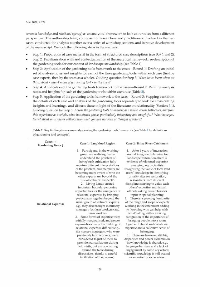
Land 2020, 9, 224
common knowledge and relational agency) as an analytical framework to look at our cases from a differentperspective. The authorship team, composed of researchers and practitioners involved in the twocases, conducted the analysis together over a series of workshop sessions, and iterative developmentof the manuscript. We took the following steps in the analysis:
• Step 1: Preparation of case material in the form of structured case descriptions (see Box 1 and 2).• Step 2: Familiarisation with and contextualisation of the analytical framework: re-description of
the gardening tools for our context of landscape stewardship (see Table 1).• Step 3: Application of the gardening tools framework to the cases—Round 1: Drafting an initial
set of analysis notes and insights for each of the three gardening tools within each case (first bycase experts, then by the team as a whole). Guiding question for Step 3: What do we learn when wethink about <insert name of gardening tool> in this case?
• Step 4: Application of the gardening tools framework to the cases—Round 2: Refining analysisnotes and insights for each of the gardening tools within each case (Table 2).
• Step 5: Application of the gardening tools framework to the cases—Round 3: Stepping back fromthe details of each case and analysis of the gardening tools separately to look for cross-cuttinginsights and learnings, and discuss these in light of the literature on relationality (Section 5.1).Guiding question for Step 5: Across the gardening tools framework as a whole, across both cases, and fromthis experience as a whole, what has struck you as particularly interesting and insightful? What have youlearnt about multi-actor collaboration that you had not seen or thought of before?
Table 2. Key findings from case analysis using the gardening tools framework (see Table 1 for definitionsof gardening tool concepts).
Cases→Gardening Tools ↓ Case 1: Langkloof Region Case 2: Tsitsa River Catchment
Relational Expertise
1. Participants in the workinggroup are realizing that tounderstand the problem ofhoneybush cultivation fully
requires different interpretationsof the problem, and members arebecoming more aware of who the
other experts are, beyond the‘usual technical suspects’.2. Living Lands created
important boundary-crossingopportunities for the emergence of
relational expertise by bringingparticipants together beyond theusual group of technical experts,e.g., they also brought in nurserymanagers (ex-farm workers) and
farm workers.3. Some forms of expertise wereinitially marginalised, and powerasymmetries made the building ofrelational expertise difficult (e.g.,the nursery managers, who werepreviously farm workers, wereconsidered to just be there to
provide manual labour duringfield visits, but are now sitting
around the table duringdiscussions, thanks to careful
facilitation of the process).
1. After 4 years of interactionaround integrated planning forlandscape restoration, there is
evidence of relational expertiseemerging: e.g., scientists
recognising the value of local landusers’ knowledge in identifying
priority sites for restoration;researchers from different
disciplines starting to value eachothers’ expertise; municipal
officials asking researchers forinput in spatial planning.
2. There is a growing familiarityof the range and scope of expertsworking in the catchment addingto ’knowing who can help with
what’, along with a growingrecognition of the importance of
bringing people into a roomtogether to build such relational
expertise and a collective sense ofbelonging.
3. There are however still bigdisparities and power dynamics in
how knowledge is shared, e.g.,language barriers; and a lack ofengagement by some key actors;
scientific knowledge is still treatedas superior by some actors.
29

Land 2020, 9, 224
Table 2. Cont.
Cases→Gardening Tools ↓ Case 1: Langkloof Region Case 2: Tsitsa River Catchment
Common Knowledge
1. Common knowledge issuperficially built on the broader
common goal of improvingknowledge of honeybush
cultivation in order to growproduction across the industry as awhole, i.e., everyone knows that
they need to combine theirknowledge and experience toachieve the goal of increasing
honeybush production. This helpsto build a shared sense of identity
and belonging.2. There is still lack of deeperunderstanding of how different
participants will benefit from theworking group, and there are
different underlying motives atplay, i.e., as yet there is not muchrespectful, shared understanding
of different personal orprofessional motives.
1. Participatory mapping andintegrated planning activities
created a platform for buildingcommon knowledge around
landscape restoration: there is agrowing shared recognition of the
importance of involving localpeople in mapping and planning,which helps to develop a shared
understanding of what matters inthe landscape.
2. A shared interest in landscaperestoration offers a boundary
object for developing commonknowledge, but different actorsstill have different underlying
motives which have not yet beenacknowledged, e.g., TraditionalLeaders are looking for jobs fortheir communities, researchers
need to produce research outputs,implementers need to produce
measurable outputs, resulting intensions between different actors
[31].
Relational Agency
1. Relational agency is not yetevident in the working group: theinitiative is still in the early stagesand the ‘doing together’ will take
time to develop. Trialingcultivation practices together
offers some promise in this regard.2. The diversity of actors and thedifferences in race, class, age, levelof education, etc. mean that muchtime needs to be spent on buildingrelational expertise and common
knowledge before relationalagency can emerge between the
diverse actors.3. If we extend the gaze to Living
Lands and how they have beenworking in the landscape more
broadly, we see evidence ofrelational expertise, and the
development of commonknowledge between themselves
and some of the landscape actors.This has enabled them to takeaction to establish the working
group as a response to theproblem of different role players in
the catchment not collaboratingaround the need to expand
honeybush cultivation. Theirknowledge and understanding ofthe various stakeholder informedtheir careful putting-together of
working group participants.
1. Prioritising, mapping, andplanning together for the
restoration of the catchment is anearly form of relational agency.While researchers have started
working more meaningfully withsome local residents, this has not
yet gone far enough as some actorsare still not participating (e.g.,
commercial farmers). Also, this isnot yet happening across the
whole catchment, i.e., it ishappening in localized pockets.2. This early stage relationalagency is being mediated by
researchers who are not from thecatchment: it should really bedriven by local residents and
restoration implementers.Moreover, we are yet to see
relational agency emerge in theactual implementation of restorationplans. However, we acknowledgethat there may be relational agency
present (or emerging) in spaceswhich we as researchers in theproject have not yet explicitly
‘looked into’ e.g., at the level oflocal restoration implementers andhow they work with residents as
restoration workers on the ground.
30
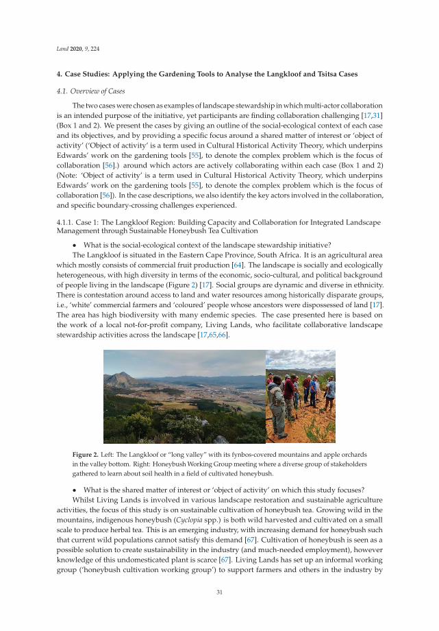
Land 2020, 9, 224
4. Case Studies: Applying the Gardening Tools to Analyse the Langkloof and Tsitsa Cases
4.1. Overview of Cases
The two cases were chosen as examples of landscape stewardship in which multi-actor collaborationis an intended purpose of the initiative, yet participants are finding collaboration challenging [17,31](Box 1 and 2). We present the cases by giving an outline of the social-ecological context of each caseand its objectives, and by providing a specific focus around a shared matter of interest or ‘object ofactivity’ (‘Object of activity’ is a term used in Cultural Historical Activity Theory, which underpinsEdwards’ work on the gardening tools [55], to denote the complex problem which is the focus ofcollaboration [56].) around which actors are actively collaborating within each case (Box 1 and 2)(Note: ‘Object of activity’ is a term used in Cultural Historical Activity Theory, which underpinsEdwards’ work on the gardening tools [55], to denote the complex problem which is the focus ofcollaboration [56]). In the case descriptions, we also identify the key actors involved in the collaboration,and specific boundary-crossing challenges experienced.
4.1.1. Case 1: The Langkloof Region: Building Capacity and Collaboration for Integrated LandscapeManagement through Sustainable Honeybush Tea Cultivation
• What is the social-ecological context of the landscape stewardship initiative?The Langkloof is situated in the Eastern Cape Province, South Africa. It is an agricultural area
which mostly consists of commercial fruit production [64]. The landscape is socially and ecologicallyheterogeneous, with high diversity in terms of the economic, socio-cultural, and political backgroundof people living in the landscape (Figure 2) [17]. Social groups are dynamic and diverse in ethnicity.There is contestation around access to land and water resources among historically disparate groups,i.e., ‘white’ commercial farmers and ‘coloured’ people whose ancestors were dispossessed of land [17].The area has high biodiversity with many endemic species. The case presented here is based onthe work of a local not-for-profit company, Living Lands, who facilitate collaborative landscapestewardship activities across the landscape [17,65,66].
Figure 2. Left: The Langkloof or “long valley” with its fynbos-covered mountains and apple orchardsin the valley bottom. Right: Honeybush Working Group meeting where a diverse group of stakeholdersgathered to learn about soil health in a field of cultivated honeybush.
• What is the shared matter of interest or ‘object of activity’ on which this study focuses?Whilst Living Lands is involved in various landscape restoration and sustainable agriculture
activities, the focus of this study is on sustainable cultivation of honeybush tea. Growing wild in themountains, indigenous honeybush (Cyclopia spp.) is both wild harvested and cultivated on a smallscale to produce herbal tea. This is an emerging industry, with increasing demand for honeybush suchthat current wild populations cannot satisfy this demand [67]. Cultivation of honeybush is seen as apossible solution to create sustainability in the industry (and much-needed employment), howeverknowledge of this undomesticated plant is scarce [67]. Living Lands has set up an informal workinggroup (‘honeybush cultivation working group’) to support farmers and others in the industry by
31

Land 2020, 9, 224
providing a platform to share knowledge and build social capital. The working group offers a space formultiple diverse actors to come together around honeybush cultivation as a shared matter of interestand thus ‘boundary crossing’ is taking place within the working group.
• Who are the actors involved?Living Lands act as the facilitator of the working group. With many connections across the industry,
Living Lands has the ability to bring diverse groups of people together and broaden and deepenknowledge-sharing. Researchers are involved in the group and contribute by creating knowledgeabout the resource itself, and about the social systems linked with the resource and industry. Expertconsultants in specific aspects of cultivation, such as soil experts or cuttings experts, are invited toshare their knowledge with the working group. Technical knowledge about the cultivation of theplant is contributed by farmers and honeybush seedling nursery managers, who are also part of thecultivation group. Farmers have been encouraged to bring their farm workers along. It is importantto note that the nursery managers (supported in this new work by Living Lands) were themselvespreviously farm workers. Their involvement in this new job and in the working group has been a shiftin their identity and role in this community.
• What are the boundary-crossing challenges and opportunities?The working group offers a platform for people from diverse knowledge systems to share
knowledge and experience on honeybush cultivation, providing opportunities for social learning.During workshops, different methods for cultivation are trialed and knowledge is co-produced throughactivities undertaken together by the members of the group. This group was created around thecommon challenge of successful honeybush cultivation. Through this common challenge, membersidentify with each other to develop a shared sense of purpose. This group contributes to buildingrelationships across the industry and trust-building between different levels of trade, which is crucialfor upscaling in the future. A shared sense of responsibility in the group reduces the fear of failureat an individual level and builds confidence. However, differences in class, race/ethnicity, education,socio-economic status, and language pose significant challenges to the aspirations of the group.
4.1.2. Case 2: The Tsitsa River Catchment: Striving for Sustainable Landscape Management and RuralLivelihoods Development through Integrated Planning
• What is the social-ecological context of the landscape stewardship initiative?This case is situated in Tsitsa River catchment, a tributary of uMzimvubu River, in the Eastern
Cape Province, South Africa. The catchment is located in one of the poorest, most ecologicallydegraded, and least developed regions of the country: the former Transkei homeland (Figure 3) [68].Residents of the communally-governed areas rely on subsistence farming and grazing, natural resourceuse, and government social grants for their livelihoods, while commercial farming is carried outin the freehold area [68]. The case is based on the work of the Tsitsa Project (TP). The TP is ascience-based social-ecological land restoration and livelihoods development programme which seeksto foster multi-actor collaboration and polycentric governance [31]. It is funded by the Departmentof Environment, Forestry, and Fisheries (DEFF). The project was initiated to reduce sedimentation oftwo large dams proposed for the uMzimvubu River, but has now shifted to a more holistic focus onmanaging the landscape for a variety of social-ecological outcomes, including local livelihoods.
• What is the shared matter of interest or ‘object of activity’ on which this study focuses?Key matters of shared interest in the Tsitsa Project (TP) include: polycentric governance, integrated
planning for landscape restoration, grazing management, and landscape sustainability for livelihoods.In this case we will focus primarily on integrated planning for landscape restoration as a shared matterof interest around which multi-actor collaboration and boundary crossing is taking place. Integratedplanning was seen as the best opportunity for researchers, managers, implementers, and communitiesto collaborate towards sustainable landscapes and livelihoods.
32

Land 2020, 9, 224
Figure 3. Left: The Tsitsa Project located in a highly erodible, degraded landscape in which local peopleare reliant on natural resources for their livelihoods. Right: Participatory mapping of priority areasfor restoration to inform integrated landscape planning has been a key boundary-crossing activityfacilitated by the Tsitsa Project.
• Who are the actors involved?Researchers from Rhodes University coordinate the project. There are many actors in the
Tsitsa River catchment involved in various activities related to integrated planning include localresidents, Traditional Leaders, government officials, scientists, natural resource managers, restorationimplementing agents, development agencies, etc. The areas of influence of the various actors overlapto some extent, leading to synergies and tensions [31]. Over time, the TP has been bringing the variousactors into shared spaces to develop a common vision and align activities to avoid further tension andduplication, and to share resources and knowledge. Integrated planning meetings and participatorymapping activities with local residents and Traditional Leaders [69] have been a key focus of this work.
• What are the boundary-crossing challenges and opportunities?Integrated planning requires people with different skills, experiences and levels of education to
work together and plan collectively. While this is a significant opportunity to manage the landscapefor sustainable and equitable outcomes, it is also fraught with challenges. The work of the TP ischaracterised by the intersection of different sources and types of knowledge, including local ecologicalknowledge based on lived experience as well as scientific knowledge based on global literature,models, remote sensing, and statistics. The project is also characterised by intersections of differentlanguages: actors speak isiXhosa, Sesotho, Afrikaans, and English, which leads to difficulties in effectivecommunication and relationship building. Land tenure differences are also a boundary-spanningchallenge: there is both communal and freehold land.
4.2. Key Findings from the Case Analysis Using the Gardening Tools Framework
We now apply the three gardening tools to the two cases of landscape stewardship in the EasternCape of South Africa: the Tsitsa River catchment and the Langkloof Region. We begin by sharinginsights from each of the cases on the gardening tools, including key points summarised in Table 2.In Section 5, we then go on to discuss some key cross-cutting findings in relation to the literature topropose a new perspective on multi-actor collaboration for landscape stewardship.
4.2.1. Case 1: Langkloof Region
To apply the gardening tools to the honeybush cultivation working group (‘working group’), it iscrucial to understand the current relationship dynamics in the region. A long history of discriminationin the area as a result of South Africa’s colonial and Apartheid history has caused fragmentationof social groups and an unequal balance of power and access to resources [17,70]. Unequal powerrelations come about through unequal representation and recognition of people from different ethnic orrace groups, economics class, age, and level of education within the working group [17]. Relationshipsbetween people are therefore in different stages: members from the same ethnic group and similarlevels of power develop relationships faster than across ethnic groups and levels of power. The same
33
Land 2020, 9, 224
applies to the manner in which the boundary-crossing dimensions (i.e., relational expertise, commonknowledge, relational agency) are realised within the group.
When we look at the process and nature of relationships during the development of the workinggroup, evidence of the three boundary-crossing dimensions can be recognised in different pockets orsub-groups of 2–3 people within the group over time. During workshops, for instance, working groupmembers visit each other’s farms. For individual farmers (from the same ethnic group), this experiencecreates recognition of their own knowledge, place and situation within the broader system of otherfarmers. This leads to the augmentation of the specialist knowledge for each farmer, even though itis limited to one type of actor in the group. Before the working group was established, farmers didnot realise that they have any knowledge to share, but during this process, they recognised that theyhave built their own specialist knowledge through experience and that it is useful knowledge for theworking group as a whole. However, this same acknowledgement of knowledge is not necessarilyextended to more marginalised members of the working group, i.e., the nursery managers and farmworkers (Table 2).
The building of relational expertise is a slow process with many steps. The nursery managers,for instance, are younger and from different ethnic groups and economic classes than most of the othergroup members. At the first workshop, they arrived in workers’ clothing and took on the role ofmanual labourers, rather than equal contributors of knowledge and expertise. Within the next fewworkshops, progression could be seen in the way they dressed (wearing more formal ‘meeting clothes’)and contributed to the workshop, each time with a little more recognition of their role and contributionof their knowledge to discussions. Initially, they would sit aside from the main group, and as thingshave progressed, they have become more comfortable sitting ‘at the table’ with the main group. Theseactors are, however, still marginalised and have not entirely found their voice within the group interms of building common knowledge. As people who themselves, and whose families (historically),have engaged in honeybush farming activities, they have important practical and local knowledge tocontribute, but their identity as ‘workers’, and the way they are marginalised, makes the bringing in ofthis knowledge to form ‘common knowledge’ a significant boundary-crossing challenge.
Some of the consultants who joined the group had a well-established sense of their own expertise,but did not realise that they would learn from others in the group. For instance, one consultant notedthat he learned a lot from the farmers’ practical knowledge, which greatly contributed to the theoreticalknowledge he had built over the years.
Common knowledge has developed within the group around the common goal, which is tosuccessfully grow honeybush and find a consistent market for high-quality honeybush. Everyone,therefore, has a shared interest to combine efforts and experience to achieve this goal. This commonknowledge, however, is still very superficial and finer nuances with regards to a shared appreciationand understanding of each member’s motivation for joining the group is still lacking.
The development of relational agency has also been limited to ethnicity and power level. In practice,farmers, researchers, and ‘Living Landers’ are trialling cultivation methods together, and this showspotential for the development of relational agency. Pockets of relational agency can be recognisedwhen looking at a larger time frame which includes the process of relationship-building before theworking group was set up, as well as after it was established.
4.2.2. Case 2: Tsitsa River Catchment
The Tsitsa Project was introduced as a top-down project that focussed on multi-actor collaborationas an outcome, with limited focus in the early stages on a process-oriented approach to buildingrelational expertise and common knowledge needed to realise this. The latter approach developedover the years in response to the reduced focus on reducing siltation of the proposed dam, and ashift to improved overall catchment management to support local livelihoods [31]. Now, 5 yearsafter the start of the project, with an enhanced research presence in the catchment, we are startingto see some evidence of relational expertise and common knowledge, and are in a better position
34

Land 2020, 9, 224
to use these gardening tools more effectively to analyse and guide the collaboration. Central to thisis trust-building, frequent interactions with actors (often in informal settings), and planning andworking together to achieve goals that all actors feel comfortable with. The legacy of apartheid andcolonialism has contributed to slowing this relational development as there are significant social andpower differentials between and among actors associated with ethnicity/race, class, language, culture,knowledge system, land tenure, etc. [31].
Evidence of relational expertise can be seen in the Tsitsa Project in at least two examples of researchersengaging with other actors. Firstly, in the way in which researchers and restoration implementersare collectively expanding their understanding of the common problem or ‘object of activity’ of landrestoration and integrated planning. The implementers (Gamtoos Irrigation Board, GIB), suggestrestoration interventions, these are agreed upon by the Traditional Leaders, and then submitted toresearchers. The researchers then suggest if those interventions are suitable for the relevant areasbased on their scientific understanding, type of soils and other biophysical features of the landscape.After suggestions from researchers, GIB revise their plan and submit it to the DEFF for final approvalbefore they commence implementing restoration. In a second example, researchers have employedparticipatory mapping processes to collect and collate knowledge from the local catchment residentsabout their restoration priorities to guide planning and research by getting a better understanding of thelocal context [69]. This has not been without its challenges: disparate literacy levels, and language andcultural barriers created difficulties for ensuring participants understood the risks of their involvement,recognised their rights (particularly important in the context of historic land rights concerns in SouthAfrica), and felt empowered by the process [69]. In these two examples, relational expertise is emergingas actors recognise the value of other actors’ perspective, knowledge and skills for expanding theirunderstanding of the problem. Engaging catchment residents and Traditional Leaders in their homelanguage (isiXhosa), creating space for local cultural practices in meeting spaces (e.g., praying at thestart of a meeting), and taking time to get to know them outside of the formal meeting spaces, havebeen key enablers of the emergence of relational agency.
Integrated restoration and planning for landscape stewardship is only possible through thedevelopment of common knowledge as implementers, local residents, Traditional Leaders, and researchersstart to understand each other’s different personal and professional motives. It also requires thefacilitating researchers starting to mediate the collaborative process by transferring, translating,and transforming knowledges across differences [58]. This building of common knowledge isevidence of the Tsitsa Project starting to work explicitly according to one of its core principles,namely transdisciplinarity [31]: i.e., an openness to working with diverse knowledges to co-producenew knowledge, which includes recognising that local communities have more knowledge thanoutsiders (i.e., the facilitating researchers) about the catchment, and they are recognised as experts inthe catchment.
Relational agency is becoming evident in the core activities of prioritising, mapping, and planning,i.e., in the integrated planning for landscape restoration. The making of maps, and the making ofdecisions, are ways in which actors are starting to ‘do together’, i.e., they are starting to build acollective strategy (Table 1). Applying the gardening tools to the Tsitsa River catchment case has shownthat more time needs to be allocated in the early stages of such an initiative for actors to listen to eachother, for facilitators to get to know the situation and the actors and their perspectives, i.e., to buildrelational expertise and common knowledge as a foundation for relational agency.
5. Discussion: Cross-Cutting Insights and a New Perspective for Multi-Actor Collaboration inLandscape Stewardship Initiatives
5.1. Cross-Cutting Insights on Relationality: What the Gardening Tools Reveal about Boudary-Crossing Workfor Landscape Stewardship
From our analysis of these two cases of landscape stewardship, we have learnt that history andcontext influence relational processes significantly; that due to these influences (and also others) the
35

Land 2020, 9, 224
boundary-crossing work is difficult; and that focusing on working in smaller, focused pockets within alarge-scale landscape initiative is helpful. Below we further unpack these three insights.
1. History and context matter. Both our cases have highlighted the importance of understandingthe influence of history in creating deep differences and shaping relations among landscapeactors. The various differences among actors identified in our cases (e.g., race/ethnicity, language,knowledge system) strongly influence knowledge and power asymmetries between actors.We found that the long history of discrimination in South Africa has caused lasting fragmentationof social groups and power imbalances. In the Langkloof case, Living Lands paid careful attentionto power and other differences in constituting the working group, e.g., including farm workers,which took some actors by surprise. In the Tsitsa case, attention to local language and culturalpractices was seen as critical to slowly and respectfully build relational expertise among actors.In Australia, Duhn et al. [58] also noted the difficulties in boundary-crossing work in post-colonialcontexts where difference and diversity are often sharply in focus. They recommend the activebuilding of a sense of belonging as a ‘red thread’ in the process of generating relational agency,and we come back to this below in the social-relational practices we recommend to supportmulti-actor collaboration.
2. Boundary-crossing work is difficult. Applying the gardening tools in the analysis of ourcases has confirmed what we already know about boundary-crossing work for landscapestewardship [17,31]: it is difficult work, and the difficulties are exacerbated by inequalitiesand power dynamics. Of course, the challenges of boundary-spanning work are also widelyacknowledged in landscape and social ecological research [7,28], and in the organizationaland educational research from which we have drawn the gardening tools [56,58,71]. However,applying these tools has helpfully revealed where some of the particular challenges lie in landscapestewardship initiatives (e.g., how the deep social divides slow down the development of relationalagency, and how building common knowledge is difficult when some forms of knowledge areseen by some actors as superior to other forms). We find that through this analysis, we canappreciate the many boundaries that are formed or that exist in these multi-actor collaborations,which we may not have seen so clearly without the tools.
3. Focused pockets of relational work are helpful. Relational expertise, common knowledge andrelational agency can develop within pockets and in an uneven or patchy way within a groupor landscape (see also Cockburn et al. [17]); i.e., they often develop more easily among moresimilar actors as a starting point, or among actors with a clearly shared interest (e.g., honeybushcultivation in the Langkloof, and landscape planning in the Tsitsa). These pockets need to enablefrequent interaction and small scale collective actions among actors, which can help to buildcommon knowledge and eventually relational agency [72].
However, even within these pockets, explicit recognition and careful mediation and facilitationof traditionally marginalised voices and knowledge holders is necessary to strongly build relationalagency and common knowledge. This takes time and skillful facilitation, to enable actors to workaround expanding their shared understanding of an object of activity to build common knowledge [56](e.g., around honeybush cultivation in the Langkloof, and around participatory mapping and integratedplanning in the Tsitsa). We find then, as also discussed by others, that careful design, management,and facilitation of boundary spaces is crucial. However we also ask ourselves, how enduring therole of facilitating organisations (such as Living Lands and Rhodes University) should or could bein landscape stewardship initiatives? Should the level of facilitation and mediation perhaps changeover time?
In both our cases, smaller pockets of multi-actor collaboration have shown how the building ofcommon knowledge can mediate the development of relational agency. However, without respectfulacknowledgement of differences among actors, i.e., where actors are willing to ‘see’ the other and whatthey can offer in a process of relational expertise, the common knowledge cannot be built. For example,
36

Land 2020, 9, 224
in the Langkloof case, through careful constitution and facilitation of the working group, the knowledgeof the farm workers was brought to the fore. This has shown that they have something to offer, whichhas brought them closer to crossing the boundaries created by historical differences between them andthe farmers and consultants. Bringing them in has also enabled the different actors to get to know eachother in a professional space, which is an important enabler of collaboration [58].
5.2. Towards New Perspectives for Multi-Actor Collaboration: A Relational Approach Suggests ThreeSocial-Relational Practices
The literature on collaboration for stewardship and natural resource management historicallyhas a strong focus on the practices of designing and building institutions to enable collaborationamong actors [9,38]. There are however growing calls for a more relational understanding of thesocial processes and ties involved in multi-actor collaboration [9,48,53], or the ‘stuff’ of relational tiesas Lejano [24] calls it. Here, we respond to these calls and offer a new perspective on multi-actorcollaboration based on a relational approach.
In light of our findings, and drawing on the literature on relationality, we propose threesocial-relational practices which could support more effective and meaningful multi-actor collaboration.They are as follows:
1. Belonging while differing. This practice speaks to the contextual challenges we identified above,which relate to differences between stakeholders which are exacerbated by inequalities and powerdynamics. Collaboration for landscape stewardship requires people to build a shared senseof identity and belonging, in spite of these differences. In arguing for this practice, we agreewith Duhn et al.’s [58] assertion that a sense of belonging should be the foundation of buildingrelational agency, and with Lejano’s [24] description of identity as a relational notion of ‘who I amin relation to others’, i.e., the interdependence of actors [73]. Actors engaged in boundary-crossingwork for landscape stewardship come into such processes with their own identities [30], fromdifferent backgrounds, and a key practice should be to build a shared sense of belonging, whileacknowledging differences. While Edwards acknowledges difference between actors in her work,she says it is often small [56]. In our cases, we have seen inter-actor differences to be large anddifficult to overcome. Rather than seeking to overcome the differences, it is important for actors tobe able to feel a sense of belonging, despite their differences, particularly in post-colonial societieswhere difference has often led to marginalization [17,58]. Recognising relational expertise andbuilding common knowledge can be a powerful way of developing this shared identity andunderstanding of the collaborative work.
2. Growing together by interacting regularly and building common knowledge. Based on theexperiences in our cases, we have identified the importance of working in small pockets todo relational work. The practice we recommend here speaks to how one might do that work.Actors collaborating for landscape stewardship need to spend time together to get to know eachother, to expand their understanding of the object of activity and to learn to act together, i.e.,to develop relational agency, and out of that, to work towards building common knowledge.As Duhn et al. put it [58], actors need to engage in a common experience or process. This requiresan explicit practice of regular interactions to grow together as a group with a shared identity andunderstanding of the complex problem in focus. We have found that this common knowledge ismost effectively built through practical actions like trialing cultivation methods in the Langklooof,and making maps in the Tsitsa. However, as pointed out by Edwards and others [56,58],these actions need to be embedded in carefully designed and managed meeting spaces forregular interactions.
3. Learning and adapting together with humility and empathy. This third practice can also be a guideto working relationally in focused pockets in order to realise relational agency. The difficulties incollaboration described above indicate opportunities for learning and adaptation—both at theindividual and the collective level (see Cockburn et al. [31] for further discussion on learning at
37

Land 2020, 9, 224
sites of tension and difficulty among diverse actors). The differences between people also callfor an empathetic approach in which people try to ‘walk in each other’s shoes’ despite theirdifferences. Paying attention to the affective or emotional dimensions of social-relational processesis critical, as without it we ignore the most basic of human characteristics [24,53]. Thus, whilelearning-by-doing and adapting together are widely recognized as important social processes andpractices in SES research [7,11], and their relevance is apparent in our cases as well, doing so withan attitude of humility and empathy for the other is less frequently recommended. In order todevelop relational expertise, those actors whose knowledge is conventionally considered superior(e.g., scientists or consultants) must be able to humble themselves in light of other forms ofknowledge helped by more marginalised actors (e.g., local knowledge, experiential knowledge).The necessity of a position of humility by scientists is recognized in complexity approaches toSES research [33], and should be adopted by scientists engaged in boundary-crossing spaces toenable social learning and the development of common knowledge. Finally, in order to truly‘see the other’ as is necessary for developing relational expertise, building common knowledge,and activating relational agency, it is necessary for actors to approach one another with empathy,i.e., to imagine walking in the others’ shoes, and to seek to understand their background andperspective [58].
5.3. Policy Implications
The research insights and social-relational practices we discuss above have at least two significantimplications for policy on landscape stewardship. Firstly, our findings indicate that collaboration amongdiverse stakeholders is a slow process which needs to be resourced effectively, and for which the relevantskills need to be built. In order to reach the ideals of landscape stewardship, i.e., to integrate research,planning, policy, and practice towards more sustainable and equitable outcomes, governments andother funders need to invest in social-relational processes and capacity building for collaboration—notonly in practical and technical solutions, as is often the case, in stewardship work [16]. Secondly,context-specific landscape stewardship approaches need to be supported, rather than imposingtop-down blueprints imported from elsewhere. Far too often, policy drives ‘one-size-fits-all’ solutionsfor landscape stewardship [4], ignoring local dynamics such as history, power relations, and socialdiversity, which we have shown to have such a strong influence on collaborative stewardship processes.
6. Conclusions
We began this article by proposing a relational approach to landscape stewardship, outliningwhat it is, why it matters, and what it means. We then applied this approach to analyse two cases oflandscape stewardship, examining multi-actor collaboration for landscape stewardship using Edwards’gardening tools [55,56]. We found the tools useful to gain a more finely-textured understanding ofhuman-human interactions. Applying the tools has shown how important the context and history ofa place and its people are in shaping the inter-personal interactions. Historic disparities and powerdynamics between people make boundary-crossing work particularly difficult, and working in smallpockets can help to focus boundary-crossing activities. In this, we offer an advancement of the workof the gardening tools: applying them in a new context, beyond the educational and social workcontexts in which they have usually been applied, has shown that it is important to emphasise thehistorical aspects and the need for careful attention from stewardship facilitators towards the differentdimensions of relationality in the context of boundary crossing work. We suggest that the tools couldbe applied in similar ways to support analysis, planning, and facilitation and gain a more nuancedunderstanding of collaboration in other social-ecological sustainability initiatives.
The tools have also helped to identify three key social-relational processes which lend a perspectiveon collaboration currently under-represented in the literature. We recommend that participants andfacilitators of boundary-crossing work pay attention to these three practices as a guide to collaboration:1. belonging while differing, 2. growing together by interacting regularly and building common
38
Land 2020, 9, 224
knowledge, and 3. learning and adapting together with humility and empathy. Finally, we offerthese three practices as a potential research framework, inviting researchers and other practitioners toinvestigate the applicability of these practices in their contexts. Our hope is that such applicationswill deepen our understanding of human-human relationships in social-ecological and landscapestewardship research.
Author Contributions: Conceptualization, J.C. and E.R.; Formal analysis, J.C., E.R., A.C., S.F.C., N.L., L.M. andB.v.d.W.; Investigation, J.C., A.C., S.F.C., N.L., L.M., and B.v.d.W.; Methodology, J.C. and E.R. All authors haveread and agreed to the published version of the manuscript.
Funding: This research has been funded by the Department of Environment, Forestry, and Fisheries (DEFF), ChiefDirectorate: Natural Resource Management Programmes (NRM), Directorate: Operational Support and Planning,through the Tsitsa Project. The contents of this paper do not necessarily reflect the view and policies of the DEFF,Chief Directorate: NRM, nor does the mention of trade names or commercial products constitute endorsement orrecommendation for use. J.C. thanks the Rhodes University Postdoctoral Fellowship; B.v.d.W. was supportedin part by the National Research Foundation of South Africa (Grant number: 126382). Living Lands gratefullyacknowledges the support from Commonland and the DOEN Foundation. The Article Publication Charge (APC)was funded by Rhodes University.
Acknowledgments: The authors would like to thank the local residents and project partners in the Langkloof andin the Tsitsa River Catchment for their participation in, and contributions to, this work.
Conflicts of Interest: The authors declare no conflict of interest.
References
1. Sayer, J.; Sunderland, T.; Ghazoul, J.; Pfund, J.-L.; Sheil, D.; Meijaard, E.; Venter, M.; Boedhihartono, A.K.;Day, M.; Garcia, C.; et al. Ten principles for a landscape approach to reconciling agriculture, conservation,and other competing land uses. Proc. Natl. Acad. Sci. USA 2013, 110, 8349–8356. [CrossRef] [PubMed]
2. Minang, P.A.; van Noordwijk, M.; Freeman, O.E.; Mbow, C.; de Leeuw, J.; Catacutan, D. Climate-SmartLandscapes: Multifunctionality in Practice; World Agroforestry Centre (ICRAF): Nairobi, Kenya, 2014;ISBN 978-92-9059-375-1.
3. Bieling, C.; Plieninger, T. The Science and Practice of Landscape Stewardship; Cambridge University Press:Cambridge, UK, 2017; ISBN 978-1-107-14226-8.
4. O’Farrell, P.J.; Anderson, P.M.L. Sustainable multifunctional landscapes: A review to implementation.Curr. Opin Environ. Sustain. 2010, 2, 59–65. [CrossRef]
5. Folke, C.; Biggs, R.; Norström, A.V.; Reyers, B.; Rockström, J. Social-ecological resilience and biosphere-basedsustainability science. Ecol. Soc. 2016, 21, 41. [CrossRef]
6. Biggs, R.; Rhode, C.; Archibald, S.; Kunene, L.M.; Mutanga, S.S.; Nkuna, N.; Ocholla, P.O.; Phadima, L.J.Strategies for managing complex social-ecological systems in the face of uncertainty: Examples from SouthAfrica and beyond. Ecol. Soc. 2015, 20, 52. [CrossRef]
7. Folke, C.; Hahn, T.; Olsson, P.; Norberg, J. Adaptive governance of social-ecological systems. Annu. Rev.Environ. Resour. 2005, 30, 441–473. [CrossRef]
8. Angelstam, P.; Grodzynskyi, M.; Andersson, K.; Axelsson, R.; Elbakidze, M.; Khoroshev, A.; Kruhlov, I.;Naumov, V. Measurement, collaborative learning and research for sustainable use of ecosystem services:Landscape concepts and europe as laboratory. AMBIO 2013, 42, 129–145. [CrossRef]
9. Cockburn, J.; Cundill, G.; Shackleton, C.; Rouget, M. Towards place-based research to support social-ecologicalstewardship. Sustainability 2018, 10, 1434. [CrossRef]
10. Conrad, E. Human and Social Dimensions Of Landscape Stewardship. In The Science and Practice of LandscapeStewardship; Bieling, C., Plieninger, T., Eds.; Cambridge University Press: Cambridge, UK, 2017; pp. 38–53,ISBN 978-1-107-14226-8.
11. Cundill, G.; Cumming, G.S.; Biggs, D.; Fabricius, C. Soft systems thinking and social learning for adaptivemanagement. Conserv. Biol. 2011, 26, 13–20. [CrossRef]
12. Bennett, N.J.; Roth, R.; Klain, S.C.; Chan, K.; Christie, P.; Clark, D.A.; Cullman, G.; Curran, D.; Durbin, T.J.;Epstein, G.; et al. Conservation social science: Understanding and integrating human dimensions to improveconservation. Biol. Conserv. 2017, 205, 93–108. [CrossRef]
39

Land 2020, 9, 224
13. Enqvist, J.P.; West, S.; Masterson, V.A.; Haider, L.J.; Svedin, U.; Tengö, M. Stewardship as a boundary objectfor sustainability research: Linking care, knowledge and agency. Landsc. Urban Plan. 2018, 179, 17–37.[CrossRef]
14. Colloff, M.J.; Lavorel, S.; van Kerkhoff, L.E.; Wyborn, C.A.; Fazey, I.; Gorddard, R.; Mace, G.M.; Foden, W.B.;Dunlop, M.; Prentice, I.C.; et al. Transforming conservation science and practice for a postnormal world.Conserv. Biol. 2017, 31, 1008–1017. [CrossRef]
15. Bieling, C.; Plieninger, T. Leveraging Landscape Stewardship. In The Science and Practice of LandscapeStewardship; Bieling, C., Plieninger, T., Eds.; Cambridge University Press: Cambridge, UK, 2017; pp. 370–382,ISBN 978-1-107-14226-8.
16. Cockburn, J.; Cundill, G.; Shackleton, S.; Cele, A.; Cornelius, S.F.; Koopman, V.; Le Roux, J.P.; McLeod, N.;Rouget, M.; Schroder, S.; et al. Relational hubs for collaborative landscape stewardship. Soc. Nat. Resour.2019. [CrossRef]
17. Cokburn, J.; Cundill, G.; Shackleton, S.; Rouget, M.; Zwinkels, M.; Cornelius, S.; Metcalfe, L.; Van denBroeck, D. Collaborative stewardship in multifunctional landscapes: Toward relational, pluralistic approaches.Ecol. Soc. 2019, 24. [CrossRef]
18. West, S.; Haider, L.J.; Masterson, V.; Enqvist, J.P.; Svedin, U.; Tengö, M. Stewardship, care and relationalvalues. Curr. Opin. Environ. Sustain. 2018, 35, 30–38. [CrossRef]
19. Stenseke, M. Connecting ‘relational values’ and relational landscape approaches. Curr. Opin. Environ. Sustain.2018, 35, 82–88. [CrossRef]
20. Cooke, B.; West, S.; Boonstra, W.J. Dwelling in the biosphere: Exploring an embodied human–environmentconnection in resilience thinking. Sustain. Sci. 2016, 11, 831–843. [CrossRef]
21. Wyborn, C. Co-productive governance: A relational framework for adaptive governance. Glob. Environ.Chang. 2015, 30, 56–67. [CrossRef]
22. Pascual, U.; Balvanera, P.; Díaz, S.; Pataki, G.; Roth, E.; Stenseke, M.; Watson, R.T.; Basak Dessane, E.; Islar, M.;Kelemen, E.; et al. Valuing nature’s contributions to people: The IPBES approach. Curr. Opin. Environ.Sustain. 2017, 26–27, 7–16. [CrossRef]
23. Preiser, R.; Biggs, R.; De Vos, A.; Folke, C. Social-ecological systems as complex adaptive systems: Organizingprinciples for advancing research methods and approaches. Ecol. Soc. 2018. [CrossRef]
24. Lejano, R.P. Relationality and social–ecological systems: Going beyond or behind sustainability and resilience.Sustainability 2019, 11, 2760. [CrossRef]
25. Preiser, R. Identifying general trends and patterns in complex systems research: An overview of theoreticaland practical implications. Syst. Res. Behav. Sci. 2019, 36, 706–714. [CrossRef]
26. Flint, C.G.; Kunze, I.; Muhar, A.; Yoshida, Y.; Penker, M. Exploring empirical typologies of human–naturerelationships and linkages to the ecosystem services concept. Landsc. Urban Plan. 2013, 120, 208–217.[CrossRef]
27. Buck, L.E.; Scherr, S.J.; Planicka, C.M.; Heiner, K. Building Partnerships for Landscape Stewardship. In TheScience and Practice of Landscape Stewardship; Bieling, C., Plieninger, T., Eds.; Cambridge University Press:Cambridge, UK, 2017; pp. 57–77, ISBN 978-1-107-14226-8.
28. Angst, M.; Widmer, A.; Fischer, M.; Ingold, K. Connectors and coordinators in natural resource governance:Insights from Swiss water supply. Ecol. Soc. 2018, 23, 1. [CrossRef]
29. Fischer, A.P. A boundary-spanning organization for transdisciplinary science on land stewardship:The Stewardship Network. Ecol. Soc. 2015, 20, 38. [CrossRef]
30. Edwards, A.; Kinti, I. Working relationally at organisational boundaries: Negotiating expertise andidentity. In Activity Theory in Practice: Promoting Learning across Boundaries and Agencies; Daniels, H.,Edwards, A., Engeström, Y., Gallagher, T., Ludvigsen, S.R., Eds.; Routledge: Oxon, UK, 2010; pp. 126–139,ISBN 1-136-03166-9.
31. Cockburn, J.; Palmer, C.G.; Biggs, H.; Rosenberg, E. Navigating multiple tensions for engaged praxis in acomplex social-ecological system. Land 2018, 7, 129. [CrossRef]
32. Pollard, S.; Biggs, H.; Du Toit, D.R. A systemic framework for context-based decision making in naturalresource management: Reflections on an integrative assessment of water and livelihood security outcomesfollowing policy reform in South Africa. Ecol. Soc. 2014, 19, 63. [CrossRef]
33. Palmer, C.G.; Biggs, R.; Cumming, G.S. Applied research for enhancing human well-being and environmentalstewardship: Using complexity thinking in Southern Africa. Ecol. Soc. 2015, 20, 53. [CrossRef]
40

Land 2020, 9, 224
34. Shackleton, S.; Masterson, V.; Hebinck, P.; Speranza, C.I.; Spear, D.; Tengö, M. Editorial for Special Issue:“Livelihood and landscape change in Africa: Future trajectories for improved well-being under a changingclimate”. Land 2019, 8, 114. [CrossRef]
35. Price, L.; Lotz-Sisitka, H. Critical Realism, Environmental Learning and Social-Ecological Change; Routledge:New York, NY, USA, 2016; ISBN 978-1-317-33847-5.
36. Donati, P.; Archer, M.S. The Relational Subject; Cambridge University Press: Cambridge, UK, 2015;ISBN 978-1-316-38135-9.
37. Larkin, M.; Eatough, V.; Osborn, M. Interpretative phenomenological analysis and embodied, active, situatedcognition. Theor. Psychol. 2011, 21, 318–337. [CrossRef]
38. Ostrom, E. Governing the Commons. The Evolution of Institutions for Collective Action; Cambridge UniversityPress: New York, NY, USA, 1990.
39. Zachrisson, A.; Beland Lindahl, K. Conflict resolution through collaboration: Preconditions and limitationsin forest and nature conservation controversies. Forest Pol. Econ. 2013, 33, 39–46. [CrossRef]
40. Lang, D.J.; Wiek, A.; von Wehrden, H. Bridging divides in sustainability science. Sustain. Sci. 2017, 12,875–879. [CrossRef]
41. Haider, L.J.; Hentati-Sundberg, J.; Giusti, M.; Goodness, J.; Hamann, M.; Masterson, V.A.; Meacham, M.;Merrie, A.; Ospina, D.; Schill, C. The undisciplinary journey: Early-career perspectives in sustainabilityscience. Sustain. Sci. 2018, 13, 191–204. [CrossRef] [PubMed]
42. Audouin, M.; Preiser, R.; Nienaber, S.; Downsborough, L.; Lanz, J.; Mavengahama, S. Exploring theimplications of critical complexity for the study of social-ecological systems. Ecol. Soc. 2013, 18, 12.[CrossRef]
43. Cilliers, P. What can we learn from a theory of complexity? Emergence 2000, 2, 23–33. [CrossRef]44. Bhaskar, R. Enlightened Common Sense: The Philosophy of Critical Realism; Routledge: Oxon, UK, 2016;
ISBN 978-1-134-86802-5.45. Cornell, S.; Parker, J. Critical realist interdisciplinarity: A research agenda to support action on global
warming. In Interdisciplinarity and Climate Change: Transforming Knowledge and Practice for Our Global Future;Bhaskar, R., Frank, C., Høyer, K.G., Næss, P., Parker, J., Eds.; Routledge: Oxon, UK, 2010; pp. 25–34, ISBN978-0-415-57387-0.
46. Ostrom, E. Understanding Institutional Diversity; Princeton University Press: Princeton, NJ, USA, 2005.47. Bennett, N.J.; Roth, R.; Klain, S.C.; Chan, K.M.A.; Clark, D.A.; Cullman, G.; Epstein, G.; Nelson, M.P.;
Stedman, R.; Teel, T.L.; et al. Mainstreaming the social sciences in conservation. Conserv. Biol. 2016, 31, 56–66.[CrossRef]
48. Cleaver, F.; Whaley, L. Understanding process, power, and meaning in adaptive governance: A criticalinstitutional reading. Ecol. Soc. 2018, 23, 49. [CrossRef]
49. Metcalf, E.C.; Mohr, J.J.; Yung, L.; Metcalf, P.; Craig, D. The role of trust in restoration success: Publicengagement and temporal and spatial scale in a complex social-ecological system. Restor. Ecol. 2015, 23,315–324. [CrossRef]
50. Moon, K.; Blackman, D. A Guide to understanding social science research for natural scientists. Conserv. Biol.2014, 28, 1167–1177. [CrossRef]
51. Stone-Jovicich, S. Probing the interfaces between the social sciences and social-ecological resilience: Insightsfrom integrative and hybrid perspectives in the social sciences. Ecol. Soc. 2015, 20, 25. [CrossRef]
52. Crona, B.; Ernstson, H.; Prell, C.; Reed, M.; Hubacek, K. Combining social network approaches withsocial theories to improve understanding of resource governance. In Social Networks and Natural ResourceManagement: Uncovering the Social Fabric in Environmental Governance; Bodin, O., Prell, C., Eds.; CambridgeUniversity Press: Cambridge, UK, 2011; pp. 44–71.
53. Cote, M.; Nightingale, A.J. Resilience thinking meets social theory: Situating change in socio-ecologicalsystems (SES) research. Prog. Hum. Geogr. 2011, 36, 475–489. [CrossRef]
54. Lindley, D. Elements of social learning supporting transformative change. S. Afr. J. Environ. Educ. 2015, 31,50–64.
55. Edwards, A. Working Relationally in and across Practices: A Cultural-Historical Approach to Collaboration;Cambridge University Press: New York, NY, USA, 2017; ISBN 978-1-107-11037-3.
41

Land 2020, 9, 224
56. Edwards, A. Building common knowledge at the boundaries between professional practices: Relationalagency and relational expertise in systems of distributed expertise. Int. J. Educ. Res. 2011, 50, 33–39.[CrossRef]
57. Christensen, T.; Lægreid, P. The whole-of-government approach to public sector reform. Publ. Adm. Rev.2007, 67, 1059–1066. [CrossRef]
58. Duhn, I.; Fleer, M.; Harrison, L. Supporting multidisciplinary networks through relationality and a criticalsense of belonging: Three ‘gardening tools’ and the Relational Agency Framework. Int. J. Early Years Educ.2016, 24, 378–391. [CrossRef]
59. Hopwood, N. Expertise, Learning and Agency in Partnership Practices in Services for Families with YoungChildren. In Working Relationally in and across Practices: A Cultural-Historical Approach to Collaboration;Edwards, A., Ed.; Cambridge University Press: New York, NY, USA, 2017; pp. 25–42, ISBN 978-1-107-11037-3.
60. Edwards, A. The role of common knowledge in achieving collaboration across practices. Learn. Cult.Soc. Interact. 2012, 1, 22–32. [CrossRef]
61. Edwards, A. Revealing Relational Work. In Working Relationally in and across Practices: A Cultural-HistoricalApproach to Collaboration; Cambridge University Press: New York, NY, USA, 2017; pp. 1–21, ISBN978-1-107-11037-3.
62. Lundvall, B.-ä.; Johnson, B. The learning economy. J. Ind. Stud. 1994, 1, 23–42. [CrossRef]63. Maxwell, J.A. A Realist Approach for Qualitative Research; SAGE Publications Inc.: Thousand Oaks, CA, USA,
2012; ISBN 978-0-7619-2923-9.64. Schafer, P. The peaks and troughs of Langkloof land reform. Finweek 2014, 22, 22–25.65. Living Lands. Eight Years on the Landscape: The Current State of Living Lands; Living Lands: Cape Town,
South Africa, 2017. Available online: https://livinglands.co.za/wp-content/uploads/2017/05/Eight-Years-on-the-Landscape.x21789.pdf (accessed on 30 June 2020).
66. Talbot, M.; van den Broeck, D. Shifting from Individual to Collective Action: Living Lands’ experience in theBaviaanskloof, South Africa. In Land Restoration; Frick, M., Helgeson, J., Eds.; Academic Press: Boston, MA,USA, 2016; pp. 521–531, ISBN 978-0-12-801231-4.
67. McGregor, G.K. Guidelines for the Sustainable Harvesting of Wild Honeybush; Department of EnvironmentalAffairs and Development Planning: Cape Town, South Africa, 2017.
68. Sigwela, A.; Elbakidze, M.; Powell, M.; Angelstam, P. Defining core areas of ecological infrastructure tosecure rural livelihoods in South Africa. Ecosyst. Serv. 2017, 27, 272–280. [CrossRef]
69. Weyer, D.; Bezerra, J.C.; De Vos, A. Participatory mapping in a developing country context: Lessons fromSouth Africa. Land 2019, 8, 134. [CrossRef]
70. Mulkerrins, J. Scale Framing in a Landscape Restoration Process: The Case of Water in the Langkloof, SouthAfrica. Unpublished Master′s Thesis, Wageningen University, Wageningen, The Netherlands, 2015.
71. Williams, P. We are all boundary spanners now? Int. J. Public Sect. Manag. 2013, 26, 17–32. [CrossRef]72. Patterson, J. Purposeful collective action in ambiguous and contested situations: Exploring ‘enabling
capacities’ and cross-level interplay. Int. J. Commons 2017, 11, 248–274. [CrossRef]73. Bouwen, R.; Taillieu, T. Multi-party collaboration as social learning for interdependence: Developing
relational knowing for sustainable natural resource management. J. Community Appl. Soc. Psychol. 2004, 14,137–153. [CrossRef]
© 2020 by the authors. Licensee MDPI, Basel, Switzerland. This article is an open accessarticle distributed under the terms and conditions of the Creative Commons Attribution(CC BY) license (http://creativecommons.org/licenses/by/4.0/).
42
land
Article
Steering Energy Transitions through LandscapeGovernance: Case of Mathare Informal Settlement,Nairobi, Kenya
Peris Njoroge 1,*, Amollo Ambole 1, Daniel Githira 2 and George Outa 1
1 Institute of Climate Change and Adaptation; University of Nairobi, University Way, Nairobi 29053, Kenya;[email protected] (A.A.); [email protected] (G.O.)
2 Physical Planner/GIS Analyst; Global Urban Observatory, UN Habitat, Nairobi 30030, Kenya;[email protected]
* Correspondence: [email protected]
Received: 15 April 2020; Accepted: 15 June 2020; Published: 23 June 2020
Abstract: Poor households in urban informal settlements face a big challenge in accessing clean energyfor cooking, heating, and lighting. We use Kenya’s Mathare informal settlement as a landscape site tobetter understand how cross-sector collaboration can enhance access to sustainable energy in informalsettlements. We also demonstrate that academics are well-placed in facilitating multi-stakeholderengagements between community members, experts, and policy actors. This is pursued by drawing onthe results of two energy research projects (CoDEC and AfriCLP). We employ a landscape governanceframework to re-conceptualise the findings from the CoDEC and AfriCLP projects. Specifically,we use the ecological, socio-cultural, and political dimensions of landscape governance to discuss therelationships between energy demands and other landscape issues in the case study. In conclusion,the paper recommends landscape governance as a promising approach for integrating energy issueswith other competing landscape interests, while also encouraging cross-sector collaboration.
Keywords: academic intermediaries; Kenya; landscape governance; sustainable energy; urbaninformal settlements
1. Introduction
Modern societies are grappling with the pressure of creating a balance between satisfying theneeds of a fast-growing population and landscape conservation [1,2]. Population trajectories indicatethat informality is likely to persist as more people move into urban areas [3,4]. Approximately, only 37%of the world’s population lived in urban areas in the 1970s [5]. This number has nearly doubled withthe 2018 world population report, indicating that urban landscapes were home to 55% of the world’spopulation [6]. This figure is expected to rise to 60% by 2030 and 70% by 2050 [7]. Worldwide, it isestimated that 1 billion people live in urban informal settlements [8]. This trend leads to the assumptionthat as rural–urban migration continues, more people seeking cheap housing will continue to flockinto informal settlements, making basic service provision more strenuous and further decreasing thesustainability of such landscapes [8–11]. This intensifies the need for implementation of strategies thatcan help provide sustainable energy transitions while also creating a balance between the synergies andtrade-offs of urban informal landscapes in regard to energy, environment and community welfare [12].
Rapid and unplanned urban growth is also likely to exacerbate existing environmental andsocioeconomic challenges plaguing urban cities of developing countries [3,4]. The demand for foodand energy continue to grow as population increases [1]. Meanwhile, unsustainable land practices ofboth the present and past human generations contribute to land degradation and unsustainable useof natural resources such as rivers and forest landscapes [1,13]. This situation prioritizes the need to
Land 2020, 9, 206; doi:10.3390/land9060206 www.mdpi.com/journal/land43

Land 2020, 9, 206
implement integrated restorative and conservation approaches to promote landscape resilience [14].Conserving indigenous forests, promoting afforestation, reducing deforestation, and increasing accessto clean energy are some of the approaches that actors can implement to create resilient landscapes [15].Attempts to solve potential challenges of urban informality have heightened attention among academics,policymakers and community organizations to understand how to shape cities to improve the qualityof life of urban dwellers while protecting the environment [12].
According to the United Nations Development Program (UNDP), ‘Unsustainable patterns ofenergy production and consumption threaten not only human health and quality of life, but also deeplyaffect ecosystems and contribute to climate change. Sustainable energy, however, not only tacklesthese challenges head-on, but is also an engine for poverty reduction, social progress, equity, enhancedresilience, economic growth, and environmental sustainability’ [16]. Enabling sustainable transition toclean energy in informal settlements is therefore an important strategy as it increases the chances ofimproving the environment and welfare of communities living there [15–17].
Urban informal settlements face various challenges that undermine their resilience and adaptationto climate change [11,18,19]. Their location in environmentally fragile landscapes such as steep slopes,riverbanks, and flood plains increases residents’ exposure to climate hazards such as landslidesand flooding [8]. The fact that most informal settlements are considered illegal makes it hard fornational governments and local authorities to design frameworks to enhance their resilience [8,11].Lack of spatial planning and insecure land tenure systems also affect efforts to govern and developthe landscapes on which the slums have been established [17,18]. Lack of infrastructure, illiteracy,and high levels of poverty further reduce the capacity of communities living in informal landscapes totransition to more sustainable livelihoods, including accessing safe energy [8]. Successfully adoptingand implementing effective landscape approaches in such places is unpredictable. It requires a degreeof muddling through, co-learning, adaptive planning, and creative design [20].
Urban development in Africa depicts a diverse and ambivalent phenomenon whose aspects donot fall neatly into global development standards [21]. About 59% of urban dwellers in Sub SaharanAfrica live in informal settlements [9]. Different informal settlements pose different challenges [17,22].Governance and development efforts in Kenya and other developing countries often misinterpret theneeds and challenges of urban informal settlements [23]. To meet these complex challenges, many actorshave recommended multi-stakeholder engagement as a plausible approach [17,18,24,25]. However,little is known about how multi-stakeholder engagement can be facilitated to achieve long-lastingchange in informal landscapes [18]. One of the two projects discussed herein was a multi-countryresearch project titled Co-Designing Energy Communities with Energy Poor Women in Urban Areas,(in short CoDEC)1. This was a two-year study on household energy in informal settlements in Kenya,Uganda, and South Africa (see ref. [17,18]). The study highlighted the role of academics as knowledgeintermediaries and change agents who can trigger cross-sector collaborations around innovations forsustainable energy transition in cities [18]. In this case, the researchers set out to better understandhow sustainable energy solutions in urban informal settlements can be achieved through collaborativeefforts between community members, experts, and policy actors. The second project was follow-upexpert interviews under the AfriCLP program where we set out to gather views from policy actors.In both projects, a transdisciplinary co-design methodology proved to be a promising approach forfacilitating multi-stakeholder engagements. In the present paper, we widen the scope of the co-designprocess using a landscape governance framework.
The use of landscape approaches is increasingly gaining prominence as a methodology foreffectively adapting to climate change, reducing disaster risk, and enhancing community resilience [26].Principles of landscape governance and landscape approaches are anchored by the concept ofmulti-stakeholder participation [24]. The widely accepted ‘Ten Principles of an Adaptive Landscape
1 http://codec.livinglab.co.ke/.
44

Land 2020, 9, 206
Approach’ proposed by Sayer et al. reflect the participatory nature of landscape approaches andhow they are entrenched in a process of multi-stakeholder governance at the landscape level [24].Landscape governance primarily relates to how decision-making addresses various conflicting interestsin the landscape [25]. It also relates to how the decisions made encourage collaborations amongstakeholders and stimulate sustainable management of the landscape [24,27]. For this paper, we definelandscape governance as the taking of collectively binding decisions considering the landscape,its use, and its development [28]. This perspective acknowledges that numerous actors are involvedin the decision-making processes and development of policies and other interventions that impactthe landscape.
The objective of this paper is to explore how landscape governance can help frame transitionstowards sustainable energy. The paper also highlights the role of academics in facilitating multi-stakeholder engagements upon which landscape governance and sustainable energy transitions areanchored. Within this framework, we examine the constraints faced in establishing cross-sectorcollaboration and present our transdisciplinary co-design methodology as a promising approachin enhancing urban services in contested landscapes where various land uses compete. We arguethat standardised and technocratic top-down approaches fail to deliver development and access tosustainable clean energy in urban informal settlements. We underscore the importance of implementingan adaptive and multi-layered cross-sector collaboration approach and the need to view energy througha landscape governance lens. Our paper indicates a need to understand and appreciate the underlyingissues that lead communities in urban informal settlements to make the choices that they make.The suggestions herein should help inform the development of effective energy transitions andlandscape governance policies.
Case Study: Mathare Informal Settlement
Informal settlements house over half of Nairobi’s population, yet occupy only 5% of the residentialarea and just 1% of the total Nairobi land area [29]. Most urban centres in Kenya were establishedduring the colonial era as seats of the British colonial government [23]. Segregation of White and Nativeresidential areas created a basis upon which a skewed system of land distribution was formed [20].Following the colonial legacy, Nairobi was racially zoned, and the native urban poor were ghettoised inthe outskirts of the city [23]. The end of colonialism did not solve the issue of unequal land distribution.Land arbitration by the post-colonial government did little to settle the landless citizens, and as aresult, led to the formation of numerous informal settlements to house the native squatters [20,23,30].These informal settlements mostly occupied the poorest quality lands due to a lack of formal systemsto provide affordable serviced land [8,29]. We chose the Mathare informal settlement as our landscapesite (Figure 1).
Like many other slums in Kenya, Mathare informal settlement in Nairobi, as it is known today,was established in the 1960s shortly after Kenya gained independence in 1963 [31]. This informalsettlement is the second largest in Kenya after Kibra. Informally, it is comprised of 13 villages across aland of roughly three-square miles (Figure 2). The larger Mathare sub-county is home to 206,564 people,resulting in a population density of 68,941 per square kilometre [32]. Residential land use dominatesall other land uses in the Mathare area. The landscape is characterised by hundreds of structures laidhaphazardly without any structural or spatial planning. The other land uses in the settlement are forcommercial and public purposes, but this only takes a small percentage.
In terms of the physical and natural characteristics, the informal settlement is a flood plain locatedalong Mathare River. This overly polluted river [33,34] is one of the three tributaries of the Nairobi RiverBasin. It connects Mathare informal settlement to Kiambu County upstream and Lower Eastern andCoastal Counties downstream. About 30% of Mathare Valley falls within the 30-metre riparian reserve(Figure 3) [20,23]. The landscape slopes from west to east and towards the river channel. The soils are amixture of alluviums, black cotton, and red clay, thereby making some parts of the settlement relativelyunstable in regard to bearing capacity [20]. It features various areas that were previously quarry sites
45

Land 2020, 9, 206
and are presently characterised by steep riverbanks. Some of these areas remain uninhabited due totheir rocky terrain and steep gradients. The settlement has been an arena of unending land disputesbetween the government authorities and private investors, tenants, and structure owners, and is oftencharacterised by numerous evictions and arbitrary demolition of structures [23].
Figure 1. Location of Mathare informal settlement in the context of Africa (Source: authors).
46
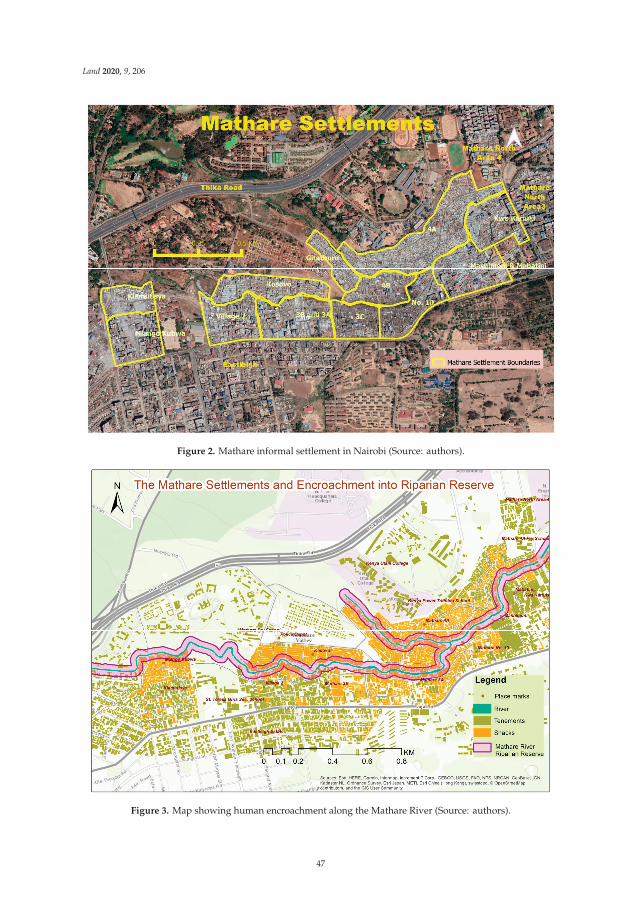
Land 2020, 9, 206
Figure 2. Mathare informal settlement in Nairobi (Source: authors).
Figure 3. Map showing human encroachment along the Mathare River (Source: authors).
47

Land 2020, 9, 206
2. Material and Methods
This paper builds on previous data and lessons generated by an interdisciplinary research team onthe multi-country research project titled Co-Designing Energy Communities with Energy Poor Womenin Urban Areas (in short CoDEC) and follow-up expert interviews in Nairobi under the AfriCLPprogram (see ref. [17–19]). Using Mathare informal settlement as the case study in Kenya, the teamheld workshops, a policy seminar, and key informant interviews. These brought together participantsfrom Mathare informal settlement: Residents, community leaders, energy service providers; Policyactors from: Nairobi County government, Nairobi County Council (Health department), Ministry ofEnergy, Kenya Power and Lighting Company (KPLC), the Energy and Petroleum Regulatory Authority(EPRA); and researchers and experts from: The University of Nairobi, Stockholm Environment Institute(SEI), IRD-Kenya, and the Kenya Institute for Public Policy, Research and Analysis (KIPPRA).
In the two-year study, CoDEC researchers used participatory research methods to facilitateknowledge co-production and solution co-design. The team engaged community members in carryingout household surveys and participatory GIS mapping to establish the socio-spatial, economic,and cultural dimensions of energy, in relation to energy and health outcomes. The case study wasselected through convenience sampling because the researchers had prior research experience withMathare. This enabled them to leverage existing relationships and work with participants whowere easily accessible and willing to participate in the survey. In an initial baseline study, researchquestionnaires were distributed to 100 households within the settlement. The questionnaires wereadministered by trained field workers drawn from the community and researchers from the Universityof Nairobi. The survey provided insights into the energy situation in the settlement in relation to healthperceptions and other socio-economic factors. The survey was followed by two focus group discussionswith residents to deliberate on factors such as the quantitative findings, gaps, and inconsistencies in thedata collected. Each focus group had 20 participants. The preliminary findings were used to engageenergy and health experts, community members, and government officials in a co-design workshop(19 participants), policy seminar (27 participants), and a dissemination workshop (20 participants)between 2017 and 2018. The co-design workshop was held to come up with energy system options forMathare. The purpose of the policy seminar was to discuss policy options for the energy-health nexusin Kenya. The dissemination workshop was held to launch “Mathare energy stories” booklet, whichcontained highlights from the household survey and comic strip illustrations of energy stories as toldby Mathare community members. Through these engagements, the researchers were able to relate thecontext-specific energy challenge in Mathare to the broader energy market and policy environment inKenya. A regional workshop for CoDEC regional partners was held in 2019 to engage stakeholders inKenya and discuss comparative analyses of case study findings (39 participants). This study enabledthe researchers to identify constraints that hinder clean energy transitions in informal settlements andcircumstances that necessitate the use of traditional fuels such as charcoal.
In a follow-up project under the AfriCLP program, the researchers used findings from theCoDEC study and carried out six key informant interviews between October and November 2019to develop a policy brief to propose electricity subsidies for informal settlements. This was used asa basis for gathering further insights from research and policy actors (see ref. [19]). Respondentsfor the key informant interviews were drawn from the Ministry of Energy, County Government ofNairobi, Kenya Power and Lighting Company (KPLC), Energy and Petroleum Regulatory Authority(EPRA), Stockholm Environment Institute (SEI), and Kenya Institute for Public Policy and Analysis(KIPPRA). This enabled the researchers to identify various constraints that hinder multi-stakeholderengagement and cross-sector collaborations between actors involved in policy and governance andlocal communities. The CoDEC research and the follow-up project under AfriCLP program identifiedthe need to bring together the diverse range of stakeholders and establish viable pro-poor energysolutions that can help meet the objectives of Kenya Vision 2030 policy blueprint while also ensuringsustainable energy access for all as subsumed under the global SDG 7 [4,17,18].
48

Land 2020, 9, 206
In this paper, we use a landscape governance framework to re-conceptualise the findings from theCoDEC and AfriCLP projects. Specifically, we used three landscape governance dimensions namelythe ecological, socio-cultural, and the political dimension to discuss the relationships between energydemands and other landscape issues in the case study.
3. Results
The research interactions in the CoDEC and AfriCLP projects unearthed various constraintsfaced in establishing cross-sector collaboration in the energy sector in Kenya. To meet this challenge,the researchers proposed transdisciplinary co-design as a collaborative approach that can enhancemulti-stakeholder engagement and cross-sector collaborations towards access to sustainable householdenergy in urban informal settlements. Lessons from the CoDEC project and insights gained fromthe Key Informant Interviews under the AfriCLP project demonstrated the role and importance ofacademics in facilitating multi-stakeholder collaborations. By framing Mathare as a landscape site inthis paper, we further highlight the energy challenge in informal settlements in relation to landscapegovernance. We thus emphasize how cross-sector collaboration is crucial for the provision of urbanservices in contested landscapes where various land uses compete.
The results are presented in two parts: (Section 3.1) Findings from the two-year CoDEC project,and (Section 3.2) Findings from the follow-up interviews under the AfriCLP project.
3.1. Findings from The Two-Year CoDEC Energy Project (2017–2019)
3.1.1. Energy Scenario and Challenges to Sustainable Energy Transition
The baseline study revealed that 93% of the Mathare households in our survey were connected tothe national grid. However, 50% of these connections were illegal and unmetered, as they were notprovided directly by the legal utility provider, Kenya Power and Lighting Company. Respondentscited the high cost of legal connection and monthly charges as factors influencing their preference forillegal connections. Charcoal was the second most preferred fuel after kerosene for heating, cooking,and boiling water (see ref. [17]). Other fuels used within the settlement include liquefied petroleum gasand electricity. The price of the fuels was a major factor in determining the household’s fuel preferenceand energy consumption. Dependence on multiple fuels was a way to make households more resilientto fluctuation in prices of charcoal, gas, and kerosene in the face of unaffordable electricity [18].Respondents also preferred kerosene to charcoal because it is relatively clean and emits less smoke.Lack of spatial planning was evident and was cited as one of the challenges hindering effectiveservice provision within the settlement. Structures are laid out haphazardly across the landscape.The development of infrastructure adds to the competing uses that put pressure on the already scarcespace. The researchers estimate that only approximately 4% of the total land area in Mathare is left formovement and circulation [20]. As a result, there are limited access roads for vehicular movement.This is a challenge especially for service providers such as Kenya Power and Lighting Company,who need access into the interior areas to erect electricity poles and transformers. Accidental fires fromthe use of candles and kerosene stoves are a common phenomenon. The lack of access roads is a majorhindrance to emergency fire response units.
3.1.2. Land Issues
Mathare informal settlement is a combination of private and public land. Some parts are ownedby the Government of Kenya, while others are owned by private local investors. Presently, most of theresidents in Mathare are tenants. In our study, 73% of the survey respondents were tenants, while 27%were structure owners. The main challenge posed by this is the lack of security of tenure as the occupiersdo not have title deeds or lease letters for the land on which they live. According to Arts et al. andHeiner, Shames and Spiegel, communities are more likely to engage in pro-environmental activities andtake better care of their landscapes if they have land ownership and feel a sense of belonging [14,25,35].
49

Land 2020, 9, 206
Due to the lack of title deeds and other land ownership rights, residents of Mathare live in fear ofeviction, and therefore do little to manage or develop their spaces [23]. Customers are required toprovide proof of land ownership to the utility provider for legal connection [20]. Lack of security oftenure therefore hinders Mathare residents from accessing legal power connections that would enhancetheir access to clean energy for cooking, heating, and lighting. As a result, the majority opt for traditionalsources of energy such as charcoal and firewood whose excessive use contributes to environmentaldegradation, deforestation, and increased health risks because of indoor air pollution [17,18].
3.1.3. Livelihood Issues
The study established that basic service provision in Mathare is either extremely poor or entirelynon-existent. The supply of clean water, and collection and disposal of waste are left to privatecontractors. Dumping into the Mathare River, along the riverbank, and on the sides of the road isrampant. In a focus group discussion, residents complained of lack of clean and safe water for drinkingand their daily use. Although the Mathare River runs through the informal settlement, pollution ishigh [34]. Different types of household refuse, raw sewage, and solid wastes are dumped into the river,thereby making the water unfit for human consumption. It should be noted that the livelihoods ofpeople downstream in the lower Eastern and Coastal regions of Kenya depend on water from theNairobi river basin (made up of Mathare River, Nairobi River, and Ngong River) for their daily use(Figure 4) [23].
Figure 4. River connects landscapes in different counties (Source: authors).
Pollution of the Mathare River, therefore, affects people within and outside the informal settlement.This necessitates a cross-border collaboration of actors in all the landscapes where the river traverses ifrehabilitation and conservation approaches are to be effective [36].
50
Land 2020, 9, 206
3.2. Findings from The Follow-Up Expert Interviews under AfriCLP Program (2019)
From the interactions with Mathare residents and interviews with key informants, the researchersidentified the following as constraints to establishing multi-stakeholder engagement and cross-sectorcollaborations:
3.2.1. Lack of Consensus
It became apparent that different agencies had different views concerning the same issues. Someof these views from the utility provider (KPLC) and the utility price regulator (EPRA) contradictedeach other. Whereas KPLC maintained that it was impossible to provide lower electricity tariffs forcommunities living in urban informal settlements, EPRA maintained that it was possible to providelower tariffs for those residents. Our engagement with community members revealed that residentswere willing to get legal connections, but only if the cost of connection and monthly power bills wereaffordable. This lack of consensus between the two key actors in the energy sector hinders collaborativeefforts towards enhancing the transition to clean energy in informal settlements.
3.2.2. Mistrust between Residents and Government Actors
The residents lacked faith in government actors and utility providers. They expressed doubt onwhether the government would act in the community’s interest. On the other hand, the county andnational governments continually fail to recognize the legitimacy of informal settlements. The 6thprinciple of Sayer et al.’s ‘Ten Principles of an Adaptive Landscape Approach’ states that trust amongstakeholders is crucial in creating negotiated and transparent change logic [24]. Trust is importantin structuring mutual relationships. It can influence public support for policies, enhance productivecooperation and promote open dialogue among stakeholders [37,38]. Existing mistrust betweengovernment actors and residents of Mathare informal settlement is a barrier to collaborations aimedat developing an effective governance model for the Mathare landscape. This mistrust exacerbatessecurity risks. The utility provider cited insecurity and rampant attacks on its officials during workvisits to the informal settlement as one of the major hindrances to provision of electricity in Mathare.The researchers conclude that there is need to invest in understanding the needs of energy consumersand build a relationship of trust particularly between informal settlement dwellers, government,and service providers. Creating a platform for government officials, experts, and community membersto co-design solutions together is one way of dealing with trust issues and enhancing security.
3.2.3. Cultural, Social, and Economic Barriers
Residents’ perceptions and financial constraints hinder them from embracing a technology switchto cleaner energy. This was attributed to the cost of legal connection and the cultural belief that charcoalis best for cooking certain traditional meals. This is in line with Sayer et al.’s argument that multiplestakeholders form their objectives differently [24]. Therefore, conflict or lack of understanding of theunderlying factors that shape the stakeholders’ preferences and objectives hinders any meaningfulgovernance, clean energy dialogues, and cross-sector collaboration [14].
3.2.4. Lack of Awareness at the Sector and Community Levels
This emerged as a barrier to cross-sector collaboration. Knowledge transfer and awarenesscreation are crucial in ensuring effective multi-stakeholder engagements [18,24]. The rights andresponsibilities of stakeholders need to be clarified and well-understood for effective collaboration totake place [8,24,25]. Some of the stakeholders did not know much about the other actors. In one ofthe workshops, a government agent involved in policy formulation confessed to having never visitedMathare informal settlement before. On the other hand, some of the residents were not aware of thegovernment agencies and their mandate. The CoDEC project researchers created a platform for bothparties to engage and learn about each other.
51

Land 2020, 9, 206
4. Analysis of CoDEC and AfriCLP Results through a Landscape Governance Framework
Analysing clean energy transition through a landscape lens requires an understanding of howthe two are related. Energy transitions and landscape governance can be understood from ecological,social-cultural, political, and environmental dimensions. In this section, we use the CoDEC andAfriCLP findings to demonstrate how clean energy transition can be understood using a landscapegovernance framework. We start by creating a link between energy transitions and different dimensionsof landscape governance.
4.1. Ecological Dimension
Landscapes provide the context for the lived experiences of humans and their communities.It is where ecological and social histories are shared [39]. Here, the creation of and participation inshared knowledge and development occurs [40]. Effective landscape approaches need to be basedon an understanding of the natural-ecological characteristics of the area [25,41]. This allows a fullyintegrated and effective framework to be developed. This is to say that formal and informal urbandwellings in Sub-Saharan Africa can perform satisfactorily if the larger environment functions properlyas a living space. This is largely determined by how communities within the respective landscapesmanifest themselves outwardly and how they interact with their living spaces [21]. County andnational governments need to acknowledge that despite their segregation, informal settlements donot thrive in isolation of the landscapes around them [8,42]. What happens in Mathare affects otherlandscapes and natural resources. For example, lack of access to electricity compels residents torely on charcoal and firewood for their cooking and heating needs. As a result, (1) Use of charcoalcontributes to deforestation and land degradation due to excessive tree logging [43,44]; (2) burning ofcharcoal leads to the release of carbon monoxide, nitrogen oxides, formaldehyde, benzene, and otherhydrocarbons into the atmosphere, thereby contributing to climate change [18,45,46]; and (3) the smokeemitted during combustion of charcoal in poorly ventilated houses increases the health risk of theusers [17,18,46]. Transitioning to clean energy and increasing access to electricity will, therefore, benefitforest landscapes, help in the fight against climate change, and contribute towards improving thelivelihoods of informal settlement dwellers.
4.2. Socio-Cultural Dimension
Part of what makes us human is that, unlike other animals, we can philosophize about ourplace in the world and can experience existential crises [40]. Sense of place and socio-culturalidentity are crucial factors in landscape governance [25]. The socio-cultural dimension of landscapeapproaches is philosophised through various cultural practices, beliefs, and heritage [1,47,48]. Cultureimpacts people’s choices and how they use or add value to natural resources [24]. The multi-leveltransdisciplinary co-design methodology enabled the CoDEC researchers to assess monetary andnon-monetary factors that shape residents’ choice of fuel and what prompts them to prefer charcoaldespite the negative impacts associated with it [17,18]. It was discovered that charcoal is culturallyviewed as a better fuel for cooking certain traditional foods [17,18]. Therefore, changing the community’senergy behaviour and land use practices requires one to understand the culture and the factors thatinform their decisions and preferences [24,39]. This approach is important in collaborative stakeholderengagements because it creates a platform for respondents to conceptualize why others do what theydo. Contestations may arise, but solutions arrived at after deliberations are usually more inclusive andstand a higher chance of acceptance at the community level [49–51].
4.3. Political Dimension
In policy and planning, landscapes are often understood as administrative territories thatare geographically bound and subject to formal territorial and institutional policy and planninginterventions [25,41,52]. However, management approaches that are implemented in isolation do
52

Land 2020, 9, 206
not suffice [1]. Lessons drawn from the CoDEC and AfriCLP projects point to the need to expandthe scope and make formal and informal institutions work across the borders to ensure genuineintegration. The role of landscape approaches is to provide a framework to integrate practice andpolicy for different land uses in each area [1]. A lot of learning and knowledge co-creation is involved toachieve integration [10]. Through co-design workshops, academics create a platform where policy andplanning actors can clarify rights and responsibilities relating to land and resource use to communitystakeholders [24]. In Mathare, this remains elusive due to lack of land ownership rights and securityof tenure and mistrust between the government agents and the local community [17,18]. Arguably,the fact that residents live in constant fear of eviction undermines their ability to support or implementlong-term sustainable landscape approaches [14]. The study concludes that policy and planninginitiatives have failed to devise sustainable energy and landscape governance approaches for theMathare landscape.
4.4. Environmental Dimension
It has been argued that the analysis of ‘energy’ as a generic concept fails to capture differencesin energy use [17]. This means that policies that are only aimed at shifting overall consumptiontowards electricity and away from traditional fuels are unable to adequately address the clean energyneeds of the urban poor. It would be incorrect to infer that increased electrification will automaticallylead to lower consumption of charcoal. However, this coupled with effective environmental policiesand landscape approaches may significantly reduce the consumption of charcoal and firewood [43].For example, in 2017 the Government of Kenya imposed a ban on tree logging and charcoal productionin public forests. The aim of this charcoal ban policy was to increase the country’s forest cover to atleast 10% and reduce the widespread use of charcoal [43,53,54]. The ban led to an increase in the cost ofcharcoal across the country [17,18,44]. Market logic dictates that an increase in the cost of charcoal willdrive consumers to switch to alternative sources such as electricity [43]. However, this logic failed totake effect in Mathare, as the majority cannot afford legal connection because of their meagre earningsat an average of Ksh. 18,000 per household [17]. The moratorium on logging and lack of affordablealternatives to charcoal led residents to switch to sawdust as a fuel [18].
5. Discussion
Implementation of effective landscape approaches calls for an iterative process of trial, learning,and adaptation that is designed to meet the specific socio-spatial conditions of the area [25]. Governanceof informal settlements is complicated by the lack of defined landscape approaches and implementationblueprints. Academics are increasingly playing pivotal roles in leading the learning processes andfacilitating actor-collaborations and multi-stakeholder engagements as was demonstrated in the CoDECproject, thereby becoming the much-needed change agents in solving some of the world’s most pressingurban challenges [15,18,55,56].
5.1. Landscape and Energy Policy Interventions
In policy and planning, landscapes are often viewed as administrative territories that aregeographically bound and thus subject to territorial policy and planning interventions [25,52].This paper emphasizes the importance of widening the scope and creating actor-networks thatmove beyond geographical boundaries [27]. We maintain that sustainable and effective landscapegovernance requires the creation of networks that transcend the boundaries and connect sustainableinterventions across different landscapes and different administrative areas [25,57]. For example, a riverconnects different areas and varied activities across different administrative territories both upstreamand downstream [8]. This means that the illegal dumping of solid wastes and household refusedone on Mathare River affects Mathare residents and communities downstream who depend on theriver [36]. Multi-level collaboration characterised by multi-stakeholders and multi-sector engagementis thus required in the governance of the Mathare landscape and others that are connected to it. Energy
53
Land 2020, 9, 206
transition strategies also need to be driven by the same principle of multi-stakeholder collaborationsacross different sectors and government levels [17,18,58]. Through a landscape approach, stakeholderscan view energy issues from a landscape perspective.
Lessons can be drawn from countries such as Chile and Brazil, where residents exchange recyclablewastes for a reduction in their electricity cost. In 2007, the ‘Ecoelce’ initiative was launched in Brazil.The program allowed exchange of recyclable garbage for a bonus in the electricity bill [59]. It isestimated that the program led to proper disposal of over 18,500 tons of waste in Fortaleza. The successof this program saw it replicated in Santiago and Rio de Janeiro in 2010 [59]. Initiating such aproject in Mathare would help solve the challenges of waste disposal and ease the cost burden ofaccessing legal electricity connection. The focus will shift from just increasing access to electricity toensuring that residents access this energy in ways that are not detrimental to the environment, naturalresources, and the safety of other people within and outside the landscape [17,18]. Such projectsrequire investment of human, technical, and financial resources from diverse stakeholders. Therefore,there is need to develop close working relationships between government agencies, academics, andresidents of informal settlements to allow the stakeholders to co-explore relevant issues and coproducepotential solutions [3,18].
5.2. Failure of Standardised Policy Interventions
Current landscape and policy interventions do not adequately address the land and clean energyissues in Mathare informal settlement. From the CoDEC research, the team concluded that Kenya’senergy policy and regulations are highly standardised and might therefore not work for the urbaninformal settlement dwellers [17,18,22]. The takeaway point from this paper is that urban informalitycannot be understood through standardised measurements because different informal settlementsraise different challenges of understanding and governance. Clean energy transitions and governanceof informal settlement landscapes cannot therefore be governed through blueprint or standard policyinterventions [17]. Universal electrification is one example of a standardising policy that has failedto work in solving energy challenges of informal settlements. For example, in South Africa, a solarpower project was established in 2011 in Enkanini informal settlement to achieve the goal of universalelectrification [10]. The project improved safety through street lighting but failed to substitute the use ofmulti-purpose fuels such as charcoal and kerosene. A similar biogas initiative was once implementedin Mathare but failed after one year because of capacity limitation and lack of community support.
Africa leads the world in the adoption of pre-paid electricity systems that have worked well inSouth Africa and in Kenya [59]. However, when the pre-paid system was introduced in Mathare,the residents used it for a few months before reverting to the illegal connections that were cheaperthan the pre-paid system because illegal connections are not metred. During the workshops andfocus group discussions, residents attributed the initiative’s failure to lack of consultation betweenthe community, government, and utility provider. In the key informant interviews, representativesfrom the utility provider and regulator attributed the failure to residents’ unwillingness to switch fromillegal connection. Evidence of interventions working in some areas and failing in others demonstratesthat community initiatives are likely to work better if they are informed by context-specific needs andexperiences of residents [17,30,42,59,60].
Similarly, environmental policies implemented by the Government of Kenya to reduce deforestationand protect the environment would work better if access to alternative and safe energy in affectedlandscapes is increased. Implementation of one in the absence of the other will do little to solve theunderlying problems [61]. The charcoal ban policy in Kenya was a top-level intervention implementedat the national level. Failure of top-down approaches to decision-making and policy developmentis increasingly becoming evident [49,62,63]. A more bottom-up approach where stakeholders areincluded is increasingly gaining prominence as a more appropriate mode of decision making to addressthe complexities of urban development [62]. Co-designing solutions with the local stakeholders ensuresinclusion in decision making and increases the chances of developing integrated policies that work for
54

Land 2020, 9, 206
the local community [64]. According to Beunen and Opdam, successful solutions are only developedin collaboration between practitioners, local communities, and researchers [65]. This marks a shift fromgovernment to governance where the need to coordinate between multi-stakeholders and resourcesis emphasised [49]. Only then can place-based solutions be created and implemented for effectivelong-term change.
5.3. Academics as Intermediaries of Change and Knowledge Co-Creation
By acting as intermediaries and catalysts of change, academics facilitate co-learning and co-designof solutions among different stakeholders [18]. The term landscape approach captures and is foundedon the aspiration of a transdisciplinary approach and collaborative governance [24,52,59,66,67]. A keysimilarity between a transdisciplinary co-design approach and a landscape governance approach isthat both aim to foster cross-sector collaboration using co-creative methods that are effective, iterative,and integrative [18,50]. These approaches help actors to move from a business-as-usual model [68] andembrace more participatory co-learning approaches that aim to build a meaningful consensus betweenmultiple stakeholders [18,69]. Translating knowledge into action that allows mitigation, adaptation,and landscape solutions in informal settlements is a challenge [66]. Overcoming this challengecalls for multi-level governance that is based on learning and knowledge co-production in concretehuman-nature systems (i.e., Landscapes) [24]. Transdisciplinary research entails collaboration andknowledge co-creation between different communities of place and practice and is, therefore, an effectiveavenue for translating knowledge into action [10,66]. In the CoDEC research, the transdisciplinaryapproach was anchored on the place-based realities of residents in Mathare [17,18]. Communitymembers exchanged ideas with policymakers on how best to deal with the issue of illegal connectionand cartels’ operations in the informal settlement. Such encounters are steps towards building trust,consensus, and creating positive change and sustainable transitions in informal landscapes.
Building consensus requires acknowledgment that different stakeholders often have contrastingviews and competing interests [24]. In addressing the interrelations between clean energy andlandscapes, Zoellner et al. regard societal acceptance as the ideal worth striving for [70]. Conflictand disagreements are problems that should be avoided. On the contrary, Leibenath and Lintz andCarvalho et al. argue that the adoption of democratic principles of contestation and competitionof ideas is more important [51]. The idea here is that competing ideas are effective in exposingsalient issues and enhancing strong collaborations [50,51]. In support of Leibenath and Lintz’s andCarvalho et al.’s argument, we believe that a transdisciplinary co-design methodology to energy andlandscape governance is a promising approach. In the CoDEC project, stakeholders gave differentideas to solve the challenges facing Mathare. These varying ideas were iterated through the Universityof Nairobi Living Lab to ensure that stakeholders’ views were captured, and common solutionsdeveloped [71]. This led to the creation of a strong actor-network that would allow the delivery ofplace-based solutions [17,18]. This enhances the translation of knowledge into action that allowsmitigation and adaptation measures to be implemented [15].
5.4. Recommendations
Urban energy landscapes emerge from the coevolution of socio-ecological and socio-technicalsystems. They are heterogeneous, diverse, and require context-based interventions for success [72].Table 1 shows place-based interventions that have been implemented in various informal settlementsaround the world. Some of these interventions can be adopted and adapted for the Mathare landscape.
55

Land 2020, 9, 206
Ta
ble
1.
Sum
mar
yof
init
iati
ves
that
can
beim
plem
ente
din
Mat
hare
:Les
sons
from
othe
rar
eas
(Sou
rce:
auth
ors)
.
Init
iati
ve
Pla
ces
Wh
ere
Imp
lem
en
ted
Wh
at
Wo
rke
dW
ha
tH
as
No
tW
ork
ed
Via
bil
ity
inM
ath
are
Uni
vers
alel
ectr
ifica
tion
Enka
nini
(Sol
arpr
ojec
t)M
atha
re(B
ioga
spr
ojec
t)Im
prov
edsa
fety
thro
ugh
stre
etlig
htin
gFa
iled
tosi
gnifi
cant
lycu
rbth
eus
eof
char
coal
and
paraffi
nBi
ogas
proj
ectf
aile
d
Pre-
paid
elec
tric
ity
syst
emSo
uth
Afr
ica;
Ken
yaC
onsu
mer
sar
eab
leto
acce
sscl
ean
ener
gyw
ithi
nth
eir
budg
etTh
esy
stem
coul
dbe
limit
ing
for
peop
leof
low
inco
me
The
pre-
paid
syst
emfa
iled
inM
atha
rebe
caus
eit
cost
resi
dent
sm
ore
than
wha
tthe
ypa
yfo
rth
eill
egal
conn
ecti
on
Rec
yclin
gfo
rel
ectr
icit
ycr
edit
Chi
le,B
razi
l
Dum
ping
isre
duce
dth
roug
hre
cycl
ing.
Itea
ses
the
expe
nses
ofpa
ying
for
elec
tric
ity
Cou
ldbe
cons
ider
edas
alo
ng-t
erm
proj
ectt
ore
duce
the
men
ace
ofill
egal
dum
ping
alon
gth
ero
ads
and
bank
sof
Mat
hare
Riv
er.
Slum
rege
nera
tion
and
reco
gnit
ion
proj
ects
Peru
,Bra
zil,
Chi
na,
Indo
nesi
a
Titli
ngha
sgi
ven
info
rmal
sett
lem
ents
land
owne
rshi
pth
atal
low
sth
emto
deve
lop
thei
rla
ndsc
apes
and
have
ase
nse
ofid
enti
tyan
dbe
long
ing.
Reg
ener
atio
npr
ojec
tsha
veal
low
edup
grad
ing
ofho
uses
inth
ein
form
alse
ttle
men
tsto
allo
wbe
tter
prov
isio
nof
serv
ices
and
esse
ntia
lam
enit
ies
Reg
ener
atio
npr
ojec
tsha
vele
dto
dem
olit
ion
ofst
ruct
ures
duri
ngth
eup
grad
ean
dth
usfa
iled
tose
cure
hous
ing
for
all
resi
dent
sas
som
eha
dto
mov
eto
othe
rpe
ri-u
rban
area
s[3
0].
Titl
ing
allo
ws
resi
dent
sto
have
lega
low
ners
hip
and
docu
men
tati
onre
quir
edby
the
utili
typr
ovid
erto
prov
ide
acce
ssto
the
grid
.Thi
sis
apo
tent
ials
olut
ion
toM
atha
re’s
ener
gyis
sues
.
56

Land 2020, 9, 206
From the foregoing, this paper recommends that a landscape governance approach shouldbe adopted when designing solutions for informal settlements to safeguard the environment andcommunity interests. Strategies and approaches to sustainable energy transitions and landscapegovernance should be adapted to the changing societal demands and shifting opportunities for planningand policy making. Incentives in terms of safety, pricing, and security of supply should be provided toencourage informal settlement dwellers to switch to legal connections. Co-design of centralised solarpower and biogas energy stations with residents should be explored as an alternative for supplyingthe community’s energy needs with affordable renewable energy. Developing the energy stationswith the community gives them a sense of ownership and the projects are more likely to succeed.The government could also consider providing special electricity tariffs for informal settlementsto reduce the cost of connections and power supply. This will incentivise them to seek legal, safeconnections. More importantly, this paper recommends and emphasizes the importance of policy actorsand regulators investing in understanding the needs of consumers. This will help to build relationshipsof trust between residents, government, and service providers through multi-actor collaborations.
5.5. Limitations
The aim of the CoDEC and AfriCLP projects discussed in this paper was to establish long-termcross-sector collaborations that would lead to sustainable energy transitions in urban Africa. As a result,the researchers in these projects did not provide concrete technical solutions that can be implementedin the case study. The researchers argue in this paper and in previous publications that long-termcross-sector collaborations and policy changes are required to enable and sustain context-specific,technical solutions [17,18]. The convenience sampling approach of this paper limits its findings to thecontext of the case study. Nevertheless, we have used examples from literature to triangulate the mainarguments of this paper and thus increase the theoretical generalizability of its recommendations.
6. Conclusions
A key lesson from the CoDEC and AfriCLP projects was that cross-sector collaboration acrossdifferent levels of governance can lead to sustainable energy transitions. These collaborations canfoster learning and help to build relationships and capacity. Stakeholders frame problems and devisepotential solutions from different perspectives and dimensions. A multi-level, transdisciplinaryco-design approach made it possible to understand what influences households’ energy choices inMathare informal settlement. The researchers assessed energy consumption at the household levelby distinguishing between different end uses and energy choices. The study looked beyond themeasurement of how much energy is used and sought to determine the drivers of energy consumptionand fuel choices. The high cost of legal power connection led many Mathare residents to optfor dangerous indirect connections to cater for their lighting needs. It also contributed to residents’dependence on biomass fuels such as wood and charcoal for their cooking and heating. Overdependenceon traditional fuels contributes to deforestation. Their combustion in poorly ventilated houses increasesindoor air pollution and release of hydrocarbons into the atmosphere, thereby contributing to climatechange. This is a similar scenario in other urban informal settlements such Enkanini informal settlementin South Africa.
In this paper, we looked at how to increase resilience in urban informal landscapes throughsustainable energy transitions. We demonstrated how academics can facilitate the search for cleanand sustainable energy solutions in urban informal settlements through transdisciplinary co-designapproaches. Using a landscape governance approach, this paper determined that the failure of technicalsolutions in Mathare is proof of the futility of approaches that are implemented in isolation withoutconsideration of all stakeholders at different sectors and landscape levels. Researchers can workclosely with people in the targeted landscapes to help policymakers understand the critical underlyingissues that influence choices and actions. Mathare residents were more open to interacting withresearchers from the University, but reluctant to trust government agents due to the disputed nature
57

Land 2020, 9, 206
of the settlement. The researchers were able to leverage this trust and bring together stakeholdersfrom different backgrounds and sectors within the academic, government, community, and privatesectors. The academics thus facilitated co-design processes where all stakeholders had a platformto share their ideas and potential solutions to the challenges. This set the basis for the developmentof energy and landscape policies that respond to the needs of the urban poor and guide sustainableenergy transitions.
We therefore recommend landscape governance as a promising approach for integrating energyissues with other competing landscape interests, while also encouraging cross-sector collaboration.Although our findings are context-specific, we argue that the landscape governance approach hasrelevance in understanding the dynamics of other informal settlements in and beyond Kenya.
Author Contributions: A.A. was the principal investigator in the CoDEC and AfriCLP projects. All authors wereactively involved in the writing of this paper in the following capacities—Conceptualization: A.A., P.N.; Writingof the original draft: P.N.; Mapping and Visualization: D.G.; Editing and initial review: A.A., G.O. All authorshave read and agreed to the published version of the manuscript.
Funding: The writing of this paper did not receive any specific funding. However, the CoDEC research projectreferred to in this paper was supported by Leading Integrated Research for Agenda 2030 In Africa (LIRA2030)program from 2017 to 2019. LIRA2030 is a five-year program aimed at supporting collaborative research projectsled by early career researchers across Africa. The program is being implemented by the International ScienceCouncil (ISC), in partnership with the Network of African Science Academies (NASAC), with support from theSwedish International Development Cooperation Agency (Sida). Additional funding for policy work in Kenyacame from the Africa Climate Change Leadership (AfriCLP) program. AfriCLP is managed by University ofNairobi and is funded by the International Development Research Centre (IDRC).
Conflicts of Interest: The authors declare no conflict of interest.
References
1. Turley, L. The Landscape Approach: Moving Towards Sustainable Land Use Patterns. SSI Commentary,Report, Ottawa. 2016. Available online: https://www.iisd.org/ssi/wp-content/uploads/2019/09/Landscape-Approach.pdf (accessed on 7 January 2020).
2. Hofstad, H.; Tveit, S.; Stokke, B. Between development and protection: Different discourses in urbanplanning. Landsc. Res. 2014, 1–15. [CrossRef]
3. Brandon, K. Learning Labs: Creating Collaborative Ways to Address Climate Change in African Cities.Stockholm Environment Institute. Available online: https://www.sei.org/featured/learning-labs-creating-collaborative-ways-to-address-climate-change-in-african-cities/ (accessed on 1 March 2020).
4. Government of Kenya. Kenya Vision 2030. 2007. Available online: https://kfcb.co.ke/wp-content/uploads/2016/08/vision_2030.pdf (accessed on 9 April 2020).
5. UN Habitat. The challenge of slums: Global report on human settlements 2003. Manag. Environ. Qual. 2004,15, 337–338. [CrossRef]
6. UNFPA. The State of the World Population 2018; United Nations Publisher: New York, NY, USA, 2018.7. United Nations. World Urbanization Prospects; United Nations Publisher: New York, NY, USA, 2014.8. Dodman, D.; Archer, D.; Mayr, M.; Engindeniz, E. Addressing the Most Vulnerable First: Pro-Poor Climate Action
in Informal Settlements; UN-Habitat: Nairobi, Kenya, 2018. Available online: https://reliefweb.int/sites/reliefweb.int/files/resources/Pro-poor%20Climate%20Action%20in%20Informal%20Settlements%20-%20WEB.pdf(accessed on 27 December 2019).
9. Habitat UN. Slum Almanac 2015–2016: Tracking Improvement in the Lives of Slum Dwellers. ParticipatorySlum Upgrading Programme. 2016. Available online: https://unhabitat.org/slum-almanac-2015-2016(accessed on 20 February 2020).
10. van Breda, J.; Swilling, M. The guiding logics and principles for designing emergent transdisciplinaryresearch processes: Learning experiences and reflections from a transdisciplinary urban case study inEnkanini informal settlement, South Africa. Sustain. Sci. 2018, 14, 823–841. [CrossRef]
11. Williams, S.; Costa, M.M.; Sutherland, C.; Celliers, L.; Scheffran, J. Vulnerability of informal settlements inthe context of rapid urbanization and climate change. Environ. Urban. 2019, 31, 157–176. [CrossRef]
12. Bai, X.; McPhearson, T.; Cleugh, H.; Nagendra, H.; Tong, X.; Zhu, T.; Zhu, Y.G. Linking urbanization and theenvironment: Conceptual and empirical advances. Annu. Rev. Environ. Resour. 2017, 42, 215–240. [CrossRef]
58

Land 2020, 9, 206
13. WWF. WWF Living Forests Report: Chapter 2. Forests and Energy. 2011. Available online: https://wwf.panda.org/our_work/forests/forest_publications_news_and_reports/living_forests_report/energy_forests/ (accessedon 5 March 2020).
14. Heiner, K.; Shames, S.; Spiegel, E. Integrated landscape management in Kenya: The state of the policyenvironment. In Proceedings of the 2016 World Bank conference on Land and Poverty, Washington, DC,USA, 14–18 March 2016.
15. Mansourian, S.; Walters, G.; Gonzales, E. Identifying governance problems and solutions for forest landscaperestoration in protected area landscapes. PARKS 2019, 83–96. [CrossRef]
16. UNDP. Sustainable Energy. Available online: https://www.undp.org/content/undp/en/home/2030-agenda-for-sustainable-development/planet/sustainable-energy.html (accessed on 14 December 2019).
17. Kovacic, Z.; Musango, J.; Ambole, L.; Buyana, K.; Smit, S.; Anditi, C.; Mwau, B.; Ogot, M.; Lwasa, S.;Brent, A.C.; et al. Interrogating differences: A comparative analysis of Africa’s informal settlements.World Dev. 2019, 122, 614–627. [CrossRef]
18. Ambole, A.; Musango, J.; Buyana, K.; Ogot, M.; Anditi, C.; Mwau, B.; Kovacic, Z.; Smit, S.; Lwasa, S.;Nsangi, G.; et al. Mediating household energy transitions through co-design in urban Kenya, Uganda andSouth Africa. Energy Res. Soc. Sci. 2019, 55, 208–217. [CrossRef]
19. Ambole, A.; Njoroge, P.; Outa, G.; Anditi, C. A case for providing electricity subsidies in urban informalsettlements in Nairobi. KY Policy Briefs Realis. Vis. 2030 2020, 1, 21–22. Available online: https://uonresearch.org/journal/index.php/kpb/article/view/10/10 (accessed on 27 April 2020).
20. Cheseto, M. Challenges in Planning for Electricity Infrastructure in Informal Settlements: Case of KosovoVillage, Mathare Valley-Nairobi. Master’s Thesis, University of Nairobi, Nairobi, Kenya, 2013.
21. Mandour, M. Sustainable informal housing by means of a better public space. Int. J. Arab Cult. Manag.Sustain. Dev. 2012, 2, 370. [CrossRef]
22. Sarmiento, H.; Tilly, C. Governance lessons from urban informality. Polit. Gov. 2018, 6, 199. [CrossRef]23. Mwaniki, D.; Wamuchiru, E.; Mwai, B.; Opiyo, R.; Mwaniki, D. Urbanisation, informality, and housing
challenges in Nairobi: A case of urban governance Failure. Cell 2015, 254, 917–960.24. Sayer, J.; Sunderland, T.; Ghazoul, J.; Pfund, J.; Sheil, D.; Meijaard, E.; Venter, M.; Boedhihartono, A.K.;
Day, M.; Garcia, C.; et al. Ten principles for a landscape approach to reconciling agriculture, conservation,and other competing land uses. Proc. Natl. Acad. Sci. USA 2013, 110, 8349–8356. [CrossRef] [PubMed]
25. Arts, B.; Buizer, M.; Horlings, L.; Ingram, V.; van Oosten, C.; Opdam, P. Landscape approaches:A state-of-the-art review. Annu. Rev. Environ. Resour. 2017, 42, 439–463. [CrossRef]
26. Prieur, M.; Luginbühl, Y.; Zoido, N.F.; de Montmollin, B.; Pedroli, B.; van Mansvelt, J.D.; Durosseau, S.Landscape and Sustainable Development: Challenges of the European Landscape Convention; Council of EuropePublishing: Strasbourg, France, 2006.
27. De Graaf, M.; Buck, L.; Shames, S.; Zagt, R. Assessing Landscape Governance: A Participatory Approach;Tropenbos International and EcoAgriculture Partners: Wageningen, The Netherlands, 2017.
28. van Assche, K.; Beunen, R. Shifting forms of landscape governance: Environmental policy, spatialplanning and place branding strategies. In Working Papers in Evolutionary Governance Theory; InternationalInstitute for Innovation in Governance: Wageningen, The Netherlands, 2017; pp. 1–21. Available online:https://d1wqtxts1xzle7.cloudfront.net/53420070/Shifting_forms_of_landscape_governance_Flanders.pdf?1496835825=&response-content-disposition=inline%3B+filename%3DShifting_forms_of_landscape_governance_e.pdf&Expires=1592410420&Signature=bVwdBkbqmL4sOoY9CZn~{}~{}xNpD0RTRI31hhCE~{}TULNd86fxD~{}Lg3EbS5JulJroo~{}WQhTdxgFRhGWMy8uvJ2kOsthT7fKp8Orw8WN3FM~{}p3rJT-uGFHMITZ8tpJcKlG0VDHnPC7K3fDJw8My0fHR8P6lhMrP8-nPjW6U9XorUMPe0k3eX3o2iD4ocZVJmPdY9S3uO-FBoChApWKBb77vK39WZsREdiv6hqpXNNWCXYHrVm9VfnJ8IsXIkBLs-VPZgQ3qvrjOQtGlkEhh3n2IX5vEdgViyG8KdDEi~{}q7WPYFA-pf-Btb2oYBHclH-F74vFbABuHvj3Pz-JVsirOKfa51A__&Key-Pair-Id=APKAJLOHF5GGSLRBV4ZA (accessed on 27 February 2020).
29. Syagga, P.; Malombe, J. Development and Management of Informal Housing in Kenya (Draft Report); Housing andBuilding Research Institute: Nairobi, Kenya, 1994.
30. Jones, P. Formalizing the informal: Understanding the position of informal settlements and slums insustainable urbanization policies and strategies in Bandung, Indonesia. Sustainability 2017, 9, 1436. [CrossRef]
31. Andvig, J.; Barasa, T. A Political Economy of Slum Spaces: Mathare Valley; Norwegian Institute of InternationalAffairs: Oslo, Norway, 2014.
59

Land 2020, 9, 206
32. Kenya National Bureau of Statistics. Kenya Population and Housing Census; Kenya National Bureau of Statistics:Nairobi, Kenya, 2019; Volume I.
33. World Health Organization. Guidelines for Drinking Water Quality, Vol. 1, Recommendations, 4th ed.; WorldHealth Organization: Geneva, Switzerland, 2011.
34. Njuguna, S.; Yan, X.; Gituru, R.; Wang, Q.; Wang, J. Assessment of macrophyte, heavy metal, and nutrientconcentrations in the water of the Nairobi river, Kenya. Environ. Monit. Assess. 2017, 189. [CrossRef][PubMed]
35. Mehnen, N.; Mose, I.; Strijker, D. Governance and sense of place: Half a century of a German nature park.Environ. Policy Gov. 2013, 23, 46–62. [CrossRef]
36. Mwaniki, D. Mapping Pollution in the Mathare River: An Analysis of Waste Disposal Patterns and RiverPollution in an Informal Settlement. Ph.D. Thesis, University of Nairobi, Nairobi, Kenya, 2012.
37. Höppner, C.; Frick, J.; Buchecker, M. Assessing psycho-social effects of participatory landscape planning.Landsc. Urban Plan. 2007, 83, 196–207. [CrossRef]
38. Conniff, A.; Colley, K.; Irvine, K. Exploring landscape engagement through a participatory touch tableapproach. Soc. Sci. 2017, 6, 118. [CrossRef]
39. Ellis, E. Ecology in an anthropogenic biosphere. Ecol. Monogr. 2015, 85, 287–331. [CrossRef]40. Fuentes, A. Human niche, human behaviour, human nature. Interface Focus 2017, 7. [CrossRef] [PubMed]41. Van, C.; Seerp, W. Landscape Governance Capacity: Towards a Framework for Assessment and Strategic Guidance of
Landscape Initiatives; Wageningen Centre for Development Innovation: Wageningen, The Netherlands, 2016.42. Zhous, Z. Towards collaborative approach? Investigating the regeneration of urban village in Guangzhou,
China. Habitat Int. 2014, 44, 297–305. [CrossRef]43. Njenga, M. Banning Charcoal Isn’t the Way to Go. Kenya Should Make it Sustainable. The Conversation.
2018. Available online: https://theconversation.com/banning-charcoal-isnt-the-way-to-go-kenya-should-make-it-sustainable-95610 (accessed on 19 December 2019).
44. Abdallah, H. Charcoal Traders Go to Uganda after Kenya Ban. The East African. 2019. Availableonline: https://www.theeastafrican.co.ke/business/Charcoal-traders-go-to-Uganda-after-Kenya-ban-/2560-5097292-lj12s4z/index.html (accessed on 20 December 2019).
45. Sovacool, B. The political economy of energy poverty: A review of key challenges. Energy Sustain. Dev. 2012,16, 272–282. [CrossRef]
46. Kaygusuz, K. Energy for sustainable development: A case of developing countries. Renew. Sustain. EnergyRev. 2012, 16, 1116–1126. [CrossRef]
47. Horlings, L.; Battaglini, E.; Dessein, J. Cultural Sustainability and Regional Development. In Theories andPractices of Territorialisation, 1st ed.; Dessein, J., Battaglini, E., Horlings, L., Eds.; Routledge: London, UK,2016; pp. 1–6.
48. Schatzki, T. The site of the social: A philosophical account of the constitution of social life and change.Choice Rev. Online 2003, 40, 3940–3946. [CrossRef]
49. van Assche, K.; Beunen, R.; Duineveld, M. Citizens, leaders and the common good in a world of necessityand scarcity: Machiavelli’s lessons for community-based natural resource management. Ethics Policy Environ.2016, 19, 19–36. [CrossRef]
50. Leibenath, M.; Lintz, G. Governance of energy landscapes between pathways, people and politics. Landsc. Res.2018, 43, 471–475. [CrossRef]
51. Carvalho, A.; van Wessel, M.; Maeseele, P. Communication practices and political engagement with climatechange: A research agenda. Environ. Commun. 2016, 11, 122–135. [CrossRef]
52. Sayer, J.; Margules, C.; Boedhihartono, A.; Dale, A.; Sunderland, T.; Supriatna, J.; Saryanthi, R. Landscapeapproaches; what are the pre-conditions for success? Sustain. Sci. 2014, 10, 345–355. [CrossRef]
53. The East African. Picking a Pathway through the Disappearing Forests of Kenya. 2018. Available online:https://www.theeastafrican.co.ke/scienceandhealth/Picking-a-pathway-through-the-disappearing-forests-of-Kenya-/3073694-4351716-rre74/index.html (accessed on 14 December 2019).
54. Natural Resources Alliance of Kenya. Kenya’s Forest Cover. 2017. Available online: https://kenra.or.ke/kenyas-forest-cover-2/ (accessed on 19 December 2019).
55. Asikainen, S.; Brites, C.; Plebanczyk, K.; Mijatovic, L.; Soini, K. Culture in Sustainability: Towards aTransdisciplinary Approach; SoPhi: Jyväskylä, Finland, 2017.
60

Land 2020, 9, 206
56. Horlings, L.G. The Role of Artists and Researchers in Sustainable Place-Shaping. In Culture in Sustainability:Towards a Transdisciplinary Approach; Asikainen, S., Brites, C., Plebanczyk, K., Mijatovic, L.R., Soini, K., Eds.;SoPhi: Jyväskylä, Finland, 2017; pp. 131–143.
57. van Oosten, C. Forest landscape restoration: Who decides? A governance approach to forest landscaperestoration. Nat. Conserv. 2013, 11, 119–126. [CrossRef]
58. Nadaï, A.; van der Horst, D. Introduction: Landscapes of energies. Landsc. Res. 2010, 35, 143–155. [CrossRef]59. Butera, F.M.; Adhikari, R.S.; Caputo, P.; Facchini, A. The Challenge of Energy in Informal Settlements. A Review
of the Literature for Latin America and Africa; Enel Foundation: Rome, Italy, 2015.60. Fernandes, E. Regularization of Informal Settlements in Latin America; Lincoln Institute of Land Policy:
Cambridge, UK, 2011.61. Chepkwony, J. Charcoal Trade Thrives Despite Logging Ban: The Standard. 2019. Available online:
https://www.standardmedia.co.ke/article/2001309788/charcoal-trade-thrives-despite-logging-ban (accessedon 20 December 2019).
62. Mansourian, S.; Sgard, A. Diverse interpretations of governance and their relevance to forest landscaperestoration. Land Use Policy 2019, 1–8. [CrossRef]
63. Ferranti, F.; Turnhout, E.; Beunen, R.; Behagel, H. Shifting nature conservation approaches in Natura 2000and the implications for the roles of stakeholders. J. Environ. Plan. Manag. 2014, 57, 1642–1657. [CrossRef]
64. Newig, J.; Fritsch, O. Environmental governance: Participatory, multi-level–and effective? Environ. PolicyGov. 2009, 19, 197–214. [CrossRef]
65. Beunen, R.; Opdam, P. When landscape planning becomes landscape governance, what happens to thescience? Landsc. Urban Plan. 2011, 100, 324–326. [CrossRef]
66. Angelstam, P.; Munoz-Rojas, J.; Pinto-Correia, T. Landscape concepts and approaches foster learning aboutecosystem services. Landsc. Ecol. 2019, 34, 1445–1460. [CrossRef]
67. Freeman, O.; Duguma, L.; Minang, P. Operationalizing the integrated landscape approach in practice.Ecol. Soc. 2015, 20. [CrossRef]
68. Reed, J.; van Vianen, J.; Barlow, J.; Sunderland, T. Have integrated landscape approaches reconciled societaland environmental issues in the tropics? Land Use Policy 2017, 63, 481–492. [CrossRef]
69. Sulistyawan, B.; Feger, C.; McKenzie, E.; Gallagher, L.; Verweij, P.; Verburg, R. Towards more effectivelandscape governance for sustainability: The case of RIMBA corridor, Central Sumatra, Indonesia. Sustain. Sci.2019, 14, 1485–1502. [CrossRef]
70. Zoellner, J.; Schweizer-Ries, P.; Wemheuer, C. Public acceptance of renewable energies: Results from casestudies in Germany. Energy Policy. 2008, 36, 4136–4141. [CrossRef]
71. Public Policy for Integrated Landscape Management in Kenya: Executive Summary of the Report from theNational Dialogue. 24–26 June 2014. Available online: http://worldagroforestry.org/sites/default/files/Public%20Policy%20Dialogue%20for%20Integrated%20Landscape%20Management%20in%20Kenya.pdf (accessedon 1 March 2020).
72. Broto, V.C. Energy landscapes and urban trajectories towards sustainability. Energy Policy 2017, 108, 755–764.[CrossRef]
© 2020 by the authors. Licensee MDPI, Basel, Switzerland. This article is an open accessarticle distributed under the terms and conditions of the Creative Commons Attribution(CC BY) license (http://creativecommons.org/licenses/by/4.0/).
61


land
Article
Inclusive Landscape Governance for SustainableDevelopment: Assessment Methodology and Lessonsfor Civil Society Organizations
Koen Kusters 1,*, Maartje De Graaf 1, Louise Buck 2, Katherine Galido 3, Alphonse Maindo 4,
Heidi Mendoza 5, Tran Huu Nghi 6, Edi Purwanto 7 and Roderick Zagt 1
1 Tropenbos International, Wageningen, 6700 AE Gelderland, The Netherlands2 EcoAgriculture Partners, Washington DC, USA & Cornell University, Ithaca, NY 14850, USA3 NTFP-EP Philippines, Quezon City, Metro Manila 1100, Philippines4 Tropenbos DR Congo, Kisangani, #6, 3ème avenue Plateau Boyoma, Democratic Republic of the Congo5 Forest Foundation Philippines, Manila, Makati 1229, Philippines6 Tropenbos Vietnam, Hué 530000, Vietnam7 Tropenbos Indonesia, Bogor 16163, West Java, Indonesia* Correspondence: [email protected]
Received: 31 March 2020; Accepted: 21 April 2020; Published: 24 April 2020
Abstract: Landscape governance refers to the combination of rules and decision-making processesof civic, private, and public actors with stakes in the landscape, that together shape the future ofthat landscape. As part of the Green Livelihoods Alliance, a program that supports civil societyorganizations (CSOs) to strengthen the governance of tropical forested landscapes, we developed andimplemented a method that facilitates stakeholders to assess the status of governance in their ownlandscape and to identify options for improvement. In this article, we aim to reflect on landscapegovernance, based on our work within the Green Livelihoods Alliance. We present the method,summarize the results of its implementation, and draw practical lessons regarding the role of CSOs toimprove landscape governance. We conducted workshops with stakeholders in 17 forested landscapesacross 10 countries in Asia, Africa, and Latin America. During each workshop, participants scoredand discussed a set of governance indicators, developed a common vision for landscape governance,and identified the practical steps that would need to be taken to achieve that vision. Analyzing theresults from the workshops, we found that landscape stakeholders tend to perceive that: opportunitiesto influence decision-making are unequal; integrated landscape planning efforts remain noncommittal;and implementation and enforcement of regulations is weak. To improve governance in the future,it is common to call for the development of multi-stakeholder processes, to allow different actors todiscuss, negotiate, and develop collaborative action to address landscape-level challenges. CSOs cansupport such processes, by helping to develop a shared understanding of landscape governance,differences in interests, and possibilities for collaborative action. CSOs can also help stakeholders todevelop multi-stakeholder procedures, and build trust and capacity among stakeholders to take anactive role in such processes.
Keywords: landscape; governance; assessment; inclusive; sustainable; multi-stakeholder
1. Introduction
Climate change, food insecurity, poverty, biodiversity loss, and related threats to the well-being ofpeople and planet are increasing the interest of policy makers, practitioners, and the private sector inlandscape approaches, through which these challenges can be addressed in an integrated manner [1,2].Landscape approaches usually promote multi-functionality in terms of agricultural, livelihood,
Land 2020, 9, 128; doi:10.3390/land9040128 www.mdpi.com/journal/land63
Land 2020, 9, 128
conservation, and climate objectives, and stress the need for iterative processes of understanding,negotiation, and decision-making among different stakeholders [3–5]. The emphasis on such processescorresponds with notions of cross-sectoral forms of environmental governance [6] and environmentalpolicy integration [7]. Closely related is the concept of integrated landscape management, referring toactions designed to achieve multiple outcomes in the landscape, ultimately contributing to the holisticpursuit of the United Nations’ Sustainable Development Goals (SDGs) [8–10].
Landscape management is influenced by formal, semi-formal, and informal decision-makingprocesses involving multiple actors in the landscape and beyond, whose interests do not alwaysalign [11–14]. Moreover, there is usually no single legal basis for decision-making at the landscape level,and policies at different spatial–administrative levels may be conflicting [15,16]. This is particularlythe case when administrative boundaries are not in line with the socio-ecological processes oflandscapes [17]. In the context of such challenges, attention for landscape governance has beengrowing [12,18]. As institutional and jurisdictional fragmentation is common, landscape governance isusually conceptualized as ‘polycentric’, involving multiple centers of decision-making [17,19–21].
The term landscape governance is frequently used by academics, practitioners, and policymakersalike, but its meaning is not always consistent. In scientific literature, landscape governance isprimarily an analytic concept, drawing attention to the connections between natural places and sociallyconstructed spaces [22]. As such, it is used to combine the lens of natural conditions of a place with thelenses of discourses and institutional practices [15,23].
Others have conceptualized landscape governance in a more applied sense. In their 2015publication, Kozar et al., for example, draw on practical experience to synthesize ‘what works’ forlandscape governance systems. According to them, landscape governance is “concerned with theinstitutional arrangements, decision-making processes, policy instruments and underlying values inthe system by which multiple actors pursue their interests in sustainable food production, biodiversityand ecosystem service conservation and livelihood security in multifunctional landscapes.” As such,landscape governance refers to the combination of decision-making processes of both state andnon-state actors, which together shape the day-to-day practical actions of management. It stressesprinciples such as dialogue, negotiation, and the need to balance agricultural, conservation, livelihood,and climate objectives [12].
Civil society organizations (CSOs) can help make landscape governance more inclusive andsustainable, among others, by building capacity of local stakeholders to stand up for their rights andparticipate in decision-making processes, lobbying for policies to promote inclusion and sustainability,facilitating multi-stakeholder processes, and acting as watchdogs [24–26].
In this article we aim to reflect on landscape governance from a practical perspective, building onexperiences of the Green Livelihoods Alliance (GLA), which is an international program that supportsCSOs to contribute to inclusive and sustainable landscape governance. We describe how the GLAused the notion of landscape governance to develop assessment workshops as part of its monitoringand evaluation framework, and share practical lessons regarding the role of CSOs in strengtheninglandscape governance. We will address the following questions: What are the desirable characteristicsof landscape governance? How can progress be measured? Additionally, how can CSOs help toimprove landscape governance? First, we introduce a method that the GLA developed to assesschanges in landscape governance. In Section 3, we present some of the main outcomes of assessmentsconducted in 14 landscapes, with examples from African landscapes in the Democratic Republic of theCongo (DRC), Nigeria, and Uganda. Section 4 of the article builds on these findings, and reflects onthe role that CSOs can play as convenors of multi-stakeholder processes, as a central component ofinclusive landscape governance for sustainable development.
64

Land 2020, 9, 128
2. Methods
2.1. Background
The GLA is a partnership between the Dutch government, Tropenbos International, the Dutchnational committee of the International Union for Conservation of Nature (IUCN-NL), and Milieudefensie,and works with partner CSOs (i.e., organizations that partner with the Green Livelihoods Alliance) in 16landscapes across 9 countries in Asia, Africa, and Latin America. The landscapes in the GLA program wereselected based on their high forest cover and biodiversity, and their importance in delivering ecosystemservices to local communities. In all landscapes, the provisioning of ecosystem services is under threat dueto high deforestation rates, often driven by agricultural expansion, and unsustainable land managementpractices. The landscape selection was also informed by the working history and expertise of the GLApartners within the various countries.
A key assumption underlying the program is that achieving multifunctional landscapes (i.e.,simultaneously achieving agricultural, livelihood, conservation, and climate objectives) requires thatdecision-making processes are inclusive—so they take multiple interests into account—and promotesustainability. It also assumes that that CSOs can play a crucial role in achieving this. The GLA hastherefore been supporting CSOs to facilitate multi-stakeholder collaboration, support the participationof smallholders and local communities in decision-making processes, and promote nature-basedapproaches to resource management, among others.
Within the framework of the GLA, Tropenbos International and EcoAgriculture Partners developeda landscape governance assessment methodology, as part of the GLA’s approach to planning, monitoring,evaluation, and learning. We defined landscape governance as “the set of rules (policies and culturalnorms) and the decision-making processes of public, private, and civic actors with stakes in thelandscape, that affect actions in the landscape” and identified a set of criteria and indicators that capturethe main elements of landscape governance to which the GLA aspires. [27]. We recognized that theobjective and desired characteristics of governance differ between the GLA landscapes and betweenactors within these landscapes. That is why we aimed to identify a set of overarching characteristicsof landscape governance, which were specific enough to be meaningful, and broad enough to allowfor context-specific interpretation. To ensure that the methodology would be easy to apply andcost-effective, we worked towards a minimum set of criteria, which provide insights into the maingovernance characteristics without making the methodology unwieldy.
A core group of authors from both organizations identified these key characteristics of landscapegovernance in line with the GLA priorities and based on literature, experience, and knowledge withinthe respective organizations. These characteristics were then translated into four criteria for landscapegovernance, each with a set of indicators for the assessment. The criteria and indicators were reviewedand revised in workshops with researchers and practitioners. Following this first revision, we organizeda pilot assessment workshop in the Cagayan de Oro landscape in the Philippines, based on which thelist of criteria was refined again to create the final version of the method. This process resulted in fourcriteria and 18 associated indicators, as shown in Table 1.
2.2. Criteria and Indicators for Inclusive and Sustainable Landscape Governance
The first criterion is inclusive decision-making. Inclusive decision-making implies that allrelevant actors, including marginalized and vulnerable groups, are able to influence decisionsof public and private actors that determine how the landscape is being used and managed [13].Often, however, decisions that influence the future of the landscape are dominated by the mostpowerful stakeholders. This can lead to decisions with negative effects on other groups, such as women,indigenous communities, recent migrants, and farmers with unclear land rights [21]. Decision-makingprocesses therefore need to be designed and implemented in a way that ensures equitable andmeaningful input from all stakeholders. It also requires transparency and accountability, to ensure
65
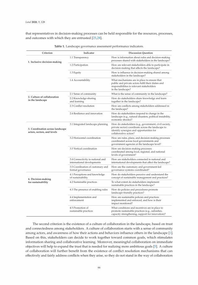
Land 2020, 9, 128
that representatives in decision-making processes can be held responsible for the resources, processes,and outcomes with which they are entrusted [25,28].
Table 1. Landscape governance assessment performance indicators.
Criterion Indicator Discussion Question
1. Inclusive decision-making
1.1 Transparency How is information about rules and decision-makingprocesses shared with stakeholders in the landscape?
1.2 Participation How are relevant stakeholders able to participate indecision-making that affects the landscape?
1.3 Equity How is influence in decision-making shared amongstakeholders in the landscape?
1.4 Accountability What mechanisms are in place to ensure thatpublic and private actors fulfil their duties andresponsibilities to relevant stakeholdersin the landscape?
2. Culture of collaborationin the landscape
2.1 Sense of community What is the sense of community in the landscape?
2.2 Knowledge-sharingand learning
How do stakeholders share knowledge and learntogether in the landscape?
2.3 Conflict resolution How are conflicts among stakeholders addressed inthe landscape?
2.4 Resilience and innovation How do stakeholders respond to change in thelandscape (e.g., natural disasters, political instability,economic shocks)?
3. Coordination across landscapeactors, sectors, and levels
3.1 Integrated landscape planning How do stakeholders (e.g., government, civil society,private sector) coordinate across the landscape toidentify synergies and opportunities forcollaborative action?
3.2 Horizontal coordination How are rules, plans, and decision-making processescoordinated across local governments andgovernment agencies at the landscape level?
3.3 Vertical coordination How are decision-making processescoordinated among local, regional, and nationallevels of government?
3.4 Connectivity to national andinternational developments
How are stakeholders connected to national andinternational developments that affect the landscape?
3.5 Coordination of customary andformal governance
How are the customary and government-ledgovernance systems coordinated?
4. Decision-makingfor sustainability
4.1 Perceptions and knowledgeof sustainability
How do stakeholders perceive and understand theconcept of sustainable management and practices?
4.2 Sustainable practices To what extent do stakeholders implementsustainable practices in the landscape?
4.3 The presence of enabling rules How do policies and procedures promotelandscape-friendly practices?
4.4 Implementation andenforcement
How are sustainable policies and practicesimplemented and enforced, and how is theirimpact monitored?
4.5 Promotion ofsustainable practices
What conditions and incentives are in place topromote sustainable practices (e.g., subsidies,capacity strengthening, support for innovation)?
The second criterion is the existence of a culture of collaboration in the landscape, based on trustand connectedness among stakeholders. A culture of collaboration starts with a sense of communityamong actors, and awareness of how their actions and behaviors influence others in the landscape [1].Based on this, stakeholders can decide to work together toward common goals, which stimulatesinformation sharing and collaborative learning. Moreover, meaningful collaboration on immediateobjectives will help to expand the trust that is needed for realizing more ambitious goals [5]. A cultureof collaboration will further benefit from the existence of conflict resolution mechanisms that caneffectively and fairly address conflicts when they arise, so they do not stand in the way of collaboration
66

Land 2020, 9, 128
in the future [18]. Finally, a culture of collaboration is expected to contribute to collective planning andaction, fostering resilience and innovations that are needed to address complex challenges [18,29].
The third criterion is coordination between actors across sectors and levels. Better coordinationis likely to help minimize trade-offs and maximize synergies between different interests in thelandscape [12,30]. Coordination can be improved through the collaborative development of integratedplanning frameworks. Moreover, coordination implies alignment of planning and decisions acrosstechnical sectors (e.g., agriculture, environment, rural development, water) and jurisdictional levels(local, regional, national, international). It may also require better coordination between customaryand formal governance institutions [31].
The fourth and final criterion is decision-making for sustainability. Ideally, the decisions made bypublic, private, and civic actors promote practices that limit the degradation of forests, grasslands,soils, and waterbodies, and contribute to their restoration [32,33]. This requires adequate knowledgeand awareness on the meaning and importance of sustainability, policies and regulations that directlypromote sustainable practices, and the actual implementation and enforcement of these policies andregulations. Finally, there are other governance processes that could stimulate sustainable thinkingand action in the landscape, such as access to support, capacity strengthening, and investmentsin innovation.
2.3. Assessing Landscape Governance in Participatory Workshops
Based on the set of criteria and indicators introduced above, we developed a landscapegovernance assessment method. It provides a simple and cost-effective tool to assess the statusof landscape governance at different points in time, as part of the GLA’s monitoring and evaluationframework. In addition, implementing the assessment provides an opportunity for landscape actorsto discuss possibilities for improvement and plan for collaborative action, thus contributing toimproved governance.
The method involves a two-day participatory workshop with stakeholders from the landscape.First, participants discuss how governance processes are currently organized in their landscape.The standard criteria and indicators are used as a discussion framework, but there is room to addadditional criteria and indicators. This part of the workshop provides an opportunity for stakeholdersto discuss (and learn about) the criteria and indicators, and to exchange knowledge and perspectives.Second, participants discuss what they would like to see change in the future, using the Rich Picturemethodology [34]. Third, participants score the current performance of the governance of their landscapeon all indicators. The scoring is done individually, using a straightforward 5-point Likert scale, from verypoor (0) to very good (+5). After scoring, the results are presented and discussed. The final part of theworkshop is then used to discuss what would need to be done in practical terms to move from the currentsituation to the desired situation. For a full description of the tool, see De Graaf et al. (2017) [27].
The method aims to create a shared understanding of how governance processes are organized inthe landscape, but it is not meant to be prescriptive or to compare this to a predetermined standard.Instead it relies on the perceptions and ideas of the actors in the landscape, to make their ownjudgement on the quality of these governance processes. This approach helps to uncover differences inaspirations and the desired characteristics of landscape governance that may exist between variousstakeholders. During the workshop, participants are actively encouraged to share their own knowledgeand experiences with others. This increases the understanding of the governance system, providesinsight in the different perspectives and interests, and shows the difficulties associated with prioritizingthese different interests. Last, but not least, the workshop setting creates a space for participants toengage with others, which helps with developing a sense of community and trust.
In early 2017, staff from Tropenbos International and EcoAgriculture Partners trained 20 facilitatorsfrom GLA partner CSOs in Africa, Asia, and Latin America during a four-day workshop. The partnerCSOs then implemented the method in the 17 GLA landscapes. Partner CSOs would invite between 20and 40 participants for a two-day workshop, aiming for a balance between different stakeholder groups
67

Land 2020, 9, 128
and representation of a diversity of viewpoints. The list of invitees would include representatives of localcommunities and indigenous peoples, community-based organizations (e.g., women’s groups, farmerassociations and cooperatives), non-governmental organizations (e.g., rights-based organizations andconservation organizations), local governments, sectoral government agencies, small and mediumenterprises, and corporations active in the landscape.
The workshop served to kick off discussions and collaborations between stakeholders withinthe program, while also serving as a base line assessment for monitoring and evaluation. After eachworkshop, the facilitators wrote a report, presenting the scores as well as qualitative descriptions of thediscussions. In 2020, similar workshops will be conducted in the same landscapes, to assess whetherand how landscape governance has changed over time. Table 2 presents the 14 landscapes for whichthe quantitative assessment data is available. Qualitative workshop reports were produced for allexcept the last two landscapes.
Table 2. Overview landscape assessments, implementing partners, and number of participants.
Landscape Partner Participants
1 Suriname: Upper Suriname River Tropenbos Suriname 23
2 Democratic Republic of the Congo: Bafwasende Tropenbos DRC 20
3 Nigeria: Akamkpa ERA 32
4 Uganda: Kalangala NAPE 25
5 Viet Nam: Upper Srepok River Basin Tropenbos Vietnam 23
6 Indonesia: Gunung Tarak (Kalimantan) Tropenbos Indonesia 26
7 Indonesia: South Solok (Sumatra) WARSI 30
8 Indonesia: Lariang Watershed (Sulawesi) NTFP-EP 20
9 Philippines: General Nakar NTFP-EP 24
10 Philippines: Northern Sierra Madre Nature Park Mabuwaya Foundation 41
11 Philippines: Cagayan de Oro River Basin (Pilot) Samdhana 38 (day 1)27 (day 2)
12 Philippines: Upper Tagoloan River Basin Forest FoundationPhilippines 28
13 Philippines: Puerto Princesa Subterranean RiverNational Park (Palawan)
Forest FoundationPhilippines 20
14 Philippines: Mt. Mantalingahan ProtectedLandscape (Palawan)
Forest FoundationPhilippines 18
Assessments were also conducted in Ghana, Liberia, and Bolivia, but at the time of writing this data is not yet available.
3. Results
We reviewed the workshop reports for general patterns and lessons. We found that the indicatorswith the lowest mean scores generated the most insightful discussions about ways in which governancecould be improved. The indicators with the lowest mean scores were: equity (Indicator 1.3); integratedlandscape planning (Indicator 3.1); and implementation and enforcement (Indicator 4.4). Below wewill address each of these indicators in some more detail, based on the qualitative descriptions of theseindicators in the different landscapes.
3.1. Stakeholders Do Not Have Equal Opportunities to Influence Decision-Making
Inequality in decision-making is one of the biggest concerns among workshop participantsin all landscapes. The influence of local communities and Indigenous Peoples on landscape-leveldecisions was often considered sub-optimal. Governments tend to be in control of important decisionsin the landscape, such as the planning of infrastructural projects and the issuance of plantation,
68

Land 2020, 9, 128
logging, and mining permits. Some governments organize consultations, where landscape actorscan comment on development plans. However, non-government participants would often point atthe lack of procedures and mechanisms that allow for structural and meaningful participation inthese planning processes. A common observation is that more powerful landscape actors, such asplantation companies, are better able to make use of opportunities to influence decision-making,because they have the necessary resources to participate, more access to information, and often havedirect access to government officials. Further discussions also revealed bottlenecks at the communitylevel. Participants in the Kalangala Landscape, Uganda, for example, mentioned that the districtgovernment had been inviting community representatives to participate in meetings, but that theseseldom showed up, due to a lack of confidence to participate.
Participants also used the discussion on this indicator to point at inequalities between communitymembers at the village level. In two-thirds of the workshop reports it is stressed that women are in adisadvantageous position, and lack representation in decision-making. Some reports further mentionthat village-level decision-making processes are dominated by village elites, and such intra-villageinequalities (in terms of both decision-making power and wealth) are further exacerbated as soon ascompanies start offering material benefits to customary leaders and village elites, to win their support.
Across the board, CSOs are considered key actors to promote equality in decision-making.They may help create opportunities for marginalized groups to share their views or raise their voice,and invest in their capacity to do so. For example, CSOs may support representatives of marginalizedgroups to participate in multi-stakeholder workshops and meetings, helping them to voice theirconcerns and share these with other actors in the landscape. There are also CSOs that supportmarginalized groups to access justice in courts, while other CSOs help to organize local actors informal structures (such as cooperatives, community-based enterprises, and women’s groups), to givetheir voices more weight in political arenas. At the same time, it was stressed that the inclusionof marginalized groups can not depend on CSO support alone, and that governments should alsotake responsibility to strengthen capacities of marginalized groups and ensure their participationin decision-making.
3.2. Integrated Landscape Planning Efforts Remain Noncommittal
In many landscapes, stakeholders highlighted the need for better alignment and coordination ofplans in the landscape. Sometimes there are efforts to improve coordination between stakeholders atthe landscape level. In Uganda, for example, participants mentioned that CSOs occasionally organizecoordination meetings, where stakeholders get together to discuss pressing issues. Despite such efforts,mistrust between stakeholders is common, and planning processes often lack transparency. In somecases, there had been integrated landscape planning initiatives, but these lacked synchronizationwith existing government planning processes. When push comes to shove, sectoral planning throughmandated government agencies tends to override well-intended multi-stakeholder planning exercises.
Discussions also revealed that government representatives and other landscape actors mayhave different ideas about the meaning of ‘coordination’. Government officials would present theirefforts to create awareness about government plans as a form of coordination. Other stakeholders,however, would argue that such awareness programs are one-way traffic, with the government sendinginformation to other actors. Overall, it is uncommon for governments to facilitate coordination betweenactors towards integrated landscape planning.
3.3. Weak Implementation and Enforcement of Regulations
In many landscapes, the regulations to promote sustainable land use and management exist. Thereis usually a range of government-devised prohibitions and requirements, such as a limitation to accessforest reserves and national parks, a ban on hunting in certain periods of the year, a moratorium onplantations in peat areas, and reporting requirements for logging and sustainable forest management.
69

Land 2020, 9, 128
However, the implementation and enforcement of these regulations is generally considered inadequate.Indeed, the indicator ‘implementation and enforcement’ had the lowest score of all indicators.
A common perspective is that local governments do not have sufficient capacity and resources (andsometimes willingness) to implement and enforce government regulations. The lack of enforcementcreates opportunities for other actors to circumvent the rules. In the Bafwasende landscape in theDemocratic Republic of the Congo, stakeholders stressed that regulations are established by legaltexts, but in the field it is the ‘law of the strongest’ that prevails. The lack of adequate governmentmonitoring was brought up in 11 out of 12 workshop reports. When government monitoring fails,CSOs may try to fill the gap, by monitoring illegal activities themselves, but public and private actorsoften ignore the results of CSO monitoring. Though watchdog CSOs have little or no power to enforcecompliance themselves, they can use their monitoring results to raise attention in the media andmobilize communities to pressure other parties.
Corruption is mentioned as a major problem in half of all the landscapes. In the Kalangalalandscape in Uganda, stakeholders argued that powerful individuals are able to influence policies,law enforcement, and the judicial system to their own advantage. Local government officials, who oftenstay in one area for a long time, establish personal relationships with businesses, and are thereforeprone to corruption.
During the workshops, CSO and community representatives often stressed the importanceof customary norms and rules. In the Akamkpa landscape in Nigeria, for example, parts of theforest cannot be used, because they are dedicated to spirits. Furthermore, eating of certain animalsis considered taboo, according to local customs. Such customary regulations are not immune toimplementation and enforcement challenges. Customary authorities may have their own enforcementsystems in place, but these are increasingly challenged by outsiders and younger generations. This isbecause they are either not aware of them, or simply attach less value to customary practices andbeliefs, such as the idea that nature will punish villagers when they violate customary rules.
3.4. Suggestions to Improve Landscape Governance
The last part of each workshop was used to discuss practical next steps to improve landscapegovernance. Three suggestions appeared common. The first is for the government to explicitlyrecognize traditional knowledge and rights, and to align government regulations with customarygovernance systems. In line with this, CSOs would need to invest in the capacity of traditional leaders,so they can effectively coordinate with government agencies.
Second, governments were urged to step up effort in support of sustainable practices, by investingin the monitoring and halting of illegal activities, implementing environmental impact assessments,developing incentives for sustainable enterprise development, and raising environmental awareness.Governments are also called upon to support the creation of a safe operational space for civilsociety organizations.
Third, 75% of the workshop reports suggest to invest in a multi-stakeholder mechanism, either byestablishing a new institutional arrangement, or by strengthening an existing one. This is expectedto contribute to all four criteria of inclusive landscape governance for sustainable development:enabling more active involvement of marginalized groups in discussions and negotiations with others;promoting information sharing and coordination between stakeholders; building trust and stimulatingcooperation; and providing a place to discuss and initiate sustainable management.
4. Discussion
The objective of the GLA program is to strengthen the role of CSOs to contribute to inclusivelandscape governance for sustainable development. The landscape governance assessments conductedat the start of the program helped to shed a light on the various perceptions on landscape governanceprocesses, and the desired changes in the future. Discussing ways to improve governance, workshop
70
Land 2020, 9, 128
participants often would stress the need for some kind of multi-stakeholder process, to bring stakeholderstogether to discuss, negotiate, and develop common solutions to challenges in the landscape.
This is in concordance with literature on landscape approaches and integrated landscape initiatives,which stress the importance of multi-stakeholder arrangements, enabling processes of negotiation, learning,and adaptation between diverse stakeholders across scales, sectors, and knowledge systems [2–5,35].Efforts to implement a landscape approach often aim to develop or strengthen institutional arrangementsfor multi-stakeholder processes, for example in the form of platforms, coalitions, forums, partnerships,and co-management boards. These are spaces where public, private, and civil society actors can discusstheir respective agendas, and collaboratively identify options to balance the various interests that existin the landscape [12,36,37]. Failure to develop a common agenda, and effectively engage differentstakeholders is seen as a main cause of poor performance of landscape approaches [2,38].
In line with the above, several GLA partner CSOs took on the role of convening multi-stakeholderprocesses in their landscapes, providing opportunities for stakeholders to share ideas, identify commonprinciples, and develop collaborative action. This has been a process of trial and error. Below wehighlight general lessons related to the role of CSOs in convening multi-stakeholder processes tostrengthen landscape governance, based on our own experiences in the GLA program and discussionswith GLA partners.
4.1. Build Capacity and Trust First
Convening organizations will need to consider carefully whether the necessary conditions foreffective and inclusive multi-stakeholder processes are in place. Two of the most important conditionsare trust and capacity among actors in the landscape. When the level of trust is low, stakeholdersmay not even want to sit at the same table, for example because they are intimidated by other actors,or skeptical of their intentions. Moreover, marginalized groups may neither have the capacity nor theconfidence to meaningfully engage in discussions and negotiations with other stakeholders. In suchcases, it is necessary to first focus efforts on improving trust between stakeholders, and building thecapacity of weaker actors, for example by helping smallholders and indigenous communities to organizethemselves, access relevant information, learn about their rights, and develop negotiation skills.
4.2. Provide Clarity about Goals and Expectations
Multi-stakeholder processes have high opportunity and transaction costs for all involved [39],and stakeholders are more likely to engage if they expect that the long-term rewards will outweigh thecosts, be it monetary or otherwise [2]. CSOs that convene multi-stakeholder processes will therefore needto be explicit about goals. The identification of a concrete challenge that connects the various stakeholderscan act as a common agenda. After a short- or medium-term goal has been determined, the convenorwill have to define the expected outcomes as clearly and realistically as possible, and communicate thiswith stakeholders. It should also provide clarity about responsibilities, timeframes, mandates, and theability of the convenor to be engaged in follow-up activities. This is important to convince actors toparticipate in the process, as well as to prevent unrealistic expectations. The convenor will have to find abalance between defining a context-specific objective and expectations at the onset, while at the same timeensuring flexibility, so that stakeholders can adjust objectives over time.
4.3. Engage the Private Sector
In many landscapes private companies are main drivers of change, but they are often reluctant toengage in multi-stakeholder processes. Our experience with organizing the landscape governanceassessment workshops serves as a case in point; private companies were not interested to participate,because they did not see how it could work in their advantage. To ensure private sector participation,convening organizations will need to proactively look for frontrunning companies, and developa business case for their engagement. Some of the elements of the business case may be related
71

Land 2020, 9, 128
to the company’s need to mitigate the risks of conflicts with communities, reputational damage,and decreasing long-term supply in the face of climate change and environmental degradation [40,41].
4.4. Connect to Policy Processes
The extent to which a multi-stakeholder process results in policy changes depends on the way itis connected to local government agencies that are in charge of spatial planning and the developmentof land-use rules and regulations at the landscape level. CSOs may connect to these agencies byconvening multi-stakeholder processes that provide direct input into ongoing policy debates anddecision-making (e.g., the development or revision of a spatial plan), and by actively engaging seniorgovernment officials in these processes [42]. Alternatively, rather than taking on the role of convenor,a CSO can assist a local government agency to adopt and incorporate multi-stakeholder processes inits modus operandi. This is likely to require changes in government procedures as well as attitudes.CSOs can help with building capacity and willingness within a local government to adjust its role fromauthority to facilitator, guiding bottom-up processes, and opening up decision-making procedures forother stakeholders.
4.5. Be Explicit about Interests and Values
Landscape actors do not only have different interests, they may also have different values.To enable constructive discussions, convening organizations can help to create openness aboutstakeholders’ values and intentions—including their own. These are not always explicit. Sometimesa CSO or a research institute functions as a bridging or boundary organization, which implies itdoes not have a clearly defined local objective. Instead, they support dialogue among stakeholders,aiming to contribute to the joint identification of challenges, mediating conflicts, and discussingsolutions [18,43–45]. Such boundary organizations are seen as impartial by the other stakeholders,but they are not necessarily value neutral, as they often try to link local interests to global objectives,e.g., concerning climate change and biodiversity [46].
4.6. Consider the Limitations of Interventions Establishing New Arrangements
Multi-stakeholder processes are en vogue. As part of donor-funded landscape-level projectsand programs, CSOs are increasingly expected to convene multi-stakeholder processes. This is oftenoperationalized through the establishment of a new institutional arrangement, such as a platform or amanagement board, where landscape actors can meet on a regular basis. It may raise complex questionsconcerning participation (who is invited? who shows up?) and representation (who represents who?are representatives accountable?). Furthermore, there is a risk that the institutional arrangementbecomes a goal in itself—a box-ticking exercise to satisfy donor demands. Making sure that such anarrangement continues operating after donor support falls away requires firm embeddedness withan institutional host and continued facilitation [47]. We argue that efforts to strengthen landscapegovernance need to build on what is already there, strengthening existing forms of collaboration andcoordination in the landscape. This ensures embeddedness and local ownership. Emphasis should beon increasing the possibilities for local stakeholders to play a role in ongoing governance processes,by building trust and capacity, including understanding of governance processes. This demands aflexible and adaptive role of the convening organization, which is harder to plan for, and does not fit inwell with more rigid project cycles.
5. Conclusions
Based on landscape governance assessments in landscapes across Africa, Asia, and LatinAmerica, we conclude that landscape stakeholders often do not have equal opportunities to influencedecision-making, that integrated landscape planning efforts tend to remain noncommittal, and thatimplementation and enforcement of regulations is often weak. We also found that multi-stakeholderprocesses are widely considered key to achieving inclusive landscape governance for sustainable
72

Land 2020, 9, 128
development. They are expected to help align and integrate planning and decision-making processesof different actors.
Such multi-stakeholder processes can take many shapes and forms. In the context of donor-fundedprojects—requiring clearly defined activities, outputs, and outcomes—a CSO may decide to design, initiate,and facilitate a multi-stakeholder process through a new institutional arrangement. Such arrangementsmean to provide a space where stakeholders can meet periodically to discuss, negotiate, and plan forcollaborative action.
However, such new multi-stakeholder arrangements initiated by outside actors may face variouschallenges, such as the lack of a clear local mandate and insufficient embeddedness in the existinggovernance system. Moreover, landscapes tend to be contested spaces, with large differences ininterests between various actors. In this context, it would be naïve to assume that bringing stakeholderstogether in a new institutional arrangement will bring the result of collaborative action to addresslandscape-level challenges.
In practice, a landscape governance system is a complex and fluid web of rules and decision-makingprocesses, which is influenced by the distribution of power and the ability of stakeholders to defendtheir own interests. Furthermore, although a governance system encompasses public, private, andcivic actors, its outcomes will largely depend on the presence of an effective (local) government that isaccountable to its citizens, has the legitimacy to make decisions, and has the legal backing and capacityto enforce rules and regulations.
In any effort to strengthen landscape governance, we stress the need to understand and build onwhat exists, and work with landscape actors to improve existing processes in the landscape. We believethere is a role for CSOs to support landscape actors to develop procedures for discussing and negotiatingwithin their landscape, and to strengthen the capacity of local governments to ensure meaningful inputfrom all stakeholders in landscape decisions. Next to that, CSOs can work with different constellationsof landscape stakeholders to help develop a shared understanding of developments, threats, underlyingcauses, governance processes, and possibilities for collaborative action. Similarly, they can facilitatevaluable monitoring and evaluation systems for tracking the effects of agreed action agendas in thelandscapes including the strengthening of governance. CSOs can also increase trust, strengthen weakerstakeholders, and create capacity, interest, and enthusiasm of stakeholders to take up their own role inlandscape governance.
The method presented in this paper can be used in its current or adapted form for practicalapplications as part of integrated landscape initiatives. It could also be used in action-research settings,informing the implementation of interventions, while gathering data on (changes to) perceptions onlandscape governance. However, assessment scores gathered in participatory workshops should notbe treated as hard data, as their quality and comparability depend on the composition of the groupof participants, the participants’ understanding of the indicators, and, related to that, the quality offacilitation. Despite such limitations, we hope that CSOs as well as action researchers will build on themethod presented in this article to further support landscape stakeholders, ultimately contributing toinclusive landscape governance for sustainable development.
Author Contributions: Conceptualization and methodology: M.D.G., L.B., and R.Z.; Investigation: M.D.G., K.G.,A.M., H.M., T.H.N., and E.P.; Project administration: M.D.G. and R.Z.; Formal analysis: M.D.G., K.K., and R.Z.;Writing—original draft: K.K. and M.D.G.; Writing—review & editing: K.K., M.D.G., L.B., K.G., A.M., H.M., T.H.N.,E.P., and R.Z. All authors have read and agreed to the published version of the manuscript.
Funding: This research was funded by the Directorate-General for International Cooperation (DGIS) of TheNetherlands, grant number 27549, and the CGIAR Research Program on Forests, Trees and Agroforestry (FTA).
Acknowledgments: The methodology was developed with the help of Seth Shames of EcoAgriculture Partners,and benefitted from feedback of the Dutch national committee of the International Union for Conservation ofNature (IUCN NL), Milieudefensie (Friends of the Earth Netherlands), and the facilitators of the landscapegovernance assessment workshops. The article also benefitted from the comments of three anonymous reviewers.
Conflicts of Interest: The authors declare no conflict of interest. The sponsors had no role in the design, execution,interpretation, or writing of the study.
73
Land 2020, 9, 128
References
1. Arts, B.; Buizer, M.; Horlings, L.; Ingram, V.; van Oosten, C.; Opdam, P. Landscape Approaches:A State-of-the-Art Review. Annu. Rev. Environ. Resour. 2017, 42, 439–463. [CrossRef]
2. Reed, J.; Barlow, J.; Carmenta, R.; van Vianen, J.; Sunderland, T. Engaging multiple stakeholders to reconcile climate,conservation and development objectives in tropical landscapes. Biol. Conserv. 2019, 238, 108229. [CrossRef]
3. Estrada-Carmona, N.; Hart, A.K.; DeClerck, F.A.; Harvey, C.A.; Milder, J.C. Integrated landscape managementfor agriculture, rural livelihoods, and ecosystem conservation: An assessment of experience from LatinAmerica and the Caribbean. Landsc. Urban. Plan. 2014, 129, 1–11. [CrossRef]
4. Milder, J.C.; Hart, A.K.; Dobie, P.; Minai, J.; Zaleski, C. Integrated landscape initiatives for African agriculture,development, and conservation: A region-wide assessment. World Dev. 2014, 54, 68–80. [CrossRef]
5. Sayer, J.; Sunderland, T.; Ghazoul, J.; Pfund, J.-L.; Sheil, D.; Meijaard, E.; Venter, M.; Boedhihartono, A.K.;Day, M.; Garcia, C. Ten principles for a landscape approach to reconciling agriculture, conservation, andother competing land uses. Proc. Natl. Acad. Sci. USA 2013, 110, 8349–8356. [CrossRef]
6. Lemos, M.C.; Agrawal, A. Environmental Governance. Annu. Rev. Environ. Resour. 2006, 31, 297–325. [CrossRef]7. Jordan, A.; Lenschow, A. Environmental policy integration: A state of the art review. Environ. Policy Gov.
2010, 20, 147–158. [CrossRef]8. Mbow, C.; Neely, C.; Dobie, P. How can an integrated landscape approach contribute to the implementation
of the Sustainable Development Goals (SDGs) and advance climate-smart objectives. In Climate-SmartLandscapes: Multifunctionality in Practice; Minang, P.A., Van Noordwijk, M., Freeman, O.E., Mbow, C.,Leeuw, J., Catacutan, D., Eds.; World Agroforestry Centre (ICRAF): Nairobi, Kenya, 2015; pp. 103–117.
9. Reed, J.; Van Vianen, J.; Deakin, E.L.; Barlow, J.; Sunderland, T. Integrated landscape approaches to managingsocial and environmental issues in the tropics: Learning from the past to guide the future. Glob. Chang. Biol.2016, 22, 2540–2554. [CrossRef]
10. Scherr, S.J.; Wertz, L. Integrated landscape approach to using restoration to help achieve multiple SDGs.In Land Restoration for Achieving the Sustainable Development Goals; International Resource Panel, UnitedNations Environment Programme: Nairobi, Kenya, 2019.
11. Salvemini, D.; Remple, N. Community-based approaches to landscape management. In Towards productivelandscapes; Chavez-Tafur, J., Zagt, R., Eds.; Tropenbos International: Wageningen, The Netherlands, 2014.
12. Kozar, R.; Buck, L.E.; Barrow, E.G.; Sunderland, T.C.H.; Catacutan, D.E.; Planicka, C.; Hart, A.K.; Willemen, L.Toward Viable Landscape Governance Systems: What Works? EcoAgriculture Partners: Washington, DC, USA, 2014.
13. Denier, L.; Scherr, S.; Shames, S.; Chatterton, P.; Hovani, L.; Stam, N. The Little Sustainable Landscapes Book:Achieving Sustainable Development Through Integrated Landscape Management; Global Canopy Programme:Oxford, UK, 2015.
14. McGonigle, D.F.; Rota Nodari, G.; Phillips, R.L.; Aynekulu, E.; Estrada-Carmona, N.; Jones, S.K.; Koziell, I.;Luedeling, E.; Remans, R.; Shepherd, K.; et al. A Knowledge Brokering Framework for Integrated LandscapeManagement. Front. Sustain. Food Syst. 2020, 4, 1–20. [CrossRef]
15. Buizer, M.; Arts, B.; Westerink, J. Landscape governance as policy integration ‘from below’: A case of displacedand contained political conflict in The Netherlands. Environ. Plan. C Gov. Policy 2016, 34, 448–462. [CrossRef]
16. Robinson, L.W.; Ontiri, E.; Alemu, T.; Moiko, S.S. Transcending landscapes: Working across scales and levelsin pastoralist rangeland governance. Environ. Manag. 2017, 60, 185–199. [CrossRef] [PubMed]
17. Van Oosten, C.; Uzamukunda, A.; Runhaar, H. Strategies for achieving environmental policy integrationat the landscape level. A framework illustrated with an analysis of landscape governance in Rwanda.Environ. Sci. Policy 2018, 83, 63–70. [CrossRef]
18. Ros-Tonen, M.; Derkyi, M.; Insaidoo, T. From co-management to landscape governance: Whither Ghana’smodified taungya system? Forests 2014, 5, 2996–3021. [CrossRef]
19. Ostrom, E. Beyond Markets and States: Polycentric Governance of Complex Economic Systems. Am. Econ.Rev. 2010, 100, 641–672. [CrossRef]
20. Nagendra, H.; Ostrom, E. Polycentric governance of multifunctional forested landscapes. Int. J. Commons2012, 6, 104–133. [CrossRef]
21. Ros-Tonen, M.A.; Reed, J.; Sunderland, T. From synergy to complexity: The trend toward integrated valuechain and landscape governance. Environ. Manag. 2018, 62, 1–14. [CrossRef]
74
Land 2020, 9, 128
22. Görg, C. Landscape governance: The “politics of scale” and the “natural” conditions of places. Geoforum2007, 38, 954–966. [CrossRef]
23. Arts, B.; Buizer, M. Forests, discourses, institutions: A discursive-institutional analysis of global forestgovernance. For. Policy Econ. 2009, 11, 340–347. [CrossRef]
24. Blomley, T.; Walters, G. (Eds.) A Landscape for Everyone: Integrating Rights-Based and Landscape GovernanceApproaches; IUCN, International Union for Conservation of Nature: Gland, Switzerland, 2019.
25. Kusters, K.; Buck, L.; de Graaf, M.; Minang, P.; van Oosten, C.; Zagt, R. Participatory planning, monitoringand evaluation of multi-stakeholder platforms in integrated landscape initiatives. Environ. Manag. 2018, 62,170–181. [CrossRef]
26. Dale, A.P.; Vella, K.; Gooch, M.; Potts, R.; Pressey, R.L.; Brodie, J.; Eberhard, R. Avoiding implementationfailure in catchment landscapes: A case study in governance of the Great Barrier Reef. Environ. Manag. 2018,62, 70–81. [CrossRef]
27. De Graaf, M.; Buck, L.; Shames, S.; Zagt, R. Assessing Landscape Governance: A Participatory Approach;Tropenbos International and EcoAgriculture Partners: Wageningen, The Netherlands, 2017.
28. Minang, P.A.; Van Noordwijk, M.; Freeman, O.E.; Catacutan, D. (Eds.) Climate-Smart Landscapes:Multifunctionality in Practice; World Agroforestry Centre (ICRAF): Nairobi, Kenya, 2015.
29. Bailey, I.; Buck, L.E. Managing for resilience: A landscape framework for food and livelihood security andecosystem services. Food Secur. 2016, 8, 477–490. [CrossRef]
30. Shames, S.A.; Heiner, K.; Scherr, S.J. Public Policy Guidelines for Integrated Landscape Management; EcoAgricultureand Partners, and Landscapes for people, Food and Nature: Washington, DC, USA, 2017.
31. Riggs, R.; Langston, J.; Margules, C.; Boedhihartono, A.; Lim, H.; Sari, D.; Sururi, Y.; Sayer, J. GovernanceChallenges in an Eastern Indonesian Forest Landscape. Sustainability 2018, 10, 169. [CrossRef]
32. Scherr, S.J.; Buck, L.; Willemen, L.L.J.M.; Milder, J.C. Ecoagriculture: Integrated landscape management for people,food and nature. In Encyclopedia of Agriculture and Food Systems; Academic Press: London, UK, 2014; pp. 1–17.
33. Buck, L.E.; Scherr, S.J. Moving Ecoagriculture into the mainstream. In State of the World: Innovations thatNourish the Planet. A Worldwatch Institute Report on Progress Toward a Sustainable Society; WW Norton &Company: New York, NY, USA, 2011.
34. Brouwer, J.H.; Woodhill, A.J.; Hemmati, M.; Verhoosel, K.S.; van Vugt, S.M. The MSP Guide: How to Design andFacilitate Multi-stakeholder Partnerships; Practical Action Publishing Ltd.: Wageningen, The Netherlands, 2016.
35. Hart, A.K.; Milder, J.C.; Estrada-Carmona, N.; DeClerck, F.A.J.; Dobie, P. Integrated landscape initiatives inpractice: Assessing experiences from 191 landscapes in Africa and Latin America. In Climate-smart Landscapes:Multifunctionality in Practice; Minang, P.A., Van Noordwijk, M., Freeman, O.E., Mbow, C., De Leeuw, J.,Catacutan, D., Eds.; World Agroforestry Centre (ICRAF): Nairiobi, Kenya, 2015.
36. Zagt, R.J.; Chavez-Tafur, J. Towards productive landscapes—A synthesis. In Towards Productive Landscapes;Tropenbos International: Wageningen, The Netherlands, 2014.
37. Kusters, K. Climate-smart Landscapes and the Landscape Approach: An. Exploration of the Concepts and TheirPractical Implications; Tropenbos International: Wageningen, The Netherlands, 2015.
38. Reed, J.; van Vianen, J.; Barlow, J.; Sunderland, T. Have integrated landscape approaches reconciled societaland environmental issues in the tropics? Land Use Policy 2017, 63, 481–492. [CrossRef]
39. Enengel, B.; Penker, M.; Muhar, A.; Williams, R. Benefits, efforts and risks of participants in landscapeco-management: An analytical framework and results from two case studies in Austria. J. Environ. Manag.2011, 92, 1256–1267. [CrossRef]
40. Scherr, S.J.; Shames, J.; Gross, L.; Borges, M.A.; Bos, G.; Brasser, A. Business for Sustainable Landscapes: An.Action Agenda to Advance Landscape Partnerships for Sustainable Development; EcoAgriculture Partners andIUCN, on behalf of the Landscapes for People, Food and Nature Initiative: Washington, DC, USA, 2017.
41. IDH Why Engaging in a Landscape Approach is Good for Business. Available online:https://www.idhsustainabletrade.com/news/case-studies-why-engaging-in-a-landscape-approach-is-good-for-business/ (accessed on 8 January 2020).
42. Kusters, K. Integrated Landscape Development: Lessons Learned by the Ecosystem Alliance; Ecosystem Alliance:Amsterdam, The Netherlands, 2015.
43. Cash, D.W.; Clark, W.C.; Alcock, F.; Dickson, N.M.; Eckley, N.; Guston, D.H.; Jäger, J.; Mitchell, R.B. Knowledgesystems for sustainable development. Proc. Natl. Acad. Sci. USA 2003, 100, 8086–8091. [CrossRef]
75
Land 2020, 9, 128
44. Ros-Tonen, M.; Pouw, N.; Bavinck, M. Governing beyond cities: The urban-rural interface. In Geographies ofUrban Governance; Springer: New York, NY, USA, 2015; pp. 85–105.
45. Clark, W.C.; Tomich, T.P.; Van Noordwijk, M.; Guston, D.; Catacutan, D.; Dickson, N.M.; McNie, E. Boundarywork for sustainable development: Natural resource management at the Consultative Group on InternationalAgricultural Research (CGIAR). Proc. Natl. Acad. Sci. USA 2016, 113, 4615–4622. [CrossRef]
46. Reyers, B.; Nel, J.L.; O’Farrell, P.J.; Sitas, N.; Nel, D.C. Navigating complexity through knowledge coproduction:Mainstreaming ecosystem services into disaster risk reduction. Proc. Natl. Acad. Sci. USA 2015, 112, 7362–7368.[CrossRef]
47. Sayer, J.; Endamana, D.; Boedhihartono, A.K.; Ruiz-Perez, M.; Breuer, T. Learning from change in the SanghaTri-national landscape. Int. For. Rev. 2016, 18, 130–139. [CrossRef]
© 2020 by the authors. Licensee MDPI, Basel, Switzerland. This article is an open accessarticle distributed under the terms and conditions of the Creative Commons Attribution(CC BY) license (http://creativecommons.org/licenses/by/4.0/).
76
land
Article
Unpacking Changing Multi-Actor and Multi-LevelActor Ties in Transformative Spaces: Insights froma Degraded Landscape, Machubeni, South Africa
Menelisi Falayi 1,*, James Gambiza 1 and Michael Schoon 2
1 Department of Environmental Science, Rhodes University, Makhanda 6140, South Africa; [email protected] School of Sustainability, Arizona State University Tempe, Tempe, AZ 85287-5502, USA;
[email protected]* Correspondence: [email protected]
Received: 4 June 2020; Accepted: 30 June 2020; Published: 13 July 2020
Abstract: The loss of ecosystem services through land degradation continues to be a significantconcern for policymakers and land users around the world. Facilitating collective action amongvarious actors is regarded as imperative in halting land degradation. Despite extensive research oncollective action, there have been few studies that continuously map social ties and detect networkevolution as a way of enabling longitudinal analysis of transformative spaces. This paper seeks toexamine the changing dynamics of multi-actor and multi-level actor ties over a period of two yearsin Machubeni, South Africa. To do this, we used social network analysis to detect continuities and/ordiscontinuities of multi-actor and multi-level actor ties over time. Overall, edge density, clusteringcoefficient, and reciprocity scores steadily increased over the two years despite a decline in the numberof active organisations within the network. Our results demonstrate that the proportion of strongties gradually increased over time across three governance networks. However, multi-level linkagesbetween the local municipality and the local organisations remained weak due to a lack of trust andcollaborative fatigue. While the transformative space has succeeded in enhancing collaboration andknowledge sharing between local organisations and researchers, further long-term engagement withgovernment agencies might be necessary for promoting institutional transformations and policyoutcomes, and building network resilience in complex polycentric governance systems.
Keywords: actors; collaboration; land degradation; learning; social capital; Social Network Analysis;transformative spaces
1. Introduction
Contemporary research shows that humanity is facing daunting environmental challenges that areincreasingly dynamic and complex [1,2]. The past century has seen drastic changes in social structures,institutions, relations, and customs. In particular, these changes have defined how societies interactwith one another and their ecosystems [3,4]. Ecosystem services play an important role in supportinghuman life on earth [5–7]. Here, we define ecosystem services as benefits that people obtain fromecosystems [8]. These benefits include food, fresh water, timber, natural medicines, climate regulation,and cultural values, amongst many others [8]. Given the importance of the Earth’s ecosystems to humanwell-being, unsustainable resource consumption and waste have forced us into a new planetary eraknown as the Anthropocene [1]. This is not surprising considering that the degradation of ecosystemservices through human activities is reported to be negatively impacting the coping capacity of at least3.2 billion people around the world [9]. For example, land degradation decreases the capacity and flowof ecosystem services [10], thereby undermining people’s livelihoods [11] and ultimately resulting
Land 2020, 9, 227; doi:10.3390/land9070227 www.mdpi.com/journal/land77

Land 2020, 9, 227
in livelihood erosion [12]. Despite accelerated biodiversity loss at both local and regional scales [5],environmental governance continues to be a major challenge [9,10].
There is general agreement that monocentric governance approaches in addressing environmentalproblems are inadequate [13]. This has prompted land users and policymakers to consider multi-actorand multi-level partnerships as a way to combat land degradation [14]. Here, multi-actor interactions aredescribed as horizontal connections that link actors across a single organisation level, while multi-levelinteractions are vertical connections that link actors across multiple organisational levels [15]. For thispaper, actors are groups or individuals that have a stake, right, or interest in land degradation and landrehabilitation initiatives [16]. These actors include natural resource users, grassroots organisations(hubs), government agencies, and research institutions.
The Intergovernmental Science-Policy Platform on Biodiversity and Ecosystem Services (IPBES)reports that land degradation can be addressed through multi-actor participation and dialogue thatrecognises the importance of knowledge co-production [9]. Multi-actor forums (multi-stakeholderforums) play a pivotal role in bringing together actors from different interest groups to havedialogues, share challenges, address complex problems, and develop policy action [17]. One keyprinciple of multi-actor forums is that they emphasize a democratic approach to reach decisions [18],thereby providing opportunities for representation of various groups drawn from the public, private,and voluntary sectors [17,19]. In recent years, multi-actor forums have received much attentionfrom policymakers and resource users for their potential to address many of the “good” governanceprinciples [18]. Several studies demonstrate the potential of multi-actor forums to address complexenvironmental challenges pertaining to climate change [20] and land degradation [16,21–23]. In researchon land rehabilitation, Zoumides et al. [16] recommended that the sustainability of land rehabilitationinitiatives might be achieved by institutionalising multi-actor forums. Such institutionalisationrequires new governance structures that overturn the business-as-usual approaches of collaborationand engagement.
In this context, actors face critical questions of how they can contribute towards social-ecologicaltransformations [24]. Here, transformation refers to “fundamental changes in structural, functional,rational and cognitive aspects of socio-technical-ecological systems that lead to new patterns ofinteractions and outcomes” [25] (p. 2). In other words, transformation refers to the process of profoundchange that leads to new outcomes or patterns [26–28]. Scoones et al. [29] argued that, in order toachieve the Sustainable Development Goals (SDGs), deliberate normative steering of transformationis necessary at both multi-actor and multi-level scales. Without detailing extensive debates ontransformations to sustainability, this article will focus on the changing dynamics of multi-actor andmulti-level ties in transformative spaces.
Transformative spaces are defined as “collaborative environments where actors investedin transformations can experiment with new mental models, ideas, and practices that can helpshift Social-Ecological Systems (SES) onto alternative paths” [30] (p. 2). It is essential to notethat transformative spaces are not transformations, but rather a form of readiness for a system totransform [14]. Put simply, transformative spaces act as starting points for institutional change throughvarious groups drawn from the public, private, and voluntary sectors. They engage in dialogue andcollaborative learning while reframing issues in a way that allows solutions [30,31]. In contrast toother participatory research designs that foster multi-actor engagement [17], transformative spacesare believed to be a promising stepping stone for SES transformations [32] and may lead to socialinnovation [33]. Here, social innovation is defined as a “process of learning and knowledge creationthrough which new problems are defined, and new knowledge is developed to solve them” [34] (p. 124).
It is believed that transformative spaces have the potential to enable systemic changes [31,33,35–40].Here, systemic changes refer to changes that pervade all parts of a system. An example includesthe Southern Africa Food Lab case study [33], which illustrates the importance of engaging withmulti-actors to respond to systemic challenges. This case study highlights that multi-actor dialogue isa prerequisite for innovative action and for developing new relationships. Other examples include the
78

Land 2020, 9, 227
involvement of marginalised actors within the formal policy dialogues in developing new opportunitiesfor intervention [36] and the importance of development actors in facilitating meetings that empowerwomen in dealing with cultural barriers [40]. Within such collaborative arrangements, researchers donot perform traditional functions of solely being scientific advisors. Instead, they play an active roleas “transformative space-makers” [39]. In this role, researchers play a pivotal role in selecting andorganising social actors in transformative spaces while balancing power dynamics [32].
Another critical aspect is that transformative spaces may enable actors to transform adversarialrelations and to foster new ways of working together [32]. However, in different circumstances,transformative spaces may ‘feel’ dangerous [31]. This is evident in the Food Lab case study wherepower-related tensions among participants created disgruntlement, thus reducing the safety ofothers [33]. This raises the case of whether transformative spaces are “safe” or “safe enough.”Here, “safe” means that transformative change involves learning where actors can freely expresstheir different views [41]. In other words, “safe” involves the concept of “learning, unlearning andrelearning.” We believe that, for a system to transform, changes might need to happen at a personallevel first [32]. Therefore, understanding how actors interact within transformative spaces is criticalfor enabling or disabling systemic changes; however, the Monitoring and Evaluation (M&E) of thesespaces is often ignored [32].
Despite an increase in the number of studies that focus on transformative thinking in the GlobalSouth, according to our literature search, no studies have managed to track how collaborative tieschange over time within these spaces. Understanding the emerging collaborative ties is critical fortracking network evolution, highlighting the emergence of central and weak actors across and withinscales, and comprehending system perceptions that may hinder or enable effective collaboration.Here, we contribute to the literature on transformative spaces and collaborative institutions by exploringthe network evolution of the Masibambisane multi-actor forum between 2018 and 2020. Our studyseeks to fill the gap in knowledge on how changing ties over time influence the flow of informationsharing, inter-organisational trust, and views of shared goals within transformative spaces in SouthAfrica. The case study area chosen for this endeavour is regarded as one of the most degraded areasin South Africa [42] and has dynamic environmental governance systems [43]; therefore, findings mayhelp develop solutions to land degradation issues. By introducing the temporal aspects of how changeoccurs, we seek to understand the changing dynamics and system perceptions of how actors makedecisions within transformative spaces over time.
A social-relational network perspective was applied to identify continuities and/or discontinuitiesof multi-actor and multi-level connections in transformative space between 2018 and 2020.Here a social-relational network perspective is defined as a set of actors (institutions or hubs) that areconnected by a set of social relationships that enables the flow of information, inter-organisationaltrust, and views of shared interests.
The specific objectives include: (a) to identify what kind of social-relational connectionsdominated the transformative space between 2018 and 2020; (b) to identify which actors dominate thetransformative space; (c) to examine system perceptions, i.e., barriers and enablers; and, (d) to see whatstrategies can be developed to support the priority needs of the transformative space. This study buildsexplicitly upon and extends emerging research focusing on transformative spaces as platforms fortransformative dialogue, collaboration, and exchange of knowledge between actors that previously didnot have dialogues [31,33,39]. This article is organised as follows: in the following section, we outlinea brief discussion of the theoretical underpinning; the next section includes a detailed overviewof the case study area and an account of the research methods used to answer the key questions;the results section follows, and describes the changing relational pattern of multi-actor ties within thetransformative space and actors’ perceptions of barriers to effective collaboration and coordination;the paper concludes by discussing the critical implications of the findings.
79
Land 2020, 9, 227
2. Theoretical Background
Linking Social Capital, Polycentrism, and Social Network Analysis
Social capital is used to describe personal relationships within networks that help to build trust,norms of reciprocity, and community participation [44]. In other words, social capital is a mechanism bywhich social relational ties are created among diverse groups, with norms of reciprocity [45]. Social tiesare composed of several key components: trust, shared norms, information channels, and authority [46].One key advantage of examining social capital is that it provides a holistic approach to understandinghow cultural, social, and institutional dynamics of communities affect their capacity for dealing withcollective action problems [47]. In terms of natural resource governance, social capital is viewed asa critical institutional mechanism that enables collective action and cooperation across scales [47].In that way, social capital is essential to successful collaboration, learning, sharing of knowledge,and developing new ideas [48]. An example includes the Mexico case study, which illustrates thateffective social capital can enhance collaboration among different institutions [49]. Most importantly,trust is viewed as a central linkage between social capital and collective action. Trust is definedas a “particular level of subjective probability with which an actor assesses that another actor willperform a particular action” [50] (p. 217). Put simply, trust enables actors to work together oncommon issues [44]. By establishing common goals and trust processes, actors may have the potentialto transform adversarial relations and to foster new ways of working together across scales [51].Drawing from social capital theory, we seek to measure the evolving multi-actor and multi-level tiesin polycentric governance systems, i.e., their changing shared beliefs, ties of information sharing,and inter-organisational trust over time.
Polycentric governance refers to multiple interacting governing authorities across scales withthe autonomy to create and implement rules and guidelines within a specific geography [52,53].Semi-autonomous governing authorities are often described as overlapping, because they are nested atmultiple scales [54]. Overlap may facilitate the flow of information among actors or institutionsacross scales, thereby enabling knowledge co-production and learning [55]. Here, we definescale as an administrative level to which a specific institutional configuration applies [56].Therefore, polycentrism involves a combination of various governing authorities drawn from multiplelevels (e.g., local, district, provincial, and national) that are not limited to formal governance bodies [54].The seminal work by Ostrom [57] highlighted that the polycentric governance concept is more flexiblethan a monocentric one in that, if one governance entity fails, others across scales can step in. In thisregard, polycentrism attempts to provide more opportunities for different actors across scales totake responsibilities in initiating and implementing sustainable solutions [58]. For this paper, we areinterested in indigenous resource user groups, government agencies, and research institutions that areinvolved in land degradation and land rehabilitation discourse. Given the perennial challenges posedby land degradation to people’s livelihoods and the environment, polycentrism is therefore required toenhance effective governance systems [59,60].
Many scholars assert that polycentrism has the potential of enabling collective action in theface of rapid and unpredictable global environmental change [52,58]. Thus, polycentric governancesystems are essential for three reasons. First, polycentric systems have a greater capacity to adapt tosocial-ecological changes than monocentric forms of governance [61,62]. The advantage of institutionaldiversity is that it enables cross-scale deliberation and learning, which are processes that enhance theadaptive capacity of governance systems [63,64]. By engaging in social learning processes, actors canshare information and experiences across scales, while developing new relationships [65]. Furthermore,combining both local and scientific knowledge is essential as it produces more relevant results,compared to using only one of the approaches [66]. The second advantage of polycentricity is thatit enables broader levels for participation [19]. It enables diverse actors to dialogue and implementsactions to problems they hold in common, thereby enhancing fit [67]. Here, institutional fit refersto a match between an institution and the problem it seeks to address [68]. The third advantage
80

Land 2020, 9, 227
of polycentric governance systems is that they enhance connectivity, modularity, and functionalredundancy that can minimise and correct errors in governance systems [52]. Given the myriadenvironmental challenges faced by policymakers and land users, functional redundancy is regarded asnecessary when an institutional failure occurs [55,63,69]. For example, multi-level governance systemswith different political jurisdiction have a higher probability of enhancing connectivity and modularitywhen governance systems fail or collapse [70]. In other words, the existence of multiple institutions atdifferent levels may help mitigate the risk of institutional failure [70,71].
Social Network Analysis (SNA) is a process commonly used to explore social structures andlinkages [15,72,73]. SNA provides methods to quantify relations among actors and resultant networkstructures [74]. In particular, it enables greater understanding beyond the characteristics of individualactors, thereby allowing an in-depth understanding of actor positions and relations, and how thesecomplex ties impact the network structures [74,75]. As argued by Schoon et al. [72], SNA is an ideal toolto measure the relational pattern of multi-actor ties, evolution, and the emergence of environmentalcollaborations over time. Social network literature discusses ways in which actors and groupsinfluence each other [15,72,73,76]. For example, actors sharing strong ties tend to influence, trust,and communicate effectively with each other more than those sharing weak ties [77]. Actors withstronger ties are more likely to enhance mutual learning and sharing of information resources withinthe network [77]. Recent studies show that actors who share common values or beliefs communicateeasily [77]. Still, such homogeneity, concentration of power, and resultant threat to ‘safety’ of space canbe problematic as transformation requires different views and opinions across scales and within scales.
As highlighted above, social capital is fundamentally about how actors cooperate [47], and thispaper focuses on the analysis of social connections in transformative spaces. Given the polycentricrelational nature of transformative spaces, SNA offers an approach to study the horizontal (multi-actor)and vertical (multi-level) connections between groups across scales. We focus specifically on measuringthe evolving multi-actor and multi-level ties in polycentric governance systems, i.e., their changingshared beliefs, ties of information sharing, and inter-organisational trust. Furthermore, we assess thebarriers to effective collaboration in transformative spaces. In this paper, barriers are obstacles thatreduce the effectiveness of collaboration and coordination. Based on our literature review, we offertwo hypotheses:
Hypothesis 1 (H1). Transformative spaces will enable broader levels of participation among actors between andwithin scales [32].
Hypothesis 2 (H2). Strong social-relational linkages (i.e., network ties) will increase over time across andwithin scales.
3. Study Area
3.1. Overview of Machubeni Communal Land: Setting the Scene
The Machubeni communal land (31◦30′53.92” S; 27◦9′53.49” E) falls within the Emalahleni LocalMunicipality of the Chris Hani District in the Eastern Cape, South Africa (Figure 1).
Machubeni also falls under the former Transkei homeland, where land allocation is primarilycontrolled by both traditional structures and the post-1994 democratic local governance structures,such as the local municipality [10,43]. According to the Emalahleni local municipality, Machubeni iscomprised of 13 villages, but the Traditional Leaders Council (TLC) claim that the area is comprised of17 villages. This contest over ward boundaries was primarily caused by the Municipality DemarcationBoard (MDB), which dissolved the spatial layout of the apartheid legacy [78]. The MunicipalDemarcation Act No. 27 of 1998 enabled the creation of new municipal areas which were non-racial,but in some cases such as Machubeni, it failed to follow complex social boundaries. This escalatedconflicts over land management between the traditional authority and the local municipality.
81

Land 2020, 9, 227
Figure 1. Map showing the location of Machubeni communal lands and the Global EnvironmentalFacility (GEF) operational areas.
Most households rely on livestock farming, state social grants, and remittance as their primarysources of income. Livestock farming is a crucial livelihood in the area, comprising approximatelyone-third of the average household’s income [10]. However, overstocking of livestock and weakgovernance institutions that work in silos have been blamed for the significant soil erosion in thearea. Moreover, the culture of collaboration is reported to be ineffective, with little to no sharingof knowledge and learning across actors, sectors, and scales [79,80]. In 2004, the Department ofEconomic Development, Environmental Affairs and Tourism identified Machubeni as one of the mostimpoverished communities in South Africa [43]. The Machubeni community received over ZAR 7million from Public Works funding under the Sustainable Land-Based Livelihoods programme toimprove the agricultural production system and reverse the process of land degradation. Through thisprogram, the community received specialised training and support in land management; however,the program was characterised by distrust and jealousy among project beneficiaries [80]. The vegetationcover in the region is dominated by Euryops floribundus shrub, Eragrostis trichodes, and Eucalyptussaligna [81]. The mean annual rainfall is 590 mm. The underlying geology of the area consists mainlyof sandstones and mudstones. The soils are generally stony and shallow, except in the valley bottoms.The hilly slopes and valley bottoms in the region are affected by sheet and gully erosion which, in turn,has affected both crop and livestock farming [10].
3.2. The Problem Space
As highlighted above, Machubeni is a highly degraded landscape coupled with disputes over landmanagement, fragmented governance structures, and a lack of collaboration and coordination betweenactors across scales. The Machubeni landscape has low levels of social capital. To enhance social capital,the Rhodes University GEF5 project team initially designed the Machubeni transformative space,in 2018. This transformative space is expected to run for four years until 2022. The transformative spaceserves as a platform where actors discuss and “freely think without the weight of disciplinary historyor institutional commitments to a given approach that may constrain dialogue, co-create and prepareinnovative ideas and innovations” [82] (p. 6035). For this paper, the Machubeni transformative spaceis also known as the Masibambisane multi-actor forum. Masibambisane means “let us work together”in the isiXhosa language. It is from within this context that we engaged numerous actors acrossscales in the process of a transformative space, intending to strengthen the ability of local government
82

Land 2020, 9, 227
structures and rural communities to adopt knowledge-based Sustainable Land Management (SLM)for improved functioning of land and ecosystems that are degraded. The transformative space seeksto foster a new culture of collaborative learning, develop new partnerships, and knowledge sharingbetween multi-actors that had previously not been part of any dialogue (supplementary: Table S1).The Machubeni multi-actor forum is a space where actors learn while attempting to create newrelationships that enable SLM. The specific objectives of the transformative space are: to (a) developstrong social connections among actors across and within scales; (b) create new ideas that enablecollaboration and knowledge sharing; and, (c) develop institutions that exhibit good institutional fitand functional redundancy.
4. Approach and Methods
4.1. Criteria for Selecting Actors
We identified actors that were involved in SLM or environmental governance, or affected by landdegradation in Machubeni, by following a two-part stakeholder identification design proposed byLeventon et al. [83]. Firstly, the Rhodes University team conducted an extensive literature searchto identify: (a) actors who live in the area (e.g., traditional leaders, natural resource user groups,and ward committees); (b) external actors who have an interest in the management and governance ofnatural resources or work within the specific environment (e.g., researchers and government agencies).Sources of literature identified included research articles [10,84,85], dissertations [79], and scientificreports [43,86]. After the extensive review of literature, the research team identified four naturalresource user groups and three departments from the local municipality, district municipality, and theprovincial government, respectively (supplementary: Table S1). In the second phase, the research teamcontacted the identified actors. The identified actors were asked to identify other actors who theyconsidered necessary for the transformative space, using a snowball sampling approach [83]. Five newnatural resource user groups and three local municipality departments were identified. In total, sixteensemi-autonomous institutions were identified in the governance network, representing a range ofadministrative levels (Figure 2).
Figure 2. Multi-actor and multi-level onion diagram.
Participatory Learning and Action (PLA) workshops are regarded as an essential vehiclefor enhancing dialogue among actors from different backgrounds and perspectives [87].Therefore, a workshop was held in order to organise the multi-actor forum. In order to achieve
83

Land 2020, 9, 227
the objectives of a transformative space, actors adopted the hub concept. A hub is a group of actorswith similar interests, e.g., livestock farmers. Local actors from Machubeni communal lands wereorganised into seven SLM groups/hubs based on their interests: conservation agriculture hub (CA);land rehabilitation hub (LR); rangeland management hub (RG); training and knowledge-sharinghub (TKS); M&E hub (ME); gender equity hub (GE); and the youth hub (YH). These groupsare semi-autonomous within the governance networks. After organising the seven SLM Hubs,actors organised a transformative space (multi-actor forum) to enhance partnerships, collaborations,knowledge sharing, transformative institutional change, and mainstreaming of SLM approaches intolocal government policies. Throughout this paper, the SLM hubs represent local organisations.
4.2. Data Collection
We used a mixed-methods approach that included a socio-metric survey [88],Participatory Learning and Action workshops [87], and semi-structured interviews and documentreview. Data for this study were collected from the Rhodes University GEF5 SLM project betweenMarch 2018 and March 2020. A social-relational pattern was applied to detect continuities and/ordiscontinuities of multi-actor and multi-level actor connections in the transformative space between2018 and 2020 (2 years). The evolution of the Masibambisane multi-actor forum allows us to: (a) detectthe changing social-relational connections over time; and (b) identify how and why these patternschange. To examine the changing dynamics of horizontal and vertical multi-actor ties, social networkdata were collected using a socio-metric survey [15]. The socio-metric survey was administeredthrough personal interviews, telephone interviews, and emails with SLM hub members, governmentrepresentatives, and Rhodes University researchers. Social-metric data were collected in two phases,(a) July 2019 and (b) February 2020; this allowed us to identify the changing social-relational connectionsover time. The first author collected data with the aid of a translator. Table 1 shows the characterisationand distribution of organisational actors across and within scales.
Table 1. Characterisation and distribution of organisational actors.
Scale Phase 1: Number of Respondents Phase 2: Number of Respondents
Research team 13 12
Local hubs 75 71
Local municipality 15 12
District municipality 2 0
Provincial government 8 8
Total 113 103
Out of 135 actors, 113 managed to complete the socio-metric survey in the first phase. In the repeatsurvey (phase 2), we interviewed the same actors (n = 103); however, we did not receive responsesfrom the district municipality. This means that our results might be biased towards experiencesof more active organisations. The socio-metric survey was divided into three main sections oforganisational ties: (a) views of common goals; (b) inter-organisational trust; and (c) informationsharing amongst actors. For analytical purposes, actors were asked to list the organisations theycooperated with in their respective networks. Specifically, actors were asked to consider threedifferent types of organisational ties: (a) views of common goals; (b) inter-organisational trust;and, (c) information sharing. Views of common goals are organisational ties concerning mutualinterest between and among various organisations within the network. Inter-organisational trustconsists in ties concerning the extent to which members of one organisation trust the members ofa partner organisation. Information sharing consists in organisational ties concerning the exchangeand sharing of land degradation and SLM information among various organisations (e.g., observation
84

Land 2020, 9, 227
of environmental change, rangeland conditions, land rehabilitation, invasive species, conservationagriculture, and bylaws.
After identifying active organisations, actors were asked to measure if they shared information,trusted, or had similar objectives with the identified organisation. Ties resting on the level ofinter-organisational trust, the flow of information amongst organisations, and views of commongoals were measured using a 5-point Likert test. This process was repeated in the second phase(repeat survey). Semi-structured interviews were used to further explain the changing dynamicsemerging from the SNA [77]. Semi-structured interviews (n = 54) were conducted with SLM hubs,government agencies, and the research team. Four PLA workshops were held to reflect on the outcomesof the SNA and to identify strategies to overcome barriers to effective collaboration and coordinationin transformative spaces. Altogether, 50 actors participated in four PLA workshops. Interviews weredigitally recorded, and ethical research clearance was obtained from the Rhodes University EthicalStandards Committee (Code: 2019-0658-813). Workshop or attendance registers were used to recordand track the regularity of actor participation per workshop. Grey literature accessed from theEmalahleni municipality was triangulated with socio-metric and semi-structured interview data.
4.3. Actor Ties Analysis
In order to test our two hypotheses, five network metrics were calculated, based on ranked scoreselicited directly from participants: in-degree centrality, betweenness centrality, edge density, clustering,and reciprocity. In-degree centrality measures the number of incoming ties received by a node fromothers [74]. Nodes with high in-degree centrality are considered to be highly connected as they arein contact with many others. Betweenness centrality measures the extent to which a node falls alongthe shortest path between the various nodes in a network [74]. An actor with the highest betweennesscentrality is usually referred to as a gatekeeper or broker [74]. Reciprocity measures the degree ofcohesion within networks, while clustering is the average of the densities of the neighbourhoods of allthe actors. Put simply, clustering measures “how many of my friends are also friends of themselves” [72](p. 680). Edge density measures the degree to which the transformative space is cohesive. To assessthe strength of the inter-organisational ties within the transformative space, ties were categorised aseither weak or strong [15]. Network data were dichotomised three times. First, all ties, both weak andstrong, were combined, and any tie greater than 0 became 1 [15]. Second, weak ties were identified aseither rarely or occasionally. Here, ties that were equal to 1 and 2 became weak ties. This allowed us tomeasure and analyse the number of observed weak ties within and between groups. Third, strongties were identified as either very often or extremely often [15]. Here, ties that were equal to 3 and 4became strong ties. This then allowed us to measure and analyse the number of observed strong tieswithin and between groups [15]. This process was done for all three networks.
4.4. Qualitative Analysis
Semi-structured interviews and PLA workshop notes were analysed using manual coding andNvivo 12 software. Qualitative data analysis followed inductive, iterative, and integrative processes [89].We open-coded the data to identify key themes related to system perceptions, i.e., barriers and enablers.The word count tool found in Nvivo 12 was used to identify dominant keywords (i.e., barriers)emerging from workshop discussions and semi-structured interviews. The merging of SNA andqualitative analysis provided a comprehensive understanding of the changing system perceptions.
5. Results
Results from the Machubeni case study are presented here to test our two hypotheses that:(a) transformative spaces will enable broader levels of participation among actors between and withinscales (Section 5.1), and (b) strong social-relational linkages (i.e., network ties) will increase over timeacross and within scales (Sections 5.2–5.4). Results from our two hypotheses will help identify which
85

Land 2020, 9, 227
key barriers and strategies enable effective collaboration and coordination in transformative spaces(Section 5.5).
5.1. Trends in Participation
Figure 3A,B shows the trend in the number of actors who attend workshop meetings in Machubeniover time. Our results show that the total number of actors who attended workshop meetingssteadily increased between Phase 1 and Phase 2 (Figure 3A,B). There was a 134% increase in thetotal number of actors who attended workshop meetings between Phase 1 and Phase 2 (Figure 3A).In total, 58 members—28 local community members, 18 government officials, and 12 researchers—wereidentified as active members in both phases (Figure 3A). Twelve were based at the local municipality,three at the district level, and six at the province level, indicating that the transformative space wascomposed of different actors across and within scales (Figure 3B).
Figure 3. Trends and changes in the number of workshop attendees over time. (A) depicts changesin the total number of attendees and (B) depicts changes in the total number of attendees per scale.W represents workshop number.
Network members highlighted that the change of workshop venue led to an increase in attendance(coded 87 times). Provision of transport (coded 89 times) for local hub members to attend workshopmeetings was cited as one of the reasons that led to an increase in attendance. Based on interviewresponses, network members cited environmental reasons for participating in the transformativespace including:
“I joined the transformative space because I would like to help transform the Machubeni landscapesinto a better sustainable area. I have realised that land degradation has rapidly increased over the past60 years. Therefore, its has become a necessity to stop land degradation and bush encroachment whichis affecting our livelihoods.”
Others cited cross-scale collaboration as a reason for joining the transformative space (coded71 times): “I joined the transformative space because I like the idea of working together. Moreover, the workshopallows us to interact and share knowledge with government officials who hardly visit Machubeni.”
While the transformative space enabled broader levels of participation in Machubeni, there wasa slight decrease in the number of active actors in Phase 2 (Figure 3B). Based on workshop attendancedata, there was a high turnover of government officials and the youths (Figure 3B). In Phase 2,we observed that district municipality staff and the youths stopped attending the workshop meetings(Figure 3B). High turnover of network members was identified as a major leakage of human capital
86

Land 2020, 9, 227
(coded 31 times). In terms of youth, the high turnover was due to a disinterest in home gardening andcommunity-based land rehabilitation (coded 24 times).
Further probing revealed that most youth did not aspire to having green jobs. Here, greenjobs refers to work related to the conservation of the environment. One youth member suggestedthat the high turnover was due to the fact that youth anticipated employment opportunities as dataenumerators and not as land rehabilitation workers. In some instances, the youths emphasised thatthe transformative space was not a safe space and their safety was often compromised. As one youthmember noted:
“Whenever we make suggestions during forum meetings, the older participants always interject us.However, we cannot argue with the elders in public because this is against our culture.”
Interviewer: But the forum is a safe space where all network members are equal?
Respondent: In principle, it is a safe space, but usually after the workshops, we often get a rebukefrom the elders for highlighting divergent points to theirs. This resulted in youths keeping quietduring workshop discussions. “It is better to be safe than sorry.”
Out of the 22 government officials identified in Phase 1, 36% represented the public service,while 64% represented the local government. Inclusively, 9% (n = 2) represented senior management,72% (n = 16) middle management, and 18% (n = 4) junior management. In Phase 2, there was a 12%decline (n = 2) in the number of middle management actors. Middle management actors interviewedrelated this 12% turnover rate to being overworked within the district (coded 12 times) and collaborationfatigue (coded 19 times). Figure 4 depicts the changes in the frequency of attendance by governmentactors over time. Further analysis revealed that the attendance ratio of senior management actors washighly fluid (Figure 4).
Figure 4. Changes in the frequency of attendance by government actors over time.
We observed that the frequency of attendance by junior management in 2019 steadily increasedfrom 20% to 80% over two years, and this coincided with the rapid decline of senior managementattendance. Based on interview responses, all senior management actors indicated apathy for futurecollaboration (coded 12 times). As one senior management actor articulated:
. . . “When the university finally exits the project in 2022, I do not see any senior government actorsfrom District or Provincial level attending forum meetings because it will be the mandate of the localmunicipality as an implementer to take over . . . ..Our role at the Provincial level is to help with policyinterpretation, but if the local municipality is non-functional there is nothing we can do” . . .
87
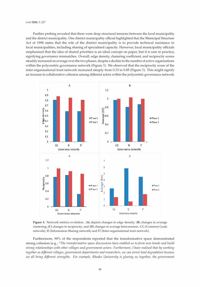
Land 2020, 9, 227
Further probing revealed that there were deep structural tensions between the local municipalityand the district municipality. One district municipality official highlighted that the Municipal StructureAct of 1998 states that the role of the district municipality is to provide technical assistance tolocal municipalities, including sharing of specialised capacity. However, local municipality officialsemphasised that the idea of shared priorities is an ideal concept on paper, but it is rare in practice,signifying governance mismatches. Overall, edge density, clustering coefficient, and reciprocity scoressteadily increased on average over the two phases, despite a decline in the number of active organisationswithin the polycentric governance network (Figure 5). We observed that the reciprocity score of theinter-organisational trust network increased steeply from 0.33 to 0.85 (Figure 5). This might signifyan increase in collaborative cohesion among different actors within the polycentric governance network.
Figure 5. Network metrics evolution. (A) depicts changes in edge density; (B) changes in averageclustering; (C) changes in reciprocity; and (D) changes in average betweenness. CG (Common Goalsnetwork), IS (Information-Sharing network) and IT (Inter-organisational trust network).
Furthermore, 90% of the respondents reported that the transformative space demonstratedstrong cohesion (e.g., “The transformative space discussions have enabled us to form new bonds and buildstrong relationships with other villages and government actors. Furthermore, I have realised that by workingtogether as different villages, government departments and researchers, we can arrest land degradation becausewe all bring different strengths. For example, Rhodes University is glueing us together, the government
88
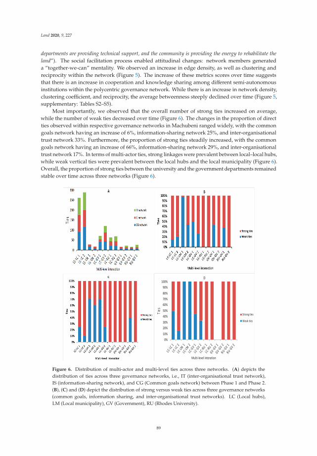
Land 2020, 9, 227
departments are providing technical support, and the community is providing the energy to rehabilitate theland”). The social facilitation process enabled attitudinal changes: network members generateda “together-we-can” mentality. We observed an increase in edge density, as well as clustering andreciprocity within the network (Figure 5). The increase of these metrics scores over time suggeststhat there is an increase in cooperation and knowledge sharing among different semi-autonomousinstitutions within the polycentric governance network. While there is an increase in network density,clustering coefficient, and reciprocity, the average betweenness steeply declined over time (Figure 5,supplementary: Tables S2–S5).
Most importantly, we observed that the overall number of strong ties increased on average,while the number of weak ties decreased over time (Figure 6). The changes in the proportion of directties observed within respective governance networks in Machubeni ranged widely, with the commongoals network having an increase of 6%, information-sharing network 25%, and inter-organisationaltrust network 33%. Furthermore, the proportion of strong ties steadily increased, with the commongoals network having an increase of 66%, information-sharing network 29%, and inter-organisationaltrust network 17%. In terms of multi-actor ties, strong linkages were prevalent between local–local hubs,while weak vertical ties were prevalent between the local hubs and the local municipality (Figure 6).Overall, the proportion of strong ties between the university and the government departments remainedstable over time across three networks (Figure 6).
Figure 6. Distribution of multi-actor and multi-level ties across three networks. (A) depicts thedistribution of ties across three governance networks, i.e., IT (inter-organisational trust network),IS (information-sharing network), and CG (Common goals network) between Phase 1 and Phase 2.(B), (C) and (D) depict the distribution of strong versus weak ties across three governance networks(common goals, information sharing, and inter-organisational trust networks). LC (Local hubs),LM (Local municipality), GV (Government), RU (Rhodes University).
89

Land 2020, 9, 227
5.2. Evolution and Description of the Common Goals Network over Time
Our analysis revealed that the distribution of strong ties increased among actors and acrossscales over time (Figure 6). Semi-structured interviews revealed four processes that contributed to theincrease of strong ties among local–local hubs over time. Network members highlighted that enhancedsocial facilitation (coded 43 times), personal relationships (coded 21 times), behavioural change (coded13 times), and personal learning (coded nine times) were related to the increase of strong ties withinthe network over time. Network members elucidated that social facilitation enabled members todevelop shared goals, thereby enhancing relational and collective agency. Most importantly, ties amonglocal–local hubs were mostly strong with like-minded organisations such as CA, LR, and RG closelyconnected in both phases (Figure 7) because of personal connections, with one hub leader suggestingthat “over the past two years we have enjoyed working together as local organisations, and we have becomestronger together.”
Figure 7. Overview of the common goals network. Arrows represent directed, weighted tiesand circle size represents degree centrality. Rhodes University (RU), Department of EconomicDevelopment, Environmental Affairs, and Tourism (DEDEAT), Department of Rural Development andAgrarian Reform (DRDAR), Chris Hani District Municipality (CHDM), Emalahleni Local Municipality(ELM), Traditional Leaders Council (TLC), Masibambisane multi-actor forum executive (MMF exe),GEF5 Community liaison officers (CLO), Conservation Agriculture Hub (CA), Land RehabilitationHub (LR), Rangeland Management Hub (RG), Training and Knowledge Hub (TK), M&E Hub (M&E),Gender Equity Hub (GE), and Youth Hub (YH).
Our data reveal that the local municipality was the least connected organisation across and withinscales in both phases (Figure 7). Further probing revealed that municipal officials were hesitantin aligning their goals with the rest of the network because of limited resources for service delivery(coded 13 times) and a lack of clearly outlined rules of engagement between local municipalities andcivil society (coded eight times). An ex-municipal employee elucidated that most municipal extensionofficers who attend the forum meetings were mere ‘pen-pushers’ with little or no authority to makedecisions that enable institutional transformations.
5.3. Evolution and Description of the Information-Sharing Network over Time
Our analysis revealed that the distribution of strong ties increased between actors and acrossscales over time (Figure 6). In Phase 1, we observed that Rhodes University was the most centraland dominating actor (Figure 8). However, in Phase 2, five organisations were identified as centralin the information-sharing network. Based on interview responses, network members linked this toan increase of cross-scale coordination meetings, i.e., Intergovernmental Relations (IGR). Both the
90

Land 2020, 9, 227
Department of Economic Development, Environmental Affairs, and Tourism and Department of RuralDevelopment and Agrarian Reform were seen as central government agencies that shared technicalinformation within the transformative space. However, network members reported weak ties betweenlocal organisations and the local municipality in both phases (Figure 6).
Figure 8. Overview of the information-sharing network. Arrows represent directed, weightedties and circle size represents degree centrality. Rhodes University (RU), Department of EconomicDevelopment, Environmental Affairs, and Tourism (DEDEAT), Department of Rural Development andAgrarian Reform (DRDAR), Chris Hani District Municipality (CHDM), Emalahleni Local Municipality(ELM), Traditional Leaders Council (TLC), Masibambisane multi-actor forum executive (MMF exe),GEF5 Community liaison officers (CLO), Conservation Agriculture Hub (CA), Land RehabilitationHub (LR), Rangeland Management Hub (RG), Training and Knowledge Hub (TK), M&E Hub (M&E),Gender Equity Hub (GE), and Youth Hub (YH).
Document analysis of grey literature from the Emalahleni municipality revealed that the localmunicipality did not have adequate scientific information to share with local communities concerningland degradation and rangelands. Further probing revealed that a lack of resource planners atthe local municipality level, such as soil scientists, pasture scientists, and natural scientists, createdcommunication barriers. Network members interviewed elucidated that political instability (coded ninetimes), high-level leadership instability (coded four times), deep structural tensions (coded eighttimes), and discontinuous participation by senior municipality officials (coded 48 times) from thelocal municipality impeded effective communication within the transformative space across scales.Despite most organisations and hubs having some informational ties in both phases, there were noinformational ties reported for the district municipality in Phase 2. Two potential explanations for thisemerged from interviews with district municipality officials, who highlighted that the participatoryprocess was time-consuming considering that the transformative space focused on five villages withinthe district. Another reason might be insufficient budgets from the district municipality to fulfildemands of the transformative space, thereby resulting in self-exclusion, e.g., “the district municipalityis financially constrained, and we support six local municipalities, it will be difficult to commit to knowledgesharing activities.”
91
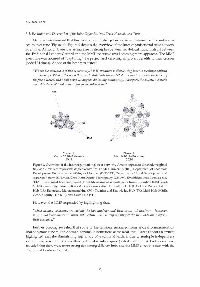
Land 2020, 9, 227
5.4. Evolution and Description of the Inter-Organisational Trust Network over Time
Our analysis revealed that the distribution of strong ties increased between actors and acrossscales over time (Figure 6). Figure 9 depicts the overview of the Inter-organisational trust networkover time. Although there was an increase in strong ties between local–local hubs, mistrust betweenthe Traditional Leaders Council and the MMF executive was becoming more apparent. The MMFexecutive was accused of “capturing” the project and directing all project benefits to their cronies(coded 34 times). As one of the headmen stated:
“We are the custodians of this community, MMF executive is distributing lucerne seedlings withoutour blessings. What criteria did they use to distribute the seeds? As the headman, I am the father ofthe five villages, and I will never let anyone divide my community. Therefore, the selection criteriashould include all local semi-autonomous hub leaders.”
Figure 9. Overview of the Inter-organisational trust network. Arrows represent directed, weightedties, and circle size represents degree centrality. Rhodes University (RU), Department of EconomicDevelopment, Environmental Affairs, and Tourism (DEDEAT), Department of Rural Development andAgrarian Reform (DRDAR), Chris Hani District Municipality (CHDM), Emalahleni Local Municipality(ELM), Traditional Leaders Council (TLC), Masibambisane multi-actor forum executive (MMF exe),GEF5 Community liaison officers (CLO), Conservation Agriculture Hub (CA), Land RehabilitationHub (LR), Rangeland Management Hub (RG), Training and Knowledge Hub (TK), M&E Hub (M&E),Gender Equity Hub (GE), and Youth Hub (YH).
However, the MMF responded by highlighting that:
“when making decisions, we include the two headmen and their seven sub-headmen. However,when a headman misses an important meeting, it is the responsibility of the sub-headman to informtheir headman.”
Further probing revealed that some of the tensions emanated from unclear communicationchannels among the multiple semi-autonomous institutions at the local level. Other network membershighlighted that the diminishing legitimacy of traditional leaders, due to multiple independentinstitutions, created tensions within the transformative space (coded eight times). Further analysisrevealed that there were more strong ties among different hubs and the MMF executive than with theTraditional Leaders Council.
92

Land 2020, 9, 227
5.5. Reflection Phase
Three months after analysing the social network data, transformative space members helda workshop to identify key barriers and strategies that enable effective collaboration and coordination.Network members identified four key barriers and practical suggestions to enable effective collaboration(Table 2).
Table 2. Identified strategies to overcome barriers to effective collaboration and coordinationin transformative spaces.
Identified Barrier Strategy
Time constraints• Finding alternative dates that suit all actors.• Dissemination and sharing of institutional calendars to enable effective planning.• Deepen and accelerate the development of local municipality technical capacity.
Weak communication channels• Extend and deepen collaboration, coordination, and communication across scales.• Facilitate vertical and horizontal communication.• Local leaders to oversee project performance and relationships.
Functional incompatibility of democratic andtraditional structures at the local level
• Leadership training and capacity development of traditional leaders and hub leaders,e.g., conflict resolution training.• Strengthen and support MMF leadership to develop and implement relevant forumpolicies and a code of ethics.
Leakages of human capital
• Enhance women participation by including female-headed families and single womenengaged in livestock farming.• Provide transport for network members.• Provide short-term employment for youths as data enumerators.• Support small business development for the local people, especially the youthand women.
Workshop participants suggested that constant M&E of governance process is a necessaryway of identifying key barriers. First, workshop participants mentioned time constraints (coded67 times) as one of the key barriers that affected effective collaboration. To solve this challenge,workshop participants highlighted the need for finding mutual workshop dates that enable inclusiveparticipation of all actors across scales. Furthermore, government officials highlighted the need ofsharing institutional work calendars as a way of enabling effective workshop planning and reducinghigh turnover rates. Second, workshop participants identified weak communication channels (coded57 times) between local hubs and the Traditional Leader’s Council as one of the key barriers to effectivecollaboration at the local level, with one hub leader highlighting:
“I think failure to communicate effectively among ourselves has strained our relations and has resultedin us forming unnecessary cliques which are unhealthy.”
Furthermore, network members emphasised that vertical and horizontal communication andaccountability are necessary for effective coordination at the local scale, with one hub membersuggesting that:
“In order to achieve our goals, we need effective communication and transparency. I have realised thatif we work in silos, we will not achieve most of the goals we set in 2018.”
Additionally, network members suggested that information deficits could be addressed byextending and deepening collaboration, coordination, and communication. To achieve cross-scalecoordination, the project team, Traditional Leaders’ Council, and SLM hub leaders were to be includedin the Emalahleni Intergovernmental Relations Forum (IGR). Third, network members identifiedfunctional incompatibility of local hubs and traditional structures (coded 32 times) as one key barrierto effective collaboration. Leadership training and capacity development of traditional leaders andhub leaders were suggested as key strategies to enhance functional compatibility. Most importantly,network members identified that there is a need to strengthen and support MMF leadership to developand implement relevant forum policies, bylaws, and a code of ethics. Other strategies includedenhancement of relationships, changing of mindsets, and renewal of commitments between actorswithin and across scales. Lastly, network members identified leakage of human capital (coded 27 times)
93
Land 2020, 9, 227
as a barrier to effective collaboration. Other identified strategies included providing transport fornetwork members, creating short-term employment opportunities, and supporting small businessdevelopment for the local people, especially the youth. One youth member highlighted:
“In order for real transformation to happen in Machubeni, the government and research institutesshould create job opportunities that appeal to the youths. I took the youth garden job because I amdesperate to make a living otherwise if I were to get a better job opportunity in Johannesburg, I woulddefinitely quit the youth garden job. Moreover, after 2022, there will not be project funding; there isno need to stay permanently in Machubeni.”
6. Discussion
This research intends to achieve a greater understanding of how evolving multi-actor andmulti-level ties influence the level of information sharing, inter-organisational trust, and views of sharedgoals in emerging transformative spaces over time. Our work has underscored the potential benefitsand challenges of establishing a transformative space that includes multiple actors across and withinscales, i.e., natural resource users, traditional leaders, key government departments, and researchers.Without overstating the claims of our results, the data support the two hypotheses: firstly, transformativespaces enable broader levels of participation among actors between and within scales; and secondly,strong social-relational linkages (i.e., network ties) increase over time across and within scales.Overall, our findings depict that bringing together a diverse network enabled open dialogue andreflexive learning among key actors within and across scales in Machubeni, mirroring what has beenwritten about transformative spaces [30,32]. Below we discuss our findings from the perspective oftransformative spaces, social networks, social capital, and polycentric governance literature.
Results presented in this study show that the proportion of strong ties across three governancenetworks (common goals, inter-organisational trust, and information sharing) increased over time.This increase may suggest that broader levels of participation and interaction of different actorsacross scales may be necessary for enhancing collaboration and coordination in transformativespaces. For example, multi-actor ties among government institutes, local hubs, and the research teamcontributed to the increase in knowledge sharing and coordination. That multi-level ties connectedactors vertically (across multiple levels) demonstrates that polycentrism might be essential in enhancingcross-scale learning and knowledge sharing in transformative spaces. Furthermore, evidence frominterviews suggests that inter-organisational trust played an essential role in enhancing knowledgesharing and coordination in transformative spaces. This finding supports points elucidated by Neweland Swan [90], who suggested that inter-organisational trust is central for the effective operation ofgovernance networks. Therefore, we argue that increased social capital can enhance collaboration andcoordination in multi-actor and multi-level networks.
Another important finding that emerged from our study is that it takes time to develop andnurture multi-level trust. Network members highlighted that high turnover of government andmunicipality officers affected inter-organisational trust and knowledge-sharing networks. For example,whenever a new government or municipality official joined the transformative space, it meant that newtrust-building, learning, and engagement processes must take place, thereby making it challenging todevelop and nurture trust [80]. Cundill and Fabricius [80] highlighted that mistrust from governmentor municipality will remain there until they can solve their operational challenges. It is thereforecritical for government or municipality officials to take charge in building trust with local communities.This requires building social capital and resilience and strengthening human capacities of ruralcommunities. Therefore, we urge researchers and government agencies involved in transformativespaces to continuously monitor and track network perceptions that influence trust throughout thestages of network development.
Results from the SNA analysis indicate that Rhodes University plays a vital role as a transformativespace-maker within the transformative space. Compared to other organisations within thetransformative space, Rhodes University recorded significantly high metric scores in both phases,
94

Land 2020, 9, 227
demonstrating its importance as a convenor, facilitator, and knowledge provider. On the other hand,significantly high metric scores (e.g., in Phase 1) might mean that the transformative space is highlycentralised around Rhodes University. Given that university-supported transformative spaces havelimited funding and strict time frames [32], we suggest that it is necessary to foster and strengthencapacities of other semi-autonomous organisations within the network, especially the local hubs.Building network redundancy of other semi-autonomous organisations within transformative spacesmight help reduce exposure to institutional failure [55,63,69]. For instance, capacity building of localhubs may help build network resilience and, in turn, improve multi-level connectivity.
Our study has highlighted the importance of analysing the administrative powers of key actors.We propose that it is “more than just engaging with any government official”; there is a needto balance engagement between junior-, middle-, and senior-ranking officials when establishinga transformative space. Our case analysis has demonstrated that the absence of senior-ranking officialsin transformative spaces hinders decision-making and transformative institutional change. Both junior-and middle-ranking officials do not have administrative powers to implement crucial decisions thatmay enable effective collaboration and coordination. Given the complex nature of the administrativesetup of government organisation, we acknowledge that there is no ‘silver bullet’ in addressing thesepower imbalances, but transformative learning is a critical prerequisite for finding solutions to addressstructural dimensions [91]. Furthermore, we propose that the community services department atthe local municipality is best suited to effect transformations in Machubeni, given that its role is tocontribute towards a safe and secure environment. However, this requires skills capacity developmentand training in systems thinking. Improving the institutional capacity of local municipalities mightnecessitate effective coordination of multiple municipality departments and knowledge sharing [92,93].
Governance literature highlights the importance of scale-crossing brokers’ collaborationin networks [94]. In South Africa, local government is identified as a critical administrative level toeffect transformations [95], considering that it is the first point of contact between local communitiesand government [96]. Furthermore, local municipalities are identified as the most appropriate policyimplementers at the local level [97]. However, we pinpointed a weakness in their connectivity withinthe transformative space. The relatively weak ties between the local municipality and the rest ofthe network implied their low capacity to influence knowledge exchange in transformative spaces.Given the low capacity to influence knowledge exchange and collaboration, the local municipality mightnot be able to effect transformations and knowledge sharing within Machubeni [95]. Failure to effecttransformations might exacerbate the rate of land degradation, thereby eroding people’s livelihoodsand pushing them further into poverty. Failure to effect transformations might depress innovationand productivity in the area, which is highly dependent on social grants. We recommend thattransformative and robust leadership are needed to steer implementation in the right direction at thelocal municipality level.
Prell et al. [98] suggested that actors sharing weak ties may find it challenging to engage in opendialogue. Our results depict that the weak ties between the traditional leaders and MMF executive at thelocal level might hinder or fracture transformations and collaboration at the local level. Interview datarevealed that the tensions at the local level might have been caused by jealousy and ineffectivecommunication channels. However, a more in-depth analysis revealed that the creation of multiplesemi-autonomous hubs at the local level created tensions, because it diluted the influence of thetraditional leaders in the area. We attributed this to the power of hubs to make individual decisionswithout consulting the traditional leaders. The question as to whether the current governancearrangements foster long-term cooperation or whether they are prone to disintegrate further remains tobe seen. Some authors argue that it is difficult to merge democratic and traditional structures in SouthAfrica because of possible dictatorial tendencies of traditional leaders [99,100]. However, we arguethat the traditional leadership is compatible with modern democracy and has the potential to improvegovernance and collaboration, and also effect transformations in rural South Africa for two reasons.Firstly, from a SLM perspective, the Communal Land Tenure Policy (CLTP) mandates the traditional
95

Land 2020, 9, 227
leaders to distribute land in their areas [101]. As such, it is their role as traditional leaders to ensure thatcommunity needs and interests are factored into local and district planning. Secondly, the MunicipalStructures Act allows traditional leaders to attend and participate in council meetings as ex-officiomembers, thereby enhancing co-operative governance across scales [92].
Despite the importance of traditional leadership in a modern democracy, we identified threeinstitutional gaps that may hinder transformations in rural South Africa. Firstly, we identifiedtraditional leaders’ inadequate skills and knowledge to pursue their mandate effectively as a majorbarrier. For example, our study highlighted that traditional leadership was ineffective in managingpartnerships for the benefit of the whole community. Secondly, our results showed that traditionalleadership structures (e.g., headman and sub-headman) were ineffective in consulting and engagingwith communities. Thirdly, our analysis revealed that women were not represented in traditionalstructures in Machubeni, which is far below the 33.3% national policy requirement [102]. Therefore, it isnecessary to strengthen and capacitate traditional leaders as a way of enhancing transformativegovernance to promote sustainability in rural South Africa. Lack of female representation might leadto the exclusion of women from participating in transformative spaces, making it an “all men affair.”Women constitute 70% of the Machubeni population and their main source of livelihood is farmingand livestock [103]. For transformation to occur, we propose that transformative spaces need to beinclusive of all key actors, including women.
Furthermore, our paper demonstrates the importance of longitudinal data and M&E for elucidatingtransformations in transformative spaces. With growing interest in transformations to sustainability [30,32,82],there is a need for adequate M&E. Lessons learned from this study include the importance of monitoringnetwork dynamics and system perceptions as a way of tracking the actual performance of transformativespaces. Without an understanding of network dynamics and system perceptions, we believe it will bedifficult to envisage network pathways that influence institutional change in transformative spaces.We reason that project teams or research institutions involved in land degradation initiatives shouldconsider strengthening M&E. This might be crucial in achieving developmental impacts and detectinginstitutional change that is attributed to transformative change [32]. M&E might help in informingtransformations and identifying barriers to transformations. We also recommend that M&E can beused as an effective tool for learning. We argue for future researchers to employ Exponential RandomGraph Models (ERGM) to test for more specific propositions, such as analysing the conditions ofinstitutional fit within transformative spaces [104].
7. Conclusions
Our results support the two hypotheses: that transformative spaces enable broader levels ofparticipation among actors between and within scales and, secondly, that strong social-relationallinkages (i.e., network ties) increased over time across and within scales. With regard to the firsthypothesis, this paper has highlighted the implications of polycentrism in enabling broader levels ofparticipation, cross-scale collaboration, and learning in transformative spaces. Despite the findingshighlighting the potential role of transformative spaces in ensuring broader levels of participation,ineffective communication channels at the local level caused tensions among the semi-autonomous hubs.This suggests that polycentric governance networks might present specific challenges. We identifiedleadership training and capacity development of traditional leaders and hub leaders, e.g., conflictresolution training, as necessities to enhance effective collaboration and coordination.
The findings from this study illustrate the importance of employing a social-relational perspectivein analysing changing social connections and relationships in transformative spaces. We observedthat actors with strong ties of trust also possessed similar strong ties of information sharing withinthe network. In particular, inter-organisational trust played an essential role in enhancing knowledgesharing and coordination. We found that learning is a critical prerequisite for finding solutionsto address structural dimensions within a transformative space over time. Network membersidentified strategies to strengthen collaboration and coordination in transformative spaces through
96

Land 2020, 9, 227
learning. While the transformative space in Machubeni has succeeded in enhancing collaboration andknowledge sharing between groups that did not previously dialogue, further long-term engagementwith government agencies might be necessary for promoting institutional transformations and policyoutcomes, and building network resilience in complex polycentric governance systems.
Supplementary Materials: The following are available online at http://www.mdpi.com/2073-445X/9/7/227/s1,Table S1: Design principles, interpretations, application in the Machubeni Case Study; Table S2: Actor groupsidentified as members of the transformative space (Masibambisane multi-actor Forum); Table S3: Centralitymeasures i.e., in-degree and betweenness over time (common goals); Table S4: Centrality measures i.e., in-degreeand betweenness over time (information-sharing network); Table S5: Centrality measures i.e., in-degree andbetweenness over time (Inter-organisational trust network).
Author Contributions: M.F.; J.G. and M.S. conceived and designed the study; M.F. undertook the field work anddata analysis under the guidance of J.G. and M.S. who are both his PhD supervisors; M.F. wrote the paper withsupport from both J.G. and M.S. All authors have read and agreed to the published version of the manuscript.
Funding: This work was funded by the Rhodes University GEF5 SLM Project (Project ID: 00095288).
Acknowledgments: The authors would like to acknowledge the generosity of residents from Machubenicommunities and government sectorial actors for participating in this research. Menelisi Falayi would like toacknowledge the Oppenheimer Memorial Trust (OMT REF: 21250/01) for providing additional financial assistance.The authors are grateful to the anonymous reviewers who helped us improve our manuscript.
Conflicts of Interest: The authors declare no conflicting interests.
References
1. Steffen, W.; Crutzen, P.J.; McNeill, J.R. The Anthropocene: Are Humans Now Overwhelming the GreatForces of Nature. AMBIO J. Human Environ. 2007, 36, 614–621. [CrossRef]
2. Steffen, W.; Rockström, J.; Richardson, K.; Lenton, T.M.; Folke, C.; Liverman, D.; Summerhayes, C.P.;Barnosky, A.D.; Cornell, S.E.; Crucifix, M.; et al. Trajectories of the Earth System in the Anthropocene.Proc. Natl. Acad. Sci. USA 2018, 115, 8252–8259. [CrossRef]
3. Ostrom, E. A general framework for analyzing sustainability of social-ecological systems. Science 2009, 325,419–422. [CrossRef]
4. Schoon, M.L.; Robards, M.D.; Brown, K.; Engle, N.; Meek, C.L.; Biggs, R. Politics and the resilienceof ecosystem services. In Principles for Building Resilience; Biggs, R., Schluter, M., Schoon, M.L., Eds.;Cambridge University Press: Cambridge, UK, 2015; pp. 32–49. ISBN 978-1-316-01424-0.
5. Hassan, R.; Scholes, R.; Ash, N. (Eds.) Ecosystems and Human Well-Being: Current State and Trends; Island Press:Washington, DC, USA, 2005; Volume 1.
6. Díaz, S.; Demissew, S.; Carabias, J.; Joly, C.; Lonsdale, M.; Ash, N.; Larigauderie, A.; Adhikari, J.R.;Arico, S.; Báldi, A.; et al. The IPBES Conceptual Framework—Connecting nature and people. Curr. Opin.Environ. Sustain. 2015, 14, 1–16. [CrossRef]
7. Falayi, M.; Shackleton, S.E.; Kemp, G.C.; Shackleton, C.M. Changes in household use and sale of locallycollected environmental resources over a 15-year period in a rural village, South Africa. For. Trees Livelihoods2019, 28, 90–107. [CrossRef]
8. Millennium Ecosystem Assessment. Ecosystem and Human Well-Being: Biodiversity Synthesis; World ResourceInstitute: Washington, DC, USA, 2005.
9. Scholes, R.; Montanarella, L.; Brainich, A.; Barger, N.; ten Brink, B.; Cantele, M.; Erasmus, B.; Fisher, J.;Gardner, T.; Holland, T.G. Summary for Policymakers of the Thematic assessment Report on Land Degradationand Restoration of the Intergovernmental Science-Policy Platform on Biodiversity and Ecosystem Services.IPBES Secr. Bonn Ger. 2018, 1–31.
10. Shackleton, C.M.; Gambiza, J. Social and ecological trade offs in combating land degradation: The case ofinvasion by a woody shrub (Euryops floribundus) at Macubeni, South Africa. Land Degrad. Dev. 2008, 19,454–464. [CrossRef]
11. Reed, M.S.; Stringer, L.C.; Dougill, A.J.; Perkins, J.S.; Atlhopheng, J.R.; Mulale, K.; Favretto, N. Reorientingland degradation towards sustainable land management: Linking sustainable livelihoods with ecosystemservices in rangeland systems. J. Environ. Manag. 2015, 151, 472–485. [CrossRef]
97

Land 2020, 9, 227
12. Shackleton, S.; Luckert, M.; Shackleton, S.; Luckert, M. Changing Livelihoods and Landscapes in the RuralEastern Cape, South Africa: Past Influences and Future Trajectories. Land 2015, 4, 1060–1089. [CrossRef]
13. Milder, J.C.; Buck, L.E.; DeClerck, F.; Scherr, S.J. Landscape Approaches to Achieving Food Production,Natural Resource Conservation, and the Millennium Development Goals. Integr. Ecol. Poverty Reduct. 2012,77–108. [CrossRef]
14. Stringer, L.C.; Reed, M.S.; Dougill, A.J.; Seely, M.K.; Rokitzki, M. Implementing the UNCCD: Participatorychallenges. Nat. Resour. Forum 2007, 31, 198–211. [CrossRef]
15. Alexander, S.M.; Armitage, D.; Charles, A. Social networks and transitions to co-management in Jamaicanmarine reserves and small-scale fisheries. Glob. Environ. Chang. 2015, 35, 213–225. [CrossRef]
16. Zoumides, C.; Bruggeman, A.; Giannakis, E.; Camera, C.; Djuma, H.; Eliades, M.; Charalambous, K.Community-Based Rehabilitation of Mountain Terraces in Cyprus. Land Degrad. Dev. 2017, 28, 95–105.[CrossRef]
17. Warner, J. Multi-stakeholder platforms: Integrating society in water resource management? Ambient Soc.2005, 8, 4–28. [CrossRef]
18. Kusters, K.; Buck, L.; de Graaf, M.; Minang, P.; van Oosten, C.; Zagt, R. Participatory Planning, Monitoringand Evaluation of Multi-Stakeholder Platforms in Integrated Landscape Initiatives. Environ. Manag. 2018,62, 170–181. [CrossRef]
19. Faysse, N. Troubles on the way: An analysis of the challenges faced by multi-stakeholder platforms.Nat. Resour. Forum 2006, 30, 219–229. [CrossRef]
20. Pinkse, J.; Kolk, A. Addressing the Climate Change—Sustainable Development Nexus: The Role ofMultistakeholder Partnerships—Jonatan Pinkse, Ans Kolk, 2012. Bus. Soc. 2012, 51, 176–210. [CrossRef]
21. Bisaro, A.; Kirk, M.; Zdruli, P.; Zimmermann, W. Global Drivers Setting Desertification Research Priorities:Insights from a Stakeholder Consultation Forum. Land Degrad. Dev. 2014, 25, 5–16. [CrossRef]
22. Mansourian, S. In the eye of the beholder: Reconciling interpretations of forest landscape restoration.Land Degrad. Dev. 2018, 29, 2888–2898. [CrossRef]
23. Schwilch, G.; Bachmann, F.; Liniger, H. Appraising and selecting conservation measures to mitigatedesertification and land degradation based on stakeholder participation and global best practices.Land Degrad. Dev. 2009, 20, 308–326. [CrossRef]
24. Mbow, C. Use It Sustainably or Lose It! The Land Stakes in SDGs for Sub-Saharan Africa. Land 2020, 9, 63.[CrossRef]
25. Patterson, J.; Schulz, K.; Vervoort, J.; van der Hel, S.; Widerberg, O.; Adler, C.; Hurlbert, M.; Anderton, K.;Sethi, M.; Barau, A. Exploring the governance and politics of transformations towards sustainability.Environ. Innov. Soc. Transit. 2017, 24, 1–16. [CrossRef]
26. Westley, F.; Tjornbo, O.; Schultz, L.; Olsson, P.; Folke, C.; Crona, B.; Bodin, Ö. A Theory of TransformativeAgency in Linked Social-Ecological Systems. Ecol. Soc. 2013, 18. [CrossRef]
27. Walker, B.; Holling, C.S.; Carpenter, S.R.; Kinzig, A. Resilience, Adaptability and Transformabilityin Social–ecological Systems. Ecol. Soc. 2004, 9. Available online: https://www.jstor.org/stable/26267673(accessed on 4 June 2020). [CrossRef]
28. Frantzeskaki, N.; Wittmayer, J.; Loorbach, D. The role of partnerships in ‘realising’ urban sustainabilityin Rotterdam’s City Ports Area, The Netherlands. J. Clean. Prod. 2014, 65, 406–417. [CrossRef]
29. Scoones, I.; Stirling, A.; Abrol, D.; Atela, J.; Charli-Joseph, L.; Eakin, H.; Ely, A.; Olsson, P.; Pereira, L.;Priya, R.; et al. Transformations to sustainability: Combining structural, systemic and enabling approaches.Curr. Opin. Environ. Sustain. 2020. [CrossRef]
30. Pereira, L.; Karpouzoglou, T.; Frantzeskaki, N.; Olsson, P. Designing transformative spaces for sustainabilityin social-ecological systems. Ecol. Soc. 2018, 23. [CrossRef]
31. Moore, M.-L.; Olsson, P.; Nilsson, W.; Rose, L.; Westley, F. Navigating emergence and system reflexivity askey transformative capacities: Experiences from a Global Fellowship program. Ecol. Soc. 2018, 23. [CrossRef]
32. Pereira, L.; Frantzeskaki, N.; Hebinck, A.; Charli-Joseph, L.; Drimie, S.; Dyer, M.; Eakin, H.; Galafassi, D.;Karpouzoglou, T.; Marshall, F.; et al. Transformative spaces in the making: Key lessons from nine cases in theGlobal South. Sustain. Sci. 2019. [CrossRef]
33. Drimie, S.; Hamann, R.; Manderson, A.; Mlondobozi, N. Creating transformative spaces for dialogue andaction: Reflecting on the experience of the Southern Africa Food Lab. Ecol. Soc. 2018, 23. [CrossRef]
98

Land 2020, 9, 227
34. Lam, A. Organizational learning. In The Oxford handbook of innovation; Fagerberg, J., Mowery, D.C.,Nelson, R.R., Eds.; Oxford University Press: Oxford, UK, 2005; ISBN 978-0-19-926455-1.
35. Charli-Joseph, L.; Siqueiros-Garcia, J.M.; Eakin, H.; Manuel-Navarrete, D.; Shelton, R. Promoting agency forsocial-ecological transformation: A transformation-lab in the Xochimilco social-ecological system. Ecol. Soc.2018, 23. [CrossRef]
36. van Zwanenberg, P.; Cremaschi, A.; Obaya, M.; Marin, A.; Lowenstein, V. Seeking unconventional alliancesand bridging innovations in spaces for transformative change: The seed sector and agricultural sustainabilityin Argentina. Ecol. Soc. 2018, 23. [CrossRef]
37. Hebinck, A.; Vervoort, J.; Hebinck, P.; Rutting, L.; Galli, F. Imagining transformative futures: Participatoryforesight for food systems change. Ecol. Soc. 2018, 23. [CrossRef]
38. Galafassi, D.; Daw, T.; Thyresson, M.; Rosendo, S.; Chaigneau, T.; Bandeira, S.; Munyi, L.; Gabrielsson, I.;Brown, K. Stories in social-ecological knowledge cocreation. Ecol. Soc. 2018, 23. [CrossRef]
39. Marshall, F.; Dolley, J.; Priya, R. Transdisciplinary research as transformative space making for sustainability:Enhancing propoor transformative agency in periurban contexts contexts. Ecol. Soc. 2018, 23, 8. [CrossRef]
40. Dyer, M. Transforming communicative spaces: The rhythm of gender in meetings in rural Solomon Islands.Ecol. Soc. 2018, 23. [CrossRef]
41. Olsson, P.; Moore, M.-L.; Westley, F.R.; McCarthy, D.D.P. The concept of the Anthropocene as a game-changer:A new context for social innovation and transformations to sustainability. Ecol. Soc. 2017, 22. [CrossRef]
42. Hoffman, M.T.; Todd, S. A national review of land degradation in South Africa: The influence of biophysicaland socio-economic factors. J. South. Afr. Stud. 2000, 26, 743–758. [CrossRef]
43. ATS/Ikwezi. Machubeni Land Use Plan Assessment Report; Rhodes University: Grahamstown, South Africa,2004; pp. 1–56.
44. Putnam, R.D. Bowling Alone: America’s Declining Social Capital. In Culture and Politics: A Reader; Crothers, L.,Lockhart, C., Eds.; Palgrave Macmillan US: New York, NY, USA, 2000; pp. 223–234, ISBN 978-1-349-62965-7.
45. Dekker, P.; Uslaner, E.M. Social Capital and Participation in Everyday Life; Uslaner, E.M., Ed.; Routledge:London, UK, 2001.
46. Coleman, J.S. Social Capital in the Creation of Human Capital. Am. J. Sociol. 1988, 94, S95–S120. [CrossRef]47. Ostrom, E.; Ahn, T.K. The meaning of social capital and its link to collective action. In Handbook of Social
Capital: The Troika of Sociology, Political Science and Economics; Edward Elgar Publishing: Cheltenham, UK, 2009.48. Bodin, Ö.; Crona, B.I. Management of Natural Resources at the Community Level: Exploring the Role of
Social Capital and Leadership in a Rural Fishing Community. World Dev. 2008, 36, 2763–2779. [CrossRef]49. Merino-Pérez, L. Conservation or Deterioration: The Impact of Public Policies on Community Institutions and on the
Use Practices of Forest Resources; Instituto Nacional de Ecología: Mexico City, Mexico, 2004.50. Gambeta, D. Mafia: The price of distrust. In Trust: Making and Breaking Cooperative Relations; Gambetta, D.,
Ed.; Basil Blackwell: London, UK, 1988.51. Stringer, L.C.; Dougill, A.J.; Fraser, E.; Hubacek, K.; Prell, C.; Reed, M.S. Unpacking “Participation” in the
Adaptive Management of Social–ecological Systems: A Critical Review. Ecol. Soc. 2006, 11. Available online:www.jstor.org/stable/26266023 (accessed on 4 June 2020). [CrossRef]
52. Schoon, M.L.; Robards, M.D.; Meek, C.L.; Galaz, V. 9 Principle 7–Promote polycentric governance systems.In Principles for Building Resilience: Sustaining Ecosystem Services in Social-Ecological Systems; Biggs, R.,Schluter, M., Schoon, M.L., Eds.; Cambridge University Press: Cambridge, UK, 2015; pp. 226–250,ISBN 9781316014240|9781107082656.
53. Ostrom, E. Polycentric systems for coping with collective action and global environmental change.Glob. Environ. Chang. 2010, 20, 550–557. [CrossRef]
54. McGinnis, M.D.; Ostrom, E. Reflections on Vincent Ostrom, Public Administration, and Polycentricity.Public Adm. Rev. 2012, 72, 15–25. [CrossRef]
55. Ostrom, E. Coping with tragedies of the commons. Annu. Rev. Polit. Sci. 1999, 2, 493–535. [CrossRef]56. Howitt, R. Scale. In A Companion to Political Geography; John Wiley & Sons, Ltd.: Hoboken, NJ, USA, 2007;
pp. 132–157, ISBN 978-0-470-99894-6.57. Ostrom, E. Beyond Markets and States: Polycentric Governance of Complex Economic Systems. Am. Econ. Rev.
2010, 100, 641–672. [CrossRef]
99

Land 2020, 9, 227
58. Morrison, T.H.; Adger, W.N.; Brown, K.; Lemos, M.C.; Huitema, D.; Phelps, J.; Evans, L.; Cohen, P.; Song, A.M.;Turner, R.; et al. The black box of power in polycentric environmental governance. Glob. Environ. Chang.2019, 57, 101934. [CrossRef]
59. Bodin, Ö. Collaborative environmental governance: Achieving collective action in social-ecological systems.Science 2017, 357. [CrossRef] [PubMed]
60. Schoon, M.; Cox, M. Collaboration, Adaptation, and Scaling: Perspectives on Environmental Governance forSustainability. Sustainability 2018, 10, 679. [CrossRef]
61. Bixler, R.P. From Community Forest Management to Polycentric Governance: Assessing Evidence from theBottom Up. Soc. Nat. Resour. 2014, 27, 155–169. [CrossRef]
62. Folke, C.; Hahn, T.; Olsson, P.; Norberg, J. Adaptive Governance of Social-Ecological Systems. Annu. Rev.Environ. Resour. 2005, 30, 441–473. [CrossRef]
63. Gelcich, C. Towards polycentric governance of small-scale fisheries: Insights from the new “ManagementPlans” policy in Chile. Aquat. Conserv. 2014, 24, 575–581. [CrossRef]
64. Elinor, O. Understanding Institutional Diversity; Princeton University Press: Princeton, NJ, USA, 2005.65. Pahl-Wostl, C.; Hare, M. Processes of social learning in integrated resources management. J. Community Appl.
Soc. Psychol. 2004, 14, 193–206. [CrossRef]66. Reed, M.S.; Dougill, A.J.; Taylor, M.J. Integrating local and scientific knowledge for adaptation to land
degradation: Kalahari rangeland management options. Land Degrad. Dev. 2007, 18, 249–268. [CrossRef]67. Cash, D.W.; Adger, W.N.; Berkes, F.; Garden, P.; Lebel, L.; Olsson, P.; Pritchard, L.; Young, O. Scale and
Cross-Scale Dynamics: Governance and Information in a Multilevel World. Ecol. Soc. 2006, 11. [CrossRef]68. Young, O.R. The Architecture of Global Environmental Governance: Bringing Science to Bear on Policy.
Glob. Environ. Polit. 2008, 8, 14–32. [CrossRef]69. Ostrom, E. Why Do We Need to Protect Institutional Diversity? Eur. Polit. Sci. 2012, 11, 128–147. [CrossRef]70. Galaz, V.; Olsson, P.; Hahn, T.; Folke, C.; Svedin, U. The Problem of Fit among Biophysical Systems,
Environmental and Resource Regimes, and Broader Governance Systems: Insights and Emerging Challenges.In Institutions and Environmental Change; Young, O.R., King, L.A., Schroeder, H., Eds.; The MIT Press:Cambridge, MA, USA, 2008; pp. 147–186, ISBN 978-0-262-24057-4.
71. Low, B.; Ostrom, E.; Simon, C.; Wilson, J. Redundancy and Diversity: Do They Influence Optimal Management?”In Navigating Social-Ecological Systems: Building Resilience for Complexity and Change; Berkes, F., Colding, J.,Folke, C., Eds.; Cambridge University Press: Cambridge, UK, 2003; pp. 83–111, ISBN 978-1-139-43479-9.
72. Schoon, M.; York, A.; Sullivan, A.; Baggio, J. The emergence of an environmental governance network:The case of the Arizona borderlands. Reg. Environ. Chang. 2017, 17, 677–689. [CrossRef]
73. Sardeshpande, M.; Shackleton, C. Urban foraging: Land management policy, perspectives, and potential.PLoS ONE 2020, 15, e0230693. [CrossRef]
74. Scott, J.; Carrington, P.J. The SAGE Handbook of Social Network Analysis; SAGE publications: Thousand Oaks,CA, USA, 2011.
75. Bodin, Ö.; Prell, C. Social Networks and Natural Resource Management: Uncovering the Social Fabric ofEnvironmental Governance; Cambridge University Press: Cambridge, UK, 2011; ISBN 978-1-139-49657-5.
76. Lee, T. Network comparison of socialization, learning and collaboration in the C40 cities climate group.J. Environ. Policy Plan. 2019, 21, 104–115. [CrossRef]
77. Borg, R.; Toikka, A.; Primmer, E. Social capital and governance: A social network analysis of forest biodiversitycollaboration in Central Finland. For. Policy Econ. 2015, 50, 90–97. [CrossRef]
78. Republic of South Africa. Local Government: Municipal Demarcation Act, Act No. 27 of 1998; Republic of SouthAfrica: Cape Town, South Africa, 1998.
79. Cundill, G. Learning, Governance and Livelihoods: Toward Adaptive Co-Management under Resource PoorConditions in South Africa. Ph.D. Thesis, Rhodes University, Grahamstown, South Africa, 2008.
80. Cundill, G.; Fabricius, C. Adaptive Co-Management in Resource Poor Conditions: Lessons from SouthAfrica. In Exploring Sustainability Science: A Southern African Perspective; African Sun Media: Stellenbosch,South Africa, 2008.
81. Mucina, L.; Rutherford, M.C. The Vegetation of South Africa, Lesotho and Swaziland; South African NationalBiodiversity Institute: Pretoria, South Africa, 2006.
100

Land 2020, 9, 227
82. Pereira, L.; Karpouzoglou, T.; Doshi, S.; Frantzeskaki, N. Organising a Safe Space for NavigatingSocial-Ecological Transformations to Sustainability. Int. J. Environ. Res. Public. Health 2015, 12, 6027–6044.[CrossRef] [PubMed]
83. Leventon, J.; Fleskens, L.; Claringbould, H.; Schwilch, G.; Hessel, R. An applied methodology for stakeholderidentification in transdisciplinary research. Sustain. Sci. 2016, 11, 763–775. [CrossRef] [PubMed]
84. Cundill, G.; Fabricius, C. Monitoring the Governance Dimension of Natural Resource Co-management. Ecol.Soc. 2010, 15. [CrossRef]
85. Cundill, G. Monitoring Social Learning Processes in Adaptive Comanagement: Three Case Studies fromSouth Africa. Ecol. Soc. 2010, 15. [CrossRef]
86. Emalahleni Municipal Assessment. Municipal Dermacation: Machubeni Communal Lands. ELM 2018,1, 1–80.
87. Chambers, R. Participatory Workshops: A Sourcebook of 21 Sets of Ideas and Activities; Routledge: Abingdon, UK,2012; ISBN 978-1-84977-213-6.
88. Carolan, B.V. Social Network Analysis and Education: Theory, Methods & Applications; SAGE Publications:Thousand Oaks, CA, USA, 2013; ISBN 978-1-4833-2079-3.
89. Bazeley, P. Integrative Analysis Strategies for Mixed Data Sources. Am. Behav. Sci. 2012, 56, 814–828.[CrossRef]
90. Newell, S.; Swan, J. Trust and inter-organizational networking. Hum. Relat. 2000, 53, 1287–1328. [CrossRef]91. Boström, M.; Andersson, E.; Berg, M.; Gustafsson, K.; Gustavsson, E.; Hysing, E.; Lidskog, R.; Löfmarck, E.;
Ojala, M.; Olsson, J.; et al. Conditions for Transformative Learning for Sustainable Development: A TheoreticalReview and Approach. Sustainability 2018, 10, 4479. [CrossRef]
92. Maserumule, M.H. Framework for strengthening the capacity of municipalities in South Africa:A developmental local government perspective. J. Public Adm. 2008, 43, 436–451.
93. Meyer, I.H.; Cloete, F. Policy dynamics: Change, failure and success. Improv. Public Policy Theory Pract.Pretoria Van Schaik Publ. 2006.
94. Ernstson, H.; Barthel, S.; Andersson, E.; Borgström, S.T. Scale-Crossing Brokers and Network Governance ofUrban Ecosystem Services: The Case of Stockholm. Ecol. Soc. 2010, 15. [CrossRef]
95. Republic of South Africa. The White Paper on Local Government: Ministry for Provincial Affairs and ConstitutionalDevelopment; Republic of South Africa: Pretoria, South Africa, 1998.
96. Thornhill, C. The transformed local government system: Some lessons. J. Public Adm. 2008, 43, 492–511.97. Koma, S.B. The state of local government in South Africa: Issues, trends and options. J. Public Adm. 2010, 45,
111–120.98. Prell, C.; Hubacek, K.; Reed, M. Stakeholder Analysis and Social Network Analysis in Natural Resource
Management. Soc. Nat. Resour. 2009, 22, 501–518. [CrossRef]99. Meer, T.; Campbell, G. Traditional Leadership in Democratic South Africa; Democracy Development Programme:
Durban, South Africa, 2018.100. Ntsebeza, L. Rural Governance and Citizenship in Post-1994 South Africa: Democracy Compromised; University of
Cape Town: Cape Town, South Africa, 2006.101. Department of Rural Development and Land Reform. Communal Land Tenure Policy; Department of Rural
Development and Land Reform: Pretoria, South Africa, 2014.102. Republic of South Africa. Traditional Leadership and Governance Framework Act, No 41 of 2003; Republic of
South Africa: Cape Town, South Africa, 2003.103. Republic of South Africa. Statistics South Africa; Republic of South Africa: Pretoria, South Africa, 2011.104. Hermans, F.; Sartas, M.; van Schagen, B.; van Asten, P.; Schut, M. Social network analysis of multi-stakeholder
platforms in agricultural research for development: Opportunities and constraints for innovation and scaling.PLoS ONE 2017, 12, e0169634. [CrossRef]
© 2020 by the authors. Licensee MDPI, Basel, Switzerland. This article is an open accessarticle distributed under the terms and conditions of the Creative Commons Attribution(CC BY) license (http://creativecommons.org/licenses/by/4.0/).
101

land
Article
Protected Area Governance and Its Influence on LocalPerceptions, Attitudes and Collaboration
Jesse Sey Ayivor 1,*, Johnie Kodjo Nyametso 2 and Sandra Ayivor 3
1 Institute for Environment and Sanitation Studies, University of Ghana, Legon, Accra, Ghana2 Department of Environment and Development Studies, Central University, Accra, Ghana;
[email protected] College of Education and Human Services, West Virginia University, Morgantown, WV 26505, USA;
[email protected]* Correspondence: [email protected]; Tel.: +233-244213287
Received: 23 June 2020; Accepted: 30 August 2020; Published: 2 September 2020
Abstract: Globally, protected areas are faced with a myriad of threats emanating principally fromanthropogenic drivers, which underpins the importance of the human element in protected areamanagement. Delving into the “exclusive” and “inclusive” approaches to nature conservationdiscourse, this study explored the extent to which local communities collaborate in the managementof protected areas and how the governance regime of these areas influences local perceptionsand attitudes. Data for the study were collected through stakeholder interviews, focus groupdiscussions as well as a probe into participating groups’ collective perceptions and opinions oncertain key issues. A total of 51 focus group discussions were held in 45 communities involving 630participants. The analysis was done using qualitative methods and simple case counts to explainlevels of acceptance or dislike of issues. The results showed that the objectives of state-managedprotected areas, by their nature, tend to exclude humans and negatively influence local perceptionsand attitudes. This, in addition to human-wildlife conflicts and high handedness by officials onprotected area offenders, affects community collaboration. The study concluded that for protectedarea management to be effective, effort must be made to positively influence local perceptions andattitudes by promoting “win-win-win” partnerships among all stakeholders.
Keywords: local collaboration; governance regime; local attitudes; local perceptions; protected area
1. Introduction
Protected areas (PAs) have remained the bedrock of nature conservation, and by far, the beststrategy to protect habitats and stem the rapid erosion of biodiversity [1,2]. The Convention on BiologicalDiversity defines a protected area (PA) as a: “geographically defined area, which is designated orregulated and managed to achieve specific conservation objectives” [3]. The International Union forConservation of Nature (IUCN), however, provides a universally accepted definition of a protectedas “a clearly defined geographical space recognized, dedicated and managed, through legal or othereffective means, to achieve the long-term conservation of nature and its associated ecosystems servicesand cultural values” [3]. The historical antecedent of the establishment of PAs stemmed from thebelief in the restorative powers of ‘a little pure wilderness,’ rooted in the romantic-transcendentalpreservation ethic [4]. This was a deterministic worldview with a cause and effect relationship, in whichthe proponents believed that experiencing original nature provided aesthetic, psychological andspiritual benefits that could not be gained in urban or even pastoral landscapes [5]. This line of thoughtprompted the establishment of large national parks and reserves where natural ecosystems could beprotected from human influence, and biodiversity could be conserved [6].
Land 2020, 9, 310; doi:10.3390/land9090310 www.mdpi.com/journal/land103

Land 2020, 9, 310
Contrary to this worldview, also referred to as the “exclusive model,” is the widely acclaimed‘socially oriented paradigm’ of PA management [7], which blends conservation objectives with concernsfor the wellbeing of local communities [8–14]. The proponents of this approach, referred to as the“inclusive model,” are of the view that local people would most likely be willing to conserve when theyreceive direct benefits from the conservation enterprise. This approach promotes local communitycollaboration in the decision-making process and enhances dialogue, transparency, mutual respect,equity and benefit-sharing.
Another important conservation approach based on multi-stakeholder engagement is matrix-basedconservation [15]. This approach stresses the importance of maintaining suitable habitats andpopulations of native species outside PAs. According to Lindenmayer and Franklin, [15], it involvesthe regulatory control of landscape activities such as farming and logging, as well as hunting, to protectspecies not only within the PA but the entire landscape. This landscape-level approach, however,presents a challenge in sub-Saharan Africa, where land ownership and livelihood issues make itsimplementation difficult.
In general, socio-economic and cultural factors, to a large extent, influence conservation decisionsin most developing countries [16]. Poverty is a major socio-economic characteristic of most communitiesbordering PAs in these countries. This raises challenges because local communities who, hitherto,derive their livelihood from forest resources and other ecosystem services before PA establishment,tend to be denied access after their establishment [8,17]. Lea et al. [18] explained that the strictprotectionists’ approach tends to displace people and deprive them of their livelihoods, therebyexacerbating their poverty situation. On the cultural front, the traditional land tenure system is amajor factor influencing conservation decisions by local communities in most developing countries.According to the International Fund for Agricultural Development (IFAD), [19], land tenure issues areof prime concern presently, as high rate of population growth, high food prices, the impact of climatechange, trade regimes and growing demand for agrofuels, among other factors, have continued toexert pressure on land tenure systems. Moreover, land for wildlife conservation may belong to privateindividuals, community groups or the state. However, since wildlife is a fugitive property that doesnot recognize property boundaries, its movement cannot be restricted, hence incessant human-wildlifeconflicts [19] occur in the absence of matrix-based conservation.
As noted by Parker et al. [7], the primary focus of PA management has been related to thebenefits these areas provide at a higher level, including the protection of biodiversity, spiritual benefitsand economic gains through tourism, with less attention given to possible concerns raised by localcommunities on how they have been disadvantaged by PA establishment. In Africa, most PAs areunder state-managed governance regime with little or no provision for local community collaboration.This raises the question as to how practicable local collaboration is in PA management if the governanceregime does not realistically involve local people. This study, therefore, examined how PA governanceregime influences multi-stakeholder collaboration in PA management in Ghana. More specifically,the study investigated the general threats faced by PAs in selected sites, how the prevailing governanceregime has influenced local community perceptions and attitudes, as well as conservation outcomes byway of threat reduction.
Theoretical Underpinnings
A protected area governance regime is critical in understanding the degree to which localpeople collaborate in protected area management. In general terms, management refers to“the process of assembling and using sets of resources in a goal-directed manner to accomplishtasks in an organization” [20] p. 4. With regard to protected areas, it involves planning, directing,organizing and evaluating [21]. Governance, on the other hand, relates to power, relationships,responsibility and accountability. In a protected area context, it refers to “who holds managementauthority and responsibility and can be held accountable according to legal, customary or otherwiselegitimate rights” [22] p. 19. Governance also covers broad issues ranging from policy to practice,
104

Land 2020, 9, 310
from behavioral issues to meaning, and from investments to impacts in relation to protected areas [22].Borrini-Feyerabend et al. [23] proposed a fundamental distinction between governance regimes andcategorized them into four types, namely: government-managed (solely managed by governmentagencies); co-managed (management responsibility and authority shared among several actors);privately managed (exclusively in private hands); and community-managed (where management isconducted by local people). Based on these governance types, West and Brechin [24] came out with thedual model—the “exclusive” and “inclusive” approaches—to explain different governance regimes.
In general, a state-managed PA governance regime by its design excludes local people. Thus,to promote inclusiveness and benefit-sharing with neighbouring communities, IUCN introduced a setof universal PA definitions based on six management categories. These are Category IA (strict naturereserve), Category IB (wilderness area), Category II (national park), Category III (natural monument),Category IV (habitat/species management area), Category V (protected landscape/seascape) andCategory VI (protected area with sustainable use of natural resources) [3]. The purpose was for eachmember country to have a blend of several categories of PAs so that while some may allow for acertain level of human activities, others would remain exclusive in order for the PA system to meetboth scientific and socio-economic needs.
The numerous challenges which characterize the exclusive approach [18,25–28] led to a paradigmshift, with the inclusive approach now taking center stage. The World Wildlife Fund (WWF),Reference [29] defined collaboration as a mutually beneficial relationship between two or more partieswho work toward common goals by sharing responsibility, authority, and accountability for achievingresults. This view sees the interests of local people as central to the area being protected and seeksto promote community collaboration in management and planning. Mulongoy and Chape [30]outlined three basic processes for a collaborative approach. These involve dialogue among the variousstakeholders and a focus on ecologically sensitive livelihoods, equitable distribution of costs andbenefits and the creation of institutions such as joint management boards or village conservationcommittees. The strengths of the collaborative approach lie in the fact that it is humane, transparentand based on democratic principles, hence its wide acceptability [31]. The approach is also importantbecause it brings groups with similar or different perspectives together to exchange viewpoints andsearch for solutions that go beyond their own vision of what is possible. It, thus, responds to complexproblems and challenges that isolated efforts cannot solve [29].
To enhance effective collaboration, Kemmis [32], in line with others [33–35], suggested that roundtable discussions in a democratic manner can help to identify more diverse and higher-level public goodsthan what each person, on their own, can bring to the table. Meffe et al. [34] designed an ecosystemmanagement framework with three contextual elements, namely, ecological, socio-economic andinstitutional contexts [34]. The framework prescribed “win-win-win” solutions, which they explainedas being community-based ecosystem management that provides an organizing framework blendingthe three contextual elements. This converging point essentially promotes a governance regime inwhich all stakeholder-interests are achieved without anyone unduly disadvantaged. They identifiedfour zones of ecosystems management, as represented in Figure 1, namely:
105

Land 2020, 9, 310
Figure 1. Zones of Ecosystems Management. Source: Modified from Meffe, [34].
A—the zone of regulatory or management authority where enforcement and regulation dictatedecision-making as pertains in all PAs;
B—the zone of societal obligations, which does not directly influence natural resource managementbut indirectly impacts decisions. Examples may include policies that integrate local needs inmanagement systems to ensure equity and fairness;
C—the zone of influence where interpersonal relationships and informal processes prevail,for example, man-nature interaction where activities inimical to the environment prevail;
D—the zone of win-win-win partnerships in which multi-stakeholder collaboration prevails andwhere there is fairness and equity among all partners.
The zone of “win-win-win” partnerships, according to Meffe et al. [34], is the ideal zone to operateto ensure that institutions regulate and dictate decisions within the ecological context, while at the sametime satisfying socio-economic needs of local people. These multifaceted dimensions in ecosystemsmanagement and PA governance were later buttressed by Feurt [36] in the concept of collaborativeknowledge networks, which captures the relationships among PA managers, local communities andorganizations with shared missions for sustaining natural systems in locally valued places.
Several commentators have, however, expressed reservations about the effectiveness of acollaborative approach. Borrini-Feyerabend et al. [23], for instance, argued that PA governanceis much more complex than the model intends to explain because, in real terms, a continuum of optionsexists for sharing authority between the governmental agency in charge and the concerned communities.These authors explained that along the continuum, PA officials may ignore the interests and capacitiesof local stakeholders and repress all unlawful relationships with the PA. Chicchon [37] also doubted theeffectiveness of a collaborative approach and argued that whereas PA managers’ interests are driven bythe political viability of PAs with biodiversity conservation as the primary goal, local people’s interestsare not necessarily conservation-driven but rather driven by economics. Cooke and Kothari [38] haveargued that local communities, often targeted for collaboration, are rarely politically cohesive and haveno collective voice. Terborgh and van Schaik [39] opined that a collaborative model is not likely tosucceed where the local population is heavily dependent on local resources unless there are livelihoodalternatives that would improve human wellbeing and help safeguard forests and other naturalresource exploitation. According to Abrams et al. [40], conservation success in African depends oncapacity building that leads to a sense of ownership. Drawing from a Tanzanian example, Meroka andHaller [41] noted that despite the official discourse of collaborative conservation, for most local people,conservation for which they do not derive any direct economic benefit means underdevelopment.As the debate waged, DeFries et al. [42], in a counter view, noted that “win-win-win” opportunities are
106

Land 2020, 9, 310
idealistic in many situations. They instead advocated for what they referred to as “small loss-big gain”opportunities. They explained this to mean a governance regime in which the ecological functioningof the protected area is maintained (“big gain”) with minimum negative consequences for human landuse (“small loss”).
Embedded in the collaborative approach [7] is the notion of local perceptions and attitudes,which some have recognized as paramount to effective collaboration. Several authors have arguedthat successful PA governance requires not only local community collaboration but also changes inperceptions and attitudes of local people, which would engender the integration of local developmentwith environmental conservation [43–45]. According to a review by Dimitrakopoulos et al. [45],perceptions and attitudes are influenced by the level of trust towards institutions responsible forgovernance and management, the restrictions imposed during the establishment of a PA, the level ofawareness among citizens and the personal attributes of individuals.
Local attitudes towards PA management, according to Eagly and Chaiken [46], is a cognitivefavoured or disfavoured evaluation of a PA, which reflects the beliefs that people hold about the PA. This,according to them, may be influenced by PA staff or management interventions, local economic needsand history, or other indirectly related socio-economic factors such as government policy. Perceptions,on the other hand, refer to people’s beliefs that derive from their experiences and interaction with aprogramme or activity [47]. Xu et al. [43] argue that local people’s perceptions are related to costsand benefits produced by PAs, their dependence on PA resources and their knowledge about PAs.According to Nicholas et al. [48], groups within the same region may even differ in their perceptionsabout the impacts of the same PA on them. Such differences in perception are mostly driven byeconomic dependence on ecosystem services [49]. Parker et al. [7] argued that improving relationshipswith local communities depends partly on identifying the perceived costs to the local communities andmitigating them, as well as identifying the perceived benefits and maintaining or enhancing them.This is in line with the argument of McNeely et al. [50] that local interest is dependent on the balancebetween the sacrifices local communities make and the benefits they derive from PAs. According tothese authors, this interest often wanes when the opportunity costs of conservation far outweigh theforegone development alternatives or traditional activities.
In a nutshell, the model of Meffe et al. [34], explained different levels of collaboration and advocatedfor the ideal (win-win-win) solutions, where governance and management responsibility and authorityare shared among multiple stakeholders and where benefits that accrue are equitably distributed toengender effective local collaboration. Though there were counter views to the collaborative model,it is also important to note that PA governance regime, to a large extent, influences local perceptionsand attitudes towards PA management, which in turn is dependent on the economic and other benefitsthat local people derive from the conservation initiative.
2. Materials and Methods
2.1. Site Description
The study area encompasses selected protected areas within the major ecological zones ofGhana. The selected PA sites span the entire latitudinal landscape of the country from about latitude5.0◦ N to about latitude 11.0◦ N. The ecological zones, which correspond with the climatic regime,are characterized by a gradation of rainfall intensity from the north of the country to the south. Owusuand Waylen [51], for instance, recorded 10-year average rainfall values for the savannah ecological zoneto the north as 1000 mm, the forest savannah ecotone in the mid portions as 1200 mm and the forestzone to the south as 1600 mm. A total of eight PAs were selected across these zones to ensure a fairrepresentation of all the major zones. These include: Kakum National Park (Category II) and AtewaRange Forest Reserve (Category VI) in the forest zone; Kogyae Strict Nature Reserve (Category IA),Digya National Park (Category II) and Bui National Park (Category II) in the forest/savannah ecotone;and Mole National Park (Category II) and Gbele Resource Reserve (Category IV) in the savannah
107

Land 2020, 9, 310
zone (Figure 2). The categorization is based on the standard IUCN definition [3]. All these PAs wereestablished by a Legislative Instrument (LI 710, as amended) [52] and operate under a state-managedgovernance regime. The Wildlife Division of the Ghana Forestry Service appoints staffwho managethe PAs, guided by comprehensive management plans, which are designed for each PA, based on themanagement category of the PA, the PA priorities and the local context.
Figure 2. Map of Ghana and the Study Sites.
The selection of the sites was also based on the fact that all of the sites contain species of significantconservation value and are major hubs for in-situ biodiversity conservation. It is also worth notingthat all six of the PAs outside the forest zone are located within the Volta Basin in Ghana, which is amajor agricultural zone in the country [53]. It is believed that if effectively managed, these PAs wouldcontribute to microclimate enhancement in the basin and impact positively on crop production [54]and the health of streams that feed the Volta River. Another important attribute of the basin is itsstrategic importance to Volta reservoirs, which supply about 50% of Ghana’s electricity needs throughhydro-electric power generation. A well-managed PA system within the basin would, therefore,
108

Land 2020, 9, 310
help in environmental resilience building [55] and stabilize the Volta Basin against total degradation,considering the level of human activities taking place in the basin.
2.2. Method
Data for this research were gathered using focus group discussions (FGD), in-depth interviewswith stakeholders and on-site inspections. Eight protected areas were selected for the study, and foreach PA, an average of five (5) focus group discussions were held in the local communities. Localcommunities are here referred to as communities located within the neighborhood of the PAs whoselivelihoods may be impacted directly or indirectly by the PA. The term local communities is used inthis paper interchangeably with ‘neighbouring communities’ and ‘nearby communities.’
Table 1 shows the names of the PAs surveyed, the total number of neighbouring communities,the number of FGDs held and the total number of participants across FGDs. Focus group discussionswere held in 45 communities. Out of a total of 630 discussants, 73% were males and 27% females.Female participation was low because of cultural barriers in some of the communities, which donot encourage women to share information with strangers when their husbands are around. Inseveral instances, separate discussions were organized for women to ensure their participation. Theskewed gender representation did not affect the results, as all the responses from both males andfemales followed similar trends. The age of participants in the FGDs ranged between 17 and 95 years.Each FGD was made up of between five (5) and 15 individuals. The selection of participants waspurposively done with the help of local opinion leaders to identify ‘normal’ residents who were ofsound mind and knowledgeable about the subject matter.
Table 1. Focus Group Discussions in Respective Protected areas (PAs).
Name ofPA
Area inKm2
Total No. of NeighboringCommunities
No. of Com’ties whereFGDs Were Conducted
No. ofFGDs
No. of Discussants
Males Females Total
Atewa 2323.0 29 4 4 27 2 29Bui 1821.0 37 5 5 49 22 71
Digya 3478.0 64 9 11 101 38 139Gbele 546.9 20 5 6 59 27 86
Kakum 360.0 64 6 6 61 22 83Kyabobo 399.0 7 5 5 54 15 69
Mole 4840.0 33 4 4 33 26 59Kogyae 324.4 21 7 10 74 20 94Totals 274 45 51 458 172 630
Source: Fieldwork, 2016.
The discussions centered on the degree of local knowledge related to the PAs, the perceivedrelevance of PAs in the local context and the benefits derived from the PAs by local people. Issuesregarding land tenure and compensation and how these influenced the attitudes of local people towardsPA management were also discussed.
Individual in-depth interviews were conducted with 17 separate people made up of PA officials,community leaders and opinion leaders such as Local Assembly members. Whereas the interviewswith the PA officials were to solicit information on the governance regime of the PAs, local collaborationand threats to the PAs, the local leaders were engaged to seek information on issues of land tenure andcompensation, as well as their level of collaboration. In addition to the interviews, on-site inspectionswith Tour Guards of the Wildlife Division were carried out. Observations made included evidenceof encroachment, disturbances by bush fires, evidence of crop raids by wild animals and land-usepatterns along the fringes of the PAs.
Secondary data was sourced from published and unpublished books, scientific journals, projectreports, workshop proceedings and Wildlife Division documented sources. These materials weresourced from libraries, online resources, government offices and institutional repositories.
109

Land 2020, 9, 310
In data analysis, percentage responses were arrived at by tallying the collective responses receivedfrom 51 focus group discussions. Though the discussions covered several topical issues and individualcontributions were varied, the flexibility of the methodology allowed for collective group responses tobe tallied for each of the following issues:
1. main occupation of participants;2. residential status;3. benefits that community members derived from the PAs;4. problems posed by PA establishment;5. the likes and the dislikes of the communities with regard to PA management; and6. the general community perceptions of protected areas.
For instance, on benefits, if there was a count of 21 out of the 51 groups listing tourism as a benefit,then tourism was given a score of 41.11% (i.e., 21 ÷ 51 × 100). The percentage values were calculated inthis manner for each of the collective group responses, independent of each other.
3. Results
3.1. Livelihood Profile of Neighbouring Communities
The results of the field survey revealed that about 89% of respondents were primarily peasantfarmers, while 11% were engaged in other occupations, including inland fishing, petty trading, charcoalproduction and local artisanal activities. Others combined occupations and engaged in activitiessuch as beekeeping, shea butter production, mostly by women in the savannah territories and smalllivestock raising in almost all the households of the nearby communities.
Farm sizes within the communities were, on average, small ranging between 0.25 hectares and2.0 hectares. A wide range of crops was cultivated, depending on the ecological zone. Table 2 showsthe dominant cash crops cultivated by PA neighboring communities.
Table 2. Dominant cash crops.
Protected Area Ecological Zone Dominant Cash Crops
Atewa RFR forest zone cocoa, oil palm, cassava, maize and plantainBui NP Forest-savannah ecotone yam, maize and cassava, cowpeas, millet
Digya NP Forest-savannah ecotone yam, maize and cassavaGbele Savannah peanut, millet, sorghum and maize
Kakum NP forest cocoa, oil palm, citrus, maize and cassavaKogyae SNR Forest-savannah ecotone yam, maize and cassava, peanuts and cowpeas
Kyabobo Forest-savannah ecotone Yam, maize, cassava, peanuts cowpeasMole Savannah millet, maize, sorghum and yam
3.2. Threats to PAs
Threats are generally activities of human or natural origin that cause significant damage toPA resources, or are in serious conflict with the objectives of PA management [56]. Based on thefindings from selected PA officials interviewed, threats to PAs in the study area can be categorizedinto underlying threats and proximate threats. The underlying threats were not directly visible orperceptible, but invariably were the main root causes of challenges faced by the PAs. These, according toour analysis, cut across all the PAs and linked to the socio-economic characteristics of the neighbouringcommunities, as well as the governance regime of the PAs. The underlying threats identified included:poverty in nearby communities, traditional land tenure system, a rapid rate of population growth andthe state-managed governance type of the PAs.
Most participants considered themselves poor, marginalized and deprived. They bolsteredtheir claim by alluding to the fact that as farmers, they lacked access to markets to sell their farm
110

Land 2020, 9, 310
produce and therefore earn only meager incomes; they also lacked skills to find decent jobs outsidetheir communities as most of them have little or no formal education. There were obvious signs ofmarginalization and deprivation among the people as basic amenities such as medical facilities, decenthousing, pipe-borne water, decent sanitation and electricity were lacking in most of the communities.
On land tenure, it was observed that apart from the state-acquired lands that were designated asPAs, landholding was mainly by families, private individuals and community/clan heads. Government,therefore, has no control over areas adjacent to the PAs and could not regulate activities that fueled PAsisolation, such as farming and tree felling for fuel. Farm plots were visibly close to the PAs, leading tocrop raids by wildlife and a high incidence of human-wildlife conflicts. Another important observationwas that most of the communities visited (62%) were predominantly migrant communities from otherparts of Ghana, engaged in leased-hold farming arrangements with no long-term security over lands.They could not, therefore, cultivate perennial cash crops such as cocoa, oil palm and cashew because oftenure restrictions.
With regard to population growth, most participants agreed that populations had grown overthe years, and that community members no longer have access to uncultivated areas to expand theirfarming activities. The fallow period for their farm plots has subsequently been reduced from five andsix years to only two years, or only one farming season currently. There were, therefore, appeals togovernment to provide access to the PAs, where local farmers claimed the soils are more fertile.
The proximate threats, on the other hand, have a visible bearing on the PAs and directly affect thestructure, composition, and functioning of the PAs. These threats and their associated impacts aremostly site-specific and presented in Table 3. The threats are ranked according to their weighting by PAofficials during interviews. Thus “6” represents the most severe threat to the PA while “1” representsthe least threat.
Adjacent land use, small-scale mining and poaching were reported as the most severe threatsfollowed by wildlife raids on farms, which affected local community support and required resourcesfor compensation, and bush burning. The least threat reported was cross-border activities. Withregard to individual protected areas, Atewa’s greatest threat was illegal small-scale mining withinand outside the reserve. The government of Ghana’s decision to mine bauxite from the PA under aChinese Synohydro deal tended to heighten this threat at the time of interviews. Adjacent land useby neighbouring communities and agricultural encroachment ranked second and third respectively,as most severe threats, while poaching was ranked as the least threat in Atewa. In the Bui NationalPark, illegal gold mining ranked as the highest threat, followed by the incidence of rampant bushburning, agricultural encroachment and conflicts between wildlife officials and some communitymembers. The situation in Kogyae was least expected, as the strict PA had existing settlements withinits boundaries. Adjacent land use followed as the second most severe threat in Kogyae, then annualbush burning and poaching. In the case of Mole National Park, the most severe threat was otherforms of land use, notably farming and livestock grazing close to the PA, which tends to make the PAsisolated and increases their vulnerability. This was followed by wildlife poaching and elephants’ raidson farms (Table 3). In Gbele Resource Reserve, group hunting, which could involve over 50 huntersat a time, was noted as a real threat particular to the Roan Antelope population. As detailed in thetable, other protected areas had their respective threats, but it was observed that the differences inthe severity of threats among the PAs were the result of differences in socio-economic and culturalcircumstances of the neighbouring communities.
Further analysis of threats facing the PAs, as illustrated in Figure 3, indicates that adjacent landusehad a total score of 35, being the most serious threat, followed by poaching with a score of 25 andannual bush burning, which scored 21. Illegal small-scale mining and conflicts between PA officialsand community members were also noted as threats, with cross border issues involving nationals fromneighboring countries and cattle grazing noted as the least serious of the threats.
111

Land 2020, 9, 310
Ta
ble
3.
Ran
king
ofPr
oxim
ate
Thre
ats
toPr
otec
ted
Are
as.
Th
reat
Ran
kin
g
Pro
tect
ed
Are
as
an
dR
esp
ect
ive
Th
reats
Ate
wa
Ran
ge
Fo
rest
Rese
rve
Bu
iN
ati
on
al
Park
Dig
ya
Nati
on
al
Park
Gb
ele
Reso
urc
eR
ese
rve
Kak
um
Nati
on
al
Park
Ky
ab
ob
oN
ati
on
al
Park
Ko
gy
ae
Str
ict
Natu
reR
ese
rve
Mo
leN
ati
on
al
Park
6M
inin
g1
Ille
gals
mal
l-sc
ale
gold
min
ing
Ille
gale
ntry
2Po
achi
ngA
djac
entl
andu
seA
djac
entl
andu
seSe
ttle
men
tsin
side
the
PAA
djac
ent
land
use
5A
djac
ent
land
use
Com
mun
ity/w
ildlif
eoffi
cial
s’co
nflic
tBu
shbu
rnin
gA
nnua
lbus
hbu
rnin
gEl
epha
ntra
ids
Poac
hing
Adj
acen
tlan
duse
Poac
hing
4A
gric
ultu
ral
encr
oach
men
tA
nnua
lbus
hbu
rnin
gA
gric
ultu
ral
encr
oach
men
tA
djac
ent
land
use
Poac
hing
Com
mun
ity/w
ildlif
eoffi
cial
s’co
nflic
tA
nnua
lbus
hfire
sEl
epha
ntra
ids
3Lo
ggin
gA
djac
entl
andu
seC
omm
unity/w
ildlif
eoffi
cial
s’co
nflic
tSe
ttle
men
ts3
insi
deth
ePA
Logg
ing
Wild
life
raid
son
farm
sPo
achi
ngA
nnua
lbus
hbu
rnin
g
2Po
achi
ngSe
ttle
men
tsin
side
the
PAC
attl
egr
azin
gC
ross
bord
eris
sues
Com
mun
ity/w
ildlif
eoffi
cial
s’co
nflic
tN
on-p
aym
ento
fla
ndco
mpe
nsat
ion
Wild
life
raid
son
farm
s1
Cro
ssbo
rder
issu
esEl
epha
ntra
ids
Cro
ssbo
rder
issu
es
Sou
rce:
Inte
rvie
ws
wit
hPA
Man
ager
san
dA
dm
inis
trat
or,2
016.
1Il
lega
lsm
all-
scal
ego
ldm
inin
gan
dgo
vern
men
t’s
des
ire
tom
ine
bau
xite
from
the
rese
rve.
2T
his
incl
ud
esth
ees
tabl
ishm
ento
fset
tlem
ents
insi
deth
ePA
.3Th
ese
ttle
rsha
veac
cept
edto
bere
sett
led
byM
arch
2020
.
112
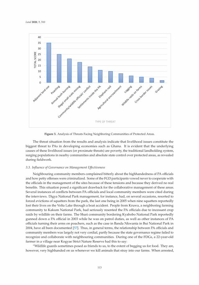
Land 2020, 9, 310
Figure 3. Analysis of Threats Facing Neighboring Communities of Protected Areas.
The threat situation from the results and analysis indicate that livelihood issues constitute thebiggest threat to PAs in developing economies such as Ghana. It is evident that the underlyingcauses of these livelihood issues (or proximate threats) are poverty, the traditional landholding system,surging populations in nearby communities and absolute state control over protected areas, as revealedduring fieldwork.
3.3. Influence of Governance on Management Effectiveness
Neighbouring community members complained bitterly about the highhandedness of PA officialsand how petty offenses were criminalized. Some of the FGD participants vowed never to cooperate withthe officials in the management of the sites because of these tensions and because they derived no realbenefits. This situation posed a significant drawback for the collaborative management of these areas.Several instances of conflicts between PA officials and local community members were cited duringthe interviews. Digya National Park management, for instance, had, on several occasions, resorted toforced evictions of squatters from the park, the last one being in 2005 when nine squatters reportedlylost their lives on the Volta Lake through a boat accident. People from Kruwa, a neighboring farmingcommunity to Kakum National Park, had seriously resented the PA officials due to incessant cropraids by wildlife on their farms. The Shari community bordering Kyabobo National Park reportedlygunned down a PA official in 2003 while he was on patrol duties, as well as other instances of PAofficials turning their arms on poachers, such as the case in Banda Nkwanta in Bui National Park in2004, have all been documented [57]. Thus, in general terms, the relationship between PA officials andcommunity members was largely not very cordial, partly because the state governance regime failed torecognize and collaborate with neighbouring communities. During one of the FDGs, a 22-year-oldfarmer in a village near Kogyae Strict Nature Reserve had this to say:
“Wildlife guards sometimes posed as friends to us, to the extent of begging us for food. They are,however, very highhanded on us whenever we kill animals that stray into our farms. When arrested,
113
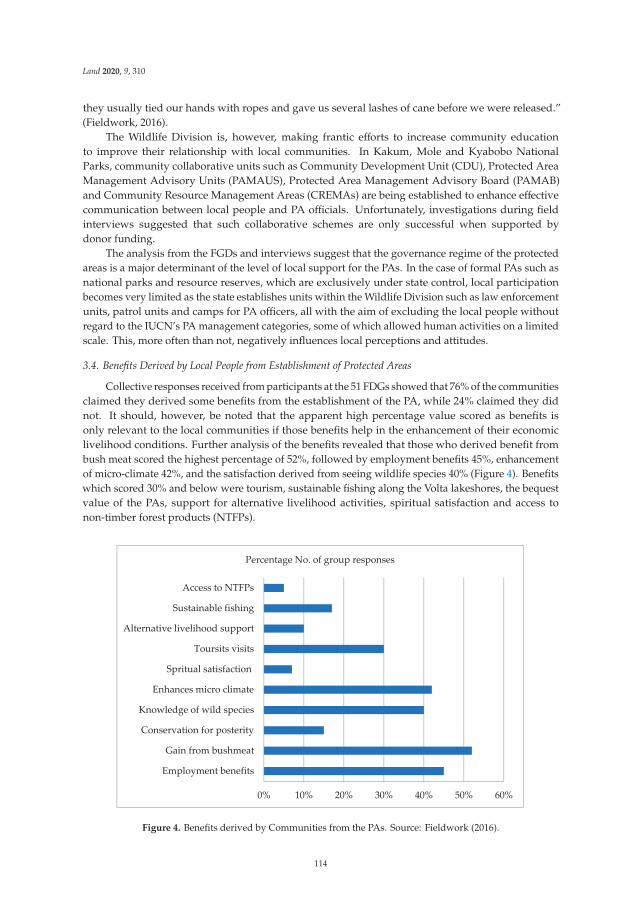
Land 2020, 9, 310
they usually tied our hands with ropes and gave us several lashes of cane before we were released.”(Fieldwork, 2016).
The Wildlife Division is, however, making frantic efforts to increase community educationto improve their relationship with local communities. In Kakum, Mole and Kyabobo NationalParks, community collaborative units such as Community Development Unit (CDU), Protected AreaManagement Advisory Units (PAMAUS), Protected Area Management Advisory Board (PAMAB)and Community Resource Management Areas (CREMAs) are being established to enhance effectivecommunication between local people and PA officials. Unfortunately, investigations during fieldinterviews suggested that such collaborative schemes are only successful when supported bydonor funding.
The analysis from the FGDs and interviews suggest that the governance regime of the protectedareas is a major determinant of the level of local support for the PAs. In the case of formal PAs such asnational parks and resource reserves, which are exclusively under state control, local participationbecomes very limited as the state establishes units within the Wildlife Division such as law enforcementunits, patrol units and camps for PA officers, all with the aim of excluding the local people withoutregard to the IUCN’s PA management categories, some of which allowed human activities on a limitedscale. This, more often than not, negatively influences local perceptions and attitudes.
3.4. Benefits Derived by Local People from Establishment of Protected Areas
Collective responses received from participants at the 51 FDGs showed that 76% of the communitiesclaimed they derived some benefits from the establishment of the PA, while 24% claimed they didnot. It should, however, be noted that the apparent high percentage value scored as benefits isonly relevant to the local communities if those benefits help in the enhancement of their economiclivelihood conditions. Further analysis of the benefits revealed that those who derived benefit frombush meat scored the highest percentage of 52%, followed by employment benefits 45%, enhancementof micro-climate 42%, and the satisfaction derived from seeing wildlife species 40% (Figure 4). Benefitswhich scored 30% and below were tourism, sustainable fishing along the Volta lakeshores, the bequestvalue of the PAs, support for alternative livelihood activities, spiritual satisfaction and access tonon-timber forest products (NTFPs).
0% 10% 20% 30% 40% 50% 60%
Employment benefits
Gain from bushmeat
Conservation for posterity
Knowledge of wild species
Enhances micro climate
Spritual satisfaction
Toursits visits
Alternative livelihood support
Sustainable fishing
Access to NTFPs
Percentage No. of group responses
Figure 4. Benefits derived by Communities from the PAs. Source: Fieldwork (2016).
114

Land 2020, 9, 310
Participants who claimed they benefited from tourism explained that though they derived noeconomic benefits, they felt delighted seeing tourists in their communities. A few lakeshore communitymembers in Digya National Park enclave bordering the Volta Lake claimed that they derived benefitsfrom sustainable fishing by virtue of the high productivity experienced near portions of the lake underprotection. In Kyabobo, some community members claimed they benefited from donor-supportedalternative livelihood activities such as beekeeping and oil palm nursery establishment in the recent past.The benefits derived from a PA tend to shape one’s perception and attitude towards that establishment,but this is also dependent on the governance regime of the PA. So in a situation where absolute statecontrol is exercised, local benefits may not meet general expectations to resolve livelihood challenges.
3.5. Problems Imposed by PA Establishment on Neighbouring Communities
Most of the local communities living close to PAs felt either disadvantaged or considered theestablishment of the PA as being a problem to them. From the findings, the most serious problem listed,with a score of 60%, was crop raids by wild animals from the reserves (Figure 5). This was followedby a lack of access to bushmeat (35%) and highhandedness on the part of PA officials (30%). Otherproblems enumerated included loss of fishing grounds with regard to those along the lakeshores, lackof access to NTFPs, restricted access to mineral deposits in Bui and Atewa, and loss of fertile lands.
0% 10% 20% 30% 40% 50% 60% 70%
Reduced land size
No open access to bushmeat…
Harrassment & arrests by WD…
Lost of most fertile lands
Crop devastation by animals…
No access to mineral deposits
No access to fishing grounds
No access to NTFPs
No access to constructional…
Percentage No. of group responses
Figure 5. Problems imposed by a PA Establishment. Source: Fieldwork, (2016).
Wildlife raids on farms were one of the major problems faced by the neighbouring communitiesfrom their perspective. Elephant raids, in particular, were reportedly very devastating and mostcommon in the vicinities of Kakum, Mole and the southern fringes of Digya. Other animals such asrodents, primates and angulates were reported to cause serious havoc to farm crops, which was amajor source of conflict between PA officials and local communities.
When these results are compared to the analysis of threats, an interesting observation was made.The two most severe threats from the point of view of PA managers and administrators were adjacentland use and poaching. At the same time, the two highest-ranking problems, as reported by the localcommunities, were crop devastation by wildlife and lack of access to bushmeat. These two pairs of
115

Land 2020, 9, 310
issues mirror each other. Indeed, it was noted that areas bordering the PAs were either communal landsor belonged to individual families. These adjacent lands were mostly under farming, and these farmsget exposed to raids by wildlife from the PAs. Farmers’ reaction to wildlife raids was mostly poaching,which unfortunately is illegal, thus bringing the communities into conflict with PA officials. From thepoint of view of the administrators, therefore, poaching was a serious threat, while local communitiesregarded their restricted access to bushmeat as a serious problem. Under such circumstances, localperceptions and attitudes would be that of resentment and/or passivity.
3.6. Community Perception of the Establishment of PAs
Based on the responses received on benefits derived from, and problems imposed by the PAs onthe communities, the question was posed as to the extent to which neighboring communities supportedthe establishment of the PAs. From the responses, 50% claimed they supported the PA concept, while35% claimed they did not support the concept. The remaining 15% remained indifferent.
Out of the total percentage which did not support the establishment of PAs, 86% responded thatcrop destruction by wild animals was a problem for them. Again, 79% of the groups that dislike theidea of PA establishment claimed that PA officials had manhandled them or their relations. Within thesame group who dislike the PA concept, 57% reported reduced farm sizes as the reason for this view.A further 23% of those who did not support the PA establishment expressed intense hatred towards PAofficials. All communities whose farms were raided by elephants were emphatic that they dislike theconcept of PA establishment. These communities constituted 36% of the total number of groups thatdisliked PA establishment. Table 4 is a summary of the above analysis showing a comparison betweenthe percentage of respondents who disliked the PA concept and those who supported it.
Table 4. Problems Imposed by PA Establishment and Community Attitudes towards PA Establishment.
Problems Imposed by PA EstablishmentPercentage of Those WhoDislike PA Establishment
Percentage of Those WhoAccept PA Establishment
Crop destruction by animals 86% 65%Frequent manhandling by WD officials 79% 15%
Reduced land size 57% 60%
All the groups that accepted the PA establishment claimed they had received some educationfrom PA officials, who explained to them the reasons for the PA establishment. They indicatedtheir willingness to serve as informants against poaching, especially by strangers, and as firefightingvolunteers when motivated to do so.
It is clear from the results that the state-management PA governance type, which dominates muchof Ghana’s conservation landscape, operates where enforcement and regulation dictate decision-makingand, in a way, tends to exclude the local people. There is, therefore, little local community collaborationin the state-managed PAs system, which contravenes the multi-stakeholder approach needed forconservation success. Furthermore, the system of land tenure where individual land rights prevaildoes not make landscape management a feasible option, so long as land remains a major source oflivelihood in sub-Saharan countries such as Ghana.
4. Discussion
The findings showed that poverty in nearby communities, land tenure issues, increasing humanpopulations and the system of PA governance were the main underlying issues that are fuelingthe myriads of challenges faced by PAs in Ghana. As indicated in the findings, indicators such asnon-availability of medical facilities, quality education, decent housing, pipe-borne water, propersanitation and electricity are lacking in most of the study communities. This lack of essential servicesis reflected in a poverty index of 0.261 for rural Ghana [58], which directly applies to most of theneighboring communities studied. This finding concurs with some earlier works, for example, Ayivor
116

Land 2020, 9, 310
et al. [59], which ranked poverty in nearby communities as the most serious threat facing PAs inGhana. This situation supports the views expressed in the broader conservation literature that PAsdo not reduce poverty in nearby communities since the primary objective of their establishmentis not human-centered, but to conserve biological diversity [18,28]. Tackling this issue requiresmulti-stakeholder collaboration, such as support from development agencies and the private sector,to promote pro-poor livelihood programs aimed at reducing poverty in these areas and householdreliance on local natural resources.
On human population growth, the main issue of concern is not the national annual growth rateof 2.2% [60], but the fact that 89% of the neighboring communities were farmers who depended onlimited land space for livelihood. Thus, any increase in population puts more pressure on the PAsthrough adjacent land-use. This is noteworthy, as the expansion in individual farms that share borderswith the PAs can result in PA isolation in the absence of matrix-based conservation. Since most of thePA sizes are small, wildlife with a wide range, such as the elephant, invade farms within their range,resulting in farmer-wildlife conflict [57]. Studies in Cameroon, for instance, indicated that elephantraids accounted for about 70% loss of family production [61]. Several studies have shown that whenneighboring communities are forced to absorb the costs of living with wildlife, local collaboration inPA management may be seriously undermined [10,62,63]. The results of this assessment showed that86% of those who had experienced crop raids by wildlife, including elephants, claimed that they didnot support the PA concept. As Naughton et al. [64] noted, human-wildlife conflicts remain a majorobstacle to community support for conservation. This requires the establishment of another form ofa compensation system, besides the existing land compensation, to appease those whose farms areraided by elephants in particular. Ogra and Badola [63] conceptualized this type of compensation asbeing more closely based on ground-level realities, which implies that farmers whose crops are raidedby wildlife should be compensated anytime such raids occur.
The governance type prevailing in all the PAs studied is the state-managed type in which decisionmaking is centralized and the approach largely “exclusive.” This approach, as earlier noted, puts ahigher premium on ecological considerations than local community welfare. Meffe et al. [34] referredto this approach as regulatory enforcement and regulation dictating decision-making. The forcedeviction of settlers from Digya National Park by PA officials because their activities did not promotethe ecological integrity of the park is an outcome of such a state-controlled governance type [57].According to Cernea and Schmidt–Soltau [65], who based their argument on the “ImpoverishmentRisks and Reconstruction Model,” if PAs achieve additional degrees of conservation, part of the cost ispaid in the coin of additional impoverishment for the people violently uprooted from their habitat andnot resettled. Thus, operating only within the “ecological and institutional context” [34] would resultin poverty in nearby communities. This is the likely reason why about 50% of the local communitiesdid not support the concept of PA establishment and would not collaborate in their management.
With regard to socio-economic benefits, a closer look at three out of the four listed benefits thathad scores of at least 40% (i.e., microclimate enhancement, knowledge of wild animals and benefitsfrom bushmeat), clearly shows that in real terms, two were intangible benefits. More so, benefitsfrom bushmeat were illegitimate because the activity was illegal, and people caught engaging init were criminalized and punished. The issue of high handedness by PA officials on PA offenders,however, tends to undermine the spirit of collaboration. According to Stern [66], such people whofeel unwanted will do everything to outwit PA officials whom they consider as “police.” Concerningemployment benefits, which scored relatively high, the real situation observed was that most of thelocal beneficiaries were only engaged seasonally as casual laborers to clear boundary lines, or to serveas tour guards, and earned only meager wages. It should be noted that in protected area managementwithin the Africa context, any small percentage number of people that oppose PA establishment mayhave more than proportionate repercussions on PA goals and objectives. For instance, it takes only oneor two people to initiate bush fires in a PA, which generally causes serious havoc to wildlife on anannual basis. This was the experience of Digya National Park and Gbele Resource Reserve (Table 3),
117

Land 2020, 9, 310
where the perpetrators were never identified. Furthermore, in Gbele Resource Reserve, where grouphunting was observed as a serious threat, it takes less than 10% of the population to perpetrate this act,but the impacts are grievous.
The research suggests that nature conservation, mainly where governance is vested in the state,does not bring enough economic benefits to local people and may result in conflicts because givingaccess to the local people to exploit the economic resources of the PA is seen to compromise theecological integrity of the ecosystem being protected. However, since poverty levels are high in theneighbouring communities as evident in the findings, the communities placed a greater premium oneconomic benefits than other benefits and, thus, not appreciative of intangible benefits since these didnot enhance their economic livelihood conditions. As a solution, Meffe et al. [34], suggested meeting theinterest of multiple stakeholders by operating within the converging point of “socio-economic context”and “institutional context,” which they referred to as “win-win-win” partnerships. This convergingpoint represents collaborative management in which stakeholders of the economic context, ecologicalcontext and institutional context combine their interests in the management of the protected areassuch that none of the three becomes unduly disadvantaged. Such collaboration would assure the localcommunities that their rights are respected and would thus, engender their support for the effectivemanagement of the protected areas.
5. Conclusions
It is obvious from the discussion that the state-managed PA governance regime does not meetlocal livelihood needs and is, therefore, perceived by most local communities as an initiative bygovernments to conserve nature for the benefit of the state. The governance regime, thus, fails toaddress poverty in nearby communities and tends to ignore fundamental problems that confront thelocal people such as human-wildlife conflicts. The regime has instead fueled antagonistic relationshipsbetween the communities and PA officials, resulting in highhandedness on the part of officials andcriminalization of livelihood-related offences that are committed by the local people. This impliesthat PA officials will continue to regard local community members as intruders rather than partnersbecause the governance regime does not engender true local collaboration. Promotion of co-managedprotected areas is an option that would enhance community ownership and ensure better collaborationand greater success in nature conservation. Furthermore, for the state-controlled areas to be effectivelymanaged, every effort must be made to positively influence local perceptions and attitudes towardsbehavioral change by promoting collaborative partnerships among the local people and all other interestgroups. The promotion of village committees such as the Community Resource Management Area(CREMA) concept, which is an initiative instituted by the Ghana Forestry Commission, provides localpeople with an open forum to discuss issues, ask questions, and recommend their own prescriptions.This initiative has started receiving recognition and, therefore, is being implemented in some ofGhana’s state-managed PAs. It is further recommended that PA officials need to solicit donor supportor additional funding from their governments to promote local collaboration and alternative livelihoodactivities, which comes at a high cost. This study also recommends a new system of compensation thatis oriented towards permanent job creation through development interventions in the neighboringcommunities to empower the local people economically to help alleviate poverty in these communities.There is also the need to consider integrated landscape management as an option where wildlife willbe protected not only in designated reserves but within the entire landscape through multi-stakeholderengagement. Effective use of the landscape in a manner that optimizes yields such as agriculturalintensification can also reduce pressure on PAs.
Author Contributions: Conceptualization, J.S.A.; Data curation, J.S.A.; Formal analysis, J.S.A., J.K.N. and S.A.;Investigation, J.S.A., J.K.N. and S.A.; Methodology, J.S.A., J.K.N. and S.A.; Writing—original draft, J.S.A., J.K.N.and S.A.; Writing—review & editing, J.S.A., J.K.N. and S.A. All authors have read and agreed to the publishedversion of the manuscript.
Funding: This research received no external funding.
118
Land 2020, 9, 310
Acknowledgments: The authors wish to thank the Wildlife Division of the Ghana Forestry Commission forgranting us access to all the protected areas to carry out fieldwork. We wish also to thank all the protected areamanagerial staff for their support during fieldwork and for the valuable information provided during interviewsessions. A note of appreciation also goes to all the local chiefs of the communities visited, for allowing us entryinto the communities and encouraging the community members to participate in the focus group discussions.Above all, we thank the Almighty God for the guidance and protection during the entire duration of the work.
Conflicts of Interest: The authors declare no conflict of interest.
References
1. Joppa, L.N.; Loarie, S.R.; Pimm, S.L. On the protection of “protected areas”. Proc. Natl. Acad. Sci. USA 2008,5, 6673–6678. [CrossRef] [PubMed]
2. Chapes, S.; Spalding, M.; Jenkins, M. The World’s Protected Areas: Status, Values and Prospects in the 21stCentury; University of California Press: Berkeley, CA, USA, 2008; pp. 1–359.
3. Dudley, N. (Ed.) Guidelines for Applying Protected Area Management Categories; IUCN: Gland, Switzerland,2008; pp. 1–86.
4. Meine, C.D. The oldest task in human history. In A New Century for Nature Resources Management; Knight, L.R.,Bates, S.F., Eds.; Island Press: Washington, DC, USA, 1995; pp. 7–35.
5. Uphoff, N. Learning from Gal Oya: Possibilities for Participatory Development and Post-Newtonian Science; CornellUniversity Press: Ithaca, NY, USA, 1992; pp. 1–448.
6. Schelhas, J.; Buck, L.E.; Geisler, C.C. The challenges of Adaptive Collaborative management. In BiologicalDiversity. Balancing Interest through Adaptive Collaborative Management; Buck, L., Geisler, C.C., Shelhas, J.,Wollenberg, E., Eds.; CRC Press: Boca Raton, FL, USA; London, UK; New York, NY, USA; Washington, DC,USA, 2001.
7. Parker, P.; Rollins, R.; Murray, G.; Chafey, A.; Cannessa, R. Community perceptions of the contributions ofparks to sustainability in Canada. Leisure/Loisir 2017, 41, 365–389. [CrossRef]
8. Wells, M.; Brandon, K. People and Parks. Linking Protected Area Management with Local People; The InternationalBank for Reconstruction and Development/the World Bank: Washington, DC, USA, 1992; pp. 1–99.
9. Kramer, R.; van Schaik, C.; Johnson, J. Last Stand: Protected Areas and the Defense of Tropical Biodiversity; OxfordUniversity Press: Oxford, UK, 1997; pp. 1–242.
10. Brandon, K.; Redford, K.H.; Sanderson, S.E. (Eds.) Parks in Peril. People, Politics and Protected Areas; IslandPress: Washington, DC, USA, 1998; pp. 1–499.
11. Oates, J.F. Myth and Reality in the Rainforest: How Conservation Strategies are Failing in Africa; University ofCalifornia Press: Berkeley, CA, USA, 1999; pp. 1–338.
12. Anthony, B. The dual nature of parks: Attitudes of neighbouring communities towards Kruger NationalPark, South Africa. Environ. Conserv. 2007, 34, 236–245. [CrossRef]
13. Andrade, G.S.M.; Rhodes, J.R. Protected areas and local communities: An inevitable partnership towardsuccessful conservation strategies? Ecol. Soc. 2012, 17, 14–29. [CrossRef]
14. Stone, M.T.; Nyaupane, G.P. Protected areas, tourism and community livelihoods linkages: A comprehensiveanalysis approach. J. Sustain. Tour. 2016, 24, 673–693. [CrossRef]
15. Lindenmayer, D.B.; Franklin, J.F. (Eds.) Towards Forest Sustainability; Island Press: Washington, DC, USA;CSIRO Publishing: Clayton, VIC, Australia, 2003.
16. Buhumuza, M.; Balkwill, K. Factors affecting the success of conserving biodiversity in national parks:A review of case studies from Africa. Int. J. Biodivers. 2013. [CrossRef]
17. Das Kanti, B. Role of NTFPs among forest villagers in a protected area of West Bengel. J. Hum. Ecol. 2005, 18,129–136.
18. Scherl, L.M.; Wilson, A.; Wild, R.; Blockhus, J.M.; Franks, P.; McNeely, J.A.; McShane, T. Can Protected AreasContribute to Poverty Reduction? Opportunities and Limitations; IUCN: Gland, Switzerland; Cambridge, UK,2004; Volume 4, pp. 1–60.
19. IFAD (International Fund for Agricultural Development). Improving Access to Land and Tenure Security; PolicyIFAD: Rome, Italy, 2008; 42p.
20. Hitt, M.A.; Black, S.; Porter, L.W. Management, 3rd ed.; Pearson Education: Upper Saddle River, NJ, USA, 2011.
119

Land 2020, 9, 310
21. Worboys, G.L.; Trzyna, T. Managing protected areas. In Protected Area Governance and Management;Worboys, G.L., Lockwood, M., Kothari, A., Feary, S., Pulsford, I., Eds.; ANU Press: Canberra, Australia, 2015;pp. 207–250.
22. UNEP-WCMC. Protected Areas and Biodiversity; UNEP-WCMC Biodiversity Series No. 21; UNEP-WCMC:Cambridge, UK, 2004.
23. Borrini-Feyerabend, G.; Kothari, A.; Oviedo, G. Indigenous and Local Communities and Protected Areas: TowardsEquity and Enhanced Conservation; IUCN: Gland, Switzerland; Cambridge, UK, 2004; pp. 1–111.
24. West, P.C.; Brechin, S.R. Resident Peoples and National Parks: Social Dilemmas and Strategies in InternationalConservation; University of Arizona Press: Tucson, AZ, USA, 1991; pp. 1–443.
25. Adams, W.; Hulme, D. If community conservation is the answer in Africa, what is the question? Orynx 2001,35, 193–200. [CrossRef]
26. Ghimire, K.B.; Pimbert, M.P. Social Change and Conservation: Environmental Politics and Impact on NationalParks and Protected Areas; Earthscan Publications: London, UK, 1997; pp. 1–352.
27. Lewis, D.; Carter, N. (Eds.) Voices from Africa: Local Perspective on Conservation; WWF-US: Washington, DC,USA, 1993.
28. Brechin, S.R.; Wilshusen, P.R.; Fortwangler, C.L.; West, P. Contested Nature: Promoting International Biodiversitywith Social Justice; SUNY Press: New York, NY, USA, 2003; pp. 1–315.
29. World Wildlife Fund (WWF). Stakeholder Collaboration: Building Bridges for Conservation; World Wildlife Fund:Washington, DC, USA, 2000; Available online: www.worldwildlife.org (accessed on 20 July 2019).
30. Mulongoy, K.J.; Chape, S. Protected Areas and Biodiversity: An Overview of Key Issues; CBD Secretariat andUNEP-WCMC: Montreal, QC, Canada; Cambridge, UK, 2004; pp. 1–55.
31. DeCaro, D.; Stokes, M. Social-psychological principles of community-based conservation and conservancymotivation: Attaining goals within an autonomy-supportive environment. Conserv. Biol. 2008, 22, 443–1451.[CrossRef]
32. Kemmis, D. Community and the Politics of Place; University of Oklahoma Press: Norman, OK, USA, 1993;pp. 1–150.
33. Daily, G.C.; Ellison, K. The New Economy of Nature and the Marketplace: The Quest to Make Conservation Profitable;Island Press: Washington, DC, USA, 2002; pp. 1–260.
34. Meffe, G.; Nielsen, L.; Knight, R.; Schenborn, D. Ecosystem Management: Adaptive, Community-BasedConservation; Island Press: Washington, DC, USA, 2002; pp. 1–333.
35. Rosenzweig, M. Win-Win Ecology: How the Earth’s Species Can Survive in the Midst of Human Enterprise; OxfordUniversity Press: Oxford, UK, 2003; pp. 1–224.
36. Feurt, C. Protecting Our Children’s Water—Using Cultural Models and Collaborative Learning toFrame and Implement Ecosystem Management. Ph.D. Thesis, Antioch University–New England,Keene, NH, USA, 2007.
37. Chicchon, A. Conservation theory meets practice. Conserv. Biol. 2000, 14, 1368–1369. [CrossRef]38. Cooke, B.; Kothari, U. Participation: The New Tyranny? Zed Books: London, UK, 2001; pp. 1–207.39. Terborgh, J.; van Schaik, C.; Davenport, L.; Rao, M. Making Parks Work: Strategies for Preserving Tropical Nature;
Island Press: Washington, DC, USA, 2002; pp. 1–511.40. Abrams, R.W.; Anwana, E.D.; Ormsby, A.; Dovie, D.B.K.; Ajagbe, A.; Abrams, A. Integrating top-down with
bottom-up conservation policy in Africa. Conserv. Biol. 2009, 23, 799–804. [CrossRef] [PubMed]41. Meroka, P.; Haller, T. Government wildlife, unfulfilled promises and business: Lessons from participatory
conservation in the Selous Game Reserve, Tanzania. In People, Protected Areas and Global Change: ParticipatoryConservation in Latin America, Africa, Asia and Europe; Galvin, M., Haller, T., Eds.; Geogra-Bernensia:Bern, Switzerland, 2008; Volume 3, pp. 177–221.
42. DeFries, R.S.; Foley, J.A.; Asner, G.P. Land use choices: Balancing human needs and ecosystem function.Front. Ecol. Environ. 2004, 2, 249–257. [CrossRef]
43. Xu, J.; Chen, L.; Lu, Y.; Fu, B. Local people’s perceptions as decision support for protected area managementin Wolong Biosphere Reserve. J. Environ. Manag. 2006, 78, 362–372. [CrossRef]
44. Eben, M. Public participation during site selections for Natura 2000 in Germany: The Bavarian Case.In Stakeholder Dialogues in Natural Resources Management; Stoll-Kleemann, S., Welp, M., Eds.; Springer:New York, NY, USA, 2007; pp. 261–278.
120
Land 2020, 9, 310
45. Dimitrakopoulos, P.G.; Jones, N.; Iosifides, T.; Florokapi, I.; Lasda, O.; Paliouras, F.; Evangelinos, K.I. Localattitudes on protected areas: Evidence from three Natura 2000 wetland sites in Greece. J. Environ. Manag.2010, 91, 1847–1854. [CrossRef] [PubMed]
46. Eagly, A.H.; Chaiken, S. Attitude structure and function. In The Handbook of Social Psychology; Gilbert, D.T.,Fiske, S.T., Lindzey, G., Eds.; McGraw-Hill: New York, NY, USA, 1998; Volume 1, pp. 269–322.
47. Htun, N.Z.; Mizoue, N.; Yoshida, S. Determinants of local people’s perceptions and attitudes toward aprotected area and its management: A case study from Popa Mountain Park, Central Myanmar. Soc. Nat.Resour. 2012, 25, 743–758. [CrossRef]
48. Nicholas, L.N.; Thapa, B.; Ko, Y.J. Resident’s perspectives of a world heritage site: The Pitons managementarea, St. Lucia. Ann. Tour. Res. 2009, 36, 390–412. [CrossRef]
49. Bennett, N.J.; Dearden, P. Why local people do not support conservation: Community perceptions of marineprotected area livelihood impacts, governance and management in Thailand. Mar. Policy 2014, 44, 107–116.[CrossRef]
50. McNeely, J.A.; Miller, K.R.; Reid, W.V.; Mittermeier, R.A.; Werner, T.B. Conserving the World’s BiologicalDiversity; IUCN: Gland, Switzerland, 1990; pp. 1–193.
51. Owusu, K.; Waylen, P. Trends in spatio-temporal variability in annual rainfall in Ghana (1951–2000).R. Meteorol. Soc. 2009, 64, 115–120. [CrossRef]
52. Attuquayefio, D.K.; Fobil, J.N. An overview of biodiversity conservation in Ghana: Challenges and prospects.West Afr. J. Appl. Ecol. 2005, 7, 1–18. [CrossRef]
53. Titriku, P.K. Agriculture in the Volta Basin: Problems and prospects. In Sustainable Integrated Development ofthe Volta Basin; Gordon, C., Ametekpor, J.K., Eds.; VBRP, Gold Type Press: Accra, Ghana, 1999; pp. 107–117.
54. Berghoher, A.; Bruner, A.; Conner, N.; Dudley, N.; Gidda, S.B.; Kettunen, K.; Mulongoy, K.J.; Pabon-Zamora, L.;Vakrou, A.; Ervin, J.; et al. Recognizing the value of protected areas. In The Economics of Ecosystems andBiodiversity in National and International Policy Making: Ecological and Economic Foundation. Bink, P., Ed.;Earthscan: London, UK, 2011.
55. Gunderson, L. Ecological resilience in theory and application. Annu. Rev. Ecol. Syst. 2000, 31, 425–439.[CrossRef]
56. Machlis, G.E.; Tichnell, D.L. The State of the World’s Parks: An International Assessment for Resource Management,Policy and Research; Westview Press: Boulder, CO, USA, 1985; pp. 1–131.
57. Ayivor, J.S.; Gordon, C.; Ntiamoa-Baidu, Y. Protected area management and livelihood conflicts in Ghana:A case study of Digya National Park. Parks 2013, 19, 37–50. [CrossRef]
58. Cooke, E.; Hague, S.; McKay, A. The Ghana Poverty and Inequality Report Using the 6th Living StandardsSurvey; University of Sussex/Unicef/Ashesie University College: Accra, Ghana, 2016; pp. 1–24. Availableonline: http://africainequalities.org/wp-content/uploads/2016/07/Ghana_Poverty_and_Inequality_Analysis_FINAL_Match_20161.pdf (accessed on 27 July 2020).
59. Ayivor, S.J.; Gordon, C.; Ntiamoa-Baidu, Y. Evaluation of management effectiveness of protected areas in theVolta Basin of Ghana: Perspectives on community participation, protected area financing and framework forevaluation. J. Environ. Plan. Policy 2019, 22, 239–255. [CrossRef]
60. Ghana Statistical Service. The Ghana Poverty and Inequality Report Using the 6th Living Standards Survey;University of Sussex/Unicef/Asheshie University College: Accra, Ghana, 2016; pp. 1–43. Availableonline: https://www.unicef.org/ghana/media/531/file/The%20Ghana%20Poverty%20and%20Inequality%20Report.pdf (accessed on 27 July 2020).
61. World Wide Fund for Nature (WWF). Elephants in the Balance: Conserving Africa’s Elephants. 2000. Availableonline: www.panda.org/resources/publications/species/elephants/index.htmlS (accessed on 1 August 2019).
62. Woodroffe, R.; Thirgood, S.; Rabinowitz, A. People and Wildlife: Conflict or Co-Existence? Cambridge UniversityPress: Cambridge, UK, 2005; pp. 406–477.
63. Ogra, M.; Badola, R. Compensating human-wildlife conflict in protected area communities: Ground-levelperspectives from Uttarakhand, India. Hum. Ecol. 2008, 36, 717–729. [CrossRef]
64. Naughton, L.; Rose, R.; Treves, A. The Social Dimensions of Human-Elephant Conflict in Africa: A LiteratureReview and Case Studies from Uganda and Cameroon; IUCN: Gland, Switzerland, 1999; pp. 1–82.
121
Land 2020, 9, 310
65. Cernea, M.M.; Schmidt-Soltau, K. Biodiversity Conservation Versus Population Resettlement: Risks toNature and Risks to People. In Proceedings of the International CIFOR Conference on Rural Livelihoods,Forests and Biodiversity, Bonn, Germany, 19–23 May 2003; pp. 19–23.
66. Stern, M.J. The power of trust: Toward a theory of local opposition to neighboring protected areas, society &natural resources. An. Int. J. 2008, 21, 859–875.
© 2020 by the authors. Licensee MDPI, Basel, Switzerland. This article is an open accessarticle distributed under the terms and conditions of the Creative Commons Attribution(CC BY) license (http://creativecommons.org/licenses/by/4.0/).
122
land
Article
Analysing and Applying Stakeholder Perceptions toImprove Protected Area Governance in UgandanConservation Landscapes
James Omoding 1, Gretchen Walters 2,*, Edward Andama 3, Salete Carvalho 1, Julien Colomer 1,
Marina Cracco 2, Gerald Eilu 4, Gaster Kiyingi 5, Chetan Kumar 1, Council Dickson Langoya 6,
Barbara Nakangu Bugembe 1, Florian Reinhard 1 and Celina Schelle 1,7
1 International Union for Conservation of Nature, Rue Mauverney 28, 1196 Gland, Switzerland;[email protected] (J.O.); [email protected] (S.C.); [email protected] (J.C.);[email protected] (C.K.); [email protected] (B.N.B.); [email protected] (F.R.);[email protected] (C.S.)
2 Institute of Geography and Sustainability, Faculty of Geosciences and the Environment,University of Lausanne, Géopolis, CH-1015 Lausanne, Switzerland; [email protected]
3 Biology department, Faculty of Science and Education, Busitema University, Jinja-Malaba Road,Tororo P.O. Box 236, Uganda; [email protected]
4 School of Forestry, Environmental and Geographical Sciences, Makerere University, University Road,Kampala 7062, Uganda; [email protected]
5 Tree Talk Plus, Plot 842 Lugolobi Close, Sempagala Zone-Buye, Ntinda-Kampala, Uganda;[email protected]
6 JC Holdings Ltd., Kampala P.O. Box 34857, Uganda; [email protected] Faculty of Environment and Natural Resources, University of Freiburg, Tennenbacher Str. 4,
79106 Freiburg, Germany* Correspondence: [email protected]; Tel.: +41-21-692-3072
Received: 15 May 2020; Accepted: 18 June 2020; Published: 25 June 2020
Abstract: Given the diversity of active institutions and stakeholders in a landscape, and the difficultiesin ensuring inclusive decision-making, evaluating landscape governance can help surface and addressunderlying issues. In the context of two protected area landscapes in Uganda, where landscapeapproaches are being implemented through a wider project on landscape governance, we analysestakeholder perceptions of inclusive decision-making and then use this evaluation to stimulatedialogue amongst stakeholder groups in each landscape. We ask, how can capturing, analysing,and collaboratively applying people’s perceptions address inclusive decision-making in landscapegovernance? We collected and analysed perceptions using SenseMaker®, a software package thatenables analysis of micronarratives (stories) from the field based on how respondents classify theirown stories, using triads, dyads, stones, and multiple-choice questions. This self-categorisation bythe respondent reduces bias in the analysis and allows the micronarrative to be cross-examined in avariety of ways when analysed using Sensemaker. This analysis created an integrated view of thestakeholder’s perceptions about inclusive decision-making in landscape governance. The resultsshow large portions of the respondents feel their voices are neglected, and management of thelandscape is poor in Mount Elgon, while in Agoro-Agu, it is the opposite trend. During a communityfeedback process, reasons for these trends were discussed and solutions proposed. Some of theunderlying factors include historical relationships with park authorities and displacement duringpark creation. To more precisely answer our research question, one could have extended stays in thecommunities studied in these landscapes, using ethnographic methods including interviews andparticipant observation; nonetheless, our method, including the feedback process, was an innovativeand important way to confront our findings with the informants directly and foster collaborative action.We conclude that understanding people’s perceptions, including through participatory feedback,can significantly inform and improve management decisions, help resolve conflicts, and facilitatedialogue between different stakeholders in the landscape.
Land 2020, 9, 207; doi:10.3390/land9060207 www.mdpi.com/journal/land123

Land 2020, 9, 207
Keywords: perceptions; Agoro-Agu; Mount Elgon; inclusive decision-making; dialogue; SenseMaker®;communities; landscape governance; Uganda
1. Introduction
Many landscapes are challenged by the competing demands of resources, leaving billions ofpeople and many economies at risk [1]. One response to this risk is the use of a landscape scale, valuablefor planning and decision-making. This allows the integration of various sector plans and programs(e.g., agriculture, forestry, conservation) across one social, environmental, and spatial context [2].Here we define a landscape as “A socio-ecological system that consists of a mosaic of natural andhuman-modified ecosystems, with a characteristic configuration of topography, vegetation, land use,and settlements that is influenced by the ecological, historical, economic and, cultural processes andactivities of the area. A landscape may encompass areas from hundreds to tens of thousands of squarekilometres” [3]. Conservation initiatives at the landscape scale became popular in the 1980s [4], when aholistic concept was needed for addressing environmental issues at a broader scale [5]. For the case ofprotected areas (PAs), the focus of this paper, this approach enabled conservationists to integrate theseunits into the wider landscape. Since then, the landscape approach has flourished as a concept fromthe mid-2000s [6] to the present. In this paper, we refer to these areas as PA landscapes, in the sameway that one may think of the Serengeti landscape.
Often seen as sets of overlapping ecological, social, and economic networks within a specific area,landscapes are considered to be a good scale for dealing with protected area (PA) issues [7,8] and forachieving sustainability [9]. In this context, landscape approaches (LAs) became popular. LAs areparticipatory processes for addressing landscape-level issues (e.g., competition for natural resourcesor land) by bringing together stakeholders from different sectors through decision-making processesor policy-practice integration [4,10]. LAs comprise numerous types, from community-based naturalresource management to integrated water resource management [11].
Recent principles which guide implementation of LAs [10] reflect the participatory nature oflandscape governance with several focusing on rights and responsibilities, justice, recognition ofmultiple stakeholders, equity, and the access of information. Improving governance can contribute toenhanced conservation outcomes [12,13], by addressing power, responsibility, accountability, and rightsas part of a dynamic process [14]. Natural resource governance is defined as the norms, institutions,and processes that determine how power and responsibilities over natural resources are exercised,how decisions are taken, and how rights-holders and stakeholders (including women, men, youth,Indigenous peoples, and local communities) secure access to, participate in, and are impacted bythe use and management of natural resources [15]. At the landscape level, governance is furthercomplicated by the values of stakeholders pursuing their interests, such as food production orbiodiversity conservation [16]. Increased attention to LAs and the associated place of governance atthe landscape scale allows for greater attention be given to issues around inclusive decision-making [2]and can enable a decision-making space across institutions, processes, and stakeholders (Figure 1).
124

Land 2020, 9, 207
Figure 1. The structure of landscape governance, adapted from [17].
Decision-making processes and institutions are the vehicles through which stakeholders cometogether to discuss and resolve natural resource issues. Inclusive decision-making in these processes iscentral to landscape governance and yet remains one of its challenges [18]. Inclusive decision-makingis “based on the full and effective participation of all relevant actors, with particular attention tothe voice and inclusion of rights-holders and groups at risk of marginalisation” [15:3]. Inclusivedecision-making often focuses on participation, which attempts to ensure that rights-holders andstakeholders are represented and can have a say in making decisions [19]. In summarising research onthe topic, Oyono and Mandondo [20] indicate that inclusive decision-making is meant to guaranteerecognition and protect against marginalisation. Although it is but one aspect of governance [21], it iscentral to landscape governance and so the focus of this paper. In many landscapes, decisions are notmade on a level playing field, with significant differences in the ability of stakeholders to participateand have their voice heard [22].
Landscape governance also must be understood within a landscape’s historical and culturalcontexts and analysed in reference to the relationships amongst stakeholders in decision-makingprocesses. Landscapes are shaped by inter-relationships of societies; protected area landscapes can beseen as cultural landscapes where societies and nature have evolved together over time [8]. Landscapeswithin which conservation projects take place are part of broader social-ecological systems wheregovernance influences conservation [23]. Treating landscapes as ahistorical entities erases the ability ofpeople to assert their power to govern them today [24]. Landscape approaches and their governancemay reinforce colonial legacies that distorted cultural management arrangements [25]. Historicallegacies of particular institutions can leave marks on people and their memories within a landscapewhere past relations between stakeholders continue to influence present-day power dynamics [26].Therefore, how stakeholders perceive institutions and their management decisions is key to landscapegovernance; it may also be decisive on if and how they engage [27].
Although landscape approaches and governance are promoted internationally including byagreements such as the Convention on Biological Diversity [28], landscapes may have severalinstitutions managing portions of them from customary and elected authorities to park managersand private stakeholders, with potentially no landscape-level authority to bring decision-makingtogether. Given the diversity of institutions and stakeholders in a landscape, and the difficulties inensuring inclusive decision-making, evaluating landscape governance can help surface and addressunderlying issues such as problems with inclusive decision-making. However, resolving governanceissues remains a challenge for many landscape practitioners [29]. In places where LAs are being used,how can governance be improved? One way is through understanding stakeholder perceptions andapplying them to learn with stakeholders on how to effectuate change in landscape governance [30].
PA management and governance should include the opinion and perception of the differentstakeholders [31], with perceptions forming an important basis of understanding how people viewconservation [30]. Stakeholders hold different perceptions, given their socioeconomic and culturaldifferences [32], and the actions pursued by these stakeholders are often based on their experiences,
125

Land 2020, 9, 207
culture, knowledge, and perceptions [33]. These perceptions can be used to support inclusivedecision-making and promote action [32]. When perceptions are presented back to landscapestakeholders, a space for dialogue can be created where stakeholders can share experiences, learn aboutissues, identify problems and solutions, and potentially enact change.
In the context of two PA landscapes in Uganda where LAs are being implemented through awider project on landscape governance, we sought to analyse stakeholder perceptions of inclusivedecision-making and then use this to stimulate dialogue amongst stakeholder groups in each landscape.We ask, how can capturing, analysing and collaboratively applying people’s perceptions foster inclusivedecision-making at the landscape level?
Due to the confluence of diverse climates and altitudinal ranges in its territory, creating a variety ofhabitats, relative to its area, Uganda is a biodiverse country, with 1742 terrestrial vertebrate species [34]4816 plant species [35,36], 1300 species of butterflies, and 260 dragonfly species [34]. However,the country lost half of its overall biodiversity value from 1975 to 1995 [37] due to habitat loss,agricultural encroachment, and expansion, climate change effects, and over-harvesting of resources,among others.
Protected areas (PAs) in the country, which shelter an estimated 95 per cent of the animal andplant species [38], fall under two main types in Uganda: forest reserves (24 per cent) and wildlifeconservation areas (10 per cent) [39]. Most game and forest reserves were established for colonialinterests (hunting, timber, and forest products) during the early 1900s, under the British colonialrule [40]. Nature conservation was not the original objective of PAs [41], and communities wereexcluded from the resource use and decision-making [42]. Approaches to nature conservation [43] andcommunity inclusion in the conservation policy process [44,45] appeared only later in the 1980s and‘90s; this is mirrored in Uganda’s policy history (Figure 2). Forest policy in Uganda has followed asimilar trend, with a participatory approach occurring in the last two decades [46]. Despite Uganda’sPAs not being designed for conservation in the past, they still provide a basis for conservation, if thepower relations embedded in their management can be balanced to avoid their use by political elites atthe expense of conservation [47].
Figure 2. Timeline showing Wildlife and Forest Reserves’ main events and policy.
In Uganda, two main categories of forests exist—those within PAs and those on private andcommunal land. Within PAs, protected forests fall under Central Forest Reserves (CFRs), managed,under the Public Trust Doctrine, for and on behalf of the people, by the National Forestry Authority(NFA), Local Forest Reserves (LFRs), managed by the District Local Governments (DLG) [48], and Privateand Community Forests, managed by communities and individuals on the basis of owning the land onwhich the forests are located (as per the Land Act). In 1996, the Uganda Wildlife Authority (UWA) wasestablished from the Uganda National Parks and Game Department. A semi-autonomous governmentagency, UWA is mandated to ensure sustainable management of wildlife resources and supervisewildlife activities in Uganda both within and outside the PAs. Currently, UWA manages 10 nationalparks, 12 wildlife reserves, five Community Wildlife Management Areas, and 13 Wildlife Sanctuaries,in addition to all wildlife outside wildlife protected areas [49].
126

Land 2020, 9, 207
2. Materials and Methods
The study sites: This study was implemented at two Sites: the Agoro-Agu Landscape (AAL)(also known as East Acholi Landscape) (encompassing the districts of Lamwo, Pader, Kitgum,and Agago and 16 Central Forest Reserves covering 65,548 ha under one Forest Management PlanningArea) and the Mount Elgon Landscape (MEL) (the Bududa and Namisindwa Districts and MountElgon National Park) (Figure 3). These two sites were selected because both participated in a landscapegovernance project and are places where the International Union for Conservation of Nature had beenengaging with communities for several years. It was realised that both landscapes did not addressgovernance in the whole landscape. In addition, the two landscapes are trans-boundary biodiversityhotspots in Uganda (Mount Elgon being a UNSECO Man and Biosphere Transboundary Reservebetween Uganda and Kenya and Agoro-Agu, a Transboundary Forest Reserve between Uganda andSouth Sudan).
Figure 3. The Agoro-Agu and Mount Elgon Landscapes/study sites. The red square identifiesAgoro-Agu, and the blue Mount Elgon.
The work reported here was intended to foster improved landscape governance in each landscapeas part of a wider conservation project. It was not meant to compare the landscapes to each other.Notably, these landscapes are managed by different conservation authorities, with different stylesof engagement with local communities. Furthermore, the northern Agoro-Agu landscape endureda civil war, while the Mount Elgon landscape did not. Finally, the colonial history with the northfocused on combining customary authorities under a single, invented ethnicity and then marginalisedthese populations vis-à-vis their engagement with southern Ugandan populations, such as those in theMount Elgon area. These differences are further detailed in the following section.
The Agoro-Agu Landscape (AAL): AAL is part of the Acholi subregion, in northern Uganda.The study site includes the Agoro-Agu CFR, Lalak CFR and vicinities. The Agoro-Agu Forest Reserve(264 sq. kms), was established in 1937, and gazetted as a CFR in 1948, and is part of a transboundary PAcomplex with South Sudan’s Imatong Forest Reserve [50,51]. This area is found in the Lamwo district,
127

Land 2020, 9, 207
which has a population density of 25.43 people per sq. km (2019 projected). The region’s populationdoubled between 1991 and 2019 [52]. The AAL’s main ethnic group is the Acholi. The Acholi are a Luopeople, who migrated into northern Uganda from South Sudan. Prior to colonisation by the British,there were approximately 60 chiefdoms, each governed by a Rwot, the hereditary leader. In pre-colonialtimes, important decisions that would impact a community could only be dealt with through consensusof clan representatives. The British grouped these chiefdoms together under a single ethnicity andadministrative area, and systematically marginalised the Acholi from schooling to labour [53]. Despitethis, the Acholi nationality has been adopted and used to challenge state authority [54]. Customaryauthority continues today, but the legitimacy of the Rwot is sometimes challenged by communitymembers, including youth [55].
The AAL suffered from persistent conflict in the mid-1980s, including the Lord’s Resistance Armycivil war against Uganda’s Government and conflicts in neighbouring South Sudan. Northern Ugandafeatures hybrid governance, where formal state authority simultaneously competes and cooperateswith traditional forms of customary authority [56].
The prevalent form of land tenure in the region is customary tenure (93 per cent of lands inAcholiland) [57,58]. The Agoro-Agu CFR is the geographical extension of the Imatong Mountains intothe Northern region of Uganda from South Sudan [59]. This mountain region is rich in biodiversityand holds many endemic and endangered species [60]. The vegetation includes Afromontane forests,shrublands, woody grasslands, and bamboos [59]. The Lalak CFR was gazetted in 1948 and covers2,212 hectares, comprising mainly woodlands and to a lesser extent, grasslands and small-scalecultivation [51]. Although there is no documented evidence that displacement happened when theCFRs were created, they did result in changes in ownership, access and use, a type of displacement [47].
Mount Elgon Landscape (MEL): The MEL is located in southern eastern Uganda along the Kenyaborder. The national park is 1110 sq. km., and is part of a transboundary PA complex with neighbouringKenya [50]. The Mount Elgon PA is in the area of two ethnic groups—the Sabiny ethnic group to thenorth and the Bagisu ethnic group to the south. The Sabiny people were originally pastoral but shiftedtowards agriculture in the 1980s in light of the introduction of hybrid corn, new ploughing techniques,market expansion, and attacks by the neighbouring Karamojong people [61]. The Bagisu people havelived in Mount Elgon for centuries [62]. Due to colonial pressure on land availability, they migratednorthward and are closely related to the Luhya people in Kenya [63].
Areas surrounding the park are densely populated, and the population density on the slopesin surrounding districts is high. In 2002, human population densities in the surrounding parishesranged from 150 people per sq. km in the north and northeast to more than 1000 people per sq. km inthe west [64].
Mount Elgon is an extinct volcano known for its diversity of endemic species and considered byconservation scientists to be irreplaceable [34]. The vegetation consists of four major vegetation types:(a) mixed montane forest (up to 2500 m), (b) bamboo and low canopy montane forest (2400–3000 m),(c) high montane heath (3000–3500 m), and (d) moorland (>3500 m). The high-altitude moorland andheath zones are rich in species endemic to Mount Elgon or shared with other east African mountains [65].Despite frequent landslides, these occur independently of anthropogenic influence [66].
Mount Elgon was first gazetted in 1929 as a forest reserve, for its role as a watershed and fortimber [67]. It was modified in 1993 to a national park status [47] and designated as a UNESCO Manand Biosphere Reserve in 2005. This change in legal status to a national park resulted in increasedrestrictions of access by local people for their livelihoods, and also access to cultural sites [68]. The MELhas a history of displacement [69]. Endemic species and degraded land justified the evictions of thesociety [47,70–72]. Parts of the park were encroached due to persistent raiding by the Karimojong whoforced the Sabiny people up the mountain, forcing UWA to excise an area of about 75 sq. km fromthe park for settlement [73]. Estimations of evictions were as many as 300,000 people [74]. Conflictswith managing authorities remain [67], due to high population density, scarce natural resources, and alargely poor population highly dependent on agriculture.
128

Land 2020, 9, 207
Material: We collected and analysed local stakeholder perceptions using SenseMaker®, a softwaretool that enables quantitative analysis of micronarratives (stories) from the field [75]. Sensemakingis part of a research tradition which aims to “make sense” of complex situations, including thosewhere power differences are likely in participating groups, allowing for diverse perspectives includingstrong points of agreement and disagreement [76]. People are storytellers, with narratives forming animportant part of their communication [77]. SenseMaker® uses these narratives to access multipleperspectives of complex situations through the identification of patterns around topics of interest andallows for meta-analysis of qualitative data that bridges a gap between case studies and large-samplesurvey data. This approach has been used by others as a monitoring tool [78] for evaluating farmer’sperceptions [79], and in climate change policy [80]. One of the reasons for using SenseMaker® was togain rapid access to multiple perspectives of complex situations through the identification of patternsaround topics of interest. It also allows the respondents to self-signify their story, and thus reducethe risk of imposing external biases during the analysis. In our study, the dataset obtained serves asa benchmark for determining current target stakeholder perceptions about how existing landscapegovernance approaches meet their expectations with regard to inclusive decision-making, amongstother issues.
Method: The SenseMaker® process comprises multiple steps from designing the framework tocollecting and analysing data and then presenting this back to communities (Figure 4). The projectteam introduced SenseMaker® to all the partners during a two-day workshop in Entebbe, Ugandain February 2018 and presented a draft questionnaire. Participants provided inputs to developthe SenseMaker® Signification Framework, which includes a prompting question that encouragesinformants to share a compelling story about a topic of interest; after this, sub-questions were askedto enable respondents to add meaning to their story, helping to signify the importance of their storyand classify it. Workshop participants decided on the following prompting question: “Reflectingon (Mount Elgon National Park OR Agoro-Agu Central Forest Reserve) can you share a positive ornegative experience that you (your family or your community) had in/with this area? Please describewhat happened.” After the micronarrative was provided in response to the prompting question,participants were asked to “signify” the context of their own story through a series of triad questionswhich place the micronarrative in the relative context of three concepts, especially those that giveinsight to trade-offs (Figure A2, Appendix A). Dyads were then used to indicate the relative strength ofa particular idea, between two opposing options (Figure A3, Appendix A). Stones were used to makecomparisons of three or more elements along two axes to differentiate how groups may perceive thesame issue differently (Figure A3, Appendix A) [81]. Multiple-choice demographic questions allowedfor secondary analysis of the data. In this analysis, we only focus on a subset of the data collected toanswer the research question (Figure A4, Appendix A).
Figure 4. The SenseMaker® Process.
In June 2018, the project team conducted a SenseMaker® training and data collectionexercise involving 20 students from Busitema University and six DLG staff from Lamwo, Bududa,and Namisindwa. The criteria applied for the selection of enumerators included interest in the tool,local language skills, and knowledge of the study area. Selected candidates followed a two-day trainingon the tool and adapted and translated the questionnaire from English to the two local languages
129

Land 2020, 9, 207
(Luo for Lamwo District and Lumasaba for Mount Elgon). The enumerator teams then travelled toMEL and AAL to test, adapt, and finalise the questionnaire.
Over four days in each study area, the 20 enumerators collected 235 stories in MEL (67 in Bududadistrict and 168 in Namisindwa district), and 229 in AAL (158 in Lamwo district/Central Forest Reserve(CFR) Agoro-Agu and 71 in Lamwo district/Lalak CFR). Local Council Chairpersons and Chiefspersonally mobilised the participants from home to home and through telephone calls to participate ata central location commonly used for meetings. Participants were then surveyed at these locations.
The stories collected were translated from the local language to English and entered into theSensemaker® system. Respondents were 57.5 per cent male and 42.5 per cent female, and the majoritywere aged between 36 and 55 years old. Fifty-two per cent had primary education. The majority ofrespondents sourced their income from agriculture, used their land for forestry, had lived in the areafor 20 years or more, and lived close to one of the PAs.
An analysis workshop was organised in October 2018 in Gland, Switzerland. Quantitativeanalyses were used to identify trends in the stories. Signifier and modifier questions were also appliedto the prompting question to identify characteristics of the stories and to explore governance issuesrelated to inclusive decision-making. In November 2018, the project team conducted a three-daycommunity participatory feedback session in each landscape to enabled respondents and stakeholdersto validate and “make sense” of the patterns that emerged from the data analysis and to developpropositions on how to improve the relations between communities and PA management in the twolandscapes. During these workshops, participants also read some of the stories collected. After readingthe stories, they were asked to interpret the stories, providing feedback based on their daily activities,and bring insights to the stories. One of the main challenges encountered during the data analysis wasthe possible time lag between when the stories were told and when they actually happened. As it wasnot possible to make that distinction during the initial data analysis process, it was, thus fundamentalto have a second-level analysis planned through a human sense-making process to validate thefindings. The main objectives of the participatory feedback exercise were to (a) Give the participants(all communities interviewed in June 2018, political leaders, and technical staff) an opportunity todiscuss the patterns of practice and create a common understanding of the changes, challenges,and opportunities in the landscapes; and (b) Deliberate on the key outcomes of the survey anddevelop action strategies. Participants were trained to read and interpret the stories and to bring newinsights to the stories and analysis. These feedback sessions provided participants with an opportunityto make proposals on how to improve working relations between the local communities and thestatutory PA management authorities and governance in the two landscapes. Once these discussionswere concluded, presentations were made on the responses and perspectives from the NFA, UWA,and DLG representatives on participants’ expectations and experiences followed by questions andanswers sessions.
3. Results
3.1. Main Perceptions Found With SenseMaker®
The findings of the SenseMaker® analysis created an integrated view of the stakeholder’sperceptions about inclusive decision-making in landscape governance. This section will explore keydimensions of inclusive decision-making and establish how people perceived the governance of theirlandscape, with a focus on the roles of key institutions, participation in decision-making, and thefairness of decisions. Although the results of both landscapes are presented together, we are notcomparing the landscapes to each other, but reporting on the perspectives found in each.
3.1.1. Inclusivity of the Governance at a Landscape Level
In both landscapes, the government was recognised as the most influential actor across landtypes (e.g., communal lands, CFRs, LFRs, National Parks, or Wildlife Reserve). Respondents from
130

Land 2020, 9, 207
AAL; however, felt that the communities played a relatively important role in managing the forestreserves (both CFRs and LFRs). The importance of roles of the traditional and cultural institutionswas also recognised in both landscapes. This type of governance continued to play an importantrole in many communities, particularly in defining and regulating the access and management ofnatural resources. In this regard, 40 per cent of the respondents from MEL and 45 per cent from AALconsidered that traditional and cultural practices were very influential in the situation described intheir story, while 30 per cent in MEL and 34 per cent in AAL thought that traditions had no influence atall (with 30 per cent of MEL and 21 per cent of AAL respondents falling between these two categories).
3.1.2. Community Participation in Decision-Making
In AAL, a slight majority (54 per cent) of the respondents perceived that the necessary mechanismsto support the participation of their communities in the decision-making processes were developedwhile only 39 per cent of the respondents from MEL felt the same. This difference of opinion betweenthe respondents of the two landscapes was even greater regarding the extent to which they felt thevoice of their communities was taken into account in decision-making. In this regard, 44 per cent ofthe respondents from AAL judged that their voice was heard while only 28 per cent in MEL felt thesame (Figure 5).
( g )
Figure 5. How the voice of the communities is taken into account in both landscapes.
131

Land 2020, 9, 207
These differences in perception could be important as they may have an impact on how localusers and communities evaluate existing conservation initiatives and management practices, and thusultimately influence their willingness to contribute to conservation efforts. There was a clear differencein how people perceived the effectiveness of the management systems in place in the two landscapes,as 48 per cent of the respondents from AAL considered that the CFRs were well managed while only21 per cent of the respondents from MEL believed this was the case about the National Park (Figure 6).
Figure 6. People’s perceptions about the way the protected area is managed.
There also seemed to be a relation between the perceived effectiveness of the current managementpractices and the inclusivity of the communities in the decision-making process (Figure 7). Figure 7overlays the clustering of stories across the axes of “management working well” or not well versusif “decisions took into account the voice of the community” or not, to find correlations. There wasan important concentration of stories in AAL, where the voice of the communities was heard andthe management practice was perceived as effective. In contrast, there was a similar concentrationof stories where the voice of the communities was neglected and the management was perceived asineffective in MEL.
Figure 7. Relationship between landscape management and taking into account the communities’voice. Green points locate micronarratives across the two axes and dark red shading identifies clustersof stories.
132
Land 2020, 9, 207
Finally, these observations were also reinforced by the perception that more people felt hopefulin AAL (49 per cent) than in MEL (24 per cent) with regard to the future of the PAs present intheir landscape.
3.1.3. Fairness in Decision-Making Processes
To illustrate how the respondents from MEL and AAL felt about the fairness in decision-makingprocesses, we considered the extent that decisions made by the management authorities were perceivedas fair or unfair. As already observed in some of the previous sections, it appears that more people inAAL considered the decisions made as fair (62 per cent) than in MEL (24 per cent).
3.2. Presenting Perceptions Back to the Communities
The participatory community feedback led to the identification of several actions to addressgovernance issues. Here, we specifically focus on those actions related to inclusive decision-making.
In MEL: The key positive aspects that informed the stories included (a) the presence of the revenuesharing program that strengthens collaboration between the communities and management, (b) theforest restoration projects that support park boundary management and improve the relationshipbetween park adjacent communities and UWA, (c) the resource-use program that promotes agood working relationship between UWA, district leadership, local leadership, and park adjacentcommunities; (d) promotion of alternative income-generating activities that leads to improvedlivelihoods among park adjacent communities; (e) the park offering employment opportunities toneighbouring communities through ecotourism. The key negative aspects on PA governance included(a) park boundary and park-land conflicts; (b) human-wildlife conflict; (c) lack of alternative sourcesof income; (d) corruption; (e) poor Governance of the Revenue Sharing Program (RSP); (f) poorgovernance of the Multiple-Use Program; (g) misinformation and politicking on PA and naturalresources governance issues.
In AAL: The key positive aspects in AAL included the following: (a) Agoro-Agu CFR’s perceivedpotential for tourism as a trans-boundary CFR between South Sudan and Uganda; (b) Perceptionof CFR benefits associated with instrumental values of the forest; (c) the large number of culturalsites, where sacred trees are respected and help conserve the environment; (d) markets and demandfor various wood (Afzelia africana and bamboo), and non-wood products existing within and outsidethe districts; (e) increase in growth and establishment of nearby refugee settlement points towardshigh demand for forest resources, which in turn, communities see as an opportunity to improve theirlivelihoods through sustainable forest management; (f) the population has emerged from more than20 years of armed conflict and is eager to catch up with the rest of Uganda; therefore it embraces anypositive conservation and development initiative; (g) awareness raised in the communities and localleadership on the values and potential of the relatively undisturbed natural forests in the AAL duringpast and current NGO initiatives as well as NFA’s CFM approaches; (h) given the scenic Kidepo ValleyNational Park close to AAL, the communities perceive a potential for tourism linked to the opening ofthe Great Northern Highway, which will connect touristic areas. The key negative aspects included(a) unclear forest boundaries; (b) cultivation and settlement in CFRs; (c) unregulated forest resourceexploitation for timber, bamboo and charcoal; (d) confusing government policies/plans relating to landand forestry; (e) poor forest management approaches; (f) inadequate funding of the forestry sector;(g) past conflict and insecurity due to war in the sub-region; (h) human-wildlife conflict.
3.3. Identified Actions Emerging From Workshop and Current State of Implementation
Workshop participants recommended several actions to improve landscape governance.
133

Land 2020, 9, 207
3.3.1. Improving Governance at the Landscape Level
As a result of the inadequate participation and involvement of the communities and local leadersin PA management planning and implementation of programs, it is essential to apply the key principlesof good natural resource governance and especially inclusive decision-making (i.e., the recognitionand respect for legitimate tenure rights, empowerment, coordination and coherence, sustainability ofresources and livelihoods, social and environmental accountability).
3.3.2. Improving Governance at the Protected Area Level
Communities are not entirely empowered to manage the Collaborative Forest Management (CFM)arrangements; therefore, a common understanding of what defines CFM is needed. This involvescommunities almost entirely managing the resource use program from its initiation, includingimplementation and monitoring. Equally, it is important to apply the key principles of good naturalresource governance.
3.3.3. Improving Governance of CFM Groups
The most effective and efficient CFM groups appear to be those that are organised at small scales(e.g., at village level). Therefore, for CFM to be efficient and effective, CFM groups should be organisedand based at the village level. Further, improving CFM agreements requires clearly identifying thedifferent roles, rights, responsibilities, and returns of stakeholders involved. Particularly important isthe need for institutional strengthening among the CFM groups.
3.3.4. Improving Community Livelihoods and Reducing Pressure on the PAs Resources
To reduce the pressure on PA resources and diminish conflicts, it is critical to develop in aparticipatory manner income-generating projects and a flow of resources or revenues for the financialsustainability of the actions required. This would foster the improvement of the communities’livelihoods as well as management and conservation of natural resources. These projects shouldconsider results and lessons of previous studies. They should also consider socio-economic andcultural aspects.
4. Discussion
4.1. Influence of History of Protected Area Establishment on Perceptions
In our results, and particularly in the community feedback process, we saw that in both areas,but notably MEL, there were negative aspects of governance associated with conflict over land andboundaries. In some stories, respondents noted a change in their ability to collect natural resources,reducing their livelihoods in many cases. Some of these issues could be explained by the history of theestablishment of each area, and changes in its status and management over time.
A forest reserve at first, Mount Elgon was gazetted as a national park in 1993. Managementshifted from the authority of the Forest Department to a much stricter UWA [67,68]. The evictions,displacements and resettlements that followed the conversion from forest reserve to national parkstatus were involuntary, poorly planned, uncompensated, and violent. In gazetting the nationalpark, local people were barred from accessing the park, generating conflict with the park authorities.Sentiments around these issues remain strong [82]. In one example, 65 per cent of the respondents inone study noted that the change in management status from a forest reserve to a national park affectedtheir cultural life negatively [68], perhaps explaining why only 24% of the MEL respondents felt thatdecision-making was fair.
134

Land 2020, 9, 207
In order to address these conflicts and to improve people-park relations in MEL in 2003,UWA introduced a Multiple Use Program to communities bordering the park. As noted in thecommunity feedback process, a key positive aspect in MEL was the presence of this program.The Ugandan conservation legislation for collaborative use of resources within national parks guidedthe process. Although UWA handed over some rights to the use of some forest resources to theResource Use Committees (RUCs), and allocated responsibility to the RUCs to monitor and controlthe level of resource use by community members, it did not grant power to the resource users todecide on products they could obtain from the forest [83]. In the perceptions of many MEL communitymembers, although the Multiple Use Program was viewed positively, in the community feedbackprocess, the poor governance of the program led to negative perceptions. In many cases, despite theexistence of a process to guide negotiations to access resources, in some cases, resource users did notunderstand which resources were regulated by permits [83]. Management decision-making power lieswith the park managers and extraction of resources from the park is based on mutual understandingbetween UWA and the park-adjacent groups. This explains why only 24% of respondents in MELrespondents felt that decision-making was fair. Most Resource User Groups lacked valid agreementssince the UWA stopped issuing new agreements and renewed old ones [83].
In MEL, confusion over park boundaries was reported in the community feedback process.UWA has also made several attempts to stop encroachment on the park. After extensive consultationwith the Ministry of Tourism, Trade and Industry, as well as the communities and the district leadership,UWA proposed to provide ownership rights. These rights were allocated to the local people who werecurrently residing in sections of the national park through boundary re-alignment to leave out theagreed-upon areas in the hope to reduce community-park conflicts in the area. The total area coveredby these families is estimated at 29.6 sq. km (out of the total area of 1,121 sq. km of park) [84]. However,the recently demarcated park boundary from 2017 appeared to have created further confusion byentering community land in some places. In 2017, the Ministry of Lands, Housing and Urban Planningre-surveyed and re-opened boundaries of Mount Elgon National Park, which the communities viewedsuspiciously as an exercise meant to evict them from their lands [83].
The Uganda Wildlife Act [85] (Section 2.1 parts a, b, e, and h) states the contribution of wildlife tothe welfare of the people of Uganda and emphasises the need to enhance socioeconomic and socialbenefits from wildlife conservation and management. In this regard, the UWA, is obliged to share20 per cent of its park entry fees with the local governments surrounding the PA from which the feeswere collected. Under the Multiple-Use Resource Access Program/User Right, communities haveregulated access to some key resources that may not be found outside the PAs, such as medicinal herbs,papyrus, etc. The implementation of these legal provisions implies benefit sharing of conservationefforts between the governments, the communities and their families neighbouring Mount ElgonNational Park. However, as perceptions from Sensemaker® demonstrate, there is a perceived lackof transparency in the revenue sharing program in terms of procedures and funds disbursed tothe districts, causing mistrust. Communities also felt that there was a lack of information on thebenefit-sharing mechanism, including who is involved, how much revenue is generated, and a lack ofclarity on procedures to access revenue or forming groups to access funds. Communities felt stronglythat the funds should be disbursed directly to the sub-counties for service delivery and not to thedistricts, as it is currently the case. Moreover, the communities felt that the revenue shared should be afraction of the total revenue generated by the PA and not only the park entry fees [83].
135
Land 2020, 9, 207
In AAL, perceptions were very different. Overall, perceptions were very positive. Negativeperceptions, particularly from the community feedback, revealed conflict around unclear boundariesand cultivation and settlement in the forest reserves. These perceptions could be explained inpart through the fact that communities are just rebuilding themselves after an extended period ofdisplacement due to armed conflict that lasted for about two decades. Many communities are stillsettled in camp-like situations with limited infrastructure and encroaching households. Due to thecivil war, AAL’s population, eager to align with the rest of Uganda in terms of development, is willingto embrace conservation and development initiatives. Therefore, the population has been moreforthcoming in respecting and implementing conservation policies, laws and regulations, making theworking relationships between the local communities and PA management authorities more cordial.This conducive and positive environment between the management authorities and the communities,with a willingness to collaborate in promoting conservation and development opportunities, could beused as a catalyst to introduce short-term initiatives and projects.
In AAL, the main and key conflict area between the NFA and the communities has been unclear,and un-demarcated forest boundaries caused by many years of lack of proper management due toinsecurity, resulting in uncertainty of tenure rights. Forest boundaries had not been maintained sincetheir initial placement in the 1930s and 1960s. Later, some of the Internally Displaced People’s Campswere located within the forest reserves. Local politicians do not want remaining people in the formercamps (even after their demobilisation) to vacate the forest reserves. As such, the eviction of thesepeople has been polarised by local politics. The blame has been placed on the NFA. For example,in Lamwo district, the actual location of Lokung CFR is contested. One community thinks thatthe CFR is in the area of Ocula, Nora and Wigot villages in Lokung Sub County, while the othercommunity thinks that the CFR is around Loticodokogwok and Storebor in Padibe West Sub County.The actual location of this CFR is now being clarified; resolution of associated issues will take time,and it will require in addition to current local government activities, intervention at the highest levelof government, as the confusion on the demarcation is becoming politicised. Overall, no concreteengagement processes have started to resolve this issue despite its identification.
Since the 1990s, the Government of Uganda (GoU) has been promoting a development agendathat has led to a reduction in poverty nationally, with a visible improvement in many of the welfareindices. However, the welfare indices for Northern Uganda have not improved at the same pace as therest of the country. Income poverty remains significantly high, literacy rates are low, and access tobasic services is poor. In AAL, just like the rest of northern Uganda, the communities perceive theresolution of natural resource access and use related conflicts, as well as the rebuilding of lives andlivelihoods after years of armed conflict, insecurity and neglect, as the government’s responsibility.
4.2. Influence of Current and Past Relationship With Governmental Authorities on Perceptions
A returning theme in the analysis in both areas was whether communities were positive or negativetowards management effectiveness and whether their voices were heard in decision-making. In AAL,there is a more positive view of management practices, which differs from a negative perception in MEL.Over the last year, two major efforts lend support to optimism in both landscapes (1) the consultationof communities (and documenting their views) on how the PAs are managed during the managementplanning processes; (2) the benefit-sharing of conservation with neighbouring communities.
136

Land 2020, 9, 207
Overall, as highlighted in Figure 5, the management of Mount Elgon National Park is stillcharacterised by high levels of mistrust and conflict between the UWA and local communities, as notedin the stories collected. The key factors appear to be the high dependence of the local communitieson the park resources for their livelihoods and the way in which the park was created through thedispossession of land [47]. The park retains important values to society at all levels beyond localresource dependence and tourism. These relate to the park’s ecological and cultural values, and areimportant to its provision of the wider ecosystem services such as the functions of the mountainwater catchment area for the region, as a carbon sink to mitigate climate change, soil conservation andglobal aspects of biodiversity conservation. The management authority has to influence a sustainablearrangement to protect these values, and so work in a more inclusive way with society.
In AAL, CFM agreements have been recently developed and implemented between NFA and thecommunities. In these CFM agreements, the community benefits include income from forest-relatedactivities such as modern beekeeping and a commercial tree nursery, improved legally recognisedaccess to resources for livelihoods and employment opportunities. On the other hand, benefits to NFAinclude future global benefits such as better managed and conserved forest and revenue from licensedactivities and reduced management costs saved for improved public relations. This appears to haveinfluenced communities’ attitudes and perceptions more than anything else as they had not seen suchinitiatives before.
In the AAL, communities heavily rely on natural resources. Conflicts have been experiencedmainly between the NFA staff and forest resource users when the latter did not comply with the termsand conditions governing their activities in CFRs. In other cases, there are people who enter andoperate in CFRs without a license or any other authority from the NFA, yet such activities are contraryto the National Forestry and Tree Planting Act 2003. All the above conflicts resulted from the longinsurgency in northern Uganda and a lack of close supervision on the part of NFA. Most InternallyDisplaced Persons Camps are situated either within the CFRs or very close, and the NFA did not makeenough effort to deploy adequate and skilled staff to effectively handle the challenges in the region.
The above-mentioned good relations between the NFA and the AAL communities and the effortsof the NFA to provide further development opportunities to the AAL could explain the NFA andcommunities’ openness to use the landscape approach in the Agoro-Agu management plan revisionprocess, which fostered inclusive decision-making [86], and why the majority of respondents fromAAL feel that the current management of the Forest Reserve works well.
In the preceding discussion, we see that for MEL, the communities’ dependence on naturalresources in the park is perceived negatively, while in AAL, this dependence is seen positively.This difference is due to the collaborative nature of CFM with high levels of decision-making authorityfor communities, as noted in the community feedback process.
The feedback from the workshop was critical to enable stakeholders to have their perspectivesheard by the relevant management authorities. These meetings also created a forum for dialogueamongst the stakeholders to identify solutions to some of the landscape governance issues that emergedfrom the study. Without the collection of stakeholder perceptions in the landscape, and the followingpresentation of these perceptions back to mixed stakeholder groups, a space for dialogue would nothave been opened. In some cases, it may be the only way for issues, such as rights or justice, to emergeat a landscape scale and to enable action [87,88]. Although it is only the initial step for identifyingactions, beginning dialogue is a crucial first step.
137
Land 2020, 9, 207
4.3. Critique of the Method
The ability of the respondents to interpret their narratives clearly stands out as one of the mostinteresting and useful features of Sensemaker®. By limiting the introduction of outside bias, the toolprovided direct access to robust evidence-based data that could then be actionable and shared withstakeholders. The ability to move between the quantitative and qualitative elements of the dataand easily visualise and examine patterns enabled deeper data exploration and allowed for a betterunderstanding of the respondents’ sentiments about the governance mechanisms in place in the twolandscapes. It allowed access to perspectives in a complex system by bringing together and makingsense of information that is normally fragmented. By contrast, the process of translation back andforth between the various languages, as well as the selection of participants could create some biasesin the dataset. SenseMaker® does not provide the capability to analyse the narratives themselves;however, the stories may be searched and examined independently, as noted in another study usingSensemaker [80]. In order to fully understand the stories, one normally needs to confront the findingswith other studies in the same sites and on the same topics, which currently, to the author’s knowledge,do not exist [89]. However, rather than do that, we conducted an in-person sense-making processthat provided an opportunity for further discussions and analysis of the stories with the communitythemselves. This is innovative and is rarely done in studies. It provides a richness to contextualisethe stories while identifying actions to improve, in this case, landscape governance. Furthermore,this method allowed us to gain insights into the perspectives, attitudes, values, needs and concernsof communities that influence governance issues in the two landscapes. To more precisely answerour research question, one could have extended stays in the communities studied in these landscapes,using ethnographic methods, including interviews and participant observation.
Using SenseMaker however comes with a cost (approximately USD 50,000 in this case), and itsunique structure and approach imply to have sufficient understanding of the tool to make the most ofit [89]. It is, thus important to ensure that adequate funding is available to source the many steps of theprocess and to allow the participation of the necessary stakeholders in each of them. Not having a goodunderstanding of these different steps and their implication may result in falling short in deliveringthe expected outcomes.
5. Conclusions
5.1. Divergences Between Policy and Practice
As seen in many cases in our discussion, good policies do not always translate into goodpractice or perceptions of those practices on the ground. For example, although there are establishedguidelines and procedures on the Revenue Sharing Program and Resource Access Program by theUWA, many community members do not believe the processes carried out in the field are transparent,including how they are communicated to community representatives. A process investigatingperceptions of policy implementation can reveal weaknesses and strengths and, possibly help improvethe governance of these processes and the conservation landscapes themselves.
5.2. The Value of Capturing Perceptions for Decision-Making and Adaptive Management
Understanding people’s perceptions is a significant contribution to inform and improvemanagement decisions as it provides insights into perspectives, attitudes, and values of the communities,and more knowledge about the context helps to address more needs and concerns. It is also anopportunity to resolve conflicts and a way to improve how communities are included by facilitatingdialogue between different stakeholders in the landscape and by enhancing the relationship andstrengthening partnerships between communities and management institutions.
138

Land 2020, 9, 207
Conflicts over resources in landscapes are commonly exacerbated by ignorance or misunderstandingof the perspectives and motivations of other stakeholders. Therefore, the SenseMaker® approach is avaluable addition allowing voices from the field to spark multi-stakeholder discussions on key elementsof programmatic interventions, leading, in theory, to shared analyses that feed joint action plans thatengage all stakeholders. Furthermore, the approach enabled people to self-signify the importance andmeaning of their stories, and so enable a deeper analysis of the emerging perceptions.
5.3. The Communities Feedback Process and Why It Matters for Improving Protected AreaLandscape Governance
Participatory feedback and sense-making workshops with stakeholders facilitate collaborativeanalysis and stimulate debate among landscape stakeholders towards actionable insights. Additionalperspectives expand options and enhance the value of the ultimate decisions. The more viewsgathered in the process of making a decision, the more likely the final product will meet the mostneeds and address the most concerns possible. Public involvement brings more information to thedecision, including knowledge about the context where decisions are implemented, and historical andcultural issues.
For the governmental representatives, it enabled communication, through visual aids, such asthose presented in this article of stakeholder perceptions, and gave access to many perceptions whichhad not been heard or documented prior.
The information generated and interpreted by the stakeholders themselves touches upon differentaspects of stakeholder inclusion in PA management in the landscape. Most importantly, participatoryanalysis and feedback sessions of perceptions lead to the strengthening of partnerships between localcommunities and PA management institutions. In these processes, community members have anopportunity to put forward proposals from which long-term engagement strategies of all parties canbe built on, so as to overcome hurdles in effective partnerships and in efficient PA management, and tobuild trust.
Author Contributions: Conceptualisation, J.O., G.W., J.C.; methodology, J.C., G.W., J.O., F.R., E.A.; validation,J.O.; formal analysis, J.O., G.W., C.S., J.C., C.K., F.R., S.C.; G.E. investigation, J.O., C.S., E.A., G.E., C.D.L., G.K.;data curation, G.W., S.C., F.R.; writing—original draft preparation, G.W., M.C.; writing—review and editing, J.O.,G.W., G.E., C.S., E.A., J.C., C.K., F.R., S.C., M.C., and B.N.B.; visualisation, S.C., and M.C.; supervision, J.O. andG.W.; project administration, J.O., C.K., G.W.; funding acquisition, IUCN. All authors have read and agreed to thepublished version of the manuscript.
Funding: This research was funded by the project entitled “Stabilising Land Use: Protected Areas Categories Vand VI as Landscape Mechanisms for Enhancing Biodiversity in Agricultural Land, Ecological Connectivity andREDD+ Implementation” funded by the German Federal Ministry for the Environment, Nature Conservation andNuclear Safety (BMUB).
Acknowledgments: The authors are grateful to the enumerators, field support staff, and translators for theircrucial role piloting and adapting the instrument, implementing the questionnaire, and collecting and translatingthe data, in particular the students who worked under E. Andama and the extension workers and district localgovernment staff of Lamwo, Namisindwa and Bududa as well as the field staff of NFA and UWA, and SteffDeprez and Claudia Van Gool who consulted on the data collection process. We are grateful to the communitymembers who participated in the process. The authors would also like to give special thanks to Jules K. Yim fromCognitive-Edge for her guidance in using SenseMaker® and to the three anonymous reviewers of this paper.
Conflicts of Interest: The authors declare no conflict of interest. The funders had no role in the design of thestudy; in the collection, analyses, or interpretation of data; in the writing of the manuscript, or in the decision topublish the results.
139
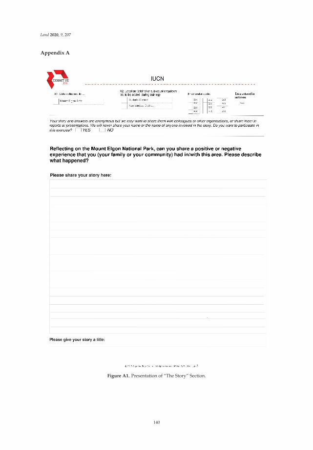
Land 2020, 9, 207
Appendix A
Figure A1. Presentation of “The Story” Section.
140

Land 2020, 9, 207
Figure A2. Details about Story Triads Section.
141

Land 2020, 9, 207
Figure A3. Details about Story Diads Section.
142
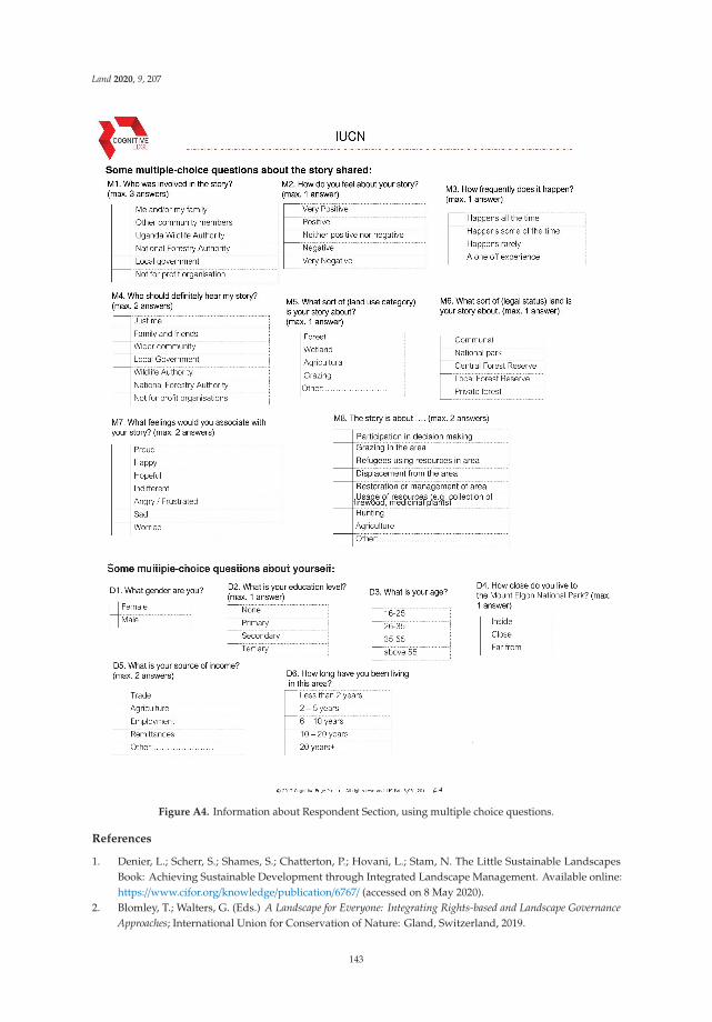
Land 2020, 9, 207
Figure A4. Information about Respondent Section, using multiple choice questions.
References
1. Denier, L.; Scherr, S.; Shames, S.; Chatterton, P.; Hovani, L.; Stam, N. The Little Sustainable LandscapesBook: Achieving Sustainable Development through Integrated Landscape Management. Available online:https://www.cifor.org/knowledge/publication/6767/ (accessed on 8 May 2020).
2. Blomley, T.; Walters, G. (Eds.) A Landscape for Everyone: Integrating Rights-based and Landscape GovernanceApproaches; International Union for Conservation of Nature: Gland, Switzerland, 2019.
143

Land 2020, 9, 207
3. Scherr, S.J.; Shames, S.; Friedman, R. Defining Integrated Landscape Management for Policy Makers.EcoAgriculture Policy Focus 2013, 10, 1.
4. Reed, J.; Deakin, L.; Sunderland, T. What are ‘Integrated Landscape Approaches’ and how effectively havethey been implemented in the tropics: A systematic map protocol. Environ. Evid. 2015, 4, 2. [CrossRef]
5. Noss, R.F. A Regional Landscape Approach to Maintain Diversity. BioScience 1983, 33, 700–706. [CrossRef]6. Palomo, I.; Montes, C.; Martín-López, B.; González, J.A.; García-Llorente, M.; Alcorlo, P.; Mora, M.R.G.
Incorporating the Social–Ecological Approach in Protected Areas in the Anthropocene. BioScience 2014, 64,181–191. [CrossRef]
7. Brown, J.; Mitchell, B. Landscape stewardship: New directions in conservation of nature and culture.George Wright Forum 2000, 70–79.
8. Brown, J.; Mitchell, N.; Beresford, M. (Eds.) The Protected Landscape Approach: Linking Nature, Culture,and Community; IUCN–The World Conservation Union: Gland, Switzerland, 2005; ISBN 978-2-8317-0797-6.
9. Wu, J. Landscape sustainability science: Ecosystem services and human well-being in changing landscapes.Landscape Ecol. 2013, 28, 999–1023. [CrossRef]
10. Jeffrey, A.S.; Sunderland, T.C.H.; Ghazoul, J.; PFund, J.-L.; Sheil, D.; Meijaard, E.; Venter, M.; Boedhihartono, A.;Day, M.; Garcia, C.; et al. Ten principles for a landscape approach to reconciling agriculture, conservation,and other competing land uses. Proc. Natl. Acad. Sci. USA 2013, 110, 8349–8356.
11. Reed, J.; Van Vianen, J.; Deakin, E.L.; Barlow, J.; Sunderland, T. Integrated landscape approaches to managingsocial and environmental issues in the tropics: Learning from the past to guide the future. Glob. Chang. Biol.2016, 22, 2540–2554. [CrossRef]
12. Bennett, N.J.; Dearden, P. From measuring outcomes to providing inputs: Governance, management, andlocal development for more effective marine protected areas. Mar. Policy 2014, 50, 96–110. [CrossRef]
13. Oldekop, J.A.; Holmes, G.; Harris, W.E.; Evans, K.L. A global assessment of the social and conservationoutcomes of protected areas: Social and Conservation Impacts of Protected Areas. Conserv. Biol. 2016, 30,133–141. [CrossRef]
14. Campese, J.; Borrini-Feyerabend, G. Human Rights-Based Approaches to Conservation: Promise, Progress,. . . and Pitfalls. In Forests and People Property, Governance, and Human Rights; Sikor, T., Stahl, J., Eds.; Earthscan:London, UK, 2011; pp. 47–62.
15. Commission of Environmental, Economic and Social Policy; IUCN. An Introduction to the IUCN NaturalResource Governance Framework (NRGF); International Union for Conservation of Nature: Washington, DC,USA, 2019.
16. Kozar, R.; Buck, L.E.; Barrow, E.; Sunderland, T.C.H.; Catacutan, D.E.; Planicka, C.; Hart, A.K.; Wil-lemen, L.Toward Viable Landscape Governance Systems: What Works; EcoAgriculture Partners: Washington, DC, USA, 2014.
17. Mansourian, S.; Aquino, L.; Erdmann, T.K.; Pereira, F.A. A Comparison of governance challenges in forestrestoration in Paraguay’s privately-owned forests and Madagascar’s co-managed state forests. Forests 2014,5, 763–783. [CrossRef]
18. Ros-Tonen, M.A.F.; Reed, J.; Sunderland, T. From Synergy to Complexity: The Trend Toward IntegratedValue Chain and Landscape Governance. Environ. Manag. 2018, 62, 1–14. [CrossRef] [PubMed]
19. Borrini-Feyerabend, G.; Dudley, N.; Jaeger, T.; Lassen, B.; Broome, N.P.; Philips, A.; Sandwith, T. Governanceof protected areas: From understanding to action. Best Pract. Prot. Area Guidel. Ser. 2013, 20, 1–125.
20. Oyono, P.R.; Mandondo, A. Inclusive Decision-Making in Natural Resource Governance. In Natural ResourceGovernance Framework Conceptual Paper; IUCN: Washington, DC, USA, 2017.
21. Springer, J. Initial Design Document for A Natural Resource Governance Framework; International Union forConservation of Nature: Gland, Switzerland, 2016; p. 14.
22. Cornwall, A. Making Spaces, Changing Places: Situating Participation in Development. IDS Work. Pap.2002, 170.
23. Walters, G.; Schleicher, J.; Hymas, O.; Coad, L. Evolving hunting practices in Gabon: Lessons forcommunity-based conservation interventions. Ecol. Soc. 2015, 20. [CrossRef]
24. Giles-Vernick, T. Cutting the Vines for the Past: Environmental Histories of the Central African Rain Forest;University Press of Virginia: Charlottesville, VA, USA, 2002.
25. Bluwstein, J. From colonial fortresses to neoliberal landscapes in Northern Tanzania: A biopolitical ecologyof wildlife conservation. J. Political Ecol. 2018, 25, 144. [CrossRef]
144

Land 2020, 9, 207
26. Gilli, M.; Cote, M.; Walters, G. Gatekeeping Access: The Dual Nature of Shea Land Formalization in Ghana’sCREMA. Master’s Thesis, Zurich University of Applied Sciences, Winterthur, Switzerland, 2020. submitted.
27. Szaboova, L.; Brown, K.; Fisher, J.A. Access to Ecosystem Benefits: More than Proximity. Soc. Nat. Resour.2020, 33, 244–260. [CrossRef]
28. Blackie, R.; Sunderland, T. Mapping Landscape Guidelines and Principles to the Aichi Targets; Center forInternational Forestry Research (CIFOR): Bogor, Indonesia, 2015.
29. Langston, J.D.; McIntyre, R.; Falconer, K.; Sunderland, T.; van Noordwijk, M.; Boedhihartono, A.K. Discoursesmapped by Q-method show governance constraints motivate landscape approaches in Indonesia. PLoS ONE2019, 14, e0211221. [CrossRef]
30. Bennett, N.J. Using perceptions as evidence to improve conservation and environmental management.Conserv. Biol. 2016, 30, 582–592. [CrossRef]
31. Eagles, P.F.J.; Romagosa, F.; Buteau-Duitschaever, W.C.; Havitz, M.; Glover, T.D.; McCutcheon, B.Good governance in protected areas: An evaluation of stakeholders’ perceptions in British Columbiaand Ontario Provincial Parks. J. Sustain. Tour. 2013, 21, 60–79. [CrossRef]
32. Webb, E.L.; Maliao, R.J.; Siar, S.V. Using local user perceptions to evaluate outcomes of protected areamanagement in the Sagay Marine Reserve, Philippines. Environ. Conserv. 2004, 31, 138–148. [CrossRef]
33. Blaikie, P. Changing Environments or Changing Views? A Political Ecology for Developing Countries.Geography 1995, 80, 203–214.
34. Plumptre, A.J.; Ayebare, S.; Behangana, M.; Forrest, T.G.; Hatanga, P.; Kabuye, C.; Kirunda, B.; Kityo, R.;Mugabe, H.; Namaganda, M.; et al. Conservation of vertebrates and plants in Uganda: Identifying KeyBiodiversity Areas and other sites of national importance. Conserv. Sci. Pract. 2019, 1. [CrossRef]
35. Luke, Q.; Beentje, H. African floras: Coverage and uses. 2016, unpublished.36. Kalema, J.; Namaganda, M.; Bbosa, G.; Ogwal-Okeng, J. Diversity and status of carnivorous plants in Uganda:
Towards identification of sites most critical for their conservation. Biodivers. Conserv. 2016, 25, 2035–2053.[CrossRef]
37. Pomeroy, D.; Tushabe, H.; Loh, J. The State of Uganda’s Biodiversity 2017; National Biodiversity Data Bank:Kampala, Uganda, 2017.
38. Gizachew, B.; Solberg, S.; Puliti, S. Forest Carbon Gain and Loss in Protected Areas of Uganda: Implicationsto Carbon Benefits of Conservation. Land 2018, 7, 138. [CrossRef]
39. Republic of Uganda. National Biodiversity Strategy and Action Plan II; National Environment ManagementAuthority: Nairobi, Kenya, 2016.
40. Howard, P.; Davenport, T.; Kigenyi, F. Planning conservation areas in Uganda’s natural forests. Oryx 1997,31, 253–264. [CrossRef]
41. Petursson, J.G.; Vedeld, P.; Sassen, M. An institutional analysis of deforestation processes in protected areas:The case of the transboundary Mt. Elgon, Uganda and Kenya. Forest Policy Econ. 2013, 26, 22–33. [CrossRef]
42. Anderson, D.; Grove, R. Introduction: The scramble for Eden: Past, present and future in African conservation.In Conservation in Africa; Anderson, D., Grove, R.H., Eds.; Cambridge University Press: Cambridge, UK,1988; pp. 1–12. ISBN 978-0-521-34199-8.
43. Adams, W.H.; Hutton, J. People, Parks and Poverty: Political Ecology and Biodiversity Conservation.Conserv. Soc. 2007, 5, 147–183.
44. Western, D.; Wright, R.M.; Strum, S.C. (Eds.) Natural Connections: Perspectives in Community-Based Conservation;Island Press: Washington, DC, USA, 1994; ISBN 978-1-55963-345-1.
45. Adams, W.H.; Hulme, D. If community conservation is the answer in Africa, what is the question? Oryx 2001,35, 193–200. [CrossRef]
46. Turyahabwe, N.; Banana, A.Y. An overview of history and development of forest policy and legislation inUganda. Int. For. Rev. 2008, 10, 641–656. [CrossRef]
47. Nakangu Bugembe, B. State Craft in Natural Resources Management Structure of Ugand. Ph.D. Thesis,Makerere University, Kampala, Uganda, 2019.
48. Republic of Uganda. State of Uganda’s Forestry; Ministry of Water and Environment, Forestry Sector SupportDepartment: Kampala, Uganda, 2016.
49. Uganda Wildlife Authority. UWA Strategic Plan; Uganda Wildlife Authority: Kampala, Uganda, 2015.50. UNEP-WCMC; IUCN. Protected Planet. The World Database on Protected Areas (WDPA); UNEP-WCMC and
IUCN: Cambridge, UK, 2020.
145
Land 2020, 9, 207
51. National Forestry Authority. Revised Forest Management Plan for Agoro-Agu Sector Central Forest Reserves forthe Period: 1st July 2018–30th June 2028; National Forestry Authority: Kampala, Uganda, 2018.
52. Republic of Uganda. Statistical Datasets; Bureau of Statistics: Kampala, Uganda, 2016.53. Amone, C.; Muura, O. British Colonialism and the Creation of Acholi Ethnic Identity in Uganda, 1894 to
1962. J. Imp. Commonw. Hist. 2014, 42, 239–257. [CrossRef]54. Laruni, E. Regional and ethnic identities: The Acholi of Northern Uganda, 1950–1968. J. East. Afr. Stud. 2015,
9, 212–230. [CrossRef]55. Kobusingye, D.N. African youths; the forgotten category in land governance. A case study of post-conflict
Acholi Region, Northern Uganda. Geoforum 2020, 109, 135–142. [CrossRef]56. Kapidžic, D. Public authority beyond hybrid governance: Creating throughput legitimacy in Northern
Uganda. Peacebuilding 2018, 6, 127–143. [CrossRef]57. Hopwood, J. Women’s Land Claims in the Acholi Region of Northern Uganda: What Can Be Learned from
What Is Contested. Int. J. Minor. Group Rights 2015, 22, 387–409. [CrossRef]58. Ker Kwaro Acholi. Principles and Practices of Customary Tenure in Acholiland; Ker Kwaro Acholi: Gulu,
Uganda, 2008.59. Zhao, Y.; Feng, D.; Jayaraman, D.; Belay, D.; Sebrala, H.; Ngugi, J.; Maina, E.; Akombo, R.; Otuoma, J.;
Mutyaba, J.; et al. Bamboo mapping of Ethiopia, Kenya and Uganda for the year 2016 using multi-temporalLandsat imagery. Int. J. Appl. Earth Obs. Geoinf. 2018, 66, 116–125. [CrossRef]
60. Gorsevski, V.; Geores, M.; Kasischke, E. Human dimensions of land use and land cover change related tocivil unrest in the Imatong Mountains of South Sudan. Appl. Geogr. 2013, 38, 64–75. [CrossRef]
61. Shiraishi, S. Part-time herdsmen: The herding camps of a mountainous agricultural people. In Nomads:Living in the Wilderness of Africa; Tanaka, J., Sato, S., Sugawara, K., Ohta, I., Eds.; Showado: Kyoto, Japan, 2010.
62. Were, G.S. The Bagisu and their past: Some notes on their legends about creation, the origins of death,the economy of their ancestors and the phenomenon of Kintu. Transafrican J. Hist. 1982, 11, 184–195.
63. Mwakikagile, G. Ethnicity and National Identity in Uganda: The Land and Its People; New Africa Press:Dar es Salaam, Tanzania, 2009; ISBN 978-9987-9308-7-6.
64. Sassen, M.; Sheil, D.; Giller, K.E.; ter Braak, C.J.F. Complex contexts and dynamic drivers: Understandingfour decades of forest loss and recovery in an East African protected area. Biol. Conserv. 2013, 159, 257–268.[CrossRef]
65. Olupot, W.; Plumptre, A.J. Conservation Research in Uganda’s Forests: A Review of Site History, Research, andUse of Research in Uganda’s Forest Parks and Budongo Forest Reserve; Novinka: New York, NY, USA, 2012;ISBN 978-1-62257-263-2.
66. Mugagga, F.; Kakembo, V.; Buyinza, M. A characterisation of the physical properties of soil and theimplications for landslide occurrence on the slopes of Mount Elgon, Eastern Uganda. Nat. Hazards 2012, 60,1113–1131. [CrossRef]
67. Vedeld, P.; Cavanagh, C.; Petursson, J.; Nakakaawa, C.; Moll, R.; Sjaastad, E. The political economy ofconservation at Mount Elgon, Uganda: Between local deprivation, regional sustainability, and global publicgoods. Conserv. Soc. 2016, 14, 183. [CrossRef]
68. Gosalamang, D.; Vedeld, P.; Gombya-Ssembajjwe, W. From Forest Reserve to National Park-Change in LegalStatus and Impacts on Livelihoods and Biodiversity Resources, Mt. Elgon, Uganda; Noragric Working Paper No. 44;Department of International Environment and Development Studies, Noragric Norwegian University of LifeSciences (UMB): Aas, Norway, 2008.
69. Norgrove, L. Parking Resistance and Resisting the Park: The Theory and Practice of National ParkManagement, a Case Study of Mount Elgon, Uganda. Ph.D. Thesis, University of Michigan, Ann Arbor, MI,USA, 2003.
70. Davenport, T.; Howard, P.; Dickinson, C. Mount Elgon National Park. Biodiversity Report; Uganda ForestryDepartment: Kampala, Uganda, 1996.
71. Howard, P.C. Nature Conservation in Uganda’s Tropical Forest Reserves; IUCN, International Union forConservation of Nature and Natural Resources: Gland, Switzerland, 1991; ISBN 978-2-8317-0085-4.
72. IUCN; WCMC (Eds.) Guidelines for Protected Area Management Categories; IUCN/UICN: Cambridge, UK, 1994;ISBN 978-2-8317-0201-8.
73. Uganda Wildlife Authority. Uganda Wildlife Authority Collaborative Management Strategy; Uganda WildlifeAuthority: Kampala, Uganda, 2000.
146

Land 2020, 9, 207
74. Vanen, C. Evicted in the Name of Nature: The Process of Eviction and Its Impact on Local Rural Livelihoodsin Mount Elgon, Uganda. Master’s Thesis, Norwegian University of Life Sciences, Ås, Norway, 2009.
75. Sensemaker; Cognitive Edge: Singapore, 2020.76. Dervin, B. Sense-making theory and practice: An overview of user interests in knowledge seeking and use.
J. Knowl. Manag. 1998, 2, 36–46. [CrossRef]77. Fisher, W.R. The Narrative Paradigm: In the Beginning. J. Commun. 1985, 35, 74–89. [CrossRef]78. Beam Exchange; Leveraging Economic Opportunities. Testing Tools for Assessing Systemic Change: Sensemaker;
LEO Report #44; USAID & UKAID: Washington, DC, USA, 2016.79. Deprez, S.; Huyghe, C.; Van Gool Maldonado, C.; Vredeseilanden/VECO. Using Sensemaker to Measure,
Learn and Communicate about Smallholder Farmer Inclusion. Case Report Thematic Learning Programme onPlanning, Monitoring and Evaluation of Complex Processes of Social Change; A Better Deal for Farmers: Leuven,Belgium, 2012.
80. Milne, K.M.G. Can sense-making tools inform adaptation policy? A practitioner’s perspective. Ecol. Soc.2015, 20. [CrossRef]
81. Van der Merwe, S.E.; Biggs, R.; Preiser, R.; Cunningham, C.; Snowden, D.J.; O’Brien, K.; Jenal, M.; Vosloo, M.;Blignaut, S.; Goh, Z. Making Sense of Complexity: Using SenseMaker as a Research Tool. Systems 2019, 7, 25.[CrossRef]
82. Jeha, L. Equity, Sustainability and Incentive-Based Conservation Measures. Community Reflections from Mt.Elgon, Uganda. Ph.D. Thesis, The University of York, York, UK, 2016.
83. IUCN; Eilu, G. Review of Effectiveness of Multiple-Use Programme in Mount Elgon National Park; IUCN: Kampala,Uganda, 2018.
84. Uganda Wildlife Authority. Mount Elgon National Park, Man and Biosphere Reserve, General Management Plan(Year 2020/2021-2029/2030); Uganda Wildlife Authority: Kampala, Uganda, 2020.
85. Republic of Uganda. The Wildlife Act; Republic of Uganda: Kampala, Uganda, 2019.86. Omoding, J.; Walters, G.; Carvalho, S.; Cracco, M.; Langoya, C.D.; Gaster Kiyingi, K.; Kumar, C.; Reinhard, F.;
Ssenyongo, E.; Twinomuhangi, L. Implementing the landscape approach in the Agoro-Agu region of Uganda.Parks 2020, 26, 99–110.
87. Berkes, F. Devolution of environment and resources governance: Trends and future. Environ. Conserv. 2010,37, 489–500. [CrossRef]
88. Freudenthal, E.; Ferrari, M.F.; Kenrick, J.; Mylne, A. The Whakatane Mechanism: Promoting Justice inProtected Areas. Nomadic Peoples 2012, 16, 84–94. [CrossRef]
89. IUCN. Making sense of community natural resource governance perceptions. Forest Brief 2020, 26.
© 2020 by the authors. Licensee MDPI, Basel, Switzerland. This article is an open accessarticle distributed under the terms and conditions of the Creative Commons Attribution(CC BY) license (http://creativecommons.org/licenses/by/4.0/).
147


land
Article
Exploring the Potential and Contribution of UNESCOBiosphere Reserves for Landscape Governance andManagement in Africa
Bettina Hedden-Dunkhorst 1,* and Florian Schmitt 2
1 Federal Agency for Nature Conservation, Konstantinstr. 110, 53179 Bonn, Germany2 German Commission for UNESCO, Martin-Luther-Allee 42, 53175 Bonn, Germany; [email protected]* Correspondence: [email protected]
Received: 23 June 2020; Accepted: 17 July 2020; Published: 22 July 2020
Abstract: United Nations Educational Scientific and Cultural Organization (UNESCO) BiosphereReserves strive for a harmonious interaction between humans and nature. As landscapes providesuitable units to mutually address matters of conservation and sustainable development, this studyaims to explore the potential and realized contribution of biosphere reserves for landscape governanceand management. We emphasize the role of stakeholder participation and cooperation as anoverarching condition for integrated landscape approaches. The regional focus is on Africa,where multiple drivers of global and local change currently significantly impact the landscape.The study’s results are based on a literature review, which is complemented by four case studiesfrom the biosphere reserves in Ghana, Malawi, South Africa, and Benin/Togo. Findings showthat in biosphere reserves, stakeholder engagement is crucial to gain community acceptance,foster intersectoral cooperation, and provide management with more legitimacy. To strengthenstakeholders’ capacities to mutually achieve conservation and development outcomes, internationalpartnerships and research and education efforts proved to be successful. The flexible biosphere reserveapproach to governance, which allows for integration with other land-management approaches,offers a suitable governance model for a landscape. Moreover, the biosphere reserve zonation conceptcan provide orientation to manage the “multifunctionality” of a landscape and address the associatedtrade-offs between different stakeholders’ aspirations.
Keywords: landscapes; biosphere reserves; stakeholder participation; conservation; sustainabledevelopment; governance; management; communication; capacity building
1. Introduction
Landscapes1 transform over time as land use changes, infrastructure develops, human populationsfluctuate, and impactful natural events occur. Ideally, landscape governance and management willadapt to these changing conditions to safeguard ecosystem functionality and guarantee sustainability.However, in large parts of the world, landscapes have been modified such that their carrying capacitieshave been exceeded, and irreversible environmental degradation ensued [5]. This situation oftencoincides with severe conflicts over natural resources that affect peoples’ livelihoods and security [6].Accordingly, over the last few decades, the need to balance human-induced developments and
1 The term landscape is used by several scientific disciplines drawing on a wide range of definitions and concepts [1,2].Considering a number of definitions developed more recently by various authors [1–4], we understand landscapes asdynamic, interactively developing social-ecological systems that often combine a mosaic of alternative land uses anddifferent governance structures.
Land 2020, 9, 237; doi:10.3390/land9080237 www.mdpi.com/journal/land149

Land 2020, 9, 237
environmental resilience became increasingly obvious [7], with landscapes considered to be a suitablespatial unit for the governance and management of social-ecological systems [8,9].
To address and resolve the conflicts among different interest groups in a specific landscape,stakeholder participation, engagement, and collaboration is increasingly considered to be a majordecisive factor [3,10]. In a landscape framework that includes operational governance structures andfunctioning institutions, stakeholder engagement is an important element to successfully negotiateinevitable trade-offs as part of conflict resolution [3,10–12]. However, as landscape institutions interactwith superior levels of governance structures or ecological systems and the stakeholder spectrumexpands, complexity and interdependences also grow further [1].
In this context, the concept of biosphere reserves and its implementation—conceptualized bythe United Nations Educational Scientific and Cultural Organization’s (UNESCO) science program“Man and the Biosphere” (MAB) and globally implemented since 1976 [13]—may offer valuableinsights and experiences for landscape governance and management that focus on environmentallybalanced sustainable development. As biosphere reserves are “designed to combine biodiversityconservation with socio-economic development and knowledge production (both scientific and local)and dissemination” [9], this concept proposes to address actual and future landscape challenges. Today,701 biosphere reserves have been designated by UNESCO in 124 countries; together, they form theWorld Network of Biosphere Reserves (WNBR) [14]. Within its regional or thematic sub-networks (e.g.,AfriMAB, the network of biosphere reserves in Sub-Saharan Africa), the WNBR promotes the sharingof best practices and experiences from biosphere reserves around the world [15]. Each biospherereserve designation precedes a stakeholder participation process and a formal request by the respectivenational government. Biosphere reserves are areas of different sizes and focuses, but they oftenemphasize one ecosystem type or natural or cultural landscape.
This study aims to explore the potential and realized contribution of UNESCO’s biosphere reserveconcept and its implementation to landscape governance and management in Africa. Its objective isto provide a common understanding of biosphere reserve structures, functions, and processes andto illustrate their relevance for landscape approaches based on four case studies. According to ourknowledge, investigating biosphere reserves in Africa from a landscape perspective is somewhat novel.The majority of references investigate biosphere reserves from an intrinsic perspective, while only afew studies [16] take a broader perspective and analyze biosphere reserves as implementing unitsfor landscape governance and management. The focus of the present study is on key componentsof a landscape approach, as obtained from a review of the literature. The case study findings arereported in the form of narratives to complement the literature review and to illustrate first-handpractical experiences. The motivation for this study is derived from the notion that different landscapeconcepts and approaches, which have emerged over time in various situations, can build upon andcomplement each other [7,12]. Thus, alternative approaches to natural resource management that aimto link conservation with sustainable development in Africa are likewise taken into consideration andcontrasted. The focus of this study is on Africa, where multiple drivers of global and local changecurrently significantly impact landscapes [4]. At the same time, the implementation of the MABprogram has made progress in parts of the continent, with the goal to establish model regions forsustainable development.
In this context, the overall guiding question of the study is the following: what can we learn fromthe concept of biosphere reserves and their implementation for landscape governance and managementin Africa? We hypothesize that biosphere reserves: (1) provide a structural framework for landscapegovernance and management and foster links between different hierarchies; (2) coordinate intersectoralactivities to achieve mutual conservation and sustainable development objectives in the designatedarea; (3) provide opportunities for knowledge generation and learning for stakeholders; and (4) addresstrade-offs between nature and people in a holistic manner, while contributing to conflict resolutionamong different interest groups. This study focuses on stakeholder engagement and collaboration,assuming these to be overarching conditions for the development and maintenance of governance
150

Land 2020, 9, 237
and management structures and the implementation of programs and projects to achieve sustainabledevelopment targets.
The following section describes the concept of biosphere reserves, as well as alternative landscapeapproaches, in Africa. Section 3 depicts the methods applied in the study and outlines an analyticalframework that identifies four crucial components for integrated approaches to landscapes. Throughthis analytical lens, the results from a literature review are presented in Section 4 to analyze thebiosphere reserve concept considering the four components. The analysis is complemented by findingsfrom four case studies of biosphere reserves located in western and southern Africa and a discussionof factors that may impact success and failure in different contexts. In Section 5, we relate the results ofthe analysis of biosphere reserves to the wider discussion on conservation and development in Africanlandscapes and draw lessons learnt from the investigation of biosphere reserves as potential modelsfor landscape governance and management. The final section draws some general conclusions ofthe study.
2. The Concept of Biosphere Reserves and Alternative Landscape Approaches in Africa
2.1. United Nations Educational Scientific and Cultural Organization (UNESCO) Biosphere Reserves
Biosphere reserves are the primary tool of UNESCO’s MAB program. This program was establishedin 1971 to strengthen the research on and implementation of human interactions with ecosystemsand to explore conservation strategies that facilitate the sustainable use of natural resources andecosystem services [17]. According to UNESCO’s definition, biosphere reserves are “learning placesfor sustainable development. They are sites for testing interdisciplinary approaches to understandingand managing changes and interactions between social and ecological systems, including conflictprevention and management of biodiversity. They are places that provide local solutions to globalchallenges” [18].
The concept of biosphere reserves has been adapted continuously since its establishment [19].Initially, areas were mainly designated based on biodiversity criteria and their capacity to supportresearch activities [11]. In 1995, the MAB program’s “Seville Strategy and the Statutory Framework ofthe WNBR” was adopted. This strategy identifies the specific role of biosphere reserves in developinga new vision of the relationship between conservation and development. It further stresses the needfor sustainable development, participatory landscape governance, and management and the role ofbiosphere reserves to provide interactions between society and ecosystems through dialogue amongrelevant actors [20]. Thus, biosphere reserves presently serve as “model regions for sustainabledevelopment” [21] worldwide [9,10], aiming to integrate conservation with the improvement of locallivelihood. To realize this vision, biosphere reserves concurrently aim to achieve the following threecomplementary functions:
1. Conservation: to protect and conserve genetic resources, species, ecosystems, and landscapes;2. Development: to foster sustainable economic and human development;3. Logistic support: to support demonstration projects, environmental education and training,
and research and monitoring related to local, national, and global issues of conservation andsustainable development [20].
Biosphere reserves are designated by an intergovernmental body, the MAB InternationalCoordinating Council (MAB ICC). The designation process follows a common set of globallyagreed-upon rules and principles. The designated area remains fully under national jurisdiction,however, according to the Statutory Framework of the WNBR, an integrated governance frameworkand management plan is obligatory for a biosphere reserve [20]. The nomination process involvesa profound understanding of the bio-geographic and socio–economic situation of the area but alsodemands the development of a clear strategy on how to fulfill the three functions of the biospherereserve and the engagement of major local stakeholders. Eventually, the nomination dossier requires
151

Land 2020, 9, 237
the formal acceptance of all relevant authorities and political representatives at different governancelevels (local, provincial, and national), before it can be submitted to UNESCO by the responsiblenational authority [20].
Characteristic Tools and Features of Biosphere Reserves
A characteristic tool to pursue the three functions of a biosphere reserves is the zonation concept.A biosphere reserve is zoned into one or more “core areas”, a “buffer zone” surrounding the core areas,and a “transition area” (see Figure 1). A core area represents a legally protected site for the conservationof biodiversity and limits activities beyond conservation to research and education only. Some formof national or local legal protection of the core zone(s) is the only condition prescribed by the MABprogram in terms of zonation. Hence, biosphere reserves have one or more legally protected core area(s),while their respective buffer zone(s) and surrounding transition zones have limited (or non-existent)legal protection status [22]. Many biosphere reserves integrate pre-existing protected sites as core areasand connect them through buffer zones forming “ecological corridors” [23]. The buffer zone is usedfor ecologically sound practices, e.g., for farming or tourism. The transition zone denotes an areawith a variety of activities (including economic activities from subsistence crop and livestock farmingto commercial agriculture, trade, industry, and tourism), where multiple stakeholders cooperate tomanage and sustainably develop the area’s resources [20]. Examples across the world show thatbiosphere reserves indeed have the potential to foster local economic development by generatingadditional income and employment opportunities associated with different economic sectors [22,24,25].Specifically, the development of new technologies related to the sustainable use of land and waterresources and the use of renewable energy or institutional innovations (like smallholder co-operativesor conservation associations) provide the potential to stimulate employment [16,22,26].
Figure 1. The zonation concept of the United Nations Educational Scientific and Cultural Organization(UNESCO) Biosphere Reserves; picture: Volcans Biosphere Reserve, Rwanda, with the volcanoes beingthe core zone; compiled by the authors.
In recent decades, UNESCO Biosphere Reserves have contributed to raising awareness of theneed for global standards to integrate conservation with social and economic development. Today,other national and international designations of protected areas follow the notion of zonation andlikewise interlink conservation and local development [27]. UNESCO Biosphere Reserves, however,accentuate their priorities differently compared to most other categories of protected areas, as theirprimary goal is the harmonization of the human–nature relationship within the designated area [9,28].
152

Land 2020, 9, 237
It is mandatory that the core zone of a biosphere reserve be a protected site under national orsub-national law. Hence, in most cases, biosphere reserves integrate pre-existing protected areas.Depending on the local and national importance of the protected area, this situation can substantiallyimpact the landscape and its governance and management system.
The designation of a specific area as a UNESCO Biosphere Reserve also has the potential to furtherstrengthen existing conservation activities, specifically by linking these activities to developmentsbeyond the boundaries of the actual protected area and by providing a supportive and integratedinstitutional frame [16]. However, encompassing conservation sites under other formal arrangements(e.g., National Parks) within a biosphere reserve also bears the risk that a biosphere reserve willfail to achieve its potential as an “open concept” that links conservation and development due todisagreements, a lack of support, and conflicts among local stakeholders [9].
To ensure the long-term quality of designated sites, the Statutory Framework of the WNBRentails a 10-year-periodic review process to monitor, assess, and report on developments within abiosphere reserve. The results of this reporting process were mixed during the first two decades of itsimplementation [19]. However, since 2013, the MAB ICC has introduced several additional measures tofurther ensure the quality of the WNBR. These include an “excellence process” to support mechanismsfor biosphere reserves that do not fully conform with the standards of the WNBR, as well as an “exitstrategy” for Biosphere Reserves that remain non-compliant with UNESCO’s designation criteria [9,29].
An important feature that determines the success of a biosphere reserve in achieving its goalsis local ownership through identification of local stakeholders with the vision and mission of abiosphere reserve [23,30,31]. UNESCO Biosphere Reserves are characterized by involving localcommunities and interested stakeholders in the decision-making processes and implementationof effective benefit-sharing mechanisms [16]. Such inclusive engagement can reduce conflictsof interest and generate economic opportunities for the local population and the likelihood fordevelopment-oriented approaches to achieve successful outcomes [11].
2.2. Alternative Natural Resource Management Approaches in Africa
While UNESCO Biosphere Reserves were established in Africa as early as the late 1970s2 [18],alternative approaches to natural resource management that integrate biodiversity conservation withthe socio-economic development of local communities have gained prominence since the mid-1980s [4].These approaches, which were first introduced by the World Wide Fund for Nature (WWF), canbe summarized under the term Integrated Conservation and Development Projects (ICDPs) [32,33].Biosphere reserve initiatives and ICDPs interacted or complemented each other, primarily where bothapproaches coincided on site, as described in Section 4.1 for Ghana [30,34].
2.2.1. Development of Alternative Approaches over Time
Until the 1970s, land management in many African countries was mostly conducted under sectoralapproaches. While many traditional African societies used to apply holistic approaches to administertheir natural resources, the socio–economic consequences of colonial and post-colonial governancesystems led to landscapes that were widely characterized by single-purpose and exclusive-useapproaches, with the management and distribution of land under the broad authority of centralgovernments. Often the needs of local communities were not reflected in landscape planning, as shownin reports about the relocations of populations for different purposes of land use [29,35].
The conservation sector, until the 1970s, focused primarily on the preservation of natural landscapesinside protected areas. It widely ignored the situation outside conservation sites and the roles ofhumans in maintaining them. Beyond legally protected areas, natural resources on communal landswere—mainly as a result of population pressure—increasingly affected by the overutilization and
2 Today, 79 UNESCO Biosphere Reserves have been designated in 29 African countries [18].
153

Land 2020, 9, 237
degradation of natural resources and a loss of biodiversity [36]. Realizing these flaws and theirconsequences for general environmental protection at the end of the 1970s, conservation acrossAfrica experienced a change in mindset [33]. It was acknowledged that previous conservationapproaches, which focused primarily on the establishment of protected areas, had been ineffective instopping general habitat losses and the poaching of protected species [37]. Moreover, conservationistsrealized that protected area development in the past often came with social injustices among localpopulations [33].
On these grounds, ICDPs promoted a shift from the “traditional fortress conservation model” [12]towards integrated approaches, which included the livelihood needs of local communities. While theliterature assessed the implementation of this “first generation of ICDPs” [4] as predominantly orientedtowards conservation with often only symbolic participation mechanisms for local communities, theywere forerunners of a paradigm shift in addressing land management and conservation [4], specificallyin Africa but also in other parts of the world [32,38]. This movement was fostered through the parallelemergence of the scientific discipline of “Landscape Ecology”, which aims to better understand therelationship between spatial formations and ecological processes at different scales and levels oforganization [12].
In the 1990s, change could also be observed in the field of development cooperation. Biodiversitywas increasingly addressed as a socio–economic asset for economic development, which led to thegrowing integration of conservation perspectives into the conceptualization of rural developmentprojects [12]. The development theory discourse in the 1980s changed and began to emphasizein particular the potential of decentralization and local empowerment approaches [12]. For thesereasons, in the late 1980 and early 1990s, ICDPs became increasingly popular development instruments.Following the Rio Conference in 1992, a number of different integrated landscape approaches gainedfurther popularity, e.g., under the names of integrated natural resource management, integratedrural development or community-based natural resource management (CBNRM) [12]. While theseapproaches have been differentiated in the literature, it is important to stress that, in practice, they oftenrepresent similar initiatives, albeit applied within different contexts and under different strategies [12].
2.2.2. The Case of Community-Based Natural Resource Management
The CBNRM approach gained high levels of attention in the conservation and developmentsectors, especially in southern Africa, and has been vital for the implementation of many ICDPs sincethe 1990s. While under colonial and post-colonial legislation, the utilization of wildlife through localcommunities was broadly prohibited; however, in the 1970s and 1980s perceptions towards wildlife userights started to slowly change in some countries [34]. New laws would allow private landowners andcommunities to make use of local natural resources and directly benefit from wildlife on communallands. The first large-scale CBNRM-project was CAMPFIRE (Communal Area Management Programfor Indigenous People) in Zimbabwe. This project was launched in 1989 and implemented at the districtlevel, promoting income generation for communities through the sustainable use of natural resources,mainly by licensing wildlife access to safari and tourism operators [36,39]. The implementation inZimbabwe sparked the introduction of similar programs in other countries, such as in Botswana,Mozambique, and Namibia. During this time, CBNRM became part of the development strategiesand conservation policies in a number of countries and was increasingly supported by internationalfunding organizations, the African Union (AU), and multilateral organizations [34].
CBNRM-approaches can take many forms and emphasize different subjects according to theirregional or national implementation contexts or corresponding bio-geographic landscapes. CBNRMcan be implemented as communal conservancies, as in the case of Namibia; as Community ResourceManagement Areas (CREMAs), to regulate natural resources in the forests of Ghana; or as WildlifeManagement Areas (WMAs), such as in Tanzania. In some countries, CBNRM is predominantlyregarded as a rural development tool; in others, there is a clear emphasis on the conservation aspect ofCBNRM and its potential to protect ecosystems [34,36]. While the scope and scale of CBNRM-approaches
154

Land 2020, 9, 237
differ, they all share the general principle of advancing the sustainable management of wildlife andnatural resources while fostering the empowerment and livelihood of local communities [40]. In allinstances, CBNRM involves some degree of the co-management of resources between central authorities,the local government, and local communities, which share rights and responsibilities through diverseinstitutional arrangements [34]. The conservancy-approach, as implemented (e.g., in Namibia), is basedin particular on relatively broad-based stakeholder participation and the devolution of managementrights over local resources to local communities.
Despite mixed performance assessments [34], due to its potential for inter-sectoral sustainabledevelopment, CBNRM has been widely acknowledged by conservationists and developmentorganizations as a useful tool to foster conservation and livelihoods and to implement internationalagreements, conservation strategies, and development agendas, such as the Convention on BiologicalDiversity (CBD). All over Africa, CBNRM-projects have become important partners for internationalorganizations to test innovations related to linking environment and development, finance mechanisms(like Payments for Ecosystem Services), or innovative approaches associated with climate changeadaptation [4,34].
3. Methodology
3.1. Analytical Framework
This study follows the broad definition of Reed et al. [12], who understand a landscape approach“as a framework to integrate policy and practice for multiple competing land uses through theimplementation of adaptive and integrated management systems”. Based on a review of the literatureon key aspects of the effective implementation of landscape approaches [12,41,42] and with specialregard to the work of Sayer et al. [3], a set of four interlinked components for a successful landscapeapproach was synthesized3.
Governance systems lay the foundation for policy and project implementation in a landscapesetting. They are highly context dependent, and their structures vary widely between landscapes. Everylandscape approach should ideally be designed according to the specific stakeholder configurationsand their goals and targets [12]. Therefore, already in the initiation process, implementing actorsneed to evaluate adequate institutional structures to address the multifunctionality of a landscape, itsopenness towards stakeholder participation, and guarantee transparency and compliance towardsthe existing rules of land use in the designated area [3]. Adaptive management is key to addressingthe dynamic processes within landscapes and their stakeholder configurations and to mitigatingthe intersectoral consequences of unforeseen changes in individual parts of the landscape [12,44].Adequate information and communication are preconditions for stakeholders to participate and engageeffectively and fulfill their roles in a landscape arrangement. Transparent communication of the aims,targets, benefits, and potential trade-offs contributes to stakeholders’ trust in the legitimacy of theimplemented approach [3]. Strengthening the capacities among stakeholders can further contribute toreducing power inequalities among stakeholders and providing knowledge for further developmentof the landscape. Multi-stakeholder participation and engagement constitute a condition for theaforementioned three components to be realized along with a base for developing general consensusand entry points for all stakeholders [3,41,42].
3 This synthesis mainly draws on the work of [3,12,42] Sayer et al. [3], who developed a set of 10 principles to guide the processof decision-making and reconciling competing land uses in landscapes. Representing a consensus view of professionalinstitutions, these principles were also discussed at the 15th meeting of the Subsidiary Body on Scientific, Technical, andTechnological Advise of the Convention of Biological Diversity (CBD) and later accepted by the CBD [3,43]. Based on acomprehensive review of landscape literature, Reed et al. develop five key aspects of an effective landscape approach.Ros–Tonen et al. synthesized five preconditions and three enabling conditions for adaptive landscape approaches andapplied them to analyze the landscape governance potential of co-management systems for reforestation in Ghana.
155

Land 2020, 9, 237
In the following, these four components—governance; adaptive management; information,communication, and capacity building; and multi-stakeholder participation and engagement—willbe used as analytical categories for the analysis of the potential of biosphere reserves for sustainablelandscape governance and management. We thus assume that the components relate to each other asoutlined in Figure 2.
Governance
Information, Communication & Capacity Building
Adaptive Management
Integrated Approach for Landscapes
Stakeholder Participation and Engagement
Figure 2. Analytical framework for a study on the potential of biosphere reserves for landscapegovernance and management.
3.2. Data Collection and Methodological Approach
Methodologically, this analysis is based on a review of scientific work on the implementation ofthe landscape approach in Africa in general and on biosphere reserves in particular. The results ofthe literature review are summarized in Sections 2 and 4. The databases of WorldCAT, Wiley OnlineLibrary, and JSTOR were used to capture the current state of peer-reviewed literature using the keyterms of this study. Moreover, online searches were conducted via Microsoft Academic Search andGoogle Scholar to complement the database research and to include relevant grey literature, primarysources, and non-peer-reviewed articles and books.
To supplement the literature review with practical insights and evidence, four biosphere reserveslocated on the African continent were empirically investigated. To select the case studies, the followingcriteria were considered: year of designation, ecosystem type, size of area and population, andgovernance and management system (Table 1). With the aim of reaching heterogeneity in these criteriaamong the four cases and exploring a geographical spread of cases across Africa, this selection resultedin the following cases: Mount Mulanje (Malawi), Vhembe (South Africa), Lake Bosomtwe (Ghana), andMono (Benin/Togo). In each biosphere reserve, a comprehensive semi-structured interview (SSIs) wasconducted. Considering the context sensitivity of the implementation practice in biosphere reservesand the intent to add in-depth insights from biosphere reserve practitioners, qualitative enquiries werechosen. The SSI-framework was selected, as its design allows one to acquire comparable qualitativeinformation on the topic, while the interviewer remains responsive to the interviewee [45].
Interviewees were senior managers of their respective biosphere reserves. Interviews wereconducted personally or via telephone and web-based telecommunication services between January andMarch 2020. The interview guide (see Appendix A) was designed analogous to the analytical frameworkdescribed above and encompasses five sections to capture the following aspects: (1) general aspectson the biosphere reserve’s vision, mission, initiation, and design; (2) governance; (3) management;(4) multi-stakeholder engagement; and (5) information, communication, and capacity building.All respondents were assured of their anonymity.
156
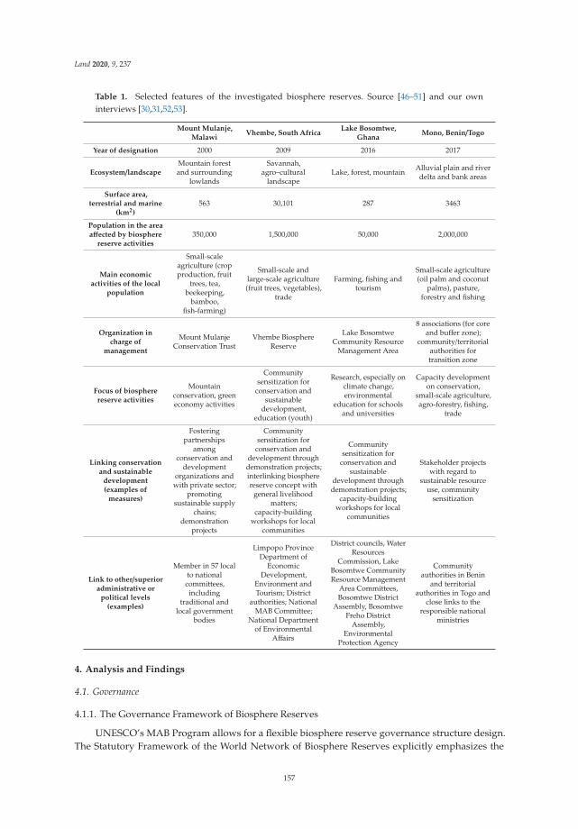
Land 2020, 9, 237
Table 1. Selected features of the investigated biosphere reserves. Source [46–51] and our owninterviews [30,31,52,53].
Mount Mulanje,Malawi
Vhembe, South AfricaLake Bosomtwe,
GhanaMono, Benin/Togo
Year of designation 2000 2009 2016 2017
Ecosystem/landscapeMountain forestand surrounding
lowlands
Savannah,agro–cultural
landscapeLake, forest, mountain Alluvial plain and river
delta and bank areas
Surface area,terrestrial and marine
(km2)563 30,101 287 3463
Population in the areaaffected by biosphere
reserve activities350,000 1,500,000 50,000 2,000,000
Main economicactivities of the local
population
Small-scaleagriculture (cropproduction, fruit
trees, tea,beekeeping,
bamboo,fish-farming)
Small-scale andlarge-scale agriculture(fruit trees, vegetables),
trade
Farming, fishing andtourism
Small-scale agriculture(oil palm and coconut
palms), pasture,forestry and fishing
Organization incharge of
management
Mount MulanjeConservation Trust
Vhembe BiosphereReserve
Lake BosomtweCommunity Resource
Management Area
8 associations (for coreand buffer zone);
community/territorialauthorities fortransition zone
Focus of biospherereserve activities
Mountainconservation, greeneconomy activities
Communitysensitization for
conservation andsustainable
development,education (youth)
Research, especially onclimate change,environmental
education for schoolsand universities
Capacity developmenton conservation,
small-scale agriculture,agro-forestry, fishing,
trade
Linking conservationand sustainable
development(examples of
measures)
Fosteringpartnerships
amongconservation and
developmentorganizations and
with private sector;promoting
sustainable supplychains;
demonstrationprojects
Communitysensitization for
conservation anddevelopment throughdemonstration projects;interlinking biospherereserve concept with
general livelihoodmatters;
capacity-buildingworkshops for local
communities
Communitysensitization for
conservation andsustainable
development throughdemonstration projects;
capacity-buildingworkshops for local
communities
Stakeholder projectswith regard to
sustainable resourceuse, community
sensitization
Link to other/superioradministrative or
political levels(examples)
Member in 57 localto nationalcommittees,including
traditional andlocal government
bodies
Limpopo ProvinceDepartment of
EconomicDevelopment,
Environment andTourism; District
authorities; NationalMAB Committee;
National Departmentof Environmental
Affairs
District councils, WaterResources
Commission, LakeBosomtwe CommunityResource Management
Area Committees,Bosomtwe District
Assembly, BosomtweFreho District
Assembly,Environmental
Protection Agency
Communityauthorities in Benin
and territorialauthorities in Togo and
close links to theresponsible national
ministries
4. Analysis and Findings
4.1. Governance
4.1.1. The Governance Framework of Biosphere Reserves
UNESCO’s MAB Program allows for a flexible biosphere reserve governance structure design.The Statutory Framework of the World Network of Biosphere Reserves explicitly emphasizes the
157
Land 2020, 9, 237
importance of diversity and encourages the development of national implementation structuresthat consider specific national contexts [20]. This consideration is related to a recognition of thepeculiarity of landscapes worldwide with regard to: their biophysical features and the differencesin natural resource use, traditional and cultural values of landscapes, existing forms of stakeholderorganization, and concerning institutional and political contexts. In practice, this flexibility has led to abroad variety of governance approaches among biosphere reserves. In some cases, biosphere reservegovernance structures are part of national, provincial, or municipal administrative authorities andmay be considered in legislation. In other cases, biosphere reserves are managed by, or function as,non-governmental organizations (NGOs) or are under some form of private management [54,55].
While appreciating the diversity in national implementation contexts, governance structuresshould be in the position to promote the realization of a biosphere reserve’s functions and to addressthe broad participation of stakeholders. Moreover, institutional structures should provide adequatemechanisms to foster sustainable resource use and human activities [20]. Due to the aforementioneddiversity of governance models, it is difficult to describe how biosphere reserves generally implementthese institutional expectations. However, two typical models (see Figure 3), categorized by theirorganizational forms as the “authority model” and “NGO model”, are described in a managementmanual for African biosphere reserve managers, compiled in cooperation between the AfriMAB,the UNESCO MAB Secretariat, and the German Commission for UNESCO in 2015 [55]. Notably,these two models represent ideal types based on comprehensive experiences with biosphere reservesin Sub-Saharan-Africa. Most biosphere reserves may find themselves somewhere on the spectrumbetween these two model poles, but a basic understanding of the fundamentally different governanceapproaches is helpful for understanding the structure and functioning of a specific biosphere reserve.
Both models share a similar composition in their organizational bodies in the form of a “managingbody” that executes the daily work of the biosphere reserve; an “executive body”, responsible fordecision-making; and an “advisory body” to ensure an informed decision-making process. In theauthority model, the management body is in some way connected to a supreme governmental authority,such as a national or provincial ministry. Executive decision-making takes place within this authority,and the management body is legally authorized to implement its decisions. This structure equips themanagement body to have a strong administrative mandate in the designated area, which is usuallybound to the mandate of the responsible governance authority, e.g., national parks and wildlife orforestry. As such, the executive or management body has only limited opportunities to engage inactivities that fall under the mandate of other public authorities, such as agriculture, tourism, water,or education. Sometimes, the mandate of the management body is limited to the core zone only [55].
Among the four case studies, Lake Bosomtwe Biosphere Reserve (Ghana) provides an interestingexample, with its governance structure integrated into an pre-existing administrative structure.The latter represents a several-tier system of traditional and political authorities that embodies thebase of the local political system. To ensure adequate management of the biosphere reserve, the “LakeBosomtwe Resource Management Area” (CREMA) was established to function as the main governanceand management entity of the area [35]. CREMAs are a tool for communities in Ghana to managetheir use of natural resources [34]. The establishment of the Lake Bosomtwe CREMA was conductedwith special regard to existing traditional decision-making structures within the Ashanti region.The CREMA’s constitution was legalized by a by-law of the two respective district assemblies, whichhave general oversight of the decisions of the CREMA board. The constitution foresees the inclusionof individual representatives of all engaged government agencies and the two district assemblies asex-officio members into the board [37].
According to the NGO model (see Figure 3), a biosphere reserve is not directly connectedto any public authority but functions as an independent organization. Its main decision-makingbody is composed of different relevant stakeholder groups, such as landowners, entrepreneurs, andresearchers, as well as national or provincial public authorities. As this executive body has no supremeadministrative mandate beyond the biosphere reserve, the management body has less or no formal
158

Land 2020, 9, 237
authority to implement its decisions in the designated area [55]. Therefore, it functions insteadas a coordinator for implementing different activities and projects towards the biosphere reserve’sgoals together with local and sometimes international partners. Without an “official” mandate forits management body, the relevance of the biosphere reserve highly depends on its acceptance bylocal communities and local political stakeholders [16]. However, functioning similar to an NGO canalso provide the management body more leeway in implementing projects and, thereby, enhance itscredibility as a politically independent organization [55].
Figure 3. Two exemplary governance models for biosphere reserves: the authority model (above);NGO model (below). Source: [55].
To illustrate a biosphere reserve structured according to the NGO model, we consider the exampleof the Vhembe Biosphere Reserve (South Africa). The Vhembe Biosphere Reserve understands itself asa non-profit organization that aims to work towards the objectives of the MAB Program [31]. The maindecision body is the board of directors of 8–10 honorary persons who are representatives of different local
159
Land 2020, 9, 237
individual or institutional stakeholder groups. They are elected for a period of three years during theannual general meeting by the Vhembe Biosphere Reserve members. An additional board seat (withoutvoting rights) exist for a representative of the Limpopo Province Department of Economic Development,Environment and Tourism, to represent the responsible governmental authority with the strongestexecutive mandate in the region. Additional board seats were established for the administrationsof the four districts that form part of the biosphere reserve to link the biosphere reserve to localpolitical and administrative structures. They advise the board from the perspective of the relevantpublic authorities. The board of directors holds five sub-committees tasked to elaborate informationon conservation, development, research, education, communication, and finance. All managementactivities and projects are coordinated by a coordinator and his or her co-worker [31].
The NGO model is less common in African countries but is prevailing in South Africa [47].In this category, the level of influence between public authorities and local stakeholders differs widely,sometimes leading to complex interconnections between different levels of local governance andstakeholders. This is especially true for biosphere reserves in countries where devolution processestowards land use and natural resource management have taken place in recent decades, and localinstitutions possess or share ownership of decision-making in the management of land use [55].
4.1.2. The Biosphere Reserve Zonation as a Tool to Structure Governance
Zonation is an important feature of a biosphere reserve but is also often highly contested. Hence,the involvement of stakeholders and their acceptance of zonation is crucial to adequately address andfulfil a biosphere reserve’s functions [56,57]. In practice, zonation is the result of negotiation processesover different types of land uses and the needs to consider existing local development plans, such asplans for infrastructure or industrial development [10].
At Lake Bosomtwe Biosphere Reserve, the core of the lake along with several smaller areas nextto the waterside have been designated as separate core zones surrounded by a buffer zone around thelake and a transition zone at its outer edges. What makes this zonation pattern of nested circles sospecial is that it is based on the preexisting cultural zonation of the local communities that inhabit thearea. For centuries, fishermen have not fished at the center of the lake, which is regarded a sacred place.
This cultural taboo has, therefore, been transmitted into the so called “cultural core area” [55].Agreeing on the concrete zonation for Lake Bosomtwe was a complex process, as three differentgovernment agencies (Forrest Services, Water Resource Commission, and “Spatial planning and Landuse”) were previously involved in managing the land use in the area and had divergent opinions onhow to implement a zoning scheme within the areas under their specific mandates. However, throughtheir integration and cooperation within the CREMA (see Section 4.4), they jointly reviewed theirearlier proposals and came to an agreement for joint zonation of the area [30].
Once the zones are established, promoting compliance and implementing conflict resolution is animportant task, which ideally should be embedded in governance structures. To resolve conflicts overnatural resource use that contradicts the zonation, the Vhembe Biosphere Reserve constantly sensitizeslocal communities and takes a constructive approach to integrate the stakeholders concerned. In recentyears, mining activities that affected the buffer zones developed and became an important economicsector in the region. The Vhembe Biosphere Reserve facilitates the exchange and agreements betweenmining companies, the provincial government, and local communities, who are engaged by enablingEnvironmental Impact Assessments. If necessary, governance structures are adapted to accommodatefor emerging issues and new stakeholders [31].
4.1.3. Initiating a Biosphere Reserve and Shaping its Governance
The prevailing governance approach for biosphere reserves is also defined by the way thatbiosphere reserves are initiated. In some countries, a formal decision of the government is the firsttrigger to establish a biosphere reserve [10]. However, a successful UNESCO designation demandsa broad consensus among local stakeholders [58]. The nomination dossier needs the approval of all
160

Land 2020, 9, 237
relevant authorities and local mandate holders of the respective communities. Therefore, biospherereserve initiators need to engage local stakeholders during the nomination process to jointly develop acommon vision for the area and find consensus on the appropriate zonation. In some cases, this canlead to a lengthy process of several years, depending on the pre-existing experiences of the stakeholderswith similar processes and potential conflicts that may emerge in the process [10,48].
In the case of South Africa, most biosphere reserves were established under the initiative of localstakeholder groups that decided to cooperate as non-profit organizations with provincial and nationalauthorities towards developing a biosphere reserve designation [48]. For the Vhembe BiosphereReserve, a group of local land and conservancy owners began the nomination process. With thesupport of the Limpopo Provincial Government, they reached out to local communities within theproposed area to inform them about the concept, to negotiate the proposed zonation approach, and toachieve the necessary acceptance from political and traditional leaders [31].
In Ghana, the process to establish the Lake Bosomtwe Biosphere Reserve was initiated by thegovernment through the Environment Protection Agency (EPA), an agency subordinated to the Ministryof Environment, Science Technology, and Innovation. The EPA hosts the chair of the national MABCommittee and initiates MAB-related activities. Before the nomination project started, a cooperationproject of the government of Ghana, UNESCO, and local community authorities was conducted tosensitize local communities to the biosphere reserve concept and to guarantee the local population’ssupport for the implementation of a CREMA as the main governance and managing body of thebiosphere reserve [30].
4.2. Adaptive Management
4.2.1. Management Structures across Case Studies
Biosphere reserve governance structures, as outlined above, strongly impact managementprocedures and performance. As we observed, the various institutional models (see Section 4.1),specific features of management related to human capacity (including: staff time, knowledge, andexperience), relations to stakeholders, and access to finances and infrastructure differ substantiallyacross biosphere reserves. The decision on which organization will assume management will stronglyinfluence a biosphere reserve’s orientation and ultimately its performance. Table 1 gives an overviewof the management organizations responsible for implementation in the four biosphere reservesinvestigated in this study.
Mount Mulanje Biosphere Reserve is managed by the Mount Mulanje Conservation Trust (MMCT),an NGO established in Malawi in 2000, the same year the biosphere reserve was designated by UNESCO.In 2005, it became a conservation trust funded by the World Bank through the Global EnvironmentalFacility. MMCT shares its goals with those of the biosphere reserve. These goals basically entailconservation of the mountain’s natural resources, primarily focusing on water, soils, and biodiversity,and the promotion of people’s livelihoods through sustainable resource use to help develop a GreenEconomy. Economic activities are related to the production and marketing of, for example, tea, fruittrees, fish, and timber [52].
The Vhembe Biosphere Reserve functions as an NGO and is coordinated through a non-profitorganization of the same name. Decisions made by the board are primarily implemented by a financedcoordinator and a number of supporting volunteers [31]. Quite differently, at the Lake BosomtweBiosphere Reserve, a CREMA and its local units, CSRMs, form the management unit of the biospherereserve. The activities connected to the Biosphere Reserve are coordinated by two employees of theWater Resource Commission, the national agency responsible for water management in Ghana, whichis also a CREMA stakeholder. At the transboundary Mono (River) Biosphere Reserve in Benin andTogo, eight local protected area associations, composed of land-owners and users, local NGOs, andother conservation initiatives, were established and officially given the mandate to manage the eight
161

Land 2020, 9, 237
core and adjacent buffer zones. The transition zone is managed by community authorities in Benin andterritorial authorities in Togo [46,53].
A characteristic of each investigated biosphere reserve is that the core management unit is verysmall. However, these units are supported by their respective executive boards and/or an advisoryboard. Moreover, management often cooperates with different governmental, non-governmental,and/or private sector supporting entities. This cooperation substantially increases management’scapacity for implementation. For example, at the Mount Mulanje Biosphere Reserve, through closepartnerships of MMCT with other organizations that operate in the area (who, contrary to MMCT, havea stronger focus on social matters like health and alphabetization), synergies evolve. This cooperationcontributes to local sustainable development and serves as a mechanism to overcome the capacitylimitations of MMCT. In practical terms, these partnerships involve the sharing of infrastructure orthe mutual use of implementation tools. An example of shared tools are the so-called communityprofiles, which reflect communities’ needs and priorities in the region and are developed by MMCT incooperation with local communities [52].
In the Mono Biosphere Reserve protected area, associations have developed close links to officiallaw enforcement agencies, especially the police, foresters, and courts. These links have significantlyhelped increase adherence to internally negotiated regulations and use restrictions for the core andbuffer zones. In addition, links to private sector companies, as recommended by UNESCO [20] (e.g., toa nearby limestone mine), resulted in additional support for conservation activities in the biospherereserve [53]. Positive experiences and intentions to further engage with the private sector were alsomentioned by other biosphere reserve managers [30,31,52]. Experience from the WNBR showed thatprivate sector engagement in conservation and development initiatives is often motivated by imagegains and, in some instances, by economic factors [59].
4.2.2. Specific Management Challenges and Tools
In a multi-stakeholder landscape setting, conflicts inevitably emerge. This raises the question ofhow biosphere reserve managers can cope with such challenges. What mechanisms have worked toaddress and ultimately solve such conflicts, and what role does the zonation of a biosphere reserveplay in this regard? In the Mono Biosphere Reserve, prior to its establishment, hardly any gazettedprotected areas existed. Hence, the core and buffer zones were identified in an intensive stakeholderdialogue process that focused on communities’ land use practices and future plans and includedtraining on ecological interrelations. Zones were ultimately identified considering breeding groundsfor fish, the reproduction of timber, or grassland restoration for communal grazing. Following theidentification of the zones, associations were established and officially mandated to manage the coreareas. Furthermore, rules and regulations were set and subsequently enforced with the support of therelevant authorities. The zonation requirements for the designation of the biosphere reserve stimulateda negotiation process that resulted in the protection of sites for communal rather than individualbenefits. Today, the communally negotiated and clear zonation of the area has contributed to reducingconflicts rather than increasing them [53].
For the Vhembe Biosphere Reserve, as for numerous other protected areas, mining activitieswithin or near the biosphere reserve are usually a matter of conflicting interests. The designatedSouth African Energy and Metallurgical Special Economic Zone (established 2017) is mainly locatedin the Vhembe Biosphere Reserve [60]. While communities anticipate employment opportunitiesthrough the large investments (as planned for), conservationists and farmers fear negative impactson the environment, specifically impacts related to the availability of already scarce water resources.The Vhembe Biosphere Reserve management understands itself as a broker in this conflicting situationand contributes by providing a negotiation platform and relevant information [31].
A major tool for biosphere reserve management—and a UNESCO requirement [20]—is amanagement plan. These plans differ substantially in terms of their implementation periods (from2 to 5 years among the four case studies) and their details. The Mount Mulanje Biosphere Reserve
162

Land 2020, 9, 237
operated in the past on the basis of a 5-year management plan that focused specifically on the forestsector. This emphasis was due to the fact that the biosphere reserve is located in a forest reserve andoverseen by the Department of Forestry. Subsequent to its periodic review of 2014, UNESCO advisedthe biosphere reserve to consider expanding its boundaries beyond the forest reserve. This suggestioncatalyzed management’s thinking towards an integrated management plan that also reflects otherssectors that form part of the management’s activities in the region, including water, energy, agriculture,and tourism. As a result, a comprehensive, integrated plan is currently being elaborated (with externalfinancial support) [52].
Funding is a major requirement for the provision of management services in a biosphere reserve.Financial resources are needed for the remuneration of staff (if employed directly by the biospherereserve), any management activities and operations (including meetings, transport, etc.), as well asconservation and development projects implemented with local stakeholders. Funds derive fromvarious sources: the government (primarily national or provincial governments), NGOs (local, national,or international NGOs), and private sector companies within or beyond the biosphere reserve. Theiravailability and continuity largely impact a biosphere reserve’s potential to advance its goals. Hence,expanding a reserve’s funding portfolio and applying for funding is a central task of biospherereserve management. For example, the MMCT in charge of the Mount Mulanje Biosphere Reserve’smanagement developed an endowment fund that is currently around 6 million US$. This fundgenerates annual revenue; it is supplemented with funding from other sources (including internationaldonor contributions and returns form MMCT’s own electricity company) to implement communityprojects [52].
More generally, with respect to a biosphere reserve’s dual goal of conservation and sustainabledevelopment, the question arises how management can successfully link these goals—specificallyin a landscape categorized by zonation. A strategy followed by the Mono Biosphere Reserve is todemonstrate the economic value of conservation measures to stakeholders. Ecotourism activities inthe buffer zone generate employment and income. For example, conserving breeding grounds forfish improves returns from a fishery over the long term, and simple methods to produce compostincrease crop yields [53]. Activities that connect stakeholders’ needs to the vision of the biospherereserve enhance understanding and trust in the biosphere reserve.
4.3. Information, Communication, and Capacity Building
Logistical support, which (according to the MAB Program) includes research and monitoring, aswell as education, training, and demonstration projects in relation to conservation and sustainabledevelopment, is one of the three basic functions of a UNESCO Biosphere Reserve [10,20] (see alsoSection 2.1). Logistical support is of specific relevance for socio-ecological systems, where stronginterconnections and correlations between biophysical and social factors exist. Moreover, the changingconditions in landscapes—such as those induced by climate change—necessitate further investigations,testing, and constant adaptation [9]. The insights obtained from the four case studies show that byconnecting different components of logistical support, effective sustainability outcomes can be achieved.
The academic staff of the University of Venda, located in the Vhembe Biosphere Reserve, playeda central role in establishing the biosphere reserve, and scientists are still part of the board. Thiscircumstance has shaped and influenced the activities of the biosphere reserve. Scientific input fromaffiliated researchers contributed to the provincial government’s Bioregional Plan for the VhembeDistrict, and the biosphere reserve remains a competent scientific partner of the government [31].Furthermore, through communication and close links between researchers and biosphere reservemanagement, emerging issues and questions with research relevance can be directly taken up andinvestigated within the area. This process strengthens the relevance and application of the appliedresearch results. For example, the research conducted by the University of Venda on crop pest predationby bats and birds in macadamia orchards provided significant results for the local fruit and nut treeindustry [61].
163

Land 2020, 9, 237
In general, the links and relationships to other national and international universities that maydevelop through the WNBR can result in valuable scientific exchange. This may lead to the testing andapplication of new research approaches or methodologies on landscapes, mutual projects, additionalexternal research funding, and a broader recognition of the results. Current literature on the roleof protected area networks and international research collaboration highlights this potential [62,63].Biosphere reserves, specifically, are well suited for transdisciplinary research approaches, oncestakeholders appreciate and value the concept [64]. Moreover, the involvement of students in researchprojects connected to the biosphere reserve can help broaden students’ understanding of landscapeapproaches and system analysis.
In the Mount Mulanje Biosphere Reserve, an evaluation of the mountain’s resources and relatedlivelihood activities—carried out with support of the Massachusetts Institute of Technology—providedcentral information for a new management plan that is currently under preparation. Followingappropriate educational measures for community members, today, people better realize theinterconnections between natural resources and act accordingly. In addition, the biosphere reserveframework itself has proven to be a useful tool for managing its communication with governmentalauthorities and international organizations [52].
Besides university students, young people are, in general, an important target group for theVhembe Biosphere Reserve, partly because of their function as multipliers for aged family membersand partly due to their role as future decision makers. In addition, young people are usually easy toreach and communicate with via social media. At the Vhembe Biosphere Reserve, the focus on youth isreflected in a number of activities that include hosting of the first African Youth Biodiversity Forum inearly 2020, regular football camps for students linked to raising awareness for conservation (and plansfor a conservation school contest), an award for young recycling champions, and an app to exchangeinformation on topics that are of specific relevance to biosphere reserve residents (e.g., information onwater shortage) [31].
Across the investigated biosphere reserves, demonstration projects proved to be effective tools tobuild capacity and communicate the practices of sustainable production and processing. At the MonoBiosphere Reserve, a large demand for capacity-building activities exists that links conservation withthe sustainable use of natural resources. Demonstration projects that, for example, showcased activitiesrelated to vegetable gardening, tree nurseries, the production of compost or biochar to improve soilproperties, or sustainable fishery practices were most successful when carried out on the propertiesof the target group and through personnel not only knowledgeable in the subject matter but alsovery familiar with the circumstances, values, and culture of the target group. The immediate benefitsderived from the implementation of new technologies for stakeholders are crucial, but medium andlong-term benefits are also recognized and valued by communities [53].
A frequent challenge for biosphere reserve managers is to direct stakeholders’ expectationstowards a realistic perception of future benefits of the biosphere reserve and the necessary contributionsas stakeholders to achieve these benefits. To avoid a cycle of “optimism and disenchantment” [16],which might have serious consequences for stakeholders’ acceptance of the biosphere reserves, clearcommunication of the potential benefits, trade-offs, and prospective timeframes is crucial. In thiscontext, the Lake Bosomtwe Biosphere Reserve is conducting consultations and capacity-buildingactivities with local communities to provide knowledge about the necessary preconditions for scalingup the tourism industry around the lake [30].
4.4. Multi-Stakeholder Participation
Regardless of the specific governance approach, stakeholder participation is one of the coreconditions for a successful implementation of the biosphere reserve concept. The Statutory Frameworkof the WNBR lists the provision of participation opportunities for stakeholders as one of its centralcriteria for designating a biosphere reserve [20]. Research results shows that biosphere reserves that failto effectively engage their relevant stakeholders endanger their sustainability in the long-run [10,16].
164

Land 2020, 9, 237
As a biosphere reserve combines different sectors within a given area and aims to cooperate withdifferent networks of local stakeholders, coordinating between stakeholders, enabling engagementwith the biosphere reserve structures, and moderating conflicts among stakeholders are key tasksof biosphere reserve managers and other affiliated actors (see Section 4.2). The biosphere reserveconcept thereby allows for comprehensive approaches to achieve effective stakeholder participationwith diverse entry points in the process for initiating, planning, implementing, and monitoring abiosphere reserve [56].
Participation should ideally begin in the initiation phase of a biosphere reserve, before any bindingdecisions are made regarding its establishment or specific zonation. This is necessary to create a sharedvision between all potentially affected stakeholders that can legitimate the biosphere reserve amongthe local population [56]. Moreover, the early participation and integration of local stakeholders’knowledge into the development process of a biosphere reserve allows the construction of adaptedstructures, the identification of functional zones, and the development of early partnerships betweenthe management and population of the biosphere reserve [16,56].
Usually, the first step of the participatory process begins with the identification of the stakeholdergroups relevant for the biosphere reserve. Although, according to the biosphere reserve concept, allstakeholders within the area will ideally be involved, in practice, this is hardly feasible [56]. However,through traditional or local governance bodies, the indirect involvement of community members indecision-making processes may take place. Nevertheless, especially during the initiation phase, largeparts of the population may not even consider themselves as stakeholders. Furthermore, as one of theinterview partners of this study estimated, even after several years of existence, only about 10% ofthe local population might know of the existence and the functions of the biosphere reserve. Similarfigures have been given by other biosphere reserves globally [65].
Due to their limited capacities, biosphere reserve managers usually work with specific stakeholdergroups and their local representatives [55]. In practice, the choice of individual stakeholders forinvolvement in certain decision-making processes and their opportunities for participation are questionsrelated to the biosphere reserve’s governance and management structures and capacities (see Section 4.2)and the identification of relevant stakeholder groups in the area.
The Vhembe Biosphere Reserve in South Africa has made it a priority to involve as manyindividuals, communities, and organizations from the area as possible into its biosphere reservestructure. Each individual or institution situated in the area, e.g., smallholders, land-owners, villageresidents, business people, or NGOs, is entitled to become a member of the biosphere reserve bysubmitting a membership application and a formal declaration of support for the biosphere reserve’saims and objectives. Every member is consequently considered to be a stakeholder and categorizedunder a certain stakeholder group (e.g., farmers, landowners, or business owners) and has votingrights in the election of the board. Moreover, membership guarantees voting rights at the annualmembership meetings and opportunities to become involved through contributions to the work of theadvisory sub-committees [31,50].
From a community perspective, the main function of the CREMA system in Ghana is to allowparticipatory decision making at the local level for commonly shared resources [51]. At the LakeBosomtwe Biosphere Reserve, local stakeholders participate in decision making and implementingCREMA policies through their membership in the Community Resource Management Committees(CRMCs). The CRMCs are formed by the village units within the Lake Bosmotwe CREMA and includeall residents and propriety owners within the catchment of the lake. The CRMCs thereby locallyexecute the CREMA’s decisions while simultaneously holding the CREMA accountable through theirrepresentatives on the CREMA executive board [30].
The ability for biosphere reserve managers to convince potential stakeholders to engage in thebiosphere reserve lies in the demonstration of potential “win–win” situations for conservation and localdevelopment and the collective sharing of potential benefits. Such benefits can come in a direct form,e.g., through income from tourism [25], or in an indirect form, e.g., through the improvement of natural
165

Land 2020, 9, 237
resources as a result of conservation measures [55,56]. The concrete mechanisms used to sensitize localpopulations to the potential benefits of biosphere reserves and engaging stakeholders in such activitiesmay, however, differ for specific stakeholder constellations on site. In all case studies, biosphere reservemanagers predominantly approach and involve local communities directly through sensitizationworkshops, meetings, and demonstration projects. For conservation measures, it is important to attractcommunity interest by demonstrating the economic benefits of such measures to stakeholders. As such,the Vhembe Biosphere Reserve aims to link its conservation work to current discussions on livelihoodimprovements in the area [31]. The Lake Bosomtwe Biosphere Reserve follows a similar path andsensitizes communities through specific projects, which are implemented through local CRSMs. Theseprojects include a sustainable agroforestry initiative, as well as an education project in local schoolsto raise awareness of the benefits of proper sanitation and waste management [30]. To highlight theeconomic potential of the biosphere reserve, the Mount Mulanje Biosphere Reserve promotes theestablishment of sustainable supply chains of agricultural products within the biosphere reserve. Oneof the successful initiatives of the biosphere reserve is the development of a smallholder tea productionassociation, which includes more than 20,000 smallholders. The establishment of this association is anexample of linking different stakeholder groups—in this case, smallholders and the tea industry—formutual benefit.
5. Discussion
As interconnections in the landscape increasingly become a matter of research [2], as well asan appropriate spatial unit for the implementation of socio-ecological-systems [8,9] and sustainabledevelopment goals [66], this study aims to answer the question “what can we learn from the concept ofUNESCO Biosphere Reserves and their implementation in landscape governance and management?”The analytical framework applied in this study defines stakeholder participation and cooperationas a “parenthesis” or necessary mechanism to advance conservation and sustainable developmentin a landscape. We also understand stakeholder cooperation as the basis for the planning andimplementation of any conservation and development activity, especially at the interfaces of suchactivities. Moreover, as synthesized from the literature [3,12,42], governance, adaptive management, aswell as information, communication, and capacity building are key analytical categories for sustainablelandscape development. This study reveals the biosphere reserve practices and mechanisms that areuseful for landscape governance and management. However, it also highlights the practical limitationsof implementing the biosphere reserve concept. Below, we discuss the lessons learned with regard tothe specific characteristics inherent to the concept of biosphere reserves.
5.1. Identifying and Engaging Relevant Stakeholders as a Condition for Social Acceptance and Sustainability
To gain the acceptance and support of local communities within a designated area, our findingsshow the importance of including relevant stakeholders in the processes for initiating, establishing,and managing a biosphere reserve. Clear participation opportunities and transparent governancestructures are important to create trust between a biosphere reserve and its constituency. While thispractice gives biosphere reserve management greater legitimacy among local communities, it canalso lead to better informed, and thus more effective, decisions for interlinking conservation anddevelopment in a given area. Thus, stakeholder engagement is regarded as one of the main prioritiesby the four biosphere reserves investigated. The literature on landscape governance confirms that theparticipation of multiple stakeholders in decision making is key for successful cooperation across allsectors of a landscape [12,41]. In this context, the identification and mobilization of relevant stakeholdergroups is considered a key factor for successful stakeholder involvement to achieve an “optimal, notmaximal” [55] level of participation. This connects to Sayer et al.’s [3] findings on the importance ofrecognizing that all stakeholders are impacted by landscape processes, although the “efficient pursuitof negotiated solutions may involve only a subset of stakeholders”.
166
Land 2020, 9, 237
5.2. Effective Communication of Potential Benefits and Trade-Offs
Without being sufficiently informed and convinced of the potential benefits that may arise from alandscape approach, local stakeholders might continue to proceed with sectoral and unsustainablepractices of natural resource use [12,16]. To inform local stakeholders of the potential benefits andinevitable trade-offs concerning land-use practices, all biosphere reserve managers interviewed for thisarticle highlighted the importance of continuously sensitizing local communities through, for example,direct consultations, capacity-building workshops, or demonstration projects. The latter have provento be especially effective tools for convincing local communities to possibly change their land-usepractices to gain long-term oriented and sustainable benefits (e.g., in the field of ecological agricultureor tourism).
However, the analysis shows that it is important for stakeholders to obtain a true assessment ofthe outcomes of a suggested landscape approach and develop realistic perceptions of the necessarytrade-offs and contributions. A landscape designation of an area, especially when it comes with aninternationally recognized label, might easily lead to overly high aspirations for local income generationthrough conservation projects, such as in the form of (eco-)tourism growth or international funding. Ifthese aspirations are not met, disenchantment amongst stakeholders could result in non-compliancewith landscape-based conservation activities [16]. Therefore, management needs to clearly outline thenecessary behavioral changes that a landscape approach demands and promote realistic expectationstowards development outlooks and livelihood improvements.
5.3. Flexibility of Governance Structures
Another key lesson that can be drawn from this analysis is that the governance provisions ofa landscape approach need to be flexible enough to adapt to specific regional, national, and localfactors. Other authors confirm this observation and highlight the need for the contextualization of anylandscape governance system [3,12,41]. As shown by the findings in Section 4, the flexible biospherereserve concept agrees with the notion of a “multi-level and cross-sectoral [governance] structure thatbenefits from the integration of internal traditional knowledge and external institutional and financialsupport” [12].
The four investigated biosphere reserves are organized and managed under different governanceapproaches: as an NGO (Vhembe Biosphere Reserve), as public associations (Mono Biosphere Reserve),through a conservation trust fund (Mount Mulanje Biosphere Reserve), or through a local collectiveform of community resource management (Lake Bosomtwe Biosphere Reserve). These, at least to someextent, fundamentally different institutional management structures emerge from the specific politicalcontexts in their respective countries and local administrative hierarchies.
However, these approaches, except for the Lake Bosomtwe CREMA, share the characteristic thattheir executive body alone has no administrative sanctioning power to enforce its decisions. On the onehand, their authority relies on their credibility among local communities and their traditional leaders.This credibility can, among other solutions, be strengthened through co-management agreements,benefit-sharing models [25], and intensive consultation processes. On the other hand, as they areinherent to the biosphere reserve concept, biosphere reserve authorities rely on their relationship andadequate inclusion in regional or national administrative authorities (e.g., the provincial governmentor national ministry). Based on our findings described in Section 4, while formal independence fromadministrative authorities can weaken the executive power of a landscape approach and restrict itsaccess to public funding, this independence can also strengthen the credibility of such authorities aspolitically independent institutions vis-à-vis their local constituencies and might ease access to externalfunding, such as through cooperation with international donors.
167
Land 2020, 9, 237
5.4. Effective Management Needs Coherent Concepts
The management body of a biosphere reserve is the executive arm of the decision-making boardand responsible for implementing its decisions, monitoring its compliance with zonation principles,and engaging with stakeholders. All investigated biosphere reserves highlight the role of short-termexternal shocks (e.g., floods, droughts) and changing socio–economic and ecological environmentsin shaping their management practices. Different forms of “adaptive collaborative management” [3]are, therefore, applied in the investigated biosphere reserves, although financial and staff capacitiesmay limit the opportunities for adjustments in their management and continual learning practices.The results demonstrate that to enhance management capacities, applications for funding are acentral task of biosphere reserve management to develop a diverse funding portfolio. The adoption,implementation, and constant adaptation of a comprehensive management plan and a correspondingbusiness plan were identified as a prerequisite for a more coherent funding approach. Moreover,coordination and partnerships with local organizations that pursue similar goals in the landscape areproven to generate synergy and indirectly increase capacity.
5.5. Zonation as a Tool for Managing the ‘Multifunctionality’ of a Landscape
The zonation concept is the central tool of a biosphere reserve to balance economic developmentand conservation within a designated area. Simultaneously, zonation can also be one of the area’smost contested features, as it spatially restricts land use for certain purposes. The application of thezonation approach in the investigated biosphere reserves, however, shows that it can be an effectivetool to manage the “multifunctionality” [3] of a landscape and to address the associated trade-offs“in a spatially explicit and ecosystem-driven manner that reconciles stakeholders’ multiple needs,preferences and aspirations” [3]. However, to achieve positive outcomes, the zonation approach hasto be the result of an intensive negotiation process with affected stakeholders; it needs to reconcilethe targets of a biosphere reserve with pre-existing development plans and land-use practices and toaddress the dynamics of land use practices in a landscape over time.
The integration into pre-existing land-management schemes and traditional approaches amongthe investigated biosphere reserves shows that the zonation concept does not have to be in conflictwith pre-existing spatial practices. Rather, designation as a UNESCO Biosphere Reserve can up-scalepreviously integrated management efforts and achieve higher visibility for the designated area.Simultaneously, a biosphere reserve can also be integrated into existing local forms of resourcemanagement, like with Lake Bosomtwe Biosphere Reserve. Conversely, alternative natural resourcemanagement approaches (e.g., CBNRM) or schemes can form a part of, and help upgrade managementefforts in, a larger landscape.
However, the case studies also showed that conflicting land-use aspirations of differentstakeholders inevitably exist throughout a landscape. To identify and reconcile these conflictsmay become a central task of landscape management [3,6,10]. Involving relevant stakeholders early inthe zonation process was shown to be a viable approach to reach a common understanding for thezonation scheme. The case study findings demonstrate that stakeholder involvement should be contextsensitive to convincingly affirm the value of a landscape concept. For example, the landscape conceptcould be explained with a model or (existing) demonstration projects. In this way, stakeholders couldbetter understand the interrelated impacts (e.g., conservation and wildlife recovery in a certain areamay foster economic benefits in another area through (eco-)tourism).
Lastly, analysis of the four cases revealed that the temporal dynamics of land use demands are asimportant as the different spatial land-use practices in a landscape at a given time. Changing economicand ecological demands can, however, necessitate the reconsideration of a zonation scheme. In thiscase, in the context of biosphere reserves, UNESCO’s periodic review process can help support theparticipative re-zoning of the relevant landscape.
168

Land 2020, 9, 237
5.6. Strengthening Stakeholder Capacities and the Role of Partnerships, Research Collaboration, andInternational Networks
To participate in landscape-oriented activities and accept diverse restrictions and aspirationswithin the same area, stakeholders need to be provided with the necessary knowledge and gaincertain skills to engage in sustainable livelihood and conservation activities. As described above,biosphere reserve management addresses these issues, such as by offering sensitization workshopsand implementing demonstration projects. However, although the need to strengthen stakeholders’capacities is consistently recognized [55], a lack of financial and human resources places severelimitations on capacity building. In this regard, incorporating local educational institutions as majorstakeholders in landscape management to accommodate both training and research needs was shownto generate positive outcomes. Applied research results can further inform precise landscape planningor catalyze suitable innovations that may be integrated into educational material and thus againcontribute to capacity building [67].
Funding from various sources is an important prerequisite to facilitate landscape management.As discussed, partnerships with organizations or companies operating within the area or the countrymay provide access to financial resources [55]. The biosphere reserve designation itself is no guaranteefor funding, as no direct financial support is associated with the designation. However, as a member ofthe WNBR and its associated international recognition, the opportunities increase to participate ininternationally funded programs or projects. Partnerships among biosphere reserves in the networkworldwide may provide additional opportunities for contacts to fund their organizations. Hence,for any given landscape, partnerships or memberships with related or affiliated entities can lead tomaterial and immaterial gains. In practical terms, these can include thematic exchanges for mutualchallenges, staff visits, or joint projects, which might contribute to facilitating both the managementand stakeholder communities within a landscape. Moreover, such networking can offer access tofurther partners and support, such as through private sector companies or donor agencies. The sameholds true for establishing (international) research cooperation, which, as shown by the investigations,can provide external funding, expertise, and international prestige to a designated area as a “modelregion for sustainable development”.
6. Concluding Remarks
The results of this study suggest that the governance and management features and tools ofthe UNESCO Biosphere Reserves that developed over the last 40+ years are of significant relevancefor existing and emerging landscape approaches in Africa. In particular, this study shows that thefollowing characteristics of biosphere reserves provide useful elements for landscape governanceand management: (1) a flexible, content-specific governance approach; (2) efforts to connect theenvironmental and developmental sectors across a landscape; (3) the biosphere reserves’ structuralframeworks for management and planning; (4) a focus on capacity development and mutuallearning among stakeholders; (5) landscape zonation as a tool to manage the multifunctionalityof a landscape; and (6) stakeholder engagement as an overarching condition. This study also indicatesthat experiences with other natural resource management schemes, which have integrated conservationand sustainable development in Africa since the 1990s, offer valuable insight into further developingthe landscape approach.
In this context, given the relative novelty of analyzing biosphere reserves under the analytical lensof the landscape approach, and due to the limited scope of this study, further research on this topic willbe necessary. Moreover, additional analyses and discussions on different landscape governance andmanagement approaches and practices in Africa would generally contribute to better understandingthe factors and conditions for best practices and drawing more wide-ranging conclusions on thesuccessful implementation of the landscape approach.
169

Land 2020, 9, 237
Author Contributions: Work on the article’s conceptualization, methodology, investigation, analysis, drafting,reviewing, and editing were equally shared among the two authors. All authors have read and agreed to thepublished version of the manuscript
Funding: This research received no external funding.
Acknowledgments: This article builds upon the authors’ collaboration in research and development projects tosupport the advancement of UNESCO’s MAB program and the development of biosphere reserves in Africa.These projects were carried out by the German Federal Agency for Nature Conservation with different Africanand international partner organizations between 2006 and 2019 and were funded by the German Ministry forthe Environment, Nature Conservation, and Nuclear Safety. We sincerely thank the four anonymous interviewpartners from Mount Mulanje Biosphere Reserve in Malawi, Vhembe Biosphere Reserve in South Africa, LakeBosomtwe Biosphere Reserve in Ghana, and Mono Biosphere Reserve in Benin and Togo for frankly sharingtheir knowledge, expertise, and experiences on biosphere reserves. We are also grateful to the four anonymousreviewers who, through their very valuable comments, encouraged us to significantly improve the manuscript.
Conflicts of Interest: The authors declare no conflict of interest.
Appendix A
Exploring the Potential and Contributions of UNESCO Biosphere Reserves for Landscape
Governance and Management in Africa, with a Focus Stakeholder Engagement. Semi-Structured
Questionnaire for Expert Interviews
Biosphere Reserve (BR): ______________________Interview partner: ______________________Date of (telephone) interview: ______________The questionnaire is divided into 5 Sections, aiming to capture indications on the following aspects:
(1) general aspects on the BR’s vision, mission, initiation, and design of the BR(2) governance(3) management(4) stakeholder engagement(5) Information, communication, and capacity building
1. BR vision, mission, initiation, and design (integrated approach and flexibility)
1.1 What is the BR’s vision (the desire for the future)? What is the BR’s mission (objectives,approach—how will you achieve this vision)?
1.2 Who initiated the BR? Who (stakeholders/sectors) was engaged in the initiation process?What has been the decisive factor for the success of the nomination process? Which factorswere stimulating/hampering?
1.3 Did national legislation have an impact on the nomination of the BR?1.4 Which economic or social sectors (e.g., agriculture, education, etc.) play a role in the BR?
What activities/measures does the BR support in its different sectors?1.5 In how far does the BR contribute to the sustainable development (e.g., income generation
and conservation) of the area?1.6 What are the drivers for processes of change within the Biosphere Reserve?1.7 Linking conservation and sustainable development (a major component of the BR concept)
is not an easy task. How do you address this issue?1.8 Is the UNESCO BR framework flexible enough to implement your concrete mission? (i.e.,
how much does the BR framework sufficiently respect the local context?)
2. Governance
2.1 What are the key structural elements, such as the board, assembly, committees, andworking groups of the BR’s governance system? Who are the members? What are theirmandates? How do they operate (meetings, etc.)?
170

Land 2020, 9, 237
2.2 Does your BR governance system function with regard to decision-making, planning, andimplementation of activities in the BR (how)? What are the obstacles/success factors? Istransparency an issue?
2.3 Is the BR level linked to superior administrative or political levels (and if so, how?). Is thislink supportive or hampering for achieving the objectives of the BR?
2.4 Is progress towards the vision/mission of the BR monitored? Is this useful, and are theresults taken up?
3. Adaptive Management
3.1 Who is responsible for managing the activities of the Biosphere Reserve (staff, workinggroups, stakeholders, etc.)?
3.2 What are the mandates of the “managers”, and who defines the mandate?3.3 Does management work on the basis of a management plan? (Please explain.)3.4 How flexible is the management in adapting to changing conditions?3.5 What obstacles does management face, and what works well (examples)?3.6 Are the financial resources of the BR a major issue for management (please explain)?3.7 How does the BR management link conservation with sustainable development?3.8 If you think about a landscape (approach), would you consider BRs suitable instruments
for landscape governance and management? Why or why not?
4. Multi-stakeholder participation
4.1 Who is considered to be a stakeholder in the BR? (The all stakeholders versus selectedstakeholders approach)
4.2 How important is stakeholder engagement in reaching the BR’s objectives?4.3 How (approaches, tools) do you engage with different stakeholders for the activities
of the BR (entry points)? Do you address marginalized groups (youth, women) in adifferent manner?
4.4 How are benefits/costs shared among stakeholders; is the sharing of benefits/costs an issueor a source of conflict?
4.5 How does the BR ensure ongoing cooperation between stakeholders withdifferent interests?
4.6 Are there (protracted) conflicts of interests between stakeholders in the BR (e.g., wateraccess and land tenure)? Is the zonation a matter of conflict?
4.7 Does the BR take part in negotiating/moderating/reaching consensus between the differentinterests of different stakeholders? How do you do this?
4.8 What other mechanisms and institutions (e.g., justice system) for conflict resolutionswithin the landscape exist (beyond the BR)?
4.9 What recommendations could you give others working in landscapes with regard tofactors for the success/failure of stakeholder cooperation?
5. Information, communication, acceptance, and Capacity Building
5.1 What information is needed to encourage that stakeholders accept and support the BR?5.2 How are the BR communities sensitized towards the BR and its functions (which
communication tools are used)?5.3 What type of capacity building (and capacity building for whom) is important to achieve
the goals of the BR (sustainable development)?5.4 What are the obstacles and success factors concerning capacity building?
171

Land 2020, 9, 237
5.5 To what extent does the BR contribute to providing information and capacity building?Apart from what you can do, what else would be important to best provide the necessaryinformation to stakeholders?
5.6 Landscapes are constantly exposed to transformative change (due to population dynamics,climate change, etc.). What does this mean for the BR in terms of information andcapacity building?
Are there any other issues you would like to raise or mention, or do you have a question yourself?
References
1. Förster, F.; Grossmann, R.; Iwe, K.; Kinkel, H.; Larsen, A.; Lungershausen, U.; Matarese, C.; Meurer, P.;Nelle, O.; Robin, V.; et al. What is Landscape? Towards a Common Concept within an InterdisciplinaryResearch Environment. eTOPOI 2012, 3, 169–179.
2. Freeman, O.E.; Duguma, L.A.; Minang, P.A. Operationalizing the integrated landscape approach in practice.Ecol. Soc. 2015, 20. [CrossRef]
3. Sayer, J.; Sunderland, T.; Ghazoul, J.; Pfund, J.-L.; Sheil, D.; Meijaard, E.; Venter, M.; Boedhihartono, A.K.;Day, M.; Garcia, C.; et al. Ten principles for a landscape approach to reconciling agriculture, conservation,and other competing land uses. Proc. Natl. Acad. Sci. USA 2013, 110, 8349–8356. [CrossRef]
4. Milder, J.C.; Hart, A.K.; Dobie, P.; Minai, J.; Zaleski, C. Integrated Landscape Initiatives for African Agriculture,Development, and Conservation: A Region-Wide Assessment. World Dev. 2014, 54, 68–80. [CrossRef]
5. Maitima, J.M.; Mugatha, S.M.; Reid, R.S.; Gachimbi, L.N.; Majule, A.; Lyaruu, H.; Pomery, D.; Mathai, S.;Mugisha, S. The linkages between land use change, land degradation and biodiversity across East Africa.Afr. J. Environ. Sci. Technol. 2009, 310–311, 315–321.
6. Bavinck, M.; Pellegrini, L.; Mostert, E. Conflicts over Natural Resources in the Global South. Conceptual Approaches;Taylor and Francis: Hoboken, NJ, USA, 2014.
7. Walker, B.H.; Anderies, J.M.; Kinzig, A.P.; Ryan, P. Exploring Resilience in Social-Ecological Systems ThroughComparative Studies and Theory Development: Introduction to the Special Issue. Ecol. Soc. 2006, 11.[CrossRef]
8. Folke, C. Resilience: The emergence of a perspective for social–ecological systems analyses. Glob. Environ.Chang. 2006, 16, 253–267. [CrossRef]
9. Bouamrane, M.; Spierenburg, M.; Agrawal, A.; Boureima, A.; Cormier-Salem, M.C.; Etienne, M.; Le Page, C.;Levrel, H.; Mathevet, R. Stakeholder engagement and biodiversity conservation challenges in social-ecologicalsystems: Some insights from biosphere reserves in western Africa and France. Ecol. Soc. 2016, 21. [CrossRef]
10. Stoll-Kleemann, S.; Welp, M. Participatory and Integrated Management of Biosphere Reserves: Lessons fromCase Studies and a Global Survey. GAIA 2008, 17, 161–168. [CrossRef]
11. Schultz, L.; Duit, A.; Folke, C. Participation, Adaptive Co-management, and Management Performance inthe World Network of Biosphere Reserves. World Dev. 2011, 39, 662–671. [CrossRef]
12. Reed, J.; van Vianen, J.; Deakin, E.L.; Barlow, J.; Sunderland, T.C.H. Integrated landscape approaches tomanaging social and environmental issues in the tropics: Learning from the past to guide the future. Glob.Chang. Biol. 2016, 22, 2540–2554. [CrossRef] [PubMed]
13. Ishwaran, N.; Persic, A. Concept and practice: The case of UNESCO biosphere reserves. Int. J. Environ.Sustain. Dev. 2008, 7, 118–131. [CrossRef]
14. UNESCO. Biosphere Reserves: World Network of Biosphere Reserves. Available online: https://en.unesco.org/biosphere/wnbr (accessed on 10 May 2020).
15. UNESCO. MAB Strategy 2015–2025; UNESCO, Man and the Biosphere Programme: Paris, France, 2015.16. Coetzer, K.L.; Witkowski, E.T.F.; Erasmus, B.F.N. Reviewing Biosphere Reserves globally: Effective conservation
action or bureaucratic label? Biol. Rev. Camb. Philos. Soc. 2014, 89, 82–104. [CrossRef] [PubMed]17. UNESCO. A New Roadmap for the Man and the Biosphere (MAB) Programme and Its World Network of Biosphere Reserves.
MAB Strategy (2015–2025), Lima Action Plan (2016–2025), Lima Declaration; UNESCO: Paris, France, 2017.18. UNESCO. What Are Biosphere Reserves? Available online: https://en.unesco.org/biosphere/about (accessed
on 10 May 2020).
172

Land 2020, 9, 237
19. Price, M.F.; Park, J.J.; Bouamrane, M. Reporting progress on internationally designated sites: The periodicreview of biosphere reserves. Environ. Sci. Policy 2010, 13, 549–557. [CrossRef]
20. UNESCO. Biosphere Reserves: The Seville Strategy and the Statutory Framework of the World Network; UNESCO:Paris, France, 1996.
21. German MAB National Committee. Full of Life. UNESCO Biosphere Reserves—Model Regions for SustainableDevelopment; Springer: Berlin/Heidelberg, Germany, 2005.
22. Makenzi, P.M. The Biosphere Reserve Concept as a Tool for Sustainable Natural Resource Managementin the Eastern Africa Region. In AfriMAB. Biosphere Reserves in Sub-Saharan Africa: Showcasing SustainableDevelopment; Pool-Stanvliet, R., Clüsener-Godt, M., Eds.; UNESCO: Paris, France, 2013.
23. van Cuong, C.; Dart, P.; Hockings, M. Biosphere reserves: Attributes for success. J. Environ. Manag. 2017,188, 9–17. [CrossRef] [PubMed]
24. Nautiyal, S.; Maikhuri, R.K.; Rao, K.S.; Saxena, K.G. Medicinal Plant Resources in Nanda Devi BiosphereReserve in the Central Himalayas. J. Herbs Spices Med. Plants 2001, 8, 47–64. [CrossRef]
25. Carius, F. Tourism Revenue Sharing with Local Communities: A Case Study of Jozani—Chwaka Bay National Parkand Biosphere Reserve, Zanzibar; University of Kaiserslautern: Kaiserslautern, Germany, 2016.
26. German Commission for UNESCO. For Life, for the Future. Biosphere Reserves and Climate Change. A Collectionof Good Practice Case Studies; German Commission for UNESCO: Bonn, Germany, 2011.
27. Chape, S.; Spalding, M.; Jenkins, M. The World’s Protected Areas. Status, Values and Prospects in the 21st Century;UNEP-WCMC and University of California: Berkely, CA, USA, 2008.
28. Makenzi, P.M. Foreword. In AfriMAB. Biosphere Reserves in Sub-Saharan Africa: Showcasing SustainableDevelopment; Pool-Stanvliet, R., Clüsener-Godt, M., Eds.; UNESCO: Paris, France, 2013.
29. UNESCO. International Co-Ordinating Council of the Man and the Biosphere (MAB) Programme. 31stSession. Final Report, 2019. Available online: https://unesdoc.unesco.org/ark:/48223/pf0000370193 (accessedon 10 May 2020).
30. Anonymous. Exploring the potential and contribution of UNESCO Biosphere Reserves for landscapegovernance and management in Africa: Lake Bosomtwe Biosphere Reserve, Ghana. Semi-Structured ExpertInterview (via telephone), 6 April 2020.
31. Anonymous. Exploring the potential and contribution of UNESCO Biosphere Reserves for landscapegovernance and management in Africa: Vhembe Biosphere Reserve, South Africa. Personal Semi-StructuredExpert Interview, 13 February 2020.
32. Alpert, P. Integrated Conservation and Development Projects. BioScience 1996, 46, 845–855. [CrossRef]33. Newman, E.D.; Hough, J.L. Conserving Wildlife in Africa: Integrated Conservation and Development
Projects and beyond. BioScience 2000, 50, 585–592.34. Roe, D.; Nelson, F.; Sandbrook, C. Community Management of Natural Resources in Africa: Impacts, Experiences and
Future Directions; Natural Resource Issues No. 18; International Institute for Environment and Development:London, UK, 2009.
35. Torri, M.C. Conservation, Relocation and the Social Consequences of Conservation Policies in ProtectedAreas: Case Study of the Sariska Tiger Reserve, India. Conserv. Soc. 2011, 9, 54–64. [CrossRef]
36. Chevallier, R. The State of Community-Based Natural Resource Management in Southern Africa: Assessing Progressand Looking Ahead; SAIIA Occasional Paper No. 240; South African Institute of International Affairs:Johannesburg, South Africa, 2016.
37. Politicians and Poachers. Available online: https://books.google.de/books?hl=de&lr=&id=kmD-P9L-lrEC&oi=fnd&pg=PR11&dq=Africa+previous+conservation+approaches,+focusing+primarily+on+the+establishment+of+protected+areas,+had+been+ineffective+in+stopping+general+habitat+loss+and+the+poaching+of+protected+species.&ots=Lyb5dMvvnM&sig=M8_iRFE8SBkwEOa9JjvxCg-J1ZQ&redir_esc=y#v=onepage&q&f=false (accessed on 18 June 2020).
38. Barrett, C.B.; Arcese, P. Are Integrated Conservation-Development Projects (ICDPs) Sustainable? On theconservation of large mammals in sub-Saharan Africa. World Dev. 1995, 23, 1073–1084. [CrossRef]
39. Frost, P.G.H.; Bond, I. The CAMPFIRE program in Zimbabwe: Payments for wildlife services. Ecol. Econ.2008, 65, 776–787. [CrossRef]
173

Land 2020, 9, 237
40. Dyer, J.; Stringer, L.C.; Dougill, A.J.; Leventon, J.; Nshimbi, M.; Chama, F.; Kafwifwi, A.; Muledi, J.I.;Kaumbu, J.-M.K.; Falcao, M.; et al. Assessing participatory practices in community-based natural resourcemanagement: Experiences in community engagement from southern Africa. J. Environ. Manag. 2014, 137,137–145. [CrossRef] [PubMed]
41. Kozak, R.; Buck, L.E.; Barrow, E.G.; Sunderland, T.C.H.; Catacutan, D.E.; Planicka, C.; Hart, A.K.; Willemen, L.Toward Viable Lanndscape Governance Systems. What Works? 2014. Available online: http://www.cifor.org/knowledge/publication/4814/ (accessed on 10 May 2020).
42. Ros-Tonen, M.; Derkyi, M.; Insaidoo, T.F.G. From Co-Management to Landscape Governance: WhitherGhana’s Modified Taungya System? Forests 2014, 5, 2996–3021. [CrossRef]
43. UNEP. Report on How to Improve Sustainable Use of Biodiversity in a Landscape Perspective. ExecutiveSummary. UNEP/CBD/SBSTTA/14/13, 2011. Available online: https://www.cbd.int/doc/meetings/sbstta/sbstta-15/official/sbstta-15-13-en.pdf (accessed on 15 May 2020).
44. Battisti, C. Why is it so difficult to have success? Applying the Swiss Cheese theory to environmentalpractices. Environ. Pr. 2018, 20, 42–54. [CrossRef]
45. Adams, W.C. Conducting Semi-Structured Interviews. In Handbook of Practical Program Evaluation, 4th ed.;Hatry, H.P., Wholey, J.S., Newcomer, K.E., Eds.; Jossey-Bass a Wiley Imprint: San Francisco, CA, USA, 2015;pp. 492–505, ISBN 9781119171386.
46. UNESCO. Ecological Sciences for Sustainable Development—Man and the Biosphere (MAB)Programme. Available online: http://www.unesco.org/new/en/natural-sciences/environment/ecological-sciences/biosphere-reserves/africa/ (accessed on 24 April 2020).
47. Department for Environmental Affairs, Republic of South Africa. The South African Strategy for theBiosphere Reserve Programme (2016–2020). 2016. Available online: https://www.environment.gov.za/sites/default/files/reports/southafricanstrategy_biospherereserve2016_2020.pdf (accessed on 10 May 2020).
48. Vhembe Biosphere Reserve. Structure of the VBR and Partners. Available online: https://www.vhembebiosphere.org/about-vbr/structure-of-the-vbr-and-partners (accessed on 10 May 2020).
49. LEDET. Vhembe District Bioregional Plan. Limpopo Department of Economic Development, Environmentand Tourism. Available online: http://www.nuleafsa.co.za/wp-content/uploads/2018/01/Vhembe-Bioregional-Plan_rev4_Dec-2017_name-changes.pdf/ (accessed on 23 April 2020).
50. Vhembe Biosphere Reserve. Constitution of the Vhembe Biosphere Reserve. Available online: https://www.vhembebiosphere.org/wp-content/uploads/2018/03/VBR_Membership_Form_March_2018.docx/ (accessedon 7 May 2020).
51. IUCN. Upscaling Community Resource Management Areas as a Delivery Mechanism for REDD+Implementation in Ghana. Brief, 2017. Available online: https://www.iucn.org/sites/dev/files/content/documents/upscaling_community_resource_management_-_ghana.pdf (accessed on 7 May 2020).
52. Anonymous. Exploring the potential and contribution of UNESCO Biosphere Reserves for landscapegovernance and management in Africa: Mount Mulanje Biosphere Reserve, Malawi. Semi-Structured ExpertInterview (via telephone), 9 March 2020.
53. Anonymous. Exploring the potential and contribution of UNESCO Biosphere Reserves for landscapegovernance and management in Africa: Mono Biosphere Reserve, Benin/Togo. Semi-Structured ExpertInterview (via telephone), 17 March 2020.
54. Stoll-Kleemann, S.; Dela Vega-Leinert, A.C.; Schultz, L. The role of community participation in the effectivenessof UNESCO Biosphere Reserve management: Evidence and reflections from two parallel global surveys.Environ. Conserv. 2010, 37, 227–238. [CrossRef]
55. German Commission for UNESCO. Management Manual for UNESCO Biosphere Reserves in Africa; GermanCommission for UNESCO: Bonn, Germany, 2015.
56. Deldicque, M. Dialogue in the itinerary of biosphere reserve creation. In Dialogue in Biosphere Reserves:References, Practices and Experiences; Bouamrane, M., Ed.; UNESCO, Man and Biosphere Programme: Paris.France, 2008; pp. 5–22.
57. Pool-Stanvliet, R.; Stoll-Kleemann, S.; Giliomee, J.H. Criteria for selection and evaluation of biospherereserves in support of the UNESCO MAB programme in South Africa. Land Use Policy 2018, 76, 654–663.[CrossRef]
174

Land 2020, 9, 237
58. Bennet, G.; Mulongoy, K.J. Review of Experience with Ecological Networks, Corridors and Buffer Zones; CBDTechnical Series No. 23; 2006. Available online: https://www.cbd.int/doc/publications/cbd-ts-23.pdf (accessedon 10 May 2020).
59. BRRhoen. UNESCO-Biosphärenreservat Rhön—Mediendienst aus Bayern, Hessen und Thüringen. Availableonline: https://www.inter-research.de/documents/BRRhoen_03_2008.pdf/ (accessed on 25 April 2020).
60. Departement of Trade and Industry. Designation of the Musina- Makhado Special Economic Zone (SouthAfrican Energy and Metallurgical Zone). Available online: https://www.gov.za/sites/default/files/gcis_document/201712/41287gon1324.pdf/ (accessed on 17 March 2020).
61. Linstädter, A. Understanding and communicating the delivery of ecosystem services in African biospherereserves -examples from South Africa. In Proceedings of the Workshop “UNESCO Biosphere ReservesinAfrica–Research Meets Development for the Implementation of the Global Sustainability Agenda 2030”,Paris, France, 12–15 June 2017.
62. Rozylowicz, L.; Nita, A.; Manolache, S.; Popescu, V.D.; Hartel, T. Navigating protected areas networks forimproving diffusion of conservation practices. J. Environ. Manag. 2019, 230, 413–421. [CrossRef]
63. Nita, A. Empowering impact assessments knowledge and international research collaboration: A bibliometricanalysis of Environmental Impact Assessment Review journal. Environ. Impact Assess. Rev. 2019, 78, 106283.[CrossRef]
64. Reed, M.G.; Abernethy, P. Facilitating Co-Production of Transdisciplinary Knowledge for Sustainability:Working with Canadian Biosphere Reserve Practitioners. Soc. Natur. Resour. 2018, 31, 39–56. [CrossRef]
65. Mose, I.; McDonald, P.A. Protected Areas and Regional Development in Europe: Towards a New Model for the 21stCentury; Ashgate Publishing Limited: Farnham, UK, 2012.
66. Mbow, C.; Neely, C.; Dobie, P. How Can an Integrated Landscape Approach Contribute to the Implementation of theSustainable Development Goals (SDGs) and Advance Climate-Smart Objectives? Minang, P.A., van Noordwijk, M.,Freeman, O.E., Mbow, C., de Leeuw, J., Catacutan, D., Eds.; World Agroforestry Centre: Nairobi, Kenya, 2015.
67. Jacobson, S.K.; McDuff, M.D.; Monroe, M.C. Conservation Education and Outreach Techniques, 2nd ed.; OxfordUniversity Press: Oxford, UK, 2015; ISBN 9780198716693.
© 2020 by the authors. Licensee MDPI, Basel, Switzerland. This article is an open accessarticle distributed under the terms and conditions of the Creative Commons Attribution(CC BY) license (http://creativecommons.org/licenses/by/4.0/).
175

land
Article
Partnerships and Stakeholder Participation in theManagement of National Parks: Experiences of theGonarezhou National Park in Zimbabwe
Walter Musakwa 1,*, Trynos Gumbo 1, Gaynor Paradza 2, Ephraim Mpofu 1,
Nesisa Analisa Nyathi 1 and Ntlakala B. Selamolela 1
1 Future Earth and Ecosystems Services Research Group, Department of Urban and Regional Planning,Doornfontein Campus, University of Johannesburg, Beit Street, Doornfontein, Johannesburg 2028,Gauteng, South Africa; [email protected] (T.G.); [email protected] (E.M.);[email protected] (N.A.N.); [email protected] (N.B.S.)
2 Public Affairs Research Institute, 2 Sherwood Road, Forest Town, Johannesburg 2193, South Africa;[email protected]
* Correspondence: [email protected]
Received: 24 August 2020; Accepted: 18 October 2020; Published: 22 October 2020
Abstract: National parks play an important role in maintaining natural ecosystems which areimportant sources of income and livelihood sustenance. Most national parks in Southern Africa aremanaged by their states. Before 2007, Gonarezhou National Park was managed by the ZimbabweParks Management and Wildlife Authority, which faced challenges in maintaining its biodiversity,community relations and infrastructure. However, in 2017 the Frankfurt Zoological Society andthe Zimbabwe Parks Management and Wildlife Authority formed an innovative partnership underthe Gonarezhou Conservation Trust (GCT). This study examines the relationship between GCTmanagement, Gonarezhou National Park stakeholders and communities as well as the impactof the relationship on biodiversity and ecosystems. The study also highlights challenges facedand lessons learned in managing Gonarezhou as a protected area. To obtain the information,key informant interviews, Landsat satellite imagery, secondary data from previous studies andgovernment sources were utilized. The results indicate that the concerted efforts of the GonarezhouConservation Trust to manage the park are starting to bear fruit in improving biodiversity conservation,ecosystem management and engaging communities. However, challenges such as governanceobstacles, problematic stakeholder management, maintaining trust in community relations, ensuringsustainability, managing the adverse impacts of climate change and human-wildlife conflicts must stillbe navigated to ensure the park’s sustainable management. Notwithstanding challenges, we arguethat a partnership arrangement such as the Gonarezhou Conservation Trust is a desirable modelthat can be applied in national parks in Zimbabwe and Africa for better biodiversity managementand tourism.
Keywords: conservation; protected area; Gonarezhou; management; sustainability; communityengagement; Zimbabwe
1. Introduction
Protected areas are defined by the International Union for the Conservation of Nature (IUCN) [1,2].As such, they are demarcated geographical spaces which are recognized, dedicated and managedthrough legal proclamation or other effective means so as to attain the long-term conservation of natureand its associated ecosystem services, human cultural values and wellbeing [1–5]. National parks areprotected areas which are crucial for sustainable development in all environmental, economic, social
Land 2020, 9, 399; doi:10.3390/land9110399 www.mdpi.com/journal/land177

Land 2020, 9, 399
and institutional facets. Thus, they are seen as a vehicle for biodiversity conservation at local, regionaland global levels [5]. Furthermore, protected areas such as national parks are regarded as tools forthe prevention of habitat loss and degradation. They provide a way to prevent species disappearanceinduced by rapid landscape changes caused by the unprecedented impact of human activities such asagriculture and urbanization [6].
The governance of national parks includes community–based, local, national, regional andglobal frameworks formulated at the various levels. They include but are not limited to SustainableDevelopment Goals (SDGs) such as SDG 15: life on land, SDG 13: climate action [7] and the NagoyaProtocol [8,9]. The governance of national parks, which draws on a hierarchy of authorities, is complexand challenging. This is even more difficult if communities which live in the vicinity of the parks aremarginalized. Thus, in order to promote sustainable natural resource management, communities haveto be involved in decision-making [10–12]. However, the continuous challenge is for the communitiesand national park managers to establish operational processes and actions which enable sustainablenatural resource management.
The creation of national parks [13] brings about social, political, institutional, economic andenvironmental changes to surrounding communities [10]. For example, communities were displacedfor the establishment of national parks such as Yellowstone National Park in USA [14]. In Africa,the creation of protected areas was mostly as a result of colonial, often draconian, policies, where localswere obliged to leave their habitable land to make way for national parks [15]. Other examples includeCentral Africa, where communities were displaced from rainforests to make way for national parks inthe Congo basin [16] and in Uganda where communities were displaced to establish Mount ElgonNational Park [17]. In South Africa communities were also displaced to make way for the establishmentof the Kruger National Park [18]. The removal of communities for the establishment of nationalparks was backed by draconian legislation to confiscate land. Local communities were marginalizedin the developments leading to and after the establishment of the conservation parks with little orno regard for the communities’ livelihoods, role in biodiversity management or sustainability. As aresult, the relationship between the parks and communities is characterized by ongoing conflicts andunresolved struggles over land and natural resources [17,19]. Currently, 14% of the terrestrial area inAfrica is under protected area status, whereas in Zimbabwe 27% is under protected area status [13].
Community resistance to the establishment of the national parks takes many forms. For example,the Masai Mara Nature reserve in Kenya is experiencing anthropogenic disturbances as a result oflivestock grazing by the Masai community [20]. Similarly, the Masai in Tanzania encroach into the parkto secure their subsistence which has been negatively affected by the establishment of the MorogoroNational Park [21]. Some communities, like the Ogiek peoples of Kenya [22–24], resorted to the regionalcourts to reclaim the land they were evicted from [25].
The establishment of the Gonarezhou National Park in Zimbabwe resulted in the dispossessionof the various communities living on the land. The communities who lost their ancestral land,cultural sites and livelihood resources were not compensated for these losses [26,27]. The pressure onlivelihoods and limited access to natural resources caused increased human-wildlife conflict aroundGonarezhou National Park in Zimbabwe [28]. In order to address the tensions between communitiesand protected areas, the authorities responsible for the establishment and management of conservationenclaves are increasingly endeavoring to engage with neighboring communities. For example,the Communal Areas Management Programme for Indigenous Resources (CAMPFIRE) in Zimbabwewas formulated to mediate human-wildlife conflict [29]. The program promotes community-basednatural resource management and has facilitated a mutually beneficial engagement between rurallocal authorities, parks management, safari operators and communities. It is a progressive innovationthat was duplicated in various forms in other countries [29–31]. However, the CAMPFIRE program’ssustainability was undermined by governance challenges that included a lack of trust and transparency.Another example would be the Sangha Transnational Park which seeks to conserve the dense, remoteand threatened forests lying between the borders of the Congo Republic, Cameroon and the Central
178

Land 2020, 9, 399
African Republic [32]. Trust, accountability and transparency tenets of good governance are often citedas crucial in natural resource management [33]. When stakeholders involved in the management of aprotected area trust each other, there are positive outcomes for conservation [34–36]. The inclusionof communities in the management of protected areas has the potential to increase the sustainabilityof protected areas and ensure that there are mutual benefits from, for example, wildlife tourism [37].These community partnerships are known to yield better conservation and community benefits. Thus,accountable, inclusive, transparent, and legitimate collaboration can increase the sustainability of suchpartnerships [19]. These experiences from CAMPFIRE and Sangha have provided valuable lessonsto inform the formulation of stakeholder engagement in the management of protected areas [38].One of the initiatives that draw on these lessons is the partnership between the Zimbabwe Parksand Wildlife Management Authority (ZPWMA) and Frankfurt Zoological Society (FZS) which wasestablished to manage the Gonarezhou National Park. This partnership is working with surroundingcommunities to establish inclusive meaningful management of the national parks. This studyfocuses on that partnership. This study has been initiated to complement existing knowledge onthe management of protected areas. There have been many studies on livelihoods and poachingin Gonarezhou [39], ecosystem services [40,41], climate change [42,43], human-wildlife conflict [28]and tourism [44]. There is, however, a dearth of studies focusing on stakeholder relationships andcollaborative management in Gonarezhou [27]. This study therefore (1) assesses recent innovations inthe management of the Gonarezhou National Park, (2) evaluates the relationship between the park andcommunities, (3) examines and highlights challenges faced in the park and limits of the innovation, and(4) draws lessons from the case study of Gonarezhou to contribute to the scholarship in stakeholderengagement and protected areas.
2. Study Area
The Gonarezhou National Park situated in South Eastern Zimbabwe covers an area of 5053km2 [45] and is the second largest protected area in Zimbabwe. Gonarezhou was established as a gamereserve in 1935 and declared a national park in 1975. The park consists of an undulating low-lyingarea, with the lowest elevation point starting at 165 m above sea level, peaking at 578 m (Figure 1) [45].The area is considered a dryland with an average maximum annual temperature of 31 ◦C. It has winterday maximum temperatures averaging 27 ◦C and summer day temperatures averaging over 31 ◦C.The mean annual rainfall of 466 mm is classified as natural region 5 of Zimbabwe which is considereda dryland region [45,46]. The Runde, Muwawa and Save Rivers are in the northern section of thepark, whereas the Mwenezi is found in the Southern section (Figure 1). The name Gonarezhou literarymeans “the place of elephants” due to the large numbers of elephants found in the park. The currentelephant population in Africa is estimated at 415,428, with Southern Africa accounting for 293,447of the herd. It is important to note that Southern Africa’s elephant population is rebounding dueto protection programs [47], and Gonarezhou has a reputation as a premier destination for qualitywildlife viewing. The park is an integral part of the Greater Limpopo Trans frontier Park (GLTP),a transboundary conservation area spanning South Africa, Mozambique and Zimbabwe. The GLTPcombines the Kruger National Park in South Africa, Limpopo National Park in Mozambique andGonarezhou National Park in Zimbabwe. The GLTP also consists of private land and concessions aswell as communal areas in all three countries.
The park shares boundaries with the settlements under communal tenure such as Malipati,Save and the Chikombedzi. The demarcation of the Gonarezhou National Park in 1975 encroachedon land belonging to the indigenous Shangaan ethnic group and resulted in the displacement ofcommunities in its vicinity. These communities include the dominant Shangaan ethnic group as wellas some Ndebele and Shona speaking communities [26,48]. Among the Shangaan groups who wereevicted was the Chitsa community. The Chitsa community have continued to resist eviction and arecurrently settled within the park boundaries [26,48].
179
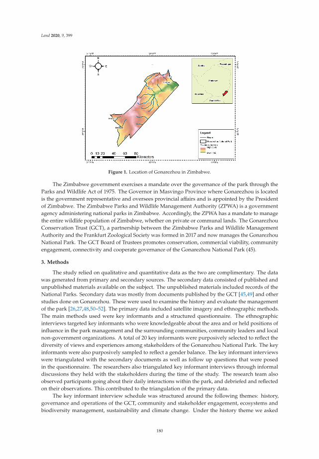
Land 2020, 9, 399
Figure 1. Location of Gonarezhou in Zimbabwe.
The Zimbabwe government exercises a mandate over the governance of the park through theParks and Wildlife Act of 1975. The Governor in Masvingo Province where Gonarezhou is locatedis the government representative and oversees provincial affairs and is appointed by the Presidentof Zimbabwe. The Zimbabwe Parks and Wildlife Management Authority (ZPWA) is a governmentagency administering national parks in Zimbabwe. Accordingly, the ZPWA has a mandate to managethe entire wildlife population of Zimbabwe, whether on private or communal lands. The GonarezhouConservation Trust (GCT), a partnership between the Zimbabwe Parks and Wildlife ManagementAuthority and the Frankfurt Zoological Society was formed in 2017 and now manages the GonarezhouNational Park. The GCT Board of Trustees promotes conservation, commercial viability, communityengagement, connectivity and cooperate governance of the Gonarezhou National Park (45).
3. Methods
The study relied on qualitative and quantitative data as the two are complimentary. The datawas generated from primary and secondary sources. The secondary data consisted of published andunpublished materials available on the subject. The unpublished materials included records of theNational Parks. Secondary data was mostly from documents published by the GCT [45,49] and otherstudies done on Gonarezhou. These were used to examine the history and evaluate the managementof the park [26,27,48,50–52]. The primary data included satellite imagery and ethnographic methods.The main methods used were key informants and a structured questionnaire. The ethnographicinterviews targeted key informants who were knowledgeable about the area and or held positions ofinfluence in the park management and the surrounding communities, community leaders and localnon-government organizations. A total of 20 key informants were purposively selected to reflect thediversity of views and experiences among stakeholders of the Gonarezhou National Park. The keyinformants were also purposively sampled to reflect a gender balance. The key informant interviewswere triangulated with the secondary documents as well as follow up questions that were posedin the questionnaire. The researchers also triangulated key informant interviews through informaldiscussions they held with the stakeholders during the time of the study. The research team alsoobserved participants going about their daily interactions within the park, and debriefed and reflectedon their observations. This contributed to the triangulation of the primary data.
The key informant interview schedule was structured around the following themes: history,governance and operations of the GCT, community and stakeholder engagement, ecosystems andbiodiversity management, sustainability and climate change. Under the history theme we asked
180
Land 2020, 9, 399
respondents how and when the park was established as well as how it has evolved. On the governanceaspect we inquired about the current governance structures of the GCT and its day-to-day operations.Likewise, on community and stakeholder engagement we focused on the GCT initiatives and itsrelationship with surrounding communities and stakeholders. When administering the key informantinterviews, we adopted suitable protocols where we created standard definitions and explanationswhich were used in data collection [53,54]. NVIVO software was used to glean and create themes fromthe various categories as well as meanings which were derived from the gathered data. Secondarydata where we consulted other journal articles and reports supplemented the gathered primarydata [26–28,39,40,42,44,45,48–52,55]. The key informant interviews and secondary data revealedthe four themes of history and current management of the Gonarezhou National Park, communityengagement, conservation and connectivity, and challenges.
There were challenges with the data collection because of the national boundary of the park whichmade it impossible for us to engage with the broader constituency of the Gonarezhou as the transfrontier park. The national park in Zimbabwe is subject to various ministries which we did not engage,as these could possibly have complimented the information generated. The issue of land is emotionaland political in Zimbabwe, and as a result the researchers had to engage sensitively with the displacedcommunities. A consequence of this sensitivity was that we failed to engage with the communitiessettled in the park. The researchers hired community members as research assistants, strictly observingthe existing protocols to secure access to the affected people. We also had a limitation of time as weonly visited during a particular season. This limited our insight into the ways in which seasonalityinfluences the stakeholder relationships and biodiversity and ecosystem management. However,the authors are confident that the information generated forms an adequate basis for generating thedepth of data needed to obtain the insights required to meet the objectives of the study.
Landcover Classification and Analysis
For the conservation theme we also analyzed changes in land cover data, where we used Landsat7 satellite imagery for 2007 and 2017 obtained from the United States Geological Services (USGS)].Atmospheric and radiometric corrections using ArcGIS 10.5 were conducted on the Landsat images.Random forest supervised, pixel-based classification in ArcGIS 10.5 was used to classify the Landsatimages. This classification was robust, effective and produced better results in environments such asGonarezhou, and its utility has been demonstrated in many studies [56–59]. A Juno Trimble handglobal positioning device was used to collect training samples for the classification and for conductingaccuracy assessment. A total of 10 land cover types, consisting of agriculture, bare land, built up areas,dense shrubs, dense vegetation, grassland, sparse shrubs, sparse vegetation, woodland and water,were classified from the Landsat satellite imagery. Google Earth Pro and extensive field visits wereutilized to verify the accuracy of the land cover classification [60]. Consequently, an overall accuracyof 77% and a margin of error 23% for the land cover classification was realized, meaning that 77% ofthe time the landcover classification confirmed what was on the ground [41]. The satellite imagerygenerated qualitative and quantitative data which were used to generate quantitative information andgenerate landcover change maps.
The rate of transformation of each landcover type was subsequently calculated from the landcover mapping, and crosstabulation of the land cover transformation was conducted using ArcGISsoftware. The transformation of each land cover type was calculated in percentages as shown inEquation (1) below [61–64].
CAi = 100 × (At+1 − At)/TA (1)
where CAi denotes the changes in the percentage share of areas covered by each land cover type inrelation to the total area of study area (%); At+1 is the area of each type of land cover during the timeinterval t + 1 (ha); At represents the area covered with each type of land cover during the time intervalt (ha); and TA represents the total study area (ha) [61–64]. The rate of transformation was utilized as aproxy to assess whether current efforts are bearing fruit in biodiversity conservation [41].
181

Land 2020, 9, 399
4. Results and Discussion
4.1. Establishment of the Gonarezhou Conservation Trust
Here we present the reasons behind establishment of GCT and reflect why it is innovative.Gonarezhou was proclaimed as a national park in 1975 and a government entity managed the park.However, Zimbabwe faced budgetary and governance challenges which negatively impacted on theGonarezhou National Park. These included a lack of manpower, a declining infrastructure, a declinein tourist visitors, destruction of vegetation and a loss of wildlife. Accordingly, in 2007 the ZPWMAsigned a memorandum of understanding with the Frankfurt Zoological Society for 10 years. Underthis memorandum of understanding (MOU) the FZS became the technical and financial assistancepartner. However, this was a challenge, because Zimbabwe continued to experience turbulence in thegovernance of land and natural resources, and tourist numbers continued to decline. In 2013, a newMOU between the FZS and ZPWMA was signed which would assist in acquiring manpower, promoterevenue generation through tourism, ensure conservation and promote community engagementand participation. Overall, the GCT is trying to maintain and increase the biodiversity of animalsin Gonarezhou National Park. In 2017, the ZPWMA and FZS partnered to form the GonarezhouConservation Trust (Figure 2).
Figure 2. Gonarezhou Conservation Trust setup.
This partnership is viewed as an innovative model for managing protected areas and is built on arelationship developed over nine years, during which time, the FZS provided technical assistance toGonarezhou. The GCT is currently responsible for running the park under a board of trustees madeup of equal members from the ZPWMA and the FZS for a period of 20 years. However, there are nocommunity members on the board. The GCT has five main objectives referred to as the five “Cs”,namely, conservation, commercial, community, connectivity and cooperate governance. These arediscussed below.
4.2. Community Engagement
In this section we highlight and assess the relationship between the park and communities. Beforethe establishment of the GCT, there was barely any community engagement, and the relationship withthe national park was adversarial. The park criminalized the communities and focused on policingthem. This made it difficult for communities to negotiate access to the park for resources for subsistence,construction of their shelters or to perform their cultural ceremonies. When the community didhave access, it was considered trespassing and they were liable for arrest. The national park wildlifeencroached on the communities’ agricultural lands and posed a constant threat to their livelihoods,and communities had no recourse. The formation of the GCT recognized the community as a strategicpillar of the Gonarezhou National Park [45]. This culminated in the engagement of the community
182

Land 2020, 9, 399
through a project called the “Mpfhuka” project which means a journey of community engagement withlocal communities to ensure a better relationship with the community. The Mpfhuka project providedan engagement platform which was used to inform communication, engagement, empowerment andeducation of the communities.
The GCT uses the “Mpfhuka” platform to mobilize all communities within and outside the parkboundaries. The mobilization is aimed towards developing a common vision about the protected area.Nevertheless, the meetings between communities and the GCT are described as ’tense’, as communitiesare given an opportunity to criticize the GCT. For example, one community member says “the GCTexpect us to listen to them but they should also listen to us”. Challenges also arise in developing a commonvision because of the trust deficit that the communities have of park management. Communitiesbelieve that GCT prioritizes animal welfare at the expense of human well-being in the conservationefforts. For example, one key community member said, “wildlife is the number one priority of GCT”.Communities are also not happy about the GCT failure to adequately compensate them for the lossesthey incur as a result of the human-wildlife conflict. Some of the tensions could be attributed tocommunity unhappiness at the terms of engagement as well as the legacy of painful memories ofdispossession. The outcome of the dialogues lays out the work that the GCT needs to do to engendercommunity trust in the new stakeholder engagement strategy.
The GCT uses the “Mpfhuka” project to assist communities in managing and promoting theireco-tourism sites such as bird watching at the Manjinji pan in the Sengwe community. Under the“Mpfhuka” project the key informants explained that the GCT established a liaison officer who is amediator between park management and the community. This move to appoint a mediator establishedcommunication channels between the GCT and the community. The “Mpfhuka” project provided aplatform for dialogue between the communities that were displaced to make way for the park. As aresult, the two parties agreed on the terms by which the displaced communities could access theGonarezhou National Park to visit their traditional and cultural sites within the park so as to practicetraditional rites such as rain making ceremonies. The “Mpfhuka” project also enables communityempowerment as well as awareness and allows communities to harvest natural resources in the park.
The “Mpfhuka” education project, through the GCT, enables schoolchildren and local communitiesto undertake educational tours in the park. These education and awareness-raising campaigns targetingschool children are a “simple and fun way” for intergenerational transfer of knowledge on climatechange, conservation, and tree planting. The GCT assists in a book project and facilitates the provisionof limited scholarships for studies linked to the environment in higher education. The liaison team atGCT believes that such education campaigns promote environmental stewardship which leads peopleto appreciate the environment and results in reduced poaching, as observed in other studies [65,66].One key informant noted that the educational and awareness campaigns “create a sense of ownership andappreciation of nature which develops future environmental stewards”.
The GCT is focusing on community empowerment to ensure that communities benefit fromtourism and conservation. Firstly, the GCT engages the community, and disadvantaged women inparticular, to ensure economic empowerment and that the community benefits from the tourismrevenues. The GCT buys the women’s handicraft which is used to furnish some of the buildings of theGCT. Some of the women in the community are involved in selling the grass for thatching. The GCTemploys “more than 80% of employees from local communities” which promotes inclusivity, involvementand a sense of ownership since communities would say “it is our local children who work in the park”.The GCT also hires community members for the construction and maintenance of community themedcamps called ‘Mananga camps’, which are used for tourist accommodation. Local community membersare also employed as tourist guides. The employment generates cash for the local community andreduces community reliance on unsustainable exploitation of the protected area resources.
The GCT have enabled the community to harvest building materials like thatch which are usedfor construction of community housing structures. Community members also have permission togather fruit and medicinal plants from the protected area under the supervision of GCT officials.
183
Land 2020, 9, 399
During droughts, the GCT also allows communities to cut grass in the park to give to their livestock.Likewise, communities can harvest natural vegetables in the park and harvest fish bi-annually or uponrequest in consultation with traditional leaders so as to allow regeneration of this resource. The mostcommon natural vegetable harvested is spider leaf/nyeve/ilude (Cleome gynandra) which is a localdelicacy, and some of the communities sell it to earn a living. The GCT and communities have devisedways to ensure that the terms on which communities enter and exploit the park are sustainable.
The key informants believe that the ‘Mpfhuka’ project has improved relations between the GCTand communities. The GCT’s community engagement strategy has potential to be sustainable.Other studies note that engaging communities is also seen as a form of environmental justice. Examplesof this are the engagement of communities adjacent to Kruger National Park in South Africa [67] andattempts to engage the Baka and Aka hunter-gatherers in the Sangha Tri-National in Cameroon [68].The sustainability and effectiveness of this can only be ascertained over time [69]. Further studiesaround community engagement and conservation are required to explore this notion in Gonarezhou,because most of these have focused on conservation while neglecting the social and political processesinvolved in community engagement [70]. However, more needs to be done to ensure sustainedcommunity engagement in natural resource management.
The community argues that they should also benefit from tourist activities at Gonarezhou.This highlights the importance of the tourist contribution to the financial sustainability of the ‘Mpfhuka’initiative. The secondary data showed that there was an increase in tourist arrivals from 2100 to5000 between 2009 and 2014 which consisted mainly of locals compared to regional and internationaltourists [51]. The increase in tourism was largely because of the positive perceptions which localtourists have of Gonarezhou [51]. The Gonarezhou National Park is enhancing revenue generationefforts through the inclusion of mini events and conferences in the park, which pulls tourists tothe neighboring Kruger National Park in South Africa. We observed that mini-conference facilitieswhere established at Simuwini camp. Accordingly, the GCT opened a training center and engagedin aggressive marketing in 2019. It also engaged a business development manager to oversee thecommercial aspects of the park, and these efforts are expected to increase the number of tourists. It istherefore recommended that the GCT should engage in efforts to ensure financial sustainability andattracting more tourists from regional and international markets. Thus, financial sustainability is crucialin the management of national parks. Financial sustainability of the park is also crucial in facilitatingcommunity engagement. National parks need to upgrade their infrastructure and devise innovativeproducts, such as virtual wildlife safaris, which boost revenues. Consequently, more research on theemerging trend of virtual wildlife safaris is proposed.
4.3. Conservation and Connectivity
The GCT views the community as an integral part of enhancing conservation, however the GCTacknowledges that this is a challenging but essential task for sustainable conservation. Gonarezhou isdominated by Mopane, Guibourtia and Combretum woodlands, and the aim is to positively maintainor increase the vegetation [45]. Likewise, the GCT also seeks to conserve wildlife and flora, and reducethreats which lead to a decline in wildlife [45]. Consequently, in this section we present the resultsof the landcover change from Landsat satellite imagery over a 10-year period (2007 to 2017) whichcovers the conservation theme. The satellite data shows that there has been negative transformationof sparse vegetation, sparse shrubs, grasslands and dense vegetation which had a CA of −9, −6, −6and −1, respectively (See Figure 3 and Table 1). The negative transformation implies that the variousvegetation classes declined between 2007 and 2017.
184

Land 2020, 9, 399
(a)
(b)
Figure 3. Landscape change in Gonarezhou (a) 2007 and (b) 2017 [41].
185
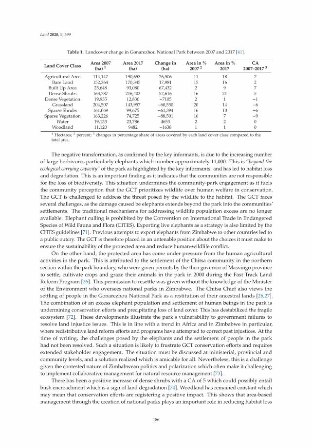
Land 2020, 9, 399
Table 1. Landcover change in Gonarezhou National Park between 2007 and 2017 [41].
Land Cover ClassArea 2007
(ha) 1Area 2017
(ha)Change in
(ha)Area in %
2007 2Area in %
2017CA
2007–2017 3
Agricultural Area 114,147 190,653 76,506 11 18 7Bare Land 152,364 170,345 17,981 15 16 2
Built Up Area 25,648 93,080 67,432 2 9 7Dense Shrubs 163,787 216,403 52,616 16 21 5
Dense Vegetation 19,935 12,830 −7105 2 1 −1Grassland 204,507 143,957 −60,550 20 14 −6
Sparse Shrubs 161,069 99,675 −61,394 16 10 −6Sparse Vegetation 163,226 74,725 −88,501 16 7 −9
Water 19,133 23,786 4653 2 2 0Woodland 11,120 9482 −1638 1 1 01 Hectares; 2 percent; 3 changes in percentage share of areas covered by each land cover class compared to thetotal area.
The negative transformation, as confirmed by the key informants, is due to the increasing numberof large herbivores particularly elephants which number approximately 11,000. This is “beyond theecological carrying capacity” of the park as highlighted by the key informants. and has led to habitat lossand degradation. This is an important finding as it indicates that the communities are not responsiblefor the loss of biodiversity. This situation undermines the community-park engagement as it fuelsthe community perception that the GCT prioritizes wildlife over human welfare in conservation.The GCT is challenged to address the threat posed by the wildlife to the habitat. The GCT facesseveral challenges, as the damage caused be elephants extends beyond the park into the communities’settlements. The traditional mechanisms for addressing wildlife population excess are no longeravailable. Elephant culling is prohibited by the Convention on International Trade in EndangeredSpecies of Wild Fauna and Flora (CITES). Exporting live elephants as a strategy is also limited by theCITES guidelines [71]. Previous attempts to export elephants from Zimbabwe to other countries led toa public outcry. The GCT is therefore placed in an untenable position about the choices it must make toensure the sustainability of the protected area and reduce human-wildlife conflict.
On the other hand, the protected area has come under pressure from the human agriculturalactivities in the park. This is attributed to the settlement of the Chitsa community in the northernsection within the park boundary, who were given permits by the then governor of Masvingo provinceto settle, cultivate crops and graze their animals in the park in 2000 during the Fast Track LandReform Program [26]. This permission to resettle was given without the knowledge of the Ministerof the Environment who oversees national parks in Zimbabwe. The Chitsa Chief also views thesettling of people in the Gonarezhou National Park as a restitution of their ancestral lands [26,27].The combination of an excess elephant population and settlement of human beings in the park isundermining conservation efforts and precipitating loss of land cover. This has destabilized the fragileecosystem [72]. These developments illustrate the park’s vulnerability to government failures toresolve land injustice issues. This is in line with a trend in Africa and in Zimbabwe in particular,where redistributive land reform efforts and programs have attempted to correct past injustices. At thetime of writing, the challenges posed by the elephants and the settlement of people in the parkhad not been resolved. Such a situation is likely to frustrate GCT conservation efforts and requiresextended stakeholder engagement. The situation must be discussed at ministerial, provincial andcommunity levels, and a solution realized which is amicable for all. Nevertheless, this is a challengegiven the contested nature of Zimbabwean politics and polarization which often make it challengingto implement collaborative management for natural resource management [73].
There has been a positive increase of dense shrubs with a CA of 5 which could possibly entailbush encroachment which is a sign of land degradation [74]. Woodland has remained constant whichmay mean that conservation efforts are registering a positive impact. This shows that area-basedmanagement through the creation of national parks plays an important role in reducing habitat loss
186

Land 2020, 9, 399
and maintaining species diversity. The landcover analysis from satellite data also demonstratesthe importance of using remote sensing in monitoring impacts of landcover on ecosystems services.National parks in Zimbabwe lack resources and capacity to engage in research on landcover whichhampers their ability to respond to climate change. However, partnering with the scientific communitiessuch as universities and research institutes can provide resources to generate the empirical data neededto inform policymaking. Currently the ZPWMA is keen to partner with local universities to engage incollaborative research, but owing to resource constraints, collaborative research has been limited.
From a faunal perspective the key informants pointed out that there has been an increase in largeherbivores. This was confirmed by the aerial survey in 2016 of large herbivores which estimatedthe population of elephant to be 10,715, impala 7421, buffalo 4797, kudu 1789, and zebra 1830 [49].The aerial survey indicated that there has been a general increase in large herbivores since 1992which points to better management and conservation leading to an increase in wildlife in Gonarezhou.Similarly, the key informants and the predator survey in 2017 also indicated an increase in thenumber of predators such as lions from 54 to 62 in 2016 and 107 wild dogs which have increasedexponentially over that past years. Maintaining predators in an ecosystem is crucial for a balanceand ensuring a stable supply of ecosystem goods and services [4]. Overall, the GCT is trying tomaintain and increase the biodiversity of animals in the Gonarezhou National Park. However, the2016 aerial survey highlighted several challenges such as an increasing presence of domestic livestock.The key informants also confirmed that communities graze their livestock within the park, and wildanimals, in particular elephants and buffaloes, raid cultivated fields of communities. Such dynamicsperpetuate the human-wildlife conflict. Grazing domestic animals in national parks is not allowedby legislation. Nevertheless, some communities graze their animals in the park owing to a lack ofpasture in communities, and porous boundaries. This human-wildlife conflict further demonstratesthe need for collaborative management in national parks. Results revealed that communities burnchili-briquettes, producing smoke which irritates elephants thereby repelling them from raiding theircrops. Thus, parks affect people and likewise communities affect parks, and the “Mpfhuka’ projectwhere the GCT continuously engages communities is a platform to air issues and resolve conflicts.
Enforcement is also challenging, given the elongated nature of the park and the fact that itcovers a vast area of 5053 km2. From an enforcement perspective, prior to formation of the GCT,enforcement and security were hampered by a low staff compliment. The key informants highlightedthat the GCT has increased the number of field rangers who conduct foot patrols in the park to 130.The GCT conducts regular training and uses innovative technologies such as the Spatial Monitoringand Reporting Tool (SMART) as an enforcement mechanism [45,75]. The GCT also acknowledges thatenforcement alone is not enough and that engaging communities ensures long-term sustainabilityand a reduction in poaching. If the SMART tool and other information communications technologies(ICT) are used by villages adjacent to Gonarezhou, there is the potential that information can be sharedwith the GCT. Hence this will add another layer of protection and law enforcement. For example,selected community members can be trained on the use of SMART as it only requires a cellphone,and these community members can report any suspicious activities to GCT, thereby strengtheningthe collaborative management of the park. However, the community members utilizing the SMARTrequire incentives such as a stipend for effective monitoring. The issue of incentives is a reemergingtheme, where there must be incentives such as stipends or any other incentives which improve theirlivelihoods. Thus, there is a need to further explore the use of ICT in conjunction with traditional footpatrols in combating wildlife crime.
Besides the elephants and human settlements, the national park faces threats from poachers,livelihoods stress induced by cyclical drought, economic decline of Zimbabwe and a decline in tourismarrivals. The latter was compounded by Covid-19 induced travel restrictions.
187
Land 2020, 9, 399
4.4. Challenges
The proceeding discussion examines the challenges faced in the park and limits of the innovation.We draw lessons from the case study of Gonarezhou to contribute to the scholarship in stakeholderengagement and protected areas. The GCT faces several challenges that include the governance of thepark, stakeholder engagement, community distrust and lack of coordination among the governmentrepresentatives in the country. The international protocols for managing elephant populations alsoundermine the viability and sustainability of the GCT initiative.
The livelihood stresses endured by the poor communities living around the park exert pressureon the communities who may have no option but to resort to unsustainable use of the park to securetheir livelihoods. The unsustainable use includes poaching of wildlife for subsistence purposes,unsustainable harvesting of vegetation and biodiversity resources, and the communities’ participationin commercial sophisticated poaching networks targeting big game animals such as elephants. Througheducation and awareness campaigns and supporting livelihoods of local communities, GCT is tryingto reverse these trends. The communities argue that more still needs to be done to enhance theirlivelihoods; nevertheless, under the difficult economic climate in Zimbabwe this is a challenging taskfor the GCT.
A further challenge is a lack of coordination between the national and transboundary governanceauthorities. The key informants mentioned that the Great Limpopo Trans frontier park was formedin 2002 between heads of state of South Africa, Mozambique and Zimbabwe and overlooked itslocalized impacts. As an example, the Gonarezhou National Park is supposed to link with the KrugerNational Park in South Africa through the Sengwe corridor. However, this is inhabited by communitiesin villages. Therefore, movement of wildlife around and through the corridor would increase theincidences of human-wildlife conflict which is already rife in the area. This experience highlights theneed for improved coordination and policy consistency between the diverse authorities engaged in thegovernance of conservation areas.
The other challenge is the failure by the GCT to deal with the issues of compensating communitiesfor the losses to wildlife which encroaches on their fields and settlements and has created a long-standinggrudge over the historical dispossession of land.
The management of protected areas is also facing challenges because of climate change andvariability. One of the key informants highlighted this by saying “just look everywhere you go and turn inthis area it’s just dry”. For example, the droughts in 1992, 2002, 2008, 2012 and recently in 2018 have ledto food insecurity within communities around the park leading to loss of livelihoods and livestockwhich increases the rate of small-scale poaching in the park [76]. It was also noted by one of the keyinformants that there is farm abandonment because of climate change which is exacerbating poachingactivities. Climate change induced drought leads to the migration and relocation of animals and theirdeath. More resources are thus required to feed animals as fodder must be prepared or purchased;likewise, the supply of water in natural pans dries up, requiring the need to pump water artificially foranimals. However, there are no artificial water pans in Gonarezhou as it is management’s approachnot to interfere with nature but rather to let the system self-regulate.
Climate change affects ecosystem functions because vegetation is reduced or destroyed leadingto elephants moving to locations with water. In this process they destroy important ecosystemservices such as mopane and acacia woodlands which are important in carbon sequestration andprovision of good quality habitats [52,55]. Similarly, extreme events such as cyclones have destroyedinfrastructure, in particular the bridge which connects the northern and southern sections of the park.This has undermined tourists’ access to the southern section. These droughts and extreme events haveaffected land use planning and community relations with the park. For example, the key informantsindicated that while the GCT encourages people to destock their livestock so as to minimize loss duringdroughts, some communities still choose to keep them which further fuels human-wildlife conflict.Furthermore, activities in communities outside pose challenges for land use management inside thepark. For example, some communities outside the park practice streambank cultivation which leads to
188

Land 2020, 9, 399
soil erosion, disturbing the aquatic systems in rivers through shifting of water pools and affecting thefish population negatively.
5. Conclusions
The purpose of our study was to (1) assesses recent innovations in the management of theGonarezhou National Park, (2) evaluate the relationship between the park and communities, (3) examineand highlights challenges faced in the park and limits of the innovation and (4) draw lessons from thecase study of Gonarezhou to contribute to the scholarship in stakeholder engagement and protectedareas. From the study it is evident that for successful management of protected areas, communitiesmust be involved as important stakeholders. However, the terms on which communities are engagedstill remains a challenge. Thus, the GCT acknowledges the importance of community mobilizationand development, and as a result they have started on a journey of “Mpfhuka” which engagessurrounding communities. Through “Mpfhuka” the GCT engages the community in conservationwhile at the same time supporting it in its efforts to improve its livelihood. Other studies also concurthat community engagement is an evolving and learning journey that is vital for the collaborativemanagement of protected areas [10,17,77]. Trust is crucial for effective collaboration with communitiesin the management of protected areas. However, it takes time to build sustainable relationshipsand solid trust [10,35]. A lack of support from or involvement of communities threatens protectedareas [17,77], for example, through poaching activities in the national park. Solutions for challengessuch as poaching as a result of poverty and poor or weak coordination amongst implementing agenciesmust continuously be sought. Thus, we propose more efforts to engage with and benefit communitiesfrom wildlife tourism of protected areas to deter negative and retrogressive actions by communities.Protected area managers are encouraged to therefore genuinely seek to engage communities and notview them as threats.
Our study highlights the importance of innovative partnerships between state and non-statenon-profit organizations, local communities, and local and international partners in managingprotected areas in Zimbabwe and elsewhere as they provide financial and technical assistance crucialin protected areas administration. Prior to the GCT partnership, tourist numbers were declining, andthe conservation efforts were suffering. It is important to note that protected area management is notonly about conservation but also about increasing revenue from tourism, enabling protected areas tobecome self-sustaining.
From a conservation perspective, the partnership has increased elephant and wildlife populationswhich shows the utility of area-based approaches in conserving wildlife. However, this has resultedin human-wildlife conflict and the park carrying more elephants than it can manage. Nevertheless,international statutes do not allow the culling of elephants, so park authorities are left to deal with agrowing problem of animal numbers. Exporting the elephants would be a solution but it is done understrict guidelines. Thus, while it is noble to follow international statutes such as CITES, this shouldnot be at the expense of sustainable management of natural resources and negative outcomes on locallivelihoods. This shows the complex structures governing protected areas that need to be navigated aswell as divergence between policy and practice.
From a land cover perspective there has been a positive increase of dense shrubs and maintenanceof woodland which is crucial for the supply of ecosystem services. The paper illustrates that there arelimits to how much local based initiatives like the GCT can resolve vulnerabilities of protected areas.The issues of CITES regulations, community sentiments, transboundary resource governance andsensitivity of natural resource governance issues pose serious challenges whose resolution is beyondthe scope of the GCT and this publication. However, the transboundary protected area managementregimes and global conservation frameworks have the potential to provide the framework withinwhich these can be sustainably tackled. The findings are that the initiatives like this one work best in acontained environment with a broader stakeholder base engagement. The stakeholder base shouldbe expanded to include the diverse government departments engaged in the governance of natural
189

Land 2020, 9, 399
resources This is even more complex with managing transboundary conservation such as the GLTP.While it is worthwhile and noble to engage in transboundary initiatives, these are difficult to implementdue to complex governance structures and competing interests. Lastly, innovative partnerships withcommunities are crucial for sustainable management of natural resources; however, governance,climate change, and trust are challenges which must be navigated in protected area management.
Author Contributions: Conceptualization, W.M., T.G., G.P., N.A.N. and N.B.S.; data curation, W.M., E.M., N.A.N.and N.B.S.; formal analysis, W.M., T.G. and E.M.; funding acquisition, W.M.; investigation, W.M., T.G., G.P.,N.A.N. and N.B.S.; methodology, W.M., T.G., G.P., E.M., N.A.N. and N.B.S.; project administration, W.M. and T.G.;resources, W.M. and T.G.; software, W.M.; supervision, W.M.; validation, W.M., G.P., E.M., N.A.N. and N.B.S.;visualization, N.A.N.; writing—original draft, W.M., T.G., G.P., E.M. and N.A.N.; writing—review & editing, W.M.,T.G., G.P. and N.B.S. All authors have read and agreed to the published version of the manuscript.
Funding: This work was funded by the National Research Foundation, South Africa (Grant no. 119288), and theArticle Processing Charge (APC) was funded by the University of Johannesburg, Faculty of Engineering and theBuilt Environment.
Acknowledgments: Sincere thanks goes to Zimbabwe Parks and Wildlife Management Authority, GonarezhouConservation Trust, and Southern Alliance for Indigenous Resources (SAFIRE) for their assistance duringthe project.
Conflicts of Interest: The authors declare no conflict of interest.
References
1. Dudley, N. Guidelines for Applying Protected Area Management Categories; Iucn: Gland, Switzerland, 2008.2. Dudley, N.; Shadie, P.; Stolton, S. Guidelines for applying protected area management categories including
IUCN WCPA best practice guidance on Recognising Protected Areas and Assigning Management Categoriesand Governance Types. Best Pract. Prot. Area Guidel. Ser. 2013, 21, 31.
3. Juffe-Bignoli, D.; Burgess, N.D.; Bingham, H.; Belle, E.; De Lima, M.; Deguignet, M.; Bertzky, B.; Milam, A.;Martinez-Lopez, J.; Lewis, E. Protected Planet Report 2014; UNEP-WCMC: Cambridge, UK, 2014; p. 11.
4. Hooper, D.U.; Chapin Iii, F.S.; Ewel, J.J.; Hector, A.; Inchausti, P.; Lavorel, S.; Lawton, J.H.; Lodge, D.M.;Loreau, M.; Naeem, S.; et al. Effects of biodiversity on ecosystem functioning: A consensus of currentknowledge. Ecol. Monogr. 2005, 75, 3–35. [CrossRef]
5. Bhola, N.; Klimmek, H.; Kingston, N.; Burgess, N.D.; van Soesbergen, A.; Corrigan, C.; Harrison, J.; Kok, M.T.Perspectives on area-based conservation and what it means for the post-2020 biodiversity policy agenda.Conserv. Biol. 2020. [CrossRef]
6. Geldmann, J.; Barnes, M.; Coad, L.; Craigie, I.D.; Hockings, M.; Burgess, N.D. Effectiveness of terrestrialprotected areas in reducing habitat loss and population declines. Biol. Conserv. 2013, 161, 230–238. [CrossRef]
7. United Nations, U. Transforming Our World: The 2030 Agenda for Sustainable Development; United Nations:New York, NY, USA, 2015.
8. Buck, M.; Hamilton, C. The Nagoya Protocol on access to genetic resources and the fair and equitable sharingof benefits arising from their utilization to the Convention on Biological Diversity. Rev. Eur. Community Int.Environ. Law 2011, 20, 47–61. [CrossRef]
9. Secretariat of the Convention on Biological Diversity. Handbook of the Convention on Biological Diversity:Including Its Cartagena Protocol on Biosafety; Secretariat of Convention: Montreal, ON, Canada, 2005.
10. West, P.; Igoe, J.; Brockington, D. Parks and peoples: The social impact of protected areas. Annu. Rev.Anthropol. 2006, 35, 251–277. [CrossRef]
11. Marongwe, L.S.; Kwazira, K.; Jenrich, M.; Thierfelder, C.; Kassam, A.; Friedrich, T. An African success:The case of conservation agriculture in Zimbabwe. Int. J. Agric. Sustain. 2011, 9, 153–161. [CrossRef]
12. Favretto, N.; Afionis, S.; Stringer, L.C.; Dougill, A.J.; Quinn, C.H.; Ranarijaona, H.L.T. DeliveringClimate-Development Co-Benefits through Multi-Stakeholder Forestry Projects in Madagascar: Opportunitiesand Challenges. Land 2020, 9, 157. [CrossRef]
13. UNEP-WCMC. Protected Area Profile for Africa from the World Database of Protected Areas, April 2020.2020. Available online: https://www.protectedplanet.net/region/AF (accessed on 21 April 2020).
14. Nabokov, P.; Loendorf, L.L. Restoring a Presence: American Indians and Yellowstone National Park; University ofOklahoma Press: Norman, OK, USA, 2004.
190
Land 2020, 9, 399
15. Rangarajan, M. Parks, Politics and History: Conservation Dilemmas in Africa. Conserv. Soc. 2003, 1, 77–98.16. Cernea, M.M.; Schmidt-Soltau, K. Poverty Risks and National Parks: Policy Issues in Conservation and
Resettlement. World Dev. 2006, 34, 1808–1830. [CrossRef]17. Omoding, J.; Walters, G.; Andama, E.; Carvalho, S.; Colomer, J.; Cracco, M.; Eilu, G.; Kiyingi, G.; Kumar, C.;
Langoya, C.D.; et al. Analysing and Applying Stakeholder Perceptions to Improve Protected Area Governancein Ugandan Conservation Landscapes. Land 2020, 9, 207. [CrossRef]
18. Fabricius, C.; de Wet, C. The influence of forced removals and land restitution. Conserv. Mob. Indig. PeoplesDisplac. Forced Settl. Sustain. Dev. 2002, 10, 142.
19. Archabald, K.; Naughton-Treves, L. Tourism revenue-sharing around national parks in Western Uganda:Early efforts to identify and reward local communities. Environ. Conserv. 2001, 28, 135–149. [CrossRef]
20. Green, D.S.; Zipkin, E.F.; Incorvaia, D.C.; Holekamp, K.E. Long-term ecological changes influence herbivorediversity and abundance inside a protected area in the Mara-Serengeti ecosystem. Glob. Ecol. Conserv. 2019,20, e00697. [CrossRef]
21. McCabe, J.T.; Perkin, S.; Schofield, C. Can Conservation and Development be Coupled among PastoralPeople? An Examination of the Maasai of the Ngorongoro Conservation Area, Tanzania. Hum. Organ. 1992,51, 353–366. [CrossRef]
22. Kweyu, R.; Thenya, T.; Kiemo, K.; Emborg, J. The nexus between land cover changes, politics and conflict inEastern Mau forest complex, Kenya. Appl. Geogr. 2020, 114, 102115. [CrossRef]
23. Kiage, O.E. The Ogiek Peoples’ Indigenous Knowledge: A Pathway towards Sustainable Natural ResourceManagement in the Mau Forest, Kenya. Afr. J. Hosp. Tour. Leis. 2019, 8, 1.
24. Chabeda-Barthe, J.; Haller, T. Resilience of Traditional Livelihood Approaches Despite Forest Grabbing:Ogiek to the West of Mau Forest, Uasin Gishu County. Land 2018, 7, 140. [CrossRef]
25. King, B. Conservation Geographies in Sub-Saharan Africa: The Politics of National Parks, CommunityConservation and Peace Parks. Geogr. Compass 2010, 4, 14–27. [CrossRef]
26. Mombeshora, S.; Le Bel, S. Parks-people conflicts: The case of Gonarezhou National Park and the Chitsacommunity in south-east Zimbabwe. Biodivers. Conserv. 2009, 18, 2601–2623. [CrossRef]
27. Muboko, N.; Bradshaw, G.J. Towards resolving local community and protected area management conflicts:Lessons from the Chitsa community and Gonarezhou National Park, Zimbabwe. Int. J. Dev. Confl. 2018, 8,62–79.
28. Gandiwa, E.; Heitkönig, I.M.; Lokhorst, A.M.; Prins, H.H.; Leeuwis, C. CAMPFIRE and human-wildlifeconflicts in local communities bordering northern Gonarezhou National Park, Zimbabwe. Ecol. Soc. 2013,18, 4. [CrossRef]
29. Frost, P.G.H.; Bond, I. The CAMPFIRE programme in Zimbabwe: Payments for wildlife services. Ecol. Econ.2008, 65, 776–787. [CrossRef]
30. Alexander, J.; McGregor, J. Wildlife and politics: CAMPFIRE in Zimbabwe. Dev. Chang. 2000, 31, 605–627.[CrossRef]
31. Murombedzi, J.C. Devolution and stewardship in Zimbabwe’s CAMPFIRE programme. J. Int. Dev. J. Dev.Stud. Assoc. 1999, 11, 287–293. [CrossRef]
32. Chupezi, T.J.; Ingram, V.; Schure, J. Study on Impacts of Artisanal Gold and Diamond Mining on Livelihoods andthe Environment in the Sagha Tri-National Park (TNS) Landscape, Congo Basin; Center for International ForestryResearch: Yaounde, Cameroon, 2009.
33. Stern, M.J.; Coleman, K.J. The Multidimensionality of Trust: Applications in Collaborative Natural ResourceManagement. Soc. Nat. Resour. 2015, 28, 117–132. [CrossRef]
34. Stern, M.J. Coercion, voluntary compliance and protest: The role of trust and legitimacy in combating localopposition to protected areas. Environ. Conserv. 2008, 35, 200–210. [CrossRef]
35. Lachapelle, P.R.; McCool, S.F. The role of trust in community wildland fire protection planning. Soc. Nat.Resour. 2012, 25, 321–335. [CrossRef]
36. Stern, M.J. The power of trust: Toward a theory of local opposition to neighboring protected areas. Soc. Nat.Resour. 2008, 21, 859–875. [CrossRef]
37. Fiallo, E.A.; Jacobson, S.K. Local communities and protected areas: Attitudes of rural residents towardsconservation and Machalilla National Park, Ecuador. Environ. Conserv. 1995, 22, 241–249. [CrossRef]
38. Mutandwa, E.; Gadzirayi, C.T. Impact of community-based approaches to wildlife management: Case studyof the CAMPFIRE programme in Zimbabwe. Int. J. Sustain. Dev. World Ecol. 2007, 14, 336–344. [CrossRef]
191

Land 2020, 9, 399
39. Gandiwa, E.; Heitkönig, I.M.; Lokhorst, A.M.; Prins, H.H.; Leeuwis, C. Illegal hunting and law enforcementduring a period of economic decline in Zimbabwe: A case study of northern Gonarezhou National Park andadjacent areas. J. Nat. Conserv. 2013, 21, 133–142. [CrossRef]
40. Mero Dowo, G.; Kativu, S.; de Garine-Wichatitsky, M. Local perceptions of tree diversity, resource utilisationand ecosystem services provision at the periphery of Gonarezhou National Park, Zimbabwe. For. TreesLivelihoods 2018, 27, 1–21. [CrossRef]
41. Musakwa, W.; Mpofu, E.; Nyathi, N.A. Local Community Perceptions on Landscape Change, EcosystemServices, Climate Change, and Livelihoods in Gonarezhou National Park, Zimbabwe. Sustainability 2020, 12,4610. [CrossRef]
42. Gandiwa, E.; Zisadza, P. Wildlife management in Gonarezhou National Park, Southeast Zimbabwe: Climatechange and implications for management. Nat. Faune 2011, 25, 101–110.
43. Gandiwa, E.; Heitkönig, I.M.; Eilers, P.H.; Prins, H.H. Rainfall variability and its impact on large mammalpopulations in a complex of semi-arid African savanna protected areas. Trop. Ecol. 2016, 57, 163–180.
44. Mutanga, C.N.; Vengesayi, S.; Chikuta, O.; Muboko, N.; Gandiwa, E. Travel motivation and tourist satisfactionwith wildlife tourism experiences in Gonarezhou and Matusadona National Parks, Zimbabwe. J. OutdoorRecreat. Tour. 2017, 20, 1–18. [CrossRef]
45. Gonarezhou Conservation Trust (GCT). The Park. 2020. Available online: http://gonarezhou.org/the-park/(accessed on 28 March 2020).
46. Mugandani, R.; Wuta, M.; Makarau, A.; Chipindu, B. Re-classification of agro-ecological regions of Zimbabwein conformity with climate variability and change. Afr. Crop Sci. J. 2012, 20, 361–369.
47. Elephant Database. Continental Totals: 2016 African Elephant Status Report. 2020. Available online:http://africanelephantdatabase.org/report/2016/Africa (accessed on 7 July 2020).
48. Mombeshora, S. Assessment of livelihoods in Chitsa settlement in Gonarezhou National Park; Bio-Hub: Harare,Zimbabwe, 2006.
49. Dunham, K.M.; Van der Westhuizen, H.F. Aerial Survey of Elephants and Other Large Herbivores in GonarezhouNational Park (Zimbabwe) and Some Adjacent Areas: 2016; Gonarezhou Conservation Trust: Chiredzi,Zimbabwe, 2016.
50. Mpofu, E.; Gandiwa, E.; Zisadza-Gandiwa, P.; Zinhiva, H. Abundance, distribution and status of Africanbaobab(Adansonia digitata L.) in dry savanna woodlands in southern Gonarezhou National Park, southeastZimbabwe. Trop. Ecol. 2012, 53, 119–124.
51. Mutanga, C.N.; Gandiwa, E.; Muboko, N. An analysis of tourist trends in northern Gonarezhou NationalPark, Zimbabwe, 1991–2014. Cogent Soc. Sci. 2017, 3, 1392921. [CrossRef]
52. Tafangenyasha, C. Tree loss in the Gonarezhou National Park (Zimbabwe) between 1970 and 1983. J. Environ.Manag. 1997, 49, 355–366. [CrossRef]
53. Pollnac, R.B.; Crawford, B.R. Assessing Behavioral Aspects of Coastal Resource Use; Coastal Resources Center,University of Rhode Island: Narrangansett, RI, USA, 2000.
54. McNally, C.G.; Gold, A.J.; Pollnac, R.B.; Kiwango, H.R. Stakeholder perceptions of ecosystem services of theWami River and Estuary. Ecol. Soc. 2016, 21, 34. [CrossRef]
55. Martini, F.; Cunliffe, R.; Farcomeni, A.; de Sanctis, M.; d’Ammando, G.; Attorre, F. Classification and mappingof the woody vegetation of Gonarezhou National Park, Zimbabwe. Koedoe 2016, 58, 1–10. [CrossRef]
56. Yan, J.; Wang, L.; Song, W.; Chen, Y.; Chen, X.; Deng, Z. A time-series classification approach based on changedetection for rapid land cover mapping. ISPRS J. Photogramm. Remote Sens. 2019, 158, 249–262. [CrossRef]
57. Deng, Z.; Zhu, X.; He, Q.; Tang, L. Land use/land cover classification using time series Landsat 8 images in aheavily urbanized area. Adv. Space Res. 2019, 63, 2144–2154. [CrossRef]
58. Zeng, H.; Wu, B.; Wang, S.; Musakwa, W.; Tian, F.; Mashimbye, Z.E.; Poona, N.; Syndey, M. A SynthesizingLand-cover Classification Method Based on Google Earth Engine: A Case Study in Nzhelele and LevhuvuCatchments, South Africa. Chin. Geogr. Sci. 2020, 30, 397. [CrossRef]
59. Zeng, H.; Wu, B.; Zhang, N.; Tian, F.; Phiri, E.; Musakwa, W.; Zhang, M.; Zhu, L.; Mashonjowa, E.Spatiotemporal Analysis of Precipitation in the Sparsely Gauged Zambezi River Basin Using Remote Sensingand Google Earth Engine. Remote Sens. 2019, 11, 2977. [CrossRef]
60. Wang, C.; Middel, A.; Myint, S.W.; Kaplan, S.; Brazel, A.J.; Lukasczyk, J. Assessing local climate zones in aridcities: The case of Phoenix, Arizona and Las Vegas, Nevada. ISPRS J. Photogramm. Remote Sens. 2018, 141,59–71. [CrossRef]
192

Land 2020, 9, 399
61. Krajewski, P. Assessing Change in a High-Value Landscape: Case Study of the Municipality of Sobotka,Poland. Pol. J. Environ. Stud. 2017, 26, 2603–2610. [CrossRef]
62. Krajewski, P. Monitoring of Landscape Transformations within Landscape Parks in Poland in the 21stCentury. Sustainability 2019, 11, 2410. [CrossRef]
63. Krajewski, P.; Solecka, I.; Mrozik, K. Forest Landscape Change and Preliminary Study on Its Driving Forcesin Sleza Landscape Park (Southwestern Poland) in 1883–2013. Sustainability 2018, 10, 4526. [CrossRef]
64. Woodward, A.J.; Fuhlendorf, S.D.; LESLIE, D.M.; Shackford, J. Influence of landscape composition andchange on lesser prairie-chicken (Tympanuchus pallidicinctus) populations. Am. Midl. Nat. 2001, 145,261–274. [CrossRef]
65. Baruch-Mordo, S.; Breck, S.W.; Wilson, K.R.; Broderick, J. The Carrot or the Stick? Evaluation of Educationand Enforcement as Management Tools for Human-Wildlife Conflicts. PLoS ONE 2011, 6, e15681. [CrossRef]
66. van der Ploeg, J.; Cauilan-Cureg, M.; van Weerd, M.; De Groot, W.T. Assessing the effectiveness ofenvironmental education: Mobilizing public support for Philippine crocodile conservation. Conserv. Lett.2011, 4, 313–323. [CrossRef]
67. Anthony, B. The dual nature of parks: Attitudes of neighbouring communities towards Kruger NationalPark, South Africa. Environ. Conserv. 2007, 34, 236–245. [CrossRef]
68. Boedhihartono, A.K.; Endamana, D.; Ruiz-Perez, M.; Sayer, J. Landscape scenarios visualized by Baka andAka Pygmies in the Congo Basin. Int. J. Sustain. Dev. World Ecol. 2015, 22, 279–291. [CrossRef]
69. Cock, J.; Fig, D. From colonial to community based conservation: Environmental justice and the nationalparks of South Africa. Soc. Transit. 2000, 31, 22–35. [CrossRef]
70. Mandudzo, W.C. People and Parks: On the Relationship Between Community Development and NatureConservation Amid Climate Change in South-Eastern Zimbabwe. In Climate Change Management; Springer:Cham, Switzerland, 2019; pp. 471–491.
71. CITES. International Trade in Live Elephants. 2019. Available online: https://cites.org/eng/news/statement/international_trade_in_live_elephants (accessed on 26 April 2020).
72. Walters, G.; Fraser, J.A.; Picard, N.; Hymas, O.; Fairhead, J. Deciphering African tropical forest dynamics inthe Anthropocene: How social and historical sciences can elucidate forest cover change and inform forestmanagement. Anthropocene 2019, 27, 100214. [CrossRef]
73. Muchadenyika, D.; Williams, J.J. Politics and the practice of planning: The case of Zimbabwean cities. Cities2017, 63, 33–40. [CrossRef]
74. O’Connor, T.G.; Puttick, J.R.; Hoffman, M.T. Bush encroachment in southern Africa: Changes and causes.Afr. J. Range Forage Sci. 2014, 31, 67–88. [CrossRef]
75. Hossain, A.N.M.; Barlow, A.; Barlow, C.G.; Lynam, A.J.; Chakma, S.; Savini, T. Assessing the efficacyof camera trapping as a tool for increasing detection rates of wildlife crime in tropical protected areas.Biol. Conserv. 2016, 201, 314–319. [CrossRef]
76. Frischen, J.; Meza, I.; Rupp, D.; Wietler, K.; Hagenlocher, M. Drought Risk to Agricultural Systems inZimbabwe: A Spatial Analysis of Hazard, Exposure, and Vulnerability. Sustainability 2020, 12, 752. [CrossRef]
77. Ayivor, J.S.; Nyametso, J.K.; Ayivor, S. Protected Area Governance and Its Influence on Local Perceptions,Attitudes and Collaboration. Land 2020, 9, 310. [CrossRef]
Publisher’s Note: MDPI stays neutral with regard to jurisdictional claims in published maps and institutionalaffiliations.
© 2020 by the authors. Licensee MDPI, Basel, Switzerland. This article is an open accessarticle distributed under the terms and conditions of the Creative Commons Attribution(CC BY) license (http://creativecommons.org/licenses/by/4.0/).
193


land
Review
Acknowledging Indigenous and Local Knowledge toFacilitate Collaboration in Landscape Approaches—Lessons from a Systematic Review
Portia Adade Williams 1, Likho Sikutshwa 2,3 and Sheona Shackleton 3,*
1 CSIR—Science and Technology Policy Research Institute, P.O. Box CT 519, Cantonments, Accra GA, Ghana;[email protected]
2 International Grants Hub, Research Office University of Cape Town Allan Cormack House, 2 RhodesAvenue, Mowbray, Cape Town 7700, South Africa; [email protected]
3 African Climate and Development Initiative and ARUA Centre of Excellence in Climate and Development,University of Cape Town, Rondebosch, Cape Town 7700, South Africa
* Correspondence: [email protected]
Received: 17 August 2020; Accepted: 15 September 2020; Published: 18 September 2020
Abstract: The need to recognize diverse actors, their knowledge and values is being widely promotedas critical for sustainability in contemporary land use, natural resource management and conservationinitiatives. However, in much of the case study literature, the value of including indigenous andlocal knowledge (ILK) in the management and governance of landscapes tends to be overlookedand undervalued. Understanding ILK as comprising indigenous, local and traditional knowledge,this systematic review synthesizes how ILK has been viewed and incorporated into landscape-basedstudies; what processes, mechanisms and areas of focus have been used to integrate it; and thechallenges and opportunities that arise in doing so. Queries from bibliographic databases (Web ofScience, JSTOR, Scopus and Africa Wide) were employed. Findings from the review underscorethat the literature and case studies that link landscapes and ILK are dominated by a focus onagricultural systems, followed by social-ecological systems, indigenous governance, natural resourcemanagement, biodiversity conservation and climate change studies, especially those related toearly warning systems for disaster risk reduction. The growing importance of multi-stakeholdercollaborations in local landscape research and the promotion of inclusive consultations have helpedto bring ILK to the fore in the knowledge development process. This, in turn, has helped to supportimproved landscape management, governance and planning for more resilient landscapes. However,more research is needed to explore ways to more effectively link ILK and scientific knowledge inlandscape studies, particularly in the co-management of these social-ecological systems. More studiesthat confirm the usefulness of ILK, recognize multiple landscape values and their interaction withstructures and policies dealing with landscape management and conservation are necessary forenhanced sustainability.
Keywords: indigenous knowledge (IK); local/traditional ecological knowledge (LEK/TEK); landscapes;collaboration; interdisciplinary/transdisciplinary research; indigenous and local knowledge (ILK)
1. Introduction
The global movement towards more pluralistic and integrative approaches to understandingand addressing the complex sustainability challenges facing humanity today acknowledges theneed to value multiple knowledge systems, to facilitate collaboration and mutual learning betweendifferent actors, and for integration across social and ecological systems, as well as the sustainabledevelopment goals [1–3]. In this review, we explore the connections and linkages between two
Land 2020, 9, 331; doi:10.3390/land9090331 www.mdpi.com/journal/land195

Land 2020, 9, 331
important concepts that are being widely promoted as critical for sustainability in contemporary landuse, natural resource management, climate change adaptation and biodiversity conservation initiatives.These concepts are indigenous and local knowledge (ILK) (see [4]) and landscape level approaches(see [5]). The latter recognize important social-ecological connections and interrelations and include,for example, integrated landscape management (ILM) and landscape stewardship. We specificallyconsider how ILK is incorporated into case studies that take a landscape approach.
The importance of recognizing indigenous and local knowledge systems emerged in 1987 from theWorld Commission on Environment and Development (WCED) report on sustainable development.According to WCED, the disappearance of ILK would likely result in the loss to larger society ofthe traditional skills, practices and understandings necessary for the sustainable management ofcomplex ecosystems [6]. International acknowledgement of indigenous and local peoples’ knowledgesystems and perspectives on environmental issues then began with work on traditional ecologicalknowledge (TEK) [7]. The 1992 United Nations Conference on Environment and Development(UNCED) (also known as the Rio Earth Summit) followed, which committed to take action globally,nationally and locally to achieve sustainable development by supporting the vital role indigenous andlocal people play [8]. In 2002, a decade later, the World Summit on Sustainable Development held inJohannesburg, South Africa formally acknowledged the historical relationships that indigenous andlocal people have to their lands over many generations [7]. Since then ILK has been incorporated intopolicy, research and practice across many different spheres of sustainable development, including themanagement of land and ecosystems. Moreover, it was the recognition of the accumulative wealthof indigenous, local and traditional knowledge, that led to the proposition that actors involved inlandscape and natural resource management concerns need to work cooperatively with indigenousand local people.
For this review, we adopt the Intergovernmental Panel on Biodiversity and Ecosystem Service(IPBES) concept of ILK to incorporate several forms of knowledge outside of mainstream scientificknowledge [4]. These include traditional ecological knowledge (TEK), cultural knowledge (CK) [9],local knowledge (LK), traditional knowledge (TK), [10,11], folk knowledge (FK) [12] and indigenousecological knowledge (IEK) [13]. Many of these terms are used interchangeably. IK is used mainlywith regards to indigenous peoples, while TK/TEK and LK are more often used for local peoplewho may or may not be indigenous, but nevertheless hold knowledge that is based on personal andcollective experiences of their local environments overtime [14]. Various scholars have debated themost appropriate use of these different terms without consensus [15–17]. We have selected to use ILKas it is more encompassing and, consequently, we refer to the various identified knowledge systems(IK, IEK, CK, TK and TEK) as ILK throughout the paper. ILK is defined based on Berkes’ [15]definition of IK, which is a cumulative body of knowledge, practice, and belief, evolving byadaptive processes and handed down through generations by cultural transmission, about therelationship of living beings (including humans) with one another and with their environment. Suchknowledge captures local natural resource management, historical and contemporary experiences,social norms, sociocultural governance structures and spiritual beliefs. Other authors have denotedILK as being qualitative, intuitive, experiential, holistic, oral, adaptive, responsive, performative,collective, spatially heterogenous and constructed [1,18,19].
A recent literature review on indigenous knowledge (IK) highlighted that, today, there isvalorization of ILK in political theory, sustainable development practice, collaborative internationalresearch agendas, biodiversity management and climate change adaptation and resilienceframeworks [4,20]. For instance, the United Nations Framework Convention on Climate Change(UNFCCC), the Intergovernmental Panel on Climate Change (IPCC) and the Intergovernmental Panelon Biodiversity and Ecosystem Services (IPBES) all acknowledge the importance of ILK systems inclimate change adaptation and biodiversity management. According to Thompson et al. [20], these newdevelopments and interests emerge from the belief, and evidence, that ILK can contribute solutionsto the unprecedented threats that humanity and the planet face today. The knowledge and beliefs
196

Land 2020, 9, 331
linked to indigenous and local practices have been important in offering theoretical advancement andpractical approaches for the sustainable use and management of natural resources [19], as well ascontributing to biodiversity conservation and other sustainability challenges [21–23]. Robinson andWallington [24] underscore that the scope and content of ILK systems are complementary to sciencewith regards to ways of governing dynamic and complex social-ecological systems. Other scholarshave described indigenous and local people as scientists with their own developed cosmologies andworldviews that have fostered wellbeing of communities and their environments over generations [25].With regards to the environment, several studies have revealed that indigenous and local people holdempirical and cultural knowledge about the environment contributing significantly to environmentalgovernance [26]. For example, anthropologists and natural scientists have documented ILK related toplants, animals and natural phenomena [27,28].
The understanding of the potential role of ILK has led to its incorporation in contemporary landscape,conservation and adaptation research and practice [15,19,24]. For example, although indigenous andlocal people are often very vulnerable to the negative impacts of climate change, they are also recognizedas possessing specific knowledge of use for adaptation [14]. The urgency of current crises related toclimate, food and water thus poses an opportunity for engagement with the sustainable practicesand solutions ILK presents [25]. Advocating for the inclusion of ILK in research and practice has thepotential to empower indigenous and local people and support them finding their own, often moreappropriate, solutions to climate change and other threats [7]. Some of the strengths of ILK includeits legitimacy, credibility, salience and usability among others [29,30]. If successfully embeddedwithin research and practice, ILK is considered to increase community buy-in and the perceivedlegitimacy of decision-making and policy formulation [21]. Furthermore, collaborative applicationof multiple knowledges is key to optimizing social-cultural-ecological resilience [31]. However,the acknowledgement of ILK is not always necessarily translated into ILK informed or ILK drivenresearch or projects [21]. Numerous challenges have been identified in practice. In this review weunpack some of these challenges or barriers as well as the factors that can contribute to the successfulincorporation of ILK into landscape projects.
Landscape approaches are one of the most widely advocated means to address growing pressureson land, water and biodiversity [32]. Landscape approaches emerged from the understanding thatland management that considers agriculture, forestry, biodiversity and poverty alleviation as separateissues will not be enough: “the scale of the global challenges we face is too great; and there is a need forgenuinely integrated approaches” [33]. Broadly speaking, landscape approaches provide a frameworkto integrate policy and practice for multiple land uses within a given area. This holistic approach,it is argued, can support more equitable and sustainable use of land and ecosystem services whilesimultaneously strengthening measures to mitigate and adapt to climate change. The understandingof a landscape approach inherently includes recognition of indigenous and local people and their ILKas a key component. For example, Principle 5 of the widely accepted 10 principles of a landscapeapproach [34], while not explicitly mentioning ILK, does refer to the importance of stakeholderinvolvement which includes local and indigenous people as land users and owners. Austin andcolleagues [21] similarly assert that the landscape approach intentionally creates space for various formsof knowledge to co-exist, be co-produced, and/or integrated in collaborative ways. An important aimof landscape approaches is to integrate different scientific disciplines, indigenous and local knowledgesystems (ILK) and Western science, and global to local needs [31,32,35].
We maintain, given the growing prominence of both ILK and integrated landscape approaches foraddressing sustainability and climate change challenges, an overview of how ILK has been incorporatedinto landscape research and practice would be timely and fit appropriately with the theme of thisspecial issue on collaboration in landscape management and governance, particularly the lessons forpractice under a changing climate. In our review, we consider the approaches and processes thathave been used for integration of ILK in landscape contexts, primarily through the consideration ofcase studies. We also examine the challenges and opportunities related to incorporating ILK at the
197
Land 2020, 9, 331
landscape level. Such an analysis will help us to understand whether ILK is given due attention inlandscape approaches for climate change resilience. Additionally, the review will provide us witha better appreciation of what might be needed for this form of knowledge to be recognized andincluded in landscape level work in order to facilitate more inclusive and sustainable management ofthe landscapes concerned.
In the next section we provide an overview of the methods used for our systematic review. This isfollowed by the results and discussion section which covers a summary of the types and characteristicsof the landscape studies reviewed; how LEK was integrated into these studies; and lastly the challengesand opportunities for studies that link landscapes and ILK. Each of these sections relates to a set ofspecific questions that we queried during the review process. The paper ends with a short conclusion.
2. Materials and Methods
2.1. Systematic Literature Review: Selection of Publications
Different types of systematic review exist based on both the methodological and analyticalapproaches adopted [36]. The major types of review are: (a) meta-analysis (statistical combination ofresults of quantitative studies with numerical analysis of measures of effect); (b) narrative (qualitativenarrative synthesis with conceptual models); (c) scoping (both qualitative and quantitative synthesisthat includes research in progress and characterizing quantity and quality of literature), (d) rapid(literature synthesis based on quantity, quality and overall direction of effect from what is alreadyknown in literature) and (e) mixed methods review (combination of all approaches) [36]. We adopted aRapid Systematic Literature Review (RSLR) approach for this study because it is a rigorous method andhas the advantage of allowing concessions for breadth and depth, and timescale. Since we considered2002 as the initial date for our review and we examined what is known about the incorporation of ILKinto landscapes from existing research following a systematic process, we considered RSLR a good fitfor our study.
We considered an initial start date of 2002 because this was the date when the World Summit onSustainable Development was held in Johannesburg, South Africa and the value of ILK, as well asthe historical relationship indigenous and local people have with their environment, was formallyacknowledged and recognized as critical for sustainable natural resource management [7]. Our aim forthis review was to identify emerging trends in the characteristics of landscape-level studies in relationto ILK, as well as unpack the different ways in which ILK is incorporated into landscape approaches.RSLR is generally used to assess the state of knowledge on a given topic and structured to producea summary of existing knowledge in addition to identifying any gaps and new directions for futureresearch, as done, for example, by Ford and Pearce and Williams et al. [37,38]. Given that this reviewforms part of a special issue on “Collaboration and Multi-Stakeholder Engagement in LandscapeGovernance and Management in Africa: Lessons from Practice”, we focused on challenges andopportunities for the incorporation of ILK in landscape approaches as well as the lessons for practice.Additionally, we were particularly interested in exploring case studies that recognize climate changeadaptation and resilience as key elements of a landscape approach, as this is an important topic withinour project and an essential consideration for any landscape level work going forward. Our reviewincluded both scientific (peer reviewed academic publications) and grey literature (working papersand reports) and followed a multistep search procedure as described below (Figure 1).
Firstly, keywords were identified for use in the publication search based on what we aimed toachieve in this review, i.e., to investigate how ILK has been incorporated into landscape research,with a focus on climate change resilience. The terms selected and used iteratively in the literaturesearch included (“indigenous knowledge” OR “cultural knowledge” OR “traditional knowledge”)AND (“landscapes”) AND (“rural”) AND (“urban”) AND (“resilience”) AND (“climate change”).Queries from bibliographic databases (Web of Science, JSTOR, Scopus and Africa Wide) were employed
198
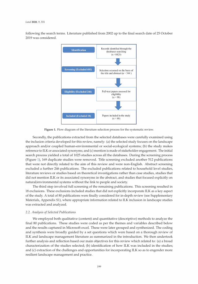
Land 2020, 9, 331
following the search terms. Literature published from 2002 up to the final search date of 25 October2019 was considered.
Figure 1. Flow diagram of the literature selection process for the systematic review.
Secondly, the publications extracted from the selected databases were carefully examined usingthe inclusion criteria developed for this review, namely: (a) the selected study focuses on the landscapeapproach and/or coupled human-environmental or social-ecological systems; (b) the study makesreference to ILK or associated synonyms; and (c) mention is made of stakeholder engagement. The initialsearch process yielded a total of 1025 studies across all the databases. During the screening process(Figure 1), 169 duplicate studies were removed. Title screening excluded another 512 publicationsthat were not directly related to the aim of this review and were non-English. Abstract screeningexcluded a further 246 publications. The excluded publications related to household level studies,literature reviews or studies based on theoretical investigations rather than case studies, studies thatdid not mention ILK or its associated synonyms in the abstract, and studies that focused explicitly onnatural/environmental systems without the link to people and society.
The third step involved full screening of the remaining publications. This screening resulted in18 exclusions. These exclusions included studies that did not explicitly incorporate ILK as a key aspectof the study. A total of 80 publications were finally considered for in-depth review (see SupplementaryMaterials, Appendix S1), where appropriate information related to ILK inclusion in landscape studieswas extracted and analyzed.
2.2. Analysis of Selected Publications
We employed both qualitative (content) and quantitative (descriptive) methods to analyze thefinal 80 publications. These studies were coded as per the themes and variables described belowand the results captured in Microsoft excel. These were later grouped and synthesized. The codingand synthesis were broadly guided by a set questions which were based on a thorough review ofILK and landscape management literature as summarized in the introduction. We then undertookfurther analysis and reflection based our main objectives for this review which related to: (a) a broadcharacterization of the studies selected; (b) identification of how ILK was included in the studies;and (c) extraction of the challenges and opportunities for incorporating ILK so as to engender moreresilient landscape management and practice.
199

Land 2020, 9, 331
Typical systematic literature review variables investigated across the publications included yearof publication, geographical location of the study, data sources, and funding sources, among others.We also extracted the main scientific areas/fields within which ILK was explored in each of thestudies, through in-depth reading of the publications. We then explored several ILK relevant themes(especially in the main findings and conclusions) related to: (a) reflections on the value of ILK in thestudies; (b) the actors/stakeholders included in the research process and management of the landscapes;(c) the processes of engagement with actors and local and indigenous people; (d) key lessons relatedto the incorporation of ILK into the case studies; and (e) the challenges identified within studiesincorporating ILK.. These themes or categories represent the breadth of thematic coverage related toILK, landscape approaches and collaboration relevant for this review. Through this process we werethen able to uncover some of the lessons for the effective integration of ILK into landscape and climatechange studies.
3. Results and Discussion
3.1. What Are the Characteristics of the Selected Landscape Studies That Integrate ILK?
We found that there has been a gradual increase over time in landscape level studies that includereference to ILK and local perspectives. Sixty-six (81%) out of the eighty studies reviewed werepublished within the last decade, with more than half (56%) being published within the last five years.These studies have been undertaken mainly in Africa, Asia and South America (accounting for morethan 70% of the reviewed studies) with some collaborative efforts between developing and developedregions (about 30%) (Figure 2). While donor funded projects dominated the case studies reviewed,it was not clear how 34% of the studies were enabled, while projects without clear donor fundingsupport (individual funded research) made up 14% of the selection.
0 2 4 6 8 10 12 14 16 18 20
Asia
Africa
South America
North America
Europe
Latin America
Multi-continental
Australia
New Zealand
Alaska
Number of studies
Geo
grap
hic
Reg
ion
20032004200520062007200820092010201120122013201420152016201720182019
Figure 2. Number of studies per geographic region according to their year of publication.
The landscape studies over the review period had varying objectives, which are reflected in severalprominent landscape level research themes and areas of scientific research. For more than 50% of thereviewed studies, ILK was associated with themes such as land use and ecosystem diversity and/orservices; rangeland and other types of natural resource management; power relations in planning
200

Land 2020, 9, 331
processes; the incorporation of local perspectives and knowledge into community development plans;social networks and resilience in rural settings; and lastly understanding how cultural resourcemanagement has evolved over the years, as well as best practices for landscape management andsustainable farming systems.
The main areas or fields of scientific research that the publications covered (for both rural andurban landscapes) are presented in Table 1. These fields included agricultural systems (27%), followedby social-ecological systems (25%), indigenous governance (15%) and natural resource management(15%), conservation and protected area management (12%), and disaster risk reduction and climatechange studies, especially those related to early warning systems (8%).
Table 1. Areas of scientific research with ILK incorporation.
Area of Scientific ResearchRelated to Landscapes
Research Focus Representative Studies
Agricultural systems
Agricultural systems studies documenttraditional knowledge and practices in
agriculture. These studies highlightissues related to ILK in relation to plants
(including medicinal plants) andanimals with their uses.
Tashiro et al. (2019); Carney and Elias(2006); Tenza et al. (2017); Nawe andHambati (2014); Davies et al. (2014);Divya et al. (2015); Agnoletti et al.
(2015); Assefa and Hans-Rudolf (2017);Neto et al. (2013); Hart and Vorster
(2006); Kunwar et al. (2016); Mapinduziet al. (2013); Epule and Bryant (2016).
Conservation and protected areasmanagement
Studies related to this theme focus onecological knowledge and its place in
the community, as well as therelationship between knowledge
transmission and biodiversity andprotected area management.
Doumbia (2006); Dudgeon (2005); Frostet al. (2015); Wehi and Lord (2017);
Fauchald et al. (2013); Linstädter et al.(2016); Boillat et al. (2013).
Indigenous governance
Indigenous governance coversgovernance responses to
socio-ecological risk. It focuses onhabitat conservation and how
indigenous local experts developenvironmental policy goals based on
their traditional knowledge formanagement of habitat change.
Freeman et al. (2015); Förster et al.(2015); Eilola et al. (2014); Kebbede(2010); Beilin et al. (2013); Gu and
Subramanian (2014); Horstkotte et al.(2014); Bardsley and Bardsley (2014);
Lamarque et al. (2014)
Disaster risk reduction and climatechange studies
Studies falling into this theme wererelated to understanding early warning
systems for disaster risk reductionunder changing climate. These studies
explore responses based on howtraditional knowledge and local
practices are being used to cope withclimate change.
Franco-Maass et al. (2016);Gómez-Baggethun et al. (2010);
Mathez-Stiefel et al. (2017); Boillat andBerkes (2013); Riva et al. (2013)
Natural resource management
The natural resource managementrelated studies focused on the
application of ILK in relation to naturalresource management. These studies
seek to establish resilient naturalresource use and management
including forest reserves through theintegration of ILK.
Mala & Oyono (2004); Uprety et al. 2016;Cumming et al. (2015); Wohling (2009);
Giannecchini et al. (2007); Chazdon(2009); Diaz et al. (2016); Leys and
Vanclay (2010); Abate (2016);Castella et al. (2013)
Social-ecological systems
SES studies focus on societaltransformation, social-ecological
resilience, and perceptions in shapingrural livelihoods and human
development. Studies broadly coversustainable pathways of change
incorporating indigenous beliefs andcultural observations into linkagesbetween people and ecosystems.
Feola (2015); Heidi and Eakin (2008);Stone-Jovicich (2015); Schönenberg et al.
(2017); Delgado-Serrano et al. (2016);Oteros-Rozas et al. (2013); de Vingo et al.
(2019); Valdivia et al. (2010);Ortega-Huerta et al. (2007);
Oteros-Rozas et al. (2015); Stump (2013);Walter and Hamilton (2014); Raffles(1999); Von Glasenapp (2011); Bruun
and Olwig (2015)
201

Land 2020, 9, 331
Our findings suggest that there has been increased interest in scholarship related to the integrationof ILK and local perspectives into more equitable and resilient landscape management over the last10 years. This is encouraging, and somewhat expected, as ILK’s importance in landscape, biodiversityconservation and natural resource management has received much attention in recent years in highlevel processes and documents such as those produced by IPBES, IPCC and UNFCC. These documentsrecognize the dynamic contribution of ILK in advancing climate resilience, biodiversity monitoring andrecovery efforts among others. As a result, we are seeing more mention of ILK in landscape governanceapproaches across a range of landscapes, whether urban or rural or focused on conservation andecosystem services or sustainable agriculture. The dominant focus on agricultural and social-ecologicalsystems in our result suggests that there is a need to enhance ILK incorporation into the design andimplementation of research related to protected area management as well as early warning systems fordisaster risk reduction and climate change adaptation. Since ILK comprises knowledge of the localenvironment held collectively by landscape residents [39], it is increasingly being seen as essentialfor encouraging collaboration and for seeking bottom-up and locally relevant solutions to landscapeand climate change challenges. Many communities, especially in rural areas, employ ILK extensivelyin their day-to-day lives, given their dependence on natural resources for their livelihood security.Their knowledge is connected, diverse and is about human and non-human aspects of the locallandscape [30]. This is acknowledged across all the studies we reviewed, where we have also seenevidence of a growing interest in linking knowledge systems and livelihood strategies, which, in turn,link to landscape use and management. The interconnection between people, their livelihoods andtheir landscapes, as well the ecosystem services received from these landscapes featured strongly in allthe studies we reviewed.
3.2. How Has ILK Been Identified and Integrated into Landscape Studies?
We identified several ways in which ILK has been explored and incorporated into landscape-levelstudies and implementation designs. Most studies (75%) employed mixed methods (both quantitativeand qualitative approaches). Only 2% used solely quantitative methods, while 23% used onlyqualitative methods. Quantitative methods are usually adopted by studies using more top-downapproaches. Moreover, quantitative methods with their scaling up potential are not necessarilyfully accepted by indigenous people and local communities [21]. Only 13% of the studies wereviewed mentioned collaboratively co-producing knowledge to address identified knowledge gaps.We then distilled out various means by which researchers engaged with indigenous and local people.The engagement processes included a combination of consultation with experts and stakeholders,key informant interviews, focus group discussions, multi-stakeholder workshops, participatoryprocesses (e.g., using participatory learning and action tools), households surveys and transect walkswith local community members. Since the majority of the studies were conducted at the locallevel, the stakeholders or actors involved in the engagement processes for exploring ILK comprisedprimarily of recognized, knowledgeable individuals or experts from the community (e.g., farmers,community elders, persons over 65 years) as key informants. A few of the studies used relativelysophisticated methods. For example, Garnett et al. [32] used a spatial mapping technique to estimatethe contribution of indigenous peoples and local communities to the protection and maintenance ofbiodiversity and provided an overview of the global importance of indigenous lands for conservation.Quantitative methods that are appropriate for cross-cultural use such as GIS mapping [40,41] andstatistical analysis [42] also exist. Participatory GIS mapping can be used to capture differentiatedviews regarding boundaries and to calculate land area under different forms of management, as wellas identify culturally important sites.
Our results reveal an acknowledgement and effort within the last two decades towards researchinglandscapes alongside diverse partners and knowledge holders, including local communities. A widerange of methods and tools have been used across the studies to engage with stakeholders and todraw out ILK related to the landscape and its components. Furthermore, in many of the studies a
202

Land 2020, 9, 331
diverse range of stakeholders and community members were engaged. Such engagement, with a rangeof different actors, can stimulate greater mutual learning and openness to alternative perspectivesand worldviews. This, in turn, can facilitate enhanced knowledge and understanding of locallandscapes, result in higher quality research and ultimately encourage improved governance outcomes.Each stakeholder should be able to bring their own knowledge content, knowledge producing processesand underlying beliefs to the table. Exchange of knowledge across different stakeholders is consideredfundamental to achieving sustainable results [34]. To safeguard the legitimacy of the knowledgeand of participating knowledge holders, the knowledge content needs to be analyzed, such that oneform of knowledge is not favored or seen as more legitimate than another. This can often be bestachieved in a co-production process. However, we found that very few of the studies specificallymentioned employing a knowledge co-production process in which different stakeholders are broughttogether in the same space. Evidence related to the principles of a landscape approach stress theneed for collaboration [34]. Future studies need to include methods that enable a collective processof knowledge production, which, in turn, can facilitate relationship building, shared activities andknowledge exchanges to produce rich evidence that will have significant landscape impact and buy-in.
3.3. What Are Some of the Challenges for Effective Integration of ILK into Landscape Studies and Approaches?
Our review has revealed that integration of ILK into landscapes management and governance isnot without its challenges. From the studies reviewed, 32 publications (40%) highlighted challengesthat could hinder sustainable incorporation of ILK into landscape governance and management.These challenges were grouped as follows: continued limited recognition of the values and rightsof ILK systems (42%); overlooked opportunities for cross-scale interactions (32%); and decliningknowledge on ILK systems (26%).
Several of the studies reviewed mentioned that too little attention has been paid to preservingcultural traditions among communities and their landscapes, particularly in the face of developmentpressures, and this is resulting in a loss of ILK (e.g., [5,43–46]). One of these studies reportedthat, development interventions and market forces have dissipated traditional culture and socialcapital [47]. Others alluded to the inadequate representation of local actors in transdisciplinary studieson landscape management and therefore limited recognition of the value these actors can bring [48–51].Project structures and approaches do not always adequately cater for all relevant actors’ involvement,hence limiting the recognition of ILK and its potential contribution to landscape management andgovernance [51].
In relation to the challenge related to inadequate cross-scale interactions, several studies highlightedissues such as insufficient development support for ILK (e.g., [44,52–55]) as well as rigid managementand governance structures that constrain institutional arrangements that could support ILK interactionsacross scales [56–59]. One study stressed that while ILK is recognized as essential at the local levelfor supporting communities’ capacities to adapt to changing environmental conditions, this isunderappreciated at the national level [60].
Regarding declining knowledge on ILK systems, some of the studies reviewed ascribed theincreasing use of modern technologies, linked to a declining trend in natural resource availability(e.g., [61–63]), and fragmented knowledge [55,64,65], with a resultant decline in traditional practices,as reasons for the erosion of ILK. However, these are not the only factors. We found from other studies,such as that by Grenier [66], that rapid population growth, growth of international markets, changingeducational systems, environmental degradation, and development processes including pressuresrelated to rapid modernization and cultural homogenization all play a critical role in the loss of ILK.
The limited recognition of the value of ILK identified from our review may be due to poorstakeholder engagement efforts or inadequate attention to innovative ways of incorporating ILKinto study designs. Other factors discussed in other literature may also be important. For example,MacGregor [7] reflected that indigenous and local people may be wary of participating in some studiesor projects because of a history of exploitation, lack of recognition and respect for their values and
203

Land 2020, 9, 331
rights, and a lack of safeguards for the control and proper use of their knowledge. Other scholars havedivulged how some ILK may be intentionally withheld as its considered secret or private within certainspaces [21]. As explained by Bohensky [67], parallel integration and/or co-production of knowledgebetween disparate knowledge systems is needed. However, integration needs to be done in a way thatdoes not lead to diminution of the integrity of either form of knowledge or cause harm to knowledgeholders themselves, but rather sets out responsibilities in a transparent and accountable manner.To ensure recognition of the value and role of ILK in landscape approaches, future studies need toidentify and give much more ethical attention and respect to local practices and beliefs as well as‘sacred’ knowledge systems that offer support for landscape protection and management.
The issue of ineffective cross-scale interactions can be difficult to address. Other studies weconsulted also show that the design of response management at the national level is such thatgovernment structures often view ILK as competing with development support programs [3,19,52].Thus, aligning national programs with the objectives of local and indigenous communities seldomhappens. Consequently, this deflects attention away from support for ILK, local practices and the rightsof indigenous people [19]. ILK matters in landscape approaches, hence recognition of its relevance atmultiple levels is important and should be encouraged to avoid loss of validity among local knowledgeholders and to improve landscape management. Specifically, we suggest that national programs shouldalso co-opt indigenous and local values and knowledge into their programs to effectively gain somelevel of cross-scale interaction (local, regional and national levels) and support.
Given that there is evidence that ILK is being lost, protecting remaining ILK is thus critical [7].The call to include ILK as an integral component of environmental and landscape governance andmanagement in order to influence decisions that affect ILK and enhance its protection has beenemphasized by numerous scholars [7,21]. Our review also suggests increased inclusion of localinformation and traditional practices in future landscape studies and projects will not only enhancelandscape management, but also help ensure preservation of ILK.
3.4. What Factors Enable and Support ILK Integration in Landscape Studies and Approaches and What AreSome of the Lessons Emerging from the Reviewed Publications?
In-depth examination of the main findings, conclusions and recommendations of the reviewedstudies revealed a set of factors that relate to the successful integration of ILK into landscape approaches.These included: inclusivity; use and transmission of ILK in landscape management; integrated andholistic landscape management; consideration of stakeholder’s perceptions; contextual understanding;working with society; acknowledging cultural capital; and recognizing multiple sources of knowledgerelated to landscape change and management. These concepts mirror the principles outlined inthe landmark paper by Sayer et al. [34] regarding the conditions required for successful landscapemanagement. Lessons related to the incorporation of ILK have been drawn from several of thereviewed studies that have specifically advanced integration of ILK and are summarized in Table 2.They highlight the value that ILK can bring to landscape management.
From the review we found that participatory research activities and approaches that (a) incorporatedILK; (b) upscaled local approaches; (c) incorporated in-depth knowledge and perspectives at a locallevel; and (d) co-designed activities with relevant stakeholders (reflecting elements of inclusivity) allcontributed to developing more inclusive and sustainable landscape management [56,68,69]. We alsofound that using integrative approaches (such as having explicitly defined objectives for inclusion oflocal people, processes for collaborative participation, and trans-disciplinary/cross-sectoral approaches)for addressing landscape management had various benefits. These benefits included the potentialfor stakeholders to better understand each other [53]; management of the local environment towardsmore favourable long-term outcomes [70]; and the ability to better address the inherent complexity oflandscape management [53]. Results from the review further showed that identifying and consideringlocal peoples’ needs, priorities and knowledge resulted in a positive feedback loop between ecosystemhealth and landscape management decisions that favours sustainability [71]. Tenza and colleagues in
204

Land 2020, 9, 331
two separate studies [65,72] showed that consideration of stakeholders’ perceptions and views beyondinitial consultations offered impetus for action and raised the prospect for indigenous communitiesto retain both their cultural and biological diversity. One of the most effective ways identifiedfor supporting ILK integration in landscape approaches is acknowledging cultural capital throughrecognition of cultural and traditional values and co-opting the values which stimulate strongcommunity support for projects [49,52,73]. Another concept that supported successful ILK integrationin landscape studies was recognition and appreciation of multiple sources of knowledge for landscapemanagement. For instance, a study by Assefa and Hans-Rudolf [74] showed that, by integratinglocal expert knowledge and realities with scientific knowledge, sustainable agroecological farmingpractices, which were well adapted to local conditions, could be promoted. Other benefits identifiedfrom the integration of ILK with scientific approaches included the design and implementation ofsocially acceptable resource management systems for long-term sustainability [75], and recognitionof the dynamism of indigenous knowledge as an adaptive asset mitigating human and non-humanenvironmental changes [48].
Table 2. Summary of key success factors, concepts and lessons from landscape studies that haveintegrated ILK.
Key Lessons on Integration of ILK from Reviewed Studies Representative Studies
a. Recognizing holistic management and restoration of theintegrity of ecosystems that will benefit humans through theprovision of resources that are important for them.
Dudgeon (2005).
b. Understanding that indigenous people (description ofgender-specific knowledge and expertise) understand theircontext and have valuable knowledge and perceptions ofchanges in the landscape.
Glasenapp et al. (2011); Doumbia (2006);Carney and Elias, M (2006)
c. Recognizing that operation and application of indigenousknowledge needs to occur at multi-scalar levels. Sharma et al. (2015).
d. Recognizing that local knowledge can be valuable inenhancing adaptive responses to landscape change.
Boillat and Berkes. (2013); Nawe andHambati (2014)
e. Appreciating that traditional ecological knowledge has beenhistorically instrumental in ensuring biodiversity conservationand enhancing local livelihoods. It remains an important assetfor resilience of farmers and for responding to climate changeand other social-ecological shifts.
Ruiz-Mallén and Corbera (2013); Riva et al.(2013)
f. Acknowledging that rural communities possess extensiveknowledge of their land resources and listening to theirperspectives.
Nawe and Hambati (2014)
g. Involving stakeholders in the research process provides voiceto multiple perspectives on social-ecological futures.
Balvanera et al. (2017); Oteros-Rozas et al.(2015)
h. Integrating both local and/or indigenous and scientificknowledge can greatly contribute to the process of landscaperesource management.
Mathez-Stiefel et al. (2017); Wehi and Lord(2017)
i. Inter and trans-disciplinary research inevitably leads toextraordinary and inclusive communication efforts.
Schönenberg et al. (2017); Stone-Jovicichand Samantha. (2015)
j. Multiple factors, that need to be understood, are contributingto decline in traditional knowledge and practices. Atreya et al. (2018)
3.5. What Are the Knowledge Gaps and Directions for Future Research in Landscape Studies?
Despite the discussion above regarding the importance of collective knowledge production, in ourreview we found few studies that actively attempted to co-produce knowledge with local communitiesover the review period (13%) (see Supplementary Materials, Figure S1). This could be as a result of a
205
Land 2020, 9, 331
limitation in the literature review process, i.e., not including knowledge co-production as a key searchterm, or it could reflect that there are still few studies taking this approach. Knowledge co-productionas a core approach in landscape-level work appears to be still gaining traction; the only studies referringto co-production in our selection were recent. Another notable gap in research on ILK identified fromthe review is the limited number of landscape studies that address climate change as a key entrypoint or core theme (8%). Although reference is made to ILK in all the studies reviewed, details of theexperiences and relationships between people, place and governance structures, including betweenactors/partners in a specific case study or project and participating communities and organizationswere limited. Few of the studies provided specifics on socio-cultural and ecological influences on thelandscape, local behavior and gendered perspectives, among others. An improved understanding ofthe relations between different people and their places could result in a richer appreciation of localpractices and cultural norms important for landscape management [76].
The three gaps mentioned above need greater attention in future studies. There is clearlyan opportunity for future studies to enhance dialogue between key stakeholders through morecollaborative learning and sharing. To achieve this, Austin and colleagues [21] suggest the need toempower indigenous and local knowledge holders to mobilize their knowledge for more contextrelevant understandings and outcomes from case studies. A collaborative knowledge production effortadds new perspectives to address contemporary ecological and social challenges [25,77]. Similarly,through collaborative processes it is possible to explore differences in knowledge holdings betweendifferent stakeholders and the implications these differences have for their working relationships.Since it is crucial to mobilize all available knowledge [21], engagements that facilitate the expression ofmultiple forms of knowledge are encouraged. We urge future studies to consider creative ways offostering dialogues and collecting stories that help provide a more relational picture of the landscapeand its residents [78].
Just as ILK is increasingly seen as critical for resilient landscapes, so should an understanding ofthe impacts of climate change and possible solutions to these impacts. This cannot be done withoutincluding indigenous and local people’s knowledge and understanding of the changes taking place andthe practices they have employed in the past. Warming temperatures, floods, droughts, increasing sealevels with resultant disappearance of food sources, wildlife extinction, economic losses, climate-relateddiseases with negative effect on livelihoods, among others, are the consequences of climate change.Climate change disproportionally affects the poorest and most marginalized communities living invulnerable regions, among them indigenous people, whose livelihoods depend on natural resources [79].According to Nakashima et al. [80], indigenous peoples’ knowledge can provide important insightsinto the processes of observation, adaptation and mitigation to such climate change consequences.Traditional knowledge of agriculture and local ecosystems could be an invaluable adaptation tool forindigenous and local peoples, hence future studies should explore ILK to drive climate adaptation atthe landscape level.
4. Conclusions
Our review shows a growing interest in research related to the integration of ILK in landscapeapproaches. Studies that explore such integration are likely to continue as the value of ILK in biodiversityconservation, landscape management and climate change adaptation is further promoted throughglobal mechanisms such as the UNFCCC, IPBES, UNEP and UNESCO (through their Man and BiosphereReserve program). We found several research themes and fields represented in the case studies wereviewed, with a predominance of studies related to agricultural systems, followed by social-ecologicalsystems, indigenous governance, natural resource management, biodiversity conservation and climatechange studies, especially those related to early warning systems for disaster risk reduction. The lownumber of studies specifically addressing climate change suggests the need for more research at thenexus between ILK, climate change and landscape governance and management. Local landscapeusers have intimate knowledge of any changes in their environment and landscapes, as well as
206

Land 2020, 9, 331
knowledge of past and contemporary practices for dealing with some of these changes. Such ILKcould play an important role in fostering more climate resilient landscapes. We also found that manyof the studies we reviewed were conducted in the global south where some of the greatest landscapechallenges are found. Moreover, there is strong support and funding for practical work in landscapemanagement in regions like Africa, Asia and South America. The dominance of donor funding for thecase studies, suggest that many of the studies may be linked to implementation projects. This is typicalof transdisciplinary research that aims to work closely with stakeholders.
We found several factors that supported or created challenges to the integration of ILK inlandscape approaches. Important challenges such as ineffective cross-scale interactions, incompleterepresentation of key stakeholders/actors in projects and minimal attention paid to local practicesand rights of indigenous people were identified. Systematically untangling these components andengaging in best practice towards knowledge integration will help towards paving a more inclusiveway forward in the application of the landscape approach. Our review demonstrated that this mightbe done by improving engagement between scientific knowledge and ILK through methodologies thatbring different stakeholders into the same space. Other potential enablers could include supportingthe development of strategies to empower marginalized communities; promotion of social learningbased on experiences of past events among local communities; co-production and co-management ofknowledge systems for landscape studies; adaptable and inclusive governance systems to facilitatecollaboration; and a holistic approach to enhance ecosystem resilience and inclusive sustainableknowledge transfer (see Supplementary Materials, Table S1). Recognizing that one of the majorobjectives of the landscape approach is to effectively inform the co-design and implementation offuture landscape management strategies and governance systems, then there is need to promote aholistic methodological framework that (a) evaluates all forms of knowledge (scientific and traditionalknowledge), (b) considers any potential trade-offs, (c) supports decision-making that includes multipleperspectives, and finally (d) enhances engagement of indigenous people and their knowledge in newknowledge creation. Without this systematic inclusion of ILK in landscape management it may provedifficult improve ecosystem health, climate resilience and livelihoods.
In conclusion, our review has demonstrated the growing importance of multi-stakeholdercollaborations in local landscape research and the promotion of inclusive consultations that havehelped to bring ILK to the fore in the knowledge development process. This, in turn, can supportimproved landscape management, governance and planning for more climate resilient landscapes.However, more research is needed to explore ways to more effectively link ILK and scientific knowledgein landscape studies through collaborative, knowledge co-production processes that give specificattention to the voices of local land users and other stakeholders. Furthermore, more systematicdocumentation of the experiences, learning and relationships built through such processes and howthese influence landscape governance and management is required. Lastly, more studies that confirmthe usefulness of ILK, recognise multiple landscape values and their interaction with structures andpolicies dealing with landscape management and governance are necessary for wider adoption oflandscape approaches that incorporate ILK as a key element.
Supplementary Materials: The following are available online at http://www.mdpi.com/2073-445X/9/9/331/s1,Figure S1: Number of studies according to their content in terms of (a) knowledge co-production, (b) collaboration/engagement mentioned, (c) future recommendations given, Table S1: Summary of recommendations from thepublications reviewed, Appendix S1: List of publications considered in the review.
Author Contributions: P.A.W., L.S. and S.S. conceptualized the study. P.A.W. and L.S. were responsible for designof the study’s methodology, data collection and analysis. P.A.W. led writing of the paper with L.S. support. S.S.reviewed the manuscript and provided relevant feedback to improve it. All authors contributed substantially tothe writing, reviewing and editing of the manuscript. All authors have read and agreed to the published versionof the manuscript.
Funding: This research received no external funding.
207
Land 2020, 9, 331
Acknowledgments: We acknowledge the World Universities Network (WUN) for funding our project on “ClimateResilient African Landscapes”. It was during workshops under this project that theideas for this review paper,and the special issue which it forms part of, emerged.
Conflicts of Interest: The authors declare no conflict of interest. The funders had no role in the design of thestudy; in the collection, analyses, or interpretation of data; in the writing of the manuscript, or in the decision topublish the results.
References
1. Tengö, M.; Johansson, K.; Rakotondrasoa, F.; Lundberg, J.; Andriamaherilala, J.-A.; Rakotoarisoa, J.-A.;Elmqvist, T. Taboos and forest governance: Informal protection of hot spot dry forest in southern Madagascar.AMBIO 2007, 36, 683–691. [CrossRef]
2. Barbier, E.B.; Hacker, S.D.; Kennedy, C.J.; Koch, E.W.; Stier, A.; Silliman, B.R. The value of estuarine andcoastal ecosystem services. Ecol. Monogr. 2011, 81, 169–193. [CrossRef]
3. Reid, W.V.; Mooney, H.A.; Cropper, A.; Capistrano, D.; Carpenter, S.R.; Chopra, K.; Dasgupta, P.; Dietz, T.;Duraiappah, A.K.; Hassan, R.; et al. Ecosystems and human well-being—Synthesis: A Report of theMillennium Ecosystem Assessment. In Millennium Ecosystem Assessment; Island Press: Washington, DC,USA, 2005; p. 137.
4. Hill, M.J.; Lesslie, R.; Donohue, R.; Houlder, P.; Holloway, J.; Smith, J.; Ritman, K. Multi-criteria assessment oftensions in resource use at continental scale: A proof of concept with Australian rangelands. Environ. Manag.2006, 37, 712–731. [CrossRef] [PubMed]
5. Frost, P.; Campbell, B.; Medina, G.; Usongo, L. Landscape-scale approaches for integrated natural resourcemanagement in tropical forest landscapes. Ecol. Soc. 2006, 11, 16–30. [CrossRef]
6. Hariem Brundtland, G. World Commission on environment and development. Environ. Policy Law 1985, 14,26–30. [CrossRef]
7. McGregor, D. Lessons for Collaboration Involving Traditional Knowledge and Environmental Governancein Ontario, Canada. Altern. Int. J. Indig. Peoples 2014, 10, 340–353. [CrossRef]
8. Lertzman, D.A.; Vredenburg, H. Indigenous Peoples, Resource Extraction and Sustainable Development:An Ethical Approach. J. Bus. Ethics 2005, 56, 239–254. [CrossRef]
9. Eckert, L.E.; Ban, N.C.; Frid, A.; McGreer, M. Diving back in time: Extending historical baselines for yelloweyerockfish with Indigenous knowledge. Aquat. Conserv. Mar. Freshw. Ecosyst. 2018, 28, 158–166. [CrossRef]
10. Becken, S.; Lama, A.K.; Espiner, S. The cultural context of climate change impacts: Perceptions amongcommunity members in the Annapurna Conservation Area, Nepal. Environ. Dev. 2013, 8, 22–37. [CrossRef]
11. Parsons, M.; Fisher, K.; Nalau, J. Alternative approaches to co-design: Insights from indigenous/academicresearch collaborations. Curr. Opin. Environ. Sustain. 2016, 20, 99–105. [CrossRef]
12. Thornton, T.F.; Scheer, A.M. Collaborative Engagement of Local and Traditional Knowledge and Science inMarine Environments A Review. Ecol. Soc. 2012, 17, 8–25. [CrossRef]
13. Gratani, M.; Butler, J.R.A.; Royee, F.; Valentine, P.; Burrows, D.; Canendo, W.I.; Anderson, A.S. Is Validationof Indigenous Ecological Knowledge a Disrespectful Process? A Case Study of Traditional Fishing Poisonsand Invasive Fish Management from the Wet Tropics, Australia. Ecol. Soc. 2011, 16, 11–25. [CrossRef]
14. Nalau, J.; Becken, S.; Noakes, S.; Mackey, B. Mapping Tourism Stakeholders’ Weather and ClimateInformation-Seeking Behavior in Fiji. Weather Clim. Soc. 2017, 9, 377–391. [CrossRef]
15. Berkes, F. Community conserved areas: Policy issues in historic and contemporary context. Conserv. Lett.2009, 2, 20–25. [CrossRef]
16. Nadasdy, P. The Politics of Tek: Power and the “integration” of Knowledge. Arct. Anthropol. 1999, 36, 1–18.17. Davis, L.G.; Nyers, A.J.; Willis, S.C. Context, provenance and technology of a Western Stemmed Tradition
artifact cache from the Cooper’s Ferry Site, Idaho. Am. Antiq. 2014, 79, 596–615. [CrossRef]18. Combest-Friedman, C.; Christie, P.; Miles, E. Household perceptions of coastal hazards and climate change
in the Central Philippines. J. Environ. Manag. 2012, 112, 137–148. [CrossRef]19. Tengö, M.; Brondizio, E.S.; Elmqvist, T.; Malmer, P.; Spierenburg, M. Connecting Diverse Knowledge Systems
for Enhanced Ecosystem Governance: The Multiple Evidence Base Approach. AMBIO 2014, 43, 579–591.[CrossRef]
20. Thompson, K.-L.; Lantz, T.C.; Ban, N.C. A review of Indigenous knowledge and participation in environmentalmonitoring. Ecol. Soc. 2020, 25, 1–27. [CrossRef]
208

Land 2020, 9, 331
21. Austin, K.G.; Lee, M.E.; Clark, C.; Forester, B.R.; Urban, D.L.; White, L.; Kasibhatla, P.S.; Poulsen, J.R.An assessment of high carbon stock and high conservation value approaches to sustainable oil palmcultivation in Gabon. Environ. Res. Lett. 2017, 12, 014005. [CrossRef]
22. Danielsen, F.; Burgess, N.D.; Balmford, A.; Donald, P.F.; Funder, M.; Jones, J.P.G.; Alviola, P.; Balete, D.S.;Blomley, T.O.M.; Brashares, J.; et al. Local Participation in Natural Resource Monitoring: A Characterizationof Approaches. Conserv. Biol. 2009, 23, 31–42. [CrossRef] [PubMed]
23. Berkes, F. Coasts for People: Interdisciplinary Approaches to Coastal and Marine Resource Management;Taylor & Francis: Abingdon, UK, 2015.
24. Robinson, C.J.; Wallington, T.J. Boundary Work Engaging Knowledge Systems in Co-management of FeralAnimals on Indigenous Lands. Ecol. Soc. 2012, 17, 16–21. [CrossRef]
25. Venkatesan, A.; Begay, D.; Burgasser, A.; Hawkins, I.; Kimura, K.I.; Maryboy, N.; Peticolas, L.; Rudnick, G.;Simons, D.; Tuttle, S. Collaboration with Integrity: Indigenous Knowledge in 21st Century Astronomy. BAAS2019, 57, 20–28.
26. Boillat, S.; Berkes, F. Perception and Interpretation of Climate Change among Quechua Farmers of Bolivia:Indigenous Knowledge as a Resource for Adaptive Capacity. Ecol. Soc. 2013, 18, 21–35. [CrossRef]
27. Johnson, A.C.; Noel, J.; Gregovich, D.P.; Kruger, L.E.; Buma, B. Impacts of Submerging and EmergingShorelines on Various Biota and Indigenous Alaskan Harvesting Patterns. J. Coast. Res. 2019, 35, 765–775.[CrossRef]
28. Bongaarts, J. IPBES, 2019. Summary for policymakers of the global assessment report on biodiversity andecosystem services of the Intergovernmental Science-Policy Platform on Biodiversity and Ecosystem Services.Popul. Dev. Rev. 2019, 45, 680–681. [CrossRef]
29. Senanayake, S.G.J.N. Indigenous knowledge as a key to sustainable development. J. Agric. Sci. Sri Lanka2006, 2. [CrossRef]
30. Wilder, B.T.; O’Meara, C.; Monti, L.; Nabhan, G.P. The Importance of Indigenous Knowledge in Curbing theLoss of Language and Biodiversity. BioScience 2016, 66, 499–509. [CrossRef]
31. Matuk, F.A.; Behagel, J.; Schaefer, C.; Duque-Brasil, R.; Turnhout, E. Deciphering landscapes through thelenses of locals: The “Territorial Social-Ecological Networks” Framework applied to a Brazilian maroon case.Geoforum 2019, 100, 101–115. [CrossRef]
32. Garnett, S.T.; Sayer, J.; du Toit, J. Improving the Effectiveness of Interventions to Balance Conservation andDevelopment. Ecol. Soc. 2007, 12, 2–22. [CrossRef]
33. Turley, S.E. Franciscan Spirituality and Mission in New Spain, 1524–1599 Conflict Beneath the Sycamore Tree (Luke19:1-10); Routledge: London, UK, 2016; pp. 1524–1599. [CrossRef]
34. Sayer, J.; Sunderland, T.; Ghazoul, J.; Pfund, J.-L.; Sheil, D.; Meijaard, E.; Venter, M.; Boedhihartono, A.K.;Day, M.; Garcia, C.; et al. Ten principles for a landscape approach to reconciling agriculture, conservation,and other competing land uses. Proc. Natl. Acad. Sci. USA 2013, 110, 8349–8356. [CrossRef] [PubMed]
35. Turnhout, E.; Gupta, A.; Weatherley-Singh, J.; Vijge, M.J.; de Koning, J.; Visseren-Hamakers, I.J.; Herold, M.;Lederer, M. Envisioning REDD+ in a post-Paris era: Between evolving expectations and current practice.Wires Clim. Chang. 2017, 8, e425. [CrossRef]
36. Grant, M.J.; Booth, A. A typology of reviews: An analysis of 14 review types and associated methodologies.Health Inf. Libr. J. 2009, 26, 91–108. [CrossRef] [PubMed]
37. Ford, J.D.; Pearce, T. What we know, do not know, and need to know about climate change vulnerability inthe western Canadian Arctic: A systematic literature review. Environ. Res. Lett. 2010, 5, 014008. [CrossRef]
38. Williams, P.A.; Crespo, O.; Abu, M.; Simpson, N.P. A systematic review of how vulnerability of smallholderagricultural systems to changing climate is assessed in Africa. Environ. Res. Lett. 2018, 13, 103004. [CrossRef]
39. Gómez-Baggethun, E.; Corbera, E.; Reyes-García, V. Traditional Ecological Knowledge and GlobalEnvironmental Change: Research findings and policy implications. Ecol. Soc. 2013, 18, 721–729. [CrossRef]
40. Ellis, E.C.; Ramankutty, N. Putting people in the map: Anthropogenic biomes of the world. Front. Ecol. Environ.2008, 6, 439–447. [CrossRef]
41. Ellis, E.C.; Klein Goldewijk, K.; Siebert, S.; Lightman, D.; Ramankutty, N. Anthropogenic transformation ofthe biomes, 1700 to 2000. Glob. Ecol. Biogeogr. 2010, 19, 589–606. [CrossRef]
42. Gerla, G. Fuzzy Logic: Mathematical Tools for Approximate Reasoning; Springer: Dordrecht, The Netherlands,2013.
209

Land 2020, 9, 331
43. Everard, M.; Gupta, N.; Scott, C.A.; Tiwari, P.C.; Joshi, B.; Kataria, G.; Kumar, S. Assessing livelihood-ecosystem interdependencies and natural resource governance in Indian villages in the Middle Himalayas.Reg. Environ. Chang. 2019, 19, 165–177. [CrossRef]
44. Stump, D. On Applied Archaeology, Indigenous Knowledge, and the Usable Past. Curr. Anthropol. 2013, 54,268–298. [CrossRef]
45. Mapinduzi, A.L.; Oba, G.; Weladji, R.B.; Colman, J.E. Use of indigenous ecological knowledge of the Maasaipastoralists for assessing rangeland biodiversity in Tanzania. Afr. J. Ecol. 2003, 41, 329–336. [CrossRef]
46. Crate, S.; Ulrich, M.; Habeck, J.O.; Desyatkin, A.R.; Desyatkin, R.V.; Fedorov, A.N.; Hiyama, T.; Iijima, Y.;Ksenofontov, S.; Mészáros, C.; et al. Permafrost livelihoods: A transdisciplinary review and analysis ofthermokarst-based systems of indigenous land use. Anthropocene 2017, 18, 89–104. [CrossRef]
47. Gu, H.; Subramanian, S.M. Drivers of Change in Socio-Ecological Production Landscapes Implications forBetter Management. Ecol. Soc. 2014, 19, 41–54. [CrossRef]
48. De Vingo, P.; Vandewiele, W.; Casazza, M.; Lega, M. Hidden environmental vulnerability in relation to theinstability of two medieval monastic communities and consequences for present environmental managementoptions. Environ. Account. Manag. 2019, 7, 121–137. [CrossRef]
49. Wehi, P.M.; Lord, J.M. Importance of including cultural practices in ecological restoration. Conserv. Biol. 2017,31, 1109–1118. [CrossRef]
50. Diaz, J.M.; Steelman, T.; Nowell, B. Local ecological knowledge and fire management: What does the publicunderstand? J. For. 2016, 114, 58–65. [CrossRef]
51. Oteros-Rozas, E.; Martín-López, B.; Daw, T.; Bohensky, E.; Butler, J.; Hill, R.; Vilardy, S. Participatory scenarioplanning in place-based social-ecological research: Insights and experiences from 23 case studies. Ecol. Soc.2015, 20, 32–66. [CrossRef]
52. Ray, L.A.; Kolden, C.A.; Chapin, F.S. A Case for Developing Place-Based Fire Management Strategies fromTraditional Ecological Knowledge. Ecol. Soc. 2012, 17, 37–72. [CrossRef]
53. Freeman, O.E.; Duguma, L.A.; Minang, P.A. Operationalizing the integrated landscape approach in practice.Ecol. Soc. 2015, 20, 24–43. [CrossRef]
54. Stone-Jovicich, S. Probing the interfaces between the social sciences and social-ecological resilience: Insightsfrom integrative and hybrid perspectives in the social sciences. Ecol. Soc. 2015, 20, 25–43. [CrossRef]
55. Feola, G. Societal transformation in response to global environmental change: A review of emerging concepts.AMBIO 2015, 44, 376–390. [CrossRef] [PubMed]
56. Förster, J.; Barkmann, J.; Fricke, R.; Hotes, S.; Kleyer, M.; Kobbe, S.; Kübler, D.; Rumbaur, C.;Siegmund-Schultze, M.; Seppelt, R.; et al. Assessing ecosystem services for informing land-use decisions.Ecol. Soc. 2015, 20, 31–50. [CrossRef]
57. Cumming, G.S. Scale-Sensitive Governance of the Environment. Restor. Ecol. 2015, 23, 196. [CrossRef]58. Ruiz-Mallén, I.; Corbera, E. Community-based conservation and traditional ecological knowledge:
Implications for social-ecological resilience. Ecol. Soc. 2013, 18, 12. [CrossRef]59. Newton, A.C.; Cayuela, L.; Echeverría, C.; Armesto, J.J.; Del Castillo, R.F.; Golicher, D.; Geneletti, D.;
Gonzalez-Espinosa, M.; Huth, A.; López-Barrera, F.; et al. Toward Integrated Analysis of Human Impacts onForest Biodiversity. Ecol. Soc. 2009, 14, 2. [CrossRef]
60. Warrick, O.; Aalbersberg, W.; Dumaru, P.; McNaught, R.; Teperman, K. The ‘Pacific Adaptive CapacityAnalysis Framework’: Guiding the assessment of adaptive capacity in Pacific island communities.Reg. Environ. Chang. 2017, 17, 1039–1051. [CrossRef]
61. Atreya, K.; Pyakurel, D.; Thagunna, K.S.; Bhatta, L.D.; Uprety, Y.; Chaudhary, R.P.; Oli, B.N.; Rimal, S.K.Factors Contributing to the Decline of Traditional Practices in Communities from the Gwallek–Kedar area,Kailash Sacred Landscape, Nepal. Environ. Manag. 2018, 61, 741–755. [CrossRef]
62. Fernández-Llamazares, Á.; Garcia, R.A.; Díaz-Reviriego, I.; Cabeza, M.; Pyhälä, A.; Reyes-García, V. Anempirically tested overlap between indigenous and scientific knowledge of a changing climate in BolivianAmazonia. Reg. Environ. Chang. 2017, 17, 1673–1685. [CrossRef]
63. Ba, Q.X.; Lu, D.J.; Kuo, W.H.J.; Lai, P.H. Traditional farming and sustainable development of an indigenouscommunity in the mountain area-a case study of Wutai Village in Taiwan. Sustainability 2018, 10, 3370.[CrossRef]
210

Land 2020, 9, 331
64. Mathez-Stiefel, S.L.; Peralvo, M.; Báez, S.; Rist, S.; Buytaert, W.; Cuesta, F.; Fadrique, B.; Feeley, K.J.;Groth, A.A.P.; Homeier, J.; et al. Research Priorities for the Conservation and Sustainable Governance ofAndean Forest Landscapes. Mt. Res. Dev. 2017, 37, 323–339. [CrossRef]
65. Tenza, A.; Pérez, I.; Martínez-Fernández, J.; Giménez, A. Understanding the decline and resilience loss of along-lived social-ecological system insights from system dynamics. Ecol. Soc. 2017, 22, 15. [CrossRef]
66. Grenier, L. Working with Indigenous Knowledge: A Guide for Researchers; International Development ResearchCouncil: Ottawa, ON, Canada, 1998.
67. Bohensky, E.L.; Butler, J.R.A.; Davies, J. Integrating Indigenous Ecological Knowledge and Science in NaturalResource Management: Perspectives from Australia. Ecol. Soc. 2013, 18, 20–26. [CrossRef]
68. Valdivia, C.; Seth, A.; Gilles, J.L.; Garcia, M.; Jimenez, E.; Cusicanqui, J.; Navia, F.; Yucra, E. Adapting toClimate Change in Andean Ecosystems: Landscapes, Capitals, and Perceptions Shaping Rural LivelihoodStrategies and Linking Knowledge Systems. Ann. Assoc. Am. Geogr. 2010, 100, 818–834. [CrossRef]
69. Schönenberg, R.; Boy, J.; Hartberger, K.; Schumann, C.; Guggenberger, G.; Siebold, M.; Lakes, T.; Lamparter, G.;Schindewolf, M.; Schaldach, R. Experiences of inter-and transdisciplinary research–a trajectory of knowledgeintegration within a large research consortium. Erdkunde 2017, 71, 177–193. [CrossRef]
70. Von Glasenapp, M.; Thornton, T.F. Traditional ecological knowledge of Swiss alpine farmers and theirresilience to socioecological change. Hum. Ecol. 2011, 39, 769–781. [CrossRef]
71. Lamarque, P.; Meyfroidt, P.; Nettier, B.; Lavorel, S. How ecosystem services knowledge and values influencefarmers’ decision-making. PLoS ONE 2014, 9, e107572. [CrossRef]
72. Tenza, A.; Martínez-Fernández, J.; Pérez-Ibarra, I.; Giménez, A. Sustainability of small-scale social-ecologicalsystems in arid environments: Trade-off and synergies of global and regional changes. Sustain. Sci. 2019, 14,791–807. [CrossRef]
73. Wehi, P.M.; Wehi, W.L. Traditional Plant Harvesting in Contemporary Fragmented and Urban Landscapes.Conserv. Biol. 2010, 24, 594–604. [CrossRef]
74. Eilola, S.; Käyhkö, N.; Fagerholm, N.; Kombo, Y.H. Linking Farmers’ Knowledge, Farming Strategies,and Consequent Cultivation Patterns into the Identification of Healthy Agroecosystem Characteristics atLocal Scales. Agroecol. Sustain. Food Syst. 2014, 38, 1047–1077. [CrossRef]
75. Assefa, E.; Hans-Rudolf, B. Indigenous resource management practices in the Gamo Highland of Ethiopia:Challenges and prospects for sustainable resource management. Sustain. Sci. 2017, 12, 695–709. [CrossRef]
76. Sharma, D.; Vergara-Asenjo, G.; Cunampio, M.; Cunampio, R.B.; Cunampio, M.B.; Potvin, C. Genesis of anindigenous social-ecological landscape in eastern panama. Ecol. Soc. 2015, 20, 37, 170–187. [CrossRef]
77. Shackleton, R.T.; Adriaens, T.; Brundu, G.; Dehnen-Schmutz, K.; Estévez, R.A.; Fried, J.; Larson, B.M.H.;Liu, S.; Marchante, E.; Marchante, H.; et al. Stakeholder engagement in the study and management ofinvasive alien species. J. Environ. Manag. 2019, 229, 88–101. [CrossRef] [PubMed]
78. Cockburn, J.; Cundill, G.; Shackleton, S.; Rouget, M. The meaning and practice of stewardship in SouthAfrica. S. Afr. J. Sci. 2019, 115, 1–13. [CrossRef]
79. Chianese, F. The Traditional Knowledge Advantage: Indigenous Peoples’ Knowledge in Climate Change Adaptationand Mitigation Strategies; International Fund for Agricultural Development (IFAD): Rome, Italy, 2016.
80. Nakashima, D.; McLean, K.G.; Thulstrup, H.; Castillo, A.R.; Rubis, J. Weathering Uncertainty: TraditionalKnowledge for Climate Change Assessment and Adaptation; UNESCO and Darwin, UNU: Paris, France, 2015.
© 2020 by the authors. Licensee MDPI, Basel, Switzerland. This article is an open accessarticle distributed under the terms and conditions of the Creative Commons Attribution(CC BY) license (http://creativecommons.org/licenses/by/4.0/).
211


MDPISt. Alban-Anlage 66
4052 BaselSwitzerland
Tel. +41 61 683 77 34Fax +41 61 302 89 18
www.mdpi.com
Land Editorial OfficeE-mail: [email protected]
www.mdpi.com/journal/land


MDPI St. Alban-Anlage 66 4052 Basel Switzerland
Tel: +41 61 683 77 34 Fax: +41 61 302 89 18
www.mdpi.com ISBN 978-3-0365-1478-9
Copyright © 2022 FDOKUMEN