COCHIN PORT TRUST LAKSHADWEEP ISLANDS:
94
Report of Sub Committee of Cochin Port Trust on proposed Up-gradation and development of Existing and New Harbour Infrastructures at Lakshadweep Islands 1 COCHIN PORT TRUST REPORT ON PROPOSED DEVELOPMENT AND UPGRADATION OF EXISTING AND NEW HARBOUR INFRASTRUCTURES AT LAKSHADWEEP ISLANDS. SEPTEMBER 2021 LAKSHADWEEP ISLANDS : Report of Expert Committee of Cochin Port Trust
-
Upload
khangminh22 -
Category
Documents
-
view
0 -
download
0
Transcript of COCHIN PORT TRUST LAKSHADWEEP ISLANDS:

Report of Sub Committee of Cochin Port Trust on proposed Up-gradation and development of Existing and New Harbour Infrastructures at Lakshadweep Islands
1
COCHIN PORT TRUST
REPORT ON PROPOSED DEVELOPMENT AND UPGRADATION OF EXISTING AND NEW HARBOUR INFRASTRUCTURES AT LAKSHADWEEP ISLANDS.
SEPTEMBER 2021
LAKSHADWEEP ISLANDS :
Report of Expert Committee of Cochin Port Trust

Report of Sub Committee of Cochin Port Trust on proposed Up-gradation and development of Existing and New Harbour Infrastructures at Lakshadweep Islands
2
CONTENTS
Sl. No Description of Items Pages
1 The Expert Committee 3
2 Message from Chairperson, Cochin Port Trust 4
3 Message from the convenor of the Committee, Cochin Port
Trust
5-6
4 Executive Summary 7-10
5 Chapter – 1- Introduction 11-27
6 Chapter – 2 – Study of Existing Facilities Jetties, Harbour and
related facilities and helipad.
28-38
7 Chapter – 3 –General Problems of the Jetty and Harbour
Infrastructures.
39-43
8 Chapter – 4 – Proposed Up-Gradation of the Existing
Infrastructures and Construction of New Infrastructures.
44-70
9 Chapter – 5- Summary of key Recommendations 71-72
10 Annexure I – IV 73-94
Annexure I & IA- Harbour Facilities at Lakshadweep Islands 73-74
Annexure II - Lakshadweep Vessel details 75-81
Annexure III – Proposed Development works in Islands 82-83
Annexure IV – Budgetary Cost Estimate of Development
works
84-94

Report of Sub Committee of Cochin Port Trust on proposed Up-gradation and development of Existing and New Harbour Infrastructures at Lakshadweep Islands
3
EXPERT COMMITTEE
Ministry of Port, Shipping and Waterways vide OM dated 23.06.2021 has constituted an
Expert Committee to aid and to advice on port operations and upgrading the shipping
infrastructure in Union Territory of Lakshadweep (UTL), particularly on future projects
to be taken up and for effective utilization of existing infrastructure in UTL, with the
following composition:
1. Chairperson, Cochin Port Trust
2. Chairman, New Mangalore Port Trust
3. Secretary (Shipping Services), UT of Lakshadweep Administration, Kavarathy
4. CMD, Shipping Corporation of India Ltd.
5. Managing Director, Dredging Corporation of India Ltd.
The Expert Committee, during its meeting held on 08.07.2021 constituted a Sub
Committee of Cochin Port Trust with following members:
1) Dr. Cyril Gorge, Dy. Chairman CoPT Chairman
2) Shri Paritosh Bala, Chief Engineer, CoPT Member and Convenor
3) Capt. Joseph Alapat, Dy Conservator ,CoPT Member
4) Smt Philo C.A, Superintending Engineer Associate Member
The Sub Committee, visited Lakshadweep and obtained relevant information from the
concerned offices. They further inspected jetties, breakwaters, wharfs and other related
sites and gathered first-hand information.

Dr M. Beena, IAS
Chairperson, CoPT
MESSAGE
Lakshadweep is an lsland territory where the transportation of both passengers andgoods is mainly through vessels/ships, with limited option of air travel mode . The
lifeline of water transportation depends on availability of all-weather berthing facility ofvessels/ships.
The Report on new Development, Renovation and Upgradation of the existinginfrastructure of Lakshadweep Port & Harbour and allied lnfrastructures is a result ofthe initiative of lvlinistry of Ports, Shipping and Waterways. Senior level officials ofCochin Port Trust, having vast experience in the field, associat€d in field level studiesand preparation of the Report.
Th€ report aims to produce a high quality reference document on upgradation ofexisting Port & Harbour lnrrastructure focussing on future development of all-weatherPort & Harbour lnfrastructure capable of handling both Cargo vessels and passenger
Vessel including Cruise Vessels throughout the year. The report also includes an outlineof possible strategies for making the lsland UT a hub of lnternational Tourist and Cruise
change destination for lnternational Shipping Liners.
The problems of the existing Port & Harbour lnfrastructure of UTL are different fromother ports of Mainland and even that of Andaman lsland. The report aims at criticalanalysis of the experiences of the officials of Lakshadweep and provide suggestions forthe development of new infrastructures and up-keeping of existing infrastructures, notonly for present-day requirement but also to meet the challenge for the years ahead.The Report has been prepared considering concerns of the population of the lslandhoping to provide a broader road map of future needs of the lsland UT and assist thelsland Administration to move to all-round human and economic development.
Dr. na,lAS
t 1l
4
ChEirperson, Cochin Port Trust
iep..l ofar!6 Coh6ttt@ ot a66in 9dt Tn6r or prpokd Up.!r.tt ri6. rnd d.wlopmen r, ErlsrirS.id e*H.rhodhf. ntu r.Brrt td.dle, rriaa& ]

e.oorr ot 5!b Cqtrm&t* ot C..hi. por Trua .n Frcpoi.d rrD-gradrro rnd dcElopslin of Exiltin, .nd ltew ll3r!@, lntr.lrtu.ilc .t !.lclEd*4p rsbnd
FOREWORD BY CONVENOR OF THE COMMITTEE
Ministry of Ports, shipping and Waterways launched the Sagarmala Programme with a
vision to reduce logistics costs for ExlM and domestic trade, with minimal infrastructure
investment.
This programme inter alia includes:
. Reducing cost of transporting domestic cargo through optimising modal mix
. Lowering logistics cost of bulk commodities by locating future industrial capacities
near the coast
. lmproving export competitiveness by developing port proximate discrete
manufacturing clusters
. Optimizine time/cost of EXIM container movement
Various components of sagarmala Programme are:
1. Port Modernization & New Port Development: De-bottlenecking and capacity
expansion of existing ports and development of new Greenfield ports
2. Port Connectivity Enhancement: Enhancing the connectivity of the ports to the
hinterland, optimizing cost and time of cargo movement through multi-modal
logistics solutions including domestic waterways (inland water transport and coasta,
shipping).
3, Port-linked lndustriatization: Developing port-proximate industrial clusters and
coastal Economic Zones to reduce logistics costs and time of ExlM and domestic
cargo.
4. Coastal Community Development: Promoting sustainable development of coastal
communities through skill development & livelihood generation activities, fisheries
development, coastal tourism etc.
5. Coastal Shipplng & lnland Waterways Transport: lmpetus to move cargo through
the sustainable and environment-friendly coastaland inlsnd waterways mode.
Though most of the programmes of sagarmala are relevant for Lakshadweep lsland, to
date no programme has been implemented under Sagarmala scheme in Lakshadweep
The proposal of this report mostly fulfils the requirements of Sagarmala Programme and
may be implemented under the programme.
The report mainly aims at Port & Harbour lnfrastructure of UTI- it also includes some
outline comprehef,Sive programme of possible future development which may
culminate into the future groMh of the lsland UT in particular, and lndia in general. lt is
mentioned here that in future most of the commercid activities will be around the
Harbour'area, and there will be a concentration of human settlement around the area.
5
l
I
I
L
I
L
I
I

R.port otsub a.emftE 6l cehh Pd Ttun q propot d UFBEdatld.nd d.wlopm*r of [rknlE &d N* H..bour lntEnru.bG.r rrclaaw..p rnands
The report has been prepared by an Expert Team of Cochin Port Trust which contains
useful suggestions of various aspects of timely relevance as well as future needs of the
Port & Harbour Infrastructure of UT, which, if implemented, the people of Lakshadweep
may be able to travel safely and comfortably.
I am grateful to Sri A. Anbarasu, lAS, Advisor to Administrator; Sri Shivkumar, lA5,
Secretary and Sri Sachin Sharma, MD, (Port, shipping & Aviation, UTLA); for their
cooperation in providing logistic support in visiting various lslands and providing
guidance and valuable inputs to facilitate the preparation of the Report. I would like to
place on record our sincere appreciation to UTL'5 Administration and ALHW
Departments, with special thanks to sri. Aneesurrahman. A, Asst Director, UTLA, for the
services rendered towards providing inputs and logistic an preparation of the Report.
QITParitosh Bala
Chief Engineer, CoPT & Convenor
6

Report of Sub Committee of Cochin Port Trust on proposed Up-gradation and development of Existing and New Harbour Infrastructures at Lakshadweep Islands
7
Executive Summary
Lakshadweep Island has ten inhabited islands, 17 uninhabited islands, a good number of
attached islets, four newly formed islets and five submerged reefs.
Lakshadweep islands mainly depend on water transport for movement within the
islands and from the mainland and it is the only affordable mode of transportation
between islands both for passengers as well as cargo. Apart from the construction
materials for development works even the essential commodities like ration, POL,
medicine, clothing, stationeries, provisions and other essential items required to meet
the daily needs of the local people are brought from the mainland. Moreover, the
students have to travel for schooling and for pursuing their higher education. Also
patients need to travel regularly to main land particularly, Kochi as there is limited
medical facility available in the island. Additionally, huge number of tourists also visits
Lakshadweep by ship. Shipping services, therefore, is the lifeline of the people of
Lakshadweep islands.
All the Islands, except Andrott Island, have shallow water lagoon on the western side
and open deep waters on the Eastern side. The lagoons have shallow waters which is
not adequate even for the Pablo boat traffic. On the eastern side of the islands, the sea
is very deep immediately from the shore and is exposed to the disturbances in the sea
in monsoons.
All inhabited Islands of Lakshadweep are provided with ferry jetties located inside the
lagoon on the western side of the islands, whereas two Islands i.e. Andrott and Kalpeni
are provided with wharf inside partial breakwater . In order to facilitate berthing of the
bigger ships, deep water open type jetties are provided in the eastern side at Kavaratti,
Agatti, Amini and Minicoy Islands. These jetties provided at the eastern side are
operational only during calm weather and sea conditions and yet to achieve the
projected target of safe and all weather operation of bigger ships.
The jetties constructed inside the lagoons can only handle berthing of low draft crafts
like boats, tugs, dump barges etc. As there is draft restrictions, passenger operations are
carried out at high sea with small Pablo boats from ship to island and vice versa and the
cargo transport is facilitated with the help of dump barges towed by wooden tugs.
During low tide the movement of crafts become difficult inside the lagoon in most of
the islands, leading to delay, unpredictable and lower safety standards in cargo as well
as passenger operations.
As the sea is the high way to these islands, shipping services assume major role in the
development of the islands. At present the Port facilities in the islands are not well
developed to the industry standards. In order to cater the above requirements, these

Report of Sub Committee of Cochin Port Trust on proposed Up-gradation and development of Existing and New Harbour Infrastructures at Lakshadweep Islands
8
inhabited islands should have well developed infrastructures for facilitating all-weather
24x7 unhindered shipping operations and effective and safe passenger handling. In view
of this, there is immediate need for providing new Port infrastructures with modern
facilities and refurbishing the existing infrastructures presently provided for handling
the passenger ships and the cargo vessels.
In pursuant to the directions of the Expert Committee, constituted by Ministry of Port,
Shipping and Waterways vide OM dated 23.06.2021 to aid and advise on port
operations and upgrading the shipping infrastructure in Union Territory of Lakshadweep
(UTL), particularly on future projects to be taken up and for effective utilization of
existing infrastructure in UTL, Senior Technical Expert Team of Cochin Port had visited
the Lakshadweep Islands during the period 20th to 24th July 2021 and inspected the jetty
infrastructures, breakwater, dredging facility and existing embarkation / disembarkation
facilities at the nine Lakshadweep islands.
In due consideration of peculiar geography of the Islands and prevailing climatic /
weather conditions and also based on the condition of the existing Port infrastructures,
in order to achieve safe, efficient and effective operation of port and shipping services
in all the islands of UT of Lakshadweep, modifications / up gradation to the existing
infrastructures and new constructions are proposed.
Upgrading physical and social infrastructure in the islands is an important issue. Some
physical infrastructures required in the islands are potable water supply, renewable
electrical energy generation, training institute for imparting training to the resident of
the islands etc. The cyclone shelters are considered essential to be built in elevated part
of the port area. These facilities should be installed in all islands. Untreated sewage
disposal has to be avoided and if required ,treated sewage waste may be disposed but
the outfalls should be placed below the level of coral growth or to be discharged in
deep water.
Solid waste disposal /management pose problem and alternative to sea dumping needs
must be explored. Electricity generated through Solar Panels and wind mills can act as
alternative clean source of energy, which will reduce use of fossil fuel considerably.
Considering all these factors, the key recommendations are as follows:
All future developmental works of the entire Lakshadweep islands are proposed
to be port led and to be taken place in and around port area.
It is proposed to develop at least one all-weather Harbour around the existing
jetty in west side in all the Islands by providing breakwater including seawall and
increasing the draft in the inner Harbour area and approach channels.

Report of Sub Committee of Cochin Port Trust on proposed Up-gradation and development of Existing and New Harbour Infrastructures at Lakshadweep Islands
9
Kadmat Island is proposed to develop as base hub for High Speed Crafts for
passenger as well as cargo movements.
The Andrott Port will act as main hub of Coastal Shipping as well as International
Shipping. The port should have all modern facilities and compliance of all
international law like MARPOL, ISPS etc. It is also proposed to construct new
container handling infrastructures and liquid petroleum product handling facility
with storage tank at Andrott. It is proposed to develop infrastructures including
floating jetty for sea plane service to facilitate development of the island as a
Business Hub.
Dredging and development of approach/entrance channel in the west side jetties
is also proposed to take up; however, the dredging activities shall be done
without causing much disturbance to the coral reef. A close environmental
monitoring should be done. All programmes should be oriented according to the
guidelines suggested by the Reef Monitoring Network and Management Plans.
Reclamation of land utilising dredged materials.
Construction of breakwater and sea wall for all west side jetties.
Nourishment and strengthening of existing partial break waters of Andrott and
Kalpeni islands and Construction of new part to complete the breakwater.
Strengthening of existing jetties and wharfs including extension of jetty head.
Construction of new jetties on the eastern side.
Installation of infrastructures at the existing water intake jetties of the
desalination plant, for utilising those to handle petroleum products.
Construction of two storied passenger terminals which will also to be utilised as
shelter during emergency/ disaster.
Construction of shed for storing of General cargo and accommodating workshop.
Installation of solar panels on the sheds for harvesting solar energy.
Construction of structures at the approaches of the jetties for installation of solar
panels.
Construction and installation of wind mills for harvesting wind energy.
Construction of water storage tank for rain water harvesting.
Construction of sewage treatment plant to cater the requirements of adjacent
residential area.

Report of Sub Committee of Cochin Port Trust on proposed Up-gradation and development of Existing and New Harbour Infrastructures at Lakshadweep Islands
10
Construction of dumping ground for disposing the garbage for proper waste
management of surrounding area.
Creation of provision for development of tourism and small scale industries like
fish processing, ice plant, coir industry etc.
Creation of Entertainment facility like park etc.
Development of landing area for sea plane to boost tourism.
Budgetary Cost Estimate of the above proposed development of infrastructures in the
Lakshadweep Islands comes to around Rs. 4047 Crores.
All the proposed development schemes are fulfilling the requirements of Sagarmala
Scheme and may be executed under the Sagarmala Scheme. Lakshadweep
Administration may approach Ministry of Port, Shipping and Waterways for availing
financial assistance for taking up the scheme, on priority basis.

Report of Sub Committee of Cochin Port Trust on proposed Up-gradation and development of Existing and New Harbour Infrastructures at Lakshadweep Islands
11
CHAPTER 1: INTRODUCTION
1.1. BRIEF DETAILS OF LAND AREA, LAGOON AREA AND LOCATION OF ALL THE
ISLANDS
The Lakshadweep group of islands lie on the northern edge of the 2500kms long North-
South aligned submarine Lakshadweep Chagos ridge. The ridge rises from a depth of
2000m to 2700m in the Lakshadweep Sea and about 4000 m in the Arabian Sea. The
eastern side of this ridge is steeper than the western. The ridge has several gaps, the main
being the Nine Degree (90) Channel which separates the atoll of Minicoy from the
northern group of islands.

Report of Sub Committee of Cochin Port Trust on proposed Up-gradation and development of Existing and New Harbour Infrastructures at Lakshadweep Islands
12
It is an archipelago of twelve atolls, three reefs and five submerged banks, with a total
of about thirty-nine islands and islets. Out of the thirty-nine islands and islets, ten
islands are inhabited islands. The reefs are also atolls, although mostly submerged, with
only small sand cays above the high-water mark, which is also un-vegetated.
The submerged banks are sunken atolls. Almost all the atolls have a northeast–
southwest orientation with the islands lying on the eastern rim and a mostly submerged
reef on the western rim, enclosing a lagoon. It has ten inhabited islands, 17 uninhabited
islands, attached islets, four newly formed islets and five submerged reefs.
All the islands are covered with white sand. At a few metres under the sand on all the
islands; excepting Minicoy and Kalpeni, lies a horizontal bed of coral lime-stone. The
limestone layer contains a reserve of potable water and freshwater, which can be tapped
by drilling bore well through the limestone subtraction at an average depth of two to
three metres.
The main islands are Kavaratti, Agatti, Minicoy and Amini. The total land area of the
islands is 32 sq. km and total population of the territory is 64,429, according to the 2011
census. Agatti has an airport with direct flights from Kochi.
The islands of the Lakshadweep are spread in north-south direction; except Andrott,
which is spread in east-west direction. Lakshadweep's surface formation consists of
coral conglomerate overlying broken pieces of coral and coral sand. All the islands are
part of atolls and have lagoons on the west side .There is also a narrow coral reef in the
east side of the islands except Andrott which has a very narrow coral reef on the south
and west side. The coral reef width of the outer rings of all the atolls except Andrott is
around 50 m to 100 m. All the lagoons are saucer shaped and have greater depth in the
middle area and shallow depth at both outer reef ring and shore side. The formation of
the lagoon on the west side of the islands is due to the direction of wind, which flow
from north-west direction to south-east direction particularly in monsoon. While the
lagoons are situated in the wind side, the east side of the islands being at the lee side ,
the width of the coral reef at this side is very narrow (50m to 100 m only).
Inhabited islands of Lakshadweep are Bitra, Chetlat, Kiltan, Kadmat, Amini, Agatti
Andrott, Kavaratti, Kalpeni and Minicoy and uninhabited islands/islets/land mass are
Cherbaniani (Beleapani) Reef, Byramgore (Chereapani) Reef, Perumal Par, Viringili,
Cheriyam, Kodithala, Tilakkam, Pitti, Thinnakara, Parali, Kalpatti, Suheli Valiya Kara,
Suheli Cheriya Kara, Bangaram
Lakshadweep is connected to Cochin by sea route. Seven passenger ships operate between various islands & Cochin and it takes 14–20 hours for the passage. Agatti of Lakshadweep is also connected to Cochin by regular commercial flights and it takes around 1 hour 20 minutes.

Report of Sub Committee of Cochin Port Trust on proposed Up-gradation and development of Existing and New Harbour Infrastructures at Lakshadweep Islands
13
1.2. BRIEF FEATURES OF VARIOUS ATOLLS/REEF : -
2. Byramgore Reef, is a
coral atoll located 33 km
south of Cherbaniani Reef
and 41 km to the
northwest of Bitra Par.
The whole northern part
of the atoll is submerged.
The total length of the
atoll, including the
submerged part, is 21.5
km, with a maximum
width of 6.3 km. The atoll
has a vast lagoon of area
172.59Sq km. There are a
few sandbanks on the
reefs, but little land is
above the water surface
during high tides.
1. Cherbaniani Reef is a
coral atoll belonging to
the Amindivi Subgroup
of islands and located 33
km north of Byramgore
Reef. It is the north-
western most feature of
Lakshadweep. The atoll
has roughly an oval
shape and its total
lagoon area is 57.46 sq.
km. The 14 km long
coral reef that encloses
the lagoon has three
small uninhabited
islands on it.

Report of Sub Committee of Cochin Port Trust on proposed Up-gradation and development of Existing and New Harbour Infrastructures at Lakshadweep Islands
14
3. Bitra Par is a coral atoll of the Amindivi subgroup of islands . The atoll has one island
(Bitra) and one very small land mass (South cay). The atoll is situated at a distance of 33
km north of Perumal Par ,41 km southeast of Byramgore Reef and 483 Km away from
Kochi. The lagoon area of the atoll is 45.61 sq. km.
Bitra Island is the main island of the atoll and has an area of 0.148 Sqkm. It is located at
the northern end of the Bitra Par coral Reef. The length and width of Bitra island are
0.57 Km and 0.28 Km at the widest point. Bitra is the smallest inhabited island with
population 271 (2011 census). Another small land mass, named as south cay is located
on the southern part of the coral reef. The area of the islet is only 0.009 sq. km.

Report of Sub Committee of Cochin Port Trust on proposed Up-gradation and development of Existing and New Harbour Infrastructures at Lakshadweep Islands
15
4. The Chetlat Island is the northern most inhabited island of Lakshadweep
archipelago. The length of island is 2.74 Km and width of 0.59 Km at the broadest point.
The area and perimeter of the island are 1.174 sq. km and 5.9 Km. This Island is part of a
Coral Atoll and it is situated at the eastern side of the Atoll. There is a small land mass of
area 0.001 sq. km, located on the northern most part of the coral reef. The two land
mass is joined with a narrow sandy strip.
The atoll has a lagoon in the west side of an area of around 3.79 Sq. km. The outer Coral
reef is mainly situated in the west of the island and is broken. There are two big inlets in
the outer coral ring. Along the eastern side of the island, there is a wide belt of a coral
delta that broadens at the north and covers the whole southern end of the island. The
atoll lagoon area has very small living coral except the outer reef ring area, where the
presence of coral is more. There is a narrow coral reef in the east of the island.
The Chetlat Island is 37 km to the northwest of Kiltan Island , 56 km on the north of the Amini Island and 432 km away from Kochi.
5. The Kiltan Island is an inhabited island of Lakshadweep, having a land area of 1.7 Sq. km. It has a length of 3.4 Km and a width of 0.6 Km at the broadest point, the perimeter of the island is around 7.7 Km. This island is part of a Coral Atoll of Amindivi subgroup

Report of Sub Committee of Cochin Port Trust on proposed Up-gradation and development of Existing and New Harbour Infrastructures at Lakshadweep Islands
16
and situated at the eastern side of the Atoll. The atoll has a small lagoon of area around 1.76 Sq. km and perimeter 7.1 Km. The outer Coral reef is almost continuous with two small broken inlets. Most of the lagoon area has living coral except the north-western area, is situated between the shoreline and outer coral ring. On the northern and southern ends of the island, there are high storm beaches. There is a narrow coral reef on the eastern side of the island. Kiltan island is situated 38 Km south-east of Chetlat, 33Km north-east of Kadmat and 394 Km away from Cochin.
6. Perumal Par, is an uninhabited coral atoll. It is located 33 km south of Bitra Par and 25 km to the northwest of Bangaram Atoll . It has a large lagoon and three small sandy islets encircling the reef, located in the eastern area. The lagoons area is 73.6 Sqkm and perimeter 38.9 Km. The area of the small islets is i) North Islet 0.1 hectares, ii) Middle Islet 0.64 hectares and iii) South Islet 0.98 hectares.

Report of Sub Committee of Cochin Port Trust on proposed Up-gradation and development of Existing and New Harbour Infrastructures at Lakshadweep Islands
17
Perumal Par, is an uninhabited coral atoll .It is located 33 km south of Bitra Par and 25 km to the northwest of Bangaram Atoll .
It has a large lagoon and three small sandy islets encircling the reef, located at the eastern area. The lagoons area is 73.6 Sqkm and perimeter 38.9 Km. The area of the small islets are i) North Island 0.1 hectares ,ii)Middle Island 0.64 hectares and iii) South Island 0.98 hectares
7. The Kadmat Island is a long (9.3 Km) and narrow (width 0.57 Km at the broadest
point) island of an area of 3.34 Sq. km and belongs to Amindivi subgroup. This Island is
the longest island of Amindivi group. Though the southern end of Kadmat island is only
6 Km away from the northern end of Amini island, the two islands are situated on
different atolls. This island is 407 Km away from Kochi and located between Amini Island
in the south and Chetlat Island in the north. It is the central most Island of Lakshadweep
Union Territory.
The lagoon is situated on the west side of the island and is about 2 Km wide at the
broadest point with a covering area of 37.0 Sqkm. There is a narrow lagoon on the east
side. There is a sand accumulation at the southern part of the island, giving rise to
undulations. The northern side is however flat. The lagoon is mostly devoid of living
coral except in the outer ring. The outer coral reef ring area has living corals and the
same is mostly unbroken except at north corner and at the mouth of approach channel.
North corner of the outer coral reef has an inlet. The lagoon has sea grass.
8. Pitti Bank is a largely submerged and sunken atoll, with an estimated lagoon area of
415 Sq km, with just the two islands Amini and Pitti situated at its opposite ends. Amini
is situated in the north-east and Pitti islet is on the south of the bank. It is oriented in a

Report of Sub Committee of Cochin Port Trust on proposed Up-gradation and development of Existing and New Harbour Infrastructures at Lakshadweep Islands
18
northeast-southwest direction, is 49 km long, in the northern part from 2 to 7 km wide
and in the southern part up to 18 km wide.
The Amini is an oval shape inhabited island and is part of Pritti Bank. The island is 2.8 Km long and up to 1.3 Km wide with an area of 2.67 Sq. km and perimeter 6.7 Km. The island is only 6 Km away from the southern end of Kadmat but situated on a different atoll. The Amini Island is at a distance of 407 km from Kochi and is located between Kavaratti Island (60 Km away) in the south and Kadmat Island (6 Km away) in the north. The island is surrounded by a narrow strip of coral reefs of varying width of 100m to 300 m. The width is more in west and southern end. The area of the lagoon is only 1.41 Sqkm. The coral reef has an outer ring of width 50 m to 100 m. On the east side of the

Report of Sub Committee of Cochin Port Trust on proposed Up-gradation and development of Existing and New Harbour Infrastructures at Lakshadweep Islands
19
Island ,there is rapid change in water depth . The west side has one approach channel towards the Jetty.
9. Bangaram is roughly a rectangle shape atoll of 8.1 km in length with a maximum
width of 4.2 km. The atoll has a lagoon of 36 Sqkm. The atoll has seven islands/islets. It
Pitti is a very small
uninhabited islet, located at
the south-western extremity
of Pitti Bank The area of the
island is 2.87 Hectares and
the perimeter is 690 m only.
There is no vegetation and
anchoring point on the
island.

Report of Sub Committee of Cochin Port Trust on proposed Up-gradation and development of Existing and New Harbour Infrastructures at Lakshadweep Islands
20
is located about 7 km northeast of the island of Agatti. Bangaram atoll is connected to
the reef of Agatti through a shallow submarine ridge and part of the same bank.
Bangaram Island, the largest
island in the atoll, with a land
surface of 0.57 Sq km and
perimeter 3.7 Km. It is located
on the south west side.
Bangaram Island has no
permanent residents but has a
small migrating population of
10 numbers. It is surrounded
by a shallow lagoon enclosed
by a coral reef ring.

Report of Sub Committee of Cochin Port Trust on proposed Up-gradation and development of Existing and New Harbour Infrastructures at Lakshadweep Islands
21
Thinnakara, is another large island in the atoll, has a land surface of area 0.522 Sq km. It is located 2.4 km East-Northeast of Bangaram island, at the edge of the lagoon basin.
Parali 1, Parali 2 and Parali 3 are three small islets at the eastern fringe of the reef. The
Islets have a total land surface of 0.089 Sq km. Parali-1 no longer exist ,it washed away
in 2017. There is another small land mass, named South Bangaram Cay, in the atoll of
area 0.001 Sq km. The islet is located in south-east of Bangaram island.
about 3.3 Km at the broadest point and area of 24.84 Sqkm. There is also a narrow coral
reef in the east. There is a sand accumulation at the north-eastern corner of the island.
10. Agatti Atoll's total land area is
3.925 Sqkm out of it the main island
area is 3.84 Sqkm and the small
Kalpatti Island has an area of 0.085
Sqkm. Kalpatti is located at the
southern end of the same reef. The
lagoon area of the atoll is 24.84
Sqkm. The largest island of Agatti
atoll is Agatti, which is a 7.8 km long
coral island of Lakshadweep. It is
located 7 km to the southwest of
Bangaram, the nearest island.
Kavaratti is the closest inhabited
island, lies 54 km to the south east.
The Agatti atoll has a big lagoon on
the western side, with a width of

Report of Sub Committee of Cochin Port Trust on proposed Up-gradation and development of Existing and New Harbour Infrastructures at Lakshadweep Islands
22
The outer coral ring of the lagoon is broken and there are few inlets in the ring. The
lagoon area particularly the outer coral reef ring has living coral.
The Agatti Island is a long (7.8 Km) and narrow (only 0.91 km wide at the broadest
point) island of an area of 3.84 Sq. km and perimeter 16.2 Km. The island is located 7
Km south-west of Bangaram Island and 54 Km north-west of the nearest inhabited
Island Kavaratti. It is 459 Km away from Kochi.
Kalpatti is a small Island mass of
area 0.085 Sqkm. It is located at
the southern end of the Agatti
reef atoll.

Report of Sub Committee of Cochin Port Trust on proposed Up-gradation and development of Existing and New Harbour Infrastructures at Lakshadweep Islands
23
11. Suheli Par is a coral atoll. The atoll is an oval-shaped 17 km long atoll surrounded by
a zone of rich coral reef. The atoll is 52 km south west of Kavaratti and 76 km south of
Agatti .The Lagoon area of the atoll is 87.76 Sqkm . There are three islands on the reef
encircling the lagoon.
Valiyakara is an Island of area 0.395 square kilometres, located at the northern end of the atoll. There is a lighthouse on this island. Cheriyakara is an Island of the atoll having an area 0.383 Sq.km, located on the south-
eastern side of the lagoon and slightly smaller than Valiyakara.
Indira-Shastri Dweep is a long narrow sandbank of area 0.11 square kilometres located between the two islands.

Report of Sub Committee of Cochin Port Trust on proposed Up-gradation and development of Existing and New Harbour Infrastructures at Lakshadweep Islands
24
12. The Andrott Island is the largest island of Lakshadweep with a land area of 4.90 sq.
km, the length of the island is 4.66 km and the maximum width is 1.43 km. This island is
the nearest island of the main land and only 293 Km away from Kochi. The island has
the highest population of the Lakshadweep Union territory with a population 11,191 (as
per 2011 census). It is the only island of Lakshadweep that lies in the east-west direction
while all other islands lie in north-south direction. Andrott is 119 km away from
Kavaratti. The island has a small coral reef surrounding it and the area of the coral reef
is only 6.6 Sqkm. There is an accumulation of sand at the north-east end of the island.

Report of Sub Committee of Cochin Port Trust on proposed Up-gradation and development of Existing and New Harbour Infrastructures at Lakshadweep Islands
25
13. The Kavaratti island is the capital of the Union Territory of Lakshadweep and is
located in the centre of Lakshadweep archipelago. The island is at a distance of 404 km
from Kochi and is located between Agatti Island on the West and Andrott Island on the
East. The closest islet is the uninhabited Pitti islet situated 24 km north of Kavaratti. The
maximum length of the island is 5.8 km and width is 1.6 km with an area of 4.22 Sq. km.
It has a shallow lagoon on the western side having a length of about 6 km and an area of
4.96 sq. km. The lagoon has a mostly unbroken coral reef outer ring except for the two
outlets in the North and in the East. The lagoon area has living coral patches. The east
side of the island has a narrow strip of coral reef.
14. Kalpeni atoll is 22.4 Km long and 7 Km wide, at the broadest part coral atoll .Kalpeni
atoll is 287 Km away from Kochi and lies 71 Km south of Andrott and 201 Km North-
Northeast of Minicoy. The atoll rests on a single ridge of Bank. The atoll has a large
lagoon on the west side measuring about 3.5 km at the point of maximum width and
area is 25.6 Sqkm.
The atoll consists of inhabited Kalpeni island, Cheriyam island and three small land
masses, Tilakkam, Kodithala and Pitti. The Kalpeni Island is situated on South-Eastern
end of the atoll while Cheriyam Island is situated on the North-East end. The rest of the
three islets are situated West of Kalpeni Island. The northern tip of Kalpeni Island is only
3 Km away from southern tip of Cheriyam Island.

Report of Sub Committee of Cochin Port Trust on proposed Up-gradation and development of Existing and New Harbour Infrastructures at Lakshadweep Islands
26
Kalpeni is the largest inhabited island of Kalpeni
atoll, located in the South-East end of the atoll.
The island is 5.3 Km long and maximum width 1.4
Km at the widest part with area of 2.79 Sqkm and
perimeter 12.1 Km.
The island is located South-East of Kavaratti Island
and midway between Andrott and Minicoy (75 Km
and 200 Km away respectively) and it is 287 km
away from Kochi. There is a large lagoon (area
25.6 Sqkm) on the North-West side of the island
area .The lagoon outer ring is almost unbroken
and inside the lagoon ,living coral is present over
large area.
Kodithala islet is situated immediately North of
Kalpeni Island and has an area of 0.0027 Sqkm

Report of Sub Committee of Cochin Port Trust on proposed Up-gradation and development of Existing and New Harbour Infrastructures at Lakshadweep Islands
27
There is another atoll in the south end of Lakshadweep Archaeologies. Name of the atoll
is Maliku and the atoll has two islands, Minicoy and Vitingili.
Cheriyam is the northern most island of the
atoll and second largest island of the atoll in
terms of area ( 0.537 Sqkm) .The island has a
migrating population of 10. The island has a
lighthouse at the North point. Tilakkam
group are a group of islands off the West of
Kalpeni. The land area of these islands is
0.055 Sqkm belong to two different families
of Kalpeni.
Koomel is a small islet off the
West tip of Kalpeni with an
area of 2000 Sqm.
Tilakkam east has an area of
8800 Sqm. Tilakkam west has
an area of 8200 Sqm. Pitti
islet has an area of 3.6
hectares

Report of Sub Committee of Cochin Port Trust on proposed Up-gradation and development of Existing and New Harbour Infrastructures at Lakshadweep Islands
28
CHAPTER 2: STUDY OF EXISTING FACILITIES JETTIES, HARBOUR AND
RELATED FACILITIES AND HELIPAD
2.1. INTRODUCTION:
Lakshadweep is a group of Islands and as such water transport is the only affordable
mode of transportation between islands for both passenger as well as general cargo.
Helicopter service is available between islands, the service also available to and from
Kochi. But the Heli-service is mainly available for medical evacuation. However, the Heli-
service between Agati Airport and Kavaratti Helipad is almost regular.
In addition to the movement of residents, Lakshadweep also depends on a water
transportation system, plying between inter islands as well as between main land and
islands for movement of all essential commodities like building materials, POL,
medicine, clothing, stationeries, provisions and other essential items required to meet
the daily needs of the local people, including produces of the island. The students and
their parents of Lakshadweep also need ship service to travel for schooling and pursuing
higher education. As there is limited medical facility available on the island patients
along with accompanied travel regularly to main land particularly, Kochi. Additionally,
huge numbers of tourists also visit Lakshadweep by ship.
Shipping services, therefore, is the lifeline of the people of Lakshadweep islands.
The port infrastructures at the Mainland at Cochin Port and New Mangalore Port are
well developed with all the necessary infrastructures like all-weather Berths, cargo and
passenger handling equipment etc. However, the infrastructures available at old
Mangalore Port and Beypore Port are inadequate. As this is not part of the scope of
study no detail is furnished.
The existing Port facilities in the islands are as follows : -

Report of Sub Committee of Cochin Port Trust on proposed Up-gradation and development of Existing and New Harbour Infrastructures at Lakshadweep Islands
29
1. Berthing Facilities at Bitra Island
2. Berthing Facilities at Chetlat Island
Chetlat Island has a small permanent jetty at the western side of the island and has a helipad at the southern end of the island The Jetty head is around 90 m away from the shore line.
Bitra Island has a small permanent jetty at the western side. There is a Helipad at the Northern corner of the island. The details of the jetty are as follows:
Jetty head 15.3 m long x 6 m wide,
Approach 169 m long x 4.5 m wide
Top level of Jetty +3.5 m and Depth
(-) 1.5 m
Year of construction 1986.
There is an approach channel to the
Jetty of length 2126 m and width 16 m.
There is no permanent rubber fender in
the Jetty.
There is an embarkation/ dis-
embarkation area without the basic
facility, at the eastern side.

Report of Sub Committee of Cochin Port Trust on proposed Up-gradation and development of Existing and New Harbour Infrastructures at Lakshadweep Islands
30
The details of jetty of Cetlat island are as follows: -
Jetty head 24.5 m long x 10.m wide,
Approach 78 m long x 6 m wide
Top level of Jetty +3.5 m and Depth (-) 1.0 m
Year of construction 1981.
There is an approach channel to the Jetty having length 880 m and a width 16 m. There
is no permanent rubber fender at the Jetty. As foreshore infrastructures at Chetlat Jetty,
there are 40 Sqm Passenger shed, 40 Sqm general Cargo shed and 94 Sqm Workshop
facility.
3. Berthing Facilities at Kiltan Island
Kiltan Island has two small Jetties one at the Eastern and another at the Western side of
the island .There is a helipad at the north-western corner of the island . The Island has a
landmark 41-metre high lighthouse .The details of the west side jetty: -
Jetty head 20 m long x 15.8 m wide
Approach 72.8 m long x 6 m wide
Top level of Jetty +3.3 m and Depth (-) 1.2 m
Year of construction 1978.
There is a well-defined approach channel to the west side Jetty having a length 780 m
and a width 16 m. The east side jetty is very small in size. There is no permanent rubber
fender at the Jetty. As foreshore infrastructures at Kiltan's west side Jetty there is 40
Sqm Passenger shed and 40 Sqm general cargo shed facility.
Report of Sub Committee of Cochin Port Trust on proposed Up-gradation and development of Existing and New Harbour Infrastructures at Lakshadweep Islands
31
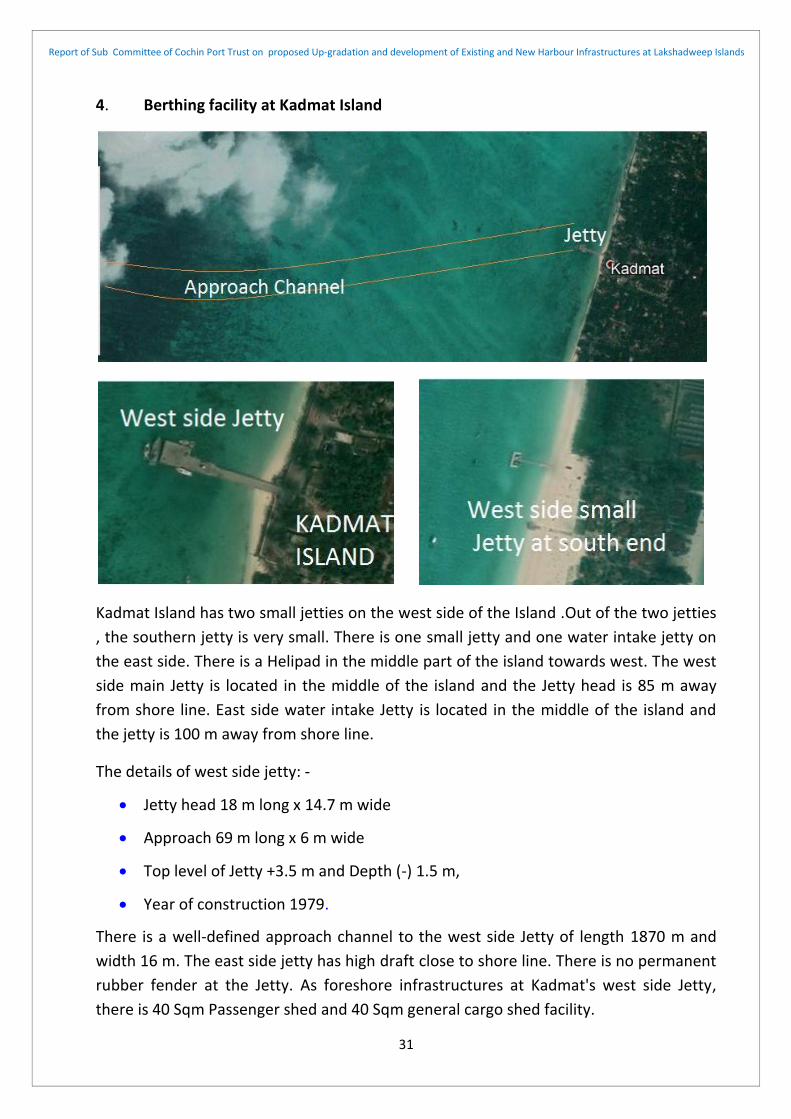
4. Berthing facility at Kadmat Island
Kadmat Island has two small jetties on the west side of the Island .Out of the two jetties
, the southern jetty is very small. There is one small jetty and one water intake jetty on
the east side. There is a Helipad in the middle part of the island towards west. The west
side main Jetty is located in the middle of the island and the Jetty head is 85 m away
from shore line. East side water intake Jetty is located in the middle of the island and
the jetty is 100 m away from shore line.
The details of west side jetty: -
Jetty head 18 m long x 14.7 m wide
Approach 69 m long x 6 m wide
Top level of Jetty +3.5 m and Depth (-) 1.5 m,
Year of construction 1979.
There is a well-defined approach channel to the west side Jetty of length 1870 m and
width 16 m. The east side jetty has high draft close to shore line. There is no permanent
rubber fender at the Jetty. As foreshore infrastructures at Kadmat's west side Jetty,
there is 40 Sqm Passenger shed and 40 Sqm general cargo shed facility.

Report of Sub Committee of Cochin Port Trust on proposed Up-gradation and development of Existing and New Harbour Infrastructures at Lakshadweep Islands
32
5. Berthing facilities at Amini Island:
Amini Island has a Helipad on the north end, one small jetty at the west side and one
standard size Jetty on the east side.
The details of the west side jetty ,known as Kachery jetty: -
Jetty head 20 m long x 14.1 m wide
Approach 74 m long x 6.65 m wide
Top level of Jetty +3.9 m and Depth (-) 1.8 m
Year of construction 1979.
There is a well-defined approach channel of length 295 m and width 16 m to the west
side Jetty. There is no permanent rubber fender at the Jetty. As foreshore
infrastructures at Amini's west side Jetty, there are 60 Sqm Passenger shed, 60 Sqm
general cargo shed and 150 Sqm workshop facility.
The details of the east side jetty, known as EHFC jetty : -
Jetty head 127 m long x 12.0 m wide
Approach 355 m long x 6.0 m wide
Top level of Jetty +5.05 m and Depth (-) 8.0 m
Year of construction 2013.
No proper fender system exists in the Jetty.
Additionally there is a very small
jetty and one water intake jetty at
the east side.

Report of Sub Committee of Cochin Port Trust on proposed Up-gradation and development of Existing and New Harbour Infrastructures at Lakshadweep Islands
33
4. Berthing Facility at Agatti Island
Agatti Island has the only Airport in the entire Lakshadweep and the Airport is situated at the southern tip of the island. Indian Air Lines operate regular flights between Kochi and Agatti. There is a Helipad inside the Airport area. The island has two small jetties on the west side and one standard Jetty on the east side. The two west side jetties are only 830 m apart. There is a water intake jetty in the east, very close to the east side jetty of the island. The west side two jetties have a common approach channel of total length 2160 m and width 16 m.
The details of the west side jetty ,known as Kachery jetty: -
Jetty head 30.0 m long x 16.0 m wide
Approach 100 m long x 6.0 m wide
Top level of Jetty +3.2 m and Depth (-) 1.8 m
Year of construction 1978.
The details of the west side Fisheries jetty : -
Jetty head 24.0 m long x 10.0 m wide
Approach 70 m long x 3.0 m wide
Top level of Jetty +2.7 m and Depth (-) 1.8 m
Year of construction 1988.
There is a well-defined common approach channel of length 2160 m and width 16 m. to
the west side Jetties .There is no permanent rubber fender at the Jetties . As foreshore

Report of Sub Committee of Cochin Port Trust on proposed Up-gradation and development of Existing and New Harbour Infrastructures at Lakshadweep Islands
34
infrastructures at Agatti's west side Jetty, there are 60 Sqm Passenger shed, 60 Sqm
general cargo shed and 150 Sqm workshop facility.
The details of the east side jetty, known as EHFC jetty : -
Jetty head 127 m long x 12.0 m wide
Approach 332 m long x 6.0 m wide
Top level of Jetty +5.05 m and Depth (-) 8.0 m
Year of construction 2012.
No proper fender system exists in the Jetty.
5. Berthing Facility at Andrott Island
Andrott Island has a helipad at south east end of the island. The island has a breakwater of length 470 m at the north. The breakwater was built in three stages and completed in 2002. There is an inner harbour to shelter small fishing boats. The outer part has three wharves of length 60 m,15.2 m and 40 m. The slope of the sea bed is gentle and needs dredging mainly inside berth area only. As Foreshore infrastructures at Andrott's only Jetty, there are 60 Sqm Passenger shed,60 Sqm general cargo shed and 94 Sqm workshop facility exist.

Report of Sub Committee of Cochin Port Trust on proposed Up-gradation and development of Existing and New Harbour Infrastructures at Lakshadweep Islands
35
6. Berthing facilities at Kavaratti Island:
Kavaratti island has a Helipad at the southern corner of the island. The island has one Jetty at the east and two small jetties at the west. The two west side jetties are 600 m apart.
The details of the west side jetty ,known as Kachery jetty: -
Jetty head 77.3 m long x 17.0 m wide
Approach 254 m long x 7.0 m wide
Top level of Jetty +3.2 m and Depth (-) 2.5 m
Year of construction 1989.
The details of the west side Fisheries jetty : -
Jetty head 80.2 m long x 10.0 m wide
Approach 107m long x 6.0 m wide
Top level of Jetty +2.7 m and Depth (-) 2.0 m
Year of construction 1972.

Report of Sub Committee of Cochin Port Trust on proposed Up-gradation and development of Existing and New Harbour Infrastructures at Lakshadweep Islands
36
There is a well-defined common approach channel to the west side Jetties of length
1140 m and width 40 m and 2.6 m depth . There is no permanent rubber fender at the
Jetties . As foreshore infrastructures at Kavaratti's west side Jetty, there are 90 Sqm
Passenger shed, 70 Sqm general cargo shed and 150 Sqm workshop facility.
7. Berthing Facilities at Kalpeni Island:
There are two jetties (North Jetty and South Jetty) on the west side of Kalpeni Island. There is a Helipad towards the north narrow part of the island. The Jetty is south of Helipad. In the east of the island, there is break water and a wharf. The break water is under reconstruction. The approach channel is towards north-west with some part passing through the coral reef area The channel is 3300 m long and 16 m wide.
The details of the east side jetty,
known as EHFC jetty : -
Jetty head 127 m long x
12.0 m wide
Approach 318 m long x 6.0
m wide
Top level of Jetty +5.05 m
and Depth (-) 8.0 m
Year of construction 2013.
Four numbers Pneumatic fenders
have been provided at the Jetty.
No proper permanent fender
system exists in the Jetty.

Report of Sub Committee of Cochin Port Trust on proposed Up-gradation and development of Existing and New Harbour Infrastructures at Lakshadweep Islands
37
The details of the west side -
south jetty : -
Jetty head 11.6 m long x
16.0 m wide
Approach 183 m long x
6.0 m wide
Top level of Jetty +3.2 m
and Depth (-) 1.8 m
Year of construction 1979.

Report of Sub Committee of Cochin Port Trust on proposed Up-gradation and development of Existing and New Harbour Infrastructures at Lakshadweep Islands
38
There is a well-defined common approach channel to the west side Jetties of length
3300 m and width 16 m and 1.8 m depth
As foreshore facility of west jetty , it has a passenger hall of area 74 Sqm and a
workshop area 184 Sqm. The east side jetty has a passenger hall of 88 Sqm and a
workshop of 94 Sqm. All the jetties have no permanent rubber fenders.
Details of existing jetties, breakwaters and related facilities in the Lakshadweep Islands
are given at Annexure I.
Details of vessels and equipment owned by Lakshadweep administration is also given at
Annexure II.
The details of the west side -
north jetty : -
Jetty head 11.0 m long x
15.0 m wide
Approach 120 m long x
6.0 m wide
Top level of Jetty +3.2 m
and Depth (-) 1.8 m
Year of construction 2010.
The east side breakwater
of Kalpeni island is 165 m
long .There is an wharf of
length 40 m. and 9.4 m
width. Top level of the
wharf is +3.5 m and depth
is 1.8m .The partial break
water and wharf was
competed in 2002 and
restoration work is being
executed

Report of Sub Committee of Cochin Port Trust on proposed Up-gradation and development of Existing and New Harbour Infrastructures at Lakshadweep Islands
39
CHAPTER 3:
GENERAL PROBLEMS OF THE JETTY AND HARBOUR
INFRASTRUCTURES
3.1. PHYSICAL AND NATURAL SETTING
The islands of Lakshadweep archipelagos are oriented primarily in North-South
direction except Andrott Island, which is oriented in East-West direction. The reason for
such orientation is mainly due to the orientation of underneath banks on which the
atolls and islands are situated and subsequent growth due to coral action in the
creation of the lagoon sands. The coral also plays the role in building up the reef.
All the atolls of Lakshadweep have lagoon on the west side, except Andrott atoll, which
has no lagoon. Moreover, the Amini Island has also a small coral reef cover. Reefs
usually vary in width from 200-400m among the different islands. However, the wave
cut platform extends from the reef margin to a distance of 50-100m only towards the
sea and the depth falls steeply within a short distance. The reason for the development
of the lagoon on the west side of the atolls is due to the presence of ambient conditions
for living and growth of corals. The outer coral reef area is in fact the most productive
area where reef-building corals grow culminating generation of calcium carbonate. The
direction of the wind in the area is mainly from West and North-West during monsoon
months, the direction of the wind in July is shown below: -
In addition to the wind, ocean/ sea currents play a very important role in the
development of atolls; it brings nutrients for the coral and also transports the materials.

Report of Sub Committee of Cochin Port Trust on proposed Up-gradation and development of Existing and New Harbour Infrastructures at Lakshadweep Islands
40
The sediments are generated and transported on the atoll by waves, currents and
importantly by cyclones. The currents in turn may be generated by waves or due to
winds and tides. The continuous pounding of the reefs by waves breaks the corals and
dislodges other organic communities from the substratum. The dominant direction of
the waves in the area during the summer and monsoon (April- September) is from the
W, WNW and WSW, though waves from the N, NNE and ENE are common during the
winter (October- March). However, because of the greater height, the waves from the
west are more effective agents for the generation of sediments and its eastward
transport across the atoll. The eastern reef of the atolls is narrower which also limits the
capacity for carbonate production and sediment generation while the western reef and
reef flat is much wider. The sediments generated are deposited on the reef front and
subsequently in the lagoon. The westerly waves also generate a circulation pattern
favouring transport in the lagoon.
Cyclones have played a significant role in the generation and transport of sediments.
The high waves generated during the cyclones break and transport not only the corals
but also large sized colonies and blocks to some distance. The corals broken and
deposited by cyclones on the eastern reefs perhaps effectively plugged the gaps in the
reef and formed an effective barrier for trapping the sediments generated and
transported from the western reef front A very dominant role has been played by waves
and currents to transport the sediments.
General the topography of the atoll, island, lagoon and coral reef outer ring is shown above.
The typical general features towards the island margin are normally uniform but some
area may be uneven mainly due to damage of corals at the reef margin. A number of
broken coral reef outer ring is present in Lakshadweep archipelagos, some of the surge
channels oriented in NW-SE to NE-SW direction are also present in the outer reef.

Report of Sub Committee of Cochin Port Trust on proposed Up-gradation and development of Existing and New Harbour Infrastructures at Lakshadweep Islands
41
The lagoons particularly the smaller lagoons are filled with sediments and have a
shallow depth. The larger lagoons however are comparatively deep. At low tide, the
reef is exposed and during high tide, it is submerged. The eastern seaside part of the
atolls has a steep storm beach with deposits of shingles and boulders .and the lagoon
side beach is sandy. The inner reef flat has thicker sediment cover, parts of which are
transported to the lagoon.
The reef areas are the living places of various communities of corals and they are
responsible for the creation of the lagoon sands and play the role in building up the
reef.
The geomorphic situation of the coral islands is delicate and it is not advisable to
remove sands and /or dead Coral stone or living coral reef without precaution except
for dredging purpose. All dredged materials have to be dumped on the shore side for
reclamation purposes.
The sands occur in a loose form on the lagoon floor and are easy to remove through
dredging by using Cutter Suction Dredgers. There is a possibility that the area may
recoup without disturbing the delicate balance as long as the depth of dredging is
limited. Slight changes will be automatically adjusted. However, the most important
sediment-forming area is the outer ring area of the reef and it should not be disturbed
as far as possible. The lagoon is the most important accumulation site of coral sand and
the lagoon will have the tendency to fill up automatically if the sands are taken out in
dredging. However, close environmental monitoring should be done. All programmes
should be oriented according to the guidelines suggested by the Reef Monitoring
Network and Management Plans.
It appears that little sediment is generated within the lagoon. The sands mostly originate at the outer reef area and are then transported, irrespective of their final resting place. The removal of limited quantities of sediment from the lagoon without disturbing the reef will have minimal effect on the rates of production or derivation as long as the generation of sediment is not disturbed.
Large scale dredging operations may affect the floral and faunal systems within and peripheral to the lagoon. Any significant lowering of lagoon floors may increase wave amplitude on downwind shores, i.e. west side of the islands. This may activate erosion. Dredging activity will draw much larger volumes of sediment into suspension than that is present in a normal situation. The channel area will have a concentration of water flow particularly during ebb tides. A new channel may result in active erosion in its head ward area at the lowest stage of the falling tide. Sediment is mainly generated from reef areas and so there may be no significant impact on limited area dredging. If there is a continuous south-easterly movement of sand/sediments, the dredged channel may be filled up. Human induced damage to corals reefs must be avoided by careful control.

Report of Sub Committee of Cochin Port Trust on proposed Up-gradation and development of Existing and New Harbour Infrastructures at Lakshadweep Islands
42
3.2. EXISTING SYSTEM AND SHORT COMING OF PASSENGER AND CARGO HANDLING
ARRANGEMENT AND RECOMMENDATION
The jetties on the eastern side of Lakshadweep islands (Amini, Agatti, Kavaratti and
Minicoy) have a high draft and all all-weather ships travelling between Cochin and
islands can be berthed easily but the problem is that the jetties are in the open sea and
safe berthing of ships is difficult, particularly during monsoon period due to high wind
velocity and rough weather.
The jetties at the western side of Lakshadweep islands are situated at a very shallow
depth and all-weather ships travelling between Cochin and islands cannot be berthed
there, though the jetties are otherwise safe for berthing of small ships/vessels.
However, there will be some difficulty during the monsoon period due to high wind
velocity and rough weather.
Due to the above reasons, all-weather Ships remain anchored in the open sea and
passengers embark and disembark into small boats brought to the existing jetties
constructed inside lagoons on the western side. This embarkation and disembarkation
system becomes extremely tough & risky and sometimes leads to capsize of small boats
and human casualties also. Loading and unloading of general cargo to and from ships
are also equally risky and dangerous. During monsoon, even this facility does not
remain viable because of the extreme sea conditions on the western side. The
passengers have to disembark and embark from the eastern side, and then ride in small
country boats across the turbulent zones & jump from the water to reach to the shore.
The children, ladies particularly patients suffer enormously due to this. The movement
of general cargo is also challenging due to the above reason.
All inhabited Islands of Lakshadweep are provided with ferry jetties located inside the
western lagoons, whereas two Islands i.e. Andrott and Kalpeni are provided with
breakwater and wharves for catering to the ships having draft up to 1.8 meters except
Andrott where available draft at berth face is 8 m. In Agatti, Amini and Kavaratti Islands
open jetties have been provided on the eastern side of these Islands for berthing of
ships plying between the mainland and Islands.
All the jetties of the islands have no proper fenders and only tyre fenders are provided.
It is considered essential to provide permanent rubber fenders with adequate capacity
and high quality rubber capable of taking the load, energy and deflection. Presently at
the east side jetty of Kavaratti island, four numbers pneumatic fenders have been
provided, which act as additional berthing aids. It is also proposed to procure and place
pneumatic fenders for additional berthing aids. Most of the jetties need to provide new
bollards and/or strengthening existing bollards.

Report of Sub Committee of Cochin Port Trust on proposed Up-gradation and development of Existing and New Harbour Infrastructures at Lakshadweep Islands
43
3.3. PHYSICAL AND SOCIAL INFRASTRUCTURE
Untreated sewage disposal is to be avoided and if required treated sewage waste may
be disposed but the outfalls should be placed below the level of coral growth or to be
discharged in deep water.
Upgrading physical and social infrastructure on the island is an important issue. Some
physical infrastructures required in the islands are potable water supply, renewable
electrical energy generation, training institute for imparting training to the resident of
the islands etc. The cyclone shelters may be built in an elevated port area. These
facilities should be installed on all islands.
Solid waste disposal /management pose a problem and an alternative to sea dumping
must be explored.
Electricity generated through Solar Panels and wind mills can act as alternative clean
source of energy, which will reduce the use of fossil fuels considerably.
The reefs are very fragile and vulnerable to human activity. The resources of the
Lakshadweep atolls are enormous and it may be relevant to decide to what extent this
fragile ecosystem can be used without causing any /minimum damage to the delicate
balance.
In Lakshadweep the lagoon is the most important sediment accumulating site. A large
volume of sediment is being generated from the reef and deposited in the lagoon. So, if
a limited amount of sand is taken out there will be no or minimal long-term damaging
effect. However, close environmental monitoring needs to be done. Once the system of
safe dredging is established in such an environment it can be widely used in other areas
also.
There are still plenty of scopes to work on a number of different aspects of the
Lakshadweep group of atolls. In the backdrop of the above stated discussion, proposal
for various future developments has been made.

Report of Sub Committee of Cochin Port Trust on proposed Up-gradation and development of Existing and New Harbour Infrastructures at Lakshadweep Islands
44
CHAPTER 4:
PROPOSED UP-GRADATION OF THE EXISTING INFRASTRUCTURES AND
CONSTRUCTION OF NEW INFRASTRUCTURES
4.1. INTRODUCTION:
In due consideration of peculiar geography of the Islands and prevailing climatic /
weather conditions and also based on the existing Port infrastructures, in order to
achieve safe, efficient and effective operation of port and shipping services in all the
islands of UT of Lakshadweep and modifications / upgradation to the existing
infrastructures and new constructions are proposed in the Islands.
All future developmental work of the entire Lakshadweep Island is proposed to be port
led development and to take place in and around the port area. The basic infrastructure
shall inter-alia include, reclamation of land utilising dredged materials, Construction of
breakwater for all west side jetties including a sea wall, Nourishment and strengthening
of existing partial break waters of Andrott and Kalpeni islands and Construction of new
part to complete the breakwater, strengthening of existing jetties and wharves
including the extension of jetty head, Construction of new jetties on the east side,
installation of infrastructures to utilise the water intake jetties at the desalination plant
for handling petroleum products. The new development work shall also include
construction of two storied passenger sheds to be utilised as shelter during emergency/
disaster, construction of sheds for storing of general cargo and accommodating
workshops, the sheds to be fitted with a solar panel for harvesting solar energy,
construction of structures at the approaches of the jetties for installing of solar panels.
Construction and installation of wind mills for harvesting wind energy, construction of
water storage tank for rain water harvesting, construction of Sewage Treatment Plant to
cater adjacent residential area, construction of dumping ground for garbage for proper
waste management of the surrounding area, creation of provision for the development
of tourism and small scale industries like fish processing, ice plant, coir industry etc,
creation of Entertainment facility like park etc. The infrastructure shall also include the
development of landing area for sea plane to boast tourism. It is also proposed to
construct new container handling infrastructures and liquid petroleum product handling
facility with a storage tank at Andrott.
It is considered essential to provide permanent rubber fenders with adequate capacity
and high quality rubber capable of taking the load, energy and deflection. It is also
proposed to procure and place pneumatic fenders for additional berthing aids. Most of
the jetties need to provide new bollards and/or strengthening the existing bollards.

Report of Sub Committee of Cochin Port Trust on proposed Up-gradation and development of Existing and New Harbour Infrastructures at Lakshadweep Islands
45
4.2. ISLAND WISE DETAIL RECOMMENDATIONS WITH BOUDGETARY COST
1. Bitra Island: -
head is very small in size; the available draft is also limited. It can handle only very small
passenger vessels and cargo barge at the jetty. The existing jetty is very close to the
Helipad of Bitra.
a) Recommendation:
It is proposed to develop an all-weather Harbour around the existing west jetty in the
Bitra Island. Following development works are proposed to be taken up:
Construction of 400 m long seawall to the west side of the island. The sea wall will be constructed at a distance of 15 m from shore line and the area between existing shore line and sea wall to be filled with dredged materials and to be reclaimed. Construction of 325 m Long and 300 m wide breakwater and extension of existing Jetty head to total 50m. Dredging the breakwater inside area up to a depth of (-) 2.5 m with Cutter Suction Dredger. Dredging and development of approach/entrance channel towards south-east of width 20 m.
Construction of two storied passenger shed in the reclaimed area. The shed will have capacity of 100 heads and to be utilised for sheltering local residents in emergency/ disaster. Construction of a water reservoir for storing water during rainy season and utilise in the port area including supplying to the local residents of the area. Construction of Sewage Treatment plant for treating the sewage of the entire island. Construction of a dumping yard for solid waste management. Construction of storing shed.
Construction of four number of wind mill for harvesting wind energy. Providing light posts at the approach of the jetty and one high mast tower at jetty head for
Bitra is a very small and the
least populated island of
Lakshadweep. The demand for
Bitra is least both for the
passenger as well as cargo. Bitra
has also not developed as a
tourist spot. The existing jetty
has no permanent fenders,
navigational aids like channel
making buoys and
cargo/passenger handling
equipment. The existing jetty

Report of Sub Committee of Cochin Port Trust on proposed Up-gradation and development of Existing and New Harbour Infrastructures at Lakshadweep Islands
46
lighting purpose. Providing solar panel over the sheds, at approach and on the shore area of suitable capacity for harvesting solar energy.
Installation of new permanent rubber fenders and bollards in the jetty. Providing passenger cum cargo handling equipment like mechanised ladder and small crane (3ton capacity).
b) Cost: The block cost estimate of various development works are as follows :-
Construction cost of Sea wall and breakwater is Rs 135 Crores (1350 m long) and other
infrastructure like sheds, passenger and cargo handling amenities, dumping ground etc
is Rs 24 Crores. Cost of extension of jetty head is Rs.15 Crores. Cost of solar panel and
wind mill including allied infrastructures is Rs 12 Crores. Cost of providing light post at
the approach of the jetty and one high mast tower is Rs.2 Crores. Construction cost of
sewage treatment plant and water reservoir is Rs 2 Crores. Cost of Rubber fender and
bollard with fixing arrangement is Rs.2 Crores.
Cost of capital dredging of approach/entrance channel and inner harbour area is Rs. 4
Crores.
Total cost of the recommended work is Rs 196 Crores.
2. Chetlat Island: -
Chetlat is a small island of Lakshadweep. The island has a small permanent Jetty on the
west side of the island. There is an embarkation / dis-embarkation area without basic
facilities on the island, which is on the eastern side. The existing harbour infrastructures
of Chetlat island is inadequate for both passenger as well as cargo. Chetlat island has
also not developed as a tourist spot. The existing jetty on the west side has no
permanent fenders, the jetty has inadequate navigational aids like channel marking
buoy, cargo/passenger handling equipment. The existing jetty head of the west side
jetty is very small in size; the available draft is also limited. It can handle only very small
passenger vessels and cargo Berge at the jetty. The east side
embarkation/disembarkation area is void of the basic facility.

Report of Sub Committee of Cochin Port Trust on proposed Up-gradation and development of Existing and New Harbour Infrastructures at Lakshadweep Islands
47
a) Recommendation:
1. It is proposed to develop an all-weather Harbour around the existing west jetty in
the Chetlat Island. Following development works are proposed to be taken up:
Construction of 400 m long seawall on west side of the island. The sea wall will be constructed at a distance of 15 m from shore line and the area between existing shore line and sea wall to be filled with dredged materials and to be reclaimed. Construction of 300 m Long and 250 m wide breakwater and extension of existing Jetty head on both sides to total 50m. Dredging the breakwater inside area up to a depth of (-) 2.5 m with Cutter Suction Dredger. Dredging and development of approach/entrance channel of width 20 m towards west.
Construction of two storied passenger shed in the reclaimed area. The shed will have capacity of 200 heads and to be utilised for sheltering local residents in emergency/ disaster. Construction of a water reservoir for storing water during rainy season and utilise in the port area including supplying to the local residents of the area. Construction of Sewage Treatment plant for treating the sewage of the harbour area including the proposed jetty of the east side. Construction of a dumping yard for solid waste management. Construction of storing shed.
Construction of four number of wind mills for harvesting wind energy. Providing light post at the approach of the jetty and one high mast tower at jetty head for lighting purpose. Providing solar panel of suitable capacity over the sheds, at approach and on the shore area for harvesting solar energy.
Installation of new permanent rubber fenders and bollards in the jetty. Providing passenger cum cargo handling equipment like mechanised ladder and small crane (3ton capacity).
2. It is proposed to construct a new jetty of 120m long jetty head and 150 m long approach trestle on the east side at the existing location of the embarkation/disembarkation area in the Chetlat Island. Following works are proposed to be taken up.

Report of Sub Committee of Cochin Port Trust on proposed Up-gradation and development of Existing and New Harbour Infrastructures at Lakshadweep Islands
48
Construction of new jetty of 120m long jetty head and 150 m long approach trestle. The proposed jetty will have a draft of 9 m .Construction of 400m long sea wall The sea wall will be constructed at a distance of 10 m from shore line and the area between existing shore line and sea wall to be filled with dredged materials and to be reclaimed. The dredging to be carried out with Cutter Suction Dredger. Dredging and development of approach/entrance channel of width 100 m towards east.
The east side of the proposed jetty has stiff sea bed slop and construction of breakwater to provide tranquil environment is not possible .As such it is proposed to provide two numbers mooring buoys for safe berthing of bigger ships .
Construction of single storied passenger, cargo and workshop sheds . Construction of a water reservoir for storing water during rainy season and utilise in the port area including supplying to the local residents of the area.
The other infrastructures like providing light post at the approach of the jetty and two high mast towers at jetty head for lighting purpose. Construction of four number of wind mill for harvesting wind energy. Providing solar panel of suitable capacity over the sheds, at approach and on the shore area for harvesting solar energy.
Providing passenger cum cargo handling equipment like mechanised ladder and one crane (15 ton capacity). Providing Permanent rubber fenders and bollards in the new jetty of required capacity.
b) Cost: The block cost estimate of various development works are as follows :-
1. Construction cost of Sea wall and breakwater of west jetty is Rs 120 Crores (1200
m long) and other infrastructure like sheds, passenger amenities, dumping yard.
etc is Rs 25 Crores. Cost of extension of jetty head is Rs. 15 Crores .Cost of solar
panel and wind mill including allied infrastructures is Rs 13 Crores. Cost of
providing light post at the approach of the jetty and one high mast tower is Rs 3
Crores. Construction cost of sewage treatment plant and water reservoir is Rs 2
Crores. Cost Rubber fender and bollard with fixing arrangement is Rs 3 Crores.
Cost of capital dredging of approach/entrance channel(650m long) and inner
harbour area is Rs. 4 Crores.
2. Construction cost of sea wall of east side new jetty is Rs 30 Crores (400m long) ,
and other infrastructure like sheds, passenger and cargo handling amenities etc is
Rs 20 Crores. Cost of construction of new jetty with fenders and bollards is Rs 100
Crores .Cost of solar panel including allied infrastructures is Rs 8 Crores. Cost of
providing light post at the approach of the jetty and two high mast tower is Rs 4
Crores Construction cost of water reservoir is Rs. 1 Crore. Cost of providing two
mooring Buoy is Rs 3 Crores.
Cost of capital dredging harbour area is Rs. 4 Crores.
Total cost of the recommended work is Rs 355 Crores.

Report of Sub Committee of Cochin Port Trust on proposed Up-gradation and development of Existing and New Harbour Infrastructures at Lakshadweep Islands
49
3. Kiltan Island: -
The approach channel appears to be dredged recently. The east side jetty is very small
and devoid of basic infrastructures. The existing harbour infrastructures available at
Kiltan island is inadequate for both passenger as well as cargo. Kiltan has also not
developed as a tourist spot. The existing jetty on the west side has no permanent
fenders, the jetty has no navigational aids like channel marking buoy, cargo/passenger
handling equipment. The existing jetty head of the west side jetty is very small in size,
the available draft is also limited It can handle only very small passenger vessels and
cargo vessels at the jetty. The east side jetty is very small and has no basic facility
a) Recommendation:
1. It is proposed to develop an all-weather Harbour around the existing west jetty in
the Kiltan Island. Following development works are proposed to be taken up:
Kiltan has a helipad on the
north-western corner of the
island and two small Jetties on
both sides of the island i.e. east
and west. The approach
channel of the west side jetty is
well defined and has a length of
800 m towards North West
direction. The east side jetty has
high draft close to shore line.
The Island has a landmark 41-
metre high lighthouse.

Report of Sub Committee of Cochin Port Trust on proposed Up-gradation and development of Existing and New Harbour Infrastructures at Lakshadweep Islands
50
Construction of 400 m long seawall to the west side of the island. The sea wall will be constructed at a distance of 20 m from shore line and the area between existing shore line and sea wall to be filled with dredged materials and to be reclaimed. Construction of 300 m Long and 250 m wide breakwater and extension of existing Jetty head to total 50m. Dredging the breakwater inside area up to a depth of (-) 4.5 m with Cutter Suction Dredger. Dredging and development of approach/entrance channel of width 20 m towards west.
Construction of two storied passenger shed in the reclaimed area. The shed will have capacity of 200 heads and to be utilised for sheltering local residents in emergency/ disaster. Construction of a water reservoir for storing water during rainy season and utilise in the port area including supplying to the local residents of the area. Construction of Sewage Treatment plant for treating the sewage of the harbour area . Construction of a dumping yard for solid waste management. Construction of storing shed.
Construction of four number of wind mills for harvesting wind energy. Providing light post at the approach of the jetty and one high mast tower at jetty head for lighting purpose. Providing solar panel of suitable capacity over the sheds, at approach and on the shore area for harvesting solar energy.
Providing passenger cum cargo handling equipment like mechanised ladder and one crane (15 ton capacity). Providing Permanent rubber fenders and bollards in the new jetty of required capacity.
2. It is proposed to carry out up gradation work of east side existing jetty including
extension of the jetty head and development works proposed are detailed below.
Upgradation work of east side existing jetty including extension of the jetty head to 50 m. Providing two mooring buoys to facilitate safe berthing of small ships.
Construction of single storied passenger shed , cargo shed and workshop shed . Construction of a water reservoir to be utilised for storing water during rainy season and utilise in the port area including supplying to the local residents of the area. Construction of Sewage Treatment plant for treating the sewage of the harbour area. Construction of a dumping yard for solid waste management. Construction of storing shed.
Providing rubber fenders, bollards etc. Providing solar panel and allied infrastructures. Providing light post at the approach of the jetty and one high mast tower at jetty head for lighting purpose
b) Cost: The block cost estimate of various development works are as follows :-
1. Construction cost of Sea wall and breakwater of west jetty is Rs 180 Crores (1200
m long) and other infrastructure like sheds, passenger amenities, dumping yard
etc is Rs 25 Crores. Cost of extension of jetty head is Rs 15 Crores. Cost of solar
panel and wind mill including allied infrastructures is Rs 12 Crores. Cost of

Report of Sub Committee of Cochin Port Trust on proposed Up-gradation and development of Existing and New Harbour Infrastructures at Lakshadweep Islands
51
providing light post at the approach of the jetty and one high mast tower is Rs 3
Crores. Construction cost of Sewage Treatment Plant and water reservoir is Rs 2
Crores. Cost Rubber fender and bollard with fixing arrangement is Rs.3 Crores.
Cost of capital dredging of approach/entrance channel(500m long) and inner
harbour area is Rs. 10 Crores.
2. Cost of east side existing jetty upgration and extension of jetty head is Rs 6
Crores .Cost of providing rubber fender ,bollard and mooring buoy is Rs 4 Crores .
Cost of solar panel and wind mill including allied infrastructures is Rs 12 Crores.
Cost of providing light post at the approach of the jetty and two high mast towers
is Rs 2 Crores. Construction cost of water reservoir and sewage treatment plant is
Rs. 2 Crores.
Cost of capital dredging harbour area is Rs. 1 Crore.
Total cost of the recommended work is Rs 277 Crores.
4. Kadmat Island: -
Kadmat island has a Helipad in the middle part of the west side and two jetties on west
side of the Island out of the two jetties the southern jetty is very small. There is one
very small jetty on the east side of the island. There is another jetty on the east side for
water intake purposes. The approach channel of the west side jetty is well defined and
has a length of 1750 m. The two southern jetty one on the east side jetty and the other
is on the west side can handle only small fishing boats /boats used for tourist

Report of Sub Committee of Cochin Port Trust on proposed Up-gradation and development of Existing and New Harbour Infrastructures at Lakshadweep Islands
52
on the west side has no permanent fenders, the jetty has inadequate navigational aids
like channel making buoy, cargo/passenger handling equipment. The existing jetty head
of the west side jetty is very small in size; the available draft is also limited. It can handle
only small passenger vessels and cargo Berge at the jetty. The east side jetty is very
small and has no basic facility.
a) Recommendation:
1. It is proposed to develop an all-weather Harbour of high draft around the existing
west jetty in the Kadmat Island. Following development works are proposed to be
taken up:
Construction of 500 m long seawall to the west side of the island. The sea wall will be constructed at a distance of 20 m from shore line and the area between existing shore line and sea wall to be filled with dredged materials and to be reclaimed.
entertainment and there is
adequate draft for that purpose.
The two jetties are devoid of
most of the basic
infrastructures. The existing
harbour infrastructures
available at the west side jetty is
inadequate for both passenger
as well as cargo. Kadmat island
is however very developed as a
tourist spot. The existing jetty

Report of Sub Committee of Cochin Port Trust on proposed Up-gradation and development of Existing and New Harbour Infrastructures at Lakshadweep Islands
53
Construction of 400 m Long and 250 m wide breakwater. Extension of existing Jetty head to total 50m long on south side.
Capital dredging in the Harbour area and reclamation. The dredge depth of the harbour is proposed to be (-)4.5 m. The breakwater inside area is proposed to be dredged with Cutter Suction Dredger to a depth of (-) 4.5 m and the dredge materials to be utilized for the reclamation of the area between existing shore line and proposed sea wall. Dredging and development of approach/entrance channel of width 20m towards west
Construction of two storied passenger shed. The shed will have capacity of 200 heads and to be utilised for sheltering local residents in emergency/ disaster. Construction of water reservoir for storing water during rainy season and utilise in the port area including supplying to the local residents of the area. Construction of sewage treatment plant for treating sewage of the harbour area . Construction of a dumping yard for solid waste management. Construction of storing shed.
Construction of four numbers of wind mills for harvesting wind energy. Providing passenger cum cargo handling equipment like mechanized ladder and crane( 15 ton capacity) . Providing light post at the approach of the jetty and one high mast tower at jetty head for lightening purpose. Providing solar panel over the sheds, at approach and on the shore area of suitable capacity for harvesting solar energy. Providing new permanent rubber fenders and bollards to the jetty.
Construction of a Hover Craft landing area of width of 40 m and with a shed of size 33m x 33 m to be utilized for maintenance of the shed of the Hovercraft.
shore line and the area between existing shore line and sea wall to be filled with
2. It is proposed to construct a new jetty of 120m long jetty head and 150 m long approach trestle on the east side at the existing location of the embarkation/disembarkation area in the Kadmat Island. The works as detailed below are proposed to be taken up. It is also proposed deepened west jetties to be utilized for the purpose of developing Kadmat as a base port of HSC.
Construction of new jetty of 120m long
jetty head and 150 m long approach
trestle. The proposed jetty will have a
draft of 9 m .Construction of 400m long
sea wall The sea wall will be
constructed at a distance of 10 m from

Report of Sub Committee of Cochin Port Trust on proposed Up-gradation and development of Existing and New Harbour Infrastructures at Lakshadweep Islands
54
dredged materials and to be reclaimed. The dredging to be carried out with Cutter Suction Dredger.
The east side of the proposed jetty has stiff sea bed slop and construction of breakwater to provide tranquil environment is not possible ,as such it is proposed to provide two numbers mooring buoys for safe berthing of bigger ships .
Construction of double storied passenger shed, cargo shed and workshop sheds . Construction of a water reservoir for storing water during rainy season and utilise in the port area including supplying to the local residents of the area. Construction of sewage treatment plant for treating sewage of the harbour area . Construction of a dumping yard for solid waste management. Construction of storing shed.
The other infrastructures like providing light post at the approach of the jetty and two high mast towers at jetty head for lighting purpose. Providing solar panel of suitable capacity over the sheds, at approach and on the shore area for harvesting solar energy.
Providing passenger cum cargo handling equipment like mechanised ladder and one crane (15 ton capacity). Providing Permanent rubber fenders and bollards in the new jetty of required capacity.
b) Cost: The block cost estimate of various development works are as follows :-
1. Construction cost of Sea wall and breakwater of west jetty is Rs 180 Crores (1450 m
long) and other infrastructure like sheds, passenger and cargo handling amenities,
dumping yard etc is Rs 30 Crores. Cost of extension of jetty head is Rs 15 Crores.
Cost of solar panel and wind mills including allied infrastructures is Rs 12 Crores.
Cost of providing light post at the approach of the jetty and one high mast tower is
Rs 2 Crores. Construction cost of sewage treatment plant and water reservoir is
Rs. 2 Crores. Cost Rubber fender and bollard with fixing arrangement is Rs. 3 Crores.
Cost of capital dredging of approach/entrance channel(1500m long) and inner
harbour area is Rs. 30 Crores.
2. Construction cost of sea wall of east side new jetty is Rs 30 Crores (400m long) , and
other infrastructure like sheds, passenger and cargo handling amenities, dumping
yard etc is Rs 20 Crores. Cost of construction of new jetty with fenders and bollards
is Rs 100 Crores . Cost of solar panel including allied infrastructures is Rs 8 Crores.
Cost of providing light post at the approach of the jetty and two high mast tower is
Rs 3 Crores. Construction cost of water reservoir and sewage treatment plant is Rs 2
Crores. Cost of capital dredging harbour area is Rs. 4 Crores. Cost of Permanent
rubber fender and bollard to be is Rs.3 Crores. Cost of two mooring Buoys is Rs 3
Crores.
Total cost of the recommended work is Rs 447Crores.

Report of Sub Committee of Cochin Port Trust on proposed Up-gradation and development of Existing and New Harbour Infrastructures at Lakshadweep Islands
55
5. Amini Island: -
The Amini island has a Helipad on the north and one small jetty on the west side of the
Island and one standard size Jetty on the east side. Additionally, there is a water intake
jetty on the east side.
aids like channel making buoy, cargo/passenger handling equipment. The existing jetty
head of west side jetty is very small in size; the available draft is also limited. It can
handle comparatively smaller passenger vessels and cargo vessels at the jetty. The east
side main jetty is however capable in handling big ships and has high draft. But during
the monsoon period berthing ships alongside the jetty is very challenging due to the
presence of strong wind and sea current. The other jetty of east side is very small and
has no basic facility and can handle only small fishing boats only.
The approach channel of the
west side jetty is only 250 m
long. The existing harbour
infrastructures available at the
west side jetty is inadequate for
both passenger as well as cargo.
Amini island is not developed as
a tourist spot. The existing
jetties of Amini island have no
permanent fenders, the jetties
have inadequate navigational

Report of Sub Committee of Cochin Port Trust on proposed Up-gradation and development of Existing and New Harbour Infrastructures at Lakshadweep Islands
56
Construction of 300 m Long and 250 m wide breakwater. Extension of existing Jetty
head to total 50m long towards north.
Capital dredging inside the breakwater area. The dredged depth of the harbour is proposed to be ( - ) 4.5 m. The a r e a i n s i d e t h e breakwater is proposed to be dredged with Cutter Suction Dredger to a dredge depth of 4.5 m and the dredge materials to be utilised for the reclamation. Dredging and development of approach/entrance channel of width 20 m and length 30 m towards west.
Construction of two storied passenger shed. The shed will have capacity of 200 heads which can be utilised for sheltering local residents in emergency/ disaster. Construction of water reservoir for storing water during rainy season and utilise in the port area including supplying to the local residents of the area. Construction of sewage treatment plant for treating sewage of the harbour area including the proposed jetty of east side. Construction of a dumping yard for solid waste management. Construction of storing shed.
Construction of four numbers of wind mills for harvesting wind energy. Providing passenger cum cargo handling equipment like mechanised ladder and crane (15-ton capacity), light post at the approach of the jetty and one high mast tower at jetty head for lightning purpose and solar panel of suitable capacity over the sheds, at approach and on the shore area for harvesting solar energy. Providing new permanent rubber fender and bollard to the jetty.
Construction of a Hover Craft landing area of width of 40 m and with a shed of size 33m x 33 m to be utilized as maintenance shed of the Hovercraft
a) Recommendation:
1. It is proposed to develop an all-
weather Harbour of high draft
around the existing west jetty in
the Amini Island. Following
development works are
proposed to be taken up:
Construction of 400 m long
seawall to the west side of the
island. The sea wall will be
constructed at a distance of 10 m
from shore line and the area
between existing shore line sea
wall to be filled with dredged
materials and to be reclaimed.

Report of Sub Committee of Cochin Port Trust on proposed Up-gradation and development of Existing and New Harbour Infrastructures at Lakshadweep Islands
57
The jetty of east side has a draft of 9m and need no/limited dredging in future.
The east side of the east side jetty has stiff sea bed slope as such construction of breakwater to provide tranquil environment for ship berthing is not possible. Provide two numbers mooring buoys for safe berthing of bigger ships as it is also not possible to construct breasting dolphins .
Providing passenger cum cargo handling equipment like mechanised ladder and crane (15 ton capacity). The other infrastructures will include providing light posts at the approach of the jetty and two high mast towers at jetty head for lighting purpose.
Construction of other infrastructures same as proposed for west side jetties like sheds for passenger, cargo and workshop on the reclaimed and available land, sewage treatment plant, water reservoir etc. The passenger shed will be utilised for sheltering purpose also in emergency/disaster. The proposed infrastructures will include providing four numbers wind mills and providing new solar panel of suitable capacity over the sheds, at approach and on the shore area.
b) Cost: The block cost estimate of various development works are as follows :-
1. Construction cost of Sea wall and breakwater for west jetty is Rs 160 Crores (1200 m
long) and other infrastructure like sheds, passenger and cargo handling amenities
dumping yard etc is Rs 30 Crores. Cost of extension of jetty head is Rs. 15 Crores
.Cost of solar panel and wind mills including allied infrastructures is Rs 12 Crores.
Cost of providing light post at the approach of the jetty and one high mast tower is
Rs 2 Crores. Construction cost of sewage treatment plant and water reservoir is Rs 2
Crores. Cost Rubber fender and bollard with fixing arrangement is Rs 3 Crores. Cost
of capital dredging of approach/entrance channel(30m long) and inner harbour area
2. It is proposed to upgrade the existing infrastructures on the East side jetty .The development works are as below:
Construction of a 400m long sea wall at east side jetty and reclaim land up to a width of 10m.

Report of Sub Committee of Cochin Port Trust on proposed Up-gradation and development of Existing and New Harbour Infrastructures at Lakshadweep Islands
58
is Rs. 3 Crores. Construction cost of Hover craft landing area and shed is Rs 10
Crores.
2. Construction cost of sea wall of east side new jetty Rs 30 Crores (400m long) and
other infrastructure like sheds, passenger and cargo handling amenities, dumping
yard etc. is Rs 25 Crores. Cost of solar panel and wind mills including allied
infrastructures Rs 12 Crores. Cost of providing light post at the approach of the jetty
and two high mast towers is Rs 3 Crores. Construction cost of water reservoir and
sewage treatment plant Rs 2 Crores. Cost of capital dredging harbour area is Rs. 4
Crores . Cost of Permanent rubber fender and bollard to be Rs.3 Crores. Cost of two
mooring Buoys is Rs 3 Crores.
Total cost of the recommended work is Rs 319 Crores
6. Agatti Island: Agatti Island has the only airport in the entire Lakshadweep Union
territory. The airport is situated in the south-west tip of the island, there is a
Helipad inside the Airport area. The island has two small jetties on the west side at a
distance of 850 m and one standard Jetty on the east side of the island. There is a
water intake jetty in the east, very close to the east side jetty of the island.
well developed as a tourist spot and has good infrastructures..The existing jetties of
Agatti island have no permanent fenders, the jetties have inadequate navigational
aids like channel marking buoys, cargo/passenger handling equipment. The existing
jetty head of the west side jetties are very small in size; the available draft is also
The approach
channel of west
side jetties is
combined and
towards the north
of length 2050 m
long. The existing
harbour
infrastructures
available at the
west side jetty is
inadequate for
both passenger as
well as cargo.
Agatti island is

Report of Sub Committee of Cochin Port Trust on proposed Up-gradation and development of Existing and New Harbour Infrastructures at Lakshadweep Islands
59
limited. It can handle comparatively smaller passenger vessels and cargo vessels at
the jetty. The east side jetty however can handle big ships and has a high draft. But
during the monsoon period berthing ships alongside the jetty is very challenging
due to the presence of strong wind and sea current.
north and north jetty head to 25 m long. Capital Dredging for development of approach/entrance channel and in the break water inside area. The dredge depth of
a) Recommendation:
1. It is proposed to develop an
all-weather Harbour of
comparatively high draft
around the existing west jetty
in the Agatti Island. Following
development works are
proposed to be taken up:
Construction of 1150 m long seawall. The sea wall will be constructed at a distance of 15 m from shore line and the area between existing shore line and sea wall to be filled with dredged materials and to be reclaimed. Construction of
850 m Long
and 250 m
wide (in the
south side)
breakwater.
The total
length of
breakwater
will be
1200m.
Extension of
existing
south Jetty
head to total
40m long
towards
north and
north jetty
head to 25 m
long. Capital
Dredging for
development
of

Report of Sub Committee of Cochin Port Trust on proposed Up-gradation and development of Existing and New Harbour Infrastructures at Lakshadweep Islands
60
the harbour proposed is 3.5 m. The area inside breakwater is proposed to be dredged with Cutter Suction Dredger.
Construction of two storied passenger shed. The reclaimed area is proposed to be utilized for shed construction. The shed will have capacity of 200 heads which can be utilised for sheltering local residents in emergency/ disaster. Construction of water reservoir for storing water during rainy season and utilize in the port area including supplying to the local residents of the area. Construction of sewage treatment plant for treating sewage of the harbour area including the surrounding area. Construction of a dumping yard for solid waste management. Construction of storing shed.
Construction of twelve numbers of wind mills for harvesting wind energy. Providing passenger cum cargo handling equipment like mechanized ladder and crane (15-ton capacity).
Construction of new foreshore road.
Providing light post at the approach of the jetty and one high mast tower at jetty head for lighting purpose. Providing solar panel of suitable capacity over the sheds, at approach and on the shore area. Providing new permanent rubber fender and bollard to the jetty.
Construction of a Hover Craft landing area of width of 40 m and with a shed of size 33m x 33 m to be utilized as maintenance shed of the Hovercraft.
2. It is proposed to upgrade the existing infrastructures of the East side jetty .The development works are as below:
Construction of a 400m long sea wall at east side jetty and reclaim land up to a width of 10m. Providing two numbers mooring buoys.
Construction of sheds for passenger, cargo and workshop on the reclaimed and available land. The passenger shed will be utilized for sheltering purpose also in emergency/disaster. Construction of sewage treatment plant, water reservoir etc.
Providing passenger cum cargo handling equipment like mechanized ladder, crane (15-ton capacity), forklift etc.
Providing light posts at the approach of the jetty and four high mast towers at jetty head for lighting purpose. Providing solar panel over the sheds, at approach and on the shore area of suitable capacity and twelve numbers wind mills.
b) Cost: The block cost estimate of various development works are as follows :-
1. Construction cost of Sea wall and breakwater of west jetty is Rs 235 Crores (2350 m long) and other infrastructure like sheds, passenger amenities, dumping yard etc. is Rs 30 Crores. Cost of extension of jetty heads is Rs 20 Crores .Cost of solar panel and wind mills including allied infrastructures is Rs 20 Crores. Cost of providing lighting infrastructures including light posts and one high mast tower is Rs 3 Crores. Construction cost of sewage treatment plant and water reservoir is Rs. 2 Crores.

Report of Sub Committee of Cochin Port Trust on proposed Up-gradation and development of Existing and New Harbour Infrastructures at Lakshadweep Islands
61
Cost of Rubber fender and bollard with fixing arrangement is Rs 3 Crores. Construction cost of Hover craft landing area and shed is Rs 10 Crores. Cost of capital dredging of approach/entrance channel and inner harbour area is Rs. 12 Crores.
2. Construction cost of sea wall of east side new jetty is Rs 30 Crores (400m long) , and
other infrastructure like sheds, passenger and cargo handling amenities, dumping
yard is Rs 25 Crores. Cost of solar panel and wind mills including allied
infrastructures is Rs 12Crores. Cost of providing lighting infrastructures including
light posts and four numbers high mast towers is Rs 4 Crores. Construction cost of
water reservoir and sewage treatment plant is Rs 2 Crores. Cost of capital dredging
harbour area is Rs. 4 Crores. Cost of Permanent rubber fender and bollard to be
Rs.3 Crores. Cost of two mooring Buoys is Rs 3 Crores.
Total cost of the recommended work is Rs 418 Crores
7. Andrott Island
Andrott island is a unique island in many sense, it is the nearest island to the mainland,
the island is oriented in east-west direction, it's area is largest (4.90 Sqm) and
population is highest (11,191 numbers) among all islands of Lakshadweep. Andrott
Island has a helipad in south-east end of the island. The island has an incomplete
breakwater in the north side of the island of length 470 m with three berths of lengths
60m, 15.2m and 60 m. There is an inner harbour to shelter small fishing boats.
The slope of the sea bed in the
breakwater area is gentle and suitable
for construction of all-weather harbour.
The island has the potential to be nerve
centre of transportation hub for the
entire Lakshadweep. Presently the
bigger passenger cum cargo ships are
anchored at outer deep sea and
embarkation/ disembarkation of
passengers and transportation of cargo
are done in small boats, which becomes
unsafe during rough sea, especially
during south-west monsoon, when
wave height at outer sea is very high

Report of Sub Committee of Cochin Port Trust on proposed Up-gradation and development of Existing and New Harbour Infrastructures at Lakshadweep Islands
62
The existing breakwater is incomplete and does not provide safe tranquil water for
loading /unloading of cargo and/or embarkation/dis-embarkation of passengers.
a) Recommendation:
It is proposed to develop an all-weather Harbour of very high draft around the
existing harbour of the Andrott Island. Following development works are proposed
to be taken up:
Construction of a new part of Break water 550m long and 50m extension of the
existing west side breakwater including strengthening. Construction of sea wall of
400 m length. The sea wall is to be constructed 15 m away from the shore line and
the area between shoreline and sea wall to be reclaimed.
Capital dredging for increasing the depth inside harbour area. Dredge depth 10 m in
the east side and 8 m in the west side is proposed to be provided. The dredging is to
be carried out using Cutter Suction Dredger and the dredged materials is proposed
to be used for reclaiming the area between sea wall and shore line. Reclamation of
land of area 6000sq.m using dredged materials.
Construction of two new Berths one at the east side of the inner harbour area of
size, 200 m long & 20 m wide and the other berth 150m long & 15 m wide with 10 m
wide approach road on the breakwater, for handling passenger ships, cargo ships
including liquid petroleum products and container ships.
Construction of shed on the shore for container stuffing and de-stuffing.

Report of Sub Committee of Cochin Port Trust on proposed Up-gradation and development of Existing and New Harbour Infrastructures at Lakshadweep Islands
63
Construction of Sheds for passenger and for storing of fish and other essential
commodities
Construction of storage tank for liquid petroleum product. New infrastructures like
passenger, break bulk cargo, container as well as liquid product handling equipment.
Construction of floating jetty for sea plane service to facilitate development of the
island as a business hub.
Providing light posts at the approach of the jetty and four high mast towers at
wharfs for lighting purpose. Providing solar panel over the sheds, at approach and on
the shore area of suitable capacity and twelve numbers wind mills.
The Andrott port will act as main hub of coastal shipping as well as international
shipping. The port should have all modern facilities and compliance of all international
law like MARPOL, ISPS etc. The following additional facilities is also proposed to be
developed at Andrott island :
It is proposed to acquire another 6000 Sqm area in the shore side to develop
various infrastructures as proposed above. The existing land available with the
port authority can also be used for the new development purpose.
It is proposed to develop infrastructures including floating jetty for sea plane
service to facilitate development of the island as a future business hub.
b) Cost: The block cost estimate of various development works are as follows :-
Construction cost of new part of breakwater including extension and strengthening of
existing breakwater of the harbour of length 600 m (New & extension ) is Rs 240 Crores
and Sea wall (400 m long) is Rs. 40 Crores and other infrastructure like sheds, passenger
amenities, dumping yard is Rs 40 Crores. Cost of construction of new berth (two nos.)
and approach road on the breakwater is Rs 75 Crores . Cost of solar panel and wind mill
including allied infrastructures is Rs 14 Crores. Cost of providing light post at the
approach of the jetty and four high mast towers is Rs 5 Crores The construction cost of
sewage treatment plant and water reservoir is Rs.3 Crores. Cost of capital dredging of
approach/entrance channel(350m long) and inner harbour area is Rs. 100 Crores. Cost
of providing permanent rubber fenders and bollards is Rs 8 Crores. Construction cost of
Hover Craft landing area and shed is Rs 10 Crores. Cost of Foreshore road (500 m) is Rs 5
Crores.
Total cost of the recommended work is Rs 540 Crores

Report of Sub Committee of Cochin Port Trust on proposed Up-gradation and development of Existing and New Harbour Infrastructures at Lakshadweep Islands
64
on the west side towards north of the island. The two west side jetties are 600 m
apart..Bathymetry of the sea bed in and around the east Jetty particularly towards the
outer side is very steep and it is technically not advisable to construct a breakwater to
make the Jetty an all-weather harbour. However, two mooring Buoys may be provided
for safe berthing of ships and embarkation/disembarkation of passengers and
transportation of cargo from a ship, by anchoring at the jetty in place of the existing
practice of anchoring at the outer sea and deploying small boats for last leg
transportation.
As the two west side jetties are 600 m apart, it is considered prudent to construct a
combined breakwater to make the jetties useable throughout the year. The jetties of
the west side have a well defined common approach channel of length less than 500 m
towards the north side.
There are no permanent fenders in the jetties. Rubber tyres are being used as fenders.
There are four pneumatic fenders provided as a temporary measure. Another type of
fenders are also seen provided in the rear side of the jetty, for berthing of the smaller
type vessels.
8. Kavaratti Island: The
Kavaratti is the capital of the
Union Territory Lakshadweep
and is located in the centre of
Lakshadweep archipelago.
The island has a helipad in the
southern end and is connected
with Agatti airport with regular
services. The island has one Jetty
on the east side and two jetties

Report of Sub Committee of Cochin Port Trust on proposed Up-gradation and development of Existing and New Harbour Infrastructures at Lakshadweep Islands
65
a) Recommendation:
1. It is proposed to develop an all-weather Harbour of 3 m draft around the existing
two jetties of the west side of the Kavaratti Island. Following development works
are proposed to be taken up:
Construction of 1570 m long break water and 1050 m long seawall. The sea wall will
be constructed at a distance of 15 m from shore line and the area between existing
shore line and sea wall to be filled with dredged materials and to be reclaimed.
Capital dredging in the approach channel and break water inner harbour area. The
dredged depth of the harbour is proposed to be 3.5 m. The breakwater inside area
is proposed to be dredged with a Cutter Suction Dredger and the dredged materials
to be utilised for the reclamation. Dredging and development of approach/entrance
channel of width 40 m and length 400 m towards north.
Construction of two storied passengers shed. The reclaimed area to be utilised for
construction of two storied passengers shed. The shed will have capacity of 300
heads which can utilised for sheltering local residents in emergency / disaster.
Construction of water reservoir to be utilised for storing water during rainy season
and utilise in the port area including supplying to the local residents of the area.
Construction of sewage treatment plant for treating sewage of the harbour area
including the surrounding area. Construction of a dumping yard for solid waste
management. Construction of storing shed.
Construction of new foreshore road.
Providing passenger cum cargo handling equipment like a mechanised ladder and
crane (15-ton capacity).
Providing light post at the approach of the jetty and two high mast tower at jetty
heads for lighting purposes. Providing solar panels of suitable capacity over the
sheds, at approach and on the shore area. Installing twelve wind mills at the shore
area for harvesting wing energy. Providing new permanent rubber fenders and

Report of Sub Committee of Cochin Port Trust on proposed Up-gradation and development of Existing and New Harbour Infrastructures at Lakshadweep Islands
66
bollards to the jetty.
Construction of a Hover Craft landing area of width 40 m and with a shed of size
33m x 33 m to be utilised as maintenance shed of the Hovercraft.
Construction of a low cost jetty for handling liquid petroleum products to the south
of existing south jetty. The jetty head will consist of breasting Dolphins and the
approach trestle will rest on single line pile.
2. It is proposed to upgrade the existing infrastructures of the East side jetty .The
development works are as below:
Construction of a 400m long sea wall at east side jetty and reclaim land up to a
width of 10m. Providing two mooring buoys for safe berthing of bigger ships.
Providing passenger cum cargo handling equipment like a mechanised ladder,
crane (15-ton capacity), forklift etc. at the jetty.
Providing light posts at the approach of the jetty and two high mast towers at
jetty head for lightning purposes. Providing new solar panel of suitable capacity
over the sheds at approach and on the shore area and four number wind mills.
Construction of other infrastructures as proposed for west side jetties like sheds
for passenger, cargo and workshop on the reclaimed and available land, sewage
treatment plant, water reservoir etc.
b) Cost: The block cost estimate of various development works are as follows :-
1. The construction cost of Sea wall and breakwater of west jetty is Rs 260 Crores
(2620 m long) and other infrastructure like sheds, passenger and cargo handling
amenities is Rs 30 Crores. Cost of solar panel and wind mill including allied
infrastructures is Rs 12 Crores. Cost of providing light posts at the approach of the
jetty and one high mast tower is Rs 4 Crores. Construction cost of sewage treatment
plant and water reservoir is Rs 3 Crores. Cost of capital dredging of
approach/entrance channel(400m long) and inner harbour area is Rs. 30 Crores.
Cost of providing permanent rubber fenders and bollards is Rs 5 Crores.
Construction cost of Hover Craft landing area and shed is 10 Crores. Construction
cost of liquid handling jetty is Rs 20 Crores.
2. The construction cost of Sea wall(400 m ) on the east site jetty is Rs 40 Crores. Cost
of other infrastructure like sheds, passenger and cargo handling amenities is Rs 25
Crores. Cost of solar panel and wind mill including allied infrastructures is Rs 12
Crores. Cost of providing light post at the approach of the jetty and two high mast
tower is Rs 4 Crores. Construction cost of sewage treatment plant and water

Report of Sub Committee of Cochin Port Trust on proposed Up-gradation and development of Existing and New Harbour Infrastructures at Lakshadweep Islands
67
reservoir is Rs 2 Crores. Cost of Permanent rubber fenders and bollards is Rs.4
Crores. Cost of two mooring Buoys is Rs 3 Crores.
Total cost of the recommended work is Rs 464 Crores.
Large size vessels are being berthed in the open sea near to the eastern side
breakwater and the passengers are transferred in the small boats at the
breakwater. This breakwater was damaged and presently restoration works are
a) Recommendation:
1. It is proposed to develop an all-weather Harbour of 3 m draft at the north end of
west side jetties of Kalpeni island. Following development works are proposed to be
taken up:
Extension of jetty head to 50 m. Construction of 400 m long seawall and 1000 m
long breakwater.
Capital dredging inside the breakwater area. Reclamation of the area between the
sea wall and shore using dredged materials. Dredging and development of
approach/entrance channel of width 30m and length 3000m towards south -west.
9. Kalpeni Island
The Kalpeni Island is the largest inhabited island of
Kalpeni atoll. The Kalpeni has a helipad in the north-
central area and two jetties in the west side. There is
one 165 m long breakwater and 30 m long Wharf at
the east. The breakwater is incomplete. The existing
north-west Jetty head is around 200 m away from
the shore line. The Jetty is very close to Helipad and
south of Helipad. The approach channel is 3300 m
long and spanning towards the south-west side and
some part of the channel is passing through coral
reef area. The island has a 37 metre high lighthouse .
being executed.
In the south-west jetty, smaller passenger
vessels and cargo vessels are being handled.
There are no permanent fenders in the jetties.
Rubber tyres are being used as fenders.

Report of Sub Committee of Cochin Port Trust on proposed Up-gradation and development of Existing and New Harbour Infrastructures at Lakshadweep Islands
68
Laying pipe line and allied infrastructures at the south jetty for handling liquid petroleum product
2. It is proposed to upgrade the existing infrastructures of the East side jetty .The
development works are as below::
Construction of a 400m long sea wall at east side jetty and reclaim land a width of 15 m. Construction of new part of break water of length 600 m long. Construction of two new wharves.
Providing passenger cum cargo handling equipment like a mechanised ladder, crane (15-ton capacity), forklift etc. at the wharfs.
Construction of four wind mills for harvesting wind energy . Providing light posts at the approach of the jetty and one high mast tower at jetty head for lightning purposes. Providing solar panels of suitable capacity over the sheds, at approach and on the shore area.
Providing new permanent rubber fenders and bollards to the jetty. Providing passenger cum cargo handling equipment like mechanised ladder and crane (15-ton capacity)
Construction of a Hover Craft landing area of width of 40 m and with a shed of size 33m x 33 m to be utilised as maintenance shed of Hovercraft.
Construction of a two storied passengers
shed in the reclaimed area. Construction
of water reservoir for storing water during
the rainy season and utilise in the port
area including supplying to the local
residents of the area. Construction of
sewage treatment plant for treating
sewage of the for the harbour area
including the surrounding area.
Construction of a dumping yard for solid
waste management. Construction of
storing shed.
Construction of four wind mills for
harvesting wind energy. Providing

Report of Sub Committee of Cochin Port Trust on proposed Up-gradation and development of Existing and New Harbour Infrastructures at Lakshadweep Islands
69
Providing light posts at the approach of the jetty and three high mast towers for lightning purpose. Providing new solar panel over the sheds, at approach and on the shore area of suitable capacity and four number wind mills
Construction of other infrastructures as proposed for west side jetties like sheds for passenger, cargo and workshop on the reclaimed and available land, sewage treatment plant, water reservoir etc.
3. It is also proposed to join Kalpeni and Cheriyam islands with road and Tourist huts may be constructed on both side of the road. The road may be constructed just west of the coral ring.
b) Cost: The block cost estimate of various development works are as follows :-
1. Construction cost of Sea wall and breakwater of west jetty is Rs 140 Crores (1400 m
long), cost of extension of jetty is Rs 15 Crores and cost of other infrastructure like
sheds, passenger and cargo handling amenities, dumping yard etc is Rs 30 Crores.
Cost of solar panel and wind mills including allied infrastructures is Rs 12 Crores.
Cost of providing light post at the approach of the jetty and one high mast tower is
Rs 3 Crores. Construction cost of sewage treatment plant and water reservoir is
Rs. 3 Crores. Cost of capital dredging of approach/ entrance channel (3000m long)
and inner harbour area is Rs. 70 Crores. Cost of providing permanent rubber fender
and bollard cost is Rs 4 Crores. Construction cost of Hover Craft landing area and
shed is Rs 10 Crores. Construction cost of liquid handling infrastructures is Rs 10
Crores.
2. The construction cost of new part of east side breakwater and strengthening of
existing breakwater is Rs 180 Crores. Construction cost of sea wall is Rs 40 Crores
(400 m) and other infrastructure like sheds, passenger and cargo handling amenities
is Rs 30 Crores. Cost of construction of new wharves (two nos.) and approach road
on the breakwater is Rs 75 Crores. Cost of solar panel and wind mills including allied
infrastructures is Rs 15 Crores. Cost of providing light post at the approach of the
jetty and three high mast towers is Rs 5 Crores. Construction cost of sewage
treatment plant and water reservoir is Rs.3 Crores. Cost of capital dredging of
approach/entrance channel (350m long) and inner harbour area is Rs. 80 Crores.
Cost of providing permanent rubber fender and bollard is Rs 6 Crores.
3. Construction cost of concrete bridge link road between Kalpeni and Cherlyam
islands is Rs 300 Crores ( 3000 m long)
Total cost of the recommended work is Rs 1031 Crores.

Report of Sub Committee of Cochin Port Trust on proposed Up-gradation and development of Existing and New Harbour Infrastructures at Lakshadweep Islands
70
Details of recommendations of new construction and up gradation of existing jetties ,
breakwaters and related facilities in the Lakshadweep Islands are given at Annexure III.
Details of cost estimates of proposed works is also given at Annexure IV.
The abstract of block cost estimate of various recommended development works is
tabulated below:
Ser Development works proposed Cost ( Rs. in Cr)
1 Bitra island 196 Crores
2 Chetlet Island 355 Crores
3 Kiltan Island 277 Crores
4 Kadmat Island 447 Crores
5 Amini Island 319 Crores
6 Agatti island 418 Crores
7 Andrott Island 540 Crores
8 Kavaratti Island 464 Crores
9 Kalpeni Island 1031 Crores
Total cost Rs. 4047Crores

Report of Sub Committee of Cochin Port Trust on proposed Up-gradation and development of Existing and New Harbour Infrastructures at Lakshadweep Islands
71
CHAPTER 5: SUMMARY OF KEY RECOMMENDATIONS
In order to achieve safe, efficient and effective operation of port and shipping services
in all the islands of UT of Lakshadweep various recommendation have been made in this
report with cost (budgetary) for the future infrastructure development and
modifications / upgradation to the existing infrastructures.
The basic theme of the recommendation is that all future developmental works of the
entire Lakshadweep islands have to be port led and to be taken place in and around
port area. Port will reclaim good land mass and this will give an opportunity to develop
various infrastructures in port area.
In the recommendation it is proposed to develop at least one all-weather Harbour
around the existing jetty on the western side of all the Islands by providing breakwater
and seawall and increasing the draft in the inner Harbour area and approach channels.
Kadmat Island is also proposed to develop as base hub for High Speed Crafts for
passenger as well as cargo movements.
The Andrott port will act as main hub of coastal shipping as well as international
shipping in future. The port should have all modern facilities and compliance of all
international law like MARPOL, ISPS etc. New container handling infrastructures
including CFS facility is recommended to develop at Andrott island. It is also
recommended to develop liquid petroleum product handling facility with storage tank
at Andrott port. Floating jetty for sea plane service to facilitate development of the
island as a business hub is recommended to develop as new infrastructures.
Dredging and development of approach/entrance channel in the west side jetties is also
proposed to take up without damaging coral reef.
The proposed basic infrastructure shall inter-alia include the followings:-,
Reclamation of land utilising dredged materials
Construction of breakwater to the all west side jetties including sea wall.
Nourishment and strengthening of existing partial break waters of Andrott and
Kalpeni islands and Construction of new part to complete the breakwater,
Strengthening of existing jetties and wharfs including extension of jetty head.
Construction of new jetties on the east side in selected islands
Installation of infrastructures to utilise the water intake jetties constructed for
desalination plant for handling petroleum products.

Report of Sub Committee of Cochin Port Trust on proposed Up-gradation and development of Existing and New Harbour Infrastructures at Lakshadweep Islands
72
Upgrading physical and social infrastructure like potable water supply,
renewable electrical energy generation, training institute for imparting training
to the resident of the islands etc. The cyclone shelters to use in natural disaster .
Electricity generated through Solar Panels and wind mills can act as alternative
clean source of energy, which will reduce use of fossil fuel considerably.
Untreated sewage disposal to be stopped and treated sewage waste to be
disposed below the level of coral growth or to be discharged in deep water.
Solid waste disposal /management to be done to avoid environmental damages
and alternative to sea dumping/inclination needs to be explored.
In order to achieve the present and future requirements as elaborated in the report ,
the recommended new development work includes the followings:-
Construction of two storied passenger terminals to be utilised as shelter during
emergency/ disaster.
Construction of shed for storing of general cargo and accommodating workshops
Installation of solar panels on the sheds for harvesting solar energy.
Construction of structures at the approaches of the jetties for providing and
installation of solar panels.
Construction and installation of wind mills for harvesting wind energy.
Construction of water storage tank for rain water harvesting.
Construction of sewage treatment plant to be catered for adjacent resident area.
Construction of dumping ground for garbage for proper waste management of
surrounding area.
Creation of provision for development of tourism and small scale industries like
fish processing, ice plant, coir industry etc.,
Creation of Entertainment facility like amusement park etc.
Development of landing area for sea plane to boost tourism
Budgetary Cost Estimate of the above proposed development of infrastructures in the
Lakshadweep Islands come around Rs. 4047 Crores.
All the proposed development schemes are coming under the Sagarmala scheme.
Lakshadweep Administration may approach Ministry of Port, Shipping and Waterways
for availing financial assistance for taking up the scheme, on priority basis.
******

Appr-
oach
Berth-
ing
3.84 7072 2160 16.00 1.50 60.00 60.00 60.00 150.00 3 1 11
(i). Katchery
jetty155.00 6.00 30.00 1.80 9.5.78
(ii). Fisheries
jetty135.00 3.00 24.00 1.80 3/88 1
(iii) Eastern side
jettyA- 332 m
B- 126.8 m 6 12 m (+)5.05m (-)8.00 2/2010 1 1
2.59 7340 74.00 6.65 14.10 (+) 3.90 2.00 13/11/79 294.00 16.00 1.80 60.00 60.00 60.00 150.00 2 - 2 - - 1 2 1 (20T) - 1
(iii) Eastern side
jettyA- 355 m
B- 126.8 m 6 12 m (+)5.05m (-)8.00
31/3/20131
Ramp 45 x 2
4.84 10720 77.00 3.00 10.15 (+) 4.00 1.80 14/11/79 - - 2.00 - 60.00
167.00(N) 60.00 94.00 - 3 6 - 1 - - 2 - - 1
Breakwater 1st
stage Western aram 155 M
Eastern aram 120M
Breakwater
2ndstage (Ext.
to Western
(+) 5.50 5/2002 375M
Main wharf (+) 3.50 5-6 60 x 15M
Wharf for IIF
vessel (+) 3.50 (-)3.5 2008 15.20x1.5
Additioal Wharf (+) 3.50 (-)4 2/2010 40 x10.6M
4 Bangaram0.58 121 - - - - 6250 16.00 2.00 - - - - - - 7 - - 1 - - - - - -
5 Bitra0.10 264 172.00 4.50 15.30 (+) 3.50 1.50 15/4/86 2126 16.00 1.00 60.00 - - - - - 2 - 1 - - 1 - - - -
73
Size
of
Wh
arf
HARBOUR FACILITIES PROVIDED IN LAKSHADWEEP ISLANDS
S.No. Island
Area
in
Sq. Km
Popula-
tion
2001
(census)
Permanent jetty
Co
mp
leti
on
dat
e
Break water
Length
in
metre
Width
Top
level in
Mtr.
Depth
in
metre
Len
gth
of
B/W
Pic
k &
carr
y
cra
ne
Wo
rksh
op
Sqm
Entr
ance
To
wer
Ru
bb
er B
uo
y
(N
os)
G.R
.P li
ghte
d B
uo
y
(No
s.)
Twin
po
int
mo
ori
ng
bu
oy
Length
in metre
Width
in
metre
Dept
h
in
metr
e Dia
of
Turn
ing
Cir
cle
in m
etre
Pas
sen
ger
hal
l M²
1
TATA P & H-
320- 1No.
TATA TFC- 280-
1No.
1 Set 1 - 2 Nos
2
Annexure - 1
(+) 3.20
1Tyre mounded
crane 12T Cap. -
1 No
Flo
atin
g c
ran
e
12 T
. T
IL/K
EL
Po
rt C
on
tro
l
Tow
er
Osp
ery
/ Sk
rit
kee
l
M.S
Mo
orin
g
buoy 5
000 D
WT
at easte
rn s
ide
/Weste
rnsid
e
5000 G
WT
Fork
lift
3 T
/4 T
/5T
Cra
nes
Mo
bile
3 T
Car
go s
hed
Sqm
.
Entrance channel &
Turning circleForeshore Facilities Navigational Aids
Cargo handling
equipments
1 Agatti
2
3 Androth
Amini

6 Chetlat1.14 2553 110.00 6.00 10.00 (+) 3.50 1.00 1981 880 16.00 1.00 60.00 40.00 40.00 94.00 2 4 2 - 1 - 1 1 1
3.12 5319 75.00 6.00 10.00 (+) 3.50 1.50 13/11/79 1870 16.00 1.80 60.00 40.00 40.00 - 2 - 8 2 Set 1 - 2 1 1
Ramp 41 x 2 m 2006
2.79 4319 3300 16.00 1.80 60.00 E/s- 88m2
W/s- 74m2 - 94.00 1 16 27 2 Set 1 - 1 1
Katchety jetty 183.00 6.00 24.20 (+) 3.20 1.80 14/11/79
Northern jetty 135.30 6.90 11.90 (+) 3.20 1.70 2/2012
Breakwater 5/2002 165M 40 x 9.40
4.22 10113 1140 40.00 2.60 100.00 90.00 70.00 150.00 2 2 14 3 set 1 2 2 2 1 1
(I) Katcheri Jetty270.00 7.00 77.35x17 (+) 3.20 2.50 3/1989
(ii) Fisheries
Jetty107.00 6.00 85.15x9.85 (+) 2.70 2.00 1972
(iii) Eastern side
jettyA- 318 m
B- 126.8 m 6 12 m (+)5.05m (-)8.00
31/5/2013
1
10 Kiltan1.63 3664 77.00 6.00 17.00 (+)3.30 1.20 1978 780 16.00 1.50 60.00 40.00 40.00 -
2- 12 - 1 - 1 1 1
4.39 9495 3275 50.00 4.00 100.00 130.00 130.00 150.00 6 18 6 2set 1 2 2 2 1
(i) Katcheri jetty 190.00 6.00 17x30 (+) 3.00 1.70 8/1/1982
(ii) Fisheries
Jetty160.00 3.00 5.30 (+) 3.50 1.80 31/12/87
(iii) Eastern side
jettyA- 230 m
B- 126.8 m 6 12 m (+)5.05m (-)8.00 14/8/08
12 Cheriyapani
Reef
13 Valiyapani
Reef 1
14 Perumul Par1
15 Suheli 12 5 1 1 2
74
10T cap. Mobile
Hydraulic crane -
1No
Floating crane 1
No
Floating crane 1
No
Hind crane 12T
Cap-1 No
Tyre mounded
crane 12T Cap. -
1 No
7
8
9
11 Minicoy
Kavaratti
Kalpeni
Kadmat

75
ANNEXURE I A
DETAILS OF INFRASTRUCTRES PROVIDED AT LAKSHADWEEP ISLANDS
Table 1: Details of Infrastructure provided in Bitra Island
SL
No
Island
Area
in
Sq.
Km
Permanent jetty
Completion
date Length
in
meter
Width
in meter Top
level
in
Mtrs
Depth
in
meter Appr-
oach
Berth-
ing
1 Permanent
Jetty.
0.1 172.00 4.5 15.3
(+)
3.50 1.50 15.4.86
Entrance channel &
Turning circle
Foreshore
Facilities Navigational Aids
Len
gth
in
met
re
Wid
th in
met
re
Dep
th in
met
re
Dia
of
Turn
ing
Cir
cle
in m
etre
Pas
sen
ger
hal
l M
²
Car
go s
hed
Sqm
. W
ork
sho
p
Sqm
E
ntr
ance
To
wer
Rub
ber
Buo
y
(N
os)
G.R
.P lig
hte
d B
uo
y
(No
s.)
Tw
in p
oin
t m
oo
rin
g
buo
y
Po
rt C
on
tro
l T
ow
er
Osp
ery
/ S
kri
t kee
l
M.S
Mo
ori
ng
buo
y a
t
east
ern
sid
e fo
r
5000 G
WT
ves
sels
2126.0
0
16.0
0
1.0
0
60.0
0
0.0
0
0.0
0
0.0
0
0.0
0
2.0
0
2.0
0
0.0
0
1.0
0
0.0
0
0.0
0
Table 2 :Details of Infrastructure provided in Chetlat Island
SL
No.
Island
Area
in
Sq.
Km
Permanent jetty
Co
mp
leti
on
dat
e
Length
in
metre
Width
in metre Top
level
in
Mtr.
Depth
in
metre Appr-
oach
Berth
-ing
1 Permanent
Jetty.
1.04 110.00 6.00 10.00 (+)
3.5
1.00 1981

76
Entrance channel &
Turning circle Foreshore Facilities Navigational Aids
Len
gth
in
met
re
Wid
th in
met
re
Dep
th in
met
re
Dia
of
Turn
ing
Cir
cle
in m
etre
Pas
sen
ger
hal
l M
²
Car
go s
hed
Sq
m.
Wo
rksh
op
Sqm
En
tran
ce T
ow
er
Rub
ber
Buo
y
(N
os)
G.R
.P lig
hte
d B
uo
y
(No
s.)
Tw
in p
oin
t
mo
ori
ng
buo
y
Po
rt C
on
tro
l
To
wer
O
sper
y / S
kri
t kee
l
M.S
Mo
ori
ng
buo
y
at e
aste
rn s
ide
for
5000 G
WT
ves
sels
880.0
0
16.0
0
1.0
0
60.0
0
40.0
0
40.0
0
94.0
0
2.0
0
4.0
0
2.0
0
0.0
0
1.0
0
0.0
0
1.0
0
Table 3 : Details of Infrastructure provided in Kiltan Island
SL
No.
Island
Area
in
Sq.
Km
Permanent jetty
Co
mp
leti
on
dat
e
Length
in
metre
Width
in metre Top
level
in
Mtr.
Depth
in
metre Appr-
oach
Berth
ing
1 Permanent
Jetty.
1.63 77.00 6.00 17.00
(+)
3.30 1.2 1978
Entrance channel &
Turning circle
Foreshore
Facilities Navigational Aids
Len
gth
in
met
re
Wid
th in
met
re
Dep
th in
met
re
Dia
of
Turn
ing
Cir
cle
in m
etre
Pas
sen
ger
hal
l M
²
Car
go s
hed
Sq
m.
Wo
rksh
op
Sqm
En
tran
ce T
ow
er
Rub
ber
Buo
y
(N
os)
G.R
.P lig
hte
d B
uo
y
(No
s.)
Tw
in p
oin
t m
oo
rin
g
buo
y
Po
rt C
on
tro
l T
ow
er
Osp
ery
/ S
kri
t kee
l
M.S
Mo
ori
ng
buo
y
at e
aste
rn s
ide
for
5000 G
WT
ves
sels
780.0
16.0
0
1.8
0
60.0
0
40.0
0
40.0
0
0.0
0
2.0
0
0.0
0
6.0
0
0.0
0
10.0
0
0.0
0
10.0
0

77
Table 4: Details of Infrastructure provided in Kadmat Island
SL
No
.
Island
Area
in
Sq.
Km
Permanent jetty
Completion
date Length
in
metre
Width
in metre Top
level
in
Mtr.
Depth
in
metre Appr
oach
Berth
ing
1 Permanent
Jetty.
3.20 75.00 6.00 10.00
(+)
3.50 1.50 13.11.79
Entrance channel &
Turning circle Foreshore Facilities Navigational Aids
Len
gth
in
met
re
Wid
th in
m
etre
Dep
th in
met
re
Dia
of
Turn
ing
Cir
cle
in m
etre
Pas
sen
ger
hal
l M
²
Car
go s
hed
Sqm
.
Wo
rksh
op
Sqm
En
tran
ce T
ow
er
Rub
ber
Buo
y
(N
os)
G.R
.P lig
hte
d B
uo
y
(No
s.)
Tw
in p
oin
t m
oo
rin
g
buo
y
Po
rt C
on
tro
l T
ow
er
Osp
ery
/ S
kri
t kee
l
M.S
Mo
ori
ng
buo
y
at e
aste
rn s
ide
for
5000 G
WT
ves
sels
1870
16.0
0
1.8
0
60.0
0
4
0.0
0
40.0
0
- 2.0
0
- 6.0
0
2 S
et
1.0
0
- 1.0
0
Table 5: Details of Infrastructure provided in Amini Island
S.
No Island
Area
in
Sq.
Km
Permanent jetty
Co
mp
leti
on
dat
e
Length
in
metre
Width
in metre Top
level
in
Mtrs.
Depth
in
metre Appr
oach
Berth
ing
1
Kachery
Jetty
2.59 74 6.65 14.1 (+)3.9 1.8 13.11.79
2. EHFC Jetty
A-355 M
B-126.8
M
6.00 12.00
(+)
5.05
M
(-) 8.00
M 31.5.2013

78
Entrance channel &
Turning circle Foreshore Facilities Navigational Aids
Len
gth
in
met
re
Wid
th in
met
re
Dep
th in
met
re
Dia
of
Turn
ing
Cir
cle
in m
etre
Pas
sen
ger
hal
l M
²
Car
go s
hed
Sq
m.
Wo
rksh
op
Sqm
En
tran
ce T
ow
er
Rub
ber
Buo
y
(N
os)
G.R
.P lig
hte
d
Buo
y (N
os.
) T
win
po
int
mo
ori
ng
buo
y P
ort
Co
ntr
ol
To
wer
O
sper
y / S
kri
t
kee
l M
.S M
oo
rin
g
buo
y a
t ea
ster
n
side
for
5000 G
WT
ves
sels
295.0
0
16.0
0
1.8
0
60.0
0
60.0
0
60.0
0
150.0
0
2.0
0
0.0
0
0.0
0
0.0
0
1.0
0
0.0
0
1.0
0
Table 6 :Details of Infrastructure provided in Agatti Island
Island
Area in Sq. Km
PERMANENT JETTY
Completion date
Length in
metre
Width in metre
Top level in Mtrs.
Depth in metre Appr-
oach Berth-
ing
AGATTI
3.84
Katchery jetty
155.00 6.00 30.00 (+) 3.20
1.80 9.5.78
Fisheries jetty
135.00 3.00 24.00 (+) 2.70
1.80 3/88
EHFC - jetty
A- 332 m B- 126.8 m
6.00 12 m (+)5.05m
(-) 8.00
12/2012
Entrance channel & Turning circle
Foreshore Facilities Navigational Aids
Len
gth
in
met
re
Wid
th in
met
re
Dep
th in
met
re
Dia
of
Turn
ing
Cir
cle
in m
etre
Pas
sen
ger
hal
l M
²
Car
go s
hed
Sq
m.
Wo
rksh
op
Sqm
En
tran
ce T
ow
er
Rub
ber
Buo
y
(N
os)
G
.R.P
lig
hte
d
Buo
y (N
os.
)
Tw
in p
oin
t
mo
ori
ng
buo
y P
ort
Co
ntr
ol
To
wer
Osp
ery
/ S
kri
t
kee
l
M.S
Mo
ori
ng
buo
y a
t ea
ster
n
side
for
5000 G
WT
ves
sels
2160.0
0
16.0
0
1.5
0
60.0
0
60.0
0
60.0
0
150.0
0
3.0
0
10.0
0
12.0
0
1 .00
1.0
0
0.0
0-
1.0
0

79
Table 7: Details of Infrastructure provided in Andrott Island.
SL
No
.
Island
Area
in
Sq.
Km
Permanent Jetty
Co
mp
leti
on
dat
e
Length
in
metre
Width
in metre
Top
level
in
Mtr.
Depth
in
metre
Appr-
oach
Berthi
ng
a. B/Water
1st stage 4.84
77.00 3.00 10.5
(+)
4.00 1.80 14.11.79
b. Western
arm 155.00 meter (5/2002)
c. Eastern
Arm 120.00 meter (5/2002)
d. Break water
2nd stage
Length – 375.00 m Top width – 6.00 m
Extension to Western arm (+) 5.50 Meter
e. Main wharf
-- 60.00 -- 15.00 (+)
3.50 --
2/2010
f. Wharf for
IIF vessel -- 15.20 -- 1.50
(+)
3.50 --
2/2008
g. Additional
Wharf -- 40.00 -- 10.6
(+)
3.50 --
2/2010
Entrance channel &
Turning circle Foreshore Facilities Navigational Aids
Len
gth
in
met
re
Wid
th in
met
re
Dep
th in
met
re
Dia
of
Turn
ing
Cir
cle
in m
etre
Pas
sen
ger
hal
l M
²
Car
go s
hed
Sq
m.
Wo
rksh
op
Sqm
En
tran
ce T
ow
er
Rub
ber
Buo
y (
No
s)
G.R
.P lig
hte
d B
uo
y
(No
s.)
Tw
in p
oin
t m
oo
rin
g
buo
y
Po
rt C
on
tro
l T
ow
er
Osp
ery
/ S
kri
t kee
l
M.S
Mo
ori
ng
buo
y
at e
aste
rn s
ide
for
5000 G
WT
ves
sels
- - 2.0
0
- 60.0
0
167.0
0(N
)
60.0
0
94.0
0
- 4.0
0
- - 1.0
0
- -

80
Table 8: Details of infrastructure provided in Kavarathi Island.
Island
Area in Sq. Km
PERMANENT JETTY
Completion date
Length in
metre
Width in metre
Top level
in Mtrs.
Depth in
metre Appr- oach
Berth- ing
Katcheri Jetty
4.22 270.00 7.00 77.35 (+) 3.20
2.50 3/1989
Fisheries Jetty
107.00 6.00 80.15 (+) 2.70
2.00 1972
EHFC - jetty A- 318 m B- 126.8 m
6.00 12 m (+) 5.05m
(-) 8.00
31.5.2013
Entrance channel & Turning circle
Foreshore Facilities Navigational Aids
Len
gth
in
met
re
Wid
th
in m
etre
Dep
th in
met
re
Dia
o
f T
urn
ing
Cir
cle
in m
etre
Pas
sen
ger
hal
l M
²
Car
go s
hed
Sq
m.
Wo
rksh
op
Sqm
En
tran
ce T
ow
er
Rub
ber
B
uo
y (N
os)
G.R
.P
ligh
ted
Buo
y
(No
s.)
Tw
in p
oin
t m
oo
rin
g
buo
y
Po
rt C
on
tro
l T
ow
er
Osp
ery
/ S
kri
t kee
l
M.S
M
oo
rin
g b
uo
y
at
east
ern
si
de
for
5000 G
WT
ves
sels
1140
40.0
2.6
0
100.0
90.0
0
70.0
0
150.0
0
2.0
0
3.0
0
11.0
0
3.0
1.0
0
2.0
2.0
0
Table 9 :Details of Infrastructure provided In Kalpeni Island
SL No.
Island Length
in Metre
Width in Metre Top level
in Metre
Depth in
Metre
Date of Completion
Approach Berthing
1 South Jetty 183.00 6.00 24.00 (+)
3.20 1.80 11 / 1979
2 Northern Jetty near Helipad
120.00 6.00 11.00 X 15.00 (+)
3.20 1.80 10 / 2010
3 Rubble Mound Break-water
165.00 -- Wharf (+)
3.50 1.80 05 / 2002
40.00 X 9.40
Entrance channel & Turning circle Foreshore Facilities
Length in
Metre
Width in
Metre
Depth in
Metre
Diameter of
Turning Circle in Metre
Passenger hall Sq. M Cargo
shed Sq. M.
Workshop Sq. M Entrance
Tower Eastern
side Western
side Eastern
side Western
side
3300 16.00 1.80 60.00 88.00 74.00 0.00 94.00 184.00 1.00

81
Navigational Aids
Rubber Buoy (Nos.)
G.R.P lighted Buoy (Nos.)
Twin point mooring
buoy
Port Control Tower
Osprey / Skirt keel
M.S Mooring buoy at eastern side for 5000 GWT vessels
0.00 10.00 2.00 1.00 0.00 1.00
Table 10 :Details of Infrastructure provided in Minicoy Island
S
L
N
o.
Island
Area
in
Sq.
Km
Permanent jetty
Co
mp
leti
on
dat
e
Length
in
metre
Width
in metre Top
level
in
Mtr.
Depth
in
metre Appr-
oach
Berth
-
ing
1 Katchery
Jetty 2.59
190.00 6.00 17.00
(+)
3.00 1.70 8/1/1982
2. EHFC Jetty
A-
230
m
B-
126.8
m
6.0
0
12 m
(+)5
.05
m
(-)8
.00
14 / 8 /08
3. Fisheries
Jetty
160.00 3.00 5.30
(+)
3.50 1.80 31/12/87
Entrance channel
&
Turning circle
Foreshore
Facilities Navigational Aids
Len
gth
in
met
re
Wid
th in
met
re
Dep
th in
met
re
Dia
of
Turn
ing
Cir
cle
in m
etre
Pas
sen
ger
hal
l M
²
Car
go s
hed
Sq
m.
Wo
rksh
op
Sqm
En
tran
ceT
ow
er
Rub
ber
Buo
y
(No
s)
G.R
.P lig
hte
d
Buo
y (N
os.
) T
win
po
int
mo
ori
ng
buo
y
Po
rt C
on
tro
l
To
wer
O
sper
y / S
kri
t
kee
l M
.S M
oo
rin
g
buo
y a
t ea
ster
n
side
for
5000 G
WT
ves
sels
3275
50.0
0
4.0
0
100.0
0
130.0
0
130.0
0
150.0
0
6.0
0
19.0
0
0..0
0
2se
t
1.0
0
2.0
0
2.0
0

Technical Specifications of UTL Ships
M.V. Kavaratti M.V. Arabian
Sea
M.V.
Lakshadwe
ep Sea
Bharat
SeemaTipu Sultan Dweep Setu Aminidivi Minicoy MV Corals
MV
Lagoons
Year of built 2007 2009 2010 1973 1982 1984 2000 2000 2014 2015
Date of delivery 27.6.2008
02.01.2010/25
Jan
15.10.2010/3
Nov27.7.82 23.9.88 12.11.87 25.8.2001 19.10.2001 10.01.2015
LOA (mtrs) 117.67 89 89 86.54 93 48 51.57 51.57 98.62 98.62
Beam (M) 18.99 15.5 15.5 15.5 10.5 10.5 17.00 17.00
Depth (M) 11.09 6.3 6.3 5.35 3 3.8 3.8 9.20
Draft (M) 5.3 3.5 3.5 4.92 4.25 1.7 2.2 2.2 4.26 4.50
Gross tonnage 8763 3261 3261 3670 3725 T 492 T 931 931 5939.00 5938
Speed (knots) 17 15 15 12 Knots 12 Knots 8 13 13 13.00 13.2
DWT 2387 725 725 1040 / 1101 887/1118 98/148 183.9 183.9 1179.00 1179
Net Tonnage 978 978
Main Engine 2*2950 KW 2*1920 KW 2*1920 KW
B&W Alpha
1360 KW at
710 RPM
stork Wer
STMAIORL
Kirloskar
VGV BSLM
Engine Power 2*2775 KW 2*4330 2*368 2*1175 BHP 2*1175 BHP
Bollard Pull
Cargo Capacity 160 MT 100 MT 100 MT 160 MT 25 MT 25 MT
Pax capacity 700 250 250 386 658 150 150 150
82
SHIPS
Annexure - II
VESSEL DETAILS OF UTLA

Viringili Parali Valiyapani Cheriyapani Skip Jack Blue Marlin Black Marlin Kiltan Kalpitti Suheli IIF
VesselsUbaidulla Thinnakara Laccadives Cheriyam
Year of built 2006.00 2007 2007 2007 2007 2007 2007 2006 2007 1987 1991 1993 1993 1995 1997
Date of delivery 1.5.2007 19.6.2007 19.6.2007 19.6.2007 29.11.2007 29.11.2007 5.12.2007 9.5.2006 9.6.2007 16.8.1987 21.1.92 13.5.93 6.11.93 10.3.1995 24.5.97
LOA (mtrs) 18.95 35 35 35 32.13 32.12 32.13 24.8 24.8 30.2 30.21 57.5 57.5 57.5 57.5
Beam (M) 4.99 9.6 9.6 9.6 9 9 9 8 8 11 11 11 11
Depth (M) 2.25 4.45 4.45 4.45 3 3 3 4 4 2.6 3.3 3.5 3.5 3.5 3.5
Draft (M) 1.19 1.35 1.5 1.5 1.2 1.2 1.2 2.7 2.7 1.8 1.35 2.7 2.7 2.7 2.7
Gross tonnage 48.00 396 396 396 164 T 164 T 164 T 179 179 164 T 254 T 738 T 738 T 738 T 738
Speed (knots) 25.00 25 25 25 20 20 20 10 10 8 25 7 7 7 7
DWT 5.50 43 43 43 24.3 24.3 24.3 Nil Nil 110/49 40.75/76 945.51 945.51 945.51 945.51
Net Tonnage 54 54
Main Engine
Caterpillar
Modle 3406E
Marine Diesel
Engine. 2x600
BHP @2100
RPM
Kirloskar
cummins
N734M
1800RPM
Deutz
MWM TBD
604 BV 12
1242 KW
Kirloskar
cummins
Vt 1710
M2
Kirloskar
cummins
Vt 1710
M2
Pro.
Power
2x415 tip
1500 rpm
Kirloskar
Cummins
Vt 1710
M2
Kirloskar
Cummins
Vt 1710 M2
Engine Power 2*335kW 2*335kW 2*235 2*1690 2*520 BHP2*520 BHP2*520 BHP 2*520 bhp
Bollard Pull
Cargo Capacity 60 T Oil 600 MT 600 MT 600 MT 600 MT
Pax capacity 15.00 100 83
Speed vessels Barge
150 Economy Class +4 Business Class 50 Economy Class & 4 VIP Class
2XCI,,OMS LTA 50 M2 Marine Diesel Engine,
MCR Power 2*1800 bhp (1342 KW) @1900rpm
2x100 bhp @2100 RPM Caterpillar 3412 E
Bollard Tug
Caterpillar modle 3406
2*335 KW
10 T

84
ANNEXURE IV
Budgetary Cost Estimate
PROPOSED DEVELOPMENT WORKS AT LAKSHADWEEP ISLANDS
1. Bitra Island
Sl. No
Description of item Amount (Rs. In crores )
West side jetty
1 Construction of Sea wall (400m long) and breakwater (325 m Long and 300 m wide) at the existing jetty
135.00
2 Other infrastructures like sheds, passenger amenities etc. 24.00
3 Extension of existing jetty head (Total 50m long ) 15.00
4 Installation of solar panel and wind mill including allied infrastructures
12.00
5 Construction of sewage treatment plant and water reservoir
2.00
6 Providing Rubber fenders and bollard with fixing arrangement
2.00
7 Providing lighting post at the approach of the jetty and one high mast tower at jetty head for lightning purpose
2.00
8 Capital dredging of approach/entrance channel and inner harbour area
4.00
Total I 196.00

85
2. Chetlet Island
Sl. No
Description of item Amount (Rs. In
crores )
West side jetty
1 Construction of Sea wall and breakwater (1200m long) of West jetty
120.00
2 Other infrastructure like sheds, passenger amenities at West jetty
25.00
3 Extension of jetty head 50m long on either side 15.00
4 Providing Solar panel and wind mill including allied infrastructures
13.00
5 Construction of sewage treatment plant and water reservoir 2.00
6 Providing Rubber fender and bollard with fixing arrangement
3.00
7 Capital dredging of approach/entrance channel ( 650m) and inner harbour area
4.00
8 Providing lighting post at the approach of the jetty and one high mast tower at jetty head for lightning purpose
3.00
East side jetty
9 Construction of seawall of east side new jetty (400m long) 30.00
10 Construction of sheds for cargo, passenger with amenities, workshops etc.
20.00
11 Construction of a new jetty [120m long jetty head and 150 m long approach trestle] including providing all service facilities
100.00
12 Providing Solar panel and wind mill including allied infrastructures
8.00
13 Construction of water reservoir 1.00

86
14 Providing lighting posts at the approach of the jetty and two high mast tower at jetty head for lightening purpose
4.00
15 Capital dredging in harbor area 4.00
16 Providing Mooring buoys 3.00
Total II 355.00
3. Kilten Island
Sl. No Description of item Amount (Rs. In crores )
West side jetty
1 Construction of Sea wall and breakwater (1200m long) of West jetty
180.00
2 Construction of shed, passenger amenities etc. at West jetty
25.00
3 Extension of west jetty head 15.00
4 Providing Solar panel and wind mill including allied infrastructures
12.00
5 Construction cost of sewage treatment plant and water reservoir
2.00
6 Providing Rubber fenders and bollards with fixing arrangement
3.00
7 Capital dredging of approach/entrance channel ( 500m) and inner harbour area
10.00
8 Providing lighting post at the approach of the jetty and one high mast tower at jetty head for lightning purpose
3.00
East side jetty
9 Upgradation and extension of jetty head of east side jetty including construction of a small shed
6.00

87
10 Providing rubber fenders, bollards etc and two mooring buoys
4.00
11 Providing solar panel and wind mill including allied infrastructures
12.00
12 Construction of water reservoir and sewage treatment plant 2.00
13 Providing lighting post at the approach of the jetty and two high mast tower at jetty head for lightning purpose
2.00
14 Capital dredging in harbor area 1.00
Total III 277.00
4. Kadmat Island
Sl. No
Description of item Amount (Rs. In crores )
West side jetty
1 Construction of Sea wall and breakwater (1450m long) of West jetty
180.00
2 Other infrastructure like sheds, passenger amenities at West jetty
30.00
3 Extension of west jetty head 15.00
4 Solar panel and wind mill including allied infrastructures 12.00
5 Construction of sewage treatment plant and water reservoir
2.00
6 Rubber fender and bollard with fixing arrangement 3.00
7 Capital dredging of approach/entrance channel ( 1500m) and inner harbour area
30.00
8 Providing lighting post at the approach of the jetty and one high mast tower at jetty head for lightning purpose
2.00
East side jetty
9 Construction of Sea wall (400m long) 30.00

88
10 Other infrastructure like sheds, passenger amenities. 20.00
11 Construction of a new jetty [120m long jetty head and 150 m long approach trestle] including providing all service facilities
100.00
12 Solar panel and wind mill including allied infrastructures 8.00
13 Construction of sewage treatment plant, dumping yard and water reservoir
2.00
14 Capital dredging in harbor area 4.00
15 Providing permanent rubber fenders and bollards 3.00
16 Providing lighting post at the approach of the jetty and two high mast towers at jetty head for lightning purpose
3.00
Providing Mooring buoys 3.00
Total IV 447.00
5. Amini Island
Sl. No Description of item Amount (Rs. In crores )
West side jetty
1 Construction of 400m long Sea wall and breakwater (300 m Long and 250 m wide) of West jetty
160.00
2 Construction a two storied passenger sheds along with all passenger amenities at West jetty
30.00
3 Extension of existing jetty head 15.00
4 Solar panel and wind mill including allied infrastructures 12.00

89
5 Construction of sewage treatment plant and water reservoir
2.00
6 Providing Rubber fenders and bollards with fixing arrangement
3.00
7 Capital dredging of approach channel and inner harbour area
3.00
8 Providing lighting post at the approach of the jetty and one high mast tower at jetty head for lightning purpose
2.00
9 Construction cost of Hover craft landing area and shed 10.00
East side jetty
10 Construction of Sea wall (400m long) and reclamation 30.00
11 Providing rubber fenders and bollards 3.00
12 Construction a two storied passenger sheds along with all passenger amenities at East jetty and a storage shed
25.00
13 Providing solar panel and wind mill including allied infrastructures
12.00
14 Construction of sewage Treatment Plant and water reservoir 2.00
15 Capital dredging in harbor area 4.00
16 Providing lighting post at the approach of the jetty and two high mast tower at jetty head for lightning purpose
3.00
Providing 2 nos. mooring buoys 3.00
Total V 319.00

90
6. Agatti Island
Sl. No Description of item Amount (Rs. In crores )
West side jetty
1 Construction of Sea wall and breakwater (2350 m Long ) of West jetty
235.00
2 Construction of a two storied passenger sheds along with all passenger amenities at West jetty
30.00
3 Extension of existing jetty head total 40m long towards
north and north jetty head to 25 m long. 20.00
4 Providing Solar panel and twelve wind mills including allied infrastructures
20.00
5 Construction cost of sewage treatment plant and water reservoir
2.00
6 Providing Rubber fenders and bollards with fixing arrangement
3.00
7 Capital dredging of approach channel and inner harbour area
12.00
8 Providing lighting infrastructure including light post and one high mast tower at jetty head
3.00
9 Construction of Hover Craft landing area of width of 40 m and with a shed of size 33m x 33 m
10.00
East side jetty
10 Construction of Sea wall (400m long) and reclamation 30.00
11 Providing permanent rubber fenders and bollards 3.00
12 Construction of a two storied passenger sheds along with all passenger amenities at East jetty and a storage shed
25.00

91
13 Providing solar panel and 4 nos. wind mill including allied infrastructures
12.00
14 Construction of sewage Treatment Plant and water reservoir 2.00
15 Providing lighting infrastructures including light post and four high mast towers
4.00
16 Capital dredging harbor area 4.00
17 Providing two mooring buoys 3.00
Total VI 418.00
7. Andrott Island
Sl. No Description of item Amount (Rs. In crores )
1 Construction of a new part of Break water 550m long and 50m extension of the existing west side breakwater including strengthening
240.00
2 Construction of sea wall 400m long and reclamation 40.00
3 Capital dredging for increasing the depth in the
breakwater inside harbor area and approach channel
(350m long)
100.00
4 Construction of two new Berths in the inner harbour area including approach road on break water
75.00
6 Construction of Sheds for passenger and for storing of fish and other essential commodities
40.00
9 Providing Solar panel and 12nos. wind mills including allied infrastructures
14.00
10 Construction cost of sewage treatment plant and water reservoir
3.00
11 Providing permanent Rubber fenders and bollards with fixing arrangement
8.00

92
12 Construction of new foreshore road 500m long 5.00
13 Providing light post at the approach of the jetty and one high mast tower at jetty head for lightning purpose
5.00
14 Construction of Hover Craft landing area of width of 40 m and with a shed of size 33m x 33 m
10.00
Total VII 540.00
8. Kavarathy Island
Sl. No Description of item Amount (Rs. In crores )
West side jetty
1 Construction of 1570m long breakwater and 1050 m Long sea wall
260.00
2 Construction a two storied passenger sheds along with all passenger amenities at West jetty
30.00
3 Providing Solar panel and wind mill including allied
infrastructures 12.00
4 Construction of sewage treatment plant and water reservoir
3.00
5 Providing Rubber fenders and bollards with fixing arrangement
5.00
6 Capital dredging of approach channel (400m long) and inner harbour area
30.00
7 Providing lighting post at the approach of the jetty and one high mast tower at jetty head for lightning purpose
4.00
8 Construction of Hover Craft landing area of width of 40 m and with a shed of size 33m x 33 m
10.00
9 Construction of liquid handling jetty 20.00

93
East side jetty
10 Construction of Sea wall (400m long) and reclamation 40.00
11 Providing permanent rubber fenders, bollards etc 4.00
12 Construction of a two storied passenger sheds along with all passenger amenities at East jetty and a storage shed
25.00
13 Providing solar panel and 12 nos. wind mill including allied infrastructures
12.00
14 Construction of sewage Treatment Plant and water reservoir 2.00
15 Providing lighting infrastructures including post at the approach of the jetty and two high mast towers at jetty head for lighting purpose
4.00
16 Providing two mooring buoys 3.00
Total VIII 464.00
9. Kalpeni Island
Sl. No Description of item Amount (Rs. In crores )
West side jetty
1 Construction of 400m long Sea wall and 1000m long breakwater
140.00
2 Construction a two storied passenger sheds along with all passenger amenities at West jetty
30.00
3 Extension of existing jetty head to 50m 15.00
4 Providing Solar panel and wind mill including allied infrastructures
12.00
5 Construction of sewage treatment plant and water reservoir
3.00
6 Providing Rubber fenders and bollards with fixing arrangement
4.00

94
7 Capital dredging of approach channel (3000m long and 30m wide) and inner harbour area
70.00
8 Providing lighting post at the approach of the jetty and one high mast tower at jetty head for lightning purpose
3.00
9 Construction of Hover Craft landing area of width of 40 m and with a shed of size 33m x 33 m
10.00
10 Construction of liquid handling jetty 10.00
East side jetty
12 Construction of new part of Break water and strengthening of existing break water
180.00
13 Construction of Sea wall (400m long) and reclamation 40.00
14 Construction of two new wharves and approach road on breakwater
75.00
15 Capital dredging of approach / entrance channel (350m long) and inner harbour area
80.00
16 Providing permanent rubber fenders, bollards etc 6.00
17 Construction of a two storied passenger sheds along with all passenger amenities at East jetty and a storage shed, work shop etc
30.00
18 Providing solar panel and 4 nos. wind mill including allied infrastructures
15.00
19 Construction of sewage Treatment Plant and water reservoir 3.00
20 Providing lighting infrastructures including light post and three high mast towers
5.00
21 Construction of concrete bridge connecting Kalpeni and Cheriyam Islands and tourist huts
300.00
Total IX 1031.00
GRAND TOTAL ( TOTAL I + II + III + IV + V + VI + VII + VIII + IX ) = Rs. 4047.00 Crores