Clear sky fraction above Indonesia: an analysis for astronomical site selection
15
arXiv:1209.1234v1 [astro-ph.IM] 6 Sep 2012 Mon. Not. R. Astron. Soc. 000, 1–15 (2012) Printed 7 September 2012 (MN L A T E X style file v2.2) Clear sky fraction above Indonesia: an analysis for astronomical site selection T. Hidayat, 1⋆ , P. Mahasena, 1 B. Dermawan, 1 T. W. Hadi, 2 P. W. Premadi 1 and D. Herdiwijaya 1 1 Bosscha Observatory and Astronomy Research Division, FMIPA, Institut Teknologi Bandung 2 Atmospheric Science Research Division, FITB, Institut Teknologi Bandung, Jl. Ganesha 10 Bandung 40132, Indonesia Accepted 2012 August 26. Received 2012 August 17; in original form 2012 May 6 ABSTRACT We report a study of cloud cover over Indonesia based on meteorological satellite data, spanning over the past 15 years (from 1996 to 2010) in order to be able to select a new astronomical site capable to host a multi-wavelength astronomical observatory. High spatial resolution of meteorological satellite data acquired from Geostationary Meteorological Satellite 5 (GMS 5), Geostationary Operational Environmental Satellite 9 (GOES 9), and Multi-functional Transport Satellite-1R (MTSAT-1R) are used to derive yearly average clear fractions over the regions of Indonesia. This parameter is determined from temperature measurement of the IR3 channel (water vapor, 6.7 µm) for high altitude clouds (cirrus) and from the IR1 channel (10.7 µm) for lower altitude clouds. Accordingly, an algorithm is developed to detect the corresponding clouds. The results of this study are then adopted to select the best possible sites in Indonesia to be analysed further by performing in situ measurements planned for the coming years. The results suggest that regions of East Nusa Tenggara, located in south-eastern part of Indonesia, are the most promising candidates for such an astronomical site. Yearly clear sky fraction of this regions may reach better than 70 per cent with an uncertainty of 10 per cent. Key words: atmospheric effects – site testing – methods: statistical. 1 INTRODUCTION Modern astronomical observatories are currently being planned and developed in many sites, as national obser- vatory or as joint international consortium involving some countries, across all continents. Large and sophisticated fa- cilities, especially for a dedicated instrument and/or wave- length, must consider various excellent observing conditions. One of important factors that determine the success of de- veloping and operating such astronomical facilities is the climate condition of the chosen site. The identification of potential sites are usually made after a careful long study. In Asia, we can see examples from Maidanak Observatory in Uzbekistan (Ehgamberdiev et al. 2000) and Devasthal in India (Sagar et al. 2000). Analysis of this climate factor could comprise several important characterisations, such as cloud cover, atmo- spheric thermal background, sky brightness, precipitable wa- ter vapour, atmospheric seeing and optical extinction, and so on. In North Africa, optical seeing at the Ouka¨ ımeden has ⋆ E-mail: taufi[email protected] been long monitored (Siher & Benkhaldoun 2004, Benkhal- doun et al. 2005). Not far from it in Spain, the largest Eu- ropean astronomical sites in the northern hemisphere, in La Palma, characterisations have been continuously moni- tored (Lombardi et al. 2006, 2007, 2008), and also in Calar Alto (S´anchez et al. 2007). In addition, Varela et al. (2008) analysed atmospheric aerosol intensively above Canary Is- land based on both satellite data and in situ measurements. Site characterisation in San Pedro M´ artir, Mexico, has also been made after more than three decades of its operation (Tapia et al. 2007). It also includes measurement of mil- limetric and infrared opacities. In California, Barcroft Fa- cility of the White Mountain Research Station is identi- fied as an excellent site for microwave observation (Marvil et al. 2006). Therefore, careful site selection has been ex- tremely important to consider from the very beginning of the project. Meanwhile, many major observatories continue to evaluate their sites to better understand the climate and character of the sites for observation scheduling and develop- ment planning. Site testing and selection for the Thirty Me- ter Telescope (TMT) is another relevant example of modern
-
Upload
independent -
Category
Documents
-
view
1 -
download
0
Transcript of Clear sky fraction above Indonesia: an analysis for astronomical site selection

arX
iv:1
209.
1234
v1 [
astr
o-ph
.IM
] 6
Sep
201
2
Mon. Not. R. Astron. Soc. 000, 1–15 (2012) Printed 7 September 2012 (MN LATEX style file v2.2)
Clear sky fraction above Indonesia: an analysis for
astronomical site selection
T. Hidayat,1⋆, P. Mahasena,1 B. Dermawan,1 T. W. Hadi,2 P. W. Premadi1
and D. Herdiwijaya11Bosscha Observatory and Astronomy Research Division, FMIPA, Institut Teknologi Bandung2Atmospheric Science Research Division, FITB, Institut Teknologi Bandung, Jl. Ganesha 10 Bandung 40132, Indonesia
Accepted 2012 August 26. Received 2012 August 17; in original form 2012 May 6
ABSTRACT
We report a study of cloud cover over Indonesia based on meteorological satellite data,spanning over the past 15 years (from 1996 to 2010) in order to be able to select anew astronomical site capable to host a multi-wavelength astronomical observatory.High spatial resolution of meteorological satellite data acquired from GeostationaryMeteorological Satellite 5 (GMS 5), Geostationary Operational Environmental Satellite9 (GOES 9), and Multi-functional Transport Satellite-1R (MTSAT-1R) are used toderive yearly average clear fractions over the regions of Indonesia. This parameter isdetermined from temperature measurement of the IR3 channel (water vapor, 6.7 µm)for high altitude clouds (cirrus) and from the IR1 channel (10.7 µm) for lower altitudeclouds. Accordingly, an algorithm is developed to detect the corresponding clouds. Theresults of this study are then adopted to select the best possible sites in Indonesia tobe analysed further by performing in situ measurements planned for the coming years.The results suggest that regions of East Nusa Tenggara, located in south-eastern partof Indonesia, are the most promising candidates for such an astronomical site. Yearlyclear sky fraction of this regions may reach better than 70 per cent with an uncertaintyof 10 per cent.
Key words: atmospheric effects – site testing – methods: statistical.
1 INTRODUCTION
Modern astronomical observatories are currently beingplanned and developed in many sites, as national obser-vatory or as joint international consortium involving somecountries, across all continents. Large and sophisticated fa-cilities, especially for a dedicated instrument and/or wave-length, must consider various excellent observing conditions.One of important factors that determine the success of de-veloping and operating such astronomical facilities is theclimate condition of the chosen site. The identification ofpotential sites are usually made after a careful long study.In Asia, we can see examples from Maidanak Observatoryin Uzbekistan (Ehgamberdiev et al. 2000) and Devasthal inIndia (Sagar et al. 2000).
Analysis of this climate factor could comprise severalimportant characterisations, such as cloud cover, atmo-spheric thermal background, sky brightness, precipitable wa-ter vapour, atmospheric seeing and optical extinction, andso on. In North Africa, optical seeing at the Oukaımeden has
⋆ E-mail: [email protected]
been long monitored (Siher & Benkhaldoun 2004, Benkhal-doun et al. 2005). Not far from it in Spain, the largest Eu-ropean astronomical sites in the northern hemisphere, inLa Palma, characterisations have been continuously moni-tored (Lombardi et al. 2006, 2007, 2008), and also in CalarAlto (Sanchez et al. 2007). In addition, Varela et al. (2008)analysed atmospheric aerosol intensively above Canary Is-land based on both satellite data and in situ measurements.Site characterisation in San Pedro Martir, Mexico, has alsobeen made after more than three decades of its operation(Tapia et al. 2007). It also includes measurement of mil-limetric and infrared opacities. In California, Barcroft Fa-cility of the White Mountain Research Station is identi-fied as an excellent site for microwave observation (Marvilet al. 2006). Therefore, careful site selection has been ex-tremely important to consider from the very beginning ofthe project. Meanwhile, many major observatories continueto evaluate their sites to better understand the climate andcharacter of the sites for observation scheduling and develop-ment planning. Site testing and selection for the Thirty Me-ter Telescope (TMT) is another relevant example of modern

2 T. Hidayat et al.
astronomical site selection (Schock et al. 2009 and referencestherein).
Presently, most major ground-based observatories arebuilt either on coastal mountains, such as in Chile and inmid-west America, or on mountains in relatively small is-land, such as in Canary Island and in Hawaii. The altitudeof the mountains is higher than 2000 m. Most of them arelocated in subtropical zone, in latitude between 25◦ and 35◦
north or south. Efforts to search the best possible site onEarth has also led astronomers to survey the polar regionssince they certainly could provide cold, dry, and dark win-ter skies with mild wind, excellent seeing, and high clearsky fraction (see, for example, Andersen & Rasmussen 2006;Saunders et al. 2009; Steinbring et al. 2010).
In this work, we present the search for a new astronom-ical site in Indonesia which is located around the equator.This country covers 95◦–141◦E and 6◦N to 11◦S. Hence, thisrepresents a vast geographical area and entirely in tropicalregion. Note also that Indonesia is an archipelago dominatedby seas, dotted with a few big islands and a lot of small is-lands. This study is motivated by a plan to build a newastronomical observatory, as an extension of the BosschaObservatory, located in Lembang (107◦36′E, 6◦49′S), theonly major observatory in Indonesia. Note that there werealready plans in 1980s to propose a 2-m class telescope (vander Hucht 1984) and a consortium to build a giant equato-rial radio telescope (Swarup, Hidayat & Sukumar 1984) inIndonesia. However, they have yet to be realised.
After more than eight decades, a new modern astronom-ical facility is thought necessary and is required to continueand advance astronomical research and education in Indone-sia. The desired facility is a new modern one, in the frame-work of national observatory, operated within a concept ofmulti-wavelength observatory; primarily in the optical, in-frared, and radio. This may represent a long-term programthat must be continuously reviewed and pursued. Therefore,to realise such a facility, a series of preparatory work mustbe conducted.
As outlined above, to determine the best possible lo-cations for astronomical sites, there are many atmosphericand geographical parameters which must be studied care-fully; and eventually site testing and monitoring must beperformed for a long period of time, i.e., more than 3 to 5years. Hence, first of all, we must identify certain regionsthat could provide a better meteorological condition. Forthis aim, we decide to evaluate the clear sky fraction, as thefirst important parameter, above Indonesia using meteoro-logical satellite data from a period of more than a decade,to obtain the pattern and quantity of cloud coverage. Weadopt methodology described in Erasmus & Sarazin (2002).Similar study has been made for many astronomical observa-tories (see, for example, Erasmus & van Rooyen 2006, Sebaget al. 2007, della Valle et al. 2010, Cavazzani et al. 2011).Motivation of this study and the use of satellite data areoutlined in the following.
The paper is organized as follows. The satellite databases used in this study is depicted in Section 2. In Section3, we describe the methodology adopted in this work. Fur-thermore, the data analysis is presented in Section 4, and isfollowed by the site selection analysis in Section 5. Discus-sion of the results is given in Section 6, and finally conclusionis drawn in Section 7.
Table 1. Data channels of meteorological satellite.
Channel Wavelength (µm)
IR1 10.3 – 11.3IR2 11.5 – 12.5
IR3 (water vapour) 6.5 – 7.0IR4 (NIR) 3.5 – 4.0
VIS (albedo) 0.55 – 0.90
2 SATELLITE DATA
As explained in Erasmus & Sarazin (2002), meteorologicalsatellites, particularly those in geostationary orbit are veryuseful sources of data for astronomical site characterization(see also Sarazin, Graham & Kurlandczyk 2003). Moreover,the very high stationary orbit (∼36000 km) provides an ex-tremely stable condition and is not influenced by the phe-nomena of the high exosphere (Cavazzani et al. 2011). Mostmeteorological satellites monitor cloud cover and other use-ful atmospheric parameters over large sections of the globewith a spatial and radiometric resolution suitable for evalu-ations at astronomical sites. Note that current satellite dataarchives cover 30 or more years of data of many areas, thusproviding an adequate climatological data base for monitor-ing, comparison, and forecasting evaluation.
With the availability of such data, cloud cover stud-ies have been reported by many authors (Sagar et al. 2000,using INSAT satellite; Erasmus & van Rooyen 2006, usingMeteosat satellite; Sebag et al. 2007; della Valle et al. 2010;Cavazzani et al. 2011, using GOES satellite) and subse-quently can be compared to the existing in situ measurementof the corresponding sites. As also mentioned in Cavazzani etal. (2011), data analyses also provide homogeneous method-ology since it is not dependent on different judgement basedon observer logbooks or on different instruments. Therefore,in our case, since ground measurements of the possible sites,described in Section 4, are mostly not available yet, the useof satellite data is indeed the most useful in guiding our ini-tial site selection process. This will be the primary source ofour long term programs prior to in situ measurements.
As a part of our astroclimate studies to in-fer clear sky fraction above Indonesia, we use highspatial resolution data collected by several meteoro-logical satellites. For this purpose, we consider dataset from http://weather.is.kochi-u.ac.jp/index-e.html, aweather data source site managed by the Kochi Univer-sity, Japan1. The data set has been collected by the GMS
5 for the period of 1995 to 2003, and GOES 9 for theperiod of 2003 to 2005. Subsequently, starting from mid-2005, data were collected byMTSAT-1R satellite (also calledHimawari-6), operated by Japan Meteorological Agency.The latter is recently replaced by MTSAT-2 (also called Hi-
mawari 7) in July 2010.The area covered by these data set is from 70◦N to 20◦S
in latitudes, and 70◦ – 160◦E in longitudes in single image,thus covering the whole part of Indonesia. The images inthese data set provide spatial resolution of 1/20◦, recordedin portable grey map (pgm) format, with an image size of
1 See also http://weather.is.kochi-u.ac.jp/wiki/archive/x e5 bc95 e7 94 a8 e6 96 b9 e6 b3 95

Clear sky fraction above Indonesia 3
Table 2. Comparison of frequencies obtained from the sky visualinspection above Lembang vs three computations
Visual Model 1* Model 2* Model 3*obs. (270) (273) (277)
Clear 278 312 291 255Mainly clear 51 46 40 35Mostly cloudy 176 151 157 163Cloudy 241 237 258 293
χ2 8.45 7.03 19.65
Note: *Results of computation. Number in the bracket corre-sponds to temperature in K for T10.7, i.e., the assumed thresholdfor mid-latitude clouds, while the assumed threshold for highcirrus adopted in this computation is T6.7 = 243 K (see text formore details).
1800 × 1800 pixels. It is equivalent to a spatial resolutionof ∼5.6 km. A complete day coverage is provided with atemporal resolution of one hour.
The satellite observations give five simultaneous images,recorded by instruments at five different channels of wave-length (one in visible and four in infrared), listed in Table 1.But note that the IR4 channel is made available by MTSAT
only. These channels may indicate the presence of clouds atdifferent height. After evaluating the calibration (Tahara etal. 2004), there exists discrepancies in the observed bright-ness temperatures between GMS 5 and GOES 9 that need tobe corrected for further analyses. However, there is a goodagreement between GOES 9 and MTSAT-1R and no partic-ular systematic error is found (Tahara & Ohkawara 2005).Moreover, calibration table to convert graphics pixel valuesto brightness temperature is provided by Kochi University.Considering both the temporal resolution and the availablewavelength channels, consequently, the advantage of usingthese data is that we can make separate analysis for bothday time and night time conditions.
3 METHODOLOGY
Furthermore, we implement a simple algorithm for dataanalyses adopting the theory of cloud detection describedin Erasmus & Sarazin (2002) (see also, Rossow & Garder1993; Soden & Bretherton 1996; Rossow & Schiffer 1999).In this work, we only use two data channels: infrared channelIR1 (10.3–11.3 µm) and water vapor channel IR3 (6.5–7.0µm), from the year 1996 to 2010. As can be shown fromthe corresponding weighting function (Erasmus & Sarazin2002; Cavazzani et al. 2011), the latter channel may indi-cate the presence of high altitude cirrus clouds (higher than8 km) and the former channel may indicate the presence ofmid-altitude clouds (at altitudes around 4 km). Atmosphericphenomena below this altitude, such as fog and semi trans-parent cloud, could not be detected by this method.
We further assume that radiation intercepted by thedetector onboard the satellite has blackbody properties andis consequently described by Planck’s law. Spectra of thereceived blackbody radiation are associated with tempera-tures of the top clouds that emitted the radiation. In ourcase, the data image with a size of 1800 × 1800 pixels havevalues between 0 and 255, accompanied by a data file to
Figure 1. Daily chart of cloud detection, computed from Model2 (see Table 2) that reproduces better the sky visual inspectionabove Lembang at a temporal resolution of 1 hour, during Mayto July 2010. The blacker the chart the more opaque the sky is(see text for more details).
calibrate the pixel values into the brightness temperature inkelvin.
In clear sky condition, the emitted electromagnetic ra-diation at the IR1 channel is practically not absorbed bythe atmosphere, so the radiation measured by the satelliteoriginates from the surface (land or ocean). However, in thepresence of cloud, the radiation is absorbed by the cloudand is reemitted as a blackbody radiation at infrared wave-length. Consequently, the presence of cloud gives the effectas if from a ‘higher surface’, since the detected radiationoriginates from the cloud top. On the other hand, radiationfrom the IR3 channel intercepted by the detector is affectedby absorption and re-emission by water vapours. These wa-ter vapours exist in an atmospheric layer between 600 mbarand 300 mbar pressure level. Therefore, radiation from thislayer strongly depends on the content of water vapor and itstemperature.
Erasmus & Sarazin (2002) used an empirical relationbetween upper troposheric humidity (UTH) with brightnesstemperature that is measured in the IR3 channel (T6.7):
UTH =cos θ
p0e31.5−0.115T6.7 (1)
where θ is the satellite’s zenith angle, and p0 = p[T =240K]/300 mbar is a reference pressure level (p0 ∼ 0.9 fortropical regions, Soden & Bretherthon 1996). With this re-lationship, UTH can be determined from the temperaturemeasured by the satellites.
To detect the presence of clouds in a pixel, first weconsider temperature T6.7 from the IR3 image. The pres-ence of cirrus clouds provides very low T6.7, or equivalently,very high UTH (> 100 per cent). Hence, a threshold valuefor T6.7 must be determined. If the IR3 channels show thepresence of clouds, then we have T6.7 < T6.7,threshold orUTH > UTHthreshold, and we identify the correspondingpixel as cloudy. All the threshold value is actually deter-mined by comparison with zeroth order ground data, de-scribed in the following section.
Subsequently, if the IR3 channels do not detect the pres-

4 T. Hidayat et al.
Figure 2. Map of Indonesia: (A) Sumatra, (B) Java, and isles to the east are Bali and West Nusa Tenggara, (C) East Nusa Tenggara,(D) Sulawesi, and (E) Papua. Identification numbers displayed on the map indicate approximate positions of the sites mentioned in Table3, to be analysed in this work (see text for details).
ence of clouds, we still have to inspect the data from the IR1channel that provide temperature we denote T10.7. As de-scribed previously, the corresponding radiation is associatedto the altitudes of the emitter that can be land, ocean, orcloud. To detect this mid-altitude cloud, a threshold valuemust also be determined. If the temperature measured bythe detector is greater than this value, we consider thatthe radiation originates from surface, land or ocean, thatis, no cloud is detected. Otherwise, the mid-altitude cloudis present. Hence, the presence of cloud is determined fromtwo successive steps.
Moreover, for the site area analysis, note that a pixelrepresents an area of ∼5 km × 5 km on the Earth’s surface.Therefore, in this work, to inspect the cloud cover of a re-gion, we take samples of an area of 5 pixel× 5 pixel, centeredat a location of interest corresponding approximately to anarea of observations within ∼50◦ zenith angles. To identifythe observing night condition from this site area analysis,we adopt the same definition used in Erasmus & Sarazin(2002). Clear or photometric nights correspond to all 25 pix-els clear above the analysed site. Furthermore, transitionalor spectroscopic nights correspond to at least 20 of 25 pixelsclear. When the number of clear pixels are less than 20, theobserving condition is considered opaque. Subsequently, foreach hour data, two images (IR1 and IR3) for the whole In-donesia are scanned using the method described above andwe derive the percentage of the clear sky fraction over theregion under study.
4 DATA ANALYSIS
4.1 Data validation and error estimation
Validation of the satellite data is not an easy task. For ex-ample, Khaiyer et al. (2004) show validation of the GOES 9
derived products using ground-based instrumentation overthe tropical western Pacific region. In our analysis, we com-
pare the computational results, retrieved from the satellitedata, corresponding to the site of the Bosscha Observatoryin Lembang with the observer log book. However, this com-parison is very limited to night time only, and lack of com-pleteness due to down time, mainly because of bad weathercondition and rainfall situation, which is not regularly notedin the log book. Therefore, we decide to conduct the sky vi-sual inspection of clouds above Lembang including day timeto obtain the daily coverage of the clouds.
We observed systematically the appearance of cloudsabove the Bosscha Observatory qualitatively every hour cor-responding to the temporal resolution of the satellite data.Almost every day, between May and July 2010, we sampledhourly the sky, although most of them were not a 24 hourscoverage. Following Steinbring et al. (2010), we classify ourvisual inspection in four bins: clear, mainly clear (when morethan half of the sky is clear), mostly cloudy (when more thanhalf of the sky is cloudy), and cloudy. We acquired 746 fre-quencies shown in Table 2. Note however that this qualita-tive visual inspection depends on observer’s judgement. Cir-rus are usually not visible from the ground especially duringthe night. They are also not generally distributed uniformlyover the sky. The agreement between models and the sky vi-sual inspection in Table 2 can be estimated to be roughly 90per cent. However if we consider only the night time samples(256 frequencies), the agreement is worse, roughly 50 percent. Therefore, absolute calibration is beyond the scope ofthis study and we estimate that the accuracy of this visualinspection cannot be better than 10 per cent.
Subsequently, we consider the tropical atmospheremodel (Kneizys et al. 1996) and adopt the temperature val-ues at the corresponding altitudes. We note that the com-putational result may be sensitive to the threshold values.A slightly different value can yield different results. To de-termine the corresponding threshold temperatures, we as-sumed three temperature values: 238, 243, 248 K for highcirrus clouds (altitudes between ∼8000–10000 m) and 270,

Clear sky fraction above Indonesia 5
Figure 3. Monthly average clear sky fraction in Indonesia from January to June 2008 for day time (left) and night time (right), expressedin percentage, for comparisons. Note that the scale in the legend is not the same for each figure. During the first three months, mostland regions in Indonesia are very cloudy. Starting in April, the southern part is clear.

6 T. Hidayat et al.
Figure 4. Monthly average clear sky fraction in Indonesia from July to December 2008 for day time (left) and night time (right),expressed in percentage. Note that the scale in the legend is not the same for each figure. The opposite situation of Fig. 3 is found. Verycloudy situation peaked in December 2008.

Clear sky fraction above Indonesia 7
Figure 5. Yearly average clear sky fraction in Indonesia from 1996 to 2010. Note that the scale in the legend is not the same for eachfigure. We see that south-eastern part is consistently clear.
273, and 277 K for mid-altitude clouds (Model 1 to 3, re-spectively; altitudes between ∼4000–5000 m). We found forhigh cirrus that the cloud fraction is not sensitive in thisassumed temperature range, but it is not the case for mid-altitude clouds. Table 2 shows the results of the computationas compared to the sky visual inspection. A simple χ2 anal-ysis leads that T6.7 = 243 K and T10.7 = 273 K for IR3 andIR1 channels, respectively, present the best possible values,giving the smallest χ2 value of 7.03, among the three modelsas shown in Table 2. Fig. 1 shows a ‘daily chart’, i.e., theappearance of hourly cloud in a complete day (24 hours)coverage as a daily time series, obtained from Model 2 (seeTable 2).
Note that there is always discrepancy between the satel-
lite data and our visual inspection. The sources of this dis-crepancy are: (1) most local cloud observed on the site is toosmall to be resolved by the satellite imager. On the otherhand, (2) the area analysed is about 25 km2 centered onthe site, which is not easily quantified by the local observer.Low or mid-altitude clouds can affect either partial areasof the sky or its totality. (3) There are also missing datain the satellite observations that we recognize to occur ran-domly. In our computation, we consider all the missing dataas opaque. After carefully comparing the satellite data withour visual inspection, and considering the above most pos-sible sources of errors, we estimate that all these errors areabout 10 per cent.
We use the inferred values of threshold temperatures to

8 T. Hidayat et al.
Figure 6. Yearly average clear fraction in Nusa Tenggara for 2002 (the best) and 2010 (the worst) both in day time and night timefor comparison. Note that the scale in the legend is not the same for each figure. Notice again that the eastern part is clearer than thewestern part at about 5 per cent.
compute the clear sky fraction for any location since the as-sumed homogeneity of satellite data is justified. Moreover,we apply the same values to the whole data in the time spananalysed in this work. It means that we apply the same pa-rameters to the four satellites functioning in different pe-riods. This assumption may be inherently inaccurate andthus can introduce biases when different seasons and siteslocated at different altitudes are compared. However, for thepurpose of this first study, the results are considered suffi-cient, accounting for the uncertainty that cannot be betterthan 10 per cent. With all these limitations, we proceed toperform relative site comparisons described in Section 5.
4.2 Monthly average clear fraction
Fig. 2 shows the map of Indonesia, an archipelago straddlingthe equator, with more land mass situated in south of theequator. Five regions denoted A (Sumatra), B (Java, Bali,and West Nusa Tenggara), C (East Nusa Tenggara), D (Su-lawesi), and E (Papua) are indicated on the map. Identifi-cation numbers corresponding to locations detailed in Table3 are for later use in Section 5.
The implemented algorithm is then used to scan thewhole data for Indonesia to read the corresponding bright-ness temperature at a time span of 15 years, from 1996 to2010. The temporal resolution as well as the wavelengthchannels of the data permit us to analyse the clear sky frac-tion separately for day time (for the Sun observations andradio application) and night time (for all wavelength of in-terest from the radio to optical). For the first evaluation ofthe clear sky over Indonesia, we show in Fig. 3 and 4 theresults of monthly average clear sky fraction for day timeand night time for comparison. We take the year 2008 thatwe consider as ‘normal’ year and we notice the seasonal cy-
cle for a year. Obviously, the corresponding cycle may beheavily related to the phenomenon of Asian monsoon thataffects considerably across Indonesia. However, it is beyondthe scope of the present work to analyse such relations.
Fig. 3 illustrates the difference in detail betweenmonthly day time and night time clear fraction from Jan-uary to June 2008. The legend below the picture does notindicate the same scale. However, one may easily notice thatthe bluer the pattern, the more cloudy the region is; and con-versely, the redder the pattern, the clearer the region is. Thedifference between day and night time fluctuates and some-times can be so pronounced as we can see for the monthof February. The first three months in the year is usuallymarked by wet season in the south and dry season in thenorth. However, we note that from the equator up to lati-tude of 4◦N, the clearer sky does not manifest itself signifi-cantly. The situation changes in April where we see a muchclearer sky in the south eastern part of Indonesia, with clearfraction about 70 to 80 per cent.
The situation for the following five months is displayedin Fig. 3 and 4. Clear fraction greater than 80 per cent ap-pears persistently for regions below the latitude of roughly5◦S. The difference between day time and night time is notsignificant as well. Java is in general very clear during thisperiod. The sky over the south east islands is even clearer.In July, the clear fraction is greater than 90 per cent. On thecontrary, North Sumatra and Papua do not show a clear skycondition. Kalimantan (Borneo) has about 40 to 50 per cent,a slightly larger clear sky fraction compared to Sumatra.
Transition to less clear condition occurs during Octoberas shown in Fig. 4. Bad weather condition is persistent inNovember and mostly in December. The sky is almost com-pletely cloudy and the clear sky fraction is lower than 20per cent. Similar analyses are made for all the data and we
Clear sky fraction above Indonesia 9
found that this general pattern is usually applicable, exceptfor temporal anomaly.
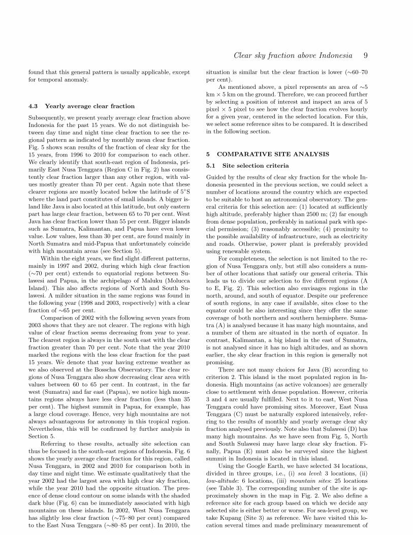
4.3 Yearly average clear fraction
Subsequently, we present yearly average clear fraction aboveIndonesia for the past 15 years. We do not distinguish be-tween day time and night time clear fraction to see the re-gional pattern as indicated by monthly mean clear fraction.Fig. 5 shows scan results of the fraction of clear sky for the15 years, from 1996 to 2010 for comparison to each other.We clearly identify that south-east region of Indonesia, pri-marily East Nusa Tenggara (Region C in Fig. 2) has consis-tently clear fraction larger than any other region, with val-ues mostly greater than 70 per cent. Again note that theseclearer regions are mostly located below the latitude of 5◦Swhere the land part constitutes of small islands. A bigger is-land like Java is also located at this latitude, but only easternpart has large clear fraction, between 65 to 70 per cent. WestJava has clear fraction lower than 55 per cent. Bigger islandssuch as Sumatra, Kalimantan, and Papua have even lowervalue. Low values, less than 30 per cent, are found mainly inNorth Sumatra and mid-Papua that unfortunately coincidewith high mountain areas (see Section 5).
Within the eight years, we find slight different patterns,mainly in 1997 and 2002, during which high clear fraction(∼70 per cent) extends to equatorial regions between Su-lawesi and Papua, in the archipelago of Maluku (MoluccaIsland). This also affects regions of North and South Su-lawesi. A milder situation in the same regions was found inthe following year (1998 and 2003, respectively) with a clearfraction of ∼65 per cent.
Comparison of 2002 with the following seven years from2003 shows that they are not clearer. The regions with highvalue of clear fraction seems decreasing from year to year.The clearest region is always in the south east with the clearfraction greater than 70 per cent. Note that the year 2010marked the regions with the less clear fraction for the past15 years. We denote that year having extreme weather aswe also observed at the Bosscha Observatory. The clear re-gions of Nusa Tenggara also show decreasing clear area withvalues between 60 to 65 per cent. In contrast, in the farwest (Sumatra) and far east (Papua), we notice high moun-tains regions always have less clear fraction (less than 35per cent). The highest summit in Papua, for example, hasa large cloud coverage. Hence, very high mountains are notalways advantageous for astronomy in this tropical region.Nevertheless, this will be confirmed by further analysis inSection 5.
Referring to these results, actually site selection canthus be focused in the south-east regions of Indonesia. Fig. 6shows the yearly average clear fraction for this region, calledNusa Tenggara, in 2002 and 2010 for comparison both inday time and night time. We estimate qualitatively that theyear 2002 had the largest area with high clear sky fraction,while the year 2010 had the opposite situation. The pres-ence of dense cloud contour on some islands with the shadeddark blue (Fig. 6) can be immediately associated with highmountains on these islands. In 2002, West Nusa Tenggarahas slightly less clear fraction (∼75–80 per cent) comparedto the East Nusa Tenggara (∼80–85 per cent). In 2010, the
situation is similar but the clear fraction is lower (∼60–70per cent).
As mentioned above, a pixel represents an area of ∼5km × 5 km on the ground. Therefore, we can proceed furtherby selecting a position of interest and inspect an area of 5pixel × 5 pixel to see how the clear fraction evolves hourlyfor a given year, centered in the selected location. For this,we select some reference sites to be compared. It is describedin the following section.
5 COMPARATIVE SITE ANALYSIS
5.1 Site selection criteria
Guided by the results of clear sky fraction for the whole In-donesia presented in the previous section, we could select anumber of locations around the country which are expectedto be suitable to host an astronomical observatory. The gen-eral criteria for this selection are: (1) located at sufficientlyhigh altitude, preferably higher than 2500 m; (2) far enoughfrom dense population, preferably in national park with spe-cial permission; (3) reasonably accessible; (4) proximity tothe possible availability of infrastructure, such as electricityand roads. Otherwise, power plant is preferably providedusing renewable system.
For completeness, the selection is not limited to the re-gion of Nusa Tenggara only, but still also considers a num-ber of other locations that satisfy our general criteria. Thisleads us to divide our selection to five different regions (Ato E, Fig. 2). This selection also envisages regions in thenorth, around, and south of equator. Despite our preferenceof south regions, in any case if available, sites close to theequator could be also interesting since they offer the samecoverage of both northern and southern hemisphere. Suma-tra (A) is analysed because it has many high mountains, anda number of them are situated in the north of equator. Incontrast, Kalimantan, a big island in the east of Sumatra,is not analysed since it has no high altitudes, and as shownearlier, the sky clear fraction in this region is generally notpromising.
There are not many choices for Java (B) according tocriterion 2. This island is the most populated region in In-donesia. High mountains (as active volcanoes) are generallyclose to settlement with dense population. However, criteria3 and 4 are usually fulfilled. Next to it to east, West NusaTenggara could have promising sites. Moreover, East NusaTenggara (C) must be naturally explored intensively, refer-ring to the results of monthly and yearly average clear skyfraction analysed previously. Note also that Sulawesi (D) hasmany high mountains. As we have seen from Fig. 5, Northand South Sulawesi may have large clear sky fraction. Fi-nally, Papua (E) must also be surveyed since the highestsummit in Indonesia is located in this island.
Using the Google Earth, we have selected 34 locations,divided in three groups, i.e., (i) sea level: 3 locations, (ii)low-altitude: 6 locations, (iii) mountain sites: 25 locations(see Table 3). The corresponding number of the site is ap-proximately shown in the map in Fig. 2. We also define areference site for each group based on which we decide anyselected site is either better or worse. For sea-level group, wetake Kupang (Site 3) as reference. We have visited this lo-cation several times and made preliminary measurement of

10 T. Hidayat et al.
Table 3. The 34 sites in Indonesia analysed in this work and the corresponding clear sky fraction for 2006 to 2010
No Site Region† Longitude Latitude Alt. Clear sky fraction (per cent)(East) (m) 2006 2007 2008 2009 2010 Mean*
Sea-level**1 Jatiwangi B 108◦10′1′′ −6◦46′4′′ 45 59.9 51.9 48.9 51.7 31.8 48.82 Waingapu C 120◦16′1′′ −9◦39′46′′ 20 72.9 75.0 71.0 70.5 67.0 71.33 Kupang*** C 123◦34′40′′ −10◦10′19′′ 25 73.2 73.8 69.8 70.4 66.5 70.7
Low-altitude**4 Sawu*** C 121◦52′38′′ −10◦33′6′′ 320 75.4 78.4 74.1 73.6 74.2 75.15 Komodo C 119◦26′51′′ −8◦33′52′′ 800 72.5 74.5 70.0 69.8 63.9 70.16 Rinca C 119◦40′19′′ −8◦45′16′′ 700 71.7 72.3 69.1 68.3 63.4 69.07 South Tambolaka C 119◦16′28′′ −9◦35′26′′ 878 70.8 72.3 68.4 66.7 61.7 68.08 East Kupang C 123◦59′18′′ −10◦15′43′′ 665 72.8 73.7 70.6 70.6 66.4 70.89 Talaud D 126◦49′33′′ +4◦18′38′′ 640 56.4 55.4 45.3 52.2 58.4 53.5
Mountain sites
10 Lembang*** B 107◦36′56′′ −6◦49′28′′ 1310 56.4 47.8 46.9 48.6 29.1 45.811 East Sumbawa B 118◦55′27′′ −8◦28′56′′ 1419 72.2 75.0 70.6 69.3 62.4 69.912 South Waingapu C 120◦14′11′′ −10◦6′56′′ 1200 71.3 74.3 69.3 70.5 67.5 70.613 Sirung C 124◦6′19′′ −8◦31′7′′ 1310 72.7 71.6 67.6 68.0 63.5 68.714 Wetar C 126◦30′47′′ −7◦41′9′′ 1390 70.3 69.3 65.2 65.1 57.5 65.515 Sinabung A 98◦23′77′′ +3◦10′19′′ 2400 23.9 24.2 19.0 19.7 21.3 21.616 Sibayak A 98◦25′58′′ +2◦55′10′′ 2400 22.6 23.4 19.1 20.2 20.7 21.217 Silimapuluh A 98◦44′56′′ +2◦27′23′′ 2100 24.1 24.9 20.3 21.9 21.9 22.618 Kerinci A 101◦51′28′′ −2◦30′8′′ 2900 39.6 36.2 34.9 36.0 35.9 36.519 West Ijen B 114◦8′10′′ −8◦6′45′′ 2340 66.1 63.2 59.5 61.9 48.0 59.720 Tibo D 119◦22′22′′ −2◦44′53′′ 3000 45.8 38.4 32.8 41.0 33.5 38.321 Lombosang D 119◦56′48′′ −5◦18′48′′ 2700 57.5 49.4 45.8 53.1 38.1 48.822 Rantemario D 120◦2′26′′ −3◦24′33′′ 3400 45.8 37.4 31.6 41.4 29.2 37.123 Binohoe D 122◦11′27′′ −1◦3′50′′ 2518 54.4 46.6 38.9 48.9 46.3 47.024 Sangihe-Siau D 125◦24′27′′ +2◦46′54′′ 1770 62.4 59.1 48.4 56.2 58.9 57.025 Rinjani 1 B 116◦27′36.3′′ −8◦24′44.9′′ 3520 69.3 70.0 66.2 67.1 58.5 66.226 Rinjani 2 B 116◦34′7.9′′ −8◦25′40.6′′ 2157 70.5 71.2 67.5 68.0 59.4 67.327 Ruteng C 120◦31′18′′ −8◦38′12′′ 2100 67.5 67.7 65.2 63.9 57.5 64.428 Lembata C 123◦23′3′′ −8◦32′38′′ 1590 71.5 71.9 68.1 67.7 63.7 68.629 Timau C 123◦56′15′′ −9◦34′46′′ 1685 70.6 70.1 66.9 67.2 60.9 67.130 Mutis C 124◦13′43′′ −9◦33′39′′ 2347 69.5 69.1 66.1 66.9 60.8 66.531 Alor C 125◦1′12′′ −8◦13′14′′ 1760 72.5 70.6 67.6 66.9 61.0 67.732 Erekebo E 135◦51′36′′ −3◦51′15′′ 3700 23.9 21.9 17.6 22.9 24.6 22.233 Puncak Jaya 1 E 137◦9′23′′ −4◦4′37′′ 4700 10.6 9.3 7.4 10.8 13.7 10.434 Puncak Jaya 2 E 137◦18′41′′ −3◦45′27′′ 4020 22.6 22.3 20.1 22.2 27.7 23.0
Notes: †indicated in Fig. 2; *mean of 5 years; **for comparisons; ***sites for reference
seeing that we found to be better than in Lembang (Site 10),in West Java, the site of the Bosscha Observatory. Moreover,we represent Lembang as reference for the group of mountainsite since we know its climate better and we are determinedthat the future site must be better than this site. Jatiwangi(Site 1) in West Java is analysed because of its propertiesas relatively dry place of the region.
Sawu (Site 4), a small island, is also taken as referencefor low-altitude site due to its unique position in the middleof Sawu Sea, between Timor and Sumba islands, that weexpect as very dry place. The chosen position is the summitof the island (320 m). Subsequently, three sites in Sumbaisland are selected (Sites 2, 7, and 12). Talaud (Site 9) ischosen to represent northern regions from the equator. Inaddition, Sangihe-Siau in the extreme north of Indonesiawith altitude 1770 m represents both north of equator andmountain site.
We define mountain sites as the locations with altitude
supposed higher than inversion layer, i.e., higher than ∼1000m (Varela et al. 2008). Applying our general criteria, thereare actually no many suitable choices. We select thus 25locations: 9 sites at altitudes between 1200 to 2000 m, 10sites between 2000 to 3000 m, and 6 sites at altitudes higherthan 3000 m. Binohoe (Site 23) in Central Sulawesi is locatedat the closest position to the equator. North of the equatoris represented by five sites only.
We choose four sites in Sumatra at altitudes higher than2000 m. West Sumatra close to the equator has been sur-veyed in the early 1980s for the plan of giant radio telescopearray at metre wavelength (Swarup et al. 1984) which does,in fact, not really demand excellent atmospheric condition.We select three sites in North Sumatra, near lake Toba, forcomparison.
In Java, we select West Ijen (Site 19), located in the fareast of Java, as can be suggested from clear fraction analy-sis. This mountain is relatively far from dense population as

Clear sky fraction above Indonesia 11
compared to, for example, Tengger Mountain that is actuallya tourist park. In West Nusa Tenggara, in Lombok Island,there is the highest mountain in the region, that is, MountRinjani with the summit at altitude 3700 m. We select twopositions on this mountain (Sites 25 and 26) that are sepa-rated by a distance of about 13 km only, but at significantlydifferent altitudes. The same case is applied to high alti-tude sites in Papua (Sites 33 and 34) which are separatedby a distance of 38 km. East Nusa Tenggara presents tensites, the most numerous in our selection, including Kupangand Sawu as reference sites. We have visited some locationsin Timor island at the proximity of Sites 3, 8, 29, and 30.Except the latter, our first impression is that the sites areindeed very dry as indicated mainly by the vegetations inthe regions. This will be analysed in a separate paper.
5.2 Five year mean of clear fraction
To figure out the general trend of clear fraction for eachlocation, it is useful to consider a yearly mean value ratherthan a monthly mean value. Subsequently, we thus computethe yearly mean total clear fraction for each location shownin Table 3 for the last five years (2006–2010). We do notdistinguish the total clear fraction between day time andnight time as we have seen for monthly mean (Fig. 3 and 4).
We have mentioned that the year 2010 had shown anextreme weather. At the site of the Bosscha Observatory,the dry season, which usually occurs in June to September,did not happen. We had so many cloudy days and heavyrainfalls. We also noted extreme weather reports from vari-ous regions in Indonesia that affected badly the transporta-tion and agriculture. In terms of clear fraction, the value inLembang dropped to 29 per cent from the average of about50 per cent of the previous four years. Therefore, the meanclear fraction in Lembang is ∼46 per cent. Compared to thesea-level sites, it is comparable to Jatiwangi (Site 1) whichis in the same region. Clear fraction in Waingapu (Site 2)and Kupang (Site 3) slightly dropped in 2010 as well, butstill present clear fraction greater than 65 per cent, and themean value greater than 70 per cent for the last five years.
Remark that the low-altitude sites (Site 4 to 8) presenthigh clear fraction about 70 per cent, with Sawu (Site 4)gives the largest (75 per cent). We notice that Sawu presentsa value approximately constant for the last five years. It evendid not drop in 2010. This is the main reason to take Sawuas reference site. Sites 4 to 7 are located in small island,and Site 8 in a big island (Timor) but in coastal area. Theirlatitudes are below 8◦S. However, this is not the case forTalaud (Site 9) in the extreme north of Indonesia. It is ina small island too, but gives a clear fraction of 53 per centonly, and at latitude 4◦N. On the contrary, notice that in2010 the clear fraction in Talaud increased to 58 per cent.
Comparison between sea-level and low-altitude sites al-lows us to retrieve that the best possible clear sky fractionin Indonesia is about 75 per cent, as indicated by Sawu, andmost probably around 70 per cent, as indicated by manylocations in East Nusa Tenggara. Therefore, we expect thatpotential sites at higher altitudes must be close to thesevalues. Most regions in Indonesia suffer decreasing value ofclear fraction (about 5 per cent) in 2010, but several regionskeep almost constant value, such as in Sumatra (A) and
Figure 7. Yearly usable night fraction, from 1996 to 2010 ofthe four sites in Sumatra compared to Lembang (Site 10/red).Only Kerinci (Site 18/magenta) that is slightly comparable toLembang. Also shown are Site 15 (green), Site 16 (blue), and Site17 (cyan).
Figure 8. Yearly usable night fraction, from 1996 to 2010 of thetwo sites in Java and the three sites in West Nusa Tenggara. Site19 (green) in East Java is better than the reference site of Lem-bang (Site 10/red). The other three sites in West Nusa Tenggaraare even better (Site 25/blue, Site 26/cyan, Site 11/magenta).
Sangihe-Siau (Site 24), or even increasing slightly (2–3 percent), such as in Papua (E).
Four high mountain sites in Sulawesi (D) present a clearfraction between 38 to 47 per cent. It means they are notbetter than the site of the Bosscha Observatory. ExceptSangihe-Siau (Site 24) in a small island, it provides a highervalue of 57 per cent. Moreover, it is comparable to West Ijenin East Java that has ∼60 per cent.
The sites in North Sumatra and Papua show low av-erage clear fraction of about 20 per cent. Even the highestsummit in Papua (Puncak Jaya 1 at altitude 4700 m) givesa value of 10 per cent only. Hence, they are not promisingsites to host a modern astronomical observatory. In the fol-lowing, however, for confirmation and completeness, thesesites are not erased in further analyses.

12 T. Hidayat et al.
Figure 9. Yearly usable night fraction, from 1996 to 2010 ofthe ten sites in East Nusa Tenggara. Kupang (Site 3/green) andSawu (Site 4/red) are reference sites. The other sites are mostlycomparable (Site 27–31).
Figure 10. Yearly usable night fraction, from 1996 to 2010 ofthe five sites in Sulawesi compared to the reference site of Lem-bang (Site 10/red). Sangihe-Siau (Site 24/yellow), Binohoe (Site23/magenta), and Lombosang (Site 21/blue) are slightly betterthan Lembang.
Figure 11. Yearly usable night fraction, from 1996 to 2010 of thethree sites in Papua (Site 32/green, Site 33/blue, Site 34/cyan)compared to the reference site of Lembang (Site 10/red). Theyare not suitable for astronomical site.
Table 4. Mean of 15 years of the night fraction in percentage
Sites Cl. Tr. Op. Usable σ*
(4) Sawu** 65.0 4.1 30.9 69.1 5.9(3) Kupang** 61.6 4.6 33.7 66.3 6.0(29) Timau 58.6 4.6 36.7 63.3 6.3(12) S. Waingapu 58.2 4.5 37.3 62.7 7.8(31) Alor 57.1 5.6 37.4 62.6 6.3
(30) Mutis 57.1 4.7 38.2 61.8 6.5(26) Rinjani 2 56.2 5.5 38.3 61.7 6.1(27) Ruteng 56.3 5.1 38.5 61.5 6.9(25) Rinjani 1 55.1 5.6 39.3 60.7 6.0(11) E. Sumbawa 55.2 5.2 39.5 60.5 8.2(14) Wetar 54.3 5.6 40.1 59.9 7.3(13) Sirung 54.4 5.1 40.6 59.4 7.3(28) Lembata 54.3 4.9 40.8 59.2 7.5(19) West Ijen 49.8 5.9 44.3 55.7 6.3(24) Sangihe-Siau 44.8 8.0 47.1 52.9 8.7(23) Binohoe 39.4 8.0 52.6 47.4 8.5(10) Lembang** 33.8 5.5 60.7 39.3 8.2(22) Rantemario 25.1 6.1 68.8 31.2 8.8(18) Kerinci 24.1 6.5 69.4 30.6 3.8(20) Tibo 22.5 6.2 71.3 28.7 7.8(21) Lombosang 38.3 6.0 71.3 28.7 8.6(15) Sinabung 13.0 4.7 82.3 17.7 4.4(16) Sibayak 12.3 4.5 83.2 16.8 4.0(17) Silimapuluh 12.2 4.5 83.2 16.8 3.9(32) Erekebo 9.3 5.2 85.5 14.5 5.3(34) P. Jaya 2 8.9 5.4 85.6 14.4 3.5(33) P. Jaya 1 2.9 4.0 93.0 7.0 3.0
Notes: *Standard deviation of usable night; **Reference site; Cl.= clear, Tr. = Transitional, Op. = opaque; the number in thebracket corresponds to the site number (see Table 3).
5.3 Usable nights in five regions
To obtain the night time clear fraction profile, in the fol-lowing we analyse mountain sites in terms of yearly aver-age usable night, i.e., a total of clear (photometric) sky andtransitional (spectroscopic) sky from 1996 to 2010. Fig. 7shows the results for the sites in Sumatra (A). It appearsthat from the four selected sites in Sumatra, Kerinci (Site18), altitude 2900 m, is better than the other sites in NorthSumatra. However, the largest clear fraction in this moun-tain is low, i.e., ∼35 per cent, occured in 1997 and 2006.The other years have lower values with transitional nighttime contribution of 6.5 per cent. Moreover, the three sitesaround Lake Toba, at altitudes 2100–2400 m, present muchlower value, fluctuating between 10 to 25 per cent. Note thatthese sites are also close to the equator.
Subsequently, Fig. 8 displays comparison of the fractionof clear sky for the sites in Java and West Nusa Tenggara(region B). First we note that the annual clear night sky inLembang is about 40 per cent only that corresponds to ∼150nights of observations (about five months of effective time).Compared to West Ijen (Site 19), we obtain a factor of 15 percent better than the reference site of Lembang. High valuesare found in 1997, 2002, and 2006, i.e., between 60–66 percent. Spectroscopic nights contribute about 6 per cent forboth sites. Furthermore, the sites in Lombok and Sumbawa(Sites 11, 25, 26) present much better clear nights. Since theSites 25 and 26 are close to each other (despite their differentaltitudes), we expect that their clear sky fractions are not

Clear sky fraction above Indonesia 13
Figure 12. Comparison of the daily charts of the reference sites: Kupang (Site 3), 2002 (top-left); Sawu (Site 4), 2002 (top-right);Lembang (Site 10), 2006 (bottom-left); and Timau (Site 29), 2002 (bottom-right). The indicated year corresponds to the best clearfraction over the past 15 years. Missing data appears as regular black boxes that are considered as opaque pixels.
too different. The largest values (∼70 per cent) are foundin 1997, 2002, and 2007. East Sumbawa (Site 11), locatedcloser to East Nusa Tenggara rather than Rinjani, appearsalso as a good site but at lower altitudes.
For region C (East Nusa Tenggara), we have selectedtwo reference sites (Sites 3 and 4) which are found system-atically better than the other mountain sites. Among theeight mountain sites analysed, there are four promising lo-cations, that is, Timau (Site 29), Alor (Site 31), Mutis (Site30), and Ruteng (Site 27) with yearly average clear nightsabove 60 per cent. Spectroscopic nights contribute below 5per cent, except for Ruteng in Flores Island. The comparisonis displayed in Fig. 9.
Moreover, for region D (Sulawesi) and E (Papua), thefraction of clear nights are shown in Fig. 10 and 11, respec-tively. They have much lower clear nights compared to C,so they are better compared to the site of Lembang. Themountain sites of Sulawesi seems providing more fluctuat-ing yearly clear nights. We found only Binohoe (Site 23) andSangihe-Siau (Site 24) which are systematically better thanLembang. Note that Lombosang (Site 21) presents a com-parable situation to Lembang during the last five years. Incontrast, the region E (Papua) provides a very low fractionof clear nights (less than 15 per cent). The highest site, Pun-cak Jaya 1 (Site 33), has clear fraction even mostly below10 per cent. Therefore, like in North Sumatra, mountains inPapua appear not suitable for astronomical sites.
5.4 Mean of fifteen years
Table 4 shows the mean of 15 years of usable nights for the24 mountain sites including three reference sites. The sitesare sorted according to decreasing usable nights along withits standard deviation (σ). We see that our reference sites 3and 4 are indeed better with σ ∼ 6 per cent. We also canverify the contribution of spectroscopic nights in additionto photometric nights. Note that South Waingapu (Site 12),despite its large clear fraction, has a higher σ. The same caseholds for East Sumbawa (Site 11) with σ = 8.2. Therefore,compared to Timau (Site 29), Alor (Site 31), Mutis (Site29), and Rinjani (Sites 25 and 26), the Sites 11 and 12 arerelatively good but ‘less stable’. Ruteng (Site 27) also fallsin this category.
We also notice that the contribution of spectroscopicnights are slightly lower in Timau and Mutis compared toAlor and Rinjani as such that the former are possibly bet-ter than the latter. Considering, however, uncertainties onthe data (∼10 per cent), we actually estimate that they arelikely to be similar. This suggest that we are led to a down-selection to Timor, Alor, and Lombok, three islands in NusaTenggara.

14 T. Hidayat et al.
Figure 13. Comparison of the daily charts of the sites: Silimapuluh (Site 17), 2007 (top-left); Rinjani 1 (Site 25), 2002 (top-right);Binohoe (Site 23), 2002 (bottom-left); and Puncak Jaya 2 (Site 34), 2010 (bottom-right).
6 DISCUSSION
6.1 Estimation using daily chart
From the above analysis, we found dry periods, detected inmost regions, i.e., in 1997, 2002, and 2006. So the periodicityof 4–5 years is still to be confirmed in the long period, ordecades. Some regions have persistently show a large clearsky fraction, mainly in East Nusa Tenggara, with its manysmall islands. Moreover, coastal area presents better situa-tion of clear sky. Mountain sites in the proximity of coastalarea generally also present large fraction of the clear sky,such as in Timau and Alor, and also in the north-easternside of Rinjani.
The yearly clear sky pattern can be inspected quicklyusing a daily chart as can be seen in Fig. 12 and 13. InFig. 12, we display three charts of reference sites (Kupang,Sawu, and Lembang) as compared to Timau, a potential siteinferred in this study. The chart of Lembang is for 2006, thatis, the driest period of the 15 years, while the three others arefor 2002, corresponding to the same driest situation. Noticealso missing data (appearing like regular black boxes) thatwe consider in our calculation as opaque. We see that cloudysituations are found mostly in January and February in thethree sites of Nusa Tenggara, compared to longer cloudysituation in Lembang, from January to April, and startingover again in December of the corresponding year.
Then, we also select the driest period for four other lessclear sites as shown in Fig. 13, i.e., the sites of Silimapuluh(in A), Rinjani 1 (in B), Binohoe (in D), and Puncak Jaya 2
(in E). We have a clear sky in Silimapuluh only between Jan-uary and February and then almost opaque all the time. Thecase of Rinjani is similar to the sites presented in Fig. 12,but it is slightly less clear than that in East Nusa Tenggara.For Binohoe, the situation has a smaller fraction of clearsky. Lastly, for Puncak Jaya, it appears that the cloud inthis region presents almost every time and the night timeappears more cloudy than the day time, probably due tobiases introduced by the fixed thresholds.
6.2 Potential sites
As inferred in Section 5.4, Timau in Timor island is rela-tively the best site in terms of the fraction of usable night.However, the altitude of this site is lower than 2000 m.Mutis, about 45 km to the south-east of Timau, is also goodsite with a high altitude of 2400 m. Timau is relatively bet-ter than Alor (about the same altitude) because Timau hasmore photometric nights. We have visited both Mutis (inSeptember 2007) and Timau (in August 2008 and 2009), butnot up to the summits. At the time of our visit to Mutis,we found it was wet, and there were fog at altitudes lowerthan 1600 m. On the other hand, the area around Timau isindeed very dry.
The site of Rinjani in Lombok island is also relativelygood, and we prefer the point to the north-east of the moun-tain summit. The photometric night fraction is 55 per centwhile the spectroscopic fraction is slightly greater than 5per cent. Ruteng in Flores island cannot be ruled out from

Clear sky fraction above Indonesia 15
this analysis since it is marginally comparable to Rinjani.We recommend therefore four Island in Nusa Tenggara forfurther site testing, with the sites in Timor island as highpriority.
The present work is limited to identifying the poten-tial sites for our future national observatory. More detailedanalyses for these sites in a monthly average fraction will bepresented in a forthcoming paper.
7 CONCLUSIONS
Meteorological satellite data with a time span of 15 years,from four different satellites, have been used to retrieve thefraction of clear sky above Indonesia for astronomical siteselection. This allows us to obtain a detailed cloud cover pat-tern over Indonesia since the data have high spatial resolu-tion (∼5 km) and provide a time span longer than a decade.Accordingly, the fraction of clear sky can be analysed sepa-rately for day time and night time, and either for monthlyor yearly average. The fraction of photometric and spectro-scopic nights are inferred to obtain the usable nights, andalso the fraction of opaque nights. Fifteen years data periodhas indicated that clear sky fraction over some regions inEast Nusa Tenggara can unambiguously reach better than70 per cent with an uncertainty of 10 per cent. A stable clearnight fraction is found during April to October with a valuebetween 55 to 75 per cent.
In tropical region like Indonesia, we find that the higherthe altitudes of the regions (mountains), the more frequentthe presence of clouds is. Coastal regions in East Nusa Teng-gara are systematically drier than that in the high moun-tains. Five sites are recommended for site testing and to beanalysed further: Timau, Mutis, Alor, Rinjani, and Ruteng.Regions near Timau in Timor has been visited, but a longerand complete survey must also be conducted. Site surveyis absolutely necessary to obtain real situation in the fieldand we must undertake in situ measurement continuously.This also must consider the detailed geographic situationof the regions. A number of theoretical and measurementprogrammes will be undertaken in the near future.
ACKNOWLEDGMENTS
The authors wish to thanks the weather team in KochiUniversity, Japan, for providing the data archive openfor research and education. The data are available atWeather Image Archive, Kochi University, downloadableat http://weather.is.kochi-u.ac.jp/archive-e.html. We thankvery much the reviewer, Dr. S. Ortolani, for his critical andcareful reading which improve this paper. This work is sup-ported by KNRT–Indonesia Research Grant, through Pro-
gram Insentif Ristek 2007–2009, to whom we are sincerelyindebted.
REFERENCES
Andersen M. I., Rasmussen P. K., 2006, in IAU Special Ses-sion 7, Astronomy in Antarctica, Cambridge Univ. Press,11
Benkhaldoun Z., Abahamid A., El Azhari Y., Lazrek M.,2005, A&A, 441, 839
Cavazzani S., Ortolani S., Zitelli V., Maruccia Y., 2011,MNRAS, 411, 1271
della Valle A., Maruccia Y., Ortolani S., Zitelli V., 2010,MNRAS, 401, 1904
Ehgamberdiev S.S., Baijumanov A.K., Ilyasov S. P.,Sarazin M., Tillayev Y.A., Tokovinin A. A., Ziad A., 2000,A&AS, 145, 293
Erasmus D., Sarazin M., 2002, in Vernin J., BenkhaldounZ., Munoz-Tunon C., eds, ASP Conf. Ser. Vol. 266, Astro-nomical Site Evaluation in the Visible and Radio Range.Astron. Soc. Pac., San Francisco, p. 310
Erasmus D., van Rooyen R., 2006, in Stepp L. M., ed., Proc.SPIE, Vol. 6267, Ground-Based and Airborne Telescopes.SPIE, Bellingham, p. 62671O
Khaiyer M. M., Nordeen M. L., Doelling D. R., Chakra-pani V., Minnis P., Smith W. L., 2004, Proc. 13thConf. on Satellite Meteorology and Oceanogra-phy. Am. Meteorol. Soc., Boston, MA, P7.6 (seehttp://ams.confex.com/ams/13SATMET/techprogram/paper 79244.htm)
Kneizys F. X. et al., 1996, The MODTRAN 2/3 Reportand LOWTRAN 7 Model, Atmos. Rad. Measurement
Lombardi G., Zitelli V., Ortolani S., Pedani M., 2006,PASP, 118, 1198
Lombardi G., Zitelli V., Ortolani S., Pedani M., 2007,PASP, 119, 292
Lombardi G., Zitelli V., Ortolani S., Pedani M., GhedinaA., 2008, A&A, 483, 651
Marvil J. et al., 2006, New Astronomy, 11, 218Rossow W. B., Garder L. C., 1993, J. Climate, 6, 2341Rossow W. B., Schiffer R. A., 1999, Bull. Amer. Meteoro.Soc. 80, 11, 2261
Sanchez S. F., Aceituno J., Thiele U., Perez-Ramırez D.,Alvez J., 2007, PASP, 119, 1186
Sagar R. et al., 2000, A&AS, 144, 349Schock M. et al., 2009, PASP, 121, 384Sebag J., Barr J., Saha A., Claver C., Krabbendam V.,2007, Rev. Mex. AA, 31, 30
Siher E. A., Benkhaldoun Z., 2004, New Astronomy, 9, 291Soden, B. J. and Bretherton, 1996, J. Geophys. Res., 101,D5, 9333
Saunders W. et al., 2009, PASP, 121, 976Steinbring E. et al., 2010, PASP, 122, 1092Sarazin M. S., Graham E., Kurlandczyk H., 2003, in AngelJ. R. P., Gilmozzi R., eds., Proc. SPIE, Vol. 4840, FutureGiant Telescopes. SPIE, Waikoloa, p. 291
Swarup G., Hidayat B., Sukumar S., 1984, Ap&SS, 99, 403Tahara Y., Ohkawara N., Okuyama A., 2004, Meteorolog-ical Satellite Center Technical Note, 44, 1
Tahara Y., Ohkawara N., 2005, Proc. 2005 EUMETSATMet. Sat. Conf., Dubrovnik, Croatia
Tapia M., Hiriart D., Richer M., Cruz-Gonzalez I., 2007,Rev Mex AA, 31, 47
van der Hucht K. A., 1984, Ap&SS, 99, 409Varela A. M., Bertolin C., Munoz-Tunon C., Ortolani S.,Fuensalida J. J., 2008, MNRAS, 391, 507
This paper has been typeset from a TEX/ LATEX file preparedby the author.