City of North Little Rock Zoning Ordinance
256
City of North Little Rock Zoning Ordinance Adopted by Ordinance #7697 on March 17, 2005 Last Amended June 12, 2017
-
Upload
khangminh22 -
Category
Documents
-
view
0 -
download
0
Transcript of City of North Little Rock Zoning Ordinance

City of North Little Rock Zoning Ordinance
Adopted by Ordinance #7697 on March 17, 2005
Last Amended June 12, 2017
TABLE OF CONTENTS Article One Authority and Purpose……………………………... 1 Article Two Definitions…………………………………………..4 Article Three General Provisions…………………………………. 31 Article Four Residential Districts………………………………... 34 Article Five Commercial Districts………………………………. 42 Article Six Industrial Districts …………………………………. 50 Article Seven Open Lands District………………………………... 58 Article Eight Conservation District……………………………..... 61 Article Nine Greenbelt and Wetland Conservation District……... 64 Article Ten Planned Unit Development………………………… 66 Article Eleven Overlay Districts…………………………………… 73 Argenta Quiet Commercial ………………………... 73 Argenta Quiet Commercial Map…………………... 74 Main Street..………………………………………... 76 Main Street Map..…...……………………………... 78 Argenta Historic ……….…………………………... 95 Argenta Historic Map……….……………………... 100 Flood Plain………………….……………….……... 101 Washington Avenue…………….………..………… 101 Article Twelve Special Provisions………………………………….. 102
Accessory Buildings……………………………...... 102 Daycare Centers and Homes……………………….. 103 Home Occupations…………………………………. 104
Carnivals or Traveling Amusement Rides…………. 106 Retail Liquor Locations……………………………. 106 Parking or Storing Trucks and Trailers…………….. 106 Parking of Recreational Vehicles…………………...107 Service Stations…………………………………….. 107 Recreational Vehicle Parks………………………… 109 Sexually Oriented Businesses……………………… 111 Roadside Vending………………………………….. 113 ATM Machines…………………………………….. 115 Cell Towers………………………………………… 115 Fences……………………………………………… 117 Fence Drawing……………………………...……… 118 Sight Triangle…………………………………..…...120 House Moving…………………………………….... 121 Decks………………………………………………..122 Residential Retaining Walls………………………... 122 Residential Appearance Standards…………………. 122
Sidewalks…………………………………………... 123 Mobile Storage Containers………………………… 124

Outside Display in C-6……………………...………126 Storage of Wrecked Vehicles……………...…..……126 Parking Commercial Vehicles in Residential ..…… 127 Vehicle Sales Lots……………………..……………127 Alternative Energy Sources…..…….……………… 128 Community Gardens……..………………………… 131 Ice Vending Machines…..…….…………………… 132 Article Thirteen Parking Requirements……………….………..……. 135 Article Fourteen Signs…………………………………………..……. 139 Article Fifteen Screening and Landscaping………………..………. 175 Article Sixteen Conditional Uses……………………….…..………. 187 Article Seventeen Special Uses………………………………..………. 190 Article Eighteen Development Plan Review………..………..………. 192 Article Nineteen Boards……………………………………...………. 206 Board of Adjustment……………………..……...…. 206 Building and Housing Board of Adjustment………. 210 Article Twenty Administration and Enforcement…………..………. 214 Article Twenty One Table of Permitted Uses……………………………. 223 Article Twenty Two Airport Zoning…………...………………...………. 241 Appendix A Park Hill Development Overlay District Appendix B Levy Development Overlay District Appendix C Traditional Neighborhood Development Appendix D Smart Code Zoning District Appendix E River Road Overlay District

Amendments
1. Ordinance 7707 May 9, 2005 Electronic Signs 2. Ordinance 7711 May 23, 2005 Side Yard Fences 3. Ordinance 7719 June 27, 2005 East Broadway Sign Overlay 4. Ordinance 7758 Nov. 28, 2005 Permitted Use List 5. Ordinance 7780 Jan. 23, 2006 Mobile storage containers/definitions 6. Ordinance 7800 Mar. 16, 2006 JFK Sign Overlay 7. Ordinance 7805 Mar. 16, 2006 Camp Robinson Sign Overlay 8. Ordinance 7843 July 24, 2006 Outside Display in C-6 9. Ordinance 7857 Sept. 11, 2006 River Road Overlay 10. Ordinance 7870 Oct. 23, 2006 Traditional Neighborhood Dev. 11. Ordinance 7920 Mar. 26, 2007 Historic District Boundary 12. Ordinance 7936 Apr. 23, 2007 Fences, Ice Vending Trailers 13. Ordinance 7966 July 23, 2007 Mobile Storage Containers 14. Ordinance 7976 Aug. 21, 2007 Mobile Storage Containers 15. Ordinance 7984 Sep. 10, 2007 Camp Robinson Sign amend 16. Ordinance 8031 Dec. 27, 2007 Home Occupations 17. Ordinance 8039 Jan. 14, 2008 Dumpster enclosures 18. Ordinance 8061 Mar. 10, 2008 Bed and Breakfast definition 19. Ordinance 8117 Nov. 24, 2008 Dumpsters in Industrial zones 20. Ordinance 8159 Apr. 13, 2009 Repealing Ord. # 8039 and 8117 21. Ordinance 8175 May 11, 2009 Update various sections 22. Ordinance 8184 July 27, 2009 Storage of Wrecked Vehicles 23. Ordinance 8190 Aug. 24, 2009 Electronic Sign measurements 24. Ordinance 8261 May 24, 2010 Sign Regulations amendments 25. Ordinance 8274 July 26, 2010 Electronic Sign placement 26. Ordinance 8276 Aug. 9, 2010 Wall Signs in Overlay districts 27. Ordinance 8296 Sep. 27, 2010 Sidewalks, Banners, Use amend. 28. Ordinance 8319 Jan. 24, 2011 Conditions for Vehicle Sales Lots 29. Ordinance 8329 Feb. 28, 2011 Amend Broadway Sign Overlay 30. Ordinance 8341 May 23, 2011 Auto detailing in I-3 zone 31. Ordinance 8367 Sep. 12, 2011 Real Estate Schools 32. Ordinance 8372 Sep. 26, 2011 Community Gardens 33. Ordinance 8412 Feb. 13, 2012 Alternative Energy Systems 34. Ordinance 8424 Mar. 26, 2012 Amend Main Street Overlay District 34. Ordinance 8461 July 23, 2012 Ice Vending Machines Regulations 35. Ordinance 8469 Aug. 27, 2012 Smart Code Zoning District 36. Ordinance 8469 Aug. 27, 2012 Amend Boards notice requirements 37. Ordinance 8471 Aug. 27, 2012 Convenience Stores in I-3 zone 38. Ordinance 8510 Feb. 25, 2013 Notice requirements 39. Ordinance 8514 Mar. 14, 2013 Hillside modification 40. Ordinance 8533 Apr. 22, 2013 Daycare requirements 41. Ordinance 8564 Aug. 26, 2013 Crystal Hill Sign Overlay 42. Ordinance 8566 Sep. 9, 2013 Hwy 161 Sign Overlay

43. Ordinance 8620 Mar. 10, 2014 Reasonable Accommodation 44. Ordinance 8662 Jul. 28, 2014 Special Event Food Vendors 45. Ordinance 8663 Jul. 28, 2014 Marble/stone water-jet cutting 46. Ordinance 8681 Sep. 20, 2014 North Hills II sign overlay 47. Ordinance 8694 Nov. 24, 2014 Office use in I-1 and I-2 48. Ordinance 8693 Nov. 24, 2014 Columbarium 49. Ordinance 8734 May 26, 2015 Park Hill Overlay 50. Ordinance 8735 May 26, 2015 Levy Overlay 51. Ordinance 8737 May 26, 2015 Bars, plasma centers, permit table 52. Ordinance 8778 Nov. 23, 2015 Highway 165 Sign Overlay 53. Ordinance 8794 Feb. 22, 2016 Overlay Districts to Appendices 54. Ordinance 8808 Apr. 25, 2016 JFK Blvd North Sign Overlay 55. Ordinance 8846 Sep. 26, 2016 Park Hill Development Overlay Map 55. Ordinance 8903 Apr. 24, 2017 Correcting Ord. 8846 56. Ordinance 8918 June 12, 2017 Adding Airport zoning
ORDINANCE NO. 7697
AN ORDINANCE TO REPEAL THE OLD ZONING ORDINANCE (ORDINANCE NO. 3171) AND ALL AMENDMENTS THERETO; ADOPTING A NEW ZONING ORDINANCE; DECLARING AN EMERGENCY; AND FOR OTHER PURPOSES.
WHEREAS, Ordinance No. 3171, as amended, regulating the use of real property within North Little Rock has become outdated and difficult to enforce; and WHEREAS, Ordinance 3171 has been amended on numerous occasions, making its compilation and administrative use as a reference increasingly difficult; and WHEREAS, reasonable and enforceable regulation of zoning provisions benefits public health, safety and welfare, enhances the value of the properties so regulated; and WHEREAS, the request to repeal and replace Ordinance 3171 was duly considered and unanimously approved by an affirmative vote of nine (9) members of the North Little Rock Planning Commission at a regular meeting thereof held on January 11, 2005. NOW, THEREFORE, BE IT ORDAINED BY THE CITY COUNCIL OF THE CITY OF NORTH LITTLE ROCK, ARKANSAS: SECTION 1: Ordinance No. 3171 and subsequent amendments thereto are hereby repealed. SECTION 2: The City of North Little Rock, Zoning Ordinance 2005, attached hereto and incorporated herein as Exhibit “A” is hereby adopted. SECTION 2: North Little Rock Municipal Code § 118-1 (4) is hereby amended to reference the proper Ordinance Number of the new Zoning Ordinance upon passage thereof SECTION 3: That all ordinances or parts of ordinances in conflict herewith are hereby repealed to the extent of the conflict. SECTION 4: That the provisions of this Ordinance are hereby declared to be severable and if any section, phrase, or provision shall be declared or held invalid, such invalidity shall not affect the remainder of the sections, phrases or provisions. SECTION 5: It is hereby found and determined that the adoption of this Ordinance is immediately necessary to insure the proper and orderly growth of the City of North Little Rock, Arkansas, to insure the proper use of real property within the City of North Little Rock, and is necessary for the immediate preservation of the public health, safety and welfare, THEREFORE, an emergency is hereby declared to exist and this Ordinance shall be in full force and effect on and after March 17, 2005.

1
NORTH LITTLE ROCK ZONING ORDINANCE
-------------
ARTICLE ONE
AUTHORITY AND PURPOSE Section 1.1 - Authority These regulations are adopted under the authority cited in Arkansas Code Annotated §14-56-401 et seq., and shall be known as the City of North Little Rock Zoning Ordinance and may be cited as such. Section 1.2 – General Purpose These regulations are intended to carry out the goals and intent of the Land Use Plan of the City of North Little Rock. Specifically, these regulations divide the city into zones. Within these zones or districts, it regulates the location, height, bulk, number of stories, and size of buildings; open space; lot coverage; density and distribution of population; and the uses of land, buildings, and structures. It does so in order to achieve the following objectives:
A. Efficiency and economy in the process of development;
B. The appropriate and best use of land;
C. Convenience of traffic and circulation of people and goods;
D. Safety from fire and other dangers;
E. Adequate light and air in the use and occupancy of buildings;
F. Healthful and convenient distribution of population;
G. Adequate public utilities and facilities;
H. Good civic design and arrangement; and
I. Wise and efficient expenditure of funds.

2
Section 1.3 – Establishment of Zoning Districts The City of North Little Rock is divided into the following zones or districts: Residential Commercial R-O Single-Family C-1 Professional Office R-1 Single-Family C-2 Local Shopping Center R-2 Single-Family C-3 Community Shopping R-3 Two-Family C-4 Heavy Commercial R-4 Multi-Family C-5 Central Business R-5 Group or Terrace Housing C-6 Downtown Commercial R-6 Single-Family Medium Density RT-1 Manufactured Home Parks and Subdivision Industrial Other I-1 Community Industrial Park CON Conservation I-2 Light Industrial Parks G/W Greenbelt & Wetland I-3 Industrial Park PUD Planned Unit Development TND Traditional Neighborhood Devel. SC Smart Code District Section 1.4 - Boundaries The boundaries of each zone or district shall be as shown on the map entitled North Little Rock, Arkansas Zoning Map, which is a part of this Ordinance. The following rules shall apply in determining the location of district boundaries:
A. Boundaries indicated as approximately following the centerline of streets, highways, alleys, railways, or waterways or other natural features shall be construed as following such centerlines.
B. Boundaries indicated as approximately following section lines, part section lines
or city limits shall be construed as following these lines.
C. Boundaries indicated as approximately following platted lot lines shall be construed as following such lot lines.
D. Boundaries indicated as following shorelines shall be construed to follow the
shoreline, and in the event of change in the shoreline shall be construed as moving with the actual shoreline.
E. Boundaries indicated as parallel to or extensions of features indicated above shall
be so construed.
3
F. When distances are not specifically indicated on the map, they shall be
determined by reference to the description contained in the ordinance adopting them and any accompanying maps used to indicate the intentions of the ordinance. Written dimensions shall take precedence over scaled measurements.
G. Where the street or property layout existing on the ground is at variance with that
shown on the Official Zoning Map or where, for other reasons uncertainty exists as to the location of a district boundary, the Board of Zoning Adjustment shall interpret the location of the boundary.
Section 1.5 – Territorial Jurisdiction for Zoning This ordinance shall apply to all lands within the corporate limits of the City of North Little Rock and 2 miles beyond the corporate limits where zoning has been established.

4
ARTICLE TWO DEFINITIONS
Section 2.1 – General For the purpose of this ordinance the following rules shall be followed:
A. Words, phrases, and terms defined by this ordinance shall be interpreted and used as they are defined.
B. Words, phrases, and terms not defined by this ordinance but defined in the
building code shall be interpreted and used as they are defined in the building code.
C. Words, phrases, and terms defined neither by this ordinance nor in the building
code shall be given their usual and customary meanings except where the context clearly indicates a different meaning.
D. The text of the regulation shall control captions, titles, and maps.
E. The word “shall” is mandatory; the word “may” is permissive.
F. Words used in the singular include the plural and words used in the plural include
the singular.
G. Words used in the present tense include the future tense and words used in the future tense include the present tense.
Section 2.2 – Definitions Abutting: Having a common border with, or being separated from such a common border by a right-of-way, alley, easement or cases where two or more lots adjoin only on a corner or corners. Access: A way of approaching or entering a property for persons, fire department and other uses. Accessory Use: A subordinate use that is clearly incidental to, or customarily found in connection with, and on the same lot as, the main use of the premises. Acre: An area of land containing 43,560 square feet within the property lines of a lot or parcel. ADAAG: means the Americans with Disabilities Act Accessibility Guidelines 36 CFR § 1191.1 App. A, and any amendments thereto.

5
Adaptive Use: Rehabilitation of a historic structure for use other than its original use such as a residence converted into offices. Addition: New construction added to an existing building or structure. Administrator: The person, designated by the director to enforce this chapter. Adult arcade: Any place where the public is permitted or invited and where a still or motion picture machine, projector, or other image-producing device is: coin-operated or slug-operated or electronically, electrically, or mechanically controlled; and maintained to show an image or images involving a specific sexual activity or a specific anatomical area to a person in a booth or viewing room. Adult bookstore or video store: A commercial establishment that offers for sale or rent any of the following as one of its principal business purposes: a book, magazine, periodical or other printed matter, photograph, film, motion picture, videocassette, reproduction, slide, or other visual representation that depicts or describes a specific sexual activity; or an instrument, a device, or paraphernalia that is designed for use in connection with a specific sexual activity. Adult cabaret: Any nightclub, bar, restaurant, or other similar commercial establishment that regularly features a: person who appears in a state of nudity or who is seminude; live performance that is characterized by the exposure of a specific anatomical area or a specific sexual activity; or film, motion picture, videocassette, slide, or other photographic reproduction that is characterized by the depiction or description of a specific sexual activity or a specific anatomical area. Adult live entertainment establishment: An establishment that features either a: person who appears in a state of nudity; or live performance that is characterized by the exposure of a specific anatomical area or a specific sexual activity. Adult motion picture theater: A commercial establishment in which for any form of consideration a film, motion picture, videocassette, slide, or other similar photographic reproduction characterized by the depiction or description of a specific sexual activity or a specific anatomical area is predominantly shown. Adult oriented business: An adult arcade, an adult bookstore or video store, an adult cabaret, an adult live entertainment establishment, an adult motion picture theater, an adult theater, a massage establishment that offers adult services, an escort agency, or a nude model studio. Adult theater: A theater, a concert hall, an auditorium, or a similar commercial establishment that predominantly features a person who appears in a state of nudity or who engages in a live performance that is characterized by the exposure of a specific anatomical area or a specific sexual activity.

6
Administrator/Administrative Official or Officer: The person(s) designated by the City of North Little Rock to administer this ordinance. Amortization: Process by which nonconforming use and structures must be discontinued or made to conform to requirements of the ordinance at the end of a specified period of time. Alley: A narrow public way that affords a secondary means of access to abutting properties and not intended for general traffic. Alter: Any structural change in the supporting or, load-bearing members of a building, such as bearing walls, columns, beams, girders, floor joists. Alteration: To replace, exchange, reconstruct, renovate, move, relocate, animate, enlarge, or decrease in size. Alternative Energy Systems (AES): Solar panels, solar hot water devices, wind turbines, windmills, and other devices of a similar nature, together with appurtenant structures and facilities used to produce, store and distribute electrical or thermal energy. Annexation: The process used by a municipality to add surrounding areas to the city and extending its municipal services, regulations, voting privileges, and taxing authority to new territory. Antique and Furniture Auction House: A business which regularly offers for sale to the highest bidder antiques and items of household wares and furniture, office wares and furniture and appliances. Antique: Fine art object or household furnishing which is at least 50 years old and was characteristic of a specified period in a specific country. Apartment: See Multi-Family Dwelling. Area of Influence: The affected area to be notified for public hearing as determined by a specific type of construction, alteration, restoration, moving or demolition as described in the individual categories found in the guidelines for review adopted by the History Commission. Attention-getting device: Any flag, streamer, spinner, pennant, costumed character, light, balloon, continuous string of pennants, flags, or fringe, or similar device or ornamentation used primarily for the purpose of attracting attention for promotion or advertising a business or commercial activity which is visible by the general public from any public right-of-way or public area.

7
Auto Repair, Major: General automobile repair including the rebuilding or reconditioning of engines, motor vehicles, or trailers, including body work, welding, painting service, muffler services, and/or transmission repair. Auto Repair, Minor: Incidental automobile repair or service normally associated with the routine service of automobiles or the repair or replacement of minor automobile parts, including oil changing and lubrication, upholstery cleaning, and other incidental service and repair work. Awning: A shelter projecting from and supported by the exterior wall of a building constructed on non-rigid materials on a supporting framework. Babysitting: The act of providing care and supervision for fewer than five (4 or less) children that are not related to the baby sitter. This definition does not apply when the baby sitter is related to the child, or when more than four children in one household are related. Bar, Tavern: An establishment primarily devoted to the serving of alcoholic beverages by the drink to the general public and in which the service of food is only incidental to the consumption of alcoholic beverages on the premises. Bed-and-breakfast: An owner-occupied or manager-occupied dwelling unit that contains no more than five guest rooms where lodging, with or without meals, is provided for compensation. Billboard: An off-premises sign. Billboard site: One sign structure regardless of the number of faces. A location containing multiple billboards not exceeding 15 feet in distance between the closest point of the billboards is one billboard site. Board of Adjustment: The term Board or Board of Zoning Adjustment shall mean the Board of Adjustment established by the Zoning Ordinance of the City of North Little Rock, Arkansas. Boarding house: A building other than a hotel, where lodging with or without meals for five or more persons are provided for compensation. A boarding house may also include the dwelling unit occupied by the owner or operator. Bond, development obligation: A document obligating funds for the purpose of insuring the performance of a developer in fulfilling an obligation required by the city. Building: Any structure enclosed and isolated by exterior walls constructed or used for residence, business, industry or other public or private purposes, or accessory thereto, and including tents, lunch wagons, dining cars, trailers, free-standing billboards and signs, fences, retaining walls, and similar structures whether stationary or movable.

8
Building, accessory: A subordinate building/structure, the use of which is clearly incidental to, or customarily found in connection with, and located on the same lot as, the use of the main building or principal use of the land. Building height: The vertical distance as measured through the central axis of the building from the elevation of the lowest finished floor level to the highest point of the building. Building, principal: A building in which the main or principal use of the lot on which it is located is conducted. Building line: A line across a lot that establishes the area within which the principle structure may be placed or erected. Car Wash: A building or area that provides facilities for washing and cleaning motor vehicles, which may use production line methods with a conveyor, blower, or other mechanical device, and which may employ hand labor. Carport: A roofed structure providing space for the parking of motor vehicles and enclosed on not more than two sides. Certificate of Appropriateness: A document awarded by a preservation commission allowing an applicant to proceed with a proposed alteration, demolition, or new construction in a designated area or sire, following a determination of the proposal’s suitability according to applicable criteria. Certificate of Compliance: the certificate issued to projects or other activities approved by the DRC. Certificate of Economic Hardship: A certificate issued by the history commission authorizing an alternation, construction, removal or demolition of a property within a historic district. Certificate of Occupancy: Official certification that a premise conforms to provisions of the zoning ordinance and building code and may be used or occupied. Character: The qualities and attributes of any structure, site, street or district. Child care facility: A facility that is licensed by the Division of Child Care and Early Childhood Education of the Department of Health and Human Services to provide care or supervision for minor children. Church or Place of Worship: A building(s) that people regularly attend to participate in or hold religious services, meetings, and other activities.

9
City: The City of North Little Rock, Arkansas. Clinic, dental or medical: A building in which a group of physicians, dentists, and professional assistants are associated for the purpose of carrying on their profession, provided no overnight patients are kept on the premises. Club or lodge: A building or structure, lot or land use area used as a private club or social organization not conducted for profit or gain. Columbarium: A repository substantially exposed above ground composed of niches designed for the purpose of the interment of cremated remains. Commercial District: Any C-l, C-2, C-3, C-4 C-5 or C-6 District. Commercial Tree Service: A person who performs work on trees for profit. Commission: The North Little Rock Planning Commission. Community Garden: The use of land primarily for the cultivation of fruits, vegetables, plants, flowers, honey and herbs along with accessory and appurtenance structures by multiple users. Conditional Use: A use permitted in particular zoning district upon review and authorization by the Planning Commission and in accordance with Article 16. Contemporary: Reflecting characteristics of the current period. Contemporary demotes characteristics which illustrate that a building, structure or detail was constructed in the present or recent past rather than being imitative or reflective of a historic design. Copy: The wording on a sign surface in either permanent or removable letter form. Corner lot: See Lot, Corner. Daycare center: Any place, home, or institution which receives eleven or more children under the age of 16 years, and not of common parentage, for care apart from their natural parents, legal guardians or custodians, when received for regular periods of time for compensation. Daycare center, adult: An establishment that provides, on a regular basis, assistance or care for five or more unrelated adults for a period of less than twenty-four hours a day and which receives a payment, fee, or grant for the adults attending the facility, whether or not operated at a profit.
10
Daycare, home: All home daycares shall be the full-time residence of the caregiver and operated in a single family home. Keeping more than 4 children (excluding family members) constitutes a home daycare. The number of children cared for in a home daycare, including the caregiver’s own children, shall not exceed 10 children. Demolition: Any act which destroys in whole or in part a building or structure. Demolition by neglect: The destruction of a building or structure through abandonment or lack of maintenance. Design Guidelines: Criteria developed by preservation commissions to identify design concerns in an area and to help property owners ensure that rehabilitation and new construction respect the character of designated buildings and districts. Detailing: Architectural aspects that, due to particular treatment, draw attention to certain parts of features of a building. Director: The director of the department of the city designated by the mayor as having authority and responsibility under this chapter. Disability: A person with a handicap to include (1) individuals with a physical or mental impairment that substantially limits one or more major life activities; (2) individuals with a record of such an impairment; and (3) individuals who are regarded as having such an impairment, but such term does not include current, illegal use of or addiction to a controlled substance as defined by section 102 of the Federal Controlled Substance Act (21 U.S.C. §802). Drip-line: An imaginary vertical line that extends downward form the outermost tips of the tree branches to the ground. Dwelling unit: Any room or group of rooms located within a structure forming a single habitable unit with facilities that are used or intended to be used for living, sleeping, cooking, eating and sanitation by one household or family. Easement: A right given by the owner of land to another party for specific limited use of that land. Element: A material part or detail of a site, structure, street, or district. Entrance Area: The area of access to the interior of the building including the design, location, and materials of all porches, stairs, doors, transoms, and sidelights. Escort: A person who: for consideration agrees or offers to act as a date for another person; or agrees or offers to privately model lingerie or to privately perform a striptease for another person.
11
Escort agency: A person or business association that furnishes, offers to furnish, or advertises the furnishing of an escort as one of its primary business purposes for any fee, tip, or other consideration. Exterior Architectural Features: The architectural style, design and general arrangement of the exterior of a structure, including the kind and texture of the building material and the type and style of all windows, doors, light fixtures, sign and other appurtenant fixtures. Fabrication: Manufacturing, excluding the refining or other initial processing of basic raw materials such as metal ores, lumber or rubber. Fabrication relates to stamping, cutting, or otherwise shaping the processed materials into useful objects. Façade: The entire building front including the parapet, wing walls, etc. Family: One or more persons occupying premises and living as a single, non-profit housekeeping unit provided that, unless all members are related by blood or marriage, the number of persons shall not exceed five. Farming: The agricultural use of land for the management of plants and animals for economic gain that typically surrounds urban and suburban development, and traditionally existed prior to urban development. Farming includes all types of tree farms (including pulp production, Christmas trees, and plant nurseries), traditional row crop production (large fields in dense, active production), small scale farming (such as hobby farms, You-Pick farms, and truck farms); as well as land devoted specifically for all types of animal management (including: cattle, horse, chicken/fowl, fish and other similar animals). Farming does not include dormant lands, lands in natural growth, or lands used for hunting, mineral extraction, the public display of any animals, or the housing or breeding of household pets (dogs, cats, birds, reptiles) or innately wild or dangerous animals. Fence: A structure greater than two feet in height, serving as an enclosure, barrier, or boundary and usually made of exterior grade materials such as treated pine, cypress, cedar, redwood, chain-link, or plastic. Festoon: A string of ribbons, tinsel, small flags, pinwheels or similar objects. Festoons are prohibited. Final Plat: The last official action of the approving governmental authority taken on a development plan that has been given preliminary approval after all conditions and requirements of preliminary approval have been met and the required improvements have either been installed or guarantees properly posted for their installation, or approval conditioned on the posting of such guarantees.
12
Fine arts: Individual art pieces not mass produced consisting of one or more of the following: Paintings, drawings, etchings, sculptures, ceramics, inlays, needlework, knitting, weaving, and/or craftwork: leather, wood, metal or glass. Fixture: A small structure or part of a structure used by the occupants of the premises for the purpose of containing, holding containers of, or incinerating garbage, trash, and similar waste products, or for landscaping, such as bird baths, ornamental statuary, arbors, rock gardens, monument flagpoles, ornamental lampposts and similar decorative features but not including enclosed buildings. Flood Plain: The land area susceptible to inundation by water as a result of a flood. The United States Congress designated the 100 year flood plain as the base flood elevation in most regulatory concerns. Floodway: The channel of a river or other watercourse and the adjacent land areas that must be reserved in order to discharge the base flood without cumulatively increasing the water surface elevation more than a designated height. Foot candle: A measurement of the amount of light falling upon an object at any given moment (illumination), called such as it refers to the amount of light falling on a square foot area located one foot away from a candle. Frontage: The length of the property line of any one premises along a public right-of-way on which it borders. Frontage, building: The length of an outside building wall on a public right-of-way. Garage Apartment: A dwelling unit for one family erected as a part of a private garage. Garage, parking or storage: Any building, except one herein defined as a private garage, used exclusively for the parking of motor vehicles and with not more than 3 pumps for the incidental sale of gasoline. Garage, private: A detached accessory building or portion of a main building, used for the storage of vehicles, or other property. Garage, public or repair: Any premises, except those described as a private or parking garage, used for the storage or care of motor vehicles or where any such vehicles are equipped for operation, repaired or kept for remuneration. Ground level: A horizontal plane passing through the average of the highest and lowest elevation of the ground along that facade of the building or structure which is nearest the street. In the absence of any building or structure, the points shall be located on the front setback line between the two side setback lines (or between the side lot lines, if no side setback is specified in the district).

13
Gross floor area: The sum of the gross horizontal areas of the several floors of a building, including interior balconies and mezzanines. All horizontal dimensions are to be made between the exterior faces of walls, including the walls of roofed porches having more than one wall. The floor area of a building shall include the floor area of accessory buildings, on the same lot, measured the same way. Habitable story: Has at least 4 feet between the ground level and the ceiling joists, enough area to provide a habitable room with net floor-to-ceiling distance of 7 ½ feet over half the floor area of the room and constitutes a habitable room as defined in the building code. Halfway House: A licensed home for inmates on release from more restrictive custodial confinement or initially placed in lieu of such more restrictive custodial confinement, wherein supervision, rehabilitation, and counseling are provided to mainstream residents back into society, enabling them to live independently. Handicap: See Disability definition. Hazardous tree: A tree of tree parts with high probability of falling or causing injury or property loss; also a tree harboring insects or a disease that could be detrimental to surrounding trees. Highest and Best Use: The use of property that will bring to its owner the greatest profit if offered for sale. Hillside Modifications: Excavation, grading, filling, hillside cuts, construction of retaining structures, and similar topographic alternations when such alterations are performed in an area where: (1) the slope is steeper than a vertical rise of 1 foot for each 4 feet of horizontal distance (referred to hereinafter as a “4:1 slope”) prior to the alteration; or (2) the final grade is steeper than a 4:1 slope between abutting lots or tracts of land, except hillside cuts or retaining structures less than or equal to five feet (5’) in vertical height. Historic District: A geographically definable area with a significant concentration of buildings, structures, sites, spaces, or objects unified by past events, physical development, design, setting, materials, workmanship, sense of cohesiveness or related historical and aesthetic associations. The significance of a district may be recognized through listing in a local, state, or national register and may be protected legally through enactment of a local historic district ordinance administered by a history commission. Home occupation or profession: A non-residential use carried on within a dwelling, which is clearly subordinate to the residential use and which does not outwardly change the residential character of the use, lot, or structure.
14
Hospital: An institution providing health services, primarily for in-patients, and medical or surgical care of the sick or injured, including as an integral part of the institution, such related facilities as laboratories, out-patient departments, training facilities, central service facilities and staff office. Hotel: A building containing guest rooms in which lodging is provided with or without meals for compensation, and which is open to transient or permanent guests, or both. Industrial district: Any 1-1, 1-2, or 1-3 District. Information Distribution Device (IDD): means any device, structure, kiosk, freestanding cubical, or other enclosed or non-enclosed rack for the purpose of distributing a variety of publications including news, information, or advertising in the public right-of-way. Junk yard, including automobile wrecking or salvage yard: A lot or part thereof used for the storage, keeping or abandonment of junk, including scrap metal or vehicles or machinery or parts thereof. Junkyards, wrecking yards and salvage yards are prohibited from the City of North Little Rock zoning territories. Kennel: Any lot or premises on which are kept five or more dogs, more than six months of age. Residences are restricted to four dogs over six months of age. Kitchen: Any room appropriated either wholly or partly to cookery. Laboratory, medical or dental: A laboratory that provides bacteriological, biological, medical, x-ray, pathological and similar analytical or diagnostic services to doctors or dentists. No fabricating is conducted on the premises except the customary fabrication of dentures or other dental replacements. Laboratory: A building or part of a building devoted to the testing and analysis of any product or animal (including humans). No manufacturing is conducted on the premises except for experimental or testing purposes. Landmark: A building, structure, objects or site which is identified as a historic resource of particular significance. Loading and unloading: The act of moving, or allowing to be moved, people or materials to or from the interior or cargo space of any vehicle. When these regulations permit a regulatory exception based upon loading and unloading, such exception only applies during such period of time that is necessary for the vehicle to be loaded and unloaded. Local unit of government: A city of the first class, a city of the second class, an incorporated town, or a county. Lodging house: See Boarding House.

15
Lot Line, Rear: The lot line opposite to the front lot line. Lot Line, Side: Any lot line other than a front or rear lot line. Lot Lines: The boundaries of a lot. Lot Area: The total horizontal area included within lot lines. Lot Depth: The mean distance between the front lot line and the rear lot line. Lot Line, Front: The lot line that abuts the street. On a corner lot, the recorded plat may designate the front lot line. Lot: A parcel of land legally defined on a subdivision map recorded with the assessment department or land registry office, or a parcel of land defined by a legal record or survey map.
Lot of record: A lot that has been submitted and approved through the development review process by the proper governmental authority(s); such as the County Planning Department or the City Planning Department. Lot width: The mean distance between the side lot lines of a lot. Lot: A legally described portion of a subdivision or plat intended as a unit for sale or ownership or for development. Lot Line, Side Street: In the case of a corner lot, the side lot line that abuts the street. Lot, Corner: A lot at the junction of and fronting on two or more intersecting streets. Lot, Interior: A lot that does not abut more than one street. Lot, through: An interior lot having frontage on two streets that do not intersect. (Also called double frontage lots.) Main Street Design Review Committee (DRC): A committee established to review design details of new development pursuant to this article. The Planning Commission or a subset of the Commission shall serve as the DRC. Maintenance: means the cleaning, painting, repair or replacement of defective parts of a sign in a manner that does not alter the basic copy design or structure of the sign. Major expansion: Any addition in floor area equivalent to 5,000 square ft, or greater than 50% of existing space.

16
Major life activity: Those activities that are of central importance to daily life, such as seeing, hearing, walking, breathing, performing manual tasks, caring for one’s self, learning and speaking. Mansard: A steeply sloping ornamental roof-like structure commonly used on exterior walls of buildings having a flat or nearly flat roof. Manufacture/Manufacturing: The mechanical or chemical process of transforming materials or substances into new products, including the assembly of component parts, the creation of products, and the blending of materials such as lubricating oils, plastics, resins, or liquors. Manufactured home park: A parcel of land under one ownership that has been planned and improved for the placement of two or more manufactured homes for rental purposes for non-transient use. Manufactured home subdivision: A tract of land that has been subdivided into platted lots intended for sale to individual property owners, and allowing single-family manufactured home residency on each lot. Manufactured home: A factory built residential dwelling constructed in accordance with the Federal Manufactured Home Construction and Safety Standards, intended for single family residential use and transported to a dwelling site as one or more sections on a permanent chassis. Marquee: A permanent roof-like structure or canopy of rigid materials supported by an extending structure from the façade of a building. Massage establishment that offers adult services: An establishment that offers massage services characterized by an emphasis on a specific sexual activity or a specific anatomical area. Massing: Volume, magnitude or overall size of a building. Microbrewery: A facility for the production and packaging of malt beverages of low alcoholic content for distribution, retail, or wholesale, on or off premise, with a capacity of not more than 15,000 barrels per year. The development may include other uses such as a standard restaurant, bar or live entertainment as otherwise permitted in the zoning district. Mobile home: A factory built residential dwelling built prior to enactment of the Federal Manufactured Home Construction and Safety Standards.

17
Mobile Storage Container: A portable storage unit, which includes but not limited to: cargo containers, shipping containers, truck boxes, truck trailers and train cars. Mobile homes, manufactured homes and recreational vehicles shall not be used as mobile storage containers. Mobile storage containers are not permitted as accessory structures in residential areas. Modular home: A factory built structured constructed to meet local building code standards. Motel: An area containing one or more buildings designed or intended to be used as temporary sleeping facilities of one or more persons or families and intended primarily for automobile transients. Multi-Family Dwelling: A structure designed for or occupied by three or more families living independently of each other, each having at least 600 square feet of gross floor area, separate housekeeping and cooking facilities, and entrances for each family. Museum: A non-profit, non-commercial establishment operated as a repository or a collection of nature, scientific or literary curiosities or objects of interest or works of art, not including the regular sale or distribution of the objects collected. NIT: A unit of measurement used to describe luminance over a square meter. One candela per square meter is equal to one NIT. Nude, nudity, or state of nudity: Any of the following: the appearance of a human anus, human genitals, or a female breast below a point immediately above the top of the areola; or a state of dress that fails to opaquely cover a human anus, human genitals, or a female breast below a point immediately above the top of the areola. Nude model studio: A place where a person who appears in a state of nudity or who displays a specific anatomical area is observed, sketched, drawn, painted, sculptured, photographed, or otherwise depicted by another person for money or other consideration. Nude model studio does not include a proprietary school that is licensed by this state, a college, community college, or university that is supported entirely or in part by taxation, a private college or university that maintains and operates educational programs in which credits are transferable to a college, community college, or university that is supported entirely or in part by taxation, or a structure containing an establishment to which the following apply: a sign is not visible from the exterior of the structure and no other advertising appears indicating that a nude person is available for viewing; a person must enroll at least three days in advance of a class in order to participate; and no more that one nude or seminude model is on the premises at a time. Nursery/Green House: An enterprise conducting retail and wholesale sale of plants grown on the site as well as accessory items such as pots, potting soil, fertilizers, insecticides, rakes, shovels, etc., but not including power equipment such as gas or electric lawnmowers and farm implements.

18
Nursing home or convalescent home: A structure designed or used for residential occupancy and providing limited medical or nursing care for occupants, but not including a hospital or mental health center. Occupancy: The portion of a building or premises owned, leased, rented or otherwise occupied for a given use. Ordinary Maintenance: Those improvements which do not change but simply upgrade a structure. Overlay district: A zoning district that encompasses one or more underlying zones and that imposes additional requirements in addition to that required by the underlying zone. Owner: A person recorded as such on official records. For the purposes of this chapter, the owner of property on which a sign is located is presumed to be the owner of the sign unless facts to the contrary are officially recorded or otherwise brought to the attention of the administrator, e.g., a sign leased from a sign company. Owner of Record: The person, corporation, or other legal entity listed as owner on the records of Pulaski County. Parapet: The extension of a false front or wall above a roof line. Park: Any area primarily intended for recreational use that is dedicated or designated by any federal, state, or local unit of government, local agency or entity, or any private individual, business, or group including any land leased, reserved, or held open to the public for use as a park. Parish house/Parsonage: A residence for a minister, priest or rabbi in connection with the operation of a church. Parking Area, public: An open area, other than a street, used for the temporary parking of 2 or more automobiles and available for public use. Parking space (off-street): A space on private land, accessible from a street or alley, recommended 9 feet wide and 20 feet long exclusive of passageways. Permanent mounting: To set, fix or secure in or on a support, thereby allowing such sign to become a fixed object to be used for the purpose of which it was intended. Permitted structure: A structure meeting all the requirements established by this ordinance for the district in which the structure is located. Permitted use: A use that is allowed in a zoning district subject only to the requirements pertaining to all uses in the district.
19
Person: An individual, firm, corporation, partnership, business, group of individuals, city department or other entity which acts singly or collectively for a common purpose. Physical or mental impairment: Includes, but is not limited to, such diseases and conditions as orthopedic, visual, speech and hearing impairments, cerebral palsy, autism, epilepsy, muscular dystrophy, multiple sclerosis, cancer, heart disease, diabetes, Human Immunodeficiency Virus infection, mental retardation, emotional illness, drug addiction (other than addiction caused by current, illegal use of a controlled substance) and alcoholism. Place of worship: A structure where persons regularly assemble for worship, ceremonies, rituals, and education relating to a particular form of religious belief and which a reasonable person would conclude is a place of worship by reason of design, signs, or architectural features. Planned Unit Development (PUD): A development of land that is under unified control and is planned and developed as a whole in a single development operation or programmed series of development stages. The development may include streets, circulation ways, utilities, buildings, open spaces, and other site features and improvements. Playground: Any public park or outdoor recreational area with play equipment installed and designed to be used by children; and outdoor recreational area with play equipment installed that is owned and operated by a charitable organization or a business. Plat: A map showing the location, boundaries and ownership of individual properties that officially records ownership changes and lot divisions. Point of purchase display: Advertising of a retail item accompanying its display, e.g., an advertisement on a product dispenser. Pole cover: A cover enclosing or decorating poles or other structural supports of a sign. Poster panel: A billboard containing up to 300 square feet of sign area. Premise: A parcel of land with its appurtenances and buildings which, because of its unity of use, may be regarded as a conveyable unit of real estate. Premises: A general term meaning part or all of any lot or part or all of any building or structure or group of buildings or structures located thereon. Pre-school: A facility designed for the day care and education of 5 or more children under legal age to attend public or private grammar school.

20
Processing: Any operation changing the nature of material or materials such as the chemical composition or physical qualities. Does not include operations described as fabrication. Product Assembly: A joining together of completely fabricated parts to create a finished product. Professional office: An office that a member of a recognized profession maintains for the conduct of that profession. Proportion: Relationship of height to width of the building outline as well as individual components. Public Facilities: A building or complexes owned by a government entity used to host events open to the public that have the capacity to at least 300 people. Public grounds: Areas including street rights-of-way, alleys, parks, medians, substations, treatment plants, plazas, squares, public buildings and any other area designated for public use. Public library: Any of the following: a city library established under §13-2-501 et seq.; a county library established under §13-2-401 et seq.; a joint city-county library established under §13-2-401 et seq. or §13-2-501 et seq.; and any other library system established under §13-2-401 et seq. or §13-2-501 et seq., or §13-2-901 et seq. Public Notice: The classified advertisement of an event, such as a preservation commission meeting, that is published in the local newspaper and posted in the city government building in order to notify the general public of the upcoming event. Recreational area or facility: An area or facility open to the public for recreational purposes. Recreational vehicle park: A lot or parcel of land used for the accommodation of recreational vehicles for recreational camping and transient dwelling purposes. Residence: A permanent dwelling place. Residential accommodations: Any building or part of a building used or intended to be used for sleeping accommodations by a person or group of persons. Other house keeping accommodations also may be provided. Residential area: A block of property within a Residential District that is used exclusively for residential purposes (including authorized home occupations) and is void of non-conforming uses.

21
Residential district, residential zoned property: Defined residential zones refer to areas described in Article Four of the North Little Rock Zoning Ordinance and designated as such by City Council. Restaurants: An establishment in which the principal use is the preparation and sale of food and beverages. Retail: The selling of goods or merchandise to the general public for personal or household consumption and rendering services incidental to the sale of such goods. Retaining Wall: A wall which does not support any habitable structure and erected between lands of different elevations to prevent erosion and/or slope failure. Rhythm: A harmonious or orderly recurrence of compositional elements at regular intervals, including the location of doors and the placement of windows, symmetrically or asymmetrically and their relative proportion. Roadside food stand: A permanent structure for the display and sale of food products to passersby with no tables, chairs, or dining facilities for customers. Roadside produce stand: A structure or vehicle utilized for the display and sale of produce. Roof Area: The outside covering of a building or structure extending above the vertical walls including the form, material, and texture of the roof, and including the slope and pitch, spacing of roof covering; size, design, number and location of dormers, the design and placement of cornices, and the size, design, material, and location of chimneys. Scale: The relative dimension, size, degree or proportion of parts of a building to one another or group of buildings. Scenic corridor: A public right-of-way which in the opinion of the city council exhibits special aesthetic and visual characteristics worthy of protection through enhanced billboard regulation. School: A public or private elementary, secondary, charter or postsecondary school. Self-Storage: A structure containing separate, individual, and private storage spaces of varying sizes leased or rented on individual leases for varying periods of time. Seminude: A state of dress where clothes covers no more than the genitals, the pubic region, and a female breast below a point immediately above the top of the areola. As well as portions of the body that are covered by supporting straps or devices.
22
Sexually oriented businesses: An adult arcade, adult bookstore or adult video store, adult cabaret, adult motion picture theater, or adult theater whose inventory, merchandise, or performances are characterized by a preponderance of "SPECIFIED SEXUAL ACTIVITIES" or "SPECIFIED ANATOMICAL AREAS" by this or any other city ordinance. Setback space: The required, space between a lot line and the building line. Shop: A retail store where goods or services are sold or performed. Sight triangle: A triangular shaped piece of land established at a street intersection in which nothing is erected, placed, planted or allowed to grow in such a manner as to limit or obstruct the sight distance of motorist entering or leaving the intersection. The sight triangle is measured from the intersection of the two right-of -ways, a distance of 25 feet along each right-of-way. Within this sight triangle there shall be no obstruction to vision between a height of 2 feet and a height of 9 feet above the average grade of each street at the centerline of the street. Street name signs, fire hydrants, street lighting poles and associated appurtenances thereto shall be permitted within this area. Sign: Any attention gathering device, structure, balloon, festoon, fixture or placard using imagery, graphics, symbols, and/or written copy designed specifically for the purpose of advertising or identifying any establishment, product, goods or services. Sign, abandoned: A sign that for at least 12 months has not identified a bona fide business such as a lessor, service, owner, product or activity. Sign, animated: Any sign which incorporates in any manner mechanical movement or apparent movement achieved by electrical pulsations or other means such as sequential light phasing. Animated signs are prohibited. Sign, area of: That area enclosed by one continuous line connecting the extreme points or edges of a sign. The area shall be determined using the largest sign area or silhouette visible at any one time from any one point. This area does not include the main supporting sign structure but all other ornamental attachments, inner connecting links, etc., which are not a part of the main supports of the sign, are to be included in determining sign area. Sign, awning: A sign painted on, printed on, or attached flat against the surface of an awning. Sign, balloon: Any display capable of being expanded by air or other gas used on a permanent or temporary basis to advertise a product or event. Balloon signs are prohibited. Sign, banner: A sign made of fabric or any non-rigid material. The maximum size of a banner is 5 feet vertical and 20 feet horizontal.

23
Sign, bench: Any sign attached to or a part of a sitting bench. Bench signs are prohibited. Sign, changeable copy (electronic): A sign whose alphabetic, pictographic, or symbolic informational content can be changed or altered on a fixed surface composed of electrically illuminated or mechanically driven changeable segments. Sign, changeable copy (manual): A sign on which copy is changed manually in the field, e.g., reader boards with changeable letters. Sign, clearance: The smallest vertical distance between the grade and the lowest point of any sign, including framework and embellishments, extending over that grade. Sign, construction: A temporary sign identifying an architect, contractor, subcontractor, and/or material supplier participating in construction on the property on which the sign is located. One construction sign for each street frontage of a construction project, not to exceed 16 square feet in sign area per face in residential zones or 64 square feet in sign area in all other zones. Such signs may be erected ten days prior to beginning of construction and shall be removed ten days following completion of construction. Sign, directional/information: A sign that does not exceed 2 feet square and no more than 4 feet in height, giving direction to a specific location, instructions or facility information. The sign may contain the business name or logo and an arrow for direction of travel, but no advertising or commercial copy. Sign, double-faced: A sign with two faces. Sign, electrical: A sign or sign structure in which electrical wiring, connections or fixtures are used. Sign, estate sale: A temporary sign erected for the purposes of advertising the sale of personal property of a private estate. Sign face: The area of a sign on which copy is intended to be placed. Sign, flashing: A sign which contains an intermittent or sequential flashing light source used primarily to attract attention. Flashing sign does not include a changeable (electronic) copy sign, or sign which through reflection or other means, creates an illusion of flashing of intermittent light. Flashing signs are prohibited. Sign, freestanding: A permanently attached sign on a freestanding pole or other support so that the bottom edge of the sign is 9 feet or greater above grade in pedestrian areas or 13 feet or greater in vehicular areas.

24
Sign, government: Any temporary or permanent sign erected and maintained by the city, county, state or federal government for traffic direction or for designation of or direction to any school, hospital, historical site, or for providing information concerning public services or events, public properties, or public facilities. Sign, ground mounted: A permanently attached sign, other than a freestanding sign, in which the entire bottom of the sign is in contact with the ground or is close to the ground and is independent of any other structure. Signs, hanging awning: signs that are located under an awning, oriented perpendicular to each sidewalk on which the premises have frontage, and relates to the occupancy within the building. Sign, height: The vertical distance measured from the highest point of the sign, including decorative embellishments, to the grade of the adjacent street or the surface grade beneath the sign, whichever is less (compare “clearance”). Sign, identification: A sign whose copy is limited to the name and address of a building; institution, or person and/or to the activity or occupation being identified. Sign, illegal: A sign which does not meet the requirements of this chapter and which has not received legal nonconforming status. Sign, illuminated: A sign with an artificial light source incorporated internally or externally for the purpose of illuminating the sign. Sign, incidental: A sign, emblem or decal informing the public of facilities or services available on the premises, e.g., a credit card sign or a sign indicating the hours of business. Incidental signs shall not exceed 5 square feet in aggregate sign area per occupancy. Sign, marquee: Any sign attached to or supported by a marquee structure. All permitted marquee signs shall have a minimum clearance of 13 feet over any vehicular use area and 9 feet over any pedestrian use area. Marquee signs shall not exceed one-third square foot of sign area per each linear foot of marquee frontage. Sign, nameplate: A non-electric on-premises identification sign giving only the name, address and/or occupation of an occupant or group of occupants. Sign, nonconforming: A sign which was erected legally but which does not comply with subsequently enacted sign restrictions and regulations. Sign, off-premises: A sign or structure for the display of advertising an establishment, merchandise, service or entertainment, which is not sold, produced, manufactured or furnished at the property on which the sign is located, e.g., billboards or outdoor advertising.

25
Sign, on-premises: A sign which pertains to the use of the premises on which it is located. Sign, open house: A temporary sign denoting that a house, apartment, or other such property which is for sale is held open for public viewing. Sign, pedestrian: Any sign oriented to pedestrian or street level visibility (including window signs, awning signs, hanging signs, nameplates, and plaques). Sign, political: A temporary sign used in connection with a local, state, or national election or referendum. No political sign be shall allowed to be placed within eight feet of the curb or edge of pavement on any public street except when flush mounted on a building face of a permanent building nor will they be permitted to interfere with safe sight distance for vehicle turning movement. Political signs in residential zones shall be limited in sign area to 16 square feet per face of sign. Sign, portable: Any sign designed to be moved easily and not permanently affixed to the ground or to a structure or building. Sign, projecting: A sign, other than a flat wall sign, which is attached to and projects from a building wall or other structure not specifically designed to support the sign. Sign, real estate: A temporary sign of 16 square feet or less advertising the real estate upon which the sign is located as being for rent, lease or sale. Real estate signs must be removed 14 days following sale, rental or lease. Sign, roof: Any sign erected over or on the roof of a building. Roof signs are prohibited. Sign, rotating: A copy in which the sign itself or any portion of the sign moves in a revolving or similar manner. Such motion does not refer to methods of changing copy. Signs, sidewalk: signs that are changeable copy “A” frame styled with printed or hand written changeable copy. Sign, snipe: A temporary sign or poster affixed to a tree, telephone poles, public benches, fence, etc. or placed on public property or in the public right of way. Snipe signs are prohibited Sign, subdivision identification: A ground mounted sign identifying a recognized subdivision, condominium complex, or residential development, not to exceed 32 square feet in area and 6 feet in height. Sign, temporary: A sign not constructed or intended for long-term use, and not permanently attached to the ground, a building or structure.

26
Sign, trailer: Any sign that is attached to a frame with wheels (or with the wheels removed) and designed in a manner that allows it to be moved easily. Trailer signs are prohibited. Sign, under-canopy: A sign suspended beneath a canopy, ceiling, roof or marquee. Sign, vehicular: Any sign displayed on a parked or moving vehicle, where the primary purpose of the vehicle is to advertise a product or business or to direct people to a business or activity. Vehicular signs shall not include business logos, identification, or advertising on vehicles primarily used for other business purposes. Vehicular signs are prohibited. Sign, wall: A sign attached parallel to the wall of a building. Wall signs include painted, individual letter and cabinet signs and signs on a mansard. Sign, wall painted: A sign which is applied with paint or similar substance on the face of a wall. Sign, window: A sign installed inside a window and intended to be viewed from the outside. Window signs shall not exceed 25 percent of the total window space. Incidental signs, when placed inside a window shall not be included in this 25 percent measurement. Sign, yard sale: A temporary sign erected for the purposes of advertising the sale of personal property at a private residence. Signboard: Any flat sign mounted or applied to a building façade. Significant architectural detail or feature: means an architectural element that contributes to the overall style, design or façade of a building. The detail may include architectural elements or materials, including, but not limited to, an arch, bracket, brickwork, capital of a column, corbelling, corniced, dentil, door, eave, fascia, gable, hood mold, latticework, pressed tin, sash, sidelight, shingles, transom, trim and window. Single-Family Dwelling: A detached structure with housekeeping and cooking and designed for or occupied by only one family and any domestic servants employed on the premises. Site built home: A home that is built on location and where no construction of the home is prefabricated and pieced together. Sitting: Location of a building in relationship to the legal boundaries and setbacks, adjacent properties, and the natural conditions of the site.

27
Solar Conversion Systems (SCS): Any solar collector panel(s), film(s), shingle(s), or other solar energy device(s) or solar structural component(s), mounted on a building or on the ground and including other appurtenant structures and facilities, whose primary purpose is to provide for the collection, storage, and distribution of solar, or radiant, energy received from the sun and used for heating or cooling, for water heating, and/or for generation of electricity. An SCS may be ground or roof mounted. Solar panels are pitched in the southerly direction to optimize solar collection. Special use: Uses that cannot be properly classified in any particular district or districts without consideration, in each case of the impact of those uses upon neighboring land and of the public need for the particular location. Specific anatomical area: Any of the following: a human anus, genitals, pubic region, or a female breast below a point immediately above the top of the areola that is less than completely and opaquely covered; or male genitals in a discernibly turgid state if less than completely and opaquely covered. Specific sexual activity: Any of the following: a sex act, actual or simulated, including an act of human masturbation, sexual intercourse, oral copulation, or sodomy; or fondling or other erotic touching of a human genital, a pubic region, a buttock, an anus, or a female breast. Storage: The safekeeping of goods or property for a fee. Store: A use devoted exclusively to the retail sale of a commodity or commodities. Story: That part of a building between the surface of a floor and the ceiling immediately above, the minimum distance being 7.5 feet. Street: A dedicated and accepted right of way for vehicular traffic or private property ways that affords the principal means of access to abutting property. Street right-of-way: The area designated for city improvements on both sides of the street. Structural feature: Any part of a structure that is designed for or intended to accommodate any given use. Structure: Anything constructed or erected, the use of which requires location on the ground or attached to something having a location on the ground, but not including fences up to 60 inches in height, or poles and appurtenances thereto uses for the provision of public utilities. Structure, accessory: A subordinate building/structure, the use of which is clearly incidental to, or customarily found in connection with, and located on the same lot as, the use of the main building or principal use of the land.

28
Structure, completely enclosed: A building enclosed by a permanent roof and by solid exterior walls pierced only by windows and entrance and exit doors. Structure, detached: A structure having no common wall with another structure except an accessory structure. Substantially limits: Suggests that the limitation is “significant” or “to a large degree”. Texture: Any improvement or tactile surface characteristics created by shape, arrangement and distribution of the component materials. Topping: Also referred to as hat-racking, stubbing, dehorning and heading; it is the severe removal of the tree canopy back to large stubs. Tree: Any self-supporting woody perennial plant, usually having a main stem or trunk and many branches, and at maturity normally attaining a height of over ten feet and a trunk diameter greater than three inches at breast height (DBH). Two-Family Dwelling: A structure designed for or occupied by two families living independently of each other, with at least 600 square feet of gross floor area, separate housekeeping and cooking facilities, and entrances for each family. Unobstructed open space: Land not occupied by a building or structure. Use by temporary permit: A use that is established for a limited time period and permitted by this ordinance. Use: The principal purpose for which a building, lot, sign or structure is intended, designed, occupied or maintained. Uses, nonconforming: Any use of a building, structure, lot or land, existing at the effective date of this ordinance that does not conform to the use regulations of this ordinance for the district in which it is located. Variance: An exception to strict interpretation of regulations of this code, granted by the Board of Zoning Adjustment in instances where strict enforcement of the ordinance would cause undue hardship due to circumstances unique to the individual property under consideration. Vehicle, altered commercial: Vehicles that were originally designed or manufactured to be commercial vehicles under definitions and/or but have been altered is such a way that neither definition would legally apply. Although it has broader application, this definition may be referred to as the “School Bus” rule.

29
Vehicle, auto camper: A lightweight, collapsible unit that fits on top of an automobile and/or into the trunk with the cover removed, and designed for travel, recreation, and vacation uses. See also recreational vehicle. Vehicle, camping trailer: A collapsible temporary dwelling structure mounted on wheels, and designed for travel, recreation, and vacation uses. See also recreational vehicle. Vehicle, commercial: Includes the following types of vehicles: vehicles that may not be lawfully operated without a commercial driver’s license pursuant to the Arkansas Uniform Commercial Driver License Act, codified at Ark. Code Ann. § 27-23-101, et seq., construction vehicles, transport vehicles, or altered commercial vehicles. Vehicle, construction and transport: Vehicles designed for excavating, lifting, demolishing, constructing, moving, transporting and/or other similar uses. The term includes, without limitation, cargo trailers, dump trucks, vehicles having more than two axles, vehicles that are propelled upon tracks or other systems not normally associated with passenger vehicles, and/or vehicles that are equipped with spades, blades, scoops, shovels, discs, forks, or other tools not normally affixed to passenger vehicles. Vehicle, motor home: A portable, temporary dwelling to be used for travel, recreation, and vacation uses, constructed as an integral part of a self-propelled vehicle. See also recreational vehicle. Vehicle, pickup coach: A structure designed to be mounted on a truck chassis with sufficient equipment to render it suitable for use as a temporary dwelling for travel, recreation, and vacation uses. See also recreational vehicle. Vehicle, recreational: Includes the following types of vehicles: travel trailers, pickup coaches, motor homes, camping trailers, auto campers, and vessels. Vehicle, recreational large: A recreational vehicle that is over 25 feet in length or 8 feet in height. Vehicle, travel trailer: A vehicular, portable structure built on a chassis, designed to be used as a temporary dwelling for travel, recreation, and vacation uses. See also recreational vehicle. Vessel: Every description of watercraft, barge and air boat capable of being used as a means of transportation on water. The definition of “vessel” also includes any trailer used to transport such watercraft over land, regardless of whether the watercraft is actually on the trailer. See also recreational vehicle. Wall Area: The vertical architectural member used to define and divide space including the kind and texture and exposure of wall sidings and trims, and the location, number, and design of all window and door openings.
30
Warehousing: The storage of goods, property, and merchandise in a warehouse. Wetland: Those areas that are inundated and saturated by surface or groundwater at a frequency and duration sufficient to support, and that under normal circumstances do support a prevalence of vegetation typically adapted for life in saturated soil conditions, including swamps, marshes, bogs, and similar areas. Wholesale: The sale of goods in quantity usually for resale by a retail merchant. Wind Mill(s): An electric generation facility whose main purpose is the conversion of wind energy to electrical power. Windmills are typically large industrial machines mounted on substantial support structures with individual blades ranging upward to 130’ or more in length. The height of the windmill is the average ground elevation to the tip of the extended blade. Windmills are normally erected in wind farm arrangements and will likely be the primary use of a particular parcel. Wind Turbine(s): An electric generation facility whose main purpose is the conversion of wind energy to electrical power. Wind turbines are relatively small machines mounted either on buildings or the ground along with a support structure and rotating blades extending less than 10’ in length. The height of the wind turbine is the average ground elevation to the tip of the extended blade. It is anticipated that most requests within the municipal boundary for electrical generation devices using wind power will be wind turbines, these devices will serve to provide accessory power, and the turbine term will be the predominately used term in this regulation. Yard, front: The open space between the front building line and front lot line. Yard, rear: The open space between the rear building line and the rear lot line. Yard, side: The space between the side building line and the side line(s). Yard: The open space that lies between the principal building or buildings and the nearest lot line. Zero-lot line: The location of a building on a lot in such a manner that one or more of the building’s sides rest directly on a lot line. Zero-lot line subdivision: A subdivision in which the resulting lots or parcels are designed for zero-lot line development.

31
ARTICLE THREE GENERAL PROVISIONS
Section 3.1 – Regulations Applying to All Districts Except as hereinafter provided:
A. No land shall be used or occupied, no structure shall be erected, altered, used or occupied, and no use shall be operated, unless in conformity with the regulations herein prescribed for the district in which such structure or land is located.
B. No structure shall be erected, altered, used, or occupied to exceed the height limits
herein established, to have less lot area, or to have narrower or smaller front, side and rear yards than herein prescribed for the district in which the structure is located.
C. All outdoor storage facilities for fuel, raw materials and products shall be
enclosed by a fence, wall or screen adequate to conceal such facilities from adjacent property.
D. No lot shall be so reduced or diminished that the total lot area, yards, or other
open spaces shall be smaller than prescribed by this ordinance.
E. Where building lines do not appear on a recorded plat or lot of record, the smallest dimension street side shall be designated as the front of the lot.
F. Farming is permitted in all districts; however, the authority to farm shall not be a valid defense to a violation of any ordinance regulating animals, nuisances, businesses, property maintenance, the environment, or otherwise enacted to protect the public health, safety, and welfare.
Section 3.2 – Exceptions to Lot Widths, Lot Areas and Minimum Setbacks in Residential Zones
A. Exception to Lot Widths and Areas. A building permit may be issued for a lawful building or structure on a lot of record when: 1. The lot is smaller than the minimum, if recorded prior to the adoption of this
zoning regulation. 2. The lot is between two developed lots. 3. The lot is between a developed lot and a street. In no case, however, shall a
lot width of less than 40 feet be permitted or a lot area of less than 4,800 square feet is permitted except in an R-5 area. A lot width of not less than 20 feet and a lot area of not less than 2,500 square feet may be permitted in the R-5 when utilized for terrace or row housing.
32
B. Exceptions to Setback Requirements. When houses are built on infill lots within a
block the front yard setback shall be no less than the average setback of the existing houses.
Section 3.3 – Permitted Encroachments on Setback Spaces in Residential Zones R-0, R-1, R-2, R-3, R-4, R-5 R-6 and RT-1 and Commercial Zone C-1 Cornices, eaves, gutters, stoops, steps, belt courses, sills, lintels and contrivances attached to the structures but not having contact with the ground, for the purposes of controlling sunlight entering the building, may project not more than 2.5 feet into any setback space and shall not be considered a violation of the required setback. Section 3.4 – Fallout, Storm or Air Raid Shelters Contrary to Bulk and Area Requirements Fallout, storm or air raid shelters may be constructed within the same area of a lot as other accessory buildings. Section 3.5 – Permitted Uses
A. A permitted use is a use allowed within a specific zoning district subject to bulk and area requirements.
B. Permitted uses in the various zoning districts are indicated by an “X” mark in the
appropriate column of the Table of Permitted Uses in Article 21 of this ordinance. In the event of any question of meaning or interpretation of the uses listed or of the districts within which they are permitted, such determination shall be made by the Planning Commission guided at all times by the purpose and intent of this regulation.
C. Where a use is not listed, the Planning Commission shall determine the
appropriate district or districts for such use, and shall cause the unlisted use to be incorporated in the ordinance by means of an amendment.
Section 3.6 – Conditional Uses Conditional uses have been identified in the various zoning districts of North Little Rock. These are uses assumed to be somewhat compatible with the zoning district and can be made acceptable when specific conditions are imposed with the use. These conditional uses are indicated by the notation “C” in the appropriate column of the Table of Permitted Uses in Article 21 of this ordinance. The establishment of and administrative procedures of Conditional Uses are specified in Article 16 of this ordinance.
33
Section 3.7 – Outside Display or Storage of Materials Every use, unless expressly exempted by this ordinance, shall be operated within a completely enclosed structure. The exemption of a use from the requirement of enclosure is indicated in district regulations. All uses exempted from total enclosure will comply with the limitation of external effects of uses as stated in Section 3.9 and the lot will be so developed and screened so that it will present an attractive appearance from all approaches. Section 3.8 – Parking requirements Each use shall provide off-street parking in accordance with provisions of Article 13 and other requirements specified herein. Section 3.9 – Limitation of External Uses In Certain Districts
A. This section shall apply to all residential zones, R-0, R-1, R-2, R-3, R-4, R-5 and R-6, RT-1 and to commercial zone C-1.
B. Limitation of external uses. Every use shall be made to comply with the
following limitations:
1. No highly flammable or explosive liquids, solids or gases shall be stored on any lot, except as required directly for and as part of any heating device or appliance, on the same lot.
2. All outdoor storage facilities for fuel, raw materials and products permitted as
a part of a dwelling or C-1 commercial use shall be enclosed by a fence, wall or screen adequate to conceal such facilities from adjacent property.
3. No materials or wastes shall be deposited upon a lot in such form or manner
that they may be transferred off the lot by normal, natural causes or forces. 4. All materials or wastes incidental to any permitted or legal nonconforming use
which might cause fumes or dust or which constitute a fire hazard, or which may be edible by or otherwise attractive to rodents or insects, shall be stored outdoors only in closed containers.

34
ARTICLE FOUR RESIDENTIAL DISTRICTS
Section 4.1 General Description The intent in designating residential districts is to establish and protect areas for present and future residential development. Residential districts are intended to protect residential character and to protect land and building value. Where conditional uses are permitted, these must have Planning Commission review and approval. Section 4.2 – R-0 Single Family District The R-0 district is intended single-family homes in a medium-density setting. This district permits zero lot line development in order to achieve the intent of the district. The design of R-0 housing permits a larger usable yard space even though the lot area is smaller. The R-0 district is further designed to provide areas for related recreational and educational facilities all being protected from direct commercial or industrial activity. Section 4.3 – R-1 Single Family District The R-1 single-family district is exclusively for single-family low-density residential areas. The regulations for the R-1 district promote and encourage a suitable environment for living by prohibiting all activities of a non-residential nature in this district. Section 4.4 – R-2 Single-Family District The R-2 single-family district is for single-family low-density residential areas of the city. The regulations for this district is designated to stabilized and protect the essential characteristics of the district, to promote and encourage a suitable environment for living by prohibiting all activities of a non-residential nature in this district. Section 4.5 – R-3 Two-Family District The R-3 district is for areas containing single- and two-family dwellings. It is a medium-density district and prohibits all non-residential activities. Section 4.6 – R-4 Multi-family District The R-4 multi-family district is for multifamily or apartment residences, but allows single- and two-family structures. The regulations for this district are designed to protect the residential character of the areas by prohibiting non-residential uses; to promote a neighborhood environment suitable for living; and to maintain open areas.
35
Section 4.7 – R-5 Group or Terrace Housing District The R-5 district is intended to provide areas for medium density, group or terrace housing. The district is envisioned as a buffer use between residential and commercial uses. The district may include group or terrace housing as well as patio homes or town houses and similar housing structures. All applications for development in the R-5 district shall require Development Plan review as described in Article 18. Section 4.8 – R-6 Single-family Medium Density The R-6 district is for single-family medium-density areas of the city. This district allows site built single-family dwellings as well as manufactured housing. This district is intended to promote and encourage a suitable environment for living and prohibits all activities of a commercial nature. Section 4.9 – RT-1 Manufactured Home Parks and Subdivisions Districts The RT-1 district allows traditional manufactured home subdivisions and parks. All developed areas of this district whether park or subdivision shall have the necessary public utilities, community facilities, and other public services in order to provide a healthy living environment with the normal amenities associated with residential districts of the city.
A. Manufactured Home Subdivision. Manufactured home subdivisions, which are allowed in the RT-1 and R-6 districts, provide for manufactured homes to be placed on individual lots. All manufactured homes located within an approved subdivision must have the date plate attached to the unit stating: “This manufactured home is designed to comply with Federal Manufactured Home Construction and Safety Standards in force at the time of manufacture”.
1. Subdivision. All manufactured home subdivisions shall comply with the
“Control of Development and Subdivision of Land” Ordinance of the City of North Little Rock as a standard residential subdivision, utilizing, as a minimum the standards for an R-6 district.
2. Foundation and Anchoring. Any manufactured home located in this district
shall be set up and anchored in accordance with the Rules and Regulations of the Arkansas Manufactured Housing Commission.
3. Tract, Lot, Yard, and Height Regulation. The following dimensions shall be
the minimum requirements for a “Manufactured Home Subdivision”:
a. The tract of land to accommodate the subdivision shall be no less than 5 acres.

36
b. The minimum lot size in square feet; the setback in feet for front, side, rear yards relative to interior or corner lots; the percent of open space; and the lot width at the front building line are the same as the respective dimensions for the R-6 Single-family district.
B. Manufactured Home Parks. Manufactured Home Parks are a permitted use in the
RT-1 district. The park provides spaces for rent to persons to setup and to hook-up, utilities to a manufactured home for at least thirty continuous days or more. Further, the manufactured home park provides certain amenities to the residents of the park for the parking and storage of boats and trailers and similar items. Common recreational areas, off-street parking space and the park in its entirety shall comply with the rules and regulations of the Arkansas State Board of Health. The Manufactured Home Park is intended as a residential area and spaces shall not be rented or leased for recreational vehicles.
1. General site requirements.
a. The physical character of the site shall be suitable for development in the
manner proposed, without hazards to persons or property, on or off the site, from probability of flooding, erosion, subsidence or slipping of soil, or other dangers, annoyances or inconveniences.
b. The developer must offset any additional public expense involved in
extending or expanding public utilities or facilities to serve the site. c. The boundaries of each manufactured home lot shall be clearly marked on
the ground by permanent flush stake markers or other suitable means. Location of lot boundaries on the ground shall be approximately as shown on the accepted plans.
2. Common recreation spaces. There shall be eight percent of the gross area of
the park reserved for common recreation space. The minimum area of any common recreation area shall be 10,000 square feet, and the minimum width of any such area shall be 80 feet. Such recreation area shall be no closer than 25 feet to any property line. Each required common recreation area shall be appropriately graded, turfed or otherwise landscaped and provided with suitable drainage facilities. The recreation area in a manufactured home park shall be maintained by the owner.
3. Accessory commercial uses. A manufactured home park containing at least 50
dwelling units, may provide for the convenience of the park residents an accessory commercial area. The commercial area shall meet the following conditions:
a. The area devoted to commercial purposes shall not exceed ten percent of
the gross park area.

37
b. No commercial use shall be closer to a property line than 25 feet.
c. Any commercial use shall be governed by the requirements of the C-2
district, but shall present no visible evidence of its commercial character from any R district outside the park.
4. Design of Streets.
a. Alignment. The standards of the subdivision regulations for the city shall
apply as to horizontal and vertical alignment of all interior streets.
b. Street widths. Surfaced roadways shall be of adequate width to accommodate anticipated traffic, and in any case shall meet the following minimum requirements:
1. Two-way, with no parking: 20 feet back of curb to back of curb. 2. Two-way, with parking on one side only: 27 feet back of curb to back
of curb. 3. Two-way, with parking on both sides: 34 feet back of curb to back of
curb. 4. The right-of-way shall be the same as pavement with a ten-foot utility
easement on at least one side.
d. Street widths at access points. At points where general traffic enters or leaves the park, street widths shall be sufficient to permit free movement from or to the stream of traffic on the public street. No parking shall be permitted which in any way interferes with the moving of traffic. Where pedestrians move from and to the park, sidewalks shall be provided in such a manner as to eliminate the necessity to use roadway surfaces to access the park.
e. Street pavement. Street pavements shall conform in material and
construction to the standards for street paving of the subdivision regulations for the city.
5. Parking and driveways.
a. Size of on-street spaces. The minimum size for each parking space
located on the street shall be nine feet wide and 20 feet long. b. Parking ratio. At least two parking spaces shall be provided for each
manufactured home space in the park. c. Location. At least one of the parking spaces required for each
manufactured home space shall be located adjacent to the space it is

38
intended to serve. The remaining parking space may be grouped into a nearby parking lot or area.
d. Corner radii. All street or driveway corner radii shall be at least 15 feet. e. Size of off-street parking spaces. The size of off-street parking spaces are
shown in the following table:
Parking Angle
Curb span or Length
Minimum Space Depth
Minimum Backing Depth
90 Degrees 9 Feet 18 Feet 26 Feet 60 Degrees 12.5 Feet 17 Feet 20 Feet 45 Degrees 12.7 Feet 16 Feet 19 Feet
Manufactured Home Park Standards Illustration
Required Storage Areas
Required Minimum 10,000 Square Foot Common Area
ApprovedWall or Fence Approved
Wall or Fence
Required Storage Areas
Required 15' Curb Radii
Required 15' Curb Radii
Required 15' Curb Radii
Required 15' Curb Radii
At least 80 sq. feet per 2 manufactured home space.
At least 80 sq. feet per 2 manufactured home space.
Street
Street
Street Street
Required Driveway & Sidewalk Access
to Street
Common Walk Areas
Required 50 foot separation for units
across a street
50'
Required 15 foot separation from
street or walk areas
Required 7 12'Side Yard Setback
Required 10'Rear Yard Setback
Minimum 15' separation from property boundary or fence
39
C. Pedestrian circulation.
1. Individual walks. Individual walks shall be provided to each manufactured home from the paved street or from a paved driveway or parking space connecting to a paved street.
2. Common walks. Common walks must meet ADA standards and shall be
provided in locations where pedestrian traffic is concentrated, for example at the park entrance and to the park office and other important facilities. Common walks should preferably be through interior areas removed from the vicinity of streets.
D. Secured Storage Area. A fenced area with locked gate shall be provided within
the manufactured home park boundary for the storage of recreational vehicles, boats and motors on trailers and similar items of personal belonging of the park residents. The spaces may be proliferated around the park to expedite the convenience of proximity. Each such storage space shall be comprised of at least 80 square feet for each two manufactured home spaces.
E. Yards and Distances Between Stands and Structures.
1. Determination of side yards. Side yard width shall be measured from the
required manufactured home to the individual manufactured home space boundary. Minimum front yard setback shall be 15 feet. The minimum side yard setback shall be 7.5 feet and the minimum rear yard shall be ten feet. Expandable rooms, enclosed patios, garages or structural additions shall be included in the manufactured home area.
2. Distance across streets. The distance from the line or corner of any
manufactured home to any manufactured home on the opposite side of a street shall be at least 50 feet.
3. Yards abutting common areas. The distance from the line or corner of a
manufactured home to a street pavement, a common parking area, a common walk, or other common area shall be at least 15 feet.
4. Distance to manufactured home park boundaries. The distance from the line or
corner of any manufactured home to a boundary line of the manufactured home park shall not be less than 15 feet. Special protection acceptable to the city shall be provided by wall, solid or louvered fencing, or open fencing with appropriate planting, at a minimum distance of 15 feet from any manufactured home.
F. Length of Residential Occupancy. No space shall be rented for periods less than
30 days.
40
G. Other Regulations. In addition to complying with the requirements of HUD Code, any manufactured home park shall comply with the rules and regulations of the Arkansas state board of health pertaining to manufactured home parks, and to the requirements of this ordinance.
Section 4.10 – Uses of Land and Buildings See the Table of Permitted Uses in Article 21 of this ordinance for uses permitted in residential districts.

41
Section 4.11 – Residential Zoning Chart of Lot, Yard, and Height Regulation.
Requirement R-0 R-1 R-2 R-3 (f) R-4 (f) R-5 (f) R-6
Minimum Lot Width (Interior/Corner) 40 / 55 60 / 75 60 / 75 60 / 75 60 / 75 20 / 37.5 45 / 55
Minimum Lot Area (Interior/Corner) 4,000 7,000 7,000 7,000 7,000 (h) 2,500 / 4,500 5,000
Maximum Lot Coverage 50% 50% 50% 50% 50% 50% 50%
Minimum Front Yard Setback (a) 25 (i) 25 25 25 25 (j) 25 25
Minimum Number of Side Yards 1 2 2 2 2 2 2
Minimum Side Yard Setback (a)(g) 10 6 6 6 10 (e) 6 6
Minimum Rear Yard Setback (a) 25 25 25 25 25 (j) 25 25
Maximum Height (k) 40 40 40 40 45 (b) 40 40
Minimum Size of Dwelling Units (d) 600 1000 700 600 350 (c) 600 600 (a) The Master Street Plan or other ordinances of the City may require a greater setback. (b) Height may be increased to 90 feet, provided that all setback requirements are complied with. (c) 240 sq ft for efficiency apartments. (d) Interior heated and cooled living spaces, excluding porches, steps and carports. (e) For buildings more than 45 feet in height, the side yard shall be increased one foot per five feet above 45 feet. (f) For single family lots in R-3, R-4 and R-5, use the requirements for the R-2 classification. (g) The side yard dimension is 10% of lot width and is measured at the front building line, with the maximum required is 8 feet - except as noted. Side yard setbacks on corner lots shall be 15 feet on the street side. (h) 3,500 sq ft for each of the first 3 dwellings in the multifamily structure plus 1,200 sq ft for each additional dwelling unit below 4 stories. If the structure is 4 stories or more, each dwelling unit in addition to the first three, add 600 sq ft per unit. (i) A setback of 35 feet is required on minor arterials and 40 feet on principal arterials or other classifications. (j) Where the height exceeds 45 feet, the setback distance shall be increased one foot for each increment of 2 feet in increased structure height above 45 feet. (k) Height is measured from the ridge of the roof to the average ground elevation at the base of the structure.

42
ARTICLE FIVE COMMERCIAL DISTRICTS
Section 5.1 – General Description Specific areas of the City are zoned for commercial uses. Each of the commercial districts is designed to accommodate the particular needs of the permitted uses in terms of:
A. Street classification; B. Access and parking amount; C. Size of lot and buildings; D. Whether open display or enclosed; E. Hours of operation; and F. Lighting and noise and other characteristics. The city encourages both single and
building group businesses, open space (light and air), landscaping, green and planted areas, all of sufficient size and design to enhance good business atmosphere and create centers of beauty and convenience for the residents of and visitors to the city.
Section 5.2 – Commercial Condominiums
A. The construction of commercial structures which may be owned under the provisions of the Arkansas Horizontal Property Act (A.C.A. ' 18-13-101 et seq.) is hereby permitted, provided all requirements of the Development Plan Review process are met.
B. Prior to the issuance of any building permit for the construction of a
condominium unit or horizontal property unit authorized under and by virtue of the Horizontal Property Act (A.C.A. ' 18-13-101 et seq.), a copy of the master deed and plans shall be attached to the master deed as required by A.C.A. '' 18-13-104, 18-13-105 shall be filed with and approved by the appropriate city officials as required for all other construction projects.
C. Notwithstanding any other provision in any other ordinance to the contrary, it is
hereby determined and found that in no event shall developments under this article or under the Horizontal Property Act (A.C.A. ' 18-13-101 et seq.) be in violation of the zoning ordinances of the city.
Section 5.3 – C-1 Professional Office District
A. Purpose and Description. The C-1 quiet business district is for professional office uses serving the residents of nearby residential areas. It is characterized by a low traffic volume. This district is located on thoroughfares, has no outdoor storage, is small in size, and is a buffer in neighborhoods between business and residential
43
areas. The regulations for this district are comparable to those for residential districts, and result in similar open space and building bulk, and retain a low concentration of pedestrian and vehicular traffic.
B. External Uses. All uses in this district shall comply with Section 3.9 External
Uses.
C. Permitted Structures. Each lot shall have at least one front line. The structure or structures may be a single building or building groups.
D. Uses of Land and Buildings
1. See the Table of Permitted Uses in Article 21 of this ordinance for permitted
uses in the C-1 Professional Office District.
2. Other Uses - See Section 3.5
E. Dimensional Requirements. See Section 5.9.
F. Off-street Parking. See Article 13.
G. Corner Visibility. See Section 12.16
H. Development Review. All applications for development in the C-1 district shall require Development Plan review as described in Article 18.
I. Location of Accessory Buildings. See Section 12.2
J. Fences. See Section 12.15.
K. Screening. See Article 15.
Section 5.4 – C-2 Local Shopping Center District
A. Purpose and Description. The purpose of the C-2 district is to provide a place for the convenient retailing of goods and services in a small-scale shopping center. The standards for development are comparable to those for residential districts in terms of floor area square footage and traffic generation. When the size of the district serves its trade area, the district will not be expanded. New C-2 districts may be located when a new trade area develops.
B. External Uses. All uses in this district shall comply with Section 3.9 External
Uses.
C. Permitted Structures. Principal structures in the C-2 district may be free standing single business buildings or may be larger structures with two or more businesses,

44
each in a separate “store” facility. In either case the lot shall have at least one front property line adjacent to a public street. Accessory buildings are permitted that are clearly related to the needs of the permitted uses but shall not include residences. Every use, unless expressly exempted shall be operated in a completely enclosed structure.
D. Uses of Land and Buildings
1. See the Table of Permitted Uses in Article 21 of this ordinance for permitted
uses in the C-2 Local Shopping Center District.
2. Other Uses- See Section 3.5.
E. Dimensional Requirements. See Section 5.9.
F. Off-street parking. See Article 13.
G. Corner Visibility. See Section 12.16.
H. Development Review. All applications for development in the C-2 district shall require Development Plan review as described in Article 18.
I. Location of Accessory Buildings. See Section 12.2
J. Fences. See Section 12.15.
K. Screening. See Article 15.
Section 5.5– C-3 Community Shopping District
A. Purpose and Description. The purpose of the C-3 community shopping district is to provide the retailing of goods such as general apparel and furnishings and durable goods. This district is usually located on a major arterial highway, and is at least three acres in size. The regulations of the district are designed to provide areas for commercial uses while protecting the abutting or surrounding residential districts. The regulations for this district are comparable to those for residential districts, resulting in similar building bulk and traffic generation
B. External Uses. All uses in this district shall comply with Section 3.9 External
Uses.
C. Permitted Structures. Principal structures in the C-3 district may be free standing, single business buildings or may be larger structures with two or more businesses, each in a separate “store” facility. In either case the lot shall have at least one front property line adjacent to a public street. Accessory buildings are permitted that are clearly related to the needs of the permitted uses but shall not include
45
residences. Every use, unless expressly exempted shall be operated in a completely enclosed structure.
D. Uses of Land and Buildings.
1. See the Table of Permitted Uses in Article 21 of this ordinance for uses
permitted in the C-3 Community Shopping District.
2. Uses Not Listed - See Section 3.5.
E. Dimensional Requirements. See Section 5.9.
F. Off-street parking. See Article 13.
G. Corner Visibility. See Section 12.16.
H. Development Review. All applications for development in the C-3 district shall require Development Plan review as described in Article 18.
I. Location of Accessory Buildings. See Section 12.2.
J. Fences. See Section 12.15.
K. Screening. See Article 15.
Section 5.6 – C-4 Trade Fair District/Heavy Commercial District
A. Purpose and Description. The purpose of the C-4 district is to provide a place for retailing, services, and commercial activities that need both large area and often includes sales lots. The C-4 district, due to its location along the frontage of major highways not only serves the local trade area but also is the ideal location for regional commercial activity. Further, the C-4 district provides business services and wholesaling in support of the activities in the larger retail centers of the city and is the location for some light industrial uses.
B. External Uses. All uses in this district shall comply with Section 3.9 External
Uses
C. Permitted Structures.
1. Principal structures in the C-4 district may be freestanding, single business buildings or may be larger structures with two or more businesses in each separate building. In either case the lot shall have at least one front property line adjacent to a public street.

46
2. Accessory buildings are permitted that are clearly related to the needs of the permitted uses but shall include residences.
3. Every use, unless expressly exempted shall be operated in a completely
enclosed structure.
D. Uses of Land and Buildings. See the Table of Permitted Uses in Article 21 of this ordinance for uses permitted in the C-4 Trade Fair/Heavy Commercial District.
E. Dimensional Requirements. See Section 5.9.
F. Off-street Parking. See Article 13, Off Street Parking.
G. Corner Visibility. See Section 12.16.
H. Development Review. All applications for development in the C-4 district shall
require Development Plan review as described in Article 18.
I. Location of Accessory Buildings. See Section 12.2 Location of Accessory Buildings.
J. Fences. See Section 12.15.
K. Screening. See Article 15.
Section 5.7 – C-5 Central Business District
A. Purpose and Description. The C-5 District encompasses the portion of the City commonly referred to as “Downtown”. This district is intended for the conduct of personal and business services and the general retail business of the community. Persons living in the community and in the surrounding trade area require direct and frequent access to this area, which provides space for professional offices, banks, governmental offices, and retailing services of all kinds. Because of its unique nature, normal commercial parking and setback requirements are relaxed.
B. External Uses. All uses in this district shall comply with Section 3.9, External
Uses.
C. Permitted Structures. Each lot shall have at least one front line and shall be occupied only by structures containing permitted uses, and such accessory buildings as are clearly incidental and normal to the permitted use.
D. Uses of Land and Buildings. See the Table of Permitted Uses in Article 21 of this
ordinance for uses permitted in the C-5 Central Commercial District.
E. Dimensional Requirements. See Section 5.9.

47
F. Off-street parking. See Article 13. G. Corner Visibility. See Section 12.16.
H. Development Review. All applications for development in the C-5 district shall
require Development Plan review as described in Article 18.
I. Location of Accessory Buildings. See Section 12.2 Location of Accessory Buildings
J. Fences. See Section 12.15.
K. Screening. See Article 15.
Section 5.8– C-6 Downtown Commercial District
A. Purpose and Description. The purpose for the C-6 district is to create a mixed-use district that provides a sense of place for those who will reside, visit, shop, recreate, be entertained and attend to municipal business there. Housing will be encouraged in the area to include apartments, freestanding homes and dwellings combined in buildings with commercial activity. Specifically, land use in the C-6 district will include personal business and government services, specialty and convenience retailing and wholesaling, medium density residential housing and hotels. A stated objective is for the people residing in and visiting downtown to experience, a special place when they step from their homes or cars and encounter a traditional community as pedestrians.
B. External Uses. All uses in this district shall comply with Section 3.9, External
Uses.
C. Permitted Structures. Each lot shall have at least one front line and shall be occupied only by structures containing permitted uses, and such accessory buildings as are clearly incidental and normal to the permitted use.
D. Uses of Land and Buildings
1. See the Table of Permitted Uses in Article 21 of this ordinance for uses
permitted in the C-6 Downtown Commercial District.
2. Uses Not Listed. See Section 3.5.
E. Dimensional Requirements. See Section 5.9.
F. Off-street parking. None Required.
G. Corner Visibility. See Section 12.16.
48
H. Development Review. All applications for development in the C-6 district shall
require Development Plan review as described in Article 18.
I. Location of Accessory Buildings. See Section 12.2 Location of Accessory Buildings
J. Fences. See Section 12.15.
K. Screening. See Article 15.

49
Section 5.9– Commercial Zoning Chart of Lot, Yard and Height Regulation. Requirement C-1 C-2 C-3 C-4 C-5 C-6
Minimum Lot Width (j) 60 80 80 100 25 25
Minimum Lot Area 7,200 10,000(b) 10,000(e) 10,000 2,500 2,500
Maximum Lot Coverage 50% 50% 40% 50% 80% 80%
Minimum Front Yard Setback (a) 25 40 40 (c) 40 0 (i) 0 (i)
Minimum Side Yard Setback Interior (a)(g) 8 0 (d) 0 (d)(f) 0 (d) 0 (d)(f) 0 (d)(f)
Minimum Side Yard Setback Corner (a)(g) 25 25 (h) 25 (h) 25 (h) 0 (i) 0 (i)
Minimum Rear Yard Setback (a) 25 20 20 20 10 10
Maximum Height 35 35 45 35 90 140
(a) The Master Street Plan or other ordinances of the City may require a greater setback. (b) All C-2 districts shall be at least one acre. Lots within the one acre shall be at least 10,000 square feet. (c) 40 feet plus one additional foot for each foot that a building on the lot exceeds 35 feet in height. (d) No minimum, except when abutting a residential area, then the setback is 15 feet. (e) All C-3 districts shall be at least three acres. Lots within the three acres shall be at least 10,000 square feet. (f) The side yard setback shall be increased 1 foot for each 5 feet of increase in building height when over 35 feet. (g) The side yard dimension is measured at the front building line. (h) 25 feet or aligned with adjoining structures. (i) Gross floor area not to exceed 10 times the lot area. (j) Pipe stem lots are prohibited.
50
ARTICLE SIX INDUSTRIAL DISTRICTS
Section 6.1 – General Conditions
A. General. The industrial zoning districts of the City are in locations that are compatible with the physical surroundings and to adjacent land use zoning districts. The standards developed herein are intended to protect industrial uses and to insure the continuing stability of land values by:
1. Providing ample, un-congested space and circulation for all industrial users.
2. Protecting each owner or tenant so that maximum convenience, safety,
economy, view, identity and amenity in relation to adjacent sites and in relation to the industrial district as a whole may be obtained.
3. Providing for adequate space for access parking, off-street loading, internal
circulation, landscaping, utilities and adequate space protection for light and air, for insulation of noise and vibration, and for police and fire protection.
4. Providing for safe and un-congested traffic and pedestrian movements both on
and off the lots.
5. Providing through careful landscaping a pleasant environment in which to work and providing shade and protection from sun and light glare and providing windbreaks.
B. Limitation on external effects of uses. Every use in an industrial district shall be
made to comply with the following limitations:
1. Enclosure of uses. Every use, unless expressly exempted by this article, shall be operated in its entirely within a completely enclosed structure; the exemption of a use from the requirement of enclosure will be indicated in the permitted use table. For all uses exempted from total enclosure, the lot will be so developed and screened so that it will present an attractive appearance from all approaches.
2. Emission of sound, heat, etc. All lots and structures will be developed and
operated in a manner that will protect surrounding lots from the emission of sound, vibration, heat, glare, radiation and fumes emitted from any operation, and shall in no case emit any of these nuisances in a dangerous degree.
3. Storage of flammable or explosive materials. No highly flammable or
explosive liquids, solids or gases shall be stored in bulk above ground. Tanks or drums of fuel directly connecting with heating devices or appliances
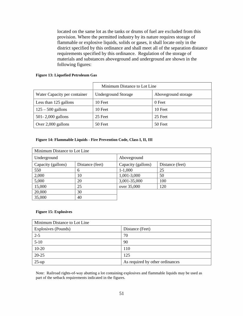
51
located on the same lot as the tanks or drums of fuel are excluded from this provision. Where the permitted industry by its nature requires storage of flammable or explosive liquids, solids or gases, it shall locate only in the district specified by this ordinance and shall meet all of the separation distance requirements specified by this ordinance. Regulation of the storage of materials and substances aboveground and underground are shown in the following figures:
Figure 13: Liquefied Petroleum Gas
Minimum Distance to Lot Line
Water Capacity per container Underground Storage Aboveground storage
Less than 125 gallons 10 Feet 0 Feet 125 – 500 gallons 10 Feet 10 Feet 501- 2,000 gallons 25 Feet 25 Feet
Over 2,000 gallons 50 Feet 50 Feet
Figure 14: Flammable Liquids - Fire Prevention Code, Class I, II, III
Minimum Distance to Lot Line Underground Aboveground Capacity (gallons) Distance (feet) Capacity (gallons) Distance (feet) 550 6 1-1,000 25 2,000 10 1,001-3,000 50 5,000 20 3,001-35,000 100 15,000 25 over 35,000 120 20,000 30 35,000 40
Figure 15: Explosives
Minimum Distance to Lot Line Explosives (Pounds) Distance (Feet) 2-5 70 5-10 90 10-20 110 20-25 125 25-up As required by other ordinances Note: Railroad rights-of-way abutting a lot containing explosives and flammable liquids may be used as part of the setback requirements indicated in the figures.
52
4. Outdoor storage and waste disposal. The following regulations shall apply to all industrial zone districts:
a. All outdoor storage facilities for fuel, raw materials, products, and uses of
similar nature shall be enclosed by an opaque fence or wall adequate to conceal such facilities from adjacent properties, streets, highways and public right-of-ways.
b. No materials or wastes shall be deposited upon a lot in such form or
manner that they may be transferred off the lot by normal natural causes or forces, and such materials shall not be allowed to pollute a watercourse, stream, lake or underground water supply.
c. All materials or wastes which might cause fumes or dust or which
constitute a fire hazard or which may be edible by or otherwise be attractive to rodents or insects shall be stored outdoors only in closed containers.
C. Conditions for site development. No land shall be used or occupied and no
structure shall be designed, erected, altered, used or occupied in an industrial district except for as permitted by this ordinance. Any permitted use shall observe all of the following conditions:
1. All yards and open areas shall be properly graded for drainage, surfaced with
concrete, asphaltic concrete, asphalt, oil, lawns or any other dust-free surfacing, and maintained in good condition, free of weeds, dust, trash and debris.
2. Any permitted use shall be provided with barriers of such dimensions that
occupants of adjacent structures are not unreasonably disturbed, either by day or by night, by the movement of vehicles, machinery, equipment or supplies.
3. Any permitted use shall be provided with entrances and exits so located as to
minimize traffic congestion. Where entrances and exits are intended for use by trucks, lanes shall be at least 12 feet wide and the radius of the curve at the pavement edge of the entrance or exit shall be at least 35 feet.
4. Any permitted use shall provide sufficient internal circulation and turning
space on the lot so that no vehicle will have to maneuver on any public right-of-way in order to gain access to or exit from any lot, or to load or unload from any structure on the lot or for any other reason.
5. Any permitted use must provide and maintain a landscaped strip at least ten
feet wide along all street property lines, exclusive of drives and walks, and such landscape should not interfere with sight distances or block needed view of buildings or their identification.

53
6. Any permitted use shall be provided with barriers of such type and so located
that no part of parked vehicles will extend beyond the yard space or into the setback space from a lot line abutting a residential lot or a street.
7. Lighting facilities shall be so arranged that they do not disturb occupants of
adjacent properties or interfere with traffic.
D. Accessory Uses. Accessory uses must meet the following requirements to be allowed in an industrial district:
1. The use must be clearly incidental and customary to and commonly associated
with the operation of the permitted use.
2. The use must be operated and maintained under the same ownership or by lessees or concessionaires thereof, and on the same lot as the permitted use.
3. The use must not include structures or structural features inconsistent with the
permitted use.
4. The use must not include residential occupancy except by caretakers or watchmen.
5. If operated partially or entirely in detached structures, such detached
structures shall be limited to a gross floor area of not more than 20 percent of the gross area of the principal structure.
6. If operated partially or entirely within the structure containing the permitted
use, the gross floor area within such structure utilized by accessory uses (except garages, loading docks and company dining rooms) shall not be greater than ten percent of the gross floor area of the structure containing the permitted use by right.
E. Permitted encroachments on setback spaces. Belt courses, sills, lintels, cornices,
eaves, gutters, stoops, and building accessories designed and intended to control light and glare entering the building, and not being a permanent part of such building by being supported from the ground, may extend three feet into any setback space without being considered in violation of the setback requirements of the industrial zone districts.
F. Development Plan Review – Industrial Districts. All applications for development
in an industrial district shall require Development Plan review as described in Article 18.
G. Industrial Access through Residential Zones. The routing of industrial trucks and
equipment through residentially zoned areas shall require the rezoning of property

54
to industrial classification prior to construction of industrial access driveways through residentially zoned property.
Section 6.2– I-1 Community Industrial Park District
A. Description of the District. The I-1 Community Industrial Park District is located between general industrial or commercial uses and quiet residential areas. The regulations of this district are intended to provide structural standards, standards of intensity of use and standards of external effects compatible with the surrounding residential districts. To these ends, development standards are established to encourage those industries and wholesaling activities that can be operated in a clean and quiet manner, plus certain public facilities which are needed to serve the occupants of the district and residents of adjoining residential districts, and to establish pleasant community industrial parks.
B. Permitted Structures. Each lot shall have at least one front property line and shall
be occupied only by structures containing permitted uses and such accessory buildings that are allowed in the district.
C. The Use of Land and Building. See the Table of Permitted Uses in Article 21 of
this ordinance for uses permitted in the I-1 Community Industrial Park District.
D. Dimensional Requirements. The bulk and area (dimensional) requirements for the I-1 district are shown in the “Bulk and Area” Chart in Section 6.5.
E. Location of Accessory Buildings. No accessory buildings shall be located on any
required front or side yard, or within 25 feet of any street or within 10 feet of any lot line. Accessory buildings shall be exclusively as product or equipment storage that is related to the principal use. The Accessory buildings shall not occupy more than 20 percent of the rear yard.
F. Fences. See Section 12.15
G. Off-street Parking. See Article 13, Off-Street Parking.
H. Corner Visibility. See Section 12.16
I. Screening. See Article 15.
Section 6.3 – I-2 Light Industrial Parks
A. Description of the District. The I-2 light industrial park district is intended to permit the normal operations of industries, subject to those regulations needed to control congestion and to protect nearby residential and business districts.

55
B. Permitted Structures. Each lot shall have at least one front property line and shall be occupied only by structures containing permitted uses and such accessory buildings as are permitted in the district.
C. The Use of Land and Buildings. See the Table of Permitted Uses in Article 21 of
this ordinance for uses permitted in the I-2 Light Industrial Parks District.
D. Dimensional Requirements. The bulk and area (dimensional) requirements for the I-2 district are shown in the “Bulk and Area” chart in Section 6.5.
E. Location of Accessory Buildings. No accessory buildings shall be located on any
required front or side yard, or within 25 feet of any street or within 10 feet of any lot line. Accessory buildings shall be exclusively as product or equipment storage that is related to the principal use. The Accessory buildings shall not occupy more than 20 percent of the rear yard.
F. Fences. See Section 12.15.
G. Off-street Parking. See Article 13, Off-Street Parking.
H. Corner Visibility. See Section 12.16
I. Screening. See Article 15.
Section 6.4 – I-3 Industrial Park District
A. Description of the District. The I-3 Industrial Park District is intended to be separated from residential and business areas in the city. Regulations are the minimum required for mutual protection of the industrial users, and, to that end, the district should not be adjacent to any residential or business district, if such abutment can possibly be avoided. The district is intended to provide good and attractive sites for industrial uses, to encourage a high standard of industrial development, and/or to encourage the location of industries requiring the use of river transportation.
B. Permitted Structures. Each lot shall have at least one front property line and shall
be occupied only by structures containing permitted uses and such accessory buildings that are permitted in the district.
C. The Use of Land and Buildings. See the Table of Permitted Uses in Article 21 of
this ordinance for uses permitted in the I-3 Industrial Park District.
D. Dimensional Requirements. The bulk and area (dimensional) requirements for the I-3 district are shown in the “Bulk and Area” chart in Section 6.5.
56
E. Location of Accessory Buildings. No accessory building shall be located on any required front or side yard, or within 40 feet of any street or within 20 feet of any lot line. Accessory buildings shall be exclusively as product or equipment storage that is related to the principal use. The Accessory buildings shall not occupy more than 20 percent of the rear yard
F. Fences. See Section 12.15.
G. Off-street Parking. See Article 13, Off-Street Parking.
H. Corner Visibility. See Section 12.16
I. Screening. See Article 15.
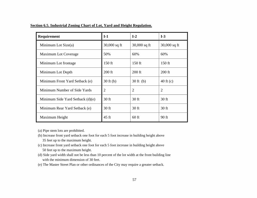
57
Section 6.5. Industrial Zoning Chart of Lot, Yard and Height Regulation.
Requirement I-1 I-2 I-3
Minimum Lot Size(a) 30,000 sq ft 30,000 sq ft 30,000 sq ft
Maximum Lot Coverage 50% 60% 60%
Minimum Lot frontage 150 ft 150 ft 150 ft
Minimum Lot Depth 200 ft 200 ft 200 ft
Minimum Front Yard Setback (e) 30 ft (b) 30 ft (b) 40 ft (c)
Minimum Number of Side Yards 2 2 2
Minimum Side Yard Setback (d)(e) 30 ft 30 ft 30 ft
Minimum Rear Yard Setback (e) 30 ft 30 ft 30 ft
Maximum Height 45 ft 60 ft 90 ft
(a) Pipe stem lots are prohibited. (b) Increase front yard setback one foot for each 5 foot increase in building height above 35 feet up to the maximum height. (c) Increase front yard setback one foot for each 5 foot increase in building height above 50 feet up to the maximum height. (d) Side yard width shall not be less than 10 percent of the lot width at the front building line with the minimum dimension of 30 feet. (e) The Master Street Plan or other ordinances of the City may require a greater setback.
58
ARTICLE SEVEN OPEN LAND DISTRICT
Section 7.1 Open Lands District
A. Description of District. The O-1 open lands district is composed of certain large open areas, land publicly owned and land suitable for the location of public buildings and certain public facilities. The regulations of this district are designed to retain the open character and settings desirable for public facilities and certain other compatible uses.
B. Permitted Structures. Each lot shall have at least one front property line and shall be
occupied by only one principal structure. Permitted structures may be a public building or facility, except where the use is for a public park, a public recreational center, a public playground, an airport, a port or harbor, or other similar facilities, as determined by the commission, several structures may be placed within the land area reserved for such public uses. Permitted structures must be located in accordance with a development plan submitted to and approved by the commission in the manner prescribed under this article. Residences may be permitted in this district provided that they are limited to those required by caretakers, police and similar personnel required to be present on the lands to provide protection and to safeguard the property.
C. The Uses of Land and Buildings. See the Table of Permitted Uses in Article 21 of
this ordinance for uses permitted in the O-1 Open Lands District. D. Uses by Temporary Permit. Upon application to and issuance by the Planning
Department of a permit, the following uses may be operated:
1. Bazaar, carnival and/or circus; provided, however, that each permit shall be valid for a period of not more than three days and shall not be renewed for more than three successive periods; and provided, further, that a period of a least 90 days shall intervene between the termination of one permit and the issuance of another permit for the same location.
2. A newspaper distribution station operated in accordance with all of the following
standards: shall be maintained in a neat and clean condition with all papers, waste wrappers and newspapers stored, handled and distributed within a completely enclosed structure until removed from the premises; shall provide adequate on-the-premises storage for bicycles; and shall prohibit unnecessary loitering on or about the premises; provided, however, that each permit shall be valid for a period of not more than one calendar year but may be renewed; and provided, further, that a failure to comply with any of the standards herein set forth shall be cause for revocation of any permit.

59
3. Noncommercial concrete batching plant, both incidental and necessary to construction in the district; provided, however, that each permit shall be valid for a period of not more than six calendar months and shall not be renewed for more than three successive periods at the same location.
4. Parking lot designated for a special event; provided, however, that each permit
shall be valid only for the duration of the designated special event; and provided, further, that if the designated special event is a seasonal activity the permit may be valid for the entire season but shall be restricted in use to designated dates and times during which the event is occurring.
5. Sale at retail of Christmas trees and wreaths; provided, however, that no permit
shall be effective prior to November 15 in each calendar year and no permit shall be valid for a period of more than 45 days.
6. Temporary building or yard for construction materials and equipment, both
incidental and necessary to construction in the district; provided however, that each permit shall be valid for a period of not more than six calendar months and shall not be renewed for more than four successive periods at the same location.
7. Temporary office both incidental and necessary for the sale or rental of real
property in the district; provided, however, that each permit shall be valid for a period of not more than six calendar months and shall not be renewed for more than four successive periods at the same location.
Section 7.2 Dimensional Requirements
Lot Area 175,000 Sq ft Open Space 60%
Minimum Front Yard 40 Feet (a)
Minimum Two Side Yards 15 Feet (b) Minimum Rear Yard 25 Feet (c)
Maximum Height 60 Feet (d)
Table Footnotes:
a. Increase front yard 1 foot for each 5 feet of building height over 45 feet. b. Any side yard abutting a street shall be a minimum 20 feet. Master Street Plan setback shall
prevail. c. If abutting an alley not adjacent to residential district, then 15 feet. If abutting a street the
setback shall be as required along the street d. Structural units necessary for the functioning of the building may exceed the height limit but
no building may exceed 90 feet and then only if yard dimensions requirements are met.

60
Section 7.3 Location of Accessory Buildings No accessory building shall be located on any required front or side yard, or within 20 feet of any street, or within five feet of any lot line, that is not a street line, except where an alley abuts the rear line of the lot detached accessory buildings not opening directly into the alley and fixtures for the disposal of trash and garbage may be set on the rear lot line, provided, however that in no case will a trash burner be located closer than ten feet to the line of any adjacent of abutting property. Accessory structures having access to the alley shall be set back five feet from the rear lot line.
Section 7.4 Fences Fences up to 8 feet in height may be erected along any boundary line of the side yards or rear yard from the front building line to the rear lot line and along the rear lot line, except where the rear lot line abuts a street. Section 7.5 Screening See Article 15 Section 7.6 Corner Visibility See Section 12.16 Section 7.7 Off-Street Parking See Article 13, Off-Street Parking.

61
ARTICLE EIGHT CONSERVATION DISTRICT
Section 8.1– Conservation District
A. Description of District. The flood plains of North Little Rock are fragile natural resources which provide wildlife habitat, pollution control, storage and passage of flood waters, aquifer recharge, recreation and open space. In the past, urbanization has impacted the flood prone areas by dredging, filling, building, pollution, and illegal dumping, and other activities inconsistent with the natural characteristics of such area. Therefore, it is the policy of the City to ensure that flood prone areas are protected from detrimental impacts and the flood plain alteration activities do not threaten public safety, welfare or cause nuisances, or negatively alter the natural ecology. In this district, a land owner or group of owners may prepare a development plan (see Article 18, Development Plan Review) in support of an application for re-zoning of property. The development plan shall prove, with engineering certification, that problems of a shallow water table, or inundation due to faulty drainage and other such problems can be corrected to support the proposed development. The applicant and/or land owners may through agreements with the Planning Commission and City Council determine the most appropriate district to be established. The provisions of the district established shall then be in effect.
B. Flood Plain. Any area that, upon field verification is determined to have one or more
of the following characteristics shall be included in the District:
1. Floodplains along the Arkansas River and its tributaries and meander scars defined by the 100-year floodplain as shown on the Federal Emergency Management Agencies (FEMA) Flood Insurance Rate Maps or Flood Hazard Boundary Maps, or the Flood of record;
2. Land along streams, bayous, meander scar lakes, and wetlands subject to
inundation, severe bank erosion, undercutting, or stream bed course alteration (bed alteration).
C. The North Little Rock Zoning Map shows District Boundaries based upon the best
available information at a City-wide scale. The actual boundaries of this district, however, shall be determined by field verification.
D. General Development Procedures. The following procedures shall be followed in the
circumstances stated:
1. Fill material shall not be placed in the flood plain until a study shall prove the floodway discharge is not increased by more than 1 foot
2. Fill material shall not be placed in the floodway under any circumstances.

62
Section 8.2 Uses of Land
A. The Uses of Land and Buildings. See the Table of Permitted Uses in Article 21 of
this ordinance for uses permitted in the Conservation District. B. Uses by temporary permit. Upon application to and issuance by the Planning
Commission of a permit, the following uses may be operated as uses by temporary permit:
1. Bazaar, carnival and/or circus; provided, however, that each permit shall be valid
for a period of not more than three days and shall not be renewed for more than three successive periods; and provided, further, that a period of at least 90 days shall intervene between the termination of one permit and the issuance of another permit for the same location.
2. A newspaper distribution station operated in accordance with all of the following
standards: shall be maintained in a sightly condition with all papers, waste wrappers and newspapers stored, handled and distributed within a completely enclosed structure until removed from the premises, shall provide adequate on-the-premises storage for bicycle and shall prohibit unnecessary loitering on or about the premises; provided. However, that each permit shall be valid for a period of not more than one calendar year but may be renewed; and provided, further, that a failure to comply with any of the standards herein set forth shall be cause for revocation of any permit.
3. Noncommercial concrete batching plant, both incidental and necessary to
construction in the district; provided, however, that each permit shall be valid for a period of not more than six calendar months and shall not be renewed for more than three successive periods at the same location.
4. Parking lot designated for a special event; provided, however, that each permit
shall be valid only for the duration of the designated special event; and provided, further, that if the designated special event is a seasonal activity the permit may be valid for the entire season, but shall be restricted in the use to designated dates and times during which the event is occurring.
5. Sale at retail of Christmas trees and wreaths; provided, however, that no permit
shall be effective prior to November 15 in each calendar year and no permit shall be valid for a period of more than 45 days.
6. Temporary building or yard for construction materials and/or equipment, both
incidental and necessary to construction in the district; provided, however, that each permit shall be valid for a period of not more the six calendar months and shall not be renewed for more than four successive periods at the same location.
63
7. Temporary office, both incidental and necessary for the sale or rental of real property in the district; provided, however, that each permit shall be valid for a period of not more than six calendar months and shall not be renewed for more than four successive periods at the same location.
Section 8.3 Structure Setback All structures must be set back at least 30 feet from all street right-of-way lines, or as required under other ordinances, whichever is the greater and setback at least 20 feet from property lines without street frontage. Section 8.4 Corner Visibility See section 12.16 Section 8.5 Permitted Structures No structures shall be permitted in the Conservation district except those used in the operation of the permitted uses, and further providing that these structures do not cover more than five percent of the total lot area. In no case will a residential structure be permitted. Section 8.6 Screening, Buffers, and Landscape All uses established in the Conservation District shall be subject to Article 15.

64
ARTICLE NINE GREENBELT AND WETLAND DISTRICT
Section 9.1 Description The district is composed of lands that are to be retained in a natural state, being either forest or designated wetlands with very limited active permissible uses. The purpose for designating green belt and wetland conservation zones is to preserve wooded or wetland areas to lessen the intensity of urban development and protect natural resources. Green Belt and Wetland Districts provide expanded buffer areas, separate uses and reduce development stress in the urban environment, as well as providing space for wildlife habitat and nature trails. Wetlands provide an important flood management tool as well as filtering urban storm water runoff. Designation of known wetlands serves the national goal of no new loss of wetlands and hopefully reduces the financial burdens on the community by avoiding improper development practices. The boundaries of these green belts and wetlands are established by the Planning Commission based on data received from private individuals, the U.S. Army Corps of Engineers, and the Soil Conservation Service. Wetlands are areas of periodic flooding caused by a combination of elevation, a high water table, soil types and also the presence of aquatic life. While the wetland condition can be eliminated by filling, such action is restricted by federal regulation. Lands approved for removal from the wetland condition are by formal permit with the U.S. Army Corp of Engineers followed by a local reclassification through the established rezoning procedure. In that green belt and wetland conservation districts have very limited economic use, it is important that lands so designated be either voluntary or by federal government action. In order to assist in the development of the overall plan for the city and to encourage the proper use of land, the City Council may establish the type of zoning district for which the lands shall be deemed suitable. Areas to be designated as green belt or wetlands shall be designated “G/W”. Section 9.2 Permitted Uses See the Table of Permitted Uses in Article 21 of this ordinance for uses permitted in the G/W Greenbelt and Wetland District. Section 9.3 Uses by Temporary Permit Applications for uses by temporary permits are submitted to the North Little Rock Planning Department. The applications are forwarded to the Planning Commission for its determination of permit approval. The approval of a temporary permit is contingent upon the conditions set by the Planning Commission and is limited also by the following:
A. The requested activity will not threaten public safety, welfare or cause nuisances, or
negatively alter the green belt or wetland areas. B. No principal structure is permitted.

65
Section 9.4 Bulk and Area of Accessory Structures Principal structures are not allowed in the GB/W District. Requests for accessory structure permits shall be routed through the Planning Department to the Zoning Board of Adjustment for consideration; upon approval by the Board of Adjustment a permit may be issued.

66
ARTICLE TEN PLANNED UNIT DEVELOPMENT
Section 10.1 Planned Unit Development Purpose The purposes of this zone are to promote flexibility and innovation in design and to encourage innovation in the design of large-scale developments and the development of vacant, in-fill parcels in the built-up portion of the city. The zone also promotes the inclusion of open space into project design. The Planned Unit Development (PUD) is a superimposed description that provides wider latitude of design to achieve the goals stated above. In concept, the PUD is a combination of zoning designation and site plan. A detailed site plan is required for consideration by the Planning Commission. Development must follow the site plan exactly. Failure in this respect will result in reversion of the property to the original zoning. Although design innovation is encouraged, and flexibility is allowed, the PUD may not be used solely as a method of avoiding zoning regulations. Once approved, the site plan becomes a zoning district by city ordinance in the same manner as any other zoning parcel. The PUD may contain any land use or combination of land uses that are compatible with the specific location and meet the standards set forth in Section 10.2.
Section 10.2 Standards for Planned Unit Development
A. The planned unit development must meet the spirit and intent of the Land Use Plan.
Significant departure must be preceded by a request to amend the Land Use Plan. B. Ownership. The site of the Planned Unit Development must be under single
ownership. C. Compatibility. The uses permitted in a Planned Unit Development must be of a type
and so located as to exercise no undue detrimental influence upon surrounding properties. This will include factual determination that the development meets the review standards outlined in Section 10.6.
D. Need. The Planning Commission shall consider a PUD proposal only after
determining that it meets at least one of the following threshold criteria:
1. The PUD will allow the development of an infill parcel in the developed portion of the city that could not be made productive under normal zoning regulations.
2. The PUD would further the city’s goal of providing housing for all economic
segments of the city and its Planning Area.
67
3. The PUD involves a parcel in which flexibility would allow high quality or innovative urban design not possible under existing zoning regulations.
4. The PUD would aid in the elimination of slums and blight within the city and its
Planning Area. 5. The PUD design results in a minimum of 30 percent of the total development
being reserved as permanent open space.
E. Size. There is no minimum size requirement for a PUD submittal; however, the Planning Commission shall consider requests for sites less than one acre only in cases where a clear public interest is addressed and where the proposal meets a specific requirement of the Land Use Plan.
F. Concurrency. The Planning Commission shall consider a PUD request only after
determining that adequate public and private utilities are available to the site or can be extended after approval at the applicant’s expense.
Section 10.3 Application Process
The applicant for a Planned Unit Development permit shall be the owner(s) of the property or the party designated to act as agent for the owners(s). The responsibilities of the applicant are as follows:
A. Pre-application Conference. Each prospective applicant shall confer with the City
Staff in connection with the preparation of the application prior to the formal submittal. The purpose of this conference is to determine if the proposed PUD would generally meet the standards outlined in section 10.2. At this conference, the following information and data shall be considered.
1. The boundaries of the property. 2. Existing easements and covenants affecting the property. 3. Physical characteristics such as drainage, topography, vegetation and existing
structures. 4. Development characteristics such as surrounding land uses, existing streets and
availability of utilities. 5. Elements of the proposed layout such as land uses, open spaces, community
facilities, densities, traffic flow and estimated impact on traffic and adjacent land uses.
B. Pre-Submission to the Planning Commission. The applicant may also elect to present
a sketch plat of the proposed PUD to the North Little Rock Planning Commission. Pre-submission of the sketch plat to the Planning Commission is strictly to receive
68
comments and/or suggestions from the Commission and to identify potential problems or deficiencies. Concurrence in the sketch plat by the Commission shall not necessarily imply approval of the final submission.
C. Site Plan submittal. No less than thirty days prior to the Planning Commission
meeting at which the proposed Planned Unit Development is to be reviewed, the applicant shall the proposed site plan to the staff. The submittal shall include the following as a minimum. Any application that is incomplete in any respect, will be returned to the applicant for appropriate corrections. Any required corrections must be turned in to the city staff prior to the Planning Commission meeting. The Commission will not review an incomplete application.
1. A site plan drawn to scale. Survey information shall be prepared by a
Professional Surveyor (P.S.) Drainage and utility calculations shall be prepared by a Professional Engineer (P.E.) The stamps of the individuals responsible for the various elements shall be affixed to the drawing.
2. Building footprints for the individual buildings to be included in the PUD. 3. Topographic contours at 2 foot intervals. 4. All easements, existing or proposed. 5. All drives, access-ways, alleys, parking lots and any streets proposed to be
dedicated. 6. Proposed landscaping. 7. Open space and community facilities, if any, proposed as part of the PUD. 8. Location of all existing and proposed private and public utilities. 9. Name(s) of the owners of the proposed project and their agent, if any. 10. Zoning classifications of adjoining properties. 11. Site improvement drawings as necessary to support the proposals outlined in the
site plan.
Section 10.4 Uses Permitted The PUD submittal will include a listing of the proposed land uses and the amount of land devoted to each. This list will constitute part of the zoning component of the PUD. No other land uses will be allowed unless the PUD is revised through a rezoning process.
69
Section 10.5 Design Regulations
A. Lot Size. No minimum district sizes are established. Housing can be clustered or otherwise concentrated or arranged in planned locations on the site to take advantage of its natural features. The proposed lots and the type of development (i.e. housing, mixed use) for each shall be clearly depicted.
B. Open Space Reservation. Land not used by buildings, accessory structures, and
yards, but part of the PUD shall be maintained as open space for the purpose of providing parks, recreational facilities, ways for pedestrian movement and circulation, and conserving visually pleasing elements of the environment. Prior to the sale of any lot, site, home or other structure, a performance guarantee of sufficient surety determined by the City shall be posted with the City for completion of said open space improvements. The site plan shall clearly depict the amount of land to be maintained as permanent open space.
C. Development Density. The site plan shall clearly depict the proposed density by
land use category. D. Property Owners’ Association. The developer shall submit a set of covenants
running with the land, providing for an automatic membership in the Property Owners’ Association, to be an incorporated nonprofit organization, operating under recorded land agreements designed and intended to exist in perpetuity, through which each property owner in the Planned Unit Development is automatically subject to a charge for an appropriate proportionate share of the expenses for maintaining the common property, open space and/or other activities of the Association. Once established, the covenants shall continue and remain in force during the entire existence of the Planned Unit Development.
E. Responsibility for Open Space. Nothing in this Section shall be construed as
assigning or assuming any responsibility or liability on the part of the City of North Little Rock, for maintenance of any private open areas, parks, or recreational facilities. A hold harmless clause shall be incorporated in the covenants running with the land to this effect. It shall be provided further, however, that when an owner of a Planned Unit Development desires to dedicate certain land areas to the City for public parks and recreational facilities, and the City approves the nature and location of such lands, and accepts the dedicated areas, the City shall be responsible for the operation and maintenance of these lands and properties thereafter.
F. Common Open Spaces. The size, shape, dimension and location of the common open
spaces shall be considered by the Planning Commission with consideration being given to the size and extent of the proposed development and the physical characteristics of the land being developed. Consideration should also be given in providing parks, recreational facilities, both active and passive, and pedestrian walkways.

70
Common open space shall be guaranteed by a restrictive covenant, describing the open space and its maintenance and improvement, running with the land for the benefit of the residents of the Planned Unit Development. The developer shall file, at the time the approved final site plan is filed, legal documents that will produce the aforesaid guarantees and, in particular, will provide for restricting the use of common open spaces for the designated purpose.
G. Preservation Plan. In order to minimize the disturbance of the natural environment, a
general preservation plan shall be required at the time of preliminary plat submission; this shall show the specific type, size and nature of the preservation area. The Planning Commission shall review the preservation plan in conjunction with the review of the site plan.
The preservation of the natural amenities within the Planned Unit Development,
including topography, trees, ground cover, natural bodies of water, and other significant natural features, shall be given due consideration. Existing trees shall be preserved wherever possible. The location of trees shall be considered when planning the common open space, location of buildings, underground services, walks, paved areas, playgrounds, parking areas, and finished grade levels. Excessive site clearing of topsoil, trees and natural features before the commencement of building operations shall be discouraged by the Planning Commission. The applicant shall provide evidence as how these objectives are to be met.
H. Transportation. The vehicular circulation system shall be designed so as to permit
smooth traffic flow with minimum hazards to pedestrian traffic. Minor streets within Planned Unit Development shall not be connected to streets outside the development in such a way as to encourage their use by through traffic.
The pedestrian circulation system and its related walkways shall be insulated as
reasonably as possible from the vehicular movement. This shall include, when deemed to be necessary by the Planning Commission, pedestrian underpass or overpass in the vicinity of schools, playgrounds, local shopping areas, and other neighborhood uses that generate a considerable amount of pedestrian traffic.
I. Land Subdivision. In the construction and installation of all subdivision
improvements in the Planned Unit Development, said improvements shall conform to all requirements and standards as set forth in the City’s Subdivision Regulations, unless exception to the requirements is recommended and approved by the Planning Commission.
If the owners in the future should request that the private streets be changed to City, the owners will bear full expense of reconstruction or any other action necessary to make the streets fully conform to the requirements applicable to public streets, prior to dedication and acceptance. The owners also shall agree that these streets shall be dedicated to public use without compensation to the owners.
71
J. Provisions existing herein do not supercede any state or federal codes or regulations, including the Arkansas Fire Code, nor is the Planning Commission or Board of Zoning Adjustment empowered to grant any variances or waivers from such state or federal codes or regulations.
Section 10.6 Review Process
The Planning Commission shall review the proposed PUD after proper submittal of all documents and review by the appropriate city staff. In reviewing any proposal, the Planning Commission shall determine that the PUD will:
A. Provide public benefits that would not be achievable through the normal zoning
regulations. B. Be consistent with the city’s Future Land Use plan. C. Not endanger the public health, welfare or safety. D. Be of a character and contain such uses that are needed in the area of the proposed
project. E. The proposed PUD will not interfere with existing traffic in the vicinity and will not
lower the level of service on any adjacent street. F. The proposed PUD will not represent such a departure in design and intensity of use
as to adversely impact the value of adjacent and nearby properties. G. Buildings within the proposed PUD shall maintain similar size and bulk
characteristics as those currently existing in the neighborhood. H. The traffic generation characteristics of proposed uses in the PUD shall be similar to
those of uses currently existing in the neighborhood.
Section 10.7 City Council Approval
A. Planned Unit Developments represent zoning districts and shall follow the same amendment procedures as other districts. This district is to be utilized as a “floating zone” which shall mean that areas will not be pre-designated as planned development districts but rather each such designation shall result from a specific and separate application for amendment. Unless otherwise stated in this Article, the Development standards and the land uses which are presented with the application for amendment shall, if approved, become the standards for the subject property and shall become a part of the zoning regulations.
B. All further development on the property shall conform to the standards adopted for
the site, regardless of any change in ownership. Approval of the PUD shall run with the land and apply to successor owners. Any proposed changes to the approved
72
standards shall be treated as amendments to the zoning regulations and must be considered in accordance with the procedures set forth at Section 20.
Section 10.8 Amendments
Following Council approval the staff may approve minor revisions to the site plan if:
A. No changes are made to either the access to or egress from the PUD. B. Any changes to internal traffic arteries do not alter overall traffic patterns, size of
streets, or functional classification of streets. C. No new streets are proposed for dedication. D. No new private streets are proposed. E. Overall residential density is not increased. F. Overall drainage patterns are not altered. G. No additional loads are placed on municipal utilities. H. Retail and office space is not increased by more than 5 percent. I. No open space is dedicated for public maintenance.
If there is disagreement about the administration of the above, or if the staff is unsure of its authority, the staff shall submit the proposed revisions to the Planning Commission.
73
ARTICLE ELEVEN OVERLAY DISTRICTS
Section 11.1 – General In order to carry out the provisions of the city’s plans, the Planning Commission may from time to time prepare or have prepared an overlay zoning district to be recommended for adoption by the City Council. Upon adoption by the City Council, the overlay district shall be enforced as a stated in this Article. Section 11.2 – Application and Enforcement The regulations in overlay districts shall be in addition to and shall overlay all other zoning districts and other ordinance requirements regulating the development of land so that any parcel of land lying in an overlay district shall also lie within one or more of the other underlying zoning districts. Therefore, all property within an overlay district will have requirements of both the underlying and overlay zoning district in addition to other ordinance requirements regulating the development of land. In case of conflicting standards between overlay district requirements and other city ordinances, the overlay requirements shall control. Section 11.3 – Argenta Quiet Commercial Overlay District
A. Description. A zoning overlay district bordering the established Argenta Historic
Residential District and providing specific additional land use regulations. B. Purpose. The downtown area is experiencing rapid change with the addition of a
regional multi-purpose area and other public and private investments and the AQC overlay district is intended to avoid the negative impact of uncontrolled change. The purpose for creating this overlay district is to impose certain land development and environmental control regulations to increase compatibility between the uses and buildings of the district and the bordering residential neighborhood. These regulations are intended to serve the general health, safety and welfare of the downtown community; to retain residential uses in the downtown area by providing a more harmonious setting for residential uses; to promote a viable commercial setting; and to avoid urban blight. The existence of a downtown residential base is believed to exert a positive influence on the downtown setting.
C. Application. These regulations shall be applied to all major alterations to the exterior
of existing structures and as provided through the existing Control of Development Regulations when new primary structures or major additions are proposed.
D. District Boundary. The AQC District encompasses all property as illustrated in the
Quiet Commercial Overlay District map. E. Overlay District Regulations. This overlay district includes provisions relative to
hours of operation of all commercial activity, limitations on exterior lighting, noise, architectural design, signage, landscaping and building height.

74
1. Hours of Operation. All businesses within the district shall be closed between the
hours of 10 p.m. and 6 a.m. to provide reduced nighttime activity in order to provide a compatible and peaceful setting conducive of the residential setting.

75
1. Hours of Operation. All businesses within the district shall be closed between
the hours of 10pm and 6am to provide reduced nighttime activity in order to provide a compatible and peaceful setting conducive of the residential setting.
2. Noise Limitations. All private businesses shall limit outdoor noise to promote a quiet setting. The use of outdoor loud speakers for the purpose of employee paging or communication is specifically banned within the defined district.
3. Exterior Illumination. While security lighting is viewed as a favorable attribute in
the district, all such illumination shall be shielded or directed away from residential dwellings.
4. Architectural Design. All new buildings or major exterior alterations shall be
compatible with the design theme of the Argenta Historic District. As such, all building permit applications relative to exterior change shall be reviewed by the Planning Commission for a certificate of appropriateness prior to issuance. The Commission may establish architectural guidelines to aid in the accomplishment of its duties.
5. Signage. Signage shall be restricted within the district in order to increase
compatibility with the residential setting. As such, signage shall be limited by existing zoning or 10 percent of the front wall, whichever is more restrictive. Signs shall be limited to wall signs, Free standing signs, such as pole or ground signs, billboards, and trailer signs are prohibited within the district. The lighting of signs shall be subdued and backlit signs are prohibited when these are within view of any residential parcel of the Argenta Historic Residential District.
6. Building Height. All new buildings within the district shall not exceed 2.5 stories
or 35 feet to improve compatibility and to avoid tall buildings towering over the adjoining residential district.
7. Landscaping. The planting of street trees is encouraged along all streets within
the district to increase area tranquility and improve general amenities. Street trees shall be required with the addition of all new primary buildings within the district. All businesses shall provide appropriate screening per the requirements of the existing screening requirements. All parking lots within the district shall provide shade trees using the ratio of one tree per six parking spaces dispersed throughout the parking lot. Low scrub screening, maintained below a height of four feet shall be provided along all street side, sidewalk borders.
8. Dumpster Screening. Efforts should be made to avoid unsightly features within
the district. All exterior waste containers shall be located behind a screening device so that the container is view and access from the interior of the lot and oriented to minimize viewing these dumpsters from any public street. The Design Review Board shall approve alternatives to brick or solid wood screening requirements.

76
9. Fence Design. Barbed wire or razor-wire is specifically prohibited from use within the district. The Planning Commission may establish fence design guidelines as a part of the proposed architectural guidelines.
Section 11.4 – Main Street Overlay (MSO) District
A. Description. The Main Street Overlay District is established to provide additional development and design regulations for the area depicted on the overlay map.
B. Design Overlay District, District, or MSO are interchangeable phrases referring to the “Main Street Overlay District.”
Section 11.4.1 - Main Street Overlay District Purpose and Boundary
A. The Main Street Overlay District is established with the intent of creating a special
urban place. Specific design requirements and environmental controls are established for the district to promote quality redevelopment with special attention to the creation of a pedestrian friendly setting. Exterior design regulations relative to building façade, landscaping, signs and buffers are included to direct the future built environment. Land use rights are not the objective of these guidelines. Land use rights for the District have been addressed through the C-6 zoning classification that allows mixed uses within the District – commercial, office and residential – with the belief that mixed use development has the potential of revitalizing the area and creating an improved sense of place. It is hoped that application of these and other regulations will support a more desirable location for the mix of business, cultural, residential and entertainment activities by encouraging economic expansion, increasing land values, and reinforcing the historic significance of the district.
B. The District encompasses all parcels within the adopted boundaries as is illustrated
on Main Street Overlay District Map. The perimeter of the Main Street Overlay District shall include the area bounded by Willow Street (from Riverfront Drive to ½ block North of Broadway) East to ½ block west of Maple Street north to 9th Street east from 1/ block west of Maple to ½ block E. of Main south along the east side of the railroad tracks to the Junction Bridge rail track (9th to Riverfront Drive) and Riverfront Drive (Cypress to Willow).
Section 11.4.2 - Application of regulations and the Design Review Committee
A. The Main Street Overlay regulations shall be applied as additional development
regulations and standards above those provided through the existing Sign Ordinance, Screening Ordinance, Zoning Ordinance and Subdivision/Control of Development Regulations of the City.
B. These regulations shall apply to new development, redevelopment, expansion of
existing development, or any change of site improvements. The design guidelines shall be implemented when a building permit is requested for exterior improvements. This ordinance also applies when any exterior improvement is undertaken which may not require a building permit, but affects the exterior visible elements of the structure or site as determined by the Planning Director or as may be appointed by
77
the Planning Director, such as any significant alteration of the exterior of a structure or site setting. Routine repairs, maintenance and interior alterations shall not require compliance with this section.
C. Structures and features of parcels existing on the effective date of this ordinance that
do not conform to the standard and guidelines established in this ordinance, shall be treated as nonconforming according to the provisions of Article III of the Zoning Ordinance. City maintenance activity within the public right-of-way is a recognized exemption.
D. Role of the Planning Commission. The Planning Commission is the primary citizen
body responsible for all planning recommendations and is authorized by the City Council to review plats and replats that result in a change in the recorded land document and may require development or site plan review with any major development. The establishment of the Main Street Overlay allows for more detailed design review and the Planning Commission is to serve in detailing specific design requirements. The review of the Planning Commission may be accomplished either prior to or after the regularly scheduled monthly Commission meeting. The Planning Commission serves as a convenient means of public input on development proposals.
E. Function of a Design Review Committee of the Planning Commission. The Design
Review Committee of the Planning Commission shall serve as the architectural or exterior design review board for the District. The Design Review Committee reviews applications after approval of the Historic District Commission (for those located in the Historic District). The DRC is established to help assure compliance with the intent of the Overlay Regulations. Approval of proposals shall be declared through issuance of Certificates of Compliance (C of C) and said certificates shall be a prerequisite to the issuance of building or sign permits. Said certificates of compliance are required prior to the granting of preliminary plat approvals or development regulations variances by either the Zoning or Building and Housing Board of Adjustments within the District when the variance may alter the exterior setting or design.
F. Submittal of proposals. The developer or designer of exterior improvements to a
structure or parcel shall meet with the Design Review Committee (DRC) prior to a request for a building permit. For those proposals located in the Historic District, a letter of approval from the Historic District will be required before review by the DRC. No building permit shall be issued without approval of the DRC. The DRC shall meet as necessary to provide a reasonable response to proposals. A written record of DRC recommendations shall be submitted to all appropriate bodies, e.g., the Planning Commission prior to formal votes on preliminary plat, site plan, or other development review and to the variance boards prior to the variance hearing.

78
Section 11.4.3 - Design Standards for Signs, Buildings, Landscaping and Other Features

79
Section 11.4.3 – Design Standards for Signs, Buildings, Landscaping and Other Features
A. Buildings, street furnishings, landscaping and signage should all be designed to be
oriented to the pedestrian rather than from the automobile vantage point. Each building may have wall signs, projecting signs, awning signs, hanging awning and sidewalk signs. For those requests located in the Historic District, a letter of approval from the Historic District will be required before a permit will be issued. The following are sign standards within the District:
1. Signs. Exceptions to the sign standards listed below require review by the DRC
and approval by the Sign Board (see Section 19.2). Permits are required through the North Little Rock Planning Office for all signs.
a. Signs shall be placed at traditional locations such as on storefront belt-
courses, hanging outside or mounted inside windows, projecting from the face of the building, or suspended from awning structure or applied on awning valances.
b. Signs shall not hide significant architectural detail or features of a building. c. Signs shall not visually clutter nor interfere with the view of the building. d. Signs shall not be painted directly on the front façade of the building. e. Trailer signs are prohibited. f. Off premise signs are not permitted with the exceptions of sidewalk signs. g. “Ghost” signs (historic painted wall signs) shall be preserved. h. Free standing signs (other than sidewalk signs) are prohibited. i. Signs shall not be placed in planters, landscape beds or other public
improvements. j. Signs (handbills) shall not be taped, glued, or otherwise attached to poles and
other furnishings in the public right-of-way. k. Window signs shall cover no more than 25% of the total glass area. l. Signs shall contain lettering which does not exceed 18 inches in height and
does not exceed more than 60% of the total sign area. m. The sign size shall be proportionate to the building and communicate to
pedestrians. n. Billboards or large free-standing signs unrelated to a building are not
permitted.

80
2. Material of Signs.
a. Signs shall be of materials such as finished carved wood, glass, copper, or
bronze letters. Signs of plywood or unfinished wood or glossy plastic are not appropriate.
b. Interior illumination for plastic signs shall not be allowed. c. Lighting for signs shall be concealed and spot or up-lit lighting is
recommended. d. Signs shall not be illuminated with visible bulbs or luminous paints, but with
remote sources. e. Moving or rotating signs are not permitted. f. Neon illumination (particularly historically styled) is permitted. Simulated
movement is not permitted, unless approved by the HDC. g. Electric Changeable Copy signs with blinking, flashing, or electronic video
or photo elements are not permitted.
3. Sign Types.
a. Wall Signs.
i. Location: Wall signs are attached flat on the exterior front building or other structure. The wall sign shall not extend above the second floor windowsill or above the overhang of a single story building.
ii. Size: For each linear foot of building primary or entrance frontage, two
square feet of sign area shall be allowed. (Not to exceed 10% of the overall primary or entrance frontage wall surface.)
iii. Single tenant: Each building may have one wall sign, or one projecting
sign or one awning sign oriented to its primary or entrance frontage.
iv. Multiple tenant: In the case of multiple tenants, one sign is allowed for each tenant section of the building. Wall and projecting signs shall not be mixed on multiple tenant buildings.
v. Corner buildings: A building located at a corner may also have one wall
sign or projecting sign oriented to its secondary or side street frontage that references the occupant of the first floor on that side and/or the name of the building. Wall and projecting signs shall not be mixed on multiple tenant buildings.
vi. Uniformity in signage style, size and material is desirable
81
b. Projecting signs.
i. Location: Projecting signs are mounted on the building façade, projecting
at a 90 degree angle from the building. Projecting signs are to be located above the second floor window sill and not extend above the roof line.
ii. Size: Projecting signs shall be no more than 15 square feet in size, with a
maximum sign height of 3 feet, and shall not project more than 5 feet from the building, or half the sidewalk width, whichever is less.
iii. Single tenant: Each building may have one wall sign, or one projecting
sign or one awning sign oriented to its primary or entrance frontage.
iv. Clearance: Projecting signs shall have a minimum distance from the sidewalk of 9 feet.
v. Multiple tenant: In the case of multiple tenants, one sign is allowed for
each tenant section of the building. Wall and projecting signs shall not be mixed on multiple tenant buildings.
vi. Corner buildings: A building located at a corner may also have one wall
sign or projecting sign oriented to its secondary or side street frontage that references the occupant of the first floor on that side and/or the name of the building. Wall and projecting signs shall not be mixed on multiple tenant buildings.
vii. Uniformity in signage style, size and material is desirable.
c. Awning signs.
i. Location: Awning signs are applied directly to the vertical face of an
awning.
ii. Size: Awning signs shall not exceed 6 square feet per awning.
iii. Single tenant: Each building may have one wall sign, or one projecting sign or one awning sign oriented to its primary or entrance frontage.
iv. Multiple tenant: In the case of multiple first floor tenants, one sign is
allowed for each tenant section of the building.
v. Awning signs shall be allowed when such signs are painted or applied flat against the vertical awning surface.
d. Hanging awning signs.
i. In addition to the permitted number of wall signs or projecting signs, or
awning signs, a building may have one hanging awning sign per business.

82
ii. Location: Hanging awning signs must be located under an awning,
oriented perpendicular to each sidewalk on which the premises have frontage, and related to the occupancy within the building.
iii. Size: Hanging awning signs shall have a maximum dimension of 8 inches
high and 3 feet wide.
iv. Clearance: Hanging awning signs shall have a minimum distance from the sidewalk of 9 feet.
e. Sidewalk signs.
i. Location: Sidewalk signs shall be permitted only on Broadway, Main
Street or any other street with a minimum of 10 foot wide sidewalks.
ii. Size: Sidewalk signs shall be no larger than 26 inches wide by 48 inches tall when in place.
iii. Spacing: Sidewalk signs shall be spaced at least 4 feet from other
sidewalk signs.
iv. Each retail business or restaurant may have one sidewalk sign.
v. Sidewalk signs are movable freestanding signs that are typically double sided and placed near the entrance of a business to attract pedestrians.
vi. All sidewalk signs shall be located between the red brick band running
parallel to the curb and the curb or, in the locations where there is no brick band, within 4 feet of the face of the curb. Sidewalk signs shall not be located within 15 feet of a street corner.
vii. Sidewalk signs provided by a business’s vendor is permitted, however no
more than 10% of the sign may display permanent vendor advertising.
viii. Sidewalk signs may have changeable copy that is hand written, drawn, or printed. Electronic changeable copy is not permitted.
ix. Sidewalk signs must be removed from the public right-of-way when the
business is not open.
x. Internally or externally illuminated sandwich board signs are not allowed.
xi. Signs must be kept in good repair. Damaged or broken signs shall be promptly removed and repaired before being placed back in service.
f. All proposed flags that have or promote a commercial message, shall be
treated as commercial signs.

83
4. Banner Types. Banners are allowed in the Main Street Overlay District. Exceptions to the banner standards listed below require review by the DRC and approval by the Sign Board (see Section 19.2).
a. Retail Banners. Retail banners are temporary fabric (vinyl) signs that allow a
business to advertise events unique to their establishment. No permit is required.
i. Maximum dimensions: 2 feet by 8 feet. ii. Banners shall be installed no more than 10 days before the event and
removed the day after the event iii. Two banners are allowed per business per event. iv. The maximum time a business may display a banner(s) is a total of 10
days per month. v. Banners shall be attached to a permanent fixed structure (fence, wall,
window). vi. No freestanding banners allowed. vii. Retail banners shall be located on the property that the banner is
associated with.
b. Public Banner. Public banners allow public organizations to advertise events such as “Junior League Open House” or “Fire Prevention Day”. No permit is required.
i. Maximum dimensions: 2 feet by 8 feet. ii. Banners shall be installed no more than 10 days before the event and
removed the day after the event iii. One banner is allowed per business per event. iv. The maximum time a business may display a banner(s) is a total of 10
days per month. v. Banners shall be attached to a permanent fixed structure (fence, wall,
window). vi. No freestanding banners allowed. vii. No commercial message allowed.
c. Festival Banners. Festival banners are those banners that promote the
function of a festival such as “Welcome to ____ Festival”, “Sponsorship List”, location, directions, etc. No permit is required.
i. They shall be installed on the day of the event. ii. Maximum dimensions: 3 feet by 20 feet. iii. Placement: on the festival grounds (fence, wall, window, lawn free
standing, etc.) iv. Festival banners shall be removed the day of the event. v. There is no limit to the number of banners that may be used on the day of
the event. vi. Festival banners may not be attached to private property without the
owner’s permission. vii. No commercial message allowed.
84
B. Buildings. Since this overlay district includes the Argenta Historic District, it is the
intent to preserve and enhance the area with improvements to existing buildings of significant character and to construct new buildings and additions that are compatible with adjacent buildings and design.
1. Existing Buildings.
a. If buildings in the MSO are in the Argenta Historic District, then the Historic
District Commission shall have authority over the renovations and character of the building. If the building is historic (50 years and older) and not in the Argenta Historic District, then preserve, maintain, or restore, (not remove and alter) the existing storefront.
b. If replacement of the original storefront is due to significant deterioration, it
shall be replaced with features to match the original storefront in design and materials.
c. Original storefront doors shall be preserved and maintained. Traditional
entrance arrangements such as recessed or flush with the sidewalk shall be maintained.
d. Paint color on commercial buildings shall conform to the general streetscape. e. Historic materials or distinctive architectural features shall not be removed or
hidden. f. Surface cleaning of historic structures shall be done with the gentlest possible
method.
2. New Construction.
a. New construction of primary buildings within the MSO that are in the Argenta Historic District shall be reviewed by the Historic District Commission. Outside of the Argenta Historic District, new construction of primary buildings shall maintain, not disrupt, the existing pattern of surrounding buildings along the street by being similar in the following:
i. Scale (height and width)
ii. Shape iii. Roof shape and pitch iv. Orientation to the street v. Location and proportion of entrances, windows and divisional bays
vi. Floor-to-floor height vii. Material and material color
viii. Texture ix. Placement on the lot

85
b. New construction adjacent to the public right of way shall not exceed three stories in height or a total height of 45 feet. Buildings with a third story set back of 20 feet may be a height of four stories or 54 feet or a combination of both (maximum of 4 stories).
c. Buildings shall maintain the distinction between upper and lower levels. d. New construction wider than the typical building width shall be visually
massed to buildings on adjacent sites. e. The primary façade of a building shall be oriented parallel with the street.
3. Projections.
a. Objects shall not project from the building façade over the public right of way except for awnings, signs and balconies.
b. Awnings shall not project more than 7 feet from the building façade and have
a minimum vertical distance of 9 feet above the sidewalk to any part of the awning.
c. Balconies over the public right of way shall have a minimum clearance of 10
feet above the sidewalk.
4. Demolition.
a. Demolition of buildings within the Argenta Historic District are under the Authority of the Historic District Commission.
b. Demolition of a building which contributes to the historic or architectural
integrity of the Historic District should not occur, unless:
i. Public safety and welfare requires the removal of a building or structure as determined by the building or code inspector and concurring reports commissioned by and acceptable to the DRC from a structural engineer, architect, or other person expert in historic preservation.
ii. Where economic hardship (the fact that no reasonable return on or use of
the building exists) has been demonstrated, proved and accepted by the DRC.
iii. Where rehabilitation is undesirable due to severe structural instability or
deterioration of a building.
iv. The building has lost its original architectural integrity and no longer contributes to the district.
v. No other reasonable alternative is feasible, including relocation of the
building.
86
5. Awnings.
a. Colors shall be compatible with others used in adjacent buildings. b. Awnings shall relate to the shape of the opening. c. Awnings shall have a vertical distance of 9 feet from the sidewalk of any part
of the awning. d. Awnings shall not project more than 7 feet from the building façade. e. Awnings shall be composed of canvas, vinyl coated canvas, acrylic fabrics or
other architectural materials compatible with the building and acceptable to the DRC.
f. Awnings shall cover only the store front display windows, balconies or
transom above the main entrance; upper façade details shall not be obscured. g. Retractable canvas awnings are allowed but shall not extend more than 7 feet
and maintain a vertical distance of 9 feet for any part of the awning.
6. Mechanical Systems and Site Utilities. HVAC units and other mechanical systems shall be located where they are not visible from the street.
7. Screen mechanical systems and site utilities with wood fencing not to exceed 10
feet in height. 8. Maintenance. Owners shall maintain all structures and improvements to keep in
good visual and structural order, including:
a. Roofs, gutters, and down spouts b. Exterior paint c. Awnings d. Signage e. Entrances f. Windows
C. Sidewalks shall be located along both sides of all streets and sidewalk passages are
encouraged throughout the area to encourage a pedestrian friendly place. Promenade style sidewalks, sidewalks having a width of 11 feet, are to be established on Main Street and Broadway within the District. The design of promenade walks shall follow the design of the 300 and 400 blocks of Main Street. Other streets shall have sidewalks of minimum 5 feet width. Sidewalks shall be constructed in accordance with the following design details:
1. Sidewalk Pavement Pattern. Broom finished concrete with tooled joints 18 x 36
inches running bond pattern perpendicular to the curb. Commence the pattern from a point where the corner property line extends across the sidewalk. Tooled

87
joints shall have an edge radius of ¼ inch. Construction and expansion joints shall coincide with the tooled pattern. Expansion joints shall be installed every 12 feet and offset from the cross paver band. All sidewalk surfaces shall be constructed in accordance with the tolerances and standards of the ADAAG.
2. Paver appearance recommended on all promenade sidewalks. A cross band of
pavers shall be installed every 12 feet. A paver band shall be installed parallel with and along the back of the street curb as constructed in the 300 and 400 blocks of Main Street.
3. Curbs and Gutters. The radius of all curbs and gutters at street intersections shall
be 25 feet at back of curb and shall align with the outside dimensions required for three lanes of traffic 11 feet wide from the existing centerline (or as required by the North Little Rock Traffic Engineer). On Main Street, the curb and gutter shall transition at a ratio of 2:1 back to the 11 foot sidewalk to permit parking on both sides of the street. All curbs in the Overlay District shall have width of 6 inches and a finished height of 6 inches. Gutters shall be 18 inches wide and integral to the curb. Curbs and gutters shall be constructed of concrete with broomed finish.
4. Curb Ramps. All curb ramps shall be constructed in accordance with ADAAG
guidelines. Appropriate texture changes for the visually impaired shall be provided. The curb-gutter lip shall be extended in a 2-foot arc across the front of the curb ramp to provide visual and textural contrast between traffic and pedestrian surfaces and to direct storm water runoff.
5. Crosswalks shall be six feet wide, and constructed in a decorative look
compatible with the adjoining promenade sidewalk. One side of the crosswalk shall be aligned with the intersecting street right-of-way as extended across the intersection. The pavement enclosed by the crosswalks at each intersection shall be broom finished concrete, unless otherwise specified by the DRC.
6. Street Lighting. Historically relevant street lamps shall be placed at the
intersection of the cross paver band and the curb-paver band, at a spacing of approximately 36 feet on center. The lamp posts and fixtures shall be selected and specified by the North Little Rock Historic District Commission for use throughout the Overlay District. The lamp posts shall include options for hanging planter brackets and banners from them. The posts shall be 12 feet high to the bottom of the fixture. Metal halide lamps providing an average light level of 2 foot candles shall be provided. The lamps shall avoid spilling light into second story windows of adjacent buildings.
D. Landscaping.
1. Existing trees assist the development of pleasing pedestrian environment and
thus are a valued asset in the Overlay District. All possible efforts shall be made in the preservation, renovation, and development of properties within the district to save and protect existing trees. Tree preservation plans showing trees to be
88
saved, trees to be removed and tree preservation details shall be prepared for all development plans.
2. Street trees shall be maintained to be of moderate size at maturity and a medium
density canopy that offers shade, but does not screen out buildings in the Overlay District. Street trees selected for the Overlay District are identified in Group 1 of the Landscape Plant Materials List. Substitute street trees of equal equality may be approved by the DRC.
3. Street trees may be omitted in front of buildings that have full canopies along
their street façade. Where street trees are desired, they shall be planted in 4 foot by 4 foot grated planting holes, along the promenade streets, approximately 36 feet on center at the midpoints between lamp posts. A tree grate style shall be selected by the DRC for the Overlay District. A tree grate frame shall be set into the concrete surrounding the tree well. Line all tree planting wells with plastic root guards to reduce the potential for curb and sidewalk buckling. All street tree plantings shall be irrigated and provided with a sub-drainage system.
4. Plant materials proposed for use in the Overlay District for street trees, shade,
screening and landscaping shall be selected from the following groups. Generally, any plant material may be used in the downtown area that is low maintenance, known to grow well in this climate, is normally disease and pest free, and is not considered a nuisance. Plant materials proposed for use in landscape plans governed by this ordinance that are not shown on the list below shall be submitted for approval by the DRC on a case by case basis.
Group 1 – Street Trees. Trees selected for this category are deciduous with medium canopies and human scale. All trees shall be single trunk, well branched specimens. Street trees shall be planted in rows of the same type, a minimum of three trees per rows.
Golden Rain Tree Honey Locust Cultivars Japanese Zelkova Eastern Redbud Lacebark Elm Cultivars Chinese Pistache Amure Maple Japanese Maple
Group 2 – Shade Trees. Plants selected for this group are long lived broad spreading deciduous shade trees. Deciduous trees shade parking areas in summer and promote snow and ice melting in winter.
Red Maple Cultivars Tulip Poplar Southern Magnolia Willow Oak Shumard Oak Bald Cypress
Group 3 – Large screening Shrubs.

89
Plants selected from this group are for screening between objectionable uses or views. Use of this category shall be limited to reduce hiding areas for illegal activities. To create an opaque screen, install the plants 5 feet on center. Space and maintain plants to grow into a low maintenance interconnected mass.
Cherry Laurel Cleyera Nellie R. Stephens Holly Sasanqua Camelia Burford Holly Foster’s Holly Indian Azalea American Holly Yaupon Holly (tree form) Forsythia Russian Olive (Elaeagnus) Little Gem Magnolia
Group 4 – Medium and Small Landscape Shrubs. Plants selected from this group are for parking lot landscaping, screening utilities, and foundation type plantings and other uses. Space and maintain plants to grow into a low maintenance interconnected mass.
Abelia Cultivars Indian Hawthorne Cultivars Dwarf Chinese Holly Aucuba Cultivars Nandina Cultivars Helleri Holly Dwarf Yaupon Holly Dwarf Azalea Cultivars Cleyera Spirea Species Hydrangea Species Boxwood Juniper Species Knock Out Rose Cultivars Viburnum Species
Group 5 – Groundcovers. Plants selected for this category must be evergreen and have low maintenance characteristics.
Liriope ‘Big Blue’ Mondo Grass Dwarf Bamboo English Ivy Ajuga Andorra Juniper Shore Jumper Blue Rug Juniper Confederate Jasmine
Group 6 – Hardy Perennials.
Daylily Cultivars Hosta Cultivars (shade only) Iris Species Ornamental Grasses Chrysanthemum Species Purple Cone Flower Daisy Species Naturalized Bulbs Blackeyed Susan Cultivars
5. Plant Size.
Group 1 – Street trees shall have a minimum caliper of 2.5 inches with a minimum branching height of 6 feet. Trees planted in plazas and public open spaces shall have a minimum caliper of 2.5 inches with a minimum branching height of 6 feet.

90
Group 2 – Shade trees shall have a minimum caliper of 3 inches with a minimum branching height of 6 feet. Group 3 – Screening shrubs shall have a minimum height of 36 – 48 inches, shall be well shaped and provided in minimum 7 gallon containers or balled and burlapped. Group 4 – Landscape shrubs shall have a minimum height of 18 – 24 inches, shall be well shaped and provided in minimum 5 gallon containers or balled and burlapped. Group 5 – Groundcovers shall be viable, well rooted cuttings. Minimum container size is one quart. Smaller stock is permitted in large applications with approval of the DRC. Group 6 – Perennials shall be viable, well-rooted cuttings. Minimum container size is one quart. Smaller stock is permitted in larger applications with approval of the DRC.
6. Planting Areas.
a. Street Trees: All street trees shall be installed in 4 foot by 4 foot grated tree
wells in approved locations in the public rights-of-way. b. Interior Landscape Areas: Landscape areas provided for shade trees in
parking areas shall have a minimum area of 800 square feet and a minimum dimension of 6 feet.
c. Perimeter Landscape Strips: Landscape strips that screen parking areas and
other uses shall have a minimum unpaved surface width of 5 feet. d. Planting Beds: Planting beds in public right-of-way shall have a minimum
area of 30 square feet. Provide all beds with irrigation and sub-drainage as needed. All planted beds shall be prepared to a minimum depth of one foot.
e. Other Landscape Areas: Landscaping on private property shall promote the
use of plant materials on the Landscape Plant Materials List to foster visual unity within the Overlay District.
7. Landscape Mulch. Landscape mulch inhibits weed growth, retains soil moisture,
reduces erosion, and reduces maintenance. All non-lawn planting areas shall maintain a mulch cover with a minimum depth of three inches. Recommended mulch types are: shredded cypress bark or shredded hardwood bark mulch. Pine Bark mulch is not recommended due to the product’s tendency to float and scatter which increases public maintenance costs.
8. Irrigation systems shall provide irrigation bubblers for each tree well in the
public right-or-way and for each shade tree in interior landscape areas. All other irrigation systems shall be designed to provide water equivalent to one inch of
91
rainfall per week. All irrigation systems shall have back flow preventers. Automatic controllers shall not be mounted in the public right-of-way or oriented toward areas visible to the public. All valve control covers shall have snap locks and shall be located within a tree well or landscape area.
9. Tree Grates. A grate style shall be selected by the DRC and provided for all
street trees in the public right-of-way approved by the DRC. The grate shall be 4 feet by 4 feet cast iron with slot openings no more than ¼” wide. Tree grates shall be set into a concrete and angle iron collar.
10. Sub Drainage. A gravel drain shall be installed connecting multiple tree wells.
The drain shall consist of a 4 inch perforated pipe, in washed gravel, wrapped in geotextile fabric. The drainpipe shall be connected to the storm sewer system. A gravel drain bed 6 inch deep shall be installed at the bottom of all tree wells 4 feet below finished grade. The drain bed shall be sloped toward the gravel drain with the perforated pipe described above.
11. Accessory Landscape Standards. The following minimum standards shall apply
to all properties within the Overlay District.
a. Parking Areas – Provide a screening band of shrubs from Group 4 with an installed height of 18 inches and a mature height maintained at 24 to 30 inches around all parking areas except where they abut buildings. Install trees from Group 1 at a spacing of 20 feet on center within the plant screen. Install shade trees from Group 2 within the parking area to shade asphalt surfaces providing 1 for every 6 parking spaces. All parking lot landscaping and screening shall be irrigated and maintained.
b. Utilities – Screen all waste collection, air conditioning units, transformers,
telephone pedestals, and other site utilities or equipment with plant materials selected from Group 3 or Group 4.
c. Delivery and Shipping Areas – These areas may be screened if determined by
the DRC to be detrimental to streetscape harmony, pedestrian use, and pedestrian activities.
E. Other Street Furnishings and Elements.
1. Street furnishings are defined as benches, planters, clocks, trash receptacles,
Information Delivery Devices, and other street fixtures. Placement of all street furnishings shall be approved by the Historic District Commission for compliance with historic guidelines and the DRC to maximize use and efficiency by downtown patrons. The street furnishings shall be clustered for patron use, ease of maintenance, shopkeeper convenience, and vandal resistance. Locations facing the street, or in shady areas are preferred. Locations are negotiable with property and/or shop owners. Placement of furnishings in front of more than 25% of a shop display window shall be avoided unless supported by the property owner. No advertising shall be permitted on any street furniture. Street

92
furnishing styles shall be selected or approved by the DRC for use in the Overlay District.
2. Planters shall be simple in form, square or round, 2 feet, to 3 feet high, 2 feet to 3
feet in width, and constructed of a heavy, weatherproofed, material. 3. Benches shall have a design popular in parks of the early 1900’s, 6 foot long with
middle arms. 4. Trash receptacles shall be of a design popular in parks of the early 1900’s. Trash
receptacles shall be located behind the curb, and at the ends and midpoints of blocks. Provide a minimum of 2 trash receptacles per side of block. An equal number of ash trays of complimentary design will be made available with trash receptacles.
5. Traffic signals shall have modern electronics, pedestrian or automatic crossing
controls, and a fixture style sympathetic to the historic period of the Overlay District.
6. Street Signs and other directional or informational signage shall have an antique
character as may be permitted within the regulations of the traffic code as adopted by the City of North Little Rock or as approved by the City Traffic Engineer. Cross walk signals are desirable and may be provided at each signalized intersection on the Overlay District to enhance pedestrian safety and identify the area as a pedestrian zone.
7. Utilities. If possible, all utilities except water shall be relocated to the alley
behind the buildings that front the street at the time of street renovation. All electrical services shall be underground. Above ground meters in front of buildings or facing public right-of-way shall not be permitted. No overhead utilities are permitted on street rights-of-way in the Overlay District.
8. Storm drainage shall be of adequate capacity with unobtrusive inlets. Place inlets
within parking areas where possible. Avoid street corners and crosswalk areas. 9. Trolley System. Streetscape design decisions must be compatible with the River
Rail Trolley System and its extensions. 10. Deliveries of Goods and Services to Businesses. To foster a pedestrian friendly
environment, all deliveries of goods and services to businesses within the district shall be from the alley side of the establishment to the greatest extent possible.
11. Bus shelters and information kiosks shall be uniform in architectural style and in
harmony with nearby street furnishings and building forms.
F. Automobile Parking.
93
1. Location. The C-6 classification does not have parking requirements like other zoning categories. The following are design guidelines to regulate parking within the District.
a. Parking lots shall not surround a building on more than 2 sides. b. Buildings shall not be removed to provide surface parking unless no other
economically viable alternative is available. c. Parking shall be clustered or located behind or to the side of buildings. d. Parking decks and lots shall be considered on a case-by-case basis.
2. Parking landscaping. Parking lots shall comply with the minimum requirements
as established in the previous section. 3. Parking lot lighting and design.
a. Parking lot lighting shall match the style used on the adjacent streetscape. b. Parking lot design shall be sensitive to the purposes and intent of the District. c. Handicapped accessible parking shall be provided pursuant to ADAAG
standards. (See 4.1.2(5) (a) and 4.6.3 in the ADAAG 36 CFR manual.) d. Passenger loading zones shall be provided pursuant to ADAAG 4.6.6.
G. Curb-Cuts.
1. Placement. Proper traffic engineering measures shall be applied to reduce the
number of curb-cuts and properly space curb-cuts to promote a pedestrian friendly environment.
a. New curb cuts on Main Street are specifically prohibited. b. Existing curb cuts may be removed or minimized to reduce conflict with
pedestrian traffic. 2. Number per block. Curb-cuts shall be minimized to allow for safe and efficient
pedestrian movement throughout the Main Street District. It is recommended that no more than two curb-cuts be allowed along a block within the district. An alley should be counted as a curb-cut and the alley should be used where possible as the primary curb-cut since it is located mid-block.
3. Size. Driveway width shall be no wider than 22 feet provided that the DRC may
adjust the width to correspond with a recommendation of the Director of the Department of Public Works if such adjustment is consistent with the uses in the district.
H. Alleys. Alleys shall serve as efficient service access for vehicles and have adequate
lighting compatible with the Main Street Streetscape. I. Fences and Walls.
1. Chain link fences and razor or barbed wire are prohibited within the District.

94
2. Ornamental iron fences may be appropriate where compatible with the style of adjoining buildings.
3. Period (1900) wood fences are also compatible with the design of the district.
J. Views.
1. New construction shall be built along the street right-of-way with no setback. 2. Significant public landmark structures should be located at major roadway
crossings to create corridor views, orient travelers and establish a sense of place. 3. New construction shall be designed to preserve consistency of front building
setback.
K. Maintenance: Buildings, signs, landscaping and street fixtures shall be maintained to reduce vandalism and increase property values.
L. Environmental Controls. The Main Street Overlay District was established to create
a quality, pedestrian friendly setting conducive to supporting regional entertainment objectives. Environmental control measures are needed to achieve this objective.
1. Hours of operation: Commercial business hours for businesses shall be from 5
a.m. to 2 a.m. Use exceptions to this regulation include hotels and all businesses accommodating sleep, security services, cleaning services, and automated services. Legal, existing uses operating later than the 2 a.m. closure restriction at the time of adoption of this overlay district are recognized as nonconforming uses.
2. Businesses within the district are prohibited from using outdoor loud speakers
without express approval of the DRC. 3. The ground floor on Main Street shall be retail, entertainment, residential or
professional (e.g. consulting) or personal (e.g. barber) services to promote a pedestrian friendly environment. For this reason, new parking decks on Main Street shall establish retain operations on the ground floor fronting Main Street.
M. Enforcement. All enforcement of violations of the Main Street Overlay District shall
be through the North Little Rock Planning department or the North Little Rock Code Enforcement Office.
N. Variances. All local appeals of decisions of the Design Review Committee shall be
before the Board of Adjustment. Variances to the hours of operation restriction may be requested through the Special Use Permit Procedure.
O. Information Delivery Devices (IDD) shall be of the same style and size and be
incorporated as an integral part of the street furnishings. Space in IDDs provided by the City of North Little Rock are provided on a publishing frequency basis. They are the only IDDs permitted in the public rights –of-way or City property in the Overlay

95
District. IDDs will be located near the City Services Building, near the Post Office Building at 5th and Main Streets and near the intersection of 7th and Main Streets. Individual information delivery devices are permitted in the Overlay District on private property with the permission of the Owner of the property and shall be spaced no closer than 50 feet apart.
Section 11.5 - Argenta Historic District
A. Purpose.
1. Effect and accomplish the protection, enhancement, and perpetuation of such
areas and improvement of districts which represent or reflect elements of the City’s cultural, social, economic, political, and architectural history.
2. Safeguard the City’s historic, aesthetic and cultural heritage, as embodied and
reflected in such areas. 3. Stabilize and improve property values in such districts 4. Foster civic pride in the beauty and accomplishments of the past. 5. Protect and enhance the City’s attractions to tourists and visitors. 6. Strengthen the economy of the City. 7. Promote the use of historic districts and landmarks for the education, pleasure,
and welfare of the people of the City.
B. District Boundary. The Argenta Historic District encompasses all property as described as follows: blocks 21, 30, 31, 40, 41 Original City of Argenta; and blocks 1-3 Melrose Place Addition; and north half of blocks 4-5 Hudson’s Addition; and block 6 less lot 10 Hudson’s Addition; and blocks 1-12 Clendenin’s Addition; and blocks 5-7 Faucett’s Addition; and block 4 less lots 1A-10A and less lots 1R-5R Faucett’s Addition; and blocks 1-2 Martha Cohen’s Addition; and lot 1R Wilkins Addition; and lots 2-6 Faucett Triangle; and land described as follows: beginning at the SE corner of lot 48 block 1 of Melrose Place Addition, commence S 1° W for approximately 100 feet; thence N 89° W approximately 150 feet; thence north approximately 100 feet to a point lying on the south lot line of lot 46 block 1 Melrose Place Addition; thence S 89° E approximately 150 feet along the south lot lines of lots 46-48 block 1 Melrose Place Addition to the point of beginning.
C. Definitions. See Article 2 D. North Little Rock Historic District Commission.
1. The Historic District Commission shall consist of no less than 5 and no more
than nine members appointed by the Mayor of the City, subject to confirmation by the North Little Rock City Council.

96
2. Members of the Historic District Commission shall include 2 persons who own property within the historic district, one of whom must also reside in a historic district, 1 architect, and 1 historian.
3. The appointments to membership on the Commission shall initially be arranged
so that the term of at least 1 member will expire each year. Their successors shall be appointed in a like manner for a term of 3 years. Vacancies shall be filled in the like manner for the unexpired term.
4. All members shall serve without compensation. 5. The Commission shall elect a chairman and a vice-chairman annually from its
membership. Members may serve on other municipal boards or commissions
E. Historic District Commission Authority and Responsibilities.
1. Adopt or amend its own rules and regulations by a vote of not less than three quarters of all members present and voting.
2. Conduct surveys and studies of neighborhoods, areas, places, structures, objects,
and improvements within the City for the purpose of determining those of distinctive historic, community, architectural, archeological interest or value.
3. Nominate buildings, structures, objects, and historic districts to the National
Register of Historic Places. 4. Recommend to the City Council the adoption of ordinances designating areas as
having special historic community or architectural value as “historic district” and add these historic districts to the provisions of this ordinance.
5. Keep a register of all properties and structures that have been designated as
historically significant, including all information required for each designation. 6. Obtain the services of qualified persons to direct, advise, and assist the History
Commission. 7. Request and receive any appropriate information, cooperation, assistance, or
studies from any City departments, boards, agencies, or commissions and any joint city-county departments, boards, agencies, or commissions.
8. Advise and assist owners of historic properties within historic districts on
physical and financial aspects of preservation, renovation, rehabilitation, reuse, and on procedures for inclusion on the National Register of Historic Places.
9. Promote the education and understanding of North Little Rock’s heritage.
10. Hold public hearings to review applications for Certificates of Appropriateness.

97
11. Adopt the Secretary of Interiors standards for rehabilitation as a general information source when making determinations.
12. Periodically review the North Little Rock Zoning Ordinance and to recommend
to the Planning Commission and the City Council any amendments appropriate for the protection and continued use of property within historic districts.
13. Review and make recommendations to the Planning Commission on all
conditional uses, rezoning, and variances that affect properties within historic districts.
14. Testify before all boards and commissions on any matter affecting architecturally
and or historically significant properties. 15. Destroy, exchange or otherwise dispose o fin accordance with the law, any
materials in its possession, except borrowed materials, which it may find to be worthless or surplus to its needs.
16. Establish and make reasonable charges for furnishing copies of materials in its
possession or for sale of historic memorabilia or signs. 17. Expend any moneys arising from grants, contributions or gratuities, and receive
bequests or donations of real or personal property and convert into money any such property which can not be used in the form received, and expend the same for any of the functions performable by it.
18. Cooperate with and receive the cooperation of the Arkansas Historic Preservation
Program, historical associations and other non-profit organizations devoted to the history of this city and state.
19. Take such action, not inconsistent with the law, as it shall deem necessary in the
performance of any of its functions.
F. Certificate of Appropriateness.
1. No building or structure, including but not limited to stone walls, fences, light fixtures, steps, paving or other appurtenant fixtures shall be erected, altered, restored, moved, or demolished within the Historic District until an application for a Certificate of Appropriateness has been submitted and approved by the History Commission.
2. An application for a Certificate of Appropriateness shall have been issued by the
Commission prior to the issuance of a building permit or other permit granted for the purpose of constructing or altering structures.
3. A Certificate of Appropriateness shall be required whether or not a building
permit is required.

98
4. Proposed repairs, alterations, new construction, moving or demolition in the Historic District shall respect and relate to the special character of the District shall respect and relate to the special character of the District. Changes shall be evaluated on the basis of:
a. The purpose of this ordinance. b. The architectural or historic value or significance of a building and its
relationship to the surrounding area. c. The general compatibility of proposed changes. d. Any other factor, including visual and aesthetic considered pertinent.
5. Repairs considered as part of a building’s ordinary maintenance are those that do
not change but simply upgrade a structure, including replacing deteriorated porch flooring, stairs, siding or trim in the same material and texture, replacing or adding screens, gutters or downspouts. These repairs shall not require a Certificate of Appropriateness, but may require review.
6. The Commission shall encourage proposed changes which reflect the original
design of the structure, based on photographs, written description or other historical documentation, and be guided by the following preferences:
a. It is preferable to preserve by maintenance rather than to repair original
features of the building. b. It is preferable to repair rather than to reconstruct if possible. c. It is preferable to restore by reconstruction of original features rather than to
remove or remodel. d. Contemporary design shall not be excluded from consideration.
7. When evaluating the general compatibility of alterations to the exterior of any
building in the Historic District, the Commission shall consider, but not be limited to, the following factors within the building’s area of influence:
a. Site. b. Height. c. Proportion. d. Rhythm. e. Roof area. f. Entrance area. g. Wall area. h. Detailing. i. Façade. j. Scale. k. Massing.
8. Additions to existing buildings shall be judged in the same manner as new
construction and shall complement the design of the original building. 9. New construction shall be judged on its ability to blend with the existing
neighborhood and area of influence.

99
10. No Certificate of Appropriateness is required for projects not visible from the
street.
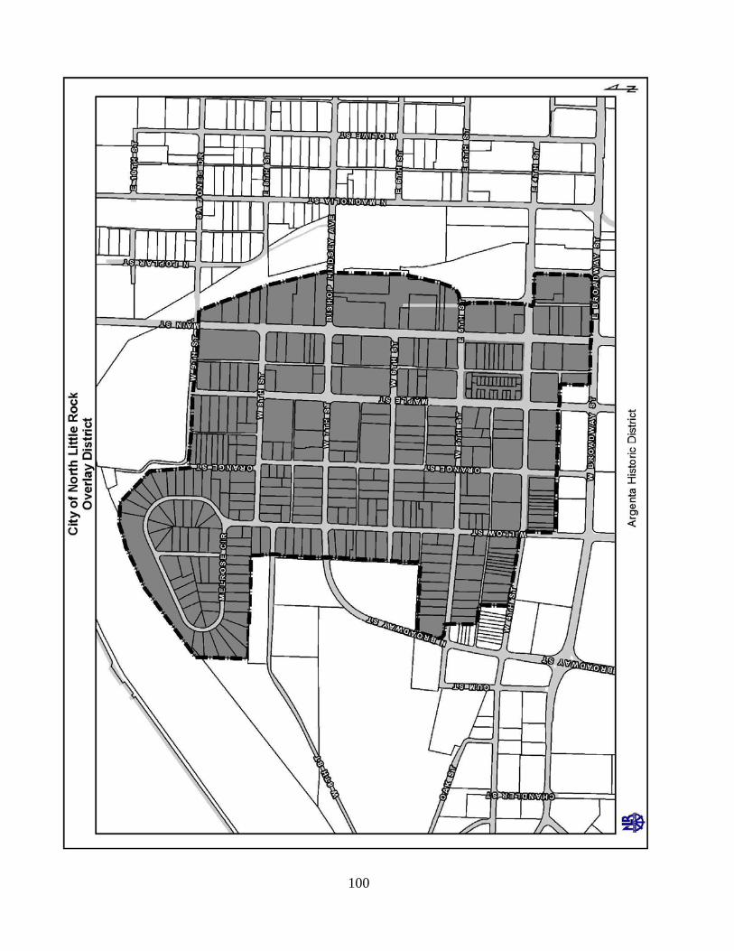
100

101
Section 11.6 – Flood Plain Overlay District
A. The North Little Rock Zoning Map shows District Boundaries based upon the best available information at a City-wide scale. The actual boundaries of this district, however, shall be determined by field verification.
B. Any area that, upon field verification is determined to have one or more of the
following characteristics shall be included in the District:
1. Floodplains along the 100-year floodplain as shown on the Federal Emergency Management Agencies (FEMA) Flood Insurance Rate Maps or Flood Hazard Boundary Maps, or the Flood of record;
2. Land along streams, bayous, meander scar lakes, and wetlands subject to
inundation, severe bank erosion, undercutting, or stream bed course alteration (bed alteration).
C. General Development Procedures. The following procedures shall be followed in
the circumstances stated:
1. Fill material shall not be placed in the flood plain until a study shall prove the floodway discharge is not increased by more than 1 foot and a fill permit is issued by the City’s floodplain manager.
2. Fill material shall not be placed in an established floodway under any
circumstances.
D. The Uses of Land and Buildings. See the Table of Permitted Uses in Article 21 of this ordinance for uses permitted in the Flood Plain Overlay District.
E. Permitted Structures. No structures shall be permitted in the Flood Plain Overlay
district except those used in the operation of the permitted uses. In general, the first floor elevation must be proven to be one foot above the designated floodplain elevation.
Section 11.7 – Washington Avenue Overlay District
A. Maximum Height. No building South of Washington Avenue, between Willow and
Cypress Streets, shall be allowed to exceed the height of 5 stories or 60 feet in order to protect area views of the Arkansas River.
102
ARTICLE TWELVE SPECIAL PROVISIONS
Section 12.1 - General The purpose of this section is to provide special development conditions for particular land uses. These uses by their nature require construction and site improvements peculiar to their operation in order for these uses to be compatible in the neighborhood where they are located. Both permitted and conditional uses shall be subject to the requirements in this Article. Section 12.2– Accessory Buildings Accessory buildings may be constructed in rear yards in the districts where allowed. Additional provisions are as follows:
A. On residential lots of 10,000 square feet or less, the square footage of the accessory
structure shall not be more than half that of the residence with a maximum of 850 square feet.
B. On residential lots of 10,000 square feet or more in area, the square footage of the
accessory structure shall not be more than 30 percent of the rear yard with a maximum of 3,500 square feet.
C. On residential lots, the pitch of accessory roofs shall be a 2:12 or greater pitch.
D. In C-1 through C-6 accessory buildings or structures shall be used exclusively as
product or equipment storage that is related to the principal use and shall be sited in the rear yard. The accessory buildings shall not occupy more than 20 percent of the rear yard.
E. Unless otherwise permitted by this ordinance, setbacks for accessory buildings are: 5
feet from a property line; and 10 feet from the principal building or other accessory building.
F. Accessory structures on industrial lots shall be permitted to exceed the height
limitation, up to but not exceeding 25 percent of the total permitted height.

103
Section 12.3 - Daycare Centers and Home Daycares
Child Daycare Centers are authorized under conditional use or special use permits and shall meet, as a minimum the following provisions:
A. The Planning Commission shall determine the number and spacing of daycare
facilities so that no adverse impact is created in a neighborhood. B. The facility shall meet all requirements of the State of Arkansas regulatory agency
for daycare facilities. C. All daycare centers/home daycares are prohibited in R-1 zoning classification.
Sid
e Y
ard
Sid
e Y
ard
Front Yard
Rear Yard
Residential
Accessory Building
Required 10 foot building separation
10'
5'
5'
Required 5 footsetback from property line
Figure 16: Accessory Buildings
104
D. All daycare centers/home daycares shall apply for a Special Use and a North Little Rock Business License.
E. All daycare centers/home daycares shall conform to applicable building and fire
regulations. F. All daycare centers/home daycares shall provide an opaque 6 foot fence around the
playground area. G. All daycare centers/home daycares shall be reviewed by the Subdivision Committee
through the Site Plan Review process. H. All daycare center/home daycare playground areas shall be grass or an approved soft
surface. I. All home daycares shall be the full-time residence of the caregiver and operated in a
single family home. J. All home daycares shall be operated on a minimum 50 feet wide residential lot. K. All home daycares shall provide a minimum of 600 square feet of hard surface
parking (asphalt or concrete) with a minimum driveway width at the street of 18 feet. L. Keeping more than 4 children (excluding family members) constitutes a home
daycare. The number of children cared for in a home daycare, including the caregiver’s own children, shall not exceed 10 children.
M. All daycare centers / home daycares shall perform a sex offender residence check through the NLR Police Department according to their rules and procedures, to determine if a level 3 or level 4 registered sex offender resides within 2000 feet of the proposed site for the daycare center / home daycare facility.
Section 12.4 – Home Occupation.
A. Home occupations are only those occupations that meet all of the requirements listed
below. Home occupations are approved administratively by city staff.
1. The home occupation is located completely within the principal dwelling unit. 2. The home occupation is solely operated by the owner(s) and occupant(s) of the
dwelling. No non-resident persons are employed. 3. The home occupation does not occupy more than 25 percent of the gross
habitable ground floor area of the principal dwelling unit.

105
4. The home occupation does not display merchandise or have outside storage of equipment or materials.
5. The home occupation does not alter the external appearance of the principal
dwelling unit. 6. The home occupation does not create noise, vibration, glare, fumes,
electromagnetic interference, odors, or air pollution outside the principal dwelling unit.
7. The home occupation does not have a sign that identifies or advertises the
business. 8. The home occupation does not involve the storage of hazardous materials, other
than substances of a type and quantity customarily associated with a home or hobby.
9. The home occupation will not cause more than two vehicles to be parked in the
vicinity of the principle dwelling unit. 10. The home occupation does not involve the external or visible manufacturing of
goods on-site.
B. Examples of Home Occupations.
1. Activities conducted principally by telephone, computer, facsimile, or mail. 2. Studios where handicrafts or objects-of-art are produced. 3. Dressmaking or apparel alterations. 4. Instructing, teaching, tutoring, or therapy of no more than four persons
simultaneously.
C. Prohibited Home Occupations.
1. Bed and breakfast. 2. Eating and drinking establishments. 3. Kennels. 4. Sales or leasing of vehicles. 5. Rest home. 6. Clinic, Doctor or Dentist Office. 7. Tourist Home. 8. Any use that requires a building code upgrade (i.e., from residential standards to
commercial standards) to accommodate the home occupation.
D. Hobbies conducted solely within the confines of a structure with no external impacts whatsoever, are not considered home occupations.

106
E. Garages Sales, Yard Sales, Carport Sales are allowed in residential zones for 1 week every 4 months.
F. The authority to operate a home occupation shall not be interpreted to waive any law
or regulation of the city, state, or federal government relating to the operation of a business, including without limitations: privilege licenses, facility licenses, professional certificates, inspection and similar requirements.
Section 12.5 – Carnival or Traveling Amusement Ride These activities may operate by obtaining a business license. The issuance of a business license is dependent, as a minimum, upon meeting the following conditions.
A. A zoning certificate has been submitted and received approval of the Planning
Department. B. The location shall be in a C-3 district shopping center parking lot where there are
200 or more parking spaces. The carnival or rides shall not occupy more than half the spaces.
C. The applicant has shall provide the following items to receive a business license:
1. Certification of insurance. 2. Certification in inspection by the Department of Labor. 3. Proof that all requirements of the Fire Marshal have been met. 4. A bond to cover costs which may be incurred by the City.
Section 12.6 – Liquor, Retail, Location Restraints
A. The location of retail liquor businesses is separated from churches and schools as
stipulated under the following conditions:
1. Permits for New Establishment. The business using the new permit shall be at least 1,200 feet from any church or public or private school.
2. Existing Permits. None shall be transferred to any location 1,200 feet of any church or public or private school.
3. Permitted Zones.
B. The distances in feet, stipulated, shall be measured from one property line to another property line.
Section 12.7 – Parking or Storing of Trucks and Trailers
A. It shall be unlawful for any person to park or store a tractor-trailer trucks or trailer of
a tractor-trailer truck in a residentially zoned district, any residential PUD, the Main Street Overlay District, the Argenta Quiet Commercial Overlay District, or in any commercial zone that is being used as a residence.
107
B. Exceptions. Section 12.7.A shall not apply to the following:
1. Any person who parks or stores any legitimate delivery service vehicle parking within any of the above named restricted districts for the purpose of to make a delivery to or a pick up from a residence located in such zone.
2. Any person who parks or stores a tractor-trailer truck at any business operating as
a nonconforming use within any of the above named restricted districts where tractor-trailer trucks were parked as part of the business when it became non-conforming.
Section 12.8– Parking of Unoccupied motor houses and Recreational Vehicles (RV) Storage Parking Permitted. The owners of motor homes, travel trailers, truck campers and other kinds of recreational vehicles may store the vehicles on their lot of residency. Provided, however, if the lot of residency is subject to bills of assurance with restrictions that prohibit the parking of such recreational vehicles, then the more restrictive shall apply. Lots that do permit parking and storage of recreational vehicles are subject to the restrictions that follow:
A. The RV shall not be attached (hooked-up) to any utilities and shall not be occupied
as living quarters; B. No part of the stored RV shall extend past the property line onto any public right-of-
way or easement. C. An exception to 12.8.B is created to allow RV to be parked in such a manner as to
extend past residential property lines onto public rights-of-way or easements for 72 hours prior to and 72 hours following a trip in the RV, to allow for trip preparation and then unpacking after the trip. This exception only applies to a R.V. that is stored at off-site locations and shall not be construed to permit interference with traffic on a public street.
Section 12.9 – Service Stations
A. Permitted structures. Each service station lot shall have at least one front line and
shall be occupied only by structures and accessory buildings as are clearly incidental and normal to the operation of service stations.
B. Dimensional requirements.
1. Lot Area. The lot area shall not be less than 14,000 square feet of which 60 per
cent shall remain as unobstructed open space; provided, however, that this open space may be used for parking and landscaped areas.

108
2. Minimum Front Yard. The main structure shall be set back 40 feet from each front property line. The pump islands shall be set back no less than 15 feet from each front property line; provided, however, if a canopy is used the forward most part may not extend any closer than 12 feet from each front property line.
3. Side Yards. No side yard is required for the primary structure. Pump islands,
including canopies, shall not be less than 15 feet from any side lot line. 4. Minimum Rear Yard. There shall be a rear yard having a depth of not less than
20 feet; provided that, where the rear lot line abuts an alley, then the minimum rear yard requirement shall be a depth of not less than 15 feet.
5. Maximum Height. No building hereafter erected or structurally altered shall
exceed 28 feet in height; provided, however, that cooling towers and other structural units necessary for the functioning of the use shall be permitted to exceed this height, provided that no building shall exceed this height, provided that no building shall exceed a height of 35 feet.
6. Location of Accessory Buildings. No accessory building except pump islands
and/or canopies shall be located in any required front yard, or within 15 feet of any lot line.
7. Fences. See Section 12.15.
8. Screens. All service stations shall provide a screen between abutting residential
zones and C-1 business areas, so as to protect these areas by day and by night from unreasonable disturbance by movement of people or vehicles, and from lights, noises or exposure to views not compatible with these areas. Such screens shall be pleasing in design and of a substantial material, easily maintained.
C. Off-street Parking. An area equal to the gross floor area but in no case less than five
parking spaces shall be provided. D. Corner Visibility. See Section 12.16. E. Used Car Sales. No used car or other related type sales shall be permitted. F. Enclosure Requirement. All major repair work shall be in enclosed areas. G. Curb Cuts and Safety Islands. Curb cuts and safety islands shall be in accordance
with the regulations of the City Engineer. H. Signs. All signs shall meet the requirements of the sign ordinance.

109
Section 12.10– Recreation Vehicle (RV) Park
RV Parks offer defined space with utility hook-ups for rental fees on a short-term basis. The market for rental space in an RV Park is predominately the traveling public. Parks such as these are generally located on sites accessible to major thoroughfares. A Development Plan Review is required to obtain a permit to build.
A. Site Requirements.
1. An RV Park may locate no closer to a residential district than 200 feet. 2. The site shall be at least 2 acres, suitably drained and free of standing water. The
drainage plan for the site shall have the approval of the City Engineer. 3. The ground surface surrounding structures, RV parking spaces, streets, and
general parking spaces in the RV Park shall be protected by grass or other suitable material that is capable of preventing soil erosion and dust.
4. Park density shall be no more than 15 campsites per gross acre. 5. Recreational vehicles shall be separated from each other and from other
structures by at least 10 feet. Any attached awnings, carports, expandable sections, or individual storage facilities shall, for purposes of this separation requirement, be considered to be part of the recreational vehicle. Each site shall contain a stabilized, level vehicular parking pad of gravel, paving, or other suitable material. No part of a recreational vehicle or other unit placed on a recreational vehicle site shall be closer than 5 feet to a site line.
6. RV Park streets shall be 10 feet minimum lanes paved in a dust free material.
When feasible, a continuous one way street with separate entry and exit is preferred. A two way street is a minimum of 20 feet of paving width. Curves and turning radii shall be constructed for vehicles 8.5 feet wide and up to 40 feet long.
7. Automobile and Light Truck Parking. 3 off-street spaces for each 2 RV pads.
B. Entrances and Exits.
1. All RV parks shall be provided with safe and convenient vehicular access from
an improved public street. It shall be the responsibility of the applicant to provide the necessary access in all cases where there is no existing improved street or road connecting the RV park site with an improved existing public street or highway.
2. Street improvements required beyond the RV Park shall be improved in
accordance with the standards of the Control of Development and Subdivision of Land Ordinance.
110
3. All entrances and exits on public streets shall be approved by the City and State
Highways then also by the Arkansas Highway and Transportation Department. 4. All R.V. Parks with more than 25 sites shall have 2 or more entrances/exits. All
R.V. Parks with more than 100 sites shall have 3 or more entrance/exits.
C. Accessory Uses. Management headquarters, recreational facilities, toilets, dumping stations, showers,
coin-operated laundry facilities, and other uses and structures customarily incidental to operation of a RV Park and campground are permitted as accessory uses to the park. In addition, stores, and other conveniences establishments shall be permitted as accessory uses, subject to the following restrictions:
1. Such establishments and the parking area primarily related to their operations
shall not occupy more than 5 percent of the gross area of the park. 2. Such establishments shall be restricted in their use to occupants of the park. 3. Such establishments shall present no visible evidence from any street outside the
park or their commercial character which would attract customers other than occupants of the park.
4. The structures housing such facilities shall not be located closer than 100 feet to
any public street and shall not be directly accessible from any public street, but shall be accessible only from a street within the park.
D. Minimum Setback or the RV Park Property. All buildings or structures, RV pads,
and automobile/small truck parking spaces shall be setback from the perimeter property line of the RV Park as follows:
1. Front Setback Minimum. 25 feet except when the RV Park fronts on a State
Highway; then 50 feet. 2. Minimum Side Setback. When abutting a dedicated public right-of-way, the side
setback shall be 25 feet on the side street; when abutting any other zoning district, the side setback shall be 15 feet along the interior lot line.
3. Minimum Rear Setback. 15 feet except when the rear yard abuts a dedicated
public right-of-way. If the rear yard abuts a dedicated public right-of-way, the minimum shall be 25 feet.
4. Screening. Article 15 shall be adhered to when the location of the RV Park abuts
a dissimilar land use. In addition, where needed to enhance aesthetics or to ensure public safety, the RV Park shall be enclosed by a fence, wall, landscape screening, or other designs approved by the Planning Director which will

111
complement the landscape and assure compatibility with the adjacent environment.
5. Electrical, Water Supply, and Sewage Disposal. All construction and utility
systems shall comply with all applicable city and state codes and standards, and be inspected by the appropriate inspectors.
6. Length of Stay.
a. Spaces shall be rented by the day, week, or month: and occupants of such space shall remain in the same RV Park not more than 3 months in any 1 year period.
b. No recreational vehicle shall be used as a permanent place of abode, dwelling or business or for indefinite periods of time. Continuous occupancy extending beyond 3 months in any 12 month period shall be presumed to be permanent occupancy requiring other arrangements.
c. Any action toward removal of wheels of a RV except for temporary purposes of repair is hereby prohibited.
7. Revocation of Permit to Operate. A finding that the operator (management) of
an R.V. Park has permitted conditions in violation of above requirements shall be cause for the revocation of the permit to operate. An appeal of the finding may be brought before the Planning Commission for a hearing of revocation.
Section 12.11– Sexually Oriented Businesses.
A. Purpose. It is the purpose of this section to regulate sexually oriented businesses to
promote the health, safety and general welfare of the citizens of the City, and to establish reasonable and uniform regulations to prevent the concentration of sexually oriented businesses within the City. The provisions of this section have neither the purpose nor effect of imposing a limitation or restriction on the content of any communicative materials, including sexually oriented materials. Similarly, it is not the intent nor effect of this section to restrict or deny access by adults to sexually oriented materials protected by the First Amendment, or to deny access by the distributors and exhibitors of sexually oriented entertainment to their intended market, unless otherwise restricted by law.
B. Definitions – See Article 2 Definitions. C. Classification. Sexually oriented businesses are classified as follows:
1. adult arcade. 2. adult bookstores or adult video store. 3. adult cabaret. 4. adult live entertainment establishment. 5. adult motion picture theater. 6. adult oriented business.

112
7. adult theater. 8. escort. 9. escort agency. 10. massage establishment that offers adult services. 11. nude model studio.
D. Location of Sexually Oriented Businesses.
1. A person commits an offense if he/she operates or allows to be operated a sexually oriented business in any zone not classified as I-2 or I-3, or regardless of classification within 1,000 feet of:
a. A church or place of worship. b. A school. c. A boundary of a residential zone or residence. d. A public park. e. A hospital or other medical facility. f. Properties listed on the National Register of Historic Places or local Historic
Districts as identified in the Arkansas Historic Preservation Program. g. A child care facility. h. A park or playground. i. A public library. j. A recreational area.
2. A person commits an offense if he/she causes or permits the operation,
establishment, or maintenance of a sexually oriented business within 1,000 feet of another sexually oriented business.
3. For the purposes of this section, measurement shall be made in a straight line in
all directions, without regard to intervening structures or objects, from the nearest point on the property line of a parcel containing an adult oriented business, to the nearest point on the property line of a parcel containing a church or place of worship, a school, a residentially zoned property, a residence, a public park, a hospital or other medical facility, properties listed on the National Historic Register or local Historic Districts as identified by the Arkansas Historic Preservation Program, a child care facility, a park or playground, a public library, or a recreational area.
4. For the purposes of this section, the distance between any two sexually oriented
businesses shall be measured in a straight line without regard to intervening structures or objects, from the nearest point on the property line of each parcel containing an adult oriented business.
E. Non-Conforming Sexually Oriented Businesses.
1. Any sexually oriented business lawfully operating on May 28, 2002, which is in violation of part D of this Section 12.11 of this ordinance shall be deemed a

113
NON-CONFORMING USE. The non-conforming use will be permitted to continue for a period not to exceed 2 years from the date of the passage of this ordinance, unless sooner terminated for any reason or discontinued for a period of 90 days or more.
Such non-conforming uses shall not be increased, enlarged, extended or altered
except that the use may be changed to a conforming use. If two or more sexually oriented businesses are within 1,000 feet of one another and otherwise in a permissible location, the sexually oriented business which was first established and continually operating at a particular location is the conforming uses and the later-established business(s) is non-conforming.
2. A sexually oriented business lawfully operating as a conforming use is not
rendered a non-conforming use by the subsequent location of a church or place of worship, a school, a residentially zoned property, a residence, a public park, a hospital or other medical facility, properties listed on the National Historic Register or local Historic Districts as identified by the Arkansas Historic Preservation Program, a child care facility, a park or playground, a public library, or a recreational area within 1,000 feet of the sexually oriented business. This provision applies only to an ongoing sexually oriented business, not to a sexually oriented business that has been terminated for any reason or discontinued for a period of 90 days or more subsequent to the location of the church or place of worship, a school, a residentially zoned property, a residence, a public park, a hospital or other medical facility, properties listed on the National Historic Register or local Historic Districts as identified by the Arkansas Historic Preservation Program, or a child care facility a child care facility, a park or playground, a public library, or a recreational area.
F. Enforcement.
1. Any person violating any part of this section, upon conviction, is punishable by a fine not to exceed $500.00.
2. If the violation is, in its nature, continuous in respect to time, the penalty for
allowing the continuance thereof is a fine not to exceed $250.00 for each day that the same is unlawfully continued.
Section 12.12 – Roadside Vending
Roadside vending takes place in locations that may be temporary and changeable, may utilize structures or vehicles that are either permanent or mobile, and are subject to seasonal activity. The regulation of activity under this section is by both privilege license and zoning provisions. The following regulations shall apply:
A. Roadside Food Stands. All roadside food vending stands shall be permanent
structures and comply with the following:
114
1. Connect to sewer, water and electrical utilities. 2. Be licensed by the State Health Department. 3. Maintain a permanent structure appearance with underpinning even when the
unit is portable. 4. Meet parking requirements of the zone. 5. Meet the setback requirements of the zone. 6. Must be approved by the Planning Commission as a conditional use in a C-3, C-
4, C-5, I-1 and I-2 zoning districts. 7. Freestanding produce price signs and directional signs shall not be utilized.
B. Roadside Produce Stands. Roadside produce stands are generally mobile and may
use a temporary display table, the back of a pick-up truck, a car truck or similar such arrangements. Produce stands are subject to the following provisions:
1. The vendor shall obtain a privilege license and the license shall be available for
inspection. 2. Roadside produce stands may be located in C-3, C-4, C-5, I-1 and I-2 districts if:
(a) no traffic hazard is created and; (b) the vendor has written permission of the property owner.
3. In C-3and I-1 districts, all produce shall be kept inside or on a vehicle. 4. In C-4, C-5 and I-2 districts, all produce may be displayed on tables. 5. Each stand shall be at least 20 feet from traffic lanes. 6. Vendor stands should be 70 feet apart and occupy no more than 2,000 square feet
of an area of approx. 70 by 30 feet when in parking lots. 7. Freestanding produce price signs and directional sign shall not be utilized.
C. Snow Cone Vendors.
1. Connect to sewer, water and electrical utilities. 2. Be licensed by the State Health Department. 3. Maintain a permanent structure appearance with underpinning even when the
unit is portable.
115
4. Meet parking requirements of the zone. 5. Meet the setback requirements of the zone. 6. Must be approved by the Planning Commission as a conditional use in a C-3, C-
4, C-5. 7. Freestanding produce price signs and directional signs shall not be utilized.
D. Special Event Food Vendors. Special Event Food Vendors (e.g. Mobile Food
Vehicles) may operate during times designated by the Mayor or his designee as a special event, for duration of not more than three (3) days. The issuance of a license for the special event is dependent, at a minimum, upon meeting the following provisions:
1. A special event Mobile Food Truck license must be obtained from the City Clerk
pursuant to provisions in Ordinance No. 8655 adopted July 14, 2014. 2. The allowed location for Special Event Food Vendors shall be (1) commercially
zoned property, or (2) residentially zoned property when the mobile food vehicles will be located on parking lots with sufficient space to allow for the placement of vendor stations and adequate ingress and egress.
Section 12.13– Automatic Teller Machines The installation of automatic teller machines (ATM) as free standing structures, not located in a bank building, shall be classified as special uses. The provisions of Article 17 Special Use shall apply. Section 12.14 – Cell Towers
A. Communication devices that can be attached to existing towers, poles, buildings, or
other structures, allowing such attachments to extend 15 feet above existing structures without a height variance, will be permitted by staff without the requirement of a formal use procedure.
B. Co-locate communication devices of competing providers on individual structures. C. Require any company installing a new tower to make appropriate provisions to allow
for the future addition of at least one other provider on a private rental basis. D. Require the company installing a new tower to agree to refrain from generating
unreasonable obstacles to such co-location arrangements. E. Communication devices that result in the addition of separate structures, such as a
tall pole or tower detached from existing structures, will be treated as broadcast stations, which are permitted in all industrial, flood prone/conservation, and C-5
116
zones. Requests for new broadcast stations outside of these designated zones are to follow the established procedure for obtaining a use variance through rezoning or the Special Use procedure, with the understanding that conditions for approval are allowed with Special Use request and these conditions normally are in regard to specific physical characteristics and screening.
F. Any tower permitted in a zone, but requiring a variance of the height limitation, or
any new tower over 75 feet in height, will be directed to the Board of Adjustment. G. New Poles will be treated as structures, requiring Planned Building Group approval
in C-5 zones if a tower is added to property currently having an existing use. H. Parking lots supporting a nearby use are to be considered as being the primary use of
property and Planned Building Group procedures shall apply when placing towers in the existing parking lot.
I. All of the provisions of the Control of Development/Subdivision Regulations to
placement of a new tower are applicable and a telecommunication tower is to be considered a primary structure.
J. Dimensional and Development requirements:
1. Lot area of not less than 5,625 square feet, such as 75 feet by 75 feet. 2. Placement of the tower in the center of the lot. 3. Maintaining building setback lines of 15 feet from any property boundary. 4. Require a six foot fence around the perimeter. 5. Require a planted buffer along all property boundaries with a minimum depth of
10 feet with planting materials to reach a height of 20 feet at maturity.
K. Provide reasonable separation of individual towers by not placing towers within the field of view of another tower or by maintaining a physical separation of 2,000 feet between towers.
L. Permit Fees.
1. Building permit fee of $25 per foot for all new towers. 2. The addition of antennas or telecommunication devices on existing towers, the
co-location of new providers on existing towers, or the replacement of existing towers, shall result in an assessment of a permit fee based on the commercial remodeling materials cost rate of $11.25 per the first $1,000 and $6.00 per each additional $1,000.

117
Section 12.15 – Fences
A. Materials. All fences shall be constructed of exterior grade materials, such as treated pine, cypress, cedar, redwood, or other exterior materials.
B. Front Yards of Residential Zones.
1. Front yard fences shall not exceed 3.5 feet in height. 2. Front yard fences shall be constructed of architectural materials. Architectural
materials do not include chain link fences or any fence that is opaque. 3. Front yard fences shall not encroach into a sight triangle. 4. Front yard fences shall be located no closer than 10 feet from the back of the
curb or at the front property line whichever is farther from the street. 5. Under no circumstance shall any fence be allowed within 3 feet of a fire plug.
C. Side Yards of Residential Zones.
1. Fences within 3 feet from any residence shall not be allowed. 2. Fences constructed between 3 feet and 6 feet from any residence shall be limited
to a maximum height of 4 feet with an additional 2 feet of height allowed, provided the upper 2 feet of the fence area has an open area of at least 40 percent.
3. Fences constructed 6 feet or greater from any residence shall not exceed 6 feet in
height. 4. Under no circumstance shall any fence be allowed within 3 feet of a fire plug.

118
119
D. Rear Yards of Residential Zones.
1. Fences up to 8 feet in height may be erected around the rear yard, except on corner lots.
E. Corner Lots of Residential Zones.
1. Fences in the side and rear yards of corner lots may not be any closer to a street than the established front building line of any abutting property.
2. Fences that face a street in the side and rear yards of corner lots shall be limited
to a maximum height of 6 feet. 3. Fences that face a street in the side and rear yards of corner lots shall be
constructed with the finished side facing the street. 4. Under no circumstance shall any fence be allowed within 3 feet of a fire plug.
F. Commercial Zones.
1. The total height of side yard fences shall not exceed 6 feet. 2. The total height of rear yard fences shall not exceed 8 feet. 3. Front yard fences are not permitted. 4. Under no circumstance shall any fence be allowed within 3 feet of a fire plug.
G. Industrial Zones.
1. The total height of side yard fences shall not exceed 6 feet. 2. The total height of rear yard fences shall not exceed 8 feet. 3. Front yard fences are not permitted. 4. Under no circumstance shall any fence be allowed within 3 feet of a fire plug.
H. Barbed Wire Fences.
1. Barbed wire may be permitted in the rear and side yards of industrial and C-4 and
C-5 zones. 2. Side yard barbed wire shall be vertical or inclined inward to the property. The
total height, including the barb wire shall not exceed 6 feet.

120
3. Rear yard barbed wire shall be vertical or inclined inward or outward to the property. The barbed wire may be mounted on A or Y arms. The total height, including the barb wire shall not exceed 8 feet.
I. Concertina or Razor Wire Fences.
1. Concertina wire or razor wire may be permitted in the rear yards of industrial
zones. 2. Concertina wire or razor wire may be permitted on top of fences 7 feet in height.
The total height, including the wire, can not exceed 8 feet.
J. Electric Fences.
1. Electric fences are prohibited within the City limits.
Section 12.16 – Unobstructed Vision at Street Intersections Public safety requires clear views near street intersections. To this end, there shall be no obstructions between 2 and 9 feet off the ground within the corner clearance triangle, an area 25 feet from the point of intersection of continuation of the curb lines and the connecting line across private property; exceptions include street name signs, fire hydrants and other necessary appurtenances.
Section 12.17 – Housing Moving
Varies
Restricted Area
Curb
Right-of-way/PropertyLine
Corner Lot
25.0'
25.0'
Figure 18: Sight Triangle

121
A. Require any person desiring to move any building, machinery or other heavy object
over the streets of the City of North Little Rock which, under the laws of the State of Arkansas requires a state permit, shall also secure a permit from the City, unless specifically exempted from local permits by state law.
B. Application for a permit required by this section shall be secured from the Planning
Department at least 48 hours in advance of the time in which the building, machinery, or other heavy object is to be moved. The person securing the permit shall designate in the application the time and route over which such materials or objects will be moved.
C. Require any person desiring to move any building, machinery or other heavy object
over the streets of the City, prior to the issuance of a permit, to post with the City an indemnity bond in the amount of $2,500 and shall assume responsibility for any and all damages that may occur during the moving of any building, machinery, or other heavy object.
D. Prior to the issuance of the permit required by this section, an applicant shall obtain
the approval of the North Little Rock Planning Commission. Prior to consideration by the Planning Commission, the applicant shall file an application including the following items:
1. Inspection Report. An inspection report by a certified and registered Home
Inspector stating that the house is capable of being moved safely. The report shall include exterior photos of the house in its present location that accurately indicates the current state of repair of the structure.
2. Development Plan. A development plan for the anticipated location of the house
must be included in the application. The plan will include a site plan of the proposed location, an estimate of the cost of remodeling, a statement of what type of remodeling is proposed, and the estimated date of completion of such remodeling and a bond to ensure timely compliance with local building codes.
3. Bond. The amount of the bond shall be based upon the size of the house to be
moved. If the house is equal to or less than 1,250 square feet of living space, the required bond shall be in the amount of $5,000. This bond may be waived by the Planning Commission if the applicant demonstrates the following:
a. The applicant is low income as defined by Part 5 of Title 24 of the Code of
Federal Regulations. b. A non-profit organization will satisfactorily guarantee completion of the
Development Plan within six months. 4. Time. The applicant will have 90 days to complete the foundation and exterior
of the site. The date of completion for the Development Plan shall be within six
122
months of the issuance of the permit, unless the Planning Commission expressly grants an extension of time. Should the Development Plan not be completed in time, or should the work performed fail to substantially conform to applicable building codes, the city may liquidate the bond and use the proceeds thereof to raze the house.
5. Violations. Violations of this section shall be considered to be continuous in
nature and punishable by a fine not to exceed $50.00 per day such violation continues.
Section 12.18 – Decks
A. Rear and side yard decks over 3 feet in height and attached to the primary structure
shall be considered part of the primary structure and be constrained by established building line setbacks and lot coverage requirements.
B. Rear and side yard decks under 3 feet in height and attached to the primary structure
shall not be constrained by established building line setbacks and lot coverage requirements.
C. Decks over 3 feet in height and not attached to the primary structure shall be treated
as an accessory structure and meet all the requirements of Section 12.2.
Section 12.19 – Residential retaining walls
A. The height of a retaining wall is measured from the top of the retaining wall to the existing grade or finished grade, whichever is lower, directly below the retaining wall.
B. The allowable height of a retaining wall is 3.5 feet or less in front and side yards, 5
feet or less in rear yards. C. Rear yard retaining walls greater than 3.5 feet in height require a three foot fence and
the combination of retaining wall and fence shall not exceed eight feet in height.
Section 12.20 - Single-family and Duplex Appearance Standards
A. Building requirements:
1. Residences shall be oriented in such a way that the front entrance is readily apparent from the street.
2. Residences shall maintain a minimal dimension such that no facade is less than
20’ in width. 3. Roofs of residences shall have a minimum 4:12 pitch.
123
4. Roofs of residences shall have a minimum 12 inch eave, excluding gutters. The eave is measured from the structure wall to the outside drip edge. This restriction does not apply to manufactured homes in legally permitted zones.
5. The siding of residences shall be of customary design and materials, including
exterior grade plywood panel, hardboard, lumber, cedar shingles, other wood, vinyl, aluminum, steel, or masonry siding materials to be consistent with the character of existing neighborhoods. Vertical ribbed or corrugated steel siding shall not be allowed.
6. The foundation of residences shall be solid and continuous around the perimeter
of the primary structure. 7. All facades shall include windows, doors or other openings.
B. Site requirements:
1. No more than 50% of the front yard shall be impervious or paved surfaces. 2. Front yard driveway surfaces shall be of concrete, asphalt, or other solid masonry
materials. Gravel is not permitted as a front yard driveway surface.
Section 12.21 - Sidewalks
A. Sidewalks shall be a minimum of 5 feet wide and shall be installed within the dedicated right-of-way adjacent to the property line, except where there are topographical constraints in which case the sidewalk may be placed at the street curb.
B. Sidewalks shall be required as follows:
1. Sidewalks are required on both sides of local, collector and arterial streets in
commercial and residential areas. 2. Sidewalks are required on both sides of designated collector and arterial streets
through industrial zoned areas.
3. Internalized pedestrian circulation systems in the form of paved pathways may be substituted for sidewalks along collector and arterial streets upon request of the applicant, the recommendations of the Planning Director and the approval of the Planning Commission. Said pathways shall be dimensioned at no lesser standard than ordinary street-side sidewalks.
4. On local streets the developer shall have the option of locating sidewalks
adjacent to the curb.

124
5. The Planning Commission may, at its option, require greater than five foot sidewalks in conjunction with commercial subdivision approvals or in other places of public assembly, or anticipated heavy pedestrian traffic volumes.
6. Sidewalks shall be required on both sides of local streets conforming to the minor
residential street length and configuration standards. 7. Sidewalks are not required to be constructed at the same grade of the curb of the
street. 8. Sidewalks are not required to be constructed in the straight line if such straight
line construction would damage trees. 9. Sidewalks shall be constructed to permit wheelchair access at street intersections. 10. Sidewalks shall be required with all replats where the development has 200 feet
or more of linear street frontage, inclusive of corner lots. 11. Sidewalks shall be required with estate residential development when the average
lot width is 150 feet or less.
12. Sidewalks are not required on frontage roads.
Section 12.22 - Mobile Storage Containers A. Residential areas
1. There shall be no more than one mobile storage container per site. 2. No mobile storage container shall remain on a lot in excess of 30 consecutive
days, and mobile storage containers shall not be placed at any one lot in excess of 30 days in any calendar year.
3. If possible, mobile storage containers should be placed in the rear yard.
4. A no-fee permit shall be required for the placement of a mobile storage container
on a lot. A site plan shall be required to obtain a permit.
5. The following setback requirements shall be maintained to obtain a permit.
a. Mobile storage containers shall be setback from any primary structure and/or accessory structure a minimum of ten feet.
b. Mobile storage containers shall be setback from any property line a minimum of five feet.
c. Mobile storage containers are not permitted in a sight triangle. d. Mobile storage containers are not permitted in the right-of-way or block a
sidewalk.

125
6. All requests for a variance will be to the Board of Adjustment.
B. Commercial areas
1. There shall be no more than one mobile storage container per site. 2. No mobile storage container shall remain on a lot in excess of 60 consecutive
days, and storage containers shall not be placed at any one lot in excess of 60 days in any calendar year.
3. Mobile storage containers shall not be the primary structure on a lot.
4. A no fee permit shall be required for the placement of a mobile storage container
on a lot. A site plan shall be required to obtain a permit.
5. Mobile storage containers shall not be located in any required parking spots.
6. Mobile storage containers are not permitted in front or side yards.
7. The following setback requirements shall be maintained to obtain a permit.
a. Mobile storage containers shall be setback from any primary structure and/or accessory structure a minimum of ten feet.
b. Mobile storage containers shall be setback from any property line a minimum of five feet.
c. Mobile storage containers are not permitted in a sight triangle. d. Mobile storage containers are not permitted in the right-of-way or block a
sidewalk.
8. All requests for a variance will be to the Board of Adjustment, except those mentioned in Section 12.22.C.
C. Mobile storage containers in commercial areas used for more than 60 days or as
permanent structures must go through the Special Use process.
D. Industrial areas
1. Any business that: rents, distributes or stores mobile storage containers, shall be exempt from Section 12.22.
2. Any business that is currently utilizing multiple mobile storage containers on or
before October 1, 2007, shall be exempt from Section 12.22.
3. One mobile storage container may be located on the property at any time. A no fee permit shall be required for the placement of a mobile storage container. A site plan shall be required to obtain a permit.

126
4. Mobile storage containers shall not be located in any required parking spots.
5. Mobile storage containers shall be set back from any primary structure a
minimum of 10 feet.
6. Mobile storage containers are not permitted in front yards.
7. All requests for a variance will be to the Board of Adjustment. E. Construction areas. Mobile storage containers (or trailers) will be allowed on
construction sites with the issuance of a building permit. Such containers or trailers shall be removed from the property upon expiration of the building permit or 30 days after issuance of the Certificate of Occupancy, whichever date is sooner.
Section 12.23 – Outdoor Display in C-6 zones
A. Businesses in C-6 zones are permitted to display merchandise outdoors during
normal hours of operation. B. Said display items may encroach onto adjoining sidewalks a distance of four feet so
long as a five foot passageway is maintained on the public right-of-way. C. Appliances, mattresses, automobiles, vehicle trailers are not permitted to be
displayed outdoors. Automobiles may only be displayed outdoors at an existing car lot.
Section 12.24 – Paint & Body Shops; Wrecked Vehicle Repair Businesses
A. The intent of this section is to establish regulations for businesses operating paint and
body shops or repairs of wrecked or inoperable vehicles in order to prevent unsightly appearances in neighborhoods and improve orderliness in the community.
B. Storage of Wrecked Vehicles and/or Parts Related Thereto. All wrecked or
inoperable vehicles, and any parts related thereto, shall be stored in a fenced area located behind the front building line. The fenced enclosure area shall meet the following requirements:
1. The enclosed area shall prevent the wrecked or inoperable vehicles and/or parts
from being seen from a city street or other right-of-way or a residence (regardless of zoning).
2. The enclosure shall have a minimum height 6 foot opaque (or wood privacy)
fence. C. If the topography or other conditions will not allow an enclosed storage area for the
wrecked or inoperable vehicles and/or parts at the rear of the business location, an

127
application for a variance may be made with the Planning Department, and the applicant may present such request to Planning Commission which shall designate an alternative area. Any person aggrieved by such decision may appeal to the Board of Adjustments in accordance with Section 19.1.
Section 12.25 – Parking or Storing Commercial Vehicles in Residentially Zoned Property
A. It shall be unlawful for any person to park or store a commercial vehicle in any
Residential Zoned Property in such a manner that any part of the vehicle shall be closer to the street than the front building line of said lot(s) as defined by city zoning regulations, or upon any street adjacent to property in any Residential Zoned Property.
B. Exceptions. Section 12.25.A shall not apply to the following:
1. Any person who parks or stores a commercial vehicle at any business lawfully
operating as a non-conforming use on Residential Zoned Property, in which case all vehicles must be parked on a proper Parking Surface.
2. Any person who parks or stores a commercial vehicle on any Residential Zoned
Property for the lawful conduct of business during normal business hours. 3. Any person who parks or stores a commercial vehicle on a construction or
demolition site; provided, all necessary permits have been properly issued and such storage does not continue for a period to exceed five days.
Section 12.26 – Vehicle Sales Lots
A. The intent of this section is to establish requirements for any vehicle sales lot that
requires a conditional use. B. Requirements for conditional uses granted to vehicle sales lot applicants. This
subsection is intended to apply only to conditional use applications made on or after January 24, 2011.
1. Fences shall not be allowed in the front yard of a vehicle sales lot, except as
mandated under Article 15 hereof. 2. Existing fences located in the front yard of a vehicle sales lot shall be removed,
unless required when adjacent to residential use. 3. Six foot wood privacy fence shall be required when vehicle sales lot abuts a
residential use. Fences shall not extend beyond the front building line of the abutting residential use.
128
4. Vehicle sales lots shall not utilize barb wire or razor wire. Any existing barb wire or razor wire shall be removed.
5. There shall be a ratio of one vehicle per every 450 square feet of open lot area.
This ratio shall include sales, employee, and customer vehicles. Open lot area does not include any structures.
6. All exterior vehicle sales lot lighting, located on a building or free standing, shall
be shielded and directed downward. Lighting shall be directed away from abutting residential uses.
7. Sales vehicles shall be displayed on one of the following surfaces: asphalt paving
or concrete. Asphalt paving shall meet the standards of the City Engineer. Sales vehicles shall not be displayed on grass or gravel surfaces.
8. All signage shall meet the requirements of Article 14 of the zoning ordinance. 9. No inoperable or wrecked vehicles shall be stored or sold from the sales lot.
Vehicle sales lots shall not store inoperable or wrecked vehicles, nor any parts thereof, as those terms are defined under the North Little Rock Property Maintenance and Nuisance Abatement Code.
10. Vehicle sales lot shall be maintained at all times. 11. Sales vehicles shall be locked and secured after business hours. 12. Sales vehicles shall not be used as storage. 13. Vehicle sales lot and any structures located on the lot shall meet all applicable
Federal, State, County and City requirements and codes. 14. Business license to be issued after Planning Staff confirmation of requirements. 15. Business license holder understands that failure to comply with these conditions
may result in loss of the Special Use and/or loss of Business License and/or removal of Electric Power Meter.
Section 12.27 – Alternative Energy Systems
A. Purpose and Intent: The City of North Little Rock encourages the use of renewable
energy to sustain the general community. The City of North Little Rock also encourages building owners to first improve the overall energy efficiency of their building. It is much less expensive to reduce heating, cooling and lighting demand than it is to satisfy that demand with a high-tech alternative energy system. The purpose of this section is to regulate the appearance and reduce the negative effects, such as offensive glare and noise, with the use of alternative energy systems that

129
may include solar panels, solar radiant devices, wind turbines, wind mills, and other associated devices
B. Regulations applying to all Alternative Energy Systems (AES):
1. Permits are required for an AES to verify compliance with aesthetics and safety.
Any AES located in a Historic District shall have approval from the North Little Rock Historic District Commission before applying for a permit.
2. No AES shall be connected to the utility grid until written authorization from the
local utility company is provided to the Planning Department, which will then be attached to the building permit. The local utility company may require a representative to be present at the time of connection.
3. All power transmission lines and power lines to and from a detached AES
accessory structure shall be located underground. 4. All electrical and plumbing components of an AES shall conform to the relevant
and applicable local, state and national codes. 5. Photovoltaic shingles, siding, or other non-glare, stealth type and unobtrusive
components of an AES are permitted in all zoning classifications or uses.
C. Regulations applying to Solar Panels:
1. Detached or ground mounted solar panels shall be treated and regulated as an accessory building in all zone classifications. Accessory Building shall be as defined in the current City of North Little Rock Zoning Ordinance.
2. In residential and commercial zones and uses, detached or ground-mounted solar
panels shall only be permitted in rear yards, and the following restrictions shall apply to these systems:
a. The maximum height of any ground mounted solar panel shall be 8 feet.
b. Solar panel systems are not exempt from lot coverage and setback
restrictions. The total coverage of a lot shall not exceed 50% of lot coverage and shall include the calculation of the primary structure and all accessory structures, including the detached AES component.
c. All ground mounted solar panels shall be located at least 5 feet from any property line and 10 feet from the primary structure.
3. Solar panels should be placed such that potential glare onto nearby properties or
roadways is minimized to the extent possible while still maintaining adequate performance from the solar panels. When glare from a solar panel is perceived
130
as a nuisance secondary impact, it shall be the responsibility of the owner to remediate the nuisance.
4. Residential roof-mounted panels which are installed such that they are visible
from the street shall be flush-mounted on the roof. The following shall apply to roof mounted panels that are visible from the street:
a. Solar panel arrangement and design should be considered when locating
panels.
b. Panels should be consolidated to form an array of panels as opposed to individual panels being located on roofs.
c. Avoid breaking up systems into multiple panel areas. d. A single array of panels symmetrically located on the roof is encouraged.
5. Residential roof-mounted panels which are installed such that they are not visible
from the street shall either be flush-mounted on the roof or, if not flush-mounted, installed no more than five feet from the roof plane surface.
6. Other parameters relative to the installation of solar panels in all districts:
a. All roof mounted solar panels shall be set back at least 3 feet from any edge,
peak, ridgeline, eave or valley of the roof to maintain pathways of accessibility.
b. Support structures for a solar panel shall match the surrounding building fabric in color.
c. All conduit, wiring and piping shall not be visible and shall be fully concealed.
D. Solar Water Heating Systems shall meet the same regulations as imposed on the use
of solar panels.
E. Regulations applying to all Wind Turbines and Wind Mills:
1. Wind Turbines and Wind Mills are not permitted in residential or commercial zones.
2. Wind Turbines and Wind Mills are allowed in all industrial zoned properties both
on buildings and on detached, ground mounted structures when located 500’ from residentially zoned property.
3. The height of any wind turbines shall not exceed the height requirement for the
zone district within which the location of the tower is proposed.

131
4. The wind turbines shall be setback 1.5 times the height of the tower from any
primary structure or property line. 5. The wind turbines shall be permitted only in rear and side yards, except as
permitted in subsection 2 above. 6. The maximum number of ground mounted wind turbines is 1 per lot or as
permitted by a Special Use Permit. 7. A 6 foot fence with a locking gate shall be required around all wind turbines to
prevent potential climbing hazards. 8. All windmills shall have a braking system when winds reach speeds in excess of
40 miles per hour. 9. The minimum height of the lowest position of the wind rotor shall be 15 feet
above the ground. 10. The landowner shall complete decommissioning of the wind turbine within 12
months after the end of the useful life of the device. It shall be presumed that the windmill is at the end of its useful life when no electricity is generated for a period of 12 months.
11. Audible sound from a wind turbine shall not exceed 45 decibels, as measured at
the exterior of any occupied building on an abutting property. 12. Wind turbines shall not display advertising, except for reasonable identification
of the manufacturer and this identifier sign shall have a total area of less than 2 square feet. Blades may only be painted uniformly in one shade of white or neutral color with all blades and mechanisms being painted the same.
F. The City will consider Solar-themed Subdivisions through the North Little Rock
Planning Commission’s Planned Unit Development process or through the creation of a Special District.
G. All waivers of these AES requirements shall be considered through the North Little Rock Planning Commission’s Special Use process with City Council providing final approval and not directed to the Board of Adjustment variance hearing process.
Section 12.28 – Community Gardening
A. Intent, Goal, and Objective: The intent of this section is to allow community
gardening and limited agricultural activity to build social connections; offer recreation, education, and economic development opportunities; to provide open space; and to generate a local food source.

132
B. Registered Community Gardens are permissible uses of property in all zones and no rezoning or variance is required to initiate a registered community garden. All Community Gardens must be registered with the City listing the property owner and the gardening coordinators contact information.
C. Registered Community Gardens may include the following features:
1. Water meters shall be allowed to serve registered community gardens.
2. There shall be no retail sales allowed at registered community garden except
plants, whole fresh produce, and honey grown or produced on the site.
3. Accessory support buildings and structures allowed on registered community garden lots include tool sheds, hoop houses, greenhouse, compost bins, and bee hive structures so long as the combined area of all accessory buildings and structures shall not exceed 15 percent of the garden lot. These accessory structures are restricted from the front property line and the established front yard setback for the zone and no closer than 5’ of any side or rear lot line. Permits are required for sheds, hoop houses and greenhouses. Any permit issued for an accessory building located in the Argenta Historic District shall have approval from the district before applying for a permit.
4. Appurtenance structures allowed on registered community garden lots include benches, raised beds, seasonal farm stands, cold frames, row covers, garden art, rain barrels, sinks, irrigation systems, or other agricultural related item.
5. No more than two beehives shall be allowed on registered community garden lots smaller than one acre in size.
6. Fences up to a height of four feet are allowed around the perimeter of a registered community garden. A permit is required for fences. Any permit issued for a fence located in the Argenta Historic District shall have approval from the district before applying for a permit.
7. No more than 10% of the lot may be used for off-street parking. D. The property owner shall be responsible for restoring the property and features
allowed under the registered community gardening provision are to be removed when the gardening function is abandoned for a period of 12 months.
Section 12.29 –Ice Vending Machines
A. The intent of this section is to establish requirements for any ice vending machine
that requires a conditional use.

133
B. Requirements for conditional uses granted to ice vending machine applicants. This subsection is intended to apply only to conditional use applications made on or after July 9, 2012.
1. Ice vending machines may be authorized as an accessory use that is related to
another primary use on the subject property. 2. Ice vending machines may be authorized as a primary use on the property. 3. Ice vending machines may be physically attached to the structure housing the
primary use on the subject property or as a stand-alone accessory or primary structure. If located in front of the primary structure, the ice vending machine must meet the setback of the zone in which it is located.
4. Ice vending machines shall be painted a similar and complimentary color to the
primary structure(s) located in the area. 5. The ice vending machine unit shall be placed on a continuous solid brick or stone
foundation. The foundation shall be a minimum of 2’ tall. 6. Exterior walls of the ice vending unit shall be stucco or dryvit material(s). 7. Any mechanical/condensing units associated with the ice vending machine shall
be located on the roof of the unit and hidden by a parapet wall. Parapet wall(s) will be of the same material and color of the structure and be a continuation of the vertical wall.
8. Dispensing areas of the ice machine unit will be covered by metal awnings
extending a maximum of 4’ from the wall of the structure. Awnings shall have a minimum of 9’ clearance from the ground.
9. Exterior lighting shall be located under the awnings at the dispensing areas. 10. Signage shall be limited to wall areas located under the awning(s). Signage shall
not be internally it, electronic changeable copy, and/or neon. 11. Two shade trees shall be provided for each unit. Trees are to have an automated
underground irrigation system. 12. Bollards shall be placed to prevent a vehicle from damaging the ice machine unit
or awnings. 13. The applicant shall comply with signage requirements found in Article 14 of the
Zoning Ordinance. 14. The applicant must meet all applicable Federal, State, County and City
requirements.

134
15. Planning Staff shall not issue a business license until inspection confirms that all
requirements have been met. 16. The applicant/owner understands that failure to comply with these conditions
may result in loss of the Conditional Use and/or loss of Business License and/or removal of Electric Power Meter.
135
ARTICLE THIRTEEN OFF-STREET PARKING REQUIREMENTS
Section 13.1 – Residential Parking
A. Single Family Dwelling less than 900 square feet – 1 space. B. Single Family Dwelling more than 900 square feet – 2 spaces. C. Two-Family Dwelling – 1.5 spaces per unit. D. Rooming houses, dormitories, fraternities –1 space per sleeping accommodation. E. Hotels and motels less than 20 guest rooms – 1 space per guest room. F. Hotels with more than 20 guest rooms – 1.2 spaces per guest room. G. Multi-Family – 1.5 spaces per unit. H. Manufactured home – 2 spaces per manufactured home space. I. Elderly housing – 0.5 spaces per unit.
Section 13.2 – School and Institutional Parking
A. Nursery, kindergarten – 1 space per employee, plus on-site loading and unloading
spaces to be required at a rate of 1 space for each 10 children accommodated. B. Elementary – 1 space per employee. Stacking space for drop-off and pickup shall be
required on the site. C. Primary – 6 spaces per classroom. Stacking space for buses and autos shall be
required on site. D. College or university – 1 space per 3 students. E. Dance schools – 5 spaces, plus 1 space for each 150 square feet of dance floor area
over 500 square feet. F. Beauty / barber schools – 3 spaces, plus 1 space for each operator station. G. Libraries – 10 spaces, plus 1 space for each 200 square feet of floor area over 1,000
square feet. H. Churches – for the seating capacity in the principal room or hall, 1 space for each 5
seats.

136
I. Hospitals, general – 1 space per 1.5 beds. J. Hospitals, convalescent (or nursing home) – 1 space per 5 beds. K. Lodges, halls, clubs (public assembly) – 1 space per 100 square feet of gross floor
area, if without fixed seats. If with fixed seats, 1 space for each 5 seats.
Section 13.3 – Entertainment and Recreation
A. Theaters, auditoriums, sports arenas, stadiums – for all fixed seating capacity, 1 space for each 4 seats; theaters in shopping centers, 1 space per 8.5 seats.
B. Bowling alleys – 3 spaces for each alley except when in a shopping center, then it
shall be 2 per alley. C. Golf courses – 4 spaces per hole, plus additional required spaces for restaurants and
cocktail lounges. D. Swimming pools – 20 spaces, plus 1 space for each 200 square feet of deck floor
area in excess of 1,000 square feet except where membership is restricted to the immediate neighborhood, a minimum of 10 spaces shall be provided.
E. Skating rinks – 1 space for each 200 square feet of floor area. F. Tennis courts – 2 spaces per court, plus 1 space for each 200 square feet of
clubhouse floor area in excess of 1,000 square feet.
Section 13.4 – Office
A. Professional and other office 0 – 20,000 square feet – 1 space for each 300 square feet floor area.
B. Professional and other office greater than 20,000 square feet – 1 space for each 500
square feet floor area. C. Banks, finance institutions – 1 space for each 300 square feet of floor area. D. Medical, dental offices and clinics – 1 space for each 200 square feet floor area. E. Veterinarians and veterinary hospitals – 1 space for each 250 square feet of floor
area exclusive of boarding areas. Section 13.5 – Retail
A. Retail stores 0 to 3,000 square feet floor area - 5 spaces.

137
B. Retail stores 3,000 to 5,000 square feet floor area - 5 spaces, plus 1 space for each 500 square feet floor area in excess of 3,000 square feet.
C. Retail stores in excess of 5,000 square feet floor area - 10 spaces, plus 1 space for
each 250 square feet floor area in excess of 5,000 square feet. D. Building materials sales where lumber is sold – 10 spaces, plus 1 space for each 120
square feet interior sales area, and 1 space per 750 square feet of warehouse area open to the public.
E. Shopping centers – 1 space for each 250 square feet of gross lease area exclusive of
bowling alleys, movie theaters, and skating rinks. F. Service stations –5 spaces, plus 1 for every bay. G. Health spas and gyms – 10 spaces, plus 1 space for each 200 square feet of floor area
in excess of 1,000 square feet. H. Restaurants (drive in) – 5 spaces, plus 1 per bay. I. Restaurants (inside seating) – 1 space for each 100 square feet of gross floor area. J. Commercial nurseries – 10 spaces, plus 1 space for each 150 square feet of inside
sales area over 1,000 square feet and 1 space per 2,000 square feet of outside area open to the public.
K. Self-service laundry – 1 space for each 3 machines. L. Dry cleaning, pickup – 3 spaces, plus 1 space for each 500 square feet of floor area
over 1,000 square feet. M. Barber, Beauty Shops – 1 space for each 200 square feet of gross building area. N. Groceries and supermarkets – 1 space for each 300 square feet of gross floor area,
exclusive of storage area. O. Convenience stores – 4 spaces, plus 1 space for each 300 square feet of gross floor
area, exclusive of storage area. P. Car Washes – 1 space in addition to each bay.
Section 13.6 – Drive thru Facilities
Drive thru facilities – shall provide not less than 3 holding or stacking spaces for each service window.

138
Section 13.7 – Manufacturing
A. Manufacturing – 1 space for each 200 square feet of office area and 1 space per 2,000 square feet of gross floor area up to 50,000 square feet. Then in addition, 1 space per 10,000 square feet of floor area above 50,000 square feet.
B. Laboratories – 4 spaces, plus 1 space for each 300 square feet of floor area in excess
of 1,000 square feet.
Section 13.8 – Warehousing Warehousing – 1 space for each 250 square feet of office area and 1 space per 2,000 square feet of gross floor area up to 50,000 square feet. Then in addition, 1 space per 10,000 square feet of floor area above 50,000 square feet. Section 13.9 – City Designated Historic District Parking
A. No motor vehicle of any kind, including any commercial or recreational vehicle, shall be parked within any area of the city that is zoned or used for residential purposes that has been designated by the federal government or city ordinance as a historic district except:
1. within a garage or carport; 2. upon a proper Parking Surface, which leads directly from the roadway to
residential property; or 3. parked in a backyard.

139
ARTICLE FOURTEEN SIGNS
Section 14.1 - Purpose and Intent
A. The purpose of this chapter is to:
1. Control and coordinate the type, placement and physical dimensions of signs within the various zoning classifications.
2. Recognize the commercial communication requirements to all sectors of the
business community. 3. Encourage the innovative use of design. 4. Promote both renovation and proper maintenance. 5. Allow for special circumstances; and to guarantee equal treatment under the law
through accurate record keeping and consistent enforcement. 6. Promote public safety by assuring safe operation of motor vehicles on public
rights-of-way within the planning jurisdiction of the city. 7. Preserve, protect and enhance the value of property within the planning
jurisdiction of the city by maintaining and improving the aesthetics of the community.
B. These purposes shall be accomplished by regulation of the placement, erection, use,
and maintenance of signs. The use of signs is regulated according to the zoning classification in which it is located. The placement and physical dimensions of signs are regulated primarily by type and length of street frontage. No sign shall be permitted as a main or accessory use except in accordance with the provisions of this chapter.
C. The primary intent of this chapter is to regulate signs of a commercial nature
intended to be viewed from any vehicular public right-of-way. D. Additional regulations on signs may be imposed by ordinances, supplemental to the
Code, for specified areas, such as historic districts.
Section 14.2 – Definitions See Article Two. Section 14.3 - Penalty It is the desire of the City Council that the provisions of this Sign Code be enforced in a fair and consistent manner. While the particular facts and circumstances of a situation may

140
dictate more drastic enforcement measures, it is the desire of the City Council that this Sign Code be enforced progressively, beginning with administrative action, followed by civil action, and if necessary, criminal action. It is envisioned by the City Council that significant education of the community will occur after passage of this chapter, and that the more severe enforcement actions will be initiated after refusal to comply with less severe measures. However, this Code may be enforced administratively, and by all civil and criminal remedies allowed under this Code and State Law. Section 14.4 -Conflicts If any portion of this chapter is found to be in conflict with any other provision of any section of this Code or other applicable codes or statutes, the provision which establishes the higher standard shall prevail. Section 14.5 - Exemptions
A. This chapter does not relate to building design. B. This chapter does not regulate:
1. Official traffic or government signs. 2. The copy and message of signs. 3. Product dispensers. 4. Scoreboards on athletic fields. 5. Flags of any nation, government, or non-commercial organization. 6. Gravestones. 7. Religious symbols. 8. Commemorative plaques. 9. The display of street numbers. 10. Any display or construction not defined as a sign.
Section 14.6 - Nonconforming Signs and Sign Uses
A. Existing signs as of the effective date of this article which do not conform to the
specific provisions of the chapter may be eligible for the designation “nonconforming” provided that the signs have a valid city permit or variance and the signs comply with all applicable laws.
B. A nonconforming sign shall lose its designation if the sign is altered in violation of
this chapter. Such signs shall be deemed illegal and removed by the sign owner pursuant to the provisions of this code or state law. This provision does not refer to change of copy or normal maintenance.
C. The nonconforming sign is subject to all requirements of this chapter regarding
safety, maintenance and repair. However, any nonconforming sign that is damaged to the extent that the cost for complete repair exceeds 50 percent of the replacement cost of the sign, such sign shall be removed by the sign owner. Owners of managed

141
on-premise signs may obtain a new sign permit if the sign is to be replaced as permitted and in accordance with the provisions of this chapter.
D. The requirements of this chapter regarding animation, the illusion of movement, or
the rate at which copy or content changes, shall not apply to any changeable copy sign (electronic) that has a valid city permit or variance and was lawfully erected prior to the 22nd day of November , 2004.
E. Maintenance of nonconforming electronic changeable copy signs. Existing
electronically changeable copy signs may be maintained; provided that such maintenance shall not result in relocation, physical enlargement in any way, increased brightness, or increased rate of copy change, of the electronic changeable copy sign.
F. Replacement of nonconforming electronic changeable copy signs. Any replacement
of an existing electronic changeable copy sign shall require a new permit and shall meet the requirements that are in existence at the time the permit is issued.
Section 14.7 -Violations
A. When, in the judgment of the Administrator, a violation of this chapter exists, the
Administrator shall issue a written order to the alleged violator. The order shall specify those sections of this chapter of which the person may be in violation and shall state that the person shall abate the violation within the applicable period of time set forth below or to appeal to the Housing and Building Board of Adjustment (Sign Board). If the violator fails to appeal or to correct the violation within the time allowed below by this section, the sign shall be deemed illegal and removed by the sign owner.
1. For permanent signs, within 10 days of receipt of the written order. 2. For temporary signs or devices, within 24 hours of receipt of the written order. 3. For signs that are unsafe or insecure or otherwise constitute an immediate danger
to public health and safety, within 24 hours of receipt of the written order. 4. In the case of an alleged violator to whom the Administrator has issued such an
order within the preceding 12-month period, the notice may require the person to abate the alleged violation within 24 hours.
B. If upon inspection, the Administrator finds that a sign is abandoned or structurally,
materially, or electrically defective, or in any way endangers the public, or is not maintained in accordance with this or other applicable codes or statutes, such signs shall be deemed illegal and the Administrator shall issue a written order to the owner of the sign and/or the occupant of the premises stating the nature of the violation and requiring the sign to be repaired in conformance with this chapter or removed within ten days of the date of the order. The owner or occupant of the premises may appeal the decision of the Administrator within 10 days to the Housing and Building Board of Adjustment (Sign Board).
142
C. Illegal signs are public nuisances. In the event of a failure to comply with the order of the Administrator, the City may institute legal proceedings pursuant to this Code, including without limitation, an action to abate the sign as a nuisance. Costs incurred by the City shall be charged to the owner of the sign and/or the owner of the property on which the sign is located. The costs may constitute a lien upon the property and may be collected by any appropriate lawful means.
Section 14.8 -Enforcement Agency The Code Enforcement Department shall enforce this chapter and all references herein.
Section 14.9 - Interpretation and Variances by Enforcement Officer The Administrator shall interpret the application of the provisions of this chapter in such a way as to carry out its stated purpose and intent. The Administrator may review requests for variances from the literal provisions of this chapter in cases where strict enforcement of the chapter would cause undue hardship to the individual application under consideration and allow such deviation only when it is demonstrated that such action will be in keeping with the spirit and intent of this chapter. In no event shall the Administrator authorize a deviation of greater that 15 percent of height and area requirements of this chapter. Requests for variances greater than 15 percent of height of area requirements shall be made to the housing and building board of adjustments pursuant to Article 19. Section 14.10 - Non-commercial Message Every sign that is authorized under this code to display a commercial message is also authorized to display a non-commercial message. Section 14.11-Compliance It is unlawful for any person to erect, place or maintain a sign in the City except in accordance with the provisions of this chapter. Section 14.12 - Business License
A. No person shall engage in the business of installing, erecting, or maintaining any
sign, nor contract for the performance of such service, without a business license to do so.
B. The business license of any sign contractor may thereafter be canceled for cause by
the Revenue/Fiscal Control Department. When any sign contractor has, within two calendar years, been found guilty of three separate violations of this chapter or the building code by any court of record, whether such judgment by appealed or not, the Revenue/Fiscal Control Department shall cancel the license. The license of any person which has been canceled shall not be renewed until all past violations have been corrected, and any application for renewal of the license shall be made to the
143
City Council, and the department shall file with the City Council a report stating whether or not all previous violations have been corrected.
Section 14.13 - Same-Bond or Insurance No person shall engage in the business of installing, or erecting or maintaining any sign or medium of display or advertising, electric or otherwise, within the City until he has filed with the City Collector a bond or certificate of liability and property damage insurance in the sum of $500,000.00 with such surety thereon as may be approved by the City Clerk. Such bond or certificate of liability and property damage insurance shall be conditioned for the installation, erection, and maintenance of signs in accordance with the ordinances of the City and laws of the state, and shall provide for the indemnification of the City and the purchaser or lessee of such signs, for damages or liabilities which may accrue by reason of faulty installation, erection, maintenance, demolition, repair, removal, or defects in, or collapse of any sign so serviced by or under the direction of the maker of such bond, or certificate of liability of property damage insurance. Such bond or certificate of liability and property damage insurance shall provide for the indemnification of any person who, while upon public property or in any public place, incurs damages for which the principal named in the bond or certificate of liability property damage insurance is legally liable. Section 14.14 -Prohibited Signs and Sales Promotion Devices The following type signs are prohibited in all districts unless otherwise noted:
A. Abandoned signs. B. Pennants, festoons, searchlights. C. Signs imitating or resembling official traffic or government signs or signals. D. Snipe signs. E. Vehicular signs. F. Trailer signs. G. Roof signs. H. Bench signs. I. Flashing signs. J. Animated signs. K. Rotating signs. L. Balloons.
Section 14.15 - Abandoned Signs and Sign Structures All abandoned signs and sign structures not removed by owner after due notice may be removed by the City. Upon completion of the work the City shall file and have a lien upon real estate for the cost of removing the sign.
144
Section 14.16 - Permit
A. Unless otherwise provided by this chapter, all signs shall require permits and payment of fees as described in this section. No permit is required for the maintenance of a sign or for a change of copy on manual changeable copy signs.
B. The following signs are exempted from permit requirements but must be in
conformance with all other requirements of this chapter:
1. Construction signs. 2. Directional/information signs. 3. Nameplates. 4. Political signs. 5. Public signs or notices. 6. Real estate signs. 7. Incidental signs. 8. Governmental signs. 9. Any sign relating to an emergency.
C. Application for a permit for the erection, alteration or relocation of a sign, when
allowed by this chapter, shall be made to the Administrator upon a form provided by the Administrator and shall include the following information:
1. The sign owner’s name, address and telephone number; and (if different) the
name of the person in possession of the premises where the sign is located or to be located;
2. The name, address and telephone number of the person who will be performing
the work requested; 3. The location and zoning description of the parcel in which the sign is or will be
located; 4. The type of sign or sign structure as defined in this chapter; 5. Specifications and scale drawings showing the materials, design, dimensions,
structural supports and electrical components of the proposed sign; 6. The cost to construct the sign and any alteration expenses; 7. Any other information the administrator shall require to ensure compliance with
this and all other applicable city ordinances. 8. Accompanying each application for a sign permit shall be a detailed drawing or
drawings, all of which are to be to scale and legible. All existing structures and proposed structures along with proposed sign locations will be indicated. Building or structure elevation drawings shall be submitted when applications are for building-mounted signs.

145
D. Accompanying each application for a sign permit for an existing sign shall be:
1. A completed application form stating all necessary facts concerning each sign, signed by the owner certifying to the facts in the application.
2. Photographs of the sign and its locations.
E. All applications for permits filed with the Administrator shall be accompanied by a
payment of the initial permit fee for each sign according to the following schedule. All signs shall be permitted and tagged for which a fee shall be paid in accordance with an adopted permit schedule.
F. If a permit is denied, the permit fee will be refunded to the applicant. If any sign is
installed or placed on any property prior to receipt of a permit, the specified permit fee shall be doubled. However, payment of the doubled fee shall not relieve the responsible party of any other requirements or penalties prescribed in this chapter. The Mayor or his designee may accept requests for refunds or unused sign fees when a lease has been terminated or the sign has been destroyed. In the event a lease has been terminated or a sign has been destroyed, the Mayor or his designee may refund a portion of the sign permit fee based on the amount of time remaining between the date the lease was terminated or the sign was destroyed and the date the permit expires.
G. Any person installing, altering or relocating a sign for which a permit has been
issued shall notify the Administrator upon completion of the work. The Administrator may require a final inspection, including an electrical inspection and inspection of footings on freestanding signs. The Administrator may require in writing upon issuance of a permit that he be notified for inspection prior to the installation of certain signs.
H. Duration of permits.
1. Permits for on-premise signs, other than electronic changeable copy signs, shall be issued for a period of one year. All sign owners shall renew their sign permits every year prior to January 31 of the year. Any sign not permitted within the month of January of the year shall be classified as abandoned. On-premise signs with expired permits are illegal and shall be removed by the sign owner at his expense. Permits shall be transferable to any subsequent owner of the property on which the sign is located. Sign permits may be renewed annually by submission of the appropriate fee with renewal of a city privilege (or business) license.
2. Permits for electronic changeable copy signs shall be issued for a
period of up to ten years, as requested by the owner. No permit for an electronic changeable copy sign may be renewed unless, at the time of
146
renewal, the sign complies with all applicable rules, regulations, and ordinances of the City. On-premise signs with expired permits are illegal and shall be removed by the sign owner at his expense. Permits shall be transferable to any subsequent owner of the property on which the sign is located.
I. All off-premise sign permits which are valid on the effective date of this article are hereby revoked. The fees paid for such permits shall be prorated, rounded to the nearest $10.00 and applied toward the new permit fees. Each billboard site shall require one off-premise sign permit. Notwithstanding any other provision for the application and issuance of permits, owners of all existing billboards shall obtain a new permit for each billboard within 60 days of the passage of this article. Billboard permits shall be issued for a period of two years. Billboard owners shall renew their permits prior to September 30th of the second year. The renewal fee shall be the same amount as the initial permit fee. The sign owner shall submit to the Administrator any changes in the information contained in the original permit. Any sign not permitted by the due date shall be classified as abandoned. Such signs are illegal and shall be removed by the sign owner at his expense.
J. Off-premise sign permits issued for new signs prior to the effective date of this
article are hereby revoked provided the permit holder has not commenced actual construction under the permit resulting in a tangible erection of the sign structure. The permit fee for such signs shall be refunded by the city upon application of the owner.
K. The issuance of a sign permit shall in no instance be construed as waiving any
provision of the chapter. If any person commences work on a sign before obtaining the necessary permit, or if a permit issued despite the violation of any provision of this chapter, or if the location or specifications of the sign vary from the approved design or location, the person shall be subject to the penalty prescribed in this code and the sign shall be removed as an illegal sign.
L. In addition, the Administrator shall revoke a sign permit for failure of the holder to
conform to any of the provisions of the chapter. All rights and privileges acquired under the provisions of this chapter, or any amendment thereto are mere licenses revocable at any time.
Section 14.17-Maintenance
A. All signs and the premises surrounding the same shall be maintained by the owner
thereof in a clean, sanitary, and inoffensive condition, and free and clear of all obnoxious substances, rubbish and weeds.
B. All signs shall be properly maintained at all times. Exposed surfaces shall be clean
and painted if paint is required. Defective parts shall be replaced.
147
C. The Administrator shall have the right to order the repair or removal of any sign
which is defective, damaged, substantially deteriorated or presents a public hazard, as defined in the edition of the Standard Building Code in force in the City.
Section 14.18-Illegal Lighting Unless otherwise specified by this chapter, all signs may be illuminated. However, no sign regulated by this chapter may utilize:
A. Any light that interferes with the safe operation of a vehicle on the public rights-of-
way.
B. Any light that unreasonably interferes with the use and enjoyment of residential property within the municipal boundary of the City.
C. An exposed incandescent lamp with an external reflector and without a sunscreen or comparable diffusion.
D. Any exposed incandescent lamp in excess of 300 watts. E. Any revolving beacon light. F. Any device that allows oscillating, rotating or flashing lights. G. Animation manifesting either kinetic or illusionary motion occasioned by a natural,
manual, mechanical, electrical or other means. H. The illusion of movement by means of a preprogrammed (repetitious or sequential)
switching action in which illuminated elements of the sign are turned off or on to visually simulate the impression of motion characteristic of chasing, running, blinking, oscillating, twinkling, scintillating, or expanding and contracting light patterns.
I. Illumination shall not be greater than that authorized under applicable zoning
restrictions as found in Sections 14.22 through 14.25.
J. The use of white light on any sign illuminated by Light Emitting Diodes, or substantially similar technology, that comprises more than twenty-five per cent (25%) of the illuminated portion of the sign.
K. Any sign illuminated by Light Emitting Diodes, or substantially similar technology,
shall not emit light greater than the level authorized under Section 14.19(D)(1)(a).
148
Section 14.19 - Electronic Changeable Copy Signs
A. Electronic changeable copy signs are prohibited except as specifically authorized within specified sign overlay districts.
B. Sign overlay districts which allow Electronic Changeable Copy Signs may be created
from time to time upon determination by the City Council that the signs may be generally regulated in such a manner that is consistent with the public interest in protecting traffic safety, upholding aesthetic appearance, minimizing the intrusion of light into residential homes, and other important interests. Sign overlay districts permitting Electronic Changeable Copy Signs shall only be considered along minor or principal arterial streets, and interstate – freeways, where: 1. little or no residential property is present; 2. few traffic accidents regularly occur; 3. no historic site, property, or district is present; and 4. the installation of electronic changeable copy signs is consistent with the
aesthetic goal for the area.
C. Sign overlay districts permitting the installation of Electronic Changeable Copy Signs shall regulate both sides of a street and may specifically regulate height, width, mass, brightness, setback, spacing, orientation, rate of change or other characteristics relevant to the particular district. No district shall be established, repealed or modified for the purpose of authorizing or banning a single sign.
D. Electronic Changeable Copy Signs located within a sign overlay district shall comply
with the standards listed within the applicable district. Electronic Changeable Copy Signs shall also comply with the standards listed below to the extent that they do not conflict with the standards of the applicable district.
1. Display Characteristics
a. Light Emissions. The light emitted by an electronic changeable copy sign
shall not increase area illumination by more than 0.3 foot candles above ambient levels as measured by a foot candle meter at the distance and using the method described in this section. Existing signs shall not be exempt from the requirements of this subsection or entitled to variance from the same by Section 14.6.
The reading should be taken with the meter aimed directly at the digital sign
at the appropriate pre-set distance. Measurement distance criteria shall be as follows:

149
Size of Sign Approximate distance between sign and measurement device
0 – 350 square feet 150 feet 351-650 square feet 200 feet 651-100 square feet 250 feet Over 1000 square feet 350 feet
Measurements of ambient light and sign output may be taken at any time. Nighttime measurements shall be taken no less than 30 minutes past sunset and no more than 30 minutes prior to sunrise. Ambient light shall be determined using a foot candle meter at the appropriate distance as indicated in this section while the electronic changeable copy sign is off or displaying all black copy. Increased ambient light caused by the electronic changeable copy sign shall be determined by using the same meter at the same location after causing the electronic changeable copy sign to show full white copy. If the difference in the two readings is greater than 0.3 foot candles, then the light emitted by the electronic changeable copy sign exceeds the level authorized by this section.
b. Movement. The illusion of movement by means of a preprogrammed (repetitious or sequential) switching action in which illuminated elements of the sign are turned off or on to visually simulate the impression of motion characteristic of chasing, running, blinking, oscillating, twinkling, scintillating, or expanding and contracting light patterns, is prohibited.
c. Rate of Change. No electronic changeable copy sign shall change copy more
frequently than once during any fifteen (15) second interval, unless the rules in the applicable overlay district provide for a slower rate of change, in which case the rate of change that provides for fewer changes in copy shall prevail. Electronic changeable copy signs that only display the time, temperature, or both the time and the temperature, may change at real time.
2. Physical Characteristics. Electronic changeable copy signs shall have the
following physical characteristics in addition to all construction specifications and location restrictions applicable to other signs (See Sections 14.20 through 14.25):
a. Electronic changeable copy signs that are located on streets with two
vehicular traffic lanes.
i. Ground Mounted Signs (Monument). No freestanding (pole) signs or wall signs permitted.
ii. Height. Signs shall be limited to a maximum of six (6) feet in height.

150
iii. Square footage. Signs shall be limited to a maximum of 32 square feet. The area of the electronic changeable copy portion of the sign shall not exceed 75 percent of the total square footage.
iv. Location. Signs shall be located a minimum of five (5) feet and
maximum of ten (10) feet from a property line along a vehicular traffic lane. No electronic changeable copy sign may be located closer than 150 feet to any residence.
v. Orientation. Signs shall be perpendicular to the right-of-way.
vi. Number of signs. Electronic changeable copy signs shall be limited to
one per property.
b. Electronic changeable copy signs that are located on streets with four vehicular traffic lanes.
i. Ground Mounted Signs (Monument). No freestanding (pole) signs or
wall signs permitted.
ii. Height. Signs shall be limited to a maximum of six (6) feet in height.
iii. Square footage. Signs shall be limited to a maximum of 48 square feet. The area of the electronic changeable copy portion of the sign shall not exceed 75 percent of the total square footage.
iv. Location. Signs shall be located a minimum of five (5) feet and
maximum of ten (10) feet from a property line along a vehicular traffic lane. No electronic changeable copy sign may be located closer than 200 feet to any residence.
v. Orientation. Signs shall be perpendicular to the right-of-way.
vi. Number of signs. Electronic changeable copy signs shall be limited to
one per property.
c. Electronic changeable copy signs that are located on streets with four vehicular traffic lanes with a median greater than 30 feet in average width.
i. Ground Mounted Signs (Monument). No freestanding (pole) signs or
wall signs permitted.
ii. Height. Signs shall be limited to a maximum of ten (10) feet in height.
iii. Square footage. Signs shall be limited to a maximum of 64 square feet. The area of the electronic changeable copy portion of the sign shall not exceed 75 percent of the total square footage.
151
iv. Location. Signs shall be located a minimum of five (5) feet and
maximum of ten (10) feet from a property line along a vehicular traffic lane. No electronic changeable copy sign may be located closer than 250 feet to any residence.
v. Orientation. Signs shall be perpendicular to the right-of-way.
vi. Number of signs. Electronic changeable copy signs shall be limited to
one per property.
d. Electronic changeable copy signs that are located on interstates and access roads to interstates.
i. Height. Freestanding signs are permitted to a maximum height of
eighteen feet (18’).
ii. Square footage. Signs shall be limited to a maximum of 84 square feet.
iii. Location. Signs shall be located a minimum of five (5) feet and maximum of ten (10) feet from a property line along a vehicular traffic lane. No electronic changeable copy sign may be located closer than 300 feet to any residence.
iv. Number of signs. Electronic changeable copy signs shall be limited to
one per property.
v. Rate of Change. No electronic changeable copy signs shall change copy more frequently than once during any thirty (30) second interval.
E. No new electronic changeable copy sign may be illuminated until it has been
inspected by an appropriate city official and certified to be incompliance with City ordinances. A violation of this section shall be deemed continuous in nature and punishable by a fine of not less than fifty dollars ($50) nor more than five hundred dollars ($500) per day. This section shall not apply to such illumination that is reasonably necessary to verify proper installation, proper function, or compliance with City ordinances.
Section 14.20- Construction specifications
A. Compliance with building, electrical, and traffic codes. All electrical signs or
equipment and devices used in electrical signs shall bear the label of Underwriters Laboratories, Inc., or other recognized independent testing laboratory approved by the building official. Disconnect switches shall be located in a safe and secure location for each electrical sign and shall be located within 25 feet of such sign. Each disconnect switch shall be located so as to be readily accessible and shall be properly identified stating what sign it controls. All materials and methods used for

152
installation shall comply with the current adopted electrical code. Specific application shall be made for approval of these signs and/or devices by the building official and/or chief electrical inspector of the city, building codes section. Such review shall be accomplished utilizing standard application and permit procedures established by the city.
B. Anchoring. No sign shall be suspended by non-rigid attachments that will allow the
sign to swing in a wind. All freestanding signs shall have self-supporting structures erected on or permanently attached to concrete foundations, or erected with pilings or other methods approved by the administrator.
C. Wind loads. All signs shall be designed to withstand a wind of 60 miles per hour. D. Additional construction specifications. No signs shall be erected, constructed or
maintained so as to obstruct any fire escape, required exit, window or door opening used as a means of egress. No sign shall be attached in any form, shape or manner which will interfere with any opening required for ventilation, except that signs that may be erected in front of any building may cover transom windows when not in violation of the provisions of the edition of the Standard Building Code or Fire Prevention Code. Signs shall be located in such a way as to maintain horizontal and vertical clearance of the overhead electrical conductors in accordance with all ordinances, depending on voltage concerned. However, in no case shall a sign be installed closer than 24 inches horizontally or vertically from any conductor or public utility guy wire. Electrical connections to any sign must be made with overhead or underground connections. Construction and placement of all signs must conform to the applicable traffic codes of the city and in no way restrict the safe and efficient movement of traffic.
E. All signs constructed shall have design that will allow the sign to be removed at or
near the base.
Section 14.21-Signs permitted in all zones The following signs are permitted in all zones:
A. All signs not requiring permits. B. One construction sign for each street frontage of a construction project. Signs shall
not be placed within a sight triangle. C. One non-illuminated real estate sign and/or garage sale sign per lot or premises.
Signs shall not be placed within a sight triangle. D. One attached nameplate sign. E. Political signs. Signs shall not be placed within a sight triangle.
153
F. Two directional/information signs. Signs shall not be placed within a sight triangle. G. One company or organizational flag that can be displayed from a permanently
mounted flag pole. H. Governmental signs.
Section 14.22-Signs permitted in R-0, R-1, R-2, R-3, R-6 and RT-1 zones
A. The following signs shall be permitted in residential R-0, R-1, R-2, R-3, R-6 and RT-
1 zones:
1. All signs as permitted in Section 14.21, excluding 14.21.F and 14.21.G. 2. Real estate signs and garage sale signs limited to 2x3 feet in size.
B. For permitted nonresidential uses, including churches and synagogues, one ground mounted sign and one wall sign shall be permitted.
C. All permitted wall signs shall face required street frontage except in complexes
where a sign without street frontage would be the only means of identification for a tenant. Wall signs shall not exceed 24 square feet in sign area.
D. All permitted ground mounted signs shall not to exceed 24 square feet in sign area.
Ground mounted signs shall have a maximum height limit of 6 feet and shall have a setback of 5 feet from any public right-of-way, measured from the closest edge of the sign. Signs shall not be placed within a sight triangle.
E. Illumination of permitted signs shall not be greater than 50 foot candles luminance.
Section 14.23 - Signs permitted in R-4 and R-5 zones
A. The following signs shall be permitted in R-4 and R-5 zones:
1. All signs as permitted in Section 14.21, excluding 14.21.F and 14.21.G. 2. Real estate signs and garage sale signs are limited to 2x3 feet in size. 3. One ground mounted subdivision identification sign per neighborhood,
subdivision or development. 4. One ground mounted identification sign per apartment or condominium complex.
B. For permitted nonresidential uses, including churches and synagogues, one ground
mounted sign and one wall sign shall be permitted.

154
C. All permitted wall signs shall face required street frontage except in complexes where a sign without street frontage would be the only means of identification for a tenant. Wall signs shall not exceed 24 square feet in sign area.
D. All permitted ground mounted signs shall not to exceed 24 square feet in sign area.
Ground mounted signs shall have a maximum height limit of 6 feet and shall have a setback of 5 feet from any public right-of-way, measured from the closest edge of the sign. Signs shall not be placed within a sight triangle.
E. Illumination shall not be greater than 100-foot candles of luminance.
Section 14.24 - Signs Permitted in I-1, I-2 and I-3 Zones
A. The following signs shall be permitted in I-1, I-2 and I-3 zones:
1. All signs as permitted in Section 14.21. 2. One freestanding or ground mounted sign per premise. 3. Window signs. 4. In addition to the allowed signs above, the owner may use one of the following:
a. Wall or mansard signs. b. One awning sign.
B. Where a building is on a corner and has more than one main street frontage, one
additional wall sign and one additional freestanding or ground mounted sign shall be permitted on the additional frontage, not to exceed the size limitations of other permitted wall and freestanding or ground mounted signs.
C. All permitted freestanding signs shall have a maximum height limit of 30 feet and
shall have a setback of 5 feet from any property line, measured from the closest edge of the sign. Freestanding signs shall have a minimum clearance of 13 feet over any vehicular use area and 9 feet over any pedestrian use area. Freestanding signs shall not exceed 2 square feet in sign area for each linear foot of main street frontage up to a maximum of 64 square feet. Signs shall not be placed in a sight triangle.
D. All permitted ground mounted signs shall have a maximum height limit of 6 feet and
shall have a setback of 5 feet from any property line, measured from the closest edge of the sign. Ground mounted signs shall not to exceed 2 square feet in sign area for each linear foot of main street frontage up to a maximum of 64 square feet. Signs shall not be placed in a sight triangle.
E. All permitted wall signs shall not to exceed ten percent in aggregate sign area for that
occupancy’s façade area. Wall signs must face required street frontage except in

155
complexes where a sign without street frontage would be the only means of identification for a tenant.
F. All permitted awning signs shall have a minimum clearance of 13 feet over any
vehicular use area and 9 feet over any pedestrian use area. Awning signs shall not exceed 25 percent of the surface area of an awning.
G. Where a lot has in excess of 150 linear feet of street frontage, one additional on-
premise freestanding or ground mounted sign will be allowed for each additional 150 linear feet of main street frontage. Such signs shall be subject to the size and height limitations of the first allowed freestanding or ground mounted sign and may be placed no closer than 150 linear feet from any other freestanding or ground mounted sign located on the same property.
H. Sign heights for all freestanding on-premises signs located on properties immediately
adjacent to and contiguous to an expressway or freeway may be measured from the elevation of the centerline of the traffic lanes (excluding frontage roads) adjacent to subject property to the top of the sign structure. It shall be the responsibility of the sign owner to submit all necessary information when this approach is used. A survey may be required as proof of elevations.
I. Illumination shall not be greater than 300 foot candles of luminance.
Section 14.25 - Signs Permitted in C-1, C-2, C-3, C-4, C-5 and C-6 Zones
A. The following signs are permitted in C-3, C-4, C-5 and C-6 zones:
1. All signs as permitted in Section 14.21. 2. One freestanding or ground mounted sign per premises. 3. Window signs. 4. In addition to the allowed signs above, the owner may use one of the following:
a. Wall or mansard signs. b. One under-canopy sign. c. One projecting sign. d. One awning sign.
B. Where a building is on a corner and has more than one main street frontage, one
additional wall sign and one additional freestanding or ground mounted sign shall be permitted on the additional frontage, not to exceed the size limitations of other permitted wall and freestanding or ground mounted signs.
C. All permitted freestanding signs shall have a maximum height limit of 36 feet and
shall have a setback of 5 feet from any property line, measured from the closest edge

156
of the sign. Freestanding signs shall have a minimum clearance of 13 feet over any vehicular use area and 9 feet over any pedestrian use area. Freestanding signs shall not to exceed 2 square feet in sign area for each linear foot of main street frontage up to a maximum of 120 square feet. Signs shall not be placed in a sight triangle.
D. All permitted ground mounted signs shall have a maximum height limit of 6 feet and
shall have a setback of 5 feet from any property line, measured from the closest edge of the sign. Ground mounted signs shall not to exceed 2 square feet in sign area for each linear foot of main street frontage up to a maximum of 120 square feet. Signs shall not be placed in a sight triangle.
E. All permitted wall signs shall not to exceed ten percent in aggregate sign area for that
occupancy’s façade area. Wall signs must face required street frontage except in complexes where a sign without street frontage would be the only means of identification for a tenant.
F. All permitted awning signs shall have a minimum clearance of 13 feet over any
vehicular use area and 9 feet over any pedestrian use area. Awning signs shall not exceed 25 percent of the surface area of an awning.
G. All permitted under canopy signs shall have a minimum clearance of 13 feet over
any vehicular use area and 9 feet over any pedestrian use area. Under canopy signs shall not exceed 15 square feet in sign area.
H. All permitted projecting signs shall have a minimum clearance of 13 feet over any
vehicular use area and 9 feet over any pedestrian use area. Projecting signs shall not exceed 15 square feet in sign area.
I. Where a lot has in excess of 150 linear feet of street frontage, one additional on-
premise freestanding or ground mounted sign shall be allowed for each additional 150 linear feet of main street frontage. Such signs shall be subject to the size and height limitations of the first allowed freestanding or ground mounted sign and may be placed no closer than 150 linear feet from any other freestanding or ground mounted sign located on the same property.
J. Illumination shall not be greater than 300-foot candles of luminance.
Section 14.26 - Off-premise Signs
A. No new off-premises or billboard signs shall be erected within the city limits, as well
as the City’s extra-territorial planning jurisdiction, subsequent to the adoption of this ordinance except as provided herein. This prohibition against new off-premises or billboard signs shall apply to all areas within the City limits and the City’s extra-territorial planning jurisdiction, including those areas regulated by the Federal Highway Beautification Act (23 U.S.C. 131) or the Arkansas Highway Beautification Act (Ark. Code Ann. §27-74-101 et seq.).

157
B. Any existing off-premises or billboard sign located on Interstate 30, Interstate 40, Interstate 440, or Highway 67/167 that is required to be removed or relocated for any reason, may only be replaced with an off-premises or billboard sign located on a site along Interstate 30, Interstate 40, Interstate 440, or Highway 67/167 as long as the site meets all of the following requirements.
1. That the site is zoned C-4, I-1, I-2, I-3, or Cons-1 and the off premise or billboard
sign, including the facing and support structure, meets all required building setbacks;
2. That the off-premise or billboard sign is not greater than 800 square feet and
shall not contain more than more than one advertising sign per facing; 3. That the off-premises or billboard sign will be separated by not less than 1000
feet from another off-premise or billboard sign. Said distance shall be measured along the nearest edge of the pavement between points directly opposite the center point of the signs. Each side of the Interstate or Highway shall be considered separately on Interstates or Highways with a median: and
4. That the maximum height for the off-premise or billboard sign shall not exceed
45 feet above grade level except that off-premises or billboard signs located within two hundred feet of a Highway or Interstate may be elevated a maximum of 45 feet above the level of the Highway or Interstate at the point of the Highway or Interstate that is perpendicular to the center of the sign.
C. There is hereby created an off-premises or billboard sign permit bank whereby the
city planning department shall maintain a permit on file for the replacement of off-premises or billboard signs as allowed under Section 14.26.B. In order for a sign owner to be eligible to have an off-premises or billboard sign permit within said permit bank, the owner must file a notice of intent to replace an existing off-premises or billboard sign with the planning department within 30 days after the original off-premises or billboard sign has been removed.
D. No off-premises or billboard sign, or any portion thereof, shall be an electronic changeable copy sign.
Section 14.27 - Temporary Special Event Banners or Devices One temporary special event banner or device per business as allowed by the administrator for special events or grand openings. Special event banners or devices shall only be utilized for nonresidential uses or nonresidential zoning districts. For these events, the banner or device may be erected for a maximum of 30 days per permit, not to exceed 4 permits in a calendar year. Special event permits are good for 30 days.
A. The banner or device shall be secured by a method approved by the administrator to
ensure safety and stability and are not permitted off premise.
158
B. The maximum size for the banner or device shall be 5 feet x 20 feet. C. The banner or device shall not be tied, secured, mounted or affixed in any manner to
a tree, landscaping, screening wall or fence. The placement of the banner or device may be pole mounted or on a building provided there are no encroachments onto a public right-of-way.
D. A special events permit shall be obtained by an owner or operator of a site, which
will allow the user to structure the number of events and days per year desired. The permit shall be submitted for review and approval as set forth in Section 14.16.
E. Maintenance shall be as provided in Section 14.17. F. For purposes of mixed use development with multiple businesses or buildings on a
lot or tract of land, only one freestanding banner or device shall be permitted per premise or lot. One wall mounted banner per business shall be permitted.
G. Banners or devices shall not be placed in a sight triangle.
H. Banners shall face required street frontage.
Section 14.28 – Temporary Open House, Estate Sale, and Yard Sale Signs The following signs may be placed in the periphery of the public right-of-way provided the following conditions are met:
A. Yard Sale Signs and Estate Sale Signs
1. The maximum allowable size shall be 4 square feet. 2. These signs shall not be attached to any tree, telephone pole, fence, public bench,
etc. 3. These signs shall not obstruct the view of motorists or otherwise interfere with
safe vehicle operation or be placed in a sight triangle. 4. Such signs shall not be erected more than 24 hours prior to the day of the event. 5. These signs shall be removed within 24 hours following the event. 6. All signs not removed within 24 hours of the event shall be deemed illegal and
the owner of said sign shall be subject to immediate action to abate the nuisance, including removal and/or legal action.
7. All signs not meeting these criteria are subject to immediate removal and disposal.
B. Open House Signs
1. Signs shall not exceed 6 square feet in area. 2. Signs are permitted only when the realtor, seller, or agent is in attendance at the
property and the property is available for viewing.
159
3. Signs shall not obstruct the view of motorists or otherwise interfere with safe vehicle operation or be placed in a sight triangle.
4. Such signs shall not be erected more than 24 hours prior to the day of the event. 5. All signs not removed within 24 hours of the event shall be deemed illegal and
the owner of said sign shall be subject to immediate action to abate the nuisance, including removal and/or legal action.
6. All signs not meeting these criteria are subject to immediate removal and disposal.
Section 14.29 – Community Event Advertising
A. Signs may be placed within the city parks subject to prior approval of the Parks and Recreation Commission or its designee.
B. Signs may be placed on city property subject to prior approval by the Mayor or the
Mayor’s designee.
Section 14.30 – Sponsor Signs at Public Facilities
A. Public Facilities are permitted to place signs indicating to the public the name of its sponsors.
B. Signs must be in compliance with the standards set by the Zoning Ordinance and the
North Little Rock Municipal Code. C. Any government entity wishing to have a sponsorship sign shall have a policy on file
with the office of Community Planning before obtaining a permit for said sign. D. There shall be no fee for the sign permit.
E. In no event shall a public facility be allowed to place a billboard on its premises.
Section 14.31 – Sign Overlay Districts.
A. East Broadway Sign Overlay District – See Section 14.100 B. Camp Robinson/Pike/Remount Sign Overlay District – See Section 14.101 C. JFK Sign Overlay District – See Section 14.102 D. Maumelle Boulevard Sign Overlay District – See Section 14.103 E. Downtown Sign Overlay District – See Section 14.104 F. Landers/Warden Road Sign Overlay District – See Section 14.105 G. MacArthur Drive Sign Overlay District – See Section 14.106 H. East McCain Sign Overlay District – See Section 14.107 I. North Hills Sign Overlay District – See Section 14.108 J. Crystal Hill Road Sign Overlay District – See Section 14.109 K. Highway 161 Sign Overlay District – See Section 14.110 L. North Hills II Sign Overlay District – See Section 14.111 M. Highway 165 Sign Overlay District – See Section 14.112

160
N. JFK Blvd North Sign Overlay District – See Section 14.113
Section 14.32-14.9 – Reserved Section 14.100 – East Broadway Sign Overlay District
A. Purpose. The purpose of this overlay district is to improve the appearance of East Broadway by reducing visual clutter caused by freestanding signs.
B. District Boundaries. Properties one-half block north and south (approximately 150
feet from right-of-way) of East Broadway and between Cedar Street and Highway 161 South.
C. All wall mounted, under-canopy, projecting and awning signs are permitted as
allowed in Article 14. D. Design Standards for Signs.
1. Freestanding signs are prohibited. 2. All permitted ground mounted signs shall have a maximum height limit of 6 feet
and shall have a setback of 5 feet from any property line, measured from the closest edge of the sign. Ground mounted signs shall not exceed 2 square feet in sign area for each linear foot of main street frontage up to a maximum of 64 square feet. Signs shall not be placed in a sight triangle.
3. Where a building is on a corner and has more than one main street frontage, one
additional ground mounted sign shall be permitted on the additional frontage, not to exceed the size limitations of other permitted ground mounted signs.
4. Illumination shall not be greater than 300-foot candles of luminance.
E. Conformance of existing Signs.
1. Where a change of business occurs on a single occupant freestanding sign, the
sign shall become a ground mounted sign conforming to the district standards. 2. When a change in location of a freestanding sign occurs, this shall require a
ground mounted sign conforming to the district standards. 3. If an existing freestanding sign is destroyed, a newly permitted sign shall
conform to the district standards. 4. For existing multi-tenant freestanding signs, a complete change in business of all
tenants shall require a ground mounted sign conforming to the district standards.
161
F. Variances. All requests for a variance of the East Broadway Sign Overlay District will be to the Housing and Building Board of Adjustment (Sign Board).
Section 14.101 –Camp Robinson/Pike/Remount Road Sign Overlay District
A. Purpose. The purpose of this overlay district is to improve the appearance of Camp
Robinson Road, portions of Remount Road, and portions of Pike Avenue by reducing visual clutter caused by freestanding signs and to provide for the controlled implementation of electronic changeable copy signs consistent with the City’s interests of safety, aesthetic appearance, and protection of residential properties.
B. District Boundaries. Properties that abut:
1. Camp Robinson Road, 2. Remount Road between Camp Robinson Road and Maryland, 3. Pike Avenue between 33rd and 34th Streets
C. All wall mounted, under-canopy, projecting and awning signs are permitted as
allowed in Article 14. Electronic changeable copy signs may not be used as wall signs.
D. Design Standards for Signs.
1. Freestanding signs are prohibited. 2. All permitted ground mounted signs shall have a maximum height limit of 6 feet
and shall have a setback of 5 feet from any property line, measured from the closest edge of the sign. Ground mounted signs shall not exceed 2 square feet in sign area for each linear foot of main street frontage up to a maximum of 64 square feet. Signs shall not be placed in a sight triangle.
3. Where a building is on a corner and has more than one main street frontage, one
additional ground mounted sign shall be permitted on the additional frontage, not to exceed the size limitations of other permitted ground mounted signs.
4. Illumination shall not be greater than 300-foot candles of luminance.
E. Conformance of existing Signs.
1. Where a change of business occurs on a single occupant freestanding sign, the
sign shall become a ground mounted sign conforming to the district standards. 2. When a change in location of a freestanding sign occurs, this shall require a
ground mounted sign conforming to the district standards. 3. If an existing freestanding sign is destroyed, a newly permitted sign shall
conform to the district standards.

162
4. For existing multi-tenant freestanding signs, a complete change in business of all tenants shall require a ground mounted sign conforming to the district standards.
F. Electronic Changeable Copy Signs. Electronic changeable copy signs are permitted
within this district according to the regulations found in Section 14.19 (A)-(C), (D)(1), and (D)(2)(a) or (b) based upon the street classification where the sign is located.
G. Variances. No variances of this section shall be permitted.
Section 14.102 – JFK Boulevard Sign Overlay District
A. Purpose. The purpose of this overlay district is to improve the appearance of JFK Boulevard by reducing visual clutter caused by freestanding signs.
B. District Boundaries. Properties that abut JFK Boulevard between Interstate 40 and
North Hills Boulevard. C. All wall mounted, under-canopy, projecting and awning signs are permitted as
allowed in Article 14. D. Design Standards for Signs.
1. Freestanding signs are prohibited. 2. All permitted ground mounted signs shall have a maximum height limit of 6 feet
and shall have a setback of 5 feet from any property line, measured from the closest edge of the sign. Ground mounted signs shall not exceed 2 square feet in sign area for each linear foot of main street frontage up to a maximum of 64 square feet. Signs shall not be placed in a sight triangle.
3. Where a building is on a corner and has more than one main street frontage, one
additional ground mounted sign shall be permitted on the additional frontage, not to exceed the size limitations of other permitted ground mounted signs.
4. Illumination shall not be greater than 300-foot candles of luminance.
E. Conformance of existing Signs.
1. Where a change of business occurs on a single occupant freestanding sign, the
sign shall become a ground mounted sign conforming to the district standards. 2. When a change in location of a freestanding sign occurs, this shall require a
ground mounted sign conforming to the district standards. 3. If an existing freestanding sign is destroyed, a newly permitted sign shall
conform to the district standards.

163
4. For existing multi-tenant freestanding signs, a complete change in business of all
tenants shall require a ground mounted sign conforming to the district standards.
F. Variances. All requests for a variance of the JFK Boulevard Sign Overlay District will be to the Housing and Building Board of Adjustment (Sign Board).
Section 14.103 – Maumelle Boulevard Sign Overlay District
A. Purpose. The purpose of this overlay district is to improve the appearance of Maumelle Boulevard by reducing visual clutter caused by freestanding signs and to provide for the controlled implementation of electronic changeable copy signs consistent with the City’s interests of safety, aesthetic appearance, and protection of residential properties.
B. District Boundaries. Properties that abut Maumelle Boulevard within the City limits
of North Little Rock. C. Wall mounted, under-canopy, projecting and awning signs are permitted as allowed
in Article 14. Electronic changeable copy signs may not be used as wall signs. D. Design Standards for all Signs.
1. Freestanding signs are prohibited. 2. All permitted ground mounted signs shall have a maximum height limit of 10
feet and shall have a setback of 5 feet from any property line, measured from the closest edge of the sign. Ground mounted signs shall not exceed 2 square feet in sign area for each linear foot of main street frontage up to a maximum of 64 square feet. Signs shall not be placed in a sight triangle.
3. Where a building is on a corner and has more than one main street frontage, one
additional ground mounted sign shall be permitted on the additional frontage, not to exceed the size limitations of other permitted ground mounted signs, except that no more than one electronic changeable copy sign may be located on any single lot.
4. Illumination shall not violate restrictions found in Section 14.18.
E. Conformance of all existing Signs.
1. Where a change of business occurs on a single occupant freestanding sign, the
sign shall require removal of the freestanding sign which may only be replaced with a ground mounted sign conforming to the district standards.
2. When a change in location of a freestanding sign occurs, it may only be replaced
with a ground mounted sign conforming to the district standards.
164
3. If an existing freestanding sign is destroyed, it may only be replaced with a
newly permitted ground mounted sign conforming to the district standards. 4. For existing multi-tenant freestanding signs, a complete change in business of all
tenants shall require removal of the freestanding sign which may only be replaced with a ground mounted sign conforming to the district standards.
F. Electronic Changeable Copy Signs. Electronic changeable copy signs are permitted
within this district according to the regulations found in Section 14.19 (A)-(C), (D)(1), and (D)(2)(c).
G. Variances. No variances of this section shall be permitted.
Section 14.104 – Downtown Sign Overlay District
A. Purpose. The purpose of this overlay district is to improve the appearance of Downtown area by reducing visual clutter caused by freestanding signs and to provide for the controlled implementation of electronic changeable copy signs consistent with the City’s interests of safety, aesthetic appearance, and protection of residential properties.
B. District Boundaries. All properties located:
1. south of West Broadway street and between North Broadway Street and Cedar
Street that abut principal arterial streets and Interstate-Freeways (as defined in the North Little Rock Master Street Plan) and access roads parallel to Interstate 30, excluding such parcels that lie, in part or in whole, within the Argenta Historic District, and
2. north of West Broadway street and between Poplar and Cedar Street that abut principal arterial streets and Interstate-Freeways (as defined in the North Little Rock Master Street Plan) and access roads parallel to Interstate 30, excluding such parcels that lie, in part or in whole, within the Argenta Historic District.
C. Electronic Changeable Copy Signs. Electronic changeable copy signs are permitted
within this district according to the regulations found in Section 14.19 (A)-(C), (D)(1), and (D)(2)(b) or (d) based upon the street classification where the sign is located.
D. Variances. No variances of this section shall be permitted.
E. Wall mounted, under-canopy, projecting and awning signs are permitted as allowed
in Article 14. Electronic changeable copy signs may not be used as wall signs.
Section 14.105 – Landers/Warden Road Sign Overlay District
165
A. Purpose. The purpose of this overlay district is to improve the appearance of Landers and Warden road by reducing visual clutter caused by freestanding signs and to provide for the controlled implementation of electronic changeable copy signs consistent with the City’s interests of safety, aesthetic appearance, and protection of residential properties.
B. District Boundaries. All properties abutting Landers or Warden Road that lie North
of McCain Boulevard within the City limits of North Little Rock. C. Electronic Changeable Copy Signs. Electronic changeable copy signs are permitted
within this district according to the regulations found in Section 14.19 (A)-(C), (D)(1), and (D)(2)(d).
D. Variances. No variances of this section shall be permitted.
E. Wall mounted, under-canopy, projecting and awning signs are permitted as allowed
in Article 14. Electronic changeable copy signs may not be used as wall signs.
Section 14.106 – MacArthur Drive Sign Overlay District
A. Purpose. The purpose of this overlay district is to improve the appearance of MacArthur Drive by reducing visual clutter caused by freestanding signs and to provide for the controlled implementation of electronic changeable copy signs consistent with the City’s interests of safety, aesthetic appearance, and protection of residential properties.
B. District Boundaries. Properties that abut MacArthur Drive within the City limits of
North Little Rock. C. Wall mounted, under-canopy, projecting and awning signs are permitted as allowed
in Article 14. Electronic changeable copy signs may not be used as wall signs. D. Design Standards for all Signs.
1. Freestanding signs are prohibited. 2. All permitted ground mounted signs shall have a maximum height limit of 6 feet
and shall have a setback of 5 feet from any property line, measured from the closest edge of the sign. Ground mounted signs shall not exceed 2 square feet in sign area for each linear foot of main street frontage up to a maximum of 64 square feet. Signs shall not be placed in a sight triangle.
3. Where a building is on a corner and has more than one main street frontage, one
additional ground mounted sign shall be permitted on the additional frontage, not to exceed the size limitations of other permitted ground mounted signs, except that no more than one electronic changeable copy sign may be located on any single lot.
166
4. Illumination shall not violate restrictions found in Section 14.18.
E. Conformance of all existing Signs.
1. Where a change of business occurs on a single occupant freestanding sign, the
sign shall require removal of the freestanding sign which may only be replaced with a ground mounted sign conforming to the district standards.
2. When a change in location of a freestanding sign occurs, it may only be replaced
with a ground mounted sign conforming to the district standards. 3. If an existing freestanding sign is destroyed, it may only be replaced with a
newly permitted ground mounted sign conforming to the district standards. 4. For existing multi-tenant freestanding signs, a complete change in business of all
tenants shall require removal of the freestanding sign which may only be replaced with a ground mounted sign conforming to the district standards.
F. Electronic Changeable Copy Signs. Electronic changeable copy signs are permitted
within this district according to the regulations found in Section 14.19 (A)-(C), (D)(1), and (D)(2)(a) or (b) based upon the street classification where the sign is located.
G. Variances. No variances of this section shall be permitted.
Section 14.107 – East McCain Sign Overlay District
A. Purpose. The purpose of this overlay district is to improve the appearance of East McCain by reducing visual clutter caused by freestanding signs and to provide for the controlled implementation of electronic changeable copy signs consistent with the City’s interests of safety, aesthetic appearance, and protection of residential properties.
B. District Boundaries. Properties that abut East McCain and lie between North Hills
Boulevard and Forrester Road within the City limits of North Little Rock. C. Wall mounted, under-canopy, projecting and awning signs are permitted as allowed
in Article 14. Electronic changeable copy signs may not be used as wall signs. D. Design Standards for all Signs.
1. Freestanding signs are prohibited. 2. All permitted ground mounted signs shall have a maximum height limit of 6 feet
and shall have a setback of 5 feet from any property line, measured from the closest edge of the sign. Ground mounted signs shall not exceed 2 square feet in
167
sign area for each linear foot of main street frontage up to a maximum of 64 square feet. Signs shall not be placed in a sight triangle.
3. Where a building is on a corner and has more than one main street frontage, one
additional ground mounted sign shall be permitted on the additional frontage, not to exceed the size limitations of other permitted ground mounted signs, except that no more than one electronic changeable copy sign may be located on any single lot.
4. Illumination shall not violate restrictions found in Section 14.18.
E. Conformance of all existing Signs.
1. Where a change of business occurs on a single occupant freestanding sign, the
sign shall require removal of the freestanding sign which may only be replaced with a ground mounted sign conforming to the district standards.
2. When a change in location of a freestanding sign occurs, it may only be replaced
with a ground mounted sign conforming to the district standards. 3. If an existing freestanding sign is destroyed, it may only be replaced with a
newly permitted ground mounted sign conforming to the district standards. 4. For existing multi-tenant freestanding signs, a complete change in business of all
tenants shall require removal of the freestanding sign which may only be replaced with a ground mounted sign conforming to the district standards.
F. Electronic Changeable Copy Signs. Electronic changeable copy signs are permitted
within this district according to the regulations found in Section 14.19 (A)-(C), (D)(1), and (D)(2)(b); however, no electronic changeable copy sign shall be located within 225 feet of any traffic signaling device.
G. Variances. No variances of this section shall be permitted.
Section 14.108 – North Hills Sign Overlay District
A. Purpose. The purpose of this overlay district is to improve the appearance of North Hills Boulevard by reducing visual clutter caused by freestanding signs and to provide for the controlled implementation of electronic changeable copy signs consistent with the City’s interests of safety, aesthetic appearance, and protection of residential properties.
B. District Boundaries. Properties that abut North Hills Boulevard and lie between
McCain Boulevard and Crestwood Road within the City limits of North Little Rock. C. Wall mounted, under-canopy, projecting and awning signs are permitted as allowed
in Article 14. Electronic changeable copy signs may not be used as wall signs.
168
D. Design Standards for all Signs.
1. Freestanding signs are prohibited. 2. All permitted ground mounted signs shall have a maximum height limit of 6 feet
and shall have a setback of 5 feet from any property line, measured from the closest edge of the sign. Ground mounted signs shall not exceed 2 square feet in sign area for each linear foot of main street frontage up to a maximum of 64 square feet. Signs shall not be placed in a sight triangle.
3. Where a building is on a corner and has more than one main street frontage, one
additional ground mounted sign shall be permitted on the additional frontage, not to exceed the size limitations of other permitted ground mounted signs, except that no more than one electronic changeable copy sign may be located on any single lot.
4. Illumination shall not violate restrictions found in Section 14.18.
E. Conformance of all existing Signs.
1. Where a change of business occurs on a single occupant freestanding sign, the
sign shall require removal of the freestanding sign which may only be replaced with a ground mounted sign conforming to the district standards.
2. When a change in location of a freestanding sign occurs, it may only be replaced
with a ground mounted sign conforming to the district standards. 3. If an existing freestanding sign is destroyed, it may only be replaced with a
newly permitted ground mounted sign conforming to the district standards. 4. For existing multi-tenant freestanding signs, a complete change in business of all
tenants shall require removal of the freestanding sign which may only be replaced with a ground mounted sign conforming to the district standards.
F. Electronic Changeable Copy Signs. Electronic changeable copy signs are permitted
within this district according to the regulations found in Section 14.19 (A)-(C), (D)(1), and (D)(2)(b); however, no electronic changeable copy sign shall be located within 225 feet of any traffic signaling device.
G. Variances. No variances of this section shall be permitted.
Section 14.109 –Crystal Hill Road Sign Overlay District
A. Purpose. The purpose of this overlay district is to improve the appearance of Crystal Hill Road by reducing visual clutter caused by freestanding signs and to provide for the controlled implementation of electronic changeable copy signs consistent with
169
the City’s interests of safety, aesthetic appearance, and protection of residential properties.
B. District Boundaries. Properties that abut Crystal Hill Road between I-430 and I-40,
and within the City of NLR. C. All wall mounted, under-canopy, projecting and awning signs are permitted as
allowed in Article 14. D. Design Standards for Signs.
1. Freestanding signs are prohibited. 2. All permitted ground mounted signs shall have a maximum height limit of 6 feet
and shall have a setback of 5 feet from any property line, measured from the closest edge of the sign. Ground mounted signs shall not exceed 2 square feet in sign area for each linear foot of main street frontage up to a maximum of 64 square feet. Signs shall not be placed in a sight triangle.
3. Where a building is on a corner and has more than one main street frontage, one
additional ground mounted sign shall be permitted on the additional frontage, not to exceed the size limitations of other permitted ground mounted signs.
4. Illumination shall not be greater than 300-foot candles of luminance.
E. Conformance of existing Signs.
1. Where a change of business occurs on a single occupant freestanding sign, the
sign shall become a ground mounted sign conforming to the district standards. 2. When a change in location of a freestanding sign occurs, this shall require a
ground mounted sign conforming to the district standards. 3. If an existing freestanding sign is destroyed, a newly permitted sign shall
conform to the district standards. 4. For existing multi-tenant freestanding signs, a complete change in business of all
tenants shall require a ground mounted sign conforming to the district standards.
F. Electronic Changeable Copy Signs. Electronic changeable copy signs are permitted within this district within 100’ of Crystal Hill Road according to the regulations found in Section 14.19 (A)-(C), (D)(1), and (D)(2)(a) or (b) based upon the street classification where the sign is located.
G. Variances. No variances of this section shall be permitted.

170
Section 14.110 –Highway 161 Sign Overlay District
A. Purpose. The purpose of this overlay district is to improve the appearance of Highway 161 by reducing visual clutter caused by freestanding signs and to provide for the controlled implementation of electronic changeable copy signs consistent with the City’s interests of safety, aesthetic appearance, and protection of residential properties.
B. District Boundaries. Properties that abut Highway 161 between I-40 and Bethany
Road, and within the City of NLR. C. All wall mounted, under-canopy, projecting and awning signs are permitted as
allowed in Article 14. Electronic changeable copy signs may not be used as wall signs.
D. Design Standards for Signs.
1. Freestanding signs are prohibited. 2. All permitted ground mounted signs shall have a maximum height limit of 6 feet
and shall have a setback of 5 feet from any property line, measured from the closest edge of the sign. Ground mounted signs shall not exceed 2 square feet in sign area for each linear foot of main street frontage up to a maximum of 64 square feet. Signs shall not be placed in a sight triangle.
3. Where a building is on a corner and has more than one main street frontage, one
additional ground mounted sign shall be permitted on the additional frontage, not to exceed the size limitations of other permitted ground mounted signs.
4. Illumination shall not be greater than 300-foot candles of luminance.
E. Conformance of existing Signs.
1. Where a change of business occurs on a single occupant freestanding sign, the
sign shall become a ground mounted sign conforming to the district standards. 2. When a change in location of a freestanding sign occurs, this shall require a
ground mounted sign conforming to the district standards. 3. If an existing freestanding sign is destroyed, a newly permitted sign shall
conform to the district standards. 4. For existing multi-tenant freestanding signs, a complete change in business of all
tenants shall require a ground mounted sign conforming to the district standards.
F. Electronic Changeable Copy Signs.

171
1. Electronic changeable copy signs are permitted within this district according to the regulations found in Section 14.19 (A)-(C), (D)(1), and (D)(2)(a) or (b) based upon the street classification where the sign is located.
2. Electronic changeable copy signs may be located up to a distance not to exceed
100’ from the property line that abuts Highway 161.
G. Variances. No variances of this section shall be permitted.
Section 14.111 – North Hills II Sign Overlay District
A. Purpose. The purpose of this overlay district is to improve the appearance of North Hills Boulevard by reducing visual clutter caused by freestanding signs and to provide for the controlled implementation of electronic changeable copy signs consistent with the City’s interests of safety, aesthetic appearance, and protection of residential properties.
B. District Boundaries. Properties that abut North Hills Boulevard and lie between
JKK Boulevard and Oak Ridge Road within the City limits of North Little Rock. C. Wall mounted, under-canopy, projecting and awning signs are permitted as allowed
in Article 14. Electronic changeable copy signs may not be used as wall signs. D. Design Standards for all Signs.
1. Freestanding signs are prohibited. 2. All permitted ground mounted signs shall have a maximum height limit of 6 feet
and shall have a setback of 5 feet from any property line, measured from the closest edge of the sign. Ground mounted signs shall not exceed 2 square feet in sign area for each linear foot of main street frontage up to a maximum of 64 square feet. Signs shall not be placed in a sight triangle.
3. Where a building is on a corner and has more than one main street frontage, one
additional ground mounted sign shall be permitted on the additional frontage, not to exceed the size limitations of other permitted ground mounted signs, except that no more than one electronic changeable copy sign may be located on any single lot.
4. Illumination shall not violate restrictions found in Section 14.18.
E. Conformance of all existing Signs.
1. Where a change of business occurs on a single occupant freestanding sign, the
sign shall require removal of the freestanding sign which may only be replaced with a ground mounted sign conforming to the district standards.

172
2. When a change in location of a freestanding sign occurs, it may only be replaced with a ground mounted sign conforming to the district standards.
3. If an existing freestanding sign is destroyed, it may only be replaced with a
newly permitted ground mounted sign conforming to the district standards. 4. For existing multi-tenant freestanding signs, a complete change in business of all
tenants shall require removal of the freestanding sign which may only be replaced with a ground mounted sign conforming to the district standards.
F. Electronic Changeable Copy Signs. Electronic changeable copy signs are permitted
within this district according to the regulations found in Section 14.19 (A)-(C), (D)(1), and (D)(2)(b); however, no electronic changeable copy sign shall be located within 225 feet of any traffic signaling device.
G. Variances. No variances of this section shall be permitted.
Section 14.112 –Highway 165 Sign Overlay District
A. Purpose. The purpose of this overlay district is to improve the appearance of Highway 165 by reducing visual clutter caused by freestanding signs and to provide for the controlled implementation of electronic changeable copy signs consistent with the City’s interests of safety, aesthetic appearance, and protection of residential properties.
B. District Boundaries. Properties that abut the south right-of-way of Highway 165
between 11200 and 12506 Highway 165 and within the City of NLR. C. All wall mounted, under-canopy, projecting and awning signs are permitted as
allowed in Article 14. Electronic changeable copy signs may not be used as wall signs.
D. Design Standards for Signs.
1. Freestanding signs are prohibited. 2. All permitted ground mounted signs shall have a maximum height limit of 6 feet
and shall have a setback of 5 feet from any property line, measured from the closest edge of the sign. Ground mounted signs shall not exceed 2 square feet in sign area for each linear foot of main street frontage up to a maximum of 64 square feet. Signs shall not be placed in a sight triangle.
3. Where a building is on a corner and has more than one main street frontage, one
additional ground mounted sign shall be permitted on the additional frontage, not to exceed the size limitations of other permitted ground mounted signs.
4. Illumination shall not be greater than 300-foot candles of luminance.

173
E. Conformance of existing Signs.
1. Where a change of business occurs on a single occupant freestanding sign, the
sign shall become a ground mounted sign conforming to the district standards. 2. When a change in location of a freestanding sign occurs, this shall require a
ground mounted sign conforming to the district standards. 3. If an existing freestanding sign is destroyed, a newly permitted sign shall
conform to the district standards. 4. For existing multi-tenant freestanding signs, a complete change in business of all
tenants shall require a ground mounted sign conforming to the district standards.
H. Electronic Changeable Copy Signs. 1. Electronic changeable copy signs are permitted within this district according to
the regulations found in Section 14.19 (A)-(C), (D)(1), and (D)(2)(a) or (b) based upon the street classification where the sign is located.
2. Electronic changeable copy signs may be located up to a distance not to exceed
100’ from the property line that abuts Highway 165.
I. Variances. No variances of this section shall be permitted.
Section 14.113 – JFK Boulevard North Sign Overlay District
A. Purpose. The purpose of this overlay district is to improve the appearance of the northern section of JFK Boulevard by reducing visual clutter caused by freestanding signs and to provide for the controlled implementation of electronic changeable copy signs consistent with the City’s interests of safety, aesthetic appearance, and protection of residential properties.
B. District Boundaries. Properties one-half block north and south (approximately 150 feet
from right-of-way) of JFK Boulevard and between the City limits and Indian Hills Drive.
C. All wall mounted, under-canopy, projecting and awning signs are permitted as allowed
in Article 14. Electronic changeable copy signs may not be used as wall signs. D. Design Standards for Signs.
1. Freestanding signs are prohibited. 2. All permitted ground mounted signs shall have a maximum height limit of 6 feet and
shall have a setback of 5 feet from any property line, measured from the closest edge of the sign. Ground mounted signs shall not exceed 2 square feet in sign area for
174
each linear foot of main street frontage up to a maximum of 64 square feet. Signs shall not be placed in a sight triangle.
3. Where a building is on a corner and has more than one main street frontage, one
additional ground mounted sign shall be permitted on the additional frontage, not to exceed the size limitations of other permitted ground mounted signs.
4. Illumination shall not be greater than 300-foot candles of luminance.
E. Conformance of existing Signs.
5. Where a change of business occurs on a single occupant freestanding sign, the sign
shall become a ground mounted sign conforming to the district standards. 6. When a change in location of a freestanding sign occurs, this shall require a ground
mounted sign conforming to the district standards. 7. If an existing freestanding sign is destroyed, a newly permitted sign shall conform to
the district standards. 8. For existing multi-tenant freestanding signs, a complete change in business of all
tenants shall require a ground mounted sign conforming to the district standards.
F. Electronic Changeable Copy Signs. 1. Electronic changeable copy signs are permitted within this district according to the
regulations found in Section 14.19 (A)-(C), (D)(1), and (D)(2)(a) or (b) based upon the street classification where the sign is located.
2. Electronic changeable copy signs may be located up to a distance not to exceed 100’
from the property line that abuts JFK Boulevard.
G. Variances. No variances of this section shall be permitted.
175
ARTICLE FIFTEEN SCREENING AND LANDSCAPING
Section 15.1 Purpose and Intent This article is designed to provide improved livability between different or dissimilar land uses by defining policy and standards regarding the placement, retention, or replacement of areas designated as screen borders or buffer areas. This article is further designed and intended to promote the health, safety, and welfare of the public by requiring screen to accomplish the following:
A. Reduce the transmission of noise, dust, and glare. B. Lessen perceived visual pollution. C. Create a greater sense of privacy. D. Improve esthetics, by effectively landscaping a non-residential use. E. Establish tree cover to improve regional air quality. F. Provide tree cover to moderate temperatures and for localized shading.
Section 15.2 General Provisions The provisions of this article are to be enforced with the following:
A. A multifamily, office, commercial or industrial construction permit representing new primary buildings or major expansion of the primary structure.
B. A preliminary plat, replat, final plat, site plan review. C. An amendment to the official zoning map or provisions of Conditional or Special
Use Permits. Section 15.3 Definitions - See Article Two Section 15.4 Specific Requirements
A. Plans are required. A landscape plan is required with all building permits, plats, site
plan reviews, rezoning, conditional and special use permits. B. Parking Lot Shading.
1. Trees from Table B or C shall be included in all new and expanded parking
areas, or trees from Table D shall be used if beneath overhead power lines.

176
2. Trees shall be planted at 1 tree per 6 parking spaces. 3. Trees shall be irrigated. 4. Trees 10 feet from the edge of parking area may serve for the parking shading
requirements. 5. Trees shall be 2.5 inch caliper or greater at time of planting. 6. Only trees from the approved planting list will count towards any requirements.
C. Front Yard Landscape Strips.
1. Landscape strips shall have a minimum width of 6 feet between the right of way and the edge of the parking area. Where parking is oriented perpendicular to the landscape strip, wheel stops shall be provided to prevent overhang into the landscape strips or add 2 feet to the width of the strip.
2. A continuous screen of shrubs at a height of 2 feet shall be required for any parking spot that faces a street. Only shrubs from the approved planting list will count towards this requirement.
3. Mulch of shredded bark or stone may be applied in all landscaped areas to reduce moisture loss and to improve the appearance of plantings near streets.
D. Side Yard Landscape Strips.
1. Landscape strips shall have a minimum width of 4 feet between the side property line and the edge of the parking area and planted with grass, shrubs or trees. Where parking is oriented perpendicular to the landscape strip, wheel stops shall be provided to prevent overhang into the landscape strips or add 2 feet to the width of the strip.
2. A continuous screen of shrubs at a height of 2 feet shall be required for any
parking spot that faces a street or adjacent property. Only shrubs from the approved planting list will count towards this requirement.
E. Street Trees.
1. Trees from Table B shall be spaced every 40 feet; trees from Table C shall be
spaced every 30 feet; or trees from Table D shall be used if beneath overhead power lines and spaced every 20 feet.
2. Trees shall be irrigated. 3. Trees shall be 2.5 inch caliper or greater at time of planting.

177
4. Only trees from the approved planting list will count towards any requirements, unless an alternate is approved by the Planning Director.
F. Buffers between dissimilar uses. Buffers shall be established with new development
activity to reduce the impact on existing neighborhoods and uses. The buffer provisions apply to different land uses separated by streets and rights-or-way and easements. Streets and roadway rights-of-way and easements shall not be used in computing the depth of any buffer area. Buffer area dimensional requirements shall be:
1. All required buffer areas shall not include any utility easement. 2. The side and rear yard buffer area shall be 5% of lot depth and width. Buffer
areas shall not be less than 6 feet or greater than 40 feet; except large shopping centers may be required to provide up to 100 foot buffers if adjoining established neighborhoods.
3. Opaque fencing screenings may be allowed along alleyways. 4. Under certain conditions, up to a 100-foot buffer may be required when a new
development or expansion of regional shopping center, major activity center or industrial district abuts an existing single-family, residential neighborhood.
5. A larger buffer area shall be required between residential areas and commercial
areas when the commercial development abuts a major roadway to reduce ambient noise levels, per the following: 70 foot Freeway and Expressways, 40 foot Arterial streets.
G. Plant Selection. Plants should be selected by their ability to:
1. Serve the intended purpose, (limited height, provides proper screening or
shading). 2. Be of low maintenance. Hardwood trees with small leaves and no fruit are
preferred within the City. 3. Fit the climate, local varieties live in zone seven. 4. Fit the site regarding sun, soil, and moisture conditions.
Section 15.5 Screen Types
A. Class A – Full Screens.
1. Trees from Table B or C shall be spaced every 20 feet; or trees from Table E shall be spaced with no visual breaks; or trees from Table D shall be used if beneath overhead power lines and spaced every 20 feet.

178
2. Only trees and shrubs from the approved planting list will count towards any
requirements, unless an option is approved by the Planning Director. 3. An 8 foot continuous opaque screen shall be provided. An opaque screen may
include one of the following: wall, fence, landscaped berm, or plantings. No opaque screen is required with trees from Table E.
4. The opaque screen must be opaque in all seasons. 5. Trees shall be irrigated.
B. Class B – Half Screens.
1. Trees from Table B or C shall be spaced every 20 feet; or trees from Table D
shall be used if beneath overhead power lines and spaced every 20 feet. 2. Only trees and shrubs from the approved planting list will count towards any
requirements. 3. A 4 foot continuous opaque screen shall be provided. An opaque screen may
include one of the following: wall, fence, landscaped berm, or plantings. 4. The opaque screen must be opaque in all seasons. 5. Trees shall be irrigated.
C. Class C – Thin Screens.
1. Trees from Table D and F shall be spaced every 20 feet; or trees from Table B, C
or E shall be spaced every 40 feet. 2. Only trees and shrubs from the approved planting list will count towards any
requirements. 3. Trees shall be irrigated.
Section 15.6 - Enforcement and Amendment
A. These provisions apply to new multi-family, office, commercial and industrial
building permits constituting new primary buildings and major expansions; and should not be required with other residential building permits. The Planning Commission shall review all screening or landscape plans for major expansions.
B. The North Little Rock City Council shall consider all requests for variance or
modifications of buffers, accompanied with the recommendation of the Planning Commission. Existing uses are encouraged to provide screening but are not subject

179
to the provisions of this section, unless otherwise specified in this ordinance for nuisance abatement.
C. All buffer areas and parking lot shading and screenings shall be installed during
construction and shall be completed prior to the issuance of an occupancy permit with the exception that during severe summer drought conditions, a 60-day extension shall be allowed. Should the drought exist at the end of the extension, additional 60-day extension may be allowed. Failure to comply with the provisions of this Ordinance may be the imposition of a fee sufficient to accomplish the provision by a by a reputable landscape architect or nursery. The Planning Director, Building Inspector or Code Enforcement Department shall be responsible for determining noncompliance. All deficiencies shall be corrected by the payment of fees sufficient for replacement.

180
Table A: Buffer/Screening of Dissimilar Land Uses New Use/Development
R1 & R2
R3 R4 R5 & R6
R0 RT1 C1 C2 C3 C4 C5 C6 I1 I2 I3
Single Family R1 & R2
X X B C C A B A A A A A A A A
Duplex R3 X X C X X A B A A A A A A A A Multi-Family R4 B C X X X A B B A A A A A A A Condominium etc.
R5 & R6
C X X X C A B B A A A A A A A
Zero Lot Single Family R0 C X X C X B C B A A A A A A A
Manufactured Home Park RT1 A A A A B C A A A A A A A A A
Professional Office C1 B B B B C A X B C B B X A A A
Neighborhood Retail C2 A A B B B A B C X C X X C B A
Regional Retail C3 A A A A A A C X X C X X B B A
Unfortunate Commercial C4 A A A A A A B C C X X A X C B
Downtown Commercial C5 A A A A A A B X X X X X X X B
Central Business District
C6 A A A A A A X X X A X X X A A
Lightest Industrial I1 A A A A A A A C B X X X X X X
Light Industrial I2 A A A A A A A B B C X A X X X
Heavy Industrial I3 A A A A A A A A A B B A X X X
Definitions: A=full screening; B=half screening; C=thin screen; X=no screen required

181
Table B: Tress over 50’ Tall Common Name Botanical Name Growth Rate Recommended
Cultivars Norway Maple Acer plantaniodes Moderate “Cleveland”, “Summer
Shade” Red Maple (N) Acer rubrum Fast “Autumn Flame”,
“Lilford”, “Red” Katsura Tree* Cercidiplyllum
japonicum Fast
Seedless Green Ash (N) Fraxinus pennsylavanica lanceolaka
Fast “Marshall’s Seedless”, “Newport Summit”
Ginko Ginkgo biloba Slow “Autumn Gold”, “Lakeview”, “Mayfield”
Kentucky Coffee Tree (N) Gymnacladus dioicus Moderate Tulip Poplar* (N) Liriodendron tulipifera Fast Sycamore* (N) Platanus occidentalis Fast London Plantree Pantanus x acerifolia Moderate Sawtooth Oak Quercus acutissima Moderate Red Oak Quercus borealis Moderate Scarlett Oak (N) Quercus coccinea Fast Shumard Oak Quercus shumardi Bald Cypress (N) Taxodium distichum Moderate Japanese Zelkova Zelkova serrata Fast “Parkview”, “Village
Green” Lacebark Elm Ulmus parvifolia Moderate Water Oak (N) Quercus nigra Moderate These large natives require space and need planting where droppage of leaves is not objectionable. Katsura Tree – use single trunk only Growth rate: Slow – less than 1” per year; Moderate 1-2 inches per year; Fast – more than 2 inches per year. (N) denotes native tree

182
Table C: Trees 30’ to 50’ Tall Common Name Botanical Name Growth Rate Recommended
Cultivars Turkish Filbert Corylus columa Moderate Thornless Honey Locust (N)
Gleditsia triacanthos inermis
Fast “Skyline” “Shademaster” “Greenglory” “Moraine”
Blackgum (N) Myssa sylvatica Slow Little Leaf Linden Tilia cordata Moderate “Greenspire” Silver Linden Tilia tomentosa Moderate Japanese Pagoda Tree Sophora japonica Fast Growth rate: Slow – less than 1” per year; Moderate 1-2 inches per year; Fast – more than 2 inches per year. (N) denotes native tree Table D: Trees less than 30’ Tall Common Name Botanical Name Growth Rate Recommended
Cultivars Trident Maple Acer buergerianum Slow Ironwood (American Hornbeam) (N)
Carpinuse caraliniana Slow
Thornless Cocksput Hawthorn
Crataegus crusgalli inermis
Moderate
Washington Hawthorn Crataegus phaenopyrus Moderate “Clark” Winter King Hawthorn Crataegus viridis Moderate Goldenrain Tree Koelreuteria paniculata Moderate Hop Hornbeam (N) Ostrya virginiana Slow Persian Parrotia Parrotia persica Moderate Chinese Pistache Pistacia chinensis Slow Japanese Maple Acer Palmadum Moderate Red Bud Cercis Canabnsis Dogwood Cornus Florida Growth rate: Slow – less than 1” per year; Moderate 1-2 inches per year; Fast – more than 2 inches per year. (N) denotes native tree

183
Table E: Evergreen Trees Over 30’ Tall Common Name Botanical Name Growth Rate Recommended
Cultivars Eastern Red Cedar** Juniperus virginiana Moderate 40’-50’ Southern Magnolia Magnolia grandiflora Slow 60’-80’ Austrian Pine Pinus nigra Moderate 50’-60’ Eastern White Pine (N) Pinus strobes Moderate 60’-80’ Scotch Pine Pinus sylvestris Fast 60’-90’ Loblolly Pine* Pinus teada Fast 60’-90’ Japanese Black Pine Pinus thunbergil Moderate 30’-50’ Virginia (Scrub) Pine (N)
Pinus virginiana Moderate 20’-40’
Southern Live Oak Quercus Virginiana Slash Pine Pinus Elliottil Shoot Leaf Pinus Echinata * Loses lower limbs-underplant ** Easily transplanted, many cultivars, including “Canaerti”, “Glauca” (N) denotes native tree Table F: Evergreen Trees Less than 30’ Tall Common Name Botanical Name Growth Rate Recommended
Cultivars Foster Holly #2 Ilex opaca: Fosteri #2 Moderate 25’-30’ Savannah Holly Ilex opaca “Savannah” Moderate 25’-30’ Yaupon Holly Ilex vomitoria Moderate 12’-15’ Nellie R Stephens Holly X”Nellie R Stephens” Fast Cherry Laurel Prunus Caroliniana Fast 20’-30’ Burford Holly Ilex Norlur Moderate Chinese Potinia Phontina Serrulata Moderate - Fast 20’-25’ Growth rate: Slow – less than 1” per year; Moderate 1-2 inches per year; Fast – more than 2 inches per year. (N) denotes native tree

184
Table G: Shrubs 3’- 4’ height Common Name Botanical Name Sun Shade Recommended
Varieties Edward Houcher Abelia Abelia Grandiflora X X Wintergreen Barberry Berberis julianae X X Japanese Boxwood Buxus microphylla X X “Koreana”
“Wintergreen” Manhattan Euonymus Euonymus
Kiautschovicus X X “Manhatian”
Dwarf Burford Holly Ilex cornuta “burfordii nana”
X X
Dwarf Horned Holly Ilex cornuta “Rotunda” X Japanese Holly Ilex crenata X X “Compactia” “Green
Island” “Greenluster” “Hetzil” “Convexa”
Dwarf Yaupon Holly Ilex vomitoria “nana” X X “Stokes” Dwarf Pfitzer Juniper Juniperius chinensis X “Compact Pfitzer” Dwarf Yaupon Ilex vomitoria “nana” Dwarf Chinese Holly Corunita Rotunda Dwarf Abellia X grandiflora
(Sherwoodii)
Gumpo Azalea Rhododendron Indicum (gumpo)
Andora Juniper Juniperus horizontalis (plumose)
Dwarf Nandina Nandina dumestion Harbor Dwarf Fire power, guit stream Table H: Shrubs 6’- 8’ height Common Name Botanical Name Sun Shade Recommended
Varieties Needlepoint Holly Ilex cornuta
“Needlepoint” X X “Willowleaf”
Box Leaf Holly Ilex crenata X X “Buxifolia” Brillant Holly Ilex x aquipernyl X X “Brlant” Wax Myrtle Myrica certifera X X Gulf Tide Osmanthus Osmanthus
heterophylus X X “Gulftide”
Burkwood Viburnum Viburnum x “burkwood”
X X
Willow Wood Viburnum Viburnum x rhytidophylloides
X “Willow wood”
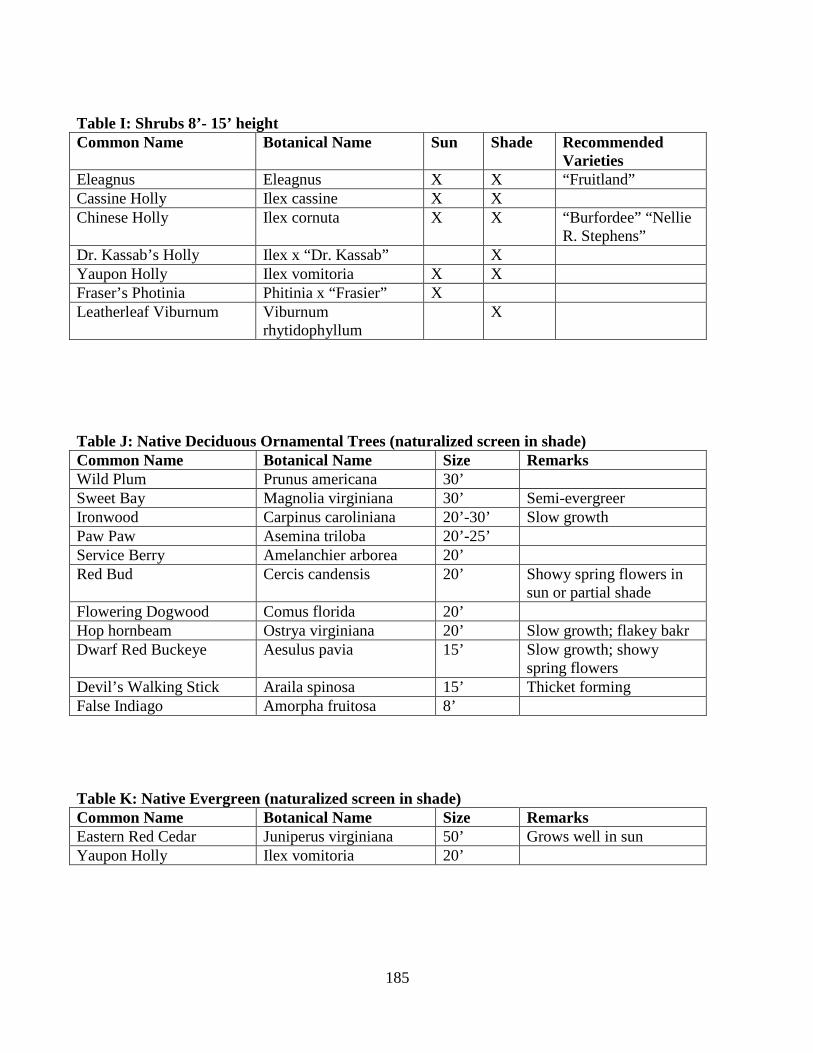
185
Table I: Shrubs 8’- 15’ height Common Name Botanical Name Sun Shade Recommended
Varieties Eleagnus Eleagnus X X “Fruitland” Cassine Holly Ilex cassine X X Chinese Holly Ilex cornuta X X “Burfordee” “Nellie
R. Stephens” Dr. Kassab’s Holly Ilex x “Dr. Kassab” X Yaupon Holly Ilex vomitoria X X Fraser’s Photinia Phitinia x “Frasier” X Leatherleaf Viburnum Viburnum
rhytidophyllum X
Table J: Native Deciduous Ornamental Trees (naturalized screen in shade) Common Name Botanical Name Size Remarks Wild Plum Prunus americana 30’ Sweet Bay Magnolia virginiana 30’ Semi-evergreer Ironwood Carpinus caroliniana 20’-30’ Slow growth Paw Paw Asemina triloba 20’-25’ Service Berry Amelanchier arborea 20’ Red Bud Cercis candensis 20’ Showy spring flowers in
sun or partial shade Flowering Dogwood Comus florida 20’ Hop hornbeam Ostrya virginiana 20’ Slow growth; flakey bakr Dwarf Red Buckeye Aesulus pavia 15’ Slow growth; showy
spring flowers Devil’s Walking Stick Araila spinosa 15’ Thicket forming False Indiago Amorpha fruitosa 8’ Table K: Native Evergreen (naturalized screen in shade) Common Name Botanical Name Size Remarks Eastern Red Cedar Juniperus virginiana 50’ Grows well in sun Yaupon Holly Ilex vomitoria 20’

186
Table L: Native Deciduous Ornamental Trees (naturalized screen in shade) Common Name Botanical Name Size Remarks Sweet Gum Liquidambar styraciflua 100’ Outstanding fall color Oaks Quercus species 60’ Naturally occurring
throughout region River Birch Betula nigra 50’ Fast growth; tolerates
shade and wet Persimmon Diospyros virginiana 50’ Osage Orange Naclura pomifera 40’ Plant close to produce
thorny hedge; male plant preferred
Sassafras Sassafras albidum 40’ Forms dense thicket; good sound barrier
Fringe tree Chionanthus virginicus 25’ Rough Leaf Dogwood Cornus drummondi 20’ Forms dense thicket Chickasaw Plum Prunus angustifolia 10’ Smooth Sumac Thus glabra 10’ Fall colors American Filbert Corytus Americana 8’ Taller when found in
natural habitat; forms dense thicket
Flameleaf Sumac Rhus copallina 8’ Outstanding fall color Coralberry Symphiocarpos
orbiculatus 5’ Attractive fruit; shade
tolerant

187
ARTICLE SIXTEEN CONDITIONAL USES
Section 16.1 – General Purpose The purpose of this section is to set forth procedures for processing conditional uses applications and to establish standards by which conditional uses can be evaluated. The Planning Commission shall hear and approve or disapprove in accordance with provisions of this section all requests for conditional use permits. Only those uses which are specifically listed as conditional uses in the respective zoning classifications may be requested for conditional use authorization. When authorization is given for conditional use and the use is established as authorized then the facility and land may be sold or otherwise have ownership transferred and the conditional use remain in effect. The conditional use authorization runs with the land. Section 16.2 – Application Procedure Application for conditional use approval shall be made by the property owner or authorized agent for the owner. The application may accompany a rezoning request or may be applied for if the use is a conditional use in the existing zoning classification. The application shall be submitted to the North Little Rock Planning department.
A. Development Plan Review. The procedure for Development Plan Review in Article
18 shall be followed. The Planning Director, at the informal meeting with the applicant may determine that aspects or items called for in the development plan review process are not relevant to a conditional use application and, thus, exempt these items from the development plan preparation. The application shall be accompanied by a fee, in accordance with North Little Rock Ordinance.
B. Submission Requirements.
1. The submission requirements shall be the same as development plan review except as aspects or items may be exempted by the Planning Director.
2. In addition to the graphic and supporting documentation required for
development plan review the applicant shall provide information showing all mitigating measures to be taken that will make the proposed use compatible with the surrounding neighborhood and especially with abutting existing uses.
Section 16.3 – Uses Exclusively Conditional
A. Correctional Facilities. Due to their nature and impact on adjacent property
correctional facilities shall require a conditional use permit in any zoning district where proposed.

188
B. Industrial by Right. Certain public and quasi-public uses due to their nature and impact on adjacent properties shall be permitted by right only in the appropriate industrial zoning district established by this ordinance. These uses may be permitted in other zoning districts by conditional use permit. The use are:
1. City and County vehicle storage yards for vehicles, maintenance equipment and
materials. 2. Utility substation for distribution of services or products or bulk storage. 3. Water or sewer treatment plant or ancillary facilities. 4. Communication, receiving or transmitting facilities other than wireless
communication facilities (WCF). The WCF are regulated in Resolution No. 5221 of the City of North Little Rock.
C. Cemeteries and columbaria. Due to their nature and impact on adjacent property,
cemeteries and columbaria shall require a conditional use permit in any zoning district where proposed other than the permitted O-1 zone.
Section 16.4 – Review Procedure
A. Staff and subdivision Committee. The subdivision committee of the Planning Commission shall review the conditional use along with staff recommendations for approval, approval with modifications, deferral or denial. The committee shall pass each development plan to the full commission for final action with any comments determined necessary.
B. Planning Commission Action. Upon receipt in proper form of the application and
development plan referred to in A. above of this section, the Planning Commission shall hold a public hearing after notice as provided by state law. The Planning Commission shall then take the follow actions:
1. The Planning Commission shall impose conditions and restrictions upon the
premises benefited by the conditional use permit as may be necessary to reduce or minimize the injurious effects of the conditional use. The conditional use must ensure compatibility with the surrounding property to better carry out the general intent of this section.
2. The Planning Commission shall report to the City Council its findings and
recommendations, including the stipulations of additional conditions, and guarantees that such conditions will be complied with when they are deemed necessary for the protection of the public interest. The City Council, subject to the requirements of this section may grant or deny any application for a conditional use. Conditional uses shall only become effective by an ordinance duly passed by the City Council.
189
3. When the application for conditional use permit includes a request for re-zoning
the procedure shall be submitted to the City Council as directed by the section. Section 16.5 – Conditions Once any portion of the conditional use authorization is utilized, all such conditions pertaining to such authorization shall immediately become mandatory. The violation of any condition so imposed shall constitute grounds for revocation of the conditional use authorization.
A. Variances. No conditional use authorized by the Planning Commission shall be
subsequently applied for as a variance to the Board of Zoning Adjustment. Amendments or changes as to the use authorized by the conditional use process must follow the same process as the original conditional use application.
B. Expansion or Additions. Expansions or additions to structures associated with
conditional uses may be approved by the director of planning without further conditional use authorization under the following circumstances:
1. The proposed expansion is limited to a structural addition to an existing building
not to exceed 10 percent of the gross floor area within the existing structure to be expanded.
2. The proposed expansion is limited to 1 time subsequent to the original
conditional use authorization. 3. The proposed expansion is reviewed and approved by the director of planning
with the determination that such expansion does not violate any of the conditions set forth in the original conditional use authorization, does not require further imposition of new conditions and does not adversely impact surrounding properties.
C. Time Limitations. Conditions may include time limits for exercise of authorization.
However, the maximum allowable time shall be limited to 1 year from the date of approval. Required permits must be obtained within the allotted period. Failure to obtain permits will result in notice of termination from city staff. The notice shall set a time and place for a revocation hearing by the Planning Commission at which time the owner may request time extension.
Section 16.6 – Right of Appeal Appeals from a decision of the Planning Commission may be made to the City Council. Appeals from a decision of the City Council may be made to a Court of Record having jurisdiction.

190
ARTICLE SEVENTEEN SPECIAL USES
Section 17.1 – Purpose The Special Use provision is to provide City Council use exceptions without rezoning the property. There are special uses which, because of their unique characteristics, may be difficult to properly classify in any particular district or districts without consideration, in each case of the impact of those uses upon neighboring land and of the public need for the particular use at the particular location. Such special uses fall into 2 categories:
A. Uses publicly operated or traditionally affected with a public interest, and that are necessary to insure the public peace, health and welfare.
B. Uses entirely private in character but of such an unusual nature that their operation
may give rise to unique problems with respect to their impact upon neighboring property or public facilities, and which uses are in principal compatible with surrounding uses.
When authorization is given for a special use and the use is established as authorized then the use and land may not be sold or otherwise have ownership transferred and the "special use" remain in effect. The special use authorization does not run with the land. Section 17.2 – Initiation of Special Use Any person, firm or corporation owning or having an interest in the subject property, with approval of the owner, may file an application for a special except in an R-1 district. Section 17.3 – Application An application for a special use or expansion of a special use shall be filed with the Planning Commission on a form prescribed by the planning commission. The application shall be accompanied by such plans and/or data prescribed by the Planning Commission and shall include a statement in writing by the applicant and adequate evidence showing that the proposed special use will conform to the standard set forth in Section 17.6, Standards. Section 17.4 – Hearing Upon receipt in proper form of the application and statement referred to above, the Planning Commission shall hold a public hearing after notice as provided by state law. Section 17.5 – Authorization For each application for a special use the Planning Commission shall report to the City Council its findings and recommendations, including the stipulations of additional conditions, and guarantees that such conditions will be complied with when they are deemed

191
necessary for the protection of the public interest. The City Council, subject to the requirements of this section may grant or deny any application for a special use. Special uses shall only become effective by an ordinance duly passed by the City Council. Provided, however, no special use shall be approved in Zones R-2, R-3, or R-4 without a two-thirds majority of all of the members of the City Council. Section 17.6 – Standards No special use shall be adopted by the Council unless the following standards are found to exist:
A. That the establishment, maintenance or operation of the special use will not be
detrimental to or endanger the public health, safety, morals, comfort, or general welfare.
B. That adequate utility, access roads, drainage, and/or other necessary facilities have
been or are being provided. C. That adequate measure has been or will be taken to provide ingress and egress so
designed as to minimize traffic congestion in the public streets. D. That the special use shall in all other respects conform to the applicable regulations
of the district in which it is located, except as such regulations may in each instance be modified by the City Council pursuant to the recommendation of the Planning Commission.
Section 17.7 – Conditions and Guaranties Prior to the granting of any special use the Planning Commission may recommend, and the City Council shall stipulate, such conditions and restrictions upon the establishment, location, construction, maintenance, and operation of the special use as deemed necessary for the protection of the public interest and to secure compliance with the standards above. In all cases in which special uses are granted the City Council shall require such evidence and guaranties [guarantees] as it may deem necessary as proof that the conditions stipulated in connection therewith are being, and will be complied with. Section 17.8 – Requirements for Authorized Special Use Each special use hereafter authorized shall be required to adhere to, height, set-back, and other standards of the zone in which the special permit is being allowed, in order to resemble the intended zone characteristics. Section 17.9 – Revocation In any case where a special use has not been established within one year after the date of the granting thereof, then without further action by the Planning Commission or the City Council, the special use authorization shall be null and void.

192
ARTICLE EIGHTEEN DEVELOPMENT PLAN REVIEW
Section 18.1 – General Application The purpose of the sections in this article are to provide processes the City will use to evaluate and regulate development of property, conditional use of land, and special uses. Section 18.2 – Development Plan Regulation
A. General Purpose and Review Guidelines. The Development plan review provisions
set forth in this section have the intent to protect the public health and safety, promote the general welfare of citizens and preserve the environment. And further:
1. The purpose of this section is to set forth procedures for processing development
plans and to establish standards for development within those districts which require compliance with this section.
2. Development Plan review is a process that provides for case by case
consideration of project particulars including the provision of parking and landscaping, site of buildings and the compatibility of the proposed development with adjacent uses.
3. The Development Plan review does not supplant the requirement for a “plot
plan” which is a part of the application for a building permit or final construction. 4. The Planning Commission may require Development Plan Review for any
project, even if exempted by these regulations. B. General Design Guidelines. All development shall be designed in such a way as to
minimize any potential deleterious impact on the surrounding area. Special attention shall be given to buffering multifamily, commercial and industrial developments from adjacent single-family areas. Design of the internal street system, ingress and egress, off-street parking, loading and pedestrian ways shall be sensitive to such conditions as safety, convenience, separation of vehicular and pedestrian traffic, cross easements, general attractiveness, areas of dwelling units and the proper relationship of different land uses. Such design shall conform to the standards set forth in “section 8 improvements” of the North Little Rock “Control of Development and Subdivision of Land” regulation.
1. Screening. Article 15, Screening and Landscaping is designed to improve
livability between different or dissimilar land uses by defining policy and standards regarding the placement, retention, or replacement of areas designated as screen borders or buffer areas. Article 15 is included in the “Development Plan Review” process.

193
2. Handicapped Parking and Accessibility. The requirement of Arkansas State Fire Code, section 508, provides for handicapped parking and accessibility shall be fully drafted and presented in the Development Plan.
C. Activities Requiring Development Plan Regulation Review. The owner of a parcel
of land shall obtain development plan approval prior to undertaking any alteration or improvement of the site including grubbing or grading, obtaining a building or codes permit for the activities, or commencing any of the following activities:
1. New principal buildings or major expansion or renovation of principal buildings,
building groups, and the site lay-out when the uses proposed are either commercial, industrial, multi-family or manufactured housing.
2. In preparation of an application to create a zoning district in a new location (re-
zone) or to expand an existing zoning district. 3. In preparation of Planned Unit Development of any land use category or
categories. 4. The preparation of a site or lot by clearing and grubbing, excavating and leveling,
providing access or utilities all for the purpose of creating a development or selling the lot or site; for development by others.
5. Any development activity proposed to take place in the “Argenta” overlay
district. 6. Conditional and Special Uses
7. Hillside Modifications.
D. Activities Not Requiring Development Plan Review. The following activities shall
not require development plan review: (these activities, however, are not exempted from the Plot Plan requirement for a building permit, building codes permit, fence construction or other state and local approval as prescribed by this zoning regulation).
1. The construction, alteration or enlargement of a single family or two-family
dwelling unit including their permitted accessory buildings. 2. The placement of manufactured housing or mobile homes on individual lots
when the lots are in approved R-6, RT-1 mobile home subdivisions or mobile home parks.
3. The harvesting of timber from forestry plots (or acreage) on declared tree farms
or timber held for maturation and harvesting. 4. Agricultural activities including agricultural buildings and structures.
194
5. Temporary structures such as construction trailers, real estate sales trailers, and
the like.
E. Review and Approval Authority. The Planning Commission is authorized to review and act on all development plans requiring review as defined above. In each instance where the Planning Commission is required to review the development plan for a proposed use, it shall approve, deny, or conditionally approve the application based on its compliance with the standards in Section 18.4 - Approval Standards, which action shall be binding upon the applicant.
F. Review Procedure.
1. Prior to submitting a formal application. The applicant may schedule a pre-
application meeting with the Planning Director. The pre-application meeting is informal and informational in nature. There is no fee for a pre-application meeting. The purposes of the meet are to:
a. Allow the Planning Department to understand the nature of the proposed land
use and issues in the proposal. b. Allow the applicant to understand the development plan review process and
required submissions. c. Identify issues that need to be addressed in future submissions.
2. Information required for pre-application meeting. The applicant should be
prepared to discuss the following with the Planning Director:
a. The proposed site, including its location, size, and general characteristics. b. The natural characteristics of the site that may limit its use and development. c. The nature of the proposed use and potential development, including a
conceptual site plan. d. Any issues or questions about existing municipal regulations and their
applicability to the project. e. Any requests for waivers from the submission requirements.
3. Waiver of Information. Where the Planning Director finds that due to special
circumstances of a particular plan, the submission of any information, Submission Requirement is inappropriate because of the nature of the proposed development, the Planning Director may waive such requirements, subject to appropriate conditions.
Section 18.3– Formal Application
A. After an application has been submitted with the required fee, the Planning Director
shall issue a dated receipt to the applicant. The Planning Director and the Subdivision Review Committee shall review the development plan application and accompanying materials for completeness. The applicant shall be notified in writing

195
of any omissions. If the applicant fails to submit a complete application within 4 months the application shall be considered withdrawn. When the Planning Director and Subdivision Review Committee make the determination that an application is complete, the application shall be scheduled for consideration at the next available Planning Commission meeting. The Planning Commission may request an evaluation of specific aspects of the development plan from the Fire Marshal, City Engineer, Utility Authorities, Traffic Department, and Historical Commission or appropriate others. It may defer making its decision until the needed information is provided or until its next regular meeting.
1. The Planning Commission shall schedule a public hearing in accord with
standard procedures at which time interested persons may appear and offer information in support of or against the proposed development plan.
a. The Planning Department shall make recommendations on each plan
submitted. b. The Subdivision Committee shall add any comment determined necessary to
expedite the hearing on the application. c. The Planning Commission may either approve the site plan with
modifications and agreements for developer contributions as necessary defer the site plan or deny the site plan.
d. When the development plan is submitted for the zoning or re-zoning of
property the final action of the Planning Commission shall be to submit its action concerning the development to the City Council for its decision.
e. The Planning Commission, when appropriate, shall require that a
performance guarantee be established with the city for the cost of site improvements. Each performance guarantee shall comply with Section 10. Assurance for Completion of Improvements as found in the Control of Development and Subdivision of Land Regulation, City of North Little Rock.
f. Development plan approval shall be valid for a period of 18 months from the
date of final approval. Prior to the expiration of the development plan approval, the applicant may request an extension of up to one year from the Planning Commission for cause shown. Development plan approval shall remain valid if a building permit has been issued for the project prior to the expiration date. Expiration of the building permit prior to completion of the project shall render the development plan approval null and void. Failure to comply with conditions placed upon development plan approval, to post any necessary performance guarantees, to comply with any other permitting processes or to address any other issues of site development, except pending litigation challenging the development plan approval, shall render the approval null and void unless an extension is granted by the Planning Commission for good cause.

196
2. Appeals from the action of the Planning Commission shall be filed with the City
Council. The content of the appeal filing shall consist of:
a. A cover letter addressed to the Mayor and Alderpersons setting forth the request.
b. A copy of the contested action by the Planning Commission certified by the
planning staff to be true and accurate.
This filing shall occur within 30 calendar days of the action of the Planning Commission on the development plan. No activity which requires development plan approval (no permit issued) shall be conducted by the developer until the City Council has made its decision.
B. Development Plan Submission Requirements. The applicant shall submit 17 copies
of development plans and supporting information drawn to scale no larger than 24 inches by 36 inches. Multiple sheets may be used, if needed, to contain (display) the entire project or phases.
1. Evidence of right, title, and interest in the site of the proposed project. 2. A key map of the site with reference to surrounding properties and existing street
locations. 3. The name and address of the owner and development plan applicant, together
with the names of the owners of all contiguous land and or property directly across the street and within 200 feet of the property, as shown by the most recent tax records in which such properties shall lie.
4. Lot line dimensions. 5. Location of all existing buildings and structures, streets, easements, driveways,
entrances and exits on the site and within 100 feet thereof. 6. Proposed location and dimensions of proposed buildings and structures, roads,
driveways, parking areas and other improvements. 7. Building setback, front side line, and rear yard distance and building heights. 8. All existing physical features on the site and within 200 feet thereof, including
streams, watercourses, existing woodlands, and existing trees at least 6 inches in diameter as measured 4.5 feet above grade. Soil conditions as reflected by survey (such as wetlands, rock ledge, and areas of high water table) shall also be shown. The Planning Commission may require a high intensity soils survey where it deems necessary.

197
9. Topography showing existing and proposed contours at 5 foot intervals for slopes averaging 20% or greater and at 2 foot intervals for land of lesser slope. A reference benchmark shall be clearly designated. Where variations in the topography may affect the layout of buildings and roads, the Planning Commission may require that the topographic maps be based on an on-site survey.
10. Parking, loading, and unloading areas shall be indicated with dimensions, traffic
patterns, access aisles, and curb radii. 11. Improvements such as roads, curbs, bumpers, decal lanes and sidewalks shall be
indicated with cross sections, design details and dimensions. 12. Location and design of existing and proposed stormwater systems, detention
areas, sanitary waste disposal systems and potable water supply, and methods of solid waste storage and disposal.
13. Landscaping and buffering plan showing what will remain and what will be
planted, indicating botanical and common names of plants and trees, dimensions, approximate time of planting and maintenance plans.
14. Lighting details indicating type of standards, location, wattage, radius of light
and intensity in foot-candles. 15. Location, dimensions, and details of signs. 16. Demonstration of technical and financial capability to complete the project. If
the applicant concludes that public disclosure of confidential financial information may be detrimental to the success of the project, the applicant may disclose such financial information to the Mayor who shall explore with due diligence, the applicant’s financial capability to complete the project as proposed in a timely fashion and make a recommendation to the Planning Commission.
17. A detailed description of all Hillside Modifications including:
a. Boundaries of any Hillside Modification. b. Existing topography prior to the Hillside Modification. c. Temporary topography while Hillside Modification is performed. d. Final topography after Hillside Modification is complete. e. Preliminary location of any retaining structures. f. Identify all existing property owners adjacent to the proposed development. g. Proposed development adjacent to residential properties shall include a
preliminary geotechnical engineering report and, in lieu of the requirement in subsection f, identify all existing property owners within four hundred feet (400’) of the proposed development.
198
Section 18.4 – Approval Standards
A. The following criteria shall be used by the Planning Director, the Subdivision Committee and the Planning Commission in reviewing applications for development plan review and shall serve as minimal requirement for approval of the application. In each instance, the burden of proof shall be on the applicant to produce evidence sufficient to warrant a finding that all criteria have been met. The development plan will reflect the natural capabilities of the site to support development. Buildings, lots, and support facilities will be clustered in those portions of the site that have the most suitable conditions for development. Environmentally sensitive areas such as wetlands, steep slopes, flood plains, and unique natural features will also be maintained and preserved to the maximum extent feasible. Natural drainage areas will also be preserved to the maximum extent feasible.
B. Traffic Access and Parking.
1. Adequacy of Road System. Vehicular access to the site will be on roads which
have adequate capacity to accommodate the additional traffic generated by the development. For developments which generate 100 or more peak hour trips based on the latest edition of the Trip Generation Manual of the Institute of Traffic Engineers, intersections on major access routes to the site within 1 mile of any entrance road which are functioning at a Level of Service C of better prior to the development will function at a minimum at Level of Service C after development. If any such intersection is functioning at a Level of Service D or lower prior to the development, the project will not reduce the current level of service. A development not meeting this requirement may be approved if the applicant demonstrated that:
a. A public agency has committed funds to construct the improvements
necessary to bring the level of access to this standard. b. The applicant will assume financial responsibility for the improvements
necessary to bring the level of service to this standard and will assure the completion of the improvements with a financial guarantee acceptable to the municipality.
c. City policy does not support (is not a proponent of) the construction
improvements.
2. Access into the Site. Vehicular access to and from the development shall be safe and convenient.
a. All entrance and exit driveways are located to afford maximum safety to
traffic, provide for safe and convenient ingress and egress to and from the site and to minimize conflict with the flow of traffic.

199
b. Any exit driveway or driveway lane is so designated in profile and grading and so located as to provide the maximum possible sight distance measured in each direction. The sight distance available shall be consistent with the standards of the City.
c. Where a site occupies a corner of 2 intersecting roads, no driveway entrance
or exit is located within 50 feet of the point of tangency of the existing or proposed curb radius of that site.
d. No part of any driveway shall be located within a minimum of 10 feet of a
side property line. However, the Planning Commission may permit a driveway serving 2 or more adjacent sites to be located on or within 10 feet of a common side property line.
e. Driveways intersect the road at an angle as near 90º as site conditions will
permit. f. Road, driveway, and parking lot construction comply with the construction
and design standards in the control of Development and Subdivision of Land Regulation.
3. Internal Vehicular Circulation. The layout of the site shall provide for the safe
movement of passenger, service, and emergency vehicles through the site.
a. Nonresidential projects that will be served by delivery vehicles will provide a clear route for such vehicles with appropriate geometric design to allow turning and backing for a minimum of vehicles.
b. Clear routes of access shall be provided and maintained for emergency
vehicles to and around buildings and shall be posted with appropriate signage (fire lane – no parking).
c. The layout and design of parking areas shall provide for safe and convenient
circulation of vehicles throughout the lot. d. All roadways shall be designed to harmonize with the topographic and
natural features of the site. The road network shall provide for vehicular, pedestrian, and cyclist safety, all season emergency access, and delivery and collection services.
4. Parking Layout and Design. Off-street parking shall conform to Article 13 Off
Street Parking and the following standards:
a. Parking areas with more than 2 parking spaces shall be arranged so that vehicles do not need to back into the street.

200
b. All parking spaces, access drives, and impervious surfaces shall be located at least 4 feet from any side or rear lot line, except where standards require a greater distance. No parking spaces or asphalt type surface shall be located within 6 feet of the front property line. Parking lots on adjoining lots may be connected by access ways.
c. In lots utilizing diagonal parking, the direction of proper traffic flow shall be
indicated by signs, pavement markings or other permanent indications. d. Parking areas for nonresidential uses shall be designed to permit each motor
vehicle to proceed to and from the parking space provided for it without requiring the moving of any other motor vehicles. “Stacked” parking may be permitted for resident parking in conjunction with residential uses if both spaces in the stack are assigned to the occupants of the same dwelling unit.
e. The “overhang” of parked vehicles shall be restricted when it might restrict
traffic flow on adjacent through roads restrict pedestrian or bicycle movement on adjacent walkways or damage landscape materials.
C. Pedestrian Circulation. The site plan shall provide for a system of pedestrian ways
within the development appropriate to the type and scale of development. This system shall connect the major building entrances/exits with parking areas and with existing or planned sidewalks in the vicinity of the project. The pedestrian network may be located either in the street right-of-way in open space or recreation areas. The system shall be designed to link the project with residential, recreational, and commercial facilities, schools, bus stops, and sidewalks in the neighborhood.
D. Stormwater Management. Adequate provisions will be made for the collection and
disposal of all stormwater that runs off proposed street, parking areas, roofs and other surfaces during a 25 year, 24 hour storm, through a stormwater drainage system and maintenance plan, which will not have adverse impacts on abutting or downstream properties. The stormwater management provisions shall be consistent with Arkansas Department of Environmental Quality Regulation and the following:
1. To the extent possible, the plan will retain stormwater on the site using the
natural features of the site. 2. For major developments, stormwater runoff systems will detain or retain water
such that the rate of flow from the site does not exceed the predevelopment rate, unless the system discharges directly to the Arkansas River.
3. The applicant will demonstrate that on- and off-site downstream channel or
system capacity is sufficient to carry the flow without adverse effects, or that the applicant will be responsible for whatever improvements are needed to provide the required increase in capacity.
201
4. All natural drainage ways will be preserved at their natural gradients and will not be filled or converted to a closed system unless specifically approved.
5. The design of the stormwater drainage system shall provide for the disposal of
stormwater without damage to streets, adjacent properties, downstream properties, soils, and vegetation.
6. The design of the storm drainage systems will be fully cognizant of upstream
runoff which must pass over or through the site to be developed. 7. The biological and chemical properties of the receiving waters will not be
degraded by the stormwater runoff from the development site. The use of oil and grease traps in manholes, the use of on-site vegetated waterways, and vegetated buffer strips along waterways and drainage swales, and the reduction in use of deicing salts and fertilizers may be required, especially where the development stormwater discharges into a meander scar or oxbow lake.
E. Erosion Control. All building site, and roadway designs and layouts will harmonize
with existing topography and conserve desirable natural surroundings to the fullest extent possible. Filling, excavation and earth moving activity will be kept to a minimum. Parking lots on sloped sites will be terraced to avoid undue cut and fill, and/or the need for retaining walls. Natural vegetation will be preserved and protected wherever possible.
During construction, soil erosion and sedimentation or watercourses are water bodies
will be minimized by an active program meeting the requirements of the Arkansas Department of Environmental Quality.
F. Water Supply. The development will be provided with a system of water supply that
provides each use with an adequate supply of drinking water. If the project is proposed to be served by a public water supply, the applicant shall
secure and submit a written statement from the supplier that the proposed water supply system conforms with its design and construction standards, will not result in an undue burden on the source or distribution system, and will be installed in a manner adequate to provide needed domestic and fire protection flows.
G. Sewage Disposal. The development will be provided with a method of disposing of
sewage which is in compliance with the State Wastewater Disposal Rules and the Control of Development and Subdivision of Land Regulation.
1. All sanitary sewage from new or expanded uses shall be discharged into a public
sewage collection and treatment system when such facilities are currently available or can reasonably be made available at the lot line and have adequate capacity to handle the projected waste generation.

202
2. If the public system cannot serve or be extended to serve a new or expanded use, the sewage shall be disposed of by an on-site sewage disposal system meeting the requirements of the State Wastewater Disposal Rules for Private Sewage Disposal.
3. When two or more lots or buildings in different ownership share the use of a
common private subsurface disposal system, the system shall be owned and maintained in common by an owners’ association. Covenants in the deeds for each lot shall require mandatory membership in the association and provide for adequate funding of the association to assure proper maintenance of the system.
4. Industrial or commercial wastewaters may be discharged to public sewers in such
quantities and/or of such quality as to be compatible with sewage treatment operations. Such wastes may require pretreatment at the industrial or commercial site in order to render them amenable to public treatment processes. Pretreatment includes, but is not limited to, screening, grinding, sedimentation, pH adjustment, surface skimming, chemical oxidation and reduction and dilution.
H. Utilities. The development will be provided with electrical, telephone, and
telecommunication service adequate to meet the anticipated use of the project. New utility lines and facilities shall be screened from view to the extent feasible. If the service in the street or on adjoining lots in underground, the new service shall be placed underground.
I. Water Quality Protection. All aspects of the project shall be designed so that:
1. No person shall locate, store, discharge, or permit the discharge of any treated, untreated, or inadequately treated liquid, gaseous, or solid materials of such nature, quantity, obnoxiousness, toxicity, or temperature that may run off, seep, percolate, or wash into surface or ground waters so as to contaminate, pollute, or harm such waters or cause nuisances, such as objectionable shore deposits, floating or submerged debris, oil or scum, color, odor, taste, or unsightliness or be harmful to human, animal, plant, or aquatic life.
2. All storage facilities for fuel, chemicals, chemical or industrial wastes, and
biodegradable raw materials, shall meet the standards of the State Department of Environmental Quality and the Fire Marshall’s Office.
J. Wastes.
1. The handling, storage, and use of all materials identified by the standards of a
federal or state agency as hazardous, special or radioactive shall be done in accordance with the standards of these agencies.
2. Any waste produced which is classified as a hazardous, special or radioactive
waste by either federal or state standards shall be disposed of at a licensed
203
disposal facility appropriate for the type of waste and done in accordance with applicable state and federal regulations.
3. No flammable or explosive liquids, solids or gases shall be stored in bulk above
or underground unless they meet the standards outlined in the I-3 Industrial district of this zoning regulation.
4. The proposed development will also provide for adequate disposal of solid
wastes. All solid waste will be disposed of at a licensed disposal facility having adequate capacity to accept the project’s wastes.
K. Shore land Relationship. The development will not adversely affect the water
quality or shoreline of any adjacent water body. The development plan will provide for access to abutting navigable water bodies for the use of the occupants of the development if appropriate.
L. Technical and Financial Capacity. The applicant has demonstrated the financial and
technical capacity to carry out the project in a timely fashion in accordance with this ordinance and the approved plan.
M. Exterior Lighting.
1. The proposed development shall provide for adequate exterior lighting to provide for the safe use of the development in nighttime hours, if such use is contemplated, without excessive illumination.
2. Lighting may be used which serves security, safety and operational needs but
which does not directly or indirectly produce deleterious effects on abutting properties or which would impair the vision of a vehicle operator on adjacent roadways. Lighting fixtures shall be shielded or hooded so that the lighting elements are not exposed to normal view by motorists, pedestrians, or from adjacent dwellings and so that they do not unnecessarily light the night sky. Direct or indirect illumination shall not exceed 0.5 foot candles at the lot line or upon abutting residential properties.
3. All exterior lighting, except security lighting, shall be turned off between 11P.M. and
6 A.M. unless located on the site of a commercial or industrial use which is open for business during that period.
N. Landscaping and Buffering.
1. The landscape will be preserved in its natural state insofar as practical by
minimizing tree removal, disturbance and compaction of soil, and by retaining existing vegetation insofar as practical during construction in accord with the Screening Ordinance of the City. Areas of vegetation to be retained shall be designated on the development plan.

204
2. The development plan will provide for landscaping that defines street edges, breaks up parking areas, softens the appearance of the development and protects abutting properties from any adverse impacts of the development.
3. The development shall also provide for the buffering of adjacent uses where
there is a transition from one type of use to another use and for screening of service and storage areas.
4. Required parking and loading spaces for nonresidential uses where not enclosed
within a building, shall be effectively screened from view by a continuous landscaped area not less than 8 feet in width containing evergreen shrubs, trees, fences, walls, berms, or any combination thereof forming a visual barrier not less than 6 feet in height along exterior lot lines adjoining all residential properties, except that driveways shall be kept open to provide visibility for vehicles entering and leaving. This requirement may be reduced or waived when it is determined that such buffering is not necessary or desirable.
O. Storage of Material.
1. All dumpsters or similar large collection receptacles for trash or other wastes
shall be located on level surfaces which are paved or graveled. Dumpsters or receptacles located in a yard which abuts a residential or institutional use or a public street shall be screened by fencing or landscaping.
2. All sites potentially hazardous to children shall require physical screening
sufficient to deter small children from entering the premises. This screening shall be maintained in good condition.
P. Hillside Modifications
1. Hillside Modifications require notification to property owners identified in the
development plan.
2. Typical engineering cross-sections showing existing hillside slopes prior to, during, and after any Hillside Modification. For development adjacent to residential property, maximum spacing between engineering cross-sections shall be 50’
3. Final geotechnical engineering report. For development adjacent to residential property, geotechnical engineering reports must address short and long-term global stability, internal and global stability of retaining structures, temporary erosion control, final erosion control, and proposed final re-vegetation.
4. Engineering Review. Prior to approval, the City Engineer shall review any development plan which indicates a Hillside Modification to verify that the design complies with the safety standards of the Arkansas State Fire Prevention
205
Code and the City of North Little Rock. The City Engineer will submit all comments to the Planning Department for consideration during plat approval.
Section 18.5 – Amendments Any alteration to a site which is inconsistent with the approved development plan shall require an amendment to the plan. Planning Commission approval must be obtained prior to the alteration. Minor changes to an approved site plan may be placed on the Planning Commission Agenda at the discretion of the Planning Director. Minor changes shall not include (1) a change to a public or private right-of-way or easement, (2) a decrease in proposed buffering or landscaping, or (3) any issue involving a condition placed on the site plan approval. Section 18.6 Appeals of City Actions Appeal of an action taken by the City Council regarding site plan review shall be to a Court of Record having jurisdiction.
206
ARTICLE NINETEEN BOARDS
Section 19.1 – Board of Adjustment There shall be and hereby is created a Board of Zoning Adjustment (hereinafter called the “Board”) consisting of 5 members. The members of the Board shall be appointed by the Mayor with the approval of the Council for a term of 3 years and may be removed only for cause upon written charges and after public hearing. Any vacancy which occurs in the Board shall be filled by the Mayor with the approval of the Council for the unexpired term of any member whose term became vacant. No member of the board shall be on the staff of the City.
A. Powers of the Board.
The Board shall have the power to consider appeals and variances of the enforcement and application of the Zoning Ordinance. Variances include, but are not limited to building setbacks, height and accessory structures. The Board shall also have the power to consider requests for reasonable accommodation as provided by the federal Fair Housing Act and the Arkansas Fair Housing Act (hereinafter called “fair housing laws”). In this context, “reasonable accommodation” means alleviating specific regulations, policies and procedures that restrict persons who are handicapped, as defined by the fair housing laws, from housing opportunities.
1. Appeals. The Board may hear appeal by an applicant of any decision made by an
administrative officer with respect to the enforcement and application of the zoning regulation; and may affirm or reverse the decision, in whole or part. Appeal shall be made to the Planning Department on a form prescribed by the Planning Department when accompanied by such reasonable fee as may be established by the North Little Rock City Council.
2. Variances. The Board may authorize, upon appeal in specific cases, variance
from the terms of the Zoning Ordinance and the Flood Management Ordinance, as amended. Variances may be sought by applying to the Planning Department on a form prescribed by the Planning Department when accompanied by such reasonable fee as may be established by the North Little Rock City Council. Conditions fixed by the Board will not be contrary to the public interest where, owing to exceptional and extraordinary circumstances, literal enforcement of the provisions of this ordinance will result in unnecessary hardship; provided, however, that no variance shall be authorized unless the board shall find that the following conditions exist:
a. That the variance will not authorize the operation of a use other than those
uses specifically permitted uses for the district in which the property for which the variance is sought;

207
b. That the development or use of the property for which the variance is sought, if limited by a literal enforcement of the provisions of this ordinance, cannot yield a reasonable return in service, use or income as compared to adjacent conforming property in the same district;
c. That the plight of the owner of the property for which the variance is sought
is due to unique circumstances existing on the property, that the unique circumstances were not created by the owner of the property and are not due to or the result of general conditions in the district in which the property is located;
d. That the variance will not substantially or permanently injure the appropriate
use of adjacent conforming property in the same district; e. That the variance will not alter the essential character of the district in which
the property for which the variance is sought is located; f. That the variance will not weaken the general purposes of this ordinance or
the regulations herein established for the specific district; g. That the variance will be in harmony with the spirit and purpose of this
ordinance; h. That the variance will not adversely affect the public health, safety or general
welfare.
3. Requests for Reasonable Accommodation. A request for reasonable accommodation may be made by an individual with a disability, his or her representative, or a developer or provider of housing for individuals with disabilities, when the application of a land use, zoning, or building regulation, policy, practice or procedure restricts fair housing opportunities. Application shall be made to the Planning Department on a form prescribed by the Planning Department when accompanied by such reasonable fee as may be established by the North Little Rock City Council. The Director of the Planning Department shall submit complete applications to the Board for determination within thirty (30) days of submittal. The Board may approve any application that satisfies all of the following conditions:
a. The accommodation will ensure that the City complies with fair housing laws
and provides greater housing opportunities for individuals with disabilities; b. The housing, which is the subject of the request for reasonable
accommodation, will be used by one or more individuals with disabilities protected under fair housing laws;
c. The requested accommodation is necessary to make housing available to one
or more individuals with disabilities protected under the fair housing laws;

208
d. The requested accommodation will not impose an undue financial or
administrative burden on the City; and e. The requested accommodation will not fundamentally alter (1) the City’s
land use plan; (2) the City’s zoning design; (3) building codes; or (4) any regulation necessary to protect the health and safety of occupants.
4. Oaths and Attendance of Witnesses. For the purpose of exercising the powers
herein enumerated, the Board shall elect a chairman and vice-chairman. The chairman, or, in his absence, the vice-chairman, shall administer oaths to or accept affirmations from witnesses and may compel the attendance of witnesses. A failure or a refusal to appear in response to a subpoena issued by the Board shall constitute a violation of this ordinance.
5. Limitations of Powers of Board. The concurring vote of 3 members of the Board
shall be necessary to reverse any order, requirements, decision or determination of any administrative official or to decide in favor of the applicant on any matter upon which the board is required to pass under this ordinance or to effect any variation in this ordinance.
a. Finding of Fact. Every decision of the Board shall be based upon findings of
fact and every finding of fact shall be supported in the record of its proceedings. The enumerated conditions required to exist on any matter upon which the board is required to pass under this ordinance or to effect any variation in this ordinance shall be construed as limitations on the power of the Board to act. A mere finding or recitation of the enumerated conditions unaccompanied by findings of specific facts shall not be deemed findings of fact and shall not be deemed compliant with this ordinance.
b. Powers strictly construed. Nothing herein contained shall be construed to
empower the Board to change the terms of this ordinance, to effect changes in the official map or to add to the specific uses permitted in any district. The powers of the Board shall be so construed that this ordinance and the official map are strictly enforced.
B. Proceedings. The Board shall adopt rules governing all proceedings before it. Such
rules shall provide and require that:
1. Public notice shall be given of all hearings and all hearings shall be open to the public;
2. Due notice of all hearings shall be given to parties in interest, in writing; 3. At any public hearing any interested party may appear in person, by agent, or
attorney, to offer evidence and testimony;

209
4. All witnesses shall be sworn or shall affirm their testimony in the manner required in courts of record;
5. All evidence and testimony shall be presented publicly. The Board may take
judicial notice of facts to the same extent and manner as courts of record and may consider any relevant facts within the personal knowledge of any member. For each case or matter heard, the Board shall cause a record of its proceedings to be prepared. The record of proceedings shall include all documents and physical evidence considered in the case together with a transcribed record of all public proceedings. The transcribed record shall include, but need not be limited to, the verbatim testimony offered by all witnesses in the case and all personal knowledge of members of the Board considered by the Board in reaching its decision. The deliberations of the Board shall show the grounds for each decision and the vote of each member upon each question. The record of proceedings shall be filed immediately in the office of the Board and shall be a public record.
C. Appeals Process.
1. Any person, taxpayer, the municipality or any officer or department of the
municipality may have a decision of the Board reviewed in the manner provided by rules relating to civil proceedings. No such review shall be granted unless a petition therefore, duly verified, setting forth that such decision is illegal, in whole or part, and specifying the grounds of the illegality, is presented to a court of record within 30 days after the filing of the decision in the office of the Board. The Board shall not be required to return the original papers acted upon by it, but it shall be sufficient to return certified or sworn copies thereof or such portions thereof as may be called for. The return shall concisely set forth such other facts as may be pertinent and material to the decision appealed from and shall be verified. The issuance of a writ on a petition hereunder shall not stay proceedings upon the decision appealed from but the court, on application after notice to the Board and on due cause shown, may grant a restraining order.
2. Liability. Any commissioner, or employee, or member of the Board of
Adjustment, charged with the enforcement of this Code, acting for the City in the discharge of his duties, shall not thereby render himself liable personally, and he is hereby relieved from all personal liability for any damage that may accrue to persons or property as a result of any act required or permitted in the discharge of his duties. The exception being a violation of due process of civil rights or gross negligence. Any suit brought against any Commissioner or employee, or member of the Board of Adjustment, because of such act performed by him in the enforcement of any provision of this Code shall be defended by legal representative until the final termination of the proceedings.
D. Notice. Any property owner seeking a hearing with the Board shall adhere to the
following:

210
1. Notice shall be given, in writing, to the property owners abutting the property where the variance is sought.
a. If the abutting property is owned by the same property owner as the property
where the variance is sought, then notice shall be given to the next abutting property or properties beyond.
2. A public notice shall be placed in the newspaper at least one time 7 days prior to
the meeting. 3. Any property owner seeking a variance shall place a sign designating the intent
of a variance for the property, for a period of at least 14 days prior to the meeting. Section 19.2 – Building and Housing Board of Adjustment There shall be and hereby is created a Building and Housing Board of Adjustment (hereinafter called the “Sign Board”) consisting of 5 members. The members of the Sign Board shall be appointed by the Mayor with the approval of the Council for a term of 3 years and may be removed only for cause upon written charges and after public hearing. Any vacancy which occurs in the Sign Board shall be filled by the Mayor with the approval of the Council for the unexpired term of any member whose term became vacant. No member of the Sign Board shall be on the staff of the City.
A. Powers of the Sign Board. The Sign Board shall have the power to consider
variances of the Sign Regulations, Fire Code, and the Building Code.
1. Hearings. Hear appeals from the decision of the administrative officers in respect to the enforcement and application of said zoning regulation; and may affirm or reverse, in whole or part, said decision of the administrative officer.
2. Variances. To authorize, upon appeal in specific cases, such variance from the
terms of the Zoning Ordinance, Fire Code, Building Code and the Sign Regulations. Conditions fixed by the Board will not be contrary to the public interest where, owing to exceptional and extraordinary circumstances, literal enforcement of the provisions of this ordinance will result in unnecessary hardship; provided, however, that no variance shall be authorized unless the board shall find that the following conditions exist:
a. That the development or use of the property for which the variance is sought,
if limited by a literal enforcement of the provisions of this ordinance, cannot yield a reasonable return in service, use or income as compared to adjacent conforming property in the same district;
b. That the plight of the owner of the property for which the variance is sought
is due to unique circumstances existing on the property, that the unique circumstances were not created by the owner of the property and are not due

211
to or the result of general conditions in the district in which the property is located;
c. That the variance will not substantially or permanently injure the appropriate
use of adjacent conforming property in the dame district; d. That the variance will not alter the essential character of the district in which
it is located the property for which the variance is sought; e. That the variance will not weaken the general purposes of this of this
ordinance or the regulations herein established for the specific district; f. That the variance will be in harmony with the spirit and purpose of this
ordinance; g. That the variance will not adversely affect the public health, safety or general
welfare.
3. Oaths and Attendance of Witnesses. For the purpose of exercising the powers herein enumerated, the Sign Board shall elect a chairman and vice-chairman. The chairman, or, in his absence, the vice-chairman, shall administer oaths to or accept affirmations from witnesses and may compel the attendance of witnesses. A failure or a refusal to appear in response to a subpoena issues by the Board shall constitute a violation of this ordinance.
4. Limitations of Powers of Sign Board. The concurring vote of 3 members of the
Sign Board shall be necessary to reverse any order, requirements, decision or determination of any administrative official or to decide in favor of the applicant on any matter upon which the Sign Board is required to pass under this ordinance or to effect any variation in this ordinance.
a. Finding of Fact. Every decision of the Sign Board shall be based upon
findings of fact and every finding of fact shall be supported in the record of its proceedings. The enumerated conditions required to exist on any matter upon which the Sign Board is required to pass under this ordinance or to effect any variation in this ordinance shall be construed as limitations on the power of the Sign Board to act. A mere finding or recitation of the enumerated conditions unaccompanied by findings of specific facts shall not be deemed findings of fact and shall not be deemed compliance with this ordinance.
b. Powers strictly construed. Nothing herein contained shall be construed to
empower the Sign Board to change the terms of this ordinance, to effect changes in the official map or to add to the specific uses permitted in any district. The powers of the Sign Board shall be so construed that this ordinance and the official map are strictly enforced.
212
B. Proceedings. The Sign Board shall adopt rules governing all proceedings before it. Such rules shall provide and require that:
1. An application or appeal filed according to stated procedures shall be given a
case number within 3 days from the date filed, applications or appeals will be assigned for hearing in the order in which they are received.
2. The Recording Secretary of the Sign Board shall notify the parties in interest of
the time scheduled for the Public Hearing. 3. At the time of the Public Hearing, the applicant may appear in his own behalf or
be represented by counsel or by agent. The applicant shall be given an opportunity for a final rebuttal.
4. Final Decision of any application or appeal to the Sign Board shall be in the form
of a motion. The Chairman shall vote on all matters and approval, in all cases, shall require a quorum of the membership of the Sign Board.
5. Within 30 days after he hearing, the Board shall notify the parties in interest of
its decision. 6. Public notice shall be given of all hearings and all hearings shall be open to the
public. 7. Due notice of all hearings shall be given to parties in interest, in writing. 8. At any public hearing a representative or any other interested party may appear in
person, by agent, or attorney, to offer evidence and testimony. 9. All witnesses shall be sworn or shall affirm their testimony in the manner
required in courts of record. 10. All evidence and testimony shall be presented publicly. The Board may take
judicial notice of facts to the same extent and manner as courts of record and may consider any relevant facts within the personal knowledge of any member. For each case or matter heard, the Board shall cause a record of its proceedings to be prepared. The record of proceedings shall include all documents and physical evidence considered in the case together with a transcribed record of all public proceedings. The transcribed record shall include, but need not be limited to, the verbatim testimony offered by all witnesses in the case and all personal knowledge of members of the Board considered by the Board in reaching its decision. The deliberations of the Board shall show the grounds for each decision and the vote of each member upon each question. The record of proceedings shall be filed immediately in the office of the Board and shall be a public record.
C. Appeals Process.

213
1. Any person, taxpayer, the municipality or any officer or department of the
municipality may have a decision of the Sign Board reviewed in the manner provided by rules relating to civil proceedings. No such review shall be granted unless a petition therefore, duly verified, setting forth that such decision is illegal, in whole or part, and specifying the grounds of the illegality, is presented to a court of record within 30 days after the filing of the decision in the office of the Sign Board. The Sign Board shall not be required to return the original papers acted upon by it, but it shall be sufficient to return certified or sworn copies thereof or such portions thereof as may be called for. The return shall concisely set forth such other facts as may be pertinent and material to the decision appealed from and shall be verified. The issuance of a writ on a petition hereunder shall not stay proceedings upon the decision appealed from but the court, on application after notice to the Sign Board and on due cause shown, may grant a restraining order.
2. Liability. Any commissioner, or employee, or member of the Sign Board of
Adjustment, charged with the enforcement of this Code, acting for the City in the discharge of his duties, shall not thereby render himself liable personally, and he is hereby relieved from all personal liability for any damage that may accrue to persons or property as a result of any act required or permitted in the discharge of his duties. The exception being a violation of due process of civil rights or gross negligence. Any suit brought against any Commissioner or employee, or member of the Sign Board, because of such act performed by him in the enforcement of any provision of this Code shall be defended by legal representative until the final termination of the proceedings.
D. Notice. Any property owner seeking a hearing with the Board shall adhere to the
following:
1. Notice shall be given, in writing, to the property owners abutting the property where the variance is sought.
a. If the abutting property is owned by the same property owner as the property
where the variance is sought, then notice shall be given to the next abutting property or properties beyond, unless the distance is greater than 500 feet from the subject property.
2. A public notice shall be placed in the newspaper at least one time 7 days
prior to the meeting. 3. Any property owner seeking a variance shall place a sign designating the
intent of a variance for the property, for a period of at least 14 days prior to the meeting.
214
ARTICLE TWENTY ADMINISTRATION AND ENFORCEMENT
Section 20.1 – Nonconforming Uses
A. Use of Land. The lawful use of land existing at the time of the passage of this ordinance, although such use does not conform to the provisions hereof, may be continued, but if such nonconforming use is discontinued, abandoned and/or superseded by a permitted use for the total of 12 months, it shall not again be devoted to a nonconforming use, and any future use of said land shall be in conformity with the provisions of this ordinance.
B. Use of Building. The lawful use of a building existing at the time of the passage of
this ordinance may be continued, although such use does not conform to the provisions hereof, and such use may be extended throughout the building provided no structural expansion, except those required by law, are made therein.
C. Nonconforming a Structure. If a nonconforming structure is removed, the
redevelopment of the resultant vacant land shall be used in conformance with its zoning district of location.
D. Re-zoning. The provisions A, B and C above shall also apply when a district
designation is changed. Section 20.2 - Damage or Destruction Nothing in this ordinance shall be deemed to prevent the restoration of a building destroyed to the extent of not more than 75 percent of its reasonable value, by fire, explosion or other casualty, or the public enemy, nor the continued occupancy or use of such building or part thereof which existed at the time of such partial destruction. The Planning Commission may waive the requirements of this section when in the opinion of a two-thirds majority of the Commission a hardship would be imposed by the literal provisions of this section. Section 20.3– Conditions, Violations and Remedies
A. Conditions.
1. Limitations on all lands and structures. No land shall be used or occupied and no
structure shall be designed, erected, altered, used or occupied except in conformity with all regulations herein established and upon performance of all conditions herein set forth.
2. Limitations on sales and rentals of all land and structures. No person, firm or
corporation and no officer or employee thereof (either as owner or as participating principal, agent, servant or employee of such owner) shall sell, rent or lease or offer or attempt to sell, rent or lease any land or structure upon the

215
representation, falsely made, that such land or structure may be used or occupied in a manner or for a use prohibited by this ordinance.
3. Limitations on municipal agencies. No permit, certificate, license or other
document or other document or oral approval, the use of which may be subject to the provisions of this ordinance, shall be issued by any department, agency or board of the municipality until the Planning Commission shall have certified that the use to be made of the permit, certificate, license, other document or oral approval is in full compliance with the provisions of this ordinance.
4. Zoning certificate required for new use. No new business or use shall be
authorized without first having been issued a zoning certificate approved and issued by the Community Planning Department.
5. Permit to use or occupy structures. No new structure shall be used or initially
occupied until an occupancy permit for such use and occupancy shall have been approved for issuance by the Community Planning Department.
6. Zoning Certificate for change of use. Neither the use of or the uses upon any
land nor the use of or the uses within any structure shall be changed until a zoning certificate for such change of use shall have been approved for issuance by the Community Planning Department.
7. Plot Plans. All applications for building and zoning permits shall be
accompanied by a plot plan in duplicate, showing the lot plan; the location of the building or buildings on the lot; accurate dimensions of buildings and lot and such other information as may be necessary to provide for the enforcement of these regulations. The plot plan and original copy of such applications shall be kept in the Department of Planning and the duplicate copy of such application shall be kept at the building site at all times during construction.
8. Foundation Certificate. No framing or wall construction of any structure shall be
commenced until the location of the foundations and footings as complying with this ordinance. A field inspection shall be made by the Building Inspector or his duly appointed agent, if not so inspected within 24 hours after notification of the foundation or footing being approved as located.
B. Violations.
1. Failure to Comply. Wherever by the provisions of this ordinance the
performance of any act is prohibited or wherever any regulation, dimension or limitations imposed on the use or change of use of or upon any land or on the erection or alteration of any structure or the use or change of use of such structure or the uses within such structure, a failure to comply with the provisions of this ordinance shall constitute a violation of this ordinance.
216
2. Fine for Violations. Any person, firm or corporation, who violates, disobeys, omits, neglects or refuse to comply with or who resists the enforcement of any of the provisions of this ordinance shall be fined not less than $500 and $250 per day that the violation continues. Where the violation is of a continuing nature, every day on which the violation exists shall constitute a separate offense.
C. Remedies.
1. Penalties. Any person, firm or corporation violating any provision of this
ordinance shall be subject to the penalties provided by ordinance. 2. Additional Remedies. In case any building or structure is erected, constructed,
reconstructed, altered, repaired, converted, or maintained or any building , structure or land is used in violation of this ordinance, the municipality or any proper person may institute any appropriate action or proceedings to prevent such unlawful erection, construction, reconstruction, alteration, repair, conversion, maintenance or use, to restrain, correct or abate such violation, to prevent the occupancy of said building, structure or land or to prevent any illegal act, conduct, business or use in or about such premises. The imposition of any penalty hereunder shall not preclude the municipality or any proper person from instituting any appropriate action or proceedings to require compliance with the provisions of this ordinance and with administrative orders and determinations made hereunder.
Section 20.4 Pending Actions and Proceedings All actions and proceedings pending in any court of record on the effective date of this ordinance shall be treated until the conclusion of such actions and proceedings as though all prior applicable zoning ordinances and amendments thereto were in full force and effect. All other actions and proceedings, of every kind and nature and whether judicial or administrative pending on the effective date of this ordinance shall be governed by the provisions of this ordinance. Section 20.5 - Offenses and Liabilities Preserved All offenses committed and all liabilities incurred prior to the effective date of this ordinance shall be treated as though all prior applicable zoning ordinances and amendments thereto were in full force and effect for the purpose of sustaining any proper suit, action or prosecution with respect to such offenses and liabilities. Section 20.6 Effect of Other Ordinances and Regulations Wherever higher or more restrictive standards are established by the provisions of any other applicable statute, ordinance or regulation than are established by the provisions of this ordinance, the provisions of such other statute, ordinance or regulation shall govern; in other words, the most restrictive standards shall apply.

217
Section 20.7 Effect of Private Covenants Wherever higher or more restrictive standards are established by the provisions of private covenants than are established by the provisions of this ordinance, the provisions of such covenants shall govern.
Section 20.8 District Regulations to be Uniform –Exception The regulations herein established shall apply uniformly to all geographical areas having the same district classification and bearing the same symbol or designation on the official map; provided, however, that if a district boundary line established by this ordinance, or by an amendment hereto, divides an area of land thereafter designated as a single lot pursuant to and in accordance with the provisions of this ordinance and if entire area of land included within the designated lot was held in one ownership of record on the date the district boundary line was established, then and in that event:
A. Each parcel of land of the area so divided may be used in conformity with and
subject to the regulations herein established for the district in which each such parcel of land is located, or
B. If the area is divided into 2 equal parcels of land, the entire area may be used in
conformity with and subject to the regulations herein established for the district in which either of such parcels of land is located; provided, however,
C. That no parcel of land containing more than 6,250 square feet shall be used in any
manner except in conformity with and subject to the regulations herein established for the district in which each parcel of land is located.
Section 20.9 Locating District Boundaries If for any reason the location or any district boundary line is not readily determined from the official map, the location of the district boundary line shall be fixed by the Planning Commission in accordance with the following provisions. Where more than one of the following enumerated applicable provisions shall prevail over all other provisions:
A. Where a district boundary line is located with reference to a fixture or monument, the
location of such fixture or monument shall control. B. Where a district boundary line is given a position within a street or alley right-of-
way or channelized waterway, the district boundary line shall be deemed to be in the center of such street or alley right-of-way or channelized waterway.
C. Where a district boundary line is shown as approximately following platted lot lines,
the district boundary line shall be deemed to coincide with such platted lot lines.
218
D. Where a district boundary line is shown by a specific dimension, such specific dimension shall control.
E. Where a district boundary line extends in the direction of the length of a block, the
district boundary line shall be deemed to coincide with the center line of such block. F. Where a district boundary line divides a platted lot or crosses unsubdivided property,
the location of the district boundary line shall be fixed from the scale of the official map.
Section 20.10 Statute of limitations for Municipality Only All actions by the municipality to restrain, correct or abate the unlawful location, gross floor area of or in a structure and alleged to result from the unlawful issuance of a permit to erect or alter such structure, shall be brought within 3 years after the issuance of the particular permit alleged to have been unlawfully issued and not after that period. Section 20.11 Administration Staff The Community Planning Department serves as Staff to the Commission for the administration of this ordinance (hereinafter call the staff). The Planning Director, the Administrator, shall be the officer in full charge of the staff. He shall be appointed by the Mayor and shall hold his office at the pleasure of the Mayor.
A. Administration. There is hereby vested in the staff the duty of administering this
ordinance and the power necessary for such administration, incidental to which duty and power the staff shall:
1. Intervene, for and on behalf of the municipality, in all public hearings before the
Board of Adjustment, present facts and information to assist the board in reaching a decision, resist and oppose any deviations from the standard provisions of this ordinance and have decisions of the Board reviewed in a court of proper jurisdiction when, in the judgment of the administrator and with the approval of the Commission, such review is desirable.
2. Propose and recommend to the Commission the enactment of amendments to this
ordinance for the purpose of improving administration and enforcement of this ordinance.
3. Propose and recommend to the Commission the enactment of amendments to the
official map as made desirable or necessary by judicial or administrative proceedings or as deemed desirable or necessary because of changed or changing conditions. All amendments proposed hereunder shall be subject to the limitations and procedure hereinafter set forth under amendment procedure.
4. The Planning Director or his designated staff member shall review all
applications for zoning certificates and shall upon compliance to this ordinance
219
approve and issue said zoning certificates. Also, Special plans shall be reviewed and submitted to the commission for approval or disapproval; upon the approval, the appropriate certificates shall be issued.
5. Receive all applications for amendments to this ordinance and to the official
map, refer such applications to the proper agencies for examination and submit to the Commission all such applications together with recommendations of the examining agencies and any recommendations by the staff deemed desirable or necessary.
6. Administer rules and regulations established by the Commission for proceedings
with regular forms for such proceedings, and a schedule of fees established by ordinance for processing amendments, issuing permits and certificates.
7. Maintain a map or maps showing the current zoning classification of all land in
the municipality and the location, type and identity of all non-conforming uses. 8. Record with the City Clerk and County Recorder all matters and things required
by the ordinance to be recorded by the Commission. 9. Maintain written records of all actions taken by the Commission under this
ordinance.
B. Enforcement. There is hereby vested in the Commission the duty of enforcing this ordinance and the power necessary for such enforcement, incidental to which duty and power the Commission shall;
1. Conduct investigations and surveys to determine compliance or non-compliance
with the provisions of this ordinance. The right to entry and inspection to enforce this ordinance may be enforced by application to and proper orders from a court of proper jurisdiction.
2. Make written orders requiring compliance with the provisions of this ordinance.
Such orders shall be served personally or by registered mail upon the person, firm or corporation deemed by the Commission to be violating the provisions of the ordinance; provided, however, that if such person, firm or corporation is not the owner of the land on or the structure in which the violation is deemed to exist or have occurred, a copy of the order shall be sent by registered mail to the owner of such land or structure, the owner to be determined from the county tax roll. The date of mailing shall be deemed the date of service of any order served by registered mail.
3. Through the attorney to institute, in courts of proper jurisdiction, proceedings for
the enforcement of the provisions of this ordinance and administrative orders and determinations made hereunder.
C. Appeals for the Commission.
220
1. Procedure. Any person, City officer, or City department of the municipality may
appeal to the Board of Adjustment from any order or decision of the Commission. Such appeal shall be taken by filing with the Community Planning Department to the Board of Adjustment, within the time provided by the rules of the Board, a notice of appeal specifying the particular grounds upon which the appeal is taken. Upon receipt of a notice of appeal, the Commission shall transmit to the Board of Adjustment all the original documents and materials, or true copies thereof, constituting the record upon which the order or decision appealed from was based.
2. Effect of Appeal. An appeal from the Commission to the Board of Adjustment
shall stay all proceedings unless the administrator certifies that, by reason of the facts stated in the certificate, a stay in his opinion would cause immanent peril to life or property. When such a certificate is filed, proceedings shall not be stayed except by a restraining order granted from the court of proper jurisdiction, after due notice to the commission by the Board of Adjustment.
Section 20.12 Amendments to Ordinance and Map The regulations, conditions, restriction, and boundaries provided for in this ordinance may from time to time be amended or repealed through the following procedure:
A. A proposal to amend this ordinance, or any part thereof, may be submitted by any
owner or owners of land within the zoning jurisdiction of the City of North Little Rock, provided, that no proposal shall be considered by the Commission within 5 days from the filing of the proposal with the North Little Rock Planning Department. The “proposal” application shall follow the Development Plan Process. The information provided in the development plan shall be sufficient to conform to the proposal. The Planning Director will inform the applicant about the sufficiency of information to be provided. See Section 20.2 for the steps in the procedure to amend this ordinance.
B. The Planning Director shall present the proposal to the Commission, together with
his recommendations on it. C. The Commission shall hold a public hearing on the proposal. Due notice of the
proposal shall be published in a local newspaper as required by law. Such public hearing may be recessed from time to time or from place to place without further published notice if such time and place for reconvening is announced at the time of recess. If the Commission does not approve or disapprove the proposal within 45 days of the date when submitted to the Commission, the petitioner may take it to the Council without recommendation from the Commission.
D. Upon the making of an affirmative report by the Commission to the Council, or upon
the presentation of a proposal which has not been acted on by the Commission with

221
the 45 days specified above the Council shall take such lawful action in accord with statutory procedure.
E. All amendments to the ordinance and the zoning map shall be listed in the order
adopted in a separate register and on the zoning map kept current by the Planning Department.
F. When an application for an amendment to the ordinance for a specific parcel or
parcels has been denied, reapplication shall not be made for a period of one year from the date of the original application.
G. Notice. Any applicant seeking a Conditional Use, Special Use, PUD or Rezoning request with the Planning Commission shall adhere to the following:
1. Notice shall be given, in writing, to property owners within two hundred (200)
feet of the property where the request is sought.
a. If the abutting property is owned by the same property owner as the property where the request is sought, then notice shall be given to the next abutting property owner(s).
2. The applicant shall provide proof of their notification by obtaining a certified
list of property owners from an abstract company. Notification shall be made either by:
a. obtaining signatures of everyone on the certified list; or
b. by sending notices by certified mail return receipt requested. Proof of
certified mail notification must be dated not later than 10 calendar days prior to the Planning Commission meeting.
3. A public notice shall be placed in the newspaper of general ci rculat ion at
least one (1) time fifteen (15) calendar days prior to the Planning Commission meeting.
4. A sign designating the intent of the request shall be posted on the site for
a period of at least fifteen (15) calendar days prior to the Planning Commission meeting.
Section 20.13 Annexed Territories Territory which may hereafter be annexed to the City of North Little Rock shall be classified residential, R-1, or conservation, as determined by the Commission immediately upon final acceptance of the territory by the City, and until such time as a zoning plan of the area is prepared and adopted. The Commission shall prepare such zoning plans within a period not to exceed 90 days from the date of acceptance of the annexed area by the City. If the Commission does not prepare or have prepared such zoning plans within 90 days from the
222
date of annexation, the owner or owners of land annexed shall have prepared a zoning plan, and it shall be deemed to e the proper and correct zoning of the property upon its filing with the Commission.
Section 20.14 Severability of Ordinance If for any reason an one or more sections, sentences, clauses or parts of this ordinance are held invalid, such judgment shall not affect, impair or invalidate the remaining provisions of this ordinance, but shall be confined in its operation to the specific sections, sentences, clauses or parts of this ordinance held invalid and the invalidity of any section, sentence, clause or part of this ordinance in any one or more instances shall not affect or prejudice in any way the validity of this ordinance in any other instance.
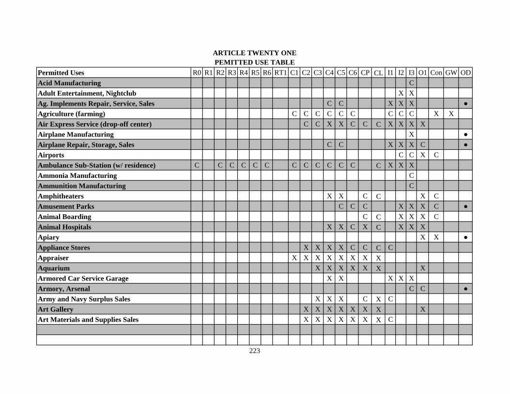
Permitted Uses R0 R1 R2 R3 R4 R5 R6 RT1 C1 C2 C3 C4 C5 C6 CP CL I1 I2 I3 O1 Con GW ODAcid Manufacturing CAdult Entertainment, Nightclub X XAg. Implements Repair, Service, Sales C C X X X ●Agriculture (farming) C C C C C C C C C X XAir Express Service (drop-off center) C C X X C C C X X X XAirplane Manufacturing X ●Airplane Repair, Storage, Sales C C X X X C ●Airports C C X CAmbulance Sub-Station (w/ residence) C C C C C C C C C C C C C X X XAmmonia Manufacturing CAmmunition Manufacturing CAmphitheaters X X C C X CAmusement Parks C C C X X X C ●Animal Boarding C C X X X CAnimal Hospitals X X C X C X X XApiary X X ●Appliance Stores X X X X C C C CAppraiser X X X X X X X XAquarium X X X X X X XArmored Car Service Garage X X X X XArmory, Arsenal C C ●Army and Navy Surplus Sales X X X C X CArt Gallery X X X X X X X XArt Materials and Supplies Sales X X X X X X X C
ARTICLE TWENTY ONEPEMITTED USE TABLE
223

Permitted Uses R0 R1 R2 R3 R4 R5 R6 RT1 C1 C2 C3 C4 C5 C6 CP CL I1 I2 I3 O1 Con GW ODArt Studio C X X X X X X X CArtificial Limbs, Sales, Service C C X X X X X X X XAsphalt Processing, Product Manufacturing C ●Assembly Hall X X X X C C X XAssociations, Clubs, Lodges X X X X C X XAthletic Clubs X X X X X X X XAthletic Fields, Public and Private C C X X X X X C C C C C C C C C X X X X XAuction House X X C C C X X XAudio Equipment, Sales, Service X X X C C C CAuditorium X X X X C X XAutomobile Accessories Installation C X X C X XAutomobile Car Wash (up to 6 bays) C X X X C X X X XAutomobile Detailing C C C C C X X X ●Automobile Manufacturing C XAutomobile Outdoor Sales Lot C C C X X ●Automobile Parts and Supplies, Indoor X X X X X XAutomobile Repair, Major X C X X XAutomobile Repair, Minor C C X X C X X XAutomobile Service Stations w/pumps X X X X C C C X X XAutomobile Storage - Outdoor (not salvage) C X X ●Automobile Storage - Indoor (not salvage) C C X X XAwning Fabrication X X X X XBakers and Baked Goods, Mfg. C C X X XBakery Shop, Outlet Sales X X X X X X X XBall Field, Complex C C X X X X X C C C C C C X C X X X X XBanks C X X X X C X X X X X
224

Permitted Uses R0 R1 R2 R3 R4 R5 R6 RT1 C1 C2 C3 C4 C5 C6 CP CL I1 I2 I3 O1 Con GW ODBar, Tavern X X X C X X XBarber Shop X X X X X X X X CBattery, Generators, Brakes, Service C C X X C X X XBeauty Shop X X X X X X X X CBed and Breakfast X X XBeverages, Bottling, Manufacturing X XBicycle Sales and Repair X X X X X X XBilliard or Pool Hall X X X X C XBlue Printing & Supplies X X X C X X CBoat Motors, Accessories Sales C X X X CBoat Storage, Dry Land, Enclosed X X X XBody Piercing C C X X XBonding Company (Bail Bondsman) X X X X X X XBook Publishing, Printing C X X X XBook Store X X X X C X XBookbinding and Mending X X X X C XBotanical Gardens (Conservatory) C C X X X X X X X X X X CBowling Alley X X X X X X CBroadcasting Station C X C C X X X X ●Broadcasting Studio X X X X X XBroom and Brushes Manufacturing X X XBus Depots X X CBusiness Machines, Repair, Sales X X X X X C X X X XButcher Shop X X X X X XCabinet Makers, Manufacturing C C C X X XCafes X X X X X X X X X X
225
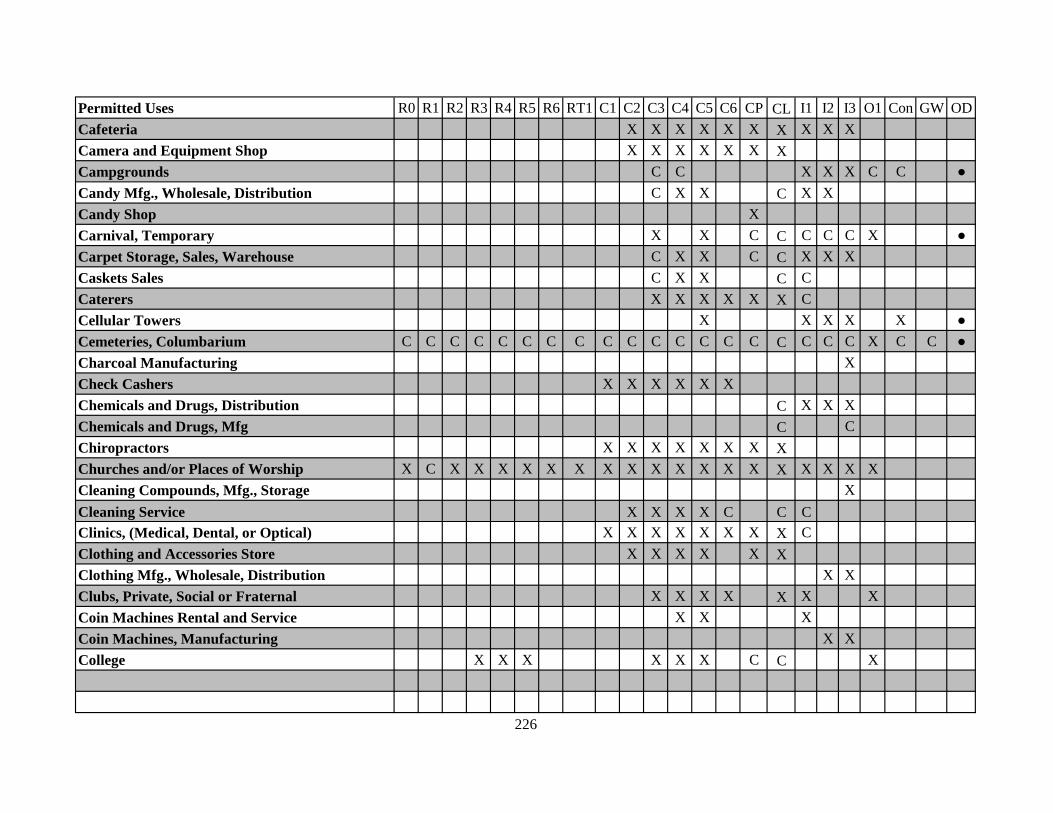
Permitted Uses R0 R1 R2 R3 R4 R5 R6 RT1 C1 C2 C3 C4 C5 C6 CP CL I1 I2 I3 O1 Con GW ODCafeteria X X X X X X X X X XCamera and Equipment Shop X X X X X X XCampgrounds C C X X X C C ●Candy Mfg., Wholesale, Distribution C X X C X XCandy Shop XCarnival, Temporary X X C C C C C X ●Carpet Storage, Sales, Warehouse C X X C C X X XCaskets Sales C X X C CCaterers X X X X X X CCellular Towers X X X X X ●Cemeteries, Columbarium C C C C C C C C C C C C C C C C C C C X C C ●Charcoal Manufacturing XCheck Cashers X X X X X XChemicals and Drugs, Distribution C X X XChemicals and Drugs, Mfg C CChiropractors X X X X X X X XChurches and/or Places of Worship X C X X X X X X X X X X X X X X X X X XCleaning Compounds, Mfg., Storage XCleaning Service X X X X C C CClinics, (Medical, Dental, or Optical) X X X X X X X X CClothing and Accessories Store X X X X X XClothing Mfg., Wholesale, Distribution X XClubs, Private, Social or Fraternal X X X X X X XCoin Machines Rental and Service X X XCoin Machines, Manufacturing X XCollege X X X X X X C C X
226

Permitted Uses R0 R1 R2 R3 R4 R5 R6 RT1 C1 C2 C3 C4 C5 C6 CP CL I1 I2 I3 O1 Con GW ODCommunity Centers X X X X C C C C C C C XConcrete, Batch Plant XConcrete, Industrial Production, Sales XConcrete, Ornamental Products Sales C C X X ●Container (Paper) Mfg., Cartons, Bags X X XContractors Office C C X X X C C X X XContractors Office w/ Outdoor Storage C X X X ●Convenience Store (No Fuel Pumps) X X X X C X X X X XConvenience Store with Fuel Pumps X X X X C C C X X X ●Copy & Printing Shops X X X X X X X X X XCosmetics Manufacturing X X XCostumes, Rental X X X X X X XCountry Clubs C C X CCrematorium CCrop Dusting, Equipment Yard X X ●Dairies, Products, Mfg., Distribution X X XDance Hall X X X X XDaycare, Adult X X X X X X X X X X X X C X X X XDaycare Center C C C C C CDaycare, Home CDelicatessens X X X X X X X X X XDelivery Service X X X X C C C X X XDelivery Service, garage C C X X XDental Laboratories X X X X C C CDental Supplies X X X X C C CDentist's Offices X X X X X X X X
227

Permitted Uses R0 R1 R2 R3 R4 R5 R6 RT1 C1 C2 C3 C4 C5 C6 CP CL I1 I2 I3 O1 Con GW ODDepartment Stores X X X X X X CDetective Agency X X X X X X X XDiesel Engines Manufacturing C XDiesel Engines, Service, Supply, Sales X X X XDinner Theatre X X X X XDisposal Plant (Sewer) X X XDistillers, Distribution, Warehouse X X XDock Private Shipping Company X X X CDock, Public X XDoctor's Offices X X X X X X X XDog Pound X X X X ●Dormitory Buildings C X X C X X C C XDrilling Company Equipment Yards X X ●Drive-In Theaters X X XDry Cleaning X X X X X X X XDry Goods Wholesale or Storage X X X X XDyeing, Commercial C C X X XElectric Equipment, Mfg., Assembly X X XElectroplating X XElevators Manufacturing X XEmbalming Establishment X X X X XEmployment Agencies X X X X X X X XEnameling and Painting Production X XEngravers X X X X C C X XEquipment Sales, Rental, Indoor C X X C C XEquipment Sales, Rental, Outdoor C X X ●
228

Permitted Uses R0 R1 R2 R3 R4 R5 R6 RT1 C1 C2 C3 C4 C5 C6 CP CL I1 I2 I3 O1 Con GW ODExplosives, Mfg., Storage, Distribution CExterminator, Contract Service, Sales X X X X XExterminator, Insecticide Mfg. XExtrusions, Metal, Manufacturing XFabrics, Weaving, Spinning X C X XFairgrounds C CFarm Lands, Crop and Ranching X X X XFarmers Market, Indoor X X X X X X X XFarmers Market, Outdoor C C C C C X ●Feed Mfg, Processing, Distribution C X XFeed, Wholesale and Storage C X XFences Metal Fabrication X XFences, Metal, Wholesale and Storage X X X ●Fertilizer Manufacturing XFertilizer, Storage C X CFire Proofing Manufacturing XFire Stations C X X C C X X X X X X X X X X X CFireworks Manufacturing CFish Hatchery XFlea Market (outdoors) C C ●Floor Materials and Installation X X X X C C C CFloor Materials Manufacturing XFlorist X X X X X X X XFood Carts in Right-of-Way C CFood Processing, Storage C C X X XFood Products Distributors X X X
229
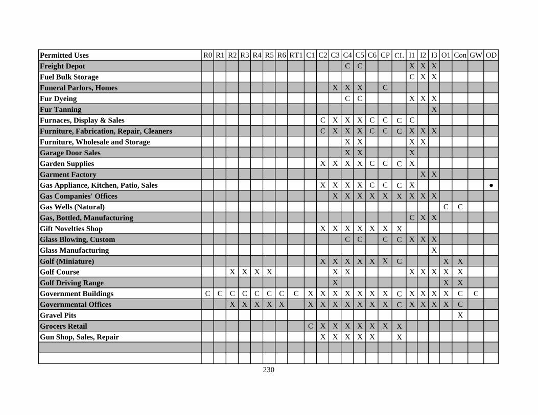
Permitted Uses R0 R1 R2 R3 R4 R5 R6 RT1 C1 C2 C3 C4 C5 C6 CP CL I1 I2 I3 O1 Con GW ODFreight Depot C C X X XFuel Bulk Storage C X XFuneral Parlors, Homes X X X CFur Dyeing C C X X XFur Tanning XFurnaces, Display & Sales C X X X C C C CFurniture, Fabrication, Repair, Cleaners C X X X C C C X X XFurniture, Wholesale and Storage X X X XGarage Door Sales X X XGarden Supplies X X X X C C C XGarment Factory X XGas Appliance, Kitchen, Patio, Sales X X X X C C C X ●Gas Companies' Offices X X X X X X X X XGas Wells (Natural) C CGas, Bottled, Manufacturing C X XGift Novelties Shop X X X X X X XGlass Blowing, Custom C C C C X X XGlass Manufacturing XGolf (Miniature) X X X X X X C X XGolf Course X X X X X X X X X X XGolf Driving Range X X XGovernment Buildings C C C C C C C C X X X X X X X C X X X X C CGovernmental Offices X X X X X X X X X X X X C X X X X CGravel Pits XGrocers Retail C X X X X X X XGun Shop, Sales, Repair X X X X X X
230
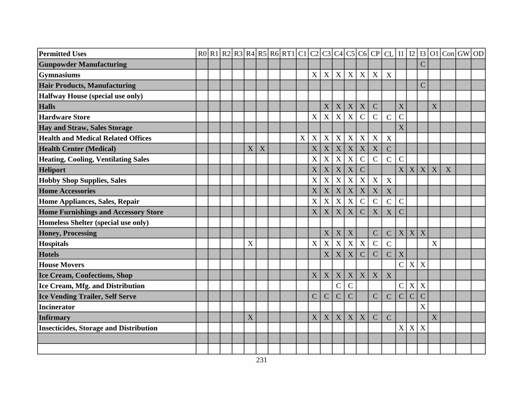
Permitted Uses R0 R1 R2 R3 R4 R5 R6 RT1 C1 C2 C3 C4 C5 C6 CP CL I1 I2 I3 O1 Con GW ODGunpowder Manufacturing CGymnasiums X X X X X X XHair Products, Manufacturing CHalfway House (special use only)Halls X X X X C X XHardware Store X X X X C C C CHay and Straw, Sales Storage XHealth and Medical Related Offices X X X X X X X XHealth Center (Medical) X X X X X X X X CHeating, Cooling, Ventilating Sales X X X X C C C CHeliport X X X X C X X X X XHobby Shop Supplies, Sales X X X X X X XHome Accessories X X X X X X XHome Appliances, Sales, Repair X X X X C C C CHome Furnishings and Accessory Store X X X X C X X CHomeless Shelter (special use only)Honey, Processing X X X C C X X XHospitals X X X X X X C C XHotels X X X C C C XHouse Movers C X XIce Cream, Confections, Shop X X X X X X XIce Cream, Mfg. and Distribution C C C X XIce Vending Trailer, Self Serve C C C C C C C C CIncinerator XInfirmary X X X X X X C C XInsecticides, Storage and Distribution X X X
231
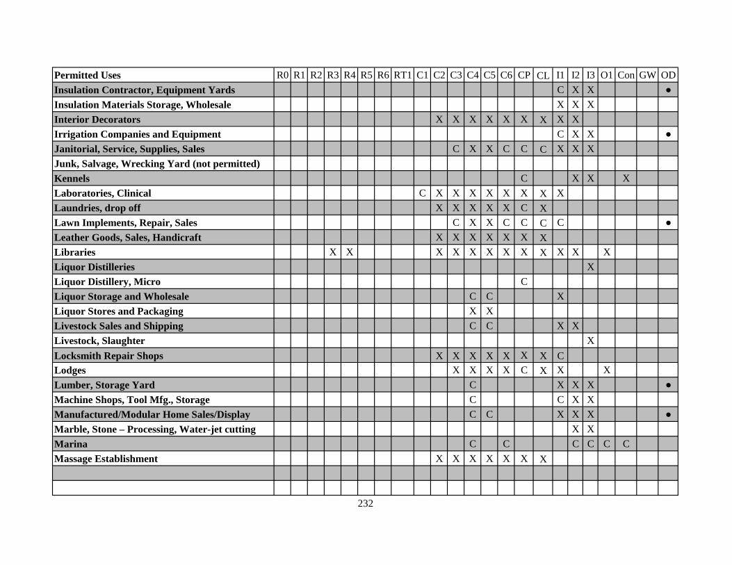
Permitted Uses R0 R1 R2 R3 R4 R5 R6 RT1 C1 C2 C3 C4 C5 C6 CP CL I1 I2 I3 O1 Con GW ODInsulation Contractor, Equipment Yards C X X ●Insulation Materials Storage, Wholesale X X XInterior Decorators X X X X X X X X XIrrigation Companies and Equipment C X X ●Janitorial, Service, Supplies, Sales C X X C C C X X XJunk, Salvage, Wrecking Yard (not permitted)Kennels C X X XLaboratories, Clinical C X X X X X X X XLaundries, drop off X X X X X C XLawn Implements, Repair, Sales C X X C C C C ●Leather Goods, Sales, Handicraft X X X X X X XLibraries X X X X X X X X X X X XLiquor Distilleries XLiquor Distillery, Micro CLiquor Storage and Wholesale C C XLiquor Stores and Packaging X XLivestock Sales and Shipping C C X XLivestock, Slaughter XLocksmith Repair Shops X X X X X X X CLodges X X X X C X X XLumber, Storage Yard C X X X ●Machine Shops, Tool Mfg., Storage C C X XManufactured/Modular Home Sales/Display C C X X X ●Marble, Stone – Processing, Water-jet cutting X XMarina C C C C C CMassage Establishment X X X X X X X
232

Permitted Uses R0 R1 R2 R3 R4 R5 R6 RT1 C1 C2 C3 C4 C5 C6 CP CL I1 I2 I3 O1 Con GW ODMattress, Manufacturing X XMausoleums XMeat Packers C XMeat, Wholesale Market C X X X X XMedical Research Facility CMessenger Service X X X X X X XMetal Plating XMetal Polish, Manufacturing XMetals, Bulk Processing, Casting XMetals, Rolling Mill XMicrobrewery with Restaurant/Bar X X X X X X X X X XMicrobrewery without Restaurant/Bar X X C C X X XMilling Equipment, Showrooms, Sales X X XMills, Flour and Grain X XMillwork Sales and Storage X X X ●Mineral Water Distillation and Bottling C C X X XMining C CMirrors, Mfg., Re-silvering, Storage C C XMobile business in ROW (Special Use only)Monuments Sales and Display X X X C ●Mortuary X X XMotels X X X C C C XMotor Freight, Garages, Warehouse X X XMotor Homes, Sales, Repair X X X ●Motorcycles, Equip., Repair, Sales, Indoor X X X X XMotorcycles, Equip., Repair, Sales, Outdoor C C X X ●
233

Permitted Uses R0 R1 R2 R3 R4 R5 R6 RT1 C1 C2 C3 C4 C5 C6 CP CL I1 I2 I3 O1 Con GW ODMuffler Shops X X X X XMuseums X X X X X X X XMusic Instruments Store X X X X X X XNews Stands X X X X X X XNewspaper Printing C C XNon-Toxic Insecticide, Manufacturing X X XNurseries, Landscape Sales X X X X C C X X X ●Nursing Homes X X CNuts, Packaging, Distributing, Sales C C C C C C C X X XOffice Equipment Store X X X X X X X X X XOffice Furniture, Mfg., Storage X X XOffice, General X X X X X X X X X X COil Fuel Storage C XOil Refinery XOil, Vegetable, Processing C XOptometrist X X X X X X X XOre Dumps COre Reduction COrnamental Metal Works, Production C X XOxygen Equip., Rental, Distribution C C X XOxygen Production and Storage X X XPaint and Equipment, Supplies, Sales X X X C C X CPaper Manufacturing XPaper Products, Wholesale and Storage C C X XParking Decks X X X X X XParking Lots C C C X X X X X X X X C C C X X X X ●
234

Permitted Uses R0 R1 R2 R3 R4 R5 R6 RT1 C1 C2 C3 C4 C5 C6 CP CL I1 I2 I3 O1 Con GW ODParks X X X X X X X X X X X X X X X X X X C X X X ●Parks Amusement X X C C ●Paving Contractor, Equipment Yards C X X ●Pawn Shops (no outside display) C X XPet Shop X X X X X X XPharmaceutical Products Mfg. C XPharmacy X X X X C X XPhoto Shops X X X X C X XPhotographers, Commercial Studios X X X X X X XPicture Framing, Prints, Glass, Sales X X X X X X XPipe Manufacturing Storage X X ●Plasma Center X XPlastic and Plastic Products Mfg. X X XPlating Works C XPlaygrounds X X X X X X X X X X X X X X X X X X ●Plumbing Fixtures, Supplies Sales X X X CPolice Station C X X C C X X X X X X X X X X X CPost Office C X X C C X X X X X X X X X X X CPoultry Farm, Egg, Broiler, Hatchery CPoultry Slaughter and Dressing X XPrinters' Equipment and Supplies X X XPublic Buildings C C C C C C C C X X X X X X X C X X X X C CPublic Utility Plant X X XPump Stations, Utility Sub-Stations C C C C C C C C C C C C C C C C C C C CQuarries C CRace Track C
235
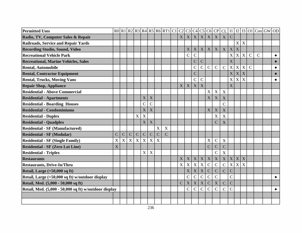
Permitted Uses R0 R1 R2 R3 R4 R5 R6 RT1 C1 C2 C3 C4 C5 C6 CP CL I1 I2 I3 O1 Con GW ODRadio, TV, Computer Sales & Repair X X X X X X X CRailroads, Service and Repair Yards X XRecording Studio, Sound, Video X X X X X X X XRecreational Vehicle Park C C X X X C C ●Recreational, Marine Vehicles, Sales C C X ●Rental, Automobile C C C C C X X X C ●Rental, Contractor Equipment C X X X ●Rental, Trucks, Moving Vans C C X X X ●Repair Shop, Appliance X X X X XResidential - Above Commercial X X XResidential - Apartments X X X X XResidential - Boarding Houses C C CResidential - Condominiums X X X X XResidential - Duplex X X X XResidential - Quadplex X X C XResidential - SF (Manufactured) X XResidential - SF (Modular) C C C C C C C CResidential - SF (Single Family) X X X X X X X X C XResidential - SF (Zero Lot Line) X C C CResidential - Triplex X X C XRestaurants X X X X X X X X X XRestaurants, Drive-In/Thru X X X X C C C X X XRetail, Large (+50,000 sq ft) X X X C C C CRetail, Large (+50,000 sq ft) w/outdoor display C C C C C C ●Retail, Med. (5,000 - 50,000 sq ft) C X X X C X C CRetail, Med. (5,000 - 50,000 sq ft) w/outdoor display C C C C C C C ●
236
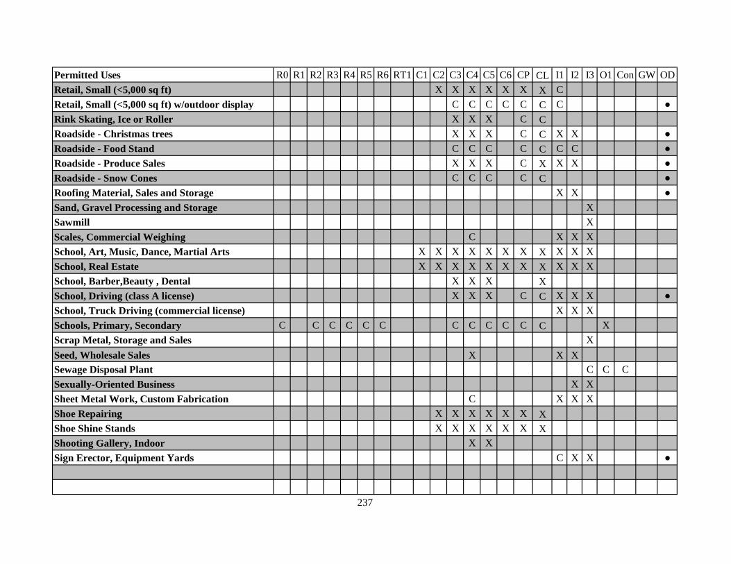
Permitted Uses R0 R1 R2 R3 R4 R5 R6 RT1 C1 C2 C3 C4 C5 C6 CP CL I1 I2 I3 O1 Con GW ODRetail, Small (<5,000 sq ft) X X X X X X X CRetail, Small (<5,000 sq ft) w/outdoor display C C C C C C C ●Rink Skating, Ice or Roller X X X C CRoadside - Christmas trees X X X C C X X ●Roadside - Food Stand C C C C C C C ●Roadside - Produce Sales X X X C X X X ●Roadside - Snow Cones C C C C C ●Roofing Material, Sales and Storage X X ●Sand, Gravel Processing and Storage XSawmill XScales, Commercial Weighing C X X XSchool, Art, Music, Dance, Martial Arts X X X X X X X X X X XSchool, Real Estate X X X X X X X X X X XSchool, Barber,Beauty , Dental X X X XSchool, Driving (class A license) X X X C C X X X ●School, Truck Driving (commercial license) X X XSchools, Primary, Secondary C C C C C C C C C C C C XScrap Metal, Storage and Sales XSeed, Wholesale Sales X X XSewage Disposal Plant C C CSexually-Oriented Business X XSheet Metal Work, Custom Fabrication C X X XShoe Repairing X X X X X X XShoe Shine Stands X X X X X X XShooting Gallery, Indoor X XSign Erector, Equipment Yards C X X ●
237

Permitted Uses R0 R1 R2 R3 R4 R5 R6 RT1 C1 C2 C3 C4 C5 C6 CP CL I1 I2 I3 O1 Con GW ODSlaughterhouses XSmall Engine Repair X X X X CSorority/Fraternity Houses C C C C C C CSound System, Rental & Service, Sales X X X X C C C X X XSoy Bean Oil Manufacturing X XSporting Goods, Retail Sales X X X X X X XStadium X ●Steel Fabrication XSteel Manufacturing, Rolling Mills XStock Yards (Livestock) X ●Stone Cutting and Screening XStorage Container Sales / Rental C X X ●Storage Tanks, Refinery, Distribution XStorage Yards, Bulk Material X X ●Store and Office Fixtures Shop X X X XStoves and Ranges Manufacturing XStoves and Ranges, Wholesale Storage X XStructural Steel Manufacturing XSugar Refining XSurgical Supplies, Wholesale, Dist. C C X X XSweeping Compound Manufacturing XSwimming Pools, Public X X X X X X C C C XSyrup and Preserve Manufacturing X XTackle Shop, Bait, Marine Supplies X X X C C C XTailors, Alterations, Repair X X X X X X X XTar, Distillation or Manufacturing X
238

Permitted Uses R0 R1 R2 R3 R4 R5 R6 RT1 C1 C2 C3 C4 C5 C6 CP CL I1 I2 I3 O1 Con GW ODTattoo Parlor C C C X X XTaxicab Garages C XTaxidermists X X X XTennis Courts X X X X X X X X X C C X X ●Theaters, Indoor X X X X X X CTheatres, Outdoor (Drive-In) C C C ●Tire Shop C C C X XTobacco Store X X X X X C X X X XTool Grinding and Sharpening X X C C X XTours, Offices & Passenger Depots X X X X C C C CTractors, Retail Sales and Display C C X X ●Trailer (Utility, Hauling) Repair, Sales C C X X ●Trucks, Tractor Trailer, Sales, Repair C C X X ●Trusses, Mfg. Custom and Retail C X XUniforms Rental, Sales X X X X C X X X XUpholsterers Shop X X C C X XVeterinarians, Clinics, Hospital X X X X X X X X X XVideo Game Arcades X X X C X XWarehouse, Mini-Storage w/outdoor storage C X X X ●Warehouse, Mini-Storage, Rental X X X XWarehouse, Office w/docks C C X X XWarehouse, Showroom w/docks C C X X XWarehouse, Storage C X X XWaste Paper Products, Manufacturing XWatches, Manufacturing X X XWaterproofing Materials, Mfg. X
239

Permitted Uses R0 R1 R2 R3 R4 R5 R6 RT1 C1 C2 C3 C4 C5 C6 CP CL I1 I2 I3 O1 Con GW ODWelding Shop, Equipment, Supplies C C X XWharf XWharf, Private Shipping Company X X X CWindow Glass Installation Shop X X XWindow, Installation, Studio, Sales X X C X XWood Products, Manufacturing XWoodworking, Cabinets, Mill Work C C X X XYacht Club X X X CZoological Gardens X X X X C C C X X X X ●Zoos X X X C C C C C ●
240

241
ARTICLE TWENTY-TWO AIRPORT ZONING
Section 22.1 – Purpose and Authority. Through its approval and adoption of this Article, the North Little Rock City Council has delegated the power to promulgate, administer and enforce airport zoning regulations contained herein to the North Little Rock Planning Commission. This Article shall be known, and may be cited, as the Airport Zoning Article of the Zoning Ordinance of North Little Rock, Arkansas. Section 22.2 – Airport Commission. Operation and management of the airport for the City, its related properties and facilities has been delegated by the City to the North Little Rock Airport Commission. Section 22.3 – Definitions. The following words, terms and phrases, when used in this article, shall have the meanings ascribed to them in this section, except where the context clearly indicates a different meaning: Airport means North Little Rock Municipal Airport. Airport elevation means 544 feet above mean sea level. Airport manager means the person responsible for the day-to-day operations and management of the municipal airport appointed by the municipal Airport Commission. Approach surface means an imaginary plane longitudinally centered on the extended runway centerline, extending outward and upward from the end of the primary surface and at the same slope as the appropriate approach zone height limitation slope set forth in Section 2.1.2. In plan, the perimeter of the approach surface coincides with the perimeter of the approach zone. Approach, transitional, horizontal and conical zones. These zones are set forth in Section 2.1.1of this article. Board of adjustment means a board consisting of five (5) members appointed by the City Council. Conical surface means an imaginary surface extending outward and upward from the periphery of the horizontal surface at a slope of 20 to one for a horizontal distance of 4,000 feet.
242
Director of Community Planning means the person responsible for the day-to-day operations and management of the Department of Community Planning appointed by the Mayor. Municipal airport commission means a commission consisting of five members appointed by the mayor and ratified by the city council to oversee the operations and management of the North Little Rock Municipal Airport. Non-conforming use means any preexisting structure, object of natural growth, or use of land which is inconsistent with the provisions of this article or any amendment thereto. Non-precision instrument runway means a runway having an existing or planned instrument approach procedure utilizing air navigation facilities with only horizontal guidance, or area type navigation equipment, for which a straight-in non-precision instrument approach procedure has been approved or planned. Obstruction means a structure, growth, or other object, including a mobile object, which exceeds a limiting height set forth in Section 2.1.2. Person means an individual, firm, partnership, public or private corporation, company, association, joint stock association, or governmental entity; includes a trustee, a receiver, an assignee, or a similar representative of any of them. Planning Commission means a commission consisting of nine members appointed by the mayor and ratified by the city council, the general purpose of which is to prepare or have prepared a plan or plans of the municipality; to receive and make recommendations on public and private proposals for development; to prepare and administer planning regulations; to prepare and transmit to the legislative body recommended ordinance implementing plans; and to advise and counsel the city government and other public bodies. Precision instrument runway means a runway having an existing instrument approach procedure utilizing an instrument landing system (ILS) or a precision approach radar (PAR). Such term also means a runway for which a precision approach system is planned and is so indicated on an approved airport layout plan or any other planning document. Primary surface means an imaginary surface longitudinally centered on a runway. The primary surface extends 200 feet beyond each end of that runway. The width of the primary surface is set forth in Section 2.1.1. The elevation of any point on the primary surface is the same as the elevation of the nearest point on the runway centerline. Runway means a paved area on the airport prepared for the landing and takeoff of aircraft along its length. Structure means an object, including a mobile object, constructed or installed by man, including, but without limitation, buildings, towers, cranes, smokestacks, earth formations, and overhead transmission lines.

243
Transitional surfaces means imaginary surfaces extending outward at 90 degree angles to the runway centerline, and the extended runway centerline at a slope of seven feet horizontally for each foot vertically from the sides of the primary, and approach surfaces to where they intersect the horizontal and conical surfaces. Tree means an object of natural growth. Utility runway means a runway that is constructed for and intended to be used by propeller driven aircraft of 12,500 pounds maximum gross weight and less. Visual runway means a runway intended solely for the operation of aircraft using visual approach procedures. Section 22.4 – Zones Created. In order to carry out the provisions of this article, there are hereby created and established certain zones which include all of the land lying beneath the approach surfaces, transitional surfaces, horizontal surface, and conical surface as they apply to the municipal airport. Such zones are shown on the North Little Rock Municipal Airport Height Zoning Ordinance Plan prepared for the municipal airport commission. An area located in more than one of the following zones is considered to be only in the zone with the more restrictive height limitation. The various zones are hereby established and defined as follows:
A. Utility runway, non-precision instrument approach zone (runways 17 and 35):
The inner edge of this approach zone coincides with the width of the primary surface and is 500 feet wide. The approach zone expands outward uniformly to a width of 2,000 feet at a horizontal distance 5,000 feet from the primary surface. Its centerline is the continuation of the centerline of the runway.
B. Runway larger-than-utility, non-precision instrument approach zone (runway 5):
The inner edge of this approach zone coincides with the width of the primary surface and is 1,000 feet wide. The approach zone expands outward uniformly to a width of 4,000 feet at a horizontal distance of 10,000 feet from the primary surface. Its centerline is the continuation of the centerline of the runway.
C. Precision instrument runway approach zone (runway 23): The inner edge of this
approach zone coincides with the width of the primary surface and is 1,000 feet wide. The approach zone expands outward uniformly to a width of 16,000 feet at a horizontal distance of 50,000 feet from the primary surface. Its centerline is the continuation of the centerline of the runway.
D. Transitional zones: Areas beneath the transitional surfaces.
244
E. Horizontal zone: The horizontal zone is established by swinging arcs of 5,000 feet radii for the runways designated as utility (runways 17 and 35), and 10,000 feet radii for the runways designated as precision instrument (runway 23) and non-precision instrument (runway 5), measured from the center of each end of the primary surface of each runway, and connecting the adjacent arcs by drawing a line tangent to these arcs. The horizontal zone does not include the approach and transitional zones.
F. Conical zone: The area that commences at the periphery of the horizontal zone and
extends outward for a horizontal distance of 4,000 feet. Section 22.5 – Airport zone height limitations. Except as otherwise provided in this article, no structure shall be erected, altered or maintained, and no tree shall be allowed to grow, in any zone created by this article to a height in excess of the applicable height limitation established in this article for each of the zones as follows:
A. Utility runway, non-precision instrument approach zone: Slope 20 feet outward
for each foot upward, beginning at the end of and at the same elevation as the primary surface, and extending to a horizontal distance of 5,000 feet along the extended runway centerline.
B. Runway larger-than-utility, non-precision instrument approach zone: Slope 34
feet outward for each foot upward, beginning at the end of and at the same elevation as the primary surface, and extending to a horizontal distance of 10,000 feet along the extended runway centerline.
C. Precision instrument runway approach zone: Slopes 50 feet outward for each foot
upward beginning at the end of and at the same elevation as the primary surface and extending to a horizontal distance of 10,000 feet along the extended runway centerline; thence slopes upward 40 feet horizontally for each foot vertically to an additional horizontal distance of 40,000 feet along the extended runway centerline.
D. Transitional zones: Slope seven feet outward for each foot upward, beginning at
the sides of and at the same elevation as the primary surface and the approach surface, and extending to a height of 694 feet above mean sea level. In addition to the foregoing, there are established height limits sloping seven feet outward for each foot upward, beginning at the sides of and at the same elevation as the approach surface, and extending to where they intersect the conical surface.
E. Horizontal zone: One hundred fifty feet above the airport elevation, i.e., at a height
of 694 feet above mean sea level. F. Conical zone: Slopes 20 feet outward for each foot upward, beginning at the
periphery of the horizontal zone and at 150 feet above the airport elevation, and

245
extending to a height of 350 feet above the airport elevation, i.e., to a height of 894 feet above mean sea level.
G. Excepted height limitations: Nothing in this article shall be construed as
prohibiting the construction or maintenance of any structure, or growth of any tree, to a height up to 50 feet above the surface of the land.
Section 22.6 – Land use restrictions. Notwithstanding any other provisions of this article, no use may be made of land or water within any zone established by this article in such a manner as to create electrical interference with navigational signals or radio communication between the airport and aircraft, make it difficult for pilots to distinguish between airport lights and other lights, result in glare in the eyes of pilots using the airport, impair visibility in the vicinity of the airport, create bird strike hazards, or otherwise in any way endanger or interfere with the landing, takeoff or maneuvering of aircraft intending to use the airport. Section 22.7 – Nonconforming uses.
A. Regulations not retroactive. The regulations prescribed by this article shall not be
construed to require the removal, lowering, or other change or alteration of any structure or tree not conforming to the regulations as of September 27, 1993, or otherwise interfere with the continuance of nonconforming use. Nothing contained in this article shall require any change in the construction, alteration or intended use of any structure or alteration which was begun prior to the effective date of this article and is diligently prosecuted.
B. Marking and lighting. Notwithstanding the preceding provisions of this section, the
owner of any existing nonconforming structure or tree is hereby required to permit the installation, operation and maintenance thereon of such markers and lights as shall be deemed necessary by the municipal airport commission to indicate to the operators of aircraft in the vicinity of the airport the presence of such airport obstruction. Such markers and lights shall be installed, operated and maintained at the expense of the city.
C. Lowering or removal of nonconforming uses. In order to eliminate or mitigate
existing hazards to landing and taking-off at the airport, to improve and make safer the airport, and to permit public use of any obstructed navigable airspace needed for such use, the municipal airport commission may acquire, by purchase, grant or condemnation, such estate or interest in any structure or tree of nonconforming use for which a permit has been granted in accordance with Section 2.2.3(C) as is necessary to conform to the applicable height limitation prescribed in this article. In cases of imminent danger to the health, safety and general welfare of the public, the municipal airport commission shall take such immediate steps as are necessary to remove such danger, and a hearing shall thereafter be held to determine what compensation, if any, should be made to the owner of the structure or tree causing such danger.

246
Section 22.8 – Permits.
A. Future uses. Except as specifically provided in subsections (1) and (2) of this subsection (a), no material change shall be made in the use of land, no structure shall be erected or otherwise established, and no tree shall be planted in any zone hereby created unless a permit therefor shall have been applied for and granted by the Planning Department. Each application for a permit shall indicate the purpose for which the permit is desired, with sufficient particularity for it to be determined whether the resulting use, structure or tree would conform to the regulations prescribed in this article. If such determination is in the affirmative, the permit shall be granted. No permit for a use inconsistent with the provisions of this article shall be granted unless a variance has been approved in accordance with subsection (f) of this section. (1) In the area lying within the limits of the horizontal zone and conical zone, no permit shall be required for any tree or structure less than 75 feet of vertical height above the ground, except when, because of terrain, land contour, or topographic features, such tree or structure would extend above the height limit prescribed for such zones. (2) In areas lying within the limits of the approach zone, but at a horizontal distance of not less than 4,200 feet from each end of the runway, no permit shall be required for any tree or structure less than 75 feet of vertical height above the ground, except when such tree or structure would extend above the height limit prescribed for such approach zones.
Nothing contained in any of the foregoing exceptions shall be construed as permitting or intending to permit any construction or alteration of any structure, or growth of any tree, in excess of any of the height limits established by this article except as set forth in Section 2.1.2.
B. Existing uses. No permit shall be granted that would allow the establishment or
creation of an obstruction, or that would allow a nonconforming use, structure or tree to become a greater hazard to air navigation than it was on September 27, 1993 or on the effective date of any amendments to this article or than it is when the application for such a permit for existing uses shall be granted.
C. Continuance of nonconforming uses. The owner of any structure or tree which is
nonconforming to the regulations of this article on September 27, 1993 shall be granted a permit authorizing continuance of such nonconforming use, upon application therefor made by him; provided that, if such application is not made within 90 days of such date, the Department of Community Planning shall by appropriate action compel the owner of the nonconforming structure or tree, at his own expense, to lower or remove such object to the extent necessary to conform to this article.
D. Change and repair of nonconforming uses. Before any existing nonconforming
structure or tree for which a permit has been issued in accordance with subsection (c) of this section may be altered or repaired, rebuilt, allowed to grow higher or replanted, a permit must be secured from the Department of Community Planning

247
authorizing such change or repair. No such permit shall be granted that would permit the structure or tree in question to be made higher or become a greater hazard to air navigation than it was when the permit for its continuance was granted.
E. Nonconforming uses abandoned or destroyed. Whenever the Department of
Community Planning determines that a nonconforming tree or structure has been abandoned or more than 50 percent torn down, physically deteriorated or decayed, no permit shall be granted that would allow such structure or tree to exceed the applicable height limit or otherwise deviate from the zoning regulations. In all such cases of 50 percent destruction, deterioration or decay, whether application is made for a permit for repair or not, the Department of Community Planning shall, by appropriate action, compel the owner of the nonconforming tree or structure, at his own expense, to lower or remove such object to the extent necessary to conform to the applicable height limit.
F. Variances. Any person desiring to erect or increase the height of any structure, or
permit the growth of any tree, or use property, not in accordance with the regulations prescribed in this article, may apply to the board of adjustment for a variance from such regulations. The application for variance shall be accompanied by a determination from the Federal Aviation Administration as to the effect of the proposal on the operation of air navigation facilities and the safe, efficient use of navigable airspace. Such variances shall be allowed where it is duly found that a literal application or enforcement of the regulations will result in unnecessary hardship, and the relief granted will not be contrary to the public interest, will not create a hazard to air navigation, will do substantial justice, and will be in accordance with the spirit of this article. Additionally, no application for variance to the requirements of this article may be considered by the Board of Zoning Adjustment (see Article Nineteen of the Zoning Ordinance) unless a copy of the application has been furnished to the airport manager and/or municipal airport commission for advice as to the aeronautical effects of the variance. If the airport manager and/or municipal airport commission does not respond to the application within 15 days after receipt, the Board of Zoning Adjustment may act on its own to grant or deny such application.
G. Obstruction marking and lighting. Any permit or variance granted may, if such
action is deemed advisable to effectuate the purpose of this article and be reasonable in the circumstances, be so conditioned as to require the owner of the structure or tree in question to install, operate or maintain, at the owner's expense, such markings and lights as may be necessary. If deemed proper by the board of adjustment, this condition may be modified to require the owner to permit the city, at its own expense, to install, operate and maintain the necessary markings and lights.
H. Notice of hearing of applications for permits and variances; introduction of
evidence. In all cases of applications for permits and variances as provided for in this section, a public notice shall be published, in the manner prescribed by law for
248
publication of legal notices, of a public hearing upon the application in question; a public hearing shall be held at which any person having an interest in the proceedings shall have an opportunity to offer evidence for or in opposition to the application in question; and written findings of fact and conclusions of law shall be made by the municipal planning commission, based upon the evidence offered at the public hearing.
Section 22.9 – Enforcement. It shall be the duty of the Director of Community Planning to administer and enforce the regulations prescribed in this article. Applications for permits and variances shall be made to the Department of Community Planning upon a form published for that purpose. Applications required by this article to be submitted to the director of community planning shall be promptly considered and granted or denied. Application for action by the Board of Zoning Adjustment shall be forthwith submitted by the Director of Community Planning. A copy of each application for permits and variances and each permit and variance granted shall be furnished to the airport manager and/or Municipal Airport Commission by the Director of Community Planning. Section 22.10 – Board of Zoning Adjustment.
A. A Board of Zoning Adjustment has been created pursuant to Article Nineteen hereof
with the power to consider appeals and variances of the enforcement and application of the Zoning Ordinance (including this Article Twenty-Two.
B. The Board of Adjustment shall make written findings of fact and conclusions of law
giving the facts upon which it acted and its legal conclusions from such facts in reversing, affirming or modifying any order, requirement, decision or determination which comes before it under the provisions of this article.
C. The concurring vote of a majority of the members of the Board of Adjustment shall
be sufficient to reverse any order, requirement, decision or determination of the director of community planning, or decide in favor of the applicant, on any matter which it is required to pass under this article, or to effect variation to this article.
Section 22.11 – Violations; penalties. Each violation of this article or of any regulation, order or ruling promulgated under this article shall constitute a misdemeanor. In addition, the North Little Rock Planning Commission may institute, in any court of competent jurisdiction, an appropriate action or proceeding to prevent, restrain, correct or abate any violation of the regulations of this article, or any order or ruling made in connection with its administration or enforcement, and the court shall adjudge then to the plaintiff such relief, by way of injunction (which may be mandatory) or otherwise as may be proper under all the facts and circumstances of the case, in order to fully carry out and effectuate the purposes of this article and the orders and rulings made pursuant to the authority herein given.

249
Section 22.12 – Conflicting regulations. Where there exists a conflict between any of the regulations or limitations prescribed in this article and any other regulation applicable to the same area, whether the conflict be with respect to the height of structures or trees and the use of land, or any other matter, the more stringent limitation or requirement shall govern and prevail.