ZONING ORDINANCE #10 TOWN OF GNESEN ST. LOUIS ...
79
ZONING ORDINANCE #10 TOWN OF GNESEN ST. LOUIS COUNTY MINNESOTA Updated May 14, 2018
-
Upload
khangminh22 -
Category
Documents
-
view
1 -
download
0
Transcript of ZONING ORDINANCE #10 TOWN OF GNESEN ST. LOUIS ...

ZONING ORDINANCE #10
TOWN OF GNESEN
ST. LOUIS COUNTY
MINNESOTA
Updated May 14, 2018

1
GNESEN LAND USE CONTROLS ORDINANCE TABLE OF CONTENTS
10.00 TITLE…………………………………………………………………………………… 3 10.01 AUTHORITY AND PURPOSE………………………………………………………. 3 10.011 Authority and Jurisdiction…………………………………………………. 3 10.012 Town Comprehensive Plan……………………………………………….. 3 10.013 Intent and Purpose…………………………………………………………. 3
10.014 Consistency with County Zoning…………………………………………. 3 10.02 GENERAL……………………………………………………………………………… 3 10.021 Rules of Construction……………………………………………………… 3 10.022 Scope, Application, and Interpretation…………………………………… 4 10.023 Vested Rights………………………………………………………………. 4 10.024 Separability…………………………………………………………………. 4 10.025 Lot Provisions………………………………………………………………. 4 10.026 Other Provisions……………………………………………………………. 5 10.027 Environmental Review…………………………………………………….. 5 10.028 Repeals……………………………………………………………………… 5 10.03 DEFINITIONS………...……………………………………………………………….. 6 10.04 (RESERVED)…………………………………………………………………………. 17 10.05 ADMINISTRATION…………………………………………………………………… 18 10.051 Zoning Officer……………………………………………………………. 18 10.052 Zoning Permit……………………………………………………………. 18 10.054 Planning Commission…………………………………………………… 18 10.055 Board of Adjustment…..……………………………………………….. 19 10.056 Variances………………………………………………………………… 20 10.057 Enforcement, Penalties, and Remedies……………………………… 21 10.058 Amendments and Rezoning Procedures…………………………….. 22 10.059 Fees……………………………………………………………………… 23 10.06 ZONING MAP AND DISTRICTS…………………………………………………… 24 10.061 Establishment of Zoning Districts……………………………………….. 24 10.062 Purpose and Intent of Zoning Districts…………………………………. 24 10.063 Zoning Districts Map……………………………………………………… 25 10.064 Shoreland Management Areas and Map………………………………. 25 10.065 Flood Hazard Areas and Map…………………………………………… 25 10.066 Interpretation of Zoning Districts, Shoreland Management and Flood Hazard Maps……………………………………………………………… 25 10.067 Zoning of Annexed Lands………………………………………………. 26 10.07 ZONE DISTRICT DIMENSIONAL STANDARDS……………………………….. 27 10.071 Dimensions……………………………………………………………….. 27 10.072 Front yard, road right-of-way setbacks………………………………… 28 10.073 Shoreland Dimensions…………………………………………………… 28 10.075 Sanitary System and Water Well Standards…………………………… 29 10.08 ZONE DISTRICT LAND USE REGULATIONS…………………………………… 31 10.081 Uses Permitted in Zone Districts………………………………………… 31 10.082 Off-Street Parking and Loading Space Requirements………………… 35 10.083 Shoreland Area District and Standards…………………………………. 36 10.084 Flood Hazard Area District and Standards…………………………….. 43 10.085 Wetland Standards……………………………………………………….. 48 10.09 (Reserved)……………………………………………………………………………. 48

2
10.10 PERFORMANCE STANDARDS………………………………………………...…. 49 10.101 Use Performance Standards…………………………………………… 49 10.102 Water Oriented Accessory Structures………………………………… 56 10.103 Signs……………………………………………………………………… 56 10.104 Handicap Accessibility Standards…………………………………….. 58 10.105 Gravel (Borrow) Pit Standards………………………………………… 58
10.106 Interim Use……………………………………………………………… 63 10.107 Communication Towers……………………………………………….. 64 10.108 Solar Farms…………………………………………………………….. 65
10.11 CONDITIONAL USES AND STANDARDS…………………………………….. 67 10.111 Purpose and Intent…………………………………………………….. 67 10.112 Application Requirements……………………………………………... 67 10.113 Hearing and Mailed Notice…………………………………………….. 67 10.114 Planning Commission Review and Recommendation……………… 68 10.115 Conditions and Restrictions…………………………………………… 69 10.116 Resubmission…………………………………………………………… 69 10.117 Lapse and Extension…………………………………………………… 69 10.118 Revocation………………………………………………………………. 69 10.12 NON-CONFORMING LOTS, USES, STRUCTURES AND ON-SITE SEWAGE TREATMENT SYSTEMS………………………………………………………. 70 10.121 Non-conforming Lots…………………………………………………… 70 10.122 Non-conforming Uses………………………………………………….. 70 10.123 Non-conforming Structures……………………………………………. 70 10.124 Non-conforming On-Site Sewage Treatment Systems……………… 72 10.125 Shoreline Riparian Non-conforming Lots……………………………... 72 10.126 Shoreline Averaging…………………………………………………….. 72 10.13 – 10.19 (Reserved)………………………………………………………………… 72 10.20 SUBDIVISION OF LAND………………………………………………………. 73 10.201 Subdivision and Platting of Land…………………………………….. 73 10.30 SEXUALLY ORIENTATED BUSINESS………………………………………. 74 10.301 Restrictions……………………………………………………………… 74 10.302 Regulated Uses………………………………………………………… 74 10.303 Definitions………………………………………………………………. 75

3
10.00 TITLE
This ordinance shall be known as the LAND USE CONTROLS ORDINANCE FOR THE TOWN OF GNESEN, MINNESOTA, adopted and effective as of December 1, 1975 and otherwise be referred to as Ordinance #10.
10.01 AUTHORITY AND PURPOSE
10.011 Authority and Jurisdiction
This ordinance establishes zoning, water well and on-site sanitation regulations for and within the Town of Gnesen, Minnesota in pursuance of the authority granted by Chapters 462 and 105, Minnesota Statutes, to promote the health, safety, morals and general welfare of the inhabitants by dividing the Town into zones and regulating the location, height, width, bulk, type of foundation, number of stories, size of buildings and other structures, the percentage of lot which may be occupied, the size of yards and other open space, the density and distribution of population, the uses of buildings, and structures for trade, industry, recreation, public activities, agriculture, forestry, soil conservation, water supply conservation, conservation of shorelands, access to direct sunlight for solar energy systems, and flood control.
10.012 Town Comprehensive Plan
The Gnesen Town Comprehensive Plan shall be the document known as the “Community Plan for the Town of Gnesen, Minnesota” adopted June 10, 1992. The Comprehensive Plan may be amended by the Town Board from time to time, in accordance with the procedures set forth in Chapter 462, Minnesota Statutes.
10.013 Intent and Purpose
This ordinance is adopted for the purpose of:
A. Protecting the health, safety, morals, comfort, convenience and general welfare. B. Regulating land use in accordance with the Town Comprehensive Plan. C. Dividing the Town into zones and districts restricting and regulating therein the location, construction,
reconstruction, alteration, and use of structures and land. D. Promoting orderly development of the residential, business, industrial, recreational and public areas. E. Providing adequate light, air, access to direct sunlight, and convenience of access to property. F. Limiting congestion in the public rights-of-way. G. Preventing overcrowding of land and undue concentration of structures by regulating the use of land and
buildings and the bulk of buildings in relation to the land and buildings surrounding them. H. Providing for the compatibility of different land uses and the most appropriate use of land throughout the
Town. I. Insuring the responsible, technically correct and appropriate legal division of land. J. Maintaining and enhancing the quality and condition of natural resources within the town. K. Providing for the administration of this ordinance and amendments thereto.
10.014 Consistency with County Zoning
As directed by Minn. Stat. § 394.33, subd. 1 the official land use controls of the Town shall not be inconsistent with or less restrictive than the standards prescribed in the official controls adopted by the county. The Town may adopt official controls, including shoreland regulations which are more restrictive than provided in the controls adopted by the county.
10.02 GENERAL
10.021 Rules of Construction A. The word person includes a firm, association, organization, partnership, trust, company or corporation as
well as an individual. B. Words used in the present tense include the future tense and the singular includes the plural unless the
context clearly indicates the contrary. C. The word building includes the word structure. D. The word shall is mandatory and the word may is permissive. E. The word lot includes the words parcel or plot.

4
F. The words used or occupied include the words intended, designed or arranged to be used or occupied G. Any word or term not interpreted or defined shall be used with a meaning of common or standard
utilization.
10.022 Scope, Application and Interpretation
A. Interpretation. In their interpretation and application, the provisions of this ordinance shall be held to be the minimum requirements for the promotion of the public health, safety, morals and general welfare.
B. Conflicting regulations. Whenever any provision of this ordinance is found to be in conflict with the provisions of any other town ordinance, the ordinance containing the more restrictive requirements shall govern.
C. Scope. 1. No structure, or part thereof, shall be erected, converted, enlarged, reconstructed, altered or moved
and no structure or land shall be used for any purpose or in any manner, which is not in conformity with the provisions of this ordinance.
2. No site or lot or part thereof, shall be converted, enlarged, reconstructed, altered or used for any purpose or in any manner, which is not in conformity with the provisions of this ordinance.
3. No Zoning Permit shall be required for: local public utility distribution lines, farming excluding livestock, recreational trails, forest management activities except as stipulated in shoreland areas, lawn ornamentation, remodeling of existing structures, accessory structure of 150 square feet or less that meets all setbacks, and satellite receiving antennas and apparatus of a diameter of 12 feet or less that meet all setbacks except as stipulated in shoreland areas.
4. Whenever in any zone district a use is neither specifically permitted nor denied, the use shall be considered prohibited.
10.023 Vested Rights
Nothing in this ordinance shall be interpreted or construed to give rise to any permanent vested rights in the continuation of any particular use, district zoning classification or any permissible activities therein, and they are hereby declared to be subject to subsequent amendment change or modifications as may be necessary to the preservation or protection of the public health, safety and general welfare.
10.024 Separability
A. Validity, general application. If any court or competent jurisdiction shall adjudge any provision of this
ordinance to be invalid, such judgment shall not affect any other provisions of this ordinance not specifically in said judgment.
B. Validity, specific application. If any court of competent jurisdiction shall adjudge invalid the application of any provision of this ordinance to a particular property, building, or other structure, such judgment shall not affect the application of said provision to any other property, building, or structure not specifically included in said judgment.
10.025 Lot Provisions
A. Reduction in lot area. No lot of record shall be reduced in size below the district requirements of this
ordinance. B. Use. A lot of record for which a deed has been recorded in the office of Recorder for St. Louis County
prior to the effective date of this ordinance shall be deemed a buildable lot even though the lot area and/or dimensions are less than those required for the district in which the lot is located provided: 1. The lot is a Lot of Record as defined herein; 2. The lot has been in separate ownership from abutting lands at all times since it became substandard; 3. The lot created complied with official controls in effect at the time; 4. Sewage treatment and building setback requirements are met; and 5. That any lot so accepted shall be no less than fifty (50) feet in width.
C. Contiguous lots. Two (2) lots of record when contiguous and when held in common ownership shall be
treated together as a single lot for purposes of this ordinance, provided such lots are located in the same district or if in different districts, the use proposed for either is allowed in both districts.
D. One principal building per lot. Except for a Planned Unit Development or a multiple-family project as provided for herein, not more than one principal building shall be located on a lot in any residential district.

5
E. Exceptions. The minimum lot width, lot area, and setback requirements established herein shall be maintained for the placement of all structures and additions unless otherwise provided. Greater lot area per unit may be required if necessary to provide for proper sewage treatment. Any structure in any zone district may have an extended roofline, which encroaches upon the minimum side, and rear yard setbacks, provided such encroachment shall not interfere with the adjacent property’s solar access or create a drainage problem.
10.026 Other Provisions
A. Sewage treatment. Structures which require sewage treatment facilities and which locate on a lot
serviced by public sewage collection shall be required to connect to such system. Any premises intended for human occupancy must be provided with an approved method of sewage treatment designed in accord with all regulations of the Minnesota Department of Health or as otherwise specified in this or pertinent ordinances of the Town of Gnesen.
B. Construction schedule. Construction of a building or structure of commencement of a use shall be substantially begun within twelve (12) months of the date of issue of a permit or said permit shall become void. Permit extensions may be granted by the Zoning Officer, provided that the proposed extension meets requirements of this ordinance; said extensions shall be in writing. Commercial and industrial structures and uses shall be completed within the time period specified on the permit or twelve months or said permit shall become void. Extensions may be granted by the Zoning Officer, provided that the proposed extension meets requirements of this ordinance; said extensions shall be in writing.
C. Temporary dwellings. The use and occupancy of a tent, recreational vehicle or other temporary dwelling for the purpose of living quarters is not permitted in any district except as provided for herein. This prohibition does not include the use of tents or recreational vehicles for camping for periods not exceeding fourteen (14) consecutive days.
D. Access to a street or road required. Every building hereafter erected shall be on a lot having permanent legal access to a public street or road.
E. Significant historic sites. No structure may be placed on a significant historic site in a manner that affects the values of the site unless adequate information about the site has been removed and documented in a public repository.
F. Unplatted cemetery. No structure may be placed closer than fifty (50) feet of an unplatted cemetery. G. Public utility service hook-ups. It shall be unlawful for any public utility, including electric power
companies, telephone companies and cooperatives providing the same or similar services, to provide service hook-ups to any new dwelling, including mobile homes and accessory buildings, located within the Town of Gnesen unless and until the prospective customer of such public utility has in his or her possession a valid permit issued by the Planning Commission of the Town of Gnesen within twelve (12) months immediately preceding the date of service hook-up.
10.027 Environmental Review
A. General. Prior to any required action by the Town Board, the Planning Commission shall review and act
upon all environmental review petitions, worksheets and impact statements that involve conditional uses, subdivision plats, or other development proposals. It shall be the responsibility of the applicant to supply all required information and to pay all fees that may be charged by the Town.
B. Review required. The Planning Commission on any development proposal may require the applicant to provide information regarding the environmental effects of a proposal. This review may take the form of a discretionary Environmental Assessment Worksheet (EAW) or as specific information and analysis sought as part of the permit review process.
10.028 Repeals
With the issuance of Gnesen Township Zoning Ordinance #10 dated May 14, 2018 all earlier Gnesen Zoning Ordinances and amendments are hereby repealed.
6
10.03 DEFINITIONS: For the purposes of this ordinance, certain words contained herein shall be defined as follows:
Access - A way of approaching or entering property without trespassing upon another person’s property.
Accessory Dwelling - A structure used as a dwelling unit that may contain sleeping spaces, kitchen facilities and/or bathroom facilities, in addition to those provided in the principal structure. A recreational vehicle used as a dwelling regardless of length of duration of use is considered an accessory dwelling. Accessory structure or use – Any subordinate building or improvement on the same lot with the principal structure or use that is customarily incidental and subordinate to the principal structure or use. Agriculture – The use of land for agricultural purpose, including farming, dairying, pasturage, horticulture, animal and poultry husbandry, and livery stable or riding center and the necessary accessory uses for packing, treating or storage of produce, provided, however, that the operation of any such accessory uses shall be secondary to that of normal agriculture and provided further that the above uses shall not include the commercial feeding of garbage or offal to swine or other animals. Airport – Any locality, either on land or water, which is regularly used or intended to be used for the landing and take-off, storage or servicing of one or more aircraft. Alley – A public right-of-way, which affords a secondary means of access to abutting property. Animal unit (see also “livestock”) – As a unit of measure for use in this ordinance, the following animal unit equivalents shall apply: one dairy cow (1.4 animal units); one slaughter steer or heifer (1.0 animal units); one horse (1.0 animal units); one swine (0.4 animal units); one sheep, goat or dog (0.2 animal units); one duck, turkey or cat (0.02 animal units); and one chicken (0.01 animal units). Apartment – A room or suite of rooms, including bath and kitchen facilities, in a multiple-family or mixed-used (residential and commercial) building designed for occupancy by a single family. Artificial Sky Glow - The brightening of the night sky attributable to man-made sources of light. Sky glow is caused by light directed or reflected upwards or sideways and reduces one's ability to view the night sky Basement – Any area of a structure, including crawl spaces, having its floor or base sub-grade (i.e., below ground level) on all four sides, regardless of the depth of excavation below ground level. Block – A single lot or series of contiguous lots enclosed within the perimeter of roads, property lines, or boundaries of a subdivision. Bluff – A topographic feature such as a hill, cliff, or embankment having the following characteristics (an area with an average slope of less than 18 percent over a distance for 50 feet or more shall not be considered part of the bluff);
1. Part or all of the feature is located in a shoreland area; 2. The slope rises at least 25 feet above the ordinary high water level of the water body; 3. The grade of the slope from the toe of the bluff to a point 25 feet or more above the ordinary high water level
averages 30 percent or greater; and 4. The slope must drain toward the water body.
Bluff impact zone – A bluff and land located within 20 feet from the top of a bluff. Boathouse – A structure designed and used solely for the storage of boats and boating equipment. Borrow pit – A land use involving the excavation or digging of material for use as fill at another site. Borrow pits used for the private use of a land owner and pits used to construct roads for forest management purposes shall not be considered borrow pits. Pits used for public road and other public works purposes shall be considered borrow pits. Buffer – The use of land topography, spaces and screening to separate uses or structures from other uses or structures. Building drain – That part of the lowest horizontal piping of a building drainage system, which receives the discharge from the solid waste, and other drainage pipes inside the walls of any building and conveys the same to the building sewer.

7
Building line – A line parallel to a lot line or the ordinary high water level at the required setback beyond which a structure may not extend. Building, principal – A building in which is conducted the main or primary use of the lot on which it is located. (See also, Principal use or structure). Bunk House- A residential accessory structure used for sleeping quarters with no sanitation, cooking facilities, or under water pressure. Campground – An open-air recreation area where temporary shelters, such as tents, Recreational Vehicles, and travel trailers, are intended to provide short-term occupancy. Cellar – An unfinished room or set of rooms below the ground level floor capable of being used for storage but not appropriate for use as living space. Change in Use - An alteration in the permitted use of an existing structure or premises to be used for a different purpose. Examples include a house or cabin converted into a storage building or a shop converted into a restaurant. Church (also referenced as “place of worship”) – A building, together, with its accessory buildings and uses, where persons regularly assemble for religious worship and which building, together with its accessory buildings and uses, is maintained and controlled by a religious body organized to sustain public worship. Club, lodge – A non-profit organization catering exclusively to members and their guests. Commercial use – The principal use of land or buildings for the sale, lease, rental, or trade of products, goods, and services. Commissioner – The commissioner of the Minnesota Department of Natural Resources. Communication Tower - A principal structure that is intended to support communication equipment for wireless, broadcast, and/or similar communication purposes. Community center facility – A building, group of buildings, or use of land intended to serve a community’s educational, recreational, religious, or service activities. Conditional use – A land use or development as defined by ordinance that would not be appropriate generally but may be allowed with appropriate restrictions as provided by official controls upon a finding that certain conditions as detailed in the zoning ordinance exist, the use or development conforms to the comprehensive land use plan of the community, and the use is compatible with the existing neighborhood. County – Means St. Louis County, Minnesota. County surveyor – The County Surveyor of St. Louis County or the authorized representative. Cul-de-sac – A permanent street terminating at one end without connecting with another street and designed so that it cannot be further extended without condemnation or taking property not dedicated as a street. Day care center – A use defined by Chapter 462, Minnesota Statutes, which is operated for profit for the daytime only care of children and/or adults. Deck, attached – A horizontal, unenclosed platform without roof, extended soffit, wall, or other features, attached or functionally related to a principal use or site. An attached deck may have railings, seats or similar features. Deck, detached – A horizontal, unenclosed platform that is freestanding, greater than eighteen (18) inches in height at any point, and is not attached or functionally related to a structure. A detached deck shall have no roof, extended soffit, nor walls, but may have railings, seats or other related features. Density – The number of dwelling units residing upon, or to be developed upon, an acre of land.
8
Driveway - A way not designed or intended to serve as a road; rather a driveway. Provides access for not more than two dwellings or other principal uses to a road at a density not higher than two dwellings per quarter-quarter section or government lot.
Duplex, triplex, and quadplex – A dwelling structure on a single lot, having two, three, and four units, respectively, being attached by common walls and each unit equipped with separate sleeping, cooking, eating, living, and sanitation facilities. Dwelling site – A designated location for residential use by one or more persons using permanent or temporary shelter, including camping and recreational vehicle sites. Dwelling – Any structure designed or used as the living quarters for one or more households. Dwelling, single-family – A detached residence, including a manufactured home, designed for one family only and having an approved sewage treatment system. Dwelling, multiple-family – A residence designed for or occupied by three or more families with separate housekeeping and cooking facilities for each with an approved sewage treatment system. Dwelling, two-family (duplex) – A residence designed for or occupied by two families, including a manufactured home, with separate housekeeping and cooking facilities for each with an approved sewage treatment system. Dwelling unit – Any structure or portion of a structure, or other shelter designed as short- or long-term living quarters for one or more persons, including rental or timeshare accommodations such as motel, hotel, and resort rooms and cabins. Dynamic Sign – A type of non-static outdoor sign that displays content digitally and is characterized by frequent change or activity.
Equal degree of encroachment – A method of determining the location of floodway boundaries so that flood plain lands on both sides of a stream are capable of conveying a proportionate share of flood flows. Extractive use – The use of land for surface or subsurface removal of sand, gravel, rock, industrial minerals, other nonmetallic minerals, and peat not regulated under Minnesota Statutes, sections 93.44 to 93.51. Failing septic system – Any on-site sewage treatment system that discharges raw or partially treated sewage to the ground surface, surface water or groundwater is a failed system. Failing systems include, unless specific evidence exists to the contrary, seepage pits, cesspools, drywells, leaching pits, and systems with less than three (3) feet of unsaturated soil beneath the system bottom, and systems causing sewage to backup into structures. Feedlot - As defined or described in Minnesota Pollution Control Agency Rules, chapter 7020. Filter strip – The use of land topography and native vegetation to provide runoff, erosion, and sedimentation control Final plat – Official plat to be filed in the office of the St. Louis County Recorder according to Minnesota Statutes and the subdivision regulations of the Town of Gnesen. Flood – A temporary increase in the flow or stage of a stream or in the stage of a wetland or lake that results in the inundation of normally dry areas. Flood frequency – The frequency for which it is expected that a specific flood stage or discharge may be equaled or exceeded. Flood fringe – That portion of the flood plain outside of the floodway. Flood fringe is synonymous with the term “floodway fringe” used in the Flood Insurance Study for St. Louis County. Flood plain – The beds proper and the areas adjoining a wetland, lake or watercourse, which have been, or hereafter may be covered by the regional flood. Flood-proofing – A combination of structural provisions, changes, or adjustments to properties and structures subject to flooding, primarily for the reduction or elimination of flood damages.

9
Floodway – The bed of a wetland or lake and the channel or a watercourse and those portions of the adjoining flood plain which are reasonably required to carry or store the regional flood discharge. Floor area – The sum of the gross horizontal areas of the floors of a building or a dwelling unit, measured from the exterior walls, or from the centerline of party walls separating buildings, excluding cellars but including basements. Forestland conversion – The clear cutting of forested lands to prepare for a new land use other than reestablishment of a subsequent forest stand. Foundation - Basements, permanent footings and walls for a structure intended to carry the weight of the structure including but not limited to masonry, concrete or treated wood. Frontage, Lot - The uninterrupted front boundary line of a parcel, or the length of such line, that abuts on a road or protected water. Frontage, Shore - Shall be the minimum distance between the points of intersection of the side lot lines and the ordinary high water level of a riparian lot. Garage/yard/rummage sale – The temporary display and sale of goods within the garage, driveway and/or premises of a residence. Government subdivision – A full government subdivision is a government lot, or a quarter- quarter section ad infinitum; or a simple fractional part of a full government subdivision as one- half, one-fourth and similar fractions; or a simple quantity part of a full government subdivision such as twenty acres, two hundred feet and similar measures. Grade - The slope of a surface, such as a parcel or road with the vertical rise or fall expressed as a percentage of horizontal distance, e.g., a 3 percent upgrade means a rise of 3 feet per 100 feet of horizontal distance. Grandfathered – (See Nonconformity). Gravel pit – (see Extractive use). Group, foster home – A residential use defined by Chapter 462, Minnesota Statutes, which provides housing for the mentally retarded, physically disabled and those in need of rehabilitation, excepting mental rehabilitation. Height of building – The vertical distance between the highest adjoining ground level at the building or ten feet above the lowest ground level, whichever is lower, and the highest point of a flat roof or average height of the highest gable of a pitched or hipped roof. Home business – A commercial or minor industrial business use conducted on the same property on which the owner’s home is situated, which may employ no more than five persons who are not residents of the owner’s home, which is of a type or character consistent with rural residential lifestyle, and which is established and operated under such conditions that the use may not be a nuisance to or otherwise incompatible with the surrounding area. Home Occupation - A use of non-residential nature conducted entirely within the dwelling or accessory structures and carried on only by the inhabitants thereof, which use is clearly incidental and secondary to the use of the dwelling for residential purposes, and which does not include an operational activity that is or may be a nuisance to or otherwise incompatible with the surrounding area. Examples of a home occupation include, but are not limited to: artist’s or craftsperson’s studio; making clothes; office for a professional practice such as engineer, architect, lawyer or accountant; teaching, with musical instruction limited to not more than two pupils at the same time; home crafts; carpentry work; office facility of a sales person, sales or manufacturer’s representative; or other uses deemed similar to the above by the Zoning Officer. Impervious surface – A constructed hard surface that either prevents or retards the entry of water into the soil and causes water to run off the surface in greater quantities and at an increased rate of flow than prior to development. Examples include; rooftops, decks, sidewalks, patios, storage area, and concrete, asphalt or gravel driveways. Impervious surface calculations shall not include pervious materials that allow permeability, excluding previously noted examples. Improved public road – Any constructed road maintained by a unit of government as an official portion of that government’s road system.

10
Individual sewage disposal system (also, on-site sewage treatment system) – A sewage disposal system, other than a public or community system, which receives sewage from an individual establishment. Unless otherwise indicated, the word “system” as it appears in this ordinance means individual sewage disposal system. Industrial use – The use of land or buildings for the production, manufacture, warehousing, storage, or transfer of goods, products, commodities, or other wholesale items. Intensive vegetative clearing – The complete removal of trees, shrubs or plants in a contiguous patch, strip, row, or block. Interim Use - An "interim use" is a temporary use of property until a particular date, until the occurrence of a particular event, or until zoning regulations no longer permit it or as described in Minnesota Statutes 394.303. Junk, salvage or wrecking yard – Any place where two (2) or more motor vehicles not containing current license plates, and not in operable condition, are stored in the open. Also, an area where used, waste, discarded, or salvaged materials are bought, sold, exchanged, stored, baled, cleaned, packed, disassembled or handled, including, but not limited to, scrap iron and other metals, paper, rags, rubber products, bottles and lumber. Storage of such material in conjunction with a permitted manufacturing process when within an enclosed area of building shall not be included. Kennel – Any structure or premises, intended for commercial activity where four (4) or more dogs over four (4) months of age are kept or raised for compensation. A person’s home where dogs are kept as pets is not a “kennel”. Livestock ( see also “animal unit”) – Farm animals such as horses, cows, sheep, goats, poultry, etc. kept for use or profit, excluding poultry and rabbits kept as pets or raised for personal use. Lot – A parcel of land designated by plat, metes and bounds, registered land survey, auditor’s plat, or other accepted means and separated from other parcels or portions by said description for the purpose of sale, lease, or separation. Lot area – The area of a lot in square feet as bounded by the lot lines. Lot coverage – Lot coverage shall include all structures, driving surfaces including gravel surfaces, septic system area, and parking areas regardless of type of surface, and all other altered surfaces. Lot of record – A lot which is part of a subdivision recorded in the office of the County Recorder of Registrar of Titles of St. Louis County, Minnesota, or a lot or parcel described by metes and bounds, the description of which has been lawfully created and recorded prior to the date of enactment of this Ordinance, or amendments thereto provided that a lot on Federal, State, tax forfeited or Minnesota Power lands that have been leased out prior to the date of enactment of this Ordinance shall be considered a lot of record even though that lot has not been individually recorded in the office of the County Recorder of Registrar of Titles. Lot water frontage – Shall be the minimum distance between the points of intersection of the side lot lines and the ordinary high water level. Lot width – The shortest distance between lot lines measured at the midpoint of the building line. Lot Width, Shoreland - The shortest distance between the property lines at the ordinary high water level. Manufactured home – A structure, transportable in one or more sections, which when erected on site is a minimum of twenty-two (22) feet wide, has a minimum finished floor area at or above the lot on one floor of seven hundred ninety-two (792) square feet, has a minimum roof pitch of three (3) feet rise over twelve (12) feet run (3/12 roof), and which is placed on and attached to a permanent full perimeter foundation provided that any so-called “floating slab on grade foundation” or any so-called “pier and post” foundation systems may be used if reviewed and certified to by a structural engineer competent in soil mechanics and licensed and certified by the State of Minnesota. Said structure is to be designed for use as a dwelling unit and shall include the same water supply, waste disposal, mechanical and electrical systems as stick-built housing. Metes and bounds – A description of a tract or parcel of land by course and distance, by reference to natural or artificial monuments, or any other method of means except by a full government subdivision, fractional amount of a full government subdivision, or by reference to a survey filed with the St. Louis County Recorder.

11
Mineral Exploration - Exploratory drilling, trenching or bulk sampling of minerals.
Minor utility structure – An above ground structure of less than four hundred (400) square feet in area housing facilities such as water or wastewater pumps, telephone switching systems, electrical transformers or substations, and the like. Mitigation Measures - Methods, plans or actions taken to reduce, offset, or eliminate adverse project or structure impacts. Mobile home – Any type of transportable structure or vehicle not drawn by its own power with permanently attached undercarriage and wheels which is designed, constructed, and equipped for use as a single-family dwelling unit, living abode, or living quarters, suitable for occupancy during the entire year which contains the same water supply, waste disposal, and electrical conveniences as immobile housing. It is the intention of this ordinance that this definition shall include “mobile home” as defined in Section 327.14, Subdivision 2 of the Minnesota Statutes Annotated. Nonconformity – The legal use, structure or parcel of land already in existence, recorded, or authorized before the adoption of official controls or amendments thereto that would not have been permitted to become established under the terms of the official controls as now written, if the official controls had been in effect prior to the date it was established, recorded or authorized. (Also known as “grandfathered”). Nonriparian Property - A parcel without shore frontage, but is within a shoreland district. Obstruction – Any dam, wall, wharf, embankment, levee, dike, pile, abutment, projection, excavation, channel modification, culvert, building, wire, fence, stockpile, refuse, fill, structure, or matter in, along, across, or projecting into any channel, watercourse, or regulatory flood plain which may impede, retard, or change the direction of the flow of water, either in itself or by catching or collecting debris carried by such water. Offices, business – A building in which business of a non-retail low traffic generating nature and clerical services and duties are carried out, including corporate offices, banks, credit unions, insurance and real estate offices and similar uses. Offices, professional – A building in which professional and management duties and services are carried out, including medical and dental clinics and offices; psychiatrists and psychologists offices; architectural, engineering, planning and legal offices; and similar uses. On-site sewage treatment system – See “individual sewage disposal system.” Ordinary high water level (OHWL) – The boundary of public waters and wetlands, and shall be an elevation delineating the highest water level which has been maintained for a sufficient period of time to leave evidence upon the landscape, commonly that point where the natural vegetation changes from predominantly aquatic to predominantly terrestrial. For watercourses, the ordinary high water level is the elevation of the top of the bank of the channel. For reservoirs and flowages, the ordinary high water level is the operating elevation of the normal summer pool. Ordinary Public View - The view seen by the naked eye from any public road or waterway or from occupied dwellings, commercial establishments, clubs, or institutions on adjacent properties. Aerial view is not to be considered public view. Outdoor Sign - Any outdoor or indoor object, device, display or structure that is used to advertise, identify, display, direct or attract attention to a person, organization, business, product, service, event or location by any means, including words, letters, figures, design, symbols, fixtures, colors, illumination or projected images. Outdoor storage – The practice and keeping of materials, supplies, and/or equipment on a lot but not within the confines of a structure. Permanent foundation – The structural supports of a building that allow the building to be physically attached to the ground. Permanent mobile home – A manufactured home built in conformance with Sections 327.31 to 327.35 of the Minnesota Statutes which:

12
1. Is at least fourteen (14) feet in width and fifty (50) feet in length provided that porches, vestibules and structures attached to the manufactured unit shall not be included in determining whether the dimensional requirements of this ordinance have been met; and
2. If affixed to the land on which is located, the title to which land is in the same name as the owner of the dwelling unit; and
3. Is affixed to the land by a permanent foundation; and 4. Is installed on the permanent foundation in accordance with Minnesota State Rules and Regulations for
Mobile Homes; and 5. Is connected to public utilities or is serviced by its own well and septic tank system; and 6. Has all wheels removed; and 7. Is assessed and taxed as real property under Chapter 272 of the Minnesota Statutes; and 8. Has been issued a residential zoning permit. 9. Because of safety features, wiring, and insulation, power upgrades, and the need for Minnesota state
inspection seals for older structures, all mobile homes must be 1977 or newer. Hazards on older mobile homes may not be updated when sold.
Planned unit development – A type of development characterized by a unified site design for a number of dwelling units or dwelling sites on a parcel, whether for sale, rent, or lease, and also usually involving clustering of these units or sites to provide areas of common open space, density increases, and a mix of structure types and land uses. These developments may be organized and operated as condominiums, time-share condominiums, cooperatives, full fee ownership, commercial enterprises, or any combination of these, or cluster subdivisions of dwelling units, residential condominiums, townhouses, apartment buildings, campgrounds, recreational vehicle parks, resorts, hotels, motels, and conversions of structures and land uses to these uses. Planned unit development, commercial – Typically uses that provide transient, short-term lodging spaces, rooms, or parcels and their operations are essentially service-oriented. For example, hotel/motel accommodations, resorts, recreational vehicle and camping parks, and other primarily service-oriented activities are commercial planned unit developments. Planned unit development, residential – A use where the nature of residency is non-transient and the major or primary focus of the development is not service-oriented. For example, residential apartments, manufactured or mobile home parks, time-share condominiums, townhouses, cooperatives, and full fee ownership residences would be considered as residential planned unit developments. To qualify as a residential planned unit development, a development must contain at least five dwelling units or sites. Plat – The diagram, map, drawing, or chart drawn to scale and showing all the essential data pertaining to the boundaries and subdivisions of a tract of land, as determined by survey, that is required for a complete and accurate description of the land which it delineates. This is the document on which the sub divider’s plan or subdivision is presented to the Planning Commission for consideration. Practical Difficulty - As defined or described in Minnesota Statutes section 394.27 Subd. 7. "Practical difficulties," as used in connection with the granting of a variance, means that the property owner proposes to use the property in a reasonable manner not permitted by an official control; the plight of the landowner is due to circumstances unique to the property not created by the landowner; and the variance, if granted, will not alter the essential character of the locality. Economic considerations alone do not constitute practical difficulties. Practical difficulties include, but are not limited to, inadequate access to direct sunlight for solar energy systems. Principal use or structure – A structure or use that is a primary or predominant focus of activity on a parcel. Principal uses include such uses as a single family home, cabin, guest cottage, resort lodge and cabins, salvage yard storage areas, offices, businesses and accessory buildings as defined in Section 10.101A. Regulation intent:
1. The primary use for a residentially zoned area is for human occupancy seasonally or permanently. Such classification determines location, setbacks, etc. of structures.
2. Further intent may be to preclude construction of an accessory building, which might later be used for sleeping or some type of occupancy/activity reserved for a residence, which would not meet setbacks, waste controls or other controls established for that zone.
Private road – A purported roadway or strip of land reserved for the use of a limited number of persons or purposes as distinguished from a publicly dedicated road. Public water – A body of water capable of substantial public use. For the purpose of this ordinance this shall be construed to mean any lake, pond, or flowage of twenty-five (25) acres or more in size, or any river or stream with a
13
total drainage area of two square miles or more, which has the potential to support any type of recreational pursuit or water supply purpose. A body of water created by a private user where there was no previous shoreland as defined herein, for a designated private use authorized by the Minnesota Commissioner of Natural Resources shall be exempt from the provisions of this ordinance as they apply to shoreland management. Public waters – Any waters as defined in Minnesota Statutes, Section 103G.005, Subdivision 15. Reach – A hydraulic engineering term to describe a longitudinal segment of a stream or river influenced by a natural man-made obstruction. In an urban area, the segment of a stream or river between two consecutive bridge crossings would most typically constitute a reach. Recreational Use - A category of commercial recreational uses that include, but is not limited to: fairgrounds, golf courses, hunting preserves, outdoor festivals, outdoor markets, outdoor paintball, ski hills, outdoor shooting facilities and racetracks. Recreational vehicle (RV) – A vehicle meeting the definition in Minnesota Statutes Chapter 327.14 and includes the following: (a) any vehicle, portable structure built on a chassis, designed to be used as a temporary dwelling for travel, recreation and vacation; (b) any structure designed to be mounted on a truck chassis for use as a temporary dwelling for travel, recreation and vacation; (c) any portable, temporary dwelling to be used for travel, recreation and vacation constructed as an integral part of a self-propelled vehicle; (d) any folding structure mounted on wheels and designed for travel, recreation, and vacation use. Recreational Vehicle (RV) Park – As defined per Minnesota Statute, Chapter 327.14 and means any area, whether privately or publicly owned, used on a daily, nightly, weekly, or longer basis for the accommodation of five or more recreational camping vehicles free of charge or for compensation except that in Gnesen the number of vehicles is set at two or more. Regional flood – A flood which is representative of large floods known to have occurred generally in Minnesota and reasonably characteristic of what can be expected to occur on average frequency in the magnitude of the 100-year recurrence interval. Regional flood is synonymous with the term “base flood” used in the Flood Insurance Study. Regulatory flood protection elevation – The elevation no lower than one (1) foot above the elevation of the regional flood plus any increases in flood elevation caused by encroachments on the flood plain that result from designation of a floodway. Remodel – An alteration of the interior or exterior portion of a structure that does not involve the replacement of the main structural frame, walls, or changes in the exterior dimensions of the structure. Remodeling of an existing structure shall be considered one or more of the following:
1. Work performed on the interior of a structure (provided work will not increase the number of bedrooms or increase water usage)
2. Replacement of siding, windows, doors, soffit, fascia, roofing (i.e. If roofing replacement does not increase height by more than 2 feet, or increase living space) and ornamentation.
3. Additional windows or doors.
Resort – A planned development waterfront commercial use whose primary purpose is to provide lodging and recreational opportunities. Retail, general sales and services – Refers to a broad range of commercial activities operating out of a permanent structure catering to the general public. Riparian Property - A lot that abuts public waters as defined by the Commissioner of Natural Resources pursuant to Minnesota Statutes, chapter 103F. Road – A public right-of-way which affords the primary means of access by pedestrians and vehicles to abutting properties, whether designated as a street, avenue, highway, road, boulevard, land, or however otherwise named or designated. Road, Public - A road open to public travel that is under the jurisdiction of and/or maintained by a state, county or township authority, as defined or described in Minnesota Statutes, section 160.02.

14
Rural commercial uses – Those uses which provide rural neighborhood level convenience services such as small grocery stores, gasoline stations, small sundry and convenience item stores, and small professional office buildings, such as doctor and dental clinics, which uses are of such size and nature as to blend well with the existing and intended development pattern of the rural neighborhood. Salvage Facility - A commercial use where the salvaging, scavenging, or recycling of any goods such as motor vehicles or motor vehicle parts, appliances, batteries, tires, or general recycling of items such as aluminum cans, paper, or glass and plastic bottles is conducted. Sauna - An accessory structure used for the sole purpose of a steam bath and change room, and/or storage of materials directly related to such activity. Screening – The use of fences, permanent landscape plantings, berms or other methods that reduce visual impact of a structure or use upon adjacent structures or uses. Semipublic use – The use of land by a private, nonprofit organization to provide a public service that is ordinarily open to some persons outside the regular constituency of the organization. Sensitive resource management – The preservation and management of areas unsuitable for development in their natural state due to constraints such as shallow soils over groundwater or bedrock, highly erosive or expansive soils, steep slopes, susceptibility to flooding, or occurrence of flora or fauna in need of special protection. Septic tank – A tank of watertight construction, provided with an inlet and outlet, whose capacity shall be such to provide an adequate detention time for sedimentation and initial decomposition and purification by anaerobic bacteria. Setback – The shortest horizontal distance between a structure, sewage treatment system or principal or accessory use and an ordinary high water level, road, sewage treatment system, well, top of a bluff, property line, or other facility. Sewage – Any water-carried domestic waste, exclusive of footing and roof drainage, of any residence, industry or commercial establishment, whether treated or untreated, and includes the liquid wastes produced by bathing, laundry and culinary operations, and from toilets and flood drains. Raw sewage is sewage which has not been subjected to any treatment process. Sewage treatment system – A septic tank and soil absorption system or other individual or cluster type sewage treatment system as defined and regulated by the St. Louis County Ordinance 61 or its successors or replacement. Sewer system – The pipelines or conduits, pumping stations, and force main, and all other construction, devices, appliances, or appurtenances used for conducting sewage or industrial waste or other wastes to a point of ultimate disposal. Shore impact zone – Land located between the ordinary high water level of a public water and a line parallel to it at a setback of 50 percent of the structure setback provided that in no case shall the shore impact zone be less than fifty (50) feet. Shoreland – Land located within the following distances from public waters: 1,000 feet from the ordinary high water level of a lake, pond, or flowage; and 300 feet from a river or stream, or the landward extent of a floodplain designated by ordinance on a river or stream, whichever is greater. The limits of shorelands may be reduced whenever the waters involved are bounded by topographic divides, which extend landward from the waters for lesser distances and when approved by the commissioner. Shoreland Vegetation Alteration - The removal of trees, shrubs or plants in a contiguous patch, strip, row, or block in a shoreland area. Sign – Any outdoor or indoor object, device, display or structure that is used to advertise, identify, display, direct or attract attention to a person, organization, business, product, service, event or location by any means, including words, letters, figures, design, symbols, fixtures, colors, illumination or projected images. Sign area – The area of a sign includes the space inside a continuous line drawn around and enclosing all letters, designs and background materials exclusive of structural supports. For the purpose of calculating the sign area of multiple-faced or back-to-back signs, the stipulated maximum sign area shall refer to a single face.

15
Significant historic site – Any archaeological site, standing structure, or other property that meets the criteria for eligibility to the National Register of Historic Places or is listed in the State Register of Historic Sites, or is determined to be an unplatted cemetery that falls under the provisions of Minnesota Statutes, section 307.08. A historic site meets these criteria if it is presently listed on either register or if it is determined to meet the qualifications for listing after review by the Minnesota state archaeologist or the director of the Minnesota Historical Society. All unplatted cemeteries are automatically considered to be significant historic sites. Slaughterhouse – An establishment where poultry or animals are butchered on a commercial basis. Soil absorption system – A system of trenches, beds, or pits, which accepts the effluent discharge from the septic tank. A leaching system whereby the effluent is leached through the soil providing for effective filtration and aerobic treatment of the effluent. Solar Farms - A solar array composed of multiple solar panels on ground-mounted rack or poles which is not directly connected to or designed to serve the energy needs of the primary use but rather for the primary purpose of wholesale sales of generated electricity. Solar farms include but are not limited to community solar gardens which are defined as a solar-electric (photovoltaic) array that provides retail electric power (or a financial proxy for retail power) to multiple community members or businesses residing or located off-site from the location of the solar energy system, consistent with Minn. Statutes 216B.1641 or successor statute. A community solar system may be either an accessory or a principal use. Steep slope – Land where agricultural activity or development is either not recommended or described as poorly suited due to slope steepness and the site’s soil characteristics, as mapped and described in available county soil surveys or other technical reports, unless appropriate design and construction techniques and farming practices are used in accordance with the provisions of this ordinance. Where specific information is not available, steep slopes are lands having average slops over 12 percent, as measured over horizontal distances of 50 feet or more that are not bluffs. Storage structure – The term storage structure shall include shipping containers and trailers, enclosed or open and attached or detached from a vehicle, that are not in active use by a permitted business, home occupation or home business. A storage structure shall be considered an accessory structure. Structure – Anything more than 30 inches high placed, constructed, or erected with a fixed location on the ground, including portable buildings, mobile homes, signs, earth sheltered homes, and swimming pools. Fences, utility poles, lawn lights, non-commercial communication towers not containing dish antennas, non-commercial wind generating towers and related minor equipment shall not be considered structures. Unattached decks regardless of height shall be considered a structure if within the shore setback for principal structures. Subdivider – Any individual, firm, association, partnership, corporation or other legal entity initiating a subdivision or plat. Subdivision – Land that is divided for the purpose of sale, rent, or lease, including planned unit developments. Surface water-oriented commercial use – (see “Waterfront commercial”). Temporary building – Such buildings incidental to construction work on the premises that are not of a permanent nature and are removed once construction is completed. Such buildings may include mobile homes or recreational vehicles. Toe of the bluff – The point on a bluff where there is, as visually observed, a clearly identifiable break in the slope, from steeper to gentler slope above. If no break in the slope is apparent, the toe of bluff shall be the lower end of a fifty (50) foot segment, measured on the ground, with an average slope exceeding eighteen (18) percent. Top of the bluff – The point on a bluff where there is, as visually observed, a clearly identifiable break in the slope, from steeper to gentler slope above. If no break in the slope is apparent, the top of bluff shall be the lower end of a fifty (50) foot segment, measured on the ground, with an average slope exceeding eighteen (18) percent. Town board – The Town Board of Supervisors for Gnesen Township, Minnesota. Town clerk – The Town Clerk of Gnesen or his or her designated agent.
16
Town engineer – The individual, firm or their agent as designated by resolution of the Town Board to perform the duties of Town Engineer as defined herein. Tract – Any parcel, lot, or area of land that is individually assessed for tax purposes. Transfer station – A facility in which solid waste from collection vehicles or individuals is concentrated for subsequent transport. A transfer station may be fixed or mobile. Use – The purpose or activity for which the land or building thereon is designated, arranged, or intended, of for which it is occupied or maintained and shall include any manner of performance of such activity with respect to the performance standards of this ordinance. Utility Facilities - Utility facilities, include but are not limited to electrical lines, wind turbines for private residential, solar panel battery or storage stations, ham radio tower, small collector wastewater treatment plants, wood boilers, communication towers or electrical substations, commercial power, steam plants, commercial wind turbine generation, wastewater treatment plant, municipal or sanitary district. Variance – Any modification, or relief from, this ordinance where it is determined by the Planning Commission acting as the Board of Zoning Appeals that, by reason of exceptional circumstances which have not been brought about by actions of the property owner, the strict enforcement of the provisions of this ordinance would cause unnecessary hardship as defined herein and, which variance if granted, will be in keeping with the spirit and intent of this ordinance and will not alter the essential character of the locality. Vehicle – A motor vehicle propelled or designed to be propelled by a motor which must be licensed or registered for use on public roads or trails, including but not limited to, cars, trucks, buses, all-terrain vehicles, semi-trailer/tractors, and motorcycles. Farm machinery, farm equipment, farm implements, logging equipment, and utility vehicles not intended for use on public roads shall not be considered a vehicle. Maximum allowed number of un-licensed vehicles is 5 per parcel and vehicles must meet setbacks for accessory structures and be screened from public roads and neighboring properties Waterfront commercial – The use of land for commercial purposes, where access to and use of a surface water feature is an integral part of the normal conductance of business. Marinas, resorts, and restaurants with transient docking facilities are examples of such use. Water-oriented accessory structure or facility – A small, above ground building or other improvement, except stairways, fences, docks, and retaining walls, which, because of the relationship of its use to a surface water feature, reasonably needs to be located closer to public waters than the normal structure setback. Examples of such structures and facilities include boathouses, gazebos, screen houses, fish houses, pump houses, and detached decks. Wetland – Shall be defined by the Minnesota Wetland Conservation Act of 1991, Chapter 354 and all subsequent amendments. Wood processing activities – A use involving mechanical equipment for the purpose of altering timber and timber by-products, such as debarking, chipping, and/or milling. Yard – A required open space unoccupied and unobstructed by any structures. Yard, front – A yard extending across a lot between the side yard setback lines and lying between the right-of-way of a road and the road setback or, in the case of water frontage only, lying between the ordinary high water level and the shoreline setback. Yard, rear – A yard extending across a lot between the inner side yard lines, and extending from the rear lot line or shoreline to the minimum rear yard or shoreline setback. Yard, side – A yard extending from the front lot line to the rear lot line, and extending from the side lot line a distance equal to the minimum side yard setback for accessory structures. Zoning officer – The individual, firm or their agent designated by resolution of the Town Board to perform the duties of Zoning Officer as defined herein.

17
10.04 (Reserved)

18
10.05 ADMINISTRATION
10.051 Zoning Officer
A. Authority. The provisions of this ordinance shall be administered and enforced by the Zoning Officer who shall be appointed by the Town Board.
B. Duties and responsibilities. The Zoning Officer shall have the following duties and responsibilities: 1. Determine that all zoning permits comply with the terms of this ordinance. 2. Conduct inspections of buildings and use of land to determine compliance with the terms of this
ordinance. 3. Maintain permanent and current records of this ordinance, including, but not limited to, all maps,
amendments, fee schedules, and permits, conditional uses, variances, appeals and applications therefore.
4. Receive, file and forward all applications for appeals, variances, conditional uses and other matters to the designated official bodies.
5. Initiate, in the name of the Town of Gnesen, any appropriate actions or proceedings against a violator of this ordinance as provided by law.
6. Interpret and administrate this ordinance subject to appeals to the Planning Commission acting as the Board of Zoning Appeals.
10.052 Zoning Permit
A. Permit required. A Zoning Permit shall be obtained before any person may:
1. Occupy or use any vacant land; or 2. Occupy or use any structure hereafter constructed, reconstructed, moved, altered or enlarged; or 3. Change the use of a structure or land to a different use; or 4. Change a non-conforming use; or 5. Place any fill or excavate in any area designated as a shoreland, wetland or which is identified on the
Flood Hazard Map. B. Information required. Applications for a Zoning Permit shall be accompanied by a plot plan showing
clearly and completely the location, dimensions and nature of any structure involved and such other information as the Zoning Officer may require for the administration of this ordinance, together with a filing fee in accordance with a schedule established by resolution of the Town Board.
10.053 Certificates of Compliance-repealed.
10.054 Planning Commission
A. Establishment. A Town Planning Commission for the Town of Gnesen is hereby established. B. Membership
1. The Planning Commission shall consist of nine (9) members who shall be appointed by resolution of the Town Board. The Town Clerk, Zoning Officer, and Town Engineer shall be ex officio members of the Commission.
2. Initial terms shall have staggered lengths with three (3) members having a one (1) year term, three (3) members having a two (2) year term and three (3) members having a three (3) year term. Thereafter, all appointments shall be for terms of three (3) years.
3. Members may be reappointed upon resolution of the Town Board. 4. Any vacancy occurring in the membership of the Planning Commission shall be filled, for the
unexpired term only, by resolution of the Town Board. 5. Members of the Planning Commission shall reside in and be registered voters of the Town of
Gnesen. 6. The Planning Commission shall adopt by-laws and elect from among the appointed members a
chair and vice-chair. 7. Members shall serve without pay but may be reimbursed for expenses pertaining to Planning
Commission business upon receiving prior authorization and approval by resolution of the Town Board.
8. The Town Board may remove any member of the Planning Commission for good cause. For the purpose of this ordinance “good cause” shall include failure to regularly attend meetings of the Planning Commission.
9. The Town Attorney shall act as the legal advisor to the Planning Com- mission.
19
C. Duties and responsibilities. The Planning Commission shall exercise the following duties and responsibilities: 1. Oversee the preparation of the Gnesen zoning and subdivision ordinances. 2. Hear and review original applications and renewal applications and submit reports and offer
recommendations thereon to the Town Board for special use permits, grading and filing permits, subdivision plat approval, planned unit developments, mobile home subdivisions, commercial and industrial development permits, variances, and any other matters to be considered by it under the Town zoning and subdivision codes.
3. Initiate procedures for changes and amendments to the Town zoning and subdivision ordinances. 4. Hear, review and make recommendations to the Town Board on amendments to the Town zoning
and subdivision ordinances proposed by the Town Board. 5. Recommend to the Town Board changes to the Gnesen Comprehensive Plan. 6. Prepare and recommend to the Town Board plans for specific projects pursuant to the Gnesen
Comprehensive Plan and to aid the Town Board in the development and completion of such projects. 7. Exercise all powers and perform all duties granted to a planning com- mission by Sections 462.351 to
462.364 of the Minnesota Statutes. 8. Establish applications, checklists and procedures, including the conduct of public hearings, to assist it
in handling matters considered by it. 9. Review Environmental Assessment Worksheets and other environmental documents and submit
reports and offer recommendations thereon to the Town Board. 10. Act with the authority of a Board of Zoning Appeals. 11. Perform such other functions as may by resolution of the Town Board be delegated to it.
D. Meetings and reporting. 1. The Planning Commission shall meet at stated regular intervals fixed by the by-laws of the Planning
Commission or at the call of the chair or Planning Commission as determined by the by-laws. 2. All meetings of the Planning Commission shall be open to the public unless involving matters for
which meetings may be closed to the public under the Minnesota Open Meeting Laws. 3. The Planning Commission shall make and keep minutes of its meetings and records of its hearings
and other official actions. 4. The Planning Commission shall adopt by-laws providing reasonable rules and regulations for the
conduct of its business. 5. The Planning Commission shall render any decisions and findings in writing to the Town Board as
soon as possible after its decision on any matter considered by it. 6. No action of the Planning Commission shall be taken without a quorum consisting of five (5)
appointed members being present. 7. The concurring vote of a majority of the members voting on any matter shall be necessary for any
action to be taken by the Planning Commission. E. General. In exercising the authority granted it under this ordinance, the Planning Commission shall be
guided by the pertinent laws of the State of Minnesota and the ordinances and procedures of the Town of Gnesen.
10.055 Board of Adjustment
A. Designation. The Board of Adjustment is hereby designated to act in accordance with Chapter 462 of
Minnesota Statutes, as amended. The rules governing meetings, voting and other pertinent aspects of the operations of a Board of Adjustment shall be the same as those established for the Planning Commission.
B. Duties and power. The Board Adjustment shall not have the power to alter or change the zoning district classification of any property nor to make any change in the terms of intent of this ordinance. Subject to appeals to the Town Board, the Board of Adjustment shall have the authority to act on the following matters: 1. To hear and decide appeals where it is alleged that there is an error in any order, requirement,
decision or determination made by an administrative officer in the interpretation or enforcement of this ordinance.
2. To hear requests for variances from the literal provisions of this ordinance. C. Members. The Board of Adjustment shall consist of the members of the Planning Commission appointed
by the Town Board.

20
10.056 Variances
A. Applications. The owner(s) of land may file a signed application with the Zoning Office on forms provided by the Town. The application shall be accompanied by plans drawn to scale and illustrations, which accurately reflect existing conditions and the improvements to be made if the variance is granted. The application shall clearly articulate the nature of the circumstances surrounding the request for a variance.
B. Appeals. A person(s) may appeal a decision made by the Zoning Officer or other administrative offices by filing a written appeal within thirty (30) days of the decision of said officer.
C. Hearing and notice. The Zoning Office shall cause to be published a notice of public hearing before the Planning Commission acting as the Board of Zoning Appeals in the official newspaper not less than ten (10) days prior to the hearing date. Notices shall also be mailed to all owners of property within five hundred (500) feet of the affected property provided that a minimum of five (5) property owners shall be notified.
D. Commission decisions. Within sixty (60) days after receipt of the application, the Planning Commission acting as the Board of Zoning Appeals shall conduct a public hearing and decide on the variance or appeal. If the Commission grants the variance, the Commission may impose such conditions, as it deems necessary to insure compliance with the intent of this ordinance.
E. Findings for variances. The Board of Adjustment shall not grant a petition for a variance unless it determines that the strict enforcement of this ordinance would cause practical difficulty, as defined here, because of circumstances unique to the individual property under consideration and that the granting of such variance(s) will be in keeping with the spirit and intent of this ordinance. Specifically, the Board must find that each of the following conditions are met: 1. Variances may be granted when the applicant for the variance establishes that there are practical
difficulties in complying with the official control. “Practical difficulties” as used in connection with
granting a variance means that the property in question cannot be put to a reasonable use under the
conditions allowed by this ordinance; the plight of the landowner is due to circumstances unique to
the property not created by the landowner; and the variance, if granted, will not alter the essential
character of the locality. Economic considerations alone shall not constitute practical difficulties if a
reasonable use for the property exists under the terms of this ordinance. No variance may be granted
that would allow any use that is prohibited in the zone district in which the subject property is located.
2. When in the opinion of the Board of Adjustment a variance may result in a material adverse effect on
the environment, the appellant may be required by the Board of Adjustment to demonstrate the
nature and extent of the effect.
3. It shall be the burden of the applicant to demonstrate sufficient practical difficulty to sustain the need
for a variance. Absent a showing of practical difficulty as provided in Minnesota Statutes and this
ordinance, the Board of Adjustment shall not approve any variance.
4. The Board of Adjustment may impose conditions in the granting of variances to insure compliance
and to protect adjacent properties and the public interest.
F. Burden of proof. It shall be the burden of the applicant to demonstrate practical difficulty to sustain the need for a variance. Absent a showing of practical difficulty as provided in Minnesota Statutes and this ordinance, the Planning Commission acting as the Board of Zoning Appeals shall not approve any variance.
G. Written findings. Decisions by the Planning Commission acting as the Board of Planning Appeals shall be rendered in writing stating the reasons in sufficient detail so that it can be determined that the decision was made in reliance on testimony given at the public hearing and according to the criteria contained in this ordinance.
H. Appeals of decisions. Any person(s) who deems themselves aggrieved by the Commission’s decision including, but not limited to, the petitioner, an affected property owner or an administrative officer of the Town, may appeal in writing the decision of the Commission to the Town Board within fifteen (15) days after the decision by the Commission.
I. Town Board public hearing. Following the notice procedures prescribed in 10.0506 C of this ordinance, the Town Board shall decide the appeal upon the record and findings of the Planning commission acting as the Board of Zoning Appeals within sixty (60) days after the appeal date, unless the Town Board’s decision is continued for a period not to exceed forty-five (45) days. The Town Board may affirm the decision of the Commission, reverse the decision, or remand the matter back to the commission for additional findings. If the action of the Town Board results in the variance being granted, the Town Board may impose such conditions, as it deems necessary to insure compliance with the intent of this ordinance.

21
J. Resubmission. No application that has been denied by the Commission or, on appeal, by the Town Board, shall be resubmitted for a period of one (1) year from the date of denial.
K. Lapse and extension. If, within one (1) year after the date the variance was granted, a zoning permit was not obtained, the variance shall become null and void. If the applicant requests an extension in writing with one (1) year after issuance, the Town Board shall conduct a public hearing and consider an extension utilizing the same notice procedures as required by the original application. The Town Board may extend the variance for up to one (1) year upon finding that: 1) a good faith effort has been made to use the variance; 2) there is reasonable expectation that the variance will be used; and 3) the facts upon which the original variance was issued are essentially unchanged.
10.057 Enforcement, Penalties, and Remedies
A. Investigation and notice. The Zoning Officer shall investigate all alleged violations of this ordinance,
notify the property owner in writing of the violations, and direct the property owner to correct violations within a reasonable period of time. If compliance is not granted within a reasonable period of time, the Zoning Officer shall report such violation to the Town Board and proceed to take appropriate and immediate legal action on the matter.
B. Violations and penalties. Any person(s), firm(s), corporation(s) or voluntary association(s), which violates or refuses to comply with any of the provisions of this ordinance, shall be guilty of a misdemeanor. Each day that a violation is permitted to exist shall constitute a separate offense.
C. Remedies. In case any building, structure or land is, or is proposed to be, erected, constructed, reconstructed, altered, converted, moved, maintained or used in violation of this ordinance, the Town Board, in addition to other remedies herein stated, may institute in the name of the Town any appropriate action or proceeding to prevent, restrain, correct or abate such building, structure or use constituting a violation.
D. Personal Liability. Personal Liability. The owner of the premises on which a nuisance has been abated by the Town shall be personally liable for the cost to the Town of the abatement, including administrative costs and attorneys’ fees. As soon as the work has been completed and the cost determined, the Town Clerk shall prepare a bill for the costs and mail it to the owner. Thereupon the amount shall be immediately due and payable at the office of the Town Clerk.
E. Assessment. On or before October 1st following abatement of a nuisance by the Town, the Town Clerk
shall list the total unpaid charges along with all other such charges as well as other charges for current services to be assessed against each separate lot or parcel to which the nuisance abatement charges are attributable. The Town Board of Supervisors may then spread the charges against such property for certification to the County Auditor for collection by the County Treasurer and paid to the Town as other taxes are collected and paid.
F. Permit or Variance Revocation. 1. Recording Decisions. All decisions made by the Planning Commission may be recorded immediately.
No land use permit will be issued until the conditions stated in the approval are implemented by the applicant. It shall be the responsibility of the Zoning Officer to determine if the conditions for permit issuance are being implemented. If the conditions are not being implemented and no land use permit is issued, no revocation of a permit is required prior to commencing appropriate legal action to compel compliance. No revocation hearing is required if the landowner of a parcel no longer wishes to continue a use for which a conditional use permit was issued. The landowner may make a request in writing to the Zoning Officer to revoke the conditional use permit.
2. Inactive Permits: If no application for a land use permit has been applied for within two years of conditional use or variance approval, a permit may be revoked if the following takes place:
a. The Zoning Officer shall inquire of the conditional use or variance decision holder as to whether the property is going to be developed.
b. The Zoning Officer determines that the holder of a conditional use or variance decision no longer intends to develop the property for the purpose for which the decision was made. Pending legal action, or applications for approval by other government entities, shall be construed by the Zoning Officer as evidence that the holder of the conditional use or variance approval does intend to develop the property.
c. The conditional use or variance holder shall have 60 days to respond. Failure to respond shall result in permit revocation. If the decision holder responds, the Zoning Officer may take any of the following actions: 1) Take no action, which will continue the decision for one year. 2) Record a statement of decision termination if the holder states that the property will not
be used for the original purpose. 3) Turn the issue over to the appropriate body for a formal revocation hearing.

22
If a decision holder applies for another conditional use or variance which is intended as a substitute for a previously approved permit, the original permit shall be terminated by the Zoning Officer.
All conditional use permit termination notices shall be recorded in the County Recorder’s Office.
3. Permit Noncompliance. a. Upon issuance of a land use permit for a variance, conditional use, performance standard or
any other permit, the Zoning Officer shall monitor compliance with the terms of the permit. If the Zoning Officer determines that a violation has taken place, notification shall be given to the applicant of the nature of the violation and the steps needed to correct it. If the Zoning Officer determines that corrective steps are either not possible, or that the applicant is unwilling to take such steps, the permit may be revoked.
b. Appeals of a revocation order shall be made to the Board of Adjustment. The Zoning Officer may, in lieu of revocation, refer the issue to the originating decision-making body for a determination and action. The originating body shall hold a public hearing on the issue in the same manner as the original permit. The body may find that the violation did not take place or was not material to compliance with the intent of the permit. Revocation decisions by the Planning Commission or the Board of Adjustment may be appealed to the Town Board. Decisions of the Town Board may be appealed to district court.
10.058 Amendments and Rezoning Procedures
A. Authority. The Town Board upon the recommendation of the Planning Commission shall have the
authority to amend this ordinance. B. Initiation. The Town Board or the Planning Commission may upon their own motion, initiate a request to
amend the text or the zoning map of this ordinance. Any person(s), firm(s), corporation(s) or other entity owning real estate in Gnesen may initiate a request to amend the district boundaries or the text of this ordinance. No application for an amendment that has been denied wholly or in part shall be resubmitted for a period of one (1) year from the date of said denial except on the grounds of new evidence or a substantial change in conditions.
C. Referral to the Planning Commission. Except where initiated by the Planning Commission, any proposed change to this ordinance shall be submitted to the Planning Commission and its recommendation shall be submitted to the Town Board within sixty (60) days after the date of application. If no recommendation is transmitted by the Planning Commission within sixty (60) days as prescribed, the Town Board may take action without further awaiting such recommendation.
D. Notice and hearing. The Town Board upon receiving the recommendation of the Planning Commission or after sixty (60) days from the submission thereof to the Planning Commission without a recommendation, shall review the application, and if a majority of the Town Board is in favor, set a public hearing. Notice of a regular or special meeting, at which a public hearing will be held shall be given by publication at least once in the official newspaper, not less than then (10) days prior to said hearing, stating the time and place. Notice shall also be mailed to all owners of property within three hundred (300) feet of the parcel included in the request not less than ten (10) days prior to the meeting. Failure to give such notice or defects or errors in the notice shall not invalidate the proceedings, provided a good faith attempt to comply with notice requirements was made.
E. Amendment of shoreland and flood hazard maps. The shoreland designation on the official shore land map and the flood plain designation on the official flood hazard map shall not be removed or changed for any parcel unless it can be shown that the designation is in error or, in the case of flood hazard areas, that the area has been filled to or above the elevation of the regional flood and is contiguous to lands outside the flood plain. Special exceptions to this rule may be permitted only with the written authorization of the Commissioner of the Minnesota Department of Natural Resources.
10.0509 Fees
A. Schedule. The Town Board shall establish, by resolution, a schedule of fees applicable to all permits,
applications, petitions, appeals and penalties required for the administration and enforcement of this ordinance. The fee schedule resolution shall be attached to all copies of this ordinance that are distributed to the public.
B. Payment. No application for a zoning permit, conditional use permit, planned unit development permit, subdivision plat, nor any other requirement permit, petition to amend the Zoning, Flood Hazard, or Shoreland Maps, nor any appeal shall be recognized, acted upon, issued or granted unless and until all

23
required fees have been submitted in full by means of cash, check or money order to the Town Clerk. Receipt of all fees shall be subject to their collection by the Town. If a fee is submitted by check or money order, no permit granted or action taken shall be of any force or effect until the check or money order so submitted shall prove collectible.
C. Refunds. Should a permit, petition, or appeal be denied, the fee shall not be refunded.

24
10.06 ZONING MAP AND DISTRICTS
10.061 Establishment of Zoning Districts
The Town of Gnesen is hereby divided into the following zoning districts:
A. RR Rural Residence District. B. SR Suburban Residence District. C. W1 Waterfront Residence District. D. W2 Waterfront Residence District. E. W3 Waterfront Residence District. F. SC Shoreland Commercial District. G. HC Highway Commercial District. H. RM Resource Management District.
10.062 Purpose and Intent of Zoning Districts
The Zoning Districts established herein for the Town of Gnesen further the general intent of this ordinance and, in addition, are established for the specific purposes stated herein. A. RR Rural Residence District The purpose of this district is to promote and protect areas that have low-density, generally residential,
development and are essentially rural in character. It is intended to allow traditional rural activities such as agriculture, forestry, home businesses and occupations in manners that do not degrade the rural character of the area.
B. SR Suburban Residence District The purpose of this district is to promote and protect areas of moderate development density for single-
family dwellings. C. W1 Waterfront Residence District The purpose of this district is to promote and protect areas along natural environment lakes or remote
streams for a balanced type and level of uses in a manner consistent with adjacent land uses and the attributes of the water body. In conjunction with appropriate overlay regulations the district is intended to protect the inherent natural characteristics of the water body while allowing reasonable use of the shoreland.
D. W2 Waterfront Residence District The purpose of this district is to promote and protect areas along recreational development lakes or
forested rivers and streams for a balanced type and level of uses in a manner consistent with adjacent land uses and the attributes of the water body. In conjunction with appropriate overlay regulations the district is intended to protect the inherent natural characteristics of the water body while allowing reasonable use of the shoreland.
E. W3 Waterfront Residence District The purpose of this district is to promote and protect areas along general development lakes or
agricultural, urban or tributary rivers and streams for a balanced type and level of uses in a manner consistent with adjacent land uses and the attributes of the water body. In conjunction with appropriate overlay regulations the district is intended to protect the inherent natural characteristics of the water body while allowing reasonable use of the shoreland.
F. SC Shoreland Commercial District The purpose of this district is to accommodate those commercial uses that provide goods and services generally associated with recreational and tourism-related activities. Such businesses would include resorts, eating and drinking establishments, sporting goods stores, bait shops, marinas and boat rentals, and similar enterprises.
G. HC Highway Commercial District The purpose of this district is to accommodate those commercial and light industrial uses that require or are best served by locations along major road corridors. These businesses tend to serve pass-through as well as community customers. Though not exclusively so, businesses in this district are relatively free standing and tend to occupy independent building sites.
H. RM Resource Management District The purpose of this district is to protect those areas which are generally unsuitable for intensive development due to wetlands, steep slopes, flooding, inadequate drainage, hazardous waste sites, areas highly susceptible to groundwater contamination, significant or unique natural resource values, significant cultural or historical values, severe erosion potential or other features requiring protection or of a value to the community. These areas also include lands where deliberate resource management is undertaken

25
including such practices as forestry, limited agriculture, game farms, nature preserves, and non-intensive recreational uses. Property within this district may include privately as well as publicly owned land.
10.063 Zoning District Map
The location and boundaries of the districts herein established are shown upon the Official Zoning Map, together with all notations, references and other information shown thereon, and all amendments thereto, shall be as much a part of this ordinance as it fully set forth and described therein. The Zoning Map shall be kept on file in the office of the Town Clerk.
10.064 Shoreland Management Areas and Maps
A. Water body classification.
The Minnesota Department of Natural Resources has classified the bodies of water within the Town of Gnesen as follows: 1. Natural Environment Lakes: Mirror Lake 2. Recreational Development Lakes: Boulder, Cameron, Eagle, Horseshoe, Island, Jacobs, Schultz and
Thompson 3. General Development Lakes: Sunshine 4. Forested Streams: Cloquet River, Lester River and all trout streams. 5. Urban and Tributary Streams: All other rivers and streams.
B. Shoreland map. The location and boundaries of the lands under the jurisdiction of the Shoreland Overlay regulations herein established are shown upon the Official Shoreland Management Area Map, together with all notations, references and other information shown thereon, and all amendments thereto, and shall be as much a part of this ordinance as if fully set forth and described therein. The Shoreland Management Area Map, which may be described separately or jointly with the Zoning Map, shall be kept on file in the office of the Town Clerk.
10.065 Flood Hazard Areas and Map
The location and boundaries of the lands under the jurisdiction of the Flood Hazard regulations herein established are shown upon the Official Flood Hazard Area Map, together with all notations, references and other information shown thereon, and all amendments thereto, and shall be as much a part of this ordinance as if fully set forth and described therein. The Official Flood Hazard Map shall by, reference, be the current prepared by the Federal Emergency Management Agency. The Flood Hazard Area Map, which may be described separately or jointly with the Zoning Map, shall be kept on file in the office of the Town Clerk.
10.066 Interpretation of Zoning Districts, Shoreland Management and Flood Hazard Maps
A. Zoning Map.
1. District boundary lines on the Zoning Map are intended to follow lot lines, the center lines of streets, alleys, highways and rights-of-way projected, the Ordinary High Water Level of lakes, ponds and water courses or the corporate limits, all as they exist upon the effective date of this ordinance or changed by a specific amendment thereto.
2. Where district boundaries are so indicated that they are approximately parallel to the centerline of a street, alley, highway or right-of-way, such district boundary shall be construed as being parallel thereto and at such distance there from as indicated on the Zoning Map. If no distance is given, such dimension shall be determined by the use of the scale of said Zoning Map. The location of such boundaries shall not be affected by any future widening or realignment of the adjacent streets or highways unless provisions are made therefore by amendment to this ordinance.
3. Where district boundaries cross property that is not subdivided into lots, and other provisions herein are not applicable, the location of the district line shall be determined by use of the scale on said Zoning Map.
4. Where a zoning district boundary line divides a parcel of land or lot which was of record into two or more districts, any portion of such a divided lot lying within fifty (50) feet of either side of the dividing district boundary line may be used for any use permitted in either district. If, however, the distance exceeds fifty (50) feet, the entire area of the separated portions shall only be used for the uses allowed within their respective zoning districts.
5. Whenever any street, alley or other public right-of-way is vacated by official action of the Town, the zoning district on each side of such street, alley or public way shall automatically be extended to the centerline.

26
6. Appeals from the Zoning Officer’s determination concerning the exact location of district boundary lines shall be determined by the Planning Commission acting as the Board of Zoning Appeals.
B. Shoreland and Flood Hazard Maps 1. The boundary lines for shoreland management areas shall first be attempted to be determined by use
of the scale of the Shoreland Management Area Map. If such attempt proves unacceptable to either the Zoning Officer or the landowner, the landowner shall conduct, at his or her expense, a survey to accurately determine the location of the shoreland management boundary line for said parcel.
2. The boundary lines for flood hazard areas shall be determined by the use of the scale of the Flood Hazard Area Map.
3. Appeals from the Zoning Officer’s determination concerning the exact location of shoreland management or flood hazard area boundary lines shall be determined by the Planning Commission acting as the Board of Zoning Appeals.
10.067 Zoning of Annexed Lands
Land hereafter annexed to the Town of Gnesen shall automatically be reclassified RM Resource Management District upon the effective date of said annexation. Within ninety (90) days thereafter, the Town may elect to study the subject annexation area and, based upon the Town Comprehensive Plan, surrounding land use, timing of development, availability of public services, existing land use patterns and other similar factors, may rezone said annexation area to one or more other classifications. If the land owner(s) wishes to have the subject property reclassified, it shall be their responsibility to petition the Town for rezoning.

27
10.07 ZONE DISTRICT DIMENSIONAL STANDARDS
10.071 A. Dimensions
The following tables establish the set of dimensional standards that shall be applied within the appropriate zone districts in the Town of Gnesen. These standards shall be interpreted as the minimum requirements for each pertinent subject. Additional standards for properties located within shoreland areas are provided in section 10.073.
B. Riparian and Non-riparian Property within shoreland area Shoreland lot area requirements shall not be less than the standards for the lake classification as developed by the Department of Natural Resources. Non-riparian lots within the Statutory Shoreland area shall be twice the lot size and width for the district designated on the official zoning map unless the zoning map designates an alternative standard or that the lot is solely used for accessory structures or for on-site sewage treatment. Riparian property is a parcel with shore frontage. Non-riparian property is a parcel without shore frontage within a shoreland district.
Lot Maximum Side Yard (2) Rear Yard (2) Max
Zone District
Area (ac.) (1)
Lot Width
Lot Coverage
Prin (3)
Acc (4)
Prin Acc Bldg Hght Prin
Bldg Hght Acc
RR
9.0
300’
10%
50’
25’
50’
25’
35’
35’
SR
4.5
300’
10%
50’
25’
50’
25’
35’
35’
W1-Rip.
(5)
2.5
200’
25%
20’
10’
20’
10’
30’
20’
Non-rip.
4.5
300’
25%
50’
25’
50’
25’
30’
30’
W2-Rip.
1.0
150’
25%
20’
10’
20’
10’
30’
20’
Non-rip.
4.5
300’
25%
50’
25’
50’
25’
30’
30’
W3-Rip.
1.0
150’
25%
15’
10’
15’
10’
30’
20’
Non-rip.
4.5
300’
25%
50’
25’
50’
25’
30’
30’
SC
1.0
200’
25%
30’
15’
30’
15’
35’
35’
HC
1.0
200’
25%
25’
15’
25’
15’
35’
35’
RM
10.0 (7)
330’
2%
50’
15’
50’
15’
35’
35’
Notes to zone district dimension table:
1. “Ac.” = acres. 2. All setbacks are measured from the property line. 3. “Prin” = principal structure on property. 4. “Acc” = any accessory structure. 5. “Rip” = riparian lots. “Non-rip” = non-riparian lots. 6. “N/A” = requirement is not applicable to this district. 7. Residential uses in the RM district have the same lot and setback requirements set forth in the SR district. 8. Front yard setback for structures on riparian (waterfront) are in Section 10.073A. Road right-of-way set
backs are found below in Section 10.072

28
10.072 Road right-of-way setbacks – Road classifications shall be determined by the appropriate road authority.
Road right-of- way setbacks shall be 35 feet, or the following road centerline setbacks; whichever is greater, with the exception noted for accessory structures. Principal and major arterial for all buildings 110 feet Major collectors 85 feet Minor collectors and local roads 68 feet
Accessory structures on local roads that are privately maintained or are on public maintained roads that serve 10 principal uses or less shall have a setback of 15 feet from the right-of-way or 48 feet from the road centerline, whichever is greater. This provision shall be interpreted by the potential vehicles coming from parcels on the same road to normally travel past the parcel under consideration. The Planning and Zoning inspector may permit a structure located adjacent to road right- of-way where such right of way is not improved and it is apparent that other access is provided and that the unimproved road right-of-way will not be opened.
10.073 Shoreland Dimensions
For structures located on lots within the shoreland management areas the following standards apply. Where these standards conflict with those listed elsewhere in this ordinance, the more restrictive shall apply.
A. Placement of structures on lots. The following table establishes the set of dimensional standards that
shall be applied to all structures placed or proposed to be placed within the shoreland areas in the Town of Gnesen. These standards shall be interpreted as the minimum requirements.
SETBACKS FROM OHWL IN FEET
CLASSES OF PUBLIC WATERS Structures Sewage Treatment
Systems
LAKES – General Development 75’ 50’
Natural Environment 150 150
Recreational Development 100 75
RIVERS – Remote 200 150
Forested and Transition 150 100
Agriculture, Urban and Tributary 100 75
MINIMUM LOT DIMENSIONS IN SHORELAND
CLASSES OF PUBLIC WATERS
Area Width M.L.C.
LAKES
Natural Environment 2.5 ac. 250’ 15%
Recreational/General Development 1.0 ac. 150’ 25%
RIVERS
Remote N.A. 300’ 5%
Forested and Transition N.A. 250’ 25%
Agriculture, Urban and Tributary N.A. 100’ 25%
Note: “M.L.C.” = maximum lot coverage.
29
Notice: Applicants are encouraged to contact St. Louis County Planning and Zoning to precisely determine any required compliance to potentially more restrictive County zoning regulations along all lakes, streams and other bodies of water.
B. Setback from bluff. No structure may be placed closer than thirty (30) feet from the top of a bluff. In
areas with severe or rapid erosion, this distance may be increased at the judgment of the Planning Commission.
C. Bluff impact zones. Structures and accessory facilities, except stairways, landings, and lifts, must not be placed within bluff impact zones.
D. Uses without water-oriented needs. Uses without water-oriented needs must be located on lots or parcels without public waters frontage, or, if located on lots or parcels with public waters frontage, must either be set back double the normal ordinary high water level setback and/or be substantially screened from view from the water by vegetation or topography, assuming summer, leaf-on-conditions.
E. High water elevations. Structures must be placed in accordance with floodplain regulations applicable to the site. Where none are applicable, the elevation to which the lowest floor, including basement, is placed or flood-proofed must be determined as possible: 1. For lakes, by placing the lowest floor at a level at least three (3) feet above the highest known water
level, or three (3) feet above the ordinary high water level, whichever is higher; 2. For rivers and streams, by placing the lowest floor at least three (3) feet above the flood of record, if
data are available. If data are not available, by placing the lowest floor at least three (3) feet above the ordinary high water level, or by conducting a technical evaluation to determine effects of proposed construction upon flood stages and flood flows and to establish a flood protection elevation. Under all three approaches, technical evaluations must be done by a qualified engineer or hydrologist; and
3. Water-oriented structures may have the lowest floor placed lower than the elevation determined in this section if the structure is constructed of flood-resistant materials to the elevation, electrical and mechanical equipment is placed above the elevation and, if long duration flooding is anticipated, the structure is built to withstand ice action and wind-drive waves and debris.
F. Steep slopes. The Zoning Office must evaluate possible soil erosion impacts and development visibility from public waters before issuing a permit for construction of sewage treatment systems, roads, driveways, structures or other improvements on steep slopes. When determined necessary, conditions must be attached to issued permits to prevent erosion and to preserve existing vegetation screening of structures, vehicles, and other facilities as viewed from the surface of public waters, assuming summer, leaf-on vegetation.
G. Height of structures. All structures in shoreland residential districts, except places of worship and non-residential agricultural structures, must not exceed thirty (30) feet in height. For dwellings with a walkout basement building height is measured from the ground level of the walkout floor to the highest point of the roof.
10.075 Sanitary System and Water Well Standards
A. Sanitary system standards. Any premises used for human occupancy in the Town of Gnesen shall be
provided with an adequate method of sewage treatment to be constructed and maintained in accordance with acceptable practices. The purpose of these regulations is to provide safe and adequate methods of sanitation standards in order to: 1. Avoid creation of a public nuisance; 2. Prevent contamination of future and existing water supplies; 3. Prevent pollution of lakes, streams, wetlands and ditches; 4. Sanitary System Setbacks and Standards- St. Louis County Standards
a. On-Site System Limiting Factors: The St. Louis County Individual Sewage Treatment Construction standards relating to lot area, setback and width standards shall be complied with. These standards may result in lot area and widths larger than required by the specific dimensional standards listed in the above table. In those situations where the sanitary system limiting factors result in a larger lot size, those standards shall be the applicable standards.
b. Structure Setback from Sanitary System: All occupied structures, including bunkhouse shall be setback 20 feet from an on-site sewage treatment system drain field and all accessory structures shall have a minimum setback of 10 feet from the system drain field.
c. Sanitary Check off: All land use permits issued within the shoreland area and parcels less than 2.5 acres outside area shall have the sanitary system reviewed to determine if the system is failing or if the proposed land use permit would adversely impact the existing sewage system of the expansion area for the sewage system. No land use permit will be issued if there is such an adverse impact or the system is failing unless the sanitary system is upgraded according to

30
County standards with approval given to the system by the County. The County shall develop administrative guidelines relating to the implementation of this procedure including provisions for not undertaking the check off when a system has been recently approved or reviewed by the County.
B. Water well standards. Any public or private supply of water for domestic purposes must conform to the Minnesota Department of Health standards for water quality.
C. Permits required. If a proposed use of land or a structure requires an on-site water supply or an on-site sewage treatment system, the Town of Gnesen shall not issue any permit for such use of land or to construct, reconstruct, move, alter or enlarge said structure until proof is given that the applicant possesses valid permits from St. Louis County or the State of Minnesota governing the location, construction and operation of a water well or on-site sanitary treatment system. If the well or sanitary system on the property predates County or State laws requiring permits, the applicant shall provide whatever information he or she can regarding the location, construction and condition of the systems; said information shall be recorded on the zoning permit.
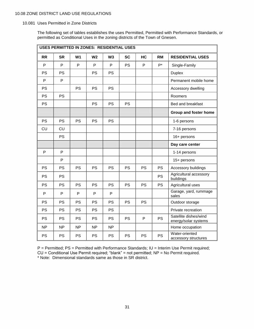
31
10.08 ZONE DISTRICT LAND USE REGULATIONS
10.081 Uses Permitted in Zone Districts
The following set of tables establishes the uses Permitted, Permitted with Performance Standards, or permitted as Conditional Uses in the zoning districts of the Town of Gnesen.
USES PERMITTED IN ZONES: RESIDENTIAL USES
RR SR W1 W2 W3 SC HC RM RESIDENTIAL USES
P P P P P PS P P* Single-Family
PS PS PS PS Duplex
P P Permanent mobile home
PS PS PS PS Accessory dwelling
PS PS Roomers
PS PS PS PS Bed and breakfast
Group and foster home
PS PS PS PS PS 1-6 persons
CU CU 7-16 persons
PS 16+ persons
Day care center
P P 1-14 persons
P 15+ persons
PS PS PS PS PS PS PS PS Accessory buildings
PS PS
PS Agricultural accessory buildings
PS PS PS PS PS PS PS PS Agricultural uses
P P P P P Garage, yard, rummage sales
PS PS PS PS PS PS PS Outdoor storage
PS PS PS PS PS Private recreation
PS PS PS PS PS PS P PS Satellite dishes/wind energy/solar systems
NP NP NP NP NP Home occupation
PS PS PS PS PS PS PS PS Water-oriented accessory structures
P = Permitted; PS = Permitted with Performance Standards; IU = Interim Use Permit required; CU = Conditional Use Permit required; “blank” = not permitted; NP = No Permit required. * Note: Dimensional standards same as those in SR district.

32
USES PERMITTED IN ZONES: COMMERCIAL USES
RR SR W1 W2 W3 SC HC RM COMMERCIAL USES
Agricultural sales and services
CU Kennel
PS Veterinary clinic
PS Farm equipment
PS Feed, grain and supplies
Automotive
PS Repair
PS Car/truck wash
PS PS Gasoline station
CU Auto/truck fleet storage
Construction
PS Building, plumbing, heating, electrical supplies
PS Contractor’s yard and storage
PS Equipment and truck sales and service
PS Tool and/or equipment rental
PS Financial institutions
Food Service
PS PS Café or restaurant
PS PS Carry-out and/or drive- in restaurant
PS PS PS PS PS Home Business
Health care
CU Clinic (outpatient Treatment)
PS Licensed residential treatment center
Lodging
CU Boarding house
CU CU CU CU CU Campground including RV park
PS Office, business
PS Office, professional
P = Permitted; PS = Permitted with Performance Standards; IU = Interim Use Permit required; CU = Conditional Use Permit required; “blank” = not permitted; NP = No Permit required.
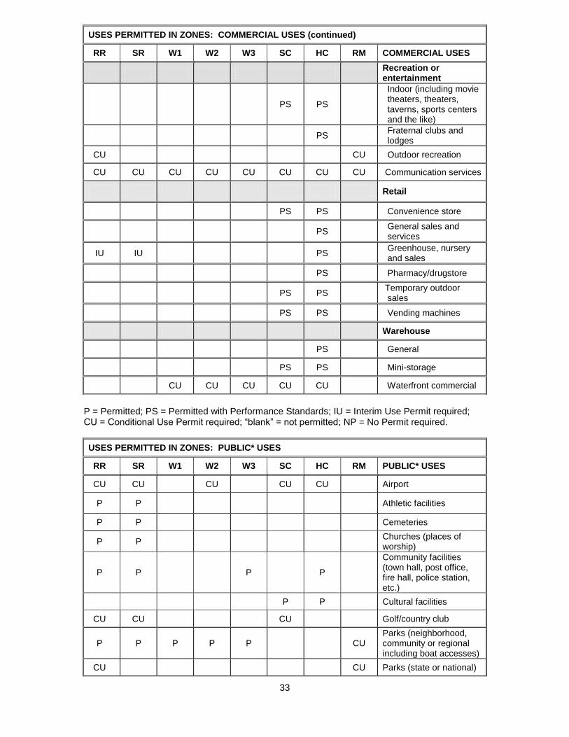
33
P = Permitted; PS = Permitted with Performance Standards; IU = Interim Use Permit required; CU = Conditional Use Permit required; “blank” = not permitted; NP = No Permit required.
USES PERMITTED IN ZONES: PUBLIC* USES
RR SR W1 W2 W3 SC HC RM PUBLIC* USES
CU CU CU CU CU Airport
P P
Athletic facilities
P P Cemeteries
P P Churches (places of worship)
P P
P P
Community facilities (town hall, post office, fire hall, police station, etc.)
P P Cultural facilities
CU CU CU Golf/country club
P P P P P CU Parks (neighborhood, community or regional including boat accesses)
CU CU Parks (state or national)
USES PERMITTED IN ZONES: COMMERCIAL USES (continued)
RR SR W1 W2 W3 SC HC RM COMMERCIAL USES
Recreation or entertainment
PS PS
Indoor (including movie theaters, theaters, taverns, sports centers and the like)
PS
Fraternal clubs and lodges
CU CU Outdoor recreation
CU CU CU CU CU CU CU CU Communication services
Retail
PS PS Convenience store
PS General sales and services
IU IU
PS Greenhouse, nursery and sales
PS Pharmacy/drugstore
PS PS Temporary outdoor sales
PS PS Vending machines
Warehouse
PS General
PS PS Mini-storage
CU CU CU CU CU Waterfront commercial

34
P P P P P P P P Open space
P P P P P P P P Recreational trails including snowmobile trails
PS PS
Schools
CU CU CU Solid waste facilities including transfer stations
PS PS PS PS PS PS PS PS Minor utility structures
P P CU P P
Water or sewage treatment, power substations, and similar or related facilities.
* “Public” includes uses and structures that may be owned privately, publicly or in some combination thereof. P = Permitted; PS = Permitted with Performance Standards; IU = Interim Use Permit required; CU = Conditional Use Permit required; “blank” = not permitted; NP = No Permit required.
USES PERMITTED IN ZONES: INDUSTRIAL USES
RR SR W1 W2 W3 SC HC RM INDUSTRIAL USES
P
Accessory uses and structures
P Custom manufacturing (production and sale of hand-made goods)
General
P Research/testing
P Training center
CU CU CU CU Gravel Pits
P Industrial equipment sales and services
Heavy Industry
CU Fabricating, processing, assembly from raw or semi-finished products
CU Secondary wood Products
PS PS Outdoor storage
PS Recycling
CU Sawmill
CU Wrecking, junk or salvage yard
P = Permitted; PS = Permitted with Performance Standards; IU = Interim Use Permit required; CU = Conditional Use Permit required; “blank” = not permitted; NP = No Permit required.

35
USES PERMITTED IN ZONES: TRANSPORTATION AND OTHER USES
RR SR W1 W2 W3 SC HC RM TRANSPORTATION USES
CU
Major transportation Terminals, hangars, switching
yards, siding, runways, heliports, etc.
P P P P P P P CU
Minor transportation Streets, highways, railroad
right-of-way, transit shelters, bicycle and pedestrian paths
OTHER USES
PS PS PS PS PS PS PS PS Land Alteration
CU
CU Contaminated soil treatment
PS PS PS PS PS PS PS PS Signs
CU CU Signs: Dynamic
PS PS PS PS PS PS PS PS Stairways and landings in shoreland areas
PS PS PS PS PS PS PS PS Temporary buildings
CU CU CU Communication Tower
CU CU CU Solar Farm
CU CU CU CU CU CU CU CU
Any other use which as determined by the Planning Commission is clearly within the intent and purpose of the zone district and which is consistent with the Gnesen Comprehensive Plan.
P = Permitted; PS = Permitted with Performance Standards CU = Conditional Use Permit required; “blank” = not permitted.
10.082 Off-Street Parking and Loading Space Requirements
A. Purpose. It is the intent of these regulations that off-street parking be provided and maintained by each property owner for the use of occupants, employees and patrons. These regulations are further intended to promote the safe and efficient storage and circulation of motor vehicles on-site to avoid undue congestion of the public streets and roadways.
B. Street access. Each parcel shall be granted at least one (1) curb cut per street that abuts that parcel. However, up to two (2) curb cuts may be permitted on any one (1) street provided that one (1) of the accesses is designated as an entrance and the other as an exit. The location and design of curb cuts shall be restricted as follows: 1. No closer than twenty-five (25) feet to any existing curb cut; 2. No closer than twenty-five (25) feet to the nearest point of any street or alley intersection provided
that on State and County roads or highways this may be extended to a minimum of one hundred (100) feet upon the recommendation of the appropriate governing unit having jurisdiction over the roadway.
3. No curb cut shall exceed thirty-three (33) feet in width; and 4. One-way curb cuts shall not exceed sixteen (16) feet in width. 5. Wherever possible and practicable, common driveways shall be used to limit the number of access
points to any road. C. Parking lot and off-street loading: general. All parking and loading for commercial, institutional and
industrial uses will be off-street. Any land used to park or store more than five (5) vehicles shall meet the following performance standards: 1. The parking area must be setback from the road right-of-way at least twenty-five (25) feet.

36
2. Access drives and curb cut locations are subject to County access permit requirements. All applications for commercial, institutional and industrial uses must include copies of St. Louis County Highway Department access permits when applicable.
3. Parking lots must have adequate stacking space to prevent access road congestion and turning conflicts.
4. Parking lots shall be surfaced with a dustless, maintainable surface and runoff cannot be directly channeled to any river, lake or stream.
5. Parking lot lighting shall not overflow onto any adjacent developed residential parcel and lots for more than five (5) vehicles shall be screened from any residential or shoreland areas.
D. Off-street parking and loading spaces standards. The following standards shall apply to the design, construction and maintenance of parking areas: 1. All parking spaces shall be at least ten (10) feet wide and twenty (20) long. All lots for more than five
(5) vehicles shall have a land area at least equal to two hundred (200) square feet for every required parking space plus an additional fifty (50) percent of this amount for driving lanes and maneuvering space.
2. Off-street loading space is required for any commercial, institutional or industrial use receiving regular truck deliveries or service. Off-street loading spaces shall be at least twenty-five (25) feet wide and sixty (60) feet long, and must be setback from the road right-of-way at least fifty (50) feet.
3. Parking spaces shall be provided in accordance with the following schedule: Handicapped accessible spaces: as required by State statute.
Commercial retail: one (1) space per two hundred (200) square feet of gross floor space. Commercial service: one (1) space per two (2) customer seats. Light industrial: one (1) space per each employee on the maximum shift and visitor spaces equal to one (1) per fifty (50) square feet of office space; plus off-street loading spaces as required. Churches/institutional: one (1) space per four (4) seats in the main assembly place. Tourism/recreational: one (1) space per two (2) users during the maximum peak period. Others: as determined by the Planning Commission.
4. Zoning permits are required for expansion of existing parking areas and special event sponsors are
required to apply for permits under this ordinance and conform with the requirement that all parking spaces be provided off-street should the sponsor anticipate more than 75 people attending the event.
5. Parking and off-street loading areas shall be maintained and present a hazard free parking area for employees, visitors and the public.
Any space allocated as a loading zone or access drive so as to comply with the terms of this ordinance shall not be used for the storage of goods, inoperable vehicles, or be included as a part of the space necessary to meet off-street parking requirements.
10.083 Shoreland Area District and Standards
A. General. 1. Authority.
These shoreland regulations are pursuant to the authorization and policies contained in Minnesota Statutes, Chapter 105 and Minnesota Regulations, Parts 6120.2500-6120.3900.
2. Policy. The uncontrolled use of shorelands within the Town of Gnesen affects the public health, safety and general welfare not only by contributing to pollution of public waters, but also by impairing the local tax base. Therefore, it is in the best interests of the public health, safety and welfare to provide for the wise use and development of shorelands of public waters. The Legislature of Minnesota has delegated responsibility to local governments of the state to regulate the subdivision, use and development of the shorelands of public waters, conserve the economic and natural environmental values of shorelands, and provide for the proper use of waters and related land resources. This responsibility is hereby recognized by the Town of Gnesen.

37
3. Jurisdiction. The provisions of this section shall apply to the shorelands of the public water bodies as classified in Section 10.064 of this ordinance. It shall also apply to all non-classified bodies of water greater than five (5) acres in size. It shall not apply to any body of water created by a private user where there was no previous shoreland except those greater than ten (10) acres in size.
4. Compliance. The use of any shoreland of public waters; the size and shape of lots; the use, size, type and location
of structures on lots; the installation and maintenance of water supply and waste treatment systems; the grading and filling of any shoreland area; the cutting of shoreland vegetation; and the subdivision of land shall be in full compliance with the terms of this ordinance and other applicable regulations.
B. Notification to the Department of Natural Resources. Copies of all notices of any public hearings to consider variances, amendments, or conditional uses under these shoreland management controls shall be sent to the Commissioner of Natural Resources or the commissioner’s designated representative and postmarked at least ten (10) days before the hearings. Notices of hearings to consider proposed subdivisions shall include copies of the subdivision. A copy of approved amendments, subdivisions and final decisions granting variances or conditional uses under these shoreland regulations shall be sent to the commissioner or the commissioner’s designated representative and postmarked within then (10) days of the final action.
C. General land use criteria. The land use districts, delineation of land use district boundaries, and decisions regarding shorelands shall be consistent with the comprehensive plan and the following criteria, considerations and objectives: 1. Preservation of natural areas; 2. Present ownership and development of shoreland areas; 3. Shoreland soil types and their engineering capabilities; 4. Topographic characteristics; 5. Vegetative cover; 6. In-water physical characteristics, values, and constraints; 7. Recreational use of the surface water; 8. Road and service center accessibility; 9. Socioeconomic development needs and plans as they involve water and related land resources; 10. The land requirements of industry which, by its nature, requires location in shoreland areas; and 11. The necessity to preserve and restore certain areas having significant historical or ecological value.
D. Uses allowed. For uses allowed by this ordinance in accord with the tables in section 10.081 and located in the shorelands of the Town of Gnesen, additional use restrictions may apply. Regardless of the status (permitted, permitted as a conditional use, or permitted with performance standards) granted to specific uses in section 10.081, the following designations shall be enforced in shorelands for the uses listed.
ADDITIONAL RESTRICTIONS FOR SHORELAND USES
LAKES* STREAMS* USES
GD RD NE FOR TRIB
CU CU CU CU CU Agricultural feedlots
CU CU CU Duplex
CU CU CU CU CU Residential planned unit development
CU CU CU Commercial
CU CU CU CU CU Commercial planned unit development
CU CU CU CU CU Surface water-oriented commercial
CU CU N CU CU Industrial
CU CU CU CU CU Extractive uses
CU CU CU Public
CU CU CU CU CU Semi-public
CU CU CU CU CU Parks and historic sites
P = Permitted; CU = Conditional Use Permit required; N = not permitted. * GD = General Development; RD = Recreational Development; NE = Natural Environment; FOR = Forested; TRIB = Tributary.
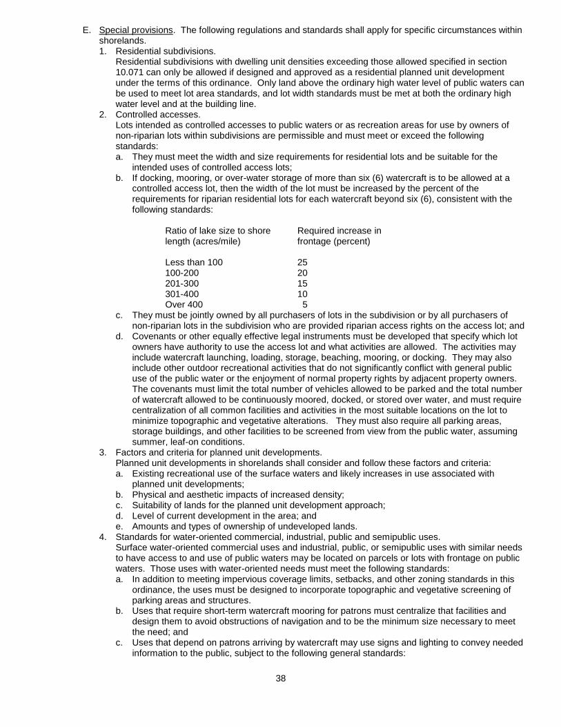
38
E. Special provisions. The following regulations and standards shall apply for specific circumstances within shorelands. 1. Residential subdivisions.
Residential subdivisions with dwelling unit densities exceeding those allowed specified in section 10.071 can only be allowed if designed and approved as a residential planned unit development under the terms of this ordinance. Only land above the ordinary high water level of public waters can be used to meet lot area standards, and lot width standards must be met at both the ordinary high water level and at the building line.
2. Controlled accesses. Lots intended as controlled accesses to public waters or as recreation areas for use by owners of
non-riparian lots within subdivisions are permissible and must meet or exceed the following standards: a. They must meet the width and size requirements for residential lots and be suitable for the
intended uses of controlled access lots; b. If docking, mooring, or over-water storage of more than six (6) watercraft is to be allowed at a
controlled access lot, then the width of the lot must be increased by the percent of the requirements for riparian residential lots for each watercraft beyond six (6), consistent with the following standards:
Ratio of lake size to shore Required increase in length (acres/mile) frontage (percent) Less than 100 25 100-200 20 201-300 15 301-400 10
Over 400 5 c. They must be jointly owned by all purchasers of lots in the subdivision or by all purchasers of
non-riparian lots in the subdivision who are provided riparian access rights on the access lot; and d. Covenants or other equally effective legal instruments must be developed that specify which lot
owners have authority to use the access lot and what activities are allowed. The activities may include watercraft launching, loading, storage, beaching, mooring, or docking. They may also include other outdoor recreational activities that do not significantly conflict with general public use of the public water or the enjoyment of normal property rights by adjacent property owners. The covenants must limit the total number of vehicles allowed to be parked and the total number of watercraft allowed to be continuously moored, docked, or stored over water, and must require centralization of all common facilities and activities in the most suitable locations on the lot to minimize topographic and vegetative alterations. They must also require all parking areas, storage buildings, and other facilities to be screened from view from the public water, assuming summer, leaf-on conditions.
3. Factors and criteria for planned unit developments. Planned unit developments in shorelands shall consider and follow these factors and criteria:
a. Existing recreational use of the surface waters and likely increases in use associated with planned unit developments;
b. Physical and aesthetic impacts of increased density; c. Suitability of lands for the planned unit development approach; d. Level of current development in the area; and e. Amounts and types of ownership of undeveloped lands.
4. Standards for water-oriented commercial, industrial, public and semipublic uses. Surface water-oriented commercial uses and industrial, public, or semipublic uses with similar needs
to have access to and use of public waters may be located on parcels or lots with frontage on public waters. Those uses with water-oriented needs must meet the following standards: a. In addition to meeting impervious coverage limits, setbacks, and other zoning standards in this
ordinance, the uses must be designed to incorporate topographic and vegetative screening of parking areas and structures.
b. Uses that require short-term watercraft mooring for patrons must centralize that facilities and design them to avoid obstructions of navigation and to be the minimum size necessary to meet the need; and
c. Uses that depend on patrons arriving by watercraft may use signs and lighting to convey needed information to the public, subject to the following general standards:
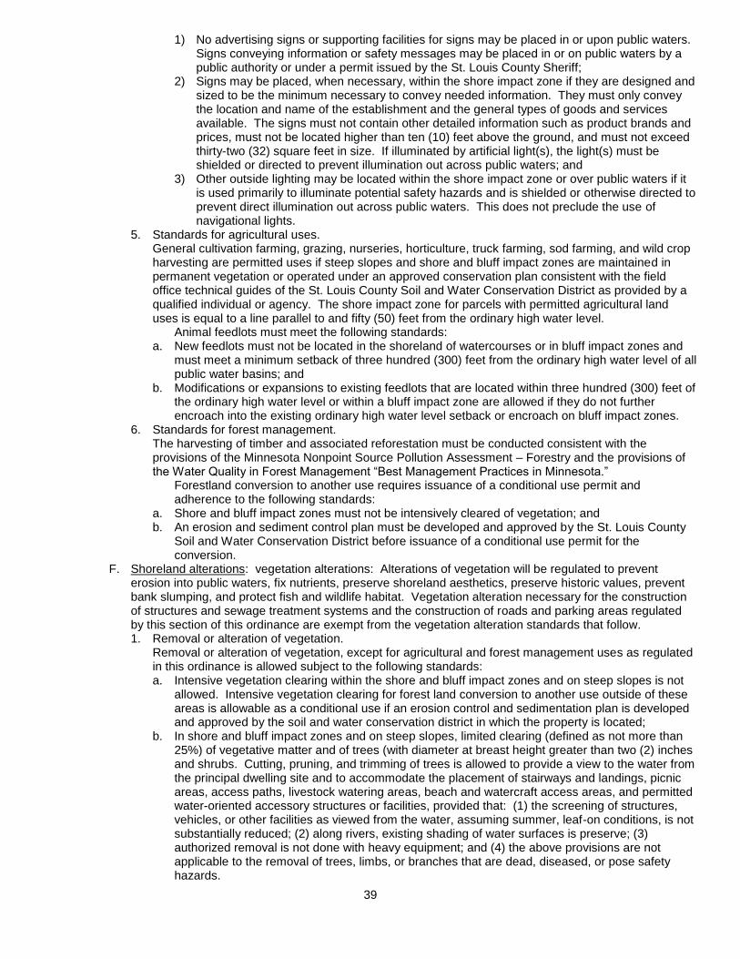
39
1) No advertising signs or supporting facilities for signs may be placed in or upon public waters. Signs conveying information or safety messages may be placed in or on public waters by a public authority or under a permit issued by the St. Louis County Sheriff;
2) Signs may be placed, when necessary, within the shore impact zone if they are designed and sized to be the minimum necessary to convey needed information. They must only convey the location and name of the establishment and the general types of goods and services available. The signs must not contain other detailed information such as product brands and prices, must not be located higher than ten (10) feet above the ground, and must not exceed thirty-two (32) square feet in size. If illuminated by artificial light(s), the light(s) must be shielded or directed to prevent illumination out across public waters; and
3) Other outside lighting may be located within the shore impact zone or over public waters if it is used primarily to illuminate potential safety hazards and is shielded or otherwise directed to prevent direct illumination out across public waters. This does not preclude the use of navigational lights.
5. Standards for agricultural uses. General cultivation farming, grazing, nurseries, horticulture, truck farming, sod farming, and wild crop
harvesting are permitted uses if steep slopes and shore and bluff impact zones are maintained in permanent vegetation or operated under an approved conservation plan consistent with the field office technical guides of the St. Louis County Soil and Water Conservation District as provided by a qualified individual or agency. The shore impact zone for parcels with permitted agricultural land uses is equal to a line parallel to and fifty (50) feet from the ordinary high water level. Animal feedlots must meet the following standards: a. New feedlots must not be located in the shoreland of watercourses or in bluff impact zones and
must meet a minimum setback of three hundred (300) feet from the ordinary high water level of all public water basins; and
b. Modifications or expansions to existing feedlots that are located within three hundred (300) feet of the ordinary high water level or within a bluff impact zone are allowed if they do not further encroach into the existing ordinary high water level setback or encroach on bluff impact zones.
6. Standards for forest management. The harvesting of timber and associated reforestation must be conducted consistent with the
provisions of the Minnesota Nonpoint Source Pollution Assessment – Forestry and the provisions of the Water Quality in Forest Management “Best Management Practices in Minnesota.” Forestland conversion to another use requires issuance of a conditional use permit and
adherence to the following standards: a. Shore and bluff impact zones must not be intensively cleared of vegetation; and b. An erosion and sediment control plan must be developed and approved by the St. Louis County
Soil and Water Conservation District before issuance of a conditional use permit for the conversion.
F. Shoreland alterations: vegetation alterations: Alterations of vegetation will be regulated to prevent erosion into public waters, fix nutrients, preserve shoreland aesthetics, preserve historic values, prevent bank slumping, and protect fish and wildlife habitat. Vegetation alteration necessary for the construction of structures and sewage treatment systems and the construction of roads and parking areas regulated by this section of this ordinance are exempt from the vegetation alteration standards that follow. 1. Removal or alteration of vegetation. Removal or alteration of vegetation, except for agricultural and forest management uses as regulated
in this ordinance is allowed subject to the following standards: a. Intensive vegetation clearing within the shore and bluff impact zones and on steep slopes is not
allowed. Intensive vegetation clearing for forest land conversion to another use outside of these areas is allowable as a conditional use if an erosion control and sedimentation plan is developed and approved by the soil and water conservation district in which the property is located;
b. In shore and bluff impact zones and on steep slopes, limited clearing (defined as not more than 25%) of vegetative matter and of trees (with diameter at breast height greater than two (2) inches and shrubs. Cutting, pruning, and trimming of trees is allowed to provide a view to the water from the principal dwelling site and to accommodate the placement of stairways and landings, picnic areas, access paths, livestock watering areas, beach and watercraft access areas, and permitted water-oriented accessory structures or facilities, provided that: (1) the screening of structures, vehicles, or other facilities as viewed from the water, assuming summer, leaf-on conditions, is not substantially reduced; (2) along rivers, existing shading of water surfaces is preserve; (3) authorized removal is not done with heavy equipment; and (4) the above provisions are not applicable to the removal of trees, limbs, or branches that are dead, diseased, or pose safety hazards.

40
c. Authorized removal of trees, shrubs and plants shall be accomplished through human means (i.e. Hands, ax, saw, etc. and shall not be done by heavy equipment.)
G. Shoreland alterations: topographic alterations, grading and filing: Alterations of vegetation will be regulated to prevent erosion into public waters, fix nutrients, preserve shoreland aesthetics, preserve historic values, prevent bank slumping, and protect fish and wildlife habitat. Grading and filling and excavations necessary for the construction of structures, sewage treatment systems, and driveways under validly issued construction permits for these facilities do not require the issuance of a separate grading and filling permit. However, the grading and filling standards in this section must be incorporated into the issuance of permits for construction of structures, sewage treatment systems, and driveways. Public roads and parking areas are regulated by the Section 10.083 H of this ordinance. 1. Permits required. Notwithstanding the previous statements, a grading and filling permit will be required for:
a. The movement of more than ten (10) cubic yards of material on steep slopes or within shore or bluff impact zones; and
b. The movement of more than fifty (50) cubic yards of material outside of steep slopes and shore and bluff impact zones.
c. A Conditional Use Permit costing twice the usual fee shall be required for all grading and filling done without a permit but for which a permit was required.
2. Considerations and conditions. The following considerations and conditions must be adhered to during the issuance of construction
permits, grading and filling permits, conditional use permits, variances and subdivision approvals: a. Grading or filling in any type 2, 3, 4, 5, 6, 7, or 8 wetland must be evaluated to determine how
extensively the proposed activity would affect the following functional qualities of the wetland: (a) sediment and pollutant trapping and retention; (b) storage of surface runoff to prevent or reduce flood damage; (c) fish and wildlife habitat; (d) recreational use; (e) shoreline or bank stabilization; and (f) noteworthiness, including special qualities such as historic significance, critical habitat for endangered plants and animals, or others.
This evaluation must also include a determination of whether the wetland alteration being proposed requires permits, reviews, or approvals by other local, state, or federal agencies such as a watershed district, the Minnesota Department of Natural Resources, or the United States Army Corps of Engineers. The applicant will be so advised.
b. Alterations must be designed and conducted in a manner that ensures only the smallest amount of bare ground is exposed for the shortest time possible.
c. Mulches or similar materials must be used, where necessary, for temporary bare soil coverage, and a permanent vegetation cover must be established as soon as possible.
d. Methods to minimize soil erosion and to trap sediments before they reach any surface water feature must be used.
e. Altered areas must be stabilized to acceptable erosion control standards consistent with the field office technical guides of the local soil and water conservation districts and the United States Soil Conservation Service.
f. Fill or excavated material must not be placed in a manner that creates an unstable slope. g. Plans to place fill or excavated material on steep slopes must be reviewed by qualified
professionals for continued slope stability and must not create finished slopes of thirty (30) percent or greater.
h. Fill or excavated material must not be placed in bluff impact zones. i. Any alterations below the ordinary high water level of public waters must first be authorized by the
commissioner under Minnesota Statutes, section 103G.245. j. Alterations of topography must only be allowed if they are accessory to permitted or conditional
uses and do not adversely affect adjacent or nearby properties. k. Placement of natural rock riprap, including associated grading of the shoreline and placement of
a filter blanket, is permitted if the finished slope does not exceed three (3) feet horizontal to one (1) foot vertical, the landward extent of the riprap is within ten (10) feet of the ordinary high water level, and the height of the riprap above the ordinary high water level does not exceed three (3) feet.
3. Connections to public waters. Excavations where the intended purpose is connection to a public water, such as boat slips, canals,
lagoons, and harbors, must be controlled by local shoreland regulations. Permission for excavations may be given only after the commissioner has approved the proposed connection to public waters.

41
H. Shoreland alterations: placement and design of roads, driveways, and parking areas. 1. General. Public and private roads and parking areas must be designed to take advantage of natural vegetation
and topography to achieve maximum screening from view from public waters. Documentation must be provide by a qualified individual that all roads and parking areas are designed and constructed to minimize and control erosion to public waters consistent with the field office technical guides of the local soil and water conservation district, or other applicable technical materials.
2. Setbacks. Roads, driveways, and parking areas must meet structure setbacks and must not be placed within
bluff and shore impact zones, when other reasonable and feasible placement alternatives exist. If no alternatives exist, they may be placed within these areas, and must be designed to minimize adverse impacts.
3. Public accesses, roads and parking areas. Public and private watercraft access ramps, approach roads, and access-related parking areas may
be placed within shore impact zones provided the vegetative screening and erosion control conditions of this subpart are met. For private facilities, the grading and filling provisions of Section 10.083 G of this ordinance must be met.
I. Shoreland alterations: stormwater management. The following general and specific standards shall apply to stormwater management activities in shorelands. 1. General Standards.
a. When possible, existing natural drainage ways, wetlands, and vegetated soil surfaces must be used to convey, store, filter, and retain stormwater runoff before discharge to public waters.
b. Development must be planned and conducted in a manner that will minimize the extent of disturbed areas, runoff velocities, erosion potential, and reduce and delay runoff volumes. Disturbed areas must be stabilized and protected as soon as possible and facilities or methods used to retain sediment on the site.
c. When development density, topographic features, and soil and vegetation conditions are not sufficient to adequately handle stormwater runoff using natural features and vegetation, various types of constructed facilities such as diversions, settling basins, skimming devices, dikes, waterways, and ponds may be used. Preference must be given to designs using surface drainage, vegetation, and infiltration rather than buried pipes and man-made materials and facilities.
2. Specific Standards. a. Impervious surface coverage of lots must not exceed twenty-five (25) percent of the lot area. b. When constructed facilities are used for stormwater management, documentation must be
provided by a qualified individual that they are designed and installed consistent with the field office technical guide of the local soil and water conservation districts.
c. New constructed stormwater outfalls to public waters must provide for filtering or settling of suspended solids and skimming of surface debris before discharge.
J. Water supply and sewage. The provision of water supply and sanitary sewage treatment within shorelands shall meet the requirements of this section and other pertinent regulations of this and other applicable ordinances. 1. Water supply. Any public or private supply of water for domestic purposes must meet or exceed standards for water
quality of the Minnesota Pollution Control Agency and the Minnesota Department of Health. 2. Sewage treatment.
a. All private sewage treatment systems must meet or exceed the Minnesota Pollution Control Agency’s standards for individual sewage treatment systems contained in the document titled “Individual Sewage Treatment Systems Standards, Chapter 7080”, a copy of which is hereby adopted by reference and declared to be part of this ordinance, or the St. Louis County regulations for on-site sewage treatment systems, whichever is the most restrictive.
b. On-site sewage treatment systems must be set back from the ordinary high water level in accordance with the setbacks established in this ordinance.
c. All proposed sites for individual sewage treatment systems shall be evaluated in accordance with the following criteria: (1) depth to the highest known or calculated ground water table or bedrock; (2) soil conditions, properties and permeability; (3) slope; (4) the existence of lowlands, local surface depressions and rock outcrops.
If the determination of a site’s suitability cannot be made with publicly available, existing information, it shall then be the responsibility of the applicant to provide sufficient soil borings and percolation tests from on-site field investigations.
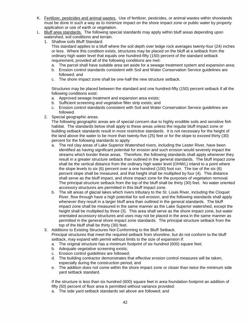
42
K. Fertilizer, pesticides and animal wastes. Use of fertilizer, pesticides, or animal wastes within shorelands
must be done in such a way as to minimize impact on the shore impact zone or public water by property application or use of earth or vegetation.
L. Bluff area standards. The following special standards may apply within bluff areas depending upon watershed, soil conditions and terrain. 1. Shallow soils Bluff Standard.
This standard applies to a bluff where the soil depth over ledge rock averages twenty-four (24) inches or less. Where this condition exists, structures may be placed on the bluff at a setback from the ordinary high water level that equals one hundred-fifty (150) percent of the standard setback requirement, provided all of the following conditions are met: a. The parcel shall have suitable area set aside for a sewage treatment system and expansion area; b. Erosion control standards consistent with Soil and Water Conservation Service guidelines are
followed; and c. The shore impact zone shall be one-half the new structure setback.
Structures may be placed between the standard and one hundred-fifty (150) percent setback if all the following conditions exist: a. Approved sewage treatment and expansion area exists; b. Sufficient screening and vegetative filter strip exists; and c. Erosion control standards consistent with Soil and Water Conservation Service guidelines are
followed. 2. Special geographic areas. The following geographic areas are of special concern due to highly erodible soils and sensitive fish
habitat. The standards below shall apply to these areas unless the regular bluff impact zone or building setback standards result in more restrictive standards. It is not necessary for the height of the land above the water to be more than twenty-five (25) feet or for the slope to exceed thirty (30) percent for the following standards to apply: a. The red clay areas of Lake Superior Watershed rivers, including the Lester River, have been
identified as having significant potential for erosion and such erosion would severely impact the streams which border these areas. Therefore, the following standards shall apply whenever they result in a greater structure setback than outlined in the general standards. The bluff impact zone shall be the vertical distance from the ordinary high water level (OHWL) inland to a point where the slope levels to six (6) percent over a one hundred (100) foot run. The toe of the six (6) percent slope shall be measured, and that height shall be multiplied by four (4). This distance shall serve as the bluff impact, and shore impact zone for the purposes of vegetation removal. The principal structure setback from the top of the bluff shall be thirty (30) feet. No water oriented accessory structures are permitted in this bluff impact zone.
b. The silt areas of glacial lakes which rivers tributary to the St. Louis River, including the Cloquet River, flow through have a high potential for soil erosion, and the following standards shall apply whenever they result in a larger bluff area than outlined in the general standards. The bluff impact zone shall be measured in the same manner as the Lake Superior watershed, except the height shall be multiplied by three (3). This area shall serve as the shore impact zone, but water orientated accessory structures and uses may not be placed in the area in the same manner as permitted in the general shore impact zone standards. The principal structure setback from the top of the bluff shall be thirty (30) feet.
3. Additions to Existing Structures Not Conforming to the Bluff Setback. Principal structures that meet the required setback from shoreline, but do not conform to the bluff
setback, may expand with permit without limits to the size of expansion if: a. The original structure has a minimum footprint of six hundred (600) square feet; b. Adequate vegetative screening exists; c. Erosion control guidelines are followed; d. The building contractor demonstrates that effective erosion control measures will be taken,
especially during the construction period; and e. The addition does not come within the shore impact zone or closer than twice the minimum side
yard setback standard.
If the structure is less than six hundred (600) square feet in area foundation footprint an addition of fifty (50) percent of floor area is permitted without variance provided: a. The side yard setback standards set above are followed; and

43
b. Erosion control measures that conform to the technical standards of the Soil and Water Conservation District are taken.
Accessory structures that meet the normally required setbacks, but not the bluff setback may be added to, provided all other provisions in the ordinance are adhered to.
10.084 Flood Hazard Area District and Standards
A. Statutory authorization. The legislature of the State of Minnesota has, in Minnesota Statutes Chapter
103F and 462, delegated the responsibility to local government units to adopt regulations designed to minimize flood losses. Therefore, the Town of Gnesen does find: 1. The flood hazard areas of the Town of Gnesen are subject to periodic inundation which results in
potential loss of life, loss of property, health and safety hazards, disruption of commerce and governmental services, extraordinary public expenditures for flood protection and relief, and impairment of the tax base, all of which adversely affect the public health, safety, and general welfare.
2. These regulations are based upon a reasonable method of analyzing flood hazards, which is consistent with the standards established by the Minnesota Department of Natural Resources.
B. Statement of purpose. It is the purpose of these regulations to promote the public health, safety, and general welfare and to minimize those losses described in section 10.084 A of this ordinance.
C. General provision. 1. Lands to which regulations apply. These regulations shall apply to all lands within the jurisdiction of the Town of Gnesen shown on the
Official Flood Hazard Map as being located within the boundaries of the Floodway, Flood Fringe, or General Flood Plain Areas.
2. Flood-proofing regulations. The publication entitled “Flood Proofing Regulations”, Office of the Chief of Engineers, U.S. Army
Corps of Engineers, Washington, D.C., dated June 1972, or its official replacements, is hereby adopted by reference and incorporated into this ordinance.
3. Permit required. A permit issued by the Zoning Officer in conformity with the provisions of these regulations shall be
secured prior to the erection, addition, or alteration of any building, structure, or portion thereof; prior to the use or change of use of a building, structure, or land; prior to the change or extension of a non-conforming use; and prior to the placement of fill, excavation of materials, or the storage of materials or equipment with the flood plain.
4. State and federal permits. Prior to granting a permit or processing an application for Conditional Use, Variance or Subdivision,
the Zoning Officer shall determine that the applicant has obtained all necessary State and Federal permits.
5. Certification. The applicant shall be required to submit certification by a registered professional engineer,
registered architect, or registered land surveyor that the finished fill and building elevations were accomplished in compliance with the provisions of this ordinance. Flood-proofing measures shall be certified by a registered professional engineer or registered architect.
6. Variances. Variances to these flood plain provisions may be granted in accordance with the procedures set forth
in section 10.0506 of the ordinance. 7. Conditional uses. The granting of conditional uses within the flood plain district shall be in accordance with the
procedures set forth in section 10.11 of this ordinance. D. Areas of application. The flood plain regulations of this ordinance apply to the following three types of
areas in the Town of Gnesen. 1. Floodway Areas. The Floodway area shall include those areas designated as floodway on the Official Flood Hazard
Map. 2. Flood Fringe Areas. The Flood Fringe area shall include those areas designated as floodway fringe on the Official Flood
Hazard Map. 3. General Flood Plain Areas. The General Flood Plain area shall include those areas designated as unnumbered ‘A Zones’ on the
Official Flood Hazard Map. E. Permitted and conditional uses.

44
1. Floodway Areas. a. In Floodway Areas only the following uses shall be permitted provided that the uses are also
permitted in the underlying zoning district: 1) General farming, pasture, grazing, outdoor plant nurseries, horticulture, truck farming,
forestry, sod farming, and wild crop harvesting. 2) Industrial-commercial loading areas, parking areas, and airport landing strips. 3) Golf courses, tennis courts, driving ranges, archery ranges, picnic grounds, boat launching
ramps, swimming areas, parks, wildlife and nature preserves, game farms, fish hatcheries, shooting preserves, target ranges, trap and skeet ranges, hunting and fishing areas, and recreational trails.
b. In Floodway Areas the following uses shall require conditional use permits provided that the uses are also permitted in the underlying zoning district: 1) Structures accessory to those listed above. 2) Extraction and storage of sand, gravel, and other materials. 3) Marinas, boat rentals, docks, piers, wharves, and water control structures. 4) Railroads, streets, bridges, utility transmission lines, and pipelines. 5) Storage yards for equipment, machinery, or materials. 6) Placement of fill. 7) Travel trailers and travel vehicles either on individual lots of record or in existing or new
subdivisions or commercial or condominium type campgrounds. 8) Structural works for flood control such as levees, dikes and floodwalls constructed to any
height where the intent is to protect individual structures and levees or dikes where the intent is to protect agricultural crops for a frequency flood event equal to or less than the 10-year frequency flood event.
2. Flood Fringe Areas. Permitted uses shall be those uses of land or structures listed as permitted uses in the underlying zoning district. Any structure that is not elevated on fill or flood-proofed in accordance with this ordinance or any use of land that does not comply with the standards provided in section 10.084 of this ordinance shall only be allowable as a conditional use.
3. General Flood Plain Areas. The uses and conditions listed in section 10.084 E.1 of this ordinance shall apply in the General Flood Plain Area. All other uses shall require conditional use permits and be subject to the floodway/flood fringe evaluation criteria pursuant to section 10.084 F of this ordinance and, according to the findings of that evaluation, be governed by the Floodway or Flood Fringe regulations, whichever is appropriate.
F. Procedures to determine Floodway and Flood Fringe areas with the General Flood Plain. 1. Required information.
Upon receipt of an application for a conditional use permit for a use within the General Flood Plain Area, the applicant shall be required to furnish such of the following information as is deemed necessary by the Zoning Officer for the determination of the Regulatory Flood Protection Elevation and whether the proposed use is within the Floodway or Flood Fringe area. a. A typical valley cross-section showing the channel of the stream, elevation of land areas adjoining
each side of the channel, cross-sectional areas to be occupied by the proposed development, and high water information.
b. Plan (surface view) showing elevations or contours of the ground; pertinent structure, fill, or storage elevations; size, location, and spatial arrangement of all proposed and existing structures on the site; location and elevations of streets; photographs showing existing land uses and vegetation upstream and downstream; and soil type.
c. Profile showing the slope of the bottom of the channel or flow line of the stream for at least five hundred (500) feet in either direction from the proposed development.
2. Technical determination. The applicant shall be responsible to submit one (1) copy of the above information to a designated engineer or other expert person or agency for technical assistance in determining whether the proposed use is in the floodway or flood fringe and to determine the regulatory flood protection elevation. Procedures consistent with Minnesota regulations MR 6120.5600 – 6120.5700 shall be followed in this expert evaluation. The designated engineer or expert shall: estimate the peak discharge of the regional flood; calculate the water surface profile of the regional flood based upon a hydraulic analysis of the stream channel and over bank areas; and compute the floodway necessary to convey the regional flood without increasing flood stages more than 0.5 feet. An equal degree of encroachment on both sides of the stream within the reach shall be assumed in computing floodway boundaries.

45
3. Acceptance of technical determination.
The Zoning Officer shall present the technical evaluation and findings of the designated engineer or expert to the Planning Commission. The Town Board must formally accept the technical evaluation and the recommended floodway and/or flood fringe district boundary or deny the permit application. Prior to official action, the Town Board may submit the application and all supporting data and analyses to the Federal Emergency Management Agency, the Department of Natural Resources or the Planning Commission for review and comment. Once the floodway and flood fringe boundaries have been determined, the Town Board shall refer the matter to the Zoning Officer who shall process the permit application consistent with the applicable provisions of this ordinance.
G. Standards for Floodway Uses. The following standards apply to all uses or conditional uses in the Floodway Areas of Gnesen. 1. Permitted uses.
a. The use shall have a low flood damage potential. b. The use shall be permissible in the underlying zoning district. c. The use shall not obstruct flood flows or increase flood elevations and shall not involve structures,
fill, obstructions, excavations, or storage of materials or equipment. 2. Conditional uses.
a. No structure, (temporary or permanent), fill (including fill for roads and levees), deposit, obstruction, storage of materials or equipment, or other uses may be allowed as a conditional use that will cause any increase in the stage of the 100-year or regional flood or cause an increase in flood damages in the reach or reaches affected.
b. The conditional use shall be permissible in the underlying zoning district. c. Fill:
1) Fill, dredge spoil, and all other similar materials deposited or stored in the flood plain shall be protected from erosion by vegetative cover, mulching, riprap or other acceptable method.
2) Dredge spoil sites and sand and gravel operations shall not be allowed in the floodway unless a long-term site development is submitted which includes an erosion and sedimentation prevention component.
d. Accessory structures: 1) Accessory structures shall not be designed for human habitation. 2) Accessory structures, if permitted, shall be constructed and placed on the building site so as
to offer the minimum obstruction to the flow of floodwaters. Whenever possible, structures shall be constructed with the longitudinal axis parallel to the direction of flood flow, and, so far as practicable, structures shall be placed approximately on the same flood flow lines as those of adjoining structures.
3) Accessory structures shall be elevated on fill or structurally dry flood proofed in accordance with the FP-1 or FP-2 classifications of the U.S. Army Corps of Engineers Flood Proofing Regulations, June 1972 edition. As an alternative, an accessory structure may be flood proofed to the FP-3 or FP-4 classifications of the regulations provided the accessory structure constitutes a minimal investment, does not exceed five hundred (500) square feet in size, and if a detached garage, must be used solely for parking of vehicles and limited storage.
4) All flood proofed accessory structures must meet the following additional standards as appropriate: the structure must be adequately anchored to prevent flotation, collapse or lateral movement of the structure and shall be designed to equalize hydrostatic flood forces on exterior walls; and, any mechanical and utility equipment in a structure must be elevated to or above the Regulatory Flood Protection Elevation or properly flood proofed.
e. Storage of materials and equipment: 1) The storage or processing of materials that are, in time of flooding, flammable, explosive, or
potentially injurious to human, animal, or plant life is prohibited. 2) Storage of other materials or equipment may be allowed if readily removable from the areas
within the time available after a flood warning and in accordance with a plan approved by the Town of Gnesen Planning Commission and Town Council.
f. Structural works for flood control that will change the course, current, or cross section of protected wetlands or public waters shall be subject to the provisions of Minnesota Statue, Chapter 103G. Community-wide structural works for flood control intended to remove areas from the regulatory flood plain shall not be allowed in the floodway.
g. A levee, dike or floodwall constructed in the floodway shall not cause an increase in the 100-year or regional flood and the technical analysis must assume equal conveyance or storage loss on both sides of a stream.

46
H. Standards for Flood Fringe Uses. The following standards apply to all uses or conditional in the Flood Fringe Areas of Gnesen. 1. Permitted uses.
a. All structures, including accessory structures, must be elevated on fill so that the lowest floor including basement floor is at or above the Regulatory Flood Protection Elevation. The finished fill elevation for structures shall be no lower than one (1) foot below the Regulatory Flood Protection Elevation and the fill shall extend at such elevation at least fifteen (15) feet beyond the outside limits of the structure erected thereon.
b. As an alternative to elevation on fill, accessory structure that constitute a minimal investment and that do not exceed five hundred (500) square feet for the outside dimension at ground level may be internally flood proofed in accordance with this ordinance.
c. The cumulative placement of fill where at any one time in excess one thousand (1,000) cubic yards of fill is located on the parcel shall be allowable only as a conditional use, unless said fill is specifically intended to elevate a structure in accordance with this ordinance.
d. The storage of any materials or equipment shall be elevated on fill to the Regulatory Flood Protection Elevation.
2. Conditional uses. a. Alternative elevation methods other than the use of fill may be utilized to elevate a structure’s
lowest floor above the Regulatory Flood Protection Elevation. These alternative methods may include the use of stilts, pilings, parallel walls, etc. or above-grade, enclosed areas such as crawl spaces or tuck under garages. The base or floor of an enclosed area shall be considered above-grade and not a structure’s basement or lowest floor if: 1) The enclosed area is above-grade on at least one side of the structure; 2) It is designed to internally flood and is constructed with flood resistant materials; 3) It is used solely for parking of vehicles, building access or storage; 4) The structure’s design and as-built condition must be certified by a registered professional
engineer or architect as being in compliance with current U.S. Army Corps of Engineers flood proofing regulations and, specifically, that all electrical, heating, ventilation, plumbing and air conditioning equipment and other service facilities must be at or above the Regulatory Flood Protection Elevation or be designed to prevent flood water from entering or accumulating within these components during times of flooding:
5) When openings are placed in a structure’s walls to provide for entry of floodwaters to equalize pressures, the bottom of all openings shall be no higher than one (1) foot above grade. Openings may be equipped with screens, louvers, valves, or other coverings or devices provided that they permit the automatic entry and exit of flood waters; and
6) That the enclosed area will be designed of flood resistant materials in accordance with current U.S. Army Corps of Engineers flood proofing standards.
b. Basements shall: not be allowed below the Regulatory Flood Protection Elevation, but non-residential basements may be allowed below this elevation provided the basement is structurally dry flood proofed in accordance with this ordinance.
c. All areas of non-residential structures to be placed below the Regulatory Flood Protection Elevation shall be flood-proofed in accordance with this ordinance and this shall require making the structure watertight with the walls substantially impermeable to the passage of water and with structural components having the capability of resisting hydrostatic and hydrodynamic loads and the effects of buoyancy. Structures flood-proofed to the FP-3 or FP-4 classifications shall not be permitted.
d. When at any time more than one thousand (1,000) cubic yards of fill or other similar material is located on a parcel for such activities as on-site storage, landscaping, sand and gravel operations, landfills, roads, dredge spoil disposal, or construction of flood control works, an erosion and sedimentation control plan must be submitted. The plan must clearly specify methods to be used to stabilize the fill on site for a flood event at a minimum of the 100-year or regional flood event. The plan must be prepared and certified by a registered professional engineer or other qualified individual acceptable to Gnesen.
e. The storage or processing of materials that are, in times of flooding, flammable, explosive, or potentially injurious to human, animal or plant life is prohibited, and, storage of other materials or equipment may be allowed if readily removable from the area within the time available after a flood warning and in accordance with a plan approved by the planning commission.
3. All flood fringe uses. a. All new principal structures must have vehicular access at or above an elevation not more than
two (2) feet below the Regulatory Flood Protection Elevation. If a variance to this requirement is granted, limitations must be specified on the period of use or occupancy of the structure for times

47
of flooding and only after determining that adequate flood warning time and local flood emergency response procedures exist.
b. Accessory land uses such as yards, railroad tracks and parking lots for commercial uses may be at elevations lower than the Regulatory Flood Protection Elevation. However, a permit for such facilities to be used by employees or the general public shall not be granted in the absence of a flood warning system that provides adequate time for evacuation if the area would be inundated to a depth greater than two (2) feet or be subject to flood velocities greater than four (4) feet per second upon occurrence of the regional flood.
c. For manufacturing and industrial uses measures shall be taken to minimize interference with normal plant operations especially along streams with protracted flood durations. Certain accessory land uses such as yards and parking lots may be at lower elevations subject to requirements set forth in subsection “b” above. In considering permit applications, due consideration shall be given to needs of an industry whose business requires that it be located in flood plain areas.
d. Fill shall be properly compacted and the slopes shall be properly protected by the use of riprap, vegetative cover or other acceptable methods.
e. Flood plain developments shall not adversely affect the hydraulic capacity of the channel and adjoining flood plain of any tributary watercourse or drainage system where a floodway or other encroachment limit has not been specified on the Official Zoning Map.
I. Public utilities, railroads, roads and bridges. 1. Public utilities. All public utilities and facilities such as gas, electrical, sewer, and water supply systems to be located
in the flood plain shall be flood-proofed in accordance with this ordinance or elevated to a height above the Regulatory Flood Protection Elevation.
2. Public transportation facilities. Railroad tracks, roads, and bridges to be located within the flood plain shall comply with the use
standards set forth in this ordinance. Elevation to the Regulatory Flood Protection Elevation shall be provided where failure or interruption of these transportation facilities are essential to the orderly functioning of the area. Minor or auxiliary roads or railroads may be constructed at a lower elevation where failure or interruption of transportation services would not endanger the public health or safety.
3. On-site sewage treatment and water supply systems. On-site water supply systems must be designed to minimize or eliminate infiltration of flood waters
into the systems; and, new or replacement on-site sewage treatment systems must be designed to minimize or eliminate infiltration of flood waters into the systems and discharges from the systems into flood waters and they shall not be subject to impairment or contamination during times of flooding. Any sewage treatment system designed in accordance with the State of Minnesota’s current statewide standards for on-site sewage treatment systems shall be determined to be in compliance with this section.
J. Mobile (manufactured) homes, and placement of travel trailers and travel vehicles (RVs). 1. Placement of new or replacement mobile homes.
The placement of new or replacement mobile homes on individual lots of record or in existing mobile home parks that are located in the flood plain will be treated as a new structure and may be placed only if elevated in compliance with this ordinance.
2. Anchoring required. All mobile or manufactured homes located in the flood plain shall be securely anchored to a foundation system that resists flotation, collapse or lateral movement. This requirement is in addition to applicable state anchoring requirements for resisting wind forces.
3. Exempted travel trailers and travel vehicles. Travel trailers and travel vehicles are exempt from the provisions of this section if they are placed on individual lots of record, in existing commercial recreational vehicle parks or campgrounds, or in existing condominium type associations and, provided they meet the following criteria: (a) have current licenses required for highway use; (b) are high-way ready meaning on wheels or the internal jacking system, are attached to the site only by quick disconnect type utilities commonly used in campgrounds and the vehicle has no permanent structural type additions attached to it; and (c) the travel trailer or travel vehicle and associated used must be permissible in any pre-existing, underlying zoning use district. Travel trailers and travel vehicles lost this exemption when development occurs on the parcel for a structural addition to the travel trailer or vehicle or an accessory structure such as a garage or storage building.
4. Requirements for non-exempt travel trailers and travel vehicles. Travel trailers and travel vehicles which are not exempted from the above section, new commercial travel trailer or travel vehicle parks or campgrounds, new residential type subdivisions and
48
condominium associations, and the expansion of any existing similar use exceeding five (5) units or dwelling sites shall be subject to the following: a. Any new or replacement travel trailer or travel vehicle will be allowed in the Floodway or Flood
Fringe areas provided said trailer or vehicle and its contents are placed on fill above the Regulatory Flood Protection Elevation and proper elevated road access to the site exists in accordance with this ordinance. No fill placed in the floodway to meet the requirements of this section shall increase flood stages of the 100-year or regional flood event.
b. All new or replacement travel trailers or travel vehicles not meeting the criteria of “a” above may, as an alternative, be allowed as a conditional use if in accordance with the following provisions and the underlying zoning district requirements. The applicant must submit an emergency plan for the safe evacuation of all vehicles and people during the 100-year flood. Said plan shall be prepared by a registered engineer or other qualified individual and shall demonstrate that adequate time and personnel exist to carry out the evacuation. All attendant sewage and water facilities for new or replacement travel trailers or other recreational vehicles must conform to the provisions of this ordinance.
10.085 Wetland Standards
A. Policy. It is in the public interest to the Town of Gnesen to:
1. Achieve no net loss in quantity, quality and biological diversity of existing wetlands. 2. Restore or enhance diminished or drained wetlands. 3. Avoid direct or indirect impacts on wetlands. 4. Replace wetland values when avoidance is not feasible or prudent.
B. Jurisdiction. The jurisdictional responsibility to review and regulate activities in or affecting wetlands is held by the Minnesota Department of Natural Resources and St. Louis County. The Town of Gnesen shall cooperate with those entities in the execution of their duties and authorities.
C. Procedures. The Town of Gnesen shall follow these procedures whenever a proposed project may impact a wetland. 1. The Zoning Officer shall make a preliminary determination using maps, photographs, site visits and
other pertinent information whether or not a proposed project may impact a wetland equal to or greater than one hundred (100) square feet in area.
2. If the Zoning Officer’s preliminary determination finds that a project does not or will not likely impact a wetland, a permit may be issued in accordance with the procedures and regulations set forth in this ordinance. If the Zoning Officer’s preliminary determination finds that the project may impact a wetland, the Zoning Officer shall, in writing, direct the applicant to contact the St. Louis County Planning and Zoning Office in order to undertake a more thorough wetland evaluation.
3. No permit shall be issued for a proposed project for which the Zoning Officer has directed the applicant to the St. Louis County Planning and Zoning Office for a wetland evaluation unless and until the applicant provides one the following documents: a. A letter from the St. Louis County Planning and Zoning Office stating that the proposed project
does not impact a wetland; or b. A Certificate of Exemption from the St. Louis County Planning and Zoning Office stating that the
proposed project is an exempted activity regarding impacts on wetlands; or c. A wetland replacement plan approved by the St. Louis County.
10.09 (Reserve)

49
10.10 PERFORMANCE STANDARDS
10.101 Use Performance Standards
Whether listed or not in the use tables in section 10.081 of this ordinance, the following performance standards shall be applied to the uses listed herein. Failure to comply with these standards even after receipt of a valid zoning permit shall prove grounds for the revocation of the permit under terms and conditions to be established by the Planning Commission.
A. Accessory buildings. No accessory building or structure shall be constructed on any lot prior to the time
of construction of the principal building to which it is an accessory, with the following exceptions: 1. On riparian, residentially zoned property W1, W2, W3: One accessory building or structure may be
erected prior to construction of a residential/principal structure if: (a) the accessory building complies with the setbacks and limitations required for a principal structure, (b) a dimensional plan for a principal structure on that property has been prepared and submitted to the Gnesen Township proper authority (ies) for approval, (c) it has been ascertained in writing by a Septic System Designer that the property can provide for construction of a St. Louis County compliant primary septic system with an alternate septic site designated, (d) the accessory structure square footage shall not exceed 1,300 square feet.
2. On Rural Residence and Suburban Residence zoned property: One accessory building or structure may be erected prior to the construction of a residence if the accessory building complies with the setbacks and limitations required for a planned residence. Any additional structures requiring a permit may not be constructed prior to construction of a residence.
3. On Commercially zoned property: A structure consistent with the uses allowed on such property must first be planned, approved and permitted by the proper authorities prior to the approval and construction of an accessory building to that principal structure/use.
4. On Resource Management zoned property: No building or structure may be constructed without the approval of the proper Township, County and State authorities.
5. Variances to these regulations on accessory structures would require the approval of the Board of Adjustment, the Town Board, the County and/or the State as required by regulation as “the proper authority (ies)”.
Tool sheds and other similar buildings for the storage of domestic supplies shall not require a zoning permit if the following standards are met: only one (1) such structure is on the lot; the area of the structure does not exceed one hundred fifty (150) square feet; and the height of the structure does not exceed twelve (12) feet and must have required setbacks. Shipping containers and trailers, enclosed or open and attached or detached from a vehicle, that are not in active use by a permitted business, home occupation or home business are not permitted in residential or waterfront districts. On riparian lots in the W-2 and W-3 Residential districts garages shall meet the following standards: shall not exceed thirteen hundred (1300) square feet in area; height shall not exceed twenty (20) feet.
B. Agricultural accessory buildings. Agricultural accessory buildings may exceed the height limitation of the
district provided that the structure is setback a distance at least equal to its height from the nearest property line. Agricultural accessory buildings used to store feed, hay and similar items or to provide temporary shelter or feeding sites for farm animals may be located on parcels lacking a principal building.
C. Agricultural activities (including those with livestock). Non-commercial agricultural activities, excepting the raising of livestock, are permitted without requiring a zoning permit in all districts. Commercial agricultural activities are permitted in all districts without a zoning permit subject to the following: 1. In shoreland areas domesticated animals shall not be picketed, fenced or otherwise contained in
shore and bluff impact zones or on steep slopes. However, access to the shore shall be allowed for watering purposes only on a site and in a manner to be approved by the Soil Conservation Service. No roosters are allowed in shoreland areas.
2. Only domesticated cats and dogs kept as pets, shall be allowed on parcels of under two (2) acres in size up to one animal unit total, and no more than five (5) chickens are permitted except as a conditional use.
3. On parcels of two (2) to four-and-a-half (4.5) acres in size one (1) animal unit per acre may be allowed, but no permit is necessary.
4. On parcels greater than four-and-a-half (4.5) and up to ten (10) acres in size five (5) animal units per acre may be allowed, but no permit is necessary.

50
5. For parcels large than ten (10) acres a maximum of thirty (30) animal units per quarter/quarter section or government lot, are permitted. If an individual owns more than one (1) quarter/quarter section or government lot that may be considered in the same general area, that property may be used in calculating the total animal units allowed the rate of twenty (20) animals units per quarter/quarter section or government lot, even if all the animals are kept on a single parcel. No land use permits are necessary if the livestock keeping remains within these guidelines.
6. The keeping of amounts greater than one thousand (1,000) poultry or small animals or more than two hundred fifty (250) swine shall require a conditional use permit.
7. No animals may be permanently penned within the principal structure setback for any zone district. 8. Where any parcel contains more than five (5) animal units of swine or poultry, enclosed quarters or
fencing shall be provided at a setback of no less than twice that required for the zone district. 9. Animal waste shall be disposed of in an environmentally sound manner, and in no case shall runoff
from waste discharge directly into a lake, river, unsealed well, or wetland. The construction of animal waste systems is encourage and may be required by the Planning Commission or Zoning Officer.
D. Bed and breakfast. In the RR Rural Residential Districts bed and breakfast facilities shall not have more than five (5) guest rooms and shall not serve more than ten (10) persons.
In the W-2 and W-3 Waterfront Residential districts such facilities shall not have more than two (2) guest
rooms and shall not serve more than four (4) persons excluding children under age twelve (12) accompanied by an adult.
Bed and breakfast facilities shall provide one (1) parking space for each guest room in addition to the minimum number required for residential and any other permitted uses.
E. Churches (places of worship). Places of worship must be on a site of at least one (1) acre in size and no principal building shall be located within thirty (30) feet of any lot line of an abutting lot in a residential district.
F. Contaminated soil treatment (disposal or land farming). The treatment of contaminated soils from underground storage tanks must follow the policies of the St. Louis County Water Plan and meet the following standards. 1. All Minnesota Pollution Control Agency Regulations shall be followed. 2. The proposer of the land farming, or other method, shall notify all property owners within one-quarter
mile of the parcel containing the site. 3. The Town shall receive all reports regarding the site and on-going operations that are sent to the
State. 4. No treatment area shall be within three hundred (300) feet of lakes, streams, mine pit lakes, and
wetland types 3, 4, and 5. 5. No disposal area shall be within one hundred (100) feet of wetland types 1, 2, 6, and 7. 6. There shall be a one hundred (100) foot setback from the disposal site to any active or inactive
borrow pit. 7. The required separation distance from ground surface to water table shall be according to State
regulations and the seasonal high water table shall be the standard used to set the water table location.
8. A minimum twenty (20) foot wide filter strip of grass or other vegetation shall separate each individual spill site contaminated soil plot.
9. Each individual plot shall have the borders identified and the source of the soil, date and amount of disposal, and other pertinent data shown on each plot site.
10. The operator of the facility shall demonstrate to the Town the ability to fulfill the requirements of the State and other jurisdictions. The failure to demonstrate this ability shall result in the denial of the permit.
11. All road weight restrictions shall be observed by the operator of the facility. 12. The applicant shall demonstrate an ability to implement the disposal regulations. 13. The permit may be revoked if the conditions of the permit are not being observed. Permit revocation
shall be made by the Zoning Officer with appeal of the revocation made to the Board of Adjustment. The Zoning Officer may require remedial efforts regarding site cleanup and closure.
G. Contractor’s yard, material storage. All outdoor storage of equipment, except automobiles and trucks up to two (2) tons, and materials/supplies shall be screened from public view.
H. Duplexes. Where permitted, duplexes must have lots at least twice the required lot size for a single family home, have septic systems meeting appropriate standards, and have an approved water supply capable of meeting the needs of both living units.
I. Fraternal clubs and lodges. Such uses may not be located closer than four hundred (400) feet to any school.
51
J. Group and foster homes. Such uses must be licensed by the State of Minnesota and/or St. Louis County for the appropriate number of residents.
K. Accessory dwelling. One (1) accessory dwelling may be allowed provided the following standards can be met: 1. Accessory Dwelling in Shoreland Areas: An accessory dwelling in shoreland areas may be allowed
with a zoning permit if the following standards are met: 1. One accessory dwelling may be allowed per lot or parcel that is a minimum of one acre in size. 2. Maximum size shall be limited to 700 square feet in floor area. 3. Maximum height shall be 20 feet. 4. An accessory dwelling shall have adequate septic, (factoring the principal structure), meet all
principal setback requirements and meet lot coverage requirements of the zone district in which it is located.
5. An accessory dwelling shall not be used for commercial or rental purposes. 6. The structure shall be screened from public waters by natural means. 7. An accessory dwelling may be combined with garage, provided the standards above are met.
2. Accessory Dwellings in Shoreland Areas Less than One Acre in Size: An accessory dwelling in shoreland areas on parcels less than one acre in size may be allowed with a zoning permit if the following standards are met: 1. One accessory dwelling may be allowed per lot or parcel. 2. Maximum size shall be limited to 250 square feet in floor area. 3. Maximum height shall be 14 feet. 4. An accessory dwelling shall have a compliant septic system, (factoring the principal structure),
meet all principal setback requirements and meet lot coverage requirements of the zone district in which it is located.
5. An accessory dwelling shall not be used for commercial or rental purposes. 6. The structure shall be screened from public waters by natural means. 7. An accessory dwelling may not be combined with garage or other accessory structure.
3. Accessory Dwellings in Nonshoreland Areas: An accessory dwelling in nonshoreland areas may be allowed with a zoning permit if the following standards are met: a. One accessory may be allowed per lot or parcel. b. Maximum size shall be limited to 700 square feet in floor area. c. Maximum height shall be 35 feet. d. An accessory dwelling shall have adequate septic, (factoring the principal structure), meet all
principal setback requirements and meet lot coverage requirements of the zone district in which it is located.
e. An accessory dwelling shall not be used for commercial or rental purposes. f. An accessory dwelling may be combined with garage, provided the standards above are met.
L. Junk, wrecking or salvage yard. All junk, wrecking or salvage yards within the Town of Gnesen shall meet the following minimum standards. 1. No material shall be disposed of or placed in a wetland and no draining or filling of wetlands shall
occur. 2. All such uses shall have a minimum rear, side and road setback of one hundred (100) feet. No
activity except fencing, berms or other screening may take place in the setback area. 3. No such use is permitted within three hundred (300) feet of a protected water. 4. All waste including batteries, tires and hazardous waste shall be kept on the property in a manner
consistent with applicable MPCA and USEPA regulations or disposed of in a manner acceptable to pertinent Town, County, State or Federal regulations.
5. Fencing, berms and use of natural topography shall be sufficiently provided to shield the view of any salvage material from any surface water, public recreation facility, public road, private residence, or other structure, within one quarter (1/4) mile of the parcel containing the salvage yard.
6. No delinquent taxes shall be owed on the property at the time a permit is issued nor at any time during the lifetime of the permit. Failure to maintain current payment status with property taxes shall be grounds for revoking the permit.
7. A record shall be kept of all salvage materials and waste brought in and out of the property. 8. The Gnesen Fire Department shall receive information on all flammable and hazardous material
stored on the property including amounts, types, and locations. 9. Fire breaks and roads shall be approved by the Gnesen Fire Department. 10. A bond or other financial assurances shall be provided to the Town of Gnesen sufficient to cover the
cost of removal and proper disposal of all salvage material and waste on the property. The Town shall determine the amount and type of assurances.

52
11. No parking related to salvage yard activity shall take place off of the property including all roads and highways.
12. The salvage yard shall conform to all on-site sewage treatment regulations. 13. The salvage yard shall conform with all standards for wells of the State Health Department including
the sealing of abandoned wells. 14. All access roads and bridges shall be able to handle traffic generated by the salvage yard as
determined by the Town Engineer. 15. Salvage yards existing at the time of enactment of this ordinance shall apply for an appropriate permit
from the Zoning Officer. This permit may not be denied if the applicant satisfies the performance standards of this ordinance. If the owner or operator is unable to follow these minimum standards, the Planning Commission may impose other standards to mitigate the problems with the salvage yard.
M. Land alterations. 1. Permit Threshold Standard. Within 300 feet of any lake or river, grading, filling, excavating, or any
alteration of the natural topography requires a permit if the following levels of alteration are met or exceeded: a. Any alteration of the natural topography located within the shore impact zone, bluff impact zone,
or on a steep slope, involving more than 10 cubic yards of material. b. Any alteration of the natural topography located within 300 feet of the shore and not covered in
“a” above, involving more than 50 cubic yards of material. c. The threshold standards listed above shall apply for the minimum lot area for the zone district
where the alteration is taking place (i.e. if the parcel is located in St. Louis County which requires a minimum lot area of one acre and a width of 150 feet and the parcel in question has twice the minimum required lot area and width, an individual would be permitted on each 150 foot one acre segment, to make alterations under the thresholds identified in “a” and “b” above without receiving a permit.)
d. The following shall not require a permit of any type: Excavations, grading and filling associated with construction of permitted structures, driveways located at the building setback or greater, (construction of boat or seaplane ramps are not exempt unless activity is less than minimum threshold) walking paths, sewage treatment systems, and gardens provided that: 1) It is done in a manner designed to minimize erosion, sedimentation, and surface runoff and
the standards set forth in St. Louis County Sections 12.04, 12.05, 12.06 are observed. 2) Permanent ground cover is established in as short a period as possible following completion
of project. 2. Land Alteration Performance Standard Permit: An over-the-counter permit may be issued for
alterations exceeding the threshold standards listed in St. Louis County 12.01 above if the following standards are observed: a. No alteration, which exceeds the threshold, has taken place in two years prior to the proposed
alteration. b. The standards listed in St. Louis County Sections 12.04, 12.05, and 12.06 are being observed. c. The technical standards of the Soil and Water Conservation District are being observed.
3. Land Alteration Conditional Use. A conditional use permit shall be required when the threshold has been exceeded and one of the following has taken place: a. The applicant disagrees with the permit standards developed under St. Louis County Section
12.02. b. Any alteration, which exceeds the threshold standards, has taken place without permit. Note:
Applicant shall pay appropriate late fee. 4. Alterations are not permitted. The following alterations in shoreland and wetland areas shall not be
allowed: a. Activities that cause unnecessary potential for soil erosion. b. An alteration that will cause water backup on adjacent properties. c. Land disturbances that significantly retard or severely impede the drainage of adjacent properties. d. Intensive vegetation clearing within shore and bluff impact zones and on steep slopes. e. Activities in designated wetland areas according to State, County, and Federal regulations.
5. Minimum Standards for all alterations. The following standards shall apply to all alterations whether or not they require a permit, a performance standard permit, or conditional use permit: a. The smallest amount of bare ground shall be exposed for as short a period of time as possible. b. Mulches or similar materials shall be used for temporary bare ground coverage and permanent
vegetation cover shall be established as soon as possible. c. Accepted methods to prevent or limit erosion and trap sediment shall be employed (i.e. hay bales
or silt fences).
53
d. Altered areas shall be stabilized according to accepted engineering or soil erosion standards. e. Material shall not be placed in a manner that creates an unstable slope, or in bluff impact zones. f. Plans to place material on steep slopes shall be reviewed by qualified professionals, and the
finished slope shall not exceed 20%. g. Any alterations below the ordinary high water level of public waters must first be authorized by the
Commissioner of Natural Resources. h. The applicant shall submit a detailed plan, showing existing conditions and proposed alterations,
from aerial view and cross-section perspectives. N. Minor utility structures. No such structures shall be located within one hundred (100) feet of any lot line of
an abutting residential district. O. Outdoor storage. In all residential districts not more than (2) portable recreation buildings or vehicles may
be stored outside provided they are owned by the resident(s), are maintained in a neat, safe and orderly fashion, and provided that they are not stored in the front yard or nearer to the front lot line than the principal building, or less than twenty-five (25) feet from any other lot line.
Fuel wood storage piles are permitted provided they are maintained in a neat, safe and orderly fashion, and provided that they are not stored in the front yard or nearer the front lot line than the principal building, or less than five (5) feet from any other lot line. In commercial districts the outdoor storage of those items not generally considered to be retail display items shall be screened from view from public streets, abutting residences, public surface water and public recreational facilities.
P. Private non-commercial recreation facilities. Such uses including tennis courts and swimming pools shall be permitted provided they are located no nearer the front lot line than the principal structure and are not less than ten (10) feet from a property line.
Q. Private Drives. Each lot where a structure is to be erected, altered in its exterior dimensions, or moved, shall have frontage on and access to an improved public road, except as follows: 1. Lots to be used for a seasonal or recreational cabin may have alternative means of access, which
shall be either by a private drive, easement of record, permission to cross, or public water. 2. Year round occupied homes must meet the following criteria:
a. The lot owner shall present to the Planning Commission proof that permanent access to the property from an improved public road, except for year round homes with water access only.
b. The lot owner shall sign before a notary public and record with the Recorder an affidavit, agreeing to the following: 1) The lot owner shall agree to maintain a private access to the lot, within the easement, at his
or her own expense, that allows the reasonable access of emergency vehicles. 2) The lot owner will not demand public road maintenance. 3) School bus service shall be made solely at the discretion of the local school district. 4) The lot owner will comply with all other County Official Controls including subdivision, zoning,
sanitary, and rural addressing ordinance.
R. Recycling center. All outdoor storage of equipment except automobiles and trucks up to two (2) tons and materials/supplies shall be screened from public view.
S. Roomers. The leasing of rooms to not more than two (2) roomers shall be permitted in all residential districts provided that no signs are displayed, the rooms are not equipped with kitchen facilities of any kind, and one (1) on-site parking space is provided for each roomer in addition to the minimum number required for the residence.
T. Satellite dishes, wind energy systems, solar collector systems. Such structures shall be permitted in all districts provided they comply with the yard and height requirements for principal buildings and are an accessory use. Special regulations apply to uses within shoreland areas.
U. Schools. Schools within existing buildings, including churches and other places of worship, shall be permitted provided that no more than twenty-five (25) students are enrolled, that there shall be no external alteration to the building(s) or grounds to reflect school usage, and sufficient parking shall be provided as required by this ordinance. Elementary, middle or secondary schools shall be on a site of at least one (1) acre in size, shall have minimum setbacks of thirty (30) feet or the minimum for the district whichever is greater, and meet all other requirements of the district.
V. Accessory dwelling. In the RR Rural Residential and W-1, W-2 and W-3 Waterfront Residential districts recreational vehicles may be used as seasonal dwellings provided the vehicles and their use meet the following criteria (a) vehicles have current licenses required for highway use; (b) vehicles are highway ready meaning on wheels or the internal jacking system, are attached to the site only by quick disconnect type utilities commonly used in campgrounds and the vehicle has no permanent structural type additions

54
attached to it; and (c) the vehicle is not situated or used on the property more than one hundred twenty (120) days in a calendar year; and (d) must meet setback requirements for districts. No more than one (1) accessory dwelling is allowed on a parcel.
W. Significant historic site. No structure may be placed on a significant historic site in a manner that affects the values of the site unless adequate information about the site has been removed and documented in a public repository according to a specific written authorization by the St. Louis County Historical Society.
X. Solid waste facilities including transfer stations. All solid waste facilities that require an individual permit from the Minnesota Pollution Control Agency shall require a conditional use permit from the Town of Gnesen. Solid waste facilities that are permitted by the MPCA as a permit by rule do not require any permit from the Town.
The Town shall not issue a conditional use permit for any solid waste facility if the following conditions cannot be met: 1. The facility is not within the shoreland area; 2. The road authority whose road provides access to the site has authorized the site; and 3. No residences are within one-quarter (1/4) mile of the use.
Y. Stairways, lifts and landings (in shoreland areas): Stairways and lifts are the preferred alternative to major topographic alterations for achieving access up and down bluffs and steep slopes to shore areas. Stairways and lifts must meet the following design requirements: 1. Stairways and lifts shall not exceed four (4) feet in width on residential lots. Wider stairways may be
used for commercial properties, public open-space properties, and planned unit developments; conditional use permits are required for such wider stairways.
2. Landings for stairways and lifts on residential lots shall not exceed thirty-two (32) square feet in area. Larger landings may be used for commercial properties, public open-space properties, and planned unit developments; conditional use permits are required for such larger landings.
3. Canopies or roofs are not allowed on stairways, lifts or landings. 4. Stairways, lifts and landings may be either constructed above the ground on posts or pilings, or
placed into the ground, provided they are designed and built in a manner that ensures control of ground erosion.
5. Stairways, lifts and landings shall be located in the most visually inconspicuous portions of lots, as viewed from the surface of the public water, assuming summer, leaf-on conditions, whenever practical.
6. Facilities such as ramps, lifts or mobility paths for physically handicapped persons are allowed for achieving access to shore areas, provided that the dimensional and performance standards above are complied with in addition to the requirements of Minnesota Regulations, Chapter 1340.
Z. Temporary buildings. Such buildings incidental to construction work on the premises shall be removed upon completion or abandonment of said work or within the period of one (1) year from the establishment of the building whichever is the lesser. No more than one (1) mobile home or currently licensed recreational vehicle per parcel may be used as a temporary residence by a homeowner working on his/her own home for a period not to exceed six (6) months; such mobile home or recreational vehicle must be served by an authorized sanitary sewage system; no extensions of this allowable time period shall be allowed.
AA. Temporary outdoor sales. Such sales are subject to the following: 1. The sale is conducted by the owner or lessee of the premises, or with his/her written permission; 2. The sale is no longer than four (4) months in duration; 3. The setbacks for a parking lot in that district shall be met for the storage and display of all
merchandise and equipment used for the sale; and 4. One sign shall be permitted per vendor, with a maximum size of sixteen (16) square feet. Said sign
may contain up to two (2) sides. Off premise signs shall not be permitted. 5. If the sale is anticipated to have more than 75 people in attendance a special events permit shall be
required. BB. Vending machines. The placement of vending machines outside of a building or structure shall be
subject to the following: 1. Machines must be accessory to a permitted principal use; 2. Machines must conform to setback requirements for the principal structure; and 3. Machines must be located immediately adjacent to the principal structure.
CC. Home business. 1. Shall be allowed without a permit if the proposed business does not generate excessive traffic related
to customers served on the premises or delivery or shipping of goods except as by a commercial service (e.g., UPS, FedEx).
2. Shall be permitted without a conditional use permit if the following standards are met: a. Business may only be operated in one (1) accessory structure.

55
b. No outside storage of materials or equipment.
c. All waste will be disposed of in accordance with County and State Regulations.
d. Local road authority whose road provides access to the parcel determines that the road may be
utilized by the home business without adversely impacting the public safety or ability of the road
to support the additional traffic.
e. County on-site sewage treatment regulations be adhered to.
f. A majority of the property owners within one-quarter mile of the use sign a petition in support of
the proposal. The petition must be submitted to the Zoning Officer for approval of form prior to
obtaining the authorization.
g. No equipment shall be used which creates offensive noise, vibration, sound, smoke, dust, heat,
glare, electrical disturbance to radio, telephone or television for uses on parcels of land other than
that on which the home business is located.
h. Applicant can demonstrate that measures have been taken to reduce artificial sky glow.
i. The Gnesen Volunteer Fire Department approves the design and placement of structures and the
storage of materials. The fire department must be made aware of any hazardous, toxic, or
flammable material kept on the property.
j. The home business shall not be a rural industry, salvage yard, or other use that is industrial in
character.
DD. Single-family dwelling. Shall be permitted in Shoreland Commercial (SC) provided the following standard
is met.
1. The lot has a minimum lot size of 4.5 acres for non-riparian lots or 1 acre for riparian lots.
EE. Commercial uses. Shall be permitted without requiring a conditional use permit if the following standards
are met.
1. No equipment shall be used which creates offensive noise, vibration, sound, smoke, dust, heat, glare,
electrical disturbance to radio, telephone or television for uses or parcels of land other than that on
which the home business is located.
2. Applicant can demonstrate that measures have been taken to reduce artificial sky glow.
3. No more than 2 ingresses or egresses to the adjoining public road as may be allowed by the
appropriate road authority.
4. Business must be closed between 10:00 p.m. and 6:00 a.m. of the following day.
5. All dumpsters, trash cans, incinerators, etc. shall be screened from public view with a fence, wall or
other enclosure 6 feet in height with a minimum of 90 percent opacity. The dumpster area may not
extend into a front yard or street side yard space, but may extend into any other required yard
provided it is at least 5 feet from the property line.
6. Any outdoor storage of materials and merchandise not available for immediate sale shall be screened
from public view with a fence, wall, other enclosure, or vegetative screening at least 6 feet in height
with a minimum of 90 percent opacity. Such storage area shall not be located in the front or street
side yard space or encroach into the required yard space specified for that zoning district.
7. Loading areas and outdoor storage areas exert visual and noise impacts on surrounding development
and residential areas. These areas, when visible from adjoining properties and/or public streets,
should be screened, recessed or enclosed. While screens and recesses can effectively mitigate these
impacts, the selection of inappropriate screening materials can exacerbate the problem. Appropriate
locations for loading and outdoor storage areas include areas between buildings, where more than
one building is located on a site and such buildings are not more than 40 feet apart, or on those sides
of buildings that do not have customer entrances.
8. Areas for outdoor storage, truck parking, trash collection or compaction, loading, or other such uses
shall not be visible from public or private rights-of-way or residential areas.
9. All storage, collection, and compaction of trash shall occur within the principal building.
10. Loading docks, truck parking, utility meters, HVAC equipment, and other service functions shall be
incorporated into the overall design of the building and the landscaping so that the visual and acoustic
impacts of these functions are fully contained and out of view from adjacent properties and public
roads.

56
11. Non-enclosed areas for the storage and sale of seasonal inventory shall be permanently defined and screened with walls and/or fences. Materials, colors, and designs of screening walls and/or fences and the cover shall conform to those used as predominant materials and colors of the building. If such areas are to be covered, then the covering shall conform to those used as predominant materials and colors on the building.
12. Additional landscaping and screening to minimize the impacts of large parking areas and building size shall be provided as determined necessary by the Zoning Officer.
10.102 Water Oriented Accessory Structures Water oriented accessory structures may be allowed with a zoning permit at a reduced shoreline setback with standards listed below, depending on the type of structure. Only one water oriented structure is allowed by permit per minimum lot area and width requirement for the dimensional district and on a lot of record, as defined herein. There shall be no water oriented structures on trout streams or on Natural Environment Lakes. A. Boathouse Standards: A boathouse may be allowed on General Development and Recreational
Development classified lakes with the following standards: 1. Maximum size shall be limited to 400 square feet in floor area on lakes less than 5,000 acres and 520
square feet in floor area on lakes greater than 5,000 acres. 2. Shall be limited to 20 feet in width parallel to the shoreline and 26 feet in depth perpendicular to the
shoreline. 3. Maximum height shall be 14 feet. 4. Shoreline setback shall be no closer than 10 feet, or more than 25 feet. 5. A garage type door at least 8 feet wide is required facing the shoreline. 6. Shall not be used for human habitation. 7. Attached decks shall not be allowed. 8. The color of the structure shall be unobtrusive earth toned colors. 9. Boathouses shall not be constructed on slopes greater than 20%.
B. All Other Water Oriented Accessory Structures (WOAS) Administrative Standards: 1. Maximum size shall be limited to 250 square feet in floor area. 2. Maximum height shall be 12 feet. 3. Shoreline setback shall be no closer than 30 feet. 4. An attached deck is allowed but must meet accessory structure setback requirements, may be no
higher than 12 feet, including rails, and is included in the maximum 250 square foot floor area. 5. Multiple use structures are allowed and must not exceed the 250 square feet in floor area. 6. Shall not be used for human habitation. 7. The color of the structure, including any deck, shall be unobtrusive earth toned colors. 8. The structure shall be screened from public waters by natural means. 9. Saunas shall meet the requirements of the St. Louis County sewage treatment standards.
C. Detached Deck Standards: Detached decks may be allowed on General Development and Recreational Development classified lakes with the following standards: 1. Maximum size shall be limited to 250 square feet in floor area. 2. Maximum height shall be 12 feet, including rails. 3. Shoreline setback shall be no closer than 30 feet. 4. The color of the structure shall be unobtrusive earth toned colors. 5. The structure shall be screened from public waters by natural means.
10.103 Signs A. Purpose. No Permit Required: No permit shall be required for the following outdoor signs:
1. Signs not exceeding six square feet in area and bearing only property numbers, post box numbers, names of occupants, or other identification of premises, not having commercial connotations.
2. Flags and insignias of any government except when displayed in connections with commercial promotion.
3. Legal notices, identification, information, or directional signs erected or required by governmental bodies, as defined in Minnesota State Statutes, section 173.02, Subd. 6.
4. Integral decorative or architectural features of buildings, except letters, trademarks, moving parts, or moving lights.
5. Signs not exceeding 16 square feet in area directing and guiding traffic and parking on private property but bearing no advertising matter.
6. A temporary sign indicating real estate for rent or for sale, related to the premises only on which it is located, and not exceeding six square feet in area.
7. Signs used on a temporary basis in conjunction with garage, estate, rummage and produce sales, and not exceeding six square feet in area.
B. Permit Required Nonshoreland: A zoning permit shall be required for outdoor signs with the following standards:

57
1. Size and number: Each use shall be allowed two signs. Each sign shall not exceed 64 square feet in surface area and shall not exceed 35 feet in height. The size or advertising area of a sign shall mean that portion of the advertising face of a sign that includes the border and trim thereof, but excludes the base and apron supports and other structural members.
2. Location: All free-standing signs shall be setback a minimum distance of ten feet from any right-of-way, and shall be the same as the required property line setback for accessory structures of the zone district in which it is located.
3. Illumination: a. Signs shall not be erected or maintained that are not effectively shielded so as to prevent beams
or rays of light from being directed at any portion of any roadway, or such intensity or brilliance as to cause glare or impair the vision of the operator of any motor vehicle.
b. No sign shall be erected or maintained which will be so placed or illuminated that it obscures or interferes with the effectiveness of any official traffic sign, device, or signal, or any official sign.
c. Downward, back lighted, internally lighted or otherwise dark sky compliant standards shall be utilized to the greatest extent possible unless there is a site-specific reason prohibiting or limiting such lighting.
C. Permit Required Shoreland: A zoning permit shall be required for outdoor signs located on riparian parcels with the following standards: 1. Size and number: Each use shall be allowed one sign that can be viewed from the public waterway
and one sign that can be viewed from the roadway. a. The sign facing the water body shall not exceed 16 square feet in surface area and shall not
exceed 10 feet in height. b. The sign facing the roadway may not exceed 32 square feet and shall not exceed 15 feet in
height. 2. Location:
a. Freestanding signs shall meet the required shoreline setback for principal structures of the lake classification on which it is located.
b. Signs may be located at a reduced setback from the shoreline provided the sign is attached to a permanent structure.
c. Setbacks shall be a minimum of 10 feet from any right-of-way, and shall be the same as the required property line setback for accessory structures of the zone district in which it is located.
3. Construction Materials: a. Signs shall be painted or stained in an unobtrusive earth toned color and shall be rustic in
appearance. b. The signs must only convey the location, name of establishment, and the general type of goods
or services available. c. The signs shall not contain other detailed information such as product brands and prices.
4. Illumination: a. Signs shall not be erected or maintained that are not effectively shielded so as to prevent beams
or rays of light from being directed at any portion of any roadway or public waters, or such intensity or brilliance as to cause glare or impair the vision of the operator of any motor vehicle. Self-illuminated lettering on signage is allowed.
b. No sign shall be erected or maintained which will be so placed or illuminated that it obscures or interferes with the effectiveness of any official traffic sign, device, or signal, or any official sign.
c. Downward, back lighted, internally lighted or otherwise dark sky compliant standards shall be utilized to the greatest extent possible unless there is a site-specific reason prohibiting or limiting such lighting. Other outside lighting may be located within the shore impact zone or over public waters if it is used primarily to illuminate potential safety hazards and is shielded or otherwise directed to prevent direct illumination out across public waters. This does not preclude use of navigational lights.
D. Permit Required: A zoning permit shall be required for outdoor signs associated with a home business with the following standards: 1. Size and number: Shall be limited to one on-site sign not to exceed 8 square feet. 2. Location: All free-standing signs shall be setback a minimum distance of ten feet from any right-of-
way, and shall be the same as the required property line setback for accessory structures of the zone district in which it is located.
3. Illumination: a. Signs shall not be erected or maintained that are not effectively shielded so as to prevent beams
or rays of light from being directed at any portion of any roadway, or such intensity or brilliance as to cause glare or impair the vision of the operator of any motor vehicle.
58
b. No sign shall be erected or maintained which will be so placed or illuminated that it obscures or interferes with the effectiveness of any official traffic sign, device, or signal, or any official sign.
c. Downward, back lighted, internally lighted or otherwise dark sky compliant standards shall be utilized to the greatest extent possible unless there is a site-specific reason prohibiting or limiting such lighting.
E. Conditional Use Permit Required: Dynamic Signs: Dynamic signs may be allowed as a conditional use with the following standards: 1. Size: Dynamic signs shall not exceed 32 square feet. Dynamic signs shall be included in the
calculation of the total permitted sign area. 2. Height: The maximum height of a dynamic sign attached to a building shall be 14 feet, or top of wall,
whichever is less. 3. Location: Dynamic signs shall be subject to the following location restrictions:
a. A dynamic sign shall be located only in commercial zone districts. b. A dynamic sign shall be located on a principal structure wall or be part of a freestanding sign. If
the dynamic sign is part of a freestanding sign, the dynamic portion shall be part of the continuous display surface of the sign.
c. A dynamic sign shall not be visible from public waters. 4. Illumination:
a. Between sunrise and sunset the maximum luminance shall be 5,000 nits and between sunset and sunrise the maximum luminance shall be 500 nits.
b. All signs with a dynamic display having illumination by means other than natural light must be equipped with an automatic dimmer control or other mechanism that automatically controls the sign’s brightness to comply with this requirement.
c. Except for institutional and public uses, the dynamic sign shall not display messages or be illuminated when the use is closed.
5. Image Characteristics and Transition: a. Duration of message. The sign message shall remain static for a period of not less than 60
seconds. b. The transition from one message to the next shall be direct and immediate, without any special
effects. c. Dynamic signs shall have a pitch of not greater than 20 millimeters between each pixel. d. Special effects, including but not limited to dissolving, fading, scrolling, starbursts and wiping shall
be prohibited. F. Outdoor Signs not Allowed: The following signs are not allowed:
1. Any sign that claims to be or resembles, hides from view, or interferes with the effectiveness of any official traffic or railroad control device, sign, or signal.
2. Any sign that obstructs or interferes with a driver’s view of approaching, merging, or intersecting traffic.
3. Any sign that prominently displays the words “stop” or “danger”. 4. Any sign that displays messages that are painted or drawn upon rocks, trees, public utility poles, or
abandoned buildings. 5. Any sign that is structurally unsafe or in disrepair. 6. Any sign located in, over, or upon public waters, unless authorized by the appropriate public waters
authority. 7. Any sign located within the shore impact zone, unless attached to a permanent structure.
10.104 Handicap Accessibility Standards
For structures requiring or providing exterior handicapped accessible access the following standards, or applicable state standards, whichever are the most restrictive, must be met: A. Walkway or exterior ramp shall be at least four (4) feet wide with a slope no greater than one (1) foot
vertical to twenty (20) feet horizontal. B. Walkway surface shall be of a permanent, hard, slip-resistant material. C. Walkway should be a direct, continuous route.
10.105 Gravel (Borrow) Pit Standards
A. Limitations of Number of Pits and Permits. No owner and/or operator may receive a conditional use permit for gravel mining for a new or expanded operation if an existing permitted pit owned or operated by the applicant remains inactive or unreclaimed.
B. Minimum Standards. All borrow pits, whether they are in operation at the time of this ordinance adoption or are proposed, including regularly established non-conforming pits, shall follow the Minimum Standards set forth in this section, except for the financial assurances section. A borrow pit shall include the pit

59
area, stockpiles, haul roads, entrance roads, scales, crusher, and all related facilities. If a pit operator of an existing borrow pit cannot meet these standards due to practical difficulty, such as extent of existing excavation or topographic conditions, the operator shall demonstrate the nature of the difficulty to the Zoning Officer and the decision of the Zoning Officer may be appealed to the Planning Commission for a ruling. The minimum standards are as follows: 1. No borrow pit shall be within three hundred (300) feet or less than the setback for principal structures,
whichever is the greater, from the shore of any lake, river or MDNR protected wetland, and a conditional use permit may require a setback greater than three hundred (300) feet due to special circumstances.
2. A no disturbance one hundred (100) foot buffer area shall be established between the pit and the property line containing the borrow pit. This buffer area may be altered through a written agreement with the adjacent property owner. Proof of the agreement shall be filed with the Zoning Officer and recorded with the County Recorder and specifically shall state what activities may take place in the buffer area. Without such an agreement the buffer area may be used under the following circumstances: a. The buffer area may contain the haul road if it is determined by the Town that for safety purposes
the pit access needs to be within the buffer area. b. The haul road may also be placed in the buffer area to avoid wetlands. The haul road must, in
the above two situations, move away from the property line as soon as feasible unless permission is obtained from the adjacent property owner.
c. If authorized in an approved reclamation plan, fifty (50) feet of the buffer area may be used for storage of topsoil. Berms, including those consisting of topsoil to be used for reclamation, may be placed in the buffer area but they shall be seeded and mulched in a manner that prevents dust from blowing onto the adjacent properties. Only berms within the buffer area are required to be seeded and mulched, and such berms in a limited duration public utility pit used for just one season are only required to have temporary seeding and need not be mulched. The one hundred (100) foot buffer cannot be used for the final 2.5 to 1 sloping of the pit during the reclamation process.
3. Hours of operation shall be limited to 7:00 a.m. to 8:00 p.m., Monday through Friday and 7:00 a.m. to 5:00 p.m. on Saturday. No borrow pit operations may take place on Memorial Day, Independence Day, Labor Day, Thanksgiving Day, Christmas Day, and Sundays. Hours and days of operations may also be extended when an emergency exists. An emergency is a short-term, unplanned and unexpected event where an immediate need for borrow material exists in order to address a significant threat to the public safety.
4. Permanent hot mix facilities require specific approval in a conditional use permit. Portable hot mix facilities are permitted for specific projects without a conditional use permit if no residence is located within one thousand (1,000) feet of the pit and the facility is limited to being in the pit two (2) working days per one thousand (1,000) tons hot mix. The time in the pits shall begin with the startup of production.
5. All Minnesota Pollution Control Agency noise and air quality standards shall apply. 6. Existing vegetation shall remain as a screen between the pit site and surrounding residences and
public roads or parks. If screening is not sufficient to block the view of the borrow pit from any residence, road, or park, the Zoning Officer may require additional screening or placement of a fence and/or berm when such additional screening is topographically feasible.
7. Excavation below the water table is permitted with appropriate State permits provided there is no adverse impact upon the quality and quantity of nearby surface water or nearby wells.
8. All entrances and exits shall be constructed so as not to create a safety hazard and, during the hours of operation of the pit, “Trucks Hauling” signs shall be placed along all public roadways leading to the pit at a distance not less than five hundred (500) feet from the pit access road. Signs must be removed or covered when the pit is not in use for more than a forty-eight (48) hour period.
9. A pit shall have a barrier controlling access and such barriers shall be clearly visible to prevent safety hazards to members of the public. The use of cable, chain, or similar barrier is prohibited. The control barrier shall effectively deny access when the pit is not in operation.
10. The pit access road shall be placed in a manner that minimizes the view into the pit from the public road or any residence unless the Town requires improved visibility for safety purposes.
11. Dust control measures shall be utilized on non-paved routes in accordance with the policy of the local road authority. Dust control measures shall also take place within the pit itself if dust leaves the property and regularly affects adjacent residential properties.
12. A borrow pit shall be solely used for operations directly related to a borrow pit. Any other use shall require a separate conditional use approval by the Town. It shall be the responsibility of the pit operator or owner to control activity within the pit area and to clean up any debris or other material left

60
on the site. If done in conjunction with a hot mix operation, the recycling of asphalt may be done in a borrow pit. Storage of asphalt, including concrete, is permitted in a general purpose or public works pit provided it is part of an ongoing recycling effort. Storage piles of recyclable asphalt and concrete must be stored in an area that cannot be seen from any public roadway.
13. No waste classified as hazardous by the Minnesota Pollution Control Agency shall be disposed of on the site.
14. A concurrent reclamation plan shall be submitted and approved by the Town. The stripping and stockpiling of the upper six (6) inches soils is a required component of all reclamation plans. These stockpiles shall be seeded and only used for reclamation purposes. The conditional use permits are issued on a yearly basis. At the time of issuance, the gravel pit must have enough topsoil available on site to reclaim the current pit operations.
15. All property lines shall be located by a Registered Land Surveyor with the line location approved by the County Surveyor. This requirement may be waived if the adjacent property owners and the borrow pit owner/operator agree to the property lines and the agreement is recorded. This agreement must be in writing and submitted to the Zoning Officer. No survey would be needed if the County Surveyor determines that a property line dispute has no merit, or if the pit operator will maintain all setbacks based on the line proposed by the adjacent owner or that the operation would not encroach upon any required setback based upon a determination by the Zoning Officer.
16. All utility line easements shall be observed and any encroachment into the utility right-of-way shall only be permitted with the written approval of the utility.
17. All operating borrow pits shall take measures to: control erosion that has the potential to damage adjacent land, and control sedimentation that has the potential to leave the site. The access road shall also be designed in a manner that minimizes erosion. Erosion and sediment control measures shall conform to the standards and specifications of the Soil Conservation Service “Field Office Technical Guide” or that of the Minnesota Department of Transportation. The Zoning Officer shall approve all erosion and sediment control measures. The owner or operator shall maintain all such practices until the pit area is permanently stabilized or reclaimed.
18. No surface or ground water may be used in borrow pit operations unless specifically authorized by the Department of Natural Resources. The Town shall receive proof of such authorization.
19. All road weight limits and other road restrictions placed in effect by the local road authority shall be observed.
20. The Town adopts as a guideline for reclamation the report entitled “A Handbook for Reclaiming Sand and Gravel Pits” published in July 1992 by the Minnesota Department of Natural Resources. Reclamation plans will be reviewed in accordance with those standards and the technical standards of the Soil and Water Conservation District.
21. Under no circumstances may a borrow pit come within the principal structure setback standard for the zone district unless a variance is approved.
22. Aesthetic Appearance from the Roadways. A berm is required when a gravel pit is adjacent to a public roadway. The berm will require a 4 to 1 slope on the front and backside. The height of the berm will be high enough to limit the view of pit operations and will be determined at the time of issuance of the conditional use permit. Guidance will be given to the pit owner from the Planning Commission. All temporary berms that must be seeded should refer to the guidelines published by the DNR in the publication titled “A Handbook for Reclaiming Sand and Gravel Pits in Minnesota”.
23. Enforcement of Township Zoning Rules. The Planning Commission is responsible for monitoring all pit operations during the year. A minimum of three (3) Planning Commission Members will perform on site pit inspections. Once each calendar year, a minimum of one (1) pit inspection will be performed with the exception of County borrow pits. County operated borrow pits shall be inspected once every three years. At the completion of the pit inspection, the Planning Commission will provide a written letter to the pit owner. The letter will include the details for work needed to be completed and any other comments deemed appropriate. This may include reclamation plans and a time schedule for specific areas of the pit. If the work is not completed, the conditional use permit may be revoked as described in Section 10.118. During the pit visits, the Planning Commission has the right to take photographs for historical references.
C. Permitted Borrow Pits. 1. The following borrow pit permits shall be available in the Town of Gnesen; existing pre-ordinance pits,
limited duration public works pits, and general purpose pits. All permits shall be recorded in such a manner that all adjacent property owners will be notified of the existence of a pit.
2. Existing Pre-Ordinance Pits a. All pit owners whose pit does not have a conditional use permit or other authorization shall make
application to the Town within six (6) months of adoption of this Ordinance. Operators may be able to continue operations during the permit application and review process.
61
b. No borrow pits may be closed under this provision if the pit was established prior to January 1, 1969 and has been in continuous use since that date, application is made within the six (6) month period, and the minimum standards are met. Continuous use is defined as the removal of a minimum of five hundred (500) cubic yards of material every year.
c. All legally established nonconformities shall cease to exist if no application is made. d. The permit shall remain in effect as long as the operation remains in compliance with the
minimum standards. e. A pre-ordinance pit that cannot meet the minimum standards may continue in operation provided
the Planning Commission has reviewed the applicant’s basis for non-compliance and agrees in writing that the standards cannot be followed. The Commission, in such a situation, while not being permitted to close the operation, may require appropriate mitigative measures.
3. Limited duration public works pits. A conditional use permit may be issued for a borrow pit established in response to a single public
works project that will not be used for more than two (2) construction seasons. The following standards and procedures shall apply for such a permit: a. Such pits shall be used solely for specified public works projects that are defined as work on
bridges, public roads, landfills and other public facilities provided that up to ten (10%) percent of pit production may be offered for general sale.
b. The unit of government sponsoring the specified public work project or projects shall be the permit applicant even if the pit under the permit is owned and/or operated by a private party.
c. Permits may be requested for a single season in which operations are restricted to forty-five (45) calendar days, or, for two (2) consecutive years.
d. All minimum standards set forth in this section shall be followed. e. No permit shall be granted to a pit owner or operator who has received a previous borrow pit
permit and, which in the determination of the Planning Commission, said pit has not been adequately reclaimed.
f. For pits that have a single season permit, crushing shall be limited to forty-five (45) calendar days, hauling may continue until completion of the project for which the pit was authorized, and the hot mix operation may continue for two (2) working days for each one thousand (1,000) tons of mix produced from the time of hot mix plant startup.
g. If the proposed borrow pit is located on a road closed for construction, hours and days of operation may be extended as specified in the conditional use permit.
h. The borrow pit shall conform to the Town Comprehensive Plan. i. Establishment of a limited duration public works borrow pit shall not be used as the primary
rationale for the subsequent establishment of a permanent borrow pit. 4. General Purpose Borrow Pits.
All borrow pits that are not existing pre-ordinance borrow pits or do not qualify as limited duration public works borrow pits are considered to be general purpose borrow pits. Such pits are required to obtain a conditional use permit and to conform to the regulations set forth in this ordinance.
D. Permit Required. 1. A conditional use permit is required for all types of borrow pits. The procedures set forth in section
10.11 of this ordinance shall be followed for the application, review and approval of such permits. 2. In addition to the criteria set forth in section 10.11 of this ordinance, the following criteria shall be
used by the Planning Commission in approving a borrow pit conditional use application: a. The ability of roads to handle pit-related traffic; b. Air quality, dust and noise control measures and ability to limit impact upon any adjacent
residential properties; c. Groundwater protection; d. Public safety; e. Control of erosion and sedimentation; f. Impact upon watershed; g. The cumulative impact of borrow pit operations in the area; and h. The ability of the owner/operator to implement the requirements of this ordinance.
3. The Planning Commission approve the borrow pit with conditions including limiting the years the permit is valid, and conditions that mitigate problems relating to pit operations.
4. Extension of permits shall be approved by the Planning Commission through a new conditional use permit.
5. In addition to the information requested in section 10.11 of this ordinance, all borrow pit applications shall provide the following information:

62
a. An index map using the U.S.G.S. map showing all features within one (1) mile of the pit. The features shall include all residences, wetlands, lakes and rivers, roads, existing borrow pits, location of other structures, utility lines and other features.
b. A written description of the pit and operation including: volume of material to be excavated, length pit to be in operation, amount of truck activity at highest and average levels, dust control measures, buffer area vegetation, depth to groundwater, hours of operation, description of operation including timing of excavation areas, routes trucks will take to and from site, types of barriers established, property line establishment, reclamation plans, noise levels at property lines, screening from the residential properties, drainage from the site, location and adequacy of topsoil set aside for reclamation, and future plans for the pit.
c. A detailed scale drawing at a scale of one hundred (100) feet per inch, unless pit property covers forty (40) acres or more, and then a two hundred (200) feet per inch scale may be used. The drawing shall show the following: 1) Contour intervals utilizing ten (10) foot contour intervals unless the Zoning Officer requires a
drawing at two (2) foot contour intervals. 2) Location of all pit operations. 3) Horizontal dimensions of the pit site. 4) All setbacks from roads and adjacent property lines. 5) Locations, size, and use of all structures on the parcel. 6) Location of all adjacent structures and their uses. 7) Area of excavation. 8) Extent of vegetation in buffer area. 9) Location of utilities. 10) Location of all interior roads and the location of barriers. 11) All lakes, streams, and wetlands on property. 12) Timing of reclamation effort.
d. Information submitted to other regulating agencies that address the required information needs of this Ordinance may be used in lieu of the specific information item listed in this section.
6. Permit Coverage. a. A new conditional use permit only covers the acreage specified in the Environmental Assessment
Worksheet (EAW). No additional acreage can be added to the original conditional use permit. b. A pit operator who holds a conditional use permit as of March 1, 1999, may apply to the Planning
Commission for expansion into an adjacent parcel of land, if the operator proves ownership or holds a lease agreement for the adjacent parcel prior to March 1, 2001. All expansions into adjacent parcels require an EAW and public hearing as described in section 10.113. Any such expansion in the future would require a new conditional use permit, an EAW, and a public hearing.
E. Reclamation standards. All borrow pits shall implement the following minimum reclamation standards. 1. Concurrent reclamation shall occur during the operation as well as at the completion of borrow
excavation and related activities. 2. At the non-working face of the pit, banks shall be maintained at a slope not to exceed 2:1 except that
at cessation of pit operations the slope shall not exceed 2.5:1. The working face may be permitted at a greater than 2:1 slope provided that by December 1 of each year banks that are higher than fifteen (15) feet shall be rounded for safety purposes, or fenced. Pits that are in operation year around may be exempted from this standard if the operator demonstrates to the Zoning Officer that these safety measures are not needed and that other measures are more appropriate.
3. All trees, brush, stumps and any other debris removed for the sole purpose of operation of borrow, shall be disposed of in a manner acceptable to the fire warden and the local solid waste authority. In no case shall vegetation from over a ten (10) acre area be kept on the property unless it is burned or buried.
4. The tops of all banks shall be rounded to conform to the surrounding topography. 5. Pits may also be reclaimed for wetland mitigation or creation and, if it is the intent of the operator to
reclaim in that manner, it must be done in accordance with a plan approved by the Town. 6. All slopes shall be stabilized, equipment and structures removed, topsoil properly placed and
permanent seeding established, banks rounded and other reclamation actions completed in accordance with the reclamation plan within eighteen (18) months of cessation of pit operations. A pit shall be considered inactive and requiring reclamation when less than one hundred (100) cubic yards of borrow material is excavated and removed per year for a two (2) year period. The Zoning Officer may require the pit owner to supply evidence of pit usage. All temporary/permanent seeding shall conform to Department of Natural Resources Pit Reclamation Standards, Minnesota Department of Transportation Standards, or Soil Conservation Service Technical Standards.

63
F. Financial Assurances. All pits shall meet the following financial assurances: 1. The pit owner shall not, at any time, have any delinquent taxes owed on the pit. 2. All pits, unless owned by a government agency or if proof is provided that through government road
projects adequate bonding protection to assure reclamation is provided, shall have a bond or other financial instrument of sufficient amount to cover cost of reclamation of the site. The Planning Commission shall determine if the financial assurance is sufficient to cover the cost of reclamation by a private individual. The financial assurance amount shall be adjusted annually for inflation. The amount of the financial instrument may be increased to cover cost of other potential environmental or safety related issues. The Zoning Officer is authorized to develop a formula to set the cost of reclamation so that there will be a standard basis for assurance amount calculation. No financial assurances will be required for pits that have less than two (2) acres excavated at any given time and in which the applicant demonstrates that concurrent reclamation is taking place.
3. Bond checklist a. The bond shall be written in favor of the Town of Gnesen b. All bonds shall be in force from the beginning of the pit operation, and renewed on an annual
basis. c. The bond period must run from March 15
th to March 15
th of each year. This closely coincides with
the date of the annual meeting and the yearly issuance of the conditional use permits. d. All bonds must be a Continuous Certificate. e. The bond amount will be a minimum of $10,000. This amount can be increased to any amount
as determined by the Planning Commission. Factors, which affect the amount of the bond, include the size of the pit, the estimate remaining years of life in the pit, and the scope of the operation.
f. Gnesen Township requires a Signature of Release. Gnesen Township shall reserve the right to hold said bond until such a time they are satisfied with all reclamation standards. The Township’s signature shall release said bonding company from any financial obligation.
g. The Acknowledgment of Individual or Partnership Contractor or Acknowledgement of Corporate Contractor must be completed and notarized. Bond Form #040. Item #1, #2 or #3 must be completed and returned with the annual conditional use application.
G. Permit Revocation. Permits may be revoked in accordance with the procedures set forth in this Ordinance.
H. Density of Borrow Pits. Conditional use permits for gravel pit operations will be issued in such a manner to minimize the cumulative impact for a specific area of the Township. The distribution of the conditional use permits will meet the following requirements: 1. The Township is divided into six (6) rectangular zones. 2. The zones are numbered Zone 1 through Zone 6. (see attached map) 3. The north/south division line is described as: The north section lines of sections 19, 20, 21, 22, 23,
and 24 of Township 52, Range 14. (Most of this line is the Normanna Road) 4. The 2 east/west division lines are described as: Line 1-The east section lines of sections 5, 8, 17, 20,
29, and 32 of Township 52, Range 14. (Some of this line is the Church Road) Line 2-The east section lines of sections 5, 8, 17, 20, 29, and 32 of Township 53, Range 14. (Some of this line is the Arnold Road)
5. A maximum of three (3) conditional use permits for private gravel pit operations are allowed in any one (1) zone.
6. The maximum number of conditional use permits for private gravel pit operations in Gnesen Township is twelve (12).
10.106 Interim Uses
A. Purpose. To allow a temporary use of property until a particular date, until the occurrence of a particular event, or until zoning regulations no longer permit it.
B. Review and Approval. Any use listed in this ordinance as, or determined by the Zoning Officer to be, an interim use may be permitted only after an application for an interim use permit has been reviewed and approved by the Planning Commission, based on the following criteria: 1. The use conforms to the zoning regulations. 2. The date or event that will terminate the use can be identified with certainty. 3. Permission of the use will not impose additional costs on the public if it is necessary for the public to
take the property in the future. 4. The user agrees to any conditions that the governing body deems appropriate for permission of the
use. 5. The use must meet the conditional use permit process in Article 10.10 of this Ordinance. 6. Any interim use may be terminated by a change in zoning regulations.

64
C. Process. Interim use permits will be processed according to the public hearing procedures for conditional use permits found in this ordinance.
D. Additional Conditions. In permitting an interim use, the Planning Commission may impose, in addition to the standards and requirements expressly specified by this ordinance, additional conditions necessary to protect the interests of the surrounding area.
E. Termination of Interim Use Permit. An interim use will terminate and become void upon the occurrence of any of the following events: 1. The termination date stated in the permit is reached. 2. A violation of any condition under which the permit was issued. 3. A change in the applicable zoning regulations which no longer allows the use. 4. The operator/owner or the use changes. 5. The designation of the use and property upon which it is located is changed to a permitted or
conditional use within the respective zone district. 6. The permit is not utilized within a period of one year from the date issued. 7. The use has been discontinued for a minimum of 1 year.
F. Certification of taxes paid. Prior to approving an application for an interim use permit, the applicant shall provide certification to the Town that there are no delinquent property taxes, special assessments, interest, or Town utility fees due upon the parcel of land to which the interim use permit application applies.
G. Expiration of Interim Use Permit. An interim use permit may not be granted for a period of greater than five years. The use will terminate upon a date or event that can be identified with certainty. The period of time for which the interim use is to be granted will terminate before any adverse impacts are felt upon adjacent properties. A land use permit can be extended for up to an additional five years without a public hearing if the following conditions are met: 1. An application and fee to extend the permit is submitted 120 days prior to the expiration date of the
permit. 2. All minimum conditions of this ordinance and conditions approved as part of the public hearing are
being followed.
10.107 Communication Towers A. No Permit Required: Commercial Communication Towers Co-location. No additional permits shall be
required for the placement of additional antennas on an approved tower, if the following standards are met: 1. The tower height is not increased by more than 20 feet. 2. The new tower height does not exceed 200 feet 3. No new lighting is required.
B. Permit Required: Commercial Communication Towers. Commercial communication towers may be allowed as a performance standard permit in all zone districts on lots or leased parcels as small as 20,000 square feet. A land use permit shall be required for accessory structures associated with communication towers. The following performance standards shall apply: 1. Notice shall be sent to adjoining property owners by the Town to determine suitability of the project in
the area. Additional standards may be required based on comments received within 14 days, or the Zoning Officer may require a conditional use permit for the project.
2. Commercial communication towers shall be outside of significant migratory bird flight paths as determined by the Minnesota Department of Natural Resources or the U.S. Fish and Wildlife Service.
3. Night time strobe lights may be permitted only when necessary to meet federal standards or protection of migratory birds.
4. Tower heights are restricted to less than 300 feet when located within 1,000 feet of a public water, or public waters wetland. Towers located outside these areas are restricted to a height less than 500 feet.
5. Towers shall not be allowed closer than two times the tower height to the nearest adjacent principal structure, unless the adjacent owner authorizes, in writing, a reduced setback.
6. Property lines setbacks shall equal the height of the tower. This setback shall also apply from the ordinary high water level for properties on a lake or river and from public road right-of-ways.
7. No advertisement shall be placed on the towers except for the name of facility owners. 8. A fencing plan shall be required as part of the application review. 9. Prior to submission of any application, the applicant shall discuss emergency and public information
needs with the appropriate government agencies. 10. Access to the site shall be obtained from the appropriate road authority. 11. All appropriate government permits and authorizations shall be adhered to.
65
10.108 Solar Farms Solar Farms shall meet the following performance standards: A. Stormwater management shall meet the requirements as set forth in this Ordinance. B. Erosion and sediment control shall meet the requirements as set forth in this Ordinance. C. Foundations. The manufacturer’s engineer or another qualified engineer shall certify that the foundation
and design of the solar panels is within accepted professional standards, given local soil and climate conditions.
D. Other standards and codes. All solar farms shall be in compliance with any applicable local, state and federal regulatory standards, including the State of Minnesota Uniform Building Code, as amended; and the National Electric Code, as amended.
E. Power and communication lines. Power and communication lines running between banks of solar panels and to electric substations or interconnections with buildings shall be buried underground. Exemptions may be granted by the Town in instances where shallow bedrock, water courses, or other elements of the natural landscape interfere with the ability to bury lines.
F. Setbacks. Solar farms must meet the minimum building setback for the zoning district and be located a minimum of 100 feet from a residential dwelling unit not located on the property.
G. Application requirements. The following information shall be provided to the Town prior to issuance of the conditional use permit: 1. A site plan of existing conditions showing the following:
a. Existing property lines and property lines extending 100 feet from the exterior boundaries, including the names of the adjacent property owners and current use of those properties.
b. Existing public and private roads, showing widths of the roads and any associated easements. c. Location and size of any abandoned wells, sewage treatment systems and dumps. d. Existing buildings and any impervious surface. e. Topography at 2 foot intervals and source of contour interval, unless determined otherwise by the
Town. A contour map of the surrounding properties may also be required. f. Existing vegetation (list type and percent of coverage; i.e. grassland, plowed field, wooded areas,
etc.). g. Waterways, watercourses, lakes and public water wetlands. h. Delineated wetland boundaries. i. The 100-year flood elevation and Regulatory Flood Protection Elevation, if available. j. Floodway, flood fringe and/or general flood plain district boundary, if applicable. k. The shoreland district boundary, if any portion of the project is located in a shoreland overlay
district. l. In the shoreland overlay district, the ordinary high water level and the highest know water level. m. In the shoreland overlay district, the toe and top of any bluffs within the project boundaries. n. Mapped soils according to the St. Louis County Soil Survey. o. Surface water drainage patterns. p. LESA score for the parcel, if located within an agricultural zoning district.
2. Site Plan of Proposed Conditions a. Location and spacing of solar panels. b. Location of access roads. c. Planned location of underground or overhead electric lines connecting the solar farm to the
building, substation or other electric load. d. New electrical equipment other than at the existing building or substation that is the connection
point for the solar farm. e. Proposed erosion and sediment control measures as required by this Ordinance. f. Proposed stormwater management measures as required by this Ordinance. g. Sketch elevation of the premises accurately depicting the proposed solar energy conversion
system and its relationship to structures on adjacent lots (if any). 3. Manufacturer's specifications and recommended installation methods for all major equipment,
including solar panels, mounting systems and foundations for poles or racks; 4. The number of panels to be installed; 5. A description of the method of connecting the array to a building or substation; 6. A copy of the interconnection agreement with the local electric utility or a written explanation outlining
why an interconnection agreement is not necessary; 7. A decommissioning plan shall be required to ensure that facilities are properly removed after their
useful life. Decommissioning of solar panels must occur in the event they are not in use for 12 consecutive months. The plan shall include provisions for removal of all structures and foundations, restoration of soil and vegetation and a plan ensuring financial resources will be available to fully

66
decommission the site. The Town may require the posting of a bond, letter of credit or the establishment of an escrow account to ensure proper decommissioning.
8. Visual Impact Analysis. An analysis of the potential visual impacts from the project including solar panels, roads and fencing along with measures to avoid, minimize or mitigate the visual effects shall be required. A plan may be required showing vegetative screening or buffering of the system from those items to mitigate for visual impacts.
9. Interference: The applicant shall minimize or mitigate interference with electromagnetic communications, such as radio, telephone, microwaves, or television signals caused by any solar farm installation.

67
10.11 CONDITIONAL USES AND STANDARDS
10.111 Purpose and Intent The development and administration of this ordinance is based upon the division of the Town into districts within which the land use regulations are specified. It is recognized, however, that there are special uses, which, because of their unique characteristics, must be considered individually as to their impact upon neighboring land and the public welfare and their compatibility at the particular location. To provide for these needs the Town Board may, by resolution, approve a Conditional Use Permit for those uses and purposes listed and may impose conditions and safeguards in such permits to insure that the purpose and intent of this ordinance is carried out.
10.112 Application Requirements
A. Requirements. An application signed by the landowner for a Conditional Use Permit shall be filed with the Zoning Officer together with a filing fee as established by the Town Board. Said application shall be accompanied by the following information: 1. A site plan drawn to scale which shows all dimensions; the location of existing and proposed streets,
buildings, and parking; the existing and proposed building height and floor area; curb cuts and driveway locations; utilities; loading areas and lighting.
2. A drainage and landscape plan showing existing and proposed topography, slopes, surface drainage, vegetation, and surface treatments.
3. Building plans showing elevation drawings and floor plans. 4. A written description of the use to be made of the property and buildings including the number of
dwelling units, employees, etc. as may be appropriate. 5. (Mandatory for property within shoreland areas and optional for all others) Information regarding soil
conditions, water supply, and on-site sewage treatment. 6. (Mandatory for property within shoreland areas and optional for all others) Information regarding the
type, uses and number of watercraft that the project will generate and the ability of the impacted water body to accommodate these watercraft.
7. For property that is or may be located within the flood plain area of Gnesen, the following information may be required: a. A typical valley cross-section showing the channel of the stream, elevation of the land areas
adjoining each side of the channel, cross-sectional areas to be occupied by the proposed development, and high water information.
b. Plan (surface view) showing elevations or contours of the ground; pertinent structure, fill or storage elevations; photographs showing existing land uses and vegetation up and downstream; and soil type.
c. Profile showing the slope of the bottom of the channel or flow line of the stream for at least five hundred (500) feet in either direction from the proposed development. A copy of the above information shall be transmitted to a designated engineer or other expert person or agency for technical assistance in determining whether the proposed use is in the floodway or flood fringe and to determine the regulatory flood protection elevation. Procedures consistent with Minnesota Regulations NR 6120.5600-6120.5700 shall be followed in this expert evaluation. The designated engineer or expert shall: estimate the peak discharge of the regional flood; calculate the water surface profile of the regional flood based upon a hydraulic analysis of the stream channel and over bank areas; and compute the floodway necessary to convey the regional flood without increasing flood stages more than 0.5 feet. An equal degree of encroachment on both sides of the stream within the reach shall be assumed in computing floodway boundaries.
8. (Mandatory for property deemed within flood plain area) Plans drawn to scale showing flood-proofing measures; and specifications for building construction and materials, filling, dredging, grading, channel improvement, and storage of materials.
9. Any other information, which in the opinion of the Zoning Officer, is required to evaluate the application and its consistency with the Town Comprehensive Plan.
10. An Environmental Assessment Worksheet (EAW) must be completed for all new conditional use permit applications.
B. Waiver authority. The Zoning Officer shall have the authority to waive any of the above information not deemed to be necessary and appropriate to evaluate the application.
10.113 Hearing and Mailed Notice
The Zoning Officer shall cause to be published a notice of the public hearing before the Planning Commission in the official newspaper at least ten (10) days prior to the hearing date. Notices shall be mailed to all owners of property within three hundred (300) feet of the parcel included in the request not less than ten (10) days

68
prior to the hearing; in Rural Residential, Suburban Residential and Resource Management District notices shall be mailed to all owners or property within fifteen hundred (1,500) feet of the parcel included in the request. Failure to give such notice or defects or errors in the notice shall not invalidate the proceedings, provided a good faith attempt to comply with notice requirements was made.
10.114 Planning Commission Review and Recommendation
A. Public Hearing. The Planning Commission shall conduct a public hearing on the application and make recommendations with findings and conditions to the Town Board.
B. Town Board action and decision criteria. Within sixty (60) days of receipt of the Planning Commission’s recommendation, the Town Board may approve or deny the Conditional Use Permit. The Town Board shall not approve a Conditional Use Permit unless it shall find that the establishment, maintenance and operation of the use: 1. Will not be detrimental to the public health, safety, morals, or general welfare; and 2. Will not cause undue traffic congestion or hazards and will not result in an on-street parking shortage;
and 3. Will not be injurious to the use and enjoyment or result in a decrease in value of other property in the
area; and 4. Will not impede the orderly development of other property in the area; and 5. Will not impose and excessive burden on parks, utilities, and other public facilities and services; and 6. Is consistent with the Town Comprehensive Plan.
C. Additional considerations in shoreland areas. In addition to the factors considered above, for applications involving shoreland areas, the Town Board shall not approve a Conditional Use Permit unless it shall find that the establishment, maintenance and operation of the use: 1. Will prevent soil erosion or other possible pollution of public waters as related to site and
development activities, both during and after construction; and 2. Will limit the visibility of the structures and other facilities as viewed from public waters; and 3. Insure that the site is adequate for water supply and on-site sewage treatment (if public utilities are
not available); and 4. Insure that the types, uses, and numbers of watercraft that the project will generate are compatible in
relation to the suitability of public waters to safely accommodate these watercraft. D. Additional considerations in flood plain areas. In addition to the factors considered above, for applications
involving flood plain areas, the Town Board shall not approve a Conditional Use Permit without making findings regarding the following: 1. The danger to life and property due to increased flood heights and velocities cause by
encroachments; 2. The danger that materials may be swept onto other lands or downstream to the injury of others or
they may block bridges, culverts, or other hydraulic structures; 3. The proposed water supply and sanitation systems and the ability of these systems to prevent
disease, contamination, and unsanitary conditions; 4. The susceptibility of the proposed facility and its contents to flood damage and the effect of such
damage on the individual owner; 5. The requirements of the use for a location in the flood plain area: 6. The availability of alternative locations not subject to flooding for the proposed use; 7. The safety of access to the property in times of flood for ordinary or emergency vehicles; 8. The expected heights, velocity, duration, rate of rise, and sediment transport of the floodwaters
expected at the site; 9. The importance of the services provided by the proposed use to the community; 10. The compatibility of the proposed use with existing development and development anticipated in the
foreseeable future; 11. The relationship of the proposed use to the comprehensive plan and flood plain management
program for the area; and 12. Such other factors which are relevant to the purposes of this ordinance.
E. Special considerations for borrow (gravel) pits. In addition to all applicable considerations noted above, the Town Board shall not approve an application for a borrow (gravel) pit without making findings that the proposed pit meets all the standards and requirements set forth in section 10.105 of this ordinance.
F. Special considerations for contaminated soil treatment (disposal or land farming) sites. In addition to all applicable considerations noted above, the Town Board shall not approve an application for a contaminated soil treatment site without making findings that the proposed site meets all the standards and requirements for such a facility set forth in section 10.101 of this ordinance.

69
10.115 Conditions and Restrictions A. Imposition of conditions. The Town Board may impose such conditions and restrictions as it deems
necessary on the establishment, location, construction, maintenance, operation, and duration of the use to ensure compliance with the requirements of this ordinance. For Conditional Use Permits in Shoreland areas, the Town Board may also impose conditions and restrictions concerning: increased setbacks from the ordinary high water level; limitations on the natural vegetation to be removed or the requirements that additional vegetation be planted; and, special provisions for the location, design, and use of structures, sewage treatment systems, watercraft launching and docking areas, and vehicle parking areas.
B. Periodic review. If periodic review is imposed as a condition of a Conditional Use Permit, the Conditional Use Permit shall be reviewed at a public hearing prior to the expiration of the review period. It shall be the responsibility of the Zoning Officer to schedule the public hearing and inform the landowner of the review. A fee shall be required to be paid.
10.116 Resubmission
No application, which has been denied by the Town Board, shall be resubmitted by the applicant for a period of one (1) year following the date of denial by the Town Board.
10.117 Lapse and Extension
If within one (1) year after the date of issuance the use for which the Conditional Use Permit was issued has not commenced, the Conditional Use Permit shall become null and void. If applicant requests an extension in writing within one (1) year after issuance, the Town Board shall conduct a public hearing and consider an extension utilizing the same notice procedures as required by the original application. The Town Board may extend the Conditional Use Permit for up to one (1) year upon finding that; a) a good faith effort has been made to use the permit, b) there is reasonable expectations that the permit will be used, and, c) the facts upon which the original permit was issued are essentially unchanged.
10.118 Revocation
If any person is found in violation of any condition or restriction imposed by the Town Board, the Town may revoke said Conditional Use Permit utilizing the procedures established in this ordinance.

70
10.12 NONCONFORMING LOTS, USES, STRUCTURES AND ON-SITE SEWAGE TREATMENT SYSTEMS It is the purpose of this section to provide for the regulation of non-conforming lots, uses, structures and on-site
sewage treatment systems. It is necessary to satisfying the purposes and intent of this ordinance, that non-conforming lots, uses, structures and on-site sewage treatment systems not be permitted to continue without restriction. Further, it is the intent of this ordinance that all non-conforming lots, uses, structures and on-site sewage treatment systems eventually be brought into conformity.
10.121 Nonconforming Lots
A. General. Lots of record in the office of the St. Louis County Recorder on the date of enactment of this ordinance that do not meet the requirements of the appropriate zone district set forth in this ordinance may be allowed as building sites without a variance from lot size requirements provided the use is permitted in the zoning district, the lot has been in separate ownership from abutting lands at all times since it became substandard, was created compliant with the official controls in effect at the time, for lots zoned W1, W2, and W3 a minimum 0.5 acre is required, for lots zoned SR a minimum 3 acres is required, and sewage treatment and setback requirements of this ordinance are met.
B. Variance required. A variance from setback requirements must be obtained before any use, sewage treatment system, or building permit is issued for a nonconforming lot. In evaluating the variance, the Board of Adjustment, shall consider sewage treatment and water supply capabilities or constraints of the lot and shall deny the variance if adequate facilities cannot be provided.
C. Contiguous lots. If, in a group of two (2) or more contiguous lots under the same ownership, any individual lot does not meet the requirements of the appropriate lot size requirements set forth in this ordinance the lot must not be considered as a separate parcel of land for the purposes of sale or development. The lot must be combined with the one or more contiguous lots so they equal one or more parcels of land, each meeting the requirements of this ordinance as much as possible.
10.122 Nonconforming Uses
A. Nonconforming uses. Uses not permitted by this ordinance but which are in existence prior to the effective date of this ordinance shall be legal nonconforming uses. Such uses may be continued but shall not be intensified, enlarged or expanded beyond the permitted or delineated boundaries of the use of the activity as stipulated in the most current permit issued prior to the adoption of this ordinance.
B. Substandard uses defined as nonconforming uses. All uses in existence prior to the effective date of enactment of this ordinance which are permitted or conditional uses within appropriate zone districts, but which do not meet the minimum lot area, setbacks or other dimensional requirements of this ordinance are substandard uses defined as legal nonconforming uses. Such uses shall be allowed to continue provided that any structural alteration or addition to a substandard use, which will increase the substandard dimensions, shall not be allowed.
C. Change of use. Such legal nonconforming use shall not be changed to another nonconforming use or be reestablished if discontinued for a continuous twelve (12) month period.
D. Maintenance. Normal maintenance of a building or other structure containing or related to a legal nonconforming use is permitted.
10.123 Nonconforming Structures
A. Nonconforming principal structure located within the Shore Impact Zone may expand without a variance if the following standards are met: 1. The principal structure meets or exceeds a ground floor area of four hundred (400) square feet. 2. The existing principal structure does not encroach upon a side or local road setback. 3. The existing principal structure (including deck) is setback from the shoreline a minimum of twenty-
five (25) feet or twenty-five percent (25%) of required shoreline, whichever is greater. 4. Structure width facing the water shall not exceed 40% of the lot width, if located within the shoreline
setback. 5. The height of the proposed addition, or completed principal structure, shall not exceed the height of
the existing structure by more than 2 feet. 6. No additions (barring a deck) have been added to the principal structure since the implementation
date of the appropriate setback standard, and the original structure existed before setback requirements were established. The appropriate dates are found in the appendix.
7. The addition will not encroach upon the septic treatment system of expansion area. 8. The maximum allowable addition shall be determined by the following formula to be applied only
once: a. Divide the existing setback by the required setback for the zone district.

71
b. Multiply the above figure by eight hundred (800) if the addition is to the rear, and three hundred (300) if the addition is to the side, five hundred (500) feet for “L” shaped additions.
c. In no event shall an addition to the rear exceed fifty percent (50%) of the original ground floor area. For “L” shaped additions, the addition shall not exceed thirty-five percent (35%) if the majority of the addition is to the rear, and twenty-five percent (25%) if the majority of the addition is to the side.
B. Nonconforming principal structures that do not meet the required shoreline setbacks, but are not located in the Shore Impact Zone may expand if the following conditions are met; 1,2,3,4,5, and 6 above, with 8a and 8c remaining the same, and the following modifications of 8b: Multiply the above figure by eight hundred (800) if the addition is to the rear, and four hundred (400) if the addition is to the side, and six hundred (600) feet for “L” shaped additions.
C. Additions to nonconforming structures that meet the shoreline setbacks, but do not meet side yard, rear yard, right of way and/or road centerline setbacks shall be restricted in the following manner: 1. If the structure is sited to be equal or greater than fifty percent (50%) of the required setback,
additions may be in any direction except toward the nonconforming setback. 2. Where the structure is sited less than fifty percent (50%) of the required setback, the addition shall
only be in the opposite direction of the nonconforming setback. 3. Structures that become nonconforming as a result of a change in functional road class may enlarge in
a manner that does not exceed the road setback standards of the original classification. D. Variance required. All additions or expansions to the outside dimensions of an existing nonconforming
structure must meet the setback, height and other requirements of this ordinance. Any deviation from these requirements must be authorized by a variance by the Planning Commission acting as the Board of Zoning Appeals.
E. In flood plain areas. No structural alteration or addition to any nonconforming structure over the life of the structure shall exceed fifty percent (50%) of its assessed value at the time of its becoming a nonconforming structure, unless the entire structure is permanently changed to a conforming structure or unless the alteration or addition would substantially reduce potential flood damages for the entire structure.
F. Decks in shoreland areas. Deck additions may be allowed without a variance to a structure not meeting the required setback from the ordinary high water level if all of the following criteria and standards are met: 1. The structure existed on the date the structure setbacks were established; 2. A thorough evaluation of the property and structure reveals no reasonable location for a deck meeting
or exceeding the existing ordinary high water level setback of the structure; 3. The deck encroachment toward the ordinary high water level does not exceed fifteen (15) percent of
the existing setback of the structure from the ordinary high water level or does not encroach closer than thirty (30) feet, whichever if more restrictive; and
4. The deck is constructed primarily of wood and is not roofed or screened. G. Other. Any other nonconforming structure may be continued in any other zone district subject to the
following: 1. No such structure shall be enlarged, increased or extended unless such enlargement, increase or
extension eliminates the nonconformity. 2. If at any time a nonconforming structure is destroyed to the extent that fifty (50) percent of its fair
market value, said value to be determined by the County Assessor, then without future action by the Town Board, such structure shall, from and after the date of such destruction, be subject to all the regulations specified in this ordinance for the district in which said land and buildings are located. Any structure, which is damaged to an extent less than fifty (50) percent of its value, may be restored to its former extent. Provided, however, that it must be reconstructed within twelve (12) months after the date of the damage.
3. Whenever a nonconforming structure ceases to be used and such cessation of use continues uninterrupted for a period of one hundred eighty (180) days following written notice of such fact being given to the owner by the Zoning Officer, then such structure shall not be used unless the nonconformity is eliminated.
4. Normal maintenance of a structure containing or related to a legal nonconforming use or with respect to a nonconforming structure is permitted, including necessary non-structural repairs and incidental alterations, which do not physically extend or intensify the nonconformity.
5. Alterations may be made to a building containing legal nonconforming dwelling units when such alterations will improve the livability thereof, provided they will not increase the number of dwelling units or size or volume of the building.

72
10.124 Nonconforming On-site Sewage Treatment Systems A sewage treatment system not meeting the requirements of this ordinance must be upgraded at any time a permit or variance or any type is required for any improvement on, or use of, the property. For the purposes of this ordinance, a sewage treatment system may not necessarily be considered nonconforming if the only deficiency is the sewage treatment system’s improper setback from the ordinary high water level. In addition, sewage treatment systems installed according to all applicable standards in effect at the time of installation may be considered as conforming unless they are determined to be failing, except that systems using cesspools, leaching pits, seepage pits, or other deep disposal methods, or systems with less soil treatment area separation above groundwater then required by the Minnesota Pollution Control Agency’s Chapter 7080 for design of on-site sewage treatment systems, shall be considered nonconforming.
10.125 Shoreline Riparian Nonconforming Lots
A. Nonconforming lots containing a principal structure may have up to 800 square feet of accessory structure(s). Said structure(s) shall not be located in the bluff or Shore Impact Zones and shall meet all other requirements of this ordinance.
B. Additions to principal or accessory structures located on nonconforming lots may be permitted provided all the minimum requirements of this ordinance can be met.
C. Nonconforming lots, regardless of lot size and width, may have one water oriented accessory use in accordance with the standards found in Article VI, Section 13 of the St. Louis County Zoning Book.
10.126 Shoreline Averaging
Regardless of the minimum shoreline setbacks set forth in Article 10.07, a principal structure including decks may be permitted to be setback from the shoreline a distance equal to the average shoreline setback of certain principal structures, plus 25 feet. To determine the allowable setback for a principal structure, the following method shall be used: A. Measure the distance of the shoreline setback of all principal structure (excluding decks) within 150 feet
of each side of the subject property building site. B. Should an undeveloped lot be encountered where there is no principal structures within the distance
described in “a” above, the measured setbacks shall be assumed equal to the normally required minimum shoreline setback for the district.
C. Total the measured setbacks and divide by the number of setbacks. D. To obtain the required setback, add twenty-five (25) feet. E. The following exceptions shall apply to shoreline averaging:
1. Shoreline averaging shall not be used for additions to structures on already developed lots. Additions shall use the standards found in this article.
2. Shoreline averaging may only be used on lots with less than the required width for the zone district in which it is located or less than 125 feet in width on General Development Lakes.
3. The resultant structure shall not be located within the bluff or Shore Impact Zone.
10.13-10.19 (Reserved)

73
10.20 SUBDIVISION OF LAND Section 10.20 of this ordinance defines the terms, conditions and procedures for the review of dividing land in the Town of Gnesen.
10.201 Subdivision and Platting of Land.
A. Purpose. Each new division of land becomes a permanent unit in the basic physical structure of the Town of Gnesen, to which, in the future, neighborhoods and other developments will, of necessity, need to cohere. In order that new divisions of land contribute toward; an attractive, orderly, stable and wholesome community environment; adequate public services; and safe streets, all divisions of land shall fully comply with the regulations and procedures set forth in this ordinance.
B. Scope. Authority and responsibility for regulating the subdivision of land within the Town of Gnesen rests with St. Louis County. Under the provisions of St. Louis County Ordinance Number 60, “Subdivision Regulations of St. Louis County,” the Town of Gnesen shall review and approve all subdivisions of land using the procedures and criteria set forth in this section.
C. Procedures. In accordance with St. Louis County Ordinance Number 60, the Town of Gnesen shall subscribe to the following procedures when reviewing and approving all proposed subdivisions in the Town of Gnesen. 1. The Planning Commission shall meet with the developer of the proposed subdivision to review the
Town Comprehensive Plan, town zoning regulations, town procedures for review of subdivisions, specific concerns about the proposed subdivision, and other related matters. The Town shall set forth in writing to the developer and St. Louis County any specific issues, conditions or related concerns to be addressed in the Concept Plan.
2. Upon approval of the Concept Plan for the proposed subdivision by the St. Louis County Planning Commission, the Planning Commission shall conduct one or more meetings to review the Concept Plan. A vote of approval may contain special conditions to be met by the developer. All decisions, including any conditions, shall be made in writing and transmitted to the developer and St. Louis County.
3. Upon the conduct of a public hearing and subsequent approval of the Preliminary Plan by the St. Louis County Planning Commission, the Planning Commission shall hold one or more public hearings to gain community comment on the Preliminary Plan. After this hearing, the Planning Commission shall vote to approve or disapprove the Preliminary Plan using the criteria listed in 10.2100.D.
4. Upon the completion of the approved subdivision and receipt of assurances in writing from the St. Louis County Planning and Zoning Office that the Final Plan conforms to the approved Preliminary Plan, the Chair and Secretary of the Planning Commission shall sign the plat and forward it to St. Louis County for final approval.
D. Criteria for reviewing proposed subdivisions. The Planning Commission shall not approve any Concept Plan, Preliminary Plan, or, if required, Final Plan, without making positive findings on all the following criteria. All findings shall be in writing and shall explicitly address each criterion. 1. Has the developer provided all information and materials as required by St. Louis County Ordinance
Number 60? 2. Does the proposed subdivision conform to the letter and spirit of the Gnesen Comprehensive Plan? 3. Does the proposed subdivision conform to the letter and spirit of Gnesen Zoning Regulations? 4. Does the proposed subdivision satisfy the design standards of St. Louis County Ordinance Number
33? 5. Will the proposed subdivision adversely impact upon existing Town roads and, if so, have satisfactory
mitigating actions been proposed? 6. Will the proposed subdivision require the construction of new Town roads or expansion or
improvement of existing Town roads? If so, do the new roads meet Town standards? 7. Will the proposed subdivision require the construction of private roads and, if so, is there an
acceptable maintenance agreement with the Town? 8. Have responses been provided regarding issues raised by effected property owners? 9. Does the proposed subdivision involve wetlands, shorelands, or flood plains and, if so, has a set of
satisfactory best management practices (including site design) been established to protect these resources?
10. Is the identified water supply adequate for the proposed subdivision at its maximum potential level of development?
11. Is the identified sewage collection and treatment system(s) adequate for the maximum potential level of development?
12. Have snow melt and storm water drainage issues been addressed, especially regarding impact upon adjacent lands or any bodies of water?
13. If earlier conditions had been established by the Town, have these conditions been satisfactorily met?

74
10.30 SEXUALLY-ORIENTATED BUSINESS
10.301 Restrictions A. Adult use only bookstores, adult theaters, adult massage parlors, adult conversation/rap parlors, adult
saunas, adult entertainment centers, adult cabarets, adult health/sport clubs, adult steam room/bath house facilities, topless/bottomless/nude dancing clubs, and other sexually orientated businesses may only be operated or maintained within areas zoned as Highway Commercial Districts.
B. Adult only bookstores, adult theaters, adult massage parlors, adult conversation/rap parlors, adult saunas, adult entertainment centers, adult cabarets, adult health/sport clubs, adult steam room/bath house facilities, topless/bottomless/nude dancing clubs, and other sexually orientated businesses shall not: 1. Be operated or maintained within five hundred (500) feet of the property lines of private residences; 2. be operated or maintained within five hundred (500) feet of a church, licensed day care facility, public
library, public educational facility which serves persons age 17 or younger, elementary school, high school, place of worship, or elderly housing facilities;
3. be operated or maintained within two thousand (2000) feet of another such sexually orientated business;
4. in regard to distance limitations set forth herein, be measured in a straight line from the main entrance from said premises or from the lot lines of properties and commercially zoned districts or from property lines in private residences;
5. be located in the same building or upon the same property as another such use; 6. be located in any place, which is also used to dispense or consume alcohol. 7. Allow minors in or on the premises. 8. Sell, offer, transfer, give, display or barter any obscene materials or services to any minor. 9. Allow or engage in any activity that is prohibited by any ordinance of Gnesen Township, the laws of
the State of Minnesota, or the United States of America. 10.302 Regulated Uses
A. Signs. Notwithstanding any other provisions of this code, a sexually orientated business shall not be permitted more than one sign advertising its business. In addition, a one square foot sign may be placed on the door to state hours of operation and admittance of adults only. All signs: 1. Shall be on premises only; 2. Shall be flat wall signs; 3. Shall not exceed fifty (50) square feet; 4. Shall not contain any flashing lights, moving elements, or mechanically changing messages; 5. Shall not contain any depiction of human form or any part thereof.
B. Windows. Notwithstanding any other provision of this code, a sexually orientated business: 1. Shall not display merchandise or pictures of the products or entertainment in window areas or any
area where they can be viewed from the road frontage; 2. shall not be covered or made opaque in any way; 3. shall not place a sign in any window.
C. Hours of Operation. Notwithstanding any other provision of this code, a sexually orientated business: 1. May operate between 10:00 a.m. and 10:00 p.m.; 2. Shall be closed on Sundays and holidays.
D. Physical Contact. Notwithstanding any other provision of this code, a sexually orientated business: 1. Employing dancers or other live entertainers shall not allow physical contact between
dancers/entertainers and the patrons of the business; 2. employing dancers or other live entertainers shall maintain a distance of four (4) feet at all times
between dancers/entertainers and other patrons of the business. E. Gratuities. Notwithstanding any other provision of this code, a sexually orientated business:
1. Shall not allow its dancers or other live entertainers to solicit payments/gratuities from the patrons of the business;
2. shall not allow the patrons of the business to make direct payments/gratuities to its dancers or other live entertainers.
F. Proof of Age. No person under the age of eighteen (18) shall be permitted on or in the premises of an adult use or sexually orientated business. Proof of age may be established by a valid driver’s license or identification card issued by Minnesota, some other state or a province of Canada, and the proof of age shall include a photograph and date of birth of the licensed person, a valid military identification card issued by the United States Department of Defense, or in the case of a foreign nation a nation other than Canada, a valid passport.

75
G. Obscene Materials. All obscene materials shall not be accessible to minors and shall be covered with a wrapper or other means to prevent display of any materials other than the publication title.
H. Warnings. All sexually orientated businesses shall prominently display a sign at the entrance and located within two (2) feet of the door opening device of the establishment a sign which states; “This business sells or displays material containing adult themes. Persons under the age of 18 years shall not enter.”
I. Penalty. A violation of this ordinance shall be a misdemeanor under Minnesota law. J. Severability. If any subsection, sentence, clause or phrase of this ordinance is for any reason held to be
invalid, such decision shall not affect the validity of the remaining portions of this ordinance. The Town Board hereby declares that it would have adopted this ordinance and each subsection, sentence, clause or phrase thereof irrespective of the fact that any one or more sections, subsections, sentences, clauses or phrases be declared invalid.
10.303 Definitions
A. The term “material” means any printed matter, visual representation, or sound recording, and includes, but is not limited by books, magazines, motion picture films, pamphlets, newspapers, pictures, photographs, drawings, sculptures, and tape or digital recordings.
B. The term “nudity” means uncovered or less than opaquely covered, post-pubertal human genitals, pubic areas, the post-pubertal human female breast below a point immediately above the top of the areola, or the covered human male genitals in a discernible turgid state. For the purposes of this definition, the female breast is considered uncovered if the nipple only or the nipple and areola only are covered.
C. The term “obscene material” means material which is whole or in part depicts or reveals nudity, sexual conduct, sexual excitement, or sado-masochistic abuse, or which includes obscenities or explicit descriptions or narrative accounts of sexual conduct, and if all of the following elements are also present: 1. Considered as a whole, by the average person, applying the contemporary community standards of
the Township, it appeals to the prurient interest; 2. it depicts, describes or represents any of the above mentioned sexual activities in a patently offensive
way; 3. it lacks serious literary, artistic, political or scientific value.
D. The term “sexual conduct” means human masturbation, sexual intercourse, or any touching of the genitals, pubic areas or buttocks of the human male or female, or the breasts of the female, whether alone or between members of the same or opposite sex or between humans and animals in an act of apparent sexual stimulation or gratification.
E. The term “sexually orientated business” shall include adult use only book stores, adult theaters, adult massage parlors, adult conversation/rap parlors, adult saunas, adult entertainment centers, adult cabarets, adult health/sport clubs, adult steam room/bath house facilities, topless/bottomless/nude dancing clubs, or other businesses where obscene materials, nudity or sexual conduct are sold or displayed.
76
EFFECTUATION This Town of Gnesen Zoning Ordinance Number 10 shall take effect and be in full force on May 20, 2018, upon its adoption by the Gnesen Town Board, and shall be published in the official newspaper of Town of Gnesen as provided by Minnesota Statutes. On April 18, 2018 the Planning Commission held a public hearing on the proposed ordinance amendments. Following the hearing, the Planning Commission forwarded the ordinance to the Gnesen Town Board with a recommendation of approval. On May 14, 2018, the Gnesen Town Board adopted Resolution number 18-12 which establishes Amended Ordinance Number 10 as the official zoning ordinance and repeals former Zoning Ordinance Number 10 amendments, effective May 20, 2018. Supervisor Opack moved the adoption of this Ordinance and Supervisor Franckowiak duly seconded the motion, and it was adopted on the following vote: Yeas : Nelson, Opack, and Franckowiak Nays: None Jon Nelson, Town Board Chair Lottie Haller, Town Clerk Certified as a complete and accurate copy Of Ordinance No. 10 – Town of Gnesen Zoning Ordinance Attest: Toni Blomdahl, Deputy Town Clerk

77
Commercial Legal Descriptions Highway Commercial South NE ¼ of NE ¼ Section 31, Township 52, Range 14 and that part of the SE ¼ of the NE ¼ lying easterly and northeasterly of a line drawn parallel with and distant 400 feet southwesterly and westerly of the centerline of County State Aid Highway No. 4, section 31,Township 52, Range 14. Highway Commercial North That part of the NW ¼ and N ½ - NW ¼ - SW ¼, Section 17 and SW ¼, Section 8,Township 52, Range 14 West, St. Louis County, Minnesota, lying with 400 feet easterly of and westerly of the centerline of County State Aid Highway No. 4. AND: that part of said N½ - NW ¼ - SW ¼, Section 17 lying easterly of a line drawn parallel with and distant 400 feet of the centerline of County State Aid highway No. 4. AND: Northerly 250 feet of NW ¼ of NW ¼ lying west of Rice Lake Road, Section 17, Township 52, Range 14. Shoreland Commercial North That portion of Section 32, Township 53N, Range 14, St. Louis County lying within 900 feet of the centerline of County State Aid Highway No. 4 beginning at the intersection of Boulder Dam Road and County State Aid Highway No. 4 and proceeding easterly to east line of Section 32. AND: Carey’s Island Lake Lots Rearrangements 1,2,3,4,5,6,7,8,9,10,11A, Block 1, and Carey’s Island Lake Re-arrangement Block 2, lots 1,2,3,4,5 and encompassing Government lot 4 south to Island Lake. This encompasses all of NE ¼ of NE ¼ of SW ¼ Section 32, Township 53N, Range 14. Shoreland Commercial South That part of Government Lot 2, Section 5, Township 52 lying westerly of County State Aid Highway No. 4 and Steve Swanstrom’s property lying easterly of County State Aid Highway No. 4. That part of lots 1 & 2 W of Old St Hwy No. 4 Ex that part subject to flooding and Ex beginning at a point on the North line of SW ¼ of NW ¼ 1408 Ft W of NW corner of SE ¼ of NW ¼ thence an azimuth of 296 Deg 184 Ft to a point on the high, that part beginning at the North part of the SE ¼ of the NW ¼ of Section 5, Township 52, Range 14 and proceeding southerly to the Abbott Road which lies 400 feet westerly of the centerline of County State Aid Highway No. 4, that part of the SE ¼ of the NW ¼ Section 5, Township 52, Range 14 beginning at the Van Road and proceeding south to the intersection of the Abbott Road lying 400 feet easterly of County State Aid Highway No. 4, AND: Doug Swanstrom’s property that part of SE ¼ of NW ¼ lying East of Hwy #4 and West of Van Road.

78