Chimanimani national reserve: management plan (Vol 1: Intro and strategy)
43
C C C H H H I I I M M M A A A N N N I I I M M M A A A N N N I I I N N N A A A T T T I I I O O O N N N A A A L L L R R R E E E S S S E E E R R R V V V E E E M M A A N N A A G G E E M M E E N N T T P P L L A A N N V V O O L L U U M M E E I I 2010 Prepared by: Andrea Ghiurghi, Stefaan Dondeyne and James Hugh Bannerman AGRICONSULTING S.p.A.
Transcript of Chimanimani national reserve: management plan (Vol 1: Intro and strategy)

CCCHHHIIIMMMAAANNNIIIMMMAAANNNIII NNNAAATTTIIIOOONNNAAALLL RRREEESSSEEERRRVVVEEE
MMAANNAAGGEEMMEENNTT PPLLAANN
VVOOLLUUMMEE II
2010
Prepared by:
Andrea Ghiurghi, Stefaan Dondeyne and James Hugh Bannerman
AGRICONSULTING S.p.A.

RNC Management Plan 2010 Volume 1 2

RNC Management Plan 2010 Volume 1 3
Index to Volume 1 1 PREFACE ................................................................................................................................................... 5
1.1 THE MANAGEMENT PLAN PREPARATION PROCESS................................................................................ 5 1.2 PURPOSE OF THE PLAN ....................................................................................................................... 10 1.3 ACKNOWLEDGEMENTS ...................................................................................................................... 13
2 ABBREVIATIONS/ACRONYMS .......................................................................................................... 15 3 GLOSSARY.............................................................................................................................................. 17 4 INTRODUCTION .................................................................................................................................... 19 5 BACKGROUND TO THE CHIMANIMANI NR AND TFCA PROJECT......................................... 27 6 OBJECTIVES OF THE CHIMANIMANI CONSERVATION AREA............................................... 39
6.1 BACKGROUND ................................................................................................................................... 39 6.1.1 The legal context about objectives of Protected Areas in Mozambique...................................... 39
6.2 OBJECTIVES FOR THE CHIMANIMANI CONSERVATION AREA ............................................................. 40 6.2.1 Aim of the Chimanimani Conservation Area .............................................................................. 40 6.2.2 Objectives of the Chimanimani Conservation Area .................................................................... 40 6.2.3 The vision for the Chimanimani Conservation Area................................................................... 41 6.2.4 The general strategy to achieve the proposed objectives............................................................ 43
Index to Volume 2
PROGRAMME 1 - LIMITS, ZONING AND ADMINISTRATIVE STRUCTURE PROGRAMME 2 - INFRASTRUCTURES AND TOURISM DEVELOPMENT PROGRAMME 3 - ECOSYSTEM CONSERVATION AND SUSTAINABLE USE OF NATURAL RESOURCES PROGRAMME 4 - RESEARCH AND MONITORING PROGRAMME 5 - AWARENESS PROGRAMME AND DIVULGATION OF PLAN CROSS BORDER ACTIONS
BIBLIOGRAPHY
Index to Volume 3
APPENDIX 1 - THE HUMAN POPULATION: HISTORY, CULTURE, LAND USE AND TRADITIONAL STRUCTURES
APPENDIX 2 - AGROECOLOGICAL REGIONS AND CLIMATE OF CHIMANIMANI APPENDIX 3 - NATURAL RESOURCES UDES BY LOCAL PEOPLE APPENDIX 4 - LIST OF TREES AND SHRUBS FOUND IN THE CHIMANIMANI TRANSFRONTIER
CONSERVATION AREA AND ENVIRONS APPENDIX 5 - CHECKLIST OF RARE AND ENDANGERED PLANTS OF CHIMANIMANI APPENDIX 6 - MINUTES OF MEETINGS AND INTERVIEWS CARRIED OUT DURING THE PREPARATION
OF THE PLAN APPENDIX 7 - PHOTOGRAPHIC CHECKLIST OF THE VASCULAR PLANTS OF CHIMANIMANI APPENDIX 8 - EXAMPLE OF AN ADVERTISING BROCHURE OF CHNR


RNC Management Plan 2010 Volume 1 5
1 Preface
1.1 The management plan preparation process
This management plan is the output of a work carried out in 2008-2009 by a
multidisciplinary team composed by three international consultants in the framework of the
technical assistance provided by Agriconsulting S.p.A. to the Ministry of Tourism (MITUR)
of Mozambique and the Chimanimani National Reserve (ChNR) staff.
The work, more specifically, was about the revision and updating of the management plan
prepared for the Chimanimani conservation area by Richard Bell in year 2000.
Objective of our work was to “obtain a revision of the existing Management Plan, using a
participative methodology and where all the relevant stakeholders involved in the process of
the management of the ChNR, as well as all of them functioning under the influence of the
ChNR, are taken into consideration, and where all the relevant suggestions from the previous
plans and the actual socio-economic and bio-ecological situations, are also included”1.
The methodology we implemented for the planning process is based on the so-called
participative approach, formalized in 2003 by the guidelines published by the World
Commission on Protected Areas (WCPA) of IUCN2. These are founded on the recognition
that the “exclusive” and solely conservative approach used in the past to plan and manage all
intervention in the field of conservation, shall now give space to the wider “inclusive”
approach that can be summarized with the following points:
• Integration of conservation objectives with those of development and improvement of
the living conditions of local people;
• Management based on a shared and consensual long term vision;
1 Extract from the “Terms of Reference of the consultancy for Revision of the Management Plan for the Chimanimani National Reserve (ChNR)” 2 Thomas, Lee and Middleton, Julie, (2003). Guidelines for Management Planning of Protected Areas. IUCN Gland, Switzerland and Cambridge, UK. ix + 79 pp.

RNC Management Plan 2010 Volume 1 6
• Decentralization and redistribution of tasks and responsibilities;
• Wide participation of all actors involved in the decision making process and co-
management;
• Increasing the value of local know-how and culture;
• Management flexibility and adaptability;
• Integration in the national and International context.
This approach has been widely used worldwide in the past years, including in the other
protected areas of Mozambique. This was also the approach used 10 years ago by R. Bell for
the preparation of the first Chimanimani plan. Bell’s plan was an innovative and inspired
work, based on deep knowledge of the local reality, extensive consultations with stakeholders
and the clear vision that the future of Chimanimani, the sacred “Mountains of the Spirits” of
the Ndau people, shall again be completely in the local people’s hands.
Drafting the present management plan, it has been decided to maintain some parts of Bell’s
plan that we consider still relevant. Several recommendations included in that plan, still
significant and up to date, are as well retained in the new plan.
The plan was prepared and drafted by the three international consultants, namely Andrea
Ghiurghi, Stefaan Dondeyne and James Bannerman but also based on the direct contribution
of other people:
• Mrs. Candida Lucas, Manager of ChNR
• Mr. Feijão Lucas, (formerly ChNR staff)
• Mrs. Ana Paula Reis, (formerly TFCA project)
• Mr. Eduardo Ndunguru, technician of the Manica province mining extension service
The work was temporally and conceptually divided in three phases:
1. Preparation phase
Study of Bell’s management plan.

RNC Management Plan 2010 Volume 1 7
Being a revision of an existing plan, this was with no doubts the first step. Yet, this simple
exercise was, in our case, not straightforward. One of the reason frequently mention for that
plan not having been implemented was that it was never completed. In fact, it consists of two
volumes - the management plan and the annexes - but only one original paper copy of the
first volume exists (from which several digital copies, often with missing parts, were
produced). It was just impossible to find a copy of the annexes despite we spent considerable
time searching the second volume in the TFCA, Tourism and Agriculture (the ministry
formerly responsible of the protected areas in Mozambique) offices in Maputo: nobody had
ever seen a copy of Volume 2. Yet the annexes contained important information and must
have existed since they were quoted in other reports. One day, toward the end of our field
work in Chimanimani we thought we finally bumped into a copy of the famous Volume 2.
During our meeting in the village of Mahate with Mr. Simon Chimelela, Richard Bells’ field
assistant during his work in Chimanimani, he mentioned he had a copy of Volume 2 of the
Plan in his house. We promptly asked him to get the copy for us, already enjoying for our
luck. But when Simon returned from his house he had in his hands just a copy of Volume 1.
We start thinking that Volume 2 might have actually never been drafted.
But the annexes, or at least some of them, in fact existed. Only they were very far from
Mozambique. At the end of July 2009, when our field work was finished and we were
already on the writing of the plan, we found out that Jessica Schafer, a researcher who
worked for her PhD thesis in Chimanimani in 1999 and assisted Richard Bell in some of the
field work, had a paper copy of the first 4 annexes. So in July 2009 she kindly scanned those
copies and mailed them to us in Chimoio. Nevertheless, we have not been able to find
annexes 5 to 11 of Bell’s plan before the end of our work.
Collection and study of other available bibliographic information.
The bibliographic research work, on the other hand, was made easier by the fact that two of
us (JHB and SD) worked in the Chimanimani area and Manica province for several years
before this work. Most of the existing bibliography on Chimanimani was already collected in
their personal records. Besides, in the previous years they conducted ecological and historical
researches on their own, collecting thus their own new data on Chimanimani. Many of these
valuable data are contained in the annexes of this plan.

RNC Management Plan 2010 Volume 1 8
First public workshop.
A first public workshop was organized in Chimoio in November 2008. For this workshop we
invited all local government representatives, traditional authorities, NGOs and private
investors to inform them about the will of the MITUR and the TFCA project to prepare a
new management plan for the ChNR and its buffer zone. During the workshop, along with a
general presentation on the TFCA project and the ecological and cultural importance of
Chimanimani as a conservation area, we introduced our team, the objectives of our work, the
methodology and the proposed consultations and field work schedule, getting at the same
time comments and suggestions from the participants.
2. Field data collection, stakeholders’ consultation and presentation of the first
management proposal
Field visits.
Our objective was to acquire deeper knowledge of the area and to collect new ecological
(plants species, birds, wildlife presence, vegetation structure), geographical (footpaths and
vehicle tracks tracing, rivers, human settlements, land use) and human impact (gold mining,
fires, agriculture) data. Most of these data, coupled with the already existing historical and
ecological bibliographic data, are presented in the annexes of this plan.
Consultation with key stakeholders.
This is the central part of the planning process. During two months we met with all
stakeholders of Chimanimani: local leaders, private investors, government representatives at
the provincial, district, postos admistrativo and localidades levels, technicians working for
development projects, NGOs and many local residents. We wanted to gather ideas and
expectations from all persons and institution with an interest on the Chimanimani area. Most
of all we wanted to comprehend the long term vision that the Chimanimani people had for
their land and also what they do not want their land to become in the future. Their fears
concerning constrained resettlements and alienation of land were quite a constant during
most of the meetings.

RNC Management Plan 2010 Volume 1 9
A list of all the people met during the consultation phase and the minutes of all these
meetings form a significant part of the annexes.
Public presentations of first management proposal.
The Sussundenga workshop was held in July 2009. At this workshop we presented the results
of our field researches, the outcome of the consultations and, on the base of these findings,
the main points of the management strategy we consider the most appropriate for ChNR.
At the end of our presentation the participants were divided into four work groups:
- Communities’ “natural resources management committees” (Comité de Gestão dos
recursos naturais)
- Mambos (Chiefs or Régulos) and other traditional leaders
- Local government representatives
- NGOs and private sector
Dividing the stakeholders into different groups made sure that all the different and sometimes
contrasting points of view and interests could arise and be openly discussed there.
Each group was asked to give their comments on the presented management proposal and
any other suggestion they considered relevant. The input of each group were written on large
paper sheets, attached to the wall and presented to the audience by each group. Time for
questions and comments was given after the presentation of each group. At the end a plenary
debate was held, during which doubts were expressed and questions on specific subjects not
tackled in our presentation were discussed. This was the occasion of publicly presenting the
Reserve managers ideas on, for example: resettlement of people, conflicts with wildlife,
relationships between people and the Reserve staff etc.
3. Drafting of the preliminary version and finalization of management plan This phase was about the drafting of the preliminary version of the management plan. It
ended at the beginning of October 2009 with the presentation in Chimoio of the draft plan to

RNC Management Plan 2010 Volume 1 10
the TFCA unit members. The final version of the plan was eventually delivered at the end of
December 2009.
1.2 Purpose of the plan
This document is intended for future decision makers of the Chimanimani Conservation
Area3 (CCA); not only managers therefore, but also to potential donors and, more directly
and above all, to populations affected by its implementation. The plan aims at providing a
strategic framework to coordinate, on this basis, the cooperation between the two sides in
pursuit of the double objective of conservation and sustainable development of the CCA.
The plan, built from the achievements of the TFCA project and the reality highlighted by the
consultants’ mission, was developed using a transparent methodology, capable of promoting
communication, building consensus and taking collective decisions.
General scope of the plan is to enable the Ministry of Tourism to achieve the long term
objective of “protecting and preserving the ecosystem of the area”, as stated by the legal texts
approved by the government of Mozambique in 2003 that sanctioned the creation of the
Chimanimani National Reserve. The approach today generally accepted on the function of
protected areas impose that further scope of the work is the development of a model of
management entirely accepted from its very beginning by all stakeholders, particularly those
living inside the conservation area, that will support the improvement of the living conditions
of local people and the economic growth of the country.
The Management Plan will represent the tool in the hands of the MITUR, the Chimanimani
management team and the local communities to rationalize the medium term objectives and
strategy and to orientate the actions following a structured schedule. Once formally accepted,
the management plan will represent the first legal instrument for the Chimanimani
conservation area through which the interests, the needs and the expectations of local people
will meet with the State’s medium and long term objectives.
3 Chimanimani Conservation Area, is the totality of the “Chimanimani Reserve” plus the “Buffer Zone”

RNC Management Plan 2010 Volume 1 11
Planning of a protected area is a process that does not end with the elaboration of a
management plan, but continue along the stages of its implementation, the monitoring and
the feedback evaluation, to adapt to changes of conditions and new objectives. The next years
of management of the ChNR will be crucial in order to create the necessary conditions to
achieve the long term objectives of the Reserve: this means that Reserve’s authorities and
local population shall be committed in constructing together the common long term vision of
Chimanimani.


RNC Management Plan 2010 Volume 1 13
1.3 Acknowledgements
Firstly, we would like to thank the members of the TFCA unit in Maputo especially, Dr
Bartolomeu Soto, Dr Afonso Madobe, Alessandro Fusari and Madyo Couto for the assistance
that they provided during the preparation of the management plan.
We would also like to thank Giorgio Andreoli and the Agriconsulting S.p.A. staff in the
Rome headquarters for their valuable support.
We would like to thank Dr. Jessica Schafer for locating some of the annexes to Richard
Bell’s Management Plan that could not be located in Mozambique and forwarding them to
us.
Mike Froude, of Mutare, for information obtained on the food security study.
The staff of the National Parks in Zimbabwe: Mrs. Cheron Musakwa director of the Mutare
regional office and Mr. David Booker Mupungu, Area Manager of Chimanimani National
Park.
In Chimoio the Santos-Lindegaard family for their hospitality; Andrew Kingman and
Milagre Nuvunga of MICAIA who helped with information, especially regarding the
Nhabawa and Mpunga areas; Sr. António Consul of ORAM for providing photocopies of the
delimitation reports; Sr. Eduardo Ndunguru, technician of the Manica province mining
extension service for information on garimpeiros and mining in the Chimanimani Area.
All the various Government official who granted interviews in Chimoio are thanked, they are
individually listed in Appendix 6.
MITUR staff in Manica, especially Dona Candida Lucas, the Reserve administrator, Julio
Salario Chironda and the various fiscais who went out of their way to help and guide us in
the field.
The former administrator of the reserve Dra Ana Paula Reis, who was able to provide much
background information.
A great deal of help was provided by the Administradora of Sussundenga District, Sra.
Mariazinha Niquice, her staff, including Chefe de Postos and the Chefes de Localidades of
the Dombe, Muoha and Rotanda Administrative areas.
All the régulos in the ChNR, especially Régulo Mussimua who took time to show us the
Chinyadembue Zimbabwe near his village.
RNC Management Plan 2010 Volume 1 14
The “Guides of Nhahedzi” who went to the mountains with members of the team and the
association of garimpeiros of Tsetsera.
All of those others who gave us of their time granted interviews and who are also listed in
Appendix 6.
Finally we would especially like to thank all the local people living in the ChNR who helped
us in one way or another and to whom this plan is dedicated.

RNC Management Plan 2010 Volume 1 15
2 Abbreviations/Acronyms ACTF Área de Conservação Trans-Fronteira – See TFCA ADIPSA Apóio as Incentivas Privados no Sector Agrário AGT Associação dos Garimpeiros de Tsetsera AMBERO Ambero Consulting Gesellscaft mbH ARPAC Arquivos do Património Cultural, Ministério da Cultura (Dealing with Cultural &
Historical Matters) CCA Chimanimani Conservation Area, it means here the sum of the Chimanimani
Reserve (ChNR) plus the Buffer zone, as per definitions given in the Decree 34/2003 creating the Reserve.
CdG Comité de Gestão/ Community Natural Resources Conservation Committee CDS-RN Centro de Desenvolvimento Sustentável dos Recursos Naturais CEF Centro Experimental Florestal / Forest Research Station, Sussundenga ChNR Chimanimani National Reserve / Reserva Nacional de Chimanimani CLUSA Cooperative League of the United States of America CNP Chimanimani National Park (Zimbabwe) DECA Desenvolvimento e Comercialização Agrícola (Devel. & Commerce of Agriculture) DINATUR National Directorate of Tourism DPA Direcção Provincial de Agricultura / Provincial Directorate of Agriculture DSS Decision Support System. System based on a holistic approach to guide the decision
making process of the Reserve managers using indicators through a specifically built system diagram of Chimanimani.
DUAT Direito de Utilizo e Provimento de Terra / Right to Use Land FRELIMO Ruling Political Party in Moçambique GoM Government of Moçambique / Governo de Moçambique GTZ German Technical Cooperation HCB Hidroeléctrico de Cahora Bassa / IAC Instituto Agrário de Chimoio IFLOMA Industrias Florestais de Manica (Forestry Company) ISPM Instituto Superior Politécnico de Manica ITC Iniciativa para Terras Comunitários (Initiatives for Communal Lands project) KSM Associação Kwaedza Simulai Manica (NGO & community broker for ChNR) MICAIA NGO & Community Broker (Micaia Fundation) and private investor (Eco-Micaia
d )MICOA Min. Para a Condenação da Acção Ambiental (Ministry of Coordination on the Environment )
MITUR Ministério do Turismo / Ministry of Tourism MOU Memorandum of Understanding NORCONSULT Consulting Company for Infrastructures in the ChNR ORAM Associação Rural de Ajuda Mútua (Moçambican NGO working with Rural
Communities) PA Protected Area / Area Protegida
RNC Management Plan 2010 Volume 1 16
PAMBERI Moçambiçan NGO working in Darue area Dombe RENAMO Former Rebel Movement & Opposition Party in Moçambique RNC Reserva Nacional de Chimanimani / Chimanimani National Reserve SDAE Serviços Distrital Actividades Economias SPER Serviços Provincial de Extensão Rural SPFFB Serviços Provincial de Florestas e Fauna Bravia – Forestry & Wildlife SPGC Serviços Provincial de Geografia e Cadaster / Land and Survey Dept TFCA TransFrontier Conservation Area UCAMA União Provincial dos Camponeses de Manica (Union of smallholders of Manica) UEM Universidade Eduardo Mondlane

RNC Management Plan 2010 Volume 1 17
3 Glossary Baixa ..................................................................................................................................Lowland wetland Buffer Zone........................................................................Outer zone of ChNR, see also Zona Tampão Chefe de Povoação ........................................................................................... Traditional Village Headman Chefe de Grupo .................................................................................Group Village Headman / Sub Chief Chefe de Posto ....................................................................................Administrador of Posto Administrativo ChiManyika (ChiManica) ................................................. Shona dialect spoken in the north of ChNR Chimwenjes ..................................................................................Armed Bandits in ChNR ca 1993 - 1995 ChiNdau............................................................................. Shona dialect spoken in the south of ChNR ChiTewe ( ChiTeve) ............................................................ Shona dialect spoken to the east of ChNR Circunscrição ...........................................................................................A medium sized in Colonial times Comité de Gestão ..........................................................................................Here conservation Committee Companhia de Moçambique ....................................Concession Company in Manica e Sofala 1891-1940 Dambo (Tando).................................................................................................................Wetland / Swamp Fiscal/fiscais............................................................................................................Here ranger/s in ChNR Garimpeiros ........................................................................... Small-scale artisanal miner often illegally so Localidade ..................................................................................Locality areas (under Posto Administrativo) Machamba..................................................................................................................................Farm or field Mambo .........................................................................................................................Shona term for Chief Mantende..............................................................................................Another name for village headman Mão de obra........................................................................................................................... Labour workers Mocambique Company................................................................................See Companhia de Moçambique Mutoro .....................................................................................................................Swampy Area in Dambo Nhamassango ......................................................Term for Ndau or Tewe mambo lit. Lord of the Forest Post Administrativo ..................................................................................... Secondary Division of District Regulado ...................................................................................Chieftainship; regedoria was Colonial usage Régulo.......................................................................................................................................................Chief Rusvingo ........................................................Walled enclosure dating to Great Zimbabwe State period Sabhuku...................................Village Headman, lit. ‘one who holds the tax book’ ex Zimbabwe but used in parts of ChNR Sadunhu .................................................................................................................Group Village Headman Saguta .................................................................................................................................Village Headman Samusha ............................................................................................................. Village Headman (Manica) Swikiro....................................................................................................Spirit Medium linked to a regulado Zona Tampão .............................................................................................................................. Buffer Zone Zona de Vigilância ..............................................Original PA proposed by Dutton and Dutton in 1974
RNC Management Plan 2010 Volume 1 18

RNC Management Plan 2010 Volume 1 – Chap. 4 INTRODUCTION 19
4 Introduction
Why Chimanimani?
Long ago it was realized that the Chimanimani Mountains Rivers and plateaux possessed a
unique landscape and environment astride the frontier between Zimbabwe and Mozambique4.
The Chimanimani Mountains are an area of great natural beauty and contain some of the
most magnificent and breathtaking mountain scenery in the whole of south east Africa. They
rise out of the hot tropical plains of Mozambique at about 200m above sea level to the cool
temperate mountains and plateaux often up to 2000m, with numerous rivers and stream
tumbling down the hills and valleys to the plains below. Monte Binga at 2436m being the
highest mountain in Mozambique.
The mountains consist of several ranges - or cordilheiras - as they are often called in
Mozambique. These run from north to south and are interspaced with several rocky or
grassland plateaux as well as deep gorges with misty evergreen forests clinging to their sides
with striking waterfalls along the course of the various rivers that have gouged them out.
The ranges straddle the Zimbabwe Mozambique border between the Mussapa Pequena River
in the north to the Lucite in the South5. They form part of a bigger range of mountains that
stretch from the Lupata Tete area along the borders of Mozambique and Zimbabwe, which
includes, the Nyanga Serra Chôa Ranges, mountain ranges around Manica, Vumba, Tsetsera,
Tandara and the various ranges in the Mossurize Chipinge area. The main ranges in the main
Chimanimani Mountains are listed below in a simplified form;
• The Mutserotsero Range in Zimbabwe in the west;
• The Mawenge Range more or less along the international border and including
Monte Binga with the Murengure Range, including Dragon’s Tooth (or
Mahoêndezi), to its south separated from the latter by the Saddle Pass;
• The Macico Range to the east of the Muvumodzi River with the Sitautonga
range to the south of it;
• The Tchinyangani Range to the west of the Zomba area;
4 Although political fact of life, which cannot be changed, the frontier is not a natural one in either human, linguistic, ecological and geographical aspects. 5 One range actually crosses the Lucite and runs south to the Búzi River in southern Mossurizr District.

RNC Management Plan 2010 Volume 1 – Chap. 4 INTRODUCTION 20
• The Mucohwe range to the north of the Mussape Gap.
The Mussapa gap itself is the largest natural route through the mountains lying in the valley
of the Mussapa Grande along an east-north-east axis. This narrows to a deep ravine just
before the Zimbabwe border called Chimanimani, after which the whole mountain range has
been subsequently called. From time immemorial it has been the main route through the
mountains used by traders, migrants as well as local people. The route went on into
Zimbabwe to the watershed between the Mussapa Grande and the Nyanyadzi Rivers and
down the latter into the Save Odzi Valley and onwards to the main Zimbabwean plateau.
Hydrography of Chimanimani
The whole of the area lies in the basin of the Búzi River System and is the source of the
majority of the flow of that river. The south and centre of the mountains are drained by the
Lucite and the Mussapa Grande, and their tributaries, the Muvumodzi, the Mutucutu, the
Muerera, the Maronga Mussapa, the Mukurupini, the Mussapa Pequena, the Rotanda and the
Munzira amongst others. In the north several rivers flow northward into the Chicamba Dam
and thence the Revue, which in turn flows into the Búzi; namely; the Munhinga, the
Nhaminguene, the Bonda, and the Mupandeia. All the rivers rise from the mountains as clear
fast flowing unpolluted rivers even though, in the last years, the Lucite and its major tributary
the Haroni have seen serious pollution with red silts as the result of alluvial gold mining
activities, principally inside Zimbabwe.

RNC Management Plan 2010 Volume 1 – Chap. 4 INTRODUCTION 21
Climate
The climate in the mountains and foothills various from being generally humid tropical to
temperate. The mean average temperature various from 22ºC in the south east lowlands to
less than 18ºC on the high mountains. Over 1500m moderate to severe frost can be
experienced on the high mountains and plateau. The main rainy season normally starts in late
November and last until late March but some rain can be experienced throughout the year
over the high mountains and foothills. No accurate rainfall figures exist from the mountain
and escarpments but by extrapolating rainfall figures from similar areas in Zimbabwe the rain

RNC Management Plan 2010 Volume 1 – Chap. 4 INTRODUCTION 22

RNC Management Plan 2010 Volume 1 – Chap. 4 INTRODUCTION 23
should be between 1 500 mm to 2 000 mm plus (see Appendix 2 for more details on the
climate of the area).
Agro-ecological Zones and vegetation
Four major agro-ecological zones occur in the TFCA. These are:
• Zone I High rainfall mountainous area
• Zone II High rainfall plains
• Zone III Escarpment and steep Mussapa valley
• Zone IV Moderate to low rainfall areas
Zone I is subdivided into Ia Mountains and foothills Ib Alluvial valleys, Zone II is sub
divided into IIa undulating plateau area with fertile soils, IIb undulating plateau area with
hydromorphic soils, Zone II has no subdivisions and Zone is divided into IVa gneissic plains,
IVb Lacustrine deposits, IVc Lucite Mussapa alluvial soils. A fuller account is given in
Appendix 2
Floristically the mountains form part of the Afromontane ecoregion, which extends from
Ethiopia to South Africa but also has some links with the Cape flora of South Africa. The
area contains a number of endemic, or near endemic, plants, birds, and reptiles. More
specifically Chimanimani falls within the Eastern Zimbabwe montane forest-grassland
mosaic ecoregion also described by White as the Afromontane centre of endemism6 (the list
of plants of Chimanimani is given in Appendix 4 and 5.
History and human settlements
The mountains have a long history of human settlement dating back to the Stone Age. The
people from that time have left many delightful rock painting, depicting hunting scenes and
ceremonies in shelters and caves in the mountains on both sides of the border. Later, they
formed, in turn, parts of the Zimbabwe, Manica, Rozvi and Sanga Shona states. The region is
dotted with ruins dating to the time of the Zimbabwe culture in the 14th and 15th centuries,
many of them unrecorded. The area also lies along several trade routes which linked the
6 White, F. 1983. The vegetation of Africa, a descriptive memoir to accompany the UNESCO/AETFAT/UNSO Vegetation Map of Africa (3 Plates, Northwestern Africa, Northeastern Africa, and Southern Africa, 1:5,000,000). UNESCO, Paris

RNC Management Plan 2010 Volume 1 – Chap. 4 INTRODUCTION 24
various Shona states to the Swahili ports on the Sofala Coast at Old Sofala, Chiloane, Buene
and Mambone.
The main mountain ranges are home to the Ndau-speaking people in the south and centre
while in the north are found Manica-speaking communities. The population do not live in the
high mountain ranges and plateaux but in the surrounding foot hills and Valleys. Here
irrigation is practiced using furrows which take the water out of the rivers to the fields where
wheat, barley and vegetables are grown. The history and the cultural aspects of the area are
covered more fully in Appendix 1.

RNC Management Plan 2010 Volume 1 – Chap. 4 INTRODUCTION 25

RNC Management Plan 2010 Volume 1 – Chap. 5 Background to the TFCA Project 26

RNC Management Plan 2010 Volume 1 – Chap. 5 Background to the TFCA Project 27
5 Background to the Chimanimani NR and TFCA project
In Zimbabwe the land that now constitutes the Chimanimani National park was originally
held by Chikukwa of Sangueme and Ngorima of Sahodi but was alienated soon after the
occupation of Rhodesia in the 1890s by the BSA Company and handed out to mainly
Afrikaans farmers, who came from South Africa.
Much later the Government acquired these farms7 from their owners. When the Chimanimani
National Park (CNP) was formed in 1949 by the, then, Southern Rhodesian Government,
quite a number of local people were evicted from the newly constituted park.8.
From the first half of the 20th century the Chimanimani Mountains attracted a number of
eminent botanists and ecologists, Rendle and Engler and Swynnerton in about 1910, Henkel
in 1931, Wild in 1951 and Goodier and Phipps in 1961. The later two compiled checklist of
the vascular plants of Chimanimani and carried out a vegetation survey of the Chimanimani
Mountains.9 Other work was carried out on the birds and mammals of the Chimanimani
Mountains by Jackson10 in 1973 and by D.J. Broadley on reptiles and amphibians
Throughout the early days people who visited the park often wandered far on the
Mozambican side and many of the features such has waterfalls acquired common English
names, for example Martin Falls (probably after a Martin who had farm in the Bundi Valley,
now in the CNP). On the Mozambique side of the border there was also thought in the late
colonial area of establishing a protected zone around the Chimanimani Mountains. As early
as 1953 the Chefe de Posto de Mavita referred to the need to protect “a majestosa
cordelheira de Chimanimani”. In 1953 the Forest Reserves of Moribane, Mpunga and
Maronga were proclaimed by portaria 8469 of the 22 July 1953. However, it was not to be
until the final stages of the colonial era that the process of establishing a protected area
commenced.
7 According to old maps the names of some of them were Dunblane, Chamois, The Corner and Stonehenge. 8 Due to that, there is still feeling of uneasiness among local people, on both sides of the border, concerning protected areas and on the Mozambican side some people are still concerned that there will be evictions in the ChNR. 9 See Goodier R., Phipps J.B. (1962), ‘A Revised checklist of the Vascular Plants of Chimanimani Mountains’, KIRKIA, Vol 1 pp. 44-46; Goodier R., Phipps J.B. (1962), ‘A preliminary Account of the Plant Ecology of the Chimanimani Mountains’ Journal of Ecology, Blackwell Scientific Publications, Oxford- 10 Jackson H.D. (1973). ‘Records of some Birds and Mammals in the Central Chimanimani Mountains’, NOVTATES, Durban, Vol. IX, Part 20 pp 291-305

RNC Management Plan 2010 Volume 1 – Chap. 5 Background to the TFCA Project 28
In 1969 the Natural Resources Board of Rhodesia was asked to look into the possibility of
establishing a joint National Park on the Mozambique-Rhodesian border; according to Hatton
and Rocha.11
11 Hatton and Rocha (1994). Maputo

RNC Management Plan 2010 Volume 1 – Chap. 5 Background to the TFCA Project 29

RNC Management Plan 2010 Volume 1 – Chap. 5 Background to the TFCA Project 30
“This was discussed at the inaugural meeting of SARCCUS in Pretoria in September 1969
(paragraphs 8.4 and 8.5 refer to this discussion). According to the Ministry of Lands
(February 1970) inter-Government negotiation was taking place in the form of the
“Mozambique/Rhodesia Forest and “Veld” Fire Control Committee”. A strip 50m in width
was to be maintained on either side of the border with no forest activity therein. A fence line
had been erected along the border by Veterinary Services during the East Coast Fever
outbreaks but it was noted that by 1969/70 the fence was not effective in controlling stock
movement. By 1970 fire guards were considered essential to protect “large areas under
forestation in the vicinity of the border” (J.E. Robinson, Director of National Parks in 1970).”
In 1973, as the result of a conference held at Sá da Bandeira (now Lubango, in Angola) and
with the subsequent support of the Directors of Veterinary Services and of the Director of the
Technical Services of Wildlife Drs. Fernando Cardosa Paisana and Dr. A. Rósinha,
respectively a preliminary ecological study was carried out by T.P. Dutton and E.A.R Dutton
with a view to identifying the natural limits for a future conservation area. The study was
carried out in the Chimanimani area during March and the beginning of April in 1973 and the
subsequent report was published in May of that year.
Dutton and Dutton recommended that that there should be three phases in the establishment
of Chimanimani,
1. In the first phase a Zona de Vigilâcia above the 1 000 m contour be
established to protect the flora and fauna of the area, with the help of the
Rhodesian Department of Parks and Wildlife. Two local recruited game
guards should be stationed in Dombe and Rotanda.
2. In the second phase the rationale behind the protection of the area was to be
explained to the local people and they were to be involved in its
administration. Two centres were to be constructed at the base of the
mountains one in Dombe and another in Rotanda area. It was thought that
tourism would increase with the end of the new tar road with high level
bridges that was being constructed between Espungabera and the
Dombe/Rotanda areas. A new border post had recently been opened near
Rotanda. A percentage of all receipts coming from tourism and tourists to the
area should be returned to local communities. Hunting was to be controlled

RNC Management Plan 2010 Volume 1 – Chap. 5 Background to the TFCA Project 31
and the natural state of the area was to be preserved and visitors should be
encouraged to walk around the area. They pointed out that the Ndau name for
the ‘Maciço’ (the main and highest mountain range) that included Monte
Binga was Mawenje and for these reason the name of the ‘park’ could be
Parque Nacional de Mawenje.
3. In the third phase they recommended that the isolated Serra Mucute (they
referred to it as Mocuta) should be considered as an addition to the park as it
also had a unique flora and fauna and its plateau was unpopulated.
4. In the final phase they recommended that a research centre and a school for
training and conservation awareness be established at Rotanda.
Short after this Mozambique became independent and with the turmoil caused by the
Zimbabwe struggle fore independence and the civil war all plans for the future of
Chimanimani in Mozambique were shelved.
It was not until the 1990s that with the end of the civil war and with the new concept of Trans
Frontier Conservation Areas that renewed interest in Chimanimani came about.
The first GEF (Global Environmental Found of the World Bank) Preparatory Missions for a
Transfrontier National Parks and Institutional Strengthening Project, in late 1991, considered
the requirements for biodiversity conservation in general in a country emerging from many
years of civil war, though with particular reference to the possibilities for establishing
protected areas in frontier regions that could complement existing or proposed protected
areas in adjoining regions of neighbouring countries. For its part the Mozambique
Government made clear its support for such a project, provided that it could make a valid and
sustainable contribution to rural development.
It was as a result of this that a feasibility study of The Chimanimani was carried out by Dr
John Hatton and Mr Aurelio Rocha in 1994.12
They recommended inter alia that;
• A Zona de Vigilâcia above the 1 000 m contour be maintained but that the
Transfrontier Conservation Area (TFCA) should include all the area between the
Lucite and Mussapa Grande areas as a Buffer Zone. They also recommended that
Serra Mucohe (next to the Corner in the CNP in Zimabwe) to the north of the
Mussapa Gap should be included in the protected area.
12 Hatton and Rocha, (1994), op cit.

RNC Management Plan 2010 Volume 1 – Chap. 5 Background to the TFCA Project 32
• The full participation of the local community at all levels with the TFCA.
• The securing of land-rights and resource use rights for the local communities as a
prerequisite for community-based management.
• The establishment of parallel contacts between the relevant Mozambican and
Zimbabwean Government Departments to develop a proposal for the setting up and
administration of a joint TFCA possibly designated as a World Heritage Site.
The boundary included a substantial human population, particularly in the lowland triangle
near Dombe, and it includes a large part of the lowland forest from the Mussapa River at
Zomba to Maronga near the Zimbabwe border, but it did not yet include Moribane forest
under régulo Mpunga.
Staff from the Provincial Services of Forestry and Wildlife (Serviços Provincial de Florestas
e Fauna Bravia - SPFFB) with their district staff started working in the TFCA in 1995-96
and in that year the CEF, the Forestry Research Centre (Centro de Experimentacão Florestal)
started work in Moribane Forest.
In 1999 as the result of discussions held during a visit to the area of the Ford Foundation
various changes were made to the boundaries of the TFCA. Firstly staff from the TFCA had
already been working in the Tsetsera area, on an ad hoc basis, as it was and area of
biodiversity and a plateau over 2000 m with large areas of montane forests on the
escarpments surrounding the plateau. It was in the initial phase of the TFCA a much safer
and accessible area than the centre and south where a certain amount of peripheral post civil
war violence and banditry carried out by the Chimwenjes (armed bandits often demobilized
soldiers/deserters) continued well after the end of the civil war. In due course this area
together with the Rotanda area was incorporated into the buffer TFCA.13
Much of the area between the northern end of the main Chimanimani Ranges and the
Tsetsera plateau has been planted to exotic pine and eucalypt plantations from the late 1950s
onwards. As the result of this much of the original montane forests and grasslands no longer
exist.
13 With the wisdom of hindsight this has caused problems inasmuch as it made the TFCA very large and difficult to manage with the available personnel. Perhaps Tsetsera should have been constituted as a separate protected area?

RNC Management Plan 2010 Volume 1 – Chap. 5 Background to the TFCA Project 33

RNC Management Plan 2010 Volume 1 – Chap. 5 Background to the TFCA Project 34
A workshop, held at the Motel Garuso on 2nd and 3rd of September 1999, addressed the
question of the Chimanimani TFCA boundaries.
The key issues were:
• should the TFCA include Moribane forest and régulo Mpunga’s area;
• And should the TFCA include the commercial plantations of exotic timber
trees around Rotanda, run by IFLOMA?
As regards to Moribane Forest and régulo Mpunga’s area; the conclusion of the workshop
was that they should be included, on the grounds that the forest is important both biologically
and for the spirits. However, it was also agreed that, since no representative from Chief
Mpunga was present at the workshop, a delegation led by CEF should approach Chief
Mpunga and determine his opinion on the point.
Regarding the IFLOMA plantations at Rotanda, Gutsa, and Messambuzi, the workshop
concluded that the plantations should be included on the grounds that they represented a
potential environmental impact on the area, and that they provided employment and other
economic opportunities for the people of Chief Mussimwa.
Other matters agreed upon were that the remaining boundaries would follow those proposed
by SPFFB prior to July 1999 (shown in Map 3). The exact boundaries in the area of Chief
Mussimwa, for example, which sagutas/chefes should be included, would be decided later
In 2000 a Management plan for the TFCA was compiled by Richard Bell, who had spent
many years in Malawi working with protected areas and national Parks. Much of the present
plan is based on Richards Bell’s work. The plan consisted of a main report with 11 annexes.
The annexes contained important information. Unfortunately, not all the annexes are now
available and some had even to be obtained from Canada. This aspect is discussed elsewhere
in this plan. Bell’s report and recommendations were never implemented, neither was the
proposal that a Nhakaedo Biosphere Reserve14 should be established.
14 Nhakaedo means heritage in the Ndau dialect of Shona language

RNC Management Plan 2010 Volume 1 – Chap. 5 Background to the TFCA Project 35

RNC Management Plan 2010 Volume 1 – Chap. 5 Background to the TFCA Project 36
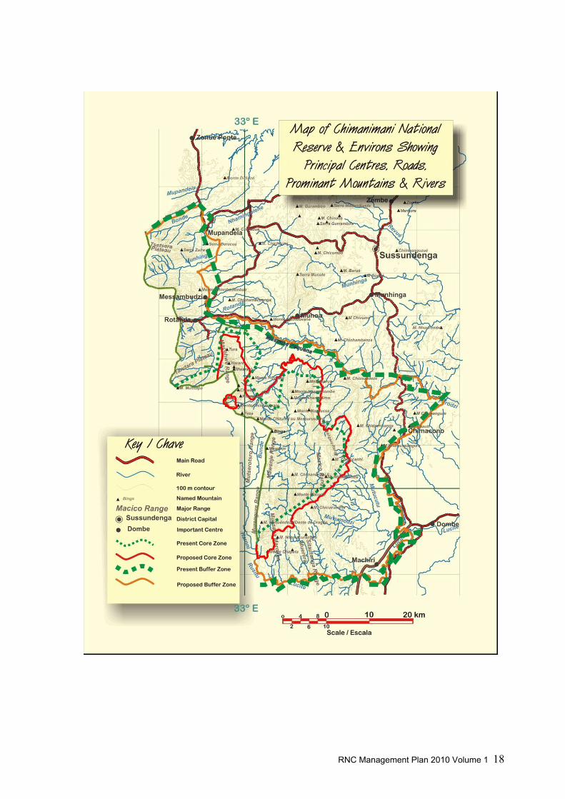
The boundaries of both the Reserve and the buffer zone were subsequently defined by the
Decree No. 34/2003. However this appears to have been done more as an office exercise,
especially in regard to the core zone with straight lines drawn across maps between
coordinates which several problems namely;
• The border did not follows natural features such as rivers, contours,
watersheds or even traditional boundaries;
• The border was in cases quite unrealistic and included areas in the Reserve of
no special biological or conservation value;
• Whole communities were unnecessarily included in the Reserve, especially in
parts of the Gutsa and Nhahedzi areas.
New proposals for the boundaries of both the Reserve and the Buffer zone are proposed in
this plan, where the boundaries follow more natural and populated areas have generally been
removed from the conservation zone. Two communities in Régulo Nhahedzi’s area ―
Nhabawa and Ferreira ― originally inside the Reserve, will be left just outside the strict
protection zone by the new limits, integrating them into community tourist activities, one of
which is already underway at Nhabawa.

RNC Management Plan 2010 Volume 1 – Chap. 5 Background to the TFCA Project 37

RNC Management Plan 2010 Volume 1 – Chap. 6 Objectives of Chimanimani Conservation Area 38

RNC Management Plan 2010 Volume 1 – Chap. 6 Objectives of Chimanimani Conservation Area 39
6 Objectives of the Chimanimani Conservation Area
6.1 Background
In 1999, R. Bell affirmed in his plan that: “Currently there is no clearly articulated or agreed
set of objectives for Chimanimani”; he then proposed in the plan the following objectives as a
starting point for discussion and negotiation:
- To improve the living standard of the people of the PNBR [Proposed Nakaedo
Biosphere Reserve, as the Chimanimani TFCA was proposed to be called] through
sustainable use of natural resources;
- To conserve and realise the spiritual, biological, economic and aesthetic values of the
PNBR;
- To achieve the above while taking advantage of the opportunities offered by the
location of the PNBR on the international border between Mozambique and Zimbabwe.
Bell’s management plan for the Chimanimani Conservation Area was never formally ratified
and adopted: no further discussion and negotiation of the objectives was carried on and the
area continued to be managed until present with no explicit long term objectives objectives.
6.1.1 The legal context about objectives of Protected Areas in Mozambique
The general framework of the management objectives for National Reserves in Mozambique
and for Chimanimani in particular is given in the general and specific legal texts regulating the
creation of the ChNR.
The Forest and Wildlife Act of 1999 gives general provision for the objectives of a National
Reserve: “National Reserves are areas of total protection set aside for the protection of certain
plant and animal species that are rare, endemic, threatened with extinction or in imminent
decline and of fragile ecosystems such as wetlands, dunes, mangroves and coral reefs, as well
as the conservation of the flora and fauna present in the same ecosystems”.

RNC Management Plan 2010 Volume 1 – Chap. 6 Objectives of Chimanimani Conservation Area 40
Decree num. 34/2003 creating the Reserve of Chimanimani also indicates the broad
management objectives for area stating that: “Considering the ecological characteristics, the
rich biodiversity and endemism of flora, the importance of Chimanimani massif as source of
various rivers and the existence of mount Binga, the highest mountain of the country, it is
necessary to protect the fauna and flora of the area”. It also states that the “Buffer Zone is
created aiming at the multiple use of the natural resources within it”.
6.2 Objectives for the Chimanimani Conservation Area
6.2.1 Aim of the Chimanimani Conservation Area
The creation of the ChNR reflects three types of interests: environmental interests, socio-
economic interests, political and institutional interests. These interests translate into broad
objectives or aims of the protected area. In the national and regional context, aim of the ChNR
is to contribute to:
• preserve the sources and watersheds of many important rivers of Central Mozambique;
• preserve the unique ecosystem representative of the Afro-montane ecoregion;
• preserve the biologic diversity of some of the most important and strategic parts of the
remaining evergreen forests of Mozambique and Southern Africa;
• preserve the ancient cultural and historical heritage of Mozambique;
• preserve the cultural diversity of Mozambique;
• preserve the cultural and spiritual values of the Ndau people;
• the sustainable development of the Manica Province and the Sussundenga district.
Moreover, the Reserve contributes to fulfil the commitments made by the State in the
framework of international conventions such as the African Convention for Conservation of
Nature and Natural Resources (Maputo 2003).
6.2.2 Objectives of the Chimanimani Conservation Area
On the base of the current legal framework, the objectives proposed in the first plan and the
ideas and opinion expressed by local stakeholders during the consultation phase of our work,
the objectives for the Chimanimani Conservation Area are as follow:

RNC Management Plan 2010 Volume 1 – Chap. 6 Objectives of Chimanimani Conservation Area 41
Prime objective of the ChNR is the one common to all Reserves as declared by the
1999 Forest and Wildlife Act of Mozambique, also reiterated in the Decree creating the
Reserve:
• “The protection of plant and animal species that are rare, endemic, threatened
with extinction or in imminent decline and of fragile ecosystems”.
After this general objective, we can recognize a series of specific objectives that are
pursued by the Reserve:
a) The improvement of the living standard of local people through the creation of new
livelihoods based on the ecotourism activity, the sustainable use of natural
resources, the adoption of biological and mechanical conservations agriculture and
the development of basic infrastructures;
b) The preservation, in a pristine state, of the unique landscapes of the Chimanimani
highlands;
c) The preservation of the lowland and mid-altitude evergreen forests, which are
among the most significant for the whole country;
d) The preservation of the water resource from the many rivers originating in the
Chimanimani Mountains;
e) The preservation of the historical monuments;
f) The preservation of the spiritual landscape of Chimanimani;
g) The active involvement of local people in the management of the Conservation
Area;
h) The informed management of the Reserve, on the base of decisions provided by a
monitoring programme and scientific researches.
6.2.3 The vision for the Chimanimani Conservation Area
The vision that will guide the management of Chimanimani for the next years is built on eight
main ideas:
Within the next few years the Chimanimani Conservation Area will be managed by an
enlarged and motivated Reserve staff. Management will entail regular meetings with the newly
created Management Board (Conselho de Gestão da Área de Conservação - CGAC): this will

RNC Management Plan 2010 Volume 1 – Chap. 6 Objectives of Chimanimani Conservation Area 42
include all stakeholders and will meet at least twice yearly as well as whenever else necessary.
Managers of the Chimanimani National Park in Zimbabwe will be invited to participate to the
Board meetings and will be consulted for cross border issues, like law enforcement, wildlife
and fire management, tourism development, exchanges of experience between the two staffs.
New limits, that exclude people from the Reserve and include ecologically important areas,
will be officially gazetted and demarcated on the ground, thus making them easily identifiable
by local people and Reserve staff.
Illegal activities in the Reserve will be under control through permanent presence of rangers
and a well established patrolling system in the highlands, while selected goldpanner will be
participating in a pilot study to assess the feasibility of driving gold panning in the Reserve to a
legal, limited, socially and environmentally responsible artisanal mining. Poaching will be
under control, reduced to a minimum, and will not concern large wildlife species. As a
consequence, wildlife population will slowly recover, assuring the persistence of viable
population of the larger species in the conservation area. Human-wildlife conflicts will be
understood and ad hoc mitigation measures will be taken. The evergreen forest inside the
Reserve will no longer be cut for agriculture and most of those in the buffer zone, particularly
in Tsetsera, Tandara, Mahate, Maronga and Mpunga will be declared protected by local
communities during the preparation of the Community Action Plans.
Infrastructures will be developed, particularly access roads and river crossings, reserve
headquarters, entrance gates and ranger posts. This will facilitate the management of the
Reserve and will contribute to the development of tourism in Chimanimani.
Tourism will be well developed: the logo, name and attractions of the Chimanimani Reserve
will be known at the regional level and new camps will be opened and operated by private
investors-local communities’ joint-ventures. Other main infrastructures in the buffer zone, i.e.
schools, health posts, bridges and roads, will be realized by the government to the benefit of
the most underdeveloped communities if Chimanimani.
Communities’ leading roles in the management of the natural resources of the buffer zone
will be recognised, formalised and strengthened. Land rights of communities will be secured:

RNC Management Plan 2010 Volume 1 – Chap. 6 Objectives of Chimanimani Conservation Area 43
communities will be fully responsible of the sustainable management of their natural resources
as they will now see it as their own responsibility rather than that of the government.
Communities will adopt conservation measures and come to a sustainable use and
management of the natural resources thanks to several incentives and alternative sources of
income, such as ecotourism, community forestry, honey production, the sale of carbon credits,
introduction of more intensive conservation agriculture.
Chimanimani will be administrated on the base of informed management decisions
provided by scientific researches and baseline data. A specific Decision Support System (DSS)
will guide the process of planning the research and monitoring programme and will help
storing the collected data in a systematic and functional manner. Researches will lead to better
scientific insights and add to the international standing of the area.
Finally, support and motivation of local communities to conserve the Chimanimani
Conservation Area will increase through the proposed incentives and also an awareness
programme carried out in collaboration with local schools and Comité de Gestão of each local
community.
6.2.4 The general strategy to achieve the proposed objectives
Therefore, the strategies on which this management plan is based are:
1) Revision of the borders of the Reserve and Buffer Zone and creation of a new
administrative structure (Programme 1)
2) Development of infrastructure and tourism (Programme 2)
3) Introduction of activities based on the sustainable use of natural resources,
conservation agriculture and the creation of incentives for local people so that there
are alternatives to the current unsustainable use of natural resources (Programme 3)
4) Research and environmental monitoring (Programme 4)
5) Introduction of a long term awareness programme (Programme 5)
6) Cross border coordination of specific activities (Chapter 7 of Volume 2).
These are presented in details in the Volume 2 of this plan.