Characterization of soil profiles in a landscape affected by long-term tillage
11
Characterization of soil profiles in a landscape affected by long-term tillage S.K. Papiernik a, * , M.J. Lindstrom a , T.E. Schumacher b , J.A. Schumacher b , D.D. Malo b , D.A. Lobb c a USDA-ARS, North Central Soil Conservation Research Laboratory, 803 Iowa Avenue, Morris, MN 56267, USA b South Dakota State University, Department of Plant Sciences, 247A SNP, Box 2140C, Brookings, SD 57007-2141, USA c University of Manitoba, Department of Soil Science, 276 Ellis Bldg., Winnipeg, Man., Canada R3T 2N2 Received 10 January 2006; received in revised form 11 May 2006; accepted 20 May 2006 Abstract Soil movement by tillage redistributes soil within the profile and throughout the landscape, resulting in soil removal from convex slope positions and soil accumulation in concave slope positions. Previous investigations of the spatial variability in surface soil properties and crop yield in a glacial till landscape in west central Minnesota indicated that wheat (Triticum aestivum) yields were decreased in upper hillslope positions affected by high soil erosion loss. In the present study, soil cores were collected and characterized to indicate the effects of long-term intensive tillage on soil properties as a function of depth and tillage erosion. This study provides quantitative measures of the chemical and physical properties of soil profiles in a landscape subject to prolonged tillage erosion, and compares the properties of soil profiles in areas of differing rates of tillage erosion and an uncultivated hillslope. These comparisons emphasize the influence of soil translocation within the landscape by tillage on soil profile characteristics. Soil profiles in areas subject to soil loss by tillage erosion >20 Mg ha 1 year 1 were characterized by truncated profiles, a shallow depth to the C horizon (mean upper boundary 75 cm from the soil surface), a calcic subsoil and a tilled layer containing 19 g kg 1 of inorganic carbon. In contrast, profiles in areas of soil accumulation by tillage >10 Mg ha 1 year 1 exhibited thick sola with low inorganic carbon content (mean 3 g kg 1 ) and a large depth to the C horizon (usually >1.5 m below the soil surface). When compared to areas of soil accumulation, organic carbon, total nitrogen and Olsen-extractable phosphorus contents measured lower, whereas inorganic carbon content, pH and soil strength measured higher throughout the profile in eroded landscape positions because of the reduced soil organic matter content and the influence of calcic subsoil material. The mean surface soil organic carbon and total nitrogen contents in cultivated areas (regardless of erosion status) were less than half that measured in an uncultivated area, indicating that intensive tillage and cropping has significantly depleted the surface soil organic matter in this landscape. Prolonged intensive tillage and cropping at this site has effectively removed at least 20 cm of soil from the upper hillslope positions. # 2006 Elsevier B.V. All rights reserved. Keywords: Tillage erosion; Erosion; Organic carbon; Inorganic carbon; Soil classification 1. Introduction Soil loss by erosion is recognized as a factor limiting crop production and plant growth throughout the world. Research has generally demonstrated yield reductions in response to topsoil loss by erosion. The www.elsevier.com/locate/still Soil & Tillage Research 93 (2007) 335–345 * Corresponding author. Tel.: +1 320 589 3411; fax: +1 320 589 3787. E-mail address: [email protected] (S.K. Papiernik). 0167-1987/$ – see front matter # 2006 Elsevier B.V. All rights reserved. doi:10.1016/j.still.2006.05.007
Transcript of Characterization of soil profiles in a landscape affected by long-term tillage
www.elsevier.com/locate/still
Soil & Tillage Research 93 (2007) 335–345
Characterization of soil profiles in a landscape
affected by long-term tillage
S.K. Papiernik a,*, M.J. Lindstrom a, T.E. Schumacher b,J.A. Schumacher b, D.D. Malo b, D.A. Lobb c
a USDA-ARS, North Central Soil Conservation Research Laboratory, 803 Iowa Avenue, Morris, MN 56267, USAb South Dakota State University, Department of Plant Sciences, 247A SNP, Box 2140C, Brookings, SD 57007-2141, USA
c University of Manitoba, Department of Soil Science, 276 Ellis Bldg., Winnipeg, Man., Canada R3T 2N2
Received 10 January 2006; received in revised form 11 May 2006; accepted 20 May 2006
Abstract
Soil movement by tillage redistributes soil within the profile and throughout the landscape, resulting in soil removal from
convex slope positions and soil accumulation in concave slope positions. Previous investigations of the spatial variability in
surface soil properties and crop yield in a glacial till landscape in west central Minnesota indicated that wheat (Triticum aestivum)
yields were decreased in upper hillslope positions affected by high soil erosion loss. In the present study, soil cores were collected
and characterized to indicate the effects of long-term intensive tillage on soil properties as a function of depth and tillage erosion.
This study provides quantitative measures of the chemical and physical properties of soil profiles in a landscape subject to
prolonged tillage erosion, and compares the properties of soil profiles in areas of differing rates of tillage erosion and an
uncultivated hillslope. These comparisons emphasize the influence of soil translocation within the landscape by tillage on soil
profile characteristics. Soil profiles in areas subject to soil loss by tillage erosion >20 Mg ha�1 year�1 were characterized by
truncated profiles, a shallow depth to the C horizon (mean upper boundary 75 cm from the soil surface), a calcic subsoil and a tilled
layer containing�19 g kg�1 of inorganic carbon. In contrast, profiles in areas of soil accumulation by tillage>10 Mg ha�1 year�1
exhibited thick sola with low inorganic carbon content (mean 3 g kg�1) and a large depth to the C horizon (usually>1.5 m below
the soil surface). When compared to areas of soil accumulation, organic carbon, total nitrogen and Olsen-extractable phosphorus
contents measured lower, whereas inorganic carbon content, pH and soil strength measured higher throughout the profile in eroded
landscape positions because of the reduced soil organic matter content and the influence of calcic subsoil material. The mean
surface soil organic carbon and total nitrogen contents in cultivated areas (regardless of erosion status) were less than half that
measured in an uncultivated area, indicating that intensive tillage and cropping has significantly depleted the surface soil organic
matter in this landscape. Prolonged intensive tillage and cropping at this site has effectively removed at least 20 cm of soil from the
upper hillslope positions.
# 2006 Elsevier B.V. All rights reserved.
Keywords: Tillage erosion; Erosion; Organic carbon; Inorganic carbon; Soil classification
* Corresponding author. Tel.: +1 320 589 3411;
fax: +1 320 589 3787.
E-mail address: [email protected] (S.K. Papiernik).
0167-1987/$ – see front matter # 2006 Elsevier B.V. All rights reserved.
doi:10.1016/j.still.2006.05.007
1. Introduction
Soil loss by erosion is recognized as a factor
limiting crop production and plant growth throughout
the world. Research has generally demonstrated yield
reductions in response to topsoil loss by erosion. The
S.K. Papiernik et al. / Soil & Tillage Research 93 (2007) 335–345336
extent of yield reduction resulting from soil erosion is
dependent on the extent of soil loss through erosion,
properties of the surface soil, subsoil and parent
material of the soil, management factors (including
tillage, crop and fertilizer inputs) and environmental
conditions relating to plant growth (Adams, 1949;
Battiston et al., 1987; Bruce et al., 1988; Fenton et al.,
2005; Kosmas et al., 2001; Olson and Carmer, 1990;
Papiernik et al., 2005; Schumacher et al., 1999;
Sparovek and Schnug, 2001).
Soil movement by tillage can be a dominant force
in redistributing soil within the profile and throughout
the landscape. Soil erosion by tillage results in the
removal of soil from convex slope positions and soil
accumulation in concave slope positions (Lindstrom
et al., 1992; Govers et al., 1994; Lobb et al., 1995).
Net downslope soil flux by tillage erosion is a
function of slope gradient, while soil translocation by
water erosion is a function of slope steepness and
length. Thus, areas with high soil loss resulting from
tillage erosion do not always correspond to those with
severe water erosion, but tillage and water erosion
operate to redistribute soil in the landscape in
predictable patterns. Tillage erosion rates are usually
highest in crest, shoulder and upper backslope
positions while soil movement by water erosion is
greatest in the mid to lower backslope region. Tillage
erosion is especially evident in hilly landscapes. Soil
morphological effects of tillage erosion include
truncated soil profiles at convex slope positions, deep
topsoil accumulation in concave slope positions and
inverted soil profiles, where subsoil material is
deposited over original surface horizons (Kosmas
et al., 2001; De Alba et al., 2004; Heckrath et al.,
2005). Few detailed studies of the effect of tillage
erosion on soil properties and soil productivity have
been reported.
Previous investigations of the spatial variability in
soil properties in landscapes affected by long-term
tillage indicate that soil organic carbon and nutrient
(nitrogen and phosphorus) contents are lower in areas
of soil removal than in areas of soil accumulation
(Pennock et al., 1994; Heckrath et al., 2005; Papiernik
et al., 2005). In the North American prairies, an
increase in pH has been observed in eroded landscape
positions as a result of the increased carbonate
concentration (Pennock et al., 1994; Papiernik et al.,
2005). Previous studies have investigated a limited
number of soil properties, but indicate that in some
landscapes, tillage erosion has the potential to have
large effects on soil properties that determine soil
productivity.
Few studies have specifically reported the impact of
tillage-induced changes in soil properties on crop
production, but these studies consistently report higher
grain yields or biomass production in areas of soil
accumulation by tillage compared to areas of soil
removal by tillage (Kosmas et al., 2001; Tsara et al.,
2001; Heckrath et al., 2005; Papiernik et al., 2005). An
investigation conducted at the site used in the present
studies indicated that low wheat (Triticum aestivum)
yields were observed in areas affected by high soil loss
by erosion, predominately due to tillage erosion on
convex slope positions (Papiernik et al., 2005). Wheat
yields in these areas of the field averaged 50% of the
maximum measured yield in each of 3 years (Papiernik
et al., 2005).
Previous studies have suggested that tillage erosion
may be partly responsible for changes in soil properties
and crop yield in hilly landscapes; they have included
qualitative descriptions of soil properties (De Alba
et al., 2004) or investigated a small number of soil
properties that are expected to affect crop growth
(Pennock et al., 1994; Kosmas et al., 2001; Heckrath
et al., 2005; Papiernik et al., 2005). Because tillage
erosion can have drastic effects on crop yield in the
prairies of North America (Papiernik et al., 2005), this
study was conducted to more fully investigate the
impact of tillage erosion on the variability in soil
properties with landscape position and depth in an hilly
prairie landscape. Soil cores were collected and
characterized from a long-term intensively tilled field
and from a nearby grassed hillslope that had no history
of tillage to evaluate the effects of soil erosion on soil
properties as a function of depth and soil removal/
accumulation by tillage. This study provides quantita-
tive measures of soil chemical and physical properties
of soil profiles in a landscape subject to prolonged
tillage erosion, and provides comparisons of the
properties of soil profiles in areas of differing rates
of soil loss by tillage and an uncultivated hillslope.
These comparisons emphasize the influence of soil
translocation within the landscape by tillage on soil
profile characteristics.
2. Methods
2.1. Experimental site
Experiments were conducted in a 2.7-ha (6.7 acres)
portion of a 16-ha (40 acres) field near Cyrus in west
central Minnesota (45.688N, 95.758W), an area
characterized by undulating topography with slopes
<10%. The site consists of a low hill and a waterway
S.K. Papiernik et al. / Soil & Tillage Research 93 (2007) 335–345 337
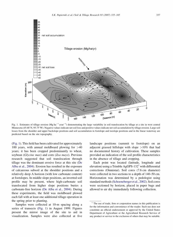
Fig. 1. Estimates of tillage erosion (Mg ha�1 year�1) demonstrating the large variability in soil translocation by tillage at a site in west central
Minnesota (45.688N, 95.758W). Negative values indicate net soil loss and positive values indicate net soil accumulation by tillage erosion. Large soil
losses from the shoulder and upper backslope positions and soil accumulation in footslope and toeslope positions and in the linear waterway are
predicted based on the site topography.
1 The use of trade, firm or corporation names in this publication is
for the information and convenience of the reader. Such use does not
constitute an official endorsement or approval by the United States
Department of Agriculture or the Agricultural Research Service of
any product or service to the exclusion of others that may be suitable.
(Fig. 1). This field has been cultivated for approximately
100 years, with annual moldboard plowing for >40
years; it has been cropped predominantly to wheat,
soybean (Glycine max) and corn (Zea mays). Previous
research suggested that soil translocation through
tillage was the dominant erosive force at this site (De
Alba et al., 2004). Erosion has resulted in the exposure
of calcareous subsoil at the shoulder positions and a
relatively deep A horizon (with low carbonate content)
at footslopes. In middle slope positions, an inverted soil
profile may be present, where high-carbonate soil
translocated from higher slope positions buries a
carbonate-free horizon (De Alba et al., 2004). During
these experiments, the field was moldboard plowed
each fall with at least one additional tillage operation in
the spring prior to planting.
Samples were collected at 10-m spacing along a
series of transects (Fig. 1) in August 1999. Figures
present the mirror image of the site to aid in
visualization. Samples were also collected at five
landscape positions (summit to footslope) on an
adjacent grassed hillslope with slope >10% that had
no documented history of cultivation. These samples
provided an indication of the soil profile characteristics
in the absence of tillage and cropping.
Each point was located (latitude, longitude and
elevation) using a Trimble AgGPS-1321 with differential
corrections (Omnistar). Soil cores (7.6 cm diameter)
were collected in two sections to a depth of 140–50 cm.
Horizonation was determined by a pedologist using
standard methods (Schoeneberger et al., 2002). Soil cores
were sectioned by horizon, placed in paper bags and
allowed to air dry immediately following collection.
S.K. Papiernik et al. / Soil & Tillage Research 93 (2007) 335–345338
2.2. Calculation of erosion estimates
To develop tillage and water erosion estimates, a
Digital Elevation Model of the entire field was
developed using a Leica survey grade DGPS system,
with points located on a 10-m grid. Erosion by tillage,
water and the combined effects of tillage and water was
estimated at each node on the grid using the Water and
Tillage Erosion Model (WATEM, Van Oost et al., 2000)
using the approach described in Schumacher et al.
(2005).
2.3. Determination of soil properties
Soil samples were air-dried and sieved (<2 mm) and
selected properties were determined. The weight
fraction consisting of particles >2 mm in diameter
was measured. Soil pH was determined in a slurry of 5 g
of air-dried soil and 10 mL of 0.01 M CaCl2. Total
carbon and nitrogen contents (g kg�1) were determined
by Dumas combustion and measured using a LECO
2000 CN analyzer (LECO Corporation, 2003). Inor-
ganic carbon (IC) was determined using a pressure
calcimeter and organic carbon (OC) determined by the
difference between total and IC (Wagner et al., 1998).
Measurements of Olsen-extractable phosphorus,
ammonium acetate-extractable potassium, nitrate-N
and ammonium-N were determined using standard soil
test procedures. Wet aggregate stability was measured
using the method described by Kemper and Rosenau
(1986).
Soil strength and bulk density were determined along
the same transects under relatively dry conditions in
August 2000. Soil cores (5.7-cm diameter) were
collected to 76 cm depth and sectioned into 0–15,
15–30, 30–60 and 60–76 cm increments. The bulk
density was estimated by dividing the mass of soil
(calculated from the difference in sample mass before
and after oven-drying) by the volume of soil (386.3 cm3
for 15-cm increments, 772.6 cm3 for 30-cm incre-
ments). Soil strength was measured by the resistance to
penetration using a Veris 3000 Profiler with a 308 angle
cone tip with a maximum diameter of 1.6 cm. The rate
of penetration was 1.8 m min�1. Three soil strength
profile measurements were taken adjacent to each
transect point.
Relationships between variables were examined using
Kendall correlation. Differences in the least-squares
means of the properties of different soil horizons were
detected using PROC MIXED in SAS (SAS Institute,
2003). Based on the erosion estimates, sampling
locations were classified into groups based on the tillage
erosion rate: soil loss >20 Mg ha�1 year�1; loss 10 to
20 Mg ha�1 year�1; loss 0 to 10 Mg ha�1 year�1; soil
accumulation 0 to 10 Mg ha�1 year�1; accumulation
>10 Mg ha�1 year�1; uncultivated. Differences in prop-
erties of the surface soil were detected using PROC
MIXED in SAS. In both cases, the MIXED model
assumed an unbalanced design with individual cores
representing repeated measures.
3. Results and discussion
3.1. Erosion estimates
Erosion rates predicted from the site topography
indicated that soil removal rates by tillage were highest in
the shoulder and upper backslope positions, with net soil
accumulation in lower slope positions and throughout the
linear waterway (Fig. 1). The transect points monitored in
this study spanned the range of erosion rates predicted for
the entire field (Papiernik et al., 2005). Predicted tillage
erosion rates at the transect points monitored in this study
varied from a net loss of 46 Mg ha�1 year�1 to a net gain
of 51 Mg ha�1 year�1 (Fig. 1); water erosion rates from a
loss of 46 Mg ha�1 year�1 to a gain of 155 Mg ha�1
year�1; tillage + water erosion rates from a loss of
66 Mg ha�1 year�1 to a net gain of 207 Mg ha�1 year�1.
The major features of the total erosion reflect the removal
of soil from the shoulder positions by tillage and
accumulation at footslope positions by tillage and water
(Papiernik et al., 2005). At this site, tillage erosion has a
dominant impact over a larger portion of the field
compared to water erosion (Papiernik et al., 2005).
Similar tillage erosion rates and erosion patterns have
been observed in other undulating landscapes (Heckrath
et al., 2005).
3.2. Properties of soil horizons
The IC content of the Ap horizon was highly variable
at this site (Table 1). Soil redistribution by erosion has
incorporated subsoil into the tilled layer and mixed soil
from different landscape positions with different
calcium carbonate contents (De Alba et al., 2004).
As observed in extensive sampling of the surface soil at
this site (Papiernik et al., 2005), soil pH, IC and OC
contents were significantly correlated (Table 2).
Expanded soil characterization in this study indicated
that total N and Olsen-extractable P contents decreased
with increasing pH and IC content and increased with
increasing OC content (Table 2). The properties of the
tilled layer are typically most affected by erosion
processes. Areas of high estimated soil loss by tillage
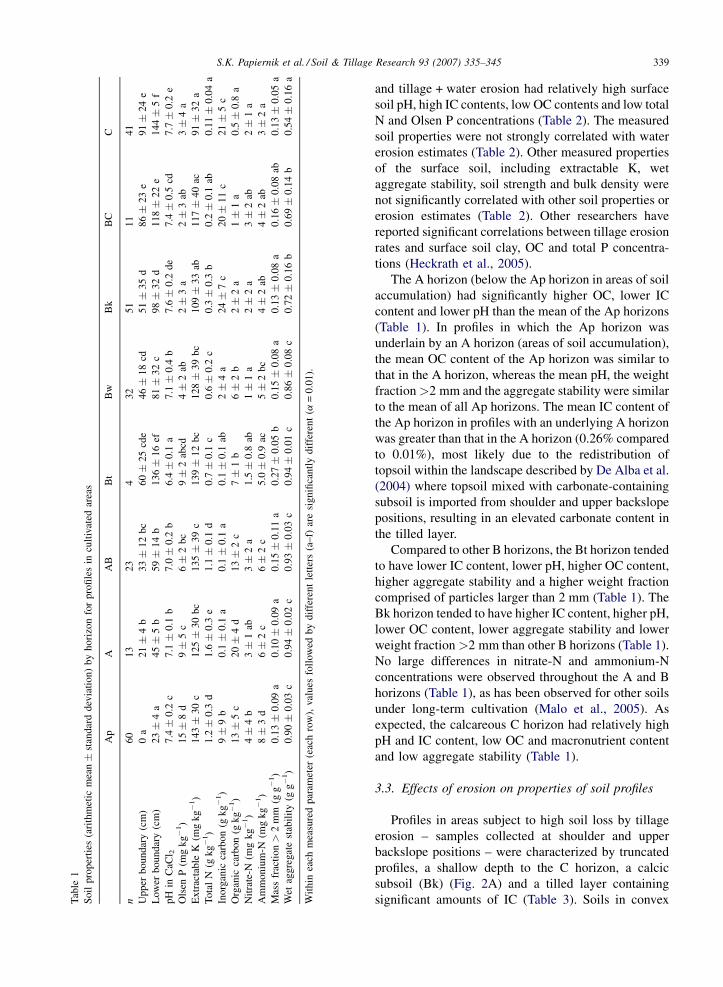
S.K. Papiernik et al. / Soil & Tillage Research 93 (2007) 335–345 339T
able
1
So
ilp
rop
erti
es(a
rith
met
icm
ean�
stan
dar
dd
evia
tio
n)
by
ho
rizo
nfo
rp
rofi
les
incu
ltiv
ated
area
s
Ap
AA
BB
tB
wB
kB
CC
n6
01
32
34
32
51
11
41
Up
per
bo
un
dar
y(c
m)
0a
21�
4b
33�
12
bc
60�
25
cde
46�
18
cd5
1�
35
d8
6�
23
e9
1�
24
e
Low
erb
ou
nd
ary
(cm
)2
3�
4a
45�
5b
59�
14
b1
36�
16
ef8
1�
32
c9
8�
32
d1
18�
22
e1
44�
5f
pH
inC
aCl 2
7.4�
0.2
c7
.1�
0.1
b7
.0�
0.2
b6
.4�
0.1
a7
.1�
0.4
b7
.6�
0.2
de
7.4�
0.5
cd7
.7�
0.2
e
Ols
enP
(mg
kg�
1)
15�
8d
9�
5c
6�
2b
c9�
2ab
cd4�
2ab
2�
3a
2�
3ab
3�
4a
Ex
trac
tab
leK
(mg
kg�
1)
14
3�
30
c1
25�
30
bc
13
5�
39
c1
39�
12
bc
12
8�
39
bc
10
9�
33
ab1
17�
40
ac9
1�
32
a
To
tal
N(g
kg�
1)
1.2�
0.3
d1
.6�
0.3
e1
.1�
0.1
d0
.7�
0.1
c0
.6�
0.2
c0
.3�
0.3
b0
.2�
0.1
ab0
.11�
0.0
4a
Ino
rgan
icca
rbo
n(g
kg�
1)
9�
9b
0.1�
0.1
a0
.1�
0.1
a0
.1�
0.1
ab2�
4a
24�
7c
20�
11
c2
1�
5c
Org
anic
carb
on
(gk
g�
1)
13�
5c
20�
4d
13�
2c
7�
1b
6�
2b
2�
2a
1�
1a
0.5�
0.8
a
Nit
rate
-N(m
gk
g�
1)
4�
4b
3�
1ab
3�
2a
1.5�
0.8
ab1�
1a
2�
2a
3�
2ab
2�
1a
Am
mon
ium
-N(m
gk
g�
1)
8�
3d
6�
2c
6�
2c
5.0�
0.9
ac5�
2b
c4�
2ab
4�
2ab
3�
2a
Mas
sfr
acti
on>
2m
m(g
g�
1)
0.1
3�
0.0
9a
0.1
0�
0.0
9a
0.1
5�
0.1
1a
0.2
7�
0.0
5b
0.1
5�
0.0
8a
0.1
3�
0.0
8a
0.1
6�
0.0
8ab
0.1
3�
0.0
5a
Wet
agg
regat
est
abil
ity
(gg�
1)
0.9
0�
0.0
3c
0.9
4�
0.0
2c
0.9
3�
0.0
3c
0.9
4�
0.0
1c
0.8
6�
0.0
8c
0.7
2�
0.1
6b
0.6
9�
0.1
4b
0.5
4�
0.1
6a
Wit
hin
each
mea
sure
dp
aram
eter
(eac
hro
w),
val
ues
foll
ow
edb
yd
iffe
ren
tle
tter
s(a
–f)
are
sig
nifi
can
tly
dif
fere
nt
(a=
0.0
1).
and tillage + water erosion had relatively high surface
soil pH, high IC contents, low OC contents and low total
N and Olsen P concentrations (Table 2). The measured
soil properties were not strongly correlated with water
erosion estimates (Table 2). Other measured properties
of the surface soil, including extractable K, wet
aggregate stability, soil strength and bulk density were
not significantly correlated with other soil properties or
erosion estimates (Table 2). Other researchers have
reported significant correlations between tillage erosion
rates and surface soil clay, OC and total P concentra-
tions (Heckrath et al., 2005).
The A horizon (below the Ap horizon in areas of soil
accumulation) had significantly higher OC, lower IC
content and lower pH than the mean of the Ap horizons
(Table 1). In profiles in which the Ap horizon was
underlain by an A horizon (areas of soil accumulation),
the mean OC content of the Ap horizon was similar to
that in the A horizon, whereas the mean pH, the weight
fraction>2 mm and the aggregate stability were similar
to the mean of all Ap horizons. The mean IC content of
the Ap horizon in profiles with an underlying A horizon
was greater than that in the A horizon (0.26% compared
to 0.01%), most likely due to the redistribution of
topsoil within the landscape described by De Alba et al.
(2004) where topsoil mixed with carbonate-containing
subsoil is imported from shoulder and upper backslope
positions, resulting in an elevated carbonate content in
the tilled layer.
Compared to other B horizons, the Bt horizon tended
to have lower IC content, lower pH, higher OC content,
higher aggregate stability and a higher weight fraction
comprised of particles larger than 2 mm (Table 1). The
Bk horizon tended to have higher IC content, higher pH,
lower OC content, lower aggregate stability and lower
weight fraction>2 mm than other B horizons (Table 1).
No large differences in nitrate-N and ammonium-N
concentrations were observed throughout the A and B
horizons (Table 1), as has been observed for other soils
under long-term cultivation (Malo et al., 2005). As
expected, the calcareous C horizon had relatively high
pH and IC content, low OC and macronutrient content
and low aggregate stability (Table 1).
3.3. Effects of erosion on properties of soil profiles
Profiles in areas subject to high soil loss by tillage
erosion – samples collected at shoulder and upper
backslope positions – were characterized by truncated
profiles, a shallow depth to the C horizon, a calcic
subsoil (Bk) (Fig. 2A) and a tilled layer containing
significant amounts of IC (Table 3). Soils in convex
S.K. Papiernik et al. / Soil & Tillage Research 93 (2007) 335–345340
Table 2
Kendall correlation coefficients for surface soil (Ap horizon) properties in cultivated areas
pH N P K IC OC WAS >2 mm BD SS TE WE TE + WE
pH in CaCl2 (pH) 1
Total N (N) �0.56 1
Olsen P (P) �0.41 0.43 1
Extractable K (K) 0.05 0.11 �0.00 1
Inorganic carbon (IC) 0.76 �0.61 �0.49 0.05 1
Organic carbon (OC) �0.56 0.86 0.46 0.05 �0.62 1
Wet aggregate stability
(WAS)
�0.12 0.21 0.05 0.20 �0.12 0.21 1
Mass fraction >2 mm
(>2 mm)
0.22 �0.19 �0.17 0.03 0.25 �0.20 0.03 1
Bulk density 0–15 cm (BD) 0.15 �0.06 0.04 0.06 0.14 �0.06 �0.05 �0.04 1
Soil strength 0–20 cm (SS) 0.20 �0.18 �0.11 �0.05 0.22 �0.18 �0.13 0.00 0.30 1
Tillage erosion (TE) 0.36 �0.32 �0.34 0.12 0.38 �0.39 �0.18 �0.00 0.06 0.23 1
Water erosion (WE) 0.07 �0.21 �0.04 �0.12 0.07 �0.17 0.10 0.16 0.00 �0.01 0.21 1
Tillage + water erosion
(TE + WE)
0.46 �0.52 �0.39 0.00 0.46 �0.57 �0.13 0.10 0.04 0.23 �0.63 �0.15 1
Bold values indicate significance at a < 0.0005. Positive correlation with erosion estimates indicates that the property was positively associated with
loss of soil.
landscape positions were classified as Barnes, Buse and
Langhei series (Table 4). Profiles in areas of soil
accumulation exhibited thick sola with a deep C horizon
(Fig. 2B). Soils in concave landscape positions were
described as belonging to the Darnen, Svea and Parnell
series (Table 4). Soil profiles characterized by high soil
loss by tillage demonstrated a C horizon with a mean
upper boundary 75 cm from the soil surface, and all
profiles in areas of high soil loss had a C horizon within
1.5 m of the soil surface (Fig. 2A). In contrast, only
three of the eight cores collected in areas of soil
Table 3
Properties of Ap horizon at sampling points classified by estimated tillage ero
mean � standard deviation)
Soil loss (Mg ha�1 year�1)
>20 10–20 0
n 13 10 1
pH in CaCl2 7.6 � 0.1 c 7.4 � 0.2 bc 7
Olsen P (mg kg�1) 10 � 8 a 11 � 5 a 1
Extractable K (mg kg�1) 142 � 19 ab 149 � 22 ab 1
Total N (g kg�1) 0.9 � 0.2 a 1.3 � 0.3 b 1
Inorganic carbon (g kg�1) 19 � 7 d 8 � 8 bc 1
Organic carbon (g kg�1) 9 � 3 a 14 � 4 bc 1
Total carbon (g kg�1) 28 � 4 c 22 � 5 b 2
Nitrate-N (mg kg�1) 3 � 4 a 4 � 2 a 4
Ammonium-N (mg kg�1) 8 � 3 a 8 � 3 a 8
Mass fraction >2 mm (g g�1) 0.13 � 0.04 a 0.14 � 0.10 ab 0
Wet aggregate stability (g g�1) 0.88 � 0.03 a 0.89 � 0.03 ab 0
Bulk density 0–15 cm (g cm-3) 1.50 � 0.10 b 1.49 � 0.09 b 1
Soil strength 0–20 cm (MPa) 2.2 � 1.1 c 1.8 � 0.9 ac 1
Within each measured parameter (each row), values followed by different
accumulation showed a C horizon within the top 1.5 m
(Fig. 2B).
The Ap horizon in areas of high (>10 Mg ha�1
year�1) soil accumulation resulting from tillage erosion
had significantly lower IC content, higher OC content,
higher wet aggregate stability, lower soil strength and
higher concentrations of total N and Olsen P than the Ap
horizon in areas of high (>20 Mg ha�1 year�1) soil loss
by tillage (Table 3).
Areas with intermediate rates of soil erosion by
tillage generally did not show statistically significant
sion rates; properties of A horizon on uncultivated hillslope (arithmetic
Soil accumulation
(Mg ha�1 year�1)
Uncultivated
hillslope
–10 0–10 >10
4 10 8 10
.4 � 0.2 bc 7.3 � 0.1 b 7.3 � 0.1 bc 6.7 � 0.6 a
2 � 8 a 21 � 5 b 21 � 7 b 7 � 4 a
44 � 28 ab 126 � 34 a 157 � 38 b 144 � 38 ab
.2 � 0.3 b 1.3 � 0.2 b 1.4 � 0.2 b 3.1 � 0.3 c
0 � 9 b 2 � 3 a 3 � 2 ab 3 � 4 ac
2 � 4 b 15 � 3 c 16 � 2 c 36 � 4 d
2 � 6 b 18 � 4 a 19 � 3 a 39 � 5 d
� 3 a 5 � 4 a 6 � 6 a 4 � 6 a
� 2 a 8 � 2 a 8 � 2 a 8 � 3 a
.13 � 0.08 a 0.09 � 0.05 a 0.21 � 0.16 b 0.15 � 0.09 ab
.91 � 0.03 b 0.88 � 0.03 a 0.91 � 0.02 b 0.95 � 0.02 c
.44 � 0.12 b 1.47 � 0.09 b 1.47 � 0.08 b 1.19 � 0.07 a
.6 � 0.7 ac 1.4 � 0.5 ab 1.3 � 0.3 a 2.0 � 0.3 bc
letters (a–d) are significantly different (a = 0.05).
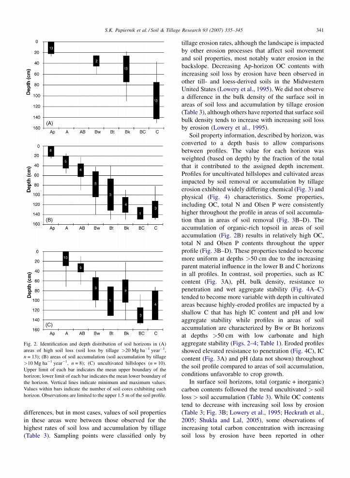
S.K. Papiernik et al. / Soil & Tillage Research 93 (2007) 335–345 341
Fig. 2. Identification and depth distribution of soil horizons in (A)
areas of high soil loss (soil loss by tillage >20 Mg ha�1 year�1,
n = 13); (B) areas of soil accumulation (soil accumulation by tillage
>10 Mg ha�1 year�1, n = 8); (C) uncultivated hillslopes (n = 10).
Upper limit of each bar indicates the mean upper boundary of the
horizon; lower limit of each bar indicates the mean lower boundary of
the horizon. Vertical lines indicate minimum and maximum values.
Values within bars indicate the number of soil cores exhibiting each
horizon. Observations are limited to the upper 1.5 m of the soil profile.
differences, but in most cases, values of soil properties
in these areas were between those observed for the
highest rates of soil loss and accumulation by tillage
(Table 3). Sampling points were classified only by
tillage erosion rates, although the landscape is impacted
by other erosion processes that affect soil movement
and soil properties, most notably water erosion in the
backslope. Decreasing Ap-horizon OC contents with
increasing soil loss by erosion have been observed in
other till- and loess-derived soils in the Midwestern
United States (Lowery et al., 1995). We did not observe
a difference in the bulk density of the surface soil in
areas of soil loss and accumulation by tillage erosion
(Table 3), although others have reported that surface soil
bulk density tends to increase with increasing soil loss
by erosion (Lowery et al., 1995).
Soil property information, described by horizon, was
converted to a depth basis to allow comparisons
between profiles. The value for each horizon was
weighted (based on depth) by the fraction of the total
that it contributed to the assigned depth increment.
Profiles for uncultivated hillslopes and cultivated areas
impacted by soil removal or accumulation by tillage
erosion exhibited widely differing chemical (Fig. 3) and
physical (Fig. 4) characteristics. Some properties,
including OC, total N and Olsen P were consistently
higher throughout the profile in areas of soil accumula-
tion than in areas of soil removal (Fig. 3B–D). The
accumulation of organic-rich topsoil in areas of soil
accumulation (Fig. 2B) results in relatively high OC,
total N and Olsen P contents throughout the upper
profile (Fig. 3B–D). These properties tended to become
more uniform at depths >50 cm due to the increasing
parent material influence in the lower B and C horizons
in all profiles. In contrast, soil properties, such as IC
content (Fig. 3A), pH, bulk density, resistance to
penetration and wet aggregate stability (Fig. 4A–C)
tended to become more variable with depth in cultivated
areas because highly-eroded profiles are impacted by a
shallow C that has high IC content and pH and low
aggregate stability while profiles in areas of soil
accumulation are characterized by Bw or Bt horizons
at depths >50 cm with low carbonate and high
aggregate stability (Figs. 2–4; Table 1). Eroded profiles
showed elevated resistance to penetration (Fig. 4C), IC
content (Fig. 3A) and pH (data not shown) throughout
the soil profile compared to areas of soil accumulation,
conditions unfavorable to crop growth.
In surface soil horizons, total (organic + inorganic)
carbon contents followed the trend uncultivated > soil
loss > soil accumulation (Table 3). While OC contents
tend to decrease with increasing soil loss by erosion
(Table 3; Fig. 3B; Lowery et al., 1995; Heckrath et al.,
2005; Shukla and Lal, 2005), some observations of
increasing total carbon concentration with increasing
soil loss by erosion have been reported in other
S.K. Papiernik et al. / Soil & Tillage Research 93 (2007) 335–345342
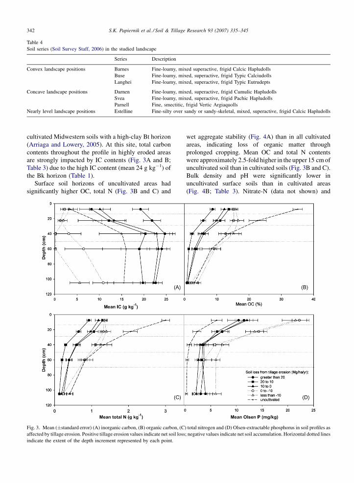
Table 4
Soil series (Soil Survey Staff, 2006) in the studied landscape
Series Description
Convex landscape positions Barnes Fine-loamy, mixed superactive, frigid Calcic Hapludolls
Buse Fine-loamy, mixed, superactive, frigid Typic Calciudolls
Langhei Fine-loamy, mixed, superactive, frigid Typic Eutrudepts
Concave landscape positions Darnen Fine-loamy, mixed, superactive, frigid Cumulic Hapludolls
Svea Fine-loamy, mixed, superactive, frigid Pachic Hapludolls
Parnell Fine, smectitic, frigid Vertic Argiaquolls
Nearly level landscape positions Estelline Fine-silty over sandy or sandy-skeletal, mixed, superactive, frigid Calcic Hapludolls
cultivated Midwestern soils with a high-clay Bt horizon
(Arriaga and Lowery, 2005). At this site, total carbon
contents throughout the profile in highly eroded areas
are strongly impacted by IC contents (Fig. 3A and B;
Table 3) due to the high IC content (mean 24 g kg�1) of
the Bk horizon (Table 1).
Surface soil horizons of uncultivated areas had
significantly higher OC, total N (Fig. 3B and C) and
Fig. 3. Mean (�standard error) (A) inorganic carbon, (B) organic carbon, (C
affected by tillage erosion. Positive tillage erosion values indicate net soil loss
indicate the extent of the depth increment represented by each point.
wet aggregate stability (Fig. 4A) than in all cultivated
areas, indicating loss of organic matter through
prolonged cropping. Mean OC and total N contents
were approximately 2.5-fold higher in the upper 15 cm of
uncultivated soil than in cultivated soils (Fig. 3B and C).
Bulk density and pH were significantly lower in
uncultivated surface soils than in cultivated areas
(Fig. 4B; Table 3). Nitrate-N (data not shown) and
) total nitrogen and (D) Olsen-extractable phosphorus in soil profiles as
; negative values indicate net soil accumulation. Horizontal dotted lines

S.K. Papiernik et al. / Soil & Tillage Research 93 (2007) 335–345 343
Fig. 4. Mean (�standard error) (A) wet aggregate stability, (B) bulk density and (C) resistance to penetration in soil profiles as affected by tillage
erosion. Positive tillage erosion values indicate net soil loss; negative values indicate net soil accumulation. Horizontal dotted lines indicate the
extent of the depth increment represented by each point.
Olsen P (Fig. 3D) were low throughout the soil profile in
uncultivated areas (receiving no fertilizer) and decreased
with depth. In uncultivated areas, bulk density, soil
strength (Fig. 4B and C), IC (Fig. 3A) and pH (data not
shown) tended to increase with depth, influenced by the
higher calcium carbonate content, lower humus contents,
reduced structural development and bulk density of
subsoil material below 50 cm. Pennock et al. (1994) also
reported significantly higher OC and total N and lower
pH and bulk density in surface soils of an uncultivated site
compared to areas subject to long-term cultivation.
Comparing soil profiles in cultivated and unculti-
vated areas emphasizes the importance of soil
translocation within the landscape in determining soil
profile characteristics. More than 50 cm of topsoil
material low in calcium carbonate accumulated at some
sampling locations in areas of soil deposition (Fig. 2B).
This accumulation, coupled with carbonate leaching
during soil genesis in these relatively wet landscape
positions, leads to very low IC contents throughout the
soil profile in areas of soil deposition that are
consistently lower than those measured in uncultivated
soil (Fig. 3A). Removal of the OC-rich mineral horizons
in eroded landscape positions leads to IC contents that
are higher throughout the soil profile than in unculti-
vated areas and areas of soil accumulation (Fig. 3A).
The IC content measured in the Ap horizon at each
sampling location was used to estimate the fraction of
the Ap horizon comprised of Bk and A material using
the mean IC content in the Bk and A horizons (Table 1).
Results indicate that the IC content of the Ap horizon
varied from essentially 100% similarity to the buried A
horizon in areas of soil accumulation to 100%
similarity to the Bk horizon in highly eroded areas.
The properties of the rooting zone in eroded areas,
combined with other processes influenced by landscape
position, such as water infiltration and availability,
result in significant yield reductions in eroded land-
scape positions as reported in Papiernik et al. (2005).
The depth of the A + AB horizons in the summit,
S.K. Papiernik et al. / Soil & Tillage Research 93 (2007) 335–345344
shoulder and upper backslope positions of uncultivated
areas ranged from 22 to 38 cm (data not shown).
Prolonged intensive tillage and cropping at this site has
effectively removed at least 20 cm of soil from the
upper hillslope positions.
The large difference in OC content found between
the uncultivated and cultivated hillslopes is in part a
reflection of the relatively high OC content of the
uncultivated topsoil (Fig. 3B). Soil OC contents below
20 cm depth on the uncultivated hillslope are similar to
those of the cultivated topsoil (Fig. 3B). Soil loss by
erosion (approximately 20 cm) on the cultivated
hillslope could account for most of the reduction in
OC concentration in the upper shoulder position. Our
observations are consistent with other studies examin-
ing the effects of cultivation on soil properties in the
prairie region (Pennock et al., 1994; Malo et al., 2005),
which report a large decrease in surface soil OC
contents in soils subject to long-term cultivation
compared to uncultivated soils. Malo et al. (2005)
indicated that the OC content of the surface soil was
similar to that of the underlying B horizon in the upper
shoulder position of cultivated areas. Pennock et al.
(1994) report a >2-fold reduction in OC content in the
upper 0.45 m following 80 years of cultivation in
Saskatchewan, Canada, similar to the reduction in
surface soil OC reported here. The reported reduction in
OC content was smaller in Malo et al. (2005) than in our
study because of the lower OC content of the
uncultivated topsoil, a reflection of the drier and
warmer climate associated with the experimental sites
in that study. Organic carbon concentrations in B
horizons were similar to those observed in this study.
Redistribution of soil by tillage is being increasingly
recognized as a major erosive force in undulating
landscapes, as evidenced by recent efforts to include
tillage erosion in descriptive and predictive erosion
models (Van Oost et al., 2000). Information regarding
carbon and organic matter dynamics in eroding
landscapes is required to allow more accurate predic-
tions of carbon sequestration and carbon dioxide
emissions from agricultural sources (Liu et al., 2003;
Van Oost et al., 2004). The global carbon budget is not
currently balanced, and current estimates of agricultural
sources and sinks may be inaccurate, since they do not
account for soil movement within the landscape (Van
Oost et al., 2004). In order to accurately model carbon
sequestration in the landscape, processes including
wind, water and tillage erosion that redistribute carbon
within the landscape must be accurately described. In
addition, this study emphasized that total carbon is not a
robust indicator of soil quality or carbon sequestration,
because IC contents can greatly exceed OC contents in
areas of severe erosion (Table 3), resulting in
significantly higher total carbon concentrations in
eroded landscape positions than in accumulating
(sequestering) landscape positions (Table 3).
4. Conclusion
At this site in west central Minnesota, cultivation for
the past �100 years has resulted in a pattern of soil
redistribution within the landscape such that topsoil has
been removed from shoulder and upper backslope
positions and accumulated in footslope and toeslope
positions. Tillage erosion, the primary erosive force at
this site, has altered the characteristics of the soil
profiles across the landscape. Low organic matter
contents throughout the soil profile in eroded landscape
positions leads to low OC, total N and Olsen-extractable
P contents relative to areas of soil accumulation. The
influence of shallow subsoil material in upper landscape
positions results in increased soil strength, low
aggregate stability, high IC content, high pH, low OC
content and low concentrations of total N and Olsen P
throughout the profile in areas of soil loss by tillage
erosion compared to areas of soil accumulation by
tillage. The mean surface soil OC and total N contents in
cultivated areas (regardless of erosion status) were less
than half that measured in an adjacent uncultivated
hillslope, indicating that intensive tillage and cropping
has significantly depleted the surface soil organic matter
in this landscape. These results provide a detailed
documentation of the effects of soil translocation by
tillage on the physical and chemical properties of soil
profiles in hilly landscapes, and are important for
continued efforts to incorporate tillage erosion into soil
erosion and crop productivity models.
References
Adams, W.E., 1949. Loss of topsoil reduces crop yields. J. Soil Water
Conserv. 4, 130.
Arriaga, F., Lowery, B., 2005. Spatial distribution of carbon over an
eroded landscape in southwest Wisconsin. Soil Tillage Res. 81,
155–162.
Battiston, L.A., Miller, M.H., Shelton, I.J., 1987. Soil erosion and corn
yield in Ontario. I. Field evaluation. Can. J. Soil Sci. 67, 731–745.
Bruce, R.R., White Jr., A.W., Thomas, A.W., Snyder, W.M., Langdale,
G.W., Perkins, H.F., 1988. Characterization of soil-crop yield
relationships over a range of erosion on a landscape. Geoderma
43, 99–116.
De Alba, S., Lindstrom, M., Schumacher, T.E., Malo, D.D., 2004. Soil
landscape evolution due to soil redistribution by tillage: a new
conceptual model of soil catena evolution in agricultural land-
scapes. Catena 58, 77–100.
S.K. Papiernik et al. / Soil & Tillage Research 93 (2007) 335–345 345
Fenton, T.E., Kazemi, M., Lauterbach-Barrett, M.A., 2005. Erosional
impact on organic matter content and productivity of selected Iowa
soils. Soil Tillage Res. 81, 163–171.
Govers, G., Vandaele, K., Desmet, P., Poesen, J., Bunte, K., 1994. The
role of tillage in soil redistribution on hillslopes. Eur. J. Soil Sci.
45, 469–478.
Heckrath, G., Djurhuus, J., Quine, T.A., Van Oost, K., Govers, G.,
Zhang, Y., 2005. Tillage erosion and its effect on soil properties
and crop yield in Denmark. J. Environ. Qual. 34, 312–324.
Kemper, W.D., Rosenau, R.C., 1986. Aggregate stability and size
distribution. In: Klute, A. (Ed.), Methods of Soil Analysis, Part 1.
second ed. American Society of Agronomy and Soil Science
Society of America, Madison, WI, pp. 425–442.
Kosmas, C., Gerontidis, S., Marathianou, M., Detsis, B., Zafiriou, T.,
Van Muysen, W., Govers, G., Quine, T., Van Oost, K., 2001. The
effects of tillage displaced soil on soil properties and wheat
biomass. Soil Tillage Res. 58, 31–44.
LECO Corporation, 2003. Total/organic carbon and nitrogen in soils.
LECO Corporation, St. Joseph, MO, Organic Application Note
203-821-165.
Lindstrom, M.J., Nelson, W.W., Schumacher, T.E., 1992. Quantifying
tillage erosion rates due to moldboard plowing. Soil Tillage Res.
24, 243–255.
Liu, S., Bliss, N., Sundquist, E., Huntington, T.G., 2003. Modeling
carbon dynamics in vegetation and soil under the impact of soil
erosion and deposition. Global Biogeochem. Cycles 17, 1074.
Lobb, D.A., Kachanoski, R.G., Miller, M.H., 1995. Tillage transloca-
tion and tillage erosion on shoulder slope landscape positions
measured using 137Cs as a tracer. Can. J. Soil Sci. 75, 211–218.
Lowery, B., Swan, J., Schumacher, T., Jones, A., 1995. Physical
properties of selected soils by erosion class. J. Soil Water Conserv.
50, 306–311.
Malo, D.D., Schumacher, T.E., Doolittle, J.J., 2005. Long-term culti-
vation impacts on selected soil properties in the northern Great
Plains. Soil Tillage Res. 81, 277–291.
Olson, K.R., Carmer, S.G., 1990. Corn yield and plant population
differences between eroded phases of Illinois soils. J. Soil Water
Conserv. 45, 562–566.
Pennock, D.J., Anderson, D.W., de Jong, E., 1994. Landscape-scale
changes in indicators of soil quality due to cultivation in Sas-
katchewan, Canada. Geoderma 64, 1–19.
Papiernik, S.K., Lindstrom, M.J., Schumacher, J.A., Farenhorst, A.,
Stephans, K.D., Schumacher, T.E., Lobb, D.A., 2005. Variation in
soil properties and crop yield across an eroded prairie landscape. J.
Soil Water Conserv. 60, 388–395.
SAS Institute, 2003. SAS version 9.1 for Windows. SAS Institute, Inc.,
Cary, NC.
Schoeneberger, P.J., Wysocki, D.A., Benham, E.C., Broderson, W.D.
(Eds.), 2002. Field book for describing and sampling soils, version
2.0. Natural Resources Conservation Service, United States
Department of Agriculture, National Soil Survey Center,
Lincoln, NE.
Schumacher, J.A., Kaspar, T.C., Ritchie, J.C., Schumacher, T.E.,
Karlen, D.L., Ventris, E.R., McCarthy, G.M., Colvin, T.S., Jaynes,
D.B., Lindstrom, M.J., Fenton, T.E., 2005. Identifying spatial
patterns of erosion for use in precision conservation. J. Soil Water
Conserv. 60, 355–362.
Schumacher, T.E., Lindstrom, M.J., Schumacher, J.A., Lemme, G.D.,
1999. Modeling spatial variation in productivity due to tillage and
water erosion. Soil Tillage Res. 51, 331–339.
Shukla, M.K., Lal, R., 2005. Erosional effects on soil organic carbon
stock in an on-farm study on Alfisols in west central Ohio. Soil
Tillage Res. 81, 173–181.
Sparovek, G., Schnug, E., 2001. Temporal erosion-induced
soil degradation and yield loss. Soil Sci. Soc. Am. J. 65,
1479–1486.
Soil Survey Staff, Natural Resources Conservation Service, United
States Department of Agriculture, 2006. Official soil series
descriptions. Available at http://soils.usda.gov/technical/classifi-
cation/osd/index.html. Accessed 19 April, 2006.
Tsara, M., Gerontidis, S., Marathianou, M., Kosmas, C., 2001. The
long-term effect of tillage on soil displacement of hilly areas used
for growing wheat in Greece. Soil Use Manage. 17, 113–120.
Van Oost, K., Govers, G., Desemet, P., 2000. Evaluating the effects of
changes in landscape structure on soil erosion by water and tillage.
Landscape Ecol. 15, 577–589.
Van Oost, K., Govers, G., Quine, T.A., Heckrath, G., 2004. Comment
on ‘‘Managing soil carbon’’ (1). Science 305, 1567b, http://
www.sciencemag.org/cgi/reprint/305/5690/1567b.pdf.
Wagner, S.W., Hanson, J.D., Olness, A., Voorhees, W.B., 1998. A
volumetric inorganic carbon analysis system. Soil Sci. Soc. Am. J.
62, 690–693.