Chapter 5 - Huntingdon SPA - Huntingdon
50
Huntingdonshire Landscape and Townscape Supplementary Planning Document 2022 Huntingdonshire District Council | Huntingdonshire Landscape and Townscape Supplementary Planning Document 2022 Chapter 5 - Huntingdon SPA: Huntingdon
-
Upload
khangminh22 -
Category
Documents
-
view
2 -
download
0
Transcript of Chapter 5 - Huntingdon SPA - Huntingdon

Huntingdonshire Landscape and Townscape Supplementary
Planning Document 2022 Huntingdonshire District Council | Huntingdonshire Landscape and Townscape Supplementary
Planning Document 2022
Chapter 5 - Huntingdon SPA: Huntingdon


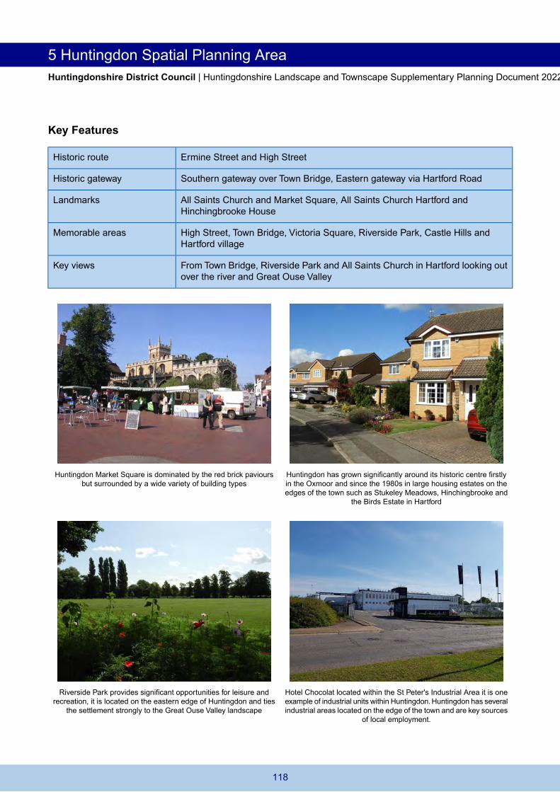
5 Huntingdon Spatial Planning Area Huntingdonshire District Council | Huntingdonshire Landscape and Townscape Supplementary Planning Document 2022
5 Huntingdon Spatial Planning Area 5.1 For the purposes of this SPD no townscape assessment is attempted of the strategic expansion location
of Alconbury Weald due to its evolving nature from a military airbase to a modern mixed use development containing housing, employment, community facilities, open space and other supporting uses. Further information on the anticipated future appearance of the site can be found at Alconbury Weald's dedicated website.
Huntingdon 5.2 Huntingdon is the administrative centre of Huntingdonshire and located towards the centre of the district.
Landscape Setting
5.3 Huntingdon is predominantly located within the elevated landscape of the Central Claylands Landscape Character Area with its southern edge and part of its historic centre falling within the Great Ouse Valley Landscape Character Area. Whilst other historic centres such as St Ives, St Neots and Godmanchester have retained their relationship with the Great Ouse Valley landscape, the historic centre of Huntingdon is cut off from the river by the ring road (B1514) which forms a visual and physical barrier to this landscape.
5.4 To the south east, the valley sides of the River Great Ouse are one of the few areas where the river valley remains largely undeveloped, providing a distinctive setting to the town when approached from the south east via Godmanchester and north east via Houghton. To the south west, the landscape is influenced by the tributary valley of Alconbury Brook and planting and areas of water at Hinchingbrooke Country Park. This area also forms an important part of the landscape gap separating Huntingdon from Brampton.
5.5 The landform rises beyond the northern fringes of the town and is more heavily influenced by the roads, industrial estates and retail park which dominate this part of the town. Further east, the A141 provides a strong edge to the town and the agricultural landscape beyond the road which falls to the east. This area is perceived as a transitional landscape linking the Great Ouse Valley to the Central Claylands and provides part of the rural setting to the town.
Edges and Visual Prominence
5.6 Huntingdon is located on the south facing slopes of the Great Ouse Valley and the existing urban edge is not widely visible when approaching the town from the north east. With the exception of some recent development which has crept up the valley sides, the majority of the town sits below the skyline and the settlement edge is defined by the vegetated margins of the A141. In contrast the town is much more visible from the north west where recent housing and employment development north of Hinchingbrooke, is particularly prominent from the main approaches to the town. The existing northern edge of the town is likely to change in the coming years with a potential bypass to the A141.
5.7 The town is not widely visible from the south (except from elevated viewpoints along the A1307 heading north west) due to the presence of significant areas of vegetation within the valley floor. From the south west the urban edge is visually defused and well wooded as a result of the established vegetation around Hinchingbrooke House and the associated country park. As part of the A14 upgrade works, the viaduct which runs over the railway is being removed opening up the townscape to the surrounding landscape.
5.8 The Great Ouse with its extensive water meadows is a key feature of the southern gateway to the town from Godmanchester, which is entered across a notable 14th century bridge (Town Bridge). Buildings along the river are mainly historic industrial buildings with a former mill building on the bank of the river converted to flats with attractive views out onto the surrounding landscape and large detached houses backing onto the river. Castle Hills, Riverside Park and playing fields and rowing club benefit from long views across the Westside Common and Port Holme water meadows.The area provides a peaceful setting away from the ring road and the town centre and is an important ecological and recreational asset.
114

Huntingdon Spatial Planning Area 5 Huntingdonshire District Council | Huntingdonshire Landscape and Townscape Supplementary Planning Document 2022
Townscape Character
5.9 The town lies to the north of the River Great Ouse but is separated from the valley landscape by Hartford Road. It has an asymmetrical settlement pattern imposed by its riverside location and instead developed along the Roman road Ermine Street. Within the southern part of the town, the Historic Centre remains as a distinctive and memorable area and the High Street intact leading to the southern area of the town where there is a strong association with the river. There is a wide variety in building types and ages with characteristic building materials including buff/cream brick and plain tile, red brick, slate and white painted render with black window frames. The historic settlement of Hartford (which is now amalgamated into urban structure of the town) to the north east provides a memorable area on the approach to the town from the east and has a strong connection within the landscape of the Great Ouse Valley.
5.10 Extensive areas of housing are located to the north and west of the town centre. These are punctuated by significant areas of open space. The main industrial area is located east of Spittals Way on land either side of the railway. The town is heavily influenced by several heavily trafficked roads. These include the ring road which encircles the town centre segregating it from the remainder of the settlement, the A1307 to the south west, Spittals Way and the A141 which defines the urban residential edge to the north east. More recently as part of the regeneration of central Huntingdon, a link road (Edison Bell Way) was constructed reducing the need for some journeys to go round the ring road and supporting residential and commercial development along it. This has made the redevelopment of former factory and warehousing sites possible providing a much improved gateway into the town being enhanced as of 2021 by removal of the A14 flyover across Brampton Road and the East coast mainline railway.
5.11 The town hosts a variety of urban character; hence 21 individual character areas have been identified (Figure 5.1 and can be viewed on the interactive map). The character of Huntingdon to the south is dominated by the ring road and the modern commercial and high density flatted development situated around the town centre periphery. The extensive residential areas vary in character and the older density development at the Oxmoor is clearly recognisable from other residential estates built towards the end of the 20thcentury at Hinchingbrooke, Stukeley Meadows, Modern Hartford, Birds Estate and St Peter's Road areas.The town has several industrial estates and retail parks which dominate the north and north western periphery of the town.
115

Figure 5.1 Huntingdon Character Areas

Page left intentionally blank
5 Huntingdon Spatial Planning Area Huntingdonshire District Council | Huntingdonshire Landscape and Townscape Supplementary Planning Document 2022
Key Features
Ermine Street and High Street Historic route
Southern gateway over Town Bridge, Eastern gateway via Hartford Road Historic gateway
All Saints Church and Market Square, All Saints Church Hartford and Hinchingbrooke House
Landmarks
High Street, Town Bridge, Victoria Square, Riverside Park, Castle Hills and Hartford village
Memorable areas
From Town Bridge, Riverside Park and All Saints Church in Hartford looking out over the river and Great Ouse Valley
Key views
Huntingdon Market Square is dominated by the red brick paviours but surrounded by a wide variety of building types
Huntingdon has grown significantly around its historic centre firstly in the Oxmoor and since the 1980s in large housing estates on the edges of the town such as Stukeley Meadows, Hinchingbrooke and
the Birds Estate in Hartford
Riverside Park provides significant opportunities for leisure and recreation, it is located on the eastern edge of Huntingdon and ties
the settlement strongly to the Great Ouse Valley landscape
Hotel Chocolat located within the St Peter's Industrial Area it is one example of industrial units within Huntingdon. Huntingdon has several industrial areas located on the edge of the town and are key sources
of local employment.
118

Huntingdon Spatial Planning Area 5 Huntingdonshire District Council | Huntingdonshire Landscape and Townscape Supplementary Planning Document 2022
Huntingdon Character Area 1: Historic Centre
Market Square with a central war memorial enclosed by the Town Hall, All Saints Church and other listed buildings
Ring road to Ermine Street junction with no. 77,78 and 79 Ermine Street in the background and 81 High Street to the left. This
demonstrates the influence of traffic infrastructure on the setting of historic routes and how this relationships changes over time
5.12 This area represents the medieval core centred along the High Street within the main town centre and heading north along Ermine Street. Ermine Street heads north past the ring road which surrounds the town centre. There is a broad range of uses and facilities including shops, offices, residential, civic and community facilities, hotels, public houses, places of worship and churchyards. Huntingdon's importance as a coaching stop, not a river port, meant that the town developed along the High Street rather than the riverbank. Unlike other Great Ouse Valley towns, Huntingdon has a limited historic river front and the historic centre is less connected to the river setting.
5.13 The pedestrianised High Street has an intimate scale, with many back of pavement buildings of various ages, styles and materials which give a richness and variety to the architectural detailing like Royal Oak Passage. These are interspersed with grand town houses. The often continuous building frontage creates a strong sense of enclosure with views down the many narrow alleyways and back courtyards which are a strong feature of the area.
5.14 There is significant historic character highlighted by medieval churches (All Saints’ Church and St Mary’s Church), burgage plots and buildings ranging from Medieval, Georgian, Victorian and Edwardian periods. Most buildings are 2-3 storey, of mixed styles and ages, reflecting the evolution of the historic centre over time (building types include 1A, 2A, 2E, 6A and 7A). Many of these buildings have ground floor retail or offices with flats above. As well as being within a conservation area, many of Huntingdon’s listed buildings are located within this character area. For example, the High Street has the Cromwell Museum, several former coaching inns (for instance the George with its medieval courtyard and gallery where Shakespearean performances are still held), churches, the Commemoration Hall and the grade II* listed Castle Hill House formerly used by the Pathfinder Squadron during the Second World War but now used as offices. Also Cowper House at the southern end of the High Street is an early 18th century red brick former house now used as offices. Above the modern shopfronts lie many clues to the historic origin of buildings along the High Street such as number 66 which has a frieze incised 'Implement Depot' and number 111, formerly the Fountain Inn, whose Venetian style window lit the Assembly Rooms.
Royal Oak Passage
Commemoration Hall
119

5 Huntingdon Spatial Planning Area Huntingdonshire District Council | Huntingdonshire Landscape and Townscape Supplementary Planning Document 2022
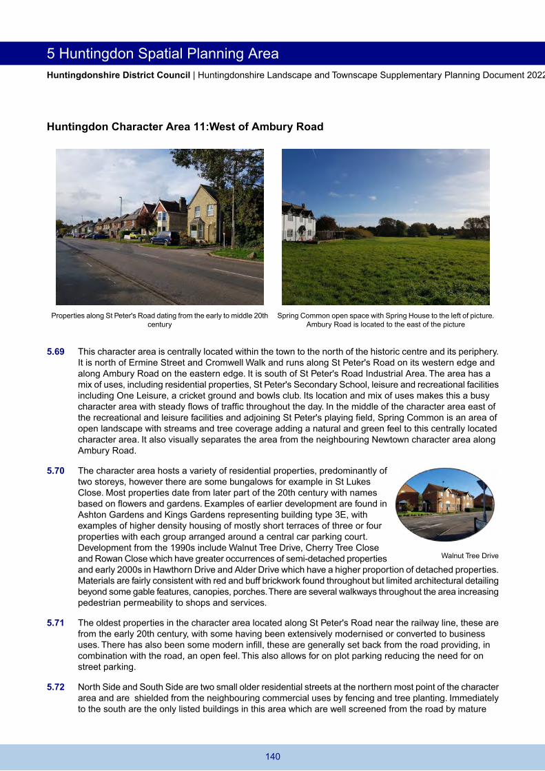
5.15 The Market Square forms the focal point of the character area and contains a significant cluster of high quality listed buildings with the square itself hosting a war memorial 'The Thinking Soldier'. The southern side of the square is enclosed by the grade II* listed Town Hall which is of eighteenth-century design in soft red brick with a portico facing the square and a Tuscan style loggia on the eastern front added in 1817 for the meat market. The western side of the Market Square comprises a range of listed buildings ranging in origin from the 16th to early 19th centuries which include a former coaching inn and the grade II* late 17th century Walden House built of soft red brick with distinctive stone dressings. On the north side of the square stands the grade I listed Church of All Saints within a small church yard.
5.16 The quieter, northern end of the High Street and Ermine Street has a further cluster of listed properties reinforcing the historic character and high quality of the historic centre. Of particular historic value is Cromwell House, largely rebuilt around 1830 this is a substantial white rendered property with a plaque and coat of arms commemorating the birth of Oliver Cromwell there in 1599.
5.17 The busyness of the historic centre increases again when at the ring road with Ermine Street forming a key road to the town centre, onwards to the Stukeleys and to industrial and retail opportunities accessed via St Peter's Road. North of the ring road sits a cluster of listed buildings including 77, 78 and 79 Ermine Street, a series of 18th century houses with bay windows, cast iron rails and steps which indicate the wealthy status of the town during that period and provide high quality character for the setting of modern development. Further north along Ermine Street are several residential streets (Great Northern Street, Merritt Street and Sayer Street) consisting of former workers cottages, small town houses and one or two larger properties as well as some modern infill and a doctor's surgery and pharmacy as well as a takeaway. Typically in this locality plots are small and narrow with buildings placed either up against the pavement or set back a little.The variety of building types is given an architectural unity through the almost universal use of gault brick and slate and by good use of scale. This is an interesting and complex area structured around Ermine Street and is predominantly nineteenth century (despite Ermine Street itself being part of the medieval core, only very little evidence of this survives visually to the present day).
5.18 The protection and enhancement of the historic centre should be a key conservation objective.
Cromwell House
Development proposals should:
Enrich the character of the area by reinforcing and acknowledging its historic character. Conserve or where appropriate enhance the significance of the heritage assets including any contribution made to significance by their settings. Reflect the existing materials and colour palette of predominately buff and red brick with white and pastel painted brick work and render and plain clay tiles and slate on 19th Century properties. Conserve and reflect the intimate scale of the compact historic centre through the control of shopfront design and building renovations. Promote high standards of design and architectural detailing to enhance the historic character of the area and conservation area. Seek to improve the main historic gateway across the river and protect the 14th century bridge. Promote increased activity in the Market Square. Explore the provision of additional public art at key locations to interpret the historical significance of the area. Explore and support opportunities for tourism particularly relating to heritage. Support initiatives for the retention of existing or creation of additional services and community facilities. Seek improved pedestrian and cycling facilities to and within the area to promote accessibility and activity within the town's historic centre.
120

Huntingdon Spatial Planning Area 5 Huntingdonshire District Council | Huntingdonshire Landscape and Townscape Supplementary Planning Document 2022
Huntingdon Character Area 2: Victoria Square
There is an intimate relationship between the terraced housing and the square. The former public house can be seen in background.
Terraced housing fronting onto Victoria Square contains a variety of detailing adding interest to the townscape
5.19 This is a distinctive patch of residential development within the conservation area located between the historic centre and the town centre periphery between Hartford Road, Montagu Road, Temple Place and Ingram Street. The area contains Victorian and Edwardian properties arranged in a very close grained development set within a grid pattern (building type 2A). The area extends to the Montagu Club and bowling green located along Hartford Road, this was built in 1897 and demonstrates building type 7A with a prominent front gable, buff and red alternate brickwork and symmetrical chimneys located on either end of the roof.
5.20 Properties are typically accessed directly from the footpath with very few having any front garden space (there are some along Hartford Road with some boundary markers). Properties are generally uniform with some variations in the brickwork though use of contrasting coloured bricks over windows and doors complemented by a variety of painted bay window frames. Additionally, some larger properties have recessed entrances examples can be found along Hartford Road. It is visually well contained with restricted views out with rear gardens concealed from the street frontage. The scale of this development fits well into this part of the town. It is connected to the town centre by the incorporation of Hartford Street and its relationship to St Mary’s Church and graveyard creates a natural urban progression in relation to the High Street.
5.21 The attractive green space at Victoria Square with its seating and tree planting has an informal shape giving it the quality of an urban village. It is also enclosed by housing and the former Victoria public house which provides a focal point (recently converted to five flats).The character area is dominated by Edwardian and Victorian terraces, many with bay windows to the front elevation (building type 2A). There has been some loss of original architectural features including changes to sash windows, doors and boundary walls; however, a well-defined streetscape with few gaps has been maintained.
5.22 Modern infill development along Temple Place to the northern edge of the character area is sympathetic to its surroundings as it reflects architectural features such as bay windows and has a similar urban form. These reflect building type 3F but exemplify how modern additions can be heavily inspired by their surroundings to positively reinforce the character of the area. The higher density flats that were built as part of this redevelopment which look out over the Riverside Park and face onto Riverside Road are not included in this character area as these are somewhat removed and share a more characteristics with other higher density flatted development found within the town centre periphery.
Hartford Road terrace
121

5 Huntingdon Spatial Planning Area Huntingdonshire District Council | Huntingdonshire Landscape and Townscape Supplementary Planning Document 2022
5.23 This is a sensitive and well defined residential area within which change should be carefully controlled.
Development proposals should:
Conserve or where appropriate enhance the significance of the heritage assets including any contribution made to significance by their settings. Promote the continued retention of original architectural features within buildings. Reflect the intimate nature of the area created by its back of pavement layout. Retain and reflect the existing materials and colour palette of local gault brick with red brick trim to windows and doors, slate roofs, tarmac paving to roads and paths and stone paving to Ouse Walk. Conserve the 'village green' character of Victoria Square's green space and consider the long term replacement of the existing trees. Support initiatives that enhance the pedestrian routes to the town centre.
122
Huntingdon Spatial Planning Area 5 Huntingdonshire District Council | Huntingdonshire Landscape and Townscape Supplementary Planning Document 2022
Huntingdon Character Area 3: Historic Centre Periphery
Hawkin's Court, Walden Road - high density town centre apartments utilising undercroft car parking to reduce the impact of parking on
the streetscene
Multi-storey car park - blending modern design into the conservation area
5.24 The historic centre periphery character area has and is continuing to undergo considerable change. It consists of the town's service area surrounding the historic centre which is largely contained within the ring road or just outside of it. The area hosts a variety of uses and facilities including car parking, a bus station, offices and commercial buildings, a fire station, library, garages, Bloomfield Park, public houses and residential buildings. Building types in the character area are varied with some historic elements mixed with major modern developments. Building types include 2A, 2B, 2C, 2D, 3E, 3F, 5D, 7A, 7B and 7C.
5.25 Due to its location around the Historic Centre, there are historic routes and gateways to the town. For example via Town Bridge, a 14th century bridge over the River Great Ouse connecting Huntingdon to Godmanchester. The bridge is grade I listed and designated as a scheduled monument.To the north of Town Bridge is the Old Bridge Hotel, an 18th century building which forms a key landmark on the ring road around the historic centre.
5.26 Other heritage assets found along key routes to the High Street are several listed buildings and older properties including a terrace of Almshouses along St George's Street which have been refurbished; The Walks North opposite the bus station comprises a series of early 19th century red brick properties varying between 2 and 3 storeys. Infill developments over time have developed these routes further. A recent change has been the refurbishment of the grade II listed former Post Office into a Wetherspoons. Buildings are typically large with residential buildings predominantly being high density apartment developments such as Hawkin’s Court on Walden Road which utilises undercroft car parking to reduce the impact of car parking on the street scene. Tree planting within residential development and along the town centre ring road provides a sense of greenness to the area. Other large buildings are used as offices such as Godwin House and Scott House (offices for the County Council).
St Johns Almshouses
123

5 Huntingdon Spatial Planning Area Huntingdonshire District Council | Huntingdonshire Landscape and Townscape Supplementary Planning Document 2022
5.27 Bloomfield Park is located to the north of the historic centre along Brookside (B1514). It has a bandstand and Barrack's Brook runs along its northern perimeter. To the east is Parkside, a rectangular 1960s/1970s building of red brick and concrete materials with distinctive regularly spaced windows and Anglian House. Anglian House was purpose built as offices for Anglian Water in the 1980s before it was converted in 2017 to flats. It has an unusual built form similar to a cross shape with light brown bricks and dark grey cladding and a large amount of car parking. Some of the car park facing onto Ambury Road South has planning permission as of 2021 for further new homes. Although Bloomfield Park is located within the ring road near the main town centre and is adjoined by several apartment blocks, it is a peaceful part of the town with areas to sit and lots of tree planting. Opposite Bloomfield Park is Park View, a 3 storey apartment and extra care facility development with enclosed gates and communal open space. This is higher density than the adjoining Newtown and its location along the ring road (B1514) justifies including the site within this character area as it character is more closely linked with other high density development within the historic centre periphery character area.
5.28 Immediately to the north of the High Street, completion of the town centre regeneration project at Chequers Court has brought a multi-story car park and modern commercial facilities with large retail units, further diversifying retail and services opportunities in Huntingdon.This character area still has potential for further change and regeneration including St Benedict’s Court immediately to the south of the historic centre which connects it to the bus station and library.
5.29 The demolition of industrial and factory buildings along St John’s Street and George Street for mixed-use regeneration and the addition of the Edison Bell Way link Road (B1044) have transformed and extended the historic centre periphery character area by offering an improved gateway into the town centre. Significant developments have already taken place here with a care home facility, a supermarket and mixed residential development of flats and houses at Moorhouse Lodge and Drovers Place already built alongside improved pedestrian and cycle access to the town centre. All residential uses fall within building type 3F. Further residential development has been permitted on the remaining site adjacent to the east coast mainline railway. Along with the removal of the former A14 viaduct which serves as a physical barrier between the townscape and wider landscape this should complete this area’s transformation.
5.30 Outside of the ring road, the character area extends to Mill Common which has a strong influence on the character of the southern and western aspects of the town centre. A footpath leads to the train station to the west and Castle Hill to the east with properties from the mid 20th century looking over the Common with the large retirement complexes of the Views (built in 2000 comprising of 39 units), Millfield Court and Millfield House (consisting of approximately 86 units built in 1987) prominent in the landscape. To the east is Castle Hill, the the site of a former motte and bailey castle providing evidence of the town's early Norman history. This site is also a scheduled monument. Along Castle Hill and Mill Common dense tree covering screens the traffic of the A1307. A small footpath links Castle Hill to several two storey detached and semi-detached houses and bungalows some dating to the middle of the 20th century reflecting characteristics of building type 3A and 3B. There is also a car park and areas of vacant hard standing which offer the opportunity for redevelopment and infill development. The opening of the Mill Common Link Road as part of the wider enhancement of the A14 has significantly altered the road layout in the Historic Centre periphery around the bus station.
5.31 The historic centre periphery is an area dominated by large scale development and highways that is capable of accommodating further change.
Bloomfield Park
Drovers Place
Moorhouse Lodge
124

Huntingdon Spatial Planning Area 5 Huntingdonshire District Council | Huntingdonshire Landscape and Townscape Supplementary Planning Document 2022
Development proposals should:
Ensure that new development responds positively to the specific opportunities available within the area. Maintain and enhance physical and visual connections to key buildings and open spaces and support permeability of the area. Improve the appearance of the key gateways into the town centre. Improve pedestrian links across the ring road to support interaction between this area and the historic centre. Support regeneration opportunities for St Benedict's Court and the bus station area. Reduce the visual dominance of cars through increased planting and improved boundary treatments to existing car parks. Conserve and enhance the open space and heritage value of Castle Hills and Bloomfield Park and promote opportunities for improving accessibility, recreation and nature conservation. Reflect the existing materials and colour palette within the immediate vicinity of the character area. Support proposals where they encourage active modes of transport. Support initiatives for the retention and creation of services and community facilities in accessible locations. Provide a low emissions and air quality assessment for major development. Assess any potential of land contamination and provide appropriate mitigation.
125

5 Huntingdon Spatial Planning Area Huntingdonshire District Council | Huntingdonshire Landscape and Townscape Supplementary Planning Document 2022
Huntingdon Character Area 4: Mill Common
Watersmeet homes and flats Large detached homes overlooking Portholme Meadow
5.32 Properties within Mill Common and Watersmeet are located south of Castle Hill and the A1307 and have a much stronger connection to the Great Ouse Valley landscape than the rest of the historic centre periphery.The area is is sensitively located immediately north of Portholme which is a large watermeadow designated as a Special Area of Conservation/ Site of Special Scientific Interest and Alconbury Brook Cambridgeshire Wildlife Site which are high value biodiversity assets. The area is at risk of flooding as Alconbury Brook runs along the southern boundary of the character area where properties look out over Portholme. Public rights of way allow walking across the meadow connecting Huntingdon to neighbouring Godmanchester via this attractive and scenic route.
5.33 The character area is currently visually separated from the main town centre by the A1307 and the tree belt that runs along the road. Some housing along Mill Common in the west of the character area dates from the early part of the 20th century with modern infill and includes large detached properties with generous front and rear gardens that are well screened from each other by dense tree planting. An example is Holme Hill House, built in 1935 in the style of a Georgian manor house with substantial grounds. Building types in this part of the character area reflect characteristics of types 3A, 3D and 3E.
5.34 Watersmeet on the eastern half of the character area is a mixed residential development of houses and flats of building type 3F built during the early 2000s. There are several large detached properties along Alconbury Brook whose external materials include dark cladding with balconies and large windows facing Portholme.The flats are arranged within two blocks with brown brick, dark detailing to windows and pitched roofs and balconies facing onto Portholme.
5.35 There is further changed planned in this part of the character area as site allocation HU6 in the Huntingdonshire Local Plan to 2036 allocates the former gas depot site for redevelopment. The site was granted planning permission in January 2018 for 11 dwellings looking out over Portholme to the south.
5.36 This is a tranquil area in close proximity to the town centre where countryside and flooding impacts are key considerations in any development.
126
Huntingdon Spatial Planning Area 5 Huntingdonshire District Council | Huntingdonshire Landscape and Townscape Supplementary Planning Document 2022
Development proposals should:
Enhance the conservation area and reflects the sensitive landscape setting of the area as well improving the appearance of the key gateway from the town centre. Consider the impact of potential flooding from Alconbury Brook on new development and how careful design can mitigate this. Retention of planting (including trees and shrubs) to minimise the impact of development as well as increase resident amenity from traffic sight and noise. Assess the ecological impacts of development and provide natural landscaping to protect and enhance biodiversity. Provide appropriate and safe vehicular access which does not adversely affect the wider transport network. Enhance and provide additional pedestrian access to existing public footpaths and to the wider countryside. Provide a low emissions and air quality assessment for major development. Assess any potential of land contamination and provide appropriate mitigation. Reflect the existing materials and colour palette within the immediate vicinity of the character area. Ensure extensions and alterations to existing properties are of an appropriate size and scale to the original dwelling and do not detract from the surrounding area.
127

5 Huntingdon Spatial Planning Area Huntingdonshire District Council | Huntingdonshire Landscape and Townscape Supplementary Planning Document 2022
Huntingdon Character Area 5:Train Station and Periphery
Property within Scholars Avenue looking toward the open space and Huntingdon train station Brampton Road. The generous set back and gradient of the road
provides mitigation form its location in the transport network
5.37 This is an irregular shaped character area located on the south side of Brampton Road (B1514) where the gradient of the land drops significantly. It is a mixed use area including a small housing estate focused around Scholars Avenue, Huntingdon train station and several properties located to the east of the station towards Mill Common known as Station Cottages.The character of the area is derived from the relationship of these to the road network and train station.
5.38 Accessed directly off Brampton Road is Scholars Avenue.The road slopes downwards towards the housing estate with a large green space providing a generous set back form the road. A metal fence and trees provide additional physical separators. The estate was built in the mid to late 1990s and forms a very cohesive group of homes built in buff brick with strong red brick detailing and distinctive windows with clear lower panels and Georgian style upper panels. They are predominantly detached with some semi-detached homes mainly on the eastern side. The building type here is 3E. Scholars Avenue is the principal road with Lodge Close and Headlands diverging from it. To the west are large playing fields, the physical impact of properties is obscured from the Great Ouse Valley landscape by dense tree planting.
5.39 Burrows Drive is accessed from Brampton Road and runs along the eastern edge of properties within Scholars Avenue, it leads to several properties which face onto the train station car park. There is a tree belt running along this edge protected by the Conservation Area designation that extends this far. These help to screen the nearby train station uses and mitigate resident amenity issues.
5.40 Huntingdon train station is a key station, its track serves the East Coast Mainline Railway with services to London and Peterborough. It has a ticket office on its eastern side with passenger access on both sides with an walkway overhead connecting the two sides.The main station building is grade II listed.The station was opened in 1849 and modernised in 1960/61.The main block is a single storey with a two storey station master's house at the north end which is of gault brick with render and a slate roof. The station has substantial amounts of car parking on either side of the railway lines and a temporary car park north of Brampton Road totaling approximately 800 spaces. These areas provide a more open feel but are dominated by hard standing and signage. A service workshop also operates from the main station car park.
5.41 The character area extends eastwards past the the train station to a cluster of eight or so properties at Station Cottages. These are accessed via the A1307 and the train station car park. These homes are physically separated from properties along Mill Common by trees and hedges as well as the by different
128

Huntingdon Spatial Planning Area 5 Huntingdonshire District Council | Huntingdonshire Landscape and Townscape Supplementary Planning Document 2022
access arrangement, hence they have been included in a separate character area. Plot sizes are irregular, several are in semi-detached pairs but there are also large detached homes. These are later additions utilising land within this clearly defined area.
5.42 The area is undergoing significant change as a result of transport infrastructure improvements. There are few development opportunities apart from extensions and alterations to existing properties.
Development proposals should:
Reflect the existing materials and colour palette within the immediate vicinity of the character area. Ensure extensions and alterations to existing properties are of an appropriate size and scale to the original dwelling and do not detract from the surrounding area. Protect and enhance where possible the trees protected by the conversation area designation who contribute to the character of the area and provide screening to the transport network and wider countryside. Provide safe access from Brampton Road and the A1307 and do not adversely impact the transport network or travel flows in this area. Promote opportunities for the enhancement and maintenance of amenity spaces to provide increased opportunities for play space, wildlife and conservation. Protect the setting and historical significance of the listed train station office. Support active modes of transport and routes to and from nearby residential estates and the town centre to the train station. Enhance and provide additional covered cycle storage spaces for train users to encourage active modes of transport.
129

5 Huntingdon Spatial Planning Area Huntingdonshire District Council | Huntingdonshire Landscape and Townscape Supplementary Planning Document 2022
Huntingdon Character Area 6: Newtown
The cemetery to the east of Primrose Lane complements that to the west providing a substantial area of green space within this part of
the town
Semi-detached houses on Ambury Hill are typical of this area with short front gardens and wide plots being a strong feature
5.43 Newtown is located to the north east of the historic centre. It is a residential area which also benefits from several community facilities including Huntingdon Community Centre, the Newtown Centre, Priory Road Chapel with cemetery and Priory Fields Surgery as well as being in walking distance to services and facilities in the town centre. Residential properties are typically older in the southern part of the area which includes small Edwardian terraces. As the area moves north a semi-detached form becomes more prevalent, particularly amongst the interwar Arts and Crafts semi-detached homes; the main building types are 2A, 3A, 3B, 3D and 3E although some modern infill of building type 3F has been incorporated. An example of modern infill can be seen along West Street where several terraced style properties have recently been built alongside the conversion of a former public house demonstrating how modern development can be sympathetically integrated into historic areas.
5.44 The form and scale of residential development is fairly consistent with generally rectangular plots with small front gardens and some back of pavement development but additions over time and major development and redevelopment have added diversity in the design, materiality and housing types found within the character area. On-street parking typically dominates the street scene in much of the area which is attractive to users of the town centre and local community facilities as well as residents.
5.45 Drivers Avenue, Coronation Avenue, Queens Drive, Coldhams North and Coldhams South are included within this character area and consist of terraced and semi-detached two storey housing and single storey detached properties set in regimented plots and an orthogonal road layout in three distinct parcels. Coxons Close follows a similar pattern of development with semi-detached properties from a similar age however arranged around a more free flowing road layout. Horse Common Lane is located at the northern most point of the character area. It has a mixture of terraced properties with a central amenity space and Bushey Close has footpaths through it increasing permeability. Properties around the amenity space are semi-detached and in larger plots accentuating the impact of the open space in contrast to the terraces located along the edge of the development.
The former PH and modern infill behind in West Street
Coldhams North
130
Huntingdon Spatial Planning Area 5 Huntingdonshire District Council | Huntingdonshire Landscape and Townscape Supplementary Planning Document 2022
5.46 There are large pockets of open space including Priory Road cemetery where the quality and historic significance of the chapel and porters' lodge are recognised by their designation as grade II listed buildings. Primrose Lane and North Street both contain allotment gardens. Together these all provide the area with green backdrops with views connecting housing to the cemetery and allotments as well as to the nearby river and riverside. To the west, properties benefit from views out across Spring Common. In this part of the character area is Nightingale Mews, a residential redevelopment of a former hospital, which adds diversity to the character area with a mixture of thirty six houses and apartments arranged in a horseshoe shape creating an enclosed space.
5.47 The character area includes St Mary’s Terrace, a short parade of Victorian terraced housing and church along Hartford Road. This is an unusual development for Huntingdonshire in that it did not, when built around 1880, attempt to link to the existing townscape.These properties benefit from scenic views directly out over Riverside Park and its pavilions, café and car parking. The River Great Ouse and tree coverage provide strong linkages between the eastern edge of this urban character area and the Great Ouse Valley landscape character area.
5.48 This is an established residential area with limited opportunities for further major development other than extensions to existing buildings and some small scale infill development.
Nightingale Mews
Development proposals should:
Reflect the dominant buff brick colour palette in any new development and support creativity in architectural detailing. Reflect the dominant building pattern of terraces and semi-detached houses in any infill development. Reduce the visual dominance of cars through increased planting and high quality boundary treatments and consider restricting car parking to discrete zones or alternate sides of the road to enhance the street scene. Ensure extensions and alterations to existing properties are of an appropriate size and scale to the original dwelling and do not detract from the surrounding area. Protect the existing areas of greenspace and tree planting which contribute to the character of the area. Support the retention and opportunities for expansion of existing leisure, recreational and community facilities.
131

5 Huntingdon Spatial Planning Area Huntingdonshire District Council | Huntingdonshire Landscape and Townscape Supplementary Planning Document 2022
Huntingdon Character Area 7: Hartford Village
Cottages along Church Lane with All Saints Church in the background Local facilities at Main Street, Hartford reinforce the area's origins as a separate village
5.49 Hartford is a former village on the eastern fringe of Huntingdon located within a conservation area containing 1-2 storey medieval buildings, 18th and 19th century terraced homes and some red brick modern infill. There is a mix of uses including residential, civic, place of worship, public house and small-scale commercial within this character area reflecting its origin as a village centre. These provide a range of building types including 1B, 2A, 2B, 3D, 3E, 3F and 6A. Hartford was subsumed by Huntingdon during the middle and later part of the 20th century due to considerable residential expansion.
5.50 Back of pavement development and a continuous building frontage on Main Street create a sense of enclosure and help retain the original village character. The historic character has been retained despite some modern infill and influence of Hartford Road/Longstaff Way, which runs through the centre of the village. Hartford House, a grade II listed L-shaped red brick property built around 1720 is set behind a large red brick wall and forms a key focal point at the centre of the former village. Much of the wall is a modern rebuild, particularly fronting onto Main Street with most of the original wall fronting onto The Hollow.
5.51 The grade II listed Barley Mow public house has a distinctive mansard roof and helps define the centre of the former village. To the north of this, short terraces with small front gardens dominate Sapley Road mostly built in buff brick or rendered.The King George V playing field provides an open aspect to the west of Sapley Road. South of Main Street/Longstaff Way is a cluster of substantial detached properties.
5.52 There are several narrow lanes including The Hollow, Church Lane and The Grove with footpaths to and along the river. Along these thick vegetation creates a sheltered and attractive atmosphere. Buildings located here include All Saints Church (grade II*) and several large residential properties with generous gardens. This aspect of the character area strongly relates to the wider landscape setting of the Great Ouse Valley. Several seating areas enable people to enjoy this character area and its landscape setting. There has been some modern infill development, of note is a striking building marketed for sale as The White House.
5.53 This is an attractive historic village which has retained many original buildings. There are some opportunities for small scale infill development but change should be carefully managed.
The Old Manor House, 66 Hartford Road
'The White House'
132

Huntingdon Spatial Planning Area 5 Huntingdonshire District Council | Huntingdonshire Landscape and Townscape Supplementary Planning Document 2022
Development proposals should:
Enrich the area by reinforcing its distinctive village character through the protection of important historic buildings and areas of green space. Reflect the existing built forms and relationship with the street prevalent in the immediate locality. Reflect the existing materials and colour palette of buff brick to Sapley Road; and white and pastel painted brick, timber frame, red brick, plain gault clay tiles and slate within the historic parts of the character area. Promote high standards of design and architectural detailing to enhance the historic character of the area. Maintain, and improve where possible, views to the Great Ouse Valley. Protect the existing trees and vegetation as a green backdrop to development, particularly those located within the conservation area and protected by a tree preservation order. Explore the provision of public art at key locations to interpret the historical significance of Hartford as a separate village. Improve pedestrian access across Hartford Road to boost physical connectivity of the character area. Support the retention of existing leisure, recreational and community facilities.
133
5 Huntingdon Spatial Planning Area Huntingdonshire District Council | Huntingdonshire Landscape and Townscape Supplementary Planning Document 2022
Huntingdon Character Area 8: Modern Hartford
This bungalow on Arundel Road is typical of many in the immediate locality forming an area of relatively low density housing
Hartford Village Hall is typical of modern civic buildings and provides modern community meeting facilities
5.54 This is a large L-shaped residential area with supporting community facilities dispersed throughout reflecting characteristics of building types 3D, 3E, 3F, 7B and 7C. Development dates from the mid-20th century with most properties originating in the 1970s, although some have with modern additions.The road layouts tend to be organic with few straight elements. Desborough Road is the principal road running through the area from Hartford Road to the south and to Sapley Road to the north east. There are many smaller residential streets and culs-de-sac diverging from it.
5.55 The area is predominantly residential with some community facilities including Hartford Village Hall which exemplifies late 20th century civic design. It also has Hartford Junior School and Infant School, a therapy centre and Hunter's Down care home in the east of the area bordering the Newtown and Oxmoor character areas. Due to the location of the character area more services and facilities can be accessed in surrounding character areas, the town centre or Tower Fields retail and leisure park.
5.56 This is a predominantly lower density area with a diverse mix of styles and forms. Single and 1.5 storey detached housing which is set back from the road and footpath dominates, the bungalows in Arundel Road, Mill Road and Desborough Road are good examples. Most properties are constructed of brick with tile roofs. Properties with 1.5 storeys have steeply pitched roofs typified by those along Charles Drive. Architectural detailing tends to be limited although some properties include tile hanging, bargeboards or decorative brickwork features and windows are usually large.
5.57 Overall, the character area has an open feel with several grass verges and central pieces of open space with some tree planting along road sides and within the pockets of open space. The medium to large front gardens have allowed for tree and hedge planting adding to the vibrancy of the residential area. Due to the amount of open space and the general lower density form of development, some infill development has taken place over time which is in keeping with the surrounding characteristics of the area. The character area experiences changes in levels contributing to this sense of openness, for example heading northwards to Kings Ripton Road via Desborough Road there is a steady incline and heading south to Hartford along Sapley Road there is a steady decline.
5.58 This is an established residential area with few opportunities for significant development, however some infill and extensions and alterations to existing properties can be accommodated.
Spacious layout along Desborough Road
134
Huntingdon Spatial Planning Area 5 Huntingdonshire District Council | Huntingdonshire Landscape and Townscape Supplementary Planning Document 2022
Development proposals should:
Reflect the dominant building pattern of detached and semi-detached single storey or 1.5 storey houses in any infill development unless located to the west of the character area where two storey semi-detached housing predominates. Reflect the existing built forms and relationship with the street in the immediate locality. Ensure extensions and alterations to existing properties are of an appropriate size and scale to the original dwelling and do not detract from the surrounding area. Reflect the dominant materials and colour palette of buff brick houses with brown concrete tiles. Protect the existing local greens and mature trees, particularly in the Desborough Road area, and promote opportunities for wildlife and nature conservation initiatives to enhance the area's ecological value. Support initiatives for the creation of additional services and community facilities within the residential area possibly through conversion or redevelopment. Maintain and improve the network of pedestrian footpaths to support active modes of travel within and through the area. Where possible incorporate renewable energy generation.
135

5 Huntingdon Spatial Planning Area Huntingdonshire District Council | Huntingdonshire Landscape and Townscape Supplementary Planning Document 2022
Huntingdon Character Area 9:The Birds Estate
Houses on Sparrowhawk Way represent the mixed sizes found in the many cul-de-sacs which dominate the layout of 'The Birds' estate
in Hartford
Further house type found and found across 'The Birds' estate in Sparrowhawk Way
5.59 The Birds Estate adjoins the historic village of Hartford and is separated from modern Hartford by Sapley Road. The character area also includes Wallace Court and linear development along Sapley Road which are of a similar age and style to these within the Birds Estate. The estate derives its name from its street names, all of which are named after species of birds. The estate comprises a series of culs-de-sac all accessed off either Eagle Way or Owl Way. Many are interconnected by footpaths which aid pedestrian permeability.
5.60 The character area comprises generally lower density detached and semi-detached housing along with some bungalows of building type 3E. The estate is a cohesive group of properties with a limited mix of building materials and house types providing a clear identity. Materials include buff and red brick, dark roof tiles, rendering and mock Tudor. Features include porches, canopies, bay windows, dormer windows and a mix between small decorative gables, large gables on side or front elevations and hipped roofs. There is typically on plot parking and garages on plot reducing the impact of cars on the street scene. The use is entirely residential with no local services or community facilities however residents have access to such facilities in Hartford, Oxmoor and in Sapley. The estate benefits from mature trees, shrubs, hedges and small local greens providing an attractive and open character to the area.
5.61 On the northern edge of the estate is heavy screening from the A141 (Spittals Way) acting as a visual buffer from traffic. Due to the surrounding road layout, the estate forms a roughly triangular shape with its narrowest point to the north where there is linear detached development facing onto Sapley Road and looking back over the A141. As the buffer from the A141 is narrowest here, the properties benefit from longer rear gardens.
5.62 There are few opportunities for further development within the estate. Any future development should seek to reinforce the dominant building types and patterns as a means of consolidating, rather than fragmenting their existing character.
Goshawk Close access from Sapley Road
136

Huntingdon Spatial Planning Area 5 Huntingdonshire District Council | Huntingdonshire Landscape and Townscape Supplementary Planning Document 2022
Development proposals should:
Maintains and enhances the limited physical and visual connections landscape views and maintains pedestrian permeability. Reflects the existing materials and colour palette of predominantly red brick with some buff and grey brick, brown concrete tiles and red pantiles, particularly where extensions are being constructed. Ensure extensions and alterations to existing properties are of an appropriate scale and design to the immediately surrounding area. Support initiatives for the provision of services and community facilities within the residential area possibly through conversion or redevelopment. Maintain screening from traffic noise from the A141. Promote opportunities for enhancement of amenity green spaces to provide increased opportunities for recreation and nature conservation and to help provide distinctive local landmarks. Protect the existing roadside vegetation along Sapley Road. Where possible incorporate renewable energy generation.
137

5 Huntingdon Spatial Planning Area Huntingdonshire District Council | Huntingdonshire Landscape and Townscape Supplementary Planning Document 2022
Huntingdon Character Area 10: Oxmoor
Kent Road shows the open space and pedestrian access to frontages common in the Radburn layout
The Whaddons provides an example of the successful integration of redevelopment
5.63 Oxmoor is a large area of relatively high density housing situated north of the historic centre between the St Peter's Road industrial area and more recent residential development toward Hartford. Oxmoor is one of the older residential expansions to the town dating from the 1950s and 1960s, originally built as Greater London overspill housing following the Town Development Act 1952. The area is typified by terraced housing arranged in a Radburn layout with open space and pedestrian access to frontages and road access and parking courts to the rear (building type 3C).There are also some small flat roofed bungalows. The layout is dominated by straight lines with the majority of properties running on a broadly north-south alignment ensuring habitable rooms gain east-west daylight.
5.64 Although the perception is of relatively high density housing Oxmoor also includes an extensive network of green spaces and pedestrian footpaths and footways over roads and through underpasses. A substantial landscape buffer runs north from Spring Common separating the residential area from St Peter's Road Industrial Area with a similar landscaping belt further east following the route of Oxmoor Lane footpath.
5.65 The area contains a wide mix of uses to support the local community. Oak Drive includes retail, health and community facilities towards the north of the area such as the Oak Tree Centre which is part of a larger complex of health uses. These most closely relate to building types 5D and 7B. The six storey Suffolk House facing Mayfield Drive at the southern extremity of the area is a focal point in close proximity to another cluster of community and leisure facilities. There are several small shops and takeaways, gymnastics club, several primary/junior and infant schools and places of worship. These are primarily located along Mayfield Road to the south of the character area. Cambridge Regional College (Huntingdon Campus), Huntingdon Primary School and Spring Common School form a focal point on California Road and American Lane which with accompanying playing fields reinforce the provision of green space. On the eastern side of the area Coneygear Park provides extensive recreational and play facilities as well as the Coneygear Centre, a large community centre which opened in February 2020.
5.66 As well as Radburn layout and style housing, there are pockets of other styles, for example, the parcels of late 20th century development that have taken place on land originally used by the college such as Wellsfield and Bevan Close.These provide additional variety to design and materials found in the character area including pastel coloured rendering, however the general character takes inspiration from the wider area with short terraces, some bungalows and amenity areas. These demonstrate building type 3E. The
Suffolk House with neighbouring bungalows
138

Huntingdon Spatial Planning Area 5 Huntingdonshire District Council | Huntingdonshire Landscape and Townscape Supplementary Planning Document 2022
Saxon Gardens development demonstrates building type 3F with a mixture of buff and red brick homes. Site allocation HU7 in the Huntingdonshire Local Plan allocates further land formerly associated with the college for residential development, detailed permission was granted for 56 homes in 2021.
5.67 There has been several residential rebuilds, infill development and the demolition and redevelopment of garage blocks for additional homes. These have generally been successfully integrated into the area demonstrating characteristics of building type 3F. Major examples of redevelopment include the Whaddons to the north of the character area along Buttsgrove Way. This incorporates modern design principles and distinctive rooflines and integrates them into the character area where an area of bungalows was redeveloped. As part of a regeneration project for Oxmoor, Moorhouse Drive, a cluster of homes in the centre of the character area have been built with varying roof levels creating a varied street scene, extensive planting and open space and pedestrian and cycle access. Another example located on the boundary between the Oxmoor and the Modern Hartford character area is Greenheart Grove including Edward Lees House. This is a cluster of homes and flats of modern design with a grassed verge providing substantial separation from the road layout. It has been included within the Oxmoor character area due to the closer architectural design and materiality of the development to other major development such as the Whaddons.
5.68 This is a predominately older residential area which has undergone some regeneration, however further opportunities remain as well as small scale infill and extensions to existing properties.
Moorhouse Drive
Development proposals should:
Promote enhanced standards of design and architectural detailing to add character and distinctiveness to new developments. Reflect the existing materials and colour palette of predominantly buff brick houses with brown concrete tiles, red brick walls and black steel railings. Promote improvements to key areas of green space for public access, recreation and nature conservation purposes. Protect the green space along the western edge of the estate and promote its enhancement through new planting as a buffer and screen to the adjacent industrial estate. Ensure adequate provision of car parking to reduce the impact on the street scene of on-street parking within residential streets. Support initiatives for the creation of additional services and community facilities within the residential area possibly through conversion or redevelopment. Where possible incorporate renewable energy generation. Provide where appropriate electric vehicle charging points particularly in parking areas for community buildings. Maintain and improve the network of pedestrian footpaths to support active modes of travel within and through the area.
139
5 Huntingdon Spatial Planning Area Huntingdonshire District Council | Huntingdonshire Landscape and Townscape Supplementary Planning Document 2022
Huntingdon Character Area 11:West of Ambury Road
Properties along St Peter's Road dating from the early to middle 20th century
Spring Common open space with Spring House to the left of picture. Ambury Road is located to the east of the picture
5.69 This character area is centrally located within the town to the north of the historic centre and its periphery. It is north of Ermine Street and Cromwell Walk and runs along St Peter's Road on its western edge and along Ambury Road on the eastern edge. It is south of St Peter's Road Industrial Area. The area has a mix of uses, including residential properties, St Peter's Secondary School, leisure and recreational facilities including One Leisure, a cricket ground and bowls club. Its location and mix of uses makes this a busy character area with steady flows of traffic throughout the day. In the middle of the character area east of the recreational and leisure facilities and adjoining St Peter's playing field, Spring Common is an area of open landscape with streams and tree coverage adding a natural and green feel to this centrally located character area. It also visually separates the area from the neighbouring Newtown character area along Ambury Road.
5.70 The character area hosts a variety of residential properties, predominantly of two storeys, however there are some bungalows for example in St Lukes Close. Most properties date from later part of the 20th century with names based on flowers and gardens. Examples of earlier development are found in Ashton Gardens and Kings Gardens representing building type 3E, with examples of higher density housing of mostly short terraces of three or four properties with each group arranged around a central car parking court. Development from the 1990s include Walnut Tree Drive, Cherry Tree Close and Rowan Close which have greater occurrences of semi-detached properties and early 2000s in Hawthorn Drive and Alder Drive which have a higher proportion of detached properties. Materials are fairly consistent with red and buff brickwork found throughout but limited architectural detailing beyond some gable features, canopies, porches.There are several walkways throughout the area increasing pedestrian permeability to shops and services.
5.71 The oldest properties in the character area located along St Peter's Road near the railway line, these are from the early 20th century, with some having been extensively modernised or converted to business uses. There has also been some modern infill, these are generally set back from the road providing, in combination with the road, an open feel. This also allows for on plot parking reducing the need for on street parking.
5.72 North Side and South Side are two small older residential streets at the northern most point of the character area and are shielded from the neighbouring commercial uses by fencing and tree planting. Immediately to the south are the only listed buildings in this area which are well screened from the road by mature
Walnut Tree Drive
140
Huntingdon Spatial Planning Area 5 Huntingdonshire District Council | Huntingdonshire Landscape and Townscape Supplementary Planning Document 2022
trees; 27, 28 and 29 St Peter's Road were all built in 1828-50 for managers of the County Gaol they are two storey substantial properties built of gault brick with stone dressings and slate roofs. The variety of properties do not give rise to a cohesive range of building materials or colour palette. Building types vary from 3A, 3B, 3D, 3E, 3F and 7B.
5.73 This is an established mixed use area with some capacity for infill development and extensions to residential or recreational and community facilities.
Development proposals should:
Ensure extensions and alterations to existing properties are of an appropriate scale and design to the immediate area. Reduce the visual dominance of cars through increased planting and boundary treatments to existing car parks and properties. Ensure adequate provision of car parking to reduce the impact on the street scene of on-street parking within residential streets. Support initiatives for the creation of additional services and community facilities within the residential area possibly through conversion or redevelopment. Promote opportunities for the enhancement of Spring Common to provide increased opportunities for wildlife and conservation. Support the retention of existing leisure and recreational facilities and opportunities for their expansion where possible. Where possible incorporate renewable energy generation and electric vehicle charging points particularly in parking areas of leisure facilities.
141

5 Huntingdon Spatial Planning Area Huntingdonshire District Council | Huntingdonshire Landscape and Townscape Supplementary Planning Document 2022
Huntingdon Character Area 12: St Peter's Road Industrial and Retail Estate
Bridge Centre, St Peter's Road - mixed industrial and trade counters Hotel Chocolat is a large employer in Huntingdon located along Redwongs Way
5.74 St Peter’s Road Industrial Area is on the eastern side of the railway, on either side of St Peter’s Road and inclines significantly up towards the A141. The majority of the character area falls within the identified established employment area within the Huntingdonshire Local Plan to 2036. It borders predominantly residential character areas: St Peter's Road to the south, Oxmoor to the east via Redwongs Way and Sapley to the north. Industrial uses have been established within the character area since the 1950s when the first developments were part of the Oxmoor Greater London overspill development.
5.75 The area has large industrial buildings, a Royal Mail sorting office, builders merchants and warehousing buildings (some with trade counters) and homeware stores, reflecting building type 5B. A landmark unit is Hotel Chocolate on Redwongs Way which occupies a large site and factory unit with permission for an extension. Buildings are typically one or two storeys with flat roofs often with brick cladding to the ground floor and corrugated panels above. An exception is along Clifton Road where the sawtooth roof design has been made into an architectural feature.
5.76 Some more recent redevelopment and infill development has taken place, for example, the Bridge Centre which is located on the western side of St Peter's Road and contains 8 warehouse and trade counter units constructed in the mid 2000s. Reds, browns, greens and blue are frequently used as colour detailing on properties. Sapley Water Tower is a prominent landmark when approaching northwards along St Peter's Road.
5.77 There is limited tree planting within the industrial area, instead it is dominated by roads, security fencing, car parking and storage areas. Along St Peter’s Road itself there are several wide green verges some with trees planted providing some visual breaks from the industrial warehouses and factories on either side of the road.There is increased tree and hedge planting along the western edge of the character where it is closest to the railway line. Grassed areas and allotments on the edge of the Oxmoor character area provide a buffer and screen from the industrial operations within the estate.
5.78 The industrial and retail areas are well established. There is some capacity for new units, extensions, change of use to other appropriate land uses or the redevelopment or renovation of older and vacant properties.
Sawtooth roofs along Clifton Road
142

Huntingdon Spatial Planning Area 5 Huntingdonshire District Council | Huntingdonshire Landscape and Townscape Supplementary Planning Document 2022
Development proposals should:
Ensure that redevelopment and infill schemes respond positively to the specific opportunities available. Promote high standards of design for any new frontage development. Co-ordinate the range of materials and colours in any future development. Support proposals for renewable energy where appropriate and electric vehicle charging points. Protect the existing grass verges and provide additional large scale planting along St Peters Road to screen external parking areas and enhance the approach route into the town. Reduce the visual dominance of cars through increased planting and boundary treatments to existing car parks and properties. Support proposals where they encourage active modes of transport such as cycling and walking. Improve the screening of the eastern side of the estate where this abuts the Oxmoor residential areas.
143

5 Huntingdon Spatial Planning Area Huntingdonshire District Council | Huntingdonshire Landscape and Townscape Supplementary Planning Document 2022
Huntingdon Character Area 13: Sapley
Sapley recreation ground Flats on the corner between Robertson Way and Kings Ripton Road provide a distinctive landmark within this area and contrast between the mixed housing on Kings Ripton Road and the 21st century design
within Robertson Way
5.79 This area is located in the northern corner of Huntingdon, it extends north of Coneygear Road up to Kings Ripton Road and beyond to the boundary with the A141. Development is visually and physically contained with tree and hedge planting along the boundary with neighbouring non-residential uses within Towerfields and the Tesco superstore as well as the A141. The area has several pockets of open space including the Jackson Walk playground and Sapley recreation ground.
5.80 It has a series of sub-areas with distinctive characteristics. The first sub-area is north of Kings Ripton Road. The Robertson Way estate was built in the early 2000s in a cul-de-sac layout with a central play area and extensive tree and hedge planting creating a green feel to the area.The styles of properties vary with those along Robertson Way and Collinson Crescent being typically higher density with a mixture of terraced, semi-detached and detached properties with shallow front gardens and some properties up to three storeys and some flats. A noticeable block of flats are located on the corner of Robertson Way fronting onto Kings Ripton Road providing additional variety to this mix of housing types along Kings Ripton Road. In contrast, Wolff Close has a mixture of more spacious detached and semi-detached properties of single and two storeys. There is further diversity within Howell Drive where several three storey blocks of flats are located.This part of the character area demonstrates building type 3F with modern design and materials reflecting neo-Georgian architectural features combined with some shared surfaces where cars and pedestrians are not separated by footpaths. There are footpaths to the adjoining superstore and car park.
5.81 Another sub-area is properties on the south side of King Ripton Road and within Green Tiles Close. Here properties are more spaciously laid out, usually detached with generous rear and front gardens. These are older than the housing to the north and demonstrate characteristics of building type 3E.There have been several additions over time to these streets including modern infill such as Lawrence Close. Kings Ripton Court is a cross shaped building used as supported living accommodation by the Salvation Army and adds further diversity in design and accommodation types in the area.
5.82 The next sub-area is south of Kings Ripton Road and comprises Sapley recreation ground.There is a car park and some play equipment and pavilion buildings. A tree belt follows the edges of the recreation ground providing some screening from the transport network. It provides a
Green Tile Close
144

Huntingdon Spatial Planning Area 5 Huntingdonshire District Council | Huntingdonshire Landscape and Townscape Supplementary Planning Document 2022
large piece of outdoor recreational and leisure space for local residents from various estates. The 1990s housing within Beaumont Close and Lamport Drive are enclosed on three sides via the recreation ground with its eastern edge facing onto Sapley Road.
5.83 The area south of the recreation ground but north of Coneygear Road consisting of Florida Avenue and Maryland Avenue continues the theme of American street names observed within the Oxmoor character area. Housing is predominantly arranged within fairly uniform rectangular plots although some irregular shaped corner plots exist. Properties are typically either semi-detached or detached and two storey and of a simple design.The colour palette consists of a mixture of grey and brown with some incorporating alternative coloured brickwork adding visual interest. There have been some modern infills which have been generally sensitively integrated. There are several footpaths and areas of green space running between properties and play areas such as Maryland Avenue playground with access to Sapley recreation ground to the north.
5.84 Thames Road provides a contrast to this with higher density flats arranged within several blocks with connecting wings.To the south is Primrose Hill care home providing approximately 60 rooms built in the early 2000s and Skate Court a large block of flats facing onto Coneygear Road.To the west of Thames Road is a modern example of major redevelopment of the former Springfield School. It incorporates additional variety in design with a mix of housing types and designs which when viewed collectively create a varied streetscape with buildings that 'turn' corners creating a continuous built frontage in places. It comprises mainly two storey properties although a feature is a three storey block of flats provided at the junction between Thames Road and Sapley providing a key focal point.The development contains a public square and an area of open space, parking areas are mostly screened from public view.
5.85 This is an established mixed use area with limited opportunities for major development, there may be opportunities for extensions to existing properties and extensions and change of use to retail and leisure buildings.
Florida Avenue
Thames Road redevelopmentwith playspace
Development proposals should:
Promote high standards of design, particularly for those that face directly onto the road frontage. Ensure extensions and alterations to existing properties are of an appropriate scale and design to the surrounding area. Co-ordinate the range of materials and colours in any future development. Enhance the visual qualities of the area by inclusion of greater architectural detailing on new developments. Maintain the tree belts providing screening from the A141 and separation between residential area and retail park. Enhance where possible walkways to nearby shops and facilities. Protect the existing trees and vegetation as a green backdrop to development. Support the retention of existing leisure, recreational and community facilities. Promote improvements to key areas of green space for public access, recreation and nature conservation purposes. Where possible incorporate renewable energy generation.
145

5 Huntingdon Spatial Planning Area Huntingdonshire District Council | Huntingdonshire Landscape and Townscape Supplementary Planning Document 2022
Huntingdon Character Area 14: Huntingdon Retail Park and Towerfields
Tesco superstore Restaurants and cinema within Towerfields
5.86 This area consists of three parcels of retail and leisure facilities built in the 1990s and 2000s located to the north and west of Kings Ripton Road and bounded by the A141 to the north.To the east of the character area are footpaths through to the nearby modern developments within Robertson Way and Jackson Walk. There is also a footpath to development along Kings Ripton Road and down St Peter's Road. A footpath over the railway line provides access to the northern edge of the Stukeley Meadows Industrial Estate.
5.87 The colour palette of the area is predominately browns and greys with cladding, large windows, buff and red brickwork and some decorative features such as contrasting brickwork, covered areas and gable features (building type 5D). Additional colour and diversity to store fronts are found through signage with company logos and colours.
5.88 On the northern most part of the character area is a superstore, petrol station and substantial amounts of surface level car parking. This is a large building with large gables providing a distinctive architectural appearance. This style is shared with the adjacent units within the Huntingdon Retail Park located on the other side of the roundabout. The park has four large retail units for homeware, garden and pets arranged in an 'L' shape with some 350 car parking spaces. The opening of a Costa in 2016 has added a service use to the retail park.
5.89 To the south of the superstore is the Tower Fields Leisure Park which has a gym, cinema, several chain restaurants, drive thrus and extensive surface level car parking. Building materials contrast with greater amounts of cladding and grey colour palette. The units here are generally smaller apart from the combined cinema and gym building which dominates this parcel. Smaller units are located on the northern edge of the parcel and typically have flat roofs with some decorative design detailing.
5.90 The various car parks create areas of openness in between large units but hardstanding dominates heavily. There is tree planting and hedges which provide visual buffers to the roundabout, St Peter’s Road and A141 and some planting within car parking areas to soften the effect of the hardstanding as well assisting to distinguish between parking areas. Most planting is found on the edges of parcels helping to enclose the sites and screen the uses from nearby residential areas. Footpaths provide some permeability to surrounding areas.
5.91 There are few development opportunities remaining apart from alterations to existing units or change of uses.
Costa unit
146

Huntingdon Spatial Planning Area 5 Huntingdonshire District Council | Huntingdonshire Landscape and Townscape Supplementary Planning Document 2022
Development proposals should:
Promote high standards of design for any new frontage retail development. Ensure adequate parking and the safely of access is not compromised by additional development or change of uses. Enhance the visual qualities of the area by inclusion of greater architectural detailing on new developments. Maintain the tree belts providing screening from the A141 and separation between the residential area to the east. Support proposals for renewable energy where they are appropriate and electric vehicle charging points. Enhance and increase where possible permeability throughout the area and encourage active modes of transport from nearby residential areas. Ensure signage is in an appropriate location and does not impact road safety.
147
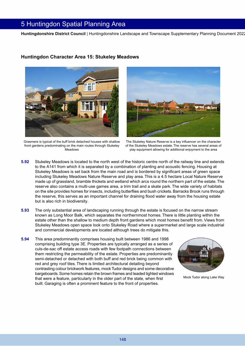
5 Huntingdon Spatial Planning Area Huntingdonshire District Council | Huntingdonshire Landscape and Townscape Supplementary Planning Document 2022
Huntingdon Character Area 15: Stukeley Meadows
Grasmere is typical of the buff brick detached houses with shallow front gardens predominating on the main routes through Stukeley
Meadows
The Stukeley Nature Reserve is a key influencer on the character of the Stukeley Meadows estate. The reserve has several areas of
play equipment allowing for additional enjoyment to the area
5.92 Stukeley Meadows is located to the north west of the historic centre north of the railway line and extends to the A141 from which it is separated by a combination of planting and acoustic fencing. Housing at Stukeley Meadows is set back from the main road and is bordered by significant areas of green space including Stukeley Meadows Nature Reserve and play area. This is a 4.5 hectare Local Nature Reserve made up of grassland, bramble thickets and wetland which arcs round the northern part of the estate.The reserve also contains a multi-use games area, a trim trail and a skate park. The wide variety of habitats on the site provides homes for insects, including butterflies and bush crickets. Barracks Brook runs through the reserve, this serves as an important channel for draining flood water away from the housing estate but is also rich in biodiversity.
5.93 The only substantial area of landscaping running through the estate is focused on the narrow stream known as Long Moor Balk, which separates the northernmost homes. There is little planting within the estate other than the shallow to medium depth front gardens which most homes benefit from. Views from Stukeley Meadows open space look onto Stukeley Road where a supermarket and large scale industrial and commercial developments are located although trees do mitigate this.
5.94 This area predominantly comprises housing built between 1986 and 1998 comprising building type 3E. Properties are typically arranged as a series of culs-de-sac off estate access roads with few footpath connections between them restricting the permeability of the estate. Properties are predominantly semi-detached or detached with both buff and red brick being common with red and grey roof tiles. There is limited architectural detailing beyond contrasting colour brickwork features, mock Tudor designs and some decorative bargeboards. Some homes retain the brown frames and leaded lighted windows that were a feature, particularly in the older part of the state, when first built. Garaging is often a prominent feature to the front of properties.
Mock Tudor along Lake Way
148

Huntingdon Spatial Planning Area 5 Huntingdonshire District Council | Huntingdonshire Landscape and Townscape Supplementary Planning Document 2022
5.95 On the southern entry to the estate, Percy Green Place is a modern addition with a higher density and flatted development form distinguishing it from the original estate (building type 3F).This is located on the route towards the town centre and near the railway line.Within the estate, there are limited community facilities comprising a primary school and mini supermarket. Stukeley Meadows is closely located to homeware stores within Stukeley Meadows Retail Park and Business Centre.
5.96 There are few opportunities for further development within Stukeley Meadows. Any future development should seek to reinforce the dominant building types and patterns as a means of consolidating, rather than fragmenting its existing character.
Percy Green flats
Development proposals should:
Ensure extensions and alterations to existing properties are of an appropriate scale and design to the surrounding area. Control the use of materials and colours in any building extensions to reflect existing properties which are predominantly red brick with some buff and grey brick, brown concrete tiles and red pantiles and Mock Tudor detailing. Maintain and enhance physical and visual connections to key landmarks to promote legibility and pedestrian accessibility. Reduce the visual dominance of cars by promoting enhanced boundary landscaping and planting. Reflect the existing built forms and relationships with the street in any new development. Support initiatives for the creation of additional services and community facilities within the residential area possibly through conversion or redevelopment. Promote opportunities for the enhancement of the Stukeley Meadows green space to improve screening to Stukeley Road and provide increased opportunities for wildlife and nature conservation. Maintain Barracks Brook as a key channel to divert flood water and where proposals are located in an area at a higher risk of flooding ensure they adequately respond to this risk in their design. Protect and enhance grass verges and landscape planting areas and provide additional street trees where space and service restrictions permit. Where possible incorporate renewable energy generation.
149

5 Huntingdon Spatial Planning Area Huntingdonshire District Council | Huntingdonshire Landscape and Townscape Supplementary Planning Document 2022
Huntingdon Character Area 16: Stukeley Road
Stukeley Meadows Retail Park hosts several large units and Terraces located along Stukeley Road substantial car parking
5.97 The character of the area is influenced by Stukeley Road and the relationship that the buildings located along or have direct access from it. As such the area is mixed use with a retail park, Victorian/Edwardian terraces, 20th century infill and in depth development and a supermarket. It has a close relationship with the Stukeley Meadows housing estate to the south (Character Area 15) and the adjoining Stukeley Meadows Business and Industrial Estate located to the north (Character Area 17) with some of the buildings that fall within the established employment area being included in this character area due to their relationship with Stukeley Road and their point of access deriving from Stukeley Road.
5.98 On the northern end of the character area is a garage and car showroom which is constructed from grey cladding with large windows with a large number of parked cars along the roadside. Here the showroom and entrance to the industrial area from Stukeley Road faces onto Stukeley Meadows residential estate but is separated by the road and screened by tree planting from the play area and nature area. These have a strong relationship with the road and provide an active frontage.
5.99 Further south on Stukeley Road is a small retail park. The retail units are of building type 5D and access is via a roundabout on Stukeley Road where the land level drops down. Several units are arranged on the edge of the park with central areas of car parking. Some units blend industrial production with trade and retail counters.The colour palette is predominantly grey with large windows as well as flashes of bold colours from company logos.
5.100 Further south still is a series of buildings representing the oldest elements of this character area. These are Victorian/Edwardian terraces opposite the Stukeley Meadows Business and Industrial Estate. These demonstrate characteristics of building type 2A with their narrow form, symmetrical window and door placements with brick detailing above and limited set back from the road. Over time there has been modern infill development along Stukeley Road and the addition of Goodliff Close and Thomas King Drive behind it. There have been further modern additions including 3 storey flats at Fern Court and Meadow Court.These add diversity to this busy part of the character area demonstrating characteristics of building types 3D, 3E and 3F.
5.101 Opposite these residential uses are a series of businesses that fall within the Stukeley Road Established Employment Area with direct access from Stukeley Road. These reflect building type 5B and 5C with businesses varying from a car service workshop, industrial workshops, warehouses, bakery and offices
Meadow Court
150

Huntingdon Spatial Planning Area 5 Huntingdonshire District Council | Huntingdonshire Landscape and Townscape Supplementary Planning Document 2022
including Stanton House occupied by Cambridgeshire County Council. A mixture of single storey low pitch grey metal cladding to industrial buildings and buff and red brick buildings for offices. The brickwork for offices are arranged in a decorative style adding architectural points of interest particularly on the road frontage.
5.102 A recent addition on the very eastern edge of the character area on the western side of the railway line is the Lidl supermarket (building type 5D). The supermarket is accompanied with approximately 78 car parking spaces and cycle storage. It is of a modern design with a monopitch roof, a grey base topped with silver cladding panels and full height glazing along the prominent Stukeley Road elevation. Its distinctive roofline is sympathetic to those in Fern Court with its lowest point toward the public footpath between the two buildings.
5.103 This is a sensitive area with the impact on the transport network and traffic flow a key consideration. Major development and redevelopment has occurred leaving only opportunities for extensions or alterations to existing properties.
Lidl on Stukeley Road
Development proposals should:
Support and retain the current uses in the character area through renovation, refurbishment or extensions to buildings. Ensure that development responds positively to the specific opportunities available to reinforce the retail and employment uses in the area. Ensure that adequate car parking is provided and maximise opportunities for covered cycle storage spaces. Consider and mitigate any potential harmful increase in vehicular movements from Stukeley Road and on the wider local transport and highway network. Reflect appropriate architectural detailing, materials and colour palette in the design of new buildings and provide where possible active frontages. Support initiatives for the creation of additional services and community facilities possibly through conversion or redevelopment. Support proposals for renewable energy and active modes of transport. Provide appropriate non-illuminated signage to protect neighbouring resident amenity and highway safety. Maintain and enhance where possible boundary treatments such as hedges to reinforce the separation between uses and the road network. Enhance connectivity to the Stukeley Meadows Local Nature Reserve and to the nearby housing estate where possible to improve screening to Stukeley Road and provide increased opportunities for wildlife and nature conservation.
151

5 Huntingdon Spatial Planning Area Huntingdonshire District Council | Huntingdonshire Landscape and Townscape Supplementary Planning Document 2022
Huntingdon Character Area 17: Stukeley Meadows Business and Industrial Estate
One unit from the Hilton Foods complex located along Latham Road Alms Close - typical blending of brickwork and steel cladding in the north of the character area. In this location larger units and
more spacious layouts with greater parking and fencing predominate
5.104 Stukeley Meadows Business and Industrial Estate is a narrow character area located between the East Coast mainline railway on its eastern edge and the A141 (Spittals Way) on its western edge.The industrial and business elements of the character area are identified as an established employment area within the Huntingdonshire Local Plan to 2036.The northern part of the character area inclines significantly along Latham Road.
5.105 Business and industrial units are located further into the character area away from residential areas. Units used for business and industrial uses include those on Blackstone Road and Latham Road and are typically small, medium or large buildings constructed from a mixture of metal cladding and buff brick with flat or low pitched roofs representing building type 5B. In the northern part of the estate, Hilton Foods occupy several very large industrial units. Typically smaller and medium sized units are found to the south of the area with a more condensed feel and less parking within plots resulting in on street parking dominating the street scene. Larger units are found throughout the area but are concentrated in greatest quantities along Latham Road. Units along here are typically set back from the road separated by fencing, car parking or greenery with some tree planting. There are clusters of smaller, single storey units such as Halcyon Court supporting smaller businesses and a number of vehicle servicing and repair businesses arranged around a central court yard and car parking area.
5.106 Redevelopment opportunities within the industrial estate are being utilised with two blocks of commercial buildings constructed in 2020 from metal cladding to provide 7 new light industrial/storage for B1, B2 and B8 uses within Alms Close on land off Blackstone Road which had been used as a builders material storage yard and rough grassed area adjacent to existing industrial buildings. Another example are the alterations and extension to 2-12 Latham Road and the addition of a car and lorry park park to the north of the building. The car and lorry park provides a large break in the building line along Latham Road, this assists in reducing the number of vehicles that park along Latham Road improving the immediate street scene.
5.107 Along its eastern edge by the railway line is the Great Stukeley Railway Cutting SSSI which is holds plant communities typical of calcareous clay grassland.This provides a green north eastern edge to the character area and provides screening from the railway line and a green setting which is a welcome contrast to large scale industrial buildings.
Halcyon Court
152

Huntingdon Spatial Planning Area 5 Huntingdonshire District Council | Huntingdonshire Landscape and Townscape Supplementary Planning Document 2022
5.108 The industrial and retail areas are well established. There is some capacity for new units, extensions, change of use to other appropriate land uses or the redevelopment or renovation of older and vacant properties.
Development proposals should:
Reinforce the use of the area as one of Huntingdon's primary employment locations. Reflect the colour palette of surrounding properties whilst endeavouring to enhance the visual qualities of the area by inclusion of greater architectural detailing. Reduce the visual dominance of cars by promoting enhanced boundary landscaping and planting. Incorporate renewable energy options where they are appropriate and electric vehicle charging points. Support proposals where they encourage active modes of transport. Maintain and reinforce the tree and landscape corridors along the railway line and the A141 to provide wildlife corridors. Promote opportunities for the enhancement of areas of planting and the Great Stukeley Railway Cutting SSSI to provide increased opportunities for wildlife and conservation.
153

5 Huntingdon Spatial Planning Area Huntingdonshire District Council | Huntingdonshire Landscape and Townscape Supplementary Planning Document 2022
Huntingdon Character Area 18: Ermine Business Park and Washingley Road
Ermine Centre Avro Court business unit demonstrating the architectural detailing and style found within the business park
5.109 Ermine Business Park extends northwards of the A141 (Spittals Way) accessed from Ermine Street and Spittals Way via a roundabout. It is an established employment area within the Huntingdonshire Local Plan to 2036.The site is slightly irregular in shape with a pond between the southern part of the business park and Spittals Way. The site has a green gap between the boundary of the business park and Spittals Way which has planning permission for business uses so has been included within the character area. The site is located on an incline; the boundaries of the business park are well screened from the road by tree and hedge planting which limit its impacts on the surrounding landscape. Within the business park further tree planting along roads and within car parks serves to break up the appearance of car parking and buildings. Adjoining the site to the west, the Local Plan to 2036 allocates land for a mixed use development under site allocation reference HU1 (Ermine Street).
5.110 The business park has expanded since the 1990s with the southern part of the site developed first and over time development connected it to the large warehouse building in the northern part of the site. The southern part of the site recognises the local ties to the RAF through street names such as Lancaster Way, Hurricane Close and Spitfire Close. The northern part of the site consists of several small units and one very large warehouse building which is screened by dense trees and hedges from the rest of the site. Within the park, units are organised in orthogonal blocks separated by roads and planting. The units are a mixture of buff brick and metal cladding. Some have colourful detailing to walls, roofs and window frames adding vibrancy to the character area, an example being Avro Court.The Ermine Centre adds further diversity in design and colouring with its distinctive white and black design. The Forum is a very distinctive building within the business park with its shallow roof line and large windows. These features fall within building type 5C.
5.111 Washingley Road and Vantage Business Park are contiguous with Ermine Business Park lying directly to the north, accessed by their own junction from the A141. Vantage Park provides high quality modern accommodation with a pale buff and cream colour palette on predominantly two storey buildings. Into Washingley Road itself units are formed of pale grey metal cladding with cars dominating the frontages. A tree belt separates a single large distribution warehouse in the north of the area also providing screening from the A141 aspect.
The Forum
154

Huntingdon Spatial Planning Area 5 Huntingdonshire District Council | Huntingdonshire Landscape and Townscape Supplementary Planning Document 2022
5.112 The business park is well established but there is potential for expansion within the business park and to west. There is capacity for new units, extensions, change of use to other appropriate land uses or the renovation of older and vacant properties.
Development proposals should:
Promote high standards of design and support creativity in architectural detailing. Reinforce the colour palettes of the adjoining buildings. Carefully consider the visual impact on the Central Claylands landscape character area in determining the potential for any expansion of the Ermine Business Park and Washingley Road to the north. Retain tree and hedge planting to screen the business uses from Ermine Street and from longer distance views from Green End. Support provision of renewable energy where appropriate. Support provision of facilities which encourage active modes of transport.
155

5 Huntingdon Spatial Planning Area Huntingdonshire District Council | Huntingdonshire Landscape and Townscape Supplementary Planning Document 2022
Huntingdon Character Area 19: Hinchingbrooke Estate
The Ornamental Lake within Hinchingbrooke Country Park is an Flamsteed Drive - large detached houses with brick detailing attractive feature in a woodland setting and rich in biodiversity.
5.113 Hinchingbrooke is a large area to the west of Huntingdon railway station and south of the A14. Hinchingbrooke Estate contains two sub-areas of residential development. Most of the area is united by its access via Hinchingbrooke Park Road which is on a steady incline, creating an open character which then drops down into the country park on one side and down towards Hinchingbrooke Business Park on the other. A link road to the northern section of the A1307 opened in September 2021. The area has a strong relationship with the surrounding landscape and areas of open space within Hinchingbrooke Country Park.
5.114 The first sub-area is the smaller and consists of properties accessed off Snowdonia Way and Dartmoor Drive.These date from the late 20th century in a cul-de-sac layout typically with buff brick detached houses with bay windows and strong gable features, garages and on plot parking all comprising building type 3E. A small proportion of red brick homes add diversity to the character. Front gardens are typically 2 to 4 metres in depth contributing to the green nature of this area which also has extensive tree planting and areas of green space.This also enables room for on plot parking which reduces the impact of parked cars on the streetscape.
5.115 Further north, is the larger of the two sub areas. This is a more architecturally mixed area where development started in 1999 and was ongoing until 2020. The area benefits from substantial tree and hedge coverage. Christie Drive is a key access route into the estate, other points of access are found from Cromwell Drive and Flamstead Drive. Development along Christie Drive demonstrates a mixture of the cul-de-sac layout and modern townhouse design with some properties being 3 storeys of symmetrical design of red and sand brick representing building type 3F. This aspect of the character area demonstrates the diverse mix of architectural styles, materials and detailing to be found in Hinchingbrooke. Properties along the southern edge face onto the country park and benefit from views into Bobs Wood. Properties along the western edge have been carefully screened through tree planting from the A14. Within this residential area several local shops are integrated as well as a primary school (building types 5D and 7C). The Glades play area forms a central open space containing a variety of play equipment with homes arranged around it in a circular layout. There are several green footpaths increasing the permeability of the area.
Christie Drive
156

Huntingdon Spatial Planning Area 5 Huntingdonshire District Council | Huntingdonshire Landscape and Townscape Supplementary Planning Document 2022
5.116 The site of the former forensic science laboratory along Christie Drive was redeveloped in 2019/20 for residential use as Cromwell Gardens with a combination of family sized housing ranging through to one bedroomed properties. Bloomfield Drive is the principal road which loops through the site; in the middle of this loop are several properties and a central piece of amenity space. This redevelopment is complementary to the existing surrounding uses and architectural styles with landscaped areas. It improves the gateway into the Hinchingbrooke Estate and a continues active frontage on the north side of Christie Drive.
5.117 Adjoining the Hinchingbrooke Estate is Hinchingbrooke Country Park which is a fundamental influencer on the character of this area. The Country Park is not included within the boundary of the character area as it covers an extensive area. Hinchingbrooke Country Park was opened in April 1989. Historically, it formed part of the large estate surrounding Hinchingbrooke House which is now part of Hinchingbrooke School. It consists of several scenic woodland walks, large lakes and bodies of water and open land. These attract a vast range of people and supports many local sports and activity groups as well as being a source of rich habitat and biodiversity.This makes it a valuable community asset.To support the growing need for additional open space and green infrastructure, the Huntingdonshire Local Plan to 2036 has allocated some 27.5ha of land to extend the Country Park.
5.118 The character of the Hinchingbrooke Estate has continued to evolve through residential development. Following recent developments, there are limited opportunities for further major development, however, extensions to properties and small scale infill may be accommodated.
Development proposals should:
Maintain and enhance physical and visual connections to key buildings and landscape views. Encourage screen planting along the boundary of the A1307 to provide a more substantial landscape buffer to areas of residential development. Protect areas of mature trees and develop a strategy for their long term maintenance and replacement where appropriate. Ensure extensions and alterations to existing properties are of an appropriate scale and design to the surrounding area. Reflect the existing materials and colour palette in any building extensions to reflect existing properties using predominantly red and sand brick with some buff and grey brick, brown concrete tiles and red pantiles. Ensure adequate provision of car parking to reduce the impact on the street scene of on-street parking. Protect and reinforce the network of footpaths set in green corridors to aid wildlife corridors and nature conservation, particularly on the edge of the residential estate where they closely relate to the adjoining Country Park. Support initiatives for the creation of additional services and community facilities within the residential area possibly through conversion or redevelopment.
157

5 Huntingdon Spatial Planning Area Huntingdonshire District Council | Huntingdonshire Landscape and Townscape Supplementary Planning Document 2022
Huntingdon Character Area 20: Hinchingbrooke Civic Area
Hinchingbrooke House from the south front, this part of the school Hinchingbrooke Hospital - civic buildings set in open landscaping is predominately used by sixth form students but also holds some
functions and weddings.
5.119 This character area contains a mix of uses including Hinchingbrooke Hospital and associated medical accommodation and police headquarters built following the land being sold to the County Council in 1962. The area also includes a secondary school with a rich history tied to the Hinchingbrooke Estate. The buildings within this character area demonstrate building types including 2E and 7B.
5.120 The extensive grounds of Hinchingbrooke School link directly to Hinchingbrooke Country Park and relate to the wider landscape of the Great Ouse Valley landscape character area. The school includes a series of listed buildings, including the grade I listed Hinchingbrooke House which is visible from Brampton Road above a surrounding grade II* wall. The house originates from the 16th century and is of stone and brick with substantial remodelling in the 1830s and roofs are castellated throughout giving a striking appearance. Also grade I listed is the gatehouse which dates from 1500 and was moved from Ramsey Abbey by the Cromwells. The remaining elements of the school grounds consist of a variety of buildings dating from the late 1960s onwards through to 2020. These are used as classrooms, sports hall, swimming pool, Performing Arts Centre, reception and caretaker facilities.
5.121 Hinchingbrooke Hospital in the northern part of the character area is set within an open landscape with hospital buildings and car parking visible from across much of the Hinchingbrooke Estate. It is set up on the inclining Hinchingbrooke Park Road with residential properties to the south and west and the business park to the north. Buildings are mostly utilitarian in style and comprise one or two storeys but with no cohesive design or colour palette. On the eastern and southern edges hospital staff accommodation is situated which is mostly brick built. Further east lie the Cambridgeshire Constabulary and the Cambridgeshire Fire and Rescue headquarters. Again these are fairly utilitarian buildings ranging from one to three storeys, mostly in pale shades with some blue framed windows,
5.122 There are several tree belts in the character area: on its eastern boundary, the hospital and former police playing fields are shielded from the open landscape of Views Common, with the Brampton Road Water Tower visible, which is on an incline towards Hinchingbrooke. Along the southern boundary of the hospital a substantial tree belt and footpath separate it from the former playing police playing field; a further tree belt exists along Hinchingbrooke Park Road. As of 2021 this part of the character area is undergoing considerable change. The Views Common link road opened in September
Tree belt
158

Huntingdon Spatial Planning Area 5 Huntingdonshire District Council | Huntingdonshire Landscape and Townscape Supplementary Planning Document 2022
2021 connecting Hinchingbrooke Park Road to the A1307. Part of the former playing fields is allocated for development in the Huntingdonshire Local Plan to 2036 for residential and care uses and Water Tower has planning permission for conversion to offices.
5.123 This character area is undergoing change and expected to undergo further change through major development complimentary to the existing land uses and landscape setting.
Development proposals should:
Ensure that development responds positively to the specific opportunities available to reinforce the civic nature of the area. Support and retain the current uses in the character area through renovation, refurbishment or extensions to buildings. Maintain and enhance physical and visual connections to key buildings and landscape views. Conserve or where appropriate enhance the significance of heritage assets including Hinchingbrooke House and its associated listed buildings and landscape and any contribution made to significance by their settings. Reflect appropriate architectural detailing, materials and colour palette in the design of new buildings. Retain the existing tree belts between the hospital and former police field, Hinchingbrooke Park Road and between Views Common and former playing field. Protect the existing wide grass verges along Hinchingbrooke Park Road that provide the spacious setting to development served from this road. Support provision of facilities which encourage active modes of transport.
159

5 Huntingdon Spatial Planning Area Huntingdonshire District Council | Huntingdonshire Landscape and Townscape Supplementary Planning Document 2022
Huntingdon Character Area 21: Hinchingbrooke Business Park
The Marriott Hotel Business unit within Ramsay Court demonstrates colour detailing to add visual interest and cycle parking spaces with some planting
5.124 To the north of the Hinchingbrooke residential and civic character areas is Hinchingbrooke Business Park, it is the smallest of the four established employment areas within Huntingdon identified in the Huntingdonshire Local Plan to 2036. The business park has developed since the end of the 1990s, first developed was the buff and red brick Marriott Hotel and a warehouse. The park has continued to grow since and is now a mixed use area with many commercial businesses and industrial workshops based there.
5.125 Units vary in size and are modern in design with large windows, buff brick, low pitch roofs and a variety of colours providing detailing to window surrounds and brickwork which provides diversity and contrast in the colour palette for the area. Several units have solar panels and covered areas dedicated for cycle parking. These units exemplify building type 5C.
5.126 The park is bounded to the north west by A141 which links to the A1 and new A14 at Brampton Hut and to the north east by the A1307 which leads to the Views Common link road. Large scale buildings on the business park are highly visible from the surrounding roads. There is vehicular and pedestrian access to the business park from the residential estate, however extensive tree and hedge planting screens the commercial uses of the business park from properties along Parkway, Dyson Close and Halley Close. There is extensive tree planting along the internal road layout of the estate creating a green and attractive feel to the business park, between trees signage is interspersed throughout. Ramsay Court, a mixture of semi detached and detached units have created an enclosed space with car parking in the centre. The openness of the car park is broken up by by tree planting and the use of different coloured materials to define spaces.
5.127 The business park is well established, there is some capacity for new units, extensions, change of use to other appropriate land uses or the renovation of older and vacant properties.
Unit within Falcon Court
160

Huntingdon Spatial Planning Area 5 Huntingdonshire District Council | Huntingdonshire Landscape and Townscape Supplementary Planning Document 2022
Development proposals should:
Promote high standards of design and support creativity in architectural detailing. Reflect the materials and colour palette of immediately surrounding buildings. Carefully consider their visual impact on the Central Claylands landscape character area. Maintain and reinforce the planting and landscaping around car parking areas to minimise their visual dominance. Retain and maintain existing tree and hedge planting, particularly along the A14 and to Hinchingbrooke Estate. Support proposals for renewable energy where they are appropriate and electric vehicle charging points. Support active modes of transport like cycling.
161