Chapter 4—Environmental Consequences
264
Giant Sequoia National Monument, Final Environmental Impact Statement Volume 1 377 Chapter 4—Environmental Consequences
-
Upload
khangminh22 -
Category
Documents
-
view
2 -
download
0
Transcript of Chapter 4—Environmental Consequences

Giant Sequoia National Monument, Final Environmental Impact Statement Volume 1377
Chapter 4—Environmental Consequences

Chapter 4—Environmental Consequences
Volume 1 Giant Sequoia National Monument, Final Environmental Impact Statement378

Chapter 4—Environmental Consequences
Giant Sequoia National Monument, Final Environmental Impact Statement Volume 1379
Chapter 4 includes the environmental effects analysis. It is organized by resource area, in the same manner as Chapter 3. Effects are displayed for separate resource areas in terms of the ongoing, indirect, and cumulative effects associated with the six alternatives considered in detail. Effects can be neutral, beneficial, or adverse. This chapter also discusses the unavoidable adverse effects, the relationship between short-term uses and long-term productivity, and any irreversible and irretrievable commitments of resources. Environmental consequences form the scientific and analytical basis for comparison of the alternatives.
Types of EffectsThe Giant Sequoia National Monument Plan is a programmatic plan that defines and describes the management direction for the Monument for the next 10 to 15 years. Programmatic plans are consistent with national direction and are, by nature, strategic and make no site-specific project decisions. There are effects associated with those decisions and those effects are described and disclosed in this FEIS consistent with the requirements of NEPA. Specifically, a description of the environmental effects associated with this analysis of all of the potential effects (ongoing, indirect, and cumulative effects) is included in this chapter.
Reasonably Foreseeable ActionsA reasonably foreseeable action is defined as any project or activity for which the effects overlap in time and location with the effects of the project under consideration (i.e., this EIS). There are a number of reasonably foreseeable actions that will, or are likely to, occur which may affect resources in the Monument. A list of anticipated reasonably foreseeable actions was developed for resource specialists to use during their effects analyses. This list is based on these key assumptions:
● Each resource area may be affected in different ways and intensities by these potential activities.
● The timeframe is within the next 3-10 years, depending on the resource area.
● Activities would only be conducted after appropriate project-level NEPA analysis, if required.
● Reasonably foreseeable actions do not follow the management direction proposed in the action alternatives.
The following types of actions should be considered (depending on resource area):
● Annual maintenance activities in the Monument, such as roads, trails, special use permits, and administrative and recreation sites. These are the activities necessary to maintain basic compliance with regulation and annual operating plans.
● Fuels management in the Monument, such as prescribed fire and managed wildfire, pile burning, maintenance of WUIs (including mechanical treatments), and additional fuels reduction activities as a result of other vegetation or site maintenance work (e.g., hazard tree abatement in campgrounds).
● Construction or reconstruction of administrative or developed recreation sites in the Monument, such as proposals for site maintenance or deferred maintenance that are listed in existing site management strategies.
● Grazing allotment management inside and outside of the Monument, such as cattle grazing, maintenance activities (including fence repair or construction), and water source maintenance.
● Road decommissioning inside and outside of the Monument, such as decommissioning roads or portions of roads that are part of the designated road system for the Sequoia National Forest.
● Tree removal on state, federal, tribal, or private lands adjacent to or outside of the Monument, including portions of enjoined timber sales in the Sequoia National Forest outside of the Monument, and tree removal for wood production on state, federal, tribal, or private lands.
● Reforestation and plantation maintenance activities adjacent to or outside of the Monument, such as site preparation, planting, releasing planted trees from competing vegetation, and gopher baiting.

Chapter 4—Environmental Consequences
Volume 1 Giant Sequoia National Monument, Final Environmental Impact Statement380
● Annual maintenance activities on state, federal, or tribal lands adjacent to the Monument, such as those for roads, trails, special use permits, administrative and recreation sites. These are the activities necessary to maintain basic compliance with regulations and annual operating plans.
● Fuels management on state, federal, or tribal lands adjacent to the Monument, such as prescribed burns and managed wildfires, pile burning, maintenance of WUIs, and fuels reduction activities as a result of other vegetation or site maintenance work (e.g., hazard tree abatement in campgrounds).
● Construction and maintenance activities on private lands adjacent to or surrounded by the Monument, such as home construction, fuels reduction, and ranch or other private business operations.
● Increasing public pressure (proportional to increasing general population) for recreation on and commodities from state, federal, and local agency lands (including the Monument and other ownerships in the vicinity), such as clean water, places to recreate, and special products.
Cumulative Effects Analysis CriteriaIn order to understand the contribution of past actions to the effects of the proposed action and alternatives, this analysis relies on current environmental conditions that are a result, in part, of past actions. Existing conditions reflect the combined effect of all prior human actions and natural events that have affected the environment and might contribute to cumulative effects.
The cumulative effects analyses in this chapter do not attempt to quantify the effects of past human actions by adding up all prior actions on an action-by-action basis. Several reasons exist for not taking this approach. First, a catalog and analysis of all past actions would be impractical to compile and unduly costly to obtain. Current conditions have been affected by innumerable actions over the last century (and beyond), and trying to isolate the individual actions that continue to have residual effects would be nearly impossible. Second, providing the details of
past actions on an individual basis would not be useful to predict the cumulative effects of the proposed action or alternatives. In fact, focusing on individual actions would be less accurate than looking at existing conditions, because information is limited on the environmental effects of individual past actions, and one cannot reasonably identify each and every action over the last century that has contributed to current conditions. Also, focusing on the effects of past human actions risks ignoring the important residual effects of past natural events, which may contribute to cumulative effects just as much as human actions. By looking at current conditions, the residual effects of past human actions and natural events, regardless of which particular action or event contributed to those effects, are captured.
Finally, the Council on Environmental Quality issued an interpretive memorandum on June 24, 2005 regarding analysis of past actions, which states, “agencies can conduct an adequate cumulative effects analysis by focusing on the current aggregate effects of past actions without delving into the historical details of individual past actions.” The cumulative effects analysis in this EIS is consistent with the National Environmental Policy Act (NEPA) Regulations (36 CFR 220.4 (f)) (July 24, 2008), which state, in part:
CEQ regulations do not require the consideration of the individual effects of all past actions to determine the present effects of past actions. Once the agency has identified those present effects of past actions that warrant consideration, the agency assesses the extent that the effects of the proposal for agency action or its alternatives will add to, modify, or mitigate those effects. The final analysis documents an agency assessment of the cumulative effects of the actions considered (including past, present, and reasonable foreseeable future actions) on the affected environment. With respect to past actions, during the scoping process and subsequent preparation of the analysis, the agency must determine what information regarding past actions is useful and relevant to the required analysis of cumulative effects. Cataloging past actions and specific information about the direct and indirect effects of their design and implementation could in some contexts be useful to predict the cumulative effects of the proposal. The CEQ regulations,

Chapter 4—Environmental Consequences
Giant Sequoia National Monument, Final Environmental Impact Statement Volume 1381
however, do not require agencies to catalogue or exhaustively list and analyze all individual past actions. Simply because information about past actions may be available or obtained with reasonable effort does not mean that it is relevant and necessary to inform decisionmaking (40 CFR 1508.7).
For these reasons, the analysis of past actions in this FEIS is based on current environmental conditions.
The Forest Service recognizes that significant scientific advances in evaluating landscape conditions have been made in the past decade and will employ improved cumulative effects analysis techniques as they become available. For example, Forest Inventory and Analysis plots may provide reference points of forest conditions over time, and landscape trajectory analyses can be used to evaluate trends without requiring detailed analysis of past actions. Where appropriate and based on available data, cumulative effects analysis for site-specific projects will consider whether proposals exacerbate or moderate trends.
Assumptions and MethodologyThe following common assumptions and methodology were applied in the effects analysis for each resource area.
Scientific Advisory Board (SAB) AdvisoriesAdvisory I. Priority of Objects
The Forest Service should use ecosystems science as the basis for its management plan for the Giant Sequoia National Monument. Its management plan should be characterized by: interrelatedness of the parts to the whole; fostering the natural diversity of the ecosystem; allowing for public use, education, and enjoyment of the monument to the extent consistent with protection and preservation of the Giant Sequoia species (The Scientific Advisory Board 2003, Advisory I).
In order to respond to new information, knowledge, and technologies, it is important to identify baseline conditions for landscapes. Ecosystem analysis “establishes a consistent, landscape-wide approach
and context for maintaining or restoring ecological conditions that provide the desired levels of resources, such as clean water, clean air, plant and animal community diversity, and species viability, consistent with regulatory requirements and ongoing policies” (2001 SNFPA, Appendix T, p. T-1).
Ecosystem analysis provides opportunities to perform assessments that are tailored to local conditions, capabilities, and restoration needs. The information assembled during landscape analysis provides the basis for the identification of opportunities for site-specific projects that will move the landscape towards desired conditions. Ecosystem analysis is a prerequisite for determining the current condition of a resource and the potential effects each of the alternatives would have on that resource. For example, this analysis forms the basis for evaluating cumulative watershed effects; defining watershed restoration needs and objectives; implementing restoration strategies; and monitoring the effectiveness of watershed protection measures.
The monitoring plan developed for the Monument, as described in Part 3, Design Criteria, of the Monument Plan, contains implementation, effectiveness, validation, and status and trend monitoring for Ecosystem Analysis.
Advisory II. ErasFor four reasons, ca. A.D. 900-1875 provides a useful reference period for change:
● Indians used fire to manage the forest;
● Logging had not yet become prevalent;
● Forest composition (but not necessarily structure) was similar to that of the present; and
● Climate, though variable, included periods similar to the recent climate.
While there are many important lessons to learn from the past, we believe we cannot rely on past forest conditions to provide us with blueprints for current and future management (Stephens et al. 2010). In particular, the nature and scale of past variability in climate and forest conditions, coupled with our imprecise ability to fully reconstruct those conditions, introduce a number of conceptual and practical problems (Millar and Woolfenden 1999a). Detailed reconstructions of historical forest conditions, often
Chapter 4—Environmental Consequences
Volume 1 Giant Sequoia National Monument, Final Environmental Impact Statement382
dendro-ecologically based, are very useful, but represent a relatively narrow window of time and tend to coincide with tree recruitment in the generally cooler period referred to as the little ice age. As such, manipulation of current forests to resemble past conditions may not produce the desired result when considering future climates (Stephens et al. 2010).
Advisory XV. Building ConsensusU.S. Forest Service managers for the Giant Sequoia National Monument should consider using collaborative management methods, and/or similar techniques, to reach a consensus on the initial management plan for the Monument, and in implementing the plan (The Scientific Advisory Board 2003, Advisory XV).
In order to fully involve people in the process of developing a management plan for the Monument, the Sequoia National Forest offered opportunities for interested people to engage in a collaborative process intended to help facilitate its development and to analyze an appropriate range of alternatives. Traditional and non-traditional approaches have been used that encourage iterative discussion, ensure that the planning process is transparent, and make certain that ideas presented for consideration are legal, fair, and practical. The collaborative process places an emphasis on understanding the complexity of the issues and the strategies that may be employed to resolve them, rather than on total agreement on the resolution of individual issues.
Advisory XXI. Plain LanguageIn the beginning, succinctly and lucidly state the theme of each Alternative. Forthrightly state the actions, standards and guidelines to execute each Alternative.
Clearly state the actions in the Framework, Mediated Settlement, etc. that are the bases and benchmarks of Alternatives “No Action” and “Proposed Action.” Describe them so clearly that the reader can grasp them from the Draft Environmental Impact Statement alone. In this way the Alternative will survive any shift in benchmarks (The Scientific Advisory Board 2003, Advisory XXI).
The description of Alternative A lays out the multiple sources and the overlay of direction that are the bases of the no action alternative. Chapter 2 describes the theme of each alternative and the management direction included in each alternative.
Advisory XV. Building ConsensusU.S. Forest Service managers for the Giant Sequoia National Monument should consider using collaborative management methods, and/or similar techniques, to reach a consensus on the initial management plan for the Monument, and in implementing the plan (The Scientific Advisory Board 2003, Advisory XV).
In order to fully involve people in the process of developing a management plan for the Monument, the Sequoia National Forest offered opportunities for interested people to engage in a collaborative process intended to help facilitate its development and to analyze an appropriate range of alternatives. Traditional and non-traditional approaches have been used that encourage iterative discussion, ensure that the planning process is transparent, and make certain that ideas presented for consideration are legal, fair, and practical. The collaborative process places an emphasis on understanding the complexity of the issues and the strategies that may be employed to resolve them, rather than on total agreement on the resolution of individual issues.
Multi-Criteria Decision Support (MCDS)The effects analysis is also reflected in the MCDS tool stemming from the public involvement effort.(53) The public involvement during scoping and subsequent public meetings resulted in a set of criteria and subcriteria displayed in a “decision framework.” MCDS, a decision support tool, displays items that are important to the interested public. It helps the interested public better understand: (1) what the Forest Service is required to consider and evaluate, and (2) where there is leeway to propose alternative management direction that complies with regulation, law, and policy. See Appendix J to this FEIS for an overview of the MCDS process.
53. A Values and Interest-Based Explorer (VIBE) model was available to the public during the scoping period.

Chapter 4—Environmental Consequences
Giant Sequoia National Monument, Final Environmental Impact Statement Volume 1383
54. In some instances, forest-wide data for the Sequoia National Forest were used when Monument-specific data were unavailable.
SPECTRUM ModelThe SPECTRUM model was used in the Monument planning process to estimate the potential outcomes of each alternative. Results from the computer modeling are only approximations of what to expect when any given alternative is implemented. The objective of modeling is to aid planners in estimating the likely future consequences of alternative sets of management actions.
The computer modeling used for this FEIS is based upon the modeling protocol used by the 2001 Sierra Nevada Forest Plan Amendment (2001 SNFPA) Final Environmental Impact Statement (FEIS). Full documentation of the approach is found in Appendix B of the SNFPA 2001 FEIS and is incorporated by reference. This appendix also includes descriptions and graphical representations of prescriptions used to model treatments. It provides a description of prescriptions that were developed for this FEIS as well as those which were used in the SNFPA 2001 FEIS. Definitions of the general treatments are found in the glossary of this FEIS. Where appropriate, data that are specific to the Monument were used during modeling.(54) These include, but are not limited to, the desired conditions, the standards and guidelines, and the estimated treatment amounts per decade for each alternative.
The modeling outputs provide an estimate of landscape-level predictions of effects and also predict a general amount of acres that might be treated by decade with general activities (prescribed fire, thinning, etc). Certain assumptions are needed in order for the model to produce its outputs. These outputs are used by the interdisciplinary team to help analyze the effects by alternative and to distinguish the differences between the alternatives. See Appendix B of this FEIS for a more detailed description of the SPECTRUM Model.
Legal and Regulatory ComplianceThe National Environmental Policy Act of 1969 (NEPA) at 40 CFR 1502.25(a) directs “to the
fullest extent possible, agencies shall prepare draft environmental impact statements concurrently with and integrated with … other environmental review laws and executive orders.” The Monument will be guided by applicable laws, regulations, policies, and guidelines. This FEIS supplements, but does not replace, the direction from those sources.
The Monument is guided by direction from numerous sources. The governing source of legal direction is the proclamation (Clinton 2000); this section discusses other laws and executive orders. Laws passed by Congress such as the NEPA, the National Forest Management Act of 1976 (NFMA), the Multiple Use Sustained Yield Act of 1964 (MUSYA), and the Endangered Species Act of 1973 (ESA), provide direction for certain aspects of management. At the national level, the Resources Planning Act of 1974 (RPA) program gives broad direction and the Administrative Procedure Act of 1966 (APA) (P.L. 79-404) governs the way in which administrative agencies of the federal government may propose and establish regulations.
Applicable laws, regulations, policies, and executive orders, as well as Forest Service manual and handbook guidance, memoranda of understanding, conservation strategies, and programmatic agreements, are listed here by resource. The relevant documents are available on the Forest Service website (http://www.fs.fed.us/publications/) and from Forest Service offices. The list included here is not all inclusive.
Scientific Study and Adaptive Management
● Forest Service Handbook (FSH) 1909.12-2006-5, Chapter 40—Science and Sustainability: direction regarding scientific review guidelines and procedures
Vegetation, including Giant Sequoia Groves
● National Forest Management Act of 1976
● National Forest Resource Management: Forest Service Manual (FSM) 2000—Chapter 2020—Ecological Restoration and Resilience

Chapter 4—Environmental Consequences
Volume 1 Giant Sequoia National Monument, Final Environmental Impact Statement384
● Silvicultural Practices Handbook (FSH 2409.17), Silvicultural Examination and Prescription Handbook (FSH 2409.26d)
● Timber Management: FSM 2400—Silvicultural Practices Chapter
Fire and Fuels ● Guidance for Implementation of Federal Wildand
Fire Management Policy, February 2009
● FSM 5100
Air QualityUse the following guidance and direction for smoke management and air quality protection:
● Federal Clean Air Act. The Federal Clean Air Act (CAA) is the federal law passed in 1963, and last amended in 1990, (42 U.S.C. §7401 et seq.) which is the basis for national control of air pollution. Some of the principal components, regulations, and policies related to the Clean Air Act that may directly or indirectly affect planning in the Monument are discussed below.
● National Ambient Air Quality Standards (NAAQS). These are standards for pollutants considered harmful to public health and the environment. The EPA has set the NAAQS for six principal pollutants, which are called “criteria pollutants” (see Table III-2: National ambient air quality standards). Smoke contributes to PM10 and to a lesser degree NO2, CO, and O3.
● Class I areas. These include national parks, wildernesses, and some U.S. Fish and Wildlife refuges that were in existence at the passage of the 1977 Clean Air Act amendments. These areas are provided special protection from new and modified major stationary sources. Federal land managers are mandated an affirmative responsibility to protect values that might be affected by air pollution, including visibility and other air quality-related values.
● Regional Haze Rule. These regulations require states to review how pollution emissions within the state affect visibility at class I areas across a broad region. These rules also require states to make “reasonable progress” in reducing any
effect this pollution has on visibility conditions in class I areas and to prevent future impairment of visibility. The states are required by the rule to analyze a pathway that takes the class I areas from current conditions to “natural conditions” in 60 years. “Natural conditions” is a term used in the Clean Air Act that means that no human-caused pollution can impair visibility. This program, while aimed at class I areas, will improve regional visibility and air quality throughout the country.
● Conformity Rule. This rule implements the Clean Air Act conformity provision, which mandates that the federal government not engage, support, or provide financial assistance for licensing or permitting, or approve, any activity not conforming to an approved state implementation plan.
● EPA Interim Policy on Wildland and Prescribed Fire, announced in 1998. This EPA interim policy integrates two public policy goals: (1) to allow fire to function, as nearly as possible, in its natural role in maintaining healthy wildland ecosystems, and (2) to protect public health and welfare by mitigating the effects of air pollutants on air quality and visibility.
● California Clean Air Act (H&S §§ 39660 et seq.). California adopted the California Clean Air Act (CCAA) in 1988. The Act provides the basis for air quality planning and regulation in California independent of federal regulations, and establishes ambient air quality standards for the same criteria pollutants as the federal clean air legislation.
San Joaquin Valley Air Pollution Control District. The district is comprised of eight counties that share a common air district: Fresno, Kern, Kings, Madera, Merced, San Joaquin, Stanislaus, and Tulare Counties. Local air pollution control districts in California develop plans and implement control measures in their areas of jurisdiction. These collectively make up California’s state implementation plan. These controls primarily affect stationary sources but do include sources of dust and smoke. The following district regulations may directly or indirectly affect planning in the Monument:
● Public Nuisance (Rule 4102). Prohibits air discharge of material that causes nuisance or annoyance to any considerable number of people.

Chapter 4—Environmental Consequences
Giant Sequoia National Monument, Final Environmental Impact Statement Volume 1385
● Prescribed Burning and Hazard Reduction (Rule 4106). This rule was adopted June 21, 2001, in response to California’s Title 17, and is designed to permit, regulate, and coordinate the use of prescribed burning and hazard reduction burning while minimizing smoke effects on the public.
● Fugitive Dust (Regulation 8). The existing Regulation 8 rules were developed to implement control strategies for major sources of dust. These include construction, demolition, excavation, extraction, handling/storage, landfills, paved/unpaved roads, and open areas. EPA has recently cited deficiencies in these existing rules and the district is evaluating a series of new rules aimed at further reductions in particulates. The San Joaquin Valley Air Pollution Control District (Valley Air District) is responsible for implementing and regulating air quality programs for Fresno County, Tulare County, and a portion of Kern County in the Sequoia National Forest. The Valley Air District regulations can be found at: http://www.valleyair.org/index.htm. The Valley Air District has set rules to limit fugitive dust emissions. However, activities conducted at an elevation of 3,000 feet or higher above sea level are exempt. Kern County Air Pollution Control District, which serves eastern Kern County, has set rules for fugitive dust but currently excludes national forests and recreation areas.
● Memorandum of understanding between the California Air Resources Board (CARB) and the Forest Service, signed on July 13, 1999. CARB has set more stringent standards, oversees state and local actions, and implements programs for toxic air pollutants, heavy-duty trucks, locomotives, ships, aircraft, off-road diesel equipment, and some types of industrial equipment.
● The Smoke Management Guidelines for Agricultural and Prescribed Burning (Title 17) are the regulatory basis for California’s smoke management program. Amendments to California’s Title 17 may directly or indirectly affect planning in the Monument. The smoke management guidelines became effective on March 14, 2001. Local air pollution control districts use these guidelines in local rule development. These guidelines are currently being revised by the CARB.
● General Conformity State Implementation Plan Handbook (1995)
Climate Change ● Environmental Protection Agency (EPA) “State of
Knowledge” paper (2007) development
● Climate Change Consideration in Project Level NEPA Analysis, January 13, 2009
Wildlife and Plant HabitatWildlife
● Endangered Species Act (ESA). The Endangered Species Act of 1973 (16 USC 1531 et seq.) requires that any action authorized by a federal agency not be likely to jeopardize the continued existence of a threatened or endangered (TE) species or result in the destruction or adverse modification of habitat of such species that is determined to be critical. Section 7 of the ESA, as amended, requires the responsible federal agency to consult the U.S. Fish and Wildlife Service (USFWS) and the National Marine Fisheries Service concerning TE species under their jurisdiction. It is Forest Service policy to analyze effects to TE species to ensure management activities are not likely to jeopardize the continued existence of a TE species or result in the destruction or adverse modification of habitat of such species that is determined to be critical. This assessment is documented in a biological assessment (BA).
● FSM and FSH, Chapter 2670. Forest Service Sensitive (FSS) species are species identified by the regional forester for which population viability is a concern. The Forest Service develops and implements management practices to ensure that rare plants and animals do not become threatened or endangered and to ensure their continued viability on national forests. It is Forest Service policy to analyze effects to FSS species to ensure management activities do not create a significant trend toward federal listing or loss of viability. This assessment is documented in a biological evaluation (BE).
● The California Condor Recovery Plan (USDI 1996) provides guidelines for management of nest and roost sites. The 1988 Forest Plan designated
Chapter 4—Environmental Consequences
Volume 1 Giant Sequoia National Monument, Final Environmental Impact Statement386
the Starvation Grove nest area and Lion Ridge roost area, which are within the Monument (USDA Forest Service 1988a pp. 3-29, 4-27 to 4-28).
● Bald and Golden Eagle Protection Act of 1940
● Migratory Bird Treaty Act of 1918
● Valley Elderberry Longhorn Beetle (VELB) Recovery Plan provides habitat management objectives from the U.S. Fish and Wildlife Service (USDI 1993b)
Threatened, Endangered, and Sensitive Species
● Endangered Species Act (ESA). The Endangered Species Act of 1973 (16 USC 1531 et seq.) requires that any action authorized by a federal agency not be likely to jeopardize the continued existence of a threatened or endangered species or result in the destruction or adverse modification of habitat of such species that is determined to be critical. Section 7 of the ESA, as amended, requires the responsible federal agency to consult the USFWS and the National Marine Fisheries Service concerning threatened or endangered species under their jurisdiction.
● Executive Order 13112, Invasive Species 64 FR 6183 (February 8, 1999), to prevent and control the introduction and spread of invasive species
● FSM and FSH, Chapter 2670. Forest Service Sensitive (FSS) species are species identified by the regional forester for which population viability is a concern. The Forest Service develops and implements management practices to ensure that plants and animals do not become threatened or endangered and to ensure their continued viability on national forests. It is Forest Service policy to analyze effects to sensitive species to ensure management activities do not create a significant trend toward federal listing or loss of viability.
Botanical Resources ● FSM Chapter 2070, Regional Native Plant
Policies.
Invasive Nonnative Species ● FSM, Chapter 2081.03 requires that a weed
risk assessment be conducted when any ground
disturbing activity is proposed. Determines the risk of introducing or spreading noxious weeds associated with the proposed action. Projects having moderate to high risk of introducing or spreading noxious weeds must identify noxious weed control measures that must be undertaken during project implementation.
● Executive Order 13112 of Feb. 3, 1999 directs federal agencies to prevent the introduction of invasive species; detect and respond rapidly to and control such species; not authorize, fund, or carry out actions that it believes are likely to cause or promote the introduction or spread of invasive species unless the agency has determined and made public its determination that the benefits of such actions clearly outweigh the potential harm caused by invasive species; and take all feasible and prudent measures to minimize risk of harm in conjunction with the actions.
● Pacific Southwest Region Noxious Weed Management Strategy
● Sequoia National Forest Weed Management Guidelines
● Work cooperatively with California and Nevada State agencies and individual counties (for example, Cooperative Weed Management Areas) to: (1) prevent the introduction and establishment of noxious weed infestations and (2) control existing infestations.
● The Forest Service will continue to participate in and work toward the goals of the California Interagency Coordinating Committee Memorandum of Understanding signed in 1995. Coordinated weed management will take place in the context of regional and local cooperative weed management areas, which allow effective strategy development and cost-sharing in specific areas to solve common weed problems.
Range ● Secretary of Agriculture regulations relating to
grazing and livestock on the National Forest System in 36 CFR 222
● Legislative authorities for administration of the National Forest System range program are described in FSM 2201. Objectives, policies, and

Chapter 4—Environmental Consequences
Giant Sequoia National Monument, Final Environmental Impact Statement Volume 1387
responsibilities for the range management program are in FSM 2202 through 2204, and FSM 2230.01 through 2230.06. National direction and guidance for grazing permit administration is contained in FSM 2230 through FSM 2238.
● 1997 Rangeland Analysis and Planning Guide
Hydrological Resources ● Organic Act of 1897, Object of Forest
Reservations, states that “Public forest reservations are established to protect and improve the forests for the purpose of...insuring conditions favorable to continuous water flow.”
● Clean Water Act of 1948 (as amended in 1972 and 1987) establishes as federal policy the control of point and non-point source pollution and assigns the states the primary responsibility for control of water pollution. Compliance with the Clean Water Act by national forests in California is achieved under state law.
● Non-point source pollution on national forests is managed through the Regional Water Quality Management Plan (USDA 2000), which relies on implementation of prescribed best management practices (BMPs).
● The California Water Code consists of a comprehensive body of law that incorporates all state laws related to water, including water rights, water developments, and water quality. The laws related to water quality (Sections 13000 to 13485) apply to waters in national forests and are directed at protecting the beneficial uses of water.
● The Porter-Cologne Water Quality Act, as amended in 2006, is included in the California Water Code. This act provides for the protection of water quality by the State Water Resources Control Board and the Regional Water Quality Control Boards, which are authorized by the U.S. Environmental Protection Agency to enforce the Clean Water Act in California.
● Executive Orders 11988 and 11990 (Floodplains and Wetlands) require federal agencies to avoid, to the extent possible, short- and long-term effects resulting from the occupancy and modification of floodplains and the modification or destruction of wetlands. Standards and guidelines are provided
for soil, water, wetlands, and riparian areas to minimize effects to floodplains and wetlands. They incorporate the BMPs of the Soil and Water Conservation Handbook. The standards and guidelines apply to all floodplains and wetlands where less restrictive management might otherwise occur.
● Clean Water Act of 1948 (as amended in 1972 and 1987) establishes as federal policy the control of point and non-point pollution and assigns the states the primary responsibility for control of water pollution. Compliance with the Clean Water Act by national forests in California is achieved under state law.
● Region 5, FSH 2509.22, Chapter 20
● Sequoia National Forest Cumulative Watershed Effects Field Guide (Kaplan-Henry and Machado 1991)
Groundwater ● Judicial doctrine and water-rights case law
provide the legal interpretations of federal and state statutes about usage and management of groundwater (see FSM 2541.01 and FSH 2509.16 for procedures to be followed for complying with federal policy and state water rights laws).
● The Forest Service national groundwater policy is intended to set out the framework in which groundwater resources are to be managed on NFS lands. As of the publication date of this document, the national policy has not yet been finalized. However, the Technical Guide for Ground Water Resource Management provides a framework for the management of groundwater resources while the national policy is completed.
● Safe Drinking Water Act of 1974, as amended (42 U.S.C. §300f et seq.). The intent of the SDWA is to ensure the safety of drinking water supplies. Its authority is used to establish drinking water standards and to protect surface and groundwater supplies from contamination.
● Resource Conservation and Recovery Act of 1976, as amended (42 U.S.C. §6901 et seq.). The Resource Conservation and Recovery Act (RCRA) regulates the generation, transportation, treatment, storage and disposal of waste materials. It has

Chapter 4—Environmental Consequences
Volume 1 Giant Sequoia National Monument, Final Environmental Impact Statement388
very specific requirements for the protection and monitoring of groundwater and surface water at operating facilities that may generate solid wastes or hazardous wastes.
● Comprehensive Environmental Response, Compensation, and Liability Act of 1980, as amended (42 U.S.C. §9601 et seq.). Also known as “Superfund,” the Comprehensive Environmental Response, Compensation, and Liability Act (CERCLA) regulates cleanup of existing environmental contamination at non-operating and abandoned sites (see also FSM 2160).
● National Environmental Policy Act of January 1, 1970 (NEPA) (83 Stat. 852 as Amended; 42 U.S.C. 4321, 4331-4335, 4341-4347) (FSM 1950.2). This act directs all agencies of the Federal Government to utilize a systematic interdisciplinary approach which will ensure the integrated use of the natural and social sciences in planning and in decision making which may have an effect on man’s environment. Hydrogeology is one of the applicable sciences.
● Forest and Rangeland Renewable Resources Planning Act of August 17, 1974 (RPA) (88 Stat. 476; 16 U.S.C. 1600-1614) as amended by National Forest Management Act of October 22, 1976 (90 Stat. 2949; 16 U.S.C. 1609) (FSM 1920 and FSM 2550). This act requires consideration of the geologic environment through the identification of hazardous conditions and the prevention of irreversible damages. The Secretary of Agriculture is required, in the development and maintenance of land management plans, to use a systematic interdisciplinary approach to achieve integrated consideration of physical, biological, economic, and other sciences.
● Federal Water Pollution Control Act of July 9, 1956, as Amended (33 U.S.C. 1151) (FSM 2501.1); Federal Water Pollution Control Act Amendments of 1972 (86 Stat. 816) (FSM 2501.1), and Clean Water Act of 1977 (91 Stat. 1566; 33 U.S.C. 1251) (FSM 2501.1, 7440.1). These acts are intended to enhance the quality and value of the water resource and to establish a national policy for the prevention, control, and abatement of water pollution. Groundwater information, including that concerning recharge and discharge areas, and information on geologic
conditions that affect groundwater quality are needed to carry out purposes of these acts.
Geological Resources ● Mining and Minerals Policy Act of December
31, 1970 (84 Stat. 1876; 30 U.S.C. 21a). This act provides for the study and development of methods for the reclamation of mineral waste products and the reclamation of mined lands. This requires an evaluation of geology as it relates to groundwater protection and geologic stability.
● Surface Mining Control and Reclamation Act of August 3, 1977 (SMCRA) (30 U.S.C. 1201, 1202, 1211, 1221–43, 1251–79, 1281, 1291, 1309, 1311–16, 1321–28). This act enables agencies to take action to prevent water pollution from current mining activities and also promote reclamation of mined areas left without adequate reclamation prior to this act.
● Federal Cave Resources Protection Act of 1988 (102 Stat. 4546; 16 U.S.C. 4301 et seq.). This act provides that Federal lands be managed to protect and maintain, to the extent practical, significant caves.
● Wild and Scenic Rivers Act of October 2, 1968 (82 Stat. 906 as Amended; 16 U.S.C. 1271-1287). This act states that it is the policy of the United States that certain selected rivers of the nation which, with their immediate environments, possess outstanding scenic, recreation, geologic, fish and wildlife, cultural, or other similar values shall be preserved in free-flowing condition.
Paleontological Resources ● FSM 2360 pertaining to special interest areas
● Omnibus Public Land Management Act of 2009 (PL 111-011, Title VI, Subtitle D, Section 6300-6312 [16 USC 470aaa-11]) “Paleontological Resources Preservation.” This subtitle provides for the management and protection of paleontological resources on Federal land, including the development of plans for inventory, monitoring, and the scientific and educational use of such resources. It also identifies collection and curation requirements, prohibited acts and penalties, rewards and forfeitures, and confidentiality.

Chapter 4—Environmental Consequences
Giant Sequoia National Monument, Final Environmental Impact Statement Volume 1389
Soils ● National Soil Management Handbook: The
Soil Management Handbook (USDA 1991) is a national soils handbook that defines soil productivity and components of soil productivity, establishes guidance for measuring soil productivity, and establishes thresholds to assist in forest planning.
● Region 5 Soil Management Handbook Supplement (USDA 1991): The Forest Service Region 5 Soil Management Handbook Supplement (R5 FSH Supplement 2509.18-95-1) establishes regional soil quality analysis standards. The analysis standards address three basic elements for the soil resource: (1) soil productivity (including soil loss, porosity; and organic matter); (2) soil hydrologic function; and (3) soil buffering capacity. The analysis standards are to be used for areas dedicated to growing vegetation. They are not applied to lands with other dedicated uses such as developed campgrounds or administrative facilities.
● Regional Forester’s Letter (dated Feb 5, 2007): This letter provided clarification to forest supervisors on the appropriate use of the R5 Soil Management Handbook Supplement (R5 FSH Supplement 2509.18-95-1).
Human Use (Including Recreation, Scenery, and Civil Rights and Environmental Justice)RecreationSeveral authorities guide the provision of recreation opportunities. The FSM provides policy direction, primarily in FSM 2300 for recreation and FSM 2700 for special uses, for both recreation special uses and non-recreation special uses.
The primary management authorities for recreation and related resources are:
● The Term Permit Act of 1915 (38 Stat. 1101, as amended; 16 U.S.C. 497)
● The Multiple Use Sustained-Yield Act of 1960 (74 Stat. 215, as amended; 16 U.S.C. 528-531)
● The Wilderness Act of 1964 (16 U.S.C. 1131-1136)
● The National Historic Preservation Act of 1966 (Pub. L. 89-665; 80 Stat. 915; 16 U.S.C. 470 et seq.)
● The Federal Lands Recreation Enhancement Act, Title VIII, Div. J., of the Consolidated Appropriations Act for 2005, Pub. L. 108-447
● The Architectural Barriers Act of 1968, as amended (42 U.S.C. 4151 et seq.)
● The Rehabilitation Act of 1973, as amended, Sections 504 and 508 (29 U.S.C. 794 and 794d)
● Title V, Section 507c of the Americans with Disabilities Act of 1990 (ADA) (42 U.S.C. 12101 et seq.)
● In addition, the Organic Act of 1897, as amended (FSM 1021.11a), instructs the Secretary of Agriculture to preserve and to regulate occupancy and use of the national forests (16 U.S.C. 473-478, 479-482, 551); prohibitions on the use of National Forest System lands are contained in 36 CFR 261 (FSM 1023.4).
Numerous statutory authorities govern the issuance and administration of special use authorizations on National Forest System lands. Some of those laws are:
● The Organic Administration Act of 1897 (16 U.S.C. 477-482, 551)
● The Act of March 4, 1915, as amended in 1956 (16 U.S.C. 497), which authorizes term permits
● Section 7 of the Granger-Thye Act of 1950 (16 U.S.C. 490, 504, 504a, 555, 557, 571c, 572, 579a, 580c-5801, 581i-1)
● The Independent Offices Appropriation Act of 1952, as amended (31 U.S.C. 9701) (Office of Management and Budget Circular No. A-25 further defines this authority)
● The Wilderness Act of 1964 (16 U.S.C. 1131-1136)
● The Land and Water Conservation Fund Act of 1964, as amended (16 U.S.C. 4601-6a(c))
● The National Forest Roads and Trails Act of 1964 (16 U.S.C. 532-38)

Chapter 4—Environmental Consequences
Volume 1 Giant Sequoia National Monument, Final Environmental Impact Statement390
● Title V of the Federal Land Policy and Management Act of 1976 (43 U.S.C. 1761-1771)
● The Alaska National Interest Lands Conservation Act of 1980 (16 U.S.C 3210)
● The National Forest Ski Area Permit Act of 1986 (16 U.S.C. 497b)
● The Omnibus Parks and Public Lands Management Act of 1996 (16 U.S.C. 497c)
● The Act of May 26, 2000 (16 U.S.C. 406l-6d), which supplements the authority to regulate commercial filming and still photography
● The Cabin User Fee Fairness Act of 2000 (16 U.S.C. 6201-6213)
● The National Forest Organizational Camp Fee Improvement Act of 2003 (16 U.S.C. 6231 et seq.).
● Special use regulations are in 36 CFR 251.
Scenery ● Agriculture Handbook 434:1973, National Forest
Landscape Management, Volume 1
● Agriculture Handbook 701:1995, Landscape Aesthetics, A Handbook for Scenery Management
● Built Environment Image Guide (BEIG): The built environment, as used in this guide, refers to the administrative and recreation buildings, landscape structures, site furnishings, structures on roads and trails, and signs installed or operated by the U.S. Department of Agriculture (USDA) Forest Service, its cooperators, and permittees.
The elements of the built environment constructed on national forest lands and grasslands, or those used for administrative purposes in rural areas, towns, and cities, shall—to the extent practicable—incorporate the principles of sustainability, reflect their place within the natural and cultural landscape, and provide optimal service to our customers and cooperators. These elements will:
● Be located, planned, and designed with respect for the natural systems in which they reside.
● Aesthetically integrate their natural, cultural, and experiential context.
● Contain design elements, including appropriate signs, that reinforce a national agency identity.
● Emphasize efficiency of energy and materials consumption in construction and operation.
● Serve as premier examples to interpret conservation of natural resources and sustainable development.
● Create environments for people to enjoy and gain increased appreciation for the natural environment, and in which employees work productively, experiencing the connection to the resources they manage.
Civil Rights and Environmental Justice
● Title VI of the Civil Rights Act of 1964 (42 U.S.C. §§ 2000d -2000d-7: Sec. 2000d). Prohibition against exclusion from participation in, denial of benefits of, and discrimination under federally assisted programs on grounds of race, color, or national origin.
● Executive Order (EO) 12898, Federal Actions to Address Environmental Justice in Minority Populations and Low-income Populations. Requires each federal agency to make achieving environmental justice part of its mission.
● Departmental Regulation (DR) 5600-2. Provides direction to agencies for integrating environmental justice considerations into USDA programs and activities, in compliance with EO 12898.
Cultural Resources/Tribal and Native American Interests/Socioeconomics
● Organic Act of 1897 (Title 16, United States Code (U.S.C.), section 473-478, 479-482, 551)
● Antiquities Act of 1906 (16 U.S.C. 431) In so doing, the USDA Forest Service built environment will strengthen and reinforce the image of the agency as an international conservation leader.
● Antiquities Act of 1906
● Native American Graves Protection and Repatriation Act (NAGPRA) of 1990

Chapter 4—Environmental Consequences
Giant Sequoia National Monument, Final Environmental Impact Statement Volume 1391
● Social Impact Analysis (1900-03)
● Civil Rights Impact Analysis (CRIA) (FSM 1730.3)
● The Civil Rights Policy for the USDA, Departmental Regulation 4300-4 dated May 30, 2003 (7 CFR 15d)
● Historic Sites Act of 1935 (16 U.S.C. 461)
● National Historic Preservation Act of 1966 (NHPA), as amended (16 U.S.C. 470), and its implementing regulation 36 CFR 800
● Archaeological and Historic Preservation Act of 1974 (AHPA) (16 U.S.C. 469)
● Archaeological Resources Protection Act of 1979 (ARPA), as amended (16 U.S.C. 47Oaa et seq.), as implemented by 36 CFR part 296
● Native American Graves Protection and Repatriation Act of 1990 (NAGPRA), as amended (25 U.S.C. 3001), as implemented by 43 CFR Part 10, Subpart B—Human Remains, Funerary Objects, Sacred Objects, or Objects of Cultural Patrimony From Federal or Tribal Lands
● Curation of Federally-owned and Administered Archaeological Collections, 36 CFR part 79
● National Indian Forest Resources Management Act (NIFRMA), Public Law 101-630, November 28, 1990
● American Indian Religious Freedom Act (AIRFA) (Public Law 103-344, October 6, 1994)
● Tribal Forest Protection Act of 2004 (Public Law 108-278, July 22, 2004)
● Executive Order 11593, Protection and Enhancement of the Cultural Environment, issued May 13, 1971
● Executive Order 13007, Indian Sacred Sites, issued May 24, 1996
● Executive Order 13175, Consultation and Coordination with Indian Tribal Governments, issued November 6, 2000
● Executive Order 13287, Preserve America, issued March 3, 2003
● The First Amended Regional Programmatic Agreement Among the U.S.D.A. Forest Service, Pacific Southwest Region, California State Historic Preservation Officer, and Advisory Council on Historic Preservation Regarding the Process for Compliance with Section 106 of the National Historic Preservation Act for Undertakings on the National Forests of the Pacific Southwest Region (2001)
● The Programmatic Agreement Among the U.S.D.A. Forest Service, Pacific Southwest Region, California State Historic Preservation Officer, and Advisory Council on Historic Preservation Regarding the Identification, Evaluation and Treatment of Historic Properties Managed by the National Forests of the Sierra Nevada, California (1996)
● Other regional programmatic agreements for individual historic property types, including lookouts, administrative buildings, and recreation residences, and specific undertaking types of fuel reduction and range; and subsequently issued programmatic agreements
● FSM 2300, Chapter 2360, Heritage Program Management
● FSM 1500, External Relations, Chapter 1560—State Tribal, County, And Local Agencies, Public and Private Organizations (2007)
● FSH 1509.13, American Indian and Alaska Native Relations Handbook
● Executive Memo, April 29, 1994, “Government-to-Government Relationship.”
● Executive Memo, September 23, 2004, “Government-to-Government Relationship.”
● Healthy Forest Restoration Act (HFRA), (Section 303 of Public Law 108-148, December 3, 2003).
● Energy Act of 2008 (Public Law 110-234).
● Department of Agriculture Departmental Regulation 1350-001, September 11, 2008.
● Departmental Regulation 1340-007, March 14, 2008.

Chapter 4—Environmental Consequences
Volume 1 Giant Sequoia National Monument, Final Environmental Impact Statement392
The effects analysis for vegetation focuses on the potential effects of the alternatives on the vegetation itself, as well as the growth environment of trees including growing space, soils, and moisture. This section also discusses the potential effects on Monument ecosystems in terms of ecological restoration, resiliency, heterogeneity, giant sequoia regeneration, and carbon sequestration. The ecological effects of the alternatives are spatially bounded by the outermost perimeter of the Monument. The effects are primarily analyzed for the first two decades of projected treatments for each of the alternatives. Beyond two decades, the analysis of effects becomes more speculative given the unpredictable nature of the environmental and management factors, such as climate change and budget levels.
Assumptions and MethodologyEcological RestorationThe Forest Service definition for ecological restoration is found in the Forest Service Manual, Chapter 2020, Ecological Restoration and Resilience (FSM 2000, August 30, 2011). It defines restoration as:
The process of assisting the recovery of an ecosystem that has been degraded, damaged, or destroyed. Ecological restoration focuses on establishing the composition, structure, pattern, and ecological processes necessary to facilitate terrestrial and aquatic ecosystem sustainability, resilience, and health under current and future conditions.
Effects on Vegetation, including Giant Sequoias
Transportation ● Highway Safety Act of 1966: The Department of
Transportation is authorized and directed to assist and cooperate with other federal departments and agencies, state and local governments, private industry, and other interested parties to increase highway safety. Each state is responsible for implementing a highway safety program to reduce traffic accidents and deaths, injuries, and property damage.
● Title 36, Code of Federal Regulations, Part 212 (36 CFR 212): The implementing regulation for the National Forest Roads and Trails Act (FRTA) includes portions of the Travel Management Rule published in the Federal Register on November 9, 2005. Part 212, Subpart B, provides criteria for designation of roads and trails. Providing safe transportation facilities and considering the affordability of maintaining the transportation facilities are two of the criteria.
● The California Vehicle Code (CVC): The CVC contains regulations related to the use of motor vehicles in California, including motor vehicles used on the national forests. The CVC sets safety
standards for motor vehicles and vehicle operators. It defines the safety equipment needed for highway legal and non-highway legal vehicles. The code also defines the roads and trails where non-highway legal motor vehicles may be operated.
● FSM sections 2350 and 7700 contain agency policy for management of the National Forest Transportation System (NFTS). FSH 7709.59 describes the maintenance management system the Forest Service uses and the maintenance standards needed to meet road management objectives (RMOs). FSH 2309.18 describes the maintenance management system the Forest Service uses and the maintenance standards needed to meet trail management objectives (TMOs).
Special Forest Products ● USDA Forest Service, 36 CFR Parts 223 and 261,
Sale and Disposal of National Forest Products and Forest Botanical Products.
● Federal Register/Vol. 73, No. 249/December 29, 2008/Rules and Regulations (FR 2008).

Chapter 4—Environmental Consequences
Giant Sequoia National Monument, Final Environmental Impact Statement Volume 1393
The Pacific Southwest Region Ecosystem Restoration goal states, in part, that:
Our goal for the Pacific Southwest Region is to retain and restore ecological resilience of the National Forest lands to achieve sustainable ecosystems that provide a broad range of services to humans and other organisms.
The Clinton proclamation also identifies a role for forest restoration. It states, in part, that:
These forests need restoration to counteract the effects of a century of fire suppression and logging. Fire suppression has caused forests to become denser in many areas, with increased dominance of shade-tolerant species. Woody debris has accumulated, causing an unprecedented buildup of surface fuels (Clinton 2000).
Modern restoration approaches use historical information as a guide, not as a precise set of specifications. Inferences gleaned from historical forest structure and composition can advise current project designs, but must be adjusted to confront current conditions and a different future climate.
Use of ScienceThe scientific approach used to disclose effects was based on quantitative, tested, and applied forest science. The research findings of other scientific investigators served as tools that helped guide predictions and explain why a certain response might be expected. These references are found as citations throughout the section. A wide variety of references were carefully reviewed to assure proper research methodology was used and to understand how they relate to the Monument. Some of the more recent studies were examined and are discussed in detail in this analysis. The Sequoia National Forest resource database was used as a tool in this analysis, as the best forest-level information available. In addition, this analysis considered the advisories of the Scientific Advisory Board, as follows.
Scientific Advisory Board (SAB) AdvisoriesAdvisory III. Desired Conditions
The overriding desired condition for vegetation is one that exhibits both stability and resilience, while best maintaining native biodiversity. That is, the
overriding goal for vegetation is the ability to resist stressors (stability) and to recover from stresses once they occur (resilience). The presidential proclamation itself speaks of “restoring natural forest resilience” in the Monument (The Scientific Advisory Board 2003, Advisory III).
The current growing conditions for vegetation ecosystems have been altered from that which existed prior to 1875. For example, current atmospheric CO2 concentration is the highest it has been in at least 420,000 years (Scientific Advisory Board 2003, Advisory III). Global temperature is rising, and the 1990s was probably the warmest decade in the last 1,000 years (Mann et al. 1998; IPCC, 2001). In the Sierra Nevada, current temperatures are also rising, and are among the warmest of the last millennium (Graumlich 1993). Rising temperatures, especially the average annual minima, are also apparent in the southern Sierra Nevada in the past century (Meyer and Safford 2011; see Appendix C).
Mixed conifer forests are subject to recurring interactions from a wide range of environmental events (“stressors” to ecosystems) such as insects, diseases, and drought. One possible strategy to ensure that these forests are resilient to these agents is to restore forest structural conditions and ecological processes characteristic of fire-adapted forests, including some general conditions that existed prior to 1875. For instance, under lower stocking conditions, there is less inter-tree competition for available sunlight, soil moisture, nutrients, and growing space. This reduced competition allows trees to 1) be more stable and resistant to severe alteration by stressors and 2) be more resilient as they respond to stressors. Currently, much of the forested landscape is much denser and has much more surface fuel than in pre-1875 conditions which reduces the forest’s resilience to catastrophic wildfire and other stressors. However, restoration of strict forest structural characteristics to pre-1875 conditions will not guarantee sustainability of our forests in the future with changing climate (Stephens et al. 2010). Instead, understanding the ecological processes that have shaped forests (for example, fire) may provide important clues as to the critical features of resilient forest ecosystems (North et al. 2009). For instance, research suggests that heterogeneity in spatial patterns of forest structure and fuels (including live tree, snag, fuel, coarse woody
Chapter 4—Environmental Consequences
Volume 1 Giant Sequoia National Monument, Final Environmental Impact Statement394
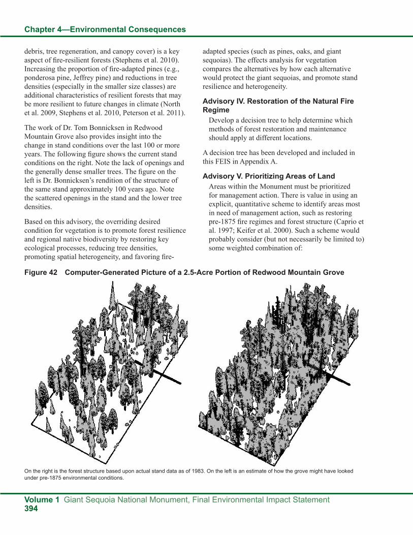
debris, tree regeneration, and canopy cover) is a key aspect of fire-resilient forests (Stephens et al. 2010). Increasing the proportion of fire-adapted pines (e.g., ponderosa pine, Jeffrey pine) and reductions in tree densities (especially in the smaller size classes) are additional characteristics of resilient forests that may be more resilient to future changes in climate (North et al. 2009, Stephens et al. 2010, Peterson et al. 2011).
The work of Dr. Tom Bonnicksen in Redwood Mountain Grove also provides insight into the change in stand conditions over the last 100 or more years. The following figure shows the current stand conditions on the right. Note the lack of openings and the generally dense smaller trees. The figure on the left is Dr. Bonnicksen’s rendition of the structure of the same stand approximately 100 years ago. Note the scattered openings in the stand and the lower tree densities.
Based on this advisory, the overriding desired condition for vegetation is to promote forest resilience and regional native biodiversity by restoring key ecological processes, reducing tree densities, promoting spatial heterogeneity, and favoring fire-
adapted species (such as pines, oaks, and giant sequoias). The effects analysis for vegetation compares the alternatives by how each alternative would protect the giant sequoias, and promote stand resilience and heterogeneity.
Advisory IV. Restoration of the Natural Fire Regime
Develop a decision tree to help determine which methods of forest restoration and maintenance should apply at different locations.
A decision tree has been developed and included in this FEIS in Appendix A.
Advisory V. Prioritizing Areas of LandAreas within the Monument must be prioritized for management action. There is value in using an explicit, quantitative scheme to identify areas most in need of management action, such as restoring pre-1875 fire regimes and forest structure (Caprio et al. 1997; Keifer et al. 2000). Such a scheme would probably consider (but not necessarily be limited to) some weighted combination of:
Figure 42 Computer-Generated Picture of a 2.5-Acre Portion of Redwood Mountain Grove
On the right is the forest structure based upon actual stand data as of 1983. On the left is an estimate of how the grove might have looked under pre-1875 environmental conditions.

Chapter 4—Environmental Consequences
Giant Sequoia National Monument, Final Environmental Impact Statement Volume 1395
1. Hazard of catastrophic stress, such as stress by severe wildfire. Factors to consider would likely include (but not necessarily be limited to) fuel load, ignition probability, stand density, fire ladder, adjacent vegetation types, and current vegetation mosaic.
2. Risk to values and objects of interest. Factors to consider would likely include (but not necessarily be limited to) water quality, erosion, sensitive species, public safety, ceremonial and traditional uses, and identification as objects of scientific or historical interest.
3. Ecological Need: Factors to consider would likely include (but not necessarily be limited to) number of fire cycles missed, biodiversity, and deviation from pre-1875 vegetative structure, composition, and function.
4. Feasibility: Factors to consider might include (but not necessarily be limited to) economic, site access, legislated land designations, and social acceptance.
It is unreasonable to expect that a thorough, fine-grained prioritization of management areas will be included in the first Monument management plan. However, at a minimum, the plan should include the determination to set priorities plus the factors to be considered for prioritizing areas, or better yet, a quantitative scheme to be used in the prioritization.
Areas are prioritized for treatment in the Monument based on protection of the objects of interest, public safety, and ecological restoration. These areas are prioritized differently by alternative as shown in the Fire and Fuels Strategies for Ecological Restoration (Chapter 2; Alternatives Considered in Detail; Desired Conditions, Strategies, and Objectives; Fire and Fuels Strategies, Strategies for Ecological Restoration). The decision tree used for each site-specific project proposed in the Monument considers the above four factors, assessing risk and effectiveness (Chapter 2, Alternatives Considered in Detail, Readers Guide to Alternative Descriptions, Ecological Restoration, Decision Tree).
Advisory XI. SequoiasAdherence to the Sierra Nevada Framework guidelines may not enable gap development through
mechanical means as no tree greater than 20 inches can be removed.
Failure to regenerate giant sequoia could adversely affect the long-term sustainability of the giant sequoia ecosystem (The Scientific Advisory Board 2003, Advisory XI).
The effects analysis for Vegetation compares the alternatives in terms of stand resilience and the need to provide openings (gaps) and other disturbances for giant sequoia regeneration. Numerous studies are referenced in describing what changes are needed to help accomplish desired conditions. Gap size is discussed in terms of adjacent tree heights and the likely effects on regeneration of desirable tree species. Gap size is also discussed in relation to recent studies by York et al (York 2009) (see the Giant Sequoia Regeneration sections that follow).
Advisory XIII. Local MarketSeek ways of building trust that mechanical thinning, when necessary, is ecologically motivated and not economically motivated, and that economic feasibility is critical to forest restoration efforts.
This effects analysis for vegetation stresses the importance of ecological restoration as defined by the Forest Service and the Pacific Southwest Region, and the role of restoration identified in the Clinton proclamation (see Ecological Restoration section above). Strategies specific to ecological restoration are included for both Vegetation and Fire and Fuels (see Desired Conditions, Strategies, and Objectives section of Chapter 2). In addition, a section on ecological restoration has been added to Chapter 2 that includes definitions, types of treatments being considered, and clearly needed criteria (see the Ecological Restoration section of Chapter 2). The Socioeconomics sections of Chapters 3 and 4 discuss and analyze the effects of Monument management on local economies and markets.
Advisory XX. Definition of TreatmentInclude a glossary with the Draft Environmental Impact Statement and other documents as needed (The Scientific Advisory Board 2003, Advisory XX).
Definitions of the types of treatments or tools proposed for use in the Monument are included in

Chapter 4—Environmental Consequences
Volume 1 Giant Sequoia National Monument, Final Environmental Impact Statement396
the Glossary of this FEIS (at the end of Volume 1). The order of priority for these tools: managed wildfire, prescribed fire, and mechanical treatment, are shown for each alternative in its alternative description, as well as in the Vegetation Strategies for Ecological Restoration (Chapter 2; Alternatives Considered in Detail; Desired Conditions, Strategies, and Objectives; Vegetation Strategies; Strategies for Ecological Restoration).
Advisory XXIV. Trade-offsIn a single, stand-alone section of the EIS, thoroughly compare and contrast the ecological trade-offs between prescribed fire and mechanical thinning (including hand treatments).
With reference to this stand-alone section, make evident which ecological trade-offs between prescribed fire and mechanical thinning were considered important in weighing the alternatives. Deemphasize those that are of little or no ecological consequence, such as precision in gap formation, and emphasize those that might have important ecological consequences, such as invasive species, native species, soils, and pathogens, while considering uncertainty (see above). Reevaluate the Alternatives in this light (The Scientific Advisory Board 2003, Advisory XXIV.).
The trade-offs section below discusses the potential ecological trade-offs between prescribed fire and mechanical treatments.
Assumptions for All AlternativesKey Modeling AssumptionsThe SPECTRUM model was used to help quantify these effects. Spectrum is a computer-based analytical tool for building natural resource management models. The results were used by the interdisciplinary team to help identify the potential effects that are expected from each alternative and to help distinguish differences in effects between the alternatives. This section describes the assumptions used to estimate the number of acres that would be treated per year. The number of acres treated per year is based on the projected budget and standards and guidelines for each alternative. The estimated acres of treatments were used as approximations for comparing the alternatives. For more information related to the
modeling effort used for this effects analysis, see the Modeling Overview in Appendix H of this FEIS.
● Wildfire would continue to burn portions of the Monument, with the projected annual rate based upon historical data.
● Mechanical treatments for restoration purposes (promoting resiliency and heterogeneity) will be followed by prescribed fire.
● Most treatments in the first two to three decades would implement strategies to protect the objects of interest and communities from unwanted fire, a priority consistent with the Framework and supported by many members of the public, both locally and nationally.
● Initial treatments to protect the objects of interest and communities would be completed in approximately 20 years. As the initial treatments are completed, the emphasis would shift to restoration and maintenance treatments (re-treatment of areas already treated to maintain desired fuel conditions and to restore a frequent fire return interval).
● While the modeling was done for 15 decades to evaluate long-term trends, the model effectively simulates treatments for only the first two to three decades.
● The Monument budget for vegetation management was assumed to be two million dollars per year.
● The modeling assumes that the assessment of potential treatments meeting the clearly needed criteria can only be made at the site-specific project level, considering the specific context of the purpose and need for action. The modeling assesses the capacity of each alternative to provide areas potentially suitable for a “Clear Need” evaluation while meeting the intent and theme of the alternative.
Effects Assumptions ● Reducing inter-tree competition will result in
increased resilience of forest trees to stresses associated with multi-year drought and a warming, potentially drier, climate.
● While it is sometimes said that fire ‘thins’ forests, it is not the same as thinning accomplished by
Chapter 4—Environmental Consequences
Giant Sequoia National Monument, Final Environmental Impact Statement Volume 1397
mechanical methods. Both result in the death of trees, however, selective mechanical cutting allows for precision that cannot be achieved otherwise. Per acre tree numbers are reduced in both cases, however the resultant spatial arrangement obtained with mechanical methods can favor selected trees in ways that fire is unable to.
● Fire is the only feasible method to significantly reduce surface fuel levels.
● The use of fire, alone, or in combination with mechanical treatments, can promote understory plant development.
● Mechanical treatments are unlikely to completely mimic the ecological processes that are associated with historical fire effects.
Trade-offsIt is assumed that there are advantages and disadvantages (“trade-offs”) to be considered in the decision to use either fire or mechanical treatments in conducting ecological restoration activities. These trade-offs are based on different site factors and conditions. In order to meet project objectives, fire may be a desirable tool on one site and mechanical may be desired on another (or a combination of the two methods). The intensity of prescribed fire is more challenging to control on a tree-by-tree basis as compared to mechanical methods, where vegetation can be carefully selected by operators. Prescribed fire behavior is responsive to a wide variety of conditions that are not easily predicted or controlled. These conditions include: changing weather conditions and variations in fuel conditions within burning areas. There is inherent risk in using prescribed fire given the many variables that dictate the intensity of the fire. A prescribed fire with planned low intensities can revert to high intensities, resulting in an unintended loss of tree species, soil protection, greatly increased erosion, nutrients, and site productivity (Gill and Allen 2008, Kaufmann et al. 2005, Stephens and Fule 2005), not to mention risk to life and property.
Managed fire can reduce smaller trees and surface accumulations of woody debris. Light to moderate burning will reduce smaller shade tolerant species that may otherwise provide a vertical ladder for crown fires, take up moisture and nutrients, or block
sunlight for regeneration of other species. Severe burn intensities often result in killing individual or groups of larger trees. Burns that kill scattered individual larger trees will create small canopy gaps that may serve to provide growing space or areas for regeneration and growth of other species. Burns that kill large groups of trees may result in stand replacement. These more severe burns are most likely to expose soils to erosion and a loss of productivity including deterioration of moisture holding properties and a loss of nutrients in an ecosystem as a result of volatilization, leaching, or runoff. Weakened trees not killed by more severe fire will be more susceptible to bark beetle attack. Erosion, insect and disease effects, accumulations of vegetation debris, and decomposition are natural ecological processes.
Stephens et al. (2009) on page 315 noted, “Mechanical plus fire treatments were effective in reducing fire severity in the Cone Fire (Skinner et al. 2004, Ritchie et al. 2007), the Rodeo Chediski Fire (Strom 2005), and the Biscuit fires (Raymond and Peterson 2005) as well as other wildfires (Omi and Martinson 2004) in the western United States. In addition, fire-only treatments were effective at reducing fire severity on the Hayman Fire (Graham 2003), the Rodeo-Chediski Fire (Finney et al. 2005), and other fires (Biswell 1989)…” Fuels have built up in the Monument and will continue to do so until treatments are allowed or nature reacts with wildfire. As fuel loads increase, burning will be more difficult. Stephens et al. (2009) warned, “… effectiveness of prescribed burn treatments will likely decline more rapidly over time as surface fuels accumulate (Finney et al. 2005, Skinner 2005).”
The weight of existing scientific evidence indicates that mechanical (hand cutting or self-propelled) followed by prescribed burning treatment is generally the first restoration choice where excessive fuels and small shade tolerant trees have accumulated in Western forests, and that special circumstances will be needed to justify burning or thinning only. The 15 different investigators familiar with fuels and forest management in the study by Schwilk et al (2009) recognized substantial “downsides” to burning on page 300. No “downsides” were singled out for mechanical treatments since these treatments

Chapter 4—Environmental Consequences
Volume 1 Giant Sequoia National Monument, Final Environmental Impact Statement398
generally accomplish surface and ladder fuels reduction. They stated, “The burning-only treatment also led to large numbers of snags (saplings and trees) that will fall over the next several years to decades, increasing the amount of fuel loading once again (Skinner 2005, Stephens and Moghaddas 2005b)…. Multiple sequential burns may be required before the fuel loading and the rate of accumulation of fuels are maintained at lower levels (Keifer et al. 2006).” Schwilk et al. (2009) on page 300, with a similar conclusion on page 301, “At the western sites, the combined mechanical plus burning treatment generally produced stand structures with fewer ladder fuels (saplings) and lower rates of fuel accumulation (i.e., fewer snags that remain to fall and less twig and litter fall from live trees due to reduced basal area), leading to more rapid development of conditions resilient to wildfire (Stephens et al. 2009).” Schwilk et al. (2009) summarized, “Without burning to treat the surface fuels, many of these mechanically thinned stands might resist crown fire initiation and spread, but could still be lost as a result of excessive heating and crown scorch in a wildfire (Agee and Skinner 2005, Ritchie et al. 2007).” Similarly, Stephens et al (2009), with 8 of the same authors as found in the report by Schwilk et al. (2009) recognized on page 316, “ although mechanically treating stands may enhance suppression capabilities by reducing crown fire potential, fire effects in these stands may be severe (Figs. 4–6), primarily due to high residual surface fuel loads...”
When considering mechanical methods that employ heavy equipment, there are trade-offs to be considered with regard to road accessibility, effects to soil, steep slopes, and costs. These factors need to be evaluated at the project level to determine the benefits and adverse effects as compared to using prescribed fire alone or in conjunction with mechanical methods.
In practice, mechanical treatments will often be followed by prescribed fire to further treat fuels accumulations. Burning may be delayed by a few years or more in stands of younger trees that are more susceptible to crown scorch or main stem injury. Slash may also be piled and burned to reduce risk to desirable trees. In some instances, fire could provide safe and adequate treatment of fuels without
mechanical treatments. Mechanical treatments may also replace fire under certain conditions.
Mechanical treatments with or without fire have resulted in successful natural regeneration of giant sequoia. A hot fire is often necessary for maximum natural sequoia regeneration, but resource trade-offs must be considered (see Effects of Alternatives on Giant Sequoia Regeneration section below).
More acres of prescribed fires than mechanical treatment are projected in Alternatives B, and C. Wildfire is predicted to occur on more acres than prescribed burning or mechanical treatments. With concerns about a warmer climate, increased emphasis on carbon sequestration, and increased concerns about the restrictions and effects of smoke management, it is essential to consider many alternative methods to reduce the increasing surface and ladder fuels that are building up in the Monument. It is important to note that mechanical treatments would often include a follow-up treatment to further reduce surface and/or ladder fuels. Mechanical treatments would be designed to prepare certain sites for safe use of fire and it is anticipated that many stands can be managed with fire only after the mechanical treatments have helped to restore lower fuel loadings.
Fire and/or mechanical treatments are commonly used to achieve ecological restoration goals. While frequently used in combination, they are often portrayed as mutually exclusive in the debate between process versus structural restorationists.
Preliminary results from the Fire and Fire Surrogate Study were that “Mechanical treatments followed by burning produced the strongest result at most sites, with more resilient forest structures..., lower surface fuel loads, and reduced rate of accumulation of surface fuels. If burning alone were the only management option, additional burns might over time reduce tree densities and fuel loading, but the mechanical plus burning treatments achieved this condition more rapidly (Schwilk 2009).
The authors concluded that “Overall, the desired response of the ecological variables presented in this paper to fuel treatments involving burning and/or mechanical treatments was generally maximized by

Chapter 4—Environmental Consequences
Giant Sequoia National Monument, Final Environmental Impact Statement Volume 1399
the combined mechanical plus burning treatments. These treatments produced desired changes in stand structure, while reducing surface fuel loading and rate of fuel accumulation in the near-term, and also increasing native understory herbaceous species diversity. Because mechanical plus burning treatments also appeared to favor alien herbaceous species invasion, this negative may need to be balanced against the positive attributes where alien species present particular management issues (Schwilk 2009).”
While the combination of mechanical and prescribed fire treatments can be effective, Schwilk et al, notes that “It is unlikely that the varied ecological roles of wildland fire can ever be entirely replaced by mechanical thinning. However, in today’s fuel-rich environments, even prescribed fire may lead to ecological outcomes that differ from historical wildfires. Mechanical harvesting may help to create conditions that allow subsequent prescribed burning (and perhaps wildland fire) to accomplish fire-related objectives more precisely and rapidly than burning alone, but mechanical treatments may not be able to mimic ecological effects of fire such as soil heating.”
Collins et al. (2011) concluded, “Based on our results it appears that if restoration of historical forest structure is an objective and fire alone is the tool then initial fires need to be intense enough to kill trees in the lower and intermediate canopy strata. While fires of lesser intensity likely will reduce surface fuels and understory trees which is important in reducing potential tree mortality from fire (Agee and Skinner 2005, Stephens et al. 2009a) and possibly maintaining desired forest conditions once achieved initially, they may not be sufficient alone to achieve historical forest structure given the substantial tree establishment that occurred during the fire exclusion period (Collins and Stephens 2007).”
Restoration treatments in the Monument will likely be followed by slash disposal either by burning, removal, or by redistribution. Schwilk et al. (2009) on page 300, with a similar conclusion on page 301, “At the western sites, the combined mechanical plus burning treatment generally produced stand structures with fewer ladder fuels (saplings) and lower rates of fuel accumulation (i.e., fewer snags that remain to fall and
less twig and litter fall from live trees due to reduced basal area), leading to more rapid development of conditions resilient to wildfire (Stephens et al. 2009).” Schwilk et al. (2009) summarized, “Without burning to treat the surface fuels, many of these mechanically thinned stands might resist crown fire initiation and spread, but could still be lost as a result of excessive heating and crown scorch in a wildfire (Agee and Skinner 2005, Ritchie et al. 2007).” Similarly, Stephens et al (2009), with 8 of the same authors as found in the report by Schwilk et al. (2009) recognized on page 316, “ although mechanically treating stands may enhance suppression capabilities by reducing crown fire potential, fire effects in these stands may be severe (Figs. 4–6), primarily due to high residual surface fuel loads...”
ResiliencyThe Society of American Foresters defines resilience as ‘the capacity of a (plant) community or ecosystem to maintain or regain normal function and development following disturbance.” Multiple disturbance agents will influence the vegetation within the Monument. Large wildfires and periodic multi-year droughts, with associated bark beetle infestations, have been the most easily recognized, although more subtle effects are brought about by windthrow, root disease, and limited fire spread lightning strikes. Actions can be taken to provide for resilience including modifications to species composition, tree density, and arrangement.
● Reducing stand density, increasing tree resilience by providing access to increased levels of soil moisture and growing space, is an effective method to reduce bark beetle-related mortality (Fettig et al., 2007) Slower growing trees appear to be more susceptible to successful attack by the western pine beetle (Craighead, 1925). In general, the subordinate crown class trees, including the intermediate and suppressed classes, are growing more slowly than the codominant and dominant crown class and would be expected to be more susceptible. Beyond crown class, crown ratio can also indicate individual tree resilience. Sartwell (1971) illustrated a strong relationship between trees with crown rations of 30 percent or less and bark beetle-related mortality.
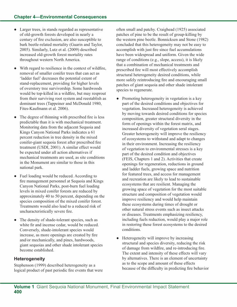
Chapter 4—Environmental Consequences
Volume 1 Giant Sequoia National Monument, Final Environmental Impact Statement400
● Larger trees, in stands regarded as representative of old-growth forests developed in nearly a century of fire exclusion, are also susceptible to bark beetle-related mortality (Guarin and Taylor, 2005). Similarly, Lutz et al. (2009) described increased old-growth forest mortality rates throughout western North America.
● With regard to resilience in the context of wildfire, removal of smaller conifer trees that can act as ‘ladder fuel’ decreases the potential extent of stand-replacement, providing for higher levels of overstory tree survivorship. Some hardwoods would be top-killed in a wildfire, but may resprout from their surviving root system and reestablish as dominant trees (Tappeiner and McDonald 1980, Fites-Kaufmann et al. 2006).
● The degree of thinning with prescribed fire is less predictable than it is with mechanical treatment. Monitoring data from the adjacent Sequoia and Kings Canyon National Parks indicates a 61 percent reduction in tree density in the mixed conifer-giant sequoia forest after prescribed fire treatment (USDI, 2001). A similar effect would be expected under all action alternatives if mechanical treatments are used, as site conditions in the Monument are similar to those in this national park.
● Fuel loading would be reduced. According to fire management personnel at Sequoia and Kings Canyon National Parks, post-burn fuel loading levels in mixed conifer forests are reduced by approximately 40 to 50 percent, depending on the species composition of the mixed conifer forest. Treatments would also lead to a reduced risk of uncharacteristically severe fire.
● The density of shade-tolerant species, such as white fir and incense cedar, would be reduced. Conversely, shade-intolerant species would increase, as more openings are created by fire and/or mechanically, and pines, hardwoods, giant sequoias and other shade intolerant species become established.
HeterogeneityStephenson (1999) described heterogeneity as a logical product of past periodic fire events that were
often small and patchy. Craighead (1925) associated patches of pine to be the result of group-killing by the western pine beetle. Bonnicksen and Stone (1982) concluded that this heterogeneity may not be easy to accomplish with just fire since fuel accumulations have been widespread and uniform. Given the wide range of conditions (e.g., slope, access), it is likely that a combination of mechanical treatments and prescribed fire will most effectively accomplish structural heterogeneity desired conditions, while more safely reintroducing fire and encouraging small patches of giant sequoia and other shade intolerant species to regenerate.
● Promoting heterogeneity in vegetation is a key part of the desired conditions and objectives for vegetation. Increased heterogeneity is achieved by moving towards desired conditions for species composition, greater structural diversity in the form of openings within the forest matrix, and increased diversity of vegetation seral stages. Greater heterogeneity will improve the resiliency of ecosystems to withstand and adapt to changes in their environment. Increasing the resiliency of vegetation to environmental stresses is a key part of the desired condition and objectives (FEIS, Chapters 1 and 2). Activities that create openings for regeneration, reductions in ground and ladder fuels, growing space and nutrition for featured trees, and access for management and recreation are likely to lead to sustainable ecosystems that are resilient. Managing the growing space of vegetation for the most suitable structure and composition of vegetation would improve resiliency and would help maintain these ecosystems during times of drought or other natural stress events such as insect attacks or diseases. Treatments emphasizing resiliency, including fuels reduction, would play a major role in restoring these forest ecosystems to the desired conditions.
● Heterogeneity will improve by increasing structural and species diversity, reducing the risk of damage from wildfire, and re-introducing fire. The extent and intensity of these effects will vary by alternatives. There is an element of uncertainty as to the scope and amount of these effects because of the difficulty in predicting fire behavior

Chapter 4—Environmental Consequences
Giant Sequoia National Monument, Final Environmental Impact Statement Volume 1401
and variations in fuel loading and burning conditions. In addition, alternatives that do not provide for mechanical treatments in conjunction with prescribed fire, or which limit the size of tree that can be removed (i.e., diameter limits), would affect the ability to quickly alter stand structure.
Giant Sequoia Regeneration ● In areas where fire intensity or soil disturbance
is high, soil will be exposed, providing favorable conditions for the establishment and growth of early seral stages of giant sequoias, other conifers, and other vegetation (brush, forbs, etc) (York et al. 2004, Meyer and Safford 2011b).
● Patches of new vegetation will become established, and shade-intolerant species such as giant sequoias, pines, and certain hardwoods will often increase in response to prescribed fire or thinning treatments that create canopy openings (Zald et al. 2008, York et al. 2004). There may be sprouting from the stumps of fire-top-killed oaks (primarily black oak) leading to new age classes of hardwoods (McDonald 1969, Fites-Kaufmann et al. 2006). The re-introduction of fire is expected to begin a shift in species composition in favor of shade-intolerant species as openings are created in the canopy of conifer forest types. These effects have been described in project documentation from the Sequoia National Park (USDI 2001). Specifically, giant sequoia regeneration is expected to increase.
● The creation of openings will lead to the establishment of young mixed conifer vegetation that will include giant sequoias and pines (York et al. 2010, Meyer and Safford 2011b). In openings close to seed-bearing giant sequoias, giant sequoia seedlings will become established, along with other naturally-occurring species (Demetry and Duriscoe 1996). Long-term survival and growth of shade-intolerant species will be more reliable in openings larger than ¼ acre, due to the more open conditions toward the middle of openings (away from the edge effect of adjacent large trees) (York et al. 2003). It is likely that initial prescribed burning treatments for protection or restoration purposes will lead to a change in composition in both the smaller and larger diameter classes
(Sequoia National Park 2002, Kiefer et al 2001). Giant sequoia regeneration may also increase substantially following second-entry burns (Webster and Halpern 2010).
● It will be important to assure ample sunlight in openings where ponderosa pine and other shade-intolerant species are desired (York et al. 2010). This will help assure favorable growth and may improve long-term resistance to drought, bark beetles, and root pathogens. Larger openings in the upper canopy will often provide conditions that promote giant sequoia and pine regeneration (York et al. 2004).
● It has long been known that fire can prepare a site, stimulate natural regeneration, and promote growth of giant sequoia (Stephenson 1996). This is a function of many factors, such as the amount of soil moisture throughout the warmest season (York et al. 2003, Shellhammer and Shellhammer 2006). The exposure of mineral soil and the opening of the canopy, attributed to harvesting, has been associated with successful sequoia regeneration (Kilgore and Biswell 1971, Harvey et al. 1980). Years of below average precipitation may reduce the chances for these conditions to occur, regardless of the method of treatment (Stephens et al. 1999, York et al. 2010). The poor success of giant sequoia regeneration over recent decades may be related to a reduction in favorable soil surface and light environments and poor seedfall timing. In addition, the intensity of fire, early snowmelt, and increased summer heat on exposed sites may further reduce regeneration success (Harvey et al. 1980). The most likely limiting factor, however, is a combination of light and soil moisture availability (Stark 1968, York et al. 2003). While giant sequoia seedlings exhibit a certain degree of tolerance towards shade and drought (Stark 1968) and can establish in relatively small canopy openings (York et al. 2010), it also displays that the juvenile vegetation shading will reduce sequoia seedling growth after the first year or two of establishment (York et al. 2010). Where low-severity fire is the only disturbance in the last twenty years, patches of sequoia regeneration are rare in groves (Mutch and Swetnam 1995, Meyer and Safford 2011b).

Chapter 4—Environmental Consequences
Volume 1 Giant Sequoia National Monument, Final Environmental Impact Statement402
● Sequoia seedlings recently planted in the current drought showed low to moderate survival in the first year in burned openings on mesic sites. The photo above on the left shows a healthy seedling in an area with productive sandy loam soil. The soil moisture was 1.7 percent (volumetric) in late August and survival was 50 percent. A similar site one mile away with 1.6 percent soil moisture had 13 percent survival. The photo on the right is from a more mesic site with more vegetation and an average shading of 70 percent. These seedlings, from an identical seed source, had 100 percent survival and displayed the best growth even when overtopped by other vegetation. The soil moisture in August 2009 was 14 percent (volumetric).
Trials with seedlings, from the same lot, also examined the effects of exposure to heat. Seedlings grown in hot, direct sunlight stopped growing in June 2009 even when soils were moist. Seedlings growing in 70 percent shade, with the same amount of soil moisture grew more and had better survival. Based on field observations, future programs to promote sequoia regeneration will need to consider the interactions between temperature and moisture that might be expected with a warming climate (Hanna pers. comm.). Based on these observations, the best approach for a large program to promote new giant sequoias will be to plant in years with higher moisture and cooler temperatures.
Picture 13 Survival of one-year-old planted sequoia seedlings in open, burned areas with 50 percent survival in August 2009 due to dry upper soils and exposure to heat.
Picture 14 Survival of identical sequoia seedlings in moist soils with 70 percent shade from vegetation was 100 percent in August 2009.
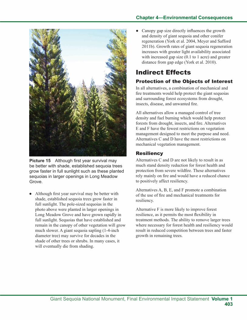
Chapter 4—Environmental Consequences
Giant Sequoia National Monument, Final Environmental Impact Statement Volume 1403
● Although first year survival may be better with shade, established sequoia trees grow faster in full sunlight. The pole-sized sequoias in the photo above were planted in larger openings in Long Meadow Grove and have grown rapidly in full sunlight. Sequoias that have established and remain in the canopy of other vegetation will grow much slower. A giant sequoia sapling (1-4-inch diameter tree) may survive for decades in the shade of other trees or shrubs. In many cases, it will eventually die from shading.
● Canopy gap size directly influences the growth and density of giant sequoia and other conifer regeneration (York et al. 2004, Meyer and Safford 2011b). Growth rates of giant sequoia regeneration increases with greater light availability associated with increased gap size (0.1 to 1 acre) and greater distance from gap edge (York et al. 2010).
Indirect EffectsProtection of the Objects of InterestIn all alternatives, a combination of mechanical and fire treatments would help protect the giant sequoias and surrounding forest ecosystems from drought, insects, disease, and unwanted fire.
All alternatives allow a managed control of tree density and fuel burning which would help protect forests from drought, insects, and fire. Alternatives E and F have the fewest restrictions on vegetation management designed to meet the purpose and need. Alternatives C and D have the most restrictions on mechanical vegetation management.
ResiliencyAlternatives C and D are not likely to result in as much stand density reduction for forest health and protection from severe wildfire. These alternatives rely mainly on fire and would have a reduced chance to positively affect resiliency.
Alternatives A, B, E, and F promote a combination of the use of fire and mechanical treatments for resiliency.
Alternative F is more likely to improve forest resilience, as it permits the most flexibility in treatment methods. The ability to remove larger trees where necessary for forest health and resiliency would result in reduced competition between trees and faster growth in remaining trees.
Picture 15 Although first year survival may be better with shade, established sequoia trees grow faster in full sunlight such as these planted sequoias in larger openings in Long Meadow Grove.

Chapter 4—Environmental Consequences
Volume 1 Giant Sequoia National Monument, Final Environmental Impact Statement404
Vegetation Types All of the alternatives move vegetation toward the desired conditions for vegetation (see Chapter 2, Vegetation Desired Conditions). The SPECTRUM model projects the estimated changes in the amount of early, mid, and late seral stages that could result from vegetation management over the next 20 years for mixed conifer forest, giant sequoias, montane hardwood-conifer, and red fir vegetation types.
In the mixed conifer forest, early seral stage vegetation is estimated to increase 450 to 650 percent in all alternatives. Mid seral stage of this vegetation type is expected to decrease in all alternatives, ranging from a reduction of 35 percent in Alternative E to a 50 percent decrease in Alternative A. The amount of late seral stage is estimated to increase in all alternatives, ranging from a 17 percent addition in Alternative A to approximately 35 percent in Alternatives B, E, and F.
In giant sequoias, early seral stage vegetation estimates are very low. This is discussed further in the following section on giant sequoia regeneration. Mid seral stage of giant sequoias is expected to decrease in all alternatives, ranging from a reduction of approximately 40 percent in Alternatives C and D to about 55 percent in Alternative A. The amount of late seral stage is estimated to increase in all alternatives, ranging from a five percent addition in Alternative C and D to between seven and eight percent in Alternatives A,B, E, and F.
In montane hardwood-conifer, early seral stage vegetation is projected to increase two to four percent in Alternatives A, B and F; four to six percent in Alternatives B and E; and approximately 15 percent in Alternatives C and D. Mid seral stage of this vegetation type is expected to decrease in
all alternatives, ranging from a reduction between seven to 10 percent in Alternatives A, B, E, and F to a 15 percent decrease in Alternatives C and D. The amount of late seral stage is projected to increase in all alternatives, ranging from a 10 percent addition in Alternatives C and D to approximately 15 percent in Alternatives A,B, E, and F.
In red fir, early seral stage vegetation is projected to increase 80 percent in Alternatives A, B, E and F, and approximately 200 percent in Alternatives C and D. Mid seral stage of this vegetation type is expected to decrease in all alternatives by approximately 20 percent. The amount of late seral stage is projected to increase in all alternatives between two and three percent.
HeterogeneityAll alternatives would increase diversity of age classes and species composition through the use of fire and/or mechanical treatments. In alternatives with smaller diameter limits, such as Alternative C, it could take longer to reach the desired conditions for heterogeneity.
Alternative D is expected to result in the most early seral habitat as a result of more uncharacteristically severe wildfires.
Alternatives E and F allow more flexibility in managing species composition, structural diversity, and fuels. This would be expected to protect stands from uncharacteristically severe wildfire and promote heterogeneity.
For potential changes in the amount of early, mid, and late seral stages by vegetation type, see the previous Resiliency section.
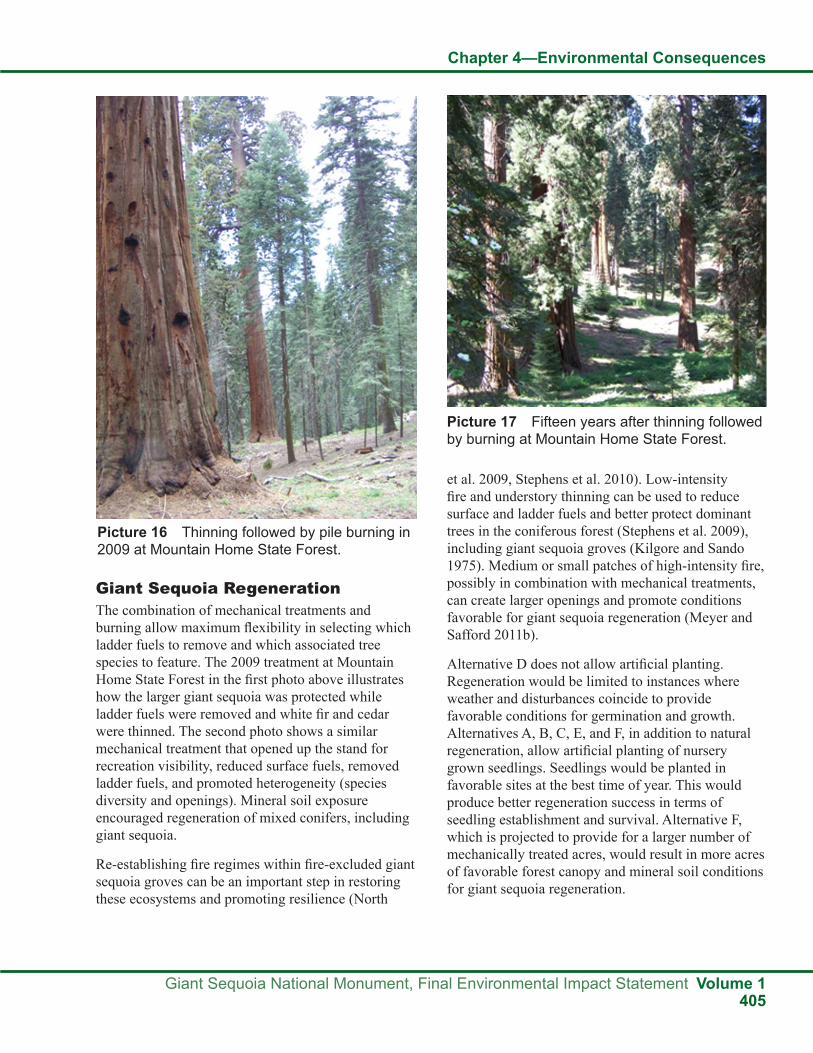
Chapter 4—Environmental Consequences
Giant Sequoia National Monument, Final Environmental Impact Statement Volume 1405
Giant Sequoia RegenerationThe combination of mechanical treatments and burning allow maximum flexibility in selecting which ladder fuels to remove and which associated tree species to feature. The 2009 treatment at Mountain Home State Forest in the first photo above illustrates how the larger giant sequoia was protected while ladder fuels were removed and white fir and cedar were thinned. The second photo shows a similar mechanical treatment that opened up the stand for recreation visibility, reduced surface fuels, removed ladder fuels, and promoted heterogeneity (species diversity and openings). Mineral soil exposure encouraged regeneration of mixed conifers, including giant sequoia.
Re-establishing fire regimes within fire-excluded giant sequoia groves can be an important step in restoring these ecosystems and promoting resilience (North
et al. 2009, Stephens et al. 2010). Low-intensity fire and understory thinning can be used to reduce surface and ladder fuels and better protect dominant trees in the coniferous forest (Stephens et al. 2009), including giant sequoia groves (Kilgore and Sando 1975). Medium or small patches of high-intensity fire, possibly in combination with mechanical treatments, can create larger openings and promote conditions favorable for giant sequoia regeneration (Meyer and Safford 2011b).
Alternative D does not allow artificial planting. Regeneration would be limited to instances where weather and disturbances coincide to provide favorable conditions for germination and growth. Alternatives A, B, C, E, and F, in addition to natural regeneration, allow artificial planting of nursery grown seedlings. Seedlings would be planted in favorable sites at the best time of year. This would produce better regeneration success in terms of seedling establishment and survival. Alternative F, which is projected to provide for a larger number of mechanically treated acres, would result in more acres of favorable forest canopy and mineral soil conditions for giant sequoia regeneration.
Picture 16 Thinning followed by pile burning in 2009 at Mountain Home State Forest.
Picture 17 Fifteen years after thinning followed by burning at Mountain Home State Forest.

Chapter 4—Environmental Consequences
Volume 1 Giant Sequoia National Monument, Final Environmental Impact Statement406
Sometimes natural regeneration will establish in small patches or with a few trees scattered across a stand within a grove (Harvey et al. 1980). The photos above illustrate the kind of effects that may be required to obtain abundant natural regeneration in giant sequoia groves. The photo above on the left, taken in the Redwood Mountain Grove, illustrates the common absence of giant sequoia regeneration in areas with reduced surface and ladder fuels, small gaps, and frequent light to moderate burning. The photo on the right shows an adjacent area with an abundance of giant sequoia regeneration that was burned by a severe wildfire in 1987. Most of the larger giant sequoias survived the high severity burn, but some were killed.
Projections of giant sequoia regeneration by the SPECTRUM model were not considered to be reasonable due to the known limitations of the model. In order to estimate the amount of giant sequoia regeneration, several factors were considered. Giant
sequoias require some canopy opening to successfully regenerate. The types of vegetation management likely to create openings suitable for giant sequoia regeneration are those that would remove trees from the canopy. This could occur with relatively hot prescribed fire, wildfire, or mechanical treatments. In the first 20 years, these types of activities are most likely to occur in the WUI defense zone. Even with these types of treatments, it is unlikey that many openings suitable for giant sequoia regeneration would occur in a treated area. It is estimated that approximately 10 percent of defense zone treatments would provide adequate openings. The amount of these activities which might take place in giant sequoia groves varies by alternative. Based on these assumptions, it is estimated that the acres of giant sequoia regeneration would be approximately 300 acres in Alternative A, 200 acres in Alternative B, 100 acres in Alternative C, 0 acres in Alternative D, 400 acres in Alternative E, and 500 acres in Alternative F.
Picture 18 Frequent light to moderate intensity burning with no sequoia regeneration (Redwood Mountain Grove.
Picture 19 Stand replacement wildfire promotes natural sequoia regeneration (Redwood Mountain Grove).
Chapter 4—Environmental Consequences
Giant Sequoia National Monument, Final Environmental Impact Statement Volume 1407
Wildfires burning in giant sequoia groves are also capable of creating openings suitable for regeneration. Because the amount, intensity, and location of wildfires make estimates of regeneration from wildfire highly speculative, no estimates of giant sequoia regeneration resulting from wildfire are provided. Based on the management direction in Alternatives C and D, it is expected that those two alternatives have the greatest potential to create suitable openings for giant sequoia regeneration with wildfire.
Cumulative EffectsThe geographic extent of analysis is the Monument and the temporal extent is the next two decades.
ResiliencyThe ability to increase resilience within the Monument is scaled, in part, by the projection of acres treated with effective methods. The likelihood of multi-year drought within the next two decades, combined with the potential for the even higher evapotranspirational demands of a warming climate, may reduce the projected benefits associated with increased treatment acres. In addition, wildfires may erase treatment benefits in areas where treatment acres fail to provide benefits over a significant portion of the area.
Prescribed fire prescriptions that kill some of the larger trees will contribute to the resilience of the remaining larger trees. The outcome, however, will likely result in tree arrangements that are not always as effective as would be obtained by mechanical treatments. This distinction would be of particular importance in situations when specific tree arrangements and/or species compositions are desired. The effects of a warming climate may reduce the beneficial effects of decreased tree numbers per acre. Remaining high density tree arrangements are likely to be more common locations for bark beetle-related mortality during multi-year drought periods.
Uncertainty related to the post-prescribed fire effects on tree arrangements complicates the projection of resiliency accomplishments. Modelling estimates project annual prescribed burning to be approximately 7,000 to 10,000 acres for Alternative A, 1,200 to 1,500 acres for Alternative B, 600 to 700 acres for
Alternative C, 50 to 100 acres for Alternative D, 900 to 1,100 acres for Alternative E, and 1,000 to 1,200 acres for Alternative F.
Alternatives that also include mechanical and hand treatments would provide for site-specific increases in resiliency. Modeling estimates project annual mechanical or hand treatments to be approximately 1,300 to 1,600 acres for Alternative A, 1,100 to 1,200 acres for Alternative B, 300 to 600 acres for Alternative C, 100 to 250 acres for Alternative D, 1,100 to 1,300 for Alternative E and 1,500 to 2,000 acres for Alternative F. While site-specific, literally tree-specific, resilience objectives would be met, uncertainties described above also apply. In particular, evapotranspirational demands may outstrip even the most highly-tailored tree arrangements.
Alternative D, given the relatively small number of treatment acres, would likely be inconsequential compared to the other alternatives.
HeterogeneityThe cumulative effects related to heterogeneity would mimic, in general, those described for resilience. Alternative D is an exception, in relation to species composition, as natural regeneration is not likely to provide the same amount of pine species, nor the number of rust-resistant sugar pine as the other alternatives.
Alternative D, treating less acres, is anticipated to be more affected by wildfire than treatments. Heterogeneity increases would be driven by fire type. If wildfire results in widespread stand-replacement (crown fire), the trend toward increased heterogeneity would be less than the trend resulting from surface and mixed-severity fires.
Giant Sequoia RegenerationWith the exception of Alternative D, where tree planting is not projected, increases in giant sequoia regeneration are likely to increase in scale with treatment acres. Alternative D could also lead to increased giant sequoia regeneration depending on the location and intensity of wildfires in the groves. However, although Alternative D is likely to allow more naturally-ignited high intensity fires to burn, the actual frequency and location of these fires is dependent upon weather conditions and lightning

Chapter 4—Environmental Consequences
Volume 1 Giant Sequoia National Monument, Final Environmental Impact Statement408
Assumptions and Methodology Ecological RestorationThe need to address the fuels buildup in the Monument was addressed in the Clinton proclamation:
These forests need restoration to counteract the effects of a century of fire suppression and logging. Fire suppression has caused forests to become denser in many areas, with increased dominance of shade-tolerant species. Woody debris has accumulated, causing an unprecedented buildup of surface fuels. One of the most immediate consequences of these changes is an increased hazard of wildfires of a severity that was rarely encountered in pre-Euroamerican times.
Effects on Fire and Fuels
strikes. There is no guarantee that any of these fires would occur in groves. In contrast, in the other action alternatives, the use of prescribed fire and mechanical treatments, combined with managed wildfire (unplanned ignitions), makes it more likely that fire would be reintroduced in portions of groves to aid regeneration in a shorter timeframe. Tree mortality, regardless of cause, in combination with prescribed fire, should lead to increased potential for both planted and natural regeneration. The effects of a warming climate may reduce this outcome, as compared to the recent historical outcomes related to the creation of openings and suitable soil exposures.
Standards and Guidelines and MonitoringEffects on vegetation affect the giant sequoias, mixed conifer, and other vegetation types and their ecosystems in the Monument, including the following objects of interest identified in the proclamation (Clinton 2000):
● The naturally-occurring giant sequoia groves and their associated ecosystems, individual giant trees, rare and endemic plant species such as the Springville clarkia, and other species listed as threatened or endangered by the Endangered Species Act or sensitive by the Forest Service.
● The ecosystems and outstanding landscapes that surround the giant sequoia groves.
The standards and guidelines for vegetation displayed in Appendix A focus on regeneration, the giant sequoia groves, sugar pine, plantations, hardwood ecosystems, and integrated pest management and are designed to protect the objects of interest and their ecosystems, both inside and outside of the groves.
The monitoring plan developed for the Monument, as described in Part 3—Design Criteria of the Monument Plan, contains implementation, effectiveness, validation, and status and trend monitoring for ecosystem analysis and vegetation. Plan monitoring is conducted to evaluate plan implementation and its effectiveness in meeting management strategies and objectives, in particular protecting the objects of interest and restoring ecosystems. Vegetation monitoring focuses on giant sequoia groves, forest outside of groves, and canopy gap analysis. Monitoring in the groves concentrates on trends in large trees, grove structure and composition, regeneration, and fuel loading to help determine management effectiveness and detect change. Outside of the groves field examinations would have a similar focus. Canopy gap analysis throughout the Monument would help determine if pine and giant sequoia regeneration is meeting desired conditions.
Outstanding opportunities exist for studying the consequences of different approaches to mitigating these conditions and restoring natural forest resilience (Clinton 2000, pp. 24095-24096).
Fire is such a pervasive disturbance in nearly all Monument ecosystems that failure to include it as part of managing large landscapes will inevitably lead to unintended outcomes (Keeley et al. 2009). The restoration and long-term maintenance of Monument ecosystems will require the restoration of fire as an ecological process. Restoring the natural role of fire in many parts of the Monument will require a focused restoration of the fuel conditions that support fire. However, mechanical treatments, biomass removal, and even fire treatments that are specifically applied to reduce fuel loads or manipulate potential fire behavior are temporary in nature.

Chapter 4—Environmental Consequences
Giant Sequoia National Monument, Final Environmental Impact Statement Volume 1409
The fire and fuels strategies and objectives, as well as the prioritizing of treatment methods in Chapter 2 of the FEIS, consider prescribed fire and managed wildfire as viable fuel treatment options. The trade-offs between types of treatments are analyzed in Chapter 4 (see that section on the following page), and how they meet the objectives in the WUI defense and threat zones is analyzed in the Wildland Urban Intermix section on the following page. In addition, the width of the WUI defense zone varies by alternative; the different levels of community protection resulting from this difference are analyzed in the Wildland Urban Intermix section treatments.
Science ConsideredThe most current and applicable science was considered and used in the Fire and Fuels sections of this FEIS. Examples include Stephens 2010, North 2009, Keeley 2009, Knapp 2009, Sawyer 2009, Odion and Hanson 2006, Husari 2006, and Van Wagtendonk 2006. For a detailed list of scientific literature used in this analysis, see the Literature Cited section at the end of Volume 1 of this FEIS.
Assumptions for All AlternativesThe environmental effects of the six alternatives considered in detail for managing the Monument are compared with respect to Issue 4, Fuels Management/Community Protection.
Fuels reduction, as proposed to protect communities and objects of interest in the Monument, may not be effective in terms of how much is treated and the kinds of treatments used (see Chapter 1, Issues).
The following guidelines from the Guidance for Implementation of Federal Wildland Fire Management Policy (February 13, 2009) were used in the fire and fuels analysis:
● Wildland fire management agencies will use common standards for all aspects of their fire management programs to facilitate effective collaboration among cooperating agencies.
● Agencies and bureaus will review, update, and develop agreements that clarify the jurisdictional inter-relationships and define the roles and responsibilities among local, state, tribal, and federal fire protection entities.
Long-term maintenance of fire-dependent ecosystems will require the return of characteristic fire regimes to Monument landscapes. Maintaining the fuel characteristics of ecosystems is only part of the solution, and fire is not likely to return simply because the fuel characteristics are restored.
Determination of where ecological restoration is needed in the Monument will be based on site-specific analysis and existing condition data, including fuel loading, fire return interval departure, fire history, fire susceptibility, and giant sequoia grove inventory data.
Use of ScienceScience Advisory Board (SAB)Advisory IX. Undesirable Fire Effects
Fuels reduction strategies in the Sierra Nevada Forest Plan Amendment may not adequately protect the giant sequoias and mixed conifer ecosystem from catastrophic fire. (For the purposes of this Advisory, “catastrophic fire” is defined as fire of an extent and severity beyond that which is consistent with the values for which the Monument was created.) (Scientific Advisory Board 2003).
Fire and fuels management strategies and proposed fuel reduction activities in Chapter 2 of the Monument FEIS build upon the standards and guidelines in the 2001 SNFPA, to better meet the goals in the Clinton proclamation to reduce fuels and restore natural forest resilience. The effects analysis for fire and fuels in Chapter 4 includes the use of the SPECTRUM model to project trends in acres of wildfire, high intensity fire, prescribed fire, and mechanical vegetation treatments and compare them by alternative. Current and projected levels of fire susceptibility are discussed and analyzed in Chapters 3 and 4.
Advisory XXIII. Defense ZoneRevise sections in the DEIS that can be taken to imply that limitation of mechanical fuels treatments to relatively narrow zones around communities automatically results in sub-standard community protection. Treat prescribed fire as a viable option that, like mechanical thinning, has its own set of trade-offs, but that in some cases is physically capable of meeting the Sierra Nevada Framework’s standards for defense and threat zones around communities. Reassess the Alternatives in this light (Scientific Advisory Board 2003).

Chapter 4—Environmental Consequences
Volume 1 Giant Sequoia National Monument, Final Environmental Impact Statement410
● Responses to wildland fire will be coordinated across levels of government regardless of the jurisdiction at the ignition source.
● Fire management planning will be intergovernmental in scope and developed on a landscape scale.
● Wildland fire is a general term describing any non-structure fire that occurs in the wildland. Wildland fires are categorized into two distinct types:
a. Wildfires—Unplanned ignitions or prescribed fires that are declared wildfires
b. Prescribed fires—Planned ignitions
● A wildland fire may be concurrently managed for one or more objectives, and objectives can change as the fire spreads across the landscape. Objectives are affected by changes in fuels, weather, topography; varying social understanding and tolerance; and involvement of other governmental jurisdictions having different missions and objectives.
● Management response to a wildland fire on federal land is based on objectives established in the applicable land and resource management plan.
● Initial action on human-caused wildfire will be to suppress the fire at the lowest cost with the fewest negative consequences with respect to firefighter and public safety.
● Managers will use a decision support process to guide and document wildfire management decisions. The process will provide situational assessment, analyze hazards and risk, define implementation actions, and document decisions and rationale for those decisions.
Trade-offs Between Types of TreatmentsFire is a management tool, capable of doing much of the work to restore ecological processes. The use of prescribed fire is beneficial in that it is planned, controlled, and can be less expensive than mechanical treatments and used on ground too steep or inaccessible for mechanical treatments.
Managed wildfire can be used as a tool to reintroduce fire to the ecosystem, reduce unnatural fuel accumulations, promote resilient forest structures
under appropriate conditions, and produce fire effects associated with natural diversity. Fire restores its past influence as a patch-wise and stand-thinning disturbance agent, as well as a facilitator of species diversity and fire-adapted conifers.
Mechanical treatments can be effective tools to modify stand structure when fire alone is undesirable or in combination with prescribed fire. In areas with heavy fuel accumulations, mechanical treatments such as hand cutting or self-propelled equipment could be used before fire is re-introduced.
Resource TopicsResource topics include Wildland Urban Intermix, Characteristic Fire Regimes, Fire History, Fuels Management, Landscape Conditions, Fire Susceptibility, Fire Return Interval, Restoration of Fire as an Ecological Process, and SPECTRUM Model Projections.
Wildland Urban Intermix (WUI)The wildland urban intermix (WUI) is an area where human habitation is mixed with areas of flammable wildland vegetation. It extends out approximately 1½-mile from developed private land in areas that have residences or commercial buildings, or administrative sites with facilities. It is comprised of two zones: an inner ¼-mile-wide buffer (the defense zone) and an outer 1¼-mile-wide buffer (the threat zone). The actual boundaries of the WUI zones are determined locally, based on the distribution of structures and communities adjacent to or intermixed with National Forest System lands. Boundaries are adjusted when new structures or developed areas are discovered.
The WUI defense zone is the buffer in closest proximity to communities and areas with higher densities of residences or commercial buildings, or administrative sites with facilities. The actual defense zone boundaries are determined at the site-specific project level following national, regional, and forest direction. Strategic landscape features such as roads, barriers, fuel types, and topography are used in delineating the physical boundary of the defense zone. Defense zones should be of sufficient extent that fuel treatments within them will reduce wildland fire spread and intensity and suppression forces can succeed in protecting human life and property.

Chapter 4—Environmental Consequences
Giant Sequoia National Monument, Final Environmental Impact Statement Volume 1411
The WUI threat zone typically buffers the defense zone. Threat zone boundaries are determined at the site-specific project level following national, regional, and forest direction. They are also delineated with strategic landscape features.
Throughout the Monument, even in WUI zones and the Tribal Fuels Emphasis Treatment Area (TFETA), mechanical treatments will be limited or prohibited:
● In wilderness (existing and proposed)
● In wild and scenic river corridors
● In inventoried roadless areas
● In research natural areas
● In riparian conservation areas
● On slopes exceeding 35 percent
● In areas greater than 9,000 feet in elevation
● In areas more than ¼ mile from a road
Based on these constraints, approximately 23 percent of the 328,315 acres of National Forest System land in the Monument could be considered for mechanical treatments (alone or in conjunction with fire treatments), compared to about 77 percent that could be considered for fire treatments.
Approximately 30 percent of the area in the WUI defense zone and about 24 percent of the area in the WUI threat zone could be considered for mechanical treatments.
Within the TFETA, approximately 15 percent of the 56,640 acres could be considered for mechanical treatments, compared to about 85 percent that could be considered for fire and hand treatments. Of the 85 percent, 48 percent is within roadless areas.
Methods and MeasurementThe SPECTRUM model was used to model, evaluate, and compare the alternatives.
Fire susceptibility, as an indicator of the possibility of large severe fire, is used in the analysis to compare alternatives. Fire susceptibility is derived from ratings of hazard (flame length), risk (fire occurrence), and severity (elevation). The Flammap model and GIS layers representing hazard, risk, and severity
are combined to produce different levels of fire susceptibility.
Hazard is defined by projected flame length using weather, fuel moisture, fuel descriptions, canopy cover, slope, and aspect data. Risk is represented by the average number of fires per year for a given area, based on historic fire occurrence.
Severity is defined primarily as a function of elevation. Historically, fire seasons are shorter and fire intensities are lower at higher elevations.
The primary metrics used in the analysis of alternatives are:
● Size of wildland urban intermix (WUI) zones
● Percent of area treated by prescribed fire and mechanical treatments in each alternative (SPECTRUM model)
● Estimated acres of moderate and high fire susceptibility
Indirect EffectsWildland Urban Intermix (WUI) ZonesAll AlternativesIn the Monument and in WUI zones, mechanical treatments will be limited or prohibited in many areas based on constraints such as slopes exceeding 35 percent, riparian conservation areas, wild and scenic river corridors, roadless areas, research natural areas or wilderness. Based on these constraints, within the WUI defense zone, approximately 30 percent of the area could be considered for mechanical treatment and, in the WUI threat zone, only about 24 percent could be considered for mechanical treatment.
Alternative A (No Action)Alternative A maintains the current management direction for the Monument and adheres to the 2001 SNFPA priorities and direction for fire and fuels management.
Common to all alternatives, the focus for fuel reduction activities is in the wildland urban intermix (WUI). Alternative A continues to use the WUI defense zone width of generally 1/4 mile (45,340

Chapter 4—Environmental Consequences
Volume 1 Giant Sequoia National Monument, Final Environmental Impact Statement412
acres) and the threat zone width of 1 1/4 mile (145,520 acres) (see the Map Packet, Wildland Urban Intermix for Alternatives A, B, E, and F).
In Alternative A (No Action), the current fuel conditions in the WUI are likely to be maintained and their associated fire risks continue to increase with time.
Alternative B (Proposed Action)Alternative B continues to use the WUI defense zone width of generally 1/4 mile (45,340 acres) and the threat zone width of 1 1/4 mile (145,520 acres) (see Map Packet, Wildland Urban Intermix for Alternatives A, B, E, and F). The actual boundaries of the WUI are determined locally, based on the distribution of structures and communities adjacent to or intermixed with national forest lands. Strategic landscape features such as roads, fuel types, and topography are used in delineating the physical boundary of the WUI (2001 SNFPA).
The alternatives can be contrasted based on the amount of area included in the WUI zones. All alternatives provide a buffer between developed areas and wildlands. The width of the WUI in Alternatives A, B, E and F is generally 1 1/2 mile, or approximately 58 percent of the Monument, compared to a width of 300 feet (or three percent of the Monument) in Alternative C, and 200 feet (or one percent of the Monument) in Alternative D.
Fuel reduction activities in the WUI zones are designed to protect human communities from wildland fires, as well as minimize the spread of fires that might originate in urban areas. The management objective in the WUI zones is to enhance fire suppression capabilities by modifying fire behavior inside the zones and provide a safe and effective area for possible future fire suppression activities (USDA Forest Service 2001e).
Alternative B includes a 20-inch diameter tree cutting limit, focusing on smaller diameter ladder fuels in the WUI defense zone for fuels reduction and fire protection. This is compared to a 30-inch diameter limit in Alternatives A and E, and no diameter limit in the WUI zones in Alternative F.
Alternatives A, B, E, and F are expected to include more fuel reduction activities in the WUI zones
than Alternatives C and D. The types of treatment proposed are expected to modify fire behavior and reduce the threat of severe wildfire to human communities. Safe firefighter access in the event of a fire will be enhanced as surface and ladder fuel levels are reduced.
Alternative CFuels management in Alternative C is focused on areas of human use and influence. This alternative includes a WUI defense zone approximately 300 feet wide (8,300 acres), or three percent of the Monument (see Map Packet, Wildland Urban Intermix for Alternative C). A threat zone is not included in this alternative. Developed recreation and administrative sites are proposed to be managed as a WUI defense zone. There is no diameter limit for tree cutting in the WUI defense zone for fuels reduction and fire protection. However, according to SEKI personnel, there is rarely a need to cut a tree over eight inches in diameter. In the WUI, mechanical treatments are proposed to be used to reduce fuels to the point where prescribed fire or managed wildfires could burn without harming high value resources. Tree removal is allowed as a by-product of fuels reduction or public safety activities, but only when clearly needed for ecological restoration and maintenance or public safety.
Alternative C is expected to include fewer acres of fuel reduction activities in the WUI defense zone, and offer a smaller buffer between developed areas and the wildlands designed to protect human communities from severe fire, than Alternatives A, B, E, and F.
Alternative DAlternative D includes a WUI defense zone approximately 200 feet wide (4,600 acres), covering about one percent of the Monument (see Map Packet, Wildland Urban Intermix for Alternative D). A threat zone is not included in this alternative. The diameter limit for tree cutting in the WUI defense zone is 12 inches for fuels reduction and fire protection. The trees cut in the WUI remain on-site. Mechanical treatments could be used to reduce fuels to the point where prescribed fire or managed wildfires could burn without harming high value resources. Tree cutting outside the WUI defense zone is only allowed to reduce risks to public and firefighter safety.

Chapter 4—Environmental Consequences
Giant Sequoia National Monument, Final Environmental Impact Statement Volume 1413
Alternative D is expected to prompt the fewest acres of fuels reduction activities in the WUI defense zone of all of the alternatives, and provide the smallest buffer between developed areas and the wildlands to protect human communities from the threat of severe fire.
Alternative EAlternative E continues to use the WUI defense zone width of generally 1/4 mile (45,340 acres) and the threat zone width of 1 1/4 mile (145,520 acres) (see Map Packet, Wildland Urban Intermix for Alternatives A, B, E, and F). For Alternative E, the WUI defense and threat zones are the only land allocations included from the 2001 SNFPA. The WUI zones are included in this alternative, even though they were not in the 1990 Mediated Settlement Agreement (MSA), because that agreement did not address the need to protect the objects of interest and the urban interface from wildfire.
The WUI in Alternatives A, B, E, and F covers approximately 58 percent of the Monument, reducing the threat of severe wildfire to human communities, as compared to three percent in Alternative C and one percent in Alternative D.
In Alternative E, where WUI zones overlap with wilderness, wilderness guidelines for fire and fuels management take precedence over those for WUI zones.
Alternative FAlternative F continues to use the WUI defense zone width of generally 1/4 mile (45,340 acres) and the threat zone width of 1 1/4 mile (145,520 acres) (see Map Packet, Wildland Urban Intermix for Alternatives A, B, E, and F). The WUI zones in Alternatives A, B, E, and F covers approximately 58 percent of the Monument, as compared to three percent in Alternative C and one percent in Alternative D.
Alternative F has no diameter limit for tree cutting in the WUI defense zone, compared to a 20-inch diameter limit in the WUI defense zone in Alternative B, and a 30-inch diameter limit in the WUI defense zone in Alternatives A and E.
Alternatives A, B, E, and F are expected to include more fuel reduction activities in the WUI zones than
Alternatives C and D. Alternative F is expected to focus on more ecological restoration activities, with no diameter limits in most areas, than Alternatives A, B, C, D, and E. The types of treatements proposed are expected to remove surface and ladder fuels, modify fire behavior, and reduce the threat of severe wildfire to human communities. Safe firefighter access in the event of a fire will be enhanced as these fuel levels are reduced.
Tribal Fuels Emphasis Treatment Area (TFETA)Alternatives A, C, D, and EAlternatives A, C, D, and E do not include the Tribal Fuels Emphasis Treatment Area (TFETA). Less protection would potentially be provided to the Tule River Indian Reservation and its watersheds, as well as to the objects of interest and watersheds in the Monument, from severe wildfire spreading from one to the other in Alternatives A, C, D, and E than in Alternatives B and F, which include the TFETA.
Alternative B (Proposed Action) and Alternative FAlternatives B and F include the TFETA, an area (56,640 acres) with a fuels reduction emphasis adjacent to the Tule River Indian Reservation (see the FEIS Map Packet, Alternatives B and F map). The TFETA is bordered by road systems, natural barriers, and topographic features that logically define this area where fuels reduction activities can take place. The focus in the TFETA is on protecting the reservation and its watersheds from severe fire effects. The first priority for fuels reduction is within 1/4 mile of the Monument/reservation boundary (3,400 acres) and in the Long Canyon area.
In the TFETA, as in the Monument, mechanical treatments will be limited or prohibited on slopes exceeding 35 percent, in riparian conservation areas, in wild and scenic river corridors, in roadless areas, in research natural areas, and in wilderness. Within the TFETA, approximately 15 percent of the 56,640 acres could be considered for mechanical treatments, compared to about 85 percent that could be considered for fire and hand treatments.
The addition of the TFETA in Alternatives B and F is expected to reduce surface and ladder fuels, modify fire behavior, and decrease the threat of

Chapter 4—Environmental Consequences
Volume 1 Giant Sequoia National Monument, Final Environmental Impact Statement414
severe wildfire to the Tule River Reservation and its watersheds, as well as to the objects of interest and watersheds in the Monument. Safe firefighter access in the event of a fire would be enhanced as fuel levels are reduced.
Fuels Management ActivitiesAll AlternativesFire as a critical natural process will be integrated into fuels management activities in the Monument. The Forest Service’s response to wildland fires is based on ecological, social, and legal consequences of the fire. The circumstances under which a fire occurs and the likely consequences for firefighter and public safety and welfare, natural and cultural resources, and values to be protected dictate the appropriate response to the fire (Guidance for Implementation of Federal Wildand Fire Management Policy, February 2009).
Federal wildland fire management policy allows for a wildland fire to be concurrently managed for one or more objectives, and objectives can change as the fire spreads across the landscape. Objectives are affected by changes in fuels, weather, and topography; varying social understanding and tolerance; and involvement of other governmental jurisdictions having different missions and objectives.
Unplanned natural ignitions in all alternatives would be evaluated on a case-by-case basis at the project level to determine if the fire would be allowed to burn. Any managed wildfires will make use of strategies and tactics commensurate with the protection of human health, safety, and natural and cultural resource values. Risks and complexities for all ignitions will be analyzed in order to determine which ignitions can be successfully managed for ecological benefit. Managed wildfire can be used as a tool to reintroduce fire to the ecosystem, reduce unnatural fuel accumulations, and promote resilient forest structures under appropriate conditions (Fites-Kaufman 2005).
Alternative A (No Action)In Alternative A, ongoing fuels management activities include prescribed fire, managed wildfire, and vegetation management. Site-specific project analysis is required for any of the fuels reduction activities proposed in the action alternatives.
The priorities for the management tools used for fuels reduction in Alternative A are:
1. Mechanical treatments
2. Prescribed fire
3. Managed wildfire (unplanned natural ignitions)
In compliance with the Mediated Settlement Agreement (MSA), Alternative A continues to require an approved fuel load reduction plan to use mechanical treatment methods inside giant sequoia grove administrative boundaries, and motorized equipment can only be used in wildfire situations. Within grove administrative boundaries and grove influence zones, Alternative A prefers prescribed fire and managed wildfire as fuel reduction methods, along with the allowance of mechanical treatments.
In Alternative A, the current fuel conditions and their associated fire risks are likely to be maintained and will continue to increase with time.
Alternative B (Proposed Action)In Alternative B, treatments for fuels reduction and ecological restoration are prioritized by land allocations/management areas as follows:
1. WUI defense zones
2. TFETA areas of high and moderate fire susceptibility within 1/4 mile of the reservation boundary
3. WUI threat zone
4. Giant sequoia groves (not previously treated in 1 through 3)
5. TFETA areas of high fire susceptibility (not previously treated in 2)
6. Old forest emphasis areas (not previously treated in 1 through 5)
The priorities for the management tools used for fuels reduction in Alternative B are:
1. Prescribed fire
2. Mechanical treatments
3. Managed wildfire (unplanned natural ignitions)

Chapter 4—Environmental Consequences
Giant Sequoia National Monument, Final Environmental Impact Statement Volume 1415
Emphasis is placed on the use of prescribed fire as a fuels management tool in this alternative, with mechanical treatments secondary. Prescribed fire can help reduce surface fuels and restore some of the ecological processes with which mixed conifer forests have evolved (North et al. 2009). When stands cannot be burned, reducing fuels to moderate fire behavior is still a key priority because wildfire is likely to burn the area eventually. A few of the ecological benefits of fire are achieved with mechanical fuel reduction, but thinning is not an effective substitute for fire in affecting ecosystem processes. Reducing surface fuels is as important as reducing ladder fuels (North et al. 2009).
The proposed fuel reduction activities in Alternative B are expected to reduce surface and ladder fuels, modify fire behavior, and move fuel conditions towards the desired condition of supporting fire to occur in its characteristic pattern and resume its ecological role. Canopy base heights would increase as understory fuels and small trees are removed or burned. Alternative B includes multiple tools for decreasing fuel buildups and reducing the risk of uncharacteristically large-scale wildfire, which may threaten the objects of interest. Alternative B proposes more areas for fuel reduction activities, reducing the threat of severe wildfire to human communities and natural resources than Alternatives A, C, D, or E.
Protecting giant sequoia groves from unusually severe wildfires includes the re-introduction of fire by using prescribed fire and managed wildfire as tools to restore and conserve grove ecosystems. Giant sequoia groves can be protected from wildfire by altering fuel conditions inside of groves, altering fuel conditions outside of groves, or both (Stephenson 1996). Inside grove administrative boundaries and grove zones of influence (ZOI), and in accordance with grove fuel load reduction plans, Alternative B prefers prescribed fire and managed wildfire as fuel reduction tools. The average fuel loading in giant sequoia groves (for 16 giant sequoia groves), including duff, is up to approximately 60 tons per acre (for more details on fuel loading, see the Giant Sequoia Inventory data in Appendix I). Groves with excessive accumulations of fuel may need mechanical treatment before fire is re-introduced.
Alternative CThe priorities for the management tools used for fuels reduction in Alternative C are:
1. Prescribed fire and managed wildfire (unplanned natural ignitions)
2. Mechanical treatments
The use of prescribed fire (planned ignitions) and managed wildfire (unplanned natural ignitions) is emphasized in Alternative C to achieve land and resource management goals. Fires could be allowed to burn hot enough to create openings, and relatively high mortality would be tolerated in fairly extensive areas of the Monument outside of the WUI, allowing for a range of fire effects.
Alternative C proposes fuel reduction activities on fewer acres than Alternatives A, B, E, and F, relying on managed wildfires (unplanned natural ignitions) when they occur, to modify fuel conditions and fire behavior, and reduce the threat of severe wildfire to human communities and natural resources.
Protecting giant sequoia groves from unusually severe wildfires includes the re-introduction of fire by using prescribed fire and managed wildfire as tools to restore and conserve grove ecosystems. Sequoia groves can be protected from wildfire by altering fuel conditions inside of groves, altering fuel conditions outside of groves, or both (Stephenson 1996). In Alternative C, giant sequoia groves will be managed using a mix of managed wildfire and prescribed fire, with some mechanical treatments to modify fuel loading, ladder fuels, and burn frequencies, and provide adequate conditions for giant sequoia regeneration.
Alternative DThe priorities for the management tools used for fuels reduction in Alternative D are:
1. Managed wildfire (unplanned natural ignitions)
2. Prescribed fire
3. Mechanical treatments (only under limited circumstances in WUI defense zone)
Alternative D has the greatest potential for allowing natural fire processes and using managed

Chapter 4—Environmental Consequences
Volume 1 Giant Sequoia National Monument, Final Environmental Impact Statement416
wildfire. Emphasis is placed on the use of managed wildfire (unplanned natural ignitions), followed by prescribed fire, to restore and maintain ecosystems and accomplish fuels management objectives in the Monument. Using fire as a tool helps to restore landscape structure and heterogeneity, and produces fire effects associated with natural diversity (Odion and Hanson, 2006).
There is the potential for fires to burn hot enough to create openings and high mortality to be tolerated in fairly extensive areas of the Monument outside of the WUI, allowing for a range of fire effects.
Alternative D proposes fuel reduction activities on the fewest acres of all the alternatives, and relies on managed wildfires (unplanned natural ignitions) when they occur, to modify fuel conditions and fire behavior, and reduce the threat of severe wildfire to human communities and natural resources.
In Alternative D, giant sequoia groves would be managed using managed wildfire and prescribed fire. In general, fires would not be suppressed unless they occur in the WUI, threaten human safety, or have the potential to kill mature giant sequoias.
Alternative EThe priorities for the management tools used for fuels reduction in Alternative E are:
1. Mechanical treatments
2. Prescribed fire
3. Managed wildfire (unplanned natural ignitions)
Alternative E includes multiple tools to decrease surface and ladder fuels, and modify fire behavior to reduce the risk of uncharacteristically large-scale wildfire, which may threaten the objects of interest.
In compliance with the MSA, Alternative E requires an approved fuel load reduction plan to use mechanical treatment methods inside grove administrative boundaries, and motorized equipment can only be used in wildfire situations. However, Alternative E has the highest diameter limits for tree cutting in giant sequoia groves within WUI defense and threat zones.
Within grove administrative boundaries and grove influence zones, in accordance with grove fuel load
reduction plans, Alternative E prefers prescribed fire and managed wildfire as fuel reduction methods and allows mechanical treatments.
Alternative FIn Alternative F, treatments for fuels reduction and ecological restoration are prioritized by land allocations/management areas as follows:
1. WUI defense zones
2. TFETA areas of high and moderate fire susceptibility within 1/4 mile of the reservation boundary
3. Giant sequoia groves (not previously treated in 1and 2)
4. TFETA areas of high fire susceptibility (not previously treated in 2)
5. WUI threat zone
6. Old forest emphasis areas (not previously treated in 1 through 5)
For Alternative F, there are no priorities for the management tools used for fuels reduction. The three tools—mechanical treatments, prescribed fire, and managed wildfire—will be used in combination based on site-specific analysis and existing conditions.
Alternative F proposes ecological restoration activities on more acres than the other alternatives. The proposed activities in Alternative F which remove surface and ladder fuels are expected to modify fire behavior and result in fuel conditions that move the area toward the desired condition of supporting fire to occur in its characteristic pattern and resume its ecological role. Canopy base heights would increase as understory fuels and small trees are removed or burned.
Alternative F includes multiple tools for decreasing fuel buildups and reducing the risk of uncharacteristically large-scale wildfire, which may threaten the objects of interest. This alternative proposes fuel reduction activities that reduce the threat of severe wildfire to human communities and natural resources on more acres than Alternatives A, C, D, and E.
A few of the ecological benefits of fire are achieved with mechanical fuel reduction, but thinning is not

Chapter 4—Environmental Consequences
Giant Sequoia National Monument, Final Environmental Impact Statement Volume 1417
Table 155 Estimated Acres of Extreme, High, Moderate, and Low FRID within the WUI Defense Zone, WUI Threat Zone, and TFETA by Alternative
Area Alternative (Acres)A B C D E F
Defense ZoneExtreme 21,470 21,470 4,200 2,310 21,470 21,470High 13,750 13,750 2,010 1,220 13,750 13,750Moderate 5,230 5,230 1,000 510 5,230 5,230Low 4,100 4,100 890 500 4,100 4,100Barren/water 800 800 200 70 800 800Total acres 45,350 45,350 8,300 4,610 45,350 45,350Threat ZoneExtreme 60,610 60,610 0 0 60,610 60,610High 30,560 30,560 0 0 30,560 30,560Moderate 32,870 32,870 0 0 32,870 32,870Low 19,030 19,030 0 0 19,030 19,030Barren/water 2,450 2,450 0 0 2,450 2,450Total acres 145,520 145,520 0 0 145,520 145,520
an effective substitute for fire in affecting ecosystem processes. Reducing surface fuels is as important as reducing ladder fuels (North et al. 2009). Research suggests that for managing fuels, most of the reduction in fire severity is achieved by reducing surface fuels and thinning smaller ladder fuel trees (Agee et al. 2000, Agee and Skinner 2005, Stephens et al. 2009). What is considered a ladder fuel differs from stand to stand, but typically these are trees in the 10- to 16-inch diameter classes (North et al. 2009). If trees larger than this are thinned, it is important to provide reasons other than for ladder-fuel treatment (North et al. 2009). In most cases, thinning 20- to 30-inch diameter trees will not affect fire severity (North et al. 2009). This research indicates that by reducing surface fuels and thinning smaller trees less than 16 inches in diameter, fire severity is reduced and fuels management objectives can be achieved. It is suggested by research that mechanical treatment plus fire, fire only, and mechanical only treatments using whole tree harvest systems were all effective at reducing potential fire severity under severe fire weather conditions. Retaining the largest trees within stands also increased fire resistance (Keeley 2009).
Protecting giant sequoia groves from unusually severe wildfires includes the re-introduction of fire by using
prescribed fire and managed wildfire as tools to restore and conserve grove ecosystems. Groves with excessive accumulations of fuel may need mechanical treatment before fire is re-introduced. Within grove administrative boundaries and grove zones of influence (ZOI), and in accordance with grove fuel load reduction plans, Alternative F prefers prescribed fire and managed wildfire as fuel reduction tools.
Fire Return Interval Departure (FRID)Fire return interval describes how often fires occur in a particular location. This is a temporal attribute of the fire regime that is measurable by determining when fire occurred last on each of the acres of the Monument and comparing this with the historic interval between fires for the vegetation type. Fire return interval is an indicator of how close the Monument is to the historic fire regime. The fire return interval for a given vegetation type can be used in conjunction with fire history maps to determine which areas in the Monument have missed natural fires. This information is known as the fire return interval departure (FRID) (see the following table and the FRID map in the FEIS Map Packet).

Chapter 4—Environmental Consequences
Volume 1 Giant Sequoia National Monument, Final Environmental Impact Statement418
Alternative A (No Action) and Alternative EAlternatives A and E propose fuel reduction activities in similar areas of the Monument and in areas of high and extreme FRID. These alternatives prioritize mechanical fuel reduction methods over prescribed fire and managed wildfire (unplanned natural ignitions), providing fewer opportunities for allowing natural fire processes in areas of high and extreme FRID than Alternatives B, C, D, and F.
Alternative B (Proposed Action) and Alternative FAlternatives B and F propose fuel reduction activities in more areas of the Monument and in areas of high and extreme FRID than Alternatives A, C, D, and E. In Alternative B, the priority tool for fuels management is prescribed fire and, in Alternative F, prescribed fire is used in combination with the other tools. With its emphasis on prescribed fire, Alternative B provides greater opportunities for restoring ecological processes in areas of high and extreme FRID than Alternatives A, E, and F.
Alternatives C and DIn Alternatives C and D, the priority tools for fuels management are managed wildfire (unplanned natural ignitions) and prescribed fire. These emphases provide the greatest opportunities for restoring ecological processes in areas of high and extreme FRID, outside the WUI, and throughout the Monument. Using fire
as a tool helps to restore landscape structure and heterogeneity, and produces fire effects associated with natural diversity (Odion and Hanson, 2006). Fire restores its past influence as a patchwise and stand-thinning disturbance agent as well as a facilitator of species diversity and fire-adapted conifers in Sierran forests (Odion and Hanson, 2006).
Fire SusceptibilityFire susceptibility is an indicator of the possibility of large severe fires. Under high fire danger weather conditions, areas of high and moderate fire susceptibility are more likely to have large severe fires than areas of low susceptibility (see the following table).
Alternative A (No Action) and Alternative EAlternatives A and E propose fuel reduction activities in similar areas of the Monument and in areas of moderate and high fire susceptibility. These alternatives have the potential to move equal areas of moderate and high fire susceptibility toward low susceptibility, reducing the possibility of large severe fires.
Alternative B (Proposed Action) and Alternative FAlternatives B and F propose fuel reduction activities on more acres in the Monument and in areas of moderate and high fire susceptibility than Alternatives
Area Alternative (Acres)A B C D E F
Tribal Fuels ZoneExtreme 0 25,160 0 0 0 25,160High 0 16,110 0 0 0 16,110Moderate 0 13,170 0 0 0 13,170Low 0 1,550 0 0 0 1,550Barren/water 0 650 0 0 0 650Total acres 0 56,640 0 0 0 56,640

Chapter 4—Environmental Consequences
Giant Sequoia National Monument, Final Environmental Impact Statement Volume 1419
A, C, D, and E. Alternatives B and F have the potential to move more areas of moderate and high fire susceptibility toward low susceptibility, reducing the possibility of large severe fires, than Alternatives A, C, D, and E.
Alternative CAlternative C proposes fuel reduction activities on fewer acres in the Monument and in areas of moderate and high fire susceptibility than Alternatives A, B, E, and F. Alternative C uses managed wildfires (unplanned natural ignitions), when they occur, to lower fire susceptibility.
Alternative DAlternative D proposes the fuel reduction activities on the fewest acres in the Monument and in areas of high and moderate fire susceptibility of all of the alternatives. Alternative D uses managed wildfires
(unplanned natural ignitions), when they occur, to lower fire susceptibility.
SPECTRUM Model ProjectionsProjected Trend in Wildfire Acres per DecadeThe trend in wildfire acres as projected by the SPECTRUM model shows more wildfire, including managed wildfire, in Alternative D than in Alternatives A, B, C, E, and F (see the following figure).
Alternative C places greater emphasis on prescribed fire and managed wildfire as fuel management tools. This alternative is second to Alternative D in its potential to allow more natural fire processes and managed wildfire, and has a greater potential to do this than the other alternatives.
Table 156 Estimated Acres of High, Moderate, and Low Fire Susceptibility in the WUI Defense Zone, WUI Threat Zone, and TFETA by Alternative
Area Alternative (Acres)A B C D E F
WUI Defense Zone High 11,970 11,970 2,900 1,560 11,970 11,970 Moderate 32,290 32,290 5,240 2,980 32,290 32,290 Low 1,090 1,090 170 70 1,090 1,090WUI Threat Zone High 21,280 21,280 21,280 21,280 Moderate 108,150 108,150 108,150 108,150 Low 16,090 16,090 16,090 16,090TFETA High 5,160 5,160 Moderate 42,230 42,230 Low 9,250 9,250Total High 33,250 38,410 2,900 1,560 33,250 38,410 Moderate 140,440 182,670 5,240 2,980 140,440 182,670 Low 17,180 26,430 170 70 17,180 26,430

Chapter 4—Environmental Consequences
Volume 1 Giant Sequoia National Monument, Final Environmental Impact Statement420
In Alternative D, emphasis is placed on the use of managed wildfires (unplanned natural ignitions), followed by prescribed fire, to restore ecological processes and accomplish fuels management objectives in the Monument.
Trends projected by the SPECTRUM model show more high intensity fire in Alternative D than in Alternatives A, B, C, E, and F (shown in the following figure).
Figure 43 Projected Wildfire Acres per Decade
Figure 44 Projected High Intensity Fire by Alternative

Chapter 4—Environmental Consequences
Giant Sequoia National Monument, Final Environmental Impact Statement Volume 1421
Mechanical TreatmentsThe trend in mechanical and hand treatments, as projected by the SPECTRUM model, shows the greatest increase in Alternative F (shown in the
following figure). Alternatives B and E are similar to the current levels projected for Alternative A, while Alternatives C and D show a decrease from current levels.
Figure 45 Projected Acres of Mechanical and Hand Treatments by Alternative
Figure 46 Projected Acres of Prescribed Fire Treatments by Alternative
Prescribed Fire Fuel TreatmentsThe trend in prescribed fire treatments, as projected by the SPECTRUM model (shown in the following figure), shows an increase in Alternative B for the
first four decades. Alternatives F and E are similar to the current levels projected for Alternative A, and Alternatives C and D show a decrease.

Chapter 4—Environmental Consequences
Volume 1 Giant Sequoia National Monument, Final Environmental Impact Statement422
Cumulative EffectsAll AlternativesThe cumulative effects area for the fire and fuels analysis is considered to be the entire Giant Sequoia National Monument, as well as adjacent lands in the Sequoia and Kings Canyon National Parks (SEKI), in the Tule River Indian Reservation, and in other state and federal agency lands (see the vicinity map in Chapter 2). This is the area of concern from a fire and fuels standpoint.
Cumulative effects are determined at the programmatic level for this analysis. Site-specific analysis will be required for all project level decisions.
Past, present, and future activities in and near the Monument include fuels management activities, including prescribed fire, managed wildfire, pile burning, maintenance of WUI zones, and fuel reduction activities resulting from other vegetation management or site maintenance work. Dispersed over time, these types of activities have resulted in a positive benefit by contributing to a reduction in severe fire behavior and moving towards fire and fuels desired conditions. Most recently, in the summer of 2010, the Sequoia National Forest jointly managed the Sheep Fire with SEKI, covering more than 9,000 acres in the Monument and the national parks. This fire was allowed to burn into the Monarch Grove, effectively re-introducing fire and lowering hazardous fuel loading on fifty-two acres of giant sequoias.
Alternatives A, B, E, and F would have cumulative beneficial effects by reducing the potential for severe fire behavior in fuel reduction areas in the WUI,
the TFETA, and areas of high fire susceptibility near communities. Alternative C and D would have fewer cumulative beneficial effects in reducing the potential for severe fire behavior in fuel reduction areas in the WUI and areas of high fire susceptibility near communities. However, Alternatives C and D emphasize the use of managed wildfire (unplanned natural ignition) as a fuels management tool, providing the greatest opportunity for allowing natural fire processes to produce beneficial fire effects. All action alternatives contribute to moving toward fire and fuels management desired conditions.
Fuels Treatment and Available Watershed AcresThe Cumulative Watershed Effects (CWE) analysis performed and described in the Hydrology Report provides a multi-scale review which aggregates effects for HUC 6 watersheds to provide a basis for evaluation of CWE for fuels management (see the Cumulative Effects section of the Hydrology Report). The analysis displayed in Table 107 of the Hydrology Report provides the acres available for fuels management at the HUC 6 watershed scale. The following table shows the acres of fuels treatments as projected by the SPECTRUM model compared to the watershed acres available for fuels treatments from the CWE analysis, by alternative.
The following graph displays the values in the previous table and contrasts the minimum acres available for fuels management with the projected acres of fuels treatments by alternative. This graph shows that projected fuel management activities are not expected to exceed those watershed acres available for treatment in any of the alternatives.
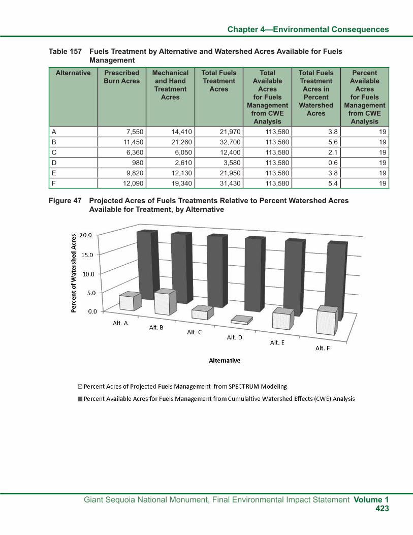
Chapter 4—Environmental Consequences
Giant Sequoia National Monument, Final Environmental Impact Statement Volume 1423
Figure 47 Projected Acres of Fuels Treatments Relative to Percent Watershed Acres Available for Treatment, by Alternative
Table 157 Fuels Treatment by Alternative and Watershed Acres Available for Fuels Management
Alternative Prescribed Burn Acres
Mechanical and Hand Treatment
Acres
Total Fuels Treatment
Acres
Total Available
Acres for Fuels
Management from CWE Analysis
Total Fuels Treatment Acres in Percent
Watershed Acres
Percent Available
Acres for Fuels
Management from CWE Analysis
A 7,550 14,410 21,970 113,580 3.8 19B 11,450 21,260 32,700 113,580 5.6 19C 6,360 6,050 12,400 113,580 2.1 19D 980 2,610 3,580 113,580 0.6 19E 9,820 12,130 21,950 113,580 3.8 19F 12,090 19,340 31,430 113,580 5.4 19

Chapter 4—Environmental Consequences
Volume 1 Giant Sequoia National Monument, Final Environmental Impact Statement424
Climate Change and Fire ManagementAs scientists and land managers focus on fire and its effects on natural ecosystems, climate plays a central role in shaping fire regimes over long time periods and in generating short-term weather that drives fire events. Recent changes in climate and fire patterns have been observed in many areas of the world, and current projections are that ongoing and long-term changes are likely. Extreme fire events can be prepared for by restoring some ecosystems and reducing uncharacteristic fuel levels with prescribed burning, mechanical treatments, and managed wildfire to protect the objects of interest and move toward desired conditions. Burning under the relatively mild fire weather conditions of a prescribed fire produces lower intensity burns and, generally, less carbon emissions than a fire burning under more extreme wildfire conditions. Managed wildfire in fire-adapted ecosystems at the landscape scale can be used to restore fire regimes and reduce fuel loads. More aggressive use of managed wildfire during lower hazard fire seasons would offer particular opportunities for relatively low-risk, large-scale burning. This would allow more acres to be burned under less extreme fire weather conditions than fires that might occur in the future under extreme heat or drought conditions (Association for Fire Ecology, 2006).
The use of prescribed burns to manage western forests may help the United States reduce its carbon footprint (Wiedinmyer 2010, Wiedinmyer and Hurteau 2010). A new study finds that such burns, often used by forest managers to reduce underbrush and protect bigger trees, release substantially less carbon dioxide emissions than wildfires of the same size.
According to Christine Wiedinmyer, “It appears that prescribed burns can be an important piece of a climate change strategy. If we reintroduce fires into our ecosystems, we may be able to protect larger trees and significantly reduce the amount of carbon released into the atmosphere by major wildfires.”
Drawing on satellite observations and computer models of emissions, the researchers associated with the study concluded that widespread prescribed burns can reduce fire emissions of carbon dioxide in the west by an average of 18 to 25 percent and
by as much as 60 percent in certain forest systems (Wiedinmyer and Hurteau 2010).
Wildfires often destroy large trees that store significant amounts of carbon. Prescribed fires are designed to burn underbrush and small trees, which store less carbon. By clearing out the underbrush, these controlled burns reduce the chances of subsequent high-severity wildfires, thereby protecting large trees and keeping more carbon locked up in the forest. According to Mathew Hurteau, “When fire comes more frequently, it’s less severe and causes lower tree mortality. Fire protects trees by clearing out the fuel that builds up in the forest” (Wiedinmyer and Hurteau 2010).
Standards and Guidelines and MonitoringEffects on fire and fuels change the surface fuels in the Monument and the buildup of those fuels that have increased the likelihood of severe wildfires. Fuels reduction is important to restoring natural forest resilience and protecting all of the objects of interest.
The standards and guidelines for fire and fuels displayed in Appendix A follow the 1988 Forest Plan, the 1990 MSA, and the 2001 SNFPA. The Clinton proclamation describes the need to “counteract the effects of a century of fire suppression” and “an unprecedented buildup of surface fuels” (Clinton 2000, p. 24096). Fire and fuels management can help address these needs. These standards and guidelines are designed to fulfill fuels management objectives by protecting the objects of interest and improving forest resilience.
The monitoring plan developed for the Monument, as described in Part 3, Design Criteria, of the Monument Plan, contains implementation and effectiveness monitoring for fire and fuels management. Planned monitoring will help evaluate how fire and fuel treatments in the WUI and general Monument meet management strategies and objectives and help reduce the threat and severity of wildfire. The data collected and analyzed will inform specialists and managers of any additional effects from managed wildfire, prescribed burns, and other fuels reduction activities.

Chapter 4—Environmental Consequences
Giant Sequoia National Monument, Final Environmental Impact Statement Volume 1425
Effects on Air ResourcesAssumptions and MethodologyParticulate Matter in the Southern Sierra NevadaThe following figure depicts seasonal patterns for PM2.5 in the southern Sierra Nevada and the city of Fresno.
PM2.5 data for Fresno follow a trend of increased PM2.5 during the winter months (November to February). This seasonal pattern contrasts with the most remote site at Pinehurst, where monthly averages are lower in the winter and higher in the summer. Winter PM2.5 concentrations in the Monument appear to be disconnected from the central valley in the winter months.
Overall, PM2.5 concentrations diverge during the winter months, and trend together during the summer months. Urban contributions to PM2.5 are limited in more remote areas during the winter months. Beginning in April and continuing to August, PM2.5 is in equilibrium between lower and higher elevation areas on the western slope of the Sierra Nevada.
Sites situated between urban and undisturbed areas show a seasonal pattern that is influenced by elevation and proximity to urban areas. This is potentially driven by winter inversions that set up over the central valley. These inversions may slow the transport of PM2.5 from urban areas by inhibiting the mixing and venting of air masses from the central valley.
Figure 48 2006 to 2008 Monthly Mean, All Data PM2.5
The following figure is a regression plot of elevation and PM2.5. The data used were obtained from the Interagency Monitoring of Protected Visual Environments (IMPROVE) network from 2002 to 2008, the Air Resources Board (ARB) network
from 2006 to 2008, and the Forest Service network from 2006 to 2008. Sites in the IMPROVE network include Yosemite National Park, Sequoia and Kings Canyon National Parks (SEKI), Kaiser, and the Dome Land Wilderness. Sites in the Forest Service

Chapter 4—Environmental Consequences
Volume 1 Giant Sequoia National Monument, Final Environmental Impact Statement426
Figure 49 Particulate Matter versus Elevation
network include North Fork, Pinehurst, Springville, and Trimmer. Visalia and Fresno are sites in the ARB network.
Site elevation may be the main factor in the Sierra Nevada for PM2.5 concentrations. Lower elevations and sites located near urban areas have seasonal high PM2.5 during the winter months (November to February). Higher elevation sites such as Pinehurst and Kernville see a decrease in PM2.5 during this period. The site at Springville has a slight increase in PM2.5 during the winter. In November, Springville was mixing well with Fresno, but was isolated from the higher elevation sites.
Sites at elevations higher than 400 meters are currently below national air quality standards. These findings indicate that locations in the Monument, which form part of the San Joaquin Air Basin, are under attainment or are cleaner than urban locations.
Late summer to early fall, PM2.5 concentrations in sites located between urban areas and wilderness are lower than what would be expected if PM concentrations were being driven primarily by fire. Further, the data suggest that elevation (including location) and time of year are helpful management considerations for fire. This information, coupled with the small size of prescribed fires, may prevent hazardous effects to air quality.
Retrospective Analysis of Burn DaysBurn day designations within the Monument are currently designated by the San Joaquin Valley Air Pollution Control District (SJVAPCD). Until recently, the California Air Resources Board (CARB) has provided this service. The data used for the retrospective analysis were based on burn day designations historically provided by CARB. Annual summaries used to establish trends and daily records from 1998 to 2001 were used to look at monthly variations.
An examination of CARB burn day records from 1973 to 2000 (shown in the following figure) suggests that designated burn days have declined in the Monument since 1973. Up to about 1988, more than 95 percent of the days each year were permissive burn days. From 1988 to 2000, the number of permissive days was just under 80 percent. Even though burn days have declined since 1973, a fairly high percentage of days remain available. The SJVAPCD is planning to develop a burn day designation process that will involve dividing the SJVAPCD up into zones. More refined meteorological data is expected to provide better forecasting and the ability to differentiate “burn” and “no burn” designations at a zone scale. This process could provide more burn day designations in the Monument.
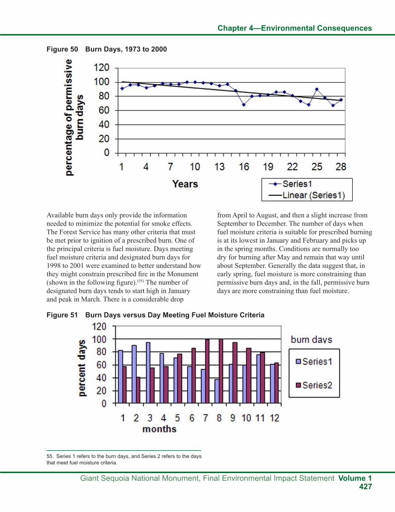
Chapter 4—Environmental Consequences
Giant Sequoia National Monument, Final Environmental Impact Statement Volume 1427
Figure 50 Burn Days, 1973 to 2000
Available burn days only provide the information needed to minimize the potential for smoke effects. The Forest Service has many other criteria that must be met prior to ignition of a prescribed burn. One of the principal criteria is fuel moisture. Days meeting fuel moisture criteria and designated burn days for 1998 to 2001 were examined to better understand how they might constrain prescribed fire in the Monument (shown in the following figure).(55) The number of designated burn days tends to start high in January and peak in March. There is a considerable drop
from April to August, and then a slight increase from September to December. The number of days when fuel moisture criteria is suitable for prescribed burning is at its lowest in January and February and picks up in the spring months. Conditions are normally too dry for burning after May and remain that way until about September. Generally the data suggest that, in early spring, fuel moisture is more constraining than permissive burn days and, in the fall, permissive burn days are more constraining than fuel moisture.
Figure 51 Burn Days versus Day Meeting Fuel Moisture Criteria
55. Series 1 refers to the burn days, and Series 2 refers to the days that meet fuel moisture criteria.

Chapter 4—Environmental Consequences
Volume 1 Giant Sequoia National Monument, Final Environmental Impact Statement428
Both fuel moisture records and burn day designations for the 1998 to 2001 period were used to examine monthly variation in permissive burn days that met fuel moisture criteria (shown in the following figure). The data suggest slightly more days meeting both criteria in the fall burn period than in the spring
period. The traditional burning period in the spring (March, April, May) averages about 45 percent of the days meeting criteria. The traditional burning period in the fall (September, October, November) averages over 50 percent of the days meeting criteria.
Another factor that could limit prescribed fire application is the availability of consecutive burn days meeting a prescription for larger projects that might take multiple days to complete. The 1998 to 2001 data was examined to better understand the opportunities for multiple day projects. The frequency (percent) of
burn periods following a no burn period that would extend at least three days is displayed in the following figure. Fuel moisture criteria are integrated as well. Coordination with SJVAPCD staff might allow better predictions of these periods.
Figure 52 Burn Days Meeting Fuel Moisture Criteria
Figure 53 Percent of Burn Periods Meeting Criteria

Chapter 4—Environmental Consequences
Giant Sequoia National Monument, Final Environmental Impact Statement Volume 1429
Of those periods that exceeded three days, the average length was four and half days. The monthly variation in the average length of days exceeding three days is shown in the following figure. These data tend to indicate that sufficient opportunity exists to allow
the varying amounts of prescribed fire considered in each alternative. The more complex issue may be one of public acceptance of smoke, which is discussed in more detail in the following section on smoke and public nuisance.
Emissions from Management ActivitiesSmoke from prescribed burning and wildland fire affect air quality and are a concern for potential adverse effects on human health and visibility. Smoke can affect visitors to the Monument and residents in surrounding communities.
Prescribed BurningWhen considering the use of prescribed burning to reduce fuels and restore the natural role of fire in ecosystems, the effects of smoke must be evaluated.
The use of prescribed burning to restore natural processes to the fire-adapted landscape of the Monument must weigh both the potential benefits and the potential effects on air quality, both within the Monument and the air district. In spite of their ecological benefits, prescribed fires, as well as natural fires, produce gases and aerosols that have instantaneous and long-term effects on air quality (Fang et al. 1999). The extent of these effects depends on fire size, fuel composition, and the physical and chemical characteristics of the events (Kasischke
and Penner 2004). Before 1800, 1.8 million hectares burned annually in California (Stephens et al. 2007). High severity, stand-replacing fires have been increasing in frequency since that time (Miller et al. 2008). Keeping the Sierra Nevada frequent, low-intensity fire regime functioning can reduce emissions and fire severity (Collins et al. 2007, Hurteau et al. 2008). A healthy, functioning natural ecosystem will accomplish long-term air quality goals for the Monument and help buffer anthropogenic emissions from the region.
Fires emit large amounts of particulate matter (PM10 and PM2.5) and carbon monoxide (CO), as well as the precursors to ozone: nitrous oxides (NOX) and volatile organic compounds (VOCs). Other chemical constituents of smoke such as polycyclic aromatic hydrocarbons (PAHs) may also enter the lungs. Some carcinogenic components in smoke are benzo-pyrene and aldehydes.
Wildfires result in greater emissions per acre when compared to prescribed burns. They also typically occur under conditions of high temperature and low
Figure 54 Average Number of Days Meeting Criteria

Chapter 4—Environmental Consequences
Volume 1 Giant Sequoia National Monument, Final Environmental Impact Statement430
humidity, when high concentrations of ozone are most likely. Prescribed burning mitigates effects on air quality by reducing existing fuels and decreasing fire hazard and the risk of high intensity wildfire. Prescribed burning allows for better control and timing of emissions and a decrease in the quantity of fuels available for consumption in a wildfire. Infrequent, large wildfires still occur naturally in some vegetation types. Prescribed fire helps to reduce the frequency and extent of large-scale high intensity wildfire events and the corresponding negative effects on air quality.
The composition and quantity of smoke emissions from fires and the effect of those emissions on local and regional air quality vary dramatically with the chemistry and condition of the fuel, the amount and arrangement of fuel layers, the behavior of the fire and weather conditions, and the size and type of fire that occurs (Ward and Hardy 1991). The phase of combustion also affects fire emissions. For instance, smoldering combustion produces more CO, NH3, and particulates than flaming combustion (Griffith et al. 1991, Ward 1999). With higher fuel moisture, a greater proportion of consumption occurs in the smoldering phase of the fire. This phase typically has lower combustion efficiency. The smoldering phase is the least efficient due to incomplete combustion and yields the highest pollutant to consumed fuel ratio.
The number of acres burned is the single most important factor in determining total emissions within an airshed. Large fires, whether originating as wildland fires or prescribed fires, produce more total emissions than small fires. Therefore, reducing the total acreage burned, regardless of the type of fire, is the most effective way to reduce the total emissions within an airshed for a short time interval (less than 100 years). In the Monument, fire acres burned per year will likely remain similar over longer time periods (thousands of years).
Fire type also influences emissions. Prescribed fires typically produce lower per-acre emissions than wildfires. Heading fires (a fire that burns with the wind) typically produce lower per-acre emissions
than backing fires, and surface fires typically produce lower per-acre emissions than crown fires. The differences in emissions among the different fire types may be attributed to differences in meteorological conditions, fuel properties, and resultant fire behavior and fuel consumption. Because prescribed fire generally produces lower per acre emissions than wildfire, it is possible to burn more acres with prescribed fire than would normally occur with wildfire and produce the same total emissions within an airshed.
The primary benefit of a prescribed fire program is in modifying the timing, size, and type of fire that occurs within a particular geographic region. With prescribed fire, it is possible to replace large, high-intensity wildfires characterized by high fuel consumption and high total emissions with smaller, lower-intensity prescribed fires characterized by lower fuel consumption and lower total emissions. This decrease in wildfire emissions typically comes with increased prescribed fire emissions. Prescribed fire allows for some control of emissions by allowing air regulators to help time emissions to minimize human health effects.
Tian et al. (2008) investigated air quality effects of prescribed fires under different management practices and fire return intervals in the southern pine forests of Georgia. They found that nighttime air quality effects from prescribed fire during the smoldering phase are greater than in the flaming phase. This is because at night, when smoldering is the highest, dispersion is the lowest. They also showed that the frequency of prescribed fire is inversely proportional to the amount of emissions. When the burn frequency is low, more biofuel is burned in each fire, leading to larger emissions and air quality effects per fire. In addition, more fuels of larger size, which usually cannot be consumed completely during flaming, contribute significantly to smoldering emissions when the time between fires increases.
Air quality effects are measured in terms of pollutant concentrations in ambient air, not in terms of total emissions. Emissions do not equate to concentrations.

Chapter 4—Environmental Consequences
Giant Sequoia National Monument, Final Environmental Impact Statement Volume 1431
Higher emissions do not necessarily mean higher concentrations. Air concentrations are a function not only of the total emissions within the airshed, but also of the timing of the emissions, the locations of emission sources relative to sensitive receptors, the meteorology of the area, and the physical characteristics of the plume. Prescribed fire generally produces lower total emissions, lower fire intensity, lower total heat production, and lower plume rise than wildfires. A wildfire can often lead to higher smoke concentrations at locations farther from the source than a similar size prescribed fire. This difference can often lead to higher smoke concentrations at locations far from the source than a prescribed fire of the same size. Type of fire, distance from the source, and acres burned per day are likely the main factors determining human health effects from smoke.
Effects on CO2 Emissions and the Carbon Budget from Prescribed BurningAn issue of significance concerning prescribed burning emissions is their effects on the carbon budget. Western and southeastern U.S. Needle-leaf forests were estimated to be dominant contributors to total yearly U.S. fire CO2 emissions, which amounted to 293 Tg CO2 /yr for the period 2002-2006 (1 Tg or teragram = 1012 g) (Wiedinmyer and Neff 2007). California contributed a significant annual average emission of CO2 from fires, 24 Tg/yr, equivalent to six percent of fossil fuel combustion estimates. Prescribed fires were observed to constitute an insignificant percentage of this emission. A 2002 study by the CARB (2006) estimated CO2 emissions from prescribed fires in California to be 123,480 Mg/yr (1 Mg or megagram = 106 g). Although current prescribed fire emissions are an insignificant percentage of the total fire emissions, different scenarios that increase prescribed fire acreage and frequency need to be analyzed for their effects on the forest of the Monument as a carbon sink or source. Fluxes of other carbon forms such as black carbon and dissolved organic carbon, in addition to CO2, will also have to be included in these carbon budget equations. Black carbon, an air pollutant and residue of incomplete combustion, is persistent in the
environment and may constitute a significant portion of the total carbon emissions from forest fires in California and the San Joaquin Valley Basin.
MethodologyPM2.5 and CO2 emissions were calculated using the methods outlined by the General Conformity to State Implementation Plan Handbook (USDA Forest Service 1995f). The emissions calculations used the total number of acres to be treated, vegetation type, estimated fuel loading, and an emissions factor. The projected acres of prescribed and wildfire were predicted with the SPECTRUM model (see Appendix B for a detailed explanation of the model).
The emission calculation formula is as follows:
E = S (A x L x EF x %C)/2000 (tons)
L= Fuel loading for ith species (tons)
EF= Emission factor for ith species (lbs/ton)
%C= Percent Combustion
Indirect EffectsAir QualityPrescribed burns produce ozone precursors. Ozone problems in the Monument occur mainly during the summer (May through September) and are primarily driven by urban influence. Prescribed burns are typically not conducted during this time period. This evaluation will only analyze the possible effects of prescribed burns on PM2.5 levels. Wildfires occur during this time, but it is impossible to predict when they will happen. It is assumed that if a wildfire occurs in the Monument the concentrations of particulate matter will be the most affected. Ozone concentrations are assumed to be less affected, and PM2.5 is a better representative of overall air quality effects.
The following figure presents, by alternative, the predicted PM2.5 emissions from prescribed fire by decade. Prescribed fires were predicted with the SPECTRUM Model.

Chapter 4—Environmental Consequences
Volume 1 Giant Sequoia National Monument, Final Environmental Impact Statement432
Figure 55 Prescribed Fire PM2.5 Emissions
The following figure shows, by alternative, the predicted PM2.5 emissions from wildfire by decade.
Wildfires were predicted with the SPECTRUM Model.
Figure 56 Wildfire PM2.5 Emissions
Prescribed fire and wildfire are separated to better analyze overall effects to air quality. Differences in total PM2.5 emissions generated by the model are not significant between scenarios. All model scenarios would have virtually the same overall effect on air quality. Trade-offs between levels of control between emissions are the primary factors in overall effects to air quality.
Prescribed fire primarily burns during the spring or fall. This can prevent the occurrence of destructive summer fires, thus decreasing emissions and minimizing air quality effects. Destructive fires have the greatest effects on air quality. Land management agencies have no control over when these fires start and very little control after they start. Wildfire can burn large areas quickly. Wildfires that are not controlled can have very high emissions that lead to
the high production of air pollutants and degradation of local and regional air quality.
Effects on air quality are likely to be most affected with a change in fire return intervals in the Monument that increase fuel consumption. This could be the effect of temperatures above the historic normal, changes in precipitation that cause conditions that are drier than normal, and forest type conversion.
The following table ranks the overall effects on air quality, with specific rationale for each alternative. Because of the removal of fuels, Alternative E would likely have the least effect on air quality. Alternatives B and F, similar to Alternative E, would maximize emission control and minimize wildfire emissions. Alternative A would reduce wildfire emissions, but not allow as much control of emissions as Alternatives

Chapter 4—Environmental Consequences
Giant Sequoia National Monument, Final Environmental Impact Statement Volume 1433
B, E, and F. Alternative C would increase short-term emissions by maximizing wildfire re-introduction and limiting mechanical fuels reduction. Alternative D
would have the greatest effects on air quality because emissions would be dominated by wildfires with the greatest potential to change the fire system.
Table 158 Air Quality Ranking by Alternative
Alternatives Overall Effects to Air Quality
Rationale
A 3(1) Moderate wildfire emissions, with the priority of fuel reduction tools allowing for some control of emissions effects on air quality.
B 2 Low wildfire emissions, with the priority of fuel reduction tools allowing for greater control of timing of emissions release and minimizing air quality effects.
C 4 Moderately high wildfire emissions, with less use of mechanical treatments and moderate prescribed fire emissions. Restoring the natural process of wildfire without managing stand structure results in short-term (3 decades) increase in emissions.
D 5 High wildfire emissions, with much less use of prescribed fire and mechanicaltreatments. Reduces overall control of emissions while maximizing total emissions released through uncontrolled fires.
E 1 Low wildfire emissions, with greater use of mechanical treatments and prescribed fire. Allows maximum control of emissions while minimizing total emissions from fire.
F 2 Low wildfire emissions, with flexibility of management tools allowing for greater control of timing of emissions release and minimizing air quality effects.
1. Qualitative Scale: 1 lowest effect, 2 low effect, 3 moderate effect, 4 moderately high effect, and 5 high effect.
Smoke and Public NuisanceThe regulatory environment for smoke has shown an overall emphasis on accommodating prescribed fire out of recognition of the severe fire risk in the western United States. In California, the public nuisance rule provides an important protection measure for property, safety, and health. However, this rule can have an unpredictable effect on prescribed burning programs.
In response to the California Code of Regulations, the SJVAPCD enacted Rule 4102. This is the Nuisance Rule, which was adopted May 21, 1992 and amended December 17, 1992. This rule essentially requires the SJVAPCD to investigate and take action to remedy any air discharge that is causing injury, detriment, nuisance, or annoyance to any considerable number of persons.
Good smoke management techniques, improved burn day forecasts, and public communication can mitigate some complaints. Public nuisance issues
are more commonly associated with changing or unforeseen conditions in the burn day forecast, or lower elevation projects where the smoke is not fully dispersed during daytime hours. Although difficult to predict, it is probably safe to assume that the effect of public nuisance calls on prescribed fire projects would increase, given growing populations in the foothill areas on the west side of the Monument.
Cumulative EffectsAir pollution is one of the most serious threats to the Monument. It is in a region that has some of the worst air quality in the nation. Air quality is typically worse than in other national forests. Air pollution threatens the health and welfare of people and natural resources.
Air quality in the Monument is primarily driven by anthropogenic emissions. Proximity to the San Joaquin Valley suggests that air quality in the Monument will continue to degrade without significant changes in anthropogenic emissions. Most of the air pollution in the Monument originates

Chapter 4—Environmental Consequences
Volume 1 Giant Sequoia National Monument, Final Environmental Impact Statement434
in the San Joaquin Valley and is transported into the Monument by prevailing winds (Blumental et al. 1985, Lehrman et al. 1994, Shair 1987, Tracer Technologies 1992, Roberts et al. 1990, Zabik and Seiber 1993). Unlike many other states, California has few large stationary sources of air pollution. Mobile, area, and small stationary sources emit the majority of the state’s pollutants.
NOX is a key ingredient in PM2.5 and ozone formation. About 75 percent of the NOX in this area comes from mobile sources (SJVAPCD 2009). With the population in the San Joaquin Valley expected to grow by 60 percent between 2000 and 2020 (SJVAPCD 2009), the problem is likely to get worse. Population growth leads to an increase in vehicle activity. The current spread-out, car-dependent society combined with the highest population growth in the state will likely lead to more driving, which will lead to more air pollution problems.
Significant amounts of the Asian aerosols have been observed at high elevation mountain sites in the western United States (VanCuren and Cahill 2002, VanCuren 2003, Liu et al. 2003). Pollutants from Asia are a regular component of the troposphere over western North America. They are more pronounced during the spring and to a lesser extent during the summer. Pollutants from intercontinental transport contribute to some of the particulate matter (PM) and ozone problems in the Monument during the spring and summer.
Fire is the primary source of emissions from the Monument. Whereas an increase in prescribed burning has been observed in the rest of the country since the late 1990s, prescribed burning in the San Joaquin Valley and California has been essentially constant. During the same period, a sharp rise in wildfires has also been observed in California and nationwide. The risks of wildfire in the western United States will increase with an increase in temperatures (Westerling et al. 2006). This will lead to an increase in acute bad air quality episodes during the summer in the Monument. Conducting prescribed burns of greater frequency and spatial coverage can mitigate future poor air quality episodes and enhance the storage of carbon by prevention of the release of carbon to the atmosphere. Alternative E would have the least potential to affect air quality, followed by Alternatives B and F.
Climate ChangeThe climate system is often defined as average weather. The climate system is complex and interactive. Climate is usually described in terms of mean and variability of temperature, precipitation, and wind over a period of time. The periods of time range from months to millions of years. The classical period is 30 years. The climate system evolves under its own internal dynamics and external factors that affect climate. External factors include human caused changes in atmospheric composition through the increase of greenhouse gases (GHGs), as well as natural events such as solar variations and volcanic eruptions.
The most important GHGs are CO2 (carbon dioxide), CH4 (methane), N2O (nitrous oxide), several synthetic halocarbons (chlorofluorocarbons [CFCs], hydrofluorcarbons, perfluorocarbons, halons, and sulphurhexafluoride), H2O (water), O3 (ozone), and aerosols. The most important GHG related to prescribed fire in the Monument is CO2.
The Environmental Protection Agency (EPA 2007) developed a “State of Knowledge” paper that outlines what is known, what is very likely, and what is uncertain about global climate change.
The following elements are known about climate change: human activities are increasing the levels of GHGs since pre-industrial times, thus changing the composition of earth’s atmosphere; the buildup of CO2 and other GHGs are largely due to the burning of fossil fuels; an unequivocal global warming trend of about 1 to 1.7 degrees Fahrenheit occurred from 1906-2005. Greenhouse gases emitted by human activities remain in the atmosphere for periods ranging from decades to centuries; therefore, atmospheric concentrations of GHGs will continue to rise over the next few decades. Increasing GHG concentrations tend to warm the planet.
The following are very likely about climate change: the increase of anthropogenic GHG concentrations has resulted in most of the observed increase in global average temperatures since the mid-20th century; the average global temperatures and sea levels will continue to rise, and precipitation patterns will change as GHGs in the atmosphere continue to rise.

Chapter 4—Environmental Consequences
Giant Sequoia National Monument, Final Environmental Impact Statement Volume 1435
The following is uncertain about climate change: how much and how fast warming will occur; and how warming will affect precipitation patterns and the rest of the climate system.
Given what is and is not known about global climate change, the following discussion outlines the cumulative effects of this project on CO2 emissions and effects of climate change on forest resources.
Projected climate change impacts include air temperature increases, sea level rise, changes in the timing, location, and quantity of precipitation, and increased frequency of extreme weather events such as heat waves, droughts, and floods. The intensity and severity of these effects are expected to vary regionally and even locally, making any discussion of potential site-specific effects of global climate change on forest resources speculative.
Because CO2 from prescribed fire mixes readily into the global CO2 pool, it is not currently possible to discern the effects of this plan from the effects of all other greenhouse gas sources worldwide, nor is it expected that attempting to do so would provide a practical or meaningful analysis of effects. Potential regional and local variability in climate change effects add to the uncertainty regarding the actual intensity of this plan’s effects on global climate change. Further, any emissions associated with the implementation of any of these alternatives would be extremely small
in the global atmospheric CO2 context, making it impossible to measure the incremental cumulative impact on global climate.
Scrutiny of the overall carbon budget for specific ecosystems may reveal that reduction or exclusion of fires to promote forests carbon sink properties may not necessarily be effective. A recent study by Fellows and Goulden (2008) showed that due to fire exclusion between the 1930s and the 1990s, U.S. mid-montane conifer forests underwent pest and disease induced net loss of big trees while forest stem density (small tree numbers) increased. This effect caused a noteworthy net decline of above ground carbon biomass (storage). Such findings indicate prescribed burning may be a potent method for forest carbon sequestration in California and the Monument.
The potential for cumulative effects is considered negligible for all alternatives because none of the alternatives would result in measurable direct and indirect effects on air quality or global climatic patterns due to the size of the Monument. Nevertheless, different execution of alternatives would have different CO2 emission and carbon sequestration potentials. Alternative F will emit the least amount of CO2. For further discussion on carbon sequestration potential of alternatives please see the effects on vegetation conditions section in Chapter 4 of this FEIS.
Figure 57 Total CO2 Emissions

Chapter 4—Environmental Consequences
Volume 1 Giant Sequoia National Monument, Final Environmental Impact Statement436
Air Quality MonitoringThe Sequoia National Forest currently incorporates a robust smoke monitoring program into forest management practices. The current program is specifically designed to focus on the monitoring of PM2.5, meteorology, and ozone. This allows fire managers to disseminate information on critical air quality issues in a timely manner.
The monitoring program is a cooperative effort that shares information and expertise with the public, other national forests, the National Park Service, public health officials, CARB, and local air districts, particularly during fire events.
Currently, the goals of the monitoring program are to:
● Provide expertise on air quality science, policy, and regulations.
● Provide a quick monitoring response.
● Provide quality long-term monitoring data.
● Produce accurate near real time data.
● Provide technical expertise on air quality monitoring equipment.
● Use monitoring data to inform future policy decisions to enhance resource protection.
● Collect long-term air monitoring data to evaluate trends and patterns in air quality.
This monitoring is used to verify the assumptions used in planning and compliance documents, assess potential human health effects, inform of potential effects that would significantly deteriorate air quality and visibility in Class I Wilderness, and provide scientific evidence to help prevent future state and national ambient air quality standard violations.
To facilitate access to the monitoring data, Iridium and ORBCOMM satellite networks are used to relay hourly data and provide web-based data access. Near real-time data of non-validated (raw) data is available at http://www.satguard.com/USFS/default.asp. Making data available to the public and other agencies ensures transparency and allows for quick access and interpretation of all data.
Since 2005, the Forest Service has operated three permanent air quality monitoring sites to monitor air quality in the Sierra Nevada, which includes the Monument. Each site uses a Met One Instruments, Inc. Model BAM-1020, Beta Attenuation Mass Monitor (BAM), to collect hourly PM2.5 data, and a 2B Technologies, Inc. Model 202 Ozone Monitor (2B) to collect hourly ozone data. A Met One Instruments, Inc. Model E-BAM, Environmental Beta Attenuation Monitor (EBAM), is used to monitor hourly PM2.5 at three additional sites surrounding the Monument, from late spring to early winter to coincide with the fire season in the Sierra Nevada. A cache of monitoring equipment currently consists of an additional eight EBAMs and two 2Bs. This cache is used to supplement the local, regional, and national monitoring programs during smoke events.
All prescribed burns are conducted in accordance with federal, state, and SJVAPCD regulations. Prescribed burns are conducted during SJVAPCD-determined burn days. Monitoring is customized using cache equipment, when appropriate, to monitor individual prescribed fires and assist fire management and air regulating officials in determining smoke effects. Permanent and seasonally-placed monitoring equipment is used as initial monitoring coverage during wildfires, with cache equipment used as needed at temporary sites.
Monitoring SitesMonitoring sites are chosen strategically to provide data for smoke from wildfires and prescribed fires, to understand pollutant fluxes into and out of Forest Service managed land, and to establish yearly air quality patterns. Data collected are used to understand air quality in the Monument including the effects of emissions from the Monument and the effects of emissions on the Monument from outside sources. Data collected during an incident are analyzed to help understand fire effects on public health, the transport of smoke, and the relation of emissions estimates, fire intensity, and size to PM2.5 and ozone concentrations.
The air quality monitoring program keeps fire managers, the public, and appropriate authorities informed of current air quality where there are potential effects from smoke.

Chapter 4—Environmental Consequences
Giant Sequoia National Monument, Final Environmental Impact Statement Volume 1437
Standards for Air QualityThe following table shows the standards that the public can use to determine which concentrations of
PM2.5 are harmful, the effects of each concentration, and the precautionary actions that the public should take.
Table 159 EPA’s PM2.5 Standard Index
Standard Index Category
PM2.5 24-hr Concentration
(µg/m3)
Health Effects Cautionary Statements
Good 0-15.4 None. None.Moderate 15.5-40.4 None. None.Unhealthy for sensitive groups
40.5-65.4 Increasing likelihood of respiratory symptoms in sensitive individuals, aggravation of heart or lung disease and premature mortality in persons with cardiopulmonary disease and the elderly.
People with respiratory or heart disease, the elderly and children should limit prolonged exertion.
Unhealthy 65.5-150.4 Increased aggravation of heart or lung disease and premature mortality in persons with cardiopulmonary disease and the elderly; increased respiratory effects in general population.
People with respiratory or heart disease, the elderly and children should avoid prolonged exertion; everyone else should limit prolonged exertion.
Very unhealthy 150.5-250.4 Significant aggravation of heart or lung disease and premature mortality in persons with cardiopulmonary disease and the elderly; significant increase in respiratory effects in general population.
People with respiratory or heart disease, the elderly and children should avoid any outdoor activity; everyone else should avoid prolonged exertion.
Hazardous >250.4 Serious aggravation of heart or lung disease and premature mortality in persons with cardiopulmonary disease and the elderly; serious risk of respiratory effects in general population.
Everyone should avoid any outdoor exertion; people with respiratory or heart disease, the elderly and children should remain indoors.
The following table can be used by the public to determine the visibility range and assess the air quality in their area.
Table 160 EPA’s PM2.5 Standard Index
Category PM2.5 1-hr Avg. Concentration (µg/m3) Visibility Range (miles)Good 0-40 ≥10 milesModerate 41-80 6 to 9 milesUnhealthy for sensitive groups 81-175 3 to 5 milesUnhealthy 176-300 1½ to 2½ miles Very unhealthy 301-500 1 to 1¼ milesHazardous Over 500 ≤¾ mile

Chapter 4—Environmental Consequences
Volume 1 Giant Sequoia National Monument, Final Environmental Impact Statement438
The procedure for using personal observations to determine the approximate PM2.5 concentration for local areas is as follows:
1. Face away from the sun.
2. Determine the limit of your visible range by looking for targets at known distance (miles).
Visible range is that point at which even high contrast objects totally disappear.
3. Use the values above to determine the local forest fire smoke category.
Effects from Climate ChangeIndirect EffectsClimate change is one of the greatest challenges to sustainable management of forests and human well-being because rates of change will likely exceed many ecosystems’ capabilities to naturally adapt. Rapidly changing climate and associated agents of change, such as amplified fire regimes, insects and diseases, atmospheric contaminants, and invasive species, have resulted in recent impacts to forest ecosystems and resources in the Monument and surrounding Sierra Nevada. Anticipating future effects of changing climate to these ecosystems will be challenging, since climate projections are inherently uncertain and climate-related stressors are variable and complex. An adaptive management approach that incorporates the best available science information, monitors ecological conditions, and adjusts management approaches based on these conditions is crucial in an era of rapidly changing climate.
The first step in addressing climagte change is to carefully assess the associated risks and vulnerabilities for natural and human communities and other values at risk. Vulnerability assessments are one management strategy that may be used to guide management for climate change. In order to build resilience, we must understand the vulnerabilities, including projected environmental changes, key values at risk, and the sensitivity of those values at risk to projected change. A vulnerability assessment spans the range of ecosystems and values at risk to identify the relative vulnerability of ecosystem components and their ability to adapt to increased stress. In turn, this helps prioritize where management actions may focus in order to maintain healthy, resilient ecosystems and protect human communities. A collaborative approach to vulnerability assessment (including management, research, and the public) can
help to avoid fragmented, piecemeal approaches that lack public support and coordinated effort.
An effective management strategy to changing climate must be flexible, responsive, incremental, and reversible (Millar et al. 2007). This will be especially challenging in forest ecosystems of the Monument and surrounding Sierra Nevada that are typified by homogeneous canopy structure and heavy fuel loads, resulting from decades of fire exclusion and intensive logging (McKelvey and Johnston 1992, North et al. 2007). Both adaptation strategies and mitigation strategies will be necessary to manage forest ecosystems in the context of changing climates and amplified fire regimes (Millar et al. 2007, Stephens et al. 2010). Adaptation strategies increase the resilience of ecosystems and resources to climate change impacts (IPCC 2007). Promotion of key ecological processes, heterogeneity in forest structure, biodiversity, and reduced surface and ladder fuels conducive to restoring wildland fire are examples of effective adaptive strategies for Sierra Nevada ecosystems in the face of changing climate (Stephens et al. 2010). Mitigation strategies seek to reduce the long-term severity of climate change by lowering the concentration of greenhouse gases in the atmosphere. Examples of mitigation strategies include carbon sequestration in ecosystems, renewable energy to reduce fossil fuel consumption, and reduction in carbon footprint through sustainable practices and operations. If we actively manage ecosystems before climate-related effects induce change, long-term management goals may be attained more effectively with fewer resources. Short-term adaptations build resistance and resilience so that ecosystems are better able to withstand change, while long-term adaptations are needed to avoid thresholds being crossed where one ecosystem abruptly transitions into another (Blate et al. 2009).

Chapter 4—Environmental Consequences
Giant Sequoia National Monument, Final Environmental Impact Statement Volume 1439
Below, the alternatives are compared with respect to their predicted relative abilities to support six adaptation or mitigation strategies that are current focus areas for Forest Service response to climate change (USDA Forest Service 2008h, 2011). These strategies and their associated effects include: (1) building adaptive capacity of ecosystems through ecological restoration, (2) enhancing watershed function, (3) sequestering forest carbon, (4) reducing existing stresses and environmental footprint, (5) encouraging sustainable operations, and (6) fostering science-management partnerships and public education.
Adaptive Capacity of Ecosystems through Ecological RestorationKoopman et al. (2011) and the Southern Sierra Partnership assessment (SSP 2010) recommend several adaptation strategies for the management of woodlands, forests, and other terrestrial ecosystems in the southern Sierra Nevada, including:
● Manage for forest heterogeneity at multiple spatial scales
● Reduce the density of small-diameter, shade-tolerant trees in fire-adapted forests
● Reduce the chance of uncharacteristically severe wildfire using ecologically-appropriate prescribed fire and thinning treatments
● Implement rapid detection of and response to invasive species
● Identify and protect future climate refugia for native species persistence
● Maintain and restore habitat connectivity across the entire ecoregion for forest and woodland species
● Protect and enhance tree recruitment in blue oak and valley oak woodlands
● Increase partnerships and education programs designed to build adaptive capacity of ecosystems
Alternatives B, C, D, and F would manage for forest heterogeneity using principles and concepts outlined in North et al. (2009). Alternatives A and E would not promote resilience to stressors using forest heterogeneity approaches. All Alternatives include the reduction of small-diameter, shade-tolerant trees
to increase forest resilience. However, based on the modeled prescribed fire and mechanical treatments per decade, the greatest number of small-diameter trees will be removed (using fire or mechanical thinning) in Alternatives B and F, followed by Alternatives A, E, and C. The least number of small-diameter trees will be removed in Alternative D.
Alternatives B and F and, secondarily, Alternatives A and E, have the greatest potential to reduce the chance of uncharacteristically severe wildfire in the Monument based solely on the modeled fire and thinning treatments per decade. Alternative D focuses on passive restoration and relies predominantly on managed wildfire to reduce vulnerability of ecosystems. Managed wildfire can be a useful management approach, but reliance on this tool as the primary method for ecological restoration is challenging for several reasons. Decades of fire exclusion coupled with intensive logging in Monument forest ecosystems have resulted in uncharacteristically high fuel loads and homogenous forest structure conducive to crown fire spread (Kilgore and Sando 1975, McKelvey and Johnston 1992). These conditions increase the susceptibility of fire-adapted forest ecosystems to uncharacteristically severe wildfire, insects or disease outbreaks, and drought-triggered mortality (North et al. 2009, Stephens et al. 2010). Projected changes in climate may also exacerbate these conditions and limit the air quality and operational opportunities suitable for managed wildfire in the southern Sierra Nevada.
No aternatives have identified future climate refugia for native species persistence. However, future vulnerability assessments (see Science-Management Partnerships) for the southern Sierra Nevada may identify refugia that can be prioritized for restoration or monitoring.
All alternatives maintain and restore habitat connectivity for sensitive forest species across the southern Sierra Nevada. The greater acreage of protected sensitive species habitat in Alternatives A, B, D, and F may facilitate greater habitat protection and connectivity for these species.
No alternatives include specific adaptation or other ecosystem management strategies for blue and valley oak woodlands. All alternatives include partnerships

Chapter 4—Environmental Consequences
Volume 1 Giant Sequoia National Monument, Final Environmental Impact Statement440
and educational components designed to support ecological restoration in the Monument.
Watershed FunctionProjected increases in winter and early spring runoff will increase flood potential in Monument rivers and streams fed principally by snowmelt. This is principally a result of earlier seasonal peak daily flows and the increase in the proportion of precipitation in the form of rain. Projected increases in wildfire frequency and intensity in the southern Sierra Nevada may also affect watersheds by increasing soil erosion, sedimentation, and the severity of fire effects to riparian and aquatic ecosystems. Blate et al. (2009), SSP (2010), and Koopman et al. (2011) suggest several adaptive strategies to promote resilient watersheds to current and future stressors, including:
● Restore ecosystem function to degraded meadows, wetlands, and riparian habitats
● Decommission or redesign roads to withstand increased rainfall intensity
● Restore proper function to floodplains and stream channels
● Maintain or increase shading and stream flow to cold-water refugia in aquatic ecosystems
● Promote riparian and aquatic habitat connectivity
● Increase forest resiliency to uncharacteristically severe wildfire and drought
Alternatives B and F provide the greatest degree of protection to watersheds by placing more refined standards and guidelines for streamside management. Alternative D has the least protection for watersheds and hydrologic resources due to the increased potential for wildfires burning at increased frequency and severity outside the historic range of variation. Alternatives C and E are at moderate risk for large, severe wildfires that could potentially lead to increased soil erosion and sedimentation in aquatic ecosystems. Alternatives A and B include a meadow restoration strategy that may increase the resiliency of meadows to projected increases in floods and peak daily flows. Alternatives C and D have the greatest number of decommissioned roads and fewest miles of open roads that could contribute to soil erosion and sedimentation. Alternative A has the greatest miles
of open roads, resulting in the greatest potential for chronic soil erosion within managed watersheds.
Carbon SequestrationForest ecosystems are a potential sink for carbon that might otherwise contribute to climate change through the release of carbon dioxide. However, uncharacteristically severe wildfire poses a long-term risk to carbon storage in Sierra Nevada forests through the combustion of above- and below-ground biomass (Hurteau and North 2010). Forest management strategies that sequester carbon in wood products, retain large trees and other carbon-retaining structures, and avoid uniform, high-density forest conditions that are vulnerable to stressors have high potential to reduce greenhouse gas emissions over the coming century (Millar et al. 2007). In the southern Sierra Nevada, forest restoration treatments that focus on reducing surface fuels, thinning the majority of small trees, and removing only fire-sensitive species in the merchantable, intermediate size class are most effective at retaining current carbon pools levels (North et al. 2009). Understory mechanical thinning, with retention of large, fire-resistant overstory trees, and prescribed fire are particularly effective at recovering and sustaining forest carbon pools in the long-term (Hurteau and North 2010, North and Hurteau 2011).
Alternative B is most likely to retain the highest level of forest carbon over the coming century. Treatments under this alternative include a high proportion of understory mechanical thinning and prescribed fire treatment acres that focus on the removal of fire-sensitive trees in the small to intermediate size classes. Alternative B likely retains the greatest number of large, fire-resistant overstory trees in the long-term, while maintaining resiliency to wildfire and changing climate. Alternative F may provide resiliency to future climate conditions, but the removal of large-diameter forest structures will not maximize carbon pools in the short- or long-term. Alternatives A, C, and E will retain an intermediate level of forest carbon in the long-term. Alternative D may sequester the greatest amount of carbon in the immediate future but will likely have the least forest carbon storage in the long-term, as warming climate and increased wildfire frequency and severity reduce carbon pools in these fire-prone forests.

Chapter 4—Environmental Consequences
Giant Sequoia National Monument, Final Environmental Impact Statement Volume 1441
Effects on Wildlife and Plant HabitatEffects on WildlifeAssumptions and MethodologyThe standards and guidelines for wildlife displayed in Appendix A are designed to protect those objects of interest both inside and outside groves. These standards and guidelines follow the 2001 or 2004 SNFPA management direction, goals, and desired conditions for the protection of key habitat characteristics. The old forest associated species conservation strategy from the 2001 SNFPA aims to
provide habitat conditions that are likely to maintain viable, well-distributed populations of old forest associated species, especially California spotted owls, northern goshawks, great gray owls, and forest carnivores.
Throughout the Monument, even in the WUI zones and the TFETA, mechanical treatments will be limited or prohibited in wilderness (existing or proposed), in wild and scenic river corridors, in inventoried roadless areas, in research natural areas, in riparian conservation areas, on slopes exceeding 35 percent, in areas greater than 9,000 feet in elevation, and in areas more than one-quarter mile from a road,
Reducing Existing StressesAside from the environmental stressors identified in prior sections, invasive species have a profound negative effect on a variety of terrestrial and aquatic ecosystems. All alternatives take an aggressive approach to controlling invasive species and preventing their introduction and spread. An early detection and rapid response strategy associated with invasive species will be critical to limit new introductions and prevent the spread of existing populations of invasive species. Aggressive treatment of established invasive species will be an important component of ecosystem management under a changing climate. Collaborative efforts with agencies and local partners will be necessary if the detection, eradication, and containment of invasive species within the Monument and surrounding lands are to be successful.
Alternative C would reduce the potential spread of many invasive plant species by restricting the total miles of open roads in the Monument. Alternative D may have the greatest potential to spread nonnative invasive species due to the increased potential for large severe wildfires associated with the spread of invasive plant species (Keeley et al. 2011). This is especially possible in the lower elevation portions of the Monument.
Sustainable OperationsIn all of the alternatives, the Monument will reduce its environmental footprint and decrease greenhouse gases emitted through implementation of sustainable
practices in its day-to-day operations. This includes the use of more fuel-efficient vehicles, reducing the number of miles driven, incorporating waste-reduction policies, and making facilities more energy-efficient.
Science–Management PartnershipsThe Monument will continue to develop science-management partnerships to be more effective at managing ecosystems in response to changing climate and other stressors. Collaboration and partnerships between scientists, managers, and stakeholders are identified as a crucial element in planning for and adapting to changing climate and associated stressors (Koopman et al. 2011, Littell et al. 2011). The Monument is currently an active partner in the Southern Sierra Conservation Cooperative and Southern Sierra Nevada Ecoregion Fire-Climate Planning Exercise. Both collaborative efforts are under the “Strategic Framework for Science in Support of Management for the Southern Sierra Nevada Ecoregion.” These partnerships bring together managers and scientists from Sequoia and Kings Canyon National Park, Sequoia National Forest/Giant Sequoia National Monument, the University of California Davis, U.S. Geological Survey Western Ecological Research Center, Bureau of Land Management, state and local governments, non-governmental organizations, and other stakeholders to develop adaptation and mitigation strategies to accelerated climate and other stressors in the ecoregion (Nydick and Sydoriak 2011a, b).

Chapter 4—Environmental Consequences
Volume 1 Giant Sequoia National Monument, Final Environmental Impact Statement442
with the exception of hazard trees. Based on these constraints, approximately 23 percent of the 328,315 acres in the Monument could be considered for mechanical treatment (alone or in conjunction with fire), compared to about 77 percent that could be considered for fire treatments.
Ecological Restoration and WildlifeEcological restoration for wildlife is defined as a reestablishment of natural functions and processes in the Monument that provide a diverse range of high quality habitats. Priority areas for restoration are those sites which were modified from their natural state by fire suppression, logging, unmanaged grazing, adverse changes in hydrology and historic development. The goal for management of wildlife habitat is to return human-disturbed areas to the natural conditions and processes characteristic of the ecological zone in which the damaged resources are situated. Ultimately, restored areas would be maintained as valuable wildlife habitat through natural processes, with little human management required. These restored areas could then contribute to the maintenance of viable populations of animal species in the Monument.
Restoration efforts may include, for example:
● Return of a natural fire regime
● Removal of exotic species
● Restoration of abandoned unneeded roads, areas over-grazed by domestic animals, or disrupted natural waterways
● Restoration of areas disturbed by management activities or by public use (such as construction or OHV damage)
● Restoration of native plants and animals
Use of ScienceScientific Advisory Board (SAB) AdvisoriesAdvisory XII. Wildlife
The Monument should closely follow current and future research on the relationships between LS/OG-correlated species, and stand-structure modification as well as grazing. Direct monitoring of sensitive LS/OG species, not merely monitoring of habitat, is called for until habitat/species relationships are better understood. The California
Wildlife Habitat Relationships System (California Dept. of Fish and Game 2000), however imperfect, is presently the most powerful tool available for predicting which species will be advantaged and which species disadvantaged when habitats are changed in specific ways. Assuming that stand modification through burning or mechanical thinning is detrimental to some of these vertebrate species, science cannot say whether long-term forest health or short-term conservative protection of LS/OG-dependent vertebrates is the correct choice (Scientific Advisory Board 2003).
A great deal of knowledge of fisher’s use of habitat has been gained since the Board’s recommendations in 2003. While monitoring all of the Monument’s sensitive species would be a great help to management, it would also be cost prohibitive. Therefore, monitoring would be limited to project-level surveys and some limited annual monitoring of fisher, California spotted owls, northern goshawks, great gray owls, and little willow flycatchers would continue in all alternatives of the FEIS.
Assumptions for All AlternativesAll of the alternatives would allow short-term reductions in habitat quality (by removing trees, snags and down woody material) for some species and create potential disturbance to individual animals. In the long-term, vegetation treatments may reduce the frequency and scale of uncharacteristically severe wildfire in the Monument and improve resiliency to drought, insects, and disease.
Assumptions for Alternative AThere are a number of ongoing activities in Alternative A (No Action) that have the potential to affect wildlife. These activities would continue in the action alternatives. They include:
● Meadow restoration
● Trail and road maintenance
● Use of designated roads and trails (with some differences in the available routes by alternative)
● Vegetation treatments, including thinning, fuels, and planting
● Prescribed burning and managed wildfire
● Water improvement projects
Chapter 4—Environmental Consequences
Giant Sequoia National Monument, Final Environmental Impact Statement Volume 1443
● Campground and administrative site operations and maintenance
● Hazard tree removal
● Livestock grazing on designated allotments
● Fish stocking in rivers and lakes by California Department of Fish and Game
● Recreational use of caves
● Rock climbing
● Special use permits
● Hunting and fishing
● Science and research
● Winter sports, including snowmobiles
Methods and MeasurementsDetermining Indirect Effects The number of acres and miles of roads reported in this effects analysis for wildlife habitat were derived from a GIS analysis and are based on totals inside the Monument boundary. There was no distinction made between public, private, or state-owned land inside the Monument, which may differ from other analyses in this FEIS.
Indirect effects of the six alternatives in this FEIS were evaluated using three primary metrics:
1. Vegetation Management: Vegetation management projects for fuels reduction and ecological restoration may affect habitat important to a particular species.
2. Recreation Effects: Roads, trails, and recreation sites may affect the quality of habitat through disturbance, fragmentation, or the loss of key habitat features.
3. Special Management Areas: In some alternatives, special management areas or land allocations are utilized to protect habitat features important to sensitive species.
Large, stand-replacing fires have the potential to affect habitat suitability for a number of wildlife species. The location and extent of large wildfires are impossible to accurately predict. Modeling of the alternatives estimated that stand-replacing fire would occur on a maximum of four percent of forested land in the Monument per decade in the next
30 years (SPECTRUM model). While these fires may drastically change habitat in limited areas, the effects would only affect a small portion of habitat Monument-wide. These changes may improve habitat function for some species while degrading or otherwise limiting abundance and distribution of habitat for others.
Determining Cumulative EffectsThe cumulative effects analysis evaluates the six alternatives in context with past, present, and reasonably foreseeable actions that when taken collectively might negatively influence the species. The cumulative effects of past management activities are incorporated within the existing condition in the Monument. The Forest Service recognizes that significant scientific advances in evaluating landscape conditions have been made in the past decade and will employ improved cumulative effects analysis techniques as they become available. For example, Forest Inventory and Analysis plots may provide reference points of forest conditions over time, and landscape trajectory analyses can be used to evaluate trends in habitat quality without requiring detailed analysis of past actions. Where appropriate and based on available data, this cumulative effects analysis for site-specific projects will consider whether proposals exacerbate or moderate habitat trends. The analysis areas vary by species.
Climate change will cause changes in the distribution of individual species and of forest and rangeland ecosystems. The precise effects of climate change on individual species are difficult to predict and will not be addressed in the effects analysis. For a more detailed description of how climate change may affect the Monument, see the Trends in Climate Change section in Volume 2, Appendix C.
General Wildlife HabitatDiverse Range of Habitats, with Special Emphasis on Riparian Areas, Montane Meadows, and Late Succession ForestAll of the alternatives would continue to provide a diverse range of habitats, but the methods used to achieve this result would vary by alternative. Alternatives C and D would rely mainly on fire while Alternatives A, B, E, and F would utilize more mechanical treatments to provide habitat resilience and diversity.

Chapter 4—Environmental Consequences
Volume 1 Giant Sequoia National Monument, Final Environmental Impact Statement444
Riparian Areas and Montane MeadowsRestoring and protecting riparian areas and montane meadows would be priorities in all of the alternatives. However, Alternative E would have the weakest protections for these habitats because this alternative does not incorporate standards and guidelines from the 2001 or 2004 SNFPAs. Vegetation treatments for fuels reduction or ecological restoration in riparian areas may result in a short-term loss of canopy cover but enhance resiliency and reduce the chance of stand-replacing fire.
Late Successional ForestNo more than 10 percent of the late seral habitat is in the WUI defense zones across the alternatives. Therefore, the effects of fuels reduction treatments on this habitat type are expected to be minimal. Ecological restoration treatments that alter stand density in late successional forest are only expected in Alternative F. Vegetation treatments may result in a short-term loss of canopy cover but is expected to enhance resiliency and reduce the chance of stand-replacing fire in the long-term.
The SPECTRUM model projects an increase in old forest habitat and the number of large trees in the next 60 years in all of the alternatives.
Restoring a More Natural Fire RegimeThe natural fire cycle is important to habitat diversity and quality in the Monument. The fire return interval is an indicator of how close the Monument is to the historic fire regime. The fire return interval for a given vegetation type can be used in conjunction with fire history maps to determine which areas in the Monument have missed natural fires. This information is known as the fire return interval departure (FRID).
Alternative A (No Action) and Alternative E: Alternatives A and E propose similar areas for fuels reduction activities in the Monument and in areas of high and extreme FRID. Alternatives A and E prioritize mechanical fuels reduction methods over prescribed fire and managed wildfire, providing less opportunity for allowing natural fire processes in areas of high and extreme FRID than Alternatives B, C, D, and F.
Alternative B and Alternative F: Alternatives B and F propose more areas for fuels reduction activities
in the Monument and in areas of high and extreme FRID than Alternatives A, C, D, and E. Alternative B prioritizes prescribed fire as a fuels management tool and Alternative F utilizes prescribed fire in combination with all of the tools. With emphasis on prescribed fire, Alternative B provides greater opportunity for restoring ecological processes using fire in areas of high and extreme FRID than Alternatives A, E, and F.
Alternatives C and D: Alternatives C and D prioritize the use of managed wildfire and prescribed fire, providing the greatest potential opportunity for restoring ecological processes using fire in areas of high and extreme FRID, outside the WUI and throughout the Monument. Using fire as a tool helps to restore landscape structure and heterogeneity, as well as produce fire effects associated with natural diversity (Odion and Hanson, 2006). Fire restores its past influence as a patchwise and stand-thinning disturbance agent as well as a facilitator of species diversity and fire-adapted conifers in Sierran forests (Odion and Hanson, 2006).
Restoring Plantations to Natural ConditionsPlantations tend to provide lower quality habitat for wildlife because of their lack of diversity, structural complexity and large trees. Alternatives E and F allow the greatest number of management options for restoration of plantations, including mechanical thinning with few diameter limits. The SPECTRUM model projects the most acres of treatments in plantations would occur in Alternatives B and E. No treatments would occur in plantations in Alternative D. Restoration of plantations in Alternative D would rely on managed wildfire and would likely take much longer to reach desired conditions. All alternatives may meet desired conditions, but Alternatives B and E are expected to accomplish this faster (more short-term effects but quicker to long-term goals).
Burned Forest HabitatIndirect EffectsVegetation ManagementVegetation management projects for ecological restoration and fuels reduction may affect burned forest habitat by reducing the number of acres of moderate and severe fire on the landscape and removing snags from burned forest.

Chapter 4—Environmental Consequences
Giant Sequoia National Monument, Final Environmental Impact Statement Volume 1445
All of the alternatives would follow management direction to set the highest priority for fuels reduction activities in the WUI. Snags in burned forest threatening human safety would be removed in all of the alternatives.
Occurrence of Large Stand-replacing FiresBased on the SPECTRUM model, all of the alternatives show an upward trend in acres of stand-replacing fire. The key factors driving this trend are assumptions that fuel-growth will outpace vegetation treatments in many areas outside of the WUI defense zones and climate change will likely lead to an increase in fire frequency, size, and severity.
Alternatives A, B, E, and F: Alternatives A, B, E, and F propose more areas for fuels reduction activities in areas of moderate and high susceptibility and potentially reduce the possibility of large, severe fires more than Alternatives C and D. The SPECTRUM model projects that Alternative F would have the
fewest acres of stand-replacing fire per decade (see the following figure). However the differences between Alternatives A, B, E, and F are less than a few hundred acres of stand replacing fire per decade according to the model.
Alternative C: Alternative C proposes fewer acres for fuel reduction and potentially would move fewer acres to low fire susceptibility (FEIS, Volume I, Chapter 4, Fire and Fuels). The SPECTRUM model projects that Alternative C would have the second highest number of acres of stand replacing fire per decade (see the following figure).
Alternative D: Alternative D proposes the fewest acres for fuels reduction activities and potentially may move the fewest acres toward low fire susceptibility (FEIS, Volume I, Chapter 4, Fire and Fuels). The SPECTRUM model projects that Alternative D would have the highest number of acres of stand-replacing fire per decade (see the following figure).
Figure 58 SPECTRUM Model Predictions for Stand-Replacing Fire Acres by Alternative

Chapter 4—Environmental Consequences
Volume 1 Giant Sequoia National Monument, Final Environmental Impact Statement446
Abundance of Snags in Burned ForestAlternative A: In Alternative A, the 2001 SNFPA standards and guidelines would be followed. This prohibits salvage of snags on at least 10 percent of an area following a stand-replacing event. This restriction does not apply to WUI defense zones (13 percent of the Monument). In old forest emphasis areas (46 percent of the Monument) all snags 15 inches or greater would be retained following stand-replacing events except to address imminent hazards to human safety.
Alternatives B, C, and F: In Alternatives B, C, and F, snags would only be removed from burned forests for safety reasons or ecological restoration. This could potentially reduce the number of medium and large snags per acre in the affected area. The change in the number of available snags would be based on a project-level, site specific decision. More snags in burned forest would be expected across the landscape than in Alternatives A and E.
Alternative E: Alternative E would follow snag retention guidelines in the 1988 Forest Plan and the 1990 MSA to retain a minimum average of 1.5 snags per acre in each compartment. Since Alternative E has the fewest limitations on snag removal, Alternative E could result in the fewest snags in burned forest across the Monument.
Alternative D: In Alternative D, snags would only be removed from burned forests for safety reasons, not for ecological restoration. More snags in burned forest would be expected across the landscape than any of the other alternatives.
RecreationSnags in burned forest near roads, trails, campgrounds and other recreation facilities would be more likely to be removed as safety hazards.
Alternatives A, B, E, and F: Approximately 1,100 miles of roads and 200 miles of trails would continue to be utilized for recreation in Alternatives A, B, E, and F. Developed recreation sites would cover about 660 acres and dispersed camping would be permitted.
Alternative C: Recreation opportunities in developed sites would be emphasized and potentially increased. Dispersed camping outside of developed
sites would be eliminated. Camping in more remote locations, in designated roadless areas, or in the Wildlands recreation niche setting would likely be allowed by permit only. Under Alternative C, the road system providing recreation access would likely be reduced from the current transportation system.
The potential for loss of snags in burned forest habitat would be concentrated at the developed recreation sites. Overall loss of snags in burned forest habitat is expected to be lower than in the other alternatives because of the elimination of dispersed camping and the reduction of the road system. Fewer acres of burned forest habitat would require the removal of snags as safety hazards.
Alternative D: Recreation would be managed similarly to Alternatives A, B, E, and F except new recreation development would be limited, many of the roads for high-clearance vehicles would be decommissioned over time due to a reduced need for access and no new roads would be constructed.
The potential for loss of snags in burned forest habitat would be less than Alternatives A, B, E, and F because of the reduction in the road system. Fewer acres of burned forest habitat would require the removal of snags as safety hazards. The overall acres of burned forest habitat subject to snag removal would be more than Alternative C however disturbance at specific developed recreation sites would likely be lower.
Management AreasThere are no special land allocations for burned forest habitat in any of the alternatives.
Cumulative EffectsThe cumulative effects analysis area includes the southern Sierra Nevada from the Kings River to the Breckenridge Mountains at the southern edge of Sequoia National Forest and east to the Kern Plateau. This includes the Tule River Indian Reservation and portions of Sequoia and Kings Canyon National Parks. This is an appropriate scale for determining cumulative effects to burned forest habitat, since it includes all suitable habitat potentially affected by implementation of the alternatives in this FEIS. The cumulative effects time frame is 20 years into the future. In addition, cumulative effects of all past actions are incorporated into the existing condition.
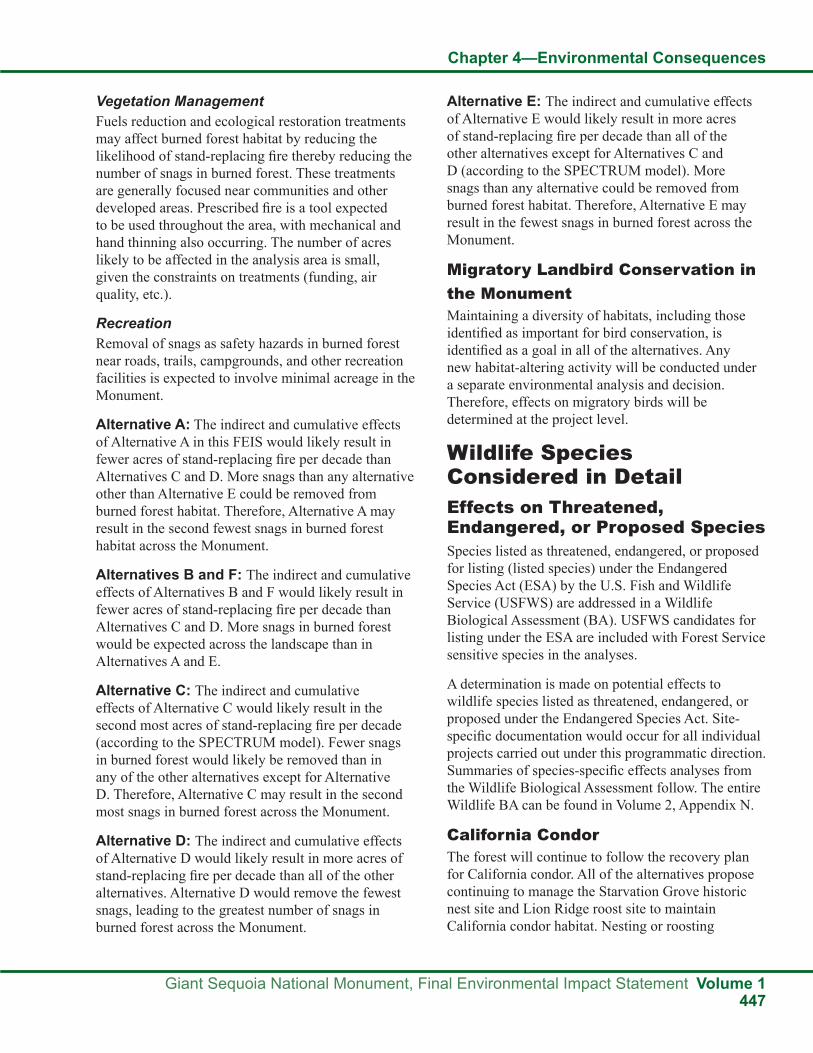
Chapter 4—Environmental Consequences
Giant Sequoia National Monument, Final Environmental Impact Statement Volume 1447
Vegetation ManagementFuels reduction and ecological restoration treatments may affect burned forest habitat by reducing the likelihood of stand-replacing fire thereby reducing the number of snags in burned forest. These treatments are generally focused near communities and other developed areas. Prescribed fire is a tool expected to be used throughout the area, with mechanical and hand thinning also occurring. The number of acres likely to be affected in the analysis area is small, given the constraints on treatments (funding, air quality, etc.).
RecreationRemoval of snags as safety hazards in burned forest near roads, trails, campgrounds, and other recreation facilities is expected to involve minimal acreage in the Monument.
Alternative A: The indirect and cumulative effects of Alternative A in this FEIS would likely result in fewer acres of stand-replacing fire per decade than Alternatives C and D. More snags than any alternative other than Alternative E could be removed from burned forest habitat. Therefore, Alternative A may result in the second fewest snags in burned forest habitat across the Monument.
Alternatives B and F: The indirect and cumulative effects of Alternatives B and F would likely result in fewer acres of stand-replacing fire per decade than Alternatives C and D. More snags in burned forest would be expected across the landscape than in Alternatives A and E.
Alternative C: The indirect and cumulative effects of Alternative C would likely result in the second most acres of stand-replacing fire per decade (according to the SPECTRUM model). Fewer snags in burned forest would likely be removed than in any of the other alternatives except for Alternative D. Therefore, Alternative C may result in the second most snags in burned forest across the Monument.
Alternative D: The indirect and cumulative effects of Alternative D would likely result in more acres of stand-replacing fire per decade than all of the other alternatives. Alternative D would remove the fewest snags, leading to the greatest number of snags in burned forest across the Monument.
Alternative E: The indirect and cumulative effects of Alternative E would likely result in more acres of stand-replacing fire per decade than all of the other alternatives except for Alternatives C and D (according to the SPECTRUM model). More snags than any alternative could be removed from burned forest habitat. Therefore, Alternative E may result in the fewest snags in burned forest across the Monument.
Migratory Landbird Conservation in the MonumentMaintaining a diversity of habitats, including those identified as important for bird conservation, is identified as a goal in all of the alternatives. Any new habitat-altering activity will be conducted under a separate environmental analysis and decision. Therefore, effects on migratory birds will be determined at the project level.
Wildlife Species Considered in DetailEffects on Threatened, Endangered, or Proposed Species Species listed as threatened, endangered, or proposed for listing (listed species) under the Endangered Species Act (ESA) by the U.S. Fish and Wildlife Service (USFWS) are addressed in a Wildlife Biological Assessment (BA). USFWS candidates for listing under the ESA are included with Forest Service sensitive species in the analyses.
A determination is made on potential effects to wildlife species listed as threatened, endangered, or proposed under the Endangered Species Act. Site-specific documentation would occur for all individual projects carried out under this programmatic direction. Summaries of species-specific effects analyses from the Wildlife Biological Assessment follow. The entire Wildlife BA can be found in Volume 2, Appendix N.
California CondorThe forest will continue to follow the recovery plan for California condor. All of the alternatives propose continuing to manage the Starvation Grove historic nest site and Lion Ridge roost site to maintain California condor habitat. Nesting or roosting

Chapter 4—Environmental Consequences
Volume 1 Giant Sequoia National Monument, Final Environmental Impact Statement448
California condors would be protected, if necessary, with road closures and limited operating periods (LOPs) in all alternatives.
Indirect EffectsVegetation ManagementVegetation management projects for fuels reduction and ecological restoration may affect California condor habitat by removing large trees with the potential to be used for roost or nest sites. Vegetation management may affect potential nesting habitat by changing the vegetative characteristics of treated stands. Fuels reduction is expected to minimize the threat of catastrophic wildlife and potential habitat loss. All of the alternatives are expected to follow management direction to set the highest priority for fuels reduction activities in the WUI. It is assumed that WUI defense zones have the greatest risk of habitat altering vegetation management activities.
For Alternatives A, B, E, and F, approximately 45,200 acres of California condor essential habitat in the Monument are within WUIs (57 percent of essential habitat) and 11,300 of those acres are within WUI defense zones (14 percent of essential habitat). Within designated California condor critical habitat in the Monument, approximately 600 acres are within WUIs (80 percent of critical habitat in the Monument) and 80 of those acres are within WUI defense zones (10 percent of critical habitat).
For Alternative C, approximately 1,400 acres of California condor essential habitat in the Monument are within WUI defense zones (17 percent of essential habitat). In Alternative C, there is no California condor critical habitat in the Monument within WUI defense zones.
For Alternative D, approximately 800 acres of California condor essential habitat in the Monument are within WUI defense zones (one percent of essential habitat). In Alternative D, there is no California condor critical habitat in the Monument within WUI defense zones.
Alternatives A, B, C, and D: In Alternatives A, B, C, and D, large trees (greater than 20 inches dbh) would not be removed for fuels reduction or ecological restoration. Trees this size would only be removed if they posed a safety hazard. The need to remove large trees or snags from a site would
be determined on site specific, project-level basis following the standards and guidelines in the FEIS. These standards and guidelines include: “fall and remove hazard trees along maintenance level 3, 4, and 5 roads and within or immediately adjacent (tree falling distance) to administrative sites. Review by an appropriate resource specialist is required prior to falling hazard trees along maintenance level 1 and 2 roads.”
Alternative E: In Alternative E, there would be no diameter limits on trees removed for fuels reduction, ecological restoration, or safety hazards, except inside WUI defense zones. Although unlikely, potential nest or roost trees could be removed. Inside the defense zones, the diameter limit for tree felling would be 30 inches dbh, except for safety hazards.
Alternative F: Alternative F would eliminate the standard and guideline from the 2001 SNFPA requiring retention of all conifer trees with a dbh of 30 inches or greater and hardwoods with a dbh of 12 inches or larger when implementing vegetation treatments. In Alternative F, there would be no diameter limits on trees removed for fuels reduction or ecological restoration (except for giant sequoias). Although unlikely, potential nest or roost trees could be removed.
RecreationCalifornia condor roosting and nesting sites are susceptible to disturbance and “require isolation from human intrusion” (U.S. Fish and Wildlife Service 1996b). In all of the alternatives, road closures would be utilized in the Starvation Grove nest area and Lion Ridge roost area if the forest is notified by the USFWS that these areas are being utilized by California condors. The management plan for the Starvation Grove Nest Area would also restrict recreation with an area closure and stop all management activities if California condors are found within or searching for nests in the vicinity of the nest management area. No new roads or trails are allowed within one-half mile of the historic nest site (USDA 1996).
Alternatives A, B, E, and F: Throughout the Monument, approximately 1,100 miles of roads and 200 miles of trails would continue to be utilized for recreation in Alternatives A, B, E, and F. Within California condor essential habitat there

Chapter 4—Environmental Consequences
Giant Sequoia National Monument, Final Environmental Impact Statement Volume 1449
are approximately 200 miles of roads. Developed recreation sites would cover about 700 acres, and dispersed camping would be permitted. Off-highway vehicle (OHV) use is allowed on designated roads.
Alternative C: Recreation opportunities in developed sites would be emphasized and increased. Dispersed camping outside of developed sites would be eliminated. Camping in more remote locations, in inventoried roadless areas, or in the Wildlands recreation niche setting would be allowed only by permit. Motorized vehicle traffic would be limited to street licensed vehicles only. Snowmobile use would be eliminated for the public, except to access private property, and otherwise only allowed for administrative reasons or emergency situations.
Alternative D: Recreation would be managed similarly to Alternatives A, B, E, and F except new recreation development would be limited, motorized use would be restricted to street-legal vehicles only, and over-snow vehicles (OSVs) would be limited to paved roads.
Management AreasThe approximately 3,000 acres around the 1984 nest site in the Starvation Grove are managed following the Starvation Grove Condor Nest Management Plan. The approximately 500-acre Lion Ridge roost area is managed to protect this historic roost site with restrictions on habitat altering activities. In the approximately 800 acres of California condor critical habitat in the Monument, the Forest Service is required to consult with the USFWS on actions they carry out, fund, or authorize to ensure that their actions will not destroy or adversely modify critical habitat for California condors. There are no additional management actions stipulated by the FEIS for these areas.
All Alternatives: All of the alternatives would continue following the guidelines from the 1996 California Condor Recovery Plan (U.S. Fish and Wildlife Service 1996b) and maintain the Starvation Grove condor nest area and the Lion Ridge roost area.
Cumulative EffectsThe cumulative effects analysis area for California condors includes the entire southern portion of the Monument plus the Blue Ridge and Tulare County rangelands critical habitat areas. This is an appropriate
scale for determining cumulative effects to California condors, since it includes all known habitat for this species potentially affected by implementation of an alternative in this FEIS. The cumulative effects time frame is 20 years into the future. The cumulative effects of all past actions are incorporated into the existing condition.
Ongoing or reasonably foreseeable future activities on private land will continue to affect habitat, but the extent of that effect is difficult to ascertain at this time. Development in critical habitat adjacent to the Monument may increase the risk of shootings, lead poisoning, power line collision, etc.
The livestock industry appears to play a significant role relative to California condor management. Cattle have been identified as contributing to a significant portion of the California condor’s diet. California condors could be negatively affected by the sale and subdivision of livestock ranches in critical habitat adjacent to the Monument.
DeterminationAlternatives A, B, C, and D: Based on the above assessment of effects, Alternatives A, B, C, and D may affect, but are not likely to adversely affect California condors or its designated critical habitat. Large trees (greater than 20 inches dbh) that could potentially be used for nesting or roosting would not be removed for fuels reduction or ecological restoration. Trees this size would only be removed if they posed a safety hazard. Vegetation management may affect potential nesting habitat by changing the vegetative characteristics of treated stands and fuels reduction projects should minimize the threat of large stand-replacing fires and potential habitat loss. Disturbance due to recreation or management activities would be minimized using road and area closures if necessary. The historically used Starvation Grove Condor Nest Area and the Lion Ridge Roost Area would continue to be managed to maintain important condor habitat elements.
Alternatives E and F: Based on the above assessment of effects, the implementation of Alternatives E and F may affect, but are not likely to adversely affect California condors or its designated critical habitat. In Alternatives E and F, there would be no diameter limits on trees removed for fuels reduction, ecological restoration (except inside WUI

Chapter 4—Environmental Consequences
Volume 1 Giant Sequoia National Monument, Final Environmental Impact Statement450
defense zones in Alternative E and for giant sequoias in Alternative F), or safety hazards. Although unlikely, potential nest or roost trees could be removed. Disturbance due to recreation or management activities would be minimized using road and area closures if necessary. The historically used Starvation Grove Condor Nest Area and the Lion Ridge Roost Area would continue to be managed to maintain important California condor habitat elements.
Valley Elderberry Longhorn Beetle (VELB)Habitat Management Objectives from the Recovery PlanObjective 1: Enhance and/or maintain the Sambucus component of native plant communities in riparian corridors and adjacent uplands within the distribution of suitable habitat for the VELB. This includes flagging and protecting all individual elderberry plants in accordance with instructions from the U.S. Fish and Wildlife Service (1993b). If an individual elderberry must be removed, mitigate as described by the U.S. Fish and Wildlife Service (1993b).
Objective 2: Maintain capability of habitat to support the VELB by avoiding use of herbicides or pesticides within a 100-foot radius of suitable VELB habitat.
Potential Threats to VELB habitat in Giant Sequoia National Monument: Fuels reduction treatments may cause short-term losses in VELB habitat quality if large elderberry shrubs are removed. Treatment of dense chaparral may benefit elderberry in the long-term through release of competition and increased water availability.
Nine grazing allotments in the Monument include potential VELB habitat (70 percent of the potential habitat is within an allotment). There is limited browsing of elderberry by livestock but it does not appear to limit recruitment or affect the larger diameter twigs used by VELB. All areas have utilization standards that limit effects to riparian shrubs, including elderberry.
Large stand-replacing fires have the potential to make habitat unsuitable for VELB in the short-term if large elderberry shrubs are affected.
Indirect EffectsVegetation ManagementVegetation management projects for fuels reduction and ecological restoration may affect VELB by removing elderberry plants. However, the distribution of elderberries below 3,000 feet is limited to a small portion (about one percent) of the land in the Monument. None of the alternatives would have specific protection for elderberry plants. Any management activity affecting this habitat would require project level analysis and, if needed, consultation with the USFWS. A GIS vegetation model based on shrub cover types below 3,000 feet that may include elderberries identifies approximately 4,800 acres within the Monument as potential VELB habitat.
Alternative A (No Action): Within potential VELB habitat, there are approximately 800 acres identified as WUI defense zone (16 percent of the habitat in the Monument) and 2,100 acres of WUI threat zone (44 percent of the habitat in the Monument). These areas have the highest priority for fuels treatments and are more likely to be affected than areas outside of WUIs.
Alternatives B and F: WUIs would be the same as in Alternative A. In addition, approximately 1,900 acres of potential VELB habitat would be within the TFETA. The short-term loss of elderberry plants would possibly be higher in Alternatives B and F than in Alternatives A, C, D, and E.
Alternative C: Alternative C would designate a WUI defense zone that extends approximately 300 feet from structures, developed recreation sites, and administrative sites. Approximately 100 acres or two percent of the potential VELB habitat within the Monument would be within WUI defense zones. Assuming that fuels treatments would be concentrated in the WUIs; the short-term loss of elderberry plants would be lower in Alternative C than in Alternatives A, B, E, and F.
Alternative D: In Alternative D, areas designated as WUIs would be smaller than in the other alternatives. The defense zone would be 200 feet from structures on National Forest System land or from the boundary with private land, unless topographic circumstances dictate otherwise. In Alternative D, approximately 50

Chapter 4—Environmental Consequences
Giant Sequoia National Monument, Final Environmental Impact Statement Volume 1451
acres or one percent of the potential VELB habitat within the Monument would be within the designated WUI defense zone. The number of proposed acres that would be treated in Alternative D is small compared to those that would be treated under the other alternatives. Therefore, the potential for short-term loss of elderberry plants would be the lowest in Alternative D.
Alternatives C and D would have the lowest risk to VELB from management activities; however, they may have a greater risk of large, stand-replacing fires.
Alternative E: The designated WUIs and fuels treatment strategy would be the same as in Alternative A (No Action). Therefore, the effects on VELB habitat are expected to be the same.
Riparian areas, which account for about one-quarter of the potential VELB habitat in the Monument, are generally low priorities for fuels treatment projects. Standards and guidelines for riparian areas minimize adverse effects. Alternative E would have the greatest risk for habitat loss because the riparian guidelines are less restrictive.
RecreationDisturbance from recreational activities is not known to be an issue for VELB. Elderberry plants near roads, trails, or campgrounds may have a slight risk of trampling or other damage.
Alternatives A, B, D, E, and F: The existing roads, trails, and developed recreation sites would continue to be utilized in Alternatives A, B, D, E, and F.
Alternative C: Recreation opportunities in developed sites would be emphasized and increased. Dispersed camping outside of developed sites would be eliminated.
The risk of decreasing habitat quality for VELB would be concentrated at the developed recreation sites. Overall effects to elderberry plants would be lower than in the other alternatives because of the elimination of dispersed camping. Fewer acres of potential VELB habitat would be affected in Alternative C.
Management AreasThere are currently no special management areas for VELB in the Monument. RCAs and CARs are land allocations with activity-related standards and guidelines aimed at maintaining species viability. Within these land allocations, the 2004 SNFPA guidelines would be followed to assess the effects of management activities and require that Best Management Practices are followed in order to minimize adverse effects and maintain habitat for riparian dependent species including VELB.
Alternative A (No Action): In potential VELB habitat, approximately 1,000 acres would be within RCAs and approximately 600 acres would be within CARs. Within these land allocations, the 2001 SNFPA guidelines would be followed to assess the effects of management activities, require that Best Management Practices are followed in order to minimize adverse effects, and maintain habitat for riparian-dependent species, including VELB.
Alternatives B, D, and F: Within potential VELB habitat, approximately 1,000 acres would be within RCAs, and approximately 600 acres would be within CARs. Within these land allocations, the 2004 SNFPA guidelines would be followed to assess the effects of management activities, require that Best Management Practices are followed in order to minimize adverse effects, and maintain habitat for riparian-dependent species, including VELB.
Alternative C: In Alternative C, riparian conservation objectives (RCOs) would be the same as in the 2004 SNFPA, but the land allocations of RCAs and CARs would be abolished.
Alternative E: Management of riparian areas would follow the 1988 Forest Plan and the 1990 MSA. There would be no RCAs, CARs, or RCOs. Alternative E would have the least protection of VELB habitat.
Cumulative EffectsThe cumulative effects analysis area for VELB includes the entire Sequoia National Forest. This is an appropriate scale for determining cumulative effects to VELB, since it includes all suitable habitat potentially affected by implementation of an alternative in this FEIS. The cumulative effects time

Chapter 4—Environmental Consequences
Volume 1 Giant Sequoia National Monument, Final Environmental Impact Statement452
frame is 20 years into the future. The cumulative effects of all past actions are incorporated into the existing condition.
Vegetation ManagementFuels reduction treatments may cause short-term losses in VELB habitat quality if large elderberry shrubs are removed. Treatment of dense chaparral may benefit elderberry in the long-term through release of competition and increased water availability.
GrazingGrazing allotments in Sequoia National Forest include potential VELB habitat. There is limited browsing of elderberry by livestock, but it does not appear to limit recruitment or affect the larger diameter twigs used by VELB. All areas have utilization standards that limit effects on riparian shrubs, including elderberry. These standards include: “Limit browsing to no more than 20 percent of the annual leader growth of mature riparian shrubs and no more than 20 percent of individual seedlings. Remove livestock from any area of an allotment when browsing indicates a change in livestock preference from grazing herbaceous vegetation to browsing woody riparian vegetation” (SNFPA ROD, Appendix A, p. A-59).
RecreationThe Greenhorn Mountain and Breckenridge areas of Sequoia National Forest completed motorized travel route designation. As a result of this process, motorized cross-country travel will be prohibited. No routes in suitable VELB habitat are being added to the national forest transportation system. Adverse effects of motorized vehicles on VELB in this area will be reduced due to the elimination of cross-country travel in this portion of the forest (USDA 2009).
WildfiresLarge, stand-replacing fires have the potential to make habitat unsuitable for VELB in the short-term if large elderberry shrubs are affected.
DeterminationAll Alternatives: All of the alternatives of this FEIS may affect, but are not likely to adversely affect valley elderberry longhorn beetles. Individual elderberry plants that are potential habitat may be lost
in fuels reduction or ecological restoration activities. The adverse effects would only be short-term; treatment of dense chaparral may benefit elderberry in the long-term through release of competition and increased water availability. Fuels reduction actions may benefit VELB habitat over the planning period by protecting shrublands from uncharacteristically severe wildfires.
Little Kern Golden Trout (LKGT)Cattle grazing may decrease habitat quality for LKGT through reductions in riparian vegetation and increases in erosion and sedimentation. The Sequoia National Forest entered into Section 7 consultation with the Fish and Wildlife Service in 1994 (U. S. Fish And Wildlife Service reference #1-1-94-F-26) for the Little Kern and Jordan Grazing Allotments. Consultation was reinitiated in 1995 (U.S. Fish and Wildlife Service reference #1-1-95-F-42) and 1996 (U.S. Fish and Wildlife Service reference #1-1-96-I-622).
The Fish and Wildlife Service determined that grazing was not likely to jeopardize the continued existence of Little Kern golden trout or cause destruction or adverse modification to critical habitat (U.S. Fish and Wildlife Service reference #1-1-94-F-26). This determination was contingent on implementation and enforcement of protective measures.
As part of the measures outlined in the Biological Opinion, annual reports to the Fish and Wildlife Service documenting the current conditions of the grazing allotments and critical habitat are required. These Section 7 consultations have lead to requirements of a 15 percent incidental use utilization standard for the Click’s Creek watershed. The remainders of the Jordon and Little Kern allotments are at a grazing standard of 40 percent utilization (+ or - five percent) and are not to exceed 20 percent on woody species. Up to 10 percent bank alteration is allowed. Minimum stubble height is set at four inches and willow utilization is not to exceed 20 percent of current year leader growth. Key riparian areas are monitored for utilization levels and stream bank damage. The two allotments together have up to 250 cow/calf pairs with use between June 6 and July 15 each year in the critical habitat.

Chapter 4—Environmental Consequences
Giant Sequoia National Monument, Final Environmental Impact Statement Volume 1453
Indirect EffectsVegetation ManagementVegetation management projects for fuels reduction and ecological restoration may affect LKGT habitat by reducing streamside cover and reducing water quality by increasing sedimentation. However, mechanical vegetation thinning for fuels treatments, or ecological restoration would be prohibited within the riparian areas of perennial and seasonally flowing streams unless they were found to be consistent with the Aquatic Conservation Strategy goals. Any management activity affecting this habitat would require project level analysis and, if needed, consultation with the USFWS.
Alternatives A, B, E, and F: Within LKGT critical habitat in the Monument, there are no acres identified as WUI defense zone and approximately 500 acres of WUI threat zone (12 percent of critical habitat in the Monument). These areas have the highest priority for fuels treatments and are more likely to be affected than areas outside of WUIs. The TFETA does not overlap with LKGT critical habitat.
Alternative C: Alternative C would designate a WUI defense zone that extends approximately 300 feet from structures, developed recreation sites, and administrative sites. Approximately 20 acres or less than one percent of the LKGT critical habitat within the Monument would be within WUI defense zones. This defense zone would be located around Lewis Camp. Assuming that fuels treatments would be concentrated in the WUIs, the threats to LKGT habitat would be lower in Alternative C than in Alternatives A, B, E, and F.
Alternative D: In Alternative D, areas designated as WUIs would be smaller than in the other alternatives. The defense zone would be 200 feet from structures on National Forest System land or from the boundary with private land, unless topographic circumstances dictate otherwise. In Alternative D, none of the LKGT critical habitat would be within the designated WUI defense zone and vegetation management activities would be unlikely. Therefore, the potential threats to LKGT habitat would be the lowest in Alternative D.
RecreationRecreation associated factors that may affect Little Kern Golden Trout include: roads acting as barriers to movement at stream crossings, increased sedimentation from roads and trails, and sport fishing. Effects from fishing are mitigated with requirements for use of barbless hooks and harvest limits managed by the California Department of Fish and Game.
Alternatives A, B, D, E, and F: The existing roads, trails, and developed recreation sites would continue to be utilized in Alternatives A, B, D, E, and F. Within LKGT critical habitat in the Monument, there are approximately 18 miles of roads, nine miles of trails, and one developed recreation site (Lewis Camp). There are multiple stream crossings by both roads and trails.
Alternative C: Recreation opportunities in developed sites would be emphasized and increased. Dispersed camping outside of developed sites would be eliminated. The risk of decreases in habitat quality for LKGT would be concentrated near developed recreation sites. Overall effects to streams within LKGT critical habitat would be lower than in the other alternatives because of the elimination of dispersed camping and the restriction of vehicle type to street-legal vehicles only. Fewer acres of potential LKGT habitat would be affected in Alternative C.
Management AreasThe entire designated LKGT critical habitat in the Monument is managed within the Little Kern River CAR.
GrazingAlmost the entire Little Kern CAR falls within the “Little Kern” grazing allotment. Grazing in this area would be managed following 2004 SNFPA guidelines and the measures outlined in the Fish and Wildlife Service’s Biological Opinions.
Grazing can result in changes in hydrology due to loss of vegetative cover, loss of riparian habitat and function, increased sedimentation, and stream channelization (USDA 2003). Standards and guidelines would limit the amount of forage utilization, as well as encourage the exclusion of animals from the riparian areas. In addition, current

Chapter 4—Environmental Consequences
Volume 1 Giant Sequoia National Monument, Final Environmental Impact Statement454
management allows managers to rest an allotment when it is determined to be in a degraded condition. Perennial and seasonally flowing streams in range allotments are required to be at proper functioning condition.
Some indirect effects from cattle grazing are expected to occur. Trampling affects the hydrology of the watershed. Accelerated runoff only temporarily increases stream flows and decreases the amount of water retained in the watershed to sustain base flows. A general reduction in the plant biomass of riparian areas can have multiple consequences. These can be increased water temperature, increased sedimentation, and decreased water storage. Increased sediment loads reduce primary production in streams. Reduced in stream plant growth and woody and herbaceous riparian vegetation may limit populations of terrestrial and aquatic insects. Grazing standards are designed to limit grazing intensity and control the timing of grazing both for physiological plant needs and stream bank protection.
Stream bank damage from cattle grazing can eliminate habitat associated with banks, alter stream morphology such as pool/riffle and width/depth ratios (Gunderson 1968, Platts 1981), and cover spawning areas with sediment which reduces survival of fish embryos (Phillips et al. 1975). Additionally, undercut banks that normally provide shelter are often damaged or collapsed in grazed areas, thus decreasing the amount of available fish habitat. Increased sedimentation due to bank collapse may decrease pool volume downstream, eliminating other important habitats.
The effects of grazing on woody vegetation are critical because of the importance of woody debris in providing nutrients, structure, pool formation and stream bank stability, shading, and microclimate effects of riparian trees and shrubs. Grazing can eliminate woody species over time (USDA 2003).
Maximum grass utilization would be limited to 30 percent on early seral sites, 45 percent on late seral sites, and on highly degraded sites utilization standards would be below 30 percent. Stream bank disturbance will not exceed 10 percent in any given reach within LKGT critical habitat. Discouraging the use of riparian areas by livestock with fencing
and off-channel watering holes will further prevent damage to riparian areas. However, any grazing in meadows containing LKGT risks a loss of habitat through bank sloughing, channel incising, loss of riparian shade, and siltation. The requirement that allotments be managed to meet Aquatic Management Strategy goals should help mitigate some of these effects. One of these goals is to “maintain and restore habitat to support viable populations of native…riparian-dependent species.” In addition, the requirement that streams in range allotments be managed to meet proper functioning condition will help mitigate some of the range effects.
Alternative A: The Little Kern River CAR would be managed following the 2001 SNFPA guidelines for RCAs and CARs. Those guidelines require the assessment of the effects of management activities, Best Management Practices are followed to minimize adverse effects, and habitat for riparian-dependent species, including LKGT, is maintained.
Alternatives B, D, and F: The Little Kern River CAR would be managed following the 2004 SNFPA guidelines for RCAs and CARs. Those guidelines require the assessment of the effects of management activities, Best Management Practices are followed to minimize adverse effects, and habitat for riparian dependent species, including LKGT, is maintained.
Alternative C: In Alternative C, RCOs would be the same as in the 2004 SNFPA, but the land allocations of RCAs and CARs would be abolished.
Alternative E: Management of riparian areas would follow 1988 Forest Plan and the 1990 MSA. There would be no RCAs, CARs, or RCOs. Alternative E would have the least protection of LKGT habitat.
Cumulative EffectsThe cumulative effects analysis area for Little Kern golden trout is the Little Kern River basin. This is an appropriate scale for determining cumulative effects to Little Kern golden trout, since it includes all suitable habitat for this species potentially affected by implementation of an alternative in this FEIS. The cumulative effects time frame is 20 years into the future. The cumulative effects of all past actions are incorporated into the existing condition.

Chapter 4—Environmental Consequences
Giant Sequoia National Monument, Final Environmental Impact Statement Volume 1455
HybridizationThe primary threat to LKGT is hybridization with introduced rainbow trout. The alternatives in this FEIS will have no effect on this issue.
Vegetation ManagementFuels reduction treatments that may affect LKGT habitat are unlikely, but could occur in the future. These treatments are generally focused near communities and other developed areas. Prescribed fire is a tool expected to be used throughout the area, with mechanical and hand thinning also occurring. The number of acres of LKGT habitat likely to be affected in the analysis area is small, given the lack of developments in the area.
GrazingGrazing in the Little Kern Allotment is expected to continue in the future and would follow Forest Service utilization standards and the standards provided by the USFWS. Grazing in the portion of the analysis area in Sequoia National Park is limited to pack animals and is regulated to minimize adverse effects.
Recreation EffectRecreational fishing, hiking, and regulated OHV use is expected to continue in the analysis area. No new roads, trails, or recreation developments are currently planned in the Little Kern River Basin.
WildfiresLarge stand-replacing fires have the potential to affect habitat suitability for LKGT by increasing sedimentation and removing streamside vegetation. The Lion Fire in 2011 burned approximately 20,000 acres within LKGT critical habitat. Most of the area burned with low or moderate severity, but LKGT in the fire area will likely be affected by ash, debris, and accelerated discharge following post-fire storm events.
DeterminationAlternatives A, B, C, D, E, and F: All of the alternatives may affect, and are likely to adversely affect Little Kern golden trout or its designated critical habitat. Cattle grazing would continue in the Little Kern grazing allotment under all of the alternatives. Standards and guidelines would be in place to minimize the adverse effects of grazing on
LKGT habitat. However, these do not fully mitigate the effects on aquatic systems resulting from livestock grazing. Disturbance of stream banks (habitat alteration) is one of the major contributing factors to listing this species. This could continue under all of the alternatives.
Stream condition index plots have been utilized in several locations within critical habitat to monitor habitat quality. There is a high amount of background sediment from loose, unconsolidated granitic soils in this dry environment. Monitoring to date does not show significant increases in sediment over background effects under current management.
Alternatives C and D would have a lower risk to LKGT habitat from management activities because the area likely to be treated in fuels reduction projects is much lower (20 acres and no acres, respectively) than in Alternatives A, B, E, and F. Alternative E would have the greatest risk for loss of habitat quality because the riparian guidelines are less restrictive.
Effects on Forest Service Sensitive Species The biological evaluation (BE) documents analysis of programmatic direction (long-term goal- and objective-based management) rather than individual projects under this FEIS. A determination is made on potential effects to wildlife species listed as Sensitive by the Regional Forester, Pacific Southwest Region, USDA Forest Service for the Sequoia National Forest. Site-specific documentation would occur for all individual projects carried out under this programmatic direction. Summaries of species-specific effects analyses from the Wildlife Biological Evaluation (BE) follow. The entire Wildlife BE can be found in the FEIS, Volume 2, Appendix M and is incorporated by reference.
Northern GoshawkManagement direction in the 2001 SNFPA for northern goshawks includes delineating a 200-acre protected activity center (PAC) around the most recent nest site and alternate nest sites containing the best available suitable forested habitat in the largest contiguous patch as possible (USDA 2001). An LOP of February 15 through September 15 for activities within one-quarter mile of the nest site may be required if documented disturbance to nesting

Chapter 4—Environmental Consequences
Volume 1 Giant Sequoia National Monument, Final Environmental Impact Statement456
activities is occurring (USDA 2001). Suitable habitat must be surveyed prior to land disturbance. There are currently 14 designated northern goshawk PACs within the Monument.
Indirect EffectsVegetation ManagementVegetation management projects for fuels reduction and ecological restoration may affect northern goshawk habitat by reducing canopy cover and removing key habitat features (large trees, snags, down woody debris). All of the alternatives would follow management direction to set the highest priority for fuels reduction activities in the WUI.
Alternative A (No Action): Alternative A would continue the existing direction in the 2001 SNFPA to locate fuels treatments across broad landscapes in order to reduce the spread and intensity of fires. Of the 208,600 total acres identified as suitable northern goshawk habitat (using CWHR model), there are 25,600 acres within the WUI defense zone (12 percent of the goshawk habitat in the Monument) and 83,900 acres within the WUI threat zone (40 percent of the goshawk habitat in the Monument). These areas have the highest priority for fuels treatments and have less stringent requirements for maintaining habitat features important to northern goshawks than areas outside of WUIs.
Alternative B: WUIs would be the same acreage as in Alternative A. In addition, the TFETA, which includes 33,600 acres of northern goshawk habitat, would be established along the border with the Tule River Indian Reservation. The short-term loss of habitat features important to northern goshawks would likely be higher in Alternative B than in Alternatives A, C, D, and E.
Alternative C: Alternative C would designate a WUI defense zone that extends approximately 300 feet from structures, developed recreation sites, and administrative sites. Approximately 4,900 acres or two percent of the northern goshawk habitat in the Monument would be within WUI defense zones. Assuming that fuels treatments would be concentrated in the WUIs, the short-term loss of habitat features important to northern goshawks would be lower in Alternative C than in Alternatives A, B, E, and F.
Alternative D: In Alternative D, areas designated as WUIs would be smaller than in the other alternatives. The defense zone would be 200 feet from structures on National Forest System land or from the boundary with private land, unless topographic circumstances dictate otherwise. In Alternative D, approximately 2,600 acres or one percent of the northern goshawk habitat in the Monument would be in the designated WUI defense zone. The number of proposed acres that would likely be treated in Alternative D is small compared to those that would likely be treated under the other alternatives. Therefore, the potential for short-term loss of habitat features important to northern goshawks would likely be the lowest in Alternative D.
Alternative E: The designated WUIs and fuels treatment strategy would be the same as in Alternative A (No Action). Therefore, the effects on northern goshawk habitat are expected to be the same.
Alternative F: Alternative F would continue existing management direction to make fuels reduction activities in the current WUIs the highest priority. The size of the WUI defense and threat zones would be the same as in Alternatives A, B, and E. In addition, the TFETA would be established. Alternative F would eliminate the standard and guideline from the 2001 SNFPA requiring retention of all conifer trees with a dbh of 30 inches or greater when implementing vegetation treatments. There would be a six-inch diameter limit within one to two acres of a nest tree for the northern goshawk. There would be no diameter limit for the rest of the acreage in a northern goshawk PAC. The short-term loss of habitat features important to northern goshawks would likely be higher in Alternative F than in the other alternatives due to the lack of diameter limits on tree felling. The long-term resiliency of northern goshawk habitat to stand-replacing events such as fire, insects and disease may be improved following treatments for ecological restoration.
RecreationHuman disturbance has the potential to cause northern goshawks to abandon their nests during the nesting and post fledging period (February 15 through September 15). Northern goshawks initiate breeding when the ground is still covered in snow, and sometimes nests are located along roads and

Chapter 4—Environmental Consequences
Giant Sequoia National Monument, Final Environmental Impact Statement Volume 1457
trails when they are not yet in use or near developed recreation sites like campgrounds. Additionally, roads and trails provide flight access for northern goshawks. When the snow melts, these sites can potentially be areas of conflict because these roads and trails are used by people. Joslin and Youmans (1999) recommend maintaining low road densities to minimize disturbance to northern goshawks. Developed recreation sites, as well as roads and trails, can fragment northern goshawk habitat by reducing canopy closure (Beier and Drennan 1997, Daw and DeStefano 2001) and by reducing forest interior patch size. Also, snag removal for safety would be more concentrated around designated campgrounds and recreation sites.
Alternatives A, B, E, and F: Approximately 1,100 miles of roads and 200 miles of trails would continue to be utilized for recreation in Alternatives A, B, E, and F. Developed recreation sites would cover about 700 acres and dispersed camping would be permitted. OHV use is allowed on designated roads only.
Alternative C: Recreation opportunities in developed sites would be emphasized and increased. Dispersed camping outside of developed sites would be eliminated. Camping in more remote locations, in inventoried roadless areas, or in the Wildlands recreation niche setting would be allowed by permit. Motorized vehicle traffic would be limited to street licensed vehicles only. Snowmobile use would be eliminated for the public, except to access private property, and otherwise only allowed for administrative reasons or emergency situations.
The risk of disturbance to northern goshawks and habitat fragmentation would be concentrated at the developed recreation sites. Overall effects to northern goshawks would be lower than in the other alternatives because of the elimination of dispersed camping and the restriction on type of motorized vehicle use. Fewer acres of potential northern goshawk habitat would be subjected to disturbance, habitat fragmentation, and hazard tree/snag removal.
Alternative D: Recreation would be managed similarly to Alternatives A, B, E, and F, except new recreation development would be limited, motorized use would be restricted to street-legal vehicles only, and OSVs would be limited to paved roads.
The risk of disturbance to northern goshawks and habitat fragmentation would be less than Alternatives A, B, E, and F because of the restrictions on vehicle types. The overall acres of northern goshawk habitat subject to disturbance would be more than Alternative C, but disturbance at specific developed recreation sites would likely be lower.
Management AreasNorthern goshawk PACs are specific land allocations established to preserve key habitat characteristics and restrict project related disturbance with LOPs. Several other land allocations, although not specifically aimed at protecting northern goshawks, also protect goshawk habitat by maintaining canopy cover, large trees, and down woody debris. These areas include California spotted owl PACs, fisher and American marten den site buffers, RCAs, CARs, old forest emphasis areas, and the Southern Sierra Fisher Conservation Area (SSFCA).
Alternatives A and B: Alternatives A and B would maintain the 14 current northern goshawk PACs and restrict management activities on 3,200 acres of high quality habitat. An LOP from February 15 to September 15 for activities within one-quarter mile of the nest site would be required for most management activities.
In northern goshawk PACs outside of WUI defense zones (2,800 acres or 88 percent of PAC acres), fuels treatment would be limited to prescribed fire. Prior to burning, hand thinning of trees, less than six inches, within a one to two-acre area around the nest tree would be permitted. These restrictions would also apply to areas where a northern goshawk PAC overlaps with WUI threat zone or the TFETA (in Alternative B).
For northern goshawk PACs, within the WUI defense zones (400 acres or 12 percent of PAC acres), mechanical treatments would be prohibited within a 500-foot radius buffer around nest trees. Prescribed burning would be allowed within the 500-foot buffer. Prior to burning, managers could conduct hand treatments, including the felling of small trees, within the one to two-acre area surrounding nest trees. The remaining area of the PAC could be mechanically treated to meet desired fuels reduction goals.
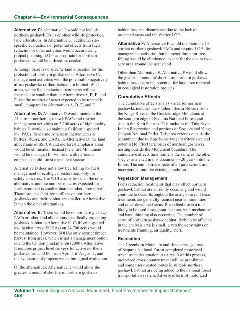
Chapter 4—Environmental Consequences
Volume 1 Giant Sequoia National Monument, Final Environmental Impact Statement458
Alternative C: Alternative C would not include northern goshawk PACs or other wildlife protection land allocations. In Alternative C, additional site-specific evaluations of potential effects from fuels reduction or other activities would occur during project planning. LOPs appropriate for northern goshawks would be utilized, as needed.
Although there is no specific land allocation for the protection of northern goshawks in Alternative C, management activities with the potential to negatively affect goshawks or their habitat are limited. WUI areas, where fuels reduction treatments will be focused, are smaller than in Alternatives A, B, E, and F, and the number of acres expected to be treated is small, compared to Alternatives A, B, E, and F.
Alternative D: Alternative D would maintain the 14 current northern goshawk PACs and restrict management activities on 3,200 acres of high quality habitat. It would also maintain California spotted owl PACs, fisher and American marten den site buffers, RCAs, and CARs. In Alternative D, the land allocations of SSFCA and old forest emphasis areas would be eliminated. Instead the entire Monument would be managed for wildlife, with particular emphasis on old forest dependent species.
Alternative D does not allow tree felling for fuels management or ecological restoration, only for safety concerns. The WUI area is less than the other alternatives and the number of acres expected for fuels treatment is smaller than the other alternatives. Therefore, the short-term effects on northern goshawks and their habitat are smaller in Alternative D than the other alternatives.
Alternative E: There would be no northern goshawk PACs or other land allocations specifically protecting goshawk habitat in Alternative E. California spotted owl habitat areas (SOHAs) on 24,700 acres would be maintained. However, SOHAs only restrict timber harvest from areas, which is not a management option due to the Clinton proclamation (2000). Alternative E requires project level surveys for active northern goshawk nests, LOPs from April 1 to August 1, and the evaluation of projects with a biological evaluation.
Of the alternatives, Alternative E would allow the greatest amount of short-term northern goshawk
habitat loss and disturbance due to the lack of protected areas and the shorter LOP.
Alternative F: Alternative F would maintain the 14 current northern goshawk PACs and require LOPs for management activities, but diameter limits for tree felling would be eliminated, except for the one to two-acre area around the nest stand.
Other than Alternative E, Alternative F would allow the greatest amount of short-term northern goshawk habitat loss due to the potential for large tree removal in ecological restoration projects.
Cumulative EffectsThe cumulative effects analysis area for northern goshawks includes the southern Sierra Nevada from the Kings River to the Breckenridge Mountains at the southern edge of Sequoia National Forest and east to the Kern Plateau. This includes the Tule River Indian Reservation and portions of Sequoia and Kings Canyon National Parks. This area extends outside the Monument due to large home range/territory size and potential to affect territories of northern goshawks nesting outside the Monument boundary. The cumulative effects time frame is the same as the other species analyzed in this document—20 years into the future. The cumulative effects of all past actions are incorporated into the existing condition.
Vegetation ManagementFuels reduction treatments that may affect northern goshawk habitat are currently occurring and would continue to occur throughout the analysis area. These treatments are generally focused near communities and other developed areas. Prescribed fire is a tool likely to be used throughout the area, with mechanical and hand thinning also occurring. The number of acres of northern goshawk habitat likely to be affected in the analysis area is small, given the constraints on treatments (funding, air quality, etc.).
RecreationThe Greenhorn Mountain and Breckenridge areas of Sequoia National Forest completed motorized travel route designation. As a result of this process, motorized cross-country travel will be prohibited and some user-created routes in suitable northern goshawk habitat are being added to the national forest transportation system. Adverse effects of motorized
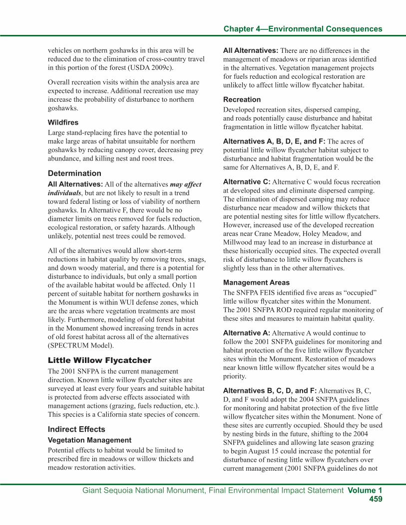
Chapter 4—Environmental Consequences
Giant Sequoia National Monument, Final Environmental Impact Statement Volume 1459
vehicles on northern goshawks in this area will be reduced due to the elimination of cross-country travel in this portion of the forest (USDA 2009c).
Overall recreation visits within the analysis area are expected to increase. Additional recreation use may increase the probability of disturbance to northern goshawks.
WildfiresLarge stand-replacing fires have the potential to make large areas of habitat unsuitable for northern goshawks by reducing canopy cover, decreasing prey abundance, and killing nest and roost trees.
DeterminationAll Alternatives: All of the alternatives may affect individuals, but are not likely to result in a trend toward federal listing or loss of viability of northern goshawks. In Alternative F, there would be no diameter limits on trees removed for fuels reduction, ecological restoration, or safety hazards. Although unlikely, potential nest trees could be removed.
All of the alternatives would allow short-term reductions in habitat quality by removing trees, snags, and down woody material, and there is a potential for disturbance to individuals, but only a small portion of the available habitat would be affected. Only 11 percent of suitable habitat for northern goshawks in the Monument is within WUI defense zones, which are the areas where vegetation treatments are most likely. Furthermore, modeling of old forest habitat in the Monument showed increasing trends in acres of old forest habitat across all of the alternatives (SPECTRUM Model).
Little Willow FlycatcherThe 2001 SNFPA is the current management direction. Known little willow flycatcher sites are surveyed at least every four years and suitable habitat is protected from adverse effects associated with management actions (grazing, fuels reduction, etc.). This species is a California state species of concern.
Indirect EffectsVegetation ManagementPotential effects to habitat would be limited to prescribed fire in meadows or willow thickets and meadow restoration activities.
All Alternatives: There are no differences in the management of meadows or riparian areas identified in the alternatives. Vegetation management projects for fuels reduction and ecological restoration are unlikely to affect little willow flycatcher habitat.
RecreationDeveloped recreation sites, dispersed camping, and roads potentially cause disturbance and habitat fragmentation in little willow flycatcher habitat.
Alternatives A, B, D, E, and F: The acres of potential little willow flycatcher habitat subject to disturbance and habitat fragmentation would be the same for Alternatives A, B, D, E, and F.
Alternative C: Alternative C would focus recreation at developed sites and eliminate dispersed camping. The elimination of dispersed camping may reduce disturbance near meadow and willow thickets that are potential nesting sites for little willow flycatchers. However, increased use of the developed recreation areas near Crane Meadow, Holey Meadow, and Millwood may lead to an increase in disturbance at these historically occupied sites. The expected overall risk of disturbance to little willow flycatchers is slightly less than in the other alternatives.
Management AreasThe SNFPA FEIS identified five areas as “occupied” little willow flycatcher sites within the Monument. The 2001 SNFPA ROD required regular monitoring of these sites and measures to maintain habitat quality.
Alternative A: Alternative A would continue to follow the 2001 SNFPA guidelines for monitoring and habitat protection of the five little willow flycatcher sites within the Monument. Restoration of meadows near known little willow flycatcher sites would be a priority.
Alternatives B, C, D, and F: Alternatives B, C, D, and F would adopt the 2004 SNFPA guidelines for monitoring and habitat protection of the five little willow flycatcher sites within the Monument. None of these sites are currently occupied. Should they be used by nesting birds in the future, shifting to the 2004 SNFPA guidelines and allowing late season grazing to begin August 15 could increase the potential for disturbance of nesting little willow flycatchers over current management (2001 SNFPA guidelines do not

Chapter 4—Environmental Consequences
Volume 1 Giant Sequoia National Monument, Final Environmental Impact Statement460
allow grazing until September 1). The requirement for monitoring these sites on a four year cycle would continue in Alternatives B, C, D, and F.
Alternative E: The 1990 MSA did not address little willow flycatcher habitat protection. Alternative E would not require monitoring or provide protection of known or potential little willow flycatcher nesting sites from grazing or other effects. Therefore, Alternative E would allow the greatest amount of potential little willow flycatcher habitat loss and disturbance due to the lack of monitoring and protected areas.
Cumulative EffectsThe cumulative effects analysis area for the little willow flycatcher includes the southern Sierra Nevada from the Kings River to the Breckenridge Mountains at the southern edge of Sequoia National Forest and east to the Kern Plateau. This includes the Tule River Indian Reservation and portions of Sequoia and Kings Canyon National Parks. This is an appropriate scale for determining cumulative effects to little willow flycatchers, since it includes all suitable habitat potentially affected by implementation of an alternative in this FEIS. The cumulative effects time frame is the same as the other species analyzed in this document—20 years into the future. The cumulative effects of all past actions are incorporated into the existing condition.
Vegetation ManagementFuels reduction treatments would be unlikely to affect little willow flycatcher habitat.
GrazingGrazing allotments in the southern portion of Sequoia National Forest include some meadows that contain potential little willow flycatcher habitat. Management direction for Troy Meadow (on the Kern Plateau), a historically occupied site, follows the 2004 SNFPA guidelines for maintaining habitat. Other meadows are managed following Forest Service utilization standards. Grazing on meadows in Sequoia and Kings Canyon National Parks is limited to pack animals and is regulated to minimize adverse effects.
RecreationThe Greenhorn Mountain and Breckenridge areas of Sequoia National Forest completed motorized
travel route designation. As a result of this process, motorized cross-country travel will be prohibited. No routes in suitable little willow flycatcher habitat are being added to the national forest transportation system. Adverse effects of motorized vehicles on little willow flycatchers in this area will be reduced due to the elimination of cross-country travel in this portion of the forest (USDA 2009).
Overall recreation visits within the analysis area are expected to increase. More recreation use may increase the probability of disturbance to little willow flycatchers.
WildfiresLarge, stand-replacing fires have the potential to make habitat unsuitable for little willow flycatchers if meadows are affected.
Brown-headed CowbirdsAny development or human activity near meadows in the analysis area may increase the population of brown-headed cowbirds and increase the likelihood of brood parasitism on little willow flycatchers.
DeterminationAlternative A: Alternative A would have no effect on little willow flycatchers. Known sites would continue to be protected following the 2001 SNFPA guidelines. No changes in management of meadows, riparian areas, or additional recreation development of potential little willow flycatcher habitat are proposed, so there would be no indirect or cumulative effects to this species.
Alternatives B, C, D, and F: Alternatives B, C, D, and F may affect individuals, but are not likely to result in a trend toward Federal listing or loss of viability of little willow flycatchers. Known sites would be protected following the 2004 SNFPA guidelines. Shifting to the 2004 SNFPA guidelines and allowing late season grazing to begin August 15 increases the potential for disturbance of nesting little willow flycatchers over current management.
However, none of these sites are currently occupied. Should they become occupied in the future and given the fact that 90 percent of little willow flycatcher nesting is generally complete by August 15, the risk of disturbance from grazing is probably small. No other

Chapter 4—Environmental Consequences
Giant Sequoia National Monument, Final Environmental Impact Statement Volume 1461
changes in management of meadows, riparian areas or additional recreation development of potential little willow flycatcher habitat are proposed.
Alternative E: Alternative E may affect individuals, but is not likely to result in a trend toward federal listing or loss of viability of little willow flycatchers. Alternative E would not provide specific protection for little willow flycatchers or their habitat at the five known sites or other potential areas.
Bald EagleBald eagles were listed as a threatened species by the USFWS in 1978, primarily due to population declines related to habitat loss, combined with environmental contamination of prey species by past use of organochlorine pesticides, such as DDT and dieldrin (USFWS 1986). Bald eagles were de-listed by the USFWS in July 2007. They continue to be protected by the Bald and Golden Eagle Protection Act and the Migratory Bird Treaty Act.
The 1990 MSA required the protection of important roost trees and feeding habitat in the vicinity of Pine Flat Reservoir, which is adjacent to the Monument. Currently, management follows the National Bald Eagle Management Guidelines. The State of California lists bald eagles as endangered, but that status is under review.
Indirect EffectsVegetation ManagementAlternatives A, B, C, D, and E: Vegetation management projects for fuels reduction and ecological restoration in Alternatives A, B, C, D, and E are unlikely to affect bald eagle habitat. Trees large enough to provide bald eagles with diurnal perches would only be removed if they were safety hazards. Riparian areas provide the habitat most important to bald eagles, and no changes in management of riparian areas are proposed that would reduce habitat quality for eagles.
Alternative F: Alternative F would eliminate the standard and guideline from the 2001 SNFPA requiring retention of all conifer trees with a dbh of 30 inches or greater and hardwoods with a dbh of 12 inches or larger when implementing vegetation treatments. Diameter limits in California spotted owl and northern goshawk PACs (25,900 acres) would
also be eliminated, except for the six-inch diameter limit for trees within one to two acres of a nest tree. The potential for short-term loss of habitat features important to bald eagles would likely be higher in Alternative F than in the other alternatives due to the lack of diameter limits on tree felling.
RecreationDeveloped recreation sites, dispersed camping, and roads potentially cause disturbance and habitat fragmentation in bald eagle habitat.
Alternatives A, B, D, E, and F: The amount of bald eagle habitat subject to disturbance and habitat fragmentation would be about the same for Alternatives A, B, D, E, and F.
Alternative C: Alternative C would focus recreation at developed sites and eliminate dispersed camping. The elimination of dispersed camping may reduce disturbance near some feeding sites used by bald eagles. However, increased use of the developed recreation areas near the Kings River, White River, California Hot Springs, Lower Tule River, and Hume Lake may lead to an increase in disturbance at these sites. Some roads near bald eagle habitat may be eliminated in Alternative C. The overall risk of disturbance to bald eagles is probably slightly less than in the other alternatives.
Management AreasThere are currently no special management areas for bald eagles in the Monument. Much of the habitat most important to bald eagles falls within RCAs.
Alternative E: Management of riparian areas would follow the 1988 Forest Plan and the 1990 MSA. There would be no RCAs, CARs, or RCOs. Alternative E would have the least protection to riparian habitat.
Cumulative EffectsThe cumulative effects analysis area for the bald eagle includes the southern Sierra Nevada from the Kings River to the Breckenridge Mountains at the southern edge of Sequoia National Forest and east to the Kern Plateau. This includes the Tule River Indian Reservation and portions of Sequoia and Kings Canyon National Parks. This is an appropriate scale for determining cumulative effects to bald eagles, since it includes all suitable habitat potentially

Chapter 4—Environmental Consequences
Volume 1 Giant Sequoia National Monument, Final Environmental Impact Statement462
affected by implementation of an alternative in this FEIS. The cumulative effects time frame is the same as the other species analyzed in this document—20 years into the future. The cumulative effects of all past actions are incorporated into the existing condition.
Vegetation ManagementFuels treatment activities are unlikely to affect bald eagle habitat in the analysis area. The removal of large snags that are deemed safety hazards is possible in developed areas (Lake Isabella, Pine Flat Lake).
RecreationThe southern portion of Sequoia National Forest completed motorized travel route designation. As a result of this process, motorized cross-country travel will be prohibited. Sixteen areas open to motorized vehicles will be added to the national forest transportation system at Lake Isabella in suitable bald eagle foraging habitat. Adverse effects of motorized vehicles on bald eagles in the analysis area may be reduced due to the elimination of cross-country travel in this portion of the forest (USDA 2009).
Overall recreation visits within the analysis area are expected to increase. More recreation use may increase the probability of disturbance to bald eagles.
WildfiresLarge, stand-replacing fires will likely change bald eagle use in an area. Bald eagle populations can be reduced by fires that destroy old-growth forests. However, snags that provide perching sites may also be created by fire (Snyder 1993).
DeterminationAlternatives A, B, C, D, and E: Alternatives A, B, C, D, and E would have no effect on bald eagles. Habitat important to bald eagles would continue to be protected following RCA guidelines. Trees large enough to provide bald eagles with diurnal perches would only be removed if they were safety hazards. Therefore, there would be no indirect or cumulative effects to this species.
Alternative F: Alternative F may affect individuals, but is not likely to result in a trend toward Federal listing or loss of viability of bald eagles. Alternative F has the potential to remove large trees that could serve as diurnal perches for bald eagles due to the lack of
diameter limits on tree felling. However, modeling showed an increasing trend in the number of large and very large trees in the Monument in Alternative F (SPECTRUM model).
Great Gray OwlThe 2001 SNFPA stipulates that PACs of at least 50 acres of the highest quality nesting habitat be established around all known great gray owl nest stands. One great gray owl PAC has been designated in the Monument.
Indirect EffectsVegetation ManagementVegetation management projects for fuels reduction and ecological restoration may affect great gray owl habitat by affecting prey abundance and nest site availability.
Alternatives A, B, C, and D: In Alternatives A, B, C, and D, trees large enough to be potential nest trees (greater than 30 inches dbh) would not be removed for ecological restoration or fuels reduction. Trees this size would only be removed if they posed a safety hazard.
Alternative E: In Alternative E, there would be no diameter limits on trees removed for fuels reduction or ecological restoration except inside WUI defense zones. Although unlikely, potential nest trees could be removed. Inside the defense zones, the diameter limit for tree felling would be 30 inches dbh, except for safety hazards.
Alternative F: In Alternative F, there would be no diameter limits on trees removed for fuels reduction, ecological restoration, or safety hazards. Although unlikely, potential nest trees could be removed.
RecreationRecreation has the potential to affect great gray owls through vehicle collisions, disturbance at nest sites, and snag reduction.
Alternatives A, B, D, E, and F: Great gray owl habitat subject to vehicle use, disturbance, and habitat fragmentation would be the same for Alternatives A, B, D, E, and F.
Alternative C: Alternative C would focus recreation at developed sites and eliminate dispersed camping.

Chapter 4—Environmental Consequences
Giant Sequoia National Monument, Final Environmental Impact Statement Volume 1463
The elimination of dispersed camping may reduce disturbance near nesting sites used by great gray owls. However, increased use of the developed recreation areas near meadows may lead to an increase in disturbance at these sites. Some roads near great gray owl habitat may be eliminated in Alternative C. The overall risk of disturbance to great gray owls is expected to be slightly less than in the other alternatives.
Management AreasGreat gray owl PACs are specific land allocations established to preserve key habitat characteristics and restrict project-related disturbance with LOPs. (Details are in the wildlife standards and guidelines, FEIS, Volume 2, Appendix A.) The first confirmed great gray owl nest in the Monument was discovered by a CDFG biologist in 2009 (Tim Kroeker, personal communication). A 60-acre PAC was established to protect this nesting area. Other land allocations, although not specifically aimed at protecting great gray owls, also protect owl habitat by maintaining large trees and restricting management activities in meadows. These areas include RCAs, CARs, and old forest emphasis areas.
Alternatives A, B, and F: Alternatives A, B, and F would maintain habitat and restrict management activities on approximately 60 acres in the current PAC. An LOP of approximately March 1 to August 15 for activities within one-quarter mile of the nest site would be required for vegetation management activities. Habitat characteristics important to great gray owls would also be protected in RCAs (meadows), CARs (27,100 acres), and old forest emphasis areas (160,600 acres). Each of these land allocations has unique standards and guidelines which vary in the level of protection they provide for great gray owl habitat (see wildlife standards and guidelines, FEIS, Volume 2, Appendix A).
Alternative C: Alternative C would not include great gray owl PACs or other wildlife protection land allocations. Alternative C would evaluate the effects of fuels reduction and restoration projects on great gray owls with BEs. LOPs appropriate for great gray owls would be utilized, as needed.
Although there is no specific land allocation for the protection of great gray owls in Alternative C,
management activities with the potential to negatively affect owls or their habitat are very limited.
Alternative D: Alternative D would maintain the current great gray owl PAC and restrict management activities at the known nesting site. It would also maintain RCAs and CARs. In Alternative D, the land allocation of old forest emphasis would be eliminated. Instead, the entire Monument would be managed for wildlife, with particular emphasis on old forest dependent species.
Alternative E: There would be no great gray owl PACs in Alternative E. Of the alternatives, Alternative E would allow the greatest amount of great gray owl habitat loss and disturbance due to fewer acres of protected areas and fewer restrictions on activities that degrade habitat quality.
Cumulative EffectsThe cumulative effects analysis area for the great gray owl includes the Sierra Nevada from Yosemite National Park to the Breckenridge Mountains at the southern edge of Sequoia National Forest and east to the Kern Plateau. This includes the Tule River Indian Reservation and Sequoia and Kings Canyon National Parks. This is an appropriate scale for determining cumulative effects to great gray owls, since it includes nearly the entire known range of great gray owls within California. The cumulative effects time frame is the same as the other species analyzed in this document—20 years into the future. In addition, cumulative effects of all past actions are incorporated into the existing condition.
Vegetation ManagementFuels reduction treatments that may affect great gray owl habitat are currently occurring and would continue to occur throughout the analysis area. These treatments are generally focused near communities and other developed areas. Prescribed fire is a tool expect to be used throughout the area, with mechanical and hand thinning also occurring. The number of acres of great gray owl habitat likely to be affected in the analysis area is small, given the constraints on treatments (funding, air quality, etc.).
GrazingGrazing allotments in the southern portion of Sequoia National Forest include some meadows

Chapter 4—Environmental Consequences
Volume 1 Giant Sequoia National Monument, Final Environmental Impact Statement464
with historic great gray owl detections. These include Dry Meadow, Troy Meadow, and Paloma Meadow. Should nesting be confirmed in any of these areas, management would follow the 2004 SNFPA guidelines for maintaining habitat. Other meadows in the forest are managed following Forest Service utilization standards. Grazing on meadows in Yosemite, Sequoia, and Kings Canyon National Parks is limited to pack animals and is regulated to minimize adverse effects.
RecreationThe Greenhorn Mountain and Breckenridge areas of Sequoia National Forest completed motorized travel route designation. In this process, motorized cross-country travel will be prohibited. No user created routes are being added to the national forest transportation system within one quarter mile of meadows. Adverse effects of motorized vehicles on great gray owls in this area will be reduced due to the elimination of cross-country travel on this portion of the forest (USDA 2009).
Overall recreation visits within the analysis area are expected to continue to increase. More recreation use may increase the probability of disturbance to great gray owls.
WildfiresLarge, stand-replacing fires have the potential to affect habitat suitability for great gray owls by changing prey densities and altering the abundance of snags and down woody debris. Mortality of nestlings or fledglings is possible if fires occur during the breeding season (Ulev 2007).
DeterminationAlternatives A, B, C, D, and F: Alternatives A, B, C, D, and F may affect individuals, but are not likely to result in a trend toward federal listing or loss of viability of great gray owls. Alternatives A, B, C, D, and F would allow short-term reductions in habitat quality by removing trees, snags, and down woody material, but the extent of potential vegetation management activities in or around meadows is limited by RCA guidelines. The potential for disturbance during nesting is reduced by utilizing an LOP around known nesting sites. In Alternative F, there would be no diameter limits on trees removed for fuels reduction, ecological restoration, or safety
hazards. Although unlikely, potential nest trees could be removed.
Alternative E: Alternative E may affect individuals, but is not likely to result in a trend toward federal listing or loss of viability of great gray owls. Alternative E would allow short-term reductions in habitat quality by removing trees, snags, and down woody material, and the potential for disturbance during nesting is greater than in the other alternatives because of the lack of LOPs.
California Spotted OwlManagement direction in the 2001 SNFPA includes delineation of 300-acre PACs with associated 300-acre HRCAs that have specific restrictions on activity. Standards and guidelines for PACs and HRCAs are intended to limit stand-altering activities and disturbance in fuels reduction projects and other management activities (see wildlife standards and guidelines for details, FEIS, Volume 2, Appendix AS).
Indirect EffectsVegetation ManagementVegetation management projects for fuels reduction and ecological restoration may affect California spotted owl habitat by reducing canopy cover and removing key habitat features (large trees, snags, down woody debris). All of the alternatives would follow management direction to set the highest priority for fuels reduction activities in the WUI.
Alternative A (No Action): Alternative A would continue the existing direction in the 2001 SNFPA to locate fuels treatments across broad landscapes in order to reduce the spread and intensity of fires. Within California spotted owl habitat (using CWHR model), there are approximately 26,200 acres identified as WUI defense zone (12 percent of spotted owl habitat in the Monument) and approximately 84,600 acres of WUI threat zone (40 percent of spotted owl habitat in the Monument). These areas have the highest priority for fuels treatments and have less stringent requirements for maintaining habitat features important to California spotted owls than areas outside of WUIs.
Alternative B: WUIs would be the same as in Alternative A. In addition, the TFETA, including approximately 33,700 acres of California spotted owl

Chapter 4—Environmental Consequences
Giant Sequoia National Monument, Final Environmental Impact Statement Volume 1465
habitat, would be established along the border with the Tule River Indian Reservation. The short-term loss of habitat features important to California spotted owls would likely be higher in Alternative B than in Alternatives A, C, D, and E.
Alternative C: Alternative C would designate a WUI defense zone that extends approximately 300 feet from structures, developed recreation sites, and administrative sites. Approximately 5,000 acres or two percent of the California spotted owl habitat in the Monument would be within WUI defense zones. Assuming that fuels treatments would be concentrated in the WUIs, the short-term loss of habitat features important to California spotted owls would be lower in Alternative C than in Alternatives A, B, E and F.
Alternative D: Alternative D with approximately 2,700 acres or one percent of the California spotted owl habitat in the Monument would be within the designated WUI defense zone. The number of proposed acres that would be treated in Alternative D is small compared to those that would be treated under the other alternatives. Therefore, the potential for short-term loss of habitat features important to California spotted owls would be the lowest in Alternative D.
Alternative E: The designated WUIs and fuels treatment strategy would be the same as in Alternative A (No Action). Therefore, the effects on California spotted owl habitat are expected to be the same.
Alternative F: Alternative F would continue existing management direction to make fuels reduction activities in the current WUIs the highest priority. The size of the WUI defense and threat zones would be the same as in Alternatives A, B, and E. In addition, the TFETA would be established. Alternative F would eliminate the standard and guideline from the 2001 SNFPA requiring retention of all conifer trees with a dbh of 30 inches or greater and hardwoods with a dbh of 12 inches or larger when implementing vegetation treatments. There would be a six-inch diameter limit within one to two acres of a nest tree for the California spotted owl. There would be no diameter limit for the rest of the acreage in a California spotted owl PAC. The short-term loss of habitat features important to California spotted owls would likely be higher in Alternative F than in the other alternatives due to the lack of diameter limits on tree felling. The
long-term resiliency of California spotted owl habitat to stand-replacing events such as fire, insects, and disease may be improved following treatments for ecological restoration.
RecreationGaines et al. (2003) reviewed studies of the northern spotted owl and determined that road-associated factors that were likely to affect spotted owls were collisions, disturbance at a specific site, physiological response, edge effects, and snag reduction. These same factors are expected to affect the California spotted owl in a similar way based upon available literature (Verner et al. 1992, Seamans 2005, Blakesley 2003).
Alternatives A, B, E, and F: Approximately 1,100 miles of roads and 200 miles of trails would continue to be utilized for recreation in Alternatives A, B, E, and F. Developed recreation sites would cover about 700 acres and dispersed camping would be permitted. OHV use is allowed on designated roads.
Alternative C: Recreation opportunities in developed sites would be emphasized and increased. Dispersed camping outside of developed sites would be eliminated. Camping in more remote locations, in inventoried roadless areas, or in the Wildlands recreation niche setting would be allowed by permit. Motorized vehicle traffic would be limited to street licensed vehicles only. Snowmobile use would be eliminated for the public, except to access private property, and otherwise only allowed for administrative reasons or emergency situations. In Alternative C, the road and trail system providing recreation access would likely be reduced from the current transportation system.
The risk of disturbance to California spotted owls and habitat fragmentation would be concentrated at the developed recreation sites. Overall effects to California spotted owls would be lower than in the other alternatives because of the elimination of dispersed camping, the restriction on type of motorized vehicle use, and the reduction of the road system. Fewer acres of potential California spotted owl habitat would be subjected to disturbance, habitat fragmentation, and hazard tree/snag removal.
Alternative D: Recreation would be managed similarly to Alternatives A, B, E, and F except new

Chapter 4—Environmental Consequences
Volume 1 Giant Sequoia National Monument, Final Environmental Impact Statement466
recreation development would be limited, motorized use would be restricted to street-legal vehicles only, and OSVs would be limited to paved roads.
The risk of disturbance to California spotted owls and habitat fragmentation would be less than Alternatives A, B, E, and F because of the restrictions on vehicle types. The overall acres of California spotted owl habitat subject to disturbance would be more than Alternative C, but disturbance at specific developed recreation sites would likely be lower.
Management AreasCalifornia spotted owl PACs are specific land allocations established to preserve key habitat characteristics and restrict project-related disturbance with LOPs. Several other land allocations, although not specifically aimed at protecting California spotted owls, also protect spotted owl habitat by maintaining canopy cover, large trees, and down woody debris. These areas include northern goshawk PACs, fisher and American marten den site buffers, RCAs, CARs, old forest emphasis areas, and the SSFCA.
Alternatives A and B: Alternatives A and B would maintain the 73 current California spotted owl PACs and restrict management activities on 22,650 acres of high quality habitat. An LOP of March 1 to August 15 for activities within one-quarter mile of the nest site would be required for most management activities.
In California spotted owl PACs outside of WUI defense zones (19,180 acres or 85 percent of PAC acres), fuels treatment would be limited to prescribed fire. Prior to burning, hand thinning of trees less than six inches within a one to two-acre area around the nest tree, would be permitted. These restrictions would also apply to areas where a California spotted owl PAC overlaps with a WUI threat zone or the TFETA in Alternative B.
For California spotted owl PACs within the WUI defense zones (3,470 acres or 15 percent of PAC acres), mechanical treatments would be prohibited within a 500-foot radius buffer around each spotted owl activity center. Prescribed burning would be allowed within the 500-foot buffer. Prior to burning, managers could conduct hand treatments, including the felling of small trees, within the one to two-acre area surrounding nest trees. The remaining area of the
PAC could be mechanically treated to meet desired fuels reduction goals.
In California spotted owl HRCAs outside of the WUIs (9,370 acres or 40 percent of HRCA acres), treatments would be designed to achieve or approach the fuels goals by reducing surface and ladder fuels less than 12 inches dbh. Do not reduce canopy cover in dominant and co-dominant trees by more than 10 percent across a stand following mechanical treatments. Where pre-treatment canopy cover in dominant and co-dominant trees is between 50 and 59 percent, mechanical treatments would be designed to retain a minimum of 50 percent canopy cover. Do not reduce canopy cover in stands that currently have between 40 and 50 percent canopy cover in dominant and co-dominant trees, except where canopy cover reductions result from removing primarily shade tolerant trees less than six inches dbh. These restrictions would also apply to areas where a California spotted owl HRCA overlaps with the TFETA (in Alternative B) but is not within WUI defense or threat zones.
For California spotted owl HRCAs within the WUI (10,870 acres or 47 percent of HRCA acres), mechanical treatments would be designed to achieve fuels goals through understory thinning to remove surface and ladder fuels up to 20 inches dbh. Do not exceed a 20 percent reduction in canopy cover in the dominant and co-dominant trees. Where pre-treatment canopy cover is between 50 and 59 percent, design mechanical treatments to retain a minimum of 50 percent canopy cover in dominant and co-dominant trees. In stands that currently have between 40 and 50 percent canopy cover, do not reduce canopy cover except where canopy cover reductions result from removing primarily shade-tolerant trees less than six inches dbh.
For California spotted owl HRCAs within the WUI defense zones (2,930 acres or 13 percent of HRCA acres), standards and guidelines for the defense zone supersede standards and guidelines for spotted owl HCRAs. There are no restrictions on sizes of trees removed (other than the 20-inch limit in Alternative B) or reduction in canopy cover.
Within the limits imposed by the standards and guidelines, it is not known how many PACs or PAC acres will actually be treated in a given year. That would be based on project level decisions.

Chapter 4—Environmental Consequences
Giant Sequoia National Monument, Final Environmental Impact Statement Volume 1467
Habitat characteristics important to California spotted owls would also be protected in northern goshawk PACs (3,200 acres), fisher den site buffers (2,970 acres), American marten den site buffers (110 acres), RCAs, CARs (27,150 acres), old forest emphasis areas (160,610 acres) and the SSFCA (333,540 acres). Each of these land allocations has unique standards and guidelines which vary in the level of protection they provide for California spotted owl habitat (see wildlife standards and guidelines, FEIS, Volume 2, Appendix A).
Alternative C: Alternative C would not include California spotted owl PACs or other wildlife protection land allocations. Alternative C would evaluate the effects of fuels reduction and restoration projects on California spotted owls with BEs. LOPs appropriate for California spotted owls would be utilized, as needed.
Although there is no specific land allocation for the protection of California spotted owls in Alternative C, management activities with the potential to negatively affect spotted owls or their habitat are limited. WUI areas, where fuels reduction treatments will be focused, are smaller than in Alternatives A, B, E, and F, and the number of acres expected to be treated is small, compared to Alternatives A, B, E, and F.
Alternative D: Alternative D would maintain the 73 current California spotted owl PACs (22,700 acres) and HRCAs (21,800 acres) and restrict management activities in high quality habitat. It would also maintain northern goshawk PACs, fisher and American marten den site buffers, RCAs, and CARs. In Alternative D, the land allocations of SSFCA and old forest emphasis areas would be eliminated. Instead the entire Monument would be managed for wildlife, with particular emphasis on old forest dependent species.
Alternative D does not allow tree felling for fuels management or ecological restoration, only for safety concerns. The WUI area is less than the other alternatives, and the number of acres expected for fuels treatment is smaller than the other alternatives. Therefore, the short-term effects on California spotted owls and their habitat are smaller in Alternative D than the other alternatives.
Alternative E: There would be no California spotted owl PACs or HRCAs in Alternative E. Instead, SOHAs, on approximately 24,700 acres, would be maintained. However, SOHAs only restrict timber harvest, which is not a management option because of the Clinton proclamation (2000). Alternative E requires surveys and evaluation of effects in a BE for projects within 1.5 miles of the center of a SOHA.
Of the alternatives, Alternative E would allow the greatest amount of short-term California spotted owl habitat loss and disturbance due to fewer acres of protected areas and fewer restrictions on activities that degrade habitat quality.
Alternative F: Alternative F would maintain the 73 current California spotted owl PACs (22,700 acres) and HRCAs (21,800 acres), but diameter limits for tree felling would be eliminated, except for the one to two-acre area around the nest stand. An LOP of March 1 to August 15 for activities within one-quarter mile of the nest site would be required for most management activities.
Other than Alternative E, Alternative F would allow the greatest amount of short-term California spotted owl habitat loss due to the potential for large tree removal in ecological restoration projects.
Cumulative EffectsThe cumulative effects analysis area for the California spotted owl includes the southern Sierra Nevada from the Kings River to the Breckenridge Mountains at the southern edge of Sequoia National Forest and east to the Kern Plateau. This includes the Tule River Indian Reservation and portions of Sequoia and Kings Canyon National Parks. This is an appropriate scale for determining cumulative effects to California spotted owls, since it includes all suitable habitat potentially affected by implementation of an alternative in this FEIS. The cumulative effects time frame is the same as the other species analyzed in this document—20 years into the future. In addition, cumulative effects of all past actions are incorporated into the existing condition.
Vegetation ManagementFuels reduction treatments that may affect California spotted owl habitat are currently occurring and will continue to occur throughout the analysis area. These treatments are generally focused near communities

Chapter 4—Environmental Consequences
Volume 1 Giant Sequoia National Monument, Final Environmental Impact Statement468
and other developed areas. Prescribed fire is a tool expected to be used throughout the area, with mechanical and hand thinning also occurring. The number of acres of California spotted owl habitat likely to be affected in the analysis area is small, given the constraints on treatments (funding, air quality, etc.).
RecreationThe Greenhorn Mountain and Breckenridge areas of Sequoia National Forest completed motorized travel route designation. In this process, motorized cross-country travel will be prohibited and some user created routes in suitable California spotted owl habitat are being added to the national forest transportation system. Adverse effects of motorized vehicles on California spotted owls in this area will be reduced due to the elimination of cross-country travel on this portion of the forest (USDA 2009).
Overall recreation visits within the analysis area are expected to continue to increase. More recreation use may increase the probability of disturbance to California spotted owls.
WildfiresLarge, stand-replacing fires have the potential to make large areas of habitat unsuitable for roosting and nesting California spotted owls by reducing canopy cover and killing large trees. However, stand-replacing fires may improve the quality of foraging habitat, at least in the short-term.
DeterminationAll Alternatives: All of the alternatives may affect individuals, but are not likely to result in a trend toward federal listing or loss of viability of California spotted owls. All of the alternatives would allow short-term reductions in habitat quality by removing trees, snags, and down woody material, and there is a potential for disturbance to individuals, but only a small portion of the available habitat would be affected. No more than 12 percent of suitable habitat is within defense zones (the area most likely to receive vegetation treatments) in any of the alternatives. In addition, modeling of suitable California spotted owl habitat showed increasing trends in acres across all of the alternatives (SPECTRUM model).
Pallid BatPallid bats are listed as a Sensitive Species in Region 5. There is no specific management direction for this species.
Risk factorsPallid bats are very sensitive to disturbance of roosting sites. The loss of large trees or snags may reduce the availability of roost structures. Some researchers believe grazing may reduce the quality of foraging habitat (Chapman et al. 1994). The emergence and spread of whit-nose syndrome, the pathogenic fungus (Geomyces destructans) that infects hibernating bats, has the potential to spread to California. Pallid bats may be at risk in the future from white-nose syndrome.
Indirect EffectsVegetation ManagementVegetation management projects for fuels reduction and ecological restoration may affect pallid bat habitat by reducing the number of snags available for roosting. All of the alternatives would follow management direction to set the highest priority for fuels reduction activities in the WUI.
Alternative A (No Action): Alternative A would continue the existing direction in the 2001 SNFPA to locate fuels treatments across broad landscapes so that the spread and intensity of wildfire is reduced. Using currently designated WUIs, there are approximately 45,300 acres identified as defense zones (13 percent of the land within the Monument) and approximately 145,500 acres of threat zones (41 percent of the land within the Monument). These areas have the highest priority for fuels treatments and have less stringent requirements for maintaining snags important to pallid bats than areas outside of WUIs.
Alternative B: WUIs would be the same as in Alternative A. In addition, the TFETA, comprised of approximately 56,600 acres, would be established along the border with the Tule River Indian Reservation. The short-term loss of snags important to pallid bats would likely be higher in Alternative B than in Alternatives C, D, and E.
In Alternative B, snags would only be removed for safety reasons or ecological restoration. Snags near

Chapter 4—Environmental Consequences
Giant Sequoia National Monument, Final Environmental Impact Statement Volume 1469
roads, campgrounds, and administrative facilities would more likely be removed. More snags would be expected across the landscape than in Alternatives A and E.
Alternative C: Alternative C would designate a WUI defense zone that extends approximately 300 feet from structures, developed recreation sites, and administrative sites. Approximately two percent of the Monument (8,340 acres) would be included in defense zones. Assuming that fuels treatments would be concentrated in the WUIs, the short-term loss of snags important to pallid bats would be lower in Alternative C than in Alternatives A, B, E, and F.
Snags would only be removed for safety reasons or ecological restoration. Snags near roads, campgrounds, and administrative facilities would more likely be removed. More snags would be expected across the landscape than in Alternatives A and E.
Alternative D: In Alternative D, designated WUI defense zones would cover approximately one percent of the Monument (4,600 acres). The number of acres expected to be treated in Alternative D is small compared to those that would be treated under the other alternatives. Therefore, the potential for short-term loss of snags important to pallid bats would be the lowest in Alternative D.
Snags would only be removed for safety reasons. Snags near roads, campgrounds, and administrative facilities would more likely be removed. More snags would be expected across the landscape than in any of the other alternatives.
Alternative E: The designated WUIs and fuels treatment strategy would be the same as in Alternative A (No Action). Therefore, the effects on pallid bat habitat are expected to be similar.
However, snag retention guidelines from the 1990 MSA are: maintain a minimum average of 1.5 snags per acre in each compartment (MSA, p.89). Therefore, fewer snags would be required to be maintained across the landscape of the Monument than the other alternatives.
Alternative F: Alternative F would continue existing management direction to make fuels reduction
activities in the current WUIs the highest priority. The size of the WUI defense and threat zones would be the same as in Alternatives A, B, and E. In addition, the TFETA would be established. Alternative F would eliminate the standard and guideline from the 2001 SNFPA requiring retention of all conifer trees with a dbh of 30 inches or greater and hardwoods with a dbh of 12 inches or larger when implementing vegetation treatments. There would be a six-inch diameter limit within one to two acres of a nest tree for the northern goshawk and California spotted owl. There would be no diameter limit for the rest of the acreage in the PACs. The short-term loss of snags important to pallid bats would likely be higher in Alternative F than in the other alternatives due to the lack of diameter limits on tree felling. The long-term resiliency of habitat to stand-replacing events such as fire, insects, and disease may be improved following treatments for ecological restoration.
RecreationSnags that are safety hazards are typically removed along roads and in developed recreation areas. This safety policy would generally affect a relatively narrow band of habitat normally within about 100 meters of the trail/road’s edge or in developed recreation areas. Given that bat species are dispersed widely throughout their range and utilize a variety of vegetation types and roost structures, the loss of snags due to hazard tree removal would have limited effects on overall habitat quality.
Alternatives A, B, D, E, and F: Approximately 1,100 miles of roads and 200 miles of trails would continue to be utilized for recreation in Alternatives A, B, D, E, and F. Developed recreation sites would cover about 660 acres, and dispersed camping would be permitted. Snags posing safety hazards would be removed as necessary along roads and trails and in developed recreation sites.
Alternative C: Recreation opportunities in developed sites would be emphasized and increased. Dispersed camping outside of developed sites would be eliminated. Under Alternative C, the road and trail system providing recreation access would likely be reduced from the current transportation system. Therefore, snags would be removed from a smaller area and effects to pallid bats would be less than in the other alternatives.
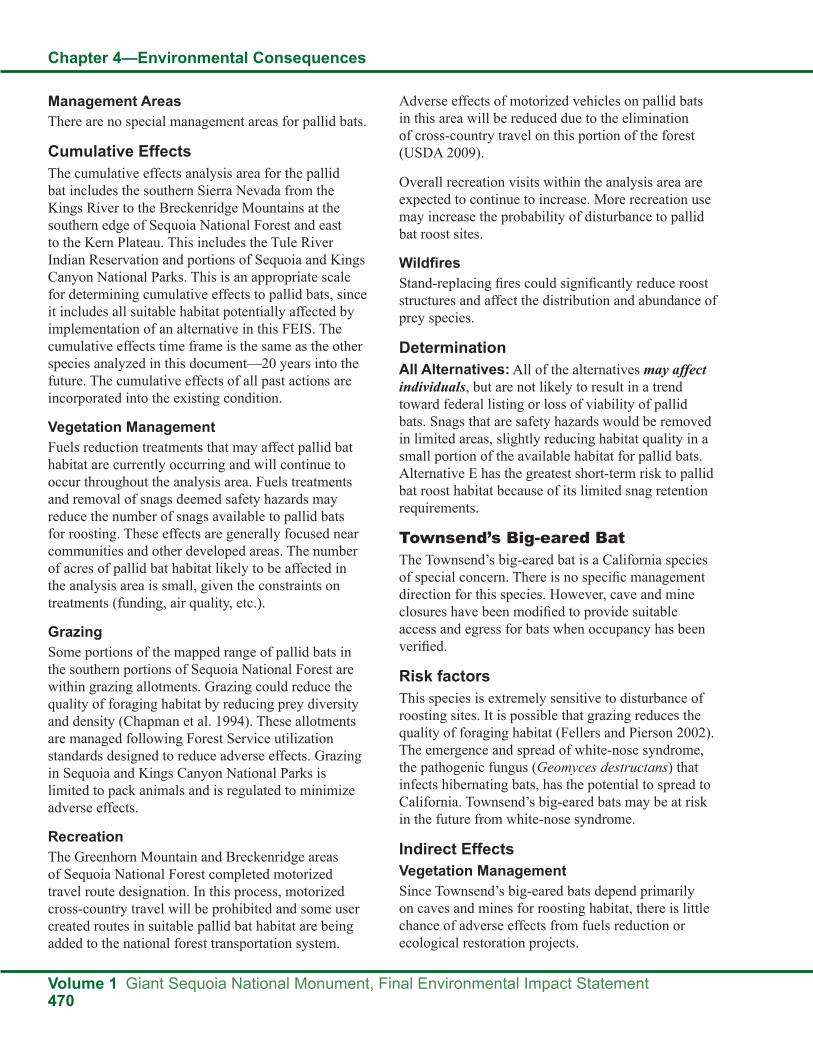
Chapter 4—Environmental Consequences
Volume 1 Giant Sequoia National Monument, Final Environmental Impact Statement470
Management AreasThere are no special management areas for pallid bats.
Cumulative EffectsThe cumulative effects analysis area for the pallid bat includes the southern Sierra Nevada from the Kings River to the Breckenridge Mountains at the southern edge of Sequoia National Forest and east to the Kern Plateau. This includes the Tule River Indian Reservation and portions of Sequoia and Kings Canyon National Parks. This is an appropriate scale for determining cumulative effects to pallid bats, since it includes all suitable habitat potentially affected by implementation of an alternative in this FEIS. The cumulative effects time frame is the same as the other species analyzed in this document—20 years into the future. The cumulative effects of all past actions are incorporated into the existing condition.
Vegetation ManagementFuels reduction treatments that may affect pallid bat habitat are currently occurring and will continue to occur throughout the analysis area. Fuels treatments and removal of snags deemed safety hazards may reduce the number of snags available to pallid bats for roosting. These effects are generally focused near communities and other developed areas. The number of acres of pallid bat habitat likely to be affected in the analysis area is small, given the constraints on treatments (funding, air quality, etc.).
GrazingSome portions of the mapped range of pallid bats in the southern portions of Sequoia National Forest are within grazing allotments. Grazing could reduce the quality of foraging habitat by reducing prey diversity and density (Chapman et al. 1994). These allotments are managed following Forest Service utilization standards designed to reduce adverse effects. Grazing in Sequoia and Kings Canyon National Parks is limited to pack animals and is regulated to minimize adverse effects.
RecreationThe Greenhorn Mountain and Breckenridge areas of Sequoia National Forest completed motorized travel route designation. In this process, motorized cross-country travel will be prohibited and some user created routes in suitable pallid bat habitat are being added to the national forest transportation system.
Adverse effects of motorized vehicles on pallid bats in this area will be reduced due to the elimination of cross-country travel on this portion of the forest (USDA 2009).
Overall recreation visits within the analysis area are expected to continue to increase. More recreation use may increase the probability of disturbance to pallid bat roost sites.
WildfiresStand-replacing fires could significantly reduce roost structures and affect the distribution and abundance of prey species.
DeterminationAll Alternatives: All of the alternatives may affect individuals, but are not likely to result in a trend toward federal listing or loss of viability of pallid bats. Snags that are safety hazards would be removed in limited areas, slightly reducing habitat quality in a small portion of the available habitat for pallid bats. Alternative E has the greatest short-term risk to pallid bat roost habitat because of its limited snag retention requirements.
Townsend’s Big-eared BatThe Townsend’s big-eared bat is a California species of special concern. There is no specific management direction for this species. However, cave and mine closures have been modified to provide suitable access and egress for bats when occupancy has been verified.
Risk factorsThis species is extremely sensitive to disturbance of roosting sites. It is possible that grazing reduces the quality of foraging habitat (Fellers and Pierson 2002). The emergence and spread of white-nose syndrome, the pathogenic fungus (Geomyces destructans) that infects hibernating bats, has the potential to spread to California. Townsend’s big-eared bats may be at risk in the future from white-nose syndrome.
Indirect EffectsVegetation ManagementSince Townsend’s big-eared bats depend primarily on caves and mines for roosting habitat, there is little chance of adverse effects from fuels reduction or ecological restoration projects.

Chapter 4—Environmental Consequences
Giant Sequoia National Monument, Final Environmental Impact Statement Volume 1471
RecreationNone of the alternatives propose expanding recreation access to caves or mines.
Management AreasThere are no special management areas for Townsend’s big-eared bats, but several caves and mines in the Monument are gated or closed to unregulated access.
Cumulative EffectsThe cumulative effects analysis area for the Townsend’s big-eared bats includes the southern Sierra Nevada from the Kings River to the Breckenridge Mountains at the southern edge of Sequoia National Forest and east to the Kern Plateau. This includes the Tule River Indian Reservation and portions of Sequoia and Kings Canyon National Parks. This is an appropriate scale for determining cumulative effects to Townsend’s big-eared bats, since it includes all suitable habitat potentially affected by implementation of an alternative in this FEIS. The cumulative effects time frame is the same as the other species analyzed in this document—20 years into the future. The cumulative effects of all past actions are incorporated into the existing condition.
Vegetation ManagementFuels treatment or other vegetation management activities are unlikely to affect Townsend’s big- eared bats because this species depends primarily on caves and mines for roosting habitat.
GrazingSome portions of the mapped range of Townsend’s big-eared bats in the southern portions of Sequoia National Forest are within grazing allotments. Grazing could reduce the quality of foraging habitat by reducing prey diversity and density (Chapman et al. 1994). These allotments are managed following Forest Service utilization standards designed to reduce adverse effects. Grazing in Sequoia and Kings Canyon National Parks is limited to pack animals and is regulated to minimize adverse effects.
RecreationThe Greenhorn Mountain and Breckenridge areas of Sequoia National Forest completed motorized travel route designation. Opportunities to access potential Townsend’s big-eared bat roost sites will be reduced
by the elimination of cross-country travel in this portion of the forest (USDA 2009).
Overall recreation visits within the analysis area are expected to increase. More recreation use may increase the probability of disturbance to Townsend’s big-eared bat roost sites.
WildfiresStand-replacing fires could affect the distribution and abundance of prey species.
DeterminationAll Alternatives: All of the alternatives would have no effect on Townsend’s big-eared bats. There are no proposed changes in the management of caves or mines, which would continue to be protected with gates or closures. Vegetation management projects are unlikely to adversely affect habitat for this species.
Western Red BatWestern red bats are listed as sensitive species in Region 5. There is no specific management direction for this species.
Indirect EffectsVegetation ManagementVegetation management projects for fuels reduction and ecological restoration may affect western red bat habitat by removing key habitat features. All of the alternatives would follow management direction to set the highest priority for fuels reduction activities in the WUI.
Alternative A (No Action): Alternative A would continue the existing direction in the 2001 SNFPA to locate fuels treatments across broad landscapes, so that the spread and intensity of wildfire is reduced. Within the mapped range of western red bats in the Monument there are approximately 24,100 acres of defense zone (20 percent of the range) and approximately 41,200 acres of threat zone (35 percent of range). These areas have the highest priority for fuels treatments, which might remove habitat features important to western red bats.
Alternative B: WUIs would be the same as in Alternative A. In addition, the TFETA would include approximately 19,500 acres in the CWHR range of western red bats. The short-term loss of habitat features important to western red bats would likely be

Chapter 4—Environmental Consequences
Volume 1 Giant Sequoia National Monument, Final Environmental Impact Statement472
higher in Alternative B than in Alternatives A, C, D, and E.
Alternative C: Alternative C would designate a WUI defense zone that extends approximately 300 feet from structures, developed recreation sites, and administrative sites. Approximately three percent of the CWHR range of western red bats in the Monument (4,000 acres) would be included in defense zones. Assuming that fuels treatments would be concentrated in the WUIs, the short-term loss of habitat features important to western red bats would be lower in Alternative C than in Alternatives A, B, E and F.
Alternative D: In Alternative D, designated WUIs would cover approximately two percent of the CWHR range of western red bats in the Monument (2,500 acres). The number of acres expected to be treated in Alternative D is small compared to those that would be treated under the other alternatives. Therefore, the potential for short-term loss of habitat features important to western red bats would be the lowest in Alternative D.
Alternative E: The designated WUIs and fuels treatment strategy would be the same as in Alternative A (No Action). Therefore, the effects on western red bat habitat are expected to be the same.
Alternative F: Alternative F would continue existing management direction to make fuels reduction activities in the current WUIs the highest priority. The size of the WUI defense and threat zones would be the same as in Alternatives A, B, and E. In addition, the TFETA would be established. Alternative F would eliminate the standard and guideline from the 2001 SNFPA requiring retention of all conifer trees with a dbh of 30 inches or greater and hardwoods with a dbh of 12 inches or larger when implementing vegetation treatments. There would be a six-inch diameter limit within one to two acres of a nest tree for the northern goshawk and California spotted owl. There would be no diameter limit for the rest of the acreage in northern goshawk and California spotted owl PACs. The short-term loss of habitat features important to western red bats would likely be higher in Alternative F than in the other alternatives due to the lack of diameter limits on tree felling. The long-term resiliency of western red bat habitat to stand-
replacing events such as fire, insects, and disease may be improved following treatments for ecological restoration.
RecreationRisk factors for this species include loss or modification of roost structures (i.e., removal of roost trees, modification of cave or mine sites), or disturbance to roosting individuals.
Alternatives A, B, E, and F: The existing roads, trails and developed recreation sites would continue to be utilized in Alternatives A, B, E, and F. The effects to western red bats could include the loss of trees and snags if they pose safety hazards and are removed. Disturbance to roosting western red bats is possible near roads, trails, dispersed camping areas, or developed recreation sites.
Alternative C: Recreation opportunities in developed sites would be emphasized and increased. Dispersed camping outside of developed sites would be eliminated. Camping in more remote locations, in inventoried roadless areas, or in the Wildlands recreation niche setting would be allowed by permit. Under Alternative C, the road and trail system providing recreation access would likely be reduced from the current transportation system.
The risk of disturbance and loss of key habitat features for western red bats would be concentrated at the developed recreation sites. Overall effects to western red bats would be lower than in the other alternatives because of the elimination of dispersed camping and the reduction of the road system. Fewer acres of potential western red bat habitat would be subjected to disturbance and loss of key features.
Alternative D: Recreation would be managed similarly to Alternatives A, B, E, and F, except new recreation development would be limited and motorized use would be restricted to street-legal vehicles only.
The risk of disturbance to western red bat roost sites would be less than Alternatives A, B, E, and F because of the restrictions on vehicle types. The overall acres of western red bat habitat subject to disturbance would be more than Alternative C, but disturbance at specific developed recreation sites would likely be lower.

Chapter 4—Environmental Consequences
Giant Sequoia National Monument, Final Environmental Impact Statement Volume 1473
Management AreasThere are no special management areas for western red bats.
Cumulative EffectsThe cumulative effects analysis area for the western red bat includes the southern Sierra Nevada from the Kings River to the Breckenridge Mountains at the southern edge of Sequoia National Forest and east to the Kern Plateau. This includes the Tule River Indian Reservation and portions of Sequoia and Kings Canyon National Parks. This is an appropriate scale for determining cumulative effects to western red bats, since it includes all suitable habitat potentially affected by implementation of an alternative in this FEIS. The cumulative effects time frame is the same as the other species analyzed in this document—20 years into the future. The cumulative effects of all past actions are incorporated into the existing condition.
Vegetation ManagementFuels reduction treatments that may affect western red bat habitat are currently occurring and will continue to occur throughout the analysis area. These treatments are generally focused near communities and other developed areas. Prescribed fire is a tool expected to be used throughout the area, with mechanical and hand thinning also occurring. The number of acres of western red bat habitat likely to be affected in the analysis area is small, given the constraints on treatments (funding, air quality, etc.).
GrazingSome portions of the mapped range of western red bats in the southern portions of Sequoia National Forest are within grazing allotments. Overgrazing could reduce the quality of riparian habitat needed by this species. However, these allotments are managed following Forest Service utilization standards designed to reduce adverse effects. Grazing in Sequoia and Kings Canyon National Parks is limited to pack animals and is regulated to minimize adverse effects.
RecreationThe Greenhorn Mountain and Breckenridge areas of Sequoia National Forest completed motorized travel route designation. As a result of this process, motorized cross-country travel will be prohibited.
Adverse effects of motorized vehicles on western red bats in this area will be reduced due to the elimination of cross-country travel on this portion of the forest (USDA 2009).
Overall recreation visits within the analysis area are expected to increase. More recreation use may increase the probability of disturbance to western red bats.
WildfiresLarge, stand-replacing fires could significantly reduce roost structures and affect the distribution and abundance of prey species.
DeterminationAll Alternatives: All of the alternatives may affect individuals, but are not likely to result in a trend toward federal listing or loss of viability of western red bats. All of the alternatives would allow short-term reductions in habitat quality by removing trees, snags, and down woody material, and there is a potential for disturbance of roosting sites, but only a small portion of the available habitat would be affected. A maximum of 20 percent of this species’ range in the Monument is in defense zones (the area most likely to receive vegetation treatments). In the long-term, vegetation treatments would result in a reduced chance of stand-replacing fires and improved forest resiliency which would benefit western red bats.
California WolverineUnder 2001 SNFPA direction, if a wolverine sighting is verified, Forest Service management activities within a five-mile radius will be evaluated for potential disturbance. For a two-year period following the detection, an LOP of January 1 to June 30 would be required for activities that would have an adverse effect. Wolverines are listed as threatened by the State of California.
Indirect EffectsVegetation ManagementVegetation management projects for fuels reduction and ecological restoration may affect wolverine habitat by reducing canopy cover and removing key habitat features (large trees, snags, down woody debris).

Chapter 4—Environmental Consequences
Volume 1 Giant Sequoia National Monument, Final Environmental Impact Statement474
Alternative A (No Action): Alternative A would continue the existing direction in the 2001 SNFPA to locate fuel treatments across broad landscapes so that the spread and intensity of wildfire is reduced. Using currently designated WUIs, there are approximately 45,300 acres identified as defense zone (13 percent of the Monument) and approximately 145,500 acres of threat zone (41 percent of the Monument). These areas have the highest priority for fuels treatments and have less stringent requirements for maintaining habitat features important to wolverines than areas outside of WUIs.
Alternative B: WUIs would be the same as in Alternative A. In addition, the TFETA, comprised of 56,600 acres, would be established along the border with the Tule River Indian Reservation. The short-term loss of habitat features important to wolverines would likely be higher in Alternative B than in Alternatives A, C, D, and E.
Alternative C: Alternative C would designate a WUI defense zone that extends approximately 300 feet from structures, developed recreation sites, and administrative sites. Approximately two percent of the Monument (8,100 acres) would be included in defense zones. Assuming that fuels treatments would be concentrated in the WUIs, the short-term loss of habitat features important to wolverines would be lower in Alternative C than in Alternatives A, B, E, and F.
Alternative D: In Alternative D, the designated WUI defense zone would cover approximately one percent of the Monument (4,600 acres). The number of proposed acres that would be treated in Alternative D is small compared to those that would be treated under the other alternatives. Therefore, the potential for short-term loss of habitat features important to wolverines would be the lowest in Alternative D.
Alternative E: The designated WUIs and fuels treatment strategy would be the same as in Alternative A (No Action). Therefore, the effects on wolverine habitat are expected to be the same.
Alternative F: Alternative F would continue existing management direction to make fuels reduction activities in the current WUIs the highest priority. The size of the WUI defense and threat zones would be the same as in Alternatives A, B, and E. In addition,
the TFETA would be established. Alternative F would eliminate the standard and guideline from the 2001 SNFPA requiring retention of all conifer trees with a dbh of 30 inches or greater and hardwoods with a dbh of 12 inches or larger when implementing vegetation treatments. There would be a six-inch diameter limit within one to two acres of a nest tree for the northern goshawk and California spotted owl. There would be no diameter limit for the rest of the acreage in northern goshawk and California spotted owl PACs. The short-term loss of habitat features important to wolverines would likely be higher in Alternative F than in the other alternatives due to the lack of diameter limits for tree felling. The long-term resiliency of wolverine habitat to stand-replacing events such as fire, insects, and disease may be improved following treatments for ecological restoration.
RecreationWolverines are sensitive to the presence of humans and human activities (Claar et al. 1999, Grinnell et al. 1937). Recreation associated factors that may affect wolverines include reduction in down logs, disturbance, and vehicle collisions (Gaines et al. 2003). The rarity of wolverines in the Sierra and the lack of recent confirmed sightings in the Monument make adverse effects from recreational activities extremely unlikely.
Alternatives A, B, E, and F: The existing roads, trails, and developed recreation sites would continue to be utilized in Alternatives A, B, E, and F. The effects to wolverines could include the loss of trees and snags if they pose safety hazards and are removed. Disturbance to wolverines is possible near roads, trails, dispersed camping areas, or developed recreation sites.
Alternative C: Recreation opportunities in developed sites would be emphasized and increased. Dispersed camping outside of developed sites would be eliminated. Camping in more remote locations, in inventoried roadless areas, or in the Wildlands recreation niche setting would be allowed by permit.
The risk of disturbance and loss of key habitat features for wolverines would be concentrated at the developed recreation sites. Overall effects to wolverines would be lower than in the other

Chapter 4—Environmental Consequences
Giant Sequoia National Monument, Final Environmental Impact Statement Volume 1475
alternatives because of the elimination of dispersed camping. Fewer acres of potential wolverine habitat would be subjected to disturbance and loss of key features.
Alternative D: Recreation would be managed similarly to Alternatives A, B, E, and F, except new recreation development would be limited and motorized use would be restricted to street-legal vehicles only. The risk of disturbance to wolverines would be less than Alternatives A, B, E, and F because of the restrictions on vehicle types. The overall acres of wolverine habitat subject to disturbance would be more than Alternative C, but disturbance at specific developed recreation sites would likely be lower.
Management AreasThere are currently no special management areas for wolverines in the Monument.
Alternatives A, B, C, D, and F: Alternatives A, B, C, D, and F would continue to follow the 2001 SNFPA guidelines to analyze and, if necessary, restrict activities that may have adverse effects in areas with confirmed wolverine detections.
Alternative E: Alternative E has no special protection for wolverines or their habitat.
Cumulative EffectsThe cumulative effects analysis area for the wolverine includes the southern Sierra Nevada from the Kings River to the Breckenridge Mountains at the southern edge of the Sequoia National Forest and east to the Kern Plateau. This includes the Tule River Indian Reservation and portions of Sequoia and Kings Canyon National Parks. This is an appropriate scale for determining cumulative effects to wolverines, since it includes all suitable habitat potentially affected by implementation of an alternative in this FEIS. The cumulative effects time frame is the same as the other species analyzed in this document—20 years into the future. The cumulative effects of all past actions are incorporated into the existing condition.
Vegetation ManagementFuels reduction treatments that may affect wolverine habitat are currently occurring and will continue to occur throughout the analysis area. These treatments are generally focused near communities
and other developed areas unlikely to be inhabited by wolverines. The number of acres of potential wolverine habitat likely to be affected in the analysis area is small, given the constraints on treatments (funding, air quality, etc.).
RecreationOverall recreation visits within the analysis area are expected to continue to increase. More recreation use may increase the probability of disturbance to wolverines. However, Sequoia and Kings Canyon National Parks limit the number of campers in wilderness. These remote areas likely have the highest probability of occupation by wolverines in the analysis area.
WildfiresLarge, stand-replacing fires have the potential to affect habitat suitability for wolverines by reducing canopy cover, decreasing prey abundance, and removing den sites.
DeterminationAll Alternatives: All of the alternatives may affect individuals, but are not likely to result in a trend toward federal listing or loss of viability of wolverines. All of the alternatives would allow short-term reductions in habitat quality by removing trees, snags, and down woody material, and there is a potential for disturbance to individuals, but in the long term, reduction in the chance of large stand-replacing fire and increases in forest resiliency would benefit wolverines and their prey species. The rarity of wolverines in the Sierra and the lack of recent confirmed sightings in the Monument make adverse effects extremely unlikely.
American MartenThe 2001 SNFPA requires the establishment of den site buffers that consist of 100 acres of the highest quality habitat in a compact arrangement surrounding American marten dens. Canopy closure retention guidelines for California spotted owls and northern goshawks maintain habitat characteristics also preferred by American marten. All suitable habitat for American martens in the Monument is within the SSFCA, which also requires the retention of habitat structures important to martens.

Chapter 4—Environmental Consequences
Volume 1 Giant Sequoia National Monument, Final Environmental Impact Statement476
Indirect EffectsVegetation ManagementVegetation management projects for fuels reduction and ecological restoration may affect American marten habitat by reducing canopy cover and removing key habitat features (large trees, snags, down woody debris).
Alternative A (No Action): Alternative A would continue the existing direction in the 2001 SNFPA to locate fuels treatments across broad landscapes in order to reduce the spread and intensity of fires. Within American marten habitat (using CWHR model), there are approximately 13,400 acres identified as WUI defense zone (10 percent of marten habitat in the Monument) and approximately 56,400 acres of WUI threat zone (41 percent of marten habitat in Monument). These areas have the highest priority for fuels treatments and have less stringent requirements for maintaining habitat features important to American marten than areas outside of WUIs.
Alternative B: WUIs would be the same as in Alternative A. In addition, the TFETA, including approximately 25,500 acres of American marten habitat, would be established along the border with the Tule River Indian Reservation. The short-term loss of habitat features important to American marten would likely be higher in Alternative B than in Alternatives A, C, D, and E.
Alternative C: Alternative C would designate a WUI defense zone that extends approximately 300 feet from structures, developed recreation sites, and administrative sites. Approximately 2,500 acres or two percent of the American marten habitat in the Monument would be within WUI defense zones. Assuming that fuels treatments would be concentrated in the WUIs, the short-term loss of habitat features important to American marten would be lower in Alternative C than in Alternatives A, B, E and F.
Alternative D: In Alternative D, approximately 1,200 acres or one percent of the American marten habitat in the Monument would be within the designated WUI defense zone. The number of proposed acres that would be treated in Alternative D is small compared to those that would be treated under the other alternatives. Therefore, the potential
for short-term loss of habitat features important to American marten would be the lowest in Alternative D.
Alternative E: The designated WUIs and fuels treatment strategy would be the same as in Alternative A (No Action). Therefore, the effects on American marten habitat are expected to be the same.
Alternative F: Alternative F would continue existing management direction to make fuels reduction activities in the current WUIs the highest priority. The size of the WUI defense and threat zones would be the same as in Alternatives A, B, and E. In addition, the TFETA would be established. Alternative F would eliminate the standard and guideline from the 2001 SNFPA requiring retention of all conifer trees with a dbh of 30 inches or greater and hardwoods with a dbh of 12 inches or larger when implementing vegetation treatments. There would be a six-inch diameter limit within one to two acres of a nest tree for the northern goshawk and California spotted owl. There would be no diameter limit for the rest of the acreage in a northern goshawk or California spotted owl PAC. The short-term loss of habitat features important to American martens would be higher in Alternative F than in the other alternatives due to the lack of diameter limits on tree felling. The long-term resiliency of American marten habitat to stand-replacing events such as fire, insects, and disease may be improved following treatments for ecological restoration.
RecreationRecreation associated factors that may affect American martens include habitat fragmentation, disturbance, and vehicle collisions (Gaines et al. 2003).
Alternatives A, B, E, and F: The existing roads, trails, and developed recreation sites would continue to be utilized in Alternatives A, B, E, and F. The effects to American martens could include the loss of trees and snags if they pose safety hazards and are removed. Disturbance to American martens is possible near roads, trails, dispersed camping areas, or developed recreation sites.
Alternative C: Recreation opportunities in developed sites would be emphasized and increased. Dispersed camping outside of developed sites would be

Chapter 4—Environmental Consequences
Giant Sequoia National Monument, Final Environmental Impact Statement Volume 1477
eliminated. Camping in more remote locations, in inventoried roadless areas, or in the Wildlands recreation niche setting would be allowed by permit.
The risk of disturbance and loss of key habitat features for American martens would be concentrated at the developed recreation sites. Overall effects to American martens would be lower than in the other alternatives because of the elimination of dispersed camping and the restrictions on vehicle types. Fewer acres of potential American marten habitat would be subjected to disturbance and loss of key features.
Alternative D: Recreation would be managed similarly to Alternatives A, B, E, and F, except new recreation development would be limited and motorized use would be restricted to street-legal vehicles only.
The risk of disturbance to American martens would be less than Alternatives A, B, E, and F because of the restrictions on vehicle types. The overall acres of American marten habitat subject to disturbance would be more than Alternative C, but disturbance at specific developed recreation sites would likely be lower.
Management AreasAmerican marten den site buffers are specific land allocations established to preserve key habitat characteristics and restrict project-related disturbance with LOPs. Several other land allocations, although not specifically aimed at protecting American martens, also protect marten habitat by maintaining canopy cover, large trees, and down woody debris. These areas include California spotted owl PACs, northern goshawk PACs, fisher den site buffers, RCAs, CARs, old forest emphasis areas, and the SSFCA.
Alternatives A and B: Alternatives A and B would maintain the current American marten den site buffer and restrict management activities on 110 acres of high quality habitat near a known den site. In the future, as research continues, more den site buffers may be established in other areas of the Monument. An LOP of May 1 to July 31 for activities within one-quarter mile of the den site would be required for most management activities.
In Alternatives A and B, fuels treatments within American marten den site buffers that are outside of WUIs would be avoided. Inside WUIs (currently 110
acres or 100 percent of existing American marten den buffers), if necessary to achieve fuels objectives, mechanical treatments of ladder and surface fuels over 85 percent of the treatment units would be permitted. Prescribed fire could be used if no other reasonable treatment method exists. LOPs would be implemented if necessary. No special management is proposed within the TFETA in Alternative B.
Outside of the WUI and within the SSFCA (approximately 62,300 acres or 45 percent of American marten habitat in the Monument), Alternative B would maintain requirements to retain 60 percent of the watersheds in large trees and canopy cover greater than or equal to 60 percent. These restrictions would also apply to areas within the TFETA (in Alternative B), but not within WUI defense or threat zones. Inside of WUIs (approximately 76,700 acres or 55 percent of American marten habitat in the Monument) those restrictions would not apply.
Within the limits imposed by the standards and guidelines, it is not known how many PACs/den buffers or acres will actually be treated in a given year. That would be based on project level decisions.
Habitat characteristics important to American martens would also be protected in California spotted owl PACs (approximately 22,700 acres), northern goshawk PACs (3,200 acres), fisher den site buffers (approximately 3,000 acres), RCAs, CARs (approximately 27,100 acres), and old forest emphasis areas (approximately 160,600 acres). Each of these land allocations has unique standards and guidelines which vary in the level of protection they provide for American marten habitat (see wildlife standards and guidelines, FEIS, Volume 2, Appendix A).
Alternative C: Alternative C would not include American marten den site buffers or other wildlife protection land allocations. Alternative C would evaluate the effects of fuels reduction and restoration projects on American martens with BEs. LOPs appropriate for American martens would be utilized, as needed.
Although there is no specific land allocation for the protection of American martens in Alternative C, management activities with the potential to negatively affect martens or their habitat are limited. WUI areas,

Chapter 4—Environmental Consequences
Volume 1 Giant Sequoia National Monument, Final Environmental Impact Statement478
where fuels reduction treatments will be focused are smaller than in Alternatives A, B, E, and F, and the number of acres expected to be treated is small compared to Alternatives A, B, E, and F.
Alternative D: Alternative D would maintain the American marten den site buffer and restrict management activities on 110 acres of high quality habitat. It would also maintain California spotted owl PACs, northern goshawk PACs, fisher den site buffers, RCAs, and CARs. In Alternative D, the land allocations of SSFCA and old forest emphasis areas would be eliminated. Instead the entire Monument would be managed for wildlife, with particular emphasis on old forest dependent species.
Alternative D does not allow tree felling for fuels management or ecological restoration, only for safety concerns. The WUI area is less than the other alternatives and the number of acres expected for fuels treatment is smaller than the other alternatives. Therefore the short-term effects on American martens and their habitat are smaller in Alternative D than the other alternatives.
Alternative E: There would be no American marten den site buffers or other land allocations specifically protecting marten habitat in Alternative E. SOHAs on approximately 24,700 acres would be maintained. However, SOHAs only restrict timber harvest from areas, which is not a management option because of the Clinton proclamation (2000). This alternative only requires analysis of effects “where projects are proposed impacting old growth stands” and consultation with the Department of Fish and Game concerning habitat protection for furbearers.
Management of riparian areas would follow the 1988 Forest Plan and 1990 MSA. There would be no RCAs, CARs, or RCOs. Alternative E would have the least protection of riparian habitat.
Of the alternatives, Alternative E would allow the greatest amount of short-term American marten habitat loss and disturbance due to the lack of protected areas or an LOP.
Alternative F: Alternative F would maintain the current American marten den site buffer and restrict management activities on 40 acres of high quality habitat near a known den site. Vegetation
treatments in den site buffers outside defense zones would be avoided. However, vegetation treatments inside defense zones would have no diameter limits. Therefore, there could be short-term losses to habitat quality in these areas. In the future, as research continues, more den site buffers may be established in other areas of the Monument. An LOP of May 1 to July 31 for activities within one-quarter mile of the den site would be required for most management activities. Habitat characteristics important to American martens would also be protected in fisher den site buffers (3,000 acres), RCAs, CARs (27,100 acres), old forest emphasis areas (160,600 acres) and the SSFCA (333,500 acres). Each of these land allocations has unique standards and guidelines which vary in the level of protection they provide for American marten habitat (see wildlife standards and guidelines, FEIS, Volume 2, Appendix A).
Cumulative EffectsThe cumulative effects analysis area for the American marten includes the southern Sierra Nevada from the Kings River to the Breckenridge Mountains at the southern edge of Sequoia National Forest and east to the Kern Plateau. This includes the Tule River Indian Reservation and portions of Sequoia and Kings Canyon National Parks. This is an appropriate scale for determining cumulative effects to American marten, since it includes all suitable habitat potentially affected by implementation of an alternative in this FEIS. The cumulative effects time frame is the same as the other species analyzed in this document—20 years into the future. The cumulative effects of all past actions are incorporated into the existing condition.
Vegetation ManagementFuels reduction treatments that may affect American marten habitat are currently occurring and would continue to occur throughout the analysis area. These treatments are generally focused near communities and other developed areas. Prescribed fire is a tool expected to be used throughout the area, with mechanical and hand thinning also occurring. The number of acres of American marten habitat likely to be affected in the analysis area is small, given the constraints on treatments (funding, air quality, etc.).
RecreationThe Greenhorn Mountain and Breckenridge areas of Sequoia National Forest completed motorized

Chapter 4—Environmental Consequences
Giant Sequoia National Monument, Final Environmental Impact Statement Volume 1479
travel route designation. As a result of this process, motorized cross-country travel will be prohibited and some routes in suitable American marten habitat are being added to the national forest transportation system. Adverse effects of motorized vehicles on American martens in the analysis area will be reduced due to the elimination of cross-country travel in this portion of the forest (USDA 2009).
Overall recreation visits within the analysis area are expected to increase. More recreation use may increase the probability of disturbance to American martens.
WildfiresIncreased fires, especially an increase in higher elevation fires, may result in a dramatic reduction in American marten habitat. Also, because of the American marten’s declivity to cross large openings, large burns may fragment marten habitat and isolate populations leading to localized extinction. Finally, increased drying conditions will lead to further desiccation of meadow edges. Drier meadow edges would likely reduce populations of voles, a prey highly important to American marten within the Sierra Nevada.
DeterminationAll Alternatives: All of the alternatives may affect individuals, but are not likely to result in a trend toward federal listing or loss of viability of American martens. All of the alternatives would allow short-term reductions in habitat quality by removing trees, snags, and down woody material, and there is a potential for disturbance to individuals, but only a small portion of the available habitat would be affected. No more than 10 percent of suitable habitat is within defense zones (the areas most likely to receive vegetation treatments) in any of the alternatives. In the long term, reduction in the chance of large stand-replacing fire and increases in forest resiliency would benefit American martens and their prey species. Additionally, modeling has shown increases in old growth habitat and in large trees (greater than 30inches dbh) in the future for all of the alternatives (SPECTRUM model).
Pacific FisherThe 2001 SNFPA requires the establishment of fisher den site buffers that consist of 700 acres of the highest
quality habitat in a compact arrangement surrounding verified birthing and kit rearing dens. Fisher den site buffers have an LOP of March 1 to June 30. Canopy closure retention guidelines for California spotted owls and northern goshawks maintain habitat characteristics also preferred by fisher. All suitable habitat for fishers in the Monument is within the SSFCA, which requires the retention of habitat structures important to fishers.
Indirect EffectsVegetation ManagementVegetation management projects for fuels reduction and ecological restoration may affect fisher habitat by reducing canopy cover and removing key habitat features (large trees, snags, down woody debris).
Alternative A (No Action): Within fisher habitat (using CWHR 2.1), there are approximately 21,100 acres identified as WUI defense zone (14 percent of fisher habitat in the Monument) and approximately 60,100 acres of WUI threat zone (40 percent of fisher habitat in the Monument). These areas have the highest priority for fuels treatments and have less stringent requirements for maintaining habitat features important to fishers than areas outside of WUIs.
Alternative B: WUIs would be the same as in Alternative A. In addition, 23,900 acres of fisher habitat (using CWHR 2.1) would be within the TFETA. The short-term loss of habitat features important to fishers would likely be higher in Alternative B than in Alternatives A, C, D, and E.
Alternative C: Alternative C would designate a WUI defense zone that extends approximately 300 feet from structures, developed recreation sites, and administrative sites. Approximately 3,900 acres or three percent of the fisher habitat within the Monument would be within WUI defense zones. Assuming that fuels treatments would be concentrated in the WUIs, the short-term loss of habitat features important to fishers would be lower in Alternative C than in Alternatives A, B, E, and F.
Alternative D: In Alternative D, approximately 2,100 acres or one percent of the fisher habitat within the Monument would be within the designated WUI defense zone. The number of proposed acres that would be treated in Alternative D is small compared to those that would be treated under the other

Chapter 4—Environmental Consequences
Volume 1 Giant Sequoia National Monument, Final Environmental Impact Statement480
alternatives. Therefore, the potential for short-term loss of habitat features important to fishers would be the lowest in Alternative D.
Alternative E: The designated WUIs and fuels treatment strategy would be the same as in Alternative A (No Action). Therefore, the effects on fisher habitat are expected to be the same.
Alternative F: Alternative F would continue existing management direction to make fuels reduction activities in the current WUIs the highest priority. The size of the WUI defense and threat zones would be the same as in Alternatives A, B, and E. In addition, the TFETA would be established. Alternative F would eliminate the standard and guideline from the 2001 SNFPA requiring retention of all conifer trees with a dbh of 30 inches or greater and hardwoods with a dbh of 12 inches or larger when implementing vegetation treatments. There would be a six-inch diameter limit within one to two acres of a nest tree for the California spotted owl and northern goshawk. There would be no diameter limit for the rest of the acreage in northern goshawk and California spotted owl PACs (25,900 acres). The short-term loss of habitat features important to fishers would likely be higher in Alternative F than in the other alternatives due to the lack of diameter limits on tree felling. The long-term resiliency of fisher habitat to stand-replacing events such as fire, insects, and disease may be improved following treatments for ecological restoration.
RecreationRecreation associated factors that may affect fishers include habitat fragmentation, disturbance, and vehicle collisions (Gaines et al. 2003).
Alternatives A, B, E, and F: The existing roads, trails and developed recreation sites would continue to be utilized in Alternatives A, B, E, and F. The effects to fishers could include the loss of trees and snags if they pose safety hazards and are removed along roads or in developed recreation sites. Disturbance to fishers is possible near roads, trails, dispersed camping areas, or developed recreation areas.
Alternative C: Recreation opportunities in developed sites would be emphasized and increased. Dispersed camping outside of developed sites would be eliminated. Camping in more remote locations, in inventoried roadless areas, or in the Wildlands
recreation niche setting would be allowed by permit. Motorized use would be restricted to street-legal vehicles only.
The risk of disturbance and loss of key habitat features for fishers would be concentrated at the developed recreation sites. Overall recreation-related effects to fishers would be lower than in the other alternatives because of the elimination of dispersed camping and the restrictions on the vehicle type. Fewer acres of fisher habitat would be subjected to disturbance and loss of key features.
Alternative D: Recreation would be managed similarly to Alternatives A, B, E, and F, except new recreation development would be limited and motorized use would be restricted to street-legal vehicles only. The risk of disturbance to fishers would be less than Alternatives A, B, E, and F because of the restrictions on vehicle types. The overall acres of fisher habitat subject to disturbance would be more than Alternative C, but disturbance at specific developed recreation sites would likely be lower.
Management AreasFisher den site buffers are specific land allocations established to preserve key habitat characteristics and restrict project-related disturbance with LOPs. Current den site buffers in the Monument are limited to the Tule River area where radio telemetry research has identified den sites. In the future, as research continues, more den site buffers may be established in other areas of the Monument.
Several other land allocations, although not specifically aimed at protecting fishers, also protect fisher habitat by maintaining canopy cover, large trees, and down woody debris. These areas include California spotted owl PACs, northern goshawk PACs, American marten den site buffers, RCAs, CARs, old forest emphasis areas, and the SSFCA.
Alternatives A and B: Alternatives A and B would maintain the 2001 SNFPA guidelines for Pacific fisher den site buffers and restrict management activities on 3,000 acres of high quality habitat near historic den sites. An LOP of approximately March 1 to June 30 for activities within den site buffers would be required for most management activities. Most of the Monument is within the SSFCA (333,500 acres). Standards and guidelines for this land allocation

Chapter 4—Environmental Consequences
Giant Sequoia National Monument, Final Environmental Impact Statement Volume 1481
provide additional requirements for protecting habitat components important to fishers including canopy cover and large trees (see wildlife standards and guidelines, FEIS, Volume 2, Appendix A).
Habitat characteristics important to fishers would also be protected in California spotted owl PACs (22,700 acres), northern goshawk PACs (3,200 acres), American marten den site buffers (100 acres), RCAs, CARs (27,100 acres), and old forest emphasis areas (160,600 acres). Each of these land allocations has unique standards and guidelines which vary in the level of protection they provide for fisher habitat (see wildlife standards and guidelines, FEIS, Volume 2, Appendix A).
Alternative C: Alternative C would not include fisher den site buffers or other wildlife protection land allocations. Alternative C would evaluate the effects of fuels reduction and restoration projects on fishers with BEs. LOPs appropriate for fishers would be utilized as needed.
Although there is no specific land allocation for the protection of fishers in Alternative C, management activities with the potential to negatively affect fishers or their habitat are limited. WUI areas, where fuels reduction treatments will be focused, are smaller than in Alternatives A, B, E, and F, and the number of acres proposed for treatment is small, compared to Alternatives A, B, E, and F.
Alternative D: Alternative D would maintain the fisher den site buffers and restrict management activities on 3,000 acres of high quality habitat. It would also maintain California spotted owl PACs, northern goshawk PACs, American marten den site buffers, RCAs, and CARs. In Alternative D, the land allocations of SSFCA and old forest emphasis areas would be eliminated. Instead, the entire Monument would be managed for wildlife, with particular emphasis on old forest dependent species.
Alternative D does not allow tree felling for fuels management or ecological restoration, only for safety concerns. The WUI area is less than the other alternatives and the number of acres expected for fuels treatment is smaller than the other alternatives. Therefore the short-term effects on fishers and their habitat are smaller in Alternative D than the other alternatives.
Alternative E: There would be no fisher den site buffers or other land allocations specifically protecting fisher habitat in Alternative E. SOHAs on 24,700 acres would be maintained. However, SOHAs only restrict timber harvest, which is not a management option because of the Clinton proclamation (2000). Alternative E only requires analysis of effects “where projects are proposed impacting old growth stands” and consultation with the Department of Fish and Game concerning habitat protection for fur bearers.
Management of riparian areas would follow the 1988 Forest Plan and 1990 MSA. There would be no RCAs, CARs, or RCOs. Alternative E would have the least protection of riparian habitat.
Of the alternatives, Alternative E would allow the greatest amount of short-term fisher habitat loss and disturbance due to the lack of protected areas or an LOP.
Alternative F: Alternative F would maintain the current fisher den site buffers. Vegetation treatments in den site buffers outside defense zones would be avoided. However, vegetation treatments inside defense zones would have no diameter limits. Therefore, there could be short-term losses to habitat quality in these areas. In the future, as research continues, more den site buffers may be established in other areas of the Monument. An LOP of March 1 to June 30 for activities within one-quarter mile of the den site would be required for most management activities. Habitat characteristics important to fishers would also be protected in American marten den site buffers (40 acres outside defense zone), RCAs, CARs (27,100 acres), old forest emphasis areas (160,600 acres) and the SSFCA (333,500 acres). Each of these land allocations has unique standards and guidelines which vary in the level of protection they provide for fisher habitat (see wildlife standards and guidelines, FEIS, Volume 2, Appendix A).
Cumulative EffectsThe cumulative effects analysis area for the fisher includes the southern Sierra Nevada from the Kings River to the Breckenridge Mountains at the southern edge of Sequoia National Forest and east to the Kern Plateau. This includes the Tule River Indian Reservation and portions of Sequoia and Kings Canyon National Parks. This is an appropriate scale for determining cumulative effects to fishers, since

Chapter 4—Environmental Consequences
Volume 1 Giant Sequoia National Monument, Final Environmental Impact Statement482
it includes all suitable habitat potentially affected by implementation of an alternative in this FEIS. The cumulative effects time frame is the same as the other species analyzed in this document—20 years into the future. The cumulative effects of all past actions are incorporated into the existing condition.
Vegetation ManagementFuels reduction treatments that may affect fisher habitat are currently occurring and would continue to occur throughout the analysis area. These treatments are generally focused near communities and other developed areas. Prescribed fire is a tool expected to be used throughout the area, with mechanical and hand thinning also occurring. The number of acres of fisher habitat likely to be affected in the analysis area is small, given the constraints on treatments (funding, air quality, etc.).
The Conservation Biology Institute conducted a computer simulation study of the interactions between fuels management, forest fires, fisher habitat, and the fisher population in the southern Sierra Nevada (Spencer et al. 2008). Their study area included this analysis area. Treating only two percent of the treatable landscape every five years (or up to 10 percent of the treatable landscape over 20 years) had no significant effect on fire or fishers at the landscape level, while treating four to eight percent of the treatable landscape every five years (or up to 20-32 percent of the treatable landscape over 20 years) was effective in reducing fire and benefiting fishers.
RecreationThe Greenhorn Mountain and Breckenridge areas of Sequoia National Forest completed motorized travel route designation. As a result of this process, motorized cross-country travel will be prohibited and some routes in suitable fisher habitat will be added to the national forest transportation system. Adverse effects of motorized vehicles on fishers in this area will be reduced due to the elimination of cross-country travel in this portion of the forest (USDA Forest Service 2009).
Overall recreation visits within the analysis area are expected to increase. More recreation use may increase the probability of disturbance to Pacific fishers.
WildfiresLarge, stand-replacing fires have the potential to make large areas of habitat less suitable for fishers by reducing canopy cover, decreasing prey abundance, and removing den and rest sites. Uncharacteristically severe wildfire ranked as a high threat to fisher habitat in the southern Sierra Nevada (Lofroth et al. 2010).
DeterminationAll Alternatives: All of the alternatives may affect individuals, but is not likely to to accelerate the trend toward Federal listing or result in loss of viability for the fisher. All of the alternatives would allow short-term reductions in habitat quality by removing trees, snags, and down woody material, and there is a potential for disturbance to individuals, but only a small portion of the available habitat would be affected. No more than 14 percent of suitable habitat is within defense zones (the area most likely to receive vegetation treatments) in any of the alternatives. In the long-term, reduction in the chance of large, stand-replacing fire and increases in forest resiliency would benefit fishers and their prey species. Additionally, modeling has shown increases in old growth habitat and in large trees (greater than 30 inches dbh) in the future for all of the alternatives (SPECTRUM model).
Alternatives E and F would pose the greatest short-term risks to fishers, because Alternative F has the fewest restrictions on vegetation management activities and Alternative E lacks LOPs. Trees large enough to be den or rest sites could be removed in Alternatives E and F. Alternative D would have the lowest risk to fishers from management activities; however, it may have a greater risk of large, stand-replacing fires.
Relictual Slender SalamanderThere is no specific management direction for this species. RCA buffers of 300 feet on either side of perennial streams, meadows, seeps, and springs and 150 feet on either side of intermittent streams provide some protection to habitat by limiting effects from management projects.
Indirect EffectsLittle is known about the status of relictual slender salamanders within the Monument. To assess effects, it was estimated that approximately 33,200 acres of

Chapter 4—Environmental Consequences
Giant Sequoia National Monument, Final Environmental Impact Statement Volume 1483
potential relictual slender salamander habitat exist within the Monument. This is based on buffers of 300 feet on either side of perennial streams and 150 feet on either side of intermittent streams, meadows, seeps, and springs within the CWHR mapped range for this species.
Vegetation ManagementVegetation management projects for fuels reduction and ecological restoration may affect relictual slender salamander habitat by reducing canopy cover, causing soil compaction, and removing down logs.
Alternative A (No Action): Within potential relictual slender salamander habitat, there are approximately 5,600 acres identified as WUI defense zone (17 percent of habitat in the Monument) and approximately 15,500 acres of WUI threat zone (47 percent of habitat in the Monument). These areas have the highest priority for fuels treatments and are more likely to be affected than areas outside of WUIs.
Alternative B: WUIs would be the same as in Alternative A. In addition, approximately 9,900 acres of relictual slender salamander habitat would be within the TFETA. The short-term loss of habitat features important to relictual slender salamanders would likely be higher in Alternative B than in Alternatives A, C, D, and E.
Alternative C: Alternative C would designate a WUI defense zone that extends approximately 300 feet from structures, developed recreation sites, and administrative sites. Approximately 1,000 acres or three percent of the relictual slender salamander habitat within the Monument would be within WUI defense zones. Assuming that fuels treatments would be concentrated in the WUIs, the short-term loss of habitat features important to relictual slender salamanders would be lower in Alternative C than in Alternatives A, B, E, and F.
Alternative D: In Alternative D, areas designated as WUIs would be smaller than in the other alternatives. The defense zone would be 200 feet from structures on National Forest System land or from the boundary with private land, unless topographic circumstances dictate otherwise. In Alternative D, approximately 400 acres or one percent of the relictual slender salamander habitat within the Monument would be
within the designated WUI defense zone. The number of proposed acres that would be treated in Alternative D is small compared to those that would be treated under the other alternatives. Therefore, the potential for short-term loss of habitat features important to relictual slender salamanders would be the lowest in Alternative D.
Alternative E: The designated WUIs and fuels treatment strategy would be the same as in Alternative A (No Action). Therefore, the effects on relictual slender salamander habitat are expected to be the same.
Alternative F: Alternative F would continue existing management direction to make fuels reduction activities in the current WUIs the highest priority. The size of the WUI defense and threat zones would be the same as in Alternatives A, B, and E. In addition the TFETA would be established. Alternative F would eliminate the standard and guideline from the 2001 SNFPA requiring retention of all conifer trees with a dbh of 30 inches or greater and hardwoods with a dbh of 12 inches or larger when implementing vegetation treatments. There would be a six-inch diameter limit within one to two acres of a nest tree for the northern goshawk and the California spotted owl. There would be no diameter limit for the rest of the acreage in northern goshawk and California spotted owl PACs. The potential for short-term loss of habitat features important to relictual slender salamanders (e.g. canopy cover) would likely be higher in Alternative F than in the other alternatives due to the lack of diameter limits on tree felling. The long-term resiliency of habitat to stand-replacing events such as fire, insects, and disease may be improved following treatments for ecological restoration.
RecreationRecreation associated factors that may affect relictual slender salamanders include habitat fragmentation, reduction in density of down logs due to their removal near roads or recreation sites, interference with dispersal, and mortality from vehicles hitting an animal.
Alternatives A, B, D, E, and F: The existing roads, trails, and developed recreation sites would continue to be utilized in Alternatives A, B, D, E, and F.
Chapter 4—Environmental Consequences
Volume 1 Giant Sequoia National Monument, Final Environmental Impact Statement484
Alternative C: Recreation opportunities in developed sites would be emphasized and increased. Dispersed camping outside of developed sites would be eliminated. In Alternative C, the road and trail system providing recreation access would likely be reduced from the current transportation system.
The risk of decreases in habitat quality for relictual slender salamanders would be concentrated at the developed recreation sites. Overall effects to relictual slender salamanders would be lower than in the other alternatives because of the elimination of dispersed camping. Fewer acres of potential relictual slender salamander habitat would be affected in Alternative C.
Management AreasThere are currently no special management areas for relictual slender salamanders in the Monument. RCAs and CARs are land allocations with activity-related standards and guidelines aimed at maintaining species viability.
Alternative A (No Action): Within the CWHR range of relictual slender salamanders, approximately 33,200 acres would be within RCAs, and approximately 4,600 acres would be within CARs. Within these land allocations, the 2001 SNFPA guidelines would be followed to assess the effects of management activities, require that Best Management Practices are followed to minimize adverse effects, and maintain habitat for riparian-dependent species.
Alternatives B, D, and F: Within the CWHR range of relictual slender salamanders 33,200 acres would be within RCAs, and 4,600 acres would be within CARs. Within these land allocations, the 2004 SNFPA guidelines would be followed to assess the effects of management activities, require that Best Management Practices are followed to minimize adverse effects, and maintain habitat for riparian-dependent species.
Alternative C: In Alternative C, riparian conservation objectives would be the same as in the 2004 SNFPA, but the land allocations of RCAs and CARs would be abolished.
Alternative E: Management of riparian areas would follow 1988 Forest Plan and the 1990 MSA. There would be no RCAs, CARs, or RCOs. Alternative E would have the least protection of relictual slender salamander habitat.
Cumulative EffectsThe cumulative effects analysis area for relictual slender salamanders includes the western slope of the Sierra Nevada from the Tule River drainage in Tulare County south to the Greenhorn Mountains and Kern River Canyon in Kern County. This includes the Tule River Indian Reservation and a portion of Sequoia National Park. This is an appropriate scale for determining cumulative effects to relictual slender salamanders, since it includes all suitable habitat potentially affected by implementation of an alternative in this FEIS. The cumulative effects time frame is the same as the other species analyzed in this document—20 years into the future. The cumulative effects of all past actions are incorporated into the existing condition.
Vegetation ManagementFuels reduction treatments that may affect relictual slender salamander habitat are currently occurring and would continue to occur throughout the analysis area. These treatments are generally focused near communities and other developed areas. Prescribed fire is a tool expected to be used throughout the area, with mechanical and hand thinning also occurring. The number of acres of relictual slender salamander habitat likely to be affected in the analysis area is small, given the constraints on treatments (funding, air quality, etc.).
GrazingSome portions of the mapped range of relictual slender salamanders in the southern portions of Sequoia National Forest are within grazing allotments. Grazing may result in trampling of individuals and reduce the quality of habitat by removing cover vegetation. The grazing allotments are managed following Forest Service utilization standards designed to reduce adverse effects. Grazing in Sequoia and Kings Canyon National Parks is limited to pack animals and is regulated to minimize adverse effects.
RecreationThe Greenhorn Mountain area of Sequoia National Forest completed motorized travel route designation. As a result of this process, motorized cross-country travel will be prohibited and some routes in suitable relictual slender salamander habitat will be added to
Chapter 4—Environmental Consequences
Giant Sequoia National Monument, Final Environmental Impact Statement Volume 1485
the national forest transportation system. Adverse effects of motorized vehicles on relictual slender salamanders in this area will be reduced due to the elimination of cross-country travel in this portion of the forest (USDA 2009).
WildfiresLarge, stand-replacing fires have the potential to reduce the quality of relictual slender salamander habitat by reducing canopy cover and removing down logs. However, in a study on the effects of fire on salamanders in the Sierra Nevada, Bagne and Purcell (2009) found that gregarious slender salamanders (Batrachoseps gregarius) persisted following low intensity fires.
DeterminationAll Alternatives: All of the alternatives may affect individuals, but are not likely to result in a trend toward federal listing or loss of viability of relictual slender salamander. Riparian areas are generally low priorities for fuels treatment projects and standards and guidelines for these areas minimize adverse effects. No more than 17 percent of potential habitat is within defense zones (the area most likely to receive vegetation treatments) in any of the alternatives. The potential for short-term loss of habitat features important to relictual slender salamanders would be the lowest in Alternatives C and D because of the smaller WUI defense zone. Alternative E would have the greatest risk for habitat loss for relictual slender salamanders because the riparian guidelines are less restrictive.
Foothill Yellow-legged FrogThere is no specific management direction for this species. RCA buffers of 300 feet on either side of perennial streams, meadows, seeps, and springs and 150 feet on either side of intermittent streams provide some protection to habitat by limiting effects from management projects.
Indirect EffectsVegetation ManagementVegetation management projects for fuels reduction and ecological restoration may affect foothill yellow-legged frog habitat by reducing streamside cover and reducing water quality by increasing sedimentation.
All Alternatives: The immediate areas along lakes, ponds, and perennial streams that are potential habitat for foothill yellow-legged frogs are low priorities for vegetation management projects. By following Best Management Practices in these areas it is unlikely that there would be any measurable change in the quality of potential foothill yellow-legged frog habitat within the Monument.
RecreationRecreation-associated factors that may affect foothill yellow-legged frogs include habitat fragmentation, reduction in streamside cover, interference with dispersal, and mortality from vehicles hitting an animal.
Alternatives A, B, D, E, and F: The existing roads, trails and developed recreation sites would continue to be utilized in Alternatives A, B, D, E, and F.
Alternative C: Recreation opportunities in developed sites would be emphasized and increased. Dispersed camping outside of developed sites would be eliminated.
The risk of decreases in habitat quality for foothill yellow-legged frogs would be concentrated at the developed recreation sites. Overall effects to foothill yellow-legged frogs would be lower than in the other alternatives because of the elimination of dispersed camping. Fewer acres of potential foothill yellow-legged frog habitat would be affected in Alternative C.
Management AreasThere are currently no special management areas for foothill yellow-legged frogs in the Monument. RCAs and CARs are land allocations with activity-related standards and guidelines aimed at maintaining species viability.
Alternative A (No Action): Alternative A would maintain RCAs and CARs. All of the lakes, ponds, and perennial streams that could provide suitable habitat for foothill yellow-legged frogs would be within these land allocations. Within these areas, the 2001 SNFPA guidelines would be followed to assess the effects of management activities, require that Best Management Practices are followed to minimize adverse effects, and maintain habitat for riparian-dependent species.
Chapter 4—Environmental Consequences
Volume 1 Giant Sequoia National Monument, Final Environmental Impact Statement486
Alternatives B, D, and F: Alternatives B, D, and F would maintain RCAs and CARs. All of the lakes, ponds, and perennial streams that could provide suitable habitat for foothill yellow-legged frogs would be within these land allocations. Within these areas, the 2004 SNFPA guidelines would be followed to assess the effects of management activities, require that Best Management Practices are followed to minimize adverse effects, and maintain habitat for riparian-dependent species.
Alternative C: In Alternative C, lakes, ponds, and streams would be managed following RCOs from the 2004 SNFPA. The land allocations of RCAs and CARs would be abolished.
Alternative E: Management of lakes, ponds, and streams would follow the 1988 Forest Plan and the 1990 MSA. There would be no RCAs, CARs, or RCOs. Alternative E would have the least protection of foothill yellow-legged frog habitat.
Cumulative EffectsThe cumulative effects analysis area for the foothill yellow-legged frog includes the southern Sierra Nevada from the Kings River to the Breckenridge Mountains at the southern edge of Sequoia National Forest and east to the Kern Plateau. This includes the Tule River Indian Reservation and portions of Sequoia and Kings Canyon National Parks. This is an appropriate scale for determining cumulative effects to foothill yellow-legged frogs, since it includes all suitable habitat potentially affected by implementation of an alternative in this FEIS. The cumulative effects time frame is the same as the other species analyzed in this document—20 years into the future. The cumulative effects of all past actions are incorporated into the existing condition.
Vegetation ManagementFuels reduction treatments that may affect foothill yellow-legged frog habitat are currently occurring and would continue to occur throughout the analysis area. These treatments are generally focused near communities and other developed areas. Prescribed fire is a tool expected to be used throughout the area, with mechanical and hand thinning also occurring. The number of acres of foothill yellow-legged frog habitat likely to be affected in the analysis area is small, given the constraints on treatments (funding,
air quality, etc.) and the low priority for treatments near lakes, ponds, and streams.
GrazingGrazing allotments in the southern portion of Sequoia National Forest include some historically occupied foothill yellow-legged frog habitat. Grazing may reduce streamside cover and reduce water quality. The grazing allotments are managed following Forest Service utilization standards, which are designed to minimize adverse effects. Grazing in Sequoia and Kings Canyon National Parks is limited to pack animals and is regulated to minimize adverse effects.
RecreationThe Greenhorn Mountain and Breckenridge areas of Sequoia National Forest completed motorized travel route designation. As a result of this process, motorized cross-country travel will be prohibited. Some routes in suitable foothill yellow-legged frog habitat will be added to the national forest transportation system. Adverse effects of motorized vehicles on foothill yellow-legged frogs in this area will be reduced due to the elimination of cross-country travel in this portion of the forest (USDA 2009).
WildfiresLarge, stand-replacing fires have the potential to reduce the suitability of habitat for foothill yellow-legged frogs by removing streamside vegetation and degrading water quality.
Air Pollution, Disease, and Nonnative SpeciesDavidson (2004) found a strong association between upwind pesticide use in California and the decline of amphibians, including foothill yellow-legged frogs. Habitat throughout the analysis area may be adversely affected by pesticides and other forms of air pollution.
Disease is strongly implicated in amphibian declines worldwide, with chytridiomycosis, a disease caused by chytrid fungus (Batrachochytrium dendrobatidis) responsible for mortality in many species. However, foothill yellow-legged frogs may be less susceptible to mortality from chytrid infection than other amphibian species (Davidson et al. 2007).
Predation by nonnative fish, primarily trout, will continue to be a threat to foothill yellow-legged frogs in the analysis area.

Chapter 4—Environmental Consequences
Giant Sequoia National Monument, Final Environmental Impact Statement Volume 1487
DeterminationAlternatives A, B, C, D, and F: Alternatives A, B, C, D, and F will have no effect on foothill yellow-legged frogs or their habitat. There are no known populations of foothill yellow-legged frogs within the Monument, and lakes, ponds, and perennial streams are unlikely to be adversely affected by vegetation treatments by following the standards and guidelines for RCAs and CARs.
Alternative E: Alternative E may affect individuals, but is not likely to result in a trend toward federal listing or loss of viability of foothill yellow-legged frogs. Alternative E would have the greatest risk for loss of habitat quality for foothill yellow-legged frogs because the riparian guidelines are less restrictive.
Mountain Yellow-legged FrogThere is no specific management direction for this species. RCA buffers of 300 feet on either side of perennial streams, meadows, seeps, and springs, and 150 feet on either side of intermittent streams provide some protection to habitat by limiting effects from management projects.
Indirect EffectsVegetation ManagementVegetation management projects for fuels reduction and ecological restoration may affect mountain yellow-legged frog habitat by reducing streamside cover and reducing water quality by increasing sedimentation.
All Alternatives: The immediate areas along lakes, ponds, and perennial streams that are potential habitat for mountain yellow-legged frogs are low priorities for vegetation management projects. By following Best Management Practices in these areas it is unlikely that there would be any measurable change in the quality of potential mountain yellow-legged frog habitat within the Monument.
RecreationRecreation associated factors that may affect mountain yellow-legged frogs include habitat fragmentation, reduction in streamside cover, interference with dispersal, and mortality from vehicles hitting an animal.
Alternatives A, B, D, E, and F: The existing roads, trails, and developed recreation sites would continue to be utilized in Alternatives A, B, D, E, and F.
Alternative C: Recreation opportunities in developed sites would be emphasized and increased. Dispersed camping outside of developed sites would be eliminated.
The risk for a decrease in habitat quality for mountain yellow-legged frogs would be concentrated at the developed recreation sites. Overall effects to mountain yellow-legged frogs would be lower than in the other alternatives because of the elimination of dispersed camping and the reduction of the road system. Fewer acres of potential mountain yellow-legged frog habitat would be affected in Alternative C.
Management AreasThere are currently no special management areas for mountain yellow-legged frogs in the Monument. RCAs and CARs are land allocations with activity-related standards and guidelines aimed at maintaining species viability.
Alternative A (No Action): Alternative A would maintain RCAs and CARs. All of the lakes, ponds, and perennial streams that could provide suitable habitat for mountain yellow-legged frogs would be within these land allocations. Within these areas, the 2001 SNFPA guidelines would be followed to assess the effects of management activities, and it would be required that Best Management Practices are followed to minimize adverse effects and maintain habitat for riparian-dependent species.
Alternatives B, D, and F: Alternatives B, D, and F would maintain RCAs and CARs. All of the lakes, ponds, and perennial streams that could provide suitable habitat for mountain yellow-legged frogs would be within these land allocations. Within these areas, the 2004 SNFPA guidelines would be followed to assess the effects of management activities. It would be required that Best Management Practices are followed to minimize adverse effects and maintain habitat for riparian-dependent species.
Alternative C: In Alternative C, lakes, ponds, and streams would be managed following riparian

Chapter 4—Environmental Consequences
Volume 1 Giant Sequoia National Monument, Final Environmental Impact Statement488
conservation objectives from the 2004 SNFPA. The land allocations of RCAs and CARs would be abolished.
Alternative E: Management of lakes, ponds, and streams would follow the 1988 Forest Plan and the 1990 MSA. There would be no RCAs, CARs, or RCOs. Alternative E would have the least protection of mountain yellow-legged frog habitat.
Cumulative EffectsThe cumulative effects analysis area for the mountain yellow-legged frog includes the southern Sierra Nevada from the Kings River to the Breckenridge Mountains at the southern edge of Sequoia National Forest and east to the Kern Plateau. This includes the Tule River Indian Reservation and portions of Sequoia and Kings Canyon National Parks. This is an appropriate scale for determining cumulative effects to mountain yellow-legged frogs, since it includes all suitable habitat potentially affected by implementation of an alternative in this FEIS. The cumulative effects time frame is the same as the other species analyzed in this document—20 years into the future. The cumulative effects of all past actions are incorporated into the existing condition.
Vegetation ManagementFuels reduction treatments that may affect mountain yellow-legged frog habitat are currently occurring and would continue to occur throughout the analysis area. These treatments are generally focused near communities and other developed areas. Prescribed fire is a tool expected to be used throughout the area, with mechanical and hand thinning also occurring. The number of acres of mountain yellow-legged frog habitat likely to be affected in the analysis area is small, given the constraints on treatments (funding, air quality, etc.) and the low priority for treatments near lakes, ponds, and streams.
GrazingGrazing allotments in the southern portion of Sequoia National Forest include some historically occupied mountain yellow-legged frog habitat. Grazing may reduce streamside cover and reduce water quality. The grazing allotments are managed following Forest Service utilization standards designed to
reduce adverse effects. Grazing in Sequoia and Kings Canyon National Parks is limited to pack animals and is regulated to minimize adverse effects.
RecreationThe Greenhorn Mountain and Breckenridge areas of Sequoia National Forest completed motorized travel route designation. As a result of this process, motorized cross-country travel will be prohibited. Some routes in suitable mountain yellow-legged frog habitat will be added to the national forest transportation system. Adverse effects of motorized vehicles on mountain yellow-legged frogs in this area will be reduced due to the elimination of cross-country travel in this portion of the forest (USDA 2009).
WildfiresLarge, stand-replacing fires have the potential to reduce the suitability of habitat for mountain yellow-legged frogs by removing streamside vegetation and degrading water quality through increased sedimentation.
Air Pollution, Disease, and Nonnative SpeciesDavidson (2004) found a strong association between upwind pesticide use in California and the decline of amphibians, including mountain yellow-legged frogs. Habitat throughout the analysis area may be adversely affected by pesticides and other forms of air pollution.
Disease is strongly implicated in amphibian declines worldwide, with chytridiomycosis, a disease caused by chytrid fungus (Batrachochytrium dendrobatidis) responsible for mortality in many species. Chytrid infection is known to occur in the analysis area and has been documented to cause mortality of mountain yellow-legged frogs (Fellers et al. 2007).
Predation by nonnative fish, primarily trout, will continue to be a threat to mountain yellow-legged frogs in the analysis area. Removal of trout from some high elevation lakes in Kings Canyon National Park has led to the recovery of mountain yellow-legged frog populations in those areas (Knapp et al. 2007).
DeterminationAlternatives A, B, C, D, and F: Alternatives A, B, C, D, and F will have no effect on mountain
Chapter 4—Environmental Consequences
Giant Sequoia National Monument, Final Environmental Impact Statement Volume 1489
yellow-legged frogs or their habitat. There are no known populations of mountain yellow-legged frogs inside the Monument. The high elevation lakes inside the Monument are in wilderness. Lakes, ponds, and perennial streams are unlikely to be adversely affected by vegetation treatments by following the standards and guidelines for RCAs and CARs.
Alternative E: Alternative E may affect individuals, but is not likely to accelerate the trend toward federal listing or result in loss of viability for the mountain yellow-legged frog. Alternative E would have the greatest risk for loss of habitat quality for mountain yellow-legged frogs because the riparian guidelines are less restrictive. However, the risk of adverse effects is slight because the high elevation lakes within the Monument are in wilderness.
Southwestern Pond TurtleThe northern portion of the Monument contains a CAR for southwestern pond turtles, protecting approximately 22,600 acres of habitat. RCA buffers provide some protection from management activities to southwestern pond turtle habitat throughout the Monument.
Indirect EffectsVegetation ManagementVegetation management projects for fuels reduction and ecological restoration may affect southwestern pond turtle habitat by disturbing nesting sites, reducing streamside cover, and reducing water quality by increasing sedimentation.
All Alternatives: The immediate areas along lakes, ponds, and perennial streams that are potential habitat for southwestern pond turtles are low priorities for vegetation management projects. By following Best Management Practices in these areas, it is unlikely that there would be any measurable change in the quality of potential southwestern pond turtle habitat within the Monument.
RecreationRecreation associated factors that may affect southwestern pond turtles include habitat fragmentation, reduction in streamside cover, interference with dispersal, and mortality from vehicles hitting an animal.
Alternatives A, B, D, E, and F: The existing roads, trails, and developed recreation sites would continue to be utilized in Alternatives A, B, D, E, and F.
Alternative C: Recreation opportunities in developed sites would be emphasized and increased. Dispersed camping outside of developed sites would be eliminated.
The risk of decreases in habitat quality for southwestern pond turtles would be concentrated at the developed recreation sites. Overall effects on southwestern pond turtles would be lower than in the other alternatives because of the elimination of dispersed camping. Fewer acres of potential southwestern pond turtle habitat would be affected in Alternative C.
Management AreasThere is a CAR for southwestern pond turtles that protects approximately 22,600 acres of habitat in the Mill Creek watershed in the northern portion of the Monument. CARs and RCAs are land allocations with activity-related standards and guidelines aimed at maintaining species viability.
Alternative A (No Action): Alternative A would maintain RCAs and CARs. All of the lakes, ponds, and perennial streams that could provide suitable habitat for southwestern pond turtles would be within these land allocations. Within these areas, the 2001 SNFPA guidelines would be followed to assess the effects of management activities, and it would be required that Best Management Practices are followed to minimize adverse effects and maintain habitat for riparian dependent species.
Alternatives B, D, and F: Alternatives B, D, and F would maintain RCAs and CARs. All of the lakes, ponds, and perennial streams that could provide suitable habitat for southwestern pond turtles would be within these land allocations. Within these areas, the 2004 SNFPA guidelines would be followed to assess the effects of management activities, and it would be required that Best Management Practices are followed to minimize adverse effects and maintain habitat for riparian-dependent species.

Chapter 4—Environmental Consequences
Volume 1 Giant Sequoia National Monument, Final Environmental Impact Statement490
Alternative C: In Alternative C, lakes, ponds, and streams would be managed following RCOs from the 2004 SNFPA. The land allocations of RCAs and CARs would be abolished.
Alternative E: Management of lakes, ponds, and streams would follow the 1988 Forest Plan and the 1990 MSA. There would be no RCAs, CARs, or RCOs. Alternative E would have the least protection of southwestern pond turtle habitat.
Cumulative EffectsThe cumulative effects analysis area for the southwestern pond turtle includes the southern Sierra Nevada from the Kings River to the Breckenridge Mountains at the southern edge of Sequoia National Forest and east to the Kern Plateau. This includes the Tule River Indian Reservation and portions of Sequoia and Kings Canyon National Parks. This is an appropriate scale for determining cumulative effects to southwestern pond turtles, since it includes all suitable habitat potentially affected by implementation of an alternative in this FEIS. The cumulative effects time frame is the same as the other species analyzed in this document—20 years into the future. The cumulative effects of all past actions are incorporated into the existing condition.
Vegetation ManagementFuels reduction treatments that may affect southwestern pond turtle habitat are currently occurring and would continue to occur throughout the analysis area. These treatments are generally focused near communities and other developed areas. Prescribed fire is a tool expected to be used throughout the area, with mechanical and hand thinning also occurring. The number of acres of southwestern pond turtle habitat likely to be affected in the analysis area is small, given the constraints on treatments (funding, air quality, etc.) and the low priority for treatments near lakes, ponds, and streams.
GrazingGrazing allotments in the southern portion of Sequoia National Forest include some southwestern pond turtle habitat. Grazing may reduce streamside cover and reduce water quality. The grazing allotments are managed following Forest Service utilization
standards, which are designed to reduce adverse effects. Grazing in Sequoia and Kings Canyon National Parks is limited to pack animals and is regulated to minimize adverse effects.
RecreationThe Greenhorn Mountain and Breckenridge areas of Sequoia National Forest completed motorized travel route designation. As a result of this process, motorized cross-country travel will be prohibited. Some routes in suitable southwestern pond turtle habitat will be added to the national forest transportation system. Adverse effects of motorized vehicles on southwestern pond turtles in this area will be reduced due to the elimination of cross-country travel in this portion of the Forest (USDA 2009).
Overall recreation visits within the analysis area are expected to increase. More recreation use may increase the probability of disturbance to southwestern pond turtles and mortality from vehicle collisions.
WildfiresLarge, stand-replacing fires have the potential to reduce the suitability of habitat for southwestern pond turtles by removing streamside vegetation and degrading water quality through sedimentation. A reduction in water quality could reduce the abundance of prey.
DeterminationAll Alternatives: All of the alternatives may affect individuals, but are not likely to result in a trend toward federal listing or loss of viability of southwestern pond turtles. Areas along lakes, ponds, and perennial streams that are potential habitat for southwestern pond turtles are low priorities for vegetation management projects. However, potential nesting areas away from water could be affected by fuels reduction or ecological restoration projects. Alternative E would have the greatest risk for loss of habitat quality for southwestern pond turtles because the riparian guidelines are less restrictive.
California Legless LizardThere is no specific management direction for this species.

Chapter 4—Environmental Consequences
Giant Sequoia National Monument, Final Environmental Impact Statement Volume 1491
Indirect EffectsVegetation ManagementVegetation management projects for fuels reduction and ecological restoration may affect California legless lizard habitat by fragmenting habitat and removing down woody debris. All of the alternatives would follow management direction to set the highest priority for fuels reduction activities in the WUI.
Alternative A (No Action): Alternative A would continue the existing direction in the 2001 SNFPA to locate fuels treatments across broad landscapes so that the spread and intensity of wildfire is reduced. Within the CWHR range of California legless lizard in the Monument, there are approximately 29,100 acres of defense zone (24 percent of the range) and approximately 52,700 acres of threat zone (44 percent of range). These areas have the highest priority for fuels treatments, which might remove habitat features important to California legless lizard.
Alternative B: WUIs would be the same as in Alternative A. In addition, the TFETA would include approximately 29,300 acres in the CWHR range of California legless lizards. The short-term loss of habitat features important to California legless lizard would likely be higher in Alternative B than in Alternatives A, C, D, and E.
Alternative C: Alternative C would designate a WUI defense zone that extends approximately 300 feet from structures, developed recreation sites, and administrative sites. Approximately four percent of the CWHR range of California legless lizards in the Monument (4,300 acres) would be included in defense zones. Assuming that fuels treatments would be concentrated in the WUIs, the short-term loss of habitat features important to California legless lizards would be lower in Alternative C than in Alternatives A, B, E, and F.
Alternative D: In Alternative D, the designated WUI defense zone would cover approximately two percent of the CWHR range of California legless lizards in the Monument (2,700 acres). The number of acres expected to be treated in Alternative D is small compared to those that would be treated under the other alternatives. Therefore, the potential for short-term loss of habitat features important to California legless lizards would be the lowest in Alternative D.
Alternative E: The designated WUIs and fuels treatment strategy would be the same as in Alternative A (No Action). Therefore, the effects on California legless lizard habitat are expected to be the same.
Alternative F: Alternative F would continue existing management direction to make fuels reduction activities in the current WUIs the highest priority. The size of the WUI defense and threat zones would be the same as in Alternatives A, B, and E. In addition, the TFETA would be established. Alternative F would eliminate the standard and guideline from the 2001 SNFPA requiring retention of all conifer trees with a dbh of 30 inches or greater and hardwoods with a dbh of 12 inches or larger when implementing vegetation treatments. There would be a six-inch diameter limit within one to two acres of a nest tree for the northern goshawk and California spotted owl. There would be no diameter limit for the rest of the acreage in northern goshawk and California spotted owl PACs. Diameter limits in northern goshawk and California spotted owl PACs would also be removed. The potential for short-term loss of habitat features important to California legless lizards (e.g. habitat connectivity) would likely be higher in Alternative F than in the other alternatives due to the lack of diameter limits on tree felling. The long-term resiliency of California legless lizard habitat to stand-replacing events such as fire, insects, and disease may be improved following treatments for ecological restoration.
RecreationRecreation associated factors that may affect California legless lizards include habitat fragmentation, reduction in density of down logs due to their removal near roads or recreation sites, and mortality from vehicles hitting an animal.
Alternatives A, B, D, E, and F: The existing roads, trails, and developed recreation sites would continue to be utilized in Alternatives A, B, D, E, and F. The effects to California legless lizards could include the loss of down logs if they are removed for fuel wood.
Alternative C: Recreation opportunities in developed sites would be emphasized and increased. Dispersed camping outside of developed sites would

Chapter 4—Environmental Consequences
Volume 1 Giant Sequoia National Monument, Final Environmental Impact Statement492
be eliminated. Camping in more remote locations, in inventoried roadless areas, or in the Wildlands recreation niche setting would be allowed by permit.
The risk of mortality from vehicles and loss of down woody material would be concentrated at the developed recreation sites. Overall effects to California legless lizards would be lower than in the other alternatives because of the elimination of dispersed camping and the restriction on vehicle types. Fewer acres of potential California legless lizard habitat would be affected in Alternative C.
Management AreasThere are no special management areas for California legless lizards. Down woody debris standards and RCAs may provide some benefit.
Cumulative EffectsThe cumulative effects analysis area for California legless lizards includes the southern Sierra Nevada from the northern Tulare County to the Breckenridge Mountains at the southern edge of Sequoia National Forest. This includes the Tule River Indian Reservation and portions of Sequoia National Park. This is an appropriate scale for determining cumulative effects to California legless lizards, since it includes a diverse array of habitat types important to California legless lizards and encompasses the entire range of this species in the Sierra Nevada. The cumulative effects time frame is the same as the other species analyzed in this document—20 years into the future. The cumulative effects of all past actions are incorporated into the existing condition.
Vegetation ManagementFuels reduction treatments that may affect California legless lizard habitat are currently occurring and would continue to occur throughout the analysis area. These treatments are generally focused near communities and other developed areas. Prescribed fire is a tool expected to be used throughout the area, with mechanical and hand thinning also occurring. The number of acres of California legless lizard habitat likely to be affected in the analysis area is small, given the constraints on treatments (funding, air quality, etc.).
RecreationThe Greenhorn Mountain and Breckenridge areas of Sequoia National Forest completed motorized
travel route designation. As a result of this process, motorized cross-country travel will be prohibited. Some routes in suitable California legless lizard habitat will be added to the national forest transportation system. Adverse effects of motorized vehicles on California legless lizards in this area will be reduced due to the elimination of cross-country travel in this portion of the forest (USDA 2009).
Overall recreation visits within the analysis area are expected to increase. More recreation use may increase the probability of disturbance to California legless lizards and mortality from vehicle collisions.
WildfiresLarge, stand-replacing fires have the potential to reduce the suitability of habitat for California legless lizards by fragmenting habitat, removing down woody debris, and reducing prey availability.
DeterminationAll Alternatives: All of the alternatives may affect individuals, but are not likely to result in a trend toward federal listing or loss of viability of California legless lizards. All of the alternatives would allow short-term reductions in habitat quality by removing down woody material, but in the long term, reduction in the chance of large stand-replacing fire and increases in forest resiliency would benefit California legless lizards and their prey species.
Effects on Management Indicator Species HabitatThe Management Indicator Species Report (MIS Report) documents analysis of programmatic direction (long-term goal- and objective-based management) in the FEIS. Site-specific documentation would occur for all individual projects carried out under the programmatic direction. Summaries of species-specific effects analyses from the MIS report are included in this section. The MIS Report can be found in the project record and online at http://www.fs.fed.us/r5/sequoia/gsnm_planning.html, and is incorporated by reference.
Management indicator species (MIS) for the Sequoia National Forest are identified in the 2007 Sierra Nevada Forests Management Indicator Species (2007 SNF MIS) Amendment (USDA Forest Service

Chapter 4—Environmental Consequences
Giant Sequoia National Monument, Final Environmental Impact Statement Volume 1493
2007a). The habitats and ecosystem components and associated MIS analyzed in the FEIS were selected from this list of MIS, as indicated in the following table. In addition to identifying the habitat or ecosystem components (first column), the California wildlife habitat relationship (CWHR) type(s) defining each habitat/ecosystem component (second column), and the associated MIS (third column), the table discloses whether the habitat of the MIS is potentially affected by the alternatives (fourth column).
This is a programmatic level FEIS with no proposed ground disturbing activities. The MIS whose habitat would be indirectly affected by the alternatives, as shown in the previous table, are carried forward in this analysis, which will evaluate the indirect and cumulative effects of the alternatives on the habitat of these MIS.
The MIS selected for analysis in this FEIS are: aquatic macroinvertebrates, fox sparrow, mule deer, yellow warbler, Pacific tree frog, mountain quail, sooty grouse, California spotted owl, American marten, northern flying squirrel, hairy woodpecker, and black-backed woodpecker.
Bioregional Monitoring Requirements for MISThe 2007 SNF MIS identifies bioregional scale habitat and/or population monitoring for the MIS for 10 national forests, including the Sequoia National Forest and the Monument. The habitat and/or population monitoring requirements for Sequoia National Forest’s MIS are described in the 2007 SNF MIS and are summarized below for the MIS being analyzed for the alternatives. The applicable habitat and/or
Table 161 Selection of MIS for Plan-level Habitat Analysis for the Monument Management Plan Final Environmental Impact Statement
Habitat or ecosystem component
CWHR type(s) defining the habitat or ecosystem
component(1)
Sierra Nevada forestsManagement Indicator
SpeciesScientific Name
Category for
Analysis(2)
Riverine and lacustrine riverine (RIV) and lacustrine (LAC) aquatic marcroinvertebrates 3Shrubland (west-slope chaparral types)
montane chaparral (MCP), mixed chaparral (MCH), chamise–redshank chaparral (CRC)
fox sparrowPasserella iliaca
3
Oak associated hardwood andhardwood/conifer
montane hardwood (MHW), montane hardwood–conifer MHC)
mule deerOdocoileus hemionus
3
Riparian montane riparian (MRI), valley foothill riparian (VRI)
yellow warblerDendroica petechia
3
Wet meadow wet meadow (WTM), freshwater emergent wetland (FEW)
Pacific tree (chorus) frogPseudacris regilla
3
Early seral coniferous forest
ponderosa pine (PPN), Sierran mixed conifer (SMC), white fir (WFR), red fir (RFR), eastside pine (EPN), tree sizes 1, 2, and 3, all canopy closures
mountain quailOreortyx picts
3
Mid seral coniferous forest
ponderosa pine (PPN), Sierran mixedconifer (SMC), white fir (WFR), red fir(RFR), eastside pine (EPN), tree size 4, all canopy closures
mountain quailOreortyx picts
3
1. All CWHR size classes and canopy closures are included unless otherwise specified; dbh = diameter at breast height; Canopy Closure classifications: S=Sparse Cover (10-24% canopy closure); P= Open cover (25-39% canopy closure); M= Moderate cover (40-59% canopy closure); D= Dense cover (60-100% canopy closure); Tree size classes: 1 (Seedling)(<1” dbh); 2 (Sapling)(1”-5.9” dbh); 3 (Pole)(6”-10.9” dbh); 4 (Small tree)(11”-23.9” dbh); 5 (Medium/Large tree)(>24” dbh); 6 (Multi-layered Tree) [In PPN and SMC] (Mayer and Laudenslayer 1988).2. Category 3: MIS whose habitat would be either directly or indirectly affected by the alternatives.

Chapter 4—Environmental Consequences
Volume 1 Giant Sequoia National Monument, Final Environmental Impact Statement494
Habitat or ecosystem component
CWHR type(s) defining the habitat or ecosystem
component(1)
Sierra Nevada forestsManagement Indicator
SpeciesScientific Name
Category for
Analysis(2)
Late seral open canopy coniferous forest
ponderosa pine (PPN), Sierran mixedconifer (SMC), white fir (WFR), red fir(RFR), eastside pine (EPN), tree size 5, canopy closures S and P
sooty (blue) grouseDendragapus obscurus
3
Late seral closed canopy coniferous forest
ponderosa pine (PPN), Jeffrey Pine (JPN), Sierran mixed conifer (SMC) white fir (WFR), red fir (RFR), tree size 5, (canopy closures M and D, and tree size 6
California spotted owlStrix occidentalis occidentalis
3
American martenMartes americana
3
northern flying squirrelGlaucomys sabrinus
3
Snags in green forest medium and large snags in green forest
hairy woodpeckerPicoides villosus
3
Snags in burned forest medium and large snags in burned forest (stand-replacing fire)
black-backed woodpeckerPicoides arcticus
3
population monitoring results are described in the 2010 Sierra Nevada Forests Bioregional Management Indicator Species (2010 SNF Bioregional MIS) Report (USDA Forest Service 2010a) and are summarized in this section. Habitat monitoring at the bioregional scale is identified for all of the habitats and ecosystem components.
Bioregional monitoring for aquatic macroinvertebrates is the index of biological integrity (IBI) and habitat condition and trend are measured by collecting aquatic macroinvertebrates and analyzing the resulting data using the river invertebrate prediction and classification system (RIVPACS) (Hawkins 2003) to determine whether the macroinvertebrate community has been impaired relative to reference condition within perennial water bodies. In addition, stream habitat features are measured according to the stream condition inventory (SCI) manual (Frazier et al. 2005).
Population monitoring at the bioregional scale for fox sparrow, mule deer, yellow warbler, Pacific tree frog, mountain quail, sooty grouse, California spotted owl, American marten, northern flying squirrel, hairy woodpecker, and black-backed woodpecker is distribution population monitoring. Distribution population monitoring consists of collecting presence data for the MIS across a number of sample locations
over time (also see USDA Forest Service 2001, Appendix E).
Fulfillment of MIS Monitoring RequirementsHabitat and/or distribution population monitoring for all MIS is conducted at the Sierra Nevada scale. Refer to the 2010 SNF Bioregional MIS Report (USDA Forest Service 2010a) for details by habitat and MIS.
The priority for vegetation management in all of the alternatives would be WUI defense zones. There are differences in the size and location of defense zones in Alternatives C and D from the other alternatives. In this analysis of effects to MIS, it is assumed that WUI defense zones have the greatest risk of habitat-altering activities.
Effects of the Alternatives on MIS HabitatThe following section is a summary of the analysis for the following category 3 species: aquatic macroinvertebrates, fox sparrow, mule deer, yellow warbler, Pacific tree frog, mountain quail, sooty grouse, California spotted owl, American marten, northern flying squirrel, hairy woodpecker, and black-backed woodpecker. The analysis of the effects of the alternatives on the MIS habitat for the selected MIS

Chapter 4—Environmental Consequences
Giant Sequoia National Monument, Final Environmental Impact Statement Volume 1495
Table 162 Acres of Habitat within WUI Defense Zones by AlternativeHabitat Alts. A, B, E,
and FAlt. C Alt. D
Riverine and lacustrine 40 40 10Shrubland 4,890 840 500Oak-associated hardwood and hardwood conifer 13,970 2,290 1,400
Riparian 50 20 10Wet meadow 170 80 30Early and mid seral coniferous forest 15,380 2,910 1,470Late seral open canopy coniferous forest 150 10 10Late seral closed canopy coniferous forest 5,140 940 510
is conducted at the programmatic scale. The analysis used the following habitat data: forest GIS layers based on 2002 aerial photo interpretation, updated in 2003 for major fires; forest inventory and analysis (FIA) plots completed in 2005; and stream survey (stream condition index plots and general survey) from 2004 and 2005. Detailed information on the MIS is documented in the 2010 SNF Bioregional MIS Report (USDA Forest Service 2010a). The full analysis of MIS species is available in the MIS Report which can be found in the project record and online at http://www.fs.fed.us/r5/sequoia/gsnm_planning.html, and is hereby incorporated by reference. Cumulative effects at the bioregional scale are tracked via bioregional monitoring and detailed in the 2010 SNF Bioregional MIS Report (USDA Forest Service 2010a).
Lacustrine/Riverine Habitat (Aquatic Macroinvertebrates)Alternatives A, B, C, E, and FIndirect Effects on HabitatFuels reduction treatments have the potential to affect water quality. In these alternatives, approximately 40 acres of lacustrine/riverine habitat would be within WUI defense zones. In order to limit potential adverse effects on water quality a suite of Best Management Practices (BMPs) will be followed. (See the hydrology section of this FEIS for a detailed description of BMPs.) Implementation of these BMPs on fuels reduction treatments is expected to maintain the current levels of flow, sedimentation, and water surface shade in the analysis area. Therefore, there would be no change in the three habitat factors for aquatic macroinvertebrates.
Cumulative Effects ConclusionThe indirect and cumulative effects of Alternatives A, B, C, E, and F are expected to result in changes in flow, sedimentation, and water surface shade that will be too small to be measured.
Alternative DIndirect Effects on HabitatFuels reduction treatments have the potential to affect water quality. In this alternative, approximately 10 acres of lacustrine/riverine habitat would be within WUI defense zones. In order to limit potential adverse effects on water quality, a suite of BMPs will be followed. Implementation of these BMPs in fuels reduction treatments is expected to maintain the current levels of flow, sedimentation, and water surface shade in the analysis area. Therefore, there would be no change in the three habitat factors for aquatic macroinvertebrates.
Cumulative Effects ConclusionThe indirect and cumulative effects of Alternative D are expected to result in changes in flow, sedimentation, and water surface shade that will be too small to be measured.
Relationship of Plan-level Habitat Effects to Bioregional-scale Aquatic Macroinvertebrates Habitat TrendAny changes in flow, sedimentation, and shade from indirect and cumulative effects of the alternatives are too small to be measured. Therefore, none of the alternatives will alter the existing trend in the River Invertebrate Prediction and Classification System (RIVPACS) scores across the Sierra Nevada bioregion.

Chapter 4—Environmental Consequences
Volume 1 Giant Sequoia National Monument, Final Environmental Impact Statement496
Shrubland (West-slope Chaparral) Habitat (Fox Sparrow)Alternatives A, B, E, and FIndirect Effects on HabitatFuels reduction treatments have the potential to affect shrubland habitat by reducing shrub ground cover and shrub size class. In these alternatives, approximately 4,900 acres of shrubland habitat would be within WUI defense zones.
Cumulative Effects ConclusionThe indirect and cumulative effects of Alternatives A, B, E, and F will result in: (1) no change in acres of shrubland habitat; (2) a reduction in shrub ground cover classes on a maximum of approximately 4,900 acres treated for fuels reduction; and (3) a reduction in CWHR size classes of shrubs on a maximum of 4,900 acres.
Alternative CIndirect Effects on HabitatFuels reduction treatments have the potential to affect shrubland habitat by reducing shrub ground cover and shrub size class. In Alternative C, approximately 800 acres of shrubland habitat would be within WUI defense zones.
Cumulative Effects ConclusionThe indirect and cumulative effects of Alternative C are expected to result in: (1) no change in acres of shrubland habitat; (2) a reduction in shrub ground cover classes on a maximum of approximately 800 acres treated for fuels reduction; and (3) a reduction in CWHR size classes of shrubs on a maximum of approximately 800 acres.
Alternative DIndirect Effects on HabitatIn Alternative D, 500 acres of shrubland habitat would be within WUI defense zones.
Cumulative Effects ConclusionThe indirect and cumulative effects of Alternative D are expected to result in: (1) no change in acres of shrubland habitat; (2) a reduction in shrub ground cover classes on a maximum of approximately 500 acres treated for fuels reduction; and (3) a reduction
in CWHR size classes of shrubs on a maximum of approximately 500 acres.
Relationship of Plan-level Habitat Effects to Bioregional-scale Fox Sparrow TrendBecause the alternatives will indirectly result in a reduction of shrub ground cover and shrub size class on less than one percent of existing shrubland habitat, this FEIS is unlikely to alter the existing trend in the habitat or lead to a change in the distribution of fox sparrows across the Sierra Nevada bioregion.
Oak–Associated Hardwoods and Hardwood/Conifer Habitat (Mule Deer)Alternatives A, B, E, and FIndirect Effects on HabitatFuels reduction treatments have the potential to affect oak-associated hardwood and hardwood/conifer habitat by reducing canopy cover. In these alternatives approximately 14,000 acres of oak-associated hardwood and hardwood/conifer habitat would be within WUI defense zones.
Cumulative Effects ConclusionThe indirect and cumulative effects of Alternatives A, B, E, and F are expected to result in: (1) no change in acres of oak-associated hardwood and hardwood/conifer habitat; (2) a possible reduction in hardwood canopy cover classes on a maximum of 14,000 acres treated for fuels reduction; and (3) no change in CWHR size classes of hardwoods.
Alternative CIndirect Effects on HabitatIn Alternative C, approximately 2,300 acres of oak-associated hardwood and hardwood/conifer habitat would be within WUI defense zones.
Cumulative Effects ConclusionThe indirect and cumulative effects of Alternative C are expected to result in: (1) no change in acres of oak-associated hardwood and hardwood/conifer habitat; (2) a possible reduction in hardwood canopy cover classes on a maximum of approximately 2,300 acres treated for fuels reduction; and (3) no change in CWHR size classes of hardwoods.

Chapter 4—Environmental Consequences
Giant Sequoia National Monument, Final Environmental Impact Statement Volume 1497
Alternative DIndirect Effects on HabitatIn Alternative D, approximately 1,400 acres of oak-associated hardwood and hardwood/conifer habitat would be within WUI defense zones.
Cumulative Effects ConclusionThe indirect and cumulative effects of Alternative D are expected to result in (1) no change in acres of oak-associated hardwood and hardwood/conifer habitat, (2) a possible reduction in hardwood canopy cover classes on a maximum of approximately 1,400 acres treated for fuels reduction, and (3) no change in CWHR size classes of hardwoods.
Relationship of Plan-level Habitat Effects to Bioregional-scale Mule Deer TrendBecause the alternatives are expected to result in a possible reduction in hardwood canopy cover classes on less than two percent of existing oak-associated hardwood and hardwood/conifer habitat, this FEIS is unlikely to alter the existing trend in the habitat or lead to a change in the distribution of mule deer across the Sierra Nevada bioregion.
Riparian Habitat (Yellow Warbler)Alternatives A, B, E, and FIndirect Effects on HabitatFuels reduction treatments have the potential to affect riparian habitat by reducing canopy cover. In Alternatives A, B, E, and F, approximately 50 acres of riparian habitat would be within WUI defense zones.
Cumulative Effects ConclusionThe indirect and cumulative effects of Alternatives A, B, E, and F are expected to result in: (1) no change in acres of riparian habitat; (2) a possible reduction in deciduous canopy cover on a maximum of approximately 50 acres treated for fuels reduction; (3) a possible reduction in total canopy cover on a maximum of approximately 50 acres; and (4) no change in CWHR size classes.
Alternative CIndirect Effects on HabitatIn Alternative C, approximately 20 acres of riparian habitat would be within WUI defense zones.
Cumulative Effects ConclusionThe indirect and cumulative effects of Alternative C are expected to result in: (1) no change in acres of riparian habitat; (2) a possible reduction in deciduous canopy cover on a maximum of approximately 20 acres treated for fuels reduction; (3) a possible reduction in total canopy cover on a maximum of approximately 20 acres; and (4) no change in CWHR size classes.
Alternative DIndirect Effects on HabitatIn Alternative D, approximately 10 acres of riparian habitat would be within WUI defense zones.
Cumulative Effects ConclusionThe indirect and cumulative effects of Alternative D are expected to be: (1) no change in acres of riparian habitat; (2) a possible reduction in deciduous canopy cover on a maximum of approximately 10 acres treated for fuels reduction; (3) a possible reduction in total canopy cover on a maximum of approximately 10 acres; and (4) no change in CWHR size classes.
Relationship of Plan-level Habitat Effects to Bioregional-scale Yellow Warbler TrendSince the alternatives are expected to result in a reduction in canopy cover on less than one percent of existing riparian habitat, this FEIS is unlikely to alter the existing trend in the habitat or lead to a change in the distribution of yellow warblers across the Sierra Nevada bioregion.
Wet Meadow Habitat (Pacific tree [chorus] frog)All Alternatives Indirect Effects to HabitatFuels reduction treatments are unlikely to occur within meadows, regardless of whether they are in or out of WUI defense zones. All alternatives identify the strategy to “Restore ecological processes of...Meadows...wherever possible.” Indian Basin Meadow, Long Meadow and Last Chance Meadow are identified as priorities for restoration in the next five years. Restoration projects could result in changes from short herb to tall herb size classes and increasing ground cover when hydrologic function is improved.

Chapter 4—Environmental Consequences
Volume 1 Giant Sequoia National Monument, Final Environmental Impact Statement498
Cumulative Effects ConclusionThe indirect and cumulative effects of all of the Alternatives are expected to result in: (1) no change in acres of wet meadow habitat; (2) a potential change in CWHR herbaceous height classes from short herb to tall herb on some acres following restoration projects; (3) a potential change in CWHR herbaceous ground cover classes toward dense on some acres following restoration projects; and (4) an improvement in meadow hydrology at any restored meadows.
Relationship of Habitat Effects to Bioregional-Scale Pacific Tree (Chorus) Frog TrendSince all alternatives, are expected to result in changes in herbaceous height class, herbaceous ground cover class, and meadow hydrology on less than one percent of the existing wet meadow habitat, this FEIS is unlikely to alter the existing trend in the habitat, or lead to a change in the distribution of Pacific tree (chorus) frogs across the Sierra Nevada bioregion.
Early and Mid Seral Coniferous Forest Habitat (Mountain Quail)Alternatives A, B, E, and FIndirect Effects on HabitatFuels reduction treatments have the potential to affect early and mid seral coniferous forest habitat by reducing tree canopy closure and understory shrub canopy closure. In Alternatives A, B, E, and F, approximately 15,400 acres of early and mid seral coniferous forest habitat would be within WUI defense zones.
Cumulative Effects ConclusionThe indirect and cumulative effects of Alternatives A, B, E, and F are expected to result in: (1) no change in acres of early and mid seral coniferous forest habitat; (2) no change in CWHR tree size class on any acres; (3) a possible reduction in tree canopy closure on a maximum of approximately 15,400 acres treated for fuels reduction; and (4) a possible reduction in understory shrub canopy cover on a maximum of approximately 15,400 acres.
Alternative CIndirect Effects on HabitatIn Alternative C, approximately 2,900 acres of early and mid seral coniferous forest habitat would be within WUI defense zones.
Cumulative Effects ConclusionThe indirect and cumulative effects of Alternative C are expected to result in: (1) no change in acres of early and mid seral coniferous forest habitat; (2) no change in CWHR tree size class on any acres; (3) a possible reduction in tree canopy closure on a maximum of approximately 2,900 acres treated for fuels reduction; and (4) a possible reduction in understory shrub canopy cover on a maximum of approximately 2,900 acres.
Alternative DIndirect Effects on HabitatIn Alternative D, approximately 1,500 acres of early and mid seral coniferous forest habitat would be within WUI defense zones.
Cumulative Effects ConclusionThe indirect and cumulative effects of Alternative D are expected to result in: (1) no change in acres of early and mid seral coniferous forest habitat; (2) no change in CWHR tree size class on any acres; (3) a possible reduction in tree canopy closure on a maximum of approximately 1,500 acres treated for fuels reduction; and (4) a possible reduction in understory shrub canopy cover on a maximum of approximately 1,500 acres.
Relationship of Plan-level Habitat Effects to Bioregional-scale Mountain Quail TrendBecause the alternatives will result in a reduction in tree canopy closure and understory shrub canopy closure on less than one percent of existing early and mid seral coniferous forest habitat in the Sierra Nevada, this FEIS is not expected to alter the existing trend in the habitat or lead to a change in the distribution of mountain quail across the Sierra Nevada bioregion.
Late Seral Open Canopy Coniferous Forest Habitat (Sooty [Blue] Grouse)Alternatives A, B, E, and FIndirect Effects on HabitatFuels reduction treatments have the potential to affect late seral open canopy coniferous forest habitat by reducing tree canopy closure and understory shrub canopy closure. In Alternatives A, B, E, and F, approximately 150 acres of late seral open canopy

Chapter 4—Environmental Consequences
Giant Sequoia National Monument, Final Environmental Impact Statement Volume 1499
coniferous forest habitat would be within WUI defense zones.
Cumulative Effects ConclusionThe indirect and cumulative effects of Alternatives A, B, E, and F are expected to result in: (1) no change in acres of late seral open canopy coniferous forest habitat; (2) a possible reduction in tree canopy closure class on a maximum of approximately 150 acres if treated for fuels reduction; and (3) a possible reduction in shrub canopy closure class on a maximum of approximately 150 acres.
Alternative CIndirect Effects on HabitatIn Alternative C, approximately 20 acres of late seral open canopy coniferous forest habitat would be within WUI defense zones.
Cumulative Effects ConclusionThe indirect and cumulative effects of Alternative C are expected to result in: (1) no change in acres of late seral open canopy coniferous forest habitat; (2) a possible reduction in tree canopy closure class on a maximum of approximately 20 acres if treated for fuels reduction; and (3) a possible reduction in shrub canopy closure class on a maximum of approximately 20 acres.
Alternative DIndirect Effects on HabitatIn Alternative D, approximately 10 acres of late seral open canopy coniferous forest habitat would be within WUI defense zones.
Cumulative Effects ConclusionThe indirect and cumulative effects of Alternative D are expected to result in: (1) no change in acres of late seral open canopy coniferous forest habitat; (2) a possible reduction in tree canopy closure class on a maximum of approximately 10 acres if treated for fuels reduction; and (3) a possible reduction in shrub canopy closure class on a maximum of approximately 10 acres.
Relationship of Plan-level Habitat Effects to Bioregional-scale Sooty Grouse TrendBecause the alternatives will result in a reduction in tree canopy closure and understory shrub canopy closure on less than one percent of existing late
seral open canopy coniferous forest habitat in the Sierra Nevada, this FEIS is unlikely to alter the existing trend in the habitat or lead to a change in the distribution of sooty grouse across the Sierra Nevada bioregion.
Late Seral Closed Canopy Coniferous Forest Habitat (California Spotted Owl, American Marten, and Northern Flying Squirrel)Alternatives A, B, E, and FIndirect Effects on HabitatFuels reduction treatments have the potential to affect late seral closed canopy coniferous forest habitat by reducing tree canopy closure and removing large snags. In Alternatives A, B, E, and F, approximately 5,100 acres of late seral closed canopy coniferous forest habitat would be within WUI defense zones.
Cumulative Effects ConclusionThe indirect and cumulative effects of Alternatives A, B, E, and F is expected to result in: (1) no change in acres of late seral closed canopy coniferous forest habitat; (2) a possible reduction in tree canopy closure class on a maximum of approximately 5,100 acres if treated for fuels reduction; and (3) a possible reduction in large snags, if removed for safety reasons, on a maximum of approximately 5,100 acres.
Alternative CIndirect Effects on HabitatIn Alternative C, approximately 900 acres of late seral closed canopy coniferous forest habitat would be within WUI defense zones.
Cumulative Effects ConclusionThe indirect and cumulative effects of Alternative C are expected to result in: (1) no change in acres of late seral closed canopy coniferous forest habitat; (2) a possible reduction in tree canopy closure class on a maximum of approximately 900 acres if treated for fuels reduction; and (3) a possible reduction in large snags, if removed for safety reasons, on a maximum of approximately 900 acres.
Alternative DIndirect Effects on HabitatIn Alternative D, approximately 500 acres of late seral closed canopy coniferous forest habitat would be within WUI defense zones.

Chapter 4—Environmental Consequences
Volume 1 Giant Sequoia National Monument, Final Environmental Impact Statement500
Cumulative Effects ConclusionThe indirect and cumulative effects of Alternative D are expected to result in: (1) no change in acres of late seral closed canopy coniferous forest habitat; (2) a possible reduction in tree canopy closure class on a maximum of approximately 500 acres if treated for fuels reduction; and (3) a possible reduction in large snags, if removed for safety reasons, on a maximum of approximately 500 acres.
Relationship of Plan-level Habitat Effects to Bioregional-scale California Spotted Owl, American Marten, and Northern Flying Squirrel TrendsBecause the alternatives will result in, at most, a reduction in tree canopy closure and reduction in large snags on less than one percent of existing late seral, closed canopy coniferous forest habitat in the Sierra Nevada, this FEIS is unlikely to alter the existing trend in the habitat or lead to a change in the distribution of California spotted owls, American martens, or northern flying squirrels across the Sierra Nevada bioregion.
Snags in Green Forest Ecosystem Component (Hairy Woodpecker)Alternative AIndirect Effects to HabitatVegetation treatments have the potential to reduce the number of medium and large snags. Snags of any size may be removed from treatment areas if they pose a safety hazard. In Alternative A, approximately 38,500 acres of forest habitat would be within WUI defense zones. Snag retention standards and guidelines from the 2001 SNFPA would apply:
● Retain the following numbers of large snags after fuels treatments except where: (1) snag removal is needed to address imminent safety hazards and (2) snag levels are reduced as a result of incidental loss to prescribed fire. In westside mixed conifer and ponderosa pine forest types, retain four of the largest snags per acre. In the red fir forest type, retain six of the largest snags per acre. In westside hardwood ecosystems, retain four of the largest snags (hardwood or conifer) per acre. Where standing live hardwood trees lack dead branches, retain six of the largest snags per acre, where they exist, to supplement wildlife needs for dead
material. Use snags larger than 15 inches dbh to meet this standard. Evaluate snag density on a 10-acre basis. The defense zone of the urban wildland intermix zone and developed recreation sites are exempt from this standard and guideline.
● In old forest emphasis area (46 percent of the Monument)—Retain all snags 15 inches or greater following stand-replacing events except to address imminent hazards to human safety.
Cumulative Effects ConclusionThe indirect and cumulative effects of Alternative A will result in: (1) a possible reduction in medium and large (greater than 15 inches dbh) snags per acre on a maximum of approximately 38,500 acres; (2) a possible reduction in large (greater than 30 inches dbh) snags per acre on a maximum of approximately 38,500 acres. Retention guidelines from the 2001 SNFPA would be followed.
Alternatives B and FIndirect Effects to HabitatFuels reduction treatments have the potential to reduce the number of medium and large snags. In Alternatives B and F, approximately 38,500 acres of forest habitat would be within WUI defense zones.
In these alternatives, snags would only be removed for safety reasons or ecological restoration. Snags near roads, campgrounds, and administrative facilities would more likely be removed. More snags would be expected across the landscape than in Alternative A.
Cumulative Effects ConclusionThe indirect and cumulative effects of Alternatives B and F are expected to result in: (1) a possible reduction in medium and large (greater than 15 inches dbh) snags per acre on a maximum of approximately 38,500 acres if snags are removed for safety reasons or ecological restoration; (2) a possible reduction in large (greater than 30 inches dbh) snags per acre on a maximum of approximately 38,500 acres if snags are removed for safety reasons or ecological restoration.
Alternative CIndirect Effects to HabitatFuels reduction treatments have the potential to reduce the number of medium and large snags. In

Chapter 4—Environmental Consequences
Giant Sequoia National Monument, Final Environmental Impact Statement Volume 1501
Alternative C, approximately 7,000 acres of forest habitat would be within WUI defense zones.
In Alternative C, snags would only be removed for safety reasons or ecological restoration. Snags near roads, campgrounds, and administrative facilities would more likely be removed. More snags would be expected across the landscape than in Alternative A.
Cumulative Effects ConclusionThe indirect and cumulative effects of Alternative C are expected to result in: (1) a possible reduction in medium and large (greater than 15 inches dbh) snags per acre on a maximum of approximately 7,000 acres, if snags are removed for safety reasons; and (2) a possible reduction in large (greater than 30 inches dbh) snags per acre on a maximum of approximately 7,000 acres if snags are removed for safety reasons.
Alternative DIndirect Effects on HabitatFuels reduction treatments have the potential to reduce the number of medium and large snags. Snags of any size may be removed from treatment areas if they pose a safety hazard. In this alternative, approximately 3,800 acres of forest habitat would be within WUI defense zones.
Cumulative Effects ConclusionThe indirect and cumulative effects of Alternative D are expected to result in: (1) a possible reduction in medium and large (greater than 15 inches dbh) snags per acre on a maximum of approximately 3,800 acres, if snags are removed for safety reasons; and (2) a possible reduction in large (greater than 30 inches dbh) snags per acre on a maximum of approximately 3,800 acres if snags are removed for safety reasons.
Alternative EIndirect Effects to HabitatFuels reduction treatments have the potential to reduce the number of medium and large snags. Snags of any size may be removed from treatment areas. In Alternative E, approximately 38,500 acres of forest habitat would be within WUI defense zones.
In Alternative E, guidance from the 1990 MSA is to: “maintain a minimum average of 1.5 snags per acre in each compartment (MSA p.89).”
Cumulative Effects ConclusionThe indirect, and cumulative effects of Alternative E will result in: (1) a possible reduction in medium and large (greater than 15 inches dbh) snags per acre on a maximum of approximately 38,500 acres, with a minimum of 1.5 snags per acre retained (2) a possible reduction in large (greater than 30 inches dbh) snags per acre on a maximum of approximately 38,500 acres, with a minimum of 1.5 snags per acre retained.
Relationship of Plan-level Habitat Effects to Bioregional-scale Hairy Woodpecker TrendThe indirect and cumulative effects of the alternatives is expected to result in a possible reduction in medium and large (greater than 15 inches dbh) snags per acre and large (greater than 30 inches dbh) snags per acre on a maximum of approximately 38,500 acres. Since this is less than one percent of the forested area in the region, this FEIS will not alter the existing trend in snags, nor will it lead to a change in the distribution of hairy woodpeckers across the Sierra Nevada bioregion.
Snags in Burned Forest Ecosystem Component (Black-backed Woodpecker)Alternative AIn Alternative A, the 2001 SNFPA standards and guidelines would be followed. This prohibits salvage of snags on at least 10 percent of an area following a stand-replacing event. This restriction does not apply to WUI defense zones. In old forest emphasis areas (46 percent of the Monument) all snags 15 inches dbh or greater would be retained following stand-replacing events except to address imminent hazards to human safety.
Cumulative Effects ConclusionThe indirect and cumulative effects of Alternative A is expected to result in: (1) a possible reduction in medium (15-30 inches dbh) snags per acre within burned forest created by stand-replacing fire if snags are removed (2) a possible reduction in large (greater than 30 inches dbh) snags per acre within burned forest created by stand-replacing fire if snags are removed.
Alternatives B, C, and FIn these alternatives, snags would only be removed from burned forests for safety reasons or ecological
Chapter 4—Environmental Consequences
Volume 1 Giant Sequoia National Monument, Final Environmental Impact Statement502
restoration. This could potentially reduce the number of medium and large snags per acre in the affected area. The change in number of available snags would depend on the size and specific location of the burned area. Snags near roads, campgrounds, and administrative facilities would more likely be removed.
The SPECTRUM model estimated that management following Alternative C would likely result in more acres of stand-replacing fire than all of the alternatives, except Alternative D.
Cumulative Effects ConclusionThe indirect and cumulative effects of Alternatives B, C, and F is expected to result in: (1) a possible reduction in medium (15-30 inches dbh) snags per acre within burned forest habitat created by stand-replacing fire if snags are removed for safety reasons or for ecological restoration; (2) a possible reduction in large (greater than 30 inches dbh) snags per acre within burned forest habitat created by stand-replacing fire if snags are removed for safety reasons or ecological restoration.
Alternative DIn Alternative D, snags would only be removed from burned forests for safety reasons. This could potentially reduce the number of medium and large snags per acre in the affected area. The change in number of available snags would depend on the size and specific location of the burned area. The number of new snags created is likely to be higher than the other alternatives because fuels would be reduced on fewer acres, and natural processes, including stand-replacing fires, would be the primary vegetation management strategy in Alternative D. The SPECTRUM model estimated that management following Alternative D would result in approximately twice as many acres of stand-replacing fire as Alternatives A, B, E and F.
Cumulative Effects ConclusionThe indirect and cumulative effects of all of the alternatives is expected to result in: (1) a possible reduction in medium (15-30 inches dbh) snags per acre within burned forest habitat created by stand-replacing fire if snags are removed for safety reasons; (2) an increase in new snags if stand-replacing wildfires occur; and (3) a possible reduction in large (greater than 30 inches dbh) snags per acre within
burned forest created by stand-replacing fire if snags are removed for safety reasons.
Alternative EThis alternative would follow snag retention guidelines in the 1988 Forest Plan and 1990 MSA to retain a minimum average of 1.5 snags per acre in each compartment. This could potentially reduce the number of medium and large snags per acre in the affected area.
Cumulative Effects ConclusionThe indirect and cumulative effects of all of the alternatives is expected to result in: (1) a possible reduction in medium (15-30 inches dbh) snags per acre within burned forest habitat created by stand-replacing fire; (2) a possible reduction in large (greater than 30 inches dbh) snags per acre within burned forest created by stand-replacing fire.
Relationship of Habitat Effects to Bioregional-Scale Black-Backed Woodpecker TrendThe indirect and cumulative effects of the alternatives are expected to result in a possible reduction in medium (15-30 inches dbh) snags and large (greater than 30 inches dbh) snags per acre within burned forest habitat created by stand-replacing fire. Alternative E may result in the fewest snags in burned forest across the Monument because the guidelines in this alternative only require a minimum retention of 1.5 snags per acre. Alternative A may result in the second fewest snags in burned forest across the Monument (through use of the 2001 SNFPA guidelines). Alternative D, which would have a greater likelihood of stand-replacing fires and would remove the fewest snags, would lead to the greatest number of snags in burned forest across the Monument. Since these alternatives are likely to affect only a small percentage of the burned area in the region, this FEIS is not expected to alter the existing trend in snags, nor will it lead to a change in the distribution of black-backed woodpeckers across the Sierra Nevada bioregion.
Nonnative Animal SpeciesAn invasive species is defined as a species that is 1) nonnative to the ecosystem under consideration and 2) whose introduction causes or is likely to cause economic or environmental harm or harm to human health (Executive Order 13112). Forest Service policy

Chapter 4—Environmental Consequences
Giant Sequoia National Monument, Final Environmental Impact Statement Volume 1503
is “to prevent the introduction and spread of new invasive species into US forest…ecosystems” (USDA 2003).
All of the alternatives in the FEIS would continue to follow this policy.
Aquatic SpeciesManagement of nonnative aquatic species would be the same in all of the alternatives. The priority would be the prevention of the introduction of new invasive species to the Monument and the removal of invasive species that are adversely affecting the viability of native species.
Terrestrial SpeciesThe current threat posed to the Monument from nonnative terrestrial species is believed to be small. While feral pigs, opossums and nonnative red foxes could present a threat to native species through depredation or competition, the distribution of these species in the Monument is limited to low elevation areas and is not likely to expand.
MonitoringEffects on giant sequoias and their surrounding ecosystems affect the spectrum of interconnected vegetation types that provide essential habitat for wildlife, including the following objects of interest identified in the Clinton proclamation:
● The naturally-occurring giant sequoia groves and their associated ecosystems, individual giant trees, rare and endemic plant species such as the Springville clarkia, and other species listed as threatened or endangered by the Endangered Species Act (ESA), or sensitive by the Forest Service.
● The diverse array of rare animal species, including the Pacific fisher, the great gray owl, the American marten, the northern goshawk, the peregrine falcon, the California spotted owl, the California condor, several rare amphibians, the southwestern pond turtle, and other species listed as threatened or endangered by the ESA, or sensitive by the Forest Service.
The monitoring plan developed for the Monument contains implementation, effectiveness, validation,
and status and trend monitoring for Ecosystem Analysis and Wildlife. Monitoring is conducted to evaluate implementation and its effectiveness in meeting management strategies and objectives, in particular protecting the objects of interest and restoring ecosystems. Data collected and analyzed inform specialists and managers of any additional effects from management activities and the need for restoration to further protect Monument ecosystems. For example, following project completion, re-surveying to determine species occupancy and habitat conditions would help determine any effects to wildlife habitat (e.g., loss of canopy cover, change in number of snags, loss of suitable nest trees). Monitoring of terrestrial wildlife, including Pacific fisher and little willow flycatchers, would help measure the effectiveness of habitat protection strategies.
Effects on Botanical FeaturesAssumptions and MethodologyMethods and MeasurementsThe TES plant strategy standards and guidelines are nearly identical for all of the action alternatives. The standards and guidelines provide a protection-based approach for TES plants and their habitat. Effective implementation of these standards and guidelines conserve individuals, populations, and habitat of TES plants. However, no prevention method is 100 percent effective; the more ground-disturbing activity, the more potential that TES plant individuals, populations, and habitat will be affected.
The alternatives are evaluated based on the potential for Forest Service management activities to change or successfully contain and reverse invasive nonnative species infestations. Factors were used to compare the potential effects of the alternatives on TES plants. The six alternatives were evaluated for their effects on TES plants, by habitat guilds, based in part on the following factors:
● relative risk of wildfire (wildfire acres projected to burn annually),

Chapter 4—Environmental Consequences
Volume 1 Giant Sequoia National Monument, Final Environmental Impact Statement504
● acres of annual mechanical fuels treatments and placement or pattern of treatments on the landscape,
● acres of annual prescribed fire.
Indirect EffectsAll alternatives except Alternative E have the same standards and guidelines for Forest Service sensitive plants and their habitats. Alternative E contains Forest Service Handbook direction for TES plants that make this alternative similar to the others in the respect. Therefore, all site-specific project environmental analysis for Monument plan implementation for all alternatives will include surveys and mitigations.
All AlternativesIn all alternatives, TES plant species would be protected. The Forest Service is mandated to maintain the viability of such species. Effects on species listed under the protection of the Endangered Species Act (ESA), both adverse and beneficial, are regulated by the USDI Fish and Wildlife Service. These effects are detailed in the biological assessment. Due to the programmatic, non-specific nature of this FEIS, most of the discussion of potential effects to TES plant species in this document is directed toward effects on future habitat potential rather than direct effects on existing populations. Negative direct and indirect effects to rare plants and their habitats from forest management activities are minimized by conducting botany surveys prior to project implementation, with flagging and avoidance of all rare plant occurrences. Compliance with the Sequoia National Forest Weed Management Guidelines during all management activities minimizes the risk for introduction and spread of noxious weeds. TES plant species would also be protected during weed management activities by using integrated pest management (IPM). IPM is a combination of invasive nonnative species control methods (mechanical, chemical, and biologic) designed in project level planning to achieve maximum control of invasive nonnative species with minimal adverse consequences on resources (in this case, TES plant species).
Most TES plant species within the Monument are at risk due to limited distribution and low population levels rather than proposed management. Most of the terrestrial species occupy rock outcrops, cliffs,
or unique habitats related to poor soils with little competing vegetation. Species adapted to rock outcrops include Carlquistia muirii, Delphinium inopinum, Dicentra nevadensis, Dudleya cymosa ssp. costifolia, Erigeron aequifolius, Eriogonum twisselmanii, Erythronium pusaterii, Heterotheca monarchensis, Lewisia congdonii, Lewisia disepala, Monardella linoides ssp. oblonga, Oreonana purpurascens, Petrophyton caespitosum ssp. acuminatum, and Streptanthus fenestratus. Mechanical treatments designed to reduce fuels are unlikely to target these areas and the effect of fire on these habitats is considered minimal.
Aquatic and riparian associated species include: Botrychium crenulatum, Botrychium minganense, Botrychium montanum, Bruchia bolanderi, Hydrotheria venosa, Meesia triquetra, and Meesia ulignosa. Effects on these species would vary little since all alternatives incorporate the riparian conservation strategy from the 2001 SNFPA. Grazing would still be allowed as discussed and subject to standards and guidelines. Species found in riparian habitats are divided into meadow species and meadow edge/riparian/streambank species. Species in the meadow, bog, and fen habitats are unlikely to be affected by changes in management proposed in this plan. Provisions for protection of these species are provided in the 2001 SNFPA riparian conservation strategy that is carried through the Monument alternatives.
Habitat for riparian/meadow edge/streambank species might be limited under alternatives that constrain opportunities for gap creation within riparian conservation areas (streamside management zones). Grazing guidelines address methods to retain vegetation where grazing may eliminate younger age classes within riparian forests.
Species that utilize small openings in forest, woodland, or shrub communities would have the greatest potential for effects from management proposed in the alternatives. These species include: Astragalus shevockii, Brodiaea insignis, Calochortus westonii, Cryptantha incana, Hulsea brevifolia, Leptosiphon serrulatus, and Mimulus gracilipes. For these species, lack of disturbance (exclusion of fire) might result in a dense canopy (of overstory trees or shrubs) and or a heavy layer of duff that suppresses growth of herbaceous plants within
Chapter 4—Environmental Consequences
Giant Sequoia National Monument, Final Environmental Impact Statement Volume 1505
these communities. Disturbance from natural or management intent might create openings that are too large and expose the plants to stress from wind and sun.
Some species might be adversely affected by avoiding natural or managed disturbances that maintain openings within the forest, since they depend on natural gaps created by fire, disease, and other factors. These species include: Brodiaea insignis, Calochortus westonii, and Hulsea brevifolia.
All alternatives would provide benefits of reduced potential for stand-replacing wildfires and the creation of small openings that support an herbaceous understory.
Alternative A (No Action Alternative)Species that benefit from general openings would be likely to benefit under Alternative A. However, benefits might be offset by the priority for creating openings adjacent to communities, where increased disturbance may offset gains in potential habitat.
Alternatives C and DAlternative C and D would have the greatest effect on canopy reduction in the short term. The expectation of more intense prescribed burns or wildfire, in the absence of mechanical pre-treatment of fuels, might benefit gap species such as Calochortus westonii, Monardella linoides, and possibly Oreonana purpurascens, Hulsea brevifolia, and Carlquistia muirii. Gaps would likely be a little larger than under other alternatives, but still fine-grained disturbances within the Monument. The larger openings and greater reduction in canopy closure would be likely to favor the above species. However, the benefit would be offset slightly by a greater chance of escaped fires with higher intensity.
Alternatives B, E, and FMechanical treatments are more conservative under Alternatives C and D than under Alternatives B, E, and F. Created openings and thinning could benefit gap phase species such as Calochortus westonii, Monardella linoides, and possibly Oreonana purpurascens, Hulsea brevifolia, and Carlquistia muirii, but not as much as a more intensive burning program. These species appear to benefit from
disturbance, including mechanical treatments, although under current (and proposed) standards and guidelines occupied habitat of either species would not be treated intentionally using mechanical means. Based on observations by Forest Service staff, Calochortus westonii appears to colonize old skid roads, roadbeds, and other areas of repeated low-level disturbance. Most of the gaps or openings would be limited to lower gradient slopes available for mechanical treatments and adjacent to communities where greater human disturbance may offset habitat improvement for TES plant species. Use of mechanical treatment gives greater control to avoid known populations, but increases the potential for compaction and displacement of soil in potential habitat.
These alternatives provide a greater risk of introducing invasive nonnative species through increased mechanical treatments. Mitigations would be in place to avoid the introduction, but these are not 100 percent effective in keeping invasive nonnative species out. If invasive nonnative species were introduced and become established, this could negatively affect the species utilizing small openings in forest, woodland, or shrub communities which include: Astragalus shevockii, Brodiaea insignis, Calochortus westonii, Cryptantha incana, Hulsea brevifolia, Leptosiphon serrulatus, and Mimulus gracilipes.
Indirect Effects on Springville ClarkiaIn relation to threatened and endangered plants, all alternatives are the same as to requirements to comply with the Endangered Species Act (ESA). All alternatives, except Alternative E have the same standards and guidelines regarding threatened and endangered plants and their habitats. However, Alternative E contains Forest Service handbook direction for threatened and endangered plants that make this alternative similar. Therefore, all site specific project environmental analysis for Monument plan implementation for all alternatives will include consultation, surveys, and mitigations.
All AlternativesIn all alternatives, threatened and endangered plants would be protected. As detailed previously, Springville Clarkia (Clarkia springvillensis) is

Chapter 4—Environmental Consequences
Volume 1 Giant Sequoia National Monument, Final Environmental Impact Statement506
the only threatened species that occurs within the Monument. The Forest Service is mandated to maintain the viability of such species. Effects on species listed under the protection of the ESA, both adverse and beneficial, are regulated by the USDI Fish and Wildlife Service. Due to the programmatic, non-specific nature of this forest plan amendment, most of the discussion of potential effects to Springville Clarkia is on future habitat potential rather than direct effects on existing populations. Negative effects to Springville Clarkia and its habitat from forest management activities are minimized by conducting botany surveys prior to project implementation, using flagging and avoidance techniques. Compliance with the Sequoia National Forest weed management guidelines during all management activities minimizes the risk for introduction and spread of noxious weeds.
Alternatives A, B, E, and FSpringville Clarkia occurs in annual grassland, blue oak woodland, and in small openings within chaparral. It is distributed across the western boundary of the Monument with about 2/3 of occurrences on the Monument and 1/3 on private ground. Given its proximity to private ground, about 1/2 of the occurrences on the Monument are within the expansive wildland urban intermix (WUI) defense and threat zones that are designated under Alternatives A, B, E, and F. (See the map in the botanical resources section of Chapter 3). This WUI designation provides for the greatest potential for effects from management on Springville Clarkia and its habitat.
Alternatives A, B, E, and F propose to treat more of the WUI (defense and threat zones) with mechanical treatments. Created openings and thinning would create gaps within the chaparral habitat of Springville Clarkia which could enhance habitat for this species. Lack of disturbance (exclusion of fire) results in a dense canopy of shrubs and a heavy layer of duff that suppresses growth of herbaceous plants (including Springvile Clarkia). Springville Clarkia has the potential to be adversely affected by avoiding natural disturbances that maintain openings within the forest, since it depends on natural gaps created by fire, disease, and other factors.
Current (and proposed) standards and guidelines dictate that occupied habitat would not be treated
mechanically, but adjacent potential habitat could be. Most of the gaps or openings (created by mechanical disturbance) would be limited to lower gradient slopes available for mechanical treatments adjacent to communities where greater human disturbance may offset habitat improvement for TES plant species. Mechanical habitat enhancement (in Alternatives A, B, E, and F) in chaparral would not be as effective as the more expansive burning under Alternatives C and D. Use of mechanical treatment increases potential for compaction and displacement of soil in potential habitat and would also increase the chances of introducing and establishing noxious weeds in unoccupied and occupied habitat. Mechanical disturbance has the potential to introduce weed propagules and create moderate to severe soil disturbance for these weeds to become established and thrive (Merriam et al. 2006). Mitigations would be in place for the introduction of noxious weeds, but these are not 100 percent effective in keeping weeds out. This is a possible long-term risk to Springville Clarkia and its habitat.
Alternatives C and DThese alternatives would have the greatest effect on canopy reduction within Springville Clarkia habitat. The expectation of more intense prescribed burns or wildfire, in the absence of soil disturbing mechanical pre-treatment of fuels would almost certainly benefit Springville Clarkia. Mechanical treatments are more conservative under Alternatives C and D than they would be under Alternatives A, B, E, and F. Gaps would likely be a little larger than under these alternatives with more mechanical treatments. The larger openings and greater reduction in canopy closure would be likely to favor Springville Clarkia and its habitat.
Alternatives C and D would also have a much lower chance of introducing and establishing noxious weeds in unoccupied and occupied habitat than Alternatives A, B, E, and F.
The monitoring plan developed for the Monument, as described in Part 3, Design Criteria, of the Monument Plan, contains implementation, effectiveness, and status and trend monitoring for threatened, endangered, and sensitive (TES) plants. Plan monitoring is conducted to evaluate

Chapter 4—Environmental Consequences
Giant Sequoia National Monument, Final Environmental Impact Statement Volume 1507
plan implementation and its effectiveness in meeting management strategies and objectives, in particular protecting the objects of interest and restoring ecosystems. Data collected and analyzed inform specialists and managers of any additional effects from management activities and the need for mitigations for TES plants to be included in project design and implementation. For example, project areas subject to mechanical disturbance will be surveyed for TES plants and suitable habitat. If plants or suitable habitat are found, these areas will be excluded from mechanical disturbance or subject to a limited operating period for mechanical equipment.
Cumulative EffectsThe cumulative effects analysis evaluates the six alternatives in context with past, present, and reasonably foreseeable actions that, when taken collectively, might influence TES plants. The cumulative effects of past management activities are incorporated within the existing condition in the Monument.
Climate change may cause changes in the distribution of TES plants. The precise effects of climate change on individual species are difficult to predict and will not be addressed in the effects analysis. For a more detailed description of how climate change may affect the Monument, see Appendix C.
Past and current activities have altered sensitive plant populations and their habitats. The effects of past activities are built into this analysis in that they are largely responsible for the existing landscape. It is unclear if all of the sensitive species included in this analysis have always been rare or were once more common, but currently rare due to past land use practices. Very little is known about population dynamics and metapopulations (a population of populations) of sensitive species such as how long individuals live, how long colonies persist, how often are new colonies formed, and how long seeds persist in the seed bank. A thorough understanding of species population dynamics and metapopulations would be necessary to accurately assess the cumulative effects of past, present, and future projects on a species. This cumulative effects analysis is based on the best available science known regarding species
distribution, ecology, and life history. Standards and guidelines or Forest Service Manual direction included in all alternatives are designed to eliminate or reduce possible negative cumulative effects by protecting sensitive plant species from direct and indirect effects. The following discussion provides an explanation of why this type of management is effective in reducing cumulative effects to sensitive plants.
MacDonald (2000) reports that a critical step in cumulative effects analysis is to compare the current condition of the resource (in this case sensitive plants) and the projected changes due to management activities (in this case, the management plan for the Monument) with the natural variability in the resources and processes of concern. This is difficult for sensitive plants since long-term data are often lacking, and many sensitive plant habitats have a long history of disturbance. In some cases, an undisturbed area where a plant exists is often lacking. For some species, particularly those which do not tolerate disturbance or are found under dense canopy conditions, minimizing on-site changes is an effective way of reducing cumulative effects. “If the largest effect of a given action is local and immediate, then these are the spatial and temporal scales at which the effect would be easiest to detect. If one can minimize the adverse effects at this local scale, it follows that there would be a greatly reduced potential for larger-scale effects” (MacDonald 2000, p. 311). For other species, particularly those which are disturbance tolerant or fire-followers, minimizing on-site changes could be detrimental. These species tolerate or benefit from on-site changes, which result in opening the stand and increasing light reception in the understory. Thus, the response of sensitive plant species to the management activities is species-dependent.
Past and present forest management activities have caused changes in plant community structure and composition across the Monument. Management activities that have cumulatively affected sensitive plant occurrences on the forest include: historic timber harvest, fire suppression, prescribed fire, recreation use, and road construction. These cumulative effects have altered the present landscape to various degrees. However, cumulative, direct, and indirect effects can be minimized by following Forest Service standards

Chapter 4—Environmental Consequences
Volume 1 Giant Sequoia National Monument, Final Environmental Impact Statement508
and guidelines and by implementing mitigation measures to monitor or offset effects to sensitive plants species. With these protective measures in place cumulative effects are less likely to be adverse.
The area of analysis for cumulative effects is greater than the Monument and consists of the entire range of each Region 5 sensitive plant species that occurs or has potential to be found within the Monument. The current conditions (population trends) of these Region 5 sensitive species are either presumed stable or unknown. Comprehensive ecological information does not exist for most Region 5 sensitive plants on the Monument, but aspects of plant ecology can be deduced from substrate and plant community preference.
The time frame for determining cumulative effects depends on the length of time that lingering effects of the past action will continue to negatively affect the species in question. This will vary widely among species because some rare plants require and tolerate disturbances that would harm others. Past actions that occurred in the area of each sensitive plant occurrence are included in this evaluation if information is available. Where site-specific information is lacking the general discussion of cumulative effects addresses the effects of disturbances likely to have occurred.
The majority of sensitive plants that are addressed have distributions outside the Monument onto the adjacent Sequoia National Forest, Sequoia National Park, Sierra National Forest, or the Los Padres National Forest. Where these plants occur on national forests, they are protected by the same (or similar) standards and guidelines as within the Monument. Occurrences within Sequoia National Park are protected by similar restriction on activities which could affect these TES plants and their habitats. Therefore, negative cumulative effects to rare plants and their habitats from forest management activities (outside the Monument) will be minimized by conducting botany surveys prior to project implementation, with flagging and avoidance of all rare plant occurrences. Only a small portion of the species considered have distributions that extend onto private land with little if any protection offered. Plants with significant populations that occur on private land are Brodiaea insignis and Leptosiphon
serrulatus. Cumulative effects from livestock grazing on these populations are unknown at this time because information and access are limited.
Plants that have distributions limited to adjacent federal lands are: Delphinium inopinum, Dicentra nevadensis, Erigeron aequifolius, Erythronium pusaterii, Heterotheca monarchensis, Monardella linoides ssp. oblonga, Oreonana purpurascens, Petrophyton caespitosum ssp. acuminatum, Streptanthus fenestratus, Astragalus shevockii, Calochortus westonii, Cryptantha incana, Hulsea brevifolia, and Mimulus gracilipes.
Two plants are entirely endemic to the Monument: Dudleya cymosa ssp. costafolia and Eriogonum twisselmannii.
Springville ClarkiaPast and current activities have altered threatened and endangered plant populations and their habitats. The time frame for determining cumulative effects depends on the length of time that lingering effects of past activities will continue to negatively affect Springville Clarkia. The effects of past activities are built into this analysis in that they are largely responsible for the existing landscape. This cumulative effects analysis is based on the current information regarding species distribution, ecology, and life history. Standards and guidelines and Forest Service Manual direction included in all alternatives are designed to eliminate or reduce possible negative cumulative effects by protecting sensitive plant species from direct and indirect effects. Negative direct and indirect effects to Springville Clarkia from Monument management activities will be minimized by conducting botany surveys prior to project implementation, with flagging and avoidance of all rare plant occurrences. Compliance with the Sequoia National Forest Weed Management Guidelines during all management activities minimizes the risk for introduction and spread of noxious weeds. Reducing direct and indirect effects is crucial in reducing cumulative effects to Springville Clarkia. MacDonald (2000) reports that a critical step in cumulative effects analysis is to compare the current condition of the resource and the projected changes due to management activities (in this case, the management plan for the Monument) with the natural variability in

Chapter 4—Environmental Consequences
Giant Sequoia National Monument, Final Environmental Impact Statement Volume 1509
the resources and processes of concern. For species such as Springville Clarkia which are disturbance tolerant or fire-followers, minimizing on-site changes could be detrimental. This species tolerates and benefits from on-site changes which result in opening the stand and increasing light reception in the understory.
It is unclear if Springville Clarkia has always been rare or was once more common, but currently rare due to past land use practices. Genetic research (McCue 1996) suggests individual populations were once united into larger populations and have been restricted by the exclusion of natural disturbance processes (namely fire). The current population trend for Springville Clarkia is presumed to be stable to slightly decreasing. Ascertaining the population trend of an annual species is difficult to impossible because of the drastic swings in individual numbers of plants in any given year, based on climate (amount and timing of precipitation across the fall, winter, and spring; high and low temperatures during germination).
Past and present forest management activities have caused changes in plant community structure and composition across the range of Springville Clarkia in the Monument. Management activities in the past that have cumulatively affected Springville Clarkia occurrences on the Monument include: fuelwood gathering, fire suppression, livestock grazing, prescribed fire, recreation use, and road construction and maintenance. These cumulative effects have altered the present landscape to various degrees. On the Monument effects can be minimized by following Forest Service standards and guidelines and by implementing mitigation measures to monitor or offset effects to sensitive plants species. With these protective measures in place cumulative effects on the Monument occurrences are less likely to be adverse.
The area of analysis for cumulative effects is greater than the area within the Monument and consists of the entire range of Springville Clarkia. The types and effects of historic activities on Springville Clarkia populations on private property are similar to the populations on the Monument. On private property these include: fuelwood gathering, fire suppression, livestock grazing, prescribed fire, recreational use, road construction and maintenance, and land clearing for residential development.
Determination for All Sensitive Species (except Springville Clarkia)The alternatives analyzed in this FEIS may affect undiscovered individuals, but are not likely to result in a trend toward federal listing or loss of viability for:
Species occurring in riparian/meadow/aquatic habitats: Botrychium crenulatum, Botrychium minganense, Botrychium montanum, Bruchia bolanderi, Hydrotheria venosa, Meesia triquetra, and Meesia ulignosa.
Species in drier, upland and forest habitats: Astragalus shevockii, Brodiaea insignis, Calochortus westonii, Cryptantha incana, Hulsea brevifolia, Leptosiphon serrulatus, and Mimulus gracilipes. Species associated with rock outcrops, cliffs, and other special geologic or soil features: Carlquista muirii, Delphinium inopinum, Dicentra nevadensis, Dudleya cymosa ssp. costifolia, Erigeron aequifolius, Eriogonum twisselmanii, Erythronium pusaterii, Heterotheca monarchensis, Lewisia congdonii, Lewisia disepala, Monardella linoides ssp. oblonga, Oreonana purpurascens, Petrophyton caespitosum ssp. acuminatum, and Streptanthus fenestratus.
Other plant species listed on the Sequoia National Forest as Forest Service sensitive do not have habitat within the Monument and, therefore, will not be affected by the plan.
Determination for Springville Clarkia
Provisions within all alternatives are determined not likely to adversely affect the listed plant species, Clarkia springvillensis. The action alternatives will not have any direct effects on Springville Clarkia individuals, seed bank, and suitable habitat. Furthermore, the alternatives analyzed in this FEIS is anticipated to have insignificant indirect and cumulative adverse effects on Springville Clarkia individuals, seed bank, and suitable habitat. In fact, provisions within all action alternatives could provide benefits for Springville Clarkia. Reintroduction of vegetation disturbance or fire into

Chapter 4—Environmental Consequences
Volume 1 Giant Sequoia National Monument, Final Environmental Impact Statement510
the ecosystem by means of careful fuels treatment, timing of controlled burns, or managed wildfire has the potential to benefit this species (McCue et al. 1996, Carter 2001, Stebbins 2002) by reducing competition from other species and improving habitat (Parker 1988).
Standards and Guidelines and MonitoringEffects on botanical features affect the following objects of interest identified in the proclamation:
The naturally-occurring giant sequoia groves and their associated ecosystems, individual giant trees, rare and endemic plant species such as the Springville clarkia, and other species listed as threatened or endangered by the Endangered Species Act (ESA), or sensitive by the Forest Service.
The standards and guidelines for botanical resources displayed in Appendix A are designed to minimize or eliminate effects on threatened, endangered, sensitive, and proposed plants, and to protect these objects of interest.
The monitoring plan developed for the Monument, as described in Part 3—Design Criteria of the Monument Plan, contains implementation, effectiveness, and status and trend monitoring for Threatened, Endangered, and Sensitive (TES) plants. Plan monitoring is conducted to evaluate plan implementation and its effectiveness in meeting management strategies and objectives, in particular protecting the objects of interest and restoring ecosystems. Data collected and analyzed inform specialists and managers of any additional effects from management activities and the need for mitigations for TES plants. Surveys would be conducted for site-specific projects where ground-disturbing activities are proposed to determine the status of populations of and suitable habitat for TES plants. If plants or suitable habitat are found, these areas would be excluded from mechanical disturbance or subject to a limited operating period for mechanical equipment.
Effects from Invasive Nonnative SpeciesAssumptions and MethodologyAssumptions for All AlternativesThe Process of Invasive Nonnative Species InvasionAny activity that moves soil or plant parts from one place to another has the potential to transport the seeds of invasive nonnative species. In the Sierra Nevada invasive nonnative species infestations primarily occur where human activity or natural events have disturbed the soil. Soil disturbance allows new plants to become established, and invasive nonnative species readily take advantage of reduced competition and increased sunlight often at the expense of native vegetation.
The following sections describe specific types of areas in national forests where the majority of invasive nonnative species are known to occur or have the greatest potential to become established in the future.
RoadsVehicles can carry invasive nonnative species when they pass through infestations or along the periphery of invasions where seeds have been deposited (Sheley et al. 1999). Roadsides along major highways, general forest roads, and two-tracked non-maintained roads are primary routes for invasive nonnative species establishment. Yellow star thistle expansion into the higher elevations of the Sierra Nevada appears to be related to movement up the roadsides (Schoenig 1999). Studies in Montana demonstrated that roads were primary arteries of spread for spotted knapweed (Mullin 1999).
Utility CorridorsHigh amounts of soil disturbance are associated with utility corridor construction and maintenance. The extensive network of hydroelectric development in the Sierra Nevada has created many miles of linear openings and access roads that invite the infestation of invasive nonnative species when seeds are carried in by maintenance equipment or vehicles.

Chapter 4—Environmental Consequences
Giant Sequoia National Monument, Final Environmental Impact Statement Volume 1511
Livestock Concentration PointsIn areas where livestock congregate such as around watering sites, corrals, trails, and along fence lines the constant soil disturbance creates openings for noxious weed establishment. Livestock can also transport the seeds in their fur, wool, or manure (Sheley et al. 1999). Invasive nonnative species can become established in other rangeland areas, for example, on range sites with naturally high amounts of bare ground.
Vegetation ManagementActivities associated with vegetation management and mechanical fuels treatments, such as the construction and use of roads, landings, and skid trails, disturb the soil. Invasive nonnative species can also be introduced into an area by mechanical equipment if it is moved from one site to another without being washed. This can help transport invasive nonnative species to new areas. Projects that create continuous openings such as treatment in wildland urban intermix (WUI) zones are especially conducive to the rapid spread of invasive nonnative species.
Recreation SitesRecreation areas and facilities such as trails, trailheads, campgrounds, and dispersed camping areas tend to harbor invasive nonnative species infestations. These areas have high public use and constant soil disturbance, a combination that facilitates invasive nonnative species introduction and infestation. Recreation and commercial horse and pack stock users may transport invasive nonnative species seeds in the supplemental feed they use to feed their stock. Recreationists can disperse seeds on their clothing, footwear, camping equipment, and vehicles (Sheley et al. 1999).
Riparian AreasInfestations of invasive nonnative species are commonly found in riparian areas due to high levels of public activity in these areas, availability of moisture, and high potential for seed transportation through stream systems. Many invasive nonnative species are adapted to riparian areas and rapidly become established on sites where soils have been disturbed such as eroding stream banks, road and trail crossings, and undeveloped trails.
Burned AreasWildfire suppression requires control line construction, staging areas for fire equipment, and fire camps. For large fires, control lines which are dug to bare mineral soil can be many miles long and up to 100 to 300 feet wide in places, inadvertently providing optimal circumstances for the spread and establishment of invasive nonnative species. Heavy equipment used on large fires can be imported from all over the state and from other states where invasive nonnative species infestations are so heavy that equipment is highly likely to be contaminated unless it has been washed. Currently, most fire equipment is moved directly from fire to fire without being washed. Fire suppression activities cause soil disturbance and create opportunities for invasive nonnative species to move into vulnerable burned areas in the first few years after the fire.
Wildland Urban Intermix (WUI)Some invasive nonnative species such as scotch broom and gorse are still sold in nurseries. In WUI areas landowners often unwittingly plant these species adjacent to national forests. Efforts are being made to educate the nursery industry and the general public so that people are less likely to plant invasive nonnative species such as scotch broom in areas where they can escape and cause problems.
Effects from Invasive Nonnative SpeciesWhen populations of invasive nonnative plants dominate wildland sites our ability to manage for healthy ecosystems is compromised or eliminated. The damage is essentially permanent when the cost of restoring the ecosystem to a healthy state is beyond our funding capacity as an agency and a society. Infestations of invasive nonnative species have already caused permanent damage to public and private wildlands on millions of acres across the western United States (Asher 1995, Forcella 1992, Thornberry 1995, USDA Forest Service 1998d).
Effects on VegetationOne of the most immediate effects of an invasive nonnative species is the displacement of native plants. When the complex mix of native plants in an ecosystem is replaced by one or a few aggressive invasive nonnative species the effects reverberate throughout that ecosystem, including unseen

Chapter 4—Environmental Consequences
Volume 1 Giant Sequoia National Monument, Final Environmental Impact Statement512
microbial flora and fauna and major predators and insect pollinators, all of which contribute to normal ecosystem function.
Effects on SoilsInfestations of invasive nonnative species are frequently accompanied by increases in erosion and runoff (Lacey et al. 1989). This is especially true when weeds with deep taproots like yellow star thistle or knapweed replace native grass species with fibrous root systems. Soil organic matter and available nitrogen decrease when topsoil is lost to erosion. In addition, soil nutrient and moisture reserves can be dramatically lowered in areas infested by invasive nonnative species. Many invasive nonnative species have secondary chemical compounds that inhibit native plant germination and growth. These compounds also affect nutrient cycling rates by inhibiting soil microbial fauna activity. Invasive nonnative species can negatively affect soil quality by reducing water infiltration, causing soil temperatures to rise, and altering nutrient cycling (Olsen 1999).
Effects on WildlifeA rapid shift from a native plant community to a monoculture of invasive nonnative species can remove forage, cover, and shelter for native animal species. Animals may either suffer reduced population growth or simply avoid the infested area. In Montana, elk winter range was badly infested with spotted knapweed. Elk use of this area significantly increased after the knapweed was treated with herbicides (Thompson 1996).
Effects on Domestic LivestockInvasive nonnative species such as leafy spurge, knapweed, and yellow star thistle can significantly reduce the carrying capacity of grazing lands. Forage can be reduced between 35 and 90 percent on rangelands infested with invasive nonnative species (USDI 1985). Many invasive nonnative species are toxic to livestock. Yellow star thistle, for example, causes a nervous disorder that can kill horses.
Effects on Riparian AreasCertain species of invasive nonnative species are adapted to moist or wet areas, and once they have taken over riparian values are lost or diminished (Dudley 1998). In addition, stream systems can carry the seeds of invasive nonnative species and
propagules great distances, hastening their spread. Noxious aquatic plant species such as purple loosestrife may spread and dominate meadow and wetland ecosystems, impeding water flow and reducing crucial wetland habitats for wildlife.
Effects on Recreation OpportunitiesRecreation can be limited or curtailed altogether in areas infested by certain invasive nonnative species. Recreation activities such as hiking and camping are no longer pleasant or feasible in areas overtaken by spiny invasive nonnative species like musk thistle, Italian thistle, or yellow star thistle. Hunters and bird dogs are reluctant to use land infested with spiny noxious thistles. Whitewater rafters are affected when spiny or prickly invasive nonnative species reduce access to hiking areas and campsites along rivers. Invasive nonnative species in waterways and riparian areas may diminish fishing opportunities.
Economic EffectsInvasive nonnative species can affect economies by reducing production of valuable resources such as livestock forage, timber, or recreation opportunities. In addition, controlling invasive nonnative species can be costly. Nationally, the economic effect of invasive nonnative species is estimated to be $13 billion annually (Westbrooks 1998). Many invasive nonnative species drastically reduce forage availability, reducing the value of land for livestock production. For example, in 1988 the value of a 1,360-acre ranch in Klamath County, Oregon was reduced from approximately $170,000 to $27,500 because of a severe leafy spurge infestation. Subsequently, the new owner spent $60,000 over 6 years on leafy spurge control with little success, indicating that for all practical purposes this land has been permanently devalued for livestock grazing.
Trends in Noxious Weed Infestation Levels in the Sierra NevadaReviewing historical patterns of the spread of invasive nonnative species in California helps us understand patterns observed in the Sierra Nevada. In California, the distribution of invasive nonnative species is positively correlated with proximity to the coast and negatively correlated with elevation (Randall et al. 1998). The explanation for this is that many invasive nonnative species were initially introduced along the coast where growing conditions are exceptionally

Chapter 4—Environmental Consequences
Giant Sequoia National Monument, Final Environmental Impact Statement Volume 1513
mild, favoring the rapid expansion of newly introduced plants. Low elevation areas generally have more settled areas and agricultural lands where large areas of disturbed vegetation and soils favor the spread of invasive nonnative species (Randall et al. 1998). Although fewer invasive nonnative species have become established in the higher elevations of the Sierra Nevada to date, it cannot be safely assumed that ecological barriers will prevent eventual invasive nonnative species spread. Shorter growing seasons and harsher climatic conditions may slow the spread of invasive nonnative species above 5,000 feet. However, invasive nonnative species such as yellow star thistle will continue to spread upslope, given time.
Fire and FuelsInvasive nonnative species tend to proliferate rapidly after wildfires and can be controlled or exacerbated by prescribed burning practices, depending on the timing and intensity of fire. Examples of invasions of invasive nonnative species after wildfire in the Sierra Nevada abound. Musk thistle has become a serious problem in the Tahoe National Forest, probably brought in during a wildfire. Spanish broom populations exploded after the 1994
Big Creek Fire on the Sierra National Forest; yellow star thistle spread extensively in the Ishi Wilderness of the Lassen National Forest after wildfires. Prescribed fire has shown great promise in controlling yellow star thistle in the coast range and on the Stanislaus National Forest, but when this species is burned too early in its life cycle populations are stimulated rather than reduced.
Lower Westside HardwoodThe lower westside hardwood forest currently contains the worst invasive nonnative species infestations in the Sierra Nevada. This zone is currently the entry point for many invasive nonnative species into national forests in the Sierra. It is a major “source” for invasive nonnative species that are moving upslope into coniferous forests. Most infestations are still primarily found at the western edge of the national forests in the foothill zone.
Increased residential development adjacent to national forests portends an increase in the invasion of invasive nonnative species due to increases in:
(1) soil disturbance; (2) the amount of plant material obtained through horticulturalists; (3) the quantity of non-natural habitats such as yards and pastures that support populations of invasive nonnative species; (4) the movement of landfill that may carry seeds of invasive nonnative species; and (5) the movement of humans and their animals inadvertently carrying seeds of invasive nonnative species (Schwartz et al. 1996).
Aquatic and Riparian EcosystemsSome invasive nonnative species are uniquely adapted to riparian habitat, and once established, may quickly dominate the vegetation. Riparian corridors provide travelways for animals and humans which may carry invasive nonnative species upstream into higher elevations. Stream currents also move invasive nonnative species seeds downstream. Examples in the foothill zone are Russian olive and salt cedar which are primarily increasing in the southern and eastern portions of the Sierra Nevada. These woody species can transform arid riparian areas into impenetrable thickets within 10 years or less (Schwartz et al. 1996). These species eliminate wildlife habitat and watering areas and may change stream hydrologic conditions resulting in increased sedimentation. Purple loosestrife can grow at high elevations; it is now near six national forests and occurs on the Eldorado National Forest. This tall, deep-rooted perennial forms solid stands, crowding out all other vegetation and impeding water flow.
Other species of special concern in aquatic or riparian habitats are bull thistle, perennial pepper weed, Spanish broom, and scotch broom. Restrictions on herbicide use near waterways can cause problems for managers when riparian values are being lost to invasive nonnative species.
The Sequoia National Forest is actively mapping the location of invasive nonnative species in and adjacent to the forest to monitor spread and detect new populations. On average, 130 acres of invasive nonnative species are being treated each year. The number of treated acres is expected to expand over the next five years.
Methods and MeasurementsThe invasive nonnative species management strategy standards and guidelines are nearly identical for all of the action alternatives. The standards and

Chapter 4—Environmental Consequences
Volume 1 Giant Sequoia National Monument, Final Environmental Impact Statement514
guidelines provide a prevention-based approach to integrated invasive nonnative species management. Effective implementation of these standards and guidelines would reduce the number of acres infested by noxious invasive nonnative species and establish a highly effective system of preventing invasive nonnative species spread into new areas. However, no prevention method is 100 percent effective; invasive nonnative species seeds will always be distributed into new areas, either inadvertently by humans or by vectors beyond human control such as wind, water, and wildlife.
As of 1996 invasive nonnative species had invaded at least 17 million acres of federal lands in the west (USDA Forest Service 1998d), more than quadrupling their range between 1985 and 1995 (Westbrooks 1998). The current average rate of spread is estimated at 14 percent annually (Asher 1995). At this rate of increase approximately
4,600 acres per day of western public lands are lost to invasive pest plants such as leafy spurge, yellow star thistle, and spotted knapweed (Westbrooks 1998). This translates to approximately 1.5 million acres of public lands overtaken by new populations of weeds each year across the west. Despite these disturbing figures over 90 percent of public lands in the west are still largely uninfested (Westbrooks 1998). This is especially true at middle to high elevations of the Sierra Nevada where nonnative plants are still sparsely distributed or entirely absent from vast areas (Schwartz et al. 1996).
One specific example of the rapidity of the spread of invasive nonnative species in the Sierra Nevada is yellow star thistle. Yellow star thistle was once considered a minor annoyance, but it is now the most common invasive nonnative species in California (DiTomaso et al. 1999, 2006), occurring in 56 of 58 counties (Pitcairn et al. 1999). Yellow star thistle was first introduced to California as a contaminant of alfalfa seed in the mid-1800s (Thomsen et al. 1996) and by 1958 had infested about 1.2 million acres (Maddox and Mayfield 1985). Since then, star thistle has expanded exponentially and now occupies at least 12 million acres or about 12 percent of California.
Indirect EffectsRelative Risk of Wildfire (Wildfire Acres Projected to Burn Annually)Alternatives C and D have the greatest risk for large, severe wildfires that could worsen existing invasive nonnative species problems or create new ones. Alternatives B, E, and F reduce the projected number of acres burned by wildfire relative to what would occur under current management (Alternative A). Standards and guidelines for addressing the spread of invasive nonnative species during burned area emergency rehabilitation (BAER) efforts will help to reduce the chance of invasive nonnative species spread after wildfires.
Annual Mechanical Treatment Acres and Placement of Treatments on the LandscapeAcres of mechanical treatments each year would be highest in Alternatives E and F. Alternatives A and B have an intermediate number of acres of mechanical treatments and thus an intermediate level of risk. Alternatives C and D treat fewer acres annually; therefore, these alternatives would have less risk from mechanical treatments. Thus, the spread of invasive nonnative species spread directly attributable to mechanical treatments in Alternatives C and D would be lowest. However, even Alternative E treats less than one percent of the Monument each year. With implementation of standards and guidelines and with increased effectiveness of Cooperative Weed Management Areas, the overall risk from all action alternatives is low. Alternatives A, B, E, and F have the greatest number of acres in the wildland urban intermix (WUI) zones where mechanical fuels treatments would be concentrated. The proximity of mechanical treatments to concentrations of people, vehicles, animals, and constant ground disturbance would make them highly likely to receive inoculations of invasive nonnative species seeds. Alternatives C and D have much less acreage designated as WUI.
Annual Prescribed Fire AcresAccording to the SPECTRUM Model,(56) Alternative B treats the greatest number of acres using prescribed
56. For more information on the SPECTRUM Model, see Appendix B of this FEIS.

Chapter 4—Environmental Consequences
Giant Sequoia National Monument, Final Environmental Impact Statement Volume 1515
fire, followed by Alternatives E and F. Alternatives A and C have intermediate levels of prescribed burning treatments. Alternative D has the lowest number of acres treated with prescribed fire. The risk of invasive nonnative species spread and population growth from prescribed fire and associated activities is highest under Alternative B and lowest under Alternative D. As a result, Alternative B has the greatest risk of introducing invasive nonnative species into new areas and spreading existing invasive nonnative species populations. However, even Alternative B treats less than one percent of the Monument each year. With implementation of standards and guidelines and with increased effectiveness of Cooperative Weed Management Areas, the overall risk from all action alternatives is low.
Overall Treatment Acres for Fuels ReductionThe threat of increased invasive nonnative species spread in the Sierra Nevada can be analyzed using the total number of acres treated by each alternative for fuel hazard reduction. The following ranking includes prescribed burning and mechanical treatments only; it does not include wildfire. Alternative B has the highest overall treatment acreage, followed by Alternatives F and A. Alternatives E and C have intermediate treatment acreages. Alternative D has the lowest number of acres treated. These treatments are targeted to a very specific portion of the Monument, primarily the WUI zone. The primary mechanism for addressing current risk and future threat of invasive nonnative species spread in treatment areas would be accomplished during site-specific environmental analysis.
In all the action alternatives, the risk of invasive nonnative species spread will be reduced by following the standards and guidelines for invasive nonnative species management and by the ongoing participation of the national forests in Cooperative Weed Management Areas. Even though alternatives with higher levels of activity bring about increased risk, they also bring increased opportunity for survey of site-specific project areas, which results in improved inventory of National Forest System lands.
Livestock GrazingAll alternatives are identical in continuing the current configuration and levels of livestock (cattle) grazing
on existing allotments. Consequently, there are no differences in effects in relation to invasive nonnative species. Livestock grazing will continued to be to be governed by existing standards and guidelines for invasive nonnative species.
ConclusionAlthough invasive nonnative species spread standards and guidelines would be implemented under all alternatives to minimize, prevent, and detect new infestations, it is assumed that there would be greater risk of infestation with increased mechanical treatment. All other factors being equal, Alternatives A, B, E, and F may have a higher potential for introduction and spread of invasive nonnative species because of their greater reliance on mechanical treatments. Alternatives C and D appear to have lower potential for introduction and spread of invasive nonnative species populations because of a greater reliance on prescribed fire. With appropriate control measures all alternatives would be within acceptable levels of risk.
Cumulative EffectsThe cumulative effects analysis evaluates the six alternatives in context with past, present, and reasonably foreseeable actions that when taken collectively might negatively influence invasive nonnative species. The cumulative effects of past management activities are incorporated within the existing condition in the Monument.
Climate change will certainly cause changes in the distribution and invasiveness of invasive nonnative species. The precise effects of climate change on individual species are difficult to predict and will not be addressed in the effects analysis. For a more detailed description of how climate change may affect the Monument, see the Effects from Climate Change section in this chapter.
The present distribution and abundance of invasive nonnative species are directly related to historical land uses, the presence of new invasive nonnative species vectors, and increased habitat vulnerability resulting from changed disturbance regimes. The Sequoia National Forest and the Monument are surrounded by developed rural and urban areas. These developed areas with their agricultural development and recreation activities will continue to be a source of

Chapter 4—Environmental Consequences
Volume 1 Giant Sequoia National Monument, Final Environmental Impact Statement516
disturbance and the introduction of invasive nonnative species in the Monument. Urban infrastructure, including state and county roads and highways that pass through National Forest System lands, will also continue to carry invasive nonnative species into the Monument.
The presence of a human population around the Monument also serves to stress habitats found on National Forest System lands. These stresses come from air pollution, altered fire regimes, and altered stream flows. Stressed habitats are more vulnerable to invasion by invasive nonnative species. These past, current, and future effects on the both private and public lands in the Monument combine to produce a high risk of introducing and spreading invasive nonnative species. Current and reasonably foreseeable actions to control invasive nonnative species are not sufficient to stem the continued introduction of invasive nonnative species.
The cumulative effect of ground-disturbing activities linked by roads has created a system highly conducive to the establishment of invasive nonnative species. As these populations become established both on the Monument and adjacent private and public lands; propagation can accelerate exponentially. Further establishment of invasive nonnative species would jeopardize the health of ecosystems by altering ecosystem processes that affect soil chemistry, hydrology, nutrient cycling, intensity, and frequency of fire, sediment deposition, and erosion.
Invasive nonnative species would affect recreation opportunities and natural scenic values, reduce
biological diversity, and degrade wildlife habitat. With the loss of plant diversity, wildlife habitat, and forage values comes a host of effects on the uses of such resources such as hunting, wildlife and wildflower viewing, wilderness values, and livestock grazing. With the loss of these uses come the potential for economic losses to the human communities surrounding the national forests.
Standards and Guidelines and MonitoringEffects from invasive species have the potential to affect all objects of interest identified in the Clinton proclamation. The standards and guidelines for invasive nonnative species in Appendix A are designed to follow Forest Service Manual (FSM) 2080 direction on integrated weed management, assess risk, and conduct weed prevention measures for all site-specific projects.
The monitoring plan developed for the Monument, as described in Part 3, Design Criteria, of the final Monument Plan, contains implementation, effectiveness, and status and trend monitoring for invasive nonnative species. Surveys would be conducted in the growing season following site-specific projects that include mechanical disturbance to determine the distribution of invasive nonnative species and if treatments or vegetation restoration measures are needed.
Effects on RangeAssumptions and Methodology Ecological RestorationMeadows that show a declining trend in plant ecological status may require restoration (depending on the cause of the decline).
Assumptions for All Alternatives ● Livestock grazing will continue in the Monument.
● The 2004 SNFPA does not change the capable, available, and suitable (CAS) lands determinations
made in the Forest Plan (except for timber management in the Monument) (USDA Forest Service 2004f, p. 15). Therefore, capability and suitability determinations for range from the Forest Plan will carry forward in management of the Monument. The 2001 SNFPA requires the verification of rangeland suitability and capability at the time of project-specific environmental analysis (USDA Forest Service 2001c, Appendix K). In other words, when allotment-specific environmental analysis is being done, the Forest Service will verify that suitability from the Forest Plan is still applicable to the lands within the

Chapter 4—Environmental Consequences
Giant Sequoia National Monument, Final Environmental Impact Statement Volume 1517
● Management Emphasis Areas (for livestock grazing) from the Forest Plan will carry forward in management of the Monument.
Indirect EffectsLivestock grazing has occurred in the Sequoia National Forest, including lands inside the Monument boundary, since the late 1800s, and is ongoing today. None of the alternatives propose to remove livestock from the Monument. The Clinton proclamation states, “Laws, regulations, and policies pertaining to administration by the Department of Agriculture of grazing permits…shall continue to apply…” (Clinton 2000, p. 24098).
Current grazing management within the Monument is administered under the guidelines identified in the Forest Plan, as amended by the 2001 SNFPA, and the MSA, and the effects from grazing addressed in those documents apply in the Monument. Site-specific environmental analysis and documentation will be conducted for each allotment consistent with all applicable laws, regulations, and policy. Livestock grazing will continue to be authorized within the Monument per the Rescission Act of 1995 (P.L.104-19) and subsequent appropriations act, the 2004 Interior Appropriations Act (P.L. 108-108), Section 325. Environmental documentation will be completed for grazing allotments according to the Sequoia National Forest Rangeland NEPA Strategy.
The effects on the range program in the Monument from implementing any of the alternatives, including the no action alternative, would be minimal. Term grazing permits for allotments within the Monument were modified to incorporate the standards and guidelines in the 2001 SNFPA and have followed that direction since about 2002. Grazing permittees have had adequate time to adjust their livestock operations to those requirements, especially concerning riparian area management. As stated above, this FEIS does not propose any changes to grazing management in the Monument.
Alternatives B, C, D, and F would carry forward the capability and suitability determinations for range from the 1988 Forest Plan. The 2004 SNFPA standards and guidelines for livestock grazing and the direction contained within that document would
allotment area. The method described in Appendix K of the 2001 SNFPA to verify range capability and suitability will be utilized for project-level environmental analysis regardless of the alternative selected.
● The Forest Plan provides direction to utilize the most current version of the Range Analysis Handbook, FSH 2209.21. That handbook is now obsolete and is replaced with the 1997 Rangeland Analysis and Planning Guide. Use of the new planning guide is applicable to all of the alternatives.
● Livestock grazing utilization is managed at the moderate use level and takes into account the habitat and forage needs of wildlife.
● If recommendations are made to close areas to livestock grazing, a subsequent site-specific environmental analysis would be necessary before actually closing any area.
● Livestock grazing areas have localized concentration effects in areas such as bedding areas, trails, developed water ing areas, riparian and wet areas, from hoof action, soil compaction, and removal and trampling of vegetation.
● No specific actions are proposed to re-establish perennial grasslands where annual grasslands now dominate the area.
Assumptions for Alternatives B, C, D, and F
● By following the Aquatic Management Strategy, strategies, objectives, and standards and guidelines for range management, as prescribed in the 2004 SNFPA, objects of interest, such as meadows, riparian areas, annual grasslands, and hardwood forest, would be adequately protected and meet the intent of the Clinton proclamation.
Assumptions for Alternative E ● There are no specific grazing standards and
guidelings for willow flycatcher or great gray owls in the Forest Plan or MSA that limit grazing.
● The Riparian Standards and Guidelines in Exhibit D of the MSA would be used for riparian area management.

Chapter 4—Environmental Consequences
Volume 1 Giant Sequoia National Monument, Final Environmental Impact Statement518
replace the 2001 SNFPA direction (see Appendix A for a complete list of the standards and guidelines for Range by alternative). The 2004 SNFPA carried forward the same requirements for grazing as the 2001 SNFPA, with two primary changes: how grazing would be regulated in willow flycatcher habitat and how it would be regulated in great gray owl protected activity centers (PACs) (USDA Forest Service 2004f, Appendix A, pp. 56-58, 61). In general, the standards and guidelines in the 2004 SNFPA for the willow flycatcher and great gray owl PACs provide for more flexibility and less restrictive grazing practices, while still protecting the habitats for these species.
Alternative A would continue current livestock management practices with management direction from the Forest Plan, as amended by the 2001 SNFPA, and portions of the MSA. The direction from the 2001 SNFPA would continue to reduce grazing opportunities within areas occupied by willow flycatchers and great gray owls.
In Alternative E, grazing management would be directed by the language of the Forest Plan and the MSA. Standards and guidelines from these documents do not include specific guidelines for grazing within occupied willow flycatcher or great gray owl habitat.
Alternatives B and F include the Tribal Fuels Emphasis Treatment Area (TFETA) along the boundary between the Tule River Indian Reservation and the Sequoia National Forest. Vegetation management and fuels treatments in this area could result in the need to construct drift fences in areas that currently have natural barriers, primarily dense brush fields, to livestock movement. This could result in increased operational costs for the affected permittee and the Forest Service.
Cumulative EffectsAs stated previously, Alternatives B and F might require additional fencing to control livestock drift as a result of the proposed TFETA. Cumulatively, none of the alternatives would have negative effects on the range program in the Monument.
Standards and Guidelines and MonitoringEffects on range resources could affect aquatic, meadow, and riparian ecosystems, and the species that depend on them for habitat, which are included in the following objects of interest for the Monument:
● The ecosystems and outstanding landscapes that surround the giant sequoia groves.
● The diverse array of rare animal species, including the Pacific fisher, the great gray owl, the American marten, the northern goshawk, the peregrine falcon, the California spotted owl, the California condor, several rare amphibians, the western pond turtle, and other species listed as threatened or endangered by the ESA, or sensitive by the Forest Service.
The standards and guidelines for range, listed by alternative in Appendix A (Appendix A, All Action Alternatives, Range), are designed to protect those objects of interest associated with aquatic ecosystems both inside and outside of groves. These standards and guidelines follow the Aquatic Management Strategy (AMS) developed in the 2001 SNFPA. The AMS was developed to retain, restore, and protect processes and landforms that provide habitat for aquatic and riparian-dependent species. The Riparian Conservation Objectives (RCOs) provide standards and guidelines to meet hydrologic resource objectives described for each alternative (Appendix A, All Action Alternatives, Hydrological Resources).
The monitoring plan developed for the Monument, as described in Part 3, Design Criteria, of the Monument Plan, contains implementation, effectiveness, validation, and status and trend monitoring for range. Plan monitoring is conducted to evaluate plan implementation and its effectiveness in meeting management strategies and objectives, in particular protecting the objects of interest and restoring ecosystems. Data collected and analyzed inform specialists and managers of any additional effects from management activities and the need for changes in management. For example, every five years, the ecological status of key meadows is monitored to help determine the effects of grazing on meadow vegetation.

Chapter 4—Environmental Consequences
Giant Sequoia National Monument, Final Environmental Impact Statement Volume 1519
Effects on Hydrological ResourcesAssumptions and Methodology Ecological RestorationEcological restoration is the process of assisting the recovery of resilience and adaptive capacity of ecosystems that have been degraded, damaged, or destroyed. Restoration focuses on establishing the composition, structure, pattern, and ecological processes necessary to make terrestrial and aquatic ecosystems sustainable, resilient, and healthy under current and future conditions (USDA Forest Service 2010c).
Degraded pertains to subtle or gradual changes that reduce ecological integrity and health. Damaged refers to acute and obvious changes in an ecosystem. An ecosystem is destroyed when severe degradation or damage removes all macroscopic life and drastically alters the physical environment as well (USDA Forest Service 2006d).
Ecological restoration for riparian ecotypes varies by ecotype, the degree of departure from stability/equilibrium, and the amount of restoration necessary to regain proper hydrological function. The following discussion provides a definition of what constitutes degradation, damage, or destruction for each ecotype; what hydrological function is compromised; and what level of restoration is expected to be necessary to regain sustainable ecologic restoration by riparian ecotype.
Naturally-Stable (Bedrock Boulder Environments)Naturally-stable ecotypes are inherently stable as they are predominantly bedrock controlled. These ecotypes are not directly influenced by land management activities, but can be affected by cumulative watershed effects; therefore, ecological restoration is dependent on elimination of upstream sediment sources, off-site sediment sources, and non-point source pollution reduction, as long as the ecotype has not been destroyed. Roads, trails, and other compacted sites, such as campgrounds, administrative sites, and urbanized areas, are
associated with increases in runoff and sediment transport to adjacent stream systems. Proper drainage control, road maintenance, surface stabilization and treatment, controlling in-channel excavation, timely erosion control, and the implementation of soil and water conservation measures all reduce off-site sedimentation. If sedimentation is caused by upstream instability, restoration of upstream riparian sites may be required to restore a naturally-stable riparian ecotype. Watershed and stream inventory are both critical components of restoration design.
Off-site and upstream sedimentation can result in degradation of the channel through its effect on aquatic habitats, specifically increases of fine material resulting in the clogging of pour spaces for aquatic insects and clogging of spawning gravels. Additional sedimentation can result in damage of the ecotype through physical channel changes affecting dissipation of stream energy and the stream’s ability to transport sediment. Without the ability of the stream to transport sediment, the channel can no longer maintain channel characteristics, and the main channel will begin to branch and develop mid-channel bars and islands; aquatic habitat is diminished, along with a reduction in the ability of the channel to provide habitat for aquatic organisms. Compromised functions associated with destruction of the ecotype include clogged spawning gravel, filling of pore spaces, filling of pools, reduction of pool depth, and changes in water chemistry. Continued sediment accumulation can result in destruction of all physical characteristics associated with a naturally-stable riparian ecotype, causing a transition to a non-functional unstable-sensitive-degraded ecotype. The destruction of the ecotype results in a braided channel characterized by high sediment loads, excessive deposition, decreased gradient, high velocity, and flashy flows with high flooding potential. These systems are incapable of supporting aquatic species and may require active on-site restoration to restore the ecosystem. The following table summarizes features, compromised function, and level of restoration associated with varying levels of damage for naturally-stable ecotypes.

Chapter 4—Environmental Consequences
Volume 1 Giant Sequoia National Monument, Final Environmental Impact Statement520
Table 163 Features, Function, and Level of Restoration Associated With Damage to Naturally-Stable Ecotypes
Level of Damage
Features Associated with Disturbance
Compromised Function Level of Restoration
Degraded ● Increased fine material in substrate.
● Bimodal distribution of bed material
● Ability to provide habitat for aquatic organism
● Off-site reduction of sediment associated with roads, trails, campgrounds, dispersed recreation sites and other facilities
Damaged ● Clogging of spawning gravels
● Clogging of pore spaces in substrate
● Filling of pools and reduction of pool depth
● Increases in stream temperature
● Decrease in dissolved oxygen
● Main channel branching with the formation of numerous mid-channel bar and islands
● Ability to provide habitat for aquatic organism
● Dissipation of stream energy
● Sediment transport
● Maintenance of channel characteristics
● Off-site reduction of sediment associated with roads, trails, campgrounds, dispersed recreation sites and other facilities
Destroyed ● Change in stream channel pattern, profile and dimension from pool riffle system to braided channel(1)
● Change from naturally-stable to unstable-sensitive-degraded ecotype
● Increases in stream temperature
● Decrease in dissolved oxygen
● Ability to provide habitat for aquatic organism
● Dissipation of stream energy
● Sediment transport
● Maintenance of channel characteristics
● Floodplain development
● Off-site reduction of sediment associated with roads, trails, campgrounds, dispersed recreation sites and other facilities. Active on-site restoration may be required to restore pre damaged conditions.
1. A/B boulder/bedrock-controlled channels are environments where pool function could be compromised, and braiding may be unlikely. B/C channels with finer substrates represent environments are more susceptible to a change in pattern, profile, and dimension.
Stable-Sensitive (Meadow Environments)Stable-sensitive ecotypes are inherently stable, dominated by moderately fine to fine stream bed material, and represent meadow environments. This ecotype is easily influenced by land management activity and very susceptible to disturbance. Ecological restoration is dependent on re-establishing critical elements associated with ecosystem stability and function. Critical elements associated with ecosystem stability and function in stable-sensitive ecotypes include sediment transport, vegetative bank protection, and stream bank stability. Ecological restoration for stable-sensitive ecotypes focuses on
the removal of the cause of disturbance. Because the nature of this ecotype is so sensitive, as long as the channel in this ecotype remains in contact with its floodplain, restoration most likely can be addressed by a change in management activity or off-site restoration to restore ecosystem function and stability. The need for restoration may be associated with on-site and/or off-site disturbances and could include reduction in runoff and sediment discharge from roads and other compacted surfaces; change in grazing practices; or control of dispersed recreation sites. The level of damage is associated with the amount and level of disturbance required to restore the ecotype.

Chapter 4—Environmental Consequences
Giant Sequoia National Monument, Final Environmental Impact Statement Volume 1521
Stable-sensitive ecotypes are dependent on good sediment transport, bank stability, and vegetative bank protection. These three elements are inter-related, and the failure of one element could lead to failure of the others, resulting in a degraded system. However, if the ecosystem is still functional and flood flows are able to access the floodplain, then restoration is usually simple, and a change in management could restore the system.
Damage to the system may occur if all three critical elements are affected. Once channel banks lose vegetation, begin to erode, and add sediment to the system, the channel begins to laterally erode; this situation may ultimately lead to evolution of the channel(57) which is associated with a vertically eroded system that is partially to completely entrenched. While stream flood flows are able to connect with a portion or all of the floodplain, the system is expected to be considered damaged. Restoration requires identification and elimination of the cause of initial degradation, in addition to restoration of the resultant
damage, which may require more than a change in management activity or reduction in sediment.
Once the system has evolved from a meandering, low gradient stable-sensitive ecotype to a gully in a meadow, the ecotype is destroyed. The destroyed ecosystem is now characterized by an entrenched stream flowing at the bottom of a gully that can no longer access its floodplain. It has transitioned to an unstable-sensitive-degraded ecotype which will not recover naturally until lateral erosion has developed a new floodplain in the bottom of the gully with sufficient width to allow development of meanders, point bars, and floodplains. The meadow habitat will be abandoned, water table drained, and habitat and species destroyed. Restoration of the destroyed ecotype is expected to include reestablishment of the original floodplain and ecological stream function requiring ground disturbing activity. The following table summarizes features, compromised function, and level of restoration associated with varying levels of damage for stable-sensitive ecotypes.
57. Stream channel evolution is a change associated with channel avulsion (meander shoot cut-off), vertical erosion, decreased stream length, increased velocity, and increased erosion.
Table 164 Features, Function, and Level of Restoration Associated With Damage to Stable-Sensitive Ecotypes
Level of Damage
Features Associated with Disturbance
Compromised Function Level of Restoration
Degraded ● Development of mid-channel bars, or
● Stream bank erosion, or
● Decrease in stream bank vegetation
● Ability to provide habitat for aquatic organism
● Dissipation of stream energy
● Sediment filtering and transport
● Stabilization of streambanks
● Change in management activity to restore function
Damaged ● Development of mid-channel bars, and
● Stream bank erosion, and
● Decrease in stream bank vegetation
● Reduction in sinuosity
● Down cutting of channel
● Partial entrenchment of channel
● Ability to provide habitat for aquatic organism
● Dissipation of stream energy
● Sediment filtering and transport
● Stabilization of stream banks
● Change in management activity to restore function and active restoration to stabilize and maintain ecologic function.
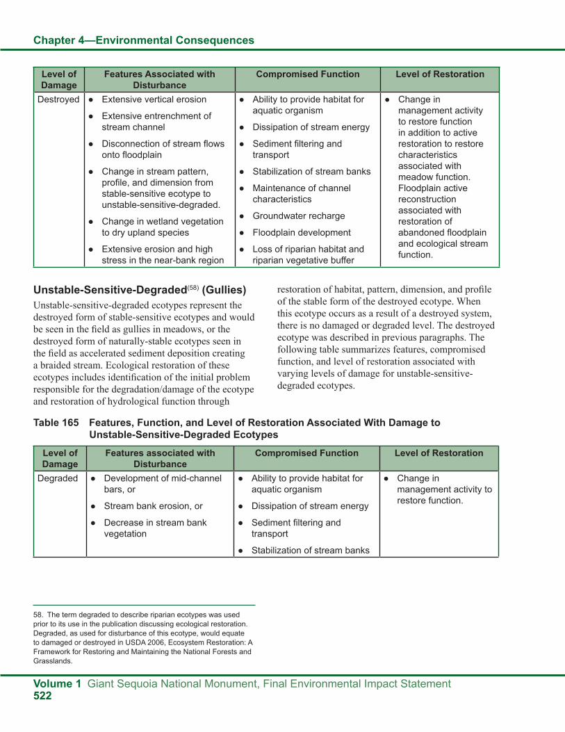
Chapter 4—Environmental Consequences
Volume 1 Giant Sequoia National Monument, Final Environmental Impact Statement522
Level of Damage
Features Associated with Disturbance
Compromised Function Level of Restoration
Destroyed ● Extensive vertical erosion
● Extensive entrenchment of stream channel
● Disconnection of stream flows onto floodplain
● Change in stream pattern, profile, and dimension from stable-sensitive ecotype to unstable-sensitive-degraded.
● Change in wetland vegetation to dry upland species
● Extensive erosion and high stress in the near-bank region
● Ability to provide habitat for aquatic organism
● Dissipation of stream energy
● Sediment filtering and transport
● Stabilization of stream banks
● Maintenance of channel characteristics
● Groundwater recharge
● Floodplain development
● Loss of riparian habitat and riparian vegetative buffer
● Change in management activity to restore function in addition to active restoration to restore characteristics associated with meadow function. Floodplain active reconstruction associated with restoration of abandoned floodplain and ecological stream function.
Unstable-Sensitive-Degraded(58) (Gullies)Unstable-sensitive-degraded ecotypes represent the destroyed form of stable-sensitive ecotypes and would be seen in the field as gullies in meadows, or the destroyed form of naturally-stable ecotypes seen in the field as accelerated sediment deposition creating a braided stream. Ecological restoration of these ecotypes includes identification of the initial problem responsible for the degradation/damage of the ecotype and restoration of hydrological function through
58. The term degraded to describe riparian ecotypes was used prior to its use in the publication discussing ecological restoration. Degraded, as used for disturbance of this ecotype, would equate to damaged or destroyed in USDA 2006, Ecosystem Restoration: A Framework for Restoring and Maintaining the National Forests and Grasslands.
restoration of habitat, pattern, dimension, and profile of the stable form of the destroyed ecotype. When this ecotype occurs as a result of a destroyed system, there is no damaged or degraded level. The destroyed ecotype was described in previous paragraphs. The following table summarizes features, compromised function, and level of restoration associated with varying levels of damage for unstable-sensitive-degraded ecotypes.
Table 165 Features, Function, and Level of Restoration Associated With Damage to Unstable-Sensitive-Degraded Ecotypes
Level of Damage
Features associated with Disturbance
Compromised Function Level of Restoration
Degraded ● Development of mid-channel bars, or
● Stream bank erosion, or
● Decrease in stream bank vegetation
● Ability to provide habitat for aquatic organism
● Dissipation of stream energy
● Sediment filtering and transport
● Stabilization of stream banks
● Change in management activity to restore function.

Chapter 4—Environmental Consequences
Giant Sequoia National Monument, Final Environmental Impact Statement Volume 1523
Naturally-Unstable (Debris Avalanche or Landslide Terrain)The naturally-unstable ecotype is typically eroded, steep, and unstable and is associated with debris avalanche or landslide terrain. These environments are extremely sensitive to disturbance. Ecological restoration of this ecotype is extremely limited due to its steep nature, very poor recovery potential, very high sediment supply, and the negligible influence of vegetation for erosion control. The best restoration of these ecotypes is to avoid or minimize disturbance.
Use of ScienceScientific Advisory Board (SAB) AdvisoriesAdvisory X. Impairment of Watershed Functions
Use the CWE analytical framework as a basis for predicting the effects of recreation on watersheds. The current CWE analytical tools will need to
be expanded beyond consideration of sediment transport in order to allow the flexibility to address chemical water quality and water use as appropriate. Consider restoration of existing water quality impairment in conjunction with management plans for expanded recreational use. The scale of watershed under analysis may need to be expanded from the current approach depending upon the extent of the proposed actions (Scientific Advisory Board 2003).
Advisory XXV WatershedsThe watershed analysis in the DEIS is effective, but would be improved by expanding the analysis to include recreation, and to overlay areas of likely management activity with watershed areas of concern. The CWE analytical protocol is better suited to analysis of subsequent specific projects and need not be conducted for the DEIS. For the purposes of the DEIS, however, the general effects
Level of Damage
Features associated with Disturbance
Compromised Function Level of Restoration
Damaged ● Development of mid-channel bars, and
● Stream bank erosion, and
● Decrease in stream bank vegetation
● Reduction in sinuosity
● Down cutting of channel
● Partial entrenchment of channel
● Ability to provide habitat for aquatic organism
● Dissipation of stream energy
● Sediment filtering and transport
● Stabilization of stream banks
● Change in management activity to restore function and active restoration to stabilize and maintain ecologic function.
Destroyed ● Extensive vertical erosion
● Extensive entrenchment of stream channel
● Disconnection of stream flows onto floodplain
● Change in stream pattern, profile, and dimension from stable-sensitive ecotype to unstable-sensitive-degraded.
● Change in wetland vegetation to dry upland species
● Extensive erosion and high stress in the near-bank region
● Ability to provide habitat for aquatic organism
● Dissipation of stream energy
● Sediment filtering and transport
● Stabilization of stream banks
● Maintenance of channel characteristics
● Groundwater recharge
● Floodplain development
● Loss of riparian habitat and riparian vegetative buffer
● Change in management activity to restore function in addition to active restoration to restore characteristics associated with meadow function. Floodplain active reconstruction associated with restoration of abandoned floodplain and ecological stream function.

Chapter 4—Environmental Consequences
Volume 1 Giant Sequoia National Monument, Final Environmental Impact Statement524
noted for each activity can be combined with the total area of disturbance, the probable location, and the susceptibility of the watershed to impairment (using, for example, the degree to which the watershed approaches the threshold of concern).
The cumulative watershed effects (CWE) analysis includes recreation effects as part of the analysis process for a watershed. The same analysis will be used for project level analyses to determine if a project is expected to put a watershed over its threshold of concern. The CWE analysis for the Monument is provided in this chapter and discussed in the Hydrology Report.
SCI was used to develop ranges of channel attributes which provide an understanding of natural variability in Monument watersheds.(59) The ranges of channel attributes are summarized in Chapter 3. More detailed information is provided in the Hydrology Report.
Science ConsideredThe most current and applicable science was considered and used in the hydrological resources sections of the Monument FEIS. Examples include Bergs and Azuma 2008, Frazier et al. 2005, Goudie 2006, and Kaplan-Henry 2007. A full list of the science considered is in the literature cited section of this FEIS and the references section of the Hydrology Report.
Assumptions for All AlternativesProposed future management activity associated with fuels management and ecological restoration would recognize thresholds of concern at the project level. Management actions and decisions would balance the need for treatment to maintain ecological condition and protection of objects of interest in addition to aquatic habitat and water quality.
Each alternative contains strategies and objectives for moving toward the desired conditions for hydrological resources. It is assumed the objectives for hydrologic resources would be met if adequate time, finances, and resources are available during the life of the Monument Plan.
Determination of where ecological restoration is needed will be based on site-specific project analysis. Natural and land management disturbances would be analyzed using Sequoia National Forest Cumulative Watershed Effects Analysis Guide (Kaplan-Henry and Machado 1991). Current watershed conditions are further discussed in the Cumulative Effects Analysis for this document.
Forest Service regulations and agreements would be followed, mitigations would be implemented, and monitoring would be performed to minimize potential effects from land management activities. Land management activities include, but are not limited to, fuels reduction, vegetation management, grazing, maintenance of infrastructure, and recreation use.
Assumptions for Alternative AAlternative A, the no action alternative, follows existing management direction from the eight sources described in Chapter 2 of this FEIS. Specific to hydrologic resources are the:
● Riparian and Wetland Standard and Guidelines from the 1990 MSA
● Aquatic Management Strategy Goals (AMS) from the 2001 SNFPA
● Riparian Conservations Areas (RCAs) from the 2001 SNFPA
● Critical Aquatic Refuges (CARs) from the 2001SNFPA
● Riparian Conservations Objectives (RCOs) from the 2001 SNFPA
Assumptions for Alternative B ● Alternative B follows the 2004 SNFPA strategies,
objectives, and standards and guidelines for the Riparian Conservation Objectives (RCOs), as well as Monument-specific standards and guidelines. The 2004 SNFPA reduces redundancy and provides more consistent direction with respect to existing laws and executive orders, while maintaining the intent of the 2001 AMS.
● Zones of Influence (ZOIs) established around the giant sequoia groves are included to ensure that key ecological processes, structures, and functions are evaluated during land management planning.
59. The Sierra Nevada Forest Plan Amendment 2004 standards and guidelines are included and added to. Monument specific standards and guidelines are in Alternatives B, C, E, and F. See Appendix A, hydrological resources for specifics.

Chapter 4—Environmental Consequences
Giant Sequoia National Monument, Final Environmental Impact Statement Volume 1525
Assumptions for Alternative C ● Alternative C manages the Monument similar to
the Sequoia and Kings Canyon National Parks (SEKI). It makes use of the strategies, objectives, and standards and guidelines for the Riparian Conservation Objectives (RCOs) from the 2001 SNFPA, as well as Monument-specific standards and guidelines.
● Streamside management zones (SMZs) would be used to protect riparian areas, rather than the critical aquatic refuges (CARs) and riparian conservation areas (RCAs).
● Management activities will be restricted to recreation sites, administrative sites, and wildland urban intermix (WUI) zones.
Assumptions for Alternative D ● Management of hydrological resources will be
limited to WUI defense zones.
● The rest of the Monument is managed to let natural processes occur with little to no intervention.
● Restoration efforts would not occur, as natural processes are expected to return resource to a stable condition.
Assumptions for Alternative E ● Alternative E follows the management direction in
the 1988 Forest Plan and the 1990 MSA.
● The MSA’s Riparian and Wetland Standards and Guidelines are used to maintain and protect hydrologic resources in terms of streambank stability, vegetative cover, stream surface shade, interception of sediment, streamside management zone designation, meadow hydrology, forage utilization, and woody and herbaceous vegetation in riparian and wetland ecosystems.
Assumptions for Alternative F ● Alternative F follows the 2004 SNFPA strategies,
objectives, and standards and guidelines for the Riparian Conservation Objectives (RCOs), as well as Monument-specific standards and guidelines.
● Zones of Influence (ZOIs) established around the giant sequoia groves are included to ensure that key ecological processes, structures, and
functions are evaluated during land management planning.
MethodologyPacific Southwest Region Stream Condition InventoryThe purpose of the Pacific Southwest Region stream condition inventory (SCI) is to collect intensive and repeatable data from stream reaches to document existing stream condition and make reliable comparisons over time within or between stream reaches. SCI is therefore an inventory and monitoring program. It is designed to assess effectiveness of management actions on streams in managed watersheds (non-reference streams), as well as to document stream conditions over time in watersheds with little or no past management or that have recovered from historic management effects (Frazier et al. 2005).
Stream Condition Inventory (SCI) plots have been established at various sites within the monument. SCI plots monitor chemical, physical and biological stream features, or attributes, that are useful in classifying channels, evaluating the condition of stream morphology and aquatic habitat, and making inferences about water quality (Frazier et. al. 2005). SCI data provides a basis for evaluation of pre- and post-project conditions.
Riparian EcotypesChannels in the Monument have been grouped into riparian ecotypes and assigned an impact level following a protocol established in Kaplan-Henry 2007. Determination of riparian ecotype is based on how a stream type responds to natural events and land management activity. Level of impact is assigned to riparian ecotypes based on the number of environmental indicators (associated with that ecotype) not considered to meet criteria for good to excellent stream stability conditions as defined by Pfankuch, 1995. Key indicators used to rank impact level include: 1) vegetative bank protection, 2) streambank cutting, 3) channel bottom deposition, 4) scour and deposition, and 5) bottom size distribution and percent stable material.
Cumulative Watershed Effects AnalysisCumulative watershed effects analysis is primarily used to determine which alternative is the best for

Chapter 4—Environmental Consequences
Volume 1 Giant Sequoia National Monument, Final Environmental Impact Statement526
protecting hydrological resources. The alternatives propose some similar and some different methods and guidance to manage the Monument. Each alternative contains different management tools that are expected to be used.(60) Normally the tools used are expected to be incorporated in the cumulative watershed effects analysis. However, the alternatives do not specifically state where these tools are expected to be used and to what extent within the Monument. Only project level analysis is expected to determine how much of an effect a tool has within a watershed. All of the alternatives have the same equivalent roaded acres. Therefore, a cumulative watershed effects analysis was used to determine current watershed conditions and threshold levels.(61)
Rating AlternativesHow well the alternatives protect hydrological resources was determined by evaluating the management direction proposed in each alternative. For example, Alternative B is expected to be better at protecting hydrological resources than Alternative C, due to the elimination of the RCAs and CARs in Alternative C. This would reduce the effectiveness of the AMS strategy to protect identified species.
Indirect EffectsAll AlternativesAlternatives A through F have different approaches to achieve ecosystem restoration, some using active management to more quickly and actively restore damaged, degraded, or destroyed landscapes, while others rely upon natural processes to achieve it over longer periods of time. Land management activities or land uses such as grazing, prescribed fire, vegetation management, or stream restoration could have negative or positive effects on the watersheds within the Monument, depending on the location, duration, and timing of the management activity or land use in a watershed. Watersheds respond differently due to their unique geology, vegetation, topography, soil, and local climate.
Those alternatives that adopt the Aquatic Management Strategy (AMS) direction as outlined in both the 2001
and 2004 SNFPAs, and propose similar levels of treatment in each watershed, are not expected to have any long-term effects to aquatic MIS site conditions at the programmatic level. Analysis of site-specific projects is necessary to identify any potential effects to water quality and riparian-dependent resources. Adopting the AMS is expected to:
● Maintain and restore water quality to meet the goals of the Clean Water Act and the Safe Drinking Water Act, providing water that is fishable, swimmable, and suitable for drinking after normal treatment.
● Maintain and restore habitat to support viable populations of native and desired nonnative plant, invertebrate, and vertaerate riparian-dependent species.
● Maintain and restore the species composition and structural diversity of plant and animal communities in riparian areas, wetlands, and meadows to provide desired habitats and ecological functions.
● Maintain and restore the distribution and health of biotic communities in special aquatic habitats (such as springs, seeps, vernal pools, fens, bogs, and marshes) to perpetuate their unique functions and biological diversity (USDA Forest Service 2004f, pp. 32-33).
None of the alternatives are expected to affect existing water rights. All current water rights and uses will be maintained in accordance with state and federal laws and regulations.
Land management activities can have effects on water quality. Livestock grazing can affect water quality if animals trample stream banks and vegetation is lost. Excess trampling could increase the amount of sediment entering a stream and could also result in changes to the morphology of the channel. Increases in sediment could range from insubstantial to substantial depending on the existing stability of the stream bank and health and vigor of riparian vegetation. Increased stream bank erosion increases the potential for sediment supply to the channel. Increased sediment to a stable stream could begin a trend towards instability depending upon the timing and extent of the damage. Forest Service regulations and agreements will be followed, mitigations will be
60. Management tools could include, but are not limited to, mastication or pile and burning, and they vary by alternative.61. See the cumulative watershed effects section of the hydrology report for more information.

Chapter 4—Environmental Consequences
Giant Sequoia National Monument, Final Environmental Impact Statement Volume 1527
implemented, and monitoring will be performed to minimize any potential effects from land management activities.
Alternative AAlternative A adopts the standards and guidelines from the 2001 and 2004 SNFPAs and would implement the AMS direction which includes the RCA and CAR land allocations, Riparian Conservation Objectives (RCOs), and associated standards and guidelines, embrace the Aquatic Management Strategy (AMS) and the Ecosystem Management Strategy of the 2001 Sierra Nevada Forest Plan Amendment, in conjunction with the 1990 Riparian and Wetland Standards and Guidelines documented in Exhibit D of the MSA. Alternative A closely follows the SNFPA AMS direction. Based on this, this alternative is not expected to have detrimental effects on water quality and riparian-dependent resources.
Ongoing effects using current management direction include, but are not limited to, recreation use and activities, roads, prescribed fires, fuels reduction, grazing, and vegetation management.
Objectives for hydrological resources in the no action alternative include:
● Preserve, enhance, and restore habitat for riparian and aquatic dependent species.
● Ensure that water quality is maintained or restored.
● Enhance habitat conservation for species associated with the transition zone between upslope and riparian areas.
● Provide greater connectivity within the watershed.
Alternative A is expected to protect hydrological resources less than Alternatives B and F and more Alternatives C, E, and D. Alternative A does not include refined standards and guidelines developed specifically for conditions found in Monument watersheds. Examples are ranges in natural variability for riparian conditions, water quality, and meadow restoration strategies. This reduces the effectiveness of this alternative to provide protection for water quality, riparian habitat, and riparian species, and reduces its ability to achieve desired conditions.
Alternative BAlternative B is expected to protect hydrological resources better than the other alternatives. This alternative is similar to Alternative A in that it recognizes the AMS defined in both the 2001 and 2004 SNFPAs, including RCOs and their associated standards and guidelines tailored to Monument watersheds, as well as CAR and RCA land allocations. Hydrological resources would have increased protection using the clearer 2004 SNFPA RCO direction, as well as local monitoring data collected in the Monument.
Management activities could be beneficial to hydrological resources, depending on the type, location, and extent of the activities. Management activities are expected to maintain, improve, and restore hydrological function in order to promote properly functioning riparian and wetland areas and aquatic ecosystems, while providing water for communities and habitats outside of the Monument. Effects of management activities will be determined during site-specific project analysis.
Alternative B is expected to best protect water quality and riparian habitat conditions, and has the greatest potential to meet desired conditions.
The objectives for hydrological resources in Alternative B and all of the action alternatives include:
1. During the life of the Monument Plan, inventory 10 percent of the perennial streams in 6th-field watersheds to determine existing condition.
2. During the life of the Monument Plan, assess meadows for hydrologic function and prioritize ecological restoration needs.
3. During the life of the Monument Plan, based on assessment, restore hydrologic function in priority meadows to enhance riparian habitat.
Alternative CAlternative C is expected to protect hydrological resources less than Alternative A and more than Alternatives D and E. While this alternative includes a portion of the 2001 and 2004 SNFPAs AMS, it eliminates land allocations associated with CARs and RCAs. In doing so, it fails to meet desired conditions

Chapter 4—Environmental Consequences
Volume 1 Giant Sequoia National Monument, Final Environmental Impact Statement528
for providing habitat conditions to support riparian and aquatic dependent species. While streamside management zones (SMZs) are included as a soil and water protection measure, these zones are not intended to do more than exclude equipment from riparian areas and act as a filter strip to trap sediment and keep it from reaching the streamcourse. RCAs and CARs provide an opportunity to develop and manage areas for water quality, riparian habitat, and aquatic-dependent species. In addition, this alternative lacks the opportunity to develop standards and guidelines specific to local watershed conditions.
Alternative DAlternative D is expected to provide the least protection for hydrological resources. This alternative does not contain the AMS defined in both the 2001 and 2004 SNFPA, including RCOs and associated standards and guidelines, or the CAR land allocations for riparian and aquatic-dependent resources. In doing so, it does not meet the desired conditions for the AMS. Alternative D does not allow treating the landscape to control wildfires in riparian and wetland areas. Much of the landscape in Monument watersheds has conditions outside the natural range of variability for fire return intervals. Uncontrolled wildfires in watersheds could lead to increases in sediment and detrimental effects on riparian dependent species, water quality, soil and water resources, large woody material, and shade and water temperatures. This could result in an inability to protect water quality, riparian habitat, and aquatic species. Natural recovery and stabilization of riparian ecosystems could take decades to achieve or might not occur.
Alternative EAlternative E is expected to give more protection to hydrologic resources than Alternative D but less
protection than Alternatives A, B, C, and F. This alternative adopts the standards and guidelines in the 1988 Forest Plan and 1990 MSA. While these documents were scientifically valid at the time, they lack the value of monitoring results and current knowledge found in the 2001 and 2004 SNFPAs and over the last 21 years. The lack of the latest science and monitoring data in managing the Monument would not provide the best possible protection for hydrological resources.
Alternative FAlternative F is expected to best protect hydrologic resources in the Monument, similar to Alternative B. Alternative F differs from the other alternatives in having fewer diameter limits, which would have no effect on the ability to manage vegetation in a manner consistent with RCOs, nor would it be expected to compromise water quality or riparian dependent species.
Management activities could be beneficial to hydrological resources, depending on the type, location, and extent of the activities. Management activities are expected to maintain, improve, and restore hydrological function in order to promote properly functioning riparian and wetland areas and aquatic ecosystems, while providing water for communities and habitats outside of the Monument. Effects of management activities will be determined during site-specific project analysis.
Alternative Outcomes for Hydrological Resource ProtectionThe following table summarizes how the alternatives are expected to protect aquatic systems.
Table 166 Watershed Protection Rankings by Alternative
Alternative Level of Protection of Aquatic Habitat and Riparian Dependent Species
Achieving Desired Conditions
B and F High BestA Moderate–high BetterC Moderate GoodE Low FairD Minimal Poor

Chapter 4—Environmental Consequences
Giant Sequoia National Monument, Final Environmental Impact Statement Volume 1529
Cumulative EffectsTreatments identified in this document have the potential to affect multiple watersheds that support numerous beneficial uses. “A watershed is a natural management unit for evaluating the physical and social consequences of management decisions” (Scientific Advisory Board 2003). Because this document proposes numerous projects at differing scales, from basin-wide fuel treatments to installation of recreation facilities that have a localized effect, the scale of the action under consideration is expected to define the watershed scale of analysis.
The forest’s cumulative watershed effects (CWE) methodology quantifies the effects of past, present, and reasonably foreseeable future management activities. The threshold of concern (TOC) is defined as an indicator of the potential for management activities to affect water quality and/or watershed stability and ultimately affect beneficial uses. The TOC is a level based on an individual subwatershed’s ability to resist change. When TOC is exceeded, the potential to affect water quality, stream stability, riparian habitat, and beneficial uses increases. TOC is expected to vary by watershed scale and prescribed treatment. Thus, TOC provides a quantification of the potential of a watershed’s tolerance for disturbance. When this level is approached, a more rigorous, field-based analysis is required prior to management activity.
The CWE analysis is the primary element of determining the effect of management activities on watersheds. This takes place at the project level, as the location of the activity is specific to the affected watershed. The CWE model focuses on the effects of ground disturbing activities. It also includes quantification of fuel treatment methods including prescribed fire and wildfire. Because prescribed fire treatments take place at the 6th-field HUC watershed scale, the effects of this action should be evaluated at the same scale.
The CWE methodology will be used as a basis for predicting the effects of all activities, including
recreation, on watersheds, which would occur during project level analysis. The current CWE analysis considers sediment transport, which is the process of concern relative to ground disturbing activities including fuels and fire management. Chemical water quality in association with recreation development has the potential for CWE. As long as water quality is considered in the development of recreation facilities and best management practices are implemented and effective, the potential for CWE is expected to be low. Mitigation is expected to focus on maintaining potential pollutants on-site, and monitoring is expected to evaluate the effectiveness of treatment. “Restoration of existing water quality impairment from recreation facilities would be considered in conjunction with management plans for expanded recreation use during project level analysis” (Scientific Advisory Board 2003).
Urbanized areas currently have the highest potential to affect water quality resources and beneficial uses as a result of the high density of compacted areas including roads. Additionally, these areas pose the greatest threat from wildfires because there is the greatest potential for loss of life, property, and resources. Therefore, these areas are the highest priority for fuels reduction treatments. Urbanized areas typically have the greatest effect on watersheds, placing them closest to or exceeding the threshold of concern. Management activities in the Monument are likely to lead to further exceedance of TOC for 7th-field HUC watersheds close to or currently over TOC. Of particular concern for fuels treatment is the urban intermix zones, where 7th-field HUC watersheds currently at or near TOC are expected to be the focus of greater fuels management. Of concern for recreation is increased use and development of already developed areas, where 7th-field HUC watersheds are already at or near TOC (Scientific Advisory Board
2003). Seventh-field HUC watersheds over 80 percent TOC as a result of the high density of compacted sites such as roads, recreation, and facilities are included in the following table.

Chapter 4—Environmental Consequences
Volume 1 Giant Sequoia National Monument, Final Environmental Impact Statement530
Table 167 7th-Field HUC Watersheds with TOC Greater than 80 Percent
7th Field HUC Watershed Existing Percent TOC Used Watershed AcresSpear Creek (5A-C) 84.6 1,470Pup Meadow (18DG) 90.4 900
Von Hellum Creek watershed (5A-D) uses more than 80 percent of TOC. The Panorama Heights community lies within the watershed and contributes most of the effect. Homes, roads, and stream crossings are the sources. CWE analysis discovered that past projects only account for approximately 4 percent of the TOC used.
Pup Meadow watershed (18DG) uses more than 90 percent of TOC. CWE analysis discovered past projects from the late 1980s to late 1990s are the cause. Any future projects in the watershed will be analyzed to determine the extent of effect to the watershed.
These watersheds have a greater potential for cumulative watershed effects and need to be closely managed during site-specific project implementation. Mitigation measures specific to projects and affected watersheds are expected to be developed during project level environmental analysis. These watersheds and any other watershed of special concern would need to be closely monitored for effects.
CWE analysis is spatial and temporal. Actual treatment at the project level is expected to focus on potential effects in watersheds affected by specific projects; scale, intensity, timing, and extent of past management activities, including vegetation management, campgrounds, facilities, and roads, have the potential to affect riparian health, soil, and water quality. Actual locations of treatments cannot be provided at the programmatic level. Cumulative watershed effects are expected to be evaluated at
the appropriate watershed scale during project level analysis. The hierarchical framework of ecosystem analysis is expected to facilitate cumulative effects analysis by providing information across multiple scales.
Detailed cumulative watershed effects analysis would be performed at the project level. Therefore, the CWE analysis for the Monument plan provides a multi-scale CWE review at the 7th-field and 6th-field HUC watershed scale. The Monument occupies a small percentage of affected 5th-field HUC watersheds; therefore CWE analysis has not been provided at this scale. Seventh-field HUC watersheds range in size from roughly 200 to 3,500 acres, with an average size of 1,500 acres. Sixth-field HUC watersheds are larger than 7th-field HUC watersheds and range in size from 10,000 to 34,000 acres, with an average of 21,000 acres. Threshold levels are based on watershed size and the sensitivity of the watershed.
Sensitivity is ranked high, moderate, and low and is a function of six physical characteristics of the watershed: soil, topography, climate, geology, vegetation, and channel condition (Kaplan-Henry and Machado 1991). High, moderate, and low sensitivity designations for watersheds yield equivalent roaded acres (ERAs) available for management of 3 percent, 4 percent, and 5 percent of the watershed acreage based on the watershed conditions. The following table displays ERAs available for management in addition to existing condition or percent TOC used from past and present activity at the 7th-field HUC watershed scale.

Chapter 4—Environmental Consequences
Giant Sequoia National Monument, Final Environmental Impact Statement Volume 1531
Table 168 CWE Analysis of 7th-Field HUC Watersheds
7th Field Watershed Acres Existing Condition
TOC ERAs Available
Percent TOC used
1803001003 Lower South Fork Kings RiverSouth Fork Kings River 2A-B 1,820 0.0 54.6 54.6 0.0Unnamed 2A-C 1,420 9.4 56.8 47.4 16.6Unnamed 2A-D 2,330 12.9 93.3 80.4 13.8Unnamed 2A-E 1,020 0.0 30.7 30.7 0.0Unnamed 2B-A 600 2.2 24.1 21.9 9.1Unnamed 2B-B 730 6.9 29.2 22.3 23.7Unnamed 2B-C 1,200 11.9 48.1 36.2 24.8Boulder Creek 2C-A 2,000 12.1 80.0 67.9 15.1North Fork Big Meadows 2D-A 610 0.0 18.3 18.3 0.0South Fork Big Meadows 2D-B 810 6.9 24.3 17.4 28.5Poison Creek 2D-C 520 5.9 20.9 15.0 28.3Weaver Creek 2D-D 1,040 4.7 41.5 36.8 11.3Fox Meadow Creek 2D-E 3,210 27.1 96.3 69.3 28.1Big Meadows 2D-F 870 14.3 26.2 11.9 54.6Evans Creek 2E-A 970 0.0 38.6 38.6 0.0Rattlesnake Creek 2E-B 300 0.0 12.2 12.2 0.0Footman Canyon 2E-C 1,440 0.0 57.6 57.6 0.0Kennedy Meadow 2E-D 1,150 5.3 46.2 41.0 11.4Buck Rock Creek 2E-E 2,900 62.9 116.2 53.3 54.1Unnamed 2E-F 840 23.1 33.6 10.5 68.8Boulder Creek 2E-G 1,060 15.0 42.3 27.3 35.4Redwood Creek 2F-B 1,680 0.0 50.3 50.3 0.0Lockwood Creek 2F-C 640 0.0 19.1 19.1 0.0Windy Gulch 2F-D 880 0.0 26.4 26.4 0.0Unnamed 2F-E 230 0.0 6.9 6.9 0.0Unnamed 2G-F 650 0.0 19.6 19.6 0.0
1803001005 Converse-Mill flat CreekIndian Creek 1G-A 3,770 34.5 150.7 116.2 22.9Long Meadow 1G-B 3,650 31.2 146.1 114.9 21.4Unnamed 1G-C 640 4.4 25.6 21.1 17.3Bearskin 1G-D 2,330 12.2 116.6 104.4 10.4Ten Mile Tributary 1G-E 770 4.7 30.7 26.0 15.4Ten Mile Creek 1G-F 3,680 40.5 184.1 143.6 22.0Landslide Creek 1G-G 2,770 18.3 110.7 92.4 16.5Tornado Creek 1G-H 2,310 22.7 42.5 19.8 53.3Bartons Resort 1G-I 1,270 2.4 38.0 35.7 6.2Cabin Creek 1F-A 750 0.0 22.4 22.4 0.0Unnamed 1F-B 1,560 0.0 62.3 62.3 0.0

Chapter 4—Environmental Consequences
Volume 1 Giant Sequoia National Monument, Final Environmental Impact Statement532
7th Field Watershed Acres Existing Condition
TOC ERAs Available
Percent TOC used
Unnamed 1F-C 580 0.0 17.3 17.3 0.0Unnamed 1E-A 860 0.0 25.9 25.9 0.0Unnamed 1E-B 700 0.0 27.9 27.9 0.0Converse Creek 1E-C 1,360 0.0 68.1 68.1 0.0Converse Creek 1E-D 1,300 0.0 39.0 39.0 0.0Unnamed 1E-E 820 0.0 24.5 24.5 0.0Converse Creek 1E-F 1,470 0.0 58.9 58.9 0.0Verplank Creek 1D-A 2,750 0.0 82.4 82.4 0.0Unnamed 1D-B 710 0.0 21.3 21.3 0.0Unnamed 1D-C 460 0.0 13.9 13.9 0.0Mill Flat Creek 1C-A 2,990 13.4 119.6 106.2 11.2Unnamed 1C-B 1,000 0.0 40.1 40.1 0.0Mill Flat Creek 1C-C 880 11.5 35.2 23.7 32.6Unnamed 1C-D 1,260 0.0 37.8 37.8 0.0Unnamed 1C-E 880 0.0 35.3 35.3 0.0Upper Abbott 1C-F 1,280 17.8 64.2 46.4 27.7Abbott Creek 1C-G 1,430 9.5 43.0 33.5 22.2Unnamed 1C-H 1,020 14.7 30.7 16.0 47.8Sequoia Creek 1C-I 1,840 0.0 91.8 91.8 0.0Mill Flat Creek 1C-J 1,390 16.0 55.5 39.5 28.8Mill Flat Creek 1C-K 1,040 30.2 41.7 11.5 72.3Unnamed 1C-L 900 0.0 35.9 35.9 0.0Davis Creek 1B-A 710 0.0 21.2 21.2 0.0Unnamed 1B-C 1,190 8.9 59.6 50.7 14.9Unnamed 1B-D 3,250 20.1 130.0 109.9 15.5Davis Creek 1B-E 3,430 0.0 102.9 102.9 0.0Mill Flat Creek 1B-F 660 0.0 19.7 19.7 0.0Unnamed 1B-G 1,480 13.6 74.0 60.4 18.4Unnamed 1B-I 3,670 9.5 146.9 137.5 6.4Unnamed 1B-H 530 0.0 15.7 15.7 0.0
1803000105 Middle Kern RiverFreeman Creek 8AA 1,780 4.1 71.3 67.2 5.8Tributary to Freeman 8AB 1,270 0.6 50.8 50.2 1.2Lloyd Meadow Creek 8AC 3,820 25.0 152.9 127.9 16.3Tributary to Freeman 8AD 1,550 1.7 61.8 60.1 2.8Unnamed Tributary 8AF 810 0.9 32.5 31.6 2.9Unnamed 8AG 360 0.3 14.6 14.3 1.8Needle Rock Creek 8BA 2,090 17.8 83.7 65.9 21.2Tributary to Kern 8BB 870 2.1 34.8 32.7 6.1

Chapter 4—Environmental Consequences
Giant Sequoia National Monument, Final Environmental Impact Statement Volume 1533
7th Field Watershed Acres Existing Condition
TOC ERAs Available
Percent TOC used
Tributary to Kern 8BC 630 4.0 25.1 21.1 16.0Holby Creek 8CA 2,960 87.8 118.3 30.5 74.2Upper Peppermint Creek 8CB 2,700 3.8 107.9 104.1 3.5Peppermint Meadow 8CC 1,870 11.9 56.1 44.3 21.1Lower Peppermint 8CD 1,720 10.5 51.7 41.2 20.3Middle Peppermint 8CE 1,070 0.0 32.1 32.1 0.0Horse Canyon 8GA 1,250 29.1 49.8 20.8 58.3Dome Creek 8GB 780 15.8 31.2 15.4 50.6Upper Alder Creek 8GD 1,040 7.8 41.6 33.8 18.7Lower Alder Creek 8GE 1,310 26.0 52.3 26.3 49.7Upper Dry Meadow 8GF 1,020 0.8 30.5 29.7 2.7Middle Dry Meadow 8GG 2,740 5.4 82.1 76.7 6.6Unnamed 8GH 710 0.0 21.5 21.5 0.0Unnamed 8GI 780 0.7 23.4 22.8 2.8Unnamed 8GJ 210 0.0 6.2 6.2 0.0Lower Dry Meadow 8GK 580 2.9 17.3 14.4 16.8Unnamed 8GL 770 0.0 23.2 23.2 0.0Upper Nobe Young 8HA 2,680 30.0 107.3 77.3 28.0Last Chance Meadow 8HB 1,200 14.3 48.1 33.9 29.6Upper Bone Creek 8HC 2,090 32.2 83.4 51.2 38.6Long Meadow Creek 8HD 2,420 26.8 96.8 70.0 27.7Middle Nobe Young 8HF 1,510 20.8 45.2 24.4 46.0Lower Nobe Young 8HG 1,930 10.5 77.3 66.8 13.6Horse Meadow Creek 8IA 1,110 1.1 44.3 43.3 2.4Parker Meadow Creek 8IB 800 2.6 32.1 29.5 8.1Parker Meadow Creek 8IC 3,160 9.7 126.3 116.6 7.7Doublebunk Creek 8ID 1,150 13.1 46.0 33.0 28.4Bear Creek 8IE 550 0.2 22.0 21.7 1.1Packsaddle Creek 8IF 830 0.3 33.2 32.9 1.0Unnamed 8IG 1,240 0.2 49.8 49.5 0.5Middle Bear Creek 8IH 1,060 6.1 42.2 36.1 14.4Mill Creek 8II 1,430 20.2 43.0 22.8 46.9Upper South Creek 8IJ 610 3.1 18.4 15.3 17.0Middle South Creek 8IL 1,020 6.5 40.6 34.1 16.0Unnamed 8IM 570 0.0 22.9 22.9 0.0Lower South Creek 8IN 1,220 22.4 36.6 14.2 61.3North Fork Clicks 7CA 1,850 2.1 55.5 53.4 3.7Headwaters Clicks 7CB 2,850 11.6 113.9 102.2 10.2Upper Fish Creek 7BJ 1,490 1.4 74.6 73.2 1.9

Chapter 4—Environmental Consequences
Volume 1 Giant Sequoia National Monument, Final Environmental Impact Statement534
7th Field Watershed Acres Existing Condition
TOC ERAs Available
Percent TOC used
1803000401 Upper PosoUnnamed 5AA 1,200 17.6 48.2 30.6 36.6Unnamed 5AB 450 7.0 18.0 11.1 38.6Spear Creek 5AC 3,160 69.4 126.4 57.1 54.8Von Hellum 5AD 1,470 49.7 58.8 9.0 84.6Peel Mill Creek 5AE 2,410 14.1 96.3 82.2 14.6
1803000501 Upper White RiverCove Canyon 18EA 1,080 3.2 43.0 39.8 7.3Lower White River 18EB 2,380 11.3 95.1 83.8 11.9Dark Canyon 18EC 390 10.6 15.7 5.1 67.5Middle White River 18ED 1,130 32.1 45.3 13.2 70.9Upper White River 18EE 2,200 44.2 88.0 43.8 50.2
1803000502 Upper Deer CreekSouth Fork Gordon 18AA 1,410 3.0 42.4 39.4 7.1Tributary to Rube 18BA 900 0.0 27.1 27.1 0.0Cold Springs 18BB 1,670 36.5 50.1 13.6 72.9Rube Creek 18BC 1,750 7.8 52.4 44.7 14.8Headwaters Rube 18BD 1,380 1.8 41.4 39.7 4.2Tributary to NR Creek 18BE 1,159.0 21.4 34.8 13.4 61.6Lower Tyler Creek 18CA 1,980 2.1 79.4 77.3 2.6Merry Creek 18CB 760 9.0 30.3 21.3 29.7Middle Tyler Creek 18CC 1,420 10.8 42.5 31.7 25.5Alder Creek 18CD 650 9.3 19.6 10.3 47.5Starvation Creek 18CE 2,610 42.3 78.2 35.9 54.0Tributary to Tyler 18CF 810 5.2 32.4 27.2 16.1Headwaters Tyler 18CG 2,420 27.9 72.5 44.7 38.4Upper Deer Creek 18DB 1,990 20.0 79.4 59.4 25.2Lower Capinero 18DD 2,730 37.2 81.8 44.6 45.5Deer Creek at Uhl 18DE 1,330 13.6 53.1 39.5 25.6Upper Deer Creek 18DF 1,780 12.7 71.2 58.5 17.9Pup Meadow 18DG 900 24.3 26.9 2.6 90.4Tributary to Capinero 18DH 930 9.9 37.1 27.2 26.8Dead Horse Meadow 18DI 630 14.6 18.9 4.3 77.1Upper Capinero Creek 18DJ 1,120 16.6 45.0 28.4 36.8
1803000601 Middle Fork Tule RiverMilk Canyon 4BA 890 0.0 26.5 26.5 0.0Unnamed 4BB 1,060 0.0 31.7 31.7 0.0Meadow Creek 4BC 600 0.0 18.1 18.1 0.0Galena Creek 4BE 1,290 0.0 38.6 38.6 0.0Silver Creek 4BF 1,040 0.0 31.2 31.2 0.0
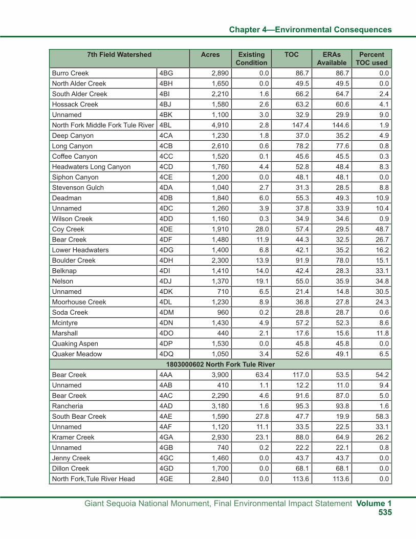
Chapter 4—Environmental Consequences
Giant Sequoia National Monument, Final Environmental Impact Statement Volume 1535
7th Field Watershed Acres Existing Condition
TOC ERAs Available
Percent TOC used
Burro Creek 4BG 2,890 0.0 86.7 86.7 0.0North Alder Creek 4BH 1,650 0.0 49.5 49.5 0.0South Alder Creek 4BI 2,210 1.6 66.2 64.7 2.4Hossack Creek 4BJ 1,580 2.6 63.2 60.6 4.1Unnamed 4BK 1,100 3.0 32.9 29.9 9.0North Fork Middle Fork Tule River 4BL 4,910 2.8 147.4 144.6 1.9Deep Canyon 4CA 1,230 1.8 37.0 35.2 4.9Long Canyon 4CB 2,610 0.6 78.2 77.6 0.8Coffee Canyon 4CC 1,520 0.1 45.6 45.5 0.3Headwaters Long Canyon 4CD 1,760 4.4 52.8 48.4 8.3Siphon Canyon 4CE 1,200 0.0 48.1 48.1 0.0Stevenson Gulch 4DA 1,040 2.7 31.3 28.5 8.8Deadman 4DB 1,840 6.0 55.3 49.3 10.9Unnamed 4DC 1,260 3.9 37.8 33.9 10.4Wilson Creek 4DD 1,160 0.3 34.9 34.6 0.9Coy Creek 4DE 1,910 28.0 57.4 29.5 48.7Bear Creek 4DF 1,480 11.9 44.3 32.5 26.7Lower Headwaters 4DG 1,400 6.8 42.1 35.2 16.2Boulder Creek 4DH 2,300 13.9 91.9 78.0 15.1Belknap 4DI 1,410 14.0 42.4 28.3 33.1Nelson 4DJ 1,370 19.1 55.0 35.9 34.8Unnamed 4DK 710 6.5 21.4 14.8 30.5Moorhouse Creek 4DL 1,230 8.9 36.8 27.8 24.3Soda Creek 4DM 960 0.2 28.8 28.7 0.6Mcintyre 4DN 1,430 4.9 57.2 52.3 8.6Marshall 4DO 440 2.1 17.6 15.6 11.8Quaking Aspen 4DP 1,530 0.0 45.8 45.8 0.0Quaker Meadow 4DQ 1,050 3.4 52.6 49.1 6.5
1803000602 North Fork Tule RiverBear Creek 4AA 3,900 63.4 117.0 53.5 54.2Unnamed 4AB 410 1.1 12.2 11.0 9.4Bear Creek 4AC 2,290 4.6 91.6 87.0 5.0Rancheria 4AD 3,180 1.6 95.3 93.8 1.6South Bear Creek 4AE 1,590 27.8 47.7 19.9 58.3Unnamed 4AF 1,120 11.1 33.5 22.5 33.1Kramer Creek 4GA 2,930 23.1 88.0 64.9 26.2Unnamed 4GB 740 0.2 22.2 22.1 0.8Jenny Creek 4GC 1,460 0.0 43.7 43.7 0.0Dillon Creek 4GD 1,700 0.0 68.1 68.1 0.0North Fork,Tule River Head 4GE 2,840 0.0 113.6 113.6 0.0

Chapter 4—Environmental Consequences
Volume 1 Giant Sequoia National Monument, Final Environmental Impact Statement536
7th Field Watershed Acres Existing Condition
TOC ERAs Available
Percent TOC used
Unnamed 4GF 900 0.0 27.0 27.0 0.0Pine Creek 4GG 3,020 12.0 90.7 78.6 13.3Backbone 4GH 2,600 8.6 104.0 95.4 8.3
1803000603 South Fork Tule RiverCrawford Creek 4EA 750 17.7 30.0 12.3 59.1Windy Creek Upper 4EC 1,790 19.5 71.4 51.9 27.4Unnamed 4ED 690 6.5 27.5 21.0 23.5Cedar Creek 4EE 1,940 45.2 77.7 32.5 58.1Kessing Creek 4EF 1,910 31.7 76.6 44.8 41.4Headwater South Fork Tule River 4EG 2,070 10.9 82.6 71.7 13.2Unnamed 4EH 410 5.0 16.4 11.4 30.6Unnamed 4EI 900 13.1 36.1 23.0 36.3Miners Creek 4EJ 950 0.0 47.7 47.7 0.0
1803000704 Upper North Fork Kaweah RiverUnnamed Tributary 3D-G 1,000 0.0 39.8 39.8 0.0Stony Creek 3E-C 1,500 15.3 75.2 59.9 20.3North Fork Woodward 3F-A 980 10.4 29.3 18.9 35.5Woodward Creek 3F-B 1,770 23.1 53.1 30.0 43.5Unnamed 3F-C 530 10.8 21.0 10.2 51.5South Fork Woodward 3F-D 870 1.0 43.7 42.6 2.3Redwood Creek 3D-A 1,400 0.2 70.1 69.9 0.3East Fork Redwood Creek 3D-B. 1,410 0.0 42.3 42.3 0.0Unnamed Tributary 3D-C 1,500 0.0 45.1 45.1 0.0Unnamed 3D-D 770 0.0 38.5 38.5 0.0Unnamed 3D-F 840 0.0 42.2 42.2 0.0Eshom Creek 3B-A/
3B-B4,370 0.0 174.9 174.9 0.0
Pierce Creek 3C-A 4,840 85.8 193.7 107.9 44.31803000705 South Fork Kaweah River
Upper Grouse 3GA 2,560 3.4 102.4 99.0 3.3East Fork Devils Canyon 3GB 1,620 0.0 81.2 81.2 0.0Unnamed 3GC 1,540 1.6 77.1 75.5 2.1
1803000706 Lower KaweahDry Creek 3A-A/
3A-B2,890 0.0 115.4 115.4 0.0
Unnamed 3A-C 970 29.8 38.7 8.9 77.1Unnamed 3A-D 1,050 14.4 42.1 27.7 34.2
18030801 Mill CreekMill Creek 19A-A 2,970 2.8 118.6 115.8 2.3Unnamed 19A-B 820 0.0 32.8 32.8 0.0

Chapter 4—Environmental Consequences
Giant Sequoia National Monument, Final Environmental Impact Statement Volume 1537
Fuels reduction treatments can affect large areas. These areas are expected to be evaluated at the 6th-field HUC watershed scale. ERAs have been converted to “acreage available for fuels management activity” using disturbances from past fires, average
fire conditions, and desired conditions for fuels management. The following table displays acreage available for fuels management treatments for high, moderate, and low sensitivity watersheds analyzed at the 6th-field HUC watershed scale.
Table 169 HUC 6 Watershed Acres and Acres Available for Fuels Management as a Function of Watershed Sensitivity
HUC 6 Watershed Watershed Acres
HUC 6 Watershed Available for Fuels Management
High Sensitivity
Moderate Sensitivity
Low Sensitivity
South Fork Kings River/Lightning Creek 6,600 1,280 1,710 2,140Upper Boulder Creek 12,750 2,480 3,310 4,130South Fork Kings River/Lower Boulder Creek 17,610 3,420 4,560 5,710Tenmile Creek 24,830 4,830 6,440 8,040Kings River/Rough Creek 12,570 2,440 3,260 4,070Kings River/Verplank Creek 5,550 1,080 1,440 1,800Mill Flat Creek 30,860 6,000 8,000 10,000Kern River/Freeman Creek 14,130 2,750 3,660 4,580Kern River/Peppermint Creek 13,910 2,700 3,610 4,510Dry Meadow Creek 23,000 4,470 5,960 7,450South Creek 14,750 2,870 3,820 4,780Lower Little Kern River 6,190 1,200 1,600 2,010Upper Poso Creek 12,390 2,410 3,210 4,010Headwaters White River 7,180 1,400 1,860 2,330Deer Creek/Gordon Creek 8,270 1,610 2,140 2,680Tyler Creek 10,640 2,070 2,760 3,450Headwaters Deer Creek 11,400 2,220 2,960 3,690North Fork Middle Fork Tule River 24,690 4,800 6,400 8,000Lower Middle Fork Tule River 8,330 1,620 2,160 2,700South Fork Middle Fork Tule River 22,540 4,380 5,840 7,300Bear Creek 16,350 3,180 4,240 5,300Upper North Fork Tule River 19,790 3,850 5,130 6,410Upper South Fork Tule River 11,410 2,220 2,960 3,700Upper North Fork Kaweah River 6,650 1,290 1,720 2,150North Fork Kaweah River/Eshom Creek 15,140 2,940 3,930 4,910South Fork Kaweah River/Grouse Creek 19,030 3,700 4,930 6,170Upper Dry Creek 4,910 950 1,270 1,590Mill Creek 3,790 740 980 1,230Total Acres 385,250 74,890 99,850 124,820

Chapter 4—Environmental Consequences
Volume 1 Giant Sequoia National Monument, Final Environmental Impact Statement538
Past fires provided information on levels of soil burn severity that occurred as a result of the fire. Information from burn area emergency rehabilitation (BAER) documents from the McNally, Deep, Choke, and Highway fires were used to provide information on soil burn severity. Acres of high, moderate, and low soil burn severity were documented from these fires and converted to percentages. The highest acreages by burn severity determined the overall severity of the fire. The following table shows that McNally and Highway are considered moderate-severity fires, Deep is a high-severity fire, and Choke
is a low-severity fire. ERAs per acre were determined based on the average of wildfire conditions from 1997 to present using these four fires. Based on evaluations of fire disturbance coefficients for average fire conditions associated with basic erosion rates of 11 for high, 5 for moderate, and 2 for low, fire severity weighted by average resulted in ERA/acre values that range from 0.64 to 0.22 with an average value of 0.27. This information was developed to provide a comparison for development of ERA/acre relationships for burn prescriptions.
Table 170 Soil Burn Severity from BAER Analysis on Past Wildfires
Fires Total Acres
Percent Soil Burn Severity Acres by Soil Burn SeverityHigh Moderate Low High Moderate Low
McNally—moderate severity
74,890 9 45 29 6,940 33,970 21,680
Deep—high severity 3,140 87 3 10 2,750 90 310Choke–low severity 4,100 12 11 78 480 440 3,180Highway—moderate severity
4,150 26 57 3 1,090 2,370 130
Desired conditions provided for burn prescriptions based on past treatment indicates high soil burn severity is expected to be around 5 percent total burn, moderate soil burn severity around 10 percent, low soil burn severity around 65 percent, and unburned areas within the total burn area are expected to equal roughly 20 percent (see the following table). These values were considered, and an average basic erosion rate of 2.4 times disturbance coefficients for average watershed characteristics and fire conditions results
in an ERA/acre value of 0.15. Watershed acres multiplied by 3 percent, 4 percent, or 5 percent, based on sensitivity, yield available ERAs. Available ERAs divided by ERA/acre values for prescribed burned prescriptions associated with desired conditions described above yield acres in a watershed available for fuels treatments. These values were calculated for each 6th field HUC watershed and are displayed in a previous table.
Table 171 Desired Condition Prescribed Burn Prescription by Soil Burn Severity (Percent)
High Moderate Low Unburned5 percent 10 percent 65 percent 20 percent
Temporal relationship of fire on the landscape has been studied by Burg and Azuma (2008). These authors studied post-fire recovery/erosion relationships at over 600 sites in the Sequoia National Forest from 2004 to 2006. Berg and Azuma found that in areas affected by high, moderate, or low soil burn severity, soil rilling is seldom evident after more than 4 years post-fire. Percent bare soil at unburned reference sites provided no significant difference to
percent bare soil at wildfire plots greater than 6 years post-fire. A number of fuel treatment techniques were evaluated, including burning at machine and hand piled fuel sites, thinning, mastication, and crushing sites. These sites provided similar results with little difference from reference conditions. “These findings suggest that the study locations ‘recovered’ from wildfire-induced surface erosion within a few years and that fuels treatments, particularly

Chapter 4—Environmental Consequences
Giant Sequoia National Monument, Final Environmental Impact Statement Volume 1539
those incorporating little or no burning, exhibit no substantive evidence of post-treatment surface erosion” (Berg and Azuma 2008).
Based on the Berg and Azuma (2008) study, it would be safe to assume that cumulative effects of wildfire and prescribed fire related activities are expected to recover after 4 years. To provide for a more conservative approach it is expected to be reasonable to assume the potential for CWE would be low after 5 years, and a 5-year fire recovery could be used to assess CWE from fire-related events.
In conclusion, this analysis provides a multi-scale CWE approach that may be used to plan projects in the future. It is expected that roughly 19 to 32 percent of 6th-field HUC watersheds, dependent on watershed sensitivity, could be treated on a 5-year cycle. This would provide for fuels treatment that is not expected to cause large-scale adverse effects to water quality and riparian-dependent species. Riparian standards are expected to be followed to ensure that riparian areas are maintained and treated in a manner that provides protection of riparian-dependent resources commensurate with the need for fuels management both inside and outside riparian areas.
Standards and Guidelines and MonitoringEffects on hydrological resources affect aquatic habitats, water quality, and ecosystems within and surrounding giant sequoia groves, including the following objects of interest identified in the proclamation (Clinton 2000):
● The naturally-occurring giant sequoia groves and their associated ecosystems, individual giant trees, rare and endemic plant species, such as the Springville clarkia, and other species listed as threatened or endangered by the Endangered Species Act, or sensitive by the Forest Service.
● The ecosystems and outstanding landscapes that surround the giant sequoia groves.
The standards and guidelines for hydrological resources displayed in Appendix A of the FEIS are designed to protect those objects of interest associated with aquatic ecosystems both inside and outside groves. These standards and guidelines follow the Aquatic Management Strategy (AMS) developed in the 2001 and 2004 SNFPAs. The AMS was developed to retain, restore, and protect processes and landforms that provide habitat for aquatic and riparian-dependent species. The AMS provides an approach based on maintaining and restoring watershed processes that form and maintain habitats and yield high quality water. The Riparian Conservation Objectives (RCOs) provide standards and guidelines to meet hydrological resource objectives described for each alternative.
The monitoring plan developed for the Monument, as described in Part 3, Design Criteria, of the Monument Plan, contains implementation, effectiveness, validation, and status and trend monitoring for ecosystem analysis and aquatic resources. Plan monitoring is conducted to evaluate plan implementation and its effectiveness in meeting management strategies and objectives, in particular protecting the objects of interest and restoring ecosystems. Data collected and analyzed inform specialists and managers of any additional effects from management activities and the need for hydrological restoration to further protect a portion of the groves’ ecosystems. For example, following project completion, resurveying aquatic resources and habitat conditions determines if there are any effects to those resources and if those effects cause concern for an ecosystem (e.g., change in stream stability, change in riparian ecotype, headcutting in meadows).
Effects on GroundwaterGroundwater can vary in quantity and quality and is dependent upon precipitation, geologic setting, forest management, and the number of wells located in a particular area. Groundwater could be depleted by management activities, including the use of groundwater wells and vegetation management
which in turn could affect groundwater discharge and dependent ecosystems such as giant sequoia groves, springs, and wet meadows. Groundwater could possibly be affected by an overall change in the water budget of a groundwater basin. A groundwater budget at equilibrium is defined as groundwater

Chapter 4—Environmental Consequences
Volume 1 Giant Sequoia National Monument, Final Environmental Impact Statement540
2. Runoff will not be affected with modifications to average stand densities by less than 20 percent (Troendle et al 2010);
3. Groundwater pumping from water wells in campgrounds and administrative sites within the zone of ecological influence of groundwater-dependent ecosystems is less than groundwater recharge to these systems (Troendle et al 2010); and
4. For the purpose of this analysis, giant sequoia groves are considered groundwater-dependent ecosystems (Borcher 2001).
The main premise of mechanical treatment, prescribed fire, and managed wildfire would be a decrease in stand density. This could reduce evapotranspiration from remaining trees and plants which could increase shallow groundwater. Numerous studies have been conducted demonstrating that changes in forest density can cause a change in water yield (Trundel et al. 2010). These changes include changes in evapotranspiration and snow pack depth. Several of the studies have concluded that a threshold of 20 percent basal area would have to be exceeded to detect a change in annual runoff. This value is supported by paired watershed studies and modeling (Troendle et al. 2006). With the removal of between 10 and 20 percent basal area, flow is affected, but the change is not detectable due to the natural variability. Many investigators have found that approximately 20 percent change in basal area must occur before a statistical change in flow could be detected (Troendle et al. 2006). MacDonald and Stednick (2003) state that 15 percent basal area must be removed before a change in flow can be detected in small research watersheds, and detection becomes more difficult as watershed size increases.
There are several variables to consider to determine changes in groundwater from fuels management activities. These variables include annual precipitation, recharge area, discharge areas, watershed size, groundwater flow system type, vegetation types, lag time between time of treatment, and ability to detect change in groundwater. Annual precipitation ranges from 25 to 50 inches with most accumulation as snow in December through March. Snow accumulation averages 100 to 300 inches,
recharge minus evapotranspiration minus groundwater pumping equal to groundwater discharge. Environmental effects on groundwater resources from activities proposed in the alternatives vary depending on the individual alternative emphasis. All alternatives would include some form of recreation, vegetation management, prescribed burning, and managed wildfire. Recreation and administrative sites can lead to the need to pump groundwater. Groundwater pumping can remove groundwater from storage and lower the groundwater level. Vegetation management has the potential to affect groundwater by reducing short-term (less than 5 years) evapotranspiration, which could provide short-term increases in groundwater and raise the water table. These activities could affect groundwater quality, quantity and dependent ecosystems, including giant sequoia groves, springs, fens, wet meadows, and caves.
Assumptions and MethodologyCumulative Effects Analysis and AssumptionsA conceptual effects analysis was used to determine the potential effects to groundwater from the alternatives analyzed in this FEIS. This analysis includes effects from mechanical treatment, prescribed fire, and managed wildfire to treat fuels and maintain and restore healthy forest ecosystems. In addition, wildfire is also analyzed. The following is a description of the conceptual model used to determine effects to groundwater resources.
Mechanical Treatment and Prescribed Fire or Managed Wildfire for Fuel Management
↓Reduces Vegetation Density
↓Reduces Evapotranspiration
↓Increases Groundwater
Several assumptions have been made in this analysis including:
1. Runoff does not increase and infiltration does not change in areas where mechanical treatments occur (Troendle et al 2010);

Chapter 4—Environmental Consequences
Giant Sequoia National Monument, Final Environmental Impact Statement Volume 1541
dependent in part on elevation. Snow accumulates from approximately 4,000 feet in elevation and above.
Watershed size and area of groundwater recharge and discharge is a significant variable in detecting effects to groundwater. Activities directly downstream or down gradient could have an effect on groundwater; however, as the watershed size increases outside of the ecological zone of influence, changes in groundwater would probably be immeasurable.
Vegetation type and size is also a significant variable. Different vegetation and the age/size of vegetation use varying amounts of soil moisture. As forest stands are treated the remaining vegetation has more available soil moisture and could increase its use and grow faster than under pretreatment conditions. The overall effect of decreased evapotranspiration will possibly be short term (less than 5 years), and groundwater levels would return to pretreatment conditions. There would be a lag time between treatment and detectable change. Detectable change could vary depending on the distance from where detection is made and where the treatment is conducted.
There are several unknown variables in assessing the effects of the proposed activities on groundwater resources. One of these variables is the extent of high soil burn severity areas within managed wildfire areas. Fires would be allowed to burn hot enough to create openings and tolerate high mortality in fairly extensive areas of the Monument outside the wildland urban intermix (WUI). This could be interpreted to mean that areas of high soil burn severity could result from managed wildfire, and soil hydrologic function will be changed resulting in less infiltration.
Indirect EffectsAlternative ARecreation management includes management of recreation activities, including backcountry use and developed recreation sites. Effects associated with recreation could include drilling new wells in the Monument at new campgrounds or administrative sites. These sites have the highest potential to affect groundwater resources in the immediate vicinity. Groundwater availability varies from site to site and can generally be replenished on an annual basis from yearly precipitation. The proposed standards and
guidelines for well drilling defined through national guidance provide an analysis tool to determine if proposed drilling could have an effect on resources including other wells in the area and other potentially affected resources.
Alternative A would manage recreation under the current direction. Groundwater conditions should not change from existing conditions under Alternative A. There are some campgrounds with wells in the vicinity of giant sequoia groves, meadows, and springs, including Indian Basin Grove. These campgrounds and wells are within the ecological zone of influence described by Borchers (2001). It is unknown if these wells currently affect adjacent groundwater dependent resources such as wet meadows, fens, and springs.
Vegetation management including mechanical thinning, prescribed fire, and managed wildfire should not affect groundwater resources as treatments would not change basal areas more than 20 percent. Wildfire could affect groundwater recharge by increasing runoff and reducing infiltration. Wildfire could result in hydrophobic soil conditions or water repellent soils and reductions in ground cover that can affect groundwater recharge. Under the existing conditions in the Monument, wildfire with high burn severity could occur. If a wildfire similar to the McNally Fire occurred in the Monument, groundwater recharge could be reduced and would likely take less than six years to recover (Berg and Azuma 2008). Managed wildfire could result in high soil burn severity and have similar consequences. Standards and guidelines for managed wildfire should provide for minimization of high soil burn severity and retention of ground cover; therefore managed wildfire should not adversely affect groundwater recharge.
Alternatives B and FAlternatives B and F would increase recreation opportunities at day use areas, campgrounds, and commercial sites. The commercial sites could include lodges, campgrounds, restaurants, health spas, and other commercial recreation facilities. These new facilities would require potable water from new groundwater wells. These alternatives have the potential to use more groundwater than any other alternative, and groundwater could be depleted at

Chapter 4—Environmental Consequences
Volume 1 Giant Sequoia National Monument, Final Environmental Impact Statement542
the local level. National guidance and the proposed standards and guidelines for well drilling provide for a thorough analysis of groundwater systems to determine if any proposed drilling will have an effect on other resources, including other wells in the area and groundwater-dependent resources. New groundwater wells should not affect groundwater dependent resources. There is also a possibility that groundwater availability could be overestimated if these facilities are proposed during a higher than normal precipitation cycle. If this is the case, water in these wells could be a problem through time. The 10 wells in the vicinity of giant sequoia groves, meadows, and springs will be evaluated to determine if groundwater pumping is affecting these groundwater dependent ecosystems. If the wells are found to be negatively affecting these groundwater dependent ecosystems, management of these facilities will be modified to eliminate this effect.
Alternatives B and F include vegetation management, prescribed burning, and managed wildfire. Alternatives B and F will manage vegetation the most, using the best available tools, and will reduce stand densities the most when compared to the other alternatives. Alternatives B and F could result in average stand densities being decreased by more than 20 percent. This could result in an overall increase in groundwater recharge. This reduction of stand density will result in less evaporation and transpiration of water and will increase subsurface water including shallow groundwater for the short term or until basal area growth reaches pretreatment conditions. Conifers, including giant sequoia located at the edge of wet meadows, could be subjected to higher water tables. It is unknown if increased groundwater levels could affect giant sequoias. As the existing vegetation grows and stand densities increase, evaporation and transpiration will increase to pretreatment levels. This overall increase in shallow groundwater will balance out over 5 to 10 years. Groundwater levels should not be less than groundwater levels under current conditions.
Alternative CAlternative C would increase recreation opportunities in developed sites. This includes constructing more picnic areas, campgrounds, and other facilities. These new facilities would require potable water from new
groundwater wells. More groundwater would be used in this alternative when compared to existing conditions or when compared to Alternative A, and local groundwater tables could be lowered. National guidance and the proposed standards and guidelines for well drilling provide for a thorough analysis of groundwater systems to determine if any proposed drilling will have an effect on other resources including other wells in the area and groundwater-dependent resources. Therefore, new groundwater wells should not affect groundwater-dependent resources. The 10 wells in the vicinity of sequoia groves, meadows, and springs will be evaluated to determine if groundwater pumping is affecting these groundwater dependent ecosystems. If the wells are found to be negatively affecting these groundwater dependent ecosystems, management of these facilities will be modified to eliminate this effect.
Alternative C includes vegetation management, prescribed burning, and managed wildfire. Managed wildfire will be emphasized in this alternative except in WUIs. Fires would be allowed to burn hot enough to create openings and tolerate high mortality in fairly extensive areas of the Monument outside the WUI. The extent and the location of areas of high soil burn severity are unknown, but it is estimated to be higher than in any of the other alternatives. Soil hydrologic function will be changed, resulting in less infiltration, and this could result in decreased groundwater recharge. It can take up to six years for these areas to recover hydrologically and for groundwater conditions to be restored to pre-fire conditions.
Alternative DAlternative D would maintain existing developed recreation sites. New developed sites would be limited to walk-in campgrounds and picnic areas. No new resorts, lodges, or organizational camps would be allowed in the Monument. The limited new developed recreation sites may require potable water and new wells. More groundwater would be used in this alternative when compared to existing conditions or when compared to Alternative A, and local groundwater tables could be lowered. National guidance and the proposed standards and guidelines for well drilling provide for a thorough analysis of groundwater systems to determine if any proposed drilling will have an effect on other resources

Chapter 4—Environmental Consequences
Giant Sequoia National Monument, Final Environmental Impact Statement Volume 1543
including other wells in the area and groundwater dependent resources. New groundwater wells should not affect groundwater dependent resources. The 10 wells in the vicinity of giant sequoia groves, meadows, and springs will be evaluated to determine if groundwater pumping is affecting these groundwater dependent ecosystems. If the wells are found to be negatively affecting these groundwater dependent ecosystems, management of these facilities will be modified to eliminate this effect.
Alternative D includes vegetation management, prescribed burning, and managed wildfire. Managed wildfire will be emphasized in this alternative except in WUIs. Fires would be allowed to burn hot enough to create openings and tolerate high mortality in fairly extensive areas of the Monument outside the WUI. The extent and the location of high soil burn severity are unknown, but it is estimated to be higher than any of the other alternatives except Alternative C. Soil hydrologic function will be changed, resulting in less infiltration, and this could result in decreased groundwater recharge. It can take up to six years for these areas to recover hydrologically and for groundwater conditions to be restored to pre-fire conditions.
Alternative EIn Alternative E, some form of recreation, vegetation management, prescribed burning, and managed wildfire will occur. Recreation management will be similar to Alternative A in that recreation will not change from existing recreation management emphasis and strategies. Mechanical treatment of stands is expected to result in less than a 20 percent basal area change. The extent and location of managed wildfire is unknown. Some areas could burn hot enough to create openings and tolerate high fire mortality outside the WUI. This could result in an overall effect of increased groundwater recharge. Recovery of these areas could take up to six years before groundwater levels are at pre-fire levels.
Cumulative EffectsThe forest has a process to evaluate cumulative watershed effects (CWE) for surface water processes including increases of peak flows and sedimentation from proposed activities. See the Hydrology Report
for a description of this method and the expected cumulative watershed effects. The CWE model does not directly address cumulative effects to groundwater. However, the CWE model indirectly addresses cumulative effects to groundwater by ensuring that surface water processes are not adversely affected. The forest does not have a technique or model for determining the cumulative effects to groundwater. However, national guidance and existing standards and guidelines for evaluating groundwater do provide for an assessment of cumulative effects for groundwater and groundwater-dependent resources. The cumulative effects of vegetation management and local groundwater use from wells in campgrounds and administrative sites are unknown. On one hand, vegetation management by mechanical thinning and prescribed burning could increase groundwater levels by reducing evapotranspiration. On the other hand, managed wildfire could produce high soil burn severity and water-repellent soils, resulting in changes in soil hydrologic function. This could result in increased runoff and less infiltration. The overall effect could be less groundwater recharge. This condition could last for six years or less, and groundwater levels could recover to pre-fire conditions in areas where managed wildfire is allowed to occur. Alternatives C and D have the highest potential for adverse effects to groundwater resources because these two alternative emphasize managed wildfire. Alternatives B and F have the lowest potential for adverse effects to groundwater resources because these two alternatives allow for more flexibility in mechanical treatment.
Monitoring of groundwater will be conducted to validate the assumption that “Groundwater pumping from water wells in campgrounds and administrative sites within the zone of ecological influence of groundwater-dependent ecosystems is less than groundwater recharge to these systems.” This is important in giant sequoia groves where campgrounds and wells are located. Monitoring should consist of determining groundwater drawdown from wells in campgrounds in the groves. Lysimeters should be installed around the groves to determine the relationship between soil moisture and groundwater withdrawal in the groves (see the Monitoring and Evaluation section in Part 3 of the Monument Plan).

Chapter 4—Environmental Consequences
Volume 1 Giant Sequoia National Monument, Final Environmental Impact Statement544
Indirect EffectsThe environmental effects to geological resources from activities that are proposed in the alternatives vary depending on the emphasis of the alternative. All of the alternatives will include some form of vegetation management, prescribed burning, managed wildfire, and recreation.
CavesThe environmental effects to caves from activities that are proposed in the alternatives could affect air quality, groundwater geochemistry and sediment levels in caves. In addition, cave resources that include cave fauna and flora, paleontological and archaeological resources, and speleogens and speleothems could be affected.
Vegetation ManagementVegetation management includes thinning and/or removal of vegetation with mechanical equipment. The result of this treatment is disturbance to soil in the form of reduced soil porosity (soil compaction) and decreased ground cover. During rainfall and snow melt events erosion could accelerate and sediment delivery rates could increase. Increased sediment rates in areas that drain into caves could result in additional sediment deposits over and beyond the normal range of distribution of sediment deposition in cave systems. Cave systems could become inundated with sediment, and cave resources could be damaged. Habitat for cave flora and fauna could be changed and result in lower populations (for more information, see the wildlife environmental effects of the FEIS).
Managed Wildfire and Prescribed BurningPrescribed burning includes burning activity-created fuels (slash generated from mechanical treatment of vegetation) and natural fuels (standing and down vegetation) that are in a condition that will burn. Managed wildfires and prescribed fires are designed to meet resource objectives that include reducing fuels and protecting resources that could get damaged from fire. Fire prescriptions are such that fire creeps down hills and upslope and consumes dead and live vegetation and soil duff and litter. Most areas with low burn intensity will have at least 50 percent
ground cover, and damage to soil is relatively minor. During the initial prescribed burn, some small areas with heavy fuels will flare up and result in moderate to high burn intensities. These small pockets could result in low ground cover and damaged soils. Prescribed fire will be allowed to creep down into streamside management zones where the fire will mostly consume ground vegetation or go out because of cooler, moister conditions. An assumption for the effects of wildfire is extensive areas of high intensity burning would occur in Alternatives C and D inside the Monument. Some caves are located in streamside management zones and in watersheds where prescribed burning would probably occur. Maintenance of fuels through secondary prescribed burning will have fewer moderate to high burn intensities.
The result of prescribed fire is reduced soil cover and changes to the biogeochemistry of soil and organic matter. During rainfall and snow melt events erosion could accelerate, and increased sediment and residual matter from the fire will be transported. Some of this transported residual matter could enter and deposit in cave systems. Sediment could deposit in cave channels and inundate cave resources. In addition, the biogeochemistry of sediment and residue could be changed as a result of fire. This change in the biogeochemical characteristics of sediment and residue and its effect on cave resources is unknown at this time. This is an unknown effect and should be evaluated in the monitoring plan. Soil strategies and best management practices in all alternatives should provide for enough ground cover and protection of the streamside management zone regardless of the alternative that is selected.
Managed wildfire and prescribed fire generate smoke that moves in the direction of prevailing winds. Some caves that have multiple openings have drafts that move air in one direction. There is a possibility that smoke from prescribed fire could move through a cave system and affect cave resources. As fire moves upslope and down slope, vegetation near cave entrances could burn. Fire near cave entrances could result in scorching, cracking, and failure of the rock surface at the cave entrance. This could
Effects on Geological Resources

Chapter 4—Environmental Consequences
Giant Sequoia National Monument, Final Environmental Impact Statement Volume 1545
result in negative effects to cave resources including archaeological resources.
Potential effects from managed wildfire could include widespread, high burn intensity areas in watersheds where caves are located. The greatest risk of this occurring is in Alternative D and to a slightly lesser degree in Alternative C. The development of a cave management plan in Alternative C could provide some protection to this resource.
RecreationRecreation related activities with the potential to affect caves include expanding and constructing new campgrounds, extending existing trails, maintaining existing trails and roads, and constructing new trails and roads. Septic systems are used in campground facilities to treat human-generated waste. Depending on the location of the septic systems, groundwater that moves through caves could be contaminated. This contaminated groundwater could negatively affect cave resources.
Encouraging more people to use trails in the vicinity of caves could result in unauthorized access into caves. This unauthorized access could negatively affect cave resources and could result in damage to caves, including broken speleothemes, graffiti in cave walls or cave entrances, human waste left in the cave, and tarnished or disturbed cave walls and floors from people touching or walking on these surfaces. In addition, unmanaged access into caves can result in dust, tracked sediments, and mud that can cover large areas of walls and floors.
Over time and with many people accessing these caves, there could be cumulative cave damage. The highest potential for effects to caves is in Alternatives A, D, and E. These alternatives allow open cave access to all caves except Boyden Cave and Church Cave. Boyden Cave is managed under a special use permit, which provides protection to the cave. Church Cave requires an access permit, and a minimum of monitoring is conducted. It is unknown if other caves are accessed and if damage is occurring.
Alternatives B and F would provide the most protection to caves in that these alternatives provide for the development of a cave management plan for the Windy Gulch area and site-specific standards
and guidelines for management, including access and closure. There is also an added benefit in the development of partnerships and potential funding opportunities if the Windy Gulch Geological Area is designated as a Special Area.
Alternative C would offer protection to caves similar to Sequoia and Kings Canyon National Parks with the development of a cave management plan. Standards for restoring, protecting, and maintaining geological resources, including natural caves and karstic processes, which are of scientific, scenic, and recreational value, would be included in this cave management plan.
Significant caves would be protected by development of site-specific cave management plans with site-specific standards and guidelines. Some caves that are determined to be non-significant could become damaged by unregulated cave access. Additional use of the caves would be monitored and appropriate action would be implemented if cave damage occurs.
Other Proposed Management StrategiesThere are no known indirect or cumulative effects to cave resources from the proposed range management, watershed management, soil management, cultural resources management, transportation management, special areas management, or management of paleontological resources in any of the alternatives.
Domes and SpiresPotential effects from wildfire suppression include fire retardant drops on domes and spires. At a minimum, this affects the color of the natural rock on the geologic feature. Natural weathering of fire retardant could take decades to be removed. Wildfire suppression efforts in past fires on the Sequoia National Forest have resulted in fire retardant drops on existing domes and spires.
RecreationPotential effects from recreation activities to domes and spires include climbing hardware left in rocks where the sport is popular. These popular areas include the Needles, Buck Rock, Dome Rock, Chimney Rock, Sentinel Peak, Elephant Knob, and many more domes and spires in the Monument. Hardware, including bolts drilled into the rock face,

Chapter 4—Environmental Consequences
Volume 1 Giant Sequoia National Monument, Final Environmental Impact Statement546
and webbing material used to create anchors provide some level of protection to a rock climber. Drilling or wedging anchors into the rock face has less effect on any feature of the dome or spire.
Other Proposed Management StrategiesThere are no known indirect or cumulative effects to domes and spires from proposed range management, vegetation management, fuels management, watershed management, soil management, cultural resources management, transportation management, special areas management, or management of paleontological resources.
Soda Springs and Hot SpringsRecreationPotential effects on soda springs and hot springs could occur from increased recreation activity. This could include open access to these resources by recreationists. Standards and guidelines for watershed management, including aquatic management strategies, riparian conservation objectives, streamside management zones, and best management practices should protect soda springs and hot springs in all the alternatives.
Other Proposed Management StrategiesThere are no known indirect or cumulative effects to soda springs and hot springs from the proposed range management, vegetation management, fuels management, watershed management, soil management, cultural resources management, transportation management, special areas management, or management of paleontological resources.
PaleontologicalPotential effects to paleontological resources in meadow sediments are unlikely to occur from any proposed management strategy. Standards and guidelines for watershed management, including aquatic management strategies, riparian conservation objectives, streamside management zones, and best management practices should protect paleontological resources in meadow sediments in all the alternatives.
The highest potential for effects to paleontological resources within caves is in Alternatives A, D, and E. These alternatives allow open cave access to all caves
except Boyden Cave and Church Cave. Development of a cave management plan for significant caves in Alternative D would include management of paleontological resources and provide for some protection to this resource.
Cumulative EffectsThere are minimal indirect effects to geological resources from the proposed alternatives. A number of standards and guidelines are in place to minimize potential effects on geological resources as well. Therefore, considering the current conditions, reasonably foreseeable actions, and the potential indirect effects of the proposed alternatives, there are few cumulative effects, as described below.
CavesContinuous access and use of caves could result in degradation of cave resources. Single access of one cave may not result in effects to cave resources, but multiple access of a single cave could result in a cumulative effect to the cave resources. For example, multiple trails in caves could damage wildlife habitat and disturb wildlife. Touching the walls of caves could leave residual matter that over time could have a visual effect. Lint, hair, skin cells, and other residual matter could result in an adverse biological change to the cave. In addition, multiple disturbances within the drainage area of a cave entrance could result in sedimentation of the cave. These disturbances could include wildfire, prescribed fire, and mechanical treatment of vegetation.
There are no known cumulative effects from the proposed watershed management, soil management, cultural resource management, transportation management, special area management, or management of paleontological resources to cave resources in any of the alternatives.
Domes and SpiresThere are no known cumulative effects from the proposed vegetation management, fuels management, watershed management, soil management, cultural resources management, transportation management, special areas management, or management of paleontological resources to domes and spires.

Chapter 4—Environmental Consequences
Giant Sequoia National Monument, Final Environmental Impact Statement Volume 1547
Soda Springs and Hot SpringsThere are no known cumulative effects from the proposed vegetation management, fuels management, watershed management, soil management, cultural resources management, transportation management, special areas management, or management of paleontological resources to soda springs and hot springs.
Standards and Guidelines and MonitoringEffects on geological resources affect the following objects of interest identified in the proclamation (Clinton 2000):
● The limestone caverns and other geologic features, including granite domes, spires, geothermally-produced hot springs and soda springs, and glacial and river-carved gorges.
The standards and guidelines for geological resources displayed in the FEIS, Volume 2, Appendix A, are designed to protect, identify, and study these objects of interest.
Land management plan monitoring is conducted to evaluate plan implementation and its effectiveness in meeting management strategies and objectives, and, in particular, protecting the objects of interest and restoring ecosystems. The monitoring plan developed for the Monument would contain implementation, effectiveness, validation, and status and trend monitoring for caves. Data collected and analyzed would inform specialists and managers of any additional effects from management activities and the need for restoration. For example, monitoring will help determine if caves are affected by management activities, if gates are secured, and if cave features are protected (e.g., change in condition of Church and Boyden Caves).
Effects on Paleontological ResourcesIndirect EffectsPotential effects on paleontological resources within meadow sediments are unlikely to occur from any proposed management direction. Standards and guidelines for hydrological and geological resources, including those for riparian conservation objectives, should protect paleontological resources within meadow sediments in all the alternatives. For a complete list of standards and guidelines by alternative, see the FEIS, Volume 2, Appendix A.
There is the potential for effects on paleontological resources within caves. All alternatives provide for using existing inventories of the caves to identify cave significance.
Standards and Guidelines and MonitoringEffects on paleontological resources affect the following objects of interest identified in the proclamation (Clinton 2000):
● The paleontological resources in meadow sediments and other sources that have recorded ecological changes in such markers as fire regimes, volcanism, vegetation, and climate.
The standards and guidelines for paleontological resources, including those for riparian conservation objectives, displayed in the FEIS, Volume 2, Appendix A, are designed to protect, identify, and study these objects of interest.
The monitoring plan developed for the Monument would contain monitoring for ecosystem analysis, aquatic resources, and caves and will help determine any effects on paleontological resources in meadows and caves.
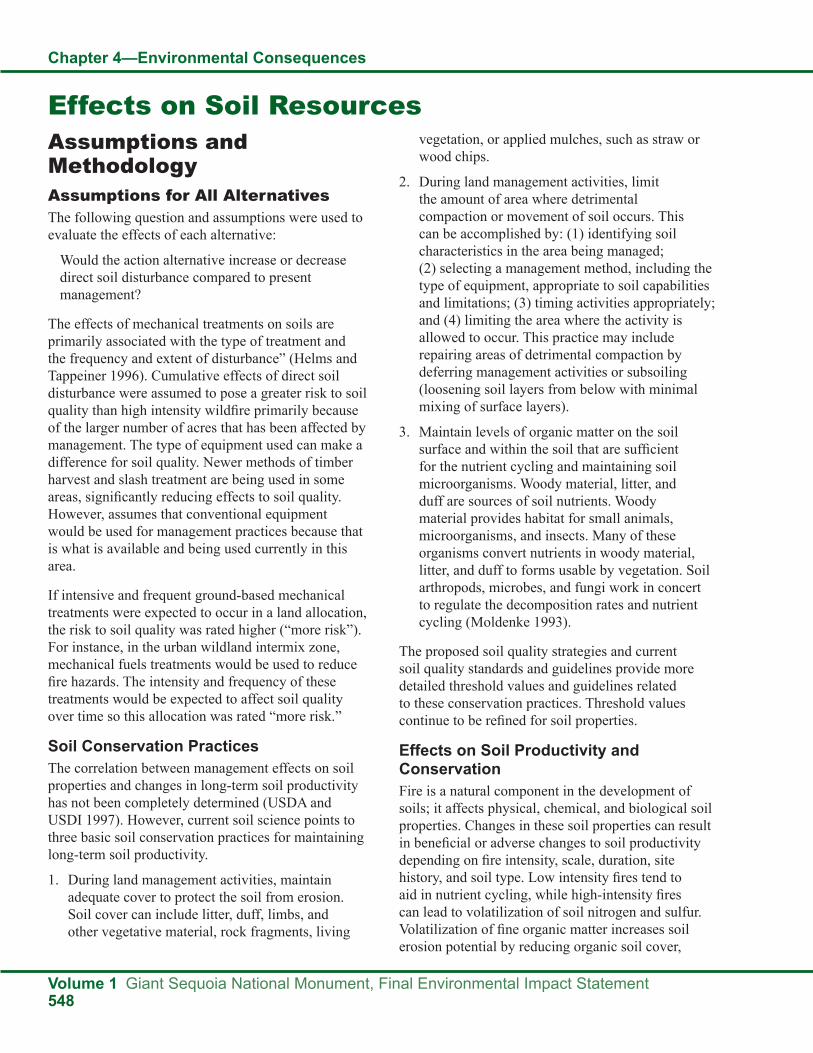
Chapter 4—Environmental Consequences
Volume 1 Giant Sequoia National Monument, Final Environmental Impact Statement548
Assumptions and MethodologyAssumptions for All AlternativesThe following question and assumptions were used to evaluate the effects of each alternative:
Would the action alternative increase or decrease direct soil disturbance compared to present management?
The effects of mechanical treatments on soils are primarily associated with the type of treatment and the frequency and extent of disturbance” (Helms and Tappeiner 1996). Cumulative effects of direct soil disturbance were assumed to pose a greater risk to soil quality than high intensity wildfire primarily because of the larger number of acres that has been affected by management. The type of equipment used can make a difference for soil quality. Newer methods of timber harvest and slash treatment are being used in some areas, significantly reducing effects to soil quality. However, assumes that conventional equipment would be used for management practices because that is what is available and being used currently in this area.
If intensive and frequent ground-based mechanical treatments were expected to occur in a land allocation, the risk to soil quality was rated higher (“more risk”). For instance, in the urban wildland intermix zone, mechanical fuels treatments would be used to reduce fire hazards. The intensity and frequency of these treatments would be expected to affect soil quality over time so this allocation was rated “more risk.”
Soil Conservation PracticesThe correlation between management effects on soil properties and changes in long-term soil productivity has not been completely determined (USDA and USDI 1997). However, current soil science points to three basic soil conservation practices for maintaining long-term soil productivity.
1. During land management activities, maintain adequate cover to protect the soil from erosion. Soil cover can include litter, duff, limbs, and other vegetative material, rock fragments, living
vegetation, or applied mulches, such as straw or wood chips.
2. During land management activities, limit the amount of area where detrimental compaction or movement of soil occurs. This can be accomplished by: (1) identifying soil characteristics in the area being managed; (2) selecting a management method, including the type of equipment, appropriate to soil capabilities and limitations; (3) timing activities appropriately; and (4) limiting the area where the activity is allowed to occur. This practice may include repairing areas of detrimental compaction by deferring management activities or subsoiling (loosening soil layers from below with minimal mixing of surface layers).
3. Maintain levels of organic matter on the soil surface and within the soil that are sufficient for the nutrient cycling and maintaining soil microorganisms. Woody material, litter, and duff are sources of soil nutrients. Woody material provides habitat for small animals, microorganisms, and insects. Many of these organisms convert nutrients in woody material, litter, and duff to forms usable by vegetation. Soil arthropods, microbes, and fungi work in concert to regulate the decomposition rates and nutrient cycling (Moldenke 1993).
The proposed soil quality strategies and current soil quality standards and guidelines provide more detailed threshold values and guidelines related to these conservation practices. Threshold values continue to be refined for soil properties.
Effects on Soil Productivity and ConservationFire is a natural component in the development of soils; it affects physical, chemical, and biological soil properties. Changes in these soil properties can result in beneficial or adverse changes to soil productivity depending on fire intensity, scale, duration, site history, and soil type. Low intensity fires tend to aid in nutrient cycling, while high-intensity fires can lead to volatilization of soil nitrogen and sulfur. Volatilization of fine organic matter increases soil erosion potential by reducing organic soil cover,
Effects on Soil Resources
Chapter 4—Environmental Consequences
Giant Sequoia National Monument, Final Environmental Impact Statement Volume 1549
creating water repellent soil layers and changing soil structure. Wildfires can occur over large areas, sometimes spanning multiple watersheds. The effects of severe wildfires pose one of the greatest risks to soil productivity in the Sierra Nevada.
Prescribed fire can be designed to minimize effects on soil properties in thinned stands when fuel loadings are relatively low. However, in areas with high stand density or where existing fuel levels are high, mechanical treatments are often necessary prior to burning to meet prescribed fire and soil resource objectives.
Historically affected areas often include dense stands with heavy surface fuels where soils have been compacted from multiple entries or large plantations located in previously burned areas. Such areas are highly susceptible to damage from ground-based equipment, and the principal risk to soil productivity is through detrimental compaction. These areas may also have the greatest need for fuels treatments as well as opportunities for soil restoration. As a result, an assessment of mechanized treatment, prescribed burning, and the potential risks of wildfire needs to be conducted, resulting in mitigation measures that would minimize effects and/or maximize restoration of soil potential in previously affected areas.
Effects of Mechanical Treatments on SoilsEcological restoration and fuels operations using mechanical means include a variety of techniques. They range, in order of increasing effects to soils, from helicopter, to skyline cable, to ground-based operations over snow or frozen soils, to hand-felling with tractor skidding. Currently the primary technique used is mechanized harvest and mechanical fuel treatment using ground-based equipment. The principal risk to soil productivity is detrimental compaction from these operations. Managing the soil resource requires identifying the risks of using mechanical equipment and prescribing mitigation measures to avoid effects to long-term soil productivity.
The effects of mechanical treatments on soils are primarily associated with the type of treatment and the frequency and extent of disturbance (Helms and Tappeiner 1996). Cumulative effects of direct soil disturbance were assumed to pose a greater risk to
soil quality than high-intensity wildfire primarily because of the larger number of acres that have been affected by management. The type of equipment used can make a difference for soil quality. Newer methods of timber harvest and slash treatment are being used in some areas, significantly reducing effects to soil quality. However, it is likely that conventional equipment would be used for management practices in the Monument because that is what is available and is currently being used in this area. If intensive and frequent ground-based mechanical treatments were expected to occur in certain land allocations, the risk to soil quality was rated higher (more risk). For instance, in the wildland urban intermix (WUI) zone, mechanical fuels treatments would be used to reduce fire hazards. The intensity and frequency of these treatments would be expected to affect soil quality over time, so this allocation was rated as higher risk.
Methods and MeasurementsEach alternative proposes a range of management activities that could affect soil to varying degrees. Additionally, each alternative would also influence the degree to which natural disturbance events, such as wildfire, could affect soil. Risk assessment was used to analyze the effects of the action alternatives. Risks to long-term soil productivity were compared under each alternative’s proposed management and level of prescribed and natural fire. The acres of different kinds of possible soil disturbance were also considered in the final evaluation.
Quantified data about detailed existing soil conditions within the Monument is lacking for this analysis. Therefore, the risk assessment for soil effects relies on assumptions of what is expected to generally occur. Each type of soil disturbance was evaluated for its potential to cause detrimental effects to soil productivity, soil hydrologic function, and soil buffering capacity as well as the relative extent of the effect. Two events or effects pose the greatest risk to soil quality:
Management activities that can displace topsoil reduce soil porosity (cause compaction), or reduce soil cover and increase erosion. High intensity burnt areas within wildfires that result in volatilization of soil nitrogen, loss of soil cover, and subsequent soil erosion.

Chapter 4—Environmental Consequences
Volume 1 Giant Sequoia National Monument, Final Environmental Impact Statement550
Managing for long-term soil productivity requires balancing the risks of these two events. Some land disturbing treatments to reduce fuel buildups can result in compaction or erosion or interrupt nutrient cycling processes, but lethal wildfire may also result in severe erosion. Standards and guidelines for soil quality have been developed to help manage risks from management activities and are listed previously in legal and regulatory compliance.
Indirect EffectsThe indirect effects of management practices on soil quality for a particular site depend on existing soil conditions and the extent to which soil characteristics are considered during project planning and implementation. The following section describes overall risks to soil quality based on the specific management direction and standards and guidelines proposed for each alternative. The relative risk to soil quality from proposed management is based mainly on: (1) the amount of soil disturbance that management activities could create; and (2) whether management would increase or decrease the effects of wildfire on soil quality.
Each alternative proposes a range of management activities that could affect soil to varying degrees. The predominant silvicultural activity is thinning from below or the harvest of smaller, often suppressed understory trees, to reduce fuel loading and the risk of fire spreading into the crowns of larger overstory trees. Ground-based logging systems such as crawler tractors, rubber tired skidders, and feller-bunchers are typically used in harvest operations; cut-to-length harvesting systems are sometimes used. Slash treatments may include no treatment, underburning, or mechanical treatment. Effects on soil from these activities can be variable depending on the equipment used, soil characteristics such as depth and clay content, soil moisture when the activity occurs, and volume of woody material removed. Another management activity that varies across the alternatives is prescribed burning. Prescribed burning by definition is implemented during times when environmental conditions create moderate fire behavior. As such, the important effect of prescribed burning is its effect on fuel structure and future wildfire intensity.
Each alternative would also influence the degree to which natural disturbance events such as wildfire
could affect soil. High-intensity wildfire ratings can indicate that: (1) most of the duff has been consumed and a white or reddish ash remains; and (2) more than 80 percent of the forest canopy has been consumed. The loss of the duff layer (soil cover) is the dominant factor affecting soil erosion potential. A high-intensity burn can also damage the surface soil structure and create hydrophobic layers, further increasing potential erosion risk.
Acres of Annual Mechanical Treatments and Placement of Treatments on the LandscapeAcres of mechanical treatments each year would likely be the highest under Alternatives E and F. Alternatives A and B would likely have an intermediate number of acres of mechanical treatments, and thus an intermediate level of risk. Alternatives C and D would likely treat fewer acres annually; hence, these alternatives would have less risk from mechanical treatments than Alternatives E and F. Alternatives C and D would mechanically treat the fewest acres; thus, effects on soil conservation and productivity directly attributable to mechanical treatments would be lowest under these alternatives. However, even Alternative E treats less than 1 percent of the planning area each year, so with the implementation of soil standards and guidelines, the overall risk from implementation of all action alternatives is low.
Alternatives A, B, E, and F would have the greatest number of acres in the wildland urban intermix where mechanical fuel treatments would be concentrated. Alternatives C and D would have much less acreage in wildland urban intermix.
Acres of Annual Prescribed FireAccording to the SPECTRUM model, Alternative B would likely treat the greatest number of acres using prescribed fire, followed by Alternatives E and F. Alternatives A and C would have intermediate levels of prescribed burning. Alternative D would have the lowest number of acres of prescribed fire. Prescribed burning activities in Alternative B would therefore have the greatest effect on reducing surface fuel loads and future wildfire intensity. The beneficial effect of prescribed fire of soils would be highest under Alternative B and lowest under Alternative D. However, even Alternative B treats less than

Chapter 4—Environmental Consequences
Giant Sequoia National Monument, Final Environmental Impact Statement Volume 1551
1 percent of the planning area each year, so the overall difference in beneficial effects between the alternatives would be small.
Relative Risk of Wildfire (Wildfire Acres Projected to Burn Annually)Alternatives C and D would have the greatest risk for large, severe wildfires that could lead to increases in soil erosion, compared to the no action alternative. Alternatives B, E, and F would reduce the projected number of acres burned by wildfire relative to what is projected for Alternative A.
Cumulative EffectsThe management prescriptions for the Monument outlined in this FEIS cover all aspects of management of soils (vegetation treatments, fire, recreation, roads). Cumulative effects on soils (those effects not directly in the plan) would mostly likely come from outside the Monument. The only potential effect from outside the Monument would be climate and climate change.
Climate projections for the Monument include: increasing temperatures; precipitation falling increasingly as rain instead of snow, leading to decreasing snowpack; and summers that are longer
and drier. Forest vegetation types are predicted to migrate to higher elevations as warmer temperatures make those areas suitable for colonization and survival. The combination of warmer climate with higher CO2 fertilization will likely increase fuel loads, leading to more frequent and intense fires throughout western North America.
The precise cumulative effects of climate change on soil productivity are difficult to predict and will not be addressed in this analysis.(62)
Standards and Guidelines and MonitoringStandards and guidelines for soil quality have been developed to help manage risks to soils from management activities (for complete lists of standards and guidelines by alternative, see Appendix A to this FEIS).
Monitoring of aquatic resources will include determining if the Best Management Practices are effective in protecting the soil and water resources of Monument watersheds (for the entire Monitoring Plan for the Monument, see the Monitoring and Evaluation section in Part 3 of the Monument Plan).
62. For a more detailed description of how climate change may affect the Monument in general, see the Effects of Climate Change section in this chapter of the FEIS and Appendix C to this FEIS.
Effects on Human Use, including Recreation, Scenery, and SocioeconomicsEffects on RecreationAssumptions and MethodologyThe analysis of effects is based on how well the alternatives would meet future recreation demand and protect the objects of interest (qualitative unit of measure). Included within that analysis for each alternative is an assessment of the relative extent to which people could be accommodated at developed sites, the relative extent of dispersed recreation opportunities, and the relative extent of road and trail opportunities. Rather than identifying specific numbers of people at one time, site capacity, or road and trail mileages, this programmatic level analysis compares possible/probable/likely recreation
opportunities allowed by each alternative, with specific numbers deferred to site-specific analysis when projects are proposed in the future.
The alternatives for managing recreation resources in the Monument are designed to follow the intent and spirit of the Clinton proclamation (2000). The text refers to recreation opportunities, which include facilities, programs, and the lands that provide the settings for recreation activities. Managers provide recreation opportunities, which allow visitors to have recreation experiences. Because recreation opportunities exist to serve people who have individual desires and needs, no one solution can adequately serve everyone; the “average” or

Chapter 4—Environmental Consequences
Volume 1 Giant Sequoia National Monument, Final Environmental Impact Statement552
the management plan which says that cross-country travel by non-mechanized users (e.g., horses, hikers) may be restricted to prevent resource damage.
XIX. Visitor Data—How should the Forest improve its visitor use database for the Giant Sequoia National Monument?This Advisory stated that the forest lacks adequate information on visitor use. This information is needed regardless of the alternative. The Forest Service currently uses National Visitor Use Monitoring (NVUM) as a method of assessing use. Due to the survey sample size, the information is only valid at the forest level and cannot be strictly applied to the Monument or a particular district or a particular site (Kocis et al. 2004, USDA Forest Service 2008b). In 2006, NVUM data were used, along with information from the National Survey on Recreation and the Environment (NSRE), the United States Census Bureau, the National Association of Counties, and local information, to develop market data, including recreation demand information, for the Sequoia National Forest (USDA Forest Service 2006a). The recreation demand analysis prepared for this Monument planning process examines additional information sources, including studies covering the nation, California, or portions of the state, for their applicability to the Monument. A March 2011 research report (Chavez) provides specific information on six day use sites in the Monument, which will be useful in future site-specific planning; research on a seventh site is being conducted in summer 2011.
Science ConsideredA recreation demand analysis was prepared for the Monument for use in this planning process and is included as Appendix D; the surveys and references cited are noted in that appendix. Useful information includes lifestyle, demographic, and economic trends, all of which can affect how or if people recreate, as well as where and when (Cordell 1999, Sheffield 2005, USDA Forest Service 2006a); race, ethnicity, and gender also affect recreation participation (Cordell 1999). Recreation activity and participation trends are examined. Studies at various scales, covering the nation, California, or portions of the state, are reviewed for their applicability to the Monument. Some survey information is specific to the Sequoia National Forest, as a whole, and others
“typical” recreationist does not exist (NARRP 2009), so that maintaining a spectrum of diverse recreation opportunities is important (Cordell 1999). Furthermore, people’s recreation needs and desires change over time, in response to changing technology, changing societal lifestyles and demographic trends, and changing recreation activities (Cordell 1999, Sheffield 2005, USDA Forest Service 2006a). How those desires will change in the future is unknown at this time. Predicting the future is uncertain, because people are unpredictable; what is popular and in demand today may change several times through future years. Consequently, this plan emphasizes flexibility, in order to accommodate future recreation demand, while still protecting the objects of interest (sustainable recreation).
Ecological Restoration and RecreationEcological restoration and recreation are linked through the concept of sustainable recreation. Providing for the long-term sustainability of National Forest System lands and resources is essential to maintaining the quality of the recreation experience for all users. Monument management needs to provide for protection of resources, through consistency with protecting the objects of interest, restoration, and developing stewardship, so that people care about the land and its resources. All project planning must consider resource sustainability. Potential environmental effects need to be minimized and mitigated. Site restoration is needed for already affected sites.
Use of ScienceScientific Advisory Board (SAB) AdvisoriesTwo advisories issued by the SAB continue to apply to recreation in the Monument.
XVI. Equestrian—Shall the Forest Service continue to allow equestrian recreational use?This Advisory is reflected in all of the alternatives, as they all allow recreation stock use in the Monument. Social conflicts and resource effects that arise during plan implementation will be dealt with on a site-specific basis. A standard and guideline is included in

Chapter 4—Environmental Consequences
Giant Sequoia National Monument, Final Environmental Impact Statement Volume 1553
provide insight to particular aspects of the Monument, such as visitor information. No one information source provides recreation participation information for the entire Monument. Consequently, information must be extrapolated from these other sources and applied to the Monument; the results are inherently uncertain.
The various surveys cited provide a snapshot in time. The results are not directly comparable, because the surveys were conducted at different times, different sampling techniques were used, and different questions were asked. Yet, even though the surveys yield different results, they do provide insight to help determine future needs for recreation opportunities in the Monument. Despite what the science indicates, predicting the future is uncertain.
Assumptions for All AlternativesThe analysis of effects uses the following assumptions, drawn from the recreation demand analysis (see Appendix D or the summary in the recreation affected environment section in Chapter 3).
● Recreation demand will increase in the future.
● The state’s population is growing rapidly, becoming more culturally and racially diverse, and aging, which will affect outdoor recreation more than anything else (Cordell 1999, Sheffield 2005).
● Families with children, youth, and seniors are large markets for outdoor recreation and will grow (Sheffield 2005, USDA Forest Service 2006a, 2008c).
● This area of the Sierra Nevada will experience the largest population growth in nearby urban areas, particularly Bakersfield and Fresno, during the next few decades (Duane 1996).
● Even if outdoor recreation participation rates are static or decline, the sheer numbers of people participating will increase, due to the increase in population (Sheffield 2005).
● People with lower income rely more on public recreation facilities, and the number of people at the lower end of the income scale is increasing disproportionately as the state’s population grows (California State Parks 2009).
● Although people have a variety of reasons for visiting, they also have numerous reasons for not visiting (California State Parks 1998, 2002, 2003, 2009, Cordell 1999, Crano et al. n.d., Sheffield 2005). A lack of information about recreation opportunities has often been cited as one of the reasons for not visiting, more frequently by people of color (Crano et al. n.d.).
● Using media that are more likely to be effective with particular groups and emphasizing activities that are more likely to be of interest to those groups may more effectively reach culturally diverse people (Crano et al. n.d.).
● The majority of people seem to prefer word of mouth from family and friends, the internet, and brochures (California State Parks 2003) as ways to receive information about recreation areas. Whites seem to rely more on newspapers for recreation information than members of other ethnic groups. Asians may rely more frequently on computers than other groups. Both Latinos and African Americans seem to rely most on television for recreation information (Crano et al. n.d.).
● High gasoline costs may have negative or positive effects on Monument visitation; some people may visit as a closer-to-home travel option than what they would normally choose, while others may choose not to visit or visit less often. Gas prices also affect the activities that people choose (Cordell et al. 2009b).
● Although people are not driving more miles, overall, the average time spent in transit has increased, indicating an increase in congestion (Cordell et al. 2009b).
● The public is developing higher expectations for quality and service; visitors will be interested in a diversity of conveniences/amenities (APPL 2004, Hill et al. 2009, Sheffield 2005).
● With an increase in the diversity of users comes an increase in the diversity of recreation experiences they desire, both in activities and types of facilities desired (California State Parks 2002, Cordell 1999, Sheffield 2005).

Chapter 4—Environmental Consequences
Volume 1 Giant Sequoia National Monument, Final Environmental Impact Statement554
● Recreation facilities and services need to be made more relevant for the state’s rapidly changing population segments, including the elderly, youth, single-parent families, ethnic groups, new immigrants, and persons with disabilities (California State Parks 2002).
● The typical family campground that was developed in the 1960s, with individual campsites designed to accommodate six people in tents or small camper trailers, no longer suits the style of recreation that many people seek to experience (California State Parks 2002, Cordell 1999, USDA Forest Service 2008a). Fewer people use tents to camp (although non-white campers are more likely to use tents than white campers). Fewer camper trailers are seen, having been largely replaced by recreational vehicles (RVs), some of which are quite large and do not fit in small campsites (although gas prices may affect future RV use and size).
● People often want to camp in larger groups than can be accommodated in many campsites; more group picnic areas and camping opportunities are needed (California State Parks 1998, 2003, 2009, USDA Forest Service 2006a).
● A range of camping opportunities is desired, from more developed campgrounds with flush toilets, hot showers, and food lockers, to more basic campgrounds with picnic tables, cold water, and vault toilets (Sheffield 2005).
● Camping alternatives, such as cabins, tent cabins, yurts, and other affordable lodging should be provided (California State Parks 2009).
● The following activities are expected to be primary in the next 10 years for the Monument (not in priority order): relaxing/escaping heat; hiking; viewing/photographing natural features/wildlife; driving for pleasure/sightseeing/driving through natural scenery; fishing and hunting; snowmobiling; biking; family gatherings; picnicking/group picnicking; developed camping/group developed camping; motorized and non-motorized water travel; swimming/water play; horseback riding; rock climbing; walking; nature center/nature study; and visiting historic/
prehistoric sites (California State Parks 1998, 2002, 2003, 2009, Cordell 1999, 2004, Cordell et al. 2004, 2009b, 2009c, Kocis et al. 2004, Sheffield 2005, 2008, USDA Forest Service 2006a).
Although the Clinton proclamation (2000) limits the use of motorized vehicles, including snowmobiles, to designated roads and the use of non-motorized mechanized vehicles (mountain bikes) to designated roads and trails, persons with disabilities are exempted from these limitations. However, this exemption does not mean that persons with disabilities are allowed to travel whenever or wherever they desire with whatever mode of transportation they desire. Persons with disabilities are not allowed to access areas that are not otherwise available to the public; for example, a road closed to public use would not be available for use by a person with a disability. A person with a disability would be able to use a wheelchair, either mechanical or electric, on roads or trails that are open to the public. Using an off-highway vehicle or all-terrain vehicle off of designated roads would not be allowed. A wheelchair is defined as a device that is designed solely for use by a mobility-impaired individual for locomotion that is suitable for use in an indoor pedestrian area (Americans with Disabilities Act 1990). A device powered by an internal combustion engine (such as an ATV or OHV) would not fit that definition.
Organization of the AnalysisDuring the public involvement process for this Monument plan, the public(63) helped to develop and refine a decision framework using the Multi-Criteria Decision Support (MCDS) model (for more information on MCDS, see the socioeconomic affected environment section in Chapter 3 of the final EIS). A portion of that MCDS framework addressed recreation in “Increase Enjoyment of the Monument,” which includes: enjoy the objects of interest; promotes diversity of users; promotes diversity of uses; provides access; connects people to others and across generations; and connects people to the land (places).
63. People involved in this process were people who are interested in the Monument; they were not selected through a scientific sampling process that would yield statistically valid results through analysis.

Chapter 4—Environmental Consequences
Giant Sequoia National Monument, Final Environmental Impact Statement Volume 1555
The public also emphasized the following items (submitted during scoping): day use; camping; tourism; concessionaires and private resorts; roads; trails; signage; parking and toilets; permittees, organizational camps, and private communities in and adjacent to the Monument; public outreach programs; and education programs. (See the recreation affected environment section in Chapter 3 or the recreation demand analysis in Appendix D of the final EIS for more information on these topics.)
Within the context of how well the alternatives are expected to meet future recreation demand and protect the objects of interest, the analysis of effects addresses both this portion of the MCDS framework and these items that the public identified as important to them (in addition to information summarized from the recreation demand analysis). The analysis appears under the following headings and subheadings:
● Increasing Numbers of Recreationists
● Protects Resources
● Enjoy the Objects of Interest
● Promotes Diversity of Users
● Promotes Diversity of Uses
● Day Use and Camping
● Tourism
● Concessionaires and Private Resorts
● Provides Access
● Roads
● Trails
● Signage
● Parking and Toilets
● Connects People to Others and Across Generations
● Permittees, Organizational Camps, and Private Communities in and Adjacent to the Monument
● Public Outreach Programs (Partnerships)
● Interpretation and Education Programs (Conservation Education)
● Connects People to the Land (Places)
● Effects on Recreation from Management Activities
In addition, effects from ongoing activities are described in Alternative A, the baseline.
Indirect EffectsAlternative A, the BaselineRecreation opportunities that are currently available and occurring are described in Chapter 3, Recreation. The effects resulting from these uses will continue to occur, such as soil compaction and erosion; threats to plants, wildlife species, riparian areas, and water quality; littering; sanitation issues; the potential for wildfire starts from unattended/abandoned campfires and vehicle exhaust systems; damage to cultural resources; and the spread of undesirable plants. Effects are particularly heightened in areas that are overused or abused and by limited resources available for maintenance. Social effects also occur, due to overcrowding and user conflicts between users who have different expectations than other users for their recreation experiences. The noted effects are based on visual observation and monitoring.
The effects from existing activities represent a baseline and are carried forward through the range of alternatives. These activities have been approved in prior environmental analyses, including the existing Forest Plan. The programmatic effects described for each of the other alternatives include the effects of ongoing activities.
Increasing Numbers of RecreationistsIn the next 25 years, the population in the Sequoia’s market zone is projected to increase 38 percent, and visitation is predicted to increase at a rate similar to the population rate increase (USDA Forest Service 2006a, 2008a, 2008c). Over the years 2005-2025, a 37 percent increase in visitation could be expected in the Monument. This increase will place more demands on the Monument’s resources. All of the alternatives have the ability to accommodate increasing numbers of recreationists, although where, how much, and what type of development is allowed varies between alternatives; the differences are explored throughout this analysis.
With more visitation comes an increased potential for crowding. Crowding can affect how and when people visit an area (Cordell 1999). Although some people

Chapter 4—Environmental Consequences
Volume 1 Giant Sequoia National Monument, Final Environmental Impact Statement556
do not mind crowds, many others find that crowding adversely affects their recreation experiences. Consequently, they may avoid visiting areas when they perceive the areas will be more crowded and shift their visits to other areas, other times of the week, or seasons of the year. If people perceive that areas are always crowded, they may simply avoid visiting them altogether (California State Parks 1998, 2002, 2003). Within the Monument, some areas are filled to capacity at times, especially on holiday weekends, indicating a need for additional recreation opportunities in the future. All of the alternatives have the ability to provide for additional recreation opportunities, with Alternatives C and D being the most restrictive for new recreation development. Alternative C focuses on recreation at developed sites and is expected to encourage new development, but only in certain locations (recreation opportunity areas; for their location, see maps in the Promotes Diversity of Uses section). In Alternative D, new development is expected to be limited to walk-in picnic areas and walk-in campgrounds, with most new development encouraged outside the Monument.
Protects ResourcesConservation and resource stewardship will be increasingly important for sustainable recreation, especially for more environmentally sensitive areas. Unmanaged recreation has the potential to damage forest resources when careless or uninformed visitors do not follow regulations for responsible use. Effective interpretive techniques and public information services, including multilingual materials, can help to inform and motivate the public, both visitors and non-visitors, into becoming stewards of the forest (California State Parks 2002, NARRP 2009, USDA Forest Service 2006a, 2008a, 2008c).
The alternatives are all designed to minimize the effect of new recreation development on the surrounding ecosystem, including the objects of interest (sustainable recreation). The standards and guidelines included in Appendix A are designed to minimize that effect. During site-specific project planning in the future, mitigations (including best management practices) are expected to be identified for project implementation. Examples of mitigation are expected to include actions such as hardening sites to avoid erosion, avoiding meadows and riparian areas, or avoiding cultural resources. Site restoration
for already affected sites is expected to occur in all of the alternatives. Involving the public in site restoration activities provides an opportunity to teach stewardship to them, so that they will care about the environment and its responsible use (NARRP 2009).
Volunteerism is a form of recreation for some people (APPL 2004, Cordell 1999, Sheffield 2008). Some people will even plan their vacations around an activity, such as cabin restoration. Recreation site restoration, trail restoration, trail maintenance, and site maintenance are all examples of activities pursued by the citizen steward. All of the alternatives are expected to offer opportunities for this type of activity, whether people are experienced volunteers or are just learning about stewardship.
Enjoy the Objects of InterestAlthough the Clinton proclamation (2000) requires that the Forest Service protect the objects of interest, people have a strong desire to enjoy those objects. People want to enjoy the Monument, including the objects of interest that make the Monument the special place that it is. People need to have opportunities to enjoy the objects, whether on-site or virtually. Part of that enjoyment means knowing about the objects, where they are, their history, and their characteristics. All of the alternatives have the ability to provide for some enjoyment off-site, through methods such as interpretive programs and virtual tours on the internet, for example.
The ability for visitors to enjoy the objects of interest on-site varies by alternative, as the type of access, facility development, and activities allowed vary. No one kind of access to the objects of interest or one kind of development to facilitate their enjoyment will satisfy all users; individuals will be better served or lesser served by whichever alternatives cater to their particular interests. Site-specific analysis may further limit what kind of development and/or activities would be allowed. Alternatives B and F have the greatest ability to provide for the most diverse types of access, facilities, and activities to enable visitors to enjoy the objects of interest. Alternatives A and E are somewhat more limited in what can occur where, according to the Forest Plan management emphasis area direction. Alternative C is expected to allow for the development of new facilities to enhance enjoyment of the objects, but, for example, if people

Chapter 4—Environmental Consequences
Giant Sequoia National Monument, Final Environmental Impact Statement Volume 1557
want to mountain bike on a trail to view the objects or camp under a giant sequoia outside of a developed campground, their ability to do their desired activities or use their desired modes of transportation are expected to be restricted in Alternative C. Alternative D is expected to allow more road access than Alternative C. But in Alternative D, visitors are expected to find different restrictions, as, for example, a mountain bike might no longer be able to be used on a particular trail (if it is not designated) that accesses their favorite object, or they might find that their favorite campground in a giant sequoia grove is no longer there.
Promotes Diversity of UsersThe diversity of recreationists will continue to increase as the American population becomes more diverse, and international visitors will increase (Cordell 1999). The Monument already sees a substantial number of international visitors (USDA Forest Service 2008a), and they are expected to increase in the future. The greatest growth is projected to be in Hispanic and Asian populations (California State Parks 2009, Sheffield 2005), and their use is projected to increase dramatically in the next 25 years. Use of the Monument by culturally diverse user groups, especially Hispanics and Asians, is prevalent and growing, although the majority of users continue to be from White/Euro-American cultures (USDA Forest Service 2006a, 2008a, 2008b, 2008c).
Multinational visitors provide a challenge in effective communications (Cordell 1999), and many recent immigrants have limited outdoor recreation experience on public lands (Sheffield 2005). Interpretation methods, including multilingual materials, designed to reach these culturally diverse users need to communicate important resource issues, solicit commitment to conservation, and encourage appropriate behaviors (APPL 2004, California State Parks 2009, USDA Forest Service 2008a). New methods of interpretation and efforts to outreach to underrepresented groups need to be developed with careful attention to their special needs. In many cases, developing products and services to reach out into the communities where underrepresented groups live, in order to raise their awareness of opportunities available (Crano et al. n.d.) or to bring the resource to them, may be needed. All of the alternatives have the ability to provide needed information.
People expect instantaneous information, thanks to the internet, so that they can customize their recreation experiences, as well as have virtual experiences (APPL 2004, Cordell 1999, Sheffield 2005, USDA Forest Service 2008a). All of the alternatives have the ability to accommodate the need for information and to provide virtual experiences.
Older adults and baby boomers want more amenities and improved access, while younger adults want more immediate, lively information and access, drawn by opportunities for excitement (Sheffield 2005). Not all older people will increase their recreation participation, however, as health concerns and mobility problems will affect their ability and desire to participate. Alternative D, with its prohibition on new road development, is expected to have the least ability to accommodate future recreation development to serve people with limited mobility, including many persons with disabilities. In addition, roads not needed to provide access for popular dispersed recreation areas, existing recreation development, or forest management are expected to be decommissioned in Alternative D. Alternative C may also affect people with limited mobility, but in a different way. In Alternative C, if roads that are maintained for high clearance vehicles are not needed for forest management or are not needed to serve existing or proposed recreation development, they are expected to be decommissioned, thereby affecting the access available to some areas. Some decommissioned roads may be converted to trails in all of the alternatives, providing for a different type of access to some areas. Because the potential for decommissioning roads is greatest in Alternative C (and somewhat less in Alternative D), the potential for conversion to trails is also greatest in Alternative C (and somewhat less in Alternative D).
Multinational forest users have different expectations for their recreation experiences. For example, Hispanic recreation participation patterns are somewhat different from predominantly Anglo populations (California State Parks 1998, 2003, Sheffield 2005), such as in picnicking; Hispanics tend to participate with larger groups, arrive earlier in the day, and spend quite a bit of time in food preparation (Sheffield 2005). Many ethnically diverse groups show a preference for recreation at developed sites; the ability to accommodate this preference is expected

Chapter 4—Environmental Consequences
Volume 1 Giant Sequoia National Monument, Final Environmental Impact Statement558
to be more limited in Alternative D than in any of the other alternatives, because Alternative D is expected to allow the least amount of new development. With the emphasis on developed recreation sites in Alternative C, at first glance, this alternative would seem to best accommodate the preference for recreation at developed sites. However, Alternatives B and F also have the potential for new development. Because of restrictions associated with development in some Forest Plan management emphasis areas, Alternatives A and E have slightly less potential than Alternatives B and F to accommodate the preference for recreation in developed sites.
Promotes Diversity of UsesWith an increase in the diversity of users comes an increase in the diversity of recreation experiences they desire, both in activities and types of facilities desired (California State Parks 2002, Cordell 1999, Sheffield 2005). The variety of activities is expected to continue to grow (Cordell 1999, Sheffield 2005). Some will be determined to be appropriate for the Monument, and some will not. As more recreation uses occur, they must compete with existing uses for a limited land base (Cordell 1999, NARRP 2009, Sheffield 2005).
The alternatives range in the diversity of recreation opportunities allowed. On one end of the scale (Alternatives B and F) is expected to be a wide variety of uses to accommodate individuals’ differing recreation preferences, with flexibility to respond to future recreation demand and new activities. On the other end of the scale (Alternatives C and D) is expected to be a more limited choice of uses, with new development only allowed in certain areas or with limitations on the type of development, and the ability to respond to changing recreation demand and activities is more limited. Which recreation activities may occur in which locations are not specified for Alternatives B, C, D, and F in order to provide the greatest flexibility to accommodate new and changing activities as they emerge in the future. However, Alternatives C and D do have some limitations on the kinds of activities that may be allowed. Alternative C emphasizes developed recreation opportunities, but only in certain locations (recreation opportunity areas; see the following maps for their location). Alternative D is expected to limit the development of new recreation facilities—no new roads are allowed, so new picnic areas or campgrounds are walk-in only.
Which activities are emphasized in Alternatives A and E are listed in Forest Plan management emphasis area direction, which is somewhat more limited than what is expected to be allowed in Alternatives B and F.
Day Use and CampingAlternative C eliminates dispersed camping along roadsides or at the end of roads in concentrated use areas, which is very popular with some current Monument visitors. Dispersed camping in the Wildlands recreation niche setting, inventoried roadless areas, or portions of the Kings River Special Management Area are expected to be allowed only by permit in Alternative C. Existing developed campgrounds are expected to remain in all of the alternatives, except in Alternative D, where, as opportunities arise, existing campgrounds within sequoia groves are expected to be considered for relocation to areas outside of groves. The alternatives differ most for new development, as described in the following paragraphs.
Camping opportunities are expected to be diverse in Alternatives A, B, E, and F. More highly developed campgrounds may be proposed in Alternatives B, C, and F than what currently exist, in order to better satisfy public demand. Alternative C is expected to encourage new development, guided by the recreation niche settings, but only in certain locations (recreation opportunity areas; see previous maps for their location); new campgrounds are expected to be at the higher end of the development scale (including amenities such as flush toilets and RV hookups), and lodges, cabins, or other overnight accommodations could also be developed. Alternatives A and E are less restrictive in the locations for new development, but sites where overnight opportunities would be developed are expected to be guided by the Forest Plan management emphasis areas and the recreation niche settings. Alternatives B and F are least restrictive in where new overnight development could occur, but the kinds of recreation opportunities encouraged in any given location are expected to be guided by the recreation niche settings (see the recreation affected environment section). Alternatives B and F are expected to allow the widest spectrum of overnight development, from undeveloped dispersed camping to campgrounds with minimal amenities (e.g., vault toilets) to highly developed campgrounds (e.g., flush toilets, RV hookups) to lodges and cabins.

Chapter 4—Environmental Consequences
Giant Sequoia National Monument, Final Environmental Impact Statement Volume 1559
Map 27 Recreation Opportunity Areas for Alternative C in the Northern Portion of the Monument

Chapter 4—Environmental Consequences
Volume 1 Giant Sequoia National Monument, Final Environmental Impact Statement560
Map 28 Recreation Opportunity Areas for Alternative C in the Southern Portion of the Monument

Chapter 4—Environmental Consequences
Giant Sequoia National Monument, Final Environmental Impact Statement Volume 1561
For day use, the alternatives vary, both in what activities/development are expected to be allowed, as well as where. In Alternative C and, to a lesser degree, Alternative D, expected road reductions are also expected to result in decreased access for hunters. No target shooting is allowed in Alternative C, although Alternative C is expected to allow other forms of dispersed recreation, such as hiking, birdwatching, fishing, and picnicking.
Alternative D is expected to allow the least amount of new development, and all new campgrounds or picnic areas are walk-in only, as no new roads are developed in that alternative. Consequently, Alternative D does not address recreation demand as well as the other alternatives. The Monument attracts groups who want to camp or picnic in developed sites, and the existing supply of facilities that meets that need is quite limited. Not all people are willing or able to walk to their campsites or picnic sites, which limits the ability of Alternative D to accommodate groups and may affect people with disabilities. In addition, many ethnically diverse groups show a preference for recreation at developed sites; the ability to accommodate this preference is expected to be more limited in Alternative D than in any of the other alternatives.
With the emphasis on developed recreation sites in Alternative C, at first glance, this alternative would seem to best accommodate the preference for recreation at developed campgrounds, developed picnic areas, or other developed day use sites. However, Alternatives B and F also have the potential to provide for new campground development, in addition to allowing dispersed camping in undeveloped areas, which is also popular. Alternatives B and F are also expected to have the potential to provide for additional day use development. Because of restrictions associated with development in some Forest Plan management emphasis areas, Alternatives A and E have slightly less potential than Alternatives B and F to accommodate the preference for camping or day use in developed sites with the development of new campgrounds, new picnic areas, or other day use sites.
Fees are expected to continue to be charged for the use of most developed campgrounds that offer services such as water, toilets, fire pits, tables, and
parking. Some day use sites that have the required amenities are also expected to have fees. Some campsites or day use areas that offer limited facilities are expected to be available at no charge. Various studies have found that recreationists are generally satisfied with their available recreation opportunities (California State Parks 1998, 2002, 2003, 2009, Kocis et al. 2004, USDA Forest Service 2006a). However, people continue to be concerned with the availability of clean restrooms, safe drinking water, and information (directional signs, information on conditions and hazards, and interpretive information). Safety and security are of more concern in some areas and among some populations (Cordell 1999, Sheffield 2005). The need for law enforcement and resource protection efforts are expected to increase with more visitation. More people are expected to be interested in visiting the groves, which might affect grove management objectives. These situations are expected to exist for all of the alternatives.
People have a continuing desire to get away from the stress of everyday life and to enjoy the outdoors (California State Parks 1998, 2002, 2003, 2009). Being able to relax is the most important motivation for outdoor recreation participation for most people. Viewing scenic beauty is important to people’s enjoyment of their favorite activities (California State Parks 1998, 2002, 2003, 2009, Cordell 1999, Hill et al. 2009, Sheffield 2005, 2008). With the Monument’s spectacular scenery, viewing it is very popular, resulting in a higher percentage of visitors participating in this activity in the forest than the regional average. Escape from the heat is a primary motivation of many visitors to the Monument, so that higher elevations are popular. Water is a magnet, attracting people to recreate; areas with water attract more visitors than areas without it. In the Monument, water provides an additional escape from the heat, and water-related activities are popular (USDA Forest Service 2006a, 2008a, 2008b, 2008c). All of the alternatives are expected to serve the desire to view scenery, including the ability to create and/or maintain vista points with overlooks. When vegetation management improves scenery and scenic vistas are created and maintained, the quality of the recreation experience is expected to be improved. The continued enjoyment of water is also expected to be accommodated by each alternative, although new access roads could not be developed in Alternative D.

Chapter 4—Environmental Consequences
Volume 1 Giant Sequoia National Monument, Final Environmental Impact Statement562
TourismNatural resources and outdoor recreation play an important role in tourism, as they provide the settings for travel activities and experiences (California State Parks 2002, Cordell 1999, Hill et al. 2009). When vegetation management improves scenery, the quality of the recreation experience is also expected to be improved. The availability and proximity of recreation opportunities affect how much people recreate, as well as their choice of activities. Climate change is evident, as the number of frost-free days is increasing (Cordell et al. 2009b). The snowpack is expected to melt earlier in the season, particularly affecting where and when winter recreation activities occur in the future (Morris and Walls 2009). (For a more detailed description of climate change, see the effects from climate change section in Chapter 4 of the FEIS.)
Although all of the alternatives are expected to promote tourism to some degree, Alternatives B, C, and F are particularly designed to promote tourism. With less development in the Monument, Alternative D is expected to attract a different type of tourist than the other alternatives, and most tourist services are expected to be located outside the Monument. Alternatives B, C, D, and F are all expected to encourage gateway community development that could cater to tourists. (For additional information on gateway community development, see the socioeconomic section in Chapter 4 of the final EIS.)
Concessionaires and Private ResortsConcessionaires, private resorts, and other commercial development are expected to continue to have opportunities in the Monument to some degree, depending on the alternative. Potential new development is possible in Alternatives B, C, and F, in particular. No new development would occur until after site-specific project environmental analysis is completed. New lodges, restaurants, and visitor centers are examples of the kinds of new development that could occur. In Alternative C, new developed facilities are expected to be located near existing roads. In Alternative D, no new lodges, resorts, or organizational camps are expected to be authorized or constructed within the Monument; such development is expected to be encouraged outside the Monument. Alternatives B, C, D, and F are all expected to encourage business opportunities and gateway
community development. (For additional information on business opportunities, see the socioeconomic section in this chapter.)
Outfitter-guides are expected to continue to have opportunities to serve visitors in all alternatives, although limitations may be placed on where they can provide services and what kinds of activities they can offer. For example, mountain bike rentals or guided trips are expected to be limited in Alternative C, due to the prohibition of mountain bikes on trails. Alternative D is expected to have fewer trails designated for mountain bike use than Alternatives A, B, E, and F, which is also expected to result in fewer opportunities for mountain bike outfitter-guides.
Provides AccessAccess is needed for people to enjoy the Monument. The sheer existence of roads and trails is not enough for people to enjoy the Monument, as permission to use the access routes is necessary. Roads need to be designated for motorized vehicle use (including over-snow vehicles), and roads and trails need to be designated for non-motorized mechanized vehicle use (mountain bikes). People cannot play if they cannot get to their destination. For some people, the use of these access routes is their primary form of recreation (e.g., sightseeing, mountain biking, hiking, horseback riding, OHV use), with other facilities only being ancillary to their enjoyment (e.g., being able to camp after a day on the trail). For other people, the access only provides a means to get from one destination to another. The following sections describe the effects on road and trail access.
Although access may be allowed on designated routes, how well those routes are maintained is expected to affect users’ ability to use and enjoy the routes. Partnerships and funding sources to provide for road and trail maintenance are expected to be important for all alternatives.
RoadsThe alternatives vary in their treatment of roads and what kind of uses are expected to be allowed. Alternatives C and D are the most restrictive, and visitors are expected to find that they may not be able to use all of the roads they want with the type of vehicle they desire. Off-highway vehicles (OHVs) and over-snow vehicles (OSVs) are expected to be

Chapter 4—Environmental Consequences
Giant Sequoia National Monument, Final Environmental Impact Statement Volume 1563
allowed on designated roads in Alternatives A, B, E, and F. In Alternatives C and D, only street licensed vehicles are allowed. Mountain bikes (non-motorized mechanized vehicles) are expected to be allowed on designated roads (and trails) in Alternatives A, B, E, and F. Bicycles, including mountain bikes, are allowed on designated roads only (no trails) in Alternative C. In Alternative D, not all roads (and trails) are expected to be designated for mountain bikes. In Alternative C, OSVs are only allowed to access private property, for administrative use, or for emergencies. In Alternative D, OSVs are allowed on paved roads only. OHV loop opportunities may be provided on roads in Alternatives A, B, E, and F. No new roads will be constructed in Alternative D, but some new parking facilities may be developed to serve any new walk-in campgrounds and walk-in picnic areas.
Some roads are expected to be decommissioned in all alternatives. Road decommissioning is emphasized in Alternative C and in Alternative D to a lesser extent. Dispersed camping along a roadside or at the end of roads is not included in Alternative C, resulting in less need for lower level maintenance roads (objective maintenance levels 1 and 2) and a greater potential for decommissioning, which is expected to result in decreased access for hunters. About 69 percent of the Monument road system is classified as objective maintenance levels 1 (313 miles) and 2 (255 miles), and this road mileage represents the extreme of what could be decommissioned in Alternative C. In reality, some of these roads are expected to be needed for management activities or to access the objects of interest, and they are not expected to be decommissioned. Some of these roads are expected to be upgraded to accommodate the development of new recreation facilities or to allow better access to the objects of interest. In Alternative D, some roads are also expected to be decommissioned, but the mileage is expected to be less than in Alternative C, because Alternative D is expected to continue dispersed camping (roadside, end of the road) opportunities. In addition, some of the roads are expected to be needed to provide access to the objects of interest or for management activities, but those road needs are expected to be more limited than in any of the other alternatives, because of the reliance on fire as the primary management tool in Alternative D. The Monument transportation plan establishes
criteria for when roads may be decommissioned; decommissioned roads may be converted to trails in any of the alternatives.
TrailsTrails for specific uses (mountain biking, hiking, stock) could be provided in Alternatives A, B, D, E, and F. Bicycles, including mountain bikes, are not allowed on trails (designated roads only) in Alternative C. In Alternative D, not all trails (and roads) are expected to be designated for mountain bikes. Loop trails could be provided in all alternatives to a certain extent, but not for bicycling in Alternative C, and not all trails in Alternative D are expected to be designated for mountain bikes, which is expected to limit loop trail opportunities. Mountain bikes (non-motorized mechanized vehicles) are expected to be allowed on designated trails (and roads) in Alternatives A, B, E, and F. Trail access in Alternative C is expected to be provided through developed trailheads, rather than some of the undeveloped trailheads that currently exist. However, since all of the undeveloped trailheads are unlikely to be developed, fewer trailheads may be available in Alternative C. Some decommissioned roads may be converted to trails in all of the alternatives. Because the potential for decommissioning roads is greatest in Alternative C (and somewhat less in Alternative D), the potential for conversion to trails is also greatest in Alternative C (and somewhat less in Alternative D). All alternatives are expected to allow the development of trails to provide access to the objects of interest. No new trail development would occur in the future until site-specific environmental analysis is completed for a proposed project.
SignageAccess includes not only roads and trails, but also good signage, maps, and other types of visitor information, including multilingual materials, to enable people to reach, understand, and appreciate the Monument. All alternatives have the ability to address the needs for information, although the ways of providing that information may differ, such as whether or not signs are provided on-site. In Alternative D, which is expected to allow less new development and emphasizes allowing natural processes to operate, fewer signs may be provided on-site to lessen the visual effect.
Chapter 4—Environmental Consequences
Volume 1 Giant Sequoia National Monument, Final Environmental Impact Statement564
Parking and ToiletsParking and toilets are expected to be provided, as appropriate, in all alternatives.
Connects People to Others and Across GenerationsMore group facilities for both camping and day use are important and will become even more important in the future, as larger “families” want to recreate together (California State Parks 1998, 2003, 2009, Sheffield 2005, USDA Forest Service 2006a). What constitutes a family has changed over the years, due to changing demographics. Research (California State Parks 1998, 2003, 2009, Sheffield 2005, USDA Forest Service 2006a) has shown that people often want to recreate in groups, and the Sequoia is a very family-oriented forest (USDA Forest Service 2006a, 2008c).
Providing outdoor opportunities to accommodate larger social groups presents forest managers with challenges, including effects from human waste, littering, soil compaction and erosion, and vegetation disturbance. Larger groups can mean concentrated resource effects, especially in riparian areas and other environmentally sensitive areas. Many of these users are urbanites, lower income groups, and culturally diverse user groups, unfamiliar or unconcerned with the dangers and vulnerabilities of the natural environment they have come to enjoy. This situation is especially true of lakes and rivers within a 1-hour drive of urban centers. Interpretive programs that increase agency presence, using peers to deliver the messages, and provide audience-valued resource information, incorporating low-impact use messages, could be effective ways to increase outreach to these users, while mitigating resource effects (USDA Forest Service 2008a); all of the alternatives can accommodate this need.
Permittees, Organizational Camps, and Private Communities in and Adjacent to the MonumentExisting organizational camps and other existing special uses authorized by permit are expected to continue to exist in all alternatives. Although new opportunities for additional organizational camps are possible in most of the alternatives (except Alternative D), additional facilities of this type are not currently in demand. No new organizational camps are expected to be developed at this time in
any alternative, although that situation could change as demand changes. No new non-recreation special uses, such as utilities or electronic sites, are expected to be allowed in Alternative D, with exceptions for scientific research or administrative needs. In addition, some types of non-recreation special uses are nondiscretionary, meaning that the agency is required to authorize some uses, such as access to private inholdings (required by the Alaska National Interest Lands Conservation Act or ANILCA).
Public Outreach Programs (Partnerships)Historically, funding for recreation facilities, such as campgrounds, trailheads, or interpretive sites, has not kept pace with public demand or maintenance needs. Appropriated dollars alone are not likely to ever be enough to fully fund the operation and maintenance of recreation opportunities, nor to fund the construction of desired new recreation development. Consequently, the need for partnerships to help provide sustainable recreation opportunities is crucial if future recreation demand is to be met in the Monument. Partnerships may provide various kinds of assistance, such as financial resources or volunteer labor, to aid in facility development, operation and maintenance, interpretation, or developing the “citizen steward.” Although the Sequoia National Forest and Giant Sequoia National Monument currently benefit from numerous partnerships (USDA Forest Service 2004a), the need to expand those partnerships, in number, diversity, and involvement, is great. Volunteerism is also a form of recreation for some people (APPL 2004, Cordell 1999, Sheffield 2008). The alternatives are all designed to encourage partnerships, although which entities would be attracted to engage in partnerships are likely to vary by alternative.
Alternative C is more likely to attract the kinds of partnerships that national parks attract, while people who are more interested in multiple use management may be less likely to engage in partnerships. Alternative D is also likely to attract some of the kinds of partnerships that national parks attract, with those entities who are more interested in allowing natural processes to operate, rather than entities that favor recreation development or multiple use management. Alternatives B and F are likely to attract more partnerships favoring recreation development and multiple use management, and, to a lesser degree, entities who prefer natural processes.

Chapter 4—Environmental Consequences
Giant Sequoia National Monument, Final Environmental Impact Statement Volume 1565
Alternatives A and E are likely to attract the same kinds of partnerships as currently exist, although if efforts to develop partnerships increase, the resulting partnerships are also likely to increase. A time element is involved for developing new partnerships, particularly with entities that do not have an existing positive relationship with the Monument. Relationships take time to cultivate; partnerships emerge from relationships.
Interpretation and Education Programs (Conservation Education)All alternatives include conservation education programs and interpretation, specifying that the forest interpretive plan be followed. The Interpretive Plan for the Sequoia National Forest and Giant Sequoia National Monument (USDA Forest Service 2008a) established a strategy for the forest’s interpretive program, featuring the interpretation of the objects of interest, both natural and cultural. Interpretive services may be provided on-site or virtually. The specific interpretive products, services, and delivery methods are expected to evolve over time, in response to evolving technologies, visitor needs and demands, and available resources. Partnerships are important in the provision of interpretation, not only because of the extra resources they provide, but also because they help to enrich the information provided and help to develop a sense of stewardship in both the partners and recipients of interpretive services (APPL 2004, NARRP 2009).
Keeping history alive for future generations is important; historic perspectives help guide us into the future. The interpretation of history promotes a connection among people and across the generations who came before us. Restoration of historic sites, such as cabins, is expected to be promoted, along with interpretation of their histories, either on-site or virtually. Sometimes off-site interpretation is most appropriate, in order to protect the resources being interpreted from damage by use or abuse.
Whether or not interpretive services are likely to be provided is not expected to change between alternatives, but the location and method of delivery may vary. All alternatives are expected to have the same potential for virtual interpretive opportunities. Alternatives B, F, and particularly C are likely to have a strong on-site component, through programs, guided
tours, and displays at visitor centers, for example. As less new development is envisioned in the Monument in Alternative D, more virtual interpretive opportunities may be provided versus on-site; on-site interpretation is expected to be focused at existing developed sites and through guided tours or programs that are not facility-dependent.
All of the action alternatives include a Children’s Forest, where children are expected to be given the opportunity to take a leadership role in forest management, in order to spark a fascination with nature and develop them as “citizen stewards” with a life-long interest and commitment to the land. Formal education programs and volunteer projects are expected to give children the opportunity to learn about natural and cultural resources and then put that knowledge into practice. Possible projects could include forest restoration work, including tree planting; trail design, construction, and maintenance; recreation site maintenance; providing interpretive programs; archaeology research; community outreach; and outdoor skill building. The existence of this Children’s Forest is expected to provide managers with another mechanism for completing desired work projects. However, when children are the people who plan and implement the projects, which work projects are completed or the methods for their completion could be very different from what the Forest Service would normally undertake.
Connects People to the Land (Places)People have a strong connection to place. This connection may come from a person’s experience, the connection may be vicarious, or a connection to place may be shared by cultures. Whatever the reason, places have particular meaning for individuals. And each person can have that attachment for a different place or multiple locations. What places those are may vary with the activity, and no one place can satisfy that connection for all people. The place and the reason for the attachment are as individual as the person (Cordell 1999, Hill et al. 2009).
The connection to place is strengthened when a person knows that he or she can visit that special place, either in person or vicariously. All of the alternatives have the ability to provide for vicarious visits, through methods such as virtual tours on the internet, for

Chapter 4—Environmental Consequences
Volume 1 Giant Sequoia National Monument, Final Environmental Impact Statement566
example. The alternatives provide for a range of recreation opportunities in the Monument, from more diverse uses (Alternatives B and F) to more limited choices (Alternatives C and D), and from a wide variety of access possibilities (Alternatives B and F) to more limited forms of access (Alternatives C and D). Because a person’s connection to place is so personal, individuals may find that no matter what alternative is selected, they still cannot access their special places in the way that they want or use them for the activities they want. Or they may find that they can use all of their favorite places the way that they want to use them, when they want to use them. However, the reality for most people would probably be somewhere in the middle, that some limitation may be placed on when (season, time of day, day of the week) they can use their favorite places, how they can get there (mode of transport), what activities they can engage in once they are there, or what kinds of facilities exist. Alternatives B and F are expected to have the most flexibility to accommodate the widest diversity of opportunities, with Alternatives C and D having the most restrictions, although in different ways.
Recreation niche settings, which focus on the special values and resources of a setting within the larger spectrum of recreation opportunities (NARRP 2009), are expected to help guide what kinds of opportunities are provided where. Recreation opportunity spectrum (ROS) settings are expected to guide the type of development provided (amount of development, construction materials, type of access, concentration of use/social encounters, remoteness). All alternatives include the recreation niche settings (see the recreation affected environment section in Chapter 3). In addition, Alternatives A and E include the Forest Plan management emphasis areas, which further focus recreation direction. Alternatives B and F eliminate those management emphasis areas and only use the niche settings for recreation management, thereby providing the greatest flexibility to accommodate new and changing recreation activities as they emerge in the future. Alternatives C and D also eliminate the Forest Plan management emphasis areas in favor of the recreation niche settings, but Alternative C further limits new recreation development to recreation opportunity areas (see maps in the Promotes Diversity of Uses section), or nodes, within some of those
niche settings. Creating and maintaining scenic vistas are expected to occur in all alternatives, particularly within the scenic routes recreation niche setting, which is expected to improve the quality of the recreation experience. No development would occur in the future until site-specific environmental analysis is completed for a proposed project.
Effects on Recreation from Management ActivitiesVisitors to the Monument might experience the sights, sounds, and traffic associated with management activities, such as prescribed fire, hand treatment, or mechanical treatment. Visitors might experience smoke and views of burned vegetation from fires (both planned and unplanned ignitions); sounds, sights, and dust from mechanical equipment; views of cut or crushed vegetation following vegetation treatment; and traffic associated with management activities. The effect to visitors’ experiences from management activities is expected to be variable. Some people see signs of management activity as a positive experience, while others find that sights and sounds of management activity detract from their enjoyment of their recreation experiences. The potential effects on recreation from management activities is expected to be temporary (with varying time frames, depending on the management activity and project) for all alternatives. Increasing efforts to interpret management activities, which could occur in all alternatives, is expected to help to build understanding of those management activities and develop a sense of stewardship (USDA Forest Service 2008a). When vegetation management improves scenery, the quality of the recreation experience is expected to be improved. Creating and maintaining scenic vistas through vegetation management is also expected to improve the quality of the recreation experience.
Comparison of AlternativesThe following table compares the alternatives for how well they respond to predicted recreation demand and potential change to the trail system, which are the measures used for the Recreation and Public Use and trail portion of the Road and Trail Access issues presented in Chapter 1.

Chapter 4—Environmental Consequences
Giant Sequoia National Monument, Final Environmental Impact Statement Volume 1567
Issu
eA
lt. A
Alt.
BA
lt. C
Alt.
DA
lt. E
Alt.
FR
ecre
atio
nSo
mew
hat l
imite
d in
flex
ibili
ty to
re
spon
d to
futu
re
recr
eatio
n de
man
d an
d ne
w a
ctiv
ities
; th
e ac
tiviti
es
emph
asiz
ed a
re
liste
d in
For
est
Pla
n m
anag
emen
t em
phas
is a
rea
dire
ctio
n.
Mos
t flex
ibili
ty to
re
spon
d to
futu
re
recr
eatio
n de
man
d an
d ne
w o
r ch
angi
ng a
ctiv
ities
.
Em
phas
izes
de
velo
ped
recr
eatio
n op
portu
nitie
s;
has
flexi
bilit
y to
re
spon
d to
futu
re
dem
and
and
new
or c
hang
ing
activ
ities
, but
with
so
me
limita
tions
on
allo
wed
ac
tiviti
es; a
ctiv
ities
su
ch a
s di
sper
sed
(roa
dsid
e or
end
of
the
road
) cam
ping
an
d bi
king
on
trails
wou
ld n
ot b
e po
ssib
le.
Lim
its th
e de
velo
pmen
t of
new
recr
eatio
n fa
cilit
ies;
mos
t lim
ited
in a
bilit
y to
resp
ond
to
futu
re re
crea
tion
dem
and
and
new
or c
hang
ing
activ
ities
; no
new
ro
ads
allo
wed
, so
new
pic
nic
area
s or
cam
pgro
unds
w
ould
be
wal
k-in
onl
y, li
miti
ng
the
abili
ty to
ac
com
mod
ate
grou
ps.
Som
ewha
t lim
ited
in fl
exib
ility
to
resp
ond
to fu
ture
re
crea
tion
dem
and
and
new
act
iviti
es;
the
activ
ities
em
phas
ized
are
lis
ted
in F
ores
t P
lan
man
agem
ent
emph
asis
are
a di
rect
ion.
Mos
t flex
ibili
ty to
re
spon
d to
futu
re
recr
eatio
n de
man
d an
d ne
w o
r ch
angi
ng a
ctiv
ities
.
Trai
l acc
ess
Pote
ntia
l for
in
crea
se a
s de
com
mis
sion
ed
road
s ar
e co
nver
ted
to tr
ails
or
new
trai
ls a
re
deve
lope
d. T
rails
fo
r spe
cific
use
s (m
ount
ain
biki
ng,
hiki
ng, s
tock
) and
lo
op tr
ails
cou
ld b
e pr
ovid
ed.
Pote
ntia
l for
in
crea
se a
s de
com
mis
sion
ed
road
s ar
e co
nver
ted
to tr
ails
or
new
trai
ls a
re
deve
lope
d. T
rails
fo
r spe
cific
use
s (m
ount
ain
biki
ng,
hiki
ng, s
tock
) and
lo
op tr
ails
cou
ld b
e pr
ovid
ed.
Mos
t pot
entia
l fo
r inc
reas
e as
de
com
mis
sion
ed
road
s ar
e co
nver
ted
to tr
ails
or
new
trai
ls a
re
deve
lope
d. T
rails
fo
r spe
cific
use
s (h
ikin
g, s
tock
) and
lo
op tr
ails
cou
ld b
e pr
ovid
ed, b
ut n
ot
for m
ount
ain
bike
s.
Mor
e po
tent
ial
for i
ncre
ase
as
deco
mm
issi
oned
ro
ads
are
conv
erte
d to
trai
ls
or n
ew tr
ails
are
de
velo
ped.
Tra
ils
for s
peci
fic u
ses
(mou
ntai
n bi
king
, hi
king
, sto
ck) a
nd
loop
trai
ls c
ould
be
pro
vide
d, b
ut
oppo
rtuni
ties
for
mou
ntai
n bi
kes
coul
d be
lim
ited.
Pote
ntia
l for
in
crea
se a
s de
com
mis
sion
ed
road
s ar
e co
nver
ted
to tr
ails
or
new
trai
ls a
re
deve
lope
d. T
rails
fo
r spe
cific
use
s (m
ount
ain
biki
ng,
hiki
ng, s
tock
) and
lo
op tr
ails
cou
ld b
e pr
ovid
ed.
Pote
ntia
l for
in
crea
se a
s de
com
mis
sion
ed
road
s ar
e co
nver
ted
to tr
ails
or
new
trai
ls a
re
deve
lope
d. T
rails
fo
r spe
cific
use
s (m
ount
ain
biki
ng,
hiki
ng, s
tock
) and
lo
op tr
ails
cou
ld b
e pr
ovid
ed.
Table 172 Comparison of Alternatives

Chapter 4—Environmental Consequences
Volume 1 Giant Sequoia National Monument, Final Environmental Impact Statement568
Cumulative EffectsThe cumulative effects analysis for recreation considers the effect of the alternatives when combined with the following past, present, and foreseeable future actions and events: management decisions; facility, road, and trail maintenance; facility, road, and trail construction/reconstruction; and population growth/societal changes. These actions were selected because they have caused or have the potential to cause changes in recreation opportunities, including public access. The geographic scope of the cumulative effects analysis is the Monument and the gateway communities; this scope was selected because the recreation opportunities in the Monument are expected to be affected by what occurs in the gateway communities and vice versa. The temporal scope is 10 years and was selected because effects on recreation and public access can continue over time.
Management DecisionsManagement decisions are directly responsible for maintaining the current recreation opportunities, providing new opportunities through actions such as allowing additional authorization of outfitter-guide activities, or eliminating recreation opportunities through actions such as road or trail closure, for example. Active management, involving education, maintenance, and volunteers, is essential for providing recreation opportunities, preventing depreciative behavior, and protecting Monument resources, including the objects of interest.
Facility, Road, and Trail MaintenanceFacility, road, and trail maintenance are essential for managing recreation opportunities. While use is expected to increase, appropriated dollars have been decreasing over the past several years. Appropriated dollars alone will likely never be enough to fully fund the operation and maintenance of recreation facilities, roads, or trails. Partnerships, including volunteers, are expected to be essential for providing high quality recreation opportunities. The cumulative effect of increasing use and decreasing maintenance could be erosion and deterioration of roads, trails, and recreation facilities; closure due to safety concerns and deferred maintenance needs; and subsequent loss of recreation opportunity and quality of the experience.
Facility, Road, and Trail Construction/ReconstructionFacility, road, and trail construction/reconstruction are expected to be essential for providing additional recreation opportunities to help meet future recreation demand. Appropriated dollars for constructing new recreation facilities have not been available for several years. Rather, the emphasis for available construction dollars has been on reconstruction to eliminate deferred maintenance. (Annual maintenance that is not completed, when scheduled, becomes deferred maintenance the following year.) If funding for recreation management remains at or near recent levels, deferred maintenance is expected to continue to increase, the condition of facilities is expected to deteriorate, and funds for new development are expected to be limited. In order to provide additional recreation opportunities in the future, partnerships will be essential to obtain funding or other resources for new development. Some new development could be constructed by private entities (authorized by special use permit), providing new business opportunities for existing businesses, or new businesses could be attracted to the area. (For additional information on business opportunities, see the socioeconomic section in this chapter.) As new facilities are developed, the costs for operation and maintenance are expected to increase above existing levels. To the extent that new facilities are developed in any of the alternatives, visitors may experience less crowding and feel crowded for fewer days.
Population Growth/Societal ChangesThe projected increase in population and societal changes are expected to affect what recreation opportunities are provided (see the recreation demand analysis in Appendix D), including what kinds of development would occur and what activities would be allowed. Beyond the need for additional group opportunities, what new opportunities would be accommodated in the future is unknown at this time, due to the uncertainty inherent in predicting the future. Any proposals for new opportunities, including new development, changes to existing sites, and special uses, would undergo site-specific project analysis before they could occur.
Road traffic is expected to increase as visitation increases, and people may experience more congestion, particularly for Alternative C and, to a

Chapter 4—Environmental Consequences
Giant Sequoia National Monument, Final Environmental Impact Statement Volume 1569
lesser degree, Alternative D, where available road mileage is expected to decrease. With the limitations on OHV use, OSV use, and mountain bike use in Alternatives C and D, some recreationists are expected to be displaced, which could increase crowding in some areas of the Sequoia National Forest outside of the Monument, or the displaced recreationists may visit other areas entirely.
People who are displaced by the reduced availability of dispersed (roadside/end of the road) camping opportunities in Alternative C might choose to go elsewhere for dispersed recreation experiences, which could increase crowding in some areas of the Sequoia National Forest outside of the Monument, or these displaced dispersed campers may visit other areas entirely. Some people could opt to use developed sites instead, which could worsen congestion problems in those sites, creating a greater need for the development of new facilities in the Monument. This need could also carry over into areas of the Sequoia National Forest outside of the Monument, Sequoia and Kings Canyon National Parks, or other nearby areas, such as Mountain Home State Demonstration Forest.
Alternative C is also likely to draw a different type of clientele than currently visit, as people who are drawn to national parks are also likely to be drawn to the Monument, and visitation patterns at the national parks and the Monument are likely to become more similar. The result could be that some current visitors may be displaced, either because perhaps the Monument no longer offers the type of recreation opportunity they desire or because of crowds.
The need for law enforcement and resource protection efforts are likely to increase, as use patterns change and the number of visitors increases. Effects on public safety and natural resources due to increased traffic and visitation are unknown, but are likely to increase. As visitation increases, the potential for conflicts between people and conflicts between people and natural and cultural resources also increases (Cordell 1999, NARRP 2009, Sheffield 2005).
New tourism-related development could occur in the gateway communities in any alternative, and Alternatives B, C, and F are particularly designed to promote tourism. However, new development is
expected to be particularly encouraged outside the Monument in the gateway communities in Alternative D, with its limitations on new development in the Monument. The cumulative effect is that any new development is expected to take time for any of the alternatives, as new businesses may need to become established in the communities if existing businesses do not have the interest or capacity, as well as the time for the construction itself (Hill et al. 2009). (For additional information on tourism related businesses, see the socioeconomic section in this chapter.)
New business opportunities could become available for outfitter-guide services, attracting new businesses to the area or expanding existing businesses. Attracting new businesses could take time (Hill et al. 2009). Depending on the alternative, a loss in opportunities for outfitter-guides could occur for some activities. For example, mountain bike tours on trails are not expected to be available in Alternative C, and mountain bike tours could be limited in Alternative D, depending on which roads and trails are designated for mountain bike use. As a result, the cumulative effect is that existing outfitter-guides might change what services they offer, or they might choose to relocate to where they could provide the services they desire. If outfitter-guides who choose not to operate in the Monument currently provide other services, such as for rock climbing, which could continue in any alternative, recreationists could experience a lack of those outfitter-guide services unless or until another outfitter-guide proposes to fill the void.
Effects on Scenery ResourcesAssumptions and MethodologyEcological Restoration and Scenery ResourcesEcological restoration processes have the potential to improve or degrade scenery resources. Healthy ecosystems and processes to sustain those ecosystems are not always viewed as scenic (Gobster 1994, 1995, 1999, Nassauer 1995, 1997, Ribe 1999, 2002, USDA Forest Service 1995c, Williams and Cary 2002 [all cited in Ryan 2005]).
Chapter 4—Environmental Consequences
Volume 1 Giant Sequoia National Monument, Final Environmental Impact Statement570
Many forests in visually sensitive areas have remained unmanaged, are reaching the end of their normal life cycle, and are becoming susceptible to nature’s regeneration processes: wildfire, disease, insect infestation, and wind throw. Nature’s regeneration processes often produce landscapes that are not visually appealing (USDA Forest Service 1980). Degraded scenic resources include landscapes with overstocked conditions and heavy fuel loads at risk for large scale regenerative processes, such as moderate and severe wildfire and disease and pest infestations with extensive areas of dead or dying vegetation. Large scale, severe natural disturbances have long-term effects on scenery resources. Landscapes in the Monument with susceptibility to these conditions translate to low scenic stability.(64) Vegetation and fire and fuels management activities can improve scenery resources in these areas.
A visually preferred landscape can be the natural outcome of forest management practices (Ryan 2005). By creating the conditions that people prefer and avoiding the conditions that people perceive as unattractive, vegetation and fires and fuels management activities can improve scenery resources (Brown and Daniel 1986, Buhyoff et al. 1986, Herzog and Kropscott 2004, Herzog and Leverich 2003, Hull and Buhyoff 1986, Kaplan et al. 1998, Patey and Evans 1979, Ruddell and Hammitt 1987, Tahvanainen et al. 2001, Tlusty and Bacon 1989 [all cited in Ryan 2005]). Management activities that restore healthy fuel loads and healthy stocking conditions lower the risks of large scale regenerative processes while improving scenery condition.
Ecosystem management involves a time element in planning for scenery condition. Tree scorching and landscape blackening due to prescribed fire are short-term (one to five-year) visual effects (Gobster 1994, Kaplan and Kaplan 1989, Taylor and Daniel 1984 [all cited in Ryan 2005]). The timing, location, configuration, landscape-level pattern, and treatment characteristics determine the effect on scenery (Litton 1984 [cited in Ryan 2005]).
Use of ScienceAmong the references cited is Social Science to Improve Fuels Management: A Synthesis of Research
on Aesthetics and Fuels Management, General Technical Report NC-261, authored by Robert Ryan and published by the North Central Research Station of the Forest Service. This reference is frequently cited throughout the analysis, and Ryan frequently cites the research of other authors in this publication.
Assumptions for All Alternatives ● Visitors to the Sequoia National Forest value
and expect to see naturally appearing landscapes (USDA Forest Service 1995c). Landscapes with the greatest variety or diversity have the greatest potential for high scenic value (USDA Forest Service 1974, 1995c). Landscapes that are more visually complex are preferred over more monotonous ones (Ryan 2005).
● A review of the research on forest aesthetics shows considerable consensus about what the public considers to be a scenic forest. Visually preferred settings have four common aspects: large trees; herbaceous, smooth groundcover; open midstory canopy with high visual penetration; and vistas with distant views and high topographic relief. Large mature trees are an important part of scenic beauty. Forests with more open structure that allows visual access through the understory are considered more scenic than forests with extremely dense understory vegetation. Downed wood from management activities is considered ugly and has a negative effect on scenic beauty (Brown and Daniel 1986, Brunson and Shelby 1992, Cotton and McBride 1987, Dwyer et al. 1991, Gobster 1994, Hull et al. 1987, Kaplan and Kaplan 1989, Kaplan et al. 1998, Scott 1998 [all cited in Ryan 2005]).
● A visually preferred landscape can be the natural outcome of forest management practices. Vegetation management activities can improve scenery resources by creating the conditions that people prefer and avoiding the conditions that people perceive as unattractive (Ryan 2005). Although vegetation management activities can improve scenery resources, short-term effects to scenery can result until mitigation measures can be carried out (e.g., burning slash piles) (Daniel and Boster 1976, Ribe 1989, Ryan 2005, Scott 1998). All vegetation treatments are expected to include mitigation measures for scenery resources 64. Scenic stability is an indicator of the ecological sustainability of
an area’s valued scenic attributes (USDA Forest Service 1995d).
Chapter 4—Environmental Consequences
Giant Sequoia National Monument, Final Environmental Impact Statement Volume 1571
in visually sensitive areas, in order to maintain and improve scenery resources (see standards and guidelines for scenery resources in Appendix A in the FEIS).
● Fuels reduction projects can improve scenic integrity and enhance scenic attributes valued in the landscape character of places (Brown and Daniel 1986, Buhyoff et al. 1986, Herzog and Kropscott 2004, Herzog and Leverich 2003, Hull and Buhyoff 1986, Kaplan et al. 1998, Patey and Evans 1979, Ruddell and Hammitt 1987, Tahvanainen et al. 2001, Tlusty and Bacon 1989 [all cited in Ryan 2005]). The timing, location, configuration, landscape-level pattern, and treatment characteristics determine the effect on scenery (Litton 1984 [cited in Ryan 2005]). These factors are determined during site-specific planning; therefore, the cumulative visual effects of the alternatives cannot be predicted with confidence. Actual effects will vary with the degree of consideration of scenery management during site-specific planning and implementation.
● Many forests in visually sensitive areas have remained unmanaged, are reaching the end of their normal life cycle, and are becoming susceptible to nature’s regeneration processes: wildfire, disease, insect infestation, and windthrow. Nature’s regeneration processes often produce landscapes that are not visually appealing (USDA Forest Service 1980). Large scale, severe natural disturbances have a negative effect on scenery resources (Daniel 2001, Fanariotu and Skuras 2004, Gobster 1994, 1995, Haider and Hunt 2002, Ribe 1990 [all cited in Ryan 2005]).
● Landscapes that have been burned are not visually appealing to people; forests left blackened and charred are perceived negatively by the public (Gobster 1999, Scott 1998, Taylor and Daniel 1984 [all cited in Ryan 2005]). Low-intensity fire can improve scenic beauty over time, but may have short-term negative visual effects, such as dead wood and scorched trunks (Gobster 1994, 1999, Kaplan and Kaplan 1989, Patey and Evans 1979, Scott 1998, Taylor and Daniel 1984 [all cited in Ryan 2005]). With education and understanding of the ecological role of fire in the landscape, the public is becoming more accepting of short-term effects of fire (Ryan 2005).
● Built elements disrupt the natural appearance of the landscape with effects to scenic integrity, depending on the design, existing level of development, and the character of the natural environment (Ryan 2005). All recreation development is expected to follow the Built Environment Image Guide (BEIG) (USDA Forest Service 2001g) and the recreation opportunity spectrum (ROS) guidelines.(65)
● Recreation facilities not only provide conveniences to attract and make visitors comfortable within the natural settings, but they also protect resources from use that is expected to lower scenic integrity. Visitor use has the potential to affect scenic integrity by damaging vegetation and causing erosion, litter, and sanitation issues. Concentrated visitor use and large groups can intensify these effects and add traffic and congestion. Hardened surfaces for parking, roads, and trails provide protection from erosion and compaction and direct traffic away from areas that may be sensitive.
● The projected increases in visitation to the Monument (see the recreation demand analysis in Appendix D in the FEIS) have the potential for increasing the disturbances to scenic quality associated with recreation use and the demand for new recreation facilities.
● Roads create disruptions in the natural appearing landscape and lower scenic integrity by reducing the natural appearance of the landscape. The major visual effect of roads is the linear appearance superimposed on nonlinear landscapes and that roads seldom match the color or texture of the adjacent landscape (USDA Forest Service 1977).
MethodologyThe analysis of effects is based on how well the alternatives are expected to achieve the desired landscape character of places, rehabilitate or restore compromised landscapes, and maintain or improve existing scenic integrity to meet scenic integrity objectives (SIOs). Recreation development and use, roads, vegetation treatments, and fire and fuels management have the ability to affect the desired conditions for scenery resources in the Monument.
65. For more discussion on ROS, see the recreation sections in Chapters 3 and 4 in the final EIS or the recreation report.
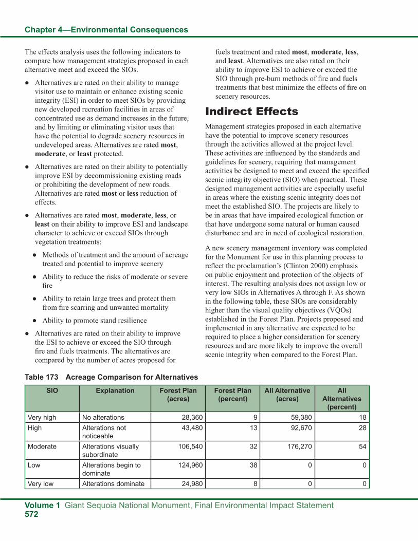
Chapter 4—Environmental Consequences
Volume 1 Giant Sequoia National Monument, Final Environmental Impact Statement572
The effects analysis uses the following indicators to compare how management strategies proposed in each alternative meet and exceed the SIOs.
● Alternatives are rated on their ability to manage visitor use to maintain or enhance existing scenic integrity (ESI) in order to meet SIOs by providing new developed recreation facilities in areas of concentrated use as demand increases in the future, and by limiting or eliminating visitor uses that have the potential to degrade scenery resources in undeveloped areas. Alternatives are rated most, moderate, or least protected.
● Alternatives are rated on their ability to potentially improve ESI by decommissioning existing roads or prohibiting the development of new roads. Alternatives are rated most or less reduction of effects.
● Alternatives are rated most, moderate, less, or least on their ability to improve ESI and landscape character to achieve or exceed SIOs through vegetation treatments:
● Methods of treatment and the amount of acreage treated and potential to improve scenery
● Ability to reduce the risks of moderate or severe fire
● Ability to retain large trees and protect them from fire scarring and unwanted mortality
● Ability to promote stand resilience
● Alternatives are rated on their ability to improve the ESI to achieve or exceed the SIO through fire and fuels treatments. The alternatives are compared by the number of acres proposed for
fuels treatment and rated most, moderate, less, and least. Alternatives are also rated on their ability to improve ESI to achieve or exceed the SIO through pre-burn methods of fire and fuels treatments that best minimize the effects of fire on scenery resources.
Indirect EffectsManagement strategies proposed in each alternative have the potential to improve scenery resources through the activities allowed at the project level. These activities are influenced by the standards and guidelines for scenery, requiring that management activities be designed to meet and exceed the specified scenic integrity objective (SIO) when practical. These designed management activities are especially useful in areas where the existing scenic integrity does not meet the established SIO. The projects are likely to be in areas that have impaired ecological function or that have undergone some natural or human caused disturbance and are in need of ecological restoration.
A new scenery management inventory was completed for the Monument for use in this planning process to reflect the proclamation’s (Clinton 2000) emphasis on public enjoyment and protection of the objects of interest. The resulting analysis does not assign low or very low SIOs in Alternatives A through F. As shown in the following table, these SIOs are considerably higher than the visual quality objectives (VQOs) established in the Forest Plan. Projects proposed and implemented in any alternative are expected to be required to place a higher consideration for scenery resources and are more likely to improve the overall scenic integrity when compared to the Forest Plan.
Table 173 Acreage Comparison for Alternatives
SIO Explanation Forest Plan (acres)
Forest Plan (percent)
All Alternative (acres)
All Alternatives
(percent)Very high No alterations 28,360 9 59,380 18High Alterations not
noticeable43,480 13 92,670 28
Moderate Alterations visually subordinate
106,540 32 176,270 54
Low Alterations begin to dominate
124,960 38 0 0
Very low Alterations dominate 24,980 8 0 0

Chapter 4—Environmental Consequences
Giant Sequoia National Monument, Final Environmental Impact Statement Volume 1573
Effects of Recreation Management on Scenic IntegrityRecreation development and use in the Monument have the potential to affect scenery resources. Visitation is projected to increase in the future (see the effects on recreation section in Chapter 4 and the recreation demand analysis in Appendix D in the FEIS), and this use is expected to increase effects on scenery resources.
Based on personal observation, recreation use, especially use without facilities to mitigate the effects of that use, can degrade scenic quality, by erosion, damage to or absence of vegetation, accumulation of litter, and sanitation issues. These environmental conditions lower scenic integrity (USDA Forest Service 1995c). The Forest Service provides recreation facilities to the public, not only for visitor convenience, but also for resource protection. Restroom facilities help to protect popular areas from sanitation issues. Designated pathways and parking protect soil resources and vegetation from trampling. Visitor information stations encourage responsible use. In these ways, developed facilities can mitigate the effects of visitor use on resources that contribute to scenery, thereby improving scenic integrity in all of the alternatives.
Studies support the strategy of minimizing recreation use effects by concentrating use (Cole 1993). In heavily used areas, increasing use is likely to have few negative effects. Where use is widely dispersed, more area will be disturbed unless use levels are very low. Most studies report that, in areas with relatively low levels of use, the amount of effect increases rapidly with initial increases in the amount of use (Cole 1993). Consequently, alternatives that allow or encourage more dispersed use could have negative effects on natural resources that contribute to scenic quality. Alternatives that allow for the development of more recreation facilities could protect scenery resources as use and visitation increase.
Most of the effects to scenic integrity caused by the built environment can be mitigated. During site-specific project planning in the future, mitigations (including best management practices) are expected to be identified for project implementation. Examples of mitigation include sensitive placement of facilities,
selection of materials that reflect elements in the natural landscape, and using colors that recess into the landscape. All recreation development is expected to follow the Built Environment Image Guide (BEIG), which defines architectural character types that harmonize with the natural landscape (USDA Forest Service 2001g).
Developed sites that meet visitor needs and preferences help to protect resources from damage associated with use. Alternatives A, B, C, E, and F allow for the development of a variety of new recreation facilities that meet visitor preferences and mitigate the effects to scenery associated with use. Alternative D limits new developed sites to walk-in campgrounds and walk-in picnic areas. (See the effects on recreation section in this chapter in the final EIS for more information). Where demand exceeds the capacity to accommodate use at developed sites, whether through crowding or unavailability of preferred facilities, use may shift to other areas without facilities, such as camping along a road in the general forest area.
By eliminating opportunities for roadside camping in undeveloped areas, Alternative C is the only alternative to avoid some potential associated effects to scenery. All of the other alternatives are expected to have a potential decrease in the existing scenic integrity in the general forest area where roadside camping is popular, which could prevent these areas from achieving the SIO as visitor use increases in the future. The greatest effects are expected in the Hume High Elevation, Great Western Divide, and Lloyd Meadow recreation niche settings which are the most popular places for dispersed camping. These places also have a higher number of acres needing restoration with an ESI below the proposed SIO.
Scenery resources are expected to be the most protected from the effects of concentrated use in undeveloped areas in Alternative C and least protected in Alternative D. Alternative C has the best ability to meet or exceed the SIO in undeveloped areas with concentrated use. Alternatives A, B, E, and F are expected to have a moderate ability, and Alternative D is expected to have the least ability to meet or exceed the SIO in undeveloped areas with concentrated use.

Chapter 4—Environmental Consequences
Volume 1 Giant Sequoia National Monument, Final Environmental Impact Statement574
Alternatives B, C, D, E, and F include a strategy to create and maintain scenic vistas which is expected to enhance both the recreation experience and scenery resources.
Effects of Road Management on Scenic IntegrityThe alternatives vary in their treatment of roads and what kinds of uses are expected to be allowed. All of the alternatives have the potential for decommissioning existing roads. (For more information on roads, see the effects on the transportation system section in this chapter in the final EIS.)
Alternatives C and D have the greatest potential for reducing the effects of roads on scenic integrity in the long term. With no new roads in Alternative D, no new effects to scenery resources are expected to occur. Alternative C has the most potential for decommissioning roads followed by Alternative D. The reduction of roads is expected to improve the scenic integrity of an area over time as routes return to their natural state (USDA Forest Service 1977). Some improvement of the existing scenic integrity as a result of road decommissioning is expected to help meet the proposed SIOs in Alternatives C and D. Status quo is expected to be the most likely result of effects from roads in Alternatives A, B, E, and F.
Effects of Vegetation Treatments on Landscape CharacterVegetation management activities can improve scenery resources by creating the conditions that people prefer, avoiding the conditions that people perceive as unattractive (Ryan 2005), and perpetuating these conditions into the future (scenic stability). All of the alternatives propose vegetation treatments in excessive fuels and overstocked conditions, but differ in their methods and the acres expected to be treated. The alternatives produce the landscape conditions that people prefer (Brown and Daniel 1986, Brunson and Shelby 1992, Cotton and McBride 1987, Dwyer et al. 1991, Haider and Hunt 2002, Hull et al. 1987, Kaplan et al. 1998, Ribe 1990, Scott 1998 [all cited in Ryan 2005], USDA Forest Service 1974, 1995c) by:
● Limiting moderate to severe fire
● Producing open forest conditions by removing excessive dead and downed wood and improving overstocked conditions
● Retaining large trees and protecting them from fire scarring and unwanted mortality
● Encouraging a highly variable and complex landscape pattern (diversity)
● Preventing forest disturbances that result in extensive areas of dead or dying trees by improving ecosystem resilience
Desired conditions for vegetation management complement and support the desired conditions for scenery:
● Trees have enough growing space to avoid severe resource competition with other trees and plants. Desirable trees continue to survive and grow in long periods of adverse weather which are less susceptible to large-scale die-off with long-term effects to scenery resources (resiliency) (Haider and Hunt 2002, Ribe 1990 [all cited in Ryan 2005]).
● Giant sequoias thrive and dominate their surroundings and vary in density and arrangement.
● Species composition, spacial arrangement, and structure in mixed conifer forests vary, resulting in preferred, more visually complex landscapes (Ryan 2005, USDA Forest Service 1974, 1995c).
● Low density forest with frequent canopy openings dominates the landscape, with higher density forest on portions of north and east aspects. More open forests that allow views through them are preferred over those with dense vegetation at eye level. Rapid tree regeneration resulting in many small trees and shrubs can block visual penetration and lower scenic quality (Ryan 2005).
● Approximately 70 percent of mixed conifer within groves and 50 percent outside of groves are dominated by trees greater than 24 inches in diameter. Vegetation treatments should strive to protect groves of large trees by retaining them during thinning (Brown and Daniel 1986, Cotton and McBride 1987, Dwyer et al. 1991, Hull et al. 1987, Kaplan et al. 1998, Scott 1998).

Chapter 4—Environmental Consequences
Giant Sequoia National Monument, Final Environmental Impact Statement Volume 1575
Vegetation strategies complement and support scenery resources:
● Reduction of fuels by decreasing down woody material, ladder fuels, and brush not only reduces risks from wildfires, but also helps to produce the conditions that people find attractive. Tree thinning has a more positive effect on scenic beauty, especially when smaller trees are removed to lower stand density (Hull and Buhyoff 1986, Tahvanainen et al. 2001 [all cited in Ryan 2005]).
● Protecting giant sequoias caters to people’s fondness for large trees. Vegetation treatments should strive to protect groves of large trees (Brown and Daniel 1986, Brunson and Shelby 1992, Cotton and McBride 1987, Dwyer et al. 1991, Hull et al. 1987, Kaplan et al. 1998, Scott 1998 [all cited in Ryan 2005]).
● Forest management techniques that promote ecosystem resilience to future changes in temperature and precipitation are expected to avoid extensive areas of dead or dying trees, which are not considered scenic (Haider and Hunt 2002, Ribe 1990 [all cited in Ryan 2005]).
● Improve stand resilience and health by varying spacing of trees both inside and outside of giant sequoia groves.
● Promote heterogeneity in plantations and young stands by encouraging more diversity in species composition and age and reduction in stand density.
● Plant in areas where natural regeneration is not likely.
The alternatives that treat the most acreage using aesthetically preferred treatments, reduce moderate or severe fire, retain and protect the scenic character of large trees, encourage diversity, and prevent long-term effects of severe disturbances (resilience) have the greatest potential to improve scenery either by improving the existing scenic integrity (ESI) to meet or exceed the scenic integrity objective (SIO) or by improving scenic stability (Brown and Daniel 1986, Brunson and Shelby 1992, Cotton and McBride 1987, Dwyer et al. 1991, Gobster 1994, Hull et al. 1987, Kaplan and Kaplan 1989, Kaplan et al. 1998, Scott 1998 [all cited in Ryan 2005]).
Methods of Treatment and Acreage Treated by AlternativeThe alternatives differ in the types of tools used to manage vegetation and the amount of acreage that is likely to be treated. Types of tools used in vegetation management influence the long and short-term effects on scenery resources. Removing dead wood or chipping on-site can greatly increase scenic ratings for management projects. Cleanup is essential in visually sensitive areas (Daniel and Boster 1976, Ribe 1989, Ryan 2005, Scott 1998). As long as mechanical treatments mitigate for effects to scenery, long-term effects to scenery are expected to be positive, and short-term effects are expected to be minimal.
Alternatives A and E consider mechanical treatment first, followed by prescribed fire and then managed wildfire. Fire is preferred over mechanical treatment in Alternatives B and C. Alternative F does not prioritize treatment tools, but allows for maximum flexibility.
In Alternatives A, B, C, E, and F, pretreatment of fuels is expected to occur before prescribed fire. Alternatives E and F allow more pre-burn fuels reduction. Pretreatment could mitigate many of the short-term effects of prescribed fire and prevent most long-term effects. Suggestions include pre-burn cutting of live trees to minimize charring and crown scorch and removing heavy fuels from the base of large trees (Ryan 2005). Mechanical treatments not related to prescribed fire may also occur. Because the wildland urban intermix (WUI) where treatment is expected to occur is smaller in Alternative C, Alternatives A, B, E, and F are expected to better protect scenery resources, with Alternative F rating highest due to its maximum flexibility.
Alternative D considers managed wildfire as the primary treatment method, which is expected to allow for little to no pretreatment of fuels, thereby posing the most risk to both short-term and long-term scenic integrity. Mechanical treatments are only expected under very limited circumstances.
All alternatives, except Alternative D, have an equal ability to use treatments such as light thinning from below and piling and burning slash which is the most aesthetically preferred treatment (Scott 1998 [cited

Chapter 4—Environmental Consequences
Volume 1 Giant Sequoia National Monument, Final Environmental Impact Statement576
in Ryan 2005]). Effects to scenery are expected to be mostly limited to short-term effects from tree scorching and landscape blackening due to prescribed fire, assuming that adequate consideration for scenery is provided at the project level to mitigate effects (Ryan 2005).
All alternatives, except Alternative D, allow for planting in areas where natural regeneration is not likely following a disturbance event. When a disturbance event has a negative effect on scenery, replanting the area can restore the scenic integrity in a shorter period of time and therefore lessen some long-term effects on the scenery resource (Ryan 2005).
Alternatives A and E have a moderate amount of acres potentially treated by mechanical or hand treatments. Alternatives B and F have the most acres potentially treated by mechanical or hand treatments. Alternative C has less acres potentially treated, and Alternative D has the least acres potentially treated by mechanical or hand treatments.
Ability to Lower the Risks of Moderate to Severe FireWildfire is likely to have more severe effects on long-term scenic integrity and landscape character than planned fuels treatment. Without pretreatment before prescribed burning, tree scorching and mortality could be more intense than expected in areas of heavy fuel loading, leaving longer-term visual effects (Ryan 2005). Managed wildfire is expected to have the greatest risks to scenery resources in the long term, because of the potential for severe fire effects due to current, high fuel loads and the lack of pretreatment.
Alternatives A, B, C, and D are expected to limit the opportunity to use mechanical methods and are expected to require more frequent or severe burning to accomplish vegetation management objectives. Alternatives E and F allow greater use of mechanical methods, in conjunction with prescribed fire, and can be done less frequently and in a more controlled manner allowing for more protection. Alternatives C and D propose little or no removal of woody biomass, meaning that material deemed excess for fuels and vegetation competition is expected to remain on-site to be removed by fire. Some of these fires are likely to be larger and hotter than fires that occur under more controlled conditions (see the effects on vegetation section in Chapter 4 in the final EIS).
Alternatives E and F most protect scenery resources from effects of moderate or severe fire. Alternative C protects scenery resources less, and Alternative D protects scenery resources least from effects of moderate or severe fire. Alternatives A and B moderately protect scenery resources from effects of moderate or severe fire.
Retain Large Trees and Protect the Scenic Attributes of Large TreesAll of the alternatives provide for large tree retention in treatment strategies, but vary in their treatment methods. The effects on vegetation section in Chapter 4 in the final EIS identifies that Alternatives E and F allow more pre-burn fuels reduction that better protect soils and larger trees from hot fires. Pre-burn fuels reduction also minimizes fire scarring. The effects on vegetation section in this chapter also identifies that Alternatives A, B, C, and D rely on fire as the main tool for reducing fuels in giant sequoia groves. In the giant sequoia/mixed conifer forest and other forests near popular recreation and tourist areas, suggestions for pretreatment of fuels, which can minimize the visual effects of prescribed fire, include pre-burn cutting of live trees to minimize charring and crown scorch and removing heavy fuels from the base of large trees (Cotton and McBride 1987 [cited in Ryan 2005]).
Alternative F is expected to have the most ability to retain and protect the scenic attributes of large trees, with greater flexibility in mechanical fuels treatments, in addition to fire, to more effectively protect larger giant sequoias from excessive heat. Alternatives A, B, and E have moderate ability. Alternative C relies more on burning and less on mechanical means and has less ability to retain and protect the scenic attributes of large trees. Alternative D is expected to have the least ability to retain and protect the scenic attributes of large trees, as this alternative relies most on managed wildfire followed by prescribed fire to meet vegetation management objectives.
Prevent Forest Disturbances that Result in Extensive Areas of Dead or Dying Trees (Resilience)The effects on vegetation section in Chapter 4 identifies that the combination of mechanical and fire treatments, as emphasized in Alternative F and allowed in Alternative E, is expected to

Chapter 4—Environmental Consequences
Giant Sequoia National Monument, Final Environmental Impact Statement Volume 1577
accomplish the most protection of productive forests from drought, insects, disease, and unwanted fire. Alternative F is expected to treat more acres of vegetation in the most controlled manner to prevent large scale forest disturbances with extensive areas of dead or dying trees. Alternative D perpetuates the risks for large scale forest disturbances with the fewest acres treated and restricting the methods of
treatment. Alternatives A, B, and C fall between these extremes and are rated moderate.
Vegetation Treatment ComparisonThe following table summarizes and compares the potential to improve scenery through vegetation treatments in each of the alternatives.
Table 174 Effects of Vegetation Treatments on Scenery
Vegetation Treatments with Potential to Improve Scenery
AlternativeA B C D E F
Protects scenic integrity Moderate Moderate Less Least Moderate MostAmount of area treated Moderate Most Less Least Moderate MostLowers risk from moderate or severe wildfire
Moderate Moderate Less Least Most Most
Retains large trees Moderate Moderate Less Least Moderate MostPromotes stand resilience Moderate Moderate Moderate Least Most Most
Effects of Fire and Fuels Management on Landscape CharacterDesired conditions for fuels in the Monument parallel desired conditions for scenery in the Monument. When fire susceptibility and severity are low, scenery resources are more stable. The purpose of fuels reduction projects is to avoid or prevent large scale, severe fires and to restore a healthy cycle of low-severity fire, which can improve scenery with some short-term visual effects (such as blackened trunks) (Gobster 1994, 1999, Kaplan and Kaplan 1989, Patey and Evans 1979, Scott 1998, Taylor and Daniel 1984 [all cited in Ryan 2005]).
Much of the Monument landscapes have missed natural fires (fire return interval departure), allowing fuels to build up (see fire and fuels affected environment in Chapter 3 in the final EIS), lowering the existing scenic integrity in several ways. Ladder fuels, including large amounts of dead material on the ground, dense midstory vegetation, and overstocked forests, have little visual penetration, a condition that has proven to be unattractive to most visitors (Ryan 2005). Large trees are identified as a scenic attribute and are at greater risk of being damaged in fires that burn through areas of high fuels buildup.
Fuels reduction treatments have a potential to produce the conditions that people find attractive (Brown and Daniel 1986, Buhyoff et al. 1986, Herzog and Kropscott 2004, Herzog and Leverich 2003, Hull and Buhyoff 1986, Kaplan et al. 1998, Patey and Evans 1979, Tahvanainen et al. 2001, Tlusty and Bacon 1989 [all cited in Ryan 2005]). Alternatives that treat the most acreage are most able to improve and perpetuate the desire conditions for scenery in the Monument by protecting large trees, creating more open landscape conditions, and protecting from the long-term effects from severe fire (Ryan 2005). Restrictions on fuels treatments can limit the ability to protect scenic quality and improve scenery.
Fuels reduction treatments are expected in all of the alternatives. Alternatives B and F propose the most potential acres for fuels treatment projects including the WUI defense zone of 45,340 acres, threat zone of 145,520 acres, and the 56,640-acre Tribal Fuels Emphasis Treatment Area (TFETA). Alternatives A and E include the WUI defense zone of 45,340 acres and threat zone of 145,520 acres and are rated as moderate. Fuels treatment is minimal in Alternative D with 4,600 WUI acres and is rated as least. Alternative C includes 8,300 WUI acres and is rated as less.
Alternatives C and D have higher potential associated with moderate to severe fires that affect scenery

Chapter 4—Environmental Consequences
Volume 1 Giant Sequoia National Monument, Final Environmental Impact Statement578
resources and less probability of improving scenery resources through fuels treatment projects that could protect trees from fire scarring, perpetuate heterogeneous landscapes, improve visual penetration in dense understories, and remove excessive dead and down wood. Alternatives E and F allow more opportunity and flexibility to control forest conditions through mechanical methods that are expected to protect and improve scenery from wildfire and overstocked conditions.
Pretreatment of fuels and how a project is implemented can minimize the visual effects of prescribed fire, as suggested by Christensen and others for the giant sequoia/mixed conifer forest and other forests near popular recreation and tourist areas. Suggestions include pre-burn cutting of live trees to minimize charring and crown scorch; removing heavy fuels from the base of large trees; using single ignitions rather than multiple ignitions; and
removing debris or additional burning if burning has exacerbated heavy dead fuel conditions (Cotton and McBride 1987 [cited in Ryan 2005]).
SummaryAlternative F has the greatest potential to maintain and improve scenic integrity in the Monument, followed by Alternative B, then Alternatives A and E, and followed by Alternative C. Alternative D is expected to be the least supportive of maintaining and improving scenic integrity because of the restrictions placed on vegetation treatments, the high risk of severe wildfire in areas valued for scenic beauty, and the opportunities available to manage increased visitation, especially those associated with camping. The following table identifies the potential for improvement of ESI by alternative and resource area, using a relative scale of least to most.
Table 175 Potential Improvement of Existing Scenic Integrity
Resource Area AlternativeA B C D E F
Recreation Moderate Moderate Most Least Moderate ModerateRoads Less Less Most Most Less LessVegetation management
Moderate Moderate Less Least Moderate Most
Fuels management
Moderate Most Less Least Moderate Most
Cumulative EffectsThe Monument shares boundaries with a number of private and public entities. Kings Canyon and Sequoia National Parks split the Monument in two, sharing viewsheds and visitors. Whether national park visitors experience the Monument landscape as foreground and middleground from within the national forest or as background from a national park location, they have higher expectations for scenic condition than many national forest visitors. Many private property owners in small mountain communities within the boundaries of the Monument have expressed a high concern for scenic condition. The Monument serves as a scenic backdrop for the Tule River Indian Reservation and central valley communities.
The overstocked conditions and heavy fuel loads in the Monument or adjacent lands increase the risks for large and severe disturbance events that compromise the scenic integrity and scenic stability across boundaries. These risks are expected to continue to compound over time if left untreated. More acres are expected to become overstocked and accumulate heavy fuel loads, adding to the number of acres that do not meet the SIO. As more acres are added, the risk of an even larger scale event, with more severe results, lasting over a greater period of time, increases. Alternatives that favor reducing the risks of large scale, severe disturbance events through vegetation or fuels treatments are expected to help protect scenery resources across all boundaries during the life of this plan. Alternatives that treat more acreage are most

Chapter 4—Environmental Consequences
Giant Sequoia National Monument, Final Environmental Impact Statement Volume 1579
likely to maintain a higher level of scenic quality during the restoration period. All of the alternatives are expected to provide some vegetation and fuels treatment. Alternative F is expected to best protect scenery resources and meet the scenic expectations of visitors and residents during the life of the plan.
Large disturbance events such as moderate and severe fires are natural ecological processes that regenerate or restore landscapes. Over many decades, returning fire as a natural process is expected to restore the ecological health and eventually create the conditions that people prefer to see in the Monument. However, long-term effects on scenery resources are expected to occur over many years before the natural fire cycle is restored unless intervention occurs. Alternative D limits the amount of intervention and increases risks to scenery resources from the effects of fire.
Population growth is projected to increase significantly in the area around the Monument, and increased visitation is expected to occur in all of the alternatives. The ability of an alternative to manage this increase in visitation is expected to have effects on scenery resources. Alternative C offers the most protection for scenery resources over both the short and long term, by providing a variety of developed facilities to minimize the effects of use on scenery resources, while minimizing the potential degradation of scenic resources in the general forest area by eliminating dispersed camping along roads.
Alternative D has the potential to have the most effects on scenery resources from visitor use. As population increases, more demand for dispersed use in the general forest area is expected, increasing the effects of recreation in these areas. By limiting development of new recreation facilities as demand increases, visitors who normally choose to use developed facilities are expected to be displaced to the general forest area, or some visitors may visit other areas entirely. Without facilities to protect the natural resources from the effects of dispersed use, scenic integrity is expected to diminish. The projected increase in visitor demand from population growth and from displaced users is expected to compound the recreation effects on scenery in the general forest area.
Effects on SocioeconomicsThis social impact analysis is a component of the environmental analysis process that uses social science information and methodology to determine how the proposed actions affect humans. To understand the overall effect of the proposed actions within the Monument, it is important to explore the social and economic conditions within the area of influence, including: Fresno, Kern and Tulare counties. By understanding the effects of the proposed actions within the Monument in context with the overall social and economic conditions of the area of influence as discussed in the affected environment section for socioeconomics (Chapter 3 of the final EIS), better decisions concerning social and economic well-being of those affected can be made.
In this section, the indirect and cumulative effects concerning the social and economic condition within the area of influence will be addressed. Specific metrics to be addressed include: Forest Service contribution to the economy within the area of influence, potential for gateway community development, and environmental justice and civil rights.
The “Public Values, Beliefs and Attitudes” section of Chapter 3 discussed the importance of understanding public issues and developing goals, or criteria, for evaluating alternatives against them. One important goal identified by stakeholders was “fostering socioeconomics.” Two key metrics associated with this goal include: supports gateway economic development and provides for diverse economic opportunities (other metrics for this goal can be found elsewhere in this chapter). Before assessing the alternatives against these metrics it is important to place them within the context of the existing condition as described in the socioeconomic section in Chapter 3. Chapter 3 highlighted key aspects of the three-county area including changing demographics in urban areas, increased population growth, double-digit unemployment rates associated with the latest economic downturn, and a growing emphasis on the health and social service economic sector. The scale

Chapter 4—Environmental Consequences
Volume 1 Giant Sequoia National Monument, Final Environmental Impact Statement580
and scope of these changes simply overwhelm the current role of Forest Service-related contributions to the area’s economy, which represents a mere 0.11 percent of the labor income across all economic sectors in the three-county area. It follows, then, that regardless of the alternative selected, the economic impact to the area of influence has the potential to remain less than one percent. This does not mean potential differences amongst alternatives are unimportant, particularly to gateway communities, yet these economic and social realities form the backdrop for considering the scale and scope of potential changes resulting from the proposed actions on the Monument.
In addition to the social and economic uncertainties facing the three-county area is the capacity for communities to respond to these changing conditions. This is particularly true for gateway communities within the area of influence. Monitoring changes in demographic patterns can assist both communities and the Monument in remaining responsive to changing societal needs over time. Monitoring gateway community capacity for economic development could include the indicators covered in Chapter 3: housing, employment by industry, the index of industrial specialization, place of work, and source of income. While not exhaustive, these indicators are readily available and will be updated in the 2010 U.S. Census, allowing for tracking changes over time.
Chapter 3 also highlighted the role of transfer payments to counties through the re-authorized Secure Rural Schools and Community Self-Determination Act (P.L. 110-343). While the alternative selected may influence the type of projects recommended by a Resource Advisory Committee (RAC), the individual projects are site-specific and beyond the scope of this document. The total available dollars authorized by the Act through Fiscal Year 2011 is unrelated to the Monument planning process and does not vary across alternatives. Key to this legislation is that through planning and implementing projects, cooperative relationships among people that use and care for Federal land and the agencies that manage Federal land will improve.
Environmental Justice and Civil RightsBased on the civil rights analysis presented in this section, the alternatives are not likely to result in civil rights impacts to Forest Service employees or customers of its programs. Also, based on the subsequent environmental justice analysis, the alternatives are not likely to result in disparate human health or environmental effects to minority communities, low-income communities, or Indian tribes.
Indirect Effects To assist in addressing the indirect effects of the proposed actions, the following questions will be answered for the three county study area:
1. What are the variables in the management alternatives (e.g., how the alternatives respond to recreation demand, fiber production, etc.) that may have potential economic consequences?
Potential changes in the Forest Service economic contribution across the alternatives are based on qualitative indicators such as the ability to accommodate day-use and picnic facilities as described in “Effects on Recreation” in this chapter, fiber production, and changes in Forest Service budget and number of employees. While mining is an important natural resource sector for the 3-county area, currently there is no authorized mineral extraction on the Monument nor will any of the alternatives allow mineral extraction on the Monument. Therefore, none of the alternatives will change the Forest Service’s contribution to the mining sector of the study area economy. In addition, none of the alternatives will impel changes to the grazing program; the Forest Service contribution to the economy due to grazing will not change.
2. How are the estimated present values of economic benefit and economic cost to different stakeholders (e.g., USFS, local businesses, local government, etc.) in the domains of interest (monument, local rural communities, and region) expected to change based on the different management alternatives?
It must be noted that overarching any potential for indirect and cumulative effects resulting from

Chapter 4—Environmental Consequences
Giant Sequoia National Monument, Final Environmental Impact Statement Volume 1581
the proposed alternatives is the expected growth in population throughout the state of California. This increase in population, unaided, will have greater potential for increasing economic growth within the area of influence than any of the proposed alternatives. The population in the San Joaquin Valley alone is expected to grow by 60 percent between 2000 and 2020 (SJAPCD 2009). Projections by the California Department of Finance show that by 2050 Kern and Fresno counties will be among the 10 most populous counties in California. The same report shows Kern and Tulare counties among the fastest growing counties in the same period. Hispanics are projected to be the majority in all three counties by 2050 (State of California, Department of Finance Population Projections for California and Its Counties 2000-2050, Sacramento, California, July 2007). These county-wide trends are driven by rapid changes in the San Joaquin Valley. The gateway communities in the mountainous eastern parts of the counties have, in the past, had a different dynamic. If past trends continue, these gateway communities will continue to be slower growing, predominantly white and somewhat older than the rest of their respective counties.
According to the SPECTRUM model,(66) the maximum potential incidental biomass produced for the Monument is variable, but declines sharply in the first five decades for all alternatives. In the first decade, for sawlog volume, all the alternatives range from 6,738 CCF (100 cubic feet) to 8,096 CCF, with the exception of Alternative F which has the maximum potential for 17,921 CCF. By the third decade, the potential outputs for Alternatives A through E drop to less than 600 CCF. Alternative F declines to 9,408 CCF by the third decade. By the fifth decade, all alternatives are less than 150 CCF. Because the total fiber production is not broken out by sawtimber, poles, fuelwood, and other products, the contribution to the economy cannot be further quantified. In addition, the numbers projected by the SPECTRUM Model are estimates and do not represent a definite commitment by the Sequoia National Forest. Actual incidental biomass produced from the
Monument will depend on site-specific project analysis and will only occur as a result of ecological restoration activities.
At this time, it is not possible to quantify changes to the number and type of recreation visits to the Monument caused by any particular alternative. So changes to the Forest Service contribution to the economy attributable to recreation are too speculative to be quantified. Projected demographic trends discussed above will influence the potential change in future recreation demand, especially changing tastes for developed recreation opportunities. The National Visitor Use Monitoring program can provide a snapshot of demand as well as the level of satisfaction among recreationists in the Monument (for more information please refer to Appendix D, Recreation Demand Analysis). This program then can assist in addressing uncertainties relating to changing recreation needs.
None of the action alternatives include a quantified change in the Sequoia National Forest budget or manpower, so the Forest Service contribution to the local economy due to direct government activity like contracting, rent, or Forest Service salaries used in the economy will not change.
In summary, none of the action alternatives will change the Forest Service’s relative contribution to the study area economy in a measurable way.
3. What is the usefulness of different methods to ensure objects of interest are protected from human uses?
The effectiveness of these methods will be determined on a site specific basis and could include a variety of techniques including the use of best management practices, etc. Likewise, cost will also be evaluated at the project level. Refer to “Effects on Recreation” in this chapter for a more thorough discussion.
Gateway community development: Gateway communities are a subset of the study area economy. To see the potential effects of changes in Forest Service management, this section focuses on who is expected to benefit from the changes described in the previous section.
66. For more information about the SPECTRUM Model, see Appendix B of the FEIS.

Chapter 4—Environmental Consequences
Volume 1 Giant Sequoia National Monument, Final Environmental Impact Statement582
While socioeconomic differences exist among the three counties, differences also exist among the gateway communities adjacent to the Monument as described in Chapter 3. Yet while differences exist, there are also similarities. For example, the “educational, health and social services” category of employment is the largest employer for all gateway communities analyzed, ranging from a low of 19 percent in Squaw Valley to a high of 34 percent in Springville. Because of the expected population growth and aging population it is probable this job sector will continue to grow the fastest and remain the largest employer among gateway communities. None of the proposed alternatives are expected to increase economic growth in this large, fast growing job sector.
Changes in management of the Monument may afford opportunity for growth in certain sectors in the gateway communities. The “arts, entertainment, recreation, accommodation and food services” job sector, for example, may be most influenced by the proposed alternatives based on human use and recreation facilities encouraged both within and outside the Monument. Among the gateway communities analyzed, this job sector currently ranges from a low of 5 percent in Springville to a high of 24 percent on the Tule River Indian Reservation. This job sector on the Tule River Indian Reservation is primarily attributable to the Eagle Mountain Casino and will likely be little influenced by the proposed alternatives. Again, most of the potential for economic growth in this sector will come from the expected increase in population. Variations among the alternatives may lead to a greater potential for economic growth in gateway communities as described in the “Effects on Recreation” section in this chapter.
In addition to creating economic opportunity, it is important to consider the ability, or capacity, of a gateway community to take advantage of those opportunities. In other words, growth potential may also be affected by a gateway community’s capacity for adapting to changing conditions. For example, only 6 percent of the population in Squaw Valley currently works in the community; the remaining 94 percent work outside of the community. This means there is a lack of available labor to capitalize on potential growth opportunities. The ability of a gateway community then, to take advantage of
increased recreation potential may depend, in part, on their capacity to adapt to changing conditions and opportunities. For additional discussion on gateway community development see the “Effects on Recreation” section in this chapter.
Although all of the alternatives would promote economic growth in the “arts, entertainment, recreation, accommodation and food services” job sector to some degree, Alternatives B, C, and F are particularly designed to promote tourism. With less development in the Monument, Alternative D would likely attract a different type of tourist than the other alternatives, and most tourist services would be located outside the monument. Alternatives B, C, D, and F would all encourage gateway community development in the “arts, entertainment, recreation, accommodation and food services” job sector (see also “Effects on Recreation” in this chapter for additional information).
Concessionaires, private resorts, and other commercial development would continue to have opportunities in the Monument to some degree, depending on the alternative. Potential new development is possible in Alternatives B, C, and F, in particular. No new development would occur until site specific project environmental analysis is completed. New lodges, restaurants, and visitor centers are examples of the kinds of new development that could occur. In Alternative C, new developed facilities would be located near existing roads. In Alternative D, no new lodges, resorts, or organizational camps would be authorized or constructed within the Monument; such development would be encouraged outside the Monument. Alternatives B, C, D, and F would all encourage gateway community development.
Outfitter-guides would continue to have opportunities in all alternatives, although limitations may be placed on where they can provide services and what kinds of activities they can offer. For example, mountain bike rentals or guided trips would be limited in Alternative C, due to the prohibition of mountain bikes on trails. Alternative D may have fewer trails designated for mountain bike use than Alternatives A, B, E, and F, which could also result in fewer opportunities for mountain bike outfitter-guides (see also “Effects on Recreation” in this Chapter for addition information).

Chapter 4—Environmental Consequences
Giant Sequoia National Monument, Final Environmental Impact Statement Volume 1583
Cumulative EffectsCumulative effects are a composite of the current condition and the potential direct and indirect effects of the proposed alternatives. Because no direct effects are expected from the proposed alternatives the cumulative effects on the social and economic condition within the area of influence are the same as the indirect effects described above.
Environmental JusticeThe federal government has a unique legal and political relationship with Indian tribal governments, established through and confirmed by the Constitution of the United States, treaties, statutes, executive orders, and judicial decisions. In recognition of that special relationship, the staff on the Sequoia National Forest is charged with engaging in regular and meaningful consultation and collaboration with tribal officials in the development of the Monument plan.
The Monument shares a boundary with the Tule River Indian Reservation. In addition to ongoing formal consultation with tribal officials, the staff of the Sequoia National Forest has endeavored to meet on an on-going basis with tribal leaders and members to better understand tribal implications of the proposed actions on the Monument. The results of these interactions are summarized to illustrate, from a tribal perspective, their ongoing needs and the potential for human health and environmental effects from the proposed action. Finally, proposed mitigation (i.e., Tribal Fuels Emphasis Treatment Area) to protect cultural and natural resources on the reservation will be discussed.
The last section of this analysis includes potential mitigation measures for future activities.
Human Health Effects(67)
Cumulative Effects: Air pollution is one of the most serious problems that threaten this area. This region has some of the worst air quality in the nation when compared with other areas where national forests are located. Air pollution threatens the health and welfare of the public, natural resources and, staff alike.
Most of the Monument air pollution originates in the San Joaquin Valley and is transported into this forest by prevailing winds (Blumental et al. 1985, Lehrman et al. 1994, Shair 1987, Tracer Technologies 1992, Roberts et. al. 1991, Zabik and Seiber 1993). Unlike many other states, California has few large stationary sources of air pollution; mobile, area, and small stationary sources emit the majority of the state’s pollutants.
Nitrogen oxides (NOX) is a key ingredient in PM2.5 and ozone formation. About 75 percent of the NOX in this area come from mobile sources (San Joaquin Valley Air Pollution Control District 2009). The problem will only get worst. The population in the San Joaquin Valley is expected to grow by 60 percent between 2000 and 2020 (SJAPCD 2009). Population growth leads to an increase in vehicle activity. A society that prefers to be spaced apart from each other (spread out) and car dependent with the highest population growth in the state means more people will generally drive more, which will lead to more air pollution problems.
Significant amounts of the Asian aerosols have been observed at high elevation mountain sites in the western United States (VanCuren and Cahill 2002, VanCuren 2003, Liu et al. 2003). Pollutants from Asia are a regular component of the troposphere over the western North America. They are more pronounced during the spring and to a lesser extent during the summer. Owing to reasons described previously, pollutants from intercontinental transport contribute to some of the PM and ozone problems in the Monument during the spring and summer times.
Prescribed and Wildland Fire: Smoke from prescribed burning and wildland fires could potentially affect air quality and is a concern because of its potential effect on human health and visibility. The smoke could potentially affect visitors to the Monument and residents in surrounding communities.
When considering the use of prescribed burning to restore the natural role of fire in ecosystems and reduce fuels, the effects of smoke from wildfire and prescribed burning must be considered. In spite of their ecological benefits, prescribed fires, as well as natural fires, produce gases and aerosols that have instantaneous and long-term effects on air quality 67. Information in this section provided by Sequoia National Forest
Air Quality Specialist; refer to air quality section of the FEIS for detailed information.
Chapter 4—Environmental Consequences
Volume 1 Giant Sequoia National Monument, Final Environmental Impact Statement584
(Fang 1999). The extent of these effects depends on fire size, fuel composition and physical and chemical characteristics of the events (Kasischke and Penner 2004).
Fires emit large amounts of particulate matter (PM10 and PM2.5) and carbon monoxide, as well as nitrous oxides (NOX) and volatile organic compounds (VOCs), which are precursors to ozone. Other constituents of smoke (gases and chemicals) such as polycyclic aromatic hydrocarbons (PAHs) may also enter the lungs. Some components, such as benzo-apyrene and aldehydes, can be carcinogenic.
Wildfires result in greater emissions per acre when compared to prescribed burns, commonly exceeding ambient air quality standards. They also often occur under conditions of high temperature and low humidity, when high concentrations of ozone are most likely. Prescribed burning reduces existing fuels, thus decreasing the fire hazard and the risk of high intensity wildfire, and decreasing the quantity of fuels available to be consumed in a wildfire. However, infrequent large-scale wildfire will still occur naturally in some vegetation types. There are concerns about the amount of smoke and how it will disperse and whether the prescribed burns would result in fewer effects to air quality than would occur with a wildland fire.
The primary benefit of a prescribed fire program is in modifying the sizes and types of fires that occur within a particular geographic region. With prescribed fire, it is possible to replace large, high-intensity wildland fires characterized by high fuel consumption and high total emissions with smaller, lower-intensity prescribed fires characterized by lower fuel consumption and lower total emissions. But this decrease in wildland fire emissions typically comes at the expense of higher prescribed fire emissions.
Sites, including the Tule River Indian Reservation, at elevation higher than 400 meters seem to be below current national air quality standards. These findings indicate that locations in the Monument, which form part of the San Joaquin Air Basin, are under attainment or are cleaner than urban locations. Further, these data suggest that elevation (including location), and time of the year are good management tools for fire. This information coupled with the small
sizes of prescribed fires may prevent hazardous effects to air quality.
Environmental EffectsEnvironmental effects may include ecological, cultural, economic, or social effects on minority communities, low-income communities, or Indian tribes when those effects are interrelated to effects on the natural or physical environment.
Indian Tribes’ Patterns of Subsistence Consumption for Fish, Vegetation, and/or Wildlife: Tribes within the three-county area routinely gather natural resources for food gathering or basket weaving materials as well as hunt and fish as they have done historically. Most of these activities are done on a seasonal basis. Input received during past Tribal Forums(68) concerning the proposed actions suggested there would be no effects to these historical subsistence consumption patterns.
Protection of Cultural, Historic, and Natural Areas: Based on notes and comments captured at past Tribal Forums from tribal meeting participants, sensitive areas are currently protected. There are no known incidents where an important cultural, historic and/or natural area was unprotected and/or damaged in recent years. Although tribes have expressed concerns about the protection of cultural resources, these resources are protected under a variety of strict federal laws which include: the Antiquities Act of 1906, National Historic Preservation Act (NHPA), the Native American Graves Protection and Repatriation Act (NAGPRA), the Archaeological Resources Protection Act (ARPA), and others. These laws will be adhered to equally through all alternatives.(69)
Detailed feedback was received from the Tule River Indian Reservation Tribal Council concerning protection of the reservation from unwanted fire. To mitigate these concerns, the interdisciplinary team and representatives from the tribe developed the Tribal Fuels Emphasis Treatment Area (TFETA): an area along the eastern boundary of the Tule River Indian Reservation. Proposed fuels treatments in the
68. Tribal Forums were held on the following dates: January 14, 2009, April 30, 2009 and August19, 2009, and are held on a quarterly basis.69. Refer to cultural resource section of the FEIS for additional information.

Chapter 4—Environmental Consequences
Giant Sequoia National Monument, Final Environmental Impact Statement Volume 1585
TFETA would focus on protecting the reservation and their watersheds from severe fire effects. Emphasis on protecting the reservation and the nearby watershed is consistent with the Forest’s government-to-government relationship and the Tribal Forest Protection Act, 2005. The first priority for fuels reduction treatments within the TFETA would be within 1/4 mile of the Monument/Reservation boundary or in the Long Canyon area within the mapped area. The TFETA is proposed in Alternatives B and F.
Mitigation and Tracking MeasuresMitigation measures include steps to reduce or eliminate the effect associated with a proposed agency action. This environmental justice analysis demonstrates the need for the National Monument staff to mitigate potential linguistic barriers, particularly within the limited-English speaking segment of the Hispanic community, to ensure full and active participation in the monument planning process. In addition to translating crucial portions of the EIS where appropriate, the Monument staff should provide translation, where practicable and appropriate, of the Record of Decision in non-technical, plain language for limited-English speakers.
Further, a partnership strategy designed to promote active outreach and relationship building to all communities within the area of influence has been included in the Monument Management Plan. Implementation of the partnership strategy should be monitored and evaluated to ensure effective outreach to potentially affected groups has occurred. The following steps may be considered, as appropriate, in developing an innovative partnership strategy:
● Translation of major documents (or summaries thereof), provision of translators at meetings, or other efforts as appropriate to ensure that limited-English speakers potentially affected by a proposed action have an understanding of the proposed action and its potential effects;
● Provision of opportunities for limited-English speaking members of the affected public to provide comments throughout the NEPA process;
● Provision of opportunities for public participation through means other than written communication,
such as personal interviews or use of audio or video recording devices to capture oral comments;
● Use of different meeting sizes or formats, or variation on the type and number of media used, so that communications are tailored to the particular community or population;
● Use of locations and facilities that are local, convenient, and accessible to the disabled, low-income and minority communities, and Indian tribes; and
● Assistance to hearing-impaired or sight-impaired individuals.
Civil RightsCivil Rights Impact Analysis (CRIA) is an analytical process used to determine the scope, intensity, direction, duration, and significance of the effects of an agency’s proposed employment and program policies, actions and decisions. It is Forest Service policy that the responsible official examines all proposed policy actions for civil rights impacts and takes one of the following actions (FSM 1730.3):
a. Prepare a CRIA and statement of its finding for any proposed policy, organizational action, or decisions which may have a major civil right impact, or;
b. Document the determination that a CRIA and statement of findings are not needed.
The following section on Civil Rights provides the data to demonstrate that a CRIA is not needed for the Giant Sequoia National Monument.
Disparate impact, a theory of discrimination, has been applied to the Monument planning process in order to reveal any such negative effects that may unfairly and inequitably impact beneficiaries regarding program development, administration, and delivery.(70) The ob-jectives of this review and analysis are to prevent dis-parate treatment and minimize discrimination against minorities, women and persons with disabilities and to ensure compliance with all civil rights statutes, federal regulations, and USDA policies and procedures.
70. For more information on disparate impact theory, see The Evolution of Disparate Impact Theory of Discrimination, Harvard Journal of Legislation, vol. 44 2007 (http://www.law.harvard.edu/students/orgs/jol/vol44_2/gordon.pdf ).

Chapter 4—Environmental Consequences
Volume 1 Giant Sequoia National Monument, Final Environmental Impact Statement586
Persons with DisabilitiesSome comments received during the Monument planning process expressed concern that changes to motorized access would prevent future access to National Forest system lands for those with disabilities. In response to these comments, a review of the project alternatives has been conducted to ensure that they apply equally to all groups. Therefore, the management plan is not discriminatory towards persons with disabilities, because it applies equally to all groups.
Under section 504 of the Rehabilitation Act of 1973, no person with a disability can be denied participation in a Federal program that is available to all other people solely because of his or her disability. There is no legal requirement to allow people with disabilities use of motor vehicles on roads, trails, or other areas that are closed to motor vehicles. Restrictions on motor vehicle use that are applied consistently to everyone are not discriminatory.
Effects of actions outlined under this plan will be distributed evenly amongst the population since access on routes designated or route closure do not prohibit or inhibit use on the basis of race, color, sex, national origin, religion, age, disability, or marital or familial status. In addition, under all
alternatives, individuals with disabilities could request a permit to travel on closed roads consistent with the Rehabilitation Act of 1973. Such access would be considered on a case-by-case basis by the Sequoia National Forest.
Study Area DemographicsIn the 2000 Census survey, people were defined as having a disability if one or more of the following conditions were true:
● They were aged 5 or older and responded “yes” to a sensory, physical, mental, or self-care disability.
● They were aged 16 years or older and responded “yes” to a disability affecting going outside the home.
● They were between the ages of 16 and 64 and responded “yes” to an employment disability.
The percent of people with disabilities in the U.S. was 15.1 in 2006 compared to 12.9 in California and 15.7, 15.9, and 13.8 in Fresno, Kern and Tulare Counties respectively (see the following table). These percentages indicate that the numbers of people with disabilities in the three-county area are similar to that of the nation and slightly higher than the state.
Table 176 Percent Persons with Disabilities in the U.S., California, and Fresno, Kern, and Tulare Counties
Total Disabilities(1) Percent Population with DisabilityUnited States 41,259,809 15.1California 4,283,468 12.9Fresno 125,731 15.7Kern 108,342 15.9Tulare 51,747 13.8
1. Total disabilities tallied for the civilian non-institutionalized population 5 years and over with disabilities. Data extracted from the 2006 American Community Survey, U.S. Census.
The percent of people 65 years and older in the U.S. was 12.4 in 2006 compared to 10.8 in California and 9.6, 8.7, and 9.2 in Fresno, Kern, and Tulare Counties respectively (see the following table). These percentages indicate the percent of the population 65 years of age and older was slightly less in the
three-county study area than either the state or the nation. While these percentages reflect Fresno, Kern, and Tulare counties as a whole, they do not recognize population differences among the gateway communities within the three-county area.

Chapter 4—Environmental Consequences
Giant Sequoia National Monument, Final Environmental Impact Statement Volume 1587
Table 177 Percent Persons 65 Years or Older in the U.S., California, and Fresno, Kern, and Tulare Counties
Total Population (5 Years and Older) Percent Total Population 65 Years and OlderUnited States 273,835.465 12.4California 33,211,121 10.8Fresno 800,681 9.6Kern 682,195 8.7Tulare 375,717 9.2
Civil Rights Monitoring and EvaluationAny projects will be implemented only after an appropriate level of NEPA is completed and the decision documented. Project-level NEPA will be completed with adequate public involvement that will consider access and concerns for minorities, women, persons with disabilities, and low income populations.
● Continue to consult early and often with Tribal Governments regarding Special Areas of Historic Tribal Significance for implementation of the Monument management plan.
● Continue to design management planning and public involvement opportunities that consider access concerns from minorities, women, persons with disabilities, and low income populations.
Review of the Public Involvement ProcessThe Sequoia National Forest Civil Rights Officer reviewed the location of public meetings and concluded that all meetings and opportunities were in
compliance with Section 504 of the Rehabilitation Act of 1973.
Determination that a CRIA is Not NeededThe Notice of Intent (NOI) initiating the scoping process was published in the Federal Register on March 18, 2009.
Based on scoping and public comment, there were no issues raised that would suggest, or from which one may infer, that implementation of the Giant Sequoia National Monument Management Plan will affect groups or classes of persons negatively, because of one or more prohibited bases.
Groups and classes of persons have been reviewed within this section of the final EIS. No groups or classes or persons were found to be disproportionately negatively affected by this management decision. This management decision applies equally to all members of the public, and therefore is not discriminatory to any person or group.
Effects on Cultural ResourcesEffects on cultural resources are described in terminology consistent with the regulations of the Council on Environmental Quality CEQ) and in compliance with the requirements of both the National Environmental Policy Act (NEPA) and Section 106 of the National Historic Preservation Act (NHPA). The determination of effect for the undertaking (implementation of the alternative) required by Section 106 of the NHPA is included in the summary of effects for each alternative.
Assumptions and MethodologyAssumptions for All AlternativesThis effects analysis methodology applies to three primary types of cultural resources: archaeological sites, ethnographic resources (including traditional cultural properties), and cultural landscape resources (including historic structures). The assumptions used in this effects analysis include:

Chapter 4—Environmental Consequences
Volume 1 Giant Sequoia National Monument, Final Environmental Impact Statement588
● Cultural resources will be managed according to existing laws, regulations, and policy to protect these resources according to societal expectations.
● Active management, encompassing the greatest acreage, will provide the best opportunities for identifying, protecting, and interpreting cultural resources.
● Events outside of management activities such as wildfires have the greatest potential to negatively affect cultural resources; these unplanned activities do not lend themselves to identification, anticipation, or mitigation.
● This programmatic level FEIS does not direct the initiation of any site-specific activities and therefore produces no direct effects on cultural resources.
● Public interest and support for cultural resource management will increase including that of Native American tribes, groups, and individuals.
● Reduction of fuel loads on and around a cultural resource has a long-term protective effect.
● High intensity fire can have a detrimental effect on all cultural resources, regardless of class.
● Emphasizing fire suppression without an aggressive prescribed fire program would increase risks to cultural resources from catastrophic wildfires.
● Prescribed fire programs pose lesser risks to cultural resources than fuels management based primarily on fire suppression.
● Adaptive use of an historic structure or district is preferable to abandonment. Abandonment leads to benign neglect which is considered a negative effect.
● Cultural resource management plans will improve management of cultural resources.
Effects analysis follows established procedures and stipulations outlined in regulations implementing Section 106 of the NHPA (36 CFR 800) and Region 5 programmatic agreements. These include: (1) identifying areas and types of resources that could be affected; (2) assessing information regarding historic properties within this area and conducting additional inventories and resource evaluations, as
necessary; (3) comparing the location of the affected area with that of important cultural resources; (4) identifying the extent and types of effects; (5) assessing those effects according to procedures established in the Advisory Council on Historic Preservation’s regulations; and (6) considering ways to avoid, reduce, or mitigate negative effects. Site-specific compliance with project-specific details will be documented for every site-specific project in the Monument, consistent with Section 106 of the NHPA (36 CFR 800) and Region 5 programmatic agreements.
This methodology focuses on the types of activities proposed in the alternatives, as well as areas containing known cultural resources that would most likely be affected.
Effects are considered either adverse (negative) or beneficial to historic properties (cultural resources) when analyzed under the NEPA. However, types of effects are not viewed this way for the purposes of assessing effects on historic properties under the NHPA: effects are either adverse or not adverse. Overall, non-beneficial effects usually result in compromising the nature of the cultural resource and may affect its eligibility for inclusion in the National Register of Historic Places (NRHP).
For cultural resources, the duration of an effect is usually not considered in assessing effects in terms of the NHPA. This is because, unlike most other types of resources, cultural resources are non-renewable resources. Damage or destruction to cultural resource sites is generally permanent. Effects on some cultural resources (such as the upgrading of windows in an historical building with non-compatible materials [wooden windows to aluminum]) can be reversed; however, until that happens, the effect is ongoing and potentially adverse.
The effects analysis for cultural resources is the intensity within the context of NRHP eligibility and integrity. The significance of cultural resources, particularly ethnographic, and cultural landscapes, often depends on their context in the larger landscape as much as their immediate physical features. Activities that occur beyond the physical boundaries of the cultural resource can affect the historic property if they affect the larger, landscape-level context.

Chapter 4—Environmental Consequences
Giant Sequoia National Monument, Final Environmental Impact Statement Volume 1589
Mitigation generally includes the avoidance of adverse effects. Standard mitigation measures are included in programmatic agreements and stipulations or developed in consultation with the state historic preservation officer.
While developing the Monument FEIS, the Sequoia National Forest consulted with culturally-associated Native American tribes and groups. The Sequoia National Forest will continue to consult with these tribes and groups on future site-specific projects. Native American tribes and groups will have the opportunity to provide additional information, express concerns about ethnographic resources, and discuss appropriate treatments.
Methods and MeasurementsIn all of the alternatives, the types of management activities considered could indirectly or cumulatively affect cultural resources and are subject to the regulations outlined in Section 106 of NHPA, as amended and as promulgated by 36 CFR 800. Cultural resource management activities such as inventory, analysis, stabilization, or restoration, and public interpretation are present in all alternatives. To some degree, each alternative would include irreversible commitments of cultural resources; the magnitude and degree of which varies by the difference in acreage for those land use zones or allocations in which future ground-disturbing activities may be considered.
The following factors will be used to determine potential effects on cultural resources:
● Total acres of potential ground disturbance, including restoration, wildland urban intermix (WUI), tribal protection, and wildfire
● Miles of potential road decommission
● Potential number of new cultural resource sites identified
Indirect EffectsIndirect effects can result from changed visitor use patterns and improved access that brings more visitors, resulting in the deterioration or loss of cultural resource sites. Studies have shown that effects on sites have three basic characteristics: (1) effects tend to be multiple (several different effects to the same site); (2) effects are cumulative; and (3) many
effects are the result of land use activities rather than deliberate vandalism (Marshall and Walt 1984, U.S. Army Corps of Engineers 1988). There is also the potential for previously unknown cultural resources to be discovered through exposure and/or damage by land use activities that involve surface disturbance over long periods of time.
Indirect effects on setting, association, or feeling may detract from the value of a cultural site for public interpretation and education.
All AlternativesProtection of cultural resources as objects of interest in the Clinton proclamation is consistent in all alternatives.
Wildlife ManagementMost activities associated with wildlife and fisheries management are proposed in site-specific projects, such as prescribed burns, revegetation, and terrestrial and aquatic structures. Some activities designed to protect threatened, endangered, proposed, candidate, and sensitive species would be subject to provisions of the NHPA because they could negatively affect cultural resources. The consistent protection of wildlife resources in all alternatives results in the same potential to affect cultural resources.
Geological Resources ManagementActivities associated with ground disturbance such as gates and fencing to close or restrict access to caves could have an effect on cultural resources. An indirect effect of a closure would be the restriction of public access to any cultural resources in the cave (beneficial), but if the closure involves ground movement, cultural resources could be damaged or destroyed (negative).
Geologic and cave features are protected as objects of interest in the Clinton proclamation (2000). The physical protection of domes, spires, hot springs, and caves could also protect cultural resources, especially those associated with cultural landscapes and sacred sites. The protection of geological resources would also protect any cultural resources on them. The same is true for the protection of paleontological resources, although the retention of areas of significant sedimentation and meadow vegetation deposits could limit the type of historic preservation activities to

Chapter 4—Environmental Consequences
Volume 1 Giant Sequoia National Monument, Final Environmental Impact Statement590
be used as part of the cultural management program (for example, no excavation of the sites for scientific study).
Invasive Nonnative SpeciesPreventing invasive nonnative species could have a beneficial effect on cultural landscapes, districts, and traditional cultural properties. Nonnative species could have a negative effect on cultural resources by altering botanical landscape features. However, the eradication of existing invasive populations could have a negative effect on cultural resources if ground-disturbing activities occur on a site. The consistent prevention of invasive nonnative species across alternatives gives them each the same potential to affect cultural resources.
Soil ResourcesProject activities that maintain soil stability on cultural resource sites by maintaining or improving vegetation coverage could preserve the soil matrix in which most cultural resources are found. Conversely, effects on cultural resources would be greatest where project activities remove the vegetation and the upper soil layer, resulting in the need for soil stabilization activities. The consistent protection of soil resources across alternatives gives them each the same potential to affect cultural resources.
Vegetation ManagementVegetation management in all alternatives focuses on ecological restoration. Restoration activities that include mechanical removal of vegetation can affect cultural resources through ground disturbance by machinery and vehicles, by felling trees on certain types of cultural resources, by skidding of logs and trees, or by erosion caused by vegetation removal or damage. Vegetation removal could also increase the visibility of cultural resource sites which may result in increased vandalism. Construction or reconstruction of permanent or temporary roads could also affect cultural resources. Many times cultural resources are discovered as a result of site-specific project analysis for management activities. As a result, a cultural resource program can benefit from the knowledge acquired in these site inventories. Unfortunately, cultural resource inventories are not conducted solely for their benefit.
Vegetation management using prescribed fire could damage or destroy cultural resources, but site-specific analysis would provide for the identification of cultural resources before project implementation, affording the opportunity to protect the cultural resources. Historic sites and structures are at a greater risk of destruction from fire when site-specific analysis is not conducted.
Changing from grove influence zones in Alternatives A and E to zones of influence in Alternatives B and F would double the number of cultural resources protected in these areas from 15 to 30 percent, because of the increase in the number of acres in the zones of influence. The change to the grove administrative boundaries in Alternatives C and D would decrease the protection of cultural resources.
Alternatives A, B, E, and F propose the most forest restoration and would have a greater potential for beneficial effects on cultural landscapes than Alternatives C and D. Restoration activity that increases soil disturbance from mechanical treatments while improving the cultural landscape would have a greater potential for a negative effect on archaeological sites. Alternatives C and D would have the least potential for soil disturbance because they identify fewer acres for mechanical treatment of vegetation.
Alternatives A, B, E, and F would have the greatest potential for beneficial cultural resource identification and the use of standardized protection measures due to increased forest restoration than Alternatives C and D.
Mechanical treatments used for forest restoration may enhance or diminish the historic character in and around cultural sites; outcomes depend on the care taken and the measures taken to avoid long-term harm to sites. The potential for mechanical treatments on more acres in Alternative F would have the potential to negatively affect cultural resources, features, and landscape contexts. Mechanical treatments in Alternatives A and E would also have the potential to negatively affect these resources, but less so than in Alternative F due to fewer potential acres of treatment. Alternatives B and C emphasize prescribed fire over mechanical treatments which could reduce the potential of negative effects on some types of
Chapter 4—Environmental Consequences
Giant Sequoia National Monument, Final Environmental Impact Statement Volume 1591
cultural resources. Alternative B would have more potential to affect cultural resources than Alternative C. Because Alternatives C and D emphasize re-introducing fire as a natural process and use fire to reduce fuels rather than mechanical treatments, these alternatives would have the least potential to affect cultural resources with mechanical treatments.
Site-specific analysis that includes the NHPA process of identification, evaluation, and mitigation would prevent or minimize the potential effects of vegetation management activities.
Hydrological Resources ManagementStable watersheds and hydrologic processes are beneficial to the long-term preservation of cultural resource sites. Watershed restoration treatments have a high potential to affect cultural resources because a large percentage of sites are located near rivers and streams. Geographic information system (GIS) analysis of the Monument shows that 35 percent of the cultural resource sites are within 100 meters of streams and rivers.
The restoration of watersheds and critical aquatic refuges would benefit cultural resources in riparian areas by reducing soil erosion and grazing effects, but have the potential to negatively affect individual cultural resources if ground-disturbing activities take place within site boundaries. The consistent protection of watershed resources across alternatives gives them each the same potential to affect cultural resources.
Cultural Resources ManagementScientific archaeological excavation affects cultural resources because it permanently destroys the physical context of archaeological deposits that cannot be replaced or replicated. Even though the archaeological deposit and its internal contextual relationship are preserved somewhat in the data recording associated with an excavation, there is the potential of scientific information being permanently lost because of limitations in current state-of-the-art data retrieval techniques.
An increase in scientific archaeological excavations would be expected in all action alternatives. The increase would be a mix of excavations in support of Section 106 of NHPA and those in support of cultural resource enhancing activities. Because of the
anticipated increase in ground-disturbing activities (such as community protection), Alternatives B, E, and F would provide for an increase in scientific archaeological excavations. Alternative C has the potential to increase cultural resource enhancement activities, as well as the potential to increase site- specific ground-disturbing activities for recreation development. Alternative D would result in the smallest increase in excavation-based disturbance because it has the greatest restrictions on ground- disturbing activities.
Recreation ActivitiesPopulation growth in California is expected to increase the amount and types of recreation use within the Monument. Accordingly, use is expected to be more intense at existing sites and to increase at those sites and areas currently being lightly used. The increase in visitors brings both positive and negative effects to cultural resources. Positive effects include opportunities for edification and education that may result in public support and advocacy for historic preservation and interpretation. Negative effects can result from increased frequency of vandalism as visitation increases, especially in those areas with little law enforcement (U.S. Army Corps of Engineers 1989b).
Construction, reconstruction, and maintenance of campgrounds and other developed facilities that include ground disturbance could affect cultural resources. Developed facilities are often situated on older historic camps or prehistoric sites and often qualify as historic. Cultural deposits at such sites may still contain valuable information even though the surface has been modified for many years. Many developed sites have reduced vegetation or ground cover which can expose artifacts and contribute to illegal collecting and excavation.
Ongoing camping activities can mix and disperse archaeological remains, fragment botanical remains (seeds) beyond recognition, and introduce modern material (such as charcoal, tin foil, beer bottle glass, and fishing swivels) to sites, compromising existing scientific information.
Developed recreation has a negative effect by providing access to adjacent areas that contain cultural resources. Beneficial effects consist of increased

Chapter 4—Environmental Consequences
Volume 1 Giant Sequoia National Monument, Final Environmental Impact Statement592
opportunities to provide cultural interpretation at sites located in developed recreation areas. New recreation sites can be designed and located outside of known cultural resource sites.
Dispersed recreation is often unregulated and occurs in a wide area. Hunters and others can make camps on top of cultural resources, leveling the land for tent pads, and disturbing the surface. Recreationists can also modify historic cabins for their own use; they remove wood from historic structures and sites for firewood, resulting in site damage. Other effects can include surface disturbance (e.g., construction of campfire rings using stone artifacts from prehistoric site features), and the introduction of modern charcoal onto site deposits (i.e., possible contamination of radiocarbon assay dating). Increased use of national forests results in increased pot hunting and vandalism opportunities, including artifact collection. The unauthorized development of roads and trails can also damage or destroy cultural sites.
The anticipated effects on cultural resources from recreation would be greatest in Alternatives B, D, E, and F by promoting the broadest range of recreation opportunities. Because the range of recreation opportunities is less in Alternative C, the potential for effects, especially those from dispersed camping, would be reduced. Although concentrated developed recreation as proposed in Alternative C could have negative effects on individual cultural resources, the elimination of dispersed camping would reduce the total number of sites affected. The development of entrance stations or kiosks would increase opportunities to educate the public on cultural resource protection.
Scenery ManagementThe consistent protection of the scenic landscape across alternatives gives them each the same potential to affect cultural resources.
Communities feel a close association with cultural and historic landscapes. Any activity that promotes scenery management and aims to maintain the feeling of the natural-appearing landscape would have a beneficial effect. Any alteration or permitted degradation of scenic integrity from the more natural settings or the settings associated with the cultural resources may affect potential cultural or historic landscapes or traditional cultural properties.
Mitigation would include the documentation and avoidance of historic and cultural landscapes and tribal cultural properties for site-specific projects.
Tribal RelationsArchaeological excavations and data recovery can come in direct conflict with Native American groups. Agreements with tribes and local Native American groups regarding the preservation of archaeological sites, if it includes a prohibition on excavation of certain site types, help preserve cultural resources, but also make those sites unavailable for scientific study. This could affect the status of our knowledge of past cultures and ways of life in the Monument.
Because of their proposals to increase ground- disturbing activities (such as those needed for community protection), Alternatives B, E, and F would provide for an increase in scientific archaeological excavation. Alternative C has the potential to increase current levels of cultural resource enhancement activities, as well as to increase site-specific ground-disturbing activities during recreation development projects. Alternative D would provide for the smallest increase in excavation disturbance because it includes the greatest restrictions on ground-disturbing activities.
In all alternatives, close collaboration with local tribes and Native American groups would minimize the effects of restricting research on cultural sites. Research programs could be developed that address the need for information about past cultures and ways of life, support resource management decisions, and address and honor the concerns of the tribes and Native American groups to the extent practicable.
SocioeconomicsIncreasing visitation by a public with changing cultural demographics may mean that new forest users (especially people from different parts of the world) may not have the same values or connection to cultural resources that other national forest users may have. Potential effects may differ depending on the way the Monument is being used by the public.
Potential effects would be greater in Alternatives A, B, D, and F, because they promote more use of the Monument, and would be less in Alternative C, because it may restrict access, or Alternative E, which through special designation manages large portions

Chapter 4—Environmental Consequences
Giant Sequoia National Monument, Final Environmental Impact Statement Volume 1593
of the Monument for single purposes. Appropriate mitigation could include an increased emphasis on educational programs focused on historic preservation and cultural resource values within the Monument and tailored to various national forest user groups.
Special Areas, including Special Interest AreasDesignating special areas could reduce the range of activities that support the identification of cultural resources. Since current information about the Monument’s cultural resources is based primarily on past program support of management activities, fewer activities could limit the ability to collect more information about cultural resources.
For the proposed Windy Gulch Geological Area in Alternatives B and F and the recommendation of part of the Moses Inventoried Roadless Area (IRA) be designated as wilderness in Alternative E, the restriction of project activities in these proposed special areas are expected to reduce the NHPA Section 106 driven cultural resource surveys, site recording, and site management.
Some designations could limit the type of historic preservation activities commonly used as part of a cultural management program (e.g., limitations on the scientific excavation of archaeological sites). Section 106 of the NHPA requires the identification of adverse effects to historic properties, and consideration of ways to reduce any identified effects. The effect of wilderness designation, however, could limit the Forest Service and others from maintaining, rehabilitating, or restoring historic structures that are eligible for inclusion in the National Register of Historic Places (36 CFR Part 63). Management of cultural resources in a wilderness is directed by Forest Service Manual 2328.8 and states “Regional Foresters may approve stabilization or restoration and subsequent maintenance of such structures if their continued existence is essential to cultural resource management. Do not use motorized equipment for restoration or maintenance unless essential (FSM 2326).” Forest Service Manual 2328.8 direction also states “management direction for cultural resources eligible for nomination to the National Register is subject to compliance with Section 106 of the National Historic Preservation Act and 36 CFR 800 (FSM 2366). A decision to remove, maintain, or
allow a historic or prehistoric structure to deteriorate naturally is a Federal undertaking that will affect the cultural resource.” (Forest Service Manual 2328.8).
Because preservation of historic structures is closely tied to the characteristics of the wilderness, Alternative E’s recommendation to designate Monument lands as part of the proposed Moses Wilderness could have an indirect adverse effect on any historic structures, unless they are provided for in the enabling legislation. Mitigations to reduce potential adverse effects under NHPA Section 106 include historic research and the documentation of historic structures following the Secretary of the Interior’s Standards and Guidelines for Architectural and Engineering Documentation (1990), and use of the Historic American Buildings Survey/Historic American Engineering Record standards and heritage documentation programs.
Transportation SystemGiven the predominant reliance on the automobile for access to national forests today, public use of an area is usually intense in areas immediately surrounding developed sites and roads, creating a heavy-use zone for recreation activities. GIS analysis of the Monument shows that approximately 55 percent of known cultural resource sites are located within 100 meters of a road, and approximately 75 percent of known sites are within 200 meters. The majority of known cultural resource sites are nearest the lowest maintenance level roads. This indicates that the majority of known sites are located in areas easily accessible to forest users. Many of the roads are of an age or have associations to qualify them as historic cultural resources or part of historic cultural landscapes such as the landscapes associated with homesteading, ranching, or logging.
Maintaining roads, improving road facilities (replacing historic rock retaining walls with cement and metal retaining walls), and upgrading roads can affect the historic character or association from which the road derives its significance. Many roads have rock walls built by the Civilian Conservation Corps (CCC) or architecturally significant historic bridges. Degradation of these roads from lack of appropriate maintenance can result in damage to the road’s historic character or association.

Chapter 4—Environmental Consequences
Volume 1 Giant Sequoia National Monument, Final Environmental Impact Statement594
Road construction, reconstruction, and maintenance can affect cultural resources through ground disturbance. Roads can alter water and sediment runoff to flow onto cultural resources, resulting in erosion that damages the soil matrix. Many Forest Service roads are unsurfaced (dirt), so the continual grading of the roads as part of maintenance can affect any cultural resource the road crosses. Proper maintenance can also have a beneficial effect on cultural resources by reducing the risk of soil erosion and the resulting effects to soil matrices containing cultural sites.
Decommissioning roads can have a negative effect on cultural resources when it eliminates roads that are themselves cultural resources with important historical associations. The ground disturbance associated with decommissioning (such as installation of dirt barriers or gates or ripping the roadway) could disturb archaeological deposits within and adjacent to the road prism. However, the more access is reduced the less likely it is that vandalism and cultural resource site damage will occur.
Upgrading a road may facilitate and increase access to areas with cultural resources. New road construction or improving existing roads can affect areas that are traditional cultural properties, are considered sacred to Native American tribes, or are important to local communities. Better access has the potential to diminish those qualities held to be sacred or culturally important. It also has the potential to introduce traffic into an area used for ceremonies, possibly limiting the ability to conduct those ceremonies. Conversely, limiting access to those authorized for this use (such as tribal members accessing ceremonial areas) could help protect cultural resources.
Those alternatives that would maintain all or most of the existing road system would have positive effects on historic roads and railroad features. Alternative A would maintain the current road system, while Alternatives B, E, and F would maintain a slightly smaller road system. The greater reduction of the transportation system in Alternative C would have the greatest potential negative effect on historic roads, but this could have the beneficial effects of making cultural resources less accessible and less prone to vandalism. Alternative D would have similar effects, but to a lesser degree than Alternative C.
Non-motorized TrailsMany of the trails in the Monument are of an age or have associations to qualify them as historic cultural resources or part of an historic cultural landscape. Trail construction and maintenance of existing trails can affect cultural resources through ground disturbance. Trail maintenance and reconstruction (i.e., upgrading culverts or bridges) can affect the historic character or association from which the trail may derive its potential significance. Water runoff and erosion caused by trails can affect the soil matrix containing cultural resources. Degradation of these trails from the lack of appropriate trail maintenance can result in damage to the trail’s historic character or association.
Trails increase access into areas containing known or unknown cultural resources, which increases the possibility of vandalism. Use of the trails by foot or hoof (i.e., horse or pack animal) has the potential to negatively affect those cultural resources crossed by trails by compacting soils, disturbing the soil matrix, and damaging artifacts.
All of the alternatives would maintain all or most of the existing trail system. In addition, all alternatives are expected to have the potential for an increase in trails due to decommissioned roads being converted to trails or the development of new trails.
Livestock GrazingEffects of livestock grazing can be documented on two levels: effect on the soil matrices in which cultural resources occur, and effects on and damages to artifacts and other cultural remains (Horne and McFarland 1993, Jackson 1999). Currently, 78 percent of all known sites are within existing grazing allotments.
Fence construction, spring developments, wells, water holes, salt licks, stock tanks, pumps, pipelines, water storage, use of heavy equipment or fire for vegetation type conversions, cattle guards, and non-structural projects such as noxious weed treatments, forage improvement, and livestock grazing can affect cultural resources. The actions of the livestock can result in chiseling in damp soils; compaction of soil and artifacts by concentration in small areas, such as around water tanks; collapse of stream banks and other soil features that may contain cultural

Chapter 4—Environmental Consequences
Giant Sequoia National Monument, Final Environmental Impact Statement Volume 1595
resources; and displacement of artifacts (affecting site significance) which can compromise site integrity and research (Horne and McFarland 1993, Jackson 1999).
None of the alternatives would change management direction for grazing in the Monument.
Special Forest ProductsSome types of special forest products collection can have an effect on cultural resources. The gathering of plant material from site locations can increase the visibility of cultural resources which may increase the potential for vandalism and site damage.
Measures taken to avoid effects to cultural resources from special forest products collection include the use of programmatic agreement standard protection measures, prior survey of all areas requested for special forest product collection, and, whenever possible, restriction of special forest product collection to areas previously inventoried for cultural resources.
None of the alternatives would change management direction for special forest products in the Monument. Collection of special forest products requires a special forest products permit.
Wildland Fire and Community ProtectionFire and fuels management in all alternatives focuses on creating defensible space in the WUI, fuels reduction using both mechanical and fire treatments, and returning fire to the ecosystem through prescribed burning and managing wildfire.
Any fire can potentially affect cultural resources. The effects of fire on cultural resources are often divided into and described as direct fire, operational, and post-fire. The differences in effects on cultural resources from fire come with the differences in the intensity of a fire, the ability to identify cultural resources and initiate protective measures, and the type of management actions taken to control the fire.
Direct effects are those caused by the fire itself. These are caused by either direct contact with flames or being in close proximity to heat or smoke. Operational effects are the result of management operations like line construction or staging. Post-fire effects are most often those caused by the change in soil stability and vegetation following a fire.
The effect on cultural resources from direct fire depends on the material components of the cultural resource and the magnitude of the heating and combustion generated by a fire. Specifically, fire and its byproducts can alter such resources through total consumption, melting, breakage, spalling, charring, and discoloration. Different materials are vulnerable based on the peak and duration of the exposure to heat and combustion. For example, a wooden structure may easily ignite and be fully consumed, whereas a bedrock milling feature in the same fuel model is relatively impervious to fire. Further, some raw materials may have multiple importance attribute classes that are affected at different temperatures or durations. For example, in the case of obsidian artifacts, hydration rinds can be compromised at relatively low temperatures (less than 200-300 degrees C), whereas severe morphological damage such as breakage or melting generally does not occur until higher temperatures (greater than 700 degrees C) are reached (Deal 2001).
Perishable artifacts (those that have carbon in their makeup) have virtually no tolerance for fire and would be destroyed by it. Nonperishable artifacts (depending on the artifact type) will tolerate only low- or moderate-intensity fire. Cultural landscapes can tolerate fire intensity that will not cause the introduction of non-compatible elements, such as bulldozed fire lines or a change in vegetation community (chaparral to grasslands).
The magnitude and duration of the heat pulse depends on fuel loading, fuel moisture content, fuel distribution, rate of combustion, soil moisture content, and other factors. The movement of heat into the cultural material is not only dependent upon the peak temperature reached, but even more so upon the length of time that the heat source is present and the composition of the cultural resource. Because fuels are not evenly distributed on or around a cultural resource and due to the variability of materials types that make up a cultural resource site, a mosaic of heating and corresponding effects usually occurs. The highest heat pulses are usually associated with areas of greatest fuel consumption and the areas that burn the longest.
Artifacts surrounded or in contact with fuels such as wood and duff are most susceptible to direct contact

Chapter 4—Environmental Consequences
Volume 1 Giant Sequoia National Monument, Final Environmental Impact Statement596
with flames and heat. These artifacts are affected by convection, radiation, and conduction heat transfer. Artifacts and features above the ground surface (i.e., structures, arboglyphs, rock art, etc.) are susceptible to preheating, convection heat transfer, and smoke effects. Thus, surface and shallow cultural resources consisting of flammable organic components (i.e., wooden structures, botanical remains) are at greatest risk from direct flame impingement, especially high intensity fire.
High-intensity fire in general has a greater potential to negatively affect cultural resources than low-intensity fire. Fires with cool combustion temperatures, generated by sparse understories and light fuels, have a lower potential to affect diagnostic artifact characteristics. Fires designed for cool combustion temperatures, such as controlled burns, can avoid major effects to archaeological sites and artifacts. Thus, prescribed burns can be effectively used to control vegetation on archaeological sites without damage to cultural resources (U.S. Army Corps of Engineers 1989a).
Operational effects are usually from ground-disturbing activities, but can also be from backfires and burnouts and the use of fire retardants. They are not limited to wildfires, but can also occur during prescribed burns. These effects are not always in the immediate vicinity of a fire, but can occur miles away as a result of the construction of camps, fire lines, etc. Operational effects can be mitigated if planned in advance to avoid and protect cultural resources.
Wildfire ignitions are unplanned and thus limit the ability for prior cultural resources identification and the development and implementation of protective measures and increase the potential for negative effects on cultural resources. Extreme fire behavior associated with uncontrollable wildfire has a greater potential to affect cultural resources. Suppression actions taken for uncontrolled wildfire typically have limited cultural resource management input and have a greater potential to negatively affect cultural resources than planned projects. Managed wildfires, while often having lower fire intensity than uncontrolled wildfire, may also have limited cultural resource management input and may have more potential to negatively affect cultural resources than prescribed fire.
Activities associated with wildfire suppression that cause ground disturbance (such as fire lines, helicopter bases and heliports, base/spike camps, and drop points) can affect cultural resources. Foam or water applied to hot rock surfaces causes spalling, “potlidding,” or fracturing that can damage archaeological features. Water and retardant drops can damage or destroy historical structures or hasten their deterioration.
Any type of vegetation removal, from either mechanical treatment or fire, reduces protective vegetative cover and increases the visibility of cultural resources which can result in unlawful collecting and excavation. The lack of vegetation can also contribute to an increase in erosion that can damage or destroy the site matrix. Fire on any level can result in the loss of ethnographic resources and the disturbance and degradation of traditional plant gathering areas, cultural sites, and sacred or spiritual places.
Fuelbreaks and other ground disturbances associated with fire protection often provide access into areas that were previously inaccessible, resulting in an increased potential for site damage and vandalism. Erosion runoff from these sites can affect cultural resource sites located within or adjacent to these features.
Low-intensity fire and planned vegetation reduction have the beneficial effect of protecting cultural resources from catastrophic, high-intensity fire, and large-scale post-fire erosion.
Fire effects on rock art (a significant cultural resource) include discoloration, soot smudging, rock face spalling, and heat penetration which changes the organic binder materials for painted elements (Kelly and McCarthy 2000). This effect can result from direct heat if fuels are in close proximity or by convection when an advancing fire preheats the rock surfaces.
Post-fire effects include increased erosion of soils that can remove or bury archaeological resources, increased tree mortality resulting in effects from trees falling or uprooting, increased rodent and insect populations that can alter subsurface soil structure, intentional and inadvertent looting, increased microbial activity which can lead to increased feeding on organic matter within archaeological soils, and

Chapter 4—Environmental Consequences
Giant Sequoia National Monument, Final Environmental Impact Statement Volume 1597
the addition of “new” carbon which can be moved through the soil column of archaeological sites by a variety of agents. These potential effects can be mitigated during prescribed burns through the use of fire prescriptions that limit the intensity of the fire.
In the case of fuels reduction, either by mechanical treatments or prescribed fire, the project planning process allows time to identify cultural resources and to develop and implement protective measures. This planning leads to greater protection of cultural resources and longer-term protection of cultural resources because of reduced fuel loads. The potential for operational effects is greatly reduced because control lines and staging can be placed to avoid cultural resources. The potential for direct fire and post-fire effects are also reduced because site-specific projects are planned to avoid extreme fire intensity, which has the greatest potential to negatively affect cultural resources.
WildfireDue to the present situation with vegetation including high surface fuel loads, overstocked stands, and longer fire seasons, an increase in acres burned by wildfires can be expected. The difference in fire occurrences by alternative is not expected to be significant early in plan implementation.
Alternatives C and D would rely most heavily on managed wildfire and thus have the greatest potential to negatively affect cultural resources because of the reduced ability to identify and protect resources in advance of the fire. Cultural resources would thus be more susceptible to damage from catastrophic wildfires and associated suppression activities. The reduced WUI zones in both alternatives would increase the number of sites not protected by controlled fuels reduction projects.
Because of the lack of fuel load reduction projects on the landscape level, in Alternatives C and D, negative effects to cultural resource sites would be expected because of increased fuel loads.
Because the knowledge of the Monument’s cultural resources is based primarily on past program support of management activities, the restriction of these activities would limit the ability to increase that knowledge.
The higher potential for road closures in Alternatives C and D could reduce public access, thus reducing an ignition source.
Community ProtectionThe focus of Alternatives A, B, E, and F is community protection, with the potential for the most acres expected to be treated in either WUI defense or threat zones. Alternatives B and F propose additional acres of fuels treatment in the TFETA. Thus, Alternatives B and F would have the greatest potential for ground disturbance effects on cultural resources, but also have the greatest potential to protect cultural resources from ground disturbance through site-specific identification, fuels reduction, and a reduced potential for high-intensity fire. Alternatives A and E have a slightly less potential to affect cultural resources because they do not propose the TFETA. Alternative C, with a reduced WUI zone of 8,300 acres, has a greater potential for protection from future planned ground disturbance than Alternative D, but lower than Alternatives A, B, E, and F. Alternative D would have the least effect for cultural resources because the potential for ground disturbance is the lowest.
Mechanical treatments to reduce fuels may enhance or diminish the historic character in and around cultural sites; outcomes depend on the care and the measures taken to avoid long-term harm to sites. The potential for mechanical treatments over the most acres in Alternative F could increase the potential to affect cultural resources, features, and landscape contexts due to site-specific project analyses. Alternatives A and E also have this potential, but it is reduced compared to Alternative F because they do not propose the TFETA so fewer acres would be affected. Alternatives B and C prioritize prescribed fire over mechanical treatments which reduces the potential for negative effects on some types of cultural resources. Alternative B has a much higher potential for an effect on cultural resources than Alternative C. Alternatives C and D prioritize the use of fire to reduce fuels accumulations through the reintroduction of fire as a natural process, especially in old forest emphasis areas and have smaller fuels management areas. Alternatives C and D would have the least potential effect on cultural resources from mechanical treatments.
Chapter 4—Environmental Consequences
Volume 1 Giant Sequoia National Monument, Final Environmental Impact Statement598
Mitigation measures for cultural resource site protection include a program of pre-fire surveys of high-susceptibility areas, potential fire control lines, and other fire suppression-related activity locations. Where cultural resources are found, programmatic agreement standard protection measures would be used, such as project redesign, relocation, protective buffer areas, and monitoring to protect affected cultural resources. Inventories should also occur during fire suppression activities in areas not previously inventoried. Effective treatment measures should be used to rehabilitate fire suppression-related ground disturbance.
Alternative AVegetationAlternatives A, B, E, and F are expected to have beneficial effects on cultural landscapes from cultural resource identification and due to more acres of planned forest restoration activities.
Because of similar vegetation treatment goals for forest restoration, the potential for beneficial effects on cultural lands in Alternative A would be similar to Alternatives B, E, and F. But because of the proposed mechanical treatments, Alternative A would have less potential for negative effects on archaeological sites than Alternatives E and F, more than Alternatives C and D, and the same as Alternative B
Alternatives C and D would count on natural processes or unplanned events for forest restoration, limiting the opportunity for site-specific cultural resource identification.
Restrictions on mechanical entry within grove boundaries would have a beneficial effect on those historic cultural resources associated with logging the groves in the late 1800s and early 1900s. The increased fuel loading within the groves as a result of those restrictions could be detrimental to cultural resources if a high intensity wildfire burns through a grove.
Alternative A’s restrictions on mechanical treatments and road building in sequoia groves, as well as the limitations on plantation development could have an overall beneficial effect on cultural resources, cultural landscapes, and archaeological sites in that
there would be less potential for effects from ground-disturbing projects.
Cumulatively, the potential effects of vegetation treatment on cultural resources in Alternative A would be equal to Alternative E due to the similarity in proposed treatments and restrictions on mechanical entry. The potential effects in Alternative A are less than those in Alternatives B and F, because Alternatives B and F have more acres of vegetation treatments and, while the grove zones of influence are larger than grove boundaries, there are no specific restrictions to treatments associated with grove zones of influence or grove boundaries in these alternatives. Potential effects in Alternative A are less than Alternative C because Alternative A has no stated preference to where restoration will take place, while Alternative C targets restoration on areas affected by human influence. The potential effects of Alternative A are greater than those of Alternative D because Alternative A has more potential for mechanical treatments.
Fire and Fuels ReductionEstablishing community protection WUI zones enables cultural resources to be identified and monitored, but the increased activity in and around cultural resources increases the potential for effects on cultural resource sites. Fuels reduction would potentially reduce fuel loads on cultural resource sites, protecting the sites from high-intensity fire while the emphasis on mechanical methods could increase the potential to affect cultural resources. The potential effects of fire and fuels management on cultural resources in Alternative A would be equal to those in Alternative E, less than those in Alternatives F and B, and greater than those in Alternatives C and D.
MineralsThe withdrawal of Monument lands from mineral and mining claims results in an overall decrease in the potential effects on cultural resources as the conflict between modern mining and historic mining sites is no longer relevant. The clean-up and reclamation of mining sites still has the potential to affect cultural resource sites. Many of the mines slated for reclamation are potential historic properties, and their cleanup could remove many of their significant features. The potential effects on cultural resources would be equal in all action alternatives.

Chapter 4—Environmental Consequences
Giant Sequoia National Monument, Final Environmental Impact Statement Volume 1599
RecreationRecreation activities have the potential to affect cultural resources both positively through education and advocacy and negatively through vandalism, expansion of recreation facilities, maintenance of existing facilities, and expansion of dispersed recreation. The potential effects of recreation on cultural resources in Alternative A would be equal to those in Alternatives B, E, and F, and greater than those in Alternatives C and D.
Recreation development and the range of recreation opportunities are somewhat restricted in Alternatives C and D.
Special Areas, including Special Interest AreasAlternative A does not propose additional special areas and thus would have less potential to affect cultural resources. The designation of Freeman Creek Grove as a botanical area would reduce the range of activities that could affect cultural resources. The potential effects of designating special areas on cultural resources in Alternative A would be more than those in Alternatives C and D and less than in Alternatives B, E, and F.
TransportationThe closure of 71 miles of maintenance level 1 roads in Alternative A would halt the effects on cultural resources that are crossed by motorized trails (in KRSMA) and roads. The potential for effects from looting, vandalism, and dispersed camping brought by open access to cultural resource sites would also be decreased. Road closures would have the potential to negatively affect some historic roads, but this could be mitigated by re-using them as trails or through evaluation and recordation. The potential effects of the transportation system on cultural resources in Alternative A would be more than those in Alternatives B, E, and F and less than those in Alternatives C and D.
Alternative BVegetationThe potential effects of vegetation management on cultural resources in Alternative B would be greater than in Alternatives A and E due to establishing the giant sequoia grove zones of Influence. The effects
would be equal to those in Alternative F. The effects would be less than those in Alternatives C and D because they propose less ground disturbance.
Alternative B is expected to have the same beneficial effects on cultural landscapes from forest restoration as Alternatives A, E, and F. It would have less potential for negative effects on archaeological sites from mechanical treatments than Alternatives E and F, more than Alternatives C and D, and the same potential as Alternative A.
Alternative B would be equal to Alternatives A, E, and F in its potential for beneficial effects from cultural resource identification and the use of standardized protection measures due to more acres available for forest restoration activities.
Fire and Fuels ReductionAlternatives B and F identify the largest area for potential fuels reduction with both WUI community protection zones and the TFETA. These areas contain 77 percent of the known cultural resources. Fuel reduction areas enable cultural resources to be identified, protected, and monitored. The increased activity in and around cultural resources would also increase the potential for effects on cultural resource sites. Fuels reduction on and near cultural resource sites would protect the sites from high-intensity fire. The use of mechanical methods could increase potential effects on cultural resources. The potential effects of fire and fuels management on cultural resources in Alternative B would be equal to those in Alternative F, greater than those in Alternatives A, C, and E, and less than those in Alternative D.
Special Areas, including Special Interest AreasAlternative B would have a moderate potential to affect cultural resources by proposing the addition of the Freeman Creek Grove Botanical Area and the Windy Gulch Geological Area. Alternative B has the potential to protect cultural resources by restricting ground disturbance in the proposed Windy Gulch Geological Area. The potential effects of designating special areas on cultural resources in Alternative B would be the same as those in Alternative F, more than those in Alternatives A, C, and D, and less than those in Alternative E.

Chapter 4—Environmental Consequences
Volume 1 Giant Sequoia National Monument, Final Environmental Impact Statement600
RecreationBecause of the potential for recreation development and the emphasis on allowing the widest range of recreational activities, the potential effects of recreation on cultural resources in Alternative B would be equal to those in Alternatives A, E, and F, and greater than those in Alternatives C and D.
TransportationAlternative B proposes a reduction in the current transportation system. The potential effects of the transportation system on cultural resources in Alternative B would be less than those in Alternative A, equal to those in Alternatives E and F, and greater than those in Alternatives C and D.
Alternative CVegetationAlternative C would limit vegetation treatments to areas of human use and influence, thus coming in direct conflict with and having the greatest potential negative effect to cultural resources. In addition, while Alternative C emphasizes fire as the preferred tool for ecological restoration, it does not place any restrictions on mechanical treatments. The targeted use of mechanical treatments in human influenced locations potentially could negatively affect all types of cultural resources.
This alternative eliminates the most restrictive land allocations, such as PACs and RCAs, and has the smallest protected ares for giant sequoia groves, only the grove administrative boundaries. The lack of restrictive land allocations creates a potential effect on cultural resources in Alternative C that is at least equal to and potentially greater than the effects of vegetation treatments in Alternatives B and F. Effects would be potentially greater than those in Alternative A. Compared to Alternative D, Alternative C would have less potential to affect cultural resources through ground disturbance. Because the knowledge of the Monument’s cultural resources is based primarily on the past program support of management activities, Alternative C would be more likely than Alternative D to increase this knowledge.
Fire and Fuels ReductionFuels reduction in the smaller WUI (8,300 acres) would reduce the potential for negative effects from
ground-disturbing projects, but would also reduce the number of cultural resource sites that would be protected from high-intensity fire. The lack of a TFETA in Alternative C could decrease the potential negative effects caused by mechanical treatments, but increases the potential negative effects caused by less fuels reduction than in Alternatives B and F.
The emphasis on managed wildfire in Alternative C would reduce the ability to identify and protect resources in advance of wildfires. Cultural resources would be more susceptible to damage from catastrophic wildfires and associated suppression activities.
The potential effects of fire and fuels management on cultural resources through fuels reduction in Alternative C would be slightly more than in Alternative D. It would be less than in Alternatives A and E, and even less than in Alternatives B and F.
The potential negative effects from managed wildfire would be slightly less in Alternative C than Alternative D. Potential negative effects would be greater than those in Alternatives A and E, and greatest when compared to Alternatives B and F, due to the lower number of fuels reduction acres identified for treatment and more managed wildfire.
RecreationBecause the range of recreation opportunities would be reduced in Alternative C, especially through the elimination of dispersed camping, effects on cultural resources would be reduced. Concentrated built recreation, as proposed in Alternative C, could have negative effects on individual cultural resource sites, but the elimination of dispersed camping would reduce the total number of cultural sites affected. The development of entrance stations or kiosks would increase opportunities to educate the public on cultural resource protection.
The potential effects of recreation on cultural resources in Alternative C would be less than those in Alternatives A, B, D, E, and F.
TransportationAlternative C has the potential to reduce the transportation system more than any other alternative. The reduction of the transportation system and

Chapter 4—Environmental Consequences
Giant Sequoia National Monument, Final Environmental Impact Statement Volume 1601
decommissioning of roads could beneficially affect cultural resources that are bisected by a road and reduce the potential for looting, vandalism, and dispersed camping. Decommissioning could have a negative effect on historic roads and railroad features. The conversion of roads to trails could be an alternative to closing historic roads.
The potential effects of the transportation system on cultural resources in Alternative C would be greater than those in any of the other alternatives.
Special Areas, including Special Interest AreasAlternative C does not propose additional special areas and thus would have less potential to affect cultural resources. The potential effects of designating special areas on cultural resources in Alternative C would be equal to those in Alternatives A and D, less than those in Alternatives B and F, and much less than those in Alternative E.
Continued management of Converse Basin Grove for giant sequoia regeneration research, cultural resources, and interpretation would be a beneficial effect.
Alternative DVegetationAlternative D emphasizes natural processes, especially the use of unplanned ignitions (managed wildfire) for ecological restoration. This emphasis could negatively affect cultural resources in three ways: (1) knowledge of the Monument’s cultural resources is based primarily on past program support of management activities, the restriction of these activities would limit the ability to increase this knowledge; (2) the lack of fuels reduction over a large landscape means there would be a higher potential for high-intensity wildfires on or near cultural resources; and (3) unplanned ignitions would limit advanced cultural resource identification and the development and implementation of protective measures.
The potential beneficial effects of vegetation management on cultural resources would be the lowest in Alternative D due to the lack of project planning and the ability to implement protective measures.
Fire and Fuels ReductionAlternative D proposes the smallest WUI zones of all alternatives. The lack of fuels reduction over a large landscape means fuel loads would not be reduced on cultural resource sites. Wildfire would be allowed to burn. Lack of projects on a landscape level would decrease the identification of cultural resources. Alternative D would have the lowest potential to protect cultural resources compared to all other alternatives.
RecreationAlternative D proposes the least new recreation development with no new resorts, lodges, or organizational camps expected to be developed in the Monument. It would therefore have the least potential of all the alternatives to negatively affect cultural resources through new construction.
TransportationAlternative D proposes a reduction in the current transportation system, and restricts construction of new roads. The potential effects of the transportation system to cultural resources in Alternative D would be greater than those in Alternatives A, B, E, and F and less than those in Alternative C.
The potential for a significant reduction in roads over time would be more likely to negatively affect historic road and railroad features in Alternative D. The conversion of roads to trails could be an alternative to closing historic roads.
Special Areas, including Special Interest AreasAlternative D does not propose additional special areas and thus would have less potential to affect cultural resources. The potential effects of designating special areas on cultural resources in Alternative D would be equal to those in Alternatives A and C and less than in Alternatives B, E, and F.
Alternative EVegetationThe potential effects of vegetation management to cultural resources in Alternative E would be equal to those in Alternative A. Although Alternative E has a grove influence zone, the effects would be less than those in Alternatives B and F which have larger giant

Chapter 4—Environmental Consequences
Volume 1 Giant Sequoia National Monument, Final Environmental Impact Statement602
sequoia grove zones of influence. Alternative E would have more potential to affect cultural resources than Alternatives C and D because they identify fewer acres for vegetation treatment.
The preservation of 600 acres in Converse Basin for cultural resources has a beneficial effect on cultural resources.
Alternative E would have the potential for beneficial effects on cultural landscapes through forest restoration similar to Alternatives A, B, and F. It would have more potential for negative effects on archaeological sites from mechanical treatments than Alternatives A and B, less than Alternatives C and D, and the same potential as Alternative F.
Alternative E would be similar to Alternatives A, B, and F in potential for beneficial effects from cultural resource identification and the use of standardized protection measures due to a greater amount of pre-planned forest restoration.
Fire and Fuels ReductionCommunity protection WUI zones would enable cultural resources to be identified, protected, and monitored. Fuels reduction would reduce fuel loads on cultural resource sites, protecting them from high-intensity fire. Mechanical treatment methods could increase the potential for effects on cultural resources. The potential effects of fire and fuels management on cultural resources in Alternative E would be equal to those in Alternative A, less than Alternatives B and F, and greater than those in Alternatives C and D.
RecreationThe potential effects of recreation on cultural resources in Alternative E would be equal to those in Alternatives A, B, and F and greater than those in Alternatives C and D. The potential for recreation development and the continued emphasis of allowing the widest range of recreational opportunities in the other alternatives are somewhat restricted in Alternatives C and D.
TransportationAlternative E proposes a reduction in the current transportation system. The potential effects of the transportation system on cultural resources in Alternative E would be less than those in Alternative
A, equal to those in Alternatives B and F, and greater than those in Alternatives C and D.
Special Areas, including Special Interest AreasAlternative E proposes the most acres for special area designation, with the designation of the Freeman Creek Grove Botanical Area (4,190 acres) and the recommendation of a portion of the Moses IRA as wilderness (15,110 acres). Wilderness designation could limit the maintenance, rehabilitation, or restoration of historic structures. This potential indirect effect of designating a wilderness on the preservation of historic structures (unless protection is provided for in enabling legislation) would be greatest in Alternative E than all other alternatives.
Alternative FVegetationThe potential effects of vegetation treatments on cultural resources in Alternative F would be greater than those in Alternatives A and E due to the establishment of the giant sequoia grove zones of influence. The effects would be equal to those in Alternative B and less than those in Alternatives C and D.
Alternative F would have the potential for beneficial effects on cultural landscapes through forest restoration similar to Alternatives A, B, and E. It would have more potential for negative effects on archaeological sites from mechanical treatments than any of the other alternatives.
Alternative F would be similar to Alternatives A, B, and E in its potential for beneficial effects from cultural resource identification and the use of standardized protection measures due to a greater number of acres planned for vegetation treatment.
Fire and Fuels ReductionAlternatives F and B identify the most potential acres for fuels reduction, with both community protection WUI zones and the TFETA. These areas contain 77 percent of the known cultural resources. Fuel reduction areas enable cultural resources to be identified, protected, and monitored. The increased activities in and around cultural resources would also increase the potential for effects on cultural resource

Chapter 4—Environmental Consequences
Giant Sequoia National Monument, Final Environmental Impact Statement Volume 1603
sites. Fuels reduction on and near cultural resource sites are expected to protect the sites from high-intensity fire. The potential effects of fire and fuels management on cultural resources in Alternative F would be equal to those in Alternative B, greater than those in Alternatives A, C, and E, and less than those in Alternative D.
Special Areas, including Special Interest AreasAlternative F would have a moderate potential to affect cultural resources by proposing the designation of the Freeman Creek Grove Botanical Area and the Windy Gulch Geological Area. Alternative F has the potential to protect cultural resources by restricting ground disturbance in the proposed Windy Gulch Geological Area. The potential effects of designating special areas on cultural resources in Alternative F would be the same as those in Alternative B, more than those in Alternatives A, C, and D, and less than those in Alternative E.
RecreationThe potential effects of recreation on cultural resources in Alternative F would be equal to those in Alternatives A, B, and E and greater than those in Alternatives C and D. The potential for recreation development and the continued emphasis of allowing the widest range of recreation opportunities are somewhat restricted in Alternatives C and D.
TransportationAlternative F proposes a reduction in the current transportation system. The potential effects of the transportation system on cultural resources in Alternative F would be less than those in Alternative A, equal to those in Alternatives B and E, and greater than those in Alternatives C and D.
Cumulative EffectsCultural resources, including ethnographic resources and their traditional cultural associations and landscape resources, have been lost or damaged in the Monument through past land management activities, such as the development of facilities and infrastructure, visitor use, and natural events. Many of the activities that are affecting cultural resources were initiated prior to implementation of the NHPA of
1966, as amended. Some trails have been in use since the turn of the 20th century, so the long-term effect of their use on cultural resources continues.
The destruction or damage of cultural resources in the Monument means the loss of information important to understanding the past (including information lost before the development of better research techniques), the loss of interpretive opportunities, and the incremental loss of the cultural resource base.
The rapid rate of urbanization, resulting in the loss of cultural resources, is putting greater significance on the cultural resources in the Monument. Cultural resources on National Forest System lands are afforded a higher level of protection than those on private lands, thus the public looks to the national forest cultural resources as a more valued resource. At the same time, given the changing cultural demographics, some national forest users may not see the relevance of cultural resource protection which impedes the effort to protect cultural resource sites.
Continual vandalism leads to the destruction of sites and the irretrievable loss of information. Vandalism removes the most recognizable artifacts (such as projectile points and grinding stones) which causes misidentification of sites and can result in the proposal of ineffective management options. The removal of time-sensitive artifacts like projectile points hinders the research and documentation of past cultural groups and lifeways.
Negative cumulative effects result from the advances of time, inadequate or inappropriate maintenance, outright destruction, and the steady loss of cultural resources through repeated mitigation of adverse effects rather than intact preservation. This could result in the reduction of cultural resources of a particular type (such as village sites) which diminishes the overall research value of cultural resources in national forests.
With implementation of the protection and mitigation measures provided by legislation, policy, and the Monument FEIS, the differences in cumulative effects on cultural resources by authorized activities in the different alternatives should be low. The difference in cumulative effects would be due to unlawful activities such as vandalism and unmanaged vehicle use.

Chapter 4—Environmental Consequences
Volume 1 Giant Sequoia National Monument, Final Environmental Impact Statement604
Alternatives that would potentially result in more acres of site-specific management activities could reduce cumulative effects as more acreage would be inventoried for cultural resources and more sites would be documented and managed.
By following the NHPA process of identification, evaluation, and mitigation, and FSM direction to protect cultural resources, all alternatives should have similar potential to affect cultural resources during site-specific projects. The greatest difference between alternatives and potential effects on cultural resources is a result of differences in the potential area affected by future projects, in the reliance on unplanned natural processes (i.e., lightning fires), and in incremental cumulative effects, which lead to the loss of cultural resources or information, either through multiple small effects or through benign neglect.
Alternatives are discussed in order of their relative potential effects from greatest to least potential effect.
Alternative D would have the greatest potential to negatively affect cultural resources because it relies on unplanned natural processes for ecological restoration while proposing the smallest fuels reduction areas (WUI). Smaller areas for fuels reduction would reduce the amount of protection for cultural resources from high-intensity fire and large-scale, post-fire erosion. The reliance on managed wildfire would limit the ability for project-specific cultural resources identification and the development and implementation of protective measures for cultural resources. The reliance on managed wildfire would increase the potential for negative effects on cultural resources. The lack of planned projects would restrict the ability to increase knowledge of the cultural resources.
Extreme fire behavior associated with uncontrollable wildfire has a greater potential for negative effects on cultural resources. Suppression actions taken during uncontrollable wildfire have limited cultural resource management input and have a greater potential to negatively affect cultural resources than planned projects.
Alternative C would have a moderate potential to negatively affect cultural resources, because it has a greater reliance on managed wildfire and fewer fuels
reduction acres. The change from managing cultural resources only in response to proposed projects to systematic identification and protection, along with more Monument-wide cultural resource studies, could beneficially affect cultural resources.
The elimination of dispersed camping is expected to reduce effects on cultural resources from the public. Road closures could have negative effects on historic roads and railroad features.
Alternative E would have less potential to negatively affect cultural resources than Alternatives C and D, but more than Alternatives A, B and F due to the designation of 4,190 acres for the Freeman Creek Botanical Area and the recommendation of 15,110 acres of the Moses Roadless Area as wilderness. A wilderness designation may restrict the potential for activities that require cultural resource identification and thus limit the ability to increase the knowledge of the cultural resources in the wilderness. It may also potentially reduce the WUI areas and reduce the number of cultural resources or acreage that would benefit from fuels reduction and place more acres of the Monument into relying on unplanned ignitions, thereby increasing the potential to affect cultural resources.
Alternative A would potentially provide fewer negative effects on cultural resources than Alternatives C and E, but more potential effects than Alternatives B and F. The identification of cultural resources as objects of interest in the Clinton proclamation and the fuels reduction acres being greater than in Alternative D provide a beneficial effect on cultural resources. Alternative A has the potential to negatively affect cultural resources because it continues the comprehensive cultural resource management program in the Monument based only on compliance with Section 106 of the NHPA. The continuation of the existing road system would have a greater potential beneficial effect to historic roads and railroad features.
Alternatives B and F would have the lowest potential to affect cultural resources. The difference in potential effects on cultural resources between Alternatives B and F are so slight that they are considered equal. Both alternatives provide protection to cultural resources by proposing the largest fuels reduction

Chapter 4—Environmental Consequences
Giant Sequoia National Monument, Final Environmental Impact Statement Volume 1605
areas, with both WUI zones and the TFETA. This would allow for more identification and protection of cultural resources. In addition, Alternatives B and F, along with Alternative C, propose the most balanced cultural resource management program.
Standards and Guidelines and MonitoringEffects on cultural resources affect the following objects of interest identified in the proclamation (Clinton 2000):
● Cultural resources, both historic and prehistoric, which provide a record of human adaptation to the landscape, and land use patterns that have shaped ecosystems.
The standards and guidelines for cultural resources displayed in Appendix A are designed to protect, identify, and study these objects of interest. These standards and guidelines comply with Section 110 of the National Historic Preservation Act (NHPA) and its implementing regulations in 36 CFR 800.
The monitoring plan developed for the Monument, as described in Part 3, Design Criteria, of the Monument Plan, contains monitoring for cultural resources. Cultural resources are monitored based on law, regulation, and policy. Most monitoring takes place based on site-specific project needs and are developed through the process codified in the NHPA in consultation with the state historic preservation officer and Advisory Council on Historic Preservation. Monitoring is based on the potential to affect historic properties listed and/or potentially eligible for listing on the National Register of Historic Places. Standard protection and mitigation measures and monitoring of those measures can be found in the First Amended Regional Programmatic Agreement Among the U.S.D.A. Forest Service, Pacific Southwest Region, California State Historic Preservation Officer, and Advisory Council on Historic Preservation Regarding the Process
for Compliance with Section 106 of the National Historic Preservation Act for Undertakings on the National Forests of the Pacific Southwest Region (2001) (Regional PA), the Programmatic Agreement Among the U.S.D.A. Forest Service, Pacific Southwest Region, California State Historic Preservation Officer, and Advisory Council on Historic Preservation Regarding the Identification, Evaluation, and Treatment of Historic Properties Managed by the National Forests of the Sierra Nevada, California (1996) (Sierra PA), and programmatic agreements for individual historic property types including lookouts, administrative buildings, and recreation residences, as well as specific undertaking types of fuels reduction and range. The need for additional monitoring is determined based on Monument needs according to Section 110 of the NHPA and Forest Service Manual 2300, Chapter 2360.
Status and change monitoring will address changes in the condition, integrity, and disturbance risk on various cultural resources in terms of prescribed fire and mechanical treatment. Cause and effect questions will address the effects of natural wildland fire and prescribed fire on cultural resources. The questions will focus on the standard protection measures and the quality of information that is available for planning fire and fuels treatments. The data obtained from the monitoring will assist managers in (1) evaluating and improving cultural resource inventory records, protective measures, and project planning information, (2) understanding the nature of fire and mechanical treatment effects on difference classes of cultural resources, (3) formulating and applying protective measures for different classes of cultural resources under varying fuel management treatments and conditions, (4) identifying baseline conditions, (5) tracking variations in cultural resource conditions across many locations and through time, and (6) identifying and assessing effects from fire and fuels management projects and determining inadvertent effects.

Chapter 4—Environmental Consequences
Volume 1 Giant Sequoia National Monument, Final Environmental Impact Statement606
Assumptions and MethodologyAssumptions for All AlternativesApplicable laws, policy, regulations, a presidential memorandum, and an action plan for tribal consultation and collaboration provide the management direction for tribal relations and issues. Forest Service activities and special use authorizations comply with the Forest Plan, as amended. All special use applications are subject to environmental review before an authorization is issued. Tribal concerns are typically addressed during site-specific project design.
The following assumptions will apply in the assessment of the environmental consequences of the alternatives:
● National forest planners view the national forest for land uses emphasizing resource values, while Native Americans view the national forests as a portion of their spiritual values, lifeways, and beliefs.
● Native people have a deep connection with the natural environment of the national forest.
● With open space around the national forests disappearing at a rapid rate because of urbanization, the Native American community will increasingly look to the national forests to meet their needs for traditional foods, plants, and places of solitude to conduct traditional activities.
The current lack of information is the limiting factor in the assessment of environmental consequences of activities on those items of concern to local tribes, Native American groups, and individuals. The desired information centers on the type of resources used (plants, stone, etc.), resource locations, and the relationship of the natural environment to native people. Fundamental baseline inventory data are limited and usually available on a project-specific basis rather than a landscape level. This is further accentuated by the hesitancy of the Native American population to share information with the national forests out of concern that the information will not
remain confidential and the resources of concern will be damaged or destroyed by the public.
Native Americans view their space within the Monument as a participant, not as a manipulator or manager, which is the view of non-indigenous cultures. Any alteration such as ground disturbance that is permanent and not in harmony with the environment could be a negative effect in the Native American view.
They are also concerned with effects on cultural resources that are associated with their ancestors and other indigenous people who lived in the Monument area. The discussion of environmental effects in the cultural resources section of this chapter that is applicable to Native American cultural resources applies here and will not be repeated. Growing emphasis on Native American input to the management of national forests has the possibility of broadening the understanding and awareness of historical ecosystem management.
The designation of the Monument was viewed by some tribes and Native Americans as detrimental to their interests in such areas as economics, fire protection, forest health, recreation and cultural use, and road access.
Indirect EffectsAll AlternativesIn all alternatives, management activities including those for camping, road maintenance, motorized and non-motorized trails, special uses, facility infrastructure, livestock grazing, and fuels reduction could indirectly or cumulatively affect the values that tribes and Native American groups and individuals may hold for the land in the Monument.
All of the alternatives would accommodate traditional and contemporary uses of the Monument.
Discussions of the potential effects to archaeological resources are included in the cultural resources section of this chapter. Any management direction that
Effects on Tribal and Native American Interests

Chapter 4—Environmental Consequences
Giant Sequoia National Monument, Final Environmental Impact Statement Volume 1607
could result in alteration of or the introduction of non-natural elements into the natural environment could be an issue of concern to tribes, Native American groups, and individuals. Any direction that could promote, improve, preserve, or restore the natural environment and natural features or promote the fabric of harmonious environment interactions would probably not be viewed as an issue of concern. Any management direction that promotes the ability to access the natural open space of the national forests would be more acceptable to tribes, Native American groups, and individuals than direction that restricts access.
Wildlife ManagementWildlife is an important part of Native American lifeways as a food source, and certain animals figure prominently in their traditional worldviews and cosmologies. Agency policies (both federal and state) on National Forest System lands (such as the taking of bears identified as public threats) might conflict with their values and in their view are not appropriate management practices and do not incorporate the proper respect.
Protection programs (including species strategies) for wildlife and botanical species (including threatened, endangered, proposed, candidate, and sensitive species) might affect the ability of Native Americans to practice traditional lifeways that today may not be reserved in treaty rights by restricting access or use of the wildlife. Habitat protection measures including area closures might deny Native Americans access to ceremonial areas or other areas of cultural concern.
Protection of TES plant species would generally benefit Native American interests where they overlap. Protection programs might also be consistent with Native American beliefs in protecting animal figures prominent in their traditional worldviews and cosmologies.
The consistent protection of wildlife resources in all alternatives gives each alternative the same potential to affect tribal and Native American interests. Mitigation measures include pre-planning collaboration with the local Native American community to identify issues and effects associated with any site-specific projects.
Invasive Nonnative SpeciesUse of pesticides to eradicate or control invasive nonnative species could have a negative effect on traditional gathering, either through damaging the plants themselves or the Native Americans who work with them.
The use of pesticides (including herbicides) along with the off-site movement of chemicals can result in the contamination of basket plants or other plants of traditional or cultural concern and potential exposure of basketweavers. Studies show that herbicide residues are detectable in plants of interest to Native Americans, not only within those areas treated with herbicides, but also outside those areas (Segawa et al. 1997). The plants that are eliminated by herbicide spraying are often the same plants that provide Native people with traditional foods and teas and are used in baskets and for healing, ceremonial, and other traditional purposes (California Indian Basketweavers Association 1994). The issue of concern to Native Americans is the presence of poisons, regardless of levels, in the environment in which they interact and that they rely on for materials and practices important to their concept of being.
The use of pesticides on private and public lands is of utmost concern to California Indian basketweavers because of the harmful effects their use may have on the health of Native American plant gatherers and communities as well as on the health and vitality of the environment. The use of pesticides may result in areas of the Monument being avoided or material not being collected by Native American plant gatherers and communities. This could restrict or alter traditional lifeways or practices that are associated with the national forests and indigenous cultures. The management direction in all of the alternatives, except Alternative D, would provide for the use of pesticides, but only when their use and application is designed for site-specific projects with the appropriate level of environmental analysis. Of the alternatives that allow pesticide use, Alternative C would place the greatest restriction on pesticides and their use. Therefore, Alternatives C and D would have the least potential effect on tribal and Native American interests from pesticide use.

Chapter 4—Environmental Consequences
Volume 1 Giant Sequoia National Monument, Final Environmental Impact Statement608
Geological Resources ManagementThe potential effects of geological resources management on tribal and Native American interests would be no different than those facing the general public and are addressed in the geological resources section.
Soil ResourcesThose activities that maintain soil stability by preserving the soil matrix would have a beneficial effect on tribal and Native American interests. Of greatest concern to Native American interests is the potential of detrimental effects on soil resources from catastrophic fire events, especially in the South Fork Tule River watershed where negative effects on soil resources could have a negative effect on water quality in the Tule River Indian Reservation.
The consistent protection of soil resources across alternatives gives each of them the same potential to affect tribal and Native American interests.
Vegetation ManagementHealthy and diverse vegetation provides a wide range of plants that Native Americans use for a variety of cultural reasons. Although invasive species pose a threat to a healthy vegetation community, certain management activities pose environmental consequences that may be considered negative by the Native American community.
The Native American community acknowledges that protection and restoration of the giant sequoia groves was the primary reason for establishment of the Monument and agree that this protection is needed and appropriate. In addition, they acknowledge and urge the Sequoia National Forest to protect giant sequoias by closely linking vegetation management and fuels management. They further urge the forest to reduce the excessive numbers of shade-tolerant species in the groves to provide favorable conditions to protect the giant sequoia groves and allow adequate openings for giant sequoia regeneration, establishment, and growth.
The Clinton proclamation’s cessation of timber production in the Monument has a negative effect on tribal and Native American socioeconomic interests through the loss of potential revenues and jobs. It could be beneficial by reducing potential negative
effects from ground disturbance in areas of tribal concern.
The Tule River Tribe has expressed concerns that vegetation management should address the potential spread of forest insect and disease activity to tribal forestlands, fuels management within sequoia groves, and proactive management based on scientific research and proven management practices.
The change from grove influence zones in Alternatives A and E to zones of influence in Alternatives B and F could potentially increase fuels management and sequoia establishment and growth in areas surrounding groves and thus increase the potential for beneficial effects on tribal and Native American interests. The lack of either protective zone for the groves in Alternatives C and D could provide the least protection of tribal and Native American interests.
Alternatives A, B, E, and F identify the most acres for forest restoration and would be more likely to have beneficial effects on tribal and Native American interests than Alternatives C and D. Increased soil disturbance from mechanical treatments in Alternatives E and F would be more likely to have negative effects on tribal and Native American interests than in Alternatives A and B. Alternatives C and D would be the least likely to result in soil disturbance effects.
Tribal consultation and additional site-specific NHPA analysis would reduce potential negative effects from most site-specific vegetation management.
Hydrological Resources ManagementStable watersheds and hydrologic processes are beneficial to the long-term preservation of tribal and Native American interests. Over 9,000 acres within the upper portion of the South Fork Tule River watershed lie within the Monument. The Tule River Tribe has water rights to the South Fork Tule River under the Winters Doctrine, and any changes to the quality or quantities of water flowing out of the South Fork are of vital interest to the Tule River Tribe.
The consistent protection of watershed resources across alternatives gives all alternatives the same potential to affect tribal and Native American interests.

Chapter 4—Environmental Consequences
Giant Sequoia National Monument, Final Environmental Impact Statement Volume 1609
Cultural Resources ManagementArchaeological excavation, whether scientific or through vandalism, would have negative effects on values held by tribes, Native American groups, and individuals. There is concern about the destruction of evidence of previous generations, including the removal of burials. Some tribes, Native American groups, and individuals are opposed to any form of excavation. There is also conflict over the information disclosure nature of the cultural resource management program and the confidential nature of the information that is seen by the tribes and other Native Americans as essential to the maintenance of their way of life. There could be an increase in scientific archaeological excavation in Alternatives B, C, and F.
The development of collaborative strategies and memoranda of understanding with tribes, local Native American groups, and individuals regarding the appropriate level of investigation, the treatment of the resources, and protection of sensitive information would have a positive effect on tribal and Native American interests.
Recreation ActivitiesSubstantial population growth in California is expected in the next 20 years resulting in a projected increase in visitation. Accordingly, use is expected to be more intense and potentially shift to those times of the year that have traditionally been low use (such as spring and fall). This is expected to result in competition for currently used areas while increasing the presence of people in new areas on a level not presently seen. This could affect the ability of Native Americans to gather traditional and contemporary valued resources, as well as the ability to practice ceremonies where privacy and solitude is essential.
Developed recreation would introduce people and vehicles into an area such that it becomes an urban park-like setting rather than a natural setting which could negatively affect tribal and Native American interests. Dispersed recreation has the potential to produce a conflict in areas of spiritual and cultural importance to the Native American community.
Some existing trails follow the routes of earlier Native American trails. Trails provide access that can create conflicts between Monument users desiring
open space and Native Americans desiring areas for ceremonies that rely on privacy and solitude.
Native Americans are concerned about restrictions, including user fees, on the continuation of traditional activities such as gathering and recreation. Fees can create an economic burden that might restrict Native American individuals’ ability to camp, hunt, fish, ride horses, gather fuelwood, and participate in other recreational activities.
The Forest Service recognizes the importance of traditional gathering in FSM 1563.03 by establishing policy that supports traditional native cultural practitioners in gathering culturally utilized plants for personal, community, or other non-commercial traditional use on lands administered by the agencies, consistent with applicable laws, regulations, and policy. Gatherers shall have access for traditional practices to lands managed by the agencies. Traditional practitioners are allowed free use, without permit, of culturally important plants; free use may be granted for traditional native cultural gathering. Local agreements are encouraged to support such gathering. In addition, local managers shall work in collaboration with tribes, tribal communities, tribal organizations, and traditional practitioners to identify, restore, and enhance traditionally important plant resources.
It is Forest Service direction to collaborate with the local Native American community to identify issues and effects associated with proposed activities and develop partnerships to resolve any conflicts.
The greatest potential for beneficial effects on tribal and Native American interests would result from Alternatives B, E, and F which promote the broadest range of recreation opportunities. The range of recreation opportunities would be less in Alternative C, limiting Native American’s recreation activities within their traditional lands.
Scenery ManagementThe Native American community feels a close association with cultural and historical landscapes. Any activity that promotes scenery management and aims to maintain the feeling of the natural landscape would have a beneficial effect. Any alteration or permitted degradation of scenic integrity from

Chapter 4—Environmental Consequences
Volume 1 Giant Sequoia National Monument, Final Environmental Impact Statement610
more natural settings might affect potential cultural or historical landscapes or traditional cultural properties. The consistent scenery management across alternatives gives each of them the same potential to affect tribal and Native American interests.
SocioeconomicsDocumentation presented in the socioeconomics section of this chapter indicates that the Monument can expect the following trends:
● Relative percentage decreasing for number of whites and Native Americans in conjunction with an increasing number of Hispanics which will bring different traditions (including characteristics of open settings).
● Decreasing percentage of Native Americans in conjunction with an increasing percentage of Hispanic population may result in the use of different botanical products for medicinal and other purposes.
Any management direction that would promote different traditions or use of different botanical products might restrict opportunities for Native Americans to practice traditional lifeways. This could affect their current lifestyles, environment, and quality of life. The development of education programs geared to different national forest user groups would help develop respect for the use of national forests by other cultural groups.
The Tule River Tribe has expressed that the designation of the Monument was a potential effect on tribal timber revenue due to sawmill closures and the loss of forest-related job opportunities for tribal members.
Alternatives A, B, D, and F would promote greater use of the Monument and have the greatest potential to affect Native Americans’ ability to practice traditional practices due to conflicts with other users. Alternatives C and E promote some recreation activities and have the potential to negatively affect Native American ability to perform some activities.
Special Areas, including Special Interest AreasAlternatives that would increase special area designations and thereby the natural appearance of the landscape would be of greater value for spiritual,
ceremonial, and other uses by Native Americans. On a whole, those areas not designated as special areas might allow a range of activities that could affect values important to the local Native American community (such as wilderness). However, some special designations might reduce or limit the types of access, which might affect the ability of the Native American community to access areas used to practice traditional and contemporary lifeways.
The designation of the Monument was viewed by some tribes and Native Americans as detrimental to their interests in such areas as economics, fire protection, forest health, recreation and cultural use, and road access.
Alternative E would have the greatest potential effect on tribal and Native American interests through the designation of 4,190 acres as the Freeman Creek Botanical Area and the recommendation of 15,110 acres of the Moses Inventoried Roadless Area as wilderness. Alternatives B and F would have a moderate potential to affect tribal and Native American interests with the designation of the Freeman Creek Botanical Area and the Windy Gulch Geological Area. Alternative A would have minimal potential to negatively affect tribal and Native American interests with the designation of the Freeman Creek Botanical Area. Alternatives A, C, and D do not propose any new special areas and thus would have the least potential effects on tribal and Native American interests. Site-specific studies would ensure that tribal and Native American interests are identified and addressed in any wilderness and special area designations.
Transportation SystemMany ceremonial locations, cemeteries, traditional gathering areas, and cultural resource sites located in the Monument contribute to the Native American community’s way of life, identity, traditional practices, and cohesiveness. Roads sometimes provide essential access to many of these areas. Reducing road access would limit the access by contemporary cultures to areas of cultural concern and importance. However, allowing administrative use and tribal access, while restricting other public access, could mitigate this reduction. Less tangibly, but no less important, roads can affect areas considered sacred by Native Americans or other groups, because roads

Chapter 4—Environmental Consequences
Giant Sequoia National Monument, Final Environmental Impact Statement Volume 1611
might limit their ability to conduct ceremonies that require privacy, and might even diminish the sacred qualities of such places (Gucinski et al. 2000).
The Tule River Tribe expressed concern over the potential loss or restricted use of existing roads through the Monument that are used to access reservation lands. These roads are vital to tribal operations and community recreation access. “Any diminishment of the existing road uses will be significant to the tribe. Loss of or restrictions on roads presently utilized through the Sequoia National Forest will leave only one route for ingress and egress to our 54,000 acre+ reservation” (letter from Tule River Tribal Council to Intertribal Timber Council, March 8, 2000).
Obtaining information about sacred places and other places of concern from some Native Americans is difficult due to different communication and negotiation styles. Revealing sacred values and identifying sacred places to outsiders might be thought of as imperiling the very values in need of protection. Involving Native Americans in Forest Service information requests facilitates collaboration between groups and the sharing of information critical to sound management decisions.
Higher road decommissioning rates in Alternatives C and D could negatively affect tribal and Native American interests by limiting access. This FEIS does not make any site-specific recommendations for road closures; site-specific environmental analysis would be needed to determine the potential effects on ingress and egress to the Tule River Indian Reservation. Alternatives A, B, E, and F would maintain road systems similar to the current situation.
Livestock GrazingThe grazing of livestock in areas that are considered important (such as traditional cultural properties) by the Native American community could constitute a foreign element within the landscape context that defines why the area is special to Native Americans; however, grazing is recognized as an income-producing economy.
All alternatives would maintain livestock grazing at the same level. Consistent range management across alternatives gives each of them the same potential to affect tribal and Native American interests.
Special Forest ProductsIncreasing Hispanic and Asian populations using the Monument bring different traditional values regarding national forest use that may conflict with current and historical cultural uses. The increasing population diversity is resulting in increased use of different botanical products for medicinal and other purposes and sometimes competition for the same forest products. Harvesting of traditionally used plants or culturally important plants by non-Native Americans affects Native American collection of those plants.
Forest Service Manual (FSM) 1563.03 provides direction on gathering and traditional practices and consultation and collaboration with Tribes, local Native American groups, and individuals, help to identify areas and opportunities for protection and enhancement of special forest products considered of importance to the Native American community, and can help reduce potential negative effects. Educational messages that focus on the groups and populations who engage in the use of special forest products (regarding proper collection levels and the fact that other groups also have an interest in special forest products) can also mitigate the effects from competition for these products.
Wildland Fire and Community ProtectionDue to the present situation with vegetation (high concentrations of fuels due to fire suppression over the last 100 years), an increase in acres burned due to wildland fires can be expected. Fire and fuels management is of great interest to Tribes and Native Americans, especially to the Tule River Tribe, whose reservation is partially surrounded by the Monument.
Wildland fire can disturb and degrade traditional plant gathering areas, archaeological sites, and sacred/spiritual places as well as cause the loss of ethnographic resources. If not properly managed, prescribed fire can have the same results. However, with proper management, prescribed fire can be used to help promote the propagation of selected species of plants (basketry plants) important to Native Americans.
Fire of any nature may alter landscapes important to traditional cultural beliefs or practices. An indirect effect of wildland fire is an increase in access created by the removal of vegetation. This access could

Chapter 4—Environmental Consequences
Volume 1 Giant Sequoia National Monument, Final Environmental Impact Statement612
bring an increase in use to areas essential to Native Americans as places for solitude or privacy.
Wildland fire suppression and fire protection programs (community defense zones) have the potential to introduce foreign visuals (firelines, etc.) into a traditional landscape that may be integral to traditional or contemporary ceremonies and practices.
The Native American community is invited to be involved in the identification of issues and concerns for wildfire suppression and hazardous fuels projects. The development of an on-call cadre of fireline-qualified Native American resource advisors would help lessen the potential effects of wildfire suppression activities on landscape values and on specific sites and areas of concern.
Prescribed burning can damage or destroy cultural resources and other values held to be of importance by contemporary cultures, and it can alter landscapes important to traditional cultural beliefs or practices.
Mitigation measures suggested by the Native American community include focusing on land management activities to hinder the spread and establishment of invasive nonnative species. To be effective, eradication of these species should include an education component that focuses on vectors associated with human activities, such as weed-free feed for pack animals and thorough cleaning of recreation equipment.
The use of alternative methods of plant control, such as removal by hand (though potentially costlier), would reduce concerns about the use of herbicides as a vegetation management tool. If herbicides are chosen as a treatment option then, during the site-specific analysis, consultation with tribes and Native Americans would help identify areas to avoid, identify alternative methods of eradication to minimize effects on these areas, and focus herbicide use in areas of lower sensitivity for the tribal and Native American community.
The community protection in Alternatives A, B, E, and F would have the potential for beneficial effects on tribal and Native American interests located near communities. Fuels treatments in the TFETA in Alternatives B and F would greatly reduce the
potential for large-scale uncontrolled fires burning from Monument lands into the Tule River Indian Reservation.
Alternatives C and D rely most heavily on managed wildfire and thus would reduce the ability to identify and protect resources in advance of wildfires. Cultural resources and other values significant to contemporary cultures would be more susceptible to damage from catastrophic wildfires and associated suppression activities.
All AlternativesAll alternatives would continue tribal relations protocols established by laws and regulation, the Forest Plan, and the 2001 SNFPA. Government-to-government consultation and consultation with non-federally recognized tribal groups and individual Native Americans would continue.
Alternative AVegetationThe potential effects of vegetation management on tribal and Native American interests in Alternative A would be less than those in Alternatives B and F due to the management of giant sequoia groves with zones of influence; equal to those in Alternatives C and E due to the combination of fuels and vegetation management for restoration and protection of sequoia groves; and less than those in Alternative D.
Fire and Fuels ReductionThe tribal fuels emphasis treatment area (TFETA) was developed in response to discussions with the Tule River Indian Tribe and their concern over fires spreading to the Tule River Indian Reservation. The Tule River Indian Tribe of California is a federally recognized tribe, and, as such, it is the policy of USDA to consult and coordinate with them on a government-to-government basis in compliance with Executive Order 13175 (Consultation and Coordination with Indian Tribal Governments) prior to making a decision. This land allocation was designed along the boundary with the Tule River Indian Reservation to not only protect the reservation and its watersheds, but also the objects of interest and watersheds in the Monument, from fires spreading from one to the other.

Chapter 4—Environmental Consequences
Giant Sequoia National Monument, Final Environmental Impact Statement Volume 1613
The TFETA is designed to act as a fuels emphasis area bordered by road systems, natural barriers, and topographic features that logically define a perimeter where fuels reduction activities could take place inside the boundary.
Because Alternative A does not propose a fuels reduction area (the TFETA) along the Monument and reservation boundary, it would have greater potential for negative effects than in Alternatives B and F, but greater potential for beneficial effects than in Alternatives C, D, and E.
MineralsThe withdrawal of Monument lands from mineral and mining claims resulted in an overall decrease in potential effects on tribal and Native American interests by reducing potential effects from ground disturbance in or near areas of interest such as ceremonial locations, cemeteries, traditional gathering areas, and cultural resource sites.
RecreationRecreation has the potential to beneficially affect tribal and Native American interest by allowing Native Americans the largest spectrum of recreation opportunities, while providing for the protection of sensitive areas such as cultural resource and ceremonial areas. The potential effects of recreation on tribal and Native American interests in Alternative A would be equal to those in Alternatives B, E, and F due to the continued emphasis on allowing the widest range of recreation activities, but less than those in Alternatives C and D. The potential for greater restrictions on recreation activities in Alternatives C and D would be more likely to negatively affect tribal and Native American interests.
Special Areas, including Special Interest AreasThe designation of Freeman Creek Botanical Area would reduce the range of activities that could affect tribal and Native American interests. The potential effects of special area designations on tribal and Native American interests in Alternative A would be equal to those in Alternatives B and F, more than those in Alternatives C and D, and less than those in Alternative E.
TransportationThe potential effects of the transportation system on tribal and Native American interests in Alternative A would be equal to those in Alternatives B, E, and F and would be less than those in Alternatives C and D.
Alternative BVegetationThe potential effects of vegetation treatment on tribal and Native American interests in Alternative B would be greater than those in Alternative A, due to management of the sequoia groves with zones of influence; equal to those in Alternatives C, E, and F, due to the combination of vegetation and fuels treatments for restoration and protection of giant sequoia groves; and less than those in Alternative D.
Fire and Fuels ReductionAlternatives B and F identify most potential acres for fuels reduction with both the WUI community protection zones and the TFETA. Fuels management would reduce fuel loads along the Monument and reservation boundary, thus reducing the potential for high-intensity uncontrolled fire to negatively affect tribal lands. The potential beneficial effects of fire management on tribal and Native American interests in Alternative B would be equal to those in Alternative F and greater than those in Alternatives A, C, D, and E.
RecreationThe potential effects of recreation activities on tribal and Native American interests in Alternative B would be equal to those in Alternatives A, E, and F and less than those in Alternatives C and D, because recreation development and the range of recreation opportunities would be somewhat restricted in Alternatives C and D.
Special Areas, including Special Interest AreasIt is not currently known what the potential effects on tribal and Native American interests would be from designating the Windy Gulch Geological Area; these would be determined in site-specific project analysis. The potential effects of designating special areas on tribal and Native American interests in Alternative B would be equal to those in Alternative F, more than

Chapter 4—Environmental Consequences
Volume 1 Giant Sequoia National Monument, Final Environmental Impact Statement614
those in Alternatives A, C, and D, and less than in Alternative E.
TransportationAlternative B proposes the current transportation system. The potential effects of the transportation system on tribal and Native American interests in Alternative B would be equal to those in Alternatives A, E, and F and less than those in Alternatives C and D.
Alternative CVegetationAlternative C would not include the most restrictive wildlife land allocations, such as protected activity centers (PACs) for spotted owls and goshawks, and riparian conservation areas (RCAs), and would use only the grove administrative boundaries for grove protection. Fewer restrictive land allocations could potentially affect tribal and Native American interests if this conflicts with their values for wildlife. The potential effects from vegetation management in Alternative C would be equal to or greater than those in Alternatives A, B, E, and F and less than those in Alternative D.
Fire and Fuels ReductionLess fuels reduction due to a smaller WUI (8,300 acres) in Alternative C would not protect tribal and Native American interests as well as the larger WUI zones in Alternatives B and F.
The emphasis on managed wildfire in Alternative C would reduce the ability to identify and protect resources in advance of a wildfire. Tribal and Native American interests would be more susceptible to damage from catastrophic wildfires and associated suppression activities.
The potential effects of fuels reduction on tribal and Native American interests in Alternative C would be slightly more than in Alternative D and less than Alternatives A, B, E, and F. The potential negative effects on tribal and Native American interests from managed and unmanaged wildfire in Alternative C would be slightly less than those in Alternative D, greater than those in Alternatives A and E, and even greater than those in Alternatives B and F due to fewer fuels reduction acres and more use of managed wildfire.
RecreationBecause the range of recreation opportunities would be reduced in Alternative C, especially through the elimination of dispersed camping, the ability of Native Americans to enjoy the full spectrum of recreation activities would also be reduced.
The potential effects of recreation on tribal and Native American interests in Alternative C would be greater than those in Alternatives A, B, D, E, and F.
Special Areas, including Special Interest AreasAlternative C would not designate any special areas and thus potential effects would be equal to those in Alternative D. The potential effects on tribal and Native American interests from the designation of special areas in Alternative C would be less than those in Alternatives A, B, E, and F.
TransportationAlternative C has the second greatest potential to reduce the transportation system. This reduction as well as the decommissioning of roads could negatively affect Native American access to areas of interests.
Alternative DVegetationAlternative D emphasizes natural processes, especially the use of unplanned ignitions (managed wildfire), for ecological restoration. This emphasis does not address comments from the Native American community that the Sequoia National Forest should protect giant sequoias by closely linking vegetation management with fuels management. It does not address the Tule River Tribe’s concern that vegetation management address the potential spread of forest insect and disease activity on tribal forestlands, fuels management within sequoia groves, and proactive management based on scientific research and proven management practices.
The potential negative effects of vegetation management on tribal and Native American interests would be greater in Alternative D than in any of the other alternatives, because the fewest acres are identified for restoration treatments.
Chapter 4—Environmental Consequences
Giant Sequoia National Monument, Final Environmental Impact Statement Volume 1615
Fire and Fuels ReductionAlternative D proposes the fewest fuels reduction acres and does not propose the TFETA. This could negatively affect tribal and Native American interests because fuel loads along the Monument and reservation boundary would not be reduced.
RecreationAlternative D proposes the least amount of new recreation development and no new resorts, lodges, or organizational camps are expected to be developed in the Monument. It would thus have the least potential to affect tribal and Native American interests through new construction.
Special Areas, including Special Interest AreasAlternative D would not designate any special areas and thus potential effects would be equal to those in Alternative C. The potential effects on tribal and Native American interests from the designation of special areas in Alternative D would be less than those in Alternatives A, B, E, and F.
TransportationAlternative D proposes the largest decrease in the transportation system and would restrict the construction of new roads, so it would have the greatest potential for negative effects on tribal and Native American interests.
Alternative EVegetationThe potential effects of vegetation management on tribal and Native American interests in Alternative E would be equal to those in Alternatives A, B, and F. Alternative E would have more potential for beneficial effects on tribal and Native American interests than Alternatives C and D.
Fire and Fuels ReductionThe community protection WUI zones proposed in Alternative E would be the same as those in Alternatives A, B, and F producing the same potential effects. Because Alternative E does not include the TFETA and fuels reduction directly along the Monument and reservation boundary, it would not protect tribal and Native American interests to the degree they are protected in Alternatives B and
F. Alternative E would have a greater potential for beneficial effects than Alternative D due to Alternatives C and D’s greater reliance on managed wildfire for fuels reduction.
RecreationThe potential effects of recreation activities on tribal and Native American interests in Alternative E would be equal to those in Alternatives A, B, and F and similar to those in Alternative D due to a nearly equal range of recreation activities. The potential effects from recreation development in Alternative E would be less than those in Alternative C.
Special Areas, including Special Interest AreasAlternative E proposes the most acres for special area designation, with the designation of the Freeman Creek Grove Botanical Area (4,190 acres) and the recommendation of a portion of the Moses Inventoried Roadless Area as wilderness (15,110 acres). The potential effects of designating special areas on tribal and Native American interests in Alternative E would thus be greater than those in all of the other alternatives.
TransportationAlternative E proposes continued use of the current transportation system. The potential effects of the transportation system on tribal and Native American interests in Alternative E would be equal to those in Alternatives A, B, and F and less than those in Alternatives C and D.
Alternative FVegetationThe potential effects of vegetation management on tribal and Native American interests in Alternative F would be greater than those in Alternative A due to management of the groves in their zones of influence; equal to those in Alternatives B and E due to the combination of vegetation and fuels management for restoration and protection of sequoia groves; and less than those in Alternatives C and D.
Fire and Fuels ReductionAlternatives F and B identify the largest area for potential fuels reduction with both the WUI community protection zones and the TFETA.

Chapter 4—Environmental Consequences
Volume 1 Giant Sequoia National Monument, Final Environmental Impact Statement616
Fuels management would reduce fuel loads along the Monument and Tule River Indian Reservation boundary, thus reducing the potential for high-intensity uncontrolled fire to negatively affect tribal lands. The potential beneficial effects of fire management on tribal and Native American interests in Alternative B would be equal to those in Alternative F and greater than those in Alternatives A, C, D, and E.
RecreationThe potential effects of recreation activities on tribal and Native American interests in Alternative F would be equal to those in Alternatives A, B, D, and E. The potential for negative effects would be less than in Alternative C because of the emphasis on allowing the widest range of recreation activities.
Special Areas, including Special Interest AreasIt is not currently known what the potential effects on tribal and Native American interests would be from designating the Freeman Creek Botanical Area and Windy Gulch Geological Area; these would be determined in site-specific project analysis. The potential effects of designating special areas on tribal and Native American interests in Alternative F would be equal to those in Alternative B, more than those in Alternatives A, C, and D, and less than in Alternative E.
TransportationAlternative F proposes the current transportation system. The potential effects of the transportation system on tribal and Native American interests in Alternative F would be equal to those in Alternatives A, B, and E and less than those in Alternatives C and D.
Cumulative EffectsDue to the rapid rate of urbanization the loss of natural open space outside the Monument’s boundary is putting greater importance on the natural open space inside the Monument. The natural open space within the Monument is afforded a higher level of protection than those resources on private lands, and thus the Native American community looks to the Monument’s natural open space as a valued
resource. The continuing reduction of the natural open space within the Monument results in the loss of opportunities for Native American communities to continue to practice traditional and contemporary lifeways and to connect to values held in importance.
Cultural landscapes are the result of human adaptation and the use of natural resources. Ethnographic resources are features of a landscape that are linked to members of a contemporary community. Any use or activity that results in alteration of the landscape affects the viability of the cultural or ethnographic landscape to promote the values held to be important to a community. Over time, this could result in a loss of the landscape and the values, affecting the long-term viability of traditional cultures and lifeways.
As the cultural demographics of the national forest user continue to change, the cultural relativity of Native American traditional practices to the new national forest user may result in unmitigated effects on the areas and resources held to be critical to the Native American community. If these effects increase over time, then the long-term viability of traditional cultures and lifeways will be in question.
Alternatives are discussed in order of their relative potential effects from greatest to least potential effect.
Alternative D would have the greatest potential to negatively affect tribal and Native American interests because it relies on unplanned ignitions and managed wildfire for ecological restoration while proposing the fewest fuel reduction acres (WUI zones only). This would create the greatest potential for uncontrolled fire to cross from the Monument boundary to tribal lands, and would not reduce fuel loads in areas most important to Native American interests. Alternative D does not address the concerns of the Native Americans regarding vegetation management.
Alternative C would have moderate potential to negatively affect tribal and Native American interests through the restriction of recreation activities and the greatest potential for a reduction in roads. These could potentially reduce Native American access to ceremonial locations, cemeteries, traditional gathering areas, and cultural resource sites that contribute to the Native American community’s way of life, identity, traditional practices, and cohesiveness.

Chapter 4—Environmental Consequences
Giant Sequoia National Monument, Final Environmental Impact Statement Volume 1617
Alternatives A and E would also have moderate potential to affect tribal and Native American interests. Overall, Alternatives A and E have larger WUI zones and would emphasize more fuels reduction. However, neither alternative proposes the TFETA and thus have a greater potential to negatively affect tribal and Native American interests. A continued wide spectrum of recreation activities and the existing transportation system in Alternatives
A and E could potentially offer Native Americans greater access and ability to participate in a wider range of activities than in Alternatives C and D.
Alternatives B and F would have the greatest beneficial effects on tribal and Native American interests due to the greatest diversity of recreation and the fuels reduction emphasis along the Tule River Indian Reservation boundary.
Effects on TransportationEffects on the Transportation SystemAssumptions and Methodology The principal effect on the road system of each of the alternatives is expected to be a change in management to respond to the access needs of the alternative and an increased emphasis on restoring the ecosystem. The proposed alternatives for managing the transportation system in the Monument are designed to implement the intent of the Clinton proclamation (2000). The full range of currently used access and travel management options, such as changing road maintenance objectives, the road management strategies previously described, and seasonal closures; and road construction and reconstruction options are expected in all alternatives (except that no new road construction is expected to occur in Alternative D). The emphasis on road management in different areas is expected to be set by the alternative theme and the land allocations, desired conditions, and standards and guidelines. Accordingly, this plan emphasizes flexibility, in order to accommodate future transportation demand. The effects analysis is based on how the alternatives are expected to meet future access needs, while still protecting the objects of interest in the Monument. Travel analysis, on a larger scale, must identify the minimum road system. Proposed changes to the designated road system, based on the management emphasis of the selected alternative, would only be implemented after completion of site-specific environmental analysis. Therefore, most of the effects of the Monument alternatives are not estimated quantitatively, but
qualitative evaluations and comparisons can be made between the alternatives.
This analysis considers changes needed to the National Forest Transportation System (NFTS) to meet the purpose and need of this analysis. Decisions regarding changes in the transportation system must consider: (1) providing for adequate public safety; and (2) providing adequate maintenance of the roads that will be designated for public use and administrative access. Assumptions are made for the environmental effects of each of the alternatives.
Ecological Restoration and MaintenanceThe focus of this section is to analyze the potential effects on the road system of various alternatives for managing the Monument. It does not focus on how the road system affects other resources, such as natural habitats which are the focus of ecological restoration. Because the road system is a constructed feature, it does not fit directly into ecological restoration which is focused on natural habitats. However, the road system does have a significant influence on natural habitats. This section will briefly examine some of those influences and how decommissioning roads can contribute to ecological restoration.
Many factors contribute to the overall influence that roads have on an ecosystem. For example, season of operation, frequency of use, type of vehicles used, presence of plant and animal species, general health of the landscape, and location are important predictors of ecosystem effects. Influences associated with human uses allowed by the access that the road system provides are not discussed here (see section on recreation). Although not all ecosystems are affected

Chapter 4—Environmental Consequences
Volume 1 Giant Sequoia National Monument, Final Environmental Impact Statement618
by roads in exactly the same way, the following areas of disturbance are consistently observed in forest settings and provide a focus for ecological restoration and forest health efforts.
Soils: Compaction of soils in forest roads is known to reduce aeration, porosity, infiltration rates, water movement, and biological activity in soils. Soil density is higher, and organic matter and moisture are much lower on roads than on nearby forest lands. Macropores which provide soil drainage and infiltration have been shown to significantly decrease in size as a result of road construction and use; reduced infiltration and increased compaction promote soil erosion, especially during seasonal rains.
Hydrology: Forest roads often develop a water-repellent soil layer caused by lack of vegetative cover, compaction, and changes in soil composition. This situation can substantially influence how runoff is processed. Erosion, the formation of water channels beside the road, and increased sediment loads in nearby streams are common results of this process.
Wildlife: Roads are known to cause habitat fragmentation and animal mortality, creating ecological limits with different plant species, light levels, and hiding cover, all of which may alter animal survival, reproductive success, and movement patterns. While many effects of roads on wildlife are negative, there can also be positive effects such as providing flyway corridors for airborne species.
Fire: Because roads provide easier access to many forest areas, forest roads often allow more human-caused fires to be ignited. Roads also provide access for fire suppression and can serve as firebreaks that interrupt the spread of low-severity ground fires.
Proper road maintenance and road reconstruction, when needed, to maintain drainage features on the roadway are important activities that contribute to maintaining a healthy ecosystem. Roads that cannot be maintained in acceptable condition or are determined not needed to meet management goals could be closed to motorized traffic or decommissioned and stabilized. Decommissioning unneeded existing, unused, and abandoned forest
roads to restore the land to a pre-road condition is an important step in the rehabilitation of natural ecosystem processes.
Although there may be countless reasons to remove unneeded roads and restore the land, the essential goals of such projects are to:
● Reduce soil erosion
● Reestablish vegetation
● Promote hillside stability
● Protect plant and wildlife species
● Protect and restore aquatic and terrestrial habitats
● Restore or preserve and enhance natural drainage patterns
● Restrict access to remote or sensitive forest sites
All of these factors contribute to the larger goal of forest restoration: the reestablishment of natural and self-sustaining ecosystem functions. Temporary forest roads can facilitate ecosystem restoration by providing easy access for equipment and by serving as firebreaks, but they have the potential to cause similar ecological problems as those caused by permanent roads.
Several strategies have proven successful in returning land used for roads to a more natural and sustainable condition. Methods such as road ripping, reshaping, and revegetation are commonly used for road decommissioning projects in forested settings. The ecosystem response to these activities is varied and depends on the initial condition of the road and the process by which the method is implemented. A successful road decommissioning project will likely need to incorporate most, if not all, of the following strategies.
Barricades: This method is commonly used for road decommissioning. It involves blocking the road from vehicle use. Barricades must be appropriate for their setting to be effective. When implemented alone, barricades do not usually constitute road decommissioning; however, barricading is an important first step in the land restoration process.
Ripping: The main purpose of ripping a road is to loosen the soil. Soils compacted by mechanized equipment may remain compacted for a long time

Chapter 4—Environmental Consequences
Giant Sequoia National Monument, Final Environmental Impact Statement Volume 1619
Table 178 Advantages and Disadvantages of Selected Road Decommissioning Strategies
Method Advantages DisadvantagesBarricades ● Inexpensive and Easy ● Does not promote natural ecosystem
function
● Road can still be traveled by ATVs and by foot
Ripping ● Loosens soil
● Increases soil infiltration
● Reduces erosion
● Prepares soil for revegetation
● Successes observed during short-term evaluation often disappear over time
● Must plan to seed with native plants immediately following ripping to minimize the invasion of exotics
Reshaping ● Reduces the risk of landslides
● Can bring the landscape back to pre-road appearance and functionality
● Expensive and often logistically infeasible
● Does little to promote ecosystem function unless other methods of land restoration are also implemented
Revegetation ● Reduces erosion
● Minimizes colonization of exotic plants
● Roots reduces soil density
● Decaying plant material enhances quality and quantity of soil organic matter
● Seeds will likely not take root unless the soil has been disturbed before planting
● Road must be well blocked to successfully eliminate all vehicle traffic
without rehabilitation. Soil productivity and physical characteristics are crucial to an ecosystem’s overall functioning. Ripping a road reduces soil density while increasing soil porosity, infiltration, moisture, and seedbed potential.
Reshaping: Physical reshaping of the roadbed may be necessary to restore natural drainage patterns, to prevent erosion on steep slopes, or to bring the landscape back to the pre-road contour if that is
a management goal. Reshaping is an expensive procedure that must be linked with other strategies to achieve full land restoration.
Revegetation: After ripping or reshaping, some plants may sprout from the soil seed bank or when seeds enter the road area from elsewhere, but seeding can speed up the process of reestablishing herbaceous cover, reducing erosion, and stabilizing the soil.
Use of ScienceScientific Advisory Board (SAB) AdvisoriesXIV. Reservation Roads—Should special consideration be given to maintaining roads used by the TuleRiver Indian Tribe?This advisory is reflected in all of the action alternatives. One strategy (see Chapter 2) provides for coordinating transportation planning, management, and road decommissioning with other entities, including the Tule River Indian Tribe. Another strategy provides for consulting with local tribal
governments and Native Americans regarding transportation and access needs, including access to culturally important sites and resources for use by Native Americans. Resources available for maintaining the existing transportation system are very constrained, so that the forest must prioritize numerous competing needs for access, including agency management activities, tribal activities, and public recreation. If limited Forest Service resources are unable to adequately maintain roads needed for tribal access, the Tribe could consider taking responsibility for specific road maintenance requirements through either road use permits or

Chapter 4—Environmental Consequences
Volume 1 Giant Sequoia National Monument, Final Environmental Impact Statement620
other agreements with the Sequoia National Forest. Resource effects and social conflicts that arise are expected to be dealt with on a site-specific basis.
XVII. Transportation Plan—The transportation plan will largely determine the pattern and volume of public use on the Giant Sequoia National Monument. The issue is whether the Forest Service’s June 8, 2001, Proposed Action considers a full range of transportation alternatives.To address this advisory, the Monument plan provides programmatic direction to minimize adverse resource effects, while providing public and administrative access to National Forest System lands and facilities in the Monument. The size and character of the Monument transportation system in the future is expected to be determined by the need for access, based on the selected alternative and consistent with protecting the objects of interest. This programmatic level plan does not propose or authorize any ground disturbing activities. Changes to the existing transportation system would only be made after appropriate site-specific environmental analysis is completed. Public transportation may be considered in the future in conjunction with other proposed site-specific projects that have the potential for greatly increasing public use in specific areas of the Monument. One of the objectives of the Monument plan is to review and enhance the existing transportation system to create a sustainable and desirable system for motorized vehicles, consistent with the selected alternative. Resource effects and social conflicts that arise are expected to be dealt with on a site-specific basis.
Assumptions for All Alternatives ● Any motor vehicle use authorized by state law is
occurring on the NFTS unless there are forest-specific prohibitions.
● The forest road budget is not expected to increase in the foreseeable future.
● Some cost for maintenance will be borne by the Forest Service for any road open to motor vehicle use.
● State laws regulating motor vehicle drivers set the standard of care for the safety of themselves, their passengers, and other users for the NFTS.
● Effects to other resources can be found within their respective sections of the final EIS.
In all of the alternatives, the road system is expected to be managed to reduce safety hazards to road users and reduce unacceptable effects to the surrounding environment from roads. The highest priority for road maintenance is expected to be the maintenance level 3 through 5 roads for public and administrative access to the objects of interest and reasonable access to private property. Other roads that provide access to private lands, important fire protection features, administrative sites, special use permitted areas, and recreation areas are also expected to be priorities to maintain.
The existing funding for road maintenance is insufficient to fully maintain the Monument’s existing roads. The lack of maintenance, particularly on the lower priority maintenance level 1 and 2 roads, is causing deterioration of the roadways. Some roads have become overgrown with brush and trees and are impassible to vehicular traffic. Other roads are causing resource damage in the form of sedimentation, as culverts and other drainage structures no longer function properly.
Funding for the past 8 years was not sufficient to maintain the road system in the Monument. The existing funding is used to repair the most pressing safety-related road problems. As a result, few of the roads are being fully maintained to standard. Roads not properly receiving maintenance in the Monument would inevitably be affected, and access for both public and administrative use is expected to continue to be degraded.
Direction for the past decade has been to encourage road decommissioning, in part to address the deferred maintenance issue. However, very little decommissioning has been completed in the Monument since the Clinton proclamation (2000) was issued, while awaiting the completion of a Monument plan and transportation plan. Once a plan is completed, the priorities for road decommissioning are expected to be roads that are causing resource damage, are overgrown and becoming impassable to vehicle traffic, or are unneeded for administration of the Monument. Road decommissioning after appropriate project planning, especially for any

Chapter 4—Environmental Consequences
Giant Sequoia National Monument, Final Environmental Impact Statement Volume 1621
remaining unauthorized routes, is expected to continue in any of the alternatives.
Maintenance Levels 3–5Maintenance level 4 and 5 roads are generally expected to remain in their current locations in all alternatives. Significant decommissioning of these level roads is not expected. Accomplishing accumulated deferred maintenance on these roads through rehabilitation/reconstruction is expected to continue to be a priority for road reconstruction funding. The restored roads are expected to provide a higher level of safety, driver comfort, and convenience, and are expected to produce substantially less sediment than existing roads with significant deferred maintenance.
Maintenance level 3 roads are also generally expected to remain in their current locations. Construction or decommissioning of collector roads is expected to be unlikely. Roads are expected to be selectively improved and managed to provide a more stable road surface, primarily using aggregate surfacing.
Maintenance Levels 1–2The most dramatic change in the Monument road system is expected to be changes in the mileage and conditions of maintenance level 1 and 2 roads. The direction common to all alternatives, as well as the standards and guidelines of various alternatives, emphasize a higher priority on road improvements for ecosystem restoration. The restoration emphasis is expected to place a higher priority on reconstruction and maintenance of maintenance level 1 and 2 roads, which are responsible for most of the riparian and aquatic effects of the road system. Some of these roads are expected to be improved or better maintained to reduce effects on adjacent resources. Others are expected to be considered for decommissioning. The availability of funding for maintenance level 1 and 2 road reconstruction and maintenance is uncertain. In all alternatives, analysis of the balance between maintenance expenditures for serviceability and for environmental protection and some improvement of environmental effects would be expected. Driving on some unmaintained roads could become impossible, due to vegetative encroachment, and some maintenance level 2 roads needed only irregularly are expected to be closed intentionally. Fewer miles of roads are expected, and most roads
decommissioned are expected to be maintenance level 1 and 2 roads.
Unauthorized RoutesAs discussed in Chapter 3 in the road system background section of the transportation system affected environment, decisions were made when the Monument was proclaimed on April 15, 2000, on which motorized routes not previously identified as system roads would be added to the system. In all alternatives, the remaining miles of unauthorized routes (not shown on motor vehicle use maps) are generally expected to be decommissioned. Any unauthorized routes determined to be needed since then could be added to the NFTS as new construction after appropriate travel analysis and sire-specific environmental analysis are completed.
Assumptions for Alternatives A, B, E, and F
● The expectation is that the majority of the current road system would continue to be used for public access, as well as resource management activities. These alternatives are expected to retain road system mileage similar to current levels of access for dispersed recreation opportunities and private land access, as well as for ecological restoration and fire protection treatment areas, compared to Alternatives C and D.
The road system in Alternatives A, B, E, and F is expected to be comprised initially of approximately 822 miles of roads in the Monument. Not all of the mileage is open to public vehicular traffic. Currently, 71 miles are maintenance level 1, which is defined as closed to vehicular access; these roads have been placed in storage between intermittent uses. The period of storage must exceed 1 year. Basic custodial maintenance is performed to prevent damage to adjacent resources and to perpetuate the road for future resource management needs. Emphasis is normally given to maintaining drainage facilities and runoff patterns. Some of the closed roads in the Monument do not have adequate physical barriers that prevent public access due to oversight at the time of closure or lack of maintenance. The expectation is that the majority of the current road system would continue to be used for public access, as well as resource management activities.

Chapter 4—Environmental Consequences
Volume 1 Giant Sequoia National Monument, Final Environmental Impact Statement622
Retaining road system mileage similar to current levels is expected to provide the highest levels of access for dispersed recreation opportunities and private land access, as well as for ecological restoration and fire protection treatment areas, compared to Alternatives C and D.
Alternatives A, B, E, and F are expected to have the highest costs for maintaining the road system, because Alternatives C and D would have a reduction in maintenance level 1 and 2 roads over time (through closure/decommission), due to reduced dispersed recreation in Alternative C and reduced access needs for vegetation management in Alternative D. The reduction in maintenance costs would be achieved only after the cost of closure/decommissioning roads is paid. The maintenance strategy in Alternatives A, B, E, and F is expected to require an increase in funding to keep the road system in acceptable condition.
If funding is not adequate to keep the road system in acceptable condition, roads are expected to be repaired, closed, relocated, or decommissioned to reduce unacceptable effects on the surrounding environment. A lack of funding for maintenance could lead to a reduced available road mileage as roads are closed or decommissioned. If maintenance funding is adequate to prevent unacceptable effects, but not adequate for full maintenance, the overall condition of the road system could be lower for these alternatives than for Alternatives C and D.
Assumptions for Alternative C ● The expectation is that most of the system
roads would be used for resource management activities, but only a portion of the road system is expected to be available for public access, primarily maintenance level 3 through 5 roads. Roads (primarily maintenance level 2) that lead to dispersed camping areas (end of the road/roadside camping) are no longer expected to be accessible, because Alternative C eliminates that kind of dispersed recreation opportunity.
The road system in Alternative C is expected to be comprised initially of approximately 822 miles of National Forest System (NFS) roads. Not all of the mileage is open to public vehicular traffic, as some is classified as maintenance level 1 road, which is defined as closed to vehicular traffic. Some of these closed roads in the Monument do not have
adequate physical barriers that prevent public access due to oversight at the time of closure or lack of maintenance. The expectation is that most of the system roads would be used for resource management activities, but only a portion of the road system is expected to be available for public access, mainly maintenance level 3 through 5 roads. Maintenance level 2 roads generally provide only dispersed recreation opportunities and could be closed to public access because Alternative C eliminates dispersed camping (end of the road/roadside camping).
Reducing the road mileage by closing roads to public access and some decommissioning of roads is expected to provide a lower level of vehicular access for dispersed recreation opportunities. Roads (mainly maintenance level 2) that lead to dispersed camping areas are no longer expected to be accessible. Roads are expected to be maintained for restoring natural processes and fire protection treatment areas, as in Alternatives A, B, E, and F. Roads proposed for decommissioning are generally expected to be short roads, less than 1 mile long, with moderate to high risk for producing unacceptable environmental effects; not needed for resource management activities; or not providing access to recreation sites, objects of interest, special use permitted areas, or private land.
Alternative C is expected to have lower costs for maintaining the road system, due to a reduction in the total miles of road over time and reduced use on most maintenance level 2 roads that are open only for administrative use. This alternative is expected to require a lower increase in funding over time to keep the road system in acceptable condition, which assumes the roads that are decommissioned and closed are an equal mix of maintenance level 1 and 2 roads. The reduction in maintenance costs is expected to begin after roads are decommissioned and after closed roads have gates or barriers installed. Reducing the total road mileage should reduce the maintenance costs in the long term more than the other alternatives, with costs significantly less than Alternatives A, B, E, and F and somewhat less than Alternative D.
Assumptions for Alternative D ● The expectation is that most of the roads would be
used for public access, and only a few roads are expected to be used for vegetation management

Chapter 4—Environmental Consequences
Giant Sequoia National Monument, Final Environmental Impact Statement Volume 1623
activities. Maintenance level 1 and 2 roads are expected to be reduced over time, due to reduced need for access to complete vegetation management projects. This alternative is expected to provide more vehicle access to the public than Alternative C.
The road system in Alternative D is expected to be comprised initially of approximately 822 miles of roads within the Monument. Not all of the mileage is open to public vehicular traffic, as some is classified as maintenance level 1 road, which is defined as closed to vehicular traffic. Some of these closed roads in the Monument do not have adequate physical barriers that prevent access due to oversight at the time of closure or lack of maintenance. There will be a reduction in maintenance level 1 and 2 roads over time, due to reduced need for access to complete vegetation management projects. The expectation is that most of the roads would be used for public access, and only a few roads will be used for vegetation management activities. Roads not needed for resource management activities and not providing a significant dispersed recreation opportunity could be considered for decommissioning.
Reducing the road mileage by decommissioning roads is expected to provide a reduction in the level of access for dispersed recreation opportunities, as well as restoration and fire protection treatment areas, compared to Alternatives A, B, E, and F, although this alternative is expected to provide more vehicle access to the public than Alternative C. Roads proposed for decommissioning are generally expected to be short roads, less than 1 mile long, with moderate to high risk for producing unacceptable resource effects; not needed for resource management activities; or not providing access to recreation sites, objects of interest, special use permitted areas, or private land.
Alternative D is expected to have lower costs for maintaining the road system than Alternatives A, B, E, and F due to a reduction in the total miles of road. Alternative D is expected to require a lower increase in funding to keep the road system in acceptable condition over time, which assumes the roads that are decommissioned are low standard maintenance level 1 or 2 roads. The reduction in maintenance costs is expected to begin after roads are decommissioned and after closed roads have gates or barriers installed. Reducing the total road mileage should reduce the
maintenance costs in the long term more than the other alternatives, with costs significantly less than Alternatives A, B, E, and F, but somewhat more than Alternative C.
If funding is not adequate to keep the road system in acceptable condition, roads are expected to be repaired, closed, relocated, or decommissioned to reduced environmental effects. A lack of funding for maintenance could lead to a reduced available road mileage as roads are decommissioned or closed. If maintenance funding is adequate to prevent unacceptable effects, but not adequate for full maintenance, the overall condition of the road system could be lower for this alternative than for Alternative C, but somewhat better than in Alternatives A, B, E, and F.
Measures Used to Assess Environmental Effects for the Transportation SystemIndicator measures are intended to address how each alternative, as the sum total of its proposed actions, responds to the Forest Plan, 2001 SNFPA, Clinton proclamation (2000), and issues identified in scoping and if the alternative is expected to have an effect on the environment. The indicator measures used to assess environmental effects for the transportation system are:
1. Public safety: 36 CFR 212.55 requires public safety to be considered when designating roads, trails, and areas for motor vehicle use. Each alternative may create different potential safety conflicts because each alternative emphasizes various combinations of users and vehicles. Any change to the application of the traffic rules is evaluated by a Forest Service qualified engineer from a public safety perspective.
2. Affordability: 36 CFR 212.55 requires consideration of the need for maintenance and administration of the designated National Forest Transportation System (NFTS). Costs for the NFTS include maintenance, operations, improvements, management, enforcement, mitigation of safety or resource issues, and decommissioning. Maintenance includes costs for needed maintenance work that has not been completed at the planned time for various reasons (deferred maintenance) and costs of maintenance

Chapter 4—Environmental Consequences
Volume 1 Giant Sequoia National Monument, Final Environmental Impact Statement624
that should be performed routinely to maintain the transportation system at its current standard (annual maintenance). Additional costs may be associated with proposed changes to the NFTS (implementation cost). These costs may be for new construction of roads that would be added to the NFTS, safety improvements, improving maintenance levels, correction of resource problems, or other work.
3. Road decommissioning/closure: Roads that cannot be maintained in acceptable condition or are unneeded to meet management goals are expected to be decommissioned, stabilized, and closed to motorized traffic. Decommissioned roads could be added to the trail system. Site-specific travel analysis will identify roads to be considered for decommissioning and site-specific environmental analysis.
4. Road construction: Potential construction of new roads for developed recreation facilities, loop driving opportunities, and administrative access needs could be proposed. Any changes to the application of the traffic rules is evaluated by a Forest Service qualified engineer from a public safety perspective.
Public SafetyThis measurement indicator looks at the effects of proposed changes to the transportation system from a public safety perspective. Any changes to the NFTS are to be evaluated by a qualified engineer for the effects on public safety. Key factors include traffic volume, speed, limited sight distance caused by horizontal and vertical alignment, and roadside vegetation. Public safety will not be altered for any of the alternatives because the proposed road system will initially match the existing system. Seasonal closures while roads are in unusable condition due to snow or rain are expected to occur to reduce the risk of motor vehicle accidents and getting stranded in an over-saturated road base. Over time, the alternatives that produce a more affordable transportation system are likely to have a positive effect on public safety because roads are expected to be more fully maintained.
AffordabilityThe existing funding for road maintenance is insufficient to fully maintain the existing roads in the
Monument. Alternatives A, B, E, and F are expected to have the highest costs for maintaining the road system, because Alternatives C and D are expected to have a reduction in maintenance level 1 and 2 roads over time (through closure/decommission). The reduction in maintenance costs are expected to be achieved only after the cost of closure/decommissioning roads was paid. The maintenance strategy in Alternatives A, B, E, and F is expected to require an increase in funding to keep the road system in acceptable condition. Alternative C is expected to have lower costs for maintaining the road system, due to a reduction in the total miles of road over time and reduced use on most maintenance level 2 roads open only for administrative use. Reducing the total road mileage should reduce the maintenance costs in the long term more than the other alternatives, with costs significantly less than Alternatives A, B, E, and F and somewhat less than D. If funding is not adequate to keep the road system in acceptable condition, roads are expected to be repaired, closed, relocated, or decommissioned to reduce unacceptable effects on the surrounding environment. A lack of funding for maintenance could lead to a reduced available road mileage as roads are closed or decommissioned.
Road Decommissioning/Closure and ConversionThe amount of road decommissioning and closure are expected to be similar between Alternatives A, B, E, and F. Alternatives C and D are expected to have a significant reduction in low standard roads over time, due to reduced dispersed camping in Alternative C and a reduced need for access to complete vegetation management projects in Alternative D. The decisions to be made on which roads to decommission and close will require site-specific information and analysis of access needs and environmental effects. No model is available to predict the amount of decommissioning and closure for the Monument; however, comparisons of the amounts of decommissioning and closure between alternatives can be made by evaluating the guidance contained in the alternatives.
The primary guidance affecting road decommissioning and multi-year closure is the same for all alternatives and is found in the management direction common to all alternatives. The guidance provides that roads should be decommissioned or closed if they are unneeded or are causing

Chapter 4—Environmental Consequences
Giant Sequoia National Monument, Final Environmental Impact Statement Volume 1625
unacceptable environmental effects. Similar guidance is provided for all alternatives by the national travel management rule. To a large extent, the same roads are expected to be unneeded and be found to be causing unacceptable environmental effects regardless of which alternative is chosen. Variation in amounts of decommissioning between alternatives is expected to be due to differences in standards and guidelines and the amount of land in allocations emphasizing decommissioning.
Since road decommissioning decisions would be made in analysis processes using public involvement and considering access needs for fire suppression and public recreation, the effect on needed access is expected to be minimized as much as possible; however, some roads currently open and in use are expected to be decommissioned. Some of the roads decommissioned from the NFTS could be added to the non-motorized trail system.
New Road ConstructionNew road construction could continue in Alternatives A, B, C, E, and F, although at greatly reduced levels than what has occurred in the past. Variables affecting the amount of new road construction by alternative include standards and guidelines and the amount of land in allocations prohibiting road construction or emphasizing no new construction. The effect of these prohibitions is expected to be minimal; minimal road development has been needed recently. New roads are expected to be strictly limited in critical aquatic refuges and riparian conservation areas. In Alternatives A, B, C, E, and F, the potential construction of new roads for developed recreation facilities, loop driving opportunities, and for needed administrative access is expected. Alternative D does not allow new road construction.
Indirect EffectsAlternative A, the BaselineIn Chapter 3 of this EIS, the existing levels of access for the Monument are described. In Alternative A, the baseline, the following activities are expected to continue to occur under current management direction for the Monument.
● Although the MSA allows OHV use on trails in sequoia groves and elsewhere, according to the
proclamation (Clinton 2000), OHV use is limited to designated roads; the exception is Forest Service trails 27E04 and 27E05 in the Kings River Special Management Area (authorized by Public Law 100-150 that created KRSMA).
● Continue to allow motorized travel on designated roads.
● Continue to provide access based on access needs.
● Continue to allow snowmobiles on designated roads.
● Continue to allow non-motorized mechanized vehicles (mountain bikes) on designated roads and trails.
● Continue to perform road and trail maintenance for the current Monument transportation system.
● Continue to propose and implement improvement projects for the current Monument transportation system.
● Continue to propose road construction when needed to meet access needs associated with new recreation or administrative facility development.
● Continue to propose road decommissioning in the Monument.
● Annual maintenance not performed on time increases the amount of deferred maintenance.
● Lack of needed maintenance on roads over time could develop severe public safety or resource effect issues and may need to be evaluated for closure to public access.
The current ongoing effects from existing activities presented in the baseline is generally expected to be carried forward through the range of alternatives. Effects described for each of the alternatives include the ongoing effects described here, and changes to ongoing effects are described by alternative.
Alternative EffectsIn Alternatives A, B, E, and F, the road system is expected to be retained similar to current levels of access for dispersed recreation opportunities, private land access, ecological restoration, and fire protection treatment areas. Alternatives A, B, E, and F potentially have the highest costs for maintaining the road system because the levels of access are expected

Chapter 4—Environmental Consequences
Volume 1 Giant Sequoia National Monument, Final Environmental Impact Statement626
to be the highest. Alternatives C and D are expected to have a substantial reduction in maintenance level 1 and 2 roads over time (closure/decommissioning), limiting driving access due to reduced dispersed recreation in Alternative C and reduced need for access to vegetation management in Alternative D. The road system in all the alternatives is initially expected to be comprised of approximately 822 miles of roads within the Monument. Currently, 71 miles are classified as maintenance level 1 roads, which are defined as closed to vehicular traffic. Some of these closed roads in the Monument do not have adequate physical barriers that prevent public access due to oversight at the time of closure or lack of maintenance of the closure barrier, which may result in unauthorized travel on closed roads.
Alternatives C and D are expected to have lower costs for maintaining the road system than Alternatives A, B, E, and F, because of a reduction in low standard roads over time due to reduced dispersed recreation in Alternative C and reduced need for access to complete vegetation management in Alternative D. These alternatives are expected to require the least increase in funding in the long term to keep the road system in acceptable condition because closing or decommissioning roads reduces maintenance costs. Overall costs are reduced, as well, once implementation costs are satisfied.
To support the existing NFTS with current and projected appropriated and non-appropriated maintenance funding, routine maintenance is being reduced, maintenance cycles are extended, and selective repairs are made to ensure public safety and prevent significant resource damage. Major repairs are funded by special appropriations outside of the annual forest budget. Current and projected funding levels do not cover deferred maintenance, which means that the deferred maintenance backlog grows annually (e.g., roads that are to be maintained once every 5 years may be maintained only once every 10 years). Over time, roads may develop severe public safety or resource damage issues and may need to be evaluated for closure to public motorized vehicular use.
Not performing routine annual maintenance on time increases the amount of deferred maintenance. Also, not performing routine annual maintenance
may increase the amount of resource damage and/or safety issues caused by the use of the roads and trails. If annual maintenance was fully funded, a large amount of deferred maintenance still exists that is only expected to be completed upon identification of a safety hazard to the public or the potential for severe resource damage.
Cumulative EffectsBefore the 1930s, travel within the Monument was limited to a few unsurfaced county roads and state highways, with some wagon roads through the public domain lands. During the 1930s, many roads were constructed by the Sequoia National Forest as fire protection truck trails. Some of the important routes have received minor upgrading. Many road miles from the 1930s are no longer available for motorized use after wildernesses were designated from the 1960s to the present.
All alternatives are expected to be comprised initially of approximately 822 miles of road (approximately 51 percent of the total forest road mileage. Alternatives A, B, E, and F are expected to provide the highest levels of access for dispersed recreation opportunities, private land access, ecological restoration, and fire protection treatment areas. Alternatives C and D are expected to provide the lowest levels of access because of a significant reduction in maintenance level 1 and 2 roads over time (closure/decommissioning) due to reduced dispersed recreation in Alternative C and reduced needs for access to vegetation management projects in Alternative D.
There are no significant cumulative effects on public safety in any of the alternatives. In all alternatives, coordination and collaboration with national, state, and county officials in the transportation management facilities to and through the Monument are expected to continue to ensure that access is maintained, standards are consistent, safety issues are addressed, and efficiency is considered at all times. The Forest Service is required to provide reasonable access to private inholdings. As ownership changes, the access requirements may also change. Overall, the transportation system for the Monument will strive to be efficient and safe, provide access to areas of interest, and provide for the variety of modes

Chapter 4—Environmental Consequences
Giant Sequoia National Monument, Final Environmental Impact Statement Volume 1627
of transportation used by all to the greatest extent possible.
None of the alternatives are likely to result in a transportation system that can be fully maintained; the forest’s road maintenance budget is not expected to increase significantly, and deferred maintenance is likely to increase in all the alternatives. However, the cumulative effect of reducing the size of the road system in Alternatives C and D should result in a transportation system on which a higher percentage of required maintenance can be accomplished, once implementation costs for closing or decommissioning roads are satisfied. Implementation costs can be significant and may temporarily reduce the funds available for maintenance, which further adds to the deferred maintenance backlog.
As the population grows and urban development expands, the continuous use of NFS roads is expected to increase, as is the demand for a variety of recreation uses in both motorized and non-motorized settings. The maintenance level 3 to 5 roads that connect the Monument to these areas will experience the most increased day use traffic, particularly on weekends. This traffic adds to the maintenance work required, but no additional funding is available to accomplish the work. Not performing routine annual maintenance on time may increase the amount of deferred maintenance. Also, not performing routine annual maintenance may increase the amount of resource damage and/or safety issues caused by the use of the roads. National Forest System lands adjacent to population centers are affected the most by user-created roads that access the forest from residential properties. As travel to and through the Monument increases, the result is expected to be more effects on surrounding public roads.
All alternatives emphasize public access to the Monument, and non-motorized recreation activities are expected to be enhanced. Permittees and landowners are expected to take a greater role in maintaining their access where the public is not allowed on motorized vehicles. Motor vehicle effects on soils and watersheds should be reduced; however, closed roads without annual access needs are expected to receive less maintenance than they currently do and may increase watershed effects slightly.
Effects on Trails and Motorized RecreationAssumptions and MethodologyThe analysis of effects is based on how well the alternatives are expected to meet future recreation demand and protect the objects of interest (qualitative unit of measure). Included within that analysis for each alternative is an assessment of the relative extent of road and trail opportunities. Rather than identifying specific road and trail mileages, this programmatic level analysis compares possible/probable/likely recreation opportunities allowed by each alternative, with specific numbers deferred to site-specific analysis when projects are proposed in the future.
The alternatives for managing recreation resources in the Monument are designed to follow the intent and spirit of the Clinton proclamation (2000). Because recreation opportunities exist to serve people who have individual desires and needs, no one solution can adequately serve everyone; the “average” or “typical” recreationist does not exist (NARRP 2009), so that maintaining a spectrum of diverse recreation opportunities is important (Cordell 1999). Furthermore, people’s recreation needs and desires change over time, in response to changing technology, changing societal lifestyles and demographic trends, and changing recreation activities (Cordell 1999, Sheffield 2005, USDA Forest Service 2006a). How those desires will change in the future is unknown at this time. Predicting the future is uncertain, because people are unpredictable; what is popular and in demand today may change several times through future years. Consequently, this plan emphasizes flexibility in order to accommodate future recreation demand while still protecting the objects of interest (sustainable recreation).
Ecological Restoration and Trails and Motorized RecreationEcological restoration and trails and motorized recreation are linked through the concept of sustainable recreation. Providing for the long-term sustainability of National Forest System lands and

Chapter 4—Environmental Consequences
Volume 1 Giant Sequoia National Monument, Final Environmental Impact Statement628
resources is essential to maintaining the quality of the recreation experience for all users. Monument management needs to provide for protection of resources, through consistency with protecting the objects of interest, restoration, and developing stewardship, so that people care about the land and its resources. All project planning must consider resource sustainability. Potential environmental effects need to be minimized and mitigated. Site restoration is needed for already affected sites.
Use of ScienceScientific Advisory Board (SAB) AdvisoriesOne advisory issued by the SAB continues to apply to trail use in the Monument.
XVI. Equestrian—Shall the Forest Service continue to allow equestrian recreational use?This Advisory is reflected in all of the alternatives, as they all allow recreation stock use in the Monument. Social conflicts and resource effects that arise during plan implementation will be dealt with on a site-specific basis. A standard and guideline is included in the management plan which says that cross-country travel by non-mechanized users (e.g., horses, hikers) may be restricted to prevent resource damage.
Science ConsideredA recreation demand analysis was prepared for the Monument for use in this planning process and is included as Appendix D; the surveys and references cited are noted in that appendix. Useful information includes lifestyle, demographic, and economic trends, all of which can affect how or if people recreate, as well as where and when (Cordell 1999, Sheffield 2005, USDA Forest Service 2006a); race, ethnicity, and gender also affect recreation participation (Cordell 1999). Recreation activity and participation trends are examined. Studies at various scales, covering the nation, California, or portions of the state, are reviewed for their applicability to the Monument. Some survey information is specific to the Sequoia National Forest, as a whole, and others provide insight to particular aspects of the Monument, such as visitor information. No one information source provides recreation participation information for the entire Monument. Consequently, information
must be extrapolated from these other sources and applied to the Monument; the results are inherently uncertain.
The various surveys cited provide a snapshot in time. The results are not directly comparable, because the surveys were conducted at different times, different sampling techniques were used, and different questions were asked. Yet, even though the surveys yield different results, they do provide insight to help determine future needs for recreation opportunities in the Monument. Despite what the science indicates, predicting the future is uncertain.
Assumptions for All AlternativesThe analysis of effects uses the following assumptions, drawn from the recreation demand analysis (see Appendix D or the summary in the recreation affected environment section in Chapter 3).
● Recreation demand will increase in the future.
● The state’s population is growing rapidly, becoming more culturally and racially diverse, and aging, which will affect outdoor recreation more than anything else (Cordell 1999, Sheffield 2005).
● Families with children, youth, and seniors are large markets for outdoor recreation and will grow (Sheffield 2005, USDA Forest Service 2006a, 2008c).
● This area of the Sierra Nevada will experience the largest population growth in nearby urban areas, particularly Bakersfield and Fresno, during the next few decades (Duane 1996).
● Even if outdoor recreation participation rates are static or decline, the sheer numbers of people participating will increase, due to the increase in population (Sheffield 2005).
● People with lower income rely more on public recreation facilities, and the number of people at the lower end of the income scale is increasing disproportionately as the state’s population grows (California State Parks 2009).
● High gasoline costs may have negative or positive effects on Monument visitation; some people may visit as a closer-to-home travel option than what they would normally choose, while others

Chapter 4—Environmental Consequences
Giant Sequoia National Monument, Final Environmental Impact Statement Volume 1629
71. People involved in this process were people who are interested in the Monument; they were not selected through a scientific sampling process that would yield statistically valid results through analysis.
may choose not to visit or visit less often. Gas prices also affect the activities that people choose (Cordell et al. 2009b).
● Although people are not driving more miles, overall, the average time spent in transit has increased, indicating an increase in congestion (Cordell et al. 2009b).
● The public is developing higher expectations for quality and service; visitors will be interested in a diversity of conveniences/amenities (APPL 2004, Hill et al. 2009, Sheffield 2005).
● With an increase in the diversity of users comes an increase in the diversity of recreation experiences they desire, both in activities and types of facilities desired (California State Parks 2002, Cordell 1999, Sheffield 2005).
● The following trail-related and motorized recreation activities are expected to be primary in the next 10 years for the Giant Sequoia National Monument (not in priority order): hiking, viewing/photographing natural features/wildlife, driving for pleasure/sightseeing/driving through natural scenery, snowmobiling, biking, horseback riding, rock climbing, and walking (California State Parks 1998, 2002, 2003, 2009, Cordell 1999, 2004, Cordell et al. 2004, 2009b, 2009c, Kocis et al. 2004, Sheffield 2005, 2008, USDA Forest Service 2006a).
Although the Clinton proclamation (2000) limits the use of motorized vehicles, including snowmobiles, to designated roads and the use of non-motorized mechanized vehicles (mountain bikes) to designated roads and trails, persons with disabilities are exempted from these limitations. However, this exemption does not mean that persons with disabilities are allowed to travel whenever or wherever they desire with whatever mode of transportation they desire. Persons with disabilities are not allowed to access areas that are not otherwise available to the public; for example, a road closed to public use would not be available for use by a person with a disability. A person with a disability would be able to use a wheelchair, either mechanical or electric, on roads or trails that are open to the public. Using an off-highway vehicle or all-terrain vehicle off of designated roads would not be allowed. A wheelchair is defined as a device that is designed solely for use
by a mobility-impaired individual for locomotion that is suitable for use in an indoor pedestrian area (Americans with Disabilities Act 1990). A device powered by an internal combustion engine (such as an ATV or OHV) would not fit that definition.
Organization of the AnalysisDuring the public involvement process for this Monument plan, the public(71) helped to develop and refine a decision framework using the Multi-Criteria Decision Support (MCDS) model (for more information on MCDS, see the socioeconomic affected environment section in Chapter 3 of the final EIS). A portion of that MCDS framework addressed recreation in “Increase Enjoyment of the Monument,” which includes: enjoy the objects of interest; promotes diversity of users; promotes diversity of uses; provides access; connects people to others and across generations; and connects people to the land (places).
The public also emphasized the following items (submitted during scoping): day use; camping; tourism; concessionaires and private resorts; roads; trails; signage; parking and toilets; permittees, organizational camps, and private communities in and adjacent to the Monument; public outreach programs; and education programs. (See the recreation affected environment section in Chapter 3 or the recreation demand analysis in Appendix D of the final EIS for more information on these topics.)
Within the context of how well the alternatives are expected to meet future recreation demand and protect the objects of interest, the analysis of effects addresses both this portion of the MCDS framework and these items that the public identified as important to them (in addition to information summarized from the recreation demand analysis). The analysis appears under the following headings and subheadings:
● Increasing Numbers of Recreationists
● Protects Resources
● Enjoy the Objects of Interest
● Promotes Diversity of Users

Chapter 4—Environmental Consequences
Volume 1 Giant Sequoia National Monument, Final Environmental Impact Statement630
● Promotes Diversity of Uses
● Concessionaires and Private Resorts
● Provides Access
● Roads
● Trails
● Signage
● Parking and Toilets
● Connects People to Others and Across Generations
● Permittees
● Public Outreach Programs (Partnerships)
● Connects People to the Land (Places)
● Effects on Trails and Motorized Recreation from Management Activities
In addition, effects from ongoing activities are described in Alternative A, the baseline.
Indirect EffectsAlternative A, the BaselineTrails and motorized recreation opportunities that are currently available and occurring are described in Chapter 3, Transportation, Trails and Motorized Recreation. The effects resulting from these uses will continue to occur, such as soil compaction and erosion; threats to plants, wildlife species, riparian areas, and water quality; littering; sanitation issues; the potential for wildfire starts from vehicle exhaust systems; damage to cultural resources; and the spread of undesirable plants.
Effects are particularly heightened in areas that are overused or abused and by limited resources available for maintenance. Social effects also occur, due to overcrowding and user conflicts between users who have different expectations than other users for their recreation experiences.
The effects from existing activities represent a baseline and are carried forward through the range of alternatives. These activities have been approved in prior environmental analyses, including the existing Forest Plan. The programmatic effects described for each of the other alternatives include the effects of ongoing activities.
Increasing Numbers of RecreationistsIn the next 25 years, the population in the Sequoia’s market zone is projected to increase 38 percent, and visitation is predicted to increase at a rate similar to the population rate increase (USDA Forest Service 2006a, 2008a, 2008c). Over the years 2005–2025, a 37 percent increase in visitation could be expected in the Monument. This increase will place more demands on the Monument’s resources. All of the alternatives have the ability to accommodate increasing numbers of recreationists, although where, how much, and what type of development is allowed varies between alternatives; the differences are explored throughout the effects on recreation section in this chapter.
With more visitation comes an increased potential for crowding. Crowding can affect how and when people visit an area (Cordell 1999). Although some people do not mind crowds, many others find that crowding adversely affects their recreation experiences. Consequently, they may avoid visiting areas when they perceive the areas will be more crowded and shift their visits to other areas, other times of the week, or seasons of the year. If people perceive that areas are always crowded, they may simply avoid visiting them altogether (California State Parks 1998, 2002, 2003). All of the alternatives have the ability to provide for additional recreation opportunities, with Alternatives C and D being the most restrictive for new recreation development.
Protects ResourcesConservation and resource stewardship will be increasingly important for sustainable recreation, especially for more environmentally sensitive areas. Unmanaged recreation has the potential to damage forest resources when careless or uninformed visitors do not follow regulations for responsible use. Effective interpretive techniques and public information services, including multilingual materials, can help to inform and motivate the public, both visitors and non-visitors, into becoming stewards of the forest (California State Parks 2002, NARRP 2009, USDA Forest Service 2006a, 2008a, 2008c).
The alternatives are all designed to minimize the effect of new trail development on the surrounding ecosystem, including the objects of interest

Chapter 4—Environmental Consequences
Giant Sequoia National Monument, Final Environmental Impact Statement Volume 1631
(sustainable recreation). The standards and guidelines included in Appendix A are designed to minimize that effect. During site-specific project planning in the future, mitigations (including best management practices) are expected to be identified for project implementation. Examples of mitigation are expected to include actions such as avoiding meadows and riparian areas or avoiding cultural resources. Restoration for already affected sites is expected to occur in all of the alternatives. Involving the public in site restoration activities provides an opportunity to teach stewardship to them so that they will care about the environment and its responsible use (NARRP 2009).
Volunteerism is a form of recreation for some people (APPL 2004, Cordell 1999, Sheffield 2008). Trail restoration and trail maintenance are examples of activities pursued by the citizen steward. All of the alternatives are expected to offer opportunities for this type of activity, whether people are experienced volunteers are are just learning about stewardship.
Enjoy the Objects of InterestAlthough the Clinton proclamation (2000) requires that the Forest Service protect the objects of interest, people have a strong desire to enjoy those objects. People want to enjoy the Monument, including the objects of interest that make the Monument the special place that it is. People need to have opportunities to enjoy the objects, whether on-site or virtually. Part of that enjoyment means knowing about the objects, where they are, their history, and their characteristics. All of the alternatives have the ability to provide for some enjoyment off-site, through methods such as interpretive programs and virtual tours on the internet, for example.
The ability for visitors to enjoy the objects of interest on-site varies by alternative, as the type of access and activities allowed vary. As no single kind of access to the objects of interest will satisfy all users, individuals will be better served or lesser served by whichever alternatives cater to their particular interests. Site-specific analysis may further limit what kind of development and/or activities would be allowed. Alternatives B and F have the greatest ability to provide for the most diverse types of access and activities to enable visitors to enjoy the objects of interest. Alternatives A and E are somewhat more
limited in what can occur where, according to the Forest Plan management emphasis area direction. Alternative C is expected to allow for the enjoyment of the objects in certain ways, but, for example, if people want to mountain bike on a trail to view the objects, their ability to do their desired activity or use their desired mode of transportation are expected to be restricted in Alternative C. Alternative D is expected to allow more road access than Alternative C. But in Alternative D, visitors are expected to find different restrictions, as, for example, a mountain bike might no longer be able to be used on a particular trail (if it is not designated) that accesses their favorite object.
Promotes Diversity of UsersThe diversity of recreationists will continue to increase as the American population becomes more diverse, and international visitors will increase (Cordell 1999). The Monument already sees a substantial number of international visitors (USDA Forest Service 2008a), and they are expected to increase in the future. The greatest growth is projected to be in Hispanic and Asian populations (California State Parks 2009, Sheffield 2005), and their use is projected to increase dramatically in the next 25 years. Use of the Monument by culturally diverse user groups, especially Hispanics and Asians, is prevalent and growing (USDA Forest Service 2006a, 2008a, 2008b, 2008c).
Multinational visitors provide a challenge in effective communications (Cordell 1999), and many recent immigrants have limited outdoor recreation experience on public lands (Sheffield 2005). Interpretation methods, including multilingual materials, designed to reach these culturally diverse users need to communicate important resource issues, solicit commitment to conservation, and encourage appropriate behaviors (APPL 2004, California State Parks 2009, USDA Forest Service 2008a). In many cases, developing products and services to reach out into the communities where underrepresented groups live, in order to raise their awareness of opportunities available (Crano et al. n.d.) or to bring the resource to them, may be needed. All of the alternatives have the ability to provide needed information.
People expect instantaneous information, thanks to the internet, so that they can customize their recreation experiences, as well as have virtual experiences

Chapter 4—Environmental Consequences
Volume 1 Giant Sequoia National Monument, Final Environmental Impact Statement632
(APPL 2004, Cordell 1999, Sheffield 2005, USDA Forest Service 2008a). All of the alternatives have the ability to accommodate the need for information and to provide virtual experiences.
Older adults and baby boomers want more amenities and improved access, while younger adults want more immediate, lively information and access, drawn by opportunities for excitement (Sheffield 2005). Not all older people will increase their recreation participation, however, as health concerns and mobility problems will affect their ability and desire to participate. Alternative D, with its prohibition on new road development, is expected to have the least ability to accommodate future recreation development to serve people with limited mobility, including many persons with disabilities. In addition, roads not needed to provide access for popular dispersed recreation areas, existing recreation development, or forest management are expected to be decommissioned in Alternative D. Alternative C may also affect people with limited mobility, but in a different way. In Alternative C, if roads that are maintained for high clearance vehicles are not needed for forest management or are not needed to serve existing or proposed recreation development, they are expected to be decommissioned, thereby affecting the access available to some areas. Some decommissioned roads may be converted to trails in all of the alternatives, providing for a different type of access to some areas. Because the potential for decommissioning roads is greatest in Alternative C (and somewhat less in Alternative D), the potential for conversion to trails is also greatest in Alternative C (and somewhat less in Alternative D).
Promotes Diversity of UsesWith an increase in the diversity of users comes an increase in the diversity of recreation experiences they desire, both in activities and types of facilities desired (California State Parks 2002, Cordell 1999, Sheffield 2005). The variety of activities is expected to continue to grow (Cordell 1999, Sheffield 2005). Some will be determined to be appropriate for the Monument, and some will not. As more recreation uses occur, they must compete with existing uses for a limited land base (Cordell 1999, NARRP 2009, Sheffield 2005).
People have a continuing desire to get away from the stress of everyday life and to enjoy the outdoors
(California State Parks 1998, 2002, 2003, 2009). Being able to relax is the most important motivation for outdoor recreation participation for most people. Viewing scenic beauty is important to people’s enjoyment of their favorite activities (California State Parks 1998, 2002, 2003, 2009, Cordell 1999, Hill et al. 2009, Sheffield 2005, 2008). With the Monument’s spectacular scenery, viewing it is very popular, resulting in a higher percentage of visitors participating in this activity in the forest than the regional average. Escape from the heat is a primary motivation of many visitors to the Monument, so that higher elevations are popular (USDA Forest Service 2006a, 2008a, 2008b, 2008c). All of the alternatives are expected to serve the desire to view scenery, including the ability to create and/or maintain vista points with overlooks. When vegetation management improves scenery and scenic vistas are created and maintained, the quality of the recreation experience is expected to be improved.
Concessionaires and Private ResortsOutfitter-guides are expected to continue to have opportunities to serve visitors in all alternatives, although limitations may be placed on where they can provide services and what kinds of activities they can offer. For example, mountain bike rentals or guided trips are expected to be limited in Alternative C, due to the prohibition of mountain bikes on trails. Alternative D is expected to have fewer trails designated for mountain bike use than Alternatives A, B, E, and F, which could also result in fewer opportunities for mountain bike outfitter-guides.
Provides AccessAccess is needed for people to enjoy the Monument. The sheer existence of roads and trails is not enough for people to enjoy the Monument, as permission to use the access routes is necessary. Roads need to be designated for motorized vehicle use (including over-snow vehicles), and roads and trails need to be designated for non-motorized mechanized vehicle use (mountain bikes). People cannot play if they cannot get to their destination. For some people, the use of these access routes is their primary form of recreation (e.g., sightseeing, mountain biking, hiking, horseback riding, OHV use), with other facilities only being ancillary to their enjoyment (e.g., being able to camp after a day on the trail). For other people, the access

Chapter 4—Environmental Consequences
Giant Sequoia National Monument, Final Environmental Impact Statement Volume 1633
only provides a means to get from one destination to another. The following sections describe the effects on road and trail access.
Although access may be allowed on designated routes, how well those routes are maintained is expected to affect users’ ability to use and enjoy the routes. Partnerships and funding sources to provide for road and trail maintenance are expected to be important for all alternatives.
RoadsThe alternatives vary in their treatment of roads and what kind of uses are expected to be allowed. Alternatives C and D are the most restrictive, and visitors are expected to find that they may not be able to use all of the roads they want with the type of vehicle they desire. Off-highway vehicles (OHVs) and over-snow vehicles (OSVs) are expected to be allowed on designated roads in Alternatives A, B, E, and F. In Alternatives C and D, only street licensed vehicles are allowed. Mountain bikes (non-motorized mechanized vehicles) are expected to be allowed on designated roads (and trails) in Alternatives A, B, E, and F. Bicycles, including mountain bikes, are allowed on designated roads only (no trails) in Alternative C. In Alternative D, not all roads (and trails) are expected to be designated for mountain bikes. In Alternative C, OSVs are only allowed to access private property, for administrative use, or for emergencies. In Alternative D, OSVs are allowed on paved roads only. OHV loop opportunities may be provided on roads in Alternatives A, B, E, and F. No new roads will be constructed in Alternative D, but some new parking facilities may be developed to serve any new walk-in campgrounds and walk-in picnic areas.
Some roads are expected to be decommissioned in all alternatives. Road decommissioning is emphasized in Alternative C and in Alternative D to a lesser extent. Dispersed camping along a roadside or at the end of roads is not included in Alternative C, resulting in less need for lower level maintenance roads (objective maintenance levels 1 and 2) and a greater potential for decommissioning, which is expected to result in decreased access for hunters. About 69 percent of the Monument road system is classified as objective maintenance levels 1 (313 miles) and 2 (255 miles),
and this road mileage represents the extreme of what could be decommissioned in Alternative C. In reality, some of these roads are expected to be needed for management activities or to access the objects of interest, and they are not expected to be decommissioned. Some of these roads are expected to be upgraded to accommodate the development of new recreation facilities or to allow better access to the objects of interest. In Alternative D, some roads are also expected to be decommissioned, but the mileage is expected to be less than in Alternative C, because Alternative D is expected to continue dispersed camping (roadside, end of the road) opportunities. In addition, some of the roads are expected to be needed to provide access to the objects of interest or for management activities, but those road needs are expected to be more limited than in any of the other alternatives, because of the reliance on fire as the primary management tool in Alternative D. The Monument transportation plan establishes criteria for when roads may be decommissioned; decommissioned roads may be converted to trails in any of the alternatives.
TrailsTrails for specific uses (mountain biking, hiking, stock) could be provided in Alternatives A, B, D, E, and F. Bicycles, including mountain bikes, are not allowed on trails (designated roads only) in Alternative C. In Alternative D, not all trails (and roads) are expected to be designated for mountain bikes. Loop trails could be provided in all alternatives to a certain extent, but not for bicycling in Alternative C, and not all trails in Alternative D are expected to be designated for mountain bikes, which is expected to limit loop trail opportunities. Mountain bikes (non-motorized mechanized vehicles) are expected to be allowed on designated trails (and roads) in Alternatives A, B, E, and F. Trail access in Alternative C is expected to be provided through developed trailheads, rather than some of the undeveloped trailheads that currently exist. However, since all of the undeveloped trailheads are unlikely to be developed, fewer trailheads may be available in Alternative C. Some decommissioned roads may be converted to trails in all of the alternatives. Because the potential for decommissioning roads is greatest in Alternative C (and somewhat less in Alternative D), the potential for conversion to trails is also greatest in

Chapter 4—Environmental Consequences
Volume 1 Giant Sequoia National Monument, Final Environmental Impact Statement634
Alternative C (and somewhat less in Alternative D). All alternatives are expected to allow the development of trails to provide access to the objects of interest. No new trail development would occur in the future until site-specific environmental analysis is completed for a proposed project.
SignageAccess includes not only roads and trails, but also good signage, maps, and other types of visitor information, including multilingual materials, to enable people to reach, understand, and appreciate the Monument. All alternatives have the ability to address the needs for information, although the ways of providing that information may differ, such as whether or not signs are provided on-site. In Alternative D, which is expected to allow less new development and emphasizes allowing natural processes to operate, fewer signs may be provided on-site to lessen the visual effect.
Parking and ToiletsParking and toilets are expected to be provided, as appropriate, in all alternatives.
Connects People to Others and Across GenerationsPermitteesExisting special uses authorized by permit are expected to continue to exist in all alternatives. No new non-recreation special uses are expected to be allowed in Alternative D, except that some types are nondiscretionary, meaning that the agency is required to authorize some uses, such as access to private inholdings (required by the Alaska National Interest Lands Conservation Act or ANILCA).
Public Outreach Programs (Partnerships)Historically, funding for trails and recreation facilities, such as trailheads, has not kept pace with public demand or maintenance needs. Appropriated dollars alone are not likely to ever be enough to fully fund the operation and maintenance of recreation opportunities, nor to fund the construction of desired new recreation development. Consequently, the need for partnerships to help provide sustainable recreation opportunities is crucial if future recreation demand is to be met in the Monument. Partnerships may provide various kinds of assistance, such as financial resources
or volunteer labor, to aid in facility development, operation and maintenance, interpretation, or developing the “citizen steward.” Although the Sequoia National Forest and Giant Sequoia National Monument currently benefit from numerous partnerships (USDA Forest Service 2004a), the need to expand those partnerships, in number, diversity, and involvement, is great. Volunteerism is also a form of recreation for some people (APPL 2004, Cordell 1999, Sheffield 2008). The alternatives are all designed to encourage partnerships, although which entities would be attracted to engage in partnerships are likely to vary by alternative.
Alternative C is more likely to attract the kinds of partnerships that national parks attract, while people who are more interested in multiple use management may be less likely to engage in partnerships. Alternative D is also likely to attract some of the kinds of partnerships that national parks attract, with those entities who are more interested in allowing natural processes to operate, rather than entities that favor recreation development or multiple use management. Alternatives B and F are likely to attract more partnerships favoring recreation development and multiple use management, and, to a lesser degree, entities who prefer natural processes. Alternatives A and E are likely to attract the same kinds of partnerships as currently exist, although if efforts to develop partnerships increase, the resulting partnerships are also likely to increase. A time element is involved for developing new partnerships, particularly with entities that do not have an existing positive relationship with the Monument. Relationships take time to cultivate; partnerships emerge from relationships.
Connects People to the Land (Places)People have a strong connection to place. The connection to place is strengthened when a person knows that he or she can visit that special place, either in person or vicariously. All of the alternatives have the ability to provide for vicarious visits, through methods such as virtual tours on the internet, for example. The alternatives provide for a range of recreation opportunities in the Monument, from more diverse uses (Alternatives B and F) to more limited choices (Alternatives C and D), and from a wide variety of access possibilities (Alternatives B and

Chapter 4—Environmental Consequences
Giant Sequoia National Monument, Final Environmental Impact Statement Volume 1635
F) to more limited forms of access (Alternatives C and D). Because a person’s connection to place is so personal, individuals may find that no matter what alternative is selected that they still cannot access their special places in the way that they want or use them for the activities they want. Or they may find that they can use all of their favorite places the way that they want to use them, when they want to use them. However, the reality for most people would probably be somewhere in the middle, that some limitation may be placed on when (season, time of day, day of the week) they can use their favorite places, how they can get there (mode of transport), or what activities they can engage in once they are there. Alternatives B and F are expected to have the most flexibility to accommodate the widest diversity of opportunities, with Alternatives C and D having the most restrictions, although in different ways.
Effects on Trails and Motorized Recreation from Management ActivitiesVisitors to the Monument might experience the sights, sounds, and traffic associated with management activities, such as prescribed fire, hand treatment, or mechanical treatment. Visitors might experience smoke and views of burned vegetation from fires (both planned and unplanned ignitions); sounds, sights, and dust from mechanical equipment; views of cut or crushed vegetation following vegetation treatment; and traffic associated with management activities. The effect on visitors’ experiences from management activities is expected to be variable. Some people see signs of management activity as a positive experience, while others find that sights and sounds of management activity detract from their enjoyment of their recreation experiences. The potential effects on recreation from management activities are expected to be temporary (with varying time frames, depending on the management activity and project) for all alternatives. When vegetation management improves scenery, the quality of the recreation experience is expected to be improved. Creating and maintaining scenic vistas through vegetation management is also expected to improve the quality of the recreation experience.
Cumulative EffectsThe cumulative effects analysis for trails and motorized recreation considers the effect of the
alternatives when combined with the following past, present, and foreseeable future actions and events: management decisions; road and trail maintenance; road and trail construction/reconstruction; and population growth/societal changes. These actions were selected because they have caused or have the potential to cause changes in trail and motorized recreation opportunities. The geographic scope of the cumulative effects analysis is the Monument and the gateway communities. This scope was selected because the recreation opportunities in the Monument are expected to be affected by what occurs in the gateway communities and vice versa. The temporal scope is 10 years and was selected because effects to recreation and public access can continue over time.
Management DecisionsManagement decisions are directly responsible for maintaining the current recreation opportunities, providing new opportunities through actions such as allowing additional authorization of outfitter-guide activities, or eliminating recreation opportunities through actions such as road or trail closure, for example. Active management, involving education, maintenance, and volunteers, is essential for providing recreation opportunities, preventing depreciative behavior, and protecting Monument resources, including the objects of interest.
Road and Trail MaintenanceRoad and trail maintenance are essential for managing recreation opportunities. While use is expected to increase, appropriated dollars have been decreasing over the past several years. Appropriated dollars alone will likely never be enough to fully fund the operation and maintenance of roads or trails. Partnerships, including volunteers, are expected to be essential for providing high quality recreation opportunities. The cumulative effect of increasing use and decreasing maintenance could be erosion and deterioration of roads and trails; closure, due to safety concerns and deferred maintenance needs; and subsequent loss of recreation opportunity and quality of the experience.
Road and Trail Construction/ReconstructionRoad and trail construction/reconstruction are expected to be essential for providing additional recreation opportunities to help meet future recreation demand. Appropriated dollars for constructing new

Chapter 4—Environmental Consequences
Volume 1 Giant Sequoia National Monument, Final Environmental Impact Statement636
recreation facilities have not been available for several years. Rather, the emphasis for available construction dollars has been on reconstruction to eliminate deferred maintenance. (Annual maintenance that is not completed, when scheduled, becomes deferred maintenance the following year.) If funding for management remains at or near recent levels, deferred maintenance is expected to continue to increase, the condition of roads and trails is expected to deteriorate, and funds for new development are expected to be limited. In order to provide additional recreation opportunities in the future, partnerships will be essential to obtain funding or other resources for new development. As new trails or roads are developed, the costs for operation and maintenance are expected to increase above existing levels. To the extent that new trails or roads are developed in any of the alternatives (except roads in Alternative D), visitors may experience less crowding and feel crowded for fewer days.
Population Growth/Societal ChangesThe projected increase in population and societal changes are expected to affect what trails and motorized recreation opportunities are provided, including what kinds of development would occur and what activities would be allowed. What new opportunities would be accommodated in the future is unknown at this time. Any proposals for new opportunities, including new development, changes to existing trails or roads, and special uses, would undergo site-specific project analysis before they could occur.
Road traffic is expected to increase as visitation increases, and people may experience more congestion, particularly for Alternative C and, to a lesser degree, Alternative D, where available road mileage is expected to decrease. With the limitations on OHV use, OSV use, and mountain bike use in Alternatives C and D, some recreationists are expected to be displaced, which could increase crowding in some areas of the Sequoia National Forest outside of the Monument, or the displaced recreationists may visit other areas entirely.
Alternative C is also likely to draw a different type of clientele than currently visit, as people who are drawn to national parks are also likely to be drawn to the Monument, and visitation patterns at the national parks and the Monument are likely to become more similar. The result could be that some current visitors may be displaced, either because perhaps the Monument no longer offers the type of recreation opportunity they desire, or because of crowds.
The need for law enforcement and resource protection efforts are likely to increase as use patterns change and the number of visitors increases. Effects on public safety and natural resources due to increased traffic and visitation are unknown, but are likely to increase. As visitation increases, the potential for conflicts between people and conflicts between people and natural and cultural resources also increases (Cordell 1999, NARRP 2009, Sheffield 2005).
New business opportunities could become available for outfitter-guide services, attracting new businesses to the area or promoting the expansion of existing businesses. (For additional information on tourism related businesses, see the socioeconomic section in this chapter.) Attracting new businesses could take time. Depending on the alternative, a loss in opportunities for outfitter-guides could occur for some activities. For example, mountain bike tours on trails are not expected to be available in Alternative C, and mountain bike tours could be limited in Alternative D, depending on which roads and trails are designated for mountain bike use. As a result, the cumulative effect is that existing outfitter-guides might change what services they offer, or they might choose to relocate to where they could provide the services they desire. If outfitter-guides who choose not to operate in the Monument currently provide other services, such as rock climbing, which could continue in any alternative, recreationists could experience a lack of those outfitter-guide services unless or until another outfitter-guide proposes to fill the void.

Chapter 4—Environmental Consequences
Giant Sequoia National Monument, Final Environmental Impact Statement Volume 1637
Effects on Special Forest ProductsSpecial forest products would be available and managed as sustainable products. They include materials such as firewood, plants, boughs, bark, berries, cones, and similar forest products. They are available for personal, tribal, educational, commercial, and scientific uses. Special forest products can be commercial or non-commercial products. They do not include sawtimber, pulpwood, cull logs, small roundwood, house logs, utility poles, minerals, animals, animal parts, rocks, water, or soil.
The gathering or collection of special forest products would be available on the Monument where not in conflict with other resources.
(USDA Forest Service, 36 CFR Parts 223 and 261, Sale and Disposal of National Forest Products and Forest Botanical Products, Federal Register/Vol. 73, No. 249/December 29, 2008/Rules and Regulations [FR 2008].)
Effects on Law EnforcementViolations of laws and regulations requiring law enforcement actions will increase as the population grows. The most significant measure of this growth will be an increase in recreation visitor day use from current levels. This increased use will create conflicts between forest users and uses. In order to mitigate such conflicts and assure both user and resource protection, additional rules and regulations will need
to be implemented and the level of enforcement expanded. Violation prevention efforts are designed to educate the forest user in proper behavior. For more information, see Appendix K of this final EIS.
Law enforcement activities do not change by alternative and will continue at the current level.
Unavoidable Adverse EffectsImplementation of the alternatives would result in some unavoidable adverse effects. The alternatives were designed to move resources toward desired conditions, but to accomplish those goals, some unavoidable adverse effects would result. These effects would vary by resource.
Implementation of any of the alternatives, including Alternative A, the no action alternative, would result in smoke emissions from prescribed burning or managed wildfire. Emissions would vary in amount by number of acres burned. The more acres proposed for prescribed burning would result in lower emissions from wildfires, which generally result in greater emissions per acre and commonly exceed ambient air quality standards. For further information, refer to the air quality section earlier in this chapter.
During prescribed burning, which is considered in all the alternatives, some trees would be killed. The amount of mortality would vary by fuel loading and topography. Mortality estimates result from fire behavior modeling and past experience. For more detailed information regarding the outcomes of the
analysis, refer to the fire and fuels section earlier in this chapter.
Inventories of archaeological findings are required by the National Historic Preservation Act of 1966. Still, there exists a potential for undiscovered sites to be exposed and/or damaged by surface disturbance or other events. If sites are found prior to implementation, mitigation to provide protection would be applied. However, often the sites are found too late. This potential damage represents an unavoidable adverse effect present in all alternatives. A detailed description can be found in the cultural resources section earlier in this chapter.
None of the alternatives have expected energy requirements and conservation potential (40 CFR 1502.16(e)).
None of the alternatives would affect the design of the built environment (40 CFR 1502.16(g)). The effects of implementing the alternatives on urban quality and historic and cultural resources are displayed in the air quality and cultural resources sections of this chapter.

Chapter 4—Environmental Consequences
Volume 1 Giant Sequoia National Monument, Final Environmental Impact Statement638
Short-term Uses and Long-term ProductivityThe consideration of “the relationship between short-term uses of man’s environment and the maintenance and enhancement of long-term productivity” (40 CFR 1502.16) is required by NEPA. This includes using all practicable means and measures, including financial and technical assistance, in a manner calculated to foster and promote the general welfare, to create and maintain conditions under which man and nature can exist in productive harmony, and fulfill the social, economic, and other requirements of present and future generation of Americans (NEPA, Section 101). Discussion related to short-term uses and long-term productivity can be found in detail in the effects analysis discussions for the individual resources throughout this chapter.
Alternatives A, B, E and F would implement ground-disturbing activities that would produce the greatest amount of short-term effects to soil and water quality,
while providing the greatest long-term benefits in terms of prevention of and protection from wildfire.
All the alternatives are likely to result in some road closures and road decommissioning. Alternatives C and D are likely to result in a slightly higher net reduction of road miles that could change use patterns due to the loss of the roads for public use.
Alternatives C and D propose more prescribed fire and/or allowance for managed wildfire over the landscape. This may produce more sediment from hotter fires in the short-term, but would reduce sediment over the long term.
All potential disturbances would be evaluated and mitigated at a site-specific level prior to implementation through landscape analyses.
Means to mitigate adverse environmental effects are considered in the alternatives. No separate mitigations were considered (40 CFR 1502.16(h)).
Irreversible and Irretrievable Commitments of ResourcesIrreversible commitments of resources are those that cannot be regained, such as the extinction of a species or the removal of mined ore. Irretrievable commitments are those that are lost for a period of time such as the temporary loss of timber productivity in forested areas that are kept clear for use as power line rights-of-way or road.
Alternative C would incorporate new developed recreation sites in recreation opportunity areas. The potential projects included in the opportunity areas would involve some amount of new development and expansion. Areas would be compacted and hardened, resulting in a temporary loss of some resources in the Monument. Prior to implementation of any project a site-specific analysis would be conducted to analyze the effects of the proposal. Mitigation of potential effects would be included in those proposals.
Localized negative effects on stand structure would occur as vegetation is permanently removed to allow for the development of access roads and structures.
The potential for irreversible commitments of cultural resources exists in all the alternatives. Examples include inadvertently damaged or destroyed sites, vandalized or looted sites, and sites that have not been inventoried and recorded and are undergoing loss from natural processes. To ensure that losses of this type are kept to an absolute minimum each alternative proposes inventory and evaluation, monitoring, and improved project implementation. A full description can be found in the discussion of cultural resources in this chapter, in the list of management goals, strategies, and objectives in Chapters 2 and 3, and in the standards and guidelines listed in Appendix A of this document.

Chapter 4—Environmental Consequences
Giant Sequoia National Monument, Final Environmental Impact Statement Volume 1639
Other Required DisclosuresThe National Environmental Policy Act directs that “to the fullest extent possible, agencies shall prepare draft EIS’s concurrently with and integrated with…other environmental review laws and executive orders” (40 CFR 1502.25(a)).
The Clinton proclamation of April 15, 2000 directed the Secretary of Agriculture, through the Forest Service, to consult with the Secretary of the Interior, through the Bureau of Land Management and the National Park Service. The Forest Service has been in contact and consultation with natural resource managers, particularly giant sequoia specialists, from Sequoia and Kings Canyon National Parks, the Bureau of Land Management, the Tule River Indian Tribe, the CalFire, and educators from universities and colleges.
In accordance with the Endangered Species Act, the Monument planning team has consulted with the U.S. Fish and Wildlife Service throughout the development of the final EIS. The final EIS has been sent to officials of the U.S. Fish and Wildlife Service for their review and comments.
Throughout the planning process, officials from the Sequoia National Forest have been in consultation with the tribal council of the Tule River Indian Reservation. Several meetings with the Tule River Indian Tribal Council, the Sequoia National Forest supervisor, and members of the Monument planning team are documented in the project file. The Monument management plan makes allowances to avoid any possible conflicts between tribal land use plans and the management of the Monument (40 CFR 1502.16(c)).
No other possible conflicts between federal, regional, state, local, or Indian reservation land use plans, policies, and controls for the area are anticipated at this time (40 CFR 1502.16(c)).
Consultation with the National Marine Fisheries Service is not required due to the absence of anadromous fish and their habitat.

Chapter 4—Environmental Consequences
Volume 1 Giant Sequoia National Monument, Final Environmental Impact Statement640