Chapter 1.3 Santa Barbara's Coastal Zone.pdf
36
COASTAL LUP Certified August, 2019 1.3 SB’S COASTAL ZONE | 1 PHOTO: SANTA BARBARA HARBOR THE SANTA BARBARA COASTAL ZONE Characteristics of the Santa Barbara Coastal Zone The City of Santa Barbara Coastal Zone, as shown on Figure 1.3-1 Component Areas on the following page 1 , encompasses a total area of three square miles (not including the Airport). The City’s Coastal Zone is distinctive for its 4-mile long publicly owned, accessible, and open to view waterfront. In total, approximately 70% of the City’s shoreline is in public ownership. In 1976, the population of the City’s Coastal Zone was estimated to be slightly in excess of 9,000 persons and in 2010, the estimate remained relatively unchanged. A variety of natural features and land uses exist in the City’s Coastal Zone. The western portion of the City’s shoreline is lined with steep coastal bluffs, and the predominant use is single-unit residences. The terrain to the east is more even, and sandy beaches prevail. In this portion of the shoreline, there is a complex pattern of uses, including residences (single-unit and multiple-unit dwellings), hotels and motels, institutions, commercial uses, 1 Another portion of the City, four miles west of the City proper, is the Santa Barbara Airport, an enclave of approximately 950 acres that is almost wholly within the Coastal Zone and is regulated by a separate Local Coastal Program (LCP). 1.3 SANTA BARBARA’S COASTAL ZONE
-
Upload
khangminh22 -
Category
Documents
-
view
3 -
download
0
Transcript of Chapter 1.3 Santa Barbara's Coastal Zone.pdf

COASTAL LUP
Certified August, 2019
1.3 SB’S COASTAL ZONE | 1
PHOTO: SANTA BARBARA HARBOR
THE SANTA BARBARA COASTAL ZONE
Characteristics of the Santa Barbara Coastal Zone
The City of Santa Barbara Coastal Zone, as shown on Figure 1.3-1 Component Areas on the following page1, encompasses a total area of three square miles (not including the Airport). The City’s Coastal Zone is distinctive for its 4-mile long publicly owned, accessible, and open to view waterfront. In total, approximately 70% of the City’s shoreline is in public ownership. In 1976, the population of the City’s Coastal Zone was estimated to be slightly in excess of 9,000 persons and in 2010, the estimate remained relatively unchanged.
A variety of natural features and land uses exist in the City’s Coastal Zone. The western portion of the City’s shoreline is lined with steep coastal bluffs, and the predominant use is single-unit residences. The terrain to the east is more even, and sandy beaches prevail. In this portion of the shoreline, there is a complex pattern of uses, including residences (single-unit and multiple-unit dwellings), hotels and motels, institutions, commercial uses,
1 Another portion of the City, four miles west of the City proper, is the Santa Barbara Airport, an enclave of approximately 950 acres that is almost wholly within the Coastal Zone and is regulated by a separate Local Coastal Program (LCP).
1.3 SANTA BARBARA’S COASTAL ZONE

CITY OF SANTA BARBARA
Certified August, 2019
1.3 SB’S COASTAL ZONE | 2
public transportation facilities, and light industrial uses. Nearly a third of this land area is designated Open Space. Visitor and recreation facilities are primarily concentrated along Cabrillo Boulevard and near the Harbor.
History of the Santa Barbara Coastal Zone
In 1903, the City Council enacted an ordinance designating all City owned property between what is now Cabrillo Boulevard and the mean high water mark for public park use. At that time, the City owned a 100-foot wide strip of land that ran along the mean high water mark for two blocks between extensions of Santa Barbara and Laguna Streets, and two other small parcels between extensions of Laguna and Milpas Streets.
In 1924, developers optioned 1,500 feet of beach frontage for small stores and “amusements.” Almost immediately, a group of civic leaders was formed who proceeded to buy the privately owned beach property from the lumber yard, just east of State Street to where the Bird Refuge is, until such time that the City could pass bond measures to buy the property. In 1927, a $450,000 bond issue was approved by the voters for land acquisition and construction of East Cabrillo Boulevard.
When a proposal to develop the lumber yard property with “high class” amusements was made in 1927, community opposition resulted in many of the same civic leaders financing the purchase of that property, to be held until again the City could pass a bond measure to buy the property. That bond issue was approved in January, 1931.
Shoreline Park is on a 15-acre coastal bluff top west of Leadbetter Beach up to where long-time residential development begins. Once used as farmland, residents feared this bluff land would be developed, blocking off public views and access. The voters approved a bond issue to buy this land in August, 1964. (A federal grant helped pay for the purchase.)
With 70 acres overlooking the ocean, the Douglas Family Preserve is the City’s largest coastal park. In the 1970’s and 1980’s various development proposals for the property failed as did two bond measures to buy it. By 1995 the property was in foreclosure. The community was given 30 days to come up with $3.5 million to pay off the loan. Several community organizations and many individuals came together to raise the funds. By the 29th day, they were $600,000 short. On the 30th day, actor Michael Douglas donated the remainder needed and gave the park its name.
Through the actions of civic-minded private citizens, voter approval of bonds to pay for the land, and the generous donations of many individuals, Santa Barbara acquired its 4.2 miles of beautiful public waterfront.

COASTAL LUP
Certified August, 2019
1.3 SB’S COASTAL ZONE | 3
NEIGHBORHOODS / COMPONENT AREAS
OF THE COASTAL ZONE As described throughout this document, the City’s Coastal Zone is complex and features a variety of natural features and land uses. To address this complexity, the Coastal Zone has been divided into ten Component Areas that range in land use from mostly residential and open space to industrial and mixed-use. The following descriptions discuss these areas in terms of their location and physical characteristics, land use, development potential, and major coastal issues. Land use designations, public access, recreation, coastal resources, hazards, and public facilities are discussed more fully in later sections of this document.
CITY OF SANTA BARBARA
Certified August, 2019
1.3 SB’S COASTAL ZONE | 4
This page intentionally left blank
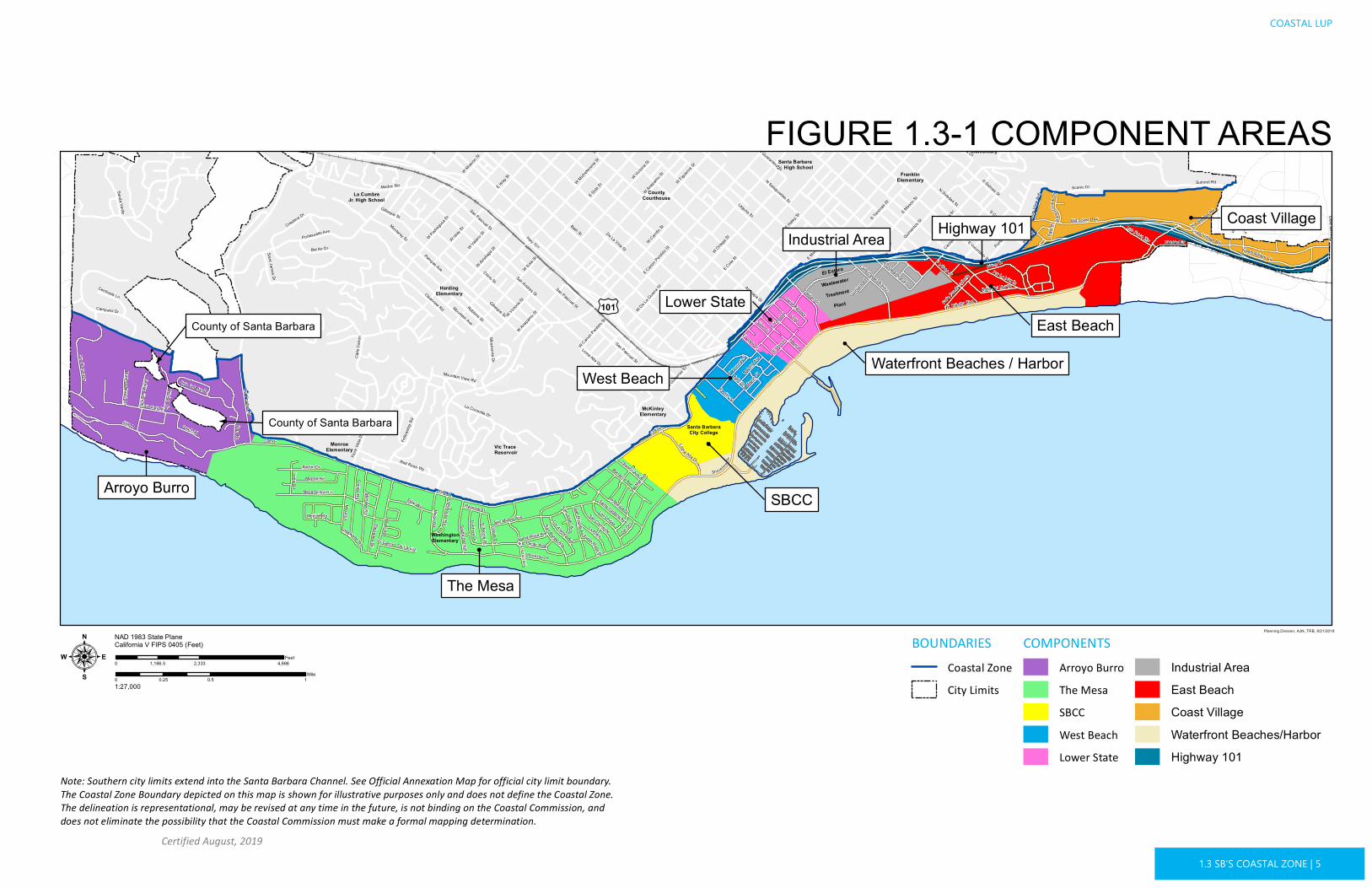
BOUNDARIESCoastal ZoneCity Limits
COMPONENTSArroyo BurroThe MesaSBCCWest BeachLower State
Industrial AreaEast BeachCoast VillageWaterfront Beaches/HarborHighway 101
CountyCourthouse
El Estero
Wastewater
Treatment
Plant
Santa BarbaraJr. High School
FranklinElementary
La CumbreJr. High School
HardingElementary
McKinleyElementary
Santa BarbaraCity College
WashingtonElementary
MonroeElementary
ClevelandElementary
Vic Trace Reservoir
Hwy 101
State St
Cliff Dr
Bath St
E Cota St
Garden St
E Haley S
t
Anacapa St
Castillo St
E Sola St
Laguna St
W Carrillo
St
Chino St
E Islay
St
Shoreline Dr
Meigs Rd
W Ortega S
t
W Anapam
u St
W Victoria
St
W Michelto
rena S
t
W Figuero
a St
E Mason S
t
Las Positas Rd
N Soledad St
E Canon P
erdido
St
Old Coast Hwy
Miramonte Dr
Robbins St
Alan Rd
E Yanon
ali
Summit Rd
Portesuello Ave
Mesa Ln
S Quarantina St
Oliver Rd
Loma Alta Dr
S Canada St
Bel Air Dr
S Milpas StNinos Dr
San Miguel Ave
La Marina Dr
Mohawk Rd
Borton Dr
Elise Wy
Cooper Rd
Fellow
ship
RdBraemar Dr
Quinien
tos St
Sea Ranch Dr
Carpinte
ria St
Flora
Vista
Dr
S Voluntario St
Red Rose Wy
La Coronilla Dr
Palisades Dr
Del Mar A
ve
San Pascual St
Scenic Dr
Gray
Crestline Dr
San Rafael Ave
Clearview Rd
Linda Rd
Pitos St
Pampas Ave
Oak Park Ln
Campanil Dr
Oceano Ave
Calle Cesar Chavez
Barranca Ave
Brosian Wy
Murrell Rd
Loyola Dr
Las Ondas
Mesa School Ln
La Plata
Natoma A
ve
Coast Village Cir
Gillespie St
San Nicolas Ave
Channel Dr
Por La Mar Dr
Medcliff Rd
Monterey St
Los Patos Wy
San Clemente
Punta G
orda S
t
Cordova Dr
Alphons
e St
Saint James Dr
Salida Del Sol
Pacific Ave
Los A lamos Ave
W Gutierrez
St
Park
Pl
El Monte Dr
Centinela Ln
Payeras St
Orilla Del Mar Dr
Sea Cliff
Portofino Wy La Paz
Ave
Calle
Can
on
Donze A
ve
Del Oro
Yankee Farm Rd
Lighthouse Rd
Ocea
n View
Ave
Vista Del Mar Dr
Harb
orVie
wD r
Santa Catalina Ave
Mountain View Rd
Santa Rosa Ave
Braemar Ranch Ln
Edgewater Wy
Calle Puer
to Valla
rta
Hot Springs Rd
El Camino De La Luz
Carmelita Ave
Olive Mill Rd
San Julia n Ave
Hermosillo Dr
Butterfly LnParkway Dr
Terrace Vista Ln
Gillespie St
Bath St
Cacique
StDe La Vina St
W Victoria
St
Helena
Quinien
tos St
W Mission
St
W Islay
St
Lom a Alta Dr
W Pedrego
sa St
E Monteci
to St
N Nopal St
W Sola St
S Salinas StModoc Rd
San Pascual St
W Arrellag
a St
W Mason S
t
Mountain Ave
E Mason
Senda Verde
E Yanon
ali St
San Andres St
W Valerio
St
W Yanon
ali St
W De La G
uerra S
t
Chapala St
Santa Rosa Pl
W Canon P
erdido
St
N Salsipuedes St
Coast Village Rd
W Anapam
u St
N Quarantina St
San Pascual St
Santa Barbara
Santa Cruz Blvd
Cliff Dr
Cliff DrCliff D
r
E Cabrillo Blvd
Sho rel ine Dr
The Mesa
Waterfront Beaches / Harbor
East Beach
Arroyo Burro
West Beach
Coast Village
Lower State
Industrial Area
SBCC
Highway 101
FIGURE 1.3-1 COMPONENT AREAS
Planning Division, AJN, TRB, 8/21/2018
: 0 0.5 10.25Mile
1:27,000
NAD 1983 State Plane California V FIPS 0405 (Feet)
0 2,333 4,6661,166.5Feet
£¤101
County of Santa Barbara
County of Santa Barbara
Note: Southern city limits extend into the Santa Barbara Channel. See Official Annexation Map for official city limit boundary.The Coastal Zone Boundary depicted on this map is shown for illustrative purposes only and does not define the Coastal Zone. The delineation is representational, may be revised at any time in the future, is not binding on the Coastal Commission, anddoes not eliminate the possibility that the Coastal Commission must make a formal mapping determination.
COASTAL LUP
Certified August, 2019
1.3 SB’S COASTAL ZONE | 5
CITY OF SANTA BARBARA
Certified August, 2019
1.3 SB’S COASTAL ZONE | 6
This page intentionally left blank

COASTAL LUP
Certified August, 2019
1.3 SB’S COASTAL ZONE | 7
PHOTO: HENDRY’S BEACH ON A FOGGY DAY
Description
The 304-acre Arroyo Burro Component Area stretches from the City’s westerly boundary, adjacent to Hope Ranch, east to Arroyo Burro Beach (also known as Hendry’s Beach) and Las Positas Road, and extends inland 1,000 yards. Characteristic of this region, and the entire western half of the City’s Coastal Zone, are coastal bluffs that rise abruptly from the beach to a height of approximately 150 feet. Inland from the bluffs’ edge, the topography continues to slope upward, in some areas steeply, in other areas leveling off as mesas, to an elevation of approximately 500 feet at the periphery of the Coastal Zone. Not all parcels in this area receive City sewer service and must rely on private, on-site sewer systems.
A creek (Arroyo Burro) runs through the southeastern boundary of this Component Area between Las Positas Road and the Alan Road tract of single-unit homes. Arroyo Burro County Beach Park is at the outlet of the creek into the Arroyo Burro Estuary at a natural break in the coastal bluffs. The estuary is periodically influenced by tidal action from the sea when a sand berm on the beach is breached by waves and/or high flows from the creek. The park functions as an important space for recreational activities and provides convenient public
ARROYO BURRO
COASTAL VIEW FROM SEA RANCH DRIVE
1
3
Arroy
oBurroMesa Creek
Las Positas RdAlan Rd
Braemar Dr
Sea Ranch Dr
Campanil Dr
Brosian WyMarina Dr
Sea Cliff
Yankee Farm Rd
Vista Del Mar DrBraemar Ranch Ln Cliff Dr
Cliff Dr
:1:12,000 0 0.250.125
Mile
CITY OF SANTA BARBARA
Certified August, 2019
1.3 SB’S COASTAL ZONE | 8
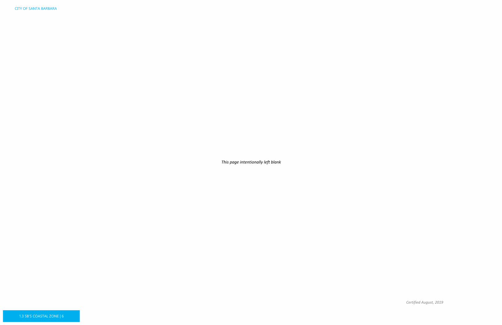
access to the beach. Additionally, a path between the park and the adjacent Douglas Family Preserve provides an off-street link to the Mesa-area neighborhoods to the east.
Land Use
The majority of land use is Residential. On the western side of this area, north of Cliff Drive, three subdivisions from the late 1950s and early 1960s resulted in 85 parcels of
approximately one acre in size. A few of these parcels remain vacant.
At the eastern end of this area, an exception to the predominant one-acre lots is the Braemar Park Tract located along Alan Road and Vista Del Mar. This tract, developed while under County jurisdiction, was annexed to the City in 1956. These parcels, while still Residential, allow for three dwelling units per acre.
Along the western and southern sides of Braemar Park Tract are two unincorporated
islands of residentially zoned and developed property that are comprised of approximately 13 parcels. Because most of the parcels are developed and currently receive City services, it is unlikely that these parcels will be annexed to the City.
Land Use Designation Residential %
Parks/Open Space
N/A 8%
Residential Max 1 du/acre 78%
Residential Max 3 du/acre 14%
1
3
FIGURE 1.3-2 ARROYO BURRO COMPONENT AREA LAND USE

ElingsPark
DouglasFamilyPreserveArroyo Burro Beach
LAS POSITAS RD
ALAN
RD
SEA RANCH DR
BRAEMAR DR
CAMPANIL DR
BROS
IAN
WY
JERRY HARWIN PARKWAY
SEA CLIFF
MARINA DRYA
NKEE
FARM
RD
SEA LEDGE LN
VISTA ARROYO
VISTA DEL MAR DR
BRAE
MAR
RANC
H LN
STONECREEK RD
REBECCA LN
PRIVATE DRIVEWAY
WADE CT
LAS GAVIOTAS
CALL
E LA
S CA
LERA
S
CUERVO AVE
SOLANA CT
MURRELL RD
YANK
EE FA
RM R
D
:1:12,000 0 0.250.125
Mile
COASTAL LUP
Certified August, 2019
1.3 SB’S COASTAL ZONE | 9
Parks and open space areas in this component include Arroyo Burro County Beach Park and several parcels recently acquired by the City for open space and restoration purposes adjacent to Arroyo Burro at the intersection of Las Positas and Cliff Drive and north of Alan Road (previously referred to as the Veronica Meadows area).
Development Potential
This area has very little potential for new residential development as only five vacant parcels and one underdeveloped parcel exist as of April 2015. As development here is typically constrained by steep slopes, coastal bluffs, or creeks, most new development is anticipated to be remodels and additions to existing single-unit homes, as well as accessory dwelling units.
Major Coastal Issues
This Component Area provides beach access, recreation, sensitive habitat, and scenic views. Neighborhood compatibility and size, bulk, and scale can be challenging issues for new residential development or expansions due to scenic view issues. However, infill residential additions have rarely raised coastal resource protection issues unless located along creeks or sensitive habitat or if they block public scenic views.
FIGURE 1.3-3 ARROYO BURRO COMPONENT AREA AERIAL

CITY OF SANTA BARBARA
Certified August, 2019
1.3 SB’S COASTAL ZONE | 10
Arroyo Burro Beach Park is a very popular beach destination and one of the only beaches in the City’s Coastal Zone where dogs are allowed on and off leash. While the parking lot at the park is sizable, parking demands for the beach can spill over into the neighborhood along Alan Road during busy beach days. The City has plans to improve the bicycle and pedestrian access along Las Positas Road to the beach park and to connect to the bike lanes and paths along Cliff Drive. A recently completed roundabout project at Las Positas Road and Cliff Drive has reduced traffic congestion in the area.
Arroyo Burro north of Cliff Drive is a highly erosive creek that is directly adjacent to the lots on the east side of Alan Road. The small size of these lots and previous development too close to the creek have resulted in several ad hoc reinforcements by private landowners of the creek banks, including terracing with rocks and sandbag walls. The City has undertaken significant restoration and fish passage improvements in Arroyo Burro estuary and has plans for restoration of the creek along several recently acquired parcels north of Alan Road and near the Las Positas Road and Cliff Drive intersection. Water quality at the Arroyo Burro Beach can be a concern when the estuary is breached during storm events.
The coastal bluffs, which are almost entirely developed with single-unit homes, are susceptible to erosion that can be incremental (associated with slow, long-term wearing of the coastal bluff) or episodic (associated with short duration, retreat and collapse of the coastal bluff). The rate of coastal bluff and beach erosion is projected to increase due to sea level rise, which could impact homes and structures that are currently built close to the coastal bluff edge, as well as public beach access. Maintaining public access to and along the shoreline requires coordination with local and regional entities to ensure that coastal access and natural sand transport are protected and enhanced.
The coastal bluff area along Sea Ledge Lane is a particularly problematic area due to the location of a known deep-seated landslide area mapped by the United States Geological Survey (USGS) and others extending from the beach up to Cliff Drive. Several single-unit residences, the majority of which were built before passage of the Coastal Act, are located on the potential landslide area. Following the El Niño storm season of 1982-1983, a 640-foot long revetment was built along the toe of the bluff along Sea Ledge Lane to protect structures threatened by wave erosion and slope failure. This is one of only two private shoreline protection structures that have been permitted in the City to date.

COASTAL LUP
Certified August, 2019
1.3 SB’S COASTAL ZONE | 11
THE MESA PHOTO: CLIFFS ALONG SHORELINE DRIVE
Description
The 635-acre Mesa Component Area spans eastward from Arroyo Burro Beach to the westerly boundary of Santa Barbara City College and extends inland to Cliff Drive. This area, appropriately referred to as “the Mesa,” is situated on relatively level, continuous coastal bluffs that vary in elevation but average 150 feet. From the coastal bluff edge inland, the terrain has an approximate five percent slope, which affords some ocean views. Tidepools exist at scattered locations along the base of the Mesa bluffs and are revealed at low tide.
The 70-acre Douglas Family Preserve is located on the west side of the Component Area. Single-unit homes line the bluffs from the Preserve east to Lighthouse Creek. Lighthouse Creek runs through approximately the center of this Component Area, exiting to the ocean at a steep break in the coastal bluffs. La Mesa Park, a neighborhood park, is located directly east of Lighthouse Creek. Single-unit homes line the coastal bluffs east of Lighthouse Creek to Shoreline Park. Shoreline Park is one the City’s most popular parks, occupying 15 acres of coastal bluff along Shoreline Drive and affording views of the ocean, beach, Harbor, and Channel Islands. A stairway provides public access from Shoreline Park to the beach
MIXED-USE DEVELOPMENT

Arroyo Honda
Arroyo
Burro
Lightho use
CreeK
Mesa Creek
McKinleyElementary
Santa BarbaraCity College
WashingtonElementary
MonroeElementary
Vic Trace Reservoir
Cliff Dr
Shoreline Dr
Meigs Rd
Las Positas Rd
Alan Rd
Mesa Ln Oliver Rd
San Miguel Ave
La Marina DrMohawk Rd
Borton Dr
Elise Wy
Cooper Rd
Fellow
ship
Rd
Flora
Vista
Dr
Red Rose Wy
La Coronilla Dr
Palisades Dr
Del M
ar Ave
San Rafael Ave
Linda Rd
Oceano AveBarranca Ave
Murrell Rd
Loyola Dr
Las Ondas
Mesa School Ln
La Plata
San Nicolas AveMedcliff Rd
San ClementeCordova Dr
Salida Del Sol
Pacific Ave
Los A lamos Ave
El Monte Dr
Payeras St
Sea Cliff
DelOro
Lighthouse Rd
Santa Catalina Ave
Santa Rosa AveEdgewater Wy El Camino De La Luz
San Julian A ve
Loma Alta Dr
Santa Rosa PlSanta Cruz Blvd
Cliff Dr
Cliff Dr
:1:23,000 0 0.250.125
Mile
CITY OF SANTA BARBARA
Certified August, 2019
1.3 SB’S COASTAL ZONE | 12
below. Public beach access from the bluffs is also achieved at the Mesa Lane Steps (at the end of Mesa Lane) and at Thousand Steps (at the end of Santa Cruz Boulevard).
Land Use
The Mesa is primarily small-lot, single-unit residential, with higher density multiple-unit development near the easterly boundary. Higher residential density and neighborhood-serving commercial use are found north of La Mesa Park along Meigs Road, Elise Way, and Cliff Drive. An elementary school and U.S. Coast Guard lighthouse facility are located along Meigs Road/Shoreline Drive.
Parks/Open Space form a significant portion of the land use, including Douglas Family Preserve, La Mesa Park, Shoreline Park, and the beach areas below the bluffs.
Development Potential
As of April 2015, approximately 10 vacant and 21 underdeveloped parcels, including those with commercial land use designation, have not developed to the theoretical maximum allowed residential density. Most new development is
anticipated to be remodeling and additions to existing single-unit homes. There may also
Land Use Designation Residential %
Parks/Open Space
N/A 21%
Residential Max 5 du/acre 67%
Medium Density Residential
Max 12 du/acre
5%
Medium High Density Residential
Max 27 du/acre
2%
Office/Medium Density Residential
Max 12 du/acre
1%
Commercial/ Medium High Residential
Max 27 du/acre
1%
Institutional Surrounding Zoning
2%
FIGURE 1.3-4 THE MESA COMPONENT AREA LAND USE

Honda ValleyPark
La MesaPark
Shoreline Park
DouglasFamily
Preserve
Leadbetter Beach
Arroyo Burro Beach
McKinleyElementary
Santa BarbaraCity College
WashingtonElementary
MonroeElementary
Vic Trace Reservoir
CLIFF DR
LAS POSITAS RD
SHORELINE DR
MEIGS RD
ALAN
RD
MESA
LN
OLIV
ER R
D
SAN MIGUEL AVE
LA MARINA DR
FELL
OWSH
IP RD
MOHA
WK
RD
RED ROSE WY
FLOR
A VIST
A DR
LA CORONILLA DR
BORTON DR
COOP
ER R
D
DOLO
RES D
R
PALIS
ADES
DR
ELISE WY
DEL M
AR AV
E
LAS ONDAS
SAN RAFAEL AVE
LA PLATA
JUAN
ITA AV
E
MESA SCHOOL LN
CALLE GALICIA
BARRANCA AVE
MURRELL RD
SAN CLEMENTE
OCEANO AVELIN
DA R
D
LITCH
FIEL
D LN
SALIDA DEL SOL
LOYOLA DR
DEL S
OL AVE
SELROSE LN
SAN NICOLAS AVE
WELDON RD
SEA CLIFF
MEDCLIFF RD
WEST
WOO
D DR
ROBERTO AVE
LOS ALAMOS AVE
CARLTON WY
CORDOVA DR
DEL O
RO
LADERA ST
EL MONTE DR
CALLE ANDALUCIA
ISLAN
D VIE
W DR
PAYERAS ST
SANTA CRUZ BLVD
SURF
VIEW
DR
PACIFIC AVE
RICARDO AVE
MARGO ST
AURO
RA AV
E
SANTA ROSA PL
LIGHT
HOUS
E RD
CALLE LINARES
SANTA CATALINA AVE
EL CAMINO DE LA LUZ
HARB
OR HI
LLS D
R
HUDSON DR
LAS OLAS AVE
SAN JULIAN AVE
SANTA ROSA AVE
VISTA DE LA PLAYA
REEF
CT
ISLET
A AVE
CALLE ALMONTE
EDGEWATER WY
ARROYO AVE
MIRA MESA DR
VIA S
EVILL
A
VALE
S ST
LA VISTA DEL OCEANO
SANTA FE PL
CORONEL RD
WHITE AVE
TERRACE RD
LUNE
TA PL
AZA
CALL
E ALE
LLA
JEFF ELINGS DR
LA JO
LLA
DR
SANTA RITA C IR
LIGHTHOUSE PL
WADE CT
SUNRISE VISTA WY
LAS GAVIOTAS
CHANNING WY
SAGE HILL RD
CAMI
NO CA
LMA
SANTA MONICA WY
LA CRESTA CIR
COLEMAN AVE
LOUISA AVE
CALLE DEL ORO
HARBOR HILLS LN
1100 B
ARRA
NCA A
VE AL
Y
CLIFF DR (FRONTAGE)
PACIFIC VIEW
EL FARO
SOLANA CT
LOS AL AMOS PL
VISTA PACIFICADEL OCEANO ST
GRAVILLA D
R
WHITE AVE
RICARDO AVE
EDGEWATER WY
LOMA ALTA DR
ELISE WY
EDGEWATER WY
SANTA ROSA AVE
MURRELL RD
:1:23,000 0 0.250.125
Mile
COASTAL LUP
Certified August, 2019
1.3 SB’S COASTAL ZONE | 13
be some limited potential for additional office/commercial development, mainly as remodeling and additions to existing facilities.
Major Coastal Issues
Similar to Arroyo Burro, this area is also almost fully developed and includes beach access, recreation, sensitive habitat, and public scenic views. Infill residential additions have raised issues if they block public scenic views.
The issues of beach and coastal bluff erosion are similar to the Arroyo Burro Component Area. Several known landslide areas are located along the bluffs in this Component Area. Several large landslides have occurred in the vicinity of El Camino De La Luz and along Shoreline Park. Some private residences and significant accessory improvements (lawns, patios, etc.) extend close to the bluff edge at some locations along the bluff. To date, however, no private shoreline protection structures have been permitted in this Component Area. Coastal bluff erosion/retreat and wave impacts affecting public beach access stairways and park infrastructure have led to several repair and reconstruction projects to maintain public access to the beach.
FIGURE 1.3-5 THE MESA COMPONENT AREA AERIAL
CITY OF SANTA BARBARA
Certified August, 2019
1.3 SB’S COASTAL ZONE | 14
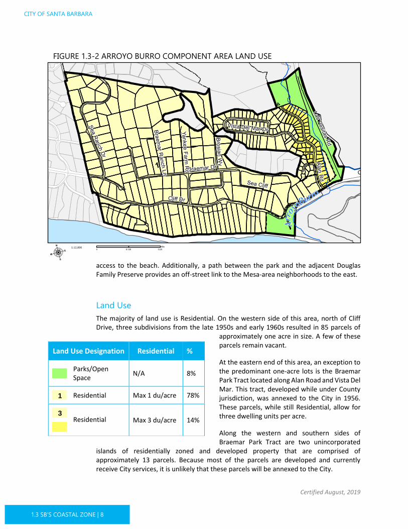
SANTA BARBARA CITY COLLEGE (SBCC) PHOTO: SBCC LA PLAYA STADIUM
Description
The Santa Barbara City College (SBCC) campus encompasses the majority of this 94-acre Component Area, which spans eastward from the western edge of SBCC, between
Shoreline Drive/Cabrillo Boulevard and Cliff Drive/Montecito Street, to the easterly edge of the campus at Pershing Park. Also included is an area of apartment units largely inhabited by SBCC students. A creek (Arroyo Honda) flows through the northwestern portion of this component along the eastern perimeter of the SBCC West Campus and Loma Alta Drive.
Land Use
SBCC is designated Institutional and operates under its own independent community college district, with a Board of Trustees. A Medium
High Density Residential area with apartment units lies in an area bordered by Cliff Drive, Loma Alta Drive, and Arroyo Honda.
SBCC CAMPUS

Arroyo Honda
McKinley
ElementarySanta Barbara
City College
Castillo St
La Marina Dr
Del Mar Ave
Oceano Ave
Barranca AveLas Ondas
Natoma Ave
W Gutierrez St
Santa Catalina Ave
Bath St
LomaAlta DrW Mason St
W Yanonali St
Cliff Dr
Shorel ine Dr
: 1:6,000 0 0.250.125Mile
COASTAL LUP
Certified August, 2019
1.3 SB’S COASTAL ZONE | 15
Development Potential
Development within SBCC is directed by the Coastal Commission-certified SBCC Public Works Plan (which reflects the SBCC’s Long Range Development Plan). The standard of review for
amendments to the Public Works Plan is the policies and provisions of the City’s LCP.
Land Use Designation Residential %
Medium High Density Residential
Max 27 du/acre
11%
Institutional Surrounding Zoning
89%
FIGURE 1.3-6 SBCC COMPONENT AREA LAND USE

Pershing
Park
Leadbetter Beach
McKinley
Elementary
Santa Barbara
City CollegeW MONTECITO ST
LA MARINA DR
DEL MAR AVE
W CABRILLO BLVD
BARRANCA AVE
OCEANO AVE
W YANONALI ST
DEL SOL AVE
WELDON RD
NATOMA AVE
W COTA ST
CORONEL PL
RANCHERIA ST
DEL ORO
LADERA ST
W GUTIERREZ ST
CORONEL ST
SANTA CATALINA AVE
HARBOR WY
LAS OLAS AVE
ISLETA AVE
W MASON ST
CORONEL RD
LUNETA PLAZA
FREEMONT PL
WILSON ST
BURTON CIR
1100 BARRANCA AVE ALY
ALLEY 0 BLOCK BATH ST
GRAVILLA DR
LOMA ALTA DR
BATH ST
: 1:6,000 0 0.250.125Mile
CITY OF SANTA BARBARA
Certified August, 2019
1.3 SB’S COASTAL ZONE | 16
Major Coastal Issues
This Component Area includes coastal access, recreation, and some small habitat areas. Coastal issues related to SBCC include, but are not limited to, public access (parking and circulation), scenic resources (public scenic views of the ocean), and habitat protection.
The City and SBCC have maintained a cooperative working relationship and continue to work to address community issues such as housing for students, parking demand, congestion management, and noise complaints in neighborhood areas. A Joint Use Agreement, originally formed in 1938 between the City and SBCC District, addresses the joint use of recreational and educational property.
Oak woodland, riparian habitats, and a monarch butterfly habitat site are located adjacent to Arroyo Honda.
FIGURE 1.3-7 SBCC COMPONENT AREA AERIAL

COASTAL LUP
Certified August, 2019
1.3 SB’S COASTAL ZONE | 17
PHOTO: VIEW FROM WEST BEACH
Description
The 74-acre West Beach Component Area is a flat area inland of Cabrillo Boulevard that spans eastward from the easterly edge of the SBCC campus at Pershing Park to Chapala Street and then loosely follows Mission Creek towards the ocean. Currently, the pleasant character of this area is a result of a unique combination of uses (residential, visitor-serving, commercial, and recreation) and styles (the Spanish Colonial Revival architecture predominates). A portion of Mission Creek touches the northeast periphery of this component.
There are four major parks in this Component Area: Pershing Park, Ambassador Park, Plaza Del Mar, and the Moreton Bay Fig Tree Park. These parks provide open space, outdoor event space, as well as softball fields, a baseball diamond, and tennis courts.
Land Use
Sometimes known as the Ambassador Tract, developed after the Ambassador Hotel (formerly the Potter Hotel) burned in 1921, this area is a major visitor-serving area, with
WEST BEACH
OLD SPANISH DAYS CARRIAGE MUSEUM

I I
MissionCreek
Santa Barbara
City College
State St
Castillo St
E Yanonali
GrayNatoma Ave
W Gutierrez St
Bath St
Helena
W Mason St E Mason
W Yanonali St
Chapala St
: 1:5,000 0 0.250.125Mile
CITY OF SANTA BARBARA
Certified August, 2019
1.3 SB’S COASTAL ZONE | 18
a number of hotels and motels, and also includes residential development. The northeasterly section allows for single- and multiple-unit dwellings, hotels, and motels.
There is a small commercial area in the northwest portion that includes grocery stores, restaurants, and other businesses, as well as four parks with passive and active recreation.
Development Potential
West Beach is fully developed, with no vacant properties. However, there are parcels that have not developed to their theoretical maximum residential density; therefore, new residential development could include requests for redevelopment with higher density of units. A small amount of hotel/commercial infill is anticipated, involving remodeling or demolition and rebuilding of existing buildings.
Land Use Designation Residential %
Parks/Open Space
N/A 21%
Hotel & Residential
Max 27 du/acre
52%
Hotel & Related Commerce I
N/A 18%
Commercial/ Medium High Residential
Max 27 du/acre
9%
FIGURE 1.3-8 WEST BEACH COMPONENT AREA LAND USE
I

Pershing
ParkWest Beach
Santa Barbara
City College
E YANONALI ST
W MONTECITO ST
W CABRILLO BLVD
W YANONALI ST
NATOMA AVE
RANCHERIA ST
HELENA AVE
LOS AGUAJES AVE
W MASON ST
KIMBERLY AVE
WILSON ST
PARKER WYREY RD
COTTAGE GROVE AVE
BURTON CIR
MOTOR WY
ALLEY 0 BLOCK BATH ST
ALLEY 400 BLOCK N BATH ST
W MASON ST
HELENA AVE
OFFRAMP
E MASON STBATH ST
W GUTIERREZ ST
W YANONALI ST
ONRAMP
E MONTECITO STCHAPALA ST
: 1:5,000 0 0.250.125Mile
COASTAL LUP
Certified August, 2019
1.3 SB’S COASTAL ZONE | 19
Major Coastal Issues
West Beach is an important visitor-serving area, with overnight accommodations and recreational facilities. As hotels are remodeled, retaining a range of rooms and room prices for all income segments could be an issue for this area. This area has the potential to support archaeological resources as well as known resources that includes a State Landmark archaeological site, Burton Mound.
The portion of Mission Creek within this Component Area has been widened and reconstructed as part of the Mission Creek Flood Control Project. However, significant development and structures are located very close to the creek banks. Additionally, most of the Component Area is located in the 100-year floodplain of Mission Creek. Inland areas are relatively protected from wave impacts by the Harbor and the wide sandy beach at West Beach. However, due to the low-lying nature of the Component Area, flooding potential could increase in the future from the effects of sea level rise and other climate impacts (changes in rainfall patterns, etc.).
FIGURE 1.3-9 WEST BEACH COMPONENT AREA AERIAL
AAA
CITY OF SANTA BARBARA
Certified August, 2019
1.3 SB’S COASTAL ZONE | 20
LOWER STATE PHOTO: STATE STREET AT CABRILLO BOULEVARD
Description
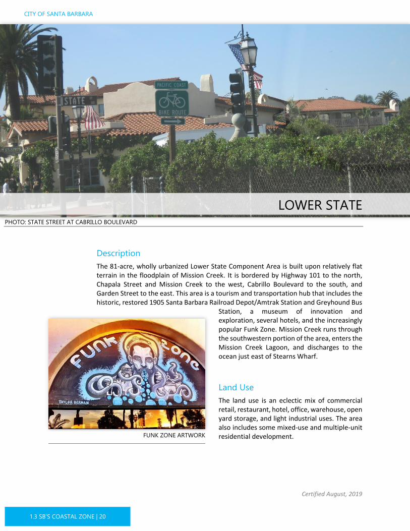
The 81-acre, wholly urbanized Lower State Component Area is built upon relatively flat terrain in the floodplain of Mission Creek. It is bordered by Highway 101 to the north, Chapala Street and Mission Creek to the west, Cabrillo Boulevard to the south, and Garden Street to the east. This area is a tourism and transportation hub that includes the historic, restored 1905 Santa Barbara Railroad Depot/Amtrak Station and Greyhound Bus
Station, a museum of innovation and exploration, several hotels, and the increasingly popular Funk Zone. Mission Creek runs through the southwestern portion of the area, enters the Mission Creek Lagoon, and discharges to the ocean just east of Stearns Wharf.
Land Use
The land use is an eclectic mix of commercial retail, restaurant, hotel, office, warehouse, open yard storage, and light industrial uses. The area also includes some mixed-use and multiple-unit residential development. FUNK ZONE ARTWORK

II
IIII
II
II
LagunaCreek
MissionCreek
El EsteroWastewaterTreatmentPlantState St Garden St
Anacapa St
E Yanonali
GrayNatoma Ave
Bath St
HelenaW Mason St E Mason
W Yanonali St
Chapala St
Santa Barbara
: 1:5,000 0 0.250.125Mile
COASTAL LUP
Certified August, 2019
1.3 SB’S COASTAL ZONE | 21
The Funk Zone area is centrally located in this Component Area, and the land use designation allows coastal-dependent and coastal-oriented uses, commercial recreational uses, arts-related uses, restaurants, and small stores. Historically, the Funk Zone was used for light industrial and restricted commercial uses and was a haven for local artists. In 2004, amendments to zone districts were certified in this area which amended some development standards and, over time, the mix of uses has shifted away from what was once lower cost rentals of buildings used for artist spaces and craftsman to a more vibrant mix, adding in residential uses, restaurants, wineries, breweries, small markets, and recreation.
Development Potential
There is some potential for new mixed-use, hotel, and multiple-unit residential development in this Component Area, with two vacant parcels and other underdeveloped
Land Use Designation Residential %
Coastal-Oriented Commercial/ Medium High Residential
Max 27 du/acre
34%
Hotel & Related Commerce II/Medium High Residential
Max 27 du/acre
55%
Coastal-Oriented Commercial & Hotel & Related Commerce II
Max 27 du/acre
11%
I I
I I
FIGURE 1.3-10 LOWER STATE COMPONENT AREA LAND USE

West BeachChase Palm Park
El EsteroWastewaterTreatmentPlant
E YANONALI ST
STEARNS WHARF
W YANONALI ST
GRAY AVENATOMA AVE
HELENA AVE
LOS AGUAJES AVE
PALM AVE
KIMBERLY AVE
PARKER WY
REY RD
BURTON CIR
MOTOR WY
ALLEY 0 BLOCK BATH ST
W MASON ST
HELENA AVE
E MASON ST
BATH ST
E MASON ST
W YANONALI STSANTA BARBARA ST
OFFRAMP
ANACAPA ST
ONRAMP
E MONTECITO ST
CHAPALA ST
ONRAMP
: 1:5,000 0 0.250.125Mile
CITY OF SANTA BARBARA
Certified August, 2019
1.3 SB’S COASTAL ZONE | 22
parcels. Since 2012, the Funk Zone has been experiencing a transformation in character due to the adaptive reuse and revitalization of older buildings as opposed to demolishing and new building development. This trend is expected to continue as reuse and revitalization are encouraged under the land use designation and zoning.
Major Coastal Issues
Lower State is a key visitor-serving area that also provides public parking for coastal access and serves as a main entry to the beach from Downtown. Sufficient on- and off-street parking is an issue due to this area’s popularity. Also, it is challenging for properties interested in redeveloping to meet on-site parking requirements. This is especially true for the small lots in the Funk Zone as well as the older buildings that were developed to industrial standards with little or no parking or building setbacks.
Significant resources have been directed toward improving Lower Mission Creek, both to improve flood control and restore habitats for endangered species such as steelhead trout and tidewater goby. Creek buffers are required to protect structures from flooding and creek bank erosion, and to improve and restore habitat. However, many existing structures are built up to, and in some cases within, the banks of Mission Creek. In this low-lying area, creek and coastal flooding is an issue that could worsen with sea level rise.
FIGURE 1.3-11 LOWER STATE COMPONENT AREA AERIAL

COASTAL LUP
Certified August, 2019
1.3 SB’S COASTAL ZONE | 23
PHOTO: AUTO REPAIR SHOP
Description
The 112-acre Industrial Component Area is low-lying and partially located in an area that was once an estuary known as El Estero. It includes the area south of Highway 101 and north of the railroad tracks, between Garden Street to the west and Milpas Street and Nopalitos Way to the east. Laguna Channel, which drains the City’s eastside, runs through the westerly portion of this area. Laguna Channel terminates at a pump station and tide gate facility that helps prevent flooding in this area during high tides and storm events.
A large land area is occupied by City facilities, including the El Estero Wastewater Treatment Plant, the Charles E. Meyer Desalination Plant, and a Fire Department training facility. Garden Street from Highway 101 to Cabrillo Boulevard serves as a major gateway to the City’s Waterfront area and beaches.
Land Use
Land uses include public works facilities, manufacturing, building supply firms, open yard storage, a homeless shelter, and general commercial, office, and storage facilities. The area between Calle Cesar Chavez and Milpas Street, north of the railroad tracks, is
INDUSTRIAL AREA
EL ESTERO WASTEWATER TREATMENT PLANT

LagunaCreek
El Estero
Wastewater
Treatment
Plant
Garden St
E Yanonali
S Quarantina St
S Milpas St
Quinientos StS Voluntario St
Gray
Calle Cesar ChavezCalle Puerto Vallarta
Cacique St
Quinientos St
E Montecito St N Nopal St
Santa Barbara
E Cabrillo Blvd
: 1:9,000 0 0.250.125Mile
CITY OF SANTA BARBARA
Certified August, 2019
1.3 SB’S COASTAL ZONE | 24
designated Industrial and allows a wide range of uses, including general commercial, industrial, and office. Residential use is prohibited in the Industrial designation, with the exception of a caretaker’s unit.
West of Calle Cesar Chavez, between the railroad and Highway 101, is designated Coastal-Oriented Industrial, Institutional, and Industrial. The Coastal-Oriented Industrial area strives to provide appropriate coastal-dependent and coastal-related industrial uses in close proximity to the Harbor and Stearns Wharf. While some properties have transitioned to coastal-dependent and related industrial uses over time, currently there is a large number of buildings and uses that are
non-conforming (e.g., office space, general industrial).
Development Potential
No new residential development is allowed in the Industrial designation. Existing residential units can remain and be upgraded, but cannot be expanded. Portions of this Component Area have the potential for expansion of non-residential square footage, particularly between Calle Cesar Chavez and Milpas Street. Based on historic trends, new non-residential development would be expected to consist mainly of remodels and additions to existing structures.
Land Use Designation Residential %
Industrial N/A 44%
Coastal-Oriented Industrial
N/A 30%
Institutional N/A 26%
FIGURE 1.3-12 INDUSTRIAL AREA COMPONENT AREA LAND USE

Chase Palm Park
El Estero
Wastewater
Treatment
Plant
E CABRILLO BLVD
E GUTIERREZ ST
E YANONALI ST
N QUARANTINA ST
S MILPAS ST
CALLE CESAR CHAVEZ
S ALISOS ST
S VOLUNTARIO ST
GRAY AVE
S QUARANTINA ST
UNION ST
CALLE PUERTO VALLARTA
NOPALITOS WY
POWERS AVES NOPALITOS WY
LAWRENCE AVE
KIMBALL AVE
ASHLEY AVE MILPAS ST
S MILPAS ST
OFFRAMP
S ALISOS ST
OFFRAMP OFFRAMP
E MASON ST
ONRAMP
E MASON ST
CACIQUE ST
SANTA BARBARA ST
PALM AVE
ANACAPA ST
INDIO MUERTO STCARPINTERIA ST
QUINIENTOS ST
ONRAMP
: 1:9,000 0 0.250.125Mile
COASTAL LUP
Certified August, 2019
1.3 SB’S COASTAL ZONE | 25
Major Coastal Issues
In this low-lying area, creek and coastal flooding are potential problems, in addition to the liquefaction hazard due to underlying soils. The existing flooding hazard could be exacerbated by sea level rise and increased storms and, in this area in particular, is dependent on the ongoing function of the Laguna Channel tide gate and pump station to prevent damaging floods.
While to date, the demand for coastal-related industrial uses has not materialized, it is important that this land area continue to be zoned for such uses to prevent the potential for gentrification as is occurring in the Lower State area.
FIGURE 1.3-13 INDUSTRIAL AREA COMPONENT AREA AERIAL
CITY OF SANTA BARBARA
Certified August, 2019
1.3 SB’S COASTAL ZONE | 26
EAST BEACH PHOTO: ANDRÉE CLARK BIRD REFUGE
Description
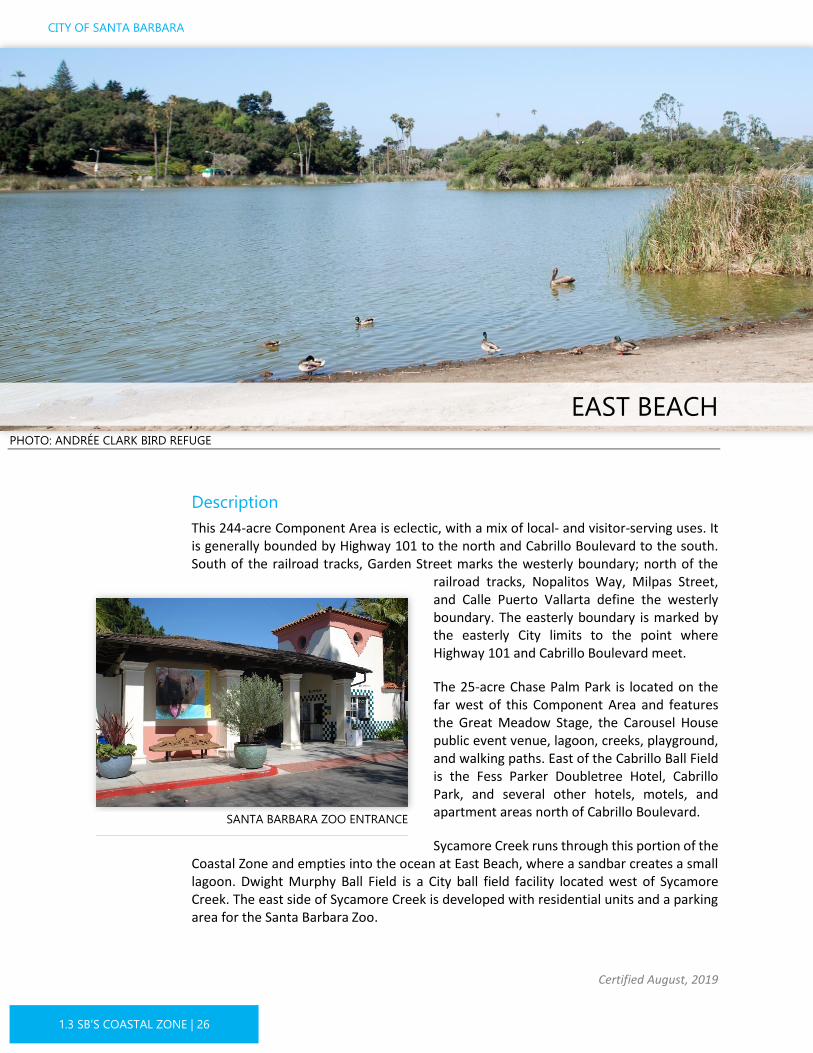
This 244-acre Component Area is eclectic, with a mix of local- and visitor-serving uses. It is generally bounded by Highway 101 to the north and Cabrillo Boulevard to the south. South of the railroad tracks, Garden Street marks the westerly boundary; north of the
railroad tracks, Nopalitos Way, Milpas Street, and Calle Puerto Vallarta define the westerly boundary. The easterly boundary is marked by the easterly City limits to the point where Highway 101 and Cabrillo Boulevard meet.
The 25-acre Chase Palm Park is located on the far west of this Component Area and features the Great Meadow Stage, the Carousel House public event venue, lagoon, creeks, playground, and walking paths. East of the Cabrillo Ball Field is the Fess Parker Doubletree Hotel, Cabrillo Park, and several other hotels, motels, and apartment areas north of Cabrillo Boulevard.
Sycamore Creek runs through this portion of the Coastal Zone and empties into the ocean at East Beach, where a sandbar creates a small lagoon. Dwight Murphy Ball Field is a City ball field facility located west of Sycamore Creek. The east side of Sycamore Creek is developed with residential units and a parking area for the Santa Barbara Zoo.
SANTA BARBARA ZOO ENTRANCE

3Clark Estate
I I
II
II
Sycamore CreekLagunaCreekMissionCreek
El Estero
Wastewater
Treatment
Plant
Garden St
E Mason St
N Soledad St
Old Coast Hwy
S Quarantina St
S Canada St
S Milpas St Ninos Dr
Quinientos St
Carpinteria St
S Voluntario St
Pitos St
Calle Cesar Chavez
Channel DrPor La Mar Dr
Los Patos Wy
Punta Gorda St
Park
Pl
Orilla Del Mar Dr
Ocea
n View
Ave
Harb
orVie
wDr
Calle Puerto Vallart
a
Hot Springs RdCaciqu
e St
Quinientos S
t
E Montecito St N Nopal St
E Yanonali St
Coast Village RdSanta Barbara
E Cabrillo Blvd
Andrée ClarkBird Refuge
: 1:17,000 0 0.250.125Mile
COASTAL LUP
Certified August, 2019
1.3 SB’S COASTAL ZONE | 27
While the terrain in this Component Area is mostly low-lying, the elevation rises to about 65 feet in the area known as “The Child’s Estate,” which is currently the Santa Barbara Zoo. The zoo overlooks East Beach and the 42-acre Andrée Clark Bird Refuge. The bird refuge features a lake (an artificially modified estuary) and passive recreational opportunities. Southeast of Cabrillo Boulevard, the 23.5-acre Bellosguardo property (formerly known as the Clark Estate) sits atop a coastal bluff on the east side of this Component Area at approximately 90 feet above sea level.
Land Use
Over half of the land use is Parks/Open Space that includes Chase Palm Park, several other parks, the Santa Barbara Zoo, and the Andrée Clark Bird Refuge.
The remainder of this Component Area is a mix of hotels, motels, apartments, condominiums, and general commercial. Commercial and Medium High Density Residential development is found in the northwestern area, flanking Milpas Street and extending along Cacique Street and a portion of Calle Puerto Vallarta. West of Sycamore Creek, hotels line Cabrillo Boulevard. Apartments and motels are found behind these hotels. East of Sycamore Creek is developed with multiple-unit housing.
Development Potential
Development potential of new residential units is limited as only one vacant property exists in this area, and nearly all other residential
Land Use Designation Residential %
Parks/Open Space
N/A 52%
Residential Max 3 du/acre 11%
Medium High Density Residential
Max 27 du/acre
7%
Hotel & Residential
Max 27 du/acre
4%
Hotel & Related Commerce I
N/A 15%
Hotel & Related Commerce II/Medium High Residential
Max 27 du/acre
3%
Commercial/ Medium High Residential
Max 27 du/acre
7%
I
3
I I
FIGURE 1.3-14 EAST BEACH COMPONENT AREA LAND USE
Chase Palm Park
East Beach
SBZoo
El Estero
Wastewater
Treatment
Plant
E CABRILLO BLVD
E HALEY ST
E MONTECITO ST
OLD C OAST HWY
S SALINAS ST
S CANADA ST
N QUARANTINA ST
CARPINTERIA ST
S MILPAS ST
QUINIENTOS ST
NINOS DR
CALLE CESAR CHAVEZ
OFFRAMP
S ALISOS ST
S VOLUNTAR IO ST
INDIO MUERTO ST
PITOS ST
PUNTA GORDA ST
CACIQUE ST
CHANNEL DR
POR LA MAR DR
LOS PATOS WY
ORILLA DEL MAR DR
S SOLEDAD ST
S QUARANTINA ST
PARK
PL
UNION ST
CALLE PUERTO VALLARTA
OCEA
N VIE
W AV
E
NOPALITOS WY
ALLAIRE ST
EDISON AVE
CORONA DEL MAR DR
LIBERTY ST
HARMON ST
POR LA MAR CIR
DEL PARQUE D R
POWERS AVE
LA CADENA ST
S NOPALITOS WY
JENNINGS AVE
LAWRENCE AVE
JUANA MARIA AVE
KIMBALL AVE
RICHARDSON AVE
ASHLEY AVE LOS PATOS WAY SB OFFRAMP
COVINA ST
ALLEY 600 BLOCK GUTIERREZ ST
VERDE MAR DR
MILPAS ST
S MILPAS ST
OFFRAMP
S ALISOS ST
OFFRAMP
N VOLUNTARIO ST
OFFRAMP
ONRAMP
E MASON ST
CACIQUE ST
OFFRAMP
COAST VILLAGE RD
ONRAMP
N NOPAL ST
OFFRAMP
INDIO MUERTO STCARPINTERIA ST
QUINIENTOS ST
E YANONALI ST
ONRAMP
Andrée ClarkBird Refuge
: 1:17,000 0 0.250.125Mile
CITY OF SANTA BARBARA
Certified August, 2019
1.3 SB’S COASTAL ZONE | 28
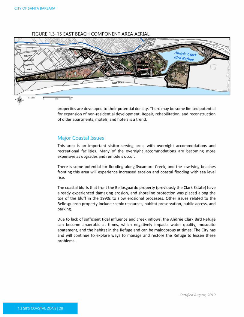
properties are developed to their potential density. There may be some limited potential for expansion of non-residential development. Repair, rehabilitation, and reconstruction of older apartments, motels, and hotels is a trend.
Major Coastal Issues
This area is an important visitor-serving area, with overnight accommodations and recreational facilities. Many of the overnight accommodations are becoming more expensive as upgrades and remodels occur.
There is some potential for flooding along Sycamore Creek, and the low-lying beaches fronting this area will experience increased erosion and coastal flooding with sea level rise.
The coastal bluffs that front the Bellosguardo property (previously the Clark Estate) have already experienced damaging erosion, and shoreline protection was placed along the toe of the bluff in the 1990s to slow erosional processes. Other issues related to the Bellosguardo property include scenic resources, habitat preservation, public access, and parking.
Due to lack of sufficient tidal influence and creek inflows, the Andrée Clark Bird Refuge can become anaerobic at times, which negatively impacts water quality, mosquito abatement, and the habitat in the Refuge and can be malodorous at times. The City has and will continue to explore ways to manage and restore the Refuge to lessen these problems.
FIGURE 1.3-15 EAST BEACH COMPONENT AREA AERIAL

COASTAL LUP
Certified August, 2019
1.3 SB’S COASTAL ZONE | 29
PHOTO: COAST VILLAGE RETAIL
Description
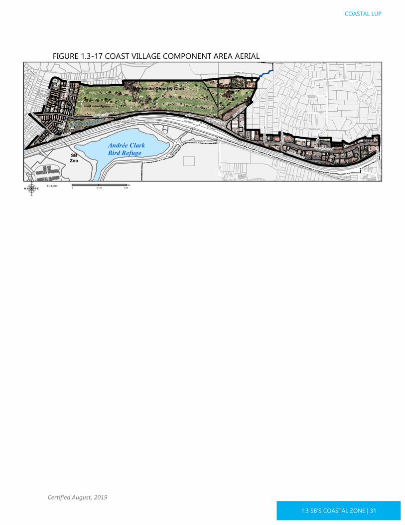
This 178-acre component has an irregular westerly boundary formed by Pitos/Salinas/Ocean View Streets; the easterly boundary is at Olive Mill Road (corresponding with the eastern City limits). The northern boundary is 1,000 yards inland of the shoreline, and the southerly boundary is formed by the City limit (at Highway 101). The western section of this area is a residential neighborhood with single- and multiple-unit dwellings, as well as a few mobile homes and RV dwellings.
The Montecito Country Club, a private golf course and fitness club, comprises a large portion of this component. The Municipal Tennis Center is located between Highway 101 and Old Coast Highway and is the primary public open space facility in this area.
The eastern portion of this component includes the retail commercial corridor along Coast Village Road.
Land Use
Over 50 percent of the land use is in Parks/Open Space, mainly comprised of the Montecito County Club property. The remaining land use is residential, commercial, and mixed-use. Residential use is mostly clustered in the western portion of this Component Area and includes low, medium, and medium high density land use designations.
COAST VILLAGE

2
Sycamore Creek
Old Coast Hwy
Summit RdScenic Dr
Pitos St
Coast Village Cir
Channel Dr
Los Patos Wy
Park
Pl
Ocea
n View
Ave
Harb
orVie
wDr
Hot Springs Rd Olive Mill Rd
Hermosillo Dr
Butterfly LnCoast Village RdAndrée ClarkBird Refuge
: 1:14,000 0 0.250.125Mile
CITY OF SANTA BARBARA
Certified August, 2019
1.3 SB’S COASTAL ZONE | 30
The region of City jurisdiction that flanks Coast Village Road, extending into unincorporated Montecito, has commercial and medium density residential land use. At Hot Springs Road and Old Coast Highway is a shopping center serving local residents. The
remainder of Coast Village Road (from Butterfly Lane to Olive Mill Road) is lined with restaurants, retail establishments, and offices. Some condominiums and apartments exist in combination with commercial uses.
Development Potential
In the Coast Village Road/Coast Village Circle area, continued in-filling of retail, commercial, office, and mixed-use is anticipated. There is some potential for additional residential development in the western portion of this Component Area.
Major Coastal Issues
Impacts to beach access from traffic and circulation is an issue in this area, particularly in connection with Highway 101. Recent and
ongoing highway projects, as well as generally increasing traffic congestion, has led to the use of Cabrillo Boulevard and Coast Village Road as a Highway 101 bypass.
Land Use Designation Residential %
Parks/Open Space
N/A 58%
Residential Max 2 du/acre 3%
Residential Max 5 du/acre 3%
Medium Density Residential
Max 12 du/acre
6%
Medium High Density Residential
Max 27 du/acre
7%
Commercial/ Medium High Residential
Max 27 du/acre
24%
2
FIGURE 1.3-16 COAST VILLAGE COMPONENT AREA LAND USE
SBZoo
Montecito Country Club
HWY 101
SUMMIT RD
OLD COAST HWYS SALINAS ST
COAST VILLAGE RD
OFFRAMP
SCENIC DR
PITOS ST
COAST VILLAGE CIR
CHANNEL DR
LOU
DILL
ON LN
LOS PATOS WY
PARK
PL
HARB
OR V
IEW
DR
OCEA
N VIE
W AV
E
HARMON ST
HOT SPRINGS RD
OLIV
E MI
LL R
D
MIDD
LE R
D
HERM
OSILL
O DR BUTTERFLY LN
UHLAN CT
LOS PATOS WAY SB OFFRAMP
COVINA ST
VERDE MAR DR
OFFRAMP
COAST VILLAGE RD
ONRAMP
OFFRAMP
Andrée ClarkBird Refuge
: 1:14,000 0 0.250.125Mile
COASTAL LUP
Certified August, 2019
1.3 SB’S COASTAL ZONE | 31
FIGURE 1.3-17 COAST VILLAGE COMPONENT AREA AERIAL

CITY OF SANTA BARBARA
Certified August, 2019
1.3 SB’S COASTAL ZONE | 32
WATERFRONT BEACHES/HARBOR PHOTO: THE HARBOR
Description
This 201-acre Waterfront Beaches/Harbor Component Area encompasses the land area south of Cabrillo Boulevard to the Pacific Ocean, including Stearns Wharf and the Harbor facilities, stretching from the westerly end of Leadbetter Beach to the easterly end of East Beach. The Waterfront is one of Santa Barbara’s key aesthetic assets, providing diverse opportunities for active recreation and passive enjoyment of the ocean, sand, and beautiful views.
This Component Area includes three miles of sandy beaches and is one of the City’s largest tourist attractions. Stearns Wharf, the Harbor, and Harbor breakwater are three of the City’s most heavily visited areas. Also included are numerous beachfront parks and open spaces, public parking lots and restrooms, Los Baños del Mar Pool, a skateboard park, sand volleyball
courts, the multi-use Beachway path, pedestrian paths, Cabrillo Pavilion and Bathhouse, a maritime museum, a yacht club, and various other facilities.
WATERFRONT DOLPHIN STATUE

3Clark Estate
Arroyo Honda
SycamoreCreek
LagunaCreek
MissionCreek
El EsteroWastewaterTreatment
PlantMcKinleyElementary
Santa BarbaraCity College
State St
E Cota St
Garden St
E Haley St
Anacapa St
Castillo St
Laguna St
W Carrillo St
W Ortega St
E Mason St
E Canon Perdido St
Old Coast Hwy
E Yanonali
S Quarantina St
S Canada StS Milpas St
Ninos Dr
La Marina Dr
Quinientos St
Carpinteria St
S Voluntario St
Del Mar Ave
San Pascual St
Gray
Pitos St
Oceano Ave
Calle Cesar Chavez
Barranca Ave
Natoma Ave
Por La Mar DrPunta Gorda StW Gutierrez St
Park Pl
Orilla Del Mar Dr
De l Oro
Ocean V
iew Ave
Har b
orVie
w Dr
Santa Catalina Ave
Calle Puerto Vallarta
Bath St
Cacique St
De La Vina St
Helena
Quinientos St
Loma Alta Dr
E Montecito St
N Nopal St
W Mason St
E Mason
E Yanonali St
W Yanonali St
W De La Guerra St
Chapala St
Santa Barbara
Cliff Dr
E Cabrillo Blvd
Sho rel ine Dr
Andrée ClarkBird Refuge
: 1:21,000 0 0.250.125Mile
COASTAL LUP
Certified August, 2019
1.3 SB’S COASTAL ZONE | 33
Arroyo Hondo, Mission Creek, Laguna Channel, and Sycamore Creek all empty into the ocean here. The lagoons at the outlets of Mission Creek and Laguna Channel combine to form one large lagoon.
Land Use
All of the land in this Component Area is publicly owned. The primary land use is Parks/Open Space, with public open spaces comprising 80 percent of the land area.
The Harbor area and Stearns Wharf have a unique land use designation that strives to assure the Harbor remains primarily a working harbor with visitor-serving and coastal-related uses secondary to coastal-dependent uses. Stearns Wharf consists of a mixture of visitor-serving, coastal-related, and coastal-dependent uses.
Development Potential
The only development potential is renovation or remodeling of existing public facilities or limited improvements to Harbor and Stearns Wharf facilities.
Major Coastal Issues
This area provides important beach access and visitor-serving, recreational, and coastal-dependent services as well as sensitive lagoon and estuary habitats. As it is directly on the low-lying coast, this is the area most vulnerable to the impacts of coastal flooding and beach erosion, intensified by sea level rise. Facilities vulnerable to flooding, erosion, and wave run-up include Cabrillo Boulevard, Shoreline Drive, beach parking lots, the Harbor, and Stearns Wharf. These resources are unique to this area and, as Santa Barbara is an
Land Use Designation Residential %
Parks/Open Space
N/A 80%
Harbor-Stearns Wharf
Surrounding Zoning
20%
FIGURE 1.3-18 WATERFRONT BEACHES/HARBOR COMPONENT AREA LAND USE

PershingPark
West Beach
Chase Palm Park
East Beach
SBZoo
El Presidio
Leadbetter Beach
El EsteroWastewaterTreatment
Plant
McKinleyElementary
Santa BarbaraCity College
CHAPALA ST
ANACAPA ST
E CABRIL LO BLVD
W CARRILL O ST LAGUNA ST
OLD COAS T HW Y
E ORTEGA ST
E GUTIERREZ ST
S SA LINAS ST
E YANONALI ST
W M ONTECITO ST
LA MARINA DR
E FIGUEROA S T
S CANADA ST
W ORTEGA S T
N Q UARANTINA S T
CA RP INTE RI A ST
S M ILPAS ST
QUINIENTO S ST
NINOS DR
W HAL EY S TSAN PASCUAL S T
CA LLE CESAR CHAVEZ
DE L MA R AVES ALISOS S T
S VOLUNTARIO S TW CAB RIL LO BLVD
W CANON PE RDIDO ST
INDIO MUERTO ST
STEARNS WHARF
OCEANO AVE
W YANONALI ST
PITOS S T
GRAY AVE
DE L SOL AVE
WENTWORTH AVE
WEL DO N RD
PUNTA GORDA ST
NATOMA AVE
POR LA MAR DR
W COTA S T
CORONEL PL
ORI LLA DE L M AR DR
RANCHERIA ST
DE L ORO
LADERA ST
FIG AVE
W GUTIERREZ S T
S QUARANTINA ST
HE LENA AVE
PARK PL
CORONEL ST
UN ION S T
ROSE AVE
CA LLE PUERTO VALL ARTA
HARBOR WY
NOPAL ITOS W Y
ALLAIRE S T
LOS AG UA JES AVE
PA LM AVE
EDISON AVE
CORONA DEL MAR DR
LIBE RTY ST
HA RM ON ST
W M ASO N ST
CORONEL RD
POR LA M AR C IR
DE L PARQUE DR
POWERS AVE
LUNE TA PLAZA
LA CADENA ST
RUTH AVE
FREE MONT PL
KIMBERLY AVE
S NOPALITOS WY
JE NNINGS AVE
WILSON ST
LAWRENCE AVE
BRADBURY AVE
JUANA MARIA AVE
KIM BAL L AV E
RICHARDSON AV E
BRINKERHOFF AVE
PA RK ER WY
DIB BLE E AVE
REY RD
COTTAGE GRO VE AVE
BURTON C IR
MOTOR WY
ASHLEY AVE
11 00 BARRANCA AVE A LY
ALL EY 0 BL OCK BATH ST
TRANSFE R AVE
LOS PATOS W AY SB OFFRAM P
ALL EY 4 00 BL OCK N BATH ST
ALLEY 100 BLOCK W. COTA ST
COV INA ST
ALLEY 600 BLOCK GUTIERREZ ST
VERDE MAR DR
MILPAS S T
DE LA GUERRA ST
DE LA GUERRA PLAZA
ALLEY 500 BLOCK W CANO N PERDIDO ST
PRESID IO AVE
GRAVI LLA DR
THOMPSO N ST
ALLEY 500 BLOCK W ORTEGA ST S M ILPAS ST
W COTA S T
OFFRAM P
W M ASO N ST
S ALISOS S T
HE LENA AVE
OFFRAM P
OFFRAM P
ONRAM P
LOMA A LTA DR
OFFRAMP
E M ASON S T
BATH S T
ONRAM P
E M ASON S T CA CIQ UE ST
W GUTIERREZ S T
W YANONALI ST
W DE L A GUERRA ST
N NOPAL ST
OFFRAMP
SANTA BARBARA ST
OFFRAM P
ONRAM P
PA LM AVE
OFFRAM P
ANACAPA ST IND IO MUERTO ST
ONRAM P
CA RP INTE RIA STQUINIENTO S ST
E M ONTE CI TO ST
CHAPALA ST
ONRAM P
Andrée ClarkBird Refuge
: 1:21,000 0 0.250.125Mile
CITY OF SANTA BARBARA
Certified August, 2019
1.3 SB’S COASTAL ZONE | 34
almost fully developed, urbanized area, cannot be easily replaced or relocated further inland.
Shoreline protection features, water control structures, and sediment management practices (i.e., regular beach nourishment from Harbor dredging) are already in place here due to the long history of erosion and flooding. As a result, it will be important to implement a comprehensive approach to address the future risks to these public areas and facilities resulting from sea level rise, including evaluation of any structures providing protection of the shoreline. Existing recreation and visitor serving facilities, including segments of the California Coastal Trail, may need to be rerouted or retrofitted to accommodate rising tides.
FIGURE 1.3-19 WATERFRONT BEACHES/HARBOR COMPONENT AREA AERIAL

COASTAL LUP
Certified August, 2019
1.3 SB’S COASTAL ZONE | 35
HIGHWAY 101 PHOTO: HIGHWAY 101
Description
This Component Area wholly includes the Highway 101 right-of-way within the Coastal Zone from northeast of the Castillo Street interchange to Olive Mill Road.
Highway 101 is a major state highway that extends through California and is an important local travel corridor through Santa Barbara County. Highway 101 provides a distinct visual gateway to the City of Santa Barbara, with its established landscaping, views of the mountains and ocean, and unique highway structures2. Intersections and undercrossings of Highway 101 act as gateways that connect the shoreline with the surrounding City.
2 Characteristics that make these structures unique, as detailed in the Highway 101 Santa Barbara Coastal Parkway Design Guidelines, include human-scale quality of their designs, freeway crossing bridges which combine elements of traditional design, with limited spans, arched spans with curved haunches, and use of pier walls and heavy timber open work, and use of sandstone revetments and support column at the Los Patos Way railroad bridge.
HIGHWAY 101 BRIDGE CONSTRUCTION

CITY OF SANTA BARBARA
Certified August, 2019
1.3 SB’S COASTAL ZONE | 36
Land Use
Highway 101 is entirely designated as open space due to its openness and the scenic views from the highway.
Development Potential
Because of Highway 101’s role as a major state and regional highway, vehicle traffic has increased as growth has occurred both locally and regionally. Increased traffic congestion ultimately led to proposals for adding a High Occupancy Vehicle (HOV) lane along a 10.9-mile length in each direction from the City of Carpinteria to Sycamore Creek in the City of Santa Barbara, ultimately resulting in a full six-lane freeway from Goleta to Ventura. The South Coast 101 HOV Lanes project is undergoing environmental review and design.
Major Coastal Issues
Preserving the scale and visual quality of Highway 101 is important as the Coastal Zone segment is a distinctive visual gateway to the community. Protection of public views of the mountains and ocean from Highway 101 and preservation of existing landscaping or incorporation of new landscaping is a requirement for proposed improvements. Proposed improvements also need to include provisions for improved pedestrian and bicyclist access to the coast.
Portions of the Highway are in the 100-year floodplain and could experience storm flooding. Coastal flooding coupled with stream flooding could occasionally impact some of the undercrossings.