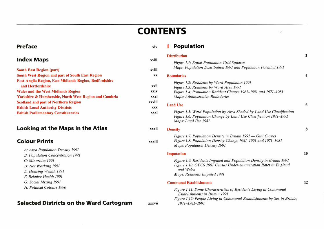
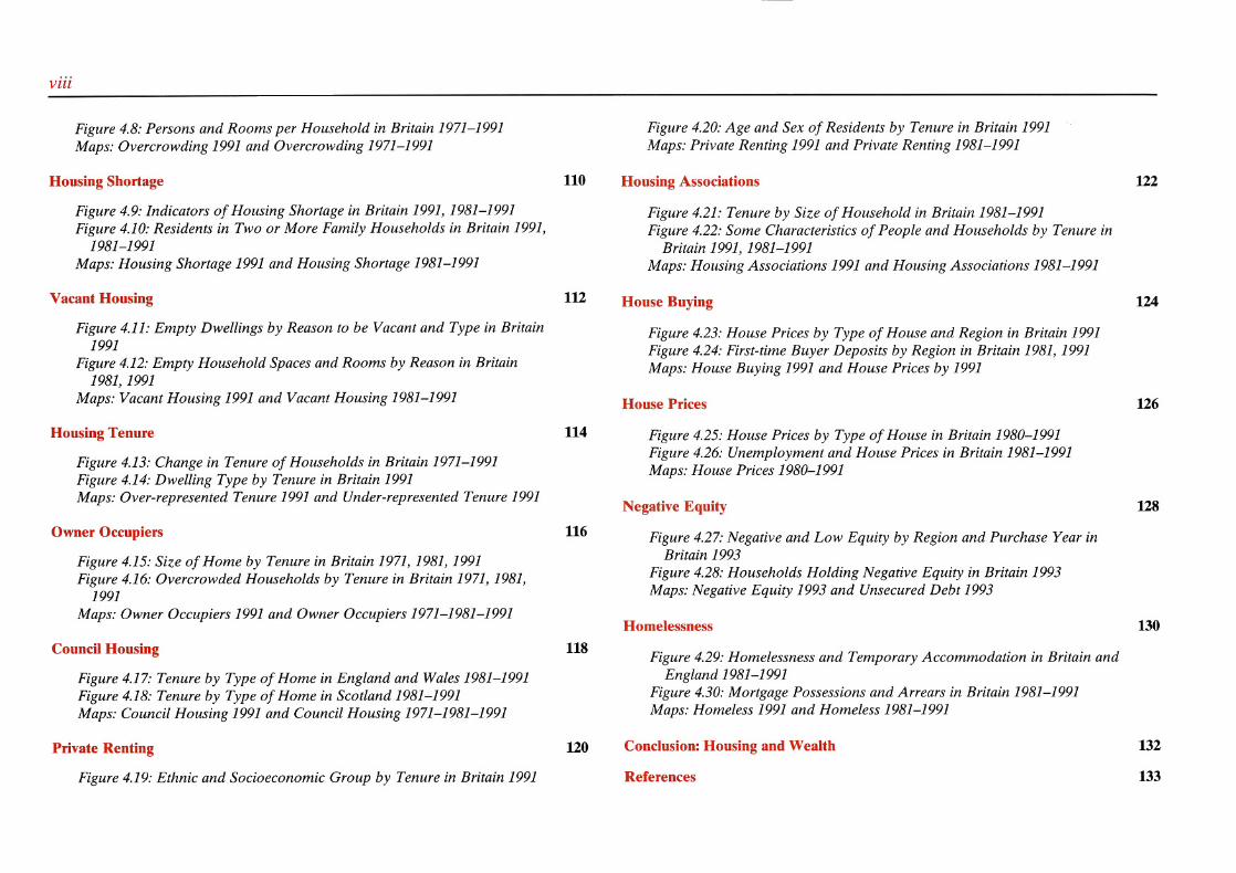
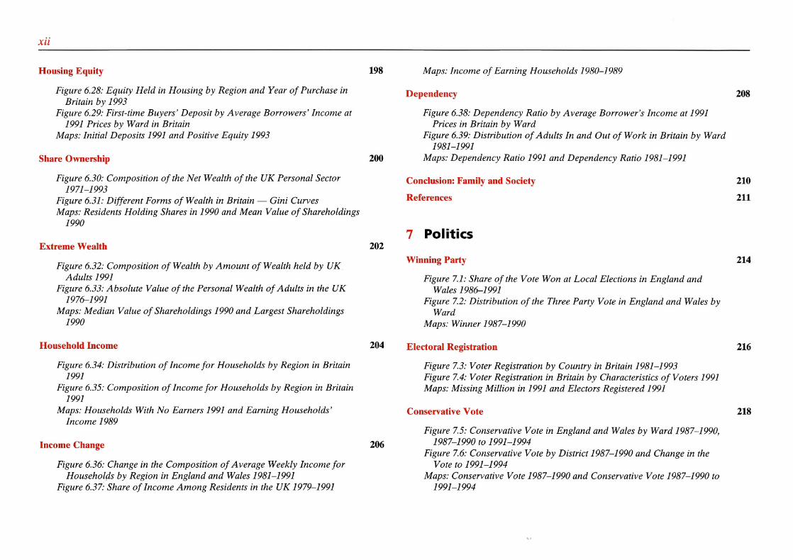
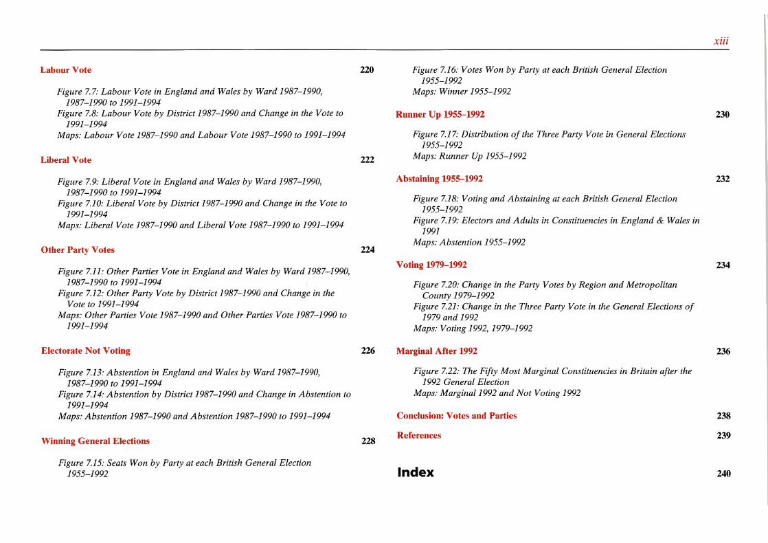
Chapter 0: Contents, Index Maps
35
-
Upload
khangminh22 -
Category
Documents
-
view
0 -
download
0
Transcript of Chapter 0: Contents, Index Maps
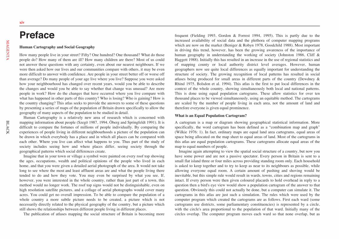
PrefaceHuman Cartography and Social Geography
How many people live in your street? Fifty? One hundred? One thousand? What do thosepeople do? How many of them are ill? How many children are there? Most of us couldnot answer these questions with any certainty, even about our nearest neighbours. If wewere then asked how our lives and our communities compare with others, it may be evenmore difficult to answer with confidence. Are people in your street better off or worse offthan average? Do many people of your age live where you live? Suppose you were askedhow your neighbourhood has changed over recent years, would you be able to describethe changes and would you be able to say whether that change was unusual? Are morepeople in work? How do the changes that have occurred where you live compare withwhat has happened in other parts of this country? Who is losing? Who is gaining? How isthe country changing? This atlas seeks to provide the answers to some of these questionsby presenting a series of maps of the population of Britain drawn specifically to allow thegeography of many aspects of the population to be studied in detail. Human Cartography is a relatively new area of research which is concerned withmapping information about people (Szegö 1987, 1994, Öberg and Springfeldt 1991). It isdifficult to compare the fortunes of millions of people individually. By comparing theexperiences of people living in different neighbourhoods a picture of the population canbe drawn in which everybody has a place and in which all places can be compared witheach other. Where you live can affect what happens to you. Thus part of the study ofsociety includes seeing how and where places differ, seeing society through thegeographical patterns which social differences create. Imagine that in your town or village a symbol were painted on every roof top showingthe ages, occupations, wealth and political opinions of the people who lived in eachhome, and that you were given a detailed aerial photograph of the area. It would not takelong to see where the most and least affluent areas are and what the people living theretended to do and how they vote. You may even be surprised by what you see. If,however, you were interested in the whole country, rather than just part of a town, thismethod would no longer work. The roof top signs would not be distinguishable, even onhigh resolution satellite pictures, and a collage of aerial photographs would cover manyacres. You could get no overall impression. To be able to compare the population of awhole country a more subtle picture needs to be created, a picture which is notnecessarily directly related to the physical geography of the country, but a picture whichstill shows the relationships between different people living in different places. The publication of atlases mapping the social structure of Britain is becoming more
frequent (Fielding 1993, Gordon & Forrest 1994, 1995). This is partly due to theincreased availability of social data and the plethora of computer mapping programswhich are now on the market (Beniger & Robyn 1978, Goodchild 1988). Most importantin driving this trend, however, has been the growing awareness of the importance ofhuman geography in understanding the working of society (Johnston 1986, Cliff &Haggett 1988). Initially this has resulted in an increase in the use of regional statistics andof mapping county or local authority district level averages. However, humangeographers now see quite local differences as equally important for understanding thestructure of society. The growing recognition of local patterns has resulted in socialatlases being produced for small areas in different parts of the country (Dewdney &Rhind 1975, Bolsdon et al. 1994). This atlas is the first to put local differences in thecontext of the whole country, showing simultaneously both local and national patterns.This is done using equal population cartograms. These allow statistics for over tenthousand places to be viewed simultaneously, using an equitable method. The cartogramsare scaled by the number of people living in each area, not the amount of land andtherefore everyone is given equal prominence.
What is an Equal Population Cartogram?A cartogram is a map or diagram showing geographical statistical information. Morespecifically, the word cartogram has been defined as a “combination map and graph”(Wilkie 1976: 1). In fact, ordinary maps are equal land area cartograms, equal areas ofspace being allocated on the map sheet to equal areas of land. Most of the cartograms inthis atlas are equal population cartograms. These cartograms allocate equal areas of themap to equal numbers of people. Imagine again attempting to view the spatial social structure of a country, but now youhave some power and are not a passive spectator. Every person in Britain is sent to asmall flat island three or four miles across providing standing room only. Each householdis asked to keep together and to try to keep as near to its neighbours as possible, whileallowing everyone equal room. A certain amount of pushing and shoving would beinevitable, but this simple rule would result in wards, towns, cities and regions remainingintact. If every person were then given coloured placards to hold overhead in reply to aquestion then a bird's eye view would show a population cartogram of the answer to thatquestion. Obviously this could not actually be done, but a computer can simulate it. Thecartograms in this atlas are just such a simulation. The rules which were used by thecomputer program which created the cartograms are as follows. First each ward (somecartograms use districts, some parliamentary constituencies) is represented by a circle,with the circle's area proportional to the population of that ward. Initially many of thecircles overlap. The computer program moves each ward so that none overlap, but as
xiv
BLA
CK
xiv
MA
GEN
TA
many are kept near to their geographical neighbours as possible. In fact mostneighbouring pairs of wards remain adjacent. The wards are also constrained to keep asnear to their original positions as possible so that the north/south and east/westorientation of places is roughly correct. However the coastline is allowed to be elastic sothat Scotland, which is relatively underpopulated, can shrink (so as to preserve theScottish border). Geographical patterns can then be drawn on these cartograms showingthe detail within, rather than between, district or county administrative boundaries.
Conventions Used in the MapsA similar format is used in most of the maps in this atlas. The maps on page 11 can betaken as an example. On the left is a traditional equal land area map. The title of the mapshows the subject and year. The year refers to the census or other data source used. Thesubtitle gives the type of statistic being mapped, here a proportion (average), and thegroup it refers to, in this case ward populations. The title to the key defines the statistic,in this case the “% of residents imputed”. The text on the facing page 10 explains what ismeant by “imputed” and provides a brief discussion of what the map contains. The keysare drawn as bar graphs which show what proportion of the map is shaded each colour.The actual percentages appear at the end of each bar and underneath the chart is statedwhat these figures refer to, in this case “% of the land area of Britain”. Beneath that thescale is then given for an area of the map equal to a thousand square kilometres. Countyboundaries are drawn on the map to help in locating particular areas. The equal population cartogram on the right of page 11 uses the same format for itskey. It shows the same statistics and uses the same divisions. However, the percentages atthe ends of the bar graphs refer to something very different and hence the bars in the keyare of different lengths. On this cartogram it is the percentage of all residents in Britainwho live in wards in each category, abbreviated on the key to “% of all residents inBritain”. Beneath that the scale is then given for an area on the cartogram equal to aquarter of a million people. Thus the cartograms are quite literally drawn on a humanscale. Because of this, the cartograms may appear to be a strange shape. London and theother metropolitan areas are huge (they contain many people), rural areas shrink andthinly populated highland areas appear as scattered dots. To help in learning this newgeography county boundaries are also shown on each cartogram (see page 5 for maps ofthese). A set of index maps have also been provided at the end of this preface giving, forthose who want it, the ward name, population, local authority district and parliamentaryconstituency for every circle on the cartograms. The maps and cartograms usually show a single statistic in great detail. Theunfamiliarity of the mapping technique, and the wealth of detail shown, results in animage which requires some experience to read. To acquire that experience the reader
should first concentrate on subjects he or she is familiar with, which should then makethis new format easier to understand. The graphs accompanying the text usually show the relationship between two or morestatistics, often at the national scale and using more traditional techniques. They mayoften appear complex because of the number of variables being compared. For instanceFigure 1.10, which is drawn opposite the map and cartogram of imputation, shows therelationship between age, sex and geography as regards estimates of under-enumeration(a term explained in the text by the figure). Over 250 individual statistics are shown inthis figure, arranged so that each can be compared with every other. To make reading the graphs less difficult they also follow conventions similar to thoseused to draw the maps. The title, which is explained in the accompanying text, usuallygives the overall areal unit used (e.g. “Britain” as, unlike a map, it is not obvious) as wellas the subject and date. For graphs the title of the vertical axis is shown across the top ofthe graph and the title of the horizontal axis is given at the bottom. Once again “% of allresidents in Britain” is often used as an abbreviation for “% of all residents in Britain wholive in wards (or other areas) which fall into a particular category”. Having learnt how toread the labelling of the maps and figures in this atlas the unfamiliar reader needs next toknow how to appreciate what these pictures show.
Seeing Patterns and ChangeStatistical methods and computer programs cannot identify unspecified patterns, theycannot interpret pictures. In contrast the human eye and brain excel in their ability to seepatterns, and the more detailed a picture is, the more visible is the pattern (Tufte 1990).For instance, it is difficult to identify a face on a very low resolution photograph. As theresolution is increased the features of the face become more focused until it can berecognised. For similar reasons most of the maps and cartograms in this atlas are drawn athigh resolution. If ten random numbers are selected and used to shade a map of the tenstandard regions of Britain, there will often appear to be a geographical pattern to themap. However, if ten thousand random numbers are selected and used to shade a wardcartogram it is immediately apparent that there is no pattern in that map. Thus if somediscernible pattern is seen on a ward cartogram, it is very unlikely to have arisen out ofchance, and there is almost certainly an explanation for it and a process behind it. Manyof the maps initially produced for this atlas showed no clear patterns. However, choice ofan appropriate statistic and shading groups can greatly alter the clarity with whichpatterns are seen. Other maps initially showed patterns that were mainly a reflection ofother statistics, such as crude mortality rates reflecting the distribution of pensioners. Inthese cases alternative statistics often had to be used which were independent ofunwanted patterns such as underlying demography. Once two geographical distributions
xv
BLA
CK
xv
MA
GEN
TA
appeared to have a pattern in common, a scatterplot could be drawn to reveal the degreeand nature of correlation (see Figure 1.9 for an example). Picture form is almost alwaysthe best way of presenting patterns. Discovering patterns of change is often as interesting as uncovering the structure to thestatus quo. How is Britain changing? A series of maps or cartograms can be used to showchange, but their comparison is difficult even when they are drawn side by side. It isoften preferable to show change on a single map. Many of the basic statistics in this atlasare given as a percentage and then the changes in that percentage are mapped. The simpledifference between two percentages is almost always used rather than a percentage of apercentage. For example, if the value of a statistic in one area increases from 1% to 2%,and another from 50% to 60%; these rises are shown as 1% and 10% respectively (not as100% and 20% rises). This method diminishes the local impact of changes but allowsbetter nationwide comparisons to be made.
How the Atlas was ProducedIn 1989 the author created a computer-generated cartogram of British counties for astudent dissertation. Many types of cartograms were developed in his subsequent PhDthesis on visualising spatial social structure (Dorling 1991) and some of the techniquesdeveloped there are used here. Work specifically on this atlas started in the summer of1992 following the first releases of the new census data and the culmination of otherresearch which involved the collection of large amounts of housing and voting data. Inthe end, however, the most time consuming aspect to drawing this atlas was still taken upby collecting more data to include. Few researchers realise just how much localinformation is available on Britain because of the difficulty of collecting it: “hardly anyfigures are available at a lower geographical scale than that of the local district orborough council” (Willmott 1994: 1). There are, in fact, thousands of figures available atdetailed geographical scales. However, making these figures comparable, checking them,and then mapping what they show could not be done with commercial computer mappingsoftware. Numerous short programs were written to transform, store, compress andretrieve the censuses and other data used here, to create and draw the maps, cartogramsand other illustrations shown, and to calculate and check the statistics quoted. Files wereproduced to be compatible with the standard drawing program of an Acorn Archimedescomputer which is used in many schools and which was used to produce all of this atlas.Numerous maps were created and viewed on screen, but only those which showed apattern of interest were chosen. The text was then read by colleagues familiar with thevarious fields covered (see below). The information has been divided by subject and thisstructure reveals some of the areas of life in Britain about which detailed spatialinformation was available. Population, demography, economics, housing, health, society
and politics also reflect different areas of academic interest. Each chapter is relativelyself-contained and the references are listed at the end of each. The final postscript fileswere also optimised to be as compact as possible. These still large files were then sent tothe publishers to be printed at the high resolution necessary for all the detail to be visible.Throughout this process Wiley staff gave a great deal of advice and undertook numerouschecks for quality, before proof-reading and printing the atlas.
Acknowledgements and SourcesThe length of the following list is testimony to the debt of gratitude I owe to all thosewho helped me to write and draw this atlas, provided information for it and funded it.Most importantly the Economic and Social Research Council and the Joint InformationSystems Committee purchased access to the census statistics and boundary data on behalfof the academic community. This information was prepared by the Office of PopulationCensuses and Surveys and is Crown Copyright. Members of this office have been mosthelpful providing the author with data and advice. Most maps are based on data from the census Small Area Statistics, while most tablesand graphs use the census Local Base Statistics. The referencing style of the latest SocialTrends is followed here. Sources are only given when the data used is not census areastatistics, and these are often given briefly in the text and in full in the references at theend of each chapter. Other census statistics are also used for Figures 1.14, 2.20, 4.20, 6.1,6.2, 6.13, 6.15, 6.16 and 6.21 which are based on an analysis of the 1991 census Sampleof Anonymised Records. Mid Year Estimates are used on pages 16, 17, 20 and 21 and inFigures 2.3, 2.4, 2.5, 2.6, 2.27 and 2.29. The data for these was also provided by theOffice of Population Censuses and Surveys and was derived from estimates made byHelen Mounsey. The census data has been extensively analysed to create new datasets.David Atkins, Martin Charlton and David Choi helped correct the geography of the 1991census enumeration district centroids shown on page 3, and link these to 1981 wards. Other official statistics used in this atlas include data from the publications RegionalTrends and Social Trends, which were sources for Figures 6.11, 6.30, 6.34, 6.35 6.36 and6.37. The historical Birth, Marriage and Mortality Statistical Series were used forFigures 2.1, 2.2, 2.12, 2.13, 5.13, 5.17 and 5.21. More historical information is includedin Figures 5.31 and 5.32 which incorporate information from past Registrar General'sDecennial Supplements and Statistical Reviews. The Labour Force Survey was used inFigure 2.18. The General Household Survey and the Housing and Construction Statisticsseries were used in Figures 4.3 and 4.5. The homelessness figures shown on page 131were derived from the Local Housing Statistics and the Scottish Office Series. Figuresfrom the Employment Gazette were used in Figures 3.6 and 3.9 and data from theNational On-line Manpower Information System were used for Figures 3.22, 3.23, 3.24,
xvi
BLA
CK
xvi
MA
GEN
TA
3.25 3.26, 3.30 and 3.31 and the maps shown on pages 91 and 97. Many other data sources have been drawn on for this atlas and many individuals havebeen very helpful to the author in accessing this information. Steve Carver provided theinformation on land-use shown on page 6. The Nationwide Building Society, via TonyChampion, provided the information on mortgages which was used to estimate houseprices and equity levels in Figures 4.24, 4.25, 4.26, 4.27, 4.28, 6.28, 6.29 and 6.38 and inthe maps on pages 125, 127, 129, 199, 205 and 207. Staff from the Office of Censusesand Population Survey's Medical Section and Brian Jarman, Madhavi Bajekal and PatDavis of St. Mary's Hospital Medical School helped provide access to the mortality dataused to produce most of the figures and maps in Chapter 5. The Department forEducation and the Welsh Office were very helpful in providing the school exam resultsdata used for Figure 6.12 and the maps on page 181. Stan Openshaw provided theinformation on share ownership used in Figure 6.31 and the maps on pages 201 and 203.Michael Thrasher provided the local government elections results used in Chapter 7.Steve Simpson allowed early access to the estimates being made of the locations of themissing million used on page 217. The general election data used in Chapter 7 wascombined by James Cornford, Bruce Tether and the author from various sources and isdeposited at the ESRC Data Archive at the University of Essex, along with the re-aggregated (to 1981 ward areas) 1991 census data which has been used here. Othersources are individually referenced in the text. It has taken three years to complete this atlas and funding for the project has comefrom many sources. The work began under a Joseph Rowntree Foundation fellowship (toresearch housing) and has been completed while the author was funded by the BritishAcademy to study the social transformation of Britain. The Economic and SocialResearch Council also provided financial support for this project through a grant to studysocial polarisation (H507255135), as, indirectly, did the Henley Centre and several otherorganisations interested in social change in Britain. Work requested by the LordCommissioners of Her Majesty's Treasury in 1994 helped finance some of the computerequipment used to print this atlas. Thanks are also due to Norwich Computer Services fortheir continued support of this equipment, and to the production team at John Wiley &Sons for their patience in handling this complex project and in particular to IainStevenson for supporting it. I would also like to thank some of the people who readthrough and criticised earlier drafts of this atlas, in particular Ile Ashcroft, TonyChampion, James Cornford, Bronwen and David Dorling, Jenny Grundy, Stacy Hewitt,Ann Rooke and Rachel Woodward. Most research is done by one person usually sitting alone at a desk or in front of acomputer screen, and profound decisions about what to map, how when and in what waycan depend as much on deciding when it is time to call it a day as on any grand theory.
My last words of thanks go to Anna Macdonald for understanding why I was always latedrawing “one last map” and for encouraging me not to give it up. With luck you will find something in this atlas of interest. In the end it is only possibleto draw these pictures because most people diligently fill in census forms, voting slips,birth certificates, mortgage applications, unemployment cards and all the other paperwork which is used to organise British society. Hopefully some of that information isbeing returned in these pages.
ReferencesBeniger, J.R. & Robyn, D.L., 1978, Quantitative graphics in statistics: a brief history, The
American Statistician, 32, 1, 1−11.Bolsdon, D., King, D. & Musgrave, S., 1994, Census Atlas of the Eastern Region: Housing, A
Statistical Analysis based on the 1991 Census of Population, PHRG information note 22,Chelmsford: Anglia Polytechnic University.
Cliff, A.D. & Haggett, P., 1988, Atlas of Disease Distributions: Analytic Approaches toEpidemiological Data, Oxford: Basil Blackwell Ltd.
Dewdney, J.C. & Rhind, D.W. (eds), 1975, People in Durham — A Census Atlas, University ofDurham: Census Research Unit.
Dorling, D., 1991, The Visualization of Spatial Social Structure, Newcastle University:Unpublished PhD Thesis.
Fielding, A.J., 1993, The Population of England and Wales in 1991: A Census Atlas, Sheffield:Geographical Association.
Goodchild, M.F., 1988, Stepping over the line: technological constraints and the new cartography.The American Cartographer, 15, 3, 311−319.
Gordon, D. & Forrest, R., 1994, People and Places 1: A 1991 Census Atlas of England, Bristol:School for Advanced Urban Studies.
Gordon, D. & Forrest, R., 1995, People and Places 2: Social and Economic Distinction inEngland, Bristol: School for Advanced Urban Studies.
Johnston, R.J., 1986, A space for place (or a place for space) in British psephology: a review ofrecent writings with especial reference to the general election of 1983, Environment andPlanning A, 18, 573−598.
Öberg, S. and Springfeldt, P., 1991, The Population: The National Atlas of Sweden, Stockholm:SNA publishing.
Szegö, J., 1987, Human Cartography, Mapping the World of Man, Stockholm: Swedish Council forBuilding Research.
Szegö, J., 1994, Mapping Hidden Dimensions of the Urban Scene, Stockholm: Swedish Council forBuilding Research.
Tufte, E.R., 1990, Envisioning Information, Cheshire, Connecticut: Graphics Press.Wilkie, R.W., 1976, Maps and cartograms, Statistical Abstract of Latin America, 17, 1−23.Willmott, P., (ed), 1994, Urban Trends 2: A Decade in Britain's Deprived Urban Areas, London:
Policy Studies Institute.
xvii
BLA
CK
References
xvii
MA
GEN
TA
xviii
011G u2012
G u2
042G u2060
G u2 062G u2
077G u2082G u2084
G u2110G u2121G u2148G u2175
G u2188G u2189G u2
204G u2
218G u2259
G u2260G u2421
G u2434G u2530
G u2537G u2695
G u2722G u2724G u2
008F k1
052F k1
068F q1
096F q1
107F q1
123F q1 129
F q1135F q1
269F k1
274F k1 277
F k1
295F q1296
F q1
322F k1
361F k1
376F q1
411F k1
412F q1
533F k1
554F q1
628F q1
646F q1
591F q1
593F k1673
F k1
743F k1
093L h1
144L i1170
L h1210L i1
213L i1
237L h1
316L i1
380L i1
413L i1
430L h1
471L i1
478L h1
491L h1
497L h1
499L h1
540L i1
551L h1
592L h1
606L h1
719L i1
739L i1
756L i1 762
L i1
007M j1030
M f1
085M j1
090M j1
174M f1
179M j1
184M j1 194
M f1
240M f1
283M f1
309M j1
454M f1
489M f1
507M f1
547M j1
577M f1
584M f1
655M j1
664M f1
697M f1
725M f1
757M j1
776M j1
013N s1020
N s1
074N s1 094
N w2
176N w2
208N s1
273N s1
303N w2
334N w2
356N w2
362N s1
384N s1
385N s1
475N s1
484N s1 510
N w2
580N w2
595N s1
598N w2
693N w2
745N w2
758N w2
772N s1
040S w1
100S w1
114S w1
115S w1
169S w1
285S v1
359S v1
363S v1
369S w1
370S v1
378S w1
399S v1
464S v1
535S v1
619S v1
642S w1
650S w1
666S v1
683S w1
688S v1
005T l
029T x1
088T l
108T x1
152T l
162T l
183T x1
192T l
224T l
290T x1
328T l
377T x1
400T x1
488T x1 493
T l
514T x1
538T x1
552T l
570T l
615T x1
597T l
019V h2
061V a3
165V r2
166V a3
264V a3
286V h2
352V h2
415V h2
423V a3
505V a3
532V a3
631V r2 635
V h2
656V a3
659V r2
660V r2
661V r2
685V r2
686V h2
696V r2
703V h2
716V a3
050W b2
065W a2
069W z1
124W b2
163W a2
205W z1
219W a2
220W z1
250W z1
271W b2
305W z1
307W a2
372W a2
383W b2
417W z1
448W a2
457W z1 516
W z1
518W b2
572W b2
614W b2
632W a2
644W a2
674W b2
675W b2 759
W a2
044Y g2
054Y g2 112
Y g2 122Y e2
132Y e2
209Y g2
270Y f2
302Y e2
390Y g2
404Y e2
436Y e2
449Y e2
468Y e2
479Y f2
503Y g2
511Y f2
525Y g2
526Y f2
652Y e2
600Y g2
658Y f2
707Y f2
726Y e2
746Y f2
002B1q2
015B1u
041B1k2049
B1u
080B1q2
092B1q2
097B1k2
101B1q2
126B1q2
145B1q2
180B1u
185B1k2
216B1q2
257B1k2
275B1k2
433B1k2
444B1u
481B1k2
561B1q2
566B1q2
573B1u
574B1u
620B1k2
682B1u 732
B1u
066D1f
073D1f
087D1f
229D1f
308D1f 379
D1d
422D1f
435D1f
467D1f
509D1f
553D1d 616
D1d
626D1d
630D1d
640D1d
649D1d
581D1f
603D1d
735D1d
032F1b
047F1v2
225F1v2
230F1l2
253F1b
280F1v2
300F1v2
425F1b
482F1v2 495
F1b
512F1l2
542F1b
564F1l2
629F1b
638F1b
582F1b
602F1l2608F1v2
679F1l2
692F1v2
748F1l2
749F1l2
031G1u2
043G1d3
048G1u2
098G1u2
128G1u2
164G1u2
161G1d3
321G1d3
336G1d3
393G1u2416G1u2
420G1d3
437G1d3
441G1d3
445G1d3
466G1u2
536G1d3 555
G1d3
618G1u2
625G1u2
717G1u2
755G1d3
744G1u2
004A a
014A t
105A a
133A t
234A t
235A a 256
A t
282A a
294A a
344A t
439A a
450A a
455A t
513A a
560A t
678A a
701A t
712A t
721A t
023B n
095B n
103B o1
153B p1
178B o1
226B n
228B e1
239B o1
268B e1
276B e1
281B p1
291B p1
315B n
319B o1
350B p1
465B o1
648B e1
694B n
747B p1
770B e1
036C e
035C e
053C c1
063C i2
067C i2
070C c1
076C e
158C e
201C i2
202C c1
211C e
233C e
249C c1
255C e
419C i2
492C c1
498C c1
639C i2
643C e
587C i2588
C i2
680C c1
708C e
016D i
033D i
038D h
079D g
089D g
117D g
136D g
159D g
203D g
278D h 287
D g
331D i 403
D i
407D h 410
D g
414D h
452D i
453D g
531D h
541D h
539D g
563D h
567D i
613D h 651
D i 657D i
663D h
662D h 687
D i 737D i
763D g
017E c
058E o
059E m2
086E m2
149E j2
155E o
171E c
187E c
206E j2
212E m2
238E c
258E j2340
E m2
401E c 428
E c 458E m2
473E o
504E j2
515E c
519E j2
524E o
637E j2
647E o
585E c
752E m2
753E m2
006H q
027H q
055H r
057H r
083H r
191H s
207H s 252
H p 266H p
345H p 402
H s
470H q
476H p
487H r
534H s
575H q
576H s
578H s
596H q
605H p
684H q
706H q
723H p
750H r
760H r
768H s
771H q
022I w
190I w
217I x
223I v
243I x 288
I x
327I v
346I v 373
I w
447I w
474I x
494I x
496I x
517I w 523
I v
545I w
601I v
607I v 711
I v
718I v
729I x
733I x
742I w
765I w
018J y
025J b1
024J b1
099J a1
634J a1
543J y
374J a1
143J a1
426J y
461J b1
195J y
248J a1299
J y
247J a1
298J b1
398J y
360J y
297J b1
246J a1
075J b1
529J a1
391J y
611J y
610J y
392J y
312J b1
141J a1
142J b1
764J a1
311J b1
001K f3
026K f3
028K z
064K g1
104K f3
138K g1
173K z
214K z
242K z
251K f3
265K g1
289K f3
351K z
382K g1
409K g1
418K f3
463K z
477K z
483K z
506K z
527K f3
550K g1
609K g1
641K f3 645
K f3
583K z
586K f3
589K f3
667K z
676K z
681K f3
699K g1
715K g1
736K z
754K g1
773K f3
116O l1
130O l1
304O l1
335O m1
337O l1
338O m1
341O m1 342
O m1
405O l1406
O l1456O l1
522O m1
521O m1
548O m1
558O m1
568O m1
569O m1
653O l1
654O l1
734O l1
738O l1
009P r1
021P y2
091P o2
140P o2 181
P o2
199P y2
200P y2
241P r1
244P y2
284P o2
293P y2
314P r1
333P y2
343P o2
349P y2
365P y2
394P r1
459P o2
502P o2
544P r1
559P o2
612P r1
617P o2
594P r1
705P y2
039Q n1
071Q n1
072Q p2
127Q p2
139Q n1177
Q z2 193Q z2
197Q n1
215Q p2
236Q p2
330Q z2
332Q n1
348Q n1
366Q z2
367Q z2
368Q z2
395Q z2
451Q p2
501Q p2
500Q p2
571Q p2
636Q p2
698Q n1
709Q z2
710Q z2
741Q z2
766Q n1
778Q n1
779Q z2
078R j 156
R j
157R j
198R d1227
R d1261R d1
262R d1
263R d1
313R j
329R d1
353R d1
354R d1355
R d1386R j
387R d1 388
R j 389R d1
396R j
397R j
604R j
704R j
056U s2
102U y1
106U y1
109U y1
150U s2
151U s2
186U y1
310U y1
364U y1
381U s2
446U y1
486U y1485U y1
627U y1
633U s2665U s2
689U s2690U s2
691U s2
702U y1
003X e3
113X e3
182X d2
221X e3
222X e3
267X d2
301X d2
371X e3 427
X d2
440X d2
442X d2
462X e3
520X d2
528X d2
546X d2
549X e3
623X d2
700X e3
720X e3
740X e3
010Z t1
034Z t1
081Z c3
134Z t1
160Z c3
167Z c3
168Z u1
196Z u1
254Z t1
279Z t1
292Z u1
317Z t1
443Z u1
460Z u1
469Z c3
480Z u1
562Z c3
579Z t1
590Z c3
713Z u1
731Z c3
037A1n2
131A1x2
231A1n2
232A1n2
320A1n2
326A1x2
323A1x2
324A1x2
325A1x2
347A1x2
408A1n2
472A1n2
508A1n2
556A1n2
557A1n2
599A1x2
677A1x2
751A1x2
761A1x2
045C1k
046C1k
051C1t2
118C1k
119C1k 120
C1k 146C1t2
147C1t2
172C1k
490C1t2
565C1t2
621C1k
622C1k
668C1t2
669C1t2
670C1t2
671C1t2
672C1t2
727C1k
728C1k
730C1k
769C1k
774C1t2 775
C1t2
777C1k
111E1c2
125E1c2
137E1m
154E1m
245E1m
272E1c2
306E1c2
318E1m
339E1m
358E1b3
357E1b3
375E1b3
424E1m
429E1c2 431
E1c2
432E1c2
438E1b3
624E1b3
714E1m
767E1b3
049A b
074A b
052A b
057A c
060A b
051A c
098A c
073A b
087A c
050A b
056A c
096A c
061A b
100A c
104A b
099A c
114A c
086A c 069
A b 030B d 032
B d
046B d
064B d
072B d
081B d 097
B d
102B d
112B d
119B d
004C e
009C e
012C e
018C e 020
C e
035C e
042C e 058
C e 071C e
075C e
082C e
084C e
113C e
111C e
123C e
128C e
013D f
043D f
048D f
076D f
094D f 095
D f 116D f
120D f
124D f
127D f
066E g
065E g
067E g 077
E g 108E g
109E g
034E g
101E g
088E g
091E g 031
E g
047E g 085
E g 023E g
078E g 005
E g
129E g 063
E g 062E g
117F a
036F a
107F a
008F a
080F a
007F a
017F e
014F a
003F a
110F a
011F a
010F e
126F e
006F a
125F a
044F e
019F a
037F e
115F a
026F a
083F a
021F a 022
F a
106F a
105F e
053G h 122
G h 059G h
025G h
054G h
055G a
079G a
089G a
090G a
092G d
093G d
033G g
001G g 002
G g
045G h 016
G h
027G h 029
G h 038G h
040G h
024G h
041G h 015
G h
039G h 068
G h
070G h
103G h
118G h
121G h 028
G h
019A b
020A b
055A b
095A a
096A a
155A b
157A a
160A a
191A a
206A a
207A a
288A a
303A b
304A b
025B c
028B c 029
B c 035B c
036B c 037
B c
052B l
063B l
075B c
077B l
079B c
083B l
102B l 121
B l
122B l
131B c
153B c
201B c
217B c
236B l
263B l 264
B l 265B l
268B c
279B c
287B l
307B c
308B c 309
B c
310B c
311B c
312B c
317B l
026C d
039C d
040C d
041C d
044C d
045C d
136C d
145C d
148C d
150C d
149C d
151C d
189C d
205C d
234C d
238C d
294C d
297C d 006
D e
033D e
057D e
058D e
059D e
060D e
061D e
062D e
066D e
247D e
249D e
254D e
248D e
290D e
001E f
011E f
031E f 049
E c
065E f
165E f
084E f
097E f
099E f
070E c
013E f
108E c
048E c
069E f
164E f
012E f
188E f
098E f
047E f
237E k
218E k
225E f
219E k
002E f
179E f
243E f
003E f
314E k 239
E k
316E c
018F m
023F m
032F j
064F j 022
F j
081F j
085F m
021F j
107F j
116F j
123F m
163F j
182F j
184F j
195F m
210F m
214F m
244F j
245F j
183F j
194F j 209
F m
162F j
282F m
296F j
298F m
213F m
313F j
046G g
050G g 051
G g 071G g
072G g
073G d
080G g
090G g
091G g
104G g
120G d
139G g
140G d
156G d
172G g
173G g
174G g
175G g
187G d
190G h
197G h
202G d
204G g
224G d
226G h
232G h
233G d
277G g
291G g 292
G g
038H h
115H h
124H h
152H h
154H h
158H h
168H h
180H h
181H h 192
H h
193H h
199H h 203
H h
208H h
260H h
286H h
005I m 053
I m 054I m
076I m
100I m
117I m
137I m
138I m 176
I m
177I m
178I m
212I m
252I m
242I m
274I m
281I m
283I m
284I m
305I m
315I m
009J k
014J k
056J k
082J k
093J k
103J k
118J k
119J k
133J k
134J k
141J k
142J k 143J k
146J k
147J k
171J k
216J k
221J k
222J k
223J k
285J k
301J k
302J k
016K o 027
K o 068K o
087K o
161K o
185K n
211K o 253
K n
235K n 240
K n 278K n
289K n
300K o
004L j
007L j
015L i
030L i
034L i
042L j
043L j
088L j
094L i
101L i
109L i 110
L j
111L j 126
L i 125L i
128L i
127L i
132L i
144L i
159L j
166L i
186L j
215L i
227L i
246L i
250L i
251L i
255L i
256L i
241L i
267L i
293L i
010M p
017M p
067M p
078M b 086
M p
105M p
106M p
169M p
198M p
200M b
257M b
261M p
273M b
280M p
299M p
008N l
024N l
074N l
089N l
092N l
112N l
113N l 114
N l 129N l
130N l
135N l
170N l
167N l
196N l
220N l
228N l 229
N l 230N l
231N l 258
N l
259N l
262N l 266
N l 269N l
270N l
271N l
272N l
275N l
276N l
295N l 306
N l
002A a
005A a
008A a
009A a
010A a 011
A a
012A a
013A a
014A a
015A a
016A a
017A a
018A a
019A a
020A a
021A a
022A a
023A a
024A a
025A a
026A a
027A a
039A a
040A a
048A a
052A a
071A a
075A a
124A a
130A a
144A a
156A a
168A a
199A a
238A a
254A a
280A a
302A a 320
A a 322A a
321A a 323
A a
357A a
358A a
364A a
030B b 033
B b
044B b
072B b
073B b
122B b
131B b
132B b
141B l
142B l
174B b
191B b
220B b
214B b
246B l
301B b
262B b
304B b
307B b
308B b
312B b
318B b
344B l
351B b
356B b
035C c
056C c
087C c
121C c
125C c
127C c 138
C c
152C c
163C c
176C c
193C c
205C c
211C c
240C c
241C c
178C c
306C c
311C c
316C c
353C c
354C c 355
C c
007D n
029D d
032D d
059D d
062D d 064
D d
079D d
099D d
105D d
175D n
182D d
185D d
192D d
200D d
201D d
206D d
212D d
213D d
235D d
242D d
248D d
249D d
294D d
300D d
260D n
271D d
328D d
329D d
334D d
360D n
362D n
037E g 058
E g
140E g
195E g
215E g
228E g
239E g
245E g
244E g
252E g
295E g
283E g
333E g
340E g
069F h
070F h
077F h
078F h
146F h
177F h 196F h 197F h
218F h
219F h
225F h
230F h
251F h
253F h
277F h
278F h
348F h
352F h 359
F h
004G i
031G i
036G k
049G i
051G k
057G i
081G i
089G k
097G k
106G i
133G k
137G i
139G i
145G i
150G k
170G i
172G i
180G i
187G i
216G k
227G i
273G i
274G i
284G i
303G i
310G i
327G k
365G i
003H j
085H j
093H j
119H j
118H j
149H k
151H j
154H k
181H k
183H k
247H j
296H j
319H j
325H j
330H j
332H j
337H k
338H j 342
H k 343H k
006I c
054I m
074I m
083I m
091I m
100I m
101I m
104I m
107I m
108I c
129I m
143I m
155I c
165I m
173I m
179I c
223I m
232I m
250I m
261I m
264I m
265I m
266I m
267I m
268I m
276I m
282I m
309I m
313I m
314I m
315I m
349I m
346I m
092J f
102J f
109J f
110J f
111J f
112J f
113J f
114J f
115J f
116J f
117J f
136J f
157J f
158J f
159J f
160J f
184J f
186J f
190J f
208J f
298J f
258J f 263
J f
305J f
317J f
001K e
046K e 050
K b
080K b
088K e
094K e
098K e
126K e
134K g
162K e
166K e
202K e
203K e
207K e
209K e
243K e
255K e 290
K e
269K e
270K e
272K e
324K e
341K e
345K e
361K e
034L n
041L l
042L l
053L n
066L l
067L n
068L n
076L l
086L l
103L l
167L n
188L l
189L l
204L n
210L n
217L l
221L n
233L l
234L n
293L n
299L n
257L l
279L n
288L n
326L l
335L n
350L l
028M o
043M o 045
M o
047M o
060M o
061M o
065M o
090M o
095M o
096M o
128M o
147M o
148M o
161M o
164M o
171M o
194M o
198M o
222M o
236M o
237M o
281M o
331M o
336M o
339M o
347M o
363M o
038N p
055N p
063N p
082N p
084N p
120N p
123N p 135
N p
153N p
169N p
224N p
226N p
229N p
231N p
256N p
291N p 292
N p
297N p
259N p
275N p
285N p
286N p
287N p 289
N p
043A d
044A d
045A d
061A d
087A a
088A a
089A d
108A d
113A d
114A d
115A d 125
A a
130A d
158A a
174A d 184
A a
185A a
186A a
187A a 196
A d
198A a
199A a
016B c
046B c
047B c
049B c
063B c
062B c 120
B c 149B c
164B c
168B c
181B c
193B c
203B c
007C k
006C k
041C e
042C d
055C d
075C e
092C e
109C d
111C e
122C k
129C e
134C k
151C d 152C e
167C e
169C e 176
C e
178C f
179C e 194
C e
205C e
013D f 014
D f 015D f
022D f
023D f 024
D f
026D f
034D f
050D f
051D f
052D f
053D f
071D f
072D f
091D f
102D f 103
D f
104D f
123D f
126D f
147D f
148D f
195D f
018E c
039E h
093E h
094E h
099E h
121E c
136E c
139E h
140E h
143E h
141E h 142
E h
144E h
145E h
146E h
150E h
172E h
173E c
001F a
002F a
003F a
036F a
037F a
056F g
059F g
060F g
073F a
097F g
119F a
177F g
183F g
204F a
008G j
009G j
010G j
011G j
012G j
083G j
101G j
155G j
156G j
162G j
163G j 165
G j
166G j
170G j
171G j
175G j
017H g
019H g
040H g 077
H g
076H g
086H g
105H g
118H g
127H g
133H g
160H g
161H g
180H g
190H g
192H g
201H g
021I b 028
I b
033I b 035
I b
054I b
070I b
081I b
084I b
106I b
107I b
124I b
131I b 132
I b
135I b
138I b
182I b
188I b
189I b
197I b
200I b
202I b
079J i 080
J i
078J i
065J i
066J i 069
J i
068J i
067J i
090J i
157J i
085J i
005J i
025J e 030
J i 038J i 048
J e
074J i
004J i
058J i
064J e
029J i
057J i
112J i
020J e
153J e
027K k
031K k
032K k 082
K k
095K k
096K k
098K k
100K k
110K k
116K k
117K k
128K k
137K k
159K k
154K k
191K k
029A f
044A f
048A f
061A f
083A f
100A f
101A f
102A f
109A f
127A f
128A f
124A f
126A f 145
A f
011B a
016B a
086B a
062B a
015B a
004B a
003B a
096B a
098B a
097B a
137B a
010B a
014B a
013B a
001B a
005B a 002
B a 103B a
065B f 007
B f
064B f
008B f
116B f
006B a
020C b
022C b
023C b
035C b
040C b 041
C b
042C b
043C b
054C b
056C b
060C b
063C b
067C b
074C b
075C b
087C b
092C b
093C b
099C b
104C b
107C b
108C b
110C b
114C b
118C b
119C b
120C b
122C b
129C b
132C b
144C b
143C b
146C b
027D c
069D c
017D c
088D c
091D c
105D c
111D c
123D c
134D c
070D c
140D c
019E d
024E d
025E d
039E d
049E d
053E d 066
E d
082E d
089E d
106E d
112E d
113E d
084E d
115E d
018E d
121E d
125E d 130E d
131E d
133E d
135E d
138E d
139E d
141E d 030
F e
031F e
034F e 033
F e
032F e
077F e
078F e
052F e
076F e 079
F e
080F e 095
F e
057F e 058
F e
059F e
068F c
050F c
136F c 009
F e
012F c 094
F e
085F e
142F e
051F e
026F c
021F e
090F e
047F e
046F e 045
F e 028G g 036
G g 038G g
055G g
073G g
037G g
081G g
071G g
117G g 072
G g
East SussexDISTRICTS
A BrightonB EastbourneC HastingsD HoveE LewesF RotherG Wealden
CONSTITUENCIESa Bexhill and Battleb Brighton Kemptownc Brighton Paviliond Eastbournee Hastings and Ryef Hoveg Lewesh Wealden
EssexDISTRICTS
A BasildonB BraintreeC BrentwoodD Castle PointE ChelmsfordF ColchesterG Epping ForestH HarlowI MaldonJ Rochford
K Southend-on-SeaL Tendring
M ThurrockN Uttlesford
CONSTITUENCIESa Basildonb Billericayc Braintreed Brentwood and Ongare Castle Pointf Chelmsfordg Epping Foresth Harlowi Harwichj North Colchesterk Rochfordl Saffron Walden
m South Colchester andMaldon
n Southend Easto Southend Westp Thurrock
Greater LondonDISTRICTS
A Barking and DagenhamB BarnetC BexleyD BrentE BromleyF CamdenG City of LondonH CroydonI EalingJ Enfield
K GreenwichL Hackney
M Hammersmith andFulham
N HaringeyO HarrowP HaveringQ HillingdonR HounslowS IslingtonT Kensington and ChelseaU Kingston upon ThamesV LambethW LewishamX MertonY NewhamZ Redbridge
A1 Richmond upon ThamesB1 SouthwarkC1 SuttonD1 Tower HamletsE1 Waltham ForestF1 WandsworthG1 Westminster, City of
CONSTITUENCIESa Barkingb Batterseac Beckenhamd Bethnal Green and
Stepneye Bexley Heathf Bow and Poplarg Brent Easth Brent Northi Brent Southj Brentford and Isleworthk Carshalton and
Wallingtonl Chelsea
m Chingfordn Chipping Barneto Chislehurstp Croydon Central
q Croydon North Eastr Croydon North Wests Croydon Southt Dagenhamu Dulwichv Ealing Actonw Ealing Northx Ealing Southally Edmontonz Eltham
a1 Enfield Northb1 Enfield Southgatec1 Erith and Crayfordd1 Feltham and Hestone1 Finchleyf1 Fulhamg1 Greenwichh1 Hackney North and
Stoke Newingtoni1 Hackney South and
Shoreditchj1 Hammersmithk1 Hampstead and Highgatel1 Harrow East
m1 Harrow Westn1 Hayes and Harlingtono1 Hendon Northp1 Hendon Southq1 Holborn and St. Pancrasr1 Hornchurchs1 Hornsey and Wood
Greent1 Ilford Northu1 Ilford Southv1 Islington Northw1 Islington South and
Finsburyx1 Kensingtony1 Kingston-upon-Thamesz1 Lewisham Deptforda2 Lewisham Eastb2 Lewisham Westc2 Leytond2 Mitcham and Mordene2 Newham North Eastf2 Newham North Westg2 Newham Southh2 Norwoodi2 Old Bexley and Sidcupj2 Orpingtonk2 Peckhaml2 Putney
m2 Ravensbournen2 Richmond-upon-Thames
and Barnes
o2 Romfordp2 Ruislip - Northwoodq2 Southwark and
Bermondseyr2 Streathams2 Surbitont2 Sutton and Cheamu2 The City of London and
Westminster Southv2 Tootingw2 Tottenhamx2 Twickenhamy2 Upminsterz2 Uxbridgea3 Vauxhallb3 Walthamstowc3 Wanstead and Woodfordd3 Westminster Northe3 Wimbledonf3 Woolwich
KentDISTRICTS
A AshfordB CanterburyC DartfordD DoverE GillinghamF GraveshamG MaidstoneH Rochester upon MedwayI SevenoaksJ Shepway
K SwaleL Thanet
M Tonbridge and MallingN Tunbridge Wells
CONSTITUENCIESa Ashfordb Canterburyc Dartfordd Dovere Favershamf Folkestone and Hytheg Gillinghamh Graveshami Maidstonej Medwayk Mid Kentl North Thanet
m Sevenoaksn South Thaneto Tonbridge and Mallingp Tunbridge Wells
SurreyDISTRICTS
A ElmbridgeB Epsom and EwellC GuildfordD Mole ValleyE Reigate and BansteadF RunnymedeG SpelthorneH Surrey HeathI TandridgeJ Waverley
K WokingCONSTITUENCIES
a Chertsey and Waltonb East Surreyc Epsom and Ewelld Eshere Guildfordf Mole Valleyg North West Surreyh Reigatei South West Surreyj Spelthornek Woking
West SussexDISTRICTS
A AdurB ArunC ChichesterD CrawleyE HorshamF Mid SussexG Worthing
CONSTITUENCIESa Arundelb Chichesterc Crawleyd Horshame Mid Sussexf Shorehamg Worthing
= 25 000people
Scale
ClevelandDurham
Nor
thum
ber-land
Tyne & Wear
Borders
Dumfries &
Galloway
StrathclydeLothian
Central Fife
Tayside
Grampian
Highlands
Cheshire
YorkshireSouth
HumbersideGreaterManchester
WestYorkshireLancashire
Mersey-side
North YorkshireCu
mbria
GwentSouth
GlamorganM
idWest
Hereford &WorcesterWarwick
shireW e s t
M i d l a n d s
Powys
Dyfed
Gwynedd Clwyd
Staffordshire
Shro
ps
hire
Hertfords
hire
Bed
for
dshir
e Suffolk
NorfolkshireCambridge-
North
am
ptonshire
Leicestershire
Nottingham-
shire
Derbyshire Lincoln-shire
Isle of
Ham
pshire
Berk-shire
Wiltshire
Wight
Dorset
SomersetDevon
Cornwall
Avon Buck
ingh
amsh
ire
Oxf
ord-
shireGloucester-
shire
WestSussex
East Sussex
Surrey
G r e a t e r
L o n d o n
Kent
Essex
Essex
Kent
East Sussex
Surrey
Greater London
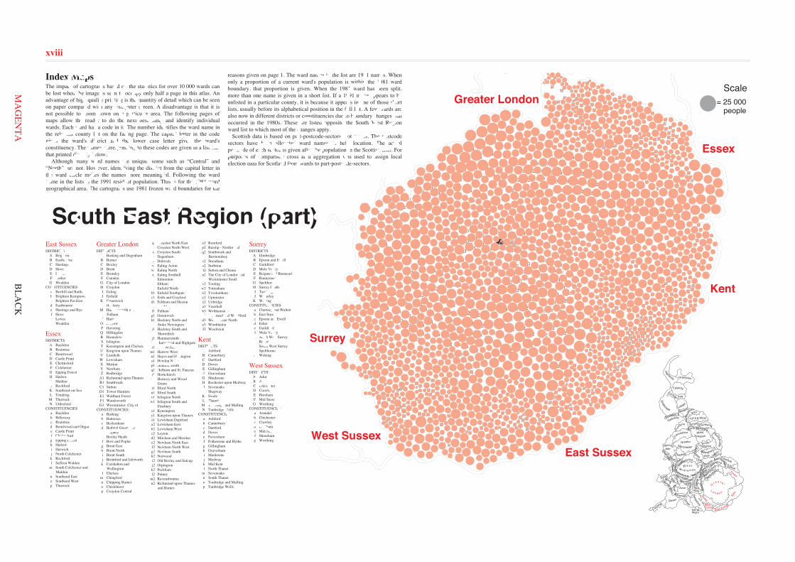
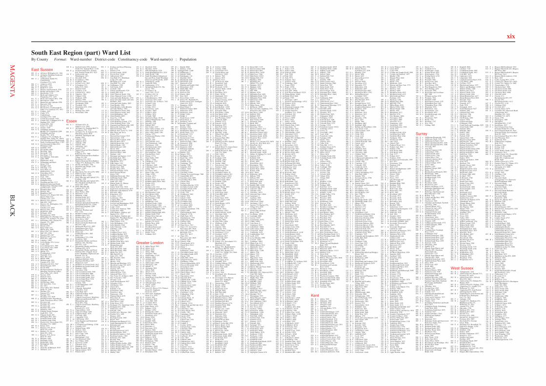
Index MapsThe impact of cartograms based on the statistics for over 10 000 wards canbe lost when the image is seen to occupy only half a page in this atlas. Anadvantage of high quality printing is the quantity of detail which can be seenon paper compared with any computer screen. A disadvantage is that it isnot possible to zoom down on a particular area. The following pages ofmaps allow the reader to do the next best thing and identify individualwards. Each ward has a code in it. The number identifies the ward name inthe relevant county list on the facing page. The capital letter in the codegives the ward's district and the lower case letter gives the ward'sconstituency. The names corresponding to these codes are given in a list likethat printed directly below. Although many ward names are unique, some such as “Central” and“North”, are not. However, identifying the district from the capital letter inthe ward circle makes the names more meaningful. Following the wardname in the lists is the 1991 resident population. This is for the 1981 wardgeographical area. The cartograms use 1981 frozen ward boundaries for the
West Sussex
South East Region (part)
reasons given on page 1. The ward names in the list are 1991 names. Whenonly a proportion of a current ward's population is within the 1981 wardboundary, that proportion is given. When the 1981 ward has been split,more than one name is given in a short list. If a 1991 name appears to beunlisted in a particular county, it is because it appears in one of those shortlists, usually before its alphabetical position in the full list. A few wards arealso now in different districts or constituencies due to boundary changes thatoccurred in the 1980s. These are listed opposite the South West Regionward list to which most of the changes apply. Scottish data is based on part-postcode-sectors, not wards. The postcodesectors have been allocated ward names to help location. The actualpostcode of each sector is given after the population in the Scottish lists. Forpurposes of comparison cross area aggregation was used to assign localelection data for Scotland from wards to part-postcode-sectors.
BLA
CK
xviii
East Sussex
Essex
Greater London
Kent
Surrey
West Sussex
WestSussex
East Sussex
Surrey
G r e a t e r
L o n d o n
Kent
Essex
Essex
Kent
East Sussex
Surrey
Greater London
West Sussex
MA
GEN
TA
xix
East Sussex001 G g Alfriston; Willingdon 4%: 1961002 G g Arlington; Hailsham South and
West 8%: 2356003 F a Ashburnham; Battle 9%;
Catsfield andCrowhurst 27%: 2478
004 C e Ashdown: 6459005 E g Barcombe: 1353006 F a Battle 91%: 5235007 F a Beckley and Peasmarsh: 1936008 F a Bodian and Ewhurst: 1350009 C e Braybrooke: 5136010 F e Brede and Udimore 16%;
Winchelsea 37%: 1235011 F a Brede and Udimore 84%: 1764012 C e Broomgrove: 4506013 D f Brunswick and Adelaide: 8396014 F a Burwash: 2506015 G h Buxted 17%: 648016 G h Buxted 83%; Crowborough St
Johns 17%; Uckfield 13%: 4972017 F e Camber: 2187018 C e Castle: 3571019 F a Catsfield and
Crowhurst 73%: 1208020 C e Central St Leonards: 4420021 F a Central 20%; Collington 63%; St
Stephens 20%: 5102022 F a Central 80%; Old
Town 11%: 4429023 E g Chailey: 2548024 G h Chiddingly and East
Hoathly 21%; Framfield: 2209025 G h Chiddingly and East
Hoathly 79%: 1636026 F a Collington 37%; St Marks; St
Stephens 48%; Sidley 9%: 10074027 G h Crowborough East; Crowborough
North; Crowborough West: 17107028 G h Crowborough St Johns 83%;
Withyham: 4186029 G h Danehill: 1879030 B d Devonshire: 6910031 E g Ditchling: 1882032 B d Downside: 7702033 G g East Dean: 1725034 E g East Saltdean; Telscombe
Cliffs: 6808035 C e Elphinstone: 4819036 F a Etchingham and Hurst
Green: 2155037 F e Fairlight: 1605038 G h Fletching: 1722039 G h Forest Row 1%;
Hartfield 99%: 2055040 G h Forest Row 99%;
Hartfield 1%: 4733041 G h Frant: 1445042 C e Gensing: 4858043 D f Goldsmid: 8516044 F e Guestling and Pett: 2137045 G h Hailsham Central and North;
Hailsham East; Hailsham Southand West 92%: 14475
046 B d Hampden Park: 7954047 E g Hamsey: 881048 D f Hangleton: 8467049 A b Hanover 14%; King's Cliff 16%;
Queen's Park 21%;Tenantry 32%: 7257
050 A b Hanover 24%; Queen'sPark 69%: 7442
051 A c Hanover 4%; Hollingbury 14%;St Peter's 33%;Tenantry 21%: 6643
052 A b Hanover 58%: 5746053 G h Heathfield: 6280054 G h Hellingly: 4561055 G a Herstmonceux: 3898056 A c Hollingbury 6%; Patcham 12%;
Preston 75%; St Peter's 5%: 9369057 A c Hollingbury 80%; Preston 9%;
Stanmer 17%: 9885058 C e Hollington: 5977059 G h Horam: 2393060 A b King's Cliff 11%;
Marine 65%: 7906061 A b King's Cliff 74%; Queen's
Park 10%: 6368062 E g Kingston 45%: 867063 E g Kingston 55%; Lewes
Priory 8%: 1496064 B d Langney: 12867065 E g Lewes Bridge 19%; Lewes
Castle: 5864066 E g Lewes Bridge 81%: 3995067 E g Lewes Priory 92%: 5099068 G h Maresfield: 3095069 A b Marine 35%;
Woodingdean: 13525070 G h Mayfield: 3515071 C e Maze Hill: 4221072 B d Meads: 6888073 A b Moulsecoomb 18%;
Tenantry 47%: 5787074 A b Moulsecoomb 82%: 7947075 C e Mount Pleasant: 5679076 D f Nevill: 8560077 E g Newhaven Denton; Newhaven
Meeching; Newhaven Valley;Ouse Valley 24%: 10628
078 E g Newick: 2445079 G a Ninfield: 1824080 F a Northiam: 1810081 B d Ocklynge: 6617082 C e Old Hastings: 4004083 F a Old Town 89%: 3744084 C e Ore: 5071085 E g Ouse Valley 76%; Seaford
North 7%: 1789086 A c Patcham 18%;
Stanmer 83%: 8146087 A c Patcham 70%;
Westdene 23%: 8196088 E g Peacehaven East; Peacehaven
North; Peacehaven West: 12992089 G a Pevensey and
Westham 44%: 2537090 G a Pevensey and
Westham 56%: 3276091 E g Plumpton: 1907092 G d Polegate North; Polegate
South 90%: 7241093 G d Polegate South 10%;
Willingdon 96%: 5971094 D f Portslade North: 8798095 D f Portslade South: 8964096 A c Preston 16%; Seven Dials 19%;
Westdene 77%: 10005097 B d Ratton: 8321098 A c Regency 24%; Seven
Dials 52%: 6390099 A c Regency 5%; Seven
Dials 25%: 2582100 A c Regency 71%; Seven
Dials 4%: 5955101 E g Ringmer: 4456102 B d Roselands: 8249103 G h Rotherfield: 3096104 A b Rottingdean: 8926105 F e Rye: 4207106 F a Sackville; St Michaels: 9014107 F a Salehurst: 2211
108 E g Seaford Central 38%; SeafordNorth 75%; Seaford West: 11330
109 E g Seaford Central 62%; SeafordEast; Seaford North 18%: 9153
110 F a Sedlescombe andWhatlington: 1631
111 C e Silverhill: 4956112 B d St Anthony's: 7983113 C e St Helens: 5041114 A c St Peter's 61%: 5507115 F a St Stephens 32%;
Sidley 91%: 6542116 D f Stanford: 8345117 F a Ticehurst: 3118118 G h Uckfield 87%: 10523119 B d Upperton: 7904120 D f Vallance: 8326121 G h Wadhurst: 4499122 G h Waldron: 4396123 C e West St Leonards: 6447124 D f Westbourne: 8588125 F a Westfield: 2461126 F e Winchelsea 63%: 1544127 D f Wish: 8404128 C e Wishing Tree: 5655129 E g Wivelsfield: 1896
Essex001 E f All Saints 82%; St
Andrews 11%: 5603002 E f All Saints 9%; Patching Hall 7%;
St Andrews 70%: 7251003 E f All Saints 9%; St Andrews 6%;
Waterhouse Farm: 6928004 L j Alresford, Thorrington and
Frating: 3493005 I m Althorne: 2265006 D e Appleton: 6818007 L j Ardleigh: 1900008 N l Ashdon: 1063009 J k Ashingdon: 2937010 M p Aveley: 7295011 E f Baddow Road and Great Baddow
Village 27%;Rothmans 18%: 3088
012 E f Baddow Road and Great BaddowVillage 5%; OldMoulsham 53%: 4123
013 E f Baddow Road and Great BaddowVillage 67%; Rothmans 8%: 5583
014 J k Barling and Sutton: 1766015 L i Beaumont and Thorpe: 2249016 K o Belfairs: 11203017 M p Belhus: 7373018 F m Berechurch; New Town 8%: 8081019 A b Billericay East: 11264020 A b Billericay West: 12592021 F j Birch, Messing and Copford 15%;
Fordham: 2220022 F j Birch, Messing and Copford 29%;
West Bergholt and Eight AshGreen 36%: 2566
023 F m Birch, Messing andCopford 56%: 1679
024 N l Birchanger: 1018025 B c Black Notley: 3069026 C d Blackmore: 1170027 K o Blenheim: 11880028 B c Bocking North: 5477029 B c Bocking South: 5736030 L i Bockings Elm: 11154031 E f Boreham; Springfield North 90%;
Springfield South 72%: 15395032 F j Boxted and Langham: 2289033 D e Boyce: 6137034 L i Bradfield, Wrabness and
Wix: 2120035 B c Braintree Central: 6316036 B c Braintree East: 7631037 B c Braintree West: 6121038 H h Brays Grove: 4007039 C d Brentwood North: 5958040 C d Brentwood South; Brentwood
West 9%: 5525041 C d Brentwood West 91%: 4505042 L j Brightlingsea East: 3634043 L j Brightlingsea West: 3807044 C d Brizes and
Doddinghurst 29%: 1907045 C d Brizes and
Doddinghurst 71%: 4704046 G g Broadway: 5002047 E f Broomfield, Pleshey and Great
Waltham 10%; PatchingHall 93%: 7379
048 E c Broomfield, Pleshey and GreatWaltham 40%: 2474
049 E c Broomfield, Pleshey and GreatWaltham 49%; Chignall, GoodEaster, Mashbury, Highwood andRoxwell 13%; StAndrews 13%: 4550
050 G g Buckhurst Hill East: 5036051 G g Buckhurst Hill West: 6207052 B l Bumpstead: 2225053 I m Burnham-on-Crouch North: 2615054 I m Burnham-on-Crouch South: 4452055 A b Burstead: 10694056 J k Canewdon: 2296057 D e Canvey Island Central: 5560058 D e Canvey Island East: 6886059 D e Canvey Island North: 7141060 D e Canvey Island South: 4514061 D e Canvey Island West: 5130062 D e Canvey Island Winter
Gardens: 7628063 B l Castle Hedingham: 1697064 F j Castle: 6539065 E f Cathedral; Springfield
South 28%: 7124066 D e Cedar Hall: 5827067 M p Chadwell St Mary: 9629068 K o Chalkwell: 11504069 E f Chignall, Good Easter, Mashbury,
Highwood and Roxwell 24%;Margaretting andStock 28%: 1422
070 E c Chignall, Good Easter, Mashbury,Highwood andRoxwell 62%: 1535
071 G g Chigwell Row: 2210072 G g Chigwell Village: 4196073 G d Chipping Ongar: 1670074 N l Clavering: 1663075 B c Coggeshall: 5220076 I m Cold Norton: 1955077 B l Colne Engaine and Greenstead
Green: 1506078 M b Corringham and Fobbing: 12300079 B c Cressing: 1553080 G g Debden Green: 4858081 F j Dedham: 1847082 J k Downhall: 3472083 B l Earls Colne: 3769084 E f East and West
Hanningfield: 2319085 F m East Donyland: 2284086 M p East Tilbury: 6028087 K o Eastwood: 13704088 L j Elmstead: 2478089 N l Elsenham: 2212090 G g Epping Hemnall: 5801091 G g Epping Lindsey: 5875092 N l Felsted: 2832
093 J k Foulness and Great WakeringEast: 2334
094 L i Frinton: 5738095 A a Fryerns Central: 10524096 A a Fryerns East: 11049097 E f Galleywood: 5817098 E f Goat Hall 27%; Moulsham
Lodge 25%; OldMoulsham 47%: 6349
099 E f Goat Hall 73%: 4381100 I m Goldhanger: 1588101 L i Golf Green: 4146102 B l Gosfield: 1302103 J k Grange and Rawreth: 5729104 G g Grange Hill: 6136105 M p Grays Thurrock North: 3766106 M p Grays Thurrock Town: 11388107 F j Great and Little Horkesley: 2334108 E c Great and Little Leighs and Little
Waltham: 2845109 L i Great and Little Oakley: 2082110 L j Great Bentley: 2206111 L j Great Bromley, Little Bromley
and Little Bentley: 1583112 N l Great Dunmow North: 2902113 N l Great Dunmow South: 3642114 N l Great Hallingbury: 1003115 H h Great Parndon: 4083116 F j Great Tey: 2196117 I m Great Totham: 3026118 J k Great Wakering Central: 1775119 J k Great Wakering West: 1304120 G d Greensted and Marden Ash: 2443121 B l Halstead St Andrews: 4750122 B l Halstead Trinity: 5025123 F m Harbour; New Town 7%: 7539124 H h Hare Street and Town
Centre: 3721125 L i Harwich East Central: 3515126 L i Harwich East: 3328127 L i Harwich West Central: 3518128 L i Harwich West: 5013129 N l Hatfield Broad Oak: 1147130 N l Hatfield Heath: 1483131 B c Hatfield Peverel: 4383132 L i Haven: 2952133 J k Hawkwell East: 6698134 J k Hawkwell West: 3969135 N l Henham: 1626136 C d Herongate and Ingrave: 2115137 I m Heybridge East: 3841138 I m Heybridge West: 2705139 G g High Beach: 2773140 G d High Ongar: 1104141 J k Hockley Central: 2260142 J k Hockley East: 3906143 J k Hockley West: 2933144 L i Holland and Kirby: 5270145 C d Hook End and Wyatts
Green: 2102146 J k Hullbridge Riverside: 3961147 J k Hullbridge South: 2969148 C d Hutton East; Hutton
South 10%: 5281149 C d Hutton North 5%; Hutton
South 90%: 6188150 C d Hutton North 95%: 3929151 C d Ingatestone and Fryerning: 4815152 H h Katherines with Sumners: 6754153 B c Kelvedon: 4883154 H h Kingsmoor: 6707155 A b Laindon: 11632156 G d Lambourne: 1841157 A a Langdon Hills: 12866158 H h Latton Bush: 5111159 L j Lawford and Manningtree: 5029160 A a Lee Chapel North: 9691161 K o Leigh: 11444162 F j Lexden 10%; Stanway: 7860163 F j Lexden 90%: 4826164 E f Little Baddow, Danbury and
Sandon 21%: 1707165 E f Little Baddow, Danbury and
Sandon 79%; Woodham Ferrersand Bicknacre 19%: 7067
166 L i Little Clacton: 2735167 N l Little Hallingbury: 1379168 H h Little Parndon: 5344169 M p Little Thurrock: 11158170 N l Littlebury: 1190171 J k Lodge: 6123172 G g Loughton Forest: 3674173 G g Loughton Roding: 5073174 G g Loughton St John's: 5284175 G g Loughton St Mary's: 4419176 I m Maldon East: 2523177 I m Maldon North West: 3854178 I m Maldon South: 4404179 E f Margaretting and
Stock 72%: 2097180 H h Mark Hall North: 2649181 H h Mark Hall South: 4969182 F j Marks Tey: 2627183 F j Mile End 45%; St
John's 55%: 7979184 F j Mile End 55%: 5053185 K n Milton: 10336186 L j Mistley: 2238187 G d Moreton and Matching: 1971188 E f Moulsham Lodge 75%: 4075189 C d Mountnessing: 1187190 G h Nazeing: 4651191 A a Nethermayne: 9223192 H h Netteswell East: 3530193 H h Netteswell West: 3217194 F j New Town 4%; St Mary's: 6892195 F m New Town 81%: 5307196 N l Newport: 2178197 G h North Weald Bassett: 5547198 M p Ockendon: 8141199 H h Old Harlow: 5937200 M b Orsett: 4871201 B c Panfield: 1710202 G d Passingford: 1992203 H h Passmores: 4821204 G g Paternoster: 4389205 C d Pilgrims Hatch: 6678206 A a Pitsea East; St
George's 8%: 15911207 A a Pitsea West: 11981208 H h Potter Street: 3971209 F m Prettygate 17%; Shrub End: 9364210 F m Prettygate 83%: 5930211 K o Prittlewell: 11632212 I m Purleigh: 1544213 F m Pyefleet 24%; Winstree: 2862214 F m Pyefleet 76%: 1699215 L i Ramsey: 2264216 J k Rayleigh Central: 3803217 B c Rayne: 2614218 E k Rettendon and Runwell 21%;
South Hanningfield 9%: 1393219 E k Rettendon and
Runwell 79%: 4455220 N l Rickling: 999221 J k Rochford Eastwood: 1672222 J k Rochford Roche: 2095223 J k Rochford St Andrews: 3212224 G d Roothing Country: 1565225 E f Rothmans 75%: 4206226 G h Roydon: 2844227 L i Rush Green: 5443228 N l Saffron Walden Audley: 2806229 N l Saffron Walden Castle: 3766230 N l Saffron Walden Plantation: 4288231 N l Saffron Walden Shire: 3159232 G h Sheering: 2453233 G d Shelley: 1861
234 C d Shenfield: 5442235 K n Shoebury: 18292236 B l Sible Hedingham: 3529237 E k South Hanningfield 91%: 2110238 C d South Weald: 1388239 E k South Woodham-Collingwood
East and West; South Woodham-Elmwood and Woodville: 16447
240 K n Southchurch: 11648241 L i Southcliff: 5054242 I m Southminster: 3374243 E f Springfield North 10%; The
Lawns: 7052244 F j St Andrew's; St
Anne's 55%: 12115245 F j St Anne's 45%; St
John's 45%: 6373246 L i St Bartholomews: 3058247 D e St George's 83%: 6166248 D e St George's 9%; St Peter's: 7103249 D e St James: 5436250 L i St James: 5939251 L i St Johns: 6413252 I m St Lawrence: 1426253 K n St Lukes: 10657254 D e St Mary's: 6029255 L i St Marys: 5052256 L i St Osyth: 3849257 M b Stanford-le-Hope: 10164258 N l Stansted Mountfitchet: 5361259 N l Stebbing: 1498260 H h Stewards: 5156261 M p Stifford: 8087262 N l Stort Valley: 1425263 B l Stour Valley Central: 1572264 B l Stour Valley North: 1414265 B l Stour Valley South: 1981266 N l Takeley: 2757267 L i Tendring and Weeley: 2302268 B c Terling: 1529269 N l Thaxted: 2681270 N l The Canfields: 1815271 N l The Chesterfords: 1580272 N l The Eastons: 1299273 M b The Homesteads: 8283274 I m The Maylands: 3362275 N l The Rodings: 1323276 N l The Sampfords: 1700277 G g Theydon Bois: 3945278 K n Thorpe: 12734279 B c Three Fields: 3509280 M p Tilbury: 11658281 I m Tillingham: 1727282 F m Tiptree: 7679283 I m Tollesbury: 2609284 I m Tolleshunt D'arcy: 1868285 J k Trinity: 3867286 H h Tye Green: 4652287 B l Upper Colne: 1665288 A a Vange: 10782289 K n Victoria: 12177290 D e Victoria: 5573291 G g Waltham Abbey East: 6145292 G g Waltham Abbey West: 5062293 L i Walton: 6251294 C d Warley: 6337295 N l Wenden Lofts: 1431296 F j West Bergholt and Eight Ash
Green 64%: 3027297 C d West Horndon: 1366298 F m West Mersea: 6602299 M p West Thurrock: 7654300 K o Westborough: 11306301 J k Wheatley: 2969302 J k Whitehouse: 3345303 A b Wickford North: 11666304 A b Wickford South: 11861305 I m Wickham Bishops 87%: 1775306 N l Wimbish and Debden: 2206307 B c Witham Central: 2649308 B c Witham Chipping Hill: 4491309 B c Witham North: 5193310 B c Witham Silver End and
Rivenhall: 4188311 B c Witham South; Wickham
Bishops 13%: 6570312 B c Witham West: 4058313 F j Wivenhoe: 6738314 E k Woodham Ferrers and
Bicknacre 81%: 2515315 I m Woodham: 1634316 E c Writtle: 5128317 B l Yeldham: 1825
Greater London001 K f3 Abbey Wood: 7092002 B1 q2 Abbey: 6110003 X e3 Abbey: 8878004 A a Abbey: 9880005 T l Abingdon: 7884006 H q Addiscombe: 13193007 M j1 Addison: 6896008 F k1 Adelaide: 8306009 P r1 Airfield: 9937010 Z t1 Aldborough: 11009011 G u2 Aldersgate: 1246012 G u2 Aldgate: 23013 N s1 Alexandra: 9021014 A t Alibon: 5601015 B1 u Alleyn: 6773016 D i Alperton: 8438017 E c Anerley: 11082018 J y Angel Road; Craig Park 5%: 6991019 V h2 Angell: 10744020 N s1 Archway: 6665021 P y2 Ardleigh Green: 8122022 I w Argyle: 12956023 B n Arkley: 15711024 J b1 Arnos 6%; Bowes 91%; Palmers
Green 6%; SouthgateGreen 6%: 8575
025 J b1 Arnos 94%; SouthgateGreen 21%: 8792
026 K f3 Arsenal: 3901027 H q Ashburton: 9039028 K z Avery Hill: 3200029 T x1 Avondale: 8019030 M f1 Avonmore: 6169031 G1 u2 Baker Street: 4474032 F1 b Balham: 11426033 D i Barham: 11092034 Z t1 Barkingside: 12607035 C e Barnehurst North: 4012036 C e Barnehurst: 6241037 A1 n2 Barnes: 9599038 D h Barnhill: 7144039 Q n1 Barnhill: 9486040 S w1 Barnsbury: 9652041 B1 k2 Barset: 6099042 G u2 Bassishaw: 0043 G1 d3 Bayswater: 9331044 Y g2 Beckton: 5484045 C1 k Beddington North: 6575046 C1 k Beddington South: 9534047 F1 v2 Bedford: 12822048 G1 u2 Belgrave: 5870049 B1 u Bellenden: 10236050 W b2 Bellingham: 7900051 C1 t2 Belmont: 6793052 F k1 Belsize: 7780053 C c1 Belvedere: 12450054 Y g2 Bemersyde: 5935055 H r Bensham Manor: 13833056 U s2 Berrylands: 8396
057 H r Beulah: 8868058 E o Bickley: 13344059 E m2 Biggin Hill: 11468060 G u2 Billingsgate: 2061 V a3 Bishop's: 9886062 G u2 Bishopsgate: 118063 C i2 Blackfen: 6816064 K g1 Blackheath: 6265065 W a2 Blackheath: 6763066 D1 f Blackwall: 4789067 C i2 Blendon and Penhill: 9462068 F q1 Bloomsbury: 6749069 W z1 Blythe Hill: 7014070 C c1 Bostall: 9434071 Q n1 Botwell: 6761072 Q p2 Bourne: 6864073 D1 f Bow: 8193074 N s1 Bowes Park: 11169075 J b1 Bowes 9%; Highfield 8%;
Palmers Green 84%; SouthgateGreen 16%: 9537
076 C e Brampton: 10048077 G u2 Bread Street: 5078 R j Brentford Clifden: 8006079 D g Brentwater: 8794080 B1 q2 Bricklayers: 8341081 Z c3 Bridge: 11681082 G u2 Bridge: 4083 H r Broad Green: 12387084 G u2 Broad Street: 4085 M j1 Broadway: 4975086 E m2 Bromley Common and
Keston: 15601087 D1 f Bromley: 9642088 T l Brompton: 4144089 D g Brondesbury Park: 8223090 M j1 Brook Green: 7172091 P o2 Brooklands: 7353092 B1 q2 Browning: 9142093 L h1 Brownswood: 6727094 N w2 Bruce Grove: 10485095 B n Brunswick Park: 13803096 F q1 Brunswick: 3990097 B1 k2 Brunswick: 9878098 G1 u2 Bryanston: 4949099 J a1 Bullsmoor; Enfield
Lock 16%: 9241100 S w1 Bunhill: 7572101 B1 q2 Burgess: 5593102 U y1 Burlington: 5721103 B o1 Burnt Oak: 13201104 K f3 Burrage: 3843105 A a Cambell: 9124106 U y1 Cambridge: 7993107 F q1 Camden: 7288108 T x1 Campden: 6747109 U y1 Canbury: 7628110 G u2 Candlewick: 1111 E1 c2 Cann Hall: 10366112 Y g2 Canning Town and Grange: 7840113 X e3 Cannon Hill: 8651114 S w1 Canonbury East: 6891115 S w1 Canonbury West: 5992116 O l1 Canons: 8961117 D g Carlton: 6149118 C1 k Carshalton Beeches: 9152119 C1 k Carshalton Central: 6240120 C1 k Carshalton North: 6796121 G u2 Castle Baynard: 34122 Y e2 Castle: 7391123 F q1 Castlehaven: 5462124 W b2 Catford: 7634125 E1 c2 Cathall: 11663126 B1 q2 Cathedral: 6269127 Q p2 Cavendish: 6407128 G1 u2 Cavendish: 6675129 F q1 Caversham: 6002130 O l1 Centenary: 8959131 A1 x2 Central Twickenham: 7294132 Y e2 Central: 7698133 A t Chadwell Heath: 8681134 Z t1 Chadwell: 11718135 F q1 Chalk Farm: 4921136 D g Chamberlayne: 7752137 E1 m Chapel End: 10489138 K g1 Charlton: 6581139 Q n1 Charville: 9961140 P o2 Chase Cross: 7421141 J a1 Chase 12%; Town 87%;
Worcesters 20%: 8629142 J b1 Chase 30%; Grange 7%;
Merryhills 25%;Trent 70%: 10117
143 J a1 Chase 58%;Worcesters 32%: 6824
144 L i1 Chatham: 8477145 B1 q2 Chaucer: 9286146 C1 t2 Cheam South: 5674147 C1 t2 Cheam West: 5612148 G u2 Cheap: 7149 E j2 Chelsfield and
Goddington: 14949150 U s2 Chessington North: 5022151 U s2 Chessington South: 8932152 T l Cheyne: 5445153 B p1 Childs Hill: 12876154 E1 m Chingford Green: 10952155 E o Chislehurst: 15864156 R j Chiswick Homefields: 6874157 R j Chiswick Riverside: 9340158 C e Christchurch: 9777159 D g Church End: 6380160 Z c3 Church End: 8913161 G1 d3 Church Street: 10017162 T l Church: 4282163 W a2 Churchdown: 9432164 G1 u2 Churchill: 8678165 V r2 Clapham Park: 12300166 V a3 Clapham Town: 11896167 Z c3 Clayhall: 12511168 Z u1 Clementswood: 11602169 S w1 Clerkenwell: 9707170 L h1 Clissold: 8983171 E c Clock House: 10485172 C1 k Clockhouse: 2178173 K z Coldharbour: 5700174 M f1 Colehill: 5786175 G u2 Coleman Street: 19176 N w2 Coleraine: 10881177 Q z2 Colham: 6413178 B o1 Colindale: 15314179 M j1 College Park and Old Oak: 8123180 B1 u College: 7583181 P o2 Collier Row: 7387182 X d2 Colliers Wood: 9931183 T x1 Colville: 7501184 M j1 Coningham: 10028185 B1 k2 Consort: 6697186 U y1 Coombe: 5145187 E c Copers Cope: 7436188 G u2 Cordwainer: 2189 G u2 Cornhill: 0190 I w Costons: 10500191 H s Coulsdon East: 12536192 T l Courtfield: 7098193 Q z2 Cowley: 8580194 M f1 Crabtree: 4991195 J y Craig Park 95%: 7122196 Z u1 Cranbrook: 10187197 Q n1 Crane: 6847198 R d1 Cranford: 9856199 P y2 Cranham East: 6915200 P y2 Cranham West: 6990201 C i2 Cray: 5506202 C c1 Crayford: 11421203 D g Cricklewood: 8193204 G u2 Cripplegate: 1563205 W z1 Crofton Park: 10430
206 E j2 Crofton: 10250207 H s Croham: 12889208 N s1 Crouch End: 8723209 Y g2 Custom House and
Silvertown: 12021210 L i1 Dalston: 7804211 C e Danson: 9439212 E m2 Darwin: 4215213 L i1 De Beauvoir: 8596214 K z Deansfield: 3445215 Q p2 Deansfield: 7334216 B1 q2 Dockyard: 13530217 I x Dormers Wells: 12644218 G u2 Dowgate: 39219 W a2 Downham: 9324220 W z1 Drake: 10290221 X e3 Dundonald: 7832222 X e3 Durnsford: 5526223 I v Ealing Common: 12574224 T l Earls Court: 9377225 F1 v2 Earlsfield: 8529226 B n East Barnet: 14196227 R d1 East Bedfont: 11938228 B e1 East Finchley: 15106229 D1 f East India: 6881230 F1 l2 East Putney: 12896231 A1 n2 East Sheen: 6450232 A1 n2 East Twickenham: 9179233 C e East Wickham: 10727234 A t Eastbrook: 8890235 A a Eastbury: 5575236 Q p2 Eastcote: 10130237 L h1 Eastdown: 8977238 E c Eden Park: 9192239 B o1 Edgware: 15415240 M f1 Eel Brook: 5724241 P r1 Elm Park: 11466242 K z Eltham Park: 6599243 I x Elthorne: 11794244 P y2 Emerson Park: 8981245 E1 m Endlebury: 7726246 J a1 Enfield Lock 84%; Enfield
Wash 12%; HoeLane 24%: 11017
247 J a1 Enfield Wash 7%; Green Street;Ponders End 5%: 8747
248 J a1 Enfield Wash 81%; HoeLane 27%: 8849
249 C c1 Erith: 10492250 W z1 Evelyn: 9763251 K f3 Eynsham: 6370252 H p Fairfield: 14923253 F1 b Fairfield: 7369254 Z t1 Fairlop: 10866255 C e Falconwood: 3563256 A t Fanshawe: 8261257 B1 k2 Faraday: 11963258 E j2 Farnborough: 9297259 G u2 Farringdon within: 95260 G u2 Farringdon without: 562261 R d1 Feltham Central: 10321262 R d1 Feltham North: 10914263 R d1 Feltham South: 8839264 V a3 Ferndale: 12481265 K g1 Ferrier: 6587266 H p Fieldway: 9408267 X d2 Figge's Marsh: 9933268 B e1 Finchley: 13980269 F k1 Fitzjohns: 5189270 Y f2 Forest Gate: 9445271 W b2 Forest Hill: 6602272 E1 c2 Forest: 10995273 N s1 Fortis Green: 9375274 F k1 Fortune Green: 5290275 B1 k2 Friary: 8487276 B e1 Friern Barnet: 14570277 F k1 Frognal: 5831278 D h Fryent: 8024279 Z t1 Fullwell: 11024280 F1 v2 Furzedown: 13853281 B p1 Garden Suburb: 14249282 A a Gascoigne: 8638283 M f1 Gibbs Green: 6645284 P o2 Gidea Park: 7210285 S v1 Gillespie: 6092286 V h2 Gipsy Hill: 12056287 D g Gladstone: 8184288 I x Glebe: 12854289 K f3 Glyndon: 7893290 T x1 Golborne: 7872291 B p1 Golders Green: 15189292 Z u1 Goodmayes: 11211293 P y2 Gooshays: 10377294 A a Goresbrook: 6817295 F q1 Gospel Oak: 6037296 F q1 Grafton: 6000297 J b1 Grange 13%; Grovelands 31%;
Merryhills 41%;Oakwood 37%: 8690
298 J b1 Grange 30%; Highfield 66%;Winchmore Hill 6%: 7934
299 J y Grange 50%; Raglan 14%;Town 13%; Village 35%: 9046
300 F1 v2 Graveney: 13353301 X d2 Graveney: 5537302 Y e2 Greatfield: 10525303 N w2 Green Lanes: 8124304 O l1 Greenhill: 7876305 W z1 Grinling Gibbons: 9781306 E1 c2 Grove Green: 10565307 W a2 Grove Park: 6492308 D1 f Grove: 5185309 M j1 Grove: 5870310 U y1 Grove: 7824311 J b1 Grovelands 18%; Winchmore
Hill 94%: 8390312 J b1 Grovelands 51%; Palmers
Green 10%; SouthgateGreen 57%: 9024
313 R j Gunnersbury: 10355314 P r1 Hacton: 10595315 B n Hadley: 16749316 L i1 Haggerston: 6235317 Z t1 Hainault: 8855318 E1 m Hale End: 6985319 B o1 Hale: 13101320 A1 n2 Ham and Petersham: 8387321 G1 d3 Hamilton Terrace: 5619322 F k1 Hampstead Town: 4995323 A1 x2 Hampton Hill: 8811324 A1 x2 Hampton Nursery: 6776325 A1 x2 Hampton Wick: 9606326 A1 x2 Hampton: 8892327 I v Hanger Lane: 11635328 T l Hans Town: 6907329 R d1 Hanworth: 10197330 Q z2 Harefield: 6514331 D i Harlesden: 5926332 Q n1 Harlington: 9743333 P y2 Harold Wood: 9854334 N w2 Harringay: 10361335 O m1 Harrow on the Hill: 9578336 G1 d3 Harrow Road: 11373337 O l1 Harrow Weald: 9897338 O m1 Hatch End: 9096339 E1 m Hatch Lane: 10293340 E m2 Hayes: 14046341 O m1 Headstone North: 10070342 O m1 Headstone South: 8894343 P o2 Heath Park: 8325344 A t Heath: 9393345 H p Heathfield: 11974346 I v Heathfield: 12429347 A1 x2 Heathfield: 9637348 Q n1 Heathrow: 7457349 P y2 Heaton: 11298350 B p1 Hendon: 15587351 K z Herbert: 7187
352 V h2 Herne Hill: 11125353 R d1 Heston Central: 6600354 R d1 Heston East: 6851355 R d1 Heston West: 11628356 N w2 High Cross: 7186357 E1 b3 High Street: 10523358 E1 b3 Higham Hill: 6747359 S v1 Highbury: 9561360 J y Highfield 26%;
Huxley 77%: 8195361 F k1 Highgate: 10517362 N s1 Highgate: 6392363 S v1 Highview: 5701364 U y1 Hill: 5698365 P y2 Hilldene: 8276366 Q z2 Hillingdon East: 6839367 Q z2 Hillingdon North: 7194368 Q z2 Hillingdon West: 9506369 S w1 Hillmarton: 6745370 S v1 Hillrise: 9446371 X e3 Hillside: 9105372 W a2 Hither Green: 10706373 I w Hobbayne: 10969374 J a1 Hoe Lane 49%; Southbury 21%;
Worcesters 28%: 8246375 E1 b3 Hoe Street: 11903376 F q1 Holborn: 5892377 T x1 Holland: 8365378 S w1 Holloway: 8629379 D1 d Holy Trinity: 9406380 L i1 Homerton: 6385381 U s2 Hook: 5087382 K g1 Hornfair: 6129383 W b2 Horniman: 10031384 N s1 Hornsey Central: 7112385 N s1 Hornsey Vale: 6450386 R j Hounslow Central: 9283387 R d1 Hounslow Heath: 11057388 R j Hounslow South: 10256389 R d1 Hounslow West: 12523390 Y g2 Hudsons: 9212391 J y Huxley 17%; Latymer 93%: 8439392 J y Huxley 6%; Weir Hall: 8221393 G1 u2 Hyde Park: 8613394 P r1 Hylands: 11665395 Q z2 Ickenham: 11658396 R j Isleworth North: 10172397 R j Isleworth South: 10359398 J y Jubilee; St Alphege 5%: 8165399 S v1 Junction: 9237400 T x1 Kelfield: 6264401 E c Kelsey Park: 8431402 H s Kenley: 8947403 D i Kensal Rise: 6043404 Y e2 Kensington: 7906405 O l1 Kenton East: 10361406 O l1 Kenton West: 10545407 D h Kenton: 9186408 A1 n2 Kew: 10014409 K g1 Kidbrooke: 6058410 D g Kilburn: 7598411 F k1 Kilburn: 9461412 F q1 King's Cross: 6993413 L i1 Kings Park: 6691414 D h Kingsbury: 7951415 V h2 Knight's Hill: 12220416 G1 u2 Knightsbridge: 4914417 W z1 Ladywell: 10018418 K f3 Lakedale: 6392419 C i2 Lamorbey: 10157420 G1 d3 Lancaster Gate: 10244421 G u2 Langbourn: 6422 D1 f Lansbury: 8381423 V a3 Larkhall: 13231424 E1 m Larkswood: 12669425 F1 b Latchmere: 11017426 J y Latymer 7%; Raglan 37%;
Village 62%: 8520427 X d2 Lavender: 5783428 E c Lawrie Park and Kent
House: 9104429 E1 c2 Lea Bridge: 10595430 L h1 Leabridge: 8846431 E1 c2 Leyton: 11655432 E1 c2 Leytonstone: 11072433 B1 k2 Liddle: 10992434 G u2 Lime Street: 0435 D1 f Limehouse: 8472436 Y e2 Little Ilford: 10408437 G1 d3 Little Venice: 8906438 E1 b3 Lloyd Park: 10655439 A a Longbridge: 8479440 X d2 Longthornton: 9547441 G1 d3 Lords: 6339442 X d2 Lower Morden: 8588443 Z u1 Loxford: 12441444 B1 u Lyndhurst: 10903445 G1 d3 Maida Vale: 8311446 U y1 Malden Manor: 5013447 I w Mandeville: 10715448 W a2 Manor Lee: 7410449 Y e2 Manor Park: 11288450 A a Manor: 5796451 Q p2 Manor: 7232452 D i Manor: 7275453 D g Mapesbury: 7323454 M f1 Margravine: 5660455 A t Marks Gate: 2624456 O l1 Marlborough: 8930457 W z1 Marlowe: 9954458 E m2 Martins Hill and Town: 9049459 P o2 Mawney: 11022460 Z u1 Mayfield: 11501461 J b1 Merryhills 34%; Oakwood 63%;
Trent 30%: 9008462 X e3 Merton Park: 8567463 K z Middle Park: 7099464 S v1 Mildmay: 11669465 B o1 Mill Hill: 15102466 G1 u2 Millbank: 7080467 D1 f Milwall: 13772468 Y e2 Monega: 8059469 Z c3 Monkhams: 9617470 H q Monks Orchard: 10527471 L i1 Moorfields: 5731472 A1 n2 Mortlake: 7815473 E o Mottingham: 9357474 I x Mount Pleasant: 12557475 N s1 Muswell Hill: 10482476 H p New Addington: 12037477 K z New Eltham: 6870478 L h1 New River: 10255479 Y f2 New Town: 6527480 Z u1 Newbury: 10964481 B1 k2 Newington: 10956482 F1 v2 Nightingale: 11999483 K z Nightingale: 4394484 N s1 Noel Park: 10896485 U y1 Norbiton Park: 5736486 U y1 Norbiton: 8216487 H r Norbury: 12573488 T x1 Norland: 4461489 M f1 Normand: 5871490 C1 t2 North Cheam: 6667491 L h1 North Defoe: 4947492 C c1 North End: 10950493 T l North Stanley: 5078494 I x Northcote: 11169495 F1 b Northcote: 11304496 I x Northfield: 11993497 L h1 Northfield: 9285498 C c1 Northumberland Heath: 10207499 L h1 Northwold: 8963500 Q p2 Northwood Hills: 9562501 Q p2 Northwood: 9513502 P o2 Oldchurch: 6940503 Y g2 Ordnance: 5296504 E j2 Orpington Central: 9331
505 V a3 Oval: 11199506 K z Palace: 2735507 M f1 Palace: 5494508 A1 n2 Palewell: 8589509 D1 f Park: 5299510 N w2 Park: 6383511 Y f2 Park: 9574512 F1 l2 Parkside: 7612513 A a Parsloes: 6539514 T x1 Pembridge: 7085515 E c Penge: 10092516 W z1 Pepys: 10781517 I w Perivale: 12379518 W b2 Perry Hill: 10826519 E j2 Petts Wood and Knoll: 15224520 X d2 Phipps Bridge: 10442521 O m1 Pinner West: 9468522 O m1 Pinner: 9705523 I v Pitshanger: 12601524 E o Plaistow and Sundridge: 14512525 Y g2 Plaistow: 8534526 Y f2 Plashet: 10814527 K f3 Plumstead Common: 3796528 X d2 Pollards Hill: 8738529 J a1 Ponders End 95%;
Southbury 31%: 10364530 G u2 Portsoken: 305531 D h Preston: 11997532 V a3 Prince's: 8095533 F k1 Priory: 6624534 H s Purley: 14597535 S v1 Quadrant: 6906536 G1 d3 Queen's Park: 10101537 G u2 Queenhithe: 79538 T x1 Queens Gate: 7953539 D g Queens Park: 5720540 L i1 Queensbridge: 10141541 D h Queensbury: 8537542 F1 b Queenstown: 8742543 J y Raglan 49%; St Marks 44%;
Village 3%: 7554544 P r1 Rainham: 12067545 I w Ravenor: 11477546 X d2 Ravensbury: 8333547 M j1 Ravenscourt: 5384548 O m1 Rayners Lane: 9181549 X e3 Raynes Park: 9646550 K g1 Rectory Field: 6483551 L h1 Rectory: 8670552 T l Redcliffe: 7352553 D1 d Redcoat: 6569554 F q1 Regent's Park: 8692555 G1 d3 Regent's Park: 9517556 A1 n2 Richmond Hill: 8886557 A1 n2 Richmond Town: 6288558 O m1 Ridgeway: 9322559 P o2 Rise Park: 7569560 A t River: 6654561 B1 q2 Riverside: 9085562 Z c3 Roding: 10442563 D h Roe Green: 6758564 F1 l2 Roehampton: 11823565 C1 t2 Rosehill: 5885566 B1 q2 Rotherhithe: 7543567 D i Roundwood: 6782568 O m1 Roxbourne: 10194569 O m1 Roxeth: 9834570 T l Royal Hospital: 4798571 Q p2 Ruislip: 7306572 W b2 Rushey Green: 7732573 B1 u Ruskin: 9767574 B1 u Rye: 8152575 H q Rylands: 8081576 H s Sanderstead: 9691577 M f1 Sands End: 6567578 H s Selsdon: 10204579 Z t1 Seven Kings: 10713580 N w2 Seven Sisters: 6584581 D1 f Shadwell: 10038582 F1 b Shaftesbury: 12566583 K z Sherard: 7385584 M f1 Sherbrooke: 4631585 E c Shortlands: 9660586 K f3 Shrewsbury: 3195587 C i2 Sidcup East: 10727588 C i2 Sidcup West: 9549589 K f3 Slade: 6717590 Z c3 Snaresbrook: 9307591 F q1 Somers Town: 6704592 L h1 South Defoe: 5167593 F k1 South End: 6084594 P r1 South Hornchurch: 11105595 N s1 South Hornsey: 6669596 H q South Norwood: 12353597 T l South Stanley: 6340598 N w2 South Tottenham: 7804599 A1 x2 South Twickenham: 9159600 Y g2 South: 15481601 I v Southfield: 10266602 F1 l2 Southfield: 12824603 D1 d Spitalfields: 8870604 R j Spring Grove: 10752605 H p Spring Park: 10317606 L h1 Springfield: 10549607 I v Springfield: 12087608 F1 v2 Springfield: 13570609 K g1 St Alfege: 6025610 J y St Alphege 7%; St Peters: 8543611 J y St Alphege 88%: 7163612 P r1 St Andrew's: 11215613 D h St Andrew's: 6672614 W b2 St Andrew: 7365615 T x1 St Charles: 5422616 D1 d St Dunstan's: 10021617 P o2 St Edward's: 6533618 G1 u2 St George's: 9243619 S v1 St George's: 9681620 B1 k2 St Giles: 11098621 C1 k St Helier North: 8458622 C1 k St Helier South: 5519623 X d2 St Helier: 8122624 E1 b3 St James Street: 13404625 G1 u2 St James': 3864626 D1 d St James': 5943627 U y1 St James: 7120628 F q1 St John's: 5960629 F1 b St John: 12401630 D1 d St Katherine's: 13810631 V r2 St Leonard's: 10349632 W a2 St Margaret: 6601633 U s2 St Mark's: 7772634 J a1 St Marks 56%;
Southbury 48%: 8044635 V h2 St Martin's: 10379636 Q p2 St Martins: 7583637 E j2 St Mary Cray: 14362638 F1 b St Mary's Park: 11530639 C i2 St Mary's: 10649640 D1 d St Mary's: 5662641 K f3 St Mary's: 6489642 S w1 St Mary: 7555643 C e St Michael's: 10207644 W a2 St Mildred: 10714645 K f3 St Nicholas: 7021646 F q1 St Pancras: 4752647 E o St Paul's Cray: 15187648 B e1 St Pauls: 13921649 D1 d St Peter's: 10365650 S w1 St Peter: 8655651 D i St Raphael's: 10666652 Y e2 St Stephens: 7399653 O l1 Stanmore Park: 10167654 O l1 Stanmore South: 9967655 M j1 Starch Green: 5734656 V a3 Stockwell: 10595657 D i Stonebridge: 5756658 Y f2 Stratford: 6227659 V r2 Streatham Hill: 11802
660 V r2 Streatham South: 10925661 V r2 Streatham Wells: 12660662 D h Sudbury Court: 6955663 D h Sudbury: 7768664 M f1 Sulivan: 5860665 U s2 Surbiton Hill: 7345666 S v1 Sussex: 6986667 K z Sutcliffe: 3688668 C1 t2 Sutton Central: 6423669 C1 t2 Sutton Common: 5989670 C1 t2 Sutton East: 7467671 C1 t2 Sutton South: 9365672 C1 t2 Sutton West: 5676673 F k1 Swiss Cottage: 9163674 W b2 Sydenham East: 10000675 W b2 Sydenham West: 10442676 K z Tarn: 2971677 A1 x2 Teddington: 9820678 A a Thames: 5723679 F1 l2 Thamesfield: 12317680 C c1 Thamesmead East: 13963681 K f3 Thamesmead Moorings: 7275682 B1 u The Lane: 7162683 S w1 Thornhill: 6936684 H q Thornton Heath: 13252685 V r2 Thornton: 7872686 V h2 Thurlow Park: 7085687 D i Tokyngton: 10545688 S v1 Tollington: 11073689 U s2 Tolworth East: 5280690 U s2 Tolworth South: 5498691 U s2 Tolworth West: 5379692 F1 v2 Tooting: 13319693 N w2 Tottenham Central: 10523694 B n Totteridge: 15312695 G u2 Tower: 14696 V r2 Town Hall: 12402697 M f1 Town: 6146698 Q n1 Townfield: 11004699 K g1 Trafalgar: 6346700 X e3 Trinity: 7553701 A t Triptons: 8781702 U y1 Tudor: 8191703 V h2 Tulse Hill: 11371704 R j Turnham Green: 8276705 P y2 Upminster: 10869706 H q Upper Norwood: 8329707 Y f2 Upton: 10215708 C e Upton: 9818709 Q z2 Uxbridge North: 6381710 Q z2 Uxbridge South: 5340711 I v Vale: 7108712 A t Valence: 8559713 Z u1 Valentines: 9771714 E1 m Valley: 11382715 K g1 Vanbrugh: 5848716 V a3 Vassall: 14161717 G1 u2 Victoria: 4585718 I v Victoria: 7701719 L i1 Victoria: 9899720 X e3 Village: 8554721 A t Village: 9665722 G u2 Vintry: 2723 H p Waddon: 13396724 G u2 Walbrook: 12725 M f1 Walham: 6808726 Y e2 Wall End: 11217727 C1 k Wallington North: 9298728 C1 k Wallington South: 9323729 I x Walpole: 12346730 C1 k Wandle Valley: 5374731 Z c3 Wanstead: 9278732 B1 u Waverley: 6896733 I x Waxlow: 11934734 O l1 Wealdstone: 9195735 D1 d Weavers: 9766736 K z Well Hall: 6369737 D i Wembley Central: 7851738 O l1 Wemborough: 9900739 L i1 Wenlock: 6203740 X e3 West Barnes: 9204741 Q z2 West Drayton: 6827742 I w West End: 11765743 F k1 West End: 5762744 G1 u2 West End: 5916745 N w2 West Green: 11325746 Y f2 West Ham: 7674747 B p1 West Hendon: 14677748 F1 l2 West Hill: 8275749 F1 l2 West Putney: 12878750 H r West Thornton: 13604751 A1 x2 West Twickenham: 6204752 E m2 West Wickham North: 9171753 E m2 West Wickham South: 9900754 K g1 West: 6122755 G1 d3 Westbourne: 10195756 L i1 Westdown: 5177757 M j1 White City and Shepherds
Bush: 9785758 N w2 White Hart Lane: 9816759 W a2 Whitefoot: 6978760 H r Whitehorse Manor: 13113761 A1 x2 Whitton: 9326762 L i1 Wick: 8540763 D g Willesdon Green: 7343764 J a1 Willow; Worcesters 20%: 9430765 I w Wood End: 10804766 Q n1 Wood End: 6929767 E1 b3 Wood Street: 11394768 H s Woodcote and Coulsdon
West: 14635769 C1 k Woodcote: 3530770 B e1 Woodhouse: 15505771 H q Woodside: 8804772 N s1 Woodside: 9778773 K f3 Woolwich Common: 7580774 C1 t2 Worcester Park North: 8692775 C1 t2 Worcester Park South: 5827776 M j1 Wormholt: 8183777 C1 k Wrythe Green: 6833778 Q n1 Yeading: 8867779 Q z2 Yiewsley: 7364
Kent001 K e Abbey: 3699002 A a Aldington: 1440003 H j All Saints: 4572004 G i Allington: 6290005 A a Appledore: 913006 I c Ash-cum-Ridley: 7575007 D n Ash: 2707008 A a Ashford Bockhanger: 3155009 A a Ashford Brookfield: 2031010 A a Ashford Bybrook: 1768011 A a Ashford Central: 3942012 A a Ashford Eastmead: 2121013 A a Ashford Hampden: 1567014 A a Ashford Henwood: 1558015 A a Ashford Kennington Lees: 2201016 A a Ashford Musgrove: 1733017 A a Ashford Queens: 1721018 A a Ashford Singleton: 2892019 A a Ashford South
Willesborough: 2917020 A a Ashford Spearpoint: 1612021 A a Ashford Twelve Acres: 1878022 A a Ashford Victoria Park: 1720023 A a Ashford Warren: 1822024 A a Ashford Waterside: 1582025 A a Ashford Willesborough
Lees: 3713026 A a Ashford Windmill: 1734027 A a Ashford Woolreeds: 1681028 M o Aylesford and Eccles: 5544
029 D d Aylesham 88%: 3556030 B b Barham Downs;
Aylesham 12%: 3199031 G i Barming: 2354032 D d Barton: 4028033 B b Barton: 6615034 L n Beacon Road: 4315035 C c Bean: 1768036 G k Bearsted: 6059037 E g Beechings: 6321038 N p Benenden: 1727039 A a Bethersden: 1341040 A a Biddenden: 2205041 L l Birchington East: 6067042 L l Birchington West: 3792043 M o Birling,Ryarsh and
Leybourne: 5253044 B b Blean Forest: 2285045 M o Blue Bell Hill: 3975046 K e Borden: 2572047 M o Borough Green: 3253048 A a Boughton Aluph: 1692049 G i Boughton Monchelsea: 2517050 K b Boughton: 1929051 G k Boxley: 8558052 A a Brabourne: 1914053 L n Bradstowe: 3837054 I m Brasted: 1374055 N p Brenchley: 2756056 C c Brent: 5210057 G i Bridge: 7844058 E g Brompton: 6402059 D d Buckland: 4658060 M o Burham and Wouldham: 2188061 M o Cage Green: 4149062 D d Capel-le-Ferne: 3019063 N p Capel: 2208064 D d Castle: 2878065 M o Castle: 4124066 L l Cecil: 2300067 L n Central Eastcliff: 6315068 L n Central Westcliff: 7485069 F h Central: 4414070 F h Chalk: 2505071 A a Charing: 2707072 B b Chartham: 2942073 B b Chestfield: 5306074 I m Chevening: 2905075 A a Chilham: 2069076 L l Cliftonville: 7180077 F h Cobham and Luddesdown: 1586078 F h Coldharbour: 4330079 D d Cornilo: 1963080 K b Courtenay: 2157081 G i Coxheath: 3954082 N p Cranbrook: 4670083 I m Crockenhill: 1615084 N p Culverden: 5185085 H j Cuxton and Halling: 4727086 L l Dane Park: 4608087 C c Darenth: 3894088 K e Davington Priory: 3706089 G k Detling: 1858090 M o Ditton: 5024091 I m Dunton Green: 1563092 J f Dymchurch and Burmarsh: 3686093 H j Earl: 6250094 K e East Downs: 3131095 M o East Malling: 4129096 M o East Peckham: 3387097 G k East: 7588098 K e Eastern: 5034099 D d Eastry: 2273100 I m Edenbridge North: 3270101 I m Edenbridge South: 4311102 J f Elham: 1429103 L l Ethelbert: 2109104 I m Eynsford: 1772105 D d Eythorne: 2467106 G i Farleigh: 1730107 I m Farningham: 1365108 I c Fawkham and Hartley: 6164109 J f Folkestone Central: 4060110 J f Folkestone Cheriton: 6048111 J f Folkestone East: 4935112 J f Folkestone Foord: 5150113 J f Folkestone Harbour: 4904114 J f Folkestone Harvey: 4726115 J f Folkestone Morehall: 4929116 J f Folkestone Park: 6251117 J f Folkestone Sandgate: 4277118 H j Frindsbury Extra: 5093119 H j Frindsbury: 7475120 N p Frittenden and Sissinghurst: 2055121 C c Galley Hill: 3029122 B b Gorrell: 5425123 N p Goudhurst: 2498124 A a Great Chart: 2557125 C c Greenhithe: 3375126 K e Grove: 6783127 C c Gundulf: 4240128 M o Hadlow: 3560129 I m Halstead Knockholt and Badgers
Mount: 3445130 A a Hamstreet: 2234131 B b Harbledown: 2055132 B b Harbour: 4573133 G k Harrietsham and Lenham: 4749134 K g Hartlip and Upchurch: 2630135 N p Hawkhurst: 4217136 J f Hawkinge and
Paddlesworth: 2266137 G i Headcorn: 4365138 C c Heath: 5321139 G i Heath: 7312140 E g Hempstead and Wigmore: 9323141 B l Herne: 10719142 B l Heron: 7276143 I m Hextable and Swanley
Village: 4695144 A a High Halden: 1411145 G i High Street: 5895146 F h Higham: 3911147 M o Higham: 4915148 M o Hildenborough: 4849149 H k Holcombe: 8682150 G k Hollingbourne: 1458151 H j Hoo St Werburgh: 7279152 C c Horns Cross: 1425153 N p Horsmonden: 1981154 H k Horsted: 7332155 I c Horton Kirby: 3019156 A a Hothfield: 1614157 J f Hythe East: 3851158 J f Hythe North: 2961159 J f Hythe South: 3068160 J f Hythe West: 3871161 M o Ightham: 1743162 K e Iwade and Lower Halstow: 2218163 C c Joyce Green: 2955164 M o Judd: 4525165 I m Kemsing: 3942166 K e Kemsley: 3465167 L n Kingsgate: 2178168 A a Kingsnorth: 3675169 N p Lamberhurst: 1394170 G i Langley: 3964171 M o Larkfield: 8549172 G i Leeds: 2477173 I m Leigh: 1518174 B b Little Stour: 2289175 D n Little Stour: 2476176 C c Littlebrook: 3897177 F h Longfield 16%; Istead: 4536178 C c Longfield 39%; Southfleet: 3141179 I c Longfield 46%: 2238180 G i Loose: 2369181 H k Lordswood: 11840
182 D d Lower Walmer: 4939183 H k Luton: 8029184 J f Lydd: 5309185 D d Lydden and Temple Ewell: 2490186 J f Lympne and Stanford: 1677187 G i Marden: 4780188 L l Margate West: 6626189 L l Marine: 2288190 J f Marsh: 1576191 B b Marshside: 2639192 D d Maxton and Elms Vale: 3775193 C c Maypole: 3728194 M o Medway: 3451195 E g Medway: 6965196 F h Meopham North: 4532197 F h Meopham South: 4332198 M o Mereworth and West
Peckham: 1563199 A a Mersham: 2166200 D d Middle Deal: 6506201 D d Mill Hill: 3799202 K e Milton Regis: 6036203 K e Minster Cliffs: 6410204 L n Minster Parish: 3286205 C c Miskin: 2825206 D d Mongeham: 4113207 K e Murston: 6776208 J f New Romney: 6204209 K e Newington: 2454210 L n Newington: 4899211 C c Newtown: 4713212 D d Noninstone: 1405213 D d North Deal: 5932214 B b North Nailbourne: 2524215 E g North: 5753216 G k North: 7685217 L l Northdown Park: 6224218 F h Northfleet East: 5859219 F h Northfleet West: 6346220 B b Northgate: 7861221 L n Northwood: 6589222 M o Oast: 2410223 I m Otford: 3282224 N p Paddock Wood: 7141225 F h Painters Ash: 4862226 N p Pantiles: 4796227 G i Park Wood: 6964228 E g Park Wood: 8339229 N p Park: 5177230 F h Pelham: 6017231 N p Pembury: 6016232 I m Penshurst and Fordcombe: 1509233 L l Pier: 2471234 L n Pierremont: 3356235 D d Pineham: 6241236 M o Platt: 1339237 M o Plaxtol and Shipbourne: 1409238 A a Pluckley: 1120239 E g Priestfield: 6377240 C c Princes: 5499241 C c Priory: 1975242 D d Priory: 3515243 K e Queenborough and
Halfway: 7464244 E g Rainham Mark: 7885245 E g Rainham: 5936246 B l Reculver: 8746247 H j Rede Court: 4861248 D d Ringwould: 1951249 D d River: 3645250 I m Riverhead: 1883251 F h Riverside: 5711252 E g Riverside: 6010253 F h Riverview: 6736254 A a Rolvenden: 1641255 K e Roman: 7285256 N p Rusthall: 5954257 L l Salmestone: 4729258 J f Saltwood and Newington: 1125259 N p Sandhurst: 1302260 D n Sandwich: 4729261 I m Seal: 2014262 B b Seasalter: 6621263 J f Sellindge: 1660264 I m Sevenoaks Kippington: 4550265 I m Sevenoaks Northern: 4057266 I m Sevenoaks Town and St
John's: 5610267 I m Sevenoaks Weald and
Underriver: 1487268 I m Sevenoaks Wildernesse: 3913269 K e Sheerness East: 5125270 K e Sheerness West: 6528271 D d Shepherdswell with
Coldred: 2166272 K e Sheppey Central: 4574273 G i Shepway East: 6412274 G i Shepway West: 6269275 N p Sherwood: 6757276 I m Shoreham: 1407277 F h Shorne: 2186278 F h Singlewell: 5950279 L n Sir Moses Montefiore: 3654280 A a Smarden: 2089281 M o Snodland: 7264282 I m Somerden: 2942283 E g South: 5381284 G i South: 8941285 N p Southborough East: 3419286 N p Southborough North: 4340287 N p Southborough West: 2971288 L n Southwood: 4675289 N p Speldhurst and Bidborough: 5698290 K e St Ann's: 5561291 N p St James': 5734292 N p St John's: 6363293 L n St Lawrence: 4478294 D d St Margaret's at Cliffe: 2979295 E g St Margaret's: 8898296 H j St Margarets and Borstal: 7240297 N p St Mark's: 5179298 J f St Mary in the Marsh: 2754299 L n St Peters: 5906300 D d St Radigunds: 3210301 B b St Stephens: 8158302 A a Stanhope: 4024303 G i Staplehurst: 5786304 B b Stone Street: 1987305 J f Stone Street: 3459306 C c Stone: 5635307 B b Sturry North: 2470308 B b Sturry South: 3172309 I m Sundridge and Ide Hill: 1847310 G i Sutton Valence: 1675311 C c Sutton-at-Hone and Hawley: 4103312 B b Swalecliffe: 3558313 I m Swanley Christchurch: 5477314 I m Swanley St Mary's: 4342315 I m Swanley White Oak: 6567316 C c Swanscombe: 2944317 J f Swingfield and Acrise: 1310318 B b Tankerton: 4002319 H j Temple Farm: 8299320 A a Tenterden East: 1778321 A a Tenterden South East: 1667322 A a Tenterden St Michaels: 2222323 A a Tenterden West: 1338324 K e Teynham and Lynsted: 5479325 H j Thames Side: 6903326 L l Thanet Parishes: 1815327 G k Thurnham: 2671328 D d Tower Hamlets: 3673329 D d Town and Pier: 2068330 H j Town: 8806331 M o Trench: 5020332 H j Troy Town: 6109333 E g Twydall: 5629334 D d Upper Walmer: 2400
335 L n Upton: 5717336 M o Vauxhall: 4174337 H k Walderslade: 13444338 H j Warren Wood: 6293339 M o Wateringbury: 1720340 E g Watling Street: 6139341 K e Watling: 4104342 H k Wayfield: 5682343 H k Weedswood: 5941344 B l West Bay: 6032345 K e West Downs: 2709346 I m West Kingsdown: 5460347 M o West Malling: 2479348 F h Westcourt: 5897349 I m Westerham and Crockham
Hill: 3948350 L l Westgate-on-Sea: 6765351 B b Westgate: 7462352 F h Whitehill: 6549353 C c Wilmington Central: 2155354 C c Wilmington East: 1642355 C c Wilmington West: 2946356 B b Wincheap: 6519357 A a Wittersham: 1431358 A a Woodchurch: 1781359 F h Woodlands: 6975360 D n Woodnesborough with
Staple: 1452361 K e Woodstock: 7937362 D n Worth: 1701363 M o Wrotham: 1767364 A a Wye: 1954365 G i Yalding: 3685
Surrey001 F a Addlestone Bourneside: 5392002 F a Addlestone North: 5278003 F a Addlestone St Paul's: 5615004 J i Alford and Dunsfold 50%: 1066005 J i Alford and Dunsfold 50%: 1086006 C k Ash Vale: 5867007 C k Ash: 9652008 G j Ashford Common: 6101009 G j Ashford East: 5784010 G j Ashford North: 4297011 G j Ashford Town: 7190012 G j Ashford West: 2367013 D f Ashtead Common: 4010014 D f Ashtead Park: 3675015 D f Ashtead Village: 5678016 B c Auriol: 4543017 H g Bagshot: 5190018 E c Banstead Village: 8082019 H g Bisley: 3542020 J e Blackheath and Wonersh: 1863021 I b Bletchingley: 2858022 D f Bookham North: 4905023 D f Bookham South: 5516024 D f Box Hill: 3155025 J e Bramley: 3163026 D f Brockham: 2669027 K k Brookwood: 1957028 I b Burstow and Horne: 6139029 J i Busbridge, Hambledon and
Hascombe 36%: 664030 J i Busbridge, Hambledon and
Hascombe 64%: 1184031 K k Byfleet: 7120032 K k Central and Maybury: 4991033 I b Chaldon: 1490034 D f Charlwood: 1969035 I b Chelsham and Farleigh, Tatsfield
and Titsey: 2486036 F a Chertsey Meads: 6351037 F a Chertsey St Ann's: 4972038 J i Chiddingfold: 2852039 E h Chipstead-Hooley and
Woodmansterne: 6319040 H g Chobham: 4144041 C e Christchurch: 4743042 C d Clandon and Horsley: 8401043 A d Claygate: 6495044 A d Cobham and Downside: 5772045 A d Cobham Fairmile: 4480046 B c College: 5443047 B c Court: 7300048 J e Cranleigh East; Cranleigh
West: 11479049 B c Cuddington: 5547050 D f Dorking North-East: 2289051 D f Dorking North-West: 2243052 D f Dorking South-East: 3479053 D f Dorking South-West: 2593054 I b Dormans: 4120055 C d Effingham: 2499056 F g Egham: 6370057 J i Elstead, Peper Harrow and
Thursley 20%; FrenshamDockenfield andTilford 19%: 1377
058 J i Elstead, Peper Harrow andThursley 80%: 2600
059 F g Englefield Green East: 2676060 F g Englefield Green West: 4442061 A d Esher: 5849062 B c Ewell Court: 4307063 B c Ewell: 4862064 J e Ewhurst: 2369065 J i Farnham Bourne: 5856066 J i Farnham Castle: 5508067 J i Farnham Rowledge and
Wrecclesham: 6958068 J i Farnham Waverley: 5286069 J i Farnham, Hale and Heath End;
Farnham Upper Hale; FarnhamWeybourne and BadshotLea: 12676
070 I b Felbridge: 1916071 D f Fetcham East: 4245072 D f Fetcham West: 4072073 F a Foxhills: 5727074 J i Frensham Dockenfield and
Tilford 81%: 3145075 C e Friary and St Nicholas: 7577076 H g Frimley Green: 7544077 H g Frimley: 5611078 J i Godalming North-East and South-
West: 5413079 J i Godalming North; Godalming
North-West: 8001080 J i Godalming South-East: 6672081 I b Godstone: 5515082 K k Goldsworth Park: 12441083 G j Halliford and Sunbury
West: 6506084 I b Harestone: 3517085 J i Haslemere North and Grayswood;
Haslemere South: 7311086 H g Heatherside: 7317087 A a Hersham North: 5406088 A a Hersham South: 6447089 A d Hinchley Wood: 4663090 J i Hindhead: 3364091 D f Holmwood and Beare
Green: 2669092 C e Holy Trinity: 5530093 E h Horley East: 8612094 E h Horley West: 10655095 K k Horsell East and Woodham: 3812096 K k Horsell West: 6846097 F g Hythe: 5932098 K k Kingfield and Westfield: 5056099 E h Kingswood with Burgh
Heath: 6340
100 K k Knaphill: 9846101 G j Laleham: 7330102 D f Leatherhead North: 5905103 D f Leatherhead South: 3813104 D f Leith Hill: 1675105 H g Lightwater: 6432106 I b Limpsfield: 3456107 I b Lingfield and Crowhurst: 4331108 A d Long Ditton: 3996109 C d Lovelace: 2275110 K k Mayford and Sutton: 2237111 C e Merrow and Burpham: 12745112 J i Milford; Witley: 7290113 A d Molesey East: 5613114 A d Molesey North: 5329115 A d Molesey South: 6266116 K k Mount Hermon East: 4477117 K k Mount Hermon West: 4041118 H g Mytchett: 4323119 F a New Haw: 4994120 B c Nonsuch: 4177121 E c Nork: 7038122 C k Normandy: 2939123 D f North Holmwood: 5427124 I b Nutfield: 2682125 A a Oatlands Park: 5493126 D f Okewood: 1784127 H g Old Dean: 4423128 K k Old Woking: 2454129 C e Onslow: 5670130 A d Oxshott and Stoke
D'Abernon: 5708131 I b Oxted North and Tandridge: 5255132 I b Oxted South: 5486133 H g Parkside: 4893134 C k Pirbright: 3862135 I b Portley: 3409136 E c Preston: 3182137 K k Pyrford: 5265138 I b Queens Park: 3188139 E h Reigate Central: 6994140 E h Reigate East: 7287141 E h Reigate North Central: 6062142 E h Reigate North-East: 5787143 E h Reigate North: 6115144 E h Reigate South Central: 6398145 E h Reigate South-East: 7376146 E h Reigate South-West: 5988147 D f Rural East: 2365148 D f Rural South: 2966149 B c Ruxley: 4854150 E h Salfords and Sidlow: 3099151 C d Send: 3975152 C e Shalford: 3781153 J e Shamley Green: 1469154 K k Sheerwater: 3447155 G j Shepperton Green: 5274156 G j Shepperton Town: 6315157 J i Shottermill: 4560158 A a St George's Hill: 4983159 K k St John's: 7952160 H g St Michaels: 3768161 H g St Pauls: 4853162 G j Staines East: 6983163 G j Staines Town: 6291164 B c Stamford: 6079165 G j Stanwell North: 4992166 G j Stanwell South: 4325167 C e Stoke: 7088168 B c Stoneleigh: 4532169 C e Stoughton: 8389170 G j Sunbury Common: 6981171 G j Sunbury East: 6157172 E h Tadworth and Walton: 6370173 E c Tattenhams: 6073174 A d Thames Ditton: 5000175 G j The Moors: 3094176 C e The Pilgrims: 3668177 F g Thorpe: 5182178 C f Tillingbourne: 5235179 C e Tongham: 2073180 H g Town: 4123181 B c Town: 5184182 I b Valley: 3583183 F g Virginia Water: 4120184 A a Walton Ambleside: 3781185 A a Walton Central: 5292186 A a Walton North: 6202187 A a Walton South: 6397188 I b Warlingham East: 4422189 I b Warlingham West: 3833190 H g Watchetts: 5039191 K k West Byfleet: 4823192 H g West End: 3346193 B c West Ewell: 5306194 C e Westborough: 8234195 D f Westcott: 2118196 A d Weston Green: 3388197 I b Westway: 4124198 A a Weybridge North: 3755199 A a Weybridge South: 4164200 I b Whyteleafe: 3166201 H g Windlesham: 4525202 I b Woldingham: 1993203 B c Woodcote: 4873204 F a Woodham: 4738205 C e Worplesdon: 8175
West Sussex001 B a Aldingbourne: 3202002 B a Aldwick East 8%; Bersted 71%;
Pevensey 9%: 6670003 B a Aldwick East 84%; Aldwick
West 92%: 9401004 B a Aldwick East 9%; Hotham 8%;
Marine: 6024005 B a Aldwick West 8%; Pagham: 5330006 B a Angmering 3%; Arundel 21%;
Walberton 3%: 1045007 B f Angmering 89%; East Preston
and Kingston 8%: 6074008 B f Angmering 9%; East Preston and
Kingston 92%; RustingtonEast 17%: 6832
009 F e Ardingly: 1594010 B a Arundel 22%; Barnham 12%;
Middleton-on-Sea 7%;Walberton 7%: 2452
011 B a Arundel 57%: 2182012 F c Balcombe: 1746013 B a Barnham 42%: 3754014 B a Barnham 46%: 4063015 B a Bersted 21%;
Pevensey 62%: 4940016 B a Bersted 8%; Orchard 91%;
Pevensey 28%: 5897017 D c Bewbush 45%; Gossops
Green: 9026018 E d Bewbush 55%; Broadfield 7%;
Ifield 40%; Rusper: 11262019 E d Billingshurst: 5770020 C b Birdham: 1798021 F e Bolney: 2055022 C b Bosham; Fishbourne: 4337023 C b Boxgrove: 1573024 E d Bramber and Upper
Beeding: 4439025 E d Broadbridge Heath: 3007026 F c Broadfield 30%;
Slaugham 82%: 5569027 D c Broadfield 63%: 7142028 G g Broadwater; Gaisford 14%: 9723029 A f Buckingham: 4957030 F e Burgess Hill-Chanctonbury: 2366
031 F e Burgess Hill-Franklands: 5102032 F e Burgess Hill-North 34%; Burgess
Hill-West: 5881033 F e Burgess Hill-North 66%; Burgess
Hill-Town: 7413034 F e Burgess Hill-St Andrews: 4748035 C b Bury: 1402036 G g Castle; Tarring 46%: 11578037 G g Central 25%; Heene 91%: 8620038 G g Central 75%; Selden 7%: 5882039 E d Chanctonbury: 4754040 C b Chichester East: 7060041 C b Chichester North: 5986042 C b Chichester South: 5226043 C b Chichester West: 4986044 A f Churchill: 4648045 F e Clayton 11%;
Hurstpierpoint 10%: 837046 F e Clayton 24%;
Hurstpierpoint 90%: 6111047 F e Clayton 65%: 1218048 A f Cokeham: 4464049 E d Cowfold: 2617050 F c Crawley Down: 5479051 F e Cuckfield 29%; Haywards Heath
Ashenground 36%;Slaugham 18%: 3424
052 F e Cuckfield 71%: 2879053 E d Denne: 6756054 C b Donnington: 1860055 G g Durrington;
Salvington 89%: 17197056 C b Easebourne: 1837057 F e East Grinstead East; East
Grinstead North 91%: 9364058 F e East Grinstead North 9%; East
Grinstead South; East GrinsteadWest 9%: 9102
059 F e East Grinstead West 91%: 5917060 C b East Wittering: 3823061 A f Eastbrook: 4437062 B a Felpham East; Felpham
West: 9114063 C b Fernhurst: 3064064 B f Ferring: 4148065 B f Findon: 1776066 E d Forest; Roffey North: 12921067 C b Funtington: 2413068 F c Furnace Green 10%; Pound Hill
North 20%; Pound HillSouth 38%; Copthorne andWorth: 8020
069 D c Furnace Green 81%: 5279070 D c Furnace Green 9%; Tilgate: 6731071 G g Gaisford 12%; Offington;
Salvington 11%: 9468072 G g Gaisford 75%;
Tarring 54%: 10607073 G g Goring: 7819074 C b Graffham: 1748075 C b Harting: 1735076 F e Haywards Heath
Ashenground 11%; HaywardsHeath Franklands: 6940
077 F e Haywards HeathAshenground 53%: 2621
078 F e Haywards HeathBentswood: 3572
079 F e Haywards Heath Harlands;Haywards Heath-Heath 17%: 4884
080 F e Haywards Heath-Heath 83%: 2850
081 G g Heene 9%; Marine: 8127082 E d Henfield: 5786083 A f Hillside: 4281084 E d Holbrook: 6482085 F e Horsted Keynes: 1485086 B a Hotham 92%; Orchard 9%: 5293087 C b Hunston: 2197088 D c Ifield 60%: 5288089 E d Itchingfield and Shipley: 2570090 F e Keymer: 5268091 D c Langley Green: 6713092 C b Lavant: 2069093 C b Linchmere: 1619094 F e Lindfield Rural: 2560095 F e Lindfield Urban: 5628096 B a Littlehampton Beach;
Littlehampton Central 75%;Littlehampton River 21%;Rustington South 30%: 10983
097 B a Littlehampton Central 16%;Littlehampton Ham 61%;Littlehampton Wick 81%: 7792
098 B a Littlehampton Central 9%;Littlehampton Ham 39%;Littlehampton River 79%;Littlehampton Wick 19%;Middleton-on-Sea 3%: 5698
099 C b Lodsworth: 1812100 A f Manor: 4170101 A f Marine: 3324102 A f Mash Barn: 3835103 B a Middleton-on-Sea 90%: 4299104 C b Midhurst: 4916105 D c Northgate: 4316106 E d Nuthurst: 1688107 C b Oving: 2468108 C b Petworth: 3866109 A f Peverel: 3944110 C b Plaistow: 4041111 D c Pound Hill North 80%; Pound
Hill South 62%: 9351112 E d Pulborough: 5115113 E d Riverside: 8114114 C b Rogate: 1785115 E d Rudgwick: 2324116 B f Rustington East 83%; Rustington
North; RustingtonSouth 70%: 9982
117 G g Selden 93%: 7136118 C b Selsey North: 4194119 C b Selsey South: 4560120 C b Sidlesham: 1190121 E d Slinfold: 1707122 C b Southbourne: 6886123 D c Southgate: 7455124 A f Southlands: 3955125 E d Southwater: 6615126 A f Southwick Green: 4936127 A f St Mary's: 1073128 A f St Nicholas: 4760129 C b Stedham: 2142130 E d Steyning: 5629131 E d Storrington: 4670132 C b Stoughton: 1585133 E d Sullington: 2177134 D c Three Bridges: 5110135 E d Trafalgar: 5576136 F c Turners Hill: 1534137 B a Walberton 89%: 2406138 E d Warnham: 1719139 E d West Chiltington: 3273140 D c West Green: 4300141 E d West Grinstead: 2709142 F e West Hoathly: 2188143 C b West Wittering: 2750144 C b Westbourne: 2054145 A f Widewater: 5232146 C b Wisborough Green: 2376
South East Region (part) Ward ListBy County Format: Ward-number District-code Constituency-code Ward-name(s) : Population
BLA
CK
xix
East Sussex
Essex
Greater London
Kent
Surrey
West Sussex
MA
GEN
TA
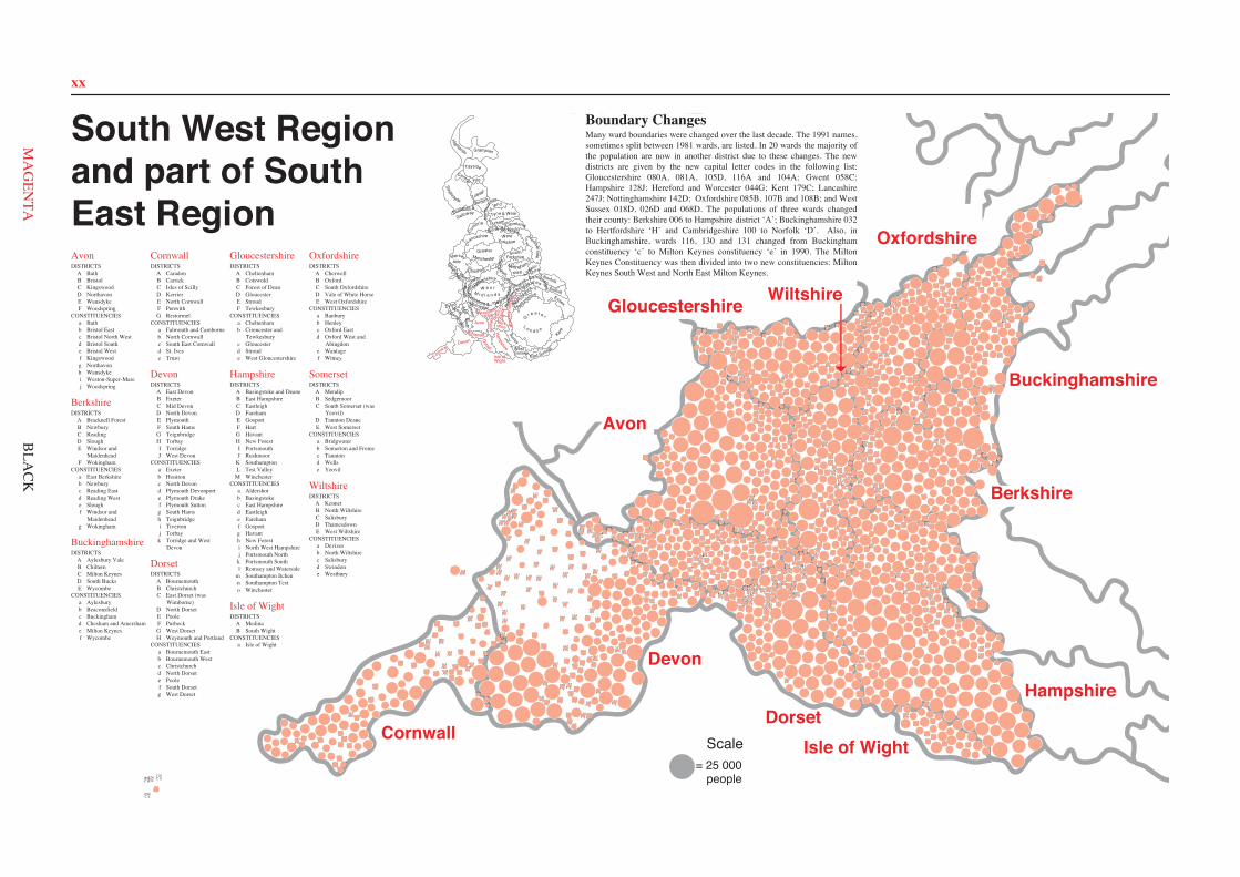
xx
001A a
017A a
028A a
055A a
093A a
094A a
095A a
098A a
106A a
110A a
129A a
139A a
140A a
143A a
151A a
154A a
008B c
020B d
022B e
023B d
030B b
035B e
033B e
006B e
083B e
061B b
007B b
081B c
068B d
085B f
021B c
031B d
005B e
131B f
060B b
004B e
036B b
019B d
080B c
034B d
063B f
029B b
082B c
018B d
011C h
024C h 025
C h
026C h
010C h
032C h
042C f
045C f
059C f
069C f 077C f
075C h
076C h
099C f
105C f
111C h 112
C h
128C h 041
C f
130C h
132C f
160C f
002D g
003D g
012D g
039D g
046D g
058D g
065D c
066D c 067
D c 070D g
071D g
072D g
079D g
088D g
100D g
109D g 113
D g
114D g
115D g 116
D g
119D g
125D g
133D c 134
D c
136D g 137
D g
141D g
166D g
152D g
153D g
159D g
157D g
158D g
163D g
164D g 165D g
167D g
014E h
015E h
016E h
037E j
038E h
040E h
043E j
044E j
054E j
056E j
064E j 073
E h
078E j 084
E j
086E h
089E h
090E h
091E h
092E h
101E h
102E h
107E h
117E j
118E h 124
E j
126E h
127E h
135E j
138E j
142E h
009F j
013F i
027F i
047F i
048F j
049F j
050F j
051F j
052F j
053F j
057F i
062F j
074F j
087F i
096F i
097F j
103F j
104F j
108F j
120F j
121F j
122F j
123F j
144F i
145F i 146
F i
147F i
148F i
149F i
150F i
155F j 156
F i
161F j
162F i
168F i
008A a
018A a
027A a
051A a
054A a
057A a
069A a
070A a
071A a
073A a
074A a
086A a 091
A a 094A a
099A a
108A a
036A a
120A a
124A a
090B b
055B b
056B b
015B b
011B b
010B b
029B b
021B b
026B b
030B b 006
B b
115B d
050B b
095B d
101B d
031B b
100B d
116B d
032B d
076B b
059B b
077B b
083B b
084B b
042B b
005B b
043B b
049B b
082B b
072B b
104B b
048B b
113B b
114B b
060B b
052B b
003C c
002C c
001C d
035C c
098C c
045C c
004C d
088C d
012C d
097C c
080C c
034C c
081C d
044C c
025D e
024D e
039D e
038D e
037D e
040D e
023D e
013D e
067D e
109D e
014D e
119D e
122D e 017
E f
020E f
068E f
093E f
016E f
033E f
046E f
047E f
096E f
117E f
063E f
062E f
022E f
019E f
078E f
058E a
075E a
092E a
111E a
110E a 007
F c 009F c
028F g
065F g
041F g 053
F g
061F g
064F g
066F c
079F g
085F g
087F g
089F g
102F g
103F g
126F g
105F c
106F g
107F g
112F c
118F g
121F g
123F g
125F g
006A a
008A a
013A a
014A c
022A c
023A c 024
A c 031A c
045A c
046A a
050A a
053A a
054A c
055A c
058A c
059A c
066A c
082A c
086A c
087A a
090A c 091
A a
094A c
097A a
098A c
102A c
106A c
109A a
112A c
113A c
115A c
118A c
120A c
122A a
123A a
126A c 127
A c
128A c
001B d
003B d
002B d
004B d
005B d
029B d
009B a
027B d
028B d
007B d
030B d
032B d
033B d
034B d
036B d
052B d
057B a
065B d
067B d
080B d
081B d
085B d
096B d
100B d
103B d
104B a
110B d
107B d
119B d
121B d
021C e
035C e
039C e
040C e
044C e
048C e
078C e
079C e
084C e
088C e
093C e
095C e
099C e
101C e
108C e
111C e
116C c
125C e
129C e
131C c
130C c
132C e
011D b
010D b
012D b
025D b
026D b
041D b
042D b
047D b
063D b
051D b
064D b
070D b
072D b
073D b
071D b
114D b 117
D b 124D b
069E a
105E a
016E a
076E a
015E a
092E a 068
E f 075E f 061
E d 043E f
018E f 038E f
020E f
074E f
062E d
060E b
083E b
049E b
077E f 056
E f 017E f
037E f
019E b 089
E f
049A c
010A c
050A c
120A c
098A c 105
A c
060A c
043A c
113A c
054A c
022A c
024A c
123A c 044
A c
115A c
011A c
063A c 056A c
101A c
090A c
041A c
012A c
018A c 032
A c
023A c
025A c
003B a
006B e 017
B e 027B e
039B e
040B e
064B e
066B a
067B e
072B a
073B a
080B e 083
B e 088B e
093B e 099
B e
091B a
121B e
122B e
126B a 007
D d
013D a
014D a
015D a
019D a
021D d
030D d
035D d
036D d
037D a
038D a
055D a
058D a
059D d
065D d
082D d
086D a
087D a
100D a
109D d
116D a
130D d
001E b
002E b
004E b 005
E b
009E b
016E b
031E b
042E b
045E b
046E b
048E b
068E b
069E b
070E b
071E b
089E b
096E b
102E b 112
E b
114E b
092E b
117E c
118E b
119E b
127E b
128E b
129E b
033F d
034F d 047
F d 053F d
057F d
074F d
075F d
076F d
077F d
078F d 079
F d 097F d
104F d
106F d 107
F d
108F d
125G e
020G e 081
G e 062G e
095G c 103
G e
061G e
051G e
084G b
052G c 028
G c
085G b
026G b
029G b
008C d
094C d
110C d
111C d
124C d
010A b
011A b
014A b
033A i
038A b
055A i
054A i
059A b
083A b
092A i
093A b 094
A b
095A b 096
A b
097A b 098
A b
120A b
121A b
144A b
157A b
160A b
168A b
169A i
170A i
171A b
184A b
190A b 194
A b 195A b
196A b
213A i
235A b
238A b
252A b
253A b
003B a
013B a
063B a
067B a
066B a
012B a
174B a
177B a
117B a 186
B a
115B a
116B a
002B a
173B a
229B a
176B a
205B a
024C i
027C i
042C i
043C i
044C i 045
C i 052C i
068C i
069C i
070C i 081
C i
106C i
139C i
142C i
158C i
172C i
189C i
193C i
197C i 219
C c
218C c
239C i
240C i
244C c
246C i
247C i 250
C i
256C i
175D c
255D c 206
D c
236D c
137D c
141D c
124D c
122D c
123D c
030D c
100D c
126D c
060D c
028D c
220D c
125D c
112D c
104D c
113D c
029D c
138D c
021D c
145D c
200D c 050
D c 049D c
048D c
020D c
161D c
039E d
061E e
078E e
084E f
085E f
090E d
108E d
119E d
131E d 156
E f 178E f
179E f
180E f
181E f
204E d
207E e
202E d
210E e
212E e
234E e
008F g
009F g
016F g
032F g
047F g
062F g 072
F g
073F g
074F g
071F g
082F h
089F g
103F g
128F g
132F g
136F g
146F g
147F g
152F g
159F g
187F g
188F g
198F g
199F g
203F g
209F g
211F g
228F g
233F g
232F g
237F g
243F g
245F g
254F g
001G h
004G h
007G h
025G h
026G h
035G h
037G h
041G h
051G h
058G h
075G h
076G h 077
G h
080G i
107G h
111G h
127G h
129G i
133G h
134G h
135G h
150G h
153G h
154G h
182G i
191G h
222G h
223G h
224G h
225G h 226
G h
221G i
249G i
023H g
056H j
065H j
087H j
102H g
183H j
088H j
022H j
101H g
192H j 230H j 086
H j
005I k
006I k
017I k
018I k
019I k
034I k
053I k
057I k
099I k
105I k
109I k
114I k
118I k
130I k
149I k
155I k
163I k
164I k 165
I k 167I k
185I k
208I k
214I k
231I k
241I k
248I k
251I k
015J k
031J k
036J k
040J k
046J k
064J k
079J k
091J k
110J k
140J k
143J k 148
J k
151J k
162J k
166J k
201J k
215J k
216J k
217J k
227J k
242J k
011A a
012A a
031A a
046A a
047A b
064A b
066A a
077A a
080A a
092A a
094A b
098A a
103A a
108A b
120A b
126A b
122A b
125A a
137A b
027B c
038B c
050B c
063B c
079B c
081B c
088B c
099B c
116B c
135B c
010D d
096D d
069D d
095D d
110D d
041D d 055
D d
002D d 001
D d
009D d
089D d
057D d
109D d
049D d 016D d
111D d
078D d
056D d
075D d
102D d
070D d
008D d
025D d
015E b
014E e
023E e
052E e
003E e 028
E e
054E e
053E e
087E e
004E b
007F f
029F f
065F f
072F d
073F d
101F f
106F f 107
F f
121F f
124F f
134F f
138F f
018G g 043
G g 044G g
045G g 071
G g
091G g
006G g 024
G g 112G g
082G g
051G g
035G g 132
G g 020G g
013G g
019G g
067G g 026G g
037G g
136G g
085G f
074G g
048G g 034
G g
032G g 033
G g 113G g
086G g
021G g 022
G g 036G g
059G g
030G g 017
G g 058G g
060G g
076H f
084H f
083H f 090
H f 093H f
114H f
115H f
117H f
127H f
128H f
129H f
130H f
131H f
139H f
133C d
100C c
040C d
039C d
005C c
068C c
123C c 119
C c
042C d
097C d 118
C d 062C d 061
C d
105C d
104C d
002A a
029A a
001A a
065A a
068A a 078
A a 076A a
102A a
077A a
112A a
113A a
005B b
007B d
011B b
016B b
017B b
026B b
032B b 034
B b 035B b
036B b
037B b
038B b
040B b
054B b
055B b
056B b
057B b
058B b
060B d
061B b
072B b
079B b
088B b 091
B b
097B b
109B b
110B b
115B b
117B d
119B b
120B b
130B b
131B b
046C e
045C e
033C e
008C e
084C e
015C e
090C e
030C e
108C e
095C e
132C e 069
C e 003C e
004C e
122C e
051C e 050
C e 063C e
121C e
094C e
093C e 086
C e 019C e 020
C e 018C e
101C e
009D c
010D c 052
D c 071D c
075D c
083D c
085D c
087D c
103D c
124D c
133D c
092E d
022E d
027E d 123
E d
127E d
126E d 049
E d
025E d
024E d
023E d
136E d 096
E d
099E d 062
E d
105E c
128E c
100E d 053E d 014
E d 028E d
107E d
098E d
106E d 134
E d 114E d
074E d
082E d
089E d
073E d
070E d
129E d
012E d
118F b 067
F e 066F e
044F e
043F e
031F e
021F e
125F b
006F b
042F b
116F b
041F b
059F b
013F b
039F b
104F a
047F b
048F b 135
F b
081F a
111F b
080F a 064
F b
017A b
020A i
030A b
038A b
042A b
045A b
046A i
049A b 071
A b
086A b
081A i
097A b
149A b
152A i
150A b
175A b
178A b
179A b
183A i
185A b 191A b 208A b
209A b
212A b
213A b
224A i
234A i 235
A i
236A i
247A b
248A b
256A b
258A i
263A b
004B o
005B o
006B o 007
B o 008B o
024B c
039B c
056B c
080B c
098B o 110
B o
114B c
115B c
117B c
131B c
142B c
143B c
144B c
145B c
156B c
165B o
177B o
188B c
189B c
190B c
202B o
203B c
206B c 238B c
259B c
260B c
027C d
036C d
047C d
048C d
082C d
083C d 084
C d
085C d
091C d
118C d
132C d 133
C d
138C d
139C d
146C d
253C d 254
C d
092D e
094D e 093D e
095D e
096D e
135D f
158D e
192D e
193D e
194D e
205D e
230D f
240D e
251D e
009E f
010E f
041E f
044E f
087E f
119E f
154E f
155E f
204E f
244E f
055F c
068F c
090F a
102F c
103F c
104F c
113F a 124
F a
128F a
140F c
159F c
180F c
261F a
267F a
268F a
269F a
014G g 019
G g 022G g
035G g
066G g
089G g
123G g
129G g
130G g
196G j
217G g
228G j
250G g
252G g
015H h
016H h
021H h
031H l
034H h
040H h
043H h
057H l
062H h
073H l
074H l
075H h
099H l
105H h
107H h
106H h
108H h
109H h
141H h
147H l
160H h
161H h
163H l
167H h
170H h
172H l
187H h
199H h
200H h
232H h
241H l
242H l
243H l
059I k
064I j
076I j
111I k
127I k
126I k
061I k
060I j
137I j
136I j
063I j
052I k
220I k
051I k
125I k 050
I k
003J a
023J a
065J a
088J a
100J a
116J a
134J a
153J a
162J a
164J a
174J a
197J a
219J a
223J a
255J a
013K m
018K n
029K m
028K m
067K n
112K n
120K m
168K n
186K m
195K n
198K n
222K m
210K n
211K m
266K d
001L l
002L i
011L i
032L l
037L i
054L l
069L l 078
L i
101L l
121L i
122L i
151L i
169L i
171L i
176L l
182L i
201L l
225L i
229L i
233L l
237L i 257L i
264L i
025M o
026M o
033M e
053M o
058M o
070M e 072
M e
077M e
079M o
148M o
157M o
166M o
173M o
012M o
181M o
184M o
215M o
216M o
218M o
221M o
226M o
227M o
207M e
214M o
231M e
239M o
245M o
246M o
249M e 262
M e
265M o
007A a
008A a
009A a 010
A a 011A a
015A a
016A a 017A a
018A a
019A a 020
A a
021A a
022A a 023
A a
024A a
025A a
026A a
001B a
002B a
003B a
004B a
005B a
006B a
012B a
013B a
014B a
027B a
028B a
029B a
030B a
031B a
032B a
033B a
002A a
003A a
005A a
013A a
014A a
015A a
018A a
019A a
024A a
033A a
041A a
045A a 051
A a
061A a
067A f
070A a 074
A a
080A a
082A a
083A a
092A a
093A a
099A a
103A f
110A a
114A a
118A a
120A f
126A a
145A a
146A f
016B c
027B d
032B d
052B c
076B c
086B c
096B c 104
B d 111B c 122
B c 121B d
131B c
137B d
143B d
109B c
108C c
059C b
107C c
138C b
068C b
063C b
062C c
008C b
034C b
136C b
029C b
011C b
048C b
030C b
012C b
038C b
085C c
079C b
078C b
066C b
065C b
089C b
064C b
042C b 119C b 116
C b
101C b
100C b 043
C b
132C b
135C e
072C e
020C e
036C e
046C e
047C e
001D d
004D e
023D d
040D e
044D d
049D e
055D e 058
D d
069D e
071D e
075D e 077
D e
081D d
084D e
087D e
088D d
091D e
094D e
095D e
105D d
106D d 112
D d
123D d
115D e
117D e
124D e
127D e
128D d
129D e
133D e
134D e
006E f
007E f 009
E f
010E a
017E f
021E f
022E f
025E f
026E f
028E f
031E f
035E f
037E f
039E f
050E f
053E f
054E f
056E f
057E f
060E f
073E f
090E f
097E f
098E f
102E f
113E f
125E f
130E a
139E f
140E f
141E f
142E f
144E f
002A d 003
A d 007A b
008A b
035A d
038A b
040A b
052A d
055A b
056A b
058A b
059A d
060A d
061A d
062A d
077A b
083A d 085
A d
090A b
099A b
100A d
104A d
057A b
107A d
108A d
116A b
117A d
118A d 128
A b
135A d
136A d
137A d
005B d
006B d
009B d 019
B d 021B d
022B d
025B a
028B a
034B d 045
B a 050B a 051
B a
049B a
064B a
066B d
069B a
075B d
089B a
093B a
096B a
097B a
102B a
106B a
109B d
111B a
119B a 129
B a
131B d
142B a
140B a
147B a
011D c
014D c
016D c
018D c
126D c
113D c
105D c
121D c
010D c
123D c 122
D c
012D c
125D c
079D c
082D c
087D c
091D c
092D c 013D c
133D c
120D c
086D c
114D c
039D c
132D c
134D c
139D c
124D c
146D c
001E a
004E a
026E a
042E a 046
E c
047E a 048
E a 054E c
063E c
067E a
080E a
081E a
095E a
098E a
101E a
103E c 130
E a
141E a
143E a
015C e
017C b
020C b
023C b
024C b 027
C b
029C e
030C e
031C e
032C e
033C e
036C e
037C e
041C e
043C b
044C e 053
C e 065C e
068C e
070C e
071C b
072C b
073C b
074C e
076C b
078C b
084C e 088
C e
094C b
112C e
110C e
115C e
127C b
138C b
144C b
145C e 148
C e
149C e
150C e
151C e
152C e
153C e
002A a
008A a
019A a
021A a
026A a
029A a
032A a
037A a
038A a
039A a
068A a
073A a
074A a 075
A a 080A a
083A a
085A a
086A a
089A a
090A a
092A a
095A a
096A a
097A a
112A a
114A a
117A a
118A a
119A a
124A a
128A a
023B b
022B b
058B b
007B b
004B b
071B b
014B b 013
B b
031B b
065B b
016B b 024
B b
025B b
017B b
062B b
084B b 063B b
006B b
035B b
091B b
108B b
069B b
070B b
130B b
036B b
081B b
018B b 100
B b
061B b
099B b
003C c
005C c
009C c
010C c
020C c
028C c
041C c
043C c
044C c
046C c
049C c 050
C c 051C c
055C c
060C c
064C e
066C c
077C e
079C c
082C c
093C c
101C c
104C c
105C c
106C c
107C c
109C c
110C c
113C c
122C e
123C c
125C c 126
C c 127C c
129C c 132
C c
012D a
027D d
030D a
034D a
042D d 045
D d
054D d
057D a
067D d
056D d
087D d
094D a
103D a
102D a
111D d
115D d
053D d
052D d
131D a
015E e
076E e
001E e
116E e
121E e
072E e
120E e
059E e
011E e
088E e
047E e
040E e
048E e
033E e
098E e
078E e
South West Regionand part of SouthEast RegionAvonDISTRICTS
A BathB BristolC KingswoodD NorthavonE WansdykeF Woodspring
CONSTITUENCIESa Bathb Bristol Eastc Bristol North Westd Bristol Southe Bristol Westf Kingswoodg Northavonh Wansdykei Weston-Super-Marej Woodspring
BerkshireDISTRICTS
A Bracknell ForestB NewburyC ReadingD SloughE Windsor and
MaidenheadF Wokingham
CONSTITUENCIESa East Berkshireb Newburyc Reading Eastd Reading Weste Sloughf Windsor and
Maidenheadg Wokingham
BuckinghamshireDISTRICTS
A Aylesbury ValeB ChilternC Milton KeynesD South BucksE Wycombe
CONSTITUENCIESa Aylesburyb Beaconsfieldc Buckinghamd Chesham and Amershame Milton Keynesf Wycombe
CornwallDISTRICTS
A CaradonB CarrickC Isles of ScillyD KerrierE North CornwallF PenwithG Restormel
CONSTITUENCIESa Falmouth and Camborneb North Cornwallc South East Cornwalld St. Ivese Truro
DevonDISTRICTS
A East DevonB ExeterC Mid DevonD North DevonE PlymouthF South HamsG TeignbridgeH TorbayI TorridgeJ West Devon
CONSTITUENCIESa Exeterb Honitonc North Devond Plymouth Devonporte Plymouth Drakef Plymouth Suttong South Hamsh Teignbridgei Tivertonj Torbayk Torridge and West
Devon
DorsetDISTRICTS
A BournemouthB ChristchurchC East Dorset (was
Wimborne)D North DorsetE PooleF PurbeckG West DorsetH Weymouth and Portland
CONSTITUENCIESa Bournemouth Eastb Bournemouth Westc Christchurchd North Dorsete Poolef South Dorsetg West Dorset
GloucestershireDISTRICTS
A CheltenhamB CotswoldC Forest of DeanD GloucesterE StroudF Tewkesbury
CONSTITUENCIESa Cheltenhamb Cirencester and
Tewkesburyc Gloucesterd Stroude West Gloucestershire
HampshireDISTRICTS
A Basingstoke and DeaneB East HampshireC EastleighD FarehamE GosportF HartG HavantH New ForestI PortsmouthJ Rushmoor
K SouthamptonL Test Valley
M WinchesterCONSTITUENCIES
a Aldershotb Basingstokec East Hampshired Eastleighe Farehamf Gosportg Havanth New Foresti North West Hampshirej Portsmouth Northk Portsmouth Southl Romsey and Waterside
m Southampton Itchenn Southampton Testo Winchester
Isle of WightDISTRICTS
A MedinaB South Wight
CONSTITUENCIESa Isle of Wight
OxfordshireDISTRICTS
A CherwellB OxfordC South OxfordshireD Vale of White HorseE West Oxfordshire
CONSTITUENCIESa Banburyb Henleyc Oxford Eastd Oxford West and
Abingdone Wantagef Witney
SomersetDISTRICTS
A MendipB SedgemoorC South Somerset (was
Yeovil)D Taunton DeaneE West Somerset
CONSTITUENCIESa Bridgwaterb Somerton and Fromec Tauntond Wellse Yeovil
WiltshireDISTRICTS
A KennetB North WiltshireC SalisburyD ThamesdownE West Wiltshire
CONSTITUENCIESa Devizesb North Wiltshirec Salisburyd Swindone Westbury
WestSussex
East Sussex
Surrey
G r e a t e r
L o n d o n
Kent
Essex
ClevelandDurham
Nor
thum
ber-land
Tyne & Wear
Borders
Dumfries &
Galloway
StrathclydeLothian
Central Fife
Tayside
Grampian
Highlands
Cheshire
YorkshireSouth
HumbersideGreaterManchester
WestYorkshireLancashire
Mersey-side
North YorkshireCu
mbria
GwentSouth
GlamorganM
idWest
Hereford &WorcesterWarwick
shireW e s t
M i d l a n d s
Powys
Dyfed
Gwynedd Clwyd
Staffordshire
Shro
ps
hire
Hertfords
hire
Bed
for
dshir
e Suffolk
NorfolkshireCambridge-
North
am
ptonshire
Leicestershire
Nottingham-
shire
Derbyshire Lincoln-shire
Isle of
Ham
pshire
Berk-shire
Wiltshire
Wight
Dorset
SomersetDevon
Cornwall
Avon Buck
ingh
amsh
ire
Oxf
ord-
shireGloucester-
shire
= 25 000people
ScaleCornwall
Devon
DorsetIsle of Wight
Hampshire
Berkshire
Buckinghamshire
Gloucestershire
Avon
Boundary ChangesMany ward boundaries were changed over the last decade. The 1991 names,sometimes split between 1981 wards, are listed. In 20 wards the majority ofthe population are now in another district due to these changes. The newdistricts are given by the new capital letter codes in the following list:Gloucestershire 080A, 081A, 105D, 116A and 104A; Gwent 058C;Hampshire 128J; Hereford and Worcester 044G; Kent 179C; Lancashire247J; Nottinghamshire 142D; Oxfordshire 085B, 107B and 108B; and WestSussex 018D, 026D and 068D. The populations of three wards changedtheir county: Berkshire 006 to Hampshire district ‘A’; Buckinghamshire 032to Hertfordshire ‘H’ and Cambridgeshire 100 to Norfolk ‘D’. Also, inBuckinghamshire, wards 116, 130 and 131 changed from Buckinghamconstituency ‘c’ to Milton Keynes constituency ‘e’ in 1990. The MiltonKeynes Constituency was then divided into two new constituencies: MiltonKeynes South West and North East Milton Keynes.
Oxfordshire
Wiltshire
BLA
CK
xx
Avon
Berkshire
Buckinghamshire
Cornwall
Devon
Dorset
Gloucestershire
Hampshire
Isle of Wight
Oxfordshire
Somerset
Wiltshire
Isle of
Ham
pshire
Berk-shire
Wiltshire
Wight
Dorset
SomersetDevon
Cornwall
Avon Buck
ingh
amsh
ire
Oxf
ord-
shireGloucester-
shire
Cornwall
Devon
DorsetIsle of Wight
Hampshire
Berkshire
Buckinghamshire
Gloucestershire
Avon
Oxfordshire
Wiltshire
MA
GEN
TA
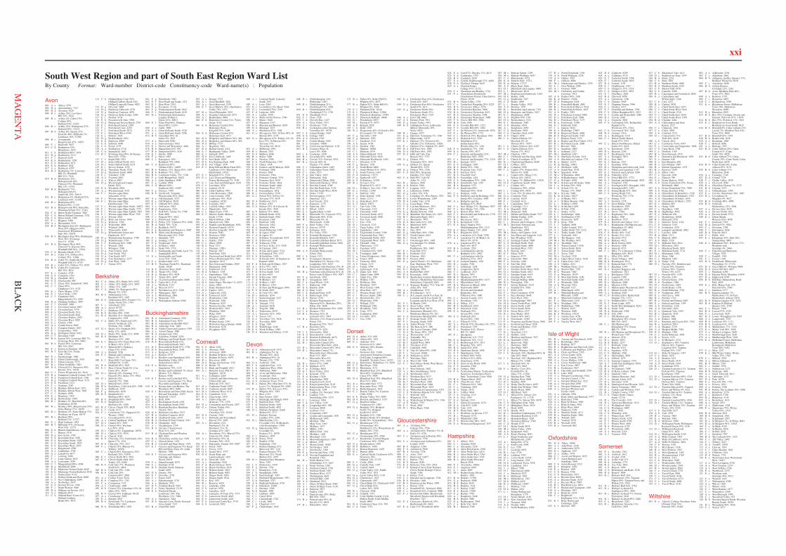
xxi
Avon001 A a Abbey: 4791002 D g Almondsbury: 7317003 D g Alveston: 3620004 B e Ashley 36%; Lawrence
Hill 22%: 7024005 B e Ashley 4%; Cabot 15%;
Cotham 65%;Redland 34%: 12421
006 B e Ashley 52%; Bishopston 27%;Redland 20%: 11614
007 B b Ashley 8%; Easton 27%;Eastville 48%; Hillfields 3%;Lockleaze 36%: 13200
008 B c Avonmouth;Kingsweston 47%: 14871
009 F j Backwell: 5627010 C h Badminton 14%;
Blackhorse: 1832011 C h Badminton 86%: 1874012 D g Badminton: 2213013 F i Banwell: 6238014 E h Bathampton: 1550015 E h Batheaston: 2671016 E h Bathford: 1842017 A a Bathwick: 4257018 B d Bedminster 2%; Lawrence
Hill 2%; WindmillHill 51%: 7416
019 B d Bedminster 25%;Bishopsworth 36%;Filwood 33%; WindmillHill 13%: 11552
020 B d Bedminster 73%;Bishopsworth 6%;Southville 20%: 10619
021 B c Bishopston 4%; Horfield 52%;Lockleaze 64%: 12168
022 B e Bishopston 69%;Redland 29%: 11125
023 B d Bishopsworth 58%; Hartcliffe;Whitchurch Park 52%: 23241
024 C h Bitton North Common: 3845025 C h Bitton Oldland Common: 3332026 C h Bitton South: 1856027 F i Blagdon: 1900028 A a Bloomfield: 5155029 B b Brislington East 6%; Brislington
West 18%; Hengrove 60%;Stockwood; WhitchurchPark 48%: 29878
030 B b Brislington East 94%; BrislingtonWest 38%; St GeorgeEast 1%: 15206
031 B d Brislington West 44%;Filwood 7%; Knowle 30%;Windmill Hill 36%: 13934
032 C h Bromley Heath: 4753033 B e Cabot 21%; Clifton 63%;
Cotham 35%: 11868034 B d Cabot 5%; Southville 80%;
Windmill Hill 1%: 8729035 B e Cabot 51%; Clifton 37%: 8555036 B b Cabot 8%; Lawrence
Hill 35%: 5024037 E j Cameley: 2224038 E h Camerton: 1393039 D g Charfield: 2831040 E h Charlcombe: 905041 C f Chase 10%; Soundwell: 3963042 C f Chase 90%;
Chiphouse 11%: 5125043 E j Chew Magna: 1376044 E j Chew Stoke: 1376045 C f Chiphouse 89%;
Mangotsfield 11%: 5287046 D g Chipping Sodbury: 3855047 F i Churchill: 2085048 F j Clevedon Central: 4907049 F j Clevedon East: 3374050 F j Clevedon North: 1911051 F j Clevedon South: 4941052 F j Clevedon Walton: 2952053 F j Clevedon West: 3585054 E j Clutton: 1586055 A a Combe Down: 5005056 E j Compton Dando: 1827057 F i Congresbury: 3435058 D g Dodington North: 8412059 C f Downend: 5189060 B b Easton 34%; Lawrence Hill 7%;
St George West 38%: 8403061 B b Easton 38%; Lawrence
Hill 34%: 8267062 F j Easton-in-Gordano: 4870063 B f Eastville 52%; Frome
Vale: 17214064 E j Farmborough: 1084065 D c Filton Charborough: 3165066 D c Filton Conygre: 3375067 D c Filton Northville: 3401068 B d Filwood 61%; Hengrove 40%;
Knowle 70%: 19194069 C f Forest; Woodstock 6%: 5618070 D g Frampton Cotterell Central: 2072071 D g Frampton Cotterell East: 1766072 D g Frampton Cotterell West: 2151073 E h Freshford: 1434074 F j Gordano: 2583075 C h Hanham Abbots East: 1973076 C h Hanham Abbots West: 3803077 C f Hanham: 4999078 E j Harptrees: 1525079 D g Hawkesbury: 1604080 B c Henbury 2%; Horfield 48%;
Southmead: 16784081 B c Henbury 98%; Kingsweston 53%;
Stoke Bishop 27%: 18458082 B c Henleaze 4%; Stoke Bishop 73%;
Westbury-on-Trym: 18179083 B e Henleaze 96%;
Redland 17%: 12727084 E j High Littleton: 1903085 B f Hillfields 97%; St George
West 19%: 12772086 E h Hinton Charterhouse: 1484087 F i Hutton: 3518088 D g Iron Acton: 1790089 E h Keynsham East: 5450090 E h Keynsham North: 3405091 E h Keynsham South: 3979092 E h Keynsham West: 2979093 A a Kingsmead: 4780094 A a Lambridge: 3768095 A a Lansdown: 4677096 F i Locking: 3498097 F j Long Ashton: 4822098 A a Lyncombe: 5250099 C f Mangotsfield 89%: 4594100 D g Marshfield: 2006101 E h Midsomer Norton North: 4645102 E h Midsomer Norton Redfield: 4018103 F j Nailsea East: 9132104 F j Nailsea North and West: 8098105 C f New Cheltenham: 5299106 A a Newbridge: 5427107 E h Newton St Loe: 1368108 F j North Weston: 3060109 D g Oldbury-on-Severn: 1412110 A a Oldfield: 4915111 C h Oldland Barrs Court 41%;
Oldland CadburyHeath 66%: 5032
112 C h Oldland Barrs Court 59%;Oldland Cadbury Heath 34%;Oldland Longwell Green: 8823
113 D g Olveston: 2045114 D g Patchway Callicroft: 4370115 D g Patchway Coniston: 4078116 D g Patchway Stoke Lodge: 2569117 E j Paulton: 4734118 E h Peasedown St John: 3708119 D g Pilning and Severn Beach: 2767120 F j Portishead Central: 2188121 F j Portishead Coast: 2250122 F j Portishead South: 2874123 F j Portishead West: 4349124 E j Publow: 1826125 D g Pucklechurch: 2921126 E h Radstock: 4980127 E h Saltford: 4340128 C h Siston: 2155129 A a Southdown: 5710130 C h Springfield: 1683131 B f St George East 99%; St George
West 42%: 15701132 C f Staple Hill: 3394133 D c Stoke Gifford North: 4111134 D c Stoke Gifford South: 8231135 E j Stowey Sutton: 1139136 D g Thornbury North: 5728137 D g Thornbury South: 6889138 E j Timsbury: 2396139 A a Twerton: 4963140 A a Walcot: 4887141 D g Westerleigh and Coalpit
Heath: 3054142 E h Westfield: 6856143 A a Westmoreland: 5192144 F i Weston-super-Mare
Ashcombe: 8134145 F i Weston-super-Mare East: 9589146 F i Weston-super-Mare
Ellenborough: 7791147 F i Weston-super-Mare North: 16872148 F i Weston-super-Mare South: 7737149 F i Weston-super-Mare Uphill: 7505150 F i Weston-super-Mare West: 7307151 A a Weston: 5014152 D g Wick and Abson: 1940153 D g Wickwar: 2366154 A a Widcombe: 4898155 F j Winford: 2868156 F i Winscombe: 4360157 D g Winterbourne Down and
Hambrook: 1677158 D g Winterbourne Frenchay: 1798159 D g Winterbourne: 5336160 C f Woodstock 94%: 5288161 F j Wraxall: 2200162 F i Wrington: 2540163 D g Yate Central: 1645164 D g Yate North: 7922165 D g Yate South: 4437166 D g Yate Stanshawes: 2277167 D g Yate West: 3496168 F i Yatton: 8372
Berkshire001 C d Abbey 24%; Battle 56%: 6932002 C c Abbey 35%; Battle 21%: 5079003 C c Abbey 37%: 3497004 C d Abbey 4%; Katesgrove 65%;
Minster 5%: 5743005 B b Aldermaston 12%;
Beenham 62%: 1625006 B b Aldermaston 88%; Pamber 11%;
Tadley North 25%: 1794007 F c Arborfield: 2252008 A a Ascot: 10755009 F c Barkham: 2957010 B b Basildon 49%: 1545011 B b Basildon 51%; Bradfield 15%;
Compton 8%: 1595012 C d Battle 24%; Kentwood 15%;
Norcot; Southcote 12%;Tilehurst 16%: 14988
013 D e Baylis 44%; Farnham 29%;Stoke 17%: 6438
014 D e Baylis 56%; Stoke 12%: 4994015 B b Beenham 38%;
Mortimer 10%: 1482016 E f Belmont 14%; Furze Platt 14%;
St Mary's 91%: 8712017 E f Belmont 86%; Pinkneys
Green 10%: 6730018 A a Binfield: 5238019 E f Bisham and Cookham; St
Mary's 9%: 7511020 E f Boyn Hill; Cox Green 76%;
Oldfield 9%: 13105021 B b Bradfield 85%: 2045022 E f Bray; Clewer North 6%; Cox
Green 24%: 10334023 D e Britwell 18%; Farnham 71%;
Haymill 25%; Stoke 17%: 9924024 D e Britwell 18%;
Haymill 75%: 7906025 D e Britwell 64%: 5559026 B b Bucklebury; Cold Ash 24%: 3050027 A a Bullbrook: 6725028 F g Bulmershe: 4038029 B b Burghfield 6%;
Mortimer 84%: 4633030 B b Burghfield 85%: 5643031 B b Burghfield 9%;
Mortimer 6%: 1280032 B d Calcot; Theale 55%: 8028033 E f Castle: 4172034 C c Caversham 17%; Peppard 41%;
Thames: 13867035 C c Caversham 83%: 8115036 A a Central Sandhurst: 4156037 D e Central 46%: 3663038 D e Central 54%; Wexham
Lea 59%: 9126039 D e Chalvey 8%; Cippenham: 10578040 D e Chalvey 92%: 9915041 F g Charvil: 2126042 B b Chieveley 21%; Downlands 14%;
Speen 17%: 1541043 B b Chieveley 79%: 2517044 C c Church 14%; Minster 6%;
Whitley: 10958045 C c Church 86%; Katesgrove 25%;
Redlands 26%: 10549046 E f Clewer North 94%: 5852047 E f Clewer South; Park 16%;
Trinity 10%: 6566048 B b Cold Ash 17%; Thatcham
North 92%: 4694049 B b Cold Ash 29%: 1106050 B b Cold Ash 29%;
Compton 40%: 2408051 A a College Town: 5414052 B b Compton 53%: 1741053 F g Coronation: 7137054 A a Cranbourne: 1400055 B b Craven 22%; Greenham 10%; St
John's 94%: 7953056 B b Craven 78%; Falkland: 10128057 A a Crowthorne: 5685058 E a Datchet: 4947059 B b Downlands 7%; Lambourn
Valley 28%: 1616060 B b Downlands 80%: 1870
061 F g Emmbrook: 5943062 E f Eton North and South: 1321063 E f Eton West: 2335064 F g Evendons: 11318065 F g Finchampstead North: 5642066 F c Finchampstead South: 6130067 D e Foxborough; Kedermister;
Langley St Mary's;Upton 16%: 20811
068 E f Furze Platt 86%; PinkneysGreen 90%: 12243
069 A a Garth: 3899070 A a Great Hollands North: 5128071 A a Great Hollands South: 5256072 B b Greenham 90%; St
John's 6%: 2823073 A a Hanworth: 8560074 A a Harmanswater: 9162075 E a Horton and Wraysbury: 4486076 B b Hungerford 16%: 991077 B b Hungerford 84%: 5183078 E f Hurley: 6260079 F g Hurst: 1692080 C c Katesgrove 10%;
Redlands 74%: 6460081 C d Kentwood 85%;
Tilehurst 84%: 14499082 B b Kintbury 23%; Speen 83%: 3493083 B b Kintbury 77%: 2472084 B b Lambourn Valley 72%: 3740085 F g Little Hungerford: 10423086 A a Little Sandhurst: 4040087 F g Loddon: 8508088 C d Minster 89%;
Southcote 88%: 14497089 F g Norreys: 7390090 B b Northcroft; Turnpike;
Winchcombe 82%: 8841091 A a Old Bracknell: 5275092 E a Old Windsor: 5030093 E f Oldfield 91%: 6942094 A a Owlsmoor: 5543095 B d Pangbourne: 3334096 E f Park 84%; Trinity 5%: 5708097 C c Park: 8081098 C c Peppard 59%: 5612099 A a Priestwood: 3414100 B d Purley 22%; Tilehurst 55%: 6920101 B d Purley 78%: 3216102 F g Redhatch: 14573103 F g Remenham and Wargrave: 4485104 B b Shaw-cum-Donnington;
Winchcombe 18%: 2269105 F c Shinfield: 7207106 F g Sonning: 1354107 F g South Lake: 5656108 A a St Mary's: 1669109 D e Stoke 54%: 3752110 E a Sunningdale and South Ascot 7%;
Sunninghill: 8076111 E a Sunningdale and South
Ascot 93%: 7438112 F c Swallowfield: 1677113 B b Thatcham North 8%; Thatcham
South: 10129114 B b Thatcham West: 6045115 B d Theale 45%: 5206116 B d Tilehurst 45%: 4824117 E f Trinity 84%: 4697118 F g Twyford and Ruscombe: 6408119 D e Upton 84%: 5142120 A a Warfield: 1724121 F g Wescott: 4773122 D e Wexham Lea 41%: 3258123 F g Whitegates: 3607124 A a Wildridings: 2906125 F g Winnersh: 7325126 F g Wokingham without: 6568
Buckinghamshire001 B d Amersham Common: 3292002 B d Amersham Town: 4075003 B d Amersham-on-the-Hill: 4923004 B d Asheridge Vale: 1862005 B d Ashley Green and Latimer: 1949006 A a Aston Clinton: 3980007 B d Austenwood: 2242008 A a Aylesbury Central: 2230009 B a Ballinger and South Heath: 1233010 D b Beaconsfield North 13%;
Beaconsfield South: 3693011 D b Beaconsfield North 87%: 3702012 D b Beaconsfield West: 3148013 A a Bedgrove: 6735014 A c Bierton: 2579015 E a Bledlow-cum-Saunderton 26%;
Hambleden Valley 24%;Stokenchurch: 6010
016 E a Bledlow-cum-Saunderton 74%: 2132
017 E f Booker and Castlefield 7%; GreatMarlow 71%; MarlowBottom: 5388
018 E f Booker and Castlefield 93%;Cressex and Frogmoor 7%; WestWycombe and Sands: 16054
019 E b Bourne End-cum-Hedsor; TheWooburns 89%: 9656
020 E f Bowerdean and Daws Hill; GreenHill and Totteridge: 15673
021 C e Bradwell: 17613022 A c Brill: 1694023 A c Buckingham North: 4191024 A c Buckingham South: 6583025 D b Burnham Beeches; Burnham
Church: 5912026 D b Burnham Lent Rise: 5273027 B d Chalfont Common: 4043028 B d Chalfont St Giles: 6154029 B d Chalfont St Peter Central: 3913030 B d Chartridge: 1645031 A c Cheddington: 2754032 B d Chenies; Chorleywood
West 51%: 258033 B d Chesham Bois and Weedon
Hill: 4263034 B d Cholesbury and the Lee: 1639035 C e Church Green: 1432036 B d Coleshill and Penn Street: 1393037 E f Cressex and Frogmoor 4%; Keep
Hill and Hicks Farm 4%; LittleMarlow: 1989
038 E f Cressex and Frogmoor 89%;Oakridge and TinkersWood: 16631
039 C e Danesborough: 2075040 C e Denbigh: 8138041 D b Denham North; Denham
South: 6692042 D b Dorney: 764043 E f Downley: 2159044 C e Eaton: 6425045 A c Edlesborough: 3176046 A a Elmhurst: 5412047 D b Farnham Royal: 5267048 C e Fenny Stratford: 11139049 E b Flackwell Heath;
Loudwater 14%; TheWooburns 11%: 7084
050 A a Gatehouse: 3244051 D b Gerrards Cross North; Gerrards
Cross South: 7337052 B d Gold Hill: 2466
053 A a Grange: 5335054 A c Great Brickhill: 2034055 A c Great Horwood: 2339056 E f Great Marlow 29%; Hambleden
Valley 76%: 2472057 B a Great Missenden: 2435058 A c Grendon Underwood: 2573059 A c Haddenham: 4906060 E b Hazlemere Central 21%; Tylers
Green: 5126061 E d Hazlemere Central 36%;
Hazlemere West;Kingshill 33%: 5498
062 E d Hazlemere Central 42%;Hazlemere East: 4371
063 D b Hedgerley and Fulmer 36%: 484064 D b Hedgerley and Fulmer 64%: 865065 B d Hilltop: 1725066 A c Hogshaw: 1901067 B d Holmer Green: 4214068 E f Hughenden Valley: 2049069 E a Icknield: 2955070 D b Iver Colnbrook: 1465071 D b Iver Heath: 4065072 D b Iver Richings Park: 1808073 D b Iver Village: 3538074 E f Keep Hill and Hicks Farm 96%;
Loudwater 10%; Marsh andMicklefield: 14514
075 E f Kingshill 67%: 2526076 E a Lacy Green and Hampden;
Princes Risborough 7%: 3199077 E f Lane End and Piddington: 4319078 C e Lavendon: 2076079 C e Linford: 19135080 B d Little Chalfont: 3991081 B d Little Missenden: 2568082 A c Long Crendon: 2505083 E b Loudwater 76%: 3028084 C e Loughton: 14762085 B d Lowndes: 1987086 A c Luffield Abbey: 1892087 A a Mandeville: 7653088 C e Manor Farm: 3795089 E f Marlow North; Marlow
South: 13756090 A c Marsh Gibbon: 2384091 A a Meadowcroft: 7689092 E a Naphill-cum-Bradenham: 3856093 C e Newport Pagnell: 14374094 A c Newton Longville: 1979095 C e Newton: 5042096 B d Newtown: 3880097 A a Oakfield: 5077098 A c Oakley: 2538099 C e Olney: 6006100 B d Penn: 3211101 C e Pineham: 12891102 A c Pitstone: 2817103 B d Pond Park: 3263104 B a Prestwood and Heath End: 6554105 E a Princes Risborough 93%: 7461106 A c Quainton: 2413107 B d Seer Green and Jordans: 2969108 C e Sherington: 2444109 A a Southcourt: 8122110 B d St Mary's: 1185111 C e Stantonbury: 7028112 A c Steeple Claydon: 3000113 A c Stewkley: 2744114 D b Stoke Poges; Wexham 1%: 4523115 A c Stone: 3865116 C c Stony Stratford: 8328117 D b Taplow: 1653118 A c Tingewick: 1932119 B d Townsend: 3320120 A c Waddesdon: 2166121 B d Waterside: 3186122 A a Wendover: 8557123 A a Weston Turville: 7659124 D b Wexham 99%: 2293125 C e Whaddon: 7005126 A c Wing: 2805127 A c Wingrave: 2059128 A c Winslow: 4409129 C e Woburn Sands: 2191130 C c Wolverton Stacey Bushes: 6606131 C c Wolverton: 8270132 C e Woughton: 9555
Cornwall001 E b Allan: 1522002 E b Altarnun: 2405003 B a Arwenack: 3099004 E b Bodmin St Mary's: 6474005 E b Bodmin St Petroc: 6079006 B e Boscawen: 4980007 D d Breage and Germoe: 3333008 C d Bryher: 78009 E b Bude and Poughill: 6512010 A c Burraton; Essa; Pill; St
Stephens: 14139011 A c Callington: 4265012 A c Calstock and Harrowbarrow;
Chilsworthy andDelaware 23%: 2817
013 D a Camborne North: 6392014 D a Camborne South: 6695015 D a Camborne West: 6113016 E b Camelford: 2115017 B e Chacewater: 1479018 A c Chilsworthy and
Delaware 77%: 1325019 D a Constantine and Gweek: 2207020 G e Crinnis; Poltair 34%;
Trevarna 50%;Treverbyn 22%: 10345
021 D d Crowan: 2168022 A c Dobwalls and Trewidland;
Morval 25%: 2605023 A c Downderry 12%;
Menheniot 13%; StDominick 21%; StGermans 41%: 1407
024 A c Downderry 33%; Morval 75%;Trelawny 8%: 1964
025 A c Downderry 55%; StGermans 59%: 1815
026 G b Edgcumbe; Gannel 36%: 9607027 B e Feock: 3447028 G c Fowey: 2376029 G b Gannel 64%: 3737030 D d Grade-Ruan and
Landewednack: 1822031 E b Grenville: 2149032 A c Gunnislake: 1822033 F d Hayle-Gwinear: 4433034 F d Hayle-Gwithian: 5610035 D d Helston North: 4502036 D d Helston South: 4003037 D a Illogan North: 6581038 D a Illogan South: 6514039 B e Kea: 1457040 B e Kenwyn: 4424041 A c Landrake: 2294042 E b Lanivet: 1920043 A c Lansallos: 1625044 A c Lanteglos; St Veep 25%: 1371045 E b Launceston North: 4045046 E b Launceston South: 2421047 F d Lelant and Carbis Bay: 3710048 E b Lesnewth: 2092
049 A c Liskeard North; LiskeardSouth: 7657
050 A c Looe: 5265051 G e Lostwithiel 21%; Rock: 5443052 G c Lostwithiel 79%: 3219053 F d Ludgvan: 4958054 A c Lynher: 1950055 D a Mabe and St Gluvias: 2390056 A c Maker: 1040057 F d Marazion: 1417058 D a Mawnan and Budock: 2838059 D d Meneage: 1833060 A c Menheniot 87%: 1508061 G e Mevagissey 38%; St Ewe 65%; St
Mewan 46%: 5378062 G e Mevagissey 62%; Poltair 12%; St
Ewe 33%; St Mewan 54%;Trevarna 13%;Treverbyn 6%: 8019
063 A c Millbrook: 1891064 B e Moresk: 2923065 D d Mullion: 2646066 B a Mylor: 5486067 B e Newlyn: 2588068 E b North Petherwin: 1795069 E b Ottery: 1428070 E b Padstow and St Merryn: 4250071 E b Penfound: 2000072 B a Penryn: 5864073 B a Penwerris: 5564074 F d Penzance Central: 3376075 F d Penzance East: 5034076 F d Penzance North: 3834077 F d Penzance South: 4668078 F d Penzance West: 3372079 F d Perranuthnoe: 1832080 B e Perranzabuloe: 5220081 G e Poltair 54%; St Ewe 2%;
Trevarna 37%: 5678082 D d Porthleven: 3123083 B e Probus: 4323084 G b Railton 25%; St Columb; St
Enoder 56%: 7848085 G b Railton 75%: 4846086 D a Redruth North: 6519087 D a Redruth South: 5592088 B e Roseland: 3169089 E b Rumford: 2408090 A c Sheviock: 1562091 B a Smithick: 4746092 E b South Petherwin: 1947093 B e St Agnes: 6592094 C d St Agnes: 83095 G c St Blaise; Tywardreath: 9235096 E b St Breward: 1648097 F d St Buryan: 3398098 A c St Cleer; St Ive 21%: 3538099 B e St Clement: 2919100 D a St Day and Lanner: 5274101 A c St Dominick 79%: 1237102 E b St Endellion: 1100103 G e St Enoder 44%; St Stephen-in-
Brannel: 6860104 F d St Erth and St Hilary: 1927105 A c St Ive 79%: 1651106 F d St Ives North: 3811107 F d St Ives South: 3443108 F d St Just: 4424109 D d St Keverne: 1843110 C d St Martin's: 113111 C d St Mary's: 1607112 E b St Minver: 2194113 A c St Neot and Warleggan: 1094114 E b St Teath: 2070115 A c St Veep 75%: 980116 D a Stithians: 2039117 E c Stokeclimsland: 2227118 E b Stratton: 1559119 E b Tintagel: 1721120 A c Torpoint: 8238121 B e Tregolls: 3680122 B e Trehaverne: 4939123 A c Trelawny 92%: 1456124 C d Tresco: 167125 G e Treverbyn 72%: 3928126 B a Trevethan: 5808127 E b Trigg: 1491128 E b Wadebridge: 6346129 E b Week St Mary: 1882130 D d Wendron and Sithney: 3139
Devon001 G h Abbotskerswell: 1475002 B a Alphington 5%; St
Thomas 70%: 4422003 B a Alphington 95%; St
Thomas 13%: 7739004 G h Ambrook: 3396005 I k Appledore East: 1121006 I k Appledore West: 1066007 G h Ashburton: 3660008 F g Avon and Harbourne: 1984009 F g Avonleigh: 1541010 A b Axminster Hamlets: 1667011 A b Axminster Town: 3514012 B a Barton 28%; Heavitree 57%; St
Loye's 7%; Wonford 9%: 5200013 B a Barton 72%; St Loye's 53%;
Whipton 10%: 7054014 A b Beer: 1415015 J k Bere Ferrers: 2923016 F g Bickleigh and Shaugh: 4364017 I k Bideford East: 3795018 I k Bideford North: 4419019 I k Bideford South: 4852020 D c Bishop's Nympton; South
Molton 9%: 2171021 D c Bishop's Tawton;
Landkey 25%: 2186022 H j Blatchcombe 12%;
Coverdale 12%; St Micheal's-with-Goodrington: 13941
023 H g Blatchcombe 88%;Coverdale 6%;Preston 13%: 10570
024 C i Boniface: 3078025 G h Bovey: 5510026 G h Bradley: 6790027 C i Bradninch: 1763028 D c Bratton Fleming 27%;
Marwood 36%: 1121029 D c Bratton Fleming 73%;
Marwood 22%; NorthMolton 26%: 2079
030 D c Braunton East; BrauntonWest: 7563
031 J k Bridestowe: 1439032 F g Brixton: 1338033 A i Broadclyst: 3110034 I k Broadheath: 1400035 G h Buckfastleigh: 3287036 J k Buckland Monachorum: 3551037 G h Buckland: 3787038 A b Budleigh Salterton: 4710039 E d Budshead: 12248040 J k Burrator: 1546041 G h Bushell: 3658042 C i Cadbury: 1885043 C i Canal: 4034044 C i Canonsleigh: 1742045 C i Castle: 3666046 J k Chagford: 1417047 F g Charterlands: 1945
048 D c Chittlehampton 14%;Witheridge: 2203
049 D c Chittlehampton 21%;Chulmleigh 73%: 1854
050 D c Chittlehampton 65%;Chulmleigh 27%: 1736
051 G h Chudleigh: 4713052 C i Clare: 1328053 I k Clovelly Bay: 1437054 A i Clyst Valley: 1931055 A i Clystbeare: 1739056 H j Cockington-with-Chelston;
Tormohun 8%: 10736057 I k Coham Bridge: 1469058 G h College: 5047059 A b Colyton: 2782060 D c Combe Martin: 3165061 E e Compton: 10508062 F g Cornwood and Harford: 1128063 B a Countess Wear; St
Loye's 8%: 5086064 J k Courtenay: 1650065 H j Coverdale 82%: 8458066 B a Cowick 32%; Exwick: 9534067 B a Cowick 68%; St
Thomas 17%: 4848068 C i Cullompton Outer: 1483069 C i Cullompton Town: 5676070 C i Culm: 3251071 F g Dart Valley: 1893072 F g Dartington: 1644073 F g Dartmouth Clifton: 2802074 F g Dartmouth Hardness: 2910075 G h Dawlish Central: 4768076 G h Dawlish North-East: 3125077 G h Dawlish South-West: 4036078 E e Drake: 11762079 J k Drewsteignton: 1337080 G i Dunsford: 1212081 C i East Creedy: 1231082 F h Eastmoor: 1175083 A b Edenvale: 2011084 E f Efford: 12104085 E f Eggbuckland: 13160086 H j Ellacombe 5%; Torwood: 9752087 H j Ellacombe 86%: 8726088 H j Ellacombe 9%; St
Marychurch: 11040089 F g Erme Valley: 1391090 E d Estover: 15578091 J k Exbourne: 1021092 A i Exe Valley: 1921093 A b Exmouth Brixington: 7296094 A b Exmouth Halsdon: 4767095 A b Exmouth Littleham Rural: 5073096 A b Exmouth Littleham Urban: 3260097 A b Exmouth Withycombe
Raleigh: 6049098 A b Exmouth Withycombe
Urban: 3941099 I k Forest: 1523100 D c Fremington; Heanton
Punchardon 2%; Instow 13%;Longbridge 34%: 8183
101 H g Furzeham-with-Churston 19%; StPeter's-with-St Mary's 81%: 9544
102 H g Furzeham-with-Churston 81%; StPeter's-with-St Mary's 19%: 9097
103 F g Garabrook: 1655104 D c Georgeham: 1493105 I k Great Wood: 1236106 C i Halberton: 1390107 G h Haldon: 2644108 E d Ham: 11431109 I k Hartland Point: 1639110 J k Hatherleigh: 1542111 G h Haytor: 2329112 D c Heanton Punchardon 6%;
Marwood 42%; Mortehoe 28%;Pilton 14%: 2048
113 D c Heanton Punchardon 92%: 2456114 I k Heanton: 1793115 B a Heavitree 10%; St
Leonard's 93%: 5407116 B a Heavitree 12%; Pennsylvania 6%;
Polsoe 33%;Rougemont 55%: 5537
117 B a Heavitree 20%;Polsoe 67%: 4251
118 I k Holsworthy: 2684119 E d Honicknowle: 12328120 A b Honiton St Michaels: 4676121 A b Honiton St Pauls: 4332122 D c Ilfracombe Central 24%;
Ilfracombe West 84%: 4304123 D c Ilfracombe Central 69%: 2632124 D c Ilfracombe Central 7%;
Ilfracombe East; IlfracombeWest 11%: 3803
125 D c Ilfracombe West 5%;Mortehoe 72%: 1833
126 D c Instow 87%: 1448127 G h Ipplepen: 2275128 F g Ivybridge: 9624129 G i Kenn Valley: 2181130 I k Kenwith: 1570131 E d Keyham: 13426132 F g Kingsbridge: 5081133 G h Kingskerswell: 4210134 G h Kingsteignton East: 5193135 G h Kingsteignton West: 3720136 F g Kingswear: 1294137 D c Landkey 2%; Newport: 3854138 D c Landkey 73%;
Swimbridge 69%: 3273139 C i Lawrence: 3064140 J k Lew Valley: 1345141 D c Longbridge 66%: 992142 C i Lowman: 4040143 J k Lydford: 1734144 A b Lympstone: 1855145 D c Lynton and Lynmouth: 1870146 F g Malborough: 1495147 F g Marldon: 1984148 J k Mary Tavy: 1663149 I k Melbury: 1677150 G h Milber: 3303151 J k Milton Ford: 1341152 F g Modbury: 1403153 G h Moorland: 1323154 G h Moretonhampstead: 1380155 I k Morice: 1558156 E f Mount Gould: 10042157 A b Newbridges: 1874158 C i Newbrooke: 1380159 F g Newton and Noss: 1782160 A b Newton Poppleford and
Harpford: 1765161 D c North Molton 74%;
Swimbridge 31%: 1667162 J k North Tawton: 1585163 I k Northam Central: 1538164 I k Northam North: 1691165 I k Northam West: 1427166 J k Okehampton: 4641167 I k Orchard Hill: 1260168 A b Otterhead: 2541169 A i Ottery St Mary Rural: 4380170 A i Ottery St Mary Town: 4138171 A b Patteson: 2873172 C i Paullet: 1368173 B a Pennsylvania 29%; Stoke
Hill 85%: 6783174 B a Pennsylvania 65%; St
David's 51%: 6454175 D c Pilton 86%: 3423
176 B a Pinhoe 8%; Stoke Hill 9%;Whipton 83%: 4873
177 B a Pinhoe 92%; Stoke Hill 6%;Whipton 6%: 5244
178 E f Plympton Erle: 16214179 E f Plympton St Mary: 11968180 E f Plymstock Dunstone: 13384181 E f Plymstock Radford: 10446182 G i Powderham: 4957183 H j Preston 87%: 8473184 A b Raleigh: 2028185 I k Rolle: 1503186 B a Rougemont 45%; St David's 49%;
St Leonard's 7%: 5165187 F g Salcombe: 2189188 F g Saltstone: 1503189 C i Sandford: 1315190 A b Seaton: 6164191 G h Shaldon: 1581192 H j Shiphay: 10068193 C i Shuttern: 1919194 A b Sidmouth Rural: 5533195 A b Sidmouth Town: 3045196 A b Sidmouth Woolbrook: 4404197 C i Silverton: 1734198 F g Skerries: 1520199 F g South Brent: 2806200 D c South Molton 91%: 3874201 J k South Tawton: 1164202 E d Southway: 13533203 F g Sparkwell: 1037204 E d St Budeaux: 11938205 B a St Loye's 32%;
Wonford 91%: 6373206 D c St Mary's; Yeo 16%: 3785207 E e St Peter: 11300208 I k Stafford: 1262209 F g Stoke Gabriel: 1258210 E e Stoke: 12112211 F g Stokenham: 1937212 E e Sutton: 10071213 A i Tale Vale: 2191214 I k Tamarside: 1322215 J k Tamarside: 1449216 J k Tavistock North: 4532217 J k Tavistock South: 5690218 C c Taw Vale: 1492219 C c Taw: 1546220 D c Tawstock: 2125221 G i Teign Valley: 1793222 G h Teignhydes: 1481223 G h Teignmouth Central: 3106224 G h Teignmouth East: 3061225 G h Teignmouth North: 3607226 G h Teignmouth West: 3629227 J k Thrushel: 1464228 F g Thurlestone: 1737229 B a Topsham: 4155230 H j Tormohun 92%: 9265231 I k Torrington: 4488232 F g Totnes Bridgetown: 2466233 F g Totnes: 4552234 E e Trelawny: 9802235 A b Trinity: 2133236 D c Trinity: 4784237 F g Ugborough: 1510238 A b Upper Axe: 1681239 C i Upper Culm: 2098240 C i Upper Yeo: 1581241 I k Waldon: 1387242 J k Walkham: 2861243 F g Wembury: 2937244 C c West Creedy: 1699245 F g West Dart: 1617246 C i Westexe North: 2517247 C i Westexe South: 2956248 I k Westward Ho: 1511249 G i Whitestone: 1996250 C i Willand: 2232251 I k Winkleigh: 1501252 A b Woodbury: 3102253 A b Yarty: 1972254 F g Yealmpton: 2063255 D c Yeo 84%: 2875256 C i Yeo: 2790
Dorset001 D d Abbey 31%: 850002 D d Abbey 69%: 1921003 E e Alderney 32%;
Newtown 61%: 9903004 E b Alderney 68%; Bourne
Valley 19%;Newtown 26%: 12401
005 C c Ameysford; Ferndown Central;Golf Links; Longham 98%;Stapehill; Tricketts Cross: 16253
006 G g Beaminster; Netherbury 1%: 3659007 F f Bere Regis: 2304008 D d Blackmore: 3131009 D d Blandford East 22%; Blandford
West 49%; CranborneChase 57%: 3905
010 D d Blandford East 78%; BlandfordWest 51%: 4985
011 A a Boscombe East: 7372012 A a Boscombe West: 7398013 G g Bothenhampton: 1823014 E e Bourne Valley 5%; Canford
Cliffs: 8208015 E b Bourne Valley 76%: 8445016 D d Bourton and District: 1533017 G g Bradford Abbas;
Yetminster 6%: 1887018 G g Bradpole 39%; Bridport
North 77%; BridportSouth 81%: 6513
019 G g Bradpole 61%: 1260020 G g Bridport North 23%; Bridport
South 19%; Symondsbury: 3302021 G g Broadmayne 13%;
Owermoigne 18%;Puddletown 22%; Winterborne StMartin 28%: 1783
022 G g Broadmayne 87%;Owermoigne 29%: 2500
023 E e Broadstone; Canford Magna;Creekmoor 38%: 23508
024 G g Broadwindsor: 1389025 D d Bulbarrow: 1089026 G g Burton Bradstock: 1459027 B c Burton: 4086028 E e Canford Heath; Creekmoor 62%;
Newtown 10%;Oakdale 74%: 27133
029 F f Castle: 2960030 G g Caundle Vale: 1347031 A a Central: 6664032 G g Cerne Valley 14%; Piddle
Valley 91%: 1831033 G g Cerne Valley 86%: 1139034 G g Charminster: 1615035 G g Charmouth: 1497036 G g Chesil Bank 5%; Chickerell: 4307037 G g Chesil Bank 95%;
Loders 26%: 1958038 B c Chewton: 4508039 C d Colehill: 7237040 C d Corfe Mullen Central; Corfe
Mullen North; Corfe MullenSouth: 9804
041 D d Cranborne Chase 43%: 709042 C d Crane: 3752
043 G g Dorchester East 14%; DorchesterNorth 44%: 1607
044 G g Dorchester East 86%; DorchesterSouth 67%: 6211
045 G g Dorchester North 56%;Dorchester South 33%;Dorchester West: 7219
046 A a East Cliff: 6842047 A b Ensbury Park: 7911048 G g Frome Valley: 1441049 D d Gillingham Town; Lodbourne;
Milton; Motcombe 39%;Wyke: 6934
050 B c Grange: 4977051 G g Halstock; Yetminster 2%: 1540052 E e Hamworthy: 12125053 E e Harbour 13%; Newtown 4%;
Oakdale 21%; Parkstone: 12626054 E e Harbour 87%; Oakdale 5%: 8947055 D d Hill Forts 34%: 1009056 D d Hill Forts 66%: 1992057 D d Hills and Vale; The
Beacon 19%: 1733058 G g Holnest 19%;
Yetminster 92%: 1833059 G g Holnest 2%; Queen
Thorne 89%: 1279060 G g Holnest 79%: 1256061 C d Holt 50%; Sixpenny
Handley 23%: 1642062 C d Holt 50%; Vale Of
Allen 3%: 1311063 B c Jumpers: 4910064 A b Kinson: 7980065 F f Langton: 1513066 A a Littledown: 10466067 G g Loders 74%: 976068 C c Longham 2%; West Parley: 3551069 D d Lower Winterborne: 1289070 D d Lydden Vale: 1170071 G g Lyme Regis: 3566072 F d Lytchett Matravers: 2871073 F d Lytchett Minster: 7327074 G g Maiden Newton: 1564075 D d Marnhull; The Stours 6%: 1925076 H f Melcombe Regis: 4413077 A a Moordown: 7473078 D d Motcombe 61%: 928079 B c Mudeford: 5693080 A a Muscliff: 9818081 B c Nea: 2875082 G g Netherbury 99%: 1590083 H f North Central: 6652084 H f North: 3471085 G f Owermoigne 49%: 1495086 G g Owermoigne 5%; Piddle
Valley 9%;Puddletown 78%: 1489
087 E e Penn Hill: 9752088 B c Portfield: 3223089 D d Portman: 1610090 H f Preston: 4966091 G g Queen Thorne 11%; Sherborne
East; Sherborne West: 7763092 A a Queens Park: 8619093 H f Radipole: 3954094 A b Redhill Park: 6943095 D d Riversdale: 1499096 D d Shaftesbury Central; Shaftesbury
Christy's; Shaftesbury Grosvenor;Shaftesbury Underhill: 6203
097 C d Sixpenny Handley 77%; Vale OfAllen 28%: 1647
098 A a Southbourne: 7575099 B c St Catherine's: 3131100 C c St Leonards and St Ives East; St
Leonards and St Ives South; StLeonards and St Ives West: 6534
101 F f St Martin: 2544102 D d Stour Valley: 2978103 A a Strouden Park: 10170104 C d Sturminster Marshall 12%;
Wimborne Minster 9%: 811105 C d Sturminster Marshall 88%: 1492106 F f Swanage North: 3578107 F f Swanage South: 5459108 A b Talbot Woods: 7150109 D d The Beacon 81%: 980110 D d The Lower Tarrants: 2496111 D d The Stours 94%: 1241112 G g Thorncombe: 1237113 G g Tolpuddle: 991114 H f Tophill East: 3370115 H f Tophill West: 5404116 B c Twynham: 4732117 H f Underhill: 3968118 C d Vale Of Allen 69%: 1048119 C c Verwood: 10446120 A b Wallisdown: 8476121 F f Wareham: 5644122 A b West Cliff: 7508123 C c West Moors North; West Moors
South: 6878124 F f West Purbeck: 1602125 A a West Southbourne: 8310126 A b Westbourne: 6832127 H f Westham East: 3617128 H f Westham North: 5147129 H f Westham West: 3100130 H f Weymouth East: 2968131 H f Weymouth West: 5035132 G g Whitechurch Canonicorum: 1391133 C d Wimborne Minster 91%: 6292134 F f Winfrith: 1651135 B c Wingfield: 2730136 G g Winterborne St Martin 72%: 1746137 A b Winton: 7795138 F f Wool: 4992139 H f Wyke Regis: 5168
Gloucestershire001 A a All Saints 34%;
College 59%: 7556002 A a All Saints 66%; Pittville 13%; St
Paul's 5%: 6726003 C e Alvington and Aylburton 38%;
Woolaston: 1756004 C e Alvington and Aylburton 62%;
Lydney: 8145005 B b Ampneys: 1184006 F b Ashchurch: 5999007 B d Avening: 1736008 C e Awre: 1614009 D c Barnwood: 14457010 D c Barton: 7781011 B b Beacon: 2029012 E d Berkeley; Vale 15%: 2523013 F b Bishop's Cleeve East; Bishop's
Cleeve North; Bishop's CleeveSouth: 7186
014 E d Bisley: 2118015 C e Blaisdon and Longhope: 1744016 B b Blockley: 1668017 B b Bourton-on-the-Water: 2999018 C e Bream: 3556019 C e Broadwell 8%; Newland: 2000020 C e Broadwell 92%; Coleford: 9880021 F e Brockworth Glebe; Brockworth
Moorfield; Brockworth Westfield;Horsbere: 7437
022 E d Cainscross; Randwick 24%;Rodborough 8%: 6664
023 E d Cam 13%; Woodfield: 4094
024 E d Cam 87%; Dursley 11%: 4615025 E d Cambridge: 1792026 B b Campden: 2438027 E d Central; Rodborough 57%: 4400028 E d Chalford; Thrupp: 6445029 A a Charlton Kings;
College 41%: 11332030 C e Churcham and Huntley: 1712031 F e Churchdown Brookfield;
Churchdown Parton; ChurchdownPirton: 10319
032 B b Churn Valley: 1378033 C e Cinderford; Ruspidge 24%: 8225034 B b Cirencester Abbey: 2570035 B b Cirencester Beeches: 3898036 B b Cirencester Chesterton: 4431037 B b Cirencester Stratton: 2298038 B b Cirencester Watermoor: 3888039 F b Cleeve Hill 98%: 3586040 B b Coln: 1696041 F b Coombe Hill 40%: 1253042 F b Coombe Hill 60%: 1892043 F e De Winton 41%; Innsworth: 3036044 F e De Winton 59%: 1732045 C e Drybrook 19%; Ruardean: 1961046 C e Drybrook 81%: 2216047 F b Dumbleton 27%;
Gotherington 30%;Winchcombe 2%: 1281
048 F b Dumbleton 73%: 1365049 E d Dursley 89%: 5077050 C e Dymock and Kempley 23%;
Redmarley 90%: 1859051 C e Dymock and Kempley 77%: 1210052 D c Eastgate: 8155053 E d Eastington: 1659054 B b Ermin 70%: 1384055 B b Evenlode Vale: 1242056 B b Fairford: 2919057 B b Fossehill: 1647058 B b Fosseridge: 1421059 F b Gotherington 70%: 1598060 B d Grumbold's Ash: 1297061 B b Hampton: 1373062 E d Hardwicke 89%;
Parklands 49%: 4164063 C e Hartpury: 1428064 F b Hatherley and the Reddings 13%;
Ermin 30%; Crickley: 3048065 A a Hatherley and the
Reddings 87%: 8045066 F e Haw Bridge 27%; Highnam: 3057067 F e Haw Bridge 73%: 1286068 A a Hesters Way: 9911069 C e Hewelsfield and St Briavels: 1739070 E d Hinton: 1147071 D c Hucclecote: 9521072 B b Kempsford: 1229073 E d King's Stanley 29%;
Minchinhampton 20%: 2113074 E d King's Stanley 71%: 2618075 D c Kingsholm: 8225076 A a Lansdown 14%; Park: 7490077 A a Lansdown 3%; St Mark's; St
Peter's 9%: 8370078 A a Lansdown 83%; St
Paul's 6%: 6077079 B b Lechlade: 2293080 F a Leckhampton with Up
Hatherley 43%: 2963081 F a Leckhampton with Up
Hatherley 57%: 3973082 E d Leonard Stanley: 1501083 D c Linden: 7348084 C e Littledean: 1258085 D c Longlevens: 8670086 C e Lydbrook: 2323087 D c Matson: 7893088 B b Mickleton: 1551089 E d Minchinhampton 80%: 4133090 C e Mitcheldean: 2632091 B b Moreton-in-Marsh: 2802092 E d Nailsworth: 6009093 C e Newent and Oxenhall;
Redmarley 10%;Tibberton 19%: 1880
094 C e Newent Central: 4111095 C e Newnham: 1192096 E d Nibley: 1213097 B b Northleach: 1654098 E d Painswick: 4142099 E d Parklands 25%;
Severn 50%: 1663100 E d Parklands 26%;
Severn 50%: 1695101 C e Pillowell: 3376102 A a Pittville 87%; Prestbury 9%: 7571103 D c Podsmead: 7393104 F a Prestbury 91%; Cleeve
Hill 2%: 6808105 E c Quedgeley;
Hardwicke 11%: 7733106 E d Randwick 76%: 1112107 E d Rodborough 35%: 1871108 C e Ruspidge 76%: 1853109 B b Sandywell: 2026110 B b Sherborne Brook: 1458111 F b Shurdington: 2242112 A a St Paul's 90%: 6450113 A a St Peter's 91%: 6954114 E d Stonehouse: 6749115 B b Stow-on-the-Wold: 1999116 F b Swindon: 1780117 B d Tetbury: 5065118 F b Tewkesbury Mitton; Tewkesbury
Newtown; Tewkesbury Prior'sPark; Tewkesbury Town: 9546
119 B b Thames Head: 1842120 B b Three Rivers: 1829121 C e Tibberton 81%: 1001122 C e Tidenham: 4943123 E d Trinity: 5015124 D c Tuffley: 8041125 F b Twyning: 1513126 E d Uley: 1483127 E d Uplands: 5331128 E c Upton St Leonards: 1674129 E d Vale 85%: 1496130 B b Vale: 1323131 B b Water Park: 4803132 C e Westbury-on-Severn: 1737133 D c Westgate: 6772134 E d Whiteshill: 1266135 F b Winchcombe 98%: 5037136 E d Wotton and Kingswood: 7457
Hampshire001 L l Abbey: 3621002 L i Alamein: 8184003 J a Alexandra: 5226004 B o Alton Holybourne: 2198005 B o Alton North-East: 4414006 B o Alton North-West: 3263007 B o Alton South-East: 1545008 B o Alton South-West and
Beech: 4936009 E f Alverstoke: 10036010 E f Anglesey: 6667011 L i Anna: 3885012 M o Badger Farm; Olivers
Battery: 3963013 K m Bargate: 11390014 G g Barncroft: 5808015 H h Barton: 3830016 H h Bashley: 7114017 A b Basing: 12487018 K n Bassett: 13298019 G g Battins: 7916020 A i Baughurst: 2448021 H h Becton: 5986022 G g Bedhampton: 7564023 J a Belle Vue: 4674024 B c Binsted: 1706
025 M o Bishops Sutton: 1299026 M o Bishops Waltham: 6037027 C d Bishopstoke: 9752028 K m Bitterne Park: 13211029 K m Bitterne: 12747030 A b Black Dam: 2666031 H l Blackfield and Langley: 4608032 L l Blackwater: 4914033 M e Boarhunt and Southwick: 1444034 H h Boldre: 1969035 G g Bondfields: 7017036 C d Botley: 4969037 L i Bourne Valley: 1932038 A b Bramley: 2551039 B c Bramshott and Liphook: 7351040 H h Bransgore and Sopley: 5267041 E f Bridgemary: 6688042 A b Brighton Hill: 7197043 H h Brockenhurst: 3322044 E f Brockhurst: 7680045 A b Buckskin: 4534046 A i Burghclere: 2650047 C d Bursledon: 5629048 C d Chandler's Ford: 6367049 A b Chapel: 1898050 I k Charles Dickens 2%;
Havelock 8%; StThomas 83%: 13077
051 I k Charles Dickens 46%: 6287052 I k Charles Dickens 52%;
Nelson 17%: 9612053 M o Cheriton: 1597054 L l Chilworth and Nursling: 6049055 F c Church Crookham: 6132056 B c Clanfield and Buriton: 4640057 H l Colbury: 2072058 M o Compton: 1582059 I k Copnor 27%; Fratton 36%;
Nelson 4%: 9240060 I j Copnor 66%; Hilsea 31%;
Nelson 14%: 16632061 I k Copnor 7%; Milton 85%: 11924062 H h Copythorne South: 1866063 I j Cosham 16%;
Paulsgrove 99%: 15846064 I j Cosham 84%: 9856065 J a Cove 76%; St Johns 8%: 4939066 G g Cowplain: 9361067 K n Coxford: 16219068 F c Crondall: 6113069 L l Cupernham: 5937070 M e Curdridge: 1211071 A b Daneshill: 5520072 M e Denmead: 5626073 H l Dibden and Hythe North: 7937074 H l Dibden Purlieu: 3278075 H h Downlands: 1792076 I j Drayton and Farlington: 12786077 M e Droxford, Soberton and
Hambledon: 3021078 L i Dun Valley: 2094079 M o Durley and Upham: 1410080 B c East Meon and Langrish: 1444081 A i East Woodhay: 4220082 C d Eastleigh Central: 5898083 C d Eastleigh North: 9149084 C d Eastleigh South: 4898085 C d Eastleigh West: 7325086 A b Eastrop: 3410087 E f Elson: 7028088 J a Empress: 4727089 G g Emsworth: 9692090 F a Eversley: 1490091 C d Fair Oak: 8016092 D e Fareham East: 6088093 D e Fareham North-West: 7629094 D e Fareham North: 6021095 D e Fareham South: 6514096 D e Fareham West: 6451097 A b Farleigh Wallop: 6688098 B o Farringdon: 1281099 H l Fawley Holbury: 9124100 J a Fernhill 55%: 3436101 L l Field: 2156102 F c Fleet Courtmoor: 6795103 F c Fleet Pondtail: 6645104 F c Fleet West: 7692105 H h Fordingbridge: 5893106 H h Forest North-West: 2408107 H h Forest North: 2149108 H h Forest South: 2026109 H h Forest West: 5327110 B o Four Marks: 2814111 I k Fratton 64%: 8471112 K n Freemantle: 12587113 F a Frogmore and Darby Green: 5944114 B c Froxfield and Steep: 1830115 B c Froyle and Bentley: 1525116 J a Grange: 4707117 B c Grayshott: 2113118 C d Hamble: 3229119 E f Hardway and Forton: 7677120 K m Harefield: 13205121 L i Harewood: 3020122 L i Harroway: 6907123 G g Hart Plain: 9055124 F a Hartley Wintney: 5486125 I k Havelock 10%; Highland 40%; St
Jude 29%: 9842126 I k Havelock 18%; Highland 60%;
Milton 15%: 11968127 I k Havelock 64%; St
Jude 14%: 9643128 F a Hawley; Cove 24%;
Fernhill 45%; StJohns 37%: 12208
129 G g Hayling East: 7948130 G g Hayling West: 8068131 B c Headley: 5607132 C d Hedge End St John's: 6035133 C d Hedge End Wildern: 7464134 J a Heron Wood: 4069135 D f Hill Head: 7843136 I j Hilsea 62%; Nelson 14%;
Paulsgrove 1%: 11725137 I j Hilsea 7%; Nelson 50%: 8470138 C d Hiltingbury East: 5404139 C d Hiltingbury West: 5679140 F c Hook: 6003141 H h Hordle: 4875142 B c Horndean-Catherington: 3775143 B c Horndean-Hazleton: 2128144 B c Horndean-Kings: 3293145 B c Horndean-Murray: 2789146 C d Hound: 6775147 H l Hythe South: 8078148 M o Itchen Valley: 1560149 A b Kempshott: 6421150 A b King's Furlong: 5091151 L i Kings Somborne and
Michelmersh: 2198152 A i Kingsclere: 4774153 J a Knellwood: 4596154 E f Lee: 7259155 E f Leesland: 6855156 B c Liss: 5726157 M o Littleton: 3703158 D e Locks Heath: 13754159 F c Long Sutton: 1292160 H h Lymington Town: 7838161 H h Lyndhurst: 3141162 J a Manor: 5589163 H l Marchwood: 4908164 J a Mayfield: 5527165 B o Medstead: 1942166 M o Micheldever: 1267167 H h Milford: 4434168 K n Millbrook: 13097169 L i Millway: 7151170 H h Milton: 4361171 L i Nether Wallop and
Broughton: 1779172 H l Netley Marsh: 2130173 M o New Alresford: 5041174 J a Newport: 4566175 A b Norden: 6081176 L l North Baddesley: 9282
177 B o North Downland: 1394178 A b North Waltham: 2228179 A b Oakley: 5927180 F c Odiham: 4886181 M o Otterbourne and Hursley: 2252182 L i Over Wallop: 2280183 A i Overton: 3986184 M o Owlesbury and Colden
Common: 3913185 A b Pamber 89%: 2401186 K m Peartree: 13694187 H h Pennington: 5438188 B c Petersfield-Heath: 2881189 B c Petersfield-St Mary's: 5102190 B c Petersfield-St Peters: 4635191 A b Popley: 3992192 D e Portchester Central: 5486193 D e Portchester East: 5068194 D e Portchester West: 7177195 K n Portswood: 11589196 G j Purbrook: 9182197 J a Queens: 9622198 K n Redbridge: 13897199 H h Ringwood North: 4468200 H h Ringwood South: 5345201 L l Romsey Extra: 3135202 B o Ropley and West Tisted: 1710203 B c Rowlands Castle: 2688204 E f Rowner: 7889205 D e Sarisbury: 5805206 B c Selborne: 2127207 M e Shedfield: 1447208 A b Sherborne St John: 2219209 A b Sherfield on Loddon: 1731210 K n Shirley: 12317211 K m Sholing: 14693212 A b Silchester: 1428213 A b South Ham: 5155214 M o Sparsholt: 1040215 M o St Barnabas: 4869216 M o St Bartholomew: 4665217 G g St Faith's: 8942218 M o St John and All Saints: 5448219 J a St Johns 55%: 3891220 I k St Jude 57%; St
Thomas 17%: 9300221 M o St Luke: 5489222 K m St Lukes: 10677223 J a St Marks: 5031224 A i St Mary Bourne: 1566225 L i St Mary's: 6599226 M o St Michael: 4491227 M o St Paul: 4796228 G j Stakes: 11532229 L i Stockbridge: 1604230 D f Stubbington: 6705231 M e Swanmore: 2675232 H h Sway: 3296233 L l Tadburn: 4698234 A i Tadley Central: 2911235 A i Tadley North 75%: 2332236 A i Tadley South: 5366237 L i Tedworth: 4653238 B c The Hangers: 1362239 M o The Worthys: 4451240 D e Titchfield: 7241241 H l Totton Central: 11936242 H l Totton North: 8934243 H l Totton South: 5306244 E f Town: 7282245 M o Twyford: 1359246 M o Upper Meon Valley: 1630247 A b Upton Grey: 2621248 A b Viables: 4121249 M e Waltham Chase: 2111250 G g Warren Park: 7255251 D e Warsash: 7480252 G g Waterloo: 10357253 C d West End North: 3190254 C d West End South: 6220255 J a Westheath: 5083256 A b Westside: 5241257 L i Weyhill: 3127258 A i Whitchurch: 4259259 B c Whitehill-Bordon and
Whitehill: 12955260 B c Whitehill-Lindford: 2286261 F a Whitewater: 1415262 M e Wickham: 2941263 A b Winklebury: 7590264 L i Winton: 6223265 M o Wonston: 4048266 K d Woolston: 14234267 F a Yateley East: 4758268 F a Yateley North: 4288269 F a Yateley West: 6617
Isle of Wight001 B a Arreton and Newchurch: 3540002 B a Bembridge: 3567003 B a Brading: 2077004 B a Brightstone and Shorwell: 2424005 B a Calbourne and Shalfleet: 2359006 B a Chale and Niton: 2765007 A a Cowes Castle: 3638008 A a Cowes Central: 2514009 A a Cowes Medina: 3196010 A a Cowes Northwood: 3680011 A a East Cowes: 3897012 B a Freshwater: 5267013 B a Gatcombe and Godshill: 2539014 B a Lake: 4405015 A a Newport Carisbrooke: 5164016 A a Newport Central: 1739017 A a Newport Mount Joy: 3223018 A a Newport Pan: 4390019 A a Newport Parkhurst: 4319020 A a Newport Wootton and
Fairlee: 6198021 A a Osborne: 2994022 A a Ryde Ashey and Binstead: 5757023 A a Ryde East: 5700024 A a Ryde St Helens: 3990025 A a Ryde St Johns: 5041026 A a Ryde West: 5664027 B a Sandown: 5299028 B a Shanklin North: 4171029 B a Shanklin South: 3884030 B a Totland: 2657031 B a Ventnor: 5978032 B a Wroxall: 1656033 B a Yarmouth: 885
Oxfordshire001 D d Abbey: 10961002 A a Adderbury: 2348003 A a Ambrosden: 2879004 D e Appleton: 1527005 A a Ardley: 3374006 E f Ascott and Shipton: 1835007 E f Aston Bampton and
Standlake: 2468008 C b Aston Rowant: 2512009 E f Bampton: 2459010 E a Bartons: 1895011 C b Benson: 4796012 C b Berinsfield: 2933013 A a Bicester East: 8209014 A a Bicester South: 4134015 A a Bicester West: 7905016 B c Blackbird Leys: 8401017 E f Bladon and Cassington: 1456018 A a Bloxham: 3937019 A a Bodicote: 2154020 C e Brightwell;
Hagbourne 21%: 3218021 E f Brize Norton and
Curbridge: 2293022 E f Burford: 1807
023 D d Caldecott: 8209024 A a Calthorpe: 6715025 E f Carterton North: 7396026 E f Carterton South: 5025027 B d Central: 1155028 E f Chadlington: 1310029 C b Chalgrove 35%: 1534030 C b Chalgrove 65%: 2832031 E f Charlbury: 2694032 B d Cherwell: 6558033 A a Chesterton: 1260034 C b Chinnor: 5949035 E f Chipping Norton: 5386036 C e Cholsey: 4117037 E f Clanfield and Shilton: 1709038 C b Clifton Hampden 86%: 2433039 E f Combe and Stonesfield: 2286040 D e Craven: 2010041 A a Cropredy: 2002042 C b Crowmarsh 24%; Rotherfield
Peppard 67%;Woodcote 25%: 2764
043 C b Crowmarsh 76%: 2448044 D d Cumnor: 5316045 A a Deddington: 2319046 C e Didcot North; Didcot
South 57%: 9331047 C e Didcot Northbourne; Didcot
South 43%: 6618048 C b Dorchester: 2256049 D e Drayton: 2240050 E f Ducklington: 1531051 A a Easington: 5831052 B c East: 6864053 E f Enstone: 1523054 E f Eynsham: 4764055 D e Faringdon and Littleworth: 5441056 E f Filkins and Langford: 1147057 E f Finstock and Leafield: 1588058 D d Fitzharris: 4310059 C b Forest Hill 83%: 1772060 E f Freeland and Hanborough: 4104061 A a Fringford: 1702062 C c Garsington 20%; Horspath: 1892063 C b Garsington 80%: 1853064 C b Goring Heath 47%: 1061065 C b Goring Heath 53%;
Woodcote 75%: 3176066 C b Goring: 3733067 A f Gosford: 1278068 C b Great Milton: 2384069 D e Greendown: 2503070 A a Grimsbury: 6073071 D e Grove: 7504072 C e Hagbourne 79%: 2496073 E f Hailey: 1860074 A a Hardwick: 7377075 D e Harwell and Chilton: 3211076 B c Headington; Old Marston and
Risinghurst 2%: 8081077 D e Hendred: 1849078 C b Henley 49%: 5147079 C b Henley 51%: 5411080 A a Heyford: 3572081 D d Hinksey: 4622082 A a Hook Norton: 2092083 A a Hornton: 1498084 D e Icknield: 4723085 C c Iffley 7%; Littlemore; Clifton
Hampden 14%: 8015086 B c Iffley 93%: 6976087 D e Island Villages: 1867088 D d Kennington: 3914089 C b Kidmore End: 1774090 E f Kingham: 1434091 D e Kingston Bagpuize and
Southmoor: 1811092 A a Kirtlington: 2503093 A a Launton: 2190094 D e Longworth: 1518095 D e Marcham: 2088096 B c Marston: 6150097 E f Milton-under-Wychwood: 2030098 E f Minster Lovell: 1613099 A a Neithrop: 5443100 C b Nettlebed 20%; Rotherfield
Peppard 33%: 1272101 C b Nettlebed 80%: 1794102 E f North Leigh: 1870103 A f North-West Kidlington: 8232104 B d North: 5140105 D d Northcourt: 5388106 D d Ock: 1903107 C c Old Marston and
Risinghurst 36%; ForestHill 16%: 2632
108 C c Old Marston andRisinghurst 53%; ForestHill 1%: 3356
109 B c Old Marston and Risinghurst 9%;Wood Farm: 7707
110 A a Otmoor: 1876111 B c Quarry: 6552112 D d Radley: 2277113 E f Rollright: 1340114 A a Ruscote: 6313115 D e Segsbury: 4729116 C b Shiplake: 2566117 D e Shrivenham: 3859118 A a Sibford: 1675119 C b Sonning Common: 3745120 A f South-East Kidlington: 5654121 B d South: 6705122 B c St Clement's: 7498123 D d St Helen without: 2340124 D e Stanford: 1964125 E f Stanton Harcourt: 1642126 A a Steeple Aston: 1621127 D e Steventon: 1429128 D d Sunningwell and Wooton: 3476129 D e Sutton Courtenay: 3489130 E a Tackley and Wootton: 1763131 B c Temple Cowley: 6707132 C b Thame North; Thame
South: 11216133 D e The Coxwells: 1531134 D e Upton and Blewbury: 1913135 C e Wallingford: 6616136 C b Watlington: 2805137 B d West: 5639138 C b Wheatley: 4261139 E f Witney East: 4977140 E f Witney North: 3278141 E f Witney South: 6705142 E f Witney West: 4081143 B d Wolvercote: 6720144 E f Woodstock: 2982145 A a Wroxton: 2116146 A f Yarnton: 3558
Somerset001 E a Alcombe: 3361002 A d Ashwick: 1612003 A d Avalon: 2528004 E a Aville Vale: 671005 B d Axbridge: 1773006 B d Axe Vale: 2018007 A b Beacon: 1990008 A b Beckington and Rode: 2238009 B d Berrow: 3004010 D c Bishop's Hull 18%;
Comeytrowe 29%; TauntonManor 89%; Taunton Priory andWilton 22%: 5765
011 D c Bishop's Hull 82%: 2762012 D c Bishop's Lydeard 4%;
Staplegrove 90%: 2584013 D c Bishop's Lydeard 7%; Norton
Fitzwarren: 2410014 D c Bishop's Lydeard 89%: 2626015 C e Blackdown: 2242016 D c Blackdown; Neroche 13%;
Trull 54%: 2993
017 C b Blackmoor Vale: 4411018 D c Bradford-on-Tone: 1547019 B d Brent: 2232020 C b Brue: 2801021 B d Burnham North: 4888022 B d Burnham South: 6145023 C b Burrow Hill: 1970024 C b Camelot: 2206025 B a Cannington and Combwich: 2854026 E a Carhampton and
Withycombe: 1246027 C b Cary: 4327028 B a Central: 5438029 C e Chard North-East: 2473030 C e Chard North-West: 3944031 C e Chard Parish: 2316032 C e Chard South-East: 2644033 C e Chard South-West: 1709034 B d Cheddar: 4484035 A d Chilcompton and Ston
Easton: 2327036 C e Chinnock: 1991037 C e Coker: 5008038 A b Coleford: 2213039 D c Comeytrowe 71%;
Trull 46%: 4618040 A b Creech: 2612041 C e Crewkerne Town: 6437042 E a Crowcombe and Stogumber: 1088043 C b Curry Rivel: 2788044 C e Dowlish: 1769045 B a Dowsborough: 1933046 E c Dulverton and Brushford: 1870047 E a Dunster: 848048 E a East Brendon: 690049 B a East Poldens: 1887050 B a Eastern Quantocks: 1535051 B a Eastover: 2939052 A d Ebbor: 1641053 C e Egwood: 2206054 E c Exmoor: 796055 A b Frome Badcox: 5942056 A b Frome Fromefield 25%; Frome
Welshmill: 4866057 A b Frome Fromefield 75%: 7989058 A b Frome Keyford: 4362059 A d Glastonbury St Benedict's: 1758060 A d Glastonbury St Edmund's: 1782061 A d Glastonbury St John's: 1655062 A d Glastonbury St Mary's: 2552063 E c Haddon: 865064 B a Hamp: 5430065 C e Hazelbury: 1495066 B d Highbridge: 5992067 E a Holnicote: 691068 C e Houndstone: 10924069 B a Huntspill: 2529070 C e Ilminster Town: 4162071 C b Islemoor: 1519072 C b Ivelchester: 2576073 C b Langport and Huish: 2882074 C e Lynches: 1804075 B d Mark: 1571076 C b Martock: 4982077 A b Mells: 2328078 C b Milborne Port: 2614079 D c Milverton: 1504080 E a Minehead North: 2829081 E a Minehead South: 3714082 D c Monument: 1854083 A d Moor: 2460084 C e Mudford: 1687085 A d Nedge: 1541086 D c Neroche 19%; Ruishton and
Creech 54%; TauntonHolway 50%; TauntonTrinity 19%: 6233
087 D c Neroche 68%: 1359088 C e Neroche: 2183089 B a Newton Green: 1539090 A b Nordinton: 1956091 D c North Curry: 1605092 D c North Deane: 1358093 B a North Petherton: 3720094 C b Northstone: 2953095 E a Old Cleeve: 1901096 B a Parchey: 1541097 B a Pawlett and Puriton: 2807098 E a Porlock and Oare: 1395099 A b Postlebury: 2136100 A d Pylcombe: 1692101 E a Quantock Vale: 1955102 B a Quantock: 5102103 E c Quarme: 848104 A d Rodney: 1888105 D c Ruishton and Creech 46%: 1763106 B a Sandford: 2010107 A d Sheppey: 2339108 A d Shepton Mallet: 7581109 B d Shipham: 1094110 C e South Petherton: 3094111 B a Sowey: 1152112 C e St Michael's: 2132113 D c Staplegrove 10%; Taunton
Halcon 10%; TauntonLyngford 10%; TauntonPyrland 55%: 3197
114 D c Stoke St Gregory: 1347115 C e Stoke: 1870116 A b Stratton: 2411117 A d Street North: 4419118 A d Street South: 5144119 B a Sydenham: 9236120 D c Taunton Fairwater 11%; Taunton
Pyrland 45%; TauntonRowbarton: 5365
121 D c Taunton Fairwater 89%: 4745122 D c Taunton Halcon 12%; Taunton
Holway 40%; TauntonTrinity 56%: 6086
123 D c Taunton Halcon 69%; TauntonPriory and Wilton 9%: 4221
124 D c Taunton Halcon 9%; TauntonHolway 11%; WestMonkton: 2966
125 D c Taunton Lyngford 90%: 4536126 D c Taunton Manor 11%; Taunton
Priory and Wilton 70%; TauntonTrinity 24%: 5220
127 C b Turn Hill: 2327128 A b Vale: 1878129 B a Victoria: 3845130 E a Watchet: 3461131 B d Wedmore: 2909132 D c Wellington North; Wellington
Rockwell Green 39%: 5136133 D c Wellington Rockwell
Green 61%: 1021134 D c Wellington South: 5145135 A d Wells Central: 1905136 A d Wells St Cuthbert's: 4374137 A d Wells St Thomas: 3484138 C b Wessex: 5181139 D c West Deane: 1336140 B a West Poldens: 2305141 E a West Quantock: 1102142 B a Westonzoyland: 1769143 E a Williton: 2312144 C b Wincanton: 5620145 C e Windwhistle: 2091146 D c Wiveliscombe: 2394147 B a Woolavington: 2082148 C e Yeovil Central: 3731149 C e Yeovil East: 5896150 C e Yeovil North: 4100151 C e Yeovil Preston: 4572152 C e Yeovil South: 4888153 C e Yeovil West: 5130
Wiltshire001 E e Adcroft; College; Drynham; John
O'Gaunt; Park 74%;Paxcroft 50%: 25465
002 A a Aldbourne: 2194003 C c Alderbury: 2861004 B b Allington; Audley; Queen's 77%;
Redland; Westcroft: 9919005 C c Amesbury: 6656006 B b Ashton Keynes;
Cricklade 12%: 2263007 B b Avon; Monkton Park 46%;
Town 47%: 5863008 A a Bedwyn: 1735009 C c Bemerton: 6007010 C c Bishopdown: 2030011 E e Blackmore Forest; Melksham
Town 20%; MelkshamWoodrow: 8058
012 D a Blunsdon: 2859013 B b Box 30%; Corsham; Neston and
Gastard; Pickwick 87%: 11076014 B b Box 70%; Pickwick 13%: 3262015 E e Bradford-on-Avon North;
Bradford-on-Avon South: 8815016 B b Bremhill 8%; Calne without 23%;
Lacock 3%; Monkton Park 54%;Town 53%: 5009
017 B b Bremhill 92%: 1919018 B b Brinkworth: 1638019 A a Bromham: 1860020 C c Bulford: 6056021 A a Burbage: 2037022 B b Calne Abberd 29%; Calne
Central 61%; CalneSouth 76%: 4058
023 B b Calne Abberd 71%; CalneCentral 39%; Calne North; CalneNorth-East: 6839
024 B b Calne South 24%; Calnewithout 65%: 2174
025 B b Calne without 11%;Hilmarton: 2046
026 A a Cannings: 1749027 D d Central: 7235028 C c Chalke Valley: 1838029 A a Cheverell: 2098030 D a Chiseldon; Dorcan 7%: 3375031 B b Colerne: 2572032 A a Collingbourne: 1505033 E e Corsley; Shearwater 26%: 1987034 D a Covingham; St
Margaret 4%: 4627035 B b Cricklade 88%: 4099036 B b Crudwell;
Malmesbury 22%: 2094037 A a Devizes East: 4845038 A a Devizes North: 2831039 A a Devizes South: 3574040 E e Ditton Marsh;
Weavers 83%: 6050041 C c Donhead: 1769042 D d Dorcan 93%: 9204043 C c Downton: 2784044 C c Durrington: 6926045 D d Eastcott: 8419046 C c Ebble: 1641047 E e Ethandune 42%; Park 26%;
Summerham: 4803048 E e Ethandune 58%; Weavers 17%;
Westbury withStorridge 4%: 2466
049 C c Fisherton and BemertonVillage: 3529
050 C c Fonthill: 1243051 C c Fovant: 1140052 D d Freshbrook; Whitworth;
Wroughton 3%: 17176053 D d Gorse Hill 6%; Western: 9686054 D d Gorse Hill 94%: 8617055 C c Harnham: 6250056 D d Haydon Wick; Moredon: 16459057 D a Highworth: 8785058 B b Hill Rise; Malmesbury Road;
Park: 4829059 E e Holt; Manor Vale 12%;
Paxcroft 10%: 3540060 C c Idmiston: 2177061 B b Kington Langley 7%;
Malmesbury 1%; St PaulMalmesbury without: 2859
062 B b Kington Langley 93%: 2452063 B b Kington St Michael;
Queen's 23%: 2740064 C e Knoyle: 1368065 B b Lacock 97%: 1035066 C c Laverstock: 3029067 D d Lawns; Wroughton 1%: 9567068 A a Ludgershall: 3379069 B b Lyneham 19%: 1111070 B b Lyneham 81%: 4747071 B b Malmesbury 77%: 3229072 E e Manor Vale 88%: 3656073 A a Market Lavington: 2449074 A a Marlborough East: 3620075 A a Marlborough West: 3168076 E e Melksham Forest; Melksham
Lambourne; MelkshamRoundpond; MelkshamTown 80%: 9482
077 C e Mere: 2257078 E e Mid Wylye Valley; Wylye
Valley 35%: 1702079 C c Milford: 3074080 A a Milton Lilbourne: 1015081 B b Minety: 2510082 C c Nadder: 1556083 A a Netheravon: 2171084 B b Nettleton: 1649085 A a North Tidworth: 5813086 A a Ogbourne: 1133087 D d Park: 10291088 E e Paxcroft 39%: 1152089 A a Pewsey: 2831090 A a Potterne: 1590091 B b Purton; The Lydiards 16%: 4186092 A a Ramsbury: 2176093 C c Redlynch: 3158094 D a Ridgeway: 3144095 A a Roundway: 1633096 A a Seend: 2383097 A a Shalbourne: 1328098 E e Shearwater 74%; Wylye
Valley 65%: 2515099 B b Sherston: 2031100 B b Somerford: 1916101 C c St Edmund: 2597102 D a St Margaret 3%; St Philip: 8083103 D a St Margaret 94%: 12545104 C c St Mark: 4320105 C c St Martin: 3054106 C c St Paul: 4182107 C c Stratford: 1797108 B b The Lydiards 84%: 1325109 C c Till Valley: 2405110 C c Tisbury: 2413111 D d Toothill: 15976112 A a Upavon: 1514113 C c Upper Bourne: 1042114 A a Urchfont: 1144115 D d Walcot: 7776116 E e Warminster East; Warminster
West: 16267117 A a West Lavington: 1076118 A a West Overton: 1274119 A a West Selkley: 1526120 E e Westbrook: 2333121 E e Westbury with
Storridge 96%: 9512122 C e Western: 1447123 C c Whiteparish: 2508124 A a Wilcot: 1380125 C c Wilton: 4238126 C c Winterbourne: 1877127 C c Winterslow: 2540128 A a Woodborough: 1495129 C c Woodford Valley: 972130 B b Wootton Bassett North; Wootton
Bassett South: 10524131 D a Wroughton 96%: 7026132 C c Wylye: 2577
South West Region and part of South East Region Ward ListBy County Format: Ward-number District-code Constituency-code Ward-name(s) : Population
BLA
CK
xxi
Avon
Berkshire
Buckinghamshire
Cornwall Devon
Dorset
Gloucestershire
Hampshire
Isle of Wight
OxfordshireSomerset
Wiltshire
MA
GEN
TA
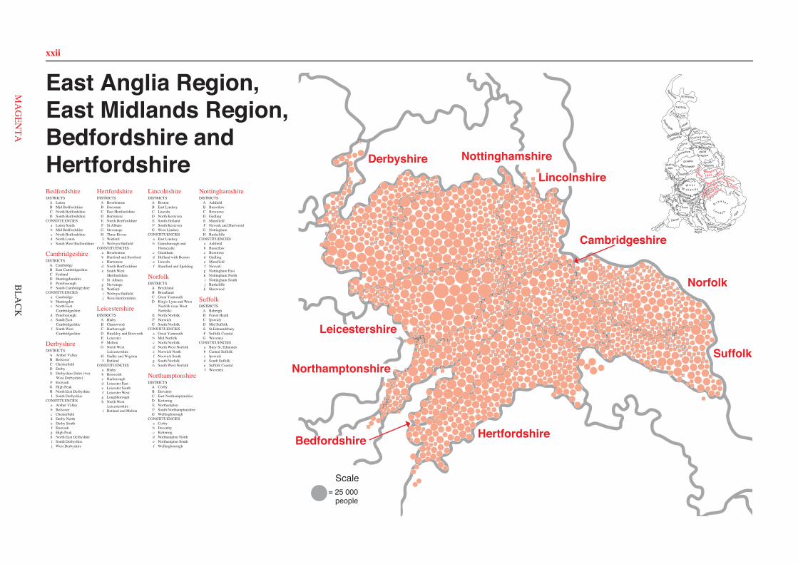
xxii
008A a
010A d
025A d
030A a
031A a
036A a
047A a
052A d
058A d
059A d
060A d
070A a
074A a
080A a
083A a 087
A d 001B b
002B b
003B e
006B b 007
B b
009B b
016B b
027B b
028B b
029B e
039B d
040B d 041
B d
043B d
045B b
057B b
062B e
063B b
065B b
066B b
068B b
075B b
076B b
077B b 078
B b
084B b
091B b
092B d
093B e
095B b
024C c
011C c
032C c
020C c
022C c
021C c
012C c
013C c
026C c
018C c
019C c
037C c
044C c
072C c
038C c
071C c
073C c
042C b
034C b
023C b
055C b
094C b
017C b
054C b
004D d
005D e
014D e
015D a 033
D e
035D e
046D e
048D e
049D e
050D e
051D e
053D e
056D e
061D e
064D e
067D e 069
D e
079D a
081D e
082D e
085D d
086D e
088D d
089D e
090D e
001A a
003A a 020
A a
026A a
028A a
038A a
077A a
087A a 093
A a 107A a
109A f
112A a 131
A f
137A a
046B e
081B c
064B c
122B c
034B c
152B c
033B c
048B c
027B e
154B e
012B e
128B e
075B e 017
B e 055B e
047B e
035B e
054B e
011C c 022
C c 023C c
024C c
025C c
043C c
078C c
083C c
084C c
085C c
086C c
094C c
100C c
104C c
139C c 140
C c 141C c
142C c
143C c
144C c
147C c
148C c
150C c 149C c
151C c
014D b
016D f
018D b
037D b
040D f
041D f 042
D b
045D b
050D f
051D b
052D b
060D b
062D f
068D b
069D b
071D b
072D b 073
D b
076D b
091D b
106D f
108D f
110D b
116D b 117D b
114D b
115D b
120D f
121D b
126D f
127D b
132D b
134D b
155D b
007E b
015E d 021
E d
032E d
039E d
049E c
053E d
059E b
092E c 095E d
096E b
097E d
098E d
103E d
105E d
111E d 118
E d
130E c
133E d 136
E b
138E d
153E b
002F e
004F f
005F e
006F e
008F f
009F f
010F f
013F f
019F e
029F f
030F e
031F e
036F f
044F e
056F f
057F e
061F f
058F e
063F f
065F f
066F f
067F f
070F e
074F f
079F e
080F f
082F e
088F f
089F f
090F e
099F f
101F e
102F f
113F f
119F f
123F e
124F e
125F f
129F e
135F e
145F f
146F e
003A a
004A a
005A a
009A j
024A j
025A j
026A j
055A a
059A j
063A a
072A j
091A a 092
A a
093A a
094A a
096A a
104A a
150A a 153
A a 152A a
160A a
169A a
172A j
186A a
204A a
015B b
018B b
028B b
030B b
031B b
032B b
033B b
053B b 076
B b 080B b
146B b
147B b
157B b
158B b
159B b
161B b
163B b
162B b
165B b 164
B b
170B b
171B b
188B b
200B b
022C h
041C c
042C c
043C c
073C c
087C c
097C c
103C c
117C h
119C c
123C c
125C c
132C c
130C c
141C c
086C c
177C c 180
C c
195C c
198C c
001D d
008D d
010D e
016D e
029D e
034D i
039D d 046
D d
049D i
062D d
066D d
107D e
113D e 115
D e
118D d
122D i
135D e
142D e
168D e
173D d
038F a
040F f
002F f
060F f
064F f
065F f
068F f
100F f
101F f
102F f
108F f
109F f
114F a
116F f
138F f
139F f
140F f
154F f 155
F f
156F f
181F a
194F f 197
F f
202F f
007G g
020G g
021G g
027G g
045G g
047G g
048G g
056G g
057G g
058G g
079G g
090G g
110G g
111G g
128G g
129G g
144G g
174G g
175G g 178
G g 179G g 167
G g
183G g
191G g
199G g
013H h
019H h
131H h
050H h
051H h
054H h
069H h
070H h
071H h
074H h
075H h
081H h
085H h
098H h
105H h
106H h
126H b
137H h
145H b
148H h
151H h
166H b
184H b
192H h
193H h
203H h
014I i
077I i
082I i
084I i
089I i
095I i
112I i
121I i
124I i
127I i
133I i
136I i
143I i
149I i
185I i
189I i
196I i
201I i
207I i
006E j
011E j
012E j
017E j
023E j
035E g
036E j
037E j
044E j
052E j
061E j
067E j
078E j
083E j
088E g
099E j
120E j
134E j
176E j 182
E j
187E j
190E g
205E j
206E j
208E j
031A a
033A a 042
A a
043A a
061A a
063A a
088A a
089A a
148A a
151A a
172A a 182A a
183A a
198A a
002B j
003B j
004B j
011B j
018B j
019B e
020B e
021B e
026B e
027B j
038B j
040B j
044B e
052B j
057B j
060B j
062B j
066B j
085B j
097B e
105B j
125B j
128B e
160B j
174B j
175B j
176B j 188
B j
022C b 023
C b 024C b
025C b
028C b
032C b 050
C g 058C g
065C a
080C b
081C b
082C b
083C b
094C b
106C a
107C b
122C b
123C g 155
C b
167C b
168C a
169C b
171C b
173C b
180C g 184
C b 185C b 186
C b
187C b
189C g
005D c
006D c
030D c
036D c
051D c 059
D c 078D c
079D c
086D c
095D c
110D c
117D c
139D c
140D c
141D c
142D c
143D c
161D c
162D c
156D c
007E d
008E d
012E d 015
E d 034E d
048E g
064E d
084E d
087E d
092E d
096E d
098E g
102E d 103
E d
104E d 126
E d 130E d 132
E d 144E d
149E d
150E d 152
E d
181E d
194E d
196E d
009F f 014
F f
047F f
049F f
056F f
069F f
070F f
071F f
072F f
108F c
112F f
113F f
135F h
145F f
164F f
165F h
153F f
159F f 178
F f
195F i
013G g
017G g
041G g
109G g
114G g
118G g
120G g
131G g
138G g 147
G g
163G g
157G g
170G g 191
G g
001H h
010H e
016H e
037H e
046H e
045H e
055H e
053H e
054H e
077H e
099H e
100H h
111H e
116H e
119H e
121H e
129H e
133H e 146
H e
154H e
035I h
039I h
091I h
101I h
115I h
124I h 134
I h 136I h
166I h
177I h
179I h
197I h
029J i
067J i
068J i
073J i
074J i 075
J i
076J i
090J i
093J i 127
J a
137J i
158J i
190J i
192J i
193J i
124A a
080A a
105A a
052A a 054
A a
056A a 146
A a
072A a
070A a
069A a
075A a
085A a
122A a
106A a
102A a
073A a
078A a
077A a
149A a
163A a
009B g
008B g 129
B g
091B g
107B g 090
B g
144B g 140
B h
153B g 142
B i 016B g 017
B g
141B g
015B g
165B g
029B b
155B g
117B g 026
B g 131B i
132B i
063B i
133B i
113C c
114C c
138C c
093C c
156C c
025C c
024C c
112C a
036C a
083C a
101C a
061C a
158C a
060C a
084C a
130C a
079C c
027C c
100C c 110
C c
104C c
066C c
065C c
019D b
038D b 043
D b
047D b
037D b
062D b 005
D b
088D b
089D b
134D b
013D b
014D b
157D b 059
D b
120D b
039D b 139
D b 004D b
012E e
022E d
046E d
010E e
045E d
094E d
064E e
021E d
119E f 123
E f
001E f
057E e
002E f
011E e
136E f
145E e
007F i
028F i
055F i
058F i
068F i
081F i
082F i
108F i
118F i
121F i
128F i
143F i
150F i
152F i 160
F i 161F i 166
F i
097G h 042G h
092G h 041
G h 116G h
051G h
154G h 049
G h 050G h
087G h
048G h 115
G h 127G h 006
G h
095G h 135
G h
151G h
032G h
031G h
109G h
098G h
033G h
096G h
003H c
020H c 034
H c
035H c
044H c 076
H c
086H c
147H c
148H c
162H c
018I i 023
I i
030I i
040I i
053I i
067I i
071I i
074I i
099I i
103I i
111I i
125I i
126I i
137I i
159I i
164I i
010A d
029A d
031A d
045A d
046A d
047A d
053A d
076A d
084A d
113A d
131A d 137
A d 154A d
172A d
176A d
180A d
181A d
107B a
121B a
004B a 079
B b
092B a
152B a
145B a 127B a
179B b
155B a
032B a
093B a
078B b
038B b
039B b
156B a
077B a 157
B a 051B a
096B a
052B a
064B a 159
B a
112B a
116B a
015B b
087B a
030B a
081B a
002B a
003B a 117
B a
024B a 167
B a 065B a
054B a
080B a
143B a
106B a 129
B a 055B a
001C e
016C e
017C e
021C e
026C e
028C e
090C e
100C e
101C e
115C e
163C e
007D c
012D c
014D c
020D e
022D c
023D c
033D c
042D c
068D c
069D c
070D c
086D c
097D c
098D c
104D c
108D e
109D e 110
D e
111D c
114D c
123D c
130D e
132D c
133D c
134D c
135D c
165D c
166D e
169D c
170D c
034E f
036E f
040E d
048E d
059E d
061E f 073
E d 074E d
075E d 089
E d
103E d 119
E f
120E f
138E f 139
E f
140E f
141E f
142E f
151E f
153E d 158
E d
173E f 174
E d
005F f
008F f
011F c
013F c
018F f
019F f
027F f
035F f
037F f
043F c
044F c
049F f 060
F f
062F c
063F c
066F c
067F c
072F f
082F f
088F f
091F c
094F f
102F f
118F c
122F f
144F c
146F f 147
F f
148F c
125F c
149F f
161F f
164F f
175F c
006G b
009G b
025G b
041G b
050G b
056G b
057G b 058
G b 071G b
083G b
085G b
095G b
099G b
105G b
124G b
126G b
128G b
136G b 150
G b
160G b
162G b
168G b
171G b
177G b
178G b
182G b
006A h
013A b
015A h 026
A h
044A h
065A b
066A b
067A b 068
A b
069A h
073A b
087A h
091A h 092
A h 094A h
102A b 115
A b
126A b
129A h
134A h 136
A h
149A h 152
A h
164A b
171A b
184A h
185A b
188A b
189A h
195A h
196A h
197A h
198A h
205A b
207A b
208A b 214
A h 216A h
217A h
220A h
226A h
003B b
008B b
017B b
025B b
027B b
029B b
034B e
035B b 043
B b 064B b
076B b
078B b
084B b
088B b
096B e
097B e
098B e
103B b 108
B b
150B b
153B b
154B b
155B b
177B b
167B b
169B b 172
B e
173B e 174
B e
175B e
187B b
200B e
201B e
202B e
229B b
021C a
022C a
030C a
031C a
040C a
074C a
083C a
100C a
116C a
118C a
121C a
122C a
125C a
137C a
144C a
146C a
156C a
157C a
176C a
225C a
230C a
007E c 009
E c
016E c
018E c
032E c
037E c
042E c
045E c
050E c
072E c
077E c
079E c
082E c
089E c
104E c
106E c
107E c
109E c
114E c
133E c
135E c
141E c
142E c
147E c
148E c
159E c
162E c
163E c
181E c
183E c
191E c
192E c 212
E c
218E c
219E c
228E c
019F f
033F e
046F e
049F e
070F f
095F f 101
F f
113F f
123F f
131F e 132
F e 138F f
180F f
199F f
203F f
206F f 001
G g
002G g 010
G g
012G g
011G g
014G g 020
G g
023G g
024G g
038G g
039G g
048G g
051G g
052G g
057G g
059G g
060G g
061G g
075G g
090G g
099G g
105G g
110G g
112G g
117G g
124G g
127G g
139G g
143G g
145G g
158G g
161G g
165G g
170G g
182G g
186G g
204G g
211G g
215G g
223G g
227G g
081D d
119D d
120D d
179D d 036
D d
063D h
111D d
140D d
093D d 166
D d
062D d
058D d 028
D d 047D d 160D d
005D h
004D h
056D h
054D h
055D h
190D h
213D h
224D d
053D h
194D d
085D d
210D d 086D d
080D d
151D d
130D d
222D d
041D d
168D d
178D d
193D d
221D d
128D d
071D h
209D h
032A a
039A a
046A a
059A a
072A a
077A a
079A a
104A a
105A a
106A a
112A a
140A a
001B b
002B b
007B b
008B b
014B c
019B b
020B b
024B c
027B b
033B c
036B b
044B b
047B b
049B b
056B b
063B b
067B b 080
B b
086B c
093B c
101B b
117B b
135B b
136B b
146B b
148B b
009C a 023
C a 043C a
050C a
062C f
065C a
068C a
081C a
083C a
092C a
100C a 102
C a
107C f 108
C f 109C f
110C f
126C a
128C a
143C a
145C a
004D c
006D c
010D c
025D c
066D c
070D c
075D c
078D c
095D c
096D c
098D c
119D c
122D c
123D c 124
D c
125D c
113D c
131D c
132D c 134
D c
138D c
142D c
003E d
011E e
015E d
031E e
038E d
042E e
060E d
071E d
076E d
082E d
087E e 088
E e 091E e
094E d
118E d
120E e
121E d 115
E e
127E d
137E d
141E e
005F b
012F b
013F e
016F b
017F b
018F e
026F e
034F e
035F b
040F b
041F b 051
F b
052F e
053F b
055F b
057F e
058F e
061F e
069F b
073F b
074F e
084F b
085F e
097F b
099F b
103F e
111F e
114F b
129F b
130F b 133
F b
147F e
030G f
037G f
029G f
048G f
021G f
022G f 028G f
116G f
144G f
064G f
045G f
054G f
139G f
089G f
090G f
081A k
082A k
083A k
084A k 085
A a
089A a
090A a
091A a
145A a
162A a
163A a 164
A a 165A a 176A a
183A a
009B b
024B b
040B b
046B b
058B f
059B f
060B f 061
B f 067B f
069B b
078B b
079B b
080B b
114B b
138B b
140B b
161B b
167B b
172B f 175B f
177B b
185B b
188B b
186B b 187
B b 190B b 189
B b
005C c
006C c
011C c
012C c 013
C c 014C c
027C c
030C a
044C c
045C c
062C a
063C a
064C a
076C c
087C c
122C c
156C c
157C c
158C c
159C c
171C c
016D k
025D d
035D d
037D k
039D d
038D d 043
D d 051D d
074D d
086D d 088
D d 094D k
108D d
117D d
119D k
128D d
131D d
133D d
135D d
153D d
154D d
182D k
184D d
015E e
021E b 031
E e
053E e
057E e 072
E e
093E e 097
E e
100E e
106E e
110E b
121E e
125E e
123E e
132E e
141E e
147E e
169E e
008F f
019F k
023F k
026F k
028F f
032F f
041F f
042F f
049F k
050F f
055F f
056F k
066F k
068F f
070F f
071F k
142F k
101F k
103F f
111F f
113F f
115F f
126F k 127
F k
137F k
144F k
150F f
151F f
166F f
173F f
179F f
002G i
004G h
007G g
010G h
017G h
018G h 029
G i
033G h
034G h
036G h
047G i
048G i
073G g
077G g
098G i
107G g
109G g
130G i
134G h 136
G g 143G i
152G g
146G g
160G h
174G g
178G i
181G i
001H j 003H j
020H j 022
H j
052H j
054H j
065H j
075H j
149H j
092H j
095H j
096H j
099H j
102H j
104H j
105H j
112H j
116H j 118
H j
124H j
129H j 139
H j
148H j
155H j
168H j
170H j
180H j 120
H j
004A d
014A d
015A d
019A d
025A d
026A d
028A d
032A d 035
A d
041A d
048A d
052A d
056A d
071A d
074A d 075
A d 080A d
087A d
105A d
106A d
108A d
118A d
120A d
128A d
141A d
164A d
165A d
166A d
173A d
175A d
023B a 024
B a
058B a
072B a
076B a
094B a
104B a
111B a
112B a
116B a
153B a
139B a
144B a
163B a
167B a
016C c 027
C c
029C b
038C b
043C c
068C c
129C c
137C c
149C c
150C c
151C c
148C c
156C c
169C c
180C b
181C b
005D b
006D b
007D b
022D b 046
D b
049D b
050D b
057D b 059
D b 067D b
069D b
085D b
086D b
092D b 115
D b
119D b
122D b
123D b
127D b
130D b
131D b
132D b
157D b 158
D b
159D b 160
D b
161D b
162D b
168D b
174D b
177D b
178D b
186D b
187D b
001E a
008E a
009E a
034E d
039E d 040
E d 042E d
044E a
045E d 047
E d
055E a
065E a
073E a
090E a
091E a
093E d
095E a
096E d
121E a 126
E a
133E a
134E a
135E a
152E d
154E a
140E a
145E a
155E a
176E a
179E a
183E d 184
E d
002F e
063F e
062F e
060F e
064F e
061F e
107F e
138F e
185F e
033F e
097F e
020F e
172F e
188F e
021F e 051
F e 066F e 054
F e 070F e 142
F e 053F e
182F e 088
F e
124F e
089F e 003
F e
103F e
170F e
098F e
136F e
099F e
113F e
114F e
010F e
077F e
084F e 171
F e
011G f
012G f
037G f
083G f
079G f
102G f
109G f
125G f
082G f 101
G f
078G f
146G f
031G f
081G f
110G f
036G f
100G f
117G f
147G f
013G f 143
G f 018G f
030G f 017
G f
East Anglia Region,East Midlands Region,Bedfordshire andHertfordshireBedfordshireDISTRICTS
A LutonB Mid BedfordshireC North BedfordshireD South Bedfordshire
CONSTITUENCIESa Luton Southb Mid Bedfordshirec North Bedfordshired North Lutone South West Bedfordshire
CambridgeshireDISTRICTS
A CambridgeB East CambridgeshireC FenlandD HuntingdonshireE PeterboroughF South Cambridgeshire
CONSTITUENCIESa Cambridgeb Huntingdonc North East
Cambridgeshired Peterboroughe South East
Cambridgeshiref South West
Cambridgeshire
DerbyshireDISTRICTS
A Amber ValleyB BolsoverC ChesterfieldD DerbyE Derbyshire Dales (was
West Derbyshire)F ErewashG High PeakH North East DerbyshireI South Derbyshire
CONSTITUENCIESa Amber Valleyb Bolsoverc Chesterfieldd Derby Northe Derby Southf Erewashg High Peakh North East Derbyshirei South Derbyshirej West Derbyshire
HertfordshireDISTRICTS
A BroxbourneB DacorumC East HertfordshireD HertsmereE North HertfordshireF St.AlbansG StevenageH Three RiversI WatfordJ Welwyn Hatfield
CONSTITUENCIESa Broxbourneb Hertford and Stortfordc Hertsmered North Hertfordshiree South West
Hertfordshiref St. Albansg Stevenageh Watfordi Welwyn Hatfieldj West Hertfordshire
LeicestershireDISTRICTS
A BlabyB CharnwoodC HarboroughD Hinckley and BosworthE LeicesterF MeltonG North West
LeicestershireH Oadby and WigstonI Rutland
CONSTITUENCIESa Blabyb Bosworthc Harboroughd Leicester Easte Leicester Southf Leicester Westg Loughboroughh North West
Leicestershirei Rutland and Melton
LincolnshireDISTRICTS
A BostonB East LindseyC LincolnD North KestevenE South HollandF South KestevenG West Lindsey
CONSTITUENCIESa East Lindseyb Gainsborough and
Horncastlec Granthamd Holland with Bostone Lincolnf Stamford and Spalding
NorfolkDISTRICTS
A BrecklandB BroadlandC Great YarmouthD King's Lynn and West
Norfolk (was WestNorfolk)
E North NorfolkF NorwichG South Norfolk
CONSTITUENCIESa Great Yarmouthb Mid Norfolkc North Norfolkd North West Norfolke Norwich Northf Norwich Southg South Norfolkh South West Norfolk
NorthamptonshireDISTRICTS
A CorbyB DaventryC East NorthamptonshireD KetteringE NorthamptonF South NorthamptonshireG Wellingborough
CONSTITUENCIESa Corbyb Daventryc Ketteringd Northampton Northe Northampton Southf Wellingborough
NottinghamshireDISTRICTS
A AshfieldB BassetlawC BroxtoweD GedlingE MansfieldF Newark and SherwoodG NottinghamH Rushcliffe
CONSTITUENCIESa Ashfieldb Bassetlawc Broxtowed Gedlinge Mansfieldf Newarkg Nottingham Easth Nottingham Northi Nottingham Southj Rushcliffek Sherwood
SuffolkDISTRICTS
A BaberghB Forest HeathC IpswichD Mid SuffolkE St.EdmundsburyF Suffolk CoastalG Waveney
CONSTITUENCIESa Bury St. Edmundsb Central Suffolkc Ipswichd South Suffolke Suffolk Coastalf Waveney
Isle of
Ham
pshire WestSussex
East Sussex
Surrey
G r e a t e r
L o n d o n
Berk-shire
Wiltshire
Wight
Dorset
KentSomerset
Devon
Cornwall
Avon Buck
ingh
amsh
ire
Oxf
ord-
shireGloucester-
shire
Essex
ClevelandDurham
Nor
thum
ber-land
Tyne & Wear
Borders
Dumfries &
GallowayStrathclyde
Lothian
Central Fife
Tayside
Grampian
Highlands
Cheshire
YorkshireSouth
HumbersideGreaterManchester
WestYorkshireLancashire
Mersey-side
North YorkshireCu
mbria
GwentSouth
GlamorganM
idWest
Hereford &WorcesterWarwick
shireW e s t
M i d l a n d s
Powys
Dyfed
Gwynedd Clwyd
Staffordshire
Shro
ps
hire
Hertfords
hire
Bed
for
dshir
e Suffolk
NorfolkshireCambridge-
North
am
ptonshire
Leicestershire
Nottingham-
shire
Derbyshire Lincoln-shire
Hertfordshire
Suffolk
Norfolk
Cambridgeshire
Lincolnshire
NottinghamshireDerbyshire
Northamptonshire
Leicestershire
= 25 000people
Scale
Bedfordshire
BLA
CK
xxii
Bedfordshire
Cambridgeshire
Derbyshire
Hertfordshire
Leicestershire
Lincolnshire
Norfolk
Northamptonshire
Nottinghamshire
Suffolk
Hertfords
hire
Bed
for
dshir
e Suffolk
NorfolkshireCambridge-
North
am
ptonshire
Leicestershire
Nottingham-
shire
Derbyshire Lincoln-shire
Hertfordshire
Suffolk
Norfolk
Cambridgeshire
Lincolnshire
NottinghamshireDerbyshire
Northamptonshire
Leicestershire
Bedfordshire
MA
GEN
TA
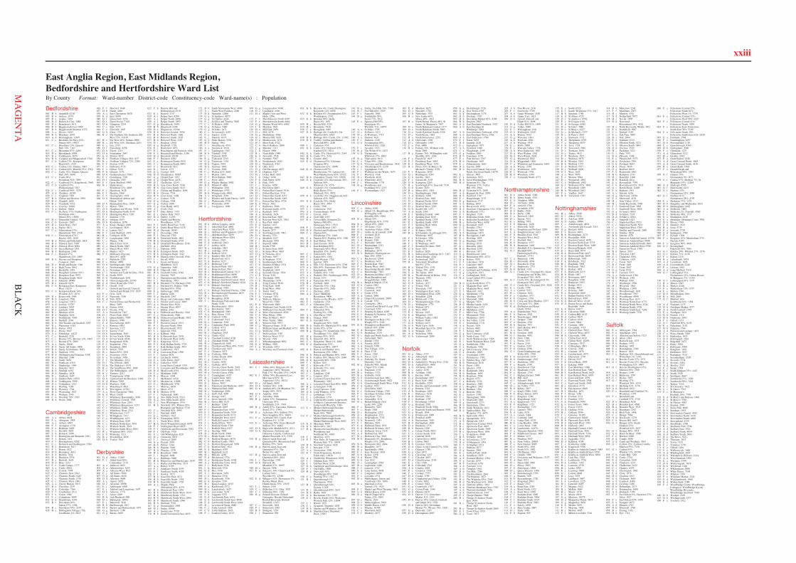
xxiii
Bedfordshire001 B b Ampthill: 6230002 B b Arlesey: 4374003 B e Aspley: 3369004 D d Barton-le-Clay: 3488005 D e Beaudesert: 5611006 B b Biggleswade Ivel: 6589007 B b Biggleswade Stratton: 6372008 A a Biscot: 11653009 B b Blunham: 2049010 A d Bramingham: 12697011 C c Brickhill; De Parys 83%;
Putnoe 44%: 16953012 C c Bromham 13%; Queens
Park 74%: 7162013 C c Bromham 87%: 4460014 D e Brooklands: 8958015 D a Caddington: 3679016 B b Campton and Meppershall: 3744017 C b Carlton 27%; Kempston
Rural 66%: 2325018 C c Carlton 31%; Oakley: 3047019 C c Carlton 42%; Harrold 53%: 2312020 C c Castle 10%; Harpur; Queens
Park 26%: 9690021 C c Castle 90%;
Newnham 56%: 7895022 C c Cauldwell 5%; Kingsbrook: 7660023 C b Cauldwell 5%;
Wilshamstead: 3367024 C c Cauldwell 90%: 7470025 A d Challney: 10203026 C c Clapham: 3501027 B b Clifton and Henlow: 5991028 B b Clophill: 1680029 B e Cranfield: 4332030 A a Crawley: 10661031 A a Dallow: 10404032 C c De Parys 17%; Goldington;
Newnham 44%;Putnoe 56%: 15085
033 D e Dunstable Central: 7328034 C b Eastcotts: 2887035 D e Eaton Bray: 2367036 A a Farley: 9411037 C c Felmersham 33%;
Sharnbrook 78%: 2736038 C c Felmersham 67%;
Riseley 48%: 2828039 B d Flitton and Pulloxhill: 1818040 B d Flitwick East: 5189041 B d Flitwick West: 6094042 C b Great Barford: 2551043 B d Harlington: 2300044 C c Harrold 47%;
Sharnbrook 22%: 1805045 B b Haynes and Houghton
Conquest: 2442046 D e Heath and Reach: 1340047 A a High Town: 8961048 D e Hockliffe: 1451049 D e Houghton Central: 5513050 D e Houghton East: 5975051 D e Houghton South: 4616052 A d Icknield: 10989053 D e Icknield: 6476054 C b Kempston East; Kempston
West: 18233055 C b Kempston Rural 34%;
Wootton 21%: 1870056 D e Kensworth: 1584057 B b Langford: 2760058 A d Leagrave: 10371059 A d Lewsey: 12707060 A d Limbury: 9455061 D e Linslade: 5389062 B e Marston: 4229063 B b Maulden: 2654064 D e Northfields: 7038065 B b Northill: 2184066 B b Old Warden and Southill: 1297067 D e Plantation: 6342068 B b Potton: 4705069 D e Priory: 5697070 A a Putteridge: 14123071 C c Renhold: 2220072 C c Riseley 52%; Roxton 13%: 1865073 C c Roxton 87%: 2005074 A a Saints: 10606075 B b Sandy All Saints: 3896076 B b Sandy St Swithuns: 5093077 B b Shefford: 3319078 B b Shillington and Stondon: 3358079 D a Slip End: 2348080 A a South: 9436081 D e Southcott: 6310082 D e Stanbridge: 1496083 A a Stopsley: 9472084 B b Stotfold: 6551085 D d Streatley: 1628086 D e Studham: 1697087 A d Sundon Park: 10522088 D d Toddington: 3999089 D e Totternhoe: 1312090 D e Watling: 7299091 B b Wensley: 1744092 B d Westoning: 1827093 B e Woburn: 1543094 C b Wootton 79%: 3765095 B b Wrest: 2068
Cambridgeshire001 A a Abbey: 6628002 F e Abington: 1955003 A a Arbury: 6897004 F f Arrington: 1370005 F e Balsham: 2429006 F e Bar Hill: 5692007 E b Barnack: 2498008 F f Barrington and Shepreth: 1691009 F f Barton: 1411010 F f Bassingbourn: 4202011 C c Benwick and Doddington: 2280012 B e Bottisham: 2617013 F f Bourn: 1822014 D b Brampton: 4673015 E d Bretton: 7834016 D f Buckden: 2534017 B e Burwell: 4628018 D b Bury: 2233019 F e Castle Camps: 1777020 A a Castle: 6064021 E d Central: 7595022 C c Chatteris East: 2562023 C c Chatteris North: 1442024 C c Chatteris South: 1376025 C c Chatteris West: 1881026 A a Cherry Hinton: 7015027 B e Cheveley: 2197028 A a Coleridge: 7164029 F f Comberton: 2311030 F e Coton: 1504031 F e Cottenham: 4895032 E d Dogsthorpe: 8391033 B c Downham 26%;
Sutton 17%: 1394034 B c Downham 74%: 2197035 B e Dullingham Villages; The
Swaffhams 1%: 2015
036 F f Duxford: 1848037 D b Earith: 4046038 A a East Chesterton: 8478039 E d East: 8494040 D f Eaton Ford: 5230041 D f Eaton Socon: 7140042 D b Ellington: 2254043 C c Elm: 3272044 F e Elsworth: 1997045 D b Elton: 1723046 B e Ely Northern; Ely Southern; Ely
West 75%: 10139047 B e Ely West 10%; Soham: 8896048 B c Ely West 14%; Stretham: 2631049 E c Eye: 2752050 D f Eynesbury: 8258051 D b Farcet: 1215052 D b Fenstanton: 2647053 E d Fletton: 9035054 B e Fordham Villages 28%: 837055 B e Fordham Villages 72%: 2206056 F f Foxton: 2324057 F e Fulbourn: 4735058 F e Girton: 3215059 E b Glinton: 3176060 D b Godmanchester: 5394061 F f Gomlingay: 3391062 D f Gransden: 2387063 F f Great Shelford: 3985064 B c Haddenham;
Witchford 12%: 4005065 F f Hardwick: 3628066 F f Harston: 1960067 F f Haslingfield: 1678068 D b Hemingford Abbots and
Hilton: 1595069 D b Hemingford Grey: 2420070 F e Histon: 7200071 D b Houghton and Wyton: 3558072 D b Huntingdon North: 8143073 D b Huntingdon West: 7281074 F f Ickleton: 1776075 B e Isleham: 1953076 D b Kimbolton: 2078077 A a King's Hedges: 6899078 C c Leverington: 3829079 F e Linton: 4167080 F f Little Shelford: 1476081 B c Littleport: 6358082 F e Longstanton: 2062083 C c Manea: 1186084 C c March East: 6134085 C c March North: 5665086 C c March West: 5033087 A a Market: 3423088 F f Melbourn; Royston
West 8%: 4629089 F f Meldreth: 2205090 F e Milton: 4000091 D b Needingworth: 2460092 E c Newborough: 1878093 A a Newnham: 4277094 C c Newton and Tydd St Giles: 1516095 E d North: 5959096 E b Northborough: 2641097 E d Orton Longueville: 10745098 E d Orton Waterville: 9743099 F f Orwell: 2107100 C c Outwell and Upwell; Upwell,
Outwell and Delph 25%: 2055101 F e Over: 2436102 F f Papworth: 1556103 E d Park: 8320104 C c Parson Drove and Wisbech St
Mary: 3659105 E d Paston: 6764106 D f Paxton: 3762107 A a Petersfield: 7167108 D f Priory Park: 4482109 A f Queen Edith's: 7505110 D b Ramsey: 7098111 E d Ravensthorpe: 8053112 A a Romsey: 6842113 F f Sawston: 7172114 D b Sawtry: 5745115 D b Somersham: 3610116 D b St Ives North: 9266117 D b St Ives South: 6046118 E d Stanground: 8550119 F f Stapleford: 1746120 D f Staughton: 2989121 D b Stilton: 3765122 B c Sutton 83%: 3076123 F e Swavesey: 1924124 F e Teversham: 3454125 F f The Mordens: 2212126 D f The Offords: 2408127 D b The Stukeleys: 4344128 B e The Swaffhams 99%: 1809129 F e The Wilbrahams: 1435130 E c Thorney: 2217131 A f Trumpington: 6568132 D b Upwood and the Raveleys: 1968133 E d Walton: 7098134 D b Warboys: 4282135 F e Waterbeach: 4921136 E b Werrington: 14792137 A a West Chesterton: 7006138 E d West: 13420139 C c Whittlesey Bassenhally: 3036140 C c Whittlesey Central: 1593141 C c Whittlesey East: 2394142 C c Whittlesey Kingsmoor: 1673143 C c Whittlesey South: 2816144 C c Whittlesey West: 2311145 F f Whittlesford: 2117146 F e Willingham: 3317147 C c Wimblington: 1471148 C c Wisbech East: 4249149 C c Wisbech North-East: 3031150 C c Wisbech North: 5619151 C c Wisbech South-West: 5684152 B c Witchford 88%: 1432153 E b Wittering: 3211154 B e Woodditton: 2026155 D b Yaxley: 7041
Derbyshire001 D d Abbey: 11465002 F f Abbotsford 58%;
Cotmanhay: 7214003 A a Aldercar: 4951004 A a Alfreton East: 3255005 A a Alfreton West: 5021006 E j All Saints: 5094007 G g All Saints: 6650008 D d Allestree: 9688009 A j Alport: 2455010 D e Alvaston: 10550011 E j Ashbourne: 6300012 E j Ashford and Longstone: 1679013 H h Ashover: 1776014 I i Aston: 4269015 B b Ault Hucknall: 850016 D e Babington: 10593017 E j Bakewell: 3818018 B b Barlborough: 1917019 H h Barlow and Holmesfield: 1971020 G g Barmoor: 1350021 G g Barms: 3689
022 C h Barrow Hill andHollingwood: 2919
023 E j Baslow: 1757024 A j Belper East: 8209025 A j Belper North: 4898026 A j Belper South: 3853027 G g Blackbrook: 3449028 B b Blackwell: 4194029 D e Blagreaves: 10546030 B b Bolsover Central: 3036031 B b Bolsover North: 1686032 B b Bolsover South: 3185033 B b Bolsover West: 3325034 D i Boulton: 11641035 E g Bradwell: 1728036 E j Brailsford: 1653037 E j Brassington and Parwich: 1846038 F a Breadsall and Morley: 1246039 D d Breadsall: 18104040 F f Breaston: 4502041 C c Brimington North: 4924042 C c Brimington South: 4893043 C c Brockwell: 5821044 E j Calver: 1371045 G g Central: 1851046 D d Chaddesden: 10965047 G g Chapel East: 1953048 G g Chapel West: 4478049 D i Chellaston: 12141050 H h Clay Cross North: 5336051 H h Clay Cross South: 3413052 E j Clifton and Bradley: 1696053 B b Clowne: 7234054 H h Coal Aston: 3288055 A a Codnor: 3138056 G g College: 3398057 G g Corbar: 3290058 G g Cote Heath: 4632059 A j Crich: 2242060 F f Dale Abbey: 1373061 E j Darley Dale: 5423062 D d Darley: 11393063 A a Denby and Horsley
Woodhouse: 3175064 F f Derby Road East: 5140065 F f Derby Road West: 6278066 D d Derwent: 10343067 E j Doveridge: 1964068 F f Draycott: 2782069 H h Dronfield North: 4601070 H h Dronfield South: 6718071 H h Dronfield Woodhouse: 2016072 A j Duffield: 4514073 C c Dunston: 5939074 H h Eckington North: 3925075 H h Eckington South: 3242076 B b Elmton-with-Creswell: 5016077 I i Etwall: 4934078 E j Eyam and Stoney
Middleton: 1622079 G g Gamesley: 3440080 B b Glapwell: 1636081 H h Gosforth Valley: 6362082 I i Gresley: 7033083 E j Hartington and Dovedale: 1604084 I i Hartshorne: 3593085 H h Hasland 11%; Hasland: 4709086 C c Hasland 6%; Rother: 7180087 C c Hasland 83%: 5536088 E g Hathersage: 2858089 I i Hatton: 2446090 G g Hayfield: 2567091 A a Heage and Ambergate: 4868092 A a Heanor and Loscoe: 4805093 A a Heanor East: 5624094 A a Heanor West: 6057095 I i Hilton: 2361096 A a Holbrook and Horsley: 2242097 C c Holmebrook: 5046098 H h Holmewood and Heath: 3032099 E j Hulland: 2102100 F f Ilkeston Central: 5513101 F f Ilkeston North: 3566102 F f Ilkeston South: 3522103 C c Inkersall: 3564104 A a Kilburn: 3944105 H h Killamarsh East: 2418106 H h Killamarsh West: 6454107 D e Kingsway: 9219108 F f Kirk Hallam North: 3719109 F f Kirk Hallam South: 3073110 G g Ladybower: 1517111 G g Limestone Peak: 1590112 I i Linton: 4031113 D e Litchurch: 10692114 F a Little Eaton: 2445115 D e Littleover: 9367116 F f Long Eaton Central: 5343117 C h Lowgates and Woodthorpe: 4687118 D d Mackworth: 8351119 C c Markham: 1646120 E j Masson: 3394121 I i Melbourne: 4528122 D i Mickleover: 11098123 C c Middlecroft: 3728124 I i Midway: 6430125 C c Moor: 4713126 H b Morton: 1978127 I i Netherseal: 1680128 G g New Mills North: 5216129 G g New Mills South: 4020130 C c New Whittington: 4744131 H h Newbold 18%; Walton 18%;
Brampton and Walton: 5710132 C c Newbold 82%: 5993133 I i Newhall: 6943134 E j Norbury: 1622135 D e Normanton: 9979136 I i North West: 1848137 H h North Wingfield Central: 6078138 F f Nottingham Road: 6055139 F f Ockbrook and Borrowash: 7092140 F f Old Park: 3728141 C c Old Whittington: 4231142 D e Osmaston: 8833143 I i Overseal: 2005144 G g Peveril: 2039145 H b Pilsley: 3344146 B b Pinxton: 5010147 B b Pleasley: 2278148 H h Renishaw: 1848149 I i Repton: 3698150 A a Riddings: 5480151 H h Ridgeway and Marsh Lane: 1839152 A a Ripley and Marehay: 5573153 A a Ripley: 9195154 F f Sandiacre North: 4197155 F f Sandiacre South: 4328156 F f Sawley: 7073157 B b Scarcliffe East: 2511158 B b Scarcliffe North: 1395159 B b Scarcliffe South: 1720160 A a Shipley Park;
Abbotsford 42%: 4179161 B b Shirebrook East: 1454162 B b Shirebrook North-West: 1634163 B b Shirebrook North: 1221164 B b Shirebrook South-West: 2894165 B b Shirebrook South: 1946166 H b Shirland: 5326167 G g Simmondley: 2985168 D e Sinfin: 10968169 A a Somercotes: 5728170 B b South Normanton East: 4025
171 B b South Normanton West: 4009172 A j South West Parishes: 2480173 D d Spondon: 12866174 G g St Andrews: 4075175 G g St Charles: 4224176 E j St Giles and Tansley: 5682177 C c St Helen's: 5030178 G g St James: 5460179 G g St Johns: 2471180 C c St Leonard's: 4207181 F a Stanley: 2236182 E j Stanton: 1619183 G g Stone Bench: 3520184 H b Sutton: 3961185 I i Swadlincote: 4531186 A a Swanwick: 4918187 E j Taddington: 1547188 B b Tibshelf: 3395189 I i Ticknall: 4929190 E g Tideswell: 2315191 G g Tintwistle: 1336192 H h Tupton: 2934193 H h Unstone: 1907194 F f Victoria: 3682195 C c Walton 82%: 6682196 I i Walton: 1651197 F f West Hallam: 5085198 C c West: 4402199 G g Whaley Bridge: 5892200 B b Whitwell: 4866201 I i Willington: 2292202 F f Wilsthorpe: 5792203 H h Wingerworth: 6902204 A a Wingfield: 2210205 E j Winster and South Darley: 1459206 E j Wirksworth: 5720207 I i Woodville: 2570208 E j Youlgreave: 1689
Hertfordshire001 H h Abbots Langley: 4418002 B j Adeyfield East: 4898003 B j Adeyfield West: 5253004 B j Aldbury and Wigginton: 2335005 D c Aldenham East: 4459006 D c Aldenham West: 4284007 E d Arbury: 2365008 E d Ashbrook: 2663009 F f Ashley: 6636010 H e Ashridge: 3403011 B j Ashridge: 3576012 E d Baldock: 9232013 G g Bandley Hill: 8159014 F f Batchwood: 6211015 E d Bearton: 6237016 H e Bedmond: 3107017 G g Bedwell Plash: 5011018 B j Bennetts End: 5561019 B e Berkhamsted Central: 5123020 B e Berkhamsted East: 6098021 B e Berkhamsted West: 4480022 C b Bishop's Stortford Central: 8614023 C b Bishop's Stortford Chantry: 6218024 C b Bishop's Stortford
Parsonage: 5452025 C b Bishop's Stortford Thorley: 7590026 B e Bovingdon and Flaunden: 4823027 B j Boxmoor: 6276028 C b Braughing: 1838029 J i Brookmans Park and Little
Heath: 5238030 D c Brookmeadow: 3854031 A a Broxbourne: 7097032 C b Buntingford: 5083033 A a Bury Green: 7155034 E d Cadwell: 2286035 I h Callowland: 5412036 D c Campions: 3148037 H e Carpenders Park: 4891038 B j Central: 4771039 I h Central: 6193040 B j Chaulden: 2935041 G g Chells: 4252042 A a Cheshunt Central: 4741043 A a Cheshunt North: 7067044 B e Chipperfield: 1680045 H e Chorleywood West 49%: 5153046 H e Chorleywood: 5433047 F f Clarence: 5573048 E g Codicote: 3096049 F f Colney Heath: 3891050 C g Cottered: 1741051 D c Cowley: 5655052 B j Crabtree: 6577053 H e Croxley Green North: 3019054 H e Croxley Green South: 3473055 H e Croxley Green: 4206056 F f Cunningham: 6325057 B j Cupid Green: 6461058 C g Datchworth: 1494059 D c Elstree: 5652060 B j Flamstead and Markyate: 4265061 A a Flamstead End: 6646062 B j Gadebridge: 4246063 A a Goffs Oak: 4581064 E d Grange: 6447065 C a Great Amwell: 1920066 B j Grove Hill: 8125067 J i Haldens: 12647068 J i Handside: 6035069 F f Harpenden East: 6553070 F f Harpenden North: 7559071 F f Harpenden South: 6772072 F f Harpenden West: 6410073 J i Hatfield Central: 5357074 J i Hatfield East: 7015075 J i Hatfield North: 5709076 J i Hatfield West: 6157077 H e Hayling: 3900078 D c Heath North: 4968079 D c Heath South: 5190080 C b Hertford Bengeo: 6074081 C b Hertford Castle: 7403082 C b Hertford Kingsmead: 5078083 C b Hertford Sele: 3621084 E d Highbury: 6507085 B j Highfield: 6122086 D c Hillside: 4250087 E d Hitchwood: 1724088 A a Hoddesdon North: 6768089 A a Hoddesdon Town: 6102090 J i Hollybush: 5224091 I h Holywell: 5716092 E d Hoo: 1910093 J i Howlands: 5659094 C b Hunsdon: 2536095 D c Kenilworth: 3756096 E d Kimpton: 2247097 B e Kings Langley: 4815098 E g Knebworth: 4372099 H e Langleybury: 3625100 H h Leavesden: 5139101 I h Leggatts: 5753102 E d Letchworth East: 6434103 E d Letchworth South-East: 8048104 E d Letchworth South-West: 6144105 B j Leverstock Green: 6840106 C a Little Amwell: 3556107 C b Little Hadham: 2043108 F c London Colney: 8132
109 G g Longmeadow: 6748110 D c Lyndhurst: 4180111 H e Maple Cross and West
Hyde: 2596112 F f Marshalswick North: 6297113 F f Marshalswick South: 6664114 G g Martins Wood 94%: 6962115 I h Meriden: 7041116 H e Mill End: 2959117 D c Mill: 4278118 G g Mobbsbury: 4366119 H e Money Hill: 3629120 G g Monkswood: 3134121 H e Moor Park: 4722122 C b Much Hadham: 2880123 C g Munden: 1311124 I h Nascot: 5996125 B j Nash Mills: 1988126 E d Newsells: 1538127 J a Northaw: 5307128 B e Northchurch: 2620129 H e Northwick: 4763130 E d Offa: 2032131 G g Old Stevenage: 6837132 E d Oughton: 5167133 H e Oxhey Hall: 3265134 I h Oxhey: 6198135 F h Park Street: 6076136 I h Park: 5345137 J i Peartree: 6550138 G g Pin Green: 4803139 D c Potters Bar Central: 3916140 D c Potters Bar East: 5733141 D c Potters Bar North: 4377142 D c Potters Bar South: 3463143 D c Potters Bar West: 4734144 E d Priory: 3412145 F f Redbourn: 5666146 H e Rickmansworth: 4179147 G g Roebuck: 5497148 A a Rosedale: 3624149 E d Royston East: 5803150 E d Royston West 92%: 7661151 A a Rye Park: 6660152 E d Sandon: 1467153 F f Sandridge: 4986154 H e Sarratt: 2577155 C b Sawbridgeworth: 7901156 D c Shenley: 2721157 G g Shephall: 4547158 J i Sherrards: 5595159 F f Sopwell: 6680160 B j South: 3798161 D c St James East: 4309162 D c St James West: 4663163 G g St Nicholas: 4911164 F f St Peters: 5957165 F h St Stephens: 7153166 I h Stanborough: 6496167 C b Standon St Mary: 3331168 C a Stanstead: 2619169 C b Stapleford: 1634170 G g Symonds Green: 7074171 C b Tewin: 2162172 A a Theobalds: 4930173 C b Thundridge: 1479174 B j Tring Central: 5038175 B j Tring East: 2698176 B j Tring West: 4861177 I h Tudor: 6632178 F f Verulam: 6570179 I h Vicarage: 7431180 C g Walkern; Martins
Wood 6%: 3500181 E d Walsworth: 8005182 A a Waltham Cross North: 4136183 A a Waltham Cross South: 5598184 C b Ware Christchurch: 4520185 C b Ware Priory: 3906186 C b Ware St Mary's: 4837187 C b Ware Trinity: 3806188 B j Warners End: 5977189 C g Watton-at-Stone: 2119190 J i Welham Green and Redhall: 6773191 G g Wellfield: 2398192 J i Welwyn East: 5387193 J i Welwyn West: 3713194 E d Weston: 1548195 F i Wheathampstead: 6091196 E d Wilbury: 5026197 I h Woodside: 6353198 A a Wormley and Turnford: 6344
Leicestershire001 E f Abbey 46%; Belgrave 4%; St
Augustine's 60%; WesternPark 17%; Wycliffe 23%: 14634
002 E f Abbey 54%; Beaumont Leys;Mowmacre 95%; StAugustine's 33%: 30122
003 H c All Saints: 8089004 D b Ambien 34%: 1190005 D b Ambien 66%; De Montfort 7%;
Trinity 69%: 5933006 G h Appleby: 1924007 F i Asfordby: 3086008 B g Ashby 13%; Nanpantan;
Outwoods 55%;Southfields 21%: 7369
009 B g Ashby 87%; Garendon; Hathern;Storer 27%: 17991
010 E e Aylestone 24%; Saffron 75%;West Knighton 65%: 16491
011 E e Aylestone 26%; Castle; EastKnighton 4%: 11330
012 E e Aylestone 50%; Eyres Monsell;Saffron 25%: 16862
013 D b Bagworth; Markfield 9%: 2111014 D b Barlestone, Nailstone and
Osbaston; Cadeby, Carlton andMarket Bosworth 11%: 3350
015 B g Barrow-upon-Soar andQuorndon 4%; Mountsorrel andRothley 55%: 5416
016 B g Barrow-upon-Soar andQuorndon 47%; TheWolds 9%: 4627
017 B g Barrow-upon-Soar andQuorndon 49%: 4614
018 I i Barrowden: 1338019 D b Barwell; De
Montfort 27%: 10957020 H c Bassett: 3496021 E d Belgrave 34%; Charnwood 8%;
Latimer 94%;Wycliffe 6%: 12589
022 E d Belgrave 63%; Mowmacre 5%;Rushey Mead; WestHumberstone 35%: 21935
023 I i Belton: 1384024 C c Billesdon 11%; Glen: 3835025 C c Billesdon 89%: 1182026 B g Birstall Goscote; Birstall
Greengate; Birstall Netherhall;Birstall Riverside; BirstallStonehill: 11951
027 C c Bosworth: 1654028 F i Bottesford: 2981029 B b Bradgate: 7254030 I i Braunston: 999
031 G h Breedon 4%; Castle Donington;Kegworth 12%: 6858
032 G h Breedon 6%; Swannington 42%;Worthington: 2742
033 G h Breedon 89%; HollyHayes 6%: 1851
034 H c Brocks Hill: 5225035 H c Brookside: 7818036 C a Broughton: 6487037 D b Burbage 4%; Castle 8%; De
Montfort 66%: 6564038 D b Burbage 96%; Castle 15%: 11502039 D b Cadeby, Carlton and Market
Bosworth 89%: 2180040 I i Casterton: 974041 G h Castle 24%; Holywell 43%;
Ivanhoe 82%: 5814042 G h Castle 76%; Holywell 9%: 2144043 D b Castle 77%: 5161044 H c Central: 4962045 E d Charnwood 5%; Coleman;
Evington 98%;Thurncourt 12%: 19050
046 E d Charnwood 87%;Humberstone 7%; Latimer 6%;West Humberstone 65%: 15522
047 D b Clarendon; Trinity 31%: 10926048 G h Coalville 12%; Ravenstone 20%;
Snibston 58%;Whitwick 7%: 3576
049 G h Coalville 13%; Greenhill 46%;Holly Hayes 75%;Whitwick 70%: 9952
050 G h Coalville 15%; Hugglescote 44%;Snibston 42%: 3952
051 G h Coalville 59%; HollyHayes 19%: 2934
052 A a Cosby: 3390053 I i Cottesmore: 2547054 A a Countesthorpe: 6438055 F i Craven: 3414056 A a Croft Hill: 1657057 E e Crown Hills; Evington 2%;
Spinney Hill 45%;Stoneygate 30%: 17033
058 F i Croxton Kerrial: 1307059 D b Desford and Peckleton: 4550060 C a Dunton 44%;
Ullesthorpe 37%: 1499061 C a Dunton 56%; Peatling 16%: 1286062 D b Earl Shilton: 9101063 B i East Goscote: 3038064 E e East Knighton 96%;
Stoneygate 65%; WestKnighton 35%: 16492
065 C c Easton 44%: 807066 C c Easton 56%: 1034067 I i Edith Weston: 1755068 F i Egerton: 3051069 A a Ellis 11%; Fairestone 42%: 2769070 A a Ellis 89%; Fairestone 10%: 3816071 I i Empingham: 1043072 A a Enderby 42%: 1707073 A a Enderby 58%; Narborough: 9956074 I i Exton: 1533075 A a Fairestone 48%: 2750076 H c Fairfield: 3668077 A a Flamville 33%: 1304078 A a Flamville 67%: 2628079 C c Fleckney: 4295080 A a Fosse; Millfield;
Ravenhurst: 9806081 F i Frisby-on-the-Wreake: 1677082 F i Gaddesby: 1276083 C a Gilmorton 24%;
Kilworth 27%: 961084 C a Gilmorton 76%;
Peatling 9%: 1550085 A a Glen Parva: 5365086 H c Grange: 3065087 G h Greenhill 54%;
Hugglescote 56%: 5650088 D b Groby 8%; Markfield 91%: 4848089 D b Groby 92%: 6734090 B g Hastings 5%; Southfields 59%;
Woodthorpe 31%: 4020091 B g Hastings 95%: 5015092 G h Holywell 48%: 2079093 C c Houghton; Tilton 1%: 2085094 E d Humberstone 93%;
Thurncourt 88%: 16877095 G h Ibstock and Heather 16%;
Ravenstone 29%: 1806096 G h Ibstock and Heather 84%: 5493097 G h Ivanhoe 18%; Moira 32%: 2046098 G h Kegworth 88%: 3390099 I i Ketton: 1811100 C c Kibworth: 4713101 C a Kilworth 73%: 1431102 A a Kirby: 4519103 I i Langham: 1248104 C c Langton: 1043105 A a Leicester Forest East 10%;
Winstanley: 3653106 A a Leicester Forest East 90%: 4406107 B g Lemyngton: 5106108 F i Long Clawson: 2148109 G h Long Whatton: 1574110 C c Lubenham: 1731111 I i Luffenham: 1374112 C a Lutterworth Linden; Lutterworth
St Mary's; Lutterworth Sherrier;Lutterworth Wycliffe: 7380
113 C c Market Harborough Bowden;Market HarboroughNorth 94%: 7880
114 C c Market Harborough North 6%;Market Harborough South;Market Harborough West: 8683
115 G h Measham: 4044116 G h Moira 68%: 2813117 B g Mountsorrel and Rothley 45%;
Woodhouse andSwithland 9%: 4369
118 F i Mowbray: 4351119 E f New Parks; St Augustine's 6%;
Western Park 71%: 18854120 D b Newbold Verdon: 3426121 F i Newport: 5755122 A a Normanton: 2550123 E f North Braunstone; Rowley
Fields 84%: 16938124 A a Northfield; Winchester: 6538125 I i Oakham East: 3433126 I i Oakham West: 5258127 G h Oakthorpe and Donisthorpe: 2041128 F i Old Dalby: 1880129 B g Outwoods 45%;
Woodthorpe 69%: 5545130 C a Peatling 75%: 1352131 B i Queniborough 1%;
Thurmaston: 9192132 B i Queniborough 14%;
Syston: 11318133 B i Queniborough 85%: 2613134 D b Ratby: 3601135 G h Ravenstone 51%: 1355136 E f Rowley Fields 16%; Westcotes;
Western Park 12%: 11694137 I i Ryhall: 1871138 C c Scraptoft; Thurnby: 4203139 D b Sheepy and Witherley: 2649140 B h Shepshed East; Shepshed
West: 12961
141 B g Sileby; Six Hills 20%: 7190142 B i Six Hills 80%: 1945143 F i Somerby: 1964144 B g Southfields 20%;
Storer 73%: 3612145 E e Spinney Hill 55%;
Stoneygate 4%;Wycliffe 71%: 14070
146 A a St Johns: 1795147 H c St Peter's: 3471148 H c St Wolstan's: 7715149 A a Stanton: 3621150 F i Stathern: 1249151 G h Swannington 58%;
Whitwick 6%: 1565152 F i Sysonby: 4331153 B g The Wolds 91%: 2433154 G h Thringstone;
Whitwick 17%: 4963155 B g Thurcaston: 2012156 C c Tilton 99%: 1286157 D b Twycross and Shackerstone: 1418158 C a Ullesthorpe 63%: 1230159 I i Uppingham: 3143160 F i Waltham-on-the-Wolds: 1673161 F i Warwick: 3446162 H c Westfield: 4038163 A a Whetstone: 4032164 I i Whissendine: 1778165 B g Woodhouse and
Swithland 91%: 2215166 F i Wymondham: 1523
Lincolnshire001 C e Abbey: 6359002 B a Alford 1%; Hogsthorpe 39%;
Willoughby withSloothby 80%: 1994
003 B a Alford 14%;Hogsthorpe 61%: 1770
004 B a Alford 85%: 2989005 F f All Saints: 3743006 G b Ancholme Valley: 1856007 D c Ashby-de-la-Launde: 2140008 F f Aveland: 2016009 G b Bardney: 2126010 A d Bargate: 2361011 F c Barrowby: 2084012 D c Bassingham: 2251013 F c Belmont: 3582014 D c Billinghay: 2075015 B b Binbrook; Donington-on-
Bain 20%: 1999016 C e Birchwood: 12934017 C e Boultham: 6415018 F f Bourne East: 5047019 F f Bourne West: 4941020 D e Bracebridge Heath: 3094021 C e Bracebridge: 7962022 D c Branston and Mere: 4217023 D c Brant Broughton and
Stragglethorpe: 2406024 B a Burgh-le-Marsh: 2718025 G b Caistor: 2502026 C e Carholme: 6778027 F f Casewick: 1641028 C e Castle: 6776029 A d Central: 2840030 B a Chapel St Leonards: 2884031 A d Coastal: 3333032 B a Coningsby: 2901033 D c Cranwell and Byard's Leap: 2553034 E f Crowland: 3292035 F f Deeping St James: 6285036 E f Deeping St Nicholas: 1236037 F f Devon: 1835038 B b Donington-on-Bain 13%;
Wragby 87%: 2102039 B b Donington-on-Bain 66%;
Tetford 18%: 1598040 E d Donington: 3598041 G b Dunholme: 2210042 D c Eagle and North Scarle: 1851043 F c Earlesfield: 5867044 F c Ermine: 1534045 A d Fenside: 4820046 A d Fishtoft: 5198047 A d Five Village: 3276048 E d Fleet: 1710049 F f Forest: 1269050 G b Forest: 2221051 B a Fotherby 2%; North
Thoresby: 2116052 B a Fotherby 98%; Marsh
Chapel 35%: 1948053 A d Frampton: 1343054 B a Friskney: 1372055 B a Frithville: 1916056 G b Gainsborough East: 6861057 G b Gainsborough North: 5822058 G b Gainsborough South-West: 5168059 E d Gedney: 1952060 F f Glen Eden: 1605061 E f Gosberton Village: 1785062 F c Grantham St Johns: 4246063 F c Greyfriars: 7214064 B a Grimoldby: 2134065 B a Halton Holgate; New
Leake 34%: 2281066 F c Harrowby: 5263067 F c Heath: 1568068 D c Heckington: 2215069 D c Heighington: 2271070 D c Helpringham: 1742071 G b Hemswell: 1951072 F f Hillsides: 2032073 E d Holbeach Hurn: 1935074 E d Holbeach St Johns: 1617075 E d Holbeach Town: 5318076 A d Holland Fen: 889077 B a Holton-le-Clay: 3818078 B b Horncastle 4%; Roughton;
Wragby 13%: 2086079 B b Horncastle 96%: 4994080 B a Hundleby: 1877081 B a Ingoldmells: 1988082 F f Isaac Newton: 1834083 G b Kelsey: 2258084 A d Kirton: 3798085 G b Lea: 2012086 D c Leasingham: 2584087 B a Legbourne: 1486088 F f Lincrest: 1712089 E d Long Sutton: 4938090 C e Longdales: 6009091 F c Loveden: 1574092 B a Mablethorpe; Sutton and
Trusthorpe 19%: 7090093 B a Mareham-le-Fen;
Tetford 12%: 1925094 F f Market and West Deeping: 5601095 G b Market Rasen: 4199096 B a Marsh Chapel 65%;
Tetney 22%: 1883097 D c Martin: 1629098 D c Metheringham: 3969099 G b Middle Rasen: 2167100 C e Minster: 10394101 C e Moorland: 6652102 F f Morkery: 2477
103 E d Moulton: 3025104 D c Navenby: 1794105 G b Nettleham: 3703106 B a New Leake 66%;
Sibsey 40%: 2103107 B a North Holme; Priory 48%; St
James'; St Margaret's: 7457108 D e North Hykeham Central: 3377109 D e North Hykeham North: 3803110 D e North Hykeham South: 3326111 D c North Kyme: 1862112 B a North Somercotes: 2252113 A d Old Leake: 1569114 D c Osbournby: 1445115 C e Park: 6406116 B a Partney 24%; Withern with
Stain: 2085117 B a Partney 76%; Willoughby with
Sloothby 20%: 1246118 F c Peascliffe: 1815119 E f Pinchbeck East: 3655120 E f Pinchbeck West: 1270121 B a Priory 52%; St Mary's; St
Michael's; Trinity: 6791122 F f Ringstone: 2045123 D c Ruskington: 4293124 G b Saxilby: 3663125 F c Saxonwell: 2193126 G b Scampton: 2263127 B a Scarbrough 81%; Seacroft: 7318128 G b Scotter: 2670129 B a Sibsey 60%: 1403130 D e Skellingthorpe: 3465131 A d Skirbeck: 4260132 D c Sleaford East: 1862133 D c Sleaford North: 2819134 D c Sleaford South: 3504135 D c Sleaford West: 2203136 G b South Cliff: 1471137 A d South: 2365138 E f Spalding Central: 1440139 E f Spalding East: 5015140 E f Spalding North: 1705141 E f Spalding South: 4747142 E f Spalding West: 6654143 B a Spilsby: 1908144 F c St Annes: 5056145 B a St Clements; Scarbrough 19%;
Winthorpe: 9037146 F f St Georges: 3926147 F f St Marys: 4730148 F c St Wulframs: 4437149 F f Stamford St Johns: 5093150 G b Stow: 1921151 E f Surfleet: 2020152 B a Sutton and Trusthorpe 81%: 3163153 E d Sutton Bridge: 4244154 A d Swineshead: 2057155 B a Tattershall; Woodhall
Spa 9%: 2779156 B a Tetford 70%: 1192157 B a Tetney 78%: 1691158 E d The Saints: 1951159 B a Theddlethorpe St Helen: 1501160 G b Thonock: 1992161 F f Toller: 1300162 G b Torksey: 2077163 C e Tritton: 5302164 F f Truesdale: 1797165 D c Waddington East: 3426166 D e Waddington West: 2259167 B a Wainfleet: 2204168 G b Walshcroft: 1226169 D c Washingborough: 3728170 D c Wellingore: 1779171 G b Welton: 2871172 A d West: 4897173 E f Weston: 2225174 E d Whaplode: 1929175 F c Witham Valley: 1583176 A d Witham: 5048177 G b Witham: 6472178 G b Wold View: 1646179 B b Woodhall Spa 91%: 2958180 A d Wrangle: 1265181 A d Wyberton: 3906182 G b Yarborough: 2890
Norfolk001 G g Abbey: 2157002 G g Abbeyfield: 1622003 B b Acle: 2208004 D h Airfield 8%; Wissey 81%: 2316005 D h Airfield 92%: 4450006 A h All Saints: 2026007 E c Astley: 2238008 B b Aylsham: 5266009 E c Bacton: 1989010 G g Beauchamp: 1853011 G g Beck Vale: 1994012 G g Beckhithe: 5254013 A b Beetley and Gressenhall: 2198014 G g Berners: 2321015 A h Besthorpe: 2465016 E c Blakeney: 1628017 B b Blofield: 3581018 E c Bodham: 1793019 F f Bowthorpe: 10784020 G g Boyland: 2592021 C a Bradwell North: 5586022 C a Bradwell South and Hopton: 5530023 G g Broads: 1844024 G g Brookwood: 2089025 B b Brundall: 4499026 A h Buckenham: 1610027 B b Burlingham: 3006028 D d Burnham: 1374029 B b Buxton: 2128030 C a Caister North: 4823031 C a Caister South: 3431032 E c Catfield: 2020033 F e Catton Grove: 8080034 B e Catton: 5663035 B b Cawston: 2265036 D d Chase; Lynn Central 47%: 5254037 E c Chaucer: 1789038 G g Chet: 2472039 G g Clavering: 2227040 C a Claydon: 4651041 D d Clenchwarton: 2156042 E c Cley: 1366043 B b Coltishall: 2315044 A h Conifer: 2429045 E c Corpusty: 1333046 F e Coslany: 7753047 D d Creake: 1799048 G g Cringleford and Colney: 2298049 F e Crome: 6992050 E c Cromer: 5022051 G g Cromwells: 1707052 G g Crown Point: 1146053 D h Denton: 6439054 D h Denver 17%; Downham
Market 31%: 2431055 D h Denver 19%; Upwell, Outwell
and Delph 24%: 1556056 D h Denver 64%; Downham
Market 7%; Wissey 19%: 1820057 G g Depwade: 2207058 D d Dersingham: 4907
059 G g Dickleburgh: 1720060 G g Diss Town: 6301061 G g Ditchingham: 2174062 D d Docking: 1795063 D h Downham Market 62%: 4398064 B b Drayton: 2962065 A b East Dereham-Neatherd: 3522066 A b East Dereham-St
Withburga: 2284067 A b East Dereham-Toftwood: 4761068 A b East Dereham-Town: 2766069 A h East Guiltcross: 1704070 F f Eaton: 8255071 D h Emneth: 2120072 E c Erpingham: 1871073 A b Eynsford: 1680074 C a Fleggburgh: 2195075 G g Forehoe: 1865076 B b Foulsham: 1379077 E c Four Stowes: 1767078 B b Freethorpe: 1607079 E c Fulmodeston: 1663080 D d Gayton: 2000081 D d Gaywood Central; Gaywood
North; Gaywood South: 18179082 E c Glaven: 3607083 C a Gorleston: 5023084 B b Great Witchingham: 1974085 D d Grimston 9%; The
Woottons 37%; ValleyHill 19%: 2964
086 D d Grimston 91%: 2449087 A h Haggard de Toni: 2058088 B b Hainford: 1707089 E c Happisburgh: 2133090 G g Harleston: 3717091 A h Harling: 2043092 A h Haverscroft: 1932093 D d Heacham; Hunstanton 11%: 5329094 A h Heathlands: 1771095 F f Heigham: 7330096 B e Hellesdon North: 3686097 B e Hellesdon South-East: 3637098 B e Hellesdon West: 4458099 G g Hempnall: 1845100 C a Hemsby: 2793101 F f Henderson: 7807102 A b Hermitage: 1473103 B b Hevingham: 2105104 E c Hickling: 1893105 G g Hingham: 1995106 E c Horning: 1070107 E c Horsefen: 2202108 B b Horsford: 2255109 E c Hoveton: 1871110 G g Humbleyard: 1469111 D d Hunstanton 89%: 4274112 G g Kidner: 1955113 F f Lakenham: 7476114 E c Lancaster: 6887115 A b Launditch: 1669116 C a Lichfield and Cobholm: 4334117 G g Long Row: 2017118 C a Lothingland: 5629119 D d Lynn Central 53%; Lynn
North: 5748120 D d Lynn South West: 3771121 C a Magdalen East: 4491122 C a Magdalen West: 4667123 F f Mancroft: 7412124 G g Marshland: 1754125 C a Martham: 2917126 A b Mattishall: 2499127 G g Mergate: 3833128 D d Mershe Lande: 2436129 A h Mid-Forest: 1232130 D d Middleton: 2135131 F e Mile Cross: 7798132 F e Mousehold: 7910133 E c Mundesley: 2655134 A h Nar Valley: 2139135 E c Neatishead: 1710136 A h Necton: 1819137 C a Nelson: 4687138 F f Nelson: 6487139 G g New Costessey: 4348140 D d North Coast: 1747141 E c North Walsham East: 7285142 E c North Walsham West: 2249143 G g Northfields: 2286144 C a Northgate: 5342145 G g Old Costessey: 5502146 C a Ormesby: 4009147 E c Overstrand: 1296148 E c Pastonacres: 1702149 A h Peddars Way: 1987150 B b Plumstead: 2610151 D d Priory: 1505152 A h Queen's: 3705153 B b Rackheath: 2604154 B b Reedham: 1650155 B b Reepham: 2504156 C a Regent: 4753157 C a Rollesby: 1534158 G g Rosebery: 3982159 E c Roughton: 2593160 D d Rudham: 1304161 G g Rustens: 2846162 E c Scottow: 2705163 E c Sheringham: 5870164 A b Shipworth: 2461165 G g Smockmill: 2273166 D d Snettisham: 2294167 B b South Walsham: 1612168 D d Spellowfields; The
Walpoles 17%: 4473169 B b Spixworth: 4503170 G g Springfields: 1531171 A b Springvale: 2413172 B e Sprowston Central: 4418173 B e Sprowston East: 4667174 B e Sprowston South: 2995175 B e Sprowston West: 1854176 C a St Andrews: 4948177 B b St Faiths: 1653178 D d St Lawrence: 2177179 D d St Margarets: 1991180 F f St Stephen: 6571181 E c Stalham: 2877182 G g Stratton: 2945183 E c Suffield Park: 2020184 A h Swaffham: 5855185 A b Swanton Morley: 2304186 G g Tasvale: 2075187 B b Taverham: 6761188 A b Taverner: 1411189 A h Templar: 1564190 D h Ten Mile: 2286191 E c The Raynhams: 2841192 E c The Runtons: 2873193 D d The Walpoles 83%: 2265194 D d The Woottons 63%: 3894195 A h Thetford-Abbey: 5491196 A h Thetford-Barnham Cross: 3707197 A h Thetford-Guildhall: 7256198 A h Thetford-Saxon: 3447199 F f Thorpe Hamlet: 7908200 B e Thorpe St Andrew North-
East: 3934201 B e Thorpe St Andrew North-
West: 3667202 B e Thorpe St Andrew South: 2665203 F f Town Close: 6533204 G g Town: 1873
205 A b Two Rivers: 2130206 F f University: 5799207 A b Upper Wensum: 1830208 A b Upper Yare: 1812209 D h Upwell, Outwell and
Delph 51%: 2698210 D d Valley Hill 81%: 1849211 G g Valley: 2049212 E c Walsingham: 1341213 D h Watlington: 2529214 A h Watton: 5613215 G g Waveney: 1861216 A h Wayland: 2001217 A h Weeting: 1935218 E c Wells: 2808219 E c Wensum Valley: 1756220 A h West Guiltcross: 1807221 D d West Walton: 1562222 D d West Winch: 2638223 G g Westwood: 3043224 D d Wiggenhall: 1806225 C a Winterton and Somerton: 1604226 A h Wissey: 2358227 G g Wodehouse: 1570228 E c Worstead: 1738229 B b Wroxham: 1494230 C a Yarmouth North: 4772
Northamptonshire001 B b Abbey North: 3288002 B b Abbey South: 3515003 E d Abington: 6886004 D c All Saints: 3046005 F b Astwell: 1786006 D c Avondale: 4302007 B b Badby: 1928008 B b Barby: 1380009 C a Barnwell: 1369010 D c Barton: 3512011 E e Billing: 7953012 F b Blakesley: 1428013 F e Blisworth: 1845014 B c Boughton and Pitsford: 1289015 E d Boughton Green: 6421016 F b Brackley East: 3501017 F b Brackley West: 5612018 F e Brafield: 966019 B b Brampton: 1577020 B b Braunston: 1669021 G f Brickhill 31%; Queensway: 7742022 G f Brickhill 69%;
Hemmingwell 95%;Redwell: 17731
023 C a Brigstock: 1398024 B c Brixworth: 4594025 D c Buccleuch: 1544026 F e Bugbrooke: 2711027 B b Byfield: 1434028 G f Castle 12%; Croyland 8%; Great
Donnington and Wilby 20%;Swanspool 76%: 5676
029 G f Castle 42%; Hemmingwell 5%;Swanspool 24%: 4227
030 G f Castle 46%; Croyland 20%: 3858031 E e Castle: 7359032 A a Central: 5337033 B c Clipston: 1624034 F e Cogenhoe: 1471035 F b Cosgrove: 1536036 B b Crick and West Haddon: 2337037 G f Croyland 72%: 4006038 E d Dallington and Kings
Heath: 10561039 A a Danesholme: 5921040 F b Danvers: 2022041 F b Deanshanger: 3008042 E e Delapre: 7108043 C a Drayton: 1536044 B b Drayton: 7071045 G f Earls Barton: 4917046 A a East: 3200047 B b Everdon: 1008048 G f Finedon: 4051049 B b Flore: 1940050 C a Forest: 1577051 F b Forest: 2181052 F e Gayton: 2352053 F b Grafton: 1596054 G f Great Donnington and
Wilby 80%: 1399055 F b Greatworth: 1639056 B b Guilsborough: 1592057 F e Hackleton: 1855058 F e Harpole: 1530059 A a Hazelwood: 5741060 E d Headlands: 6120061 F e Heyford: 1718062 C f Higham Ferrers: 5949063 B b Hill: 4225064 G f Irchester: 5001065 C a Irthlingborough: 6310066 D c Ise Valley: 7737067 B b Kilsby: 2107068 C a King's Cliffe: 1162069 F b King's Sutton: 2073070 D c Kingsley: 4390071 E d Kingsthorpe: 6247072 A a Kingswood: 7171073 F b Kingthorn: 1727074 F e Kislingbury: 1133075 D c Latimer: 3503076 E d Links: 8351077 A a Lloyds: 5484078 D c Loatland: 3465079 A a Lodge Park: 6128080 B b Long Buckby: 3958081 C a Lower Nene: 1390082 E d Lumbertubs: 14476083 C a Margaret Beaufort: 1445084 F b Middleton Cheney: 3607085 F e Milton: 1157086 B c Moulton: 3047087 E e Nene Valley: 20605088 E e New Duston: 9985089 G f North 49%: 1036090 G f North 51%: 1082091 E e Old Duston: 7065092 C a Oundle: 3996093 B c Overstone and Walgrave: 2317094 E d Park: 9151095 D c Pipers Hill: 2906096 D c Plessy: 2983097 F b Potterspury: 1408098 D c Queen Eleanor: 1384099 F b Rainsborough: 2795100 C a Raunds: 7493101 B b Ravensthorpe: 1720102 C a Ringstead: 2003103 F e Roade: 2527104 A a Rural East: 2283105 A a Rural North: 1322106 A a Rural West: 1500107 C f Rushden East: 5280108 C f Rushden North: 5906109 C f Rushden South: 6525110 C f Rushden West: 5881111 F e Salcey: 2198112 A a Shire Lodge: 3887113 D c Slade: 3481114 F b Slapton: 955
115 E e South: 6529116 G f South; Wollaston 13%: 2417117 B b Spratton: 1788118 E d St Alban: 6725119 D c St Andrew's: 4592120 E e St Crispin: 6161121 E d St George: 6500122 D c St Giles': 3886123 D c St Mary's: 4227124 D c St Michael's: 3337125 D c St Peter's: 2643126 C a Stanwick: 1732127 E d Thorplands: 8393128 C a Thrapston: 4033129 F b Tove: 1724130 F b Towcester: 7006131 D c Tresham: 2658132 D c Trinity: 4412133 F b Wardoun: 1971134 D c Warkton: 3075135 B b Weedon: 2363136 B b Welford: 1375137 E d Welford: 7977138 D c Welland: 2206139 G f West: 1643140 A a West: 5070141 E e Weston: 9994142 D c Wicksteed: 2861143 C a Willibrook: 1492144 G f Wollaston 87%: 3003145 C a Woodford: 1209146 B b Woodford: 2443147 F e Yardley: 1647148 B b Yelvertoft: 1297
Nottinghamshire001 H j Abbey: 5540002 G i Abbey: 9224003 H j Ash Lea: 5838004 G h Aspley: 10896005 C c Attenborough: 4854006 C c Awsworth and Cossall: 3215007 G g Basford: 9856008 F f Beacon: 4603009 B b Beckingham: 2175010 G h Beechdale: 9040011 C c Beeston Central: 6470012 C c Beeston North-East: 5775013 C c Beeston North-West: 3489014 C c Beeston Rylands: 4292015 E e Berry Hill: 3974016 D k Bestwood Park: 4637017 G h Bestwood Park: 8839018 G h Bilborough: 7443019 F k Bilsthorpe: 3522020 H j Bingham: 7094021 E b Birklands: 7402022 H j Bishop: 1802023 F k Blidworth: 4215024 B b Blyth: 1867025 D d Bonington: 4837026 F k Boughton: 5760027 C c Bramcote: 5923028 F f Bridge: 5533029 G i Bridge: 8863030 C a Brinsley: 2485031 E e Broomhill: 4660032 F f Bullpit-Pinfold: 4235033 G h Bulwell East: 9997034 G h Bulwell West: 12145035 D d Burton Joyce and Stoke
Bardolph: 3669036 G h Byron: 14427037 D k Calverton: 6680038 D d Carlton Hill: 6155039 D d Carlton: 5835040 B b Carlton: 6410041 F f Castle: 5864042 F f Caunton: 1866043 D d Cavendish: 3715044 C c Chilwell East: 5819045 C c Chilwell West: 6033046 B b Clayworth: 1990047 G i Clifton East: 8167048 G i Clifton West: 10259049 F k Clipstone: 3517050 F f Collingham: 2801051 D d Conway: 3540052 H j Cranmer: 1876053 E e Cumberlands: 4572054 H j Dayncourt: 2730055 F f Devon: 5327056 F k Dover Beck: 1995057 E e Eakring: 4408058 B f East Markham: 1996059 B f East Retford East: 7080060 B f East Retford North: 6629061 B f East Retford West: 6970062 C a Eastwood East: 4559063 C a Eastwood North: 2504064 C a Eastwood South: 4585065 H j Edwalton: 4775066 F k Edwinstowe: 4969067 B f Elkesley: 1671068 F f Elston: 1256069 B b Everton: 2131070 F f Farndon: 2233071 F k Farnsfield: 3990072 E e Forest Town: 7449073 G g Forest: 10331074 D d Gedling: 5536075 H j Gotham: 2046076 C c Greasley: 10105077 G g Greenwood: 10845078 B b Harworth East: 4030079 B b Harworth West: 3783080 B b Hodsock: 2802081 A k Hucknall Central: 6160082 A k Hucknall East: 5816083 A k Hucknall North: 7330084 A k Hucknall West: 9854085 A a Jacksdale: 3312086 D d Killisick: 4184087 C c Kimberley: 6400088 D d Kingswell: 5780089 A a Kirkby-in-Ashfield Central: 5685090 A a Kirkby-in-Ashfield East: 6259091 A a Kirkby-in-Ashfield West: 6850092 H j Lady Bay: 5243093 E e Ladybrook: 7326094 D k Lambley: 1192095 H j Lamcote: 2539096 H j Leake: 5595097 E e Leeming: 5488098 G i Lenton: 6898099 H j Leys: 3255100 E e Lindhurst: 3687101 F k Lowdham: 2225102 H j Lutterell: 8495103 F f Magnus: 3422104 H j Malkin: 3669105 H j Manor: 1578106 E e Manor: 6935107 G g Manvers: 10578108 D d Mapperley Plains: 5673109 G g Mapperley: 9691110 E b Meden: 5635111 F f Meering: 1604112 H j Melton: 4685113 F f Milton-Lowfield: 5316
114 B b Misterton: 2241115 F f Muskham: 2057116 H j Musters: 4761117 D d Netherfield: 5872118 H j Nevile: 1905119 D k Newstead;
Ravenshead 38%: 4141120 H j North Keyworth; Wolds: 3011121 E e Northfield: 3887122 C c Nuthall: 5193123 E e Oak Tree: 5897124 H j Oak: 2064125 E e Oakham: 6732126 F k Ollerton North: 3271127 F k Ollerton South: 3491128 D d Oxclose: 3520129 H j Packman: 3221130 G i Park: 7951131 D d Phoenix: 3184132 E e Pleasleyhill: 5373133 D d Porchester: 5391134 G h Portland: 9643135 D d Priory: 3039136 G g Radford: 8619137 F k Rainworth: 4561138 B b Rampton: 2141139 H j Rancliffe: 1660140 B b Ranskill: 1814141 E e Ravensdale: 7539142 F k Ravenshead 62%: 3633143 G i Robin Hood: 11498144 F k Rufford: 1951145 A a Selston: 6226146 G g Sherwood: 10354147 E e Sherwood: 4118148 H j Soar Valley: 1915149 H j South Keyworth: 5560150 F f Southwell East: 3903151 F f Southwell West: 3055152 G g St Anne's: 8019153 D d St James: 5329154 D d St Mary's: 6810155 H j Stanford: 1423156 C c Stapleford East: 5523157 C c Stapleford North: 5931158 C c Stapleford West: 5705159 C c Strelley and Trowell: 2640160 G h Strelley: 9328161 B b Sturton: 2576162 A a Sutton-in-Ashfield Central: 10736163 A a Sutton-in-Ashfield East: 9998164 A a Sutton-in-Ashfield North: 9965165 A a Sutton-in-Ashfield West: 9790166 F f Sutton-on-Trent: 1799167 B b Sutton: 2012168 H j Thoroton: 1607169 E e Titchfield: 5304170 H j Tollerton: 1819171 C c Toton: 5637172 B f Trent: 1481173 F f Trent: 2047174 G g Trent: 8721175 B f Tuxford: 2577176 A a Underwood: 2786177 B b Welbeck: 1381178 G i Wilford: 9395179 F f Winthorpe: 2396180 H j Wiverton: 1861181 G i Wollaton: 12495182 D k Woodborough: 1691183 A a Woodhouse: 7597184 D d Woodthorpe: 6090185 B b Worksop East: 6311186 B b Worksop North-East: 6771187 B b Worksop North-West: 4744188 B b Worksop North: 5728189 B b Worksop South-East: 7292190 B b Worksop South: 7376
Suffolk001 E a Abbeygate: 3364002 F e Aldeburgh: 2654003 F e Alderton and Sutton: 3123004 A d Alton: 1304005 D b Badwell Ash: 1575006 D b Barham: 1974007 D b Barking: 1902008 E a Barningham: 2269009 E a Barrow: 1843010 F e Bealings 76%; Grundisburgh and
Witnesham 2%: 1343011 G f Beccles Town 37%: 2571012 G f Beccles Town 63%; Beccles
Worlingham 53%: 6847013 G f Beccles Worlingham 47%;
Mutford 29%: 2700014 A d Berners: 1340015 A d Bildeston: 1597016 C c Bixley: 7055017 G f Blything 37%;
Wainford 38%: 1434018 G f Blything 63%: 1376019 A d Boxford: 1852020 F e Bramfield and Cratfield 3%;
Westleton: 1375021 F e Bramfield and
Cratfield 97%: 1720022 D b Bramford: 3636023 B a Brandon East: 4500024 B a Brandon West: 3575025 A d Brantham: 2292026 A d Brett Vale: 1446027 C c Bridge: 7084028 A d Brookvale: 2279029 C b Broom Hill: 6613030 G f Bungay 16%; South
Elmham 25%;Wainford 62%: 2227
031 G f Bungay 84%: 3975032 A d Bures St Mary: 1598033 F e Buxlow: 2060034 E d Cangle: 5440035 A d Capel and Wenham: 3363036 G f Carlton 15%; Carlton Colville;
Mutford 55%: 7210037 G f Carlton 85%;
Whitton 73%: 10799038 C b Castle Hill: 7282039 E d Castle: 2754040 E d Cavendish: 1628041 A d Chadacre: 2233042 E d Chalkstone: 6122043 C c Chantry: 6279044 E a Chevington: 1902045 E d Clare: 1976046 D b Claydon: 1817047 E d Clements: 3614048 A d Copdock: 4386049 D b Creeting: 1456050 D b Debenham: 2131051 F e Dennington: 1688052 A d Dodnash: 3399053 F e Earl Soham 5%; Hasketon 23%;
Otley: 1827054 F e Earl Soham 95%: 1455055 E a Eastgate: 4972056 A d Elmsett: 1763057 D b Elmswell: 2760058 B a Exning: 1932059 D b Eye: 1741
060 F e Felixstowe Central 27%;Felixstowe South 81%;Felixstowe West 1%: 3739
061 F e Felixstowe Central 32%;Felixstowe West 99%: 6227
062 F e Felixstowe Central 41%;Felixstowe North: 5095
063 F e Felixstowe East; FelixstoweSouth-East 38%: 5199
064 F e Felixstowe South 19%;Felixstowe South-East 62%: 2929
065 E a Fornham: 2568066 F e Framlingham: 2697067 D b Fressingfield: 1710068 C c Gainsborough: 8165069 D b Gislingham: 2040070 F e Glemham: 1237071 A d Glemsford: 3212072 B a Granby: 2932073 E a Great Barton: 2030074 A d Great Cornard North: 4065075 A d Great Cornard South: 4156076 B a Great Heath: 3360077 F e Grundisburgh and
Witnesham 98%: 2381078 G f Gunton 33%;
Normanston 9%: 2672079 G f Gunton 67%; Harbour 7%; St
Margarets 93%: 11264080 A d Hadleigh: 6595081 G f Halesworth: 4415082 G f Harbour 32%;
Normanston 22%: 2888083 G f Harbour 61%;
Normanston 28%: 4793084 F e Hasketon 77%: 1276085 D b Haughley and Wetherden: 2031086 D b Helmingham: 1492087 A d Holbrook: 1892088 F e Hollesley 2%; Tunstall: 3560089 F e Hollesley 98%: 1537090 E a Honington: 2228091 E a Horringer; Horringer Court: 3901092 D b Hoxne: 1769093 E d Hundon: 2443094 B a Iceni: 5739095 E a Ixworth: 2720096 E d Kedington: 1780097 F e Kelsale: 1309098 F e Kesgrave 10%; Martlesham 27%;
Nacton: 4195099 F e Kesgrave 90%: 4610100 G f Kessingland;
Pakefield 10%: 5091101 G f Kirkley 29%; Whitton 27%: 3276102 G f Kirkley 71%: 4138103 F e Kirton: 2115104 B a Lakenheath: 5424105 A d Lavenham: 1693106 A d Leavenheath: 2240107 F e Leiston: 5562108 A d Long Melford: 3519109 G f Lothingland 37%;
Normanston 42%; Oulton Broad;St Margarets 7%: 11591
110 G f Lothingland 63%: 3737111 B a Manor: 1847112 B a Market: 4246113 F e Martlesham 73%: 3737114 F e Melton: 3501115 D b Mendlesham: 1961116 B a Mill: 2663117 G f Mutford 16%;
Southwold 16%: 1208118 A d Nayland: 1175119 D b Needham Market: 4377120 A d North Cosford: 1578121 E a Northgate: 3011122 D b Norton: 2114123 D b Onehouse: 2093124 F e Orford: 1153125 G f Pakefield 90%: 6103126 E a Pakenham: 2182127 D b Palgrave: 1766128 A d Polstead and Layham: 1403129 C c Priory Heath: 7408130 D b Rattlesden: 1823131 D b Rickinghall: 2264132 D b Ringshall: 2472133 E a Risby: 1984134 E a Risbygate: 3484135 E a Rougham: 1826136 F e Rushmere: 3927137 C c Rushmere: 7515138 F e Saxmundham: 2529139 B a Severals: 5334140 E a Sextons: 3404141 A d Shotley: 2537142 F e Snape: 1509143 G f South Elmham 75%: 1412144 B a South: 1528145 E a Southgate: 4667146 G f Southwold 27%: 1599147 G f Southwold 58%: 3424148 C c Sprites: 7116149 C c St Clement's: 7422150 C c St John's: 7763151 C c St Margaret's;
Bealings 24%: 7748152 E d St Mary's and Helions: 1606153 B a St Mary's: 3796154 E a St Olaves: 4053155 E a Stanton: 2970156 C c Stoke Park: 8060157 D b Stonham: 1503158 D b Stowmarket Central: 4382159 D b Stowmarket North: 4439160 D b Stowmarket South: 4408161 D b Stowupland: 4239162 D b Stradbroke: 1548163 B a Studlands Park: 2746164 A d Sudbury East: 3554165 A d Sudbury North: 4054166 A d Sudbury South: 3683167 B a The Rows: 5221168 D b Thurston: 2612169 C c Town: 7324170 F e Trimleys: 5770171 F e Ufford: 1656172 F e Walberswick: 1648173 A d Waldingfield: 3829174 D b Walsham-le-Willows: 1914175 A d West Samford: 1595176 E a Westgate: 3344177 D b Wetheringsett: 1618178 D b Weybread: 1620179 E a Whelnetham: 2090180 C b White House: 7168181 C b Whitton: 7363182 F e Wickham Market: 2243183 E d Wickhambrook: 1968184 E d Withersfield: 1588185 F e Woodbridge Centre; Woodbridge
Farlingaye; Woodbridge Kyson;Woodbridge Riverside;Woodbridge Seckford: 7449
186 D b Woolpit: 1619187 D b Worlingworth: 1577188 F e Yoxford: 1512
East Anglia Region, East Midlands Region,Bedfordshire and Hertfordshire Ward ListBy County Format: Ward-number District-code Constituency-code Ward-name(s) : Population
BLA
CK
xxiii
Bedfordshire
Cambridgeshire
Derbyshire
Hertfordshire
Leicestershire
Lincolnshire
Norfolk
Northamptonshire
Nottinghamshire
Suffolk
MA
GEN
TA
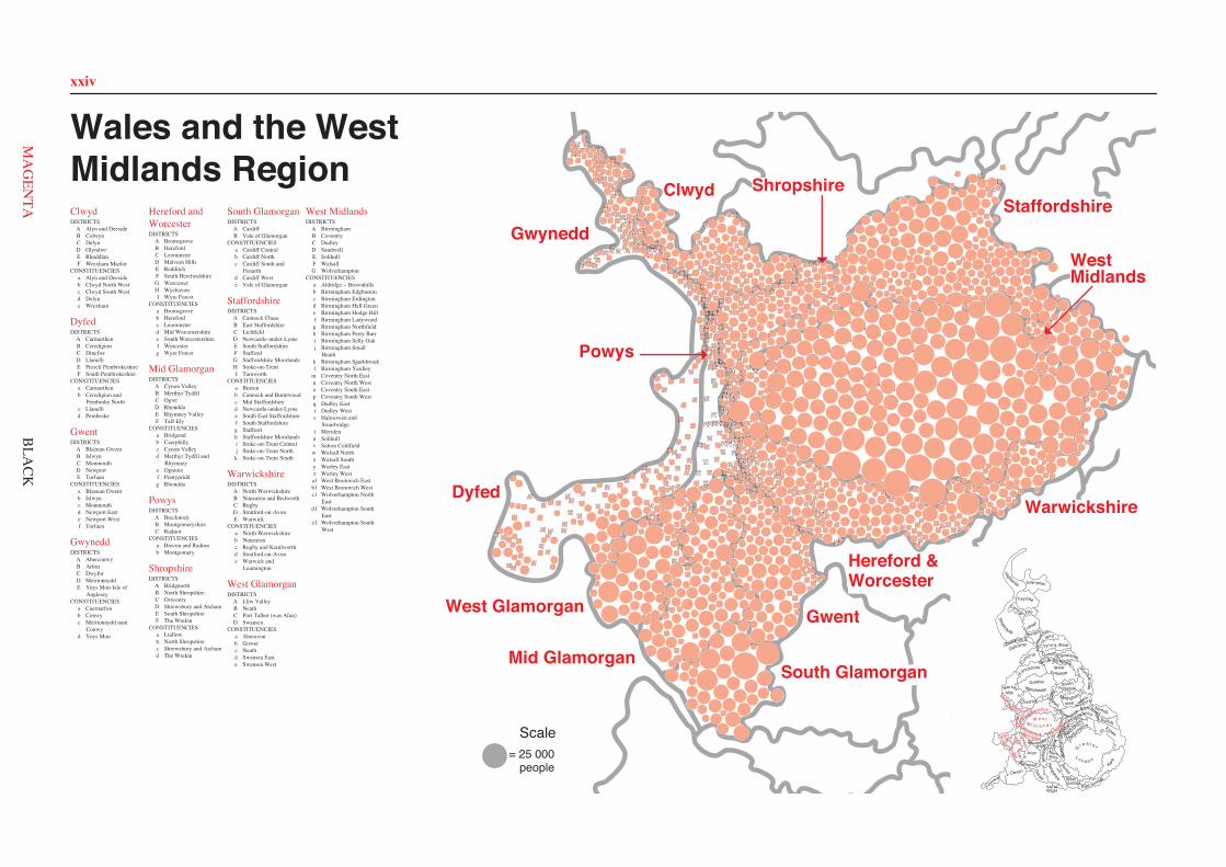
xxiv
003A l
139A f
009A j
021A d
020A d
092A k
105A j
056A b
059A c
065A k
012A c
074A d
076A h
078A b
035A i
088A h
094A f
096A g
104A i
010A j
033A g
115A h 114
A h
077A b
093A f
106A j
075A f
034A i
085A e 127
A l 135A j
011A f
134A k
064A k
083A e
058A c
084A e
014A g
002A l
148A v
147A v
146A v
013B n
025B o 048B o
053B p
062B m
082B m
086B n
097B m
099B o
125B n
143B o
128B n
152B m
153B p
158B p
159B p 162B p
163B m
006C r
037C r
042C q
041C q
049C q 067
C r
089C r
107C q
044C q
008C r
141C q
043C q
050C r
090C r
016C q
073C s
015C s
017C s
007C s
100C s
110C s 109
C s 001D y
027D z
036D y
046D a1
051D z
066D a1
070D a1
071D b1 072
D b1
079D a1
095D z
108D a1
112D z
111D y
124D b1
126D z
144D y 136D y
138D y
150D b1
151D z
154D b1
155D b1
157D a1
019E t
045E t
047E t
057E u
063E t
087E t
091E t
101E u
102E t 113
E u
116E t
140E u 129
E u 130E u
131E u
133E u
137E t
004F a
005F a
018F x
026F w 028
F w
031F w 032F w
038F a
052F x
080F a
117F x 118
F x
121F a
122F x
123F x
142F x
132F w
145F a
160F w
161F w
023G d1
024G d1
030G d1
040G c1
055G c1
022G d1
069G e1
060G c1
103G e1
039G c1
120G e1
054G d1
068G e1
098G e1
029G d1
149G e1119
G e1
061G c1
156G c1
081G c1
005A a 011
A a
016A a 037
A a
042A a
046A a
055A a
072A a
082A a
121A a
131A a
151A a
154A a
165A a
166A a
170A a
180A a
186A a 191
A a 196A a
007B b
018B b 040
B b
092B b
094B b
160B b
161B b
176B b
179B b
014C c
015C c
019C c
021C c
023C c
036C c
059C c
074C c
084C c
089C c
091C c 100
C c
102C c
103C c
109C c
111C c 112
C c 113C c
115C c
119C c
122C c
127C c
138C c
146C c
172C c
183C c
184C c
188C c
198C c
010D c 027
D c 029D c
032D c
035D c
043D e
049D c
071D c
070D c
083D c
090D c
097D c
099D e
104D e
105D c
106D c 107
D c
108D c
116D e
117D e
123D c
124D c
128D e
144D e 145
D e
147D e
171D c
173D e
178D e
182D e
187D e
189D e
195D c
013E d
012E d
038E d
001E d
048E d
079E d 002
E d 039E d
008F b
028F b
033F c 034
F c
050F b
051F c
053F b
068F b
073F b
075F b
076F b
077F b
081F c
086F b
093F b
101F b
120F c
125F b
129F c
134F b
135F b
139F b
143F b
149F b
150F b
167F b
169F c 175
F c
177F b
185F b
190F b
193F b
004G f
017G f
045G f
095G f
132G f 156
G f
157G f 158G f 159
G f 162G f
163G f
164G f
009H e
024H d
025H e
026H e 031
H e
044H d 130
H d
052H d
054H f
056H d
057H d
058H d
060H e
061H e
062H e
063H e
064H e 065
H e 066H e
067H e
085H d
087H d
088H e
096H e
098H f
110H f
118H d
137H d
140H e
141H e
142H f
152H e 153
H e
155H f
174H e
181H f
192H e
003I g
006I g
020I g
022I g
030I g
041I g
047I g
069I g
078I g
080I g
114I g
126I g
133I g 136
I g
148I g
168I g
194I g 197
I g
001A a
002A a
013A a
014A a
015A a
016A a
020A a
030A a
046A a 058
A a
062A a
065A a
070A a
075A a
086A a
094A a
095A a
113A a
120A a
143A a
008B b
033B b
036B b
037B b
053B b
054B b
066B b 067
B b
087B b 088
B b 089B b
097B b
104B b
111B b
112B b
116B b
118B b 122B b
128B b
129B b
133B b 134
B b 135B b 136
B b 138B b
142B b
023C b 057
C b 059C b
076C b
080C b
081C b
090C b
109C b
114C b
124C b
125C b
127C b
131C b
132C b
137C b
006D c
007D c
009D c
010D c
024D c
039D c
040D c
061D c 063
D c
077D c
091D c
092D c
093D c
102D c
103D c
106D c
107D c
108D c
110D c
121D c
123D c
126D c
003E a
005E a
011E a
012E a
021E a
022E a
025E a
026E a
028E a 029
E a
031E a
032E a
034E a
035E a 045E a
069E a
082E a
083E a 084E a
085E a
096E a 098
E a
115E a
117E a
119E a
130E a
139E a
144E a
004F d
019F d
027F b
038F d
042F d
017F d
048F d
047F d
051F d
052F b
056F d
055F b 060
F d
064F d
068F d
071F d
074F d
073F d
043F d
072F d
078F d
079F d
041F d
044F d
099F b
100F b 101
F b
050F d 105
F d
018F d
140F d
141F d
049F d
145F d
008A b
032A c
034A c 037
A b 043A b
049A b
079A c
092A c
098A b 124
A b 139A b
142A b
150A b 151
A b
195A c
002B a 011B a
031B a
035B a
041B a
064B a
072B a
076B a
080B a
099B a
104B a
136B a
141B a
153B a
160B a 165
B a
171B a
180B a
185B a
186B a
187B a
191B a
192B a
201B a
207B a
004C b
005C e
009C c
028C b
029C e
047C c
048C c
051C b 052
C b
067C c
073C c
081C e
094C b
100C b
110C c
119C c
120C e
123C c
131C e
152C b
163C c
159C e
168C e
170C c
172C b
176C e
200C e
010D d
030D d
042D j
062D d
065D d
071D d
093D d
102D d
108D d
109D j
122D g
128D g
130D d
137D j
149D d
155D d
161D d
175D j
177D d
179D d
196D d
199D g
202D d
003E f
025E f
026E f 033
E f
060E f
066E f 024
E f
070E f
078E f 082
E f 059E f
090E f 091E f
061E f
106E f
112E f
113E f
127E f
143E f
145E f 144E f 146
E f
148E f
157E f
169E f
173E f
183E f
203E f
204E f
205E f
012F c
013F g
014F g
045F g
050F c
063F g
068F g
069F g
075F g
084F g
086F c
088F g
097F c
101F g
103F g
121F g
129F g
134F g
135F c
140F c
147F g
154F g
164F c
156F g
167F c
174F g 178
F g
188F c 193
F g 206F g
006G h
019G h
020G h
021G h
022G h 023
G h
038G h
046G h
053G h
054G h
055G h
056G h
057G h
077G h
085G h
105G h
107G h
111G h
118G h 114G h
115G h 116
G h 117G h
125G h
189G h
190G h
194G h
198G h 001
H i 018H i
027H k
036H i
039H j 040
H j 058H j
074H j
083H k 089
H k
095H i
096H i
126H k
132H k
138H j
158H i
166H i
181H k
184H j
197H k
007I e
017I e
016I e
044I e
015I e
133I e
162I e
182I e
087I e
007A a
009A a
010A a
012A a
034A a
035A a
040A a
041A a
048A a
051A a
053A a
057A a
059A a
068A a
074A a
077A a
082A a
106A a
110A a 003
B b
006B b
011B b
024B b
027B b
028B b
046B a
050B b
054B a
072B a
083B a
094B b
095B b 111
B b
114B b
004C c
014C c
016C c
020C c
026C c
033C c
042C c
043C b
044C c
049C b
056C c
061C c
064C c
065C c
075C c
076C c 078
C c 079C c
086C c
093C c
116C c
117C b
005D d
008D d
013D d
015D d
019D d
025D d
032D d
036D d
045D d
047D d
052D d
055D d 058
D d
060D d
067D d
071D d
073D d
084D d
087D d
088D d
089D d
090D d
091D d
097D d
098D d
099D d 100
D d
101D d
103D d 102
D d
104D d
105D d
112D d
113D d
118D d
030E e
021E e
069E e
031E e 037
E e 022E e
070E e
029E e
108E e
107E e
109E e
001E c
002E c
081E c 092
E c 080E c
063E e
062E e 066
E e
023E e
017E e
096E c
085E e
018E e
039E e 038
E e
115E e
014A a
012A a
013A a
015A a
011A a
035A a 036
A a 037A a 038
A a 002A a
108A a
016A a
070A a
003A a
084A a
067A a
095A a
052A a
119A a
129A a
130A a
069A a
133A a
068A a
120B b
044B b
058B b
049B b
047B b
048B b
034B b
033B b
057B b
114B b
056B b
006B b
083B c 090
B c
131B c
134B c
085B c
021C d
023C d
022C d
032C d
004C d
005C d
072C d
059C d
073C d
105C d 103
C d 101C d
102C d
100C d
104C d
062C d
066C d
017C d
029C d
053C d
076C d
132C d
106C d
109C d
042D c
043D c
128D c
087D c
028D c
027D c
091D c
088D c
039D c
041D c
080D c
081D c
078D c
077D c
082D c
079D c 089
D c
092D c
046D c
086D c
040D c
117E d
118E d
116E d
099E d
122E b
126E b
124E b
123E b
125E b
007E b
121E b
045E b
001F e
019F e
020F e
018F e
055F e
054F e
112F e
110F e
111F e
008F e
096F e
098F e
093F a
094F a
024F c
025F c
115F c
127F c 026
F c 074F c 113
F c 075F c
060F e
097F e
071F e
051F c
050F c
009F e
031F e 030
F e
063F e 065
F e 064F e
010F e
107F e 061
F e
033A a 034
A a
035A a
040A a
090A a 093
A a
098A a 097
A a
002A a 052
A a
076A a
065A a
078A a
049A a
096A a
051A a 100
A a
135A a
082A a
141A a
079A a
006B b
007B b
005B b
031B b
074B b
001B b
116B b
047B b
046B b
083B b
045B b
101B b
089B b
095B b
020B b
042B b
107B b
041B b
077B b
058B b
086B b
108B b 142
B b
099B b
030B b
029B b
015B b
125B b
004B b 126
B b 003B b
016B b
088B b
092B b
102B b
080C a
014C c
118C c 008
C c
113C c
009C c
061C a
039C a
013C c
054C a
085C a
059C a
036C a
127C a 132C a
081C a
084C a 087
C a
091C a
053C a
112C a
129C a
103C a
023C a
057D c
018D c
019D c
062D c
072D c
024D c
067D c
017D c
026D c
063D c
131D c
037E d
038E d
060E b
064E b
110E d
066E d
111E d 117
E d
044E b
048E b
043E b 050
E b 056E b
137E b
021E d
025E d
028E d
055E b
071E d 094
E d
133E b
022E d
136E d
138E d 109
E d
128E d
070E d
027E d
134E d
130E d
104E d
123F d
120F d 121
F d 119F d
122F d
140F d
139F d
114F d
011F d
073F d
012F d
106F d 010
F d 115F d
069F d 068
F d
075F d
032F d
105F d
124F d
053A a 004
A a 003A a
052A a
083A a
020A a
019A a
010A a
011A a
039A a
038A a
040A a
017A a
021A a
018A a
081A a
042A a
082A a
049A c
022A c
037B b
063B b
001B b
015B b
031B b
009B b
030B b
068B b
067B b
093B b
078B b
035B b
077B b
028C c
046C c
065C c
047C c
085C c 088
C c
087C c
089C c
091C c
050C c
054C c
029C c
036C c
026C d
059C d
027C c
074C c
080C c
084C c 079
C c
075C c 064C c
061C c
056C c
043C c
048C c
051C c
006D e 008
D d
070D e
012D d
014D e
069D e
007D d
013D e
024D d
005D e 086
D d
041D e
092D d
025D e
076D e
044D e
060D e
045D d 057
D d
058D d
016E f
033E f
032E f
071E f
090E f
055E f
002E f
073E f
072E f
023E f
066E f
062E f
034E c
054A b
108A b
119A b
044A b
020A c
066A b
067A b
046A b
047A b
053A b
074A b
115A b 031
A b
049A c
040A b
029A b
140A c
039A b
038A c
135A c
028A c
064B b
061B b
055B b
069B b
070B b
056B b
065B b
112B a
111B a
132B a
037B a
116B a
114B b
062B b
130B b
133B a
122B a
099B a
085B a 086
B a
019B a
101B a
025B a
024B a
018B a
117B a
081B a
102B a
142B a
098B b
088B b
120B b
087B b
129C a
128C a
048C a 063
C a 125C a 124
C a
136C a
042C a
017C a 057
C a 075C a 077
C a 076C a
123C a
113C a
003C a 060
C a 035C a 080C a
006C a
090C a
138C a 026
C a 001C a
012D c 014
D c 058D c
051D c
043D c
027D c
030D c
002D c
118D c
068D c 134
D c 079D c
011D c
045D c
059D c 013
D c
010D c
109D c
082D c
103D c
016E d
015E d
009E d
007E d 008E d 127
E d 126E d
104E d
105E d 107
E d 073E d
106E d
071E d
041E d
052E d 137
E d
036E d
139E d
131E d
095E d 050
E d
092E d
096E d
097E d
094E d
121E d 023
E d
078E d 100
E d 084E d
083E d
089E d
033E d
034E d 110
E d 072E d
141E d
091E d
021E d 093
E d 032E d 022
E d 004E d
005E d
010A c
008A c
009A c
003A c
002A c
066A c
067A c
065A c
007A c
096A c
006A c
075A c
050A c
049A c
042B d
041B d
040B d
037B d
088B d
077B d 014B d
016B d
015B d
095B d
060C a
023C a
027C e 058C e
052C e
020C e
018C e
022C e 068C e
021C e
019C e
082C a
081C a
032C a 031
C a 029C a
053C e
072C a
071C e
028C a
033C a
034C a
024C a
083C e
074C e
043D g
036D g
076D g
073D g
038D g
055D g
091D g
092D g
094D g
080D g
097D g
017E b 057
E b
059E b
005E b
070E d
001E b
061E b
062E b
084E b
051E b 069
E b
048E b
004E b
078E d
086E d 039E d
011E d
064E d 063
E d
093E d
056E b
090F f 046
F f
030F f
089F f
045F f
079F f
047F f
085F f
035F f
012F f
044F e
087F f
013F f
025F e
054F e
026F e
088A a
086A a
089A a
006A a
034A a
067A a
020A a
021A a
056A a
091A a 051
A a
050A a
070A a
073A a
069A a
019A a
007A a
053A a 054
A a
008A a
055A a
059A a
014A a 094
A a
033A a
005A a
090A a 098
A a 093A a
015A a
092A a
001A a
097A a
052B b
061B b 060B b
074B b
096B b
032B b 030B b
029B b 072
B b 071B b
079B b 078
B b
080B b
077B b
022B b
004B b
012B b
023B b
017B b
044B b
002B b
031B b
066B b 043
B b
046B b
064B b
049B b
065B b
048B b
039B b
025B b
009B b
018B b
011B b
035B b 040
B b
058B b
062B b
010B b
085B b
095B b
036C a
041C a
042C a
082C a 016
C a 045C a 028
C a
038C a
003C a
047C a 057
C a
024C a
076C a 027
C a
013C a 026
C a
081C a
037C a 083
C a
068C a
075C a 063
C a
087C a 084C a
003A a
014A c
001A a
007A c
037A c
016A d
013A d
015A d
012A d
036A d
019A a
018A a
002A a
023A a 027
A b
029A b
028A b
031A b 032
A c
026A d
030A b
006B e
010B e 020
B e 009B e
017B e
008B e
011B e 005
B c
004B c
022B e 038B e
021B e
033B e
024B e
035B e
034B e
039B e
025B e
004C a
001C a
049C a
050C a
015C a
014C a
013C a
054C a
031C a 039
C a
035C a
032A b 036
A b 037A b
003A c 023
A b 041A b
038A c
030A c
022B c
011B c
012B a
046B c
034B c
026B a
008B c
043B c
048B c
009B c
045B c 051
B c
027B c
002B c 017
B c
016B c
019D e
020D e
025D e
018D e
040D d
010D d 042
D d
006D b
028D d
055D e
029D d
053D d 005
D e
024D e
021D e
007D b
047D b
033D b
044D b 052D b
Wales and the WestMidlands RegionClwydDISTRICTS
A Alyn and DeesideB ColwynC DelynD GlyndwrE RhuddlanF Wrexham Maelor
CONSTITUENCIESa Alyn and Deesideb Clwyd North Westc Clwyd South Westd Delyne Wrexham
DyfedDISTRICTS
A CarmarthenB CeredigionC DinefwrD LlanelliE Preseli PembrokeshireF South Pembrokeshire
CONSTITUENCIESa Carmarthenb Ceredigion and
Pembroke Northc Llanellid Pembroke
GwentDISTRICTS
A Blaenau GwentB IslwynC MonmouthD NewportE Torfaen
CONSTITUENCIESa Blaenau Gwentb Islwync Monmouthd Newport Easte Newport Westf Torfaen
GwyneddDISTRICTS
A AberconwyB ArfonC DwyforD MeirionnyddE Ynys Mon-Isle of
AngleseyCONSTITUENCIES
a Caernarfonb Conwyc Meirionnydd nant
Conwyd Ynys Mon
Hereford andWorcesterDISTRICTS
A BromsgroveB HerefordC LeominsterD Malvern HillsE RedditchF South HerefordshireG WorcesterH WychavonI Wyre Forest
CONSTITUENCIESa Bromsgroveb Herefordc Leominsterd Mid Worcestershiree South Worcestershiref Worcesterg Wyre Forest
Mid GlamorganDISTRICTS
A Cynon ValleyB Merthyr TydfilC OgwrD RhonddaE Rhymney ValleyF Taff-Ely
CONSTITUENCIESa Bridgendb Caerphillyc Cynon Valleyd Merthyr Tydfil and
Rhymneye Ogmoref Pontypriddg Rhondda
PowysDISTRICTS
A BrecknockB MontgomeryshireC Radnor
CONSTITUENCIESa Brecon and Radnorb Montgomery
ShropshireDISTRICTS
A BridgnorthB North ShropshireC OswestryD Shrewsbury and AtchamE South ShropshireF The Wrekin
CONSTITUENCIESa Ludlowb North Shropshirec Shrewsbury and Atchamd The Wrekin
South GlamorganDISTRICTS
A CardiffB Vale of Glamorgan
CONSTITUENCIESa Cardiff Centralb Cardiff Northc Cardiff South and
Penarthd Cardiff Weste Vale of Glamorgan
StaffordshireDISTRICTS
A Cannock ChaseB East StaffordshireC LichfieldD Newcastle-under-LymeE South StaffordshireF StaffordG Staffordshire MoorlandsH Stoke-on-TrentI Tamworth
CONSTITUENCIESa Burtonb Cannock and Burntwoodc Mid Staffordshired Newcastle-under-Lymee South East Staffordshiref South Staffordshireg Staffordh Staffordshire Moorlandsi Stoke-on-Trent Centralj Stoke-on-Trent Northk Stoke-on-Trent South
WarwickshireDISTRICTS
A North WarwickshireB Nuneaton and BedworthC RugbyD Stratford-on-AvonE Warwick
CONSTITUENCIESa North Warwickshireb Nuneatonc Rugby and Kenilworthd Stratford-on-Avone Warwick and
Leamington
West GlamorganDISTRICTS
A Lliw ValleyB NeathC Port Talbot (was Afan)D Swansea
CONSTITUENCIESa Aberavonb Gowerc Neathd Swansea Easte Swansea West
West MidlandsDISTRICTS
A BirminghamB CoventryC DudleyD SandwellE SolihullF WalsallG Wolverhampton
CONSTITUENCIESa Aldridge − Brownhillsb Birmingham Edgbastonc Birmingham Erdingtond Birmingham Hall Greene Birmingham Hodge Hillf Birmingham Ladywoodg Birmingham Northfieldh Birmingham Perry Barri Birmingham Selly Oakj Birmingham Small
Heathk Birmingham Sparkbrookl Birmingham Yardley
m Coventry North Eastn Coventry North Westo Coventry South Eastp Coventry South Westq Dudley Eastr Dudley Wests Halesowen and
Stourbridget Meridenu Solihullv Sutton Coldfieldw Walsall Northx Walsall Southy Warley Eastz Warley West
a1 West Bromwich Eastb1 West Bromwich Westc1 Wolverhampton North
Eastd1 Wolverhampton South
Easte1 Wolverhampton South
West
= 25 000people
Scale
South Glamorgan
Clwyd Shropshire
Hereford &Worcester
Gwent
Mid Glamorgan
West Glamorgan
Dyfed
Powys
Gwynedd
Warwickshire
Isle of
Ham
pshire WestSussex
East Sussex
Surrey
G r e a t e r
L o n d o n
Berk-shire
Wiltshire
Wight
Dorset
KentSomerset
Devon
Cornwall
Avon Buck
ingh
amsh
ire
Oxf
ord-
shireGloucester-
shireHertfo
rdshire
Bed
for
dshir
e
Essex
Suffolk
NorfolkshireCambridge-
North
am
ptonshire
Leicestershire
Nottingham-
shire
Derbyshire Lincoln-shire
ClevelandDurham
Nor
thum
ber-land
Tyne & Wear
Borders
Dumfries &
Galloway
StrathclydeLothian
Central Fife
Tayside
Grampian
Highlands
Cheshire
YorkshireSouth
HumbersideGreaterManchester
WestYorkshireLancashire
Mersey-side
North YorkshireCu
mbria
GwentSouth
GlamorganM
idWest
Hereford &WorcesterWarwick
shireW e s t
M i d l a n d s
Powys
Dyfed
Gwynedd Clwyd
Staffordshire
Shro
ps
hire
Staffordshire
WestMidlands
BLA
CK
xxiv
Clwyd
Dyfed
Gwent
Gwynedd
Hereford andWorcester
Mid Glamorgan
Powys
Shropshire
South Glamorgan
Staffordshire
Warwickshire
West Glamorgan
West Midlands
South Glamorgan
Clwyd Shropshire
Hereford &Worcester
Gwent
Mid Glamorgan
West Glamorgan
Dyfed
Powys
Gwynedd
Warwickshire
GwentSouth
GlamorganM
idWest
Hereford &WorcesterWarwick
shireW e s t
M i d l a n d s
Powys
Dyfed
Gwynedd Clwyd
Staffordshire
Shro
ps
hire
Staffordshire
WestMidlands
MA
GEN
TA
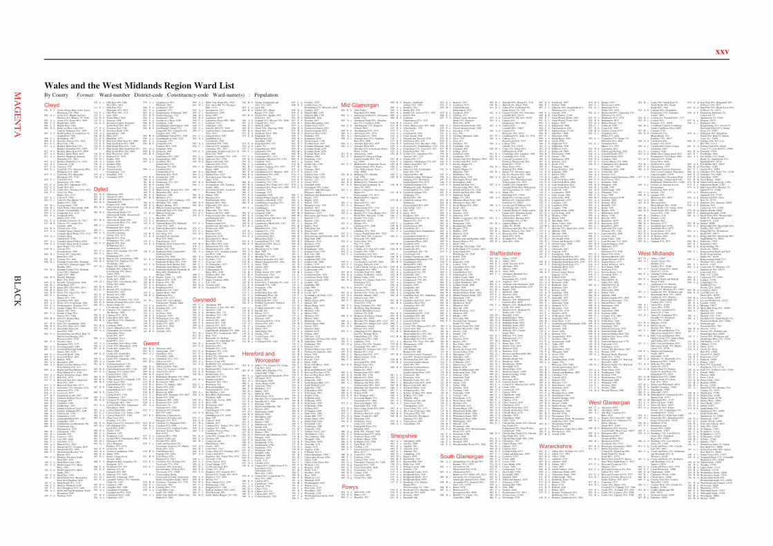
xxv
Clwyd001 F e Acton; Borras Park; Little Acton;
Rhosnesni 21%: 8936002 A a Aston 47%; Higher and East
Shotton 24%; Mancot 7%: 2946003 A a Aston 53%; Ewloe 86%: 4696004 C d Bagillt East: 2689005 C d Bagillt West: 1202006 B b Betws yn Rhos; Gele 20%;
Llanfair Talhaiarn 16%: 1678007 E b Bodelwyddan; St Asaph East; St
Asaph West: 5108008 F e Bronington: 2947009 F e Brymbo; Minera 33%: 3453010 F e Bryn Cefn: 1786011 A a Buckley Bistre East 13%;
Buckley Pentrobin 44%: 1984012 A a Buckley Bistre East 87%: 3099013 A a Buckley Bistre West: 4627014 A a Buckley Mountain; Buckley
Pentrobin 25%: 2903015 A a Buckley Pentrobin 31%: 1076016 A a Caergwrle: 1749017 C d Caerwys: 2327018 F e Caia Park 17%; Queensway 88%;
Whitegate 51%: 6481019 F e Caia Park 22%; Maesydre;
Rhosnesni 15%: 3716020 F e Caia Park 61%;
Queensway 12%: 3995021 C d Castle 28%; Oakenholt: 3757022 C d Castle 36%: 818023 C d Castle 36%; Trelawny 97%: 4222024 F c Cefn 31%; Plas
Madoc 26%: 2111025 F c Cefn 61%: 2954026 F c Cefn 9%; Plas Madoc 74%;
Ruabon 19%: 2788027 D c Ceiriog Ganol: 1765028 D c Chirk North; Chirk South: 3994029 C d Cilcain; Gwernaffield: 3714030 F e Coedpoeth 31%: 1513031 F e Coedpoeth 69%;
Minera 19%: 3787032 C d Coleshill; Trelawny 3%: 3767033 B b Colwyn 37%; Eirias 14%;
Llysfaen: 4649034 B b Colwyn 63%: 2724035 A a Connah's Quay Central 16%;
Connah's Quay Wepre 73%: 2112036 A a Connah's Quay
Central 84%: 2766037 A a Connah's Quay Golftyn: 4426038 A a Connah's Quay South; Connah's
Quay Wepre 27%: 5139039 D c Corwen 25%;
Gwyddelwern: 1404040 D c Corwen 4%; Llangollen
Rural 36%: 935041 D c Corwen 70%: 1661042 D c Denbigh Central 48%; Denbigh
Lower 42%; Denbigh Upper 79%;Henllan: 5402
043 D c Denbigh Central 52%; DenbighLower 58%; DenbighUpper 21%: 3889
044 B b Dinarth; Mochdre;Rhiw 19%: 5678
045 E b Dyserth; Tremeirchion: 3848046 D c Efenechtyd: 1257047 B b Eirias 20%; Glyn 36%: 2191048 B b Eirias 33%: 1144049 B b Eirias 33%; Glyn 35%: 2592050 F c Esclusham 11%;
Minera 47%: 1441051 F c Esclusham 89%: 2621052 A a Ewloe 14%; Penyffordd: 3944053 C d Ffynnongroyw; Gronant: 3715054 F e Garden Village 50%; Grosvenor;
Stansty 26%: 3621055 F e Garden Village 50%;
Stansty 54%: 2206056 B b Gele 6%; Kinmel Bay;
Towyn: 6720057 B b Gele 74%; Llanddulas: 5082058 B b Glyn 30%; Rhiw 81%: 5489059 C d Greenfield; Holywell
East 16%: 3200060 F e Gresford East and West; Holt 7%;
Marford and Hoseley 29%;Rhosnesni 64%: 5329
061 F e Gwenfro; NewBroughton 49%: 3175
062 C d Gwernymynydd: 1684063 F e Gwersyllt East and South;
Stansty 20%: 4238064 F e Gwersyllt North: 2566065 F e Gwersyllt West: 2878066 C d Halkyn: 3820067 A a Hawarden: 1901068 A a Higher and East Shotton 13%;
West Shotton 19%: 914069 A a Higher and East Shotton 64%;
West Shotton 81%: 4355070 A a Higher Kinnerton; Hope: 3884071 F e Holt 93%: 1879072 C d Holywell East 84%; Holywell
West 10%: 2997073 C d Holywell West 90%: 2573074 F c Johnstown 13%; Ponciau: 4174075 F c Johnstown 87%: 2791076 C d Leeswood: 2077077 D c Llanarmon-yn-Ial: 1681078 D c Llanbedr Dyffryn Clwyd: 1349079 D c Llandegla: 819080 D c Llandrillo: 1048081 D c Llandyrnog: 1247082 D c Llanfair Dyffryn Clwyd: 1351083 B c Llanfair Talhaiarn 84%: 1298084 A a Llanfynydd: 1730085 B c Llangernyw: 1415086 D c Llangollen Rural 64%: 1507087 D c Llangollen: 3267088 D c Llanrhaeadr-ym-Mochnant: 981089 D c Llanrhaeadr-yng-
Nghinmeirch: 1359090 B c Llansannan: 1318091 D c Llansilin: 850092 D c Llanynys: 1075093 F a Llay 34%: 1660094 F a Llay 66%: 3172095 A a Mancot 93%: 2824096 F e Marchwiel 8%; Overton: 2859097 F e Marchwiel 92%: 1985098 F e Marford and Hoseley 71%;
Rossett: 4523099 E d Meliden; Prestatyn South-
West 50%: 3651100 C d Mold Bron Coed: 1402101 C d Mold Central 37%; Mold
West: 1992102 C d Mold Central 63%; Mold
South: 2781103 C d Mold East: 1394104 C d Mold North 26%; Mynydd Isa
East; New Brighton: 6428105 C d Mold North 74%: 1176106 C d Mostyn; Whitford: 4248107 F e New Broughton 51%: 1448108 A a North and East Broughton; South
Broughton: 5444109 C d Northop: 4155
110 F e Offa East 30%; OffaWest 50%: 3423
111 F e Offa East 70%;Whitegate 49%: 4932
112 F e Offa West 50%: 1711113 F c Pant: 2204114 B b Pentre Mawr: 5443115 F c Penycae: 3438116 E d Prestatyn Central; Prestatyn
South-West 50%: 4933117 E d Prestatyn East: 3786118 E d Prestatyn North: 4745119 A a Queensferry: 1896120 B b Rhos: 4457121 E b Rhuddlan: 3575122 E b Rhyl East; Rhyl West 9%: 4993123 E b Rhyl South-East 92%: 5985124 E b Rhyl South-West 64%: 3349125 E b Rhyl South; Rhyl South-East 8%;
Rhyl South-West 36%: 6043126 E b Rhyl West 91%: 4539127 F c Ruabon 81%: 2510128 D c Ruthin: 5029129 A a Saltney: 4528130 A a Sealand: 3000131 B c Trefnant: 1722132 C d Trelawnyd and
Gwaenysgor: 1711133 A a Treuddyn: 1551134 B c Uwchaled: 1470
Dyfed001 B b Aberaeron: 1493002 A a Abergwili: 1962003 B b Aberporth 8%; Beulah 64%: 1122004 B b Aberporth 92%;
Penparc 61%: 3489005 B b Aberystwyth East; Aberystwyth
North 39%: 1847006 B b Aberystwyth North 12%;
Aberystwyth South; AberystwythWest 73%: 4894
007 B b Aberystwyth North 50%;Aberystwyth West 27%: 1620
008 C c Ammanford 35%;Pontamman 45%: 1090
009 C c Ammanford 65%: 949010 F d Amroth; Lampeter
Velfrey 25%: 1472011 F d Begelly 42%; East
Williamston 76%: 2224012 F d Begelly 58%; East
Williamston 24%;Saundersfoot: 4143
013 C c Betws 41%; Garnant 12%: 959014 C c Betws 59%;
Pontamman 55%: 1757015 B b Beulah 14%; Llandyfriog: 1899016 B b Beulah 23%; Penbryn 17%;
Troedyraur: 1962017 D c Bigyn 18%; Dafen 98%;
Felinfoel 58%; Lliedi 8%;Llwynhendy 39%; SwissValley: 9930
018 D c Bigyn 24%; Lliedi 10%;Tyisha 62%: 4589
019 D c Bigyn 59%; Llwynhendy 36%;Tyisha 38%: 6864
020 B b Borth: 1971021 E d Brawdy 36%; Letterston;
Wiston 20%: 2763022 E d Brawdy 64%: 888023 C a Brynamman: 932024 D c Burry Port; Pembrey 33%: 5579025 E d Burton; Neyland West 45%: 2364026 D c Bynea; Dafen 2%;
Llwynhendy 24%: 3953027 E d Camrose 13%; Johnston 12%;
The Havens: 1985028 E d Camrose 87%: 2018029 B b Capel Dewi 48%: 628030 B b Capel Dewi 52%; Llandysul
Town: 2066031 B b Cardigan: 4409032 F d Carew; Manorbier 14%: 1562033 A a Carmarthen Town North;
Carmarthen TownSouth 10%: 5677
034 A a Carmarthen TownSouth 90%: 3121
035 A a Carmarthen Town West: 3449036 C a Castle 47%; Manordeilo: 1878037 E d Castle 48%; Garth 32%;
Priory: 5004038 E d Castle 52%; Garth 68%;
Prendergast 60%: 5387039 C a Castle 53%; Llandeilo: 1284040 A a Cenarth: 1950041 B b Ceulanamaesmawr 31%;
Tirymynach 86%: 1909042 B b Ceulanamaesmawr 69%: 1216043 E b Cilgerran 31%; Clydey 49%;
Crymych 45%: 2241044 E b Cilgerran 69%: 1199045 B b Ciliau Aeron 24%; Llanarth: 1725046 B b Ciliau Aeron 29%;
Llansantffraid 78%: 2144047 B b Ciliau Aeron 47%;
Llansantffraid 22%: 1224048 E b Clydey 51%;
Crymych 46%: 1744049 A a Clynderwen: 1353050 E b Crymych 9%; Dinas Cross 21%;
St Dogmaels 48%: 1441051 A a Cynwyl Elfed 20%; Llangunnor;
Newchurch: 3846052 A a Cynwyl Elfed 80%: 1309053 C a Cynwyl Gaeo 17%; Talley: 1209054 C a Cynwyl Gaeo 83%: 1168055 E b Dinas Cross 33%;
Scleddau 11%: 678056 E b Dinas Cross 47%; Newport: 1922057 D c Elli; Felinfoel 42%;
Lliedi 82%: 8349058 B b Faenor: 1747059 C a Ffairfach: 1155060 E b Fishguard: 3128061 C a Garnant 88%; Glanamman: 4002062 D c Glanymor: 4534063 D c Glyn; Hengoed;
Pembrey 67%: 8176064 E b Goodwick: 1933065 A a Gorslas; Llanddarog: 5300066 E d Hakin: 5030067 D c Hendy; Llangennech;
Tycroes: 8966068 F d Hundleton 48%; Lamphey 4%;
Stackpole: 1471069 F d Hundleton 52%: 451070 E d Johnston 11%; St
Ishmael's 28%: 649071 E d Johnston 77%: 1659072 D c Kidwelly; Trimsaran: 5879073 F d Lampeter Velfrey 75%; Narberth
Urban 8%: 1165074 B b Lampeter: 1989075 F d Lamphey 96%: 1580076 A a Laugharne Township;
Llanddowror 70%: 2425077 B b Llanbadarn Fawr: 1468078 A a Llanboidy: 1675
079 A a Llanddowror 30%;Whitland: 2011
080 C a Llandovery: 2037081 C a Llandybie: 3537082 A a Llandyfaelog; St Ishmael: 2602083 B b Llandysiliogogo: 1721084 C a Llanegwad: 1740085 C a Llanfair-ar-y-Bryn: 1046086 B b Llanfarian: 1148087 C a Llanfihangel Aberbythych: 1560088 B b Llanfihangel Ystrad 17%;
Llangeitho 58%; Llangybi 12%;Tregaron 20%: 1582
089 B b Llanfihangel Ystrad 83%: 1558090 A a Llanfihangel-ar-Arth: 2122091 C a Llangadog: 1747092 B b Llangeitho 42%;
Tregaron 80%: 1555093 A a Llangeler: 3066094 E d Llangwm: 1947095 B b Llangybi 88%;
Llanwenog 28%: 1689096 A a Llangyndeyrn: 2983097 A a Llanllwni 38%;
Llanybydder 13%;Pencarreg 19%: 839
098 A a Llanllwni 62%;Llanybydder 87%;Pencarreg 81%: 3018
099 B b Llanrhystyd: 1293100 A a Llansteffan: 1877101 B b Llanwenog 72%: 1213102 B b Lledrod: 2052103 C a Llynfell: 940104 E d Maenclochog; Wiston 28%: 2015105 F d Manorbier 86%: 1616106 F d Martletwy: 1280107 B b Melindwr 21%;
Tirymynach 14%; Trefeurig: 1979108 B b Melindwr 79%: 1460109 E d Merlin's Bridge: 1871110 E d Milford Central and East; Milford
North and West 12%: 5042111 E d Milford North and
West 88%: 3577112 C a Myddfai: 640113 C c Myddnfych: 1184114 F d Narberth Rural 32%; Narberth
Urban 70%: 1654115 F d Narberth Rural 68%; Narberth
Urban 22%: 1157116 B b New Quay: 915117 E d Neyland East; Neyland
West 55%: 3006118 C c Pantyffynnon: 1215119 F d Pembroke Dock Central 32%;
Pembroke DockMarket 74%: 1795
120 F d Pembroke Dock Central 68%;Pembroke DockLlanion 22%: 1649
121 F d Pembroke Dock Llanion 78%;Pembroke St Mary 54%: 3749
122 F d Pembroke Dock Market 26%;Pembroke Dock Pennar: 3192
123 F d Pembroke Monkton; Pembroke StMary 46%; Pembroke StMichael: 5496
124 F d Penally; Tenby 1%: 1478125 B b Penbryn 83%: 1675126 B b Penparc 39%: 758127 C a Penygroes: 2203128 E d Prendergast 40%;
Rudbaxton 31%: 1362129 C a Quarter Bach: 1093130 E d Rudbaxton 69%;
Wiston 52%: 2272131 D c Saron 16%; Cross Hands;
Pontyberem; Tumble: 8400132 C a Saron 84%: 2701133 E b Scleddau 89%: 1271134 E d Solva: 1743135 A a St Clears: 3014136 E d St David's: 1959137 E b St Dogmaels 52%: 982138 E d St Ishmael's 72%: 1077139 F d Tenby 37%: 1802140 F d Tenby 61%: 2950141 A a Trelech: 1520142 B b Ystwyth: 1674
Gwent001 B b Abercarn: 4823002 E f Abersychan: 7015003 A a Abertillery 19%;
Cwmtillery: 5868004 A a Abertillery 81%: 3714005 D e Allt-yr-yn 16%;
Shaftesbury: 6752006 D e Allt-yr-yn 84%: 7042007 D d Alway 7%; Liswerry: 10490008 D d Alway 93%: 8137009 B b Argoed: 2653010 A a Badminton; Beaufort 12%: 3680011 A a Beaufort 88%; Rassau: 7183012 D d Beechwood: 7899013 D e Bettws 7%; Malpas: 9202014 D e Bettws 93%: 8187015 B b Blackwood: 7218016 E f Blaenavon: 6066017 A a Blaina 45%; Nantyglo 39%: 4027018 A a Blaina 55%: 2558019 A a Brynmawr 40%: 2200020 A a Brynmawr 45%: 2439021 A a Brynmawr 7%;
Nantyglo 61%: 3382022 A c Brynmawr 8%; Llanelly
Hill 33%: 1689023 E f Brynwern; Cwmyniscoy;
Pontypool; St Cadocs andPenygarn 31%: 5971
024 D d Caerleon 3%; Ringland: 9282025 D e Caerleon 97%: 8086026 C d Caerwent 12%; Caldicot Castle;
Dewstow; Severn; WestEnd: 10210
027 C c Caerwent 88%: 2100028 C c Cantref; Castle and
Grofield 85%: 4956029 C c Castle and Grofield 15%;
Croesonen; Llanover 7%; Mardy;Priory 20%: 5130
030 B b Cefn Fforest 41%;Pengam 19%: 2254
031 B b Cefn Fforest 59%;Pengam 81%: 5263
032 E f Coed Eva 22%; St Dials 25%;Two Locks 77%: 5241
033 E f Coed Eva 78%; Fairwater;Greenmeadow; St Dials 65%;Two Locks 23%: 15808
034 E c Croesyceiliog North;Croesyceiliog South; LlanyrafonNorth; Llanyrafon South: 10015
035 B b Crosskeys; Ynysddu 13%: 3738036 C c Crucorney: 1891037 B b Crumlin 94%: 5735038 A a Cwm; Ebbw Vale
South 19%: 4581039 A a Ebbw Vale North 8%; Ebbw Vale
South 81%: 3962
040 A a Ebbw Vale North 92%: 4525041 D e Gaer; Stow Hill 7%; Tredegar
Park: 11971042 A a Georgetown: 3317043 C c Goetre Fawr: 2295044 D e Graig: 4505045 D d Langstone: 2655046 C c Lansdown; Priory 80%: 3800047 C c Larkfield: 1471048 C c Llanbadoc: 1302049 A c Llanelly Hill 67%: 2600050 C c Llanfoist Fawr; Llanwenarth
Ultra: 3073051 C c Llangybi Fawr: 1607052 A a Llanhilleth 41%;
Crumlin 6%: 2529053 A a Llanhilleth 59%: 3189054 C c Llanover 93%; Llantilio
Crossenny 24%: 2427055 E f Llantarnam; Pontnewydd 21%; St
Dials 10%: 5950056 C c Llantilio Crossenny 76%: 1185057 D d Llanwern 76%: 2720058 D d Magor with Undy 36%;
Llanwern 24%: 2315059 C d Magor with Undy 64%;
Rogiet: 3608060 D e Marshfield: 3065061 C c Mitchel Troy: 1225062 E f New Inn Lower; New Inn
Upper: 5729063 B b Newbridge: 6564064 C c Overmonnow 14%; Trellech
United: 2642065 C c Overmonnow 86%; Vauxhall;
Wyesham: 7930066 E f Panteg: 7003067 B b Penmaen 16%;
Pontllanfraith: 8592068 B b Penmaen 84%: 3643069 D e Pillgwenlly 28%; Stow
Hill 93%: 5861070 D e Pillgwenlly 72%: 3993071 E f Pontnewydd 79%: 4680072 E f Pontnewynydd 38%; St Cadocs
and Penygarn 69%;Wainfelin: 3910
073 E f Pontnewynydd 62%;Snatchwood; Trevethin: 7071
074 C c Portskewett: 1905075 C c Raglan: 1857076 D e Risca East 19%;
Rogerstone: 8745077 B b Risca East 81%; Risca
West 54%: 8330078 B b Risca West 46%: 2326079 C c Shirenewton 39%: 936080 C c Shirenewton 61%: 1455081 A a Sirhowy 16%; Tredegar Central
and West: 7340082 A a Sirhowy 84%: 4951083 A a Six Bells: 2734084 C c St Arvans: 1451085 C c St Christophers: 1877086 D d St Julians: 8688087 C c St Kingsmark; St
Marys 40%: 3148088 C c St Marys 60%: 999089 C c Thornwell: 1966090 E f Upper Cwmbran: 6068091 C c Usk: 2187092 D d Victoria: 6453093 B b Ynysddu 87%: 3386
Gwynedd001 C a Aberdaron: 908002 D c Aberdovey; Corris 10%: 997003 C a Abererch: 1348004 E d Aberffraw 28%: 712005 E d Aberffraw 72%: 1787006 C a Abersoch: 805007 E d Amlwch 28%: 1087008 E d Amlwch 28%: 1100009 E d Amlwch 43%: 1675010 D c Arthog 10%; Brithdir and
Llanfachreth; Dolgellau 9%: 1064011 D c Arthog 90%; Llangelynin: 1861012 D c Bala: 1922013 D c Barmouth 3%; Dyffryn
Ardudwy 2%; Llanelltyd: 817014 D c Barmouth 97%: 2306015 E d Beaumaris 45%;
Pentraeth 23%: 1335016 E d Beaumaris 55%: 1130017 C a Beddgelert: 535018 B a Bethel 25%; Deiniolen: 1900019 B a Bethel 75%: 1558020 A c Betws-y-Coed: 848021 E d Bodffordd 12%; Llanmerch-y-
Medd 34%: 782022 E d Bodffordd 88%; Cefni 41%: 1957023 E d Bodorgan: 1511024 B a Bontnewydd 32%;
Llanwnda 63%: 1531025 B a Bontnewydd 68%;
Waunfawr 18%: 1081026 C a Botwnnog: 934027 D c Bowydd and Rhiw;
Trawsfynydd 5%: 2135028 A c Bro Machno: 1134029 A b Bryn Rhys; Eglwysbach;
Fforddlas: 3640030 D c Bryn-Crug; Tywyn: 3608031 A b Bryn: 1286032 E d Bryngwran: 1854033 E d Brynteg 28%;
Llanbedrgoch 77%: 1688034 E d Brynteg 72%;
Llanbedrgoch 23%: 1669035 C a Buan: 474036 E d Cadnant: 1049037 B a Cadnant: 1913038 A c Caerhun 29%; Trefriw 35%: 1014039 A b Caerhun 71%: 1406040 A b Capelulo; Pant-yr-Afon;
Penmaenan: 4177041 E d Cefni 59%; Cyngar 29%: 1306042 C a Clynnog: 867043 D c Conglywal and
Maenofferen: 2494044 A b Conwy: 3627045 D c Corris 90%: 1191046 A b Craig-y-Don 15%; Penrhyn: 4071047 A b Craig-y-Don 85%;
Deganwy 16%; Tudno 76%: 6771048 C a Criccieth: 1720049 A c Crwst; Gower: 3012050 E d Cwm Cadnant: 2377051 D c Cynfal and Teigl: 803052 E d Cyngar 71%: 1074053 A b Deganwy 14%; Gogarth 18%;
Mostyn 61%; Tudno 24%: 4635054 A b Deganwy 71%: 2509055 B b Deiniol: 957056 B b Dewi; Hendre 61%: 2297057 C a Dolbenmaen: 1338058 D c Dolgellau 91%: 2396059 D c Dyffryn Ardudwy 98%: 1452060 C a Efail-Newydd: 829061 B b Garth; Menai Bangor 23%: 938
062 B b Gerlan; Llanllechid andAber 12%: 1475
063 C a Gest: 899064 B b Glyder 34%; Menai
Bangor 77%: 1542065 B b Glyder 66%; Hendre 39%;
Pentir 4%: 1617066 A b Gogarth 21%; Mostyn 39%: 2006067 A b Gogarth 61%: 2211068 D c Harlech: 1880069 B b Hirael 34%; Marchog: 3096070 B b Hirael 66%: 811071 E d Holyhead Town: 1091072 E d Kingsland 34%;
Maeshyfryd 24%;Trearddur: 3309
073 E d Kingsland 66%: 975074 A b Lafan: 754075 C a Llanaelhaearn: 1050076 C a Llanarmon 16%;
Llanystumdwy: 1001077 C a Llanarmon 84%: 1114078 E d Llanbadrig; Mechell 22%: 1761079 D c Llanbedr: 1101080 C a Llanbedrog: 1051081 B a Llanberis; Llanrug 23%: 2573082 D c Llandderfel: 1552083 E d Llanddyfnan 22%; Moelfre: 1495084 E d Llanddyfnan 78%: 1047085 B a Llandwrog 27%;
Llanwnda 37%: 1357086 B a Llandwrog 73%: 1791087 B b Llandygai 38%; Pentir 14%: 1261088 B b Llandygai 62%; Pentir 16%: 1900089 E d Llaneilian: 2276090 C a Llanengan: 1157091 E d Llanfaethlu: 1645092 E d Llanfair Pwllgwyngyll: 3101093 E d Llanfair-yn-Neubwll: 2732094 E d Llanfihangel Ysgeifiog 22%;
Llanidan 42%: 1127095 E d Llanfihangel
Ysgeifiog 78%: 1561096 E d Llangoed: 1280097 E d Llanidan 58%: 951098 B b Llanllechid and Aber 88%: 945099 B a Llanllyfni: 1036100 E d Llanmerch-y-Medd 66%: 1167101 B a Llanrug 10%;
Waunfawr 82%: 1552102 B a Llanrug 67%: 1734103 D c Llanuwchllyn: 926104 E d London Road 28%;
Morawelon: 2222105 E d London Road 72%: 1201106 E d Maeshyfryd 29%; Parca'r
Mynydd: 1883107 E d Maeshyfryd 47%: 1060108 A b Marl: 3495109 D c Mawddwy: 586110 E d Mechell 78%: 1192111 B a Menai Caernarfon 36%: 818112 B a Menai Caernarfon 64%: 1462113 C a Nefyn: 2548114 B b Ogwen: 2083115 A b Pandy: 1722116 B a Peblig; Seiont 12%: 2859117 B a Penisarwaun: 1324118 D c Penrhyndeudraeth: 2404119 A b Pensarn: 2839120 B b Pentir 66%; Y Felinheli 8%: 1626121 E d Pentraeth 77%: 1369122 B a Penygroes: 1796123 C a Pistyll: 506124 C a Porthmadog East: 929125 C a Porthmadog West: 746126 E d Porthyfelin 34%: 789127 E d Porthyfelin 66%: 1527128 C a Pwllheli North 40%; Pwllheli
South: 2793129 C a Pwllheli North 60%: 1181130 B b Rachub: 851131 E d Rhosyr: 2113132 B a Seiont 88%: 2643133 B a Talysarn: 1305134 D c Trawsfynydd 95%: 1470135 A c Trefriw 65%: 839136 C a Tremadog: 1433137 E d Tudur: 1667138 C a Tudweiliog: 904139 E d Tysilio: 2126140 A c Uwch Conwy: 976141 E d Valley: 2389142 B a Y Felinheli 92%: 1664
Hereford andWorcester
001 E d Abbey 12%; Central 13%; LodgePark 40%: 4312
002 E d Abbey 88%; Batchley 17%;Church Hill: 13288
003 I g Aggborough and Spennells: 8574004 G f All Saints: 5633005 A a Alvechurch: 5829006 I g Areley Kings: 6354007 B b Aylestone: 5563008 F b Backbury: 1171009 H e Badsey: 2837010 D c Baldwin: 1859011 A a Barnt Green: 5274012 E d Batchley 22%; Central 40%: 4039013 E d Batchley 61%: 3569014 C c Bateman: 1035015 C c Bayton and Mamble: 740016 A a Beacon: 4203017 G f Bedwardine: 6808018 B b Belmont: 5958019 C c Berrington: 1287020 I g Bewdley: 5341021 C c Bircher: 1629022 I g Blakedown: 1872023 C c Border: 628024 H d Bowbrook: 2222025 H e Bredon: 2592026 H e Bretforton and Offenham: 2296027 D c Bringsty: 1459028 F b Broad Oak: 1267029 D c Broadheath: 1776030 I g Broadwaters: 6750031 H e Broadway: 2775032 D c Bromyard: 3401033 F c Burghill: 1284034 F c Burmarsh: 1887035 D c Butterley: 1417036 C c Castle: 1127037 A a Catshill: 6316038 E d Central 20%; Crabbs Cross 97%;
Feckenham 33%;Greenlands 22%;West 16%: 13582
039 E d Central 26%; Lodge Park 7%;West 76%: 7800
040 B b Central: 4872041 I g Chaddesley: 2106042 A a Charford: 5734043 D e Chase: 5721044 H d Claines 14%: 971045 G f Claines 86%: 5917046 A a Cofton Hackett: 1752
047 I g Cookley: 2532048 E d Crabbs Cross 3%;
Feckenham 67%; West 8%: 4625049 D c Cradley: 1627050 F b Dinedor Hill: 1254051 F c Dinmore Hill: 1756052 H d Dodderhill: 1824053 F b Doward: 1615054 H f Drakes Broughton: 2433055 A a Drakes Cross: 6797056 H d Droitwich Central: 6383057 H d Droitwich South: 8221058 H d Droitwich West: 6362059 C c Eardisley: 929060 H e Eckington: 2449061 H e Elmley Castle: 1744062 H e Evesham East: 2445063 H e Evesham Hampton: 4646064 H e Evesham North: 2330065 H e Evesham South: 6259066 H e Evesham West: 2143067 H e Fladbury: 2004068 F b Fownhope: 1143069 I g Franche: 7480070 D c Frome Vale: 1708071 D c Frome: 1346072 A a Furlongs: 3964073 F b Garron: 1220074 C c Golden Cross: 1348075 F b Golden Valley: 1521076 F b Gorsley: 1232077 F b Gorsty: 3455078 I g Greenhill: 6560079 E d Greenlands 78%; Lodge
Park 53%; Matchborough;Winyates: 26891
080 I g Habberley and Blakebrook: 6535081 F c Hagley: 1577082 A a Hagley: 4258083 D c Hallow: 1752084 C c Hampton Court: 1532085 H d Hanbury: 1072086 F b Harewood End: 1364087 H d Hartlebury: 2253088 H e Harvington and Norton: 2538089 C c Hatfield: 1173090 D c Hegdon: 1310091 C c Hergest: 979092 B b Hinton: 5434093 F b Hollington: 941094 B b Holmer: 6937095 G f Holy Trinity: 6109096 H e Honeybourne and Pebworth: 2166097 D c Hope End: 2980098 H f Inkberrow: 3016099 D e Kempsey: 3722100 C c Kingsland: 985101 F b Kingsthorne: 1265102 C c Kington Town: 2197103 C c Kyre Vale: 908104 D e Langland: 5896105 D c Laugherne Hill: 2142106 D c Leadon Vale: 2404107 D c Ledbury: 5119108 D c Leigh and Bransford: 1610109 C c Leintwardine: 838110 H f Lenches: 1135111 C c Leominster East: 1974112 C c Leominster North: 5064113 C c Leominster South: 2999114 I g Lickhill: 7022115 C c Lindridge: 990116 D e Link: 5408117 D e Longdon: 1926118 H d Lovett: 1673119 C c Lyonshall with Titley: 1125120 F c Magna: 2087121 A a Majors Green: 2064122 C c Mansel: 766123 D c Marcle Ridge: 1659124 D c Martley: 1760125 F b Merbach: 1303126 I g Mitton: 5363127 C c Mortimer: 923128 D e Morton: 2002129 F c Munstone: 1202130 H d North Claines: 2869131 A a Norton: 5937132 G f Nunnery: 6862133 I g Offmore: 6233134 F b Olchon: 1060135 F b Old Gore: 1125136 I g Oldington and Foley Park: 6328137 H d Ombersley: 2089138 C c Pembridge: 909139 F b Penyard: 1563140 H e Pershore Holy Cross: 3625141 H e Pershore St Andrews: 3462142 H f Pinvin: 2593143 F b Pontrilas: 1546144 D e Powyke: 3119145 D e Priory: 2288146 C c Pyons with Birley: 1069147 D e Ripple: 1691148 I g Rock and Ribbesford: 2430149 F b Ross-on-Wye East: 4774150 F b Ross-on-Wye West: 4832151 A a Sidemoor: 5824152 H e Somerville: 1903153 H e South Bredon Hill: 1273154 A a South Wythall: 2337155 H f Spetchley: 1709156 G f St Barnabas: 6032157 G f St Clement: 7061158 G f St John: 6744159 G f St Martin: 8425160 B b St Martins: 4679161 B b St Nicholas: 4587162 G f St Nicholas: 5996163 G f St Peter: 8913164 G f St Stephen: 6284165 A a Stoke Prior: 2645166 A a Stoney Hill: 5357167 F b Stoney Street: 1091168 I g Sutton Park: 6184169 F c Swainshill: 1187170 A a Tardebigge: 1850171 D c Temeside: 1536172 C c Tenbury Town: 2657173 D e The Hanleys: 1512174 H e The Littletons: 2926175 F c Thinghill: 1246176 B b Three Elms: 5858177 F b Tram Inn: 1135178 D e Trinity: 5714179 B b Tupsley: 6346180 A a Uffdown: 10114181 H f Upton Snodsbury: 1984182 D e Upton upon Severn: 2561183 C c Upton: 1349184 C c Valley of the Teme: 862185 F b Walford: 1122186 A a Waseley: 3720187 D e Wells: 3182188 C c Weobley: 1076189 D e West: 3438190 F b Whitfield: 1227191 A a Whitford: 5419192 H e Wickhamford: 1465193 F b Wilton: 1311194 I g Wolverley: 2125195 D c Woodbury: 1857196 A a Woodvale: 2150197 I g Wribbenhall and Arley: 5025198 C c Wye: 815
Mid Glamorgan001 E b Aber Valley;
Penyrheol 18%: 8666002 A c Aberaman North 41%; Aberaman
South: 7124003 A c Aberaman North 59%; Aberdare
East 5%; Cwmbach: 8288004 E b Aberbargoed 13%; Bargoed;
Gilfach: 9674005 E b Aberbargoed 87%: 3373006 A c Abercynon 39%: 2574007 A c Abercynon 61%: 3954008 A c Aberdare East 33%; Aberdare
West 50%: 5608009 A c Aberdare East 62%: 4025010 A c Aberdare West 50%;
Hirwaun 62%; Llwydcoed; Pen-y-Waun: 11184
011 E d Abertysswg: 1499012 F f Beddau 6%; Church Village;
Llantwit Fardre 90%; Ton-teg: 12894
013 F f Beddau 94%; Llantrisant Town;Llantwit Fardre 10%; Pont-y-Clun; Talbot Green; Tyn-y-Nant: 18098
014 B d Bedlinog 13%; MerthyrVale: 4782
015 B d Bedlinog 78%: 2828016 B d Bedlinog 9%; Treharris: 6349017 E b Bedwas and Trethomas; St
James 6%: 6552018 C e Bettws; Llangeinor; Newcastle
Higher 8%;Pontycymmer 13%: 5011
019 C e Blackmill 49%; OgmoreVale: 4642
020 C e Blackmill 51%: 1467021 C e Blaengarw 25%;
Pontycymmer 87%: 2710022 C e Blaengarw 75%: 1402023 C a Brackla 27%; Coity Higher 16%;
Morfa 90%; Oldcastle: 11398024 C a Brackla 73%; Coity
Higher 84%: 10212025 F e Brynna 33%;
Llanharan 47%: 2504026 F e Brynna 67%;
Llanharan 53%: 3841027 C e Caerau; Nantyffyllon 88%: 7822028 C a Cefn Cribwr 24%; Laleston;
Newcastle 15%: 8446029 C a Cefn Cribwr 76%;
Pyle 17%: 2452030 F f Cilfynydd: 2750031 C a Cornelly 41%; Pyle 83%: 8049032 C a Cornelly 59%: 3784033 C a Coychurch Lower 16%;
Porthcawl East 3%; St Bride'sMajor: 3788
034 C a Coychurch Lower 84%: 2269035 F f Creigiau; Pentyrch: 6347036 D g Cwm Clydach; Llwyn-y-Pia 76%;
Tonypandy 46%: 6802037 B d Cyfarthfa; Park 33%: 8089038 D g Cymmer; Porth 60%: 10122039 E d Darran Valley: 2738040 B d Dowlais 1%; Gurnos; Park 67%;
Penydarren 25%;Town 9%: 11228
041 B d Dowlais 18%;Penydarren 75%: 5439
042 B d Dowlais 81%; Town 4%: 6159043 D g Ferndale; Maerdy: 8847044 F e Gilfach Goch: 3558045 F f Glyncoch; Pontypridd
Town 83%: 5794046 F f Graig; Treforest 14%: 2863047 F f Hawthorn; Ilan; Rhydfelen
Central; Rhydfelen Lower;Treforest 7%: 8748
048 E b Hengoed; St Cattwg; YstradMynach 56%: 13921
049 A c Hirwaun 15%; Rhigos 49%: 1515050 A c Hirwaun 23%; Rhigos 51%: 1874051 E b Llanbradach; Ystrad
Mynach 44%: 6299052 C e Llangynwyd 22%; Maesteg
East 9%; Maesteg West;Nantyffyllon 12%: 7514
053 C e Llangynwyd 78%: 1854054 F e Llanharry: 2336055 D g Llwyn-y-Pia 24%; Trealaw;
Tonypandy 54%: 6811056 E b Machen 9%; St James 94%: 6727057 E b Machen 91%: 3742058 C e Maesteg East 91%: 4777059 E b Maesycwmmer: 2328060 C a Morfa 10%;
Newcastle 85%: 5082061 E b Morgan Jones 18%;
Penyrheol 82%; StMartins 8%: 9935
062 E b Morgan Jones 82%: 4885063 E d Moriah 38%: 1236064 E d Moriah 62%: 2030065 A c Mountain Ash East: 2922066 A c Mountain Ash West 10%;
Penrhiwceiber 38%: 3076067 A c Mountain Ash West 90%: 4343068 C e Nant-y-Moel: 2454069 E b Nelson: 4140070 E d New Tredegar: 4031071 C e Newcastle Higher 13%;
Ynysawdre 81%: 2606072 C a Newcastle Higher 79%;
Ynysawdre 19%: 3750073 D g Pen-y-Graig; Porth 10%: 6546074 C e Pencoed: 9277075 A c Penrhiwceiber 62%: 4283076 D g Pentre; Ystrad 8%: 5887077 B d Plymouth: 5285078 E d Pontlottyn; Twyn
Carno 11%: 2305079 F f Pontypridd Town 17%;
Rhondda: 4943080 D g Porth 30%; Ynyshir: 5629081 C a Porthcawl East 97%: 6624082 C a Porthcawl West: 9297083 C e St Bride's Minor: 5755084 E b St Martins 92%: 5580085 F f Taffs Well: 3517086 E d Tir-Phil: 1319087 F f Tonyrefail East; Tonyrefail
West: 10717088 B d Town 87%: 5796089 F f Trallwng: 3784090 F f Treforest 78%: 2733091 D g Treherbert; Treorchy 8%: 7458092 D g Treorchy 92%: 7225093 E d Twyn Carno 89%: 2420094 D g Tylorstown: 7115095 B d Vaynor: 3362096 A c Ynysybwl: 4401097 D g Ystrad 92%: 5902
Powys001 A a Aber-Craf: 1465002 B b Banwy: 833003 C a Beguildy: 702
004 B b Berriew; Guilsfieldwithout 22%: 1510
005 A a Bronllys: 764006 A a Builth 48%: 970007 A a Builth 52%; Erwood 55%: 1451008 A a Bwlch: 904009 B b Cadfarch;
Glantwymyn 32%: 1107010 B b Caersws: 1478011 B b Carno; Rhiewcynon 36%: 1048012 B b Churchstoke: 1339013 C a Clyro: 622014 A a Crickhowell: 2166015 A a Cwm-Twrch: 1944016 C a Disserth and Trecoed: 1036017 B b Dolforwyn 49%: 676018 B b Dolforwyn 51%; Mochdre: 1596019 A a Erwood 45%; Llanafanfawr: 1363020 A a Felin-Fach 31%; Yscir 61%: 919021 A a Felin-Fach 69%: 795022 B b Forden 31%; Llandrinio 35%;
Trewern 36%: 1225023 B b Forden 69%: 777024 C a Gladestry; Old Radnor 37%: 697025 B b Glantwymyn 68%: 763026 C a Glasbury: 838027 C a Glascwm 34%; Llanbadarn
Fawr 36%: 578028 C a Glascwm 66%: 480029 B b Guilsfield within; Welshpool
Gungrog 87%; WelshpoolLlanerchyddol 59%: 4175
030 B b Guilsfield without 23%;Welshpool Castle; WelshpoolLlanerchyddol 21%: 2241
031 B b Guilsfield without 25%;Llandrinio 23%;Meifod 20%: 796
032 B b Guilsfield without 30%;WelshpoolLlanerchyddol 20%: 699
033 A a Gwernyfed: 1375034 A a Hay: 1407035 B b Kerry: 1655036 C a Knighton: 2851037 C a Llanbadarn Fawr 64%; St
Harmon 32%: 825038 C a Llanbister: 658039 B b Llanbrynmair: 859040 B b Llandinam: 851041 C a Llandrindod East; Llandrindod
North: 2538042 C a Llandrindod South No.1;
Llandrindod South No.2;Llandrindod West: 2405
043 B b Llandrinio 42%;Llandysilio 54%: 1203
044 B b Llandysilio 46%;Llansantffraid 18%: 726
045 C a Llanelwedd: 478046 B b Llanfair Caereinion: 1490047 C a Llanfihangel Rhydithon: 538048 B b Llanfihangel 14%;
Meifod 80%: 1002049 B b Llanfihangel 86%: 790050 A a Llanfrynach 49%: 540051 A a Llanfrynach 51%: 557052 B b Llanfyllin: 1267053 A a Llangamarch 27%: 253054 A a Llangamarch 73%: 691055 A a Llangattock: 1078056 A a Llangors: 1059057 C a Llangunllo: 641058 B b Llangurig: 680059 A a Llangynidr: 983060 B b Llanidloes East 18%; Llanidloes
West 30%: 542061 B b Llanidloes East 82%: 1673062 B b Llanidloes West 70%;
Trefeglwys 45%: 997063 C a Llansantffraed-
Cwmdeuddwr: 456064 B b Llansantffraid 82%: 1278065 B b Llanwddyn 49%: 660066 B b Llanwddyn 51%: 693067 A a Llanwrtyd Wells: 649068 C a Llanyre: 1073069 A a Llywel 34%; Maescar 65%: 833070 A a Llywel 66%: 466071 B b Machynlleth No.1 50%;
Machynlleth No.2 45%: 963072 B b Machynlleth No.1 50%;
Machynlleth No.2 55%: 1070073 A a Maescar 35%; Yscir 39%: 689074 B b Montgomery: 1059075 C a Nantmel: 601076 C a New Radnor; Old
Radnor 63%: 890077 B b Newtown Central; Newtown
East 80%; Newtown South: 6717078 B b Newtown East 20%: 386079 B b Newtown Llanllwchaiarn
North 40%: 702080 B b Newtown Llanllwchaiarn
North 60%; NewtownLlanllwchaiarn West: 2743
081 C a Painscastle: 463082 C a Presteigne: 2141083 C a Rhayader Town 36%: 587084 C a Rhayader Town 64%: 1039085 B b Rhiewcynon 64%: 805086 A a St David within: 1424087 C a St Harmon 68%: 493088 A a St John; St Mary 25%: 4040089 A a St Mary 75%: 2059090 A a Talgarth: 1818091 A a Talybont-on-Usk: 669092 A a Tawe-Uchaf 28%;
Ystradgynlais: 3155093 A a Tawe-Uchaf 72%: 1137094 A a The Vale of Grwyney: 844095 B b Trefeglwys 55%: 736096 B b Trewern 64%; Welshpool
Gungrog 13%: 882097 A a Ynyscedwyn: 2087098 A a Ystradfellte: 591
Shropshire001 A a Albrighton: 4490002 A a Alveley: 2580003 E a Apedale: 981004 F d Arleston: 2547005 E a Ashford: 704006 D c Attingham: 1331007 D c Bagley: 4553008 B b Baschurch: 1745009 D c Bayston Hill: 5462010 D c Belle-Vue: 5348011 E a Bishop's Castle: 1989012 E a Bitterley: 719013 A a Bridgnorth Castle: 1014014 A a Bridgnorth East: 1530015 A a Bridgnorth Morfe: 3873016 A a Bridgnorth West: 5079017 F d Brookside 12%; Dawley
Magna 89%;Wrockwardine 1%: 7386
018 F d Brookside 13%; Stirchley: 5262019 F d Brookside 75%: 4497020 A a Broseley: 4858021 E a Bucknell: 898
022 E a Burford: 1241023 C b Cambrian: 5127024 D c Castlefields and
Ditherington: 5521025 E a Caynham: 1050026 E a Chirbury: 871027 F b Church Aston; Newport
North 15%; NewportWest 36%: 3478
028 E a Church Stretton North: 1981029 E a Church Stretton South: 2180030 A a Claverley: 1370031 E a Clee: 854032 E a Cleobury Mortimer: 2401033 B b Clive: 1347034 E a Clun: 871035 E a Clunbury: 754036 B b Cockshutt: 1344037 B b Colemere: 868038 F d College: 2674039 D c Condover: 1896040 D c Copthorne: 7873041 F d Cuckoo Oak 10%; Madeley: 5992042 F d Cuckoo Oak 90%: 5119043 F d Dawley Magna 5%;
Langley: 3962044 F d Dawley Magna 7%;
Malinslee: 5287045 E a Diddlebury: 911046 A a Ditton Priors: 1245047 F d Donnington Wood: 3061048 F d Donnington: 4640049 F d Dothill and Park 15%;
Wrockwardine 99%: 3837050 F d Dothill and Park 37%: 2749051 F d Dothill and Park 48%: 3589052 F b Edgmond; Ercall
Magna 7%: 2921053 B b Ellesmere Rural West: 1941054 B b Ellesmere Urban: 2967055 F b Ercall Magna 93%: 3005056 F d Ercall: 2412057 C b Gatacre: 3140058 A a Glazeley: 1410059 C b Gobowen: 3357060 F d Hadley; Leegomery 18%: 5884061 D c Harlescott: 5737062 A a Harrington: 1366063 D c Haughmond: 2496064 F d Haygate: 2779065 A a Highley: 3299066 B b Hinstock: 2218067 B b Hodnet: 1405068 F d Hollinswood and Randlay: 6628069 E a Hopton Wafers: 972070 A a Idsall: 3568071 F d Ironbridge The Gorge: 2583072 F d Ketley Bank 17%; Lawley: 4452073 F d Ketley Bank 83%;
Wombridge 6%: 2545074 F d Ketley: 3109075 A a Kinlet: 1307076 C b Kinnerley: 1129077 D c Lawley: 2150078 F d Leegomery 82%: 4481079 F d Lilleshall: 3109080 C b Llanyblodwel: 851081 C b Llanymynech: 1393082 E a Ludlow Castle: 2800083 E a Ludlow East Hamlet: 3738084 E a Ludlow Galdeford: 2857085 E a Lydbury North: 1094086 A a Manor: 2948087 B b Market Drayton East: 2601088 B b Market Drayton North: 4294089 B b Market Drayton South: 2587090 C b Maserfield: 2769091 D c Meole-Brace: 7628092 D c Monkmoor: 6410093 D c Montford: 1687094 A a Morville: 1289095 A a Much Wenlock: 3232096 E a Munslow: 609097 B b Myddle: 1200098 E a Newcastle: 880099 F b Newport East; Newport
North 15%: 3466100 F b Newport North 70%: 2395101 F b Newport West 64%: 2088102 D c Onslow: 1396103 D c Pimhill: 1703104 B b Prees: 2713105 F d Priorslee: 6578106 D c Quarry: 4392107 D c Rea Valley: 6563108 D c Rowton: 1966109 C b Ruyton-XI-Towns: 836110 D c Severn Valley: 2186111 B b Shavington: 1317112 B b Shawbury: 2457113 A a Sheriffhales: 2957114 C b St Martin's: 2513115 E a Stanton Lacy: 627116 B b Stanton: 1050117 E a Stoke St Milborough: 660118 B b Stoke-upon-Tern: 1500119 E a Stokesay: 2284120 A a Stottesdon: 1045121 D c Sundorne: 5195122 B b Sutton: 1234123 D c Sutton: 5066124 C b Sweeney: 2028125 C b Trefonen: 1469126 D c Underdale: 5190127 C b Victoria: 3183128 B b Wem Rural: 1170129 B b Wem Urban: 4882130 E a Wentnor: 653131 C b West Felton: 1123132 C b Weston Rhyn: 2287133 B b Whitchurch North: 2887134 B b Whitchurch Rural: 1454135 B b Whitchurch South: 2893136 B b Whitchurch West: 2088137 C b Whittington: 2303138 B b Whixall: 1105139 E a Wistanstow: 696140 F d Wombridge 94%; Wrockwardine
Wood 21%: 6379141 F d Woodside: 6798142 B b Woore: 1606143 A a Worfield: 2051144 E a Worthen: 1955145 F d Wrockwardine Wood 79%: 3824
South Glamorgan001 A a Adamsdown 13%; Roath 78%;
Rumney 34%: 12073002 A a Adamsdown 5%;
Plasnewydd 56%: 8158003 A a Adamsdown 82%;
Butetown 33%; Splott 14%: 8111004 B c Alexandra 3%; Cornerswell;
Llandough; Stanwell 44%: 9530005 B c Alexandra 97%; Stanwell 38%;
Sully 13%: 12758006 B e Baruc: 5478007 A c Butetown 67%;
Grangetown 46%: 8658008 B e Buttrills 7%; Cadoc 13%;
Court 89%: 6068
009 B e Buttrills 84%; Dyfan 8%: 5116010 B e Buttrills 9%; Illtyd: 7956011 B e Cadoc 87%; Castleland 9%;
Dinas Powys 3%: 7301012 A d Caerau 3%; Ely 33%; Fairwater;
Llandaff 40%: 21674013 A d Caerau 97%; Ely 66%: 20239014 A c Canton 16%;
Grangetown 54%: 8962015 A d Canton 42%;
Llandaff 60%: 10847016 A d Canton 42%;
Riverside 38%: 10213017 B e Castleland 91%; Sully 1%: 3576018 A a Cathays 41%;
Plasnewydd 26%: 7572019 A a Cathays 59%;
Gabalfa 76%: 10120020 B e Court 11%; Dyfan 65%;
Gibbonsdown: 9705021 B e Cowbridge 16%; Llandow: 2903022 B e Cowbridge 84%: 5158023 A a Cyncoed; Llanishen 11%;
Pentwyn; Plasnewydd 18%;Roath 22%: 33718
024 B e Dinas Powys 97%;Stanwell 18%: 9888
025 B e Dyfan 27%; Peterston-super-Ely 5%; Wenvoe 84%: 3496
026 A d Ely 1%; Radyr and StFagans 78%; Whitchurch andTongwynlais 12%: 5875
027 A b Gabalfa 24%; Heath 16%;Llandaff North 94%; Whitchurchand Tongwynlais 7%: 11817
028 A b Heath 18%;Rhiwbina 95%: 12845
029 A b Heath 65%; Lisvane and StMellons 6%; Llanishen 89%;Rhiwbina 5%: 20852
030 A b Lisvane and St Mellons 94%;Trowbridge 66%: 14371
031 A b Llandaff North 6%; Radyr and StFagans 22%; Whitchurch andTongwynlais 80%: 13431
032 A c Llanrumney; Rumney 66%;Trowbridge 34%: 22780
033 B e Llantwit Major; StAthan 9%: 10196
034 B e Peterston-super-Ely 95%: 2518035 B e Rhoose; Wenvoe 16%: 4824036 A d Riverside 62%: 7448037 A c Splott 86%: 9278038 B e St Athan 91%: 3568039 B e Sully 86%: 3686
Staffordshire001 H i Abbey: 12739002 B a Abbey: 2404003 E f Acton Trussell: 1679004 C b All Saints: 1991005 C e Alrewas: 4409006 G h Alton: 1865007 I e Amington; Bolehall 26%;
Glascote 22%;Stonydelph 19%: 12930
008 A b Anglesey: 7471009 C c Armitage with Handsacre: 4426010 D d Audley and Bignall End: 6276011 B a Bagots: 2549012 F c Barlaston: 2946013 F g Baswich: 3926014 F g Beaconside: 2599015 I e Belgrave 16%; Bolehall 8%;
Glascote 60%: 6839016 I e Belgrave 22%; Bolehall 56%;
Castle 19%: 6349017 I e Belgrave 61%; Bolehall 9%;
Trinity 24%: 7159018 H i Berryhill: 11563019 G h Biddulph East: 3959020 G h Biddulph Moor: 2153021 G h Biddulph North: 5364022 G h Biddulph South: 4439023 G h Biddulph West: 3322024 E f Bilbrook 29%; Codsall
South: 5064025 E f Bilbrook 71%: 3544026 E f Bishopswood: 1373027 H k Blurton: 10385028 C b Boney Hay: 3135029 C e Bourne Vale: 1810030 D d Bradwell: 6205031 B a Branston: 3934032 A c Brereton and Ravenhill: 6461033 E f Brewood: 2964034 A c Brindley Heath: 936035 B a Broadway: 3810036 H i Brookhouse: 10664037 A b Broomhill: 6137038 G h Brown Edge: 2539039 H j Burslem Central: 11699040 H j Burslem Grange: 10481041 B a Burton: 1294042 D j Butt Lane: 5632043 A b Cannock South: 5876044 I e Castle 81%; Mercian 28%: 6078045 F g Castle: 3596046 G h Caverswall: 1577047 C c Central: 5479048 C c Chadsmead: 3490049 A b Chadsmoor: 5837050 F c Chartley: 2519051 C b Chase Terrace: 4170052 C b Chasetown: 4273053 G h Cheadle North-East: 3271054 G h Cheadle South-East: 3816055 G h Cheadle West: 4178056 G h Checkley: 5479057 G h Cheddleton: 4088058 H j Chell: 13135059 E f Cheslyn Hay North 18%; Cheslyn
Hay South 52%;Featherstone 9%; Great WyrleyLandywood: 7560
060 E f Cheslyn Hay North 82%; CheslynHay South 18%: 3332
061 E f Cheslyn Hay South 30%: 1140062 D d Chesterton: 7257063 F g Church Eaton: 1633064 B a Churnet: 2331065 D d Clayton: 4261066 E f Codsall North: 4237067 C c Colton and Ridwares: 1993068 F g Common: 3127069 F g Coton: 4489070 E f Coven: 3395071 D d Cross Heath: 6384072 B a Crown: 2464073 C c Curborough: 5728074 H j East Valley: 11961075 F g Eccleshall: 5892076 B a Edgehill: 3809077 G h Endon and Stanley: 4230078 E f Essington: 4750079 A c Etching Hill: 7289080 B a Eton: 3889081 C e Fazeley: 4548082 E f Featherstone 91%: 3812083 H k Fenton Green: 13394084 F g Forebridge: 2578
085 G h Forsbrook: 5497086 F c Fulford: 6368087 I e Glascote 18%; Stonydelph 81%;
Wilnecote 65%: 12510088 F g Gnosall: 5550089 H k Great Fenton: 11168090 E f Great Wyrley North: 1209091 E f Great Wyrley Town: 5165092 A c Hagley: 3829093 D d Halmerend: 3400094 C b Hammerwich: 4201095 H i Hanley Green: 12128096 H i Hartshill: 11084097 F c Haywood: 4749098 A b Heath Hayes: 9410099 B a Heath: 5946100 C b Highfield: 5371101 F g Highfields: 3598102 D d Holditch: 4124103 F g Holmcroft: 5508104 B a Horninglow: 5990105 G h Horton: 1740106 E f Huntington: 2892107 G h Ipstones: 1422108 D d Keele: 2351109 D j Kidsgrove: 7489110 C c King's Bromley: 1561111 G h Kingsley: 2999112 E f Kinver: 5054113 E f Lapley: 2781114 G h Leek North-East: 4602115 G h Leek North-West: 4868116 G h Leek South-East: 4621117 G h Leek South-West: 5759118 G h Leekfrith: 1509119 C c Leomansley: 2993120 C e Little Aston: 2566121 F g Littleworth: 4974122 D g Loggerheads: 4355123 C c Longdon: 1542124 A b Longford: 5456125 G h Longnor: 1580126 H k Longton South: 12860127 E f Lower Penn: 1639128 D g Madeley: 3796129 F g Manor: 6169130 D d May Bank: 5653131 C e Mease Valley: 1661132 H k Meir Park: 14413133 I e Mercian 72%; Spital 26%: 6190134 F g Milford: 3305135 F c Milwich: 1406136 B a Needwood: 4973137 D j Newchapel: 6564138 H j Norton and Bradeley: 12342139 A b Norton Canes: 6549140 F c Oulton: 1597141 B a Outwoods: 2467142 A b Parkside: 5347143 E f Pattingham: 2283144 E f Penkridge North-East 38%;
Penkridge South-East 89%: 4986145 E f Penkridge North-East 62%: 1347146 E f Penkridge South-East 11%;
Penkridge West: 2232147 F g Penkside: 4242148 E f Perton Central; Perton
Dippons: 11336149 D d Porthill: 4385150 A b Pye Green Valley: 7950151 A b Rawnsley: 4360152 C b Redslade: 3618153 B a Rolleston: 3203154 F g Rowley: 3653155 D d Seabridge: 7995156 F g Seighford: 3722157 E f Shareshill: 1975158 H i Shelton: 11530159 C e Shenstone: 3246160 B a Shobnall: 4175161 D d Silverdale: 7124162 I e Spital 74%: 4370163 C c St John's: 6678164 F c St Michael's: 3628165 B a Stapenhill: 5901166 H i Stoke West: 11312167 F c Stonefield and Christchurch: 3230168 C e Stonnall: 1526169 E f Stourton: 1694170 C c Stowe: 4298171 B a Stretton: 7432172 C b Summerfield: 3059173 E f Swindon: 2306174 F g Swynnerton: 4208175 D j Talke: 4447176 C e Tame: 1545177 D d Thistleberry: 5923178 F g Tillington: 3885179 D d Town: 4297180 B a Town: 4383181 H k Trentham Park: 15588182 I e Trinity 76%;
Wilnecote 35%: 7640183 E f Trysull and Seisdon: 2027184 H j Tunstall North: 11283185 B a Tutbury and Hanbury: 3805186 B a Uxbridge: 2721187 B a Victoria: 4476188 F c Walton: 5787189 G h Warslow: 1333190 G h Waterhouses: 1182191 B a Waterside: 4429192 B a Weaver: 1976193 F g Weeping Cross: 6930194 G h Werrington: 6100195 A c Western Springs: 5925196 D d Westlands: 4074197 H k Weston: 14908198 G h Wetley Rocks: 1958199 D g Whitmore: 2165200 C e Whittington: 3362201 B a Winshill: 6746202 D d Wolstanton: 4934203 E f Wombourne North; Wombourne
South-East 19%: 5242204 E f Wombourne South-
East 81%: 2668205 E f Wombourne South-West: 5801206 F g Woodseaves: 1974207 B a Yoxall: 1998
Warwickshire001 E c Abbey 49%; St John's 9%: 4713002 E c Abbey 51%: 3991003 B b Abbey: 7295004 C c Admirals: 4720005 D d Alcester: 5620006 B b Arbury: 9015007 A a Arley: 2877008 D d Aston Cantlow: 1843009 A a Atherstone North: 4699010 A a Atherstone South: 3348011 B b Attleborough: 7064012 A a Baddesley Ensor: 1924013 D d Bardon: 1705014 C c Benn: 4719015 D d Bidford: 4320016 C c Bilton: 4878017 E e Bishop's Tachbrook 38%;
Budbrooke 18%: 1729018 E e Bishop's Tachbrook 62%: 2002
019 D d Brailes: 1957020 C c Brownsover: 6156021 E e Brunswick 31%;
Willes 53%: 6431022 E e Brunswick 69%; Clarendon 11%;
Milverton 5%: 6572023 E e Budbrooke 82%: 2170024 B b Bulkington: 8072025 D d Burton Dassett: 2212026 C c Caldecott: 5285027 B b Camp Hill: 7490028 B b Chilvers Coton: 6337029 E e Clarendon 16%;
Willes 47%: 4421030 E e Clarendon 17%; Manor 7%;
Milverton 44%: 4818031 E e Clarendon 56%;
Manor 11%: 3957032 D d Claverdon: 1812033 C c Clifton and Newton: 2613034 A a Coleshill North: 3577035 A a Coleshill South: 2934036 D d Compton: 1465037 E e Crown; Manor 13%: 6981038 E e Cubbington 16%; Radford
Semele 16%: 1302039 E e Cubbington 84%: 4788040 A a Curdworth: 2057041 A a Dordon: 3112042 C c Dunchurch and Thurleston: 2904043 C b Earl Craven: 3513044 C c Eastlands: 5649045 D d Ettington: 1556046 B a Exhall: 7399047 D d Farnborough: 1958048 A a Fillongley: 3110049 C b Fosse: 3380050 B b Galley Common: 8794051 A a Grendon: 2062052 D d Harbury: 6020053 A a Hartshill: 3371054 B a Heath: 7565055 D d Henley: 3436056 C c Hillmorton: 5628057 A a Hurley: 3195058 D d Kineton: 2079059 A a Kingsbury: 4639060 D d Kinwarton: 2039061 C c Knightlow: 2855062 E e Lapworth 32%; Leek
Wootton 29%: 1784063 E e Lapworth 68%: 2020064 C c Lawford: 3102065 C c Leam Valley: 1349066 E e Leek Wootton 71%: 2047067 D d Long Itchington: 1957068 A a Mancetter: 4527069 E e Manor 11%;
Milverton 52%: 4785070 E e Manor 57%: 4370071 D d Moreton Morrell: 1107072 B a Mount Pleasant: 10535073 D d Napton Priors: 1573074 A a Nether Whitacre: 1619075 C c New Bilton: 5095076 C c Newbold: 4731077 A a Newton Regis: 1115078 C c Overslade: 6071079 C c Paddox: 5059080 E c Park Hill 8%; St
John's 56%: 5662081 E c Park Hill 92%; St
John's 4%: 4737082 A a Polesworth: 6768083 B a Poplar: 7034084 D d Quinton: 1988085 E e Radford Semele 84%: 2055086 C c Ryton-on-Dunsmore: 1331087 D d Salford Priors: 1386088 D d Sambourne: 1460089 D d Shipston: 3882090 D d Snitterfield: 1988091 D d Southam: 6808092 E c St John's 31%: 2863093 C c St Mary's: 1275094 B b St Nicholas: 7548095 B b Stockingford: 7020096 E c Stoneleigh: 2007097 D d Stratford Alveston: 5107098 D d Stratford Guild: 4893099 D d Stratford Market Hall: 7261100 D d Stratford New Town: 4703101 D d Studley: 5883102 D d Tanworth Earlswood: 1779103 D d Tanworth: 1515104 D d Tredington: 2333105 D d Vale of The Red Horse: 2457106 A a Warton: 2258107 E e Warwick North; Warwick
South 76%: 13705108 E e Warwick South 12%; Warwick
West 44%: 4003109 E e Warwick South 12%; Warwick
West 56%: 5001110 A a Water Orton: 3555111 B b Weddington: 7284112 D d Welford: 2198113 D d Wellesbourne: 5230114 B b Whitestone: 8600115 E e Whitnash: 7385116 C c Wolston: 2281117 C b Wolvey: 1969118 D d Wooton Wawen: 2056
West Glamorgan001 C a Aberavon: 6034002 B c Aberdulais: 2049003 A c Allt-Wen; Clydach 14%;
Rhos: 5214004 C a Baglan; Port Talbot 8%: 7465005 D e Bishopston 1%; Dunvant 57%;
Killay; Mayals;Sketty 90%: 21545
006 D b Bishopston 10%; Newton;Oystermouth; West Cross: 14915
007 D b Bishopston 89%: 4291008 B c Blaengwrach 46%;
Glynneath 90%: 4427009 B c Blaengwrach 54%;
Glynneath 10%: 1512010 D d Bonymaen; Llansamlet: 18028011 B c Briton Ferry East 13%;
Cimla 44%; Neath East 90%;Neath North 9%; NeathSouth 80%: 12172
012 B a Briton Ferry East 87%; BritonFerry West; Neath East 1%: 5917
013 C a Bryn and Cwmavon 13%;Margam: 2522
014 C a Bryn and Cwmavon 5%; PortTalbot 92%: 5497
015 C a Bryn and Cwmavon 81%: 5077016 B c Bryn-Coch North; Bryn-Coch
South; Dyffryn 19%: 6637017 B c Cadoxton: 1417018 D e Castle 14%; Sketty 10%;
Townhill 5%; Uplands 37%: 7980019 D e Castle 19%; Townhill 32%: 5367020 D e Castle 34%; Landore 25%: 5508021 D e Castle 34%; Uplands 16%: 5788
022 B c Cimla 56%; Neath East 9%;Neath North 78%; NeathSouth 20%: 7186
023 A b Clydach 86%; Graigfelen;Pontardawe 15%; Trebanos;Vardre: 9067
024 D e Cockett 4%; Townhill 64%: 7117025 D e Cockett 96%;
Penderry 21%: 14854026 B a Coedffranc Central; Coedffranc
North; Coedffranc West: 8499027 B c Crynant: 2118028 D d Cwmbwrla 32%;
Mynyddbach 72%;Penderry 79%: 19677
029 D d Cwmbwrla 68%;Landore 16%: 6670
030 A c Cwmllynfell; Godre'r Graig;Ystalyfera: 6043
031 C a Cymmer: 3326032 A b Dulais East; Llangyfelach 26%;
Pontardulais; Tal-y-Bont: 5986033 D b Dunvant 33%; North
Gower 80%: 6834034 B c Dyffryn 81%: 2458035 C a Glyncorrwg: 1279036 A b Gorseinon Central; Gorseinon
East; Lower Loughor; Penyrheol;Upper Loughor: 13478
037 A b Gowerton East; Gowerton West;Kingsbridge; Llangyfelach 74%;Penllergaer; Dunvant 10%: 13180
038 A c Gwaun-cae-Gurwen; LowerBrynamman;Pontardawe 85%: 8735
039 C a Gwynfi: 1741040 D d Landore 59%;
Morriston 16%: 6525041 A b Mawr: 1908042 D d Morriston 84%;
Mynyddbach 28%: 16994043 B c Neath North 12%; Tonna: 2649044 D b North Gower 20%; South
Gower 20%: 1756045 B c Onllwyn: 1318046 B c Pelenna: 1326047 D b Pennard: 2812048 B c Resolven: 3372049 C a Sandfields East: 6192050 C a Sandfields West: 6975051 B c Seven Sisters: 2343052 D b South Gower 80%: 1826053 D d St Thomas: 6993054 C a Tai Bach: 4915055 D e Uplands 47%: 5823
West Midlands001 D y Abbey: 11567002 A l Acock's Green 19%;
Sheldon 21%;Yardley 59%: 23040
003 A l Acock's Green 81%; SmallHeath 4%: 22139
004 F a Aldridge Central andSouth: 12999
005 F a Aldridge North and WalsallWood: 13459
006 C r Amblecote 13%; BrierleyHill 91%; Brockmoor andPensett 4%; Wordsley 8%: 13010
007 C s Amblecote 33%; Wollaston andStourbridge West 75%: 14959
008 C r Amblecote 54%; BrierleyHill 9%; Quarry Bank andCradley 42%: 17874
009 A j Aston 42%: 11554010 A j Aston 45%: 11578011 A f Aston 6%; Sandwell 5%;
Soho 51%: 17166012 A c Aston 8%; Erdington 20%;
Nechells 7%; StocklandGreen 53%: 21400
013 B n Bablake: 15340014 A g Bartley Green;
Weoley 78%: 39031015 C s Belle Vale and Hasbury 27%;
Halesowen South 85%: 14036016 C q Belle Vale and Hasbury 29%;
Hayley Green 27%; Quarry Bankand Cradley 58%: 15865
017 C s Belle Vale and Hasbury 43%;Halesowen South 15%; HayleyGreen 73%: 15730
018 F x Bentley and DarlastonNorth: 14073
019 E t Bickenhill: 13325020 A d Billesley 7%; Bournville 23%;
Brandwood 96%: 33004021 A d Billesley 93%; Hall
Green 2%: 25573022 G d1 Bilston East 3%; Bilston
North 3%; East Park 13%;Ettingshall 53%: 8233
023 G d1 Bilston East 97%: 10968024 G d1 Bilston North 97%; East
Park 10%: 15011025 B o Binley and Willenhall: 18611026 F w Birchills Leamore: 13644027 D z Blackheath: 12445028 F w Blakenall: 13153029 G d1 Blakenhall 6%; Ettingshall 18%;
Spring Vale: 15773030 G d1 Blakenhall 94%: 11147031 F w Bloxwich East: 11949032 F w Bloxwich West: 14213033 A g Bournville 16%; King's
Norton 12%; Longbridge 23%;Northfield 83%: 32433
034 A i Bournville 2%; Selly Oak: 21887035 A i Bournville 59%; Brandwood 4%;
King's Norton 88%: 35245036 D y Bristnall: 12782037 C r Brockmoor and
Pensett 96%: 12669038 F a Brownhills: 11607039 G c1 Bushbury 17%; Low Hill 4%;
Oxley 98%; TettenhallRegis 29%: 17920
040 G c1 Bushbury 83%; Low Hill 8%;Oxley 2%: 11491
041 C q Castle and Priory 10%; CoseleyEast 70%: 9363
042 C q Castle and Priory 23%; Nethertonand Woodside 10%; StThomas's: 16147
043 C q Castle and Priory 4%; Nethertonand Woodside 11%; StJames's: 13054
044 C q Castle and Priory 63%: 7579045 E t Castle Bromwich: 12580046 D a1 Charlemont: 11405047 E t Chelmsley Wood: 11846048 B o Cheylesmore: 14386049 C q Coseley East 30%; Coseley
West 68%: 11045050 C r Coseley West 32%; Gornal 3%;
Sedgley: 16584051 D z Cradley Heath and Old
Hill: 12015052 F x Darlaston South: 12993053 B p Earlsdon: 15850
054 G d1 East Park 24%; Ettingshall 29%;St Peter's 12%: 7615
055 G c1 East Park 54%; Heath Town 53%;St Peter's 3%: 12671
056 A b Edgbaston; Harborne 2%;Ladywood 7%;Sparkbrook 2%: 23202
057 E u Elmdon: 10178058 A c Erdington 30%;
Kingstanding 21%; Oscott 2%;Stockland Green 47%; SuttonVesey 4%: 25947
059 A c Erdington 50%; Kingsbury;Sutton New Hall 1%; SuttonVesey 2%: 32509
060 G c1 Fallings Park 34%; LowHill 70%: 13412
061 G c1 Fallings Park 66%; HeathTown 17%; Low Hill 8%: 10496
062 B m Foleshill: 17939063 E t Fordbridge: 9344064 A k Fox Hollies 12%; Small
Heath 3%; Sparkbrook 12%;Sparkhill 68%: 24725
065 A k Fox Hollies 88%: 20615066 D a1 Friar Park: 12282067 C r Gornal 97%: 15903068 G e1 Graiseley 25%; Penn 75%: 12358069 G e1 Graiseley 75%: 9082070 D a1 Great Barr: 12587071 D b1 Great Bridge: 10841072 D b1 Greets Green and Lyng: 11961073 C s Halesowen North: 12287074 A d Hall Green 98%; Moseley 7%;
Sparkhill 7%: 27664075 A f Handsworth 6%;
Sandwell 95%: 27397076 A h Handsworth 94%; Perry
Barr 2%: 23735077 A b Harborne 23%; Quinton: 24920078 A b Harborne 76%;
Ladywood 21%: 21992079 D a1 Hateley Heath: 12848080 F a Hatherton Rushall: 13546081 G c1 Heath Town 30%; Wednesfield
North 5%; WednesfieldSouth 67%: 11224
082 B m Henley: 18086083 A e Hodge Hill 29%; Shard End 32%;
Yardley 39%: 23877084 A e Hodge Hill 5%; Washwood
Heath 84%: 24873085 A e Hodge Hill 66%; Shard End 49%;
Small Heath 3%: 28911086 B n Holbrook: 17953087 E t Kingshurst: 9011088 A h Kingstanding 79%;
Oscott 4%: 22850089 C r Kingswinford North and Wall
Heath; KingswinfordSouth 29%: 16478
090 C r Kingswinford South 71%;Wordsley 92%: 22618
091 E t Knowle: 11203092 A k Ladywood 2%; Moseley 14%;
Sparkbrook 30%: 10933093 A f Ladywood 32%;
Soho 11%: 11229094 A f Ladywood 37%: 9399095 D z Langley: 12346096 A g Longbridge 77%;
Northfield 17%;Weoley 22%: 26452
097 B m Longford: 16637098 G e1 Low Hill 10%; St
Peter's 69%: 10596099 B o Lower Stoke: 15879100 C s Lye and Wollescote: 12212101 E u Lyndon: 10154102 E t Meriden: 10872103 G e1 Merry Hill; Penn 25%: 14849104 A i Moseley 79%;
Sparkhill 25%: 23970105 A j Nechells 31%: 7315106 A j Nechells 62%; Small Heath 13%;
Washwood Heath 16%: 22804107 C q Netherton and
Woodside 80%: 7261108 D a1 Newton: 12414109 C s Norton 16%; Pedmore and
Stourbridge East: 14609110 C s Norton 84%; Wollaston and
Stourbridge West 25%: 13216111 D y Old Warley: 11178112 D z Oldbury: 11334113 E u Olton: 11571114 A h Oscott 2%; Perry
Barr 98%: 21884115 A h Oscott 91%: 20059116 E t Packwood: 12157117 F x Paddock: 13658118 F x Palfrey: 14267119 G e1 Park 27%; Tettenhall
Wightwick 77%: 11735120 G e1 Park 73%; St Peter's 16%: 11546121 F a Pelsall: 14067122 F x Pheasey: 9800123 F x Pleck: 11018124 D b1 Princes End: 13543125 B n Radford: 16888126 D z Rowley: 12349127 A l Shard End 19%; Sheldon 79%;
Yardley 2%: 21543128 B n Sherbourne: 15780129 E u Shirley East: 11498130 E u Shirley South: 16798131 E u Shirley West: 11846132 F w Short Heath: 12513133 E u Silhill: 12453134 A k Small Heath 14%;
Sparkbrook 54%: 18506135 A j Small Heath 64%;
Sparkbrook 1%: 20582136 D y Smethwick: 11857137 E t Smith's Wood: 12458138 D y Soho and Victoria: 8875139 A f Soho 38%: 10661140 E u St Alphege: 12565141 C q St Andrews: 12116142 F x St Matthew's: 11771143 B o St Michael's: 14220144 D y St Pauls: 12346145 F a Streetly: 13927146 A v Sutton Four Oaks 1%; Sutton
New Hall 97%: 30480147 A v Sutton Four Oaks 99%; Sutton
New Hall 2%: 30485148 A v Sutton Vesey 95%: 27472149 G e1 Tettenhall Regis 71%; Tettenhall
Wightwick 23%: 11004150 D b1 Tipton Green: 13929151 D z Tividale: 12795152 B m Upper Stoke: 17312153 B p Wainbody: 12739154 D b1 Wednesbury North: 12499155 D b1 Wednesbury South: 12323156 G c1 Wednesfield North 95%;
Wednesfield South 33%: 15059157 D a1 West Bromwich Central: 11570158 B p Westwood: 14225159 B p Whoberley: 15711160 F w Willenhall North: 13073161 F w Willenhall South: 13758162 B p Woodlands: 18802163 B m Wyken: 18029
Wales and the West Midlands Region Ward ListBy County Format: Ward-number District-code Constituency-code Ward-name(s) : Population
BLA
CK
xxv
Clwyd
Dyfed
Gwent
Gwynedd
Hereford andWorcester
Mid Glamorgan
Powys
Shropshire
South Glamorgan
Staffordshire
Warwickshire
West Glamorgan
West Midlands
MA
GEN
TA
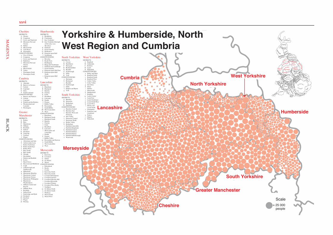
xxvi
013A c
032A e
034A c
036A c
040A c
050A d
058A c
074A d
078A e
082A d
097A d
105A e
106A d
123A e
124A e 130
A d
141A d
185A e
201A c
212A e
024B g
068B f
088B f
091B f
121B g
153B f
169B g
171B g
172B g
173B g
174B f
175B f
191B g
182B g
202B f
204B f
095C b1
006C r
016C u
018C t
026C r
031C q
027C r
041C u
049C t
030C q
066C r
067C t
056C r
023C u
062C q
047C t
100C s
099C s
108C q
004C r
102C s
107C q
096C b1
101C s
057C r
005C b1
137C q 025
C r
022C u
154C t
094C s
048C t
215C u
002D v
059D w
060D w
061D w
072D v
073D o
092D w
093D w
120D w
134D o
177D v 178
D v
179D o
180D o
183D o
189D v
192D v 193
D v
209D v 210
D w
017E x
037E x 054E x
055E x
111E x
114E m 115E m 116
E m
142E o
147E m 148E m
149E m
150E m
151E m
152E o
156E x
158E x
184E x
188E x
208E o
089F k
019F k
129F k
052F d1
051F d1
044F y
043F y 028
F y 029F y
162F y 132
F y
168F y
133F y
069F k
070F y 166
F k 165F k
167F k
139F d1
140F d1
198F d1
207F d1 035
G l 038G j
053G a1065
G h 063G h
064G h
075G a1087G h
090G a1
103G l
109G l
110G h
112G a1
113G a1
145G a1
160G l
161G j 176
G l 186G l
187G j
211G h
007H b
008H b
009H b
010H b
015H j
079H j
080H j 081
H j
083H b
084H b
086H z
085H z
125H z
126H z
127H z
143H z
155H b
194H z
195H z
003I a
033I a
039I a
042I a
046I i
071I b1
076I i 077
I i 098I i
104I a
144I b1
146I i
164I b1
170I i 190
I i 181I a
196I b1
199I b1
200I a
205I i
206I a
001J p
011J p
012J c1
014J n
020J d1
021J c1
045J p
118J n
117J n
119J n
122J n
128J c1
131J c1
135J n
136J n
138J p
157J c1
159J c1
163J p
197J c1
203J d1
213J c1
214J p
216J p
077A e
054A e
076A e
045A e
020A d
021A d
053A d
071A d
079A d
108A d
084A d
044A e
046A e
019A d
001B i
002B h 004
B g
005B j
006B i
014B j
016B f
022B f
024B h
027B k
028B j
029B k
031B i
032B k
037B i
038B j
040B k
041B i
043B h
051B f
061B j
066B g
073B f
081B h
082B k
093B g
091B h
092B g
100B f
102B g
103B i
106B j
110B g
009D m
012D m
015D m
035D n
042D n 048
D m
060D n
065D m
069D m
070D m
080D n
085D n
086D m
087D n 096
D n
097D n
107D n
109D m
003C l
010C l
013C c
018C l
023C b
030C b
033C l
039C b
047C c 052
C l
056C b
058C b
059C c
062C l
063C c
067C b
072C l
074C b
078C c
088C c
094C b 095
C c 104C c
007E p
008E a
011E a
017E p
025E p
026E a
034E p
036E a
049E p
050E q
055E o
057E o
064E o
068E o
075E a 083E q
089E q
090E o
098E q
099E a
101E q
105E o
003A a
007A a
017A b
024A a
029A b 031
A b 033A c
034A b
035A b 036
A c 048A c 049
A c
057A a 062
A a 066A c 068
A c
069A c
074A a
077A a
092A b 093
A b 094A c
001B f
004B e
005B f
008B e
010B f
011B f
012B e
025B e
028B d
039B d
044B f
050B e
056B d
072B d
073B d
076B d
079B d
082B f 085
B f
088B e
091B e
002C g
006C g
014C h
015C o
016C o
019C g
020C h
026C h
030C o
041C h
046C h 052
C h
053C g
054C g
067C h
070C o
071C o
081C g
084C o
086C h
087C g
090C o
009D m
013D i
018D j
021D l
022D k
023D k
027D n 032
D i
037D l
038D l
040D j
042D l
043D i
045D m
047D n 051
D m
055D k
058D i 059
D l
060D j
061D k 063D m
064D j 065
D m 075D k
080D j
078D n
083D n
089D n
006A v 016
A v
015A v
019A b
020A b
021A b
033A d
038A l
046A b
051A c
056A d
065A b
066A l
068A l
069A l
070A l
074A d 083
A c 089A c
092A v
097A v 098
A v
109A d
111A d
112A c
114A b
116A d
124A c
125A l
127A c
023B e
025B e
047B e 052
B e
058B e
067B i
075B e
077B i
082B i
085B i
090B e
095B e
103B i 099
B i 102B i
110B e
113B i
120B i
108C g
009C g 012
C g
003C k 004
C k
043C k
002C k
017C k 073
C k
050C f
041C f
011C a
010C a
008C a 034C a
018C a
013C a
035C f
036C f
044C g
059C f
060C f
042C g
045C g
001D u
005D q
007D h 014
D m
022D q
024D n
031D o
032D m
037D p
049D h
053D n
054D n
055D p
063D u
064D r
071D q
076D r
078D o
079D r
080D r
081D o
084D p
087D u
088D u
091D m
093D s
094D o
096D n
115D m
121D p
122D h
123D h
126D q
107E w 106
E w 118E w
117E w
027E t
029E t 028
E t
061E s
086E t
026E t 048
E j 057E j
062E w
072E t
030E s
104E s 105
E s
040E j
100E j 101
E j
119E w
039E j
016A d
018A a 024
A a 023A a
037A a
042A a
052A a
057A a
060A a
061A e
063A d
079A a
093A a
117A d
126A e
130A a
140A a
160A e
161A a
174A d
175A d
176A d
177A a
178A a
180A a 182A d
186A a
004B b
005B b
011B b 025
B b
030B b 044
B b 045B b 046
B b 047B b
053B b
092B b
105B b
121B b
122B b
132B b
157B b
158B b
159B b
001C c
003C c
012C c
014C c
031C c
043C c
048C c
058C c
078C c 084
C b
119C c
124C c
138C c
149C c 156
C c
165C c 166
C c
164C c
181C c
184C c
187C c
193C c
194C c
197C c 201
C c
202C c
032D e
036D e
073D e
080D e
106D e
107D e
128D e
137D e
142D e
151D e
152D e
154D e
167D e
171D e
185D e
190D e
192D e
200D e
009E f 028
E f
035E f 054
E j
026E f
010E f
039E f
081E f
007E f
071E f 040
E f
027E f
008E f
072E f
029E j
098E f
085E f
002F g
019F g 020
F g 021F g
056F h
059F g
068F h 069
F g
082F h
090F g
091F h
094F h
099F h
100F h
101F h
102F h
103F h 111
F g 112F g
113F g 114
F g 115F g 116
F g
120F h 125
F h 127F h 129
F g
141F h
145F g
146F g 147
F g
148F g
150F g
170F g
013G h
034G h
038G d 041
G h
050G d 055
G d 064G d
065G d
066G d
067G d
070G d
075G d
083G d
087G d 088
G d 089G d
097G d
109G h
015G d
118G h
123G d
131G h
134G d
135G d
136G d
155G h
162G h
163G h
172G d 173
G d
179G d
183G d
189G d
195G h 198
G h 199G h
006H j
017H i
022H j
033H i
049H i
051H i
062H i
074H j
076H j
077H j
086H j
095H i
096H i
104H j
108H i
110H j
133H i
139H j
143H i
144H i
153H i
168H j
169H j
188H j
191H i
196H i
001A f
008A d
015A f
016A d
023A f
031A f
035A f 040
A f 046A f
047A f
049A f
054A f
055A f
058A f 059
A f
068A f
095A f
110A d
116A f
118A f
121A f
143A f
144A f
145A f
133A f
136A f
139A d
146A f
149A d
158A d
160A d
161A d
162A f
164A d
009B a 032
B a
044B a
045B a
071B a
076B a
119B a
122B a
124B a
131B a
132B a
156B a
157B a
012C b
141C b 019
C b
018C b
067C b 042
C b 048C b
013C b
117C b
014C b
025C d
041C d
026C d
147C d
081C d
020C d
006C d
108C d
064C d
063C d
010D c
021D c
017D c
033D c
034D c
050D c
052D c
053D c
057D c 060
D c 061D c
066D c
070D c
073D c
075D c
077D c
079D c
082D c
111D c
112D c
114D c 115D c
120D c
142D c 134
D c
135D c
002E d
004E d
003E d
007E d
022E d
039E d
043E d
051E d 065
E d
069E d
074E d
097E e
098E d
099E d
102E d
103E d
105E d
107E d
123E e
126E d
127E d
128E d
129E d
130E e
138E e
140E d
150E d
159E d
005F e
011F e
024F e
027F e
028F e
030F e
029F e 036
F e 037F e
038F e
056F e
062F e
072F e
078F e
080F e
083F e
084F e 085
F e 086F e
087F e
088F e
089F e
090F e 091
F e 092F e
093F e
094F e
096F e
100F e 101
F e
104F e
106F a
109F e
113F e
125F a
137F e
148F e
151F a
152F a
153F a
154F a
155F a
163F e
165F e
166F e
167F e
168F e
005D a
031D a
039D a
041D b
085D a
086D a
107D a
110D a
111D a
121D a
122D a
123D a 124
D a
143D a
161D a 162D a
151D b
155D b
157D a
164D a
166D a
173D b
179D a
189D a
002A b
055A b
063A b
064A b
065A b
069A b
071A b
072A b
074A b 073
A b 075A b
082A b
089A b
090A b
093A b
103A b
118A b
120A b
131A b
132A b
153A b
168A b
043B d 044
B d
045B d
046B d
047B d
048B d
049B d
050B d
080B d
083B d
096B d
098B d
099B d
100B d
109B d
127B d
174B d
185B d
012C b
024C c
025C c
026C c
027C c
028C c
029C c
051C c
057C c 058
C c
068C b
097C c
115C c
117C b
126C c
141C b
146C c 160
C c 163C b
170C b
172C c
178C b
186C b
188C b
001E d
010E d
011E d
019E e
020E e
021E e
030E d
032E e
037E e
076E d
079E e
094E d
108E d
119E e
130E d
133E e
149E d
154E d
167E e
169E d
181E e
187E d
190E d
004F f
022F f
038F f
040F f
042F f
052F f
070F f
077F f
078F f 081
F f
095F f
114F f
134F f
140F f
148F f 156
F f
171F f
175F f
176F f
177F f
180F f
182F f
003G c 016G c
023G c
035G c
036G c
062G c
084G c
091G c
092G c
104G c
138G c
139G c
142G c 147
G c
150G c
152G c
158G c
165G c
183G c
184G c
009H h
015H h
018H i
008H i 059
H g
128H i
056H i
061H g
088H g
135H h
087H g
102H g
116H g
125H i
017H i
013H h
129H i
159H i
060H h
101H h
014H h
006I e
007I e
033I e
034I e
053I e
054I e
066I e 067
I e
105I e
106I e
112I e
113I e
136I e 137
I e
144I e
145I e
022A a 028
A a
044A a
045A a
060A a
105A m
113A a
130A a
154A a
188A m
194A a
197A a 207
A m
220A a
226A a
230A a
245A a
267A m 268
A m
291A a
294A m
004B c
008B b 031
B b
047B b
078B b
086B c
121B c
132B b
144B c 155
B c
163B b
175B b
189B c
203B b
214B b
257B c
266B c
269B b 275
B c 280B c
285B b
288B c
023C d
039C d
046C d
050C d
056C d
087C d
089C d
095C d
097C d
124C d
126C d
140C d
146C d
173C d
185C d
212C d
227C d
235C d
247C d
274C d 297
C d 302C d
001D e
009D e
010D e
041D e
067D e
071D e
072D e 073
D e 074D e
075D e
076D e
082D e
083D e
091D e
092D e
106D e
111D e
112D e
184D e
190D e
296D e
300D e
011E f
015E f 048
E f 065E f
085E f
110E f
115E f
122E f
123E f
149E f 168
E f
170E f
171E f
191E f
202E f
211E f 233
E f 260E f
261E f
248E f
265E f
290E f
007F g
024F g
026F g
066F g
077F g
080F g 103
F g
159F g
161F g
195F g
200F g
205F g
209F g
216F g 258
F g
262F g
256F g
003G i
012G i
033G i
049G h
058G i
059G h
061G h
109G h
138G i
141G i 150
G i 151G i
152G i
156G h
165G h
167G i
208G i
215G i
221G i
241G h 242
G h
246G i
251G h
252G h 253
G h
254G i 273
G i
279G i
287G i
025H j
034H j
037H j
040H j 088
H j
090H j
093H j
104H j
118H j
120H j
157H j
187H j
217H j 229
H j
255H j
281H j
284H j
289H j
293H j
014I k
018I k
043I k
054I l
064I k
096I k
119I k
052I l
162I k
013I k
053I k
063I k
224I l
134I f
223I k
019I k
232I k
135I l
196I k
002J l
006J l
029J l
032J l 036
J l
069J l
070J l
079J l
100J l
108J l
127J l 128
J l
136J l
192J l
228J l
231J l
234J l
238J l
259J l
282J l
292J l
298J l
299J l
094K m
107K m
114K m
131K m
133K m
143K m
145K m 147
K m
164K m
182K m
263K m 295
K m 301K m
005L n
068L n
116L n
158L n
160L n
169L n
181L n
180L n
186L n
193L n
225L n
117L n
176L n
177L n
178L n
283L n
179L n
239L n
244L n
021L n
081L n
183L n
016M o
017M o
027M o
030M o
051M o
098M o
099M o
101M o
137M o
148M o
172M o
174M o
198M o
201M o
206M o
210M e
237M o
240M o 243
M o
249M o
250M o 270
M o
271M o
276M o
277M o
303M e
020N p
035N p
038N p
042N h
055N h
057N p
062N h 084
N p
102N h
125N h
129N h
139N p
142N p
153N p
166N p
199N p
204N p
213N p 218
N p
219N h
222N p 236
N p
264N p
272N p
278N p
286N p
304N h
002A f
022A f
031A f
039A f
049A f
056A f
072A f
085A f
086A f
089A f
098A f
110A f
147A f
152A f
171A f
176A f
177A f
178A f
180A f
179A f
181A f
195A f
208A f
213A f
012B b
021B b
036B b
037B b
041B b
057B b
058B c
066B c
090B b
099B c
104B b
108B c
117B b
116B b
131B b
138B b
139B b
140B b
145B b
161B b
160B b
162B b 174
B c 183B b
189B c 191
B b 196B b
200B b
201B b
202B b
203B b 205
B c
206B b
217B b
023C a
064C a
067C a
088C a
095C a
094C a
188C a 087
C a
212C a
159C f
158C f
114C a
125C f
003C f
026C f
027C a
034C f
051C a
050C a
207C a
133C a
146C f
136C f
112C f
080C f
028C f
121C f
079C f
081C f
124C a
184C a
004C f
215C f
014D b
015D b
018D b
032D b 044
D b 054D b
059D b
091D b
096D b
105D b
111D b 118
D b
120D b
122D b 128
D b 151D b 154
D b 155D b
156D b
185D b
186D b
164D b
165D b
187D b
197D b
209D b
123E c
142E c
149E c
175E c
150E c
097E c 109
E c 192E c
173E c
190E c
144E e
143E e
134E c
052E c
008E c 010
E c 009E c 061
E c 113E c
107E c
007E c
006E c 005E c
069E c 157
E c
024E c
025E c
060E c
070E c 148
E c
016F d
043F d
046F d
047F d
062F d
063F d
068F d
074F d
076F d
077F c
084F d
101F c
119F d
126F d
132F d
135F d
141F d 163
F d
166F d
193F d
211F d
219F d
011G e
013G e
017G e
019G e
030G e
035G e
038G e 040
G e
042G e
045G e
048G e
055G e
065G e
071G e
073G e
075G e
083G e
093G e
100G e
102G e
129G e
137G e
153G e 167G e 168
G e 169G e 170G e
172G e
182G e
194G e
198G e
199G e
204G e
216G e
218G e
001H g
020H g
029H g
033H g
053H g
078H g
082H g
092H g
103H g
106H g
115H g
127H g
130H g
210H g
214H g
Yorkshire & Humberside, NorthWest Region and Cumbria
CheshireDISTRICTS
A ChesterB CongletonC Crewe and NantwichD Ellesmere Port and
NestonE HaltonF MacclesfieldG Vale RoyalH Warrington
CONSTITUENCIESa City of Chesterb Congletonc Crewe and Nantwichd Eddisburye Ellesmere Port and
Nestonf Haltong Macclesfieldh Tattoni Warrington Northj Warrington South
CumbriaDISTRICTS
A AllerdaleB Barrow-in-FurnessC CarlisleD CopelandE EdenF South Lakeland
CONSTITUENCIESa Barrow and Furnessb Carlislec Copelandd Penrith and the Borderse Westmorland and
Lonsdalef Workington
GreaterManchesterDISTRICTS
A BoltonB BuryC ManchesterD OldhamE RochdaleF SalfordG StockportH TamesideI TraffordJ Wigan
CONSTITUENCIESa Altrincham and Saleb Ashton-under-Lynec Bolton North Eastd Bolton South Easte Bolton Westf Bury Northg Bury Southh Cheadlei Davyhulmej Denton and Reddishk Ecclesl Hazel Grove
m Heywood and Middletonn Leigho Littleborough and
Saddleworthp Makerfieldq Manchester Blackleyr Manchester Centrals Manchester Gortont Manchester Withingtonu Manchester
Wythenshawev Oldham Central and
Roytonw Oldham Westx Rochdaley Salford Eastz Stalybridge and Hyde
a1 Stockportb1 Stretfordc1 Wigand1 Worsley
HumbersideDISTRICTS
A BoothferryB CleethorpesC East YorkshireD East Yorkshire Borough
of Beverley (wasBeverley)
E GlanfordF Great GrimsbyG HoldernessH Kingston upon HullI Scunthorpe
CONSTITUENCIESa Beverleyb Booth Ferryc Bridlingtond Brigg and Cleethorpese Glanford and Scunthorpef Great Grimsbyg Kingston-upon-Hull Easth Kingston-upon-Hull
Northi Kingston-upon-Hull
West
LancashireDISTRICTS
A BlackburnB BlackpoolC BurnleyD ChorleyE FyldeF HyndburnG LancasterH PendleI PrestonJ Ribble Valley
K RossendaleL South Ribble
M West LancashireN Wyre
CONSTITUENCIESa Blackburnb Blackpool Northc Blackpool Southd Burnleye Chorleyf Fyldeg Hyndburnh Lancasteri Morecambe and
Lunesdalej Pendlek Prestonl Ribble Valley
m Rossendale and Darwenn South Ribbleo West Lancashirep Wyre
MerseysideDISTRICTS
A KnowsleyB LiverpoolC SeftonD St. HelensE Wirral
CONSTITUENCIESa Birkenheadb Bootlec Crosbyd Knowsley Northe Knowsley Southf Liverpool Broadgreeng Liverpool Garstonh Liverpool Mossley Hilli Liverpool Riversidej Liverpool Waltonk Liverpool West Derbyl Southport
m St. Helens Northn St. Helens Southo Wallaseyp Wirral Southq Wirral West
North YorkshireDISTRICTS
A CravenB HambletonC HarrogateD RichmondshireE RyedaleF ScarboroughG SelbyH York
CONSTITUENCIESa Harrogateb Richmondc Ryedaled Scarboroughe Selbyf Skipton and Ripong York
South YorkshireDISTRICTS
A BarnsleyB DoncasterC RotherhamD Sheffield
CONSTITUENCIESa Barnsley Centralb Barnsley Eastc Barnsley West and
Penistoned Don Valleye Doncaster Centralf Doncaster Northg Rother Valleyh Rotherhami Sheffield Attercliffej Sheffield Brightsidek Sheffield Centrall Sheffield Hallam
m Sheffield Heeleyn Sheffield Hillsborougho Wentworth
West YorkshireDISTRICTS
A BradfordB CalderdaleC KirkleesD LeedsE Wakefield
CONSTITUENCIESa Batley and Spenb Bradford Northc Bradford Southd Bradford Weste Calder Valleyf Colne Valleyg Dewsburyh Elmeti Halifaxj Hemsworthk Huddersfieldl Keighley
m Leeds Centraln Leeds Easto Leeds North Eastp Leeds North Westq Leeds Westr Morley and
Leeds Souths Normantont Pontefract and
Castlefordu Pudseyv Shipleyw Wakefield
Isle of
Ham
pshire WestSussex
East Sussex
Surrey
G r e a t e r
L o n d o n
Berk-shire
Wiltshire
Wight
Dorset
KentSomerset
Devon
Cornwall
Avon
GwentSouth
GlamorganM
idWest
Buck
ingh
amsh
ire
Oxf
ord-
shireGloucester-
shire
Hereford &WorcesterWarwick
shireW e s t
M i d l a n d s
Powys
Dyfed
Gwynedd Clwyd
Staffordshire
Shro
ps
hire
Hertfords
hire
Bed
for
dshir
e
Essex
Suffolk
NorfolkshireCambridge-
North
am
ptonshire
Leicestershire
Nottingham-
shire
Derbyshire Lincoln-shire
ClevelandDurham
Nor
thum
ber-land
Tyne & Wear
Borders
Dumfries &
GallowayStrathclyde
Lothian
Central Fife
Tayside
Grampian
Highlands
Cheshire
YorkshireSouth
HumbersideGreaterManchester
WestYorkshireLancashire
Mersey-side
North YorkshireCu
mbria
= 25 000people
Scale
Humberside
Cumbria
Lancashire
Merseyside
Cheshire
West YorkshireNorth Yorkshire
Greater Manchester
South Yorkshire
BLA
CK
xxvi
Cheshire
Cumbria
GreaterManchester
Humberside
Lancashire
Merseyside
North Yorkshire
South Yorkshire
West Yorkshire
Cheshire
YorkshireSouth
HumbersideGreaterManchester
WestYorkshireLancashire
Mersey-side
North YorkshireCu
mbria
Humberside
Cumbria
Lancashire
Merseyside
Cheshire
West YorkshireNorth Yorkshire
Greater Manchester
South Yorkshire
MA
GEN
TA

xxvii
Cheshire001 C c Acton: 1443002 F g Alderley Edge: 4482003 C c Alexandra: 4916004 B b Alsager East: 4925005 B b Alsager West: 6987006 H j Appleton and Stretton: 8888007 E f Appleton 5%; Farnworth 12%;
Halton: 7860008 E f Appleton 7%;
Kingsway 90%: 6405009 E f Appleton 79%;
Kingsway 2%: 5291010 E f Appleton 8%; Farnworth 88%;
Hough Green 15%: 8825011 B b Astbury: 1380012 C c Audlem: 2274013 G h Barnton: 5802014 C c Barony Weaver: 4650015 G d Barrow 11%; Mara: 1968016 A d Barrow 89%: 4132017 H i Bewsey: 5062018 A a Blacon Hall: 6465019 F g Bollington Central: 1892020 F g Bollington East: 2575021 F g Bollington West: 2573022 H j Booths Hill: 2729023 A a Boughton Heath: 5823024 A a Boughton: 3218025 B b Brereton: 1613026 E f Broadheath 10%; Ditton 81%;
Riverside 11%: 6412027 E f Broadheath 15%; Ditton 19%;
Hough Green 47%: 5899028 E f Broadheath 75%; Hough
Green 38%; Riverside 16%: 9157029 E j Brookfields; Castlefields 5%;
Clough 17%; Daresbury 19%;Murdishaw; Norton: 23937
030 B b Buglawton: 3702031 C c Bunbury: 2023032 D e Burton and Ness: 2935033 H i Burtonwood: 10042034 G h Castle: 6331035 E f Castlefields 95%; Halton
Brook 8%: 7605036 D e Central: 4689037 A a Christleton: 4635038 G d Church: 2232039 E f Clough 16%; Grange 68%: 5925040 E f Clough 67%; Heath 61%: 8175041 G h Cogshall: 2118042 A a College: 5014043 C c Combermere: 1871044 B b Congleton Central: 3092045 B b Congleton North: 5306046 B b Congleton South: 6032047 B b Congleton West: 7109048 C c Coppenhall: 7265049 H i Croft: 15120050 G d Cuddington and Marton: 6434051 H i Culcheth and Glazebury: 7215052 A a Curzon: 3799053 B b Dane: 4369054 E j Daresbury 81%: 1274055 G d Davenham and Moulton: 5507056 F h Dean Row: 5183057 A a Dee Point: 6070058 C c Delamere: 3689059 F g Disley: 4590060 A a Dodleston: 2037061 A e Elton: 6122062 H i Fairfield: 7636063 A d Farndon: 2113064 G d Forest: 1626065 G d Frodsham East: 3282066 G d Frodsham North West: 3532067 G d Frodsham South: 2089068 F h Fulshaw: 5110069 F g Gawsworth: 2421070 G d Gorst Wood: 4372071 E f Grange 10%; Halton
Brook 84%: 7550072 E f Grange 22%; Halton Brook 7%;
Heath 3%; Mersey 53%: 6031073 D e Grange: 5056074 H j Grappenhall and Thelwall: 8778075 G d Gravel: 3728076 H j Great Sankey North: 10406077 H j Great Sankey South: 9369078 C c Grosvenor: 4630079 A a Grosvenor: 5117080 D e Groves: 7666081 E f Hale: 2012082 F h Handforth: 6343083 G d Hartford: 4605084 C b Haslington: 6143085 E f Heath 36%; Mersey 47%: 5487086 H j Heatley: 2902087 G d Helsby Central: 1554088 G d Helsby North: 1693089 G d Helsby South and Alvanley: 1761090 F g Henbury: 2104091 F h High Legh: 2740092 B b Holmes Chapel: 5465093 A a Hoole: 5403094 F h Hough: 3436095 H i Howley: 4637096 H i Hulme: 6938097 G d Kingsley: 2035098 E f Kingsway 9%;
Riverside 73%: 5871099 F h Knutsford Nether: 2243100 F h Knutsford Over: 4385101 F h Knutsford South: 4731102 F h Knutsford West: 1993103 F h Lacey Green: 4619104 H j Latchford: 7004105 B b Lawton: 3248106 D e Ledsham: 6577107 D e Little Neston: 3405108 H i Longford: 4855109 G h Lostock Gralam: 2338110 H j Lymm: 2583111 F g Macclesfield Central: 8687112 F g Macclesfield East: 7167113 F g Macclesfield North East: 8279114 F g Macclesfield North West: 10241115 F g Macclesfield South: 7305116 F g Macclesfield West: 7345117 A d Malpas: 3684118 G h Marston and Wincham: 2672119 C c Maw Green: 5453120 F h Mere: 1711121 B b Middlewich Cledford: 3630122 B b Middlewich Kinderton: 6470123 G d Milton: 1060124 C c Minshull: 3913125 F h Mobberley: 2697126 A e Mollington: 2740127 F h Morley and Styal: 5054128 D e Neston: 3960129 F g Nether Alderley: 3205130 A a Newton: 5007131 G h Northwich: 4243132 B b Odd Rode: 5358133 H i Orford: 7623
134 G d Oulton: 1918135 G d Over One: 3802136 G d Over Two: 5449137 D e Parkgate: 3789138 C c Peckforton: 1508139 H j Penketh and Cuerdley: 9115140 A a Plas Newton: 4482141 F h Plumley: 2374142 D e Pooltown: 3629143 H i Poulton-with-Fearnhead
North: 11730144 H i Poulton-with-Fearnhead
South: 5605145 F g Poynton Central: 7264146 F g Poynton East: 2359147 F g Poynton West: 5508148 F g Prestbury: 5272149 C c Queens Park: 5276150 F g Rainow: 2723151 D e Rivacre: 4711152 D e Riverside: 2408153 H i Rixton and Woolston: 9555154 D e Rossmore: 5828155 G h Rudheath and Whatcroft: 3572156 C c Ruskin Park: 5064157 B b Sandbach East: 5055158 B b Sandbach North: 6092159 B b Sandbach West: 4692160 A e Saughall: 3729161 A a Sealand: 4643162 G h Seven Oaks: 1601163 G h Shakerley: 1729164 C c Shavington: 6835165 C c St Barnabas: 5110166 C c St Johns: 4270167 D e Stanlow: 3719168 H j Statham: 1941169 H j Stockton Heath and Walton: 7705170 F g Sutton: 2979171 D e Sutton: 6723172 G d Swanlow: 4134173 G d Tarporley: 2308174 A d Tarvin: 4105175 A d Tattenhall: 3263176 A d Tilston: 1690177 A a Upton Grange: 3710178 A a Upton Heath: 5162179 G d Vale Royal: 6715180 A a Vicars Cross: 5235181 C c Waldron: 5650182 A d Waverton: 1750183 G d Weaver: 946184 C c Wellington: 3758185 D e Westminster: 3765186 A a Westminster: 6310187 C c Weston Park: 1749188 H j Westy: 7554189 G d Wharton: 3707190 D e Whitby: 5315191 H i Whitecross: 4429192 D e Willaston and Thornton: 3848193 C c Willaston East: 2692194 C c Willaston West: 3287195 G h Winnington: 1410196 H i Winwick: 3264197 C c Wistaston: 4622198 G h Witton North: 3010199 G h Witton South: 3322200 D e Wolverham: 2850201 C c Wrenbury: 1906202 C c Wybunbury: 3167
Cumbria001 A f All Saints: 4135002 E d Alston Moor: 2065003 E d Appleby Bongate: 1213004 E d Appleby: 1357005 F e Arnside: 2216006 C d Arthuret: 3021007 E d Askham: 932008 A d Aspatria: 2740009 B a Barrow Island: 3518010 D c Beckermet: 3040011 F e Beetham: 1692012 C b Belah; Stanwix Urban 18%: 8162013 C b Belle Vue 22%; Denton
Holme 9%; Trinity 92%: 6543014 C b Belle Vue 78%;
Yewdale 60%: 8918015 A f Binsey: 1816016 A d Boltons: 1961017 D c Bootle: 1498018 C b Botcherby 43%;
Harraby 73%: 6856019 C b Botcherby 57%; St
Aidans 52%: 6212020 C d Brampton: 3957021 D c Bransty: 4088022 E d Brough: 1199023 A f Broughton: 1569024 F e Broughton: 2348025 C d Burgh 40%; Dalston: 3279026 C d Burgh 60%; Stanwix
Rural 9%: 1820027 F e Burneside: 1934028 F e Burton and Holme: 2402029 F e Cartmel Fell: 1524030 F e Cartmel: 1820031 A f Castle: 3567032 B a Central: 5518033 D c Cleator Moor North: 4630034 D c Cleator Moor South: 3036035 A f Clifton: 1669036 F e Colton and Haverthwaite: 1620037 F e Coniston: 1304038 F e Crake Valley: 1543039 E d Crosby Ravensworth: 1202040 A f Crummock: 1247041 C d Currock 9%; St Cuthbert without;
Upperby 9%: 3036042 C b Currock 91%; St Aidans 6%;
Stanwix Urban 4%: 5805043 E d Dacre: 1175044 B a Dalton North: 5849045 B a Dalton South: 5850046 A f Dalton: 1740047 A f Dearham: 1929048 C b Denton Holme 91%;
Trinity 8%: 5633049 A f Derwent Valley: 1969050 D c Distington: 2600051 E d Eamont: 1351052 D c Egremont North: 4441053 D c Egremont South: 3270054 A f Ellen: 1933055 A f Ellenborough: 3865056 F e Endmoor: 2527057 D c Ennerdale: 1952058 A f Ewanrigg: 2941059 A f Flimby: 1775060 D c Frizington: 2472061 D c Gosforth: 1568062 F e Grange: 3867063 C d Great Corby and Geltsdale 39%;
Hayton: 2953
064 C d Great Corby and Geltsdale 61%;Wetheral: 5042
065 E d Greystoke: 1442066 D c Harbour: 3438067 C b Harraby 27%;
Upperby 91%: 6895068 A f Harrington: 2884069 E d Hartside: 1035070 D c Haverigg: 1030071 B a Hawcoat: 5490072 F e Hawkshead: 1229073 D c Hensingham: 3845074 E d Hesket: 2405075 D c Hillcrest: 3741076 B a Hindpool: 5827077 D c Holborn Hill: 2679078 F e Holker: 1701079 D c Howgate: 3088080 F e Hutton: 1286081 C d Irthing: 1975082 D c Kells: 2631083 F e Kendal Castle: 2285084 F e Kendal Far Cross: 1870085 F e Kendal Fell: 1832086 F e Kendal Glebelands: 2390087 F e Kendal Heron Hill: 2347088 F e Kendal Highgate: 2153089 F e Kendal Mintsfeet: 1779090 F e Kendal Nether: 2261091 F e Kendal Oxenholme: 2288092 F e Kendal Stonecross: 2133093 F e Kendal Strickland: 1797094 F e Kendal Underley: 1650095 A f Keswick: 4836096 F e Kirkby Lonsdale: 2076097 E e Kirkby Stephen: 2209098 E d Kirkby Thore: 1269099 E d Kirkoswald: 1281100 F e Lakes Ambleside: 3353101 F e Lakes Grasmere: 1650102 E d Langwathby: 1354103 E d Lazonby: 1187104 F e Levens: 1745105 E d Long Marton: 907106 F a Low Furness: 2716107 E d Lowther: 1485108 C d Lyne; Stanwix Rural 13%: 2852109 F e Lyth Valley: 1492110 A d Marsh: 2183111 D c Melthwaite: 1477112 D c Millom without: 1401113 F e Milnthorpe: 2573114 D c Mirehouse East: 2431115 D c Mirehouse West: 2796116 A f Moorclose: 4254117 C b Morton; Yewdale 40%: 7358118 A f Netherhall: 2991119 B a Newbarns: 5800120 D c Newtown: 3776121 A f Northside: 1253122 B a Ormsgill: 6902123 E e Orton with Tebay: 1242124 B a Parkside: 5483125 F a Pennington: 1823126 E d Penrith East: 4836127 E d Penrith North: 4120128 E d Penrith South: 2365129 E d Penrith West: 2009130 E e Ravenstonedale: 886131 B a Risedale: 5336132 B a Roosecote: 5968133 A f Salterbeck: 3202134 D c Sandwith: 2945135 D c Seascale: 1766136 A f Seaton Moor: 5764137 F e Sedbergh: 3088138 E e Shap: 1294139 A d Silloth: 2942140 E d Skelton: 1376141 C b St Aidans 42%; Stanwix
Urban 71%: 6111142 D c St Bees: 1655143 A f St Bridget's: 2124144 A f St John's: 4419145 A f St Michael's: 4346146 A f Stainburn: 2775147 C d Stanwix Rural 78%; Stanwix
Urban 7%: 4134148 F e Staveley-in-Westmorland: 1630149 A d Tarns: 1800150 E d Ullswater: 1199151 F a Ulverston Central: 1580152 F a Ulverston East: 1667153 F a Ulverston North: 1709154 F a Ulverston South: 3936155 F a Ulverston West: 2974156 B a Walney North: 5420157 B a Walney South: 6161158 A d Wampool: 2197159 E d Warcop: 1186160 A d Warnell: 1798161 A d Waver: 1966162 A f Westfield: 3805163 F e Whinfell: 1155164 A d Wigton: 5306165 F e Windermere Applethwaite: 1507166 F e Windermere Bowness
North: 2225167 F e Windermere Bowness
South: 1908168 F e Windermere Town: 2292
GreaterManchester
001 J p Abram: 13302002 D v Alexandra: 11351003 I a Altrincham: 10356004 C r Ardwick 1%; Central 1%;
Hulme 82%: 6422005 C b1 Ardwick 2%; Hulme 18%; Moss
Side 39%: 6731006 C r Ardwick 97%;
Longsight 11%: 11124007 H b Ashton Hurst: 12909008 H b Ashton St Michael's: 10814009 H b Ashton St Peters': 10593010 H b Ashton Waterloo: 10068011 J p Ashton-Golborne: 12785012 J c1 Aspull-Standish: 13435013 A c Astley Bridge: 13624014 J n Atherton: 11996015 H j Audenshaw: 13173016 C u Baguley; Brooklands 37%: 16712017 E x Balderstone: 9681018 C t Barlow Moor: 12560019 F k Barton: 9983020 J d1 Bedford-Astley: 12709021 J c1 Beech Hill: 11391022 C u Benchill 46%; Northenden 48%;
Sharston 26%: 14950023 C u Benchill 54%;
Sharston 74%: 15717024 B g Besses: 9131
025 C r Beswick and Clayton 22%;Lightbowne 3%; NewtonHeath 93%: 14857
026 C r Beswick and Clayton 26%;Bradford 20%; Central 17%: 6976
027 C r Beswick and Clayton 51%;Bradford 80%: 15345
028 F y Blackfriars 34%; Broughton 36%;Kersal 6%: 6881
029 F y Blackfriars 66%;Langworthy 4%: 5467
030 C q Blackley 4%;Charlestown 82%: 10722
031 C q Blackley 96%;Crumpsall 7%: 12259
032 A e Blackrod: 12415033 I a Bowdon: 11034034 A c Bradshaw: 13603035 G l Bredbury: 14753036 A c Breightmet: 14987037 E x Brimrod and Deeplish: 8739038 G j Brinnington: 10748039 I a Broadheath: 11409040 A c Bromley Cross: 13346041 C u Brooklands 63%;
Northenden 52%: 14291042 I a Brooklands: 10086043 F y Broughton 57%;
Kersal 11%: 6960044 F y Broughton 8%;
Kersal 83%: 10485045 J p Bryn: 12617046 I i Bucklow: 9109047 C t Burnage 14%; Didsbury: 15314048 C t Burnage 21%; Old Moat 9%;
Withington 83%: 14273049 C t Burnage 65%; Levenshulme 20%;
Withington 17%: 13787050 A d Burnden: 12800051 F d1 Cadishead 23%;
Irlam 96%: 11608052 F d1 Cadishead 77%: 6962053 G a1 Cale Green: 11453054 E x Castleton: 9720055 E x Central and Falinge: 10783056 C r Central 21%;
Cheetham 22%: 5001057 C r Central 60%;
Harpurhey 11%: 6691058 A c Central: 11005059 D w Chadderton Central: 11289060 D w Chadderton North: 10216061 D w Chadderton South: 10562062 C q Charlestown 18%;
Crumpsall 93%;Harpurhey 11%: 14780
063 G h Cheadle Hulme North: 14862064 G h Cheadle Hulme South: 14362065 G h Cheadle: 12203066 C r Cheetham 78%;
Harpurhey 3%: 11325067 C t Chorlton: 13680068 B f Church: 10667069 F k Claremont 12%; Weaste and
Seedley 66%: 8159070 F y Claremont 88%: 11603071 I b1 Clifford: 10746072 D v Coldhurst: 11684073 D o Crompton: 10784074 A d Daubhill: 11345075 G a1 Davenport: 12292076 I i Davyhulme East: 9607077 I i Davyhulme West: 10141078 A e Deane-cum-Heaton: 16966079 H j Denton North East: 12866080 H j Denton South: 11244081 H j Denton West: 11703082 A d Derby: 13103083 H b Droylsden East: 11974084 H b Droylsden West: 10692085 H z Dukinfield Stalybridge: 10310086 H z Dukinfield: 12298087 G h East Bramhall: 16564088 B f East: 10430089 F k Eccles: 11738090 G a1 Edgeley: 12725091 B f Elton: 12354092 D w Failsworth East: 10583093 D w Failsworth West: 10416094 C s Fallowfield 18%;
Levenshulme 7%;Rusholme: 13245
095 C b1 Fallowfield 31%; WhalleyRange: 15851
096 C b1 Fallowfield 52%; MossSide 58%: 13099
097 A d Farnworth: 12481098 I i Flixton: 9714099 C s Gorton North 20%; Gorton
South 51%: 9418100 C s Gorton North 80%: 11126101 C s Gorton South 4%;
Longsight 82%: 12715102 C s Gorton South 45%;
Levenshulme 73%;Longsight 7%: 16634
103 G l Great Moor: 13802104 I a Hale: 10737105 A e Halliwell: 12456106 A d Harper Green: 13749107 C q Harpurhey 20%;
Lightbowne 82%: 13264108 C q Harpurhey 55%; Newton
Heath 7%: 7350109 G l Hazel Grove: 15792110 G h Heald Green: 13055111 E x Healey: 11768112 G a1 Heaton Mersey: 15051113 G a1 Heaton Moor: 12373114 E m Heywood North: 9517115 E m Heywood South: 11086116 E m Heywood West: 9680117 J n Hindley Green: 15185118 J n Hindley: 12267119 J n Hindsford: 14018120 D w Hollinwood: 10062121 B g Holyrood: 10634122 J n Hope Carr: 12684123 A e Horwich: 14458124 A e Hulton Park: 14921125 H z Hyde Godley: 11286126 H z Hyde Newton: 12196127 H z Hyde Werneth: 11334128 J c1 Ince: 10171129 F k Irlam 4%; Winton: 12894130 A d Kearsley: 12692131 J c1 Langtree: 14499132 F y Langworthy 23%; Ordsall 20%;
Pendleton 9%; Weaste andSeedley 5%: 5247
133 F y Langworthy 73%;Pendleton 13%; Weaste andSeedley 29%: 12004
134 D o Lees: 10017135 J n Leigh Central: 12010136 J n Leigh East: 13002137 C q Lightbowne 15%; Moston: 14836138 J p Lightshaw: 13922
139 F d1 Little Hulton 15%; WalkdenNorth 73%; WalkdenSouth 29%: 13867
140 F d1 Little Hulton 85%: 9851141 A d Little Lever: 12113142 E o Littleborough: 11693143 H z Longdendale: 10580144 I b1 Longford: 9726145 G a1 Manor: 11981146 I i Mersey St Mary's: 11965147 E m Middleton Central: 8690148 E m Middleton East: 8457149 E m Middleton North: 11709150 E m Middleton South: 10050151 E m Middleton West: 6823152 E o Milnrow: 11304153 B f Moorside: 10796154 C t Moss Side 3%; Old
Moat 91%: 12421155 H b Mossley: 10091156 E x Newbold: 10502157 J c1 Newtown: 11953158 E x Norden and Bamford: 12125159 J c1 Norley: 10223160 G l North Marple: 12008161 G j North Reddish: 15763162 F y Ordsall 80%: 5676163 J p Orrell: 12182164 I b1 Park: 7673165 F k Pendlebury 28%; Swinton
North 86%; SwintonSouth 9%: 15486
166 F k Pendlebury 3%; SwintonSouth 79%; Worsley andBoothstown 21%: 13291
167 F k Pendlebury 69%; SwintonSouth 12%: 11141
168 F y Pendleton 78%: 7728169 B g Pilkington Park: 9933170 I i Priory: 9458171 B g Radcliffe Central: 10709172 B g Radcliffe North: 12846173 B g Radcliffe South: 10050174 B f Ramsbottom: 13743175 B f Redvales: 11094176 G l Romiley: 14187177 D v Royton North: 11101178 D v Royton South: 9740179 D o Saddleworth East: 12477180 D o Saddleworth West: 10794181 I a Sale Moor: 9755182 B g Sedgley: 10395183 D o Shaw: 10309184 E x Smallbridge and
Wardleworth: 13208185 A e Smithills: 11008186 G l South Marple: 12132187 G j South Reddish: 13571188 E x Spotland: 7913189 D v St James: 8586190 I i St Martin's: 11710191 B g St Mary's: 12018192 D v St Marys: 12317193 D v St Pauls: 10380194 H z Stalybridge North: 11162195 H z Stalybridge South: 11138196 I b1 Stretford: 10039197 J c1 Swinley: 10848198 F d1 Swinton North 14%; Walkden
North 25%; Walkden South 33%;Worsley andBoothstown 19%: 11086
199 I b1 Talbot: 8521200 I a Timperley: 11102201 A c Tonge: 10898202 B f Tottington: 12363203 J d1 Tyldesley East: 15526204 B f Unsworth: 9597205 I i Urmston: 9590206 I a Village: 10253207 F d1 Walkden North 3%; Walkden
South 38%; Worsley andBoothstown 60%: 12346
208 E o Wardle: 8716209 D v Waterhead: 12387210 D w Werneth: 11476211 G h West Bramhall: 14718212 A e Westhoughton: 10614213 J c1 Whelley: 11095214 J p Winstanley: 15575215 C u Woodhouse Park: 11385216 J p Worsley Mesnes: 13126
Humberside001 E d Abbey: 3704002 A b Airmyn and Rawcliffe: 2777003 G c Aldbrough: 1793004 F f Alexandra: 3791005 D a Anlaby: 5718006 I e Ashby Grange East: 3022007 I e Ashby Grange West: 4411008 H i Avenue 17%; Beverley 17%;
Myton 43%: 8951009 H h Avenue 83%;
Newland 10%: 11428010 E d Barton-upon-Humber
Bridge: 4775011 E d Barton-upon-Humber Park: 4647012 C b Battleburn: 2182013 H h Beverley 2%;
Newland 90%: 10861014 H h Beverley 3%; Orchard Park 10%;
University 88%: 12315015 H h Beverley 77%; Orchard Park 7%;
University 8%: 11988016 G c Bilton: 2739017 H i Boothferry 7%;
Newington 74%: 10775018 H i Boothferry 93%;
Derringham 14%;Newington 4%: 13555
019 E e Bottesford Central: 3885020 E e Bottesford East: 4232021 E e Bottesford West: 3585022 F f Bradley: 4245023 G c Brandesburton: 1835024 C c Bridlington Bessingby: 5213025 C c Bridlington Hilderthorpe: 5173026 C c Bridlington Old Town East: 4659027 C c Bridlington Old Town
West: 6231028 C c Bridlington Quay North: 5432029 C c Bridlington Quay South: 5455030 E d Brigg: 5322031 D a Brough: 6975032 E e Broughton: 4448033 I e Brumby East: 3673034 I e Brumby West: 5368035 G c Burstwick: 1348036 G c Burton Pidsea: 1474037 E e Burton-upon-Stather: 2719038 F f Carnforth: 4285039 D a Castle: 4488040 F f Central: 3722041 D b Cherry Holme: 2209042 F f Clee: 3756
043 B d Cleethorpes Alexandra: 4713044 B d Cleethorpes Beacon Hill: 3804045 B d Cleethorpes Central: 4711046 B d Cleethorpes Middlethorpe: 3077047 B d Cleethorpes North: 4829048 B d Cleethorpes Riverside: 5150049 B d Cleethorpes Sidney: 3632050 B d Cleethorpes Thrunscoe: 4806051 C c Coastal: 1530052 F f Cromwell: 4341053 I e Crosby Town North: 3968054 I e Crosby Town South: 3693055 A b Crowle: 3699056 H i Derringham 86%: 10901057 C c Driffield North: 5837058 C c Driffield South: 4225059 H g Drypool 19%; Holderness 52%;
Ings 4%; Noddle Hill 23%;Sutton 39%: 19518
060 H h Drypool 7%; Holderness 7%;Stoneferry; Sutton 3%: 17553
061 H g Drypool 74%;Southcoates 3%: 10248
062 G c Easington: 1370063 A b East Derwent: 1959064 A b East Howdenshire: 1983065 A b Epworth and Belton: 5908066 I e Frodingham North: 4664067 I e Frodingham South: 2500068 C b Garrowby: 2148069 A b Gilberdyke: 2933070 F f Gilbey: 4066071 A b Goole Central and South: 3201072 A b Goole East: 3507073 A b Goole North-East: 3017074 A b Goole North: 5308075 A b Goole West: 3251076 E d Goxhill: 1796077 F f Grant Thorold: 4198078 F f Great Coates: 6037079 E e Gunness: 3441080 B d Habrough and
Stallingborough: 1595081 F f Hainton: 4296082 A b Haxey: 4453083 B d Healing: 1979084 G c Hedon: 6066085 D a Hessle East: 6646086 D a Hessle West: 7172087 H g Holderness 34%; Ings 46%;
Southcoates 21%: 12605088 H g Holderness 7%; Longhill 4%;
Marfleet 93%: 12317089 A b Holme-upon-Spalding
Moor: 3006090 A b Hook: 1126091 G c Hornsea North: 5512092 G c Hornsea South: 2422093 A b Howden: 4213094 E d Humber: 2024095 F f Humber: 3916096 B d Humberston: 5514097 C c Hutton Cranswick: 2220098 B d Immingham Bluestone: 2521099 B d Immingham Central: 3352100 B d Immingham Humber: 5265101 H h Ings 24%; Noddle Hill 77%;
Sutton 59%: 24212102 H g Ings 26%; Longhill 96%: 13901103 A b Keadby with Althorpe: 1733104 G c Keyingham: 3106105 I e Kingsway East: 2846106 I e Kingsway West: 4362107 D a Kirk Ella: 5736108 E d Kirton: 2897109 B d Laceby: 2922110 D a Leconfield: 2336111 D a Leven: 2036112 I e Lincoln Gardens East: 2815113 I e Lincoln Gardens West: 4022114 F f Little Coates: 4230115 C c Lowland: 2016116 H g Marfleet 7%;
Southcoates 75%: 11280117 C b Market Weighton: 4746118 A b Marshland: 1573119 E e Messingham: 2952120 A b Mid Howdenshire: 1389121 D a Mill Beck and Croxby: 6551122 D a Minster North: 3463123 D a Minster South: 4519124 D a Molescroft: 4219125 H i Myton 57%: 6199126 C c Nafferton: 2298127 B d New Waltham: 3623128 H i Newington 1%; St
Andrews 56%: 6205129 H i Newington 20%;
Pickering: 11909130 E d North Ancholme: 1849131 A b North Axholme: 1340132 A b North Cave: 1715133 E e North West: 1914134 F f Nunsthorpe: 3820135 H h Orchard Park 83%;
University 4%: 12551136 I e Park East: 5195137 I e Park West: 2935138 G c Patrington: 2598139 G c Paull: 1399140 F f Pelham: 1448141 C b Pocklington: 6878142 G c Preston North: 2040143 D a Priory: 5027144 I e Riddings East: 3134145 I e Riddings West: 4942146 C c Roman: 1449147 G c Roos: 1697148 F f Scartho: 4213149 E d Scawby: 2505150 G c Seaton: 1583151 D b Skidby and Rowley: 2068152 G c Skirlaugh: 2261153 A b Snaith: 4244154 E d South Ancholme: 2681155 D b South Cave: 4957156 F f Springfield: 3979157 D a Springfield: 6732158 G c Sproatley: 1997159 H i St Andrews 44%: 4841160 C c St John: 2140161 D a St Mary's East: 5059162 D a St Mary's West: 3681163 C b Stamford Bridge: 3347164 D a Swanland: 6961165 G c Thorngumbald: 3327166 D a Tickton: 2472167 E e Trentside: 1311168 A b Trentside: 1823169 E d Ulceby: 1882170 C b Vale: 2207171 F f Victoria: 3940172 C c Viking: 3058173 D b Walkington: 2339174 B d Waltham: 6157175 F f Weelsby: 3837176 F f Wellow: 3453177 F f West: 5179178 C b Wilberfoss: 2211179 D a Willerby: 6148
180 F f Willows: 5051181 E e Winterton: 5941182 F f Wintringham: 4714183 G c Withernsea North: 2949184 G c Withernsea South: 3484185 B d Wold Parishes: 1416186 C b Wold: 1602187 E d Wold: 1641188 C b Woodland: 1815189 D a Woodmansey: 4187190 E d Wrawby: 1620
Lancashire001 D e Adlington: 5653002 J l Aighton, Bailey and
Chaigley: 932003 G i Alexandra: 5249004 B c Alexandra: 6202005 L n All Saints: 5335006 J l Alston: 3486007 F g Altham: 1481008 B b Anchorsholme: 7007009 D e Anderton, Heath Charnock and
Rivington: 3033010 D e Anglezarke, Heapey and
Wheelton: 1512011 E f Ansdell: 3812012 G i Arkholme: 1548013 I k Ashton 27%; Larches 87%: 6911014 I k Ashton 73%; Riversway 18%;
Tulketh 13%: 6398015 E f Ashton: 4148016 M o Aughton Park: 3605017 M o Aughton Town Green: 4841018 I k Avenham 32%;
Riversway 65%: 5885019 I k Avenham 68%: 4621020 N p Bailey: 5062021 L n Bamber Bridge Central; Lostock
Hall 8%: 6488022 A a Bank Top: 6275023 C d Barclay: 5148024 F g Barnfield: 4040025 H j Barrowford: 5756026 F g Baxenden: 4979027 M o Bickerstaffe: 1156028 A a Billinge: 7656029 J l Billington: 4379030 M o Birch Green: 11053031 B b Bispham: 6572032 J l Bolton-by-Bowland: 806033 G i Bolton-le-Sands: 4077034 H j Boulsworth: 5291035 N p Bourne: 6820036 J l Bowland, Newton and
Slaidburn: 871037 H j Bradley: 5463038 N p Breck: 3428039 C d Briercliffe: 3257040 H j Brierfield: 4872041 D e Brindle and Hoghton; Clayton-le-
Woods East 5%: 2313042 N h Brock: 1473043 I k Brookfield: 6690044 A a Brookhouse: 8125045 A a Brownhill: 7225046 C d Brunshaw: 5100047 B b Brunswick: 6987048 E f Bryning-with-Warton: 3309049 G h Bulk: 6712050 C d Burnley Wood: 4096051 M o Burscough: 4904052 I l Cadley 19%;
Greyfriars 84%: 6721053 I k Cadley 7%; Moor
Park 72%: 5310054 I l Cadley 74%; Moor Park 6%;
Sharoe Green 15%: 6077055 N h Calder: 1468056 C d Calder: 4326057 N p Carleton: 5020058 G i Carnforth: 5150059 G h Castle: 7185060 A a Cathedral: 4719061 G h Caton: 3465062 N h Catterall: 2037063 I k Central 49%; Deepdale 47%; St
Matthew's 7%: 7103064 I k Central 51%;
Riversway 17%: 4251065 E f Central: 4188066 F g Central: 4598067 D e Charnock Richard: 1925068 L n Charnock: 1895069 J l Chatburn: 1213070 J l Chipping: 1392071 D e Chorley East: 5291072 D e Chorley North-East: 5394073 D e Chorley North-West: 6881074 D e Chorley South-East: 5203075 D e Chorley South-West: 6351076 D e Chorley West: 5498077 F g Church: 6050078 B b Claremont: 6870079 J l Clayton-le-Dale and
Salesbury: 1535080 F g Clayton-le-Moors: 6146081 L n Clayton-le-Woods East 42%;
Bamber Bridge South: 9525082 D e Clayton-le-Woods
East 54%: 5454083 D e Clayton-le-Woods West and
Cuerden; Farington 19%; LeylandSt Ambrose 25%: 6359
084 N p Cleveleys Park: 4496085 E f Clifton: 3569086 B c Clifton: 7707087 C d Cliviger: 2436088 H j Clover Hill: 4662089 C d Coal Clough: 4284090 H j Coates: 5081091 D e Coppull North: 3789092 D e Coppull South: 3909093 H j Craven: 5163094 K m Cribden: 6899095 C d Daneshouse: 5267096 I k Deepdale 53%; St
Matthew's 31%: 6106097 C d Deerplay: 1577098 M o Derby: 6795099 M o Digmoor: 4507100 J l Dilworth: 3863101 M o Downholland: 1279102 N h Duchy: 1880103 F g Eachill: 3527104 H j Earby: 5485105 A m Earcroft: 6323106 D e Eccleston and Heskin: 5003107 K m Eden: 3506108 J l Edisford, Low Moor and
Trinity: 4779109 G h Ellel: 3985110 E f Elswick and Little
Eccleston: 1443111 D e Euxton North: 3542112 D e Euxton South: 4342
113 A a Ewood: 7178114 K m Facit and Shawforth: 2968115 E f Fairhaven: 4030116 L n Farington 73%: 4799117 L n Farington 8%; Leyland
Central 51%; Leyland StAmbrose 75%: 5460
118 H j Fence: 2304119 I k Fishwick: 6479120 H j Foulridge: 1356121 B c Foxhall: 6460122 E f Freckleton East: 2858123 E f Freckleton West: 3064124 C d Fulledge: 4108125 N h Garstang: 3948126 C d Gawthorpe: 4720127 J l Gisburn, Rimington: 1057128 J l Grammar School: 3871129 N h Great Eccleston: 2977130 A a Green Bank: 6355131 K m Greenfield: 5651132 B b Greenlands: 6668133 K m Greensclough: 4967134 I f Greyfriars 7%; Ingol 22%;
Larches 13%; Preston RuralEast 16%; Preston RuralWest: 10962
135 I l Greyfriars 9%; Moor Park 8%;Sharoe Green 85%;Sherwood: 13438
136 J l Grindleton and WestBradford: 1446
137 M o Halsall: 1929138 G i Halton-with-Aughton: 2332139 N p Hambleton: 4638140 C d Hapton: 2986141 G i Harbour: 5183142 N p Hardhorn: 3078143 K m Hareholme: 5494144 B c Hawes Side: 7612145 K m Healey and Whitworth: 4603146 C d Heasandford: 5167147 K m Helmshore: 6868148 M o Hesketh-with-Becconsall: 3567149 E f Heyhouses: 4431150 G i Heysham Central: 3562151 G i Heysham North: 3996152 G i Heysham South: 7224153 N p High Cross: 3291154 A a Higher Croft: 5470155 B c Highfield: 7343156 G h Hornby: 1807157 H j Horsfield: 4619158 L n Howick: 3474159 F g Huncoat: 4032160 L n Hutton and New Longton: 5040161 F g Immanuel: 4853162 I k Ingol 78%: 5543163 B b Ingthorpe: 6734164 K m Irwell: 5466165 G h John O'Gaunt: 6072166 N p Jubilee: 3882167 G i Kellet: 1878168 E f Kilnhouse: 4562169 L n Kingsfold; Middleforth
Green 11%: 6982170 E f Kirkham North: 3271171 E f Kirkham South: 3040172 M o Knowsley: 5216173 C d Lanehead: 6310174 M o Lathom: 3485175 B b Layton: 6644176 L n Leyland Central 49%; Leyland St
Mary's 22%: 3110177 L n Leyland St John's 29%; Moss
Side 70%: 5977178 L n Leyland St John's 71%; Leyland
St Mary's 8%: 4421179 L n Leyland St Mary's 70%: 4043180 L n Little Hoole and Much
Hoole 29%; Longton Central andWest: 5580
181 L n Little Hoole and MuchHoole 71%: 2645
182 K m Longholme: 5303183 L n Lostock Hall 92%: 6145184 D e Lostock; Moss Side 30%: 6119185 C d Lowerhouse: 4458186 L n Manor: 4367187 H j Marsden: 5132188 A m Marsh House: 7266189 B c Marton: 6887190 D e Mawdesley: 1750191 E f Medlar-with-Wesham: 2727192 J l Mellor: 3519193 L n Middleforth Green 89%: 3657194 A a Mill Hill: 6009195 F g Milnshaw: 5052196 I k Moor Park 13%;
Tulketh 87%: 6702197 A a Moorgate: 7301198 M o Moorside: 4563199 N p Mount: 3850200 F g Netherton: 4791201 M o Newburgh: 2092202 E f Newton and Treales: 3148203 B b Norbreck: 6397204 N p Norcross: 3712205 F g Norden: 3246206 M o North Meols: 3419207 A m North Turton: 3510208 G i Overton: 2636209 F g Overton: 5771210 M e Parbold: 4129211 E f Park: 3673212 C d Park: 4539213 N p Park: 5087214 B b Park: 6779215 G i Parks: 4009216 F g Peel: 4454217 H j Pendleside: 1417218 N p Pharos: 3487219 N h Pilling: 2204220 A a Pleckgate: 7579221 G i Poulton: 5494222 N p Preesall: 5168223 I k Preston Rural East 1%;
Ribbleton 75%: 5119224 I l Preston Rural East 83%: 5505225 L n Priory: 2778226 A a Queen's Park: 6845227 C d Queensgate: 4552228 J l Read: 1468229 H j Reedley: 4695230 A a Revidge: 7707231 J l Ribblesdale: 2500232 I k Ribbleton 25%; St
Matthew's 62%: 6261233 E f Ribby-with-Wrea: 1442234 J l Ribchester: 1654235 C d Rosehill: 5285236 N p Rossall: 4881237 M o Rufford: 1804238 J l Sabden: 1268239 L n Samlesbury and Cuerdale: 1227240 M o Scarisbrick: 2975241 G h Scotforth East: 4984242 G h Scotforth West: 6178243 M o Scott: 5455244 L n Seven Stars: 4153
245 A a Shadsworth: 6207246 G i Silverdale: 2027247 C d Simonstone: 1285248 E f Singleton and Greenhalgh: 1362249 M o Skelmersdale North: 6070250 M o Skelmersdale South: 5276251 G h Skerton Central: 4131252 G h Skerton East: 3877253 G h Skerton West: 5358254 G i Slyne-with-Hest: 3038255 H j Southfield: 4905256 F g Spring Hill: 5591257 B c Squires Gate: 6016258 F g St Andrew's: 4120259 J l St James's: 2398260 E f St John's: 4059261 E f St Leonard's: 4911262 F g St Oswald's: 5659263 K m Stacksteads: 4273264 N p Staina: 5038265 E f Staining: 1950266 B c Stanley: 5337267 A m Sudell: 7160268 A m Sunnyhurst: 6398269 B b Talbot: 5796270 M o Tanhouse: 5386271 M o Tarleton: 4781272 N p Tithebarn: 3641273 G i Torrisholme: 4228274 C d Trinity: 3747275 B c Tyldesley: 6526276 M o Upholland North: 3676277 M o Upholland South: 3040278 N p Victoria: 4601279 G i Victoria: 6173280 B c Victoria: 6524281 H j Vivary Bridge: 5810282 J l Waddington: 1152283 L n Walton-le-Dale: 5038284 H j Walverden: 4206285 B b Warbreck: 6755286 N p Warren: 4860287 G i Warton: 2292288 B c Waterloo: 6246289 H j Waterside: 4142290 E f Weeton and Westby: 2002291 A a West Rural: 6929292 J l Whalley: 3195293 H j Whitefield: 4752294 A m Whitehall: 4375295 K m Whitewell: 5617296 D e Whittle-le-Woods: 3517297 C d Whittlefield: 6601298 J l Wilpshire: 2681299 J l Wiswell and Pendleton: 1017300 D e Withnell: 3528301 K m Worsley: 4066302 C d Worsthorne: 3166303 M e Wrightington: 2975304 N h Wyresdale: 1791
Merseyside001 B i Abercromby: 8735002 B h Aigburth: 14768003 C l Ainsdale: 13206004 B g Allerton: 14956005 B j Anfield: 15272006 B i Arundel: 11959007 E p Bebington: 14179008 E a Bidston: 12887009 D m Billinge and Seneley
Green: 13267010 C l Birkdale: 11892011 E a Birkenhead: 14900012 D m Blackbrook: 9594013 C c Blundellsands: 11792014 B j Breckfield: 13633015 D m Broad Oak: 9845016 B f Broadgreen: 15832017 E p Bromborough: 14518018 C l Cambridge: 13339019 A d Cantril Farm; Knowsley
Park 92%;Northwood 11%: 12250
020 A d Cherryfield 19%; KirkbyCentral 71%: 5943
021 A d Cherryfield 81%; KirkbyCentral 10%: 6036
022 B f Childwall: 15816023 C b Church: 12067024 B h Church: 17940025 E p Clatterbridge: 18127026 E a Claughton: 14246027 B k Clubmoor: 15907028 B j County: 15657029 B k Croxteth: 17146030 C b Derby: 12921031 B i Dingle: 13628032 B k Dovecot: 13429033 C l Duke's: 11957034 E p Eastham: 15011035 D n Eccleston: 9461036 E a Egerton: 14473037 B i Everton: 6059038 B j Fazakerley: 13116039 C b Ford: 12683040 B k Gillmoss: 14952041 B i Granby: 13022042 D n Grange Park: 9436043 B h Grassendale: 15267044 A e Halewood East 19%; Whiston
North; Whiston South: 14860045 A e Halewood East 6%; Prescot
West 20%; St Gabriels 86%; StMichaels: 12917
046 A e Halewood East 75%; HalewoodSouth; Halewood West: 18144
047 C c Harington: 13521048 D m Haydock: 10965049 E p Heswall: 16569050 E q Hoylake: 15732051 B f Kensington: 15005052 C l Kew: 13264053 A d Kirkby Central 19%;
Northwood 37%: 3382054 A e Knowsley Park 8%; Longview;
Page Moss 30%;Roby 19%: 11466
055 E o Leasowe: 13282056 C b Linacre: 11772057 E o Liscard: 15012058 C b Litherland: 12332059 C c Manor: 13263060 D n Marshalls Cross: 8886061 B j Melrose: 15280062 C l Meols: 12641063 C c Molyneux: 14247064 E o Moreton: 12053065 D m Moss Bank: 10593066 B g Netherley: 8539067 C b Netherton: 10325068 E o New Brighton: 14880069 D m Newton East: 9971070 D m Newton West: 9445071 A d Northwood 52%; Tower
Hill: 12471
072 C l Norwood: 12973073 B f Old Swan: 14267074 C b Orrell: 11937075 E a Oxton: 15326076 A e Page Moss 20%; Roby 81%; St
Gabriels 14%; Swanside: 17332077 A e Page Moss 50%; Princess: 11694078 C c Park: 14715079 A d Park: 7537080 D n Parr and Hardshaw: 8873081 B h Picton: 14088082 B k Pirrie: 14094083 E q Prenton: 15040084 A d Prescot East; Prescot
West 80%: 10706085 D n Queen's Park: 8881086 D m Rainford: 8758087 D n Rainhill: 12454088 C c Ravenmeols: 11835089 E q Royden: 16529090 E o Seacombe: 15877091 B h Smithdown: 11308092 B g Speke: 11340093 B g St Mary's: 13395094 C b St Oswald: 10117095 C c Sudell: 14491096 D n Sutton and Bold: 9846097 D n Thatto Heath: 9854098 E q Thurstaston: 16004099 E a Tranmere: 13840100 B f Tuebrook: 15430101 E q Upton: 16640102 B g Valley: 10909103 B i Vauxhall: 7385104 C c Victoria: 12248105 E o Wallasey: 15642106 B j Warbreck: 18833107 D n West Sutton: 9767108 A d Whitefield: 7353109 D m Windle: 8868110 B g Woolton: 15483
North Yorkshire001 H g Acomb: 7189002 A f Aire Valley: 2681003 C f Almscliffe 14%;
Killinghall 67%: 3237004 C f Almscliffe 86%: 2066005 E c Amotherby 24%; Sheriff
Hutton 74%: 2240006 E c Amotherby 69%; Hovingham 9%;
Kirby Misperton 20%: 2200007 E c Amotherby 7%;
Hovingham 56%: 1455008 E c Ampleforth 14%;
Helmsley 82%: 1722009 E c Ampleforth 6%; Helmsley 18%;
Hovingham 27%;Kirkbymoorside 7%: 1317
010 E c Ampleforth 80%: 1282011 G e Appleton Roebuck: 1680012 B b Appleton Wiske: 1613013 G e Askham Bryan: 1131014 D b Askrigg: 1002015 D b Aysgarth: 1082016 F d Ayton: 2551017 G e Barlby with Osgodby: 3911018 D b Barton: 1418019 G e Beal: 1802020 H g Beckfield: 6407021 B b Bedale: 3319022 A f Bentham: 2866023 C a Bilton; East Central 4%; New
Park 15%: 8154024 E c Birdsall 27%;
Sherburn 36%: 1422025 E c Birdsall 73%; Sheriff
Hutton 4%: 1539026 C f Bishop Monkton 19%;
Claro 26%; Killinghall 22%;Lower Nidderdale 14%: 2391
027 C a Bishop Monkton 25%;Boroughbridge 16%; Claro 27%;Knaresborough West 3%;Newby 26%: 2575
028 C f Bishop Monkton 56%; KirkbyMalzeard 23%; LowerNidderdale 30%: 2537
029 H g Bishophill: 5538030 G e Bishopthorpe: 3148031 A f Bolton Abbey: 1226032 D b Bolton Manor: 910033 H g Bootham: 6093034 C f Boroughbridge 84%: 2431035 G e Brayton: 5756036 B b Brompton: 2064037 B b Broughton and Greenhow: 2178038 G e Byram-cum-Sutton: 1339039 A f Calton: 1459040 G e Camblesforth: 2095041 B b Carlton Miniott: 1902042 G e Carlton: 2046043 F d Castle: 5945044 D b Catterick with Tunstall: 3058045 G e Cawood with Wistow: 2324046 F d Cayton: 4374047 F d Central: 5798048 G e Church Fenton: 1996049 A f Clapham: 1266050 C a Claro 4%; Nether Poppleton 34%;
Ouseburn 78%: 2820051 C a Claro 42%; Ouseburn 22%;
Spofforth 22%: 2097052 E c Clifton without: 3865053 H g Clifton: 6565054 D b Colburn: 4437055 G e Copmanthorpe: 4125056 A f Cowling: 1897057 B b Crakehall: 1640058 B c Crayke: 1260059 D b Croft-on-Tees: 748060 E c Dales 39%; Kirby
Misperton 77%: 2264061 E c Dales 61%: 1002062 F d Danby: 2790063 F d Derwent: 2342064 C a Duchy; East Central 33%;
Killinghall 11%; New Park 85%;West Central 11%: 15130
065 G e Dunnington: 3135066 B c Easingwold: 3545067 C a East Central 63%;
Granby 5%: 4256068 F d Eastfield: 6442069 E c Ebberston 8%;
Rillington 86%: 2285070 E c Ebberston 92%: 1335071 G e Eggborough: 1525072 A f Embasy with Eastby: 1796073 G e Escrick: 1900074 F d Eskdaleside: 4363075 G e Fairburn with Brotherton: 1295076 F d Falsgrave: 6895077 F c Filey: 6619078 H g Fishergate: 7064079 C f Fountains 25%; Newby 70%;
Wathvale 4%: 2399
080 C f Fountains 66%; RiponWest 25%: 2896
081 C f Fountains 9%; Newby 4%;Wathvale 96%: 2279
082 H g Foxwood: 9750083 G e Fulford: 2520084 F d Fylingdales: 2183085 A f Gargrave: 1530086 A f Glusburn: 4016087 C a Granby 41%; Starbeck 9%;
Wedderburn 61%: 7982088 C a Granby 54%; Starbeck 8%: 4393089 A f Grassington: 1448090 B b Great Ayton: 4759091 D b Grinton and Upper
Swaledale: 717092 H g Guildhall: 6137093 G e Hambleton: 2073094 C a Harlow 24%; Pannal;
Wedderburn 13%: 9194095 C a Harlow 76%; West
Central 33%: 7821096 D b Hawes and High Abbotside: 1315097 E c Haxby North-East; Haxby West;
Wigginton: 13234098 A f Hellifield: 1452099 B c Helperby: 1584100 G e Hemingbrough: 2700101 F c Hertford: 4278102 G e Heslington: 1229103 H g Heworth: 6417104 B b Hillside: 1433105 D b Hipswell: 3819106 H g Holgate: 6311107 E c Hovingham 9%; Kirby
Misperton 3%;Kirkbymoorside 24%: 1205
108 B c Huby-Sutton: 1714109 E c Huntington North; Huntington
South: 8997110 A f Ingleborough: 2850111 D b Kirby Hill: 1216112 C f Kirkby Malzeard 77%;
Mashamshire 19%: 2170113 E c Kirkbymoorside 69%: 2650114 C a Knaresborough East;
Knaresborough West 97%: 13654115 H g Knavesmire: 5776116 B b Leeming Bar: 1824117 B b Leeming: 3031118 D b Leyburn: 2074119 F d Lindhead: 2384120 D b Lower Dale: 1124121 C f Lower Nidderdale 55%; Nidd
Valley 48%: 2742122 D b Lower Swaledale: 495123 E c Malton: 4294124 C a Marston Moor; Nether
Poppleton 6%; UpperPoppleton 21%: 3365
125 C f Mashamshire 81%: 1796126 F d Mayfield: 7283127 H g Micklegate: 6259128 D b Middleham and Coverdale: 1391129 G e Monk Fryston: 1577130 H g Monk: 6248131 B b Morton-on-Swale: 1512132 F d Mulgrave: 3487133 C a Nether Poppleton 60%: 1469134 E c New Earswick: 2160135 F d Newby: 4538136 C f Nidd Valley 52%; Pateley
Bridge 19%: 2058137 G e North Duffield: 1263138 B b Northallerton North-East: 2798139 B b Northallerton South-East: 3923140 B b Northallerton West: 2907141 F d Northstead: 5711142 E c Norton: 6342143 E e Osbaldwick and
Heworth 42%: 2318144 E e Osbaldwick and
Heworth 58%: 3168145 B b Osmotherley: 1217146 C f Pateley Bridge 81%: 2023147 A f Penyghent: 1659148 E c Pickering 9%; Thornton
Dale: 2496149 E c Pickering 91%: 5698150 E c Rawcliffe; Skelton 41%: 4122151 D b Reeth: 939152 A f Ribbleside: 1074153 G e Riccall with Kelfield: 2332154 D b Richmond Central: 2063155 D b Richmond East: 3624156 D b Richmond West: 2175157 E c Rillington 14%;
Sherburn 64%: 1890158 C f Ripon East 12%; Ripon
West 75%: 6543159 C f Ripon East 88%: 5862160 B b Romanby Broomfield: 2364161 B b Romanby: 2969162 B b Rudby: 2719163 F d Scalby: 4694164 D b Scorton: 750165 D b Scotton: 3460166 F d Seamer: 3564167 G e Selby Central: 2222168 G e Selby North: 4411169 G e Selby South: 2659170 G e Selby West: 3308171 A f Settle: 2730172 G e Sherburn-in-Elmet: 5672173 E c Sheriff Hutton 22%; Stockton and
Bossall 23%: 1067174 B c Shipton: 2069175 E c Skelton 59%: 909176 A f Skipton Central: 1186177 A f Skipton East: 4867178 A f Skipton North: 2279179 A f Skipton South-West: 1151180 A f Skipton South: 2172181 A f Skipton West: 1928182 G e South Milford: 1732183 B b Sowerby: 3464184 C a Spofforth 78%: 1946185 D b St Agathas: 1017186 D b St Michael with St Luke: 1241187 D b Stanwick: 1324188 C a Starbeck 83%;
Wedderburn 26%: 7191189 B c Stillington: 1328190 E c Stockton and Bossall 77%: 1836191 B b Stokesley: 4788192 E c Strensall: 4432193 F d Streonshalh: 6357194 G e Stutton with Hazlewood: 1837195 A f Sutton: 3270196 B b Swainby: 1572197 D b Swaleside: 1652198 G e Tadcaster East: 2722199 G e Tadcaster West: 3730200 B b Tanfield: 1315201 B b The Cowtons: 1635202 B b The Thorntons: 1639203 B b Thirsk: 4162204 G e Thorpe Willoughby: 2907205 B c Tollerton: 1473206 B b Topcliffe: 2212
207 C a Upper Poppleton 79%: 2234208 A f Upper Wharfedale: 1560209 D b Urevale: 1128210 H g Walmgate: 6949211 F d Weaponness: 6798212 C a West Central 56%: 3821213 A f West Craven: 1528214 H g Westfield: 6042215 C f Wharfedale Moors: 1994216 G e Wheldrake with Elvington: 2335217 B b Whitestonecliffe: 1493218 G e Whitley: 2982219 F d Woodlands: 6825
South Yorkshire001 B f Adwick: 16142002 C g Anston and Woodsetts: 12278003 A a Ardsley: 9877004 B e Armthorpe: 16977005 B f Askern: 11414006 C g Aston, Orgreave and
Ulley: 15215007 A a Athersley: 8863008 B e Balby: 14336009 D m Beauchief: 18193010 B f Bentley Central: 12168011 B f Bentley North Road: 11606012 B e Bessacarr: 13652013 D i Birley: 18851014 C h Boston: 10378015 C o Bramley, Ravenfield and
Wickersley: 16999016 C o Brampton, Melton and
Wentworth: 8921017 A b Brierley: 9715018 D j Brightside: 16971019 C g Brinsworth, Catcliffe and
Treeton: 12764020 C h Broom: 10103021 D l Broomhill: 12599022 D k Burngreave: 14707023 D k Castle: 13602024 A a Central: 11023025 B e Central: 11481026 C h Central: 8122027 D n Chapel Green: 23479028 B d Conisbrough: 14894029 A b Cudworth: 10343030 C o Dalton, Hooton Roberts and
Thrybergh: 14028031 A b Darfield: 10208032 D i Darnall: 18327033 A c Darton: 11956034 A b Dearne South: 12015035 A b Dearne Thurnscoe: 10939036 A c Dodworth: 11521037 D l Dore: 19167038 D l Ecclesall: 19698039 B d Edlington and
Warmsworth: 12291040 D j Firth Park: 17245041 C h Greasebrough: 9106042 D l Hallam: 17684043 D i Handsworth: 17524044 B f Hatfield: 15048045 D m Heeley: 17626046 C h Herringthorpe: 10289047 D n Hillsborough: 18453048 A c Hoyland East: 10194049 A c Hoyland West: 8237050 B e Intake: 10994051 D m Intake: 19231052 C h Kimberworth: 11466053 C g Kiveton Park: 9568054 C g Maltby: 17115055 D k Manor: 12182056 B d Mexborough: 15282057 A a Monk Bretton: 11572058 D i Mosborough: 31234059 D l Nether Edge: 15162060 D j Nether Shire: 15935061 D k Netherthorpe: 14016062 A a North West: 9478063 D m Norton: 15477064 D j Owlerton: 15902065 D m Park: 15681066 A c Park: 7575067 C h Park: 9619068 A c Penistone East: 9045069 A c Penistone West: 10773070 C o Rawmarsh East: 10572071 C o Rawmarsh West: 9722072 B d Richmond: 13471073 B d Rossington: 12647074 A a Royston: 11139075 D k Sharrow: 13504076 B d South East: 16880077 A a South West: 9423078 D n South Wortley: 22881079 B d Southern Parks: 14439080 D j Southey Green: 15512081 C g St John's: 10734082 B f Stainforth: 15447083 D n Stocksbridge: 13619084 C o Swinton: 12254085 B f Thorne: 17057086 C h Thorpe Hesley: 11088087 C g Thurcroft and Whiston: 10428088 B e Town Field: 11131089 D n Walkley: 16740090 C o Wath: 10868091 B e Wheatley: 11497092 A b Wombwell North: 6441093 A b Wombwell South: 10510094 A c Worsbrough: 10090
West Yorkshire001 D u Aireborough: 24633002 C k Almondbury 11%; Dalton 16%;
Deighton 1%; Newsome 72%;Paddock 3%: 14241
003 C k Almondbury 20%;Dalton 58%: 11644
004 C k Almondbury 70%;Newsome 16%: 10856
005 D q Armley: 20623006 A v Baildon: 15385007 D h Barwick and Kippax: 22461008 C a Batley East 11%; Batley
West 25%; Birstall andBirkenshaw 62%;Spen 3%: 18394
009 C g Batley East 15%; DewsburyEast 88%; DewsburyWest 4%: 15960
010 C a Batley East 2%; BatleyWest 61%: 11678
011 C a Batley East 72%: 12175012 C g Batley West 12%; Dewsbury
East 12%; DewsburyWest 80%: 17230
013 C a Batley West 3%; Birstall andBirkenshaw 26%; Heckmond-wike 57%; Spen 34%: 20035
014 D m Beeston: 17262015 A v Bingley Rural: 15298016 A v Bingley: 12898017 C k Birkby; Deighton 11%: 16265018 C a Birstall and Birkenshaw 12%;
Cleckheaton 84%: 14380019 A b Bolton: 13171020 A b Bowling: 17770021 A b Bradford Moor: 16393022 D q Bramley: 21389023 B e Brighouse: 9806024 D n Burmantofts: 18736025 B e Calder Valley: 11176026 E t Castleford Ferry Fryston 33%;
Castleford Glasshoughton 4%;Pontefract North 84%: 17706
027 E t Castleford Ferry Fryston 67%;CastlefordGlasshoughton 7%: 10208
028 E t Castleford Glasshoughton 7%;Castleford Whitwood 91%: 12075
029 E t CastlefordGlasshoughton 82%: 11249
030 E s Castleford Whitwood 9%;Normanton and Sharlston 78%;Stanley and Altofts 36%: 19172
031 D o Chapel Allerton: 21984032 D m City and Holbeck: 20754033 A d Clayton: 13104034 C a Cleckheaton 16%;
Heckmondwike 43%;Spen 62%: 19742
035 C f Colne Valley West 35%;Golcar 56%: 13833
036 C f Colne Valley West 65%: 8697037 D p Cookridge: 21161038 A l Craven: 14310039 E j Crofton and Ackworth 39%;
Normanton and Sharlston 22%;Wakefield South 22%: 12621
040 E j Crofton and Ackworth 61%;Hemsworth 26%; SouthElmsall 9%: 14284
041 C f Crosland Moor;Newsome 12%: 16977
042 C g Dalton 26%; Denby Dale 11%;Kirkburton 98%: 20700
043 C k Deighton 88%: 11736044 C g Denby Dale 89%;
Kirkburton 2%: 14901045 C g Dewsbury West 17%;
Mirfield: 18459046 A b Eccleshill: 14864047 B e Elland: 10931048 E j Featherstone: 14087049 D h Garforth and Swillington: 23499050 C f Golcar 44%; Lindley 39%;
Paddock 42%: 19334051 A c Great Horton: 15211052 B e Greetland and Stainland: 11153053 D n Halton: 21502054 D n Harehills: 21297055 D p Headingley: 16073056 A d Heaton: 16856057 E j Hemsworth 74%; South
Kirkby 22%: 14063058 B e Hipperholme and
Lightcliffe: 10002059 C f Holme Valley North; Holme
Valley South 12%: 16816060 C f Holme Valley South 88%: 14430061 E s Horbury 38%; Ossett: 20562062 E w Horbury 62%: 9018063 D u Horsforth: 21080064 D r Hunslet: 14802065 A b Idle: 14052066 A l Ilkley: 13530067 B i Illingworth: 10238068 A l Keighley North: 15460069 A l Keighley South: 13289070 A l Keighley West: 16371071 D q Kirkstall: 19104072 E t Knottingley: 14690073 C k Lindley 61%;
Paddock 56%: 17596074 A d Little Horton: 16792075 B e Luddendenfoot: 10624076 D r Middleton: 17977077 B i Mixenden: 10804078 D o Moortown: 20342079 D r Morley North: 22170080 D r Morley South: 25301081 D o North: 21031082 B i Northowram and Shelf: 10394083 A c Odsal: 16836084 D p Otley and Wharfedale: 23108085 B i Ovenden: 10711086 E t Pontefract North 16%; Pontefract
South: 16757087 D u Pudsey North: 22597088 D u Pudsey South: 21192089 A c Queensbury: 16241090 B e Rastrick: 10154091 D m Richmond Hill: 20066092 A v Rombalds: 15258093 D s Rothwell: 19944094 D o Roundhay: 21092095 B e Ryburn: 11182096 D n Seacroft: 18983097 A v Shipley East: 14332098 A v Shipley West: 15421099 B i Skircoat: 11127100 E j South Elmsall 91%: 13135101 E j South Kirkby 78%: 11131102 B i Sowerby Bridge: 9901103 B i St John's: 10969104 E s Stanley and Altofts 29%; Stanley
and Wrenthorpe 54%: 13671105 E s Stanley and Altofts 31%; Stanley
and Wrenthorpe 39%: 11617106 E w Stanley and Altofts 4%;
Wakefield Central 3%; WakefieldEast 74%: 12091
107 E w Stanley and Wrenthorpe 8%;Wakefield North 93%: 15398
108 C g Thornhill: 17048109 A d Thornton: 13830110 B e Todmorden: 10481111 A d Toller: 17599112 A c Tong: 14106113 B i Town: 11501114 A b Undercliffe: 15515115 D m University: 17348116 A d University: 18898117 E w Wakefield Central 97%;
Wakefield North 7%: 15429118 E w Wakefield East 26%; Wakefield
South 72%: 15020119 E w Wakefield Rural; Wakefield
South 6%: 16931120 B i Warley: 10431121 D p Weetwood: 16618122 D h Wetherby: 24656123 D h Whinmoor: 19010124 A c Wibsey: 13835125 A l Worth Valley: 13788126 D q Wortley: 22927127 A c Wyke: 16931
Yorkshire & Humberside, North West Regionand Cumbria Ward ListBy County Format: Ward-number District-code Constituency-code Ward-name(s) : Population
BLA
CK
xxvii
Cheshire
Cumbria
GreaterManchester
Humberside
Lancashire
Merseyside
North Yorkshire
South Yorkshire
West Yorkshire
MA
GEN
TA
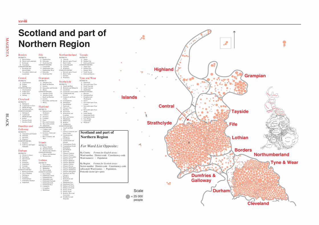
xxviii
013A k
009A k
011A k
056A b
080A b
102A b
054A b
110A k 043
A b 025A a
041A a
042A a
024A a
068A b
094A b
055A b
120A b
051A a
101A a 061
A k
116A a
060A a
021A a
032B g 119
B g
066B e
031B g
059B g 086B g
058B g
018B k
023B e
057B f
026B f
062B k
022B g
017B e
073B f 084
B e 085B e
083B e
028B f
027B f
103B f
104B k
111B f
112B f
115B k
091B e
039C l
040C l
053C l
052C l
092C l
038C l
004C m 098
C m
006C m
005C m
007C m
118C l
090C l
105C l
088C l
109C l
015C m 016
C m 014C m
030C m
029C m
087C m
089C m 008
D h
002D d
003D h
046D h
072D h
082D h
045D h
096D h
019D h
095D h
097D h
081D h
001D h 010
D d
067D d
012D d 020D d
044D d
117D d
075D d
076D d
074D d
035E j
034E i 036
E i
049E i 037
E i
107E i 069E i
050E i
078E j
071E j
033E i 047
E i
100E j 108
E j 077E j
099E j
070E j 093
E j
048E i
064E c
079E c
065E c
063E c
106E c 114
E c 113E c
010A a
013A a 018
A a
023A a
025A a 028
A a
031A a
036A a
041A a
063A a 067
A a
072A a
074A a
085A a
076A a
088A a
091A a
003B d
006B b
012B b
015B d
016B d 017B d
020B d
030B d
034B b
039B b
044B d
046B b
047B b
048B b
053B d
056B d
061B d
062B d
071B d
083B b
075B b
077B b
078B b
079B d
089B d
094B d
001C c
002C f 004
C c 005C c
007C c
011C f
019C b
032C c
033C c
038C b 042
C f
043C c
045C c
051C b
054C b
057C c
060C b
064C c
066C c
065C b
084C c
080C c
087C b
090C c
095C c
008D f
009D e
014D e
021D f
022D e
024D f
026D e
027D e
029D f
035D e
037D f
040D f
049D f
050D e
052D e 055
D e
058D e
059D e
068D f
069D e
070D f
073D e
081D e 082
D e
086D f
092D f 093
D f
096D e
097D e
098D f
012A e
023A e
024A e 025
A e 026A e
059A e
072A e
082A e 099
A e
113A e 117
A e
124A e
123A e 128
A e
130A e
158A e 160
A e
003B c
022B c
028B c 029
B c 032B c
055B c 056
B c
075B c 077
B c
078B c
080B g
087B c
089B g
094B c
096B c
102B g
106B c
115B c
116B c
114B c
118B c
119B c
125B c
131B g
163B g
002C e
007C f
011C f
015C f
016C e
020C f
021C e
033C f
034C f
035C f
040C e
044C f
049C f
052C e
057C f 063
C f
079C e
092C f
095C f 141
C e
142C e
148C e
154C e
005D b
006D b
013D b
018D b
019D b 039
D b 045D b
048D b
061D b
068D b
127D b
071D b
070D b
093D b
109D b
111D b
112D b
122D b
126D b
134D b
136D b
137D b 159
D b
167D b 001
E d
010E d
046E d
047E g
050E d
051E d
053E d
054E d
058E d
076E d
081E d
083E d 084
E d 086E d
090E g
107E d
108E d
120E d
121E d
132E d
138E d
143E d 140
E d
156E g
162E g 166
E g
155F a
017F a
153F a
105F a
098F g 097F g
144F g
101F g
110F a
139F a
135F a
169F a
104F a
066F g
014F g 009
F g 027F g
067F g
133F g
004G a
103G a
060G a
152G a
100G a
069G a
074G a 030
G a
064G a 091
G a 065G a
150G a 073
G a 151G a
036G a
129G a
008H a 031
H a 170H a
145H a
062H a
038H a
037H a
149H f
042H f 041
H f 043H f
165H f
164H f 088
H f 085H f
161H f 157
H f
146H f 147
H f
168H f
003A a
004A a
005A a
006A a
007A a
033A a
039A a
040A a
045A a
053A a
061A a
062A a
064A a
092A a
097A a
113A a
117A a
008B a 010
B a
014B a 022
B a 025B a
036B a
037B a
041B a
058B a
067B a
076B a
077B a
096B a
101B a
106B a
118B a 021
C b
030C b
031C b 032
C b
034C b
047C b
048C b
056C b
057C b
059C b
073C b
080C b 082
C b
093C b
095C b
109C b
114C b
024D a
038D a
046D a
051D d
052D c
063D a
065D a
068D d
069D d
070D d
071D d
072D d
081D d
083D c
084D c
085D c
086D c 103
D c
104D c
107D a
116D c
001E c
002E c
009E c
015E c
017E c
018E c
019E c
023E c
026E c
029E c
035E c
042E c
044E c
049E c
054E c
060E c
066E c
078E c
087E c
088E c
089E c
090E c
091E c
098E c
100E c
105E c
108E c
110E c
111E c
112E c
115E c
119E c
011F d
012F d 013
F d
016F d
020F d
027F d
028F d
043F d
050F d
055F d
074F d
075F d
079F d
094F d
099F d 102
F d
017A a 020
A a 018A a 012
A a
019A a
006A a
008A a
007A a
013A a
005A a
016B b
036B b
032B b 025
B b
030B b
041B b
033B b
026B b
011B b 010
B b
021B b
040B b
031B b 037
B b 015B b
024B b
003B b
039C a
009C a
014C a
002C a 023
C a
001C a
046C a
004C a
045C a
038C a
027D b
029D b
044D b
022D b
034D b
035D b
028D b
042D b
043D b
051A a
052A a
002A a
009A a 001
A a 025A a
053A a
003A a 037
A a 043A a
044A a
054B b
056B b
014B b
026B b
038B c
042B b
008B b
022B c
063B c
047B c
023B a
013B b
057B b
041B b 039
B b
028B b
012B c
004B c
040B c
059B c
049B c
027B c
024B a
007B c
011B c
055C a
048C a
062C d
061C d
006C a 058
C a
015C d 005
C d
010C d
045C d
046C d 016
C d 050C d
034C d
032C d
033C d
019C d
017C d
020C d
018C d
021C d
030C d
031C d
035C d
060C d
036C d
029C d
026A a
036A a 037
A a
025A a
038A a
015A a
032A a 012
A a 016A a
018A a
048A a
042A a
001A a
035B a
046B a
027B a
011B a 010
B a 014B b
033B b
003B b
031B b
043B b
030B b
034B a
002B a
028B b
029B b
041C b
020C b
021C b
023C b
013C b
047C b
007C b
017C b
024C b
022C b
005D b 044D b
045D b
006D b
049D b
050D b
009D b
019D b
004D b 040D b
039D b
008D b
006A c 030A c
042A c
013A b
014A b
011A b
010A b
029A b 005
A b 041A b
035A b
028A b
020A b
019A c
017A c
015A b
058A c 044
A c
007A c 018
A c
043A c
046B d
050B d
021B d
057B d
049B d 016
B d 031B d
008B d
032B b
055B b
047B a
002B a
048B a
025B a
060B a 036
B a
001B d
037B d
045B d
033B a
059B a
040C e 056
C e
026C e
022C e
027C e
009C e
034C e 053
C e
054C e 024
C e
003C e
039C e 004
C e 012C e 023
C e 051C e
052C e
038C e
081A b 039
A b 089A b
001A b
012A e
013A b
004A e
069A e
041A e
022A e
065A b
043A a 075A b
044A b
067A b
070A b
061A a
019A a
062A a
026A d
010A e
040A e
066A d
025A d
009B c 034
B c
057B c
038B c
037B c 020
B c 014B c
024B c 051
B c
023B c 033
B c 002B c
083B c
082B c
088B c
086B c
087B c
031C d
056C d
030C d
071C d
073C d
032C d
072C d 074
C d
027C d
028C d
029C d
085C d
077C d
078C d
046C d 079
C d
050C d
064C d
049C d
055D e
060D e
084D e
059D e
076D e
008D e
006D e
003D e
005D e
007D e
058D e 063
D e
042E f
016E f
015E f
017E f
048E f
052E f
047E f
018E f
011E f
021E f
054E f
080E f
053E f
068E f
045E f
036E f
035E f
053A b
061A b
074A b
005A b
004A b
039A b 010
A b 001A b
054A b
073A b
107B a
080B a 081B a 091
B a 089B a
090B a
088B a
021B a
101B a
100B a
092C b
019C b
020C b 036
C b 034C b
027C c
071C c
056C c
035C b
087C b 026
C b
045D b
022D b
046D b
047D b
058D b
057D b
094D b
042D b
041D b
095D b
093D b
002D b
006D b
007D b
070D b
069D b
068D b
003D b
066D b
067D b
104E b
072E b 105
E b
102E b
103E b
055F c
029F c
030F c
106F c
059F c
008F c
009F c
033F c
028F c
040F c
011F c
031F c 077
F c 076F c 082
F c
044F c 043
F c
025F c
075F c
024F c
023F c
097F c
048G c
063G c
051G c
060G c
096G c
084G c
083G c 085
G c 078G c
013G c 014
G c 086G c
079G c
065G c
064G c
038G c
012G c
049G c
050G c
032H a
037H a
062H a
017H a
016H a
018H a
052H a
015H a
098H a
099H a
091A a
089A a
088A a
090A a
033A a
115A a
020A a
137A a
140A a
043A a 139
A a
068A a
138A a
097A a
034A a
037A a
049A a
050A a
036A a
048A a
035A a
055B b 126
B b
018B b
132B b 131
B b 125B b
053B b
061B b
133B b
054B b
052B b
127B b
060B b
135B b 013B b
085B g
086B g 024
B g 099B g
101B g
107B d
047B g
141B d
093B d
042B d
051B d 070
B d 075B d
017B d
019B c
022B c 145B c 084
B b
056B b
083B f
119B f 076
B f
077B f
136B f 016
B f 039B e
120B f
028B b
082B g
130B e
029B b
122B b
087B g
124B g
121B i
102B i
041B e 021
B e
074B f
100B e
123B e
003B i
006B e
004B e 005
B e
112B c
111B c
081B c
096B c
114B f
015B f 059
B f 001B f
062B f
063B f
079B c 080
B c
092B f
002B i
066B i
117B i
118B h
064B i 116B h
065B i
072C j
025C j
071C j
110C j 098
C j 014C j
073C j
146C j
026C j
027C j
147C j
095C j 038
C j
046C j
109C j 012
C j
105C j
106C j
044C j
103C j
045C j
104C j
069D i
057D h
094D h
108D h
040D i
143D h
129D h 011D h
010D h
008D h
134D h
078D h
058D i
113D h
023D i
067D i
032D i
030D h
031D h
128D i
142D i
009D h
007D h
144D h
034A a
214A a
467A a
304A a
174A a
303A a
296A a
297A a
215A a
263A a
262A a
216A a
425A a
369A a
299A a
298A a
261A a
033A a
020A a
169A a
032A a
031A a
294A a
170A a
336A a
235A a
239A a
234A a 231A a 233A a
237A a
238A a
236A a
232A a
230A a
352A a 348A a 373A a
371A a 350A a 351A a 014
A a 015A a
349A a
370A a 372A a
017A a
016A a
018A a
449A a
450A a
451A a
468B g1
252B g1
125B d 446
B d 253B d
134B d
044B d
267B d
445B d
471C d
318C d
171C d
472C d
319C d
378C d
144C d
259C d
258C d
001E f
139E f
039E f
398E f
399E f
040E f 260
E f 037E f
003E f
098E f
038E f 462
E f
002E f
357F c
142F c
328F c 113
F c 329F c
114F c
384F c 143
F c
140F c 141
F c
326F c
358F c
048G g
225G h
224G h 223G h
049G g
084G h
226G h
083G h
227G h
153G h
229G h
074G h
228G h
290G h
289G h
257G g
051G g
050G g
438G h
437G h
424G h
415G g
021G g
022G g
463G g
146G g
145G g
256G g
255G g
308G g
024G g
025G g
310G g
309G g
181G g
157H i
201H i
161H i
159H i
160H i 158
H i
162H i
026H i
458H i
071H i
405H i
209H i
208H i
207H i 402
H i
330I j 325
I j
089I j 464
I j 175I j
466I j
064I j
332I j
331I j
164I j
165I j
470I j
469I j
163I j
465I j
029I j 027
I j
028I j
030I j
355J k
194J k 193
J k
447J k
473J k
127J k
173J k
079J k
448J k
334J k
335J k
090K m 148K m 008K m 093
K m 092K m
116K p 117K p
119K p
118K p 009
K p 010K p 011
K p 094K p
120K p
380K p
012K p
422K q
150K m
293K m
292K m
221K m
382K p
080K p
081K p
381K q
383K p
244K p
243K p
301K n 486
K n 485K n
082K p
417K p
067K n
440K n 156
K n
367K q
249K q
368K q
250K q
242K q
131K v
130K v
342K v
132K v
251K v
409K q
410K q
327K q
149K u
151K v
152K v
379K u
421K u
316K u
103K u
347K u
043K u
042K u
428K s
006K s
404K s
397K s
403K s
429K s
396K s
176K s
091K m
057K m
058K u
059K m
390K m
138K r
137K r
395K r 391
K r
413K m
411K m
452K m
414K m 420
K r
363K l
317K l
453K l
291K l 004
K l
111K t
197K r
129K r
052K m
053K o
198K o 155
K o
392K o
099K o 346
K o
154K o
386K r
389K r 388
K r
300K q
441K q
406K v
408K q
177K u
036K u
190K s
035K u
483K t
203K t
202K t
412K t
095K t
096K t
112K t
204K t
183K l
019K r
387K r 427K r
484K n
385K o
416K o
072L x
459L x
073L x
069L x
211L x
210L x
180L x
460L x
479L x
213L x
123L x
147L e
313L e
312L e 439
L e 086L e
264M f1
266M f1
265M f1
394M w
393M f1
056M w
192M w
068M w
199M w
311M w
191M w
185M f1
200M f1
184M f1
461M f1
278N y
270N y
287N y
286N y
288N y
269N y
276N y
268N y
281N y
284N y
283N y
273N y
275N y
274N y
272N y 285
N y 277N y
282N y
271N y
279N y
280N y
104O c
107O c
443O b
167O b
444O b
013O c
133O c
105O c
187O b 418
O b
186O b
007O c
206O b
075O b
135O b
457O b
432O b
430O b
456O b
166O b
106O c
333O c
005O c
108O c
168D e
109D e
110D e 101
D e 102D e 100
D e 065D e
306D e
188D e
307D e
315D e
062D e
359P z
360P z
407P z
454P a1041P a1
365P a1
476P z
419P a1
066P a1
366P a1
122P a1
375P a1
295P a1
401P z
361P z
124P z
087P z
362P z
475P z
474P z
433Q b1
060Q b1
482Q b1
182Q b1
442Q b1
376Q b1
076Q c1
302Q c1
305Q c1
345Q b1
128Q b1
136Q c1115Q c1
364Q b1
356Q c1
054Q b1
088Q b1
055Q b1
217Q b1
172Q b1
061Q b1
400R d1
023R d1
205R e1
321R k
046R k
045R k 353R k
354R k
374R e1
337R e1 047
R d1
195R e1 322
R e1
196R e1
434R e1
077R e1
431R d1
423R d1
320R d1 189
R d1
070R d1222
R d1 455R d1
240R e1
178R e1
241R e1
220R f1
063R f1
179R f1377R f1
323R e1
254R f1
078R f1
324R f1
218R f1
219R f1
245S g1
436S a1
248S g1
246S g1
338S a1
481S g1
480S g1
085S g1
247S g1
097S g1
341S a1
340S a1
339S a1
121S a1
212S a1
478S a1
314S g1
426S a1
343S a1
477S a1
126S a1
435S a1
344S a1
013A a
090A d
020A a
019A a
018A a
021A a
091A d 048
A d
037A d
044A d
057A d
014A a
012A a
069A a
053A a
052A a
051A a
009A a
015A a
066A a 065
A a
089A d
064A d
063A d
033B c
054B b 084
B b 023B c
060B c
078B c
008B c
059B c
074B c
067B e
058B c
024B b
047B c
031B c
082B a
011B b
026B b
032B b
017B b
061B a
085B b
016B a
010B a
068B a
080B a
049B e
050B e
004C d
034C e
072C e
028C e
045C e
001C d
040C e
039C e
041C e
042C e
087C e 086
C e
027C e
083C e
071C d
038C d
070C e
079C d
056C e
022C e
035C e
081C e
029C e
030C e
073C e
046C e
043C e
088C e
003C d
036C d 006
C d
062C d
005C d
007C d
025C d
055C e
002C d
075C d
076C d
077C d
009B a
016B a
014B a
010C b
003C b
002C b
001C b
013C b
012C b
004C b
006C b 005C b
011C b
Scotland and part ofNorthern RegionBordersDISTRICTS
A BerwickshireB Ettrick and LauderdaleC RoxburghD Tweeddale
CONSTITUENCIESa Roxburgh and
Berwickshireb Tweeddale, Ettrick and
Lauderdale
CentralDISTRICTS
A ClackmannanB FalkirkC Stirling
CONSTITUENCIESa Clackmannanb Falkirk Eastc Falkirk Westd Stirling
ClevelandDISTRICTS
A HartlepoolB Langbaurgh-on-TeesC MiddlesbroughD Stockton-on-Tees
CONSTITUENCIESa Hartlepoolb Langbaurghc Middlesbroughd Redcare Stockton Northf Stockton South
Dumfries andGallowayDISTRICTS
A Annandale and EskdaleB NithsdaleC StewartryD Wigtown
CONSTITUENCIESa Dumfriesb Galloway and Upper
Nithsdale
DurhamDISTRICTS
A Chester-le-StreetB DarlingtonC DerwentsideD DurhamE EasingtonF SedgefieldG TeesdaleH Wear Valley
CONSTITUENCIESa Bishop Aucklandb City of Durhamc Darlingtond Easingtone North Durhamf North West Durhamg Sedgefield
FifeDISTRICTS
A DunfermlineB KirkcaldyC North East Fife
CONSTITUENCIESa Central Fifeb Dunfermline Eastc Dunfermline Westd Kirkcaldye North East Fife
GrampianDISTRICTS
A Aberdeen CityB Banff and BuchanC GordonD Kincardine and DeesideE Moray
CONSTITUENCIESa Aberdeen Northb Aberdeen Southc Banff and Buchand Gordone Kincardine and Deesidef Moray
HighlandDISTRICTS
A Badenoch andStrathspey
B CaithnessC InvernessD LochaberE NairnF Ross and CromartyG Skye and LochalshH Sutherland
CONSTITUENCIESa Caithness and
Sutherlandb Inverness, Nairn and
Lochaberc Ross, Cromarty and
Skye
IslandsDISTRICTS
A Orkney IslandsB Shetland IslandsC Western Isles Islands
CONSTITUENCIESa Orkney and Shetlandb Western Isles
LothianDISTRICTS
A East LothianB Edinburgh CityC MidlothianD West Lothian
CONSTITUENCIESa East Lothianb Edinburgh Centralc Edinburgh Eastd Edinburgh Leithe Edinburgh Pentlandsf Edinburgh Southg Edinburgh Westh Linlithgowi Livingstonj Midlothian
NorthumberlandDISTRICTS
A AlnwickB Berwick-upon-TweedC Blyth ValleyD Castle MorpethE TynedaleF Wansbeck
CONSTITUENCIESa Berwick-upon-Tweedb Blyth Valleyc Hexhamd Wansbeck
StrathclydeDISTRICTS
A Argyll and ButeB Bearsden and MilngavieC ClydebankD Clydesdale (was Lanark)E Cumbernauld and
KilsythF Cumnock and Doon
ValleyG CunninghameH DumbartonI East KilbrideJ Eastwood
K Glasgow CityL Hamilton
M InverclydeN Kilmarnock and
LoudounO Kyle and CarrickP MonklandsQ MotherwellR RenfrewS Strathkelvin
CONSTITUENCIESa Argyll and Buteb Ayrc Carrick, Cumnock and
Doon Valleyd Clydebank and
Milngaviee Clydesdalef Cumbernauld and
Kilsythg Cunninghame Northh Cunninghame Southi Dumbartonj East Kilbridek Eastwoodl Glasgow Cathcart
m Glasgow Centraln Glasgow Garscaddeno Glasgow Govanp Glasgow Hillheadq Glasgow Maryhillr Glasgow Pollocks Glasgow Provant Glasgow Rutherglenu Glasgow Shettlestonv Glasgow Springburnw Greenock and Port
Glasgowx Hamiltony Kilmarnock and
Loudounz Monklands East
a1 Monklands Westb1 Motherwell Northc1 Motherwell Southd1 Paisley Northe1 Paisley Southf1 Renfrew West and
Inverclydeg1 Strathkelvin and
Bearsden
TaysideDISTRICTS
A AngusB Dundee CityC Perth and Kinross
CONSTITUENCIESa Angus Eastb Dundee Eastc Dundee Westd North Taysidee Perth and Kinross
Tyne and WearDISTRICTS
A GatesheadB Newcastle upon TyneC North TynesideD South TynesideE Sunderland
CONSTITUENCIESa Blaydonb Gateshead Eastc Houghton and
Washingtond Jarrowe Newcastle-upon-Tyne
Centralf Newcastle-upon-Tyne
Eastg Newcastle-upon-Tyne
Northh South Shieldsi Sunderland Northj Sunderland Southk Tyne Bridgel Tynemouth
m Wallsend
Isle of
Ham
pshire WestSussex
East Sussex
Surrey
G r e a t e r
L o n d o n
Berk-shire
Wiltshire
Wight
Dorset
KentSomerset
Devon
Cornwall
Avon
GwentSouth
GlamorganM
idWest
Buck
ingh
amsh
ire
Oxf
ord-
shireGloucester-
shire
Hereford &WorcesterWarwick
shireW e s t
M i d l a n d s
Powys
Dyfed
Gwynedd Clwyd
Staffordshire
Shro
ps
hire
Cheshire
Hertfords
hire
Bed
for
dshir
e
Essex
Suffolk
NorfolkshireCambridge-
North
am
ptonshire
Leicestershire
YorkshireSouth
Nottingham-
shire
Derbyshire
Humberside
Lincoln-shire
GreaterManchester
WestYorkshireLancashire
Mersey-side
North YorkshireCu
mbria ClevelandDurham
Nor
thum
ber-land
Tyne & Wear
Borders
Dumfries &
Galloway
StrathclydeLothian
Central Fife
Tayside
Grampian
Highlands
= 25 000people
Scale
Cleveland
Durham
Tyne & WearNorthumberland
Borders
Lothian
Fife
Tayside
GrampianHighland
Strathclyde
Dumfries &
Islands
Central
Scotland and part of Northern Region
For Ward List Opposite: By County Format for English areas: Ward-number District-code Constituency-code Ward-name(s) : Population
By Region Format for Scottish areas: Sector-number District-code Constituency-code (allocated) Ward-names : Population, Postcode-sector (pt = part)
Galloway
008A a 015
A a
007A a
BLA
CK
xxviii
Borders
Central
Cleveland
Dumfries andGalloway
Durham
Fife
Grampian
Highland
Islands
Lothian
Northumberland
Strathclyde
Tayside
Tyne and Wear
ClevelandDurham
Nor
thum
ber-land
Tyne & Wear
Borders
Dumfries &
Galloway
StrathclydeLothian
Central Fife
Tayside
Grampian
Highlands
Cleveland
Durham
Tyne & WearNorthumberland
Borders
Lothian
Fife
Tayside
GrampianHighland
Strathclyde
Dumfries &
Islands
Central
Galloway
MA
GEN
TA
xxix
Borders001 C a Abbey; Jedburgh South: 5812,
TD8.6 002 C a Bowmont: 3510, TD5.8(pt) 003 B b Buccleuch: 0, TD9.7(pt) 004 C a Burnfoot East; Burnfoot
West: 6033, TD9.8 005 A a Burnmouth, Foulden and
Hutton: 1041, TD15.1 006 A a Chirnside; Duns; Langton and
Lammermuir; Edrom, Swinton andWhitsome: 6532, TD11.3(pt)
007 A a Cockburnspath and Reston: 574,TD13.5(pt)
008 A a Coldstream: 2689, TD12.4 009 C a Croft: 0, TD3.6(pt) 010 B b Earlston(pt): 2006, TD4.6(pt) 011 B b Earlston(pt): 93, TD3.6(pt) 012 A a Eccles and Leitholm: 252,
TD5.7(pt) 013 A a Eyemouth West; Eyemouth East;
Ayton and Coldingham: 6302, TD14.5 014 C a Floors: 6079, TD5.7(pt) 015 B b Gala Central: 4650, TD7.4 016 B b Galawater: 0, EH37.5(pt) 017 A a Gordon and Greenlaw(pt): 0,
TD2.6(pt) 018 A a Gordon and Greenlaw(pt): 0,
TD4.6(pt) 019 A a Gordon and Greenlaw(pt): 1014,
TD10.6 020 A a Gordon and Greenlaw(pt): 770,
TD3.6(pt) 021 B b Hillside: 0, TD5.7(pt) 022 D b Innerleithen East; Innerleithen
West: 2874, EH44.6(pt) 023 C a Jedburgh North: 129, TD6.9(pt) 024 B b Ladhope; Netherdale: 2789,
TD7.5(pt) 025 B b Langhaugh: 0, EH44.6(pt) 026 B b Lauder: 1755, TD2.6(pt) 027 D b Linton(pt): 0, EH26.8(pt) 028 D b Linton(pt): 2327, EH46.7(pt) 029 D b Linton(pt): 97, EH26.9(pt) 030 B b Meigle: 5097, TD1.1 031 B b Melrose: 3626, TD6.9(pt) 032 B b Mossilee(pt): 0, EH43.6(pt) 033 B b Mossilee(pt): 4514, TD1.3(pt) 034 D b Peebles North; Peebles East: 5003,
EH45.8 035 D b Peebles West; Peebles South;
Middle Tweed: 3362, EH45.9 036 B b Philiphaugh: 304, EH38.5(pt) 037 B b St Boswells: 2949, TD6.0 038 C a Teviot North; Teviot South;
Teviotdale(pt); Liddesdale: 4716,TD9.0(pt)
039 C a Teviotdale(pt): 0, DG14.0(pt) 040 B b Thornfield: 63, TD5.8(pt) 041 B b Tweedbank: 6192, TD1.2 042 D b Upper Tweed: 944, ML12.6(pt) 043 D b Walkerburn and Traquair(pt): 0,
TD1.3(pt) 044 D b Walkerburn and Traquair(pt): 716,
EH43.6(pt) 045 C a Weensgate; Slitrig: 4735, TD9.9 046 C a Wilton North; Wilton South: 4332,
TD9.7(pt)
Central001 A a Alloa East; Fairfield: 8695,
FK10.3(pt) 002 A a Alloa West: 4955, FK10.1 003 A a Alva: 5201, FK12.5 004 B c Antonine: 2001, FK4.2(pt) 005 C d Argyll(pt): 6871, FK7.0 006 C a Argyll(pt); Cornton; Gowanhill;
Ballengeich(pt); Polmaise(pt): 8797,FK7.7(pt)
007 B c Avon(pt): 0, G67.3(pt) 008 B b Avon(pt): 1978, FK1.3(pt) 009 A a Baingle; Delph: 13187, FK10.2 010 C d Ballengeich(pt): 7761, FK8.1 011 B c Bankier(pt): 0, G68.0(pt) 012 B c Bankier(pt): 8651, FK4.1 013 B b Beancross; Redding: 10357, FK2.9 014 B b Boness Grange(pt): 7516, EH51.9 015 C d Borestone; Whins(pt): 6747, FK7.9 016 C d Bridge of Allan: 5469, FK9.4 017 C d Callander(pt): 185, FK18.8 018 C d Callander(pt): 315, FK20.8(pt) 019 C d Callander(pt): 3268, FK17.8 020 C d Callander(pt): 449, FK19.8(pt) 021 C d Callander(pt): 874, FK21.8(pt) 022 B c Camelon: 8046, FK1.4 023 B a Carse(pt): 6075, FK2.8(pt) 024 B a Carse(pt): 84, FK7.7(pt) 025 A a Clackmannan: 3555, FK10.4(pt) 026 B b Dean(pt): 7194, EH51.0 027 B c Denny; Dunipace: 5492, FK6.6(pt) 028 B b Douglas(pt): 5728, FK3.0 029 C d Dumgoyne(pt): 0, G83.9(pt) 030 C d Dumgoyne(pt): 121, G62.8(pt) 031 C d Dumgoyne(pt): 4366, G63.9(pt) 032 C d Dunblane East: 3348, FK15.0(pt) 033 C d Dunblane West and
Kilmadock(pt): 1971, FK16.6 034 C d Dunblane West and
Kilmadock(pt): 4659, FK15.9(pt) 035 C d Endrick(pt): 4568, G63.0(pt) 036 C d Endrick(pt): 55, G83.8(pt) 037 A a Gartmorn; Tillicoultry: 6208,
FK13.6 038 B c Graeme; Laurieston: 3052, FK1.1 039 B b Graham; Boness Grange(pt): 5026,
FK3.9 040 B c Grahamsford(pt): 4743, FK5.3 041 B b Grange; Park; Inchyra; Bowhouse;
Douglas(pt); Dean(pt): 7985, FK3.8 042 B b Hallglen; Shieldhill: 8033,
FK1.2(pt) 043 A a Harviestoun(pt): 3532, FK14.7(pt) 044 A a Harviestoun(pt): 72, KY13.7(pt) 045 C d King's Park(pt): 3294, FK8.2 046 C d King's Park(pt); Leckie; Torbrex;
Trossachs(pt): 5445, FK8.3 047 B c Ladysmill; Victoria;
Grahamsford(pt); Dawson;Dalgrain: 8734, FK2.7
048 C a Ladywell(pt): 0, FK5.4(pt) 049 B c Larbert; Chacefield: 7777,
FK6.5(pt) 050 C d Logie: 5081, FK9.5(pt) 051 A a Mar: 0, FK7.7(pt) 052 A a Menstrie(pt): 0, FK9.5(pt) 053 A a Menstrie(pt): 2274, FK11.7 054 B b Muiravonside(pt): 966, EH49.6(pt) 055 C a Polmaise(pt): 63, FK2.8(pt) 056 B b Polmont(pt): 436, EH49.7(pt) 057 B b Polmont(pt);
Muiravonside(pt): 12216, FK2.0 058 C a Sauchenford; Ladywell(pt): 4836,
FK7.8 059 B c Stenhousemuir; Crownest,
Carronvale; Stenhouse, Carron;Carse(pt): 11541, FK5.4(pt)
060 C d Trossachs(pt): 0, G83.7(pt) 061 C d Whins(pt): 197, FK6.6(pt) 062 C d Whins(pt): 93, FK6.5(pt) 063 B c Woodlands; Summerford;
Mariner: 7349, FK1.5
Cleveland001 C c Acklam: 5150002 C f Ayresome: 6749003 B d Bankside: 5809004 C c Beckfield: 5105
005 C c Beechwood: 5238006 B b Belmont: 8312007 C c Berwick Hills: 4621008 D f Bishopsgarth: 7919009 D e Blue Hall: 6543010 A a Brinkburn: 5400011 C f Brookfield: 6600012 B b Brotton: 5179013 A a Brus: 5507014 D e Charltons: 5127015 B d Church Lane: 4640016 B d Coatham: 4151017 B d Dormanstown: 6650018 A a Dyke House: 6858019 C b Easterside: 4633020 B d Easton: 5600021 D f Egglescliffe: 7985022 D e Elm Tree: 4491023 A a Elwick: 1579024 D f Fairfield: 4923025 A a Fens: 6602026 D e Glebe: 6262027 D e Grange: 4465028 A a Grange: 6235029 D f Grangefield: 5160030 B d Grangetown: 3915031 A a Greatham: 2330032 C c Gresham: 4959033 C c Grove Hill: 5454034 B b Guisborough: 6442035 D e Hardwick: 5612036 A a Hart: 4273037 D f Hartburn: 7111038 C b Hemlington: 4639039 B b Hutton: 4344040 D f Ingleby Barwick: 6169041 A a Jackson: 5165042 C f Kader: 6095043 C c Kirby: 5414044 B d Kirkleatham: 7889045 C c Linthorpe: 5232046 B b Lockwood: 3564047 B b Loftus: 7315048 B b Longbeck: 8093049 D f Mandale: 7198050 D e Marsh House: 8725051 C b Marton: 5012052 D e Mile House: 5590053 B d Newcomen: 4929054 C b Newham: 12194055 D e Newtown: 5837056 B d Normanby: 4935057 C c North Ormesby: 5393058 D e Northfield: 4835059 D e Norton: 6122060 C b Nunthorpe: 5309061 B d Ormesby: 3871062 B d Overfields: 4758063 A a Owton: 5312064 C c Pallister: 4651065 C b Park End: 5756066 C c Park: 4649067 A a Park: 5743068 D f Parkfield: 6251069 D e Portrack and Tillery: 5761070 D f Preston: 2942071 B d Redcar: 4836072 A a Rift House: 5883073 D e Roseworth: 6109074 A a Rossmere: 5336075 B b Saltburn: 6145076 A a Seaton: 5410077 B b Skelton: 6349078 B b Skinningrove: 1716079 B d South Bank: 6829080 C c Southfield: 4224081 D e St Aidan's: 4958082 D e St Cuthbert's: 5971083 B b St Germain's: 4761084 C c St Hilda's: 4627085 A a St Hilda: 6974086 D f Stainsby: 6488087 C b Stainton and Thornton: 5133088 A a Stranton: 5387089 B d Teesville: 6475090 C c Thorntree: 8748091 A a Throston: 6410092 D f Victoria: 5226093 D f Village: 5277094 B d West Dyke: 7601095 C c Westbourne: 5261096 D e Whitton: 3444097 D e Wolviston: 2482098 D f Yarm: 8929
Dumfries andGalloway
001 A a Buccleuch: 0, TD9.0(pt) 002 B a Caerlaverock(pt): 0, DG12.5(pt) 003 B b Cairn; Dalswinton; Cluden;
Greyfriars: 7703, DG2.0(pt) 004 D b Cairnpat; Sheuchan; Aird: 4242,
DG9.8 005 D b Cairnsmore(pt): 0, DG7.2(pt) 006 D b Cairnsmore(pt): 1286, DG8.7 007 C b Castle Douglas West; Castle
Douglas East: 5427, DG7.1 008 D b Castle(pt): 0, KA26.0(pt) 009 D b Castle(pt): 1927, DG8.0(pt) 010 B a Cresswell; Castledykes; Corberry;
Ryedale: 4809, DG2.7 011 B a Crichton; Caerlaverock(pt); Craigs;
Georgetown: 11331, DG1.4(pt) 012 A a Cummertrees: 5741, DG12.5(pt) 013 C b Dalbeattie West; Dalbeattie
East: 5393, DG5.4 014 B b Douglas; Criffel: 2531, DG2.8(pt) 015 A a Dryfe; Lockerbie: 5078, DG11.2 016 A a Eastriggs: 6839, DG12.6 017 C b Fleet: 2271, DG7.2(pt) 018 A a Galabank; Langholm: 3282,
DG13.0 019 D b Glencowan; Knockcullie: 6567,
DG9.7 020 C b Glenkens(pt): 0, DG2.9(pt) 021 C b Glenkens(pt): 0, DG2.0(pt) 022 C b Glenkens(pt): 0, KA6.7(pt) 023 C b Glenkens(pt): 81, DG3.4(pt) 024 C b Glenkens(pt); Ken: 3855, DG7.3(pt) 025 A a Greenknowe; Beattock: 3564,
DG10.9(pt) 026 A a Gretna: 3499, CA6.5 027 B a Greystone; Parkhead: 5453,
DG1.3(pt) 028 B b Kello(pt): 0, KA18.4(pt) 029 B b Kello(pt): 160, ML12.6(pt) 030 B b Kello(pt): 4962, DG4.6(pt) 031 B b Kirkland: 2093, DG3.4(pt) 032 A a Kirtle; Milk: 3157, DG11.3 033 B b Laurieknowe; Summerville;
Babbington: 6904, DG2.9(pt) 034 B a Lochar(pt): 341, DG11.1(pt) 035 B a Lochar(pt); Ae; Heathhall: 5874,
DG1.1 036 A a Lochmaben(pt): 0, DG1.3(pt) 037 A a Lochmaben(pt): 263, DG1.4(pt) 038 A a Lochmaben(pt): 4329, DG11.1(pt) 039 D b Lochnaw: 3849, DG9.0 040 D b Logan: 2375, DG9.9 041 C b Milton: 1243, DG2.8(pt) 042 A a Moffat: 0, TD7.5(pt) 043 B b Morton: 2466, DG3.5 044 D b Newton Stewart(pt): 0, DG7.3(pt) 045 D b Newton Stewart(pt): 4289,
DG8.6(pt) 046 B a Newton; Lincluden;
Stakeford: 2385, DG1.2 047 C b Screel; Tarff; Kirkcudbright North;
Kirkcudbright South: 5359, DG6.4 048 A a Standalane; Springbells and
Creca: 1335, DG14.0(pt) 049 D b Whithorn; Inch: 2449, DG8.8 050 D b Wigtown; Drumwalt: 3093, DG8.9
Durham001 E d Acre Rigg: 3685002 C e Annfield Plain: 3970003 B c Bank Top: 3704004 G a Barnard Castle East; Barnard Castle
West: 4783005 D b Bearpark: 1827006 D b Belmont: 3983007 C f Benfieldside: 5584008 H a Bishop Auckland Town: 4005009 F g Bishop Middleham;
Cornforth: 4069010 E d Blackhalls: 6222011 C f Blackhill: 4404012 A e Bournmoor: 3271013 D b Brandon: 6037014 F g Broom; Chilton 23%;
Ferryhill 14%: 7291015 C f Burnhope: 1222016 C e Burnopfield: 4944017 F a Byerley; Sunnydale 18%: 3907018 D b Carrville: 3019019 D b Cassop-cum-Quarrington: 4485020 C f Castleside: 1456021 C e Catchgate: 3011022 B c Central: 2973023 A e Chester Central: 1653024 A e Chester North: 3982025 A e Chester South: 3953026 A e Chester West: 4396027 F g Chilton 77%; Woodham 61%: 9378028 B c Cockerton East: 5890029 B c Cockerton West: 3177030 G a Cockfield: 1666031 H a Cockton Hill;
Henknowle 31%: 5899032 B c College: 3338033 C f Consett North: 2942034 C f Consett South: 4103035 C f Cornsay: 1564036 G a Cotherstone with Lartington: 668037 H a Coundon 11%; Coundon Grange;
Henknowle 69%: 4477038 H a Coundon 89%: 4145039 D b Coxhoe: 4777040 C e Craghead: 2964041 H f Crook North: 1666042 H f Crook South 20%: 940043 H f Crook South 80%: 3784044 C f Crookhall: 1930045 D b Croxdale: 1347046 E d Dawdon: 5823047 E g Deaf Hill: 1414048 D b Deerness: 3568049 C f Delves Lane: 4406050 E d Dene House: 3995051 E d Deneside: 4224052 C e Dipton: 2848053 E d Easington Colliery: 5484054 E d Easington Village: 2477055 B c Eastbourne North: 3106056 B c Eastbourne South: 3686057 C f Ebchester and Medomsley: 4639058 E d Eden Hill: 5511059 A e Edmondsley: 634060 G a Eggleston; Streatlam with
Whorlton 26%: 1178061 D b Elvet: 2297062 H a Escomb; Woodhouse
Close 17%: 3122063 C f Esh: 4311064 G a Etherley; Toft Hill and
Lands 57%: 2248065 G a Evebwood with Ramshaw; Toft Hill
and Lands 43%: 2435066 F g Ferryhill 86%: 4319067 F g Fishburn; New Trimdon and
Trimdon Grange; Old Trimdon: 7162068 D b Framwelgate: 4956069 G a Gainford and Winston: 1749070 D b Gilesgate Moor: 3070071 D b Gilesgate: 3748072 A e Grange Villa: 1148073 G a Greta: 635074 G a Hamsterley and South Bedburn;
Lynesack 87%: 1895075 B c Harrowgate Hill: 5521076 E d Haswell: 1767077 B c Haughton East: 8353078 B c Haughton West: 4853079 C e Havannah: 5600080 B g Heighington: 2071081 E d High Colliery: 1770082 A e Holmlands Park: 3509083 E d Horden North: 5160084 E d Horden South: 3719085 H f Howden; Wheatbottom and
Helmington Row 15%: 2599086 E d Howletch: 4054087 B c Hummersknott: 4142088 H f Hunwick: 1560089 B g Hurworth: 3621090 E g Hutton Henry: 1921091 G a Ingleton: 658092 C f Lanchester: 4919093 D b Langley Moor and
Meadowfield: 3125094 B c Lascelles: 3603095 C f Leadgate: 4246096 B c Lingfield: 4082097 F g Low Spennymoor and Tudhoe
Grange 25%: 1174098 F g Low Spennymoor and Tudhoe
Grange 75%; Tudhoe: 7019099 A e Lumley: 4346100 G a Lynesack 13%; Staindrop: 1662101 F g Middlestone: 4729102 B g Middleton St George: 3191103 G a Middleton-in-Teesdale: 1477104 F a Middridge 11%; Simpasture 24%;
West: 7270105 F a Middridge 89%: 4325106 B c Mowden: 4012107 E d Murton East: 7378108 E d Murton West: 3450109 D b Neville's Cross: 4281110 F a Neville: 2878111 D b New Brancepeth: 1314112 D b Newton Hall: 5388113 A e North Lodge: 2438114 B c North Road: 4070115 B c Northgate North: 3754116 B c Northgate South: 3336117 A e Ouston: 3293118 B c Park East: 5595119 B c Park West: 3460120 E d Park: 1929121 E d Passfield: 5015122 D b Pelaw: 2572123 A e Pelton Fell: 2570124 A e Pelton: 4830125 B c Pierremont: 5647126 D b Pittington and West Rainton: 3722127 D b Plawsworth 28%; Framwellgate
Moor: 4148128 A e Plawsworth 72%: 1069129 G a Romaldkirk: 810130 A e Sacriston: 4620131 B g Sadberge: 1553132 E d Seaham: 4137133 F g Sedgefield: 5773134 D b Shadforth: 1394135 F a Shafto: 2677136 D b Sherburn: 3246137 D b Shincliffe: 1746138 E d Shotton: 4287139 F a Simpasture 76%: 1383140 E d South Hetton: 2799141 C e South Moor: 4065142 C e South Stanley: 4511143 E d South: 1530144 F g Spennymoor: 6462145 H a St Helen's; West Auckland: 5334146 H f St John's Chapel: 1429147 H f Stanhope: 2572
148 C e Stanley Hall: 4104149 H f Stanley: 1733150 G a Startforth East: 645151 G a Startforth with Boldron: 1027152 G a Streatlam with Whorlton 74%: 532153 F a Sunnydale 82%: 2627154 C e Tanfield: 4303155 F a Thickley: 4997156 E g Thornley: 2970157 H f Tow Law: 2204158 A e Urpeth: 3980159 D b Ushaw Moor: 4332160 A e Waldridge: 2532161 H f Wheatbottom and Helmington
Row 85%: 2594162 E g Wheatley Hill: 3498163 B g Whessoe: 2168164 H f Willington East 13%; Willington
West: 3621165 H f Willington East 87%: 3152166 E g Wingate: 3602167 D b Witton Gilbert: 2704168 H f Wolsingham: 3380169 F a Woodham 39%: 3090170 H a Woodhouse Close 83%: 4530
Fife001 B d Aberhill and Methil: 5245, KY8.1 002 B a Auchmuty: 9786, KY6.2 003 C e Auchtermuchty and
Strathmiglo(pt): 140, KY13.7(pt) 004 C e Auchtermuchty and
Strathmiglo(pt): 3622, KY14.7(pt) 005 A b Ballingry; Lochore: 6393,
KY5.8(pt) 006 A c Blairhall and High
Valleyfield(pt): 116, FK10.3(pt) 007 A c Blairhall and High Valleyfield(pt);
Oakley North and Saline(pt): 11162,KY12.9
008 B d Burntisland West: 2682, KY3.0(pt) 009 C e Central: 519, KY8.5(pt) 010 A b Cowdenbeath Foulford;
Cowdenbeath South East; Townhill,Kingseat and Halbeath: 8586, KY4.9
011 A b Cowdenbeath Moss Side;Crossgates and Hill of Beath: 5580, KY4.8
012 C e Cupar North: 5890, KY15.4 013 A b Dalgety Bay East and
Aberdour(pt): 0, KY2.5(pt) 014 A b Dalgety Bay East and
Aberdour(pt): 1729, KY3.0(pt) 015 A b Dalgety Bay West and North
Queensferry; Dunfermline Garvock;Blacklaw and St Leonards; Dunfermline,Aberdour; Dunfermline, Pitcorthie: 13630,KY11.5
016 B d Dunearn; Torbain;Rimbleton: 18995, KY2.6
017 A c Dunfermline Central; Dunfermline,Woodmill: 15412, KY11.4
018 A c Dunfermline North 1: 9242, KY12.0 019 A c Dunfermline West; Limekilns,
Dunfermline and Pitreavie West; RosythWest: 3413, KY11.3
020 A b Dunfermline, Linburn; Rosyth East;Rosyth South: 13400, KY11.2
021 B d Dunnikier; Fair Isle: 5142, KY1.3 022 C e Freuchie, Kingskettle and
Springfield(pt): 0, KY7.6(pt) 023 C e Freuchie, Kingskettle and
Springfield(pt); Cupar South: 7164,KY15.5
024 C e Gleneden and Crail; Kilrenny,Anstruther and Carnbee: 5098, KY10.3
025 B a Glenwood North; GlenwoodWest: 9839, KY7.4
026 C e Howe of Fife(pt): 0, KY6.3(pt) 027 C e Howe of Fife(pt); Freuchie,
Kingskettle and Springfield(pt): 6514,KY7.7
028 A b Inverkeithing East; InverkeithingWest: 7052, KY11.1
029 A b Kelty East and West: 5519,KY4.0(pt)
030 A c Kincardine and Culross: 3236,FK10.4(pt)
031 B d Kinghorn, Burntisland East: 6356,KY3.9
032 B b Kinglassie and Bowhill(pt): 0,KY5.8(pt)
033 B a Kirkland and Mountfleurie; LevenWest; Leven East: 5977, KY8.4
034 C e Largo: 2473, KY8.6 035 A b Lochgelly North(pt): 0, KY5.0(pt) 036 B a Markinch: 11228, KY7.6(pt) 037 B d Methilhill: 5833, KY8.2 038 C e Motray: 5181, KY16.0 039 C e Newburgh and District: 2571,
KY14.6(pt) 040 C e Newport-on-Tay and Wormit: 5414,
DD6.8 041 A b Oakfield and Lumphinnans;
Lochgelly North(pt); LochgellySouth: 7044, KY5.9
042 A c Oakley North and Saline(pt): 0,FK14.7(pt)
043 A c Oakley North and Saline(pt): 0,KY13.7(pt)
044 A c Oakley South and Torryburn;Cairneyhill and Crossford: 10472, KY12.8
045 B d Old Buckhaven: 5991, KY8.3 046 B d Pathhead and Victoria: 5706, KY1.1 047 B a Pitcoudie and Cadham(pt): 5323,
KY6.1 048 B a Pitcoudie and Cadham(pt); Leslie;
Collydean and Balgeddie: 5035,KY6.3(pt)
049 B d Raith; Linktown and Auchtertool;Hayfield; South Parks: 11439, KY2.5(pt)
050 B d Smeaton; Sinclairtown; Dysart andWemyss; Gallatown andThornton(pt): 7089, KY1.2
051 C e St Andrews South; St AndrewsSouth East: 9289, KY16.8
052 C e St Andrews West; St AndrewsCentral: 4149, KY16.9
053 C e St Monans, Elie andPittenweem(pt): 2030, KY9.1
054 C e St Monans, Elie andPittenweem(pt): 3374, KY10.2
055 B b Stenton and Balgonie; Pitteuchar;Kinglassie and Bowhill(pt);Cardenden: 7099, KY5.0(pt)
056 C e Tayport and Forgan: 3460, DD6.9 057 B d Valley; Bennochy; Gallatown and
Thornton(pt); East Wemyss and Muiredge;Denbeath and Savoy: 4552, KY1.4
058 A c Wellwood, Milesmark andDunfermline North 2: 5272, KY12.7
059 B a Windygates; Kennoway: 8876,KY8.5(pt)
060 B a Woodside: 4860, KY7.5
Grampian001 A b Abbotswell; Balnagask;
Loirston: 6988, AB1.4(pt) 002 B c Aberchirder, King Edward: 1562,
AB5.5(pt) 003 D e Aboyne and Cromar;
Feughdee: 5766, AB3.5 004 A e Ashley; Mannofield: 12571, AB1.7 005 D e Banchory(pt): 0, AB3.7(pt) 006 D e Banchory(pt): 4556, AB3.4(pt) 007 D e Banchory(pt): 81, AB3.8(pt) 008 D e Banchory(pt): 9143, AB3.3(pt) 009 B c Banff, Hilton: 8004, AB4.1 010 A e Bieldside: 0, AB3.3(pt) 011 E f Bishopmill; New Elgin: 10693,
IV30.2 012 A e Bridge of Dee; Cairngorm;
Culter: 8822, AB1.5(pt) 013 A b Broomhill: 13170, AB1.6
014 B c Buchanhaven, Catto; Buchan NorthEast; Buchan North; Cruden, Boddam;Longside, Rattray: 8183, AB4.7(pt)
015 E f Buckie East: 7979, AB5.1 016 E f Buckie West(pt): 0, AB4.2(pt) 017 E f Buckie West(pt): 6343, AB5.2(pt) 018 E f Cathedral: 4916, IV30.1 019 A a Causewayend; Denburn; Newhills
East; Middleton; Oldmachar(pt): 15418,AB2.8(pt)
020 B c Central Buchan: 17665, AB4.6 021 E f Central West: 12481, IV30.3 022 A e Cults: 7312, AB1.0(pt) 023 B c Deer(pt): 103, AB4.0(pt) 024 B c Deer(pt): 7286, AB4.8(pt) 025 A d Dyce North(pt): 0, AB5.0(pt) 026 A d Dyce North(pt); Dyce South: 6724,
AB2.0(pt) 027 C d Ellon and District(pt): 0, AB4.7(pt) 028 C d Ellon and District(pt): 0, AB4.8(pt) 029 C d Ellon and District(pt): 10353,
AB4.9(pt) 030 C d Fintray and Skene(pt): 5017,
AB2.0(pt) 031 C d Fintray and Skene(pt): 94,
AB1.8(pt) 032 C d Fintray and Skene(pt): 9658,
AB3.6(pt) 033 B c Fordyce, Boyndie(pt): 0, AB5.2(pt) 034 B c Fordyce, Boyndie(pt): 4834,
AB4.2(pt) 035 E f Forres(pt): 0, PH26.3(pt) 036 E f Forres(pt); Findhorn Valley: 14413,
IV36.0(pt) 037 B c Fraserburgh East: 15361, AB4.5 038 B c Fraserburgh West: 8129, AB4.4 039 A b Gairn; Duthie: 6080, AB1.2 040 A e Garthdee(pt): 0, AB3.6(pt) 041 A e Garthdee(pt): 7014, AB1.9 042 E f Glenlivet: 1927, AB3.9(pt) 043 A a Grandholm; Tillydrone; Stockethill;
Westburn; Danestone: 13700, AB2.2 044 A b Harlaw: 12589, AB2.4 045 E f Heldon: 76, IV35.7 046 C d Huntly: 4623, AB5.5(pt) 047 E f Keith(pt): 583, AB5.5(pt) 048 E f Keith(pt): 6933, AB5.3(pt) 049 C d Kintore and South
Inverurie(pt): 6935, AB5.0(pt) 050 C d Kintore and South Inverurie(pt);
East Garioch(pt): 182, AB5.8(pt) 051 B c Kirktown, Roanheads: 767,
AB4.9(pt) 052 E f Laich: 2165, AB5.4(pt) 053 E f Lennox: 2088, IV33.7 054 E f Lossiemouth; Innes: 7248, IV31.6 055 D e Lower Deeside: 6925, AB1.4(pt) 056 C d Lower Donside(pt): 0, AB2.8(pt) 057 B c Macduff, Gardenstown;
Clerkhill: 2540, AB4.3 058 D e Mearns South and St
Cyrus(pt): 885, DD9.7(pt) 059 D e Mearns South and St Cyrus(pt);
Mearns West and Marykirk: 5379,AB3.1(pt)
060 D e Mid Deeside: 689, AB1.5(pt) 061 A a Middlefield; Cummings Park;
Marchburn: 11549, AB2.7 062 A a Newhills West: 8059, AB2.9 063 D e Newtonbervie; Inverbervie and
Johnshaven: 5107, DD10.0(pt) 064 C d North Inverurie; East Garioch(pt);
West Garioch: 15233, AB5.9(pt) 065 A b Old Aberdeen; Balgownie;
Linksfield; Pittodrie; Castlehill: 9945,AB2.1
066 A d Oldmachar(pt): 5764, AB4.0(pt) 067 A b Quarryhill; Muirfield;
Midstocket: 14126, AB2.5 068 E f Rathford: 1318, IV34.7 069 A e Seafield; Donmouth: 5498,
AB1.8(pt) 070 A b Sheddocksley; Summerhill; Queen's
Cross; Fernielea: 15549, AB2.6 071 C d South Formartine(pt): 0, AB3.3(pt) 072 C d South Formartine(pt): 2602,
AB3.7(pt) 073 C d South Formartine(pt): 270,
AB3.4(pt) 074 C d South Formartine(pt); North
Formartine: 3943, AB3.8(pt) 075 A b Springhill; Hilton; Cattofield;
Argyll: 9605, AB2.3 076 D e Stonehaven North; Kinneff and
Stonehaven South: 14526, AB3.2 077 C d Strathbogie(pt): 136, AB5.3(pt) 078 C d Strathbogie(pt): 2652, AB5.4(pt) 079 C d Strathbogie(pt): 4342, AB5.6(pt) 080 E f Strathisla; Speyside: 4453, IV32.7 081 A b Sunnybank: 4695, AB1.1 082 B c Turriff(pt): 6869, AB5.7 083 B c Turriff(pt); Meethill,
Glendaveny(pt): 111, AB5.6(pt) 084 D e Upper Deeside: 385, AB1.0(pt) 085 C d Upper Donside; Lower
Donside(pt): 10602, AB4.0(pt) 086 B c Upper Ythan(pt): 0, AB5.9(pt) 087 B c Upper Ythan(pt): 55, AB5.0(pt) 088 B c Upper Ythan(pt); Meethill,
Glendaveny(pt): 3834, AB5.8(pt) 089 A b Victoria; Glenbervie: 9707, AB1.3
Highland001 A b Abernethy: 665, PH25.3 002 D b Acharacle(pt): 1016, PH36.4 003 D b Acharacle(pt): 141, PH42.4 004 A b Alvie and Insch(pt): 2464, PH22.1 005 A b Alvie and Insch(pt);
Kingussie: 1875, PH21.1 006 D b Argour and Strontian(pt): 124,
PH37.4 007 D b Argour and Strontian(pt): 214,
PH38.4 008 F c Avoch and Fortrose(pt): 1064,
IV9.8 009 F c Avoch and Fortrose(pt): 1895,
IV10.8 010 A b Badnock and Strathspey No.6;
Badnock and Strathspey No.7: 521,PH24.3
011 F c Bailechaul: 1572, IV16.9 012 G c Bracadale(pt): 272, IV56.8 013 G c Bracadale(pt): 462, IV47.8 014 G c Bracadale(pt): 93, IV48.8 015 H a Brora and Loth(pt): 151, KW11.6 016 H a Brora and Loth(pt); Helmsdale: 889,
KW8.6 017 H a Brora(pt): 419, IV28.3 018 H a Brora(pt); Brora and Loth(pt): 1828,
KW9.6 019 C b Carse; Culduthel(pt); Ness
Islands(pt); Lochardil(pt); Clava(pt);Balloan(pt); Culloden and Balloch(pt);Ardersier and Petty(pt);Drakies(pt): 13496, IV1.2(pt)
020 C b Central: 10536, IV2.3 021 B a Central; Watten: 1473, KW12.6 022 D b Claggan: 340, PA34.5(pt) 023 F c Coigach and Lochbroom(pt): 0,
IV27.4(pt) 024 F c Coigach and Lochbroom(pt): 1688,
IV26.2 025 F c Coigach and Lochbroom(pt): 692,
IV23.2 026 C b Columba(pt); Ballifeary(pt); Glen
Urquhart(pt); Kinmylies(pt);Craigphadrig(pt): 115, PH35.4(pt)
027 C c Columba(pt); Ballifeary(pt); GlenUrquhart(pt); Kinmylies(pt);Craigphadrig(pt): 13944, IV3.6(pt)
028 F c Conon Valley(pt): 1859, IV14.9 029 F c Conon Valley(pt);
Tarradale(pt): 243, IV4.7(pt) 030 F c Conon Valley(pt);
Tarradale(pt): 3517, IV6.7
031 F c Coulhill; Ardross andBridgend: 6185, IV17.0
032 H a Creich(pt); Kincardine: 1381,IV24.3(pt)
033 F c Cromarty and Rosemarkie: 865,IV11.8
034 C b Crown: 7365, IV3.5 035 C b Culduthel(pt); Ness Islands(pt);
Lochardil(pt); Clava(pt); Balloan(pt);Culloden and Balloch(pt); Ardersier andPetty(pt); Drakies(pt): 445, IV13.7
036 C b Dalneigh; Park: 11208, IV2.4 037 H a Dornoch Burgh; Dornoch Rural;
Creich(pt): 2042, IV25.3 038 G c Duirinish: 1173, IV55.8 039 A b Dulnain Bridge; Carrbridge
Etc: 636, PH23.3 040 F c Fodderty; Tulloch: 5409, IV15.9 041 D b Fort William Urban Area;
Inverlochy; Banavie Achnacarry: 5258,PH33.7
042 D b Fort William Westt; Fort WillianPlan; Caol West; Caol East;Corpachh: 6641, PH33.6
043 F c Fryish: 1354, IV22.2 044 F c Gairloch: 1039, IV21.2 045 D b Glencoe and Ballachul(pt): 0,
IV40.8(pt) 046 D b Glencoe and Ballachul(pt): 247,
PA38.4(pt) 047 D b Glencoe and Ballachul(pt): 991,
PA39.4 048 G c Glensheil and Glenelg(pt): 0,
IV3.6(pt) 049 G c Glensheil and Glenelg(pt): 0,
PH35.4(pt) 050 G c Glensheil and Glenelg(pt): 0,
PH41.4(pt) 051 G c Glensheil and Glenelg(pt);
Lochalsh(pt): 2404, IV40.8(pt) 052 H a Golspie Rural; Golspie: 1655,
KW10.6 053 A b Grantown on Spey No.1(pt);
Grantown on Spey No.2(pt): 0, AB3.9(pt) 054 A b Grantown on Spey No.1(pt);
Grantown on Spey No.2(pt): 3340,PH26.3(pt)
055 F c Kilmuir and Shandwick: 1374,IV1.1(pt)
056 C c Kiltarlity and Kirkhill: 780, IV5.7 057 D b Kinlochleven(pt): 0, PH30.4 058 D b Kinlochleven(pt): 1076, PA40.4 059 F c Knockbain and Killearnan: 627,
IV8.8 060 G c Kyle: 430, IV41.8 061 A b Laggan and Dalwhinnie(pt): 172,
PH19.1 062 H a Lairg; Assynt; Eddrachilles and
Durn; Tongue: 3817, IV27.4(pt) 063 G c Lochalsh(pt): 0, IV4.7(pt) 064 G c Lochalsh(pt): 118, IV53.8 065 G c Lochalsh(pt): 364, IV52.8 066 D b Mallaig and Arisaig(pt): 0, PH43.4 067 D b Mallaig and Arisaig(pt): 0, PH44.4 068 D b Mallaig and Arisaig(pt): 1033,
PH41.4(pt) 069 D b Mallaig and Arisaig(pt): 231,
PH40.4 070 D b Mallaig and Arisaig(pt): 388,
PH39.4 071 C c Muirtown; Kilmorack: 3221,
IV4.7(pt) 072 E b Nairn North; Nairn West; Nairn
South: 4848, IV12.4 073 A b Newtonmore(pt): 0, PH31.4(pt) 074 A b Newtonmore(pt); Laggan and
Dalwhinnie(pt): 1335, PH20.1 075 F c North Tain(pt): 0, IV24.3(pt) 076 F c North Tain(pt); South Tain and
Inver: 4812, IV19.1 077 F c Obsdale and Milnafua; West
Invergordon; East Invergordon: 5882,IV18.0
078 G c Portree East(pt); PortreeWest(pt): 97, IV46.8
079 G c Portree East(pt); Portree West(pt);Snizort; Kilmuir: 4486, IV51.9
080 B a Pulteney No.1(pt); PulteneyNo.2(pt): 5781, KW1.5
081 B a Pulteney No.1(pt); PulteneyNo.2(pt): 83, KW2.6
082 F c Seaboard and Tarbat: 2968, IV20.1 083 G c Sleat(pt): 161, IV44.8 084 G c Sleat(pt): 188, IV43.8 085 G c Sleat(pt): 251, IV45.8 086 G c Sleat(pt); Strath(pt): 903, IV49.9 087 C b Smithton; Strathdearn and
Strathnairn; Loch Ness East; FortAugustus Glenmoriston: 522, PH32.4
088 B a South East No.1(pt); South EastNo.2(pt): 121, KW7.6
089 B a South East No.1(pt); South EastNo.2(pt): 318, KW5.6
090 B a South East No.1(pt); South EastNo.2(pt): 358, KW6.6
091 B a South East No.1(pt); South EastNo.2(pt): 913, KW3.6
092 C b South Kessock; Raigmore; StStephens: 554, IV1.1(pt)
093 D b Spean Bridge and RoyalBorough(pt): 291, PH35.4(pt)
094 D b Spean Bridge and RoyalBorough(pt): 431, PH31.4(pt)
095 D b Spean Bridge and RoyalBorough(pt): 888, PH34.4
096 G c Strath(pt): 352, IV42.8 097 F c Strathcarron: 1237, IV54.8 098 H a Strathy(pt): 88, KW13.6 099 H a Strathy(pt): 946, KW14.7(pt) 100 B a Thurso East No.1; Thurso East
No.2; North East No.1(pt); North EastNo.2(pt): 5390, KW14.8
101 B a Thurso West No.1; Thurso WestNo.2; West No.1; West No.2: 6726,KW14.7(pt)
102 E b Tradespark(pt); Achareidh(pt);Cranloch and Lodgehill(pt); Merryton(pt);North Nairnshire(pt); Auldearn(pt); SouthNairnshire(pt): 0, IV36.0(pt)
103 E b Tradespark(pt); Achareidh(pt);Cranloch and Lodgehill(pt); Merryton(pt);North Nairnshire(pt); Auldearn(pt); SouthNairnshire(pt): 0, PH26.3(pt)
104 E b Tradespark(pt); Achareidh(pt);Cranloch and Lodgehill(pt); Merryton(pt);North Nairnshire(pt); Auldearn(pt); SouthNairnshire(pt): 142, IV1.2(pt)
105 E b Tradespark(pt); Achareidh(pt);Cranloch and Lodgehill(pt); Merryton(pt);North Nairnshire(pt); Auldearn(pt); SouthNairnshire(pt): 5633, IV12.5
106 F c Urqhart and Ferintosh: 4668, IV7.8 107 B a Wick No.1; Wick No.2; North East
No.1(pt); North East No.2(pt): 5547,KW1.4
Islands001 C b Barvas; Shawbost: 332, PA83.3 002 C b Bays; Obbe; Paible: 1815, PA82.5 003 C b Benbecula; Iochdar: 2285, PA81.5 004 C b Carloway; Uig: 4637, PA86.9 005 C b Coulregrein; Manor Park; Goathill;
Aignish: 5975, PA87.2 006 C b Gress; Coll; Laxdale; Bayhead;
Tiumpan: 9547, PA86.0 007 A a Harray and Firth; Birsay; Evie and
Rendall; Sanday; Westray andPapawestray; Stronsay and Eday; Rousay;Shapinsay: 8468, KW17.2
008 A a Kirkwall St Magnus; KirkwallWeyland; Kirkwall Broadsands; KirkwallSt Olafs; Kirkwall Quoybanks; KirkwallPapdale; St Ola; St Andrews andDeerness: 7442, KW15.1
009 B a Lerwick Sound; Lerwick Clickimin;Lerwick North; Lerwick Central; LerwickHarbour; Lerwick Twageous; LerwickBreiwick; Bressay; Whiteness Weisdaleand Tingwall: 8509, ZE1.0
010 C b Lochboisdale; Northbay;Castlebay: 1316, PA80.5
011 C b Lochmaddy: 1803, PA88.5 012 C b Newton; North Lochs; Kinloch;
Pairc; Tarbert: 1508, PA85.3 013 C b Port of Ness; Dell: 382, PA84.3 014 B a Scalloway; Sandsting and Aithsting;
Walls and Sandness; Gulberwick Quarffand Cunningsbu; Burra and Trondra;Sandwick; North Dunrossness; SouthDunrossness: 512, ZE3.9
015 A a Stromness West; Stromness Central;Stromness North; Stenness and Orphir;Sandwick; Holm; Burray and SouthRonaldsay; Flotta and Walls: 3702,KW16.3
016 B a Unst; North Yell and Fetlar; SouthYell; Northmavine; North Delting; SouthDelting; Nesting and Lunnasting; Whalsayand Skerries; Sandwick: 13501, ZE2.9
Lothian001 B f Alnwickhill; Gilmerton: 9162,
EH17.8(pt) 002 B i Baberton(pt): 161, EH27.8(pt) 003 B i Baberton(pt): 259, EH14.4 004 B e Balerno(pt): 284, EH14.6 005 B e Balerno(pt): 4988, EH14.7 006 B e Balerno(pt): 9069, EH14.5 007 D h Bankton(pt): 0, ML6.7(pt) 008 D h Bankton(pt): 4557, EH48.4 009 D h Bankton(pt): 92, FK1.2(pt) 010 D h Barbauchlaw; Easton: 8575,
EH48.3(pt) 011 D h Bathville; Burnbrae: 7145, EH48.2 012 C j Bilston and Roslin(pt): 3550,
EH25.9 013 B b Blackhall: 5368, EH4.3 014 C j Bonnyrigg South: 5554, EH19.3 015 B f Braidburn(pt): 10578, EH16.6 016 B f Braidburn(pt): 8419, EH10.6 017 B d Broughton: 6556, EH7.4 018 B b Calton(pt): 1225, EH1.3 019 B c Calton(pt): 9471, EH7.5 020 A a Cockenzie: 8582, EH32.0 021 B e Colinton: 5937, EH13.0 022 B c Craigentinny: 10989, EH7.6 023 D i Craigshill; East Calder: 10038,
EH53.0(pt) 024 B g Cramond: 5460, EH4.6 025 C j Dalkeith and Newton(pt): 0,
EH16.4(pt) 026 C j Dalkeith and Newton(pt): 5538,
EH22.1(pt) 027 C j Dalkeith and Newton(pt);
Woodburn(pt); Dalkeith andNewbattle(pt): 5864, EH22.2(pt)
028 B b Dalry: 6931, EH11.2 029 B b Dean: 6142, EH12.5 030 D h Deans(pt): 1277, EH54.7 031 D h Deans(pt): 13558, EH54.8 032 D i Deans(pt): 16876, EH54.6 033 A a Dirleton(pt): 2229, EH31.2 034 A a Dirleton(pt); North
Berwick(pt): 2227, EH39.5 035 A a Dunbar(pt): 204, TD13.5(pt) 036 A a Dunbar(pt): 7935, EH42.1 037 A a East Linton: 1685, EH40.3 038 C j Easthouses and Mayfield(pt): 6914,
EH22.5 039 B e Fairmilehead: 4143, EH10.7(pt) 040 D i Fauldhouse: 4792, EH47.9(pt) 041 B e Firrhill: 8325, EH13.9 042 B d Fort: 4764, EH6.5 043 A a Gladsmuir: 2155, EH34.5 044 C j Glencorse and Ladywood: 7068,
EH26.0 045 C j Gorebridge(pt): 0, EH38.5(pt) 046 C j Gorebridge(pt): 6994, EH23.4 047 B g Granton: 5996, EH5.2 048 A a Haddington(pt): 0, TD11.3(pt) 049 A a Haddington(pt): 5299, EH41.3 050 A a Haddington(pt): 6111, EH41.4 051 B d Harbour: 3499, EH6.6 052 B b Haymarket(pt): 1628, EH3.8 053 B b Haymarket(pt): 231, EH2.4 054 B b Haymarket(pt): 970, EH3.7 055 B b Holyrood(pt): 1584, EH1.1 056 B b Holyrood(pt): 6445, EH8.9 057 D h Hopetoun: 112, EH30.9(pt) 058 D i Houston: 6579, EH52.5(pt) 059 B f Inch: 7863, EH17.7 060 B b Inverleith(pt): 6046, EH4.1 061 B b Inverleith(pt): 6065, EH3.5 062 B f Kaimes(pt): 0, EH18.1(pt) 063 B f Kaimes(pt): 166, EH20.9(pt) 064 B i Kirkliston(pt): 0, EH52.5(pt) 065 B i Kirkliston(pt): 0, EH53.0(pt) 066 B i Kirkliston(pt): 3073, EH28.8 067 D i Knightsridge; Ladywell;
Howden: 7108, EH54.5 068 A a Lammermuir: 376, EH36.5 069 D i Linhouse: 1820, EH27.8(pt) 070 B d Links: 3030, EH6.7 071 C j Loanhead(pt): 0, EH17.8(pt) 072 C j Loanhead(pt): 189, EH10.7(pt) 073 C j Loanhead(pt); Bilston and
Roslin(pt): 6145, EH20.9(pt) 074 B f Longstone: 7695, EH14.1 075 B d Lorne; Lochend: 8745, EH6.8 076 B f Marchmont: 3041, EH9.3 077 B f Merchiston: 8450, EH10.4 078 D h Middleton: 6987, EH49.7(pt) 079 B c Milton(pt): 0, EH21.6(pt) 080 B c Milton(pt): 362, EH21.8(pt) 081 B c Milton(pt): 7754, EH15.3 082 B g Moat: 9402, EH11.3 083 B f Morningside: 9726, EH9.1 084 B b Mountcastle: 2870, EH8.8 085 B g Muirhouse(pt): 10574, EH4.4 086 B g Muirhouse(pt): 4328, EH4.5 087 B g Murrayfield: 9726, EH12.7 088 A a Musselburgh East(pt); Musselburgh
Central(pt): 5841, EH21.8(pt) 089 A a Musselburgh East(pt); Musselburgh
Central(pt): 6734, EH21.7 090 A a Musselburgh East(pt); Musselburgh
Central(pt): 80, EH22.2(pt) 091 A a Musselburgh South; Musselburgh
West; Carberry: 9583, EH21.6(pt) 092 B f New Town: 0, EH22.1(pt) 093 B d Newhaven: 8189, EH6.4 094 D h Newlands: 5853, EH47.7 095 C j Newtongrange; Dalkeith and
Newbattle(pt); Easthouses andMayfield(pt): 5914, EH22.4
096 B c Niddrie; Craigmillar: 7521, EH16.4 097 A a North Berwick(pt): 5258, EH39.4 098 C j North Bonnyrigg and
Lasswade(pt): 6066, EH19.2 099 B g North East Corstorphine: 7471,
EH4.7 100 B e North Hailes: 8613, EH14.2 101 B g North West Corstorphine: 2721,
EH4.8 102 B i Parkgrove: 184, EH12.0 103 C j Pathhead: 1609, EH37.5(pt) 104 C j Penicuik North East(pt): 0,
EH46.7(pt) 105 C j Penicuik North East(pt): 6140,
EH26.8(pt) 106 C j Penicuik South West: 4618,
EH26.9(pt) 107 B d Pilton: 4875, EH5.1 108 D h Polkemmet: 7424, EH47.8 109 C j Poltonhall and Rosewell(pt): 1278,
EH24.9 110 C j Poltonhall and Rosewell(pt); North
Bonnyrigg and Lasswade(pt): 2402,EH18.1(pt)
111 B c Portobello(pt): 5501, EH15.2 112 B c Portobello(pt): 6319, EH15.1 113 D h Preston: 9859, EH52.6 114 B f Prestonfield; Mayfield: 8723,
EH16.5 115 A a Prestonpans West; Prestonpans
East: 7014, EH32.9 116 B h Queensferry(pt): 0, EH52.6(pt) 117 B i Queensferry(pt): 2940, EH29.9 118 B h Queensferry(pt): 9419, EH30.9(pt) 119 B f Sciennes: 6161, EH9.2 120 B f Shandon: 10478, EH11.1 121 B i Sighthill: 2852, EH12.9 122 B b South East Corstorphine: 5097,
EH12.6 123 B e South Hailes: 6881, EH14.3 124 B g South West Corstorphine: 12071,
EH12.8 125 B b St Giles(pt): 145, EH2.3 126 B b St Giles(pt): 1607, EH1.2 127 B b St Giles(pt): 5144, EH3.9 128 D i St Michaels: 3041, EH54.9 129 D h Starlaw: 6329, EH48.1 130 B e Stenhouse: 8138, EH11.4 131 B b Stockbridge(pt): 101, EH2.2 132 B b Stockbridge(pt): 123, EH2.1 133 B b Stockbridge(pt): 5225, EH3.6 134 D h Strathbrock: 7071, EH49.6(pt) 135 B b Telford: 9424, EH4.2 136 B f Tollcross: 8922, EH10.5 137 A a Tranent North: 4533, EH33.1 138 A a Tranent Ormiston(pt): 0, EH37.5(pt) 139 A a Tranent Ormiston(pt): 2238,
EH35.5 140 A a Tranent Ormiston(pt): 6030,
EH33.2 141 B d Trinity: 5598, EH5.3 142 D i West Calder: 7459, EH55.8(pt) 143 D h Whitrigg(pt): 6685, EH47.0 144 D h Whitrigg(pt): 900, ML7.5(pt) 145 B c Willowbrae: 10971, EH8.7 146 C j Woodburn(pt): 0, EH21.8(pt) 147 C j Woodburn(pt): 3002, EH22.3
Northumberland001 E c Acomb with Sandhoe: 1597002 E c Allendale: 2123003 A a Alnwick Castle: 3159004 A a Alnwick Clayport: 2092005 A a Alnwick Hotspur: 2168006 A a Amble East: 3362007 A a Amble West: 2503008 B a Bamburgh: 582009 E c Bardon Mill: 1195010 B a Beadnell: 1039011 F d Bedlington Central: 4848012 F d Bedlington East: 4143013 F d Bedlington West: 3995014 B a Belford: 1177015 E c Bellingham: 1164016 F d Bothal: 5383017 E c Broomhaugh and Riding: 982018 E c Broomley and Stocksfield: 3033019 E c Castle: 1375020 F d Central: 3555021 C b Central: 4138022 B a Chatton: 705023 E c Chesters: 1099024 D a Chevington: 2983025 B a Cheviot: 622026 E c Chollerton with Whittington: 1105027 F d Choppington: 2369028 F d College: 3181029 E c Corbridge: 3533030 C b Cowpen: 4400031 C b Cramlington East: 4437032 C b Cramlington South-East: 5155033 A a Craster and Rennington: 691034 C b Croft: 3445035 E c East Tynedale: 1262036 B a Edward: 1765037 B a Elizabeth: 2739038 D a Ellington: 2908039 A a Elsdon: 574040 A a Embleton: 814041 B a Ford: 1182042 E c Gilesgate: 1163043 F d Guide Post: 3708044 E c Haltwhistle: 3773045 A a Harbottle: 684046 D a Hartburn: 986047 C b Hartford and West
Cramlington: 4368048 C b Hartley: 5101049 E c Haydon: 2020050 F d Haydon: 3642051 D d Hebron, Hepscott and Mitford: 2025052 D c Heddon-on-the-Wall: 1504053 A a Hedgeley: 874054 E c Hencotes: 3347055 F d Hirst: 4102056 C b Holywell: 3552057 C b Isabella: 4314058 B a Islandshire: 2599059 C b Kitty Brewster: 2901060 E c Leazes: 3209061 A a Lesbury: 1805062 A a Longframlington: 1112063 D a Longhorsley: 1244064 A a Longhoughton: 1529065 D a Lynemouth: 2024066 E c Mickley: 1056067 B a Milfield: 1089068 D d Morpeth Central: 2352069 D d Morpeth Kirkhill: 2961070 D d Morpeth North: 3448071 D d Morpeth South: 2382072 D d Morpeth Stobhill: 3250073 C b Nesham and New Delaval: 4993074 F d Newbiggin East: 3833075 F d Newbiggin West: 3267076 B a Norhamshire: 1573077 B a North Sunderland: 1781078 E c Ovingham: 1239079 F d Park: 3092080 C b Parkside: 10250081 D d Pegswood: 3532082 C b Plessey: 3574083 D c Ponteland East: 3026084 D c Ponteland North: 1714085 D c Ponteland South: 2963086 D c Ponteland West: 3475087 E c Priestpopple: 3623088 E c Prudhoe North: 2169089 E c Prudhoe South: 3567090 E c Prudhoe West: 2854091 E c Redesdale: 881092 A a Rothbury: 2500093 C b Seaton Delaval: 3800094 F d Seaton: 5007095 C b Seghill: 2681096 B a Seton: 1755097 A a Shilbottle: 2913098 E c Slaley and Hexhamshire: 1207099 F d Sleekburn: 3556100 E c South Tynedale: 967101 B a Spittal: 3340102 F d Stakeford: 3043103 D c Stamfordham: 1984104 D c Stannington: 1588105 E c Tipalt: 980106 B a Tower: 2808107 D a Ulgham: 2912108 E c Upper North Tyne: 760109 C b Village: 4913110 E c Wanney: 881111 E c Warden and Newbrough: 1080112 E c Wark: 946113 A a Warkworth: 2372114 C b Wensleydale: 7562115 E c West Tynedale: 943116 D c Whalton: 1038117 A a Whittingham: 929118 B a Wooler: 1975119 E c Wylam: 2142
Strathclyde001 E f Abronhill East(pt): 0, FK1.3(pt) 002 E f Abronhill East(pt): 0, ML6.7(pt) 003 E f Abronhill West; Abronhill East(pt);
Carbrain East(pt): 10574, G67.3(pt) 004 K l Aikenhead: 11533, G45.9 005 O c Ailsa; Glendoune: 5451, KA26.9 006 K s Alexandra Park: 5946, G33.2 007 O c Alloway: 9217, KA7.4 008 K m Anderston(pt): 0, G1.3 009 K p Anderston(pt): 0, G2.5 010 K p Anderston(pt): 101, G2.6 011 K p Anderston(pt): 396, G2.7 012 K p Anderston(pt): 5407, G3.8 013 O c Annbank, Mossblown and St
Quivox: 3629, KA6.5 014 A a Ardconnel, Kilmore(pt): 0, PA68.6 015 A a Ardconnel, Kilmore(pt): 0, PA69.6 016 A a Ardconnel, Kilmore(pt): 0, PA74.6 017 A a Ardconnel, Kilmore(pt): 108,
PA73.6 018 A a Ardconnel, Kilmore(pt): 1214,
PA75.6 019 K r Arden: 0, G77.6(pt) 020 A a Ardenslate; Milton: 6514, PA34.4 021 G g Ardrossan North: 6955, KA22.7 022 G g Ardrossan South: 3898, KA22.8 023 R d1Arkleston: 0, G52.4(pt) 024 G g Arran(pt): 1393, KA28.0 025 G g Arran(pt): 1516, KA29.0 026 H i Arrochar and Kilcreggan;
Tullichewan and Luss(pt): 833, G83.7(pt) 027 I j Avondale North(pt): 0, ML3.7(pt) 028 I j Avondale North(pt): 0, ML3.8(pt) 029 I j Avondale South(pt): 0, KA17.0(pt) 030 I j Avondale South(pt): 9328,
ML10.6(pt) 031 A a Awe(pt): 0, PA36.4 032 A a Awe(pt): 1128, PA35.1 033 A a Awe(pt): 684, PA33.1 034 A a Awe(pt): 73, FK20.8(pt) 035 K u Baillieston(pt): 444, G71.7(pt) 036 K u Baillieston(pt): 8024, G69.7(pt) 037 E f Balloch, Ravenswood and Seafar
North(pt): 14028, G67.2 038 E f Balloch, Ravenswood and Seafar
North(pt); Carbrain West andGreenfaulds(pt); Condorrat East;Westfield and Condorrat West: 7738,G68.9(pt)
039 E f Banton and Kilsyth Central andEast(pt): 0, FK6.5(pt)
040 E f Banton and Kilsyth Central andEast(pt): 5941, G65.0(pt)
041 P a1Bargeddie and Langloan: 2325,G69.7(pt)
042 K u Barlanark(pt): 6594, G32.0 043 K u Barlanark(pt): 7151, G32.9 044 B d Barloch: 2504, G62.8(pt) 045 R k Barrhead East; Barrhead
South: 9260, G78.2(pt) 046 R k Barrhead West; Barrhead
North: 7991, G78.1(pt) 047 R d1Barshaw; Ralston(pt): 8528,
PA1.3(pt) 048 G g Beith(pt): 0, G78.4(pt) 049 G g Beith(pt): 0, KA3.4(pt) 050 G g Beith(pt); Garnock East(pt): 3503,
KA15.2 051 G g Beith(pt); Garnock East(pt): 3737,
KA15.1 052 K m Bellahouston(pt): 5381, G51.1 053 K o Bellahouston(pt): 8053, G51.2 054 Q b1Bellshill East(pt): 6551, ML4.1(pt) 055 Q b1Bellshill North and Central: 4012,
ML4.3 056 M w Bellville: 2117, PA15.1 057 K m Belvidere(pt): 2501, G40.2 058 K u Belvidere(pt): 3578, G40.3 059 K m Belvidere(pt): 3808, G40.4 060 Q b1Benhar(pt): 0, EH48.3(pt) 061 Q b1Benhar(pt): 8103, ML7.5(pt) 062 D e Biggar; Duneaton(pt): 6169,
ML12.6(pt) 063 R f1Bishopton: 6014, PA7.5 064 I j Blacklaw; Calderglen(pt): 9041,
G74.2(pt) 065 D e Blackwood: 0, ML9.3(pt) 066 P a1Blair Park: 7217, ML5.1 067 K n Blairdardie: 6251, G15.6 068 M w Blairmore; Broomhill: 4197,
PA15.3 069 L x Blantyre: 10839, G72.9(pt) 070 R d1Blythswood; Deanside: 6957,
PA4.8(pt) 071 H i Bonhill East; Riverside(pt): 10178,
G83.9(pt) 072 L x Bothwell(pt): 0, G71.6(pt) 073 L x Bothwell(pt): 6871, G71.8(pt) 074 G h Bourtreehill: 7460, KA12.9 075 O b Braehead; Whitletts: 8440, KA8.9 076 Q c1Brandon: 5788, ML1.1 077 R e1Brediland; Foxbar: 7527, PA2.0 078 R f1Bridge of Weir: 5344, PA11.3(pt) 079 J k Broom; Kirkhill: 9112, G77.5 080 K p Broomhill(pt): 2445, G11.6 081 K p Broomhill(pt): 8631, G11.7 082 K p Broomhill(pt): 9408, G14.9 083 G h Broomlands(pt): 1364, KA11.3 084 G h Broomlands(pt); Girdle Toll: 12544,
KA11.1 085 S g1Cadder: 6167, G64.3 086 L e Cadzow(pt): 0, ML10.6(pt) 087 P z Cairnhill; Calder;
Shawhead(pt): 11881, ML6.9 088 Q b1Calder Valley; Forgewood: 11598,
ML4.2 089 I j Calderglen(pt): 0, G72.0(pt) 090 K m Calton(pt): 1123, G1.1 091 K m Calton(pt): 2322, G40.1 092 K m Calton(pt): 818, G1.5 093 K m Calton(pt): 84, G1.4 094 K p Calton(pt): 90, G2.8 095 K t Cambuslang(pt): 7815, G73.2 096 K t Cambuslang(pt): 8404, G73.3 097 S g1Campsie and Torrance: 4863, G65.7 098 E f Carbrain West and
Greenfaulds(pt): 11176, G67.4(pt) 099 K o Cardonald: 10872, G52.2 100 D e Carluke West; Law,
Carluke: 11025, ML8.5(pt) 101 D e Carluke, Whitehill(pt): 0, ML2.9(pt) 102 D e Carluke, Whitehill(pt); Carluke,
Crawforddyke: 7271, ML8.4 103 K u Carntyne: 7047, G32.7 104 O c Carrick North(pt): 0, DG8.6(pt) 105 O c Carrick North(pt): 0, KA6.7(pt) 106 O c Carrick North(pt): 4542,
KA19.7(pt) 107 O c Carrick South(pt): 0, DG8.0(pt) 108 O c Carrick South(pt): 6324,
KA26.0(pt) 109 D e Carwath(pt): 234, EH46.7(pt) 110 D e Carwath(pt): 322, EH55.8(pt) 111 K t Castlemilk(pt): 6814, G45.0 112 K t Castlemilk(pt): 8428, G73.4(pt) 113 F c Catrine, Sorn and North
Auckinleck(pt): 68, KA4.8(pt) 114 F c Catrine, Sorn and North
Auckinleck(pt); Mauchline(pt): 5518,KA5.6
115 Q c1Central Wishaw; Cambusnethan;Thornlie, Pather: 13244, ML2.8
116 K p Central(pt): 0, G2.1 117 K p Central(pt): 0, G2.2 118 K p Central(pt): 106, G2.4 119 K p Central(pt): 215, G2.3 120 K p Central(pt): 3906, G3.6 121 S a1Central: 3359, G66.1 122 P a1Central: 4864, ML5.3 123 L x Central; Burnbank: 5548, ML3.0 124 P z Chapelhall: 11721, ML6.8 125 B d Chapelton(pt): 6523, G61.3 126 S a1Chryston: 1561, G69.8(pt)
127 J k Clarkston and Stamperland;Busby: 5852, G76.8(pt)
128 Q b1Cleland: 10038, ML1.5(pt) 129 K r Cowglen: 9475, G46.8(pt) 130 K v Cowlairs(pt): 6325, G21.2 131 K v Cowlairs(pt): 7150, G21.1 132 K v Cowlairs(pt): 7951, G21.4 133 O c Coylton and Kincaidston: 3055,
KA6.6(pt) 134 B d Craigdhu; Kilmardinny(pt): 6602,
G62.7 135 O b Craigie: 7917, KA8.0 136 Q c1Craigneuk; South Coltness; North
Coltness: 10369, ML2.7 137 K r Crosshill(pt): 10283, G41.3 138 K r Crosshill(pt): 7893, G41.2 139 E f Croy and Kilsyth South West(pt): 0,
FK4.2(pt) 140 F c Cumnock East; Cumnock West and
Auchinleck(pt): 7362, KA18.1 141 F c Cumnock South and Old
Cumnock(pt); Cumnock West andAuchinleck(pt); Catrine, Sorn and NorthAuckinleck(pt); Drongan, Ochiltree,Rankinston and Stair: 5548, KA18.2
142 F c Dalmellington(pt): 0, DG7.3(pt) 143 F c Dalmellington(pt); Patna and
Dalrymple(pt): 9900, KA6.7(pt) 144 C d Dalmuir and Central(pt);
Mountblow: 7368, G81.4 145 G g Dalry(pt): 2668, KA24.5 146 G g Dalry(pt): 3679, KA24.4 147 L e Dalserf: 90, ML8.5(pt) 148 K m Dennistoun(pt): 280, G1.2 149 K u Dennistoun(pt): 3980, G31.1 150 K m Dennistoun(pt): 5242, G4.0 151 K v Dennistoun(pt): 7061, G31.2 152 K v Dennistoun(pt): 7174, G31.3 153 G h Dreghorn(pt): 485, KA11.5(pt) 154 K o Drumoyne(pt): 4370, G52.4(pt) 155 K o Drumoyne(pt): 8995, G51.4 156 K n Drumry: 5743, G15.8 157 H i Dumbarton Bowling(pt): 429,
G60.5(pt) 158 H i Dumbarton Central; Renton and
Alexandria South: 5090, G82.4 159 H i Dumbarton North(pt): 5948, G82.2 160 H i Dumbarton North(pt); Dumbarton
Bowling(pt); Riverside(pt): 6752, G82.3 161 H i Dumbarton South: 2996, G82.1 162 H i Dumbarton West; Cardross and
Craigerdoran: 6084, G82.5 163 I j Duncanrig(pt): 1617, G76.8(pt) 164 I j Duncanrig(pt): 568, G74.5 165 I j Duncanrig(pt); Hairmyres;
Crosshouse(pt): 18934, G75.8 166 O b Dundonald, Loans and
Monkton(pt): 0, KA11.5(pt) 167 O b Dundonald, Loans and
Monkton(pt): 2772, KA2.9(pt) 168 D e Duneaton(pt): 0, DG10.9(pt) 169 A a Dunollie(pt): 3485, PA34.5(pt) 170 A a Dunollie(pt): 453, PA38.4(pt) 171 C d Duntocher; Old Kilpatrick: 2882,
G60.5(pt) 172 Q b1Dykehead: 6526, ML7.4(pt) 173 J k Eaglesham: 4722, G76.0 174 A a East Lochfyne(pt): 906, PA21.2 175 I j East Mains(pt): 0, G73.5(pt) 176 K s Easterhouse(pt): 7210, G34.0 177 K u Easterhouse(pt): 7464, G69.6(pt) 178 R e1Elderslie(pt): 7416, PA5.9 179 R f1Erskine: 6531, PA8.6 180 L x Fairhill; Low Waters: 5642, ML3.6 181 G g Fairlie, Skelmorlie and
Cumbrae(pt): 1996, PA17.5 182 Q b1Fallside: 7433, G71.6(pt) 183 K l Fernhill: 1152, G76.9(pt) 184 M f1Firth(pt): 1715, PA18.6 185 M f1Firth(pt): 4740, PA16.9 186 O b Forehill; Holmston: 11552, KA7.3 187 O b Fort: 2029, KA7.1 188 D e Forth: 8018, ML11.8 189 R d1Gallowhill; Sandyford: 6452, PA3.4 190 K s Gartloch: 560, G69.8(pt) 191 M w Gateside; Bow: 6516, PA16.8 192 M w Gibshill: 5325, PA15.2 193 J k Giffnock West(pt): 7047, G46.7(pt) 194 J k Giffnock West(pt); Giffnock East;
Crookfur: 9457, G46.6 195 R e1Glenburn North; Castlehead: 9654,
PA2.6 196 R e1Glenburn South; Elderslie(pt): 8199,
PA2.8 197 K r Glenwood: 65, G46.7(pt) 198 K o Govan: 5436, G51.3 199 M w Greenock East Central: 8323,
PA15.4 200 M f1Greenock South; Firth(pt): 10700,
PA16.0 201 H i Haldane and Kilmaronock(pt): 0,
G63.0(pt) 202 K t Halfway(pt): 0, G72.9(pt) 203 K t Halfway(pt): 12664, G72.8(pt) 204 K t Halfway(pt): 6696, G73.5(pt) 205 R e1Hawkhead(pt): 92, G53.7(pt) 206 O b Heathfield; Newton: 3875, KA8.8 207 H i Helensburgh Central(pt): 5498,
G84.9 208 H i Helensburgh Central(pt);
Helensburgh West: 6339, G84.8 209 H i Helensburgh East: 6720, G84.7 210 L x High Blantyre(pt): 0, G74.2(pt) 211 L x High Blantyre(pt); Stonefield: 7745,
G72.0(pt) 212 S a1Hillhead and Broomhill;
Harestances: 8815, G66.2 213 L x Hillhouse; Wellhall North: 13721,
ML3.9 214 A a Holy Loch(pt): 232, G83.7(pt) 215 A a Holy Loch(pt): 456, PA24.8 216 A a Holy Loch(pt): 720, PA27.8 217 Q b1Holytown; New Stevenston;
Newarthill, Carfin: 0, ML5.4(pt) 218 R f1Houston(pt): 0, PA13.4(pt) 219 R f1Houston(pt): 1023, PA14.6(pt) 220 R f1Houston(pt): 5944, PA6.7 221 K m Hutchesontown: 6589, G5.0 222 R d1Inchinnan: 4497, PA4.9 223 G h Irvine Landward(pt): 0, KA3.3(pt) 224 G h Irvine Landward(pt): 222,
KA3.2(pt) 225 G h Irvine Landward(pt): 76, KA2.0(pt) 226 G h Irvine Landward(pt): 810,
KA11.2(pt) 227 G h Irvine Townhead;
Dreghorn(pt): 3960, KA11.4 228 G h Irvine Vineburgh; Irvine
Woodlands: 8996, KA12.0 229 G h Irvine West; Irvine North: 4063,
KA12.8 230 A a Islay, Kilarrow Jura and
Colonsay(pt): 106, PA61.7 231 A a Islay, Kilarrow Jura and
Colonsay(pt): 161, PA45.7 232 A a Islay, Kilarrow Jura and
Colonsay(pt): 196, PA60.7 233 A a Islay, Kilarrow Jura and
Colonsay(pt): 243, PA46.7 234 A a Islay, Kilarrow Jura and
Colonsay(pt): 288, PA44.7 235 A a Islay, Kilchoman
Kildalton(pt): 1160, PA42.7 236 A a Islay, Kilchoman Kildalton(pt): 182,
PA49.7 237 A a Islay, Kilchoman Kildalton(pt): 183,
PA47.7 238 A a Islay, Kilchoman Kildalton(pt): 336,
PA48.7 239 A a Islay, Kilchoman Kildalton(pt): 985,
PA43.7 240 R e1Johnstone Central: 8418, PA5.8 241 R e1Johnstone Cochrane Mill; Johnstone
Castle; Johnstone Spateston: 8395, PA5.0 242 K q Kelvindale: 7490, G20.0 243 K p Kelvinside(pt): 7354, G13.1 244 K p Kelvinside(pt): 8811, G12.0
245 S g1Kenmure and Baldernock(pt): 0,G23.5(pt)
246 S g1Kenmure and Baldernock(pt): 0,G62.8(pt)
247 S g1Kenmure and Baldernock(pt): 2894,G64.4
248 S g1Kenmure and Baldernock(pt): 295,G62.6(pt)
249 K q Keppochhill(pt): 3822, G20.7 250 K q Keppochhill(pt): 4831, G20.9 251 K v Keppochhill(pt): 7598, G22.5 252 B g1Kessington; Chapelton(pt): 6764,
G61.2 253 B d Keystone: 3700, G62.6(pt) 254 R f1Kilbarchan: 4106, PA10.2(pt) 255 G g Kilbirnie North: 3331, KA25.7 256 G g Kilbirnie South(pt): 4303, KA25.6 257 G g Kilbirnie South(pt): 743, KA14.3 258 C d Kilbowie West; Faifley North(pt);
Hardgate: 7608, G81.6 259 C d Kilbowie(pt); Faifley South; Faifley
North(pt): 6530, G81.5 260 E f Kildrum and Park; Carbrain
East(pt): 5423, G67.1 261 A a Kilkerran(pt): 1239, PA32.8 262 A a Kilkerran(pt): 125, PA26.8 263 A a Kilkerran(pt): 96, PA25.8 264 M f1Kilmacolm(pt): 0, PA10.2(pt) 265 M f1Kilmacolm(pt): 4664, PA13.4(pt) 266 M f1Kilmacolm(pt): 729, PA11.3(pt) 267 B d Kilmardinny(pt): 0, G63.9(pt) 268 N y Riccarton: 56, KA2.9(pt) 269 N y Shortlees: 7567, KA1.4 270 N y Stewarton, Dunlop and
Fenwick(pt): 0, G78.4(pt) 271 N y Stewarton, Dunlop and
Fenwick(pt): 0, KA13.7(pt) 272 N y Stewarton, Dunlop and
Fenwick(pt): 2741, KA3.6 273 N y Stewarton, Dunlop and
Fenwick(pt): 3146, KA3.3(pt) 274 N y Stewarton, Dunlop and
Fenwick(pt): 3886, KA3.5 275 N y Part Stewarton: 1343, KA3.4(pt) 276 N y Hurlford: 4729, KA1.5(pt) 277 N y Galspon: 5684, KA4.8(pt) 278 N y Crookedholm and Newmilns(pt): 0,
G77.6(pt) 279 N y Crookedholm and
Newmilns(pt): 3623, KA16.9 280 N y Darrel: 4002, KA17.0(pt) 281 N y Gateshead, Grosshouse and
Knockentiber: 3630, KA2.0(pt) 282 N y Altonhill and Kilmaura(pt): 0,
KA11.2(pt) 283 N y Altonhill and Kilmaura(pt): 8838,
KA3.2(pt) 284 N y Onthank: 5835, KA3.1 285 N y Longpark and Wardnesk;
Newfarmloch and Piersland; PartNewfarmloch: 9157, KA3.7
286 N y Whitch Road, Bonnington andHoward Park: 5020, KA1.2
287 N y Dundonald Road: 3080, KA1.1 288 N y Town Centre; Bellfield: 7524,
KA1.3 289 G h Kilwinning East: 6476, KA13.7(pt) 290 G h Kilwinning South; Kilwinning
West: 9624, KA13.6 291 K l Kings Park: 11275, G44.5 292 K m Kingston(pt): 2705, G5.9 293 K m Kingston(pt): 397, G5.8 294 A a Kinloch: 2698, PA37.1 295 P a1Kirkwood: 13132, ML5.5 296 A a Kirn and Hunters Quay(pt): 5819,
PA23.7 297 A a Kirn and Hunters Quay(pt);
Auchamore and Innellan; HolyLoch(pt): 7962, PA23.8
298 A a Knapclale, Lochgilphead(pt);Craignish, Glenaray; Soroba; EastLochfyne(pt): 4571, PA31.8
299 A a Knapclale, Lochgilphead(pt); EastLochfyne(pt): 1446, PA30.8
300 K q Knightscliffe: 198, G61.1(pt) 301 K n Knightswood: 7756, G13.2 302 Q c1Knowetop; Muirhouse: 8579,
ML1.2 303 A a Kyles and Bute(pt): 339, PA22.3 304 A a Kyles and Bute(pt): 3971, PA20.0 305 Q c1Ladywell; North
Motherwell: 14056, ML1.3 306 D e Lanark North; Lanark and
Carstairs: 7151, ML11.7 307 D e Lanark South; Clyde Valley;
Carmichael: 9649, ML11.9 308 G g Largs North(pt): 4474, KA27.8 309 G g Largs North(pt); Fairlie, Skelmorlie
and Cumbrae(pt): 6093, KA30.9 310 G g Largs South; Largs North(pt): 5328,
KA30.8 311 M w Larkfield; Greenock West Central;
Greenock West End; Cardwell Bay: 9591,PA16.7
312 L e Larkhall East: 8821, ML9.2 313 L e Larkhall North; Larkhall
South: 7087, ML9.1 314 S g1Lenzie: 6538, G66.4 315 D e Lesmahagow; Douglas: 7749,
ML11.0 316 K u Lethamhill: 8124, G32.6 317 K l Linn Park: 3931, G44.3(pt) 318 C d Linnvale and Drumry(pt): 0,
G15.8(pt) 319 C d Linnvale and Drumry(pt);
Kilbowie(pt): 7442, G81.2 320 R d1Linwood East; Linwood
West: 10278, PA3.3 321 R k Lochfield(pt): 0, G77.6(pt) 322 R e1Lochfield(pt); Hawkhead(pt);
Hunterhill: 6494, PA2.7 323 R e1Lochwinnoch(pt): 1234, PA9.1 324 R f1Lochwinnoch(pt): 2994, PA12.4 325 I j Long Calderwood: 67, G72.9(pt) 326 F c Lugar, Logan and Muirkirk;
Cumnock South and OldCumnock(pt): 6010, KA18.3
327 K q Maryhill: 7385, G23.5(pt) 328 F c Mauchline(pt): 0, KA1.5(pt) 329 F c Mauchline(pt): 1979, KA5.5(pt) 330 I j Maxwellton(pt): 71, G72.8(pt) 331 I j Maxwellton(pt); East
Mains(pt): 6732, G74.4 332 I j Maxwellton(pt); Morrishall;
Calderglen(pt); East Mains(pt): 14310,G74.3
333 O c Maybole: 2938, KA19.8 334 J k Mearns(pt): 0, G78.2(pt) 335 J k Mearns(pt): 0, G78.3(pt) 336 A a Mid Kintyre(pt): 143, PA41.7 337 R e1Millarston: 6939, PA1.2 338 S a1Milton and Gartshore(pt): 0,
G63.0(pt) 339 S a1Milton and Gartshore(pt): 0,
G65.0(pt) 340 S a1Milton and Gartshore(pt): 1499,
G65.9(pt) 341 S a1Milton and Gartshore(pt): 4215,
G65.8 342 K v Milton: 11426, G21.3 343 S a1Moodiesburn(pt): 138, G67.4(pt) 344 S a1Moodiesburn(pt): 6061, G69.0 345 Q b1Mossend; Bellshill East(pt): 11838,
ML1.4 346 K o Mosspark: 8732, G52.3(pt) 347 K u Mount Vernon: 8617, G32.8 348 A a Mull(pt): 0, PA63.6 349 A a Mull(pt): 113, PA70.6 350 A a Mull(pt): 163, PA66.6 351 A a Mull(pt): 269, PA67.6 352 A a Mull(pt): 68, PA62.6 353 R k Neilston(pt): 5725, G78.3 354 R k Neilston(pt): 700, G78.4(pt) 355 J k Netherlee: 4729, G44.3(pt) 356 Q c1Netherton; Garrion: 10505, ML2.0 357 F c New Cumnock(pt): 0, DG4.6(pt)
358 F c New Cumnock(pt): 4590,KA18.4(pt)
359 P z New Monkland East(pt): 0,EH48.3(pt)
360 P z New Monkland East(pt): 0,FK1.3(pt)
361 P z New Monkland East(pt): 10134,ML6.7(pt)
362 P z New Monkland West;Whinhall: 9039, ML6.0
363 K l Newlands: 10463, G43.2 364 Q b1Newmains: 6381, ML2.9(pt) 365 P a1North Central and Glenboig(pt): 0,
G69.8(pt) 366 P a1North Central and
Glenboig(pt): 9570, ML5.2(pt) 367 K q North Kelvin(pt): 5936, G20.6 368 K q North Kelvin(pt): 7620, G20.8 369 A a North Kintyre; Mid
Kintyre(pt): 2469, PA29.6 370 A a North Lorn(pt): 0, PA71.6 371 A a North Lorn(pt): 203, PA65.6 372 A a North Lorn(pt): 487, PA72.6 373 A a North Lorn(pt): 83, PA64.6 374 R e1Oakshaw; Saucel; Seedhill: 5483,
PA1.1 375 P a1Old Monkland; Kirkshaws: 11118,
ML5.4(pt) 376 Q b1Orbiston: 0, G71.8(pt) 377 R f1Park Mains: 6655, PA8.7 378 C d Parkhall: 7523, G81.3 379 K u Parkhead: 5848, G31.4 380 K p Partick(pt): 2270, G3.7 381 K q Partick(pt): 4798, G12.8 382 K p Partick(pt): 6033, G11.5 383 K p Partick(pt): 7943, G12.9 384 F c Patna and Dalrymple(pt): 1619,
KA6.6(pt) 385 K o Penilee: 0, PA1.3(pt) 386 K r Pollock: 11240, G53.5 387 K r Pollockshaws(pt): 0, G78.1(pt) 388 K r Pollockshaws(pt): 11247, G53.7(pt) 389 K r Pollockshaws(pt): 9051, G53.6 390 K m Pollockshields(pt): 1332, G41.1 391 K r Pollockshields(pt): 5481, G41.5 392 K o Pollockshields(pt): 8260, G52.1 393 M f1Port Glasgow East: 9960,
PA14.6(pt) 394 M w Port Glasgow South; Clune Brae;
Port Glasgow West: 9783, PA14.5 395 K r Queens Park: 4938, G41.4 396 K s Queenslie(pt): 7014, G34.9 397 K s Queenslie(pt): 9610, G33.4 398 E f Queenzieburn and Kilsyth North
West(pt): 0, G65.8(pt) 399 E f Queenzieburn and Kilsyth North
West(pt): 6508, G65.9(pt) 400 R d1Ralston(pt): 0, G52.3(pt) 401 P z Rawyards and Holehills; Gartlea;
Craigneuk: 9627, ML6.6 402 H i Rhu and Garelochead: 4853, G84.0 403 K s Riddrie(pt): 6723, G33.5 404 K s Riddrie(pt): 9966, G33.3 405 H i Riverside(pt): 7187, G83.0 406 K v Robroyston: 532, G64.1(pt) 407 P z Rochsoles and Glenmavis: 98,
G67.4(pt) 408 K q Ruchill(pt): 0, G64.2(pt) 409 K q Ruchill(pt): 7379, G22.6 410 K q Ruchill(pt): 8872, G22.7 411 K m Rutherglen(pt): 10204, G42.8 412 K t Rutherglen(pt): 3881, G73.1 413 K m Rutherglen(pt): 4833, G42.7 414 K m Rutherglen(pt): 6428, G42.0 415 G g Saltcoats North: 5505, KA21.6 416 K o Scotstoun(pt): 0, PA4.8(pt) 417 K p Scotstoun(pt): 7547, G14.0 418 O b Seafield: 6007, KA7.2 419 P a1Shawhead(pt): 0, ML4.1(pt) 420 K r Shawlands: 7530, G43.1 421 K u Shettleston(pt): 2598, G31.5 422 K q Shettleston(pt): 4105, G4.9 423 R d1Shortroods: 4472, PA3.2 424 G h South Beach: 6489, KA21.5 425 A a South Kintyre: 8610, PA28.6 426 S a1South Lenzie and Waterside: 4667,
G66.5 427 K r South Nitshill: 0, G78.2(pt) 428 K s Springburn(pt): 6741, G33.1 429 K s Springburn(pt): 742, G33.6(pt) 430 O b St Cuthberts; Kingcase; Troon
North and Central: 10118, KA10.6 431 R d1St James; Ferguslie: 5229, PA3.1 432 O b St Nicholas: 7161, KA9.2 433 Q b1Stane: 0, EH47.9(pt) 434 R e1Stanely: 7747, PA2.9 435 S a1Stepps(pt): 3413, G69.9 436 S a1Stepps(pt): 4483, G33.6(pt) 437 G h Stevenston North: 4768, KA20.4 438 G h Stevenston South; Saltcoats
East: 5475, KA20.3 439 L e Stonehouse: 7468, ML9.3(pt) 440 K n Summerhill: 9937, G15.7 441 K q Summerston: 0, G62.6(pt) 442 Q b1Tannochside: 86, G71.7(pt) 443 O b Tarbolton Symington and
Craigie(pt): 1861, KA1.5(pt) 444 O b Tarbolton Symington and
Craigie(pt): 2543, KA5.5(pt) 445 B d Thorn(pt): 0, G81.5(pt) 446 B d Thorn(pt); Castlehill: 8171, G61.4 447 J k Thornliebank(pt): 531, G46.8(pt) 448 J k Thornliebank(pt); Mearns(pt): 9979,
G77.6(pt) 449 A a Tiree and Coll(pt): 130, PA76.6 450 A a Tiree and Coll(pt): 768, PA77.6 451 A a Tiree and Coll(pt); Clober: 172,
PA78.6 452 K m Toryglen(pt): 8449, G42.9 453 K l Toryglen(pt): 9719, G44.4 454 P a1Townhead: 0, G69.6(pt) 455 R d1Townhead; Moorpark: 10682,
PA4.0 456 O b Troon East: 5530, KA10.7 457 O b Troon South and West: 7697,
KA9.1 458 H i Tullichewan and Luss(pt); Haldane
and Kilmaronock(pt): 8266, G83.8(pt) 459 L x Uddingston: 5126, G71.7(pt) 460 L x Udston; Ferniegair;
Cadzow(pt): 11911, ML3.7(pt) 461 M f1Upper Larkfield; Gourock: 11743,
PA19.1 462 E f Village, Dullatur and Seafar South;
Croy and Kilsyth South West(pt): 1024,G68.0
463 G g West Kilbride: 4941, KA23.9 464 I j West Mains(pt): 0, G73.4(pt) 465 I j West Mains(pt): 173, G76.9(pt) 466 I j West Mains(pt): 3878, G74.1 467 A a West Rothesay; Central Rothesay;
East Rothesay; Kyles and Bute(pt): 3383,PA20.9
468 B g1Westerton: 6348, G61.1(pt) 469 I j Westwoodhill(pt); Kelvin;
Headhouse: 9423, G75.0 470 I j Westwoodhill(pt); Lickprivick;
Crosshouse(pt): 8635, G75.9 471 C d Whitecrook(pt): 0, G13.4(pt) 472 C d Whitecrook(pt); Dalmuir and
Central(pt): 6364, G81.1(pt) 473 J k Williamwood: 8530, G76.7 474 P z Woodhall(pt): 0, ML7.5(pt) 475 P z Woodhall(pt): 1555, ML7.4(pt) 476 P z Woodhall(pt): 98, ML1.5(pt) 477 S a1Woodhead(pt): 0, G68.9(pt) 478 S a1Woodhead(pt): 8392, G66.3 479 L x Woodhead: 14333, ML3.8(pt) 480 S g1Woodhill(pt): 5567, G64.2(pt) 481 S g1Woodhill(pt); Auchinairn and
Crowhill: 12264, G64.1(pt) 482 Q b1Woodlands and Viewpark: 7525,
G71.5 483 K t Woodlands: 8158, G72.7 484 K n Yoker(pt): 0, G81.1(pt) 485 K n Yoker(pt): 5740, G13.4(pt) 486 K n Yoker(pt): 9779, G13.3
Tayside001 C d Aberfeldy(pt): 111, FK21.8(pt) 002 C d Aberfeldy(pt): 3007, PH15.2 003 C d Almond Valley: 2010, PH8.0 004 C d Alyth(pt): 0, DD8.1(pt) 005 C d Alyth(pt): 2868, PH11.8(pt) 006 C d Alyth(pt): 5852, PH10.6 007 C d Alyth(pt): 878, PH12.8(pt) 008 B c Ancrum: 8680, DD2.2 009 A a Arbirlot and Hospitalfield: 5320,
DD11.2 010 B a Balgillo; Eastern; Sidlaw(pt): 7553,
DD5.3(pt) 011 B b Baxter Park: 6423, DD4.6 012 A a Brechin North(pt): 5322, DD9.7(pt) 013 A a Brechin North(pt): 79, AB3.1(pt) 014 A a Brechin South: 5290, DD9.6 015 A a Brothock; Colliston and
Hayshead: 4256, DD11.3 016 B a Broughty Ferry; Monifieth
West: 6990, DD5.2 017 B b Caird: 12503, DD4.9 018 A a Carnoustie East: 4908, DD7.6 019 A a Carnoustie West(pt): 0, DD5.4(pt) 020 A a Carnoustie West(pt): 1105,
DD5.3(pt) 021 A a Carnoustie West(pt): 6532, DD7.7 022 C e Carse of Gowrie(pt): 3171, PH2.8 023 B c Central: 1763, DD1.4 024 B b Coldside: 7687, DD3.7 025 C d Coupar Angus: 3934, PH13.9(pt) 026 B b Craigie Bank; Craigie Barns;
Clepington; Maryfield: 7782, DD4.7 027 C e Craigie: 7124, PH1.1 028 C e Craigrossie(pt): 141, FK15.0(pt) 029 C e Craigrossie(pt): 4574, PH3.1 030 C e Craigrossie(pt): 584, PH4.1 031 B c Downfield; St Marys: 8908, DD3.9 032 B b Drumgeith; Midmill: 12344, DD4.8 033 B c Dudhope: 649, DD1.1 034 C e Dunearn(pt): 437, FK14.7(pt) 035 C e Dunearn(pt): 5328, PH2.9 036 C d Dunkeld: 965, PH9.0 037 A d Dunnichen: 4952, DD8.3 038 C d Dunsinnan: 3631, PH1.4 039 C e East Kinross(pt): 0, KY5.0(pt) 040 C e East Kinross(pt): 231, KY4.0(pt) 041 C e East Kinross(pt): 62, KY6.3(pt) 042 C e East Kinross(pt): 8979, KY13.7(pt) 043 C e East Strathearn: 5222, PH7.3 044 A d Eastern Glens: 3713, DD8.4 045 C e Ericht(pt): 0, FK19.8(pt) 046 C e Ericht(pt): 1990, PH6.2 047 B c Fairmuir: 7022, DD3.8 048 A d Forfar Central and Lemno;
Langlands: 6322, DD8.2 049 B e Gowrie(pt): 0, PH13.9(pt) 050 B e Gowrie(pt): 147, PH14.9(pt) 051 A a Harbour; Timmergreens and
Elms: 5644, DD11.1 052 A a Hillside(pt): 0, DD10.0(pt) 053 A a Hillside(pt): 8162, DD10.9 054 B b Hilltown: 1515, DD1.2 055 C e Kinnoull(pt): 1253, PH14.9(pt) 056 C e Kinnoull(pt); Carse of
Gowrie(pt): 7197, PH2.7 057 A d Kirriemuir: 3457, DD8.5 058 B c Law; Rockwell: 7534, DD3.6 059 B c Lochee West; Lochee East;
Ardler: 11209, DD2.3 060 B c Logie: 2229, DD1.5 061 B a Longhaugh; Whitfield; Fintry
North; Fintry South; Sidlaw(pt): 7932,DD4.0(pt)
062 C d Lunan Valley: 3952, PH10.7 063 A d Lunan(pt): 0, PH13.9(pt) 064 A d Lunan(pt): 1019, PH12.8(pt) 065 A a Marywell and Cliffburn(pt): 5903,
DD11.5 066 A a Marywell and Cliffburn(pt): 6941,
DD11.4 067 B e Menzieshill; Gourdie; Blackshade;
Gowrie(pt): 5734, DD2.5 068 B a Monifieth East: 7871, DD5.4(pt) 069 A a Montrose North; Montrose
South: 6991, DD10.8 070 C e North Inch: 6792, PH1.5 071 C d North Muirton: 8823, PH1.3 072 C e Orchil(pt): 792, FK15.9(pt) 073 C e Orchil(pt): 887, PH5.2 074 B c Pitalpin: 12892, DD2.4 075 C d Pitlochry: 3704, PH16.5 076 C d Rannoch and Atholl(pt): 220,
PH17.2 077 C d Rannoch and Atholl(pt): 807,
PH18.5 078 B c Riverside; St Ninians: 7361, DD2.1 079 C d Scone: 6842, PH2.6 080 B a Sidlaw(pt): 0, DD8.1(pt) 081 C e South Inch: 7155, PH2.0 082 B a Trottick; Gillburn; Sidlaw(pt): 7978,
DD3.0 083 C e Tulloch; Burghmuir; Tullylumb;
North Letham; South Letham: 11594,PH1.2
084 B b Wellgate: 158, DD1.3 085 B b West Ferry; Douglas: 5009, DD5.1 086 C e West Kinross(pt): 0, KY14.7(pt) 087 C e West Kinross(pt): 72, KY14.6(pt) 088 C e West Strathearn: 2306, PH7.4 089 A d Western Glens: 337, PH11.8(pt) 090 A d Westfield and Dean(pt): 0,
DD4.0(pt) 091 A d Westfield and Dean(pt): 8227,
DD8.1(pt)
Tyne and Wear001 D h All Saints 17%; Whiteleas: 9113002 D d All Saints 31%; Biddick
Hall 62%: 7009003 D h All Saints 52%; Tyne Dock and
Simonside 9%: 4872004 C m Battle Hill 17%;
Wallsend 50%: 6833005 C m Battle Hill 4%;
Northumberland: 12511006 C m Battle Hill 5%; Howdon 73%;
Riverside 6%: 7138007 C m Battle Hill 75%; Howdon 27%;
Wallsend 9%: 12511008 D h Beacon and Bents: 7690009 A k Bede 39%; Bensham 86%: 9820010 D d Bede 40%; Monkton 40%;
Primrose 12%: 7607011 A k Bede 53%; Deckham 17%: 5673012 D d Bede 60%; Biddick Hall 7%;
Fellgate and Hedworth 13%;Primrose 39%: 9952
013 A k Bede 9%; Bensham 14%;Felling 12%; Teams 19%: 4555
014 C m Benton 10%; Holystone 37%: 5163015 C m Benton 31%;
Longbenton 21%: 4331016 C m Benton 59%; Holystone 8%: 6030017 B e Benwell 32%; Elswick 10%;
Fenham 65%: 10618018 B k Benwell 68%; Elswick 3%; West
City 12%: 7487019 D h Biddick Hall 25%; Tyne Dock and
Simonside 68%: 6469020 D d Biddick Hall 7%; Boldon Colliery;
Cleadon and East Boldon 6%; Fellgate andHedworth 31%: 12700
021 A a Birtley; Lamesley 92%: 16052022 B g Blakelaw 42%; Castle 37%;
Fawdon 75%; Kenton 5%: 17452023 B e Blakelaw 58%; Denton 5%;
Fenham 35%; Kenton 3%;Wingrove 32%: 14663
024 A a Blaydon 35%;Winlaton 90%: 10603
025 A a Blaydon 65%; Ryton 11%: 6938
026 B f Byker 32%; Moorside 7%;Sandyford 29%: 6109
027 B f Byker 33%; Monkchester 40%;Walkergate 9%: 7682
028 B f Byker 36%;Monkchester 60%: 8465
029 C m Camperdown 29%;Weetslade: 12201
030 C m Camperdown 71%; Holystone 55%;Longbenton 23%; Valley 10%: 15804
031 B g Castle 5%; Fawdon 18%;Grange 69%; South Gosforth 8%: 11141
032 B g Castle 58%: 6632033 E i Castletown 27%; Town End
Farm 35%: 5918034 E i Castletown 73%: 7358035 E j Central 4%; Hendon 5%; St
Michael's 7%; Thornholme 63%: 8166036 E i Central 43%: 4669037 E i Central 53%; Pallion 63%; South
Hylton 10%: 14074038 C l Chirton 11%; Riverside 46%: 5201039 C l Chirton 44%; North Shields 19%;
Riverside 20%: 7521040 C l Chirton 45%; Collingwood;
Seatonville 5%: 14451041 A a Chopwell and Rowlands
Gill 41%: 3901042 A a Chopwell and Rowlands Gill 59%;
Crawcrook and Greenside 19%;Winlaton 10%: 8221
043 A b Chowdene; High Fell 81%;Lamesley 8%; Leam 21%: 18549
044 D d Cleadon and East Boldon 94%;Whitburn and Marsden 8%: 8762
045 D h Cleadon Park 14%; Harton 46%;Whitburn and Marsden 19%: 5678
046 D h Cleadon Park 86%: 6314047 E i Colliery 10%; Fulwell 13%; St
Peter's: 12096048 E i Colliery 11%;
Southwick 66%: 7629049 E i Colliery 71%: 7016050 E i Colliery 8%; Fulwell 87%: 9697051 A a Crawcrook and Greenside 81%;
Ryton 6%: 7977052 C l Cullercoats 17%;
Tynemouth: 10551053 C l Cullercoats 83%; Seatonville 23%;
Whitley Bay 4%: 10493054 A b Deckham 10%; Saltwell 42%: 4421055 A b Deckham 5%; Felling 10%;
Leam 74%; Pelaw andHeworth 19%: 10498
056 A b Deckham 68%; Low Fell 28%;Saltwell 6%: 8473
057 B f Dene: 12899058 B g Denton 11%; Westerhope: 14085059 B g Denton 84%;
Lemington 16%: 10366060 A a Dunston 1%; Whickham
North 65%: 6839061 A k Dunston 99%: 9469062 B k Elswick 87%: 8150063 E c Eppleton 15%; Houghton 69%;
Shiney Row 8%: 10246064 E c Eppleton 28%; Hetton 48%: 8987065 E c Eppleton 57%;
Houghton 31%: 9617066 B e Fawdon 7%; Grange 31%;
Kenton 5%; South Gosforth 73%: 12060067 D d Fellgate and Hedworth 56%;
Primrose 29%: 7683068 A b Felling 78%; Pelaw and
Heworth 16%: 8331069 E i Grindon 46%; South
Hylton 88%: 14868070 E j Grindon 49%; Thorney
Close 47%: 10893071 E j Grindon 5%; Pallion 12%; South
Hylton 2%; Thorney Close 53%: 7985072 D h Harton 54%; Horsley Hill 7%;
Westoe 14%; West Park 48%: 9012073 B f Heaton: 9365074 D d Hebburn Quay 40%; Hebburn
South 76%: 7510075 D d Hebburn Quay 60%;
Monkton 30%: 6758076 D d Hebburn South 24%;
Monkton 30%; Primrose 20%: 5659077 E j Hendon 28%; St
Michael's 81%: 11819078 E j Hendon 67%: 7395079 E c Hetton 52%: 6115080 A b High Fell 19%; Leam 5%; Low
Fell 72%: 9071081 D h Horsley Hill 11%; Rekendyke 6%;
Westoe 52%: 5370082 D h Horsley Hill 82%: 6673083 B e Jesmond 20%; Moorside 59%;
South Gosforth 6%; West City 8%: 7888084 B e Jesmond 80%; Sandyford 3%;
South Gosforth 14%: 9635085 B e Kenton 87%: 8914086 B g Lemington 84%; Newburn: 17923087 C m Longbenton 55%: 4211088 C l Monkseaton 38%;
Seatonville 21%: 5520089 C m Monkseaton 4%; Valley 90%: 8974090 C l Monkseaton 58%; St
Mary's 55%: 10845091 B e Moorside 34%;
Wingrove 68%: 9296092 C l North Shields 81%: 7727093 E j Pallion 26%; St Michael's 11%;
Thornholme 37%: 7878094 A b Pelaw and Heworth 64%;
Wrekendyke 41%: 9687095 D h Rekendyke 33%; Tyne Dock and
Simonside 23%: 3184096 D h Rekendyke 55%;
Westoe 20%: 5805097 D h Rekendyke 6%; Westoe 15%; West
Park 52%: 5504098 C m Riverside 28%;
Wallsend 40%: 6288099 E j Ryhope 22%; Silksworth: 16024100 E j Ryhope 78%: 10170101 A a Ryton 83%: 7500102 A b Saltwell 52%; Teams 24%: 6854103 B f Sandyford 67%: 6225104 B k Scotswood: 9031105 C l Seatonville 51%; Whitley
Bay 6%: 5215106 E c Shiney Row 92%: 10454107 E i Southwick 34%; Town End
Farm 65%: 9314108 E j St Chad's: 10638109 C l St Mary's 45%; Whitley
Bay 13%: 5571110 A k Teams 57%: 5410111 B f Walker: 9009112 B f Walkergate 91%: 9696113 E c Washington East; Washington
North 28%; Washington South;Washington West 60%: 45891
114 E c Washington North 72%;Washington West 40%: 14121
115 B k West City 80%: 6223116 A a Whickham North 35%; Whickham
South: 14718117 D d Whitburn and Marsden 73%: 5367118 C l Whitley Bay 77%: 7188119 B g Woolsington: 8527120 A b Wrekendyke 59%: 6028
Ward List
BLA
CK
xxix
Borders
Central
Cleveland
Dumfries andGalloway
Durham
Fife
Grampian
Highland
Islands
Lothian
Northumberland
Strathclyde Tayside
Tyne and Wear
MA
GEN
TA
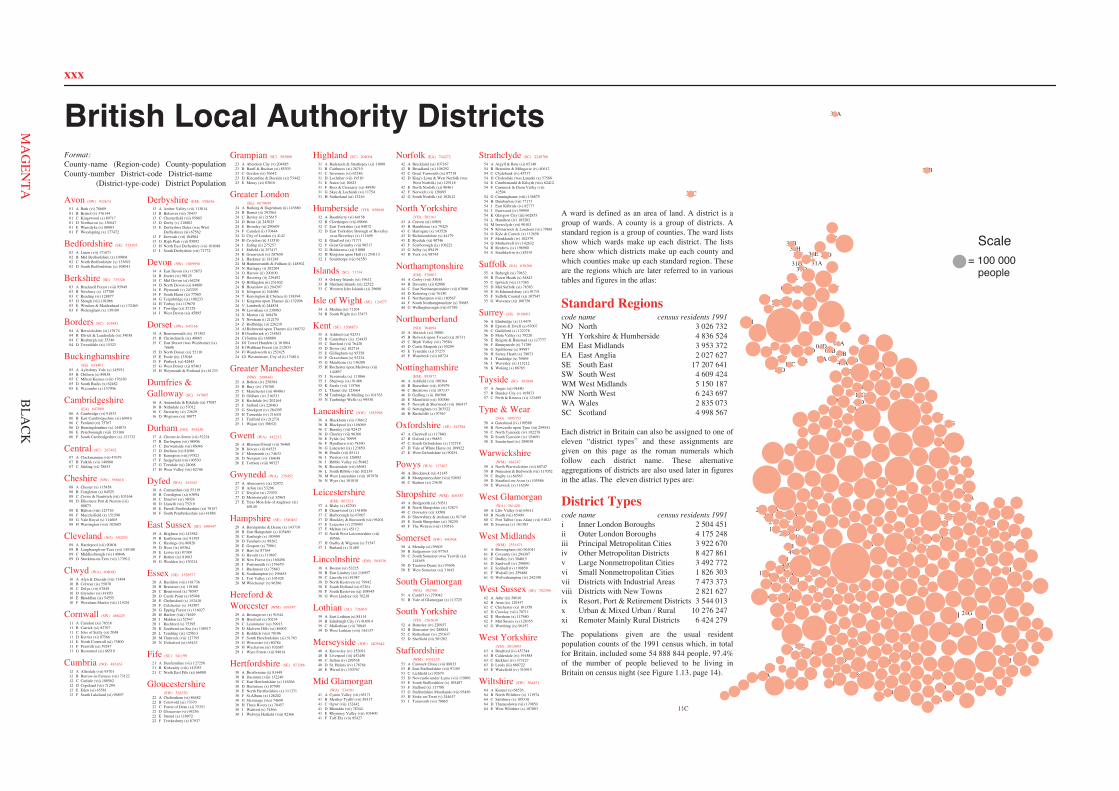
xxx
24G
24F 24L
24M
24N
24S
24T
24V 24W
24Y
24B1
24D1
24F1
24G1 24A
24B
24C
24D
24E 24H
24I
24J
24K
24O 24P
24Q
24R
24U
24X
24Z
24A1
24C1
24E1
25A 25B
25C 25D 25E
25F
25G
25H 25I
25J 40A
40B 40D
40C
40E
52A 52B
52C 52D
58A
58B 58C
58D 58E
61A 61B
61C 61D 61E
61F 61G
63A 63B
63C
63D 63E
01A 01B 01C
01D
01E 01F
02A
02B
02C
02D
03A
03B
03C 03D
03E 03F
05A
05B
05C
05D
05E
06A 06B
06C
06D
06E 06F
08A
08B
08C
08D 08E
08F 08G
08H
09A 09B 09C 09D
11A 11B
11D
11E
11F
11G
11C
12A
12B
12C
12D 12E
12F
13A
13B 13C
13D 13F
13G 13H
13I
13E
14A 14B
14C 14D
14E 14F
14G
14H
14I 14J
15A
15B
15D
15E
15F 15G
15H
15C
17A
17B
17C 17D 17E
17F 17G
17H
19A 19B 19C
19D
19E 19F 19G
20A
20B
20C
20D
20E 20F
20G 20H
20I 20J
20K
20L
20M
20N
22A 22B
22C 22D
22E
22F
28A
28B 28C 28D
28E
28F
28G
28H
28I
28J
28K
28L
28M
29A 29B
29C 29D 29E 29F 29G 29H
29I 30A
30B
30C
30D
30E
30F
30G
30H 30I
30J
32D
32A
32B
32C
32E 32F
32G
32H
32I
34A 34B
35A
35B
35C 35D
35E
35F 35G
35H
35I
35J
35K
35L
35M 35N
36A
36B
36C 36D
36E 36F
36G 36H 36I 36J
36K
36L
36M
36N
37A
37B 37C
37D 37E 37F
37G
37H
37I
38A
38B 38C 38D
38E 38F
38G
42A
42B
42C
42E 42F
42G
42D
44A
44B
44C 44D
44E
44F
44G
45A 45B
45C
45D
45E
45F
43A
43B 43C 43D
43E 43F
43G
43H
46A
46B
46C
46D
46E 46F
46G 46H
47A
47B
47C 47D
47E
49A
49B 49C
49D 49E
49F
50A
50B 50D
50E
50C
53A 53B 53C
53D
53E
53F
53G 53H
53I
55A
55B
55C 55D 55E 55F 55G
56A
56B 56C 56D 56E
56F 56G
56H
56I 56J
56K
59A 59B
59C
59D
59E
62A 62B
62C 62D 62E 62F
62G
64A
64B
64C
64D
64E
10A
10B 10C
10D
10E 10F
18A 18B
18C 18D
18E 18F
26A
26B 26C 26D
26E
27A 27B
27C
27D
27E
41A 41B
41C
41D 41E
41F
48A
48B
48C
51A 51B
60C
60A
60B 60D
04A 04B 04C
04D
07A
07B
07C
16A 16B 16C 16D
21A 21B
21C
23A
23B
23C
23D 23E
31A
31B
31C
31D
31E 31F 31G
31H
39A
39B
39C 39D
54A
54B 54C
54E
54F 54G
54H
54I 54J
54K 54L
54M
54N
54O
54D
54P
54Q 54R
54S
57A
57B 57C
33A
33B
33C
= 100 000people
Scale
British Local Authority Districts
Avon (SW) 932674
01 A Bath (vi) 7868901 B Bristol (v) 37614401 C Kingswood (x) 8971701 D Northavon (x) 13064701 E Wansdyke (x) 8000301 F Woodspring (x) 177472
Bedfordshire (SE) 524105
02 A Luton (vii) 17167102 B Mid Bedfordshire (x) 10980102 C North Bedfordshire (x) 13369202 D South Bedfordshire (x) 108941
Berkshire (SE) 735326
03 A Bracknell Forest (viii) 9594903 B Newbury (x) 13778003 C Reading (vi) 12887703 D Slough (vii) 10106603 E Windsor & Maidenhead (x) 13246503 F Wokingham (x) 139189
Borders (SC) 103881
04 A Berwickshire (xi) 1917404 B Ettrick & Lauderdale (xi) 3403804 C Roxburgh (xi) 3534604 D Tweeddale (xi) 15323
Buckinghamshire(SE) 634407
05 A Aylesbury Vale (x) 14593105 B Chiltern (x) 8983805 C Milton Keynes (viii) 17633005 D South Bucks (x) 6248205 E Wycombe (x) 157906
Cambridgeshire(EA) 647089
06 A Cambridge (vi) 9193306 B East Cambridgeshire (xi) 6041606 C Fenland (xi) 7576706 D Huntingdonshire (x) 14407506 E Peterborough (viii) 15316606 F South Cambridgeshire (x) 121732
Central (SC) 267492
07 A Clackmannan (vii) 4767907 B Falkirk (vii) 14098007 C Stirling (vi) 78833
Cheshire (NW) 956616
08 A Chester (x) 11545808 B Congleton (x) 8452508 C Crewe & Nantwich (vii) 10316408 D Ellesmere Port & Neston (vii)
8087308 E Halton (viii) 12371608 F Macclesfield (x) 15159008 G Vale Royal (x) 11460508 H Warrington (viii) 182685
Cleveland (NO) 550293
09 A Hartlepool (vii) 9040409 B Langbaurgh-on-Tees (vii) 14510809 C Middlesbrough (vi) 14084609 D Stockton-on-Tees (vii) 173912
Clwyd (WA) 408090
10 A Alyn & Deeside (vii) 7349410 B Colwyn (ix) 5507010 C Delyn (vii) 6784910 D Glyndwr (xi) 4187010 E Rhuddlan (ix) 5455510 F Wrexham Maelor (vii) 115251
Cornwall (SW) 468425
11 A Caradon (xi) 7651611 B Carrick (xi) 8270711 C Isles of Scilly (xi) 204811 D Kerrier (xi) 8756611 E North Cornwall (xi) 7380011 F Penwith (xi) 5924711 G Restormel (xi) 86519
Cumbria (NO) 483163
12 A Allerdale (vii) 9570112 B Barrow-in-Furness (vii) 7312212 C Carlisle (vii) 10056212 D Copeland (vii) 7129412 E Eden (xi) 4558112 F South Lakeland (xi) 96897
Derbyshire (EM) 928636
13 A Amber Valley (vii) 11301413 B Bolsover (vii) 7043713 C Chesterfield (vii) 9588513 D Derby (v) 21880213 E Derbyshire Dales (was West
Derbyshire) (xi) 6756213 F Erewash (vii) 10498413 G High Peak (vii) 8509213 H North East Derbyshire (vii) 10108813 I South Derbyshire (vii) 71772
Devon (SW) 1009950
14 A East Devon (ix) 11587314 B Exeter (vi) 9812514 C Mid Devon (xi) 6425814 D North Devon (xi) 8480014 E Plymouth (v) 24335514 F South Hams (xi) 7756514 G Teignbridge (ix) 10823314 H Torbay (ix) 11967014 I Torridge (xi) 5212914 J West Devon (xi) 45895
Dorset (SW) 645166
15 A Bournemouth (ix) 15130215 B Christchurch (ix) 4086515 C East Dorset (was Wimborne) (ix)
7869815 D North Dorset (xi) 5211015 E Poole (ix) 13304815 F Purbeck (xi) 4244515 G West Dorset (xi) 8546315 H Weymouth & Portland (ix) 61233
Dumfries &Galloway (SC) 147805
16 A Annandale & Eskdale (xi) 3708716 B Nithsdale (x) 5701216 C Stewartry (xi) 2362916 D Wigtown (xi) 30077
Durham (NO) 593430
17 A Chester-le-Street (vii) 5222417 B Darlington (vii) 9890617 C Derwentside (vii) 8604617 D Durham (vi) 8108617 E Easington (viii) 9782117 F Sedgefield (viii) 9053017 G Teesdale (xi) 2406817 H Wear Valley (vii) 62746
Dyfed (WA) 343543
18 A Carmarthen (xi) 5511918 B Ceredigion (xi) 6309418 C Dinefwr (xi) 3802618 D Llanelli (vii) 7521918 E Preseli Pembrokeshire (xi) 7015718 F South Pembrokeshire (xi) 41886
East Sussex (SE) 690447
19 A Brighton (vi) 14358219 B Eastbourne (ix) 8139519 C Hastings (ix) 8082019 D Hove (ix) 8536419 E Lewes (ix) 8738919 F Rother (ix) 8168319 G Wealden (ix) 130214
Essex (SE) 1528577
20 A Basildon (viii) 16173620 B Braintree (xi) 11916020 C Brentwood (x) 7059720 D Castle Point (x) 8594820 E Chelmsford (x) 15241820 F Colchester (x) 14250720 G Epping Forest (x) 11602720 H Harlow (viii) 7462920 I Maldon (x) 5254720 J Rochford (x) 7539520 K Southend-on-Sea (ix) 15851720 L Tendring (ix) 12581320 M Thurrock (vii) 12779520 N Uttlesford (xi) 65432
Fife (SC) 341199
21 A Dunfermline (vii) 12725821 B Kirkcaldy (viii) 14705321 C North East Fife (xi) 66888
Gloucestershire(SW) 528370
22 A Cheltenham (vi) 8648222 B Cotswold (xi) 7337022 C Forest of Dean (xi) 7535122 D Gloucester (vi) 9425622 E Stroud (x) 11097222 F Tewkesbury (x) 87937
Grampian (SC) 503888
23 A Aberdeen City (v) 20488523 B Banff & Buchan (xi) 8530323 C Gordon (xi) 7664223 D Kincardine & Deeside (xi) 5344223 E Moray (xi) 83616
Greater London(SE) 6679699
24 A Barking & Dagenham (ii) 14368024 B Barnet (ii) 29356424 C Bexley (ii) 21561524 D Brent (ii) 24302524 E Bromley (ii) 29060924 F Camden (i) 17044424 G City of London (i) 414224 H Croydon (ii) 31351024 I Ealing (ii) 27525724 J Enfield (ii) 25741724 K Greenwich (ii) 20765024 L Hackney (i) 18124824 M Hammersmith & Fulham (i) 14850224 N Haringey (i) 20220424 O Harrow (ii) 20010024 P Havering (ii) 22949224 Q Hillingdon (ii) 23160224 R Hounslow (ii) 20439724 S Islington (i) 16468624 T Kensington & Chelsea (i) 13839424 U Kingston upon Thames (ii) 13299624 V Lambeth (i) 24483424 W Lewisham (i) 23098324 X Merton (ii) 16847024 Y Newham (i) 21217024 Z Redbridge (ii) 22621824 A1Richmond upon Thames (ii) 16073224 B1Southwark (i) 21854124 C1Sutton (ii) 16888024 D1 Tower Hamlets (i) 16106424 E1Waltham Forest (ii) 21203324 F1 Wandsworth (i) 25242524 G1 Westminster, City of (i) 174814
Greater Manchester(NW) 2499441
25 A Bolton (iv) 25858425 B Bury (iv) 17676025 C Manchester (iii) 40486125 D Oldham (iv) 21653125 E Rochdale (iv) 20216425 F Salford (iv) 22046325 G Stockport (iv) 28439525 H Tameside (iv) 21643125 I Trafford (iv) 21273125 J Wigan (iv) 306521
Gwent (WA) 442212
26 A Blaenau Gwent (vii) 7646826 B Islwyn (vii) 6452526 C Monmouth (x) 7463326 D Newport (vi) 13604826 E Torfaen (viii) 90527
Gwynedd (WA) 235452
27 A Aberconwy (ix) 5297227 B Arfon (xi) 5329627 C Dwyfor (xi) 2707027 D Meirionnydd (xi) 3296527 E Ynys Mon-Isle of Anglesey (xi)
69149
Hampshire (SE) 1540467
28 A Basingstoke & Deane (x) 14371028 B East Hampshire (x) 10346028 C Eastleigh (x) 10599928 D Fareham (x) 9926228 E Gosport (x) 7506128 F Hart (x) 8776428 G Havant (x) 11969728 H New Forest (ix) 16045628 I Portsmouth (v) 17467928 J Rushmoor (x) 7568328 K Southampton (v) 19685528 L Test Valley (x) 10142828 M Winchester (x) 96386
Hereford &Worcester (WM) 676747
29 A Bromsgrove (x) 9154429 B Hereford (x) 5023429 C Leominster (xi) 3991329 D Malvern Hills (xi) 8690229 E Redditch (viii) 7810629 F South Herefordshire (xi) 5176329 G Worcester (vi) 8078429 H Wychavon (xi) 10268729 I Wyre Forest (vii) 94814
Hertfordshire (SE) 973286
30 A Broxbourne (x) 8144930 B Dacorum (viii) 13224030 C East Hertfordshire (x) 11626630 D Hertsmere (x) 8759030 E North Hertfordshire (x) 11137130 F St.Albans (x) 12620230 G Stevenage (viii) 7469930 H Three Rivers (x) 7845730 I Watford (x) 7456630 J Welwyn Hatfield (viii) 92366
Highland (SC) 204004
31 A Badenoch & Strathspey (xi) 1100831 B Caithness (xi) 2671031 C Inverness (vi) 6218631 D Lochaber (vii) 1931031 E Nairn (xi) 1062331 F Ross & Cromarty (xi) 4895031 G Skye & Lochalsh (xi) 1175431 H Sutherland (xi) 13216
Humberside (YH) 858040
32 A Boothferry (xi) 6415832 B Cleethorpes (vii) 6906632 C East Yorkshire (xi) 8407232 D East Yorkshire Borough of Beverley
(was Beverley) (x) 11169932 E Glanford (xi) 7177132 F Great Grimsby (vii) 9051732 G Holderness (xi) 5100032 H Kingston upon Hull (v) 25411332 I Scunthorpe (vii) 61550
Islands (SC) 71734
33 A Orkney Islands (xi) 1961233 B Shetland Islands (xi) 2252233 C Western Isles Islands (xi) 29600
Isle of Wight (SE) 124577
34 A Medina (ix) 7110434 B South Wight (ix) 53473
Kent (SE) 1508873
35 A Ashford (xi) 9233135 B Canterbury (ix) 12443535 C Dartford (vii) 7642035 D Dover (ix) 10271435 E Gillingham (x) 9535835 F Gravesham (x) 9323435 G Maidstone (x) 13620935 H Rochester upon Medway (vii)
14485735 I Sevenoaks (x) 11106635 J Shepway (ix) 9148635 K Swale (vii) 11576635 L Thanet (ix) 12366435 M Tonbridge & Malling (x) 10176335 N Tunbridge Wells (x) 99538
Lancashire (NW) 1383998
36 A Blackburn (vii) 13661236 B Blackpool (ix) 14606936 C Burnley (vii) 9241536 D Chorley (vii) 9636636 E Fylde (ix) 7099936 F Hyndburn (vii) 7839036 G Lancaster (ix) 12385036 H Pendle (vii) 8511136 I Preston (vi) 12608236 J Ribble Valley (x) 5048236 K Rossendale (vii) 6568136 L South Ribble (viii) 10213936 M West Lancashire (viii) 10797836 N Wyre (ix) 101818
Leicestershire(EM) 867521
37 A Blaby (x) 8270037 B Charnwood (x) 14180637 C Harborough (x) 6760737 D Hinckley & Bosworth (vii) 9620137 E Leicester (v) 27049337 F Melton (xi) 4511237 G North West Leicestershire (vii)
8056637 H Oadby & Wigston (x) 5154737 I Rutland (x) 31489
Lincolnshire (EM) 584536
38 A Boston (xi) 5322538 B East Lindsey (xi) 11695738 C Lincoln (vi) 8198738 D North Kesteven (x) 7994238 E South Holland (xi) 6726138 F South Kesteven (xi) 10894538 G West Lindsey (xi) 76218
Lothian (SC) 726010
39 A East Lothian (x) 8411439 B Edinburgh City (v) 41891439 C Midlothian (vii) 7884539 D West Lothian (viii) 144137
Merseyside (NW) 1403642
40 A Knowsley (iv) 15209140 B Liverpool (iii) 45245040 C Sefton (iv) 28953840 D St. Helens (iv) 17876440 E Wirral (iv) 330767
Mid Glamorgan(WA) 534101
41 A Cynon Valley (vii) 6517141 B Merthyr Tydfil (vii) 5931741 C Ogwr (vii) 13244241 D Rhondda (vii) 7834441 E Rhymney Valley (vii) 10340041 F Taff-Ely (vii) 95427
Norfolk (EA) 744272
42 A Breckland (xi) 10716742 B Broadland (xi) 10629242 C Great Yarmouth (ix) 8771942 D King's Lynn & West Norfolk (was
West Norfolk) (xi) 12911842 E North Norfolk (xi) 9046142 F Norwich (vi) 12089542 G South Norfolk (xi) 102612
North Yorkshire(YH) 702161
43 A Craven (xi) 4989143 B Hambleton (xi) 7942543 C Harrogate (x) 14352643 D Richmondshire (x) 4417943 E Ryedale (xi) 9074643 F Scarborough (ix) 10622143 G Selby (x) 8941943 H York (vi) 98745
Northamptonshire(EM) 578807
44 A Corby (viii) 5304444 B Daventry (xi) 6288644 C East Northamptonshire (vii) 6768644 D Kettering (vii) 7615044 E Northampton (viii) 18056744 F South Northamptonshire (x) 7068544 G Wellingborough (vii) 67789
Northumberland(NO) 304694
45 A Alnwick (xi) 3008145 B Berwick-upon-Tweed (xi) 2673145 C Blyth Valley (vii) 7958445 D Castle Morpeth (x) 5029945 E Tynedale (xi) 5727545 F Wansbeck (vii) 60724
Nottinghamshire(EM) 993872
46 A Ashfield (vii) 10836446 B Bassetlaw (vii) 10397946 C Broxtowe (vii) 10713746 D Gedling (vii) 10650046 E Mansfield (vii) 10038646 F Newark & Sherwood (vii) 10641746 G Nottingham (v) 26352246 H Rushcliffe (x) 97567
Oxfordshire (SE) 547584
47 A Cherwell (x) 11784047 B Oxford (vi) 9685347 C South Oxfordshire (x) 13271847 D Vale of White Horse (x) 10992247 E West Oxfordshire (x) 90251
Powys (WA) 117467
48 A Brecknock (xi) 4114548 B Montgomeryshire (viii) 5269248 C Radnor (xi) 23630
Shropshire (WM) 406387
49 A Bridgnorth (xi) 5051149 B North Shropshire (xi) 5287349 C Oswestry (xi) 3350849 D Shrewsbury & Atcham (x) 9174949 E South Shropshire (xi) 3823049 F The Wrekin (viii) 139516
Somerset (SW) 460368
50 A Mendip (xi) 9560350 B Sedgemoor (xi) 9776350 C South Somerset (was Yeovil) (xi)
14165550 D Taunton Deane (ix) 9369650 E West Somerset (xi) 31643
South Glamorgan(WA) 392780
51 A Cardiff (v) 27904251 B Vale of Glamorgan (x) 113725
South Yorkshire(YH) 1262630
52 A Barnsley (iv) 22093752 B Doncaster (iv) 28885452 C Rotherham (iv) 25163752 D Sheffield (iii) 501202
Staffordshire(WM) 1031135
53 A Cannock Chase (vii) 8883353 B East Staffordshire (vii) 9710553 C Lichfield (x) 9267953 D Newcastle-under-Lyme (vii) 11909153 E South Staffordshire (x) 10548753 F Stafford (x) 11778853 G Staffordshire Moorlands (vii) 9545053 H Stoke-on-Trent (v) 24463753 I Tamworth (vii) 70065
Strathclyde (SC) 2248706
54 A Argyll & Bute (xi) 6514054 B Bearsden & Milngavie (iv) 4061254 C Clydebank (iv) 4571754 D Clydesdale (was Lanark) (x) 5758854 E Cumbernauld & Kilsyth (viii) 6241254 F Cumnock & Doon Valley (vii)
4259454 G Cunninghame (viii) 13687554 H Dumbarton (vii) 7717354 I East Kilbride (iv) 8277754 J Eastwood (iv) 5995954 K Glasgow City (iii) 66285354 L Hamilton (iv) 10520254 M Inverclyde (vii) 9010354 N Kilmarnock & Loudoun (vii) 7986154 O Kyle & Carrick (x) 11265854 P Monklands (iv) 10237954 Q Motherwell (iv) 14263254 R Renfrew (iv) 19698054 S Strathkelvin (iv) 85191
Suffolk (EA) 636266
55 A Babergh (xi) 7963255 B Forest Heath (x) 5484355 C Ipswich (vii) 11736555 D Mid Suffolk (xi) 7838355 E St.Edmundsbury (xi) 9173155 F Suffolk Coastal (xi) 10754755 G Waveney (xi) 106750
Surrey (SE) 1018003
56 A Elmbridge (x) 11447956 B Epsom & Ewell (x) 6700756 C Guildford (x) 12237856 D Mole Valley (x) 7922056 E Reigate & Banstead (x) 11777756 F Runnymede (x) 7178956 G Spelthorne (x) 8998756 H Surrey Heath (x) 7907356 I Tandridge (x) 7696956 J Waverley (x) 11321256 K Woking (x) 86765
Tayside (SC) 383848
57 A Angus (xi) 9448057 B Dundee City (v) 16587357 C Perth & Kinross (xi) 123495
Tyne & Wear(NO) 1095152
58 A Gateshead (iv) 19958858 B Newcastle upon Tyne (iii) 25954158 C North Tyneside (iv) 19227858 D South Tyneside (iv) 15469158 E Sunderland (iv) 289038
Warwickshire(WM) 484247
59 A North Warwickshire (vii) 6074759 B Nuneaton & Bedworth (vii) 11705259 C Rugby (x) 8456359 D Stratford-on-Avon (x) 10558659 E Warwick (x) 116299
West Glamorgan(WA) 361428
60 A Lliw Valley (vii) 6361160 B Neath (vii) 6540060 C Port Talbot (was Afan) (vii) 5102360 D Swansea (v) 181303
West Midlands(WM) 2551671
61 A Birmingham (iii) 96104161 B Coventry (iv) 29438761 C Dudley (iv) 30461561 D Sandwell (iv) 29009161 E Solihull (iv) 19985961 F Walsall (iv) 25948861 G Wolverhampton (iv) 242190
West Sussex (SE) 702290
62 A Adur (ix) 5801662 B Arun (ix) 12935762 C Chichester (xi) 10135862 D Crawley (viii) 7071162 E Horsham (x) 11768062 F Mid Sussex (x) 12835562 G Worthing (ix) 96157
West Yorkshire(YH) 2013693
63 A Bradford (iv) 45734463 B Calderdale (iv) 19158563 C Kirklees (iv) 37312763 D Leeds (iii) 68072263 E Wakefield (iv) 310915
Wiltshire (SW) 564471
64 A Kennet (x) 6852664 B North Wiltshire (x) 11197464 C Salisbury (x) 10531864 D Thamesdown (vii) 17085064 E West Wiltshire (x) 107803
A ward is defined as an area of land. A district is agroup of wards. A county is a group of districts. Astandard region is a group of counties. The ward listsshow which wards make up each district. The listshere show which districts make up each county andwhich counties make up each standard region. Theseare the regions which are later referred to in varioustables and figures in the atlas:
Standard Regionscode name census residents 1991
237 620 3htroNONYH Yorkshire & Humberside 4 836 524EM East Midlands 3 953 372EA East Anglia 2 027 627SE South East 17 207 641
424 906 4tseW htuoSWSWM West Midlands 5 150 187
796 342 6tseW htroNWN370 538 2selaWAW765 899 4dnaltocSCS
Each district in Britain can also be assigned to one ofeleven “district types” and these assignments aregiven on this page as the roman numerals whichfollow each district name. These alternativeaggregations of districts are also used later in figuresin the atlas. The eleven district types are:
District Typescode name census residents 1991i Inner London Boroughs 2 504 451ii Outer London Boroughs 4 175 248iii Principal Metropolitan Cities 3 922 670iv Other Metropolitan Districts 8 427 861v Large Nonmetropolitan Cities 3 492 772vi Small Nonmetropolitan Cities 1 826 303vii Districts with Industrial Areas 7 473 373viii Districts with New Towns 2 821 627ix Resort, Port & Retirement Districts 3 544 013x Urban & Mixed Urban / Rural 10 276 247xi Remoter Mainly Rural Districts 6 424 279
The populations given are the usual residentpopulation counts of the 1991 census which, in totalfor Britain, included some 54 888 844 people, 97.4%of the number of people believed to be living inBritain on census night (see Figure 1.13, page 14).
Format:County-name (Region-code) County-populationCounty-number District-code District-name (District-type-code) District Population
BLA
CK
xxx
Avon (SW) 932674
Bedfordshire (SE) 524105
Berkshire (SE) 735326
Borders (SC) 103881
Buckinghamshire(SE) 634407
Cambridgeshire(EA) 647089
Central (SC) 267492
Cheshire (NW) 956616
Cleveland (NO) 550293
Clwyd (WA) 408090
Cornwall (SW) 468425
Cumbria (NO) 483163
Derbyshire (EM) 928636
Devon (SW) 1009950
Dorset (SW) 645166
Dumfries &Galloway (SC) 147805
Durham (NO) 593430
Dyfed (WA) 343543
East Sussex (SE) 690447
Essex (SE) 1528577
Fife (SC) 341199
Gloucestershire(SW) 528370
Grampian (SC) 503888
Greater London(SE) 6679699
Greater Manchester(NW) 2499441
Gwent (WA) 442212
Gwynedd (WA) 235452
Hampshire (SE) 1540467
Hereford &Worcester (WM) 676747
Hertfordshire (SE) 973286
Highland (SC) 204004
Humberside (YH) 858040
Islands (SC) 71734
Isle of Wight (SE) 124577
Kent (SE) 1508873
Lancashire (NW) 1383998
Leicestershire(EM) 867521
Lincolnshire (EM) 584536
Lothian (SC) 726010
Merseyside (NW) 1403642
Mid Glamorgan(WA) 534101
Norfolk (EA) 744272
North Yorkshire(YH) 702161
Northamptonshire(EM) 578807
Northumberland(NO) 304694
Nottinghamshire(EM) 993872
Oxfordshire (SE) 547584
Powys (WA) 117467
Shropshire (WM) 406387
Somerset (SW) 460368
South Glamorgan(WA) 392780
South Yorkshire(YH) 1262630
Staffordshire(WM) 1031135
Strathclyde (SC) 2248706
Suffolk (EA) 636266
Surrey (SE) 1018003
Tayside (SC) 383848
Tyne & Wear(NO) 1095152
Warwickshire(WM) 484247
West Glamorgan(WA) 361428
West Midlands(WM) 2551671
West Sussex (SE) 702290
West Yorkshire(YH) 2013693
Wiltshire (SW) 564471
Standard Regions
District Types
MA
GEN
TA
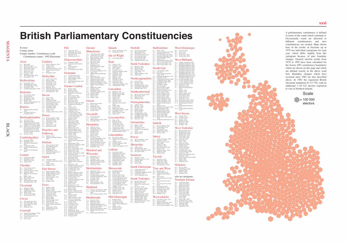
xxxi
12a
45a
17a 17b
12c
17d
45c
09b
17e 17f 12d
17g
45d
12e
12f
58a
45b
12b
17c
58b
09a 58c
58d
09c
58e 58f 58g
09d
58h
09e
09f
58i 58j
58k
58l 58m
52c
32a 32b
32c
32d
63e
63f 63g
52f
52d
63h
43a
63j
63l
63s 63t
43b
52g
43c 43d
43e
52l
52n
63v
43f
52o 52a
52b 63a
63b
63c
63d
52e
32e 32f
63i
63k 32g
32h 32i
63m 63n
63o 63p
63q 63r
63u
52h
52i
52j
52k
52m
63w
43g
13a 46a
46b
37a
13b
37b
46c
44a
44b
38a
13f
38b
46d 38c
37c
13g
38d
44c
37g
46e 46f
13h
37h
46j
37i
46k
13i
38f
44f
13j
13c
13d
13e
37d 37e
37f
38e
44d 44e
46g 46h
46i
55a 55b
42a 06b
42b 06c
42c 42d
06e 42g
55d 06f
42h
55e
55f 06a
55c
42e
42f 06d
24a
24b
24c
24d
24e
24f 24g
24h
24i
24j
24k
24l
24m 24n
24o
24p
24q 24r
24s
24t
24u
24v
24w
24x
24y
24z
24a124b1
24c1
24d1
24e1
24f124g1
24h1
24i1
24j1
24k1
24l124m1
24n1
24o1
24p1
24q1
24r124s1
24t1
24u1
24v124w1
24x1
24y1
24z1
24a2
24b2
24c2
24d2
24e224f2
24g2
24h2 24i2
24j2
24k224l2
24m2
24n2
24o2
24p2
24q2
24r2
24s224t2
24u2
24v2
24w2
24x2
24y224z2
24a3
24b324c3
24d3
24e3
24f3
05a
47a
05b
20b
20c
20d 05c
20f
05d
20g
20h 20i
47b
30b
30c
02b
05e
02c
20j
30d 02d
47d
20k
20l
30f 20m
02e
30e
30g
47e
30i
30j
47f 05f 20a
30a
20e
02a
47c 20n
20o 20p
30h
28a
62a
35a
28b
19a
35b
62b
35c 35d
03a
28c
56b 28e
35e
35f
35h
56e 19e
62d
34a
19g
35i
35j
35k
62e 56f
03b
28h
35l
28i 56g
03c 03d
28l 35m
62f
35n
56i
35o
35p
19h
28o
03f
56k
03g
19b 19c
56a
62c 19d
28d 56c
56d
35g
28f 28g
19f 28j
28k
56h
03e
28m
28n
56j
62g
50a 15c
22b
64a
11a
14b
01g
11b
14c 15d
64b
11d
64c 50b
15f
11c 14g
22d
50c
14h 14i
14k
11e
01h
50d 64e
15g
22e
01i 01j
50e
01a
15a 15b
01b
01c
01d
01e
22a
14a
22c
01f
14d
14e 14f
15e
64d
14j
29a
53a
53b
29b
29c
49a 61t
53c
29d
49b 59a 59b
59c
49c
53e 53f
29e
53g
53h
59d
59e
29g
61a
61b
61c
61d
61e 61f
61g
61h
61i
61j
61k 61l 61m
61n 61o 61p
61q 61r
61s
53d
61u
53i 53j
53k
61v
49d
61w 61x
61y 61z
61a161b1
61c1
61d161e1
29f
25e
36e
08a 08b 08c
08d 08e
36f
08f
25l
25m
40d
40e
36h
25o
08g
25p
36i 36l
36n
25z
08h
36o
40p 40q
25d1
36p
25a
25b
40a
36a 36b
36c
25c
25d 40b
36d 25f
25g
25h
40c
25i 25j
25k
36g
25n
40f 40g
40h
40i
40j 40k
25q
25r
25s 25t
25u
25v
25w
36j
36k
25x
36m
40m 40n
25y
40l
25a1
25b140o 08i
08j
25c1
60a
10a
26a
48a
41a
27a
41b
18a
18b
10b
10c 27b
41c
10d
60b 26b
18c
27c
41d 26c
48b
60c
26d 26e 41e
18d
41f 41g
26f
51e
10e
27d
51a
51b
51c
51d
60d
60e
57a
54a
54b
23c
31a
54c
21a 07a 54d
54e
54f
54g
54h
54i
16a
21b 21c
54j
39a
54k
07b 07c
16b
23d
31b
54y
23e
21d
39h
39i
39j
23f
21e
57d
33a
57e
54f1
31c
04a
07d
54g1
04b
33b 23a
23b
57b 57c
39b 39c
39d
39e 39f
39g
54l
54m
54n
54o
54p 54q
54r
54s
54t
54u
54v 54w
54x
54z 54a1
54b1
54c1
54d1
54e1
65a 65b
65c 65d
65e
65f 65g
65h
65i
65j
65k
65l
65m
65n 65o
65p
65q
British Parliamentary Constituencies
Avon01 a Bath: 6368901 b Bristol East: 6257701 c Bristol North West: 7272601 d Bristol South: 6430901 e Bristol West: 7057901 f Kingswood: 7172701 g Northavon: 8349601 h Wansdyke: 7715601 i Weston-Super-Mare: 7883901 j Woodspring: 77534
Bedfordshire02 a Luton South: 7301602 b Mid Bedfordshire: 8186402 c North Bedfordshire: 7378902 d North Luton: 7685702 e South West Bedfordshire: 79662
Berkshire03 a East Berkshire: 9036503 b Newbury: 8025203 c Reading East: 7215103 d Reading West: 6793703 e Slough: 7388903 f Windsor and Maidenhead: 7732703 g Wokingham: 85914
Borders04 a Roxburgh and Berwickshire:
4348504 b Tweeddale, Ettrick and
Lauderdale: 39493
Buckinghamshire05 a Aylesbury: 7920805 b Beaconsfield: 6426805 c Buckingham (boundary altered
slightly in 1990 see 05e): 5606305 d Chesham and Amersham: 6989505 e Milton Keynes (split into Milton
Keynes South West and NorthEast Milton Keynes on 10 July1990 under statutory instrumentno.1307): 129170
05 f Wycombe: 72564
Cambridgeshire06 a Cambridge: 6902206 b Huntingdon: 9291306 c North East Cambridgeshire:
7993506 d Peterborough: 8763806 e South East Cambridgeshire:
7860006 f South West Cambridgeshire:
84418
Central07 a Clackmannan: 4896307 b Falkirk East: 5191807 c Falkirk West: 5012607 d Stirling: 58266
Cheshire08 a City of Chester: 6337008 b Congleton: 7047708 c Crewe and Nantwich: 7499908 d Eddisbury: 7508908 e Ellesmere Port and Neston:
7157208 f Halton: 7490608 g Macclesfield: 7654808 h Tatton: 7108508 i Warrington North: 7854808 j Warrington South: 77694
Cleveland09 a Hartlepool: 6796809 b Langbaurgh: 7956609 c Middlesbrough: 5884409 d Redcar: 6249409 e Stockton North: 6945109 f Stockton South: 75959
Clwyd10 a Alyn and Deeside: 6047710 b Clwyd North West: 6735110 c Clwyd South West: 6060710 d Delyn: 6659110 e Wrexham: 63720
Cornwall11 a Falmouth and Camborne: 7070211 b North Cornwall: 7684411 c South East Cornwall: 7302711 d St. Ives: 7115211 e Truro: 75101
= 100 000electors
Scale
Cumbria12 a Barrow and Furness: 6776412 b Carlisle: 5514012 c Copeland: 5491112 d Penrith and the Borders: 7376912 e Westmorland and Lonsdale:
7186512 f Workington: 57597
Derbyshire13 a Amber Valley: 7015513 b Bolsover: 6669313 c Chesterfield: 7178313 d Derby North: 7317613 e Derby South: 6632813 f Erewash: 7562713 g High Peak: 7079313 h North East Derbyshire: 7070713 i South Derbyshire: 8234213 j West Derbyshire: 71201
Devon14 a Exeter: 7672314 b Honiton: 7922314 c North Devon: 6899814 d Plymouth Devonport: 6579914 e Plymouth Drake: 5166714 f Plymouth Sutton: 6743014 g South Hams: 8306114 h Teignbridge: 7489214 i Tiverton: 7102414 j Torbay: 7117114 k Torridge and West Devon: 76933
Dorset15 a Bournemouth East: 7508915 b Bournemouth West: 7473815 c Christchurch: 7143815 d North Dorset: 7671815 e Poole: 7922115 f South Dorset: 7578815 g West Dorset: 67256
Dumfries andGalloway16 a Dumfries: 6114516 b Galloway and Upper Nithsdale:
54474
Durham17 a Bishop Auckland: 7257217 b City of Durham: 6816517 c Darlington: 6609417 d Easington: 6506117 e North Durham: 7369417 f North West Durham: 6113917 g Sedgefield: 61024
Dyfed18 a Carmarthen: 6888718 b Ceredigion and Pembroke North:
6618018 c Llanelli: 6505818 d Pembroke: 73187
East Sussex19 a Bexhill and Battle: 6585019 b Brighton Kemptown: 5764619 c Brighton Pavilion: 5761619 d Eastbourne: 7610319 e Hastings and Rye: 7183819 f Hove: 6745019 g Lewes: 7391819 h Wealden: 74665
Essex20 a Basildon: 6758520 b Billericay: 8038820 c Braintree: 7888020 d Brentwood and Ongar: 6583020 e Castle Point: 6622920 f Chelmsford: 8344120 g Epping Forest: 6758520 h Harlow: 6861520 i Harwich: 8026020 j North Colchester: 8647920 k Rochford: 7686920 l Saffron Walden: 7487820 m South Colchester and Maldon:
8641020 n Southend East: 5670820 o Southend West: 6419820 p Thurrock: 69171
Fife21 a Central Fife: 5615221 b Dunfermline East: 5017921 c Dunfermline West: 5094821 d Kirkcaldy: 5176221 e North East Fife: 53747
Gloucestershire22 a Cheltenham: 7980822 b Cirencester and Tewkesbury:
8829922 c Gloucester: 8057822 d Stroud: 8255322 e West Gloucestershire: 80007
Grampian23 a Aberdeen North: 6021723 b Aberdeen South: 5888123 c Banff and Buchan: 6487323 d Gordon: 8010323 e Kincardine and Deeside: 6661723 f Moray: 63255
Greater London24 a Barking: 5045424 b Battersea: 6821824 c Beckenham: 5944024 d Bethnal Green and Stepney:
5567524 e Bexley Heath: 5768424 f Bow and Poplar: 5668524 g Brent East: 5331924 h Brent North: 5891724 i Brent South: 5603424 j Brentford and Isleworth: 7088024 k Carshalton and Wallington:
6517924 l Chelsea: 4237124 m Chingford: 5540124 n Chipping Barnet: 5715324 o Chislehurst: 5378224 p Croydon Central: 5579824 q Croydon North East: 6440524 r Croydon North West: 5724124 s Croydon South: 6476824 t Dagenham: 5964524 u Dulwich: 5514124 v Ealing Acton: 5868724 w Ealing North: 6352824 x Ealing Southall: 6557424 y Edmonton: 6305224 z Eltham: 5198924 a1 Enfield North: 6742124 b1 Enfield Southgate: 6431124 c1 Erith and Crayford: 5921324 d1 Feltham and Heston: 8122124 e1 Finchley: 5290724 f1 Fulham: 5274024 g1 Greenwich: 4778924 h1 Hackney North and Stoke
Newington: 5465524 i1 Hackney South and Shoreditch:
5793524 j1 Hammersmith: 4722924 k1 Hampstead and Highgate: 5820324 l1 Harrow East: 7473324 m1 Harrow West: 6961624 n1 Hayes and Harlington: 5444924 o1 Hendon North: 5151324 p1 Hendon South: 4840124 q1 Holborn and St. Pancras: 6448024 r1 Hornchurch: 6052224 s1 Hornsey and Wood Green: 7349124 t1 Ilford North: 5867024 u1 Ilford South: 5574124 v1 Islington North: 5627024 w1 Islington South and Finsbury:
5554124 x1 Kensington: 4212924 y1 Kingston-upon-Thames: 5107724 z1 Lewisham Deptford: 5701424 a2 Lewisham East: 5767424 b2 Lewisham West: 5931724 c2 Leyton: 5727124 d2 Mitcham and Morden: 6372324 e2 Newham North East: 5955524 f2 Newham North West: 4647124 g2 Newham South: 5114324 h2 Norwood: 5249624 i2 Old Bexley and Sidcup: 4944924 j2 Orpington: 5731824 k2 Peckham: 5826924 l2 Putney: 6191424 m2 Ravensbourne: 5725924 n2 Richmond-upon-Thames and
Barnes: 5308124 o2 Romford: 5400124 p2 Ruislip - Northwood: 5415124 q2 Southwark and Bermondsey:
6025124 r2 Streatham: 5682524 s2 Surbiton: 4242124 t2 Sutton and Cheam: 6094924 u2 The City of London and
Westminster South: 5502124 v2 Tooting: 6830624 w2 Tottenham: 6831924 x2 Twickenham: 6307224 y2 Upminster: 6413824 z2 Uxbridge: 6174424 a3 Vauxhall: 6247324 b3 Walthamstow: 4914024 c3 Wanstead and Woodford: 5582124 d3 Westminster North: 5884724 e3 Wimbledon: 6191724 f3 Woolwich: 55977
GreaterManchester25 a Altrincham and Sale: 6589725 b Ashton-under-Lyne: 5870125 c Bolton North East: 5865925 d Bolton South East: 6560025 e Bolton West: 7134425 f Bury North: 6952925 g Bury South: 6579325 h Cheadle: 6613125 i Davyhulme: 6167925 j Denton and Reddish: 6846325 k Eccles: 6491025 l Hazel Grove: 6430225 m Heywood and Middleton: 5717625 n Leigh: 7006425 o Littleborough and Saddleworth:
6557625 p Makerfield: 7142525 q Manchester Blackley: 5523425 r Manchester Central: 5644625 s Manchester Gorton: 6241025 t Manchester Withington: 6383825 u Manchester Wythenshawe: 5354825 v Oldham Central and Royton:
6133325 w Oldham West: 5406325 x Rochdale: 6952225 y Salford East: 5261625 z Stalybridge and Hyde: 6818925 a1 Stockport: 5809525 b1 Stretford: 5446725 c1 Wigan: 7273925 d1 Worsley: 72244
Gwent26 a Blaenau Gwent: 5563826 b Islwyn: 5107926 c Monmouth: 5914726 d Newport East: 5160326 e Newport West: 5487126 f Torfaen: 61104
Gwynedd27 a Caernarfon: 4646827 b Conwy: 5357627 c Meirionnydd nant Conwy: 3241327 d Ynys Mon: 53412
Hampshire28 a Aldershot: 8175428 b Basingstoke: 8295228 c East Hampshire: 9213928 d Eastleigh: 9173628 e Fareham: 8112428 f Gosport: 6963828 g Havant: 7421728 h New Forest: 7541328 i North West Hampshire: 7310128 j Portsmouth North: 7959228 k Portsmouth South: 7764528 l Romsey and Waterside: 8262828 m Southampton Itchen: 7210428 n Southampton Test: 7293228 o Winchester: 79218
Hereford andWorcester29 a Bromsgrove: 7111129 b Hereford: 6967629 c Leominster: 7087329 d Mid Worcestershire: 8426929 e South Worcestershire: 8042329 f Worcester: 7421129 g Wyre Forest: 73550
Hertfordshire30 a Broxbourne: 7211630 b Hertford and Stortford: 7665430 c Hertsmere: 6995130 d North Hertfordshire: 8006630 e South West Hertfordshire: 7083630 f St. Albans: 7418830 g Stevenage: 7023330 h Watford: 7229130 i Welwyn Hatfield: 7214630 j West Hertfordshire: 78573
Highland31 a Caithness and Sutherland: 3090531 b Inverness, Nairn and Lochaber:
6946831 c Ross, Cromarty and Skye: 55524
Humberside32 a Beverley: 8119832 b Booth Ferry: 8074732 c Bridlington: 8482932 d Brigg and Cleethorpes: 8237732 e Glanford and Scunthorpe: 7347932 f Great Grimsby: 6742732 g Kingston-upon-Hull East: 6903632 h Kingston-upon-Hull North:
7136332 i Kingston-upon-Hull West: 56111
Islands33 a Orkney and Shetland: 3147233 b Western Isles: 22784
Isle of Wight34 a Isle of Wight: 99838
Kent35 a Ashford: 7176735 b Canterbury: 7518135 c Dartford: 7236635 d Dover: 6896235 e Faversham: 8197735 f Folkestone and Hythe: 6585635 g Gillingham: 7185135 h Gravesham: 7074035 i Maidstone: 7283435 j Medway: 6173635 k Mid Kent: 7445935 l North Thanet: 7097835 m Sevenoaks: 7105035 n South Thanet: 6244135 o Tonbridge and Malling: 7729235 p Tunbridge Wells: 76808
Lancashire36 a Blackburn: 7325136 b Blackpool North: 5808736 c Blackpool South: 5680136 d Burnley: 6895236 e Chorley: 7853136 f Fylde: 6357336 g Hyndburn: 5853936 h Lancaster: 5871436 i Morecambe and Lunesdale:
5642636 j Pendle: 6406336 k Preston: 6415836 l Ribble Valley: 6499636 m Rossendale and Darwen: 7690936 n South Ribble: 7817336 o West Lancashire: 7746236 p Wyre: 67778
Leicestershire37 a Blaby: 8179037 b Bosworth: 8023437 c Harborough: 7651437 d Leicester East: 6343437 e Leicester South: 7112037 f Leicester West: 6551037 g Loughborough: 7545037 h North West Leicestershire: 7241437 i Rutland and Melton: 80976
Lincolnshire38 a East Lindsey: 8002638 b Gainsborough and Horncastle:
7203838 c Grantham: 8346338 d Holland with Boston: 6790038 e Lincoln: 7890538 f Stamford and Spalding: 75153
Lothian39 a East Lothian: 6669939 b Edinburgh Central: 5652739 c Edinburgh East: 4568739 d Edinburgh Leith: 5652039 e Edinburgh Pentlands: 5556739 f Edinburgh South: 6135539 g Edinburgh West: 5899839 h Linlithgow: 6108239 i Livingston: 6109239 j Midlothian: 60255
Merseyside40 a Birkenhead: 6268240 b Bootle: 6930840 c Crosby: 8253740 d Knowsley North: 4876140 e Knowsley South: 6226040 f Liverpool Broadgreen: 6008040 g Liverpool Garston: 5753840 h Liverpool Mossley Hill: 6040940 i Liverpool Riverside: 4959540 j Liverpool Walton: 7010240 k Liverpool West Derby: 5671840 l Southport: 7144340 m St. Helens North: 7126140 n St. Helens South: 6750740 o Wallasey: 6567640 p Wirral South: 6111640 q Wirral West: 62453
Mid Glamorgan41 a Bridgend: 5853141 b Caerphilly: 6452941 c Cynon Valley: 4969541 d Merthyr Tydfil and Rhymney:
5843041 e Ogmore: 5219541 f Pontypridd: 6168541 g Rhondda: 59955
Norfolk42 a Great Yarmouth: 6826342 b Mid Norfolk: 8033642 c North Norfolk: 7378042 d North West Norfolk: 7743842 e Norwich North: 6330842 f Norwich South: 6360342 g South Norfolk: 8164742 h South West Norfolk: 77652
North Yorkshire43 a Harrogate: 7625043 b Richmond: 8287943 c Ryedale: 8704843 d Scarborough: 7636443 e Selby: 7717843 f Skipton and Ripon: 7562843 g York: 79242
Northamptonshire44 a Corby: 6833344 b Daventry: 7182444 c Kettering: 6785344 d Northampton North: 6913944 e Northampton South: 8347744 f Wellingborough: 73875
Northumberland45 a Berwick-upon-Tweed: 5491945 b Blyth Valley: 6091345 c Hexham: 5781245 d Wansbeck: 63457
Nottinghamshire46 a Ashfield: 7507546 b Bassetlaw: 5858346 c Broxtowe: 7312346 d Gedling: 6895346 e Mansfield: 6696446 f Newark: 6880146 g Nottingham East: 6793946 h Nottingham North: 6949446 i Nottingham South: 7279646 j Rushcliffe: 7625346 k Sherwood: 73354
Oxfordshire47 a Banbury: 7184047 b Henley: 6470247 c Oxford East: 6307547 d Oxford West and Abingdon:
7232847 e Wantage: 6832847 f Witney: 78521
Powys48 a Brecon and Radnor: 5150948 b Montgomery: 41386
Shropshire49 a Ludlow: 6893549 b North Shropshire: 8267549 c Shrewsbury and Atcham: 7062049 d The Wrekin: 90892
Somerset50 a Bridgwater: 7156750 b Somerton and Frome: 7135450 c Taunton: 7803650 d Wells: 6983350 e Yeovil: 73057
South Glamorgan51 a Cardiff Central: 5771651 b Cardiff North: 5672151 c Cardiff South and Penarth: 6148451 d Cardiff West: 5889851 e Vale of Glamorgan: 66672
South Yorkshire52 a Barnsley Central: 5537352 b Barnsley East: 5405152 c Barnsley West and Penistone:
6337452 d Don Valley: 7632752 e Doncaster Central: 6889052 f Doncaster North: 7473252 g Rother Valley: 6830352 h Rotherham: 6093752 i Sheffield Attercliffe: 6917752 j Sheffield Brightside: 6381052 k Sheffield Central: 5905952 l Sheffield Hallam: 7658452 m Sheffield Heeley: 7095352 n Sheffield Hillsborough: 7734352 o Wentworth: 64914
Staffordshire53 a Burton: 7529253 b Cannock and Burntwood: 7260053 c Mid Staffordshire: 7341453 d Newcastle-under-Lyme: 6659553 e South East Staffordshire: 7019953 f South Staffordshire: 8275853 g Stafford: 7466353 h Staffordshire Moorlands: 7503653 i Stoke-on-Trent Central: 6552753 j Stoke-on-Trent North: 7314153 k Stoke-on-Trent South: 71316
Strathclyde54 a Argyll and Bute: 4789454 b Ayr: 6548154 c Carrick, Cumnock and Doon
Valley: 5533054 d Clydebank and Milngavie: 4733754 e Clydesdale: 6187854 f Cumbernauld and Kilsyth: 4648954 g Cunninghame North: 5480354 h Cunninghame South: 4901054 i Dumbarton: 5722254 j East Kilbride: 6408054 k Eastwood: 6368554 l Glasgow Cathcart: 4468954 m Glasgow Central: 4810754 n Glasgow Garscadden: 4128954 o Glasgow Govan: 4582254 p Glasgow Hillhead: 5722354 q Glasgow Maryhill: 4842654 r Glasgow Pollock: 4613954 s Glasgow Provan: 3656054 t Glasgow Rutherglen: 5270954 u Glasgow Shettleston: 5191054 v Glasgow Springburn: 4584254 w Greenock and Port Glasgow:
5205354 x Hamilton: 6153154 y Kilmarnock and Loudoun: 6200254 z Monklands East: 4839154 a1 Monklands West: 4926954 b1 Motherwell North: 5729054 c1 Motherwell South: 5004254 d1 Paisley North: 4640354 e1 Paisley South: 4788954 f1 Renfrew West and Inverclyde:
5812254 g1 Strathkelvin and Bearsden: 61116
Suffolk55 a Bury St. Edmunds: 7996755 b Central Suffolk: 8273555 c Ipswich: 6726155 d South Suffolk: 8483355 e Suffolk Coastal: 7933355 f Waveney: 84181
Surrey56 a Chertsey and Walton: 7046556 b East Surrey: 5787856 c Epsom and Ewell: 6813856 d Esher: 5884056 e Guildford: 7726556 f Mole Valley: 6694956 g North West Surrey: 8364856 h Reigate: 7185356 i South West Surrey: 7228856 j Spelthorne: 6934356 k Woking: 80842
Tayside57 a Angus East: 6317057 b Dundee East: 5895957 c Dundee West: 5995357 d North Tayside: 5596957 e Perth and Kinross: 65410
Tyne and Wear58 a Blaydon: 6604458 b Gateshead East: 6435558 c Houghton and Washington:
7932558 d Jarrow: 6261158 e Newcastle-upon-Tyne Central:
5997358 f Newcastle-upon-Tyne East:
5716558 g Newcastle-upon-Tyne North:
6618758 h South Shields: 5939258 i Sunderland North: 7287458 j Sunderland South: 7260758 k Tyne Bridge: 5307958 l Tynemouth: 7495558 m Wallsend: 77941
Warwickshire59 a North Warwickshire: 7147359 b Nuneaton: 7090659 c Rugby and Kenilworth: 7776659 d Stratford-on-Avon: 8282459 e Warwick and Leamington: 71259
Format:County-nameCounty-number Constituency-code Constituency-name : 1992 Electorate
West Glamorgan60 a Aberavon: 5165060 b Gower: 5723160 c Neath: 5639260 d Swansea East: 5919660 e Swansea West: 59785
West Midlands61 a Aldridge - Brownhills: 6340461 b Birmingham Edgbaston: 5304161 c Birmingham Erdington: 5239861 d Birmingham Hall Green: 6009161 e Birmingham Hodge Hill: 5765161 f Birmingham Ladywood: 5697061 g Birmingham Northfield: 7053361 h Birmingham Perry Barr: 7216161 i Birmingham Selly Oak: 7215061 j Birmingham Small Heath: 5521361 k Birmingham Sparkbrook: 5167761 l Birmingham Yardley: 5474961 m Coventry North East: 6478761 n Coventry North West: 5067061 o Coventry South East: 4879661 p Coventry South West: 6347461 q Dudley East: 7535561 r Dudley West: 8663261 s Halesowen and Stourbridge:
7764461 t Meriden: 7699461 u Solihull: 7730361 v Sutton Coldfield: 7141061 w Walsall North: 6960461 x Walsall South: 6564261 y Warley East: 5171761 z Warley West: 5716461 a1 West Bromwich East: 5694061 b1 West Bromwich West: 5765561 c1 Wolverhampton North East:
6269561 d1 Wolverhampton South East:
5615861 e1 Wolverhampton South West:
67288
West Sussex62 a Arundel: 7924162 b Chichester: 8212462 c Crawley: 7827762 d Horsham: 8415862 e Mid Sussex: 8082762 f Shoreham: 7125262 g Worthing: 77540
West Yorkshire63 a Batley and Spen: 7641763 b Bradford North: 6671963 c Bradford South: 6991463 d Bradford West: 7001663 e Calder Valley: 7441763 f Colne Valley: 7204363 g Dewsbury: 7283963 h Elmet: 7055863 i Halifax: 7340163 j Hemsworth: 5567963 k Huddersfield: 6760463 l Keighley: 6635863 m Leeds Central: 6205863 n Leeds East: 6169563 o Leeds North East: 6437263 p Leeds North West: 6940663 q Leeds West: 6708463 r Morley and Leeds South: 6310763 s Normanton: 6556263 t Pontefract and Castleford: 6464863 u Pudsey: 7084763 v Shipley: 6881663 w Wakefield: 69794
Wiltshire64 a Devizes: 8974564 b North Wiltshire: 8585164 c Salisbury: 7591664 d Swindon: 9006764 e Westbury: 87356
also on cartogram:Northern Ireland65 a Antrim East: 6283965 b Antrim North: 6912465 c Antrim South: 6801365 d Belfast East: 5283365 e Belfast North: 5506265 f Belfast South: 5203265 g Belfast West: 5460965 h Down North: 6866265 i Down South: 7609365 j Fermanagh and South
Tyrone: 7019265 k Foyle: 7458565 l Lagan Valley: 7264565 m Londonderry East: 7555965 n Newry and Armagh: 6750865 o Strangford: 6887065 p Ulster Mid: 6907165 q Upper Bann: 67446
A parliamentary constituency is definedin terms of the wards which constitute it.Occasionally wards are allocated todifferent constituencies and newconstituencies are created. Maps drawnhere of the results of elections up to1979 use individual cartograms for eachyear, which differ slightly from thiscartogram because of past boundarychanges. General election results from1979 to 1992 have been calculated forthe frozen 1983 constituency boundarieswhich are shown on this page and whichare defined exactly in the above wardlists. Boundary changes which haveoccurred since 1983 are also describedabove. In 1992 the registered Britishelectorate numbered 42 113 792, with anadditional 1 125 143 electors registeredto vote in Northern Ireland.
BLA
CK
xxxi
Avon
Bedfordshire
Berkshire
Borders
Buckinghamshire
Cambridgeshire
Central
Cheshire
Cleveland
Clwyd
Cornwall
Cumbria
Derbyshire
Devon
Dorset
Dumfries andGalloway
Durham
Dyfed
East Sussex
Essex
Fife
Gloucestershire
Grampian
Greater London
GreaterManchester
Gwent
Gwynedd
Hampshire
Hereford andWorcester
Hertfordshire
Highland
Humberside
Islands
Isle of Wight
Kent
Lancashire
Leicestershire
Lincolnshire
Lothian
Merseyside
Mid Glamorgan
Norfolk
North Yorkshire
Northamptonshire
Northumberland
Nottinghamshire
Oxfordshire
Powys
Shropshire
Somerset
South Glamorgan
South Yorkshire
Staffordshire
Strathclyde
Suffolk
Surrey
Tayside
Tyne and Wear
Warwickshire
West Glamorgan
West Midlands
West Sussex
West Yorkshire
Wiltshire
Northern Ireland
MA
GEN
TA
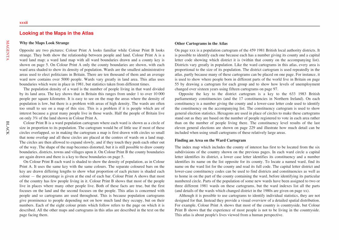
Looking at the Maps in the Atlas
Why the Maps Look Strange
Opposite are two pictures; Colour Print A looks familiar while Colour Print B looksstrange. They both show the relationship between people and land. Colour Print A is award land map; a ward land map with all ward boundaries drawn and a county key isshown on page 5. On Colour Print A only the county boundaries are shown, with eachward area shaded to show its density of population. Wards are the smallest administrativeareas used to elect politicians in Britain. There are ten thousand of them and an averageward now contains over 5000 people. Wards vary greatly in land area. This atlas usesboundaries which were in place in 1981, but statistics taken from different times. The population density of a ward is the number of people living in that ward dividedby its land area. The key shows that in Britain this ranges from under 1 to over 10 000people per square kilometre. It is easy to see on the map the areas where the density ofpopulation is low, but there is a problem with areas of high density. The wards are oftentoo small to see on a map of this size. This is a problem if it is people which are ofinterest because a great many people live in those wards. Half the people of Britain liveon only 3% of the land shown in Colour Print A. Colour Print B is a ward population cartogram where each ward is shown as a circle ofsize in proportion to its population. The cartogram would be of little use if most of thesecircles overlapped, so in making the cartogram a map is first drawn with circles so smallthat none overlap and all these circles are placed at the centres of wards on a land map.The circles are then allowed to expand slowly, and if they touch they push each other outof the way. The shape of the map becomes distorted, but it is still possible to draw countyboundaries, districts, towns and villages upon it. On Colour Print B the county boundariesare again drawn and there is a key to these boundaries on page 5. On Colour Print B each ward is shaded to show the density of population, as in ColourPrint A. It uses the same key with the same colours. The separate coloured bars on thekey are drawn differing lengths to show what proportion of each picture is shaded eachcolour — the percentage is given at the end of each bar. Colour Print A shows that mostof the country has few people living in it. Colour Print B shows that most of the peoplelive in places where many other people live. Both of these facts are true, but the firstfocuses on the land and the second focuses on the people. This atlas is concerned withpeople and so cartograms are used throughout. This is because population cartogramsgive prominence to people depending not on how much land they occupy, but on theirnumbers. Each of the eight colour prints which follow refers to the page on which it isdescribed. All the other maps and cartograms in this atlas are described in the text on thepage facing them.
Other Cartograms in the AtlasOn page xxx is a population cartogram of the 459 1981 British local authority districts. Itis possible to identify each one because each has a number giving its county and a capitalletter code showing which district it is (within that county on the accompanying list).Districts vary greatly in population. Like the ward cartograms in this atlas, every area isproportional to the size of its population. The district cartogram is used repeatedly in theatlas, partly because many of these cartograms can be placed on one page. For instance, itis used to show where people born in different parts of the world live in Britain on page55 by drawing a cartogram for each group and to show how levels of unemploymentchanged over sixteen years using fifteen cartograms on page 97. Opposite the key to the district cartogram is a key to the 633 1983 Britishparliamentary constituencies (and the 17 constituencies in Northern Ireland). On eachconstituency is a number giving the county and a lower-case letter code used to identifythe constituency on the accompanying list. The constituency cartogram is used to showgeneral election statistics. Hexagons are used in place of circles to make these cartogramsstand out as they are based on the number of people registered to vote in each area ratherthan on the number of people living there. The constituency level results of the lasteleven general elections are shown on page 229 and illustrate how much detail can beincluded when using small cartograms of these relatively large areas.
Finding an Area on the Ward CartogramThe index map which includes the county of interest has first to be located from the sixsubdivisions of the country shown on the previous pages. In each ward circle a capitalletter identifies its district, a lower case letter identifies its constituency and a numberidentifies its name on the list opposite for its county. To locate a named ward, find itsname on the ward list for the county and read its full code. The capital letter district andlower-case constituency codes can be used to find districts and constituencies as well asto home in on the part of the county containing the ward, before identifying its particularnumbered circle. Parts of the population of some new wards have been assigned to two orthree different 1981 wards on these cartograms, but the ward indexes list all the parts(and details of the wards which changed district in the 1980s are given on page xx). Although it is possible to use cartograms to identify individual statistics, they are notdesigned for that. Instead they provide a visual overview of a detailed spatial distribution.For example, Colour Print A shows that most of the country is countryside, but ColourPrint B shows that the experience of most people is not to be living in the countryside.This atlas is about people's lives viewed from a human perspective.
xxxii
BLA
CK
Looking at the Maps in the Atlas
xxxii
MA
GEN
TA
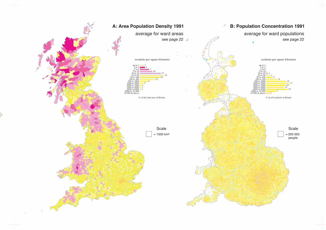
= 250 000people
Scale = 1000 km
Scale
residents per square kilometre
% of the land area of Britain
up to 1 1 to 22 to 5
5 to 1010 to 2525 to 50
50 to 100100 to 300
300 to 10001000 to 20002000 to 30003000 to 40004000 to 6000
6000 to 10 00010 000 & above
34
710
1719
1612
63
111
residents per square kilometre
% of all residents in Britain
up to 1 1 to 22 to 5
5 to 1010 to 2525 to 50
50 to 100100 to 300
300 to 10001000 to 20002000 to 30003000 to 40004000 to 6000
6000 to 10 00010 000 & above
13
58
1417
1413
157
2
B: Population Concentration 1991average for ward populations
see page 22
A: Area Population Density 1991average for ward areas
see page 22
= 250 000people
Scale = 250 000
people
Scale
0.44.70.30.28.93.80.60.10.20.1
13.634.713.615.82.9
WhiteBlack CaribbeanBlack AfricanBlack OtherIndianPakistaniBangladeshiChineseOther AsianOther OtherEnglish bornScottish bornWelsh bornIrish BornOther EEC born
51 874500212178840477163157198290
42 89752212748837494
% of all residents residents inin classified wards Britain ('000s)
largest ethnic or national minority group
% of all residents in Britain
% of all adults of working age (16 to 59/64)
up to5%
5% to7.5%
7.5%to 10%
10% &above
unemployed or on a scheme
up to 5%
5% to 7.5%
7.5% to 10%
10% & above
16.0
4.7
0.7
0.3
15.3
11.1
2.3
0.6
5.9
8.6
4.1
1.8
2.5
10.3
8.1
7.8
retired orpermanentlysick
D: Not Working 1991proportions of ward populations
see page 98
C: Minorities 1991second largest ward populations
see page 62
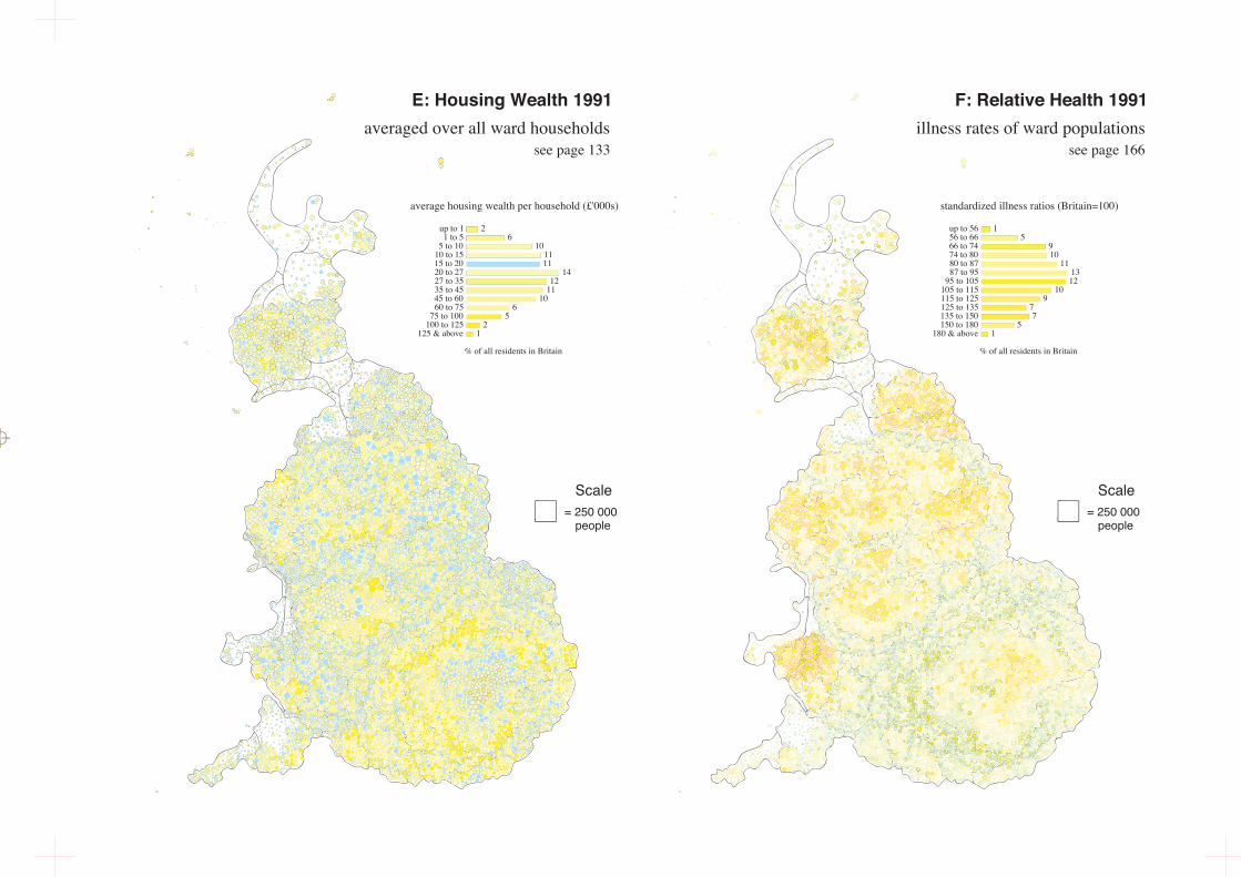
= 250 000people
Scale = 250 000
people
Scale
% of all residents in Britain
up to 11 to 5
5 to 1010 to 1515 to 2020 to 2727 to 3535 to 4545 to 6060 to 75
75 to 100100 to 125
125 & above
26
101111
1412
1110
65
21
average housing wealth per household (£'000s)
E: Housing Wealth 1991averaged over all ward households
661 egap ees331 egap ees
standardized illness ratios (Britain=100)
% of all residents in Britain
15
910
111312
109
77
51
up to 5656 to 6666 to 7474 to 8080 to 8787 to 95
95 to 105105 to 115115 to 125125 to 135135 to 150150 to 180
180 & above
F: Relative Health 1991illness rates of ward populations
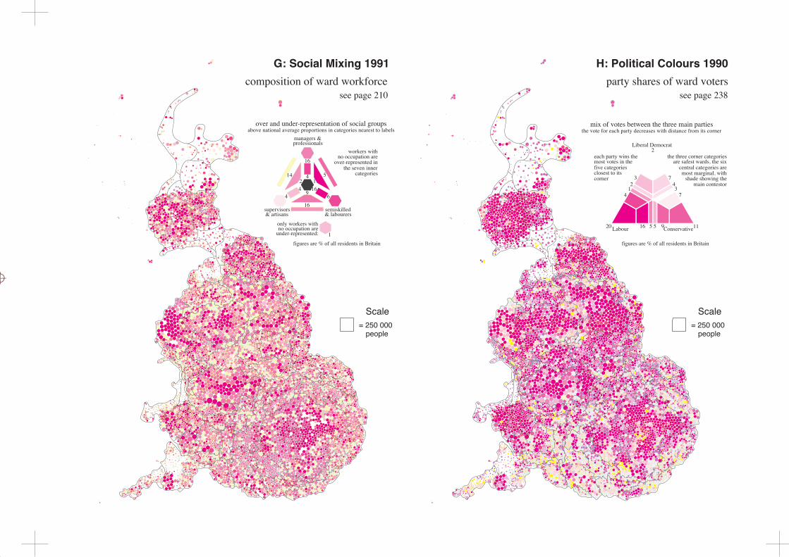
= 250 000people
Scale = 250 000
people
Scale
G: Social Mixing 1991composition of ward workforce
see page 210
over and under-representation of social groupsabove national average proportions in categories nearest to labels
managers &professionals
616
44
9
16
412
1
514
16supervisors& artisans
semiskilled& labourers
119551620 Labour Conservative
7431
4273
Liberal Democrat2
each party wins themost votes in thefive categoriesclosest to itscorner
figures are % of all residents in Britain figures are % of all residents in Britain
H: Political Colours 1990party shares of ward voters
see page 238
no occupation areover-represented in
the seven innercategories
workers with
only workers withno occupation are
under-represented:
the three corner categoriesare safest wards, the six
central categories aremost marginal, with
shade showing themain contestor
mix of votes between the three main partiesthe vote for each party decreases with distance from its corner
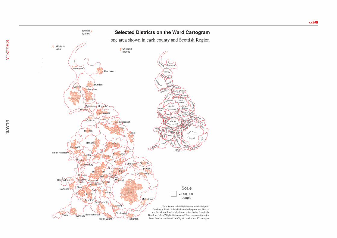
249
Truro Plymouth BournemouthIsle of Wight
Taunton
BristolCardiff
Newport
Merthyr
Swansea
CarmarthenGloucester
SwindonReading
Luton
MiltonKeynes
Wrexham
Brighton
Chelmsford
Worcester
InnerLondon
Southampton
Watford
Maidstone
Leicester
Northampton
Norwich
Oxford
Shrewsbury
Stoke
Ipswich
Guildford
Warwick
Birmingham
Chichester
Brecon
Isle of Anglesey
Cambridge
Chester
MiddlesbroughCarlisle
Derby
Dumfries
Durham
Manchester
HullPreston
Lincoln
Liverpool
York
Morpeth
Nottingham
Sheffield
Newcastle
Leeds
Galashiels
StirlingDunfermline
AberdeenInverness
ShetlandIslands
WesternIsles
OrkneyIslands
EdinburghGlasgow
Dundee
Note: Wards in labelled districts are shaded pink.Brecknock district is labelled after its largest town, Brecon
and Ettrick and Lauderdale district is labelled as Galashiels.Dumfries, Isle of Wight, Swindon and Truro are constituencies.Inner London consists of the City of London and 13 boroughs.
ClevelandDurham
Nor
thum
ber-land
Tyne & Wear
Borders
Dumfries &
Galloway
StrathclydeLothian
Central Fife
Tayside
Grampian
Highlands
Cheshire
YorkshireSouth
HumbersideGreaterManchester
WestYorkshireLancashire
Mersey-side
North YorkshireCu
mbria
GwentSouth
GlamorganM
idWest
Hereford &WorcesterWarwick
shireW e s t
M i d l a n d s
Powys
Dyfed
Gwynedd Clwyd
Staffordshire
Shro
ps
hire
Hertfords
hire
Bed
for
dshir
e Suffolk
NorfolkshireCambridge-
North
am
ptonshire
Leicestershire
Nottingham-
shire
Derbyshire Lincoln-shire
Isle of
Ham
pshire
Berk-shire
Wiltshire
Wight
Dorset
SomersetDevon
Cornwall
Avon Buck
ingh
amsh
ire
Oxf
ord-
shireGloucester-
shire
WestSussex
East Sussex
Surrey
G r e a t e r
L o n d o n
Kent
Essex
= 250 000people
Scale
Selected Districts on the Ward Cartogramone area shown in each county and Scottish Region
Tydfil
xxxvii
BLA
CK
249xxxvii
MA
GEN
TA
![(2Z,N 0 0 0 E)-N 0 0 0 -[(2-Hydroxy-1-naphthyl)- methylidene]furan-2-carbohydrazonic acid](https://static.fdokumen.com/doc/165x107/631360d4b033aaa8b2100e91/2zn-0-0-0-e-n-0-0-0-2-hydroxy-1-naphthyl-methylidenefuran-2-carbohydrazonic.jpg)


![[EGYPT TII – 2019] [0] - Global Tobacco Index](https://static.fdokumen.com/doc/165x107/6319f6d81e5d335f8d0b611d/egypt-tii-2019-0-global-tobacco-index.jpg)