Channel-fill and sheet-flood facies sequences in the ephemeral terminal River Gash, Kassala, Sudan
14
Sedimentary Geology, 63 (1989) 171-184 171 Elsevier Science Publishers B.V., Amsterdam - Printed in The Netherlands Channel-fill and sheet-flood facies sequences in the ephemeral terminal River Gash, Kassala, Sudan OSMAN MAHMOUD ABDULLATIF Department of Geology, Unioersityof Khartoum, P.O. Box 321, Khartoum (Sudan) Received May 17, 1988; revised version accepted February 2, 1989 Abstract Abdullatif, O.M., 1989. Channel-fill and sheet-flood facies sequences in the ephemeral terminal River Gash, Kassala, Sudan. Sediment. Geol., 63: 171-184. Detailed facies analysis of the River Gash fluvial sed~ents, on two-dimensional profdes across and along the main channel, has revealed a number of facies and two distinct types of sequences: channel-fill and sheet-flood sequences. It seems that each sequence type is produced by specific depositional event, and both sequences represent two-end members for suite of mixed sequences. The facies and sequences show rapid lateral variability, and they merse and interfinser with each other. They also show partial to complete modification due to subsequent floods and stage variation. It seems that the thick sediments of the River Gash in the Kassala area were produced in two phases. First by braided channel aggradation and lateral migration. Second by both channelized and unchannelized sheet-flood depo~tion. Deposits of these two phases contribute to the sediments of the present-day Gash fluvial basin in the Kassala area. The Gash sediments show some similarities and differences to those of ephemeral and low-sinuosity braided streams. The predominance of sheet-flood deposits is consistent with the ephemeral flashy high flow regime in the River Gash. The non-conformity of the River Gash depositional style with the braided model of fluvial deposition may be due to this semi-arid terminal flashy character which has control on the depositional processes and patterns. Introduction Recent studies in fluvial sedimentology have pointed out the limitations of vertical profiles, and emphasized the importance of lateral variability for the interpretation of fluvial sediments (Collin- son, 1978; Friend, 1983; Miall, 1988a,b). It has been suggested that the best approach to tackle this problem is by two-dimensional and, if possi- ble, three-dimensional profiles. This seems im- portant especially when dealing with sediments of ephemeral rivers, such as the River Gash (Fig. 1), which ends forming an inland terminal fan-delta (Fig. 2). Because tittle work has been done on such rivers, their sediment organiT~tion is still rather problematic (Reading, 1986). The River Gash is a shallow, low-sinuosity stream with mainly sandy sediments. These sedi- 0037-0738/89/$03.50 © 1989 Elsevier S¢'ience Pubfishers B.V. ments are well exposed in two-dimensional pro- files (sections) near the city of Kassala, Sudan (Fig. 1). These profiles have revealed a variety of facies and sequences. This study describes, char- i EGYPT //'~ ZAIRE v'"L,.J_. /-- ".... J Fig. 1. Location of the River Gash in northeastern Sudan.
Transcript of Channel-fill and sheet-flood facies sequences in the ephemeral terminal River Gash, Kassala, Sudan

Sedimentary Geology, 63 (1989) 171-184 171 Elsevier Science Publishers B.V., Amsterdam - Printed in The Netherlands
Channel-fill and sheet-flood facies sequences in the ephemeral terminal River Gash, Kassala, Sudan
O S M A N M A H M O U D A B D U L L A T I F
Department of Geology, Unioersity of Khartoum, P.O. Box 321, Khartoum (Sudan)
Received May 17, 1988; revised version accepted February 2, 1989
Abstract
Abdullatif, O.M., 1989. Channel-fill and sheet-flood facies sequences in the ephemeral terminal River Gash, Kassala, Sudan. Sediment. Geol., 63: 171-184.
Detailed facies analysis of the River Gash fluvial sed~ents, on two-dimensional profdes across and along the main channel, has revealed a number of facies and two distinct types of sequences: channel-fill and sheet-flood sequences. It seems that each sequence type is produced by specific depositional event, and both sequences represent two-end members for suite of mixed sequences. The facies and sequences show rapid lateral variability, and they merse and interfinser with each other. They also show partial to complete modification due to subsequent floods and stage
variation. It seems that the thick sediments of the River Gash in the Kassala area were produced in two phases. First by
braided channel aggradation and lateral migration. Second by both channelized and unchannelized sheet-flood depo~tion. Deposits of these two phases contribute to the sediments of the present-day Gash fluvial basin in the Kassala area.
The Gash sediments show some similarities and differences to those of ephemeral and low-sinuosity braided streams. The predominance of sheet-flood deposits is consistent with the ephemeral flashy high flow regime in the River Gash. The non-conformity of the River Gash depositional style with the braided model of fluvial deposition may be due to this semi-arid terminal flashy character which has control on the depositional processes and patterns.
Introduction
Recent studies in fluvial sedimentology have pointed out the limitations of vertical profiles, and emphasized the importance of lateral variability for the interpretation of fluvial sediments (Collin- son, 1978; Friend, 1983; Miall, 1988a,b). It has been suggested that the best approach to tackle this problem is by two-dimensional and, if possi- ble, three-dimensional profiles. This seems im- portant especially when dealing with sediments of ephemeral rivers, such as the River Gash (Fig. 1), which ends forming an inland terminal fan-delta (Fig. 2). Because tittle work has been done on such rivers, their sediment organiT~tion is still rather problematic (Reading, 1986).
The River Gash is a shallow, low-sinuosity stream with mainly sandy sediments. These sedi-
0037-0738/89/$03.50 © 1989 Elsevier S¢'ience Pubfishers B.V.
ments are well exposed in two-dimensional pro- files (sections) near the city of Kassala, Sudan (Fig. 1). These profiles have revealed a variety of facies and sequences. This study describes, char-
i EGYPT / / ' ~
ZAIRE v'"L,.J_. / - - ".... J
Fig. 1. Location of the River Gash in northeastern Sudan.

172
acterizes and interprets the facies and sequences, and examines their role in relation to the develop- ment of the River Gash fluvial basin in the Kas- sala area. The study was conducted in April and May of 1987, before the arrival of the annual flood. More observations were collected during the flood period.
Geologic setting
The River Gash originates in the Eritrean high- lands of Ethiopia (Fig. 1). The catchment area,
which consists of gneisses, granites and minor volcanics, is estimated at 21,000 km 2 (Swan, 1956). The total length of the River Gash from its source in Eritrea to the apex of the fan-delta near Kas- sala is about 280 km. The gradients are relatively large in Eritrea, for instance, the River Gash drops down from an elevation of 2000 m to 1100 m m.s.1, in the first 175 km. But in the Kassala area the topography is mainly flat with a gentle slope to the northwest. The elevation at Kassala is 500 m and about 450 m m.s.l, at about the middle of the River Gash fan-delta, near Aroma town (Fig.
Fig. 2. Landsat (thematic mapper) photograph showing the River Gash and the Gash terminal fan-delta (centre). Photograph was taken in October, 1987, just at the end of the annual flood. Scale 1 : 1,000,000; photograph supplied by NCRSC, Sudan.

Fig. 3. The Gash terminal fan-delta showing fan boundaries and distributary channels pattern as drawn from Fig. 2. Un- channelized sheet-flood feature is shown in stripes at the toe of the fan-delta.
3). In the lower reaches in the Sudan, the River Gash becomes ephemeral and usually flows only from July to late September. The climate is semi- arid to arid, and is hot and dry most of the year. The rainy season usually lasts for three months from July to September.
Rock units in the Kassala area consist of Pre- cambrian basement complex rocks, essentially made of granitic gneisses; and the clays of the plain, which are considered to be Tertiary-Pleisto- cene weathering products of the basement rocks. These two units are overlain by the Pleistocene- Recent fluvial sediments of the River Gash. Whiteman (1971), believes that the River Gash might have joined the Atbara River in the Pleistocene.
The Gash terminal fan-delta
North of Kassala most of the river water is lost by evaporation and infiltration, and the River Gash forms an inland terminal fan-delta having a characteristic conical shape (Fig. 2). The Gash
173
fan-delta shows some resemblance to Markanda terminal fan (Mukherji, 1976; Parkash et al., 1983). But the Gash fan-delta covers an area of 2000 km 2, which is 30 times the area of Markanda fan. The boundary and the distributary channels pat- tern of the Gash fan-delta are shown in Fig. 3. The Gash fan-delta is cultivated and modified by irrigation canals, but the distributary pattern and shape can be seen in both old and recent photo- graphs. There is a progressive decrease in channel size and incision from the apex to the toe of the Gash fan-delta, where the channels die out and a shallow sheet-flood dominates. For example, un- channelized sheet-flood feature can be seen near the toe of the fan-delta. This feature is shown by diagonal ruling in Fig. 3.
Fluvial sediments
The fluvial sediments extend between 3 and 4 km east, and between 5 and 7 km to the west of Kassala. The thickness reaches more than 40 m in the west and northwest, and a maximum of 80 m in the Gash fan-delta (Boswinkel, 1984). Saeed (1969) found that the ratio between coarse and fine sediments in many boreholes in the Kassala area indicates that the dominant fractions are very fine to coarse sands and gravels represent over 65~. Downstream from Kassala there is pro- gressive increase in fine fractions (silts and clays) which reach a maximum in the Gash fan-delta. Ibrahim (1980), applied an empirical approach and found that the bed load in fiver Gash is 56.3 kg s -1 and the suspended load is 15,200 ppm by weight.
Discharge and channel patterns
The River Gash has a shallow sandy bed with wide flood plains. The main channel depth is between 1 and 2 m and a width varies from 100 to 800 m, with an average of 200-300 m (WAPS, 1982).
The river also shows rapid discharge variations. The hydrograph for the 1907-1980 period (Fig. 4) shows a corrected average discharge of 800 m 3 s-1, a minimum of 90 m 3 s-1 and a maximum of 1900 m 3 s -1. For the same period, the runoff is
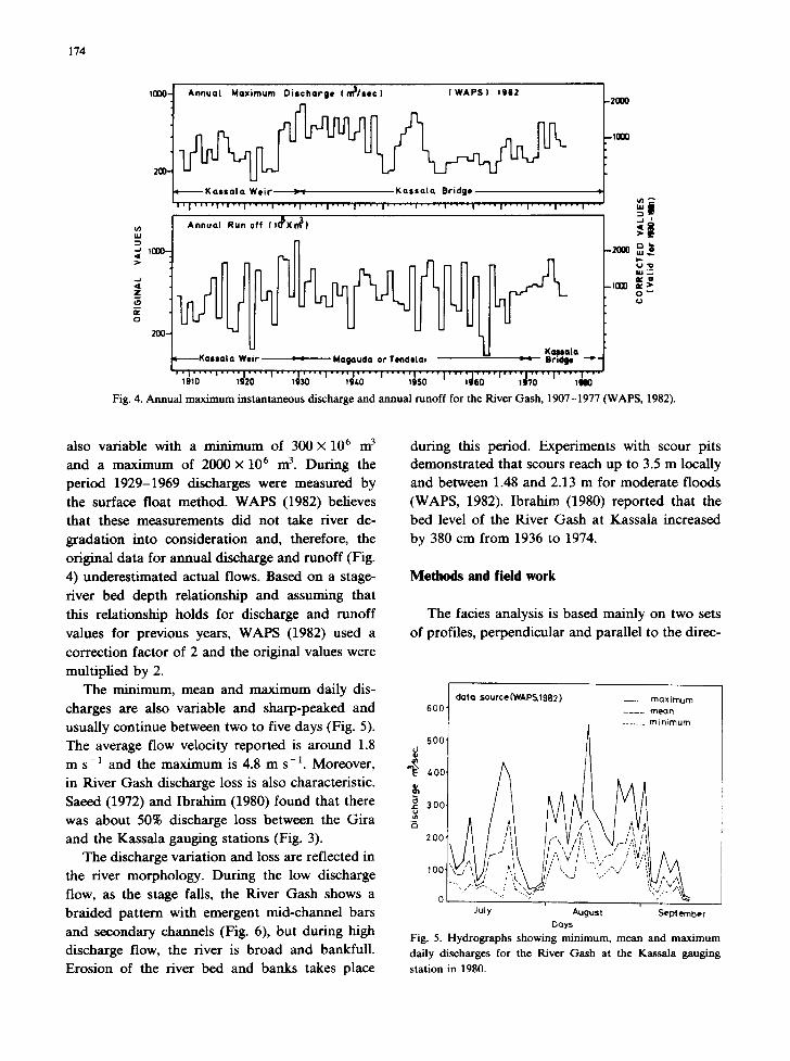
174
t000- A n n u a l M a x i m u m D i s c h a r g e I m l / s e c ) I W A P S ) 1912 -Z000
200. ~ -10al
K a s $ a l a We i r >~ K a s s a l a Br idge • . ~ ' | ' ' ' ' I , I " I ' ' ' ' I ' ' ' I I ' ' ' ' I . . . . I . . . . I . . . . . I . . . . I ' ' " I ' ' ' ' I . . . . I . . . . | . . . . I ' " ~ l
A n n u a l Run of f ( , 0 5 X d ) X I ~ '
::)
o
o
e l r Magauda or Tendelm Bmclge " ~ i , | . . . . | . . . . . . . . , , , ,
, , ,o ' "'"',,,o " , .o" . . . . ; ' ; J ;o . . . . ÁNo"'" Fig. 4. Annual maximum instantaneous discharge and annual runoff for the River Gash, 1907-1977 (WAPS, 1982).
also variable with a minimum of 300 × 106 m 3 and a maximum of 2000 × 106 m 3. During the period 1929-1969 discharges were measured by the surface float method. WAPS (1982) believes that these measurements did not take river de- gradation into consideration and, therefore, the original data for annual discharge and runoff (Fig. 4) underestimated actual flows. Based on a stage- river bed depth relationship and assuming that this relationship holds for discharge and runoff values for previous years, WAPS (1982) used a correction factor of 2 and the original values were multiplied by 2.
The minimum, mean and maximum daily dis- charges are also variable and sharp-peaked and usually continue between two to five days (Fig. 5). The average flow velocity reported is around 1.8 m s-1 and the maximum is 4.8 m s-1. Moreover, in River Gash discharge loss is also characteristic. Saeed (1972) and Ibrahim (1980) found that there was about 50% discharge loss between the Gira and the Kassala gauging stations (Fig. 3).
The discharge variation and loss are reflected in the river morphology. During the low discharge flow, as the stage falls, the River Gash shows a braided pattern with emergent mid-channel bars and secondary channels (Fig. 6), but during high discharge flow, the river is broad and bankfull. Erosion of the river bed and banks takes place
during this period. Experiments with scour pits demonstrated that scours reach up to 3.5 m locally and between 1.48 and 2.13 m for moderate floods (WAPS, 1982). Ibrahim (1980) reported that the bed level of the River Gash at Kassala increased by 380 cm from 1936 to 1974.
Methods and field work
The facies analysis is based mainly on two sets of profiles, perpendicular and parallel to the direc-
t da ta source(WAPSA082) - - max imum 600 . . . . mean
.. . . . . . m in imum
soo] 400
2 0 0 t~
I 00' "- ~ II,/:/~'';" -/ "~'~., ,, 0 " -..: , . . ,r T
July August September Days
F ig . 5. H y d r o g r a p h s s h o w i n g m i n i m u m , m e a n and m a x i m u m
d a i l y d i scharges f o r the R i v e r G a s h at the K a s s a l a g a u g i n g
station in 1980.

175
Fig. 6. Main geomorphological features in the active channel at Kassala. (a) Development of transverse bars of linguoid type (centre) as stage falls. Flow is towards the observer (north), and channel width is about 100 m. (b) Same location as in (a), but at a lower
stage. It shows the development of minor channels and small kite-shape sand-flat. (c) Location 50 m north of (b), at a lower stage than that of (b) showing sand-fiats and minor channels. Flow is from left to fight (north).
176
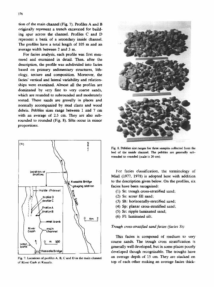
tion of the main channel (Fig. 7). Profiles A and B originally represent a trench excavated for build- ing spur across the channel. Profiles C and D represent a bank of a secondary inside channel. The profiles have a total length of 105 m and an average width between 2 and 3 m.
For facies analysis, each profile was first mea- sured and examined in detail. Then, after the description, the profile was subdivided into facies based on primary sedimentary structures, lith- ology, texture and composition. Moreover, the facies' vertical and lateral variability and relation- ships were examined. Almost all the profiles are dominated by very fine to very coarse sands, which are rounded to subrounded and moderately sorted. These sands are gravelly in places and normally accompanied by mud clasts and wood debris. Pebbles sizes range between 1 and 7 cm with an average of 2.5 cm. They are also sub- rounded to rounded (Fig. 8). Silts occur in minor proportions.
!;°' i
location of Profiles !
J Kassala Bridge
/ ~, Profile O \ \ ~ ,~profile C
-- ~profit e B
~ ---east bank 2,
~,assala aridgeJ
Fig. 7. Locations of profiles A, B, C and D in the main channel
of River Gash at Kassala.
Fig. 8. Pebbles size ranges for three samples collected from the bed of the inside channel. The pebbles are generally sub-
rounded to rounded (scale is 20 em).
For facies classification, the terminology of Miall (1977, 1978) is adopted here with addition to the facies
(1) (2) (3) (4) (5) (6)
description given below. On the profiles, six have been recognized: St: trough cross-stratified sand; Ss: scour fill sand; Sh: horizontally-stratified sand; Sp: planar cross-stratified sand; Sr: ripple laminated sand; Fh laminated silt.
Trough cross-stratified sand facies (facies St)
This facies is composed of medium to very coarse sands. The trough cross stratification is generally well developed, but in some places poorly developed though recognizable. The troughs have an average depth of 15 cm. They are stacked on top of each other making an average facies thick-
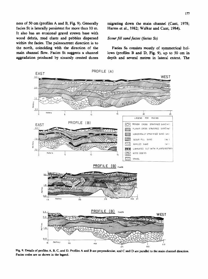
hess of 50 cm (profiles A and B, Fig. 9). Generally facies St is laterally persistent for more than 10 m. It also has an erosional gravel strewn base with wood debris, mud clasts and pebbles dispersed within the facies. The paleocurrent direction is to the north, coinciding with the direction of the main channel flow. Facies St suggests a channel aggradation produced by sinuosly crested dunes
177
migrating down the main channel (Cant, 1978; Harms et all., 1982; Walker and Cant, 1984).
Scour fill sand facies (facies Ss)
Fades Ss consists mostly of symmetrical hol- lows (profiles B and D, Fig. 9), up to 50 cm in depth and several metres in lateral extent. The
EAST
2.o
1.0
0.0
2.0
1.0
0,0
PROFILE (A)
WEST
S 10 15
EAST PROFILE (B)
] ,0
M e t e r s ] [ 1 5 10 15
L EOEND FOR FACIES
F• 1ROUOH CROSS STRATIFIED SAND(st)
PLANAR DROSS STRATIFIED SAND(sp}
HORIZONTALLY STRATIFIED SAND (sh)
SCOUR RLL SAND ( $ s )
RIPPLED SAND ( s r )
LANINATED SILT (WITH PLANTSROOT~dlJ I i
WOOD DEBRIS
GRAVEL
PROFILE (B) Co,,~
=.___= PROFILE {B} ¢o,~'w =,_~_o WEST
0,0 ~ , , /q , / re .." 3~5 I
4O 5 3
4 5 S O
Fig. 9. Details of profiles A, B, C, and D. Profiles A and B are perpendicular, and C and D are parallel to the main channel direction. FaNes codes are as shown in the legend.

178
NORTH
PROFILE IC)
SOUTH
N~RTH
MQtr*s 5
PROFILE (D) SOUTH
0 Het t rs ~; I0
Fig. 9. (continued).
;S 20
facies is composed of coarse to very coarse sands. Pebbles and mud clasts ranging in sizes from 1 to 6 cm occur throughout the facies and in some places as basal lags. Wood debris is common and in some profiles the facies is made of wood debris and minor sands (profile A). A complex pattern of facies Ss cutting each other vertically and laterally is also characteristic (profiles B and D). Generally
the sand fill conforms to the base of the scour, and small-scale trough cross beds tend to occur at the top of some scours. Laterally facies Ss passes into other facies such as facies Sp and facies Sh.
Facies Ss has been reported from both modern and ancient fluvial sediments and has been attri- buted to discharge variations (Cant and Walker, 1978; Miall, 1978; Parkash et al., 1983). In the River Gash, facies Ss may be considered as due to the cut-and-fill aggradational process. Its position in the profiles indicate that it has been created by minor channels cutting preexisting sediments at
low discharge flow.
Horizontally stratified sand facies (facies Sh)
Facies Sh consists of fine to medium sands. Pebbles and wood debris are scattered within the facies and gravel strewn bases are also present. Facies Sh has an average thickness of 40 cm and a
maximum of 120 cm, and is laterally persistent for more than 10 m. Moreover, the facies occurs at different positions within the profiles: at the base, in the middle and at the upper part.
Facies Sh reflects an upper flow regime condi-
tion in the River Gash. Its different positions within the profiles, may be attributed to the fact that facies Sh occurs whenever the plane bed
conditions (depth/veloci ty /gra in size) are met (Harms et al., 1982). Facies Sh is similar to that observed in other flood and ephemeral streams deposits (McKee et al., 1967; Williams, 1971;
Parkash et al., 1983).
Planar cross-stratified sand facies (facies Sp)
Facies (Sp) is composed of fine to medium
sands. Rare pebbles and mud clasts occur either dispersed within the facies or as a basal lag. It occurs singly or in sets of up to four sets (profile A, Fig. 9). Foresets dip between 15 and 25 o, and the paleocurrent directions in profiles A and B are to the east, diverging from the direction of the main channel which is to the north. But in profiles C and D, the paleocurrent directions are to the north, conforming with the direction of the main channel. Facies Sp has an average thickness of 45 cm and is laterally persistent for more than 20 m.

179
The position of facies Sp in the profiles suggests that it has been produced by sand waves or trans- verse bars of linguoid type (Fig. 6; Collinson, 1986).
Ripple laminated sand facies (facies Sr)
This facies consists of silty, fine to very fine sands. Both small trough cross-laminated and climbing ripples are present. It occurs singly or as superimposed sets, having undulatory tops and bottoms (profile B, Fig. 9). Fine plant debris and root traces are commonly present. The thickness of facies Sr is between 5 and 15 cm with an average of 10 cm, and laterally traceable for more than 10 m. Facies Sr has a restricted extent com- pared with other facies, and its preservational potential is higher in the upper parts of the pro- files. Its occurrence suggests deposition during the lower flow r e , me as overbank deposits (Walker and Cant, 1984).
Laminated silt facies (facies FI)
Facies F1 consists mainly of brown, finely laminated to massive silts. Desiccation cracks and root traces are commonly present. Undulatory tops and bottoms of this facies are also character- istic. The facies thickness ranges between 5 and 10 cm and it is laterally traceable for several metres. Observation in the overbank areas and abandoned
secondary channels and pools, shows that facies F1 may reach there a thickness of 40 cm (Fig. 10).
Facies F1 suggests deposition under a flow re- gime below that of facies Sr, mainly by vertical accretion. The low preservational potential of facies F1 and facies Sr compared with other facies, suggests that these two facies were partially to completely removed by subsequent flash floods and mobile secondary channels (Cant, 1978; Stear, 1983).
Grain size analysis
Several channel and overbank spot samples were analysed for their grain-size distributions. Loca- tions and facies types of these samples are given in Figs. 11 and 12. The channel samples, which rep- resent facies St, facies Sh and facies Sp, were taken from the bank and the bed of the active inside channel (Fig. 11). The overbank samples, all represent facies (F1), and were taken from differ- ent locations within the main channel such as dry pools, abandoned minor channels and thin curly drapes on the active inside channel (Fig. 11).
The channel samples were dry sieved and the overbank samples were analysed by hydrometer. The cumulative weight percentages are shown in Fig. 12. The curves of the channel samples suggest two types of populations: saltation and suspension populations. The truncation between the two types occurs at about 2.5-3 ~. But the overbank sam-
Fig. 10. Desiccation cracks in fades F1, location is a dry pool in the overbank area of the main channel.
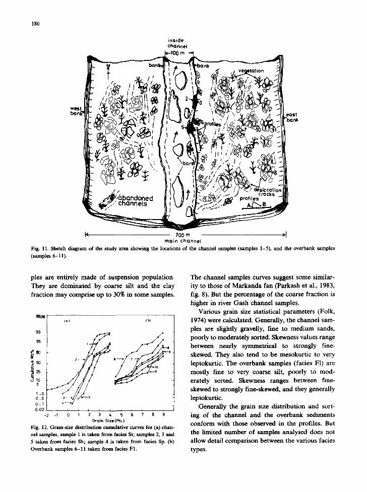
180
inside channel
l< 700 m >J main channel
Fig. 11. Shetch diagram of the study area showing the locations of the channel samples (samples 1-5), and the overbank samples (samples 6-11).
pies are entirely made of suspension population. They are dominated by coarse silt and the clay fraction may comprise up to 30~ in some samples.
99
95
:,50
0.I 0.02
-2
(a) (b)
' ~ ' -I 0 1 2 4 5 6 7 8 9
Grain Size {Phi )
Fig. 12. Gram-size distribution cumulative curves for (a) chan- nel samples, sample 1 is taken from facies St; samples 2, 3 and
5 taken from facies Sh; sample 4 is taken from facies Sp. (b)
Overbank samples 6-11 taken from facies F1.
The channd samples curves suggest some similar- ity to those of Markanda fan (Parkash et al., 1983, fig. 8). But the percentage of the coarse fraction is higher in river Gash channel samples.
Various grain size statistical parameters (Folk, 1974) were calculated. Generally, the channel sam- ples are slightly graveUy, fine to medium sands, poorly to moderately sorted. Skewness values range between nearly symmetrical to strongly fine- skewed. They also tend to be mesokurtic to very leptokurtic. The overbank samples (facies F1) are mostly fine to very coarse silt, poorly to mod- erately sorted. Skewness ranges between fine- skewed to strongly fine-skewed, and they generally leptokurtic.
Generally the grain size distribution and sort- ing of the channel and the overbank sediments conform with those observed in the profiles. But the limited number of samples analysed does not allow detail comparison between the various facies types.
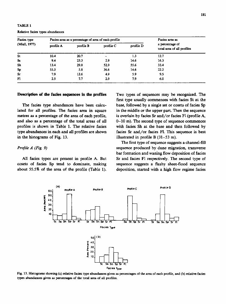
TABLE 1
Relative facies types abundances
181
Facies type
(Miall, 1977)
Facies area as a percentage of area of each profile
profile A profile B profile C profile D
Facies area as
a percentage of
total area of all profiles
St 10.4 20.7 - 1.3 12.7
Ss 9.4 23.3 2.9 14.6 16.3
Sh 13.4 29.8 52.9 55.6 33.4
Sp 55.5 5.8 36.6 14.6 22.2
Sr 7.9 12.6 4.9 5.9 9.5
F1 2.5 7.7 2.9 7.9 6.0
Description of the facies sequences in the profiles
The facies type abundances have been calcu- lated for all profiles. The facies area in square metres as a percentage of the area of each profile, and also as a percentage of the total areas of all profiles is shown in Table 1. The relative facies type abundances in each and all profiles are shown in the histograms of Fig. 13.
Profile A (Fig. 9)
All facies types are present in profile A. But cosets of facies Sp tend to dominate, making about 55.5% of the area of the profile (Table 1).
Two types of sequences may be recognized. The first type usually commences with facies St at the base, followed by a single set or cosets of facies Sp in the middle or the upper part. Then the sequence is overlain by facies Sr and/or facies F1 (profile A, 0-10 m). The second type of sequence commences with facies Sh at the base and then followed by facies Sr and/or facies F1. This sequence is best illustrated in profile B (31-53 m).
The first type of sequence suggests a channel-fill sequence produced by dune migration, transverse bar formation and waning flow deposition of facies Sr and facies F1 respectively. The second type of sequence suggests a flashy sheet-flood sequence deposition, started with a high flow regime facies
60. 50. 40. 30.
<~ 20. 10
(a) profile O Profile A profile B profile C
St Ss Sh Sp Sr F[ St Ss Sh SP Sr FI .Ss St~ Sp Sr FI St Ss Sh Sp Sr FI
Facies Type
i 4° 3O
20
St Ss Sh Sp Sr FI
Facies Type
Fig. 13. Histograms showing (a) relative facies type abundances given as percentages of the area of each profile, and (b) relative facies types abundances given as percentages of the total area of all profiles.
182
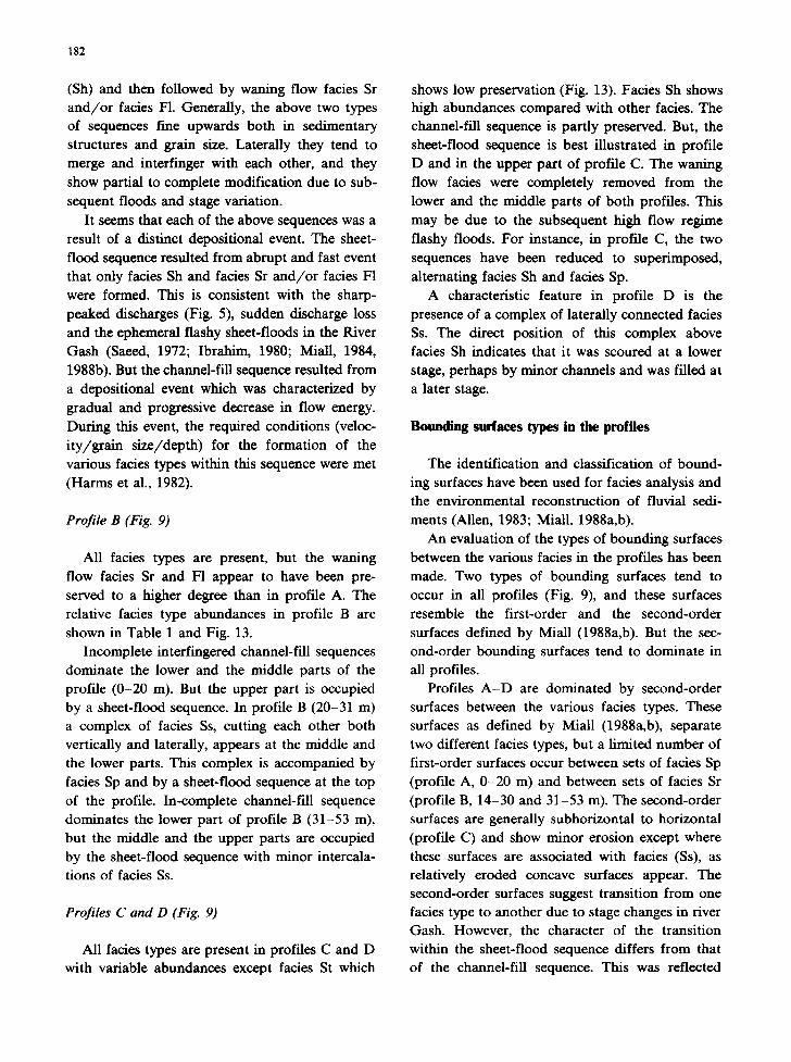
(Sh) and then followed by waning flow facies Sr and/or facies F1. Generally, the above two types of sequences fine upwards both in sedimentary structures and grain size. Laterally they tend to merge and interfinger with each other, and they show partial to complete modification due to sub- sequent floods and stage variation.
It seems that each of the above sequences was a result of a distinct depositional event. The sheet- flood sequence resulted from abrupt and fast event that only facies Sh and facies Sr and/or facies F1 were formed. This is consistent with the sharp- peaked discharges (Fig. 5), sudden discharge loss and the ephemeral flashy sheet-floods in the River Gash (Saeed, 1972; Ibrahim, 1980; Miall, 1984, 1988b). But the channel-fill sequence resulted from a depositional event which was characterized by gradual and progressive decrease in flow energy. During this event, the required conditions (veloc- ity/grain size/depth) for the formation of the various facies types within this sequence were met (Harms et al., 1982).
Profile B (Fig. 9)
All facies types are present, but the waning flow facies Sr and F1 appear to have been pre- served to a higher degree than in profile A. The relative facies type abundances in profile B are shown in Table 1 and Fig. 13.
Incomplete interfingered channel-fill sequences dominate the lower and the middle parts of the profile (0-20 m). But the upper part is occupied by a sheet-flood sequence. In profile B (20-31 m) a complex of facies Ss, cutting each other both vertically and laterally, appears at the middle and the lower parts. This complex is accompanied by facies Sp and by a sheet-flood sequence at the top of the profile. In-complete channel-fill sequence dominates the lower part of profile B (31-53 m), but the middle and the upper parts are occupied by the sheet-flood sequence with minor intercala- tions of facies Ss.
Profiles C and D (Fig. 9)
All facies types are present in profiles C and D with variable abundances except facies St which
shows low preservation (Fig. 13). Facies Sh shows high abundances compared with other facies. The channel-fill sequence is partly preserved. But, the sheet-flood sequence is best illustrated in profile D and in the upper part of profile C. The waning flow facies were completely removed from the lower and the middle parts of both profiles. This may be due to the subsequent high flow regime flashy floods. For instance, in profile C, the two sequences have been reduced to superimposed, alternating facies Sh and facies Sp.
A characteristic feature in profile D is the presence of a complex of laterally connected facies Ss. The direct position of this complex above facies Sh indicates that it was scoured at a lower stage, perhaps by minor channels and was filled at a later stage.
Bounding surfaces types in the profiles
The identification and classification of bound- ing surfaces have been used for facies analysis and the environmental reconstruction of fluvial sedi- ments (Allen, 1983; Miall, 1988a,b).
An evaluation of the types of bounding surfaces between the various facies in the profiles has been made. Two types of bounding surfaces tend to occur in all profiles (Fig. 9), and these surfaces resemble the first-order and the second-order surfaces defined by MiaU (1988a,b). But the sec- ond-order bounding surfaces tend to dominate in all profiles.
Profiles A-D are dominated by second-order surfaces between the various facies types. These surfaces as defined by Miall (1988a,b), separate two different facies types, but a limited number of first-order surfaces occur between sets of facies Sp (profile A, 0-20 m) and between sets of facies Sr (profile B, 14-30 and 31-53 m). The second-order surfaces are generally subhorizontal to horizontal (profile C) and show minor erosion except where these surfaces are associated with facies (Ss), as relatively eroded concave surfaces appear. The second-order surfaces suggest transition from one facies type to another due to stage changes in river Gash. However, the character of the transition within the sheet-flood sequence differs from that of the channel-fill sequence. This was reflected
into different facies types assemblages within each sequence.
Higher-order bounding surfaces (third- to six- order; Miall, 1988b), were not revealed in the profiles. But the fluvial depositional style in river Gash, characterized by the facies sequences (Fig. 9), the geomorphic elements (Fig. 6) with a major channel and a number of mobile secondary chan- nels, suggest the possibility of the presence of higher order surfaces.
Discussion and conclusion
Like other semi-arid braided streams, the River Gash shows rapid discharge variation. This may be due to climatic and seasonal rainfall changes and losses due to evaporation and infiltration (Saeed, 1972; Miall, 1977; Ibrahim, 1980). The discharge variation and loss is reflected in flow patterns and channel morphology, and results in rapid deposition and aggradation, and the even- tual multifurcation and the formation of the Gash terminal fan-delta.
The facies analysis of the River Gash sediments allows the recognition of channel-fill and sheet- flood type sequences. These sequences represent two-end members for suites of mixed sequences. The sequences generally merge and interfinger with each other and show rapid lateral changes. Second-order bounding surfaces almost dominate all profiles, and these surfaces indicate transition from one facies type to another due to stage variation.
The facies and sequences in the River Gash suggests some similarities to those observed in ephemeral and perennial sandy braided streams (Mckee et al., 1967; Williams, 1971; Miall, 1977, 1978; Cant, 1978; Parkash et al., 1983). For in- stance, the channel-fill sequence in the River Gash shows resemblance to the ephemeral channel-fill and channel-bar sequences of Picard and High (1973), and the channel sequences in the South Saskatchewan River (Cant, 1978), in the later case especially with respect to the combination of facies St and facies Sp and their arrangement within the sequences. However, some differences still remain between the River Gash and the South Saskatche-
183
wan River. For example, the Gash is shallower and shows rapid discharge variation. A second difference its ephemeral, flashy terminal character, and a third its rapid lateral facies change. In the fourth place, the River Gash is characterized by a horizontally stratified sands and abundant scour- ing and filling features, both reflected by facies Sh and facies Ss respectively. The predominance of facies Sh (Fig. 13) in the profiles is consistent with the ephemeral, flashy high flow regime in River Gash.
It seems that the sand-dominated sediments in River Gash enhanced the scouring and erosional processes as well as the lateral mobility of the channels (Ibrahim, 1980; Collinson, 1984). In ad- dition, the location of the study area near the apex of the Gash terminal fan-delta might have played a role in this respect. Moreover, there is also a similarity with the Markanda terminal fan (Parkash et al., 1983) with respect to fan mor- phology and the types of facies present. But the lateral arrangement and variability of the facies and sequences in the Markanda fan are not clear from the vertical profiles. It is to be expected that more resemblance will exist between the Gash fan-delta and the Markanda fan.
The facies, the sequence types and the geome- try of the Gash fluvial sediments in the Kassala area (Boswinkel, 1984; Nur Elmadina and Kruse- man, 1986), suggest that deposition occurred in two phases. The first phase was formed by chan- nels with minor channelized sheet-flood deposi- tion, and the second phase by both channelized and unchannelized sheet-flood on the flood plains. Channel aggradation and lateral migration subse- quently produced multi-phase interfingered se- quences of braided channels and sheet-flood de- posits, stacked on each other. This series of events produced the present-day River Gash fluvial sedi- ments in the Kassala area.
Finally, it seems that the fluvial depositional style in the River Gash does not conform fully with the braided model of fluvial deposition (Cant, 1978). This may be attributed not only to the semi-arid, terminal and ephemeral flashy char- acter of river Gash, but also to the "variability and instability of the fluvial system both in rate and process" (Schumm, 1981).
184
A c k n o ~ t s
Thanks are due to Nur Elmadina and Mohammed Dein and the technical staff at the N.W.C., Kassala, for providing help and access to their data and drafting facilities. I thank N. Barazi for making usefull suggestion on earlier draft of this manuscript. I also thank A. Miall for helpful comments, and two anonymous referees for con- structive criticism of an earlier version of this manuscript.
Relerenees
Allen, J.R.L., 1983. Studies in fluviatile sextimentation: bars, bar complexes and sandstone sheets (low-sinuosity braided streams) in the Brownstones (L. Devonian), Welsh Borders. Sediment. Geol., 33: 237-293.
Boswinkel, J.A., 1984. WAP-2, Progress Report. N.W.C., Kas- sala.
Cant, D.J., 1978. Development of a facies model for sandy braided fiver sedimentation: a comparison of the South Saskatchewan river and the Battery Point Formation. Mere. Can. SOc. Pet. Geol., 5: 622-639.
Cant, D.J. and Walker, R.G., 1978. Fluvial processes and facies sequences in the sandy braided South Saskatchewan river. Sedimentology, 25: 625-648.
Collinson, J.D., 1978. Vertical sequences and sand body shape in alluvial sequences. Mere. Can. SOc. Pet. Geol., 5: 577-586.
Collinson, J.D., 1986. Alluvial sediments. In: H.G. Reading (Editor), Sedimentary Environments and Facies. Blackwell, Oxford, 2nd ed., pp. 20-67.
Folk, R.U, 1974. Petrology of Sedimentary Rocks. Hemphill, Auston, Texas, 182 pp.
Friend, P.F., 1983. Towards field classification of alluvial architecture or sequence. In: J.D. CoUinson and J. Lewis (Editors), Modern and Ancient Fluvial Systems. Int. Assoc. Sedimentol., Spec. Publ., 6: 345-355.
Harms, J.C., Southard, J.B. and Walker, R.G., 1982. Structures and sequences in elastic rocks. Soc. Econ. Paleontol. Mineral., Short Course, No. 9.
Ibrahim, A.A., 1980. River Gash behaviour and training. M.Sc. Thesis, University of Khartoum.
Mckee, E.D., Grosley, E.J. and Berryhill, H.L., 1967. Flood deposits, Bijou Creek, Colorado, June 1965, J. Sediment. Petrol., 37: 829-851.
Miall, A.D., 1977. A review of the braided river depositional environments. Earth SCI. Rev., 13: 1-62.
Miall, A.D., 1978. Lithofacies types and vertical profiles in braided fiver deposit: a summary. Mere. Can. Soc. Pet. Geol., 5: 597-605.
Miall, A.D., 1983. Basin analysis of fluvial sediments. In: J.D. Collinson and J. Lewis (Editors), Modern and Ancient
Fluvial Systems. Int. Assoc. Sedimentol., Spec. Publ., 6: 337-345.
Miall, A.D., 1984. Variations in fluvial style in lower Cainozoic synorogenic sediments of the Canadian arctic Islands. Sedi- ment. Geol., 38: 499-523.
Miall, A.D., 1988a. Reservoir heterogeneities in fluvial sand- stones: lessons from outcrop studies. Am. Assoc. Pet. Geol., Bull., 72: 682-697.
Miall, A.D., 1988b. Architectural elements and bounding surfaces in fluvial deposits: anatomy of Kayenta Formation (Lower Jurassic), southeast Colorado. Sediment. Geol., 55: 233-262.
Muldaerji, A.B., 1976. Terminal fans of inland streams in Sutlej-Yamuna plain, India. Geomorphology 20: 190-204.
Nur Elmadina, E.K. and ~ , 1986. Assessment study for water supply for wad Sherifie refregee camp. N.W.C., Kassala.
Parkash, B., Awasthi, A.R. and Gohaln, K., 1983. Lithofacies of Markanda terminal fan, Kurukshetra district, Haryana, India. In: J.D. Collinson and J. Lewin (Editors), Modern and Ancient Fluvial Systems. Int. Assoc. SedimentoL, Spec. Publ., 6: 337-345.
Picard, N.D. and High, L.R., 1973. Sedimentary Structures of Ephemeral Streams. Development in Sedimentology, 17. Elsevier, Amsterdam, 223 pp.
Reading, H.G. (Editor), 1986. Sedimentary Environments and Facies. Blackwell, Oxford, 2nd ecl., pp. 520-524.
Saeed, E.M., 1969. Ground water appraisal of the Gash fiver basin at Kassala. Geol. Miner. Resour. Dep., Khartoum, Bull., 17:88 pp.
Saeed, E.M., 1972. Hydrology of the Gash river basin, Kassala District. Geol. Miner. Resour. Dep., Kahartoum, Bull., 21: 109 pp.
Schumm, S.A., 1981. Evolution and response of the fluvial system, sedimentologic implication. SOc. Econ. Pet. Mineral., Spec. Publ., 31: 19-29.
Stear, W.M., 1983. Morphological characteristics of ephemeral stream channel and overbank splay sandstone bodies in the Permian lower Beaufort group, Karoo Basin, South Africa. In: J.D. Collinson and J. Lewin (Editors), Modem and Ancient Fluvial Systems. Int. Assoc. Sexfimentol., Spec. Publ., 6: 405-421.
Swan, C.H., 1956. The recorded behaviour of the fiver Gash in the Sudan. Ministry of Irrigation and Hydro-electric Power, Khartoum.
Walker, R.G. and Cant, D.J., 1984. Sandy fluvial systems. In: R.G. Walker (Editor), Facies Models (2nd ed.). Geosci. Can., Reprint Ser., 1: 71-89.
WAPS, 1982. Water Resources Assessment Program in the Sudan: Kassala Gash basin, Final Technical Report. N.W.C., Kassala.
Whiteman, A.J., 1971. Geology of the Sudan Republic. Clarendon, Oxford.
Williams, G.E., 1971. Flood deposits of the sand-bed ephemeral streams of central Australia. Sedimentology, 17: 1-40.