Challenges and opportunities in the reuse of abandoned ...
342
ZECCA, C. 2019. Challenges and opportunities in the reuse of abandoned urban space. Robert Gordon University [online], PhD thesis. Available from: https://openair.rgu.ac.uk Challenges and opportunities in the reuse of abandoned urban space. ZECCA, C. 2019 This document was downloaded from https://openair.rgu.ac.uk The author of this thesis retains the right to be identified as such on any occasion in which content from this thesis is referenced or re-used. The licence under which this thesis is distributed applies to the text and any original images only – re-use of any third-party content must still be cleared with the original copyright holder.
-
Upload
khangminh22 -
Category
Documents
-
view
0 -
download
0
Transcript of Challenges and opportunities in the reuse of abandoned ...

ZECCA, C. 2019. Challenges and opportunities in the reuse of abandoned urban space. Robert Gordon University [online], PhD thesis. Available from: https://openair.rgu.ac.uk
Challenges and opportunities in the reuse of abandoned urban space.
ZECCA, C.
2019
This document was downloaded from https://openair.rgu.ac.uk
The author of this thesis retains the right to be identified as such on any occasion in which content from this thesis is referenced or re-used. The licence under which this thesis is distributed applies to the text and any original images only – re-use of any third-party content must still be cleared with the original copyright holder.

Challenges and opportunities in the reuse of abandoned urban space
Cecilia Zecca
PhD 2019
Challenges and opportunities in the reuse of abandoned urban space
Cecilia Zecca
A thesis submitted in partial fulfilment of
the requirements of the
Roberg Gordon University
for the degree of Doctor of Philosophy
September 2019

ii

iii
ABSTRACT
Contemporary cities have emerged as a result of diverse urban and architectural
transformations, new interventions and redevelopment as well as through a cycle
of abandonment and regeneration. New categories of resulting spaces are
generated through these processes. Simultaneously, generic spaces are becoming
new urban centralities, arguably to the detriment of local identity. City centre
malls, for instance, are flattening the uniqueness of the cities by re-proposing
similar characters across various locations and contexts.
Non-places, empty spaces and urban voids are cases in point that deserve and
require further investigation. Nowadays, in a period of economic recession,
developments based on demolitions and reconstructions, are not always suitable.
Against this context, areas of abandonment appear to offer potential for
development which is at one creative and sensitive to local contexts.
This research explored the urban and architectural phenomenon of abandonment
and investigated the discrepancy between academic expected qualitative design
of re-use and real solutions often adopted during projects of regeneration.
The study took Aberdeen city as its concrete focus, exploring methods to connect
more strongly the environment of cultural challenges (the academy) and the
environment of the urban and social priorities (the local government), in an effort
to define a network of reciprocal collaborations.

iv
Typo-morphology and rhythmic urban analysis, together with sites observation
utilising mental maps, were the main methods used to investigate specific
abandoned spaces in Aberdeen. Furthermore, through three urban workshops
delivered in collaboration with Aberdeen City Council, Robert Gordon University,
International College RGU and the University of South of Florida, the research
explored collaborative ways to expand the knowledge of urban and architectural
re-use to the practice.
This work represents an original contribution to knowledge through the
presentation of a conceptual system of mutual collaboration between the main
authorities and institutions within the city of Aberdeen, and proposes a framework
for delivering workshops in partnership. On the one hand the school of
Architecture may significantly influence the urban evolution through cultural and
creative input. On the other, the city council may consider the cognitive process
of academic analysis of the city, developing strategies to improve the quality of
the city spaces in terms of liveability and valuable social environment.
Key words: Abandoned spaces, non-places, empty space, urban voids,
architectural re-use, collaborative design process, urban and architectural
workshop, Aberdeen urban system.

v
Acknowledgements
I had the pleasure to work on my PhD in an exiting environment at Scott
Southerland School, surrounded by great people who shared their knowledge and
supported me in different ways.
Throughout my journey I had the occasion to collaborate with external
professionals and academics, so my thanks go to all participants from the planning
department of Aberdeen City Council, especially Sepideh Hajisoltani; to Josué
Robles Caraballo from University of South of Florida and his students; to RGU and
ICRGU architecture students who took part to the workshops.
I would like to thank my supervisory team, Prof Richard Laing, Prof David McClean,
Dr Christopher Thorpe and Dr Fiona Smith, for their patience and availability every
time I needed clarifications and advices. They all challenged my thinking, posing
constructive questions but at the same time giving me the freedom to choose the
direction of my work.
Now, I would also like to thank my Italian supervisor Dr Donato Lobefaro,
switching the language for a moment:
Professore, I suoi insegnamenti sono sempre stati di ispirazione ed hanno
contribuito a rendermi piú consapevole professionalmente.
Ricordo sempre con grande affetto e stima le sue lezioni di architettura e le
giornate passate a lavorare insieme in studio.
A big thank to my lovely husband who always supported my initiatives and life
changes; to my fabulous family for their constant happy attitude, help and
supporting words. I am lucky to have a family who always listen to me and try to
understand my work and thoughts; you are all in my heart.
vi
To my dad,
Roberto Zecca (1950-2017)
A mio padre,
Roberto Zecca (1950-2017)
Con sensibilitá e sottile ironia mi hai fatto conoscere l’immenso mondo dell’arte.

vii
Table of content
Abstract ..................................................................................................iii
Acknowledgements ...................................................................................v
List of tables ..........................................................................................xii
List of figures……………..............................................................................xiii
List of figures sources..............................................................................xix
List of abbreviations ..............................................................................xxvi
Chapter 1. The research path ............................................................. 1
1.1 Introduction ................................................................................ 2
1.2 Research background ................................................................... 5
1.3 Aims and objectives ..................................................................... 6
1.4 Structure of the thesis .................................................................. 7
1.5 Original contribution of the thesis .................................................. 10
Chapter 2. Methodology ..................................................................... 13
2.1 Introduction to the methodology .................................................... 13
2.2 Overview of the methodology ........................................................ 18
2.3 The literature review and precedents study ..................................... 20
2.4 A semantic path ........................................................................... 24
2.5 Information exchange, knowledge exchange ................................... 28
2.6 Reading the city. Observations ...................................................... 33
2.6.1 Observation of the areas ...................................................... 34
2.6.2 Mapping ............................................................................ 34
2.6.3 Typo-morphological analysis ................................................ 35
2.6.4 Rhythm analysis ................................................................. 38
2.6.5 Tour observation................................................................. 40
2.6.6 Mental map ........................................................................ 40

viii
2.7 Classification and taxonomy of the areas ........................................ 41
2.8 Ethical consideration and evaluation of risks .................................... 42
2.9 Validity of the research ................................................................. 44
Chapter 3. The city system. Literature review and conceptual
explanations ..................................................................................... 45
3.1 Introduction ................................................................................ 45
3.2 City as a system .......................................................................... 46
3.3 Research focus and background ..................................................... 53
3.4 The idea of the city today ............................................................. 56
3.5 The significance of words in the context of this research ................... 61
3.6 Places, non-places, empty places ................................................... 64
3.6.1 The place ............................................................................ 65
3.6.2 The non-place ..................................................................... 67
3.6.3 The empty place .................................................................. 74
3.6.4 The roles of the buildings within place, non-place, empty place . 76
3.7 Urban voids ................................................................................. 77
3.8 Logic of the fragment and loss of place ........................................... 82
3.9 Reflections between perception and belonging. Concept of beauty ..... 83
3.10 Cases of regenerations ................................................................. 89
3.10.1 Parc de La Villette ............................................................. 92
3.10.2 Genoa harbour .................................................................. 94
3.10.3 Parco Dora ....................................................................... 96
3.10.4 Highline Manhattan ............................................................ 98
3.10.5 Fondaco dei tedeschi ......................................................... 100
3.10.6 Superkilen ........................................................................ 102
3.10.7 Therese Gate in Oslo ......................................................... 104

ix
3.11 Precedents. Criteria for future projects ........................................... 105
3.12 Process of collaborations for urban and architectural projects of re-
use ............................................................................................ 108
3.13 Summary of the chapter ............................................................... 114
Chapter 4. Aberdeen views ................................................................ 117
4.1 Introduction and chapter overview ................................................. 117
4.2 Interpretation of abandoned areas ................................................. 120
4.2.1 Empty place ........................................................................ 121
4.2.2 Urban fragmented void ......................................................... 121
4.2.3 Non-place ........................................................................... 124
4.3 Aberdeen Masterplan. Reading and vision of the local authorities ....... 128
4.3.1 Aberdeen Masterplan and Local Development Plan. The seven
areas .......................................................................................... 132
4.4 Reflections on the LDP objectives ................................................... 145
4.5 Identification of abandoned spaces within the areas. Reading
methods ..................................................................................... 147
4.5.1 Mapping – relation with the urban context .............................. 150
4.5.2 Typo-morphologic analysis ................................................... 154
4.5.3 Rhythm analysis ................................................................. 176
4.5.4 Observation tour ................................................................. 180
4.5.5 Mental maps ...................................................................... 182
4.6 Categorisation of Aberdeen abandoned areas .................................. 183
4.7 Table taxonomy of the areas ......................................................... 185
4.8 Summary of the chapter ............................................................... 187
Chapter 5. An emerging collaborative path ........................................ 188
5.1 Theoretical analysis approach ........................................................ 189

x
5.2 A point of contact. Active collaboration ........................................... 191
5.3 Aberdeen CUP: A collaborative urban path ...................................... 194
5.3.1 Workshop 2016 ................................................................... 198
5.3.2 Workshop activities 2016 ..................................................... 199
5.3.3 Final presentation 2016 ....................................................... 200
5.3.4 Consideration raised after the first workshop 2016 .................. 200
5.3.5 Workshop 2017 .................................................................. 201
5.3.6 Workshop activities 2017 ..................................................... 204
5.3.7 Survey questions 2017 ........................................................ 206
5.3.8 Survey results 2017 ............................................................ 208
5.3.9 Final presentation 2017 ....................................................... 218
5.3.10 Consideration raised after the second workshop 2017 ............. 219
5.3.11 Workshop 2018 ................................................................. 219
5.3.12 Workshop activities 2018 .................................................... 222
5.3.13 Pre-design survey questions for students 2018 ...................... 225
5.3.14 Pre-design survey for students’ results 2018 ......................... 226
5.3.15 Pre-design questions for planners 2018 ................................ 232
5.3.16 Pre-design questions for planners’ results 2018 ..................... 234
5.3.17 Final presentation 2018 ...................................................... 238
5.3.18 Post design questions for students 2018 ............................... 240
5.3.19 Post design questions for students’ results 2018 .................... 241
5.3.20 Considerations raised after the third workshop 2018 ............... 244
5.4 Participations. DM Planning department interviews .......................... 246
5.4.1 Questions for management team, Planning Department ACC
2018 .......................................................................................... 246
5.4.2 Questions’ results 2018 ....................................................... 247

xi
5.5 Production of significance. The methodological design approach ......... 252
5.6 Table taxonomy of design approaches ............................................. 281
5.7 Summary of the chapter ................................................................ 283
Chapter 6. From Aberdeen to Aber-net .............................................. 285
6.1 Analysis as designing backwards .................................................... 287
6.2 Re-use and re-form as a theoretic strategy ..................................... 290
6.2.1 Alternative use of non-places ................................................ 291
6.2.2 Re-use of empty places ....................................................... 291
6.2.3 Re-use of fragmented urban voids ........................................ 292
6.3 “Aber-net”, a network of collaborations ........................................... 294
6.3.1 The essence of the workshop. Opportunities for Aberdeen ........ 296
6.4 Original contributions to knowledge ................................................ 297
6.5 Suggestions for further research .................................................... 298
6.5.1 Urban and architectural analysis ........................................... 298
6.5.2 Urban and architectural process of re-use design .................... 299
6.5.3 Process of collaboration within projects of regeneration ............ 300
References ......................................................................................... 302
Appendix A Survey questions 2017 ......................................................... 309
Appendix B Pre-design survey questions for students 2018 ........................ 310
Appendix C Pre-design questions for planners 2018 ................................... 311
Appendix D Post design questions for students 2018 ................................. 312
Appendix E Letter ................................................................................. 313
Appendix F Survey questions for DM Planning department 2018 ................. 314

xii
LIST OF TABLE
Table 1: Aims and objectives of the thesis ................................................ 6
Table 2: Summary of the structure of the thesis ....................................... 8
Table 3: Originality of the thesis ............................................................. 10
Table 4: Diagram of research focus, data collection and data analysis
methods .............................................................................................. 19
Table 5: Diagram of research focus, data collection and data analysis
methods .............................................................................................. 20
Table 6: Precedents study and rational for selection .................................. 23
Table 7: Categories of abandoned spaces ................................................. 81
Table 8: Precedents study – Urban themes & strategies and Design
elements .............................................................................................. 106
Table 9: Charette details ........................................................................ 110
Table 10: Workshop details .................................................................... 113
Table 11: Taxonomy of abandoned spaces in Aberdeen ............................. 186
Table 12: Example of Aberdeen Collaborative urban path workshop
timetable ............................................................................................. 197
Table 13: Taxonomy of design approaches used during Aberdeen
Collaborative Urban Path workshops ........................................................ 282
Table 14: Summary of design approaches in relation to the space
abandonment condition ......................................................................... 293
Table 15: Original contributions to knowledge .......................................... 297

xiii
LIST OF FIGURES
Figure 1: Diagram of the methodology ..................................................... 15
Figure 2: Piazza dell’Anfiteatro, Lucca, Italy ............................................. 36
Figure3: Diagram of human flows in different spaces ................................. 38
Figure 4: Relations between parts of the city system. Radial, scattered and
grid ..................................................................................................... 66
Figure 5: Manufacturing 16, Burtynsky, E., 2005 ...................................... 72
Figure 6: Carpark. Goldman, M. 2019. Example of non-place ...................... 74
Figure 7: Empty buildings. ..................................................................... 76
Figure 8: Fragmented void between roads ................................................ 79
Figure 9: Diagram of urban and architectural concept of void typologies ...... 80
Figure 10: Diagram of interconnections between the categories of abandoned
spaces ................................................................................................. 81
Figure 11: Concetto spaziale. Fontana, L. 1959 ......................................... 84
Figure 12: Diagram of beauty significance in architecture........................... 88
Figure 13: Diagram of precedents, Fisher-Gewirtzman, 2016 ...................... 90
Figure 14: Matrix of intervention approaches, Fisher-Gewirtzmanv, 2016 ..... 91
Figure 15: Exploded axonometric of Parc de La Vilette – Bernard Tshumi’s
project ................................................................................................. 93
Figure 16: Conceptual layers of Parc de La Vilette – Rem Koolhaas’s project 94
Figure 17: Bigo elevator. Genoa harbour .................................................. 95
Figure 18: Magazzini del Cotone. Genoa harbour....................................... 96

xiv
Figure 19: left: View of Parco Dora. Right: Internal space of re-used factory at
Parco Dora ........................................................................................... 97
Figure 20: Re-used factory at Parco Dora ................................................. 97
Figure 21: General Masterplan of Parco Dora ............................................ 98
Figure 22: Highline walkway ................................................................... 98
Figure 23: Highline. Vertical connections .................................................. 99
Figure 24: Highline. Micro-activities underneath the Highline ...................... 100
Figure 25: New roof of Fondaco dei Tedeschi ............................................ 101
Figure 26: Axonometric of Fondaco dei Tedeschi ....................................... 101
Figure 27: Project concept of Fondaco dei Tedeschi ................................... 102
Figure 28: View of Superkilen ................................................................. 103
Figure 29: Concept behind the colours of Superkilen ................................. 103
Figure 30: Removable volume on Theresa Gate, Oslo ................................ 104
Figure 31: Unhuman space. From the film Matrix ...................................... 120
Figure 32: left: Empty station of Cults on the Deeside line. Right: Empty Bon
Accord Bath. Aberdeen .......................................................................... 121
Figure 33: Example of fragmented public space ........................................ 122
Figure 34: Example of residual fragmented void ....................................... 123
Figure 35: Example of derelict fragmented void. Union Street, Aberdeen ..... 123
Figure 36: Example of road. Union Street, Aberdeen ................................. 124
Figure 37: Example of street. Back Wynd, Aberdeen ................................. 125
Figure 38: Example of green-space. Industrial estate, Aberdeen ................. 126
Figure 39: Example of green-place, Aberdeen1 ......................................... 126
Figure 40: Example of wide space, Aberdeen ............................................ 127
Figure 41: Examples of square. Left: St Nicholas Square, Aberdeen. Right: The
Green Square, Aberdeen ........................................................................ 128

xv
Figure 42: Objectives and strategies. Aberdeen City Centre Masterplan 2015, p.
29 ....................................................................................................... 130
Figure 43: Intervention areas. Aberdeen City Centre Masterplan 2015, p. 63 131
Figure 44: Castlegate. Aberdeen City Centre Masterplan 2015, p. 85 ........... 132
Figure 45: Castlegate. Aberdeen City Centre Masterplan 2015, p. 86 ........... 134
Figure 46: Castlegate. Aberdeen City Centre Masterplan 2015, p. 87 ........... 135
Figure 47: Castlegate. Aberdeen City Centre Masterplan 2015, p. 87 ........... 135
Figure 48: Castlegate. Aberdeen City Centre Masterplan 2015, p. 77 ........... 137
Figure 49: Train station area. Aberdeen City Centre Masterplan 2015, p. 81 . 138
Figure 50: Train station area. Aberdeen City Centre Masterplan 2015, p. 82 . 139
Figure 51: Train station area. Aberdeen City Centre Masterplan 2015, p. 83 . 140
Figure 52: Queen Street. Aberdeen City Centre Masterplan 2015, p. 73 ....... 142
Figure 53: Queen Street. Aberdeen City Centre Masterplan 2015, p. 74 ....... 143
Figure 54: Queen Street. Aberdeen City Centre Masterplan 2015, p. 75 ....... 144
Figure 55: Diagram of design process ...................................................... 149
Figure 56: Aberdeen, map of abandoned areas on photogrammetric picture . 151
Figure 57: Aberdeen, representation map of abandoned areas .................... 151
Figure 58: Aberdeen, historical evolutions ................................................ 153
Figure 59: Castlegate typological map ..................................................... 155
Figure 60: Castlegate morphological map ................................................. 156
Figure 61: Aberdeen waterfront typological map ....................................... 158
Figure 62: Aberdeen waterfront morphological map .................................. 159
Figure 63: Golden Square typological map ............................................... 161
Figure 64: Golden Square morphological map ........................................... 162
Figure 65: Bon Accord area and gardens typological map ........................... 163
Figure 66: Bon Accord area and gardens morphological map ...................... 164

xvi
Figure 67: Aberdeen train station, Union and Market Street typological map. 165
Figure 68: Aberdeen train station, Union and Market Street morphological
map .................................................................................................... 166
Figure 69: Hazlehead Park typological map .............................................. 167
Figure 70: Hazlehead Park morphological map .......................................... 168
Figure 71: Queen Street typological map ................................................. 170
Figure 72: Queen Street morphological map ............................................. 171
Figure 73: Deeside railway typological map .............................................. 173
Figure 74: Deeside railway morphological map ......................................... 173
Figure 75: Deeside railway, buildings along the line................................... 174
Figure 76: Diagram of constructed elements along the Deeside railway ....... 175
Figure 77: Rhythm of Aberdeen areas...................................................... 176
Figure 78: Photos of the areas rhythm at different times ............................ 177
Figure 79: Observation tours of the workshop 2016 and 2017 .................... 180
Figure 80: Observation tours of the workshop 2018. Mitchell Hall ................ 181
Figure 81: Aberdeen mental map ............................................................ 182
Figure 82: Collaborative project. From Alexander’s theory of a pattern language,
1978 .................................................................................................. 192
Figure 83: Diagram of Aberdeen Collaborative Urban Path workshop ........... 196
Figure 84: Diagram of workshop involvement ........................................... 197
Figure 85: Workshop 2018, presentation on the concept of void ................. 205
Figure 86: Survey 2017 diagram 1 ......................................................... 211
Figure 87: Survey 2017 diagram 2 ......................................................... 212
Figure 88: Survey 2017 diagram 3 ......................................................... 212
Figure 89: Workshop 2018, students and planners meeting ........................ 222
Figure 90: Workshop 2018, Naming the spaces ........................................ 223

xvii
Figure 91: Workshop 2018, Naming the spaces presentation ...................... 224
Figure 92: Survey 2018 diagram 1 ......................................................... 228
Figure 93: Survey 2018 diagram 2 ......................................................... 229
Figure 94: Survey 2018 diagram 3 ......................................................... 243
Figure 95: Castlegate proposed map ....................................................... 254
Figure 96: Castlegate, proposed view of Marischal Street ........................... 255
Figure 97: Castlegate, proposed map of the harbour area .......................... 256
Figure 98: Castlegate, proposed section of the harbour area ...................... 256
Figure 99: Aberdeen waterfront, proposed map ........................................ 257
Figure 100: Aberdeen waterfront, proposed section ................................... 258
Figure 101: Aberdeen waterfront, proposed long section ............................ 258
Figure 102: Aberdeen waterfront, proposed views ..................................... 259
Figure 103: Golden Square, proposed section ........................................... 260
Figure 104: Golden Square, proposed map ............................................... 261
Figure 105: Golden Square, proposed activities ........................................ 262
Figure 106: Golden Square, proposed statue new position ......................... 263
Figure 107: Golden Square, proposed view .............................................. 263
Figure 108: Bon Accord area and garden, proposed map ........................... 265
Figure 109: Bon Accord area and garden, proposed view of the street ......... 265
Figure 110: Bon Accord area and garden, proposed view of the park ........... 266
Figure 111: Bon Accord area and garden, proposed view of the terraces ...... 267
Figure 112: Bon Accord area and garden, internal view of the bath ............. 268
Figure 113: Bon Accord area and garden, external view of the bath ............ 268
Figure 114: Aberdeen train station, proposed map .................................... 269
Figure 115: Aberdeen train station, proposed view .................................... 270
Figure 116: Aberdeen train station, proposed green-places ........................ 270

xviii
Figure 117: Hazlehead Park, proposed map and intervention ...................... 272
Figure 118: Hazlehead Park, proposed Gate House re-use .......................... 273
Figure 119: Hazlehead Park, proposed Toilet block re-use .......................... 274
Figure 120: Hazlehead Park, proposed Maze building re-use ....................... 274
Figure 121: Queen Street, proposed map ................................................. 275
Figure 122: Queen Street, proposed external view .................................... 276
Figure 123: Queen Street, proposed Police Station building re-use .............. 277
Figure 124: Queen Street, proposed views of the new belts........................ 277

xix
LIST OF FIGURES SOURCES
Figure 2: Piazza dell’Anfiteatro, Lucca, Italy. Kuroda, T. in Ricerca, Scoperta,
Innovazione: l’Italia dei saperi edited by Gesuoto, M. K. 2014. From
http://www.iictokyo.com/ryugaku/settimana/book2013.pdf#page=95
Figure 5: Manufacturing 16, Burtynsky, E., 2005. From
https://www.edwardburtynsky.com/
Figure 6: Carpark. Goldman, M. 2019. Example of non-place. From
http://michellegoldman.co.uk/collections/non-places/
Figure 7: Empty buildings. From https://www.architetti.com/rigenerazione-urbana-
milano-e-torino-vuoti-urbani.html
Figure 8: Fragmented void between roads. From Google Map Street view.
Aberdeen.
https://www.google.com/maps/@57.1353294,2.0932356,4380m/data=!3m1!1e3
Figure 11: Concetto spaziale. Fontana, L. 1959. From
http://www.mart.tn.it/collections.jsp?ID_LINK=688&area=137&id_context=3282
Figure 13: Diagram of precedents. FISHER-GEWIRTZMAN, D., 2016. Adaptive
Reuse Architecture Documentation and Analysis. Journal of Architectural
Engineering Technology, 5(3)
Figure 14: Matrix of intervention approaches. FISHER-GEWIRTZMAN, D., 2016.
Adaptive Reuse Architecture Documentation and Analysis. Journal of
Architectural Engineering Technology, 5(3)
Figure 15: Exploded axonometric of Parc de La Vilette. Bernard Tshumi’s
project. From https://www.archdaily.com/92321/ad-classics-parc-de-la-villette-
bernard-tschumi/5037f5b228ba0d599b000691-ad-classics-parc-de-la-villette-
bernard-tschumi-axon

xx
Figure 16: Conceptual layers of Parc de La Vilette. Rem Koolhaas’s project. From
http://www.arc1.uniroma1.it/saggio/DIDATTICA/Cad/1999Stu/esercit/immag2.h
tm
Figure 17: Bigo elevator. Genoa harbour. From
http://www.centrocongressigenova.it/en/postcongress/il-porto-antico/
Figure 18: Magazzini del Cotone. Genoa harbour. From
http://www.comune.genova.it/articoli/la-bilancia-porto-antico-ndash-ducale
Figure 19: left: View of Parco Dora. Right: Internal space of re-used factory at
Parco Dora. From https://www.latzundpartner.de/en/projekte/postindustrielle-
landschaften/parco-dora-turin-it/
Figure 20: Re-used factory at Parco Dora. From
https://www.latzundpartner.de/en/projekte/postindustrielle-landschaften/parco-
dora-turin-it/
Figure 21: General Masterplan of Parco Dora. From
https://www.latzundpartner.de/en/projekte/postindustrielle-landschaften/parco-
dora-turin-it/
Figure 22: Highline walkway. Courtesy of Diller+Scofidio
Figure23: Highline. Vertical connections. Courtesy of Diller+Scofidio
Figure 24: Highline. Micro-activities underneath the Highline. From
https://newyork.cbslocal.com/top-lists/best-spots-along-nycs-high-line-park/
Figure 25: New roof of Fondaco dei Tedeschi. From https://oma.eu/projects/il-
fondaco-dei-tedeschi
Figure 26: Axonometric of Fondaco dei Tedeschi. From
https://oma.eu/projects/il-fondaco-dei-tedeschi

xxi
Figure 27: Project concept of Fondaco dei Tedeschi. From
https://oma.eu/projects/il-fondaco-dei-tedeschi
Figure 28: View of Superkilen. From
https://www.researchgate.net/publication/330831337_The_Atmosphere_of_Ope
n_Public_Spaces/figures?lo=1
Figure 29: Concept behind the colours of Superkilen. From
https://edition.cnn.com/travel/article/copenhagen-surreal-park/index.html
Figure 30: Removable volume on Theresa Gate, Oslo. From
https://www.archdaily.com/625813/mm1-exhibition-room-for-contemporary-
art-rintala-eggertsson-architects
Figure 31: Unhuman space. From the film Matrix. From
https://www.horizonworld.de/der-matrix-code-das-kultbuch-vollstaendig-
ueberarbeitet-als-taschenbuch/
Figure 32: left: Empty station of Cults on the Deeside line. Right: Empty Bon
Accord Bath. Aberdeen. Left from P. Ward,
https://www.geograph.org.uk/photo/3140908 Right from
https://www.pressandjournal.co.uk/fp/news/aberdeen/637961/fresh-petition-to-
save-historic-bon-accord-baths-launched-to-pile-pressure-on-council/
Figure 36: Example of road. Union Street, Aberdeen. From
https://www.geograph.org.uk/photo/3140908
Figure 39: Example of green-place, Aberdeen. From
https://friendsofhazlehead.co.uk/activities/play-park/
Figure 40: Example of wide space, Aberdeen. From
https://www.urbanrealm.com
Figure 42: Objectives and strategies. Aberdeen City Centre Masterplan 2015, p.
29
Figure 43: Intervention areas. Aberdeen City Centre Masterplan 2015, p. 63
https://www.researchgate.net/publication/330831337_The_Atmosphere_of_Open_Public_Spaces/figures?lo=1
https://www.researchgate.net/publication/330831337_The_Atmosphere_of_Open_Public_Spaces/figures?lo=1
https://www.horizonworld.de/der-matrix-code-das-kultbuch-vollstaendig-ueberarbeitet-als-taschenbuch/

xxii
Figure 44: Castlegate. Aberdeen City Centre Masterplan 2015, p. 85
Figure 45: Castlegate. Aberdeen City Centre Masterplan 2015, p. 86
Figure 46: Castlegate. Aberdeen City Centre Masterplan 2015, p. 87
Figure 47: Castlegate. Aberdeen City Centre Masterplan 2015, p. 87
Figure 48: Castlegate. Aberdeen City Centre Masterplan 2015, p. 77
Figure 49: Train station area. Aberdeen City Centre Masterplan 2015, p. 81
Figure 50: Train station area. Aberdeen City Centre Masterplan 2015, p. 82
Figure 51: Train station area. Aberdeen City Centre Masterplan 2015, p. 83
Figure 52: Queen Street. Aberdeen City Centre Masterplan 2015, p. 73
Figure 53: Queen Street. Aberdeen City Centre Masterplan 2015, p. 74
Figure 54: Queen Street. Aberdeen City Centre Masterplan 2015, p. 75
Figure 95: Castlegate proposed map. From
https://www.collaborativeurbanpath.com
Figure 96: Castlegate, proposed view of Marischal Street. From
https://www.collaborativeurbanpath.com
Figure 97: Castlegate, proposed map of the harbour area. From
https://www.collaborativeurbanpath.com
Figure 98: Castlegate, proposed section of the harbour area. From
https://www.collaborativeurbanpath.com

xxiii
Figure 99: Aberdeen waterfront, proposed map. From
https://www.collaborativeurbanpath.com
Figure 100: Aberdeen waterfront, proposed section. From
https://www.collaborativeurbanpath.com
Figure 101: Aberdeen waterfront, proposed long section. From
https://www.collaborativeurbanpath.com
Figure 102: Aberdeen waterfront, proposed views. From
https://www.collaborativeurbanpath.com
Figure 103: Golden Square, proposed section. From
https://www.collaborativeurbanpath.com
Figure 104: Golden Square, proposed map. From
https://www.collaborativeurbanpath.com
Figure 105: Golden Square, proposed activities. From
https://www.collaborativeurbanpath.com
Figure 106: Golden Square, proposed statue new position. From
https://www.collaborativeurbanpath.com
Figure 107: Golden Square, proposed view. From
https://www.collaborativeurbanpath.com
Figure 108: Bon Accord area and garden, proposed map. From
https://www.collaborativeurbanpath.com
Figure 109: Bon Accord area and garden, proposed view of the street. From
https://www.collaborativeurbanpath.com
Figure 110: Bon Accord area and garden, proposed view of the park. From
https://www.collaborativeurbanpath.com

xxiv
Figure 111: Bon Accord area and garden, proposed view of the terraces. From
https://www.collaborativeurbanpath.com
Figure 114: Aberdeen train station, proposed map. From
https://www.collaborativeurbanpath.com
Figure 115: Aberdeen train station, proposed view. From
https://www.collaborativeurbanpath.com
Figure 116: Aberdeen train station, proposed green-places. From
https://www.collaborativeurbanpath.com
Figure 117: Hazlehead Park, proposed map and intervention. From
https://www.collaborativeurbanpath.com
Figure 118: Hazlehead Park, proposed Gate House re-use. From
https://www.collaborativeurbanpath.com
Figure 119: Hazlehead Park, proposed Toilet block re-use. From
https://www.collaborativeurbanpath.com
Figure 120: Hazlehead Park, proposed Maze building re-use. From
https://www.collaborativeurbanpath.com
Figure 121: Queen Street, proposed map. From
https://www.collaborativeurbanpath.com
Figure 122: Queen Street, proposed external view. From
https://www.collaborativeurbanpath.com
Figure 123: Queen Street, proposed Police Station building re-use. From
https://www.collaborativeurbanpath.com

xxv
Figure 124: Queen Street, proposed views of the new belts. From
https://www.collaborativeurbanpath.com
All other images and table by author.

xxvi
LIST OF ABBREVIATION
ACC: Aberdeen City Council
DMT: Duty Management team
ICRGU: International College Robert Gordon University
LDP: Local Development Plan
LTS: Local Transport Strategy
RGU: Robert Gordon University
USF: University of South of Florida

Page | 1
CHAPTER 1
THE RESEARCH PATH
_________________________________________________________
This chapter explains the context of the research, and introduces some key
related studies.
The research questions, aims and objectives of the research are highlighted
along with a summary description of the structure of the thesis, its originality
and contribution to knowledge in the field.

Page | 2
1.1 Introduction
This research concerns an investigation into the manner in which a cross-
organisational form of collaboration (public, private, educational, municipal) can
be developed and applied to help propose innovative solutions to urban
challenges.
The specific context of this research involves an investigation of the
contemporary phenomena of obsolescence at both urban and building scale. A
key term throughout this research is the concept of abandoned. It is used to
describe the generic urban spaces and buildings that belong to the category of
the places used in the analysis.
Abandoned spaces often represent an image of historical architectural ruins
related to military, industrial or political remains. However, more recent urban
research (Corsaro 2010) adopted this term to outline neglected areas within the
urban landscape as a result of the ongoing city expansion over the last forty
years.
This phenomenon has led to the development of various typologies for residual
and neglected spaces. These include: urban voids; old industrial unused
settlements; obsolete infrastructures; which have become new icons of the
contemporary urban scenario ( Cariello, A., Ferorelli, R., 2014).
The evolution of contemporary urbanity faces what may be the remains of the
extensive construction of the modern period in architecture. Rem Koolhaas
refers to this as Junk-space (2006). The idea of these spaces belongs also to the
theories of generic place where the lack of human identity and “hyper
functionalism” take place which is meant as an overabundance of functions. This

Page | 3
work will also draw on the concept of non-places developed firstly by Webber
(1964) and later by the anthropologist Marc Auge’ (1995).
The literature review considers significant, recent discourse and theories of these
contemporary uncertain spaces.
The concept of Abandonment is explored as an urban and architectural
phenomenon of context’s deprivation (urban identity) and social and human
function deprivation.
Furthermore, the literature review considers precedent studies in order to
understand design actions for re-using those spaces.
The aim of collecting theoretical data and studying precedents is to explore the
discrepancy between the theoretical aspects of regeneration and re-use and the
real outcomes of regeneration planning of the cities. As stated, at its core the
research investigates these urban aspects and proposes methods of regeneration
through a specific form of cross-organisational collaboration, within the context
of city of abandoned spaces in Aberdeen.
The research questions:
Observing the evolution dynamics in a contemporary urban context and the
transformation of historical and social urban tissues, it becomes relevant to
reflect on urban and architectural re-use as an opportunity as well as, for
improving and developing a more sustainable urban future for the city.
This work addresses the use of theory and design process in order to generate
appropriate and informed solutions of re-use in architecture and the urban field
more broadly for two main reasons: on the one hand the current economic and
environmental recess is increasingly significant. Changes are required

Page | 4
concerning strategies of reuse and recycling of parts of the city. On the other,
the only new construction and new intervention around the city may generate, in
the point of contact with the old city system, fragments of neglected places or
urban voids. (Piano, R. 2015) It is pertinent then, to question why this happens
and if it is possible to create a better balance between new and old, considering
the importance of the spaces aesthetical, social and cultural value and not just
their economic and commercial value.
Focusing on territorial, (Secchi, 1984), (Setti, G. 2013) social (Auge’ 1995) and
urban (Webber, 1964) (koolhaas, R. 2006) transformations, the research aims
to discuss the reuse of abandoned urban buildings and areas. Abandoned places
present a complex phenomenon which requires new design, planning and
governance approaches and programs based on the principle of alternative
solutions to the whole conservation and whole replacement of buildings or areas.
These ordinary strategies of intervention (conservation or replacement) are, in
the meantime, opposing and extreme and even though they may be
fundamental for a “re-activation” of the areas, they often show problematic
issues (public opinion, new architecture challenges, loss of traces, and
restoration in style) that a more creative and planned strategic reuse are better
able to accommodate.
The strategies of re-use, related to abandoned urban spaces, are developed in
Aberdeen city as context, through studies and analysis of its territory,
architecture identity, and urban analysis, and also through practical projects
elaborated, designed, and recorded as part of a collaboration between RGU and
the City Council.

Page | 5
Exploring this specific contemporary context and issues further, the research is
organised around three research questions that drive the work and structure its
content.
What are the recurrent characteristics (urban and architectural) of
abandoned spaces and neglected areas within the cities and how can they
be categorised?
What are the design principles and criteria of re-use related to different
type of abandonment or non-spaces concept and how can they be
categorised?
Can cross-organisational and cross-sector collaboration be applied to help
instigate, develop and apply positive change in challenging complex urban
settings?
1.2 Research background
This PhD work critically reviews on previous research carried out in different
countries in order to understand the state-of-the-art around abandoned places
issues, the methodologies adopted by researchers to collect information and
similar data and to analyse the similarity or diversity of the findings. The
underlying research philosophy is formed from an understanding of collaborative
practice, which ultimately produced a design workshop model, which emerged
through application in the context of Aberdeen (“Aber-net”)
The theme of abandoned and urban neglected areas is broadly internationally
studied (Cao, U. Romagni, L. Foti, G., 2006). The reason for this focus is the
enormous quantity of abandoned buildings, infrastructures, factories, periphery

Page | 6
houses left empty following the industrial economic boom and the property
speculation.
1.3 Aims and objectives
At an over-arching level, the research critically evaluates the theories, processes
and practice concerning abandoned or underused urban environments, and the
collaborative design-led process which can lead to their recovery and re-use. The
process of redesigning these spaces is then explored, pursuing a network of
practical and concrete collaboration between universities and local authorities.
Defining what may constitute the discrepancies and the similarities between
academic and professional/authorities processes and drivers offers the possibility
to explore the development of a solid, longer and more engaged interaction
between drivers, (the authorities who raise the briefs) and opportunities
(including interaction involving Universities through the definition of challenges,
methods and solutions).
AIM 1 Q1 What are the recurrent characteristics (urban and architectural) of abandoned spaces and
neglected areas within the cities and how can they be categorised?
Q2 What are the design principles and criteria of re-use related to different type of abandonment
or non-spaces concept and how can they be categorised?
- To identity the current stage of knowledge of abandoned spaces and
unpack this concept in subcategories as contribution to their
categorisation.
- To develop a set of design themes and principles and build a
conceptual framework in order to test their replicability within the
context of urban abandoned areas.
Objective 1: to undertake a contextual review of the field of urban and
architectural abandonment phenomenon expanding the theories to highlight the
importance of the analysis of these existing spaces and the importance of the
theory behind practical design approach.
Objective 2: to undertake reviews of key successful projects (contemporary –

Page | 7
mainly from the 1980s –post industrialisation period - design precedents) and
categorise them together to define a theoretical framework of design for
abandoned places. (Precedents study profile).
AIM 2
Q3 Can cross-organisational and cross-sector collaboration be applied to help instigate, develop
and apply positive change in challenging complex urban settings?
- To develop and test design methodologies using the context of
Aberdeen city as case study, while establishing a net of collaborations
between local authority and academia in order to address the gap
between theory of the projects and current real results.
Objective 3: to define, and elaborate strategic instruments of analysis
regarding the city of Aberdeen and propose potential project approaches (based
on the study of the aforementioned precedents) considering council needs.
Objective 4: to run and establish the structure of workshops in order to:
understand Aberdeen city council and academia priorities, individuate abandoned
areas in Aberdeen city, research by design possible solutions for the selected
sites (through students work) and define needs, challenges and urban
opportunities for future collaborations.
AIM 3
Q3 Can cross-organisational and cross-sector collaboration be applied to help instigate, develop
and apply positive change in challenging complex urban settings?
- To gather and share developing Forms and Tools (Taxonomy of the
abandoned spaces, Taxonomy of design themes and website of input).
Objective 5: to describe develop processes/models of the principles used within
the workshops projects and collect them in a common and shared
taxonomy/platform (design protocol)
Objective 6: to set Aberdeen workshop guidelines for a net of collaborations
(University and council)
Table 1: Aims and objectives of the thesis
1.4 Structure of the thesis
The research is conceptualized as a theoretically based yet applied path of urban
and architectural regeneration and explores principles and methods of design
projects and collaborative projects, establishing design methodologies for
abandoned and under-used areas and buildings. The theoretical concepts are

Page | 8
validated in specific areas in Aberdeen city through a stronger collaboration
between council and architecture schools, organizing a series of student-led
workshops.
Sections of the thesis
1st Critical literature reviews of contemporary phenomena of urban
obsolescence and precedents study (the case study). Elaboration of
methods/criteria to establish architecture and urban principles for
designing.
2nd Analysis of Aberdeen city ill-defined and abandoned areas.
Test and validate the design criteria described in the first part of the
research through workshops and projects.
3rd - Defining Aberdeen city re-use guidelines and guidelines for a net of
collaborations between academia (schools of architecture) and council.
- Collecting the visions and design guideline proposals in a table of
taxonomy and a website.
Table 2: Summary of the structure of the thesis
The first part of the thesis contextualizes the urban phenomena of abandoned
places and its various conceptualizations of non-places, empty space and urban
voids. This helps to define a general conceptual and analytical frame of the
contemporary urban realities in the last thirty to forty years. The study is
conducted through a critical analysis and review of the main literature and
journals concentrated on the theme of place, aesthetic criteria and concept of
identity of place, before shifting the attention to the opposite that describes the
idea of abandoned places.

Page | 9
The concepts and literature considered for this work are related not just to
architectural and urban themes of ill-defined spaces, but also to Auge’ (1995)
concept of non-place that concerns the human and social way to perceive and to
live in the contemporary city.
This part of the thesis reviews the broad literature around the phenomenon of
contemporary cities and abandoned places generated in the last years,
considering and consolidating the concept of re-use through an analysis of
selected projects as precedent studies.
Therefore, a taxonomy of re-use design has been selected to analyse their
recurrent project actions on these kind of city spaces.
The second part of the thesis is focused on a critical analysis of specific areas
and buildings of Aberdeen city according to the characteristics of abandoned
areas studied in the first part of thesis.
The aforementioned interpretation of the city represents a work of collaboration
between academia and Aberdeen City Council carried out through workshops,
reflections and dialogue around different points of views and students’ proposals.
This section then investigates, through applicative experiences of urban
workshops in Aberdeen, the construction of a process around the theme of
innovation of these areas. In doing so, new synergies and new forms of
cooperation between academia and local authorities are proposed as a way to
give more space to design experimentation.
The occasion offered by these summer workshops is to propose architectural and
urban themes of interventions studied with the selected precedents and also to
validate methods able to offer sharable and accurate answers to the local urban
needs.

Page | 10
The third part of the thesis is dedicated to define a conceptual framework of the
collaborative net-work between RGU and Aberdeen City Council which is titled in
this research as “Aber-net”. Furthermore, this part defines the significance as a
foundation for future reflections and theories for possible urban collaborations
evolution of the city.
The work done during the workshops (2016/2017/2018) is focused on the
subject of re-use of specific areas of Aberdeen. Reflections on the possible
design modus operandi are based on precedents study and overall through
graphic urban and architectural proposals. The latter are collected and organized
in a taxonomy and on a website, listing and underlining the different categories
of these areas and their potentialities in terms of design.
The workshop, based on the experimentation of processes, is used to
demonstrate and establish protocol/methods of re-use design projects where the
collaboration between RGU and ACC becomes the key point for more creative
and sustainable future urban scenarios.
The final outcomes of the path entitled From Aberdeen to Aber-net, is
representative of the thesis original results. The Taxonomy is proposed as
coherent table articulated in design hypotheses for the future urban
transformations.
1.5 Original contribution of the thesis
To advance the understanding on how the concept of the abandoned and
ill-defined (non-) places in the urban environment can be refined
throughout application. This is carried out by demonstrating Aberdeen city

Page | 11
as a real case study, individuating specific ill-defined, abandoned areas in
its city center.
To contribute to the design methodology of re-use projects through
specific process of analysis.
To test and verifying the methods within the selected areas in Aberdeen
through collaborative work between university and local authority (Aber-
net) carried out through architectural and urban summer workshops.
Creation of a common and shared taxonomy/platform of input and visions
raised during the workshops accessible by the academia and the council.
Table 3: Originality of the thesis
The Aberdeen areas considered and selected in collaboration with the planning
department of Aberdeen City Council, constitute disused spaces and sites for
potential design project actions.
Through urban workshops in Aberdeen city made in collaboration with Aberdeen
city council, the research is exploring both theoretical and practical ways to re-
design and give value to abandoned and/or under-used places, non-places and
voids in Aberdeen.
The importance of critical connection between old and new parts of the city and
the transferability of the design methodologies to real cases, from the academy
to practice will be tested here.
From an intellectual perspective, the work represents an original contribution to
the study of abandoned and ill-defined (non-) spaces in urban areas taking
Aberdeen as its specific focus. In particular, the general concept of abandonment
is unpacked in subcategories useful to individuate the features of different urban
areas and environment. This would help to clarify their urban nature, their role
or absence within the city context and help to address projects of regeneration.

Page | 12
In a broad sense, the research explores the importance and benefits of rigorous
theoretical analysis and design theory which may positively influence and
accompany the practice process. Finally, this work represents a contribution to
the practical process of urban regeneration too, through developing
methodologies for delivering re-use projects and improving the social and urban
environment with coherent projects guidelines as a starting point of the projects
of reconversion.

Page | 13
CHAPTER 2
METHODOLOGY
_________________________________________________________
2.1 Introduction to the methodology
This chapter explains how the research was undertaken and describes the
methods used to achieve the aims and objectives of the thesis. The literature
review supporting specific urban analysis methods adopted to investigate areas in
the city of Aberdeen, is directly discussed in this chapter, paragraph 2.3, while the
broader literature and current debates around the theme of abandonment
phenomenon are elaborated in the literature review chapter 3.
Page | 14
The methodology adopted in this research relied mainly on qualitative data from
a range of sources. The literature review helped to clarify and direct the topic,
providing an overview of the themes and current urban phenomena.
Particular attention was paid to the etymology of the nouns used within urban and
architectural disciplines and to the methods used in urban analysis, in order to
better categorise the spaces and clarify their characteristics.
In addition to this, specific projects of regeneration and re-use were selected as
precedent studies. These precedents are analysed through an interpretation of the
design themes and principles, applying the theory of the design project and the
urban rapport between context and buildings.
Analysis is designing backwards.
Jerry Wells
(in Simitch, A. 2014 p. 14)
The precedence projects helped and supported the definition of theoretical
framework for applicative design solution in Aberdeen.
The analysis of these projects has been conducted through frameworks based on
critical review of key literature of contemporary urban and architectural theories.
These theories have been elaborated and critically revisited in chapter 3. The
retrospective analysis of existing successful projects is organised through a
consideration of design themes, principles and criteria summarised in the
paragraph3.11. This theoretical data, obtained from projects analysis, have been
validated through a quasi-scientific method where the design themes and criteria
are tested using the experience of designing. Researching by design is a specific
method to validate hypotheses, to produce knowledge (Buchanan, R. 2001;

Page | 15
Heylighen A., Cavallin, H., Bianchin, M. 2009) and moreover to generate additional
data related to the main case study, which in this research is Aberdeen city.
As De Jong (2009) noted, when architectural and urban designs are recognisable
then the notion of “category” becomes fundamental to clarify and understand the
possible design approaches replicable. Involving the activity of categorising design
themes is crucial to research through design. This feeds particularly into practical
experiments recorded on a step-by-step basis. In this research the practical
workshops, organised with Aberdeen City Council, were based on urban analysis
and precedents study as main literature; the activities undertaken during the
workshops exemplified the concept of research by design and enabled to
communicate the results achieved through the design process used.
Fig.1 Diagram of the methodology
The theoretical design criteria have been applied through design simulations in
specific areas in Aberdeen and the design approaches are also part of the data. In
Etymological study
Urban analysis &
precedents study
Classification
Case study - Aberdeen
SIGNIFICANCE OF THE ABANDONED SPACES AND RIGOROUS
GUIDES FOR DESIGN APPROACH (practical and collaborative) OF
RE-USE

Page | 16
order to have an objective evaluation of the data, the designs have not been
carried out by the researcher rather third party has been involved. In particular,
students from architecture schools have participated as designers to the summer
workshops undertaken in Aberdeen.
The choice of using practical workshops to test and validate theoretical data and
assumptions is based on studies conducted in the literature review (chapter 3)
and related to ways of collaboration within urban regeneration projects.
In particular, the analysis of the precedents enabled to better clarify the
complexity of dealing with projects of regeneration and highlighted their common
characteristic of being delivered through different expertise involvements. For this
reason, the literature further investigated three different forms of collaboration,
selecting the workshop as valid collaborative method which fills the discrepancy
between theory and practice individuated for this research and as stated in chapter
1.
The organisation of summer workshops in Aberdeen specifically used for this
research has been described in the paragraph 2.3 of this chapter.
Focusing on urban phenomena, involves different aspects some of which are
directly connected to local authority’s requirements, decisions and regulations.
The summer workshops, have been organised by departments of architecture in
collaboration with the planning department of Aberdeen City Council, generating
an alternative point of contact between a professional environment and the
academy. Despite the school of architecture in Aberdeen being already engaged
in other forms of partnership with local authorities, the summer workshops were
a new form of collaboration in the city. The impact of the workshops were
evaluated through physical observations of the activities and through qualitative

Page | 17
analysis of questionnaire answers given by participants. These methods are
explained later in the paragraph 2.4.
The main active part of each workshop concentrated on students’ participation at
different stages of their education.
In these respects, the study investigates criteria for urban design solutions while
also aiming to generate and intensify this type of collaboration between academia
and local authority (Question 3, aim 2 pg.6); for this reason, the literature reviews
chapter included a third theme and contextualisation regarding processes of
collaboration.
The comprehensive collection of academic and case study resources (Lynch, K.
1960; Rossi, A. 1982; Corsaro, E. 2010; Mareggi, M. 2017), addressed the
methodology through a set of research methods:
1) A Semantic path, is based on a wide literature related to the use of language
and its mental images associations. This method investigated the origin of
the words used and addressed the use of them during the analysis and
design process.
2) Information exchange, knowledge exchange, where data are collected
through specific interviews (information) and where the design
methodology analysed in the case studies are validated through practical
workshops (knowledge).
3) Reading the city, is based on the observations of the city of Aberdeen and
urban analysis. Through observations of the workshops, this method also
practically investigated the city of Aberdeen.

Page | 18
2.2 Overview of the methodology
The combination of theoretical data, case studies, interviews and practical design
study enabled the research to triangulate and validate the data.
The collected data was analysed through two methods:
On the one hand a triangulation enabled the research to elucidate comprehensive
information and complementary aspects of the same phenomenon ensuring the
consistency of the work.
On the other, theory and perspective triangulation method enabled to use the
multiple theoretical contents to examine and interpret data from different
perspectives.

Page | 19
RESEARCH FOCUS
1 2 3
Abandoned spaces
investigation
Applicable design
principles
investigation
Process of collaboration
investigation
DATA COLLECTION METHODS
1 2 3
Literature reviews
related
Semantic analysis
(abandoned place)
Urban analysis
Literature reviews
related
Precedents study
Semantic analysis
(design principle)
Practical
workshops/observation
Literature reviews related
Cases study
Interviews
Practical
workshops/observation
DATA ANALYSIS METHODS
1 2 3
Triangulations
Categorizing the
terms/terminologies
Categorizing the
spaces within
Aberdeen
Triangulations
Categorizing the
design principle
terminologies
Categorizing the
design
principles/criteria
Triangulations
Observations
(video, final conference of the
workshops)
Categorizing design
inputs in a
taxonomy/website
Table 4: Diagram of research focus, data collection and data analysis methods

Page | 20
In summary, investigating the three main questions of the research (pg. 5)
constitutes an original contribution to three main areas:
1) A categorisation of different morphologies of abandoned spaces
2) A categorisation of design solutions connected with the surrounding context
3) A net of expertise
In this regard the methodology is a set of specific methods for each area.
The rationale behind the choice of this selection is related to the phenomenon of
abandonment and its urban scale; the necessity to understand and clearly define
the design approaches suitable for project of reuse; the necessity to involve
different expertise in order to support and master the complex theme of
abandonment and its reuse.
Table 5: Diagram of research focus, data collection and data analysis methods
2.3 The literature review and precedent study
The literature review, analysed for exploring the theme of abandoned areas within
the contemporary cities, does not extend back to ideas developed in the eighties.

Page | 21
During this period the debate around derelict places, following the economic
industrial evolution, became relevant for the urban and architecture studies and
research. In particular, the notion of non-places (Augè, M. 1995) has been
considered as one of the central fields of investigation and has been applied for
the urban and architecture context.
However, the importance of earlier theories in architecture and urbanity, such as
the different methods of city analysis and reading proposed by Aldo Rossi (1982)
and Kevin Lynch (1960) are adopted as valid approaches for collecting urban data
of Aberdeen. Furthermore, the literature review incorporates references related to
philosophical consideration on the design process, in particular the notion of
etymology of the terms as valid method to consider their significance and thus the
significance of the projects.
The precedent studies were selected in order to focus only on cases of adaptive
re-use design, and excluded instances that demonstrated historical conservation,
restoration, or wholesale demolition.
The project themes of intervention on the existing built environment can be
identified through three different macro-categories of approach, conservation,
demolition and newly construction and building on built environment.
The thesis investigates the third point of building on within an existing built fabric,
thus the re-use of existing buildings or urban areas. This approach explores
flexible and innovative solutions of re-use and maintains pre-existing spaces and
buildings as collective document of the history. The considered successful projects
of re-use (precedents) are related with the themes of conversion, adaptive re-use
and coherent affordable intervention of temporary re-use. There is a wide range

Page | 22
of possible project actions and so the analysis is organized around the following
criteria:
1) classification of existing abandoned space (e.g. non-place, empty place, void)
2) strategy of intervention and architecture composition (e.g. overlap, fragments)
3) social innovation (e.g. re-appropriation of the space by citizens, new activities)
The use of precedent studies and structured analyses are significant for
understanding the value and importance of thought and conscious architecture
actions of re-use and for demonstrating that a creative project is not a solo act
and reduced to a single idea; rather, it involves knowing several design principles,
architectural references and working effectively with the architectural and urban
existing context.
Furthermore, on a theoretical level the re-use projects and literature selected do
not belong to a specific city or geographical area in order to individuate similar
and wider design actions and principle even in different contexts. On the contrary
the applied part of the research, where the theories are tested, is focused on
Aberdeen city and its abandoned or underused spaces.

Page | 23
Precedents study profile - Summary
year name and use context Architects Rational for
selection
1982 Parc de la
Villette 1 & 2
Urban - Paris Thsumi vs Rem
Koolhaas
Fragment of the past
1992 Genoa harbour Urban/marine
- Genoa
R. Piano Reactivation of
obsolete surrounding
areas
1998 Parco Dora Urban - Turin Jean Pierre Buffi & all, P.
Latz
Reactivation of
obsolete surrounding
areas
1999 Highline
Manhattan
Urban – New
York
J. Corner, Scofidio Reactivation of
obsolete surrounding
areas
2009 Fondaco dei
Tedeschi
Urban/marine
Venice
OMA Re-use of historical
building
2011 Superkilen
Copenhagen
Urban/hilly BIG Architects, Topotek
1, Superflex
Bird view of the city
2015 Therese Gatein
Oslo
Urban Oslo School of
Architecture
Ephemeral
reactivation of the
urban area
Table 6: Precedents study and rational for selection

Page | 24
The precedent studies demonstrated the importance of the design process and
clear design principles related to entire architectural composition that involve
different elements, from the context to the old area or building. These projects
and the method used to analyse them enabled to define a list of several design
criteria (principles) that can be adopted and can lead future adaptive
interventions.
For the practical aspect of the workshops, the research literature focused on
examples of collaboration underpinned and already established in other cities. The
study of different forms of collaboration has been conducted in order to identify
the most appropriated format for the case study within the city.
2.4 A Semantic path
The semantic method of investigation was used in this research to explore and
unpack the ideas and assumptions embedded in the concepts of abandonment and
non-places, and to indicate the design principles’ solutions.
Linguistic methods were linked with discourse analysis, which belong to the wider
social constructionist approaches and which investigates fixed or changeable
meaning of a language. This approach is founded on structuralist and
poststructuralist linguistic philosophy (Foucault, M. 1966; Piaget, J. 2015). This
involves the notion that human culture can be conceptualised as a text. Its
meanings are structured and produced through forms of language and discourse.
That is to say, language does not merely describe things it refers to; rather, it
actively works to construct them through practices of naming and classifying.

Page | 25
The method used for this PhD research however, is related with the roots of the
words and aims to explore their broader etymological context along with their use
and abuse in the field of architecture and urbanity. This method helps to gather
also important data on the figures and images that these words generate during
the design process.
The main purpose of using a semantic method is summarised with Vilèm Flusser’s
(1995) question:
How has the word design come to achieve its present-day significance
throughout the world?
The philosopher’s essay, On the word design: An etymological essay, is thus
considered as a good method for analysing the words used broadly in urban
analysis and design processes. In particular, the approach adopted here is related
to an etymological study and related evolutions and changes of the meanings of
words. Even if the present research does not focus on the concept of design,
Flusser’s approach is still a valid option to draw the significance of specific terms
used through their etymological and historical changes. Particularly structuring a
glossary enabled to identify differences between spaces analysed facilitating their
classification, similarly this method helped to construct a table of possible design
approaches of re-use.
The use of this method is related to the interest in exploring in depth the relation
between architectural/urban discipline and the terms used to describe it and its
approaches.
Thus, this relation and cross-disciplines, urban and linguistic disciplines, represent
complex social practices (Forty, A. 2000) and the method applied in this research

Page | 26
aims to investigate the etymology and so the meaning of the words (in
architecture) to fulfil their objectives according with the idea/image behind them.
Furthermore, this semantic practice enables to create a cognitive-founded and
rooted common base of shared discourse during the process of collaboration
between academia and local authority.
This consideration is also validated by a document edited in 2013 by Aberdeen
city council regarding Aberdeen Brown Field Urban Capacity Study. Within the
discourse used by Aberdeen city council, Regeneration Area is defined and
understood in the following way:
Areas designated as in need of intervention to improve quality of life,
through programmes of demolition [emphasis added] and rebuilding of
housing. (page 17)
In a process of collaboration that focuses on neglected or abandoned urban areas,
it becomes very important to establish at the beginning the instruments and the
methodology of work including the concepts and the significances of the words
used from that point forward.
Firstly, this helps to create a taxonomy of significances through an etymological
research of the words and their correspondences in other language such as their
classic origins (Latin and Greek for example).
This method enables, through an interdisciplinary critical approach, to analysis
from different perspectives some key words (Corsaro, E. 2010) that are generally
used within the cultural and urban contemporary cities dynamics of
transformation.

Page | 27
Every investigated word is analysed in order to locate its meaning in an historical
but also theoretical framework that helps to set its purpose within the architecture
and urbanity discipline.
The semantic path used here, aims also to analyse and understand the raised
images and thoughts generated from the words and how the words direct the way
of thinking (Forty, A. 2000). Naming different urban spaces and buildings is the
start point to explore the nature of the spaces through a guided analysis.
Abandoned or underused are generic adjectives that should be explored in more
depth to generate reflections on these spaces and to elaborate more specific and
bespoke design solutions.
What constitutes abandoned and underused is not self-evident. It is important to
understand how and why labelling certain places works to reconstitute them as
legitimate objects for re-appropriation.
In the urban processes of regeneration, the value of the existing elements is
related also to its image that a word could generate. A project of re-use, and so
of regeneration, should be a narrative description of the history of that place or
building.
Using specific words means indicating the disciplinary and historical context-
tradition in which the new intervention will operate and this method allows to
contextualise and categorise the entities of some areas of the city and the entities
of the project of regeneration.
As Louis Kahn argued (1969), it is important to assign precise sense to the words
because they have the role of naming facts. It is the art of naming the things
(Wurman, R. S. 1986).

Page | 28
In relation with architecture and urban themes it is important to use specific words
and clarify their meaning in these contexts.
They are key-words of specific discipline thus, discussing their role is crucial to
contribute to the disciplines itself.
As a result of this method, the research tests the effectiveness of selected
analysis-words and design approaches-words through practical workshops where
urban studies and project proposals are experimented on Aberdeen city.
Practically this method helps to classify and categorise the different under-used
urban spaces in Aberdeen city.
The finding and data elaborated are gathered in two glossaries, one for the
selected areas analysis in Aberdeen and one for the design approaches proposed.
The specific terminologies critically studied through this method are explicitly
delivered during the workshops organised together with the university and
Aberdeen city council.
Using certain words instead of others facilitates the focus on particular areas
helping to classify them in different categories. This study is supported also by
explanation of Rossi and Lynch theory and spaces’ observations.
2.5 Information exchange, Knowledge exchange
Information and knowledge exchange summarises two main methods used
simultaneously to gather data. Particularly, data are related to theoretical aspects
of categorising design approach of re-use of abandoned spaces, and practical
aspects related to closer collaboration between academia and local authority.

Page | 29
Practically the methods are translated in workshops, where students are called to
analyse and design solutions for the council needs (knowledge exchange), and in
interviews to the different participants.
This research, drawn on the literature review related to the contemporary urban
and architectural abandonment phenomena, has focused on the more physical
aspects of those concepts on Aberdeen city. Particularly, eight areas around the
city were selected with the guidance of Aberdeen City Council for which they have
been recognised as in need of regeneration.
Knowledge exchange: The workshops
The conceptual explanations investigated in the literature (chapter 3) have been
explored through a practical method of workshops delivered with a collaboration
between university and city council (knowledge exchange). These concern the
study and analysis of abandoned areas and the possible design criteria used as
possible methodology of regeneration and re-use projects.
The workshops aimed to gain a wide range of project guidelines for areas around
Aberdeen city considered by the council as under-used (or abandoned) and
requiring urban improvement.
The planning department of Aberdeen city council have been involved since the
first stage of the research, selecting urban spaces and specific function
requirements in line with the future masterplan.
Particularly the collaboration involves three institutions, Scott Sutherland School
Robert Gordon University (SSS), International College Robert Gordon University
(IRGU) and University of South of Florida (USF), and the main city authority,
Aberdeen City Council (ACC).

Page | 30
Each institution offered maximum 8 places (24 in total) through a selection criteria
based on the quality of students’ CV, portfolio of academic/professional works and
a motivation letter.
RGU and USF offered this call for participation to their undergraduate and Master
Students. ICRGU offers places to the undergraduate.
ACC invites one planner per each group of students and a specific team from the
Planning Department for the students’ work reviews.
Preparatory work, Project process – steps and methods
The local authority and the universities prepared maps, wrote the brief and
questionnaires in advance, and selected the topics of every intervention such as
lectures, presentations, tours and reviews days.
The workshop was based on a theoretical and practical approach as outlined in the
next steps:
Step 1: the students were informed before the workshop starting day about the
reading list on Aberdeen city provided by the facilitators.
Step 2: During the workshop, students received theoretical presentations about
the importance and the meaning of a valuable urban and architectural analysis
and successive interventions together with practical and technical support through
tours meetings and presentations delivered by the practitioners.
Step 3: The students worked on the analysis of assigned area within the host
architecture school (RGU) and mainly at the city council (Marischal College) on the
concept proposals, receiving feedback from academics and professionals.

Page | 31
Step 4: The final presentation of the students’ work took place at the City Council
of Aberdeen in front of collaborators and guests from the university and the
council.
This research has considered three workshops delivered during the summers
2016, 2017 and 2018. Projects explored during the workshops are analysed in
chapter 5 where an example of the typical ten days organisation is shown under
table 11.
Information exchange: The interviews
Two types of questionnaires are used, both belonging to the open-ended
interviewing (Patton, 1987). Questionnaires, involving students and professionals
from the Council, aimed to obtain data and critical opinions from the participants
of the workshops and also to trace and explore interesting areas for further
investigation.
The open-ended questions related to the urban and architecture disciplines have
been used for collecting data from students. The choice of open-ended questions
was related to the relatively small number of participants and aimed to allow them
to describe and elaborate ideas around multiple topics related to theme of urban
abandonment, urban regeneration and cross-collaboration.
A set of questions have been carefully arranged for the purpose, including
graphical explanations (k. Lynch, 1960) of the notions explored during the
workshops. The graphical explanations can be also considered as non-verbal
interview that are specifically related with architectural research involving
drawings and sketches (Lucas, R .2016).

Page | 32
A similar questionnaire is also proposed to planners who actively were involved in
the students’ work during the third workshop 2018.
On the other hand, an open-ended questionnaire related to the organisation of the
workshop was chosen for the facilitators of the workshop in order to give the
freedom to explore and comment the process of collaboration and elaborate
suggestions for future possible experiences.
Therefore, the purposes of the questionnaires aimed to gather different
information in relation with the different role of the respondents within the
collaboration process:
- The questionnaire was sent to students participating to the workshops in order
to elaborate considerations on their understanding of these particular spaces and
their interpretation of the city and the collaborative work of regeneration.
In particular these were useful for testing and analysing the clarity and
effectiveness of the methods (of urban analysis and design principles applicability)
used during the workshops and raised in this research.
- The questions was sent to planners in order to achieve an understanding of the
respondents’ point of view in relation to more theoretical aspects of the city
regeneration.
- The questions were sent to management team of the planning department of
Aberdeen City Council in order to achieve a holistic understanding of the their
point of view in relation to strengths and limitations of the collaborative process.

Page | 33
2.6 Reading the city. Observations
Reading the city is a practical approach to define two categories of observations
adopted for this research and discussed in chapter 4: the first one is related to
referenced analysis methods for urban purposes; the second one is related to the
analysis of practical experience embarked with the workshop, thus used for
collaborative approaches purposes.
In this paragraph the main methods used for analysing the areas selected are
drawn on consistent urban references. In this regard, this paragraph contains part
of the literature review considered as valid and coherent urban analysis methods
applicable on the selected areas in Aberdeen. Thus, the areas in Aberdeen city
have been read through a wide spectrum of observation methods and described
later in this paragraph.
- To gain urban data through graphic maps, photos and diagrams have been used
in order to understand the existing conditions of the areas and to classify them
within different urban categories, particularly focused on different cases of
abandonment. The choice of these methods of analysis have been used
accordingly to the characteristics and the nature of the areas, for instance a
rhythm analysis has been used mostly to monitor the use of those spaces.
- To gather collaborative processes data for this research, during the workshops,
all activities and meetings between students, academics and planners have been
filmed and recorded prior being discussed and analysed in the chapter 5.
Finally, the effectiveness of the urban analysis for abandoned areas, the
importance of the use of precedents and the workshops activities have been
observed and reported to critically evaluate the impact of this research.

Page | 34
2.6.1 Observation of the areas
To gain data on the areas around Aberdeen, five methods have been selected
according to their extensive and well referenced use for analysing the city.
Particularly, these methods are described as follows:
2.6.2 Mapping
Firstly, by mapping the areas on a broader and general view of the context, has
enabled to contextualise and understand the relations between different parts of
the city.
The areas have been highlighted on the map on a large scale, and their relations
with the surrounding urban systems have been then explained graphically through
a map of urban layers.
This first layers-relation observation method has helped to obtain a scheme of
Aberdeen urban territory and a scheme of the areas characteristics in relation to
the city.
The areas are firstly marked within the settlements which are highlighted
homogenously. The areas are individuated under their morphological position
(Barresi, A. Pultrone, G. 2009). The areas are also individuated on a second level
of decomposition of the map and confrontation between each other (ibid).
Similarly, to Emerson’s (2014) approach for the abandoned industrial areas in
Glasgow, isolating the areas on the map appears to be a useful method in order
to clarify their dimensions and relations in terms of distances and visual
connections.

Page | 35
2.6.3 Typo-morphological analysis
The purpose of using this method to collect data related to the areas selected in
Aberdeen is to use a particular lens to effectively identify the characteristics that
define the identity both natural and constructed.
Every area has been analysed at an appropriate scale in order to read the form
generated by solids and voids and the settlements stratification over different
ages; the architectural typology of relevant buildings presented in the areas have
been selected and extrapolated from the map in order to be analysed in their use
and architectural features. In particular, the relations between pedestrian
accesses and urban space have been highlighted on the maps in order to
understand the urban accessibility weakness and potentialities. The main urban
spines, if any, have been read in their twofold role of connection and separation
between urban space and built environment.
This method enables to understand the relation between the evolution and the
expansion of the city in terms of urban form and typology of the built environment.
The Rossian concept of permanence (1982) is particularly highlighted through this
analysis as demonstrated historically, for instance, in the evolution of Lucca piazza
dell’Anfiteatro where the medieval constructions are distributed around the
remaining form of the ancient amphitheatre. In this regard, the urban morphology
persists and establishes different relations with later interventions.
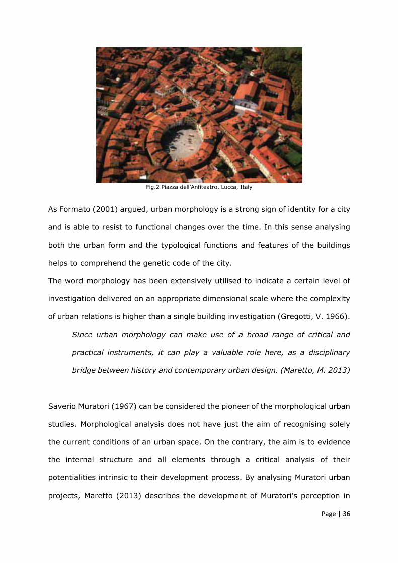
Page | 36
Fig.2 Piazza dell’Anfiteatro, Lucca, Italy
As Formato (2001) argued, urban morphology is a strong sign of identity for a city
and is able to resist to functional changes over the time. In this sense analysing
both the urban form and the typological functions and features of the buildings
helps to comprehend the genetic code of the city.
The word morphology has been extensively utilised to indicate a certain level of
investigation delivered on an appropriate dimensional scale where the complexity
of urban relations is higher than a single building investigation (Gregotti, V. 1966).
Since urban morphology can make use of a broad range of critical and
practical instruments, it can play a valuable role here, as a disciplinary
bridge between history and contemporary urban design. (Maretto, M. 2013)
Saverio Muratori (1967) can be considered the pioneer of the morphological urban
studies. Morphological analysis does not have just the aim of recognising solely
the current conditions of an urban space. On the contrary, the aim is to evidence
the internal structure and all elements through a critical analysis of their
potentialities intrinsic to their development process. By analysing Muratori urban
projects, Maretto (2013) describes the development of Muratori’s perception in
Page | 37
relation to the urban structure formative logic. Specifically, the author describes
his concept of transition from bringing together theory and architecture to
morphology analysis as planning discipline. In this regard, it is noticed that
morphology analysis has been recently reconsidered as an important step for
mastering complex urban projects (ibid), particularly for two main reason: on one
hand the growth of contemporary cities and their population requires deep
consideration of settlements forms and transformations’ mechanism over time; on
the other the necessity of developing more sustainable cities is directly connected
with society and not just with energy consumption. In this sense, Maretto states
that the form of existing cities and their use should be transformed according to
daily life.
Morphology criterion of scale, both architectural and social, lends itself
perfectly to drawing together the various operative levels of sustainable
strategies, and indeed can contribute to launching a new urban culture for
the twenty-first century. (Maretto, M. 2013)
The typo-morphological analysis method aims to read the DNA of the city (Barresi,
A. Pultrone, G. 2009) and is a resource for encompassing the transformations’
possibilities. In this respect, this method may be considered as both an
interpretation and a guide for urban development and transformation considering
all levels of complexity within the urban forms and the architectural features
(ibid.).

Page | 38
2.6.4 Rhythm analysis
Rhythmicity defines a mode of experiencing spaces and places within the city with
direct implication for the urban design. In this sense, observing how the areas are
experienced by the users helps to encompass the sense of the places and their
intrinsic uses.
This method has been applied on the selected areas through a map that
highlighted human flows and their intensity with the help of diagrams.
The rhythmicity of the areas selected has been also analysed with photographs
taken at different times of the day in order to study the frequency and the use of
the spaces. These data are reported and graphically schematised within a
taxonomy in the chapter 4.
Urban spaces are geometrically different; generally, the linear ones, such as
infrastructures, fit for a specific purpose which is moving from one point to
another, while the aerial ones are inhabited more randomly. The main
morphological and typological character of urban long element is the forced and
directional flow of humans which differs completely from the flow of an aerial
geometry such as a park.
Fig.3 Diagram of human flows in different spaces

Page | 39
Rhythm analysis as method for investigating urban spaces is an approach to
analyse the relation between space, time and society. (Hetherington, K.; Smith,
R. J. 2013)
The concept of rhythm is given by the repetition that regulates and reproduces
the sense of urban space and its relational aspects of the place life. Lefebvre
(2004) argues that rhythm analysis offers the possibility to understand the
complexity of the spaces, their interactions, mobility and the connections between
particular and universal.
The rhythm of inhabiting an open public space is completely different, for instance,
to the rhythm of public transportation. In this sense this analysis enables to clarify
the different relations between the factors of the equation spaces-dimension-
speed-time-tempo.
In terms of graphical description, according to Mareggi (2017), representing the
rhythm of urban space considering the activities and the intensity of
frequentations would be more an interpretive approach against the more
objectives. This seems however appropriate for the purpose of this research
because the interpretation of urban rhythmicity may suggest the potential of
future design actions (ibid.).
Mareggi (2017) describes seven different types of temporality and variety of the
urban environment, which can be represented in static or dynamic maps. Two of
these seemed to be more appropriate for the context of Aberdeen. Particularly the
areas selected have been analysed considering the opening time of the activities
and the intensity of users’ frequentation (ibid.) collected through a series of photo
frames.

Page | 40
2.6.5 Tour observation
Another type of observation was conducted through guided historical visits of
Aberdeen. The visits were organised in collaboration with Aberdeen City Heritage
Trust who also has been involved in the workshops to support the work with
historical maps, historical pictures and perspective drawings of the city.
The aim of the tours was to understand the history of Aberdeen and its physical
territory from different perspectives. In particular, participants were accompanied
on the old route of the historical city, which is now occupied by car park buildings
and main roads, crossing neglected spaces and forgotten areas on different
topographic levels.
2.6.6 Mental map
Using interpretative diagrams to summarise the main urban feature of the areas
enables to select and identify the urban environment within pattern. This concept
derives firstly from the Gestalt theory (Sema Uzunoglu, S. 2011) which recognise
common perceptive process related with various forms. In this regard, it is
possible to understand which urban forms and characteristics of the areas are
relevant for future design processes. The most recognisable and clearest parts of
the city, thus, play important roles in terms of identity and they contribute to the
drawing of the form of the city.
Although the original method adopted by Lynch (1960) was intended as graphic
interview directed to citizens in order to study their perception processes of the
city, in this research, mental map is intended as graphical schemes based on map
observation and discussions raised during the workshop between students and
planners.

Page | 41
According to Lynch (ibid), mental maps are useful to clarify the common perceived
elements of the city plan that are fundamental for defining a collective idea of the
city. From the mental maps collected by the author emerged that there were some
perceptive constants that could be classified.
Particularly, Lynch noted that linear infrastructures, such as railways but even
beaches, were seen as barriers or edges; rather typical street, roads and
occasional routes were classified as paths to localise other elements or
monuments; the junctions and crossing points were identified as nodes; the
homogenous areas were selected as typical districts; finally, relevant elements
helpful for the orientation were defined landmarks.
It can be argued that Lynch introduced a new urban geography, different from the
spatial traditional analysis of the city. His approach and method are, in a certain
way, similar to the typo-morphological analysis based on the concept of plan, site-
location, typology and historical evolution, with the difference that Lynch
introduced the concept of environment perception and subjective liveability.
2.7 Classification and taxonomy of the areas
The aforementioned urban analysis methodology has supported the study of
Aberdeen areas and allowed to collect data in order to understand the issues and
lack of urban and social relations of those spaces. In particular, by examining the
data and by triangulating the information collected, it has been possible to
categorise every area within particular sub-category of space belonging to the
general notion of abandonment, such as empty-place, non-place and fragmented
void. To better support and reinforce the results obtained, a simple calculation has
been used to quantify the level of abandonment in proportion to the entire area
expressed in square metre. According with the common urban density/floor ratio

Page | 42
(Dell’Aguzzo, M. 2013; Yu-Hsin, T. 2014), used to calculate the index of built areas
or open spaces in relation to a specific area considered and which is generally
expressed with the formula factor to be determined/ total square metre of the
area, the abandoned spaces within the areas selected in Aberdeen have been
divided by the total square metre of the areas. In this sense, the taxonomy (table
n. 10 Chapter 4) presents also the index of abandonment within every area which
is also, logically no greater than 1.
2.8 Ethical consideration and evaluation of risks
The research has been conducted with the involvement of students, academics
and professionals from Aberdeen city council who have participated actively to
workshops and to interviews.
The participants have been not subject to harm in anyway and they have been all
voluntaries and with the full right to withdraw from the study at any stage.
All students interviews have been conducted anonymously while the interviews for
planners and academics have been delivered in a non-anonymous way given the
nature of the guided interviews and the roles of the stakeholders within the
organisation of the workshop.
The ethical clearance permission have been consulted before the interviews, thus
letters and informed consents have been read and signed by participants before
the acceptance to participate to interviews (Appendix A, B, C, D, E, F).
There have been not any specific risks associated with this research. Despite the
research focusing on academic and professional projects in which have been
involved other figures (students, academics, planners), the related risks can be
considered to be very low. Particularly the involvement of the researcher has not

Page | 43
directly influenced with the work of the students. The information and
presentations delivered at the commencing week of the workshop have been
drawn on objective and well referenced historical evolution of the European cities
and selected re-use projects have been described in order to introduce general
examples of urban design approaches. The purpose of these presentations was
mainly related to support an international cohort from a broad-range of
backgrounds, with a holistic overview of the urban debates, conditions and
challenges within the contemporary European scenario. During the more practical
week, where students have been required to propose conceptual projects of
regeneration, the researcher has not played a direct role related to design
decisions and criteria. Instead, the role has been limited to observe and record all
phases of the practical week related to the process of developing projects through
an exchange of comments between students and planners.
The workshops have been closely organised in advance, with detailed timelines
and list of the activities followed during the ten days. The whole organisation has
been undertaken with consideration of any site specific risks. To mitigate the risk
of potentially negative results, specific theoretical and practical activities have
been planned together with planners and academics before the beginning of every
workshop. It has been conducted considering the ages and the level of the
students (undergraduate and master students) and their academic background. A
collection and analysis of well known architecture design projects (the precedents
case study) have been prepared to support the students design principles and
procedure of works.

Page | 44
2.9 Validity of the research
The research included procedures of data collection based on interviews, case
studies analysis, observations and applicative urban projects experiences applied
on Aberdeen city, in order to define guidelines and protocols for future
interventions in the areas of abandonment.
The triangulations elaborated as process to evaluate the data and the engagement
through applicative experience enabled to test the consistency of this research
and its findings gathered through multiple research methods. This helped to
demonstrate the credibility as internal validity, of the research objectives.
Furthermore, the wide literature review and the analysis of similar PhD research
methods enabled to identify the consistence of the transferability of this research.
This external validity is also supported by the international cultural education
(University of South of Florida, RGU, ICRG, ACC) brought within the practical
workshops.
The theoretical transferability is also validated and the procedure of collecting data
regarding abandoned areas and to collect a list of design criteria may be used in
other cities and countries.

P a g e |45
CHAPTER 3
THE CITY SYSTEM. Literature review
and conceptual explanations
_________________________________________________________
3.1 Introduction
This chapter provides an overview of previous and current research focusing on
the concept of abandonment and possible re-use within the urban and
architectural literature.
The research investigates abandoned and underused spaces in Aberdeen, the
processes and the methods to bring them back within the city system.

P a g e |46
Analysis of successful design projects of re-use principles and successful
examples of processes of collaboration have been considered for the practical
part of this research.
The purpose of reviewing previous research is to define the research framework
described in this thesis, to collect primary data and to critically revise the data
collections. The literature reviews can be divided into three different categories.
These address the three main areas of this study:
1. Critical study of the previous research concerning abandoned spaces
phenomena and related methods of analysis of these spaces, which
informed the topic and support the sense of the focus perspective.
2. Critical analysis of previous design projects precedents study, which
helped to categorise the design principles applicable within the case of
urban and architecture re-use.
3. Critical analysis of the cases of municipal collaboration (academia and
public authorities) implicated in the process of design within several cities,
which addressed the practical application, testing and validating the
theories (points 1 and 2). This was done through collaborative urban
workshops held in Aberdeen.
3.2 City as a system
The contemporary city is structured by a variety of relations, objects and
infrastructures, which make its reading complex and multi-layered. (Rossi,
Eisenman 1982; Tschumi, B. 1983, 1996).

P a g e |47
Daverio (2013) indicated new aspects of contemporary city. He describes the
main visual aspects of the urban environment, such as the skyline and
landmarks as memorable aspects for how humans to imagine and represent the
city in their mind. The landmarks and the skyline represent an aggregate of
psyche (Daverio, P. 2013).
Discussing the aggregate of the psyche, the critic intends the strong
recognisability and the identity load of the city image, fixed in the minds.
Through its skyline and landmarks, the city may be recalled by inhabitants and
be part of their unconscious capability of associating icon and place.
This idea is similar to Aldo Rossi’s (1989) concept of urban artifact which
denotes all relevant elements, such as the landmarks, the main streets, palaces,
buildings that comprise the city.
At this point, we might discuss what our idea of the building is, our most
general memory of it as a product of the collective, and what relationship
it affords us with this collective.
About Palazzo della Regione in Padua. Aldo Rossi 1989 The MIT press.
The definition of artefact, according to the Oxford English Dictionary (2018), is:
An object made by a human being, typically one of cultural or historical
interest.
At the urban scale the architect Aldo Rossi (1986) used the word artifact instead
and defined it as:
A form that persists through a set of transformations.

P a g e |48
In fact, the concept of urban artifact, as well as of permanence, becomes an
element that is the base of Rossi’s intention. Namely the author determines an
analysis method to collect the traces of history comprising the city. Rossi’s
purpose is to define a transferable theory of architecture that provides concrete
research tools.
Rossi’s intention seems to be to develop, or propose, an analytic path that aims
to define an effective studying method of the complex urban phenomena that
create a city.
Rossi explored the comparative method to compare the differences and also
introduced the historical method as a critical reading of the city.
This means that the history of a city is never crystallized, but is something
dynamic and in motion because it is always evolving.
For Rossi, (1989) the complex urban structure is marked by urban artifact,
elements characterised by their own form and architecture. A typical example is
Palazzo della Regione di Padova, which has been transformed functionally and
architecturally but imprinted in the collective memory and so forms part of the
image of the city of Padua. The city is a product of engineering and architecture,
integrated with urban artifacts.
The urban artifact is something that breaks the rules of urban evolution and
which sometimes represents the exception.
The evolution of the urban artifact over time, is the main driver of the nature
and morphology of the city. A city is a human achievement and the urban
artifact contributes to the collective individuality and recognisability of the city
itself.
P a g e |49
Urban artifacts are primary elements, solids and areal, such as squares for
example, and they are dynamic because they are able to accelerate the
urbanisation process of the city.
Evolution of the city takes place as part of a dynamic process and its form
derives from an accumulation of history. The collective memory is not reified and
blocked and does not recall objects from the past. The collective memory is the
consciousness that there has been an historical process and this process is going
to evolve over time. (Rossi, A. 1982; Aymonino, C. 1977)
In defining the notion of urban artifact, Rossi (1982) described several examples
such as Palladio Basilica in Vicenza where the narration becomes pervaded with
emotionality and subjectivity. In this sense the notion of urban artifact is
connected with personal experience of the places and with personal memory
which influence the perceptive connotations of an architectural or urban
element. In this regard, the physical form represents, finally, all aspects of
urban artifacts from individuality, memory and social function to locus.
The architecture and urbanity of the city are the concrete manifestation of the
society and of the city’s economic and cultural evolution. The city analysis today
is more complex. It is necessary to consider social, economic, political, and
visual aspects too.
If Rossi (1982) proposed a typological and morphological analysis with focus on
the study of urban phenomena, earlier Lynch (1960) proposed instead a more
perceptive analysis related to concept of imageability. This involves an
overlapping of the city’s fixed components, edges, spines, paths, and the city
dynamic components such as people. The perception of the city is an image of

P a g e |50
mind and is subjective, but it is possible to individuate some urban scheme
constants.
These constants are linked with Gestalt psychology (Khamsi, J. 2012) for which
there are fixed tendencies of organization of a system and its parts. (Popczyk,
M. 2016)
Lynch and Rossi’s approaches are methodologically different and developed in
different contexts, one in the US cities and the other in the European cities, but
today they may be a source for understanding the complexity of the city system.
The complexity of a city is also explored by Aymonino who, on numerous
occasions, defined the analytic method for individuating relations between types
of building and urban form in relation to their changing nature over the time.
Aymonino (1977) defined a form of glossary in which to ground his theory.
Typology is the comparative study of physical characteristics of the built
environment into distinct types. Urban Morphology is the study of the city form
created by urban artifact and different parts of the built environment. Relation is
a rapport between typology and morphology of a city and its development over
time is fundamental to understanding in depth the nature of a city.
Aymonino argued that architecture is an urban phenomenon and its important
character is its urban quality and its capacity to dialogue with the context.
Mainly it is its capacity to establish a relation with other buildings, with the
landscape and infrastructure and the capacity to be part of a process (urbanity).
The knowledge of the history is vital for good urban analysis enriching the
critical and creative consciousness of the architect, providing more information
used for the project process.
The type-morphologic analysis aims to obtain 1) knowledge as disciplinary
contribution to the construction processes of the city and 2) knowledge as

P a g e |51
disciplinary contribution of the transformation and stratification processes of the
city. Both are fundamental for the cultural background of all professional
involved in city projects of regeneration and urban transformation.
One of the Aymonino’s most important contributions is the idea of completion.
Every historical city has incomplete places, buildings or urban areas. Imposing
new constructions cannot be always a reasonable action. Building new
architecture becomes legitimate when the other resources, such as scientific
restoration, building recovering, do not have any functional and operative sense
but overall any resolving approach.
On the other hand, the complete historical part of the city tends to have a
crystallised value into the historic process and so it becomes a permanence in
the physical relations of the parts of the city.
The formal complete part of a city, as whole, is fully proposed as urban artifact
by Aymonino.
Urban analysis means to assign a role and to establish a clear opinion on the
parts of the city that set the parameters for the design project. In this sense,
architecture and urban projects are the reinterpretation of the context
morphology, which is in turn their derivation and base of their form.
The structure and narrative form of Aymonino and Rossi’s theories have been
analysed by Stefano Boeri (Boeri, S. 2016) who sought to discover new
modalities for reading and study the urban phenomena.
As Paul Ricoeur (2016) argues, architecture is to space what literature is to
history. Boeri tries to find in Rossi, Aymonino and Gregotti’s language, the
configuration of space, time and architecture, using study tools that belong to
architecture discipline and philosophy too.
P a g e |52
Boeri’s literature studies allow him to give shape to another and more
contemporary theory of the city system. The author divided his notion of the city
into:
Internal city, mainly the thought of the architect, thus the more academic and
conceptual vision of the city that precedes the narrative idea of the city.
External city, the consensual, that is the city as a common and codified
description belonging to the disciplinary tradition.
This new possibility of reading the city system might give rise to an idea of
solitude of the architect thought, and its lack of generating a common concept of
the place.
Boeri’s views belong to a depth study of the main literatures that have
characterised the last architecture and urban history but also to a new urban and
city scenario constituted by new types of spaces, often residual or simply empty
spaces.
His research approach consists in an analysis of the three main authors: Rossi,
Aymonino and Gregotti. Through an original examination of the texts and the
words used, he seeks to understand the meaning of the city, its territory and its
architecture.
The city scenario of today is also made by new locations non-properly defined,
such as the abandoned places, brownfield or the peripheries which contribute to
compose the city form. It becomes important then, to understand what the new
reading methods of these types of places are, beginning from the consciousness
of their new historical, social and morphological value (Secchi, B. 1984; Piano,
R. 2015).

P a g e |53
3.3 Research focus background
The phenomenon of urban and architecture abandonment and their related study
on adaptive re-use have been explored by previous research, typically using
cities as case studies.
In particular, two theses have been analysed from Camerino University (Italy).
Both relate to abandoned buildings and areas but with two different approaches.
On the one hand, the first thesis entitled “Disused industrial site: Which
architecture approach? Conservation, renewal/re-maker, re-form, redesigning
industrial disused space” (Medori, S. 2011) studies and focuses on the
architecture approach and design methodology applied to these empty building
and areas. On the other the second thesis entitled “Abandonment: from anomaly
to principle” (Corsaro, E. 2010) investigates specific brownfield in relation to
urban and landscaping context, arguing that it is crucial to preserve the diversity
expressed by these areas.
The first thesis (Medori, S. 2011) adopts case studies, mainly in Germany and
Spain with practical and recorded site visits, as replicable examples of re-use
project principles. The emblematic characteristics of the selected projects are re-
interpreted and proposed as possible design methods of re-use for the Italian
case. These are discussed through open interviews with professionals and
significant figures on the international architectural scene.
The second thesis (Corsaro, E. 2010) analyses the case of abandoned spaces
and brownfield through the etymological method of research, focusing on the
relationship between time and space. The Italian expression of dismissione
(brownfield, decommissioning in English) is studied exploring its role as anomaly
and then exploring its contradictory role as a rule.

P a g e |54
This method enables the researcher to classify and map the various building and
areas taken in examination.
The applied part of the research uses a charrette as a collaborative method to
experiment the adaptive design on the selected areas of research in Italy. The
method is methodically recorded in all steps and proposed as a valid instrument
for addressing the plan and design of brownfields.
Here the researcher interviews Professor Peter Latz, a worldwide firm expert on
project of re-use, who personally adopted the Design Charrette for Westerholt
and Duisburg North projects.
These two examples are part of a wider interdisciplinary research project
underpinned by three different universities along the Adriatic coast in Italy
entitled PRIN research and coordinated by professor Barbieri, P. (2006, 2008).
This is a research programme of National Interest and financed by MIUR
(Ministry of University and Scientific Research) for the years 2006-2008.
The departments involved were the DART – Department Environment Nets
Territory – of Pescara Faculty of Architecture; PROCAM - Department of
Environmental Planning and Construction - of Ascoli Piceno Faculty of
Architecture; DCA - Department of Construction and Architecture – of IUAV
Venice Faculty of Architecture.
The main work is concentrated on individuating along the coast, and so crossing
several cities, some constants that allow the definition of possible intervention
modalities and project criteria for neglected and abandoned spaces.
P a g e |55
The aim is the identification of possible coordinated transformation scenarios
with strategic use for the different categories of Public Works (the collective use
of public spaces, buildings).
The research conclusions are based on an agenda of re-qualification approaches
of urban and territory transformation projects where useful instruments for the
evaluation of the transformations’ quality of projects are listed.
The theme of adoptive re-use has also been the subject, of an Australian PhD
research from Bond University of Gold Coast.
The research identifies a gap in the knowledge related to an absence of clear
criteria for future adaptive reuse project and a lack of consensus as how to
maximise adaptive reuse potential (Conejos, S. 2013).
The aim of the research by a PhD candidate entitled “Designing for future
Building Adaptive Reuse” (Conejos, S. 2013) is to review the design
principles used so far to adapt them to new typologies of the space such as
brownfield or neglected and abandoned buildings.
The direction of that PhD includes the idea of existing building and its reuse as a
main and primary starting point of the built environment sustainability.
The methodology adopted here is focused on the analysis of case study of
successful projects of reuse as primary data collection. The criteria gathered are
then classified in order to establish and test a multi-criteria decision-making
model that can be applied to new design projects.
The research moves its form to specific tools of new rating that can offer a
more unified criterion for assessing adaptive reuse potentiality of an old
building in relation to function, technology, social and political issues.

P a g e |56
For this particular aspect that investigates instruments and specific tools to
calculate and give weight to a sustainable project, the researcher has used
mixed methods, qualitative and quantitative, included anonymous online
surveys to professionals and more open-ended and non-anonymous
interviews aimed at other specific professionals (Conejos, S. 2013).
The present research has considered the aforementioned previous research
studies. It has referred to them in order to understand the current state of the
art concerning the concepts of abandoned spaces and to form the research itself,
linking the theme within Aberdeen city. The previous research are also analysed
in order to follow and articulate acknowledged methods of collecting and
analysing data.
3.4 The idea of the city today
A problem that emerges in contemporary cities is a loss of identity and the
character of these spaces. Their expansion, in the last years, has been due to
unrestrained construction and has not considered the local identity of places
(Auge’, M. 1995; Barbieri, 2010).
Koolhaas (2006) extends this concept to describe Eastern cities constructed
within very short scales and which do not belong to any historical root.
The generic city (Koolhaas, R. 2006), is a city without context and the big
architectural buildings, from Koolhaas bigness concept, are self-determined.
The theory of bigness dissolves the classic language and logic of architecture,
and generates a new type of city unable to establish confrontations with the
past. It is not able to create relations with the old city and it is in a sort of
competitive condition with historical zones.

P a g e |57
Bigness is urbanism against architecture and all of its containers will represent
the post-architectural landscape.
The dialogue between histories, renovation and modern architecture is then not
very evident.
The new interventions are often based on the predominant presence of
constructed objects out of scale (Koolhaas, R. 2006).
The risk may be that oversized buildings impose their self-referential nature on
the existing urban context, with a potential non-long relation with the heritage.
The renewed idea of the city centre as a place of exchange, meeting and of the
stratification of history can disappear and the main and potential urban artifact
can become weaker in terms of city imageability, (Lynch, K. 1960) beauty and
sense of belonging.
A contemporary urban difficulty concerns a lack of relations between spaces and
a lack of application with regards to reuse planning and regeneration, rather
than the current abandonment and sterile expansion approach.
On the terms it is interesting to follow Koolhaas’ comparison of the
generalisation of the city described using the image of airports, characterised by
a lack of their own identity.
Lack of identity leads to the idea of void or even specifically to the notion of
nothing. Ritzer, (2004) argued that the culturally controlled social forms are
basically lacking in content. This is especially the case of the new social spaces
defined non-place by Auge’ (1995) such as the shopping malls. Drawing on this
concept, Ritzer (2004) described the globalisation of nothing as a combination of
re-proposing localism within the globalism and the growth of capitalism.
In this sense the concept of globalisation of nothing (ibid) is expanding and
globalizing forces tend towards homogeneity of architectural and urban design

P a g e |58
particularly in their programmed functions, which are related to the notion of
non-places in a more specific sense.
Identity has always been a centralizing force that insists on a specific point on
the map. When the settlements are expanding, the centre loses its authority and
power until an irreparable breaking point.
The generic city is a city without history, while a city centre should be
continuously renovated as both the oldest and the newest place.
Koolhaas, with a clear but pessimistic thought, comes to the conclusion that the
generic city is not improved but just abandoned and that the idea of
stratification and intensification is just an extraneous concept; the generic city
does not have any stratification.
Through this theoretical and intellectual path Koolhaas arrives at the concept of
Junk-space, a theory of the present, a contemporary product of the non-quality
of the designed space.
With this provocative name, Koolhaas echoes Le Corbusier’s exhortation
Architecture or Revolution. (Le Corbusier, 1931)
The architect should contribute with a progressive dimension of architecture,
otherwise the junk-space, thus the contemporary, will be just the aesthetic form
of the progress and not the progress itself and everything will be reduced to an
iconic form of machine celibataire, Celibate machine, (Duchamp, M. 1923) as
prodigious as useless.
Junkspace is the total sum of our current achievement; we have built
more than all previous generations together, but somehow we do not
register on the same scales. We do not leave pyramids. According to a
new gospel of ugliness, there is already more Junkspace under
P a g e |59
construction in the 21st century than survived from the 20th. It was a
mistake to invent modern architecture for the 20th century.
(Koolhass, R. 2006)
The three papers, Bigness, The generic city and Junkspace, (Koolhaas, R. 2006)
offer a clear view of ungovernable forces that control the space in the city and
that make it a junk-space.
The relation between history and identity here is exposed to a critical notion
where identity, intended as a way of sharing the past, becomes a losing
statement.
In a century where populations are expanding there are fewer and fewer models
to share and the more the history is used, the less it is important. Koolhaas,
with this statement, argues that misusing the history reduces its significance
within a place. That it is particularly the case of the huge influx of tourists and
their constant search for original characters, which leads to an exaggeration of
identity and local reproductions. In this sense Koolhaas investigates the relation
between history, identity and the way of sharing the past.
The result cannot be just the worn-out concept of non-place but something
broader.
Junkspace becomes a new way to conceptualise space, exactly as the third
landscape of Gilles Clement, introducing new concepts of the contemporary
space (Clément, G. 2005).
It can be argued that horizontal European city growth is not sustainable
anymore, neither in terms of cost, recycling (construction side, gas or electricity
supply, general and urban waste, infrastructures, etc.) nor in terms of space.
According to Piano, (2015) this concept is inevitably connected also with
political, social and economic reasons.
P a g e |60
This research will not focus particularly on political, social or economic debates
around the role of architecture within the society, but it is considered necessary
to clarify some points in order to have a more holistic view of the contemporary
urban cities phenomena and evolutions.
What emerges, particularly from Koolhaas reflections on the contemporary cities
is a lack of discussion on political and social conflicts within the urban spaces.
(Aureli, P.V., 2008)
This is probably due to the climate of the second half of the seventies,
characterised by new thematic expositions within the cultural panorama, which
were focused mainly on the new phenomenon of the archistar, to the
disadvantage of all bigger research groups that earlier worked on the urban
improvements problems. The political climate was at the end of the social
classes conflicts (sixties period) that the cultural and political establishment tried
to overcome with new movements such as the postmodernism. The
postmodernism, during which Koolhaas participated to the installation of Strada
Novissima at the Biennale in Venice, probably depicts the cultural block that
neutralised and de-politicalised the architectural and urban theories and
discourse. This process contributed to transform architecture in a sort of private
field with no relations with the society. However, it is in its public character that
architecture should find its deeper meaning. Moneo (1986) argued that
architectural language, in order to be meaningful and able to draw the features
of the city, should be firstly sharable.
Probably, as Wouter Vanstiphout argued, during an interview conducted by the
architectural journalist Magliozzi (2015), the architecture, in order to reclaim its
social and political role, should face the concept of democracy, participation and

P a g e |61
political uncertainty. At the end, architecture and urban space are the
incarnation of politics. (ibid)
Focusing on design possibilities, this research draws around current themes on
which contemporary debate remains open (Abitare journal 545, 2015) and
include building reuse and conversion of places, buildings and roads.
Although the re-use debate is open for almost thirty years (ibid), (Conejos, S.
2013), the morphologic and qualitative characteristics are not yet defined.
Giving a coherent form to these places becomes emblematic because the form
has always been the expression of our language and because the form has
always been the expression of our identity for almost twenty-five centuries.
3.5 The significance of words in the context of this research
I have no need whatsoever to draw my design. Good architecture, how
something is to be built, can be written. One can write the Parthenon.
Adolf Loos, 1924, 139 (in Forty, A. 2000)
Architecture does not exist without drawing, in the same way that
architecture does not exist without texts.
Bernanrd Tschumi, 1980-81,102 (in Forty, A. 2000)
Complexity of linguistic analogies in designing has been extensively explored
over time. Words in architectural processes of designing, play an important and
relevant role in shaping the decisions, defining the spaces and even relating the
project to the context. Words generate the idea and create reality on their own.
My own words take me by surprise and teach me what I
think.
Deridda, 1978,11 (in Forty, A. 2000)

P a g e |62
Lakoff and Johnson (1980) argued that metaphors are able to modify human
perceptions and understanding of particular concepts and objects. In urban and
architectural disciplines, the use of specific terms to refer to a space or a
composition is crucial and enables to identify right issues and to guide towards
right articulations of the design process.
Particularly, articulating and individuating specific terms helps to avoid
generalisation and helps to demonstrate how words shape the kinds of imagery
and semantic associations they make (Forty, A. 2000), and how in turn this
feeds directly into and informs decision-making and practice. Critically reflect on
the language raises awareness of the relationship between mental processes
imagery, design and building practice.
Shön (1979) analysed how the perception of a community may change in
relation to the metaphor adopted to describe it and how the language’s
associations can affect the decisions for improving a certain situation. During the
1950s a debate was raised on what could be done to improve the quality of the
life and the buildings in the dense residential areas of Washington city. The
obsolescent phenomena were defined as disease and thus city planners decided
to cure it by demolishing, re-designing and re-building the entire area. In this
sense Shön referred to the slums condition as seeing slums as congenital
disease. Opposite to this concept, he later proposed to look at the slums as
natural communities (1993, p. 145). In this circumstance the way of looking the
slums’ future was orientated towards their preservation and improvements.
Each definition highlights certain aspects and hides others, thus each one
generates a specific frame where its imaginary should be located.
When a metaphor or a term become redundant even its possible solutions
become limiting. To this assumption Shön responded that

P a g e |63
We need to understand the metaphors, and generate a new, all-
encompassing metaphor that incorporates elements of both, transforms
both into a new generative metaphor.
(Shön, D.A. 1993, p. 139 in Ritchie, L. D. 2013)
Providing and studying key terms that can describe particular spaces and their
features (Forty, A. 2000) even through linguistic associations, can locate the
problems within a more historical and perceptive framework, setting out
consistent support to approach the issues.
Moreover, conducting etymological studies related to words used in architecture
(Daverio, P. 2013) enable to encompass the deep significance and to re-
establish theoretical analogy, such as in the case of the word beauty and
symmetry better explored in the paragraph 3.8 and earlier in the next paragraph
3.5 where the meaning of words is explored in order to investigate particular
spaces.
Words accompany spaces and signs, in their descriptions and in their meaning
within the urban context, so it is important to explore the terms’ origins, thus
the etymological roots, and their significance in order to redefine a common
understanding of those spaces.
In this regard, the following paragraphs offer a set of explanations and
reflections on the use of the terms place, non-place, empty place and urban
void, as declinations of the wider and more generic phenomena of abandonment.

P a g e |64
3.6 Places, non-places, empty places
In the city mapping and reading, it is possible to recognise particular areas
characterised by a lack of relations and connection with the surrounding context.
The characteristics of an area and the ways the relations are interrupted are
different and open to re-categorisation. These urban spaces, have several
aspects connected to their past and it is also possible to highlight a number of
constants.
On the one hand, they are defined and differentiated by their urban and
architectural configuration, their morphology may be linear, aerial or pointed,
but also by their typology in terms of particularity of the place.
Generically, these spaces could be described with the adjective abandoned but,
as wider literature (Secchi, B. 1984; Augé, M. 1993; Gilles, C. 2005; Barbieri, P.
2010) has tried to identify, they have different variants and develop different
subcategories. On the other hand, abandoned spaces have a common
denominator: it is their indeterminateness that creates, in some cases, the
feeling of getting lost and of identity deprivation.
Using the adjective abandoned however, is arguably too generic and the risk
may be that this term is used more from habit than to refer to specific
characteristics of particular spaces.
The study of these relatively new residual spaces around the city has been
underpinned in various disciplines but it is important to analyse critically first the
opposite concept of the real place.
Introducing the concept and the use of the term place can lead later to some
reflections on morphological and typological natures of the abandoned spaces.

P a g e |65
3.6.1 The Place
The term place may be understood through a sense of recognisability, and it has
social, anthropological and urban significance.
The city and its material and immaterial heritage, is a dense system of urban
artifacts, where it is possible to read and recognise its identity.
For Rossi (1966), the complex urban structure is marked by urban artifact. The
city is a work of engineering and architecture integrated with urban artifacts.
Palazzo della Regione of Padua contains a multiplicity of new functions which are
completely independent from the form, but the form itself, as Rossi argued,
belongs to the wider urban system of the city.
Its form is organized into space and over time; the city has evolved, taking into
consideration the Palace’s presence. For this reason, it is still possible to
recognise its value and its importance as urban artifact.
The evolution of the city is a dynamic process which is formed by historical
accumulation, where the collective memory is not a static image of the city past.
The collective memory is more the awareness that an historical process has been
there, and this process is always evolving (Rossi, A. 1989).
If the city evolves over time through architecture, then architecture
Is the fixed scene of human events, full of generation sentiments, public
events, private tragedies, new and old facts. (Rossi, A. 1966)
Place, therefore, is the city made through relationships: Its historical relations,
urban connections between various spaces and juxtaposition between solids and
voids.
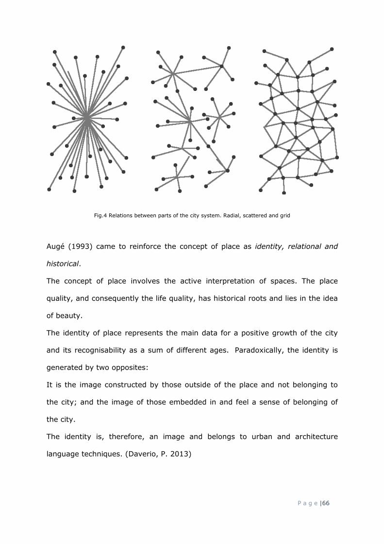
P a g e |66
Fig.4 Relations between parts of the city system. Radial, scattered and grid
Augé (1993) came to reinforce the concept of place as identity, relational and
historical.
The concept of place involves the active interpretation of spaces. The place
quality, and consequently the life quality, has historical roots and lies in the idea
of beauty.
The identity of place represents the main data for a positive growth of the city
and its recognisability as a sum of different ages. Paradoxically, the identity is
generated by two opposites:
It is the image constructed by those outside of the place and not belonging to
the city; and the image of those embedded in and feel a sense of belonging of
the city.
The identity is, therefore, an image and belongs to urban and architecture
language techniques. (Daverio, P. 2013)

P a g e |67
3.6.2 The non-place
Places without identity are described through different neologisms.
The sense of indeterminacy and approximation of these spaces, on an
architectural and urban level, are the result of places thought, regardless of their
relationship with the surrounding context and with the history of the place.
If you do not look at the landscape as an object of human activities,
discovering a quantity of informal spaces with no purpose, of which it is
difficult to give a name.
(Clement, G. 2003)
Rotenberg (2011) defined Atopia as a space where people have to affirm
themselves through the same space.
We are guided with instructions, rather than relationships.
Spaces offer messages that inform about the permissible activities that
each is prepared to contain. In ordinary spaces, we read the semiotics of
the space by observing the people who are already in the space. The
messages of Atopia are written on the walls.
(Rotenberg, R. 2011 p. 254)
Rotenberg gives to these spaces a sort of human interpretation, describing the
atopia through people’s behaviour.
One leaves the shopping centre with one's purchases having confirmed
one's sense of self.
This over-arching valuing of the experience of place as an experience of
self is the primary characteristic of atopic spatial practices.
(Rotenberg, R. 2011 p. 254)

P a g e |68
An etymological study suggests that the opposite concept of place can be
investigated through two different but similar words respectively
originated from Greek and from French: ατοπία, atopía and non-lieu, non-
place.
Atopia, from Greek ατοπία, atopía - placelessness, unclassificable, where “a” is
the privative of topos (place), represents a condition of non-belonging and
describe all parts of the city which determine a variation. That variation is given
by the lapsing of its function and therefore by its abandonment. It could be said
that atopy is the absence of territory and environment.
The relation between the concept of atopia and the notion of non-place resides
in the concept of absence. On the one hand, it is the absence of relations with
the environment. On the other, it is the absence of relation between humans so,
absence of social function relations.
Manzione (2012) argued that the concept of non-place should be sought in the
infrastructures spaces of the city and its periphery, which are already territories
of atopia.
The neologism, non-place, defines a space thought independently, without any
relations to context and for specific functions only. The main relation, as Augé
described, is between individual and place, not between people in a place.
Augé’s definition derives from ethnology and anthropology and entered in the
architectural discourse and urban world recently.
In the city it is possible to find also uncertain conditions which may be described
with the name non-place.
The non-places, in the city reading, have different declinations but are extremely
important for describing territory changes. In fact, Augé’s vision is more
concentrated on time analysis as the overabundance of events that create an

P a g e |69
acceleration of history, and on the ego as excess of individuality. These points
converge in the concept of place. Non-places are closed to the heterotopias of
Michel Foucault (1966); namely the reality founded more on transience than
presence. Particularly, the heterotopias are spaces that correspond to the notion
of utopia with the difference that they are realised and localised. Their function
is to compensate and to be related to all other spaces as for instance, the
garden or the cemetery. Heterotopias helped to shape the definition of all urban
and architectural spaces with multiple functions and multiple dimensions.
Augé’s non-place analysis however, does not belong to an urban and
architecture study but more to a social and anthropologic sphere.
The author coined the word and its concept that has consequently been object of
study of the urban and architecture disciplines which have adopted the term with
a shift of meaning.
Augé’s concept of overabundance of events, in this sense, becomes relevant in
the urban and architectural comparison between the notions of place and non-
place.
Place is a system of relations between solids, voids, public and private spaces,
connections and infrastructures. The balance and, thus, the relation between
these components generate the place. As such, the important aspects of the
place are the rhythm, the intensity in-between the component parts.
Dwelling on the rhythm is a key point for generating a certain equilibrium even
between uncompleted parts of the city.
In this sense, an over-designed and over-structured space may flatten the
concept of place. Conversely exaggerating the ratio of a place generates a non-
place.

P a g e |70
The expression of non-place is a space with a lack of identity, an anonymous
place disconnected from any social relations and from the history and tradition of
the context.
The common denominator here is anonymity, and in the case of a building, such
as stations and airports, the concept of non-place is expressed in the serial
reproduction of the architectural spaces.
Non-places are the installations required for the accelerated circulation of
people and goods (fast-running roads, turn-offs, airports), as well as the
means of transport themselves, big shopping malls or even refugee camps
where the planet’s homeless are parked away.
(Marc Augé, 1995)
The neologism non-place is often associated with Augé however, already in the
sixties Webber (1964) noticed that the nature of communications could change
radically the notion of place and city. For Webber (ibid.) the essence of the city
was interaction and so considering the mobility, rather than specific settlements
and introduced the notion of urbanity as lifestyles, collective uses of the spaces
and interactions.
Humans interact with the city in order to have access to different goods, needs
and desires; in this sense mobility is fundamental to approach those
opportunities.
Based on this assumption, Webber formulated for the first time, the fission
between urbs and civitas, between built environment and urban community
defining a renewed idea of post-city-age.

P a g e |71
Paradoxically Webber’s non-places are the city spaces that appear impersonal,
anonymous and abstract probably because ideologically the city is generally
associated with an historical and nostalgic idea of civitas. Those spaces are
inevitably affected nowadays, as well as in the sixties, by commodification,
thingsification (materialisation), speed up and mass media (Amin, A.; Thrift, N.
2002).
It can be argued that Webber anticipated the crisis of places role as
exemplification of culture and identity containers, thus a weakening of the places
meant as containers of information. This has led to an overcoming of the
traditional spatio-temporal delimitation of the urban places but simultaneously to
a need of re-appropriation of those spaces in order to have local experience
which may become cultural and collective memory. This means that, on one
hand there is a de-localisation of interests and the intensity of human
interactions is no longer depending on proximity and the place itself; on the
other there is the constant attempt, by humans, to characterise the experience
in relation to places which belong to the cultural memory attitude of elaboration,
a sort of typical human reification.
In this sense Webber anticipated, by almost thirty years, a new form of urban
evolution no longer local but instead non-local. It has to be noticed, however,
that Webber observed the urban space purely in term of human use and
behaviours (Teitz, M. B., 2007).
The dissemination of other forms of communication and transversal lifestyles,
due to the medias and web interactions, has demonstrated in some ways
Webber’s hypothesis.
Nowadays citizens establish relations, services and community initiatives without
using physically the urban spaces, traditionally meant as civic place such as a

P a g e |72
piazza. In this sense today people can make a city without the city. Basically
they can concretise the traditional meaning of civitas. Civitas, from the original
etymology citizen, for which being together creates the city and not the
opposite. If civitas is human interaction and if through the acceleration of
technology communication people can interact without a common place, then
the concept of physical urban space and so the city is overturned and requires
new interpretation in order to be mastered with new projects.
For the philosopher Umberto Curi (2016), who pays more attention to the
physical space of the city, the non-place is the space where the communication
is interrupted but in the last ten years several artists and photographers tried to
capture images which may describe the notion of these spaces.
The photographer Edward Burtynsky (fig. 5) investigates through his images
how industry has changed the landscape. Chinese women in the manufacturing
or the infrastructural tangles are the expression of the hyper-modernisation and
also are the dilemma of modernity.
Fig.5 Manufacturing 16, Burtynsky, E., 2005
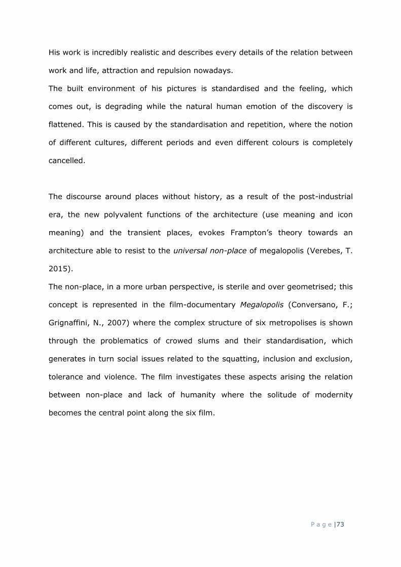
P a g e |73
His work is incredibly realistic and describes every details of the relation between
work and life, attraction and repulsion nowadays.
The built environment of his pictures is standardised and the feeling, which
comes out, is degrading while the natural human emotion of the discovery is
flattened. This is caused by the standardisation and repetition, where the notion
of different cultures, different periods and even different colours is completely
cancelled.
The discourse around places without history, as a result of the post-industrial
era, the new polyvalent functions of the architecture (use meaning and icon
meaning) and the transient places, evokes Frampton’s theory towards an
architecture able to resist to the universal non-place of megalopolis (Verebes, T.
2015).
The non-place, in a more urban perspective, is sterile and over geometrised; this
concept is represented in the film-documentary Megalopolis (Conversano, F.;
Grignaffini, N., 2007) where the complex structure of six metropolises is shown
through the problematics of crowed slums and their standardisation, which
generates in turn social issues related to the squatting, inclusion and exclusion,
tolerance and violence. The film investigates these aspects arising the relation
between non-place and lack of humanity where the solitude of modernity
becomes the central point along the six film.

P a g e |74
Fig.6 Carpark. Goldman, M. 2019. Example of non-place
The notion of non-place has been formalised by Augé in 1995 but as early as the
sixties the group of architects Archigram (1962), originated in a cultural
environment at the beginning of the technologies, were studying the phenomena
of networks. They focused on all type of nets, visible and invisible, and on these
nets’ power of remodelling the landscape as a sort of holistic and global village.
The communication and the movement between humans and objects are
represented through networks and the pop-city Instant city, a sort of social
module, is the representation of the new man habitat and the consumer society.
It may be argued that the Archigram’s archetypal image is the prediction of
Augé non-place thirty year later.
3.6.3 The empty place
A linear consequence of the physical action of abandonment become, in terms of
space, the empty place. Empty places are, for definition, uninhabited places but
P a g e |75
yet with a reflection of their past life where the social and cultural events of the
country are overlapped. They are the evidence of a presence of the past,
expresses through their current absence.
An empty place is a space that does not have significance anymore and that has
lost its reason to exist in the composition of city urbanity.
In this case, the empty place, does not need to be physically divided by a fence
or barrier. It is inaccessible. It is almost a forbidden place; or, even more so, an
invisible place within the city.
The concept of void has been wrongly associated (Sposito, C. 2012) with the
emptying of buildings or industrial sites, which also generate complex
phenomena of new relations with the city.
The specific category related with industrial sites has been analysed, earlier than
Sposito’s theory, by Secchi (1984) as a specific and uncertain space that appear
in the dense and morphological and well defined city tissues.
As early as the eighties, Secchi argued that voids appear as urban fractures, as
areas with no current function or use and with a lost relation with the physical,
social and functional aspect. Despite the extended and radical aspect of voids,
there are not project indicators that take consciously the opportunity to redefine
the whole urban structure (Secchi, B. 1984).
These empty places have typically always been related to abandoned industrial
areas where the most problematic aspect concerns their oversized dimension.
The metric data bring an important aspect to reflect on for project of renovation
within the consolidated urban tissues.
By looking at an empty urban place, it becomes important to reflect on the
correct new role starting from a specific architecture and urban methods.

P a g e |76
Fig.7 Empty buildings.
The dimension often is related first of all to the real estate values rather than to
a proactive possibility of urban, aesthetic and social-economic regeneration.
In this sense, the empty places are out of proportion to the purchasing and
expropriating capacities of the local authorities.
These spaces cannot be brought back just to the simple concepts of conservation
or recycling. They should be related to more complex reflections of their new
significance within the modern urban context. The design process of these
particular cases should start with a clear theme and observation (Secchi, B.
1984).
Speaking of urban empty place means reflecting on their roles over time (e.g.
history, current and future) and their physiognomy in relation to the modification
of the city.
3.6.4 The roles of the buildings within place, non-place, empty place
The several conditions of the aforementioned type of spaces often are typically
related with the presence of buildings. It is possible to identify the different role
of the built environment in these categories of spaces:

P a g e |77
In the place: the heritage, buildings or roads are the tracks of evolution.
They persist with the present, with the time and with the lifestyle. The
contemporary concept is clear because different historical periods are part
of the same system; they create a material and immaterial network.
In the non-place: the buildings or infrastructures do not belong to anyone.
They are used with indifference and are conceived as abstract entities.
In the empty place the differences between inside and outside do not exist
anymore. The open space is empty; the building is empty.
One of the common themes of these last two categories, non-place and empty
place, is that there is a lack of identity.
3.7 Urban voids
Several interpretations of the word Void have been provided within the urban
and architectural literature and debate regarding the contemporary city.
For Eastern civilization, the void is the positive complementary entity of the solid
and imbued within of intellectual and spiritual values (Roveroni, S. 2008).
In this section, however, the research considers Western appropriations
perception of void.
The nature of the urban void is a component of space and may be interpreted as
both absence and presence.
The question that arises regarding the notion of void is related to its twofold
aspect. Is it an object absence or a significance absence?
There are two typical explanations associated with concept of Void in the
architecture and urban discourse; on one hand the voids are all components of

P a g e |78
the city without constructions and this category includes public spaces too, such
as squares and parks. The void is assumed to be an important part of the city.
Furthermore, the term has been elaborated as a form of architectural
significance with reference to classic spaces such as the Pantheon (the temple of
all Gods) inner void which represents, through absence, the universal concept of
its monumentality (Espuelas, F. 2004). In this sense, the void has a positive and
important interpretation as part of the project. The concept associated with this
idea is a conceptualisation of void as designed subtractive space.
This first interpretation of the notion of void defines the main characteristic as an
important part of the context form and even of the buildings form.
Its role is to regulate the relation between new and past objects. Furthermore,
the void reorganises the spaces and such highlights new images as well as
recomposing the figurative continuity of the places.
On the other hand, a void is generically understood as an indefinite emptiness.
The solid has however, to be assumed in order to define this type of space.
Colin Rowe (1979) proposed, through Collage City, an analysis of the city that
implicitly describes the void as negative element and as opposed to the positive.
This type of reading, however, was already present in Nolli’s scientific map of
Rome, produced in 1748, where for the first time the measured plan of the city
was represented solely through solids and voids and thus structured on an
iconographic relation between viability and built environment.
There is also a third interpretation of the void as element, as part of a more
complex system. Roger Trancik (1986) argued that spaces which do not make a

P a g e |79
positive contribution to the surrounding areas and which do not provide any
coherent connections, are ill-defined as voids. He later refers to these as lost
spaces (ibid).
Michael Greenberg (1990) analysed urban voids and gave the description of
these spaces as Temporarily Obsolete Abandoned Derelict Sites.
There are also other definitions and adjectives which are used and considered for
describing and giving meaning to voids. These include the latest terra incognita,
and urban ruins. To date, however, a terminological consensus has still not been
reached on the definition of uncertain urban spaces.
deFilippis (2010) analysed the concept of void and its interpretation starting
from the etymological meaning. Through a precise study of the words he
associated to the notion of void, the concept of fragment.
The definition of fragment according to the Oxford English Dictionary is a part
broken off or otherwise detached from a whole; an isolated or incomplete part of
something. (2018)
The concept of fragment is strongly closed to the idea of unplanned, marginal
and residual condition described further by Groth and Corijn (2005) regarding
the issue of urban voids.
Fig.8 Fragmented void between roads

P a g e |80
Furthermore, the idea of fragment has been also used to describe specific
characteristics of urban voids in the city of Milan. The fragments are present in
the city but are not an active and connected part of the complex city system. In
particular, fragment has been the name of Milan urban design workshop which
was focused on the design possibilities around the city voids.
As an interpretation of urban voids, this research considers, the concept of
fragmented voids to analyse the open urban spaces that have the potential to
become an urban social place for the city.
Fig.9 Diagram of urban and architectural concept of void typologies
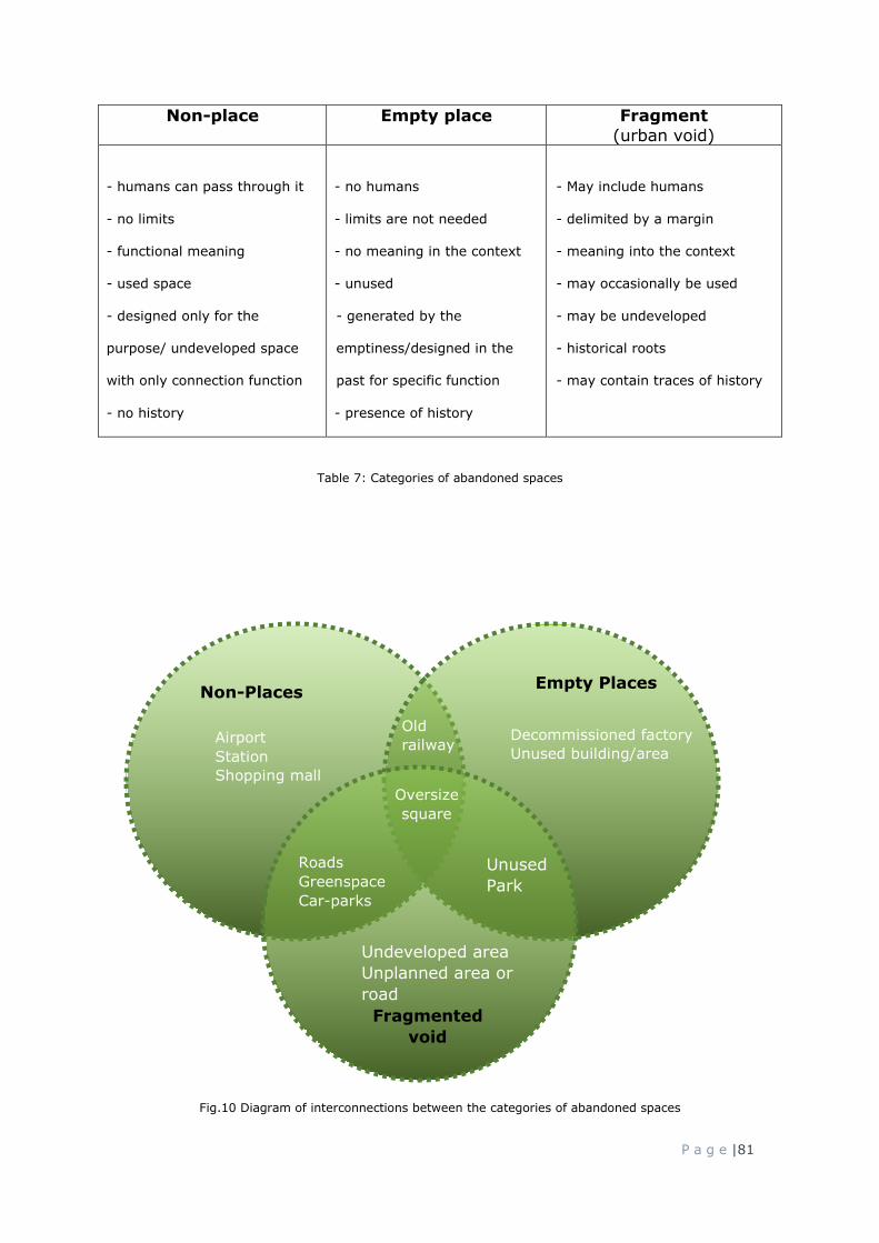
P a g e |81
Non-place Empty place Fragment
(urban void)
- humans can pass through it
- no limits
- functional meaning
- used space
- designed only for the
purpose/ undeveloped space
with only connection function
- no history
- no humans
- limits are not needed
- no meaning in the context
- unused
- generated by the
emptiness/designed in the
past for specific function
- presence of history
- May include humans
- delimited by a margin
- meaning into the context
- may occasionally be used
- may be undeveloped
- historical roots
- may contain traces of history
Table 7: Categories of abandoned spaces
Fig.10 Diagram of interconnections between the categories of abandoned spaces
Non-Places Empty Places
Fragmented
void
Roads
Greenspace
Car-parks
Oversize
square
Airport
Station
Shopping mall
Decommissioned factory
Unused building/area
Old
railway
Undeveloped area
Unplanned area or
road
Unused
Park

P a g e |82
3.8 Logic of the fragment and the loss of place
In the built environment, building is a concept that determines today a
fragmentation of the city. This fragment, with a view to historical stratification,
can only be a vital connotation of the contemporary city.
A fragmented city could be intended as a system of different parts with different
functions and different morphologies. The fragment could also refer to the
delicate balance between different parts.
At the 2008 Biennale of Venice architectural exposition in the space was
recognisable because was a broken space, made through fragments. This was
the case of David Rockwell’s art work Hall of fragment of with.
In art theory, concept of entropy, replicable in the city and its urban system,
becomes a place made by different elements and objects, namely a variation of
solids and voids, as thematic diversification of artifacts and events.
Building in built environment is, therefore, a need due to lack of spaces, but is
also an ethic duty for the architects (Conejos, S. 2013). Before imagining how
our countryside will be, it is important to first question how our city will change.
Paradoxically, absolute fragmentation could become a standardization of itself.
For this reason, only a continued comparison with order (urban artifact,
landmark) could generate an exception. Within the plurality of these fragments
there are recognisable elements which together create an urban composition of
old and new.
The city of today is comprised of a degree of fragmentation. This heterogeneity
defines the idea of quality which becomes interaction, overlapping and mixture
marked by contrast and vagueness.

P a g e |83
The contemporary appears as a puzzle of parts which emphasises, in their points
of contact, the difficulty of connection and the lack of communication (Bozzelli,
A. 2008).
3.9 Reflections between perception and belonging. Concept of beauty
Architecture and urbanity have to answer to a certain level of urban quality,
environment, housing, mobility, more sustainable buildings and economic
development.
The image of the city (Lynch, 1960) follows the idea that the form affects the
social behaviour and then the concept of beauty assumes a sense of grace,
harmony of the place, going over the idea of isolated area or building. The
project has to respond to perceptive, functional and morphological relations
because relations create interest which in turn creates more sustainable and
economic development, tourism and improvement of the urban life.
In the paragraph 3.6.1 the concept of place has been analysed as opposite of
the concept of non-place, empty place and void in their different declinations of
the meaning of generic absence. From this assumption it is possible to elaborate
a discussion related to the architecture and urban meaning of presence.

P a g e |84
Fig.11 Concetto spaziale. Fontana, L. 1959
The presence, in terms of conceptual space, is a sign, a signifier and signified
because is part of an agreed system and composition, exactly as the de
Saussure’s semiology (1967) defines the word as part of the language.
This linguistic analogy is common in architecture and within the arts in general,
especially because the signs are combination of elements, the signifiers depict
the meaning in the mind of the receivers and the signified are the object idea
that is communicated. These concepts are explored for instance by Thsumi who
played with signifiers in his Parc the La Villette project through relations and
broken relations between old and new elements.
The presence, in terms of space, is the concept of place which has been
associated several times to the idea of beauty both in architectural and
philosophical-artistic literature. In the following description and explanations, it
is possible to notice as the concept of beauty has been objectified within these

P a g e |85
disciplines, associated to the harmony thus to numerical balance. In this
regards, the hypothesis of harmony may help to fill the theoretical void of the
concept of beauty.
The idea of place associated to the concept of beauty, in the urban and
landscaping context, is both useful and beautiful (Turner, T. 1987). To have a
good place it is helpful to consider and create archetypes (Turner, T. 1995).
A set of archetypes can provide better goals for the landscape planning
process than the vacuous concept of open space.
(Turner, T. 1995 pg. 276)
The concept of beauty within the city is made of several conditions. These
include density, (Daverio, P. 2013) intensity (Piano, R. 2015) and time, but also
clarity and readability are the main elements defining the order.
The logic of the fragment is a rational path that describes the relations between
different public and private spaces, between mobility and the business system of
the city and how these relations are perceived by the citizens in terms of beauty.
The concept of beauty is not an aesthetic solution, rather the result of all
arguments on urban and architectural clarity, readability, connections, scientific
and humanistic definitions are aesthetic solutions.
The concept of beauty is more complex and articulated by a variety of historical
overlays and it is consistent to analyse and control for the semantic load of this
notion.
Ka’los kay agatos, (Daverio, P. 2013) in Greek represents on the one hand an
aesthetic idea of proportions and on the other the idea of usefulness. It means

P a g e |86
that beauty is a concept which expresses the ethical relation between them.
Campo Baeza defines the action of architect as “establishing the order of the
space” and reminds that Platone (Baeza, C. 2013) said that beauty is “splendour
of truth” and so when the idea is clear and readable, the beauty is expressed.
As Daverio (2013) argued the notion of beauty, within Western culture, began in
ancient Greece and represented the good, the true and the belle. The
philosophical notion related to the ancient idea of beauty was the Kalokagatia,
term constructed on the concept of Kalos = beauty, and Agathos = honesty
(Durrigl, M-A., 2002).
Neoplatonist philosophers revised the concept of beauty, directing it into a more
transient condition which has in turn anticipated its Christianized form of
expression. (ibid)
In fact, Sant’Agostino, almost coeval of the Neoplatonism period, defined the
Christianity salvation as an effect of the Pulcritudo Dei, ergo an objective beauty
which may be shifted in architecture with concept of archetype (Daverio, P.
2013).
It is possible to notice that beauty has been a concept explored from different
perspectives and investigated through centuries.
In architecture, Vitruvius argued and defined the Ratio Venustatis (Venustas =
Venere = Grace and Beauty) thus the eurythmia, ratio between Firmitas
(strength), Utilitas (utility, function) and Venustas (aesthetically pleasing).
Again, the beauty is not just a subjective consideration, but it is a relation
between different and various factors.
In architectural and urban field, beauty, thus the harmony, is the expression of
relations between urban artifact, (Rossi, A. 1966) paths, buildings, humans,

P a g e |87
perception of the space, and the voids between them can be a resource of
beauty.
In the Baroque era, voids represented the beauty of the urban system. The
Fontana di Trevi project is into the disposition of roads and buildings which
create a soundless atmosphere thus in the designed urban voids.
Passing from a dimension and so a context to another (for example from solids
system to infrastructure and paths system of the city) is the key for reading and
understanding the whole system of the city and the balance between its different
parts.
Pythagoras realised that the relation and balance between objects may be
represented through numbers but this balance was going to change in relation to
the context. His concept of tetractis, relation between numbers from one to four,
defines the equilibrium, and thus the beauty, through the concept of harmony,
elaborating a balance between entity and quantity (Daverio, P. 2013).
In this sense, it is possible to argue that the harmony of the line is different from
the harmony of the square:
In the linear mathematical context, the sum of three plus four would be seven,
but in the areas context that sum would be equal to five (Daverio, P. 2013).
From this assumption and from the notion of beauty as objective characteristic
in architecture emerges that it is important to find the units of measurement of
the relation and balance, thus the harmony between different systems and
elements. Those elements or parts may be translated in urban and architecture
discourse as alignments, vertical or horizontal paths, solids and voids.

P a g e |88
Fig.12 Diagram of beauty significance in architecture
In the contemporary city, the variables that classify different parts of the city
and then their relations are increasing so, establishing the order of today space
means opening different urban debates.
Beauty will save the world is a Dostoevsky quotation used by Renzo Piano
(2015) to describe order, proportion and harmony between parts of the whole
and as fundamentals of the architecture.
In the urban and architectural systems, these characteristics do not have to
coincide with a formal and aesthetic enclosed result but more flexible and open.
Often in the field of perception an enclosed system is associated with the
concept of symmetry and so to a mirrored image, but the semantic density of
symmetry is more complex.
Symmetriais composed by Syn and so Sym (Oxford, 1996) means ‘with’ ‘whole’
and ‘Metron’ which means ‘to measure’. The deep meaning of symmetry is
measuring, the ratio and relationship between entities, yet the harmony between
elements in a certain system.

P a g e |89
In the city, that concept shades and becomes possibility of open systems which
hybridise and contaminate each other and which is open to new evolutions.
The relationship between the thing and its space is key for the beauty. […]
That beauty must be open enough to allow things to happen, to move
inside, and to imprint a context (Hecht, S. Colin, K., 2015).
Bernando Secchi (2013) argues that architecture and urban discipline have to
take responsibly for worsening inequalities and can be one of the causes of
economic crisis.
Leaving an open urban system is to the base of European history of architecture
and urbanity: designing means exceeding the time limits and giving a concrete
value to an idea and a relaunching of social and economic growth.
The concept which emerges from the idea of beauty is that the social, economic,
urban, architectural and sustainable balance depends on the way in which the
city is read and the relations between its parts.
Today, this analysis reveals that a dimensional expansion of the city (for
European city) is not enough in itself and it is fundamental to understand in
which contexts the city is read, and which idea of the city the urban and
architectural theory is moving towards.
3.10 Cases of regenerations
This section aims to analyses successful projects of regeneration of abandoned
places, considering and consolidating the concept of re-use. As Fisher-
Gewirtzman (2016) states, studying precedents is one of the most important

P a g e |90
part in the architecture process, not just in terms of academic task but even in
the professional process of design elaboration. Particularly her formal analysis of
precedents is based on identifying formal principles and abstraction process in
order to classify projects of re-use and summarise them with diagrams. This
method has been considered to return to and adopt in the precedents studies
later in this paragraph.
The reason of classifying precedents within a table of diagrams through naming
the different design approaches and compositions of re-use proves to be
fundamental as designing with existing built environment requires different level
of knowledge, of design capability of carrying out multiple works, and of
planning the design process.
Fisher-Gewirtzman analysis (2016) are based on Ching (1979), Clark and Pause
(1985) and Baker (1985) theories and are considering twelve characteristics of
the projects, design approach and compositions, such as repetition, symmetry
and balance, hierarchy, planes, surface, etc. In conclusion all projects are
classified crossing the strategy and tactics of interventions.
Fig.13 Diagram of precedents. Fisher-Gewirtzman, D. 2016
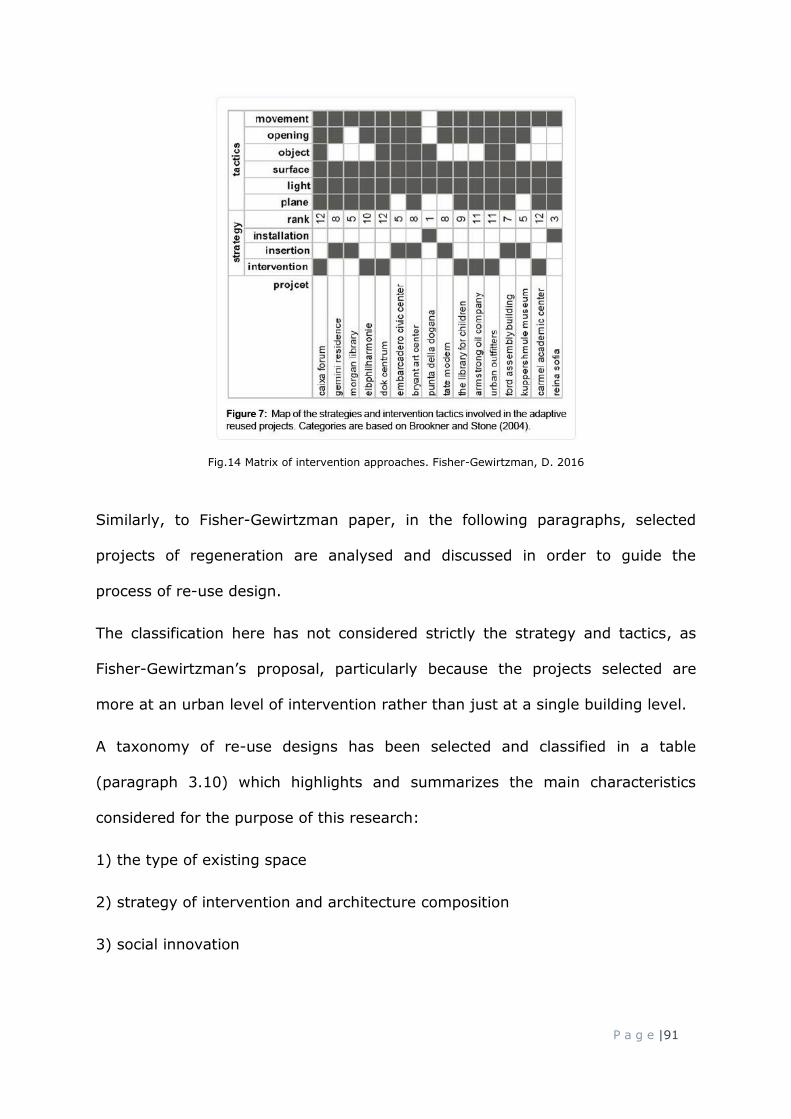
P a g e |91
Fig.14 Matrix of intervention approaches. Fisher-Gewirtzman, D. 2016
Similarly, to Fisher-Gewirtzman paper, in the following paragraphs, selected
projects of regeneration are analysed and discussed in order to guide the
process of re-use design.
The classification here has not considered strictly the strategy and tactics, as
Fisher-Gewirtzman’s proposal, particularly because the projects selected are
more at an urban level of intervention rather than just at a single building level.
A taxonomy of re-use designs has been selected and classified in a table
(paragraph 3.10) which highlights and summarizes the main characteristics
considered for the purpose of this research:
1) the type of existing space
2) strategy of intervention and architecture composition
3) social innovation

P a g e |92
A question raised from these projects relates to the possibility of defining a
specific modus operando, a common design approach to the project of the
existing as a resource of urban transformation, and if this approach derives from
a specific characteristic of the space.
The hypothesis is legitimated by the project of Parc de La Villette of Bernard
Tshumi first and Rem Koolhaas then, who both participated to the competition of
re-designing the park as cultural public space. The projects are very similar even
if the designers come from different cultural environments and background
forma mentis. This highlights, in a certain way, the importance of projects based
on theoretical principles of coherence and sharing.
3.10.1 Parc de La Villette
The competition theme was related to the larger urban regeneration of the East
parts of Paris, l'aménagement de l'est de Paris, approved by the city council in
1983. The public spaces’ masterplans were combined with a view of residential
expansions of the city and the idea of the park was based on a new vision of
innovation and pluralism.
The winning intervention (Bernard Thsumi 1982) can be considered one of the
most influential architectural projects for the new contemporary architectural
theory, although was not so distant from Koolhaas’ idea.
In that historical moment, the urban scenario was changing. The architects were
in front of new landscapes made of old historical fragments (the old city walls
such as the Berlin one, for example), industrial ruins, natural elements and
desire and necessity of progress.

P a g e |93
The Parc de la Villette itself represent the first live experiment of a new design
methodology where the general rules and the new methods were based on a
multitude of urban evolutions through the centuries. (Hardingham, S. 2012)
It is the first time that an architectural project is not presented as unique and
crystallized object, but as a deconstructed and unlimited space instead.
Even if that project can be considered, in the meantime, both an overturning
and a denial of the classic urban interventions of the eighties, the new design
method and principle is enormously clear. The relation with the existing
environment is established here through a project of three layers: lines, surfaces
and points, and each of them defines a level of a specific function (flows, folies,
green spaces and buildings).
Fig.15 Exploded axonometric of Parc de La Vilette. Bernard Tshumi’s project
Parc de la Villette represents a reflection on the time: the past; the present;
and, future, and their relation and balance. It is a relevant starting point for
thinking and reflecting on projects of regeneration and on the overall process of
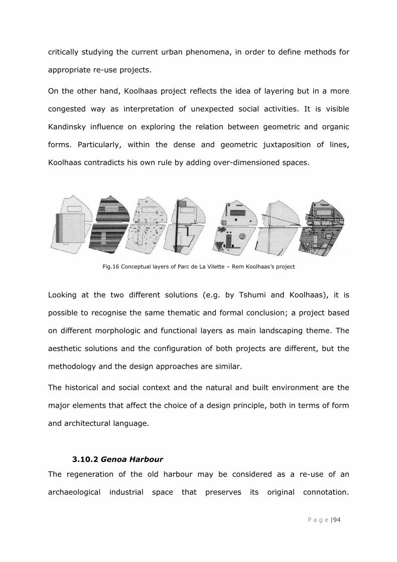
P a g e |94
critically studying the current urban phenomena, in order to define methods for
appropriate re-use projects.
On the other hand, Koolhaas project reflects the idea of layering but in a more
congested way as interpretation of unexpected social activities. It is visible
Kandinsky influence on exploring the relation between geometric and organic
forms. Particularly, within the dense and geometric juxtaposition of lines,
Koolhaas contradicts his own rule by adding over-dimensioned spaces.
Fig.16 Conceptual layers of Parc de La Vilette – Rem Koolhaas’s project
Looking at the two different solutions (e.g. by Tshumi and Koolhaas), it is
possible to recognise the same thematic and formal conclusion; a project based
on different morphologic and functional layers as main landscaping theme. The
aesthetic solutions and the configuration of both projects are different, but the
methodology and the design approaches are similar.
The historical and social context and the natural and built environment are the
major elements that affect the choice of a design principle, both in terms of form
and architectural language.
3.10.2 Genoa Harbour
The regeneration of the old harbour may be considered as a re-use of an
archaeological industrial space that preserves its original connotation.

P a g e |95
Interestingly, as Piano explained (2018) the culture of the city and its citizens is
more orientated to do not lose anything. This attitude is probably a consequence
of the geographical conformation of the region, crushed on the coastline. In this
sense, this project of regeneration is not just an evidence of the past but also a
reflection of its cultural and social environment.
The design of the harbour enhances its original function of connection with other
places reinforcing the relation between the city and the sea.
By designing a unique surface for the pavement, Piano overlaps a rigorous
rectangular grid for positioning streetlights, trees and wind spinners, all
elements present within the harbour, ground, water and air.
Fig.17 Bigo elevator. Genoa harbour
These elements became the most iconic landmarks of the project. Particularly
two out-of-scale objects, not distant from Koolhaas exceptions for Parc De La
Villette, were added to the water; the Bigo, an elevator for viewing the city from
above, that redraws the old shapes of the harbour cranes and the Sfera, a
transparent biosphere with twenty meter of height.

P a g e |96
The old factories, Magazzini del Cotone were reused without altering their
structural modularity. However, and interestingly, just the secondary partitions
were removed in order to have flexible internal spaces for shops and café.
Fig.18 Magazzini del Cotone. Genoa harbour
3.10.3 Parco Dora
Parco Dora was one the largest abandoned industrial area (Fiat Ferriere,
Michelin, Paracchi, Savigliano) in Turin close to the river and the main spines of
the city. The project designed by Peter Latz (2004) aimed to create a sort of
hybridization and intertwined overlap between old industrial ruins and modern
elements characterized by the predominant presence of nature.
Historically these type of industrialization represented for the city, the
materialization of an economic rebirth. In this sense, the project shows an
acceptation, almost respect, of the rigid old structures and the form of the
spaces and buildings. This approach, however, is not passive, rather tends to
interpret the history with unexpected contrasts and de-compositions.

P a g e |97
The landscape design and the nature are the heart of the project. Greenery,
trees and water are balanced between the remaining parts of the massive
buildings.
Fig.19 left: View of Parco Dora. Right: Internal space of re-used factory at Parco Dora
Some continues façade made of concrete were re-used as artistic canvas and the
buildings themselves were refunctioned with new social activity spaces.
Fig.20 Re-used factory at Parco Dora
The main concept behind the entire project is based on a central spine which
leads to the areas through perpendicular secondary paths.

P a g e |98
Fig.21 General Masterplan of Parco Dora
The park is today the largest green lung and most important example of
successful re-use of the city.
3.10.4 Highline Manhattan
The old railway in Manhattan, New York, is probably the most famous project of
railway line re-use where the ability of using different species of plants and the
concepts itself of transforming the entire long bridge in a “suspended forest”
above the city, is what remains the most in the collective imagery.
Fig.22 Highline walkway

P a g e |99
The choice of maintaining the rails and re-use them with a new idea of mobility –
the rails are used for movable deckchairs – and highlighting their presence
through a pavement that simulates the idea of movements, does not destroy the
memory and the past function and purpose of the Highline, rather demonstrates
that the old urban elements can be reactivated through modern functions and
design languages.
Nevertheless, the main design principle is still vague if we do not concentrate
the attention to the interconnections. The Highline re-use project is based not
just on the idea of rehabilitating the line but rather the spaces in between it and
the city. Many stairs, elevators and lateral connections are the heart of the
project itself.
Fig.23 Highline. Vertical connections
The micro-economy and different functions have been generated around the
highline. The line remains constant in its length but on the contrary, the spaces
around and so the borders of the line have been elevated to social places.

P a g e |100
Fig.24 Highline. Micro-activities underneath the Highline
3.10.5 Fondaco dei tedeschi
The old building is located in Venice, thus in highly historical place. In this sense
the external features of the building are completely renovated with no evident
modern intervention. Yet the relation with the context and the sea water has
remained unchanged. Interestingly, at that time the population of Venice was
decreasing and for this reason the project, before focusing on the design,
considered the programmatic aspect of the building. Particularly, the
functionality of the building was thought as a sort of urban storehouse with
various activities related to shopping, cultural events and social spaces in order
to attract both, tourists and citizens.
In terms of relations with the context, all spontaneous external paths and
accesses, used by citizens as shortcuts, were kept in order to maintain and
consolidate the urban character of the projects direct firstly to the residents.
The original structure was a mixture of several interventions made during the
past. Basically it was not just one building but multiple buildings at once.
The main architectural theme is, thus developed inside of the building through
unexpected vertical dispositions of new devices and paths. The vertical direction
of these inserts reveal the overlap of multiple historical structures. What

P a g e |101
emerges from this approach is mainly an acceptation of all historical
stratifications, without considering which one was more authentic or important.
In this sense the contemporary project becomes a witness of the past periods.
The new roof is a silent horizontal plane, reminding miesian play of geometries,
slightly detached from the existing structure.
Fig.25 New roof of Fondaco dei Tedeschi
Fig.26 Axonometric of Fondaco dei Tedeschi
All new elements are clearly declared and even reinforced by the use of bright
colours. The main architectural principle seems to follow the idea of
interpenetrating the old mass with new scattered volumes.

P a g e |102
Fig.27 Project concept of Fondaco dei Tedeschi
The project revitalises the building, and overall the surrounding small areas and
re-opened the old market space to the public; this happened against the first
conviction of the client to just convert it in an anonymous hotel.
3.10.6 Superkilen
The project came from the necessity to regenerate one of the most ethnically
diverse area of the city. The area is located at the junction of three main streets
in a highly built environment.
The design theme is related to modelling the ground by adding artificial dunes,
various urban furniture and artistic installations, but the main focus is on the use
of three different colours for the long square pavement.
Uninterrupted curved lines are in contraposition with streetlights, greeneries and
event spaces, which are treated as fragments within the common square space.

P a g e |103
Fig.28 View of Superkilen
The choice of using different colours for the pavements of the three main areas
of the square, seems to be related to a more aero-photogrammetric view and
taking the colours from the landscape and surrounding built spaces.
Fig.29 Concept behind the colours of Superkilen
All different derivations convert in the central point of the new long public square
depicting the new social focal place of meeting for all citizens.

P a g e |104
3.10.7 Therese Gate in Oslo
The temporary project for Therese Gate was a temporary installation set during
a workshop by students from Oslo School of Architecture. The aim was
investigating ways of regenerating the area through ephemeral elements placed
and geometrically distributed in a triangular square at the intersection of two
streets.
The strong geometry of the area was contrasted by a dislocation of fragmented
volumes that, if recomposed, would have generated a solid cube.
Fig.30 Removable volume on Theresa Gate, Oslo
Yet, the function of these elements is contrasting the multiple functions of the
busy area mainly related with business and advertisements. Each volume hosts
artistic exposition that can be seen through small scattered openings, with the
aim of slowing the human flows and invite it to pause.
The distribution of the volumes creates inner voids and the diagonal cut of the
volumes create a system of nooks-and-crannies.

P a g e |105
3.11 Precedents. Criteria for future projects
The precedents analysis enabled to have a clear idea of the approaches both
urban and architectural, which are summarized in the following taxonomy and
that may be useful as guides for future projects with similar context’s condition.

P a g e |106
Table 8: of precedents study – Urban themes & strategies and Design elements

P a g e |107
What emerged from the analysis of the precedents study is a set of clear urban
themes and architectural principles feasible for projects of re-use and more in
general for the regeneration of abandoned and neglected post-industrial areas
and buildings.
All projects reveal a certain level of complexity not just in terms of design but
even related to programmatic aspects and organisations. In this sense it is also
possible to notice the multiple involvements which took part in the projects
phases.
This is particularly the case of broader projects such as Parc de la Villette and
Dora park which began with a competition, thus with multiple expertise as
committee board, and later involved historians, philosophers, landscape
architects, communities and local authorities in order to have more holistic
approach to the site.
The renovation of the Highline in Manhattan commenced with the determination
of the citizens to preserve the infrastructure, later congregated in a new
community association, which launched the design competition.
The Fondaco dei Tedeschi as well as Genova Harbour involved various
professionals and different authorities such as the cultural heritage public body.
Superkilen project and Therese Gate project may be seen also as a sort of social
experiment where the first one involved residents from different cultures and
second one involved students from architecture schools.
In this regard, the next paragraph focuses on process of collaborations related to
urban and architectural projects of re-use, selecting those examples which are
pertinent for the practical aspect of this research and its practical focus on
Aberdeen city.

P a g e |108
3.12 Process of collaborations for urban and architectural projects of re-
use
A common characteristic, related to urban regeneration projects, in particular
with adaptive reuse designs, is the methodology adopted for the process. This
involves several stakeholders, communities, authorities, universities and
students.
The typical urban design collaborations comprise the urban Charrette and the
urban Workshop. Both of these can be configured in different ways and several
stakeholders are involved.
Both processes have been studied in order to objectively define their strength
and understand what the best approach is, in order to address issues related
with urban abandoned areas.
Before going into the main characteristics of the Charrette and Workshop
collaboration, which are more related to dealing with specific themes of design
projects of re-use, interesting is the case of Macerata Council (Italy) that
underpinned a particular and innovative collaboration with a professional and
selected citizen. In the final document, Rigenerazione Riqualificazione Urbana
Macerata (2015) issued by the local authorities, are illustrated deep urban
analysis particularly related to urban voids around the city, studies of successful
cases in other cities and specific methodologies and techniques for regenerating
the city of Macerata. The aim of this work carried out by a professional was
mainly based on 1) involving selected citizens based on their participation, in
order to facilitate the creation of new public spaces to discuss urban issues
related with the abandonment phenomenon, 2) creating specific reporting form

P a g e |109
for abandoned buildings or areas within the city, to be populated by citizens, 3)
writing up a detailed urban analysis and related methodology of regeneration.
This particular case can be considered as a live experiment to test new type of
city planning through a plan of re-use and regeneration, facilitated also by a
more conscientious involvement of the citizens. Probably it represents one of the
main starting points towards a more sustainable way to plan the urban evolution
of the city. However, as the conclusions also highlight, this model may be
applicable and suitable in areas spatially delimited and with a low number of
population or in areas where citizens are already culturally prepared to play a
more active role within the city decisions plans. Macerata case is still an isolated
case of new type of collaboration created appositely to approach urban issues of
regeneration and the relationship are established mainly between specific
planning department and the citizens, moderated by a professional.
The other two processes of collaboration, Charrette and Workshop, have a more
variegated participation and includes more professionals at different stages of
their career.
Previous PhD research, analysed within the paragraph 3.3, adopted the Charatte
as a process of collaboration and a design instrument for the guidelines of
abandoned building reuse in the city. (Corsaro, E. 2010)
The Charette process can be organized through different configurations of
participation, however, there are few common points very similar in every
Charette regarding adaptive re-use project.
This collaborative process has been successfully adopted, for instance, in the
project of Westerholt. (ibid)

P a g e |110
Charette is a process which involves various professional figures. Generally, it is
organized through a first phase of round table where owners, politicians and
representatives of the citizens, discuss public needs and aims. The second phase
of the design workshop is realized through the work of architects and urbanists
who propose projects and possible solutions for the round table requirements.
The nature of the work is to have specific guidelines as possible adaptive
solutions and these are generated during a short time (generally 2 weeks). For
this reasons all corrections are immediately drawn and changed and all
professional groups are updated in the meantime.
The third phase is related with a moderation where a specific professional figure
is employed to moderate and guarantee the flow of communications between the
round table and the professionals of the workshop. The moderator plays a key
role in taking responsibility for the exchange process.
The final phase relates to the presentation of the works to a public authorities’
panel. The aim is to collect all solutions and proposals and add them to the
interventions planning program of the council.
Charette Summary:
Principles Context Use strength - continuos feedback
- interdisciplinary
- citizens’ involvement
- feasibility
- work on site
- urban regeneration
- urban planning
- masterplan
- complex urban
problems
- high number of
decision makers
- visioning
idea/feasibility
- short duration of the
process
Table 9: Charette details
Another example of collaboration is the workshop. There are various possible
configurations for the workshops, but in the case of urban regeneration and

P a g e |111
design re-use it is appropriate to consider the involvement of both academics
and local authorities as they are significant actors for the urban future.
Roberts (2016) notices that contemporary urbanism and architecture is more
comparable to a tabula plena as opposite to the rasa one. In this sense, it
appears inevitable to work in-between and on existing parts of the city and
buildings. This type of assumption introduces the necessity of stronger and wider
collaborations which involve different fields of investigations. In particular
Roberts’s book is an example of experimental collaboration between Oslo School
of Architecture and Design, Columbia School of Architecture and the Planning
department of the government quarter in Oslo. This collaboration explores urban
and architectural themes, addressing theoretical questions related to design
strategies, pedagogical strategies and professional engagement, and exploring
methods to develop partnerships.
Alain and Melluso (2016) argued that the academia and the council are deeply
involved in the urban scenario. Even the city urban crisis may be read as a
consequence generated within these environments.
The contemporary scenario of the city is characterized by two main crises (Alain,
P. Melluso, V., 2016). One is related to the architecture university and the lack
of re-definition of its role within the city, where the schools are not able to
create systematic relations with the city and its council.
The other is related to local authorities that have not been able to update the
city planning process during the sudden passage from the urban expansion
(1960s) to the urban regeneration (1980s).

P a g e |112
These considerations have been raised by authors to propose a more
consolidated collaboration between university and local authority within the city
of Parma in Italy.
From 2014, the summer workshops organised for regeneration’s projects in
Parma, were transformed in a longer process of collaboration between university
and Parma Council. Parma cittá Futurais is a long term urban planning program,
where the concept and innovation is firstly discussed within the university,
involving several disciplines and studios. They experiment, over the years, new
urban opportunities and innovative methods to respond to the needs of new
urban interventions. For this program the university and council established a
stable union to improve the quality of the city plans and to offer even better
services for the communities.
The collaboration is seen as a resource for the society that they called the third
mission, where the potentiality of the academic methodology and the cultural
richness are highlighted in order to elaborate valuable urban projects.
Again in 2014 the University of architecture G. d’Annunzio in Pescara signed a
memorandum of understanding with the city council and other seven
international architecture schools to establish periodic workshops called Pescara
Summer School. The memorandum is called Universitá e cittá – Pescara Polo
della cultura e della conoscenza, University and city – Pescara Centre of culture
and knowledge, and represents the scientific support of the architecture school
to the city council (Fusero, P., 2016).

P a g e |113
The various meetings, organised to discuss the issues and possible regenerations
around the city, are meant as strategic occasions and tools which have as
common denominator the universities knowledge.
An interesting reflection on the nature and purpose of the workshop has been
argued by Curto, R. (2007) in the presentation of a workshop’s publication
carried out by students from Turin Polytechnic University and a
telecommunication company. The professor insisted on the relation between the
actors and their reciprocal interests where research and business can find
common spheres on which to make a system of collaboration.
The results are the proposal projects craft by academics and students and also
represent reflections for future workshops inputs.
The confrontation between academics and professionals is, according to Curto,
vital for the growth of both and it is constructive in terms of possible
collaborations.
Workshop Summary:
Principles Context Use strength - continues feedback
- interdisciplinary
- academia involvement
- theoretical methodology
- exchange of knowledge
between academics and
local authorities
- urban regeneration
- urban planning
- masterplan
- landscaping
- complex urban
problems
- when there is
high number of
decision makers
- visioning
idea/feasibility
- short duration of the
process
- innovation/cultural
discussion
- intense educational
program
- intense focus on an
area
Table 10: Workshop details

P a g e |114
3.13 Summary of the chapter
The literature review was elaborated around the contemporary post-industrial
urban and architectural phenomena of obsolescence. The investigation ranged
from architectural discourse to broader declinations used to describe those
spaces, encompassing anthropologic, historical and etymological studies.
In this regard, it was consistent to draw a critical analysis on the nature of these
spaces and their association with specifics terms.
Looking at possible pragmatic actions of regeneration and re-use, the chapter
analysed a range of relevant precedents in order to understand how the issue
can be approachable. The analysis revealed a set of urban themes and design
principles (pg. 104) but also revealed that projects of regeneration require
multiple professional figures. In this sense, in order to achieve the aim 3 of
practically testing those principles within the city of Aberdeen, the last part of
the chapter argues the most common form of collaboration used for these types
of projects.
The investigation of urban abandonment and the precedents study enabled to
target and frame the focus and achievements of the summer workshops in
Aberdeen. Particularly, they enabled to individuate the issues related to
abandonment phenomenon around Aberdeen city and initiate discussions on
possible action of regeneration. The theoretical approach, based on the
conceptual findings of this research, have been undertaken within the workshops
as described and elaborated in chapter 5.
Furthermore, the literature reviews, discussing similar cases of workshop
collaborations, enabled to define a first structure of activities for the Aberdeen
summer workshops. Particularly, the study of similar collaborations raised the

P a g e |115
necessity of dividing the length of the workshop in two parts, one more
theoretically supportive in order to inform participants on conceptual
explanations and one more practical and based on methodological approach of
design reuse. In this regard, the conceptual explanations elaborated in this
research fed into the introducing week of the workshop as valid way to stimulate
urban observations and individuate the possible lacks of connectivity of the
areas. The support of precedents study fed more into the practical activities of
the workshop, supporting the approaches and validating the method of
researching by design.
The structure of the workshop is based on a series of meetings with academics
and professionals where projects examples, scenarios of transformation and the
areas of interventions are explored and discussed.
The originality of this project of collaboration is the possibility of sharing the
visions between universities and council, experimenting methods of research by
design, projects outputs and receiving feedback from professional and council.
The aim of the workshop is to deal with themes related to the city, to the
landscape and to the territory without any new constructions and focusing on re-
use operations.
The workshop process of collaboration is very common, but also a strong way to
stimulate discussions around the city, involving different stakeholders from
different environment.
Before moving on the workshop activities undertaken during the summers 2016,
2017 and 2018, the next chapter 4 presents the urban analysis results gained by
using the combination of urban methods detailed in the methodology.
P a g e |116
In particular, the phenomenon of urban and architectural abandonment
described within the literature review, is investigated more pragmatically within
the context of Aberdeen city.
Firstly, chapter 4 draws an overview and interpretations of the abandonment’s
declinations of non-place, empty place and urban fragmented void, through
practical examples within the city. This has been done in order to clarify any
physical meaning of each category.
Sequentially and as consequence of the discussions undertaken with Aberdeen
City Council, eight areas around Aberdeen are selected. In this regard, the
Aberdeen City Masterplan 2015 and the Local Development Plan are reported as
starting points of the investigations.
Finally, the areas are analysed with urban maps and methods described in the
methodology chapter 2 and categorised in a taxonomy of urban and architectural
conditions of abandonment.

Page | 117
CHAPTER 4
ABERDEEN VIEWS
_________________________________________________________
4.1 Introduction and chapter overview
The literature review dealt with relevant aspect of the concepts of non-places,
empty-spaces and fragmented voids. These allowed to conceptualise and categorise
a range and type of spaces that are currently ill-defined and/or occupy a liminal
status. In paragraph 4.2 these theoretical notions are applied to concrete examples
taken from the urban context Aberdeen city.
Given that the urban abandoned spaces within Aberdeen city provide a practical
context for this study, it was appropriate to approach Aberdeen City Council in

Page | 118
order to initiate discussions related to underused spaces – abandoned – and their
possible reconnection within the urban city system. In this respect, to develop
further investigations on these urban spaces within the city, it was proposed to
actively involve students from architecture schools.
Referring to the Aberdeen City Centre Masterplan 2015-2035 and the Local
Development Plan (LDP), Aberdeen City Council (ACC) proposed critical areas in
need of regeneration, defined as opportunity sites and key areas for future
interventions, which could be explored through different lenses, more academic and
particularly by the students.
The selection of a limited number of areas listed on the Masterplan was decided in
order to meet the objectives of all parts involved related to urban study, student’s
outcomes and different insights proposed for the council.
Paragraph 4.3 describes the areas selected as they are reported in the Aberdeen
City Centre Masterplan, report and Local Development Plan, together with the
strategies individuated by ACC.
Paragraph 4.4 concernes the areas are analysed for the purpose of this research,
following urban analysis methodologies listed in the Chapter 2, in order to
understand their degree and typology of abandonment.
The literature related to urban analysis (Chapter 2) demonstrated the importance
of specific methods of urban analysis in order to categorise the spaces within the
city, and create a taxonomy of spaces able to indicate the main characteristic of
each of them. The importance of these spaces/buildings categorisation helps to
recognise the specific problems related with these areas in order to address and
identify the future suitable design methods and approaches. (which will be explored
in chapter 5)

Page | 119
If there is no significant problem or no perceived need for intervention, there
is generally no basis for affirming the value of a programme that purports to
address this non-problem. (Rossi et al., 1998, p.64).
Subsequently and supported by the data collected from the urban analysis, in the
paragraph 4.5 the areas are summarised and classified under the three main
subcategories of abandoned spaces already individuated in the literature as
fragmented voids, empty spaces and non-place.
Finally, in the paragraph 4.6 the areas are listed in a taxonomy which explicitly
emphasises the main aspects and characteristics of each area.
The areas selected were:
1. Castlegate - Marischal street – Aberdeen harbour front
2. Aberdeen waterfront
3. Golden Square
4. Bon Accord area and gardens
5. Aberdeen train station – Union and Market street
6. Hazlehead Park
7. Queen Street
Furthermore, one area has been identified by the researcher as relevant and
pertinent case study in Aberdeen which was not included in the ACC masterplan
and as a consequence for the workshops. The area is the old Aberdeen-Ballater
railway, used nowadays as a shared space pedestrians / cycle path. The importance
of analysing this linear resulting space is related to its nature of abandoned line and

Page | 120
its subsequent re-use which still maintains its twofold and contradictory function of
connection and separation as conceived on different scales.
8. Aberdeen Deeside way - old railway
4.2 Interpretations of abandoned areas
Before analysing the selected areas within Aberdeen city, we require to critically re-
consider the notion of empty place, fragmented void, and non-place, making, at
this stage, general connections within Aberdeen city. The concepts are reinforced
and shaped in order to clarify and describe the ideas raised after the study of the
literature, and to pragmatically use certain names and terms to describe existing
urban issues and urban design expectations as semantic approach for the research.
The notions of non-place, empty place and fragmented urban void are interrelating
to each other by the lack of various urban relations with the other parts of the city
and between the users, so a lack of physical, social and urban functions.
Fig.31 unhuman space. From the film Matrix
The three categories are analysed through their constant architectural and urban
characteristics but also their de-contextualisation within the city.

Page | 121
In this regard, before focusing on the areas examined in the next paragraphs, the
concepts of empty place, fragmented void and non-place are summarised and
reflected on some examples within Aberdeen.
4.2.1 Empty place
The areas selected for analysis contain a number of empty buildings. These can be
categorised as empty places in view of their possibility to be re-converted as social
and more public places.
The main phenomenon of emptiness in terms of urban consequence, is related to
the generation of urban borders. The lines between outside and inside are more
strongly marked and defined once the building becomes abandoned.
Fig.32: left: Empty station of Cults on the Deeside line. Right: Empty Bon Accord Bath. Aberdeen
Paradoxically the emptiness of a building raises and reinforces the presence of the
past and thus the history of a place.
4.2.2 Urban fragmented void
Urban fragmented voids may have different configurations within the cities and
this can be described through various adjectives. Particularly for this research

Page | 122
three subcategories of fragmented voids are described as theoretical deductions
based on the literature reviews.
As discussed previously in chapter 3, fragmented voids are unconstructed parts
of the city with no particular significance.
Marginal fragmented voids can be categorised in those spaces which are at the
margins of others, for instance a road. They probably have been planned in the
past or, as in the case of the picture n. 33, they are just unused and
unpleasant.
Fig.33: example of marginal fragmented void, Aberdeen.
Residual fragmented voids are the results of unconsidered spaces and generally
between two constructed or planned areas.

Page | 123
Fig.34: example of residual fragmented void.
Derelict fragmented voids are generally those spaces considered normally empty
within the city, thus not constructed, but in a neglected condition which sometimes
generates unsafe urban spaces and a sense of degradation.
Fig.35: example of derelict fragmented void, Aberdeen.
Figure 35 shows an old well used side entrance to a shop when it was in the
building. However, as soon as the entrance became disused, the quite large space
became fragmented, disconnected and unpleasant.

Page | 124
4.2.3 Non-place
The notion is not just related to functional spaces, such us train station or airport,
but to all spaces not thought for social activity and as a possible destination within
the city. A city with a high ratio of non-places in comparison with its places is then
not a city liveable at a human scale. In this regard establishing and naming a
subcategory of non-places may be strategic in order to define what should be
maximized and what should be minimized in view of an urban regeneration design.
Road and Street
A road is a functional connection, an element within the city, used and designed to
be occupied by transportations vehicles mainly. The pavements of a road are
generally not designed for high amount of human presence. The declination of non-
place in this sense is also related to the urban proportions and measures of a road.
The width of it exceeds the human scale and consequentially the places around
appear to be scattered.
By extrapolating the principle of place and non-place, it can be assumed that within
the city there are potentially many streets converted into non-streets.
Fig.36: Example of road. Union Street, Aberdeen

Page | 125
Streets thought as a place are, on the contrary, designed for human interactions
and as part of the social environment.
Fig.37: example of street. Back Wynd, Aberdeen
The presence of vehicles does not preclude the nature of a place. The proportions
between the width of pedestrian space and vehicles space instead, the entire width
of the street, the height of the buildings along it, and the density of activities within
the buildings play a predominant role in the definition of a street-place.
Green-space and green-place
The concept of green-space may be considered already part of the more generic
concept of non-place issue. Green-space is generally between spaces and with the
purpose of dividing different functions, thus there is not any human factors related
with the nature of it.

Page | 126
Fig.38: example of green-space. Industrial estate, Aberdeen
In a situation such as that illustrated in figure 38, the greenspace cannot be a
destination for social activities but also it cannot add any value to the surrounding
spaces in terms of pleasure, beauty/harmony, function and sustainability for its
reduced size.
Green-places on the contrary are designed with particular attention to the
proportions, variations of the natural landscape and in relation to the urban
surrounding areas.
Fig.39: Example of green-place, Aberdeen

Page | 127
The purpose of the green-place is to have social and symbolic functions that enable
the space to be rooted within the context. This aspect is crucial for the citizens’
perception of the urban green-place. Symbols and social functions of green-places
are fundamental to create a recognisable city with specific genetic code. Their
importance in the urban tissue is related to the identity of the city since they are
the open spaces of the city but also part of the broader landscape.
Wide space and square
Both wide spaces and squares are open spaces within the city but with different
function and social purpose. A wide space within Aberdeen is often used nowadays
as car park, thus can be qualified as part of the non-place category. The twofold
aspect of being an open-space and a non-place shows the incompatibility of
overlap, in equal proportions, two different functions. On one hand an open space
is closed to the concept of square, of piazza; on the other can be used as functional
non-place.
Fig.40: example of wide space, Aberdeen
By definition, a square, occupies a privileged space within the city and a genetic
heritage of the urban tissue evolution. This to say that public square can be

Page | 128
considered important elements that contribute to the identity of a city as well as
monuments, traditions, and social habits. The symbolic function of social place -
and its importance as a citizen destination - make it an important organisational
element of the urban environment, therefore an element of balance and relation
between buildings, streets and roads.
Fig.41: examples of square. Left: St Nicholas Square, Aberdeen. Right: The green Sqaure, Aberdeen
As highlighted so far, the notion of urban non-place may have various conditions
and declinations, depending on its configuration and role within the city.
4.3 Aberdeen Masterplan. Reading and vision of the local authorities
Aberdeen masterplan is intended to direct twenty years’ development of the city
centre, from 2015 to 2035. The main objective of the masterplan is the economic
growth of city and the improvement of the quality of the life based on
Creating an inclusive energised and sustainable future for Aberdeen City and
Shire. City centre regeneration is a key facet of this vision.
(Aberdeen city centre masterplan report, 2015, p. 16)
The issues individuated in the report of Aberdeen city centre masterplan are mainly
related to the economy and business development which have been dominated in

Page | 129
the last years mainly to the oil and gas sector. The potentiality of this feature is the
internationality of the Aberdeen population but despite this multiculturalism, the
city centre does not show cosmopolitan aspect either in the retail and leisure or in
the use of public spaces. It also underlines the failures of the more recent building
developments in terms of quality of design.
In summary, Aberdeen has a strong international economy, workforce,
history and outlook. The city centre should reflect this international
character.
(Aberdeen city centre masterplan report, 2015, p. 16)
The Aberdeen Masterplan arranges the future interventions under four thematic
strategies which aim to improve: 1) Economy, 2) Community, 3) Environment and
4) Infrastructure.
These strategies are addressed across forty-nine areas in the city centre, through
eight objectives and are divided in subcategories in relation to the improvement
needed according to the council and developers vision for each area.
Below is the image of the table that summarises the objectives, the themes of the
four strategies and the areas:

Page | 130
Fig.42: Objectives and strategies. Aberdeen City Centre Masterplan 2015, p. 29

Page | 131
Furthermore, the report classifies specific areas within the city centre, from the list
of the Opportunity sites presented in the 2017 Local Development Plan (LDP), that
are less utilised and are closed or that coincide to a number of sites which are
already under development, such as Marischal Square. The classified areas are
described as Areas of Interventions and each of them presents a description section
divided into: 1) The Vision, 2) The opportunity, 3) Development objectives, 4)
Development Summary.
Fig.43: Intervention areas. Aberdeen City Centre Masterplan 2015, p. 63
The areas are here described and listed according to the LDP and the Masterplan
Areas of Intervention. The intention of the following sections is to outline the
strategy within the Masterplan. This provides an important understanding of
context for the original research exploration (in chapter 5).

Page | 132
4.3.1 Aberdeen Masterplan and Local Development Plan. The seven areas
1. Castlegate – under Areas of Intervention - AM
The area should be an attraction of visitors and tourists and link to the harbour
to the south and the beach to the east.
The Vision:
Castlegate will be the new centre’s civic square as it has been in the past
portrayed in the masterplan as a popular place to enjoy the city life.
The opportunity:
Castlegate needs substantial repaving and measures to improve microclimate.
Also it will be the comfortable place of events such as market and concerts.
These changes of functions will stimulate interest from building owners and new
businesses to invest in new leisure uses around the square.
Fig.44: Castlegate. Aberdeen City Centre Masterplan 2015, p. 85
Page | 133
Development objectives:
The development approach should deliver:
- New paving surface for the area including Justice Street to simplify the space
and take a lead from the building edges to square and streets.
- New landmark such as lighting scheme of permanent or temporary
installations.
- New protection from the winter weather condition in the square
- The shops front should be attractive and limited to the use of retail, food &
drink and assembly and leisure.
- The upper floors on Castlegate should be limited to the use of office, hotels &
hostels and residential.
- The development should consider the area behind Castlegate
- Better connections and use of the ground space at Castlehill for public use
- Replacement of the roundabout connecting the area to the Beach Boulevard
with a crossroads junction, improving the pedestrian and cyclist paths.

Page | 134
Fig.45: Castlegate. Aberdeen City Centre Masterplan 2015, p. 86
Development summary:
- Refurbishment of properties on Castlegate with limitation of the ground floor
uses: 1. Retail, 2. Food & drink, 3. Leisure. Upper floor uses: 1. Offices, 2. Hotel
and Hostels, 3. Residential.
- New residential apartments.

Page | 135
Fig.46: Castlegate. Aberdeen City Centre Masterplan 2015, p. 87
Fig.47: Castlegate. Aberdeen City Centre Masterplan 2015, p. 87

Page | 136
3. Golden Square - under Areas of Intervention “Union Street West” -
AM
Golden Square is part the of Union Street West Vision where the refurbishment
of the Music Hall and the new City Rooms will increase the cultural, civic and
commercial character of the city. Golden Square is under the Environment: Light
of the North strategy (figure above n. 42) and future development are
mentioned in the Development objectives of Union Street.
Development objectives:
Golden Square should be redesigned in order to remove the car parking and to
create outdoor performance space as continuation of the Music Hall. The design
should involve the regeneration and redefinition of South Silver Street as
pedestrian street mainly.
2. Aberdeen waterfront – under Opportunity sites - LDP
The Coastal Planning classifies the waterfront into two types of area, developed
and undeveloped coast. The undeveloped coast is unsuitable for development.
The developed part is already a focus of economic and recreational activity and
is suitable for further developments. All developments should consider strategies
which consider nature protection, aquaculture, fisheries, agriculture, industry, off
shore wind energy, shipping, tourism, development of infrastructure and
mitigation and adaptation to climate change such as flood risk, sea-level rise and
weather event. (LDP pag 41)

Page | 137
Fig.48: Castlegate. Aberdeen City Centre Masterplan 2015, p. 77
4. Bon Accord square - under Areas of Intervention “Union Street West”
Bon Accord is under Union Street Intervention and is considered a key space for
the redevelopment of the entire area in the city centre.
Development objectives:
Bon Accord should be redesigned to have an urban garden with more plants and
biodiversity, raised beds and seating areas to encourage meetings and stays.
The accessibility should be redesigned and the new pavement should be
considered. The illustration of the vision is together with map above, fig. 48.

Page | 138
5. Aberdeen train station - under Areas of Intervention
The Station and the surrounding area extended until the Aberdeen Market should
represent the gateway experience and should have a better connection with the
city centre.
The Vision:
The vision for the Station Gateway aims to improve the areas by pedestrianizing
the routes between Union Street and the station. New hotels and retail facilities
will improve and animate the public space as entrance to the city centre.
The Opportunity:
Fig.49: Train station area. Aberdeen City Centre Masterplan 2015, p. 81
The station taxi rank will be relocated and the station concourse will be
expanded. The Atholl House would provide a better gateway and facilitate the
connections to the Trinity Centre and Union Street.
Development objectives:
- Remove cars on Guild Street and part of Carmelite Street and Wapping Street

Page | 139
for more pedestrian footways.
- Guild Street will be the new public place with high quality materials and simple
unfussy design.
- Relocation of the drop off and taxi rank to College Street.
- Redevelopment of the existing taxi area to expand the station concourse with
retail uses and hotel above.
- Redevelopment of Atholl House and Trinity Centre entrance replaces with high
quality foyer/atrium space and new bridge link to the trinity Centre
- Programme of enhancement and improvement for the Trinity Centre.
Fig.50: Train station area. Aberdeen City Centre Masterplan 2015, p. 82
Development summary:
- expanded station concourse to include retail and food & drink functions

Page | 140
- new station hotel above the concourse
- New Trinity Centre entrance and bridge
- Hotel on Atholl House
Fig.51: Train station area. Aberdeen City Centre Masterplan 2015, p. 83
Page | 141
6. Hazlehead – under Opportunity sites LDP
Hazlehead is located out of Aberdeen city centre and is part of a vision called
Green Belt which has the purpose to maintain the distinct identity of Aberdeen
by defining with greenery the physical boundaries of the city. No development
will be permitted in the Green Belt apart from those essential for the agriculture,
woodland and forestry.
Buildings in the Green Belt which have a historic or architectural interest or a
valuable traditional character will be permitted to undergo an appropriate
change of use which makes a worthwhile contribution to the visual character of
the Green Belt.
Extensions of the existing buildings will be permitted in the Green Belt if the
original remains predominant; if the design is sympathetic to the original one; if
the siting of the extension relates well to the setting of the original one.
7. Queen Street - under Areas of Intervention
The vision:
Queen Square is the new name of Queen Street to indicate the transformation
of the area into new mixed use urban quarter.
Cafes, shops and apartments will populate the public space which will be
pedestrianised. The vision aims to activate the area during the day and the
night with cultural events in the Lemon Tree and the Arts centre.

Page | 142
The opportunity:
The aspiration is to downsize the Police Station to alternative accommodation
and to redevelop the Town House extension and former Grampian Police
headquarters together with other buildings and under used spaces on Queen
Street. The uses will be commercial and food & drink for the ground floors and
residential for the upper floor.
Fig.52: Queen Street. Aberdeen City Centre Masterplan 2015, p. 73
Development objectives:
- Refurbishment of the Marischal College eastern annex and Greyfriars John
Knox Church.

Page | 143
- Redevelopment of the Town House extension and former Grampian Police
headquarters
-Development of the pavement with pedestrian use only with the extension of
Lodge Walk as a link from Union Street and the new square adjacent to
Aberdeen Arts Centre.
- Attractive and coherent contemporary architecture respecting the Marischal
College, the Greyfrias John Knox Church, the Town House, the Arts centre and
Queen Street Church.
- Retail and food & drink on Queen Street.
- High quality of the public area.
- Broad Street will have access restricted to buses and taxi and will be designed
as a high quality space used for temporary events.
Fig.53: Queen Street. Aberdeen City Centre Masterplan 2015, p. 74

Page | 144
Development Summary:
- Refurbishment at the eastern annex of Marischal College with offices,
assembly and leisure.
- Refurbishment of Greyfrias John Knox Church with food & drink uses,
business, hotels and hostels, assembly and leisure.
- New retail, financial, professional and other services, and food and drink at the
ground floors.
- New upper floor for residential use.
Fig.54: Queen Street. Aberdeen City Centre Masterplan 2015, p. 75

Page | 145
The Local Development Plan is a guide for the urban interventions and includes a
list of policies for every area described. Another city plan is related to the mobility
and transport. In particular, the Local Transport Strategy 2016-2021 aims to
implement the long-distance pedestrian routes such as the Deeside Way analysed
in paragraph 4.5.
The masterplan is a proposal, adopted by the council, which influences every future
intervention, forms the backdrop to every decision, although it is not a prescriptive
template. It also indicates size of possible buildings, functions and materiality.
The indications and the guidelines proposed in the Masterplan are similar, despite
the areas have different urban characters. Almost all of them, excluding Hazlehead
Park, Golden and Bon Accord Square, have been addressed with the retail, food &
drink and residential destinations only.
It also appears a sort of discrepancy between the descriptions and the proposed
maps of the new structures. In particular, the strategy of refurbishment and the
idea of visual connections with the existing context are mentioned several times,
but then all existing buildings are clearly evidenced to be demolished on the maps.
4.4 Reflections on the LDP objectives
The objectives of LDP seem more oriented toward an economic and marketing
development at the disadvantage of a harmonious urban and architectural
development of public space. The risk of using the statement growing city centre
employment base (objective n.2) may fall in an urban plan based on mimicry and
reiteration of the same structure and development’s formula, which have been
already applied for the renovation of the train station, Union Square, and the

Page | 146
Marischal Square new building. Interestingly, for both interventions the term
square has been used even if the predominant elements are more constructed and
less orientated to architecturally define the public and urban space in its civitas and
agora declination. According to Rogers (2017) planning means considering the
spaces in-between and the quality and nature of public spaces where the voids,
thus the non-constructed spaces such as squares and streets, define the urban
harmony.
The objective (n.2), growing city centre employment base, already defines some
intentions related to the functions and activities, which have to take place in the
city centre. This seems to aprioristically exclude other forms of public space use
and a mix of activities for people and citizens from different backgrounds, and it
seems to go against the objective n.4 Living city for everyone.
Public space – big or small, noisy or quiet – reflects civic values.
(Rogers, R. 2017)
Aberdeen is a relatively a small city (232,000 Population Projections for Scottish
Areas, 2016) with a strong architectural character due to its materiality and
architectural style; regenerating historical city centres and developing the harmony
of spaces over time, might mean both design approaches of juxtaposed consistency
and contrast. Giving a Metropolitan outlook (objective n.3) and particularly using
these generic terms may be open to various interpretations; the risk may be to
generate a weakening of the city identity and local community, reinforcing on the
contrary, the notion and the appearance of Koolhaas’ generic city. Furthermore,
metropolitan, despite its Greek etymology of mother-city, is generally referred to a
modern and dynamic city (Enciclopedia Universale Mondadori, 1989) which does

Page | 147
not envisage a Changing of perception (objective n.1) of the city centre and the
typical local productions defined under the objective n.5 Made in Aberdeen.
More specifically, observing the objectives in relation to the area studied in this
thesis, there are incongruent associations. For instance, Castlegate, which is the
oldest piazza of the city, is associated to the objective of transforming it in
something with more metropolitan outlook. Yet changing perception for a historical
place as Castlegate seems challenging, particularly, as discussed later in the
chapter, the issues related to a space which is not constructed and so a void, are
generally related to the other non-constructed spaces such as streets, connections
and pedestrian paths. This suggests that what should change is the connection of
Castlegate with Union, King and Marischal Streets, rather than its perception.
Interestingly, one of the Golden Square’s objective is becoming culturally
attractive, but this is not the case of Castlegate.
In conclusion, what emerged from the LDP is a long list of generic objectives which
are repeated several times for almost all areas, but their vague and not specific
aspect is sometimes contradictory and confounding.
4.5 Identification of abandoned spaces within the areas. Reading methods
The vision of the Council articulates the priorities that need to be addressed in a
specific time frame, according to the masterplan 2015.
On the other hand, as constructed through urban and architectural discourse, there
is the possibilities to explore even more the borders of these selected areas trying
to emphasise the importance of interconnectivity between them. By considering the
character of identity of Aberdeen and the areas mentioned in the Aberdeen

Page | 148
masterplan 2015 and in the Local Development Plan 2017, other areas at the
borders and other existing issues emerged from the study of the city urbanity.
The methodological analysis approach underpinned by a more academic reading,
enables to identify particular urban problems and address them through specific
solutions according with similar precedents examples.
Analysis brings to a work a type of deep reading whereby probing and questioning
reveal the potentials and significances of a precedent. Analysis becomes,
furthermore, a mode of seeing and understanding a work.
The analysis of urban areas are based on broad literatures and specific methods
that help to understand, not just the area itself, but also its borders and the related
relations with the surrounding context. The relations and the borders are indeed
indicators of urban identity. Relations and connectivity, archetypes (Turner, 1995)
or their declination in the Rossian urban artifacts (Rossi 1982) therefore, are
fundamental for the concept of place.
According to this, the lack of relations and significant urban and social elements
generates placeless-ness.
Two main categories of relations are useful to explore the meaning and the issues
of an area. Relation means that presences have effectively taken place. In terms of
urbanity and landscaping relation can be:
1) With the surrounding and so made through paths, connections, steps,
emphasizing particular parts of the city.
2) Between the users and so through social functions.

Page | 149
Based on this assumption specific analysis methods are used in the following
paragraphs to individuate and classify the type of abandonment of the areas
examined and to link the issues to specific cases study.
Reading Principle
Fig.55: Diagram of design process
In the following analysis it is explored the nature of the areas selected for proposals
of regeneration by the ACC Planning Department and reported in the paragraph
4.1, investigating their urban characteristics and the subcategories of abandoned
spaces they may fall into.
The areas are studied through specific methodologies of urban analysis (Chap.2)
adopted in the urban and architecture disciplines characterised by a more
theoretical approach.
The urban and architecture analysis, particularly mapping, typo-morphologic,
rhythm, observation and mental maps, are the main instruments within a more
research orientated context. They aim to investigate the city in a more holistic way,
interpreting the various aspects of the city. By defining the potentialities of the
spaces through the data and information shown on the drawing maps, these types
- Mapping
- Typo-morphologic analysis
- Rhythm analysis
- Observation
- Perceptive/interpretative
Precedents study
- Transversality
- Contrast
- Repetition – Flows
- Entropy – Variety
- Flows & Grids

Page | 150
of analysis-instruments enable to address a process of design methodologically
structured.
4.5.1 Mapping – relation with the urban context
As a first phase in analysing the areas selected in Aberdeen by ACC, photographic
areal images from Digimap have been used to map and identify the areas within
their surrounding urban context. In this respect a first visual interpretation has
helped to identify their dimensions, physical forms and positions within the city (fig.
56). From this first view of the areas it appears clear that they are almost fractal
urban spaces, thus are not just constructed solids but mainly spaces in-between
the built elements. The diagram drawn on the map then, has been isolated to
better understand the relation between the areas and also to clearly visualise and
evaluate the fragmentation and the proportions of the selected abandoned spaces
within the city.

Page | 151
Fig.56: Aberdeen, map of abandoned areas on photogrammetric picture
Fig.57: Aberdeen, representation map of abandoned areas

Page | 152
What emerged from these maps is a regular distribution of the areas along a spine,
mainly Union Street and its continuations of Queen’s Road and the Beach
Boulevard. The exception appears to be the railway for its linear configuration and
isolation from the city centre.
From this scale the areas within the city centre seem closed to each other,
suggesting a net of abandoned urban spaces, which could potentially become a
widespread net of re-connections.

Page | 153
Fig.58: Aberdeen, historical evolutions

Page | 154
The historical evolution of the city (fig. 58) suggests that in a first moment the
growth followed a centripetal configuration around Castlegate and the Green.
The later establishment of Union Street and the dense constructions along it,
generated a spine of isolation between different parts of the city. If on the one
hand Union Street is a west-east connection axis, which does not lead to the sea
due to the orthographic conformation of the land, on the other it separates the
south and north areas. The areas selected, with the exclusion of Castlegate and
Queen Street, are situated in the most recent expansion of the city.
Subsequently, in order to have a clear understanding of the areas, each one has
been analysed, on a bigger scale, in order to identify the connections and relations
with the surrounding built environment and the city infrastructure system. Scaling
the images in this way affords for the buildings and monuments to be individuated
and categorised within the areas in need of regeneration. The following typo-
morphological analysis are described for each area of intervention.
4.5.2 Typo-morphologic analysis
In this paragraph are presented the typo-morphological analysis conducted on all
eight selected areas and the related discussions on the data collected.

Page | 155
1 Castlegate:
Fig.59: Castlegate typological map

Page | 156
Fig.60: Castlegate morphological map
Castlegate is situated near to the headland of Castlehill in a dense and historical
area. It is the only public open space presented there but the accessibility is limited
by the intense traffic of Union and King Street.
The accesses on the east end are less utilised and not directly connected with other
parts of the city. Particularly Justice Street, which descends on the north side of the
square, leads down to a traffic junction, node of four main roads.
In terms of urban morphology, the orientations of the buildings and their
configurations seem to converge on Castlegate space which becomes the focal
point of the city space. It is evident a predominant direction of the flows on the

Page | 157
east-west axis and a lack of connectivity in the perpendicular direction which would
lead to the harbour.
The presence of green spaces is not evident apart from some residual areas on the
east side of the hill.
The built environment is an overlaying of different periods particularly on the
harbour areas included Marischal Street, which appears as transitional space with
not particular attractive character or social function.
Some main buildings may be distinguished and categorised as landmarks for their
specific historical meaning or social use. Particularly from the typological analysis it
emerges that Tolbooth, Archibald Simpson and Salvation Army Citadel buildings
have significant architectural and historical values, which are not highlighted
through the open and in-between spaces of area. The lack of pedestrian and public
confluences, particularly from Marischal, Castle and King Street pulls the focus on
other directions to the disadvantage of urban permanencies as a sign of the city
identity.

Page | 158
2 Aberdeen waterfront:
Fig.61: Aberdeen waterfront typological map

Page | 159
Fig.62: Aberdeen waterfront morphological map
In comparison with Aberdeen city centre, the area is scattered and less dense in
terms of urbanity.
The natural environment of the waterfront and the extensive presence of green
spaces are the main feature of the area, worth of preservation. Despite the
presence of green areas, particularly those one along the Boulevard, they seem to
appear disconnected from the rest of the environment and without clear and
specific social and attractive functions. The lack of designed green places is here

Page | 160
predominant and the presence of the three roads along their sides increases the
sense of discontinuity and fragmentation.
The accessibility is limited to the Beach Boulevard spine and the Esplanade road
but with multiple possibility for pedestrian accesses and flows on the coastal strip.
Interestingly the linearity of the coast is respected even in the paths that lead to
the beach, giving a sense of landscaping continuation. In fact, there are not
perpendicular accesses from the pedestrian esplanade to the beach area but rather
there are ramps, which follow the natural conformation of the contours.
The buildings along the coast are not of particular relevance; their appearance
recalls more temporary structures. There is a lack of architectural dialogue between
buildings distributed on a linear system and this highlights different times of
construction.
Footdee gives the main historical presence; the old fishing village characterised by
local cottages, intimate neighbourhood and eccentric houses owners’ paintwork.
The village is compressed on the coast and hidden by industrial buildings on the
west side.

Page | 161
3 Golden Square:
Fig.63: Golden Square typological map

Page | 162
Fig.64: Golden Square morphological map
The proximity of Union Street, the Music Hall and the accessibility on all sides of
the square give a strategic location to Golden Square. This highlights its important
potential as public open place.
Currently the square is used as transitional part of the city centre, the majority of
the space is used as carpark, which also supresses the valuable presence of the
statue of Duke of Gordon, positioned in the centre.
What emerged from the morphological analysis is mainly an incongruence in
linguistics terms; de facto Golden Square can be consider a space more suitable for
vehicles rather than for human interaction. Its function is mainly to divert the

Page | 163
traffic in many directions. There is a complete lack of urban and social relation with
the main landmark on west side, the Music Hall.
The green spaces are limited and help to separate two rows of carpark.
The recent restoration of the Music Hall added more functions to the building in
order to be visited and used throughout the entire day. This contributes to
recognise even more the historical building as a landmark for the city and renovate
place of meeting. In this sense Golden Square may potentially become a place
where the original idea of square is related to social functions, even as open space
extension of public buildings.
4 Bon Accord area and gardens
Fig.65: Bon Accord area and gardens typological map

Page | 164
Fig.66: Bon Accord area and gardens morphological map
The park, situated in the city centre presents a sloppy terrain which connects the
upper area of Bon Accord to the lowest of Willowbank Road. It appears to be a
transversal spine of Union Street and potentially an aerial place of connections
between different zones, residential, workplaces and commercial.
The garden is currently underused and the lack of street illumination and the
abandoned brick structure contribute to make the space unsafe for citizens.
The park itself expresses the morphological idea of delimited area but the adjacent
green spaces suggest possibilities of more hybridisation between part of the
constructed city and the green areas.

Page | 165
Few forgotten permanencies (Rossi, A. 1982) could potentially become renovate
landmarks for regenerating the area. Bon Accord bath is an abandoned Art Deco
building, the Brick Garden Terrace was the major selling point of Bon Accord
Terrace, and Bon Accord Square hosts Archibald Simpson Memorial but is currently
used as carpark. Bringing back these dislocated buildings and the square and
linking them together would generate congruence within different context of the
city.
5 Aberdeen train station, Union and Market Street:
Fig.67: Aberdeen train station, Union and Market Street typological map

Page | 166
Fig.68: Aberdeen train station, Union and Market Street morphological map
The main issue related with the train station area seems to be the pedestrian
accessibility which is restricted by the intense traffic. The presence of two shopping
malls in the area, Trinity centre and Union square, and their predominant
configuration which supresses and hides other historical buildings such as the
station, generate a sense of massivness reducing public open spaces and their
transversal pedestrian flows.
The presence of the Trinity centre’s carpark creates cramped spaces around one of
the oldest area in Aberdeen. Furthermore, the market in its neglected condition
represents a massive and predominant volume facing the public space namely, The

Page | 167
Green. Its public function can potentially be transformed somehow in order to
modify the surrounding urban tissues and to increase the identity of the area.
6 Hazlehead Park:
Fig.69: Hazlehead Park typological map

Page | 168
Fig.70: Hazlehead Park morphological map
Hazlehead Park has three main entrances, two along Hazlehead Avenue and one on
Hazlehead Road. The pedestrian circulation along Hazlehead Avenue however is not
well solved. In fact walking from Queen’s road, the pavement is unexpectelly
interrupted on the left side, forcing pedestrains to cross the road and reach the
right side. Since Hazlehead Park is on the left side, pedestrians are forced to cross
the road again in proximity of the first park entrance.
Furthermore, the carparks do not have designed structure with the consequence of
having disorganised parking spaces.

Page | 169
Inside the park the circulation is mainly concentrated on an existing path but users
can easily cross the greenery and reach different areas.
There are mainly three abandoned buildings within the park; specifically, the
Gatehouse is listed building situated at the first entrance of the park. It is a
significant construction for its position and structure. Inside the house almost all of
the internal partitions materials were burned and destroyed due to a fire. This helps
to open up, arguably, a possible freedom in organising the space inside during a
preliminary re-use design.
The second building is an old toilet block situated close to the second entrance of
the park, precisely behind an existing café building. Contrarily to the Gatehouse,
the toilet block does not present any significant architectural value and its
appearance is strongly derelict.
The third building is located near to the labyrinth and it was the old highest point of
view for monitoring people within the maze. The structure is particularly
interesting, constituted by an accentuated pitched roof.

Page | 170
7 Queen Street:
Fig.71: Queen Street typological map

Page | 171
Fig.72: Queen Street morphological map
The isolation of Queen Street with respect to the surrounding area highlights its
only function of connections but this is also limited in one way when closed to King
Street. There are two greenery roundabout which are completely de-contextualised
and suggest the need of improving the quantity of green within the city centre.
The area is located in a rich part of Aberdeen city in terms of architectural heritage
and landmarks. The presence of Marischal college, the Art centre, the Parish church
and the new intervention of Marischal Square contribute to characterise the city
and its appearance.
The police station in this sense, appears as a massive volume out of scale which
does not have any dialogue in terms of architectural language and urban

Page | 172
connectivity with the surrounding buildings and streets. Walking on Queen Street,
the presence of many landmarks is not obvious and some of them go unnoticed.
Ultimately, the connections with Union and King Street seem to be poor,
highlighting the need of repairing this fragmentation.
8 Deeside railway:
The Deeside way was a 43¼ miles of railway from Aberdeen to Ballater patronised
by royalty to visit their residence at Balmoral Castle. (Holland, J. 2015)
The line was used as a passage of the royal trains but also as a track of the modern
battery-operated railcar. It was introduced in conjunction with steam power and
had a certain level of passengers estimated to increase. Despite the introduction of
the battery-operated railcar in 1958 the railway closed in 1966. The battery railcars
are now preserved as museum pieces.
The transformation into a pedestrian and cycle path generated some deviations of
the original route and from the Western side the conversion offers today different
views of the natural landscapes and historical castles. The presence of the royal
castle at Balmoral, even just as tourism attraction, preserved the surrounding
spaces at the borders of the railway but also contributed to the historical
restoration of characteristic elements related to the railway such us the Milton of
Crathes steam carriage (The Royal Deeside railway, 2018).
The first section of the reused Deeside line runs from Duthie Park in Aberdeen to
Banchory and the first significant trace of the old railway and stations appears at
Peterculter station. For the purpose of this research just the length from Aberdeen
to Peterculter is analysed.

Page | 173
Fig.73: Deeside railway typological map
Fig.74: Deeside railway morphological map

Page | 174
Fig.75: Deeside railway, buildings along the line
A railway leads people from an origin to a new destination by train, but the new re-
drawn way cannot lead so rapidly and so easily along the complete historical route.
Its paradoxical isolation and connection is presented at different scales. Aberdeen
Deeside line connects two far points, separating two lateral areas. It is indeed at
once an element of connection and isolation.
The nature and history of the Deeside railway is important to this line and
represents a significant aspect of identity for the city. The identity of place
represents the main image of the positive growth of the city and its recognisability
demonstrates the sum of different ages. It is then important to reconstruct and
redraw this image before it disappears within the landscape.
Nowadays, on the Aberdeen segment of the line, many examples of construction
are oriented facing away from the line. The greenway therefore, can still be
considered a back and not a ‘new frontage’.
The Eastern part of the entire old railway, close to Aberdeen, is less considered as
natural heritage and unfortunately some recent interventions have weakened the
open spaces at the border of the path (fig. 75).
The Aberdeen greenway still connects, even if with some deviations, the points A
and B, Aberdeen and Ballater. In the re-conversion of this long distance various
nodes and points have been forgotten.

Page | 175
The secondary stations in some cases are in abandonment apart from the historical
and listed station of Pitfodels, built in 1894. It has been redeveloped as a private
house. This intervention has limited the historical and social sense of that building,
erasing the connectivity between the Pitfodels place and the railway.
Fig.76: Diagram of constructed elements along the Deeside railway
The original conversion of the Deeside railway aimed to recreate a natural wildlife
environment and this objective has been successfully addressed. Nevertheless, the
path itself has been poorly replaced with tarmac, erasing completely the nature of
that space and it still remains in its isolation despite it is still connecting two far
points, A and B. It is not so obvious that a person can walk or cycle for so long
distance and with a specific mobility purpose and moving reason.
Generally, the greenway is used for a mono-directional walkway, back and forward,
with not any interaction with the surrounding green-places or towns, or artifact.

Page | 176
4.5.3 Rhythm analysis
Fig.77: Rhythm of Aberdeen areas

Page | 177

Page | 178
Fig.78: Example of frequentation time. Photos of the areas, rhythm at different times.
The data collected with the rhythm analysis are crucial because they represent the
social practices and the characters of the area. The map (fig. 77) represents two
different experiences both spatial and temporal.
Firstly, the opening times of activities divided in two categories, 9.00am to 5.00pm
and 5.00pm to 22.00pm, create a patchwork of the typical places of congregation
within a specific frame of time. This is particularly useful in order to understand the
flow of users, the new or changing life styles and consumptions and to propose
bespoke and new activities related with that frame of time during the design
proposals.
Page | 179
Secondly, with help of photographs and urban webcams images, the pixelated
diagrams create an image of the intensity of users’ frequentations of the area
during a working day. The data were collected in morning, afternoon and nights.
The map shows an overage of the frequentations.
From the opening time of activities, it is possible to notice as the day activities are
more predominant than during evenings. Particularly they are distributed along
Union Street while the few activities are disappearing at the edge of the city centre,
such as on the Queen Street area as well as the area of the waterfront. This
represents a sort of fragmentation on the map and suggests that an increment of
activities, or a better balance between day and night could be a way for
regenerating the spaces.
From the frequentations map it is possible to notice that during a working day
some areas are not experienced, particularly both parks and the waterfront for
their location far from the city centre and core of the main activities. The Beach
Boulevard however seems to be highly frequented and this can be due also to the
presence of supermarkets and shops.
Castlegate, Golden Square, Bon Accord, Queen Street and the Deeside areas
appear as transient spaces with no activities able to generate social places of
staying.
The train station area is generally crowded, even in a weekend day, and this is due
to a combination of functions and streets infrastructures. The issue of being an
unsolved urban area seems to be related to pedestrian flows relegated to narrow
spaces and the closed pedestrian connections after the day opening times.
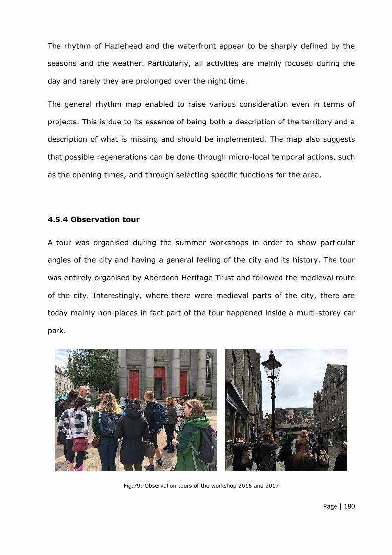
Page | 180
The rhythm of Hazlehead and the waterfront appear to be sharply defined by the
seasons and the weather. Particularly, all activities are mainly focused during the
day and rarely they are prolonged over the night time.
The general rhythm map enabled to raise various consideration even in terms of
projects. This is due to its essence of being both a description of the territory and a
description of what is missing and should be implemented. The map also suggests
that possible regenerations can be done through micro-local temporal actions, such
as the opening times, and through selecting specific functions for the area.
4.5.4 Observation tour
A tour was organised during the summer workshops in order to show particular
angles of the city and having a general feeling of the city and its history. The tour
was entirely organised by Aberdeen Heritage Trust and followed the medieval route
of the city. Interestingly, where there were medieval parts of the city, there are
today mainly non-places in fact part of the tour happened inside a multi-storey car
park.
Fig.79: Observation tours of the workshop 2016 and 2017

Page | 181
The possibility of attending this tour enabled the researcher to have a clear idea of
the evolution of the city and a better understanding of some rich architectural
elements still hidden around the places. Particularly, some buildings or rooms which
are still closed to the public, were opened by the council in order to show to the
participants, inner historical and important landmark of the city. The Mitchell Hall
(fig. 79) within Marischal College, for instance is an impressive room adjacent to
Queen Street and presents lattice structure supporting umbrella vaults.
Furthermore, wider polychrome pointed arched windows are on the main three
sides of the nave.
Parish church on Queen Street presents similar architectural connotations to the
Mitchell Hall and its strategic location, together with Aberdeen Art Centre are the
main historical structure within the area.
Fig.80: Observation tours of the workshop 2018. Mitchell Hall

Page | 182
4.5.5 Mental map
Fig.81: Aberdeen mental map
The mental map (fig. 80) was graphically summarised collecting data during the
meetings with local authorities and students attending the workshops.
Firstly, the abundant greenery around Aberdeen city characterises its particular
natural aspect but it is also visible as it is almost completely missing within the city
centre and the west settlements.
Holburn, Union and King Street are evidenced as a unique spine which divides the
main city areas, marked with red circled patterns. Furthermore, the spine often
generates barriers in crossing the urban spaces, making difficult links between
main roads and urban paths.
Various landmarks are present within the city but they tend to disappear visually on
urban scaled map and this is probably due to the congestion of the built

Page | 183
environment; by using a mental diagram it is more evident the quantity of
historical and social landmarks and their potentiality in view of a regeneration’s
plan. Particularly they seem also strategically located within the central areas along
Union Street and aligned in the surrounding areas such as the waterfront and the
parks. This potentially suggests a crossing (Union Street areas) and linear
geometry (waterfront and parks) for setting urban design projects.
4.6 Categorisation of Aberdeen abandoned areas
By adopting these type of analysis, methodologically illustrated in chapter 2, it was
possible to gather objective data on the areas taken in examination, which have
supported the following considerations regarding the nature of these spaces and
their level of abandonment. Particularly what emerged is a general level of isolation
and lack of connectivity with the social places within the city as thoroughly
described for each site hereunder:
1. Castlegate should be one of the main squares in the city but currently it is
isolated and not connected with the other urban environments and this makes it fall
in the category of fragmented voids. Analysing also the potentiality of its
transversal connectivity with the harbour waterfront, what emerged is a system of
underused buildings including those one with more industrial features. In
conclusion the entire area may be described as both a fragmented void with
punctual empty spaces which potentially can contribute to reinvigorate the area if
re-used.
2. The Aberdeen waterfront presents many fragmented voids around its line,
particularly those one underneath within the esplanade ramps’ creases. Yet some
green spaces are underused and their being encircled with roads reinforce this

Page | 184
connotation. The presence of unrelated buildings closed to each other but mainly
the presence of massive supermarket and carparks, highlight also a non-place
connotation.
3. Golden Square, as noticed during the analysis phase, is a roundabout serving
carpark spaces. The only function of carpark attributable to the area lies mainly in
the non-place category.
4. Bon Accord garden and its surrounding area represents an urban green
fragmented void within the city. Its isolation does not allow a whole use of the park
by citizens and the presence of abandoned buildings within the park and the area
such as the brick garden and Bon Accord bath fall within the empty space category.
5. The train station area, seen as a system of different buildings, streets, shopping
malls, market and pedestrian areas, is a complex overlap of disaggregated factors
which do not dialogue with each other. This sort of urban entropy together with
elements out of scale, such as Trinity centre, the market and the shopping mall
attached to the station, generate a certain level of non-place feeling.
6. Hazlehead Park, for the presence of the three derelict buildings, presents empty
spaces connotation but it can also be categorised within the non-place. This is
mainly due to its accessibility and its uncertain connotation at the borders, between
the park, the road and the carpark.
7. Queen Street, as emerged from the morphological analysis, represents a
fragmented void in-between the city and its main landmarks. Its function of
connection is limited and the absence of a specific urban and social purpose make it
fall also within the category of non-place.

Page | 185
8. The Deeside railway is a fragmented void albeit its linearity, which separates the
areas at its borders and does not allow any perpendicular crossing. The old function
of connecting two remote cities is missing today and the transformation in a
walkway without any changes in its linearity and dimension, make it fall within the
category of non-places.
4.7 Table taxonomy of the areas
The beauty of a city, ergo the concept of harmony elaborated in the chapter 3
through conceptual explanations supported by the literature review, suggests that
a certain level of density and intensity of urban relations, but also the rhythm such
as time, tempo and infrastructures, defines the quality of a place.
Following the classification and the identification of non-places, empty places and
fragmented voids within the areas taken in examination, it is helpful to quantify
those spaces to better understand their roles within the city and thus what
strategies of intervention are more suitable to address the issues.
In this regard, according with the common urban site ratio used to calculate the
index of built areas, an indicator data-set is proposed, considering the relationship
between the sum of the abandoned areas and the area upon which they are
situated. This simple calculation enables to measure and compare the quantity but
also the quality of the urban and social spaces selected around Aberdeen city.
The result of this formula may be defined as an index value no greater than 1
which defines the urban character of areas in need of regeneration.
The following table shows the data collected through the urban analysis and the
categories of the spaces related with the areas within Aberdeen city.

Page | 186
Tab. 11: Taxonomy of abandoned spaces in Aberdeen

Page | 187
4.8 Summary of the chapter
This chapter analysed the areas selected for the workshop together with Aberdeen
city council – planning department, highlighting the urban and architectural issues
raised in the local Development Plan of Aberdeen city and Aberdeen City Centre
Masterplan 2015. Furthermore, all areas have been analysed through the methods
described in chapter 2 and the data collected and results have been categorised in
table 10 in accordance to their nature of being fragmented void, empty place or
non-place.
Alternative urban analysis enabled to deeply understand the areas from different
aspects. This was particularly suitable for recognising and studying the three
categories of contemporary abandonment phenomenon, fragmented void, empty
place or non-place. Specifically, the frequentation map, the urban rhythmicity and
mental map highlighted how the spaces are used or unused, pointing objectively
out the weaknesses and potentialities of these urban environments.
These selected urban analyses have also proven to be analytically effective for
identifying and quantifying the concepts of urban abandonment introduced in the
preceding chapters.
The next chapter describe the complexity of dealing with urban project of
regeneration and so the need of a more collaborative design process.
Particularly, to address the complexity related to urban projects of regeneration the
chapter investigates a methodological process of collaboration between the main
institution of the city, the council and the school of architecture. The experience of
this collaboration took place in the form of workshops during the summers 2016,
2017 and 2018. These three experiences are also described in Chapter 5.

Page | 188
CHAPTER 5
AN EMERGING COLLABORATIVE PATH
_________________________________________________________
Chapter 4 presented two approaches to reading the issues related to the built
environment in Aberdeen city. On the one hand, current challenges and possible
ways to address them are reported in the 2015 Aberdeen City Masterplan and
Local Development Plan. On the other, and through this research, the physical
areas under consideration have been analysed with specific academic
methodologies in order to address and formulate rooted design hypotheses in
response to different level of abandonment such as non-places, empty places and
fragmented voids.

Page | 189
The differences between the two approaches illustrate the complexity of dealing
with urban projects of regeneration and highlight the necessity of critical and
additional discussions.
Chapter 5 critically discusses design proposals based on deep urban analysis and
academic research undertaken during the design-led research workshops,
exploring approaches of consolidation of collaborative programmes between
educational institutions and authorities, thus addressing the research questions,
aims and objectives set out in the Introduction (Section 1.1).
The purpose of this exploration is to explore possible forms of contact and
cooperation in order to improve the quality of the urban spaces in Aberdeen within
a climate of synergic and mutual collaboration. Additionally, the workshop
experiences are used instrumentally to categorise within a taxonomy of design
criteria the design approaches linked directly to the urban studies conducted.
5.1 Theoretical analysis approach
I am enough of an artist to draw freely upon my imagination. Imagination
is more important than knowledge. For knowledge is limited, whereas
imagination embraces the entire world, stimulating progress, giving birth to
evolution (Einstein, A. 1929. Originally in "What Life Means to Einstein”;
Calaprice, A. 2000).
This statement is particularly relevant to underline the concept that theoretical
approaches are not simply subservient to the practical one, but rather are
fundamental to shape and find bespoke solutions especially within the urban and
architecture field where knowledge is both humanist and scientific. Theoretical and
Page | 190
multidisciplinary approaches, such as the investigation of urban and architecture
semantic meanings, may have relevant pragmatic consequences. Theoretically
investigating urban context influences the capacity to take design decisions and it
may be reinforced in particular cases of regeneration needs.
The economic recession sensibly affected Aberdeen city, which revealed its
vulnerability related to an economy so heavily focused on the oil and gas sector.
Notably, the masterplan guidelines reveal proposals for urban improvements
based only on proposal led by developers from the private sector which may be
arguably seen just as pragmatically orientated.
Approaching these urban scale problems requires a holistic effort from both
intellectual and practical perspectives. Different knowledge and multidisciplinary
studies on the current urban issues related to Aberdeen city could help to
recognise other aspects and reconsider the possible solutions through a different
lens overcoming the risk of lack of imagination. Therefore, the emphasis on
collaboration within the research study carries both intellectual and immediately
applicable value.
Despite the concept of Renaissance collaboration, the old shop, is nowadays
reminded mainly for its art and craft productions, in reality it represented a deeper
form of collaboration. It was an interdisciplinary space in which a holistic approach
was the basis for all work. In a Latin spirit of cum-laborare, (collaboration)
“working together” (Enciclopedia Universale Mondadori, 1989), even the nature
was seen as the result of art and science confluence. This concept seems today
overcome while other and more individualistic forms of work take hold, particularly
in relation to private construction sector. In this sense, and as specified in this
thesis, the gap between theory and practice or institutions and authorities can be

Page | 191
filled if the historical meaning of collaboration were restored. In the urban and
architectural field, the concept of collaboration becomes even more pragmatic and
suggests a path that from theoretical explanations and concepts leads to tangible
results. Tangible results, ergo works made through a combination of expertise,
thus the Renaissance old concept of shop.
Work-shop, based on the examples described in chapter 3, is a laboratory where
participants with different background actively work together on a topic. Within a
workshop there is not the classic and unique interaction mentor-participant but
rather a bidirectional exchange of thoughts.
Workshop means, first of all, active involvement of all participants based on
confrontations, discussions and contaminations as basis for practical results.
This intense moment of communication represents on one hand, a way for the
University and the Council to relate with external parties and on the other, a way
to intensify the communications within the respective places. This type of
collaboration thus, facilitates the reciprocal knowledge within a practical
framework.
5.2 A point of contact. Active collaboration
Working on a complex theme such as the urban environment and its regeneration
means working on heritage, identity, culture, and re-use. The different point of
views of the academia and the authorities are useful to enrich the possibilities and
the quality of the future urban development. This overlap of different point of
views may be articulated in closer relationship between the public facility (planning
department) and teaching and research facility (university).

Page | 192
Merging the competences and the perspectives may help to create more
theoretical-rooted design solutions which can bridge the gap between academic
work and professional work.
A work is constantly renewed by its encounters with new perceptions, new
works.
Simitch, A. Warke, V. 2014, p. 132
Fig.82: Collaborative project. From Alexander’s theory of a pattern language, 1978
The need of having coherent design proposals elaborated in a medium-short time
and with the involvement of both academics and professionals, has led, according
to the literature, the possibility of organising summer workshops. The timeframe
of a workshop, generally around two weeks, is long enough to achieve a certain
level of details of the masterplans and is coherent with the desired objectives. The

Page | 193
collaboration between professional and academic environments, thus the
participants, excluded other forms of co-working such as the charrette which is
organised just for professionals and often with private owners.
On the one hand, a workshop represents for the students a moment out of the
ordinary academic pedagogical schemes and more orientated toward a
professional approach with a deep involvement of planners. On the other, it
represents for planners a possibility of deeply analysing the urban tissues and
following methodological process of design regeneration based on acknowledged
methods.
A more active interaction between university and public authority help to redefine
the ethic purpose of the urban project and its relation with the historical identity
of the city.
The summer workshops emphasise the dialogue between university and council
through active participations to the discussion of Aberdeen urban issues.
The workshops in collaboration with ACC represent an opportunity to experiment
the design theories around the relatively recent urban theme of abandoned places
and non-places.
The combination and confrontation between varied entities - the authorities and
the educational institutions - provides a powerful model to fill the discrepancy
between these two different work environments.
On one hand the students from the university have the occasion to work under
the supervision of academics and local professionals together, and join efforts to
generate spatial ideas for a number of neglected areas within the City of Aberdeen.
The collaboration allows students to exchange thoughts with several practitioners
from the Council’s Planning and Sustainable Development Team. This dialogue
highlights the real implication of the brief projects. By formulating the right

Page | 194
questions to the right people (council and academics) the students’ solutions will
be rooted in the real scenario of Aberdeen city.
On the other hand, the council has the occasion to participate to a more
methodological and academic design approach that can highlight new urban
opportunities through design projects of innovation.
5.3 Aberdeen CUP: A collaborative urban path
Aberdeen Collaborative Urban Path takes place in Aberdeen and is a collaboration
between Aberdeen City Council, and the institutions Robert Gordon University,
International College Robert Gordon University of Aberdeen UK, and University of
South of Florida USA.
The stated focus of establishing the collaboration in organising urban summer
workshops, was to arrange a system where the students from the two architecture
schools work on specific areas presented in the 2015 Aberdeen Masterplan.
Aberdeen’s selected areas for the workshops were determined by the Council’s
agenda but also by the insight of this research and its objectives related to
exploring phenomena of urban abandonment and associated methodological ways
to address design proposals particularly focused on the nature of those spaces and
their urban issues. Discussions have been raised between academics and planners
during the preparation of the briefs in order to clarify the objectives of both parts.
Furthermore, confronting the urban problems perceptions helped to shape the
choice of the areas in order to make them closely aligned for the purpose of
exploring possible design solutions and for sharing the workshops’ aims of having
multidisciplinary contributions to the current urban phenomena of underused
spaces within Aberdeen city.

Page | 195
Aberdeen Collaborative Urban Path was established in the summer 2016 by the
four main facilitators, lecturers from the three schools of architecture (RGU, ICRG,
USF) and planners from the Planning Department of Aberdeen city council.
Robert Gordon University and International College Robert Gordon
University Aberdeen, UK:
Architect, lecturer in Architecture Cecilia Zecca
MArch, Research assistant Ruxandra Avram
University of South of Florida, USA:
Architect, lecturer in Architecture Josue Robles Carabello
Aberdeen city council, UK – planning department
MSc Building & Urban Design, Assoc RTPI, Planning officer Sepideh Hajisoltani
Every workshop lasts ten working days for a total of fourteen days of stay, during
which meetings and discussions with local archivists, historians, and various
university members are scheduled and organised to highlight the features of the
city identity.
For the purpose of this research summer workshops may be described as a semi-
structured (see later Table 11) experimental experience to better understand
forms of collaborative urban projects. In this sense the three summer workshops
showed chronologically an increasing improvement over the three years in terms
of organisation, urban themes, suitable students’ groups’ number and clarity of
the objectives to achieve.

Page | 196
Fig.83: Diagram of Aberdeen Collaborative Urban Path workshop
The students are all internationals and so far the participants are from Egypt,
China, Malaysia and Nigeria (ICRGU) Scotland, Norway, Italy, Slovenia, England,
Ireland (RGU), and different parts of the United States of America (USF).
The international character of this collaboration is a particular aspect and offers
new points of view and different perspectives to approach local urban problems.
The multiculturalism is a strong way to generate cognitive contributions, to enrich
reflections and prefiguration of a possible urban scenario that may define the
future guidelines for the next city regenerations (Lähdesmäki, T., 2014; Innocenti,
P. 2016).

Page | 197
Fig.84: Diagram of workshop involvement
An example of the workshop structure along the ten days is showed below:
Day 1 Monday
9.00-14.00 14.00-15.00 15.00-17.00
Free
Introduction to the workshop
(S. Hajisoltani-C. Zecca-J. Robles)
Marischal College
Project Brief by Sandy Beattie(Team
leader of Design, Masterplanning&
Conservation Team- ACC)
Marischal College/ Third Floor West/ Room 1
Day 2 Tuesday
10.00-11.00 12.00-19.30
Site Presentation Town House Committee
room 4
Students city/site exploration- brain-storming
Small room available in Marschal College
Day 3 Wednesday
9.30-10.00 10.00-12.00 13.00-17.00
Aberdeen Heritage Trust Presentation on
Historical development of Aberdeen
Marischal College
Aberdeen Heritage Trust
Guided Walk of Aberdeen City centre
Students city/site exploration-
brain-storming Small room available in
Marschal College
Day 4 Thursday
10.00-12.00 13.00-18.00
C. Zecca & R. Avram
European cities. Principles and methods of urban regeneration
RGU – NS326
C. Zecca& R. Avram
Day workshop Concepts elaboration
RGU – NS326
Day 5 Friday
9.00-19.30 17.00-19.00
Students work room in Marschal College
CRIT on Projects
(C.Zecca-R.Avram-J.Robles)
ACC, RGU, ICRG, USF Drink 6 Degree North – Little John Street

Page | 198
Day 6 Monday
9.300-19.30
Students work Large room available in Marschal College
1 planner each group (30min)- exchange
1 member of Transportation team (30min)- exchange
Day 7 Tuesday
9.300-19.30
Students work Large room available in Marschal College
CRIT on Projects
(C.Zecca-R.Avram-J.Robles)
Day 8 Wednesday
9.00-14.00 14.00-16.00 16.00-19.30
Students work Large room available in
Marschal College
Design Review with Nigel McDowell
(architect…PD)
Students work Large room available in
Marschal College
Day 9 Thursday
9.00-19.30
Students work Large room available in Marschal College
Day 10 Friday
9.30-13.00
Free RGU, ICRGU, USF Final presentation
Marschal College
Table 12: Example of Aberdeen Collaborative urban path workshop timetable
5.3.1 Workshop 2016
During the 2016 workshop students investigated new opportunities for creating
urban regeneration around the city centre and worked on the first four areas:
1. Castle Gate
2. Aberdeen waterfront
3. Golden Square
4. Bon Accord areas and garden
The projects aimed to bring new ideas of using these spaces through a specific
program of different and new functions and through a balance between
regeneration, historical places and re-designed sense of identity.

Page | 199
All solutions followed the idea of a project as a path, a renewed idea of visual
connection within the city, restoring the underused spaces with different activities
for the citizens.
5.3.2 Workshop activities 2016
The first workshop activity took place in Aberdeen in the summer 2016 where
eight students from USF were divided into four groups according to the number of
the areas selected, while one student from RGU worked closely with all American
groups helping to explore the city and its urban character.
The activities began with a research of relevant precedents studies presented the
first week at the council as valid examples to address projects of regeneration.
Particularly each group selected two cases of regeneration and used them as
references and basis for elaborating coherent choices during the design process.
Visiting four sites, interviewing citizens and planners and the tour around the city
took the majority of the time during the first week of the workshop. This already
seemed to be limiting in terms of time frame management.
In this occasion no questionnaire was prepared because, as first experiment of
collaborative work, it was considered more appropriate to observe the process and
interactions between students and planners. This enabled to objectify the pro and
cons of this collaboration, the changes needed and possible improvements.
During the second week students worked on their design proposals within the
council and in some public spaces within the city with the help of the main
facilitators.

Page | 200
5.3.3 Final presentation 2016
The final presentation took place in the Townhouse and hosted around forty
attendees mainly from various departments of the council.
Each students’ group presented a design proposal for the area assigned together
with their precedents study again. This congruence between principles
extrapolated from the references and their theoretical application for the purpose
of regenerating Aberdeen received particular positive comments.
5.3.4 Considerations raised after the first workshop 2016
As first experience the results gathered in terms of consistency of the urban
analysis, interviews conducted by students to planners and community and the
related proposals based on coherent precedents appeared to be one of the main
strength of the workshop.
Despite the contents of the arguments and despite the proposals followed a linear
and consistent structure, the organization of the workshop presented some issues
particularly connected to the time of working, the workplace and the number of
area-people involved.
The scattered way of working around the city appeared to be problematic
especially for the facilitators who were required to reach different places to meet
student’s groups. The need of having a common space, university or council
offices, and a common focus for the workshop was thus clear.
More significantly, it appeared clear that the number of areas chosen were too
many for the short length of the workshop. Working on different sites means
spending more time to walk around, discuss different urban or landscaped

Page | 201
environments and to do not concentrate all energy and synergy on the same
issues.
Finally, in terms of theoretical clarifications and workshop plans, it became
necessary the use of detailed written brief in order to clarify all objectives stated
by the council and the academics for the final outcomes of the works.
During the next months these points were discussed between the facilitators and
helped to organise the workshop for the summer 2017.
5.3.5 Workshop 2017
During the 2017 summer, students aimed to complete masterplan of public spaces
of Aberdeen related to two areas. The following numbering list is related to the
order of the selected areas given in chapter 4, in order to facilitate the reading
and the logical structure of the chapters:
5. Aberdeen train station
6. Hazlehead Park
The title of the briefs “Aberdeen gateway, Union Square and the City Centre” and
“At the edges of Aberdeen, Hazlehead Park and its buildings between history and
nature of a country” have been selected and discussed in advanced with academics
and planners as detailed in the methodology chapter 2. Particularly the choice of
the areas and the needs that had to be addressed have been specifically stated
by the council, while the opportunities and potentials of those spaces, included
the importance of referring to the evolution of the history and identity of the city
and using consistent precedents in order to form the design choice on knowledge
have been articulated more by the academics. Both projects in the city centre and

Page | 202
in the park, are strategically in harmony with the cultural context, where
enhancing and providing new architecture themes means working on relations and
creating stronger gateway experience for people and tourists in order to improve
the first image and impression of the city urbanity and the park.
The brief:
INTRODUCTION
In the spirit of collaboration, for the second year, Aberdeen city Council welcomes University
of South of Florida, Robert Gordon and International College Robert Gordon University
students for an urban regeneration workshop.
For ten days, students will explore urban projects based on exchange of ideas and design
proposals. The students involved in the research, will aim to complete masterplan of public
spaces of Aberdeen.
BRIEF 1: ABERDEEN GATEWAY, UNION SQUARE AND THE CITY CENTRE
Historically, the area surrounding Union Square in the proximity of the harbour was
dominated by a busy, lively atmosphere due to the industrial appeal within the area.
The 2009 addition of Union Square created a central transport hub that lead to poor
accessibility to the waterfront from the rest of the city. This aspect prevents visitors and
locals to explore the area, creating an underused public realm. Union Square has also
contributed to the weakening of the memory of the place by introducing a hot-spot of transit
spaces (non-places) and commercial spaces.
The area represents an uncertain condition of Aberdeen urban configuration which
introduces complex themes such as the urban concept of non-places.
The non-place is a space thought independently of relations with the context, just for specific
functions. The main relation is just between individual and place, not between people in a
place.
The evolution of a city should be a dynamic process, formed by historical accumulation,
urban collective memory, sense of identity and spaces designed on a human scale.
The disconnection of the area with the city centre is also the effect of the presence of many
office buildings, warehouses and intense traffic. These industrial urban elements sit side by
side with historical, eclectic architectural styles and construction techniques present on site.
New ideas to regenerate the area are needed to allow for a continuation of urban memory
as opposed to the present trend of creating non-places.
The Opportunity
As an urban vision, it would be very important to reconsider the main pedestrian spines from
the station to Union Street such as Market Street, Guild Street and also the pedestrian
“tunnel” connection with the Trinity Centre.
Along these paths and around the secondary roads (Exchange road, Hadden street, Trinity
lane) some old and significant buildings will be re-thought as parts of a broader regeneration
project.
Enhancing and providing new architecture themes for these buildings, means working on a
re-use project which includes, designed relations with the identity of the city, improving the
image of the city urbanity, creating new and more public functions.

Page | 203
Sustainability is one of the main concept in view of an urban and architecture project of re-
use therefore the ideas must consider greener infrastructures, alternative energy use for the
buildings and the strong relation with the context.
AIMS
A much enhanced gateway experience and better pedestrian routes between Union Street
and the station will radically improve first impressions of Aberdeen and the attraction of
access by rail. When emerging from train station, people will be greeted with a more
welcoming city. More generous public realm will create more space for people to meet and
linger with new hotels and retail facilities helping to animate and enliven this important
entrance to the city centre.
Relations aims
1) The train station and bus station can be better linked with the city centre in order to
offer a stronger sense of place and to re-define its identity image which should have a visual
impact on its main arrival point.
2) The re-use of the Trinity “tunnel” should be thought as a new internal/urban public
link with city centre and be connected transversally with shops and public
activity/attractiveness
3) The project should consider a thematic link between the existing Market and “the
green”. The regeneration of this part of the city should enhance the cultural link between
local urbanity and local space of production and exchanges.
Functional aims
1) The removal of car borne traffic on Guild Street necessitates the relocation of the
station taxi rank and vehicular drop off area, creating the opportunity to expand and enhance
the station concourse. This along with the redevelopment of Atholl House would provide a
better gateway and enhanced connections to the Trinity Centre itself. Trinity Centre will be
subject to an enhancement programme that will seek to improve access and entrance
arrangements.
2) The regeneration of Bridge Street and College Street should be more pedestrian
friendly establishing a more public functions for the building along this path.
3) The Market should have more identity as a place with local specific trades and
activities.
BRIEF 2: AT THE EDGES OF ABERDEEN, HAZLEHEAD PARK AND ITS BUILDINGS
BETWEEN HISTORY AND NATURE OF A COUNTRY
Hazlehead Park is a very busy natural location not far from the city centre. Its attractions
bring hundreds of people around the park and to the surrounding areas, during the summer
time, but the pathway to get there (from the roundabout to the park) is completely
disconnected with Aberdeen city.
In the past, Hazlehead Park was connected to the city with a tram rails which represented
a spine between the urbanity and natural Aberdeen landscape. Today it is transformed in
an anonymous road with a running path on the side.
At Hazlehead Park it is possible to admire the nature beauty but also this area is rich of
Aberdonian history thanks to historical buildings and monuments along the path and in the
park itself.
The opportunity

Page | 204
The bigger masterplan project of re-connection and new relation between the Park and the
main streets for the city centre, and the smaller projects of the abandoned buildings must
be thought as a sustainable project in line with the re-use principles of architecture.
AIMS
The re-use interventions in Hazelhead Park aim to create a link between the nature and the
man-made environment. This relationship should reinforce the connections that has been
weakened by the distance between the Park and the City Centre.
Relations and functional aims
The urban regeneration of the area from the roundabout to the Maze in the park
should be reflected in the repurposing of the individual elements in the Park.
Re-think the running path and the old tram line/vehicle road leading to the park with
the possibility to create alternative type of mobility.
The project should enhance the connectivity between these elements in the park
The gatehouse is the first building, a granite house at the entrance of the park that,
together with the old tram stops, should be regenerated as a welcoming points.
The Maze building represents a very original and characteristic symbol for the city
and the local culture and it should be enhanced as a local identity attraction for the area.
The toilet block immediately after the second main entrance of the park, is an
abandoned “back-front” building for the park, which needs to be reconnected with the
surrounding areas and natural greenery spaces around.
The waiting shelter near the gatehouse represents an occasion to re-create and re-
use a semi-open public space.
These interventions can become an occasion to offer to the community engagement
possibilities, for example the school could use the new facilities for extracurricular activities.
5.3.6 Workshop activities 2017
During the second workshop there has been more involvement of RGU and ICRGU
students who have participated within the activities and focused on the Hazlehead
Park project while students from Florida have worked mainly on the Station area
despite an exchange of thoughts and short design concept session, which was
delivered all together on both areas. The 2017 workshop involved two students
from ICRGU, two students from RGU both undergraduate, and ten master students
from USF.

Page | 205
The workshop commenced with a formal meeting at the council where the Design,
Masterplanning & Conservation Team from ACC presented the objectives of
Aberdeen masterplan and described the urban features of the city. That was
followed by a site visit of the train station area in order to familiarise with the
urban spaces around it.
RGU hosted the students the second day for a seminar concerning notions on
urban system its layers and on the meaning of architectural beauty. Furthermore,
the concept of contextualisation, based on the theoretical explanations of chapter
3, was introduced starting from an interpretation of the opposite concept of void
represented with a blank slide.
Fig.85: Workshop 2018, presentation on the concept of void
It was particularly useful for stimulating the students to reflect on the Aberdeen
urban spaces and to understand the different relations between various elements
such as historical buildings, modern buildings, roads, streets and open spaces.
Finally, some projects of re-use within European cities (listed in Chapter 3) were
presented to show possible design approaches and urban configurations.
In this occasion a questionnaire was compiled and distributed to the students (see
appendix A) Students were required to submit answers at the end of the workshop.

Page | 206
The aim of the survey was to collect data on their impressions after deeper urban
study of the city and on their analytical approaches to historical contexts and
related regeneration interventions. Furthermore, offering ten days for answering
the questions would have facilitated a more holistic understanding of the urban
environment, especially for the Americans who were not familiar with the city.
5.3.7 Survey questions 2017
Below, are the questions formulated and their aims.
Q1 How do you perceive the urban context of Aberdeen city?
This question aimed to gather experiential data related to the perception of
architectural inclined participants.
Q2 How does this compare with other American and European cities you
have visited?
Aiming to reflect on the identity’s character of the city and collect information on
experiencing different urban environments.
Q3 Please draw a diagram of the urban layout of Aberdeen. Feel free to
format this however you wish, but try to express what you feel are the
defining elements (e.g. layout, features, landmarks, and so on).
Similarly, to mental maps analysis, this question helped to collect a series of
patterns, which schematically highlight the main connotation of the city. This
helped to identify perceptive constants within Aberdeen.

Page | 207
Q4 As an architect, what do you feel are the defining elements when
undertaking urban regeneration in the context of a historical built
environment?
Given the multicultural aspect of the participants, this question aimed to gather
data on design approach related to historical context and what the architectural
and urban elements are important to preserve, for participants with architectural
background.
Q5 Can you provide examples of such elements which you found in
Aberdeen city?
This question aimed to gather data directly on the city of Aberdeen and its
perception, before introducing questions related to design theme of urban
regeneration.
Q6 Please describe possible strategies and methodologies applicable for
regeneration of existing buildings. Include mention of their re-use and the
relationship between old and new.
Aiming to collect data on the understanding of academic methodologies of
approaching urban problems through design of regeneration and understanding
of the historical overlap between old and new interventions.
Q7 Please give an example as applied in your own project.
Referring to their project, proposed during the workshop, this question aimed to
collect data on the coherence between theoretical methods and their application
in practice.

Page | 208
The day after the seminar was used to spend time on exploring the city and its
characteristics and to visit Hazlehead Park and its three abandoned buildings,
opened by the council specifically for the students.
All other days until the end of the workshops were spent to work on students’
projects and interim reviews with planners and academics.
5.3.8 Survey results 2017
Number of students answering the survey: 8 out of 14
Q1 How do you perceive the urban context of Aberdeen city?
Almost all answers demonstrated an understanding of the historical importance
and of particular features of the architectural layout. Particularly it was recognised
even certain characters of uniqueness:
“[…] Inspiration from Classical and Gothic periods gives to Aberdeen a
strong personality that distinguishes it from other UK cities […]”
However, what emerged was a general feeling of lack of relation between the parts
of the city and so a perception of fragmented city centre.
“Aberdeen is disconnected, and at times unapproachable to the pedestrian.
The scale of the street does not address the human, causing streets to
encourage movement and not congregation.”
Particularly in this assumption it is evident that the fragmentation of the city is
given by an over-rhythmicity which does not allow any pause moment between
different urban scenarios.
Page | 209
“[…] Modern building do not seem to fit within their context and can
sometimes be placed in awkward locations, such as Union Square. […]”
It is clear that, from an architectural perspective, the evolution of the city of
Aberdeen is not perceived as a systemic and reinforced action of new
interventions. What emerges, from the first impressions and reflections, is a lack
of equilibrium between old and new as first aim. Particularly, new interventions
are perceived as suppressing elements of the historical ones, moved forward by
economic reasons (Union Square is the old station transformed in a centre mall)
at the disadvantage of more connected and thought project of regeneration.
“[…] I think maintaining this identity while trying to introduce modern
elements has caused somewhat of a clash in the city […].”
Furthermore, negative perceptions of the urban system were very common
especially for what concern the infrastructures and pedestrian areas.
“[…] A single street making the city’s centre […]”
“[…] Aberdeen has a lack of gravity in its urban context. […] There is not
obvious centre. This, combined with a lack of pedestrianised areas, results
in a quite fragmented city.”
“[…] Adapting society’s needs to a historical infrastructure can be somewhat
of a challenge.”
The main students’ reflections appear to be focused on the quality of the public
urban spaces and on the fractures which caused imbalance between historical
centre, society’s needs and new interventions.
Page | 210
Q2 How does this compare with other American and European cities you
have visited?
The answers received were different as everyone used different cities experiences.
One of the answer, compared the Aberdeen’s character with the London’s urban
system.
“[…] London seems to have different approach towards its historical
context: it tends to cover its historic buildings with modern ones. […] As a
result, Aberdeen is different in that if tries to maintain its cultural identity.”
The comparison seems to be challenging due to the enormous difference in scale
between the two urban contexts. However, it is interesting to notice the
importance given to the sense of identity as fundamental character for the urban
environment and again the complexity related to the relation between old and
modern structures within the city.
“Most European cities I have visited have an obvious centre and focal point
where people congregate […] the centre is often defined by: Density of
buildings, density of people/circulation, geographical centre. In European
cities I have visited these three points are often close to each other.
However, in Aberdeen they are not.”
Reflections on density show the importance of having a differentiation of the urban
layers and how this characteristic is important for the entire city system. What
emerges from Aberdeen reading is the lack of clusters and functions variation,
which could improve the liveability of the city for citizens and tourists.

Page | 211
Q3 Please draw a diagram of the urban layout of Aberdeen. Feel free to
format this however you wish, but try to express what you feel are the
defining elements (e.g. layout, features, landmarks, and so on).
Fig.86: Survey 2017 diagram 1
From this diagram it is evident the necessity of more pedestrianised paths and
areas as there are just two green element indicated as pedestrian zone.
Interesting, the students added another layer indicated as suggested
pedestrianisation to reinforce the needs raised during the workshop investigation’s
phase. The disconnections between different parts of the city is also highlighted.
Ultimately, the student added a more schematic drawing stressing the necessity
of links between landmarks previously pointed in the diagram, Castlegate,
Marischal College, the Art Gallery and the train station (Union Square).

Page | 212
Fig.87: Survey 2017 diagram 2
The second diagram presents a more geometrical categorisation of the spaces and
it is evident that the historic defining elements are predominant on the modern
ones. Despite there are other modern buildings and interventions within the city,
the student highlighted just two centre malls, St. Nicholas & Bon Accord and Union
Square.
Fig.88: Survey 2017 diagram 3
The third diagram shows a more geometrical and schematic idea of the city. Union
Street and Guild Street are separated by linear buildings and despite they are

Page | 213
viable in both directions the arrows are directed toward Castlegate. This probably
highlights the importance of the square as potential public space. Trinity centre is
drawn as the only connection between the two main streets.
All diagrams are drawn on plan and there is not any insight of section or skyline
as memorable perception.
Q4 As an architect, what do you feel are the defining elements when
undertaking urban regeneration in the context of a historical built
environment?
“[…] it is necessary to keep its identity and flaunt it […]. A city historic
infrastructure is what narrates its story, draws people to it, and gives it a
unique characteristic that no other city has. […]”
There is not a clear description of the defining elements of a historical built
environment, however the answer tried to explain the concept of identity as the
main important character to consider in a project of regeneration.
“[…] regenerating a historical environment can be a challenging task
because it should aim to make the city as comfortable and interactive as
possible to its citizens, but still maintain its historic and cultural
infrastructure.”
This answer is still generic and does not give more data and information related
to possible methodological approaches to projects of regeneration. However, it is
still present the idea of creating more balance.
“To design a language that links existing landmarks and respects but
accentuates the existing vernacular.

Page | 214
- Pedestrian areas to gather outside landmarks responding to local climate
- Adaptive reuse of existing buildings with appropriate function for
surroundings
- Functions of adjacent buildings to work in unison to keep areas
populated throughout the day”
Interestingly in this answer there is a list of defining elements together with
proposed approaches of regeneration. What emerges is the importance of the
architecture language to be used for re-using existing buildings and to re-connect
landmarks, buildings and surrounding areas. It seems relevant the idea of using
coherent architecture and urban grammar to design a balanced composition of the
city.
“Defining moments should be what the essence of the city is. These
moments stem from where people congregate and community forms. […]”
The importance of public spaces is here highlighted and they are called moments
in order to remark their function of breaking the transitional movements of the
city.
Q5 Can you provide examples of such elements which you found in
Aberdeen city?
“Adequate reuse of old churches in the city centre. (Nox, Soul casino)”
It appears clear that an adaptive re-use of old structure to new functions, even
radical, is considered to be a coherent approach. Probably in these two examples
it is evident the relation between old new, obtained through a clear architectural
contrast inside-outside.

Page | 215
“[…] historical buildings have been adopted to modern needs rather than
being demolished and rebuilt. […] However, in some areas in Union Street,
particularly Trinity centre, this has failed to happen, since the mall
completely covers some streets behind it, creating very uncomfortable and
hard-to-access places.”
In this answer, it is possible to notice again a critical approach on imposed modern
buildings that generate a sort of obstacle to the complete reading of the city
centre.
Q6 Please describe possible strategies and methodologies applicable for
regeneration of existing buildings. Include mention of their re-use and the
relationship between old and new.
“[…] Combination of both, maintaining some existing features whilst adding
modern intervention.”
This answer clearly defines once again the need of balance between old and new.
There was also a more practical approach to the questions which pointed to the
use of the same material (granite) as a character that should be interrupted.
“[…] playing with materiality and using different material than granite to
have contrast throughout the city.”
In this sense the urban and architectural theme is more oriented towards a
visualisation of the city which should be emphasised through contrasts; different
materials may narrate different ages of the city.

Page | 216
“[…] A complete remodelling of the interior can be made while still
maintaining the facades. […] If the building is not A listed the exterior can
be demolished leaving only the main structure. […] Sometimes an extension
can be added to a building or the roof can be cut out to make room for
modern block to be inserted into old body.”
Few approaches are given and are related to architectural language and
composition. Interestingly the adjective “inserted” was used to describe an
architectural principle of plugging-in or interpenetration of new element onto the
historical structure.
However, most of the American answers were more oriented toward a more radical
changes and demolitions.
“Having small urban and community driven installations into the city will
allow more regeneration. Re-using the market hall is essential. The market
hall is currently cutting off circulation of Market Street to the Green. The
old market hall needs to be demolished […].”
This answer shows a certain level of contradiction in terms of general idea of the
meaning of re-use in architecture. In this sense, demolishing and re-placing a new
building is considered to be an action of re-use.
Probably this misunderstanding may be related to a different cultural background;
American architecture and built environment is generally constructed, planning
the entire life of the building, including its end (Daverio, P. 2013). This generates
an idea of demolition as an obvious part of the construction process.
Q7 Please give an example as applied in your own project.

Page | 217
“Stripping back building to existing structure than adding new cladding
elements.”
The methodological approach to the design is clearly related to the principle of
wrapping with a new skin the old structure but it is not mentioned the general
approach at a more urban and landscaping scale.
“[…] we have redefined the functions of some buildings, giving them
completely new purposes. […] Maze house will have its walls demolished,
leaving only its roof structure.
In this answer the approach to the entire project for Hazlehead Park is not evident
and it seems more related to re-functioning the single buildings within the park.
It is possible to notice, from the answers received, that there was a general
interest in exploring the concept of identity and more generally the possibilities
for re-creating urban relations between different city layers, elements and public
spaces. The considerations on the city of Aberdeen and its possible regeneration
showed an approach oriented to explore and understand the original urban
character and to experiment appropriate design methods to create modern
projects while enhance the existing identity.
This approach, oriented to architectural themes and the use of its languages, differ
from the objectives of LDP focused on establishing specific functions for improving
more the local economy rather than the urban composition of the city.
However, the last questions did not give the expected information related to a
more holistic masterplan approach and subsequently a description of the
architectural methods adopted for the single buildings within a smaller scale.

Page | 218
5.3.9 Final presentation 2017
The final presentation took place in Aberdeen city council with a significant number
of guests from ACC departments, local community associations, RGU and ICRGU.
The first groups of students presented proposals for the regeneration of the train
station area stressing the idea of having more bright colours around the urban
spaces. These provocative proposals raised some comments on the relation
between old and new and the architectural theme of radical contrasting approach
as evidence of the time.
What emerged from the presentations and final comments was a general interest
for the different approaches that the students had to the project of regeneration.
Particularly the Hazelhead Park work group introduced a theoretical method of
connecting through the opposite concept of designed fragments and lines. The
intensity of fragments of lines would have ensured the restoring unity between
buildings, paths and natural elements.
This theoretical assumption generated attentions and discussions between
planners and other professionals, generally involved with more technical and
bureaucratic work. Particularly the attention was on the meaning of fragmentation
and its potential to create links within a structured landscaping system, the Park.
Organised fragments can establish a hierarchy of patterns, enables to define new
landmarks, and a hierarchy of functions. From this concept, some proposals from
the public were raised in relation to use lines for paths, some fragments as
benches in particular areas of the park and series of illumination lines.

Page | 219
5.3.10 Considerations raised after the second workshop 2017
The second experience helped to raise mainly two important consideration related
to the physical location and dimensions of the area that should be selected for this
type of activity and related to the way of grouping the students.
Proposing two areas of engagement, in comparison to the four selected the year
before, generated less stressful activities along the ten days, but the area of the
train station area was still too wide and difficult to master in ten days. The
proposals in fact, were not as clear as they could be with a smaller area such as
Hazlehead Park.
Secondly, American and local students were divided accordingly with the area
chosen with the result of limited interactions, which did not enable constructive
debates and a knowledge exchange. The groups divisions were not planned in
advance and so the American students did not benefit from the local students as
they should have.
5.3.11 Workshop 2018
During the summer 2018, one area was selected as the subject of investigation.
This decision was based on the previous experience and outcomes of the
workshops. Concentrating on different areas would have meant dealing with a
broader variety of urban issues, different historical characters to respect and
different relations with various portions of the city. In particular, given the short
time for practical activities led by the students and given the international cohort,
focusing on one small area seemed to be more appropriate for this type of
collaboration. Furthermore, the regeneration of the area selected represented a

Page | 220
priority for the city council agenda considering the proximity to an urban and
architectural intervention completed recently.
In detail, the area is near to the Marischal College building and the new
intervention at Marischal Square:
7. Queen Street
The brief:
INTRODUCTION
In a spirit of collaboration, for the third year, Aberdeen City Council welcomes the
University of South Florida, Robert Gordon University and International College Robert
Gordon University students to participate in an urban regeneration workshop.
For ten days students will explore urban projects based on exchange of ideas and design
proposals. The students involved in the research will aim to develop a complete
masterplan of public spaces of Aberdeen.
BRIEF 1: ABERDEEN CITY CENTRE, FROM QUEEN STREET TO QUEEN’S SQUARE
Post-industrial European cities are becoming more complex in terms of urban structures,
the overlapping of multi-functional spaces and historical and contemporary urban
readability.
Within this frame, there has been a gradual transition from urban city expansion to urban
city regeneration, which requires alternative solutions to the solely conservation or
replacement of buildings and urban spaces.
Strategies of intervention (conservation or replacement) are potentially opposing, and
even though they may be fundamental for a “re-activation” of the areas, they highlight
often problematic issues (including public opinion, new architecture challenges, loss of
history, and restoration style) for which creative and planned strategic reuse might
compensate.
For this reason, the workshop aims to develop project ideas that can demonstrate
innovative urban and architectural design, including re-use, including an accurate analysis
of the existing areas and their potential adaptation for the contemporary needs.
The area of intervention represents nowadays an uncertain urban condition of Aberdeen
however, it is characterised by important potentials as social and renewed public spaces.
Recent master-planned interventions within various areas in the city centre, including
Queen Street, generated particular residual spaces. During the workshop, the Queen
Street area in particular will be investigated to explore the meaning and significances of
urban voids, fractures and non-places.
The evolution of a city should be here a dynamic process with strong and clear urban and
architecture grammar able to link existing buildings and public places together.
The potential offered by Queen Street lies in it offering both urban connection and being
an urban spine for major public services including the eastern annex of Marischal College,
the Police station, the Lemon Tree building, the Arts Centre and the Town House.
New ideas to regenerate the area are needed to allow for a continuation of urban memory,
to reinforce the urban rhythm and to transform the functional corridor of Queen Street in

Page | 221
public social and vivacious stretched square (the social corridor), as opposed to the
present trend of creating non-places and self-referential spaces thus with no relations
(references) with the context.
The Opportunity
As an urban vision for pedestrian space and more public activities place, the first
architectural approach has to demonstrate a deep understanding of the city urbanity, its
historical roots and its rhythmic nature of everyday urban life.
The design proposal must consider the existing urban context and should aim to transform
the urban path to initiate a process of cultural and artistic development, to realise possible
collaborations and to give back a renewed sense of architectural identity to the city.
Enhancing and providing new architecture themes for the buildings will require working
on a re-use project which includes designed relations with the identity of the city,
improving the image of the city urbanity, and creating new and more public functions.
Sustainability is one of the main drivers for an urban and architecture project of re-use
therefore the design ideas must consider green infrastructure, including alternative energy
use for the buildings and the strong relation with the context.
AIMS
“Queen’s Square” represents the regeneration of Queen Street in order to create better
and clearer relations between buildings, landmarks and streets. Therefore, the students’
project has to have strong thematic character and coherent relation with the rest of the
city.
The existing buildings may be modified, re-used and altered in accordance with concepts
of architectural adaptive re-use and within a coherent urban masterplan of the Queen’s
Square area.
Relations aims
Case Studies must be considered to define the project choices
4) The pavement of Queen Street can be better related with the different historical
buildings and with the new intervention in front of Marischal College. The design should
consider the point of meeting between these different spaces.
5) The project should consider the various entrances (public or private buildings) and
create a solution, a sort of designed filters between the Street and the doors/entrances.
6) The re-use of the aforementioned buildings should be regarded as being part of a
more complex urban intervention and not as an isolated case of design. The project of
the buildings should demonstrate their relation with the city, with the urban intervention.
7) The project should consider a thematic link between the existing and local
characteristics of the city and the recent interventions. Particular attention should be paid
on the greenery as important part of the project itself.

Page | 222
5.3.12 Workshop activities 2018
The third workshop delivered in 2018 involved a total number of fifteen students
of which eight master students were from USF, four undergraduate students from
RGU and three undergraduate students from ICRGU. They were divided into three
mixed working groups of five people.
During the organisation phase, it was decided that the workshop should encourage
more interaction between students and planners. This was possible through the
organisation of specific working days at the council (two days for the entire length
of the workshop) where students would have worked closely with the members of
the council.
Fig.89: Workshop 2018, students and planners meeting
During the first day, the workshop started as usual with a meeting at the council,
a presentation of the Aberdeen city masterplan objectives and various
interventions from the planners.
It was also planned to have American students’ presentation of precedents study
along the line of the 2016 workshop. This decision was previously taken by
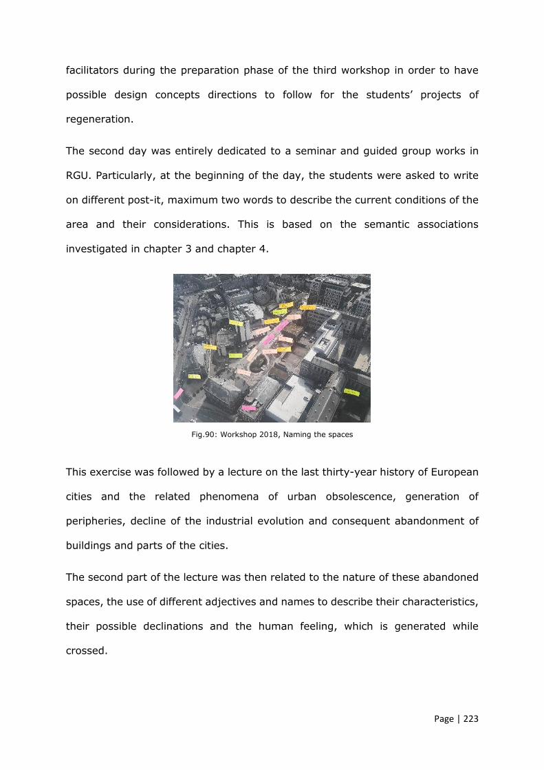
Page | 223
facilitators during the preparation phase of the third workshop in order to have
possible design concepts directions to follow for the students’ projects of
regeneration.
The second day was entirely dedicated to a seminar and guided group works in
RGU. Particularly, at the beginning of the day, the students were asked to write
on different post-it, maximum two words to describe the current conditions of the
area and their considerations. This is based on the semantic associations
investigated in chapter 3 and chapter 4.
Fig.90: Workshop 2018, Naming the spaces
This exercise was followed by a lecture on the last thirty-year history of European
cities and the related phenomena of urban obsolescence, generation of
peripheries, decline of the industrial evolution and consequent abandonment of
buildings and parts of the cities.
The second part of the lecture was then related to the nature of these abandoned
spaces, the use of different adjectives and names to describe their characteristics,
their possible declinations and the human feeling, which is generated while
crossed.

Page | 224
Fig.91: Workshop 2018, Naming the spaces presentation
During the second part of the day students worked in groups on a first urban
analysis aiming to individuate critical issues and lack of connectivity within the
area. The problems raised were then discussed and first ideas of possible design
concepts were proposed.
On this occasion a pre-design questionnaire was compiled and distributed to the
students (see appendix B) Students were required to submit answers by the end
of the day.
The aim of the pre-design survey was to collect data on their first impressions of
the issues related to the area in terms of urban layout and then in terms of
buildings architecture.
Given the involvement of planners during the working days a similar pre-design
questionnaire was distributed to the member of the council actively engaged with
the students. The questions and answers are described later in the paragraph.

Page | 225
5.3.13 Pre-design survey questions for students 2018
Below, are the questions formulated and their aims.
Q1 The choice of Queen Street as the case study, for this year’s workshop,
came from the necessity of Aberdeen City Council to improve the urban
area around the recent intervention of Marischal Square. What are, for you,
the main urban and architectural issues related to Queen Street at present?
Please at the end of your answer list 3 word or adjectives that best
describe the area taken in exam.
The aim of this question is to collect data on their point of view and particularly
on the language they use to individuate and name urban issues.
Q2 Please draw a diagram of the existing area.
Drawn on the example of mental maps analysis, this question helps to collect a
series of patterns, which schematically highlight the main connotation of the area.
This helps to identify perceptive constants within the specific area.
Q3 Please identify and list/describe those landmarks, urban artefact and
important urban elements that you would maintain to highlight the sense
of Aberdeen identity in the area being studied.
Aiming to identify recognisable defining elements of the area on a larger scale and
understand if there are common perceptions.
Q4 As indicated in the brief and discussed in our first meeting at the council,
there are 3 main types of buildings to work on (Police station, Townhouse,
ground floors along the road). What are the essential architectural
components, elements or characteristics that make them recognisable in
terms of an Aberdeen architectural identity?

Page | 226
Similarly, to the previous questions but with focus on the buildings, this question
aims to gather data on the perceptions of Aberdeen’s architecture from a
multicultural perspective. Furthermore, it helps to collect data on what the
architectural elements are important to preserve.
Q5 Please explain what the terms Urban Regeneration and Adaptive re-use
mean for you.
Aiming to gather data on common or contrasting idea of both concepts to clarify
the meaning and importance of urban regeneration and adaptive re-use in a
broader theoretical context.
The rest of the days focused on students work at the council with a few hours
dedicated to presentations, historical tours and interim reviews with planners and
architects.
5.3.14 Pre-design survey for students’ results 2018
Number of students answering the questions: 14 out of 15
Q1 The choice of Queen Street as the case study, for this year’s workshop,
came from the necessity of Aberdeen City Council to improve the urban
area around the recent intervention of Marischal Square. What are, for you,
the main urban and architecture issues related to Queen Street at present?
Please at the end of your answer list 3 word or adjectives that best describe
the area taken in exam.

Page | 227
“[…] Queen Street currently lacks an identity. There are not specific
attractions or functions around on the street that allow usability. There is
potential to make it a great space of intervention that links with the current
development around the site.
3 words: Enclosed, Boring, Empty”
Despite the presence of important historical buildings adjacent to the area, and
the use of “enclosed” suggests that, identity is seen as missing characteristic
probably due to lack of activity and social places. The choice of using the adjectives
“boring” and “empty” seems to be referred to public and social activities rather
than to urban and architectural aspects of the layout.
“The main urban and architectural issues related to the Queen Street at the
present is that it looks like abandoned area […].
3 words or adjectives: in-active, lifeless, lack of economic vitality”
This answer more clearly defines similar concepts of lack of social activities but
interestingly it associates the area with the idea of urban abandonment, as if the
area were a sort of forgotten fragment of the city.
“Lack of public spaces, lots of noise from King Street Junction, dead-end
traffic.
Loud, Alley, Boring.”
In this perception a sensorial aspect related to the noise coming from the city is
also involved; in fact Queen Street is described as “alley”, not as a street, without
relevant function for the city area. This is particularly crucial given its location in-
between two important spines, Broad and King Street.

Page | 228
“Connection to King Street is not strong. […] Some structures not as
desirable as historic structures. […]”
It seems that the presence of traffic spines and the lack of pedestrian and public
space predominate on the historical character of this part of the city.
“Randomness, building orientation, vegetation always are not placed in a
meaningful way.
Lonely, no character, poor transition into main roads.”
The lack of having a common canvas, thus a certain equilibrium, between different
urban layers and patterns, appears to be the main issue individuated by the
students. In this regard, the aspect of isolation of Queen Street goes in contrast
with its function of connection and potential longitudinal public spaces.
Q2 Please draw a diagram of the existing area.
Fig.92: Survey 2018 diagram 1

Page | 229
In this diagram, urban artifacts, for instance the church, Marischal College, and
the surrounding districts are individuated as clusters.
In this sense it is clear that the mental perception of the city is of a patchwork.
Particularly, different types of transitions are highlighted with different dashed
lines and some climatic considerations together with proposed interventions are
annotated on the map.
Curiously, in the junction between Queen and King Street, the square Castlegate
is not drawn. This is probably because the city structure may be difficult to
understand immediately, especially for the American students. The space is also
shown as an underused public space.
Fig.93: Survey 2018 diagram 2
More schematically, this diagram presents just the main spines and it individuates
two contrasting areas in terms of intensity. The junction with Broad Street is, in
fact, identified as more silent than King Street.

Page | 230
Q3 Please identify and list/describe those landmarks, urban artifacts and
important urban elements that you would maintain to highlight the sense
of Aberdeen identity in the area being studies.
“[…] Sense of scale.”
“Aberdeen identity: - Granite - Festivals
Site identity: - Vegetation - Art enriched - Surrounded by important
buildings, City Council, Town House, Art Museum, Church, Lemon Tree,
University.”
“Vegetation plays a key role in making Queen Street more appealing to
pedestrians and it can be link social zone city one another. […]”
The sense of scale appears to be an important factor in contributing to the identity
of the city.
From the second answer instead, there are also immaterial elements such as
festivals.
Vegetation is considered as an artefact playing an important role for the
uniqueness of the city image.
Q4 As indicated in the brief and discussed in our first meeting at the council,
there are 3 main types of buildings to work on (Police station, Townhouse,
ground floors along the road). What are the essential architectural
components, elements or characteristics that make them recognisable in
terms of an Aberdeen architectural identity?
“[…] Buildings have a few characteristics of Classical Architecture as well as
Gothic Architecture.”

Page | 231
“Granite, colours, form, rhythm.”
The historical character of certain periods is identified as main factor but
interestingly, in the second answer, the rhythm seems to play an important role
in defining the city identity. Materials, colours and the layout of the city are
mentioned too, thus the rhythm is probably referred to the urban intensity and
the historical building consistency within the city centre.
“The characteristics of the police station that currently exist are un-relating
to the rest of Aberdeen’s built form. […]”
This answer does not identify any defining elements, rather is focusing on the
exception given by the modern police station’s building which seem to be out of
scale in comparison with rest of the area.
Q5 Please explain what the terms Urban Regeneration and Adaptive re-use
mean for you.
“Reviving a previously docile urban settlement.”
“Urban regeneration: Refuelling an existing space with a design that bring
citizens & people together by improving the economic & authentic parts of
the space. Adaptive re-use: Reusing an old site/building for other program
than what its originally designed for.”
“Keeping the identity of original building and the city. For building, adaptive
re-use should be as flexible as possible for different possibilities of future
use.”

Page | 232
“Urban regeneration is an action of reforming the existing area to cope with
the prosperity of the community and also creating the sustainable
environment for the users. Adaptive re-use is normally related to the
historical site where the reuse or re-purpose the old site or building changes
the existing function to deal effectively with the new requirements and
needs in current period of time.”
Similarly, all answers associated with the concept of urban regeneration an action
of revitalising the identity of historical places and accommodate the more
contemporary needs of the citizens and visitors. On the contrary, adaptive re-use
was not described as a specific design theme which aims to investigate relations
between old and new or even transform the old structure morphologically.
5.3.15 Pre-design questions for planners 2018
Below, are the questions formulated and their aims.
Q1 The choice of Queen Street as the case study, for this year’s workshop,
came from the necessity of Aberdeen City Council to improve the urban
area around the recent intervention of Marischal Square. What are, for you,
the main urban and architecture issues related to Queen Street at present?
Please at the end of your answer list 3 word or adjectives that best
describe the area taken in exam.
The aim of this question was to collect data on their point of view and particularly
on the language they use to individuate and name urban issues.
Page | 233
Q2 Within your department, do you discuss themes related to the urban
form, urban permanence, values and potentiality inherent to the existing
built environment?
Aiming to understand if there are theoretical discussions on the value of certain
spaces and their urban meaning within the department.
Q3 Please identify landmarks, urban artefact and important urban elements
that you would maintain to highlight the sense of Aberdeen identity in there
are taken in exam.
Aiming to identify recognisable defining elements of the area on a larger scale and
understand the perceptions of professionals.
Q4 As a local authority does the council have an up-to-date system of
mapping the urban underused/compromised spaces, buildings or urban void
fractures? How are they categorised/named?
Aiming to collect data on the modality of categorising the urban spaces within the
department and see if there is any specific database of underused areas.
Q5 Please explain what the terms Urban Regeneration and Adaptive re-use
mean for you.
Aiming to gather data on common or contrasting idea of both concepts to clarify
the meaning and importance of urban regeneration and adaptive re-use in a
broader theoretical context.

Page | 234
5.3.16 Pre-design questions for planners’ results 2018
Planners involved: two
Q1 The choice of Queen Street as the case study, for this year’s workshop,
came from the necessity of Aberdeen City Council to improve the urban
area around the recent intervention of Marischal Square. What are, for you,
the main urban and architecture issues related to Queen Street at the
present? Please at the end of your answer list 3 word or adjectives that best
describe the area taken in exam.
“Strategically located – Unattractive and visually cluttered – Potential”
“I consider the main urban and architectural issues at Queen’s Square to
be:
- At the present it is an underutilised, under-visited area with nothing
to attract people to it, or keep them there;
- The public realm is poor and the buildings within the area are not of
any particular quality;
- Surface car parking dominates some of the smaller spaces adjacent
to buildings, which could be used for more public benefit;
- It sits in such close proximity to Union Street, Marischal College &
Square and the Town House, yet is not well connected, particularly
for pedestrians;
- The existing multi-storey car park serving Marischal College is only
accessible via Queen (and Broad) Street, as is the other car parking.
3 words or adjective that best describe the area: Underutilised /
Opportunity / Neglected.

Page | 235
Both answers recognise the strategic location of the area and its lack of
connections with the main parts of the city.
Interestingly the second answer uses already the new name, mentioned in the
vision for opportunity sites published by the council, in fact it is called Queen’s
Square even if its connotation is linear. It is a road and belt-connection between
Broad and King Street.
Yet in the second answer, there are three listed words included “opportunity”,
which does not describe the current urban and architectural issues of the area. On
the contrary the first part of the answer stresses the concept of being a space
under – utilised - visited.
Q2 Within your department, do you discuss themes related to the urban
form, urban permanence, values and potentiality inherent to the existing
built environment?
Both answers were just “yes” and this shows that the question should have been
formulated in other words, guiding the participants to more elaborated discourse
and reflection.
Q3 Please identify landmarks, urban artifact and important urban elements
that you would maintain to highlight the sense of Aberdeen identity in there
are taken in exam.
“[…] Particular sympathy would need to be shown in terms of the siting and
heights of any buildings within the area to ensure that the settings of those
buildings is adequately preserved, or potentially enhanced.”
“There are a number of valuable listed buildings on Queen Street. Marischal
College and the church on the corner of Queen Street and Broad Street are

Page | 236
the most significant to me. One of the most important urban elements for
Queen Street is that it created an opportunity for looking at alternative
views to these valuable buildings. None of these views happen to be
principal ones, yet they are very interesting angles to look at these
buildings. The open space in front of the art centre also has great potential
and should be left/extended as an open space. I believe the police station
(especially their car park) and the modern extension to the town house are
dominating and detracting the visual amenity.”
Historical buildings are immediately classified as urban artifact but not the modern
one such as the police station or the townhouse. Despite their questionable
architectural value, they are dominating the area and so they should be read as
potential objects of modifications, regeneration and adaptation. This concept
seems to be missing in modern neglected buildings towards easier concept related
to their demolition.
Q4 As a local authority does the council have an up-to-date system of
mapping the urban underused/compromised spaces, buildings or urban void
fractures? How are they categorised/named?
“I’m not sure that we do, although the City Centre Masterplan, along with
other Council planning briefs and documents (Union Street Conservation
Area Character Appraisal) does highlight key project areas such as Queen’s
Square which have been identified as being underused and having the
potential to be significantly improved to the benefit of city centre and sense
of place.”

Page | 237
“Normally large scale sites that are underused are identified opportunity
sites for future development as part of the local development plan process
but not sure if that is the case for smaller scale sites. […].”
From the answer it is clear that different areas considered to be in need of
regeneration are generally marked within the City Centre Masterplan which is
already a design guideline. This means that apparently there is not any database
of the current status of underused, abandoned buildings or neglected areas.
Q5 Please explain what the terms Urban Regeneration and Adaptive re-use
mean for you.
“Urban Regeneration – any intervention that injects life to a declining urban
fabric, this can be done by design intervention and also introduction of new
uses but should ultimately aim to change the perception of the place.
Adaptive re-use – Using the existing tangible and intangible resources to
reverse the decline of an urban fabric by introducing new meaning/s to a
place so that social group(s) can use the space with no conflict on amenity
of people living or working within surrounding properties nor any
detrimental impact on the character of the area.”
“Urban regeneration to me, means improving a city centre (and some
intrinsically linked surrounding areas) for the public betterment, which can
be achieved in a variety of different ways, not least in a Planning sense
through well-designed redevelopment of existing buildings, creation of new
buildings with a mix of vibrant uses and, crucially, the creation or
improvement of high-quality public realm/parks and spaces that provide a
good quality of urban amenity (see Dundee Waterfront,

Page | 238
Newcastle/Gateshead quayside and Edinburgh’s St Andrea Square & bus
station).
Adaptive re-use in my mind is the well-thought out, sympathetic conversion
of existing buildings for a suitable new use. In Aberdeen city centre in
particular, we are seeing an increasing amount of such proposals since the
collapse of the oil price and subsequent lack of demand for office space in
Aberdeen. This has led, positively in a Planning sense, given the aim of the
City Centre Masterplan, to some high-quality proposals for the change of
use of historic buildings from vacant office back into residential flats, which
was their original purpose in many cases. Adaptive re-use will be key to the
success of the City Centre Masterplan as given the historic nature of the
city centre, the amount of brownfield land available for new development is
relatively low.”
There seems to be a clear explanation for both aims and even an explorative way
to look at the resources of a space or existing building.
In comparison with students’ survey, these two answers highlight an interest in
adopting forms of urban and architectural re-use to improve the spaces within the
city and draw around material and immaterial thematic related to the urbanity.
5.3.17 Final presentation 2018
After ten days of collaborative work, the final presentation took place within the
Marischal college building in front of various professionals from Aberdeen City
Council and, RGU, ICRGU, USF academics and a councillor.

Page | 239
From the students’ proposals emerged a constructive argument drawn on the idea
that public space is a complex combination of urban and architectural elements
and multiple functions. Analysing precedents implies a deep understanding of what
elements worked, why and how. A successful public space does not function
because there is one element that is predominant or particularly evident, but
because each element complements each other within continuous changes of
balance of permanent and temporary places and functions.
The discussion, raised by the councillor who attended the presentation, however
mainly focused on the future urban plans and on the agreements between the
council and developers in relation to the need to improve business attractions
through urban and architectural developments.
On this assumption, some reflections can be elaborated here. Particularly, it seems
instructive to mention Adam Smith, during his Glasgow lectures, (in Settis, S.
2017) who advocated that the Earth belongs to all generations. Following this
concept, it is possible to argue that discussing public space’s modifications
involves multiple professionalisms, and this attributes to the role of architecture a
social and ethical commitment. If the social and ethical role of architecture is
recognised, then all tangible and intangible elements of the city should be
subtracted to the sole logic of profit. In this sense, landscape, monuments, urban
artifact, public spaces and new interventions within the city should be
encompassed within the same frame of community’s rights. This directly leads to
reflect on the political aspect of architecture as form of safeguarding the
landscapes and the cities for the future generations (Settis, S. 2017). Identifying
the social and political importance of architecture and research related to urban
and architectural discourses reveals the democratic position of the discipline or,
as more openly Rogers (2017) argued its force of democracy.

Page | 240
Arguing about public spaces, thus, is vital for city life because they represent its
lungs and are the expression of society. In this sense the final presentation was a
way to initiate a broader debate, that otherwise would have mainly been discussed
between authorities and developers.
5.3.18 Post design questions for students 2018
Below, are the questions formulated and their aims.
Q1 Please describe the existing urban space of Queen Street in relation to
the discussions and considerations raised within the workshop.
This question is similar to that one posed in the pre-design questionnaire and aims
to understand if after the discussion initiated during the workshop there was any
changes in perceiving the area or any different comprehension of the spaces.
Q2 How did you perceive the methodology of urban analysis we have
undertaken?
Aiming to effectively evaluate the methods adopted to read the urban environment
against the sole observation.
Q3 What are the main urban architectural principles used for your project?
Aiming to understand if there was a coherent and consequential process between
urban analysis and design principles chosen.
Q4 Please draw a schematic diagram of your main urban and architecture
principle.
Page | 241
A diagram of the proposed urban and architectural concept would help to objectify
the clearance of the principles adopted.
Q5 What are the essential architectural parts of the existing buildings that
you maintained and/or highlighted within your project?
The purpose of this question was to understand how the identity of the city is
highlighted through projects proposed.
5.3.19 Post design questions for students’ results 2018
Number of students answering the questionnaire: 4 out of 15.
Q1 Please describe the existing urban space of Queen Street in relation to
the discussions and considerations raised within the workshop.
“[…] it is also aptly situated to create a linking space between Union Street
and King Street. We discussed how there are buildings situated on the site
that are detrimental to the area that could be repurposed/removed. […]
There is also an underutilised commodity in that there are a number of
culture-lead activities/buildings that do not relate to the space.”
“[…] People (especially families) find no incentive to stay in Aberdeen
because of the lack of things to do in its central streets.”
“The existing conditions of Queen Street are unused as a destination and is
clearly just used as a pedestrian and car throughway. […]”
The nature of Queen Street being just a transition space is described differently in
all three answers but all are more orientated to reiterate the concept through its
current or potential functions. Interestingly, in comparison with the answers

Page | 242
received for the pre-design questionnaire, the answers are more concise and less
explorative, almost aiming to identify a specific problem.
Q2 How did you perceive the methodology of urban analysis we have
undertaken?
“We took an in depth look at how people used the given space as well as
other areas located within the city, we wanted to identify the main features
that are being underutilised and that are lacking within the city, as a whole.
I felt that our analysis was heavily focused on the actual site opposed to
trying to solely fit analysis untaken about precedent projects.”
“[…] The site studies […] gave me a strong understanding of Aberdeen and
Scotland in general. It is very interesting to see how locals view the area
and have a first-hand look into what they would change.”
“We began by learning the history of Aberdeen and the style of urban and
architecture language of the city. I found this helpful to design something
that fit the culture and town. I think the next steps of talking with city
council members from other sectors was the most helpful because of their
insight to the project.”
The methodology undertaken seemed to be well received by students in order to
have a broader understanding of the urban material and immaterial features of
the area. Particularly the exchange of comments and opinion helped to gather
insights and many ways of observing a city.
Q3 What are the main urban architectural principles used for your project?
“[…] It was important to our group that we create a sort of cultural centre
that would attract people to gather here, not only creating a stimulating

Page | 243
day time use but importantly to enhance the space with a vibrant nightlife.
“The Belt” we wanted to create a transitioning loop that encompassed the
site making use of the various nooks-and-crannies around that site to
create area of intrigue and interest.”
The objectives of the project, deriving from the urban analysis, are simple and
precise as well as the main principle which seems to be the coherent response to
the problems.
Q4 Please draw a schematic diagram of your main urban and architecture
principle.
Fig.94: Survey 2018 diagram 3
As the previous answer, this diagram demonstrates a clear interpretation of the
weaknesses of the area and appears to be complete in its simplicity.
The simplicity nevertheless, is a complex theme in architecture, it is a balance
which should be carefully understood and assessed in order not to fall into banality
and reductionism.
Q5 What are the essential architectural parts of the existing buildings that
you maintained and/or highlighted within your project?
“We decided to keep the structural part of the police HQ with the intent to
renovate the exterior façade and interior spaces. The idea was to use the

Page | 244
police HQ for accommodation and studio space for people such as artists
[…].”
“We mainly tried to highlight the materiality and monumental qualities of
the existing buildings by contrasting them with the lightness of the
interventions. […]”
Two architectural themes are highlighted in the answers, on one hand the concept
of re-using an existing out of scale building stakes acceptance and interpretation
of the history including both positive and negative events; on the other the
concept of revealing the historical context, introducing opposite and undoubted
new elements.
The post-design questionnaire showed interesting and positive results related to
the theoretical structure and subsequent practical setting of the workshop. The
considerations stated in the answers introduced insights and elaborated
arguments around the phenomena of urban abandonment and on how it could be
approached.
5.3.20 Considerations raised after the third workshop 2018
The third workshop enabled to have a wider view of the experience of collaborating
with two different institutions and of the general organization of it.
In terms of pragmatic program of the workshop it seemed appropriate to focus
only on one area per year with all students, local and American mixed in one or
two groups. The choice of having only one area was dictated mainly by the nature
of the workshop of being a short activity. Moreover, mixing the students in few
groups would facilitate the reviews activity and would concentrate more the
Page | 245
efforts, improving the quality of the results. Furthermore, the active involvement
of planners in the group work ensured a certain consistency and viability of the
proposals.
By distributing pre- and post- design questionnaires it was possible to understand
if the workshop activities contributed to have various and alternative ways to
perceive a space and to describe it using specific or unspecific terminology.
Reflecting on the terminology used, revealed the way students and professionals
conceptualise limitations and potentialities of the area. According to Johnson
(1980), the use of specific terms and instead of another may affect perceptions
and the experiences.
According to the experience of Shön D. A. (1979) and his example of the shift of
perception from ‘slums as congenital disease’ and ‘seeing slums as natural
communities’ (paragraph 3.5), it is possible to conclude that the use of particular
terms and the activities organised around the use of language enabled to better
understand the urban spaces. It also enabled to articulate and more
comprehensive discussions between academics, planners and students and to
propose sharable design concepts.
Interestingly the post-design questionnaire’s answers contain more strategic
terms which seem to aim to describe an urban process of mending rather than
imposition of new elements and design. “Transitioning loop”, “nooks-and-
crannies”, “tangible and intangible resources” are intended as elements open to
have a dialogue with the surrounding areas and buildings, with not over
impositions of new volumes or new voids.

Page | 246
5.4 Participations. DM Planning department interviews
The third workshop 2018 was the most constructive in terms of clarifications on
the potential synergy between the school of architecture and the planning
department of the city. Some considerations, raised during the ten days together
with planners, who participated for three years to this collaboration, helped to
formulate some possibilities of having a more official memorandum of intentions
established between the parties involved. In this sense, appeared to be helpful in
the interest of this research, to gain the opinions from the planning department
and the management team through four designed questions (Appendix F).
5.4.1 Questions for management team, Planning Department ACC 2018
Below, are the questions formulated and their aims.
Q1. What benefits do you perceive might be gained by the council as a
result of the collaboration?
Aiming to clarify the objectives of the council related to the workshops and the
collaboration with the academia.
Q2. How does this relate to the aims and expectations you have of the
workshops and what you hope they will achieve?
The purpose of this question was to understand if there is effectively a synergy
between intentions and results gained during the workshop.
Q3. What contributions and other forms of valuable insight do you think
architecture students can make to the issues and challenges relating to the
city masterplan?

Page | 247
Aiming to explore other possible forms of collaboration starting from the positive
contributions that students can bring to city masterplan discussions.
4. Looking at other successful collaborative experience in some European
cities (Oslo, Pescara, Venice, Barcelona, etc.) do you think that it would be
beneficial in the future for the architecture school and Aberdeen City council
to establish a more formal template for coordinating students’ contributions
to the city masterplan vision?
Mentioning similar work, the question aims to explore possible typical forms of
agreement for coordinating collaborations which include students work.
5.4.2 Questions’ results 2018
Q1. What benefits do you perceive might be gained by the council as a
result of the collaboration?
Answer1: “Focused delivery of development on vacant land in the city
center helping to deliver the objectives of the City Centre Masterplan,
Development Plan and the Council’s commitment to City Centre
Regeneration and increasing residential population in the City Centre as
recommended by the recent City Centre Living Study.”
Answer2: “[…] the process would only benefit Council if the collaboration
were formally being recorded and disseminated and with clear objectives &
outputs that the Council would action. […]”

Page | 248
The workshop seems, from these answers, a tool aimed to collect proposals for
delivering the city council objectives and needs.
The second answer more explicitly describe the workshop as way for gather
broader views and better shape the objectives of the City Centre Masterplan.
Answer3: “– Exploring a number of options for the same site – Benefitting
from the interactions between students and staff – Involving a wider range
of stakeholders in the planning process – Informing students of the practical
challenges of real projects.”
In this view, the interactions between different stakeholders from different
backgrounds and the possibility of exchanging thoughts and ideas are more
evident and focused on the significance of a collaborative process.
Q2. How does this relate to the aims and expectations you have of the
workshops and what you hope they will achieve?
Answer1: “Greater collaboration will hopefully lead to a shared, deliverable
vision and action program for the regeneration of these spaces, improved
quality of design of both buildings and public realm and increase the
confidence of the development industry that the Council and its partners
are willing and able to fulfil these objectives.”
Answer2: “I would anticipate everyone has slightly different aims, mine is
to ensure that the students are given a good basis for, and constructive
review, of the proposals. What I get in return is to meet people who are
exploring a context very differently from ones they are used to and bring
fresh ideas and approaches to their proposals for Aberdeen.
Page | 249
This year we were lucky to have the Planning Convener Councilor watching
the presentations and giving her views on the approach to students’ work
[…].”
Answer3: “Over the last few years of running the workshop we have
covered all the previously mentioned perceived benefits, albeit with varying
level of impact.”
All three answers show positive impressions and expectations, highlighting more
the reciprocal benefits of combining together various approaches.
Q3. What contributions and other forms of valuable insight do you think
architecture students can make to the issues and challenges relating to the
city masterplan?
Answer1: “Architecture students can bring a design perspective gleaned
from their study of buildings and projects that have been catalysts for City
Centre regeneration all over the world.”
Answer2: “I would expect to see a range of enthusiastic design led
approaches to delivering the masterplan. However, this is something better
done when shaping the production of a masterplan or in specific delivery of
certain projects. I would anticipate the projects in the masterplan will give
a good source of project for RGU to take forward in an academic way that
could shape future development.”
The engagement of students and their genuine passion for design are the main
contribution perceived from the council; interestingly, the second answer shows
insights for longer collaborations and a broader view of delivering future city
developments.

Page | 250
Answer3: “Their presentation skill is a key for visualizing various options
discussed in the workshop. Given the financial constraints this approach is
often not possible with developer and designers. These can be compiled and
can create a package before selecting one development scenario.
The advantages of the collaboration seem to be just related to achieve better goals
from the council in developing future urban regeneration actions.
Q4. Looking at other successful collaborative experience in some European
cities (Oslo, Pescara, Venice, Barcelona, etc.) do you think that it would be
beneficial in the future for the architecture school and Aberdeen city council
to establish a more formal template for coordinating students’ contributions
to the city masterplan vision?
Answer1: “Yes.”
There has probably been some inaccuracy in formulating the question. This has
enabled for the opportunity to give a short answer.
Answer2: “I am not aware of collaborative programs in other European
cities but the collaboration in project delivery in Aberdeen must always start
at a local level, regardless of the background of interested parties, however
there is a need for representation from formally constituted groups and
businesses in order that their interest is known/relevant.
RGU had always had projects focused within Aberdeen at all scales of
development and a more collaborative approach is mutually beneficial if it
is indeed formally recognized. […]”

Page | 251
Answer3: “Yes, there seems to be room for developing the workshop even
further and benefiting from the creativity, knowledge and presentation skills
of students.”
There appeared to be a general interest in continuing and elaborating the
public/academic collaboration. The work delivered by the students and academics,
particularly if it is related to precedents study, is perceived as valuable operation
and an updating method, which in turn can bring and highlight possible innovative
ways to regenerate the city.
Although the benefits discussed are more related to the council party, the
workshop is an important opportunity even for academics and students who have
the occasion to explore and experiment projects of transformation within the city.
In this sense, merging the competencies would mean drawing a future scenario of
the city that would be closer to social, cultural and identity needs.
Thus, merging the intentions of both institutions would help to bring outside of
the respective sites the urban and architectural work, giving to the city an adding
value.
In a moment of economic recession, collaborating is a way of generating nets of
expertise to improve the quality of the community places and to remark the social
importance of the university and the authority.
The first three workshops were focused mainly on addressing urban issues but
they have also been a sort of brainstorming useful to envisage the future outputs.
Looking back to other similar experience (Chapter 3), an agreed collaborative plan
of work enables to organise a set of confrontations in the form of public
presentations for instance, which would help to verify the hypothesis of urban

Page | 252
transformation; it would enable also to draw publications as a manifesto of the
theoretical work and results gained.
5.5 Production of significance. The methodological design approach
Architecture is a field of thinking rather than doing, field of reflection.
The most important thing of architecture is to find the potentials.
That means to do more than a building and to do more than a
programme. Finding potentials means finding possibilities for the
community and for the urbanity.
(Herzog, J. 2016)
The workshop activities enabled participants, working in a collaborative
environment, to raise considerations related to project approaches of regeneration
for the selected areas in Aberdeen. Particularly this research may be seen as a
lens between urban and architectural study of the abandonment phenomena in
general and then in Aberdeen, and the possible transposition of the theory in
practical design approaches to the question.
Observing the activities delivered during the workshops, interpreting the
discussions raised about the nature of those spaces and the formulations of
possible design solutions, helped to articulate the following design methods for
the cases presented. The guidelines proposed are intended as pragmatic proposed
ideas derived from the urban analysis underpinned and described in chapter 4 and
based on the study of precedents examined in chapter 3.
The next section explains the main design themes and principles used to
regenerate the areas selected. The whole work carried out during the three

Page | 253
workshops is also published on a dedicated website called Aberdeen Collaborative
Urban Path.
1. Castlegate
Castlegate acts as elbow connection of Union Street with King Street but overall
it may represent a significant public space for the city in relation to Marischal
Street and Regent Quay.
The oil industrialisation has produced in particular areas of Aberdeen, serial of
standardised buildings particularly within spaces located to the harbour. The
formal and morphological characters of those buildings show a lack of relation with
the anthropological system and the surrounding historical buildings.
The co-existence of old historical buildings, industrial buildings and open spaces,
which have the potential to become public spaces, have driven some design
principles related to the way of maintaining together architecture and historical
differences, establishing a dialogue between them.
The analysis conducted for Castlegate suggests that its configuration as public
node and converging point of three main urban axes, Union, King and Marischal
Street, should be re-thought in order to enhance pedestrian flows without
interruptions.
Establishing a pedestrian hierarchy through the square may also provide more
fluid transitions, and may lead the users to Marischal Street directly without
crossing a roadway. In this sense, the project of re-use for the square could give
importance to its location as historical Aberdeen’s core and thus bring back its
collective significance to the city. The square could become a renewed

Page | 254
interpretation of multifunctional urban place where different events may take
place and be catalytic occasion for attracting citizens and tourists. A flexible plaza
space would encourage an interchanging core for the city.
In this regard, the emerging architectural design criterion is to give value to the
fragmented voids of Castlegate introducing their complementary opposites,
various and fragmented solids. Small public removable hubs may strategically
inhabit the square generating new flows into the urban voids between them.
These “small public rooms” may become the outside extension of the shops, bars
and covered spaces for events such as markets and temporary expositions.
Fig.95: Castlegate proposed map
To redefine the distinct and historical value of connection, the relation between
Castlegate and the waterfront could be emphasised. A restriction of cars on
Marischal Street would allow it to be safe and attractive for pedestrians. By
programming the street as a gentle transition from the top of Castlegate to the

Page | 255
bottom of the waterfront, artificial and elevated platforms, intended as functional
and architectural thematic steps, may help to highlight the main Aberdeen public
activities such as grab-and-go options, storefront opportunities and pop-up food
carts. It would represent “Aberdeen in a Street” serving and attracting locals and
tourists.
Fig.96: Castlegate, proposed view of Marischal Street
From Marischal Street, citizens and visitors may be led to a waterfront that could
become a place of identity re-appropriation. Regent Quay waterfront re-use design
may inhabit a portion of the harbour and coexist with the working and industrial
activities currently there. By regenerating the portion of the harbour in front of
Regent Quay and dividing it from the Trinity and Market Street harbour spaces, it
would be possible to create an active public waterfront, symbol of the city.

Page | 256
Fig.97: Castlegate, proposed map of the harbour area
Particularly this dimensionally generous portion of the harbour could become
home to outdoor events and concerts, kids’ playgrounds, a gathering place for
people on lunch break and a children’s green centre. With a focus on adaptive re-
use design the industrial building located within the harbour on Regent Quay may
be transformed, with not many historical limitations, in a new hybrid place for
people where urban and industrial characters may reinforce the sense of identity.
In this sense, the architecture composition could merge strategically the multi-
storey internal space introducing common voids within the building.
Fig.98: Castlegate, proposed section of the harbour area
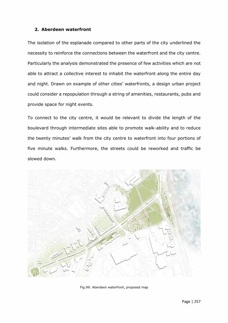
Page | 257
2. Aberdeen waterfront
The isolation of the esplanade compared to other parts of the city underlined the
necessity to reinforce the connections between the waterfront and the city centre.
Particularly the analysis demonstrated the presence of few activities which are not
able to attract a collective interest to inhabit the waterfront along the entire day
and night. Drawn on example of other cities’ waterfronts, a design urban project
could consider a repopulation through a string of amenities, restaurants, pubs and
provide space for night events.
To connect to the city centre, it would be relevant to divide the length of the
boulevard through intermediate sites able to promote walk-ability and to reduce
the twenty minutes’ walk from the city centre to waterfront into four portions of
five minute walks. Furthermore, the streets could be reworked and traffic be
slowed down.
Fig.99: Aberdeen waterfront, proposed map

Page | 258
A project of regeneration and re-use of the waterfront has to establish also visual
relations between urban places and natural landscape working mainly in sections.
The natural configuration of the site allows to inhabit the ground exploiting the
natural and steep connotation of the terrain. The residual space, natural dunes,
retaining walls could be reconsidered as places for social activity and places for
validating the aesthetic identity of the landscape.
Fig.100: Aberdeen waterfront, proposed section
Reinforcing the transversal connection through designed sections of the site also
highlights the possibility of exploring physical relation with the sea water.
Introducing open air bath and facilities may become a landmark icon of collective
attraction and of seaside skyline perception.
Fig.101: Aberdeen waterfront, proposed long section

Page | 259
The hard sloping retaining walls of the waterfront could be covered by vegetation
to soften the edge, increase the visual continuity of the space and help to reduce
the harsh winds from the sea edge.
Moreover, all residual spaces underneath which are currently empty-spaces could
be transformed in covered public places for staying and for new food and drink
activities beside the main walkway of the esplanade.
Fig.102: Aberdeen waterfront, proposed views
3. Golden Square
Lynch’s concept of imageability is here particularly relevant because the form of
Golden Square may be described as a fixed element within the mental process of
perceiving the urban space. It is able to shape the kinds of imagery associated
with that particular part of the city.

Page | 260
A clear form and more specifically a central and symmetrical form, such as a circle,
has to be considered as strong symbolic element which has to be reinforced and
mastered in a regeneration project of urban re-use. It becomes the main occasion
for reasoned strategy of urban improvement using instrumentally its weaknesses,
due to isolation of the form compared to the surrounding context, and
transforming them in strengths, in open systems able to dialog with the rest of
the city.
Golden Square is strongly self-referential, all sides are similar despite their
different connections with other urban spines of the city such Union street, with
the historical building the Music Hall and with its counterpoint of Union Terrace
Garden. Arguably, Golden Square is clearly an infrastructural node of distribution
revealing its nature of traffic roundabout rather than its nature of public open
space as its name may suggest.
The main challenge in a project of re-use is to use the original central form as
advantage and as an element of reconnection with the city. In this sense, the
project could highlight the perceptive character through a de-composition of the
circle which acts just in section. Portions of the circle may be lifted and
transformed in shelters, path and elements that may be visually led toward other
surrounding parts of the city.
Fig.103: Golden Square, proposed section

Page | 261
Fig.104: Golden Square, proposed map
All parking on the ground level could be removed from the centre of the square,
but the roundabout would remain with access to the other three entrances to the
square. The centre circle may be a mix of terraces and seating. The circle may
begin to elevate to create a green-covered public space such as a pavilion. This
would provide more possibilities to enjoy the events occurring in the square
despite various weather conditions.
For the nature of the square, the civitas, the project of re-use could have a variety
of programmed and un-programmed uses and become an amenity for the
surrounding context, especially the Music Hall. The space could be used as an
outdoor venue and provide an enjoyable accent during the day and night.

Page | 262
Fig.105: Golden Square, proposed activities
An important aspect for regenerating Golden Street is to reinforce its presence
within the view from Union Street. In this respect, the Duke of Gordon’s statue
may be moved at the crossing point between South Silver and Union Street and
the entire spine leading to the square could be pedestrianised and buildings could
be covered with green wall as counterpoint of natural sculpture to the old statue.

Page | 263
Fig.106: Golden Square, proposed statue new position
Fig.107: Golden Square, proposed new

Page | 264
4. Bon Accord area and garden
The area is characterised by multifunctional buildings and residential settlements.
Paradoxically the garden is relatively closed to the city centre yet is not used by
the citizens and visitors as other green areas within the city. In this sense, the
diversity of the surrounding program could provide the chance to envision the park
as a space for accommodating community activities and more in general different
users of the entire area.
Urban parks have generally been organised according to a geometrical scheme
where borders are scrupulously delimited through precise lines generated by a
change of materials, greenery and pavement.
A design composition criterion may invert this concept, proposing a continuation
of the Bon Accord Terrace Garden greenery on Bon Accord Terrace overpassing
the junction with Union Street. Particularly the line of junction may be interpreted
through a hybridisation which fray the edges establishing transitional relations
between the park and the city hiding the point where the natural elements end
and the urban element begin.
The vehicular flow along Bon Accord Crescent may be reduced to one lane in order
to enhance prominent pedestrian path to the garden from the city centre. The
creation of a main pedestrian corridor perpendicular to Union Street can be
considered as reinforcement of the connections along with more opportunities to
accommodate different activates for residents and visitors.

Page | 265
Fig.108: Bon Accord area and garden, proposed map
Fig.109: Bon Accord area and garden, proposed view of the street

Page | 266
For a project of re-use would be particularly helpful designing directly in sections
and creating gradual steps from the Bon Accord Crescent to the residential area
along Hardgate Street.
The park itself could become a common platform crossed by paths as its original
features, which enables the users to navigate the place while having access to
amenities and residential areas. In this sense, the connection becomes areal
rather than linear.
Fig.110: Bon Accord area and garden, proposed view of the park
The three level brick terraces of earlier 19th century garden architecture could be
reused reminding the historical function of the entire garden as Market Garden
and reintroducing on the lower levels strategic small urban allotments for the
residents.
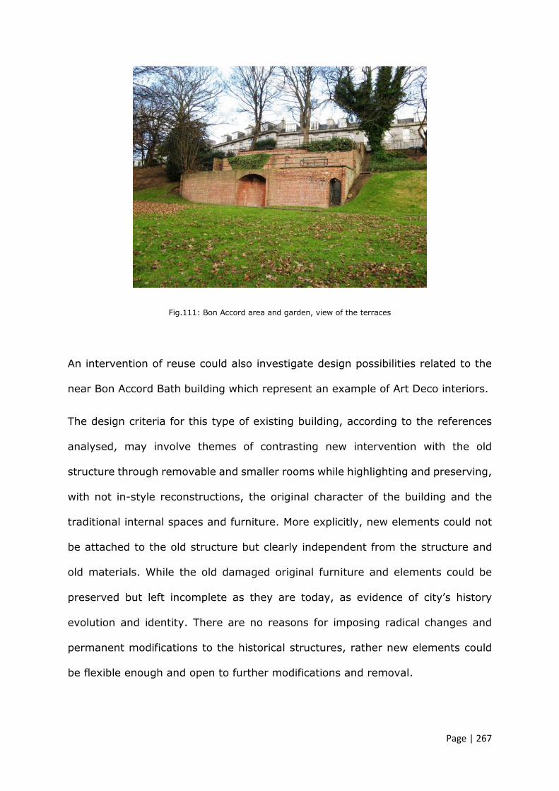
Page | 267
Fig.111: Bon Accord area and garden, view of the terraces
An intervention of reuse could also investigate design possibilities related to the
near Bon Accord Bath building which represent an example of Art Deco interiors.
The design criteria for this type of existing building, according to the references
analysed, may involve themes of contrasting new intervention with the old
structure through removable and smaller rooms while highlighting and preserving,
with not in-style reconstructions, the original character of the building and the
traditional internal spaces and furniture. More explicitly, new elements could not
be attached to the old structure but clearly independent from the structure and
old materials. While the old damaged original furniture and elements could be
preserved but left incomplete as they are today, as evidence of city’s history
evolution and identity. There are no reasons for imposing radical changes and
permanent modifications to the historical structures, rather new elements could
be flexible enough and open to further modifications and removal.
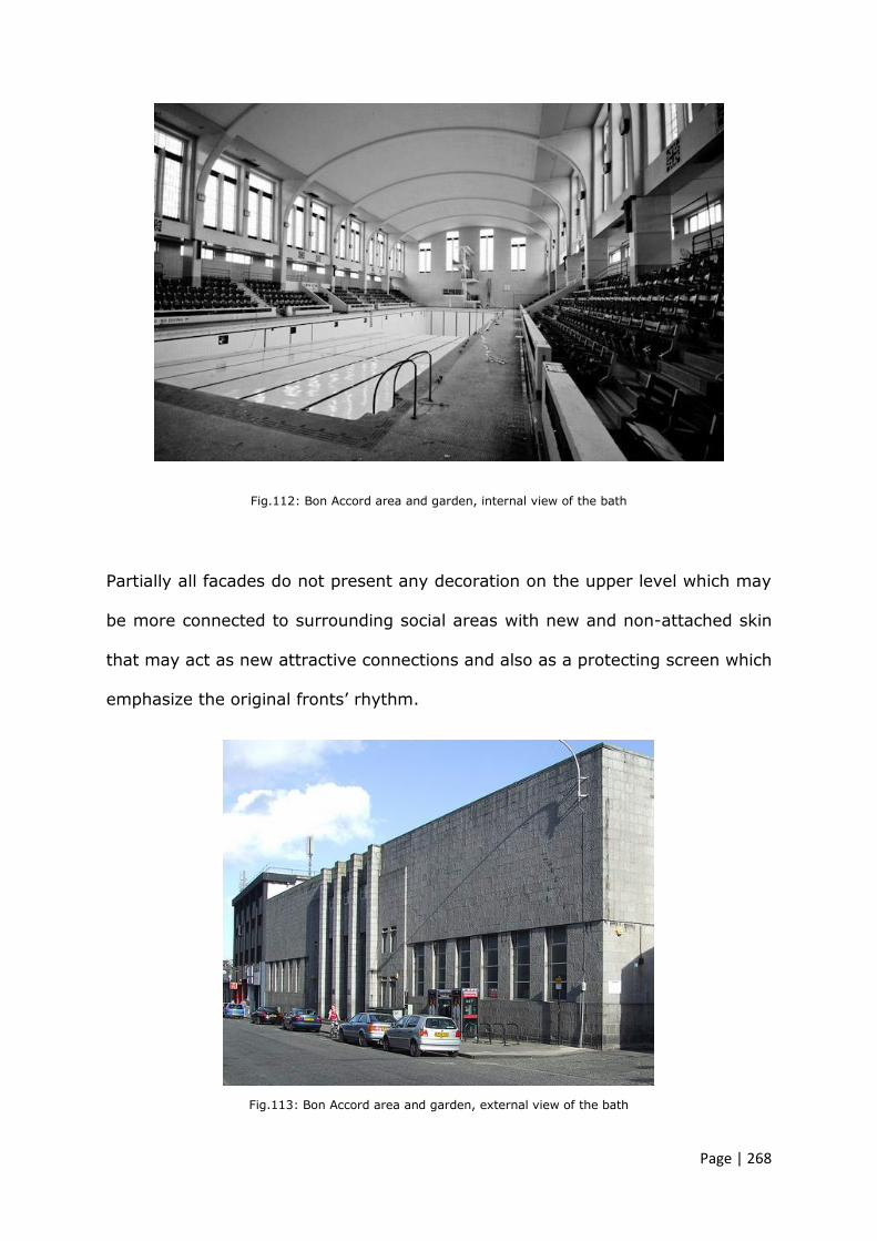
Page | 268
Fig.112: Bon Accord area and garden, internal view of the bath
Partially all facades do not present any decoration on the upper level which may
be more connected to surrounding social areas with new and non-attached skin
that may act as new attractive connections and also as a protecting screen which
emphasize the original fronts’ rhythm.
Fig.113: Bon Accord area and garden, external view of the bath

Page | 269
5. Aberdeen train station
The area around the train station is highly congested; the traffic and the
overlap of modern constructions have hidden the oldest pedestrian part of the
city. The composition of the built environment is not clear and does not follow
any juxtaposition rule, thus there seems to be a lack of balance and harmony
between solids and voids.
An intervention of urban regeneration could then consider the possibilities of
recreating harmony by adding more voids intended as public and green places.
The main urban theme would be based on “milling” the area transversally in
order to re-connect Union and Guild Street and reinforcing the existing
connections.
Existing buildings, such as the old market, may be manipulated by subtracting
portions of the entire volume, in order to create more open spaces, and the
remaining structure may be wrapped with renewed skin.
Fig.114: Aberdeen train station, proposed map

Page | 270
The public places could be meant as extended, stretched squares able to host
ephemeral temporary volumes, greeneries and urban furniture organised within a
designed imaginary grid, where its orientation would follow the existing perceived
urban directions.
Fig.115: Aberdeen train station, proposed view
The uniformity of the pavement symbolically would represent a unique canvas to
reinforce the distributions of different layers of functions. All elements could be
aligned on both horizontal and vertical surfaces proposed.
Fig.116: Aberdeen train station, proposed green-places

Page | 271
Yet, green beds could be in line, extruded and modelled in their surfaces in order
to be inhabited by people and visitors.
6. Hazlehead Park
Hazlehead Park is mainly perceived as an aerial natural space divided in three
parts, the entrance with the old empty gate house and the pet corner, the central
zone accessible from the back with a café and an empty toilet building and the
final one with the rose garden, a labyrinth and the old maze empty building. These
subcategory of the space highlights the necessity to find a continuation and design
criteria able to bring back the empty buildings within a landscape design mastered
by a common architectural language.
The natural environment may be seen as a complex system generated by a set of
single elements where the whole is perceived starting from the exaggeration of
natural diversity. From this concept it would be possible to address a landscape
project based on intense fragments which can draw a visual continuity between
the three areas. These fragments may have different functions and be paths, seats
and greenery.
Diverse and fragmented lines, as main theoretical theme, can be used to imitate
the irregularity of nature all around the park. Curved lines and fragments of lines
could start to diverge and direct the walk all around the three empty buildings
which could be brought to a new life through a project of re-use. Particularly the
three empty buildings have different configurations and different historical
meaning therefore, the architectural approaches will consider these aspects and

Page | 272
will link every building to the site using different declinations of the same design
language adopted for the site regeneration.
Fig.117: Hazlehead Park, proposed map and intervention
The first empty building, the gate house, is a historical building at the entrance of
the park and may be converted in a welcoming information point. Its presence
may be reinforced through light extruded volumes positioned on the existing
openings. Small new volumes, clearly diverse and treated with different finishing,
represent a declination of the main architectural theme of the entire project.

Page | 273
Fig.118: Hazlehead Park, proposed Gate House re-use
Dealing with architectural projects of re-use includes a deep understanding of the
general context and its uses. Hazlehead Park is a natural area used mainly during
the weekends for resting and being more in contact with nature but, given its
aerial extension, it is also used as a space for practicing various sports especially
in the central space closed to the toilet block.
In relation to this, the empty toilet building may be transformed into a more
utilised facility say for renting sports accessories such as bikes and as changing
room for runners.
The empty toilet block is facing the central entrance of the park giving an
unpleasant first visual experience to the users and visitors. The designed fragment
and lines on the ground may guide the users to use yet, this building and visually
invite them to explore underused parts of the garden through unexpected views.
The architectural criterion for re-connecting this building to the park could consider
to enfold the original structure with a new skin. The use of timber cladding would

Page | 274
increase the relation with the park through a material which is more in harmony
with the entire natural context.
Fig.119: Hazlehead Park, proposed Toilet block re-use
The third building is positioned at the entrance of the labyrinth and its
morphological configuration is related to its function. It was the highest point of
view over the maze. This building may be reused to enhance the visits within the
labyrinth but also as a new place for visualising the natural configuration and
topography of Aberdeen. Sitting on a hill, from Hazlehead Park it is possible to
have a view of the city and of the North Sea. In terms of architecture principle,
the particular triangular and characteristic form of the old structure could be
reinforced and different points of view may be introduced to better appreciate the
landscape.
Fig.120: Hazlehead Park, proposed Maze building re-use

Page | 275
7. Queen Street
Queen Street is compressed within multiple functional buildings and main
urban spines. It is almost hidden from Union Street and the only two accesses
are at its ending points.
The main architectural and urban proposal for the area could be based on the
theme of introducing a multifunctional belt, which encircles and highlights the
other accesses to Queen Street, particularly from Union and King Street. In
this way Queen Street can be re-absorbed within the urban tissue and its
function of connectivity would be included within the belt.
The idea of creating a multifunctional circular path around the area would allow
to treat the Queen Street’s surface as a unique canvas where different
historical and modern buildings can coexist together.
Fig.121: Queen Street, proposed map

Page | 276
The massive presence of the police station can be provocatively reinforced as
memory of a recent past and re-used for as performing space in the lower floors
and as apartment on the higher levels.
Looking at this modernity ruin with a renewed interest, can contribute to avoid a
process of cancelation and destruction of the urban identity and the memory of
the places, exploring the potential of transformation.
The architectural composition theme of adapting an existing modern building out
of scale, could improve its presence within the city. In this sense the police station
is re-used by re-proposing a new skin able to establish a dialogue with the context
and by becoming a sort of vertical junction.
Fig.122: Queen Street, proposed external view
The role of the envelop thus, becomes not just a design action aimed at the
building itself, but at new ways to inhabit the urban spaces transforming the built
environment and its urban areas in new central and crucial clusters.
Therefore, the new skin acquires significance and new expressive and aesthetic
value, enhancing its communicative aspects on the urban scenario.

Page | 277
According to Portoghesi (2007), the derivation of the term envelop is from the
past participle of the Latin verb involvere, which reveals a more general and
ambiguous meaning: the result of a wrapping or packaging that encloses, conceals
and masks a content.
In the language of architects, the word has retained all of its ambiguity, being
used both for something that conceals complexity by reducing it to a homogeneous
block, and a meaning of conferring transparency on and unveiling something that
is not intended to be displayed but to be let glimpsed. (ibid.)
Fig.123: Queen Street, proposed Police Station building re-use
Playing with the police station’s skin would create new urban views through the
building itself and from the building.
Fig.124: Queen Street, proposed views of the new belts

Page | 278
The belt would lead users through new thematic areas highlighted by different
colours of the pavement and the urban furniture.
This would reinforce the different public activities, such as performing spaces
retails’ areas, event spaces, but also would help to highlight the urban functions
changes along it.
8. Deeside railway
As anticipated in chapter 4, the eighth area analysed, has not been considered for
the workshop activity but it is part of a study conducted in 2018 for urban themes
around the idea of urban material and immaterial borders. In this sense, the
research on Aberdeen Deeside line explored the connotation of abandoned linear
space, particularly looking at its twofold function of connection and separation at
different scales.
From a symbolic point of view, decommissioning an old rail track represents an
action of re-appropriation of particular urban and collective space. Being a way in
the past automatically allows to use it as new green-path particularly suitable for
cycling and walking. The gentle slope, the longitudinal configuration and its
isolation are safe conditions for the new users. The automatic idea of using this
natural corridor as new functional “way” in its various declination, green- natural-
walk- cycle-way for new forms of mobility represents, at the same time, an
innovation and a limitation:
It is innovation in terms of renewed interpretations of the past through different
possible mobility; it is a limitation in terms of its length and non-variation, which
affects immediately the slow mobility.

Page | 279
The analysis underpinned suggest to investigate and explore, in terms of re-
conversion, what the borders are and what type of architecture objects and
landscapes are there, at the borders.
All elements could be transformed in places of memory of the old identity of the
line and in occasions to better connect the main way with the surrounding
contexts.
In this regards the line itself may become a multifunctional line connected with
different micro spaces. The result would be a transition from the apathetic concept
of renewed “way” to historical- touristic- green- natural -“place”.
By enhancing new and variegate mobility, the functions of old building and
constructed elements along the tracks can assume various configurations:
Stations
The re-use project could re-activate the station as a node through a programme
of social, meeting activities and functions and enhancing the connections with the
main line but also with the micro-areas of the city. This will be possible laying
aside the mono-directional idea of human flows and enhancing a principle of
perpendicular and more aerial flows and interactions.
In a perspective of new mobility, the station may become a “new” station for
coming and going, for instance serving the recent sharing transportation
initiatives.
Platforms
Platforms are part of the station and with it could evolve in terms of architecture
choices and details. Looking at the platforms from the old railway instead, they
are naturally and already suitable in its dimensions for resting, staying and sitting.

Page | 280
Tunnel
The re-use of tunnels is an important moment within the project because it is
already and architecture work, is underground and so has also poetic relations
with the materiality itself.
In this regard, it is helpful to look at other languages use of the words tunnel and
corridor. For example, the literal translation from the Italian is “galleria”, in French
“galérie”, which would be gallery.
This concept suggests that a corridor or a “galleria” was a narrow and long space
within a building connecting different spaces. Those long corridors used to be
decorated within the buildings.
Following this concept rather than just functionally connecting two spaces, a
tunnel may be designed as an open-covered long gallery where the transition from
outside and inside modifies the footstep, and the surface of the walls can be used
to reinforce the collective memory related to that space.
Bridges
Exploring the relations between two infrastructures defines the basis for
interpreting and exploring two different typology of mobility; in this respect how
can the vertical path between a car way above and a cycle path below be possible?
The architectural elements considered such as the existing walls and pillars may
be exaggerated and intensified in order to activate and re-use the spaces
underneath making possible the vertical connections for different uses.

Page | 281
5.6 Table taxonomy of design approaches
The projects carried out during the three workshops are based on theoretical
insights, precedents study and principles.
The following taxonomy re-proposes the connotations of the areas examined in
chapter 4 and describes the urban design themes and the related architectural
design elements used to address project of re-use.
The approaches’ principles are summarised through an explanation of the urban
themes, which are highlighted in red in the diagrams. The design elements used
to reinforce those theoretical concepts are also listed in the last column.
The table below summarises the design principles and criteria of architectural and
urban re-use of non-places, empty places and fragmented voids and it represents
the main findings which are directly linked with aim 1 and 2 (Chapter 1, page 6).
Furthermore, the process followed in the workshops represents a research-led and
a merging working method which is connected to aim 3 and enabled to record and
share the workshops results.

Page | 282
Table 13: Taxonomy of design approaches used during Aberdeen Collaborative Urban Path workshops

Page | 283
5.7 Summary of the chapter
Projects of regeneration are inevitably connected with the re-use of the existing
spaces; the two concepts are interrelated and indivisible, otherwise there would
not be any need of regenerating a space.
Complex urban and architectural project of regeneration, which include different
expertise, should be based on clear and strong principles derived from a careful
urban analysis. It should also include a strong programme, based on the study of
frequentations of the area and its rhythmicity and include innovative functions for
site.
The modernist concept of form follows function is overturned within the project of
regeneration. The form of the existing space, according to Latz (in Corsaro, E.
2010), must be accepted and it is fundamental to research different processes of
re-using those spaces.
The complexity of the investigation leads to the need of multiple involvements,
thus chapter 5 investigated the process of organising practical workshops through
a collaboration between academia and the city council. Three live experiences
were undertaken in order to collect data and understand the most suitable and
successful formula for the context of the case study, ergo in relation to Aberdeen
city its actors.
All three workshops are described in the chapter along with some consideration
related to the organisation, length and method to select the areas of
engagements.
Later in the paragraph all urban themes investigated during the workshops in
order to address the problems of the existing areas and their declinations of

Page | 284
fragmented voids, non-places or empty places, are described and shown through
significant images. All urban themes and related architectural design elements
used are categorised within a taxonomy (tab. 12).
The next chapter 6 illustrates a summary of the entire thesis and argues the
conclusions formulated on three main areas of investigation.
Firstly, it describes the importance of consistent urban analysis and methods in
order to understand the emerging urban phenomena and to deliver them
coherently. This also highlights the importance of intellectual expertise within the
preliminary phases of possible project of regeneration.
Secondly, the chapter draws on the concept of non-place, empty place and
fragmented voids, what the design approaches may be and which related
theoretical considerations seem to be appropriated.
Finally, to ensure deeper discussion on the urban environment of Aberdeen city,
a network of collaboration, which include university and local authority, is
encouraged and proposed as Aber-net.

Page| 285
CHAPTER 6
FROM ABERDEEN TO ABER-NET
_________________________________________________________
This research has explored the application of a collaborative approach to the re-
design and re-purposing of abandoned urban spaces, through parties from the
public sector and academia.
The study moved from wide and theoretical investigation of urban and
architectural abandonment to the definition of three sub-categories non-places,
empty spaces and fragmented voids which can be employed to describe different
types of abandoned space within the contemporary city (chapter 3). Particularly
it investigated urban design themes and architectural principles which could be

Page| 286
applied in the design of their regeneration, starting from the determination of
defined re-use. With the intention of having more pragmatic results, the study
focused on Aberdeen and its abandoned spaces in order to verify the theoretical
aspects previously investigated (chapter 4).
Discussions initiated with the local authority raised the possibility of employing a
more collaborative process to understand and plan for regeneration of those
spaces. In particular, the designed semi-structured form of the workshops
seemed to be appropriate because it could involve both institutions on reflecting
on nature and design possibilities related to the areas (chapter 5).
From the detailed analysis undertaken in chapter 4 and the proposal urban and
architectural themes proposed in chapter 5, three main ideas related to projects
of urban re-use, regeneration and their complexity emerged as possible
strategies.
The above mentioned concepts have explicit implications for the practice of re-
use which requires a methodological reading of the historical urban significances
of the urban spaces and specific design approaches of recreating
interconnections.
On the one hand, a more sustainable approach would include the reuse of
abandoned and underused spaces as a method to maintain and reinforce
historical and more recent interventions within the city. This concept has been
investigated through a taxonomy of design principles which differ from the
principles adopted for the whole conservation or demolition and new
construction.
On the other hand, the study of abandoned areas and their regeneration
evidenced that working within the urban environment involves multiple factors,

Page| 287
not always so tangible and even different professional figures and authorities. In
this respect, the presence of the university, particularly the schools of
architecture, at the beginning of the regeneration process appeared to be
consistent and a significant contributor to approach the issues through a more
theoretical and intellectual urban analysis. A more balanced relation between
practical and theoretical approaches aimed to identify what the real and possible
collaborations are and how they can be set for reintegration of two different
work environment, institutions and authorities.
To answer the three main questions posed in chapter 1, the research adopted
multiple methods ranging from etymological analysis, urban graphical analysis
and experimental collaborative workshops with focus on urban and architectural
design. The next three paragraphs summarise the results gained related to each
question.
6.1 Analysis as designing backwards
What are the recurrent characteristics (urban and architectural) of
abandoned spaces and neglected areas within the cities and how can
they be categorised? (AIM 1)
Projects of conversion involve a higher level of urban and landscaping analysis
that specifically investigates the urban context, the existing objects to be
redeveloped, and the interrelated connections between the existing elements
and the surrounding areas.
This research has demonstrated methodological and rigorous analysis to deeply
understand the complex urban, landscaping and architectural systems related to
abandoned spaces in Aberdeen. By considering their roles within the context,

Page| 288
their function of connections, their specific urban declinations of abandonment,
this research classified and named those spaces in order to deeply understand
their nature and subsequently to identify ad hoc interventions of regeneration.
In particular, from a critical analysis of the literature and from conceptual
explanations of abandoned urban and architectural spaces, three categories of
recurrent characteristics were considered:
1. Non-place is an impersonal space characterised by a lack of localism. Its
structure is often standardised and over geometrised, creating sterile
spaces for human interactions even if it is used by human.
2. Empty place represents an absence within the city system. It is an old
building or urban space that is no longer used. In this case the border
between inside and outside is not so important because the building is not
inhabited, thus the adjacent space around is empty.
3. Fragmented urban void is not an active and connected part of the city and
its role generally is related to dividing spaces, a sort of threshold. It does
not make a positive contribution and it generally does not have a human
use. (flowerbed, green roundabout, etc.)
In doing so, the analysis allowed to categorise those urban spaces in a taxonomy
useful for individuating their identity and urban characters within the city.
This taxonomy, where non-places, empty places and fragmented urban voids are
categorised, enabled to have a more complete picture of the current urban
conditions and a clearer understanding of the dimension of abandonment
phenomenon.
In other words, following a rigorous analysis helps to individuate the specific
problematic issues related to the essence of isolation in order to find the related
specific solution of re-use.

Page| 289
Selecting methodological urban and landscaping analysis has proved to be
fundamental for coherent urban projects of re-use, especially in dealing with
particular interstitial urban spaces. Furthermore, the ability to name those
abandoned or underused spaces and its related ability to find declinations and
different meanings in the context appeared to be consistent.
Existing abandoned urban spaces cannot be just replaced indistinctively with a
new function or simply erased with a superimposition of new infrastructure-
buildings, ignoring the micro-localism interactions and connections.
In dealing with regeneration of urban abandoned spaces within the city,
however, one cannot be exempt from morphological and deeper theoretical
studies focused on the history and significance of those existing spaces. This is
necessary in order to be conscientious of the semantic and structural role of
those spaces within the city urban tissue.
Analysing urban abandoned spaces within the city can be compared to analysing
a narrative text and understanding the significance of the terms used. Every
term assumes its significance in that specific context. The whole sense can be
read starting from the understanding of the relations between words.
The analysis, thus, appears to be fundamental for any further action of
regeneration of the components of the city.
The interpretative aspect of urban analysis is essential for design projects based
on the existing spaces. Therefore, from analysis it is possible to select what to
preserve and what to change in order to re-establish and enhance connections
with the context. In this regard, projects of re-use are intended to be processes
of historical evolution.

Page| 290
6.2 Re-use and re-form as a theoretic strategy
What are the design principles and criteria of re-use related to different
type of abandonment or non-spaces concept and how can they be
categorised? (AIM 1)
The concept of using precedents is considered valid at all stages and should be
reintegrated as a coherent method even at other stages more related to the
practice. In particular, as Fisher-Gewirtzman (2016) noted, this type of study,
related to existing successful projects, involves complex analysis and different
level of categorisations, ranging from formality approach, historical context,
quality of the spaces, level of conservation and condition of the building or urban
space which has to be re-used. Crossing these analysis enables to
methodologically identify the main characteristics and condition of an abandoned
area or building, to strictly recognise the design strategies and relations with the
existent. In this sense, the research explored ways of categorising and naming
design themes and approaches based also on relevant urban analysis. These
design principles have been theoretically explored and tested through the
practical workshops in order to formalise and classifying possible themes of
reuse within a table of recommendations for regeneration projects within
Aberdeen city.
What emerged from the studies conducted during the workshops, was a set of
different design approaches in respect to the three cases of abandonment
individuated during the urban analysis phases.

Page| 291
6.2.1 Alternative use of non-places
The different aspects and various scales of non-places suggest that rebalancing
the spaces through logics of variations between solids, voids, finished and
unfinished enable to master these type of spaces.
Others have argued that non-places can be mono-functional such as car parks,
or alienating such as train stations and shopping malls where the functionality of
the services predominate on human and social activities. In this sense, a project
of re-use should reconnect the space to the surrounding context breaking the
original design logics fit to the purpose, and may well introduce a discontinuity
or a fresh direction.
The interventions on the rigidity of non-places would aim to add a certain level
of imperfection to the spaces by harmonising the relation between functions,
services, temporary structures and unplanned open spaces. In this case,
discontinuity and imperfection become a guiding concept because they help to
take coherent distance to take in order to respect a context. A project of re-use
of a non-place can be obtained by subtraction rather than by addition.
6.2.2 Re-use of empty places
In the case of empty place, the adaptive re-use seems to be the most
appropriate design action when the technical and structural characteristics of the
old building allow it.
Accepting the existing connotations and reinforcing the adjacent open spaces
may potentially create icons of renewed identity within the city.

Page| 292
Experimenting through design ideas with old buildings, re-writing their relations
through architectural principles of composition, help to master the projects
toward the main elements of the context.
Maintaining an old structure and establishing a dialogue with its form, skin,
functional and visual characteristic means to imprint contemporary signs on a
building which belong to the past.
The architectural principles are numerous and their clarity and harmony should
re-establish the relation with context. Massive appendixes, additions of volumes,
subtractions of old building’s portions, wrapping with new skin are examples of
principles which can give back to the building reasons to be in that urban
context and sense of identity.
6.2.3 Re-use of fragmented urban voids
Dealing with non-constructed spaces involves semantic declination of the
essence of a void. It means that space should be renewed starting from its bi-
dimensional connotation as a public crossing area. The aim is changing the
public significance of the void within the urban tissues but not its geometrical
characteristic of being an open space, a void.
Re-drawing an existing fragmented void should highlight its contribution as part
of the genetic code of the city and not just contemplate actions of filling it with
permanent solids. Particular attention may be paid on the contemporary
architectural themes (Cucinella, M. 2018) of relating the surrounding built
environment with nature investigating stronger relations between them.
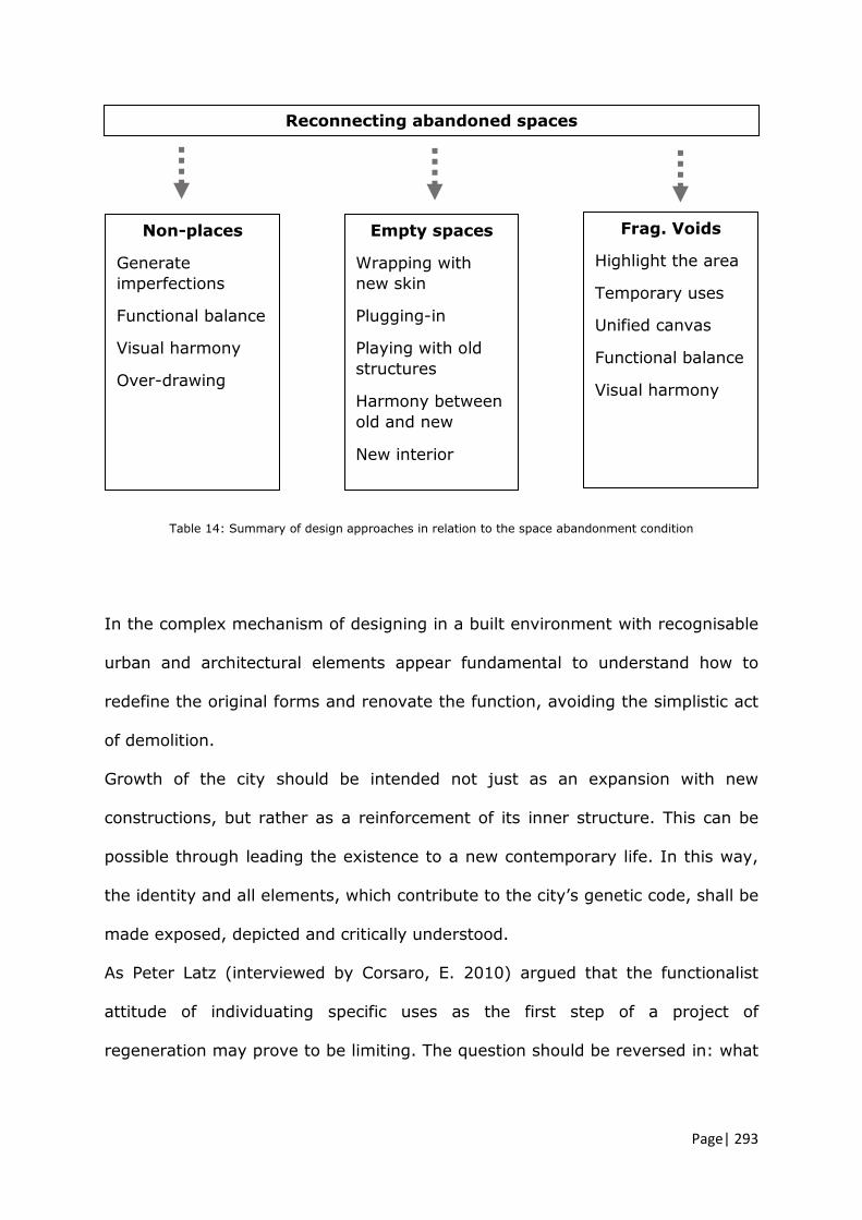
Page| 293
Table 14: Summary of design approaches in relation to the space abandonment condition
In the complex mechanism of designing in a built environment with recognisable
urban and architectural elements appear fundamental to understand how to
redefine the original forms and renovate the function, avoiding the simplistic act
of demolition.
Growth of the city should be intended not just as an expansion with new
constructions, but rather as a reinforcement of its inner structure. This can be
possible through leading the existence to a new contemporary life. In this way,
the identity and all elements, which contribute to the city’s genetic code, shall be
made exposed, depicted and critically understood.
As Peter Latz (interviewed by Corsaro, E. 2010) argued that the functionalist
attitude of individuating specific uses as the first step of a project of
regeneration may prove to be limiting. The question should be reversed in: what
Reconnecting abandoned spaces
Non-places
Generate
imperfections
Functional balance
Visual harmony
Over-drawing
Empty spaces
Wrapping with
new skin
Plugging-in
Playing with old
structures
Harmony between
old and new
New interior
Frag. Voids
Highlight the area
Temporary uses
Unified canvas
Functional balance
Visual harmony

Page| 294
are the abandoned structures within the city and what can we do with them?
(ibid)
6.3 Aber-net, a network of collaborations
Can cross-organisational and cross-sector collaboration be applied to
help instigate, develop and apply positive change in challenging
complex urban settings? (AIM 2 & AIM 3)
Through categorisation of the declinations and natures of abandoned urban
spaces, the research demonstrated that deep intellectual urban studies may
positively inform the practice and guides towards a consistent, more
collaborative and effective project of regeneration.
This analytical process can be transferred to the practice through a more
synergic and collaborative work which may involve various expertise. Analysing
critically the territory and its elements, is a more theoretical and intellectual
approach which may positively influence and accompany the preliminary and
feasibility study of the project, as a starting point of the entire reconversion.
By interrelating the expertise and following specific methods of analysis and
multi-scales design approaches, it would be possible to configure other and new
ideas of renewed urban places within the city.
The reintegration of architecture schools within the process of defining design
urban strategies within the city they reside, may help to address the basis of a
more specialist and practical approach. The risk of generating alienated urban
spaces that Koolhaas (2006) defined as junk-spaces within the sole logic of
business development, in other words within a generic city (ibid), together with
a lack of design elements rooted in the history and identity of the city, maybe

Page| 295
contrasted through a more holistic view of the process of planning the city where
the academics and intellectuals would play a more active role.
The proposed Aber-net is a planned process of collaboration, aimed at
supporting and providing qualitative guidelines for project approaches related to
the re-use of spaces. The process is also aimed towards the design of more
sustainable futures, and represent a path towards initiating deeper theoretical
discussions about the nature of the abandoned spaces within the city, their
characteristics and features which then can be addressed.
Aber-net is practical method to discuss urban complex themes related to the
phenomenon of abandonment. It may also enable to raise, initiate and mediate
complex choices on the urban and architectural evolution of the city, involving
different expertise.
The areas analysed during the workshops are subject to different opinions; often
public, political and marketing positions are in contrast and this can lead to a
dilution of potentials and more holistic solutions of regeneration.
In this sense, Aber-net can collect and distinguish the different opinions and
interests and discuss them with the presence of planners, professionals and with
the presence of the university which can assure a scientific and multidisciplinary
debate. The aim of moderating complex urban themes is to draw new design
inputs for projects of regeneration based on the existing spaces within the city.
These methods of collaboration may lead, in the future, to a broader community
acknowledgement and to a more shared guide for the city masterplan.

Page| 296
In conclusion, Aber-net is a process of collaboration for individuating equally
shared urban project themes which can be the starting points for faster
regenerations and urban improvements. It would also be a way to facilitate
every year the reintegration of abandoned areas within the city system, securing
better investments for the developers.
The presence of the university can facilitate the process of researching,
analysing and categorising the spaces, ensuring the data-sharing.
This collaboration may help to draw tangible and more participated urban views
for the city future.
6.3.1 The essence of the workshop. Opportunities for Aberdeen
Proposing workshops, organised by schools of architecture and local authorities,
helps to analyse the urban environment and to conduct design orientated
research for specific areas within the city, with focus on spatial and architectural
developments. The deep reading of the urban tissue and the pre-figuration of
possible design solutions are the main activities of the workshop underpinned by
planners and students who, from being involved parties, come to be interested
participators.
The aim of the activities:
Deep reflective and critical analysis of the selected urban spaces
Experiencing the spaces
Working within the council departments to deeply understand priorities,
limitations and challenges.
Constantly receiving multiple and different feedbacks
Working process based on interdisciplinary groups

Page| 297
Local and external knowledge exchange and cooperation
Short timeframe
Students’ participation brings design interpretations out of today’s all-
commanding market economy-ordinary, but rooted in a feasibility frame
(alternative solutions)
The flow of communication within the workshop is based on a mutual learning
process related to both, academic research approach led by students and viable
reviews oriented on the feasibility of the concepts conducted by the planners.
6.4 Original contributions to knowledge
RESEARCH FOCUS APPLICATION RESULT
+
Table 15: Original contributions to knowledge
The research explored and contributed to expand the concept of urban
abandonment, clarifying and distinguishing three subcategories such as non-
places, empty places and fragmented urban voids. In doing so, applicative urban
analysis were carried out in eight specific areas within Aberdeen city.
Urban abandoned areas
non-place empty place fragmented urban void
(chapters 1-2-3)
Collaborative method
Institutions & authorities Knowledge exchange Practical design activities
(chapters 1-2-3)
ABER-NET
(chapters 6)
Case study: Aberdeen

Page| 298
Furthermore, the research contributed to expand the supporting theories for
designing methodology of re-use projects. The supporting theories were verified
through applicative and collaborative workshops focused on the areas previously
selected.
The work carried out during the workshops enabled to categorise both the urban
analysis and the design themes and principles within specific taxonomies. All
works are also available online on a specific website called Aberdeen
Collaborative Urban Path.
6.5 Suggestions for further research
The main contribution of this work lies within the subject of Aber-net
collaboration, but the thesis also explored other two aspects related to urban
and architectural themes constructed around the contemporary phenomenon of
urban abandonment. In particular, it proposes urban and architectural analysis
methods suitable for these spaces; urban and architectural process of re-use
design. Therefore, three fields of further investigation are here proposed.
6.5.1 Urban and architectural analysis
The use of different urban analysis is a fundamental practice for having a
comprehensive picture of the city and its feature. Crossing various disciplines,
such as anthropological and etymological studies, enables to better understand
the changing phenomena of the contemporary cities due to new life styles,
political, social and cultural evolution or de-evolution. Furthermore, this

Page| 299
approach would enable to name precisely the new aspects in order to master
them in a subsequent phase of conceptual solutions.
Additional contributions might focus on new graphical maps of the cities, which
may be gained through a further study related to urban and architectural
analysis methods. Particularly the urban rhythmicity appears to be an
explorative way to understand and categorise the spatial-temporal phenomena
of an area, not just in relation to what can be seen, but also to what can be
heard. Recent research (Mareggi, M. 2013) are investigating static and dynamic
maps to represent the different declinations of the temporality, such as intensity
of the use, repetition of activities, scheduled functions or the historical layers of
inhabiting the spaces. The graphical representations techniques are still
experimented in order to collect data on the existing spaces but even in order to
simulate practices of inhabiting new designed places.
6.5.2 Urban and architectural process of re-use design
Researching by design is a tangible method to experiment if urban and
architectural hypothesis, related to principles of re-use, may be viable and may
enhance the social and cultural value of a place. In this sense, the concepts
elaborated during the workshops have been categorised and synthesised in a
taxonomy of approaches intended as general guidelines, which can be developed
through different types of more detailed projects.
The criteria used to categorise the coherent themes and principles are based
also on precedents study and may be expanded through future work.
Subcategories and further criteria may go in depth more. Furthermore, the
entire collection of Aberdeen’s areas in need of regeneration may be expanded
and updated even with more technological and computerized resources. Design
Page| 300
principles’ categorisation may be also accompanied by students’ design proposal
elaborated during the workshop as a physical guide for the feasibility phase of
the real project. It can be considered as an open-ended tool to gather urban
information and specific guides for approaching and for addressing urban areas
issues, weaknesses and potentialities.
6.5.3 Process of collaboration within projects of regeneration
Planners and architects need to recover their confidence and re-engage in
political debates, on how we can build a better society, as we chose to
after the Second World War. Professional education, and professional
institutions, should be about identifying common ground, rediscovering
the multidisciplinary spirit of the Bauhaus, working and training together,
not about defending territory or the purity of professional practice.
(Rogers, R.2017 p.319)
Investigating the process of practical workshop enabled to understand the
reciprocal needs of the academia and authority concerning, on one hand
pedagogical strategies, overall structure and aims of the brief, viable concepts
and more articulated ideas of design on the other.
The length of the workshops and its organisation enabled this research to
investigate and highlight what the points of contact between the institutions,
planners and students could be.
Further contributions may be orientated in exploring longer-term collaborations
along the academic semesters where students, academics and planners would
work on similar themes but approached from different perspectives.
Page| 301
Merging the competencies would help to bridge the discrepancy between
university studies and working field of application, generating a circle of
continues updates for academic staff, students and planners.

Page | 302
ARCHIGRAM. 2018. [online] Available from: https://www.archigram.net/about.html 2019]
ABERDEEN CITY COUNCIL, 2013. Local Development Plan, Brownfield Urban
Capacity Study Update 2013, Aberdeen
ALAIN, P. and MELLUSO, V., 2016. A permanent workshop of strategic urban design. Domus, 1007, pp. 16-17
ALEXANDER, C., ISHIKAWA, S. and SILVERSTEIN, M., 1978. A Pattern Language:
Towns, Buildings, Construction Oxford: Oxford University Press.
AMIN, A. and THRIFT, N., 2002. Cities: Reimagining the Urban. Cambridge: Polity Press.
AUGÉ, M., 1995. Non-places: introduction to an anthropology of supermodernity.
London: Verso.
AURELI, P.V., 2008. The Project of Autonomy: Politics and Poetics Within and Against Capitalism New York: Princeton Architectural Press.
AYMONINO, C., 1977. Lo studio dei fenomeni urbani. Roma: Officina edizioni.
AZ ENCICLOPEDIA UNIVERSALE, 1989. Enciclopedia. Mondadori.
BAEZA, C., 2013. [online] Thinking with the hands. Politecnico of Milan. Available
from: https://vimeo.com/68549655
BAKER, G.H., 1985. Le Corbusier, an analysis of form. England: Van Nostrand Reinhold.
BARBIERI, P. and ET AL., 2010. Hyper Adriatica OP_2 : public works and the
Adriatic city : guidelines for the qualification of urban and territorial projects, PRIN 2006/2008. Barcellona: List Lab.
BARBIERI, P. and ET AL., 208. OP_1 : Opere pubbliche e cittá adriatica
indirizzi per la qualificazione dei progetti urbani e territoriali. Barcellona: List Lab.
BARRESI, A. andPULTRONE, G., 2009. The contribution of morphological analysis in the rehabilitation of peripheries. Atti del Convegno Nazionale INU “Quante periferie?
Quali politiche di governo del territorio”. 22-23 March 2007. Planum.
BOERI, S., 2016. La città scritta. Carlo Aymonino, Vittorio Gregotti, Aldo Rossi, Bernardo Secchi, Giancarlo De Carlo. Quodlibet ed.
BOZZELLI, A., 2008. Il ruolo della bellezza nella questione dell’abitare
contemporaneo. Macramé, pp. 11-14

Page | 303
BUCHANAN, R., 2001. Design Research and the New Learning Researching Design: Designing Research March 1999. MIT Press.
CALAPRICE, A., ed. 2000. The Expanded Quotable Einstein. New Jersey, United
States: Princeton University Press.
CAO, U., ROMAGNI, L. and FOTI, G., 2006. Grandi aree industriali dismesse e progetto urbano. in OP_adriatico 1 “Temi e ricerche per la qualificazione dei progetti
urbani e territoriali nella città adriatica”. In: PRIN, ed. PRIN. pp. 74 - 87
CARIELLO, A. and FERORELLI, R., 2014. Riuso del paesaggio in abbandono. Domus. [online] Available from:
https://www.domusweb.it/it/opinion/2014/01/09/riuso_del_paesaggio_in_abbandono.html [Accessed 2017]
CHING, F., 1979. Architecture Form, Space and Order. New York: Van Nostrand
Reinhold.
CLARK, R.H. and PAUSE, M., 1985. Precedent in Architecture. Oxford: Van Nostrand Reinhold.
CLÉMENT, G., 2005. Manifesto del terzo paesaggio. Macerata: Quodlibet.
CONEJOS, S., 2013. Designing for Future Building Adaptive Reuse. [online] PhD
thesis, Bond University, Gold Coast, Australia.
Megalopolis. 2007. Directed by F. Conversano and N. Grignaffini. RAI-3.
CORSARO, E., 2010. Dismissione: da anomalia a regola. Caratteri, criticità e ruoli delle aree industriali
dismesse per Adriapolis: teoria per un’ agenda strategica di indirizzo. [online] PhD thesis, Università degli studi di Camerino – Facoltà di Architettura sede di Ascoli Piceno (IT).
CUCINELLA, M., 2019. Mario cucinella architects. [online] Available from:
https://www.mcarchitects.it/luomo-non-puo-piu-sopraffare-la-natura [Accessed 04/16 2018]
CULLEN, G., 1961. The concise townscape. Architectural Press ed. Oxford: Elsevier.
CURI, U., 2016. Filosofia +Non-Luoghi. Treviso, Italy: TRA Treviso Ricerca Arte.
CURTO, R., 2007. Abitare, Comunicare, Pensare, Sperimentare. Workshop 2007
TILab Le telecomunicazioni per chi le usa e gli spazi per chi li progetta. In: Alinea editrice,
ed. Firenze: pp. 7-8

Page | 304
DAVERIO, P., 2013. La cittá densa. Conference ed. University of Genoa:
DEFILIPPIS, A., 2010. Urban collision - Design opportunities in tensions and fragments University of Cincinnati.
DE JONGE, J.M. 2009. Landscape architecture between politics and science, an integrative perspective on landscape planning and design in the network society. Ph.D. Thesis, Wageningen University, Wageningen, Amsterdam, The Netherland.
DELL’AGUZZO, M., 2013. Urbanizzazione in Europa: Una diagnosi comparativa.
[online] Master thesis, Università degli Studi dell’Aquila. Available from: http://www.planeco.org/staff/romano/web-cORSI/Tesi_Laurea/dell_aguzzo.pdf
DUCHAMP, M. 1923. Celibate machine.
DURRIGL, M., 2002. Kalokagathia - beauty is more than just external appearance.
Journal of Cosmetic Dermatology, , pp. 208-10
EMERSON, T., 2014. Glasgow Atlas, Studio Tom Emerson. Glasgow:
ESPUELAS, F., 2004. Il Vuoto. Riflessioni sullo spazio in architettura. Christian Marinotti edizioni ed. Milano:
FATIGATI, L., FORMATO, E. and GALLUCCI, P., 2001. Tipi edilizi e forma della città.
Naples: ed. Fiorentino NT.
FISHER-GEWIRTZMAN, D., 2016. Adaptive reuse, architecture documentation and analysis. Journal of Architectural Engineering Technology, 5(3)
FLUSSER, V. and CULLARS, J., 1995. On the word design: An etymological essay.
MIT Press, 11, N. 3, pp. 50-53
FORTY, A., ed. 2000. Words and buildings: a vocabulary of modern architecture. London: Thames & Hudson.
FOUCAULT, M., 1966. Les mots et les choses. Une archéologie des sciences
humaines. Paris: Gallimard.
FUSERO, P., 2018. Summer school archivi. [online] Available from: http://www.paolofusero.it/category/summer-school/ 2017]
GEHL, J., 2010. Cities for people. Island Press.
GREENBERG, M., POPPER, F.J. and WEST, B.M., The TOADS: A New American
Urban Epidemic. Urban affairs review, SAGE Journals, 25, pp. 435-454
GREGOTTI, V., 1966. IL TERRITORIO DELL’ARCHITETTURA. Milano: Feltrinelli.
Page | 305
GROTH, J. and CORIJN, E., 2005. Reclaiming Urbanity: Indeterminate Spaces, Informal Actors and Urban Agenda Setting. Urban studies, SAGE Journals, 42(3),
pp. 503-526
HARDINGHAM, S., 2012. Bernard Tschumi : Parc de la Villette Supercrit #4 . Routledge: Rattenbury, Kester.
HECHT, S. and COLIN, K., 2015. La bellezza, un lavoro mai compiuto: Beauty as
unfinished bus ness. Domus, 990, pp. 16
HERZOG, J., 2016. hardly finished work. Harvard GSD.
HETHERINGTON, K. and SMITH, R.J., 2013. Urban Rhythms: Mobilities, space and interaction in the contemporary city. The Sociological Review. [online] 61Available
from: https://journals.sagepub.com/doi/full/10.1111/1467-954X.12050 [Accessed 2013]
HEYLIGHEN, A., CAVALLIN, H. and BIANCHIN, M., 2009. Design in Mind.
Massachusetts Institute of Technology, 25, Number 1, pp. 94-105
INNOCENTI, P., 2016. Migrating heritages: Experiences of cultural networks and cultural dialogue in europe. London and New York: Routledge.
KHAMSI, J., 2012. Curious Little Diagrams: Gestalt psychology and the Urbanism of
Colin Rowe and Kevin Lynch. Urban infill, 5, pp. 84 - 89
KOOLHAAS, R., 2006. Junkspace. Per un ripensamento radicale dello spazio urbano. Macerata Italy: Quodlibet.
LÄHDESMÄKI, T., 2014. The role of space in the politics of intercultural dialogue. In
E. Burdusel, O. Matiu, D. Preda, & A. Tomus (Eds.), Cultural Encounter. The Mosaic of Urban Identities. In: UNEECC FORUM, ed. pp. 28-42
LAKOFF, G., & JOHNSON, M., 1980. Metaphors we live by. Chicago: University of Chicago Press.
LATZ, P., 2019. Latz and parteners. [online] Available from:
https://www.latzundpartner.de/en/projekte/postindustrielle-landschaften/parco-dora-turin-it/ 2016]
LE CORBUSIER, 1931. Towards a new architecture. London: Rodker.
LEFEBVRE, H., 2004. Rhythmanalysis. Space, Time and Everyday life. New York:
Continuum.
LUCAS, R., 2016. Research methods for architecture. London: Laurence King Pubblication.

Page | 306
LYNCH, K.A., 1960. The Image of the City. MIT Press.
MAGLIOZZI, Z., 2015. Architettura e politica. intervista a wouter vanstiphout. [online] Available from: https://www.artribune.com/attualita/2015/03/architettura-
e-politica-intervista-a-wouter-vanstiphout/ 2019]
MANZIONE, L., 2012. Eutopics descrivere il resto. altri sguardi sulla città. [online] Available from: https://eutopics.wordpress.com/2012/05/25/non-luoghi-figure-
dellassenza-figure-dellincognit/ 2015]
MAREGGI, M., 2017. The over-familiar landscape that escapes to the absent-minded gaze The Journal of
Public Space. [online] 2, n.1Available from: https://webcache.googleusercontent.com/search?q=cache:0DCsEkmh2kIJ:https://www.journalpublicspace.org/index.php/jps/article/download/247/246+&cd=21&hl=
en&ct=clnk&gl=uk [Accessed 2017]
MARETTO, M., 2013. Saverio Muratori: towards a morphological school of urban design. Urban morphology. [online] 17, 2Available from:
http://www.urbanform.org/online_public/2013_2.shtml [Accessed 2013]
MEDORI, S., 2011. Aree industriali dismesse: Quale tema di Archtiettura? Conservare, ri-fare, ri-formare: riprogettare la dismissione industriale. Unpublished
PhD thesis, University of Camerino, Ascoli Piceno, IT.
MONEO, R., 1986. The solitude of buildings. Cambridge, Mass: Harvard University, Graduate School of Design.
MURATORI, S., 1967. Civilta e territorio. Rome: Centro studi di storia urbanistica.
NEUMEYER, F., 1991. The artless word : Mies van der Rohe on the building art.
Oxford dictionaries. 2019. [online] Oxford University Press. 2018 Cambridge: MIT
Press.
PATTON, M.Q., 1987. How to use qualitative methods in evaluation. 2nd ed. Newbury Park: SAGE Publications.
PIAGET, J., 2015. Structuralism. 1st ed. London: Psychology Press.
PIANO, R., 2015. Rammendo e rigenerazione urbana per il nuovo rinascimento
convegno fondazione italcementi. [online] Bergamo: Fondazione Italcementi. Available from: https://www.youtube.com/watch?v=APcQ5Hra8Po [Accessed
December 2015 filmed conference]
PIANO, R., 2018. filmed interview "La mia Genova". Palazzo Ducale, Genova, Italy.
https://www.artribune.com/attualita/2015/03/architettura-e-politica-intervista-a-wouter-vanstiphout/

Page | 307
POPCZYK, M., 2016. The aesthetics of the city-image. Argument, biannual philosofical journal. [online] 5Available from:
https://philarchive.org/archive/POPTAO-5
PORTOGHESI, P., 2007. Involucri. L’involucro e il volto. Materia, 55
RICOEUR, P., 2016. Architecture and Narrativity. 7, pp. 31-34
RITCHIE, L.D., 2013. Metaphor. Cambridge: Cambridge University Press.
RITZER, G., 2004. The Globalization of Nothing. Thousand Oaks, CA and London:
Pine Forge Press.
ROBERTS, B., ed. 2016. Tabula Plena Forms of Urban Preservation. Lars Müller Publishers.
ROCKWELL, D. 2008. Hall of fracment. Venice: Biennale di Venezia.
ROGERS, R., 2017. A place for all people. Great Britain: Canongate Books Limited.
ROSSI, A. and EISENMAN, P., 1982. The architecture of the city . American ed.
revised by Aldo Rossi and Peter Eisenman. ed. London: Graham Foundation for Advanced Studies in the Fine Arts.
ROSSI, P.H., LIPSEY, M.W. and FREEMAN, H.E., 1998. Evaluation: A systematic approach. Thousand Oaks: Sage Publications.
ROTENBERG, R., 2011. Space, place, site and locality: The study of landscape in cultural anthropology. in: Simon Bell et al. Exploring the Boundaries of Landascape Architecture. In: ROUTLEDGE, ed.
ROVERONI, S., 2008. Figure del vuoto. Figures of the void. [online] Doctorate
thesis, Università degli studi di Trieste. Available from: http://hdl.handle.net/10077/2677
ROWE, C. and KOETTER, F., 1979. Collage city. U.S.A.: The MIT Press.
SCHÖN, D.A., 1979. Generative metaphors in problem solving setting in social
policy. In A. Ortony (ed.), Metaphor and thought. In A. Ortony (ed.), Metaphor and thought. In: CAMBRIDGE UNIVERSITY PRESS, ed. pp. 137-164
SECCHI, B., 1984. Un problema urbano: l'occasione dei vuoti. Casabella, 503, pp.
18-21
SEMA UZUNOGLU, S. andUZUNOGLU, K., 2011. The application of formal perception of gestalt in architectural education. Elsevier Ltd. pp. 994

Page | 308
SETTI, G., 2013. New ways of Reusing Abandoned Industrial Architectures. Living Landscapes - Landscapes for living. 2012. Planim The journal of Urbanism. pp. 25 -
1001
SETTIS, S., 2017. Architettura e democrazia. Paesaggio, cittá, diritti civili. Italy: Giulio Enauidi editore.
SIMITCH, A. and WARKE, V., 2014. The language of architecture. 26 principles
every architect should know. USA: Quarto Knows.
SPOSITO, C., 2012. Sul recupero della aree industriali dismesse. tecnologie materiali impianti ecosostenibili innovativi. In: MAGGIOLI EDITORE, ed.
TEITZ, M.B., 2007. Melvin Webber and the “Nonplace Urban Realm". Access,
(Winter 2006-2007), pp. 29
TRANCIK, R., 1986. Finding lost space: theories of urban design. New York: Van Nostrand Reinhold Co.
TSCHUMI, B., 1996. Architecture and disjunction. London: MIT.
TURNER, T., 1986. English Garden Design: History and Styles since 1650.
Woodbridge, Suffolk: Antique Collectors Club.
TURNER, T., 1987. Landscape Planning. London: Hutchinson Education.
TURNER, T., 1995. Greenways, blueways, skyways and other ways to a better London. Landscape and urban planning, Elsevier, 33, pp. 269-282
VEREBES, T., 4 November 2015. Towards a Distinctive Urbanism: An Interview with
Kenneth Frampton.
VIERECK, G.S., 1929. What Life Means to Einstein. The saturday evening post, p.17
Walkable london. 2018. [online] Available from: https://www.walkablelondon.co.uk [Accessed 04/04 2018]
WEBBER, M., 1964. The Urban Place and the Nonplace Urban Realm. Explorations
into Urban Structure, pp. 79-153
WURMAN, R.S., 1986. What Will Be Has Always Been: the Words of Louis I. Kahn. New York: Rizzoli International Publications.
YU-HSIN, T., 2014. Location-demand-based residential floor area ratio distribution
method. SAGE, Urban Studies, 51(12)

Page | 309
APPENDIX A SURVEY QUESTIONS 2017
QUESTIONNAIRE
REFLECTION ON URBAN REGENERATION (2017)
NAME____________________________SURNAME___________________________
SCHOOL___________________________________________________YEAR______
1. How do you perceive the urban context of Aberdeen city?
2. How does this compare with other American and European cities you have visited?
3. Please draw a diagram of the urban layout of Aberdeen. Feel free to format this
however you wish, but try to express what you feel are the defining elements (e.g. layout, features, landmarks, and so on).
4. As an architect, what do you feel are the defining elements when undertaking urban
regeneration in the context of a historic built environment?
5. Can you provide examples of such elements which you found in Aberdeen city?
6. Please describe possible strategies and methodologies applicable for the regeneration of existing buildings. Include mention of their re-use and the relationship between old and new.
7. Please give an example as applied in your own project.
Signing this paper allows Robert Gordon University to anonymously use the information you provide
Signature
____________________
Your feedback is important, and will help to form future workshops, and will feed into ongoing research at Robert Gordon University.

Page | 310
APPENDIX B PRE-DESIGN SURVEY QUESTIONS FOR STUDENTS 2018
PRE DESIGN QUESTIONNAIRE
REFLECTION ON ABERDEEN URBAN REGENERATION
(STUDENTS) 2018
NAME____________________________SURNAME_______________________________
DEPARTMENT_____________________________________________________________
1. The choice of Queen Street as the case study, for this year’s workshop, came from the necessity of Aberdeen city Council to improve the urban area around the recent intervention of Marischal Square. What are, for you, the main urban and architectural issues related to Queen Street at present? Please at the end of your answer list 3 word or adjectives that best describe the area taken in exam.
2. Please draw a diagram of the existing area.
3. Please identify and list/describe those landmarks, urban artefact and important urban elements that you would maintain to highlight the sense of Aberdeen identity in the area being studied.
4. As indicated in the brief and discussed in our first meeting at the council, there are 3
main types of buildings to work on (Police station, Townhouse, ground floors along the road). What are the essential architectural components, elements or characteristics that make them recognisable in terms of an Aberdeen architectural identity?
5. Please explain what the terms Urban Regeneration and Adaptive re-use mean for you.
Signing this paper allows Robert Gordon University to anonymously use the information you provide
Signature
____________________
Your feedback is important, and will help to form future workshops, and will feed into ongoing research at Robert Gordon University.

Page | 311
APPENDIX C PRE-DESIGN SURVEY QUESTIONS FOR PLANNERS 2018
PRE DESIGN QUESTIONNAIRE
REFLECTION ON ABERDEEN URBAN REGENERATION
(Planners) 2018
NAME____________________________SURNAME_______________________________
DEPARTMENT_____________________________________________________________
During the summer workshop you will work directly within a student group. Please answer to
the questions below. Your contribution will be used for an urban and architecture research
undertaken at Robert Gordon University.
1. The choice of Queen Street as the case study, for this year’s workshop, came from the necessity of Aberdeen City Council to improve the urban area around the recent intervention of Marischal Square. What are, for you, the main urban and architecture issues related to Queen Street at the present? Please at the end of your answer list 3 words or adjectives that best describe the area taken in exam.
2. Within your department, do you discuss themes related to the urban form, urban permanence, values and potentiality inherent to the existing built environment?
3. Please identify landmarks, urban artefact and important urban elements that you would
maintain to highlight the sense of Aberdeen identity in the area taken in exam.
4. As a local authority does the council have an up-to-date system of mapping the urban
underused / compromised spaces, buildings or urban void fractures? How are they categorised/named?
5. Please explain what does the terms Urban Regeneration and Adaptive re-use mean for you
Signing this paper allows Robert Gordon University to anonymously use the information you provide
Signature
____________________
Your feedback is important, and will help to form future workshops, and will feed into ongoing research at Robert Gordon University.

Page | 312
APPENDIX D POST DESIGN QUESTIONS FOR STUDENTS 2018
POST DESIGN QUESTIONNAIRE
REFLECTION ON PROJECT METHODOLOGICAL APPROACH
(Students) 2018
NAME ________________________SURNAME___________________________
SCHOOL____USF_______________________________________________YEAR______
During the summer workshop you analysed and worked on the regeneration of Queen Street.
Please answer to the questions below. Your contribution will be used for an urban and
architecture research undertaken at Robert Gordon University.
1. Please describe the existing urban space of Queen Street in relation to the discussions and considerations raised within the workshop.
2. How did you perceive the methodology of urban analysis we undertaken?
3. What are the main urban and architectural principles used for your project?
4. Please draw a schematic diagram of your main urban and architecture principles.
5. What are the essential architectural parts of the existing buildings that you maintained and/or highlighted within your project?
Signing this paper allows Robert Gordon University to anonymously use the information you provide
Signature
_______________ _____
Your feedback is important, and will help to form future workshops, and will feed into ongoing research at Robert Gordon University.

Page | 313
APPENDIX E LETTER
Dear ……….
I am a doctoral research student at Scott Southerland School at RGU and
my research focus on underused and ill-defined urban areas and buildings in Aberdeen city. It investigates the methods and ways to reactivate these
spaces through specific urban and architecture design approach while exploring possible processes of collaboration between academia and local
authority.
For this reason I am involved in organising the summer workshops in Aberdeen since 2015. The urban workshops are an occasion for both
University and Council to collaborate together for creating possible and future visions of specific areas in Aberdeen city. This year the participants
are from the schools of architecture of Robert Gordon University,
International College Robert Gordon University and University of South of Florida.
Answering the questions below you will contribute to form future workshops
and feed into my research.
Many thanks for your time.
With kind regards,
Cecilia Zecca

Page | 314
APPENDIX F SURVEY QUESTIONS FOR DM PLANNING DEPARTMENT 2018
SURVEY QUESTIONS FOR DM PLANNING DEPARTMENT
2018
NAME____________________________SURNAME_______________________________
DEPARTMENT_____________________________________________________________
1. What benefits do you perceive might be gained by the council as a result of the collaboration?
2. How does this relate to the aims and expectations you have of workshops and what you hope they will achieve?
3. What contributions and other forms of valuable insight do you think
architecture students can make to the issues and challenges relating to the city masterplan?
4. Looking at other successful collaborative experience in some European cities (Oslo, Pescara, Venice, Barcelona, etc.), do you think that it would
be beneficial in the future for the architecture school and Aberdeen city council to establish a more formal template for coordinating students contributions to the city masterplan vision?