Montana Bureau of Mines and Geology Abandoned-Inactive ...
236
Montana Bureau of Mines and Geology Abandoned-InactiveMines of the Kootenai National Forest-AdministeredLand MBMG 395 Phyllis A. Hargrave Alan R. English Mike D. Kerschen Geno W. Liva Jeffrey D. Lonn James P. Madison JohnJ. Metesh Robert Wintergerst Prepared for the U.S. Department of Agriculture Forest Service-Region 1
-
Upload
khangminh22 -
Category
Documents
-
view
0 -
download
0
Transcript of Montana Bureau of Mines and Geology Abandoned-Inactive ...
Montana Bureau of Mines and GeologyAbandoned-Inactive Mines of the
Kootenai National Forest-Administered Land
MBMG 395
Phyllis A. HargraveAlan R. English
Mike D. KerschenGeno W. LivaJeffrey D. Lonn
James P. MadisonJohn J. Metesh
Robert Wintergerst
Prepared for the U.S. Department of AgricultureForest Service-Region 1

Abandoned-Inactive Mines of theKootenai National Forest-Administered Land
Open-File ReportMBMG 395
December 1999
Phyllis A. HargraveAlan R. English
Mike D. KerschenGeno W. Liva
Jeffrey D. LonnJames P. Madison
John J. MeteshRobert Wintergerst
Prepared for the U.S. Department of AgricultureForest Service-Region 1
byMontana Bureau of Mines and Geology

ii
Contents
Page
List of Figures . . . . . . . . . . . . . . . . . . . . . . . . . . . . . . . . . . . . . . . . . . . . . . . . . . . . . . . . . . . . . . . iv
List of Tables . . . . . . . . . . . . . . . . . . . . . . . . . . . . . . . . . . . . . . . . . . . . . . . . . . . . . . . . . . . . . . . vii
Introduction . . . . . . . . . . . . . . . . . . . . . . . . . . . . . . . . . . . . . . . . . . . . . . . . . . . . . . . . . . . . . . . . . . 11.1 Project Objectives . . . . . . . . . . . . . . . . . . . . . . . . . . . . . . . . . . . . . . . . . . . . . . . . . . . . 11.2 Abandoned and Inactive Mines Defined . . . . . . . . . . . . . . . . . . . . . . . . . . . . . . . . . . . 21.3 Health and Environmental Problems at Mines . . . . . . . . . . . . . . . . . . . . . . . . . . . . . . 2
1.3.1 Acid-Mine Drainage . . . . . . . . . . . . . . . . . . . . . . . . . . . . . . . . . . . . . . . . . . . 31.3.2 Solubility of Selected Metals . . . . . . . . . . . . . . . . . . . . . . . . . . . . . . . . . . . . 31.3.3 The Use of pH and SC to Identify Problems . . . . . . . . . . . . . . . . . . . . . . . . 5
1.4 Methodology . . . . . . . . . . . . . . . . . . . . . . . . . . . . . . . . . . . . . . . . . . . . . . . . . . . . . . . . 51.4.1 Data Sources . . . . . . . . . . . . . . . . . . . . . . . . . . . . . . . . . . . . . . . . . . . . . . . . . 51.4.2 Pre-field Screening . . . . . . . . . . . . . . . . . . . . . . . . . . . . . . . . . . . . . . . . . . . . 61.4.3 Field Screening . . . . . . . . . . . . . . . . . . . . . . . . . . . . . . . . . . . . . . . . . . . . . . . 7
1.4.3.1 Collection of Geologic Samples . . . . . . . . . . . . . . . . . . . . . . . . . . 81.4.4 Field Methods . . . . . . . . . . . . . . . . . . . . . . . . . . . . . . . . . . . . . . . . . . . . . . . . 8
1.4.4.1 Selection of Sample Sites . . . . . . . . . . . . . . . . . . . . . . . . . . . . . . . 91.4.4.2 Collection of Water and Soil Samples . . . . . . . . . . . . . . . . . . . . . . 91.4.4.3 Marking and Labeling Sample Sites . . . . . . . . . . . . . . . . . . . . . . 101.4.4.4 Existing Data . . . . . . . . . . . . . . . . . . . . . . . . . . . . . . . . . . . . . . . . 10
1.4.5 Analytical Methods . . . . . . . . . . . . . . . . . . . . . . . . . . . . . . . . . . . . . . . . . . . 101.4.6 Standards . . . . . . . . . . . . . . . . . . . . . . . . . . . . . . . . . . . . . . . . . . . . . . . . . . . 11
1.4.6.1 Water-Quality Standards . . . . . . . . . . . . . . . . . . . . . . . . . . . . . . . 111.4.6.2 Soil Standards . . . . . . . . . . . . . . . . . . . . . . . . . . . . . . . . . . . . . . . 13
1.4.7 Analytical Results . . . . . . . . . . . . . . . . . . . . . . . . . . . . . . . . . . . . . . . . . . . . 141.5 Kootenai National Forest . . . . . . . . . . . . . . . . . . . . . . . . . . . . . . . . . . . . . . . . . . . . . . 14
1.5.1.1 Production . . . . . . . . . . . . . . . . . . . . . . . . . . . . . . . . . . . . . . . . . . 171.5.1.2 Milling . . . . . . . . . . . . . . . . . . . . . . . . . . . . . . . . . . . . . . . . . . . . . 17
1.6 Summary of the Kootenai National Forest Investigation . . . . . . . . . . . . . . . . . . . . . 181.7 Mining Districts and Drainage Basins . . . . . . . . . . . . . . . . . . . . . . . . . . . . . . . . . . . . 19
Clark Fork and Kootenai River Drainages . . . . . . . . . . . . . . . . . . . . . . . . . . . . . . . . . . . . . . . . . 192.1 Geology . . . . . . . . . . . . . . . . . . . . . . . . . . . . . . . . . . . . . . . . . . . . . . . . . . . . . . . . . . . 192.2 Economic Geology . . . . . . . . . . . . . . . . . . . . . . . . . . . . . . . . . . . . . . . . . . . . . . . . . . . 212.3 Hydrology and Hydrogeology . . . . . . . . . . . . . . . . . . . . . . . . . . . . . . . . . . . . . . . . . . 212.4 Summaries of the Lower Clark Fork and Kootenai River Drainages . . . . . . . . . . . . 222.5 Jack Waite Mine . . . . . . . . . . . . . . . . . . . . . . . . . . . . . . . . . . . . . . . . . . . . . . . . . . . . 242.6 Vermilion River Adit . . . . . . . . . . . . . . . . . . . . . . . . . . . . . . . . . . . . . . . . . . . . . . . . . 282.7 Ambassador Mine . . . . . . . . . . . . . . . . . . . . . . . . . . . . . . . . . . . . . . . . . . . . . . . . . . . 33
iii
2.8 Heidelberg Mine or Price Claims . . . . . . . . . . . . . . . . . . . . . . . . . . . . . . . . . . . . . . . 382.9 Pilgrim Mine . . . . . . . . . . . . . . . . . . . . . . . . . . . . . . . . . . . . . . . . . . . . . . . . . . . . . . . 422.10 Holliday (Homestead) Mine . . . . . . . . . . . . . . . . . . . . . . . . . . . . . . . . . . . . . . . . . . 472.11 Brown Hill or Broken Hill Mine . . . . . . . . . . . . . . . . . . . . . . . . . . . . . . . . . . . . . . . 522.12 Blue Creek or Scotchman Mine . . . . . . . . . . . . . . . . . . . . . . . . . . . . . . . . . . . . . . . . 562.13 Rock Lake Adit . . . . . . . . . . . . . . . . . . . . . . . . . . . . . . . . . . . . . . . . . . . . . . . . . . . . 682.14 Nancy Jane and Twin Peaks Mines . . . . . . . . . . . . . . . . . . . . . . . . . . . . . . . . . . . . . 722.15 Independence Mine . . . . . . . . . . . . . . . . . . . . . . . . . . . . . . . . . . . . . . . . . . . . . . . . . 772.16 Snowfall Prospect and King Mine . . . . . . . . . . . . . . . . . . . . . . . . . . . . . . . . . . . . . . 822.17 Viking Mine or Gold Hill Claims . . . . . . . . . . . . . . . . . . . . . . . . . . . . . . . . . . . . . . 872.18 Bramlet Creek (and Branagan) Mine . . . . . . . . . . . . . . . . . . . . . . . . . . . . . . . . . . . . 912.19 Gloria or Little Annie Mine . . . . . . . . . . . . . . . . . . . . . . . . . . . . . . . . . . . . . . . . . . . 952.20 Vermiculite Mountain Mine . . . . . . . . . . . . . . . . . . . . . . . . . . . . . . . . . . . . . . . . . . 992.21 Copper Reward Mine . . . . . . . . . . . . . . . . . . . . . . . . . . . . . . . . . . . . . . . . . . . . . . . 1022.22 Snowshoe Mine . . . . . . . . . . . . . . . . . . . . . . . . . . . . . . . . . . . . . . . . . . . . . . . . . . . 1062.23 Cherry Creek or St. Paul Mill . . . . . . . . . . . . . . . . . . . . . . . . . . . . . . . . . . . . . . . . 1132.24 Victor-Empire Mine . . . . . . . . . . . . . . . . . . . . . . . . . . . . . . . . . . . . . . . . . . . . . . . . 1172.25 Silver Mountain Mine . . . . . . . . . . . . . . . . . . . . . . . . . . . . . . . . . . . . . . . . . . . . . . 1202.26 Loyal, Shaughnessy Hill, and Lukens-Hazel Mines . . . . . . . . . . . . . . . . . . . . . . . 1232.27 Grouse Mountain and Iron Mask Mines . . . . . . . . . . . . . . . . . . . . . . . . . . . . . . . . 1282.28 Giant Sunrise Mine and Sunrise Mill . . . . . . . . . . . . . . . . . . . . . . . . . . . . . . . . . . 1352.29 Goat Creek Adit . . . . . . . . . . . . . . . . . . . . . . . . . . . . . . . . . . . . . . . . . . . . . . . . . . . 1422.30 Snowstorm Mine . . . . . . . . . . . . . . . . . . . . . . . . . . . . . . . . . . . . . . . . . . . . . . . . . . 1462.31 Summary of the Clark Fork, Fisher River, Yaak, and Kootenai River Drainages . . . . . . . . . . . . . . . . . . . . . . . . . . . . . . . . . . . . . . . . . . . . 151
References . . . . . . . . . . . . . . . . . . . . . . . . . . . . . . . . . . . . . . . . . . . . . . . . . . . . . . . . . . . . . . . . . 156

iv
List of Figures
Figure Page
1. The location of a mine is found as shown . . . . . . . . . . . . . . . . . . . . . . . . . . . . . . . . . . . . . . . 72. The Kootenai National Forest . . . . . . . . . . . . . . . . . . . . . . . . . . . . . . . . . . . . . . . . . . . . . . . 153. Abandoned-inactive mines in the lower Clark Fork and Kootenai River drainages . . . . . 214. The Jack Waite mine lies predominantly on private land . . . . . . . . . . . . . . . . . . . . . . . . . . 264a. The Montana Tunnel at the Jack Waite is open and had a small discharge of water . . . . . 274b. Waste material partially filled Dixie Creek . . . . . . . . . . . . . . . . . . . . . . . . . . . . . . . . . . . . 275. The Vermilion River adit . . . . . . . . . . . . . . . . . . . . . . . . . . . . . . . . . . . . . . . . . . . . . . . . . . 305a. The open and easily accessible Vermilion River adit . . . . . . . . . . . . . . . . . . . . . . . . . . . . . 315b. Sample VVRS10M at the Vermilion River adit . . . . . . . . . . . . . . . . . . . . . . . . . . . . . . . . . 316. The Ambassador mine on Granite Creek . . . . . . . . . . . . . . . . . . . . . . . . . . . . . . . . . . . . . . 356a. Granite Creek flowed at a low rate when visited in late August . . . . . . . . . . . . . . . . . . . . 366b. Granite Creek (at low flow) has cut the waste dump at the Ambassador, . . . . . . . . . . . . . 367. The Heidelberg mine discharged water to Rock Creek . . . . . . . . . . . . . . . . . . . . . . . . . . . 407a. As viewed from above, the Heidelberg mine . . . . . . . . . . . . . . . . . . . . . . . . . . . . . . . . . . . 417b. The discharge from the Heidelberg . . . . . . . . . . . . . . . . . . . . . . . . . . . . . . . . . . . . . . . . . . 418. The Pilgrim mine adit and discharge . . . . . . . . . . . . . . . . . . . . . . . . . . . . . . . . . . . . . . . . . 448a. At the Pilgrim mine, the 20-gpm discharge was practically hidden . . . . . . . . . . . . . . . . . . 458b. A pool of water formed by the discharge at the Pilgrim mine . . . . . . . . . . . . . . . . . . . . . . 459. The Holliday mine had two adits . . . . . . . . . . . . . . . . . . . . . . . . . . . . . . . . . . . . . . . . . . . . 499a. At the Holliday mine, none of the structures . . . . . . . . . . . . . . . . . . . . . . . . . . . . . . . . . . . 509b. The 8-gpm discharge from the lower adit at the Holliday . . . . . . . . . . . . . . . . . . . . . . . . . 5010. Broken Hill mine sample location . . . . . . . . . . . . . . . . . . . . . . . . . . . . . . . . . . . . . . . . . . . 5410a. Water flowed from the caved adit on patented land at the Broken Hill . . . . . . . . . . . . . . . 5510b. The Broken Hill waste dump was steep and largely unvegetated . . . . . . . . . . . . . . . . . . . 5511. The Blue Creek mine also known as the Stackhouse or the North Star . . . . . . . . . . . . . . . 5811a. The waste dump at the Blue Creek mine . . . . . . . . . . . . . . . . . . . . . . . . . . . . . . . . . . . . . . 5911b. The adit at the Blue Creek was open and accessible . . . . . . . . . . . . . . . . . . . . . . . . . . . . . 5912. The Rock Lake adit . . . . . . . . . . . . . . . . . . . . . . . . . . . . . . . . . . . . . . . . . . . . . . . . . . . . . . . 7012a. The adit near Rock Lake was predominantly caved . . . . . . . . . . . . . . . . . . . . . . . . . . . . . . 7112b. The small rate flow at Rock Lake was measured . . . . . . . . . . . . . . . . . . . . . . . . . . . . . . . . 7113. The Nancy Jane mine . . . . . . . . . . . . . . . . . . . . . . . . . . . . . . . . . . . . . . . . . . . . . . . . . . . . . 7414. The Twin Peaks mine . . . . . . . . . . . . . . . . . . . . . . . . . . . . . . . . . . . . . . . . . . . . . . . . . . . . . 7514a. The Nancy Jane mine had a small seep . . . . . . . . . . . . . . . . . . . . . . . . . . . . . . . . . . . . . . . 7614b. The Twin Peaks mine showed no adverse effects . . . . . . . . . . . . . . . . . . . . . . . . . . . . . . . 7615. The Independence mine . . . . . . . . . . . . . . . . . . . . . . . . . . . . . . . . . . . . . . . . . . . . . . . . . . . 8015a. Looking north at the adit discharge at the Independence . . . . . . . . . . . . . . . . . . . . . . . . . . 8115b. Looking down from the talus and upper caved adit at the Independence . . . . . . . . . . . . . . 8116. The Snowfall mine . . . . . . . . . . . . . . . . . . . . . . . . . . . . . . . . . . . . . . . . . . . . . . . . . . . . . . . 8416a. The adit discharge at the Snowfall prospect . . . . . . . . . . . . . . . . . . . . . . . . . . . . . . . . . . . 8516b. A site on the South Fork of Silver Butte Creek was chosen . . . . . . . . . . . . . . . . . . . . . . . . 85

v
17. The Viking mine . . . . . . . . . . . . . . . . . . . . . . . . . . . . . . . . . . . . . . . . . . . . . . . . . . . . . . . . . 8917a. Recent habitation at the Viking has resulted in a modern A-frame . . . . . . . . . . . . . . . . . . 9018. The Bramlet Creek mill . . . . . . . . . . . . . . . . . . . . . . . . . . . . . . . . . . . . . . . . . . . . . . . . . . . 9318a. Collapsed mill ruins lay beside Bramlet Creek . . . . . . . . . . . . . . . . . . . . . . . . . . . . . . . . . 9418b. Bramlet Creek ran clear and cold downstream from the Bramlet Creek mill. . . . . . . . . . . 9419. The Gloria mine . . . . . . . . . . . . . . . . . . . . . . . . . . . . . . . . . . . . . . . . . . . . . . . . . . . . . . . . . 9719a. As viewed from the road to the Wayup mine, the Gloria’s waste dumps . . . . . . . . . . . . . 9819b. One waste dump at the Gloria . . . . . . . . . . . . . . . . . . . . . . . . . . . . . . . . . . . . . . . . . . . . . . . 9820. Vermiculite Mountain mine . . . . . . . . . . . . . . . . . . . . . . . . . . . . . . . . . . . . . . . . . . . . . . . 10121. The Walker Tunnel at the Copper Reward . . . . . . . . . . . . . . . . . . . . . . . . . . . . . . . . . . . . 10421a. A seep emerged from the collapsed adit portal at the Copper Reward . . . . . . . . . . . . . . . 10521b. At the Copper Reward, lush green vegetation grew . . . . . . . . . . . . . . . . . . . . . . . . . . . . . 10522. The Snowshoe mine . . . . . . . . . . . . . . . . . . . . . . . . . . . . . . . . . . . . . . . . . . . . . . . . . . . . . 10922a. A panorama looking west shows the flat reclaimed area. The adits at the Snowshoe . . . 11022b. At the Snowshoe, a seep emerged from the disturbed area . . . . . . . . . . . . . . . . . . . . . . . 11122c. Recently indurated mine waste downstream of the Snowshoe . . . . . . . . . . . . . . . . . . . . . 11123. The Cherry Creek mill . . . . . . . . . . . . . . . . . . . . . . . . . . . . . . . . . . . . . . . . . . . . . . . . . . . 11523a. Tailings sample CCHT10H from the Cherry Creek mill . . . . . . . . . . . . . . . . . . . . . . . . . 11623b. The foundation of the mill at the Cherry Creek . . . . . . . . . . . . . . . . . . . . . . . . . . . . . . . . 11624. The Victor-Empire mine . . . . . . . . . . . . . . . . . . . . . . . . . . . . . . . . . . . . . . . . . . . . . . . . . . 11925. Silver Mountain mine . . . . . . . . . . . . . . . . . . . . . . . . . . . . . . . . . . . . . . . . . . . . . . . . . . . . 12226. Shaughnessy Creek adit, Loyal mine, and Lukens-Hazel . . . . . . . . . . . . . . . . . . . . . . . . 12626a. The Loyal mine’s one collapsed . . . . . . . . . . . . . . . . . . . . . . . . . . . . . . . . . . . . . . . . . . . 12726b. A small pool of water formed at the caved portal of the Shaughnessy Creek adit. . . . . . 12727. The mine map of the Iron Mask . . . . . . . . . . . . . . . . . . . . . . . . . . . . . . . . . . . . . . . . . . . . 13127a. The intermittent drainage that is a tributary to Carr Draw . . . . . . . . . . . . . . . . . . . . . . . . 13227b. A 0.5-gpm seep was found on KNF-administered land . . . . . . . . . . . . . . . . . . . . . . . . . . 13228. The Grouse Mountain mine . . . . . . . . . . . . . . . . . . . . . . . . . . . . . . . . . . . . . . . . . . . . . . . 13328a. Photos of the Grouse Mountain mine . . . . . . . . . . . . . . . . . . . . . . . . . . . . . . . . . . . . . . . . 13429. The Giant Sunrise mine . . . . . . . . . . . . . . . . . . . . . . . . . . . . . . . . . . . . . . . . . . . . . . . . . . 13729a. The open adit at the Giant Sunrise held standing water . . . . . . . . . . . . . . . . . . . . . . . . . . 13829b. The waste dump had been eroded by runoff, . . . . . . . . . . . . . . . . . . . . . . . . . . . . . . . . . . 13830. The Sunrise mill . . . . . . . . . . . . . . . . . . . . . . . . . . . . . . . . . . . . . . . . . . . . . . . . . . . . . . . . 13930a. As seen from KNF-administered land, the tailings were fairly well vegetated . . . . . . . . 14030b. The water at the sample site on Copper Creek . . . . . . . . . . . . . . . . . . . . . . . . . . . . . . . . . 14031. The Goat Creek adit . . . . . . . . . . . . . . . . . . . . . . . . . . . . . . . . . . . . . . . . . . . . . . . . . . . . . 14431a. The caved Goat Creek adit is barely discernible . . . . . . . . . . . . . . . . . . . . . . . . . . . . . . . 14531b. The sparsely vegetated waste dump was in direct contact with Goat Creek . . . . . . . . . . 14532. The Snowstorm mine . . . . . . . . . . . . . . . . . . . . . . . . . . . . . . . . . . . . . . . . . . . . . . . . . . . . 14832a. Looking downstream on Callahan Creek . . . . . . . . . . . . . . . . . . . . . . . . . . . . . . . . . . . . . 14932b. The adit discharge from the open adit at the Snowstorm . . . . . . . . . . . . . . . . . . . . . . . . . 149

List of Tables
Table Page
1. Screening criteria 62. Water-quality standards 123. Clark Fork Superfund background levels (mgikg) for soils. 134. Variouslevelsoftoxicityforlead ; 135. The estimated relative production from Lincoln and Sanders counties. 176. Summary of Kootenai National Forest investigation. 187. USGS stream-gage locations within the Kootenai National Forest. 228. Summary of sites in the lower Clark Fork drainage (Cabinet Ranger District) 239. JackWaiteminewater-qualityexceedences. 2510. Soil sampling results at the Vermilion River adit 2911. Vermilion River adit water-quality exceedences. 3212. Soil sampling results at the Ambassador mine. 3413. Ambassador mine water-quality exceedences. 3714. Soil sampling results at the Heidelberg mine 3915. Heidelberg mine water-quality exceedences. 3916. Pilgrim mine water-quality exceedences. 4617. Soil sampling results at the Holliday mine (mg/kg) 4818. Holliday (Homestead) mine water-quality exceedences. 5119. Broken Hill mine water-quality exceedences. 5320. Soil sampling results at the Blue Creek mine (mgikg) 5721. BlueCreekminewater-qualityexceedences 6022. Summary of sites in the upper Kootenai drainage. 6123. RockLakeaditwater-qualityexceedences. 6924. Nancy Jane and Twin Peaks mine water-quality exceedences. 7325. Acid rain leach results at the Independence mine (~g/L) 7826. Independence mine water-quality exceedences. 7927. Snowfall and King mine water-quality exceedences. 8628. Vikingminewater-qualityexceedences. 8829. Bramlet Creek mill water-quality exceedences. 9230. Gloria mine water-quality exceedences. 9631. Copper Reward (Walker Tunnel) mine water-quality exceedences. 10632. Soil sampling results (mgikg) for the Snowshoe mine. 10833. Snowshoe mine water-quality exceedences. 11234. Soil sampling results at the Cherry Creek mill (mg/kg) '. ..11435. Cherry Creek mill water-quality exceedences. 11436. Soil sampling results-Victor Empire mine (mgikg) 11837. Waste dump sampling results-Silver Mountain mine(mgikg). 12138. Lukens-Hazel, Loyal and Shaughnessy Creek mine water-quality exceedences. 12539. Soil-sampling results ai the Iron Mask mine and mill. 130
VI

40. Grouse Mountain and Iron Mask mine water-quality exceedences. 13041. Giant Sunrise mine and Sunrise mill water-quality exceedences. 14142. Goat Creek adit water-quality exceedences. 14343. Snowstorm mine water-quality exceedences. 15044. Surnmaryofwater-qualityexceedences 15245. Summaryofwater-qualityexceedences 15346. Sites in the upper Kootenai River drainage 154
.VII

viii
List of Appendixes
Appendix Page
I USFS - MBMG Field Form . . . . . . . . . . . . . . . . . . . . . . . . . . . . . . . . . . . . . . . . . . . . . . . 174II List of Sites in the Kootenai National Forest . . . . . . . . . . . . . . . . . . . . . . . . . . . . . . . . . . 175III Description of Mines and Mill Sites . . . . . . . . . . . . . . . . . . . . . . . . . . . . . . . . . . . . . . . . . 176IV Soil and Water . . . . . . . . . . . . . . . . . . . . . . . . . . . . . . . . . . . . . . . . . . . . . . . . . . . . . . . . . . 215
1
Introduction
To fulfill its obligations under the Comprehensive Environmental Response, Compensation andLiability Act (CERCLA), the Northern Region of the U. S. Forest Service (USFS) desires toidentify and characterize the abandoned and inactive mines with environmental, health, and/orsafety problems that are on or affecting National Forest System lands. The Northern Region ofthe USFS administers National Forest System lands in Montana and parts of Idaho and NorthDakota. Concurrently, the Montana Bureau of Mines and Geology (MBMG) collects anddistributes information about the geology, mineral resources, and ground water of Montana.Consequently, the USFS and the MBMG determined that an inventory and preliminarycharacterization of abandoned and inactive mines in Montana would be beneficial to bothagencies and entered into a series of participating agreements to accomplish this work. The firstforest inventoried was the Deerlodge National Forest. The results of this inventory are presentedin five volumes with the MBMG open-file report (OFR) numbers following the title: Volume I-Basin Creek (OFR 321), Volume II-Cataract Creek (OFR 344), Volume III-Flint Creek and RockCreek (OFR 345), Volume IV-Upper Clark Fork River (OFR 346), and Volume V-JeffersonRiver (OFR 347). The second forest inventoried was the Helena National Forest. The results ofthis inventory are presented in Volume I-Upper Missouri River (OFR 352), and Volume II-Blackfoot and Little Blackfoot Rivers (OFR 368). The third Forest inventoried was theBeaverhead National Forest with the results presented in 1998's MBMG OFR 379. Theinventories of abandoned mines in the Kootenai, and the Lewis and Clark National Forests werebegun in 1997 and completed in 1998. Sites on U.S. Bureau of Land Management-(BLM)administered land are described in MBMG OFR 365.
1.1 Project Objectives
In 1992, the USFS and MBMG entered into the first of these agreements to identify andcharacterize abandoned and inactive mines on or affecting National Forest System lands inMontana. The objectives of this discovery process, as defined by the USFS, were to
1. Utilize a formal, systematic program to identify the "Universe" of sites withpossible human health, environmental, and/or safety-related problems that are eitheron or affecting National Forest System lands.
2. Identify the human health and environmental risks at each site based on sitecharacterization factors, including screening-level soil and water data that have beentaken and analyzed in accordance with EPA quality-control procedures.
3. Based on site-characterization factors, including screening-level sample data whereappropriate, identify those sites that are not affecting National Forest System lands,and can therefore be eliminated from further consideration.
4. Cooperate with other state and federal agencies, and integrate the Northern Region

2
program with their programs.
5. Develop and maintain a data file of site information that will allow the region to pro-actively respond to governmental and public interest group concerns.
In addition to the USFS objectives, the MBMG objectives also included gathering newinformation on the economic geology and hydrogeology associated with these abandoned andinactive mines. Enacted by the Legislative Assembly of the State of Montana (Section 75-607,R.C.M., 1947, Amended), the scope and duties of the MBMG include, “the collection,compilation, and publication of information on Montana's geology, mining, milling, and smeltingoperations, and ground-water resources; investigations of Montana geology emphasizingeconomic mineral resources and ground-water quality and quantity.”
1.2 Abandoned and Inactive Mines Defined
For the purposes of this study, mines, mills, or other processing facilities related to mineralextraction and/or processing are defined as abandoned or inactive as follows:
A mine is considered abandoned if there are no identifiable owners or operators forthe facilities, or if the facilities have reverted to federal ownership.
A mine is considered to be inactive if there is an identifiable owner or operator of thefacility, but the facility is not currently operating, and there are no approvedauthorizations or permits to operate.
1.3 Health and Environmental Problems at Mines
Abandoned and inactive mines may host various safety, health, and environmental problems thatmay include metals that contaminate ground water, surface water, and soils; airborne dust fromabandoned tailings impoundments; sedimentation in surface waters from eroding mine and millwaste; unstable waste piles with the potential for catastrophic failure; and physical hazardsassociated with mine openings and dilapidated structures. Although all problems were examinedat least visually (appendix I-Field Form), the hydrologic environment appears to be affected tothe greatest extent. Therefore, this investigation focused most heavily on impacts to surface andground water from the mines.
Metals are often transported from a mine by water (ground-water or surface-water runoff), eitherby being dissolved, suspended, or carried as part of the bedload. When sulfides are present, acidcan form, which in turn increases the metal solubility. This condition, known as acid-minedrainage (AMD), is a significant source of metal releases at many of the mine sites in Montana.

3
1.3.1 Acid-Mine Drainage
Trexler and others (1975) identified six components that govern the formation of metal-ladenacid-mine waters. They are as follows:
1) availability of sulfides, especially pyrite, 2) presence of oxygen, 3) water in the atmosphere, 4) availability of leachable metals, 5) availability of water to transport the dissolved constituents, and 6) mine characteristics that affect the other five elements.
Most geochemists would add to this list mineral availability, such as calcite, which can neutralizethe acidity. These six components occur not only within the mines but can exist within minedumps and mill-tailings piles making waste material sources of contamination as well.
Acid-mine drainage is formed by the oxidation and dissolution of sulfides, particularly pyrite(FeS2) and pyrrhotite (Fe1-xS). Other sulfides play a minor role in acid generation. Oxidation ofiron sulfides forms sulfuric acid (H2SO4), sulfate (SO4
=), and reduced iron (Fe2+). Mining ofsulfide-bearing rock exposes the sulfide minerals to atmospheric oxygen and oxygen-bearingwater. Consequently, the sulfide minerals are oxidized, and acid-mine waters are produced.
The rate-limiting step of acid formation is the oxidation of the reduced iron. This oxidation ratecan be greatly increased by iron-oxidizing bacteria (Thiobacillus ferrooxidans). The oxidized ironproduced by biological activity is able to promote further oxidation and dissolution of pyrite,pyrrhotite, and marcasite (FeS2-a dimorph of pyrite).
Once formed, the acid can dissolve other sulfide minerals, such as arsenopyrite (FeAsS),chalcopyrite (CuFeS2), galena (PbS), tetrahedrite ([CuFe]12Sb4S13), and sphalerite ([Zn,Fe]S) toproduce high concentrations of copper, lead, zinc, and other metals. Aluminum can be leached bythe dissolution of aluminosilicates common in soils and waste material found in southwesternMontana. The dissolution of any given metal is controlled by the solubility of that metal.
1.3.2 Solubilities of Selected Metals
At a pH above 2.2, ferric hydroxide(Fe[OH]3) precipitates to produce a brown-orange stain insurface waters and forms a similarly colored coating on rocks in affected streams. Other metals,such as copper, lead, cadmium, zinc, and aluminum, if present in the source rock, may co-precipitate or adsorb onto the ferric hydroxide (Stumm and Morgan, 1981). Alunite(KAl3[SO4]2[OH]6) and jarosite (KFe3[SO4]2[OH]6) will precipitate at pH less than 4, dependingon SO4
= and K+ activities (Lindsay, 1979). Once the acid conditions are present, the solubility ofthe metal governs its fate and transport:

I~Manganese solubility is strongly controlled by the redox state of the water and is limited .
by sever~l ~inerals such as pyrol?site and mang~ite; ~~er reduced conditi~ns, pyr~lusite ~(MnOJ IS dIssolved and manganIte (MnO[OH]) IS preCIpItated. Manganese IS found IIImineralized environments as rhodochrosite (MnCO3) and its weathering products.
Alumin~m solubility is most often controlled by alunite (KAI3[SO4h[OH]6) or by gibbsite(AI[OH]3)' depending on pH. Aluminum is one of the most common elements in rock-forming minerals such as feldspars, micas, and clays.
Silver sol~bility is strongly affected by the activities of halides such as CI-, F-, Br-, and I-.Redox and pH also affect silver solubility but to a lesser degree. Silver substitutes for othercations in common ore minerals such as tetrahedrite and galena and is found in the lesscommon hydrothermal minerals pyrargyrite (Ag3SbSJ and proustite (Ag3AsS3).
Arsenic tends to precipitate and adsorb with iron at low pH, and de-sorb or dissolve athigher pH. Thus, once oxidized, arsenic will be present in solution in higher pH waters. Ata pH between 3 and 7, the dominant arsenic compound is a monovalent arsenate H2AsO4.Arsenic is abundant in metallic mineral deposits as arsenopyrite (FeAsS), enargite(Cu3AsS4), and tennantite (CU12As4S13)' to name a few.
Cadmium solubility data are limited. In soils, cadmium solubility is controlled by thecarbonate species octavite (CdCO3) at a ~oil-pH above 7.5 and by strengite (Cd3[PO4h) at asoil-pH below 6. In soils, octavite is the dominant control on solubility of cadmium. Inwater, at low partial pressures ofH2S, CdCO3 is easily reduced to CdS.
Copper solubility in natural waters is controlled primarily by the carbonate content;malachite (Cu2[OHhCO3) and azurite (Cu3[OHh[CO3h) control solubility when CO3 isavailable in sufficient concentrations. In soil, copper complexes readily with soil iron toform cupric ferrite. Other compounds in soil such as sulfate and phosphates also maycontrol copper solubility. Copper is present in many ore minerals, including chalcopyrite(CuFeS2)' bornite (CuSFeS4)' chalcocite (CU2S), and tetrahedrite (CU12Sb4S13)'
Mercury readily vaporizes under atmospheric conditions and thus, is most often found inconcentrations well below the 25 ~g/L equilibrium concentration. The most stable form ofmercury in soil is its elemental form. Mercury is found in low-temperature hydrothermalores as cinnabar (HgS), in epithermal (hot springs) deposits as native m~rcury (Hg), and asHg in human-made deposits where mercury was used in the processing of gold ores.
Lead concentrations in natural waters are controlled by lead carbonate, which has anequilibrium concentration of 50 ~g/L at a pH between 7.5 and 8.5. As with other metals,concentrations in solution increase with decreasing pH. In sulfate soils with a pH less than6, anglesite controls solubility while cerussite, a lead carbonate, controls solubility inbuffered soils. Lead occurs in the common ore mineral galena (PbS).
4

JZinc solubility is controlled by the fomlation of zinc hydroxide and zinc carbonate in i
natural waters. At a pH greater than eight, the equilibrium concentration of zinc in waterswith a high bicarbonate content is less than 1 00 ~g/L. Franklinite may control solubility atpH less than five in water and soils, and is strongly affected by sulfate concentrations.Thus, production of sulfate from AMD may ultimately control solubility of zinc in wateraffected by mining. Sphalerite (ZnS) is common in mineralized systems.
1.3.3 The Use ofDH and SC to Identify Problems
In similar mine evaluation studies, pH and specific conductance (SC) have been used todistinguish "problem" mine sites from those that have no adverse water-related impacts. Thegeneral assumption is that low pH «6.8) and high SC (variable) indicate a problem, and thatneutral or higher pH and low SC indicate no problem.
Limiting data collection only to pH and SC largely ignores the various controls on solubility andcan lead to erroneous conclusions. Arsenic, for example, is most mobile in waters with higher pHvalues (>7), and its concentration strongly depends on the presence of dissolved iron. Cadmiumand lead also may exceed standards in waters having pH values within acceptable limits.
Reliance on SC as an indicator of site conditions also can lead to erroneous conclusions. The SCvalue of a sample represents 55 to 75% of the total dissolved solids (TDS) depending on theconcentration of sulfate. Without knowing the sulfate concentration, an estimate ofTDS basedon SC has a 25% error range. Further, without having a "statistically significant" amount ofSCdata for a study area, it is hard to define what constitutes a high or low SC value.
Thus, a water sample with a near-neutral pH and a moderate SC could be interpreted to mean thatno adverse impacts have occurred when one or more dissolved-metal species may exceedstandards. With this in mind, the evaluation of a mine site for adverse impacts on water and soilmust include the collection of samples for analysis of metals, cations, and anions.
1.4 Methodology
1.4.1 Data Sources
.The MBMG began this inventory effort by completing a literature search for all known mines inMontana. The MBMG plotted the published location(s) of the mines on USFS maps. From themaps, the MBMG developed an inventory of all known mines located on or that could affectNational Forest System lands in Montana. The following data sources were used:
1) the MILS (mineral industry location system) data base [U.S. Bureau of
Mines(USBM) ],2) the MRDS (mineral resource data systems) data base [U.S. Geological
Survey(USGS)],
5

6
4) state publications on mineral deposits, 5) USGS publications on the general geology of some quads, 6) recent USGS/USBM mineral resource potential studies of proposed wildernessareas,7) MBMG mineral property files.
During subsequent field visits, the MBMG located numerous mines and prospects for which noprevious information existed. Conversely, other mines for which data existed could not be locatedin the field.
1.4.2 Pre-Field Screening
Field crews visited only sites with the potential to release hazardous substances and sites thatlacked information to make that determination without a field visit. For problems to exist, a sitemust have a source of hazardous substances and a method of transport from the site. Most metalmines contain a source for hazardous substances, but the common transport mechanism, water, isnot always present. Sites on dry ridgetops were assumed to have no mechanism for watertransport and mines described in the literature as small prospects were considered to haveinconsequential hazardous-materials sources thus neither type was visited.
In addition, the MBMG and the USFS developed screening criteria (table 1) to determine if a sitehad the potential to release hazardous substances or posed other environmental or safety hazards.The first page of the Field Form (appendix I) contains the screening criteria. If any of the answerswere “yes” or unknown, the site was visited. Personal knowledge of a site and publishedinformation were used to answer the questions. USFS mineral administrators used these criteria to"screen out" several sites using their knowledge of an area.
Table 1. Screening criteria.
Yes No 1. Mill site or tailings present 2. Adits with discharge or evidence of a discharge 3. Evidence of or strong likelihood for metal leaching or AMD (water stains, stressed
or lack of vegetation, waste below water table, etc.) 4. Mine waste in flood plain or shows signs of water erosion 5. Residences, high public-use area, or environmentally sensitive area (as listed in
HRS) within 200 feet of disturbance 6. Hazardous wastes/materials (chemical containers, explosives, etc.) 7. Open adits/shafts, highwalls, or hazardous structures/debris
If the answers to questions 1 through 6 were all "NO" (based on literature, personalknowledge, or site visit), then the site was not investigated further.

7
Mine sites that were not visited were retained in the data base along with the data source(s)consulted (appendix II). However, often these sites were viewed from a distance while visitinganother site. In this way, the accuracy of the consulted information was often verified.
Placer mines were not studied as part of this project. Although mercury was used inamalgamation, the complex nature of placer deposits makes detection of mercury difficult and isbeyond the scope of this inventory. Due to their oxidized nature, placer deposits are not likely tocontain other anomalous concentrations of heavy metals. Limestone and building stone quarries,gravel pits, and phosphate mines were considered to be free of anomalous concentrations ofhazardous substances and were not examined.
1.4.3 Field Screening Sites that could not be screened out as described above were visited. All visits were conducted inaccordance with a health and safety plan that was developed for each forest. An MBMG geologistusually made the initial field visit and gathered information on environmental degradation,hazardous mine openings, presence of historical structures, and land ownership. Some sitelocations were refined using conventional field methods. Each site is located by latitude/longitudeand by Tract-Section-Township-Range (see figure 1 for explanation).
Figure 1. The location of a mine is found as shown using a counterclockwise progression ofdecreasing quarters of a section of land. The resulting tract in this case is ABDA.

8
At sites for which sparse geologic or mining data existed, MBMG geologists characterized thegeology, collected samples for geochemical analysis, evaluated the deposit, and describedworkings and processing facilities present.
Sites with potential environmental problems were studied more extensively. The selection ofthese sites was made during the initial field visit using the previously developed screening criteria(table 1). In other words, if at least one of the first six screening criteria was met, the site wasstudied further. Sites that were not studied further are included in appendix III.
On public lands, sites with ground-water discharge, flowing surface water, or contaminated soils(as indicated by impacts on vegetation) were mapped by the geologist using a Brunton compassand tape. The maps show locations of the workings, exposed geology, dumps, tailings, surfacewater, and geologic sample locations.
1.4.3.1 Collection of Geologic Samples
The geologist took the following samples, as appropriate:
1) select samples–specimens representing a particular rock type taken for assay;
2) composite samples–rock and soil taken systematically from a dump or tailings pilefor assay, representing the overall composition of material in the source;
3) leach samples–duplicates of selected composite samples for testing leachable metals(EPA Method 1312).
The three types of samples were used, respectively, to characterize the economic geology of thedeposit, to examine the value and metal content of dumps and tailings, and to verify theavailability of metals for leaching when exposed to water. Assay samples were only taken toprovide some information on the types of metals present and a rough indication of theirconcentrations. Outcrops and mine waste were not sampled extensively enough to providereliable estimates of tonnages, grades, or economic feasibility.
1.4.4 Field Methods
An MBMG hydrogeologist visited all of the sites that the geologist determined had the potentialfor environmental problems. A hydrogeologist also visited the sites that only had evidence ofseasonal water discharges, possible sedimentation, airborne dust, mine hazards, or stabilityproblems and determined if there was a potential for significant environmental problems. Thehydrogeologist then determined whether sampling was warranted and if so, selected soil andwater sampling locations.

9
1.4.4.1 Selection of Sample Sites
This project focused on the impact of mining on surface water, ground water, and soils. Thereasoning behind this approach was that a mine disturbance may have high total metalconcentrations yet may be releasing few metals into the surface water, ground water, or soil.Conversely, another disturbance could have lower total metal content but be releasing metals inconcentrations that adversely impact the environment.
The hydrogeologist selected and marked water and/or soil sampling locations based on fieldparameters (SC, pH, Eh, etc.) and observations (erosion and staining of soils/streambeds) andchose sample locations that would provide the best information on the relative impact of the siteto surface water and soils. If possible, surface-water sample locations were chosen that wereupstream, downstream, and at any discharge points associated with the site. Soil sample locationswere selected in areas where waste material was obviously impacting natural material. In mostcases where applicable, a composite-sample location across a soil/waste mixing area was selected.In addition, all sample sites were located to assess conditions on National Forest System lands;therefore, samples sites were located on National Forest System lands to the extent ownershipboundaries were known.
Because monitoring wells were not installed as part of this investigation, the evaluations ofimpacts to ground water were limited to strategic sampling of surface water and soils.Background water-quality data are restricted to upstream surface-water samples; background soilsamples were not collected. Laboratory tests were used to determine the propensity of wastematerial to release metals and may lend additional insight to possible ground-water contaminationat a site.
1.4.4.2 Collection of Water and Soil Samples
Sampling crews collected soil and water samples, and took field measurements (streamflow) inaccordance with the following:
Sampling and Analysis Plan (SAP)–These plans are site specific, and they detail thetype, location, and number of samples and field measurements to be taken.
Quality Assurance Project Plan (QAPP) (Metesh, 1992)–This plan guides theoverall collection, transportation, storage, and analysis of samples, and the collectionof field measurements.
MBMG Standard Field Operating Procedures (SOP)–The SOP specifies how fieldsamples and measurements will be taken.

10
1.4.4.3 Marking and Labeling Sample Sites
Sample-location stakes were placed as close as possible to the actual sample location and labeledwith a sample identification number. The visiting hydrogeologist wrote a sampling and analysisplan (SAP) for each mine site or development area that was then approved by the USFS projectmanager. Each sample location was plotted on the site map or topographic map and described inthe SAP; each sample site was given a unique seven-character identifier based on its location,sample type, interval, and relative concentration of dissolved constituents. The characters weredefined as follows:
D DA T L I CD: Drainage area-determined from topographic mapDA: Development area (dominant mine)T: Sample type: T-Tailings, W-Waste Rock, D-Soil, A-Alluvium, L-Slag,
S-Surface Water, G-Ground WaterL: Sample location (1–9)I: Sample interval (default is 0)C: Sample concentration (High, Medium, Low) determined by the
hydrogeologist, based on field parameters.
1.4.4.4 Existing Data
Data collected in previous investigations were neither qualified nor validated under this project.The quality-assurance managers and project hydrogeologists determined the usability of suchdata.
1.4.5 Analytical Methods
The MBMG Analytical Division performed the laboratory analyses and conformed, as applicable,to the following:
Contract Laboratory Statement of Work, Inorganic Analyses, Multi-media, Multi-concentration. March 1990, SOW 3/90, Document Number ILM02.0, U.S. EPA,Environmental Monitoring and Support Laboratory, Las Vegas, NV
Method 200.8 Determination of Trace Metals in Water and Waste by InductivelyCoupled Plasma and Mass Spectrometry-U.S. EPA
Method 200.7 Determination of Trace Metals in Water and Waste by InductivelyCoupled Plasma and Mass Spectrometry-U.S. EPA

11
If a contract laboratory procedure did not exist for a given analysis, the following method wasused:
Test Methods for Evaluating Solid Waste-Physical/Chemical Methods, SW-846,3rd edition, U.S. EPA, Washington D.C.
EPA Method 1312 Acid-rain Simulation Leach Test Procedure-Physical/ChemicalMethods, SW-846, 3rd edition, U.S. EPA, Washington D.C., Appendix G.
All analyses performed in the laboratory conformed to the MBMG Laboratory AnalyticalProtocol (LAP).
1.4.6 Standards
EPA and various state agencies have developed human health and environmental standards forvarious metals. To put the metal concentrations that were measured into some perspective, theywere compared to these developed standards. However, it is understood that metal concentrationsin mineralized areas may naturally exceed these standards.
1.4.6.1 Water-Quality Standards
The Safe Drinking Water Act (SDWA) directs EPA to develop standards for potable water. Someof these standards are mandatory (primary), and some are desired (secondary). The standardsestablished under the SDWA are often referred to as primary and secondary maximumcontaminant levels (MCLs). Similarly, the Clean Water Act (CWA) directs EPA to developwater-quality standards (acute and chronic) that will protect aquatic organisms. These standardsmay vary with water hardness and are often referred to as the Aquatic Life Standards. Theprimary and secondary MCLs along with the acute and chronic Aquatic Life Standards forselected metals are listed in table 2. In some state investigations, the standards are applied tosamples collected as total-recoverable metals. Because total-recoverable-metals concentrationsare difficult if not impossible to reproduce, this investigation used dissolved metalsconcentrations.

12
Table 2. Water-quality standards.
PRIMARYMCL(1)
(mg/L)
SECONDARYMCL(2)
(mg/L)
AQUATIC LIFEACUTE(3,4)
(mg/L)
AQUATIC LIFECHRONIC(3,5)
(mg/L)
Aluminum 0.05-0.2 0.75 0.087
Arsenic 0.05 0.36 0.19
Barium 2
Cadmium 0.005 0.0039/0.0086(6) 0.0011/0.0020(6)
Chromium 0.1 1.7/3.1(6,7) 0.21/0.37(6,7)
Copper 1 0.018/0.034(6) 0.012/0.021(6)
Iron 0.3 1
Lead 0.01510 0.082/0.2(6) 0.0032/0.0077(6)
Manganese 0.05
Mercury 0.002 0.0024 0.000012
Nickel 0.1 1.4/2.5(6) 0.16/0.28(6)
Silver 0.1 0.0041(8) 0.00012(8)
Zinc 5 0.12/0.21(6) 0.11/0.19(6)
Chloride 250
Fluoride 4 2
Nitrate 10(as N)
Sulfate 500(9) 250
pH (Std. Units) 6.5-8.5
(1) 40 CFR 141; revised through 8/3/93(2) 40 CFR 143; revised through 7/1/91(3) Priority Pollutants, EPA Region VIII, August 1990 (4) Maximum concentration not to be exceeded more than once every 3 years.(5) 4-day average not to be exceeded more than once every 3 years.(6) Hardness dependent. Values are calculated at 100 mg/L and 200 mg/L.(7) Cr+3 species.(8) Hardness dependent. Values are calculated at 100 mg/L.(9) Proposed, secondary will be superseded. (10) Action level, EPA Drinking Water Regulations & Health Advisories, October 1996 EPA822-B-96-002

13
1.4.6.2 Soil Standards
There are no federal standards for metal concentrations and other constituents in soils; acceptablelimits for such are often based on human and/or environmental risk assessments for an area.Because no assessments of this kind have been done, metal concentrations in soils were comparedto the limits postulated by the EPA and the Montana Department of Health and EnvironmentalSciences for sites within the Clark Fork River basin in Montana. The proposed upper limit forlead in soils is 1,000 mg/kg to 2,000 mg/kg, and 80 to 100 mg/kg for arsenic in residential areas.The Clark Fork Superfund Background Levels (Harrington-MDHES, oral commun., 1993) arelisted in table 3.
Table 3. Clark Fork Superfund background levels (mg/kg) for soils.
Reference As Cd Cu Pb Zn
U.S. Mean soil 6.7 0.73 24.0 20.0 58
Helena Valley Mean soil 16.5 0.24 16.3 11.5 46.9
Missoula Lake BedSediments
- 0.2 25.0 34.0 105
Blackfoot River 4.0 <0.1 13.0 - -
Phytotoxic Concentration 100 100 100 1,000 (500*) 500
*A more recent level of 500 mg/kg for lead was provided for state superfund programs (JudyReese, oral commun., 1999). The 1,000 level is an upper limit for lead and not used at CFR sites. For reference, Reese also provided the following Clark Fork Superfund phytotoxicity levels:
Table 4. Various levels of toxicity for lead (ARWWS : Anaconda Regional Water and WasteStandards, a part of the Anaconda National Priorities List).
Source ppm
ARWWS ecological RA low pH<6.5 94 (Natural Resource Damage #)
ARWWS ecological RA low pH>6.5 179 (Natural Resource Damage #)
ARWWS ecological RA high pH<6.5 250
ARWWS ecological RA high pH>6.5 250
Kabata-Pendias & Pendias (1992) 100-400
CH2MHill (1987) 1,000

14
1.4.7 Analytical Results
The results of the sample analyses were used to estimate the nature and extent of potential impactto the environment and human health. Selected results for each site are presented in thediscussion; a complete listing of water-quality, soil chemistry are presented in appendix IV.
The data for this project were collated with existing data and incorporated into a new MBMGabandoned-inactive mines data base. The data base will eventually include mines and prospectsthroughout Montana. It is designed to be the most complete compilation available for informationon the location, geology, production history, mine workings, references, hydrogeology, andenvironmental impact of each of Montana's mining properties. The data fields in the current database are presented in appendix V and are compatible with the MBMG geographic informationsystem (GIS) package.
1.5 Kootenai National Forest
Approximately 1.8 million acres are administered by the USFS in the Kootenai National Forest(KNF). The area lies west of the Continental Divide in northwest Montana (figure 2). The USFSregional office is located in Missoula, Montana, with the Supervisor’s office in Libby and districtoffices located in Trout Creek (Cabinet), Libby (Libby and the former Fisher River), Troy (ThreeRivers), Fortine (Murphy Lake), and Eureka (Rexford). The northern half of the Wallace 1E x 2Equadrangle and most of the Kalispell 1E x 2Equadrangle cover the area. KNF-administered landlies within portions of Sanders and Lincoln counties.
The topography is typical of southwestern Montana’s basin and range province, grading fromsemiarid grass/sagebrush-vegetated valleys to coniferous forests and alpine peaks abovetimberline. Cedar, western white pine, Englemann spruce, western hemlock, lodgepole pine,Douglas fir, and western larch dominate the forest (GORP, 1998). Higher elevations (above 6,000ft) grow whitebark pine, mountain hemlock, and alpine larch. The Cabinet Mountains and the94,272 acre Cabinet Mountains Wilderness lie within the central portion of the KNF. Typicalelevations in the KNF range from 8,000 ft in the Cabinets and 7,000+ ft in the Ten Lakes ScenicArea. Snowshoe Peak is 8,738 ft and A Peak is 8,634 ft, both in the Cabinet Mountains. Valleyelevations are about 2,600 ft in the towns of Libby and Eureka making the mountains’ relief evenmore spectacular; the lowest point in Montana (1,828 ft) is along the Montana-Idaho borderwhere crossed by the Kootenai River.
1.5.1 History of Mining
Some knowledge of the local mining history is helpful in understanding the problems created bythe abandoned and inactive mines in the area. The first metal production in the area came fromplacer mining in 1867 (Johns, 1970) along Howard Creek. Lyden (1987) described the placer

KootenaiNational Forest
Countyboundaries
Majorroads
Figure 2. The Kootenai National Forest and associated wilderness areas cover nearly 2.2 millionacres in northwest Montana.
Missoula
15
o2
o2
o2
o93
56
200
37
Yaak Eureka
Trout Creek
508
0 15 30
M ILES
NNNNNNLibby
Fortine
Troy

16
mining in the area from 1904 to 1945 when a total of 4,318 fine ounces of gold was recoveredfrom Lincoln County. No very large placer deposits were noted; the largest was Libby Creek andits tributaries. Seventy-five percent of the gold taken from the county was from this area. Other,smaller placer occurrences were located on Fisher River, Big Cherry Creek, Yaak River, CallahanCreek, Kootenai River, Tobacco River, and Wolf Creek. Production from these was measured in afew ounces to tens of ounces. Placers in Sanders County produced a little more than 1,300 ouncesfrom 1904 to 1945. Most came from the Vermilion River, Trout Creek and the Clark Fork Riverdownstream from Trout Creek. Placer mining continues in these areas, albeit small scale, topresent day.
The late-1880's saw the advent of lode mining in Lincoln County. The Snowshoe (lead-silver-gold) mine (in the Libby district) was one of the largest producers in the area (Johns, 1970),producing over $1,000,000 since 1892 (Banister and others, 1981). The Snowstorm mine in theCallahan Creek area was another large producer in Lincoln County, and it operated prior to 1905.It eventually produced over $4,000,000 worth of lead, zinc, silver, and gold. Mines in the WestFisher area were located by the 1890's, including the Branagan, Jumbo and American Kootenaimines. Johns (1970) noted that the Midas mine also produced tungsten during the years of WorldWar I. Banister and others (1981) stated that there were over 300 claims located within theCabinet Mountains wilderness study area between 1882 and 1973. Non-metallic minerals minedfrom the Sanders and Lincoln counties area include vermiculite, barite, and other minerals minedin even smaller amounts than vermiculite and barite.
In Lincoln County, the Kootenai National Forest includes all or part of four mining districts andfour “areas” as defined by Johns (1970). These lode mining districts include Libby, Troy, WestFisher (Cabinet), and Eureka, and the “areas” include the Ural near Eureka, Northern ThompsonFalls, Thompson Lakes, and Yaak River. In Sanders County, Crowley (1963) defined thefollowing districts that are associated with the Kootenai National Forest: Blue Creek, Noxon-Cabinet, Pilgrim Creek, Trout Creek, Vermilion River (Silver Butte), and White Pine. Koschmannand Bergendahl (1968) described only two mining districts in Sanders and Lincolncounties—those being Libby and Sylvanite. Sahinen (1935) included seven districts in LincolnCounty, including Cabinet/West Fisher, Libby/Snowshoe, Rainy Creek, Sylvanite, TobaccoRiver, Troy (Grouse Mountain/Callahan), and Wolf Creek. He divided the portion of SandersCounty that is encompassed in the Kootenai National Forest into the districts of Blue Creek(Heron), Silver Butte (Vermilion, Cabinet), Trout Creek, and White Pine (Eagle).
Placers, in general, reached their maximum production before 1872, when the richest ones beganto play out; production was primarily by “hydraulicking” and by sluicing. By 1870, productionfrom gold and silver lode deposits had become important. Most lode mines had been discoveredby the late 1880's, with the main period of production from 1880 to 1907. Mines with silver as themajor commodity were most active from 1883 until 1893, when the silver panic forced theclosure of many of these polymetallic mines. Many operations never resumed. Mines yieldinggold ores, especially of the "free milling" variety, which contain free gold, enjoyed greaterlongevity. Some of these gold producers were worked until 1942 when the federal government

17
placed restrictions on gold mining as a result of World War II. During World War II, governmentprice supports and essential industry rulings brought many small to medium copper, lead, andzinc properties into production. Following the war, the increased supply and labor costs coupledwith the withdrawal of price supports prematurely closed most of these properties. The KoreanConflict brought some of these back on line as once again the government influenced theeconomics of mining. Additional properties were brought on line as the Defense LogisticsAgency went through a period of creating stockpiles of critical strategic minerals.
1.5.1.1 Production
Johns (1970) estimated production from Lincoln County including the years from 1900 to 1964 atapproximately $5,000,000 with most of the value coming from lead and gold. Crowley (1963)estimated production from Sanders County for the years of 1906 to 1961 at approximately$13,000,000. The greatest production years were 1917 to 1919, with aggressive productionlasting until 1929. A small resurgence of mining in Lincoln County in the early 1940's and in the1980's added to the total production. Again, according to Johns (1970), placers additionallyproduced 2,904 ounces of gold and 109 ounces of silver for a total worth of $72,571 in the yearsfrom 1906 to 1964. Crowley (1963) estimated placer production from Sanders County yielded571 ounces of gold and 86 ounces of silver for a total worth of $17,184. Lead production peakedin Sanders County in 1937–1938. No records from the previous years were noted in thesereferences but considerable production probably took place during this time.
Table 5. The estimated relative production from Lincoln and Sanders counties.Tons Gold (oz) Silver (oz) Copper (lb) Lead (lb) Zinc (lb) Total $
Lincoln County 513,927 25,903 1,179,918 148,622 40,745,609 13,924,988 $4,990,768
Sanders County 7,308,705 1,388 726,783 3,070,548 135,491,901 2,129,435 $12,763,545
The estimated values reflect the price of commodities at the time of production and not currentprices.
1.5.1.2 Milling
An understanding of the history of milling developments is essential for interpreting mill sites,understanding tailings characteristics, and determining the potential for the presence of hazardoussubstances. Mills, usually adjacent to the mine, produce two materials: 1) a product that is eitherthe commodity or a concentrate that is shipped off site to other facilities for further refinement,and 2) mill waste, which is called tailings.
In the 1800's, almost all mills treated ore by crushing and/or grinding to a fairly coarse sizefollowed by concentration using gravity methods. Polymetallic sulfide-ores were concentrated

18
and shipped to be smelted (usually to sites off USFS-administered land). Gold was often removedfrom free-milling ores at the mill by mercury amalgamation. Cyanidation arrived in the UnitedStates about 1891, and because it resulted in greater recovery rates, it revolutionized goldextraction in many districts. Like amalgamation, cyanidation also worked only on free-millingores, but it required a finer particle size. About 1910, froth flotation became widely used toconcentrate sulfide ores. This process required that the ore be ground and mixed with reagents toliberate the ore-bearing minerals from the barren rock.
Overall then, there were two fundamental processes used for ore concentration: gravity andflotation, and three main processes used for commodity extraction: amalgamation, cyanidation,and smelting. Each combination of methods produced tailings of different size and composition,each used different chemicals in the process, and each was associated with a different geologicenvironment.
1.6 Summary of the Kootenai National Forest Investigation
A total of 299 sites were identified in or near the Kootenai National Forest (KNF) by using theUSBM MILS data base as a basic reference. Other sources of information include Calkins andMacDonald (1909), Gibson (1948), Johns (1970), Banister and others (1981), and Crowley(1963). Table 6 summarizes the process by which the final results were achieved in the KootenaiNational Forest inventory. These numbers are accurate to the extent that the current data base isupdated. The numbers will change reflecting progress in database entry and additionalinformation.
Table 6. Summary of Kootenai National Forest investigation.
Total number of abandoned/inactive mines sites that were:
PART A - Field FormLocated in the general area from MILS 299
PART B - Field Form (Screening Criteria)Screened out by KNF minerals administrator or 181
by description in literatureLocation inaccurate 23
Visited by MBMG geologist 97Screened out by geologist 65
PART C - Field FormSampled (water and soil) 30

19
An individual discussion of each of the 30 sites that were referred to the hydrogeologists andwere sampled is included in this report.
1.7 Mining Districts and Drainage Basins
The Kootenai National Forest includes more than 12 mining districts as defined by severalauthors. These boundaries are subject to interpretation and change; often the same district isknown by various names. Some mines are not located in traditional districts, so for the purposesof this study, all the mines studied have been organized by drainage basin. This is a convenientway to separate the National Forest into manageable areas for discussion of geology andhydrogeology, and perhaps more important, it is an aid to the assessment of cumulativeenvironmental impacts on the drainage.
Clark Fork and Kootenai River Drainages
The lower Clark Fork and upper Kootenai river drainages are in the Kootenai National Forest,west of the Continental Divide (figure 3). Major tributaries of the Clark Fork River within thesouthern area of the Kootenai National Forest include the Vermilion River, Trout Creek, and theBull River. The Kootenai River is fed by the Tobacco River, Fisher River, Libby Creek, and theYaak River.
2.1 Geology
Some of the most recent geologic studies in the area resulted in two USGS bulletins that describethe Cabinet Mountains and Scotchman Peak wilderness areas (USGS bulletins 1501 and 1467).The Cabinet Mountains area studied by Wells et al. (1981) is dominated by Belt Supergrouprocks– Precambrian metasediments. Minor mafic sills (in the Wallace Formation) and smallstocks intrude the metasedimentary rocks. The sediments have been metamorphosed to agreenschist facies and the original size fractions of the rocks were clay, silt, and sand. The totalsedimentary package exceeds 27,000 ft thickness. Earhart (1981) wrote a summary of theScotchman Peak Wilderness Study area in Montana and Idaho.
Dahlem (1959) mapped the geology at the confluence of the Yaak and Kootenai rivers. His thesisdescribed the Prichard, Ravalli and Wallace formations in the area as well as the Purcell lava andthe glacial geology. In this report, Dahlem described the geology associated with the Duplex andOro-Highland mines.

20
2.2 Economic Geology
The Kootenai National Forest contains all or part of many mining districts: White Pine, TroutCreek, Vermilion (Silver Butte), Rock Creek, Troy (Callahan and Grouse Mountain), and BlueCreek districts, with many small unnamed outliers in the other drainages (Sahinen, 1935). Theupper Kootenai drainage, in addition, contains the Sylvanite, Tobacco River, Rainy Creek, Libby(Snowshoe), Cabinet, and Fisher River mining districts defined by the USGS (Sahinen, 1935).Figure 3 represents the mines and mills within the Kootenai National Forest in the lower ClarkFork and upper Kootenai River drainages.
The Cabinet Mountains host the majority of the mineral development in the Kootenai NationalForest with outliers in the east flank of the Bitterroot Range and in the Whitefish Mountains.Deposits are found in veins in the Belt rocks or as strata-bound occurrences in Belt rocks. Ravalli,Prichard and Wallace formations are the primary hosts. The single dominant structural featurethat is associated with mineral localities is the north-striking Snowshoe fault that has been tracedfor over 16 miles in the Cabinet Mountains. The northwest-striking Rock Lake fault continues foranother 12 miles to the south (Gibson, 1935).
Silver-lead veins have been the most exploited, with gold-quartz veins and copper depositscomposing minor production. Placer mines have been small, scattered, and moderately productivecompared to placers in Montana as a whole.
2.3 Hydrology and Hydrogeology
Average annual precipitation in the Kootenai Forest ranges from 14 to18 inches per year invalleys and from 60 to 80 inches in the mountains. Most precipitation occurs in the spring monthsin the form of rain or snow. Temperatures in the forest vary from well below 0EF during thewinter to greater than 100EF during the summer.
The Kootenai National Forest has an areal extent of about 1.8 million acres. The Clark Fork,Fisher, Yaak, and Kootenai rivers descend westward from greater than 7,000 ft above sea level inthe headwaters to 2,175 ft above sea level at Noxon on the Clark Fork River and 1,940 feet abovesea level at Troy on the Kootenai River.
The USGS currently maintains seven stream-flow gaging stations within the Kootenai NationalForest. The locations, station numbers, periods of record, drainage areas, and annual mean flowsare summarized in table 7.

0 6 12
MILES
Giant Sunrise
Grouse MountainIron Mask
Sunrise millSnowstorm
Goat Creek
Victor-EmpireSilver Mountain
Shaughnessy CreekLoyal
Lukens-Hazel
SnowshoeCopperReward
Cherry Creekmill
Blue CreekBroken Hill
Heidelberg
Gloria
Bramlet CreekHolliday
PilgrimViking
King Snowfall
Vermilion River adit
Ambassador
Jack Waite
Twin Peaks
Independence
Nancy Jane
Rock Lake
Kootenai River
Yaak River
Tobacco River
Fisher
River
Clark Fork River
30N
31N
32N
33N
29N
Kootenai National Forest
State Lands Highway
Stream
Drainage divide
Private
Inventoried Site
Site with potential environmentalproblems impacting KNF-administeredlands
Figure 3. The abandoned-inactive mines in the Kootenai National Forest are located in four drainage basins.The Lolo National Forest lies to the south-southeast and the Flathead National Forest to the east.
Vermiculite Mountain
25W
30W28W29W
26W27W
31W32W33W34W
37N
36N
35N
34N
27N
28N
26N
25N
24N
23N
22N
20N
21N
NNNNNN
Lolo National Forest

22
Table 7. USGS stream-gage locations within the Kootenai National Forest.
Gage Location USGS StationNumber
Period ofRecord (WY)
Drainage Area(Sq. Miles)
Annual MeanFlow (cfs)
Clark Fork below Noxon RapidsDam, near Noxon, MT
12391400 1960-1997 21,833 20,610
Tobacco River near Eureka, MT 12301300 1959-1997 440 273
Kootenai River below Libby Damnear Libby, MT
12301933 1972-1997 8,985 11,230
Fisher River near Libby, MT 12302055 1968-1997 838 498
Basin Creek near Yaak, MT 12304040 1991-1997 27.4 34
Yaak River near Troy, MT 12304500 1957-1997 766 881
Kootenai River at Leonia, ID 12305000 1928-1997 11,740 13,800
2.4 Summaries of the Lower Clark Fork and Kootenai River Drainages
There are 299 mine and mill sites on or near the Kootenai National Forest within the Clark ForkRiver and Kootenai River drainages. Of these, 30 were determined to have a potential to haveadverse effects on soil or water quality on KNF-administered land (figure 3). Of the 30 that havea potential of affecting KNF-administered land, 13 sites have one or more discharges fromworkings or waste material, 10 sites exhibited signs of water or wind erosion, and 7 had both anadit discharge and some component of wind or water erosion.
In the summaries, the sites listed in bold exhibited one or more environmental problems and arediscussed in the following sections. The mines in these drainages are presented generallyupstream to downstream with the Clark Fork drainage mines discussed first (table 8) followed by those of the Kootenai River drainage are discussed again, upstream to downstream (table 9).
If mine openings or other dangerous features (unstable structures, highwalls, steep waste-rockdumps) were observed at a site on KNF-administered land, it is identified (Y) under the hazardheading in each table. In general, only those sites at which samples were collected wereevaluated. Of the 299 sites inventoried, 32 sites on or partially on KNF-administered land wereidentified as having potential safety problems.

23
Table 8. Summary of sites in the lower Clark Fork drainage (Cabinet Ranger District).NAME VISIT OWNER 2 SAMPLE HAZARD 4 REMARK
Ajax Placer / See Also Walnut Y N N NE Placer: fairly recent location notice as Carl E #4 / Williams-n-Eichert.
Amazon Property Y N N Y One open adit with crosscut; dry; also two prospects.
Ambassador Y N Y Y One discharging adit, streamside waste.
Bee and Boo Claim Group N N N NE Screened out: no site visit; no references; copper.
Blue Creek / Scotchman /North Star Y M Y Y One adit with discharge; streamside waste; seep
from toe of dump.
Bonanza Gold Mine N N N NE May be Vermilion River adit; unable to identify for certain.
Brende Property N N N NE See Copper Ridge; SA005413.
Brown Hill / Broken Hill /Bobby Y M Y NE One discharging adit; but no water flowing in
drainage at time of visit.
Clark Fork Placer N P N NE Screened out: private; placer; flooded by Clark Fork Reservoir.
Four up Group N M N NE Screened out: only reference to it was MBMG Bulletin 95; status -unknown.
Frederick and Wind Group N N N NE Screened out: only one reference in MBMG Bulletin 95; p. 23;inaccurate location.
Freeman Prospect N N N NE Screened out: prospect only.
Gold King Prospect Y N N NE Two trenches / prospects in the general area. No impact.
Gopher Hole Mine Y N N NE Prospect only; approximately 6' x 10' x 8' deep.
Heidelberg Mine / PriceClaims Y N Y Y Adit discharge and streamside waste.
Holliday (Homestead / SilverMark) Y N Y NE 2 discharging adits; lower waste dump in contact with W. Fork
Pilgrim Creek.
Jack Waite Mine Y P Y YWater discharges from an open adit and sinks intoground before flowing onto KNF-administeredland.
Laura Apex Group N N N NE Unable to locate; reference is Lawson, 1975, MBMG Bulletin 95,p. 24.
Lucky Luke Y N N Y One open adit. Visited.
Miller N N N NE Visited general area; no workings noted; access through privateland.
Pilgrim Y N Y NE Discharging adit; seep at toe of dump; stream cutsedge of dump.
Razorback N N N NE Screened out: only reference is USBM production files & theaccuracy is +/-1 km.
Red Fir Claims Y N N NE Unpatented mining claims; see also Amazon mine.
Rock Creek Project / Copper N N N NE Screened out: no site visit; only reference in USGS Bulletin 1501;prospect only.
Ryan N N N NE Screened out: inaccurate location; no references in MILS.
Shoestring 1 & 2 Y M N Y Mixed ownership– patented/National Forest.
Sid Claim N M N NE Screened out: no site visit; only reference–MBMG Bulletin 95.
Sims Gulch Placer N M N NE Screened out: placer; inaccurate location.
St. Paul Pass Prospect N N N NE Screened out: Cabinet Mountains Wilderness; short adit & prospectonly.

Trout Creek Placer N M NE Screened out: placer. Drove through area. No sign of placer.
Screened out: visited general area; see Lyden (1948) MBMGMemoir 26 for description.
VemUllion Creek Placer
~
N
Vermilion River Adit y N y y One discharging adit, possible streamside waste.
Walnut-Carl E. Placer y NE Placer; visited because we were in area. Wash plant and feed box.
Screened out: placer; drove general area; small placers all alongthe Vemlilion River.
Waylett Placer N M NE
White Star (Baker) N NE Possibly found mine; prospects/collapsed adits'!
1) Mines in bold may pose environmental problems and are discussed in the text; others are included only in appendix II (all mines) andappendix III (short write-ups for each mine).
2) Administration/Ownership DesignationN: KNF-administered landP: PrivateM: Mixed (KNF-administered land and private)U: Owner unknown
3) Solid and/or water samples (including leach samples)4) Y: Physical and/or chemical safety hazards exist at the site.NE: Physical and chemical safety hazards were not evaluated.
5) Mill site present
2.5
Jack Waite Mine
2.5.1 Site Location and Access
The
Jack Waite mine (T22N 32W 17 DAAC) is located on private land that straddles theMontana/Idaho border. A portal and mill are located in Idaho. A portal on the Montana side
(Montana Tunnel) is about 15 miles west of Belknap, Montana, and is accessed via Forest Road152.
2.5.2 Site History-Geologic Features
Mineralization associated with the Jack Waite mine was discovered in the early 1900's. The minewas developed in 1911, but due to poor roads, high zinc content, and lack of milling equipment,
it was operated sporadically until 1927 at which time the mine was electrified and a 125-ton millconstructed. Maj or production at the mine ceased in 1961. Between 1911 and 1961, productionrecords
show that 687,425 tons of ore were mined, which included 1,549 oz. gold; 616,615 oz.silver; 1,035,240 lbs copper; 133,953,045 lbs lead; and 20,871,892 lbs zinc.
Prichard Fonnation slate hosts the mineralization, which is along a N.60oW. shear zone that dips45°-55°SW. Veins range from I in. to 12 ft wide and contain siderite/quartz gangue minerals:pyrite,
sphalerite, tetrahedrite, chalcopyrite, galena, pyrrhQtite, and cosalite are the ore minerals.The workings consist of about 24,000 ft of drifts and crosscuts, and several thousand feet ofraises and winzes.
24

2.5.3 Environmental Condition
The Montana Tunnel is open and flooded. Within a few feet of flowing out of the tunnel, thewater completely infiltrates into waste material that was dumped into Dixie Creek, a tributary toBeaver Creek. The volume of waste material has been estimated at 3,800 cubic yards (PioneerTechnical Services, 1994). Dixie Creek flows onto the upper end of the waste dump andcompletely infiltrates into the dump. At the toe of the waste dump, the water re-emerges.
2.5.3.
Site Features-Sample Locations
Water-quality samples were collected from Dixie Creek up gradient (DJWSIOL) anddowngradient (DJWS20L) of the site on KNF-administered land. The flow rates at theselocations were 7 and 25 gpm, respectively. Upstream, Dixie Creek pH was 6.51 and specificconductance was 40 I.1rnhos/cm. Downstream, Dixie Creek pH was 7.06 and specificconductance was 139 I.1rnhos/cm. Samples were collected on September 10,1997. Site featuresand sample locations are shown in figure 4; photographs are shown in figures 4a" and 4b.
2.5.3.2
Soil
Soil
samples were not collected.
2.5.3.3
Water
The
concentration of analytes in the upstream sample (DJWS 1 OL) did not exceed any waterquality standards (table 2). The concentration of lead in the downstream sample exceeded theprimary
MCL and the chronic aquatic life standard but had no other problems.
Table
9. Jack Waite mine water-quality exceedences.
Sample Site A 'II A ' IBICdlcl C lria
sa , r cu.fFe
PblMI
HI N. I ' IICIn gl'.!AgZn
FINOls
"o' l S.I HI.13 Y-'" I P
Spring
upgradient ofsite (DJWSIOL)
Water in gully below Slshaft (DJWS20L)
'AC!Exceedence
codes:P -Primary MCLA -Aquatic Life AcuteC -Aquatic Life ChronicNote:
The analytical results are listed in appendix IV.
25


Figure 4a. The Montana Tunnel atthe Jack Waite is open and had asmall discharge of water thatcompletely infiltrated into the waste
dump.
Figure
4b. Waste material partially filled Dixie Creek as photographed September 10, 1997.
27

28
2.5.3.4 Vegetation
Vegetation on KNF-administered land does not appear to be impacted by the site.
2.5.3.5 Summary of Environmental Conditions
Water-quality standards upstream of the site are not exceeded. Downstream, the lead MCL andchronic aquatic life criteria are exceeded in the water seeping from the toe of the waste dump.Vegetation on KNF-administered land does not appear to be impacted by the site.
2.5.4 Structures
All structures are on private property and were not evaluated or inventoried.
2.5.5 Safety
The site was on private property and not evaluated for safety.
2.6 Vermilion River Adit
2.6.1 Site Location and Access
The unnamed Vermilion River adit was driven to the northwest on the north side of theVermilion River road. An improved gravel road (Forest Road 154) paralleling the VermilionRiver passes within 25 feet of the portal, which is highly visible. The site is approximately 12miles from the town of Trout Creek and is on the east side of the Clark Fork River. The adit is inBBAA section 09, T24N, R30W on the Seven Point Mountain 7.5-min. quadrangle at anelevation of 2,695 ft.
2.6.2 Site History-Geologic Features
No records were found concerning this site. It was tentatively named the Bonanza by USFSpersonnel in Trout Creek. The only mention of Bonanza Gold Mining was found in MBMGmineral property files. A newspaper clipping noted that Vermilion Gold, Inc. was renamedBonanza Gold, Inc. in 1962; the company was owned by Frank H. and Frank D. Duvall. Thiscompany were involved in placer mining in the area. Therefore, the name “Bonanza” is verytentatively assigned to this location. This site should also not be confused with the Silver Buttemine that was also known as the “Vermilion,” which is located up Lyons Gulch near Silver ButtePass.
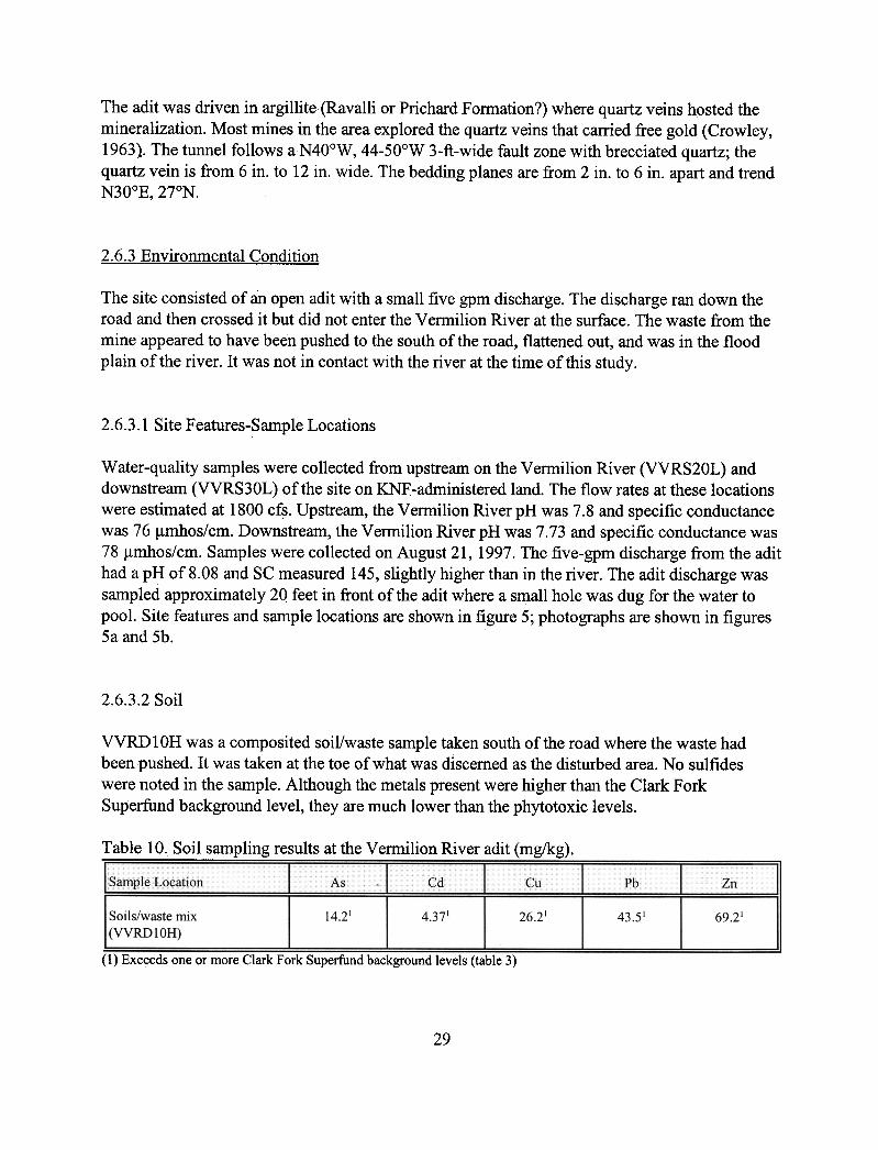
The adit was driven in argillite (Ravalli or Prichard Formation?) where quartz veins hosted themineralization. Most mines in the area explored the quartz veins that carried free gold (Crowley,1963). The tunnel follows aN40oW, 44-50oW 3-ft-wide fault zone with brecciated quartz; thequartz vein is from 6 in. to 12 in. wide. The bedding planes are from 2 in. to 6 in. apart and trendN30OE, 27°N.
2.6.3 Environmental Condition
The
site consisted of an open adit with a small five gpm discharge. The discharge ran down theroad and then crossed it but did not enter the Vermilion River at the surface. The waste from themine appeared to have been pushed to the south of the road, flattened out, and was in the flood
plain of the river. It was not in contact with the river at the time of this study.
2.6.3.1
Site Features-Sample Locations
Water-quality samples were collected from upstream on the Vermilion River (VVRS20L) anddownstream (VVRS30L) of the site on KNF-administered land. The flow rates at these locationswere
estimated at 1800 cfs. Upstream, the Vermilion River pH was 7.8 and specific conductancewas 76 J.lmhos/cm. Downstream, the Vermilion River pH was 7.73 and specific conductance was
78 J.lmhos/cm. Samples were collected on August 21, 1997. The five-gpm discharge from the adithad a pH of8.08 and SC measured 145, slightly higher than in the river. The adit discharge was
sampled approximately 20 feet in front of the adit where a sn;1all hole was dug for the water topool. Site features and sample locations are shown in figure 5; photographs are shown in figures
5a and 5b.
2.6.3.2
Soil
VVRDIOH was a composited soil/waste sample taken south of the road where the waste hadbeen pushed. It was taken at the toe of what was discerned as the disturbed area. No sulfideswere
noted in the sample. Although the metals present were higher than the Clark ForkSuperfund background level, they are much lower than the phytotoxic levels.
:!:able
10, Soi!sampling results at the Vennilion River arlit (mg/kg).
As ~d Cu PbSample Location
Zn14.214.37126.21
43.51Soils/waste mix(VVRD 1 OH)
69.2'
(1) Exceeds one or more Clark Fork Superfund background levels (table 3)
29


Figure 5a. The open and easily accessible Veffililion River adit was driven less than 25 feet northof the improved gravel road paralleling the Veffililion River.
Figure 5b. Sample VVRS 1 OM at the Vermilion River adit was taken from a small pool of waterformed by the five-gpm adit discharge. It was taken on the north side of the road.
31

2.6.3.3
Water
The
concentrations of analytes in the the upstream sample (VVRS 10M) and downstream sample(VVRS30L) did not exceed any water quality standards (table 2). The analyses revealed a slightincrease
in arsenic and nickel levels, but only to 2.5 and 2.8 ~g/L, respectively. The riversamples measured below the detection limits on these metals.
Table
Vennilion River arlit water-quality exceedences.
Sam..pleSite" Ai.".1
As..[BalCd..[Crj.Cu
Fe I Pb I Mn I H gi Ni l A gi Zn I Cl FlNo:-tso"i Si IpH]
WRS20L
-upstreamof site
VVRS30L
-down-stream of site
VVRSIOM -aditdischarge
Note:
The analytical result~are listed in appendix IV.
2.6.3.4 Vegetation
Vegetation on KNF-administered land does not appear to be impacted by the site. No dead ordying vegetation was noted. The cottonwoods and willows growing in the area appeared healthy.
Grasses grew along the discharge channel.
2.6.3.5 Summary of Environmental Conditions
Few or no environmental effects were noted from this adit. The small discharge, at the time of .this study, infiltrated into the ground before it reached the Vermilion River. The difference in theamount of flow between the five-gpm adit discharge and the flow in the Vermilion River at thetime of sampling precluded the probability of a significant impact.
2.6.4 Structures
There were no structures associated with this site. There were the remains of a cabin up the road,but all structures at the site were no longer present.
32

33
2.6.5 Safety
The open adit had a door made of 2"x 4"s and metal shingles and was approximately five feet tall.It was easily scalable or access could be gained from the sides. It provided only minimaldiscouragement to the public. No signs were posted. The adit was highly visible from theVermilion River Road (Forest Road 154).
2.7 Ambassador Mine
2.7.1 Site Location and Access
The Ambassador mine lies approximately four miles by Forest Service Trail 214 from the gatedtrailhead that is six miles from the town of Trout Creek. The road along Trout Creek is ForestRoad 214. The old road has been washed out in several places as it paralleled Granite Creek.Access is by foot only; alders and Devil’s Club grow along the old road. Several large diameterculverts have also been washed out. The mine is located in DDDB section 04, T23N, R32W, at anelevation of 3,740 ft on the Larchwood 7.5-min. quadrangle. The mine lies entirely on KNF-administered land in Sanders County.
2.7.2 Site History-Geologic Features
Placer gold was found at the turn of the century in Trout Creek and on Granite Creek (Lyden,1948), downstream of the Ambassador mine. The lode property was worked since at least 1929;in 1931, a 350-foot adit had been driven and 600 tons of ore stockpiled (Crowley, 1963).Additional work was completed during the years of 1936–1940, 1940's–1956. The portal wascaved when visited by Crowley in the early 1960's. The mine map showed the workings to be1,840 feet in quartzitic argillites and intersecting a mineralized aplite dike (Crowley, 1963). Theworkings also explored an offshoot of the Granite Creek stock–a syenite with disseminated pyrite.Crowley (1963) published production figures from the Ambassador from 1939 to 1941, includinga total tonnage of 93 tons of ore producing 38 ounces of gold, 319 ounces of silver, 613 pounds ofcopper and 3,680 pounds of lead.
Trauerman and Waldron (1940) listed the Ambassador as consisting of 20 unpatented miningclaims. They stated there were plans for a 24-ton mill, but it is unknown if a mill was ever built.No structural remains of a mill were noted in the field visit.
2.7.3 Environmental Condition The adit at the Ambassador discharged a small amount of water, and the waste dump was in theflood plain of Granite Creek. The waste dump had steep sides and was not vegetated on the steep
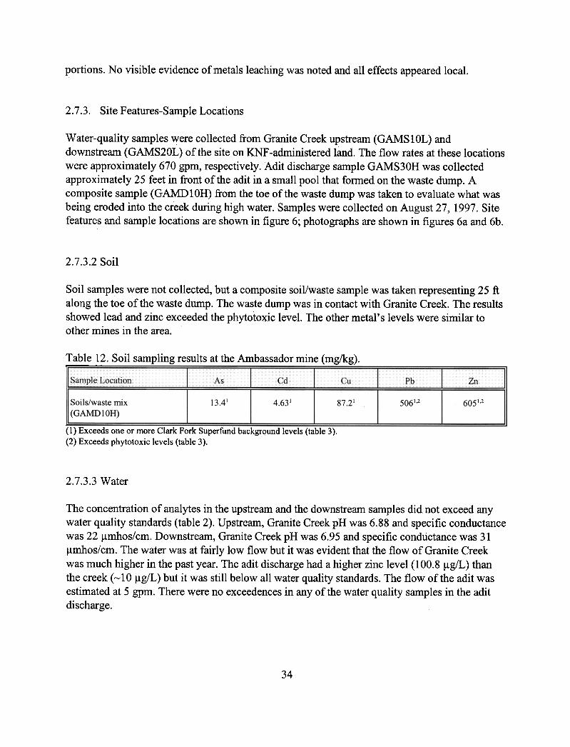
portions.
No visible evidence of metals leaching was noted and all effects appeared local.
2.7.3.
Site Features-Sample Locations
Water-quality samples were collected from Granite Creek upstream (GAMSIOL) anddownstream (GAMS20L) of the site on KNF-administered land. The flow rates at these locationswere approximately 670 gpm, respectively. Adit discharge sample GAMS30H was collectedapproximately 25 feet in front of the adit in a small pool that formed on the waste dump. Acomposite sample (GAMD10H) from the toe of the waste dump was taken to evaluate what wasbeing eroded into the creek during high water. Samples were collected on August 27, 1997. Sitefeatures and sample locations are shown in figure 6; photographs are shown in figures 6a and 6b.
2.7.3.2
Soil
Soil samples were not collected, but a composite soil/waste sample was taken representing 25 ftalong the toe of the waste dump. The waste dump was in contact with Granite Creek. The resultsshowed
lead and zinc exceeded the phytotoxic level. The other metal's levels were similar toother mines in the area.
!able
12. Soil sampling results at the ~bassador mine (mg/kg).
AsCdC'u
-
Pb
ZnSample Location~
13.414.63187.21
5061,2 6051,2Soils/waste mix(GAMDIOH)
(1) Exceeds one or more Clark Fork Superfund background levels (table 3).(2) Exceeds phytotoxic levels (table 3).
2.7.3.3
Water
The
concentration of analytes in the upstream and the downstream samples did not exceed anywater quality standards (table 2). Upstream, Granite Creek pH was 6.88 and specific conductancewas
22 ~rnhos/cm. Downstream, Granite Creek pH was 6.95 and specific conductance was 31~rnhos/cm. The water was at fairly low flow but it was evident that the flow of Granite Creekwas
much higher in the past year. The adit discharge had a higher zinc level (100.8 ~g/L) thanthe creek (~ 1 a ~g/L) but it was still below all water quality standards. The flow of the adit wasestimated at 5 gpm. There were no exceedences in any of the water quality samples in the adit
discharge.
34
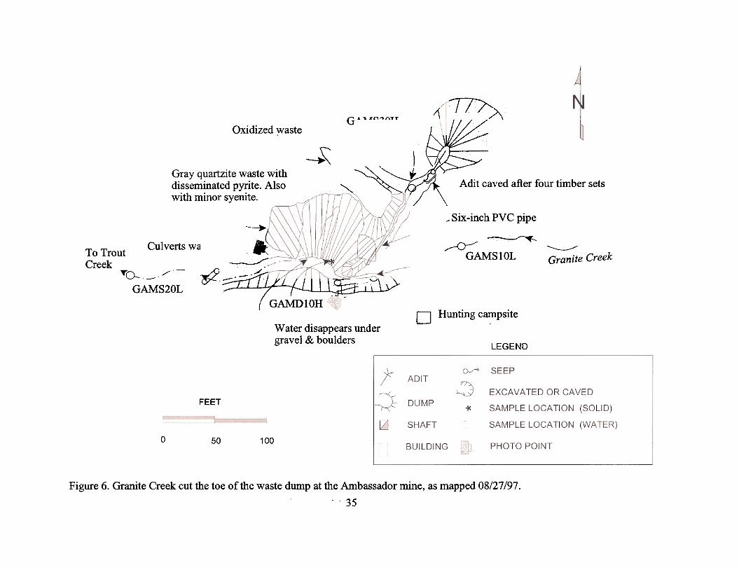
~~
"C:
i:I::'0('f")\/)
~
-<\
Q)
"'r;j~~
,"0Q
)N"0;.<
0
i-::S
otn~
<a) .
-a).tn_a)~
'C-
~ >
-"8a)p-a)-->
-"...
tnN
a)
~
t~o
~
~
~;j o-'S
S
>-a)~
~tn-
~
tn C
-'-.a~
(/J
a.>(/J
~a.>
'S~c,S~~~"0a.>
~u;a<
~
~
~
0)A.
A.
~tl.~g
I
~(/)\
';..
1
~0-as
~~rni;>-
"3u
~
!8~~
Q)
0 ~
~U '<
3-rn~
~
oo!.c~~~\..)
~).~ ~\J
~8-A
/l"- ~
j -.'.\\
~I ~
, 0
\ ~
'~ ~
o~~
G)
f/j
~.C
)
Ol)
=.~=x::
0
~Q)
§00
00 ~
'Cd
Q)
Q):g
p.=g.o00..0-.eo'd~
-Q)
Q)
~
:;.-
::s:~
0zUJ"U
J-J
I-WWLL
0 0I{) aa.-
t'-0\t'-~000"'Ca.>0-
~8~IJ$'~'s;..
~rn~,c~ ~
a.>
.-:S
~~"'Ca.>rncd
~a.>
-:Sc, 0a.>0a.>
-:SEC.)
~a.>;..
Ua.>
.~~\0a.>
~01)
~

Figure
6a. Granite Creek flowed at a low rate when visited in late August but had obviouslyflowed at a greater rate previously.
Figure 6b. Granite Creek (at low flow) has cut the waste dump at the Ambassador, resulting in aneasily erodible face. The partly open adit lies in upper center of the photo.
36

37
Table 13. Ambassador mine water-quality exceedences.
Sample Site Al As Ba Cd Cr Cu Fe Pb Mn Hg Ni Ag Zn Cl F NO3 SO4 Si pH
GAMS10L-upstream ofsite
GAMS20L-downstreamof mine
GAMS0H-aditdischarge
Note: The analytical results are listed in appendix IV.
2.7.3.4 Vegetation
Vegetation on KNF-administered land does not appear to be impacted by the site. Grasses grewalong the discharge channel and the trees were not affected by mining. Knapweed grew on thedisturbed area in front of the adit. The steep face of the waste dump was sparsely vegetatedprobably because of erosion and the unstable nature of the slope.
2.7.3.5 Summary of Environmental Conditions
The Ambassador mine has only a local effect on the environment; primarily, a physicaldisturbance. At the time of the sampling, no exceedences of water-quality standards were noted.The soil and waste sample did exceed the phytotoxic levels for lead and zinc.
2.7.4 Structures
All structures were on the south side of Granite Creek and were collapsed. They consisted of twoflattened cabins. There was an abandoned hunting camp with signs of fairly recent use. A smallamount of trash was strewn through the forest with all but the glass rusting away.
2.7.5 Safety
The adit was open approximately 20 feet back (four timber sets were intact). Granite Creek hadcut the creek bank, resulting in a unstable slope. Culverts were perched in the almost drydrainage; they had been washed out, probably by the spring floods. The site is not easilyaccessible and would only be visited by foot traffic, probably hunters.

2.8 Heidelberg Mine or Price Claims
2.8.1 Site Location and Access
The Heidelberg mine lies eight miles from Noxon along the Rock Creek road. The last two mileshave to be hiked because of the gated road (Forest Road 150A) and the washed-out bridges overRock Creek. Forest Road 150 up to the gate from Highway 200 is in good condition. TheHeidelberg is located Y2-mile south of Rock Lake in section 32, T27N, R31 W with the lower aditon the Elephant Peak 7 oS-min. quadrangle at 4,100 ft elevation and the upper adits on theHoward
Lake 70S-min. quadrangle at an elevation of5,100 ft.
2.8.2 Site History-Geologic Features
In the 1920's, the site originally consisted of 21 unpatented mining claims staked by R.J. PriceMining Company (MBMG mineral property files, 1969); the property has been described as
consisting of as many as 21 claims and as few as 12 claims. The Price Company became theHeidelberg Mining Company in 1936 and began work on the lower crosscut tunnel whose
objective was mineralization east of Rock Lake. Gibson (1948) listed this occurrence as the"Price" with the workings consisting of an open cut at 5,200 ft and a N20oE adit that had beendriven 343 feet as of 1932. These workings probably correspond to the upper Heidelberg area.
The local country rock is the Ravalli Fonnation (Crowley, 1963), mainly quartzites. The majorstructural feature-the Rock Lake fault-is a 6-ft-wide shear zone that cuts the Ravalli and trendsN33°W,
is near vertical, and has a displacement of2,500 ft (Crowley, 1963). Somemineralization is found associated with the fault. Minerals include sphalerite, galena, pyrite, andchalcopyrite in a quartz vein. The total production from the mine was estimated at 28 tons.
2.8.3 Environmental Condition
The adit discharge, while substantial, exhibited no signs of precipitating metals. The dischargeinfiltrated into the dump and a waste dump seep may be the same water. The waste dumpobviously had been eroded by high water flow of Rock Creek. A small amount of miningequipment waste was noted.
2.8.3. Site Features-Sample Locations
Water-quality samples were collected from upgradient (RHES20L) and downgradient(RHES30L) of the site on KNF-administered land. The flow rates at these locations were 1.8 cfs.Upstream, Rock Creek pH was 7.28 and specific conductance was 6 J.lI11hos/cm. Downstream,Rock Creek pH was 7.27 and specific conductance was 10 J.lmhos/cm. The adit discharge was
38

sampled immediately south of the portal; its pH was 7.86 and SC was 32 ~mhos/cm. A wasterock and soil sample composite was taken at the base of the waste dump where it was in contactwith Rock Creek. Samples were collected on September 09, 1997, when Rock Creek was at arelatively low flow. Site features and sample locations are shown in figure 7; photographs areshown in figures 7a and 7b.
2.8.3.2
Soil
One soil sample was collected from the toe of the waste dump where it was in contact with RockCreek. The metals levels are all well below the phytotoxic limits. They are similar to those foundat the Vermilion River adit.
Table 14. Soil sampling results at the Heidelberg mine (mg/kg).
(1) Exceeds one or more Clark Fork Superfund background levels (table 3).
2.8.3.3
Water
The
concentration of analytes in the all of the samples did not exceed any water-quality standards(table 2). Most were at or just above the detection limits. Even the waste dump seep sample did
not appreciably increase in metals. Zinc concentrations edged up slightly in the adit and seepsamples but were well below the water quality standards.
Table
15. Heidelberg mine water-quality exceedences.
Samp.leSite Al .j As.jBajGdlCr.j CutEe
Rb
i Mn l H gi Ni l A g. 1 Znc
C!
F INO,.jso"lsij..pHj
RHES20 -upstream ofarlit
RHES
lOL-aditdischarge
RHES40L-seep fromtoe of waste dump
RHES30
downstreamon Rock Creek
Note:
The analytical results are listed in appendix IV.
39


Figure 7a. As viewed from above, the Heidelberg mine consisted ora discharging adit, remnantmining equipment, and a waste dump that was in contact with Rock Creek.
Figure
7b. The discharge from the Heidelberg infiltrated into the waste dump and discharged atthe toe. The discharge emerges just below the camera case used for scale.
41

42
2.8.3.4 Vegetation
Vegetation on KNF-administered land does not appear to be impacted by the site. Trees andshrubs grew moderately well on the waste dump except, where the slope was overly steep anderoded by Rock Creek.
2.8.3.5 Summary of Environmental Conditions
The Heidelberg mine area reflects the nature of the mineralization of the deposit. Quartzites andquartz veins host the majority of the mineralization. The lower adit reportedly never intersectedthe target and so never opened a sulfide orebody to be susceptible to acid-mine drainage. Theupper workings are dry.
2.8.4 Structures
The buildings to the northeast of Rock Lake Meadows are in good condition but will probablyquickly deteriorate in the future. Pack rats and hikers have started the degradation of the cabins.The large penstock and Pelton wheel at the mine is an attractive structure to hikers and may posea threat to safety.
2.8.5 Safety
The lower adit is open for at least 50 feet and has no timbering. It appeared in good condition butwas slippery with water and inherently dangerous. The upper adits were all caved and were evenmore remote and inaccessible. The large iron penstock, as stated above, posed an attractive targetfor climbing. The area is well used by hikers going to Rock Lake and is easily visible. During thisstudy, several groups used the site as a rest stop and point of interest.
2.9 Pilgrim Mine
2.9.1 Site Location and Access
The Pilgrim (or Holbert) mine may be found with difficulty six miles southwest of Noxon on theGem Peak 7.5-min. quadrangle. Access is by an improved gravel road (Forest Road 149) fromNoxon that follows Pilgrim Creek, then Forest Road 2713, and then by foot from the Trailhead1084 on the South Fork Pilgrim Creek. The trail is not the actual mining road but comes close tothe mine. The mine was found by following the switchback traces of the barely discernablemining road which branches off from the trail. The mine is located in CCDD section 08, T25N,
R33Wat an elevation of approximately 3,600 ft on a drainage identified by Johns (1970) as"Tobin Creek."
2.9.2 Site History-Geologic Features
Johns (1970) is the primary reference for this mine, and the following is a summary of hisfindings. Earliest mining took place in the early 1900's when Princemont Mining Company ofIdaho
claimed the Pilgrim Group of six mining claims. The claims were later (1926) wo~ked bythe Cabinet Range Copper Mining Company. The next mention of the mine was in 1960'when
one adit was accessible but filled with water. The workings consisted of three tunnels: 200, 700,and 2,000 ft long.
The geology of the mine area was described as "thin-bedded, light greenish-grey, slightlycalcareous argillite with some thick beds of brownish-grey quartzite." The formation's strike wasnortheast and its dip was 60oNW. It was described as Newland or Wallace slates. Calcite wasabundant, with minor malachite, azurite, and chalcopyrite in quartz.
2.9.3 Environmental Condition
Vegetation cloaked the caved adit and the dump was surrounded by large coniferous trees. Noevidence of adverse effects was noted. The grasses that had revegetated the waste dump grewrampantly.
As was the case with most of the mines in this area, the effects here were restricted tothe disturbed area.
2.9.3.1
Site Features-Sample Locations
Water-quality samples were collected from upstream (PPIS20L) and downstream (PPIS30L) ofthe site on KNF -administered land. The flow rates at these locations were estimated as 1 cfs.Upstream,
Tobin Creek pH was 7.31 and specific conductance was 64 ~mhos/cm. Downstream,Tobin Creek pH was 7.28 and specific conductance was 51 ~mhos/cm. The adit discharge wasalso sampled (PPISI0L), and its pH was 6.9 and SC was 69 ~mhos/cm. Samples were collectedon August 28, 1997. Site features and sample locations are shown in figure 8; photographs areshown in figure 8a and 8b.
2.9.3.2 Soil
Soil samples were not collected. The waste dump was exclusively large angl;llar fragments andnot prone to erosion.
43


Figure 8a. At the Pilgrim mine, the 20-gpm discharge was practically hidden by the verdantundergrowth. The discharge channel had a slight iron staining.
Figure 8b. A pool of water fonned by the discharge at the Pilgrim mine also had healthyvegetation suriounding it.
45

2.9.3.3 Water
The concentration of analytes in all of the samples did not ~xceed any water quality standards(table 2). There was a slight increase in the concentration of arsenic (5. 7 ~g/L) in the aditdischarge compared to the two creek water samples but it did not exceed any water qualitystandards. The upstream and the downstream samples both had slightly higher (4.4 and 5.1 ~g/L,respectively) zinc concentrations than the adit discharge «2 ~g/L).
Table 16. Pilgrim mine water-quality exceedences.
Sample Site AI I As I Ba.] Cd I Cr I Cu.]Fe PblMn IHglNilAglZQ Cl, FjNO3lso..j Si IpH I
PPIS20L-upstream ofsite
PPIS
1 OL-adit discharge
PPIS30L-downstreamof Pilgrim
Note: The analytical results are listed in appendix IV.
2.9.3.4 Vegetation
Vegetation on KNF-adrninistered land does not appear to be impacted by the site. Both theunderstory vegetation and the trees were healthy. Mosses grew in and around the adit dischargechannel. Wildflowers and grasses grew up to the edge of the small pool of water on the wastedump. The sides of the waste dump were not well vegetated, probably because of the lack of soil.
2.9.3.5
Summary of Environmental Condition
The
discharging adit had no effect on the downstream water quality as sampled by MBMG. Theslightly elevated arsenic level in the adit discharge was not detectable downstream. The smallconcentrations
of zinc in the upstream and downstream samples appeared to be a backgroundlevel for the area.
2.9.4 Structures
No
structures or evidence of any structures remained at the site.
46

2.9.5 Safety
The site was remote and no evidence of any visitors was observed. The site is close to a .
designated Forest Service trail but not on it. The waste dump had steep flanks with loose rocksand may be considered a safety hazard.
2.10 Holliday (Homestead) Mine
2.10.1
Site Location and Access
The Holliday (or Homeste~d) mine lies seven miles west of Noxon, following improved gravelForest Road 149 for five miles and then two miles on Route 2744 to a locked gate. The loweradit lies approximately Yz-mile beyond the gate, to the south of a small clearing. The upper aditcan be found by following the closed road another Yz-mile to the northwest and then to the south.The adits all lie in AADD section 36, T26N, R34W at an elevation of 3,400 and 3,600 ft,
respectively.
2.10.2 Site History-Geologic Features
The mine was named for Mark V. Holliday, of Noxon, who operated the mine in the 1960'sunder the name Silver Mark Mines, Inc. (MBMG mineral property files). Unpatented miningclaims associated with the site include the Harold, Bob, Homestead, Ross, Extension, Cabin, andChristie. Later, the KeIiny claim was worked in 1968 and as late as 1971.
Crowley (1963) was the primary reference for this mine and his description is summarized here.The Pilgrim Creek unorganized mining district contains the Holliday, as well as the Pilgrim,Miller, and White Star mines. The Holliday was first worked in 1939 by the Homestead MiningCompany, then described as developing from 1945 to 1949, and inactive from 1950 to 1956.Holliday Mines, Inc. took over in 1957 and shipped 16 tons of ore in 1961 that yielded 20 ouncesof silver, 2,000 pounds of lead, and 600 pounds of zinc.
Two adits were driven to explore the mineralization here: an upper one (presently caved) and themain lower one (also caved). Crowley (1963) mentioned that a winze sunk in the lower adit wasflooded in 1961. A mine map can be found in Crowley (1963)..
Milky white quartz veins with irregular occurrences of sulfides fill fractures in the WallaceFoffi1ation calcareous argillite. Little wall-rock alteration was noted. Ore minerals were pyrite,sphalerite, chalcopyrite, galena, and marcasite. A N45°W -trending vertical fault was mapped 280feet into the adit, but it did not appear to control the mineralization.
47

2.10.3 Environmental Condition
Two adits at the Holliday had small discharges, and both waste dumps showed evidence ofhaving been in contact with the creek in the past. The lower dump had a steeply eroded face. Theworkings
and the discharges were typical of this area. The effects of the mine were restricted tothe immediate area; no widespread effects were noted. The maximum area of surface disturbancewas approximately 300 ft by 700 ft. Past studies included Pioneer Technical Services' sampling
in 1993 that found the chronic aquatic life standard for lead was exceeded in the lower aditdischarge, and in the upstream and downstream samples.
2.10.3. Site Features-Sample Locations
Water-quality samples were collected from West Fork Pilgrim Creek upstream of all miningdisturbance (PHOS10L) and downgradient (PHOS40L) of the lower adit on KNF-administeredland. The flow rates at these locations were 60 gpm and 673 gpm, respectively. Upstream, WestFork Pilgrim Creek pH was 6.33 and specific conductance was 35 ~mhos/cm. Downstream,West Fork Pilgrim Creek pH was 7.59 and specific conductance was 34 ~mhos/cm. Sampleswere
collected on August 13, 1997. The discharges from the upper adit (PHOS20H) and loweradit (PHOS50L) flowed less than 10 gpm and neither one directly entered the active drainage.Site features and sample locations are shown in figure 9; photographs are shown in figures 9aand 9b.
2.10.3.2 Soil
One soil sample was collected at the toe of the waste dump. The sample probably containedsome waste because the dump was being undercut by the creek.
Table 17. Soil sampling results at the Holliday mine (mg/kg).--
Cd Cu..1
Pb
Sample ~~~~ ~s Zn
Soils/waste mix(PHODIOH)
9.481 4.331
8.71104112.21
(1) Exceeds one or more Clark Fork Superfund background levels (table 3)
2.10.3.3 Water
The concentration of analytes in the upstream and downstream samples (PHOS 1 OL andPHOS50L) did not exceed any water quality standards (table 2). Both analyses of the aditdischarge samples showed 10 times greater zinc levels than those of the stream samples.Strontium also was appreciably higher in the adit discharge samples. All other metals were at or
48


Figure 9a. At the Holliday mine, none of the structures shown in the old mine maps of the lowerworkings remained. Only mine car tracks and a small amount of rusting debris marked the minesite.
Figure 9b. The 8-gpm discharge from the lower adit at the Holliday had little evidence of metalsprecipitating in the channel. Hoses, pipes, and scrap metal marked the collapsed adit.
50

51
below detection limits in all four samples. The laboratory pH measurements of 7.47 and 7.57 forthe lower adit and the upstream sample, respectively, were within water-quality standard limits.The field pH measurements for these two samples were 5.94 and 6.33. The upper adit dischargepH measurements also had a 0.8 discrepancy. It was not determined which measurement wascorrect.
Table 18. Holliday (Homestead) mine water-quality exceedences.
Sample Site Al As Ba Cd Cr Cu Fe Pb Mn Hg Ni Ag Zn Cl F NO3 SO4 Si pH
PHOS10L-upgradientof all mining
S1
PHOS20H-upper aditdischarge
PHOS50L-lower aditdischarge
S1
PHOS40L-downstreamof mining activity
Exceedence codes:(1) Laboratory pH did not exceed standard.Note: The analytical results are listed in appendix IV.
2.10.3.4 Vegetation
Vegetation on KNF-administered land does not appear to be severely impacted by the site.Knapweed grew on the disturbed areas. The support area in front of the lower adit was sparselyvegetated, probably because of the crushed waste rock that armored it.
2.10.3.5 Summary of Environmental Conditions
Only local effects of the mining activity were noted at the Holliday. The area of surfacedisturbance was less than one acre at each adit.
2.10.4 Structures
Structures, including an ore bin, an aluminum compressor house, sheds, and an aluminum house,shown on the mine map by Crowley and Newman (MBMG mineral property files, 1961), were nolonger present at the Holliday.

52
2.10.5 Safety
Rusting debris posed the greatest safety threat here. The waste dumps also were steep but notoverly so. The adits were completely caved, and the lower ones were difficult to locate.
2.11 Brown Hill or Broken Hill Mine
2.11.1 Site Location and Access
The Broken Hill mine is a little over ½-mile southeast of the Blue Creek mine in section 10,T27N R34W at an elevation of 4,240 ft. Access is the same as the Blue Creek mine (Forest Road490), but instead of following 490 to the Blue Creek, bear right on Forest Road 2290 to the gatewhere the remaining two switchbacked miles of road must be hiked. The patented claims hadbeen recently logged, so the road was in good condition.
The mine is labeled as the “Brown Hill” on the Heron 7.5-min. quadrangle, but all of the literatureon the mine’s history lists it as “Broken Hill.” Two patented claims associated with the site arethe Broken Hill and the Bobby; both adits lie on patented land.
2.11.2 Site History-Geologic Features
According to MBMG files, the Broken Hill was mined from 1923 to 1927. Only two adits weredriven to the east on the property with a winze connecting them. Minerals associated with themine include (in order of abundance) galena, sphalerite, pyrite, pyrrhotite, and chalcopyrite(Gibson, 1948). The site was mined in the 1920's by the Broken Hill Silver-Lead Mining Co., andthen the Federal Mining and Smelting Co. then by H.C. Conn (Crowley, 1963). Other ownersincluded Continental Mining Company, W.J. Nichols, and Swann, Swann and Goddard. Bothadits were reported as caved in 1960 (Crowley, 1963). They originally explored a total length ofat least 458 ft.
Similar mineralogy to the Blue Creek mine was found in the Broken Hill and it may be associatedwith the same “Blue Creek” fault. Ore minerals include pyrite, pyrrhotite, sphalerite, galena,chalcopyrite, and arsenopyrite in quartz-tourmaline-tremolite veins (Crowley, 1963).
2.11.3 Environmental Condition No water flowed in the intermittent tributary to the East Fork of Blue Creek at the time of thisstudy. The adit discharge pooled on the waste dump and then infiltrated into the dump. It did notre-emerge at the base. No negative environmental effects were noted besides the physicaldisturbance of the mine.

53
2.11.3.1 Site Features-Sample Locations
Water quality could only be measured in the pooled water on the waste dump (BBHS10H).Samples were collected on September 11, 1997. Site features and sample locations are shown infigure 10; photographs are shown in figures 10a and 10b.
2.11.3.2 Soil
Soil samples were not collected. The waste dump had no sign that the waste was ever in contactwith the active drainage. All effects were confined to the local area. Pioneer Technical Servicesestimates the waste rock dump to be 6,200 cubic yards.
2.11.3.3 Water
The concentrations of analytes in the adit discharge exceeded the water-quality standard for zinconly (table 2). The zinc concentration in the downstream sample exceeded the chronic and acuteaquatic life standards, but the site had no other problems. The discharge was estimated at 20 gpmby MBMG and at 25 gpm by Pioneer Technical Services (1995). Pioneer’s sampling of the aditdischarge found chronic aquatic life criteria exceedences in lead, mercury, and zinc.
Table 19. Broken Hill mine water-quality exceedences.
Sample Site Al As Ba Cd Cr Cu Fe Pb Mn Hg Ni Ag Zn Cl F NO3 SO4 Si pH
BBHS10H-aditdischarge
AC
Exceedence codes:A - Aquatic Life AcuteC - Aquatic Life Chronic
Note: The analytical results are listed in appendix IV.
2.11.3.4 Vegetation
Vegetation on KNF-administered land does not appear to be impacted by the site. The waste-rockdump was only sparsely vegetated with 6 ft–20 ft spruce and fir trees. The trees that were presentwere healthy, as were the trees that grew surrounding the area.
2.11.3.5 Summary of Environmental Conditions
All effects at the Broken Hill were local and confined to the disturbed area. Both adits were onpatented ground. The lower waste dump was on KNF-administered land.

Recentlylogged
90' to creek fromedge of dump
Discharge sinks intodump
BBHS10H
N
0 100 50
FEET
SHAFT
ADIT
DUMP
SEEP
EXCAVATED OR CAVED
SAMPLE LOCATION (SOLID)
SAMPLE LOCATION (WATER)
BUILDING PHOTO POINT
MARSH / WETLANDS
Figure 10. The Broken Hill mine was predominantly patented, but the discharge flowed ontoKNF-administered land.
54

Figure lOa. Water flowed from the caved adit on patented land at the Broken Hill butimmediately pooled on the waste dump on KNF-administered land.
Figure lOb. The Broken Hill waste dump was steep and largely unvegetated with the slopereflecting the steep topography surrounding the site.
55

56
2.11.4 Structures
One ore loadout or ore bin remained at the base of the waste dump. No other structures remainedat the Broken Hill. A few scattered pieces of lumber lay on the waste dump.
2.11.5 Safety
The adits at the site were private and not evaluated for safety. The waste dump was very steep andpoorly vegetated. The site was remote and access was restricted by the locked gate at the bottomof the hill. Hunters were observed in the general area, but no other signs of use were noted.
2.12 Blue Creek or Scotchman Mine
2.12.1 Site Location and Access
The Blue Creek, or Scotchman, mine was found in CC section 03, T27 N R34W on the SawtoothMountain 7.5-min. quadrangle about five miles from Highway 200. Access is via the Blue CreekRoad (Forest Road 409) then one mile later the road splits to the East Fork of Blue Creek (stillroad 409), in another 1.7 miles, bear left on 409 (don’t take 2290). The end of the road is 1.2miles farther where access is by foot through a timber clearcut another 1,000 feet to the mine site.The elevation of the site is approximately 3,200 feet. The south adit is entirely on private,patented land and the north adit is on private land, but the waste dump is on KNF-administeredland.
2.12.2 Site History-Geologic Features
The Blue Creek silver-lead-zinc mine has been known by many names including Stackhouse,North Star, and Scotchman. The deposit may have been worked as early as 1908–1910 byMontana Mining and Milling Company (Crowley, 1963). According to MBMG mineral propertyfiles, the workings totaled 2,500 feet of tunnel, a 40-foot shaft and stopes. Blue Creek Mining wasthe operator of the Stackhouse claims (named after Pearl Stackhouse). Other references list theclaim names Scotchman #6, #6½, #7, Blue Creek #1, #2, and Hillside claims. Lucky Star MiningCompany worked the mine from 1966 to 1970.
The following summary is from an MBMG report in 1967 and from Crowley (1963). The depositwas described as a replacement deposit in a 14-foot-thick shear zone in altered argillite. Galena,sphalerite, pyrite, arsenopyrite, chalcopyrite, sericite, and chlorite were associated with severalinch to two-ft quartz veins. The adit was originally 900 ft long with a 110-ft winze (the winzeand a stope were flooded at the time). The Lucky Star Mining Company was hand tramming and

57
hand sorting the ore and shipping small lots to the Bunker Hill smelter in Idaho (1927). Anotherreport listed the two adits as lower adit 530 feet to caved area, and the upper adit consisting of a400-ft crosscut and about another 520 ft to a caved area. An excellent mine map is found as aplate in Crowley (1963).
Precambrian Ravalli quartzites and argillites hosted the mineralization; minor alteration wasdescribed. The adits explored the Blue Creek fault—a west dipping, NW-striking structure.Crowley (1963) described it as a shear zone with brecciated zones containing ore. Mineralsfound at the Blue Creek include galena, sphalerite, pyrite, and pyrrhotite with calcite and quartzgangue (Gibson, 1948). Lesser amounts of arsenopyrite, marcasite, and chalcopyrite were found.
2.12.3 Environmental Condition
The Blue Creek mine reflected the relatively recent nature of the workings. The upper adit hadan adit discharge, and the waste dump was in contact with Blue Creek. Evidence pointed to thedump actively eroding during high water in the peak runoff times. The discharge from the aditinfiltrated into the waste and a seep emerged adjacent to the creek. Blue Creek exhibited noadverse effects of the mining.
2.12.3.1 Site Features-Sample Locations
Water-quality samples were collected from upstream (BBCS20L) and downstream (BBCS10L)of the site on KNF-administered land. The flow rates at these two locations were approximately2.0 cfs. The 20-gpm adit discharge was sampled (BBCS30L) as it passed onto KNF-administeredland from the patented claim where the open adit was found. The seep at the toe of the wastedump also flowed approximately 20 gpm and was characterized by sample BBCS40L. Sampleswere collected on September 10, 1997. Site features and sample locations are shown in figure 11;photographs are shown in figures 11a and 11b.
2.12.3.2 Soil
One soil/waste sample was collected (BBCD10H). This sample was taken of the waste because itwas in contact with Blue Creek.
Table 20. Soil sampling results at the Blue Creek mine (mg/kg).
Sample Location As Cd Cu Pb Zn
Soils/waste mix (BBCD10H) 1,0001,2 36.61 3071 52741,2 10,9301,2
(1) Exceeds one or more Clark Fork Superfund background levels (table 3).(2) Exceeds phytotoxic levels (table 3).
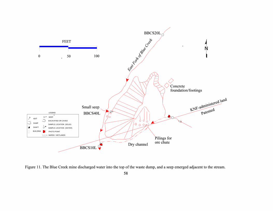
SHAFT
ADIT
DUMP
SEEP
EXCAVATED OR CAVED
SAMPLE LOCATION (SOLID)
SAMPLE LOCATION (WATER)
LEGEND
BUILDING PHOTO POINT
MARSH / WETLANDS

Figure 11 a. The waste dump at the Blue Creek mine would be in contact with the creek duringhigh water flow.
Figure 11 b. The adit at the Blue Creek was open and accessible to the public, but it was onprivate land.
59

60
2.12.3.3 Water
The concentration of analytes in the upstream sample (BBCS20L) did not exceed any waterquality standards (table 2). The downstream sample (BBCS10L) also did not exceed anystandards. The seep at the toe of the waste dump did exceed the chronic aquatic life standard butonly by two to three times the allowed limit. The adit discharge level in zinc did not come nearthe level found at the Broken Hill mine.
Table 21. Blue Creek mine water-quality exceedences.
Sample Site Al As Ba Cd Cr Cu Fe Pb Mn Hg Ni Ag Zn Cl F NO3 SO4 Si pH
BBCS40L-upstream ofnorth adit
BBCS30 -adit discharge
BBCS40 -seep C
BBCS10 -downstreamExceedence codes:
C - Aquatic Life ChronicNote: The analytical results are listed in appendix IV.
2.12.3.4 Vegetation
Vegetation on KNF-administered land does not appear to be impacted by the site. Healthy cedar,spruce and fir trees grew immediately adjacent to the waste dump. The adit and the dischargechannel had lush vegetation growing up to the edge of the disturbance. The steep slopes of thewaste dump were sparsely vegetated.
2.12.3.5 Summary of Environmental Conditions
The Blue Creek mine has an 20-gpm adit discharge, but the water quality was good. Theupstream and downstream samples showed no exceedences. The only standard that wasexceeded was the chronic aquatic life criteria in the small seep flowing from the base of thewaste dump.
2.12.4 Structures
All structures were collapsed except for an ore bin at the south adit. The ore chute and binsdepicted on Crowley’s (1963) map are totally collapsed with only the pilings remaining. Theremains of one cabin and a “Worthington” compressor was found at the south adit, but thesewere on private land.

61
2.12.5 Safety
The south adit was caved at the portal but did have a steep slope above it. The open adit at theBlue Creek mine was on private land so it was not evaluated. The waste dump was steep andunstable, especially at high water. Table 22. Summary of sites in the upper Kootenai drainage. Sites in bold were sampled.
NAME VISIT OWNER SAMPLE HAZARD REMARKS
Fortine Ranger DistrictBluebird - See Also Green Mountain Y M N NE Shallow workings and old cabin noted. Also D. Nesbitt; KNF states same.
Bonnett-Hoerner N M N NE Screened out: barite; at south end of Lost Lake.
Gilbralter Ridge Mine Y N N Y Small opening beyond caved portal.
Green Mountain Y N N NE Only dry; shallow workings noted.
Hansen Prospect / Little Princess? Y N N Y Nesbitt (KNF) open adit approx. 45 ft, no environmental problems.
Independence Y N Y Y Shallow workings; also one adit approx 30 feet deep -D. Nesbitt; KNF.
Limestone Occurrence N P N NE Screened out: limestone occurrence.
Moen N N N NE Unable to locate; visited general area; trench only as described in Johns, 1970; p. 152.
Nancy Jane Claims Y N Y Y One small seep.
Peterson (Twin Peaks) Blacktail Y N Y NE Nesbitt (KNF): adits filled with water and collapsing.
Rex Mine / Jager Mine Y N N Y Opening to mine has caved in leaving an opening into the tunneled mine shaft. D.Nesbitt- KNF.
Rock Lake Adits Y N Y NE One collapsed adit with a 1-gpm discharge.
Schmitz Mine / Joshua Adit Y N N Y The mine shaft is completely caved in and you have to look for the old adit to find it.
Swansea Rosa Lode Claim Y N N NE No comments on field form.
Tetrault N N N NE Visited general area; unable to locate. Johns (1961) reports a 25-ft adit in basalt atbase of cliff.
Tobacco River Placer N P N NE Screened out: placer also plots on private land.
Twin Peaks Prospect N N N NE Screened out: general location in secs. 6; 13; 14. Commodity is Cu; accuracy is +/-1km.
Unnamed Barium N M N NE Screened out: barium.
Unnamed Barium N N N NE Screened out: barite prospect; no references in MILS; accuracy +/-1 km.
Libby Ranger DistrictAda Prospect N M N NE Screened out: no workings noted in Pardee and Larsen 1929. Prospect only.
American Kootenai Y M N Y One open adit with trash on land of mixed ownership; 2 prospects.
Bear Creek Portal Y N N NE Visited general area, could find no evidence of workings.
Bee and Zee N N N NE May be in Cabinet Mountains wilderness; screened out; no workings.
Betty Mae N N N NE Screened out: inaccurate location; no access and reference says shallow.
Big Chance Placer N P N NE Screened out: only reference to this placer is MSHA report from 1981.
Big Cherry Creek Placer N N N NE Screened out: placer; literature states that it wasn't worked since 1939.
Big Eight Placer N P N NE Screened out: placer; no record of production; mostly; if not all; private.

NAME VISIT OWNER SAMPLE HAZARD REMARKS
62
Big Sky / Montana Silver-Lead Y N N NE One caved adit found downhill from trail. Other 1200' adit could not be located.
Bolyard Placer/Vaughan& Greenwell N M N NE Screened out: placer.
Bonus Claim N N N NE Screened out: no access; no references in MILS; lead; copper occurrence.
Boulder Hill (Hope & Boulder Hill) N M N NE Screened out: unable to locate.
Bramlet Creek Mill Y M Y NE Tailings reported along creek.
Branagan / Brannigan / Fisher Creek Y P N Y Mostly private; no tailings noted-may have been washed away.
Cableway Group N N N NE Screened out: only one reference in literature; inaccurate location.
Cherry Creek Mill Site Y N Y Y Streamside tailings.
Comet Placer N M N NE Screened out: placer; probably mostly private.
Copper Mountain N M N NE Screened out: private?; no references except a mineral property file; accuracy of +/-1 km.
Copper-iron Occurrence N M N NE Screened out: no references in MILS data base.; inaccurate location.; unnamedoccurrence.
Copper-silver-iron Occurrence N M N NE Screened out: occurrence only; no references; private?; accuracy +/-1 km.
Copper Reward / Walker Group Y N Y NE One adit with small discharge flow. Never reaches creek.
Cow Creek N M N NE Screened out: placer; may be private; no references in MILS.
Crater N M N NE Screened out: inaccurate location, 100' adit only (in 1948).
Cu-Pb-Fe-Mn Occurrence N M N NE Screened out: inaccurate location (+/-1 km). Unnamed occurrence. No references inMILS.
D. & W. Group N M N NE Visited general area; no workings noted; access through private land.
Darling Placer N N N NE Screened out: placer; workings only pits and trenches.
Denver No. 1 & 2 N N N NE Unable to locate. No description in literature.
Diamond John N M N NE Ownership unknown; patented claims in area.; part of Montanore project? ; screenedout.
Dome Mine N N N NE Screened out.
Double Mac Y N N NE Collapsed adit bearing N37EW; dry; next to road.
Fairbault N N N NE Unable to locate. No signs of workings south of Cherry Creek. Unlikely to influence.
Fisher River Property N M N NE Screened out: placer; accuracy +/-1 km.
Fisher River Quarry N P N NE Screened out: quarry; no references; commodity listed as gold/silver.
Ford Placer N M N NE Screened out: placer; but visited Midas and general area; no effects to KNF land.
Fourth of July N M N NE Small mill on Fourth of July Creek burned in 1909; workings on private ground.
Getner Placer N P N NE Screened out: placer; on private land.
Golden Bear N N N NE Screened out: open cuts only (Gibson, 1948).
Golden West' Mine, "New" Mine Y N N Y Three open adits; one caved. Seasonal discharge but dry when visited.
Gold Hill Group, Gold Hill Claims N M N NE Screened out: Gold Hill group is same as Viking Mine.
Glacier Ag-Pb/Hazel T./Lukens Y P N NE Private: sampled downstream on adjacent to road.
Gloria Y N Y Y Three openings; small waste dump in flood plain.
Granite Concrete Pit and Plant N P N NE Screened out: concrete plant; non-metallic.
Granite Creek/Mountain Rose Y N N Y Open adit.
Grizzly / Missouri Group N N N NE Unable to locate; drove road up Leigh Creek but couldn't spot mine workings. Burnarea.
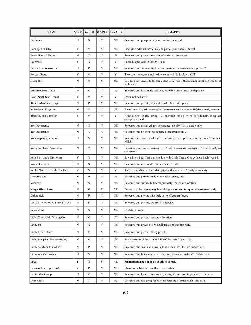
NAME VISIT OWNER SAMPLE HAZARD REMARKS
63
Halfmoon N N N NE Screened out: prospect only, no production noted.
Hannegan / Libby Y M N NE Five short adits all caved; may be partially on national forest.
Harry Howard Placer N N N NE Screened out: placer; only one reference to occurrence.
Hathaway Y N N Y Partially open adit; 2 feet by 3 feet.
Heintz R a Construction N P N NE Screened out: commodity listed as quartzite dimension stone; private?
Herbert Group Y M N Y Two open holes; one inclined; one vertical (B. Lacklen; KNF).
Horse Hill N M N NE Screened out: unable to locate; (Johns 1962) wrote that a winze in the adit was filledwith water.
Howard Creek Claim N M N NE Screened out: inaccurate location; probably placer; may be duplicate.
Hoyt (North Star Group) Y M N Y Open inclined shaft.
Illinois-Montana Group N P N NE Screened out: private, 2 patented lode claims & 1 placer.
Indian Head Tungsten N N N NE Bannister et al. (1981) states that there are no workings here. WO3 and moly prospect.
Irish Boy and Rambler Y M N Y Adits almost totally caved - 2' opening; little sign of adits remain, except anovergrown road.
Iron Occurrence N N N NE Screened out: unnamed iron occurrence; no site visit; outcrop only.
Iron Occurrence N N N NE Screened out: no workings reported; occurrence only.
Iron-copper Occurrence N N N NE Screened out: inaccurate location; unnamed iron-copper occurrence; no references inMILS.
Iron-phosphate Occurrence N M N NE Screened out: no references in MILS; inaccurate location (+/-1 km); only anoccurrence.
John Bull-Uncle Sam Mine Y N N NE 250' adit on Bear Creek at junction with Cable Creek. One collapsed adit located.
Joseph Prospect N N N NE Screened out: inaccurate location; also private.
Jumbo Mine (Formerly Tip Top) Y N N Y Three open adits; all locked & gated with chainlink. 2 partly open adits.
Kenelty Mine N P N NE Screened out: private land, Plum Creek timber, inc.
Kennedy N N N NE Screened out: surface bulldozer cuts only; inaccurate location.
King / Silver Butte N M Y NE Drove to private property boundary: no access. Sampled downstream only.
Kirkpatrick N P N NE Screened out: private with little or no effects on forest.
Last Chance Group / Poston Group N P N NE Screened out: private; vermiculite deposit.
Leigh Creek N N N NE Unable to locate.
Libby Creek Gold Mining Co. N M N NE Screened out: placer; inaccurate location.
Libby Pit N N N NE Screened out: gravel pit; MILS listed as processing plant.
Libby Creek Placer N M N NE Screened out: placer; mostly private.
Libby Prospect (See Hannegan) Y M N NE See Hannegan (Johns; 1970; MBMG Bulletin 79; p. 108).
Libby Sand and Gravel Pit N P N NE Screened out: sand and gravel pit; non-metallic; plots on private land.
Limestone Occurrence N N N NE Screened out: limestone occurrence; no references in the MILS data base.
Loyal Y N Y NE Small discharge ponds up south of portal.
Lukens-Hazel Upper Adits Y P N NE Plum Creek land; at least three caved adits.
Lucky Mac Group N M N NE Screened out: location inaccurate; no significant workings noted in literature.
Lynx Creek N N N NE Screened out: talc prospect only; no references in the MILS data base.
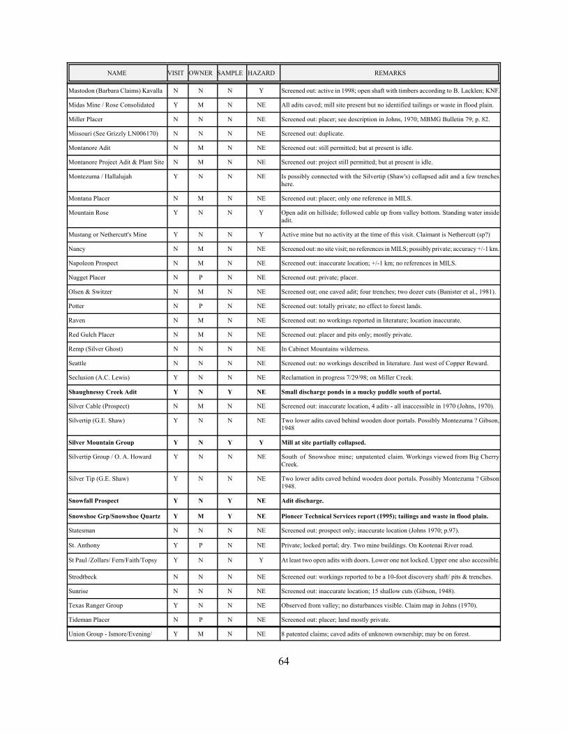
NAME VISIT OWNER SAMPLE HAZARD REMARKS
64
Mastodon (Barbara Claims) Kavalla N N N Y Screened out: active in 1998; open shaft with timbers according to B. Lacklen; KNF.
Midas Mine / Rose Consolidated Y M N NE All adits caved; mill site present but no identified tailings or waste in flood plain.
Miller Placer N N N NE Screened out: placer; see description in Johns, 1970; MBMG Bulletin 79; p. 82.
Missouri (See Grizzly LN006170) N N N NE Screened out: duplicate.
Montanore Adit N M N NE Screened out: still permitted; but at present is idle.
Montanore Project Adit & Plant Site N M N NE Screened out: project still permitted; but at present is idle.
Montezuma / Hallalujah Y N N NE Is possibly connected with the Silvertip (Shaw's) collapsed adit and a few trencheshere.
Montana Placer N M N NE Screened out: placer; only one reference in MILS.
Mountain Rose Y N N Y Open adit on hillside; followed cable up from valley bottom. Standing water insideadit.
Mustang or Nethercutt's Mine Y N N Y Active mine but no activity at the time of this visit. Claimant is Nethercutt (sp?)
Nancy N M N NE Screened out: no site visit; no references in MILS; possibly private; accuracy +/-1 km.
Napoleon Prospect N M N NE Screened out: inaccurate location; +/-1 km; no references in MILS.
Nugget Placer N P N NE Screened out: private; placer.
Olsen & Switzer N M N NE Screened out; one caved adit; four trenches; two dozer cuts (Banister et al., 1981).
Potter N P N NE Screened out: totally private; no effect to forest lands.
Raven N M N NE Screened out: no workings reported in literature; location inaccurate.
Red Gulch Placer N M N NE Screened out: placer and pits only; mostly private.
Remp (Silver Ghost) N N N NE In Cabinet Mountains wilderness.
Seattle N N N NE Screened out: no workings described in literature. Just west of Copper Reward.
Seclusion (A.C. Lewis) Y N N NE Reclamation in progress 7/29/98; on Miller Creek.
Shaughnessy Creek Adit Y N Y NE Small discharge ponds in a mucky puddle south of portal.
Silver Cable (Prospect) N M N NE Screened out: inaccurate location, 4 adits - all inaccessible in 1970 (Johns, 1970).
Silvertip (G.E. Shaw) Y N N NE Two lower adits caved behind wooden door portals. Possibly Montezuma ? Gibson,1948
Silver Mountain Group Y N Y Y Mill at site partially collapsed.
Silvertip Group / O. A. Howard Y N N NE South of Snowshoe mine; unpatented claim. Workings viewed from Big CherryCreek.
Silver Tip (G.E. Shaw) Y N N NE Two lower adits caved behind wooden door portals. Possibly Montezuma ? Gibson1948.
Snowfall Prospect Y N Y NE Adit discharge.
Snowshoe Grp/Snowshoe Quartz Y M Y NE Pioneer Technical Services report (1995); tailings and waste in flood plain.
Statesman N N N NE Screened out: prospect only; inaccurate location (Johns 1970; p.97).
St. Anthony Y P N NE Private; locked portal; dry. Two mine buildings. On Kootenai River road.
St Paul /Zollars/ Fern/Faith/Topsy Y N N Y At least two open adits with doors. Lower one not locked. Upper one also accessible.
Strodtbeck N N N NE Screened out: workings reported to be a 10-foot discovery shaft/ pits & trenches.
Sunrise N N N NE Screened out: inaccurate location; 15 shallow cuts (Gibson, 1948).
Texas Ranger Group Y N N NE Observed from valley; no disturbances visible. Claim map in Johns (1970).
Tideman Placer N P N NE Screened out: placer; land mostly private.
Union Group - Ismore/Evening/ Y M N NE 8 patented claims; caved adits of unknown ownership; may be on forest.

NAME VISIT OWNER SAMPLE HAZARD REMARKS
65
Unnamed Aluminum N N N NE Screened out: unnamed aluminum deposit.
Unnamed Asbestos N P N NE Screened out: private; part of the Vermiculite Mountain property.
Unnamed Barite N P N NE Screened out: no references in MILS, private.
Unnamed Calcite N M N NE Screened out: commodity calcium; no references in MILS; inaccurate location.
Unnamed Chlorite & Sericite N N N NE Screened out: mica deposit; unnamed occurrence.
Unnamed Copper, Lead & Silver N M N NE Screened out: inaccurate location; no references in MILS.
Unnamed Copper N M N NE Screened out: no references in MILS; accuracy of +/-1 km; occurrence only.
Unnamed Copper N P N NE Screened out: private; prospect only (6-ft pit); inaccurate location.
Unnamed Copper N M N NE Screened out: no references in MILS; unnamed occurrence; inaccurate location.
Unnamed Copper N N N NE Screened out: prospect only; flooded by Libby dam (?)
Unnamed Feldspar & Mica N M N NE Screened out: inaccurate location; in secs. 16;21;22;27 & 28 according to MILS.
Unnamed Gold N P N NE Screened out: no references in MILS; private.
Unnamed Gold N M N NE Screened out: no references in MILS; inaccurate location; unknown ownership.
Unnamed Gold & Silver N P N NE Screened out:
Unnamed Gold & Silver N P N NE Screened out: no references in MILS data base; unnamed deposit.
Unnamed Gold & Silver N P N NE Screened out: inaccurate location; no references in MILS; and probably private.
Unnamed Gold & Silver N N N NE Screened out: no references in MILS; unnamed deposit; +/-1 km accuracy.
Unnamed Limestone N M N NE Screened out: limestone occurrence.
Unnamed Lead & Zinc N N N NE Screened out: no references in MILS; accuracy of +/-1 km; unnamed deposit.
Unnamed Quartz N M N NE Screened out: in the office; qtz crystal prospect according to MILS; no otherreferences.
Unnamed Silver, Lead & Copper N M N NE Screened out: inaccurate location; no references in MILS; may be private?
Universal Zonolite Corp. Property N P N NE Screened out: private; same as Vermiculite Mountain mine; LN006190.
Vermiculite Mountain Mine Y M Y NE Sampled upstream and downstream of private land.
Victor-Empire Y N Y Y Discharge sinks into waste dump, one open adit.
Viking Mine / Gold Hill Claims Y N Y Y Adit discharge.
Waylett North Prospects Y N N NE Walked down to these prospects; one fairly steep highwall; rest are trenches.
Waylett Group / Moose Hill / Royal Y N N NE Unable to locate; walked general area where mine was plotted on topo; but could notfind.
Wayup Mine / Way up Y P N NE All disturbances private; four open adits w/ discharges.
Williams Y N N NE Visited trenches on top of ridge; did not find adits. Reportedly G. Shaw had an openportal.
Wolf Creek Placer N P N NE Screened out: mostly; if not all; private. Placer.
Wollastonite Veins N N N NE Screened out: commodity silicon; no workings present.
Zonolite Mine N M N NE Screened out: accuracy +/-5 km; non-metallic Vermiculite mine.
Rexford Ranger District
Big Creek Y N N Y One open adit with seep only; did not sample.
Big Creek Extension N N N NE Visited general area; location inaccurate; unlikely to affect forest.
Copeland N N N NE Screened out: placer and prospect; adit was 40 to 60 feet long and caved in 1961.

NAME VISIT OWNER SAMPLE HAZARD REMARKS
66
Iron Occurrence N N N NE Screened out: no references in MILS; accuracy of +/-1 km.
Kenelty N N N NE Screened out: roadcut with veins only (Johns, 1961).
Kootenai River Placer N N N NE Screened out: placer; flooded by reservoir.
Mc Guire Prospect N N N NE Screened out: no references in MILS; only an Ag; Cu; Pb prospect.
Stonehill Placer N N N NE Screened out: placer; last worked in the 1930's. May be private? Although maps showit as forest.
Unnamed Copper Y N N NE Two prospect pits and two trenches.
Unnamed Galena N P N NE Screened out: galena discovered in a well on the Jim Meeker ranch (Johns, 1961) noworkings.
Unnamed Galena, Cu & Silver N N N NE Screened out: sample taken from skid trail.
Unnamed Silver, Gold & Copper N N N NE Screened out: no references in MILS; accuracy of +/-1 km.
Valley View Claim/ J.B. Claim N N N NE Screened out: +/-1 km accuracy; no references in mils; lead-zinc prospect.
Three Rivers RangerDistrict
American Eagle Y N N NE No effects, one 200' adit, caved, hearty vegetation.
Asarco Tailings Pond N P N NE Screened out: private; current operating permit.
Barite Prospect N M N NE Screened out: barite - mislocated.
Bear N S N NE Screened out: dry ridgetop; state land.
Big Eight Y P N NE See Snowshoe claim for upstream / downstream water sample.
Big Four N M N NE Unable to locate.
Bimetallic / Black Horse N M N NE Screened out: ridgetop location (dry); unknown ownership.
Black Diamond Y M N NE Literature said glory hole; and four adits but unable to locate except for one adit.
Blacktail N M N NE Unknown ownership; unable to locate.
Cabinet N M N NE Unknown ownership; unable to locate.
Cabinet Queen Prospect Y P N NE No disturbance visible.
Callahan Creek Placer N M N NE Screened out: placer mine; unknown ownership.
China Creek N N N NE Screened out: placer; inaccurate location; no references in MILS.
Christmas Tree Mine N S N NE Screened out: on dry ridgetop - state land.
Condor Mining & Leasing N N N NE Screened out: placer.
Copper Mountain Mine N P N NE Screened out: private; no effect; barite.
Crescent Tunnel Y M N NE Unable to locate this; it is mislocated; visited area.
Daniel Lee / Daniel Lee Vein N N N NE Screened out: prospect only; location from Hayes; 1984. Part of Troy mine project.
Duplex / Sugar Queen N N N NE Screened out: inaccurate location 1 or 2 adits; partly collapsed in 1959, Dahlem, 1959.
Fairway Creek Prospect N N N NE Screened out: prospect only; from Hayes (1984).
Ferrel N N N NE Unable to locate; inaccurate location. Literature says west of Yaak road but S-T-R iseast.
Giant Sunrise / Montana Sunrise Y N Y Y Waste in floodplain, flooded adit.
Goat Creek Adit Y N Y NE Small waste dump in contact with creek.
Gold Flint-Key Stone N M N NE Screened out: disturbances on patented land. Also in section 17. See also MorningGlory mine.

NAME VISIT OWNER SAMPLE HAZARD REMARKS
67
Great Northern Property N M N NE Unable to locate.
Grouse Creek Y N N Y One open adit, standing water inside, no flow.
Grouse Mountain Y P Y NE Adit discharge.
Hiawatha Y P N NE Covered by talus.
Iron Mask Y M Y NE Adit discharge. Open adits on private.
JF Prospect N N N NE Screened out: prospect only; reference from Hayes (1984).
John Francis Claims N N N NE Screened out: no site visit; no references in MILS.
Keeler Mountain N M N NE Unable to locate; unknown ownership.
Kotschevar Barite N N N NE Screened out: barite mine - no visit.
Last Chance Y N N NE Caved adit, dry.
Liberty Metals N P N NE Screened out: private with no effect on KNF-administered land.
Limestone Occurrence N P N NE Screened out: limestone occurrence; private.
Little Spokane N M N NE Screened in office: dry ridgetop - part of Grouse Mountain property.
Lost Cause Mine Y M N NE Visited general area, may have been caved shaft.
Milton Group N P N NE Screened out: private with no effect on KNF-administered land.
Montana Morning N N N NE Screened out: active.
Montana Premier Mine N P N NE Screened out: barite mine - operating permit.
New Morning Glory/Haywire Mining Y M N Y Water standing in the adit and small shaft with standing water. Water not accessibleto sample.
Oro-Highland / Highland Silver N N N NE Screened out: location inaccurate; two adits; references Johns, 1970 and Young et al.,1962.
Rankin N M N NE Screened out: prospect only.
Second Chance / McGuire Property N N N NE Screened out: inaccurate location, p. 119, Johns (1970). 600' adit, 40' adit & a pit.
Silver Grouse Y N N Y Open adit. Dump has been eroded away by creek. One cabin good condition.
Silver King Y N N NE Caved and dry adits with vegetated dumps.
Silver Strike Y M N NE Part of Grouse Mountain mine.
Snipetown Placer N N N NE Screened out: placer; on Yaak river. See Dahlem, 1959 for reference.
Snowstorm / B. and B. Y P Y Y Tailings and waste mostly washed away by floods.
Spar Lake / Spar Lake Copper N N N NE Screened out: surface prospect only (Johns; 1970).
Sunrise Mill Y P Y NE Sampled downstream on KNF-administered land.
Sylvanite Mill / Keystone Group Y M N NE Mixed ownership; mill could be a hazardous structure. No tailings noted infloodplain.
Trio N N N NE Screened out: inaccurate location; no access.
Troy Proj - Man-way & ConveyorAdit
N M N Y Screened out: Spar Lake still considered active (under care and maintenance) 1997.
Troy Proj. - North Adits N M N Y Screened out: part of Troy mine / Spar Lake project; still under care & maintenance.
Troy Proj. - South Adit N M N Y Screened out: part of Troy / Spar Lake project. Still active (care & maintenance;1997).
Troy Project/ Spar Lake N M N NE Screened out: Troy mine surface plant & offices (Hayes, 1984).
Unnamed Clay N N N NE Screened out: unnamed clay deposit; little or no impact.
Unnamed Talc N N N NE Screened out: unnamed talc occurrence; bulldozer cut only.

I) Mines in bold may pose environmental problems and are discussed in the text; others are included only in appendix II (all mines) andappendix III (short write-ups for each site).
2) Administration/Ownership DesignationN: KNF-administered landP: PrivateM: Mixed (KNF-administered land and private)S: State of MontanaU: Owner unknown
3) Solid and/or water samples (including leach samples).4) Y: Physical and/or chemical safety hazards exist at the site.NE: Physical and chemical safety hazards were not evaluated.
5) Mill site present.
2.13 Rock Lake Adit
2.13.1
Site Location and Access
The Rock Lake adit is located on the south end of Rock Lake in the Tobacco River drainage. It isin DBCB section 06 T35N, R26W on the Eureka South 7.5-min. quadrangle at an elevation of2,950 ft. The adit is approximately 150 ft southeast of Forest Road 3688 as it splits from ForestRoad 3683, which leads to Lost Lake and Timber Lake. An inconspicuous two-track road lead tothe adit to the southeast.
2.13.2 Site History-Geologic Features
No
references to the Rock Lake adits were noted in literature. It may be the same as the Bonnett-Homer that was listed in the same section by Johns (1961, plate 1). It was worked in 1958. Thedescription doesn't quite match in that the adit that this study looked at was not in Purcell basaltbut rather in a buff to tan argillite (Precambrian Piegan Group ?). The geologic map (Johns,1961) shows a NE-trending fault cutting through this area with Piegan Group to the west andMissoula Group to the east with Purcell basalt between the two.
The adit trends S54°E. There was an open cut uphill and to the south of the adit. The Bonnett-Homer as described in Johns wa~ a barite prospect.
2.13.3 Environmental Condition
This
was a small disturbed area but is very close to Eureka and the recreational area near the
68

It,
surrounding lakes. The discharge has a small flow, and the flow never reaches the active drainage I
or the lake via the surface. The commodity was probably barite.
2:13.3.1 Site Features-Sample Locations
A water-quality sample was collected from the adit discharge (RRLS10L) on KNF-administeredland. The flow rate at this location was less than one gpm. The sample was collected onSeptember 29, 1998. Site features and sample locations are shown in figure 12; photographs areshown in figures 12a and 12b.
2.13.3.2 Soil
No soil samples were collected. No evidence of any solids contributing metals to the surroundingarea was noted.
2.13.3.3 Water
The concentration of analytes in the adit discharge sample (RRLSIOH) did not exceed any water-quality standards (table 2). The pH was 7.76 and the SC was 441 ~hos/cm. No evidence ofmetals precipitation was noted.
Table 23. Rock Lake adit water-quality exceedences.
Sample Site A}..As Ba Cd er Cu Fe Pb Mn Hg Ni Ag Zn Cl F N03 S04 Si pH
RRLSIOH-adit
discharge
Note: The analytical results are listed in appendix IV.
2.13.3.4 Vegetation .
Vegetation on KNF-administered land does not appear to be impacted by the site. Grasses grewin the adit-di~charge channel. The adit had grasses and shrubs growing adjacent to the portal.
2.13.3.5 Summary of Environmental Conditions
This is a small site and had few or no signs of any environmental degradation caused by previousmining activities.
69


Figure 12b. The small rate flow at Rock Lake was measured as it flowed from the adit and wascaptured by a short piece ofPVC pipe.
71

72
2.13.4 Structures
One cabin in good condition was made of 2" by 3" lumber. It appeared as if it was recently built.The roof was still on it.
2.13.5 Safety
The site had a small crawl space into the old workings but was almost completely caved. Therewas a 10-ft highwall at the portal that was downhill from the upper road leading to an open cut.
2.14 Nancy Jane and Twin Peaks Mines
2.14.1 Site Location and Access
The Nancy Jane and Twin Peaks mines are located in the Ten Lakes scenic area on the KsankaPeak 7.5-min. quadrangle. The Nancy Jane is in DBBC section 14, T37N, R26W at 6,660 ftelevation and the Twin Peaks mine is in DDDA sec. 14, T37N, R26W, at an elevation of 7,060ft. They both are in an intermittent drainage flowing northwest to Blacktail Creek. The TwinPeaks mine is labeled as such on the topographic map but is also known as the Peterson property(Johns, 1961). Whipple et al. (1983) listed alternate names of the Twin Peaks mine as the RedBird, Midnight, and Copper Kettle (formerly patented claims) and the Eureka (unpatented). TheNancy Jane’s name was found on a location notice at the site. The sites are now entirely onKNF-administered land.
2.14.2 Site History-Geologic Features
The Twin Peaks mine was located in 1900 by Gus Peterson (Johns, 1961) as a copper prospect. Itwas explored by a 30-foot shaft, a 220-foot upper adit, a 300-foot to 400-foot center adit, and a300-foot lower adit. Ore minerals included primarily chalcopyrite, malachite, hematite, barite,and calcite (Johns, 1961). The primary focus of exploration was on the copper-bearing Purcelllava veins that contain quartz-barite-siderite (Whipple and others, 1983). No production wasnoted from this property. The mines were in the Purcell basalt (lava). Whipple and others (1983)stated that the British Columbia Copper Company evaluated the area in 1912 but had lost interestin the area by 1920.
2.14.3 Environmental Condition These mines appeared to be a fairly significant mining area from the number of mine symbols onthe map. Most disturbances were small, isolated workings. The Purcell lava hosted most of thedeposits and most had minor sulfide occurrences.
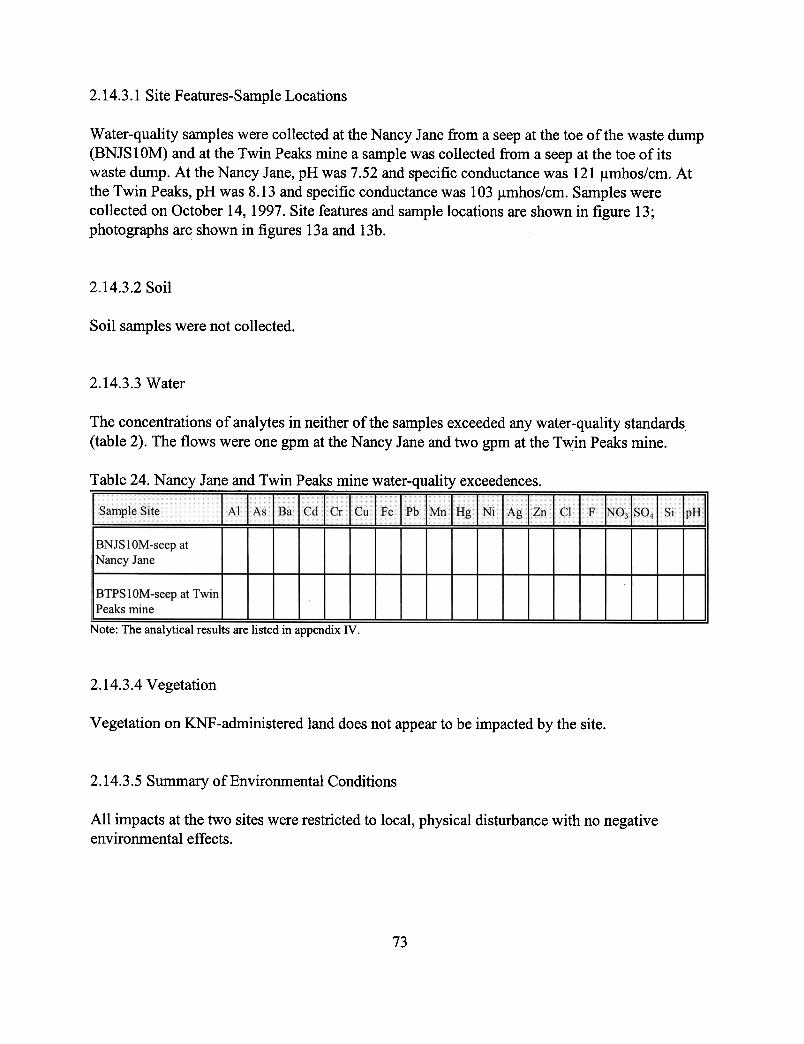
2.14.3.1
Site Features-Sample Locations
Water-quality samples were collected at the Nancy Jane from a seep at the toe of the waste dump(BNJS 10M) and at the Twin Peaks mine a sample was collected from a seep at the toe of itswaste dump. At the Nancy Jane, pH was 7.52 and specific conductance was 121 ~mhos/cm. Atthe Twin Peaks, pH was 8.13 and specific conductance was 103 ~mhos/cm. Samples werecollected on October 14, 1997. Site features and sample locations are shown in figure 13;photographs are shown in figures 13a and 13b.
2.14.3.2
Soil
Soil samples were not collected.
2.14.3.3
Water
The
concentrations of analytes in neither of the samples exceeded any water-quality standards(table 2). The flows were one gpm at the Nancy Jane and two gpm at the Twin Peaks mine.
Table 24. Nancy Jane and Twin Peaks mine water-q~!~~xceedences.
SampJe Site Al As~ Bil l Cd~Cr.lCu~Fec, ,,' "
Ph
i Mnl Hg i Ni l A gi Zn, 01 F INO31S041 Si jpH..!
BNJSIOM-seep atNancy Jane
BTPSIOM-seep at TwinIPeaks mine
Note:
The analytical results are listed in appendix IV.
2.14.3.4 Vegetation
Vegetation on KNF -administered land does not appear to be impacted by the site.
2.14.3.5 Summary ofEnvironmenta1 Conditions
All impacts at the two sites were restricted to local, physical disturbance with no negativeenvironmental effects.
73


Figure 14a. The Nancy Jane mine had a small seep to the right of the photo.
Figure
14b. The Twin Peaks mine showed no adverse effects and was largely naturallyreclaimed.
76

77
2.14.4 Structures
One collapsed cabin was found at the Nancy Jane, but no structures were found at the TwinPeaks mine.
2.14.5 Safety
The sites had no safety concerns.
2.15 Independence Mine
2.15.1 Site Location and Access
To reach this site from Eureka, travel north on Highway 93, 3.2 miles to Forest Route 1001 thenapproximately two miles to road 864 and then east on a private road to Trail 340. This site isreached by foot trail (Forest Service Trail 340) approximately two steep miles up Indian Creeknortheast of Eureka. The road is closed approximately six miles from Eureka and permission ofat least three landowners must be obtained before crossing the private land in section 29. Analternate route is by hiking from the east on Trail 83 from the Ten Lakes scenic area.
The formerly patented claim is in CADA section 22, T37N, R26W on the Ksanka Peak 7.5-min.quadrangle. It lies approximately ½-mile west of the Ten Lakes scenic area. The workings are onKNF-administered land in the Fortine Ranger District. The patented claim was purchased by theUSFS in the early 1990's (1992 or 1993) as a part of the Ten Lakes Wilderness Study Area (EdMonnig, District Ranger, Fortine Ranger District, personal communication, 1999). The adits lieat 6,220 ft and 6,450 ft elevations, a climb of almost 2,700 ft from the beginning of the trail. Thetrail has been recently maintained except for the last quarter mile.
2.15.2 Site History-Geologic Features
The mine is one of the larger in the area and is considered a copper property. It was located in1892 by Edward Boyle (Johns, 1970) and other names associated with the property include theDickie Lode, Safety Lode, Pearl (formerly the Little Willie), Liberty, and National Lode. TheAnaconda Copper Mining Company showed an interest in the Independence in 1907 (Whippleand others, 1983). This report states that most interest in the area by major companies had wanedby the 1920.
The strata with which the mine is associated include (from lower to upper) the Piegan argilliteand quartzite, Purcell Lava, and the Shepard and Kintla units of the Missoula Group (argillites,sandstone, and quartzites). The deposit has been hypothesized to be a replacement type with
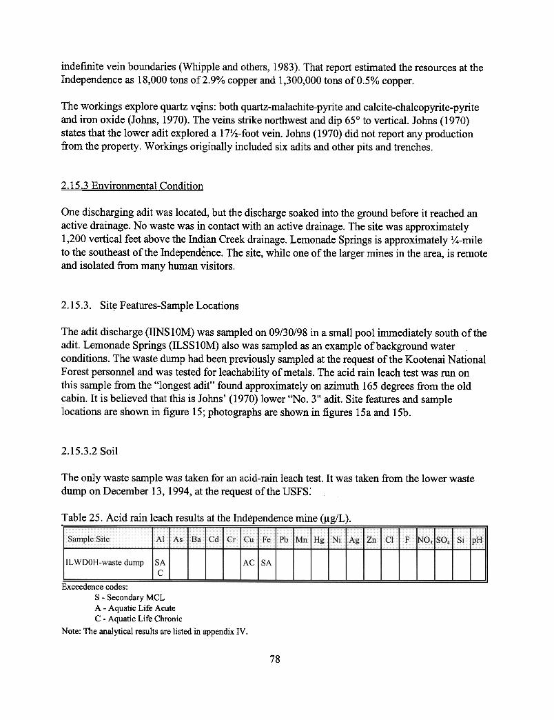
indefinite vein boundaries (Whipple and others, 1983). That report estimated the resources at theIndependence as 18,000 tons of2.9% copper and 1,300,000 tons of 0.5% copper.
The workings explore quartz v~ins: both quartz-malachite-pyrite and calcite-chalcopyrite-pyriteand iron oxide (Johns, 1970). The veins strike northwest and dip 650 to vertical. Johns (1970)states that the lower adit explored a 17Y2-foot vein. Johns (1970) did not report any productionfrom the property. Workings originally included six adits and other pits and trenches.
2.15.3 Environmental Condition
One discharging adit was located, but the discharge soaked into the ground before it reached anactive drainage. No waste was in contact with an active drainage. The site was approximately1,200 vertical feet above the Indian Creek drainage. Lemonade Springs is approximately lf4-mileto
the southeast of the Independence. The site, while one of the larger mines in the area, is remoteand isolated from many human visitors.
2.15.3. Site Features-Sample Locations
The adit discharge (IINSI0M) was sampled on 09/30/98 in a small pool immediately south of theadit. Lemonade Springs (ILSSI0M) also was sampled as an example of background waterconditions. The waste dump had been previously sampled at the request of the Kootenai NationalForest personnel and was tested for leachability of metals. The acid rain leach test was run onthis sample from the "longest adit" found approximately on azimuth 1.65 degrees from the oldcabin. It is believed that this is Johns' (1970) lower "No.3" adit. Site features and samplelocations are shown in figure 15; photographs are shown in figures 15a and 15b.
2.15.3.2 Soil
The only waste sample was taken for an acid-rain leach test. It was taken from the lower wastedump on December 13,1994, at the request of the USPS:
Table 25. Acid rain leach results at the Independence mine (~g/L).
I ~ "SampieSlte
..A.1 As tBa lCd l Cr 1cu iFe I Pb !Mn lHg 'I Ni lAg! Zn..c
"'t~
F~O:l~SO41
Si [pH..!
ILWDOH-waste
dump SAC
AcisA
Exceedence
codes:S -Secondary MCLA -Aquatic Life AcuteC -Aquatic Life ChronicNote:
The analytical results are listed in appendix IV.
78
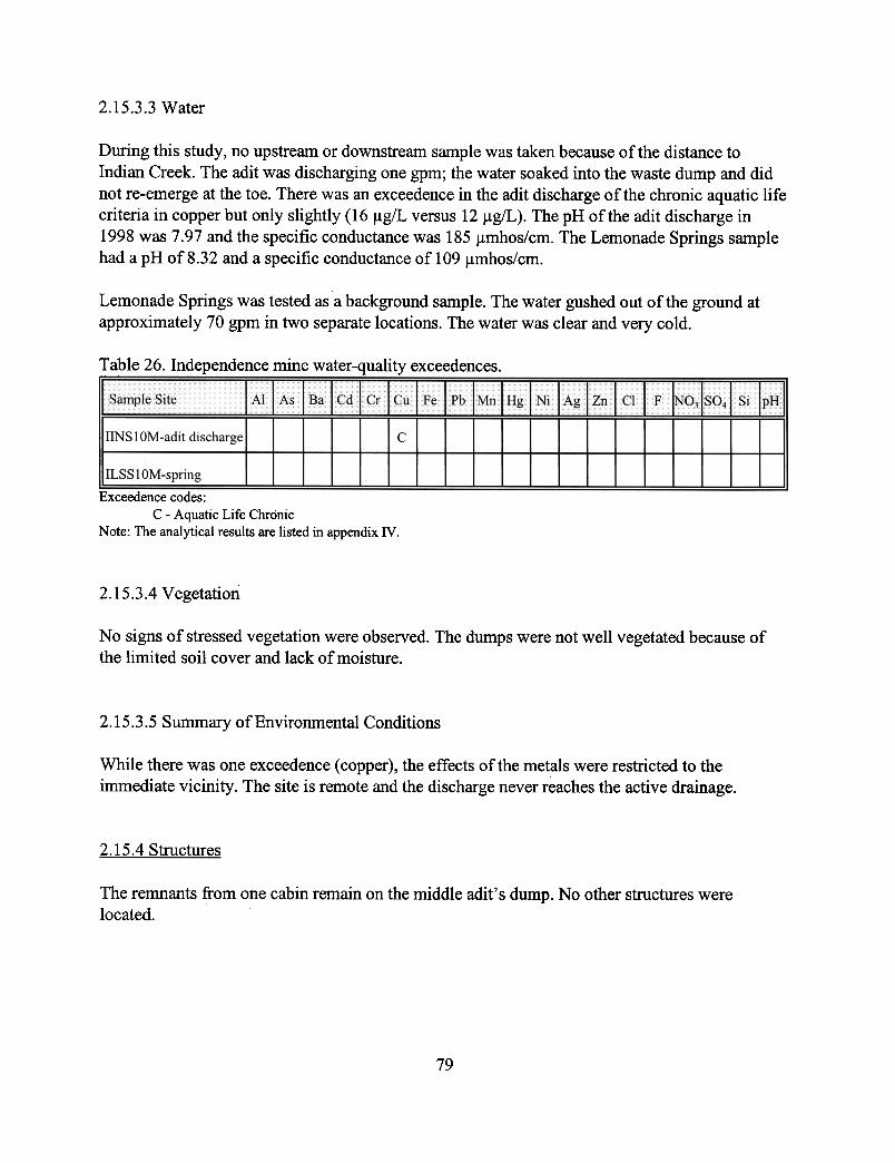
2.15.3.3 Water
During
this study, no upstream or downstream sample was taken because of the distance toIndian Creek. The adit was discharging one gpm; the water soaked into the waste dump and didnot re-emerge at the toe. There was an exceedence in the adit discharge of the chronic aquatic lifecriteria in copper but only slightly (16 ~g/L versus 12 ~g/L). The pH of the adit discharge in1998 was 7.97 and the specific conductance was 185 ~mhos/cm. The Lemonade Springs samplehad a pH of 8.32 and a specific conductance of 1 09 ~mhos/cm.
Lemonade Springs was tested as a background sample. The water gushed out of the ground atapproximately 70 gpm in two separate locations. The water was clear and very cold.
Table 26. Independence mine water-quality exceedences.---
Samp.!eSite Al As
Blcdl
C I C IFa rue
P
bl MIH l N.1 A .17\n g,lt gJLn Cl .ch;;r ol !so l 'I HIFjl,..1..1\ ,_'-.,Sl p,
IINS
1 OM-adit discharge I
cILSS
1 OM-spring
Exceedence codes:C -Aquatic Life Chronic
Note: The analytical results are listed in appendix IV,
2.15.3.4 Vegetation
No signs of stressed vegetation were observed. The dumps were not well vegetated because ofthe limited soil cover and lack of moisture.
2.15.3.5 Summary of Environmental Conditions
While
there was one exceedence (copper), the effects of the metals were restricted to theimmediate vicinity. The site is remote and the discharge never reaches the active drainage.
.2.15.4 Structures
The remnants from one cabin remain on the middle adit's dump. No other structures werelocated.
79

SHAFT
ADIT
DUMP
SEEP
EXCAVATED OR CAVED
SAMPLE LOCATION (SOLID)
SAMPLE LOCATION (WATER)
LEGEND
BUILDING PHOTO POINT
MARSH / WETLANDS

Figure 15a. Looking north at the aditdischarge at the Independence, thedischarge seeps from the adit andinfiltrates into the waste dump. Itdoes not re-emerge at the surface.
Figure I5b. Looking down from the talus and upper caved adit at the Independence, the adit canbe distinguished by the green grass in front of the geologist.
Rl

82
2.15.5 Safety
The upper adit was open only 5 ft but it had overhanging rocks. The lower adit was still partiallyopen; it was 6 ft by 6 ft by at least 20 ft deep with the tracks remaining. The middle, dischargingadit was totally collapsed.
The following mines are in the Fisher River drainage.
2.16 Snowfall Prospect and King Mine
2.16.1 Site Location and Access
The Snowfall prospect and the King mine are located in the Silver Butte district on the SilverButte Pass road (Forest Road 148). The Snowfall prospect can be located by parkingimmediately to the north of Silver Butte Pass at the trailhead for Trail 360 leading to the east.Access is via hiking the trail to the east and then turning north down an old overgrown miningroad to the adit which is marked by a prospect symbol on the Silver Butte Pass 7.5-min.quadrangle. It is located in CBAC section 16, T25N, R30W. It is entirely on KNF-administeredland.
The King mine is located down the road on the Goat Peak 7.5-min. quadrangle in DDAA section7, T25N, R30W at an elevation of 4,920 ft. It is entirely on patented land and access is poorbecause of a locked gate and alders that have overgrown the road. Forest Road 2300 that leads tothe mine is in good condition, however.
2.16.2 Site History-Geologic Features
The King mine was formerly known as the Silver Butte (Johns, 1970) and was discovered in1887. The property was worked from 1905 to 1910 and after 1943. Companies that operated themine included the Kentucky Vermilion Company and the Silver Butte Zinc-Lead MiningCompany. Workings included four adits for a total of 4,300 feet. Reportedly, the quartz veinassociated with the mine is 10–30 feet wide in Prichard argillite. Ore minerals include mostlygalena, with lesser pyrite, chalcopyrite and sphalerite. Johns (1970) also described a mill thatwas built at the King mine.
The Snowfall mine was tentatively identified as such. The description in Johns (1970) places theSnowfall “a quarter of a mile north of Silver Butte Pass and 1½ miles southeast of the Kingmine.”

83
This description also states that the workings consisted of two adits, one of which was east of theroad. West of the road, an adit and a discovery pit explored an eight-in. vertical vein. Theseworkings were not found. The site was one unpatented claim that was relocated by Roark andEcho in 1955 (Johns, 1970). The geology of the area involved the Prichard-Ravalli contact withthe ore found in a quartz-siderite and chalcopyrite-pyrite vein.
2.16.3 Environmental Condition The King mine was not examined because the workings are all on patented land. Lacklen (oralcommunication, 1997) reported that the site had tailings and waste in contact with the creek. TheSnowfall prospect was less than one acre of disturbance that had been practically totallyobliterated by natural processes. Few artifacts of mining remained, only some iron remnants of amill or processing facility were found in the intermittent drainage south of the adit. A depressionrepresenting the adit and a waste dump were barely discernible.
2.16.3.1 Site Features-Sample Locations
The Snowfall prospect was sampled upstream and downstream, and a sample was taken at apoint where the adit discharge pooled enough to sample. The site was visited twice. It wasoriginally visited on October 29, 1997, but inclement weather prevented mapping the area so itwas visited again on August 18, 1998. The King mine was sampled at this later date.
A downstream sample was taken below the King mine on South Fork of Silver Butte Creek. Itwas taken to evaluate the effects of the upstream mining activity. No upstream sample was takenbecause there was no access through the patented claims. Site features and sample locations atthe Snowfall are shown in figure 16; a photograph is shown in figure 16a. A photograph of thedownstream sampling site is shown in figure 16b.
2.16.3.2 Soil
No soil samples were taken.
2.16.3.3 Water
The pH of the downstream sample measured in the field exceeded the lower limit; it was 6.06.The lab pH measured 7.53. There were no other exceedences at the Snowfall.
The water in the South Fork of Silver Butte Creek appeared clear, cold and cascading. It carriedno exceedences. The creek flowed at 20 gpm as measured with a bucket and stopwatch.


Figure 16a. The adit discharge at the Snowfall prospect pooled at the collapsed portal of the aditand fonned a wet mossy area.
Figure 16b. A site on the South Fork of Silver Butte Creek was chosen to test the effects ofmining upstream at the King mine.
R~

86
Table 27. Snowfall and King mine water-quality exceedences.
Sample Site Al As Ba Cd Cr Cu Fe Pb Mn Hg Ni Ag Zn Cl F NO3 SO4 Si pH
SSNS20L-upstream ofsite
SSNS10L-aditdischarge
SSNS30L-downstreamof Snowfall prospect
S1
SKIS10L-downstreamof King mine
Exceedence codes:S - Secondary MCL
(1) Laboratory pH did not exceed standardNote: The analytical results are listed in appendix IV.
2.16.3.4 Vegetation
No effects to the vegetation were noted. The Snowfall mine had lush vegetation, and the trees onthe waste dump appeared healthy.
The road into the King mine was overgrown with alders. Unvegetated waste dumps could beseen in the distance. Those workings were on private land and so were not evaluated.
2.16.3.5 Summary of Environmental Conditions
The effects of the mining at the Snowfall were localized, as were the effects at the King mine.
2.16.4 Structures
No evidence of any structures were found at the Snowfall. A iron flywheel was partiallysubmerged in the boggy bank next to the creek.
The King mine had buildings that could be seen in the distance. All buildings were on privateland.

87
2.16.5 Safety
The Snowfall prospect had a totally collapsed adit with a steep highwall. The site was remote,and so safety concerns were negligible. The King mine was on private land and was notevaluated for safety.
2.17 Viking Mine or Gold Hill Claims
2.17.1 Site Location and Access
The Viking mine lies to the north-northeast of the Snowfall and King sites. The mine is accessedvia Forest Route 148 traveling 9.7 miles from the turnoff on Highway 2. The small side roadcrosses the Silver Butte/Fisher River and access is then by hiking a short distance. It lies on theSilver Butte Pass 7.5-min. quadrangle and is entirely on KNF-administered land.
2.17.2 Site History-Geologic Features
Three patented claims in the Gold Hill group and other unpatented claims comprise the Vikingmine. The foundation of a mill is still present. It was built in 1938 but abandoned in 1946, andwas already collapsed in 1961 (Johns, 1970). Ravalli quartzite and quartzitic argillite host thedeposit that consists of galena, chalcopyrite, pyrite, limonite, and hematite (Johns, 1970). Theore minerals are found in bedding veins of quartz and free gold. Contacts with Prichard argilliteand a metadiorite sill may also be associated with the mine.
Workings consisted of five tunnels with almost 2,000 feet of drifts and crosscuts. Nearly all thedevelopment is on patented claims. One adit was partially open, and one stope had daylighted.The remainder of the adits are completely caved; the lowest has a small discharge.
2.17.3 Environmental Condition The discharge seeps from a collapsed adit, runs down the road, and then drops over the slopeabove the foundation of the old mill. It does not enter the active drainage. No adverse effectswere noted to the environment.
2.17.3.1 Site Features-Sample Locations
The adit discharge (SVIS10L) was sampled and samples were taken upstream (SVIS20L) anddownstream (SVIS30L) on an unnamed tributary to Silver Butte Creek that flows from south tonorth in section 4. The adit discharge was sampled in a small pool formed immediately in front

Iof the collapsed adit. The upstream and downstream samples were taken approximately 100 feet .
from the site. The site was sampled on 10/28/97. Site features and sample locations are shown in ~figure 17; a panorama photograph is shown in figure 17a.
2.17.3.2 Soil
No soil samples were taken. The waste dumps were not in contact with any active water bodyand no effects to the soil were noted.
2.17.3.3 Water
No water-quality limits were exceeded at the Viking. The adit discharge showed only a slightincrease in zinc from below detection limit upstream and downstream of the mine to 2.91lg/L inthe adit discharge. This level is well below the water-quality standards which are in the 100's ofIlg/L (the secondary MCL is 500 Ilg/L.)
Table 28. Viking mine water-quality exceedences.
Sample Site Al As Ba Cd Cr Cu Fe Pb Mn Hg Ni Ag Zn Cl F NO) S04 Si pH
SYIS20L-upstream ofsite
SYIS30L-downstreamof mine
SYIS 10L-adit discharge
Note: The analytical results are listed in appendix IY.
2.17.3.4 Vegetation
No effects of the mining on vegetation was noted. The site was investigated in late Fall whenmuch of the vegetation had become dormant but no dead or dying trees were noted. The grassesall appeared healthy.
2.17.3.5 Summary of Environmental Conditions
Mining at the Viking affected very little of the environment. Most of the effects were physical innature. Two adits were partially open, and a stope had daylighted.
88

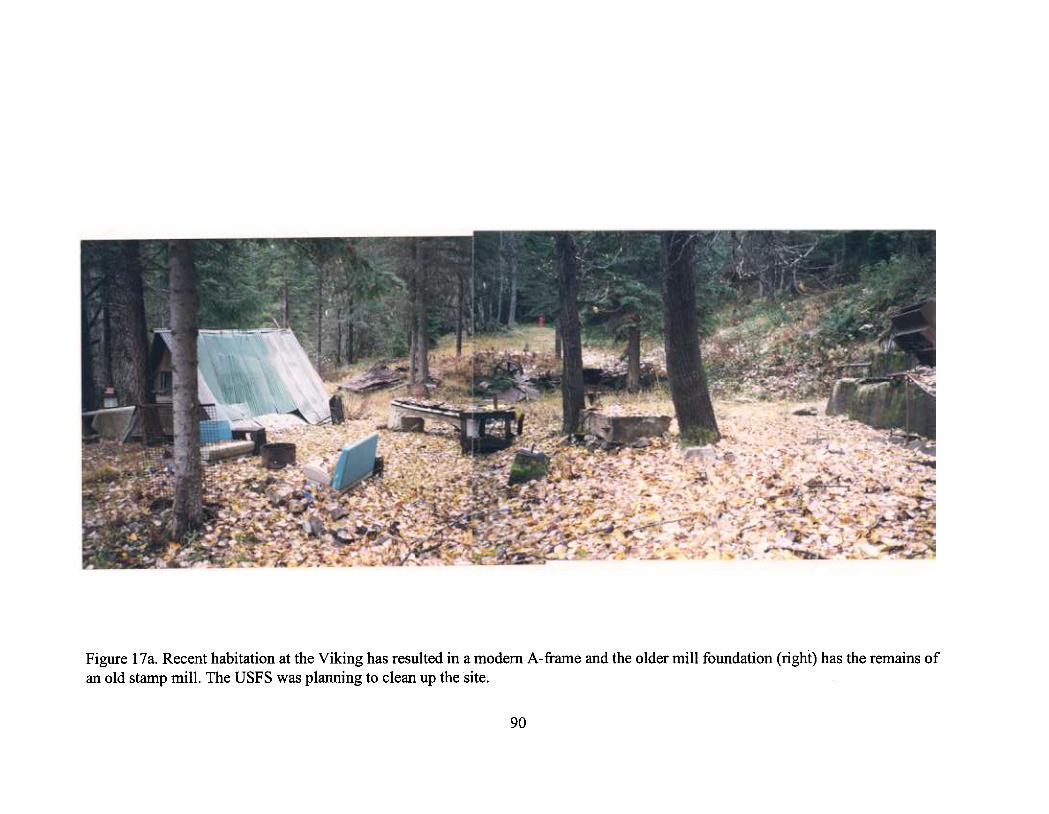
\0 0
§ ~ aC
I
S:~
rJ)
""'
J
a ~
"C ~
S
~=
"'CD
~~ ;~ CD
§.
c::: ~
.C
/) §
..~
oC
/)~
~ ~
~
5='
"C
CD
""<
:§
~~
~aC
IaC
I
s-~
(")
~""
'"1C
D
CD
§ ~
.§ ~ P
o~
C
D ~
rJ)
~~
. S
!1>
0 P
o S >-
I ~ a CD 8. 5=
'C
D
0 s: ~ s - - ~ [ ~ 0 ~ ~ ~. ~ '-" ~ ~ rJ
) 5='
CD ~ S e. ~ 0 .-
t)

91
2.17.4 Structures
An A-frame cabin was still present when this investigation looked at the property. The concretefoundation was all that was left of the mill except for an iron hopper for the stamp mill. Boardsand parts of old mining equipment had been stacked to the south of the cabin. Tables, benchseats out of vehicles, and miscellaneous equipment was strewn around the site.
2.17.5 Safety
The site had partially open adits and at least one stope that had daylighted. The lower adit thattrended S58EW was open with a hole large enough for an animal to enter. The iron base of themill was tilted and may tip in the future.
2.18 Bramlet Creek (and Branagan) Mine
2.18.1 Site Location and Access
This unnamed site is located on Bramlet Creek immediately downstream from the Branaganmine. Forest Route 2332 leads to the Branagan and Bramlet Creek site. The site liesapproximately two miles from the junction of the Fisher River The road is closed approximatelyc-mile beyond the millsite at the trailhead of Trail 658. The road as far as the mill is improvedgravel with the mill itself located on a small overgrown 200 foot long spur road. The Branaganmine is accessible only by hiking a steep hillside after crossing Bramlet Creek. The workings(some open) at the Branagan are on patented land.
2.18.2 Site History-Geologic Features
The Branagan mine was reported to have had a mill; a mill foundation was found at theBranagan. Gibson (1948) described a 10-stamp mill that ran for several years at the Branagan.Johns (1970) reported that a 15-stamp mill was built to process ore from the Branaganapproximately around the turn of the century. No mention of a second mill was found inliterature. The mine dumps were eroded by Bramlet Creek during high water (Johns, 1970). Thisreport also mentions that mill tailings were present in the creek and were claimed as a placer.
2.18.3 Environmental Condition
The Bramlet Creek site poses few environmental problems. The floods and years of erosion havewashed most of the tailings and waste dumps associated with the two sites downstream. Thesamples were collected to assess any problems that were not visibly evident.

I2.18.3.1 Site Features-Sample Locations .
Water-quality samples were collected up gradient (BBRSI0L) and downgradient (BBRS20L) of ~
the site on KNF-administered land. The flow rates at these locations were 75 gpm and 400 gpm,respectively. Upstream, Bramlet Creek pH was 5.94, and specific conductance was 10~mhos/cm. The upstream sample was taken immediately upstream from where the patented landstarted and where the creek split into several channels. Downstream, Bramlet Creek pH was 7.25and specific conductance was 20 ~mhos/cm. The second sample was taken approximately 50 feetdownstream from the mill ruins. Samples were collected on July 31, 1998. Site features andsample locations are shown in figure 18; photographs are shown in figures 18a and 18b.
2.18.3.2 Soil
Soil samples were not collected.
2.18.3,3 Water
The concentration of analytes in the upstream sample (BBRS 1 OL) did not exceed any water-quality standards (table 2). The pH did fall below acceptable levels (5.94), and this reading wasreplicated in the lab (5.95). The concentration ofanalytes in the downstream sample actuallydecreased from or stayed the same as the upstream sample. The pH increased in the downstreamsample to an acceptable level of7.25.
Table 29. Bramlet Creek mill water-quality exceedences.
SampJeSite Al As Ba Cd Cr Cu Fe Pb Mn Hg Ni Ag Zn CI F NO3 SO4 Si pH
BBRS I OL-upstream of Ssite
BBRS20L-downstreamof site
Exceedence codes:S -Secondary MCL
Note: The analytical results are listed in appendix IV.
2.18.3.4 Vegetation
Vegetation on KNF-administered land does not appear to be impacted by the site. Trees andshrubs grew up to the waters edge. Small trees grew up through the timbers of the collapsed millbuilding.
92

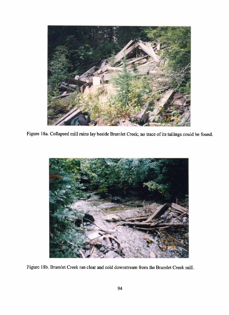
Figure
l8a. Collapsed mill ruins lay beside Bramlet Creek; no trace of its tailings could be found.
Fii,ure 18b. Bramlet Creek ran clear and cold downstream from the Bramlet Creek mill.
94

95
2.18.3.5 Summary of Environmental Conditions
The site was not greatly impacted by the mining activity. No metals loading was noted. Fewphysical remnants of the milling remain.
2.18.4 Structures
All structures at the Branagan are on private property and were not evaluated or inventoried. Themill adjacent to Bramlet Creek is almost totally collapsed. It should be considered a slight hazardbecause a few timbers on the uphill side are still standing.
2.18.5 Safety
The site has few hazardous structures but on the other hand is readily accessible. Evidence of arecent campsite at the end of the small spur road that leads to the mill suggests recreational use.
2.19 Gloria or Little Annie Mine
2.19.1 Site Location and Access
The Gloria, as it is now known, lies high on the south-facing slope of West Fisher Creek. A four-wheel drive road turns north from just before where Forest Route 6746 is gated in section 34.The access is actually by four-wheel drive from where the road crosses West Fisher Creek in theSE¼ section 36. The road here has been washed out by the creek. The mine is located on theHoward Lake 7.5-min. quadrangle at an elevation of 5,620 feet in section 27, T27N, R31W.
2.19.2 Site History-Geologic Features
The Golden West Mining Company first mined here as the Little Annie (Gibson, 1948) as earlyas the 1930's. The base camp was along West Fisher Creek and a cabin was built at the mine. Inthe 1950's, one claim was relocated (Johns, 1970). The adits explored a quartz vein that isparallel or subparallel to bedding in Prichard argillite and sandstone. It is up to two feet thick andcontains native gold, as well as sphalerite, pyrite, galena, and lesser pyrrhotite and chalcopyrite(Gibson, 1948).
2.19.3 Environmental Condition No adverse effects were noted at the Gloria except for surface disturbances. The area was neartimber line, and the vegetation was typical for the elevation. Trees were slightly stunted from thenaturally harsh environment.

I2.19.3.1 Site Features-Sample Locations .
Water-quality samples were collected from upstream (FGLS30L) and downstream (FGLS20L) ofthe site on KNF -administered land on an unnamed tributary to West Fisher Creek. It appeared asif it was a permanent stream, although the flow was small and sometimes went subsurface undertalus. The flow rate at both locations was 15 gpm. Upstream, pH was 6.99 and specificconductance was 12 J.lmhos/cm. Approximately 100 feet downstream from the mine workings(FGLS20L), pH was 6.98, and specific conductance was 10 J.lmhos/cm. A sample of the aditdischarge (FGLS10L) exceeded secondary MCL and chronic water-quality standards foraluminum and manganese. The pH was also low; it measured 6.01 in the field and 6.13 in thelab. It, therefore, was below the 6.5 cutoff for pH. The flow of the adit discharge was small atone gpm. Samples were collected on October 15, 1997 (although the camera dated the photo asOctober 16). Site features and sample locations are shown in figure 19; photographs are shown infigures 19a and 19b.
2.19.3..2 Soil
Soil samples were not collected.
2.19.3.3 Water
The concentrations of analytes in the upstream and downstream samples did not exceed anywater-quality standards (table 2). The concentration of aluminum in the adit-discharge sampleexceeded the secondary MCL and the chronic aquatic life standard. The pH was also below thesecondary MCL standard for water quality; manganese levels exceeded the secondary MCL.
Table 30. Gloria mine water-quality exceedences.
Sample Site Al As Ba Cd Cr Cu Fe Pb Mn Hg Ni Ag Zn Cl F NO3 SO4 Si pH
FGLS30L-upstream of Sthe Gloria
FLGS20L-downstreamof the Gloria
FGLS 1 OL-adit SC S
discharge
Exceedence codes:S -Secondary MCLC -Aquatic Life Chronic
Note: The analytical results are listed in appendix IV.
96


Figure
19a. As viewed from the road to the Wayup mine, the Gloria's waste dumps and cabinwere visible on the south-facing slope north of West Fisher Creek.
Figure 19b. One waste dump at the Gloria was in contact with the unnamed tributary to WestFisher Creek.
98

99
2.19.3.4 Vegetation
Vegetation on KNF-administered land does not appear to be impacted by the site. The mine islocated on a south-facing slope at an elevation at which the trees are thinning out because of theelevation. Larch and fir trees are beginning to grow after being logged recently. No dead ordying trees were noted. The vegetation is stressed in the general area due to the elevation andharsh climate.
2.19.3.5 Summary of Environmental Conditions
Although the adit discharges had exceedences in two metals (aluminum and manganese), theflow was extremely small (one gpm). The low pH would be a problem except for the fact of thesmall flow. The analyses of the upstream and downstream samples were similar.
2.19.4 Structures
One cabin remained at the mine site. It was well built but the windows were missing. Anothercabin was adjacent to West Fisher Creek at the main camp. Both were in good condition.
2.19.5 Safety
One open adit was found at the Gloria. A second adit was largely caved but the opening waslarge enough to crawl into. The site is remote and not easily reached, but it is marked on thetopographic map. There were no signs of recreational activity at the time of this visit.
2.20 Vermiculite Mountain Mine
2.20.1 Site Location and Access
The Vermiculite Mountain mine is on private land near the head of Rainy Creek basin (section22, T31N, R30W). The site is accessible by taking highway 37 for 5.5 miles out of Libby, thenturning north on Rainy Creek road for approximately one mile where the mine property begins.
2.20.2 Site History-Geologic Features
In 1915, E. N. Alley of Libby was prospecting for vanadium when he noticed that the coarsemica-like minerals in the walls of his mine swelled enormously when heated by the flame of hiscandle. This mineral proved to be vermiculite. Mr. Alley and others formed the Zonolite Co. and

100
started a small-scale production of the vermiculite in 1925. By 1948, a 1,000-ton mill waserected at the site, producing 350 to 400 tons of concentrate per day, and in 1959 the mill wasenlarged. By this time the site was known as the largest vermiculite mine in the United States(Johns,1959).
Johns (1959) describes the deposit as an elongated stock composed of pyroxenite and syenite.Intruding the Wallace and Striped Peak formations, the pyroxenite is coarse grained andcomposed of vermiculite, aegerine-augite, fibrous amphibole asbestos, magnetite, and biotite.According to Johns, the vermiculite has been derived from hydrothermally altered biotite.
2.20.3 Environmental Condition
The site has been extensively mined over the years from underground and open-pit strip mining,but has since been re-contoured and re-seeded over most of the disturbed area. The site is onprivate land so a site map was not prepared, nor were any detailed observations made of anystructures on the site.
2.20.3.1 Site Features-Sample Locations
An upstream and downstream water sample was collected on Rainy Creek on KNF-administeredland above and below the Vermiculite Mountain mine to assess whether the mine has any impacton Rainy Creek. Site features and sample locations are shown in figure 20.
2.20.3.2 Soil
Soil on KNF-administered land did not appear to have been affected by runoff or sedimentationfrom the Vermiculite Mountain mine. No soil samples were collected.
2.20.3.3 Water
The upstream surface-water sample (RVMS10H) was collected at the head waters of RainyCreek, which at that time was flowing approximately 100 gpm on KNF-administered land abovethe Vermiculite Mountain mine property. The downstream water sample (RVMS20H) wascollected as it flowed onto KNF-administered land below the Vermiculite Mountain mine, whichhad increased to an estimated 300 gpm. Neither of the surface water samples exceeded MCLs forany of the constituents tested.

Vermiculite Mountainmine propertyKootenai National Forest
Fleetwood Creek
N
SHAFT
ADIT
DUMP
SEEP
EXCAVATED OR CAVED
SAMPLE LOCATION (SOLID)
SAMPLE LOCATION (WATER)
BUILDING PHOTO POINT
MARSH / WETLANDS
LEGEND
0 1.00.5
MILES
Figure 20. The Vermiculite Mountain mine.
RVMS10H
RVMS20H
101

102
2.20.3.4 Vegetation
Vegetation appeared healthy throughout the site with much of the site being re-vegetated alongRainy Creek.
2.20.3.5 Summary of Environmental Condition
Environmental impact from the site appears limited; much of the mine site has been re-contouredand re-vegetated.
2.20.4 Structures
All of the structures, waste dumps, and debris are on private land. No building materialassociated with the mine was observed on KNF-administered land.
2.20.5 Safety
Rainy Creek road allows public access through private land, but all secondary roads are gated orchained shut, and the mine property is well posted as private with no trespassing.
2.21 Copper Reward Mine
2.21.1 Site Location and Access
The Copper Reward is accessible only by hiking the closed road (Forest Road 4785) leading upCherry Creek. The road has been closed off by a Kelly hump approximately two miles downfrom the adit in the SE¼ section 4. The adit lies up the hill on a faintly evident overgrownmining road leading to the north/northwest in CDAD section 08, T28N, R31W. The overgrownroad switchbacks at the avalanche chute and then goes east another 300 feet. The mine is atapproximately 3,840 feet elevation and is on the Cable Mountain 7.5-min. quadrangle map.
2.21.2 Site History-Geologic Features
The Copper Reward is also known as the Walker Tunnel. The tunnel was the main working on a“group of five claims on the north side of Cherry Creek” (Gibson, 1948). The five claims werethe Copper Reward, Hidden Treasure, Copper Gold, Contention, and Nellie L. (Johns, 1970).The configuration of the claims as well as the location of the Walker Tunnel were shown onfigure 15 in Johns (1970). The mine (actually on the Copper Gold unpatented claim according to

IJohns) explored at least 440 ft back along a shear zone. The actual Copper Reward unpatented .
claim lies on the south side of Cherry Creek (Johns, 1970). Figure 16 in the Johns (1970) report ~showed the configuration of the mines associated with the Snowshoe fault, with the CopperReward on a NW-SE-trending splay of the fault.
The adit was caving as long ago as pre-1948 and was caved in 1970 when Johns visited it. Twoother totally collapsed adits were found just north of the closed road (Forest Road 4785) alongCherry Creek.
Ravalli quartzite (N25°W, 35°NE) hosts the near vertical shear zone that strikes approximatelythe same direction. Ore minerals included pyrite, arsenopyrite, galena with lesser chalcopyriteand sphalerite (Gibson, 1948). Oxides included anglesite,malachite, azurite, and limonite (Johns,1970). No production was noted.
2.21.3 Environmental Condition
The disturbance at the adit was less than one acre. The adit discharge flowed from the collapsedportal and pooled on the flat area to the south of the adit. It then infiltrated into the waste dumpand did not re-emerge from the dump. The dump lies approximately 500 feet uphill (and 230 feetin elevation) from Cherry Creek.
2.21.3.1 Site Features-Sample Locations
One water-quality sample was collected from the adit discharge (CWTSI0L) at the site on KNF-administered land. The flow rate at this location was 15 gpm. The pH was 6.82 and specificconductance was 91 ~mhos/cm. The sample was collected on September 02, 1998. Site featuresand sample locations are shown in figure 21; photographs are shown in figures 21a and 21b.
2.21.3.2 Soil
No soil or waste samples were collected at the Walker Tunnel. The waste dump wasapproximately 500 feet from the active drainage.
2.21.3.3 Water
The concentration of analytes in the adit discharge (CWTSI0L) did not exceed any water-qualitystandards (table 2). The water appeared clear and cold. No metals precipitate was noted.
103


Figure
21 b. At the Copper Reward, lush green vegetation grew up to edge of the pool fonned by
the adit discharge.
105

106
Table 31. Copper Reward (Walker Tunnel) mine water-quality exceedences.
Sample Site Al As Ba Cd Cr Cu Fe Pb Mn Hg Ni Ag Zn Cl F NO3 SO4 Si pH
(CWTS10L)-aditdischarge
(CWTS20L)-duplicateof adit discharge
Note: The analytical results are listed in appendix IV.
2.21.3.4 Vegetation
Vegetation on KNF-administered land does not appear to be impacted by the site. The grassesthat grew on the flat area were tall and lush. None of the trees showed any sign of stress.
2.21.3.5 Summary of Environmental Conditions
This site was sampled for the sake of completeness and not because there were indications ofproblems. The water quality analyses showed that the water had no exceedences of any water-quality criteria.
2.21.4 Structures
No structures remained at the site. There may have been a cabin on the road at the site, but onlyscattered boards and debris remained.
2.21.5 Safety
The site is remote, not easily visible, and small in extent; no hazards were noted.
2.22 Snowshoe Mine
2.22.1 Site Location and Access
The Snowshoe mine is located in BADA section 07, T28N, R31W and the Snowshoe Peak 7.5-min. quadrangle at an elevation of a little less than 4,600 feet. The adits are at higher elevations.The mine can be found at the terminus of a four-wheel drive road that follows Snowshoe Creekup the valley. The site lies less than 1.5 miles from the Cabinet Mountains Wilderness boundary.

I"I
2.22.2 Site History-Geologic Features
Associated with the Snowshoe fault, the Snowshoe mine was one of the largest metals producersin the area. The four patented claim names associated with this mine are the Chinook, Rustler,Snowshoe, and Porcupine (Johns, 1970). The claims were first explored in the 1 870's and wereintermittently worked until recently. Recorded production from 1901 to 1945 was 54,194 tonsalthough estimates using the mine maps and stopes equaled 250,000 tons of ore (MBMG mineralproperty files). At least five adits were driven and one shaft sunk, with a cumulative footage of6,500 feet of drifting along the Snowshoe fault. The workings totaled over 8,000 ft. The samemineral property files described the ore as consisting of argentiferous galena in white quartz andquartzite. The mining method used combined open-stulled stope, and cut and fill.
The geology of the area is dominated by the Snowshoe fault, striking N12°W with a near-verticaldip and in places, producing a shear zone averaging six feet wide (Gibson, 1948). The faultplaces Ravalli sandstones and argillites to the east adjacent to the Wallace Formation's shalesand limestones. Ore minerals include chiefly galena and sphalerite with lesser p~te and sparsechalcop~te and arsenop~te. Gibson (1948) reported that a personal account by one of theowners estimated that up to 40% of the concentrates were lost by poor milling methods. Anarticle from the Spokesman Review from April 25, 1943 (MBMG mineral property files) statedthat the original mill (250-tpd capacity) made no attempt to recover the zinc in the ore, resultingin metal-rich tailings at the Snowshoe site.
2.22.3 Environmental Condition
A portion of the area was recently reclaimed by DSL-AMRB and the USFS (approximately1989). The area downhill from the' adits appeared to have been recontoured arid reseeded. Rillsand deeper gullies running to the creek had already started to form on the slope. Downstreamfrom the flat area formed by the mill site, Snowshoe Creek was actively eroding the partlyindurated waste that lined its banks. Large slabs of iron-cemented waste with abundant visiblechunks of galena were being undermined by the creek. A covering of a fine-grained clay (lime?)capping also was being eroded.
2.22.3.1 Site Features-Sample Locations
Water-quality samples were collected from upstream (SSNS10L) and downstream (SSNS20L) ofthe site on KNF-administered land. The flow rates at these locations were 440 and 507 gpm,respectively. Upstream, Snowshoe Creek pH was 8.1 and specific conductance was 62~mhos/cm. Downstream, Snowshoe Creek pH was 7.57 and specific conductance was 81~mhos/cm. Samples were collected on July 30, 1998. A spring that emanated from the north sideof the tailings area was also sampled (SSNS30L). Its pH was 7.39 and,specific conductance was
107

108
88; the flow was estimated to be 15 gpm. More samples were not collected because of the privateland position. Additional samples of the springs and seeps on the flat (tailings?) area and from amonitor well on the lower end of the tailings area were taken by Pioneer Technical Services(1995). Site features and sample locations are shown in figure 22; photographs are shown infigures 22a, 22b, and 22c.
2.22.3.2 Soil
Two waste samples were collected. SSND10H was a composite sample along the waste beingactively eroded by Snowshoe Creek. It had visible fragments of galena in a iron-cemented waste.The sample was collected along 100 feet of the creek. The second sample (SSND20H) was of thewhite to light gray clay capping material on the waste as it was being eroded by the creek Thismaterial has elevated levels of lead and zinc that exceed phytotoxic limits. Lacklen (USFS, 1998,pers. comm.) indicated that this material may be the cover spread as a part of the reclamationeffort in the area.
Table 32. Soil sampling results (mg/kg) for the Snowshoe mine.
Sample Location As Cd Cu Pb Zn
Waste eroding into creek(SSND10H)
5515.81,2 90.411 328.561,2 10872.11,2 9315.0791,2
Capping material(SSND10H)
56.071 11.191 11.801 686.781,2 1045.091,2
(1) Exceeds one or more Clark Fork Superfund background levels (table 3).(2) Exceeds phytotoxic levels (table 3).
2.22.3.3 Water
The concentration of analytes in the upstream sample (SSNS10L) did not exceed any waterquality standards (table 2). The concentration of cadmium in the downstream sample exceededthe primary MCL as well as the acute and chronic aquatic life criteria. The lead level alsoexceeded the acute and chronic criteria downstream. The spring (SSNS30L) exceeded the acuteand chronic aquatic life criteria for zinc. This may be because of natural conditions or because ofan unidentified source of the zinc. This spring may be the “intermittent tributary” sampled byPioneer Technical Services (1995).


"1:;~@
§'a)~-~=
"1:;~
Q)Q
)..2()~Q
) Q
),.c:(),.c:
-0-=
m
0."" ~
-,.c:~
();i?:;o-.0
Q)
0 ::::J =
m
Q)Q
)m,.c:-.d°-~
Po
"1:;e~
=
~:E
~~
Q)
.om]
Q) ~ -
10. 0 =
Q) ~
~
~O
O
Q)Q
)=0
Q)
,.c: 10. ~m
UO
~Q
)~80m
r",.c: P
o
""' m
Q
)Q
)~Q
),.c: 0
m-=
"1:;~
CZ
)§m
-dm.~
=
00
"1:;~=
~
0 .~
Q)5hP
o,.c:
Q)
mf-4
10. m
.c,S
~~
0
Q)~
'a)~
ooa"1:;.~
9
Q)Q
)=e.,c:;Q
):.§ ;
~()
Q)
Q)
m
10.10."'"
Q)
~:::=
,.c:~
Q)f-4
Q)~
-d,.c:00
§-=m
.~
~-
~B
oo0.""
Q)
,.c: =
10.m
Oc,S
'OO
e~Q
)<oo
~
..~
~eQ
)0
,.c:~
~-
00"1:;.£.o~~
~ ~
~_o --~
10. :>
0
0 _.
§]~~
Po-,.c:a=
-~<
"1:; Q
)
~~
§.8N
~
m
N_B
~~
:=.88
~eP
ocz)]
Q)
Q)
~_.:.s.:.s
0

Figure 22b. At the Snowshoe, a seep emerged from the disturbed area on the north side of the flatarea and mixed with the water from a natural spring. The iron staining that is evidentdistinguishes the two sources.
Figure 22c. Recently indurated mine waste downstream of the Snowshoe was actively beingundercut by Snowshoe Creek. A white clay capping lies on the surface of the waste and tailings.
111

112
Table 33. Snowshoe mine water-quality exceedences.
Sample Site Al As Ba Cd Cr Cu Fe Pb Mn Hg Ni Ag Zn Cl F NO3 SO4 Si pH
SSNS30L-spring A C
SSNS10L-upstream
SSNS20L-downstream P AC
A C
Exceedence codes:P - Primary MCLA - Aquatic Life AcuteC - Aquatic Life Chronic
Note: The analytical results are listed in appendix IV.
2.22.3.4 Vegetation
Vegetation on KNF-administered land does not appear to be impacted by the site. The vegetationon the flat area that is patented did appear to be barren with only mosses and sparse grassgrowing. The lack of vegetation may be due to the recent nature of the reclamation.
2.22.3.5 Summary of Environmental Conditions
Most of the disturbances and problems at the Snowshoe are on the patented ground. The waterleaving the private ground and running onto KNF-administered land did have exceedences incadmium and zinc. The waste that is being actively eroded downstream also exceeded levels ofarsenic, cadmium, copper, lead, and zinc. Even the capping material had levels of metals thatexceeds the Clark Fork Superfund background levels and zinc in the capping material exceedsthe phytotoxic level.
2.22.4 Structures
No structures remain at the Snowshoe mine. The Snowshoe Peak 7.5-min. topographic mapshows some symbols of building ruins on the private land but even these are no longer present.
2.22.5 Safety
No safety concerns were noted on KNF-administered land at the Snowshoe mine and mill site.Pioneer Technical Services (1995) did mention the presence of three open and hazardous aditson patented ground along with unstable waste piles. Pioneer ranked the Snowshoe with anAIMSS safety score of 69.39 which ranked it 48th out of over 500 sites.
I'"2.23 Cherry Creek or St. Paul Mill .
2.23.1 Site Location and Access ~
This mill site was not in the MILS data base but was identified by Pioneer Technical Services(1995) as a ranked site in their study. MBMG mineral property files list it as the "St. Paul" mill.It is easily accessible to within 300 feet of the site by the improved gravel road.
2.23.2 Site Historv-GeologicFeatur~s
This mill was built to process the ore and tailings from the Snowshoe mine. It is unclear if therewas more than one or two subsequent mills at this site. A report from the MBMG mineralproperty files (1945) stated that a mill was processing 50 tons per day. This report said the millconsisted of a ball mill, eight flotation cells, and a filter. The Snowshoe tailings were loaded intotrucks and hauled to the mill. There was a 100-ton storage bin at the mill. Sharp (MBMG,unpublished report) said that flotation at the mill recovered only 65% of the silver and lead foundin the old tailings. The tailings averaged 1.5% lead, 2.5 % zinc, 1 oz per ton silver, and 0.07 ozper ton gold and that there were (at the mos~) 25,000 tons of tailings (at the Snowshoe).
The exact dates of operation were not located, but another mill was described in reports as beingbuilt in 1958 and being stripped of equipment in 1967. An article in the Wallace Minernewspaper stated that the 100-ton selective flotation concentrator was nearing completion in1957. All that was left to complete was electrical and plumbipg work. The operators at the timewere Merger Mines, Inc. and St. Paul Lead Conipany. By 1967, most of the machinery at themill had been stripped (MBMG mineral property files). The mill was probably built this fardown on Cherry Creek because of the seasonal lack of water at the Snowshoe mine site (asreported in other MBMG reports).
2.23.3 Environmental Condition
The site has been previously reclaimed by recontouring and reseeding. No obvious visible signsof environmental problems were noted. Grass was growing on the reclaimed areas and thesurrounding trees appeared healthy. A cross section of the old tailings were exposed in an oldroad cut where it was sampled.
2.23.3.1 Site Features-Sample Locations
Water-quality samples were collected upstream (CCHS20L) and downstream (CCHSI0L) of thesite onKNF-administered land. The flow rate at each location was 2,876 gpm. Upstream, CherryCreek pH was 7.55 and specific conductance was 84 ~mhos/cm. Downstream, Cherry Creek pH
113

Iwas 7.6, and specific conductance was 84 J.lmhos/cm. Two soiVtailings samples were also .
collected. The first was a vertical composite of the tailings where they were exposed in a road ~cut. The second was a composite taken across the surface of the reclaimed area. Samples werecollected on September 03, 1998. Site features and sample locations are shown in figure 23;photographs are shown in figures 23a and 23b.
2.23.3.2 Soil
The soil and tailings samples collected were analyzed by Energy Laboratories, Inc. of Billings.The total cyanide was found to be 5.6 J.lg/g in CCHT10H and 0.6 J.lglg in CCHT20H. PioneerTechnical Services also analyzed for cyanide and found 0.867 mgikg.
Table 34. Soil sampling results at the Cherry Creek mill (mg/kg).
Sample Lqcation As Cd Cu Pb Zn
CCHTIOH-vertical profile 1784.21,2 2.3981 248.4391,2 11506.061,2 1672.8171,2
CCHT20H-horizontal profile 41,191 3.251\ 32.84\ 1366.8281,2 758.7811.2
(1) Exceeds one or more Clark Fork Superfund background levels (table 3).(2) Exceeds phytotoxic levels (table 3).
2.23.3.3 Water
The concentration ofanalytes in the upstream sample (CCHS20L) and downstream sample(CCHS10L) did not exceed any water-quality standards (table 2). The tailings site was at least 50feet from the creek and about 20 feet higher than the creek.
Table 35. Cherry Creek mill water-quality exceedences.'" ,
Sample SIte Al As Ba Cd Cr Cu Fe Pb Mn Hg Nl Ag Zn CI F N03 S04 SI pH
(CCHS20L) upstreamon Cherry Creek
(CCHSIOL)-down-stream on Cherry Creek
Note: The analytical results are listed in appendix IV.
2.23.3.4 Vegetation
Vegetation on KNF -administered land does not appear to be impacted by the site. The area to the
114


figure 23a. Tailings sampleCCHTIOH from the Cherry Creekmill was taken from a thick remnantof the pile.
Figure 23b. The foundation of the mill at the Cherry Creek site posed a safety threat because oferosion at the footings.
116

117
southeast of the mill foundation has been recontoured and seeded in grasses. The flat areas that were probably tailings have also been seeded with grasses. Trees did not show any effects of themilling waste and small “islands” of trees grew in the flat tailings areas. Small trees also havebegun to encroach and revegetate the area. The road leading to the site also has been closed offand has trees beginning to obliterate it.
2.23.3.5 Summary of Environmental Conditions
The Cherry Creek mill site showed no effects on the water-quality of Cherry Creek, althoughsamples by Pioneer Technical Services (1995) showed an observed release of arsenic to thesediment in the creek.
2.23.4 Structures
The mill building and all equipment were removed in the 1980's or before. Only the concretefoundations of the mill remain. The bridge that previously crossed the river at this location alsohas been removed.
2.23.5 Safety
The mill and equipment have been totally removed, however, three large concrete foundationsremain. One has fallen over probably due to undermining by erosion, and another showed signsof erosion. Pioneer Technical Services ranked the Snowshoe with an AIMSS safety score of13.22, which ranked it 98th out of over 500 sites.
2.24 Victor-Empire Mine
2.24.1 Site Location and Access
The Victor-Empire mine is on the north side of Granite Creek along the Granite Creek Trailapproximately three quarters of a mile from the trailhead. The site is accessed by taking theShaughnessy Road off of Highway 2 for 1.2 miles, then turning right onto Granite Lake Road for0.8 miles, then left on Forest Route 618 (Granite Creek Road) for another 7.5 miles where theroad dead ends at the Granite Creek trailhead.
2.24.2 Site History-Geologic Features
The Victor-Empire mine development consists of a 2,000-foot adit on the Snowshoe fault and a

118
short drift on a branching fault in Ravalli sedimentary rock (Johns, 1970). A diamond drill holedriven from the end of the 2,000-foot drift along the Snowshoe fault, in a direction a little northof east, was reported to have intercepted a high-grade gold-silver-lead ore at about 940 feet(Gibson 1948). Johns states this 4.5 foot vein assayed at $290 per ton.
The Snowshoe fault zone, from two to five feet wide, contains pyrite, pyrrhotite, and galena inquartz.East of the fault is quartzite and sandstone of the Ravalli Formation, and on the west side of thefault is argillite and calcareous quartzite of the Wallace Formation (Johns, 1970).
2.24.3 Environmental Condition
The Victor-Empire mine consist of one single open adit that discharges water across the waste-rock dump dissipating into the soil slightly past the dump. There is associated mine trash, steelpipe, sheet metal, etc., piled a short distance on either side of the mine adit. The mine and dumpare from 600 to 700 feet uphill from Granite Creek.
2.24.3.1 Site Features-Sample Locations
An adit-discharge sample (GEVS10H) was collected, and upstream (GEVS20L) and downstream(GEVS30L) surface-water samples were collected on Granite Creek. Site features and samplelocations are shown in figure 24.
2.24.3.2 Soil
The waste-rock dump comprises country host rock consisting mostly of gray quartzite and shalewith some scattered iron-stained quartz. Disseminated chalcopyrite was seen in a few of therocks within the dump. The dump showed no signs of erosion or instability to impact thesurrounding soil. However, analysis of the waste dump shows arsenic exceeds phytotoxic levels,and arsenic, cadium, lead, and zinc exceeded Clark Fork Superfund Levels. Vegetation aroundthe dump showed no signs of stress and appeared healthy.
Table 36. Soil sampling results–Victor Empire mine (mg/kg). Sample Location As Cd Cu Pb Zn
Waste dump(GEVW10H)
493.25 1,2 1.562 1 11.5621 67.68 1 228 1
(1) Exceeds one or more Clark Fork Superfund Background Levels (table 3).(2) Exceeds Phytotoxic Levels (table 3).
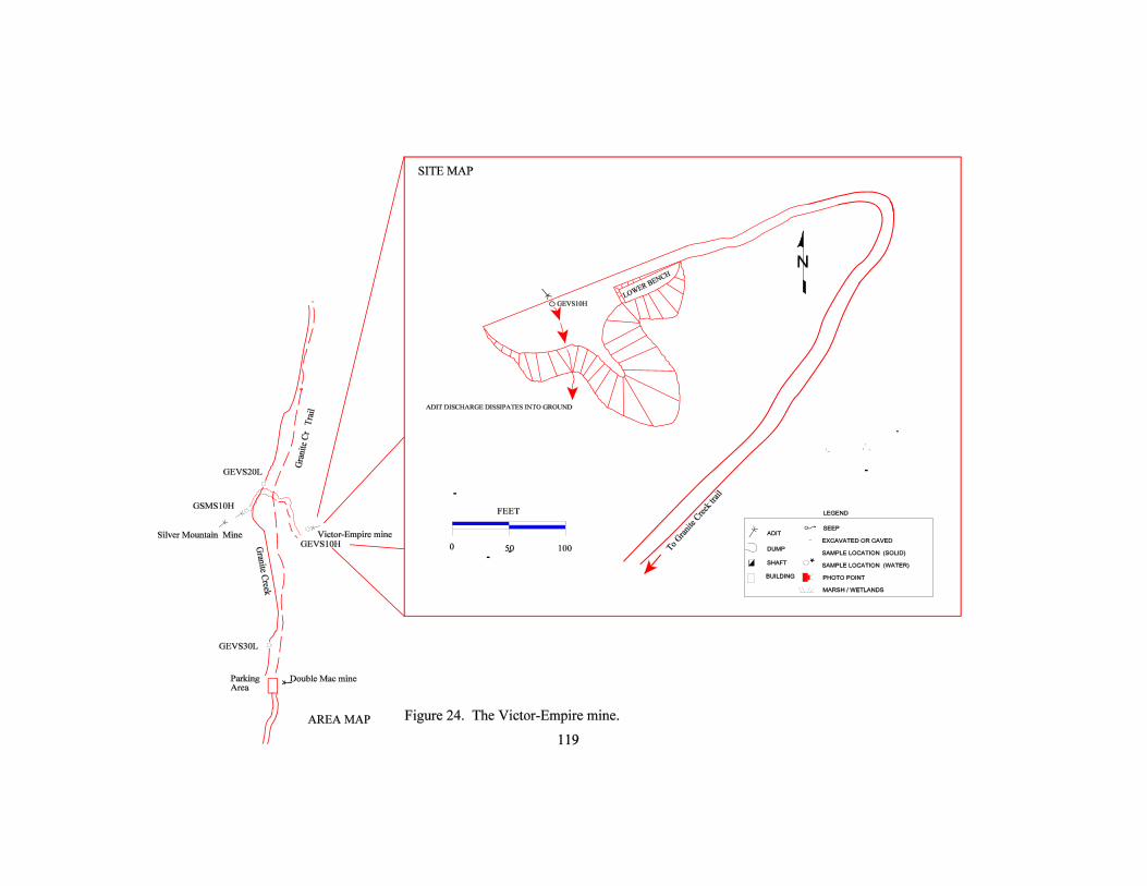

120
2.24.3.3 Water
An adit discharge was flowing at the time of visit approximately 4 – 5 gpm. Analysis of thewater sample showed no constituents tested exceeding MCLs, and there was no iron staining orother visual evidence of poor water quality. The stream samples on Granite Creek also showed good-quality water.
2.24.3.4 Vegetation
Vegetation appeared healthy throughout the site with vegetation re-establishing on the crown ofthe dump and on the old roads leading to the site.
2.24.3.5 Summary of Environmental Condition
Environmental impact from the site appears limited; the adit discharge from the site is belowMCLs, the waste dump is composed mainly of unaltered, unmineralized wall rock, and the site isapproximately 700 feet from Granite Creek.
2.24.4 Structures
There are no structures at the site.
2.24.5 Safety
The open adit is a safety concern but the site is not visible from the Granite Creek trail, and fewpeople likely visit the site.
2.25 Silver Mountain Mine
2.25.1 Site Location and Access
The Silver Mountain mine is on the south side of Granite Creek along the Granite Creek Trailapproximately three quarters of a mile from the trailhead. The site is accessed by taking theShaughnessy Road off of Highway 2 for 1.2 miles, then turning right onto Granite Lake Road for0.8 miles, then left on Forest Route 618 (Granite Creek Road) for another 7.5 miles where theroad dead ends at the Granite Creek trailhead.

121
2.25.2 Site History-Geologic Features
The Silver Mountain mine consist of three adits: one above another along the Snowshoe faultand a fault that runs parallel to it (Gibson, 1948). The upper adits are caved and the lower aditblocked off by a wooden door chained and padlocked. According to Gibson the Snowshoe faultis about three feet wide, consisting of breccia, gouge, country rock and vein quartz. Pyrite,arsenopyrite, galena, sphalerite are the more common minerals, occurring in streaks, bands, anddisseminated grains in the quartz.
Only high-grade ore was mined in 1910, and several shipments of lead-silver ore were made. Amill was erected in 1936 at the site but operated for only a short period of time. Most of themilling equipment was moved prior to 1964 (Johns, 1970).
2.25.3 Environmental Condition
There is a discharge from the lower adit of the Silver Mountain mine flowing across the uppersurface of a small waste-rock dump, dissipating into the dump. The mine and dump are severalhundred feet from Granite Creek and do not appear to be impacting the creek.
2.25.3.1 Site Features-Sample Locations
A surface-water sample was collected from the adit discharge flowing approximately three gpm(GSMS10H), and upstream (GEVS20L) and downstream (GEVS30L) surface-water samplesalso were collected from Granite Creek to assess any impacts to the stream. Site features andsample locations are shown in figure 25.
2.25.3.2 Soil
The waste-rock dump comprises mainly unmineralized gray quartzite country rock, with somescattered milky white quartz with no apparent sulfides. Analysis of the waste dump showedarsenic exceeded phytotoxic levels. Yet, the dump was partially vegetated with minimal signs oferosion and limited, if any, impact to the soils.
Table 37. Waste dump sampling results-Silver Mountain mine(mg/kg).Sample Location As Cd Cu Pb Zn
Base of waste dump(GSMW10H)
1434 1,2 3.137 1 31.64 1 828 1 314 1
(1) Exceeds one or more Clark Fork Superfund Background Levels (table 3).(2) Exceeds Phytotoxic Levels (table 3).


123
2.25.3.3 Water
None of the surface-water samples exceeded MCLs for any of the dissolved constituents tested.The adit sample showed slightly higher concentrations of arsenic, molybdenum, and zinc thanthe stream samples but was still well below exceedence levels.
2.25.3.4 Vegetation
Vegetation showed no signs of stress, in fact, trees and undergrowth has started to re-establish onthe dumps.
2.25.3.5 Summary of Environmental Condition
Environmental impact from the site appears limited; the adit discharge from the site is belowMCLs, the waste dump is composed mainly of unaltered, unmineralized wall rock, and the site isseveral hundred feet from Granite Creek.
2.25.4 Structures
The only structure at the site is the mill building approximately 175 feet east of the lower mineadit. It is in poor condition, with the front half of the building collapsed and the rest appearingunstable.
2.25.5 Safety
The unstable condition of the mill building is a safety concern, but access to the mine is difficult. The mine is not visible from the Granite Creek trail. One has to forge Granite Creek and followan overgrown road to the site.
2.26 Loyal, Shaughnessy Hill, and Lukens-Hazel Mines
2.26.1 Site Location and Access
These three sites were combined into one summary because of their close proximity to each otherand because of the small nature of each disturbance on KNF-administered land. All are close toLibby, Montana, and are reached via Forest Road 618. The Loyal and Shaughnessy Creek sites arebehind a locked gate and are adjacent to Plum Creek Timber land. A small spur road leads off ofForest Road 618 in section 5 to the Loyal and Shaughnessy Creek mines. A trail to the south

124
and Horse Creek then branches off of this spur road. This road leads to the Loyal mine in section6. An obscure trail leads off the switchback on the spur road that leads to the Shaughnessy Creekadit. The Lukens-Hazel (or Glacier Silver-Lead) mine and mill are entirely on private land north ofRoad 618. The Little Hoodoo Mountain 7.5-min. quadrangle shows adit symbols for all threemines. Access to these mines is generally considered to be easy, although the two upper mines areaccessible only by foot. During the site visit, several people were observed using the road forhorseback riding, hunting and hiking. A small group of houses is located in section 33,approximately one mile down from the sites.
2.26.2 Site History-Geologic Features
The Loyal mine is briefly mentioned in Gibson (1948). A vertical fault cutting a sill in the Wallacecalcareous shale was explored by driving an 85 ft adit. Partly oxidized pyrite, galena and sphaleritein quartz associated with the fault was described.
The Lukens-Hazel has been known as Hazel T., Glacier Lead-Zinc and may have been known asthe Shaughnessy Hill group. The Lukens-Hazel supposedly consisted of two miles of workingsaccessed by at least four adits (Gibson, 1948) and was divided into two “lodes”: the East vein andthe West vein. Both veins were originally quartz and pyrite that were crushed by faulting. Theveins were then recemented by later quartz/sulfide deposition. The West vein was the moreextensively explored. A 325-ton-per-day (tpd) mill was built prior to 1930 (Gibson, 1948). Themill was inactive in 1936 (Johns, 1970) and was dismantled prior to 1964.
The Shaughnessy Creek adit may be one of the adits mentioned in Gibson (1948) and Johns (1970)as one of the workings included in the Lukens-Hazel description.
2.26.3 Environmental Condition The two small adits on KNF-administered land uphill from the main Lukens-Hazel workings weresimple: one adit with a waste dump. The adit at each site was totally caved, and there was a lessthan one-gpm discharge at both that sunk into the waste dump. The main Lukens-Hazel site wasmore complex but was on private land and so was not assessed in this study.
2.26.3.1 Site Features-Sample Locations
Water-quality samples were collected from upstream of all mining (SLHS20M) and downstreamof the mill (SLHS10H) of the site on KNF-administered land. The flow rates at these locationswere 40 and 43 gpm, respectively. Upstream, Shaughnessy Creek pH was 7.79 and specificconductance was 125 Fmhos/cm. Downstream, Shaughnessy Creek pH was 8.09 and specificconductance was 277 Fmhos/cm. Samples were collected on September 1, 1998.

125
The adit discharge at the Loyal (HLOS10H) and the unnamed Shaughnessy Creek adit(SSCS10M) were sampled. Both were sampled from the small pool of water formed by thedischarge. Site features and sample locations are shown in figure 26; photographs are shown infigures 26a and 26b.
2.26.3.2 Soil
Soil samples were not collected. Neither mine on KNF-administered land had dumps that incontact with surface water or even near any surface water. The Lukens-Hazel was primarily onpatented ground.
2.26.3.3 Water
The concentrations of analytes in the upstream sample did not exceed any water-quality standards(table 2). The lead concentrations in the downstream sample exceeded the primary chronicaquatic-life standard but had no other problems. The small adit discharge at the ShaughnessyCreek adit exceeded the manganese secondary MCL, and the pH of 6.41 was lower than thesecondary MCL. The discharge from the Loyal adit had a fairly high aluminum level that exceededthe secondary MCL and the chronic aquatic-life standard.
Table 38. Lukens-Hazel, Loyal and Shaughnessy Creek mine water-quality exceedences.
Sample Site Al As Ba Cd Cr Cu Fe Pb Mn Hg Ni Ag Zn Cl F NO3 SO4 Si pH
SLHS20M-upstream ofall mining activity
SLHS10H-downstreamof mines
C
HLOS10H-Loyal aditdischarge
S C
SSCS10M-Shaugh-nessy adit discharge
S S1
Exceedence codes:S - Secondary MCLC - Aquatic Life Chronic
(1) Field pH did not exceed standard.Note: The analytical results are listed in appendix IV.

~2
r1.I.IrII(lI.II11)t.l1
~~~
0~
Q ~
~ ~
~5 ~
~
~
~§§z3
~.:J-J~
~
~~
~~
§~U
)~~
~~
~~
n ".
1:1-':]
~~
~
~ ~
~~
1
u;:;.
jC/)
.~I:£'
J~~¥J
~0)
~ ~
.~ -1
~~~n~~~E~~
0)
.:a!~~.~~

Figure
26a. The Loyal mine's one collapsed adit was located by following the trail to HorseCreek from the Shaughnessy Creek drainage. .
Figure 26b. A small pool of water formed at the caved portal of the Shaughnessy Creek adit. Thewater was sampled to test the effect of the mine.
127

128
2.26.3.4 Vegetation
Vegetation on KNF-administered land does not appear to be impacted by the two adits. The millarea, on private land, appeared to still be affected by the mining activity (as viewed from the road).The fire that destroyed the mill may have caused the vegetation in the area to be stunted andprohibited new growth.
2.26.3.5 Summary of Environmental Conditions
The KNF-administered land associated with these sites had not been affected by mining activity.Some of the private land may have been impacted.
2.26.4 Structures
All structures are on private property and none were evaluated or inventoried.
2.26.5 Safety
Both adits on KNF-administered land were completely caved and so were not consideredhazardous. The sites were not readily accessible because of the locked gate on private land.
2.27 Grouse Mountain and Iron Mask Mines
2.27.1 Site Location and Access
These two sites were combined because they are in close proximity and on the same side of theridge. They are approximately one mile apart in direct distance. The Iron Mask mine is locatedprimarily on patented land on the Spar Lake 7.5-min. quadrangle in BACB section 14, T30N,R34W at an elevation of approximately 3,560 ft. An improved gravel road leads to the mine andbeyond but is gated and locked at the bottom.
The Grouse Mountain mine is located on the Troy 7.5-min. quadrangle in CABA section 10,T30N, R34W. Access is difficult, the road is almost entirely overgrown and the best access is byhiking up the bottom of a tributary to Carr Draw. This site is also almost entirely on patented land.

129
2.27.2 Site History-Geologic Features
This area was first explored in the 1890's and was being worked in the 1930s when Gibson (1948)described the area. The adit started in the Prichard Formation and then explored the mineralizationin the Grouse Mountain metadiorite dike (Gibson, 1948). The workings totaled 3,000 ft of drifts(Johns, 1970). Lenticular and faulted veins in a shear zone contact of the dike hosted themineralization. These quartz-calcite veins carry galena, pyrrhotite, arsenopyrite, sphalerite, pyrite,and chalcopyrite (in decreasing order of abundance).
Total production at the Iron Mask was listed in Gibson (1948) as approximately 200 tons from theyears of 1892 to 1931. More development was done in 1943, when Montana Mining and MillingCompany leased the property and the Giant Sunrise mill. They produced nine tons of leadconcentrate and 23 tons of zinc concentrate (Johns, 1970). Ernie Williams was still working theproperty in 1997 when visited. The property consisted of two patented claims with two 300 ft adits(Gibson, 1948). Lead, zinc, silver and gold were recovered from galena, sphalerite, arsenopyrite,pyrrhotite, pyrite, and chalcopyrite in a quartz, calcite, chlorite, and hornblende gangue (Gibson,1948). This property also explored the highly altered Grouse Mountain dike.
2.27.3 Environmental Condition
The Iron Mask had a small adit discharge on private land that flowed into the waste dump andexited on KNF-administered land. The drainage that came from the mine flowed onlyintermittently before entering into the North Fork of Keeler Creek.
The Grouse Mountain mine waste dumps were in contact with the small tributary to Carr Draw.The stream was flowing in October 1997 and showed signs of having a larger flow earlier in theyear.
2.27.3.1 Site Features-Sample Locations
Both sites are primarily on patented land but were sampled only on KNF-administered land.Water-quality samples were collected from only downstream (KIMS10H) of the Iron Mask site onKNF-administered land. The flow rate at this location was estimated at 0.5 gpm. Downstream, thesmall tributary of the north Fork of Keeler Creek had a pH of 7.41 and specific conductance was211 Fmhos/cm. Samples were collected on October 01, 1997. Site features and sample locationsare shown in figure 27; photographs are shown in figures 27a and 27b.
Water-quality samples were collected from upstream (CGMS10L) and downstream (CGMS20M)of the Grouse Mountain site on KNF-administered land. The flow rates at each location wasestimated at three gpm. Upstream, the small tributary to Carr Draw had a pH of 7.63 and specificconductance was 93 Fmhos/cm. Downstream, the same tributary had a pH of 6.6 and specific

130
conductance was 27 Fmhos/cm. Samples were collected on October 01, 1997. Site features andsample locations are shown in figure 28; photographs are shown in figure 28a.
2.27.3.2 Soil
One soil sample (KIMD10H) was collected at the base of the waste dump. It showed elevatedlevels of all metals. This sample was soil mixed with some waste.
Table 39. Soil-sampling results at the Iron Mask mine and mill (mg/kg).
Sample Location As Cd Cu Pb Zn
Soils/waste mix (KIMD10H)
31211,2 59.61,2 56.51,2 14891,2 19811,2
(1) Exceeds one or more Clark Fork Superfund background levels (table 3).(2) Exceeds phytotoxic levels (table 3).
2.27.3.3 Water
The concentration of analytes in the upstream sample (CGMS10L) did not exceed any water-quality standards (table 2). The concentration of cadmium and zinc in the downstream sampleexceeded the chronic aquatic-life standards. The Iron Mask had an exceedence of the primaryMCL of aluminum but had no other problems.
Table 40. Grouse Mountain and Iron Mask mine water-quality exceedences.
Sample Site Al As Ba Cd Cr Cu Fe Pb Mn Hg Ni Ag Zn Cl F NO3 SO4 Si pH
CGMS10L-upstream ofGrouse Mountain
CGMS20M -down-stream Grouse Mtn
C AC
KIMS10H-down-stream of Iron Mask
P
Exceedence codes:P - Primary MCLA - Aquatic Life AcuteC - Aquatic Life Chronic
Note: The analytical results are listed in appendix IV.


Figure 27a. The intemlittent drainage that is a tributary to Carr Draw eroded the GrouseMountain mine's waste dump.
Figure
27b. A O.5-gpm seep was found on KNF-administered land on top of the waste dump atthe Iron Mask.
132
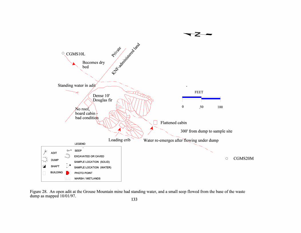


135
2.27.3.4 Vegetation
Vegetation on KNF-administered land does not appear to be significantly impacted by the sites.The waste dump at the Grouse Mountain mine was heavily revegetated on the flat top but onlysparsely to moderately revegetated on the flanks. This was probably due to the lack of soil in theseareas. Trees grew up to the edge of the dump and appeared healthy. Most impacts at the Iron Maskwere on patented land but no impacts to the vegetation was noted. Again, the waste dump was onlymoderately vegetated but had little soil development.
2.27.3.5 Summary of Environmental Conditions
These two sites contribute only a small amount of metals to the local area and do not appear tohave an effect on the surrounding KNF-administered land.
2.27.4 Structures
All structures are on private property and were not evaluated or inventoried. The Grouse Mountaindid have an old ore bin and a collapsed cabin on private land. There were originally several cabins,a blacksmith shop, and an ore bin at the Grouse Mountain mine. No structures at all were noted atthe Iron Mask.
2.27.5 Safety
The site was largely private and was not evaluated for safety. The surrounding KNF-administeredland had no safety concerns.
2.28 Giant Sunrise Mine and Sunrise Mill
2.28.1 Site Location and Access
The Giant Sunrise (or Montana Sunrise) is located on a tributary of Copper Creek in BBBCsection11, T30N, R34W at an elevation of 3,720 ft. The drainage is an unnamed creek drainingfrom the east flank of Grouse Mountain. The site is entirely on KNF-administered land.
The Sunrise mill is located in DABC section 02, T30N, R34W at an elevation of 2,715 ft. It liesentirely on patented ground but the effects to KNF-administered land could be estimated bysampling on federal land downstream on Copper Creek.

136
2.28.2 Site History-Geologic Features
The Giant Sunrise property was found in 1928 (Johns, 1970). At least five adits worked theproperty (Gibson, 1948), exploring a northwest-trending dike in Prichard Formation. These aditstotaled over 7,855 ft of workings. It is not evident if this dike is somehow related to the GrouseMountain metadiorite dike or not. The ore minerals include pyrrhotite, sphalerite, galena,chalcopyrite, pyrite, and ilmenite (Gibson, 1948). Gibson (1948) stated that a 100-tpd mill wasbuilt at the Giant Sunrise in 1934. Johns (1970) stated that this was a 200-ton mill and that it wasdismantled in 1958 (Johns, 1970); it was active in 1935 and 1936 but was idle in 1939. Johns(1970) also states that the Iron Mask and Montana Morning properties and the “25-ton GiantSunrise mill” were leased in 1943 by the Montana Mining and Milling Company. It is unclearwhether this is a misquote or if Johns was correct. The report doesn’t directly say but it seems thismill was built at the Giant Sunrise site and is a different one than the Sunrise mill to the northeastand down the valley.
The Sunrise mill is located approximately one mile to the northeast of the Giant Sunrise. Noinformation on its history could be found in literature. It may have processed ore from many of thesmall mines in the area.
2.28.3 Environmental Condition
Mine waste is in the flood plain of the unnamed tributary to Copper Creek. Several seeps emanatefrom the toe of the main waste dump. This may be the result of the infiltration of the standingwater in the adit at the top of the waste dump.
The Sunrise mill is on private land. As observed from KNF-administered land, it appeared thatmost of the remaining sediment is cobble-sized with willows and cottonwood trees growing on it.
2.28.3.1 Site Features-Sample Locations
Water-quality samples were collected from the adit at the Giant Sunrise (CGMS10M) anddownstream (CGMS20M) of the site on KNF-administered land. The flow rates at these locationswere 0.2 and 1 gpm, respectively. The adit discharge’s pH was 7.24 and the specific conductancewas 129 Fmhos. Downstream, at the seep at the base of the waste dump, the pH measured 6.2 andspecific conductance was 121 Fmhos/cm. The pH of the sample downstream on Copper Creekmeasured 7.19 and the specific conductance was 57 Fmhos. More samples were not collectedbecause of the private land position. Samples were collected on October 2, 1997. Site features andsample locations at the Giant Sunrise are shown in figure 29; photographs are shown in figures 29aand 29b. Site features and sample location at the Sunrise mill are shown in figure 30; photographsare shown in figures 30a and 30b.


Figure 29a. The open adit at the Giant Sunrise held standing water but none was flowing at thesurface to the active drainage.
Figure 29b. The waste dump had been eroded by runoff, and a small seep flowed from the baseof the dump.
138
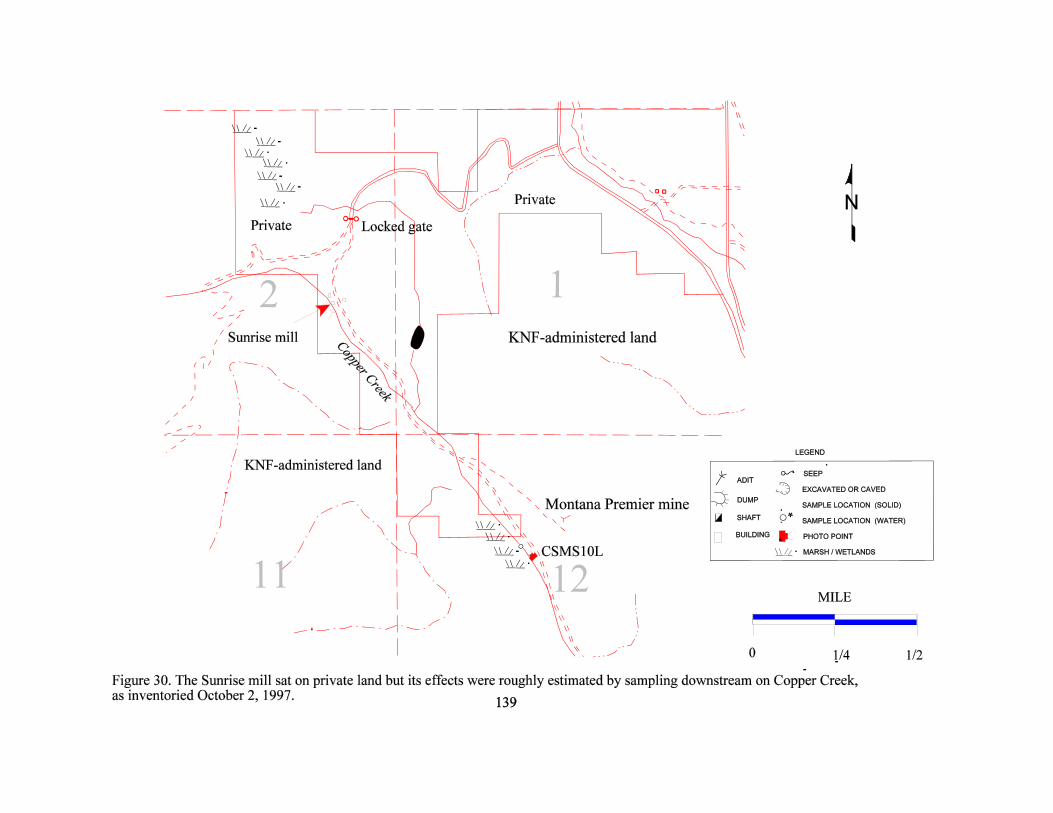

Figure 30a. As seen from KNF-administered land, the tailings were fairly well vegetated and thetailings were dry.
Figure 30b. The water at the sample site on Copper Creek was fairly stagnant, but the vegetation
appeared very healthy.
140

141
2.28.3.2 Soil
No soil or waste samples were collected because of the private land and because the waste dumpswere directly in contact with the drainage.
2.28.3.3 Water
The concentrations of analytes in the adit-discharge sample did not exceed any water-qualitystandards (table 2) but the lab pH was 8.56 while the field ph was 7.24. The downstream or seepsample had an exceedence in lead and again the field pH was 6.2 while the lab pH was anacceptable 7.52. The concentration of iron in the sample downstream from the mill exceeded thesecondary MCL but had no other problems.
Table 41. Giant Sunrise mine and Sunrise mill water-quality exceedences.
Sample Site Al As Ba Cd Cr Cu Fe Pb Mn Hg Ni Ag Zn Cl F NO3 SO4 Si pH
CGSS10M-aditdischarge
S1
CGMS20 -downstreamof the mine
C S1
CSMS10L-downstreamof the mill
S
Exceedence codes:S - Secondary MCLC - Aquatic Life Chronic
(1) Laboratory pH or field pH did not exceed standard.Note: The analytical results are listed in appendix IV.
2.28.3.4 Vegetation
Vegetation on KNF-administered land does not appear to be impacted by the site.
2.28.3.5 Summary of Environmental Conditions
Effects of the Giant Sunrise mine were local, and the discharge was extremely small.

142
2.28.4 Structures
All structures at the Sunrise mill were on private property and were not inventoried for this study.From KNF-administered land, it was observed that several buildings in good condition were on theproperty.
2.28.5 Safety
The open adit was a concern at the Giant Sunrise. McCulloch (oral communication, 1999) reportedconducting a field evaluation with the lessee. At that time, the mine was open but low oxygenconditions were encountered in the adit. The remaining cabins were in fair-to-bad condition andmay pose a safety threat.
2.29 Goat Creek Adit (name coined for current inventory)
2.29.1 Site Location and Access
This unnamed adit on Goat Creek may be accessed by either a hiking trail from Callahan Creek(Forest Trail 152) or by cutting down the hill from the clearcut above (as done in this study). Thetrailhead was not evident from the road and may not be maintained. The site was accessed bydriving 4.5 miles from the South Fork of Callahan Creek road junction and walking down througha clearcut to a faint trail along the creek. Walking was difficult because of the steepness of thetopography and numerous blowdowns. The adit is located on the Smith Mountain 7.5-min.quadrangle in BDCD section 31, T31N, R34W at an elevation of 3,200 ft.
2.29.2 Site History-Geologic Features
No references were found for this site and no name could be attached to it. The name “Goat Creekadit” was coined for this study. The site lies 1¾ miles south-southwest of the Snowstorm mine. Ifthe N25EW trend of the dike and veins at the Snowstorm mine is followed, the Goat Creek adit ison the same trend. The rock on the waste dump was primarily quartzite (Prichard ?) with a smallamount of white quartz containing sparse sulfides. No intrusive was noted at Goat Creek.
2.29.3 Environmental Condition
The waste dump was the only environmental concern noted. It was in direct contact with the activeflow of the creek. The waste was primarily large blocks of hard quartzite and did not appear to beeasily eroded. The entire area of disturbance was less than one acre.

143
2.29.3.1 Site Features-Sample Locations
The waste dump was in contact with Goat Creek for approximately 50 feet. Water-quality sampleswere collected from upstream (GGMS10L) and downstream (GGMS20L) of the site on KNF-administered land. Each flow rate was estimated at 898 gpm. Upstream, Snowshoe Creek pH was6.24 and specific conductance was 26 Fmhos/cm. Downstream, Snowshoe Creek pH was 6.6 andspecific conductance was 27 Fmhos/cm. Samples were collected on October 2, 1997. Site featuresand sample locations are shown in figure 31; photographs are shown in figures 31a and 31b.
2.29.3.2 Soil
There was no soil to sample between the waste dump and the creek. There was also no evidence ofmetals leaching into the creek. Soil samples were not taken.
2.29.3.3 Water
The only exceedence of water-quality criteria was the field pH in the upstream sample thatmeasured 6.24, but the laboratory pH measured and acceptable 7.86 (table 2).
Table 42. Goat Creek adit water-quality exceedences.
Sample Site Al As Ba Cd Cr Cu Fe Pb Mn Hg Ni Ag Zn Cl F NO3 SO4 Si pH
GGMS10L-upstream ofsite
S1
GGMS20-downstreamof site
Exceedence codes:S - Secondary MCL
(1) Laboratory pH did not exceed standard.Note: The analytical results are listed in appendix IV.
2.29.3.4 Vegetation
The vegetation did not appear impacted by the site. Few plants grew on the waste dump except formosses and a few grasses. This was probably a function of the tree canopy and the lack of soil onthe waste dump. Trees grew in the collapsed mine portal and adjacent to the dump.

Rails
0 50
FEET
100
SHAFT
ADIT
DUMP
SEEP
EXCAVATED OR CAVED
SAMPLE LOCATION (SOLID)
SAMPLE LOCATION (WATER)
LEGEND
BUILDING PHOTO POINT
MARSH / WETLANDS
Caved back 50 ft
Talus
Dump iscalcite/quartz withblack tourmaline
GGMS10L
In contact 40 ft, calcite veins >4",locally brecciated with later quartzveins, no sulfides noted, some oxides.
GGMS20L
Cabin ruins
To Callahan Creek
Figure 31. The Goat Creek adit’s waste dump was in contact with Goat Creek forapproximately 40 ft, as inventoried October 2, 1997.
144

Figure
31a. The caved Goat Creek adit is barely discernible to the left of the green backpack.There was no evidence of any adit discharge.
Figure
31 b. The sparsely vegetated waste dump was in direct contact with Goat Creek. The largesize of the fragments that compose the dump inhibits erosion of the waste.
145
146
2.29.3.5 Summary of Environmental Conditions
This site is small; it was sampled more for the sake of completeness and impartiality—not becauseit was thought to impact KNF-administered land. The site was noted by an adit symbol on the 7.5-min. quadrangle but had no other references.
2.29.4 Structures
A collapsed log structure was located approximately 50 ft to the east of the site. A few artifactsremained but otherwise it was in total ruins.
2.29.5 Safety
Although the site was adjacent to a marked trail, the access was not easy. The waste dump wassteep and rocky, but few visitors probably ever use this trail. No other safety concerns were noted.The adit was completely caved and marked only by a depression.
2.30 Snowstorm Mine
2.30.1 Site Location and Access
The Snowstorm mine can be found approximately five miles up Callahan Creek. The road iswashed out approximately one mile before the mine. The original mine road paralleling CallahanCreek is almost completely obliterated by floods. The site was accessed by walking the final mileand fording Callahan Creek on foot. The mine is located on the Troy 7.5-min. quadrangle inCCBC section 20, T31N, R34W at elevations ranging from 2,600 ft to 3,400 ft. Most of thedisturbances at the Snowstorm are patented, but one adit was found east of the main area that wason KNF-administered land. An old mill also was found half torn down adjacent to the adit.
2.30.2 Site History-Geologic Features
The Snowstorm was one of the largest producers in the area. It was originally called the B. and B.(Gibson, 1948). The Big Eight patented claims lie to the north along the same trend. Productionfrom the Snowstorm was recorded from 1917 through 1928, but it was worked for some yearsprior to 1905 (Gibson, 1948). This report listed production previous to 1930 from the Snowstormas more than $4,000,000 in lead, zinc, gold, and silver. The ore had been shipped by train to a millat Troy from 1916 until the mill burned in 1927. There was no mention in literature of the partiallydismantled mill found on site.
The geology of the area is dominated by replacement veins in a NW-trending mafic dike that was

147
as wide as 54 ft in some of the workings. The Prichard host rock was essentially barren accordingto Gibson. The veins contained galena, sphalerite, pyrrhotite, pyrite, chalcopyrite, andarsenopyrite. The ore minerals were mixed with chlorite and amphibole.
Workings at the Snowstorm reportedly consisted of at least seven adits with large, stoped areas.
2.30.3 Environmental Condition
Floods have washed away much of the streamside waste at the Snowstorm and the Big Eight. Thiswaste was located on private land, and the site was viewed from the creek bed. Mine-relatedbuildings remain but are on private land. Two were in imminent danger of collapsing the CallahanCreek when visited in 1997. The open adit discharges water that finds its way into Callahan Creek,but the flow is moderate.
2.30.3.1 Site Features-Sample Locations
Water-quality samples were collected from upstream (CSNS10L) and downstream (CSNS20L) ofthe site on KNF-administered land. The estimated flow rate at each location was 11,220 gpm.Upstream, Snowshoe Creek pH was 10.38 (probably an error due to meter malfunction) andspecific conductance was 28 Fmhos/cm. Downstream, Snowshoe Creek pH was 7.86 and specificconductance was also 28 Fmhos/cm. Samples were collected on September 30, 1997. An aditdischarge was sampled on KNF-administered land to the east of the main disturbance (CSNS30H).Its field pH was 11 (possibly an error due to a malfunctioning meter or probe?) and specificconductance was 331; the flow was estimated to be five gpm. The lab pH was 8.64. More sampleswere not collected because of the private land position. Site features and sample locations areshown in figure 32; photographs are shown in figures 32a and 32b.
2.30.3.2 Soil
No waste samples were taken because most workings were on patented land and much of the wastehad been washed away. The waste dump on KNF-administered land was not in contact with theactive drainage.


Figure
32a. Looking downstream on Callahan Creek, the waste dumps are largely eroded awayby spring floods.
Figure 32b. The adit discharge from the open adit at the Snowstoml was sampled in September30, 1997. The total flow was estimated at five gpm.
149

150
2.30.3.3 Water
The concentrations of analytes in the upstream sample (CSNS10L) did not exceed any waterquality standards (table 2) in fact, most metals’ levels were at or near detection limits. The pH wasmeasured at 10.38 in the upstream sample, but the pH meter may have been malfunctioningbecause this reading seems abnormally high. The metal concentrations in the downstream sampledid not exceed any water-quality criteria but did show a slight increase in the zinc levels. The zincconcentration increased from 5.9 Fg/L upstream to 26 Fg/L downstream. Copper levels alsoincreased from below detection limits to 6.8 Fg/L. Considering the large flow of Callahan Creek,even this slight change could considerably increase the metals loading that occurs.
The adit discharge had even higher levels of zinc (76.1 Fg/L) but the flow was only five gpm. The water appeared clear and cold. The zinc level did not exceed any water-quality criteria.
Table 43. Snowstorm mine water-quality exceedences.
Sample Site Al As Ba Cd Cr Cu Fe Pb Mn Hg Ni Ag Zn Cl F NO3 SO4 Si pH
CSNS10L-upstream ofsite
S
CSNS20L-downstreamof site
S1
CSNS30H-aditdischarge
Exceedence codes:S - Secondary MCL
(1) Laboratory pH did not exceed standard.Note: The analytical results are listed in appendix IV.
2.30.3.4 Vegetation
Vegetation on KNF-administered land does not appear to be impacted by the site. Mosses andgrasses grew right up to the edge of the adit discharge.
2.30.3.5 Summary of Environmental Conditions
Few adverse effects of the mining activity were noted on KNF-administered land in the area of theSnowstorm. No exceedences to water quality were noted, and no evidence of metals loading wasfound.

151
2.30.4 Structures
Most structures are on private property and were not evaluated or inventoried. In passing, it wasnoted that two of the buildings associated with the mine were perched on the edge of the erodedbank of Callahan Creek. A “dry” mine building was in good condition. The mill on KNF-administered land appeared as if someone had salvaged some of the lumber and had left a skeletalbuilding. A powder house on KNF-administered land to the east of the open adit was in goodcondition and was a unique design—reminiscent of a European-style building with its curved roofand stucco sides. It was empty of any explosives, but evidence was found that it had once been apowder house.
2.30.5 Safety
The private portion of the site was not evaluated for safety, although many buildings wereobserved from KNF-administered land. The open adit on KNF-administered land was an obvioussafety concern, and the half-demolished mill building was attractive to recreationists. The site wasremote and was not accessible by car or truck at the time of this visit.
2.31 Summary of the Clark Fork, Fisher River, Yaak, and Kootenai River Drainages
Most of the mine and mill sites exhibiting a potential to cause environmental problems on KNF-administered land are scattered in isolated occurrences in the Cabinet Mountains and areassociated with Belt rocks. Of the 30 sites that have a potential to adversely affect soil or waterquality on KNF-administered land, 17 are entirely on KNF-administered land, five are on privateland and seven are on private and public land. Many of the sites were discharging water but mostdischarges did not make it to nearby streams (faults were associated with many of the mines);several had waste material in contact with the stream. The relative severity of the impacts to KNF-administered land in this area was generally small and impacts were localized.
Repeated visits to some sites exemplify the need for multiple sampling events. At various sites,adits that showed evidence of discharging no longer discharged at the time of the geologist’s visit.Also, creeks that may contact mining wastes and carry sediment at times of high flow may have amuch lower sediment load later in the summer and fall. Years of exceptionally high precipitationmay not accurately reflect the influence of a specific mine. Some of the sites under consideration were examples of prior attempts at reclamation. TheSnowshoe mine and the Cherry Creek mill site were recontoured and reseeded in the late-1980's.The Snowshoe mine has deeply eroded gullies forming in the reclaimed part, while waste withabundant pyrite and galena was in direct contact with Showshoe Creek downstream of the mine.The Cherry Creek millsite does not have a water component to its environmental effects but doeshave some remnant metals and cyanide associated with the remaining tailings and cover material.

152
An accurate assessment of the cumulative impact of mining on the drainage would requireextensive sampling on private land. Many mining sites were patented and the more extensivelydeveloped (and mineralized) areas are the more likely to be patented. Sampling on private land inmany cases also would be necessary to determine the impact of the mining upstream.
Other drainages in the Yaak and Tobacco River watersheds also have clusters of mines and mills,but overall the impacts are local. Table 44 lists the mines considered in this report. The exceedenceof one or more MCLs is noted for each site as well as the analyses for each sample. All of thesamples collected at that site were considered.
Table 44. Summary of water-quality exceedences in the Fisher River drainage.
Sample Site Al As Ba Cd Cr Cu Fe Pb Mn Hg Ni Ag Zn Cl F NO3 SO4 Si pH
Snowfall-upstream
Snowfall-adit discharge
Snowfall-downstreamof Snowfall prospect
S1
SKIS10L-downstreamof King mine
Viking -upstream
Viking-downstream
Viking-adit discharge
Bramlet Crk-upstream S
Bramlet Crk-downstr.
Gloria-upstream S
Gloria-downstream
Gloria-adit discharge SC SExceedence codes:
P - Primary MCLS - Secondary MCLA - Aquatic Life AcuteC - Aquatic Life Chronic
Note: The analytical results are listed in appendix IV.

153
Table 45. Summary of water-quality exceedences in the Clark Fork River drainage. Sample Site Al As Ba Cd Cr Cu Fe Pb Mn Hg Ni Ag Zn Cl F NO3 SO4 Si pH
Jack Waite-upgradient
Jack Waite-downstream PAC
Ambassador-upstream
Ambassador-downstr.
Ambassador-discharge
Vermilion-upstream
Vermilion-downstream
Vermilion-discharge
Heidelberg-upstream
Heidelberg-discharge
Heidelberg-dump seep
Heidelberg-downstream
Pilgrim-upstream
Pilgrim-adit discharge
Pilgrim-downstream
Holliday-upstream S1
Holliday-upper disch.
Holliday-lower disch. S1
Holliday-downstream
Broken Hill-discharge AC
Blue Creek-upstream
Blue Creek-discharge
Blue Creek-seep C
Blue Creek-downstream

154
Table 46. Sites in the upper Kootenai River drainage. Sample Site Al As Ba Cd Cr Cu Fe Pb Mn Hg Ni Ag Zn Cl F NO3 SO4 Si pH
Nancy Jane-seep
Twin Peaks-seep
Rock Lake-adit
Independence-adit C
Independence-spring
Snowshoe-spring A C
Snowshoe-upstream
Snowshoe -downstream
P AC
A C
Copper Reward-adit
Cherry Creek mill-upstream
Cherry Creek mill-downstream
Lukens etc-upstream
Lukens etc-downstream C
Loyal-adit discharge S C
Shaughnessy-adit S S1
Grouse Mt-upstream
Grouse Mt-downstream C AC
Iron Mask-downstream P
Giant Sunrise-adit S1
Giant Sunrise-downstr C S1
Sunrise mill-downstr S
Goat Creek-upstream S1

155
Goat Ck-downstream
Snowstorm-upstream S
Snowstorm-downstr S1
Snowstorm-adit

156
References
Alden, W. C., 1953, Physiography and glacial geology of western Montana and adjacent areas:U.S. Geological Survey Professional Paper 231, 200 p., plus plates.
Anonymous, [n.d.], Mineral properties files: Montana Bureau of Mines and Geology, Butte.
Anonymous (GORP), 1998, Great Outdoor Recreation Pages (GORP),http://gorp.c...rce/US_Wilderness_Area/MT_CABIN.htm
Bergantino, R. N., 1978, Average annual temperatures–Montana, unpublished map: MontanaBureau of Mines and Geology, Butte.
Bondurant, K. T., and Lawson, D. C., 1969, Directory of mining enterprises, 1968: MontanaBureau of Mines and Geology Bulletin 72, 64 p., plus plate.
Calkins, F. C., 1909, A geological reconnaissance in northern Idaho and northwestern Montana.(With notes on the economic geology by D.F. MacDonald): U.S. Geological SurveyBulletin 384, 112 p.
Crowley, F. A., 1961, Directory of known mining enterprises, 1960: Montana Bureau of Minesand Geology Bulletin 20, 67 p., plus plate.
Crowley, F. A., 1962, Directory of known mining enterprises, 1961: Montana Bureau of Minesand Geology Bulletin 25, 75 p.
Crowley. F. A., 1963, Mines and mineral deposits (except fuels) Sanders County, Montana:Montana Bureau of Mines and Geology Bulletin 34, 58 p., 6 plates.
Dahlem, D. A., 1959, Geology of the Yaak River-Kootenai River confluence: Butte, MontanaSchool of Mines, unpublished M.S. thesis, 131 p., 3 plates.
Geach, R. D., 1964, Directory of mining enterprises for 1963: Montana Bureau of Mines andGeology Bulletin 38, 71 p.
Geach, R. D., 1965, Directory of mining enterprises for 1964: Montana Bureau of Mines andGeology Bulletin 46, 81 p.
Geach, R. D., 1966, Directory of mining enterprises for 1965: Montana Bureau of Mines andGeology Bulletin 49, 87 p.
Geach, R. D., and Chelini, J. M., 1963, Directory of known mining enterprises, 1962: MontanaBureau of Mines and Geology Bulletin 33, 84 p., plus plate.

157
Gibson, R., 1948, Geology and ore deposits of the Libby quadrangle, Montana. U.S. GeologicalSurvey Bulletin 956, 131 p., 9 plates.
Gilbert, F. C., 1935, Directory of Montana mining properties: Montana Bureau of Mines andGeology Memoir 15, 100 p.
Hansen, M., 1971, Directory of mining enterprises, 1970: Montana Bureau of Mines and GeologyBulletin 82, 59 p., plus plate.
Hargrave, P. A., Bowler, T. P., Lonn, J. D., Madison, J. P., Metesh, J. J., and Wintergerst, R.,1998, Abandoned-inactive mines of the Blackfoot and Little Blackfoot River drainages.Helena National Forest. Volume II: Montana Bureau of Mines and Geology Open-fileReport 368, 182 p.
Harrison, J. E., and Jobin, D. A., 1963, Geology of the Clark Fork quadrangle Idaho-Montana.U.S. Geological Survey Bulletin 1141-K, 38 p., 2 plates.
Hayes, T. S., 1983, Geologic studies on the genesis of the Spar Lake strata-bound copper-silverdeposit, Lincoln County, Montana: Stanford University, California, Ph.D. dissertation, 340p., 4 plates.
Hem, J. D., 1985, Study and interpretation of the chemical characteristics of natural waters, 3rdedition. USGS Water-supply Paper 2254, 263 p., plus plates.
Hill, J. M., 1912, The mining districts of the western United States (with a geologic introductionby Waldemar Lindgren). U.S. Geological Survey Bulletin 507, p.181–198, 1 plate.
Johns, W. M., 1959, Progress report on geologic investigations in the Kootenai-Flathead area,northwest Montana: Montana Bureau of Mines and Geology Bulletin 12, 56 p.
Johns, W. M., 1960, Progress report on geologic investigations in the Kootenai-Flathead area,northwest Montana. 2. Southeastern Lincoln County: Montana Bureau of Mines andGeology Bulletin 17, 52 p.
Johns, W. M., 1961, Progress report on geologic investigations in the Kootenai-Flathead area,northwest Montana. 3. Northern Lincoln County: Montana Bureau of Mines and GeologyBulletin 23, 57 p., 6 plates.
Johns, W. M., 1962, Progress report 4. Geologic investigations in the Kootenai-Flathead area,northwest Montana. Southwestern Flathead County: Montana Bureau of Mines andGeology Bulletin 29, 38 p., 4 plates.

158
Johns, W. M., 1970, Geology and mineral deposits of Lincoln and Flathead counties, Montana:Montana Bureau of Mines and Geology Bulletin 79, 182 p.
Johns, W. M., Smith, A. G., Barnes, W. C., Gilmour, E. H., and Page, W. D., 1963, Progress report5. Geologic investigations in the Kootenai-Flathead area, northwest Montana. WesternFlathead County and part of Lincoln County: Montana Bureau of Mines and GeologyBulletin 36, 68 p.
Koschmann, A. H., and Bergendahl, M. H., 1968, Principal gold-producing districts of the UnitedStates: U.S. Geological Survey Professional Paper 610, p.142–171.
Krohn, D. H., and Weist, M. M., 1977, Principal information on Montana mines: Montana Bureauof Mines and Geology Special Publication 75, 151 p.
Lawson, D. C., 1975, Directory of mining enterprises for 1974: Montana Bureau of Mines andGeology Bulletin 95, 66 p., plus plate.
Lawson, D. C., 1976, Directory of mining enterprises for 1975: Montana Bureau of Mines andGeology Bulletin 100, 63 p., plus plate.
Lawson, D. C., 1978, Directory of mining enterprises for 1977: Montana Bureau of Mines andGeology Bulletin 107, 59 p.
Lawson, D. C., 1979, Directory of mining enterprises for 1978: Montana Bureau of Mines andGeology Bulletin 109, 55 p., plus plate.
Lawson, D. C., 1980, Directory of mining enterprises for 1979: Montana Bureau of Mines andGeology Bulletin 111, 52 p.
Lawson, D. C., 1984, Directory of Montana mining enterprises for 1983: Montana Bureau ofMines and Geology Bulletin 121, 57 p.
Lindsay, W. L., 1979, Chemical equilibria in soils: New York, N.Y., John Wiley & Sons, 449 p.
Lindsey, D. A., Wells, J. D., and Van Loenen, R. E., (USGS), and Banister, D. P., Welden, R. D.,Zilka, N. T., and Schmauch, S. V., and Kleinkopf, M. D., 1978, Mineral resources of theCabinet Mountains wilderness, Lincoln and Sanders counties, Montana: U. S. GeologicalSurvey Open-file Report 78-327, 99 p., 4 plates, 11 figures in pocket.
Lindsey, D. A., Wells, J. D., and Van Loenen, R. E., Banister, D. P., Welden, R. D., Zilka, N. T.,Schmauch, S. V., Domenico, J. A., Friskin, J. G., Hopkins, R. T., and Kleinkopf, M. D.,1981, Mineral resources of the Cabinet Mountains wilderness, Lincoln and Sanderscounties, Montana: U. S. Geological Survey Bulletin 1501, 77 p., 2 plates.

159
Lyden, C. J., 1948, The gold placers of Montana: Montana Bureau of Mines and Geology Memoir26, 152 p.
Lyden, C. J., 1987, The gold placers of Montana: Montana Bureau of Mines and Geology Reprint6, 120 p.
Madison, J. P., Lonn, J. D., Marvin, R. K., Metesh, J. J., and Wintergerst, Robert, 1998,Abandoned-inactive mines program. Deerlodge National Forest. Volume IV. Upper ClarkFork River drainage: Montana Bureau of Mines and Geology Open-file Report 346,156 p.
Maest, A. S., and Metesh, J. J., 1994, Butte ground water injury assessment report–Clark ForkRiver basin NPL sites, Montana. Montana Department of Health and EnvironmentalSciences, December 1994, 120 p.
Marvin, R. K., Metesh, J. J., Hargrave, P. A., Lonn, J. D., Watson, J. E., Bowler, T. P., andMadison, J. P., 1998, Abandoned-inactive mines of the Beaverhead National Forest:Montana Bureau of Mines and Geology Open-file Report 348, 513 p.
Marvin, R. K., Metesh, J. J., Lonn, J. D., Madison, J. P., and Wintergerst, Robert, 1995,Abandoned-inactive mines program. Deerlodge National Forest. Flint Creek and RockCreek drainages: Montana Bureau of Mines and Geology, Final report to the U.S.Department of Agriculture, USFS, 174 p.
McClernan, H. G., 1975, Preliminary bibliography and index of the metallic mineral resources ofMontana through 1969: Montana Bureau of Mines and Geology Special Publication 70, 91p.
McCulloch, R. B., 1993, Montana mining directory: Montana Bureau of Mines and GeologyBulletin 131, 76 p.
Metesh, J. J., 1993, Unpublished report for Darrel McNenny, U.S. Forest Service, Missoula,Montana, April 1993, 10 p.
Metesh, J. J., 1992, Quality assurance project plan for mine site preliminary assessments–Deerlodge National Forest, May 1992: Montana Bureau of Mines and Geology Open-fileReport 259, 36 p., plus appendix.
Metesh, J. J., Lonn, J. D., and Hall, J. G., 1994, GIS analysis: Geology-land type associations,Basin and Cataract Creek drainages: Final Report to U.S. Department of Agriculture,Forest Service, March 1994, 14 p.

160
Metesh, J. J., Lonn, J. D., Marvin, R., Hargrave, P. A., and Madison, J. P, 1998, Abandoned- inactive mines. Helena National Forest. Upper Missouri River drainage: Montana Bureau of Mines and Geology Open-file Report 352, 195 p.
Metesh, J. J., Lonn, J. D., Marvin, R., Madison, J. P., and Wintergerst, Robert, 1995, Abandoned-inactive mines. Deerlodge National Forest. Volume V. Jefferson River drainage: MontanaBureau of Mines and Geology Open-file Report 347, 132 p.
Metesh, J. J., Lonn, J. L., Duaime, T. E., and Wintergerst, Robert, 1994, Abandoned-inactivemines program report. Deerlodge National Forest. Volume I. Basin Creek drainage:Montana Bureau of Mines and Geology Open-file Report 321, 131 p.
Metesh, J. J., Lonn, J. D., Duaime, T. E., Marvin, R. K., and Wintergerst, Robert, 1995,Abandoned-inactive mines program. Deerlodge National Forest. Volume II. Cataract Creekdrainage, Montana Bureau of Mines and Geology Open-file Report 344, 163 p.
Pardee, J. T., and Larsen, E. S., 1929, Deposits of vermiculite and other minerals in the RainyCreek district near Libby, Montana. U.S. Geological Survey Bulletin 805-B, 29 p.
Peck, J. H., 1960, An evaluation of the mineral deposits of the Rainy Creek district near Libby,Montana, University of Massachusetts, unpublished B.S. thesis, 51 p.
Pioneer Technical Services, Inc. (with assistance by: Thomas, Dean and Hoskins, Inc.), 1994,Abandoned hardrock mine priority sites, summary report (for Montana Department of StateLands Abandoned Mines and Reclamation Bureau), March 1994.
Pioneer Technical Services, Inc., 1995, Abandoned hardrock mine priority sites, summary reportfor Montana Department of State Lands Abandoned Mines and Reclamation Bureau, April1995, 588 p.
Sahinen, U. M., 1935, Mining districts of Montana: Montana School of Mines, Butte, unpublishedB.S. thesis, 109 p.
Shields, R. R., White, M. K., Ladd, P. B., and Chambers, C. L.,1996, Water resources of Montana,Water Year 1996: USGS-WDR-MT-95-1, 533 p.
Stout, K. C., and Ackerman, W., 1958, Directory of known mining enterprises, 1957: MontanaBureau of Mines and Geology Information Circular 20, 59 p.
Stumm W., and Morgan J. J., 1981, Aquatic chemistry: an introduction emphasizing chemicalequilibria in natural waters: John Wiley & Sons, New York, N.Y., 780 p.
161
Trauerman, C. J., 1940, Directory of mining properties: Montana Bureau of Mines and Geology.Memoir 20, 135 p.
Trauerman, C. J., and Reyner, M. L., 1950, Directory of Montana mining properties, 1949:Montana Bureau of Mines and Geology Memoir 31, 125 p., plus plates.
Trexler, B. D. Jr., Ralston, D. A., Reece, D. A., and Williams, R. E., 1975, Sources and causes ofacid mine drainage: Idaho Bureau of Mines and Geology Pamphlet 165, 129 p.
U.S. Forest Service, Montana Department of State Lands, Montana Department of Health andEnvironmental Sciences, and Montana Department of Natural Resources and Conservation,1990, Draft environmental impact statement, Noranda Minerals Corporation, MontanaReserves Company Joint Venture, Montanore Project: 419 p.
U.S. Geological Survey, and U.S. Bureau of Mines, 1981, Mineral resources of the CabinetMountains wilderness, Lincoln and Sanders counties, Montana: U.S. Geological SurveyBulletin 1501, 77 p.
U.S. Geological Survey, and U.S. Bureau of Mines, 1981, Mineral resources of the ScotchmanPeak wilderness study area, Lincoln and Sanders counties, Montana, and Bonner County,Idaho. U.S. Geological Survey Bulletin 1467, 77 p.
Walker, D. D, 1963, Tungsten resources of western Montana; miscellaneous deposits. U.S. Bureauof Mines Report of Investigations 6334, 60 p.
Whipple, J.W., Perry, W.J., Leinz, R.W., Bankey, Vicky, Hoover, D.B., Kleinkopf, M.D.Hamilton, M.M., and Avery, D.W., 1983, Mineral resource potential of the Ten Lakeswilderness study area, Lincoln County, Montana: U.S. Geological Survey MiscellaneousField Studies Map MF-1589-A, 7 p.
Young, F. M. Crowley, F. A., and Sahinen, U. M. 1962. Marketing problems of small businessenterprises engaged in lead and zinc mining: Montana Bureau of Mines and Geology.Bulletin 30, 58 p.
Zilka, N. T., 1981, Economic appraisal of the Scotchman Peak wilderness study area, Lincoln andSanders counties, Montana, and Bonner County, Idaho. U.S. Geological Survey Bulletin1467D, 26 p.

Appendix IUSFS-MBMG Field Form


PART C(To be completed for all sites Q,Q.Lscreened out in Parts A or B)
1. GENERAL SITE INFORMATION
2.
OPERATIONAL HISTORY
Dates of significant mining activity,
MINE PRODUCTION
Commodity(s)
I
Production
(ounces)
MILL PRODUCTION
Commodity(sJI
Production(ounces)

3. HYDROLOGY
Nonewellwetland-
Name of nearest Stream. which flows intoSprings (in and around mine site): Numerous SeveralDepth to Groundwater ft, Measured at: _shaftlpit/holeAny waste(s) in contact with active stream _Yes _No
4. TARGETS {Answer the following based on general observations only)
Surface
WaterNearest surface water inake miles, Probable use.Describe number and uses of surface water intakes observed for 15 miles downstream of
site: ~ "'
WellsNearest well _miles, Probable use.Describe number and use of wells observed within 4 miles of site:
PopulationNearest dwelling _miles, Number of months/year occupied monthsEstimate number of houses within 2 miles of the site (Provide estimates for 0-200ft, 200ft-1 mile,
1-2miles, if possible)
Recreational UsageRecreational use on site: _High (Visitors observed or evidence such as tire tracks, trash, graffiti, fire
rings, etc.; and good access to site), _Moderate (Some evidence of visitors and site is
accessible from a poor road or trail), _Low (Little, if any, evidence of visitors and site is not easily
accessible)Nearest recreational area miles, Name or type of area:
5.
SAFETY RISKS
Unstable structures,
_Explosives

6.
MINE OPENINGS
Include in the following chart all mine openings located on or partially on National Forest lands. Also, includemine openings located entirely on private land if a point discharge from the opening crosses onto NationalForest land. In this case, enter data for the point at which the discharge flows onto National Forest land; youdo not need to enter information about the opening itself.
TABLE
1 -ADITS, SHAFTS, PITS, AND OTHER OPENINGS
Opening Number
Type of Opening
Ownership
Opening Length (ft)
Opening Width (ft)
Latitude (GPS)
Longitude (GPS)
Condition
Ground water
Water Sample #
Photo Number
Comments (When commenting on a specfic mine opening, reference opening number used in Table 1):
Codes Applicable for all entries: NA= Not applicable, UNK=Unknown, OTHER=Explain in comments,
NO=NO or noneType of opening: ADIT=Adit, SHAFT=Shaft, PIT=Open Pit/Trench, HOLE=Prospect Hole, WELL=WellOwnership: NF=NationaJ Forest, MIX=National Forest and Private (Also, for unknown), PRV=PrivateCondition (Enter all that apply): INTACT=lntact, PART=Partially collapsed or filled, COLP=Filied or
collapsed, SEAL=Adit plug, GATE=Gated barrier,Ground water (Water or evidence of water discharging from opening): NO=No water or indicators of water,
FLOW=Water flowing, INTER=lndicators of intermittant flow, STAND= Standing water only (In this
case, enter an estimate of depth below grade)

7.
MINE/MILL WASTE
Include in the following chait all mine/mill was/8s located on or partially on National Forest lands. Also, include mine/mill wastes locatedentirely on private land if is visually effecting or is vety likely to be effecting NaDonai Forest resources. In this case enter data for the point
at which a discharge from the waste flows onto National Forest land, or where was/8s has migrated onto National Forest land; only enter
as much Infon718tion about the was/8 as relevant and practicable.
TABLE 2 -DUMPS, TAIUNGS, AND SPOIL PILES
Waste Number
Waste Type
Ownership
Area (acres)
Volume (cu yds)
Size of Material
Wind Erosion
Vegetation
Surface Drainage
Indicators of Metals
Stability
Location with respectto Floodplain
Distance
to Stream
Water Sample #
Waste
Sample #
Soil Sample #
Photo
Number
Codes Applicable for all entries: NA= Not applicable, UNK=Unknown, OTHER=Explain in comments, NO=NO or none
Waste Type: WASTE=Waste rock dump, MILl=Mill tailings, SPOIL=Oierburden or spoil pile, HIGH=Highwall, PLACER=Placer orhydraulic deposit, POND=Settiing pond or lagoon, ORE=Ore Stockpile, HEAP=Heap Leach
Ownership: NF=Nationai Forest, MIX=Nationai Forest and Private (Also, for unknown), PRV=Private
SIze of material (If composed of different size fractions, enter the sizes that are present in significant amounts): FINE=Finer than sand,
SAND=sand, GRAVEL=>sand and <2", COBBLE=2"~', BOULD=>S'
WInd Erosion, Potential for: HIGH=Fine, dry material that could easily become airborne, airborne dust, or windblown deposits,MOD=Moderate, Some fine material, or fine material that is usually wet or partially cemented; LOW=Little if any fines, or
fines that are wet year-round or well cemented.Vegetation (density on waste): DENSE=Ground cover> 75%, MOD=Ground cover 25% -75%, SPARSE=Ground cover < 25%,
BARREN = Barren
SUrface Drainage (Include all that apply): RILl=Surface flow channels mostly < " deep, GULlY=Flow channels >1' deep,SEEP=lntermittant or continuous discharge from was1e deposit, POND=Seasonsal or permanent ponds on feature,
BREACH=Breached, NO=No indicators of surface flow observeIndicators of Metals (Enter as many as exist): NO=None, VEG=Absence of or stressed vegetation, STAIN=yellow, orange, or red
precipitate, SALT=Salt deposits, SULF=Sulfides present
Stability: EMER=lmminent mass failure, UKE=Potential for mass failure, LOW=mass failure unlikely
location w/respect to Stream: IN=ln contact with normal stream, NEAR=ln riparian zone or floodplain, OUT=Out of floodplain

8. SAMPLES
Take samples only on National Forest lands.
TABLE 3 -WATER SAMPLES FROM MINE SITE DISCHARGES
Sample Number
Date sample taken
Sampler (Initials)
Discharging From
Feature Number
Indicators of MetalRelease
Indicators ofSedimentation
Distance to stream (ft)
Sample Latitude
Sample Longitude
Field pH
Field SC
Flow (gpm)
Method ofmeasurement
Photo Number
Comments: (\.'I/hen commenting on a specfic water sample, reference sample number used in Table 3):
Codes Applicable for all entries: NA= Not applicable, UNK=Unknown, OTHER=Explain in comments,NO=NO or none
Discharging From: ADIT=Adit, SHAFT=Shaft, PIT=Pit/Trench, HOLE=Prospect Hole, WASTE = Waste rockdump, MILL=Mili tailings, SPOIL=Overburden or spoil pile, HIGH=Highwall, PLACER=Placer or
hydraulic deposit, POND=Settling pond or lagoon, WELL=WeliFeature Number: Corresponding number from Table 1 or Table 2 (Opening Number or Waste Number)Indicators of Metal Release (Enter as many as exist): NO=None, VEG=Absence of, or stressed vegetation/
organisms in and along drainage path, STAIN=yellow, orange, or red precipitate, SALT=Salt deposits, SULF=Sulfides present, TURB=Discolored or turbid discharge
I ndlcators of Sedimentation (Enter as many as exist): NO = None, SUGHT = Some sedimentation in channel,banks and channel largely intact, MOD=Sediment deposits in channel, affecting flow patterns,banks largely intact, SIGN=Sediment deposits in channel and/or along stream banks extending tonearest stream
Method of Measurement: EST=Estimate, BUCK=Bucket and time. METER=Flow meter

TABLE 4 -WATER SAMPLES FROM STREAM(S)
Location relative tomine site/features
Upstream(Background)
Downstream
Sample Number
Date sample taken
Sampler (Initials)
Stream Name
Indicators of MetalRelease
Indicators ofSedimentation
Sample Latitude
Sample Longitude
Field pH
Field SC
Flow (gpm)
Method ofmeasurement
Photo Number
Comments: (When commenting on a specfic water sample, reference sample number used in Table 4):
Codes Applicable for all entries: NA= Not applicable, UNK=Unknown, OTHER=Explain in comments,NO = NO or none
Indicators of Metal Release (Enter as many as exist): NO=None, VEG=Absence of, or stressed streamsidevegetation/organisms in and along drainage path, STAIN=yellow, orange, or red precipitate,SALT=SaJt deposits, SULF=Sulfides present, TURB=Discolored or turbid discharge
Indicators of Sedimentation (Enter as many as exist): NO=None, SUGHT=Some sedimentation in channel,natural banks and channel largely intact, MOD=Sediment deposits in channel, affecting streamflow patterns, natural banks largely intact, SIGN=Sediment deposits in channel and/or along streambanks extending V2 a mile or more downstream
Method of Measurement: EST=Estimate, BUCK=Bucket and time, METER=Flow meter

TABLE 5 -WASTE SAMPLES
Sample Number
Date of sample
Sampler (Initials)
Sample Type
Waste Type
Feature Number
Sample Latitude
Sample
Longitude
Photo Number
Comments: (When commenting on a specfic waste or soil sample, reference sample number used in
Table 5):
Codes Applicable for all entries: NA= Not applicable, UNK=Unknown, OTHER=Explain in comments,NO=NO or none
Sample Type: SING=Single sample, COMP=composite sample (enter length)Waste Type: WASTE = Waste rock dump, MILL=Mili tailings, SPOIL=Overburden or spoil pile,
HIGH=HighwaJl, PLACER=Placer or hydraulic deposit, POND=Settling pond or lagoon sludge,ORE=Ore Stockpile, HEAP=Heap Leach
Feature Number: Corresponding number from Table 2 (Waste Number)

TABLE 6 -SOIL SAMPLES
Sample Number
Date of sample
Sampler (Initials)
Sample Type
Sample Latitude
Sample Longitude
of
Ukely SourceContamination
Feature Number
Indicators ofContamination
Photo
Number
Comments:
(When commenting on a specfic waste or soil sample, reference sample number used in
Table 6):
Codes Applicable for all emrles: NA= Not applicable, UNK=Unknown, OTHER=Explain in comments,NO=NO or none
Sample Type: SING=Single sample. COMP=composite sample (enter length)Ukely Source of Comamlnatlon: ADIT=Adit, SHAFT=Shaft, PIT=Open Pit, HOLE=Prospect Hole,
WASTE=Waste rock dump, MILL=MiII tailings, SPOIL=Overburden or spoil pile, PLACER=Placer or hydraulic deposit, POND=Settling pond or lagoon, ORE=Ore Stockpile,HEAP=Heap Leach
Feature Number: Corresponding number from Table 1 or 2 (Opening or Waste Number)Indicators of Contamination (Enter as many as exist): NO=None, VEG=Absence of vegetation,
PATH=Visible sediment path, COLOR=Different color of soil than surrounding soil,SALT=SaIt crystals

9. HAZARDOUS WASTES/MATERIALS --
TABLE 7 -HAZARDOUS WASTES/MATERIALS
Waste Number
Type ofContainment
Condition ofContainment
Contents
Estimated Quantityof Waste
Comments: (When commenting on a specfic hazardous waste or site condition, reference waste numberused in Table 7):
Codes Applicable for all entries: NA= Not applicable, UNK=Unknown, OTHER=Explain in comments,NO = NO or none
Type of Containment: NO=None. UD=drum/barreVvat with lid, AIR=drum/barrel/vat without lid,CAN = cans/jars, UNE=lined impoundment, EARTH=unlined impoundment
Condition of Containment: GOOD=Container in good condition, leaks unlikely, FAIR=Container has somesigns of rust, cracks, damage but looks sound, leaks possible. POOR=Container has visible holes,cracks or damage, leaks likely, BAD = Pieces of containers on site, could not contain waste
Contents: from label if available, or guess the type of waste, e.g., petroleum product, solvent. processingchemical.
Estimated Quantity of Waste: Quantity still contained and quantity released

10. STRUCTURES
For structures on or partially on National Forest lands.
TABLE 8 -STRUCTURES
Type
Number
Condition
Photo
Number
Comments:
Codes Applicable for all entries: NA= Not applicable, UNK=Unknown, OTHER=Explain in comments,NO=NO or none
Type: CABIN=Cabin or community service (store, church, etc.), MILL=mill building, MINE=building relatedto mine operation, STOR=storage shed, FLUME=Ore Chute/flume or tracks for ore transport
Number: Number of particular type of structure all in similar condition or length in feetCondition: GOOD=aJl components of structure intact and appears stable, FAIR=most components present
but signs of deterioration, POOR=major component (roof, wall, etc) of structure has collapsed oris on the verge of collapsing, BAD = more than half of the structure has collapsed
.11.
MISCELLANEOUS
Describe any obvious removal actions that are needed at this site:
General Comments/Observations (not otherwise covered)

.12.
SITE MAe
Prepare a sketch of the site. Indicate all pertinent features of the site and nearby environment. Include allsignificant mine and surface water features. access roads. structures, etc. Number each important fearue atthe mine site and use these number throughout this form \Nhen referring to a particular feature (Tables 1 and
2). Sketch the drainage routes off the site into the nearest stream.

13. RECORDED INFORMATION
Owner(s) of patented landName:
~
Address:Telephone Number:
Claimant(s)Name:Address:Telephone Number:
Surface Water (From water rights)Number of Surface Water Intakes within 15 miles downstream of site used for:
_Domestic, _Municipal, -,Irrigation, -~Stock,,Commerical/lndustrial, --Fish Pond, -,Mining,
,Recreation, _Other
1-2 miles
,o-v.
miles 1/.-V2 miles3-4 miles of site
V2-1 mile
Wells (From well logs)Nearest well _milesNumber of wells within
2-3 miles
Sensitive EnvironmentsUst any sensitive environments (as listed in the HAS) within 2 miles of the site or alongreceiving stream for 15 miles downstream of site (wetlands, wilderness, national/state park,wildlife refuge, wild and scenic river, T&E or T&E habitat, etc):
1-2 milesPopulation (From census data)Population within _0-1/4 miles 1/4-1/2 miles
2-3 miles _3-4 miles of site
1/2-'
mile
Other sources of information (MIls #, MRDS #, other sampling data, etc):

IIAppendix II
List of Sites in the Kootenai National Forest ~

CODE
S
V
V
V
V
V
V
S
S
S
S
U
S
S
S
S
S
V
U
VS
U
V
S
V
U
V
V
S
S
S
S
S
V
V
S
V
U
V
S
S
V
S
S
S
S
S
S
S
S
V
V
V
T
31N
31N
24N
27N
23N
31N
27N
30N
23N
30N
31N
28N
27N
31N
27N
29N
29N
35N
35N
31N
29N
31N
29N
30N
33N
31N
27N
37N
27N
24N
35N
34N
29N
26N
26N
25N
27N
31N
30N
28N
31N
29N
31N
31N
24N
28N
31N
34N
30N
30N
28N
25N
25N
SEC TRACT QUADRANGLE
21 AACC VERMICULITE MOUNTAIN
31 BDCD SMITH MOUNTAIN
9 BBBB SEVEN POINT MOUNTAIN
25 ABDB HERON
4 DDDB LARCHWOOD
34 ABBD TROY
36 CCBA HOWARD LAKE
31 DAAB CROWELL MOUNTAIN
1 CDDC BLOOM PEAK
12 TROY
16 TROY
30 SNOWSHOE PEAK
12 HERON
29 SCENERY MOUNTAIN
27 HOWARD LAKE
18 WOLF PRAIRIE
33 CABLE MOUNTAIN
28 DCDA BOULDER LAKES
27 BOULDER LAKES
19 AD DB TROY
24 WOLF PRAIRIE
18 TROY
36 CCCD SNOWSHOE PEAK
14 SPAR LAKE
3 AAAA NEWTON MOUNTAIN
17 TROY
3 CCDA SAWTOOTH MOUNTAIN
24 CCCD KSANKA PEAK
12 CBDB HOWARD LAKE
6 SEVEN POINT MOUNTAIN
6 EUREKA SOUTH
34 FLATIRON MOUNTAIN
15 B WOLF PRAIRIE
1 ACAC HOWARD LAKE
1 DBBA HOWARD LAKE
26 DADA GOAT PEAK
10 ACBC HERON
19 TROY
10 DDBB SPAR LAKE
33 SNOWSHOE PEAK
23 TROY
27 CADA CABLE MOUNTAIN
6 SCENERY MOUNTAIN
16 TROY
7 TROUT CREEK
24 A CABLE MOUNTAIN
22 TROY
5 PINK MOUNTAIN
12 LIBBY
12 TROY
8 CDDA SNOWSHOE PEAK
26 DADA GOAT PEAK
25 CCDB GOAT PEAK
MINE NAME R
ADA PROSPECT 30W
ADIT (GOAT CREEK) 34W
AJAX PLACER / SEE ALSO WALNUT 30WAMAZON
PROPERTY 34WAMBASSADOR
32WAMERICAN
EAGLE/FEDERAL SILVER LEAD 34WAMERICAN
KOOTENAI 31WASARCO
TAILINGS POND 33W
ATTLEBURY CREEK MINE SHAFT 32W
BARITE PROSPECT 34W
BEAR 34W
BEAR CREEK PORTAL 31W
BEE AND BOO CLAIM GROUP 34W
BEE AND ZEE 32W
BETTY MAE 31W
BIG CHANCE PLACER 27W
BIG CHERRY CREEK PLACER 31W
BIG CREEK 30W
BIG CREEK EXTENSION 30W
BIG EIGHT / B & B / B + B 34W
BIG EIGHT PLACER 28W
BIG FOUR 34W
BIG SKY / MONTANA SILVER-LEAD 32W
BIMETALLIC / BLACK HORSE 34W
BLACK DIAMOND 34W
BLACKTAIL 34W
BLUE CREEK / SCOTCHMAN / NORTH STAR 34W
BLUEBIRD -SEE ALSO GREEN MOUNTAIN 26W
BOLYARD PLACER NAUGHAN & GREENWELL 31W
BONANZA GOLD MINE 30W
BONNETT-HOERNER 26W
BONUS CLAIM 32W
BOULDER HILL (HOPE & BOULDER HILL) 27W
BRAMLET CREEK MILL 31W
BRANAGAN / BRANNIGAN / FISHER CREEK 31W
BRENDE PROPERTY 31W
BROWN HILL / BROKEN HILL / BOBBY 34W
CABINET 34W
CABINET QUEEN PROSPECT 34W
CABLEWAY GROUP 31W
CALLAHAN CREEK PLACER 34W
CHERRY CREEK MILL SITE 31W
CHINA CREEK 32W
CHRISTMAS TREE MINE 34W
CLARK FORK PLACER 31W
COMET PLACER 31W
CONDOR MINING & LEASING 34W
COPELAND 30W
COPPER MOUNTAIN 31W
COPPER MOUNTAIN MINE 34W
COPPER REWARD / WALKER GROUP 31W
COPPER RIDGE 31W
COPPER RIDGE MILL 31W

CODES
S
S
S
S
U
V
R
3aW
3aW
31W
28W
33W
34W
31W
34W
27W
31W
31W
32W
32W
34W
32W
31W
34W
33W
29W
31W
3aW
32W
31W
34W
32W
3aW
34W
25W
31W
31W
33W
3aW
3aW
32W
32W
31W
34W
31W
31W
34W
26W
31W
34W
34W
31W
31W
26W
31W
29W
31W
31W
31W
34W
T
28N
28N
31N
28N
31N
30N
30N
29N
29N
30N
27N
30N
29N
33N
36N
28N
29N
33N
25N
30N
27N
24N
26N
27N
27N
28N
30N
36N
29N
27N
34N
25N
24N
30N
23N
27N
27N
30N
29N
30N
37N
28N
30N
30N
28N
26N
37N
29N
30N
27N
30N
30N
30N
su
svssusussssssssvvvvssvssvvsvuvuvvsvvsvvsvv
MINE NAME
COPPER-IRON OCCURRENCE
COPPER-LEAD-IRON-MANGANESE OCCUR.
COPPER-SIL VER-IRON OCCURRENCE
COW CREEK
CRATER
CRESCENT TUNNEL
D. & W. GROUP IDA V. ADIT
DANIEL LEE I DANIEL LEE VEIN
DARLING PLACER
DENVER NO.1 & 2
DIAMOND JOHN
DOME MINE
DOUBLE MAC
DUPLEX I SUGAR QUEEN
ESTHER MAY ASBESTOS
FAIRBAULT
FAIRWAY CREEK PROSPECT
FERREL
FISHER RIVER PROPERTY
FISHER RIVER QUARRY
FORD PLACER
FOUR UP GROUP
FOURTH OF JULY
FREDERICK AND WIND GROUP
FREEMAN PROSPECT
GETNER PLACER
GIANT SUNRISE I MONTANA SUNRISE
GILBRAL TER RIDGE MINE
GLACIER AG-PB IHAZEL T.I LUKENS
GLORIA
GOLD FLINT-KEY STONE
GOLD HILL GROUP. GOLD HILL CLAIMS
GOLD KING PROSPECT
GOLDEN BEAR
GOLDEN ROC MINES
GOLDEN WEST MINE, "NEW" MINE
GOPHER HOLE MINE
GRANITE CONCRETE PIT AND PLANT
GRANITE CREEK I MOUNTAIN ROSE
GREAT NORTHERN PROPERTY
GREEN MOUNTAIN
GRIZZLY I MISSOURI GROUP
GROUSE CREEK
GROUSE MOUNTAIN
HALFMOON
HANNEGAN I LIBBY
HANSEN PROSPECT I LITTLE PRINCESS?
HARRY HOWARD PLACER
HATHAWAY
HEIDELBERG MINE I PRICE CLAIMS
HEINTZ R A CONSTRUCTION
HERBERT GROUP
HIAWATHA
SEC TRACT QUADRANGLE
15 HORSE MOUNTAIN
35 HORSE MOUNTAIN
36 LIBBY
6 FISHER MOUNTAIN
26 KOOTENAI FALLS
2 TROY
32 LITTLE HOODOO MTN
26 SAWTOOTH MOUNTAIN
21 WOLF PRAIRIE
29 LITTLE HOODOO MTN
16 HOWARD LAKE
16 TREASURE MOUNTAIN
12 AADA LITTLE HOODOO MTN
29 DBBC LEONIA
34 YAAK
19 SNOWSHOE PEAK
10 SPAR LAKE
9 NEWTON MOUNTAIN
2 MILLER LAKE
3 LIBBY
19 HOWARD LAKE
22 LARCHWOOD
13 DCBB HOWARD LAKE
15 HERON
26 ELEPHANT PEAK
5 HORSE MOUNTAIN
11 BBBC TROY
32 ABDB MOUNT MARSTON
5 CABB LITTLE HOODOO MTN
34 CDDB HOWARD LAKE
16 CBBB NEWTON MOUNTAIN
4 SILVER BUTTE PASS
4 ABCA SEVEN POINT MOUNTAIN
17 TREASURE MOUNTAIN
15 BLACK PEAK
34 DBAA HOWARD LAKE
10 CDBB HERON
12 LIBBY
7 BDBC LITTLE HOODOO MTN
10 TROY
24 BBCC KSANKA PEAK
4 BBBA CABLE MOUNTAIN
24 BAAC SPAR LAKE
10 CABA TROY
33 CABLE MOUNTAIN
2 ABCD HOWARD LAKE
8 AABA EUREKA NORTH
34 CABLE MOUNTAIN
7 CCDD TONY PEAK
32 CBCA ELEPHANT PEAK
3 LIBBY
29 DCCD LITTLE HOODOO MTN
10 DADB TROY

CODES
V
S
S
S
V
S
V
S
V
V
S
S
S
S
S
V
S
V
S
S
V
U
S
S
S
V
S
S
S
S
V
S
U
U
S
S
S
V
S
S
S
S
S
S
V
V
V
S
V
S
S
S
R
33W
34W
34W
26W
31W
29W
31W
26W
32W
3aW
34W
29W
31W
28W
32W
3aW
32W
33W
31W
34W
3aW
31W
34W
29W
28W
3aW
3aW
27W
28W
34W
32W
34W
3aW
29W
32W
31W
3aW
31W
31W
31W
34W
27W
34W
31W
34W
34W
31W
3aW
3aW
31W
33W
3aW
27W
T
35N
26N
26N
30N
27N
32N
26N
37N
30N
26N
30N
37N
31N
32N
32N
31N
22N
28N
28N
28N
31N
26N
30N
33N
27N
31N
25N
29N
33N
30N
35N
30N
31N
24N
28N
27N
28N
31N
26N
31N
31N
37N
33N
33N
30N
30N
29N
22N
31N
29N
32N
37N
29N
SEC
TRACT QUADRANGLE
3 CLARK MOUNTAIN
36 AADD GEM PEAK
36 AADD GEM MOUNTAIN
30 C HORSE HILL
13 HOWARD LAKE
26 DAAD URAL CREEK
13 DCDC HOWARD LAKE
22 CAAD KSANKA PEAK
21 TREASURE MOUNTAIN
18 CAAA HOWARD LAKE
14 BACB SPAR LAKE
8 ROBINSON MOUNTAIN
36 LIBBY
7 D VOLCOUR
2 TURNER MOUNTAIN
28 VERMICULITE MOUNTAIN
17 DAAC BLACK PEAK
7 DACB SAWTOOTH MOUNTAIN
22 CACA CABLE MOUNTAIN
14 SAWTOOTH MOUNTAIN
21 BCDD VERMICULITE MOUNTAIN
1 BAAC HOWARD LAKE
25 SPAR LAKE
25 URAL CREEK
34 LOON LAKE
34 VERMICULITE MOUNTAIN
7 DDAA GOAT PEAK
15 WOLF PRAIRIE
20 URAL CREEK
1 TROY
25 YAAK
23 ADDB SPAR LAKE
10 DABC VERMICULITE MOUNTAIN
12 VERMILION PEAK
6 SNOWSHOE PEAK
11 HOWARD LAKE
30 CABLE MOUNTAIN
30 BACA LIBBY
2 HOWARD LAKE
32 LIBBY
35 TROY
12 EUREKA NORTH
34 A KILBRENNAN LAKE
8 FLATIRON MOUNTAIN
10 TROY
2 DBBB TROY
6 ABCC LITTLE HOODOO MTN
18 DDAB BELKNAP
28 VERMICULITE MOUNTAIN
5 BCCA LITTLE HOODOO MTN
26 PULPIT MOUNTAIN
2 ROBINSON MOUNTAIN
20 DBAA WOLF PRAIRIE
MINE NAME
HOERNER
HOLLIDAY (HOMESTEAD I SILVER MARK)
HOMESTEAD MINING CLAIMS
HORSE HILL
HOWARD CREEK CLAIM
HOYT (NORTH STAR GROUP)
ILLINOIS-MONTANA GROUP
INDEPENDENCE
INDIAN HEAD TUNGSTEN
IRISH BOY AND RAMBLER
IRON MASK
IRON OCCURRENCE
IRON OCCURRENCE
IRON OCCURRENCE
I RON-COPPER OCCURRENCE
I RON-PHOSPHATE OCCURRENCE
JACK WAITE MINE
JFPROSPECT
JOHN BULL-UNCLE SAM MINE
JOHN FRANcrs CLAIMS
JOSEPH PROSPECT
JUMBO MINE (FORMERLY TIP TOP)
KEELER MOUNTAIN
KENELTY
KENEL TY MINE
KENNEDY
KING I SILVER BUTTE
KIRKPATRICK
KOOTENAI RIVER PLACER
KOTSCHEVAR BARITE
LARUE-CRIPE ASBESTOS
LAST CHANCE (LITTLE SPOKANE)
LAST CHANCE GROUP I POSTON GROUP
LAURA APEX GROUP
LEIGH CREEK
LIBBY CREEK GOLD MINING CO.
LIBBY CREEK PLACER
LIBBY PIT
LIBBY PROSPECT (SEE HANNEGAN)
LIBBY SAND AND GRAVEL PIT
LIBERTY METALS
LIMESTONE OCCURRENCE
LIMESTONE OCCURRENCE
LIMESTONE OCCURRENCE
LITTLE SPOKANE
LOST CAUSE MINE
LOYAL
LUCKY LUKE
LUCKY MAC GROUP
LUKENS-HAZEL UPPER ADITS
LYNX CREEK
MANGANESE-LEAD-COPPER-IRON OCCUR.
MASTODON (BARBARA CLAIMS) KAVALLA

CODE
S
S
V
U
S
S
S
U
S
SSS
S
V
V
V
S
V
S
V
S
S
S
V
S
V
S
S
S
S
V
S
S
V
S
V
S
S
V
S
V
S
V
V
S
S
V
V
V
V
V
V
S
MINE NAME
MC GUIRE PROSPECT
METALLIC MINERALS OCCURRENCE
MIDAS MINE I ROSE CONSOLIDATED
MILLER
MILLER PLACER
MILTON GROUP
MISSOURI (SEE GRIZZLY LNOO6170)
MOEN
MONTANA MORNING
MONTANA PLACER
MONTANA PREMIER MINE
MONTANORE ADIT
MONTANORE PROJECT ADIT & PLANT SITE
MONTEZUMA/HALLALUJAH
MOUNTAIN ROSE
MUSTANG OR NETHERCUTT'S MINE
NANCY
NANCY JANE CLAIMS
NAPOLEON PROSPECT
NEW MORNING GLORY I HAYWIRE MINING
NUGGET PLACER
OLSEN & SWITZER
ORO-HIGHLAND I HIGHLAND SILVER
PETERSON (TWIN PEAKS) BLACKTAIL
PHILLIPS
PILGRIM
POTTER
RANKIN
RAVEN
RAZORBACK
RED FIR CLAIMS
RED GULCH PLACER
REMP (SILVER GHOST)
REX MINE I JAGER MINE
ROCK CREEK PROJECT I COPPER
ROCK LAKE ADITS
RUTH V
RYAN
SCHMITZ MINE I JOSHUA ADIT
SEATTLE
SECLUSION (A.C. LEWIS)
SECOND CHANCE I MCGUIRE PROPERTY
SHAUGHNESSY CREEK ADIT
SHOESTRING 1 & 2
SID CLAIM
SILVER CABLE (PROSPECT)
SILVER GROUSE
SILVER KING
SILVER MOUNTAIN GROUP
SILVER STRIKE I MOLYNEAUX
SILVER TIP (G.E. SHAW)
SILVERTIP (G.E. SHAW)
SILVERTIP GROUP I O. A. HOWARD
R
29W
30W
30W
33W
30W
34W
31W
26W
34W
31W
34W
31W
31W
30W
31W
31W
29W
26W
30W
33W
30W
31W
35W
26W
31W
33W
28W
34W
30W
30W
34W
30W
32W
25W
32W
26W
32W
34W
25W
31W
30W
29W
31W
31W
32W
32W
34W
34W
32W
34W
31W
30W
31W
T
34N
36N
27N26N
26N
31N
28N
37N
31N
28N
30N
27N
27N
27N
29N
27N
26N
37N
31N
34N
29N
26N
32N
37N
37N
25N
27N
32N
31N
24N
27N
28N
30N
35N
27N
35N
24N
27N
35N
28N
27N
34N
29N
24N
24N
28N
30N
30N
29N
30N
28N
26N
28N
SEC
TRACT QUADRANGLE
24 INCH MOUNTAIN
18 MOUNT HENRY
19 DCDC HOWARD LAKE
35 ABAA NOXON
4 DCDA BARREN PEAK
13 TROY
4 CABLE MOUNTAIN
8 ACBA EUREKA NORTH
28 DADA TROY
3 CABLE MOUNTAIN
12 TROY
11 CCDC HOWARD LAKE
9 CBCA HOWARD LAKE
31 AABC HOWARD LAKE
7 BDBC LITTLE HOODOO MTN
26 ACDA HOWARD LAKE
14 KENELTY MOUNTAIN
14 DBBC KSANKA PEAK
22 VERMICULITE MOUNTAIN
9 BBAA NEWTON MOUNTIAN
19 SWEDE MOUNTAIN
11 ABDD HOWARD LAKE
36 D SMITH MOUNTAIN
14 DDDA KSANKA PEAK
25 B MOUNT HENRY
8 CCDD GEM MOUNTAIN
20 CACC LOON LAKE
14 KILBRENNAN LAKE
21 VERMICULITE MOUNTAIN
15 SEVEN POINT MOUNTAIN
25 ABDB HERON
19 B CABLE MOUNTAIN
6 DCAA SCENERY MOUNTAIN
15 CBDA MOUNT MARSTON
26 DCCC ELEPHANT PEAK
6 DBCB EUREKA SOUTH
24 B LARCHWOOD
23 HERON
7 DBDA MOUNT MARSTON
18 AABC SNOWSHOE PEAK
28 BCBA BARREN PEAK
24 INCH MOUNTAIN
6 AABA LITTLE HOODOO MTN
13 BDDA TROUT CREEK
24 LARCHWOOD
36 SNOWSHOE PEAK
11 BADA TROY
15 BDAA SPAR LAKE
12 TREASURE MOUNTAIN
10 TROY
18 SNOWSHOE PEAK
32 BCCA HOWARD LAKE
7 DCCB SNOWSHOE PEAK

CODE
S
S
S
V
V
V
S
S
V
V
S
S
S
S
S
VV
V
U
V
S
S
S
S
S
S
S
SS
S
V
V
S
S
S
S
S
S
S
S
S
S
S
S
S
V
S
S
S
S
S
S
S
R
30W
30W
33W
30W
32W
34W
30W
34W
32W
31W
31W
31W
29W
27W
30W
34W
26W
33W
26W
31W
27W
27W
33W
32W
34W
34W
33W
34W
26W
34W
31W
34W
30W
32W
30W
28W
26W
26W
30W
30W
32W
30W
30W
30W
29W
28W
29W
30W
30W
28W
29W
33W30W
T
25N
25N
33N
25N28N
31N
37N29N
28N
31N
27N
27N
34N
29N25N
30N
37N
34N
37N
28N
29N
36N
29N
24N
29N29N28N29N
37N27N26N
30N
31N
34N
31N27N
37N
37N
30N
33N
34N
28N
24N
28N
29N
37N
31N
31N
31N
36N
37N
35N
28N
MINE NAME
SIMS GULCH PLACER
SIMS PROSPECT
SNIPETOWN PLACER
SNOWFALL PROSPECT
SNOWSHOE GROUP/SNOWSHOE QUARTZ
SNOWSTORM / B. AND B.
SOLO JOE
SPAR LAKE / SPAR LAKE COPPER
ST PAUL /ZOLLARS/ FERN/FAITHITOPSY
ST. ANTHONY
ST. PAUL PASS PROSPECT
STATESMAN
STONEHILL PLACER
STRODTBECK
SUNRISE
SUNRISE MILL
SWANSEA ROSA LODE CLAIM
SYLVANITE MILL / KEYSTONE GROUP
TETRAULT
TEXAS RANGER GROUP
TIDEMAN PLACER
TOBACCO RIVER PLACER
TRIO
TROUT CREEK PLACER
TROY PROJ -MAN-WAY & CONVEYOR ADIT
TROY PROJ. -NORTH ADITS
TROY PROJ. -SOUTH ADIT
TROY PROJECT/ SPAR LAKE
TWIN PEAKS PROSPECT
ULLEY (SQUAW PEAK)
UNION GROUP -ISMORE/EVENING/
UNIVERSAL
UNIVERSAL ZONOLITE CORP. PROPERTY
UNNAMED ALUMINUM
UNNAMED ASBESTOS
UNNAMED BARITE
UNNAMED BARIUM
UNNAMED BARIUM
UNNAMED CALCITE
UNNAMED CHLORITE & SERICITE
UNNAMED CLAY
UNNAMED COPPER
UNNAMED COPPER
UNNAMED COPPER
UNNAMED COPPER
UNNAMED COPPER
UNNAMED COPPER
UNNAMED COPPER, LEAD, & SILVER
UNNAMED FELDSPAR & MICA
UNNAMED GALENA
UNNAMED GALENA, COPPER, & SILVER
UNNAMED GOLD
UNNAMED GOLD
SEC TRACT QUADRANGLE
24 CBAD SILVER BUTTE PASS
14 DADA SILVER BUTTE PASS
19 KILBRENNAN LAKE
16 CBAC SILVER BUTTE PASS
7 BADA SNOWSHOE PEAK
20 CCBC TROY
28 MOUNT HENRY
16 SPAR LAKE
12 DDDC SNOWSHOE PEAK
19 CODA LIBBY
19 CDCC ELEPHANT PEAK
5 CADB HOWARD LAKE
2 INCH MOUNTAIN
4 WOLF PRAIRIE
9 SILVER BUTTE PASS
2 DABC TROY
14 CAAB KSANKA PEAK
9 BABB NEWTON MOUNTAIN
14 KSANKA PEAK
6 CABA SNOWSHOE PEAK
17 WOLF PRAIRIE
23 EUREKA SOUTH
30 CROWELL MOUNTAIN
28 LARCHWOOD
26 DDBB SAWTOOTH MOUNTAIN
35 ABDA SAWTOOTH MOUNTAIN
6 ACDD SAWTOOTH MOUNTAIN
25 BBCD SAWTOOTH MOUNTAIN
8 EUREKA NORTH
13 HERON
2 ACAC HOWARD LAKE
11 CBCC SPAR LAKE
22 VERMICULITE MOUNTAIN
11 FLATIRON MOUNTAIN
15 DDCB VERMICULITE MOUNTAIN
34 LOON LAKE
13 KSANKA PEAK
25 KSANKA PEAK
3 VERMICULITE MOUNTAIN
35 BANFIELD MOUNTAIN
11 FLATIRON MOUNTAIN
35 HORSE MOUNTAIN
1 SILVER BUTTE PASS
15 HORSE MOUNTAIN
31 FISHER MOUNTAIN
20 BAAC RED MOUNTAIN
15 C ALEXANDER MOUNTAIN
21 VERMICULITE MOUNTAIN
33 VERMICULITE MOUNTAIN
11 REXFORD
14 RED MOUNTAIN
19 MOUNT BALDY
9 HORSE MOUNTAIN

CODE
S
S
S
S
S
V
S
S
S
S
S
S
S
U
V
S
V
V
VV
S
V
V
V
S
U
V
S
V
U
V
V
S
S
S
U
S
R
3aW
28W
33W
27W
28W
34W
33W
34W
29W
3aW
28W
29W
33W
34W
31W
28W
3aW
3aW
3aW
3aW
3aW
32W
3aW
3aW
31W
3aW
3aW
3aW
31W
34W
33W
31W
27W
3aW
32W
33W
3aW
T
28N
26N
33N
30N
26N
35N
33N
33N
25N
36N
37N
29N
32N
30N
27N
37N
31N
25N
25N
24N
24N
29N
25N
24N
26N
27N
27N
24N
27N
31N
25N
27N
29N
30N
34N
33N
31N
SEC TRACT QUADRANGLE
16 HORSE MOUNTAIN
11 LOON LAKE
31 PULPIT MOUNTAIN
17 WOLF PRAIRIE
2 LOON LAKE
25 MOUNT BALDY
36 PULPIT MOUNTAIN
34 KILBRENNAN LAKE
12 MILLER LAKE
18 MOUNT HENRY
20 RED MOUNTAIN
31 FISHER MOUNTAIN
25 PULPIT MOUNTAIN
29 SPAR LAKE
32 BDBA HOWARD LAKE
22 REXFORD
23 VERMICULITE MOUNTAIN
22 BBCB SILVER BUTTE PASS
27 ABCC SILVER BUTTE PASS
9 BBM SEVEN POINT MOUNTAIN
7 SEVEN POINT MOUNTAIN
12 TREASURE MOUNTAIN
4 CACD SILVER BUTTE PASS
9 BBBB SEVEN POINT MOUNTAIN
15 CBDB HOWARD LAKE
28 CCAC BARREN PEAK
20 DBDC BARREN PEAK
4 SEVEN POINT MOUNTAIN
33 ABCA HOWARD LAKE
5 B TROY
4 BCCB NOXON
26 ADAC HOWARD LAKE
18 WOLF PRAIRIE
3 VERMICULITE MOUNTAIN
34 FLATIRON MOUNTAIN
4 NEWTON MOUNTAIN
10 VERMICULITE MOUNTAIN
MINE NAME
UNNAMED GOLD
UNNAMED GOLD & SILVER
UNNAMED GOLD & SILVER
UNNAMED GOLD & SILVER
UNNAMED GOLD & SILVER
UNNAMED GOLD & SILVER
UNNAMED LEAD & ZINC
UNNAMED LIMESTONE
UNNAMED QUARTZ
UNNAMED SILVER
UNNAMED SILVER, GOLD, & COPPER
UNNAMED SILVER, LEAD & COPPER
UNNAMED TALC
UNNAMED URANIUM
UPPER HEIDELBERG
VALLEY VIEW CLAIMI J.B. CLAIM
VERMICULITE MOUNTAIN MINE
VERMILION I CARPENTER PROPERTY
VERMILION MILL SITE
VERMILION RIVER ADIT
VERMILLION CREEK PLACER
VICTOR-EMPIRE
VIKING MINE I GOLD HILL CLAIMS
WALNUT-CARL E. PLACER
WANLESS LAKE PROSPECT IHAMERMILL
WAYLETT GROUP I MOOSE HILL I ROYAL
WAYLETT NORTH PROSPECTS
WAYLETT PLACER
WA YUP MINE I WAY UP
WEYERHAEUSER
WHITE STAR (BAKER)
WILLIAMS
WOLF CREEK PLACER
WOLLASTONITE VEINS
WOODS MINE
YMK FALLS
ZONOLITE MINE
V:
Visited S: Screen in office U: Location inaccurate

III-1
Appendix III Description of Mines and Mill Sites
Kootenai National Forest - Lincoln County
American EagleLN005646
This site was visited 07/30/97 and one caved adit (N40°E) was found with hearty vegetation. Thesite is adjacent to the road. The American Eagle was described in Gibson (1948) an adit 1,300feet long with several hundred feet of crosscuts. This NW-trending working was associated witha metadiorite sill and the Prichard argillite. There may have been three other adits and one ofthese may have been the one that the MBMG geologist found. The longest adit was driven alongan NW-trending fault in the metadiorite sill.
American KootenaiLN005922
This lode was discovered in the 1890's according to Johns (1970) and according to Gibson(1948), three adits were driven. One adit was still open at the time of this visit, with the twoothers caved and nearly obliterated. There is a road to the open adit and there was evidence ofcamping on the waste dump.
Gibson (1948) states that the American Kootenai is hosted by the Prichard Formation with theore in bedding plane or crosscutting veins. The veins were irregular thickness with very littlepyrite; the sparse original pyrite had been largely oxidized. The total length of workings in allthree adits was estimated at 600 feet (Gibson, 1948). No trace of the mill was found (built before1901) and it may have been destroyed by a snowslide or a fire (Johns, 1970). Few sulfides werereported mainly because of oxidation due to the shallow nature of the deposit. A cable that maybe a remnant of the aerial tramway from the Jumbo Group was located to the east of the mine.
ASARCO Tailings PondLN008393
This site was screened out because the current operating permit is on private land. No referenceswere found for this site.
B & BLN004169
There are at least three caved adits along the creek. The dumps spill into the creek but are mostlyall washed away. Mineralized Prichard is exposed by recent floods downstream on the river. Fourpatented claims and two unpatented are north of the Snowstorm mine (Johns, 1970). Gibson(1948) first described this site. Sphalerite was the most abundant ore mineral with lesser amountsof galena, pyrrhotite, chalcopyrite, pyrite, and magnetite (Gibson, 1948). This report goes on tosay that between 1912 and 1928 over 6,000 tons of lead-zinc ore were mined. It was idle in 1931.

III-2
Barite ProspectLN004114
This site was screened out because it was a prospect, and it was mislocated. There were not anyreferences found for this site.
BearLN006194
The Bear site is located a mile and a half northeast of the Big Eight property (Johns, 1970). Johns(1970) states that there is a quartz vein that contains galena and sphalerite, and samples assayed20 percent lead and three ounces of silver per ton. The vein is in the Prichard Formation. Thissite was screened out because it is located on a dry ridgetop and is on state land.
Bee and ZeeLN004402
The Bee & Zee Mine was screened out because, according to USGS Bulletin 1501, it is nothingmore than a prospect with no workings. The bulletin also states there are several quartz veins afew inches to two feet wide along shear zones conformable and unconformable with the beddingof the argillite host rock.
Betty MaeLN006122
This site was screened out because Johns (1960) described the property as consisting of "severalshallow cuts and pits", and Gibson (1948) described it as six shallow openings and the location isapproximate. The property is behind the Montanore locked gate. Minerals occurring in the quartzveins and veinlets include galena, chalcopyrite, sphalerite, lesser amounts of pyrrhotite, nativecopper, and melanterite, with oxides cerussite and anglesite. The veins are in the PrichardFormation, and a selected sample contained 10% copper, 20 ounces of silver, and ½- ounce ofgold per ton.
Big Chance PlacerLN004149
This site was screened out because it is a placer and the only reference to it is a 1981 MSHAreport. Most, if not all, land placered in the area along Wolf Creek is private.
Big Cherry Creek PlacerLN006086
Big Cherry Creek is a tributary of Granite Creek, and placer mining has been reported along BigCherry Creek. The production has not been sufficiently large and testing has not been done todetermine if small pockets of dredged gravel exist (Lyden, 1948).
Big Creek LN004064
This mine lies approximately 300 feet west of the site of the former USFS Big Creek Cabin onBig Creek. The cabin is no longer present but is marked on the topographic maps. The adit is

III-3
uphill on a talus slope to the north of pack trail 150. It had a small seep and some standing waterinside the open adit. Johns (1970) reported that the adit was 300 feet long driven along a smallquartz vein in the Prichard Formation. Small pieces of iron-stained quartz were found on thedump but the majority of the rock was gray quartzite. The adit was hidden by a grove of trees andhad a wooden snow-shed or “roof” over it. The adit trended N15°W and was open for at least 40feet.
Big Creek ExtensionLN004069
This site was described by Johns (1970, p. 121) as “high on the ridge just north of the Big Creekproperty” but no other location was noted. It was screened out because of this inaccurate location.The general area was visited but no signs of mining activity was noted. The property wasreported to have had two short adits driven into a barren quartz vein. This occurrence may havebeen an extension of the Big Creek fault zone.
Big Eight PlacerLN005902
This site was screened out because it was a placer claim which was mostly, if not all, private. Itwas located in 1902 and no record of production was noted in MBMG Bulletin 17 (1960), p. 35.The property consists of 160 acres.
Big FourLN006118
There are seven unpatented claims located on the west side of Gordon Creek and a half milenorth of Callahan Creek (Gibson, 1948). It is also two and a half miles south of Kerr Mountain(Johns, 1970). There is an adit that has about 1,000 feet of workings, but the veins rarely reach athickness of six inches. The adits explore two shear zones in the Snowstorm dike, and the wallrock of the dike is in the Prichard formation (Gibson, 1948). The site was screened out becauseof the inability to locate the mine.
Big SkyLN006050
This site is located to the north of the trail to Leigh Lake. Johns (1970) reported two accessibleadits but when the site was visited in 1998, one was collapsed and MBMG staff could not findthe other one. It is assumed that it is caved and covered by talus. The two adits, 1,200 feet and700 feet long respectively, were driven along the north-trending Snowshoe Fault. WallaceFormation lies to the west of the fault and Ravalli Formation is to the east of the fault. Galena,sphalerite, pyrite, with minor chalcopyrite, arsenopyrite, and pyrrhotite are found in a quartz,ankerite and calcite gangue (Johns, 1970).
Bimetallic MineLN006182
There are 14 unpatented claims located on the north side of the North Fork of Keeler Creek(Gibson, 1948). Gibson also states that the development work done was four short adits were
III-4
driven. The adits explore the Grouse Mountain dike. A few of the veins are more than eightinches thick, but most of the veins are less then eight inches thick. This site was screened outbecause it is located on a dry ridgetop.
Black DiamondLN006142
This site has limited access because of private land to the west. One adit was located on KNF-administered land but it was collapsed. Gibson (1948) reported that this property on Pine Creekexplored small veins/shear zones in quartzite associated with dikes. He reported a 100-ton millhad been built in the 1930's. Johns (1959) listed workings as consisting of four adits (one 500-feet long) and a “glory hole” on the hillside. This glory hole was not located during the site visit.
BlacktailLN005650
According to Johns (1970), the Blacktail mine is located on a tributary of Sanko Creek, and theclaim was staked after a fire in 1938. The development work included a short shaft and a ten footadit. Later, two additional claims were located. An additional eight pits and a 20 foot aditexposed 200 feet of the vein. The Blacktail vein ranges in width form two to ten inches. Asample of the vein assayed at 9.64% copper, 2.80 ounces of silver, and 0.04 ounces of gold perton. This site was screened out because of the inability to locate the mine.
Bolyard PlacerLN005758
This site was screened out because it was a placer and there were no references listed for Bolyardplacer in the MILS database.
Bonnett-HoernerLN004049
This occurrence is described in Johns (1961) as a barite prospect consisting of a bulldozer trenchand an inaccessible adit in Purcell basalt. It was screened out because the commodity beingexplored for was barite and because the location was inaccurate (described as the south end ofLost Lake in Johns, 1970).
Bonus ClaimLN005762
This site was screened out because there was no access into the area shown on the topographicmap, the location was +/-1 km and there were no references to it in the MILS database.
Boulder HillLN006030
This site was described by Johns (1960) as being inactive for the past 10 years. The property wasreported as a prospect with two short inaccessible adits and 50 pits and trenches; was unable tolocate.

III-5
CabinetLN004542
This site was screened out because of the inability to locate this mine, and there were not anyreferences found.
Cabinet QueenLN005766
No disturbance was visible at the Cabinet Queen in 1997. The adit described in Gibson (1948)was 550 feet long and was started in the Grouse Mountain dike and then hit the Prichard argillite.The vein here was quartz/calcite with arsenopyrite, pyrite, sphalerite, and lesser galena andchalcopyrite (Gibson, 1948). The property was reported by Johns (1970) to have been active asrecently as 1958.
Cableway GroupLN006066
This site was screened out because it had only one reference in literature (MBMG Bulletin 95, p.15) which stated that it was a silver - lead - gold prospect and its status was "developing". It wasclaimed by Donald C. and Marie Cripe of Libby, Montana. The location was described as beingin section 33, T28N, R31W.
Callahan Creek PlacerLN006090
This site was screened out because it was a placer mine, and there were no references found.
China CreekLN005774
This site was screened out because it did not have references listed in the MILS database, it is aplacer, and it had a very inaccurate location.
Christmas Tree MineLN005778
This site was screened out because it is located on a dry ridgetop, and there were no referenceslisted. This site was also located on state land.
Comet PlacerLN005590
Many placer claims located on Little Cheery Creek near its confluence with Libby Creek werebought by Comet Mining Co. (Gibson, 1948). The pay streak is contained by stream gravels andheavy overburden (Gibson, 1948). This placer was screened out because it was a placer, and theownership is probably mostly private.
Condor Mining and LeasingLN004212
This site was screened out because it is a placer. There were no references listed for this site.
III-6
CopelandLN005994
This placer and prospect was screened out because of the small nature of the workings. Thetunnel is caved, but the size of the dump indicates that the tunnel was about 40 ft to 60 ft long(Johns, 1961). The Copeland placer mine is located in the NE corner of the SE Yaak Riverquadrangle and a mile and a half west of the mouth of Copeland Creek.
Copper MountainLN004272
This site was screened out because it plotted on private land (but may be on public?), the onlyreference was a USBM mineral property file and the precision was +/-1 km. The commoditieswere listed as copper, silver, and gold.
Copper Mountain MineLN006054
This mine was screened out because it was owned privately (Crowley, 1960).
Copper Iron OccurrenceLN005814
This occurrence was screened out because it had an inaccurate location, it is an unnamedoccurrence and there were no references to it in the MILS database.
Copper, Lead, Iron, and Manganese OccurrenceLN005622
This occurrence was screened out because it had no references in the MILS database, the locationwas +/-1 km, and it is an unnamed occurrence. It is unknown if the occurrence is on private orforest land, but it is probably of forest land.
Copper, Silver, and Iron OccurrenceLN005718
This site was screened out because it had an accuracy of +/-1 km, there were no references, and itwas an occurrence only. The commodities were listed as gold, silver, iron, copper, and zinc. Theownership was unknown.
Cow CreekLN005782
This occurrence was screened out because it may be private, it is a placer and there are noreferences to it in the MILS database.
Crescent TunnelLN004232
The general area where this mine was plotted was visited but we were unable to locate it. It iseven labeled on the Troy 7.5-min. quadrangle but only a prospect was found in this area.

III-7
Daniel LeeLN006186
This prospect was screened out because it was described as being located in section 26, T29N,R34W, and a different location was found in Hayes (1984). It was also described as a prospectonly. Johns (1959) states that there is a quartz vein (10 to 15 feet wide) that is vertical, and onepit has been excavated on the vein. The vein is in Ravalli quartzite and argillite. Quartz makes up95 to 98 percent of the vein. The commodities were lead and copper.
DemonstratorLN005546
According to Gibson (1948), this site consists of several small veins of quartz disseminated withgalena, pyrite, and sphalerite in the Wallace Formation on the north fork of Prospect Creek, Thisstudy was unable to locate the Demonstrator.
Denver 1 & 2LN004179
The general area of this mine was visited, but the exact location was never identified becausethere were no references to it. The Herbert mine was located to the southeast of where this minewas plotted. No environmental problems were noted.
D. and W.LN005702
The following summary is from Gibson (1948). This group of claims were located on ProspectCreek and consisted of the Last Turn, Wakefield and others. The Ida V. adit was driven 500 feeton a NW-striking quartz vein in the Wallace Formation. Metallic minerals include pyrite, galena,and sphalerite. There was at least one other adit at the D. & W. according to Gibson.
The general area was visited; only caved adits or prospects were found. Access was gained viathe road to the Herbert. The exact location of the mine was not determined (Gibson states onlythat the group was located on Prospect Creek).
Darling PlacerLN005906
This site was screened out because it was a placer and only reference to it stated that it consistedof pits and trenches (MBMG Bulletin 17, 1960, p. 35). It was operated in 1929. Productionconsisted of 20 ounces in 2 years (Johns, 1960).
Diamond JohnLN004412
Gibson (1948) states that the Diamond John mine is located on the north side of Libby Creek,and it is about 3 miles (road and trail) above the main road to Howard Lake. There is a 60-footadit along 2 quartz veins and small amounts of gold and silver have been assayed. The locationof the mine was inaccurate.

III-8
DomeLN005662
This site was screened out and was not visited because Gibson (1948) described the workings asa small cut and outcrops only. The occurrence is associated with quartz veins in the WallaceFormation's sandstone. The metallic mineralization includes pyrite, specular hematite andlimonite (Gibson, 1948).
Double MacLN005582
This site was screened out and was not visited because Gibson (1948) described the workings asa small cut and outcrops. The occurrence is associated with quartz veins in the WallaceFormation's sandstone. The metallic mineralization includes pyrite, specular hematite andlimonite (Gibson, 1948).
Gibson (1948) states that the Double Mac mine consists of two short adits and several pitsfollowing quartz veins lying parallel to the bedding in quartzitic sandstone of the RavalliFormation. The mine has been reclaimed with the adits closed off. It is on the north side of theparking lot to the Granite Creek trailhead.
Duplex-Sugar QueenLN004532
This mine was described by Dahlem (1959) as being one adit located in a Purcell sill southwestof the Leonia fault. Production was 100 tons of lead and zinc ore. Ore minerals included galena,sphalerite, chalcopyrite, and bornite. It was located in the 1930's and was presumably beingworked in the 1950's. A small write-up on the Duplex-Sugar Queen was in Young and others(1962) who described the ore minerals as galena, pyrite and quartz found in a N50°E 60°SE veinthat varied from a few inches to 3 feet.
Esther May AsbestosLN006126
This site was screened out because it was described as two unpatented claims which had drillingand two surface pits only as a method of exploration (Johns 1959). The occurrence was describedas being a tremolite and anthophyllite asbestos vein in Wallace Formation.
FairbaultLN005678
The Fairbault Mining Co. includes five claims on the south side of Cherry Creek. They are abouta mile above the Copper Reward group of prospects (Gibson, 1948). There is an adit that is 335ft long at an elevation of 4,100 ft. Assays show that there is a little gold and silver in the ore body(Gibson, 1948).
FerrelLN006154
This mine was described in Johns (1959) as an inaccessible adit in section 9, T33N, R33W but ¼

III-9
mile west of the Yaak road which contradicts the section location. This site was screened outbecause of this inaccurate location. The adit was inaccessible in 1959 according to Johns (1959).
Fisher River PropertyLN005786
This is listed in the MILS database as a gold prospect, with an accuracy of +/-1 km. No otherreferences were listed.
Fisher River QuarryLN004287
This site was screened out because it was listed as a quarry, its commodities were listed as goldand silver, and there were no references listed for the site. These factors indicate that it wasprobably only an occurrence or prospect.
Ford PlacerLN004322
The Ford placer was once included in the Midas mine (Johns, 1970). The general area wasvisited but no placer disturbances were noted. Ownership is mixed (on private land and on KNF-administered land).
Getner PlacerLN005602
This occurrence was screened out because it was a placer, it plotted on private land and there wasonly one reference to it—USGS Bulletin 956, 1948, p. 128, plate 1. The Getner placer mine waslocated on Libby Creek just below Crazyman Creek (Gibson, 1948).
Gibralter Ridge MineLN008356
This mine was an unnamed adit symbol on the Mount Marston 7.5-min. quadrangle; the name"Gibralter Ridge mine" was coined for this report. The mine was located on the Gibralter Ridgetrail. The site was visited and a small opening was found beyond a caved portal.
GloriaLN005938
The Gloria was previously known as the Little Annie (Johns, 1970) and was originally mined bythe Golden West Mining Company. Two nearly parallel adits, trending N10°W, were connectedby a crosscut and totaled approximately 300 feet (Gibson, 1948). The host rock is Prichardargillite and sandstone; quartz veins carry sphalerite, pyrite, galena, and native gold (Gibson,1948). The veins roughly parallel the nearly vertical beds in the sedimentary rocks. When visitedin 1997, one adit discharged a small amount of water and was open.

III-10
Goat CreekLN008357
This site was screened out because of the inability to locate the site, and there were no referenceslisted for this site.
Golden West or “New” MineLN005942
This mine lies on the opposite (south) side of the West Fisher Creek valley and is described asthe Gloria or Little Annie mine. It is reached by an overgrown road that crosses the creek on theeast side of the grassy clearing and switchbacks up the hillside. A hoist engine and another smallmotor is located on a flat loading area well below the mines. A cable leads from the hoist up thesteep hillside to the adits. A trail switchbacks above the loading area, also leading to the adits.The four adit portals follow the contours of the hillside. They were driven to the south alongbedding plane quartz veins which appear to pinch and swell. Three open adits and one collapsedadit were located as well as additional small prospects into the hillside. Water from the drainageto the west was probably piped to the east for the mining operations. A compressor line alsoremains between the mines. The adits were all dry at the time of this study but evidence waspresent of a small discharge from at least two of them (eroded rills on the dump of adit #2 andsmall soggy areas to the north of the adits' portals). The site lies well above West Fisher Creekand is unlikely to affect water quality there. There was no evidence that the discharge everreached an active drainage.
Gibson (1948) discusses the "New" mine of the Golden West Mining Company, but at that time,only one adit was present. It is interesting to note that the quartzite beds are uniformly dippingshallowly to the south at the adits but become tightly (and spectacularly) folded to the westtoward the unnamed drainage which flows into the West Fisher. The host rock is probably thePrichard Formation. Only trace sulfides were noted on the dumps.
Goldflint-KeystoneLN004327
The Goldflint and Keystone are two patented claims that are associated with the New MorningGlory mine at Sylvanite. Johns (1970) described their workings as a 200-foot tunnel and a raise(Keystone) and a 360-foot tunnel and raise at the Goldflint. The Keystone Group supposedly hadtwo adits (700 and 900 feet in length) by 1910. A 1- to 2-foot quartz vein in Prichard quartzitewas the target of these mines with ore minerals of auriferous pyrite and native gold (Johns,1970). The site may have open raises (Johns, 1970) or glory holes on private land (MBMG files).
Granite Concrete Pit and PlantLN004307
This site was screened out because it was a sand and gravel pit and it was plotted on private land.There were no references to this site in the MILS database.
III-11
Granite Creek Mining CompanyLN005666
Granite Creek Mining Company was formerly known as the Mountain Rose. The propertyconsisted of 10 claims in 1936 located on the south side of Granite Creek half a mile east of theSnowshoe fault (Johns, 1970).This site was visited by following the cable up the hillside fromthe downed aerial tram connecting the adit with the former camp along Granite Creek. The aditwas open with no discharge developed in bedded quartzite that dips 77° E.
Great Northern PropertyLN004332
This site was screened out because of the inability to locate the mine. There were no referenceslisted for this site.
Grizzly Property/Missouri/McDonaldLN006170
The Grizzly Claims (formerly the Missouri Group) are located on Leigh Creek about two milesabove the confluence of Leigh Creek and Cherry Creek (Johns, 1959). The Grizzly property wasalso identified as the McDonald property by Billingsly, and there are seven unpatented claims(Johns, 1970). Many adits were driven at altitudes of 3,600 and 4,400 ft. The most abundantgangue material in the veins is quartz (Gibson, 1948). This site was screened out because theinability to locate the mine.
Grouse CreekLN008391
The Grouse Creek site was a newly coined term for the AIM program. One open adit was foundand was estimated at 500 feet to 1,000 feet of workings. Black to gray siltstone and sandstone,with a small amount of iron oxide (possibly from a shear zone) was found on the waste dump.The dump was heavily vegetated. A small amount of standing water was inside the adit butshowed no evidence of flowing. No sulfides were noted. No structures were present at the site.
HalfmoonLN004337
This site is located a little more than a half of a mile east of the Snowshoe fault and 600 feetsouth of the Poorman Creek and Cable Creek divide. It is an unpatented claim, and a tunnelexposes a 22–24 inch vein. Development work includes a ten-foot tunnel and two pits (Johns,1970).
Hannigan (Libby)LN005930
The Hannegan was previously known as the Libby (Johns, 1970). Gibson (1948) described theLibby which is located west of the Tip Top or Jumbo group. The adits were located in July, 1998and all were caved. They are largely if not entirely on private land. Prichard Formation hosts theirregular quartz veins that range in size from less than an inch to several feet in width (Gibson,
III-12
1948). Minerals include quartz, galena, anglesite, cerussite, pyromorphite, native gold, and ironoxides (Johns, 1970).
HansenLN004347
This mine is located off of a small trail which takes off from the second major switchback on theBurma road (Blacktail Trail #92). Its location is shown in Johns (1970). The adit was open anddry when visited in 1998 with no timbers or stulls.
It was driven in Purcell Lava following a quartz vein with sulfides and some oxides. Johns(1970) stated that it was 57 ft long and that the vein contained quartz, chalcopyrite, barite andpyrite with lesser copper-bearing minerals. Nesbitt (USFS, oral commun., 1998) thought that thismay also be known as the Little Princess mine.
Harry Howard PlacerLN005598
This site was screened out because it is a placer, and there was only one reference to it, USGSBulletin 956, 1948, p. 128, plate 1. Harry Howard’s claims were located on Cherry Creek nearthe mouth of Smearl Creek (Gibson, 1948.)
HathawayLN005914
This mine is on the hillside north of highway 37 near Canoe Gulch District Ranger Station. Johns(1970) claims no ore was produced from the Hathaway, but development work consisted of a 300foot adit with crosscuts, and one open cut exposing the vein 150 ft north of the adit portal. A visitto the site found the adit partially open and dry.
Heintz Ra ConstructionLN004292
This site was screened out because its commodity in the MILS database was listed as quartzitedimension stone.
HerbertLN006070
The Herbert mine is located on the Little Hoodoo Mountain 7.5-min. quadrangle and consists ofone patented claim. On 09/01/98, there were two near vertical, open inclined shafts. Noenvironmental problems were found. Gibson (1948) reported that the original mine consisted of10 claims which had two adits and several trenches. In 1934, two adits, one of which was 300 ft,had been driven into shales and sandstones of the Wallace Formation. Both these adits werecaved in 1998. The mineralization was found in narrow, NW-trending, quartz-pyrite veins. Themine was listed as “developing” in 1974 (Lawson, 1975).

III-13
HiawathaLN005630
The Hiawatha's adit was covered by talus when visited in 07/29/97. It was also associated withthe Grouse Mountain dike like many of the other mines in the area. The ore on the dump hadquartz-galena veins (Gibson, 1948). The mine may have been active as recently as the 1950's(Johns, 1970).
HoernerLN005974
This report is referenced by Johns (1961) and was described as being on the "west side of SpreadCreek" in section 3, T35N, R33W. The mineralization was found in a 8- to 28-in. thick, east-weststriking, quartz vein that was adjacent to a metadiorite sill. The vein itself was in PrichardArgillite. The road along the west side of the creek was driven but no workings were found.
Horse HillLN004237
Location for this site is described by Johns (1962) as just northwest of Horse Hill Lookout in theSW¼ section 30, T30N, R26W consisting of an inactive prospect developed by a short adit andwinze filled with water. This site was not visited because of the inability to locate the mine.
Howard Creek ClaimLN004342
The MILS database lists USGS Bulletin 956 (Gibson, 1948) as the only reference for this site.Only a vague reference to claims on Howard Creek were noted so this site was screened out.According to Gibson, this site was one of the earliest enterprises, and this site is where some ofthe coarsest gold was found on this creek.
HoytLN004054
This site was visited on 08/11/98 and was found to have an open inclined shaft. The workingswere found on a small inlier of KNF-administered land surrounded by privately owned land.Johns (1961) described the inclined shaft as 170 ft long that was driven into the Warland syenitestock. The workings explored a 14- to 16-in. quartz vein (Johns, 1961). The same report said thatthere may have been a mill constructed here at one time.
Irish Boy and RamblerLN005934
The Irish Boy and Rambler claims were described in both Gibson (1948) and Johns (1970). Theclaims explore the Prichard sandstones and argillites and their associated veins. The quartz veinscontain galena, anglesite, limonite, sericite and carbonate. When visited in 1998, the adits weredifficult to distinguish. The road was easily spotted by its stacked rocks to the southeast of theLake Creek trail. The road soon degraded into an overgrown trail. Both adits were mostly closedbut were considered open because they still had a small crawl-space at the opening.

III-14
Iron OccurrenceLN004094
This iron occurrence is located east of the J. D. Daniel ranch and about 50 feet east of Volcourroad (Johns, 1961). A vein outcropped in the Prichard argillite that was several feet wide (Johns,1961). This site was screened out because of its small size and insignificant mineralization.
Iron OccurrenceLN005890
Four miles northwest of Libby (near the center of section 36 T31N, R31W), veinlets of quartzassociate with metadiorite sill occur, and a sample contained 0.16 percent copper, 11.80 percentiron, 0.60 ounces of silver, and a trace of gold, zinc, and manganese (Johns, 1960).
Iron-Copper OccurrenceLN005838
This site was screened out because it had an accuracy of +/-1 km, it had no references in theMILS database, and it was an unnamed copper-iron occurrence.
Iron OccurrenceLN005710
This site was screened out because there were no references to it in the MILS database, it is listedas an iron occurrence, and the location is inaccurate.
Iron/Phosphate OccurrenceLN005854
This site was screened out because it had no references to it in the MILS database, it had aninaccurate location (+/-1 km) and was listed only as an occurrence.
Jager (Rex)LN004029
D. Nesbit (KNF) reported that the "opening to mine has caved in; leaving an opening into thetunneled mine shaft." The site visit by MBMG on 08/07/97 found a caved portal but with an openhole into the adit. The mine lies 4.9 miles from Highway 93 along the Deep Creek road.
The six original claims were located in 1929 exploring a "6- to 8-in. silver-bearinggalena-chlorite vein" (Johns, 1970). The vein is in both a metadiorite sill and in argillites of thePiegan (?) Group (Johns, 1970). Two adits were described: a 70-ft adit and a 476-ft lower adit. Aseries of NW-trending bedding plane faults were mapped in the mine.
John Francis ClaimsLN004164
This property was screened out because there was no references for it in the MILS database, nomine symbols on the topographic map and an accuracy of +/- 1 km. The MILS database does lista mineral property file 21.104 for it. It is listed as a copper prospect.

III-15
JumboLN005918
The Jumbo group was also known as the Tip Top (Gibson, 1948); also the Blacktail and the NewDeal properties (Johns, 1970). In 1998, three adits were open but secured with chainlink andbarbed wire. Two other adits were partly open and one was completely caved. An adit downhillfrom the trail had caved and was eroding away the trail. The adits were fairly short (+/-300 ft) butthere were several along the same horizon. An aerial tramway was described in Gibson (1948)and the remains of a concrete and rock base was found in front of one of the adits. The cablefrom the tramway stretches down to just east of the American Kootenai mine. Mineralsassociated with the Tip Top or Jumbo include quartz, sericite, sphalerite, pyrite, pyrrhotite, andiron oxides (Gilbert, 1948). The host rock is Prichard argillites and sandstones.
Keeler MountainLN005654
According to Gibson (1948), the Keeler Mountain prospect is at the base of Keeler Mountain. Itis developed by an adit that is 120 feet long, and the adit has intersected many quartz veins. Thissite was screened out because of the poor location accuracy.
KeneltyLN004009
Small stringers of quartz and iron oxides were found by Gerald Kenelty and there were twoclaims staked (Johns, 1961). The veins range from ¼- to 6-in. wide (Johns, 1961).
Kenelty MineLN006034
This occurrence was screened out because it was plotted on private land. It is a barite dig withthree trenches and a strip pit 175 by 18 by 5½ ft, and it is located about two miles south of LoonLake (Johns, 1970).
KennedyLN005878
This site was screened out because it had no significant workings. This group of claims arelocated on the north side of Kennedy Gulch and east of State Highway 37, and there are severalbulldozer cuts (Johns, 1960).
King Mine / Silver ButteLN004357
This property was not examined because the access was restricted by a "Keep Out" sign, and it ison private, patented land. No work has obviously been done on the property in quite a whilebecause the road was overgrown with alders. Johns (1970, p. 122) described the property ashaving two different mills in the past: a pre-1905, 150-ton mill destroyed by fire and a later(1950's) 80-ton flotation mill which was dismantled. There is presently at least one intactbuilding, but Johns reported that most other mine buildings were either destroyed or collapsed. Asummary from Johns includes: the property was developed by four adits totaling 4,300 feet in

III-16
quartz /galena/pyrite/chalcopyrite and sphalerite veins in Prichard argillite. Two adits wereaccessible in 1970. According to Bobbie Lacklen (1997, USFS, Libby RD, oral commun.) thesite was considered for a land exchange but was rejected because of the presence of mill tailingsand their possible liability. One sample was taken downstream on USFS land to test the totalmetals impact of the mine.
KirkpatrickLN004059
This site was screened out because it is located on private land and is unlikely to impact publicland. The workings reported in Johns (1960, MBMG Bulletin 17, p. 28-29) included a 80-ft adit,a 35-ft caved shaft and a bulldozer cut.
Kootenai River PlacerLN006102
This site was screened out because it was most likely flooded when the reservoir, LakeKoocanusa, formed. About 1,100 cubic yards of gravel was treated by a stationary washing plant,and thirteen ounces of gold was recovered (Lyden, 1948).
Kotschevar BariteLN006166
Johns (1970) states that the Kotschevar (Copper Mountain group) is located on Copper Mountainabout five miles south of Troy. There are nine unpatented claims and three millsites. There is an80 ft and a 35 ft adit and many pits and cuts on the multiple veins. This site was screened outbecause it was a barite mine.
Larue-Cripe AsbestosLN006126
This prospect was screened out because it was described as surface pits only (Johns, 1959) andwas a tremolite asbestos occurrence in the Wallace Formation argillite. It also had a generallocation occurring in section 26, T35N, R32W, 1½-miles southwest of Roderick Butte.
Last ChanceLN006178
This site had a caved adit and was dry on a dry hillside when visited 07/29/1997. The mine wasformerly called the Little Spokane (Johns, 1970). The adit started in Prichard argillite and thenencountered the Grouse Mountain dike. The adits were 150 to 200 ft long. No production wasreported as of 1959 (Johns, 1970).
Last Chance Group/PastonLN004199
This site was screened out because it was private, it was a vermiculite mine and it was combinedwith Vermiculite Mountain mine (LN006190). The Last Chance Group includes eight unpatentedclaims ( Johns, 1970).

III-17
Leigh CreekLN004302
This site was screened out because there were no references and it could not be located when thegeneral area was visited.
Liberty MetalsLN004317
This site was screened out because it is located on private land and it has no effect on theKootenai National Forest. The Liberty Metals mine is located on Iron Creek and is six milessouth of Troy (Johns, 1970). The property consists of eight patented claims and nine unpatentedclaims (Johns, 1970).
Libby Creek Gold Mining Co.LN004207
This site was screened out because it was a placer deposit and its location was inaccurate. Theclaims of the Libby Creek Gold Mining Co. are located on Howard Creek and on Libby Creeknear the junction of the two creeks (Gibson, 1948).
Libby Creek PlacerLN006042
This site was screened out because it is a placer. The ownership in this area is primarily private.
Libby PitLN004592
This site was screened out because it was a gravel pit, and there were no further references to it inthe MILS database. It was shown as being located on KNF-administered land on the bluelineownership 7.5-min topographic map.
Libby Sand and Gravel PitLN004312
This site was screened out because it was a sand and gravel occurrence, and it plots on privateland. There were no references for it in the MILS database.
Limestone OccurrenceLN005614
This prospect was screened out because it was a limestone occurrence and was on private land.
Limestone OccurrenceLN005834
This occurrence was screened out because it is a limestone occurrence, and there were noreferences for it in the MILS database.

III-18
Limestone OccurrenceLN006046
This site was screened out because it is a calcareous tuffa deposit (MBMG Memoir 12, 1959, p.51) and is on private property. It is located one half mile from the Great Northern railroad.
Little SpokaneLN005634
Gibson (1948) states that the Little Spokane prospect is located on the North Fork of KeelerCreek, and a adit penetrated the Grouse Mountain dike (the adit was caving). The Little Spokaneprospect became part of the Liberty Metals group. There are two unpatented claims (Johns,1970). This prospect was screened because it is located on a ridgetop and is dry.
Lost CauseLN004547
There were no references for this site. It was visited in 1997 and was found to have a heavilyvegetated dump with a few hundred feet of workings indicated. There was possibly a caved shaftat the site. The ownership of the land was not determined.
Lucky Mac GroupLN004372
The Lucky Mac’s location was inaccurate (somewhere in section 28), and the reference to itreported no workings. There were six to eight claims in the Raves and the Lucky Mac groups andthey are located about two miles southwest of the Zonolite Corp. mine (Johns, 1960).
Lukens - HazelLN004204
This mine was also known as the Glacier Silver-Lead and is located at the junction of Graniteand Shaughnessy creeks. More than 10,500 ft of workings were explored in at least four levels,and the deposit was split into the East and West veins (Gibson, 1948). The site had a 325-ton perday mill.
Presently, the mill has been dismantled and burned. The effects of private land was evaluated bysampling upstream and downstream on KNF-administered land. No open adits were noted in1998; safety hazards on private land were not evaluated.
Lynx CreekLN004377
This occurrence was screened out because there were no references to it in the MILS database,and it had an inaccurate location. It is a talc occurrence.
Mn, Pb, Cu, Fe OccurrenceLN005714
This site was screened out because it had no references to it in the MILS database, it is listed asan unnamed mineral occurrence, and the accuracy was +/-1 km.

III-19
Mastodon/Barbara Claims/KavallaLN004382
Lacklen (oral commun, 1998) stated that this prospect was an active operation. She said thatthere was an open timbered shaft on the property. There were no references in the MILSdatabase. The site was not visited because it was considered active.
McGuire ProspectLN004387
This property was screened out because it had no references to it in the MILS database, it waslisted as only a prospect, and the accuracy was +/- 1 km.
Metallic Minerals OccurrenceLN005982
This site was screened out because of the vague location description, the small nature of theworkings and because it was described as an occurrence in float only.
MidasLN005910
Gibson (1948) described the Midas as totaling 3,000 ft of workings with a 75-ton flotation/cyanide mill, with production (up to 1948) totaling $59,000. The claims were originally locatedin 1905 with early production in 1916 to 1918 with both gold and tungsten produced, and latergold, silver, copper and lead. Again according to Gibson (1948), mineralization included quartz,scheelite, and carbonate with sericite, chlorite, galena and tetrahedrite. He states that "native goldassociated with iron oxide, malachite, and scheelite can be seen with the aid of a hand lens".
Prospects and two partially caved shafts remain on the patented land. Presently (1997), all theworkings on KNF-administered land are caved and only the concrete footings remain at the millsite. Two wooden buildings are in poor condition, and there is an ore bin and the remains of awooden tram above the mill's ruins. No tailings were identified in the drainage.
Miller PlacerLN005894
Located along Fisher Creek about two miles south of Teeters Peak is Miller Placer. Thedevelopmental work done was a 100-ft shaft (inaccessible),and a churn drill hole (110 ft deep)(Johns, 1970). No production has been reported (Johns, 1970).
Milton GroupLN005802
This site was screened out because there were not any references listed and the site is located onprivate land with no effect on the Kootenai National Forest.
Missouri (Grizzly)LN005554
This site is the same as the Grizzly. The Missouri group is made up of seven claims located on

III-20
the north side of Leigh Creek, about two miles above its confluence with Cherry Creek (Gibson,1948). Many short adits were driven on quartz veins along a shear zone striking northwestward(Gibson, 1948).
MoenLN004392
The area where this mine was plotted by Johns (1970) was visited but no evidence of the minewas noted. It was described by Johns (1970) as a 40 by 4 by 4-ft trench which was dug a fewhundred feet southwest of a switchback on the Burma road. The commodity was barite withminerals present including barite, quartz, iron oxides, with lesser amounts of chalcopyrite,tenorite, malachite, and manganese oxide.
Montana MorningLN004039
The Montana Morning prospect is located near the head of Iron Creek in the south eastern part ofsection 28 (Gibson, 1948). There is an adit and several crosscuts which are all located in a dike,but there is also another adit in the Prichard sediments (Gibson, 1948). There are four unpatentedclaims (Johns, 1970). This site is also listed as active.
Montana PlacerLN005594
This occurrence was screened out because it is a placer, and only had one reference in the MILSdata base–USGS Bulletin 956, p. 128 and plate 1. The ownership is uncertain; both private andKNF-administered land occur in the area. Ten claims on Cherry Creek near Snowshoe Creek areincluded in Montana Placer (Gibson, 1948).
Montana PremierLN005578
Gibson (1948) states that most of the Montana Premier prospect is located in section 28 on thewest slope of Copper Mountain, and the Montana Premier prospect includes eight claims. Thisprospect is located on private land.
Montanore AditLN008401
The ownership of this site is mixed, it is considered active, and there were no references listed.
Montanore Project Adit and Plant SiteLN008400
The ownership of this site is mixed, it is considered active, and there were no references listed.
MontezumaLN006018
The Montezuma prospect is located about two miles southeast of the Midas mine and includessix unpatented claims (Johns, 1960). There are two adits and an inaccessible 30-ft inclined shaft.

III-21
There are also 12 or more pits and trenches (Johns, 1960). Quartz veins from a few inches thickup to 20 inches thick have been explored (Gibson, 1948).
Mountain Rose or Granite CreekLN005666
Gibson (1948) described the Mountain Rose prospect as five unpatented claims with an aerialtram that connected the mine with a camp on Granite Creek. A 98-ft long adit with a 770-ft longcrosscut hit a series of NW-striking quartz-sulfide veins. The veins were largely bedding- planecontrolled and were 1 to 12 in. thick. Minerals included pyrite, galena, sphalerite with lesserpyrrhotite and chalcopyrite (Gibson, 1948).
MustangLN005954
This mine was considered active in 1998. In 1948, Gibson described a 300-ft long adit and Johns(1970) describes a 700-ft long adit, presumably the same adit. When visited on 08/19/98, noactivity was noted. Two shallow "beginnings" of adits (one used for storage) and two other openadits were noted at a large open flat cut. The upper adit's portal was locked; the lower one wasopen but only extended back 35 ft. A spring with small discharge is captured as a water sourcebut is not near the waste dumps. A locked "powder house" was also located on the property.Rockie Nethercutt was the mine’s last known operator.
Gibson (1948) described a 7-in. to 18-in. quartz vein in the Ravalli Formation's sandy or shaleyargillites. Minerals include pyrite, galena, and iron oxide with lesser pyromorphite anddisseminated pyrrhotite.
NancyLN004252
This is listed in the MILS database as a copper, gold, silver occurrence, but there are noreferences for it. It has an accuracy of +/- 1 km, and it is possibly private. For these reasons, itwas screened out.
Napoleon ProspectLN004397
MILS listed this occurrence's commodities as lead, vanadium, zinc, copper and strontium. Thelocation was inaccurate (+/-1 km) and the property may be private. The site was screened out.There were no references for this site.
New Morning GloryLN006134
The exact location of the New Morning Glory mine is somewhat ambiguous but the mine nameseems to refer to several unpatented and four patented claims including the Keystone andGoldflint. This study refers to the cluster of workings immediately to the west of the communityof Sylvanite. There appears to be two main adits, one of which is open and with standing waterassociated with it. The other adit to the south is located to the west of a rock pile with a small

III-22
cabin on it. A claim map from the MBMG files shows these workings on the Bluestone andBluestone No.2 unpatented claims.
Johns (1970) describes the occurrence here as associated with Prichard quartzite with themineralization in northwest-trending quartz veins. Regionally the veins are situated inlongitudinal faults associated with the Sylvanite anticline.
Nugget PlacerLN005542
This placer was screened out because it lies on private land and it is a placer, with little, if any,impact on federal lands. The Nugget Placer has many claims on Libby Creek located about a milebelow the mouth of Bear Creek (Gibson, 1948).
Olsen and SwitzerLN006106
Eight unpatented claims are located near the head of Bramlet Creek in the Prichard formationwhich lies horizontal or dips slightly to the north, northeast, or southeast. The 6 in.–48 in. quartzveins have been disturbed by faults (Gibson, 1948).
Oro-HighlandLN006058
This property consists of two adits and a bulldozer cut (Johns, 1970). Ore minerals includegalena, argentite and quartz (Young et al., 1962) with Johns additionally listing anglesite, pyrite,and chalcopyrite as ore minerals. The metadiorite dike here strikes N40°W (Johns, 1970).
PhillipsLN005970
This site was screened out because the workings were described as a eight-foot prospect into thehillside (Johns, 1961). The site may be on private land. The mineralization is associated with aNW fault that crosses the Yaak River at the site, with a quartz vein containing pyrite, malachite,and iron oxides.
PotterLN006026
This prospect is located on private land surrounded by Plum Creek Timber land. There is noeffect on National Forest land. The prospect lies about two miles west of Loon Lake and a halfmile north of US Highway 2 (Johns, 1970). References also include Johns (1960).
RankinLN006150
The site was screened out because it was only a six-foot prospect. There are several quartzveinlets ranging from ¼- to 3-in. wide (Johns, 1959).
III-23
RavenLN005998
This site was screened out because it's location was inaccurate (somewhere in section 21) and thereference to it reported no workings. There are six to eight claims that were staked by Messers, J.D. Daniels, H. C. Daniels, and H. Daniels. The claims are located about two miles southeast ofthe Zonolite Corp. mine (Johns, 1960). The development includes a 20-foot adit and ninebulldozer cuts, along with two pits exposing a vein. No production has been reported on theproperty (Johns, 1960).
Red Gulch PlacerLN005586
Located below the mouth of Little Cherry Creek, Red Gulch Mining brought water by ditch fromCable Creek and Bear Creek. West of the present workings pits had been sunk until some goldwas found at the bedrock (Gibson, 1948). The deposit was screened out both because it was aplacer and because it's location was described approximately.
Remp/Silver GhostLN005566
The Remp mine, located at the head of Cedar Creek was screened out because of the small natureof the workings, and because of the small nature of the deposit and the remote location. It mayalso be considered an active mining operation. The Remp mine had workings that consisted of a220 foot trench, a 20-ft long adit, and two caved adits (USGS Bulletin 1501). Other workingslisted include a 35-ft inclined shaft and several small trenches. At the time of the USGS report, a35-ft long adit was being driven to intersect the vein.
St. Paul or ZollarsLN006062
The St. Paul mine was recently worked (in the 1990's) but no work had been done in 1998. Thegroup originally consisted of seven claims (Gibson, 1948) and the group stretches fromSnowshoe Creek over the ridge to Cherry Creek. The Snowshoe side had been the most recentlyworked. There were three open, or partially open, adits and a mucker and other miningequipment was still present in 1998. Wooden doors secured the adits. The adit on the CherryCreek side was completely caved and there was evidence of a small seasonal discharge. Thedischarge was too small to sample when visited in 1998.
The mine is hosted by Ravalli sandstones, quartzites, and argillites (Gibson, 1948) and theworkings explore the Snowshoe Fault. Ore minerals galena, sphalerite, and chalcopyrite in aquartz gangue (Johns, 1970).
SeattleLN005558
Five unpatented claims were located on a quartz vein in the Ravalli Group that strikes N45° to50°W and dips 35° to 40°NE (Johns, 1970). This site was screened out because there are noreferences to any workings on the claims (Gibson, 1948).

III-24
Seclusion (A.C. Lewis)LN008514
Reclamation was in progress at this site when visited on 07/29/98. The adit area was beingrecontoured and it looked as if some of the old equipment and timbers that had been stored werealso being removed. The ruins of one cabin remained. No other information on the mine could befound.
SchmitzLN004194
The Schmitz mine is in the Eureka mining district. The two east-trending adits were both cavedbut they both had open holes that provided access into the adit (in 08/1997). "The mine shaft iscompletely caved in and you have to look for the old adit to find it" from personal commun., D.Nesbit, KNF.
Silver GrouseLN005658
The MBMG geologist found one open adit here, but the waste dump had been totally erodedaway by the creek. There was one cabin in good condition near the junction of roads. Accordingto Gibson (1948), the site originally consisted of nine unpatented claims. He described a 300-ftlong adit that explored quartz veins in the Ravalli sandstone. Minerals mined at the Silver Grouseincluded pyrrhotite, chalcopyrite, pyrite and biotite.
Silver KingLN006038
This site was visited on 07/29/97, and all adits were caved and dry with vegetated dumps. Thelower adit was reported by Johns (1970) as having been 300-ft long with all three adits totaling850 ft. The mine was worked in 1957; production was reported in 1929 and 1930 (Johns, 1970).Gibson (1948) wrote the original description of this mine.
SilvertipLN004522
This deposit is a continuation of the vein explored by the Snowshoe mine on Snowshoe Creek(Gibson, 1948). The main working was driven along the Snowshoe fault for 300 ft (Johns, 1970)and the site has been inactive since at least 1926. These prospects were viewed from the CherryCreek trail. No discharges were noted and because of the remote nature of the site few problemswere anticipated.
SilvertipLN008516
This mine was not in the original MILS database. It may be the same mine as described by Johns(1970) and Gibson (1948) as the Montezuma.

III-25
Silver StrikeLN005638
This was considered to be a part of the Grouse Mountain mine for the purpose of this study.
Snipetown PlacerLN006158
The Snipetown placer is located below Yaak Falls on the Yaak River. The ground was leasedfrom E. Johnson, and the operators were R. Moore, J. Lewis, M. D. Powely, and Mr. Packingham(of the U. S. Immigration and Custom Services).The gold-bearing gravel was found above theriver, and a flume was constructed to transport water. There are a few test pits and a collapsedadit (Johns, 1959).
Solo JoeLN005990
This site was screened out because it is a placer, the location is inaccurate, and disturbance waslimited to about one-half acre (Johns, 1961). The occurrence was located in the early 1900's andworked again in 1938–1940.
Spar Lake CopperLN004262
Johns (1970) states that there are six unpatented claims located on the north side of Hiatt Creek.There have been four bulldozer cuts across the vein, and the vein is mostly made up of quartz(95%).
Stonehill PlacerLN005870
This occurrence was screened out because it was a placer, and it was reported to be last workedin the 1930's. The only reference to it is in Johns (1961, MBMG Bulletin 23, p. 36). He statedthat it was private land although the Forest ownership map shows it as KNF-administered, and itis located a half mile south of Stonehill. The area of disturbance was described as 40 ft by 90 ft(Johns, 1961). The placer may have been flooded when the dam created reservoir LakeKoocanusa.
StrodtbeckLN004537
This site was screened out because the workings present were reported to be a 10-ft discoveryshaft / pits and trenches (Johns, 1960) in 1931. The production was reported to be one car of ore.Johns also stated that it had been inactive for many years.
Sunrise ProspectLN006114
The sunrise prospect is located in the Libby quadrangle about 4-miles southeast of the southeastcorner of the quadrangle. There is a quartz vein exposed for 1,000 ft, and the vein is 6 to 18inches thick. Some gold is visible with a hand lens (Gibson, 1948).

III-26
Sylvanite MillLN008521
The eastern portion of this structure lies on private land while the map shows the western portionon KNF-administered land. Files at the MBMG contain a photo of a 25-ton stamp mill located atthe Sylvanite site, owned by the Haywire Mining and Milling Company. Johns (1970, p. 111)described the property as first having a 10-stamp mill in 1897 at the Keystone, that was replacedby a 20-stamp mill at the Goldflint, that was replaced in 1910 by a 200-ton mill and a 2,400-ftaerial tramway. A large steel tank, a crusher and a hopper are all located on KNF-administeredland, as well as the western part of the mill. The mill lies to the west of and, adjacent to, thesmall community of Sylvanite. No tailings were noted at the time of the inventory.
Texas Ranger GroupLN005694
Four claims about two miles west of the county road comprises the Texas Ranger Group. Theclaims are located along the Snowshoe fault zone which dips at 86° SE (Gibson, 1948). An adithas been driven S03°W; the east wall rock is of the Ravalli Formation, and the west wall rock isof the Wallace Formation (Gibson, 1948).
Tideman PlacerLN005898
This site was screened out because it is a placer which was reported to be fairly small and wasworked from 1900 to approximately 1931. Most of the workings are located near the junction ofAtlanta Creek and Wolf Creek, and production was on the order of 15 ounces in 1930 and 1931(MBMG Bulletin 17, 1960, p. 17).
TrioLN005570
There are two unpatented claims included in the Trio prospect, and the claims are located a halfmile west of Bull Lake. The ore forms along a north striking fault zone that appears to be dippingat about 55° westward (Gibson, 1948). This site was screened out because there is no accessalong Emma Creek and the description of the site is vague.
Troy Unit/Project (Surface Plant and Offices)LN004144
The mill here is on the Sawtooth Mountain quadrangle in section 26, T29N, R34W. The rest ofthe complex is on the Spar Lake 7.5-minute quadrangle. It is presently (1997) considered to beunder "care and maintenance" by ASARCO.
Tobacco River PlacerLN006098
This site was screened out because it is both on private land and it is a placer deposit. Lyden(1987) reported that a small amount was reported to have been recovered here (near Eureka) in1921.

III-27
Twin Peaks ProspectLN004277
This prospect was screened out because of its inaccurate location (in sections, 6, 13, and 14). Itwas listed in MILS as a copper prospect but no references were listed.
UnionLN005926
The Union mine may have formerly been known as the Olsen and Switzer (Johns, 1960) but thelocation description is not exactly the same. The occurrence consists of eight patented claims.The deposit is hosted by Prichard Formation with quartz veins from six-in. to four-ft wide(Johns, 1960). Ore minerals included galena, sphalerite, pyrrhotite, chalcopyrite, and pyrite.These adits were collapsed when visited in 1998.
UniversalLN005642
This site was on private land but was investigated as viewed from KNF-administered land. Allworkings were covered by slumping except for an open cut. Original workings consisted of a250-ft adit. The mine encountered the Grouse Mountain dike after passing through Prichardargillite (Gibson, 1948). Veins with the maximum with of six inches also contained galena,sphalerite, and lesser chalcopyrite, pyrrhotite, pyrite and marcasite (Gibson, 1948). The propertywas reported as active in 1958 (Johns, 1970)
Universal Zonolite PropertyLN004247
The Universal Zonolite Insulation Company was formed in 1939, combining several independentoperations (Johns, 1970, p. 147). In 1948 the name was changed to Zonolite Company and in1964, the Zonolite Division was a part of W.R. Grace. It is predominantly private and has beenreclaimed.
Unnamed AluminumLN005846
This site was screened out because it was only an unnamed aluminum occurrence with no otherreferences to it in the MILS data base.
Unnamed BariteLN005730
This occurrence was screened out because it was plotted on private land, it had a vague local, andwas not in the MILS data base.
Unnamed CalciteLN005830
This site was screened out because it's commodity was calcium, it's accuracy was +/-1 km and itmay be the same as Wollastonite veins (LN006130). There were no references in the MILS database.
III-28
Unnamed Chlorite and SericiteLN004099
This site was screened out because it is a mica occurrence and an unnamed occurrence. There areseveral quartz veins containing chlorite and sericite ranging from one- to six-in. wide (Johns,1961).
Unnamed ClayLN006162
This site was screened out because it had little or no impact on KNF-administered land. It is anunnamed clay deposit.
Unnamed CopperLN005818
This occurrence was screened out because there were no references to it in MILS, it is anunnamed occurrence and because of the uncertainty of the ownership (it was plotted as being onKNF-administered land but may be private or mixed ownership).
Unnamed CopperLN005826
This occurrence was screened out because of an inaccurate location, no references in MILS andbecause it is an unnamed occurrence.
Unnamed CopperLN005882
There are two quartz veins that are east striking 1,000 ft southeast of Fisher Mountain in the SE¼section 31, T29N, R29W, and the two veins are 1-ft wide and about 50 ft apart. One veincontained quartz, sparse chalcopyrite, pyrite, tenorite (?), and azurite. Country rock ismud-cracked medium-gray argillite and calcareous limestone located in the Wallace Formation.Samples of the pit assayed 1.20% copper, and a trace of lead and silver (Johns, 1960).
Unnamed CopperLN005886
A prospect near the Kootenai River is located on a cliff several hundred feet east of CanyonCreek Road, and a sample was assayed to be 0.54 percent copper, and a trace of lead and zinc(Johns, 1960).
Unnamed Copper, Lead, and GoldLN005858
This site was screened out because it had no references to it in MILS, and the location wasinaccurate (+/-1 km).
Unnamed Feldspar and MicaLN005726
This site was screened out because it had an inaccurate location (it was in secs. 16, 21, 22, 27 and

III-29
28 as well as 33 according to the MILS data base). No references were listed for it in the MILSdatabase. The commodities were listed as feldspar and mica.
Unnamed GalenaLN004084
This occurrence consists of a quartz vein, with traces of galena, chalcopyrite, pyrite, and nativesilver (Johns, 1961) that was sampled in a skid trail. It was found on the south side of YoungCreek. The actual quartz vein was not found; the sample was float.
Unnamed GoldLN005806
This occurrence was screened out; there were no references in the MILS data base, and it plottedon private land.
Unnamed GoldLN005810
This occurrence was screened out because it was an unnamed occurrence, there were noreferences to it in the MILS data base, and the location was inaccurate.
Unnamed Gold, Lead, and CopperLN005842
This occurrence was screened out because the location accuracy was +/-1 km, there were noreferences listed in the MILS data base, and it is plotted on private land (although the MILS database listed it as National Forest).
Unnamed Gold and SilverLN005618
This occurrence was screened out because it was plotted on private land, it had a vague locationdescription, and there were no references to it in the MILS data base.
Unnamed Gold and SilverLN005742
This deposit was screened out for several reasons: it was unnamed, it had no references in theMILS data base, and it was plotted on private land.
Unnamed Gold and SilverLN005790
This deposit was screened out because there are no references to this deposit, and it is on privateland.
Unnamed Gold and SilverLN005822
This occurrence was screened out because of the inaccurate location, and there were noreferences in the MILS data base.
III-30
Unnamed Gold/Silver and Unnamed GoldLN005862 and LN005866
Both of these sites plotted in a switchback on the South Fork of Meadow Creek road off of theYaak River road. The area was visited briefly and some disturbance was noted in the area, but nosigns of mine workings were noticed. The area looked remotely like it had been placered. Noenvironmental effects were noted. No references were listed in the MILS data base.
Unnamed LimestoneLN005850
This site was screened out because it is only a limestone occurrence. It had no references to it inthe MILS data base.
Unnamed Lead and ZincLN005746
This occurrence was screened out because it had no references in the MILS data base, it had anaccuracy of +/-1 km, and it was an unnamed occurrence.
Unnamed SilverLN005738
This site was screened out because the accuracy was +/-1 km, the name is "unnamed silver" andthere were no references to it in MILS.
Unnamed Silver, Gold, CopperLN005794
This site may be the one described in Johns (1961) as mineralization sampled from a roadcut anddeveloped by a small prospect pit. The site was screened out because of the limited informationon it and the small nature of the occurrence.
Unnamed QuartzLN005610
MILS states this as a quartz prospect, but there are no other references listed. This prospect wasscreened out.
Unnamed TalcLN006198
Johns (1959) states a bulldozer cut exposed a talc vein five- to six-feet wide for 20 feet, andanother cut was from 15 to 20 ft wide for 30 ft.
Unnamed UraniumLN005734
There were no references found for this site, and the location was inaccurate.
III-31
Waylett GroupLN006022
The Waylett mine was not located even though the general area was walked, and the area wherethe mine symbol on the map is located was searched. No signs of recent exploration was foundwhen the area was visited on 07/1998.
These tungsten claims were first prospected in 1905 (Johns, 1970) and the area was the target ofcontinued exploration in the 1950's. Johns reported that there was an inclined shaft but most ofthe exploration and development work was by trenching. The mineralization was scheelite inquartz hosted by Wallace Formation.
Waylett North ProspectsLN008518
These prospects are on the Barren Peak 7.5-min. quadrangle to the north of the Waylett mine. Aseparate entry was created for them. The prospects are just that–prospects. There is one 20-fthighwall but the remainder of the workings are bulldozer scrapes. The trail down to the prospectsis closed and is overgrown with alders.
WayupLN005946
This site was described as having three adits in Gibson (1948) but four were located uponinspection, all either partially or completely open with discharges from them. The water in thedrainage here cascades down the steep slope, and it couldn't be determined if the water comingfrom the adit was actually formation water or just surface water which had percolated down andwas running out of the portal.
Again according to Gibson (1948), the adits were driven on a shear zone with the PrichardFormation to the west of the shear and the Ravalli sandstone east of the shear. The ore itself wasreported to be in quartz veins in the shear zone, and ore minerals included galena and pyrite. Nobuildings are present. No upstream or downstream water samples could be taken because upstream of the mine private land extends almost to the ridgetop and down from the mine thedischarge infiltrates into the talus slope before it reaches the drainage on public land.
WeyerhauserLN005574
Gibson (1948) states, the Weyerhauser prospect is located in the northwest quarter of section 5on the western slope of Preacher Mountain. The development work includes several open cutsand a 270-ft long adit (Gibson, 1948).
WilliamsLN005950
A general description in Gibson (1948, p. 92) is as follows. He states the group of seven claims isin the vicinity of Twin Peaks and Great Northern Mountain, but he does not describe exactlywhere the workings are. The workings are described as short adits and open cuts; the longest adit

III-32
was described as 200-ft long.
The prospects were visited 08/19/98; no environmental problems were noted. Numerous opencuts exploring a quartz vein along the ridge were found. An open adit on the far side of the ridgewas reported to have been recently worked by G.E. Shaw (B. Lacklen, KNF, 1998) but it was notlocated.
Wolf Creek PlacerLN006094
This site was screened out because it was a placer and most of the land surrounding Wolf Creek.
Wollastonite VeinsLN006130
This site was described in Johns (1960) as being two wollastonite veins on the south side ofKennedy Gulch. The site was screened out because of the commodity and because of theinaccurate location.
Woods MineLN004189
This site was screened out because it had an accuracy in the MILS data base of +/-1 km with noaccess (roads or trails) on the topographic map. It also had no references to it in literature, and itscommodities were lead, zinc, silver and diatomite.
Yaak FallsLN006146
The site as described in Johns (1959) was visited but no adit was located 100 feet west of Yaakroad at Yaak Falls. Johns (1959) described the workings as a 150-ft adit along the strike of aquartz and galena vein in Ravalli quartzite or quartzitic argillite. It was accessible in 1959 butmay have been obliterated during road construction. This study was unable to locate it.
Zonolite MineLN004297
This site was screened out because the accuracy was +/-5 km, and was a non-metallic vermiculitemine. This site is probably a duplicate of the Vermiculite Mountain mine.
ZollarsLN004159
This site was screened out because it had no references listed in the MILS data base. Johns(1970) listed Walter C. Zollars of Libby as owner of three unpatented claims of the St. PaulGroup. This may be the same mine.

III-33
Kootenai National Forest - Sanders County
Ajax PlacerSA005253
No references were listed in the MILS database for this placer and it was not mentioned in Lyden(1948). It is mentioned in Johns (1970, MBMG Bulletin 79). Johns states that this localityaverages $1.00 a yard in 1961 from an area 100 ft by 400 ft. A fairly recent placer operation wasnoted in the general vicinity of where MILS listed this occurrence, but we were not 100% surethat this was the same deposit. A small old wash plant was in place and had been used fairlyrecently. A ore bin with sluice was also present.
Amazon PropertySA001320
This mine and the Red Fir claims may be synonymous. Crowley (1963) lists it as developed byshallow surface pits but one open adit (no timbers) with a crosscut was found. It had nodischarge. Massive, dark brown limonitic-stained rocks were scattered on the old mining roads. Crowley stated that this mine was hosted by the Ravalli Formation and ore minerals includedchalcopyrite and tetrahedrite which was confirmed by the field visit. Access was by hiking theold mining roads from the road up Big Eddy Creek.
Bee and Boo Claim GroupSA004753
There are no references for this occurrence in the MILS data base. It is listed as a copperprospect with a location accuracy of +/-500 meters. It was screened out.
Brende PropertySA001296
Quote from Crowley, F.A., 1963, MBMG Bulletin 34, p. 50 .... "In the 1930's, the unpatentedclaims were relocated by H.O. Brende of Clark Fork, Idaho, and additional development workwas done." This was the only published reference to Brende so it was assumed that the Brendeand Copper Ridge properties were the same.
Bonanza Gold MineSA005263
The MILS database did not list any references for this occurrence. It was screened out because ofthe lack of any reference and the poor accuracy (+/-1 km).
Clark Fork PlacerSA005223
The reference of this occurrence is Lyden, 1948 who states that it is an area downstream of theconfluence of Trout Creek and the Clark Fork of the Columbia River. The area is private, thelocation is inaccurate, this is a placer and it was flooded by the dams on the Clark Fork River andso the site was screened out.

III-34
Copper RidgeSA005413
Crowley (1963) quotes Sahinen (1949) saying that development here consisted of five adits andone inclined shaft. Access was gained by walking the four mile Canyon Creek pack trail from thetrail head on the Vermilion River road. The site is also known as the Brende Property. Itpresently consists of numerous (at least five) caved adits and one partly open adit (shaft?) withsteep sides. The site is very remote and access is difficult. The mill associated with this site islisted under a separate entry in the database. The site was dry.
Copper Ridge MillSA008388
Quote from Crowley, F.A., 1963, MBMG Bulletin 34, p. 50 .... " During the early 1880's theprospect was discovered and a mill was constructed about a half a mile below the main workings. The mill burned but was rebuilt in 1897 as a stamp mill." Milky white quartz vein with minorpyrite and chalcopyrite crystals remained at the mill site. It appeared as if (and is reasonable toassume) that the ore was very selectively milled because of the distance and difficulty oftransportation from the Copper Ridge adits. A foundation remains as well as two halves of aniron tank (spiral classifier?) and a large piece of an iron Chilean mill. No tailings were noted inthe creek and no effect of milling was noted in the vegetation. No remains of a stamp mill werenoted.
Duplex (Sugar Queen)LN004532
Johns (1970) listed the Duplex as consisting of two, 200-foot long adits and a winze. The winzewas flooded at the time of John's visit. The mine explored a vein in a metadiorite sill in thePrichard Formation. The quartz-calcite vein contained galena, sphalerite, chalcopyrite, and pyrite.Dahlem (1959) described the geology of the Dulpex mine area. The mine is hosted by a sill onthe SW-side of the Leonia fault. It was primarily a lead-zinc producer although not a large one(100 tons of ore). The ore minerals were bornite and chalcopyrite.
Fredrick and Wind GroupSA001356
This group referred to as the "Fredrick Group" in MBMG Bulletin 95, p. 23 is only located byT27N, R34W in the Squaw Peak district. Its status was listed as "developing" and thecommodity was listed as silver and copper. The owner-operators were listed as Lynn Keith andArt Neils of Troy, Montana.
Four Up GroupSA001350
Summary from Lawson, D.C., 1975, MBMG Bulletin 95, p. 23 ..... Owner: Donald C. Cripe andothers, Libby, MT. Operator: Hillside Mines, Inc., Spokane, WA. Status: Developing. Commodity: Copper. .... No other information found so this prospect was screened out.

III-35
Freeman ProspectSA005048
Ravalli Formation hosted the quartz-chalcopyrite-bornite, malachite, and limonite veins at theFreeman prospect (Crowley, 1963). According to the USGS, the occurrence is approximately onemile from the end of the Copper Peak road. The field crew of MBMG was unable to locate theoccurrence.
Gold King ProspectSA005273
The site visit here revealed two trenches. One was immediately north of the Elk Mountain packtrail in a clear-cut. The other trench was located in a clearing approximately ¼-mile north of thefirst trench. The rocks consisted of glacial debris and iron-stained quartzite. No problems werenoted.
Golden Rock MinesSA001362
Only one reference to this mine was listed in the MILS data base. MBMG Bulletin 95 listed thismine as being owned by Golden Rock Mines, Inc. of Wallace, Idaho, a gold, silver, lead, copperprospect and was inactive in 1974. Only the township and range was listed; no section was noted. The site was screened out for these reasons.
Gopherhole MineSA005033
This mine was listed as developing in MBMG Bulletin 95 (1975) and was owned by J.C. Brooksof Clark Fork, Idaho and Dettwiler Brothers, Noxon, Montana. A prospect was found where thelocation plotted on the topographic map, and it was assumed that this was the correct location. The rock was slightly iron-stained argillite with few or no sulfides. The prospect was 6 ft by 8 ftby 10 ft, and was high and dry on a hillside.
Homestead Mining ClaimsSA005318
These claims were described in MBMG Memoirs 15, 20 and 30. They included unpatentedclaims of Ross, Homestead, Harold and Bob and were active in 1939 with 325 ft of developmentwork and in 1948 expanding to 475 ft of drifts. Crowley (1963) stated that the HomesteadMining Company and the Holliday mine were the same property. The Homestead MiningCompany evidently never showed any production–just development work.
Laura Apex GroupSA005168
The only references to this mine is in Lawson, 1975, MBMG Bulletin 95 which states that it is insection 12, T24N, R29W, owned by Donald C. Cripe and others, Libby, Montana, a copperprospect who's status was "developing" in 1975. No other reference could be found. No evidenceof mining activity could be found.

III-36
Lucky LukeSA005143
There were not any tailings and there was not a mill at the site. There are no discharging aditslocated at the Lucky Luke site. There were no hazardous materials or structures associated withthe site.
According to Crowley (1963), the mine is located four miles north of Belknap, but a USGStopographic map shows a Lucky Luke mine located about four miles west of Belknap. Therewere no other references listed for this site.
MillerSA005053
According to Crowley (1963), the Miller prospect is located on Pilgrim Creek road three milessouthwest of Noxon. Development work includes two adits, and both are caved at the portal. It isestimated from the size of the dumps that each of the adits were approximately 700 ft long. Thedumps contained quartz, chalcopyrite, copper pitch, and pyrite.
Monia Sales ProspectSA001278
F.A. Crowley (1963) described this prospect and stated that it had a copper-precipitating plant. Itwas not visited during the summer of 1997 because it lies in the Lolo National Forest and is alsoon five patented claims.
RazorbackSA004743
This site was screened out in the office because it had an accuracy of +/-1 km, and the onlyreference in MILS was a USBM production file.
Red Fir ClaimsSA005183
The only reference to this location was in MBMG Bulletin 95, which stated that it was inactive in1974. The reference listed the operator as International Minerals and Chemical Corp., of Skokie,Illinois and the owner as J.C. Brooks of Clark Fork, Idaho. A field visit revealed unpatentedclaim location notices, one open adit (considered to be the Amazon mine), and two prospectshigher on the hill. All were dry.
Rock CreekSA005288
This occurrence is found in the USGS Bulletin 1501, it is plotted on the map of mineral localitiesbut no further mention of it appears in the text. This site was screened because it is assumed thatit is only a prospect.

III-37
Ruth VSA005408
According to Crowley (1963), the Ruth V patented claim is located in section 24, T24N, R32W,on Trout Creek. There is several caved adits and the dumps indicate that there was a large amount of development work. A sample of iron-stained quartz from the dumps assayed a trace ofgold, 0.2 ounce silver per ton, 0.3 percent lead, trace of zinc, trace of copper, and 76.2 percentsilica.
RyanSA004758
This occurrence was screened out because it was listed in T27N, R34W, sections 22, 23, 14, 15;the location was inaccurate. There were no references for it in MILS.
ShoestringSA004748
The Shoestring mine is located on mixed private and National Forest land. It is unlikely that therewill be any impact on the National Forest due to this site. There is no mill site nor any tailingslocated at the site. There are not any discharging adit, hazardous structures, or hazardousmaterials associated with the site.
Sid ClaimSA005188
Summary from Lawson, D.C., 1975, MBMG Bulletin 95, p. 24 ..... "Status: developing. Commodity: copper. Owner-operator: Sidney deBarathy, 2900 Sherman, Butte, MT 59701." Noother information; no other references so this was screened out.
Sims Gulch PlacerSA005283
There were not any references listed for this site. There was a report of two placer miners killedin a cave-in of an 86-foot shaft in Sims Gulch approximately 2.5 miles above the VermilionRiver. A quart bottle filled with gold and two to three pounds of gold in the sluice was reportedlyfound. This occurrence was never confirmed. A lode mine at the head of Sims Gulch wasdescribed in Johns (1970) and is a separate entry in this data base.
Sims ProspectSA008390
According to Johns (1970), the Sims Prospect is located 2.5 miles east of Silver Butte Pass. It isnear the divide between Sims Creek and Waloven Creek. Development work includes a 100-ftadit, a caved adit, and a trench. A grab sample assayed 2.85% copper, 2.25 ounces of silver and0.003 ounces of gold per ton.

III-38
St. Paul Pass ProspectSA004663
This location is described in the USGS Bulletin 1501 (Cabinet Mountains, Montana) asconsisting of a 20-foot adit and two prospect pits. It was not visited because of its remotelocation and the small chance of any discharge. It was located between the Burke Formation tothe west and the Wallace Formation to the east. The occurrence was associated with the RockLake fault, in pods and lenses of quartz veins. A chip sample by the USGS assayed 0.1 opt Au,5.0 opt Ag, and 0.45% Cu.
Trout Creek PlacerSA005218
According to Lyden (MBMG Memoir 26, p. 135), Trout Creek is a northeastward flowingtributary of the Clark Fork of the Columbia River. In 1914, two operators were able to recover$747 in gold and at the turn of the century placer claims on Granite Creek were paying well. Itwas reported that a small amount of placer mining has been done just below the confluence of theEast and West Forks of Trout Creek. There has been no reports of lode mining within thedrainage basin of Trout Creek.
Ulley (Squaw Peak)SA005238
This mine was screened out because of the inaccurate location listed in MBMG Bulletin 34 (onehalf mile northeast of the Squaw Peak lookout station). There was no production listed for theUlley, and in 1960, only a few feet of the inclined shaft was accessible. Crowley (1963) reportedthat the prospect was worked in the 1930's by Dixie Queen Mining Company who drove twocrosscut adits and the inclined shaft. Mineralization at the Ulley included quartz, magnetite,chalcopyrite, hematite, limonite and malachite (Crowley, 1963).
Unnamed CopperSA005398
This site was screened out because of an inaccurate location and because there were noreferences in MILS. The general area was visited, but no site visit was made.
Upper HeidelbergSA008389
The Upper Heidelberg is located near Rock Lake (Crowley, 1963). This site is near theHeidelberg site, but there are not any problems associated with this site. There is no mill site ortailings present. There are also no discharging adits located at the upper Heidelberg. One oldcompressor sat outside the largest adit and some mining equipment had been thrown over thebank.
Vermilion Creek PlacerSA005228
This general description could apply to several of the placers along the Vermilion River. The areashows no sign of large-scale placering; only small recent work was observed. The Vermilion
III-39
River has flooded many times in the past, probably erasing any sign of past placering.
Vermilion Mill SiteSA008402
The Vermilion Mill site is located in section 27, T25N, and R30W. The ownership of the land isunknown. Section 27 may have been involved in a checker-board trade. It is not likely that thesite would have any impact on National Forest resources. The site was visited in 1998 when themill was located near the end of the fairly recent logging road (to the east just before the roadbecomes impassable as it crosses the creek. The mill was in total ruins, and no tailings could befound along the creek. Only cobbles were noted in the area.
Vermilion Mine/CarpenterSA005418
Two attempts were made to find this mine in 1997 but it was too late in the year (October) tomake a serious effort. The Cabinet Divide trail (360) was walked up the Libby side and noworkings were noted. The road up Lyons Gulch on the Vermilion side was no longer usable. Johns (1970) describes the property as consisting of a lower mill site and the workingsapproximately one mile north of the mill site. The mine and mill were located in the summer of1998. The mill was on the east side of the creek near the end of the recent logging road. It wasentirely collapsed. The older mining road was impassable for vehicles but was walked up to theadits. Two adits are totally collapsed on the lower portion and two other adits were located byfollowing the overgrown road to the north. The upper adits were also collapsed with one showingevidence of a small discharge but was not discharging at the time of this visit. Evidence was seenof fairly recent exploration.
Wanless Lake ProspectSA008517
This prospect is in the Cabinet Mountains Wilderness on the Goat Peak Trail (Banister et al.,1981). The working consists of a small pit dug on the Rock Lake fault zone with Prichard andBurke formations offset by the fault.
Waylett PlacerSA001284
The MILS data base listed no references for this location. It is mentioned in Johns (1970,MBMG Bulletin 79, p. 84). This paragraph states that is was on "lower Lyons Creek"; it may beon private ground. They locate it in Lyons Gulch north of the Vermilion River. Lyden (1948) didnot mention this deposit by name but does discuss the placers in the area in general. The roadalong the entire length of the Vermilion River was driven and several placers noted but none ofthem was identified as the Waylett. This site was screened out because it was a placer andbecause of the inaccurate location.
White Star / BakerSA005063
The White Star site is located on KNF-administered land. There was not a mill site or any

III-40
tailings located at the site. No hazardous structures or materials nor any discharging adits wereassociated with the site. Two portals can be seen on Pilgrim Creek from the main road (southeastof the Holiday road) (Crowley, 1963). The adits are 95-ft and 340-ft long.

III-43
Appendix IVSoil and Water
Analytical ResultsKootenai National Forest

Appendix IV. Soil sample results.
HgQCZnQCPbQCNiQCCuQCCrQCCdQCBaQCAsQCAgLab IDMine and Samplemg/Kgmg/Kgmg/Kgmg/Kgmg/Kgmg/Kgmg/Kgmg/Kgmg/Kgmg/Kg
Ambassador1.625*605*506B5.7487.2U4.34B4.63B140*B13.4U2.1798S0057GAMD10H
Blue Creek1.645109305274B18.6307NB13.5*36.6B9.82*1000B7.0298S0075BBCD10H
Cherry Creek Millsite1672.817*11506.06B0.864*248.4392.4552.39811.8631784.212.36499S0078CCHT10H
758.781*1366.828B3.226*32.844.2063.251B122.87741.19B1.24399S0077CCHT20H
Heidelberg1.04444.316.9B8.33B25.6NU4.18*U0.42B25.4*B3.28U2.0998S0074RHED10H
Holliday1.082*104*12.2B7.13B8.7U4.33U4.33B91.8*B9.48U2.1698S0056PHOD10H
Iron Mask1.21819811489B26.9B56.5NB15.1*59.6B82.3*3121U2.4498S0076KIMD10H
Silver Mountain314.091*827.88B4.927*31.6393.1993.13742.4611433.92.64699S0076GSMW10H
Snowshoe Mine9315.079*10872.1B3.544*328.555B1.01390.41B4.3565515.827.48299S0023SSND10H
1045.09*686.782B2.581*11.8012.82411.189132.77756.069B2.08799S0022SSND20H
Vermilion River Adit<.546*69.2*43.5B15.4B26.2B6.56U4.37B79.5*B14.2U2.1898S0058VVRD10H
Victor-Empire227.813*67.676B6.905*11.5625.8231.56267.89493.25U<.20299S0075GEVW10H
B - Detected but below method detection limit.
U - Analyzed for but below instrument detection limit.
N - Spike samplerecovery not within control limits.
* - Duplicate sample not within control limits.
ICP - Outside of calibrated range of ICP

Appendix IV. Water-quality chemistry.
Disch.redoxlab_phlab_scfield_scfield_phSiO2SO4NO3_nFClZnAgNiHgMnPbFeCuCrCdBaAsAlBottle
gpm umhos/cmmg/Lmg/Lmg/Lmg/Lmg/Lug/Lug/Lug/Lug/Lmg/Lug/Lmg/Lug/Lug/Lug/Lug/Lug/Lug/LNumber
Ambassador - sample date 08/27/9758.082462267.5422.642.2<.05--<.05100.8<1.4.1<.1<.002<2.<.003<2.<2.<2.35.51.4<30.aditGAMS30H
673.27.0926226.8812.94.3<.05--<.59<1.<2.<.1<.002<2.<.003<2.<2.<2.29.2<2.<30.upstreamGAMS10L673.27.0836316.95135.9<.05--<5.13<1.<2.<.1<.002<100.<.003<2.<2.<2.33.6<2.<30.downstreamGAMS20L
Blue Creek - sample date 09/10/97207.6827217.096.52.60.19<.05<.59.6<1.<2.<.1<.002<2.<.003<2.<2.<2.30.2<1.<30.aditBBCS30L207.8539--6.636.4<2.50.13<.05<.511.8<1.<2.<.1<.002C14.4<.003<2.<2.<2.16.1<1.<30.seepBBCS40L
897.68.3869637.625.5<2.50.05<.05<.54.7<1.<2.<.1<.002<2.<.003<2.<2.<2.26.2<1.<30.upstreamBBCS20L897.68.3767587.445.5<2.50.06<.05<.56.9<1.<2.<.1<.002<2.<.003<2.<2.<2.22.8<1.<30.downstreamBBCS10L
Bramlet Creek - sample date 07/31/9875S5.9512.610S5.944.98<2.50.093<.05<.511.7<1.<2.<10.008<2.0.0862.27<2.<2.25.11<1.19.2upstreamBBRS10L
4007.221.1207.256.323.3320.059<.05<.56.51<1.<2.<10.001<2.0.006<2.<2.<2.20.77<1.<15.downstreamBBRS20L
Broken Hill - sample date 09/11/97208.3661806.516.63.790.06<.05<.5CA515<1.<2.<.10.005<2.<.003<2.<2.<2.13.830.7<30.aditBBHS10M
Cherry Creek Millsite - sample date 09/03/9828767.6294847.555.53.9550.109<.05<.563.63<1<2<1<.001<2<.007<2<2<219.413.01<15upstreamCCHS20L28767.4693847.65.43.960.11<.05<.564.57<1<2<1<.001<2<.007<2<2<227.033.2<15downstreamCCHS10L
Copper Reward/Walker Tunnel - sample date 09/02/9826.9797916.828.14.478<.05<.050.71818.2<1<2<10.007<20.016<2<2<218.0416.21<15aditCWTS10L27.1196916.828.24.749<.05<.050.9068.73<1<2<10.008<20.015<2<2<26.816.49<15adit-dupCWTS20L
Giant Sunrise - sample date 10/02/970.2S8.561701497.249.94.220.210.061.3841.5<1.<5.--<.001<2.<.005<2.<2.<2.15.32.4<15.aditCGSS10M
17.52122121S6.210.611.5<.05<.05<.532.2<1.3.4--<.001C3.7<.005<2.<2.<2.13.22.8<15.downstreamCCSS20M
Gloria - sample date 10/15/971S6.131917S6.014.64.85<.05<.050.61<15.<1.2.29<1.S0.05<2.0.03910.5<2.<2.13.1<1.CS96.1aditFGLS10L
157.2814126.994.4<2.50.05<.050.54<15.<1.<2.<1.<.001<2.<.005<2.<2.<2.10.9<1.<15.upstreamFGLS30L157.0413106.984.252.640.09<.050.54<15.<1.<2.<1.<.001<2.<.005<2.<2.<2.9.9<1.<15.downstreamFGLS20L
Goat Creek Adit - sample date 10/02/978987.863226S6.2411.72.87<.05<.05<.52.7<1.<2.--<.001<2.<.005<2.<2.<2.9.7<1.<15.upstreamGGMS10L8987.8733276.611.63.7<.05<.05<.5<2.<1.<2.--<.001<2.<.005<2.<2.<2.10.6<1.<15.downstreamGGMS20L
Granite & Silver Mountain mines - sample date 08/12/9837.612302307.99.13628.88<.050.07<.569.61<13.07<10.001<2<.005<2<2<216.230.35<15aditGSMS10H
44887.351.846.47.884.13.2370.105<.05<.53.12<1.<2.<1<.001<2.<.005<2.<2.<2.18.52<1.<15.upstreamGEVS20L44887.485446.87.724.0453.240.111<.05<.53.09<1.<2.<1<.001<2.<.005<2.<2.<2.26.84<1.<15.downstreamGEVS30L
Grouse Mountain - sample date 10/01/9738.32101937.6312.42.78<.05<.05<.53.5<1.2.9--<.001<2.<.005<2.<2.<2.7.19.7<15.upstreamCGMS10L38.27113276.611.3435.92<.05<.05<.5CA145.1<1.3.4--<.001<2.0.006<2.<2.C2.114.135.4<15.downstreamCGMS20M
Heidelberg - sample date 09/09/973008.142327.866.72.620.07<.05<.56.1<1.<2.<.1<.002<2.<.003<2.<2.<2.22<1.<30.aditRHES10L3008.0836317.545.9<2.50.05<.05<.57.5<1.<2.<.10.017<2.<.0032.2<2.<2.15.2<1.<30.seepRHES40L8087.44967.281.25<2.5<.05<.05<.57<1.<2.<.1<.001<2.<.005<2.<2.<2.20.1<1.<30.upstreamRHES20L8087.715107.272.2<2.5<.05<.05<.52.5<1.<2.<.1<.002<2.<.003<2.<2.<2.15<1.<30.downstreamRHES30L
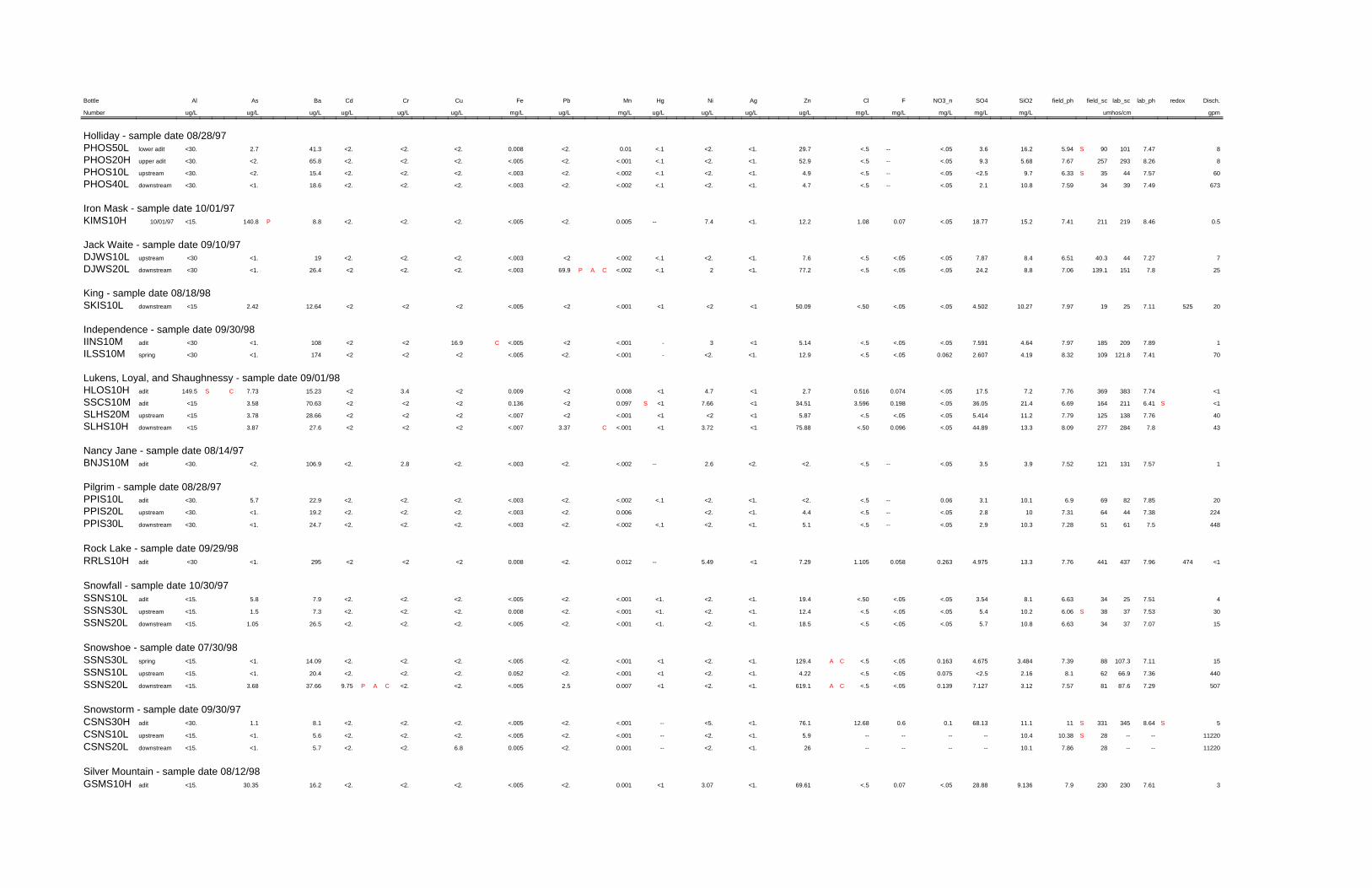
Disch.redoxlab_phlab_scfield_scfield_phSiO2SO4NO3_nFClZnAgNiHgMnPbFeCuCrCdBaAsAlBottle
gpm umhos/cmmg/Lmg/Lmg/Lmg/Lmg/Lug/Lug/Lug/Lug/Lmg/Lug/Lmg/Lug/Lug/Lug/Lug/Lug/Lug/LNumber
Holliday - sample date 08/28/9787.4710190S5.9416.23.6<.05--<.529.7<1.<2.<.10.01<2.0.008<2.<2.<2.41.32.7<30.lower aditPHOS50L88.262932577.675.689.3<.05--<.552.9<1.<2.<.1<.001<2.<.005<2.<2.<2.65.8<2.<30.upper aditPHOS20H
607.574435S6.339.7<2.5<.05--<.54.9<1.<2.<.1<.002<2.<.003<2.<2.<2.15.4<2.<30.upstreamPHOS10L6737.4939347.5910.82.1<.05--<.54.7<1.<2.<.1<.002<2.<.003<2.<2.<2.18.6<1.<30.downstreamPHOS40L
Iron Mask - sample date 10/01/970.58.462192117.4115.218.77<.050.071.0812.2<1.7.4--0.005<2.<.005<2.<2.<2.8.8P140.8<15.10/01/97KIMS10H
Jack Waite - sample date 09/10/9777.274440.36.518.47.87<.05<.05<.57.6<1.<2.<.1<.002<2<.003<2.<2.<2.19<1.<30upstreamDJWS10L
257.8151139.17.068.824.2<.05<.05<.577.2<1.2<.1<.002CAP69.9<.003<2.<2.<226.4<1.<30downstreamDJWS20L
King - sample date 08/18/98205257.1125197.9710.274.502<.05<.05<.5050.09<1<2<1<.001<2<.005<2<2<212.642.42<15downstreamSKIS10L
Independence - sample date 09/30/9817.892091857.974.647.591<.05<.05<.55.14<13-<.001<2<.005C16.9<2<2108<1.<30aditIINS10M
707.41121.81098.324.192.6070.062<.05<.512.9<1.<2.-<.001<2.<.005<2<2<2174<1.<30springILSS10M
Lukens, Loyal, and Shaughnessy - sample date 09/01/98<17.743833697.767.217.5<.050.0740.5162.7<14.7<10.008<20.009<23.4<215.237.73CS149.5aditHLOS10H<1S6.412111646.6921.436.05<.050.1983.59634.51<17.66<1S0.097<20.136<2<2<270.633.58<15aditSSCS10M407.761381257.7911.25.414<.05<.05<.55.87<1<2<1<.001<2<.007<2<2<228.663.78<15upstreamSLHS20M437.82842778.0913.344.89<.050.096<.5075.88<13.72<1<.001C3.37<.007<2<2<227.63.87<15downstreamSLHS10H
Nancy Jane - sample date 08/14/9717.571311217.523.93.5<.05--<.5<2.<2.2.6--<.002<2.<.003<2.2.8<2.106.9<2.<30.aditBNJS10M
Pilgrim - sample date 08/28/97207.8582696.910.13.10.06--<.5<2.<1.<2.<.1<.002<2.<.003<2.<2.<2.22.95.7<30.aditPPIS10L
2247.3844647.31102.8<.05--<.54.4<1.<2.0.006<2.<.003<2.<2.<2.19.2<1.<30.upstreamPPIS20L4487.561517.2810.32.9<.05--<.55.1<1.<2.<.1<.002<2.<.003<2.<2.<2.24.7<1.<30.downstreamPPIS30L
Rock Lake - sample date 09/29/98<14747.964374417.7613.34.9750.2630.0581.1057.29<15.49--0.012<2.0.008<2<2<2295<1.<30aditRRLS10H
Snowfall - sample date 10/30/9747.5125346.638.13.54<.05<.05<.5019.4<1.<2.<1.<.001<2.<.005<2.<2.<2.7.95.8<15.aditSSNS10L
307.533738S6.0610.25.4<.05<.05<.512.4<1.<2.<1.<.001<2.0.008<2.<2.<2.7.31.5<15.upstreamSSNS30L157.0737346.6310.85.7<.05<.05<.518.5<1.<2.<1.<.001<2.<.005<2.<2.<2.26.51.05<15.downstreamSSNS20L
Snowshoe - sample date 07/30/98157.11107.3887.393.4844.6750.163<.05<.5CA129.4<1.<2.<1<.001<2.<.005<2.<2.<2.14.09<1.<15.springSSNS30L
4407.3666.9628.12.16<2.50.075<.05<.54.22<1.<2.<1<.001<2.0.052<2.<2.<2.20.4<1.<15.upstreamSSNS10L5077.2987.6817.573.127.1270.139<.05<.5CA619.1<1.<2.<10.0072.5<.005<2.<2.CAP9.7537.663.68<15.downstreamSSNS20L
Snowstorm - sample date 09/30/975S8.64345331S1111.168.130.10.612.6876.1<1.<5.--<.001<2.<.005<2.<2.<2.8.11.1<30.aditCSNS30H
11220----28S10.3810.4--------5.9<1.<2.--<.001<2.<.005<2.<2.<2.5.6<1.<15.upstreamCSNS10L11220----287.8610.1--------26<1.<2.--0.001<2.0.0056.8<2.<2.5.7<1.<15.downstreamCSNS20L
Silver Mountain - sample date 08/12/9837.612302307.99.13628.88<.050.07<.569.61<1.3.07<10.001<2.<.005<2.<2.<2.16.230.35<15.aditGSMS10H

Disch.redoxlab_phlab_scfield_scfield_phSiO2SO4NO3_nFClZnAgNiHgMnPbFeCuCrCdBaAsAlBottle
gpm umhos/cmmg/Lmg/Lmg/Lmg/Lmg/Lug/Lug/Lug/Lug/Lmg/Lug/Lmg/Lug/Lug/Lug/Lug/Lug/Lug/LNumber
Sunrise Mill - sample date 10/01/974497.9762577.1912.54.87<.05<.05<.512.4<1.<2.--0.01<2.S0.333<2.<2.<2.26.71.2<15.downstreamCSMS10L
Twin Peaks - sample date 08/14/9727.771111038.133.75.5<.05--<.5<2.<2.2.3--<.002<2.<.003<2.<2.<2.142.5<2.<30.seepBTPS10M
Vermiculite Mountain - sample date 08/13/981008.14213868.0819.5245.377<.050.1080.7155.14<1.6.6<1<.001<2.<.005<2.2.21<2.181.721.445<15.upstreamRVMS10H6008.41492465S8.5524.7310.3550.0760.9116.694.32<1.6.9<10.004<2.<.005<2.3.23<2.3302.28<30.downstreamRVMS20H
Vermilion River Adit - sample date 08/21/9757.971431458.0815.714.5<.05--<.5<2.<1.2.8<.10.008<2.<.003<2.<2.<2.7.22.5<30.aditVVRS10M
18007.878768.119.82.8<.05--<.5<2.<1.<2.<.1<.002<2.<.003<2.<2.<2.44.9<1.<30.upstreamVVRS20L18007.7377788.249.92.7<.05--<.5<2.<1.<2.<.1<.002<2.<.003<2.<2.<2.44.7<1.<30.downstreamVVRS30L
Victor-Empire - sample date 08/12/9848.054024278.0112.2441.37<.050.2640.5668.72<1.5.304<10.013<2.0.024<2.<2.<2.44.5933.66<30.aditGEVS10H
44887.351.846.47.884.13.2370.105<.05<.53.12<1<2<1<.001<2<.005<2<2<218.52<1.<15upstreamGEVS20L44887.485446.87.724.0453.240.111<.05<.53.09<1<2<1<.001<2<.005<2<2<226.84<1.<15downstreamGEVS30L
Viking - sample date 10/28/972.57.9993956.99155.96<.05<.05<.52.9<1.<2.<1.<.001<2.<.005<2.<2.<2.19.6<1.<15.aditSVIS10L
134.67.8832307.3710.82.655<.05<.05<.5<2.<1.<2.--<.001<2.<.005<2.<2.<2.221<1.<15.upstreamSVIS20L134.67.7235297.3410.8<2.684--<.05<.5<2.<1.<2.--<.001<2.<.005<2.<2.<2.22.7<1.<15.downstreamSVIS30L