CHACO'S PLACE
310
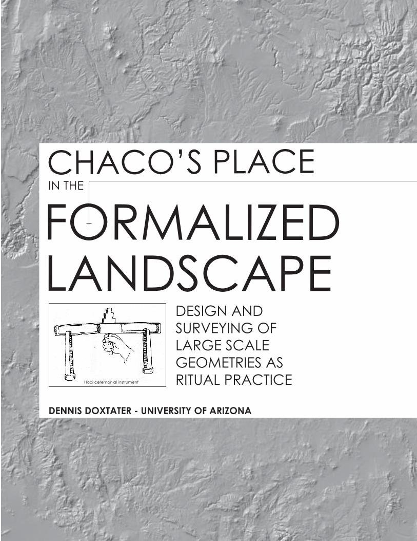
CHACO’S PLACE FORMALIZED LANDSCAPE DENNIS DOXTATER - UNIVERSITY OF ARIZONA IN THE DESIGN AND SURVEYING OF LARGE SCALE GEOMETRIES AS RITUAL PRACTICE Hopi ceremonial instrument
-
Upload
khangminh22 -
Category
Documents
-
view
2 -
download
0
Transcript of CHACO'S PLACE
CHACO’S PLACE FORMALIZEDLANDSCAPE
DENNIS DOXTATER - UNIVERSITY OF ARIZONA
IN THE
DESIGN ANDSURVEYING OFLARGE SCALEGEOMETRIES ASRITUAL PRACTICEHopi ceremonial instrument

Biographic Note The author is a licensed architect with professional academic and practice experience in architecture and landscape architecture. A professional Bachelor of Architecture is from the University of Washington, Seattle, with a M.A. in Socio-Cultural Anthropology at the same institution. A Doctor of Architecture comes from an interdisciplinary program at the University of Michigan. Present status is Professor Emeritus in the College of Architecture, Planning and Landscape Architecture at the University of Arizona. The ancestral Doxtater name is Oneida Indian.
TABLE OF CONTENTS Introduction 1
READING THIS BOOK FROM DIFFERENT BACKGROUNDS 3 Social organization 3 Introducing probability comparisons between existing and random patterns 4 “Reading” the design analyses 6
A note to archaeologists 9 1. Toward an Evolutionary Theory of Formalized Large Scale Ritual 11
Frameworks in the Landscape Shamanistic use of “web” structures in the landscape 11 Ritually used cross frameworks in the larger landscape 26 Archaeological interpretations of the interim between shamanistic and 32 historic landscapes Possible origins of ritual landscape cross structures on the Southern Colorado 39 Plateau 2. Probability Comparisons: Alignment Involvement of Great Kiva 51
Locations Existing literature on random comparisons 51 Influence of large scale natural topography on alignments 52 Natural features used in the analysis 57 Locations of great kiva sites 58 Comparing BMIII/PI and PII/PIII 70
3. A Surveyed East Meridian and First Triadic Structure of Chaco 79
The first built ceremonial site as mediator of a large scale bipolar line 84
Intercardinal axes and a triadic ritual definition in Chaco Canyon 86
Great kiva linkage to the landscape: “villages” in the West 93
PROBABILITY TEST: THE MOUNT WILSON MERIDIAN 97 4. Formalizing the “West” and a Triadic Plateau Frame 106
Kiva Mesa – Broken Flute Cave 106 A second axis from Sipapu: Butler Wash Main Panel – Lowry 109 The Ganado Cross as more defined southern pole in the West 115 A Ship Rock mediator between West and East 117 Later Lowry and Village of the Great Kivas: an introduction to major 120 changes at Chaco
PROBABILITY TEST: THE “FAN” PATTERN OF LINES FROM THE SIPAPU 126 5. “East” Communities and Integration with the Triadic Chaco Focus 132 PROBABILITY TEST: LOCATIONS OF PI GREAT KIVAS AND THEIR 138 ALIGNED RELATIONSHIP TO THE GREATER LANDSCAPE AND EARLY TRIADIC CHACO Early alignments not involved in the Chaco focus 145 REVISED TRIADIC EXPRESSION OF CHACO/CURVED ROCK THAT 147
SPEAKS New meaning to Curved Rock That Speaks/Pueblo Bonito: A Lizard Head 152 meridian
6. The Lizard Head Meridian: Framing the Large Scale Foundation 156 for Formalized Great Houses in Chaco
Establishing the Lizard Head meridian 158
The search for natural cross axes congruent with the new meridian: Chaco East X 160 Adjusting the original Chaco triangle to create Chaco West X 165
Axial unification and bringing power to the Curved Rock That Speaks 170 Canyon survey points and lines as framework for major great kivas and houses 174 7. Locating New Great Houses / Casa Rincoñada and Orienting 175
Monumental Walls An architectural history perspective on “monumental” great houses 175 Architecturalization of the meridian: Pueblo Alto and Tsin Kletsin 180 Hungo Pavi as “Keeper of Chaco East X”: symbolically understanding early great 183 walls Pueblo del Arroyo and Chetro Ketl: terminating the axes of West Chaco X 187 Meanings of Peñasco Blanco and Una Vida additions 190 Formal integration of Casa Rincoñada, New Alto and Pueblo Bonito 193 PROBABILITY TEST: GREAT HOUSE WALLS AS ASTRONOMY OR 200 LANDSCAPE INTEGRATION? NOT YET A TEMPLE 205 8. The Plateau Frame Beyond Chaco 208
“OUTLIERS” Kin Ya’a and Muddy Water 208 Standing Rock 213
EXTENSION OF THE WILSON MERIDIAN Cerro Moctezuma and Paquime 216 Replicating the Chaco landscape/architecture scheme at Aztec 218 Aztec West X and its great house emulation of Chaco West X 223 The Great North Road as ritual integrator of Aztec and Chaco 228
9. Toward an Anthropology of Prehistoric Landscape/Architecture 239 Design
ANCESTRAL PUEBLO EVOLUTION OF FORMALIZED LANDSCAPE RELIGION The religious effect of alignments among or with prominent natural features 240 Formalization of a triadic ritual framework across a likely previously shamanistic 242 plateau Lizard Head meridian and Curved Rock That Speaks 243 The move to Aztec 247 The great north road as design/surveying evidence 249 Territorialization of landscape ritual and formality 250 Adding a design dimension to cultural anthropology 254 A SUMMARY OF PROBABILITY TESTING OF POSSIBLE DESIGN PATTERNS 255 Simple three-point alignments among a total group of great kiva sites 256 Testing the Mount Wilson meridian complex 257 Testing the “fan” pattern of lines from the Sipapu 258 Symbolic “great walls”: comparing probabilities of astronomical with landscape 259 meaning FUTURE RESEARCH 260
Appendix I: Computer Applications as Essential Design Analysis Tools 262 Geopatterns 2 264 Geopatterns 3 270 Appendix II: Prehistoric Surveying 273 A field exercise aligning an interim point between two visible end points 275 Simulating a line survey between Humphrey’s Peak and Blanca Peak 278 List of Three – Point Alignment Accuracies Described in the Analyses 285 References Cited 289
LIST OF ILLUSTRATIONS 1. Butler Wash panel detail. 12
2. Numic and Yuman spiderweb of landscape features and connecting trails. 13
3. Spatial layout of Isoma ritual. 14
4. “Cosmic” structure of shamanistic Warao landscape. 15
5. Symbolic structure of the Warao roundhouse. 18
6. Oppositional structures of the Navajo cosmos. 21
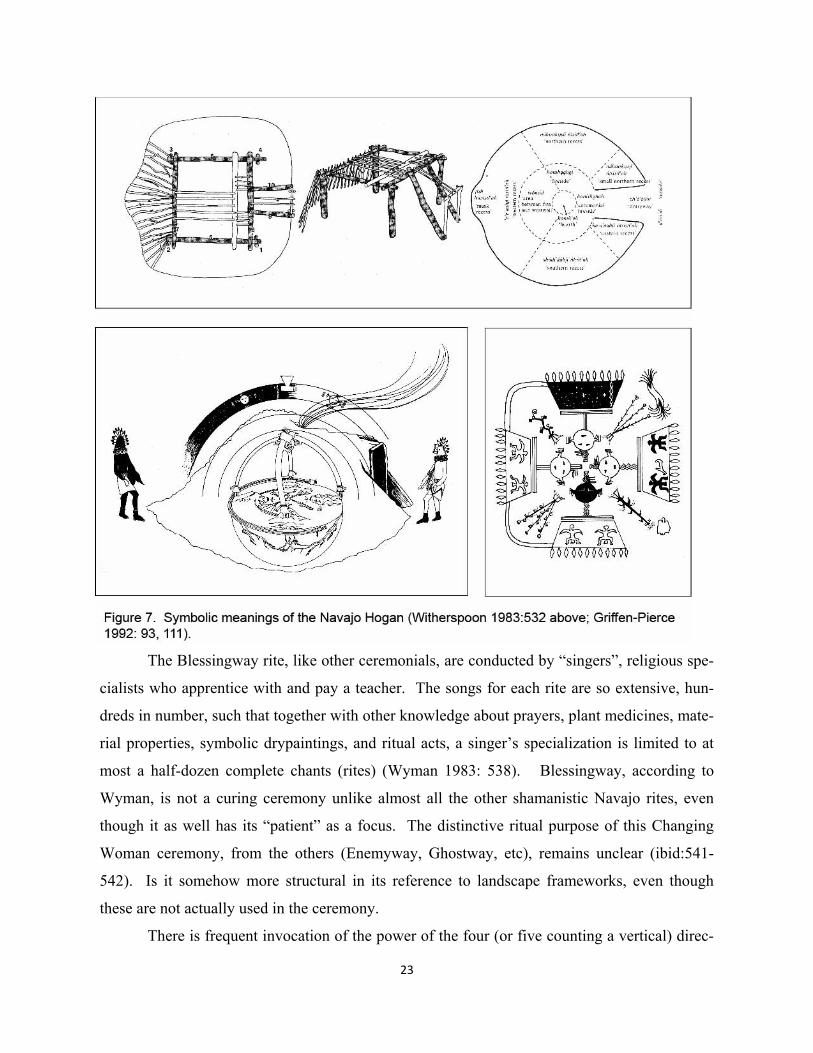
7. Symbolic meanings of the Navajo Hogan. 23
8. Formal graphic diagram of quartets of natural ritual foci in the Tewa landscape 27
9. Graphically formal diagram of “local cosmology” of the Keres Pueblos. 28
10. Dualistically structured “villagescape” around 14th century Rio Grande pueblo. 29
11. Triaxial ritual structure of Hopi landscape and ceremonial cycle. 30
12. Most coincidentally accurate three-point alignment of natural features; possible 40
early line to Comb Ridge; relation of alignments to Canyon de Chelly.
13. “Sipapu” as junction of the Little Colorado and Colorado Rivers in the Grand 42 Canyon.
14. Highest mountains other most prominent natural features in the Ancestral Pueblo 44 region.
15. Two coincidental crosses formed by prominent natural features: De Chelly X and 46 Kin Bineola X.
16. Comb Ridge natural north-south “axis mundi”. 47
17. Butler Wash Main Panel rock art. 49 _________________________________________________________________________
18. Location of 61 Basketmaker III – Pueblo III great kiva sites plus 21 most 53
significant natural features on the Southern Colorado Plateau.
19. Thirteen random point areas in Chaco Canyon to test the influence of smaller 54 scale linear features on alignment numbers.
20. Examples of most prominent natural features in the Ancestral Pueblo landscape. 59
21. Locations of the most prominent natural features used in the analysis. 60
22. Great kiva images from Google Earth. 61
23. Location of test area in which all 61 existing great kiva sites occur, and in which 67
100 sets of equivalent numbers of random points are scattered. 24. Probability relationship between random and designed alignments. 68
25. Box and whisker plots for tests of random alignments at ten accuracies. 69
26. Number of involved alignments for each site, natural and built, during early and 71
late periods. 27. Box and whisker plots for alignments created in 100 sets of 34 random points at 72
four accuracies, compared to the number of alignments among 34 early great kiva points.
28. Comparisons of early and late great kiva groups in combination and individually. 73
29. Comparisons of numbers of alignments in the existing 34 and 27 groups taken 74
independently w/o natural features. 30. Map comparison of existing early group alignments with highest random set of 75
34 points each of 100 sets at an accuracy of 0.075°. 31. Map comparison of total existing alignments with highest random set of 61 points 76
each of 100 sets. __________________________________________________________________________ 32. Coincidental natural cardinal alignment between Abajo Peak, El Diente and 80
Mount Wilson. 33. Simulation of required survey station points in cardinal north-south line from 83
Mount Wilson to McCarty’s Flow. 34. Photo of McCarty’s Flow, most recent volcanic event in the Zuni-Bandera field. 84
35. Chaco Canyon intersection of MountWilson – McCarty’s Flow axis and the 85
Sipapu “sunray” to Mount Chicoma and Truchas Peak.
36. Chimney Rock natural feature and associated later PII Chacoan “outlier” great 87 kiva and great house.
37. Most precise coincidental triaxial intersection point on the plateau adjacent to 88 later major Chacoan great kiva and house, Kin Bineola.
38. Hypothetical unification of MountWilson meridian, natural amphitheater and 89 most precise triaxial intersection point on plateau at Kin Bineola. 39. Location of “Curved Rock That Speaks” natural amphitheater with respect to 90 29SJ423 – Shabik’eschee line. 40. Plan of Shabik’eschee Basketmaker III village in Chaco Canyon. 91 41. Location of early great kiva sites and possible rock art evidence of early large- 94
scale ritual.
42. Coincidental natural and built features cardinally associated with Mount Wilson: 101 best two comparable patterns from 100,000 random sets.
43. Alternative test areas for Mount Wilson meridian pattern. 102 ____________________________________________________________________________
44. Kiva Mesa BMIII great kiva site in large scale context with possible other early 108 ritual foci. 45. Technical drawing of “Main Panel” at Butler Wash: precise alignment with Sipapu 110
and Lowry great kiva. 46. Location of Rincon “great kiva” at the topographic tip of Comb Ridge with respect 112
to the Sipapu – Lowry line and the Main Panel at Butler Wash. 47. Location of Bluff great kiva and great house: relation to Sipapu – Lowry line. 113 48. Multiple BMIII-PI great kiva focus at Ganado. 116 49. Ship Rock – Lowry – Tohatchi – Village of the Great Kivas as “Middle” vertical. 119 50. Similar great house plans of Lowry and Village of the Great Kivas compared with 122 Chacoan outliers. 51. Site analyses of great kiva and building orientations, alignments of buildings and 124
prehistoric roads at Lowry Ruin and Village of the Great Kivas. 52. Orientations of great kivas at Lowry and Village of the Great Kivas. 126
53. Existing array of alignments to the Sipapu, and best comparable pattern from 130 random set number 7,712. __________________________________________________________________________
54. Grass Mesa great kiva and surrounding community. 133 55. Location of northern PI communities. 137 56. Map of 17 eastern PI great kiva sites and test area for probability analysis with 139
example of one random set.
57. Graph comparisons of existing and random alignments with three early Chaco 141 foci. 58. Alignments of distant great kiva sites and natural features with Kin Bineola, 142 29SJ423, and Shabik’eschee. 59. Large scale PI alignments not involving the three Chaco foci. 144 60. Alignment of great kivas and natural amphitheater adjacent to first three great 148 house room blocks in Chaco Canyon. 61. PI room block forms at Morris 33 and Pueblo Bonito in Chaco Canyon. 150 62. Photos of Mount Wilson, Lizard Head and Black Face feature. 153 63. Relation of three Wilson Group features with triadic PI Chaco. 154 _________________________________________________________________________ 64. Prolongation of Lizard Head meridian to Haystack Mountain. 159 65. USGS bench mark points on Mesa Verde and Hosta Butte. 161 66. Location of Chaco East X with respect to Lizard Head – Haystack Mountain 162
meridian.
67. Coincidental prolongation of Haystack Mountain – Chaco East X line to 163 Black Face feature.
68. Logical opposed axis from Haystack Mountain to Mount Wilson. 164 69. Sipapu – Kin Bineola X line as base for revising original Chaco triangle. 166 70. Prolongation of two lines from Tohatchi to create corners of new Chaco 167
triangle with Chaco West X at apex.
71. Enlarged maps of creation of revised triangle and opposed Chaco West X. 168 72. Homologies of large scale alignments and wall orientations between Kin 169
Bineola X and Pueblo Pintado. 73. Pierre’s Butte in relation to cross axis lines from two X points in Chaco Canyon. 171 74. Summer solstice shunt from Lizard Head to Curved Rock That Speaks meridians. 172 _________________________________________________________________________ 75. Non-architectural Ancestral Pueblo geometric design: woven bands from Basket- 176
maker periods before 600 A.D.; early and late pottery from Chaco Canyon 900. – 1200 A.D.
76. Basketmaker pithouses from La Plata area and Chaco Canyon. 178 77. Determination of Pueblo Alto and Tsin Kletsin locations. 181 78. Positioning of Hungo Pavi due east of Chaco East X, perpendicular west wall; 184 north wall orientation as homologue to bisect of angle to Pueblo Alto – Tsin Kletsin meridian. 79. Positioning and wall orientation symbolism of Pueblo del Arroyo and Chetro 188 Ketl with respect to Chaco West X and Chaco East X. 80. Relation of Black Face meridian to 29SJ1253 great kiva, the Fajada Butte 191 Sun Dagger, and remodeled Una Vida. 81. Formalized plan of Una Vida and possible orientation symbolism of major 192 wall. 82. Laying out Casa Rincoñada by prolonging Pierre road point through Chaco 194 West X; position of New Alto with respect to Mount Wilson and Pierre road point lines. 83. Cardinally oriented “Middle” architecture. 196 84. Eight Chacoan “E” great house plans used in the analysis and relationship of 201 wall orientation alignment with distant points. 85. Associations of great wall orientations of largest Chacoan great houses with 203 lunar and solar risings and settings, and cardinal axes; from Sofaer (1997). ________________________________________________________________________
86. Possible alignments superimposed over Marshall et. al. 1979 drawings of 211 Muddy Water and Kin Ya’a.
87. Possible alignments associated with Standing Rock complex; lines and 214 destinations on Marshall et. al. 1979 drawing. 88. Prolongation of Mount Wilson meridian and Chaco East X – Haystack to 217 create intersection at Cerro Moctezuma. 89. Hypothetical first determination of Aztec East X, subsequent addition of 220 “Navajo” axis from Mount Taylor to Hesperus Peak. 90. Location of Salmon as “keeper” of Aztec East X; similarity of Salmon plan 222 to Hungo Pavi, “keeper” of East Chaco X. 91. Creation of Aztec West X and emulation of great house positioning at Chaco 224 West X. 92. Apparent bisect of Grass Mesa – Mount Wilson angle as determinant for 225 orientation of East great house at Aztec; enlarged plan of West great house. 93. Illustration of North and South Roads to Chaco Canyon as drawn by Copeland 229 (2012). 94. Extremely precise alignment of major North Road features Kutz Canyon Stair 230 and Halfway House as probable prolongation from Casa Rincoñada – Chaco West X – Pierre road point. 95. Location of Twin Angels on hypothetically separate survey line from Aztec 232 West X to Arena Alta. 96. Relation of Sacred Ridge community and ceremonial focus to Haystack 234 Mountain – Black Face line and meridian from Kutz Stair. 97. Formalized triadic ritual expression at plateau, center (Chaco and Aztec), 237 and great house scales. ________________________________________________________________________ 98. “Geopatterns 2” software Main Page. 265 99. Geopatterns 2 Records and Patterns pages. 267 100. Geopatterns 2 Options menu and Test Areas set up. 268 101. “Geopatterns 3” Main Page, and example of found complex pattern. 270 ________________________________________________________________________ 102. Carrying great kiva pillars from the mountains on Chacoan roads, from Snygg 274 and Windes (1998).
103. Finding an aligned point between two distant natural features using tall 276 tripods with plumb lines. 104. Aligned positions of interim points in field exercise for three pairs of 277 distant natural features. 105. Initial and final survey stations of the simulated survey of a line between 280 Humphrey’s Peak and Blanca Peak. 106a & 106b List of all survey points necessary to straighten the initial line 282 between Humphrey’s Peak and Blanca Peak. 283
1
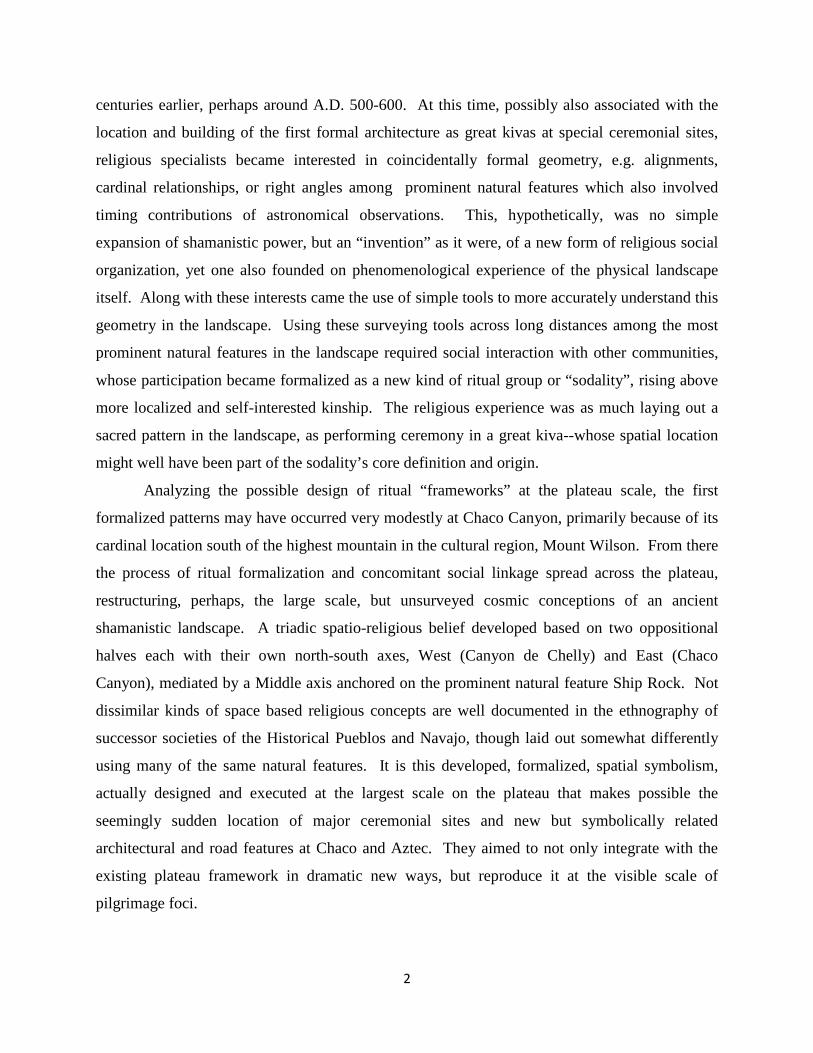
Introduction:
It has taken some time for the consensus to develop that 11th century Chaco Canyon, at least, was
a large scale pilgrimage destination for Ancestral Pueblo people, and that much of it was not
intended or used primarily for domestic residence or resource storage. Given this relatively
recent definition as a place for religion and ritual practice, rather than trade or political control
per se, intriguing questions remain. First, how were obvious centers like Chaco and Aztec, as
well as other places with large circular great kivas and large apartment like roomblock
constructions, located in the plateau landscape. Beyond the process of deciding exactly where to
build, why suddenly at this time did they begin to construct monumental multistory walls, often
several, seemingly independently oriented within a particular “great house”? What was the
purpose of aligning two of these Chaco great houses directly north-south of each other on
opposite rims of the canyon? What was the ritual purpose of road segments and related features
running to great houses, particularly in Chaco and Aztec?
Evidence of conscious, religiously based, design process is largely evident in all of these
examples except the most primary, i.e. the location of a site before construction begins. The two
cardinally aligned buildings on the north and south rims of the canyon are not really an exception
here, because some design consideration is likely to have first located this schematic pair itself.
There is a paradox here. At some point prior to the large-scale organization we associate with
monumental Chaco, the landscape had undoubtedly been intensely used as a source of religious
power for smaller scale social groups, probably mediated by shaman. How then, could these
kinds of societies suddenly coalesce in the 1000’s, bursting forth, not only with some sort of
religious “draw” at the scale of the plateau landscape, but with unprecedented design elements,
formal aspects of which begin to look like temples?
The idea behind the present interdisciplinary based design analysis is that the climax
Chaco “Phenomenon” needed several precedent centuries by which to develop the schematic
basis--conceptions of Ancestral Pueblo religion itself--of formal physical settings for ritual
practice at pilgrimage centers. To make this case, one needs to hypothesize a fundamental
religious change in the symbolic use of the larger plateau landscape that occurred several
2
centuries earlier, perhaps around A.D. 500-600. At this time, possibly also associated with the
location and building of the first formal architecture as great kivas at special ceremonial sites,
religious specialists became interested in coincidentally formal geometry, e.g. alignments,
cardinal relationships, or right angles among prominent natural features which also involved
timing contributions of astronomical observations. This, hypothetically, was no simple
expansion of shamanistic power, but an “invention” as it were, of a new form of religious social
organization, yet one also founded on phenomenological experience of the physical landscape
itself. Along with these interests came the use of simple tools to more accurately understand this
geometry in the landscape. Using these surveying tools across long distances among the most
prominent natural features in the landscape required social interaction with other communities,
whose participation became formalized as a new kind of ritual group or “sodality”, rising above
more localized and self-interested kinship. The religious experience was as much laying out a
sacred pattern in the landscape, as performing ceremony in a great kiva--whose spatial location
might well have been part of the sodality’s core definition and origin.
Analyzing the possible design of ritual “frameworks” at the plateau scale, the first
formalized patterns may have occurred very modestly at Chaco Canyon, primarily because of its
cardinal location south of the highest mountain in the cultural region, Mount Wilson. From there
the process of ritual formalization and concomitant social linkage spread across the plateau,
restructuring, perhaps, the large scale, but unsurveyed cosmic conceptions of an ancient
shamanistic landscape. A triadic spatio-religious belief developed based on two oppositional
halves each with their own north-south axes, West (Canyon de Chelly) and East (Chaco
Canyon), mediated by a Middle axis anchored on the prominent natural feature Ship Rock. Not
dissimilar kinds of space based religious concepts are well documented in the ethnography of
successor societies of the Historical Pueblos and Navajo, though laid out somewhat differently
using many of the same natural features. It is this developed, formalized, spatial symbolism,
actually designed and executed at the largest scale on the plateau that makes possible the
seemingly sudden location of major ceremonial sites and new but symbolically related
architectural and road features at Chaco and Aztec. They aimed to not only integrate with the
existing plateau framework in dramatic new ways, but reproduce it at the visible scale of
pilgrimage foci.
3
Ritual processes of the Ancestral Pueblo had become heavily integrated with the design
of landscape and architectural formalities, the explanation of which may begin to answer some of
the outstanding questions in the larger inquiry. For this reason, the primary emphasis of this
work is based on design analysis from a landscape architecture/architecture perspective, while
suggesting interdisciplinary linkage to social anthropology, archaeology, statistics and survey
engineering.
READING THIS BOOK FROM DIFFERENT BACKGROUNDS
It is one thing as an architect-social anthropologist, to study the role of formal physical settings
in small scale ritual practice, whether in traditional dwellings or villages, but when one suggests
that not dissimilar uses of form might be expanded to large scales defined by prominent natural
features, red lights start turning on. First among these concerns the radical notion that prehistoric
people had the technology to lay out accurate simple geometry across long, often not inter-
visible, distances. With some exploratory fieldwork, a limited but illustrative literature, and
evaluation by the editor of a prominent journal of surveying engineering, this turns out to be the
least problematic part of the present set of ideas. Readers who are most interested in the
surveying issues, or who have initial doubts in this regard, should first turn to the book’s
appendix. It consists of two parts: first, is a full description of the “Geopatterns” software
versions that were necessary to describe geometries among points on the earth’s ellipsoid and
test patterns for random probabilities; and second, is the literature on prehistoric surveying and a
detailed simulation of such a landscape process across one of the longer possible ritual lines on
the plateau.
Social organization
The first chapter seeks to develop the more important social anthropological basis behind
technical aspects of the surveying hypothesis. While good landscape maps of societies with
shaman based religion are few and far between, respectable ethnographies can be found that
integrate this kind of critical data into this work. Theoretically the religious conceptions attached
to these larger scaled natural topographies range from a kind of “spider web” linkage between
features of special spiritual power at different loci, to a geometrically formalized “cosmic” map
based on locations of significant highly symbolic natural features, particularly prominent
4
mountains. While some of these features are used in shamanistic practice, no special ceremonial
foci for more organized ritual are integrated through accurate surveying. The religious use of
shamanistic cosmic conceptions implies limited large scale social organization beyond a kind of
equal access of small communities to natural features within the so defined symbolic landscape.
The best evidence for a shift away from shamanistic uses of landscape as cosmos comes
from the work of Alfonso Ortiz (1969) on his native Tewa, a post Ancestral Pueblo tribe.
Essential here is a rereading of his central thesis, an ethnographically based, theoretical critique
at the time, of structural anthropology’s (Levi-Straussian) view of hidden organizing processes in
smaller societies that belied the spatial dualism of kinship groups in villages. Ortiz strongly
argued that the actual physical layout of Tewa ritual in their surrounding landscape, to the
contrary, constituted a socially real structuring process for religious societies, one not subtly
concealed among kinship groups, but working above them in very mappable ways. Embedded in
Ortiz’s treatise, however, is something of an anthropological bias for language based means of
structuring symbolism. He explained that the layout of paths to sacred features in their three-
tiered cosmic structure somehow emerged from Tewa origin myths, in spite of the fact that the
most powerful expression and experience of Tewa religion probably came not from telling a
story, but from ritual practice out in the surrounding landscape.
The present argument suggests that the transition from more piecemeal shamanistic uses
of symbolic topographic features—in spite of or perhaps politically enabled by shared cosmic
concepts—to formal surveyed frameworks organizing religious groups was not dependent on any
detailed articulation of myth. Myth had always been associated with the shamanistic cosmos,
just as it still is with ritual practice in the Historical Tewa. The greater formality of ritual
landscape layout and way of integrating different religious groups within the Tewa pueblo
community, however, is unlikely to have originated from some social need expressed through
ancient story telling. Rather, it could well be a legacy from processes of structuring ritual and
religion that emerged from actual use of the large-scale landscape as much as a millennia before-
-with its integral practices of surveying.
Introducing probability comparisons between existing and random patterns
Statistical analysis supports much academic research and the present work aims to at least
introduce its potential contribution in this regard. The use of such methodology to distinguish
5
and determine aspects of design is however, quite new to fields like architecture, landscape
architecture or planning. Usually it is quite evident that an “object” is intentionally designed,
particularly through its perception in images, increasingly amplified by computer manipulation.
The cognitive maps that ground both formalized architecture and landscape ritual, on the other
hand, are less object-like and less immediately recognizable. Little research exists, with some
promising exceptions, that identify formalized cognitive map-like design components of
traditional dwellings or monumental historical architecture, much less ritual layouts of landscape
like those used by the Tewa. Yet one can begin exploration in this direction by assuming that
basic geometric forms like alignments, right angles, cardinal relationships, bisected angles and
the like will be key components, not unlike formal architecture. The most logical research
demand after proposing a causal link between religious societies and formalized landscape
frameworks is to analyze existing geometric patterns among natural and built sites attempting to
distinguish design from coincidence.
Chapter 2 finds as many prehistoric great kiva sites from about 500-1200 A.D. on the
Southern Colorado Plateau as are readily available in existing archaeological literature and data
bases, 61 at the time of this exercise. The presence of an adjacent roomblock is not a
requirement for inclusion in the list. Given the hypothesis about integrating such ceremonial
sites with prominent natural features, 21 of the most logical of these are added to the analysis.
Without any specific, possibly designed pattern in mind, the analysis simply inquires about the
number of three-point alignments—at ten different accuracies—with which the great kiva-natural
feature points are involved. Creating 100 equivalent sets of random points on the plateau,
keeping the natural features constant, how do numbers of three-point alignments compare?
Revealed is the apparent reality that among any existing layout of sites in this range, some
number of random alignments will occur, even though probabilities of some design may be quite
high. Distinctions between the involvement of earlier (500-900 A.D.) and later (900-1200 A.D.)
great kivas also provide tentative initial correlations to the hypothetical importance of plateau
formalization prior to the major “re-formalization” in Chaco Canyon. Possible influence of
linear natural features on alignments, at smaller scales, is explored by setting up test boxes in the
canyon topography of Chaco itself.
Chapters 3, 4, 5 and 7 include additional probability exercises that test specific, more
complex patterns being discussed in phases of design and ritual evolution. The first of these is a
6
possible partially designed, partially coincidental, meridian from Mount Wilson at the north end,
extending south through one additional natural feature and five great kiva sites. The compound
pattern creates some number of three-point alignments and cardinal two-point relationships
which are modeled and tested against 100,000 equivalent sets of random points. Alternative
ways of setting up test areas to better represent the clustering of great kivas in Chaco Canyon are
included in the exercise. The second existing compound pattern compared with random
phenomena consists of multiple axes of alignments emanating from the Sipapu “emergence”
point (in a fan shape) at the confluence of the two Colorado Rivers in the Grand Canyon. One of
these lines itself creates multiple three-point alignments among its five points, two natural and
three defined by great kivas. A third exercise looks the incidence of three-point alignments
among early great kiva sites on the eastern side of the plateau, asking how their involvement in
the three ritual foci of the earliest and first formalization at Chaco compares to random
phenomena. The final piece of probability testing compares two theories about the orientation of
monumental walls of the great houses of Chaco and Aztec. One sees them pointing to horizon
points where the solstice and equinox sun rises and sets, and the other, part of present work
mainly in Chapter 7, together with examples elsewhere in this book, theorizes wall orientation as
symbolic replications of important components of the surveyed large scale layout that located, or
founded, these largest of great houses.
“Reading” the design analyses
It is not expected that even readers with backgrounds in professional design or planning will be
initially drawn to the landscape patterns presented as an evolution of ritual design lasting about
700 years, climaxing in centers at Chaco and Aztec. While designers and planners are highly
skilled in understanding and creating similar geometric complexity associated with the
engineering and functional behavioral uses of form--and the precise description needed to
construct--little in their background, whether from design history or modern practice, has
included the kinds of formal frameworks that traditional cultures use to structure ritual practice.
Thus even designers and planners are encouraged to spend time with the anthropologically
described spatial patterns of Chapter 1, building up an aesthetic sensitivity of sorts for the kinds
of formal logic found in successor Historical Pueblo and Navajo spatio-religious thinking. While
composed of simple alignments, cardinal relationships, right angles, and bisects, what, beyond
7
still limited probability testing, distinguishes presently diagramed existing patterns from
geometries created totally by coincidence?
As the hypothetical landscape evolution proceeds, does one recognize repetition of key
symbolic forms such as north-south axis mundis, and attempts to integrate intercardinal or
cardinal cross axes—capturing the power of the corners as well as the verticals of the scheme, as
it were? Do these cosmic patterns themselves materialize at several different spatial scales
including the entire plateau, its two halves, the layout of Chaco and Aztec centers, and that of
some great kivas and great houses? At the symbolic core of these patterns, can the reader
imagine how religious specialists created their frameworks by understanding and incorporating
the very highest and most prominent mountains of the Southern Colorado Plateau along with the
even more unique confluence point in the Grand Canyon, especially when discovering
coincidental geometry among them and astronomical rise/set observation points? How did these
schemes organize and distribute spiritual power of the landscape to ceremonial great kivas across
the plateau, including the eventual centers of Chaco and Aztec?
The severest critics of this kind of work argue that so much random geometry exists even
in the presently limited number of Ancestral Pueblo sites and natural features, that it is easy and
even disserving of academic discipline to pick out certain ones that seem to conform to an
ethnographically based design logic. What will the reader think, in this regard, about the
author’s “choice” of the highest mountain in the center of the plateau as being religiously critical
to the location of the two ultimate pilgrimage centers at Chaco and Aztec? How often do
relationships like these—those of a high order of symbolic and social importance—occur among
the presented patterns? Are the orders of natural features and ceremonial foci consistent and
therefore cumulative in an evidentiary sense? Can the design/planning reader develop a
persuasive holistic evaluation of the full range of possible intentional patterns?
At much smaller scales, designers will be especially good at judging whether the plan
layout and building orientation of one site is intentionally reproduced at another some distance
away, in part validating the design of the large scale pattern that connects them. The best
example here, recognized as well by some non-designers, is the replication of layout pattern of
the three major buildings of the Chaco center layout at Aztec. Many further commonalities of
landscape scheme, particularly as sites integrate with distant places are described in Chapters 7
and 8. Other examples at some distance from the two centers are provided, e.g. the design plan
8
similarities of great houses at each end of north-south alignment at the middle of the plateau, or
the replication of angles of one highly coincidental intersection point of three axes in the plan of
a large great house on one of the axes some distance away.
One of the most complex and difficult patterns to evaluate, from all reader orientations,
will be several hypothetical “X” points as intersections of large-scale axes; most have no built
feature to mark them with the exception of the late centroid feature of the Aztec layout. On the
plateau there exist two naturally or coincidentally occurring cross-like patterns, each of which
has three large scale axes intersecting at common X points of about 20 and 300 meters
respectively from their constituent lines. One includes a north-south axis mundi, while the other
does not. While a very large Chacoan great house on the outskirts of the canyon is built about
600 meters from the most accurate of these natural phenomena, neither reveals any standing built
feature on their common “X” point.
The hypothetical X points at Chaco and Aztec, two at each site, were also created by the
intersection of two or more large scale lines to distant natural features. The religious intent
appears to have been to search for the greatest coincidence possible in connecting cross axes
with north-south meridians that had been previously chosen for their own naturally coincidental
features. Maximum spiritual power flowed from all regions of the plateau, ultimately being
distributed to the built receptacles of great kivas and great houses, not unlike electric substations
receiving power from distant dams or plants. This hypothetical use of X points, from a
surveying perspective, is not that dissimilar from countless numbers of “benchmarks” used in
modern settings. These largely unnoticed little markers are essential in the creation of accurate,
legally accountable locations for most of the built features that surround us.
In general our awareness of the underlying design and engineering behind contemporary
man-made physical settings is quite limited. Any professional, who has gone through the
process of beginning with some natural site with its unique features, then exploring the multitude
of ways the setting might be used to satisfy a building program of some complexity, knows full
well the amount of work required to arrive at a clean, highly functional solution. Design
analysis, whether as a Post Occupancy Evaluation of a contemporary built setting or prehistoric
ritual framework, is also complex. The author can only testify that as both professional
architect/landscape architect and anthropologically oriented researcher, the geometric patterns of
this book--as elegantly simple as many are--required a great deal of time and effort to reveal.
9
The first foray into Chaco and related phenomena occurred thirty years ago with a successful
National Endowment for the Arts grant aimed immodestly at discovering the “origins of design
in Anasazi architecture”. A careful read of all the details of the present accumulation of possible
Ancestral Pueblo ritual patterns, including accuracy and orientation numbers, will likely be less
interesting to most readers than was the long discovery process to the author. Nevertheless,
probably the only way the reader can truly evaluate this design analysis work--and ideally an
appreciation of the genius of Ancestral Pueblo designers themselves--is to “own” the detail.
A note to archaeologists
This work obviously depends heavily on the archaeological record. However, virtually no use of
data within that field by others, with the exception of Steve Lekson (1999), presently seeks to
prove or disprove the ability of Ancestral Pueblo people to survey at large scale. Furthermore,
relatively little corresponding research works from a symbolic anthropological perspective of
ritual design. Thus as yet, the present exercise is only marginally peripheral to mainstream
archaeology. The author has made every effort to use extant archaeological literature as
accurately as possible, even though having neither the background nor print space to rigorously
engage the full record. This is particularly true of interpretations of more purely territorial and
ecological uses of landscape that ultimately must be integrated.
Dating is apparently always difficult, even when archaeologists can spend the time and
money to seriously dig; and comparing scores of sites across the entire region, from periods
spanning 600-700 years is only a rare job for well-funded teams, ambitious PhD candidates, or
wise oldsters from the field. More problematic still is the problem of dating the use of landscape
features, X points, and other related purely geometric foci that have no yet discovered built form.
Even when a datable structure comes into being, the date when the site was located, along with
the possibility of some overbuilt small marker may well be difficult to determine.
Archaeologically, the present idea of an evolution of plateau ritual design is obviously gross, at
best, and will require huge verification from these and other anthropological experts. But what
existing patterns reveal from a design perspective is a start. Thus the present work makes no
claim to be archaeology, though extensive use of this literature may initially be misleading. At
present it is difficult to see how a rigorous discourse on these topics could emerge from anything
10
other than interdisciplinary research, in which, nevertheless, the role of “outside the box”
archaeologywill be critical.
11
1. Toward an Evolutionary Theory of Formalized Large-Scale Ritual Frame-works in the Landscape In the earliest and organizationally simplest of periods of the Ancestral Pueblo people, shaman-
ism may well have linked dwelling ritual with web-like spiritual trails across the landscape.
Timing contributions of astronomy could have been complementary. Yet the most powerful re-
ligious symbolism could have come from the landscape, astronomical phenomena included, ra-
ther than from dwellings or small village settings, per se. At some much later point in the evo-
lution of Southwest social organization, as evidenced in historical ethnographies, somewhat
smaller scale, more territorial landscapes are structured into cross-like ritual frameworks that
exhibit formal symbolic domains, oppositions, thresholds, and orientations, characteristics
found as well in special but modest architectural settings called kivas.
In between these two overly simplified evolutionary poles, occurred unique large-scale
social organization on the Southern Colorado Plateau, climaxing with monumental pilgrimage
centers and ceremonial architecture. During this period of perhaps a thousand years, did the
larger landscape play a markedly diminished role in its religious effect? Was there a concomi-
tant increase in the religious effect of large formal architecture and associated astronomical
events? Or, can one develop an alternative theory of how a change in the use of landscape pow-
er itself—a process of religious formalization at large scales—preceded and made understanda-
ble the big architecture at the end? At its root, such a theory would have to include not only re-
ligious practices in both natural and architectural settings, but specific social mechanisms by
which political and economic forces are organized. One can begin to trace this hypothetical
evolution by taking a closer look at shamanistic use of the landscape.
Shamanistic use of web structures in the landscape
Much of the recent research into “landscape archaeology” has focused on relatively loosely or-
ganized, less sedentary, less populous societies. Leading the way, to a certain extent, has been
work that identifies minimal, usually non-architectural traces of symbolic acts in natural land-
scapes occupied by Neolithic hunters and gathers in Europe (e.g. Bradley 2000, 2006), or much
more recent Sami occupation of the artic zone (Mulk & Bayliss-Smith 2006, 2007). Rock art,
12
quarry sites, unique natural features, associated astronomical phenomena all were religiously
powerful at relatively large scales of landscape. In the Southwest, as well, early people at least
up to the end of Basketmaker II periods (about 500 A.D.) also used similar material expression
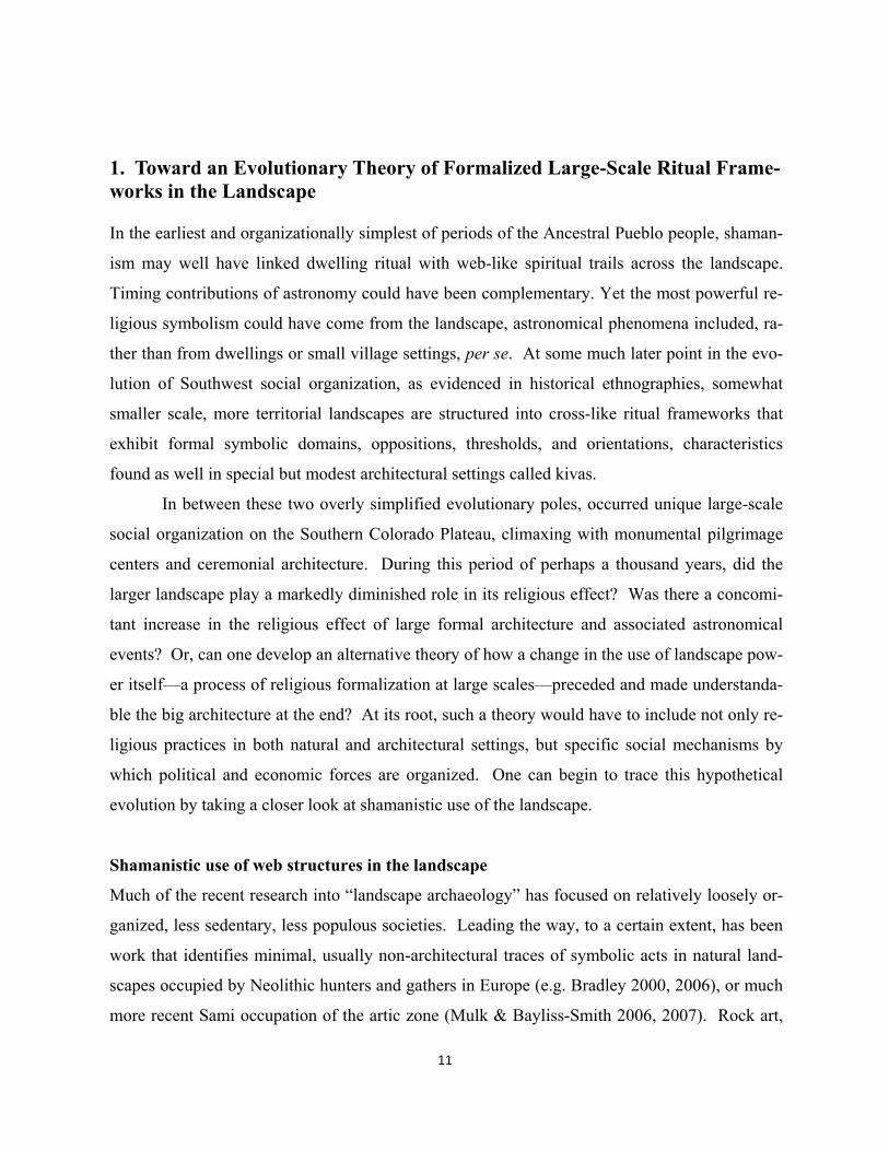
of religious meanings across their landscapes. Schaafsma (1994) makes a convincing case that
rock images depict and were even created by shaman during the relatively long epochs leading
up to the major changes in Ancestral Pueblo society during Basketmaker III / Pueblo periods.
Southwest rock panels, e.g. figure 1, are among the most impressive rock art in all America.
She cites anthropology widely, describing the shaman’s role in making contact with spiritual
power to effect curing, possible influence on hunting and gathering, and social conditions.
Most importantly, from our present per-
spective, is the obvious attachment of these
records of shamanistic transformations to spe-
cific locations in the natural landscape, rather
than being primarily associated with any ar-
chaeologically determined residential camp,
hamlet or village. Yet in work by Schaafsma,
for example, rock art locations are not particu-
larly documented as to landscape location or
context. This may not be primarily out of con-
cern for possible vandalism (facilitated by pub-
lication) but due to assumptions that mapping
is not an important research dimension in this
case, either because the record is so incomplete
or complicated or the potential additional knowledge of spatial patterns would be minimal.
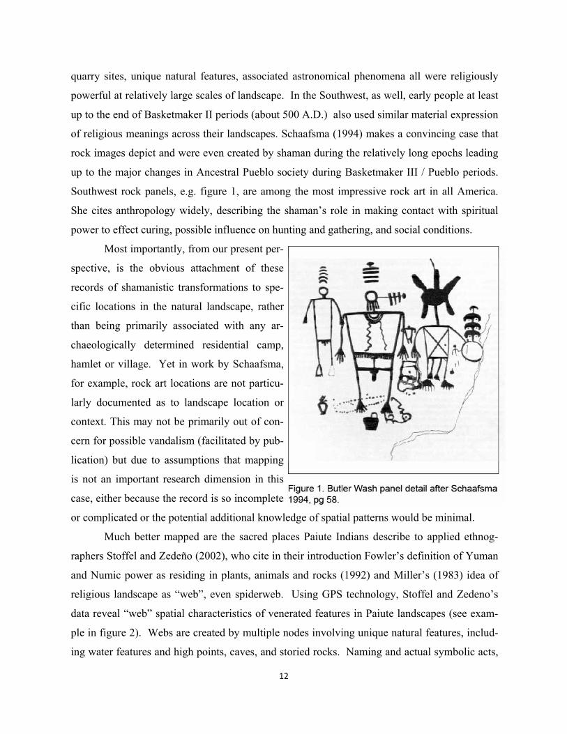
Much better mapped are the sacred places Paiute Indians describe to applied ethnog-
raphers Stoffel and Zedeño (2002), who cite in their introduction Fowler’s definition of Yuman
and Numic power as residing in plants, animals and rocks (1992) and Miller’s (1983) idea of
religious landscape as “web”, even spiderweb. Using GPS technology, Stoffel and Zedeno’s
data reveal “web” spatial characteristics of venerated features in Paiute landscapes (see exam-
ple in figure 2). Webs are created by multiple nodes involving unique natural features, includ-
ing water features and high points, caves, and storied rocks. Naming and actual symbolic acts,
13
often involving song, prayer and dreams
at these sites generate religious meaning.
The web can be mnemonic in both fea-
ture and locational aspects. To Stoffel
and Zedeno, the trails of the web are
themselves sacred in that the experience
of traveling along one changes a person,
usually restoring balance or health
(202:181). Socially, “spatiotemporal
linkages are obvious templates for future
movements and for the maintenance of
relationships” (ibid:187).
One could argue that to a large
extent-- however powerful their symbol-
ic places and acts are--that spider web
patterns are not very good layouts for
truly formal ritual. If one looks, for ex-
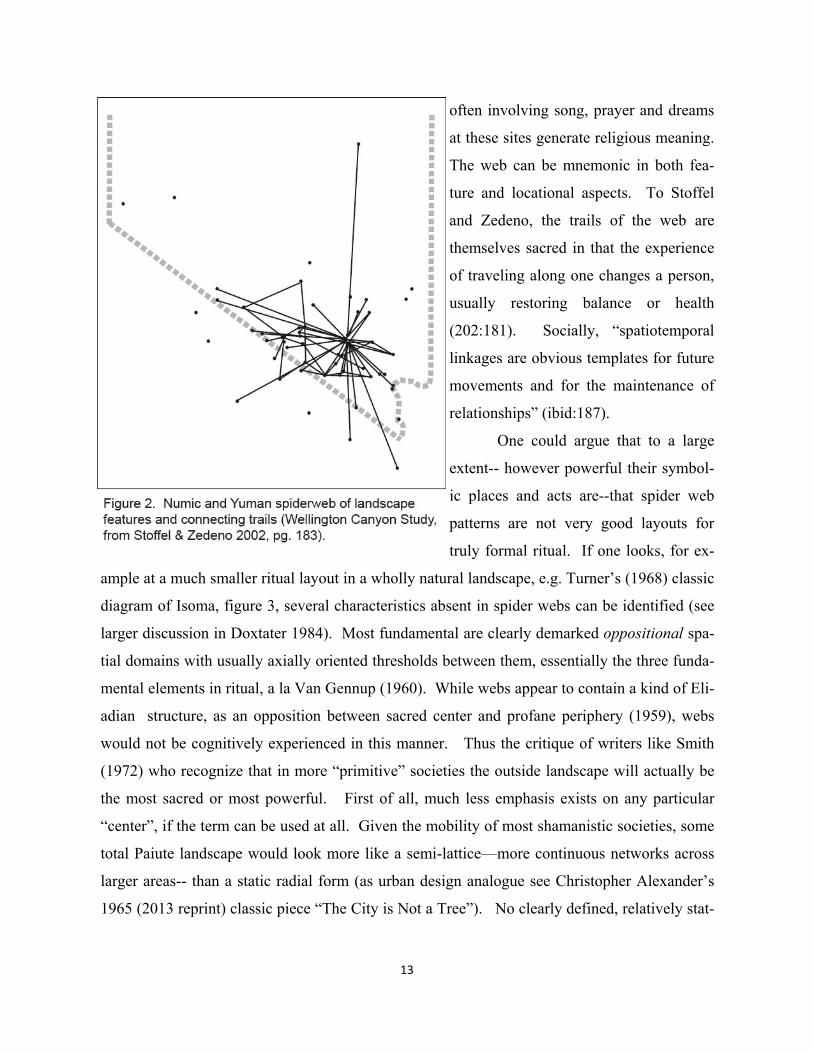
ample at a much smaller ritual layout in a wholly natural landscape, e.g. Turner’s (1968) classic
diagram of Isoma, figure 3, several characteristics absent in spider webs can be identified (see
larger discussion in Doxtater 1984). Most fundamental are clearly demarked oppositional spa-
tial domains with usually axially oriented thresholds between them, essentially the three funda-
mental elements in ritual, a la Van Gennup (1960). While webs appear to contain a kind of Eli-
adian structure, as an opposition between sacred center and profane periphery (1959), webs
would not be cognitively experienced in this manner. Thus the critique of writers like Smith
(1972) who recognize that in more “primitive” societies the outside landscape will actually be
the most sacred or most powerful. First of all, much less emphasis exists on any particular
“center”, if the term can be used at all. Given the mobility of most shamanistic societies, some
total Paiute landscape would look more like a semi-lattice—more continuous networks across
larger areas-- than a static radial form (as urban design analogue see Christopher Alexander’s
1965 (2013 reprint) classic piece “The City is Not a Tree”). No clearly defined, relatively stat-
14
ic structures organize clear oppositions and thresholds
so typical of the transformative work of formal ritual.
The Isoma layout of figure 3, does not exist as
a permanent spatial layout in the landscape, even
though water features and burrows are involved in the
layout. Powerful symbolism becomes manifest in the
way the designed spatial structure or “framework” or-
ganizes specific meanings of objects and animals used
in the ritual. The Isoma setting and experiences create
the transformation between humans and spirit power,
eventually influencing or balancing disrupted kin rela-
tionships among the participants. By contrast, in
shamanist societies ethnography such primary transfor-
mations perhaps do not occur out among the web and
its nodes, but in the formally laid out dwelling, with its
Isoma-like designed structure, operating on both hori-
zontal and vertical planes. Turner does not talk about
how the Ndembu dwelling does or does not participate
in rituals such as the Isoma. To a large extent, the Isoma layout can be seen as not atypical of
shamanistic dwellings, yet exemplifies how ritual structure laid out in a natural landscape dif-
fers from web structure, even though at different scales.
Perhaps one of the most dramatic examples of how the primary shaman transformation
takes place in the formally defined architectural setting occurs in the Yanomami, a slash and
burn culture on the Upper Orinoco River in Venezuela. Here the larger landscape, spatially and
religiously an extensive web of connections usually along waterways, provides the source of
spiritual power at cultural scales not too dissimilar, perhaps, to those of the U.S. Southwest.
The ethnography of shaman initiation by Jokic (2008), provides a highly detailed, graphic ex-
planation of how symbolically the larger landscape, in both its object and less formal spatial
expression, becomes reconfigured in the body of the initiate (Jokic himself was also initiated).
Using the central pole of the village round house or its equivalent as the source of transforma-
tional power, specific parts of the landscape from mountaintops and forest are reintegrated into
15
specific parts of the novitiate
shaman’s body. Yet, in spite of
the spatial structure of the more
or less formally laid out human
body, no formal Yanomami
landscape framework or cosmos
exists, nor is homologically laid
out on the shaman during the
ritual.
The typical anthropolog-
ical conception of a more terri-
torial, non-cosmic Yanomami
space is as a concentric zone
around each village. Actual
GPS aided analysis of their path
patterns, however, not only re-
futes these anthropological as-
sumptions , but replaces it with
the concept of “reticular
space”…a “crisscrossing net-
work of sites (points) and routes
(lines)” (Albert and Le Tour-
neau 2007). While only rough-
ly analogous to Alexander’s
mathematical semi-lattice, the
actual maps of these networks
look very much like the trails
animals might take either along
waterways, or cutting through
forest areas; there is no sense of
center or focus, even on particu-
16
lar villages. Again, no large scale formal or ritual structure is mentioned in a review of repre-
sentative Yanomami ethnography.
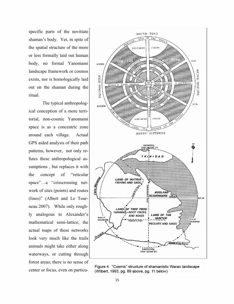
Yet just downstream, in the Orinoco Delta proper, bands and sub-tribes of traditional
Warao people with shamanistic religion not that different on the surface from the Yamoma-
mi, actually laid out a formal, 200 km wide, oppositional framework that defined their home-
land, figure 4 (Wilbert 1993:13). The north and south points of the Warao world are marked
by two “petrified world trees” in the form of mountains and abodes of two gods associated
with these directions. These are actual topographical features, Naparima Hill on Trinidad Is-
land to the north and 212 kilometers to the south, Cerro Caroshimo (Wilbert 1993:11). These
two points deviate only about nine arc minutes of longitude of being an exact meridian. Wil-
bert mentions the possibility of laying out such a long line in relatively flat jungle terrain--the
two “mountains” are only 192 and 150 meters in elevation--by using astronomical references.
The east and west points on the Warao landscape cross are determined by the sun. Solstice
points are additionally important in their origin myth. Both cardinal and intercardinal gods
inhabit their cosmic frame (ibid:23).
Describing the related Yekuana subgroup in the Alto Orinoco, Barandiaran (1979)
speaks of supports for the heavens and the location of the world tree (Yuca Amraga) on the
mountain Cerro Kushamakari (912). They understand a mandala-like structure with a vertical
axis linked to the Milky Way. This vertical axis of sacred mountain, cosmic pillar and sacred
tree functions to connect the Yekuana shaman to spirit power, either relaying messages on the
axis, transporting souls or curing health problems associated with the earth (947).
Wilbert as well describes similar sources of landscape power which now involves
more formally defined applied or even “designed” spatial frameworks. There are three gods
of the axis mundi who direct the movement of spirits and souls to and from earth (1993:91);
“from an early age the individual Warao remains engaged in a relentless tug-of war- between
himself and the supernaturals...the gods need humans to provide them with food, and the hu-
mans need gods to protect their lives and their goods” (ibid:93). Three different kinds of
shamans serving different gods of the directions facilitate these processes. The shamans go to
their associated direction when they die. Some go to a beautiful city on the top of the moun-
tain at the center of the world (axis) (ibid: 95), which can be interpreted as either the vertical
17
position of center (Cerro Kushamakari) or the horizontal position of north mountain as zenith
of the axis (Naparima Hill). Wilbert suggests the Warao cosmos is strongly “reminiscent” of
Aztec and Mayan concepts (ibid 109).
While there exists a geographically real cross structure that defines the Warao world,
much of the anthropological sense of its meaning comes second hand, as it were, from myth.
In one such example, the “celestial bird could be observed carrying out its mandate to fly at
midnight and during the day to the meridian, shake his beautiful wing and sign for the pro-
tection of the children on earth” (Wilbert 1993:109). Wilbert, however, knows of no actual
ritual practice or pilgrimage that involves the important points on the cosmic structure
(personal communication). He has only observed the approximate point where the axes meet
from the air, and did not see any obvious ritual elaboration of the location such as permanent
shrines or temples. Mythically there should be a sacred tree at this location. Wilbert did
mention a vague association of the ancestors of different subgroups with different directions
of their cosmos. But any kind of large-scale ritual framework that might have integrated
subgroups is unknown. He does mention the more localized ritual congregation of bands, or
subtribes, at a clearing in the forest (with no described location relative to their larger cos-
mos). A simply constructed shrine was built on the eastern side of the clearing and a single
row of houses opposite to the west (1993: 101). The patron god of the subtribe is represent-
ed in this plaza as a sacred rock. This pattern appears to mirror Gossen’s model of space in
the Chamula (1972), and is not atypical in many Mayan ceremonial sites.
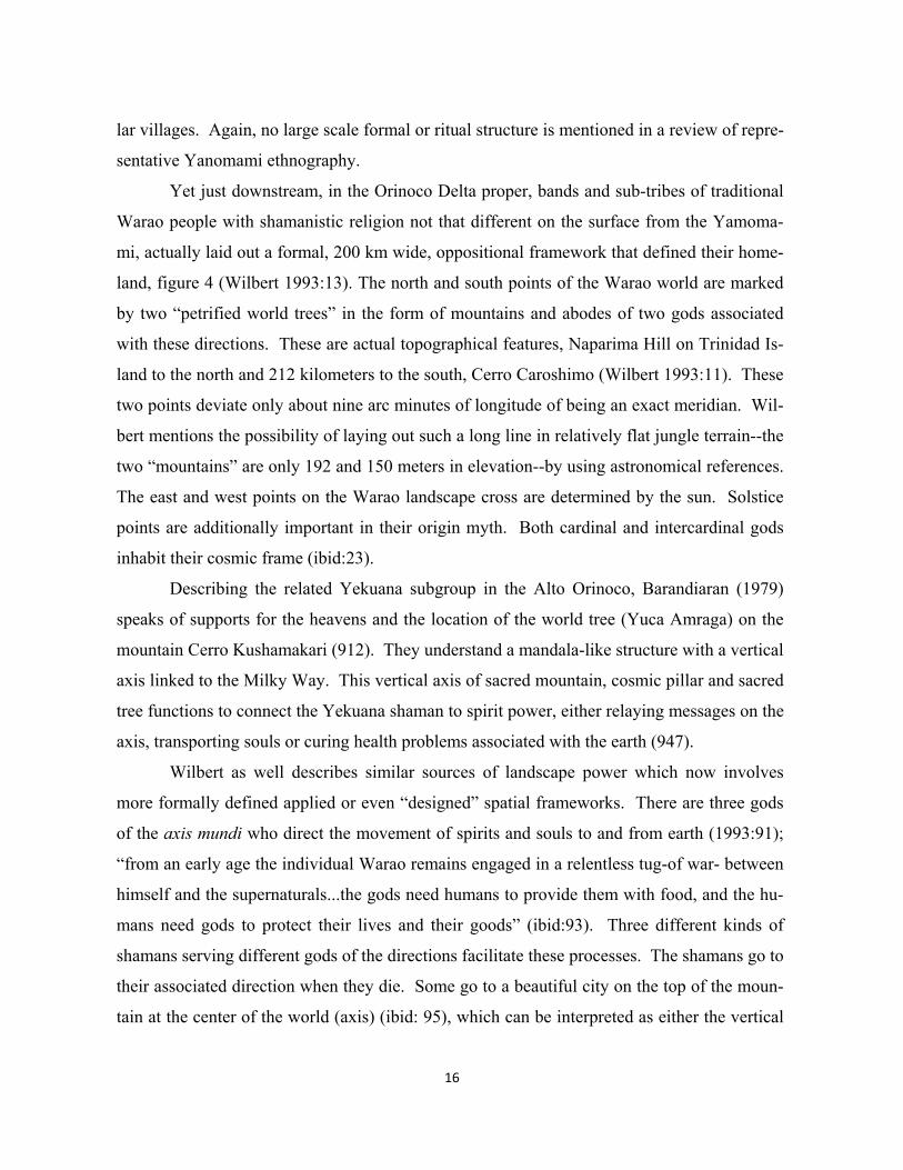
While largest scale formalized ritual in the Warao is relatively unknown, both Wil-
bert and Barandiarian give ample space in their volumes to both the structure of landscape
(figure 5) and related ritual practices at the scale of the domestic roundhouse, where shaman
curing and other sacred acts find their focus (Barandarian 1979:948). Perhaps the most im-
pressive thing about spatial structure and ritual in the Warao, particularly in Wilbert, is the
emotive intensity or affective power of these devices for making contact with the spirits.
Wilbert’s description and interpretation of the Bahana myth and ritual is particularly instruc-
tive here. Figure 5 illustrates the concept of a cosmic egg and a competitive coexistence of
birds and bees who invade each other houses and cannibalize one another’s offspring
(1993:163). This egg and its cosmic axis exist as an attribute of roundhouse symbolism, in-
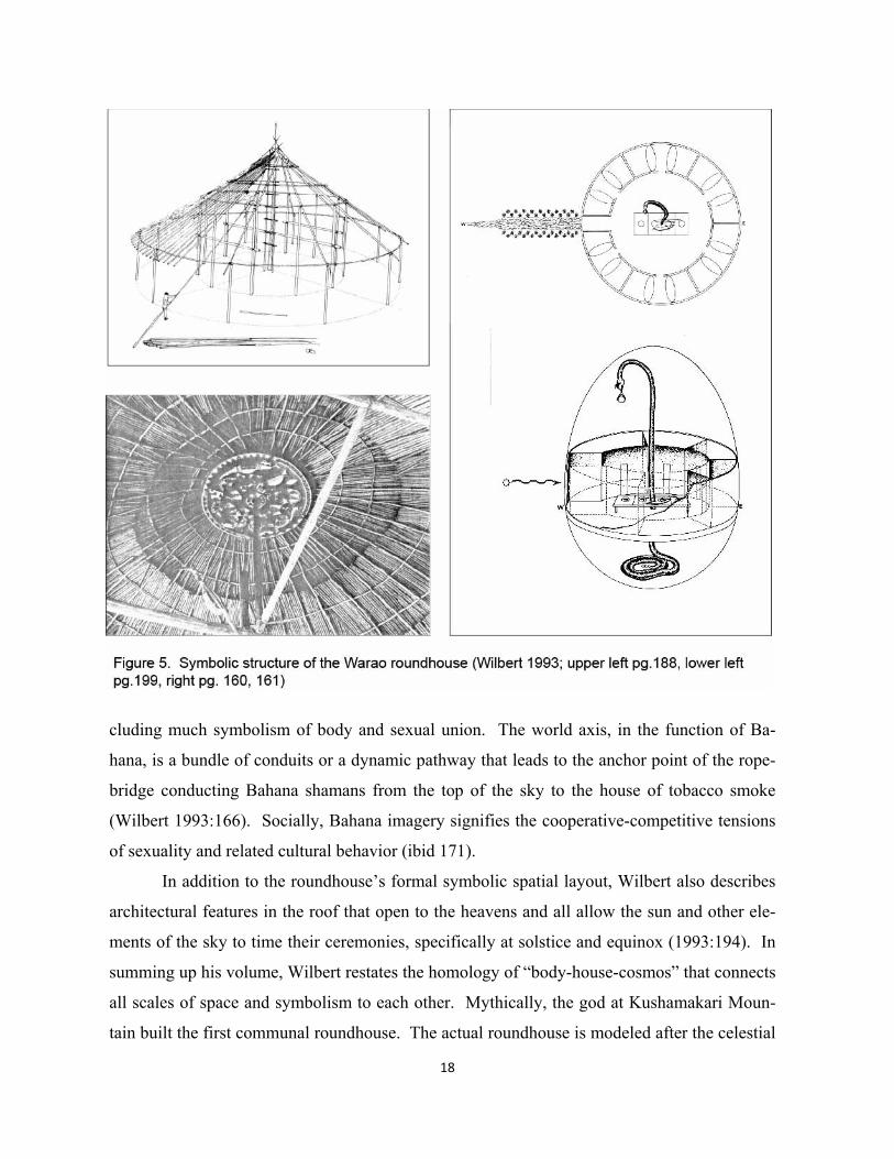
18
cluding much symbolism of body and sexual union. The world axis, in the function of Ba-
hana, is a bundle of conduits or a dynamic pathway that leads to the anchor point of the rope-
bridge conducting Bahana shamans from the top of the sky to the house of tobacco smoke
(Wilbert 1993:166). Socially, Bahana imagery signifies the cooperative-competitive tensions
of sexuality and related cultural behavior (ibid 171).
In addition to the roundhouse’s formal symbolic spatial layout, Wilbert also describes
architectural features in the roof that open to the heavens and all allow the sun and other ele-
ments of the sky to time their ceremonies, specifically at solstice and equinox (1993:194). In
summing up his volume, Wilbert restates the homology of “body-house-cosmos” that connects
all scales of space and symbolism to each other. Mythically, the god at Kushamakari Moun-
tain built the first communal roundhouse. The actual roundhouse is modeled after the celestial
19
sphere as expressed in both myth and actual landscape frame (1993:194).
Clearly, the Warao belong to the category of societies whose religion is based on the
transformational power of shaman. Yet unlike what might be a majority of these societies the
Warao have for some reason actually surveyed, or formalized, at least some aspects of a large
scale frame, raising questions about relationships to cosmic structure in their dwellings and
myth. Why, they, unlike the Yanomami, do this is theoretically undefined. Heinen (2003)
compares the two groups using the adjectives of “fierce” (Yanomami) and “peaceful” (Warao).
The Yanomami have a male supremacy complex, while the Warao maintain much more of an
equilibrium between the sexes. Warfare and witchcraft are more prominent among the
Yanomami, while the Warao are easygoing and cooperative, having no fear of talking openly
about their spirit ancestors. Are these differences in any way related to presence of a more for-
mally defined large-scale landscape of the Warao that somehow moderated heterogeneous
bands and sub-tribes with significant dialects and ecological niche histories?
In the U.S. Southwest, the Navajo provide a second apparent hybrid between shaman-
istic and partially formalized landscapes. Ecologically, their extended kinship residential
groups, involved in making an agricultural and hunting living off marginal lands, might have
been somewhat similar to late Basketmaker II Pueblo societies. In terms of religion,
Lamphere’s overview of Southwestern ceremonialism among all the Native American groups
of the southwest (1983:743) begins with shamanistic groups like the Yumans, then Apaches,
and then places the Navajos just prior to the Pueblos. Compared to the Yumans and Apaches,
“ritual reciprocity (or prestation), and the concomitant themes of removal and sanctification (or
identification) become elaborated in the context of Navajo ceremonialism, where cosmology
and structure of rituals are more formalized and where the symbolism of song, ritual objects,
and actions becomes more apparent” (ibid:749). She continues to define how ritual power is
acquired more through apprenticeship than vision experience as in Yumans and Apaches. The
Navajo cosmos has more structure, both vertically and horizontally, and involves emergence
not unlike Pueblo ceremonialism. “Navajo ritual seems to replicate the cosmos more clearly,
and color, sex, and directional symbolism is more fully utilized. Navajo ritual includes more
agricultural symbolism as well.” (ibid:753)
What most differentiates the Historical Pueblos from the Navajo, in Lamphere’s over-
view, are variations of the idea of two parallel worlds, one supernatural and the other social. It
20
is taken further in the Pueblos where the supernatural is divided into classes to mirror the so-
cial world. Moreover, death among the Historical Pueblos changes humans into ancestors
who become supernaturals, compared with Navajo beliefs that death creates malevolent, sick-
ness-producing ghosts (Lamphere 1983 :754). Generally, compared to the Navajo model of
the universe, Pueblo cosmologies are more extensively structured (ibid:755).
Witherspoon (1983:525) defines two basic social relationships among the Navajo.
One consists of those with whom one is related, or a kinship solidarity, and the other is with
those unrelated, or non-kinship solidarity. Bonds created by kinship tend to be expressed in
“affection, care, kindness, and unsystematic sharing” (ibid :525). Relationships between non-
kin groups are more systematic and fundamentally reciprocal. More recently, an extended
family group resided in proximity to each other, and all participated in the group’s herd of
sheep. A “head mother” determines residence rights. Prior to the introduction of sheep, such
groups would have been dependent upon some agriculture and hunting, not unlike Ancestral
Pueblo ecology (ibid: 525). In sum, while reciprocity existed between these extended kinship
residential groups, there was no clearly defined larger scale group (Witherspoon 1983:531).
How then, more specifically, does the creation and maintenance of Navajo social pat-
terns rely affectively upon the appropriation of a religious landscape? Where do the principal
spirits reside, and how then do ritual sites and practices make connection to the spirits and
thus provide power to influence? Aldred makes the argument that Navajo land and religion
are one (2000:23). The primary spiritual deities are the Holy People. They in turn created
“Diyinni” or spiritual beings that possess the entire landscape, including animals, plants,
weather elements, and celestial bodies. Beyond this shamanistic relationship, emphasis exists
for the four mountains that create their basic cosmos as well as some point of emergence
known to every Navajo (ibid: 25). For a comprehensive list of major landscape features see
McPherson (1992: 15). Kelly and Francis mention the way the larger landscape framework is
repeated (homologically) with structured features at progressively smaller scales of landscape
and social groups, though no clear map of such a possibility is provided by the these authors
(1994:197). They do mention however, as will be mapped later in this volume, the folk rec-
ord of an apparently survey straight “sunray” running at very large scale west to east across
the plateau (2005).
21
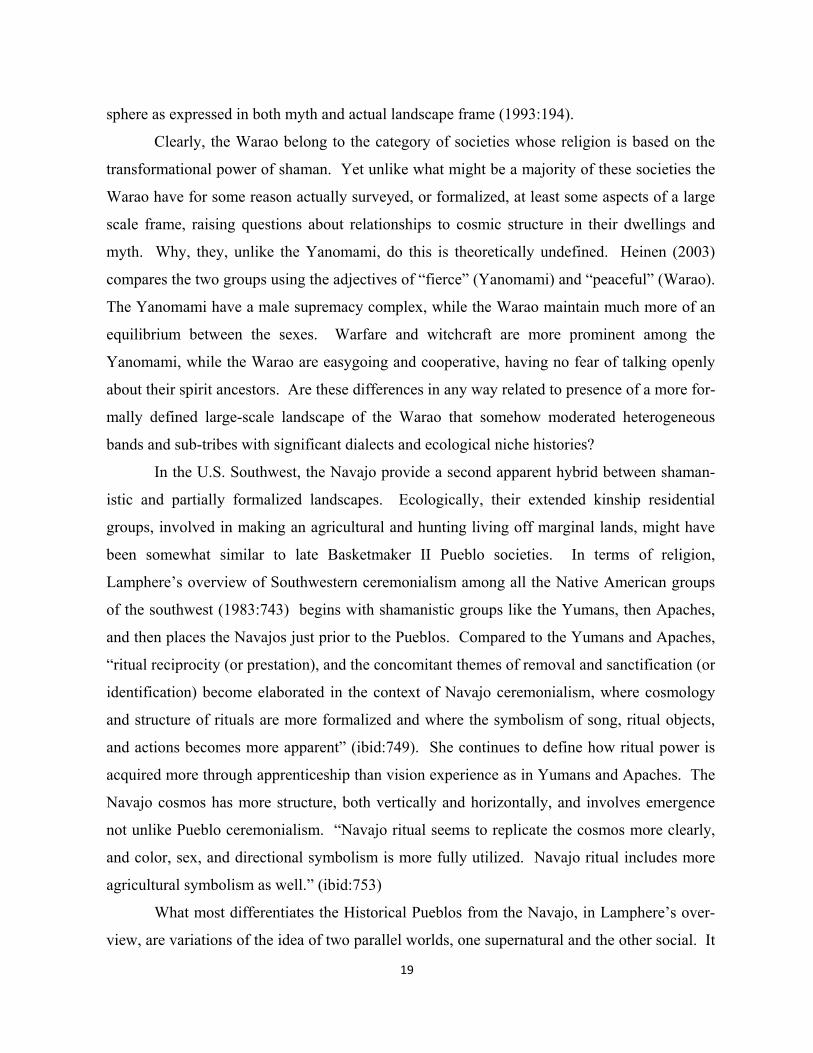
There appears to be little highly structured ritual use particularly of the most promi-
nent mountains of their landscape as cosmos, as was true of the Warao as well. What we
have instead, are less structured uses developed and maintained by individual shaman and
integrated with myth. Such association can be seen in myths about Changing Woman, one of
their most revered deity.
22
“Many geographical formations in their homelands are conceptualized as or-gans of Changing Woman’s body. For example, the sacred mountain of the south in Navajoland can be translated as ‘Tongue Mountain’, whereas the sa-cred mountain of the north is considered the heart of the earth’s form. Be-tween these two lie the earth’s lungs and breathing diaphragm. Changing Woman is often described as the mother who gave birth to the Navajo and as the nurturer of all beings.” (Aldred 2000:23).
A detailed list of features of the natural landscape held by the Navajo to be sacred--including
clay sources for pottery, springs, air vents, waterfalls, dinosaur remains, and eagle nests--can
also be found in Kelly and Francis (1994:81).
Again, as landscape meaning somewhat more formalized than the shamanistic “web”,
Witherspoon and Peterson associate important cognitive and cultural attributes--motifs on
rugs, sandpaintings, masks, clothing, staffs, hair buns, or rock walls--to the spatial frame of
their large-scale horizontal and vertical directions anchored at four distant mountains. This
integrates with a mythology of emergence through four underworlds or previous stages of ex-
istence (1995:34). Their diagrams of figure 6 are held to be a kind of cognitive core of Nava-
jo thought and religion. Notably, the diagram structures opposed symbolic domains; the two
ends of any one axis are “bipolar”, while spatial oppositions between halves of the cosmos
created by the “vertical” or central axis are “bilateral” (ibid 38).
The Navajo dwelling, architecturally not that dissimilar to Ancestral Pueblo pit houses
and kivas, seems both shamanistic and specifically linked to larger scale frameworks on the
landscape, not unlike the Warao roundhouse. The formal spatial structure, orientation, and
meanings of symbolic oppositions as domains of the hogan are clearly evident in the diagrams
of figure 7. The most important ritual performed in the hogan and in immediately adjacent
dance circles outside is the Blessingway rite, given historical precedence over other ceremoni-
als, and the “backbone” of Navajo religion (Wyman 1983:540). Changing Woman is a prima-
ry focus of the Blessingway. Apparently no aspect of the Blessingway rite involves the actual
movement of participants out into the more distant sacred natural landscape, yet not unlike the
Warao and Yamomami, objects used in the ritual come from the summits of sacred moun-
tains, e.g. the mountain soil bundle containing buckskin packages of soil and certain stone ob-
jects (ibid 540).
23
The Blessingway rite, like other ceremonials, are conducted by “singers”, religious spe-
cialists who apprentice with and pay a teacher. The songs for each rite are so extensive, hun-
dreds in number, such that together with other knowledge about prayers, plant medicines, mate-
rial properties, symbolic drypaintings, and ritual acts, a singer’s specialization is limited to at
most a half-dozen complete chants (rites) (Wyman 1983: 538). Blessingway, according to
Wyman, is not a curing ceremony unlike almost all the other shamanistic Navajo rites, even
though it as well has its “patient” as a focus. The distinctive ritual purpose of this Changing
Woman ceremony, from the others (Enemyway, Ghostway, etc), remains unclear (ibid:541-
542). Is it somehow more structural in its reference to landscape frameworks, even though
these are not actually used in the ceremony.
There is frequent invocation of the power of the four (or five counting a vertical) direc-
24
tions, in addition to the basic framework of the hogan with its opening to the east from whence
comes good, and a smoke hole in the center of the roof to get rid of evil. During these and
Holyway chants, all people or objects move “sunwise”, from left to right or from east to south
(ibid: 550). A bull-roarer is whirled outside the hogan associated with each of the cardinal
points. After the ceremony, things that have been used need to be disposed of by helpers in
stated directions away from the hogan. Ceremonies are opened with a consecration of the
structure; the singer rubs cornmeal on four beams of the roof in the cardinal directions. Just
after dawn on the first morning a fire is made with a fire drill. Four small sandpaintings, usual-
ly of snakes, might be located at the cardinal directions around the central fireplace. (ibid 551).
Certainly the most graphic fusion of landscape as cosmos, hogan and ritual process ap-
pears in the dry sandpainting on the hogan floor during ritual, see figure 7. It is destroyed after
the ceremony. Wyman reports that all Holyway chants, most Evilway chants and the Blessing-
way ceremonies involved dry sandpainting (552). He goes on to describe their structure:
“Place is important to a Navajo; and a locality symbol--the center in radial composi-tions, the foundation bar in linear ones--is conspicuous. The main theme symbols are arranged according to one of three types of composition: linear, with figures in a row or rows; radial, with important symbols cardinally oriented in a Greek cross and with subsidiary symbols in the quadrants in a Saint Andrew’s cross, around a center symbolizing the spring, pool, mountain or dwelling where the commemorated epi-sode took place; and extended center, with a central motif occupying most of the space. Sequences of color have directional sexual or other ritual meanings. Finally the entire picture is surrounded by an encircling guardian, usually the red and blue Rainbow deity or garland, open to the east for the entrance of good and the expulsion of evil. Sometimes a pair of small symbols enhances control of this eastern aper-ture.” (Wyman 1983: 552).
Finally, to what degree do highly spatially structured ceremonies, focused on individual prob-
lems such as “illness, bad dreams, recollection of violated restrictions, fear of witchcraft, or
other reasons” (Wyman 1983: 555), involve effects that influence the social well-being of the
extended kinship residential group, or other groups in reciprocal relationships? Nothing is said
in Wyman’s overview about rites of passage.
Apparently passage rites such as birth, marriage and death involve far less ceremony
than chants, which is somewhat surprising given the kinship basis of the important residential
group. The wedding does however, take place again in the sacred hogan, though among a
25
small number of guests. Ritual movements involve much reference to the sacred directions:
“The groom enters the hogan and walks sunwise around the fire to a seat on the northwest side. The girl is led by her father to a place next to the groom. The father takes a new basket filled with corn mush and points the opening in the de-sign to the east. He makes a cross and a circle in corn pollen upon the surface of the basket and turns the design opening toward the young people. the two then wash each other’s hands in water. The man takes a pinch of mush from where the pollen touches the circle to the east, then bits from the south, west, and north sides. The girl follows him in each of these acts. In some localities the couple is expected to consume all the mush. Usually, however, after prayers and some-times songs the assembled relatives and friends eat the rest of the mush. The two fathers deliver little sermons on the reciprocal duties of husband and wife, how they should get along together, and the like. The gathering does not break up un-til Blessingway songs have been sung at dawn.” (Leighton & Kluckholn 1948:81) After a Navajo dies, two of four people who have been with him or her until the end pre-
pare a grave while the other two ready the body for burial (Reichard 1928:141-143). Burial
takes place the next day with only the mentioned four people participating:
“One of the mourners leads the horse[loaded with the possessions of the de-ceased] deliberately toward the grave. He is followed by the two bearing the corpse on their shoulders. A fourth mourner warns travelers that they may change their route.” (ibid:142). At the grave, only the body is arranged and cov-ered with brush or stones to keep the animals away. Reichard mentions that tools used by the deceased are burned or mutilated, and the horse is shot before the mourners return home. During the following four days the mourners remain quiet and leave the hogan only when absolutely necessary and then accompanied by the head mourner. A guard keeps the trail between the hogan and the grave open by signaling to passers-by. Early on the morning of the day following the fourth night the mourners bathe again. After the entire family has also bathed there is a short period of ceremonial wailing and the mourning time is past.” (ibid:143). While it is tempting to read some directional opposition into the axis between hogan and
grave, as might be part of some aspect of landscape structure, Reichard provides no maps of
such. Some sort of opposition must exist, however, between the power of the hogan (as “life”
perhaps), and a place associated with nature (“death”?).
A much more dramatic expression between death and the hogan is provided by Griffin-
26
Pierce (1992:121). When the central fireplace of a hogan is abandoned because a young person
has died there, a relative has the following options: burn the hogan with the body inside, create
an opening on the north side to allow removal of the corpse, or block the door and smoke hole
with timbers to show that it now contains a burial. Navajos will not approach such a hogan for
fear of witchcraft (ibid).
Where, then, does one place the Navajo on a spectrum from shamanistic use of the land-
scape to some hypothetically complex highly formalized ritual use of large scale frames? On
the one hand, it is maintained that all the Navajo landscape is sacred and perhaps web-like, even
though we don’t have Stoffel & Zedeno mapping to document active shamanistic use. Yet one
also finds the anthropological assertion that the large-scale cosmic framework thoroughly infus-
es religious cognitions along multiple symbolic dimensions, especially in the intensively used
homologically structured hogan. Yet there is little formalized ritual or related architecture in
the landscape, and certainly no large scale pilgrimage foci that we see in climax Chaco/Aztec,
and possibly earlier in the Ancestral Pueblo.
Ritually used cross frameworks on the larger landscape
Shamanistic landscapes--either as “webs” or more formally structured cross-like “cosmos” with
minimal related large scale ritual practice-- may have predominated among the Ancestral Pueb-
lo up to about 500 A.D. on the Southern Colorado Plateau. Curiously enough, there is some-
thing of a void of landscape theory in studies of new organizational forms involving villages
and larger ceremonial structures that follow. One needs to fast forward a thousand years to the
Historic Pueblo period, before finding again anthropological ideas and evidence of religious use
of larger scale landscapes.
Alfonso Ortiz' (1969) anthropological description of space in the Tewa world provides
perhaps the most detailed example of a series of sites in the landscape being linked together by
cross-like alignments to a focus (pueblo). For the Tewa, two cardinal axes with six landscape
sites each, integrated a flow of spiritual power from the farthest mountain points, intermediate
hilltops, and springs to the sacred center opening in the San Juan pueblo, figure 8. Radiating
out from the center, each scale of axially positioned landscape site associated with stages of so-
cial and religious "becoming" in Tewa society. All sites in the system involve ritual sipapu or
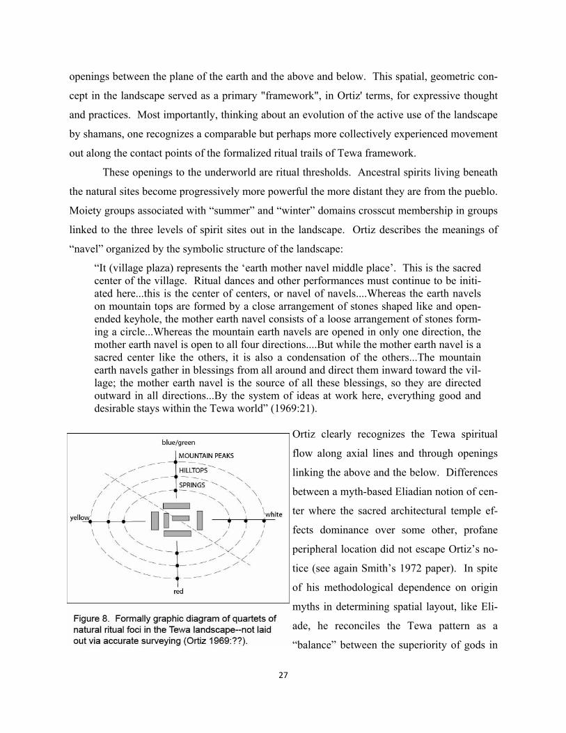
27
openings between the plane of the earth and the above and below. This spatial, geometric con-
cept in the landscape served as a primary "framework", in Ortiz' terms, for expressive thought
and practices. Most importantly, thinking about an evolution of the active use of the landscape
by shamans, one recognizes a comparable but perhaps more collectively experienced movement
out along the contact points of the formalized ritual trails of Tewa framework.
These openings to the underworld are ritual thresholds. Ancestral spirits living beneath
the natural sites become progressively more powerful the more distant they are from the pueblo.
Moiety groups associated with “summer” and “winter” domains crosscut membership in groups
linked to the three levels of spirit sites out in the landscape. Ortiz describes the meanings of
“navel” organized by the symbolic structure of the landscape:
“It (village plaza) represents the ‘earth mother navel middle place’. This is the sacred center of the village. Ritual dances and other performances must continue to be initi-ated here...this is the center of centers, or navel of navels....Whereas the earth navels on mountain tops are formed by a close arrangement of stones shaped like and open-ended keyhole, the mother earth navel consists of a loose arrangement of stones form-ing a circle...Whereas the mountain earth navels are opened in only one direction, the mother earth navel is open to all four directions....But while the mother earth navel is a sacred center like the others, it is also a condensation of the others...The mountain earth navels gather in blessings from all around and direct them inward toward the vil-lage; the mother earth navel is the source of all these blessings, so they are directed outward in all directions...By the system of ideas at work here, everything good and desirable stays within the Tewa world” (1969:21).
Ortiz clearly recognizes the Tewa spiritual
flow along axial lines and through openings
linking the above and the below. Differences
between a myth-based Eliadian notion of cen-
ter where the sacred architectural temple ef-
fects dominance over some other, profane
peripheral location did not escape Ortiz’s no-
tice (see again Smith’s 1972 paper). In spite
of his methodological dependence on origin
myths in determining spatial layout, like Eli-
ade, he reconciles the Tewa pattern as a
“balance” between the superiority of gods in
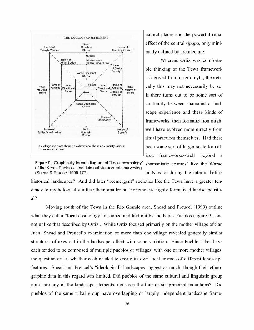
28
natural places and the powerful ritual
effect of the central sipapu, only mini-
mally defined by architecture.
Whereas Ortiz was comforta-
ble thinking of the Tewa framework
as derived from origin myth, theoreti-
cally this may not necessarily be so.
If there turns out to be some sort of
continuity between shamanistic land-
scape experience and these kinds of
frameworks, then formalization might
well have evolved more directly from
ritual practices themselves. Had there
been some sort of larger-scale formal-
ized frameworks--well beyond a
shamanistic cosmos’ like the Warao
or Navajo--during the interim before
historical landscapes? And did later “reemergent” societies like the Tewa have a greater ten-
dency to mythologically infuse their smaller but nonetheless highly formalized landscape ritu-
al?
Moving south of the Tewa in the Rio Grande area, Snead and Preucel (1999) outline
what they call a “local cosmology” designed and laid out by the Keres Pueblos (figure 9), one
not unlike that described by Ortiz,. While Ortiz focused primarily on the mother village of San
Juan, Snead and Preucel’s examination of more than one village revealed generally similar
structures of axes out in the landscape, albeit with some variation. Since Pueblo tribes have
each tended to be composed of multiple pueblos or villages, with one or more mother villages,
the question arises whether each needed to create its own local cosmos of different landscape
features. Snead and Preucel’s “ideological” landscapes suggest as much, though their ethno-
graphic data in this regard was limited. Did pueblos of the same cultural and linguistic group
not share any of the landscape elements, not even the four or six principal mountains? Did
pueblos of the same tribal group have overlapping or largely independent landscape frame-
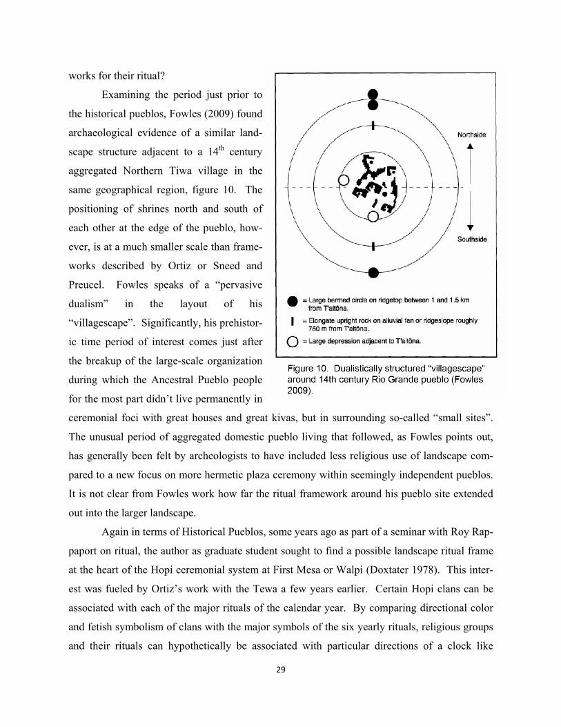
29
works for their ritual?
Examining the period just prior to
the historical pueblos, Fowles (2009) found
archaeological evidence of a similar land-
scape structure adjacent to a 14th century
aggregated Northern Tiwa village in the
same geographical region, figure 10. The
positioning of shrines north and south of
each other at the edge of the pueblo, how-
ever, is at a much smaller scale than frame-
works described by Ortiz or Sneed and
Preucel. Fowles speaks of a “pervasive
dualism” in the layout of his
“villagescape”. Significantly, his prehistor-
ic time period of interest comes just after
the breakup of the large-scale organization
during which the Ancestral Pueblo people
for the most part didn’t live permanently in
ceremonial foci with great houses and great kivas, but in surrounding so-called “small sites”.
The unusual period of aggregated domestic pueblo living that followed, as Fowles points out,
has generally been felt by archeologists to have included less religious use of landscape com-
pared to a new focus on more hermetic plaza ceremony within seemingly independent pueblos.
It is not clear from Fowles work how far the ritual framework around his pueblo site extended
out into the larger landscape.
Again in terms of Historical Pueblos, some years ago as part of a seminar with Roy Rap-
paport on ritual, the author as graduate student sought to find a possible landscape ritual frame
at the heart of the Hopi ceremonial system at First Mesa or Walpi (Doxtater 1978). This inter-
est was fueled by Ortiz’s work with the Tewa a few years earlier. Certain Hopi clans can be
associated with each of the major rituals of the calendar year. By comparing directional color
and fetish symbolism of clans with the major symbols of the six yearly rituals, religious groups
and their rituals can hypothetically be associated with particular directions of a clock like
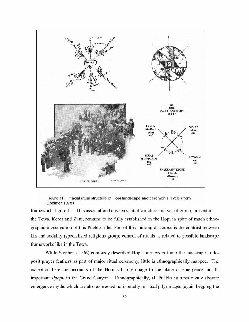
30
framework, figure 11. This association between spatial structure and social group, present in
the Tewa, Keres and Zuni, remains to be fully established in the Hopi in spite of much ethno-
graphic investigation of this Pueblo tribe. Part of this missing discourse is the contrast between
kin and sodality (specialized religious group) control of rituals as related to possible landscape
frameworks like in the Tewa.
While Stephen (1936) copiously described Hopi journeys out into the landscape to de-
posit prayer feathers as part of major ritual ceremony, little is ethnographically mapped. The
exception here are accounts of the Hopi salt pilgrimage to the place of emergence an all-
important sipapu in the Grand Canyon. Ethnographically, all Pueblo cultures own elaborate
emergence myths which are also expressed horizontally in ritual pilgrimages (again begging the
31
question of whether ritual or myth is most primary). At the Hopi pueblo Oraibi, for example,
Geertz (1984) creates comparative taxonomies of multiple versions, most of which contain
clear spatial symbolism of an opposition between some emergence from below to above
(horizontal movement on the landscape in terms of actual ritual). Hieb (1994) dedicates his
piece more broadly to the concept of “sipapu”, examining the active ritual use of these openings
in the ground that are traditionally built in semi-subterranean Hopi ceremonial kivas. As dia-
grammed in Saile (1977), these liminal openings are also part of Ortiz’s Tewa radiating system
of landscape features. In the same religious vein, on the top of Mount Taylor, one of the high-
est mountains of the southeast portion of the Ancestral Pueblo area, Blake (1999) describes a
six-foot deep hole, presumed to have been dug by indigenous people for sipapu related ritual.
The Grand Canyon, again, is one of the most dramatic of such openings. Mischa Titiev
(1937) recorded the most detailed ethnographic account of the Hopi salt expedition to the can-
yon from the village of Oraibi. Both the Hopi and Zuni make pilgrimage to gather salt at their
respective sacred sources, one to the Grand Canyon (Eiseman 1959, Vecsey 1983:88), the other
to Koluwala:wa or the confluence of the Zuni and Little Colorado Rivers (Ferguson & Hart
1985:125). For the Zuni, this is an important pilgrimage made every four years by religious
leaders; all Zuni go to this threshold location after death as do the Hopi to theirs. The trip the
Hopi make down Salt Trail Canyon (figure 13 ahead) takes them by a supposedly natural
mound feature, about thirty meters in diameter. Additional accounts of this pilgrimage experi-
ence come from two naturalist/writers, Eiseman (1959) and more recently Engelhard (2004).
Eiseman photographed the mound feature and documented other shrines on the way to the actu-
al junction of the two rivers where he located the salt source. Engelhard (2004) also describes
multiple shrines along the trail. For both writers, the salt sources and the threshold confluence
itself, not the mound shrine, is the ultimate destination of the pilgrimage, as is the case with the
Zuni at their confluence point upriver on the Little Colorado. But were pilgrimages to emer-
gence points part of a formalized, cross like framework like the Tewa?
In regards to possible frameworks, and particularly their relation to Pueblo social organ-
ization, among the Zuni the order of significance of the colors and associated cardinal direc-
tions expresses ranking of religious societies (Potter and Perry 2000:63). Zuni kivas are also
hierarchically ordered in a counterclockwise circuit of the village. This spatial order then deter-
mines the sequence of rituals through the season (ibid). These are all bipolar or axial associa-
32
tions. But here again, one has no evidence comparable to the Tewa that these ritual structures
existed both in myth, and were laid out on the Hopi or Zuni landscapes. But it is certainly logi-
cal. One the primary reasons that we have the Tewa record, in this regard, is because Ortiz
himself was Tewa.
In any event, there exists relatively good ethnographic evidence that formally laid out,
ritually used large scale frameworks did exist in Historical Pueblo periods, differences between
Eastern and Western pueblo religious organization not yet considered.
Archaeological interpretations of the interim between shamanistic and historic landscapes
The present work rests on the idea that ritual use of the landscape did not recede dramatically
during the later prehistoric Pueblo periods after a probable ancient intensity of shamanistic
practices. Rather than seeing ritual frameworks in Historical Pueblo landscapes as secondary
expressions of myth, might they more logically be seen as a continuation or even reflection of
formalized landscape structures in preceding Pueblo periods? This approach ideally seeks to
shift the focus of investigation from a more exclusive interest in architecture, particularly “great
houses” and “great kivas”, to a more inclusive ritual formulation that integrates, and indeed af-
fectively depends upon, a formalized large scale natural landscape. The first formal ritual lay-
outs, beyond domestic dwellings and even great kivas, it will be argued, occurred in the land-
scape and not monumental architecture.
Moving back in time from the Historical Pueblos—with their evidence of landscape
framing--one is drawn to the recent volume Religious transformation in the late Pre-Hispanic
world (Glowacki and Van Keuren 2011). Scanning these chapters, one finds scant mention of
any large-scale ritual landscape structure as important to Ancestral Pueblo societies (1275/1300
– 1540) that immediately followed Chaco. In introducing the main theme of the book, the edi-
tors describe the archaeological task of theoretically understanding religious practice from
“careful documentation of ritual items, ceremonial spaces, and religious iconogra-
phy” (2011:12). Again, no mention is made of larger scale ritual use of landscape.
Plog’s discussion about ritual and cosmology in the Chaco, however, the volume’s start
point for consideration of the very late Pre-Hispanic period, cites Ortiz’s work and generally
associates much of the directional symbolism and even frameworks of historical pueblos with
the earlier “Chaco Phenomena” (2011:54), yet without specific spatial examples of possible
33
large-scale, formalized ritual landscapes in this era. The other contributors to the Glowacki/
Van Keuren volume make little reference to any large-scale religious frameworks. Instead, the
discussion clearly focuses on an intensity of religious practice in aggregated pueblos, including
the new Katsina cults and larger, performance oriented plazas. Yet both also exist in historical
pueblos as either integrated into or layered upon formally organized landscape ritual.
Bernardini’s (2011) piece on Hopi ethnogenesis provides perhaps the most theoretically
interesting discussion. Within Hopi traditions and practice, he defines two distinct forms,
traced to differences between autochthonous and immigrant groups. The immigrants brought a
different kind of religious orientation that can be associated with larger-scale organization
linked to Mesa Verde, Totah (Aztec area) and even Chaco (204). Local populations never par-
ticipated in Chaco per se, while newcomers had. Thus in Hopi religious life, Katsina ceremo-
nies during one half of the year were associated with the autochthonous, more kinship oriented
egalitarian traditions, while the other half of the year the calendrical rituals were controlled by
immigrant traditions described as being more hierarchical. Interestingly enough, Bernardini
associates the calendrical rituals (most associated perhaps with frameworks as in figure 11) not
only with sodality histories traceable to Chaco, but with the abuse of ritual power by priestly
hierarchies (219). As we will see further below, current archaeological theory sees sodalities as
associated with less integrating hierarchical power, while--somewhat paradoxically--kinship
controlled Katsina religion is more horizontal or egalitarian. In conclusion, Bernardini says
that “Ritual was both a motivating factor behind migration, assimilation, aggregation, and con-
flict, and a lens though which actors understood these processes. The scales of these religious
traditions—can be surprisingly large.” (220).
What might be missing in Bernardini’s ethnographic projection back into prehistoric
theory is a clear set of ideas of how large-scale ritual frameworks function in relation to the two
traditions of Hopi religion. In this regard Geertz (1984) is much more specific about actual
spatial structure, e.g. that the Katsina cult uses four directional elements, and the calendrical
cycle six (234), again more like that diagramed in figure 11. Both involve prominent features
on the landscape. Geertz clearly argues that the older Sipapuni or calendrical cycle is not
something that immigrant groups brought with them, but patterns that were also autochthonous
to the plateau, a more fundamental spatial map on the landscape. This gets to the heart of the
theoretical issue, i.e. separating control of ritual membership, whether by kinship clans or so-
34
dality groups, from the integrating effect of large scale ritual frameworks. In fact, it turns the
immigration issue on its head. Rather than introducing a new form of control and conflict in the
Hopi, for example, as “Chacoans” are held to have done, it may have been the sharing of a com-
mon large-scale plateau structure that actually allowed them to make the move to a new loca-
tion in the first place. This may well be the genius of the insipient cosmic Warao structure, al-
lowing the relatively peaceful movement of multiple social groups within the same culturally
defined landscape.
The distinction between kin based religion and cross-cutting sodalities, explained by
Bernardini as a product of a kind of ritual brought by immigrants, is cast more broadly as differ-
ences between Western and Eastern Pueblos in Ware (2002):
At the westernmost Hopi Pueblos, ritual sodalities are controlled by and deeply imbedded within kinship organizations. At Hopi, each ceremony is “owned” by a particular matrilinear descent group, and the principal lineage of the controlling descent group cares for ceremonial paraphernalia and provides the head priest for a fraternal sodality responsible for conducting the ceremo-ny…In contrast, Eastern or Rio Grande Pueblo sodalities have emerged as cen-tralized village political organizations that function independent of kinship con-trol and that exert considerable influence beyond the ritual life of the community through their control of village political offices, communal labor, inter-pueblo trade and so on. (94 & 95) Ware describes the standard anthropological view of this “divergence” as related to the
inability of kin controlled religion (Western) to accommodate large populations living in post-
Chaco aggregations as true pueblos; non-kin sodalities (Eastern) solved this problem. He points
to the contrary (not unlike Geertz) that archaeologically, the early origins of Pueblo sodalities
might have occurred in one of the oldest forms of Pueblo religion, the “clan-ceremony-sodality-
kiva complex”, best illustrated in the historical Hopi (ibid:97). Ware suggests that the Hopi pat-
tern of kinship/sodality layering evolved together and might date back to the Basketmaker III-
Pueblo I transition, around A.D. 700.
Using archaeologically defined settlement patterns, Ware describes the need of early
segmented matrilineal groups to develop more communal structures where male descent groups
could meet apart from the men residing with their sisters. At stake in these religious groups
was the control of access to farm land and other resources. Ware does not explore how larger-
scale landscape frameworks might relate to either matrilineal or male descent (sodality) groups.
The use of the kiva or big house as a kind of super dwelling seems to be considered as the pri-
35
mary ritual setting, not necessarily linked to the landscape. There is an assumption here, per-
haps, that the more Tewa like cosmological structure mentioned by Plog developed later along
with the monumental architecture of Chaco. Ware (2002) continues to describe how politically
centralizing tendencies—separating the sodalities from male descent groups--diverge from the
Hopi model in cycles of large-scale P-I (A.D. 700-900) aggregation of Eastern Pueblos, espe-
cially in the northern San Juan region, along with the Zuni as part of the continuum of “sodality
detachment” (102). Chaco, according to Ware might have been an early expression of new
forms of organization based on sodalities without kinship. There exists a clear emphasis on
spatial scale and integration in the way these new institutions function under unstable social and
environmental conditions, particularly considering “multiethnic contexts where traditional kin-
ship-based organizations are compromised by population loss or dispersal”, and that
“ceremonialist networks can thrive at fairly immense scales” (105). Thus in spite of an early
BM III – PI separation of male descent group sodality from the most immediate matrilineal kin-
ship group, non-kin sodalities at large scales emerge rather suddenly three hundred years later
with Chaco.
Ware and Blinman’s analysis of this non-kin based sodality reorganization emphasizes
the role of medicine societies, which integrate and subordinate other sodalities in the ceremoni-
al hierarchy” (2000:385). In this same vein, they cite Ortiz’s discussion of the role of dualistic
sodalities, or moieties, expressed at the pueblo scale in a northside and southside division (this
structure homologically exists in the larger-scale landscape diagram of figure 8). In the Tewa at
least, memberships in medicine and clown fraternities, in addition to warfare, hunting and a
woman’s society cross-cut or mediate the dualistic division (388). While moiety chiefs are sub-
ordinate to a single village chief, power is balanced by the chief’s selection in alternate years
from opposed moieties. One of the key adaptive characteristics of non-kin sodalities is their
ability to link across intra and inter pueblos scales for purposes of ritual exchange and a variety
of other functions (395).
Much of the reemergence (after Chaco) of non-kinship sodality groups in the East are,
according to Ware and Blinman (2000), the result of unique ecological conditions accompany-
ing the aggregations of pueblo ancestors into “true” pueblos beginning in the 1300’s. They de-
scribe how original dualistic organization can be spotted in certain architectural layouts stretch-
ing back to PII periods, especially at Chaco and Aztec (Totah) (ibid:398), and are still expressed
36
in the historical layouts of Eastern pueblos. What is puzzling, however, is that “original” dual-
istic sodalities are associated with the formalities of monumental architecture at the climax pe-
riod, when populations did not live in large scale true pueblos, but used these great houses and
kivas for large scale ritual. And that after Chaco, in spite of a radical scaling down of plateau
organization into more territorial tribal entities, and in spite of a radical reconstitution of dwell-
ing into true pueblos where dualism is seldom formalized in architectural or planning, one finds
a “continuity” of these non-kinship sodalities.
In addition to a lack of discussion about these apparent architectural distinctions, a po-
tentially far greater spatial discontinuity exists with regard to sodalities, an adequate discourse
about which is missing as well. When archaeologists cite Ortiz as to the existence of dual or-
ganizations in the Tewa, little mention is made of the larger-scale landscape framework that
founds Ortiz’s analysis of “becoming” a Tewa. To a large extent, the aspect of Tewa ritual
practice out in the formalized landscape is almost epiphenomenal to the basic religious and po-
litical function of sodalities. Similarly, at Chaco and Aztec ritual settings like great kivas are
clearly recognized and assumed to be involved with larger-scale sodality organization, but
without any evidence, or even dedicated research, that a comparable formalized landscape com-
ponent existed.
From the perspective (and practice) of landscape frameworks, it appears as though nei-
ther the distinction between kin-based and non-kin based (dualistic) kinds of sodalities, nor be-
tween dispersed and aggregated residential architecture define linkage to their ritual use. As
associated with the more indigenous Hopi populations, some form of spatially structured sodal-
ity ceremonialism is quite old, and logically might have involved landscape frameworks associ-
ated with dualism, not unlike later Tewa. Yet we have no real theoretical discourse, beyond
Ortiz, as to the actual effects of these frameworks and how they might relate to the operation
particularly of large-scale non-kin religious societies.
Ortiz’s work needs to be understood in its full theoretical “dimension”. The primary
anthropological goal of Ortiz’s thesis was to critique then dominant structuralist understandings
of “dual” organization. Levi-Strauss (1955) had essentially demoted dualism, concentrically
expressed in the physical form of villages in traditional societies such as the Bororo (128), to a
largely hidden triadic flow of marriage exchange. Eastern Pueblos like the Tewa were clearly
dualistic in terms of their formally expressed moiety structure. And Ortiz does find a ritual
37
landscape structure that was actually triadic in a different sense, with clear mediating entities
like the Towa é whose members and ritual foci in the landscape stand between the young and
deceased Dry Food People. The Tewa framework and “world view”, as seen in figure 8 is a
structure of multiple tetrads open at the corners to the flow of power between most sacred dis-
tant landscape features and the pueblo as center.
Where Ortiz most differed from Levi-Strauss, perhaps, was in ethnographically deter-
mining that the triadic pattern at the heart of moiety dualism was not hidden, but expressively
powerful in the actual framework and experience of the landscape. Furthermore, rather than
revealing a hidden hierarchical component among “primitive” societies thought to be dualisti-
cally egalitarian, and unlike the associations of hierarchy with Eastern dualism (and Chaco),
Ortiz often characterizes the effects of the Tewa ritual system as being egalitarian, e.g.
1972:140. Ortiz’ emphasis on the formalized landscape frame rises above the politics of either
clanship or moieties--both of which can be described in hierarchical terms. The religious struc-
ture in the landscape comes first, as it were, and as long as its relationships are egalitarian, then
it functions to integrate the larger community. The fact that Ortiz actually saw landscape
frames as theoretically distinct forms of religious “structure” can be discerned in his subsequent
discussion about a pan-Pueblo “world view” which begins with a description of space:
“All peoples try to bring their definitions of group space somehow into line with their cosmologies, but the Pueblos are unusually precise about it….the Pueblos attempt to reproduce this mode of classifying space on a progressively smaller scale…the dominant spatial orientation, as well as that of motion is centripetal or inward…a Pueblo priest, when setting out a dry painting, will first carefully set out the boundaries and then work his way inward toward the center. The Navajo singer, on the other hand, will work outward from the middle.” (142-143)
He is not specific about the actual ritual use of these multi-scaled frameworks in the landscape,
but the meaning is clear, given their structural role described in The Tewa World.
Although Ortiz clearly differentiates the triadic Tewa world framework from Eliadian
concepts where the sacred center is more powerful than the periphery, he feels that any discus-
sion about which foci of the framework are more affective than others is pointless, given the
integrating or flowing character of the process. Nevertheless, one would tend to interpret the
four sacred mountains at the distant ends of the cross structure, some with their sipapu (Ortiz
1969:19) as being most seriously spiritual. All twelve landscape places are religiously power-
38
ful, and must provide the ritual efficacy that ultimately integrates these social groups.
At what point did these powerful religious devices evolve from intensive shamanistic uses of
the natural landscape? Were Ware’s sodalities, traceable back to A.D. 700, less the product of
local kinship politics than indicators of large-scale ritual frameworks? Was there some sort of
evolution of a then ancient Warao-like cross structure stretching well back into the Basketmak-
er II period? As an entry into theorizing about the advent of early landscape frameworks in the
Ancestral Pueblo, one should be as specific as possible about the way Tewa (and Hopi) struc-
tures integrate their sodality participants.
Looking again at figure 8, clear social hierarchies exist in the six levels of existence,
three human and three spiritual, expressed as three concentric rings of sacred sites in the land-
scape. At the top of the ranking are the Made People, as the humans closest to ultimate spiritu-
ality; these are the moiety societies, medicine men and clowns (17). Their power exists not only
in their responsibility for the yearly cycle of calendrical rituals—the “structure of structures”--
but in mentoring practices of the two lower levels of society. This is the more hierarchical im-
age that archaeologists project back into early pueblo non-kin sodality organization, including
Chaco.
Paradoxically, Ortiz (1969:125) calls the Made People, “those of the middle of the
structure” and extols their ability to influence or mediate moiety oppositions among people of
the two lower identities of Tewa existence. How then, is their association with the outermost
ring of four sacred mountains connected with this mediational role? Ortiz is not specific on this
point of spatial logic. Yet the answer can be discerned from his analysis. Tewa ritual practi-
tioners might have less imagined the concentric rings of the structure than a series of clock-like
axes and directions that corresponded to the calendrical ritual cycle encompassing both Sum-
mer and Winter halves of the year. Conceptually, each ceremony is a direction of contact with
the most sacred entity at the most distant end of the axis in question. Mediation is built into the
layout, since any ritual direction in the Summer half of the year, for example, will have its op-
posite expression and direction during Winter. One can think of a clock like structure of both
space and time. In this view, the notion of “middle” (emphasized in Ortiz as the pueblo dance
plazas) expresses the way the two ends relate to each other by the center.
Rather than think of plazas of aggregated pueblos as some new ceremonial focus in
Pueblo religion after the break-up of Chaco, rereading Ortiz, it is clearly pointed out that they
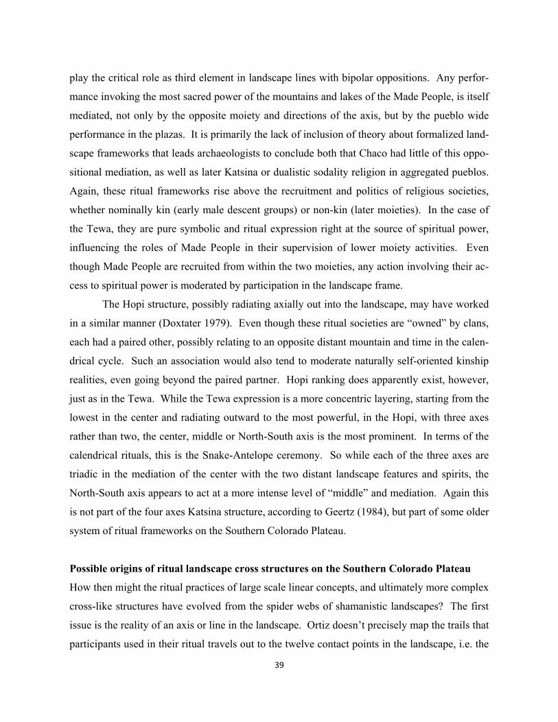
39
play the critical role as third element in landscape lines with bipolar oppositions. Any perfor-
mance invoking the most sacred power of the mountains and lakes of the Made People, is itself
mediated, not only by the opposite moiety and directions of the axis, but by the pueblo wide
performance in the plazas. It is primarily the lack of inclusion of theory about formalized land-
scape frameworks that leads archaeologists to conclude both that Chaco had little of this oppo-
sitional mediation, as well as later Katsina or dualistic sodality religion in aggregated pueblos.
Again, these ritual frameworks rise above the recruitment and politics of religious societies,
whether nominally kin (early male descent groups) or non-kin (later moieties). In the case of
the Tewa, they are pure symbolic and ritual expression right at the source of spiritual power,
influencing the roles of Made People in their supervision of lower moiety activities. Even
though Made People are recruited from within the two moieties, any action involving their ac-
cess to spiritual power is moderated by participation in the landscape frame.
The Hopi structure, possibly radiating axially out into the landscape, may have worked
in a similar manner (Doxtater 1979). Even though these ritual societies are “owned” by clans,
each had a paired other, possibly relating to an opposite distant mountain and time in the calen-
drical cycle. Such an association would also tend to moderate naturally self-oriented kinship
realities, even going beyond the paired partner. Hopi ranking does apparently exist, however,
just as in the Tewa. While the Tewa expression is a more concentric layering, starting from the
lowest in the center and radiating outward to the most powerful, in the Hopi, with three axes
rather than two, the center, middle or North-South axis is the most prominent. In terms of the
calendrical rituals, this is the Snake-Antelope ceremony. So while each of the three axes are
triadic in the mediation of the center with the two distant landscape features and spirits, the
North-South axis appears to act at a more intense level of “middle” and mediation. Again this
is not part of the four axes Katsina structure, according to Geertz (1984), but part of some older
system of ritual frameworks on the Southern Colorado Plateau.
Possible origins of ritual landscape cross structures on the Southern Colorado Plateau
How then might the ritual practices of large scale linear concepts, and ultimately more complex
cross-like structures have evolved from the spider webs of shamanistic landscapes? The first
issue is the reality of an axis or line in the landscape. Ortiz doesn’t precisely map the trails that
participants used in their ritual travels out to the twelve contact points in the landscape, i.e. the
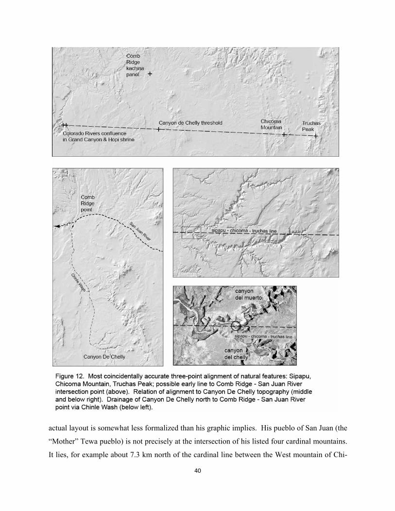
40
actual layout is somewhat less formalized than his graphic implies. His pueblo of San Juan (the
“Mother” Tewa pueblo) is not precisely at the intersection of his listed four cardinal mountains.
It lies, for example about 7.3 km north of the cardinal line between the West mountain of Chi-
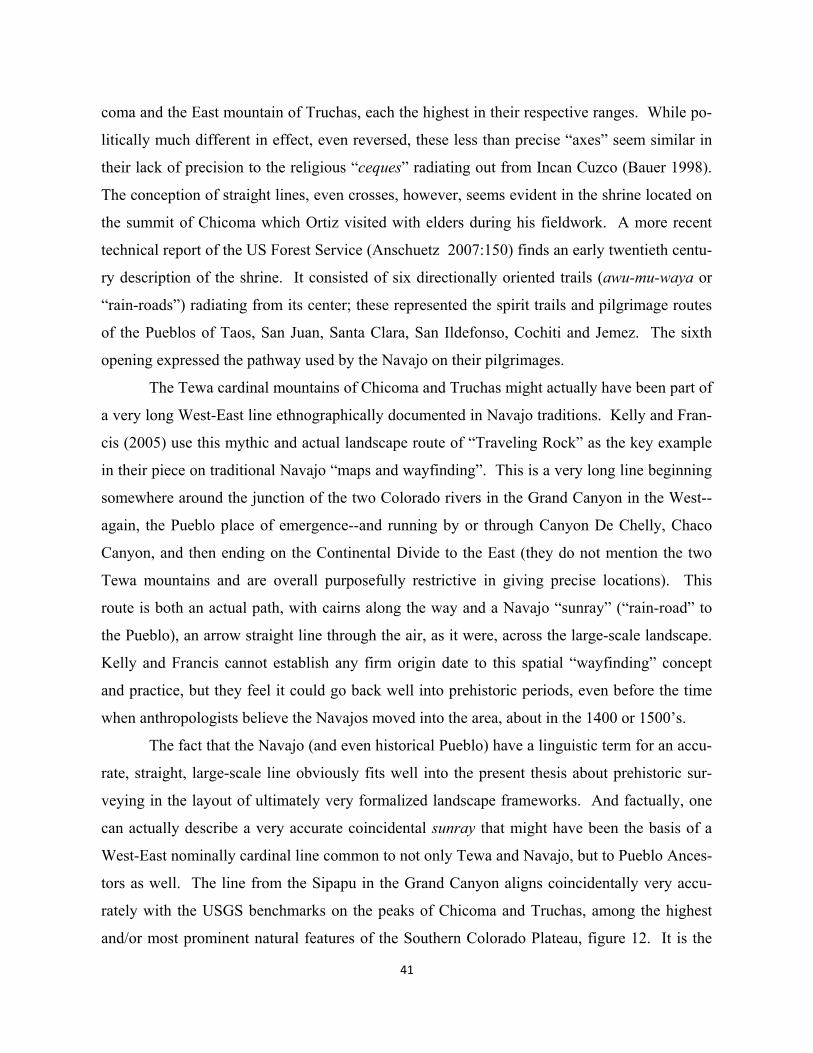
41
coma and the East mountain of Truchas, each the highest in their respective ranges. While po-
litically much different in effect, even reversed, these less than precise “axes” seem similar in
their lack of precision to the religious “ceques” radiating out from Incan Cuzco (Bauer 1998).
The conception of straight lines, even crosses, however, seems evident in the shrine located on
the summit of Chicoma which Ortiz visited with elders during his fieldwork. A more recent
technical report of the US Forest Service (Anschuetz 2007:150) finds an early twentieth centu-
ry description of the shrine. It consisted of six directionally oriented trails (awu-mu-waya or
“rain-roads”) radiating from its center; these represented the spirit trails and pilgrimage routes
of the Pueblos of Taos, San Juan, Santa Clara, San Ildefonso, Cochiti and Jemez. The sixth
opening expressed the pathway used by the Navajo on their pilgrimages.
The Tewa cardinal mountains of Chicoma and Truchas might actually have been part of
a very long West-East line ethnographically documented in Navajo traditions. Kelly and Fran-
cis (2005) use this mythic and actual landscape route of “Traveling Rock” as the key example
in their piece on traditional Navajo “maps and wayfinding”. This is a very long line beginning
somewhere around the junction of the two Colorado rivers in the Grand Canyon in the West--
again, the Pueblo place of emergence--and running by or through Canyon De Chelly, Chaco
Canyon, and then ending on the Continental Divide to the East (they do not mention the two
Tewa mountains and are overall purposefully restrictive in giving precise locations). This
route is both an actual path, with cairns along the way and a Navajo “sunray” (“rain-road” to
the Pueblo), an arrow straight line through the air, as it were, across the large-scale landscape.
Kelly and Francis cannot establish any firm origin date to this spatial “wayfinding” concept
and practice, but they feel it could go back well into prehistoric periods, even before the time
when anthropologists believe the Navajos moved into the area, about in the 1400 or 1500’s.
The fact that the Navajo (and even historical Pueblo) have a linguistic term for an accu-
rate, straight, large-scale line obviously fits well into the present thesis about prehistoric sur-
veying in the layout of ultimately very formalized landscape frameworks. And factually, one
can actually describe a very accurate coincidental sunray that might have been the basis of a
West-East nominally cardinal line common to not only Tewa and Navajo, but to Pueblo Ances-
tors as well. The line from the Sipapu in the Grand Canyon aligns coincidentally very accu-
rately with the USGS benchmarks on the peaks of Chicoma and Truchas, among the highest
and/or most prominent natural features of the Southern Colorado Plateau, figure 12. It is the
42
only accurate, naturally coincidental three-point alignment among most prominent natural fea-
tures (defined further in the following chapter). This 555.009 km line from the sandbar at the
junction of the Little Colorado and Colorado Rivers to the peak of Truchas misses the described
shrine on Chicoma by about 39.8 meters. As we will see below, the precise line passes right
through the gateway of Canyon de Chelly and 658 meters north of the northernmost great kiva
in Chaco Canyon (the earliest great kiva at Peñasco Blanco on the North Rim). As described
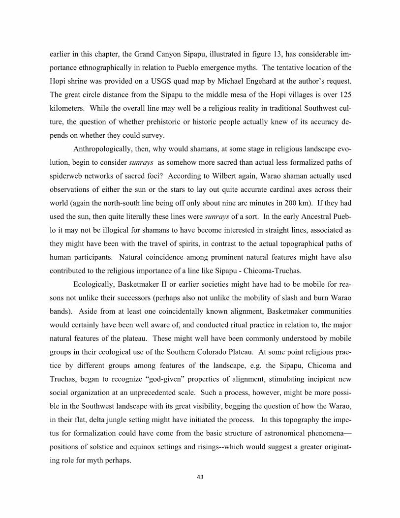
43
earlier in this chapter, the Grand Canyon Sipapu, illustrated in figure 13, has considerable im-
portance ethnographically in relation to Pueblo emergence myths. The tentative location of the
Hopi shrine was provided on a USGS quad map by Michael Engehard at the author’s request.
The great circle distance from the Sipapu to the middle mesa of the Hopi villages is over 125
kilometers. While the overall line may well be a religious reality in traditional Southwest cul-
ture, the question of whether prehistoric or historic people actually knew of its accuracy de-
pends on whether they could survey.
Anthropologically, then, why would shamans, at some stage in religious landscape evo-
lution, begin to consider sunrays as somehow more sacred than actual less formalized paths of
spiderweb networks of sacred foci? According to Wilbert again, Warao shaman actually used
observations of either the sun or the stars to lay out quite accurate cardinal axes across their
world (again the north-south line being off only about nine arc minutes in 200 km). If they had
used the sun, then quite literally these lines were sunrays of a sort. In the early Ancestral Pueb-
lo it may not be illogical for shamans to have become interested in straight lines, associated as
they might have been with the travel of spirits, in contrast to the actual topographical paths of
human participants. Natural coincidence among prominent natural features might have also
contributed to the religious importance of a line like Sipapu - Chicoma-Truchas.
Ecologically, Basketmaker II or earlier societies might have had to be mobile for rea-
sons not unlike their successors (perhaps also not unlike the mobility of slash and burn Warao
bands). Aside from at least one coincidentally known alignment, Basketmaker communities
would certainly have been well aware of, and conducted ritual practice in relation to, the major
natural features of the plateau. These might well have been commonly understood by mobile
groups in their ecological use of the Southern Colorado Plateau. At some point religious prac-
tice by different groups among features of the landscape, e.g. the Sipapu, Chicoma and
Truchas, began to recognize “god-given” properties of alignment, stimulating incipient new
social organization at an unprecedented scale. Such a process, however, might be more possi-
ble in the Southwest landscape with its great visibility, begging the question of how the Warao,
in their flat, delta jungle setting might have initiated the process. In this topography the impe-
tus for formalization could have come from the basic structure of astronomical phenomena—
positions of solstice and equinox settings and risings--which would suggest a greater originat-
ing role for myth perhaps.
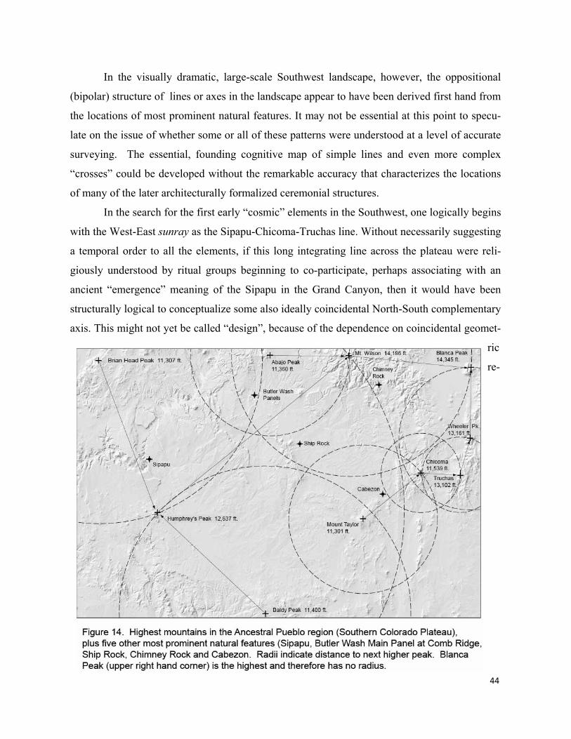
44
In the visually dramatic, large-scale Southwest landscape, however, the oppositional
(bipolar) structure of lines or axes in the landscape appear to have been derived first hand from
the locations of most prominent natural features. It may not be essential at this point to specu-
late on the issue of whether some or all of these patterns were understood at a level of accurate
surveying. The essential, founding cognitive map of simple lines and even more complex
“crosses” could be developed without the remarkable accuracy that characterizes the locations
of many of the later architecturally formalized ceremonial structures.
In the search for the first early “cosmic” elements in the Southwest, one logically begins
with the West-East sunray as the Sipapu-Chicoma-Truchas line. Without necessarily suggesting
a temporal order to all the elements, if this long integrating line across the plateau were reli-
giously understood by ritual groups beginning to co-participate, perhaps associating with an
ancient “emergence” meaning of the Sipapu in the Grand Canyon, then it would have been
structurally logical to conceptualize some also ideally coincidental North-South complementary
axis. This might not yet be called “design”, because of the dependence on coincidental geomet-
ric
re-
45
lationships. If one assumes that the most dramatic possible intersection point for a vertical axis
and the East-West axis is the natural gateway to Canyon de Chelly, again figure 12 (much more
so than Chaco), then knowledge of the two highest mountains north and south might have come
into play.
Figure 14 illustrates the locations of the highest mountains and most prominent natural
features on the Southern Colorado Plateau. It is clear that from the Canyon de Chelly position
on the Sipapu-Truchas Peak line, the highest mountain in the North is Abajo Peak, and the
highest in the South is Baldy Peak. Little can be reported about Ancestral Pueblo or more re-
cent Ute or Paiute religious use of the Abajo range, the highest point of which is actually
known in the literature as “Blue Mountain”; it is called “Furry Mountain” by the Navajos who
believe it has a male spiritual inner form (McPherson 1992). Mount Baldy, for its part is the
highest peak in the White Mountains and second highest peak in the state of Arizona. The
White Mountain Apache tribe regards the mountain as one of their most sacred (Welch
1997:90).
Neither ethnography nor archaeology provides any evidence that the intersection point
between these two close to cardinal lines was precisely known or otherwise defined in material
terms. Some evidence of inter-cardinal or cross axes, however, exists. Recalling the older Ho-
pi structure that emphasizes inter-cardinal axes in addition to at least the North-South vertical,
one can begin to visualize in figure 15 additional axes to some very early landscape frame.
Working from Baldy Peak in the south, the two highest mountains in the SW (Humphrey’s
Peak) and SE (Mount Taylor) are quite symmetrically located at similar latitudes. Up in the
north, the two highest mountains of the NW (Brian Head) and NE (Blanca Peak) are also some-
what symmetrically located at similar latitudes. Coincidentally, the cross lines from these four
mountains, and the north-south axis of the vertical pair intersect about 330 meters from a com-
mon point in Canyon de Chelly, this point itself lies 3.578 km north of the of the Sipapu-
Truchas line. Again, no archaeological or ethnographic evidence exists precisely at the coinci-
dental three-axes intersection point, located just north of the Canyon de Chelly visitor’s center.
No assumption is being made that these intersection points were precisely located by surveying,
just that the large-scale pattern could be cognitively understood and might have begun to foster
large scale formalizations.
Humphrey’s Peak and Mount Taylor, at least, are known as significant religious features
46
for
among Pueblo groups. The Hopi have a very high religious regard for the San Francisco range
of mountains (e.g. Bernbaum 1997:9) in which Humphrey’s Peak is the highest. On the top of
Mount Taylor, citing Blake again (1999) can be found a manmade hole, or possibly symbolic
sipapu. Little ethnographic information can be found about Brian Head, now just a few hun-
dred feet above the top of a popular ski run; the mountain’s name was Monument Peak until
1890. While there is also scant evidence of religiosity from Pueblo culture about Blanca Peak
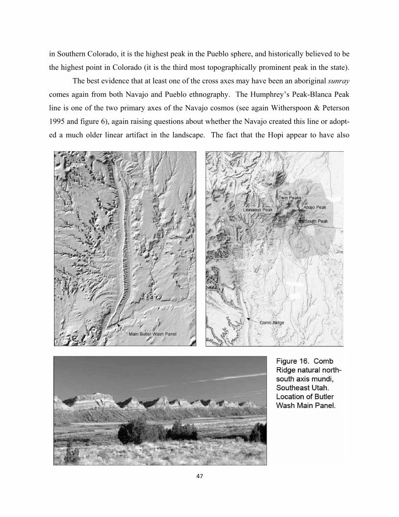
47
in Southern Colorado, it is the highest peak in the Pueblo sphere, and historically believed to be
the highest point in Colorado (it is the third most topographically prominent peak in the state).
The best evidence that at least one of the cross axes may have been an aboriginal sunray
comes again from both Navajo and Pueblo ethnography. The Humphrey’s Peak-Blanca Peak
line is one of the two primary axes of the Navajo cosmos (see again Witherspoon & Peterson
1995 and figure 6), again raising questions about whether the Navajo created this line or adopt-
ed a much older linear artifact in the landscape. The fact that the Hopi appear to have also
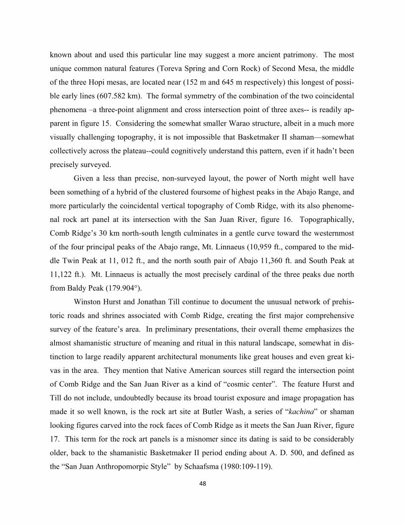
48
known about and used this particular line may suggest a more ancient patrimony. The most
unique common natural features (Toreva Spring and Corn Rock) of Second Mesa, the middle
of the three Hopi mesas, are located near (152 m and 645 m respectively) this longest of possi-
ble early lines (607.582 km). The formal symmetry of the combination of the two coincidental
phenomena –a three-point alignment and cross intersection point of three axes-- is readily ap-
parent in figure 15. Considering the somewhat smaller Warao structure, albeit in a much more
visually challenging topography, it is not impossible that Basketmaker II shaman—somewhat
collectively across the plateau--could cognitively understand this pattern, even if it hadn’t been
precisely surveyed.
Given a less than precise, non-surveyed layout, the power of North might well have
been something of a hybrid of the clustered foursome of highest peaks in the Abajo Range, and
more particularly the coincidental vertical topography of Comb Ridge, with its also phenome-
nal rock art panel at its intersection with the San Juan River, figure 16. Topographically,
Comb Ridge’s 30 km north-south length culminates in a gentle curve toward the westernmost
of the four principal peaks of the Abajo range, Mt. Linnaeus (10,959 ft., compared to the mid-
dle Twin Peak at 11, 012 ft., and the north south pair of Abajo 11,360 ft. and South Peak at
11,122 ft.). Mt. Linnaeus is actually the most precisely cardinal of the three peaks due north
from Baldy Peak (179.904°).
Winston Hurst and Jonathan Till continue to document the unusual network of prehis-
toric roads and shrines associated with Comb Ridge, creating the first major comprehensive
survey of the feature’s area. In preliminary presentations, their overall theme emphasizes the
almost shamanistic structure of meaning and ritual in this natural landscape, somewhat in dis-
tinction to large readily apparent architectural monuments like great houses and even great ki-
vas in the area. They mention that Native American sources still regard the intersection point
of Comb Ridge and the San Juan River as a kind of “cosmic center”. The feature Hurst and
Till do not include, undoubtedly because its broad tourist exposure and image propagation has
made it so well known, is the rock art site at Butler Wash, a series of “kachina” or shaman
looking figures carved into the rock faces of Comb Ridge as it meets the San Juan River, figure
17. This term for the rock art panels is a misnomer since its dating is said to be considerably
older, back to the shamanistic Basketmaker II period ending about A. D. 500, and defined as
the “San Juan Anthropomorpic Style” by Schaafsma (1980:109-119).
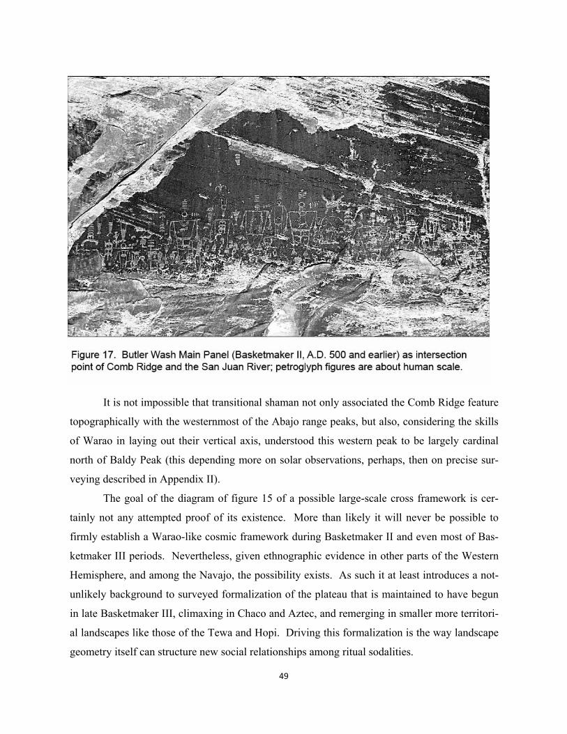
49
It is not impossible that transitional shaman not only associated the Comb Ridge feature
topographically with the westernmost of the Abajo range peaks, but also, considering the skills
of Warao in laying out their vertical axis, understood this western peak to be largely cardinal
north of Baldy Peak (this depending more on solar observations, perhaps, then on precise sur-
veying described in Appendix II).
The goal of the diagram of figure 15 of a possible large-scale cross framework is cer-
tainly not any attempted proof of its existence. More than likely it will never be possible to
firmly establish a Warao-like cosmic framework during Basketmaker II and even most of Bas-
ketmaker III periods. Nevertheless, given ethnographic evidence in other parts of the Western
Hemisphere, and among the Navajo, the possibility exists. As such it at least introduces a not-
unlikely background to surveyed formalization of the plateau that is maintained to have begun
in late Basketmaker III, climaxing in Chaco and Aztec, and remerging in smaller more territori-
al landscapes like those of the Tewa and Hopi. Driving this formalization is the way landscape
geometry itself can structure new social relationships among ritual sodalities.
50
The most appropriate applied science means to investigating possibilities of large-scale
surveying--as an essential part of landscape formalization-- is a cold consideration of simple
alignments involving some clearly defined set of religious features built during the periods in
question, this in the spatial context of some also clearly defined set of most prominent natural
features. Without consideration of possible meaning of more complex landscape patterns, with
regard to some framework of plateau religion and ritual, what are the statistical probabilities
that the locations of religious foci were intentionally designed to involve accurate, large-scale
alignments with natural features and other foci, i.e. that some number of these existing geome-
tries were not wholly coincidental. This is the goal of chapter 2.
51
2. Probability Comparisons: Alignment Involvement of Great Kiva Locations While some patterns from design analysis portions of following chapters can be tested against
random phenomena, it is possible to first test the simple tendency of a total list of great kiva
sites—from Basketmaker III to Pueblo III—together with significant natural features to form
three-point alignments. This is irrespective of any design analysis ideas about particular logical
looking layouts. If there turns out to be an unusually high number of alignments in this total
group--well beyond the probabilities of coincidence--then along with anthropological ideas of
the first chapter, most readers might be convinced that some sort of formalization is not impos-
sible in this time period. One can then proceed to look for an evolution of design logic in these
frameworks, creating probability tests where possible.
Existing literature on random comparisons
The first critiques of assertions of designed landscape alignments were simple computer proce-
dures testing claims about Ley Lines in England, usually under 10 km in length. As detailed
thirty years ago by archaeologists Williamson and Bellemy (1983), random arrays of points at
similar scales and accuracies produced many coincidental alignments. Other brief studies of
random alignments--as much exercises in computer application--produced similar conclusions,
e.g. O’Carroll (1979) and Papadopoulos (2001). For any given number of points (sites) of a
given dimension, spread in a defined spatial area, numbers of three, four, five, etc. point ran-
dom alignments can be predicted for particular accuracies. Generally these facts are taken to
mean that most if not all assertions that certain landscape features are intentionally aligned are
probably wrong.
Two things have been missing in these peripheral forays into larger symbolic landscape
structures. First is the most obvious, i.e. that just because some larger number of random align-
ments exists among a set of features doesn’t rule out intentional patterns among some subset. It
just means that one cannot necessarily use comparisons with random phenomena to prove in-
tentional design. While prehistoric builders might have understood a few coincidental align-
ments, particularly with natural features, and might have intentionally designed additional lay-
outs, they would have had no clue about some much larger number of random patterns. The
52
second and more important ingredient missing in the limited literature on random geometries is
application to a particular cultural landscape setting, where the selection and definition of
“points” is clear, and the spatial scale of analysis is well reasoned. The first mainstream archae-
ological publication to test the alignment of built features in the Americas against random pat-
terns was Swanson’s GIS based analysis of signal fire alignments at relatively small scales of
several kilometers on Cerro Moctezuma, the apparently sacred peak with a kiva-like feature
(see figure 88) visible to the west of Paquime in Northern Mexico (2003). Using ten randomly
generated sets of points on the mountain, and the Student’s t-test statistical process, he conclud-
ed that the existing pattern of signal locations had a high probability of intentional design. Note
the limited number of random sets used and the reliance on statistical methodology to infer
probability.
Also more recently, but in Old World archaeology of Scandinavia, Sahlqvist enlisted
statistical faculty at the University of Uppsala for his novel dissertation seeking to prove that
Neolithic peoples used the locations of small burial mounds, also at smaller scales, to create
cardinal cross centers associated with territorial boundaries (2000). By randomly varying
points away from existing intersections and along the axes of cardinally (north-south or east-
west) related crosses, Sahlqvist and colleagues were able to state a good probability of design,
in spite of controversy about whether the patterns were Neolithic or part of Early Medieval or-
ganization.
The following exercises compare alignments among existing sites and random ones.
While two publications, Doxtater 2007 and 2009 include random comparisons, they focus pri-
marily on specific sites and their patterned relationships. A piece of the 2007 paper does in-
clude a simple analysis of points in a specified area, the focus of the first exercise below. The
number of sites, however, was quite restricted, only 22, and is subject to questions about impar-
tiality of site inclusion. The primary purpose of that article, however, was an explanation of the
use of the Geopatterns application for a computer oriented audience (see present Appendix I).
Influence of large scale natural topography on alignments
One seeks to simply compare the number of three-point alignments, at stipulated ranges of ac-
curacies, between existing and randomly generated points. To do so, equivalent numbers of
random points are scattered in a test area encompassing all existing great kiva sites compiled for
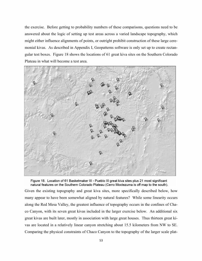
53
the exercise. Before getting to probability numbers of these comparisons, questions need to be
answered about the logic of setting up test areas across a varied landscape topography, which
might either influence alignments of points, or outright prohibit construction of these large cere-
monial kivas. As described in Appendix I, Geopatterns software is only set up to create rectan-
gular test boxes. Figure 18 shows the locations of 61 great kiva sites on the Southern Colorado
Plateau in what will become a test area.
Given the existing topography and great kiva sites, more specifically described below, how
many appear to have been somewhat aligned by natural features? While some linearity occurs
along the Red Mesa Valley, the greatest influence of topography occurs in the confines of Cha-
co Canyon, with its seven great kivas included in the larger exercise below. An additional six
great kivas are built later, mostly in association with large great houses. Thus thirteen great ki-
vas are located in a relatively linear canyon stretching about 15.5 kilometers from NW to SE.
Comparing the physical constraints of Chaco Canyon to the topography of the larger scale plat-
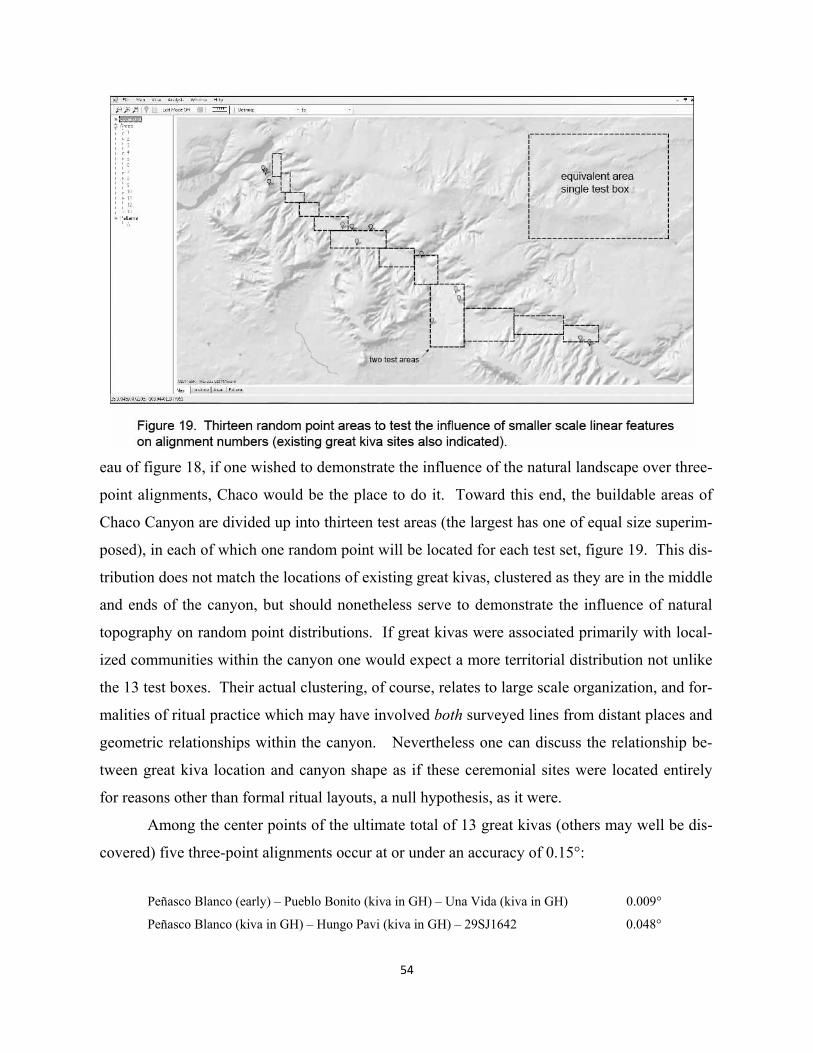
54
eau of figure 18, if one wished to demonstrate the influence of the natural landscape over three-
point alignments, Chaco would be the place to do it. Toward this end, the buildable areas of
Chaco Canyon are divided up into thirteen test areas (the largest has one of equal size superim-
posed), in each of which one random point will be located for each test set, figure 19. This dis-
tribution does not match the locations of existing great kivas, clustered as they are in the middle
and ends of the canyon, but should nonetheless serve to demonstrate the influence of natural
topography on random point distributions. If great kivas were associated primarily with local-
ized communities within the canyon one would expect a more territorial distribution not unlike
the 13 test boxes. Their actual clustering, of course, relates to large scale organization, and for-
malities of ritual practice which may have involved both surveyed lines from distant places and
geometric relationships within the canyon. Nevertheless one can discuss the relationship be-
tween great kiva location and canyon shape as if these ceremonial sites were located entirely
for reasons other than formal ritual layouts, a null hypothesis, as it were.
Among the center points of the ultimate total of 13 great kivas (others may well be dis-
covered) five three-point alignments occur at or under an accuracy of 0.15°:
Peñasco Blanco (early) – Pueblo Bonito (kiva in GH) – Una Vida (kiva in GH) 0.009°
Peñasco Blanco (kiva in GH) – Hungo Pavi (kiva in GH) – 29SJ1642 0.048°
55
Chetro Ketl (kiva in GH) – Hungo Pavi (kiva in GH) – Shabik’eschee 0.051°
Chetro Ketl (kiva in GH) – Hungo Pavi (kiva in GH) – 29SJ1642 0.102°
Peñasco Blanco (kiva in GH) – Chetro Ketl (kiva in GH) – 29SJ1642 0.146°
Because of the large accuracy gap between the first three and the last two, one can use only the
three at or under 0.055° to compare with patterns created by random points. The expectation is
that given the constraints of Chaco Canyon’s shape, sets of 13 random points each should quite
commonly reproduce numbers similar to the existing. What happens however is that in 62 of
100 sets no three-point alignments are created under 0.055°. A match with the existing does
occur, i.e. three three-point alignments under 0.055°, but only two times in 100, or a probability
of 0.02. Thus the existing are by no means ordinary, suggesting the possibility that some de-
sign intent was operating in their placement. Chapter 3 will develop diagrams that suggest line-
ar relationships between 29SJ423, the performance area called Curved Rock that Speaks, and
Shabik’esche, early on, and then later a related alignment between early Peñasco Blanco, early
Pueblo Bonito, and Kin Nashabas (adjacent to Una Vida)—which may well explain much of the
meaning behind the three alignments used in this initial probability test.
Thus it may be likely that even at the small scale of 15.5 kilometers, the shape of a line-
ar canyon and a relatively large number of sites does not create any obviously overwhelming
influence in the generation of three-point alignments. The idea that some unique natural topog-
raphy would exert such influence at the largest scale seen in figure 18, about 300 kilometers
across and more when including the most prominent natural features, seems patently false.
What then about buildable vs. non-buildable areas? Could there not be some natural
pattern among these site conditions, independent of more extreme limiting effects of canyons,
buttes, mountains, washes, watercourses and the like? Obviously some percentage of the rela-
tively flat Ancestral Pueblo plateau is nonetheless not suitable for the construction of a twenty-
meter circular great kiva. But it may not matter where this number actually lies, whether 20%,
50% or 70%. The question is, again, whether in this layout of buildable site areas, geological
processes created random patterns, portions of which create linear tendencies—apart from those
due to more dramatic topographic features. One cannot here map all buildable areas to evaluate
any potential influence to natural or coincidental patterns. It seems, however, given the rela-
tively small number of sites (61) and certain enormity of buildable areas, that these would have
56
far less influence than a feature like Chaco Canyon in positioning sites to create relatively accu-
rate three-point alignments.
The reader of this volume will probably be aware that each time a new random set of
points is generated in a specified geographic area, there will be an intuition that some will land
on unbuildable topography, regardless of whether buildable areas in themselves have linear pat-
terns. Great kivas have to be built on relatively flat ground. One way around this problem is to
think of the existing buildable landscape as a random act, at least from the perspective of possi-
ble design location of sites built on it. If most if not all great kivas were located for other, non-
symbolic or ecological reasons, their locations would become part of the larger natural random
pattern of buildable areas. In this case, one would not expect unusual numbers of three-point
alignments in this entirely random combination. There are two issues here, one, the layout or
shape of existing patterns of buildable land on the plateau, and two, the percentage this repre-
sents in relation to the total. It will be shown that given the existing shape and percentage, the
locations of great kivas either do or do not deviate significantly from the random. What as-
sumptions do we make about the random points?
For the present one simply doesn’t know the incidence in which a random point will
land on an unbuildable setting. Since the amount of buildable land in the test area probably is
over fifty percent, perhaps even conservatively, what would be the effect of half of the random
points of any given set landing on unbuildable sites? With a very elaborate and very costly
mapping/ analysis software one should be able to generate a list of random alignments created
only on buildable sites in a set. One could then compare these with existing. If, for the sake of
discussion, the buildable / unbuildable areas are roughly a 50-50 split, then with a decent num-
ber of random sets, the issue would largely disappear as an influence on the incidence of ran-
domly created alignments. Or, generally, the greater the percentage of buildable area, the less it
exists as a factor in generating random alignments.
In the following largely unprecedented kind of test, it is recognized that some of the ran-
dom points in each set will fall on unbuildable sites, but that because the probably high ratio of
buildable sites on the plateau, and number of random sets generated, this effect may be mini-
mal. If it turns out that the existing great kivas are involved in an unusually larger number of
alignments--as are a few random sets--it would still remain to be ultimately proved that both
existing and exceptional random sets weren’t in some way determined by a unique layout of
57
buildable sites. Again some reassurance that this is not the case comes from the above demon-
stration that even when natural forms appear to seriously constrain the placement of ceremonial
foci, like in Chaco Canyon—at much smaller scales—they seem in themselves to only rarely
create equivalent numbers of accurate alignments.
Natural features used in the analysis
As introduced in Chapter 1, religious practice among Ancestral Pueblo people likely involved
the most significant natural features in the Ancestral Pueblo portion of the Colorado Plateau,
examples of which are illustrated in figure 20. In summary, these are the Sipapu at the conflu-
ence of the two Colorado rivers in the Grand Canyon, the Comb Ridge feature with its point on
the San Juan River, the highest mountains--Mount Wilson, Abajo Peak, Baldy Peak, Humphries
Peak, Brian Head, Blanca Peak, Mount Taylor, Hesperus Peak, Mount Chicoma, Truchas Peak,
Wheeler Peak--Chimney Rock, McCarty’s Flow, Ship Rock, Haystack, Cabezon, Hosta Butte,
and the high point of Mesa Verde (MVHP). To this list can be added Cerro Moctezuma
(evident in late Chaco); it is somewhat less a highest mountain in its region, but may have been
chosen for its coincidental location in relation an earlier understood coincidental meridian on
the eastern side of the plateau. For a geographic locations see figure 21 (which adds features
involved later in framework evolution).
The present object is to largely ignore the hypothetical cultural meaning of these fea-
tures discussed in Chapter 1, accepting in this exercise their uniqueness as natural features; the
goal is to be as independent as possible from any alignments with great kivas known before the
analysis. They must, to the greatest degree possible, stand on their merits as unique features.
The least meritorious in this regard are the high point of Mesa Verde where only the fire look-
out presently identifies this point on the northern Mesa Verde ridge, the symmetrical but mod-
est Haystack Mountain, and perhaps Cerro Moctezuma. In defense of this selection, however,
the list of great kiva sites listed below excludes many of the late Chaco kivas with which these
three sites are geometrically connected. In summarizing lists of total involvement in align-
ments (provided later in the analysis) these site involvements are among the lowest numerically
and therefore did not create a bias by being included in the selection.
58
Locations of great kiva sites
It is considerably more difficult to establish precise locations of a large number of built site ru-
ins compared to most unique natural features. In this latter case, high points are clearly marked
on USGS 7.5 quad maps or can be accurately determined from topographic form, such as at
Ship Rock’s twin peaks where a mid-point must be chosen, or at the junction of the Colorado
and Little Colorado Rivers in the Grand Canyon. The following analysis profiles accuracies
down to around visual acuity (0.017°), necessitating a high accuracy in site location. In a 100
km alignment of an interim point and two end points, a 0.017° deviation of accuracy amounts to
about 15 meters if the interim point is at the center of the line. Site locations are recorded down
to tenths of an arc second, about 3 meters, and GPS and mapmaking errors can be expected in
the range of two or three arc seconds. All work is done in a WGS 84 compatible map grid.
Prehistoric great kivas, which occur throughout the Basketmaker III (500 A.D.) through
Pueblo III (1300 A.D.) periods, run from about 14 to 23 meters in diameter, are characteristical-
ly semi-subterranean ceremonial settings with four pillars, central roof openings and floor si-
papu. At present, while most acknowledge that the great kivas of Chaco Canyon might well
have been used by pilgrims traveling from some great distance, the conventional wisdom about
outlier great kivas is that they were local, perhaps kinship affairs of one kind or another. The
usual Chacoan pattern is for a great kiva to be accompanied by a pueblo-like great house also
associated in function with larger social scale ritual (whether pilgrimage or kinship). Kendrick
and Judge (2000) speak of a more rhetorical, competitive role of the great houses at the Lowry
Ruin compared to a more integrative function of the great kivas within the community. The
obvious ritual focus of the overall site is taken in the present work to be the great kiva.
While general site locations are available in archaeological data bases, often important
features do not have clear map or GPS locations. In a small number of cases, using general
UTM locations in Google Earth, one can find the clear outlines of great kivas, from which accu-
rate positions can be recorded, see examples of figure 22. Most of the time, however, one
combs through hardcopy archives, and any library material on sites looking for an “x” marked
on a quad map or equivalent. No good location information is available for nine known sites;
unknown others undoubtedly exist. Given the large number of sites for which good locations
were available, 61, however, it is not believed that the omission of an additional 9 or more seri-
ously impacts the outcome of the study. This is not to say that the site information for all 61 is
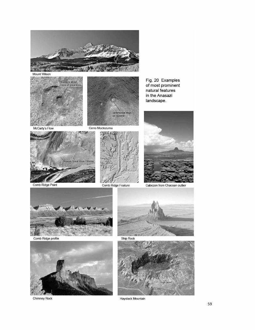
59
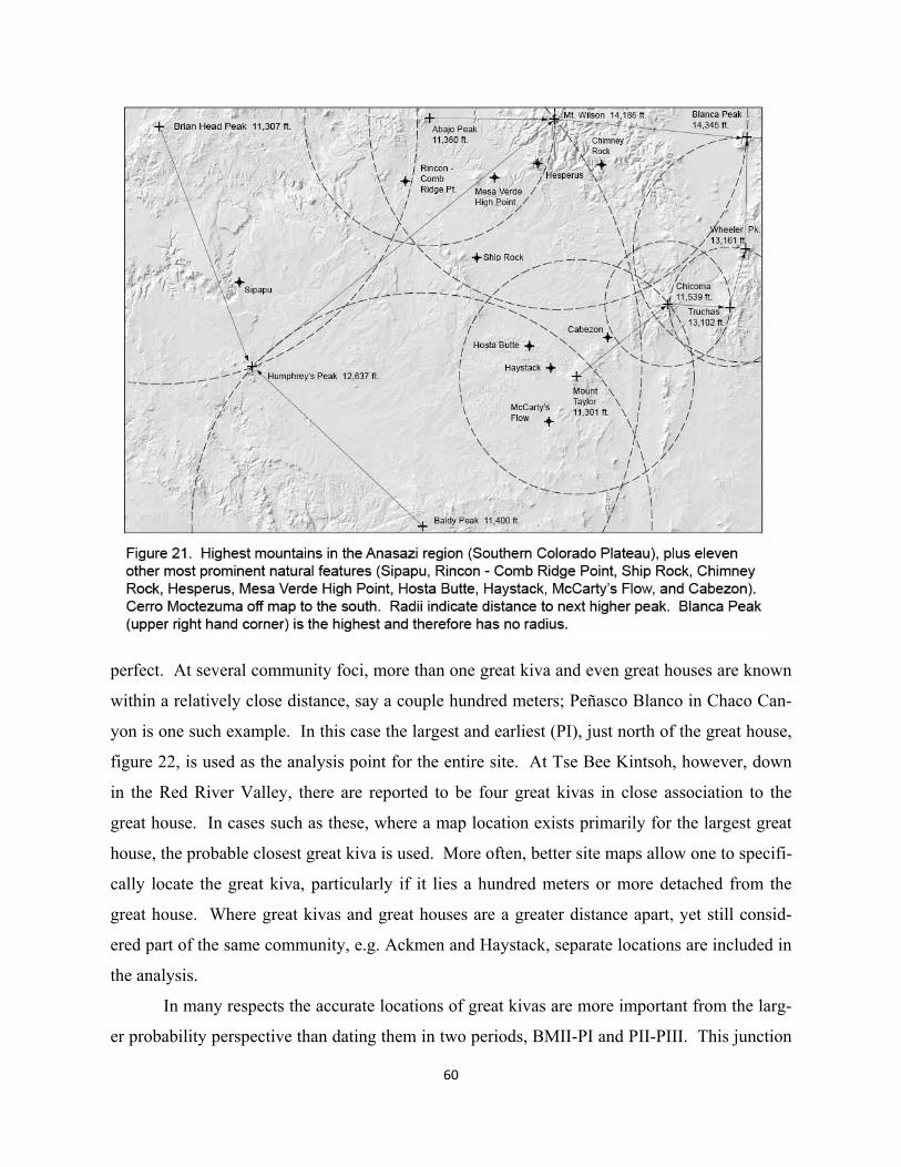
60
perfect. At several community foci, more than one great kiva and even great houses are known
within a relatively close distance, say a couple hundred meters; Peñasco Blanco in Chaco Can-
yon is one such example. In this case the largest and earliest (PI), just north of the great house,
figure 22, is used as the analysis point for the entire site. At Tse Bee Kintsoh, however, down
in the Red River Valley, there are reported to be four great kivas in close association to the
great house. In cases such as these, where a map location exists primarily for the largest great
house, the probable closest great kiva is used. More often, better site maps allow one to specifi-
cally locate the great kiva, particularly if it lies a hundred meters or more detached from the
great house. Where great kivas and great houses are a greater distance apart, yet still consid-
ered part of the same community, e.g. Ackmen and Haystack, separate locations are included in
the analysis.
In many respects the accurate locations of great kivas are more important from the larg-
er probability perspective than dating them in two periods, BMII-PI and PII-PIII. This junction
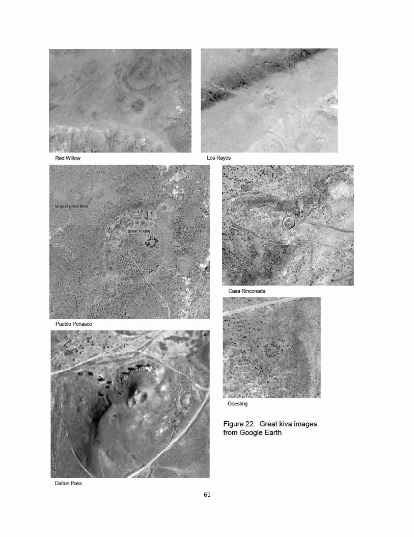
61
62
is generally recognized as a distinction between earlier more mobile groups which aggregate at
times into great kiva and other “villages” (in the Chuskas, early Chaco Canyon and particularly
up in the San Juan area) and subsequent organization into Chaco related “phenomena” (Adler
and Wilshusen 1990). A greater climatic variability occurs during the earlier period (Nelson
and Schachner 2002).
The reader should consider the selection of sites in the two time periods as provisional.
With 61 sites involved, the potential questions from archaeological readers about their dating
will undoubtedly be numerous. The strategy, for present purposes only, is to record the most
readily available site date given in archaeologically broad survey publications or state archives.
More specifically, it is the date of the community (and probable focus), not the great kiva or
great house architecture that is used. The logic here is twofold. In that alignments are contexts
with other sites, it seems less likely that a great kiva would be built and aligned on an earlier
established unaligned site, unless of course the alignment and the distant context originated at
the site at a later time. Paramount, perhaps, is the site location, not the fact that an architectural
great kiva was built. Secondly, some early shrine, kiva or sipapu-like feature might well have
been obliterated in subsequent, more architecturally formal ritual settings. The shrine/kiva fea-
ture at the Comb Ridge point might be an example here (figure 46), or the simple sipapu and
shrine at the tops of most sacred mountains like Mount Taylor and Chicoma. A parallel exam-
ple can be observed in the historical Hopi village Walpi, where architecturally defined kivas
and their sipapus are essentially subordinate to the naturally formed village plaza with its most
sacred sipapu, just a simple, small hole in the ground.
Given the above considerations, the 61 sites are divided into an early group of 34, and a
later one of 27 as detailed below. While outlier sites exist that do not have associated great ki-
vas, every attempt has been made to include the greatest number of those with great kivas for
which site information is available. The great kivas associated with the Bonito Phase great
houses of Chaco Canyon (Pueblo Bonito, Chetro Ketl, Pueblo Arroyo, Hungo Pavi, and perhaps
Wijiji) are excluded from the analysis because of the possible fact that most of these locations
were determined by small scale relationships within the canyon after the formalized landscape
meaning of Chaco itself had been laid out. Included in Chaco Canyon are two Basketmaker
great kivas (in “villages”), two singular (without great houses) possibly also early great kivas,
and three later features associated with the first three early PII great houses: Peñasco Blanco,

63
Casa Rincoñada (built later but spatially adjacent to Pueblo Bonito), and Kin Nahasbas (also
built later but spatially adjacent to Una Vida). Interestingly enough, contrary to the free-
standing character of those included, those excluded great kivas seem to be all confined within
great house plazas.
Basket Maker III – Pueblo I 1. 29 SJ – 1253 Unexcavated great kiva in Chaco Canyon, not related to a great house. Listed
as late PI-early PII in Marshall, et.al. 1979, pg. 273. Located from UTM’s provided by Chaco Canyon National Historical Park.
2. 29 SJ – 1642 Unexcavated great kiva in Chaco Canyon, not related to a great house. Listed as early PII in Marshall, et.al. 1979, pg.273, but more recently Dabney Ford at Chaco Canyon National Historical Park is inclined to earlier dating, even BMIII (personal com-munication). This location is marked as “ruins” on quad map, as explained by Park staff. See also photo in Van Dyke 2007:115)
3. 29 SJ – 423 Excavated BMIII (516-557) “village” in Chaco Canyon. Marshall, et. al. 1979, pg. 273 summarize from Windes 1975. Located from UTM’s provided by Chaco Can-yon National Historical Park.
4. & 5. Ackmen (N) & Ackmen (S) Situated about 200 meters from each other, these two great kivas are dated as PI, about 855-872 A.D. by Martin and Rinaldo 1939. Summa-rized in Marshall, et.al. 1979, pg. 311. Great kiva locations from topo map in Martin and Rinaldo, pg. 325.
6. Andrews Van Dyke (1999:62) lists two habitation sites with dates in late PI (about 882-889 A.D.); two great kivas are built around 924-941 in early PII. The great house-great kiva complex dates from about 919 A.D. (this is the great kiva location used in the analysis - location determined from map on page 58).
7. Bad Dog Ridge Listed as having a BMIII component in Gilpin and Benallie Jr. (2000), page 162. They list five great kivas (two in BMIII) on the large site extending well into PII. The location of the largest was determined from UTM’s by Gilpin and from map on page 167. Largest of the possible great kiva depressions (apparent focal point) is used as point. 8. Bluff Cameron (2009) states that this site had been used since BM III times, pg. 298. Great kiva location from GPS by author. 9. Broken Flute Cave Listed as dated A.D. 623-635 (Morris) by Gilpin and Benallie (2000), pg. 162. UTM’s supplied by Dennis Gilpin used as great kiva location. 10. Chimney Rock Great Kiva From Parker (2004) the Chimney Rock community was ac tive throughout the PI period, as well as PII, pg. 54. Coordinates for great kiva were determined from quad map provided by Kane (2004) pg. 105. 11. Coolidge Kantner (1999) gives a 883 A.D. beginning date for the site (pg. 123). Site location clearly indicated on quad map copy from ARMS (Archaeological Records Management Section NM). Both great kivas are quite close to the great house; point between two kivas used. 12. Cottonwood Falls Severance (2004) defines the beginning of the site in the mid 800’s A.D. Site location of great kiva from GPS by author.
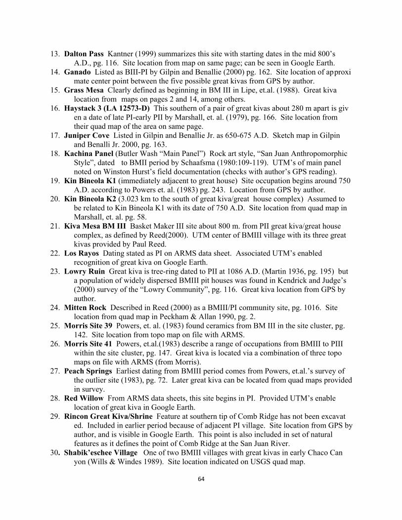
64
13. Dalton Pass Kantner (1999) summarizes this site with starting dates in the mid 800’s A.D., pg. 116. Site location from map on same page; can be seen in Google Earth. 14. Ganado Listed as BIII-PI by Gilpin and Benallie (2000) pg. 162. Site location of ap proxi mate center point between the five possible great kivas from GPS by author. 15. Grass Mesa Clearly defined as beginning in BM III in Lipe, et.al. (1988). Great kiva location from maps on pages 2 and 14, among others. 16. Haystack 3 (LA 12573-D) This southern of a pair of great kivas about 280 m apart is giv en a date of late PI-early PII by Marshall, et. al. (1979), pg. 166. Site location from their quad map of the area on same page. 17. Juniper Cove Listed in Gilpin and Benallie Jr. as 650-675 A.D. Sketch map in Gilpin and Benalli Jr. 2000, pg. 163. 18. Kachina Panel (Butler Wash “Main Panel”) Rock art style, “San Juan Anthropomorphic Style”, dated to BMII period by Schaafsma (1980:109-119). UTM’s of main panel noted on Winston Hurst’s field documentation (checks with author’s GPS reading). 19. Kin Bineola K1 (immediately adjacent to great house) Site occupation begins around 750 A.D. according to Powers et. al. (1983) pg. 243. Location from GPS by author. 20. Kin Bineola K2 (3.023 km to the south of great kiva/great house complex) Assumed to be related to Kin Bineola K1 with its date of 750 A.D. Site location from quad map in Marshall, et. al. pg. 58. 21. Kiva Mesa BM III Basket Maker III site about 800 m. from PII great kiva/great house complex, as defined by Reed(2000). UTM center of BMIII village with its three great kivas provided by Paul Reed. 22. Los Rayos Dating stated as PI on ARMS data sheet. Associated UTM’s enabled recognition of great kiva on Google Earth. 23. Lowry Ruin Great kiva is tree-ring dated to PII at 1086 A.D. (Martin 1936, pg. 195) but a population of widely dispersed BMIII pit houses was found in Kendrick and Judge’s (2000) survey of the “Lowry Community”, pg. 116. Great kiva location from GPS by author. 24. Mitten Rock Described in Reed (2000) as a BMIII/PI community site, pg. 1016. Site location from quad map in Peckham & Allan 1990, pg. 2. 25. Morris Site 39 Powers, et. al. (1983) found ceramics from BM III in the site cluster, pg. 142. Site location from topo map on file with ARMS. 26. Morris Site 41 Powers, et.al.(1983) describe a range of occupations from BMIII to PIII within the site cluster, pg. 147. Great kiva is located via a combination of three topo maps on file with ARMS (from Morris). 27. Peach Springs Earliest dating from BMIII period comes from Powers, et.al.’s survey of the outlier site (1983), pg. 72. Later great kiva can be located from quad maps provided in survey. 28. Red Willow From ARMS data sheets, this site begins in PI. Provided UTM’s enable location of great kiva in Google Earth. 29. Rincon Great Kiva/Shrine Feature at southern tip of Comb Ridge has not been excavat ed. Included in earlier period because of adjacent PI village. Site location from GPS by author, and is visible in Google Earth. This point is also included in set of natural features as it defines the point of Comb Ridge at the San Juan River. 30. Shabik’eschee Village One of two BMIII villages with great kivas in early Chaco Can yon (Wills & Windes 1989). Site location indicated on USGS quad map.
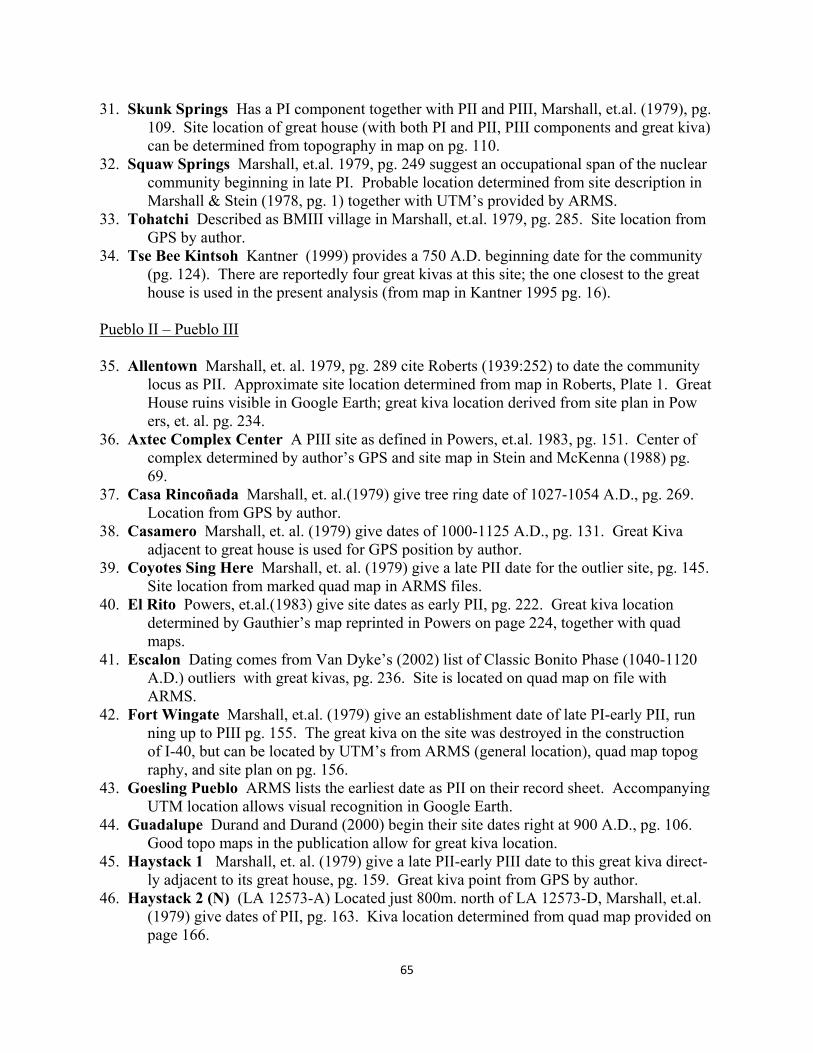
65
31. Skunk Springs Has a PI component together with PII and PIII, Marshall, et.al. (1979), pg. 109. Site location of great house (with both PI and PII, PIII components and great kiva) can be determined from topography in map on pg. 110. 32. Squaw Springs Marshall, et.al. 1979, pg. 249 suggest an occupational span of the nuclear community beginning in late PI. Probable location determined from site description in Marshall & Stein (1978, pg. 1) together with UTM’s provided by ARMS. 33. Tohatchi Described as BMIII village in Marshall, et.al. 1979, pg. 285. Site location from GPS by author. 34. Tse Bee Kintsoh Kantner (1999) provides a 750 A.D. beginning date for the community (pg. 124). There are reportedly four great kivas at this site; the one closest to the great house is used in the present analysis (from map in Kantner 1995 pg. 16). Pueblo II – Pueblo III 35. Allentown Marshall, et. al. 1979, pg. 289 cite Roberts (1939:252) to date the community locus as PII. Approximate site location determined from map in Roberts, Plate 1. Great House ruins visible in Google Earth; great kiva location derived from site plan in Pow ers, et. al. pg. 234. 36. Axtec Complex Center A PIII site as defined in Powers, et.al. 1983, pg. 151. Center of complex determined by author’s GPS and site map in Stein and McKenna (1988) pg. 69. 37. Casa Rincoñada Marshall, et. al.(1979) give tree ring date of 1027-1054 A.D., pg. 269. Location from GPS by author. 38. Casamero Marshall, et. al. (1979) give dates of 1000-1125 A.D., pg. 131. Great Kiva adjacent to great house is used for GPS position by author. 39. Coyotes Sing Here Marshall, et. al. (1979) give a late PII date for the outlier site, pg. 145. Site location from marked quad map in ARMS files. 40. El Rito Powers, et.al.(1983) give site dates as early PII, pg. 222. Great kiva location determined by Gauthier’s map reprinted in Powers on page 224, together with quad maps. 41. Escalon Dating comes from Van Dyke’s (2002) list of Classic Bonito Phase (1040-1120 A.D.) outliers with great kivas, pg. 236. Site is located on quad map on file with ARMS. 42. Fort Wingate Marshall, et.al. (1979) give an establishment date of late PI-early PII, run ning up to PIII pg. 155. The great kiva on the site was destroyed in the construction of I-40, but can be located by UTM’s from ARMS (general location), quad map topog raphy, and site plan on pg. 156. 43. Goesling Pueblo ARMS lists the earliest date as PII on their record sheet. Accompanying UTM location allows visual recognition in Google Earth. 44. Guadalupe Durand and Durand (2000) begin their site dates right at 900 A.D., pg. 106. Good topo maps in the publication allow for great kiva location. 45. Haystack 1 Marshall, et. al. (1979) give a late PII-early PIII date to this great kiva direct- ly adjacent to its great house, pg. 159. Great kiva point from GPS by author. 46. Haystack 2 (N) (LA 12573-A) Located just 800m. north of LA 12573-D, Marshall, et.al. (1979) give dates of PII, pg. 163. Kiva location determined from quad map provided on page 166.
66
47. Kin Hocho’I Dating comes from Van Dyke’s (2002) list of Classic Bonito Phase (1040- 1120 A.D.) outliers with great kivas, pg. 236. Site location from UTM’s in Fowler, et. al. (1987), maps on pages 33 and 41. 48. Kin Nahasbas Discussion about this great kiva site in Vivian and Reiter (1960) centers on PII dates, pg. 103. GPS located by author. 49. Kin Ya’a Marshall, et.al. (1979) give PII-PIII dates, pg. 201. GPS great kiva location by author. 50. Kiva Mesa PII Reed (2000) documents the PII components of this site, pg. 995. Great kiva can be located by photo on page 998. 51. Las Ventanas Marshall, et.al. (1979) place this site in PII-PIII, pg. 187. Site located on quad map on file with ARMS. 52. Muddy Water Marshall, et. al. (1979) give a temporal affinity of PII, pg. 207. Topo map on page 208 allows location of great kiva. 53. Navajo Springs Warburton and Graves (1992) place this outlier site at PII, pg. 51. Great kiva can be located from aerial photos and site drawings in article. 54. Newcomb Site dating from PII given in Marshall, et. al. (1979), pg. 101. GPS by author was taken at great kiva large midden at center of linear site. 55. Peñasco Blanco There are four great kivas directly associated with this great house in Chaco Canyon. The largest, just north of the great house is used (located via Google Earth). The kivas are undated according to Marshall, et. al. (1979), pg. 270; they give two dates, 900 A.D. and 1050-1088 A.D. for the great house. 56. Pueblo Pintado Marshall, et.al. (1979) give a date of 1060 A.D. for construction of the great house, and 900 A.D. to 1250 time range for the associated community, pg. 81 & 86. GPS location by author. 57. Salmon Excavated Chacoan component date for great house and great kiva is 1080, Mar- shall, et. al. (1979), pg. 304. GPS location by author. 58. Sanostee Temporal affinity given as PII by Marshall, et. al. (1979), pg. 105. Great kiva/ great house location not marked on quad map segments on file with ARMS, but with these as starters, probable great kiva is just visible in Google Earth. 59. Standing Rock Marshall, et.al. (1979) give dates as late PII – early PIII, pg. 231. Great kiva can be located from map on pg. 214 in Powers, et.al. (1983). 60. Toh La Kai Temporal affinity of late PII-early PIII in Marshall, et.al. (1979), pg. 235. Site marked on quad map segment on file with ARMS. 61. Village of the Great Kivas Dating by Roberts (1932), pg. 156 gives a tree-ring date of the great house at 1015 A.D. GPS location by author. [Great kiva sites not included for lack of maps or other information by which to position: Pa-dilla Well, Cove, Whirlwind Lake, Ida Jean, Vidal Great Kiva, Jackson Lake, San Mateo Mesa, Nez Site, Heaton Canyon] As shown in figure 23, one can first locate the existing 21 natural and 61 great kiva sites and
then draw a test area around the area within which all 61 great kivas occur. In the test area one
can delete all of the existing and replace them with 61 randomly located points. The 21 natural
points are constant and participate equally in the generation of random alignments. The reader
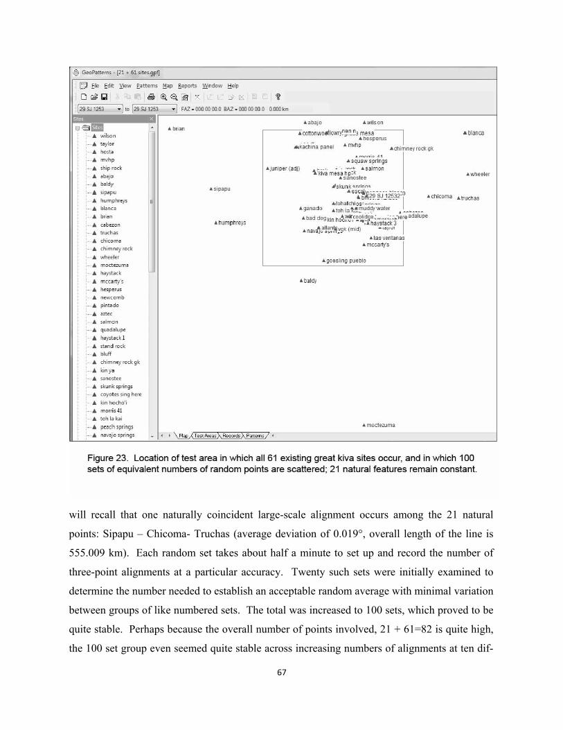
67
will recall that one naturally coincident large-scale alignment occurs among the 21 natural
points: Sipapu – Chicoma- Truchas (average deviation of 0.019°, overall length of the line is
555.009 km). Each random set takes about half a minute to set up and record the number of
three-point alignments at a particular accuracy. Twenty such sets were initially examined to
determine the number needed to establish an acceptable random average with minimal variation
between groups of like numbered sets. The total was increased to 100 sets, which proved to be
quite stable. Perhaps because the overall number of points involved, 21 + 61=82 is quite high,
the 100 set group even seemed quite stable across increasing numbers of alignments at ten dif-
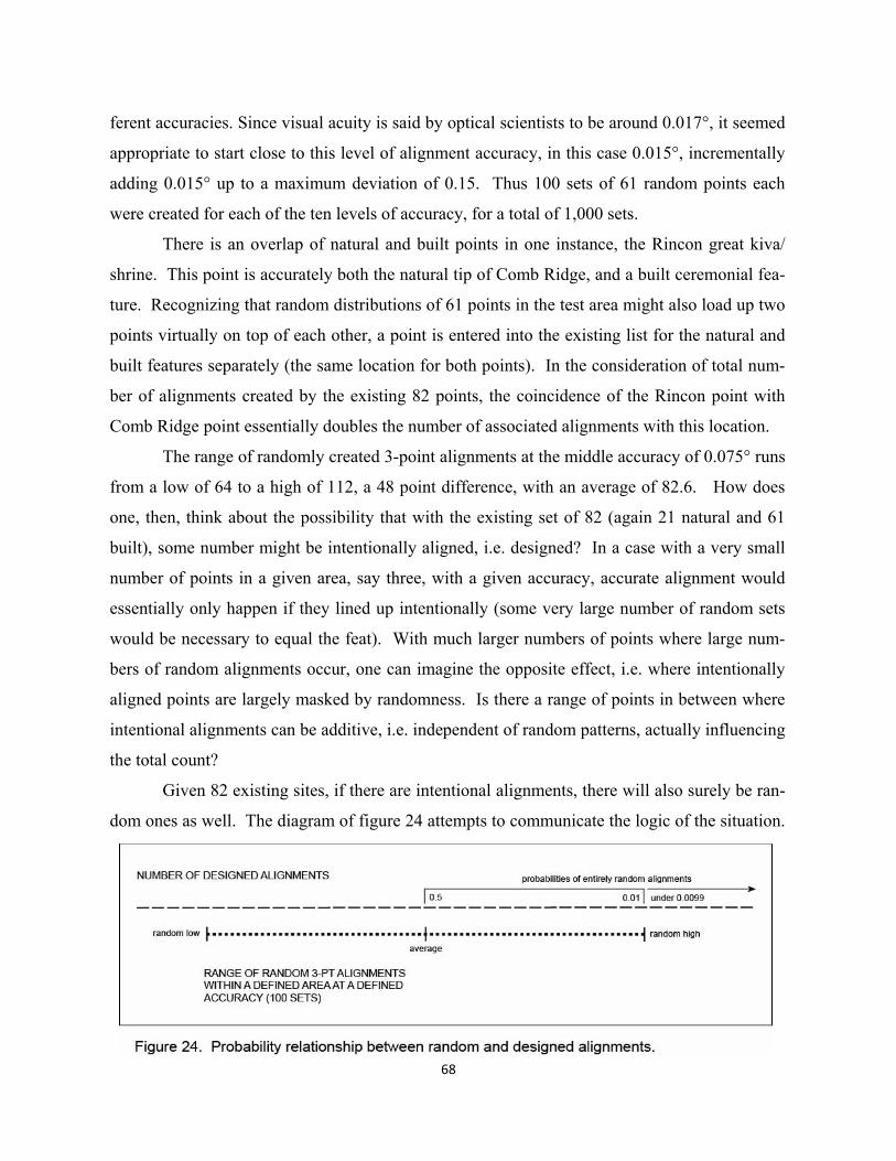
68
ferent accuracies. Since visual acuity is said by optical scientists to be around 0.017°, it seemed
appropriate to start close to this level of alignment accuracy, in this case 0.015°, incrementally
adding 0.015° up to a maximum deviation of 0.15. Thus 100 sets of 61 random points each
were created for each of the ten levels of accuracy, for a total of 1,000 sets.
There is an overlap of natural and built points in one instance, the Rincon great kiva/
shrine. This point is accurately both the natural tip of Comb Ridge, and a built ceremonial fea-
ture. Recognizing that random distributions of 61 points in the test area might also load up two
points virtually on top of each other, a point is entered into the existing list for the natural and
built features separately (the same location for both points). In the consideration of total num-
ber of alignments created by the existing 82 points, the coincidence of the Rincon point with
Comb Ridge point essentially doubles the number of associated alignments with this location.
The range of randomly created 3-point alignments at the middle accuracy of 0.075° runs
from a low of 64 to a high of 112, a 48 point difference, with an average of 82.6. How does
one, then, think about the possibility that with the existing set of 82 (again 21 natural and 61
built), some number might be intentionally aligned, i.e. designed? In a case with a very small
number of points in a given area, say three, with a given accuracy, accurate alignment would
essentially only happen if they lined up intentionally (some very large number of random sets
would be necessary to equal the feat). With much larger numbers of points where large num-
bers of random alignments occur, one can imagine the opposite effect, i.e. where intentionally
aligned points are largely masked by randomness. Is there a range of points in between where
intentional alignments can be additive, i.e. independent of random patterns, actually influencing
the total count?
Given 82 existing sites, if there are intentional alignments, there will also surely be ran-
dom ones as well. The diagram of figure 24 attempts to communicate the logic of the situation.
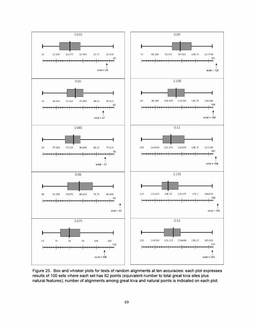
69
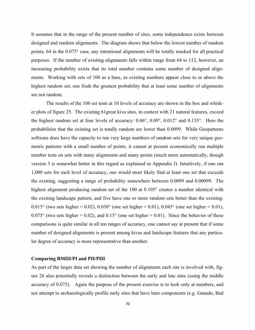
70
It assumes that in the range of the present number of sites, some independence exists between
designed and random alignments. The diagram shows that below the lowest number of random
points, 64 in the 0.075° case, any intentional alignments will be totally masked for all practical
purposes. If the number of existing alignments falls within range from 64 to 112, however, an
increasing probability exists that its total number contains some number of designed align-
ments. Working with sets of 100 as a base, as existing numbers appear close to or above the
highest random set, one finds the greatest probability that at least some number of alignments
are not random.
The results of the 100 set tests at 10 levels of accuracy are shown in the box and whisk-
er plots of figure 25. The existing 61great kiva sites, in context with 21 natural features, exceed
the highest random set at four levels of accuracy: 0.06°, 0.09°, 0.012° and 0.135°. Here the
probabilities that the existing set is totally random are lower than 0.0099. While Geopatterns
software does have the capacity to run very large numbers of random sets for very unique geo-
metric patterns with a small number of points, it cannot at present economically run multiple
number tests on sets with many alignments and many points (much more automatically, though
version 3 is somewhat better in this regard as explained in Appendix I). Intuitively, if one ran
1,000 sets for each level of accuracy, one would most likely find at least one set that exceeds
the existing, suggesting a range of probability somewhere between 0.0099 and 0.00099. The
highest alignment producing random set of the 100 at 0.105° creates a number identical with
the existing landscape pattern, and five have one or more random sets better than the existing:
0.015° (two sets higher = 0.02), 0.030° (one set higher = 0.01), 0.045° (one set higher = 0.01),
0.075° (two sets higher = 0.02), and 0.15° (one set higher = 0.01). Since the behavior of these
comparisons is quite similar in all ten ranges of accuracy, one cannot say at present that if some
number of designed alignments is present among kivas and landscape features that any particu-
lar degree of accuracy is more representative than another.
Comparing BMIII/PI and PII/PIII
As part of the larger data set showing the number of alignments each site is involved with, fig-
ure 26 also potentially reveals a distinction between the early and late sites (using the middle
accuracy of 0.075). Again the purpose of the present exercise is to look only at numbers, and
not attempt to archaeologically profile early sites that have later components (e.g. Ganado, Bad
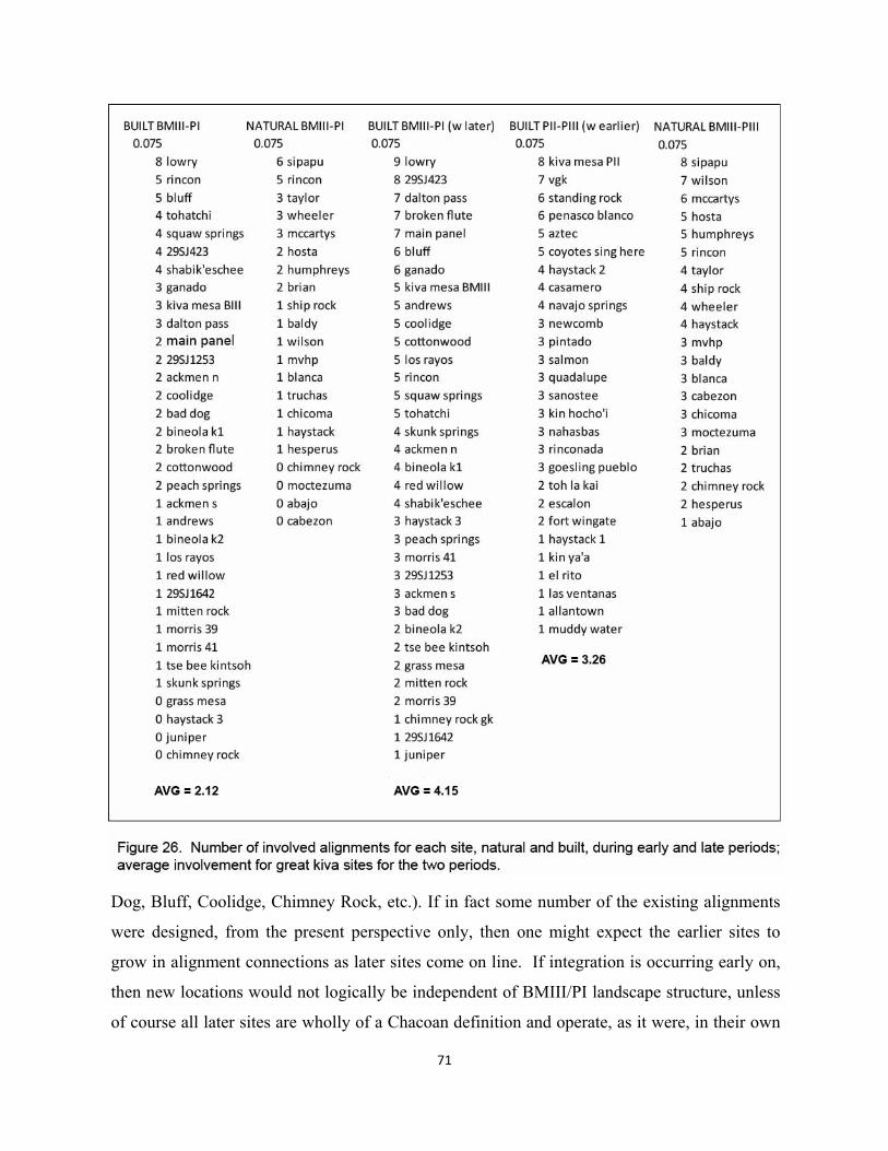
71
Dog, Bluff, Coolidge, Chimney Rock, etc.). If in fact some number of the existing alignments
were designed, from the present perspective only, then one might expect the earlier sites to
grow in alignment connections as later sites come on line. If integration is occurring early on,
then new locations would not logically be independent of BMIII/PI landscape structure, unless
of course all later sites are wholly of a Chacoan definition and operate, as it were, in their own
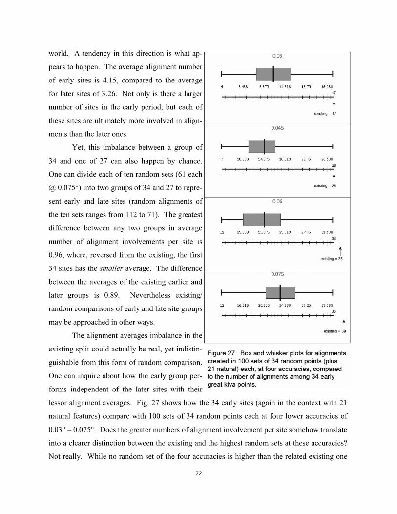
72
world. A tendency in this direction is what ap-
pears to happen. The average alignment number
of early sites is 4.15, compared to the average
for later sites of 3.26. Not only is there a larger
number of sites in the early period, but each of
these sites are ultimately more involved in align-
ments than the later ones.
Yet, this imbalance between a group of
34 and one of 27 can also happen by chance.
One can divide each of ten random sets (61 each
@ 0.075°) into two groups of 34 and 27 to repre-
sent early and late sites (random alignments of
the ten sets ranges from 112 to 71). The greatest
difference between any two groups in average
number of alignment involvements per site is
0.96, where, reversed from the existing, the first
34 sites has the smaller average. The difference
between the averages of the existing earlier and
later groups is 0.89. Nevertheless existing/
random comparisons of early and late site groups
may be approached in other ways.
The alignment averages imbalance in the
existing split could actually be real, yet indistin-
guishable from this form of random comparison.
One can inquire about how the early group per-
forms independent of the later sites with their
lessor alignment averages. Fig. 27 shows how the 34 early sites (again in the context with 21
natural features) compare with 100 sets of 34 random points each at four lower accuracies of
0.03° – 0.075°. Does the greater numbers of alignment involvement per site somehow translate
into a clearer distinction between the existing and the highest random sets at these accuracies?
Not really. While no random set of the four accuracies is higher than the related existing one
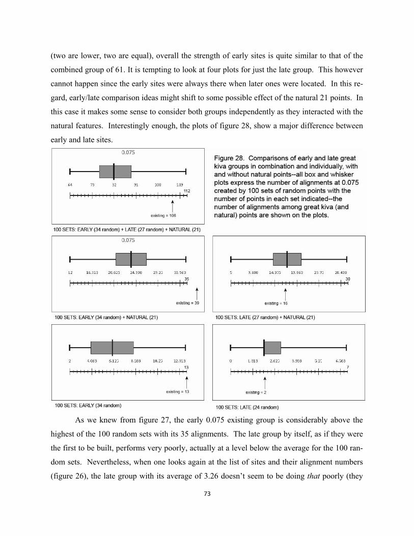
73
(two are lower, two are equal), overall the strength of early sites is quite similar to that of the
combined group of 61. It is tempting to look at four plots for just the late group. This however
cannot happen since the early sites were always there when later ones were located. In this re-
gard, early/late comparison ideas might shift to some possible effect of the natural 21 points. In
this case it makes some sense to consider both groups independently as they interacted with the
natural features. Interestingly enough, the plots of figure 28, show a major difference between
early and late sites.
As we knew from figure 27, the early 0.075 existing group is considerably above the
highest of the 100 random sets with its 35 alignments. The late group by itself, as if they were
the first to be built, performs very poorly, actually at a level below the average for the 100 ran-
dom sets. Nevertheless, when one looks again at the list of sites and their alignment numbers
(figure 26), the late group with its average of 3.26 doesn’t seem to be doing that poorly (they
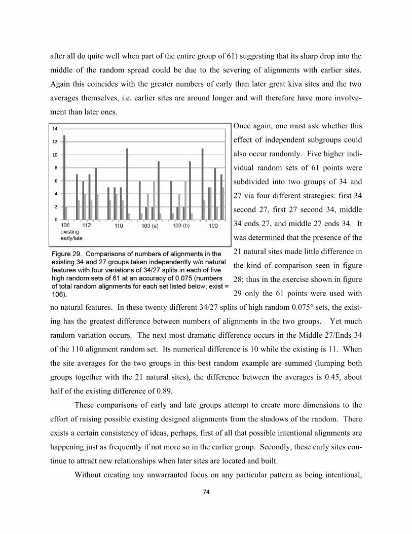
74
after all do quite well when part of the entire group of 61) suggesting that its sharp drop into the
middle of the random spread could be due to the severing of alignments with earlier sites.
Again this coincides with the greater numbers of early than later great kiva sites and the two
averages themselves, i.e. earlier sites are around longer and will therefore have more involve-
ment than later ones.
Once again, one must ask whether this
effect of independent subgroups could
also occur randomly. Five higher indi-
vidual random sets of 61 points were
subdivided into two groups of 34 and
27 via four different strategies: first 34
second 27, first 27 second 34, middle
34 ends 27, and middle 27 ends 34. It
was determined that the presence of the
21 natural sites made little difference in
the kind of comparison seen in figure
28; thus in the exercise shown in figure
29 only the 61 points were used with
no natural features. In these twenty different 34/27 splits of high random 0.075° sets, the exist-
ing has the greatest difference between numbers of alignments in the two groups. Yet much
random variation occurs. The next most dramatic difference occurs in the Middle 27/Ends 34
of the 110 alignment random set. Its numerical difference is 10 while the existing is 11. When
the site averages for the two groups in this best random example are summed (lumping both
groups together with the 21 natural sites), the difference between the averages is 0.45, about
half of the existing difference of 0.89.
These comparisons of early and late groups attempt to create more dimensions to the
effort of raising possible existing designed alignments from the shadows of the random. There
exists a certain consistency of ideas, perhaps, first of all that possible intentional alignments are
happening just as frequently if not more so in the earlier group. Secondly, these early sites con-
tinue to attract new relationships when later sites are located and built.
Without creating any unwarranted focus on any particular pattern as being intentional,
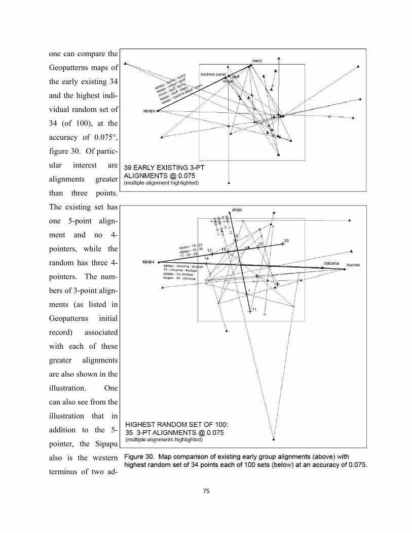
75
one can compare the
Geopatterns maps of
the early existing 34
and the highest indi-
vidual random set of
34 (of 100), at the
accuracy of 0.075°,
figure 30. Of partic-
ular interest are
alignments greater
than three points.
The existing set has
one 5-point align-
ment and no 4-
pointers, while the
random has three 4-
pointers. The num-
bers of 3-point align-
ments (as listed in
Geopatterns initial
record) associated
with each of these
greater alignments
are also shown in the
illustration. One
can also see from the
illustration that in
addition to the 5-
pointer, the Sipapu
also is the western
terminus of two ad-
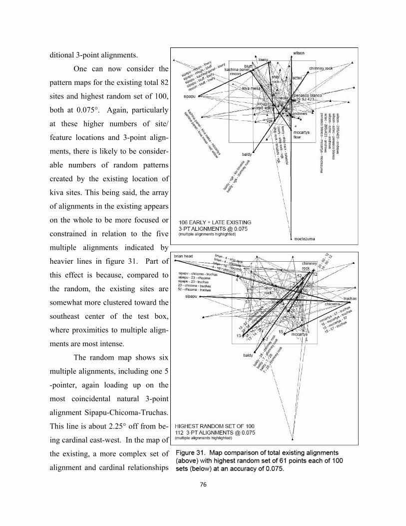
76
ditional 3-point alignments.
One can now consider the
pattern maps for the existing total 82
sites and highest random set of 100,
both at 0.075°. Again, particularly
at these higher numbers of site/
feature locations and 3-point align-
ments, there is likely to be consider-
able numbers of random patterns
created by the existing location of
kiva sites. This being said, the array
of alignments in the existing appears
on the whole to be more focused or
constrained in relation to the five
multiple alignments indicated by
heavier lines in figure 31. Part of
this effect is because, compared to
the random, the existing sites are
somewhat more clustered toward the
southeast center of the test box,
where proximities to multiple align-
ments are most intense.
The random map shows six
multiple alignments, including one 5
-pointer, again loading up on the
most coincidental natural 3-point
alignment Sipapu-Chicoma-Truchas.
This line is about 2.25° off from be-
ing cardinal east-west. In the map of
the existing, a more complex set of
alignment and cardinal relationships
77
occurs between Mount Wilson and Cerro Moctezuma, the natural feature McCarty’s Flow and
four great kiva sites in between: Aztec, Peñasco Blanco, 29SJ423, and Andrews. In total this
complex includes five overlapping 3-point alignments and ten different north-south cardinal
relationships between pairs of points (at the range of 0.075°).
Returning to the primary issue of simple numbers of alignments--leaving complex pat-
terns for later chapters--what then, can we understand at this point? Questions remain about
how one conceptualizes relations between the real and the random. For example, if one takes
the smaller set of existing early sites, along with the 21 natural, it is possible to lay out or design
34 hypothetical points (at 0.075°) connected by alignments in a most efficient manner, i.e. that
each site is located by only two alignment relationships to other sites (minimum necessary to
precisely create an intersection and site location). There are no random alignments considered
in this design, although some number is undoubtedly also created. In this exercise, using the
present landscape context, the number of alignments necessary is roughly identical to the num-
ber of sites. The existing 34 great kiva sites create 39 alignments at the same accuracy suggest-
ing the possibility that all might be designed. But the average number of alignments in 100 sets
of random points is only 24.29. If one expects the random to contribute the average in the exist-
ing patterns, in this case about 24 (24.29), then 39-24, or 15 is an approximate number that
might be designed. This is about half the number if 34 hypothetical sites are located to create
greatest design efficiency, yet a relatively high percentage.
Consider then the larger group of 61 (always in the context of the 21 natural), and about
60 or so alignments that would be the most efficient designed means of linking all together.
The total alignment number of existing sites is 106, minus the 60, leaving room for a contribu-
tion of about 45 random alignments. But since the lowest of the 100 random sets (all at the
0.075 range) is 64, and the average is about 82, the most likely number of designed alignments
would be much less than 60, more in the range of 24 (106 minus 82). Thus in the larger and
later group, the likelihood of design drops off considerably as a percentage.
This of course is but a mental game where the existing are independent from the ran-
dom, and the random contribution is likely to be around the average. In actual situations one
cannot be certain that the random contribution isn’t an unusually high or low number. It is also
probably true that there is a range, perhaps even in the present analysis, where designed align-
ments exert some influence over the numbers of random. This probable continuum from very
78
small numbers of points, where the random exert greatest influence, to the very large where any
independence of the existing becomes invisible, needs to be much better understood.
In sum, however, it would seem to be unscientific to conclude that the Ancestral Pueblo,
in all probability, did not survey any alignments, totally dismissing this kind of research, just as
it would be even more illogical to believe that all alignments of a particular range of accuracies
were designed. Together with the preceding more anthropological chapter, the introductory
pieces of probability analysis listed below can be carried forward as this volume moves into its
design analysis mode—with periodic tests of some particular layouts against random phenome-
na.
1. The existing alignments between great kivas and landscape features are in a probabil-
ity range of 0.02 to 0.0099 compared to 100 sets of 61 random points in each of ten
levels of accuracy.
2. The greater number of great kiva sites in the early BMIII-PI period (34) is a first in-
dication of possible early alignment importance.
3. The greater averages of alignment involvement per site in the early group contributes
to the possibility of alignment importance in early sites, i.e. that later ones build up-
on early ones, always in the context of the 21 natural features.
4. A comparatively high difference in numbers of alignments among the two groups
taken independently from each other, and without the natural features, follows the
logic of the other two early-late indicators.
3. A Surveyed East Meridian and First Triadic Structure at Chaco Canyon
While anthropological theories discussed in Chapter 1 pushed the formation of sodalities back
to the early PI period around A.D. 700, accuracy in the location of the two Basketmaker III vil-
lages with great kivas in Chaco Canyon, with respect to large-scale lines, suggests an earlier
horizon for the advent of these religious organizations--an expressive link, perhaps, between
acts of surveying and the development of great kiva ceremonial architecture. The previous
chapter examined the probability that some number of alignments among a largest set of great
kiva sites (Basketmaker III-PIII) were intentionally laid out or designed; the location pattern of
one of these two Chaco great kiva sites will also be compared to probabilities of a similar pat-
tern occurring randomly. Why might plateau sodalities have formed earliest in Chaco Canyon,
and how might this process have involved the formalization of shamanistic practices associated
with the Canyon de Chelly “cross” diagramed in the preceding chapter? Would social-
ecological exigencies need to exist, particularly involving larger-scale movement of populations
and the need to integrate diverse social groups? As discussed in Chapter 1, archaeologists do
not totally discount the possibility of large-scale relationships in the function of first sodalities
in the upheavals of PI beginning in the 700’s. The present argument simply pushes the date
back about 150 years.
The most causal component to the first Chaco formalization might logically have been
some sort of religious impetus coming expressively from the landscape itself, a sort of affective
mandate as it were. Was this need initially felt less in the loosely organized shamanistic prac-
tice of the hypothetical Canyon de Chelly cross, then at greater distances from this focus, e.g.
on eastern or Chaco side of the Chuskas? Would groups living farther from Canyon de Chelly
have been less inclined to share the shamanistic resources of the cross, even though spatially
adjacent to some of its features, particularly Mount Taylor in the Southeast? The more struc-
tured linkage of newly developing sodalities to ancient powerful oppositional axes (not that un-
like what individual shaman had likely been doing for some time) could be seen as an attempt
to gain greater religious power, given different locational and ecological motivations. Most im-
79
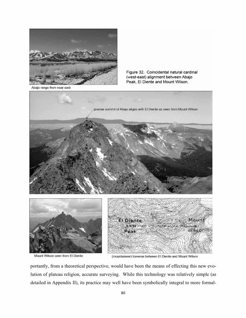
80
portantly, from a theoretical perspective, would have been the means of effecting this new evo-
lution of plateau religion, accurate surveying. While this technology was relatively simple (as
detailed in Appendix II), its practice may well have been symbolically integral to more formal-
81
ized ritual relationships with distant others.
Imagine small groups of shaman/priests in the northern San Juan region becoming
aware of the geometric relationship between Abajo Peak and Mount Wilson (named after the
topographer A.D. Wilson who made the first historical ascent in 1874); these are two of the
most northerly mountains in the sphere. Figure 32 pictures the precise and totally coincidental
alignment of actually two “fourteeners” with Abajo Peak. Mount Wilson (14,256), the highest
in the San Miguel Range of the southwest area of the San Juan Mountains, connects to El
Diente (14,159 ft) via a 1,289 m traverse, one of the “most famous” in Colorado (according to
mountaineer blogs). The latitudes of the two precise benchmarks are virtually identical (Mount
Wilson 37° 50’ 21” and El Diente 37° 50’ 21.7”). These points in turn, are equally identical, a
fraction of an arc second again, to the latitude of the benchmark on Mount Abajo (37° 50’
21.8”). Thus if a signal fire were built on the top of Abajo Peak, the peak of El Diente, as
shown in figure 32, would have provided a remarkable sighting feature from the peak of Mount
Wilson.
The question can be raised as to whether they could determine the precise cardinal, east
-west, accuracy of the line. The movement of the sun was likely tracked not only from Abajo
Peak but from Mount Wilson as well. Equinox sunrise, over Mount Wilson, and sunset, over
Abajo Peak, could well have been observed from these opposite locations 129.457 km apart.
The 2,896 foot difference in elevation between the two peaks means that risings and settings
will occur about 655 meters south of true east (rise), and the same distance north of true west
(set) (Seymore & Edberg 1979). Certainly the observation of the equinox sunrise would be
more dramatic, if the pinnacles of the El Diente-Mount Wilson pair could be discerned on a
clear day at this distance. If priestly groups hauled firewood up to the peak of Mount Wilson,
then its fairly precise location in relation to the equinox sunrise could be determined. While
the first glimpse of the sun’s crown would occur a little less than 655 meters to the south
(because of the three hundred feet lower elevation along the ridge), at its full width, its north-
ern edge would come close to coinciding with the signal fire on the peak. The sun’s diameter
is 0.5°, which at the distance from Abajo Peak is about 1,129 meters. Yet it is difficult for the
naked eye to easily define the edges of a half risen sun. Thus while the symbolic equinox ris-
ing and perhaps setting might logically have been associated with the Abajo Peak – Mount
Wilson line, cardinality of this geometry could have been interpreted as just slightly off, in
82
spite of its absolute coincidental precision described by modern means.
On the other hand, if shaman (becoming priests) had the ability to measure a fairly accu-
rate solar determined cardinal north (much more so than the approximate full degree deviation
of the north star beginning about 500 A.D.), then using the flatter terrain at the signal point on
the top of Abajo Peak, some sort of perpendicularity might have been determined. This could
have been more accurate than the 0.29° angle the sunrise crown misses Mount Wilson.
Here, then, may have been a readymade, quite precise, linear opposition between two
highest peaks, complete with the affective power of its equinox sunrise/sunset experience. Re-
lated to this religiosity could have been traditions of East-West dualities associated with the
Great Sipapu and its line east to Chicoma and Truchas. While the more modest Abajo Peak
might have been used by shamans in its relation to the Canyon de Chelly cross, Mount Wilson,
the highest in the San Miguel range, might as well have been the object of shamanistic practice,
though perhaps initially in a less integrated manner (not as part of any cosmos). Significantly,
however, this oppositional structure of the two northern peaks occurs within the larger reach of
the de Chelly cross. If shamans from early Basketmaker III communities to the east had begun
to participate in some sort of emerging “twin peaks” cult of the evolving religion (Abajo &
Wilson, and homologically at a smaller scale El Diente & Wilson), then it might have been log-
ical to imagine a second vertical axis running south from Mount Wilson to pair up with the
Abajo Peak-Baldy Peak vertical. At some point in this thinking by a small group of incipient
priests, a decision might have been made to conduct a novel survey, a southward prolongation,
to find some also oppositional south feature to religiously anchor the new east axis.
This would have been no technical act, per se, but an extension of religious practice per-
haps involving participation of individuals from different areas along the way, the line-
associated group of religious specialists amounting to a sodality, cross-cutting different com-
munities on the eastern side of the plateau. This same sort of fusion of spatial path and reli-
gious sodality may well have energized the later transport of tree trunks across larger distances
and through different communities during the construction of major Chacon architecture in the
canyon (see figure 102). If Warao shamans laid out a north-south line between two poles, off
about nine arc minutes—in the flat jungles of the Orinoco Delta—how accurate could first An-
cestral Pueblo surveyor-priests prolong a line south from Mount Wilson across the more visible
larger scale Southwest topography? As will be seen in the technical Appendix II on surveying
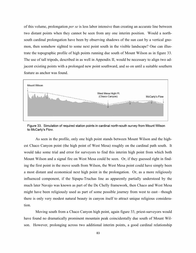
83
of this volume, prolongation per se is less labor intensive than creating an accurate line between
two distant points when they cannot be seen from any one interim position. Would a north-
south cardinal prolongation have been by observing shadows of the sun cast by a vertical gno-
mon, then somehow sighted to some next point south in the visible landscape? One can illus-
trate the topographic profile of high points running due south of Mount Wilson as in figure 33.
The use of tall tripods, described in as well in Appendix II, would be necessary to align two ad-
jacent existing points with a prolonged new point southward, and so on until a suitable southern
feature as anchor was found.
As seen in the profile, only one high point stands between Mount Wilson and the high-
est Chaco Canyon point (the high point of West Mesa) roughly on the cardinal path south. It
would take some trial and error for surveyors to find this interim high point from which both
Mount Wilson and a signal fire on West Mesa could be seen. Or, if they guessed right in find-
ing the first point in the move south from Wilson, the West Mesa point could have simply been
a most distant and economical next high point in the prolongation. Or, as a more religiously
influenced component, if the Sipapu-Truchas line as apparently partially understood by the
much later Navajo was known as part of the De Chelly framework, then Chaco and West Mesa
might have been religiously used as part of some possible journey from west to east—though
there is only very modest natural beauty in canyon itself to attract unique religious considera-
tion.
Moving south from a Chaco Canyon high point, again figure 33, priest-surveyors would
have found no dramatically prominent mountain peak coincidentally due south of Mount Wil-
son. However, prolonging across two additional interim points, a good cardinal relationship
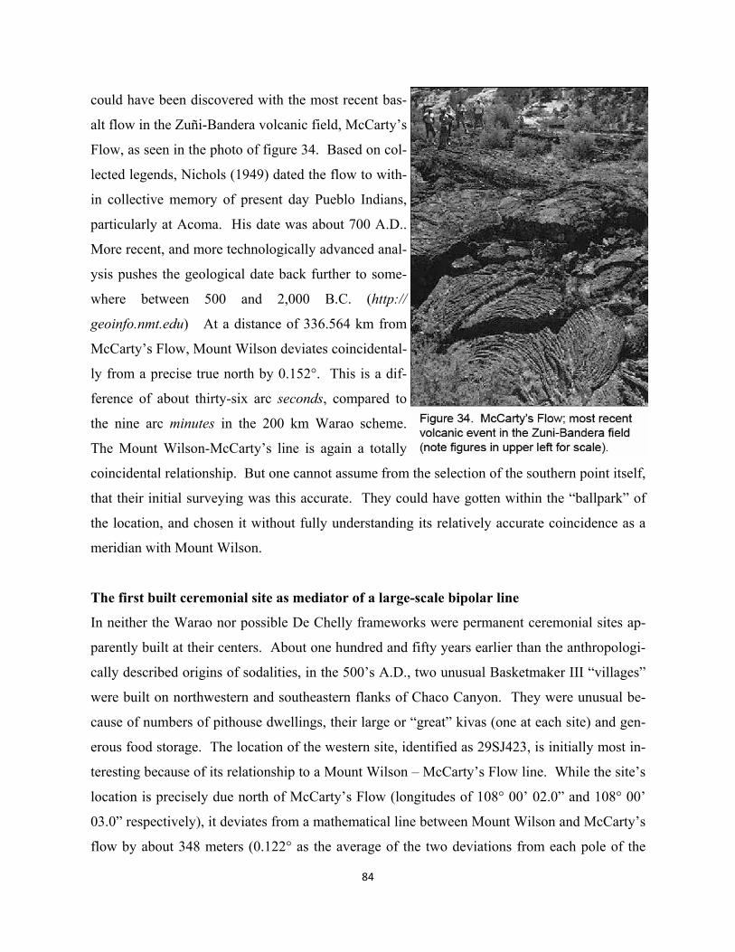
84
could have been discovered with the most recent bas-
alt flow in the Zuñi-Bandera volcanic field, McCarty’s
Flow, as seen in the photo of figure 34. Based on col-
lected legends, Nichols (1949) dated the flow to with-
in collective memory of present day Pueblo Indians,
particularly at Acoma. His date was about 700 A.D..
More recent, and more technologically advanced anal-
ysis pushes the geological date back further to some-
where between 500 and 2,000 B.C. (http://
geoinfo.nmt.edu) At a distance of 336.564 km from
McCarty’s Flow, Mount Wilson deviates coincidental-
ly from a precise true north by 0.152°. This is a dif-
ference of about thirty-six arc seconds, compared to
the nine arc minutes in the 200 km Warao scheme.
The Mount Wilson-McCarty’s line is again a totally
coincidental relationship. But one cannot assume from the selection of the southern point itself,
that their initial surveying was this accurate. They could have gotten within the “ballpark” of
the location, and chosen it without fully understanding its relatively accurate coincidence as a
meridian with Mount Wilson.
The first built ceremonial site as mediator of a large-scale bipolar line
In neither the Warao nor possible De Chelly frameworks were permanent ceremonial sites ap-
parently built at their centers. About one hundred and fifty years earlier than the anthropologi-
cally described origins of sodalities, in the 500’s A.D., two unusual Basketmaker III “villages”
were built on northwestern and southeastern flanks of Chaco Canyon. They were unusual be-
cause of numbers of pithouse dwellings, their large or “great” kivas (one at each site) and gen-
erous food storage. The location of the western site, identified as 29SJ423, is initially most in-
teresting because of its relationship to a Mount Wilson – McCarty’s Flow line. While the site’s
location is precisely due north of McCarty’s Flow (longitudes of 108° 00’ 02.0” and 108° 00’
03.0” respectively), it deviates from a mathematical line between Mount Wilson and McCarty’s
flow by about 348 meters (0.122° as the average of the two deviations from each pole of the
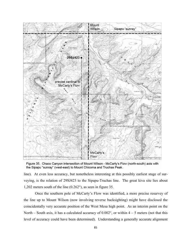
line). At even less accuracy, but nonetheless interesting at this possibly earliest stage of sur-
veying, is the relation of 29SJ423 to the Sipapu-Truchas line. The great kiva site lies about
1,202 meters south of the line (0.262°), as seen in figure 35.
Once the southern pole of McCarty’s Flow was identified, a more precise resurvey of
the line up to Mount Wilson (now involving reverse backsighting) might have disclosed the
coincidentally very accurate position of the West Mesa high point. As an interim point on the
North – South axis, it has a calculated accuracy of 0.002°, or within 4 – 5 meters (not that this
level of accuracy could have been determined). Understanding a generally accurate alignment
85
of the West Mesa high point, but without surveying the established but perhaps less precisely
understood Sipapu-Truchas line, the great kiva site 29SJ423 might have been located logically
close to the intersection of the two lines. As seen in figure 35, this intersection area occurs
down on the floor of the Chaco River canyon. The later PI-PII great kiva just north of the even-
tual Peñasco Blanco great house (the earliest at this site) actually is the closest great kiva in
Chaco Canyon to the intersection point in question. Yet the vantage point is superior from the
higher position of 29SJ423.
Intercardinal axes and a triadic ritual definition in Chaco Canyon
Yet in spite of all of the eventual ceremonial sites built in the canyon to the east of 29SJ423, the
second BIII great kiva “village”, Shabik’eschee, also to the east, might not have been the next
point to be located. If emerging sodality groups in the east were being so bold as to lay out a
new dualistic North-South meridian, perhaps creating a cross with Sipapu-Truchas, then they
might have sought two possibly coincidental inter-cardinal axes to complete the framework--
like those of the shamanistic De Chelly cosmos--expanding the number of religious societies
and communities involved. The ability to survey would have been becoming increasingly es-
sential. From probably ancient cognitive wayfinding, without surveying, it could have been
understood that the positions of Abajo Peak and Mount Taylor have the potential to serve as a
NW-SE line for the emerging eastern focus. An actual survey would have shown the line to run
about 15 km southwest of 29SJ423. A complementary line from Baldy Peak up to some point
in the NE, however, might have been less evident. If a line had first been laid out between
Baldy Peak and the first 29SJ423 in Chaco, and then prolonged up to the northeast, it would
have come in the general vicinity of what was undoubtedly already a highly religious, if still
essentially shamanistic, natural feature, Chimney Rock, figure 36. Additionally, from a formal
design perspective, this feature is roughly north of the SE feature of Mount Taylor (unlike
Blanca Peak in the De Chelly cosmos).
Once the accurate survey of a line from Baldy Peak to Chimney Rock was accom-
plished, not necessarily in any highly organized time frame, then its intersection point with a
surveyed line from Abajo Peak to Mount Taylor could have been determined. This mathemati-
cal point lies about 602 m northwest of the Chacoan great house, Kin Bineola, largest built out-
side of the canyon, and larger than Hungo Pavi and Wijiji in the canyon (Powers 313): it is vir-
86
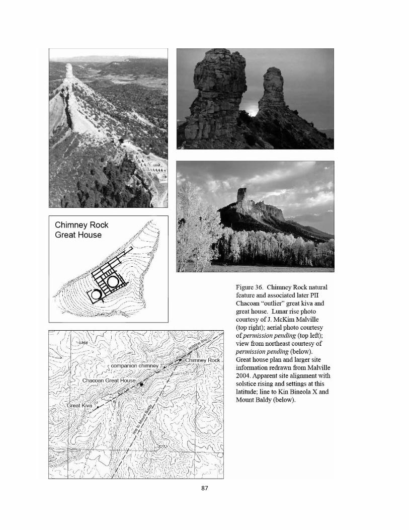
87

88
tually the same size as Salmon, a similar distance from and largest outside the Aztec complex
(Totah). As seen in figure 37, the eventual location of Kin Bineola’s great kiva, immediately
adjacent to the great house on its western flank, lies about 253 m from the Abajo Peak – Mount
Taylor line (0.105) and 342 m. from the Baldy Peak – Chimney Rock axis (0.101).
In earlier work by the author (Doxtater 2002), this intersection point shown in figure 37
was assumed to have been known because of its highly unique coincidental alignment with a
third axis between Brian Head, the NW mountain of the De Chelly framework, and Cabezon in
the SE, a prominent volcanic feature of some importance later in this volume. The three lines
run about 20 m from a common point at alignment averages from 0.006° to 0.008°. Yet it is
perhaps more likely, given less precise earliest surveying, that accuracies even up to 0.15°
might have been used, as described in the previous chapter. In many respects the inclusion of
only two intercardinal axes, without Brian Head – Cabezon, makes more sense as a kind of
eastern mirror image of the De Chelly cross. Regardless of how the Kin Bineola point was un-
derstood early on, the site becomes unusually complex not only for its eventual very large great
house and length of occupation, but for linear features and an outlying singular great kiva to the
south, as seen in figure 37 (Marshall et.al. 1979:58).
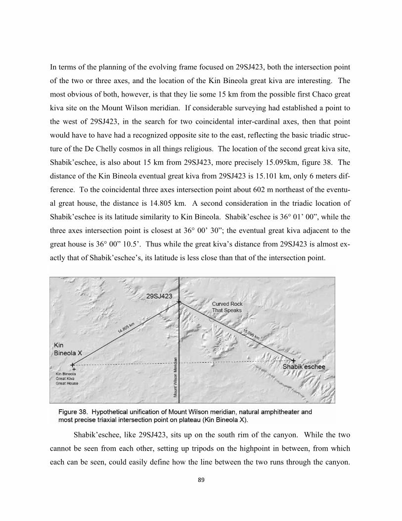
In terms of the planning of the evolving frame focused on 29SJ423, both the intersection point
of the two or three axes, and the location of the Kin Bineola great kiva are interesting. The
most obvious of both, however, is that they lie some 15 km from the possible first Chaco great
kiva site on the Mount Wilson meridian. If considerable surveying had established a point to
the west of 29SJ423, in the search for two coincidental inter-cardinal axes, then that point
would have to have had a recognized opposite site to the east, reflecting the basic triadic struc-
ture of the De Chelly cosmos in all things religious. The location of the second great kiva site,
Shabik’eschee, is also about 15 km from 29SJ423, more precisely 15.095km, figure 38. The
distance of the Kin Bineola eventual great kiva from 29SJ423 is 15.101 km, only 6 meters dif-
ference. To the coincidental three axes intersection point about 602 m northeast of the eventu-
al great house, the distance is 14.805 km. A second consideration in the triadic location of
Shabik’eschee is its latitude similarity to Kin Bineola. Shabik’eschee is 36° 01’ 00”, while the
three axes intersection point is closest at 36° 00’ 30”; the eventual great kiva adjacent to the
great house is 36° 00” 10.5’. Thus while the great kiva’s distance from 29SJ423 is almost ex-
actly that of Shabik’eschee’s, its latitude is less close than that of the intersection point.
Shabik’eschee, like 29SJ423, sits up on the south rim of the canyon. While the two
cannot be seen from each other, setting up tripods on the highpoint in between, from which
each can be seen, could easily define how the line between the two runs through the canyon.
89
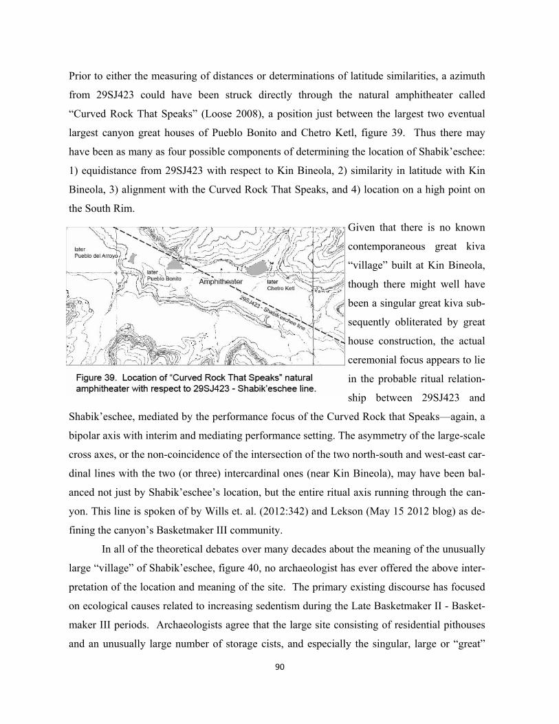
Prior to either the measuring of distances or determinations of latitude similarities, a azimuth
from 29SJ423 could have been struck directly through the natural amphitheater called
“Curved Rock That Speaks” (Loose 2008), a position just between the largest two eventual
largest canyon great houses of Pueblo Bonito and Chetro Ketl, figure 39. Thus there may
have been as many as four possible components of determining the location of Shabik’eschee:
1) equidistance from 29SJ423 with respect to Kin Bineola, 2) similarity in latitude with Kin
Bineola, 3) alignment with the Curved Rock That Speaks, and 4) location on a high point on
the South Rim.
Given that there is no known
contemporaneous great kiva
“village” built at Kin Bineola,
though there might well have
been a singular great kiva sub-
sequently obliterated by great
house construction, the actual
ceremonial focus appears to lie
in the probable ritual relation-
ship between 29SJ423 and
Shabik’eschee, mediated by the performance focus of the Curved Rock that Speaks—again, a
bipolar axis with interim and mediating performance setting. The asymmetry of the large-scale
cross axes, or the non-coincidence of the intersection of the two north-south and west-east car-
dinal lines with the two (or three) intercardinal ones (near Kin Bineola), may have been bal-
anced not just by Shabik’eschee’s location, but the entire ritual axis running through the can-
yon. This line is spoken of by Wills et. al. (2012:342) and Lekson (May 15 2012 blog) as de-
fining the canyon’s Basketmaker III community.
In all of the theoretical debates over many decades about the meaning of the unusually
large “village” of Shabik’eschee, figure 40, no archaeologist has ever offered the above inter-
pretation of the location and meaning of the site. The primary existing discourse has focused
on ecological causes related to increasing sedentism during the Late Basketmaker II - Basket-
maker III periods. Archaeologists agree that the large site consisting of residential pithouses
and an unusually large number of storage cists, and especially the singular, large or “great”
90
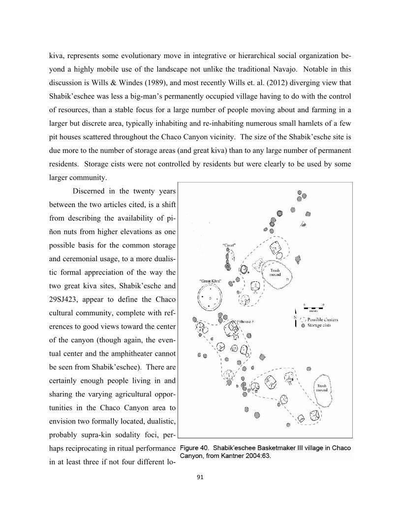
91
kiva, represents some evolutionary move in integrative or hierarchical social organization be-
yond a highly mobile use of the landscape not unlike the traditional Navajo. Notable in this
discussion is Wills & Windes (1989), and most recently Wills et. al. (2012) diverging view that
Shabik’eschee was less a big-man’s permanently occupied village having to do with the control
of resources, than a stable focus for a large number of people moving about and farming in a
larger but discrete area, typically inhabiting and re-inhabiting numerous small hamlets of a few
pit houses scattered throughout the Chaco Canyon vicinity. The size of the Shabik’esche site is
due more to the number of storage areas (and great kiva) than to any large number of permanent
residents. Storage cists were not controlled by residents but were clearly to be used by some
larger community.
Discerned in the twenty years
between the two articles cited, is a shift
from describing the availability of pi-
ñon nuts from higher elevations as one
possible basis for the common storage
and ceremonial usage, to a more dualis-
tic formal appreciation of the way the
two great kiva sites, Shabik’esche and
29SJ423, appear to define the Chaco
cultural community, complete with ref-
erences to good views toward the center
of the canyon (though again, the even-
tual center and the amphitheater cannot
be seen from Shabik’eschee). There are
certainly enough people living in and
sharing the varying agricultural oppor-
tunities in the Chaco Canyon area to
envision two formally located, dualistic,
probably supra-kin sodality foci, per-
haps reciprocating in ritual performance
in at least three if not four different lo-
92
cations: the two great kivas, the amphitheater and perhaps at Kin Bineola. But from the purely
ecological perspective, whichever of the two theoretical archaeological views one subscribes
to, what would have caused such a departure from the ancient shamanistic use of the land-
scape? After all, Navajos used the canyon similarly for long periods of time without ever
needing more highly organized and permanently fixed ceremonial sites. Wills et. al.
(2012:346) concludes their (re)investigation by suggesting that both the density of “dispersed”
population in Chaco Canyon and its reliance upon formalized ritual organization continued on
into PI periods, (hypothesizing about lost evidence in this period due to alluvial effects), and
right up into the major expansion of the 10th and 11th centuries. Is this a move among promi-
nent archaeologists to recognize some ancestry of formalized ritual processes, particularly in
the canyon?
Two questions should be addressed. First, is ritual formalization, a triadic expression
with two end poles and an interim place of mediation, in an area like Chaco essential to the
ecological sharing of the agricultural resources among mobile occupants? Perhaps not; while
Lightfoot and Feinman (1982:81) see these larger villages as created by local competition
among big men primarily due to the fact that some pit houses are larger than others, part of
their rationale could well relate to the development of linear landscape structures, i.e. to attract
individuals to certain locations through migration, to increase regional exchange ties, and to
encourage the production of agricultural surplus. In many ways their ideas seems to relate bet-
ter to larger scale social space. How, for example, would only two big men among the large
population around Chaco, emerge to locate their “villages” as relatively formal oppositions at
higher ends of the canyon—not to mention the possible role of the Curved Rock That Speaks?
The “big man” concept is essentially territorial rather than ritualistic.
Another clue to larger-scale socio-cultural organization can be found in Washburn and
Webster’s (2006) analysis of variations in basket and ceramic graphics in Basketmaker II and
especially III. Significant design differences translate into large-scale migrations in these peri-
ods, and by implication possible religious integration. They suggest: “that whereas some of
these developing agriculturalists were long term inhabitants…others were immigrants from
regions more distant from the Four Corners area”. While much of the data for Washburn and
Webster’s piece comes from Chuska areas, the implications for migration and integration to
more isolated areas such as Chaco might be even more pronounced, hence the earliest of these
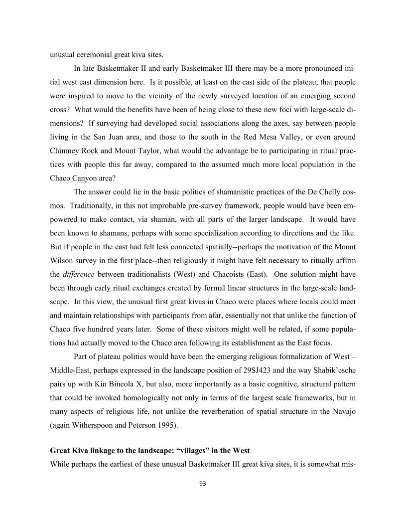
93
unusual ceremonial great kiva sites.
In late Basketmaker II and early Basketmaker III there may be a more pronounced ini-
tial west east dimension here. Is it possible, at least on the east side of the plateau, that people
were inspired to move to the vicinity of the newly surveyed location of an emerging second
cross? What would the benefits have been of being close to these new foci with large-scale di-
mensions? If surveying had developed social associations along the axes, say between people
living in the San Juan area, and those to the south in the Red Mesa Valley, or even around
Chimney Rock and Mount Taylor, what would the advantage be to participating in ritual prac-
tices with people this far away, compared to the assumed much more local population in the
Chaco Canyon area?
The answer could lie in the basic politics of shamanistic practices of the De Chelly cos-
mos. Traditionally, in this not improbable pre-survey framework, people would have been em-
powered to make contact, via shaman, with all parts of the larger landscape. It would have
been known to shamans, perhaps with some specialization according to directions and the like.
But if people in the east had felt less connected spatially--perhaps the motivation of the Mount
Wilson survey in the first place--then religiously it might have felt necessary to ritually affirm
the difference between traditionalists (West) and Chacoists (East). One solution might have
been through early ritual exchanges created by formal linear structures in the large-scale land-
scape. In this view, the unusual first great kivas in Chaco were places where locals could meet
and maintain relationships with participants from afar, essentially not that unlike the function of
Chaco five hundred years later. Some of these visitors might well be related, if some popula-
tions had actually moved to the Chaco area following its establishment as the East focus.
Part of plateau politics would have been the emerging religious formalization of West –
Middle-East, perhaps expressed in the landscape position of 29SJ423 and the way Shabik’esche
pairs up with Kin Bineola X, but also, more importantly as a basic cognitive, structural pattern
that could be invoked homologically not only in terms of the largest scale frameworks, but in
many aspects of religious life, not unlike the reverberation of spatial structure in the Navajo
(again Witherspoon and Peterson 1995).
Great Kiva linkage to the landscape: “villages” in the West
While perhaps the earliest of these unusual Basketmaker III great kiva sites, it is somewhat mis-
94
leading to base much of the discourse about Shabik’eschee (and 29SJ423) in Chaco to the East,
when six such sites have been identified in the west, particularly in and around the Chuskas.
95
Until the mid-700’s there is nothing comparable elsewhere in the east, even up in the Mesa
Verde area (with the exception perhaps of the 6th century Dillard site).
Whether in the possibly formalizing East or West, these kinds of sites are still quite rare
in the landscape. During the 500-700’s, village-like sites with large more specialized ceremoni-
al structures are the exception, not the rule, among the more numerous strictly residential clus-
ters across the landscape (Gilpin and Benallie 2000:172). Reed’s volume on the foundations of
Basketmaker III offers a multi-authored overview of Basketmaker III. Generally the volume
contrasts with Wills & Windes 1989 view of the Chaco sites as related to less sedentary strate-
gies of land use, maintaining the idea that these “villages” emerged primarily in response to
permanent occupation related intensive agriculture. New, however, is the volume consensus
that this happened earlier than conventionally thought. They are relatively permanent settings
compared to habitations used occasionally. If Wills et.al. 2012, a decade later, have really sub-
tly moved the argument away from piñon nut harvesting events to something possibly involving
some ritual formality laid over canyon topography, then would Reed’s authors possibly alter
their critique of Chaco village interpretation? The Basketmaker volume does spend text space
on discussions of great kivas, though few large-scale associations are specifically discussed.
Reed’s introduction cites Vivian and Reiter (1965) who suggest that the origin of great kivas
probably predates Basketmaker III. More specifically they compare Shabik’eschee with the site
of Broken Flute Cave, built about one hundred years later (late 500’s or early 600’s) up in the
Redrock Valley (Chuska associated), figure 41.
Thinking more of a unified religious and migration causality in the formation of cere-
monial great kiva sites, particularly if the early Chaco layout did in fact express large-scale for-
malizing ritual, then what would one expect over in the “West” hemisphere? To a certain ex-
tent the term “hemisphere” may be misleading, since the center of the hypothetical traditional
shamanistic plateau cross would have been associated with Canyon de Chelly in the Chuskas.
Thus the larger number of Basketmaker III great kiva sites could have had more to do with tra-
ditional meanings of the cross’s axis mundi and its unsurveyed but perhaps known focus, rather
than with any West dualism responding to an emerging East at Chaco. As shamanistic land-
scapes transitioned to more formally organized religious sites would there have been constraints
against revising the de Chelly framework? If so, how were these sites located to achieve a
more powerful and more formalized symbolic connection to landscape? The earliest, Broken
96
Flute Cave, at least, suggests that the natural phenomenological character of the setting might
have been important, perhaps even in addition to some cognitively understood location in sym-
bolic areas of the cross (cardinal and inter-cardinal).
Robins and Hays-Gilpin’s piece in the Reed volume (2000:241-2) describe rock art de-
picting ritual procession at Broken Flute Cave in association with its great kiva, and associated
“village” pit houses and storage (the kiva is from the 600’s but the site was used earlier as a
Basketmaker II pit house site). The processional rock art at Broken Flute Cave is not unlike
that found near Butler Wash at Comb Ridge. While a search for possible alignments with large-
scale natural features, like Chaco, does not turn up likely candidates, nevertheless, this location
is clearly the locus of significant ritual. Robins and Hays-Gilpin do leave the reader with a
sense of larger integrative religious space in the landscape in their comments particularly about
similar, even more important, ritual going on at Comb Ridge. They say that, “at least one of the
Butler Wash panels may have been in use during the seventh century as a focal point of move-
ment and interaction between populations living at Bluff Bench and Cedar Mesa, and possibly
even on a larger scale” (2000:241). They also describe cardinal directional (cross) symbolism
implicit in the panels.
In spite of implications for formalized larger scale ritual, Robins and Hays-Gilpin do not
necessarily see the emergence of these practices as part of some larger religious formalization
of any very large scale plateau framework. Great kivas are built partly because men need a
means to integrate with others from different natal communities into their spousal groups (ibid
239). There is little discussion about why there would be so relatively few of these sites across
an area with widely dispersed but large populations. Alternatively, one can interpret the rock
art panels as expressive of ritual scales much larger than patriarchial kinship linkages. Particu-
larly at Comb Ridge, one can imagine people traveling from some distance to participate in rites
associated with the northern pole of the vertical axis of the Canyon de Chelly cross.
A second early great kiva, Juniper Cove, was located curiously west of both Broken
Flute Cave, and the vertical axis associated hypothetically with Comb Ridge and Abajo Peak.
Of the six Basketmaker III or early PI listed by Gilpin and Benallie Jr., Broken Flute Cave and
Juniper Cove may be the earliest. Thus following Shabik’eschee and 29SJ423, a second pair
might have been established (Dillard notwithstanding) also forming a triad of large-scale sites
to the west, see again figure 41. While Broken Flute Cave and Juniper Cove do not appear to
97
have been located by surveying, rather in context with more traditionally understood cognitive
or cosmic frames, their positions with respect to the Butler Wash panels and Comb Ridge might
reveal the first formalizing remodeling on the western side of the plateau. A logical equiva-
lence could have been seen between the Comb Ridge intersection point (vertical axis and San
Juan river axis which points to the Grand Canyon Sipapu) and 29SJ423, sitting as it does near-
est to the Mount Wilson meridian and the Sipapu – Truchas line. Might West and East sodali-
ties at Juniper Cove and Broken Flute Cave have had emerging ritual correspondence to Kin
Bineola and Shabik’eschee? If the Chaco triad had been formally laid out, it could have pro-
voked responses for Chuska areas in the traditional cosmos to create their own large-scale asso-
ciations. Some discord might well have developed between populations that continued to use
the landscape more traditionally with shamans—even visiting major sites like Comb Ridge—
and those intent on formalizing permanent great kiva sites.
Foremost in this admittedly most speculative design analysis of earliest plateau land-
scape structure is the assertion that the first Chaco great kiva, perhaps 29SJ423, was positioned
by survey on a new eastern meridian to Mount Wilson and that it may have been the stimulus to
change in the West. Eventually through later periods, this coincidental axis with McCarty’s
Flow spatially integrates four additional great kiva sites. The following exercise focused on
this compound pattern includes all of the eventual built sites, not just the first at 29SJ423.
While a single site might more frequently be randomly located on the coincidental Wilson me-
ridian with McCarty’s Flow, alignment of five built sites will obviously be a much rarer phe-
nomenon. Depending on just how frequently this compound pattern occurs randomly, if the
late combination is ultimately considered intentional, than it would be likely that 29SJ423’s lo-
cation was designed as well.
PROBABILITY TEST: THE MOUNT WILSON MERIDIAN
The diagram of figure 31 in the preceding chapter illustrates a compound “alignment” that pro-
duces five intertwined 3-point alignments among seven total points: Mount Wilson, Aztec (site
centroid), Peñasco Blanco (earliest kiva), 29SJ423, Andrews, McCarty’s Flow, and and the kiva
like feature on Cerro Moctezuma. More will of course be said about later built sites in subse-
quent chapters. This exercise uses the new version of Geopatterns (3) software described in
Appendix I. While the previous version also allowed searching large numbers of random sets
for specific pattern compounds--unlike the simple aggregates of a more limited number of sets
in Chapter 2--the new version can search for more complex combination patterns. Within this
compound, at the range of 0.075° (the median of the Chapter 2 exercise) the following individu-
al patterns occur:
3-pt alignments (5) Andrews – 29SJ423 – Mount Wilson (0.008°) Peñasco Blanco – Aztec – Mount Wilson (0.020°) Andrews – 29SJ423 – Aztec (0.053°) Andrews – Aztec – Mount Wilson (0.054°) [Peñasco Blanco – McCarty’s Flow – Cerro Moctezuma] 2-pt cardinal relationships (10) 29SJ423 – McCarty’s Flow (0.010°) Mount Abajo – Mount Wilson (0.011° west – east) Peñasco Blanco – Andrews (0.047°) Aztec – McCarty’s Flow (0.068°) [Cerro Moctezuma – Mount Wilson] [Cerro Moctezuma – McCarty’s Flow] [Cerro Moctezuma – Aztec] [Cerro Moctezuma – 29SJ423] [Cerro Moctezuma – Peñasco Blanco] [Cerro Moctezuma – Andrews]
One first notices in these lists the preponderance of cardinal relationships created by Cerro
Moctezuma. The geometric or mathematical reason why this particular location is so involved
at or under 0.075° appears to be simply because of its great distance south from the other sites.
The greater distance a point is from others, relative to a precise north-south meridian, the small-
er the angle of deviation. The design analysis of Cerro Moctezuma as a somewhat latter day
extension of more fundamental Chacoan layout is discussed in Chapter 8. At present, however,
the inclusion of Cerro Moctezuma in probability tests seems unwarranted, particularly in its car-
dinality, because of the influence of distance per se, in spite of the fact that the alignment exten-
sions from the earlier Chacoan layout will be shown to be very precise. This issue is moot, how-
ever, because of present software limitations. Even the most recent version cannot process ex-
tremely long compound strings of patterns such as a test the full Wilson complex, including
Moctzuma, would require. Needed would be a string of 15 individual patterns, 5 (3-pt.) align-
98
99
ments and 10 (2-pt. cardinals).
Eliminating Cerro Moctezuma from the above lists, leaves four 3-pt. alignments and
four 2-pt. cardinals which seem to connect three natural and four great kiva sites; the west-east
relationship between Abajo Peak and Mount Wilson is included (this is the only naturally coin-
cidental cardinal relationship at this accuracy). Within the present limitations of Geopatterns 3,
these can be modeled with the search string: A+A(2)+A(2)+A(3)+C(2)+C(1)+C(2)+C(1), i.e.
that given the existing 81 sites, the computer finds this particular compound pattern when given
the “site analysis” command. The geographic area in which sets of 61 random points (great kiva
equivalents) are located, keeping the now 20 natural features fixed, is the same as in Chapter 2.
In this test the accuracies of the existing alignment and cardinal patterns are used as the limits
for the random. The four alignments are under 0.055°, and the cardinals under 0.070°.
At these accuracies two such compound patterns occur in the 44,706th and 95,180th sets
of 100,000 sets, each with 61 random points. A third set with the search string is reported, but
is an east-west line involving the Sipapu. The two matching patterns are reported as follows:
Patterns Investigated (1):
A+A(2)+A(2)+A(3)+C(2)+C(1)+C(2)+C(1) (1) 1: set 44,706 Alignment: 34(34.51745 , -108.00153) , mccartys , 29(36.78737 , - 107.99285) , 359.849576 Alignment: 34(34.51745 , -108.00153) , mccartys , wilson , 359.866611 Alignment: 34(34.51745 , -108.00153) , mccartys , 19(36.48130 , - 108.00031) , 359.935174 Alignment: mccartys , 29(36.78737 , -107.99285) , wilson , 359.858773 Cardinal: 19(36.48130 , -108.00031) , 34(34.51745 , -108.00153) , 179.970918 Cardinal: wilson , abajo , 89.989038 Cardinal: 19(36.48130 , -108.00031) , mccartys , 179.985454 Cardinal: 12(34.82285 , -109.45693) , abajo , 0.069079 id=2 AlignmentTolerance = 0.055 CardinalTolerance = 0.07
Patterns Investigated (1): A+A(2)+A(2)+A(3)+C(2)+C(1)+C(2)+C(1) (2) 1: set 95,180 Alignment: 61(37.10040 , -108.00249) , mccartys , 43(34.19284 , -108.00173) , 179.981699 Alignment: 43(34.19284 , -108.00173) , mccartys , wilson , 359.889305 Alignment: 43(34.19284 , -108.00173) , mccartys , 56(36.18631 , -107.99691) , 359.899000 Alignment: mccartys , 56(36.18631 , -107.99691) , wilson , 359.847741 Cardinal: mccartys , 61(37.10040 , -108.00249) , 0.033535
Cardinal: wilson , abajo , 89.989038 Cardinal: mccartys , 43(34.19284 , -108.00173) , 179.930768 Cardinal: abajo , 2(34.82071 , -109.46315) , 179.973854 id=1 AlignmentTolerance = 0.055 CardinalTolerance = 0.07
As the reader will see from figure 42 that compares the existing Wilson compound pattern, in
each of the two random matches an additional east-west point on the Wilson – Abajo line is
created as a cardinal relationship within 0.07°(though not necessarily aligned within 0.055°).
Thus in both random sets the north-south combination of alignments and cardinals generates
five point compounds, compared to the six points in the existing (all three without Moctezu-
ma). The involvement of Mount Wilson is also greater, given its appearance in four patterns in
the existing, compared to three in each of the random matches. The reverse is true with
McCarty’s Flow, which occurs in only 2 existing patterns, while the random sets have five and
six respectively.
What can be said then about the two sets of 100,000 that mostly satisfy the best model
of the Wilson meridian complex? To a certain extent one would expect random points to car-
dinally align with Mount Wilson and McCarty’s Flow even though these two points are about
0.16° off a precise north-south (the much more coincidentally cardinal Abajo Peak – Mount
Wilson is too short of a distance to attract the numbers of random points needed to create a 5-
point alignment). But one near match in 50,000 random sets defies such expectations. If the
four existing great kiva sites were randomly located for other reasons, yet somehow along the
Wilson – McCarty’s axis, it would not seem to be due to any great propensity for random
points to line up with this unique coincidental natural meridian.
This probability exercise raises more specific questions about the logic of creating a
single test box for distributing random points that mirrors the actual area where the existing 61
great kiva sites are located. Looking at the pattern of the existing 61 sites, figure 23, there is
clearly a clustering of existing sites roughly south of both Abajo Peak and particularly Mount
Wilson. At first the fact that seven of the 61 great kiva sites are in Chaco Canyon would seem
to work against using a single large scale test box. Could it not have been that the location of
one of the first two great kivas in Chaco on the Wilson – McCarty’s meridian, 29SJ423, was
itself a random phenomenon with respect to meridian alignment? While there is nothing in the
100
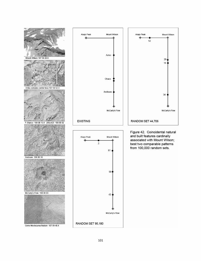
101
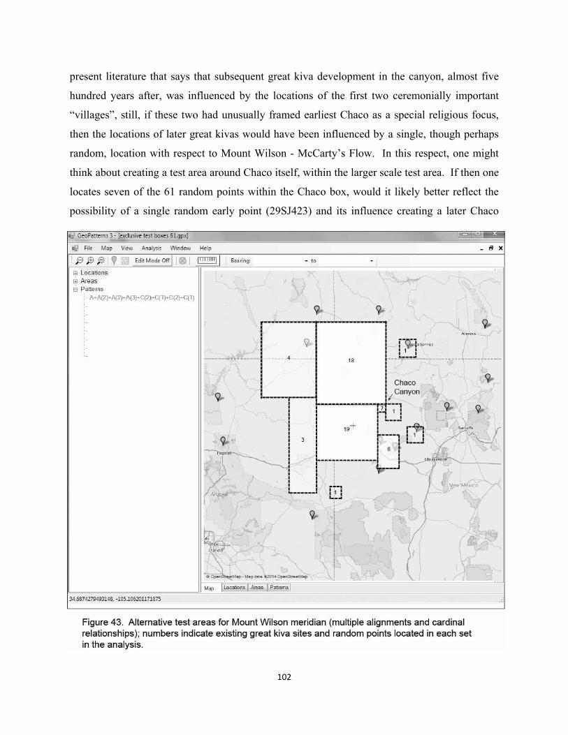
present literature that says that subsequent great kiva development in the canyon, almost five
hundred years after, was influenced by the locations of the first two ceremonially important
“villages”, still, if these two had unusually framed earliest Chaco as a special religious focus,
then the locations of later great kivas would have been influenced by a single, though perhaps
random, location with respect to Mount Wilson - McCarty’s Flow. In this respect, one might
think about creating a test area around Chaco itself, within the larger scale test area. If then one
locates seven of the 61 random points within the Chaco box, would it likely better reflect the
possibility of a single random early point (29SJ423) and its influence creating a later Chaco
102
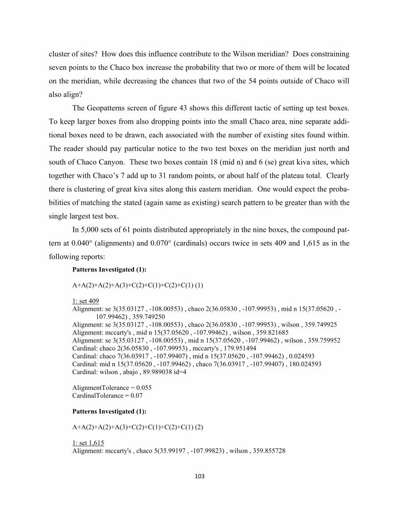
103
cluster of sites? How does this influence contribute to the Wilson meridian? Does constraining
seven points to the Chaco box increase the probability that two or more of them will be located
on the meridian, while decreasing the chances that two of the 54 points outside of Chaco will
also align?
The Geopatterns screen of figure 43 shows this different tactic of setting up test boxes.
To keep larger boxes from also dropping points into the small Chaco area, nine separate addi-
tional boxes need to be drawn, each associated with the number of existing sites found within.
The reader should pay particular notice to the two test boxes on the meridian just north and
south of Chaco Canyon. These two boxes contain 18 (mid n) and 6 (se) great kiva sites, which
together with Chaco’s 7 add up to 31 random points, or about half of the plateau total. Clearly
there is clustering of great kiva sites along this eastern meridian. One would expect the proba-
bilities of matching the stated (again same as existing) search pattern to be greater than with the
single largest test box.
In 5,000 sets of 61 points distributed appropriately in the nine boxes, the compound pat-
tern at 0.040° (alignments) and 0.070° (cardinals) occurs twice in sets 409 and 1,615 as in the
following reports:
Patterns Investigated (1): A+A(2)+A(2)+A(3)+C(2)+C(1)+C(2)+C(1) (1) 1: set 409 Alignment: se 3(35.03127 , -108.00553) , chaco 2(36.05830 , -107.99953) , mid n 15(37.05620 , - 107.99462) , 359.749250 Alignment: se 3(35.03127 , -108.00553) , chaco 2(36.05830 , -107.99953) , wilson , 359.749925 Alignment: mccarty's , mid n 15(37.05620 , -107.99462) , wilson , 359.821685 Alignment: se 3(35.03127 , -108.00553) , mid n 15(37.05620 , -107.99462) , wilson , 359.759952 Cardinal: chaco 2(36.05830 , -107.99953) , mccarty's , 179.951494 Cardinal: chaco 7(36.03917 , -107.99407) , mid n 15(37.05620 , -107.99462) , 0.024593 Cardinal: mid n 15(37.05620 , -107.99462) , chaco 7(36.03917 , -107.99407) , 180.024593 Cardinal: wilson , abajo , 89.989038 id=4 AlignmentTolerance = 0.055 CardinalTolerance = 0.07 Patterns Investigated (1): A+A(2)+A(2)+A(3)+C(2)+C(1)+C(2)+C(1) (2) 1: set 1,615 Alignment: mccarty's , chaco 5(35.99197 , -107.99823) , wilson , 359.855728
104
Alignment: mccarty's , chaco 5(35.99197 , -107.99823) , mid n 8(36.85498 , -107.99691) , 359.912946
Alignment: mccarty's , chaco 5(35.99197 , -107.99823) , mid n 7(37.42048 , -107.99670) , 359.923707 Alignment: mccarty's , mid n 8(36.85498 , -107.99691) , mid n 7(37.42048 , -107.99670) ,
359.946436 Cardinal: mid n 7(37.42048 , -107.99670) , chaco 5(35.99197 , -107.99823) , 179.951070 Cardinal: wilson , abajo , 89.989038 Cardinal: mid n 7(37.42048 , -107.99670) , mid n 8(36.85498 , -107.99691) , 179.983372 Cardinal: chaco 5(35.99197 , -107.99823) , se 5(35.39946 , -107.99851) , 179.977364 id=1 AlignmentTolerance = 0.055 CardinalTolerance = 0.07
While the two random sets satisfy the search string derived from existing patterns, and are 6-
point alignments like the existing, some variation exists in the respective participation of ran-
dom and natural sites (Wilson and McCarty’s Flow). In the existing, Wilson is again involved
in 4 patterns (including the cardinal to Abajo), and McCarty’s Flow in 2, while in set 409 these
numbers are 3 and 2 respectively, and in set 1,615, the two natural points occur 2 and 4 times
respectively. Thus the existing has greater association with Mount Wilson, while at least one of
the random involves McCarty’s Flow twice as much. Given that the stated search string
“matches” the existing, but contains some variation, one can only say that random are quite
comparable, though not exact.
Clearly, the clustering of test boxes in this second Wilson meridian exercise increases
the probability of the compound pattern occurring randomly from roughly about 0.00002 (1 in
50,000) to about 0.0004 (1 in 2,500). Interestingly enough, constraining seven random points
within Chaco Canyon only produces one pair of sites (to match the existing 29SJ423 and Peñas-
co Blanco) in set 409, while set 1,615 has only one random point in the canyon. But loading
up 24 points north and south of the Canyon is apparently what does the trick. Thus we return to
one of the most vital issues of this volume. Was the location of 29SJ423 designed to be aligned
with Mount Wilson and McCarthy’s Flow, or was its location in this regard a coincidence?
Why does the clustering of great kiva sites occur with respect to the Wilson meridian? Was an
early large scale integrative function of 29SJ423 (and its framing partner Shabik’eschee) the
primary reason why BMII populations and especially classic period ceremonial sites are located
in Chaco Canyon? If so, then this second probability test with more exclusive boxes is moot,
i.e. that religious symbolism of the large scale structure causes the clustering and therefore dis-

105
torts any probability testing that creates exclusive areas in this manner.
Even if one accepts the lessor odds in the two exercises above that the Wilson pattern is
a random phenomenon, other facts can be entered into this analysis of design intent. With the
exception perhaps of Andrews, the other three great kiva sites on the vertical are not just any
ordinary 3 of 61. Ideally, one should rank existing sites to give weight to pattern participation
of those much more ceremonially or organizationally important than others. First, 29SJ423 is
the most northerly (intuitively most sacred) of the only two early great kiva sites in Chaco Can-
yon (the meridian alignment happens here not with Shabik’eschee). Then later the most nor-
therly of the perhaps second pair of canyon great kivas in PI is built on the line (the large early
kiva north of Peñasco Blanco). Finally at the build-out climax of Chacoan influence, the new
center successor of Aztec is located precisely on the line from the Peñasco Blanco great kiva to
Mount Wilson. These facts, taken together with random probabilities likely lying towards the
lower end of a 0.0004 – 0.00002 spectrum, make a decent hypothetical foundation for formally
designed large scale, ritually based locations of these highly symbolic, ceremonial foci on the
Wilson – McCarty’s Flow meridian. Logically the design implications of the total pattern can
be extended to 29SJ423.
One also does not know at present how a search string fully including Cerro Moctezuma
would compare, i.e. whether the distance factor would negate the seven additional patterns
(alignments and cardinals) created by the southern point.
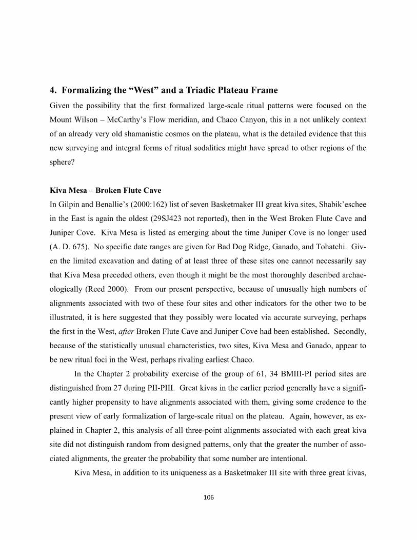
106
4. Formalizing the “West” and a Triadic Plateau Frame
Given the possibility that the first formalized large-scale ritual patterns were focused on the
Mount Wilson – McCarthy’s Flow meridian, and Chaco Canyon, this in a not unlikely context
of an already very old shamanistic cosmos on the plateau, what is the detailed evidence that this
new surveying and integral forms of ritual sodalities might have spread to other regions of the
sphere?
Kiva Mesa – Broken Flute Cave
In Gilpin and Benallie’s (2000:162) list of seven Basketmaker III great kiva sites, Shabik’eschee
in the East is again the oldest (29SJ423 not reported), then in the West Broken Flute Cave and
Juniper Cove. Kiva Mesa is listed as emerging about the time Juniper Cove is no longer used
(A. D. 675). No specific date ranges are given for Bad Dog Ridge, Ganado, and Tohatchi. Giv-
en the limited excavation and dating of at least three of these sites one cannot necessarily say
that Kiva Mesa preceded others, even though it might be the most thoroughly described archae-
ologically (Reed 2000). From our present perspective, because of unusually high numbers of
alignments associated with two of these four sites and other indicators for the other two to be
illustrated, it is here suggested that they possibly were located via accurate surveying, perhaps
the first in the West, after Broken Flute Cave and Juniper Cove had been established. Secondly,
because of the statistically unusual characteristics, two sites, Kiva Mesa and Ganado, appear to
be new ritual foci in the West, perhaps rivaling earliest Chaco.
In the Chapter 2 probability exercise of the group of 61, 34 BMIII-PI period sites are
distinguished from 27 during PII-PIII. Great kivas in the earlier period generally have a signifi-
cantly higher propensity to have alignments associated with them, giving some credence to the
present view of early formalization of large-scale ritual on the plateau. Again, however, as ex-
plained in Chapter 2, this analysis of all three-point alignments associated with each great kiva
site did not distinguish random from designed patterns, only that the greater the number of asso-
ciated alignments, the greater the probability that some number are intentional.
Kiva Mesa, in addition to its uniqueness as a Basketmaker III site with three great kivas,
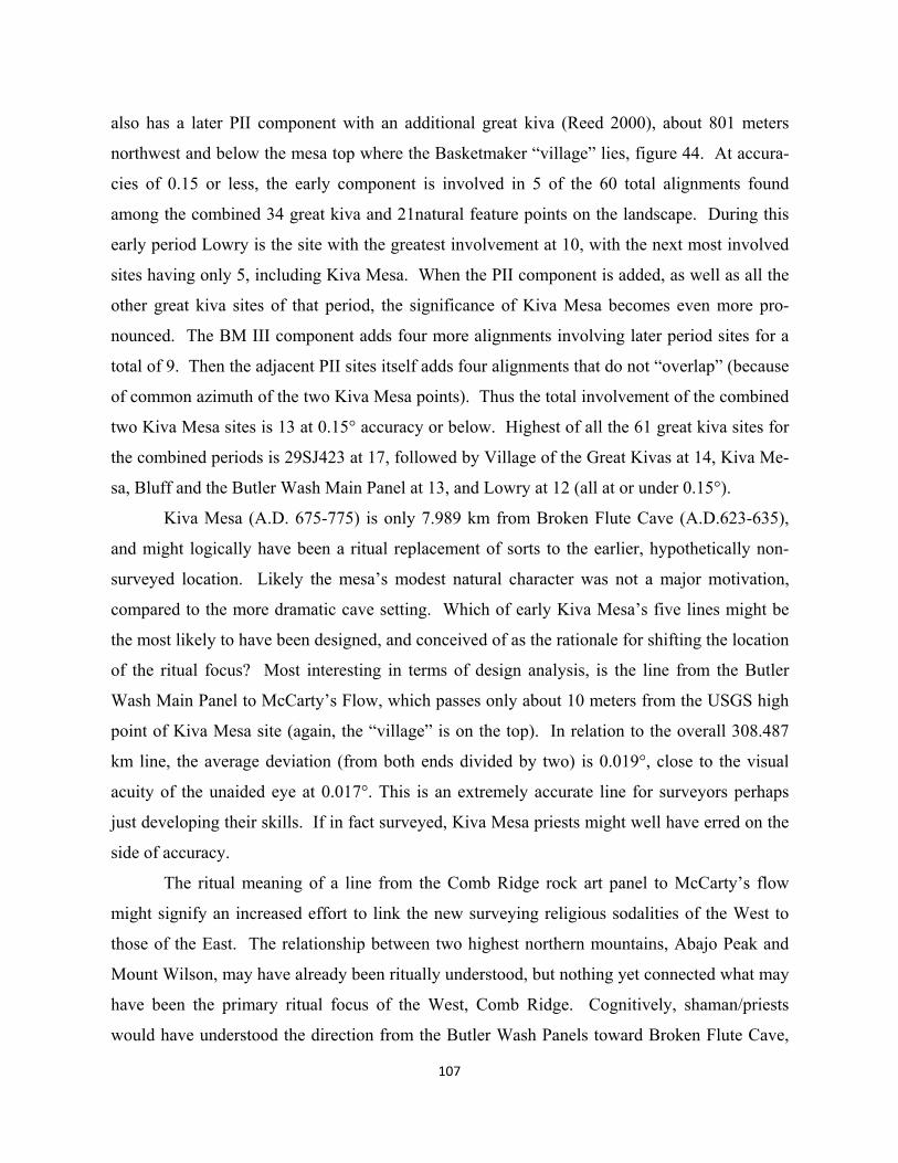
107
also has a later PII component with an additional great kiva (Reed 2000), about 801 meters
northwest and below the mesa top where the Basketmaker “village” lies, figure 44. At accura-
cies of 0.15 or less, the early component is involved in 5 of the 60 total alignments found
among the combined 34 great kiva and 21natural feature points on the landscape. During this
early period Lowry is the site with the greatest involvement at 10, with the next most involved
sites having only 5, including Kiva Mesa. When the PII component is added, as well as all the
other great kiva sites of that period, the significance of Kiva Mesa becomes even more pro-
nounced. The BM III component adds four more alignments involving later period sites for a
total of 9. Then the adjacent PII sites itself adds four alignments that do not “overlap” (because
of common azimuth of the two Kiva Mesa points). Thus the total involvement of the combined
two Kiva Mesa sites is 13 at 0.15° accuracy or below. Highest of all the 61 great kiva sites for
the combined periods is 29SJ423 at 17, followed by Village of the Great Kivas at 14, Kiva Me-
sa, Bluff and the Butler Wash Main Panel at 13, and Lowry at 12 (all at or under 0.15°).
Kiva Mesa (A.D. 675-775) is only 7.989 km from Broken Flute Cave (A.D.623-635),
and might logically have been a ritual replacement of sorts to the earlier, hypothetically non-
surveyed location. Likely the mesa’s modest natural character was not a major motivation,
compared to the more dramatic cave setting. Which of early Kiva Mesa’s five lines might be
the most likely to have been designed, and conceived of as the rationale for shifting the location
of the ritual focus? Most interesting in terms of design analysis, is the line from the Butler
Wash Main Panel to McCarty’s Flow, which passes only about 10 meters from the USGS high
point of Kiva Mesa site (again, the “village” is on the top). In relation to the overall 308.487
km line, the average deviation (from both ends divided by two) is 0.019°, close to the visual
acuity of the unaided eye at 0.017°. This is an extremely accurate line for surveyors perhaps
just developing their skills. If in fact surveyed, Kiva Mesa priests might well have erred on the
side of accuracy.
The ritual meaning of a line from the Comb Ridge rock art panel to McCarty’s flow
might signify an increased effort to link the new surveying religious sodalities of the West to
those of the East. The relationship between two highest northern mountains, Abajo Peak and
Mount Wilson, may have already been ritually understood, but nothing yet connected what may
have been the primary ritual focus of the West, Comb Ridge. Cognitively, shaman/priests
would have understood the direction from the Butler Wash Panels toward Broken Flute Cave,
108
perhaps suggesting the southern pole of the new Mount Wilson meridian, as appropriate termi-
nus. Organizing participants along the way, a surveyed line between the two could have then
discovered the coincidence with the modest Kiva Mesa, only a couple hours walk from Broken
Flute Cave. While this line somewhat mimics the hypothetical Abajo Peak – Mount Taylor in-
tercardinal axis that helps create Kin Bineola X, symbolically it is a much more powerful and
ritually accessible axis, perhaps socio-politically engaging populations in the Red Mesa Valley
and El Malpais lava flows connected to McCarty’s.
109
A second axis from Sipapu: Butler Wash Main Panel - Lowry
Not only is Lowry among the highest of the 61 great kiva sites (with VGK) in terms of involve-
ment in alignments, but it is located very precisely on a prolongation from the Sipapu point
shown in figure 13, through the Butler Wash Main Panel, figure 45. Using the Sipapu point
taken from its USGS quad map and a GPS reading taken at the Butler Wash Main Panel, this
mathematical line comes within about 2 meters of the center of the reconstructed Lowry great
kiva (GPS reading and Google Earth), shown also in figure 44. The average deviation of the
overall line of 299.695 km is 0.0006°. While again this kind of accuracy would not have been
possible, except by error, even with simple techniques that can get close to visual acuity at
0.017°. The azimuth of this line from the Sipapu is 301° 53’ 03.5”, which falls within two de-
grees of summer solstice sunrise at this latitude, suggesting possible additional religiosity.
If this seemingly powerful line from the Grand Canyon and the southern point of Comb
Ridge had been prolonged from the Sipapu up to the Lowry area, what second line, or geomet-
ric consideration could have provided the necessary intersection point? One of Lowry’s 13
(three-point) alignments within the 0.15° range is a line from Abajo Peak to Truchas Peak at the
end of the coincidental Sipapu – Chicoma—Truchas line. The average angular deviation of the
398.839 km Abajo-Truchas line is a modest 0.083°, meaning that it misses the center of Low-
ry’s great kiva by about 138 meters to the northeast. It actually runs between Lowry great kiva
and the North Great House (shown in greater detail later in this chapter) much or all of which
may have been built after the establishment of the Lowry point. Interestingly, given the possi-
ble summer solstice involvement of the Sipapu – Comb Ridge line (now extended to Lowry),
the Abajo-Truchas azimuth, 239° 40’ 48”, is close to the winter solstice sunrise angle, 239° 18’
00” as seen from Abajo Peak (this angle could vary depending upon the height of the sunrise
horizon relative to Abajo Peak). The azimuth to the Lowry great kiva, 239° 32’ 15.8”, is a little
closer. The clearly visible distance between Abajo Peak and Lowry is 55.547 km. Recalling
possible shamanistic observations from Abajo Peak of the equinox sunrise over Mount Wilson,
a winter solstice association to both Lowry and the Eastern pole at Truchas is noteworthy,
though less precise than the hypothetically surveyed line from Sipapu and the Butler Wash
Main Panel.
A pattern to be fully described shortly is Lowry’s location as an emerging largest scale
“Middle” component in the new triadic frame with East (Chaco) and West (Comb Ridge – Aba-
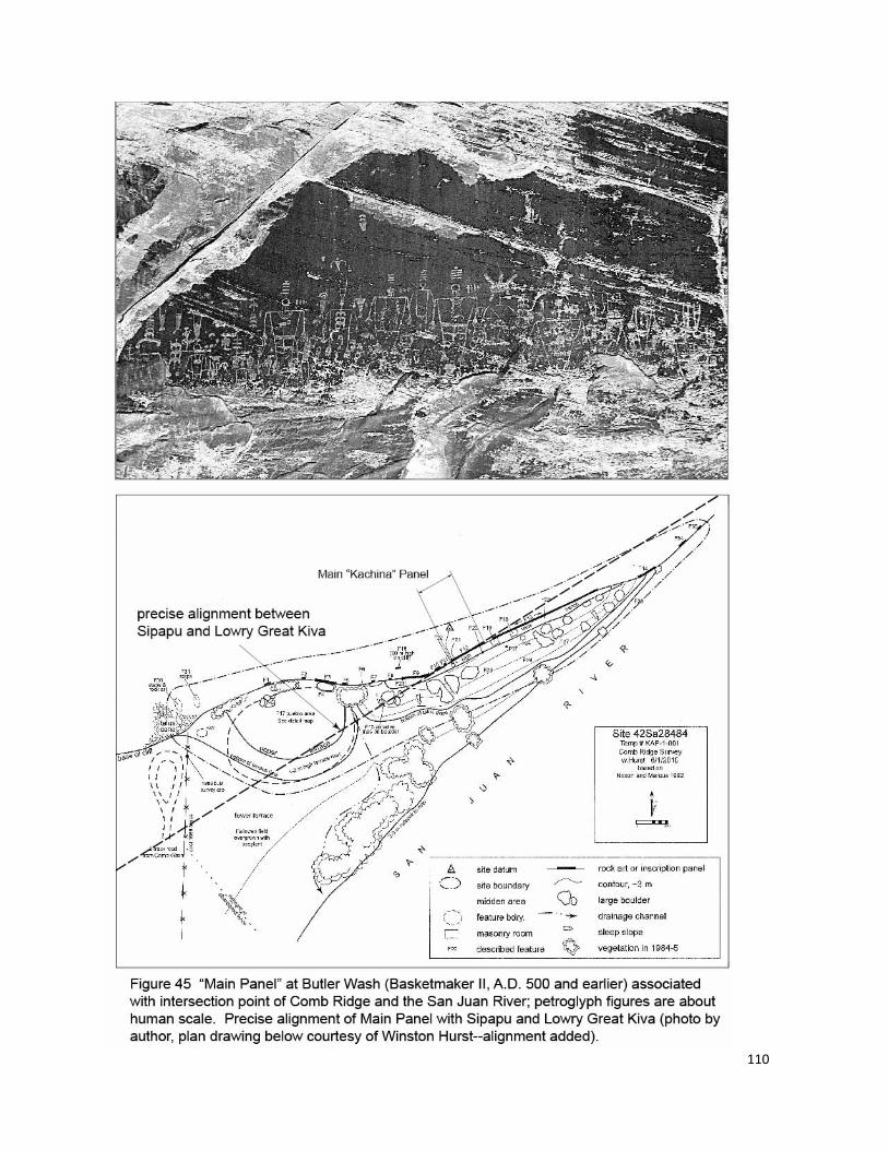
110
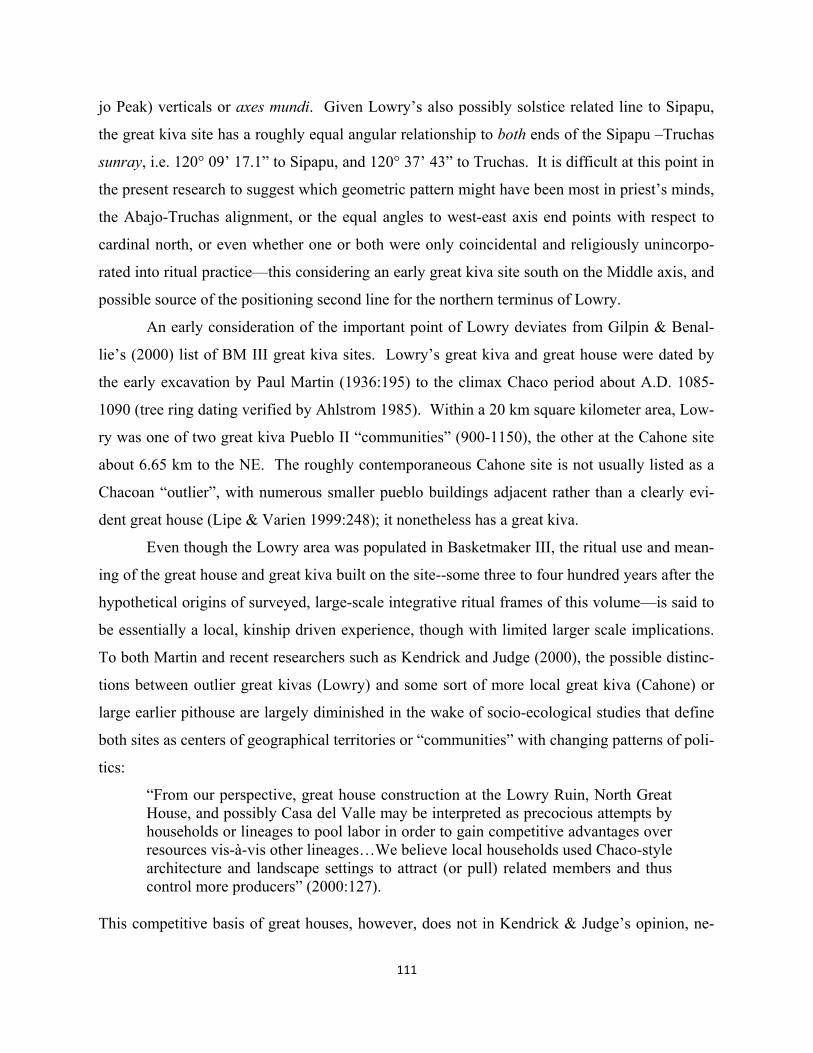
111
jo Peak) verticals or axes mundi. Given Lowry’s also possibly solstice related line to Sipapu,
the great kiva site has a roughly equal angular relationship to both ends of the Sipapu –Truchas
sunray, i.e. 120° 09’ 17.1” to Sipapu, and 120° 37’ 43” to Truchas. It is difficult at this point in
the present research to suggest which geometric pattern might have been most in priest’s minds,
the Abajo-Truchas alignment, or the equal angles to west-east axis end points with respect to
cardinal north, or even whether one or both were only coincidental and religiously unincorpo-
rated into ritual practice—this considering an early great kiva site south on the Middle axis, and
possible source of the positioning second line for the northern terminus of Lowry.
An early consideration of the important point of Lowry deviates from Gilpin & Benal-
lie’s (2000) list of BM III great kiva sites. Lowry’s great kiva and great house were dated by
the early excavation by Paul Martin (1936:195) to the climax Chaco period about A.D. 1085-
1090 (tree ring dating verified by Ahlstrom 1985). Within a 20 km square kilometer area, Low-
ry was one of two great kiva Pueblo II “communities” (900-1150), the other at the Cahone site
about 6.65 km to the NE. The roughly contemporaneous Cahone site is not usually listed as a
Chacoan “outlier”, with numerous smaller pueblo buildings adjacent rather than a clearly evi-
dent great house (Lipe & Varien 1999:248); it nonetheless has a great kiva.
Even though the Lowry area was populated in Basketmaker III, the ritual use and mean-
ing of the great house and great kiva built on the site--some three to four hundred years after the
hypothetical origins of surveyed, large-scale integrative ritual frames of this volume—is said to
be essentially a local, kinship driven experience, though with limited larger scale implications.
To both Martin and recent researchers such as Kendrick and Judge (2000), the possible distinc-
tions between outlier great kivas (Lowry) and some sort of more local great kiva (Cahone) or
large earlier pithouse are largely diminished in the wake of socio-ecological studies that define
both sites as centers of geographical territories or “communities” with changing patterns of poli-
tics:
“From our perspective, great house construction at the Lowry Ruin, North Great House, and possibly Casa del Valle may be interpreted as precocious attempts by households or lineages to pool labor in order to gain competitive advantages over resources vis-à-vis other lineages…We believe local households used Chaco-style architecture and landscape settings to attract (or pull) related members and thus control more producers” (2000:127).
This competitive basis of great houses, however, does not in Kendrick & Judge’s opinion, ne-
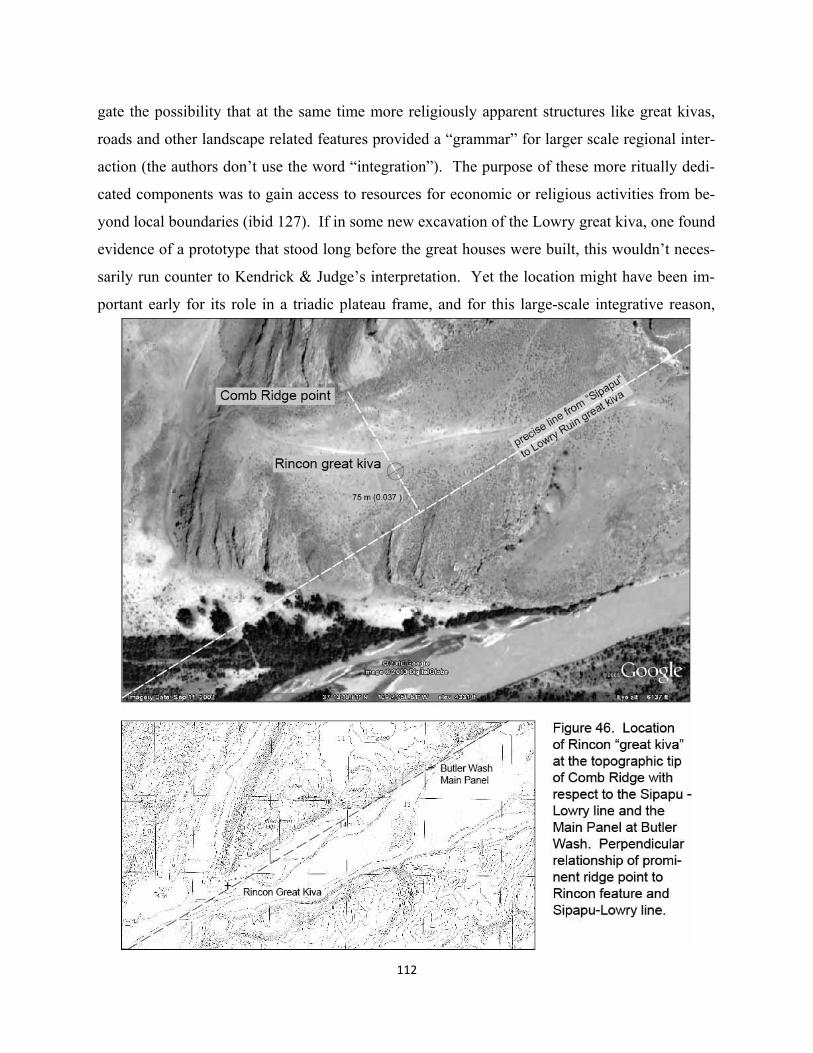
112
gate the possibility that at the same time more religiously apparent structures like great kivas,
roads and other landscape related features provided a “grammar” for larger scale regional inter-
action (the authors don’t use the word “integration”). The purpose of these more ritually dedi-
cated components was to gain access to resources for economic or religious activities from be-
yond local boundaries (ibid 127). If in some new excavation of the Lowry great kiva, one found
evidence of a prototype that stood long before the great houses were built, this wouldn’t neces-
sarily run counter to Kendrick & Judge’s interpretation. Yet the location might have been im-
portant early for its role in a triadic plateau frame, and for this large-scale integrative reason,
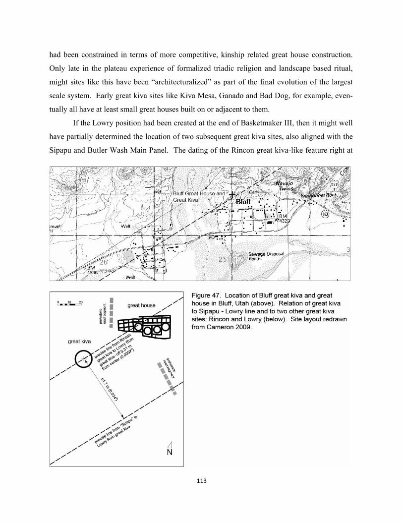
had been constrained in terms of more competitive, kinship related great house construction.
Only late in the plateau experience of formalized triadic religion and landscape based ritual,
might sites like this have been “architecturalized” as part of the final evolution of the largest
scale system. Early great kiva sites like Kiva Mesa, Ganado and Bad Dog, for example, even-
tually all have at least small great houses built on or adjacent to them.
If the Lowry position had been created at the end of Basketmaker III, then it might well
have partially determined the location of two subsequent great kiva sites, also aligned with the
Sipapu and Butler Wash Main Panel. The dating of the Rincon great kiva-like feature right at
113
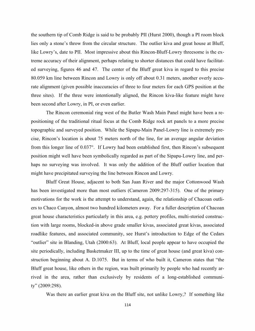
the southern tip of Comb Ridge is said to be probably PII (Hurst 2000), though a PI room block
lies only a stone’s throw from the circular structure. The outlier kiva and great house at Bluff,
like Lowry’s, date to PII. Most impressive about this Rincon-Bluff-Lowry threesome is the ex-
treme accuracy of their alignment, perhaps relating to shorter distances that could have facilitat-
ed surveying, figures 46 and 47. The center of the Bluff great kiva in regard to this precise
80.059 km line between Rincon and Lowry is only off about 0.31 meters, another overly accu-
rate alignment (given possible inaccuracies of three to four meters for each GPS position at the
three sites). If the three were intentionally aligned, the Rincon kiva-like feature might have
been second after Lowry, in PI, or even earlier.
The Rincon ceremonial ring west of the Butler Wash Main Panel might have been a re-
positioning of the traditional ritual focus at the Comb Ridge rock art panels to a more precise
topographic and surveyed position. While the Sipapu-Main Panel-Lowry line is extremely pre-
cise, Rincon’s location is about 75 meters north of the line, for an average angular deviation
from this longer line of 0.037°. If Lowry had been established first, then Rincon’s subsequent
position might well have been symbolically regarded as part of the Sipapu-Lowry line, and per-
haps no surveying was involved. It was only the addition of the Bluff outlier location that
might have precipitated surveying the line between Rincon and Lowry.
Bluff Great House, adjacent to both San Juan River and the major Cottonwood Wash
has been investigated more than most outliers (Cameron 2009:297-315). One of the primary
motivations for the work is the attempt to understand, again, the relationship of Chacoan outli-
ers to Chaco Canyon, almost two hundred kilometers away. For a fuller description of Chacoan
great house characteristics particularly in this area, e.g. pottery profiles, multi-storied construc-
tion with large rooms, blocked-in above grade smaller kivas, associated great kivas, associated
roadlike features, and associated community, see Hurst’s introduction to Edge of the Cedars
“outlier” site in Blanding, Utah (2000:63). At Bluff, local people appear to have occupied the
site periodically, including Basketmaker III, up to the time of great house (and great kiva) con-
struction beginning about A. D.1075. But in terms of who built it, Cameron states that “the
Bluff great house, like others in the region, was built primarily by people who had recently ar-
rived in the area, rather than exclusively by residents of a long-established communi-
ty” (2009:298).
Was there an earlier great kiva on the Bluff site, not unlike Lowry,? If something like
114
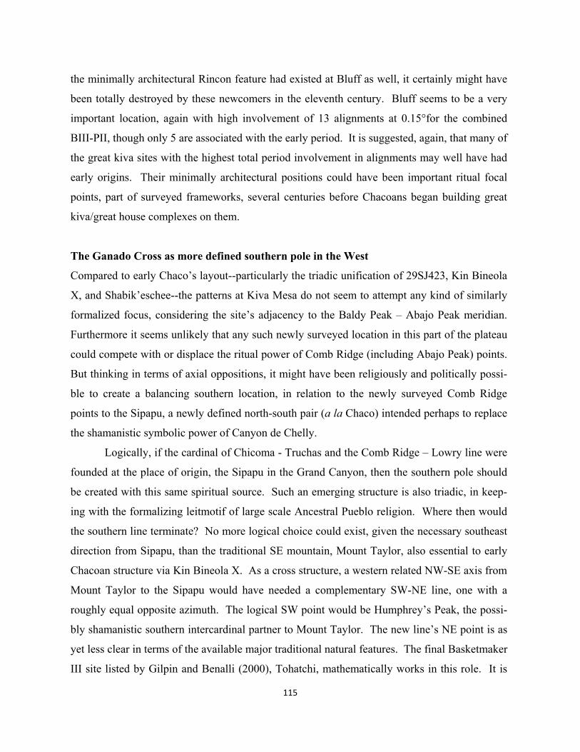
the minimally architectural Rincon feature had existed at Bluff as well, it certainly might have
been totally destroyed by these newcomers in the eleventh century. Bluff seems to be a very
important location, again with high involvement of 13 alignments at 0.15°for the combined
BIII-PII, though only 5 are associated with the early period. It is suggested, again, that many of
the great kiva sites with the highest total period involvement in alignments may well have had
early origins. Their minimally architectural positions could have been important ritual focal
points, part of surveyed frameworks, several centuries before Chacoans began building great
kiva/great house complexes on them.
The Ganado Cross as more defined southern pole in the West
Compared to early Chaco’s layout--particularly the triadic unification of 29SJ423, Kin Bineola
X, and Shabik’eschee--the patterns at Kiva Mesa do not seem to attempt any kind of similarly
formalized focus, considering the site’s adjacency to the Baldy Peak – Abajo Peak meridian.
Furthermore it seems unlikely that any such newly surveyed location in this part of the plateau
could compete with or displace the ritual power of Comb Ridge (including Abajo Peak) points.
But thinking in terms of axial oppositions, it might have been religiously and politically possi-
ble to create a balancing southern location, in relation to the newly surveyed Comb Ridge
points to the Sipapu, a newly defined north-south pair (a la Chaco) intended perhaps to replace
the shamanistic symbolic power of Canyon de Chelly.
Logically, if the cardinal of Chicoma - Truchas and the Comb Ridge – Lowry line were
founded at the place of origin, the Sipapu in the Grand Canyon, then the southern pole should
be created with this same spiritual source. Such an emerging structure is also triadic, in keep-
ing with the formalizing leitmotif of large scale Ancestral Pueblo religion. Where then would
the southern line terminate? No more logical choice could exist, given the necessary southeast
direction from Sipapu, than the traditional SE mountain, Mount Taylor, also essential to early
Chacoan structure via Kin Bineola X. As a cross structure, a western related NW-SE axis from
Mount Taylor to the Sipapu would have needed a complementary SW-NE line, one with a
roughly equal opposite azimuth. The logical SW point would be Humphrey’s Peak, the possi-
bly shamanistic southern intercardinal partner to Mount Taylor. The new line’s NE point is as
yet less clear in terms of the available major traditional natural features. The final Basketmaker
III site listed by Gilpin and Benalli (2000), Tohatchi, mathematically works in this role. It is
115
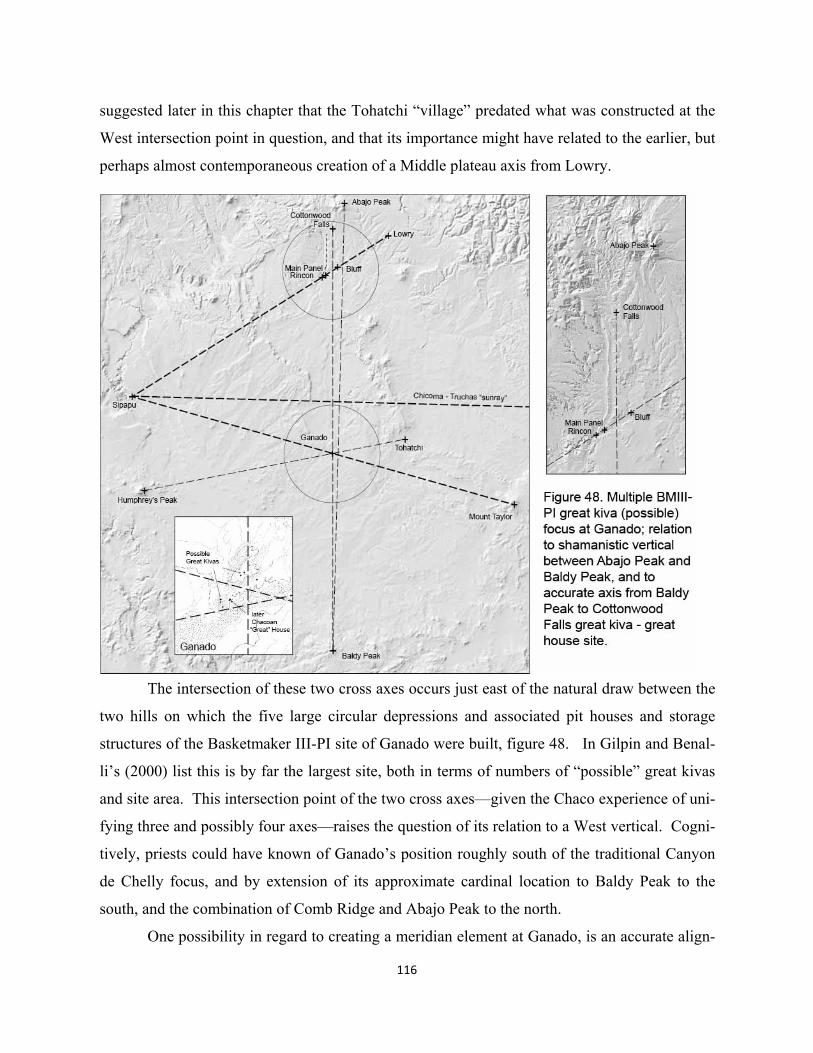
116
suggested later in this chapter that the Tohatchi “village” predated what was constructed at the
West intersection point in question, and that its importance might have related to the earlier, but
perhaps almost contemporaneous creation of a Middle plateau axis from Lowry.
The intersection of these two cross axes occurs just east of the natural draw between the
two hills on which the five large circular depressions and associated pit houses and storage
structures of the Basketmaker III-PI site of Ganado were built, figure 48. In Gilpin and Benal-
li’s (2000) list this is by far the largest site, both in terms of numbers of “possible” great kivas
and site area. This intersection point of the two cross axes—given the Chaco experience of uni-
fying three and possibly four axes—raises the question of its relation to a West vertical. Cogni-
tively, priests could have known of Ganado’s position roughly south of the traditional Canyon
de Chelly focus, and by extension of its approximate cardinal location to Baldy Peak to the
south, and the combination of Comb Ridge and Abajo Peak to the north.
One possibility in regard to creating a meridian element at Ganado, is an accurate align-
117
ment that exists between Baldy Peak, Ganado, and the complex site of Cottonwood Falls, with
its largest great kiva in Southern Utah (Hurst personal conversation) and multiple road seg-
ments. This 407.327 line misses the small Chacoan great house at Ganado by about 194 meters
(0.055°). While Cottonwood Falls has not been extensively excavated, Severance (2004:144)
describes the site as the center of an extensive farming area from PI-PIII, though he believes a
midden on the site is Basketmaker III. Also interesting about the Cottonwood Falls site loca-
tion, besides its accuracy with Ganado and Baldy Peak, is its topographical relation to Comb
Ridge and its San Juan points, and Abajo Peak. As seen in figure 48, Cottonwood Falls lies at
the northern end of the Comb Ridge feature, with a clear view of the Abajo peaks. While there
are many other sites in this area, Cottonwood Falls is apparently one of the most interesting, or
important, not just because of its largest of great kivas, but also large adjacent room block with
possible embedded kivas. Given its accurate cardinal alignment with Ganado and Baldy Peak,
it is not impossible that Cottonwood Falls played a horizontally mediating ritual role between
the two verticals of Comb Ridge (natural feature) and the long (cosmic) line from Abajo Peak
to Baldy Peak. Ganado, for its part would also be Middle, a vertical southern opposition to
northern Cottonwood, with the axis from Sipapu – Truchas in between. Unlike Chaco, howev-
er, with 29SJ423’s association to this west-east naturally coincidental line, there is no site or
other evidence to more clearly suggest similar meaning of the Sipapu – Truchas line to the
mathematical alignment between Baldy Peak – Ganado – Cottonwood Falls.
Did shaman traditionalists continued to use non-formalized Canyon de Chelly focus in
in spite of the new developments at Chaco? Or, did surveyed locations and built sites such as
Ganado and Cottonwood (including Rincon and Bluff) largely displace Canyon de Chelly as a
focus? And in this case what would their relationship have been to Chaco?
A Ship Rock Mediator between West and East
In spite of the obvious eventual ritual power at Chaco during its climax, the earlier developing
frame, possibly responding to a diminished shamanistic meaning of the Abajo Peak-Baldy Peak
meridian, may have been intent upon somehow integrating a West vertical and focus (perhaps
Ganado) with an East vertical (Chaco). Since Ganado (BMIII-PI) was created 100-200 years
after the first great kivas in Chaco the possible initial impetus of that formalization, the Abajo
Peak-Mount Wilson (equinox) cardinal, might well have given way to alternative meanings of
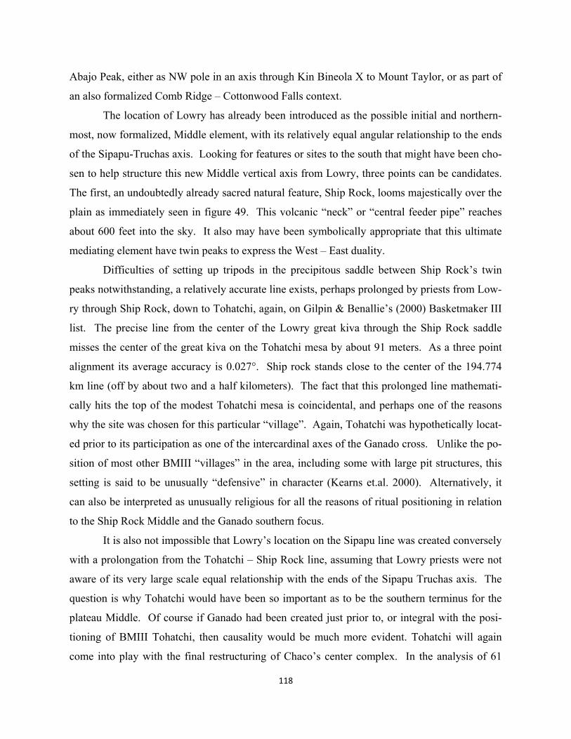
118
Abajo Peak, either as NW pole in an axis through Kin Bineola X to Mount Taylor, or as part of
an also formalized Comb Ridge – Cottonwood Falls context.
The location of Lowry has already been introduced as the possible initial and northern-
most, now formalized, Middle element, with its relatively equal angular relationship to the ends
of the Sipapu-Truchas axis. Looking for features or sites to the south that might have been cho-
sen to help structure this new Middle vertical axis from Lowry, three points can be candidates.
The first, an undoubtedly already sacred natural feature, Ship Rock, looms majestically over the
plain as immediately seen in figure 49. This volcanic “neck” or “central feeder pipe” reaches
about 600 feet into the sky. It also may have been symbolically appropriate that this ultimate
mediating element have twin peaks to express the West – East duality.
Difficulties of setting up tripods in the precipitous saddle between Ship Rock’s twin
peaks notwithstanding, a relatively accurate line exists, perhaps prolonged by priests from Low-
ry through Ship Rock, down to Tohatchi, again, on Gilpin & Benallie’s (2000) Basketmaker III
list. The precise line from the center of the Lowry great kiva through the Ship Rock saddle
misses the center of the great kiva on the Tohatchi mesa by about 91 meters. As a three point
alignment its average accuracy is 0.027°. Ship rock stands close to the center of the 194.774
km line (off by about two and a half kilometers). The fact that this prolonged line mathemati-
cally hits the top of the modest Tohatchi mesa is coincidental, and perhaps one of the reasons
why the site was chosen for this particular “village”. Again, Tohatchi was hypothetically locat-
ed prior to its participation as one of the intercardinal axes of the Ganado cross. Unlike the po-
sition of most other BMIII “villages” in the area, including some with large pit structures, this
setting is said to be unusually “defensive” in character (Kearns et.al. 2000). Alternatively, it
can also be interpreted as unusually religious for all the reasons of ritual positioning in relation
to the Ship Rock Middle and the Ganado southern focus.
It is also not impossible that Lowry’s location on the Sipapu line was created conversely
with a prolongation from the Tohatchi – Ship Rock line, assuming that Lowry priests were not
aware of its very large scale equal relationship with the ends of the Sipapu Truchas axis. The
question is why Tohatchi would have been so important as to be the southern terminus for the
plateau Middle. Of course if Ganado had been created just prior to, or integral with the posi-
tioning of BMIII Tohatchi, then causality would be much more evident. Tohatchi will again
come into play with the final restructuring of Chaco’s center complex. In the analysis of 61
119
120
great kiva sites in context with 21 natural features, Chapter 2, Tohatchi is in the middle range of
involvements, with 8.
Later Lowry and Village of the Great Kivas: an introduction to major changes in Chaco
“There seems to be a conspicuous absence of formal great kivas in Chaco until about A. D.
1050” (Windes, et. al. 2000:45). While it may be that Windes & Wills (1989) do not include
Shabik’eschee’s and 29SJ423’s great kivas some five hundred years earlier as part and parcel
to any kind of large-scale ritual definition of Chaco (“formal great kivas”), nevertheless, a clear
hiatus of these major ceremonial foci existed at least up until two great kivas were added in the
late 800’s A.D. at the very beginning of major Chaco formalization (to be discussed in the next
chapter). During this hiatus, perhaps, the rest of the plateau was being formally integrated into
something of a whole—hypothetically a principal motivation for and ritual motif of the creation
of Chaco as major pilgrimage center. Part of this eventual expression also took place at other
locations on the plateau some distance from Chaco.
The “outlier” site of Village of the Great Kivas is actually dated about 35 years before
the first classic great kiva in Chaco, about 1015. We will also see that at this time in the can-
yon, it is possible that the first formalized great house is being built with oriented, large monu-
mental walls, and a triadic plan of central and wing room blocks. The relatively early dating of
the Village of the Great Kivas (VGK) comes from its two great houses and the northern of two
great kivas (Roberts 1932:156). Very few great kivas have been tree ring dated because of the
lack of roof structure; most, like the northern one excavated at VGK, are assumed to be contem-
poraneous with the dates of adjacent great houses. The larger, southern great kiva was not exca-
vated and perhaps if less formalized in architectural character, might be earlier. While this vol-
ume argues that Lowry was located in Basketmaker III, in relation to its Sipapu and Ship Rock
lines, VGK and the later 11th century construction at Lowry might have been conceived as an
expression of Middle axis strength during classic Chaco.
Roberts’ view of this remote site at least fifty kilometers from any contemporaneous or
later great kiva/great house site (see map in Warburton and Graves 1992:52-3) is clearly intru-
sive. He writes that, “there are no indications in this immediate vicinity of an earlier group.
Hence the conclusion that the builders must have come from the north and brought their archi-
tectural practices with them.” (Roberts 1932:157). This could have been the case for an earlier
121
singular great kiva as well. By “north” Roberts means Chaco Canyon, yet only six years later
Paul Martin excavates Lowry Ruin located more geographically to the north. At this site tree
ring dates for the great kiva exist, but are substantially later than those at VGK, i.e. around
A.D. 1085 – 1090 (Martin1936:195).
What is it then that pairs up classic period Lowry with VGK, perhaps replacing earlier
Tohatchi as the southern pole of the Middle? First of all, again in terms of the analysis of 61
great kiva sites and 21 natural features, VGK has a second high number of 0.15° involvements
in three point alignments, at 14 (Lowry has 12), strongly suggesting that at least some of them
were designed. Two stand out as most analytically interesting. Mathematically, as a Middle
prolongation from Ship Rock and Tohatchi, the VGK site forms a relatively accurate 0.068°
three point alignment, or if prolonged from Lowry and Ship Rock, an alignment of 0.056°.
The second intersecting line which might have locked in VGK’s position on the Middle axis is
the Baldy Peak – Kin Bineola – Chimney Rock axis which was hypothesized as one of the in-
tercardinal axes of the first Chaco layout and Kin Bineola X, figure 49 again. This line from
the benchmark on the top of Baldy Peak to the center of the PII great kiva at Kin Bineola
(adjacent to the great house) misses a center point between VGK’s two great kivas by about 5
meters, an overly accurate line of 0.002°. The outer walls of the two great kivas are about 30
meters apart. If the Kin Bineola great house/great kiva point had existed from about late PI,
early PII (with Kin Bineola X being much earlier), it would not have been necessary to resur-
vey the entire line to Chimney Rock, just perhaps the southern leg on which VGK is located.
Thus the Baldy Peak – VGK – Chimney Rock axis is less accurate, though at 0.062°, in the
lower half of the 0.15° total range considered in the analysis of Chapter 2.
In many respects, i.e. formalized multi-point and cardinal alignments, and building ori-
entations, the site geometries of Lowry and VGK reveal similarities to the north-south pair of
great houses on the north and south rims of Chaco Canyon, Pueblo Alto and Tsin Kletsin
(though neither have great kivas). This most widely recognized example of formal symbolic
landscape integration between two Ancestral Pueblo sites, about 3.754 km apart, may have
been laid out in the early 11th century, about the time VGK’s relationship to Lowry was estab-
lished. Following chapters detail the meaning of the Alto-Tsin Kletsin pair as intimately inter-
twined with the meaning of the ultimate Chaco frame, and in doing so may clarify why similar
knowledge and resources were put into the physical settings of Lowry and VGK, also related to
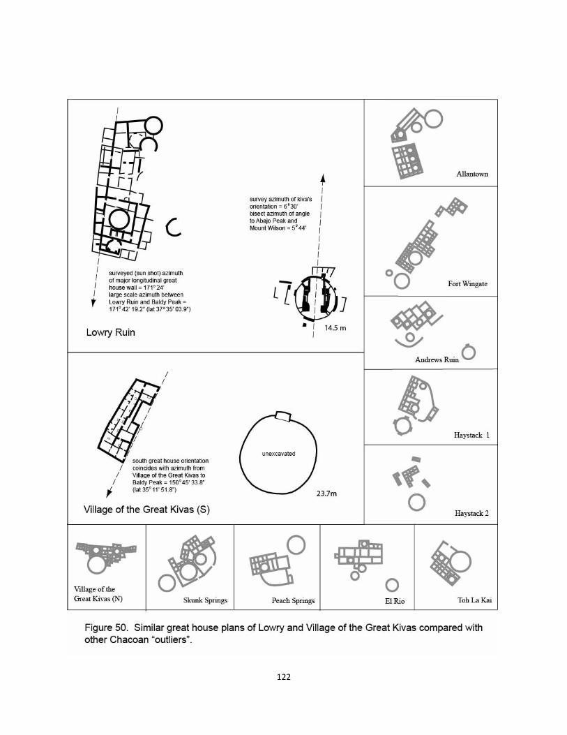
122
Middle expression, though at the plateau scale.
When working on the first version of a Ship Rock axis mundi idea (Doxtater 2003), the
author kept mistaking the loose zerox sheet of the Lowry great house plan with that of the sec-
ond or southern great house at VGK. For a licensed architect and studio instructor of many
years’ experience, this similarity of plan layout became the first of several evidentiary pieces
pointing to a designed, probable ritual relationship between the two outliers aligned to each oth-
er via Ship Rock (and Tohatchi). Plans of other outliers, provided as well in figure 50, are so
comparatively varied in their building geometries and site relationships with adjacent great ki-
vas, that the relatively cohesive plan, similarly angled walls, and location of apparent entry are-
as of Lowry and VGK (S) must have been intentionally designed as a pair.
The 2003 article, however, failed to investigate the orientation of these two buildings,
particularly in respect to the first formal straight walls possibly symbolically oriented to aspects
of large scale frameworks being laid out in Chaco. Current work took new GPS positions at the
centers of the two great kivas at VGK to verify accurate building and site orientation. An abso-
lutely precise determination of center points is not possible without site intervention, however,
because the north kiva was backfilled after excavation as were test areas of the unexcavated
southern kiva.
According to the best present establishment of site orientation, as seen in figure 51, the
major building orientation of the southern VGK great house very accurately mimics the align-
ment from VGK (center of the north kiva) to Mount Baldy. Once the archaeological site was
correctly oriented in Adobe Illustrator, a dotted line was oriented the same as the azimuth to
Mount Baldy (Chimney Rock) and moved to the building plan; it aligns very cleanly with the
two corner points of the great house east wall. What then about the Lowry great house built
some seventy years later? The author had twenty or so years ago taken theodolite sun shots to
determine the orientation of about forty Chacoan outlier great houses (together with those in the
canyon). The measurement at Lowry read about 171° 24”. If Lowry was a larger scale copy of
VGK(S), and religiously needed to be oriented to a large scale alignment, it would have been
logical for the Lowry great house to mimic its southern analogue. The azimuth from Lowry at
its higher latitude to Mount Baldy is 171° 42’ 19.2”. If this is a symbolic, designed feature, its
establishment would have required a surveyed line from Lowry to Mount Baldy, perhaps as part
of a pre-construction consecration.
123
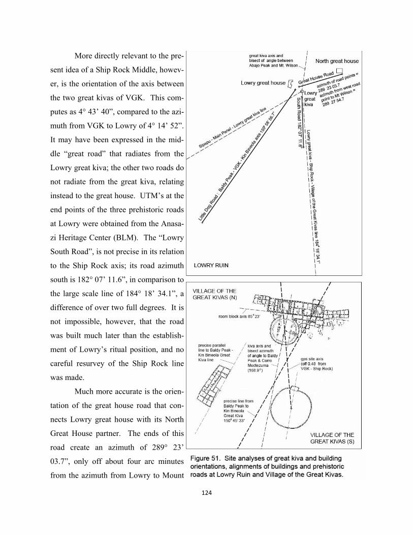
124
More directly relevant to the pre-
sent idea of a Ship Rock Middle, howev-
er, is the orientation of the axis between
the two great kivas of VGK. This com-
putes as 4° 43’ 40”, compared to the azi-
muth from VGK to Lowry of 4° 14’ 52”.
It may have been expressed in the mid-
dle “great road” that radiates from the
Lowry great kiva; the other two roads do
not radiate from the great kiva, relating
instead to the great house. UTM’s at the
end points of the three prehistoric roads
at Lowry were obtained from the Anasa-
zi Heritage Center (BLM). The “Lowry
South Road”, is not precise in its relation
to the Ship Rock axis; its road azimuth
south is 182° 07’ 11.6”, in comparison to
the large scale line of 184° 18’ 34.1”, a
difference of over two full degrees. It is
not impossible, however, that the road
was built much later than the establish-
ment of Lowry’s ritual position, and no
careful resurvey of the Ship Rock line
was made.
Much more accurate is the orien-
tation of the great house road that con-
nects Lowry great house with its North
Great House partner. The ends of this
road create an azimuth of 289° 23’
03.7”, only off about four arc minutes
from the azimuth from Lowry to Mount
Wilson at 289° 27’ 54.7”. If the Chacoan influenced priests at Lowry were intent on associating
the northern pole of the Ship Rock axis with the northern pole of the Mount Wilson (Chacoan)
meridian, then one would expect this kind of accuracy given the good direct visibility of the
peak 86.627 km away.
The third linear feature, “Little Dog Road”, more associated with the Lowry great house
itself, has an azimuth of 150° 58’ 56.7”. Curiously enough, this road closely mimics the align-
ment of the great house’s prototype at VGK to Mount Baldy, i.e. 150° 45’ 33.8”. If this is an
intentional design feature, the priests at Lowry would have felt so strongly about VGK’s rela-
tionship to the Mount Baldy-Kin Bineola -Chimney Rock axis that they expressed the orienta-
tions from both latitudes. VGK’s position on the Baldy Peak – Chimney Rock axis makes most
sense during earlier Basketmaker III (PI?) as the framework becomes integrated at its largest
scale. While the classic period construction at VGK (and Lowry) pays homage to the old Kin
Bineola X line and particularly the West (southern) pole at Baldy Peak, it also provides a some-
what startling indication of a radical extension of scale in the ultimate Chaco layout, particularly
in an extended final location of the southern pole of the Mount Wilson meridian. This perspec-
tive became clearer after first investigating the orientation of the great kiva at Lowry. Relying
on a professional survey of the orientation of the exposed (restored) central pillars of the Lowry
ceremonial structure, it was determined that its central azimuth, 6° 31’ 59” is within a degree of
the bisect of the angle from the kiva center to Abajo Peak and Mount Wilson, 5° 49’ 18”.
In reanalyzing site orientations for VGK, the question loomed whether the great kiva
(N) at the southern pole of the Ship Rock axis as well might express a bisect. The angles, how-
ever, from the kiva’s central axis to Baldy Peak and McCarty’s Flow, are many degrees off
from being possibly designed. But, as we will see in following chapters, the ultimate southern
extension of the Mount Wilson meridian runs to Cerro Moctezuma, clearly visible west of
Paquimé (Casas Grandes, Mexico). As seen in figure 52, the graphically determined axis of
VGK’s north great kiva (from Robert’s correctly oriented drawings) is an azimuth south of
about 168.9°, while the bisect of the angle from the center of the north VGK great kiva, to
Baldy Peak and Cerro Moctezuma, is 168° 55’ 43”.
The dating of VGK’s northern and probably youngest great kiva is important here.
Could its orientation be one of the key clues to when the extension of the Mount Wilson meridi-
an to Cerro Moctezuma took place? It will be suggested that the ultimate Chaco framework,
125
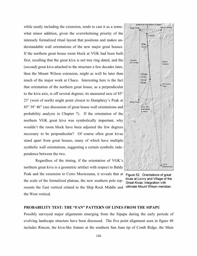
126
while neatly including the extension, tends to cast it as a some-
what minor addition, given the overwhelming priority of the
intensely formalized ritual layout that positions and makes un-
derstandable wall orientations of the new major great houses.
If the northern great house room block at VGK had been built
first, recalling that the great kiva is not tree ring dated, and the
(second) great kiva attached to the structure a few decades later,
then the Mount Wilson extension, might as well be later than
much of the major work at Chaco. Interesting here is the fact
that orientation of the northern great house, as a perpendicular
to the kiva axis, is off several degrees; its measured axis of 85°
23’ (west of north) might point closest to Humphrey’s Peak at
85° 39’ 46” (see discussion of great house wall orientations and
probability analysis in Chapter 7). If the orientation of the
northern VGK great kiva was symbolically important, why
wouldn’t the room block have been adjusted the few degrees
necessary to be perpendicular? Of course often great kivas
stand apart from great houses, many of which have multiple
symbolic wall orientations, suggesting a certain symbolic inde-
pendence between the two.
Regardless of the timing, if the orientation of VGK’s
northern great kiva is a geometric artifact with respect to Baldy
Peak and the extension to Cerro Moctezuma, it reveals that at
the scale of the formalized plateau, the new southern pole rep-
resents the East vertical related to the Ship Rock Middle and
the West vertical.
PROBABILITY TEST: THE “FAN” PATTERN OF LINES FROM THE SIPAPU
Possibly surveyed major alignments emerging from the Sipapu during the early periods of
evolving landscape structure have been discussed. The five point alignment seen in figure 48
includes Rincon, the kiva-like feature at the southern San Juan tip of Comb Ridge, the Main
127
Panel at Butler Wash, one of the most remarkable rock art sites in the SW, the Bluff great kiva,
and Lowry Ruin, located at the northern terminus of the four-point plateau Middle Axis running
south through Ship Rock, Tohatchi and Village of the Great Kivas. Lowry is also about mid-
way between the two ends of the plateau’s only naturally coincidental three-point alignment,
the coincidental alignment from the Sipapu to Chicoma and Truchas Peak. Also prominent and
quite accurate is a line from the Sipapu to Mount Taylor that possibly helped locate the early
western focus at Ganado.
Later in the Chaco build out, other lines from the Sipapu may also have been religiously
important in providing important emergence symbolism. One such line involves the layout of a
central Chaco “X” intersection point, via a construct through Kin Bineola X and Pueblo Pinta-
do, while another may have been part of locating the New Alto/Pueblo Alto pilgrimage entry to
the canyon. A tenth line running through early Broken Flute Cave to the Aztec center is also
quite accurate but could not have been, as we will see in later chapters, a primary determination
of Aztec’s important location on the Wilson meridian. An eleventh line through the South
Road’s termination site of Kin Ya’a and Guadalupe far to the east adjacent to Cabezon, can also
be included in this group of quite accurate Sipapu radiations. As listed below, four more align-
ments under 0.15° are much less accurate and might be first candidates, perhaps along with
Broken Flute Cave – Aztec, to be considered random—though again random alignments can be
quite accurate as well.
Five point alignment: Sipapu – Main Panel – Lowry 0.0006° Sipapu – Rincon – Lowry 0.037° Sipapu – Rincon – Bluff 0.036° Sipapu – Bluff – Lowry 0.035° Rincon – Bluff – Lowry 0.0007°
Other Sipapu lines under 0.04° included in test
Sipapu – Chicoma – Truchas 0.019° Sipapu – Kin Ya’a – Guadalupe 0.021° Sipapu – Broken Flute – Aztec 0.026° Sipapu – Ganado – Taylor 0.039°
128
Additional Sipapu lines up to 0.150°
Sipapu – Kin Bineola X – Pueblo Pintado 0.016° Sipapu – White House – New Alto 0.050° Sipapu – White House – 29SJ423 0.080° Sipapu – Tohatchi – Cabezon 0.101° Sipapu – Coolidge – Casamero 0.109° Sipapu – Los Rayos – Cabezon 0.140°
Returning to the analysis methodology of Chapter 2, one can set up a test box again
placing 61 random points in each set. Moctezuma is excluded for the same reason described
more specifically in the Mount Wilson meridian exercise (previous chapter), working with 20
fixed natural features. The test area covering all of the existing great kiva sites on the plateau
seems to work well with the goal of finding random “fans” of alignments radiating out from the
Sipapu. In the existing set of sites, the five-point alignment from the Sipapu can be modeled as
A+A(2)+A(3)+A(3)+A(2), and is the only such compound pattern that occurs when the exist-
ing set is searched in “site analysis”. The ten additional three point alignments that also use the
Sipapu point in the west at or under 0.15° cannot be simply added to this search string. Adding
another “A(1)” with only one point in common with the compound creates an endless set of
such connections working from the other four points of the Sipapu – Lowry line. In the early
stages of defining the specifications for Geopatterns 3, the ability to have additional patterns to
the search string limited to a single “fan” point, such as Sipapu was discussed. Because of con-
struction time and money, this feature was eventually dropped. There is in the present case,
however, a strategy that produces good numbers and isn’t too time consuming to run.
If one tests A+(A(2)+A(3)+A(3)+A(2) separately, its involvement with the Sipapu is
relatively rare and immediately limits the numbers of test sets that need to be examined more or
less manually for additional lines to the Sipapu. The additional rays to Sipapu, outside of the
five-point search string, can be recorded by inspecting a single search string of “A’s” that is
simultaneously reported for each of the same random sets. Because most of the interesting ex-
isting Sipapu lines are much more accurate than the 0.15° or even 0.075° range, one can use the
lower number of 0.04° in the analysis. Of the total existing 15 in the 0.15° range, ten are under
0.04°. Because the test only works with great kiva locations, the very accurate line involving
the Kin Bineola X line is not included; four from the range of 0.080° - 0.14° are also excluded.
129
This in no way biases the process, since the random points are competing in the same range.
Thus we are looking to match the existing five-point alignment and four additional rays to the
Sipapu, all under 0.04°.
In 10,000 sets of 61 random points each, the stated five-point pattern occurs about two
or three times in a hundred (0.025). Of these 247 five-point alignments, about a fifth (57) are
formed with Sipapu as their westernmost point (0.0051). Thus randomly produced Sipapu five-
pointers occur about once every 200 sets (0.005). As one might imagine, the naturally occur-
ring three-pointer between Sipapu-Chicoma-Truchas will more frequently become a five-
pointer, needing to add only two, compared to three (Sipapu with some other natural feature) or
even four aligned random points (with no additional natural feature). Forty-seven of the 247
(of 10,000 sets) five-pointers have no natural features at all. Of the 57 Sipapu five-pointers, 51
are formed with the help of Chicoma and Truchas. Two of the 57 link up with Mount Taylor or
McCarty’s Flow respectively, not unlike the existing’s use of the natural (Rincon) point of
Comb Ridge, and four work only with the Sipapu. The existing set has 8 total three-point align-
ments coming from Sipapu (not including Rincon-Bluff-Lowry which is part of the five-
pointer). The chart below summarizes these data:
10,000 sets of 61 random points each with 20 fixed natural features 247 sets contain a five-point alignment at or under 0.04°
57 of the 247 involve the Sipapu 51 of these five-pointers were formed on Sipapu-Chicoma-Truchas
3 of these equal or exceed the total number (8) of existing three-point alignments to the Sipapu (2,656 has 9, 4,201 and 8,416 have 8 each) 6 of the 247 Sipapu five-pointers do not include Chicoma/Truchas
2 hook up with Mount Taylor (7 three-point alignments total) and McCarty’s Flow respectively (6 total) 4 use Sipapu only in their five-pointers (#7,712 equals the existing total of 8 three-point alignments, the others having 5, 5 and 4)
Only one set of 10,000 exceeds the total number of existing Sipapu three-point alignments.
This is set number 2,656, with 9 total, which along with random sets 4,201 and 8,416, each with
8 total Sipapu lines, match or exceed the existing. But the five-pointers of these sets are created
with Chicoma-Truchas, seeming to diminish the match comparison. Looking at those six sets
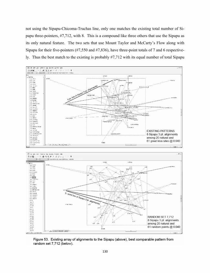
130
not using the Sipapu-Chicoma-Truchas line, only one matches the existing total number of Si-
papu three-pointers, #7,712, with 8. This is a compound like three others that use the Sipapu as
its only natural feature. The two sets that use Mount Taylor and McCarty’s Flow along with
Sipapu for their five-pointers (#7,550 and #7,836), have three-point totals of 7 and 6 respective-
ly. Thus the best match to the existing is probably #7,712 with its equal number of total Sipapu
131
three-point lines, perhaps a greater comparative consideration than using a second natural fea-
ture since there is less likelihood of pairing (2 of 10,000) up than lining up only with Sipapu (4
of 10,000).
The odds that the existing eight three-point alignments at or under 0.040° to the Si-
papu—four of which are part of a five-point alignment—are randomly located with respect to
possible designed large scale geometry appears to lie somewhere around 1 in 10,000
(considering set 7,712 as the only best match) and 2 in 10,000 (including the Chicoma-Truchas
set #2,656 with its 9 total three pointers). As figure 53 illustrates, random patterns similar to
the existing do occur, though very rarely. In this case of #7,712, Sipapu’s five-pointer runs at
the bottom of its “fan” to random points 45, 23, 30, and 46. It has four other lines terminating
at Blanca Peak, Truchas Peak, random point 25 (Haystack is the interim point) and random
point 11 (Taylor is the interim point). The existing Sipapu pattern involves four additional nat-
ural sites (Rincon, Chicoma-Truchas, and Mount Taylor), while set #7,712 involves five
(Blanca, Chicoma-Truchas, Haystack and Taylor) and might be considered a bit stronger con-
sidering symbolic religious content. But #7,712’s five-pointer has no other natural features,
compared to the existing Sipapu line through Rincon as the southern natural tip of Comb
Ridge; nor is #7,712 possibly solstice in orientation. The terminal points of the two compared
five-pointers of figure 53, most likely symbolically important, show somewhat greater strength
for the existing. Lowey has 9 three point alignments, while random point 46 has 7. Overall, as
a random set, #7,712 isn’t particularly high in total number of three-point alignments. It has
only 48 compared with the existing 69 (at or under 0.040°).
When added together, the very low likelihood of being a random set together with the
symbolic value of Comb Ridge, the Butler Panel, Lowry and Ganado, seem to create a modest
hypothesis of some sort of symbolic emergence symbolism for the Sipapu “fan”—not yet in-
cluding the importance of other lines from this Grand Canyon point to be profiled in coming
chapters.
5. “East” Communities and Integration with the Triadic Chaco Focus
Again, the clan-ceremony-sodality-kiva complex may be very old, dating to the Basketmaker
III – Pueblo I transition around A.D. 700 (Ware 2002). Furthermore, according to archaeolo-
gists, it wasn’t until the advent of “villages” that this need for integration arose. Architecture
and other material evidence is quite similar to both western and eastern organization until A.D.
700; and it is with the new village forms shortly after that sodalities are felt to emerge. Given
the present hypothesis that sodalities first formed earlier at Chaco in the 500’s, based on a more
purely spatial concept of ritual organization, the bipolar landscape axis, how does one interpret
the variations of village aggregation and religious structures that occur at the end of Basket-
maker III and into PI?
The PI period saw much movement and exploration of new settlement forms, people
with different backgrounds moving into aggregated “villages”. These new “villages” represent
significant social change and necessitated high-level integrative facilities (Adler & Wilshusen
1990:143). More recently Wilshusen and Potter (2010:170) see “villages” as a means of
providing safety in numbers, but also a means of social and religious integration:
“Village settings also provide a means to socially integrate ethnically or histori-cally diverse populations and diffuse or even suppress group differ-ences….Whereas the direct ties of blood, marriage, or residence might have suf-ficed to establish an individual’s or household’s identity in a dispersed commu-nity, it is more common to see more-complex organizational forms, such as dual organizations or clans, in settings that are more aggregated or highly populated (Gross 1979; Tuzin 2001). While clans and dual organizations often are imbued with kinship associations and may regulate marriage, they are fundamentally not tied to a particular set of blood ties or local connections….They are the means of creating regional linkages and ways of wresting corporate control of resources out of localized lineages or kin groups.”
In terms of landscape and architecture, there are two kinds of “villages”, one more hierarchical
and kinship oriented with oversized pit structures of prominent families with adjacent room
blocks built from the excavated soil, and the other with a more isolated great kiva structure
seemingly owned by the community (Wilshusen & Potter 2010:176). To Ware this split would
132
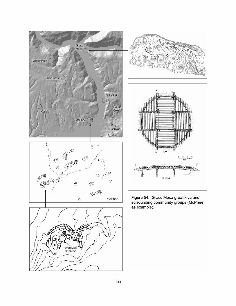
133
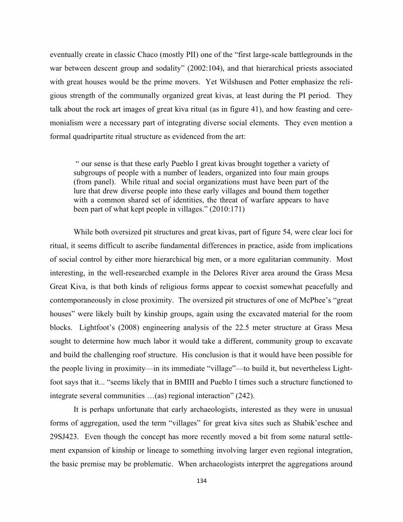
134
eventually create in classic Chaco (mostly PII) one of the “first large-scale battlegrounds in the
war between descent group and sodality” (2002:104), and that hierarchical priests associated
with great houses would be the prime movers. Yet Wilshusen and Potter emphasize the reli-
gious strength of the communally organized great kivas, at least during the PI period. They
talk about the rock art images of great kiva ritual (as in figure 41), and how feasting and cere-
monialism were a necessary part of integrating diverse social elements. They even mention a
formal quadripartite ritual structure as evidenced from the art:
“ our sense is that these early Pueblo I great kivas brought together a variety of subgroups of people with a number of leaders, organized into four main groups (from panel). While ritual and social organizations must have been part of the lure that drew diverse people into these early villages and bound them together with a common shared set of identities, the threat of warfare appears to have been part of what kept people in villages.” (2010:171)
While both oversized pit structures and great kivas, part of figure 54, were clear loci for
ritual, it seems difficult to ascribe fundamental differences in practice, aside from implications
of social control by either more hierarchical big men, or a more egalitarian community. Most
interesting, in the well-researched example in the Delores River area around the Grass Mesa
Great Kiva, is that both kinds of religious forms appear to coexist somewhat peacefully and
contemporaneously in close proximity. The oversized pit structures of one of McPhee’s “great
houses” were likely built by kinship groups, again using the excavated material for the room
blocks. Lightfoot’s (2008) engineering analysis of the 22.5 meter structure at Grass Mesa
sought to determine how much labor it would take a different, community group to excavate
and build the challenging roof structure. His conclusion is that it would have been possible for
the people living in proximity—in its immediate “village”—to build it, but nevertheless Light-
foot says that it... “seems likely that in BMIII and Pueblo I times such a structure functioned to
integrate several communities …(as) regional interaction” (242).
It is perhaps unfortunate that early archaeologists, interested as they were in unusual
forms of aggregation, used the term “villages” for great kiva sites such as Shabik’eschee and
29SJ423. Even though the concept has more recently moved a bit from some natural settle-
ment expansion of kinship or lineage to something involving larger even regional integration,
the basic premise may be problematic. When archaeologists interpret the aggregations around
the Grass Mesa great kiva, even though admitting a larger integrative purpose, the thinking be-
gins with aggregation and not integration. The idea of a dangerous landscape and the need to
cluster together for safety appears to be the primary motive to aggregate. This happens first,
and then because of the diversity of people that have moved into the area from a distance, facili-
ties like great kivas are eventually created to moderate the more natural hierarchies of kinship
and their great house like dwelling patterns (room blocks and pit houses). Curiously, this only
happens within particular villages, not unlike those in earliest Chaco.
From the perspective of a possible formally evolving religious landscape the concept of
“village” doesn’t really seem to adequately characterize either new aggregated domestic pat-
terns, or the great kiva foci. The author’s master’s thesis in socio-cultural anthropology
(Doxtater 1971) described commonalities in the architectural and settlement patterns of small
village-like societies in the anthropological record. Having also done later work on pueblos in
Spain (Doxtater 1989), it seems in retrospect that the concept of “village” really suggests a so-
cial situation where the strongest glue, as it were, is simple propinquity, a term used more than
once in Pitt-Rivers (1971). In cross-cultural studies of small spatial “aggregations” of the mas-
ter’s thesis, there is almost always an unmistakable formality in the arrangement of dwellings,
one undoubtedly integral to some sort of ritual practice. Even in the Spanish pueblo, where
assumptions of propinquity and safety were certainly at least partially true, at least originally, a
deeper semiotic interpretation of pueblo form revealed a set of practices and related spaces that
structured a kind of “local” ritual, spiritually effective but not founded on distant mountains and
other natural features, yet with structural remnants of such (see a wider discussion in Doxtater
1994).
When Basketmaker groups shift from dispersed hamlets of two or three pit-houses to
aggregations of up to several hundred, the propinquity assumption and its associated concept of
“village” has always been the logical cause. Yet compared to very tightly clustered, defensive
settlements, Basketmaker or PI aggregations really do not exhibit this kind of protective territo-
riality, nor really the closeness or propinquity that Pitt-Rivers felt to be more of an internal so-
cial organizing effect. What has been missing in the Southwest pueblo evolution is an under-
standing of where the religious, ritual structure exists, and its relationship to dwelling and great
kiva form. Most likely the greatest source of religious power in pit-house periods is in the
shamanistic landscape. Furthermore, it makes sense that during this period hamlets are dis-
135
136
persed, alleviating the potential conflict of formalized small scale settlements, which again
from a theoretical perspective, are practically universal when people without large-scale land-
scape frameworks live closely together.
So why isn’t this a problem when Ancestral Pueblo people first aggregated to some ex-
tent? First of all, even though people are living closer to each other, as illustrated in figure 54,
the basic architectural pattern is still essentially one of dispersed family units. Architecturally,
there is no village as such. Thus the transition from shamanistic landscape religion appears to
be rather smooth. But, as is presently being suggested, the formalized axes-based, sodality or-
ganized shift is being strongly expressed in the great kiva and its location. In effect this turns
the propinquity/defense assumption on its head. Rather than first grouping together because of
safety and related internal cohesiveness, these societies are instead intent upon participating in
the formalizing large-scale landscape frame. The spider web like structure in the landscape
may be shifting to formalized foci at great kivas. In this view, the location of the Grass Mesa
great kiva--while not necessarily the eventual building--was chosen first, and became the mag-
net for aggregation. Integration didn’t follow aggregation, but was there from the start, in ef-
fect moderating or even eliminating simple kinds of inside-outside territorality--and maintain-
ing the conceptual dispersal, and subordination, of domestic kinship units.
In the Grass Mesa case, calling all of the five or six different groups of aggregated
dwellings “villages” in the area, including the one around the great kiva itself, creates an illu-
sion of two different kinds of aggregations. This thinking even generates ideas about different
kinds of small scale social organization, one focused on more domestic oversized pit-house
structures and the other on a great kiva as a kind of more community dance hall. In the absence
of any consideration of the religious meaning of the large scale landscape, either shamanistic or
more formally structured, one is left with the appearance of competing religious practices, one
more hierarchical and the other more egalitarian. While ritual practiced in over-sized pit-house
structures might well have been more hierarchically controlled by family elders it likely did not
operate independently of more collective ritual in the great kiva, and most importantly of the
large-scale meaning of the landscape and other sodality groups at a distance.
Certainly much shamanistic ritual in pit-houses has always been focused more, perhaps,
on the more self-interested well-being of family members, though mediated by shamans from
the community. Much of these practices could have continued with one fundamental change.
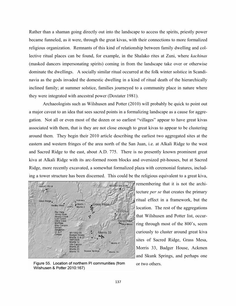
137
Rather than a shaman going directly out into the landscape to access the spirits, priestly power
became funneled, as it were, through the great kivas, with their connections to more formalized
religious organization. Remnants of this kind of relationship between family dwelling and col-
lective ritual places can be found, for example, in the Shalako rites at Zuni, where kachinas
(masked dancers impersonating spirits) coming in from the landscape take over or otherwise
dominate the dwellings. A socially similar ritual occurred at the folk winter solstice in Scandi-
navia as the gods invaded the domestic dwelling in a kind of ritual death of the hierarchically
inclined family; at summer solstice, families journeyed to a community place in nature where
they were integrated with ancestral power (Doxtater 1981).
Archaeologists such as Wilshusen and Potter (2010) will probably be quick to point out
a major caveat to an idea that sees sacred points in a formalizing landscape as a cause for aggre-
gation. Not all or even most of the dozen or so earliest “villages” appear to have great kivas
associated with them, that is they are not close enough to great kivas to appear to be clustering
around them. They begin their 2010 article describing the earliest two aggregated sites at the
eastern and western fringes of the area north of the San Juan, i.e. at Alkali Ridge to the west
and Sacred Ridge to the east, about A.D. 775. There is no presently known prominent great
kiva at Alkali Ridge with its arc-formed room blocks and oversized pit-houses, but at Sacred
Ridge, more recently excavated, a somewhat formalized plaza with ceremonial features, includ-
ing a tower structure has been discerned. This could be the religious equivalent to a great kiva,
remembering that it is not the archi-
tecture per se that creates the primary
ritual effect in a framework, but the
location. The rest of the aggregations
that Wilshusen and Potter list, occur-
ring through most of the 800’s, seem
curiously to cluster around great kiva
sites of Sacred Ridge, Grass Mesa,
Morris 33, Badger House, Ackmen
and Skunk Springs, and perhaps one
or two others.
138
Clearly, much more information about sites and locations is needed. Certainly it is true that at
least in the later classic Chacoan periods that some outlier aggregations or communities cluster
around great houses, but without evidence of a prominent great kiva construction. Regardless
of the time period, without much more detailed excavation to determine whether some sort of
less architecturally defined plaza existed at some sites, like at Sacred Ridge, and without stud-
ies of the locations of communities without big great kiva structures, one cannot yet say some
places were “off the grid” so to speak, while others were forming in relation to new nodes of
spirit power. Furthermore, considering figure 55, what were the distances from these loci that
would influence aggregation around them?
Hypothetically, specialized, ritually related aggregation had been symbolically associat-
ed with formalizing loci at least two hundred years before the relatively short lived “villages”
north of the San Juan, and continuity in this regard would likely have existed in this region
(perhaps including the recently investigated Dillard site). But could there have been a social
conflict between those following this new direction of plateau religion. Would traditionalists
with only oversized pit-structures have aggregated at locations without linkage to the frame?
In such a case one would expect propinquity and territorial defense to be in greater play, and
therefore a different settlement pattern, more like true villages. This, however, does not seem
to happen.
PROBABILITY TEST: LOCATIONS OF PI GREAT KIVAS AND THEIR ALIGNED RELATIONSHIP TO THE GREATER LANDSCAPE AND TRIADIC EARLY CHACO If one could show that a defined set of great kiva locations in all probability involved designed
large-scale patterns, then the reverse aggregation idea should immediately become more inter-
esting. If great kivas were built on framework loci, then these locations could have predated
domestic clustering around them. If aggregation occurred first in locations chosen for reasons
other than linkage to sacred mountains and the like, then any large-scale alignments existing
among these “secondary” great kiva locations should not be distinguishable from purely ran-
dom phenomena. This is testable.
In the probability exercises in Chapter 2, large-scale patterns of a relatively complete
list of great kiva locations from Basketmaker III through PIII, some 61 in all, are compared
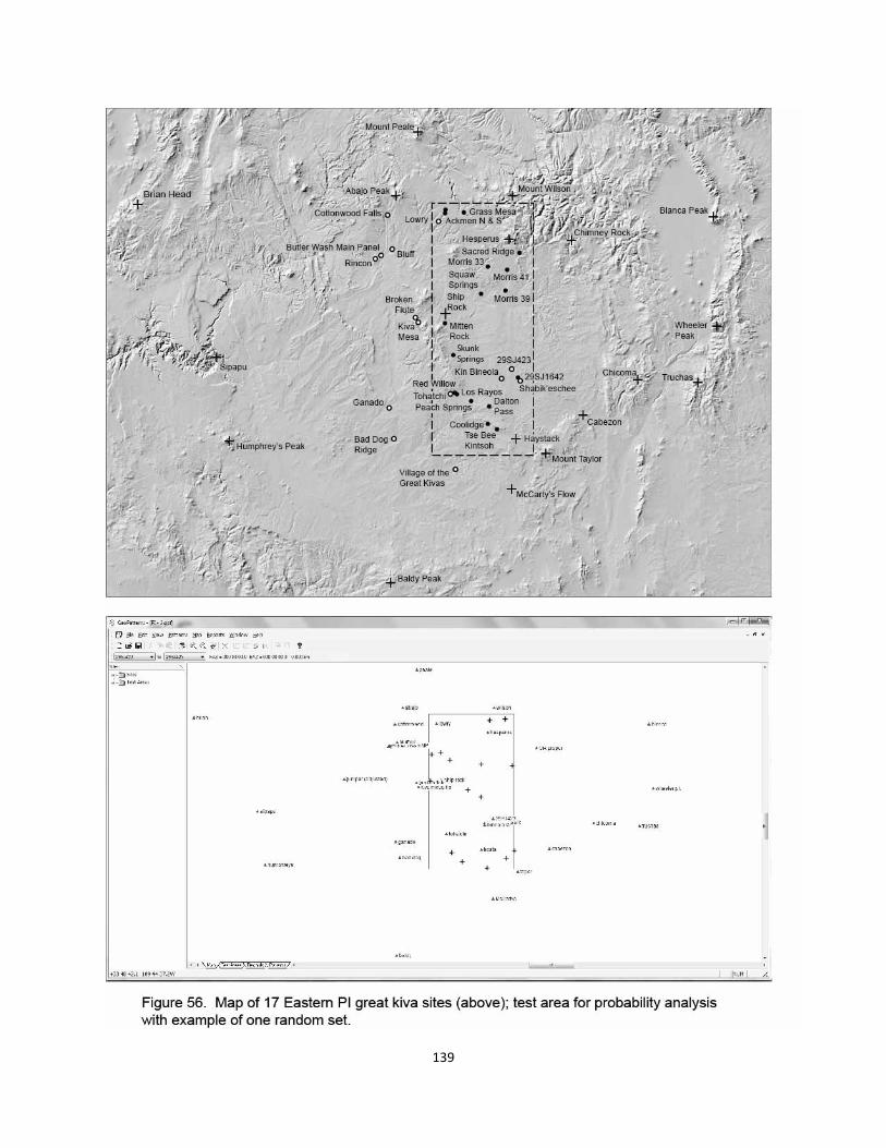
139
140
with patterns created by random points located in the same geographical area. In brief, the total
group of existing great kivas clearly separated itself from almost all random patterns, strongly
suggesting some design, even though an unknown number of random alignments are likely to
be mixed in with the existing as well. When separating the great kivas into BMIII-PI and PII-
PIII groups, again, the earlier do better in regard to the likelihood of design, though it is not de-
termined in Chapter 2 whether the outcome of the group separation itself might be coincidental
(within the overall clearly positive results of the entire list of great kivas). In the present chap-
ter’s context, however, it is possible to shed further light on the behavior of the more numerous
segment of the early group. These, as it turns out, are built almost exclusively in the eastern
side of the plateau about 200-300 years after the hypothetical first ritual focus at Chaco, and
subsequent larger scale formalization of the whole cultural sphere.
The map of figure 56 identifies seventeen PI great kiva sites, described in greater detail
in Chapter 2, all on the eastern side of the plateau. Notably, while identified on the map, three
locations are not included in the analysis: Sacred Ridge because of the lack of great kiva struc-
ture per se, Morris 33 because of a lack of precise GPS site location, and Badger House because
of very recent acquisition of site location (these three sites are not part of the larger study of 61).
Thus the following analysis looks at large-scale alignment patterns of fifteen sites: Ackmen N,
Ackmen S, Grass Mesa, Morris 41, Morris 39, Squaw Springs, Mitten Rock, Skunk Springs,
29SJ1642 (440 meters from Shabik’eschee), Red Willow, Los Rayos, Peach Springs, Dalton
Pass, Coolidge, and Tse Bee Kintsoh.
Two questions are asked: 1) in the hypothetical context of early great kivas and 21 natu-
ral features, how many three point alignments do the fifteen PI sites create compared to an equal
number of random points in the same area, and 2) is there a tendency for alignments created by
the PI sites to focus on the three possible Chaco foci sites of Kin Bineola, 29SJ423, and Sha-
bik’eschee? The null hypothesis is that there was no surveyed positioning of great kivas among
the 15, predicting that the number of three point alignments generated by these sites should fall
within the expected range of random phenomena, and that like other random alignments, they
should not particularly focus on the Chaco triad.
One hundred different sets of 15 random points each located within the test area of fig-
ure 56 generate varied numbers of three-point alignments in the context of earlier great kivas
and 20 natural features (minus Moctezuma). The level of accuracy is set at 0.15°, the upper
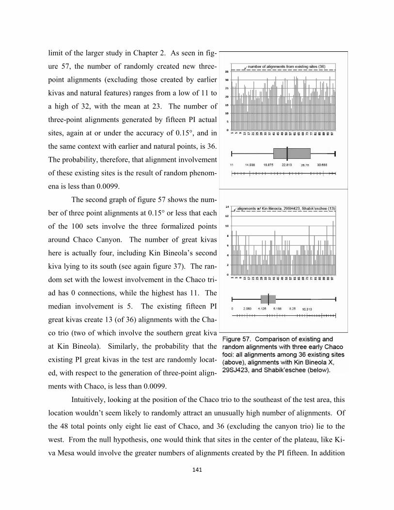
141
limit of the larger study in Chapter 2. As seen in fig-
ure 57, the number of randomly created new three-
point alignments (excluding those created by earlier
kivas and natural features) ranges from a low of 11 to
a high of 32, with the mean at 23. The number of
three-point alignments generated by fifteen PI actual
sites, again at or under the accuracy of 0.15°, and in
the same context with earlier and natural points, is 36.
The probability, therefore, that alignment involvement
of these existing sites is the result of random phenom-
ena is less than 0.0099.
The second graph of figure 57 shows the num-
ber of three point alignments at 0.15° or less that each
of the 100 sets involve the three formalized points
around Chaco Canyon. The number of great kivas
here is actually four, including Kin Bineola’s second
kiva lying to its south (see again figure 37). The ran-
dom set with the lowest involvement in the Chaco tri-
ad has 0 connections, while the highest has 11. The
median involvement is 5. The existing fifteen PI
great kivas create 13 (of 36) alignments with the Cha-
co trio (two of which involve the southern great kiva
at Kin Bineola). Similarly, the probability that the
existing PI great kivas in the test are randomly locat-
ed, with respect to the generation of three-point align-
ments with Chaco, is less than 0.0099.
Intuitively, looking at the position of the Chaco trio to the southeast of the test area, this
location wouldn’t seem likely to randomly attract an unusually high number of alignments. Of
the 48 total points only eight lie east of Chaco, and 36 (excluding the canyon trio) lie to the
west. From the null hypothesis, one would think that sites in the center of the plateau, like Ki-
va Mesa would involve the greater numbers of alignments created by the PI fifteen. In addition
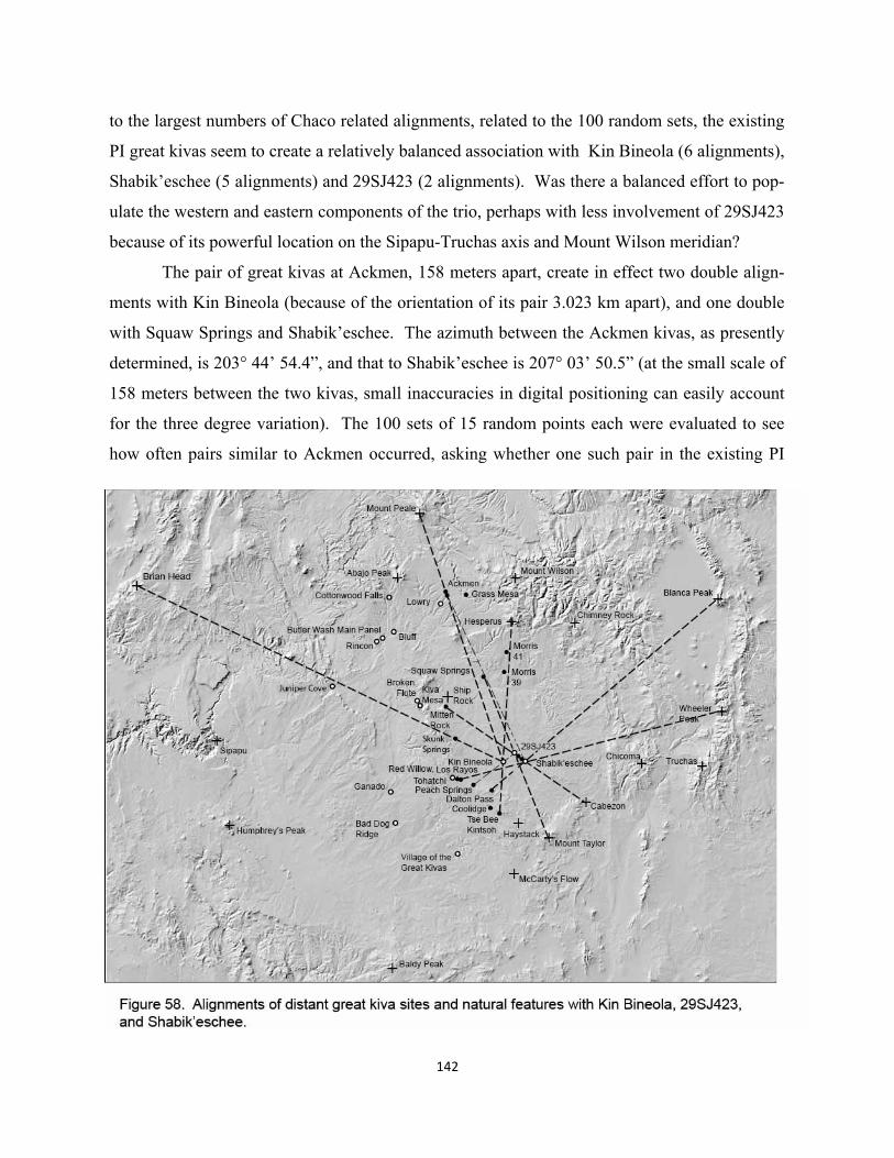
142
to the largest numbers of Chaco related alignments, related to the 100 random sets, the existing
PI great kivas seem to create a relatively balanced association with Kin Bineola (6 alignments),
Shabik’eschee (5 alignments) and 29SJ423 (2 alignments). Was there a balanced effort to pop-
ulate the western and eastern components of the trio, perhaps with less involvement of 29SJ423
because of its powerful location on the Sipapu-Truchas axis and Mount Wilson meridian?
The pair of great kivas at Ackmen, 158 meters apart, create in effect two double align-
ments with Kin Bineola (because of the orientation of its pair 3.023 km apart), and one double
with Squaw Springs and Shabik’eschee. The azimuth between the Ackmen kivas, as presently
determined, is 203° 44’ 54.4”, and that to Shabik’eschee is 207° 03’ 50.5” (at the small scale of
158 meters between the two kivas, small inaccuracies in digital positioning can easily account
for the three degree variation). The 100 sets of 15 random points each were evaluated to see
how often pairs similar to Ackmen occurred, asking whether one such pair in the existing PI
143
kivas is skewing the comparison. Of the 100, similarly spaced pairs occurred randomly 31
times, with two sets having two pairs. Thus random pairs are not uncommon and the presence
of one existing example in the 15 PI kivas shouldn’t seriously bias the analysis.
Also evaluated in a visual scan of the dispositions of the 15 random points in the 100
sets was the effect of a random point landing in or very near the Chaco triangle. This is similar
to the way 29SJ1642, again only 425 meters from Shabik’eschee relates to the Chaco trio. It
too seems to generate an unusual number of alignments, acting like one of the Chaco trio, per-
haps paring up with Shabik’eschee. 29SJ1642 is an alignment focus for five aligned relation-
ships with the other 14 PI points. In the 100 random sets, a single point lands in or near the
Chaco triangle 15 times. Four of these points create no alignments in the total created by the
15 random points for each set. Only alignments are counted that involve at least one other
point of the 15; this replicates the basic pattern of a community great kiva site being linearly
connected to one of the Chaco points and a distant natural feature.
In seven sets, the Chaco random point involves one such alignment. In two sets, the
number is two; in one set it is four, and in one set the number is five, equal to 29SJ1642. Thus
the ability of 29SJ1642 to act like one of the Chaco trio is as good as one of the 100 random
sets, and better than 99 others. Furthermore, when one looks at the particular random set
(number 95) that produces the five Chaco focused alignments, it matches the highest overall
number of alignments, 32, produced by any set of fifteen. But in looking at the second graph
of figure 57, set 95 only creates six alignments that focus on the Chaco trio (not including
those generated by the random point in the canyon area. Adding these six to the five generated
by its random point falling in the Chaco area, gives only 11, compared to the 18 of the existing
(13+5) when 29SJ1642 is added to the earlier trio. The next best random set is 62, whose ran-
dom point in the canyon area creates 4 of these alignments. But again, of its total number of
alignments created by 15 random points, only 4 focus on the canyon. Thus its total is only 8,
compared to the existing 18.
Mapping the the existing alignments focused on the Chaco trio (excluding 29SJ1642),
does not attempt to persuade the reader that all, figure 58, were intentionally laid out or de-
signed. Again, as discussed in Chapter 2 at greater length, it is likely that some number of ran-
dom alignments will occur in any or perhaps all analyses of existing patterns of great kiva lo-
cations in the landscape. Chapter 2 also tells us that the range of accuracy up to at least 0.15°
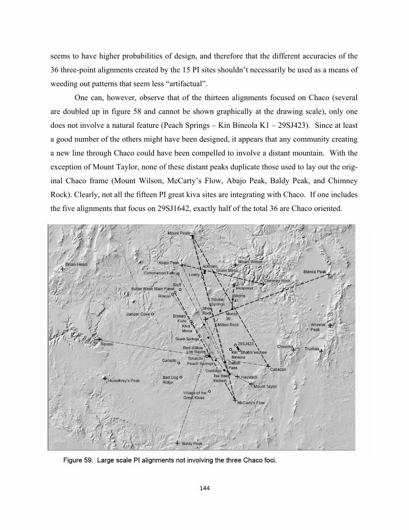
144
seems to have higher probabilities of design, and therefore that the different accuracies of the
36 three-point alignments created by the 15 PI sites shouldn’t necessarily be used as a means of
weeding out patterns that seem less “artifactual”.
One can, however, observe that of the thirteen alignments focused on Chaco (several
are doubled up in figure 58 and cannot be shown graphically at the drawing scale), only one
does not involve a natural feature (Peach Springs – Kin Bineola K1 – 29SJ423). Since at least
a good number of the others might have been designed, it appears that any community creating
a new line through Chaco could have been compelled to involve a distant mountain. With the
exception of Mount Taylor, none of these distant peaks duplicate those used to lay out the orig-
inal Chaco frame (Mount Wilson, McCarty’s Flow, Abajo Peak, Baldy Peak, and Chimney
Rock). Clearly, not all the fifteen PI great kiva sites are integrating with Chaco. If one includes
the five alignments that focus on 29SJ1642, exactly half of the total 36 are Chaco oriented.
145
Early alignments not involved in the Chaco triad
The other 18 alignments created by the 15 PI great kiva sites are shown in figure 59. Of these,
only one does not involve a natural feature (Cottonwood Falls-Mitten Rock-Tse Bee Kintsch).
Again, which ones might be more likely to have been designed and which ones are random?
At least one of these lines is suspect because of its connection to both Mount Wilson and Baldy
Peak. Considering what these two peaks might already have been doing in the developing
frame, it would be somewhat subversive for a Skunk Springs community to lay out such a line
with it as interim point. The location of Los Rayos as interim point on a Sipapu – Cabezon line
also similarly seems illogical. Yet such a line with Tohatchi might have been involved in the
laying out of Ganado, and the location of Los Rayos could have been conceived of as part of
this earlier and important line. The trio of Tohatchi, Red Willow and Los Rayos are an unusual
cluster of great kivas, five and two kilometers apart. It may be unlikely that the Humphrey’s
Peak- Lowry-Ackmen N was designed because of the proximity between the two great kiva
points. While Lowry is hypothetically a very important Middle point at the scale of the plateau
triad, a line from close by Ackmen to very distant Humphrey’s Peak seems symbolically unbal-
anced, and even more difficult to survey.
Most immediately striking about figure 59 is the number of diagonal lines from areas
around Comb Ridge and Abajo Peak to McCarty’s Flow and communities to the southeast of
Chaco. Given that some of these alignments are likely to have been designed, among the most
interesting would be the position of Dalton Pass and Tse Bee Kintsoh on a five point alignment
that includes Mount Peale, Lowry, and McCarty’s. Every possibility of three-point alignment
at or under 0.15° does not occur among these five points, but three patterns do, together includ-
ing all five. Notably, Lowry does not form a 0.15° or under alignment with Mount Peale and
McCarty’s, which enters into the discussion of ideas about an earlier location of this Middle
site. An interesting four point pattern also occurs in the larger array of northwest-southeast
diagonals. Three alignments involve the foursome of the Main Panel at Butler Wash, Kiva
Mesa BMIII, Red Willow, and McCarty’s.
Morris 39 and 41connect to each other by two alignments that terminate at three natural
features, Ship Rock, Chimney Rock and Hesperus, a seemingly contained simple frame focus-
ing on the intersection at Morris 39. In addition to Grass Mesa’s prominent natural setting at
the former confluence of the Dolores River and Beaver Creek (now a reservoir), it sits on an
146
intersection created by four mountain features, Abajo Peak- Chimney Rock and Mount Peale-
Cabezon. While either of these lines might be random, or even both, there could be some co-
incidence of the peninsular natural setting with surveyed alignments, making the location more
ritually powerful.
Finally, to what extent are there two groups of PI great kiva sites, one focused on Cha-
co and the other more diversified and less integrated, perhaps. Up in the San Juan region,
Grass Mesa, Morris 39 and Morris 41 have no lines involving Chaco, while Ackmen, close to
Lowry has possible connections to both Kin Bineola and Shabik’eschee, the early West/East
pair. Again Wilshusen & Potter 2010 do not include the Ackmen pair, or Morris 39 and Mor-
ris 41 in their map of PI villages. But from the analysis thus far, Grass Mesa, the apparent ritu-
al focus of a large Delores River aggregation, has no connection to Chaco. Yet archaeological
blogs talk about the resemblance of the arc formed room blocks, particularly at McPhee (and at
Morris 33), to the earliest great house forms at three sites in Chaco Canyon. It is even specu-
lated that when the PI village area north of the San Juan vacated at around A.D. 900, they went
south and became more involved in a reenergizing Chaco focus. But others counter that these
first room blocks in Chaco were being built about the same time as McPhee in the 800’s
(Windes 2003 Neitzel 2007).
If key northern great kiva foci like Grass Mesa were apparently not integrated into
Chaco, did they hook up with West or Middle elements of the overall plateau frame? Mount
Peale-McCarty’s Flow most likely might not been part of the positioning of Lowry, given its
0.327° inaccuracy. The Abajo Peak – Grass Mesa – Chimney Rock line is three times more
accurate at 0.098°, providing a possible connection to the West vertical. And the Ship Rock-
Morris 39-Blanca Peak line, if designed, could have associated with the plateau Middle and the
traditional shamanistic NE feature, left behind, so to speak, when Chaco created its cross axes
at Kin Bineola. Is it possible that Grass Mesa and other great kiva foci up north (aside from
Ackmen) were somewhat more competitive and separate from Chaco at this time? Could they
have been responding to the new religious mode of landscape formalization by creating several
great kiva foci, aligned to natural features, and developing great houses, but little integration in
any sort of focus like Chaco?
147
REVISED TRIATIC EXPRESSION OF CHACO /CURVED ROCK THAT SPEAKS
Hypothetically the three earliest ritual foci in or near Chaco canyon, Kin Bineola, 29SJ423, and
Shabik’eschee were created by Abajo Peak’s cardinal relation to Mount Wilson and Sipapu-
Chicoma-Truchas. The tripartite ritual setting may also have functioned as the East component
of a largest scale plateau framework also structured in three components. How then, might the
addition of PI axes and associated communities focused on the three Chaco locations have al-
tered the organizational character of the original triad?
The number of possible PI great kiva communities linking with Chaco is relatively
small, eight in all. Associated with either or both of the Kin Bineola great kivas are Tse Bee
Kintsoh (south), Skunk Springs (central) and the Ackmen pair (north). Shabik’eschee involves
Dalton Pass in the south, central Los Rayos and Mitten Rock farther north. The final two loca-
tions, Squaw Springs and Peach Springs involve 29SJ423. The Peach Springs line that con-
nects Kin Bineola K1 with 29SJ423, however, doesn’t fit the pattern of a community site, a
Chaco point, and a distant natural feature. All other seven do, including the Squaw Springs –
29SJ423 – Mount Taylor line. Not mentioned above for this reason are the alignments from the
Ackmen pair through Squaw Springs to Shabik’eschee (no natural feature). The close by
29SJ1642 essentially duplicates all of the lines to Shabik’eschee, with the exception of its line
to Peach Springs and Bad Dog, again an axis without a natural feature, and perhaps more likely
to be a random alignment.
If these eight, or perhaps seven communities traveled to Chaco to conduct formalizing
axis based ritual, they logically would have met at their associated particular site of the triad.
Evolving rites that integrated West, Middle and East religious sodalities, might well have been
held in the natural amphitheater plaza, originally aligned with 29SJ423 and Shabik’eschee
(figure 39). With respect to the fundamental plateau scaled, triadic spatial symbolism of the
evolving religion, the location of and practice focus at the amphitheater creates a kind of cogni-
tive dissonance. The ritual focus, acting to integrate West and East sodalities, should logically
be associated with and conducted by priests from the Middle, symbolism perhaps early on tied
to 29SJ423 and its important location on the Mount Wilson meridian and Sipapu-Truchas line.
At Chaco in the 800’s, three arc shaped room blocks or great houses are constructed,
perhaps along with two new great kivas, figure 60. One great kiva and roomblock is very close
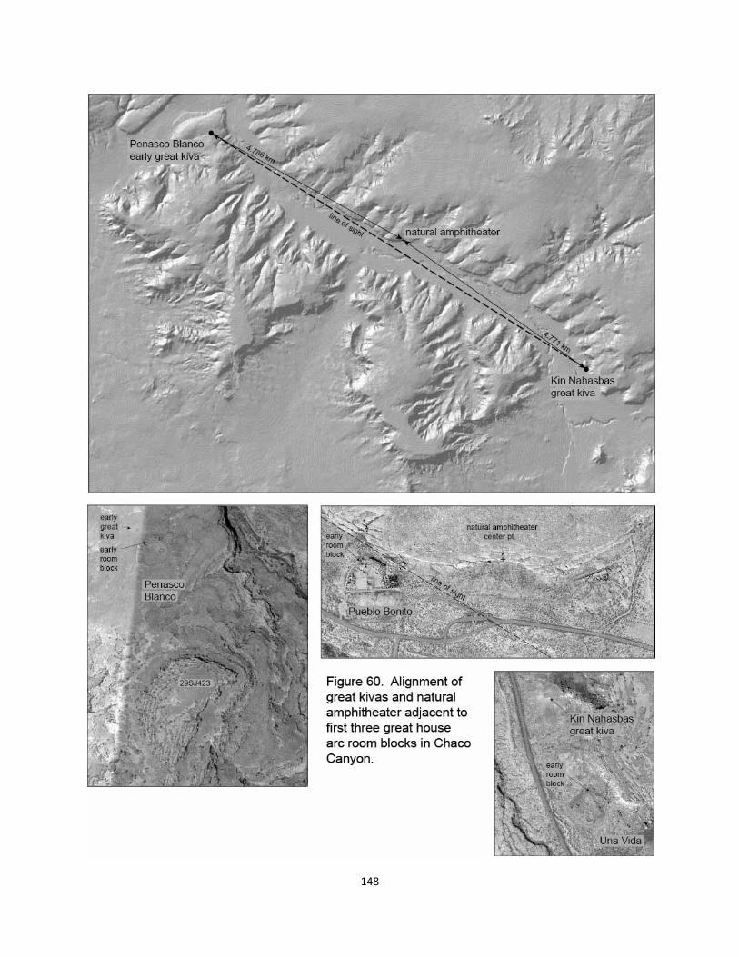
148
149
north of 29SJ423, Peñasco Blanco; another such pair at Una Vida is built at the eastern end of
the canyon near Fajada Butte; and then the central roomblock of Pueblo Bonito was located ad-
jacent to the amphitheater plaza. The western great house likely continued ritual associations
with the important location of 29SJ423, with this subsequent PI great kiva now being more ac-
curately aligned with the Sipapu-Truchas line ( 0.138°); no other new alignments appear to be
added at this point 637 meters due north. The presumptive early eastern ritual focus at Sha-
bik’eschee, however, has been moved much closer to the Curved Rock That Speaks. The PI
great kiva of Kin Nahasbas (late ninth century: Lekson 2006:74), just north of Una Vida could
have been located to form a visible triad with the amphitheater plaza and Peñasco Blanco’s kiva
(also north of its great house). The distances from the centers of the two “West” and “East”
great kivas to the center point of the amphitheater are remarkably similar, only off about 7 me-
ters from being equal. The new great kiva of Kin Nahasbas was apparently located only in rela-
tion to the other two components in the new triad, rather than via large-scale alignments.
While the new layout is clearly triadic, and may also be evidence of surveying skills,
symbolically the new element of Pueblo Bonito may be interesting for other, less evident rea-
sons. Part of this mix is the recognition that Kin Bineola might have continued its West identi-
ty by creating its own late PI roomblock, and prospers in the classical PII/PIII period, even
picking up a dualistic partner to the near southeast of the canyon at Pueblo Pintado. Thus it
doesn’t seem immediately logical to see the religious function of Kin Bineola as being shifted
to Peñasco Blanco in the new PI layout of Chaco with Pueblo Bonito perhaps assuming the
Middle role of 29SJ423. Una Vida does seem to replace Shabik’eschee as the East focus. To a
certain extent, the building of Pueblo Bonito, which might have been the first move of the new
scheme, seems intrusive. Even though the plaza could have been used communally for over
two hundred years prior to the building of a great house there, it is as if some entity came into
the canyon and sought to replace 29SJ423’s Middle role linked to the Mount Wilson meridian,
with a Middle concept that was uniquely Chacoan.
Recognizing that the associations of PI communities to the Chaco triad may have been
focused on the much earlier BMIII points, perhaps after much of the ritual had shifted away
from these early “villages” to the amphitheater area, one can see the two sites of 29SJ423 and
Peñasco Blanco as expressing two different and still active meanings. First of course is the link
to the early plateau frame and Mount Wilson, and second is a reconstituted West entity, perhaps
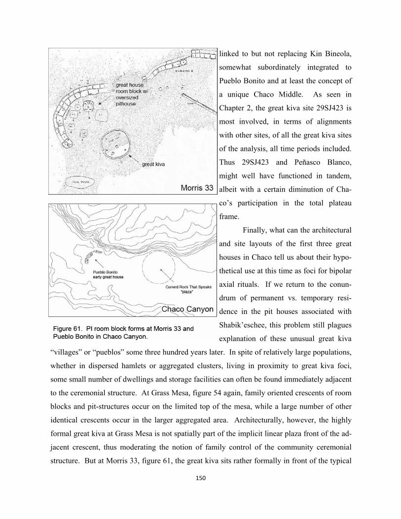
150
linked to but not replacing Kin Bineola,
somewhat subordinately integrated to
Pueblo Bonito and at least the concept of
a unique Chaco Middle. As seen in
Chapter 2, the great kiva site 29SJ423 is
most involved, in terms of alignments
with other sites, of all the great kiva sites
of the analysis, all time periods included.
Thus 29SJ423 and Peñasco Blanco,
might well have functioned in tandem,
albeit with a certain diminution of Cha-
co’s participation in the total plateau
frame.
Finally, what can the architectural
and site layouts of the first three great
houses in Chaco tell us about their hypo-
thetical use at this time as foci for bipolar
axial rituals. If we return to the conun-
drum of permanent vs. temporary resi-
dence in the pit houses associated with
Shabik’eschee, this problem still plagues
explanation of these unusual great kiva
“villages” or “pueblos” some three hundred years later. In spite of relatively large populations,
whether in dispersed hamlets or aggregated clusters, living in proximity to great kiva foci,
some small number of dwellings and storage facilities can often be found immediately adjacent
to the ceremonial structure. At Grass Mesa, figure 54 again, family oriented crescents of room
blocks and pit-structures occur on the limited top of the mesa, while a large number of other
identical crescents occur in the larger aggregated area. Architecturally, however, the highly
formal great kiva at Grass Mesa is not spatially part of the implicit linear plaza front of the ad-
jacent crescent, thus moderating the notion of family control of the community ceremonial
structure. But at Morris 33, figure 61, the great kiva sits rather formally in front of the typical
family arc with its smaller and oversized pit houses.
Eventually at Pueblo Bonito, also figure 61, its great house will have a great kiva inte-
grated into its plaza space, not unlike what we see in Morris 33. If we assume that the first
Pueblo Bonito great house room blocks, and possible pit structures were built in relation to the
Curved Rock That Speaks plaza as a kind of great kiva, then this pattern seems more similar to
that at Grass Mesa than Morris 33. At first this would seem to suggest a kind of kinship con-
trol of the great kiva at places like Morris 33, and some greater community authority at other
places like Pueblo Bonito, Grass Mesa, as well as Peñasco Blanco and Una Vida where their
room blocks were originally apart from their great kivas to the north. Ritually, however, even
where the great kiva becomes more architecturally integrated into the great house, the basic
social opposition might well have still obtained. Most great kivas, hypothetically, involve axi-
al sodalities and social organization at large scales. While great houses in all their manifesta-
tions probably always involved more hierarchical control by kinship or other individually mo-
tivated social groups, spatially integrated great kivas would have involved sodalities whose
membership was not determined by kinship, nor controlled by these family oriented
“sponsors”.
Furthermore, some usage of the great house facilities, depending upon scale, not un-
likely had to do with providing accommodations for guests from afar and thus could have been
more neutral in terms of social control. The occupation of caretaker dwellings associated with
great kivas might not have been determined by one kinship group, but by either the various
kinship groups of the aggregation, or even by participants of distant sodality members.
Thus the plan of Morris 33 might not point to direct control of what goes on in the
great kiva by the adjacent family crescent, whether as sponsors or caretakers, but could begin
to show a kind of homologue effect (same spatial, symbolic structures at different scales). In
the site layouts of Grass Mesa and the contemporaneous trio in Chaco, the different spatial re-
lationship could indicate a kind of supra-level ritual focus. If, for the sake of discussion, Grass
Mesa not only attracted an aggregation relatively close by, but was conceptually a more re-
gional focus for the entire northern San Juan area, then the closer architectural relationship
between great kiva and crescent at Morris 33, and perhaps at the other great kiva sites in the
region, could have expressed a certain subordination. At whatever scale, there would always
be a tension between great house and great kiva, one more subject to kinship or hierarchical
151
152
control, and the other in the hands of large-scale sodalities, both socially and in terms of link-
age to distant natural features. As largest scale foci emerge in BMIII-PI, next smaller scale
great kiva sites may have tended to “architecturalize”. This may have had more to do with
recognition of a great kiva-great house’s subordinate position in relation to regional foci, than
with any actual kinship takeover of large-scale great kiva functions.
Chaco of course becomes the ultimate regional focus, at least on the eastern side of the
plateau. Pueblo Bonito’s first room blocks are adjacent too but do not spatially or architectur-
ally incorporate the amphitheater wall and its inherent plaza. While it may have had pit-
structures and soon after small kivas immediately in front (Windes 2003, Neitzel 2007: 21),
one hasn’t the sense of strong control by some particular kinship group. Besides, the room
block crescent, unlike the more architectonic arcs up in the San Juan area, is composed of three
distinct construction segments, perhaps a first example of great house constructions by multi-
ple groups (as documented in the ultimate build outs of these enterprises, Hudson 1972). Ra-
ther than think of these Pueblo Bonito room blocks as being built and used by kinship groups,
they more likely would have accommodated people belonging to the Middle coming into the
canyon to do ritual among themselves--there may have been three plateau groups within the
Middle itself--and among those from Peñasco Blanco (West) and Una Vida (East).
New meaning to Curved Rock That Speaks/Pueblo Bonito: a Lizard Head meridian It may not have been only the recognition of Chaco’s natural amphitheater as the three hundred
year ultimate ritual performance focus that fueled the building of Pueblo Bonito and the move-
ment of the eastern component to Una Vida. More spiritually profound, perhaps, was the earli-
est knowledge of what may have been the greatest motive behind the looming classic build out
of Chacoan landscape and architecture in PII/PIII. The analysis of the next chapters present
the design logic that just as early shaman-priests may have been struck with the phenomenolo-
gy of the cardinal coincidence between Abajo Peak and Mount Wilson, similarly might later
religious specialists have been captivated by two additional features to the east of Wilson: the
volcanic Lizard Head and the protruding rock formation called Black Face, figure 62.
These three unique features, beginning with Mount Wilson, are all visible from each
other in the Wilson Group (of peaks). Given the meridian relationship of Mount Wilson with
early Chaco and the new Peñasco Blanco via 29SJ423, it could have been later discovered that
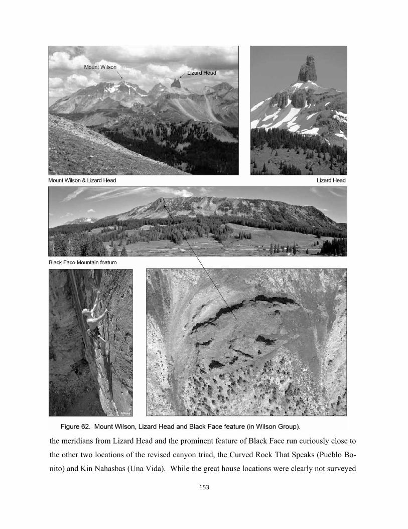
153
the meridians from Lizard Head and the prominent feature of Black Face run curiously close to
the other two locations of the revised canyon triad, the Curved Rock That Speaks (Pueblo Bo-
nito) and Kin Nahasbas (Una Vida). While the great house locations were clearly not surveyed
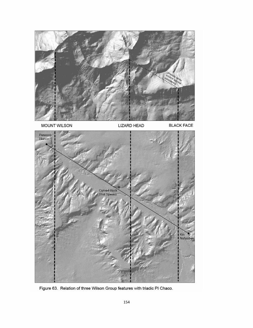
154
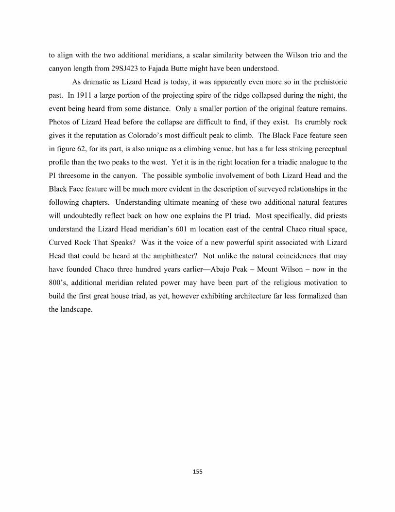
155
to align with the two additional meridians, a scalar similarity between the Wilson trio and the
canyon length from 29SJ423 to Fajada Butte might have been understood.
As dramatic as Lizard Head is today, it was apparently even more so in the prehistoric
past. In 1911 a large portion of the projecting spire of the ridge collapsed during the night, the
event being heard from some distance. Only a smaller portion of the original feature remains.
Photos of Lizard Head before the collapse are difficult to find, if they exist. Its crumbly rock
gives it the reputation as Colorado’s most difficult peak to climb. The Black Face feature seen
in figure 62, for its part, is also unique as a climbing venue, but has a far less striking perceptual
profile than the two peaks to the west. Yet it is in the right location for a triadic analogue to the
PI threesome in the canyon. The possible symbolic involvement of both Lizard Head and the
Black Face feature will be much more evident in the description of surveyed relationships in the
following chapters. Understanding ultimate meaning of these two additional natural features
will undoubtedly reflect back on how one explains the PI triad. Most specifically, did priests
understand the Lizard Head meridian’s 601 m location east of the central Chaco ritual space,
Curved Rock That Speaks? Was it the voice of a new powerful spirit associated with Lizard
Head that could be heard at the amphitheater? Not unlike the natural coincidences that may
have founded Chaco three hundred years earlier—Abajo Peak – Mount Wilson – now in the
800’s, additional meridian related power may have been part of the religious motivation to
build the first great house triad, as yet, however exhibiting architecture far less formalized than
the landscape.
6. The Lizard Head Meridian: Framing the Large-Scale Foundation for Formalized Great Houses in Chaco
The huge discourse which sees Chaco Canyon as the first large scale ceremonial center on the
Southern Colorado Plateau, beginning with the first three modest roomblocks in the 800’s, does
not really explain why a hundred years or so later the massive investments in pilgrimage archi-
tecture begin. If, however, there had been a formalized triadic ritual structure established for
centuries at the plateau scale, and Chaco was but an East component in it, how might this idea
potentially better explain the 11th century “phenomenon”? First of all, people using the Chaco
focus had hypothetically introduced the surveying based religious practice of using ritual land-
scape axes, and associated priests may have been instrumental in the subsequent laying out the
larger triadic plateau. Again, these frameworks were not just social organization, per se, but
more fundamentally the basis of a shared religion, structured at all scales by spatially opposed
domains involving both natural and social entities, mediated by those of the Middle. What
then, in the early 1000’s, drove such large numbers of plateau communities to invest in a kind
of re-formation of their basic beliefs about geography and religion?
Certainly others are much more adept than the present author at presenting ecological
reasons including effects of drought, resource exchange strategies, and outright political will or
agency that may have been part and parcel to the big build out. But the agreement among these
experts that above all else, Chaco was a relatively egalitarian pilgrimage center (Renfrew
2001), clearly suggests that religion was not only one factor in the mix, but perhaps the major
one. If a triadic plateau religion had existed for three or four hundred years, its maintenance,
perhaps not that unlike the use of large-scale cosmologies by shamanistic groups like the Nava-
jo, certainly was under no central control by any priestly element in any part of the plateau,
even Ganado or Chaco where modest formalized expression may have had foci. Nor is a cen-
tral place known to have existed at or near Ship Rock as some all-powerful pilgrim destination
that expressed the plateau whole. Political balance among the different community groups in
both West and East might have been achieved by more subtle flows of ritual exchange at differ-
ent scales, perhaps involving some more or less stable “maintenance” structure necessary at the
two foci.
156
157
The Chaco “phenomenon” might have been most fundamentally the expressive recasting
of plateau religious framework within the eastern half, i.e. the shift from a largest scale, plateau
integrated Mount Wilson focus at 29SJ423 in the canyon, to a more exclusively eastern focus at
the Curved Rock That Speaks. Above all else, this layout would have been consciously de-
signed, even initiated by priest surveyors. Given that surveying practice may have been at the
very basis of religion, these individuals were the ultimate creators and keepers of sacred
knowledge. While the idea of a somewhat scaled-down symbolic expression of plateau struc-
ture and creation of a unified pilgrimage center on one side of the plateau seems to have strong
political overtones, one has difficulty pinning down who the actual movers and shakers were or
where they lived in the canyon, particularly during the first stages of laying out the new design.
To the contrary, not unlike the idea that populations aggregated in part because of large
scale landscape structure--and their foci--if religious thinkers more or less on their own began
laying out a revised structure that more powerfully captured the essence of a formalized plateau
religion, then communities might well have been easily persuaded to participate. After all, most
surveying on the plateau would have been a process of shared spatial and social participation
across large distances. The process of surveying, or hauling in timbers for buildings for that
matter (see Snygg & Windes 1998 image as figure 103), could have been a core value of the
religion. So if a small group of priests from somewhere, perhaps not even Chaco, had the idea
to explore new expression of this large-scale religious practice, it may have been more of a self-
fulfilling than primarily politically motivated phenomenon. Alternate interpretations are possi-
ble regarding what happened toward the end of the project.
The design analysis of this chapter maps the way a relatively complete framework of
survey points was seemingly laid out prior to the construction of the largest great kiva, five new
great houses and their great kivas and the formalization of two of the three preexisting canyon
great house sites. Because of the short period, a few decades in the mid-11th century during
which these buildings came into being, and the way they are integrated with each other via the
framework, it very much appears as if most if not all of the surveyed points were conceptualized
and executed as part of a relatively unified design “whole”. The scheme might well have been
understood prior to beginning the massive construction of new great kivas and great houses. In
terms of social space, this idea obviously contradicts any notion that particular great houses
were initiated by territorially competitive groups, thereby accounting for the conventional im-
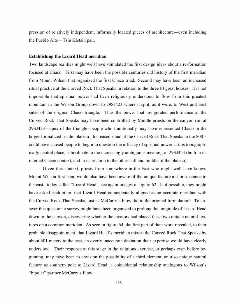
158
pression of relatively independent, informally located pieces of architecture—even including
the Pueblo Alto – Tsin Kletsin pair.
Establishing the Lizard Head meridian
Two landscape realities might well have stimulated the first design ideas about a re-formation
focused at Chaco. First may have been the possible centuries old history of the first meridian
from Mount Wilson that organized the first Chaco triad. Second may have been an increased
ritual practice at the Curved Rock That Speaks in relation to the three PI great houses. It is not
impossible that spiritual power had been religiously understood to flow from this greatest
mountain in the Wilson Group down to 29SJ423 where it split, as it were, to West and East
sides of the original Chaco triangle. Thus the power that invigorated performance at the
Curved Rock That Speaks may have been controlled by Middle priests on the canyon rim at
29SJ423—apex of the triangle--people who traditionally may have represented Chaco in the
larger formalized triadic plateau. Increased ritual at the Curved Rock That Speaks in the 800’s
could have caused people to begin to question the efficacy of spiritual power at this topograph-
ically central place, subordinate to the increasingly ambiguous meaning of 29SJ423 (both in its
internal Chaco context, and in its relation to the other half and middle of the plateau).
Given this context, priests from somewhere in the East who might well have known
Mount Wilson first hand would also have been aware of the unique feature a short distance to
the east, today called “Lizard Head”, see again images of figure 62. Is it possible, they might
have asked each other, that Lizard Head coincidentally aligned as an accurate meridian with
the Curved Rock That Speaks, just as McCarty’s Flow did in the original formulation? To an-
swer this question a survey might have been organized to prolong the longitude of Lizard Head
down to the canyon, discovering whether the creators had placed these two unique natural fea-
tures on a common meridian. As seen in figure 64, the first part of their work revealed, to their
probable disappointment, that Lizard Head’s meridian misses the Curved Rock That Speaks by
about 601 meters to the east, an overly inaccurate deviation their expertise would have clearly
understood. Their response at this stage in the religious exercise, or perhaps even before be-
ginning, may have been to envision the possibility of a third element, an also unique natural
feature as southern pole to Lizard Head, a coincidental relationship analogous to Wilson’s
“bipolar” partner McCarty‘s Flow.
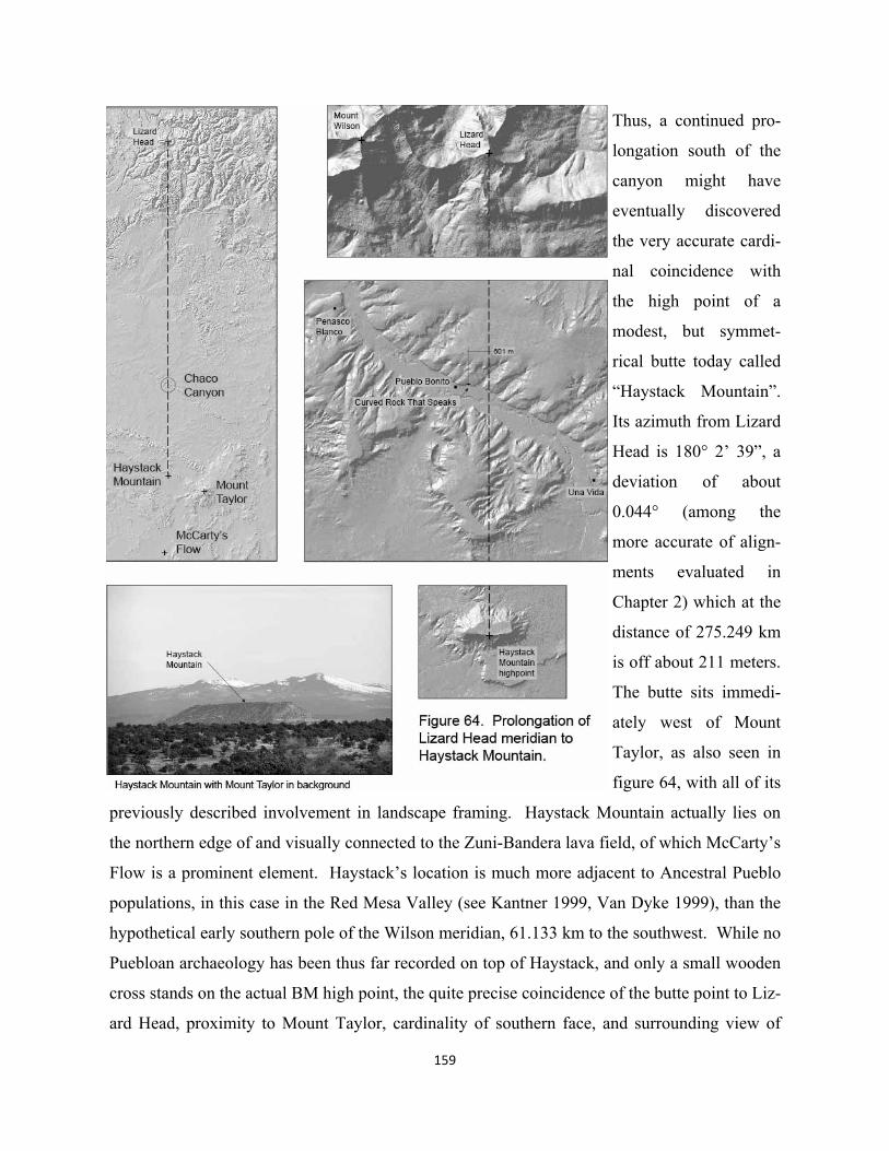
Thus, a continued pro-
longation south of the
canyon might have
eventually discovered
the very accurate cardi-
nal coincidence with
the high point of a
modest, but symmet-
rical butte today called
“Haystack Mountain”.
Its azimuth from Lizard
Head is 180° 2’ 39”, a
deviation of about
0.044° (among the
more accurate of align-
ments evaluated in
Chapter 2) which at the
distance of 275.249 km
is off about 211 meters.
The butte sits immedi-
ately west of Mount
Taylor, as also seen in
figure 64, with all of its
previously described involvement in landscape framing. Haystack Mountain actually lies on
the northern edge of and visually connected to the Zuni-Bandera lava field, of which McCarty’s
Flow is a prominent element. Haystack’s location is much more adjacent to Ancestral Pueblo
populations, in this case in the Red Mesa Valley (see Kantner 1999, Van Dyke 1999), than the
hypothetical early southern pole of the Wilson meridian, 61.133 km to the southwest. While no
Puebloan archaeology has been thus far recorded on top of Haystack, and only a small wooden
cross stands on the actual BM high point, the quite precise coincidence of the butte point to Liz-
ard Head, proximity to Mount Taylor, cardinality of southern face, and surrounding view of
159
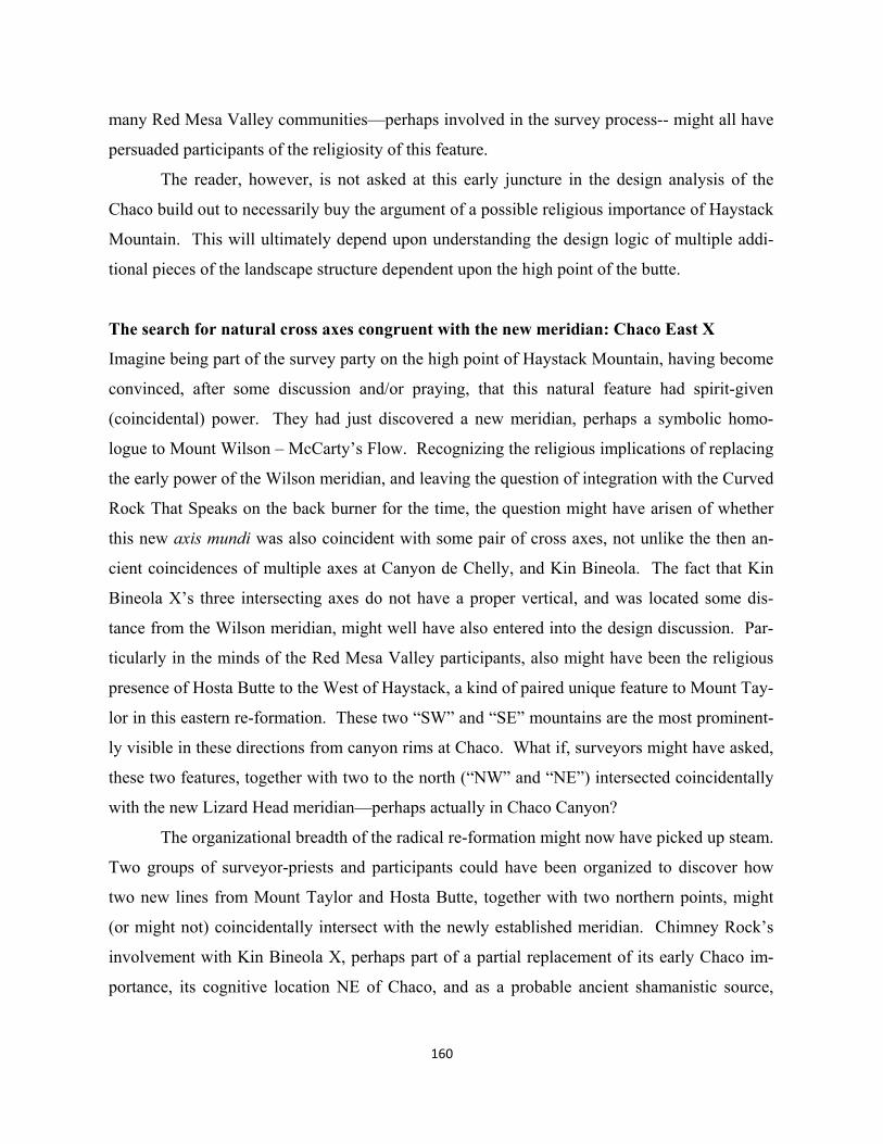
many Red Mesa Valley communities—perhaps involved in the survey process-- might all have
persuaded participants of the religiosity of this feature.
The reader, however, is not asked at this early juncture in the design analysis of the
Chaco build out to necessarily buy the argument of a possible religious importance of Haystack
Mountain. This will ultimately depend upon understanding the design logic of multiple addi-
tional pieces of the landscape structure dependent upon the high point of the butte.
The search for natural cross axes congruent with the new meridian: Chaco East X
Imagine being part of the survey party on the high point of Haystack Mountain, having become
convinced, after some discussion and/or praying, that this natural feature had spirit-given
(coincidental) power. They had just discovered a new meridian, perhaps a symbolic homo-
logue to Mount Wilson – McCarty’s Flow. Recognizing the religious implications of replacing
the early power of the Wilson meridian, and leaving the question of integration with the Curved
Rock That Speaks on the back burner for the time, the question might have arisen of whether
this new axis mundi was also coincident with some pair of cross axes, not unlike the then an-
cient coincidences of multiple axes at Canyon de Chelly, and Kin Bineola. The fact that Kin
Bineola X’s three intersecting axes do not have a proper vertical, and was located some dis-
tance from the Wilson meridian, might well have also entered into the design discussion. Par-
ticularly in the minds of the Red Mesa Valley participants, also might have been the religious
presence of Hosta Butte to the West of Haystack, a kind of paired unique feature to Mount Tay-
lor in this eastern re-formation. These two “SW” and “SE” mountains are the most prominent-
ly visible in these directions from canyon rims at Chaco. What if, surveyors might have asked,
these two features, together with two to the north (“NW” and “NE”) intersected coincidentally
with the new Lizard Head meridian—perhaps actually in Chaco Canyon?
The organizational breadth of the radical re-formation might now have picked up steam.
Two groups of surveyor-priests and participants could have been organized to discover how
two new lines from Mount Taylor and Hosta Butte, together with two northern points, might
(or might not) coincidentally intersect with the newly established meridian. Chimney Rock’s
involvement with Kin Bineola X, perhaps part of a partial replacement of its early Chaco im-
portance, its cognitive location NE of Chaco, and as a probable ancient shamanistic source,
160
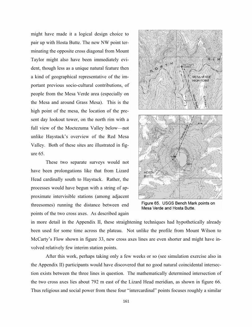
161
might have made it a logical design choice to
pair up with Hosta Butte. The new NW point ter-
minating the opposite cross diagonal from Mount
Taylor might also have been immediately evi-
dent, though less as a unique natural feature then
a kind of geographical representative of the im-
portant previous socio-cultural contributions, of
people from the Mesa Verde area (especially on
the Mesa and around Grass Mesa). This is the
high point of the mesa, the location of the pre-
sent day lookout tower, on the north rim with a
full view of the Moctezuma Valley below—not
unlike Haystack’s overview of the Red Mesa
Valley. Both of these sites are illustrated in fig-
ure 65.
These two separate surveys would not
have been prolongations like that from Lizard
Head cardinally south to Haystack. Rather, the
processes would have begun with a string of ap-
proximate intervisible stations (among adjacent
threesomes) running the distance between end
points of the two cross axes. As described again
in more detail in the Appendix II, these straightening techniques had hypothetically already
been used for some time across the plateau. Not unlike the profile from Mount Wilson to
McCarty’s Flow shown in figure 33, new cross axes lines are even shorter and might have in-
volved relatively few interim station points.
After this work, perhaps taking only a few weeks or so (see simulation exercise also in
the Appendix II) participants would have discovered that no good natural coincidental intersec-
tion exists between the three lines in question. The mathematically determined intersection of
the two cross axes lies about 792 m east of the Lizard Head meridian, as shown in figure 66.
Thus religious and social power from these four “intercardinal” points focuses roughly a similar
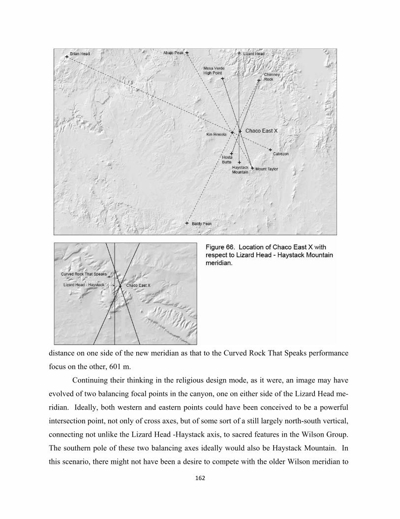
162
distance on one side of the new meridian as that to the Curved Rock That Speaks performance
focus on the other, 601 m.
Continuing their thinking in the religious design mode, as it were, an image may have
evolved of two balancing focal points in the canyon, one on either side of the Lizard Head me-
ridian. Ideally, both western and eastern points could have been conceived to be a powerful
intersection point, not only of cross axes, but of some sort of a still largely north-south vertical,
connecting not unlike the Lizard Head -Haystack axis, to sacred features in the Wilson Group.
The southern pole of these two balancing axes ideally would also be Haystack Mountain. In
this scenario, there might not have been a desire to compete with the older Wilson meridian to
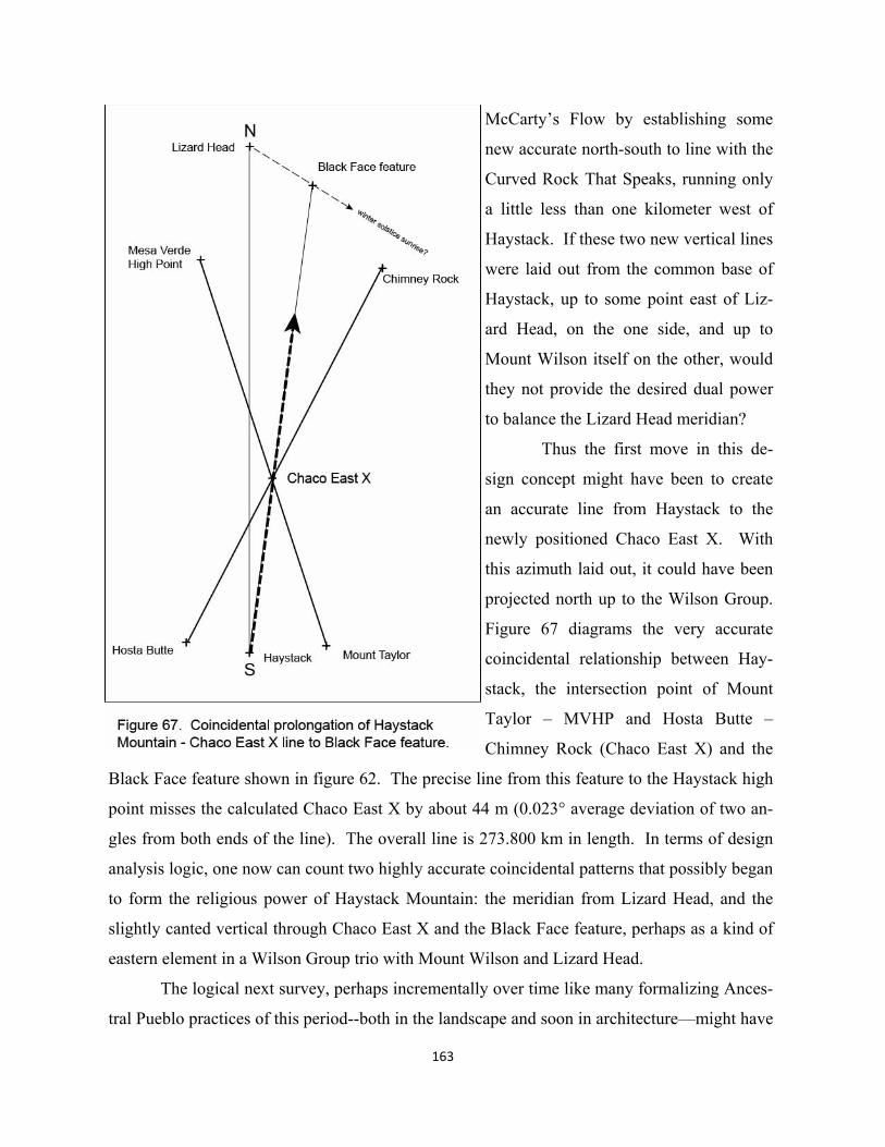
163
McCarty’s Flow by establishing some
new accurate north-south to line with the
Curved Rock That Speaks, running only
a little less than one kilometer west of
Haystack. If these two new vertical lines
were laid out from the common base of
Haystack, up to some point east of Liz-
ard Head, on the one side, and up to
Mount Wilson itself on the other, would
they not provide the desired dual power
to balance the Lizard Head meridian?
Thus the first move in this de-
sign concept might have been to create
an accurate line from Haystack to the
newly positioned Chaco East X. With
this azimuth laid out, it could have been
projected north up to the Wilson Group.
Figure 67 diagrams the very accurate
coincidental relationship between Hay-
stack, the intersection point of Mount
Taylor – MVHP and Hosta Butte –
Chimney Rock (Chaco East X) and the
Black Face feature shown in figure 62. The precise line from this feature to the Haystack high
point misses the calculated Chaco East X by about 44 m (0.023° average deviation of two an-
gles from both ends of the line). The overall line is 273.800 km in length. In terms of design
analysis logic, one now can count two highly accurate coincidental patterns that possibly began
to form the religious power of Haystack Mountain: the meridian from Lizard Head, and the
slightly canted vertical through Chaco East X and the Black Face feature, perhaps as a kind of
eastern element in a Wilson Group trio with Mount Wilson and Lizard Head.
The logical next survey, perhaps incrementally over time like many formalizing Ances-
tral Pueblo practices of this period--both in the landscape and soon in architecture—might have
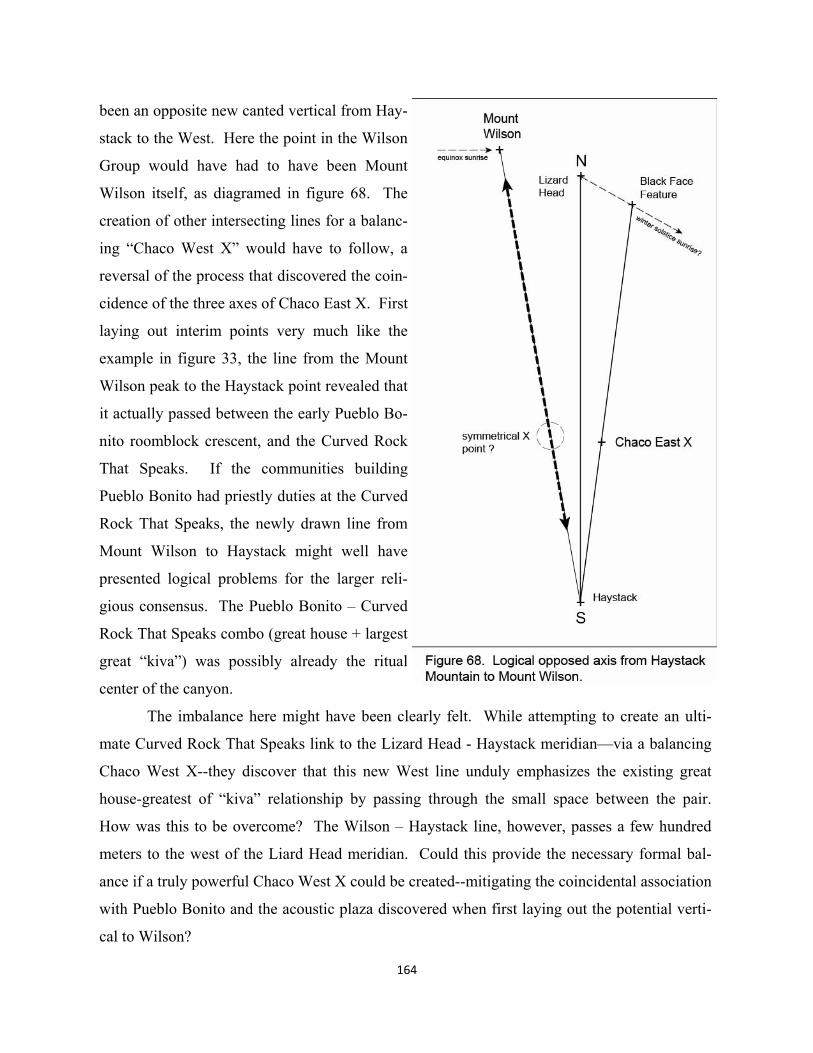
been an opposite new canted vertical from Hay-
stack to the West. Here the point in the Wilson
Group would have had to have been Mount
Wilson itself, as diagramed in figure 68. The
creation of other intersecting lines for a balanc-
ing “Chaco West X” would have to follow, a
reversal of the process that discovered the coin-
cidence of the three axes of Chaco East X. First
laying out interim points very much like the
example in figure 33, the line from the Mount
Wilson peak to the Haystack point revealed that
it actually passed between the early Pueblo Bo-
nito roomblock crescent, and the Curved Rock
That Speaks. If the communities building
Pueblo Bonito had priestly duties at the Curved
Rock That Speaks, the newly drawn line from
Mount Wilson to Haystack might well have
presented logical problems for the larger reli-
gious consensus. The Pueblo Bonito – Curved
Rock That Speaks combo (great house + largest
great “kiva”) was possibly already the ritual
center of the canyon.
The imbalance here might have been clearly felt. While attempting to create an ulti-
mate Curved Rock That Speaks link to the Lizard Head - Haystack meridian—via a balancing
Chaco West X--they discover that this new West line unduly emphasizes the existing great
house-greatest of “kiva” relationship by passing through the small space between the pair.
How was this to be overcome? The Wilson – Haystack line, however, passes a few hundred
meters to the west of the Liard Head meridian. Could this provide the necessary formal bal-
ance if a truly powerful Chaco West X could be created--mitigating the coincidental association
with Pueblo Bonito and the acoustic plaza discovered when first laying out the potential verti-
cal to Wilson?
164
Adjusting the original Chaco triangle to create Chaco West X
Proceeding with the their larger Haystack based concept, priest-surveyors might have consid-
ered finding two lines to intersect with Wilson – Haystack to further convince people of the
power of some balancing X point west of the Lizard Head meridian (the role of Pueblo Bonito
notwithstanding). The successful (in part coincidentally remarkable) Chaco East X had al-
ready involved the four most logical natural features at the corners of the re-forming Chacoan
side of the plateau, and the Black Face feature. If adherents to the religious aspects of the orig-
inal Chacoan cross at Kin Bineola were still active at this site, it may be possible that their in-
fluence was felt in this quest for a balancing cross intersection point west of the Curved Rock
That Speaks. Thrown into the mix could also have been people at the West canyon site of Pe-
ñasco Blanco (associated with 29SJ423), sensitive perhaps to what was happening to their ear-
lier prominence of being at the vertex of the original triangle with Kin Bineola X and Sha-
bik’eschee.
The design logic might have been to replace the two lines and their intersection point
(the vertex at 29SJ423) with a similar construct whose intersect would be on the Wilson –
Haystack axis at a point just west of the canyon center, a balancing Chaco West X. This re-
vised triangle might keep Kin Bineola X as its western base point, thereby facilitating some
religious continuity in this piece of the new Chaco frame. The original triangle, see again fig-
ure 38, might have been conceptualized as pivoting clockwise from a fixed Kin Bineola X, cre-
ating both a new eastern base point to replace Shabik’eschee and a new ChacoWest X point
closer to the canyon center. The base of this rotated triangle might have been struck first as a
line originating from the Sipapu. After all, the coincidental Sipapu – Chicoma – Truchas line
could have been one of the two lines that positioned the original vertex at 29SJ423. While a
Sipapu line is shifting here from vertex to base, the essential geometric relationship between
these two elements of an equilateral triangle may have provided some symbolic continuity to
the change.
Design evidence of this shifted base lies in the very accurate alignment from the Sipapu
through Kin Bineola X, actually striking the Kin Bineola great house’s large partner to the SE
of the canyon, Pueblo Pintado, figure 69. The total line is 372.472 km. While this line was
not included in the probability exercises of Chapter 4, the high likelihood that some number of
165
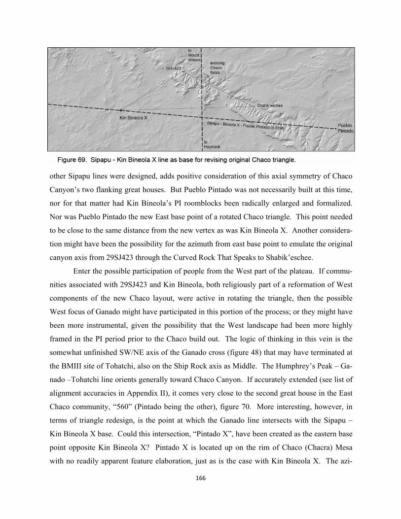
166
other Sipapu lines were designed, adds positive consideration of this axial symmetry of Chaco
Canyon’s two flanking great houses. But Pueblo Pintado was not necessarily built at this time,
nor for that matter had Kin Bineola’s PI roomblocks been radically enlarged and formalized.
Nor was Pueblo Pintado the new East base point of a rotated Chaco triangle. This point needed
to be close to the same distance from the new vertex as was Kin Bineola X. Another considera-
tion might have been the possibility for the azimuth from east base point to emulate the original
canyon axis from 29SJ423 through the Curved Rock That Speaks to Shabik’eschee.
Enter the possible participation of people from the West part of the plateau. If commu-
nities associated with 29SJ423 and Kin Bineola, both religiously part of a reformation of West
components of the new Chaco layout, were active in rotating the triangle, then the possible
West focus of Ganado might have participated in this portion of the process; or they might have
been more instrumental, given the possibility that the West landscape had been more highly
framed in the PI period prior to the Chaco build out. The logic of thinking in this vein is the
somewhat unfinished SW/NE axis of the Ganado cross (figure 48) that may have terminated at
the BMIII site of Tohatchi, also on the Ship Rock axis as Middle. The Humphrey’s Peak – Ga-
nado –Tohatchi line orients generally toward Chaco Canyon. If accurately extended (see list of
alignment accuracies in Appendix II), it comes very close to the second great house in the East
Chaco community, “560” (Pintado being the other), figure 70. More interesting, however, in
terms of triangle redesign, is the point at which the Ganado line intersects with the Sipapu –
Kin Bineola X base. Could this intersection, “Pintado X”, have been created as the eastern base
point opposite Kin Bineola X? Pintado X is located up on the rim of Chaco (Chacra) Mesa
with no readily apparent feature elaboration, just as is the case with Kin Bineola X. The azi-
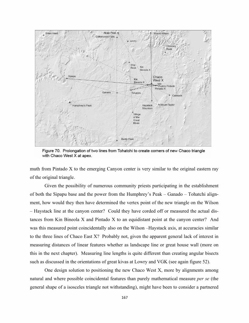
167
muth from Pintado X to the emerging Canyon center is very similar to the original eastern ray
of the original triangle.
Given the possibility of numerous community priests participating in the establishment
of both the Sipapu base and the power from the Humphrey’s Peak – Ganado – Tohatchi align-
ment, how would they then have determined the vertex point of the new triangle on the Wilson
– Haystack line at the canyon center? Could they have corded off or measured the actual dis-
tances from Kin Bineola X and Pintado X to an equidistant point at the canyon center? And
was this measured point coincidentally also on the Wilson –Haystack axis, at accuracies similar
to the three lines of Chaco East X? Probably not, given the apparent general lack of interest in
measuring distances of linear features whether as landscape line or great house wall (more on
this in the next chapter). Measuring line lengths is quite different than creating angular bisects
such as discussed in the orientations of great kivas at Lowry and VGK (see again figure 52).
One design solution to positioning the new Chaco West X, more by alignments among
natural and where possible coincidental features than purely mathematical measure per se (the
general shape of a isosceles triangle not withstanding), might have been to consider a partnered
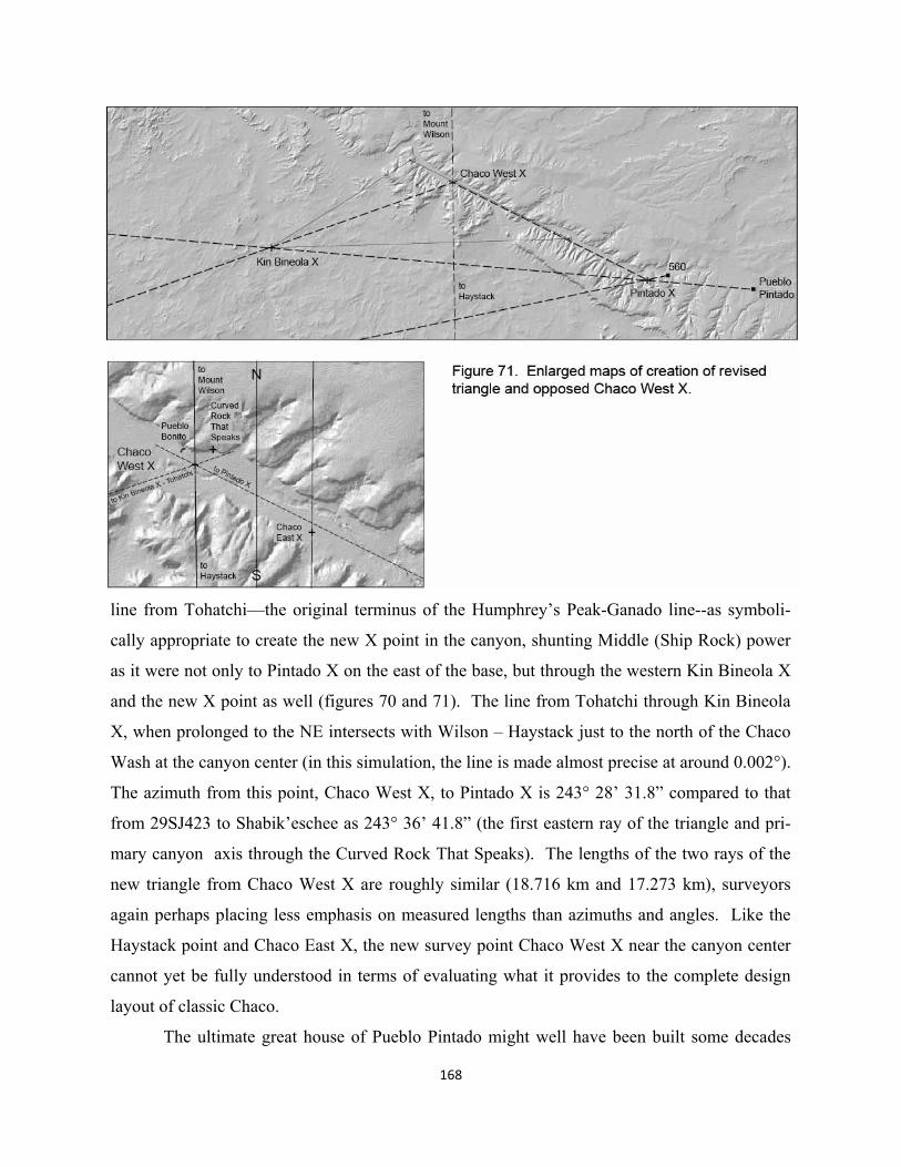
168
line from Tohatchi—the original terminus of the Humphrey’s Peak-Ganado line--as symboli-
cally appropriate to create the new X point in the canyon, shunting Middle (Ship Rock) power
as it were not only to Pintado X on the east of the base, but through the western Kin Bineola X
and the new X point as well (figures 70 and 71). The line from Tohatchi through Kin Bineola
X, when prolonged to the NE intersects with Wilson – Haystack just to the north of the Chaco
Wash at the canyon center (in this simulation, the line is made almost precise at around 0.002°).
The azimuth from this point, Chaco West X, to Pintado X is 243° 28’ 31.8” compared to that
from 29SJ423 to Shabik’eschee as 243° 36’ 41.8” (the first eastern ray of the triangle and pri-
mary canyon axis through the Curved Rock That Speaks). The lengths of the two rays of the
new triangle from Chaco West X are roughly similar (18.716 km and 17.273 km), surveyors
again perhaps placing less emphasis on measured lengths than azimuths and angles. Like the
Haystack point and Chaco East X, the new survey point Chaco West X near the canyon center
cannot yet be fully understood in terms of evaluating what it provides to the complete design
layout of classic Chaco.
The ultimate great house of Pueblo Pintado might well have been built some decades
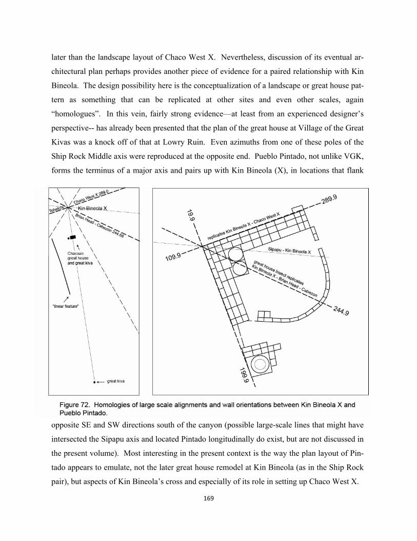
later than the landscape layout of Chaco West X. Nevertheless, discussion of its eventual ar-
chitectural plan perhaps provides another piece of evidence for a paired relationship with Kin
Bineola. The design possibility here is the conceptualization of a landscape or great house pat-
tern as something that can be replicated at other sites and even other scales, again
“homologues”. In this vein, fairly strong evidence—at least from an experienced designer’s
perspective-- has already been presented that the plan of the great house at Village of the Great
Kivas was a knock off of that at Lowry Ruin. Even azimuths from one of these poles of the
Ship Rock Middle axis were reproduced at the opposite end. Pueblo Pintado, not unlike VGK,
forms the terminus of a major axis and pairs up with Kin Bineola (X), in locations that flank
opposite SE and SW directions south of the canyon (possible large-scale lines that might have
intersected the Sipapu axis and located Pintado longitudinally do exist, but are not discussed in
the present volume). Most interesting in the present context is the way the plan layout of Pin-
tado appears to emulate, not the later great house remodel at Kin Bineola (as in the Ship Rock
pair), but aspects of Kin Bineola’s cross and especially of its role in setting up Chaco West X.
169
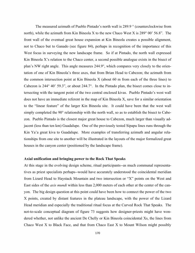
170
The measured azimuth of Pueblo Pintado’s north wall is 289.9 ° (counterclockwise from
north), while the azimuth from Kin Bineola X to the new Chaco West X is 289° 00’ 56.8”. The
front wall of the eventual great house expansion at Kin Bineola creates a possible alignment,
not to Chaco but to Ganado (see figure 84), perhaps in recognition of the importance of this
West focus in surveying the new landscape frame. So if at Pintado, the north wall expressed
Kin Bineola X’s relation to the Chaco center, a second possible analogue exists in the bisect of
plan’s NW right angle. This angle measures 244.9°, which compares very closely to the orien-
tation of one of Kin Bineola’s three axes, that from Brian Head to Cabezon; the azimuth from
the common intersection point at Kin Bineola X (about 60 m from each of the three lines) to
Cabezon is 244° 40’ 59.3”, or about 244.7°. In the Pintado plan, the bisect comes close to in-
tersecting with the tangent point of the two central enclosed kivas. Pueblo Pintado’s west wall
does not have an immediate referent in the map of Kin Bineola X, save for a similar orientation
to the “linear feature” of the larger Kin Bineola site. It could have been that the west wall
simply completed the 90° relationship with the north wall, so as to establish the bisect to Cabe-
zon. Pueblo Pintado is the closest major great house to Cabezon, much larger than visually ad-
jacent (less than ten km) Guadalupe. One of the previously tested Sipapu lines runs through the
Kin Ya’a great kiva to Guadalupe. More examples of transferring azimuth and angular rela-
tionships from one site to another will be illustrated in the layouts of the major formalized great
houses in the canyon center (positioned by the landscape frame).
Axial unification and bringing power to the Rock That Speaks
At this stage in the evolving design scheme, ritual participants--as much communal representa-
tives as priest specialists perhaps--would have accurately understood the coincidental meridian
from Lizard Head to Haystack Mountain and two intersection or “X” points on the West and
East sides of the axis mundi within less than 2,000 meters of each other at the center of the can-
yon. The big design question at this point could have been how to connect the power of the two
X points, created by distant features in the plateau landscape, with the power of the Lizard
Head meridian and especially the traditional ritual focus at the Curved Rock That Speaks. The
not-to-scale conceptual diagram of figure 73 suggests how designer-priests might have won-
dered whether, not unlike the ancient De Chelly or Kin Bineola coincidental Xs, the lines from
Chaco West X to Black Face, and that from Chaco East X to Mount Wilson might possibly
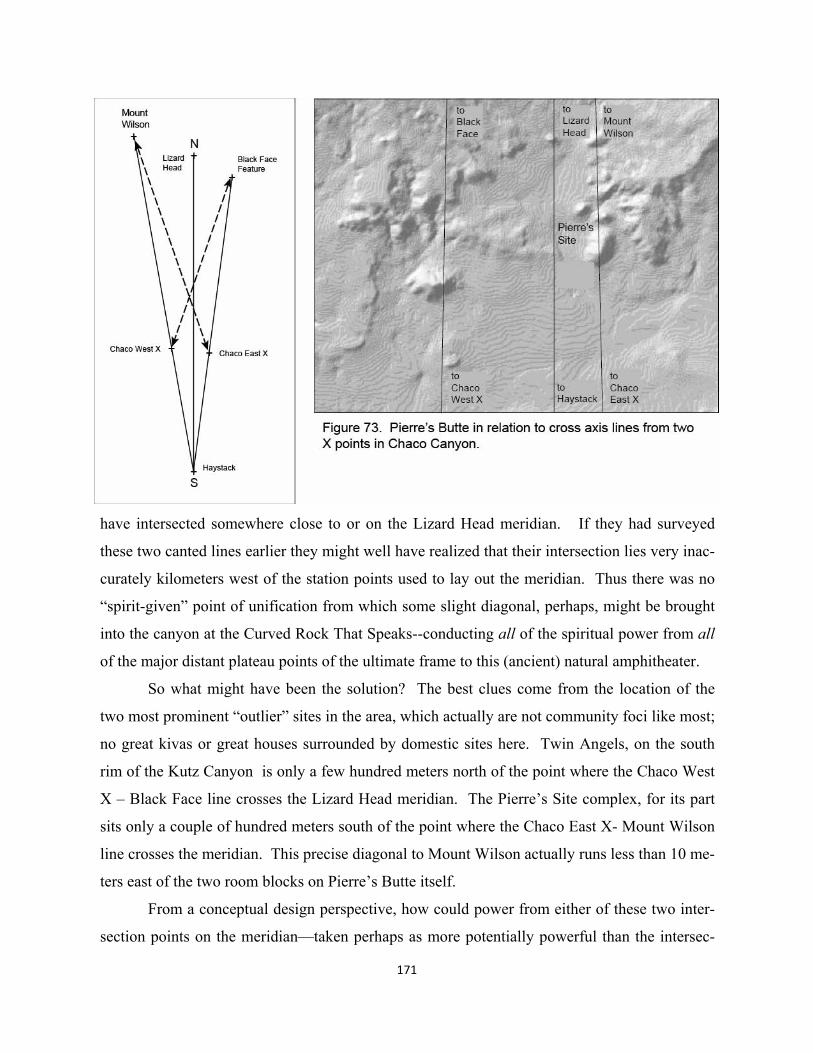
have intersected somewhere close to or on the Lizard Head meridian. If they had surveyed
these two canted lines earlier they might well have realized that their intersection lies very inac-
curately kilometers west of the station points used to lay out the meridian. Thus there was no
“spirit-given” point of unification from which some slight diagonal, perhaps, might be brought
into the canyon at the Curved Rock That Speaks--conducting all of the spiritual power from all
of the major distant plateau points of the ultimate frame to this (ancient) natural amphitheater.
So what might have been the solution? The best clues come from the location of the
two most prominent “outlier” sites in the area, which actually are not community foci like most;
no great kivas or great houses surrounded by domestic sites here. Twin Angels, on the south
rim of the Kutz Canyon is only a few hundred meters north of the point where the Chaco West
X – Black Face line crosses the Lizard Head meridian. The Pierre’s Site complex, for its part
sits only a couple of hundred meters south of the point where the Chaco East X- Mount Wilson
line crosses the meridian. This precise diagonal to Mount Wilson actually runs less than 10 me-
ters east of the two room blocks on Pierre’s Butte itself.
From a conceptual design perspective, how could power from either of these two inter-
section points on the meridian—taken perhaps as more potentially powerful than the intersec-
171
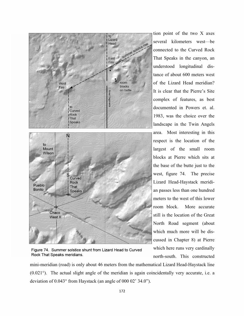
172
tion point of the two X axes
several kilometers west—be
connected to the Curved Rock
That Speaks in the canyon, an
understood longitudinal dis-
tance of about 600 meters west
of the Lizard Head meridian?
It is clear that the Pierre’s Site
complex of features, as best
documented in Powers et. al.
1983, was the choice over the
landscape in the Twin Angels
area. Most interesting in this
respect is the location of the
largest of the small room
blocks at Pierre which sits at
the base of the butte just to the
west, figure 74. The precise
Lizard Head-Haystack meridi-
an passes less than one hundred
meters to the west of this lower
room block. More accurate
still is the location of the Great
North Road segment (about
which much more will be dis-
cussed in Chapter 8) at Pierre
which here runs very cardinally
north-south. This constructed
mini-meridian (road) is only about 46 meters from the mathematical Lizard Head-Haystack line
(0.021°). The actual slight angle of the meridian is again coincidentally very accurate, i.e. a
deviation of 0.043° from Haystack (an angle of 000 02’ 34.0”).
173
We know that after the cardinal segment at Pierre, the North Road runs south on a slight
diagonal to the west down to the canyon center, accommodating the 600 meter inaccuracy be-
tween the Lizard Head meridian and the Curved Rock That Speaks. The road, however, was
built in the early 1100’s after the new formalized great houses had been constructed (Kincaid
1983). Thus the road could not have been the initial component of the survey scheme to con-
nect meridian power to the center of the canyon and especially to the Curved Rock That
Speaks.
Two additional and unusual site features at Pierre may have been the key to delivering
spirit power from meridian to central ritual plaza. An eastern fire feature, “El Faro”, sits atop a
smaller butte directly north above the largest room block. Because of three adjacent rooms, the
survey (Power et. al. 1983) couldn’t definitely say whether the fire hearth here was for signal-
ing or domestic use. It is located, however, on the very high point of the smaller butte, with
three small rooms running down the slope to the south. On another small butte to the southwest
of El Faro, is located a large 3x3 meter “signaling hearth” with no adjacent structures. Since
many of the room block structures were built later at the time of Great Road construction, it
could be that these two signaling features constituted the initial ritual rationale for the Pierre
complex. Given that the two fire hearths are about 600 meters apart, longitudinally, and that
the western hearth’s longitude of 107° 57’ 23” is very close to the center point of the Curved
Rock That Speaks amphitheater at 107° 57’ 26.6”, this could be a kind of “spiritual shunt” that
at certain times connected meridian flow from Lizard Head to a surveyed mini-meridian down
to the central ritual plaza.
The azimuth between western and eastern hearths is 298° 10’ 52”, about two degrees
from summer solstice sunrise at this latitude. While no actual observations have yet been made
to better define this possibility, the hearth features could have been a timing element in switch-
ing Lizard Head meridian flow at Pierre to the Curved Rock That Speaks meridian. The date
should be just before or after actual solstice, perhaps setting up actual ritual events in the can-
yon. While the fire hearths may have been part of some larger scale signaling from Pierre, the
primary ritual efficacy might have been the lighting of the two fires in unison as the sun rose to
the east. Not only might spiritual power from Lizard Head have been conducted to the Curved
Rock That Speaks meridian, but the effect could have been symbolically heightened by the in-
tegration of rays of the solstice sunrise.
174
Canyon survey points and lines as framework for major great kivas and houses
The layout of the shunt between the Lizard Head and Curved Rock That Speaks meridians, to-
gether with the cross axis intersection point as Chaco East X and the revised triangle apex as
Chaco West X –actually only four survey points in all—provides the key survey “benchmarks”
by which the five new great houses and largest of great kivas, the singular Casa Rincoñada, are
positioned. While no probabilistic test has yet been devised to capture this total layout, a not
inconsiderable formal design logic exists in this survey process. The ability of the formalized
framework to explain both the location and orientation of the largest and singular great kiva and
five new great houses, along with remodeled aspects of Pueblo Bonito and Una Vida, should
provide considerable additional evidence of overall design intent--that begins in the large scale
landscape and culminates in monumental architecture.
7. Locating New Great Houses / Casa Rincoñada and Orienting Monumental Walls
Given the survey layout diagramed in the previous chapter, it seems likely that implications for
new great houses and their locations were becoming apparent as the design of the large scale
ritual process played out. Could they have held off creating new architecture until they ob-
tained a certain closure of the landscape scheme? When the major construction phase begins in
earnest around 1020 A.D. (Powers et. al. 1983:250), it is not impossible that builders at any
particular site knew what was being or going to be erected at the other sites. It is not incon-
ceivable that survey related ritual activities by different socio-religious groups were taking
place at many sites, perhaps from the time when their location had been determined by the new
formal landscape frame. This radical view runs counter to intuitions that imagine more politi-
cally individual or territorial choices initiating these very large religiously purposed buildings.
Thus a certain theoretical impasse appears, one between a new understanding of cultural land-
scape history--particularly in the organizational potential of large scale ritual formalization--
and conventional histories of designed, formal architecture.
An architectural history perspective on “monumental” great houses
It is during the 11th century that Pueblo Ancestors laid out for the first time precise, massive
straight walls as part of roomblock distribution in their non-domestic, ceremonially related
great houses in Chaco Canyon. The first formal monumental architecture, beyond the con-
strained but still highly formal great kiva circles and within an already ancient Ancestral Pueb-
lo region provides an exceptional opportunity to think about a natural history of “architecture”
in the more conventional, formalistic sense of the word. In late Basketmaker periods (around
700 A.D.) when people lived only in organic pit houses and stored goods in pit structures as
well, their graphic geometry of smaller artifacts clearly illustrates a capacity for design, figure
75. This capacity continues to be limited to smaller artifacts for an additional 300 years, even
though people are building precise circular great kivas and living in seemingly more architec-
tural, yet still organic surface structures called “pueblos”. What is it, then, that initiates this
175
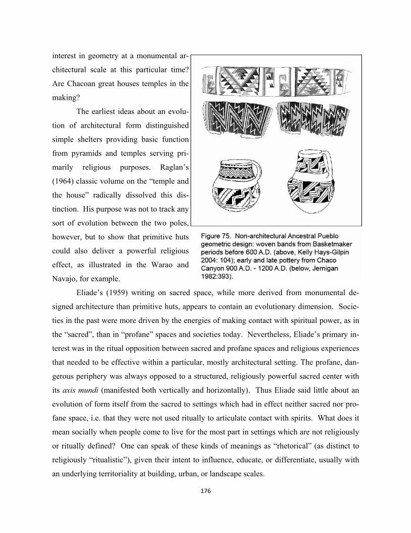
176
interest in geometry at a monumental ar-
chitectural scale at this particular time?
Are Chacoan great houses temples in the
making?
The earliest ideas about an evolu-
tion of architectural form distinguished
simple shelters providing basic function
from pyramids and temples serving pri-
marily religious purposes. Raglan’s
(1964) classic volume on the “temple and
the house” radically dissolved this dis-
tinction. His purpose was not to track any
sort of evolution between the two poles,
however, but to show that primitive huts
could also deliver a powerful religious
effect, as illustrated in the Warao and
Navajo, for example.
Eliade’s (1959) writing on sacred space, while more derived from monumental de-
signed architecture than primitive huts, appears to contain an evolutionary dimension. Socie-
ties in the past were more driven by the energies of making contact with spiritual power, as in
the “sacred”, than in “profane” spaces and societies today. Nevertheless, Eliade’s primary in-
terest was in the ritual opposition between sacred and profane spaces and religious experiences
that needed to be effective within a particular, mostly architectural setting. The profane, dan-
gerous periphery was always opposed to a structured, religiously powerful sacred center with
its axis mundi (manifested both vertically and horizontally). Thus Eliade said little about an
evolution of form itself from the sacred to settings which had in effect neither sacred nor pro-
fane space, i.e. that they were not used ritually to articulate contact with spirits. What does it
mean socially when people come to live for the most part in settings which are not religiously
or ritually defined? One can speak of these kinds of meanings as “rhetorical” (as distinct to
religiously “ritualistic”), given their intent to influence, educate, or differentiate, usually with
an underlying territoriality at building, urban, or landscape scales.
177
Recognizing evidence in many ethnographic accounts of landscape use, a very small
number of architectural historians have recognized that sacred space exists beyond the scale of
temple experience or architecture. Rykwert (1976) investigated the Eliadian structuralist idea
in the religious bases of the founding of Rome, as well as large scale parallels in other societies
including the primitive. Rykwert’s model suggests an almost Jungian archetypal notion of ex-
pression in most traditional societies, whether historic, prehistoric, or ethnographic. The basic
patterns of “Eliadian” structures in cities or villages are not dissimilar to those found in huts
and temples. Missing here too, however, is an evaluation of a separate, rhetorical component as
a distinct means of social power in Roman architecture and city layout. The triumphal architec-
ture, parades of returning conquering Caesars, and ultimately many of the events in the colise-
um setting (McCormick 1986) are almost pure rhetoric with a strong real and symbolic territori-
al underpinning. The intent is to impress and persuade, a source of power quite different from
that experienced in sacred ritual settings whose primary purpose is to make contact with the
gods.
But what about the largest scale of all, the known landscape or heavenly cosmos, repre-
sentations of which in both ethnographic and historical societies take the form of seemingly
“Eliadian” center structures? Here the sacred-profane opposition may break down, at least in
the landscape, according to Smith’s critique (1972). Observing a more ethnographic reality in
primitive cultures, the periphery is usually the most sacred. This is where the gods live, as in
good ethnographic accounts of larger scale, sacred landscape practice extensively described
earlier in this volume. Vincent Scully (1989), the architectural historian most recognized, per-
haps, for discourse about sacred architecture and landscape, describes the dance plazas of the
historic pueblo ritually integrating the surrounding sacred mountains. Influenced perhaps by
his earlier work on the way temples in the Classical World orient to landscape features (1962),
he sees landscape spatial patterns as more of an extension of architecturally framed dance in
pueblo plazas.
The assumption that the largest of ritually framed landscapes are derived from temple or
primitive hut architecture, or created more fundamentally by myth as in Eliade or even Ortiz, is
of course presently challenged by arguing for a technical ability of traditional societies to sur-
vey geometric patterns at scales far beyond immediate viewsheds—a radical, but nonetheless
logical extension of scale, in effect, of the formal ritual layouts of huts. In this sense, large
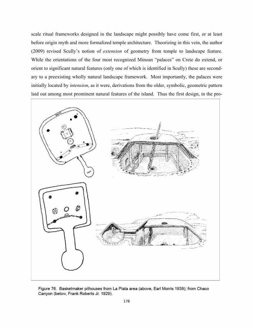
178
scale ritual frameworks designed in the landscape might possibly have come first, or at least
before origin myth and more formalized temple architecture. Theorizing in this vein, the author
(2009) revised Scully’s notion of extension of geometry from temple to landscape feature.
While the orientations of the four most recognized Minoan “palaces” on Crete do extend, or
orient to significant natural features (only one of which is identified in Scully) these are second-
ary to a preexisting wholly natural landscape framework. Most importantly, the palaces were
initially located by intension, as it were, derivations from the older, symbolic, geometric pattern
laid out among most prominent natural features of the island. Thus the first design, in the pro-

cess of creating architectural settings occurred in the landscape, rather than on the actual site.
Summarizing the architecture mentioned in previous chapters, for hundreds of years pri-
or to about 700 A.D. each Basketmaker family lived in its own pit house as illustrated in figure
76. Corn growing, hunting and gathering families and community groups are relatively settled,
but would move because of drought or other ecological exigencies. While the relationship be-
tween sacred dwelling and larger symbolic landscape is ethnographically unknown in this peri-
od, some shaman mediated cosmos like the Warao or Navajo has been hypothesized.
Around 800 – 900 AD Anasazi families begin building small, more or less rectilinear
above ground “pueblo” storage structures in an informal arc around the still circular pit houses,
return to figure 54. This domestic example is adjacent to the highly formalized early great kiva
of Grass Mesa (Brisbin 1988). Early archaeologists in the SW, influenced by extant historical
pueblos, laid out their temporal classification system based in part on this change in domestic
building form, i.e. “Basketmaker” to “Pueblo”. The ecological emphasis is on greater settle-
ment permanence, increasing crop surplus along with population growth, and functionality of
storage.
The first clusters of rectilinear storage rooms are not consciously laid out, cognitively
imagined designs, compared again to the rich evidence of graphic skills as shown in figure 75
(now more in pottery rather than baskets and weavings), or in formally designed great kivas.
As described in Chapter 5, during Pueblo I periods in Chaco Canyon larger clusters of room
blocks emerged at three foci in the later part of 800 A.D.; new great kivas were built north of
two of these. Yet, again, no other great kivas or formalized great houses are constructed in the
canyon until the early 1000’s. How would architectural historians explain this incredibly ab-
rupt formalization that occurs not only in the siting of these huge new monuments, but in the
apparently symbolic orientations of massive “great walls”, often multiple variations in one
structure? In the absence of understanding a preexisting ritual layout in the greater landscape
and Chaco Canyon, one might conclude that some itinerant Central American priest/architect
suddenly showed up and somehow persuaded half a dozen or so separate social entities (each
comprised of multiple internal groups) to more or less contemporaneously spend enormous re-
sources building structures the likes of which had never been seen before.
179
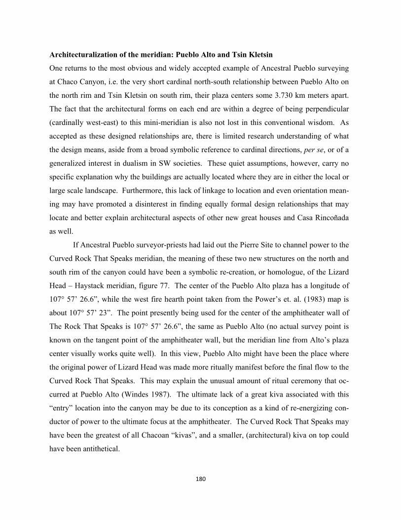
180
Architecturalization of the meridian: Pueblo Alto and Tsin Kletsin
One returns to the most obvious and widely accepted example of Ancestral Pueblo surveying
at Chaco Canyon, i.e. the very short cardinal north-south relationship between Pueblo Alto on
the north rim and Tsin Kletsin on south rim, their plaza centers some 3.730 km meters apart.
The fact that the architectural forms on each end are within a degree of being perpendicular
(cardinally west-east) to this mini-meridian is also not lost in this conventional wisdom. As
accepted as these designed relationships are, there is limited research understanding of what
the design means, aside from a broad symbolic reference to cardinal directions, per se, or of a
generalized interest in dualism in SW societies. These quiet assumptions, however, carry no
specific explanation why the buildings are actually located where they are in either the local or
large scale landscape. Furthermore, this lack of linkage to location and even orientation mean-
ing may have promoted a disinterest in finding equally formal design relationships that may
locate and better explain architectural aspects of other new great houses and Casa Rincoñada
as well.
If Ancestral Pueblo surveyor-priests had laid out the Pierre Site to channel power to the
Curved Rock That Speaks meridian, the meaning of these two new structures on the north and
south rim of the canyon could have been a symbolic re-creation, or homologue, of the Lizard
Head – Haystack meridian, figure 77. The center of the Pueblo Alto plaza has a longitude of
107° 57’ 26.6”, while the west fire hearth point taken from the Power’s et. al. (1983) map is
about 107° 57’ 23”. The point presently being used for the center of the amphitheater wall of
The Rock That Speaks is 107° 57’ 26.6”, the same as Pueblo Alto (no actual survey point is
known on the tangent point of the amphitheater wall, but the meridian line from Alto’s plaza
center visually works quite well). In this view, Pueblo Alto might have been the place where
the original power of Lizard Head was made more ritually manifest before the final flow to the
Curved Rock That Speaks. This may explain the unusual amount of ritual ceremony that oc-
curred at Pueblo Alto (Windes 1987). The ultimate lack of a great kiva associated with this
“entry” location into the canyon may be due to its conception as a kind of re-energizing con-
ductor of power to the ultimate focus at the amphitheater. The Curved Rock That Speaks may
have been the greatest of all Chacoan “kivas”, and a smaller, (architectural) kiva on top could
have been antithetical.
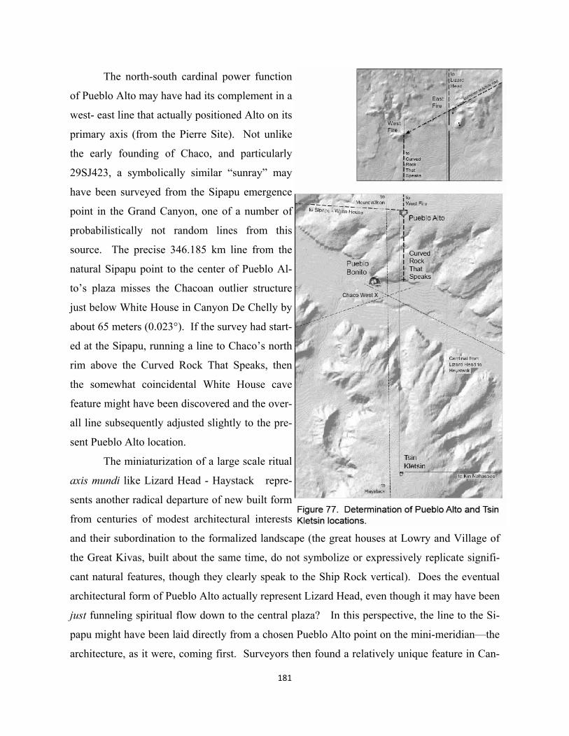
181
The north-south cardinal power function
of Pueblo Alto may have had its complement in a
west- east line that actually positioned Alto on its
primary axis (from the Pierre Site). Not unlike
the early founding of Chaco, and particularly
29SJ423, a symbolically similar “sunray” may
have been surveyed from the Sipapu emergence
point in the Grand Canyon, one of a number of
probabilistically not random lines from this
source. The precise 346.185 km line from the
natural Sipapu point to the center of Pueblo Al-
to’s plaza misses the Chacoan outlier structure
just below White House in Canyon De Chelly by
about 65 meters (0.023°). If the survey had start-
ed at the Sipapu, running a line to Chaco’s north
rim above the Curved Rock That Speaks, then
the somewhat coincidental White House cave
feature might have been discovered and the over-
all line subsequently adjusted slightly to the pre-
sent Pueblo Alto location.
The miniaturization of a large scale ritual
axis mundi like Lizard Head - Haystack repre-
sents another radical departure of new built form
from centuries of modest architectural interests
and their subordination to the formalized landscape (the great houses at Lowry and Village of
the Great Kivas, built about the same time, do not symbolize or expressively replicate signifi-
cant natural features, though they clearly speak to the Ship Rock vertical). Does the eventual
architectural form of Pueblo Alto actually represent Lizard Head, even though it may have been
just funneling spiritual flow down to the central plaza? In this perspective, the line to the Si-
papu might have been laid directly from a chosen Pueblo Alto point on the mini-meridian—the
architecture, as it were, coming first. Surveyors then found a relatively unique feature in Can-
182
yon De Chelly coincidentally on this line to serve as a ritual connector to possible traditions of
an ancient cross focus in shamanistic times.
The idea that Lizard Head’s power stopped at Pueblo Alto and the Curved Rock That
Speaks, may be evident in a closer look at how this great house actually aligns with Tsin
Kletsin. The plaza centers do not align, alleviating perhaps any contradiction of the southbound
power’s ultimate destination. It stops at the amphitheater. Instead, a separate small scale can-
yon meridian was apparently designed to align the west walls of the two rim structures. Sym-
bolically the 50 meters or so difference from Pueblo Alto’s center line and its west wall could
have been understood as adequately separating the two “mini-meridians”, the one from Pierre’s
west fire hearth being the longer and most important. An angular variation of 50 meters at the
distance between the two rim great houses is about 0.77°, compared to most surveyed lines of
the major expansion being well under 0.075°.
Tsin Kletsin’s position as “Haystack Mountain” on this west wall line could have been
determined more locally by a cardinal west-east line from the earlier established Kin Nahasbas
great kiva. This point, the reader will recall, possibly replaced Shabik’eschee as the eastern en-
tity in relation to the early great kiva at Peñasco Blanco and Curved Rock That Speaks/Pueblo
Bonito in the middle. The monolithic north wall of the Tsin Kletsin plaza, facing Pueblo Alto,
is about 0.3 of one arc second (9 m) off an identical latitude. This accuracy would only come
from using solar determinants of due west from Kin Nahasbas, not laying out a great circle per-
pendicular (which would deviate much more from a celestial west-east).
The author’s theodolite measurement of great house wall orientations records the major
west-east wall of Pueblo Alto being about 0.85° from true cardinal, and Tsin Kletsin’s is almost
identical at 0.83°, making both within one degree of being perpendicular to the north-south
alignment between the two. Without significant further research into the layout accuracy of the
architecture itself, compared to large scale landscape geometry, it is difficult to presently specu-
late whether these deviations from cardinal west-east might be intentional or just the product of
a lessor working accuracy within the architectural medium of the time. As evaluated in more
detailed drawings not presently illustrated, the NW corners of the two great houses in question
seem to be designed as 90°. This reinforces the use of their west walls as the aligning features
between north and south rims. The walls of Pueblo Alto’s eventual east wing are not perpen-
dicular, off 2.9 and 4.0 degrees, variations common in the new Chacoan great houses.
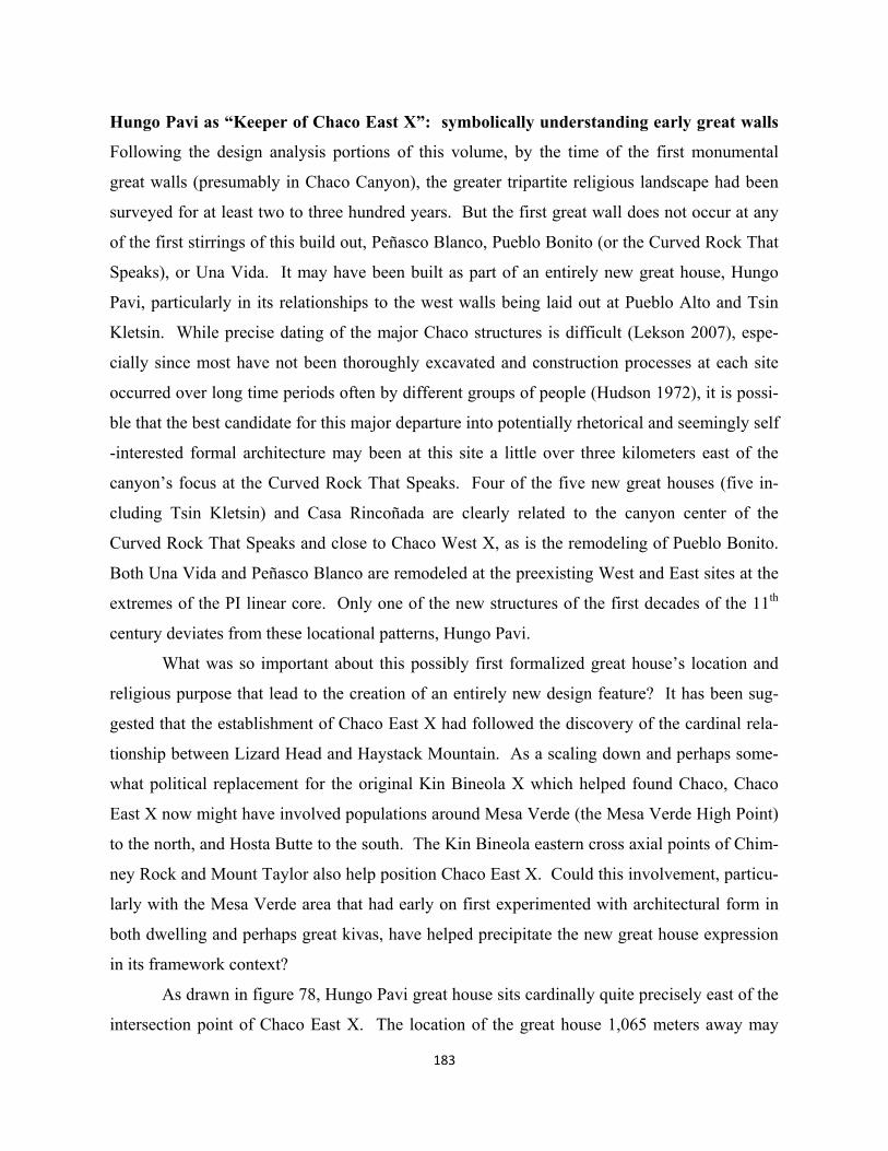
183
Hungo Pavi as “Keeper of Chaco East X”: symbolically understanding early great walls
Following the design analysis portions of this volume, by the time of the first monumental
great walls (presumably in Chaco Canyon), the greater tripartite religious landscape had been
surveyed for at least two to three hundred years. But the first great wall does not occur at any
of the first stirrings of this build out, Peñasco Blanco, Pueblo Bonito (or the Curved Rock That
Speaks), or Una Vida. It may have been built as part of an entirely new great house, Hungo
Pavi, particularly in its relationships to the west walls being laid out at Pueblo Alto and Tsin
Kletsin. While precise dating of the major Chaco structures is difficult (Lekson 2007), espe-
cially since most have not been thoroughly excavated and construction processes at each site
occurred over long time periods often by different groups of people (Hudson 1972), it is possi-
ble that the best candidate for this major departure into potentially rhetorical and seemingly self
-interested formal architecture may been at this site a little over three kilometers east of the
canyon’s focus at the Curved Rock That Speaks. Four of the five new great houses (five in-
cluding Tsin Kletsin) and Casa Rincoñada are clearly related to the canyon center of the
Curved Rock That Speaks and close to Chaco West X, as is the remodeling of Pueblo Bonito.
Both Una Vida and Peñasco Blanco are remodeled at the preexisting West and East sites at the
extremes of the PI linear core. Only one of the new structures of the first decades of the 11th
century deviates from these locational patterns, Hungo Pavi.
What was so important about this possibly first formalized great house’s location and
religious purpose that lead to the creation of an entirely new design feature? It has been sug-
gested that the establishment of Chaco East X had followed the discovery of the cardinal rela-
tionship between Lizard Head and Haystack Mountain. As a scaling down and perhaps some-
what political replacement for the original Kin Bineola X which helped found Chaco, Chaco
East X now might have involved populations around Mesa Verde (the Mesa Verde High Point)
to the north, and Hosta Butte to the south. The Kin Bineola eastern cross axial points of Chim-
ney Rock and Mount Taylor also help position Chaco East X. Could this involvement, particu-
larly with the Mesa Verde area that had early on first experimented with architectural form in
both dwelling and perhaps great kivas, have helped precipitate the new great house expression
in its framework context?
As drawn in figure 78, Hungo Pavi great house sits cardinally quite precisely east of the
intersection point of Chaco East X. The location of the great house 1,065 meters away may
184
have followed the pattern of nesting great houses against the canyon’s north wall, as occurs at
the Curved Rock That Speaks, Pueblo Bonito, and Una Vida. Like the Kin Bineola site, there is
no known archaeological feature associated with the Chaco East X point, though no remote
sensing has been conducted. In terms of accuracy, the intersection area is about about 150 m
across, determined by the amount of angular deviation perhaps typical for Ancestral Pueblo sur-
veying, roughly within about 0.06° deviation (visual acuity again is 0.017°). The latitude of
Chaco East X was set identical to that of the central small kiva embedded in the major west-east
roomblock of Hungo Pavi, a kind of reverse test of the relationship between the two. As the
reader has seen, and will continue to see, the Chaco East X point used is very accurate in its
participation in multiple large scale patterns.
At first look, the most obviously designed elements of Hungo Pavi are the long, precise
straight walls, and formal manner in which the two end wings, together with the longitudinal or
longest room block form an “E” shape (front walls to enclose these courtyards came later). The
triadic E form recognizes a seemingly central feature in the main block like the small integrated
kiva at Hungo Pavi. Some great houses, however, have no central feature, especially in early
stages of their construction (Lekson 1984). Though Lekson would perhaps hesitate to point to
any specific sequence of features, it is possible that the main longitudinal block of rooms at
185
Hungo Pavi may have been one of the first departures, somewhere between 945 AD and 1020
AD, from the undisciplined arcs of the first three great houses. Lekson suggests that its wing
walls might have been built in the later part of the sequence (2007: 32-36). Of first importance,
therefore, might have been the meaning of the ninety-five meter straight back wall of the first
room block.
In spite of not being seen from the front or great kiva side of the emerging ceremonial
site, was the two or three story wall primarily a rhetorical, monumental expression of status?
While the three largest central Chacoan structures could have been linked with West, Middle
and East ritual groups from the large scale ritual landscape, could other ritual groups have had
authority over other foci of the landscape framework? Did potential or actual competitive po-
litical dimensions exist between these groups, resulting in desires to build bigger and more
prestigious great houses? Does this explain one of the most remarkable aspects of Chaco, i.e.
that many of the hundreds of great house rooms were apparently never used?
While the competitive notion makes sense from a simple, almost contemporary rhetori-
cal perspective, it really doesn’t explain why Hungo Pavi designers would have made the first
step of building a formalized straight wall rather than just creating a bigger arc cluster of
rooms. Furthermore, if the location of the structure had in fact been determined by intension in
relation to the religiously vital cross intersection point, after considerable allied efforts of priest
surveyors from distant areas, what would the building of a great wall mean in this context?
Given the possibility that Ancestral Pueblo landscape frameworks consist of symbols defined
as precisely oriented straight lines, why wouldn’t great walls do likewise? The question fol-
lows as to what might have been symbolically intended? Two possibilities have been previous-
ly explored in the literature, limited as it is. Both the author and a NOAA team lead by the
artist/ archaeoastronomer Anna Sofaer (coincidentally about the same time in the early 1980’s)
took theodolite sun shot readings of the orientations of Chacoan great walls. Hungo Pavi’s
great wall azimuth was calculated as 85° 6’ (Doxtater) and 85° 14’ (Sofaer 1997) west of north.
While both researchers sought to understand some symbolic meaning of these orienta-
tions, their hypotheses differ. The present author (1991), for his part, suggested that the walls
and their orientations primarily expressed alliances, possibly pointing to other great house sites
in or around the canyon. Sofaer, working with astronomers, saw the walls as connecting pri-
marily to rise and setting points of the sun and moon (1997). Her hypothesis followed earlier
186
work discovering remarkable astronomical interpretations of the “Sun Dagger”, a placement of
rock slabs on Chaco Canyon’s Fajada Butte that cast light patterns on a carved spiral form to
mark solar and lunar cycles (Sofaer, et. al. 1982).
While some of Sofaer et.al.’s great wall azimuth data seemed to also be pointing to the
sun and moon, as popularized in the film Mystery of Chaco Canyon (Sofaer 1999), others seem
less convincing. These interpretations (like those of the author) were largely inconclusive be-
cause of the lack of tests against random phenomena. Her team’s measured front wall azimuth
of the formalized Pueblo Bonito, for example, is less than one degree from being cardinally
east-west, in a supposed equinox expression. Hungo Pavi, for its part, at almost a full five de-
grees off cardinal is also included as an equinox or cardinal expression (Sofaer1997). No eval-
uation is published at either great house as to how sight lines and the “mask” (the way in which
topography alters the azimuth of an equinox sunrise for example) relate to building locations.
A much more precise interpretation of the orientation of Hungo Pavi’s monumental
north wall relates to the cross intersection point cardinally west of the great house. Hypotheti-
cally, one of the goals of Chacoan ritual elaboration in the late tenth and early eleventh centu-
ry, again, was to integrate Chaco East X with meridian power. And the most perceptually pow-
erful new axis mundi symbolism in the new scheme might well have been the replication of
Lizard Head – Haystack as a scaled down axis between the west walls of Pueblo Alto and Tsin
Kletsin on opposite sides of the canyon rims. Thus it could have been that these two rim points
were laid integral to conceptualizing the new “keeper” of the Chaco East X point. So how
might have integration between the two taken place? Hungo Pavi’s oddly off “cardinal” orien-
tation accurately mimics the bisect of the angle from Chaco East X to the two great houses on
the rims. Hungo Pavi’s measured azimuth is again 85° 06’. The calculated bisect from Chaco
East X to the west wing wall points of Pueblo Alto and Tsin Kletzin is 84° 54’, off about
twelve arc minutes. The technical process of accurately transferring the bisect azimuth from
Chaco East X to the Hungo Pavi great wall a kilometer away could have used lengths of cords
to capture the angle, but accuracy would depend upon the ability to relate the measured angle to
a constant north direction.
Thus the orientation of one of the first monumental “great walls” may have been used to
symbolically express an integration of the new Chaco East X, for all of its religious landscape
and socio-political meaning, to the new Lizard Head – Haystack ritual structures at the canyon
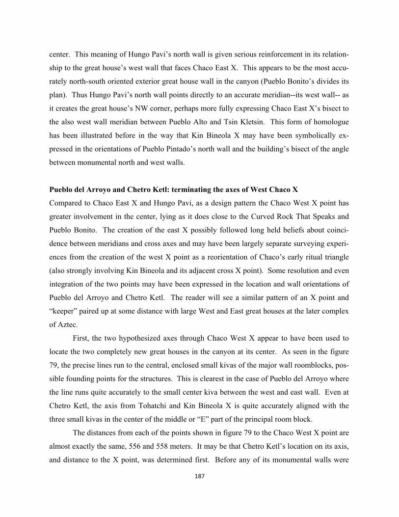
187
center. This meaning of Hungo Pavi’s north wall is given serious reinforcement in its relation-
ship to the great house’s west wall that faces Chaco East X. This appears to be the most accu-
rately north-south oriented exterior great house wall in the canyon (Pueblo Bonito’s divides its
plan). Thus Hungo Pavi’s north wall points directly to an accurate meridian--its west wall-- as
it creates the great house’s NW corner, perhaps more fully expressing Chaco East X’s bisect to
the also west wall meridian between Pueblo Alto and Tsin Kletsin. This form of homologue
has been illustrated before in the way that Kin Bineola X may have been symbolically ex-
pressed in the orientations of Pueblo Pintado’s north wall and the building’s bisect of the angle
between monumental north and west walls.
Pueblo del Arroyo and Chetro Ketl: terminating the axes of West Chaco X
Compared to Chaco East X and Hungo Pavi, as a design pattern the Chaco West X point has
greater involvement in the center, lying as it does close to the Curved Rock That Speaks and
Pueblo Bonito. The creation of the east X possibly followed long held beliefs about coinci-
dence between meridians and cross axes and may have been largely separate surveying experi-
ences from the creation of the west X point as a reorientation of Chaco’s early ritual triangle
(also strongly involving Kin Bineola and its adjacent cross X point). Some resolution and even
integration of the two points may have been expressed in the location and wall orientations of
Pueblo del Arroyo and Chetro Ketl. The reader will see a similar pattern of an X point and
“keeper” paired up at some distance with large West and East great houses at the later complex
of Aztec.
First, the two hypothesized axes through Chaco West X appear to have been used to
locate the two completely new great houses in the canyon at its center. As seen in the figure
79, the precise lines run to the central, enclosed small kivas of the major wall roomblocks, pos-
sible founding points for the structures. This is clearest in the case of Pueblo del Arroyo where
the line runs quite accurately to the small center kiva between the west and east wall. Even at
Chetro Ketl, the axis from Tohatchi and Kin Bineola X is quite accurately aligned with the
three small kivas in the center of the middle or “E” part of the principal room block.
The distances from each of the points shown in figure 79 to the Chaco West X point are
almost exactly the same, 556 and 558 meters. It may be that Chetro Ketl’s location on its axis,
and distance to the X point, was determined first. Before any of its monumental walls were
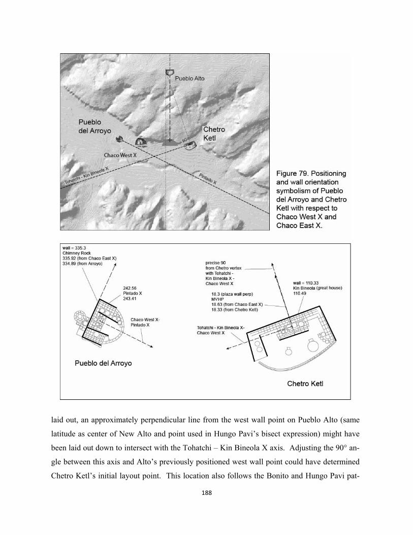
188
laid out, an approximately perpendicular line from the west wall point on Pueblo Alto (same
latitude as center of New Alto and point used in Hungo Pavi’s bisect expression) might have
been laid out down to intersect with the Tohatchi – Kin Bineola X axis. Adjusting the 90° an-
gle between this axis and Alto’s previously positioned west wall point could have determined
Chetro Ketl’s initial layout point. This location also follows the Bonito and Hungo Pavi pat-
189
tern of being up against the canyon’s north wall. Pueblo del Arroyo, however, for obvious rea-
sons of geometric religious symmetry, could have been located by measuring the same Chetro
Ketl – West Chaco X distance on its axis from Pueblo Pintado X. The site relationship of termi-
nating an axis, rather than “keeping” it as with Hungo Pavi, must have had carried somewhat
different implications of ritual power. Great houses at both “560” and Pueblo Pintado also ap-
pear to terminate large scale axes.
In addition to the apparent power of the site itself terminating an axis, the monumental
wall orientations of Pueblo del Arroyo and Chetro Ketl may have been used symbolically to do
other religious work, revealing a considerable complexity to these “buildings”. Chetro Ketl’s
huge north wall at 110.33° in the SW quadrant very accurately points not to the Kin Bineola X
point on which, together with Tohatchi, the great house may have been founded, but to the Kin
Bineola great house which in short order becomes as large as the ultimate size of Alto, del Ar-
royo, and Una Vida. The azimuth from the Chetro foundation point to the great kiva immedi-
ately adjacent to the great house at Kin Bineola is 110° 44’ 42.9” (about 110.74°). This rela-
tionship between Chetro Ketl (its major wall orientation) and Kin Bineola great house has also
been noted by Sofaer and will be discussed in more detail below. Also elaborated is the fact
that there is no geological or engineering explanation for the wide variation of wall orientations,
and general lack of design interest in 90° angles where they meet. Thus given the likelihood of
symbolic meaning, what is the best explanation in the present context for the other major wall
orientations at Chetro Ketl and Pueblo del Arroyo?
Again, Chetro Ketl’s north wall is quite accurate to the Kin Bineola great house, about
18.010 km away. Because of this orientation perhaps, Chetro Ketl’s wall is not accurately
(about two degrees off) perpendicular to the originating line to Pueblo Alto’s west wall point.
Thus one might evaluate the orientation of the interior south wall of the central room block
seen prominently from within the eventual plaza. Curiously, as formally related to the massive
back wall as a contemporary designer might think logical, it is off two degrees. These builders
of such precise linear walls would certainly have had the ability to run these two walls accurate-
ly parallel, had they been so inclined. At 108.3°, the interior plaza wall could be pointing in-
stead to Kin Bineola X (108° 54’ 31.3” or 108.91°) which again lies some 600 meters NW of
the great house. Yet if this were the design intent, the orientations of Chetro Ketl’s walls are in
an illogical reversed posture compared to these two Kin Bineola points.
Alternatively, the perpendicular to Chetro’s plaza wall, 18.3°, when extended north-
ward, has a very close affinity to the azimuth from Chetro to the Mesa Verde High Point,
18.33°, the natural feature terminus of the NW-SE axis of Chaco East X (this line actually ter-
minates quite accurately farther north at the small outlier structure of Escalante in the Moctezu-
ma valley—no great kiva). Thus is it possible that Chetro Ketl, in addition to bringing in pow-
er from Ganado and Tohachi, used its interior wall to pick an axial component of East Chaco
X? This would amount to a fusion of sorts of the two Chaco X’s at the center. Chetro Ketl has
at least three other wall features whose orientations remain to be interpreted.
Pueblo del Arroyo’s big wall orients at an azimuth of 335.3°, which again is not perpen-
dicular to its founding axis to Chaco West X and Pueblo Pintado X (about 333.7°), not unlike
Chetro Ketl about two degrees off in this regard. Reflecting on what Chetro Ketl’s plaza wall
may have been doing, the azimuth to Chimney Rock, the NE natural feature of Chaco East X,
is 334° 54’ 00” or 334.9°. While accuracies of wall orientations will be discussed in more de-
tail in the concluding exercise of this chapter, a variation of 0.40° between measured wall ori-
entation and azimuth is relatively accurate. Del Arroyo has an additional four possibly symbol-
ic wing walls, none of which are perpendicular to its major back wall.
The ritual importance of uniting the two new Chaco X points at the centralizing focus
around the Curved Rock That Speaks will have its analogue in the later layout of Aztec. At
Chaco, if wall orientations of the new Chetro Ketl and Pueblo del Arroyo can someday be rec-
ognized as having been symbolically associated with the two northern features of the Chaco
East X, then one would begin to sense a certain power asymmetry between the West and East
entities at the canyon center. Compare the linkage of the larger structure of Chetro Ketl (East)
with that of Pueblo del Arroyo (West). The East group of sodalities and ritual associations is
connected to the large Kin Bineola great house and X, Tohatchi on the Middle axis, Ganado,
Humphrey’s Peak, and even the Sipapu; additionally it might also pick up associations with
Mount Taylor and the rich region around Mesa Verde. Arroyo, for its part as West, counts only
the Pueblo Pintado X communities of “560” and Pueblo Pintado great house, together with the
axial associations with Chimney Rock and Hosta Butte.
Meanings of Peñasco Blanco and Una Vida additions
Should this asymmetry discussion also be extended to the extensive additions to early West and
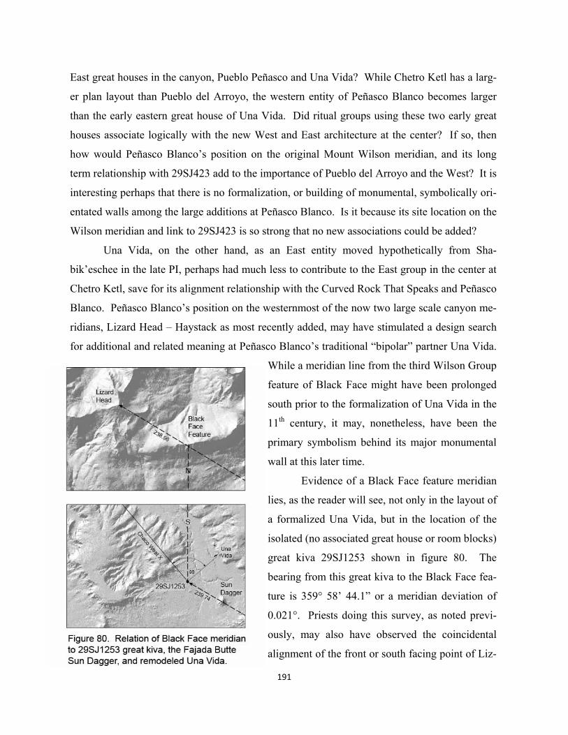
East great houses in the canyon, Pueblo Peñasco and Una Vida? While Chetro Ketl has a larg-
er plan layout than Pueblo del Arroyo, the western entity of Peñasco Blanco becomes larger
than the early eastern great house of Una Vida. Did ritual groups using these two early great
houses associate logically with the new West and East architecture at the center? If so, then
how would Peñasco Blanco’s position on the original Mount Wilson meridian, and its long
term relationship with 29SJ423 add to the importance of Pueblo del Arroyo and the West? It is
interesting perhaps that there is no formalization, or building of monumental, symbolically ori-
entated walls among the large additions at Peñasco Blanco. Is it because its site location on the
Wilson meridian and link to 29SJ423 is so strong that no new associations could be added?
Una Vida, on the other hand, as an East entity moved hypothetically from Sha-
bik’eschee in the late PI, perhaps had much less to contribute to the East group in the center at
Chetro Ketl, save for its alignment relationship with the Curved Rock That Speaks and Peñasco
Blanco. Peñasco Blanco’s position on the westernmost of the now two large scale canyon me-
ridians, Lizard Head – Haystack as most recently added, may have stimulated a design search
for additional and related meaning at Peñasco Blanco’s traditional “bipolar” partner Una Vida.
While a meridian line from the third Wilson Group
feature of Black Face might have been prolonged
south prior to the formalization of Una Vida in the
11th century, it may, nonetheless, have been the
primary symbolism behind its major monumental
wall at this later time.
Evidence of a Black Face feature meridian
lies, as the reader will see, not only in the layout of
a formalized Una Vida, but in the location of the
isolated (no associated great house or room blocks)
great kiva 29SJ1253 shown in figure 80. The
bearing from this great kiva to the Black Face fea-
ture is 359° 58’ 44.1” or a meridian deviation of
0.021°. Priests doing this survey, as noted previ-
ously, may also have observed the coincidental
alignment of the front or south facing point of Liz-
191
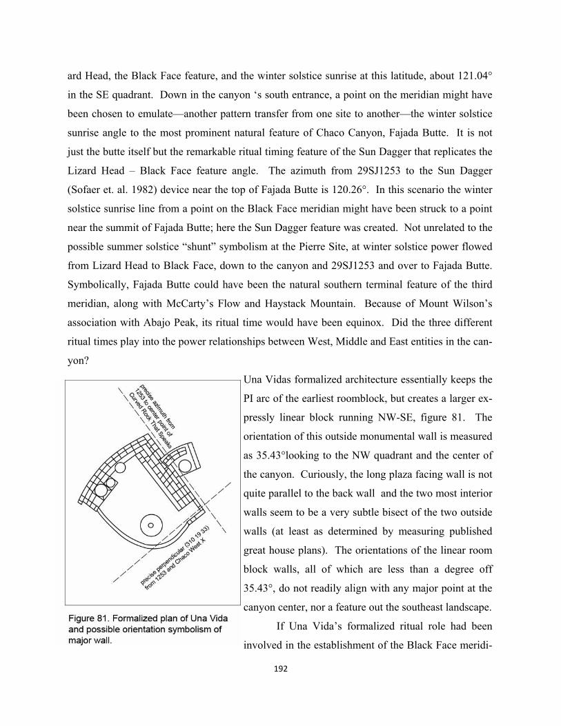
192
ard Head, the Black Face feature, and the winter solstice sunrise at this latitude, about 121.04°
in the SE quadrant. Down in the canyon ‘s south entrance, a point on the meridian might have
been chosen to emulate—another pattern transfer from one site to another—the winter solstice
sunrise angle to the most prominent natural feature of Chaco Canyon, Fajada Butte. It is not
just the butte itself but the remarkable ritual timing feature of the Sun Dagger that replicates the
Lizard Head – Black Face feature angle. The azimuth from 29SJ1253 to the Sun Dagger
(Sofaer et. al. 1982) device near the top of Fajada Butte is 120.26°. In this scenario the winter
solstice sunrise line from a point on the Black Face meridian might have been struck to a point
near the summit of Fajada Butte; here the Sun Dagger feature was created. Not unrelated to the
possible summer solstice “shunt” symbolism at the Pierre Site, at winter solstice power flowed
from Lizard Head to Black Face, down to the canyon and 29SJ1253 and over to Fajada Butte.
Symbolically, Fajada Butte could have been the natural southern terminal feature of the third
meridian, along with McCarty’s Flow and Haystack Mountain. Because of Mount Wilson’s
association with Abajo Peak, its ritual time would have been equinox. Did the three different
ritual times play into the power relationships between West, Middle and East entities in the can-
yon?
Una Vidas formalized architecture essentially keeps the
PI arc of the earliest roomblock, but creates a larger ex-
pressly linear block running NW-SE, figure 81. The
orientation of this outside monumental wall is measured
as 35.43°looking to the NW quadrant and the center of
the canyon. Curiously, the long plaza facing wall is not
quite parallel to the back wall and the two most interior
walls seem to be a very subtle bisect of the two outside
walls (at least as determined by measuring published
great house plans). The orientations of the linear room
block walls, all of which are less than a degree off
35.43°, do not readily align with any major point at the
canyon center, nor a feature out the southeast landscape.
If Una Vida’s formalized ritual role had been
involved in the establishment of the Black Face meridi-
193
an and the 29SJ1253 great kiva, just across the canyon, then one might look for a homologue
of this relationship in the great house’s new straight walls. Not unlike the pattern transfer
between VGK and Lowry, Pueblo Pintado, Pueblo Alto – Tsin Kletsin and Hungo Pavi, one
examines the large-scale alignment components at 29SJ1253, seeking their expression in the
the revised Una Vida design. The azimuth from 29SJ1253 to the center point on the amphi-
theater wall of the Curved Rock That Speaks is 36° 33’ 24.9”. While this orientation is less
than one degree off the measurement of Una Vida’s back wall, it appears to be most identical
with the two interior most walls of the formal roomblock. Coincidentally, though off about
three degrees, the two locations of 29SJ1253 and Una Vida (both located independently of
each other) form a rough perpendicular to 29SJ1253’s azimuth to the Curved Rock That
Speaks.
Formal integration of Casa Rincoñada, New Alto and Pueblo Bonito
Pueblo Alto, the natural form of the Curved Rock That Speaks, Tsin Kletzin, Pueblo Bonito’s
formalization, Casa Rincoñada and New Alto are all cardinally oriented, creating a possible
Middle complex perhaps ritually distinct from the functions of Pueblo del Arroyo (West) and
Chetro Ketl (East). Symbolically, the location of Casa Rincoñada and lack of associated
great house or room block across the wash from the emerging greatest of great houses seems
more religiously and perhaps politically vital to the final landscape/architecture scheme fo-
cusing on the canyon center.
In longitude, the new largest of canyon kivas sits between the already probably long
lived Curved Rock That Speaks/Pueblo Bonito pair, an initial apparent mediation between the
two Middle religious sites. While the amphitheater and its great house may have ritually
functioned for close to two hundred years or so by this time, the new infusion of the Lizard
Head - Haystack meridian, and its homologue of Pueblo Alto and Tsin Kletsin might have set
up a certain imbalance, or perhaps potential dominance of the canyon Middle pair. Did Pueb-
lo Bonito’s role need clarification? How did the formalization of this ultimately greatest
piece of architecture relate to its still totally natural complement, the large ritual plaza with its
new Lizard Head connections? How did the architecturalized component of the Curved Rock
That Speaks, i.e. Pueblo Alto, play off against or with the huge project of turning Pueblo Bo-
nito into the biggest monument of all? From the perspective of pilgrims using the the canyon
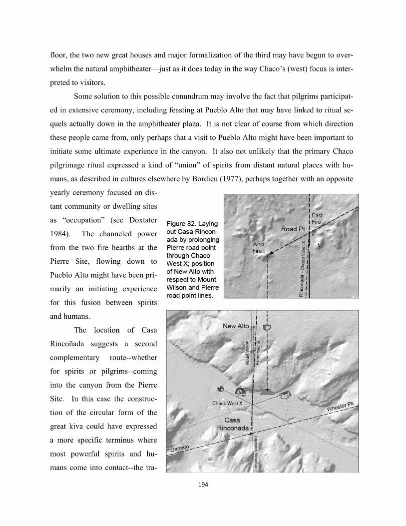
194
floor, the two new great houses and major formalization of the third may have begun to over-
whelm the natural amphitheater—just as it does today in the way Chaco’s (west) focus is inter-
preted to visitors.
Some solution to this possible conundrum may involve the fact that pilgrims participat-
ed in extensive ceremony, including feasting at Pueblo Alto that may have linked to ritual se-
quels actually down in the amphitheater plaza. It is not clear of course from which direction
these people came from, only perhaps that a visit to Pueblo Alto might have been important to
initiate some ultimate experience in the canyon. It also not unlikely that the primary Chaco
pilgrimage ritual expressed a kind of “union” of spirits from distant natural places with hu-
mans, as described in cultures elsewhere by Bordieu (1977), perhaps together with an opposite
yearly ceremony focused on dis-
tant community or dwelling sites
as “occupation” (see Doxtater
1984). The channeled power
from the two fire hearths at the
Pierre Site, flowing down to
Pueblo Alto might have been pri-
marily an initiating experience
for this fusion between spirits
and humans.
The location of Casa
Rincoñada suggests a second
complementary route--whether
for spirits or pilgrims--coming
into the canyon from the Pierre
Site. In this case the construc-
tion of the circular form of the
great kiva could have expressed
a more specific terminus where
most powerful spirits and hu-
mans come into contact--the tra-
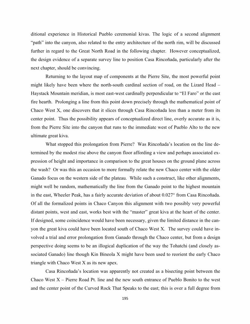
195
ditional experience in Historical Pueblo ceremonial kivas. The logic of a second alignment
“path” into the canyon, also related to the entry architecture of the north rim, will be discussed
further in regard to the Great North Road in the following chapter. However conceptualized,
the design evidence of a separate survey line to position Casa Rincoñada, particularly after the
next chapter, should be convincing.
Returning to the layout map of components at the Pierre Site, the most powerful point
might likely have been where the north-south cardinal section of road, on the Lizard Head –
Haystack Mountain meridian, is most east-west cardinally perpendicular to “El Faro” or the east
fire hearth. Prolonging a line from this point down precisely through the mathematical point of
Chaco West X, one discovers that it slices through Casa Rincoñada less than a meter from its
center point. Thus the possibility appears of conceptualized direct line, overly accurate as it is,
from the Pierre Site into the canyon that runs to the immediate west of Pueblo Alto to the new
ultimate great kiva.
What stopped this prolongation from Pierre? Was Rincoñada’s location on the line de-
termined by the modest rise above the canyon floor affording a view and perhaps associated ex-
pression of height and importance in comparison to the great houses on the ground plane across
the wash? Or was this an occasion to more formally relate the new Chaco center with the older
Ganado focus on the western side of the plateau. While such a construct, like other alignments,
might well be random, mathematically the line from the Ganado point to the highest mountain
in the east, Wheeler Peak, has a fairly accurate deviation of about 0.027° from Casa Rincoñada.
Of all the formalized points in Chaco Canyon this alignment with two possibly very powerful
distant points, west and east, works best with the “master” great kiva at the heart of the center.
If designed, some coincidence would have been necessary, given the limited distance in the can-
yon the great kiva could have been located south of Chaco West X. The survey could have in-
volved a trial and error prolongation from Ganado through the Chaco center, but from a design
perspective doing seems to be an illogical duplication of the way the Tohatchi (and closely as-
sociated Ganado) line though Kin Bineola X might have been used to reorient the early Chaco
triangle with Chaco West X as its new apex.
Casa Rincoñada’s location was apparently not created as a bisecting point between the
Chaco West X – Pierre Road Pt. line and the new south entrance of Pueblo Bonito to the west
and the center point of the Curved Rock That Speaks to the east; this is over a full degree from
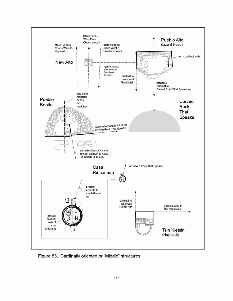
196
197
being precise even though perceptually from Rincoñada’s position, it has a relatively equal re-
lationship to Bonito and the amphitheater with respect to the Chaco West X - Pierre Road
Pt.axis.
While Casa Rincoñada was built in the last half of the 11th century (Vivian & Reiter
1960), New Alto, the small formal block built adjacent to Pueblo Alto shown in figure 83, has
been dated as 1110-1140 (Chaco Archives). Yet there is much in this very symmetrical feature
that speaks not only to an integration with somewhat earlier large scale landscape layout, but
also specifically to the possible second “sunray” from the Pierre Site to Chaco West X and
Casa Rincoñada. Sometimes lumped together with other small late (less than) great houses, i.e.
Casa Chiquita or Kin Kletso, New Alto as well has been referred to as a kind of annex to its
adjacent large great house, Pueblo Alto. Particularly in New Alto’s case, this assumption really
doesn’t follow design logic from either a planning or architectural sense.
Why would a great house like Pueblo Alto, with ample space in its linear room blocks
to accommodate a relatively small number of additional rooms, build an “annex” 216 meters
from the main structure? In terms of task-performance efficiency of moving items back and
forth, storage capacity, or being within in the range of voice communication, this doesn’t make
sense. Thus one returns to symbolism and ritual function. Given the possible vertical meaning
of Pueblo Alto in regard to both its central axis to the Curved Rock That Speaks and it role in
organizing the homologue of Lizard Head – Haystack Mountain, could New Alto have had a
related axis mundi meaning? The center kiva of the small formal structure has a longitude of
107° 57’ 35.2”, errors of reading GPS devices or Google Earth notwithstanding. A vertical re-
lationship of New Alto with Casa Rincoñada has been mentioned in Sofaer (1997), but no pre-
cise professionally surveyed data is provided. Using readily available GPS locations, Casa
Rincoñada’s center point longitude is quite close at 107° 57’36.9”. But the hypothetical Chaco
West X, 107° 57’ 36.0” is a bit closer to that of New Alto, off 0.8” rather than 1.7”. These fig-
ures, however, must be taken as only very provisional at the much smaller scales at the canyon
center, given the potential for ready reference GPS points to be off 3-4 meters. At a distance of
1.199 km apart, a 0.8” deviation is about 24 meters or 1.14°, not at all accurate compared to
larger scale layouts or even some within the canyon, e.g. most using Chaco West X. Given that
the New Alto structure is only about 20 meters wide in the east-west dimension there is an ob-
vious need to measure these relationships more precisely. It is this author’s opinion that if the
Chacoan priests intended to align New Alto north-south to either Chaco West X or Casa Rinco-
ñada, they could have done it much closer than 24 meters. At the present, however, the best
indication of vertical alignment is to Chaco West X, not Casa Rincoñada. This makes sense in
that the line that locates Casa Rincoñada might have been the slight diagonal up to the El Faro
road point at the Pierre Site, a construct that appears to contribute dramatically to the great
north road layout (contemporaneous perhaps with New Alto).
Apart from New Alto’s possible meridian relationship to Chaco West X, its position
also, and perhaps more importantly expresses the two most important northerly seeking lines of
this seemingly all important survey point at the canyon center (West X). The reader will recall
how the slight diagonal from Haystack Mountain up to Mount Wilson could have been the ini-
tial line on which Chaco West X was eventually located (with Tohatchi – Kin Bineola X).
With the addition of the Pierre Road Pt. - Chaco West X - Casa Rincoñada line, we now have
two slight diagonals running within 20-30 meters on each side of New Alto, again figure 83.
This could have created a symbolic balance related to the symmetrical New Alto architecture
and enclosed small kiva. It could have been almost a replication of the relation of Haystack to
the three Wilson Group natural features, one ray to Mount Wilson, a vertical element (New Al-
to’s parallel to Pueblo Alto and the Lizard meridian), and a line to the easternmost of the three
northern mountain features. Yet, as thus far laid out, the eastern axis does not yet run to the
Black Face feature, but only to the Pierre Road Point.
In terms of latitude, New Alto lies quite accurately (again present measurement limita-
tions notwithstanding) due west of the point on Pueblo Alto’s west wall used for the hypothet-
ical bisect layout from Chaco East X, as replicated in Hungo Pavi’s major wall. Thus there
might have been a designed 90° relationship of the New Alto – Pueblo Alto axis to the Lizard
Head – Haystack Mountain homologue down to Tsin Kletsin. Just how precisely the building
orientation of New Alto works geometrically with this relationship to Pueblo Alto remains to
be seen. The small structure has a generally accepted cardinal orientation, as recorded in ar-
chaeological drawings. Neither Sofaer’s group, nor the author, recorded sunshot measure-
ments of New Alto while up on the north rim documenting Pueblo Alto’s close to east-west
orientation (88.9° by author).
While New Alto might have replicated aspects of the founding role of Haystack Moun-
tain in the Lizard Head inspired layout that precipitated the new Chaco frame, the small formal
198
199
structure on the north rim, though, does not originate the three lines up to the Wilson Group.
This logically would have been the symbolic role of Chaco West X, perhaps as closely associat-
ed with Casa Rincoñada. At this scaled down version of the landscape master layout, New Alto
might have expressed the way the new Chaco center effectively mediates these ritual lines as
they pass through the canyon on their way north.
Finally, in terms of building location and “great” wall orientation, although Pueblo Bo-
nito’s original position is maintained in extensive formalization, what can one say about its new
massive wall features? Most obvious are the two very cardinal constructions, the north-south
middle element that cleanly divides the huge structure in two, and the west-east front of the
western half of the arc, again figure 83. Given the good possibility that Pueblo Bonito had long
been ritually linked with the major ritual that took place at the Curved Rock That Speaks, it
makes symbolic sense to interpret its new interior axis mundi, not so much as a sign of equinox
timing as Sofaer (1997) suggests (there are no know related observation features), but as a clear
homologue for the vertical axis that runs from the west fire hearth at the Pierre Site down
through Pueblo Alto to the amphitheater plaza. Thus the essence of Pueblo Bonito’s internal
meridian could have been Lizard Head as ultimate spiritual source for the Middle role of its rit-
ual participants.
What then was symbolically perpendicular to the Lizard Head meridian, a possible rea-
son for the front west wall? Could this have expressed the western line to the Sipapu, and the
aligned White House in Canyon de Chelly that positioned Pueblo Alto on its faux Lizard Head
axis? Bonito’s front eastern wall angles slightly to the NE toward to the Curved Rock That
Speaks plaza. Was this an auditory point in the amphitheater where ritual participants commu-
nicated with the spirits? Pueblo Bonito’s eastern “half” is larger, and along with the construc-
tion of the main great kiva on this side of the internal meridian wall suggest a greater im-
portance to things to its east, i.e. its pairing up with the Curved Rock That Speaks.
Pueblo Bonito’s fourth wall feature, on the east side of its central great kiva, appears to
link this possibly biased eastern ritual function to Casa Rincoñada across the wash. This rela-
tionship, evidenced not only by the wall’s accurate orientation (189.8 wall and 190.35 azimuth
to Rincoñada) but the cut between the mound features south of Pueblo Bonito has been com-
mented on by others (Stein et. al. 1997). While Casa Rincoñada’s principal axis is accurately
north south, replicating good cardinals in both Pueblo Bonito and west fire hearth-Pueblo Alto-
200
Curved Rock That Speaks, figure 83 shows a strangely asymmetrical diagonal running from an
interior circular form to the north main entrance. The center line of this diagonal feature works
well as an axis to the center point of the Curved Rock That Speaks amphitheater (as best deter-
mined graphically).
With the exception of the late New Alto, the cardinally oriented form of Pueblo Alto,
Tsin Kletsin, Pueblo Bonito, Casa Rincoñada, and probably the natural amphitheater feature of
the Curved Rock That Speaks all organize through location and wall orientations to create a
possibly integrated Middle function at the new canyon center. The most “middle” of the Mid-
dle was probably Casa Rincoñada located as it is between the architecturalized Lizard Head
meridians of Pueblo Bonito and Pueblo Alto/Curved Rock That Speaks. This role could have
been strengthened with its direct path to the El Faro related road point at the Pierre Site, and
the actual Lizard Head – Haystack Mountain meridian. New Alto may have created a kind of
gate with Pueblo Alto through which the path runs. Most important socio-politically, could
have been the way Casa Rincoñada, with its separate Middle location on a rise, expressed a
certain dominance over the extreme new formalized architectural definitions on the north side
of the wash. Even the natural largest of great kivas (the amphitheater) is directly aligned with
the prominent architectural features on the north and south rims and perceptually dwarfed by
the massive Pueblo Bonito. At the height of the big build-out one may even ask whether Casa
Rincoñada, with its seemingly more egalitarian oppositional meaning—albeit with fewer par-
ticipants perhaps—replaced the possibly centuries old ritual function of the Curved Rock That
Speaks?
PROBABILITY TEST: GREAT HOUSE WALLS AS ASTRONOMY OR LANDSCAPE INTEGRATION?
Given the two alternative reasons for the symbolic meaning of great wall orientations—
astronomical (Sofaer 1997) and landscape frame (Doxtater 1991)—it is possible to test both in
terms of probabilities of being random. Theoretically and ethnographically, both alignments to
sacred mountains and to astronomically determined points are important in traditional ritual.
Spatial frameworks incorporating most unique natural features most likely contribute uniquely,
while not at all dismissing complementary and also unique temporal uses of the movements of
the sun, moon and stars. This is clearly evident in this volume’s discussion of key, often coin-
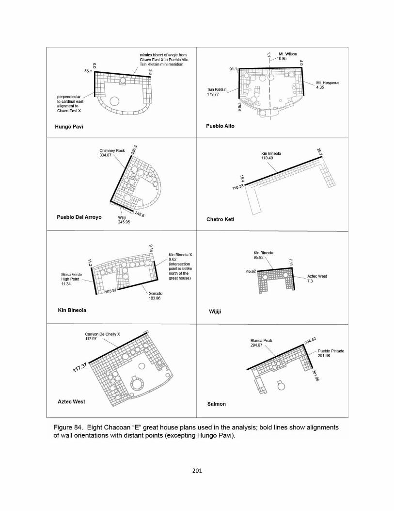
201
cidental, large scale layouts, e.g. a solstice line from the Sipapu to Comb Ridge, the equinox
relationship between Abajo Peak and Mount Wilson, the power “shunt” at the Pierre’s Site, or
possibly solstice relationships between Lizard Head and the Black Face feature and analog from
29SJ1253 great kiva to the Sun Dagger on Fajada Butte.
For purposes of this exercise, only the eight more formal E shaped Chacoan great hous-
es, like Hungo Pavi, are included, as shown in figure 84. The most striking aspects of these
structures are the angles at which wing walls attach to the main, longitudinal walls. Certainly
priest surveyors with the likely ability to conduct extremely precise large scale alignments
would have had the technical skill to attach wing walls at precise 90° angles. Walls are not an-
gled simply to accommodate topography. If builders could construct a technically straight back
wall from 60 - 140 m long, then it is extremely unlikely that some ground condition in wing
wall directions would cause virtually all of the corner angles to deviate. Of the sixteen corners
in question, none comes closer than 0.42° from being precisely perpendicular, ranging from
87.9° to 97.5°. The corners of the smallest great house Wijiji, seeming the most formally and
possibly last in the canyon to be laid out, actually vary by over a degree; one is 0.42° and the
other 1.49°. While an obvious “perpendicular” constraint of all great houses exists within a
maximum deviation of 7.5°, one can hypothesize that if the long back walls were symbolically
oriented, so were the wings. The plan of the building, therefore, may have been designed less
as a precise geometric form, than as a sequence of expressions of somewhat independent sym-
bolic orientations or meanings. Builders did not precisely relate the lengths of the walls to any
plan formality. Wing wall lengths are not any constant ratio to back wall lengths. The two out-
side wing walls, for their part, while within a meter or two of being equal, were clearly not
measured to be identical in length.
Let us first examine the astronomical hypothesis that walls orient to rise/set points of the
sun and moon cycles. Besides the three exterior wall orientations, Sofaer includes the possibil-
ity of a perpendicular to the longitudinal wall, a possible “facing” axis to the great house. What
are the odds, then that of thirty-two orientations (4x8), some number will point within a range
of defined deviation to the eight orientations given in Sofaer (1997), Fig. 85 She maintains that
either the major wall or a perpendicular align in six of the great E houses of the present study.
The range of deviation permitted by Sofaer runs from the mentioned 4.8° of Hungo Pavi to 1.1°
of Pueblo Alto’s cardinal. Kin Bineola and Wijiji have no proposed astronomical features in
202
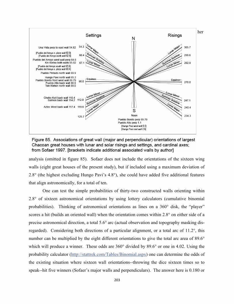
203
her
analysis (omitted in figure 85). Sofaer does not include the orientations of the sixteen wing
walls (eight great houses of the present study), but if included using a maximum deviation of
2.8° (the highest excluding Hungo Pavi’s 4.8°), she could have added five additional features
that align astronomically, for a total of ten.
One can test the simple probabilities of thirty-two constructed walls orienting within
2.8° of sixteen astronomical orientations by using lottery calculators (cumulative binomial
probabilities). Thinking of astronomical orientations as lines on a 360° disk, the “player”
scores a hit (builds an oriented wall) when the orientation comes within 2.8° on either side of a
precise astronomical direction, a total 5.6° arc (actual observation and topography masking dis-
regarded). Considering both directions of a particular alignment, or a total arc of 11.2°, this
number can be multiplied by the eight different orientations to give the total arc area of 89.6°
which will produce a winner. These odds are 360° divided by 89.6° or one in 4.02. Using the
probability calculator (http://stattrek.com/Tables/Binomial.aspx) one can determine the odds of
the existing situation where sixteen wall orientations--throwing the dice sixteen times so to
speak--hit five winners (Sofaer’s major walls and perpendiculars). The answer here is 0.180 or
204
about a one in 5.6 probability of duplicating the existing pattern by chance. Adding the sixteen
wing walls that create ten hits in thirty-two wall orientations, gives a rate of 0.110 or about one
in 9.1.
One can now test the second hypothesis, i.e. that walls primarily orient to built or natural
features in the landscape (excluding purely analogic expression like Hungo Pavi’s north wall for
present purposes). This list includes the two coincidental cross X intersection points at Kin Bin-
eola and Canyon de Chelly, their natural features of Brian Head, Humphrey’s Peak, Abajo Peak,
Baldy Peak, Blanca Peak, Chimney Rock and Mount Taylor, in addition to Chaco East X and its
two new natural axes points, Hosta Butte and the Mesa Verde High Point (Chaco West X and
the importance of Lizard Head and Black Face were not understood at the time of this exercise).
The Sipapu, Mount Wilson, and Cabezon round out the natural list along with Hesperus Peak
(one of the four Navajo cosmic points). The total number of natural points, including intersec-
tions is sixteen. For the built components of the list, included are all of the major Chacoan great
houses: Pueblo Alto, Peñasco Blanco, Una Vida, Hungo Pavi, Wijiji, Chetro Ketl, Pueblo Ar-
royo, Pueblo Bonito, Tsin Kletsin in the canyon, Kin Bineola and Pueblo Pintado flanking the
canyon to the SW and SE respectively, and the late structures of Salmon and Aztec West up
north in area of present day Farmington, NM. The final list also logically includes Casa Rinco-
ñada and what may have been largest pre-Chacoan great kiva site of Ganado with possibly five
of the large ceremonial features.
This list creates thirty-one points on the distant landscape as potential symbolic orienta-
tions to the four features of each great house. The number can be reduced to thirty, given the
impossibility of a great house feature orienting to itself. The choice of the angular deviation of
a wall or perpendicular (to the precise distant point) to use in the test is determined by which
deviation produces the best likelihood of intentional design. A smaller deviation number reduc-
es the number of “hits” in the exercise, and vice versa. For the given list of thirty distant points,
the best deviation number for the thirty-two great wall features of the E houses is 0.60°, a figure
about five times more accurate than the astronomical test. This number is multiplied by two to
again accommodate an azimuth falling on either side of a distant point, giving an arc of 1.2°.
Multiplying this number by the thirty points provides a total of 36° of possible hits of 360°. The
odds then, of any one feature coinciding with a distant point is 0.10, or one in ten. But since
each wall points in two directions (that are not paired up as in the astronomical), the odds of any
205
wall hitting a distant point is two times as great or 0.20, one in five. Turning to the probability
calculator, what is the likelihood that building thirty-two features each with a 0.20 odds, will
orient within 0.60°, of fourteen distant points (the actual case as shown in figure 86)? Eight of
these points are great houses or Ganado, and six are mountains or a natural intersection point.
This probability is 0.0013, about 1 in 720. Large scale surveyed patterns, therefore, are eighty
times more likely to have been the symbolic, designed basis for great house wall orientation
than astronomical phenomena.
How would this comparison change if the allowed deviations of the astronomical orien-
tations were much closer to landscape lines? Priest surveyors should have been able to work
within a similar range for both. In the present case the accuracy of lines to distant points in the
landscape is much easier to ascertain than some unknown actual sighting of astronomical phe-
nomena which must include a topographic section of the landscape features involved. One
doesn’t know at present even if relatively accurate sightings from great house sites are possible
within the canyon, or whether larger scale observations could have been made on the canyon
rim and transferred down to great house sites below. If they did this, however, they would
seem to have been much less accurate than the transfer of the mentioned bisect of the Chaco
East X angle to Hungo Pavi’s back wall.
NOT YET A TEMPLE
The brief probability exercise above certainly does not do justice to this volume’s full range of
ideas hypothesizing a much richer symbolic potential among formal architectural elements--
created by Ancestral Pueblo ritual sodalities and their communities. Yet clearly, the more simi-
lar and more integrated, even subordinated, formalized architecture is to previously formalized
ritual patterns founded in the large-scale landscape, the less one sees these buildings as all pow-
erful locations of gods, the public access to which is controlled by hierarchies of priests and
other theocratic figures. Chacoan great houses emerge somewhat innocently, perhaps, in a con-
text of large scale ritual design and practice focused on great kiva ceremonial nodes. They do
so with a clear expression of the distinction between and subordination to their great kivas, un-
doubtedly seen as thresholds for the direct communication between humans and spirits who live
in the most powerful natural places at some distance. Even though at smaller scales of social
organization perhaps, kiva forms become embedded in the evolving architecture of great hous-
206
es, nevertheless, at the largest scale of the great house itself, the kiva most often sits alone in its
privileged position. But in terms of cognitive, formal plan intentions--even of the largest and
most formalized of the great houses--one can find no consistent geometric relationship between
the location of the great kiva and the shape of the three or more monumental walls of these
largest of buildings. At the scale of Chaco Canyon itself, the largest great kiva, Casa Rinco-
ñada, again, has no surrounding great house, strongly suggesting its dominant ritual and social
relationship to all of the great houses. How the nevertheless architectural Casa Rincoñada re-
lates to the possibly greatest (and most natural) of “kivas”, the Curved Rock That Speaks, how-
ever, remains an open question of continuing provocation in the next chapter.
All in all, one senses that the massive building that started in the late 900’s and early
1000’s, really during only about a hundred years or so, might be associated with Chaco’s de-
mise. In terms of the creation of large scale, formal ritual processes that might even have be-
gun with the great kiva in the 500’s, and founded the ultimate layout of Chaco Canyon, a rough
span of 500 years, all this architecture at the end begins to look suspicious. Eventually re-
searchers will need to sort out the distinctions, if possible, between the social bases of ritual
associated with more singular great kivas, and those operating in the massive architectural set-
tings of largest Chacoan great houses. In spite of the obvious religious exuberance of form,
still functional may have been alliances between distant communities or tribes for purposes of
marriage and other exchange and facilitation of the movement of people during times of eco-
logical contingencies like drought. For an earlier period of time, however, the primary expense
of making sacred geometry might well have been in the process of surveying landscape pat-
terns themselves. While these were likely collaborative efforts of allied groups, not unlike the
staged construction processes of great houses, the latter, together with the efforts to bring in
timbers from distant high places, might have begun to clearly overshadow the landscape based,
religious surveying processes of positioning sites.
Herein may have grown the seeds for undue competition between dualistically or triad-
ically organized great house entities. The possibility that many of the oriented great walls of
these structures carried strong, permanent associations to the particular groups who built them,
an emerging rhetoric beyond their monumental scale may have unduly fueled the competitive
portion of the delicate opposition between landscape spiritual collective (great kiva) and self-
interested clan or alliance (great house). When one notices that the pair of great houses that
207
flank Pueblo Bonito and the Curved Rock That Speaks, i.e. Arroyo as West and Chetro Ketl as
East, are measurably unequal in number of rooms, then perhaps the balanced, landscape based
system is beginning to strain. Yet it is still expression based on patterns of large scale ritual,
not fundamentally territorial signage where the landscape has essentially disappeared as a ritu-
ally integrated opposition, leaving temples to express the power of an elite group in control of
access to the gods. The reader is invited to compare detailed research into the religious function
of the central Aztec pyramid at Tenotichlan provided in Broda et.al.(1987). A clear sense ex-
ists that the gods no longer live in the mountains, but exist, among other things, as tiny statues
that can be manipulated and even kept in centralized urban religious edifices, including pyra-
mids.
8. The Plateau Frame Beyond Chaco
With all that was happening with the new Chaco, both in terms of landscape frame and radical
architecturalization, what was going on at the many smaller ceremonial foci across the Southern
Colorado Plateau? The two well used extensive surveys of these “outliers” by Marshall et. al.
(1979), and Powers et.al. (1983) still provide the best yet description of general site layouts in-
cluding roads, architecture, pottery, provisional dating and other vital archaeological evidence.
Missing, of course, from the present volume’s perspective, is why or how these sites were lo-
cated, particularly those with great kivas. While multifaceted tables begin to paint a picture of
an outlier whole with relationships to each other and to Chaco, there is no analysis of possible
integration with an accurate, surveyed landscape frame at the scale of plateau landscape. The
following examples are not an attempt to provide any definitive “proof” in this direction, but to
provide examples of the kind of new work that needs to be added to better understand
“outliers”. Formalized elements of two outliers, Lowry Ruin and Village of the Great Kivas,
have already been discussed in Chapter 4. The late Chacoan complex at Aztec, while certainly
no typical small outlier, will be seen in this chapter as perhaps the best example of the way the
plateau frame (and integrated architecture) outside of Chaco is also being formally designed or
redesigned.
“OUTLIERS”
Kin Ya’a and Muddy Water
The Kin Ya’a site is best known for its unique great house tower and as the apparent terminus
for the major south (west) prehistoric road from Chaco Canyon. For these and other reasons
spelled out in Marshall et. al. 1979:207 and Powers et.al. 1983:202, the people who built these
features were clearly connected to or influenced by those who were laying out and building the
new Chaco center. Of course they may in fact have been the same people, in that Chaco wasn’t
a permanent population focus, but pilgrimage destination probably built by these same visitors.
This being said, there may be surveyed aspects of Kin Ya’a that suggest a certain independence
208
209
from the new Chaco scheme including formalized peripheral relationships to other sites outside
of the canyon.
Using the Powers et.al. site drawing as base in figure 86, one can analyze a possible ra-
tionale for the formal site axis created by the intersection points of the prehistoric road seg-
ments that not only connect with the road from the canyon to the north, but also direct the flow
of the site to somewhere to the SW. Having looked carefully at the road segments that make up
the long southern roads out of the canyon (from Kincaide 1983), it is clear that their longest
lengths do not constitute any precisely linear surveyed alignment, though smaller pieces may be
relatively straight. What may be more interesting is the way roads are used fairly accurately
and even symbolically at or near built sites, just as a segment of the North Road at the Pierre
Site is quite cardinal precisely on the Lizard Head meridian. Thus considering Kin Ya’a, why
does the larger road from Chaco split in two, creating a trapezoidal domain that includes the
great kiva and great house.
The symbolic function of Hosta Butte, only a little over twelve kilometers to the SW,
has been previously described as the possible SW pole of one of the two cross axes of Chaco
East X. But Kin Ya’a is not positioned on this line, even though it appears to be the termination
of the south Chaco road running in this general direction. It is not impossible that Kin Ya’a
was founded or positioned in the landscape in the late PI or early PII period, or in any event pri-
or to the big Chaco scheme and the layout of Chaco East X. If this were the case, then Hosta
Butte might well have been more of a local focus of natural spiritual power. What might have
been known about larger scale frames at the time was the coincidental phenomenon of Kin Bin-
eola X, important to the triangular creation of earliest Chaco. One of its three axes, again, runs
from Baldy Peak to Chimney Rock (with the base of the Ship Rock vertical , VGK, on this
line), and is only twenty kilometers or so from Kin Ya’a.
Looking more closely then, at the northern and southern points of the Kin Ya’a road de-
fined domain, they appear to align not only with a high point of nearby Hosta Butte, but down
to Baldy Peak as well. Thus, prior to the big scheme focused in Chaco, perhaps, Kin Ya’a
might have received its ritual power by connecting more primarily--via Hosta Butte--with the
base of the West vertical or axis mundi (Ganado and Cottonwood Falls) and its earlier Chaco
line through Kin Bineola X and Chimney Rock. In effect, then, the South Chaco road, with re-
gard to Kin Ya’a, is less of a centrifugal distributor from Chaco Canyon, than a centripetal path
210
to an earlier laid out foci well connected to the largest scale earlier plateau frame.
Noticeably, the alignment from Baldy Peak through Hosta Butte comes closest to the
isolated great kiva at Kin Ya’a, which might be earlier than the great house with its tower locat-
ed across the ceremonial domain near the intersection of the two eastern road segments. While
there are analysis problems in determining which point on the flat featureless top of Hosta
Butte (a mid-point is presently used unlike the clear high point on Haystack Mountain), survey-
ors might have created a possible “x” point on the Kin Ya’a site near the great kiva and prior to
the construction of roads and great house. The quite accurate alignment of the straight road
segment to the west of the domain area is one possible indication of such. It orients quite accu-
rately to Ganado, making sense given its central focus function on the hypothetical West verti-
cal, whose base of Baldy Peak, again, might have been the prime mover for Kin Ya’a’s major
site orientation. This Ganado road, however, is not a good cardinal, off close to two degrees.
Ganado, therefore, might not have been an originating intersection line an “x” point of Kin
Ya’a.
One of the lines originating at the Sipapu, as described in the analysis in Chapter 4, ac-
tually hits the great kiva (about 13 m from the the GPS center point) near the western road’s
intersection of the domain, as it runs to the great kiva at the Guadalupe outlier. While there is a
certain logic of including Cabezon, the eastern feature of one of Kin Bineola X’s axes and visu-
ally adjacent to Guadalupe, it is difficult to suggest which of the two outlier sites aligned with
the Sipapu might have come first. One of the future research issues should be a more precise
determination the intersecting line that located Kin Ya’a on the Baldy Peak – Hosta Butte axis.
The orientation of the tower great house at 227.9° to the SE might eventually play into this in-
quiry, e.g. perhaps something in the direction of Mount Taylor, but as yet cannot be associated
with any large scale azimuth.
Only seven and a half kilometers NW of Kin Ya’a lies the Muddy Water community,
complete with great kiva and three great house features. First of all, if great kivas and their
communities were located via a relationship to the large-scale landscape frame, wouldn’t the
close proximity to a seemingly important Kin Ya’a be ritually illogical? Again, social space in
the Ancestral Pueblo landscape may have had a territorial component in shamanistic Basket-
maker periods, but in the centuries of possible ritual structure that followed, symbolic integra-
tion would have been the key. And if one looks at the multitudinous religious entities that ap-
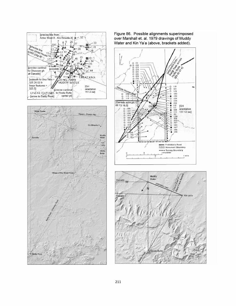
211
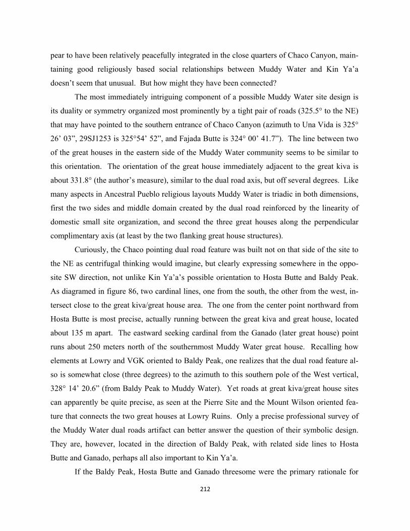
212
pear to have been relatively peacefully integrated in the close quarters of Chaco Canyon, main-
taining good religiously based social relationships between Muddy Water and Kin Ya’a
doesn’t seem that unusual. But how might they have been connected?
The most immediately intriguing component of a possible Muddy Water site design is
its duality or symmetry organized most prominently by a tight pair of roads (325.5° to the NE)
that may have pointed to the southern entrance of Chaco Canyon (azimuth to Una Vida is 325°
26’ 03”, 29SJ1253 is 325°54’ 52”, and Fajada Butte is 324° 00’ 41.7”). The line between two
of the great houses in the eastern side of the Muddy Water community seems to be similar to
this orientation. The orientation of the great house immediately adjacent to the great kiva is
about 331.8° (the author’s measure), similar to the dual road axis, but off several degrees. Like
many aspects in Ancestral Pueblo religious layouts Muddy Water is triadic in both dimensions,
first the two sides and middle domain created by the dual road reinforced by the linearity of
domestic small site organization, and second the three great houses along the perpendicular
complimentary axis (at least by the two flanking great house structures).
Curiously, the Chaco pointing dual road feature was built not on that side of the site to
the NE as centrifugal thinking would imagine, but clearly expressing somewhere in the oppo-
site SW direction, not unlike Kin Ya’a’s possible orientation to Hosta Butte and Baldy Peak.
As diagramed in figure 86, two cardinal lines, one from the south, the other from the west, in-
tersect close to the great kiva/great house area. The one from the center point northward from
Hosta Butte is most precise, actually running between the great kiva and great house, located
about 135 m apart. The eastward seeking cardinal from the Ganado (later great house) point
runs about 250 meters north of the southernmost Muddy Water great house. Recalling how
elements at Lowry and VGK oriented to Baldy Peak, one realizes that the dual road feature al-
so is somewhat close (three degrees) to the azimuth to this southern pole of the West vertical,
328° 14’ 20.6” (from Baldy Peak to Muddy Water). Yet roads at great kiva/great house sites
can apparently be quite precise, as seen at the Pierre Site and the Mount Wilson oriented fea-
ture that connects the two great houses at Lowry Ruins. Only a precise professional survey of
the Muddy Water dual roads artifact can better answer the question of their symbolic design.
They are, however, located in the direction of Baldy Peak, with related side lines to Hosta
Butte and Ganado, perhaps all also important to Kin Ya’a.
If the Baldy Peak, Hosta Butte and Ganado threesome were the primary rationale for
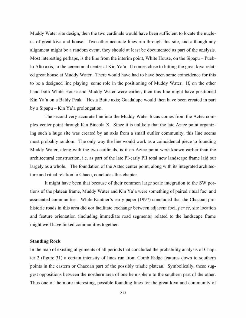
213
Muddy Water site design, then the two cardinals would have been sufficient to locate the nucle-
us of great kiva and house. Two other accurate lines run through this site, and although any
alignment might be a random event, they should at least be documented as part of the analysis.
Most interesting perhaps, is the line from the interim point, White House, on the Sipapu – Pueb-
lo Alto axis, to the ceremonial center at Kin Ya’a. It comes close to hitting the great kiva relat-
ed great house at Muddy Water. There would have had to have been some coincidence for this
to be a designed line playing some role in the positioning of Muddy Water. If, on the other
hand both White House and Muddy Water were earlier, then this line might have positioned
Kin Ya’a on a Baldy Peak – Hosta Butte axis; Guadalupe would then have been created in part
by a Sipapu – Kin Ya’a prolongation.
The second very accurate line into the Muddy Water focus comes from the Aztec com-
plex center point through Kin Bineola X. Since it is unlikely that the late Aztec point organiz-
ing such a huge site was created by an axis from a small outlier community, this line seems
most probably random. The only way the line would work as a coincidental piece to founding
Muddy Water, along with the two cardinals, is if an Aztec point were known earlier than the
architectural construction, i.e. as part of the late PI-early PII total new landscape frame laid out
largely as a whole. The foundation of the Aztec center point, along with its integrated architec-
ture and ritual relation to Chaco, concludes this chapter.
It might have been that because of their common large scale integration to the SW por-
tions of the plateau frame, Muddy Water and Kin Ya’a were something of paired ritual foci and
associated communities. While Kantner’s early paper (1997) concluded that the Chacoan pre-
historic roads in this area did not facilitate exchange between adjacent foci, per se, site location
and feature orientation (including immediate road segments) related to the landscape frame
might well have linked communities together.
Standing Rock
In the map of existing alignments of all periods that concluded the probability analysis of Chap-
ter 2 (figure 31) a certain intensity of lines run from Comb Ridge features down to southern
points in the eastern or Chacoan part of the possibly triadic plateau. Symbolically, these sug-
gest oppositions between the northern area of one hemisphere to the southern part of the other.
Thus one of the more interesting, possible founding lines for the great kiva and community of
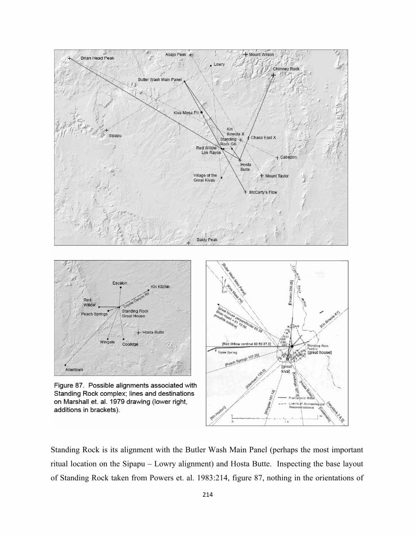
214
Standing Rock is its alignment with the Butler Wash Main Panel (perhaps the most important
ritual location on the Sipapu – Lowry alignment) and Hosta Butte. Inspecting the base layout
of Standing Rock taken from Powers et. al. 1983:214, figure 87, nothing in the orientations of
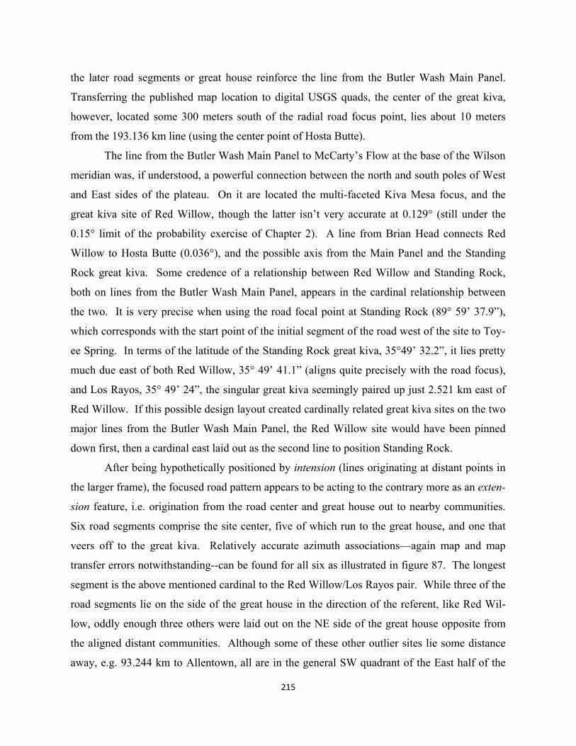
215
the later road segments or great house reinforce the line from the Butler Wash Main Panel.
Transferring the published map location to digital USGS quads, the center of the great kiva,
however, located some 300 meters south of the radial road focus point, lies about 10 meters
from the 193.136 km line (using the center point of Hosta Butte).
The line from the Butler Wash Main Panel to McCarty’s Flow at the base of the Wilson
meridian was, if understood, a powerful connection between the north and south poles of West
and East sides of the plateau. On it are located the multi-faceted Kiva Mesa focus, and the
great kiva site of Red Willow, though the latter isn’t very accurate at 0.129° (still under the
0.15° limit of the probability exercise of Chapter 2). A line from Brian Head connects Red
Willow to Hosta Butte (0.036°), and the possible axis from the Main Panel and the Standing
Rock great kiva. Some credence of a relationship between Red Willow and Standing Rock,
both on lines from the Butler Wash Main Panel, appears in the cardinal relationship between
the two. It is very precise when using the road focal point at Standing Rock (89° 59’ 37.9”),
which corresponds with the start point of the initial segment of the road west of the site to Toy-
ee Spring. In terms of the latitude of the Standing Rock great kiva, 35°49’ 32.2”, it lies pretty
much due east of both Red Willow, 35° 49’ 41.1” (aligns quite precisely with the road focus),
and Los Rayos, 35° 49’ 24”, the singular great kiva seemingly paired up just 2.521 km east of
Red Willow. If this possible design layout created cardinally related great kiva sites on the two
major lines from the Butler Wash Main Panel, the Red Willow site would have been pinned
down first, then a cardinal east laid out as the second line to position Standing Rock.
After being hypothetically positioned by intension (lines originating at distant points in
the larger frame), the focused road pattern appears to be acting to the contrary more as an exten-
sion feature, i.e. origination from the road center and great house out to nearby communities.
Six road segments comprise the site center, five of which run to the great house, and one that
veers off to the great kiva. Relatively accurate azimuth associations—again map and map
transfer errors notwithstanding--can be found for all six as illustrated in figure 87. The longest
segment is the above mentioned cardinal to the Red Willow/Los Rayos pair. While three of the
road segments lie on the side of the great house in the direction of the referent, like Red Wil-
low, oddly enough three others were laid out on the NE side of the great house opposite from
the aligned distant communities. Although some of these other outlier sites lie some distance
away, e.g. 93.244 km to Allentown, all are in the general SW quadrant of the East half of the
216
plateau. It may be possible to set up a probability exercise to determine the likelihood of some
outlier site in the area matching the orientation of all road features at Standing Rock, within a
stipulated accuracy.
Curiously, with all the radiating roads, none aligns with the often mentioned longer
Coyote Canyon road between Standing Rock and Kin Klizhin, the small great house without a
great kiva just a few kilometers west of the Chaco center. Other lines within the accuracies of
the probability exercise of the last chapter also involve the isolated Standing Rock great kiva:
Kiva Mesa PII – Haystack 2 & 3, and Kin Hocho’l – Kin Bineola K1 (at the great house).
These lines may be more likely to be random, since they do not include important natural fea-
tures which may have been necessary components to founding/locating great kiva foci. Finally,
the orientation of the Standing Rock great house of 29.62° toward the NE (author’s measure-
ment) carries as yet little strong associational evidence. The only thing that one can presently
note is that its perpendicular of 60.38° is similar to the azimuth to Brian Head (61° 10’ 56”). If
this were a design, it would link to Red Willow’s partner position on the Brian Head – Hosta
Butte line. Standing Rock’s great house has a relatively formal classic “D” shape with a large,
straight back wall and arc formed front. Given the indicators of symbolic wall orientation in
other larger great houses, the Standing Rock structure as well merits further investigation.
EXTENSION OF THE WILSON MERIDIAN Cerro Moctezuma and Paquime
The largest sites outside of the new Chaco center are certainly Aztec, up in the San Juan River
area, and Paquime down in today’s Chihuahua, Northern Mexico. While the latter is not neces-
sarily Chacoan in time or architectural characteristics, Lekson’s volume (1999) on the “Chaco”
meridian links these two poles with the Chaco center by virtue of their cardinal alignment,
among other things. Chaco was first, then Aztec, and finally Paquime. In terms of the survey-
ing accuracy in the present design analysis, these three sites are only very loosely aligned with-
in about two full degrees. Lekson does not involve significant natural features in his meridian,
while mentioning the fact that Paquime’s kiva like structure on Cerro Moctezuma, described
earlier, is quite accurately cardinal south from Peñasco Blanco.
Referring back to the probability exercise at the end of Chapter 3, it appears quite likely
that an important part of the Ancestral Pueblo plateau layout was the meridian, not from Chaco

217
per se, but from Mount Wilson: on it, again, are Mount Wilson, Aztec, Pueblo Peñasco,
29SJ423, Andrews, McCarty’s Flow and Cerro Moctezuma. Symbolic expression of the total
meridian, including the late or post Chaco Cerro Moctezuma, appears to exist in the great kiva
orientations at the north and south poles of the Middle axis from Lowry to Village of the Great
Kivas. As diagramed previously in figure 52, the classic Chaco period kiva orientations might
be bisects of the angles to the two pairs of West and East meridian features, i.e. Abajo Peak and
Mount Wilson in the north, and Baldy Peak and Cerro Moctezuma to the south. If this design
interpretation were someday better confirmed, it would mean that the extension of the Wilson
meridian down to Cerro Moctezuma occurred during the last decades of the 11th century, per-
haps as part of the impending move to Aztec, and before the urban layout of Paquime.
If it was al-
so true that a triadic
plateau structure
had existed for sev-
eral centuries prior
to the new Chaco
scheme, why con-
nect the Ship Rock
plateau Middle axis
with an extension
of the Wilson me-
ridian? Is it possi-
ble that the new
Lizard Head in-
spired Chaco center
had diminished the
East integration
with the traditional
triadic plateau, in-
cluding the Ganado
and Ship Rock ax-
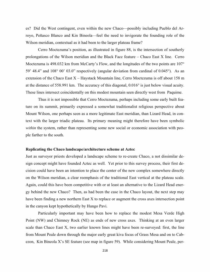
es? Did the West contingent, even within the new Chaco—possibly including Pueblo del Ar-
royo, Peñasco Blanco and Kin Bineola—feel the need to invigorate the founding role of the
Wilson meridian, contextual as it had been to the larger plateau frame?
Cerro Moctezuma’s position, as illustrated in figure 88, is the intersection of southerly
prolongations of the Wilson meridian and the Black Face feature – Chaco East X line. Cerro
Moctezuma is 498.032 km from McCarty’s Flow, and the longitudes of the two points are 107°
59’ 48.4” and 108° 00’ 03.0” respectively (angular deviation from cardinal of 0.045°). As an
extension of the Chaco East X – Haystack Mountain line, Cerro Moctezuma is off about 158 m
at the distance of 558.991 km. The accuracy of this diagonal, 0.016° is just below visual acuity.
These lines intersect coincidentally on this modest mountain seen directly west from Paquime.
Thus it is not impossible that Cerro Moctezuma, perhaps including some early built fea-
ture on its summit, primarily expressed a somewhat traditionalist religious perspective about
Mount Wilson, one perhaps seen as a more legitimate East meridian, than Lizard Head, in con-
text with the larger triadic plateau. Its primary meaning might therefore have been symbolic
within the system, rather than representing some new social or economic association with peo-
ple farther to the south.
Replicating the Chaco landscape/architecture scheme at Aztec
Just as surveyor priests developed a landscape scheme to re-create Chaco, a not dissimilar de-
sign concept might have founded Aztec as well. Yet prior to this survey process, their first de-
cision could have been an intention to place the center of the new complex somewhere directly
on the Wilson meridian, a clear reemphasis of the traditional East vertical at the plateau scale.
Again, could this have been competitive with or at least an alternative to the Lizard Head ener-
gy behind the new Chaco? Then, as had been the case in the Chaco layout, the next step may
have been finding a new northern East X to replace or augment the cross axes intersection point
in the canyon kept hypothetically by Hungo Pavi.
Particularly important may have been how to replace the modest Mesa Verde High
Point (NW) and Chimney Rock (NE) as ends of new cross axes. Thinking at an even larger
scale than Chaco East X, two earlier known lines might have been re-surveyed: first, the line
from Mount Peale down through the major early great kiva focus of Grass Mesa and on to Cab-
ezon, Kin Bineola X’s SE feature (see map in figure 59). While considering Mount Peale, per-
218
219
haps, as the new NW feature, the line seeking to create an Aztec East X would only have to be
re-surveyed from Grass Mesa southward to Cabezon. The other cross axis could have been the
long, possibly ancient shamanistic line from Blanca Peak to Humphrey’s Peak (see map in fig-
ure 15). This axis could have incorporated the early west side of the plateau via linkage with
the Canyon de Chelly frame including Brian Head, Mount Taylor, Baldy Peak, Abajo Peak, and
the Grand Canyon Sipapu.
Once the intersecting point of these two lines was established, the next design element
could have sought to connect the X point with some third axis running symbolically south to
north. Perhaps having some knowledge of the prolongation of Haystack – Chaco East X that
discovered the coincidence with the Black Face feature, surveyors might have known that the
new Aztec (Totah) X lay in the vicinity of this line. In resurveying the eastern ray of the triad
from Haystack, they would have been amazed at the intersecting coincidence of these three
lines, essentially a duplication of the coincidence of Chaco East X. The mathematical line from
Haystack to Black Face (154.594 km) only misses the precise Aztec East X point (from the ini-
tial two lines) by about 8 meters. Thus both Chaco East X and the new Aztec East X are coin-
cidentally aligned very accurately with Haystack – Black Face feature. This line misses the
precise cross axes intersection point of Chaco East X by about 44 meters (average deviation of
0.022° or close to visual acuity). This latter range of accuracy is likely closer to the limit of
surveyors’ skills than the overly precise 8 m at Aztec East X.
An extremely intriguing piece of evidence for an Aztec East X survey point may lie in
the fact that it is also coincidental with the intersection of the two Navajo large-scale axes illus-
trated earlier in figure 6. The two mathematically determined intersection points for Grass Me-
sa – Cabezon and Humphrey’s Peak – Blanca Peak (Ancestral Pueblo), and Hesperus Peak –
Mount Taylor and Humphrey’s Peak – Blanca Peak (Navajo) are latitudes: 36° 44’ 55.0”, and
36° 44’ 55.4”; and longitudes: 107° 56’ 03.9”, and 107° 56’ 01.5” (respectively). Given that
the Navajo originally first moved into the Ancestral Pueblo plateau area in the vicinity of Aztec
and the San Juan River in the 1500’s or so, is it possible that they knew of Aztec East X and
adopted one of the preexisting Aztec East X axes but weren’t taken with the late emphasis of
Grass Mesa and Cabezon. Instead they first chose the more prominent SE feature of Mount
Taylor. Perhaps with some surveying help from Ancestral Pueblo priests still knowledgeable of
these traditions, they might have prolonged a line from Mount Taylor through the X point to
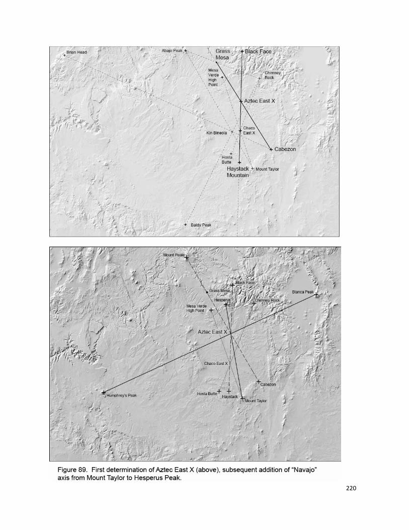
220
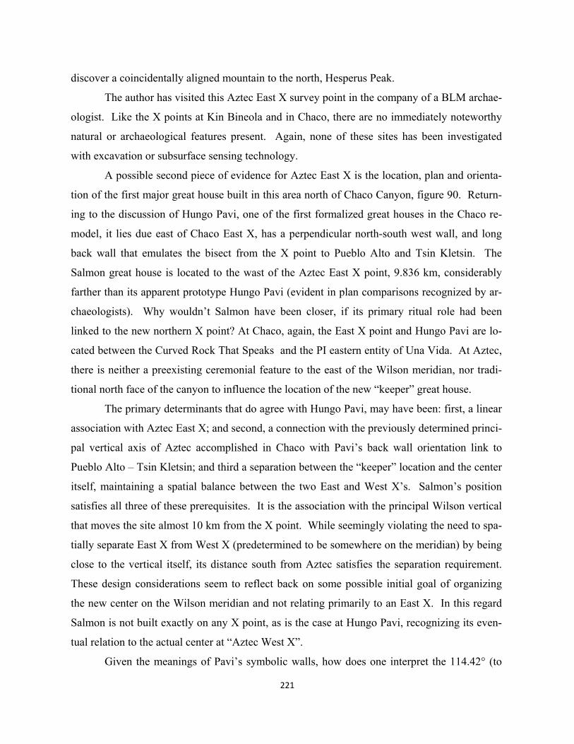
221
discover a coincidentally aligned mountain to the north, Hesperus Peak.
The author has visited this Aztec East X survey point in the company of a BLM archae-
ologist. Like the X points at Kin Bineola and in Chaco, there are no immediately noteworthy
natural or archaeological features present. Again, none of these sites has been investigated
with excavation or subsurface sensing technology.
A possible second piece of evidence for Aztec East X is the location, plan and orienta-
tion of the first major great house built in this area north of Chaco Canyon, figure 90. Return-
ing to the discussion of Hungo Pavi, one of the first formalized great houses in the Chaco re-
model, it lies due east of Chaco East X, has a perpendicular north-south west wall, and long
back wall that emulates the bisect from the X point to Pueblo Alto and Tsin Kletsin. The
Salmon great house is located to the wast of the Aztec East X point, 9.836 km, considerably
farther than its apparent prototype Hungo Pavi (evident in plan comparisons recognized by ar-
chaeologists). Why wouldn’t Salmon have been closer, if its primary ritual role had been
linked to the new northern X point? At Chaco, again, the East X point and Hungo Pavi are lo-
cated between the Curved Rock That Speaks and the PI eastern entity of Una Vida. At Aztec,
there is neither a preexisting ceremonial feature to the east of the Wilson meridian, nor tradi-
tional north face of the canyon to influence the location of the new “keeper” great house.
The primary determinants that do agree with Hungo Pavi, may have been: first, a linear
association with Aztec East X; and second, a connection with the previously determined princi-
pal vertical axis of Aztec accomplished in Chaco with Pavi’s back wall orientation link to
Pueblo Alto – Tsin Kletsin; and third a separation between the “keeper” location and the center
itself, maintaining a spatial balance between the two East and West X’s. Salmon’s position
satisfies all three of these prerequisites. It is the association with the principal Wilson vertical
that moves the site almost 10 km from the X point. While seemingly violating the need to spa-
tially separate East X from West X (predetermined to be somewhere on the meridian) by being
close to the vertical itself, its distance south from Aztec satisfies the separation requirement.
These design considerations seem to reflect back on some possible initial goal of organizing
the new center on the Wilson meridian and not relating primarily to an East X. In this regard
Salmon is not built exactly on any X point, as is the case at Hungo Pavi, recognizing its even-
tual relation to the actual center at “Aztec West X”.
Given the meanings of Pavi’s symbolic walls, how does one interpret the 114.42° (to
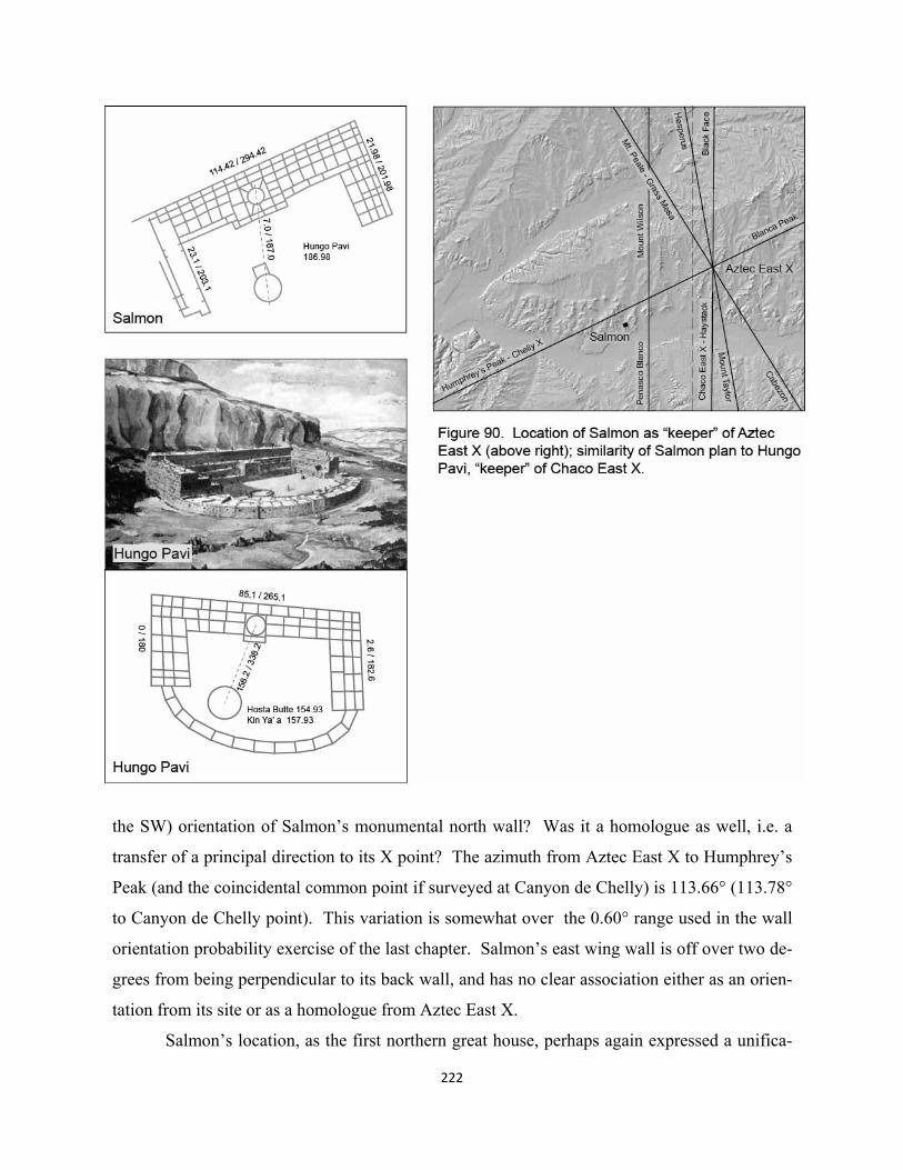
222
the SW) orientation of Salmon’s monumental north wall? Was it a homologue as well, i.e. a
transfer of a principal direction to its X point? The azimuth from Aztec East X to Humphrey’s
Peak (and the coincidental common point if surveyed at Canyon de Chelly) is 113.66° (113.78°
to Canyon de Chelly point). This variation is somewhat over the 0.60° range used in the wall
orientation probability exercise of the last chapter. Salmon’s east wing wall is off over two de-
grees from being perpendicular to its back wall, and has no clear association either as an orien-
tation from its site or as a homologue from Aztec East X.
Salmon’s location, as the first northern great house, perhaps again expressed a unifica-
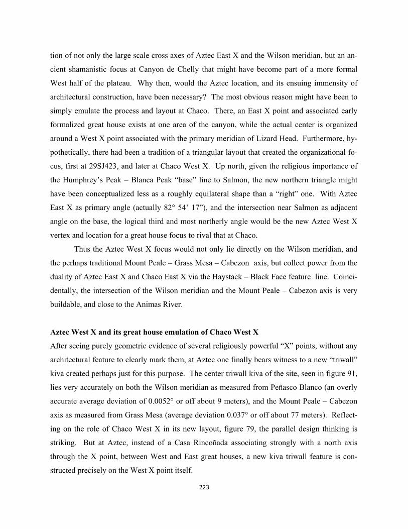
tion of not only the large scale cross axes of Aztec East X and the Wilson meridian, but an an-
cient shamanistic focus at Canyon de Chelly that might have become part of a more formal
West half of the plateau. Why then, would the Aztec location, and its ensuing immensity of
architectural construction, have been necessary? The most obvious reason might have been to
simply emulate the process and layout at Chaco. There, an East X point and associated early
formalized great house exists at one area of the canyon, while the actual center is organized
around a West X point associated with the primary meridian of Lizard Head. Furthermore, hy-
pothetically, there had been a tradition of a triangular layout that created the organizational fo-
cus, first at 29SJ423, and later at Chaco West X. Up north, given the religious importance of
the Humphrey’s Peak – Blanca Peak “base” line to Salmon, the new northern triangle might
have been conceptualized less as a roughly equilateral shape than a “right” one. With Aztec
East X as primary angle (actually 82° 54’ 17”), and the intersection near Salmon as adjacent
angle on the base, the logical third and most northerly angle would be the new Aztec West X
vertex and location for a great house focus to rival that at Chaco.
Thus the Aztec West X focus would not only lie directly on the Wilson meridian, and
the perhaps traditional Mount Peale – Grass Mesa – Cabezon axis, but collect power from the
duality of Aztec East X and Chaco East X via the Haystack – Black Face feature line. Coinci-
dentally, the intersection of the Wilson meridian and the Mount Peale – Cabezon axis is very
buildable, and close to the Animas River.
Aztec West X and its great house emulation of Chaco West X
After seeing purely geometric evidence of several religiously powerful “X” points, without any
architectural feature to clearly mark them, at Aztec one finally bears witness to a new “triwall”
kiva created perhaps just for this purpose. The center triwall kiva of the site, seen in figure 91,
lies very accurately on both the Wilson meridian as measured from Peñasco Blanco (an overly
accurate average deviation of 0.0052° or off about 9 meters), and the Mount Peale – Cabezon
axis as measured from Grass Mesa (average deviation 0.037° or off about 77 meters). Reflect-
ing on the role of Chaco West X in its new layout, figure 79, the parallel design thinking is
striking. But at Aztec, instead of a Casa Rincoñada associating strongly with a north axis
through the X point, between West and East great houses, a new kiva triwall feature is con-
structed precisely on the West X point itself.
223
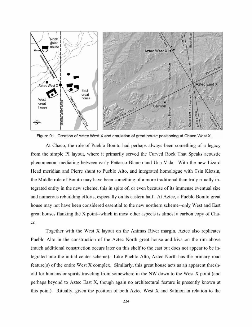
At Chaco, the role of Pueblo Bonito had perhaps always been something of a legacy
from the simple PI layout, where it primarily served the Curved Rock That Speaks acoustic
phenomenon, mediating between early Peñasco Blanco and Una Vida. With the new Lizard
Head meridian and Pierre shunt to Pueblo Alto, and integrated homologue with Tsin Kletsin,
the Middle role of Bonito may have been something of a more traditional than truly ritually in-
tegrated entity in the new scheme, this in spite of, or even because of its immense eventual size
and numerous rebuilding efforts, especially on its eastern half. At Aztec, a Pueblo Bonito great
house may not have been considered essential to the new northern scheme--only West and East
great houses flanking the X point--which in most other aspects is almost a carbon copy of Cha-
co.
Together with the West X layout on the Animas River margin, Aztec also replicates
Pueblo Alto in the construction of the Aztec North great house and kiva on the rim above
(much additional construction occurs later on this shelf to the east but does not appear to be in-
tegrated into the initial center scheme). Like Pueblo Alto, Aztec North has the primary road
feature(s) of the entire West X complex. Similarly, this great house acts as an apparent thresh-
old for humans or spirits traveling from somewhere in the NW down to the West X point (and
perhaps beyond to Aztec East X, though again no architectural feature is presently known at
this point). Ritually, given the position of both Aztec West X and Salmon in relation to the
224
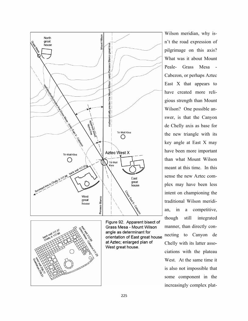
225
Wilson meridian, why is-
n’t the road expression of
pilgrimage on this axis?
What was it about Mount
Peale- Grass Mesa -
Cabezon, or perhaps Aztec
East X that appears to
have created more reli-
gious strength than Mount
Wilson? One possible an-
swer, is that the Canyon
de Chelly axis as base for
the new triangle with its
key angle at East X may
have been more important
than what Mount Wilson
meant at this time. In this
sense the new Aztec com-
plex may have been less
intent on championing the
traditional Wilson meridi-
an, in a competitive,
though still integrated
manner, than directly con-
necting to Canyon de
Chelly with its latter asso-
ciations with the plateau
West. At the same time it
is also not impossible that
some component in the
increasingly complex plat-
226
eau frame may have sought a return to an ancestral Grass Mesa and related San Juan region.
The present partially restored Aztec West great house is the focus the visitor center ex-
perience. The orientation of its major back wall was measured some time ago by the author,
including over fifty other great house structures on the plateau; no data for the unrestored Az-
tec East structure was collected at that time. The orientation of Aztec West is 117.37° to the
SW, which seems to reinforce an interpretation of Salmon’s major wall to a less ancient survey
point in Canyon de Chelly on the Humphrey’s Peak – Blanca Peak line (also the coincidental
point for two other axes and the perpendicular to Sipapu). The azimuth from Aztec West X to
the Canyon de Chelly point is 117.98°. Interestingly enough, the builders of Aztec West ap-
parently did not choose to create a homologue of the Humphrey’s Peak – Blanca Peak line by
using the orientation of the line itself as it passes through Aztec East X, i.e.113.78°. Again,
several examples of this kind transfer of orientation from one site to another have been sug-
gested, e.g. Hungo Pavi and Pueblo Pintado. Perhaps the founding of the huge Aztec West
great house was seen of such importance that a line from Aztec West X to the Canyon de
Chelly point was specially surveyed to not only orient the new monument, but further invigor-
ate West X itself.
The northeast corner of Aztec West may have been of particular importance in that it
expressed not only the Canyon de Chelly line but perhaps the principal axis to Aztec North and
beyond. The orientation of the great house’s east wall is 32.89° to the NW, while the azimuth
from Aztec West X to Grass Mesa is 30.95°. This deviation of almost two degrees, however, is
not really close to the range used in the probability exercise in Chapter 7. It is also true that the
location of Aztec North, its adjacent road, and great kiva are not precisely established com-
pared to a GPS position of Aztec West. This great house might have been laid out a few years
after the establishment of the West X point, and its east wall could have been orientated more
specifically in some way to Aztec North features.
Emulating the orientation of Aztec East’s major or back wall from Stein and McKenna
drawings (1988), one can tentatively comment on the apparent relationship between west and
east wall orientations and the bisect of the angle between the two major Aztec West axes, see
again figure 92. If this were an intentional design element, it would associate the west great
house with Mount Peale-Cabezon and the east great house with the Wilson meridian. In this
sense Aztec East is more like Pueblo Bonito in its relation to the central (Lizard Head) meridi-
227
an; in both we see a large interior great kiva and an expressed interior duality of west and east
room block components, thus adding an interesting footnote to the apparent absence of a large
Middle great house at Aztec. Yet according to the cited survey drawings, Aztec East’s west
wall does not appear to be parallel to the Wilson meridian.
In spite of a certain amount of design analysis, no geometric, possible intentional pattern
can be found for the location of the two triwall kivas in the NW and NE quadrants of the Aztec
site. This includes both relationships to other adjacent built features and to distant landscape or
great kiva points. Formally, they seem paired up as “northern” components immediately linked
to their respective West and East great houses. To a certain extent this replicates the only tri-
wall kiva in Chaco Canyon at Pueblo del Arroyo. Here the kiva feature, see again figure 79,
was attached directly to Arroyo’s major back wall. If the triwall design was created to express
an X point--much less as spaces for major ritual than geometric expressions of their capacity to
organize, focus, or “center”--then why are they attached to great houses?
One scenario, the absence of more detailed archaeological data notwithstanding, could
begin with the creation of the triwall form as an expression of the Aztec West point. Social
groups involved with Pueblo del Arroyo might have been, via their common West religious def-
inition, associated with the apparent re-definition of the Wilson meridian as a new West ele-
ment—both within the Lizard Head – Haystack triad, and in relation to Canyon de Chelly and
West at the plateau scale. The triwall element at Pueblo del Arroyo might therefore have been
added as a sign of these associations. This may have been additionally multivocal in that Pueb-
lo del Arroyo’s axis could have been created by one of the triangle lines of Chaco West X.
Thus there would have been a certain unification of the two West X points through the mediat-
ing act of building the triwall as an attachment on Pueblo del Arroyo’s north wall.
Would it follow then, that the two Aztec great houses would feel the symbolic need to
replicate Pueblo del Arroyo’s role by respectively adding triwall kivas just north of their major
back walls? In this case, a kind of legitimization of new Aztec religious practice may have
been felt by creating these homologues of the “mother” West great house at the Chaco West X
center—whose constituency might logically have included Kin Bineola as the early Chaco
West, Peñasco Blanco as the PI West and probable survey point for Aztec’s relationship to the
Wilson meridian, and even people from the West hemisphere of plateau.
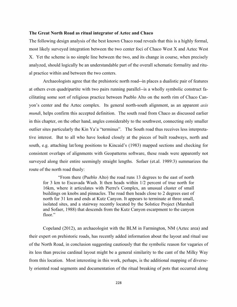
228
The Great North Road as ritual integrator of Aztec and Chaco
The following design analysis of the best known Chaco road reveals that this is a highly formal,
most likely surveyed integration between the two center foci of Chaco West X and Aztec West
X. Yet the scheme is no simple line between the two, and its change in course, when precisely
analyzed, should logically be an understandable part of the overall schematic formality and ritu-
al practice within and between the two centers.
Archaeologists agree that the prehistoric north road--in places a dualistic pair of features
at others even quadripartite with two pairs running parallel--is a wholly symbolic construct fa-
cilitating some sort of religious practice between Pueblo Alto on the north rim of Chaco Can-
yon’s center and the Aztec complex. Its general north-south alignment, as an apparent axis
mundi, helps confirm this accepted definition. The south road from Chaco as discussed earlier
in this chapter, on the other hand, angles considerably to the southwest, connecting only smaller
outlier sites particularly the Kin Ya’a “terminus”. The South road thus receives less interpreta-
tive interest. But to all who have looked closely at the pieces of built roadways, north and
south, e.g. attaching lat/long positions to Kincaid’s (1983) mapped sections and checking for
consistent overlaps of alignments with Geopatterns software, these roads were apparently not
surveyed along their entire seemingly straight lengths. Sofaer (et.al. 1989:3) summarizes the
route of the north road thusly:
“From there (Pueblo Alto) the road runs 13 degrees to the east of north for 3 km to Escavada Wash. It then heads within 1/2 percent of true north for 16km, where it articulates with Pierre's Complex, an unusual cluster of small buildings on knobs and pinnacles. The road then heads close to 2 degrees east of north for 31 km and ends at Kutz Canyon. It appears to terminate at three small, isolated sites, and a stairway recently located by the Solstice Project (Marshall and Sofaer, 1988) that descends from the Kutz Canyon escarpment to the canyon floor.”
Copeland (2012), an archaeologist with the BLM in Farmington, NM (Aztec area) and
their expert on prehistoric roads, has recently added information about the layout and ritual use
of the North Road, in conclusion suggesting cautiously that the symbolic reason for vagaries of
its less than precise cardinal layout might be a general similarity to the cant of the Milky Way
from this location. Most interesting in this work, perhaps, is the additional mapping of diverse-
ly oriented road segments and documentation of the ritual breaking of pots that occurred along
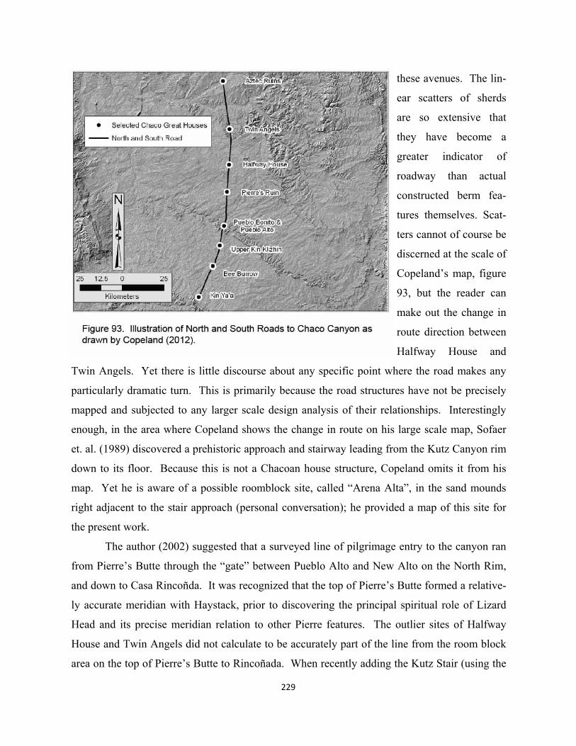
229
these avenues. The lin-
ear scatters of sherds
are so extensive that
they have become a
greater indicator of
roadway than actual
constructed berm fea-
tures themselves. Scat-
ters cannot of course be
discerned at the scale of
Copeland’s map, figure
93, but the reader can
make out the change in
route direction between
Halfway House and
Twin Angels. Yet there is little discourse about any specific point where the road makes any
particularly dramatic turn. This is primarily because the road structures have not be precisely
mapped and subjected to any larger scale design analysis of their relationships. Interestingly
enough, in the area where Copeland shows the change in route on his large scale map, Sofaer
et. al. (1989) discovered a prehistoric approach and stairway leading from the Kutz Canyon rim
down to its floor. Because this is not a Chacoan house structure, Copeland omits it from his
map. Yet he is aware of a possible roomblock site, called “Arena Alta”, in the sand mounds
right adjacent to the stair approach (personal conversation); he provided a map of this site for
the present work.
The author (2002) suggested that a surveyed line of pilgrimage entry to the canyon ran
from Pierre’s Butte through the “gate” between Pueblo Alto and New Alto on the North Rim,
and down to Casa Rincoñda. It was recognized that the top of Pierre’s Butte formed a relative-
ly accurate meridian with Haystack, prior to discovering the principal spiritual role of Lizard
Head and its precise meridian relation to other Pierre features. The outlier sites of Halfway
House and Twin Angels did not calculate to be accurately part of the line from the room block
area on the top of Pierre’s Butte to Rincoñada. When recently adding the Kutz Stair (using the
230
point on the rim of the canyon where the stair approach begins) to the Chaco West X scheme
that is now seen to organize the line from Rincoñada to the Pierre Road Point (at El Faro), a
much clearer pattern began to emerge. Not only was the Kutz Canyon stair positioned as the
northernmost feature of the line from or to Rincoñada, via Chaco West X, but the small road
related feature of Halfway House also lies accurately on this line. Thus a very accurate align-
ment of five features—Casa Rincoñada-Chaco West X-Pierre Road-Halfway House-Kutz
Stair-- not only unifies all of the best known segments of the North Road except for Twin An-
gels, actually veering off almost three full degrees E of N to Kutz Canyon, but provides anoth-
er validating piece to X point (Chaco West) hypotheses.
Thus the divergent variations in road segment orientations have masked the remarkable
precision by which the road features themselves were probably first laid out contemporaneous-
ly with the development of the Aztec landscape scheme or perhaps its great house infill. The
actual road segments may relate more to subsequent usage by non-surveyor ritual participants.
Recalling that the Chaco West X point may have been determined by the mathematical inter-
section of Wilson – Haystack and Tohatchi-Kin Bineola X, it is extremely improbable that as a
random phenomenon it would participate so accurately with the principal ritual road line into
Chaco. This line consists of eleven separate three point alignments (see list in Appendix II).
Errors in GPS readings and map transfers notwithstanding, the lowest average deviation of the
eleven (taken from both ends) is 0.0002° and the highest is 0.011°, while the average of the
eleven is 0.005° (visual acuity again is 0.017°). Considering the 52.050 km length of the line,
the greatest distance any three-point line would be off its interim point, is about 2-3 meters; or,
all lines clearly hit their features, pretty much dead center.
This likely evidence of Ancestral Pueblo surveying abilities aside, it seems under-
standable why Casa Rincoñada-Chaco West X ran to the Pierre Road point on the Lizard Head
meridian, but why does this axis continue very precisely to the mysterious stair feature that
disappears into Kutz Canyon, and what was the role of Halfway House on this line? If long
held suppositions that the North Road ran from Chaco all the way to Aztec are true, now con-
sidering the features of Casa Rincoñada – Kutz Stair alignment, straight as an arrow, then why
would the way to Aztec make an abrupt almost ten degree turn to the west at the stair point?
Curiously there is no well documented road segment between the stair and Aztec—the direct
alignment runs mostly in the canyon wash--including at the primary non-community outlier
site that appears to connect the two, Twin Angels. Nevertheless, two large-scale landscape
considerations may have played into a pilgrimage role for the Twin Angels room block with
two enclosed kivas perched rather precariously on a rim outcrop overlooking Kutz Canyon.
Perhaps most important was its adjacency to the Lizard Head – Haystack meridian which pass-
es about 123 meters west of the structure. Was this another “keeper” relationship not that un-
like Hungo Pavi and Salmon where structures were located off associated axes? Logically, a
small structure like Twin Angels couldn’t be directly on the Lizard Head meridian, competing
231
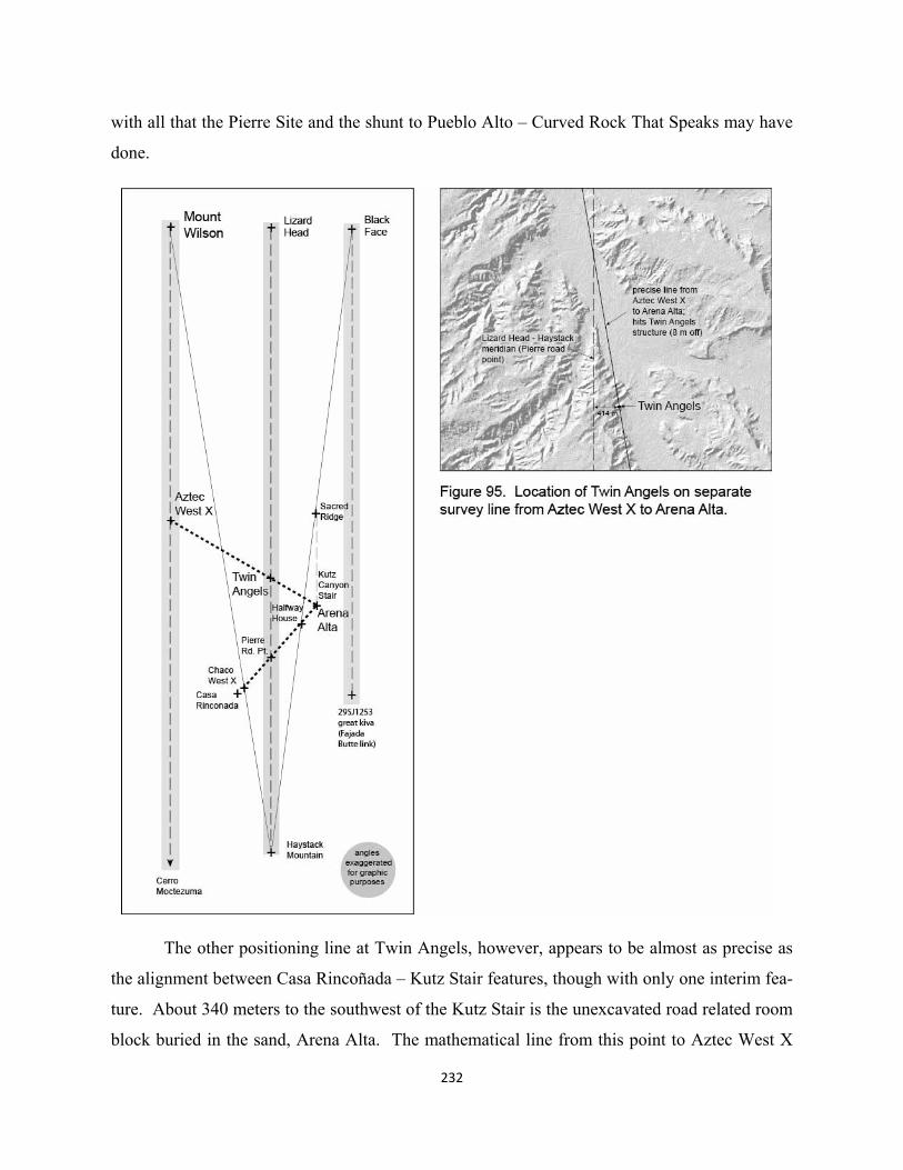
with all that the Pierre Site and the shunt to Pueblo Alto – Curved Rock That Speaks may have
done.
The other positioning line at Twin Angels, however, appears to be almost as precise as
the alignment between Casa Rincoñada – Kutz Stair features, though with only one interim fea-
ture. About 340 meters to the southwest of the Kutz Stair is the unexcavated road related room
block buried in the sand, Arena Alta. The mathematical line from this point to Aztec West X
232
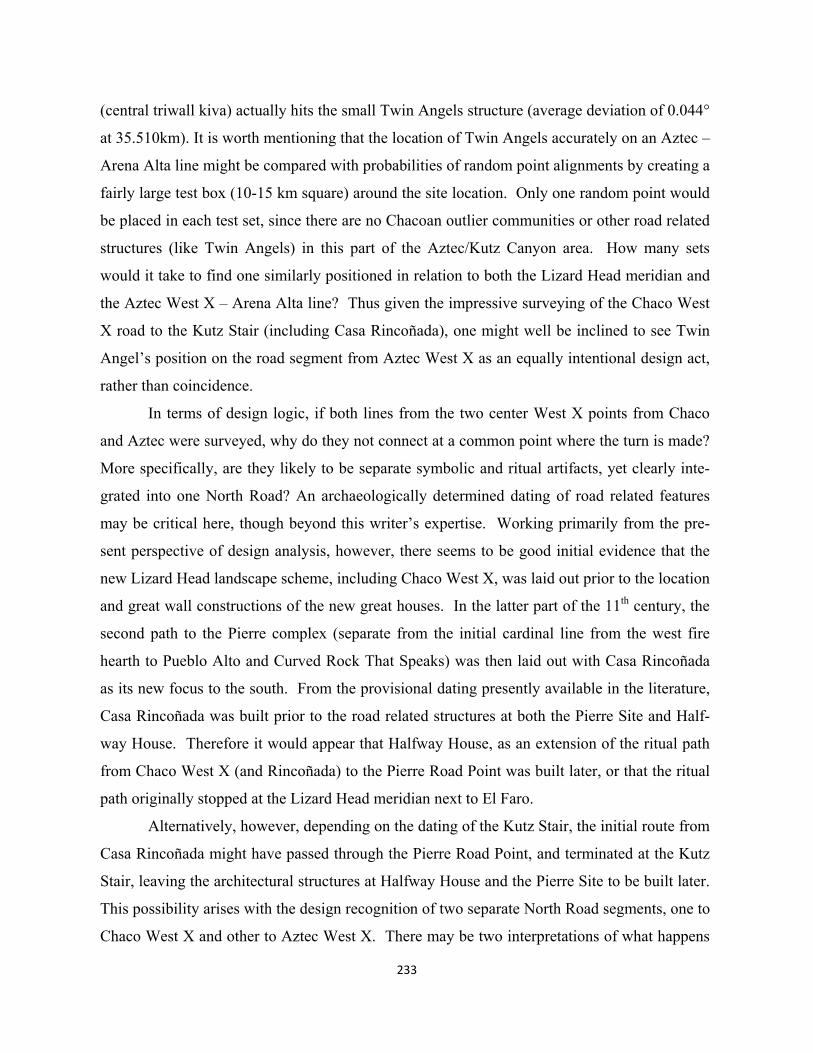
233
(central triwall kiva) actually hits the small Twin Angels structure (average deviation of 0.044°
at 35.510km). It is worth mentioning that the location of Twin Angels accurately on an Aztec –
Arena Alta line might be compared with probabilities of random point alignments by creating a
fairly large test box (10-15 km square) around the site location. Only one random point would
be placed in each test set, since there are no Chacoan outlier communities or other road related
structures (like Twin Angels) in this part of the Aztec/Kutz Canyon area. How many sets
would it take to find one similarly positioned in relation to both the Lizard Head meridian and
the Aztec West X – Arena Alta line? Thus given the impressive surveying of the Chaco West
X road to the Kutz Stair (including Casa Rincoñada), one might well be inclined to see Twin
Angel’s position on the road segment from Aztec West X as an equally intentional design act,
rather than coincidence.
In terms of design logic, if both lines from the two center West X points from Chaco
and Aztec were surveyed, why do they not connect at a common point where the turn is made?
More specifically, are they likely to be separate symbolic and ritual artifacts, yet clearly inte-
grated into one North Road? An archaeologically determined dating of road related features
may be critical here, though beyond this writer’s expertise. Working primarily from the pre-
sent perspective of design analysis, however, there seems to be good initial evidence that the
new Lizard Head landscape scheme, including Chaco West X, was laid out prior to the location
and great wall constructions of the new great houses. In the latter part of the 11th century, the
second path to the Pierre complex (separate from the initial cardinal line from the west fire
hearth to Pueblo Alto and Curved Rock That Speaks) was then laid out with Casa Rincoñada
as its new focus to the south. From the provisional dating presently available in the literature,
Casa Rincoñada was built prior to the road related structures at both the Pierre Site and Half-
way House. Therefore it would appear that Halfway House, as an extension of the ritual path
from Chaco West X (and Rincoñada) to the Pierre Road Point was built later, or that the ritual
path originally stopped at the Lizard Head meridian next to El Faro.
Alternatively, however, depending on the dating of the Kutz Stair, the initial route from
Casa Rincoñada might have passed through the Pierre Road Point, and terminated at the Kutz
Stair, leaving the architectural structures at Halfway House and the Pierre Site to be built later.
This possibility arises with the design recognition of two separate North Road segments, one to
Chaco West X and other to Aztec West X. There may be two interpretations of what happens
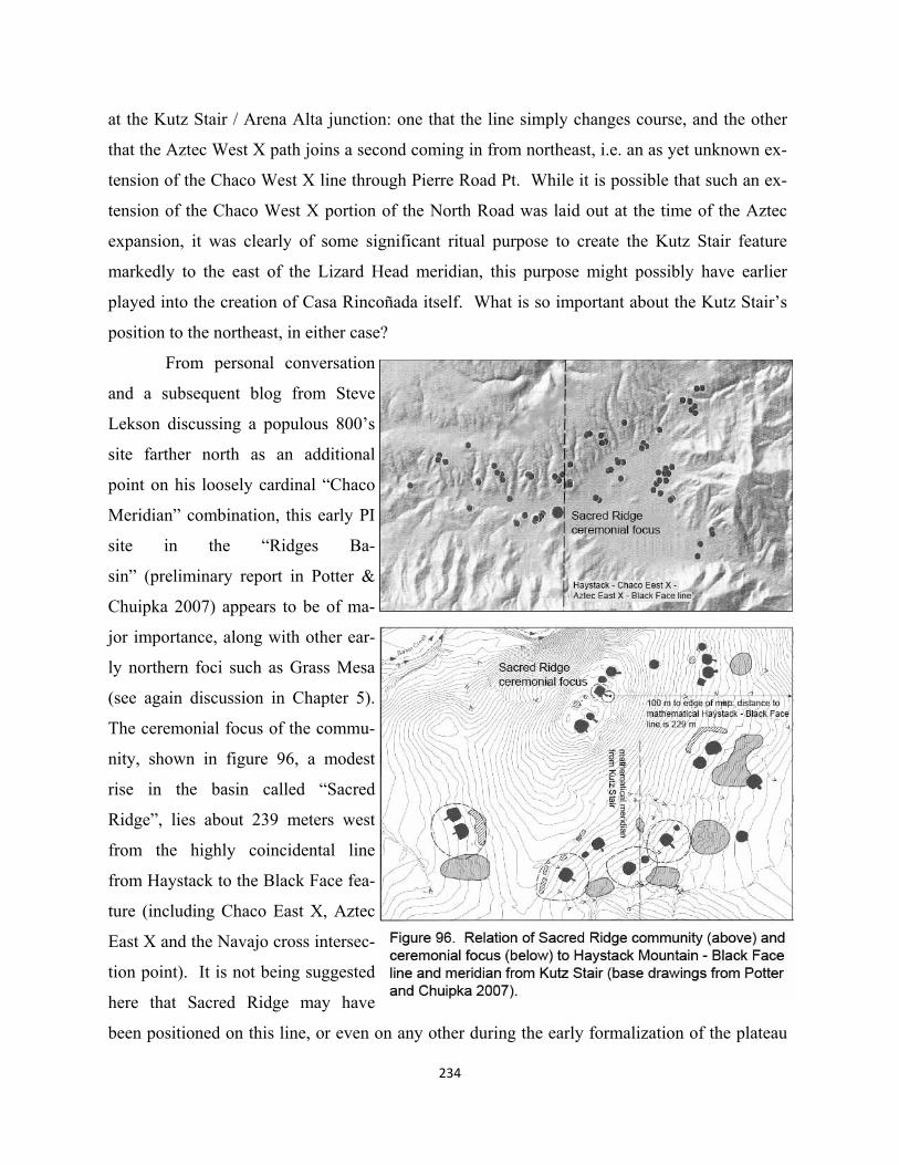
at the Kutz Stair / Arena Alta junction: one that the line simply changes course, and the other
that the Aztec West X path joins a second coming in from northeast, i.e. an as yet unknown ex-
tension of the Chaco West X line through Pierre Road Pt. While it is possible that such an ex-
tension of the Chaco West X portion of the North Road was laid out at the time of the Aztec
expansion, it was clearly of some significant ritual purpose to create the Kutz Stair feature
markedly to the east of the Lizard Head meridian, this purpose might possibly have earlier
played into the creation of Casa Rincoñada itself. What is so important about the Kutz Stair’s
position to the northeast, in either case?
From personal conversation
and a subsequent blog from Steve
Lekson discussing a populous 800’s
site farther north as an additional
point on his loosely cardinal “Chaco
Meridian” combination, this early PI
site in the “Ridges Ba-
sin” (preliminary report in Potter &
Chuipka 2007) appears to be of ma-
jor importance, along with other ear-
ly northern foci such as Grass Mesa
(see again discussion in Chapter 5).
The ceremonial focus of the commu-
nity, shown in figure 96, a modest
rise in the basin called “Sacred
Ridge”, lies about 239 meters west
from the highly coincidental line
from Haystack to the Black Face fea-
ture (including Chaco East X, Aztec
East X and the Navajo cross intersec-
tion point). It is not being suggested
here that Sacred Ridge may have
been positioned on this line, or even on any other during the early formalization of the plateau
234
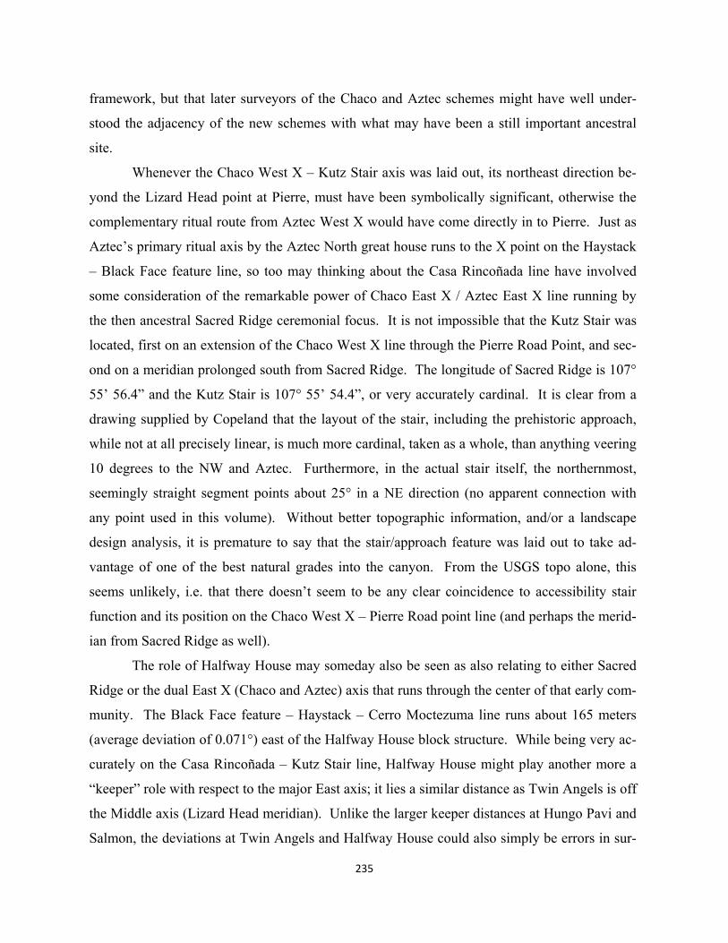
framework, but that later surveyors of the Chaco and Aztec schemes might have well under-
stood the adjacency of the new schemes with what may have been a still important ancestral
site.
Whenever the Chaco West X – Kutz Stair axis was laid out, its northeast direction be-
yond the Lizard Head point at Pierre, must have been symbolically significant, otherwise the
complementary ritual route from Aztec West X would have come directly in to Pierre. Just as
Aztec’s primary ritual axis by the Aztec North great house runs to the X point on the Haystack
– Black Face feature line, so too may thinking about the Casa Rincoñada line have involved
some consideration of the remarkable power of Chaco East X / Aztec East X line running by
the then ancestral Sacred Ridge ceremonial focus. It is not impossible that the Kutz Stair was
located, first on an extension of the Chaco West X line through the Pierre Road Point, and sec-
ond on a meridian prolonged south from Sacred Ridge. The longitude of Sacred Ridge is 107°
55’ 56.4” and the Kutz Stair is 107° 55’ 54.4”, or very accurately cardinal. It is clear from a
drawing supplied by Copeland that the layout of the stair, including the prehistoric approach,
while not at all precisely linear, is much more cardinal, taken as a whole, than anything veering
10 degrees to the NW and Aztec. Furthermore, in the actual stair itself, the northernmost,
seemingly straight segment points about 25° in a NE direction (no apparent connection with
any point used in this volume). Without better topographic information, and/or a landscape
design analysis, it is premature to say that the stair/approach feature was laid out to take ad-
vantage of one of the best natural grades into the canyon. From the USGS topo alone, this
seems unlikely, i.e. that there doesn’t seem to be any clear coincidence to accessibility stair
function and its position on the Chaco West X – Pierre Road point line (and perhaps the merid-
ian from Sacred Ridge as well).
The role of Halfway House may someday also be seen as also relating to either Sacred
Ridge or the dual East X (Chaco and Aztec) axis that runs through the center of that early com-
munity. The Black Face feature – Haystack – Cerro Moctezuma line runs about 165 meters
(average deviation of 0.071°) east of the Halfway House block structure. While being very ac-
curately on the Casa Rincoñada – Kutz Stair line, Halfway House might play another more a
“keeper” role with respect to the major East axis; it lies a similar distance as Twin Angels is off
the Middle axis (Lizard Head meridian). Unlike the larger keeper distances at Hungo Pavi and
Salmon, the deviations at Twin Angels and Halfway House could also simply be errors in sur-
235
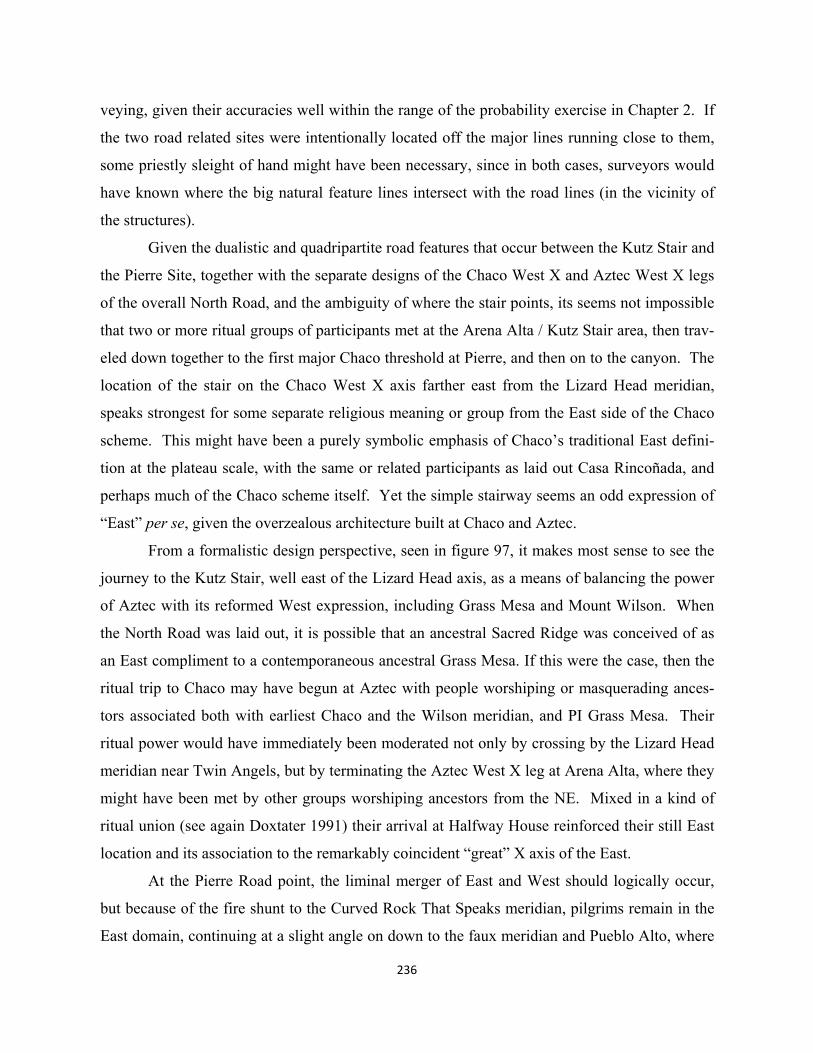
236
veying, given their accuracies well within the range of the probability exercise in Chapter 2. If
the two road related sites were intentionally located off the major lines running close to them,
some priestly sleight of hand might have been necessary, since in both cases, surveyors would
have known where the big natural feature lines intersect with the road lines (in the vicinity of
the structures).
Given the dualistic and quadripartite road features that occur between the Kutz Stair and
the Pierre Site, together with the separate designs of the Chaco West X and Aztec West X legs
of the overall North Road, and the ambiguity of where the stair points, its seems not impossible
that two or more ritual groups of participants met at the Arena Alta / Kutz Stair area, then trav-
eled down together to the first major Chaco threshold at Pierre, and then on to the canyon. The
location of the stair on the Chaco West X axis farther east from the Lizard Head meridian,
speaks strongest for some separate religious meaning or group from the East side of the Chaco
scheme. This might have been a purely symbolic emphasis of Chaco’s traditional East defini-
tion at the plateau scale, with the same or related participants as laid out Casa Rincoñada, and
perhaps much of the Chaco scheme itself. Yet the simple stairway seems an odd expression of
“East” per se, given the overzealous architecture built at Chaco and Aztec.
From a formalistic design perspective, seen in figure 97, it makes most sense to see the
journey to the Kutz Stair, well east of the Lizard Head axis, as a means of balancing the power
of Aztec with its reformed West expression, including Grass Mesa and Mount Wilson. When
the North Road was laid out, it is possible that an ancestral Sacred Ridge was conceived of as
an East compliment to a contemporaneous ancestral Grass Mesa. If this were the case, then the
ritual trip to Chaco may have begun at Aztec with people worshiping or masquerading ances-
tors associated both with earliest Chaco and the Wilson meridian, and PI Grass Mesa. Their
ritual power would have immediately been moderated not only by crossing by the Lizard Head
meridian near Twin Angels, but by terminating the Aztec West X leg at Arena Alta, where they
might have been met by other groups worshiping ancestors from the NE. Mixed in a kind of
ritual union (see again Doxtater 1991) their arrival at Halfway House reinforced their still East
location and its association to the remarkably coincident “great” X axis of the East.
At the Pierre Road point, the liminal merger of East and West should logically occur,
but because of the fire shunt to the Curved Rock That Speaks meridian, pilgrims remain in the
East domain, continuing at a slight angle on down to the faux meridian and Pueblo Alto, where
237
the primary rituals of unification may have taken place, in preparation for ultimate performance
at the natural amphitheater. The ritual route went from the central triwall kiva, Aztec West X,
down to Chaco West X, architecturally expressed by the terminus of the axis from Kutz Stair at
Casa Rincoñada. Since Rincoñada’s location and orientation make it one of the Middle ele-
ments in central Chaco it may have been used by both groups united initially during the pil-
grimage at the Kutz Stair.
238
239
9. Toward an Anthropology of Prehistoric Landscape/Architecture Design
There is no academic discipline, or even sub discipline, whose primary goal seeks to under-
stand social and particularly cognitive space. While one would think that “wayfinding”, as our
most immediate example of cognitive maps, would constitute a serious research domain within
contemporary design and planning, only a couple of now older “how to” books, barely keep the
ideas of Lynch (1960) and others alive. The flourishing though still esoteric applications of
Space Syntax to wayfinding today are the exception here within their broader interests in the
human uses of different morphologies of environment (initiated by Hillier & Hanson 1984).
While the seminal work of both Lynch and Hillier & Hanson made copious use of literature
about or maps of traditional settings, neither developed any clear distinction between religious-
ly used symbolic/ritual space and other social phenomena better defined as territoriality, both
unique forms of cognitive mapping. This is precisely what an anthropology of traditional space
needs to do.
Our contemporary 21st century environments are so devoid of formalized, long lived
ritual layouts of space, that assumptions of wide spread territoriality, though again not well re-
searched, are largely true. While a contemporary designer might actively pursue symbolic con-
tent in the layout of a church or a memorial landscape (e.g.Wasserman 1998) there is little in
our academic histories of architecture, planning, or landscape that includes ritual “maps” as it
were, especially in the scant course coverage of the prehistoric. The emphasis lies in the built
artifact more so than how it can create and participate in ritual practice moving through sym-
bolic thresholds, domains and other elements of structure. This preoccupation with the artifact
is largely true as well in archaeology, with the more recent area of “landscape archaeology”
just beginning to ask questions about more symbolic landscape contexts ( Darvill 1999, Brad-
ley 2000, 2006), though not yet inquiring about possibilities of designed large scale frame-
works. We remain some distance from any generally consensual definition of the difference
between territorial examples of social space, at all scales, and ritual patterns that are much more
formalized, symbolic, complex, participatory, and often integrative. Thus there is precious lit-
240
tle discourse, in design and planning or anthropology that can yet point to the changing social
role of cognitive maps in an evolution of “shamanistic” to surveyed “formalized” large scale
landscapes. The present work is hopefully a small step in that direction.
ANCESTRAL PUEBLO EVOLUTION OF FORMALIZED LANDSCAPE RELIGION
The religious effect of alignments among or with prominent natural features
Hypothetically, neither shamanistic landscapes where some non-surveyed “spider web” or
“cosmos” anchored on real topographic features is shared by tribes living within, nor ritually
surveyed evolutions of such, are territorial. Rather, these symbolic definitions may tend to
mitigate competition for resources, at least from within the defined cultural sphere. The spir-
itual power of the natural landscape constitutes a kind of symbolic capital available for the so-
cial and curative purposes of these societies. Given, therefore, that the powerful larger natural
setting had most likely been loaded with shamanistic spiritual affect, perhaps for millennia, it
is not unreasonable to suggest that at some time, religious specialists began to attribute extra
power to coincidental geometric relationships among the most prominent of “god-given” fea-
tures—mostly alignments and particularly those cardinally orientated. The development of
simple but accurate techniques of surveying may not have been driven by any functional pur-
pose, as in modern engineering, but by a desire to create greater religious affect among fea-
tures in the natural landscape. This is not yet design, but with such tools, and a context of ritu-
al practice as the primary expression of religion, first formalized larger scale geometric arti-
facts might soon have followed.
Pivotal in some new anthropology of traditional space is the rereading of Ortiz, de-
scribed in Chapter 1. While generally successful in questioning the kinship/mythology based
dualistic structures in lessor organized cultures, Ortiz’s work perhaps more importantly con-
tributed a new appreciation for the spatial structure of a ritual landscape. Yet his interpretation
may have fallen short of fully understanding the phenomenological contribution, or originating
capacity of space and cognitive mapping itself. He felt that spatial layouts of ritual landscape
were essentially secondary, essentially coming from origin myth as a sort of primary social
medium. To the contrary, assuming a non-territorial, shared landscape, an “on the ground”
native discovery of coincidental, large scale geometry might immediately transcend more lan-
241
guage based kinship or mythic definitions of social groups, engaging other social entities asso-
ciated with features some distance from each other. The discourse about when and how ritual
sodalities came into being, and how they worked with kinship organization, might really be less
complicated than it seems. Most ritual groups in the Ancestral or Historical Pueblos are funda-
mentally large scale and integrative, rising above kinship definition. This may have been even
more the case in a hypothetical prehistoric survey based religion. Most important perhaps, is
the idea that sodalities were not invented to ameliorate relatively local scale distribution of kin-
ship power, but to engage more formally in the larger scale landscape that might well have been
culturally shared for thousands of years.
Very much in this same vein, the creation of the first formalized piece of ceremonial
architecture, the great kiva, could have been part and parcel to the development of survey based
design in the larger landscape. Whether the “chicken” as structured landscape preceded these
ritual foci as “eggs” or not, should be a theoretical question of considerable priority—the folk
wisdom of indeterminacy to the contrary. Presently, early PI great kiva sites, with adjacent
seemingly domestic structures, are felt to be largely local phenomena, unique and limited in
number compared to the basic domestic pattern of small kinship pithouse homesteads scattered
about sparsely within a community area. The role of these first specialized ritual settings, prob-
ably misnamed “villages”, are not at all clear from the archaeological record. Notably, the
number of alignments associated with early great kiva sites, as illustrated in the probability
analysis of Chapter 2, is higher than in later periods, suggesting that work needs to be done to
not only determine how the sites were used, but perhaps even more importantly, where they
were located.
The design analysis of the first two great kiva sites in Chaco Canyon (29SJ423) reveals
not only the possible intentional location of the northernmost site on the Mount Wilson –
McCarty’s Flow (north-south) cardinal axis, and close to the only large-scale coincidental three
-point alignment on the plateau among the Grand Canyon Sipapu-Mount Chicoma-Truchas
Peak (west-east) but a relatively good equilateral triangle with 29SJ423 as apex to base points
at the coincidental intersection of Kin Bineola X (three large scale axes) to the west, and the
second great kiva site of Shabik’eschee east in the canyon. The “cross axes” of Kin Bineola X
—perhaps not unlike those of the corner mountains of the shamanistic cosmos—might have
been understood by surveying in an effort to find complementary corner axes to the Wilson me-
242
ridian in the vicinity of Chaco Canyon. The acoustical amphitheater wall called Curved Rock
That Speaks sits quite accurately on the eastern ray of the early Chaco triangle whose end
points are the two great kiva sites. This formal flanking of the canyon has been briefly com-
mented on by archaeologists, an implicit understanding of some process of larger scale design
and formalization.
Most importantly, this hypothetical evolutionary turn of landscape religion may not
have begun by people in the canyon, seeking to magnify the religious power of the canyon by
“extension” out into the greater spiritual landscape. Rather it could have been the reverse, with
early priests or shamans first discovering the cardinal relationship between Abajo Peak –
Mount Wilson (west-east) far to the north, and a complementary perpendicular down to the
most recent volcanic event called McCarty’s Flow(south from Wilson). Thus the concept of
layout was “intension”, i.e. beginning with significant landscape elements on the periphery, and
then secondarily channeling that spiritual power to more ritually accessible ceremonial sites,
with clustering populations around. The intension process of understanding the equinox rela-
tion with Abajo Peak, then laying out the meridian from Wilson, positioning the two canyon
sites, carrying timber supports some distance, and completing the great kiva form, may have
been a new kind of religious practice, specifically integrating different social groups associated
with the geometry, rather than any more socially or politically motivated religious extension to
create a “center” at the plateau scale. The design and execution of laying out landscape and
related (subordinated) architectural form may have been the most important aspect of these reli-
gious acts, perhaps even more so than doing ritual in the kivas once built.
Formalization of triadic ritual framework across a likely previously shamanistic plateau
Interpreting the first “Chaco” layout and location of great kivas more as an early change in reli-
gious process, per se, than new center with large scale political implications, allows one to
think quite differently about change in other parts of the plateau. It is not impossible that the
period beginning in late Basketmaker III and running into the PI period (roughly 600 – 800
A.D.) saw a reformulation of basic religious process across much of the plateau. Great Kiva
sites appear in all parts of the cultural sphere, though in small number. Most interesting are the
geometries that possibly “emerged” from the Sipapu in the Grand Canyon—confluence of the
two Colorado Rivers—to found new framework, particularly on the west side of a shamanistic
243
cosmos with its axis mundi (north-south vertical) between Abajo Peak and Mount Baldy. The
line from the Sipapu through the southern tip of Comb Ridge (and the main panel of the Butler
Wash Rock Art) and up through the Bluff site and to Lowry Ruin may have formalized a
northern ritual focus, complementary to a southern focus at Ganado laid out with lines from the
Sipapu to Mount Taylor and from Humphrey’s Peak to Tohatchi.
Tentative evidence that these new ritual experiences on the western side were designed
cognizant of the eastern precedent of Mount Wilson and Chaco appears in the mediating or
“Middle” vertical structure laid out on Ship Rock with aligned great kiva sites of Lowry Ruin,
Tohatchi and Village of the Great Kivas. While the basic triadic structure of Ancestral Pueblo
religion might have been first formalized in the design of the early Chaco layout (vertex and
two base points), it may have been inherently more likely in West, Middle and East domains of
the traditional shamanistic cosmos itself. This is not to say that its formalization during the
new survey integrated ritual practices didn’t likely intensify the expressive and social effects of
these meanings in emergent sodalities, at all scales of organization, particularly the larger ones.
In the late PI, Chaco itself--perhaps in recognition of the formalizing larger plateau
frame and sharper definitions of triadic Pan-Ancestral Pueblo religion--constructs a triad of em-
bellished or new sites with two new great kivas, creating a smaller more visually defined can-
yon axis. Early non-formalized or organic roomblocks are built at both of ends and adjacent to
the Curved Rock That Speaks in the Middle (Pueblo Bonito). This modest Chaco remodel may
have more formally expressed its relationship to the emergent plateau frame, since its NW
point, Pueblo Peñasco, is sited quite close to 29SJ423, and still on the Mount Wilson meridian,
funneling power into the canyon triad as it were. The SE great kiva of Kin Nahasbas and great
house of Una Vida, adjacent to Fajada Butte, replace earlier Shabik’eschee. Little in this re-
definition, however, speaks to any intention to make Chaco anything more than an Eastern fo-
cus, in sync with the plateau frame.
Lizard Head meridian and Curved Rock That Speaks
By the early 11th century, the primary mode of Ancestral Pueblo religion for several hundred
years might have been designing and surveying layouts of large scale landscape patterns, to-
gether with the integrated building of liminal great kivas and associated pithouse or roomblock
structures. In a very real sense, these processes were the religion, the motivation of different
244
groups to participate with each other, and of probably specialized individuals to create new de-
sign by which to keep the religious process vital. The PI formalization could have been driven
primarily by these forces, almost religion for its own sake, rather than any radical new ecologi-
cal need to organize at these scales. So too can one begin to see the motivation of different
groups of people coming into Chaco in the early 1000’s and laying out one of the most highly
designed landscape-architectural integrations yet theorized in SW prehistory. Fueling it all
may have been in effect a transfer of plateau scale triadic structure to the naturally coincidental
positioning of two additional mountain features east of Mount Wilson (in the Wilson Group).
If Chaco were to be legitimately perceived as the new pilgrimage center of the entire plateau, a
kind of renaissance of its earliest role in the new religious process, it would need the power of
“god-given” natural features to make the case.
Only by analyzing classic Chaco from a design perspective can one begins to appreciate
the creative religiosity--design and execution--that informed not only the positioning of all new
structures, whether great kivas or great houses, but new symbolically oriented monumental
wall features in them. Designers of the new scheme perhaps fully recognized the goal of a le-
gitimate triadic plateau pilgrimage center by conceptualizing and laying out most of the scheme
as a whole, prior to the construction of architectural components. This part of the process, after
all, may have been the most engaging in terms of ritual participation by groups from distant
regions.
Core to the scheme might have been the channeling of the Lizard Head meridian at the
Pierre Site to a mini-meridian running due south to the Curved Rock That Speaks, correcting
the close but not accurate alignment of the ultimate ritual plaza of the amphitheater with the
most powerful newly crowned Middle mountain. This positions both Pueblo Alto right on the
meridian and Tsin Kletsin aligned with Alto’s west wall perhaps as symbolic re-creation of the
Lizard Head meridian with Haystack Mountain coincidentally at its base. The design of three
lines from Haystack Mountain to the other two northern peaks in the Wilson Group provide
west and east scaffolding components of the landscape frame; the west line ran to Mount Wil-
son and the east to the Black Face feature. A new cross-axes “X” point may have been created
in the canyon coincidentally on the Haystack-Black Face line to replace Kin Bineola X. The
wall orientations of Hungo Pavi, perhaps the first great house with these monumental features,
appear to integrate the Chaco East X point with the Pueblo Alto-Tsin Kletsin mini-meridian.
Then the original Chaco triangle with its western point at Kin Bineola X could have been rotat-
ed with a new vertex (Chaco West X) created by a Haystack – Wilson line and lines coming in
from Ganado and Tohatchi from the West side and Middle of the plateau. These lines position
the new great houses of Chetro Ketl (East) and Pueblo del Arroyo (West). Great wall orienta-
tions of new great houses and remodeled existing ones seem understandable in the context of
the large scale landscape elements of the new scheme.
The design of the 11th century Chaco scheme seems to follow the modus operandi of
religious process of the BMIII – PI period, but creates with its ingenuity and scope of participa-
tory process a primary pilgrimage locus on the East side of the plateau. Other imbalances
might also have surfaced as different groups began filling in the architectural elements of the
canyon center. Spatially, one cannot speak of territorial differences between West, Middle and
East great houses, for example, since their locations appear to have been all firmly determined
by the initial layout of the landscape scheme. Nevertheless these constituencies began creating
this new kind of architecture as much as anything to express huge, oriented walls and perhaps
the spatially based sodality process itself, rather than any kind of temple for worship.
“Rhetorical” effects, previously suppressed in Ancestral Pueblo building, may have found their
voice. Chetro Ketl (East) has a floor plan even larger than Pueblo Bonito, for example, and
much larger than that of Pueblo del Arroyo (West).
In this same vein, it is not unlikely that large scale surveying processes were socially
more cross-cutting than building architecture in terms of political makeup. While some lines,
and possible social constituencies, fell clearly within one of the three symbolic domains of the
religion—West, Middle, or East—others were less specific, often necessary for a common un-
derpinning or design logic of the scheme. Compared to the construction of the new great hous-
es over years or even decades, survey participation was less labor intensive and required less
design coordination over much shorter periods of time. Quite possibly, therefore, the new rhe-
torical element of monumental architecture involved a certain competition among constituen-
cies. Particularly important might have been the way formally defined ritual groups sought to
maintain their construction crews during the years it took to build such huge structures. All of
this increasingly competitive architecture probably intensified political dimensions of the pro-
cess by which participants identified themselves as members of the West, Middle, or East.
Perhaps there had always been at least two ways of belonging: one, by living in an area defined
245
246
either at the plateau or “hemisphere” scale and/or having traditionally used a particular natural
feature in the system; or two, by being a member of one of the three sodalities within a com-
munity area. It seems likely that the structural principal of the evolved plateau religion would
have become expressed at smallest social scales during the three or four hundred years of land-
scape formalization prior to the big Chaco build-out.
During the BMIII-PI period, the limitation of architectural form to the simple circular
great kiva may have effectively constrained the insipient rhetorical expression of monumental
buildings. While the construction of most historical or prehistorical pieces of monumental
architecture seems likely to have been preceded by an asymmetrical, territorial control of the
site, the new great houses at Chaco were clearly located in the context of large-scale integra-
tive framework—again a process of “intension” compared to “extension” where the building
comes first and certain elements orient to landscape features secondarily. And even though,
again, any particular great house can be seen more as an assemblage of separate, symbolically
oriented monumental walls, than any conceptualized “whole” building meant to impress or
persuade, still there was much in their process that may have begun working against the partic-
ipatory genius of creating formal design frameworks in the landscape.
Casa Rincoñada’s late begin date, after most of the great houses were under construc-
tion or completed, may have recognized the subtle rhetorical strain in what had been a com-
fortable relationship between the natural features of the ritual landscape and simple circular
architectural form. This may have been the primary driver of the second ritual axis from the
Lizard Head point at the Pierre Site down through Chaco West X, terminating at a slight rise
across the Chaco river south from the great houses of Pueblo del Arroyo, Pueblo Bonito, Pueb-
lo Alto, and Chetro Ketl. Also playing into this move may have been the growing size of Pueb-
lo Bonito, and questions about its traditional role of “keeping” the great plaza of the Curved
Rock That Speaks. Building the largest great kiva in the canyon on this surveyed site location
Casa Rincoñada, partially buried in the earth with no adjacent great house or significant sur-
face roomblock, expressed as much as anything opposition to an architecture on the verge of
becoming “style”. The people that performed ritual in Casa Rincoñada’s spatial and religious
context in the canyon were quite likely in effect representatives at the highest level of West,
Middle, and East.
The move to Aztec
Only a few decades after Casa Rincoñada was built, however, the need was felt to design and
execute a second major scheme and new center to the north. At least two things may have
powerfully played into this radical addition. First, given the hypothesis about design, survey-
ing, and building as core to practice of the triadic plateau religion, what was the effect as the
Chaco scheme became more or less complete? The entire package of what became 11th centu-
ry Chaco had most probably been so engaging in all the social participation and design it exe-
cuted, that pilgrims could have felt a diminished purpose for being involved in the finished
product. After all, given the absence of written or mythic instructions for ritual practice of this
overall complexity, particularly at the largest of scale, what would people have shared?
Would they have been content with reuniting with work partners, reminiscing about the laying
out of axes, or building? How did journeying to the center change an earlier essence of partic-
ipation when many, but not all, people were much more actively “being in the landscape” by
laying out sacred lines? Here one can glimpse, perhaps, the meaning of many of the prehistor-
ic roads built toward the end of the major construction period in Chaco. Together with the
scattering of ceremonial pots along related routes, these experiences could have been latter
day reflections on a more essential and even more participatory experience in the landscape,
rather than in already built architectural form in the canyon.
Secondly, one can consider the possibility that the architectural and ultimately political
imbalance between West and East great houses, along with a felt competition with all the
building and rebuilding of Pueblo Bonito at the Middle, eventually stressed the integrative bal-
ance of the religious system beyond its limits. The design of Aztec, because of the very accu-
rate location of its center (Aztec West X) triwall kiva appeared to logically revitalize the early
Chaco meridian from Mount Wilson to McCarty’s Flow. This axis, as the 6th century impetus
for the formalization of the likely shamanistic cosmos on the plateau, had seen its power
change and perhaps diminish as the new Chaco scheme centered on its new meridian from
Lizard Head. The early Wilson axis had been both Chaco Middle (at the vertex of the trian-
gle) and East component at the formalizing plateau scale. With the Lizard Head scheme, Cha-
co’s Wilson axis became perhaps less symbolically important at both Chaco and plateau scale,
i.e. it may have transitioned to a revised West within the canyon, and lost much of its plateau
247
significance given Chaco’s intention to effectively replace a triadic plateau frame with its
scheme on the eastern side.
In a sense, the move north to the San Juan could have been a return of sorts by groups
involved in the Chacoan scheme to areas closer to those vacated after the BMIII-PI formaliza-
tion of the plateau. As discussed in Chapter 5, many of the architectural traits, especially the
first organic surface pueblo forms, were from north of the San Juan and may have been brought
to Chaco by these people in the late PI or early PII period. There is nothing that design analy-
sis can suggest, however, as to which of the triadic definitions these people might have associ-
ated with as they influenced the first three arc room blocks in the canyon--though they likely
would have had an ancient reverence for Mount Wilson, as the highest and one of the most vis-
ible peaks in the San Juan region. The strongest design evidence rests in the fact that Aztec’s
unique triwall kivas, one at the very center of the complex, is reproduced on the back wall of
Chaco’s West great house, Pueblo del Arroyo. Was the creation of a new, but similarly pat-
terned scheme at Aztec a movement among West constituents both within Chaco, and perhaps
at the plateau scale as well? Peñasco Blanco, on the Wilson axis and the PI West entity, Kin
Bineola, to the southwest of Chaco, and even people from the Ship Rock meridian (Lowry and
Village of the Great Kivas) and/or westernmost Chacoan outliers themselves might have felt
the need to resurrect the earlier importance of Mount Wilson. The extension of this meridian to
Cerro Moctezuma could have been part of this movement.
For whatever socio-political or purely ritualistic reasons Aztec came to be, its layout
clearly followed the earlier landscape logic of Lizard Head Chaco. Partially coincidental “X”
points, first East then West guide the positioning of the new great houses: Salmon as the
“keeper” of Aztec East X, and three structures, West, North and East organized by the central
triwall kiva, actually built on the Aztec West X point itself. This new great kiva form might
have been specifically designed to express the organizing “X” point. The Aztec scheme’s for-
mal tilt to the NW appears to relate primarily to a surveyed line between two of the shamanistic
cosmos’s corner mountains, Humphrey’s Peak and Blanca Peak, and the early Grass Mesa axis
involving Mount Peale and Cabezon on which the principal road segment entering the complex
from Aztec North lies. Replicative as the Aztec scheme is of Chaco, there is no Middle ele-
ment comparable to Pueblo Bonito, perhaps because of the lack of any comparable long used
natural amphitheater such as the Curved Rock That Speaks. In this, Chaco is still the center
248
and perhaps partially explains the motivation of people associated with Aztec to make the ulti-
mate pilgrimage to the origin of formalized triadic religion some seventy kilometers to the
south.
The great north road as design evidence
In spite of the increasingly self-evident monumentality of the new “great” wall structures at
both Chaco and Aztec, the design analysis of Ancestral Pueblo surveying in the layout of the
pilgrimage road(s) between the two generates a much more intriguing set of research questions
about the pivotal feature in the route: a simple stair into Kutz Canyon. To integrate the Aztec
West X point, and its complex, to both the Lizard Head meridian and vital points in Chaco like
its West X, Casa Rincoñada, and the Curved Rock That Speaks, designer priests could have laid
out a direct line to the meridian point at the Pierre Site, adjacent to the fire hearth of El Faro.
This they did not do. Instead, they conceptualized and likely laid out two straight lines--one
coming from Chaco West X and the other from Aztec West X--the ends of which terminate
about 300 meters from each other in the stair area at the south rim of Kutz Canyon. This loca-
tion lies almost two kilometers east of the Lizard Head meridian, and participates in a very pre-
cise line starting with Casa Rincoñada, Chaco West X, the El Faro road point at the Pierre Site,
and Halfway House. The northern line, turning about 12.6° from the southern axis to Chaco,
perhaps originated from a room block called Arena Alta near the stair, and was straightened to
Aztec West X. Twin Angels, very accurately on this northern line sits over a hundred meters
off the Lizard Head meridian. Halfway House also sits precisely on the southern line from the
stair to Chaco Canyon, but similarly is only adjacent to the passing major line, the highly coin-
cidental Cerro Moctezuma- Haystack-Chaco East X-Aztec East X-Black Face feature axis.
It seems doubtful that designers simply extended the hypothetically earlier Casa Rinco-
ñada line through the Pierre point to the place where it hit Kutz Canyon. Furthermore it doesn’t
make design sense to survey this extension as a means of locating a stair for people coming
through the Kutz Canyon wash from Aztec. Topographically, a best walking route from Aztec
probably wouldn’t go through the canyon with its rough, changing wash, and steep sides, but
would stay to the west of the canyon as modern roads from the Aztec area do. Even if they
wanted to use the wash to walk in, there would undoubtedly be several as good as or better
places to locate a stair considerably west of both the Lizard Head meridian and the existing stair
249
250
location. Given the probable penchant in their religion for landscape formality and the religious
importance of a pilgrimage route between the two centers, the existing stair position seems
most logically to be the result of the line from Casa Rincoñada being extended from the Pierre
Site first, finding an intersection point with a second line from some ritually important place to
the north, other than Aztec. A coincidence of this point with the the Kutz Canyon rim may
have created additional symbolism. The stair features do not change direction 12.6 degrees at
the canyon (toward Aztec West X); the approach is mostly cardinal and stair eventually points
more NE. Thus the stair might not have been built as a route for people from Aztec—they
came by their own and separate line—but for people or spirits from somewhere in the opposite
direction. Whether or not this involves the early regional focus at Sacred Ridge, or not, remains
part of the Kutz Stair puzzle.
The design logic of the two part layout of the great north road seems to speak fairly
clearly to the fundamental triadic core of their ritual practices, exposing pilgrims in their route
to the power of the three northern mountains, Wilson, Lizard Head, and Black Face, and the
three lines from the southern vertex at Haystack Mountain, essential in the positioning of the
three most important points of the Chaco scheme: the Pierre El Faro point, Chaco East X and
Chaco West X. It is quite possible that people from all parts of the plateau came to Aztec, the
Pierre Site, or the great road junction at the Kutz Stair to begin their liminal experience, partici-
pating as West, Middle, or East groups. The great north road could have served as a highly de-
signed means of linking adherents to the essence of their religion--the triadic landscape frame-
work-- before doing more collective ritual with greater numbers of participants in the canyon,
especially at the Curved Rock That Speaks. Given the seemingly clear survey design of the
stair location in the East sphere, it seems unlikely that all the pilgrims using the great north road
to Chaco came from or passed through Aztec first.
Territorialization of landscape ritual and formality
One can see the association of sodalities that may have created Aztec as an attempt to better
redefine cultural identity, yet clearly using the tools of integrating frameworks of Ancestral
Pueblo ritual practice of the time. Within the relatively short span of about 200 years, however,
this verdant area around the San Juan River is radically depopulated, in spite of post-Aztec ef-
forts to maintain ritual practices focused on large urban-like settings (Mesa Verdian sites such
251
as Sand Canyon, Hovenweep, etc.). Apparently, though much design analysis is lacking, after
some 800 years of ritually laying out and using a formalized landscape, Ancestral Pueblo peo-
ple rather abruptly stopped doing so. Was there a reversion to shared shamanistic practices of
the greater landscape? Probably not, since the major landscape features had been redefined for
purposes of framework ritual, and its concomitant large scale social organization. Yet many of
the new cultural forms of Pueblo people, from the 1300’s through historical times, should now
be more understandable given the possible framework experience of immediate ancestors.
Most significant should be change in the religious use of landscape? Did ritual sodalities still
owe their definition and function to distant features in the landscape? What happened to the
formal architecture of great kivas and great houses? Were ritual roads still part of their prac-
tice? Did pilgrimage still take place, and if so to where?
In the period after the apparent breakup of the plateau framework and before the Span-
iards arrived, archaeologists have found many examples of usually short lived true pueblo
forms, where community social groups were experimenting with actually living domestically in
settings not that dissimilar in size to some of the larger great houses of Chaco or Aztec. From
the huge variation in plan layouts that were being tried, it is quite clear, however, that socially
and symbolically, these structures were much more like the informal, organic earliest of room
blocks of the Ancestral Pueblo, just much larger in scale. While the location of these first true
domestic pueblos has not, for the most part, been accurately mapped or analyzed for evidence
of any large-scale frame integration, the striking lack of formal features, and really design, in
these building layouts may be a good indication of a negative outcome in this regard. The for-
mal “Chacoan” great house elements like monumental walls and their triadic “E” shaped plans
were likely part and parcel to the founding location and ritual use of these specialized ceremo-
nial settings. The circular form of great kivas, for their part, perhaps long the primary architec-
tural component of plateau scale ritual, also largely disappear, giving way to community scale
plazas for ceremony. Though some squaring off of plaza spaces possibly shows infrequent ini-
tial design intent, a thorough design analysis would probably determine that these minimal for-
mal elements happened more for practical construction reasons as the pueblos grew, rather than
as religious expression.
Part of the quick building, moving and rebuilding of these true pueblos, might well turn
out to be a fundamental spatial response to the breakup of plateau frameworks, for possible rea-
252
sons of social or political imbalance implicit in the climax of Chaco and Aztec. It is almost as
if community groups no longer participating in the essential survey part of the landscape prac-
tice-- that somewhat inadvertently created the context for big architecture--opt out of stale ritual
that remained, focused as it became primarily on formalized architectural settings. A non-
monumental true pueblo, not integrated into the larger landscape should be largely a territorial
outcome, a simple aggregation of roomblock forms with little design of formal ritual elements.
This author has previously suggested how formalized landscape based societies and religions
respond when their large scale frameworks either become politically untenable or unusable be-
cause of control by intrusive outside societies (Doxtater 1994). At its extreme, one can hypoth-
esize a shift to a more “local” form of ritual whose integrative functions are confined to more
populous, truly residential agglomerations as “villages” or pueblos.
The areas around the true pueblos, whether Prehispanic or Historic (Berninini 2005,
Zedeño 1997), can probably be best described as maintained by territorial occupation and con-
trol rather than any larger scale ritual exchange. The role of “local” ritual practices emphasiz-
ing an opposition between plaza and roomblock may diminish or even eliminate territoriality
within the residential community. An anthropology of Ancestral and Historical Pueblo social
space, with its emphasis on mapped or cognitive patterns, should eventually include significant
research done using the mentioned Space Syntax methodology on pueblo forms, e.g Cooper
1995, Fergusen (1996), and Ganns (2003). In this work, the essential territorial (global vs. lo-
cal) argument of Hillier et. al., however, seems only applicable to these Southwest examples to
the degree that they are not primarily defined by a symbolic or cultural framework of space,
whether as a part of either formalized landscapes or as local ritual. Space Syntax, while osten-
sively created out of the full range of traditional morphologies, really seems best applied to
modern, territorial uses of space.
How does “local ritual”, or “local cosmology” as coined by Snead and Preucel (1999)
among Pueblo people differ from hypothetically earlier formal landscape practices. This is the
time, according again to Adams (1991) when the “katcina” cults are introduced with their em-
phasis on visiting masked dancers. Yet it seems likely that visitation of gods from the signifi-
cant natural features of the landscape frame might always have played an important part of for-
malized landscape ritual, and that much of the visitation would have been made by social
groups at some distance from each other. The breakup of the framework in the 12th or 13th cen-
253
tury would have dramatically diminished the latter aspect of visitation—actually laying out or
otherwise experiencing first-hand the larger ritual landscape--while at the same time emphasiz-
ing or considerably expanding those aspects having to do with the spirits per se. Since integra-
tion aspects of formalized landscapes are now, or perhaps eventually, reduced to supra-kinship
elements within the actual pueblo or even between adjacent pueblos of the tribal group, as in the
historical Hopi, Zuni and Tewa, visitation by these known and possibly related individuals
would not have carried the same social or religious impact. Thus it may have been necessary to
disguise what are really local folk as spiritual beings. Again, real alliance visitors are now the-
oretically absent, leaving spirits as the only category of visitors. In the Historical Pueblos, as
described in Chapter 1, these katcina (or more generally sodality) groups are associated with
radial layouts of landscape, really more “extension” within a now limited geographic and terri-
torial space, than “intension” where ceremonial sites are first located via surveying ritual fo-
cused on distant natural features. Not only are locals disguised as visitors from afar, albeit su-
pernatural, but the framework itself is a kind of representation of the possible previously all-
encompassing framework on the plateau.
Curiously enough, however, and another call for greater design analysis of the Pueblo
record overall, when the Tewa chose their two west-east mountains of the foursome around
their mother pueblo of San Juan, they chose Mount Chicoma and Truchas Peak. These two, as
the reader will recall, participate in the only large scale coincidental three-point alignment
among natural features, that running through Canyon de Chelly to the Sipapu, and possibly part
of the arrow straight “sunray” described in Navajo tradition. While the Tewa clearly did not
survey the intersection point between the cardinal axes of their now more territorial “local cos-
mos” as a means of positioning their pueblo, nor do the features and paths ritual participants use
in the landscape portions of their practices appear to have been formally laid out, the location of
the mother pueblo does have a possibly intentional, much larger scale connection to the plateau.
The latitude of Catholic Church at San Juan is only about one arc second off that of Casa
Rincoñada. This, as well as the connection with the Sipapu sunray, coincides with the Tewa’s
emphasis of cardinal, rather than intercardinal axes of their cosmos.
Speculating further in this same vein, if late prehistoric Pueblo groups had coalesced
into larger tribes consisting of a group of pueblos, were these people somehow related to those
that had been East particularly during the time of the breakup of the Chaco/Aztec schemes?
254
Did the Hopi pueblos constitute an oppositional West, located on that side of the ancient plat-
eau? After all, their apparent center of Second Mesa lies squarely on one of the possible major
axes of plateau prehistory, Humphrey’s Peak – Blanca Peak, which passes between two twin
villages of Mishongnovi and Shipaulovi (the other village of Second Mesa, Shongopovi lies a
few hundred meters to the west) and accurately by the sacred Corn Rock and the Toreva Spring
feature, perhaps expressions of some sort of ritual focus for the three mesas. This long line,
again perhaps one of the shamanistic intercardinals for their early cosmos, could also have been
a major azimuth for the layout of Aztec, and is one of the pair of “corner” mountains claimed
by the Navajo. A third tribe consisting of a small number of constituent separate pueblos, the
Zuñi, calls itself the “Middle” people. The precise meridian from Ship Rock, the ultimate Mid-
dle in the hypothetically earlier plateau frame, runs south 180 km, hitting the present day pueb-
lo of Zuñi, the last of and possibly “mother” to the other fabled lost cities (pueblos) of Cibola.
While the meridian hits the village area of dwellings, from the church the azimuth to Ship Rock
is 359° 37’ 31” (to the NE).
Furthermore, as described in Chapter 1, both the Hopi and Zuñi still make pilgrimage to
river confluences, the Sipapu in the Grand Canyon, and the junction of the Zuñi River and Lit-
tle Colorado respectively. Though these places of emergence are less distant than likely similar
practice as part of framework ritual, they remain good examples of religious groups journeying
to sacred places outside of their ostensively territorial tribal areas. Yet, regardless of these ritu-
al memories of large scale ritual practice, little formal social integration seems to occur among
the three tribal areas, at least as recorded in historical times. While Ortiz clearly defines actual
ritual paths in the Tewa local landscape as cosmos (yet overly formalized in his drawings), be-
cause of lack of ethnographic data, one cannot even speculate about the possible formalization
in any total Zuñi or Hopi landscape. One knows from early ethnography that the Hopi fre-
quently deposited prayer feathers and visited certain features at distances from their pueblo, but
most of these were not observed first hand and apparently never mapped.
Adding a design dimension to cultural anthropology
The present work, above all else, aims to describe how perceptions of larger natural land-
scape—as shared, phenomenologically real experiences—might in themselves under certain
social and cultural circumstances, create formalized changes in the organization of religion. In
255
preliterate societies, these kinds of landscape meanings and structure may not be secondary re-
flections of myth or kinship structure, but evolve through the practice of primary ritual in natu-
ral physical settings. What this may mean in some prehistoric societies at least, is that con-
scious, formalized design does not first occur in sacred imitations of domestic architecture, as
one might assume, but in surveyed layouts among natural features. So while a formal design
analysis of prehistoric architecture may often be left to architectural historians, schooled more
in rhetorical effects of style than ritual process, the purpose and meaning of Ancestral Pueblo
ceremonial places on the Southern Colorado Plateau remains, for all intents and purposes unan-
alyzed.
Academics may be prone to quickly dismiss the present work as too ambitious, too
overreaching and too lacking in disciplinary detail and support typical in discourse about
“archaeological” societies. While not untrue, present goals seek as much to illustrate the kind
of interdisciplinary work necessary as to definitively prove interesting patterns were actually
designed. One must also understand that beginning with good ethnographic and archaeological
literature, and then looking for seemingly formal design elements—undiscovered large scale
artifacts as it were—will only be the start of a new kind of landscape research process. After
some ideal collaboration between architect/landscape architect designers and anthropologists,
interesting patterns of formalized landscape need to be subjected to the best comparisons with
random geometric phenomena possible. In today’s science, all kinds of images from biological
material to natural landscapes are increasingly analyzed by computer applications for the pres-
ence of form—from face recognition to terrorist safe houses. Again, the present work falls seri-
ously short in its attempts to utilize this technology. Yet, the probability comparisons embed-
ded in the present chapters should be taken seriously, not as examples of cutting edge design
recognition application, but again, of the kind of research that needs to be done by significantly
larger numbers of people.
A SUMMARY OF PROBABILITY TESTING OF POSSIBLE DESIGN PATTERNS
The presently used Geopatterns software (Appendix I) was created to both accurately describe
geometric relations between points on the surface of an ellipsoid earth and compare existing
patterns with those created randomly. To avoid the very costly and technically experimental
process of writing computer algorithms that would work with no preloaded kinds of form for
256
which to search, it was assumed that prehistoric design in the landscape would consist at a min-
imum of simple alignments, right angles, cardinal relationships, and bisected angles. Among
landscape points, each of these simple patterns can either occur because of design or random
chance. While several computer experts have put together quick applications to show the num-
bers of random alignments, from three points upward, that can occur at a given level of accura-
cy and within a defined scale, only two archeologists to date have included comparisons be-
tween existing and random patterns in their work (Stahlqvist 2000: cardinal relationships be-
tween two points, and Swanson 2003: three point alignments). In both cases, the scale is small,
within a viewshed of 10-20 km or less.
Formal design, and its analysis, however, usually consists of understanding the way
these simple patterns are organized in some number into much more complex, though logically
elegant, layouts. The evolution of three versions of Geopatterns has been driven largely by the
need to model more complex pattern combinations that are found among existing archaeologi-
cal sites, then testing them against the random. As novel as this work is, it has only begun to
scratch the surface of understanding what really constitutes a designed landscape layout. Well
known attributes of graphic design such as symmetry or different kinds of pattern repetition
cannot be presently modeled in Geopatterns. While the desired attention to spatial attributes of
ritual, such as axes, thresholds, oppositions, homologues and the like will likely limit the kind
of patterns used in formalized landscape, ethnographically this data is not well mapped, anoth-
er reason the present computer application remains but a first inquiry into this research process.
Nevertheless, a good deal of present work has produced at least some interesting initial
results. These have been embedded in the book’s text, as much as possible, at places where the
discussed possible design patterns are most related to a probability test.
Simple three-point alignments among a total group of great kiva sites (Chapter 2)
1. The first exercise shows the usefulness of a box test area technique, even where strong
linear topography exists at smaller scales, by looking at three-point alignments among
thirteen great kiva sites in Chaco Canyon. The number of three-point alignments
among existing great kivas is only matched twice in 100 random sets of thirteen each,
suggesting some design component even with the linear confines of the canyon.
2, The major effort of Chapter 2 uses a single large test box around the entire plateau area
257
where 61 great kiva sites occur during time periods from Basketmaker III – Pueblo III
(500-1300 A.D.). Twenty-one most prominent natural features are kept constant in tests
against 100 sets of 61 random points each. At ten levels of accuracy, from 0.015° to
0.15°, the existing number of three-point alignments among the total of 82 points (built
plus natural) exceeds the highest random number among any of the 100 sets at accura-
cies of 0.06°, 0.09°, 0.012° and 0.135°. The number of alignments in the existing at ten
different accuracies ranges from 25 to 210. The highest alignment producing set of the
100 is that at 0.105°, whose number (149) is identical to the existing at that same accu-
racy. Among the five other accuracies, two random sets (of 100) have one more align-
ment than the existing (0.030° and 0.045°), and two have two more (0.015° and 0.075°).
The average number of alignments involving an individual early great kiva site from the
BMIII-PI period is 4.15. In the following PII-PIII period, the involvement of the aver-
age site is 3.26, possibly suggesting a greater tendency to locate great kiva sites by
large-scale surveying during the period prior to the major Chaco and Aztec schemes. A
list of involvements of all 61 great kiva sites is included, and provides some additional
evidence of design importance for those with highest numbers.
Testing the Mount Wilson meridian complex (Chapter 3)
1. A more complex, possibly designed pattern combines alignment with cardinal north-
south relationships among seven points, two natural and five kiva or kiva-like sites:
Mount Wilson, Peñasco Blanco, 29SJ423, Andrews, McCarty’s Flow, and Cerro
Moctezuma. Because of the large number of simple three-point alignments and two-
point cardinal relationships that these seven points create, the total cannot yet be mod-
eled in the author’s software. A reduced model consisting of five three-point align-
ments at or under 0.054° and five cardinal relationships at or under 0.068° is possible
when eliminating the very distant Cerro Moctezuma from the site list. Searching
through a much larger number of random sets, than in the exercise in Chapter 2, a com-
parable random pattern is found in the 44,706th and 95,180th sets of 100,000 trials
(0.00002).
2. Rather than use one large test box for the great kiva area of the plateau, a second exer-
cise creates non-overlapping test box areas of different sizes where clusters of great ki-
258
vas occur, again keeping the natural 21 plateau sites constant. The purpose here is to
better capture the effect of the cluster of great kivas located in the Chaco Canyon area.
In 5,000 sets of 61 points distributed appropriately in nine area boxes, the modeled
compound pattern occurs twice in sets 409 and 1,615 (0.0004). This greater frequency
of the random, however, must be tempered by the possibility that if the Mount Wilson –
McCarty’s Flow meridian was created early in the ritual formalization of the plateau, it
would have logically influenced the location of subsequent great kivas. In this regard, a
test placing random points in a relatively small test box at Chaco Canyon may be mis-
leading.
Testing the “fan” pattern of lines from the Sipapu (Chapter 4)
The Sipapu point at the confluence of the two Colorado Rivers in the Grand Canyon is
involved in fourteen three point alignments (within the accuracy range of 0.150°) that
radiate east to natural and great kiva sites across the plateau. Four of these three-point
alignments overlap with one additional one to create a five-point alignment: Sipapu-
Rincon-Main Panel-Bluff-Lowry. Thus besides the four Sipapu three-pointers in this
one five-point line, ten other single three-point alignments exist between the Sipapu and
pairs of other plateau sites. One of these is the only naturally coincidental large scale
three-point alignment between major natural features: Sipapu-Chicoma-Truchas. Set-
ting up one large test box as in Chapters 2 & 3, and eliminating Moctezuma again for
similar reasons, a search string of simple patterns can be set up to capture the random
involvement probability of the Sipapu in the five-point alignment. Then, finding ran-
dom sets where the existing pattern is matched, numbers of additional simple three-
point alignments with the Sipapu are listed for each set. The accuracy range for the five
-point pattern is 0.040°, but for the additional single three-point patterns, the existing
range was considered as two high. Thus the existing list of additional three-point pat-
terns was limited to four, besides the five-pointer, with a maximum angular deviation of
0.040° as well. Thus random sets looked for a five-pointer and four additional three-
pointer alignments. In 10,000 sets of random points (again with 61 random points and
the usual number of fixed natural features) only one set exceeds the existing Sipapu in-
volvement (four in the five-point alignment, and four additional three-pointers), with a
total of nine. Two other random sets match the existing number of Sipapu lines at
eight. The probability of a random match is about 0.0003.
Symbolic “great walls”: comparing probabilities of astronomical with landscape meaning (Chapter 7)
The theoretical contrast in prehistoric landscape/architectural relationships, tentatively
defined earlier by the author as “intension” and “extension” (Doxtater 2009), can be
preliminarily tested as it relates to the large great houses in Chaco Canyon. Sofaer’s
(1997) point of view sees the formal, undoubtedly symbolically oriented monumental
walls of the great houses as aligning with astronomical rise and set points of the sun at
equinox and solstices. Not unlike Scully’s (1962) original work with Greek temples,
the relationship between architecture and landscape begins with what is built. The con-
struction can be sited anywhere, for other reasons, but then features are designed to
“extend” out to some landscape form and/or astronomical marker. The opposite rela-
tionship occurs when a formal landscape pattern positions the building, by “intension”,
prior to construction. The present work promotes the idea that symbolic “great” walls
primarily carry meanings related to “intension” aspects of the landscape frame--and
their religious and social effects--used to found the ritual purpose of the structure.
Using the varying angles of the three large walls of eight “E” shaped great hous-
es, probabilities of pointing to astronomical set and rise positions on the horizon are
compared to azimuths of 16 natural features (including “X” or intersection points) to-
gether with 15 of the larger Chacoan great house sites and the great kiva Casa Rinco-
ñada, including Aztec West, Salmon, Kin Bineola, and Pueblo Pintado outside of the
canyon. From the “intension” perspective, the odds of the existing walls aligning as
they do by coincidence within the most accurate range of 0.60° is 1 in 720 (0.001). As
for the “extension” alternative, using Sofaer’s aligning features of back walls and their
perpendiculars, and using her much less accurate measure of angular deviation of 2.8°,
the chances of creating the existing number of alignments is only 1 in 5.6 (0.18), and
perhaps less with refinement of selected features.
259
260
FUTURE RESEARCH
Certainly one can expect much improved computer application beyond that described in Ap-
pendix I, to better model and test comparisons between existing and random patterns; and
someday interest and resources may entice a group to actually survey a long line using simple
prehistoric tools, as simulated in Appendix II. But the most challenging aspects of this kind of
inquiry will be the manner of integrating design analysis with both anthropology (ethnography
and archaeology) and statistical testing. What do the numbers of the probability exercises
above mean? In themselves they range from a random probability of around 0.01 in the first
exercise, close to standards of more sophisticated statistical methods in the social sciences, to
0.00001 and less for the second, a chance taken all too willingly every day by people playing
one lottery or another. Locating and building a ceremonial structure, of course, isn’t quite as
everyday as buying a lottery ticket.
While probability numbers seem to be good indicators of design intent, future studies in
this direction should begin with well-reasoned components in design analysis and anthropolo-
gy. The six probability exercises included in this volume, may indicate that certain patterns are
more likely to have been designed and laid out via large scale surveying—and each of these
could be substantially expanded as individual research topics—but as yet they only begin to
substantiate the most radical ideas behind this work. For the most part, design analysis alone
has produced the seemingly logical sequence of landscape layout that positions architecture and
orients its monumental features in classic schemes at Chaco (Lizard Head), and Aztec (Mount
Wilson revival). These patterns, for the most part, cannot yet be modeled and tested against
random phenomena, before which, additional design analysis at smaller scales would undoubt-
edly be necessary. There is a good reason why specific patterns, such as the six presently test-
ed, have not been more intensively studied and published as separate pieces, prior to more spec-
ulative ideas about how they might combine into plateau frameworks. It is simply because of
the limited interdisciplinary research that can presently be brought to bear in largely unfunded
work by one person with a design and social anthropology background, but only very modest
expertize in archaeology and statistics.
Yet, it is fair to say, the ability of landscape and architectural design to analyze (and cre-
ate) schematic “wholes” is as much the driver of the present work as are current interdiscipli-
261
nary limitations of producing publishable research pieces. From a design perspective the clas-
sic Chaco and Aztec schemes are seemingly so logical as an expression of precedent Ancestral
Pueblo landscape based ritual, that they could not reasonably have been created de novo in
such a short span in the early 11th century. Theoretically, this design patterning must have had
time to mature over centuries rather than a few decades, and at an inclusive plateau scale that
explains the commensurate scope of Chacoan influence and participation when its scheme(s)
blooms to life. Ultimately, the integration of this theory of large scale plateau design with so-
cial anthropology, archaeology, and statistics, should prove just as rewarding in areas around
the plateau, as in Chaco Canyon and at Aztec.
In spite of a yet to be integrated process of design analysis, it is envisioned that the pre-
sent exercise can serve as a call for others to engage in the interdisciplinary discourse neces-
sary to bring the study of large scale landscape ritual—and related architecture—into the aca-
demic fold. The best context for this might well be the Ancestral and Historical Pueblo record.
With the development of more extensive literature published in reputable journals, one will be
able to begin posing questions about the possibility of similar phenomena at certain “stages”
of social organization in other cultures, e.g. Central Mexico or Peru, the Ancient Mediterrane-
an, or Scandinavia.
262
Appendix I: Computer Applications as Essential Design Analysis Tools
To accurately describe alignments of points, as might have been laid out by prehistoric survey-
ors, one must have software that can quickly calculate positions relative to great circle lines on
an ellipsoidal earth surface. A great circle is identical to a meridian plane which passes through
the center of the earth in a north-south direction; but a great circle can be taken in any direction
relative to the center. Presently (2014) several great circle calculators can be found as freeware.
Most are used to calculate the azimuth or direction of an aviation course, along with distances
between points on these great circle lines. The most extensive tool listed by Wikipedia (Aug.
10, 2013) is “Moveable Type Scripts” which in addition to azimuth and bearing (direction
along an azimuth) also can calculate midpoint, destination points, intersections between cours-
es, distances from great circle lines, closest points to the pole, and rhumb lines. This applica-
tion, however, is not based on an elliptical shape of the earth. Even back in the early 2000s,
when the present work intensified, these applications would not have been nearly sufficient to
describe accuracies of points on lines. Even more importantly, they provide only specifically
set up calculations, rather than much quicker, more geometrically comprehensive data about
relationships between numbers of points on the earth’s surface. The difference in use is like
that between considering huge numbers of potential geometrical relationships in the process of
developing a design, of a larger urban setting or building for example, and the subsequent spe-
cific testing of proposed structural elements by engineers.
Discovering the rationale behind a designed setting, i.e. “design analysis”, is not that
dissimilar to the design process itself. In an urban setting or large building, all of the trial and
error “sketches” and accompanying design decisions are not readily evident in the final form.
Even though the function of some aspects of form may be immediately understandable, far
more complex meanings can only be derived from serious evaluation of both infrastructure
(engineering) and behavioral uses of form (social science). This is also true in traditional cul-
tures where obvious functions of shelter and the like mask less evident “structuralist” symbol-
ism effective in the social practices of ritual and encompassing religion (e.g. Bordieu 1973,
Doxtater 1981, Cunningham 1972, Gossen 1972, Kamau 1976).
263
Ortiz’s contribution to defining cultural space in the Historical Pueblos, in this regard,
has been discussed at length in Chapter 1. A related kind of symbolic design and ritual in the
precedent Ancestral Pueblo culture, the argument follows, also involved landscape, but at a
larger scale rather than temples or settlements. Understanding the logic of these geometric
frameworks is certainly more difficult than studying the layered religious meanings of tradi-
tional dwellings, where aspects of ritual practice and symbolic meaning often overlap with
form necessary to physically support the building. The position of numerous natural and built
points in a large-scale landscape, however, obviously offers no such immediate indication of
underlying symbolic structure, only a seemingly random maze of geometric patterns--from
which one might hopefully discern some subset consisting of understood and/or designed for-
mal relationships. Yet the basic geometric elements of ritual in traditional dwellings will be
similar to those of large scale frameworks. Ritual spatial patterns are above all else about for-
mal relationships composed of axes between opposed domains or elements, thresholds, orienta-
tions, and repetitions of such formalized patterns at different scales, or “homologies” (see Dox-
tater 1984 for a fuller discussion).
What kind of tool, then, is necessary to conduct a design analysis to discover such pat-
terns of formalities among ceremonial sites and important features of the larger landscape?
Like design processes generally, one needs to do a lot of trial and error “sketching” of how site
locations might have created a landscape pattern for some more complex purpose like ritual.
The conventional design tools are primarily pencil and paper, by which geometric form can be
explored in plan and section, orthographically or in perspective. Computer based drawing tools
such as Sketchup have attempted, with limited success, to match the conventional fluidity or
ease of creating design alternatives in hand drawing. Some design schools do not allow stu-
dents to use computers until they have mastered traditional tools, simple as they are.
Formalized prehistoric landscape symbolism also has the potential for design complexi-
ty, and understanding these patterns requires a sort of reverse process of trying many alterna-
tives described mathematically in a computer. An application is needed to be able to quickly
calculate alternative geometries, and as much as possible communicate them graphically. Sec-
ondly, once complex hypothetical patterns are developed, as in schematic designs, they can
then be tested against random phenomena. The continuing process of developing such a tool is
essential to this work. Such an application--called “Geopatterns” by the firm that built it—is
the primary theme in Doxtater 2007. Some of this history is condensed below, together with an
update on the most recent Geopatterns “3” version.
Geopatterns 2
Early pre-computer attempts to investigate large-scale geometric patterns were extremely lim-
ited. When only using physical maps, assessing the accuracy of possible geometric patterns
among points in the landscape was difficult if not impossible. Sketching of pattern possibilities
did not adequately incorporate the precise realities of site location. At the smallest scale where
one can accurately measure site location on a USGS quad, the map is only about 11 kilometers
across. Thus, while one can tape numbers of quad maps together to evaluate larger possible
geometries with simple straightedges, the process quickly becomes cumbersome and technical-
ly inaccurate.
While no readily available software apps existed ten years ago, it was not then a techni-
cally difficult application to evaluate single three point alignments. Two of the author’s col-
leagues with math and optical physics background both relatively easily made such applications
to provide azimuths or directions between three points and the degree of alignment accuracy
with each other. Using these early tools that described single alignments only, work soon indi-
cated the need to evaluate three additional basic geometric patterns: a simple bisect, consisting
of a vertex point and three lines from it at equal angles to each other running to three distant
points; a cardinal relationship between two points either east-west or north-south of each other:
and three points in a ninety degree or right angle relationship to each other. Eventually the soft-
ware became too manual and slow to search for such patterns economically. These were more
like specific engineering exercises than part of a design analysis. Furthermore, the seemingly
largest roadblock to serious consideration of large scale surveying seemed to be shifting from
proving the technical ability of the ancients to understand and lay out such patterns (as will be
described in Appendix II) to our ability to discern intentionally designed patterns from those
created by randomness.
In seeking a more efficient and expanded means of using the computer to describe the
four simple patterns mentioned above, more formal combinations of these patterns, and com-
parisons of these patterns with those created by random points, it seemed logical to attempt to
use GIS based applications. Toward this end a young GIS expert at University of Arizona was
264
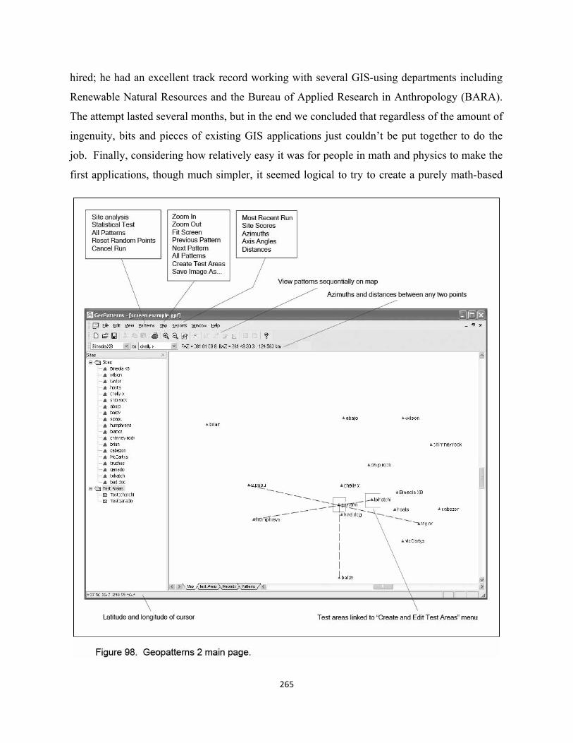
265
hired; he had an excellent track record working with several GIS-using departments including
Renewable Natural Resources and the Bureau of Applied Research in Anthropology (BARA).
The attempt lasted several months, but in the end we concluded that regardless of the amount of
ingenuity, bits and pieces of existing GIS applications just couldn’t be put together to do the
job. Finally, considering how relatively easy it was for people in math and physics to make the
first applications, though much simpler, it seemed logical to try to create a purely math-based
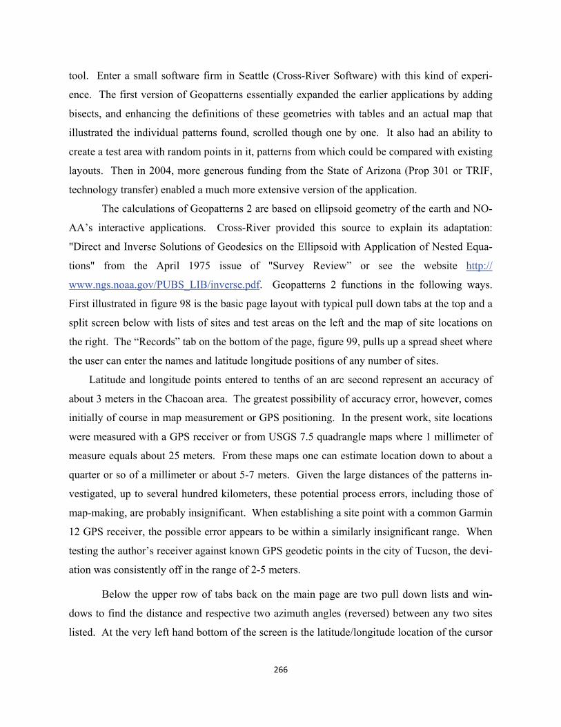
tool. Enter a small software firm in Seattle (Cross-River Software) with this kind of experi-
ence. The first version of Geopatterns essentially expanded the earlier applications by adding
bisects, and enhancing the definitions of these geometries with tables and an actual map that
illustrated the individual patterns found, scrolled though one by one. It also had an ability to
create a test area with random points in it, patterns from which could be compared with existing
layouts. Then in 2004, more generous funding from the State of Arizona (Prop 301 or TRIF,
technology transfer) enabled a much more extensive version of the application.
The calculations of Geopatterns 2 are based on ellipsoid geometry of the earth and NO-
AA’s interactive applications. Cross-River provided this source to explain its adaptation:
"Direct and Inverse Solutions of Geodesics on the Ellipsoid with Application of Nested Equa-
tions" from the April 1975 issue of "Survey Review” or see the website http://
www.ngs.noaa.gov/PUBS_LIB/inverse.pdf. Geopatterns 2 functions in the following ways.
First illustrated in figure 98 is the basic page layout with typical pull down tabs at the top and a
split screen below with lists of sites and test areas on the left and the map of site locations on
the right. The “Records” tab on the bottom of the page, figure 99, pulls up a spread sheet where
the user can enter the names and latitude longitude positions of any number of sites.
Latitude and longitude points entered to tenths of an arc second represent an accuracy of
about 3 meters in the Chacoan area. The greatest possibility of accuracy error, however, comes
initially of course in map measurement or GPS positioning. In the present work, site locations
were measured with a GPS receiver or from USGS 7.5 quadrangle maps where 1 millimeter of
measure equals about 25 meters. From these maps one can estimate location down to about a
quarter or so of a millimeter or about 5-7 meters. Given the large distances of the patterns in-
vestigated, up to several hundred kilometers, these potential process errors, including those of
map-making, are probably insignificant. When establishing a site point with a common Garmin
12 GPS receiver, the possible error appears to be within a similarly insignificant range. When
testing the author’s receiver against known GPS geodetic points in the city of Tucson, the devi-
ation was consistently off in the range of 2-5 meters.
Below the upper row of tabs back on the main page are two pull down lists and win-
dows to find the distance and respective two azimuth angles (reversed) between any two sites
listed. At the very left hand bottom of the screen is the latitude/longitude location of the cursor
266
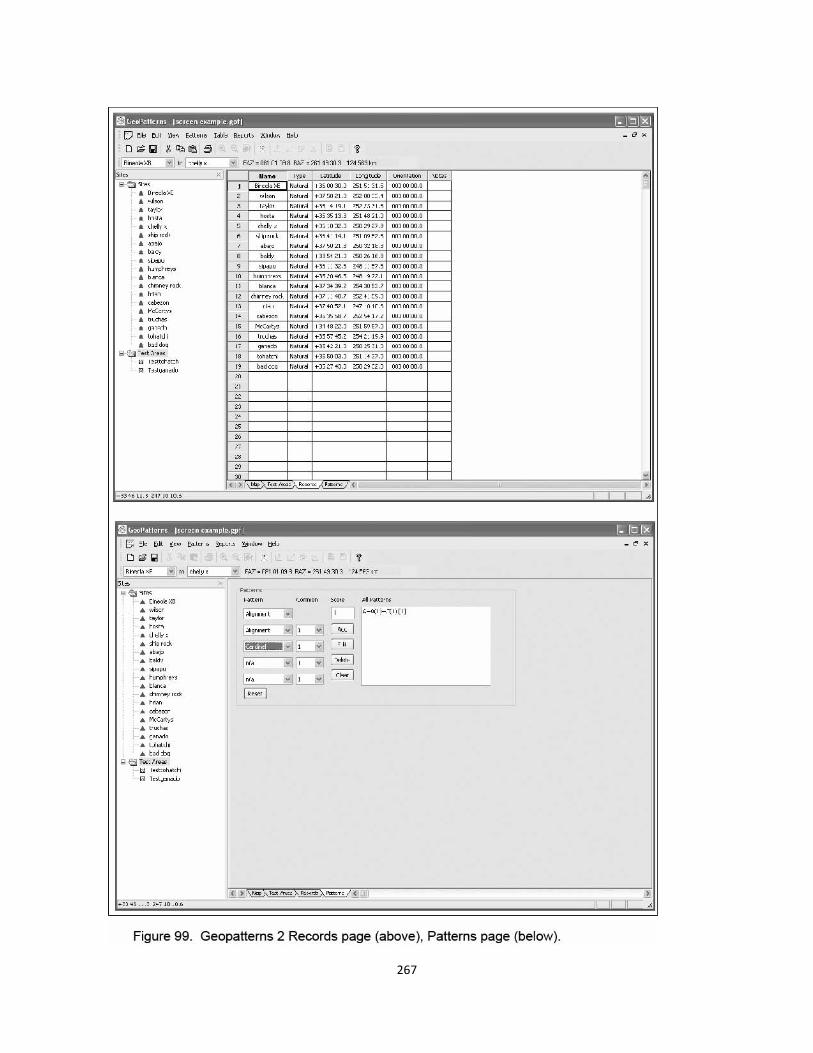
267
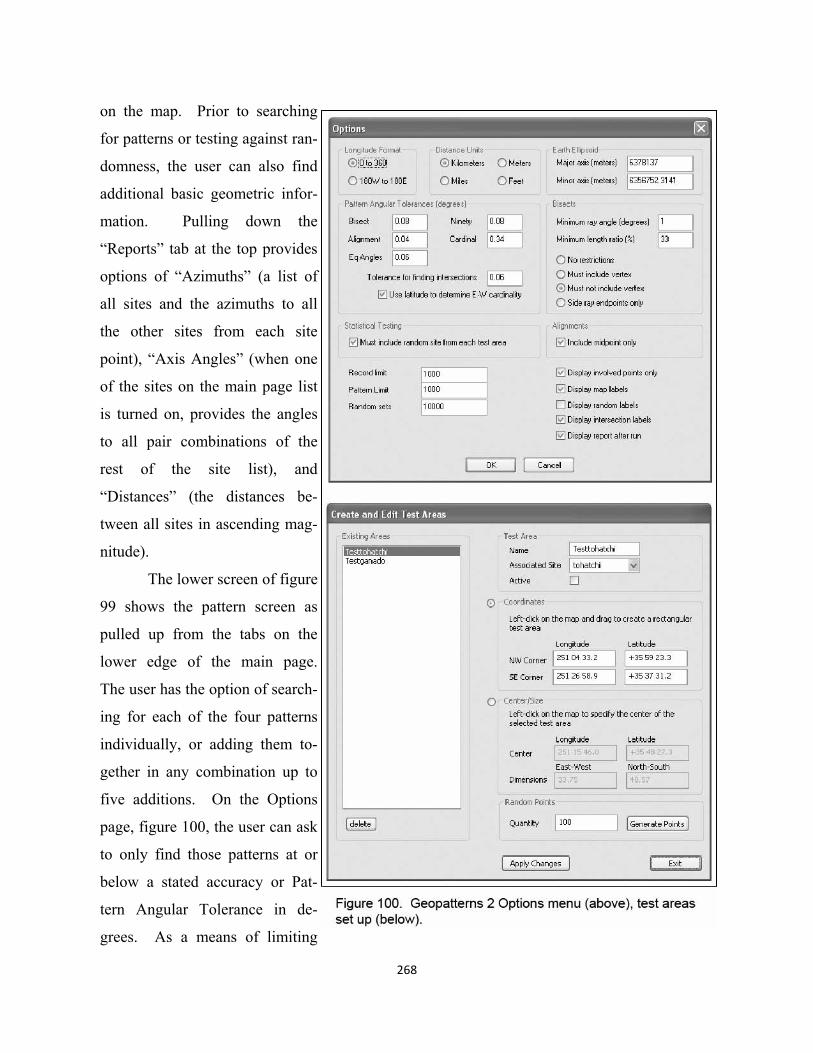
268
on the map. Prior to searching
for patterns or testing against ran-
domness, the user can also find
additional basic geometric infor-
mation. Pulling down the
“Reports” tab at the top provides
options of “Azimuths” (a list of
all sites and the azimuths to all
the other sites from each site
point), “Axis Angles” (when one
of the sites on the main page list
is turned on, provides the angles
to all pair combinations of the
rest of the site list), and
“Distances” (the distances be-
tween all sites in ascending mag-
nitude).
The lower screen of figure
99 shows the pattern screen as
pulled up from the tabs on the
lower edge of the main page.
The user has the option of search-
ing for each of the four patterns
individually, or adding them to-
gether in any combination up to
five additions. On the Options
page, figure 100, the user can ask
to only find those patterns at or
below a stated accuracy or Pat-
tern Angular Tolerance in de-
grees. As a means of limiting
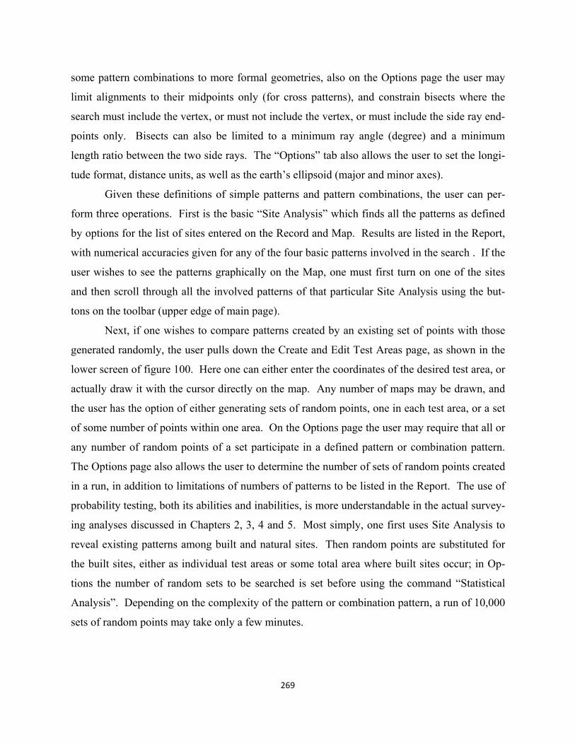
some pattern combinations to more formal geometries, also on the Options page the user may
limit alignments to their midpoints only (for cross patterns), and constrain bisects where the
search must include the vertex, or must not include the vertex, or must include the side ray end-
points only. Bisects can also be limited to a minimum ray angle (degree) and a minimum
length ratio between the two side rays. The “Options” tab also allows the user to set the longi-
tude format, distance units, as well as the earth’s ellipsoid (major and minor axes).
Given these definitions of simple patterns and pattern combinations, the user can per-
form three operations. First is the basic “Site Analysis” which finds all the patterns as defined
by options for the list of sites entered on the Record and Map. Results are listed in the Report,
with numerical accuracies given for any of the four basic patterns involved in the search . If the
user wishes to see the patterns graphically on the Map, one must first turn on one of the sites
and then scroll through all the involved patterns of that particular Site Analysis using the but-
tons on the toolbar (upper edge of main page).
Next, if one wishes to compare patterns created by an existing set of points with those
generated randomly, the user pulls down the Create and Edit Test Areas page, as shown in the
lower screen of figure 100. Here one can either enter the coordinates of the desired test area, or
actually draw it with the cursor directly on the map. Any number of maps may be drawn, and
the user has the option of either generating sets of random points, one in each test area, or a set
of some number of points within one area. On the Options page the user may require that all or
any number of random points of a set participate in a defined pattern or combination pattern.
The Options page also allows the user to determine the number of sets of random points created
in a run, in addition to limitations of numbers of patterns to be listed in the Report. The use of
probability testing, both its abilities and inabilities, is more understandable in the actual survey-
ing analyses discussed in Chapters 2, 3, 4 and 5. Most simply, one first uses Site Analysis to
reveal existing patterns among built and natural sites. Then random points are substituted for
the built sites, either as individual test areas or some total area where built sites occur; in Op-
tions the number of random sets to be searched is set before using the command “Statistical
Analysis”. Depending on the complexity of the pattern or combination pattern, a run of 10,000
sets of random points may take only a few minutes.
269
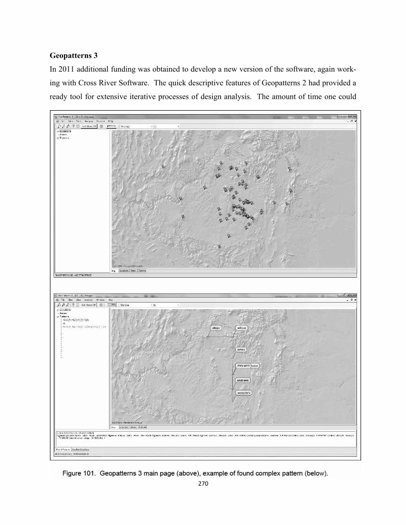
270
Geopatterns 3
In 2011 additional funding was obtained to develop a new version of the software, again work-
ing with Cross River Software. The quick descriptive features of Geopatterns 2 had provided a
ready tool for extensive iterative processes of design analysis. The amount of time one could
271
spend on searching for meaningful patterns exponentially increased. Yet neither the second or
new third version has the ability to “sketch” built into the software, though the consideration of
multitudes of pieces of possible cultural layouts has been greatly enhanced. As hypotheses of
more organized designs develop they are presently captured more conventionally in Adobe Il-
lustrator.
The primary rationale for Geopattern 3 sought both a better means of testing random pat-
terns and of enhancing some aspects of design processes. Most important among random test-
ing was the Geopatterns 2 limitation of five individual patterns—primarly alignments and cardi-
nals in the present work—that could be combined to model more complex “compounds”. An-
other goal for the new version, though not realized because of time and money, was an ability to
“bracket” particular compounds, connecting them together into increasingly complex layouts.
The idea here was to be able to set accuracies and other limiting conditions differently within
each bracket. A second accomplished goal allows test area setups where certain features are
fixed, e.g. mountains in the present exercises located either inside or outside of test areas emu-
lating the location of existing sites. The primary design analysis enhancement of the third ver-
sion better graphically links points on the earth and calculated relationships with current digital
mapping. Figure 101 shows the new background of fully zoomable ArcGIS (World Shaded Re-
lief) imagery, one choice among several others: Google, Bing, Ovi, Yahoo, and Yandex.
One of the advantages of the third version is the ability to get a good lat/long point from
any feature shown on any of these maps. As seen in Chapter 2, some archaeological features
are clearly evident on sources like Google Earth. For others, one must continue to get locations
from archaeological data bases, usually as marked on USGS topo quads (now digitally available
from several sources).
As explained in aspects of the probability exercises of this volume, the new software al-
ready has its limitations, primarily in terms of numbers of single patterns that can be added to-
gether to model more complex compounds. It is yet difficult to say exactly what numbers can
be combined, but looking at the example of the lower screen in figure 101, a “search string” of
eight three-point alignments and two-point cardinal relationships—at a particular accuracy—
successfully models the compound pattern shown among existing sites. This cannot be done in
the previous version. The Mount Wilson layout is compared in Geopatterns 3 to patterns creat-
ed by large numbers of random sets of points. A number of natural sites remain fixed in these
exercises both within and outside of test areas in which equivalent numbers of random points
are generated.
At present, one still needs to use features of Geopatterns 2 together with the new ver-
sion. While the Geopatterns 3 has the ability to state azimuths and distances between any two
points, on the main menu bar of the screen, one must use the older version to see azimuths from
any one point to all others on the site records list, and axis angles that show the angles from
single points to all others in pairs (the means of calculating the average accuracy of a three-
point alignment by averaging the deviation of interim point as seen from each end of the line).
One of the very useful design analysis features that carried forward in the latest version
is the ability to quickly scroll through patterns found for search strings. In version 2, after
searching in “Site Analysis” and creating a list of found patterns in the report text, the user can
return to the map screen and graphically image each found pattern on the list (at whatever accu-
racy had been set). In Geopatterns 3, the report list also occurs as a text report, but also on the
main screen as a variable sized window below the map. Highlighting a particular found pattern
on this list shows the geometric layout of the pattern on the map.
Distinguishing designed from random layouts remains a work in progress, and for a per-
son with a design background, one of the most interesting aspects of the work. But one thing is
clear. This is no simple process of picking a few points in the landscape that might have geo-
metric relationships. Rather it is a time-consuming, complex process of design analysis and
testing, one which relies heavily upon evolving software.
272
273
Appendix II: Prehistoric Surveying
The best and most obvious evidence that Ancestral Puebloans designed and surveyed layouts
between constructed, and or natural points in the landscape is the geometric relationship be-
tween Pueblo Alto and Tsin Kletsin. As seen in Chapter 7, the major (north) walls of the two
buildings are within about one degree of being cardinal east-west, and their two west walls are
very precisely aligned north and south of each other. This relationship, however, has been so
implicitly accepted for some time, including general assumptions of accuracy, that no published
work presently identifies actually which features were most important in the prehistoric design.
Chapter 7 maintains that the central axis of Pueblo Alto was positioned by a longer cardinal
line, not initially to the south rim of the canyon, but between the center of the Curved Rock
That Speaks and the western fire signal of the Pierre Site complex.
At a later time, hypothetically, a different cardinal was extended from Alto’s west wall
down to Tsin Kletsin, as a homologized version of the naturally coincidently meridian from Liz-
ard Head to Haystack Mountain. Apart from this possible symbolism, the relationship between
Pueblo Alto and Tsin Kletsin is accepted as having been designed. Some sort of engineering
expertize was essential to both establish the direction of south, and to project the line to partici-
pating surveyors on the south rim. Did this rely on the same technology used to construct the
straight west wall of Pueblo Alto, along with other monumental walls of the great houses in
Chaco Canyon? While it is possible that builders might have simply sighted along Alto’s west
wall, perhaps cardinally oriented and built straight by cord lines—in which case the good accu-
racy of aligned west walls might have been somewhat accidental--other instruments might have
been involved. At issue here is whether a major wall orientation was established first in relation
to some more distant point in the landscape or heavens with a surveying instrument, while the
actual straightness of the subsequent wall was laid out with string lines.
Larger scale Ancestral Pueblo surveying, while technically more challenging than laying
out Tzin Kletsin’s position with respect to Pueblo Alto, might likely have had an important reli-
gious “dimension”. Close to a billion Muslims orient themselves by compass five times a day to
Mecca, and had impressive astrolabe technology to do so in earlier times. In regards to great
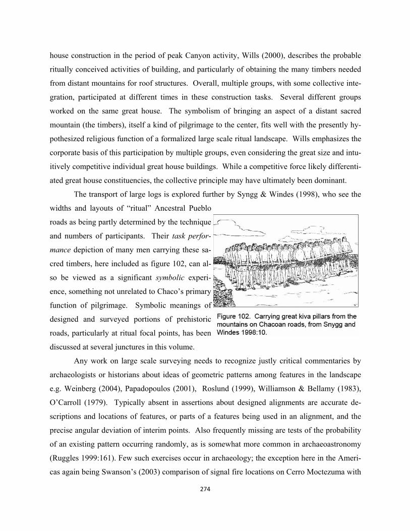
274
house construction in the period of peak Canyon activity, Wills (2000), describes the probable
ritually conceived activities of building, and particularly of obtaining the many timbers needed
from distant mountains for roof structures. Overall, multiple groups, with some collective inte-
gration, participated at different times in these construction tasks. Several different groups
worked on the same great house. The symbolism of bringing an aspect of a distant sacred
mountain (the timbers), itself a kind of pilgrimage to the center, fits well with the presently hy-
pothesized religious function of a formalized large scale ritual landscape. Wills emphasizes the
corporate basis of this participation by multiple groups, even considering the great size and intu-
itively competitive individual great house buildings. While a competitive force likely differenti-
ated great house constituencies, the collective principle may have ultimately been dominant.
The transport of large logs is explored further by Syngg & Windes (1998), who see the
widths and layouts of “ritual” Ancestral Pueblo
roads as being partly determined by the technique
and numbers of participants. Their task perfor-
mance depiction of many men carrying these sa-
cred timbers, here included as figure 102, can al-
so be viewed as a significant symbolic experi-
ence, something not unrelated to Chaco’s primary
function of pilgrimage. Symbolic meanings of
designed and surveyed portions of prehistoric
roads, particularly at ritual focal points, has been
discussed at several junctures in this volume.
Any work on large scale surveying needs to recognize justly critical commentaries by
archaeologists or historians about ideas of geometric patterns among features in the landscape
e.g. Weinberg (2004), Papadopoulos (2001), Roslund (1999), Williamson & Bellamy (1983),
O’Carroll (1979). Typically absent in assertions about designed alignments are accurate de-
scriptions and locations of features, or parts of a features being used in an alignment, and the
precise angular deviation of interim points. Also frequently missing are tests of the probability
of an existing pattern occurring randomly, as is somewhat more common in archaeoastronomy
(Ruggles 1999:161). Few such exercises occur in archaeology; the exception here in the Ameri-
cas again being Swanson’s (2003) comparison of signal fire locations on Cerro Moctezuma with
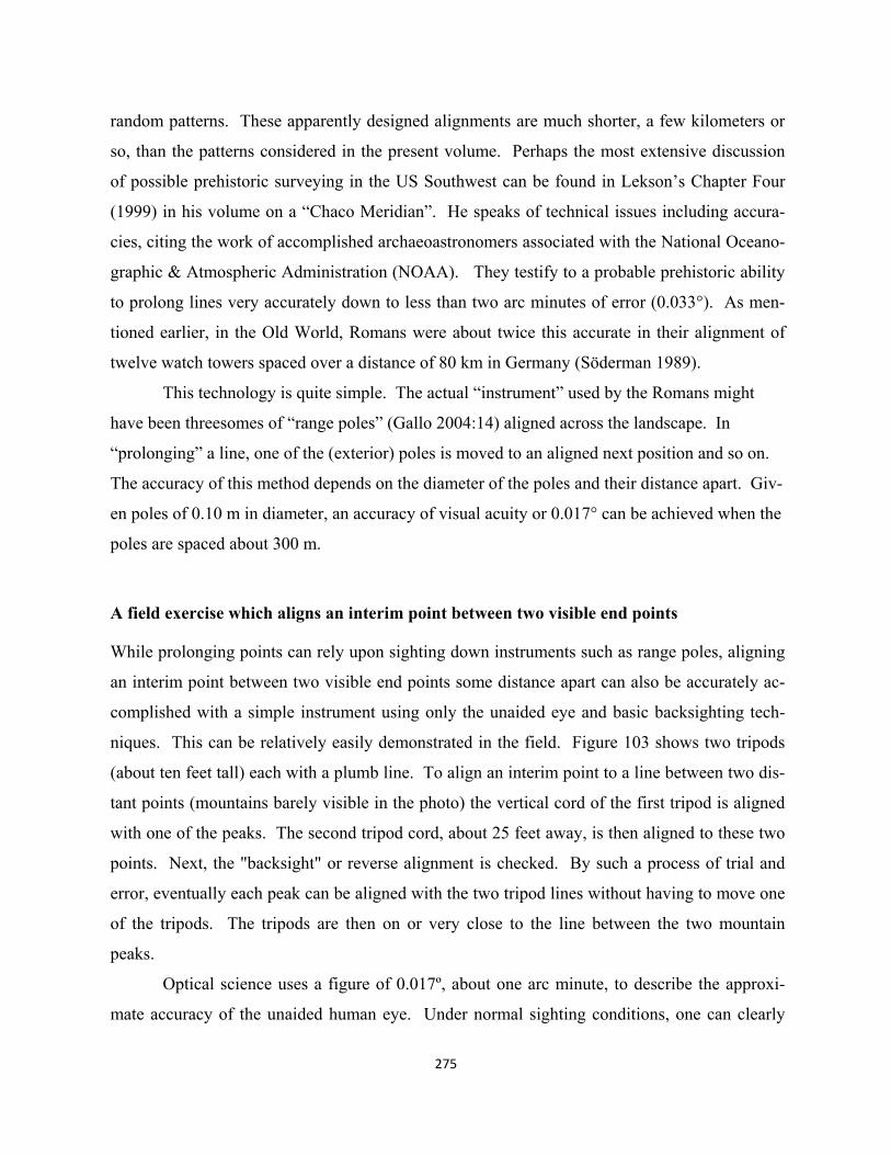
275
random patterns. These apparently designed alignments are much shorter, a few kilometers or
so, than the patterns considered in the present volume. Perhaps the most extensive discussion
of possible prehistoric surveying in the US Southwest can be found in Lekson’s Chapter Four
(1999) in his volume on a “Chaco Meridian”. He speaks of technical issues including accura-
cies, citing the work of accomplished archaeoastronomers associated with the National Oceano-
graphic & Atmospheric Administration (NOAA). They testify to a probable prehistoric ability
to prolong lines very accurately down to less than two arc minutes of error (0.033°). As men-
tioned earlier, in the Old World, Romans were about twice this accurate in their alignment of
twelve watch towers spaced over a distance of 80 km in Germany (Söderman 1989).
This technology is quite simple. The actual “instrument” used by the Romans might
have been threesomes of “range poles” (Gallo 2004:14) aligned across the landscape. In
“prolonging” a line, one of the (exterior) poles is moved to an aligned next position and so on.
The accuracy of this method depends on the diameter of the poles and their distance apart. Giv-
en poles of 0.10 m in diameter, an accuracy of visual acuity or 0.017° can be achieved when the
poles are spaced about 300 m.
A field exercise which aligns an interim point between two visible end points
While prolonging points can rely upon sighting down instruments such as range poles, aligning
an interim point between two visible end points some distance apart can also be accurately ac-
complished with a simple instrument using only the unaided eye and basic backsighting tech-
niques. This can be relatively easily demonstrated in the field. Figure 103 shows two tripods
(about ten feet tall) each with a plumb line. To align an interim point to a line between two dis-
tant points (mountains barely visible in the photo) the vertical cord of the first tripod is aligned
with one of the peaks. The second tripod cord, about 25 feet away, is then aligned to these two
points. Next, the "backsight" or reverse alignment is checked. By such a process of trial and
error, eventually each peak can be aligned with the two tripod lines without having to move one
of the tripods. The tripods are then on or very close to the line between the two mountain
peaks.
Optical science uses a figure of 0.017º, about one arc minute, to describe the approxi-
mate accuracy of the unaided human eye. Under normal sighting conditions, one can clearly
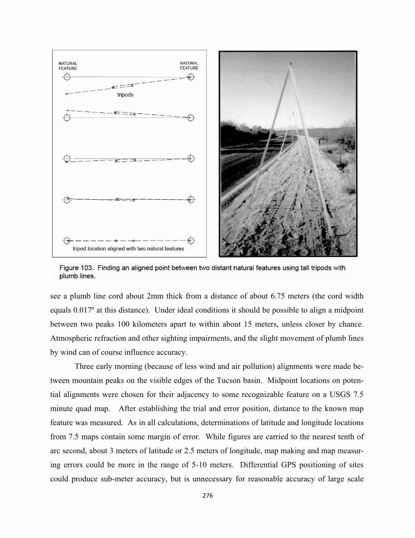
see a plumb line cord about 2mm thick from a distance of about 6.75 meters (the cord width
equals 0.017º at this distance). Under ideal conditions it should be possible to align a midpoint
between two peaks 100 kilometers apart to within about 15 meters, unless closer by chance.
Atmospheric refraction and other sighting impairments, and the slight movement of plumb lines
by wind can of course influence accuracy.
Three early morning (because of less wind and air pollution) alignments were made be-
tween mountain peaks on the visible edges of the Tucson basin. Midpoint locations on poten-
tial alignments were chosen for their adjacency to some recognizable feature on a USGS 7.5
minute quad map. After establishing the trial and error position, distance to the known map
feature was measured. As in all calculations, determinations of latitude and longitude locations
from 7.5 maps contain some margin of error. While figures are carried to the nearest tenth of
arc second, about 3 meters of latitude or 2.5 meters of longitude, map making and map measur-
ing errors could be more in the range of 5-10 meters. Differential GPS positioning of sites
could produce sub-meter accuracy, but is unnecessary for reasonable accuracy of large scale
276
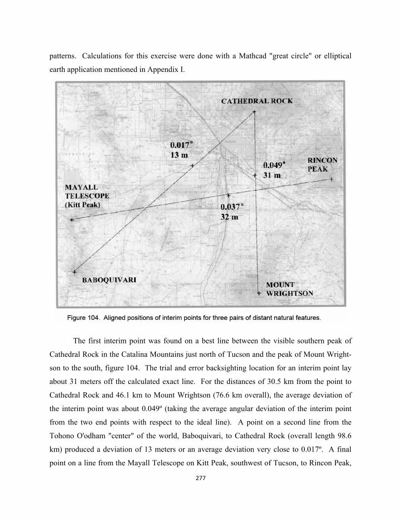
patterns. Calculations for this exercise were done with a Mathcad "great circle" or elliptical
earth application mentioned in Appendix I.
The first interim point was found on a best line between the visible southern peak of
Cathedral Rock in the Catalina Mountains just north of Tucson and the peak of Mount Wright-
son to the south, figure 104. The trial and error backsighting location for an interim point lay
about 31 meters off the calculated exact line. For the distances of 30.5 km from the point to
Cathedral Rock and 46.1 km to Mount Wrightson (76.6 km overall), the average deviation of
the interim point was about 0.049º (taking the average angular deviation of the interim point
from the two end points with respect to the ideal line). A point on a second line from the
Tohono O'odham "center" of the world, Baboquivari, to Cathedral Rock (overall length 98.6
km) produced a deviation of 13 meters or an average deviation very close to 0.017º. A final
point on a line from the Mayall Telescope on Kitt Peak, southwest of Tucson, to Rincon Peak,
277
278
measured 32 meters off, or an average deviation of 0.037º (overall length 103.0 km). The use
of the white Mayall telescope structure, clearly visible at a distance of about 50km, begins to
suggest daytime target sizes, colors and distances.
Field conditions were best for the second two lines. Although all were located early in the
morning, the first, Wrightson-Cathedral Rock, occurred midweek when one would expect great-
er air pollution in the Tucson area (additionally, this interim site lies only a few hundred meters
from I-10). The breeze at this site, though slight, blew appreciably steadier than at the others
and probably moved the plumb lines more directly perpendicular to the alignment. The author
didn't use helpers to steady lines or screen the breeze at any of the sites. The other two points
were established on Sunday mornings at desert locations well outside of the built up urban area.
Visual pollution conditions were optimal (late May and early June).
The degree of accuracy in these three alignments comes very close to previously mentioned
field studies reported by Lekson from his personal conversation with Rolf Sinclair and Anna
Sofaer (1999:1180). Their degree of inaccuracy, again, was about 1 meter in 2,000 (2km), or
about 0.029º for prolonging or extending a long non-meridian line across the landscape. Thus
the figures seem very similar either for interim marks between two end points or for prolonging
a line from one point.
Simulating a surveyed line between Humphrey’s Peak and Blanca Peak
When it comes to laying out a much longer line between end points not visible from any single
interim point processes are naturally more labor intensive, but still could have relied only upon
a tripod pairs and plumb bobs. In this case the process could have involved an iterative straight-
ening of multiple three-point segments back and forth sequentially across the full length of the
line until a requisite linearity is achieved. To initiate the process, approximate interim points
could have been set up on ridges or high points along the full length of the line. It must be pos-
sible to view the two adjacent points from each point of the total line. While the technology is
still simple backsighting with pairs of tripods at each point, multiple iterations of aligning with
sequential threesomes eventually straightens the line. See Lewis (2001:223) for a related dia-
gram and further explanation in a larger context of prehistoric surveying practices.
No testing of this hypothetical process of large scale straightening of lines has been under-
taken in the field. This, of course, would be ideal, but expensive. In the meantime, one can
more economically use computer tools to set up a reasonable simulation of how some number
of iterative survey stations could establish such a line. The line chosen for the exercise is that
adopted by the Navajo for their SW-NE axis, from Humphrey’s Peak to Blanca Peak, a dis-
tance of 607.582 km. While no evidence points to a Navajo understanding of this line as a
straight or surveyed “sunray” like their lore about the larger part of Sipapu-Chicoma-Truchas,
one can map its possible involvement in Aztec East X as described in Chapter 8. Furthermore
as also mentioned the line runs very close to what might have been the ritual focus of the three
Hopi Mesas. This line would have been more difficult to survey than most of the possible lines
described in the present work, maybe even more so than prolongations to Cerro Moctezuma.
Particularly problematic for Ancestral Puebloan surveyors could have been stretching the
straightening process across the Continental Divide.
The following simulation required the use of three computer applications, a digitized ver-
sion of USGS quads such as Trails.com to determine lat/long locations for points, the Path Pro-
filer add-on with Google Earth to check viewsheds or visibility among threesomes of station
points (accounting for the curvature of the earth), and the author’s software to determine an
equivalent to visual accuracy of any particular backsight measurement. The location of every
station point in the iterative process is described in the simulation data.
To get started, high points visible from each of its nearest two neighbors are selected
along a rough cognitive line between the two known end points. From Humphrey’s Peak, at
12,637 ft, priest surveyors would have had an unobstructed view to the high point of the Chus-
kas, Roof Butte at 9,783 ft. The two peaks, however, are 263.793 km apart. To facilitate sig-
naling, an interim location, the high point of Black Mountain at 7,467 ft is added in this leg of
the simulation. Looking east from Roof Butte, surveyors also had an unobstructed view to var-
ious high points on the Continental Divide, about 230-240 km distant. Here too an interim sig-
naling point is added, a highest point in the San Juan River area on Piedra Peak at 8,551 ft.
From here surveyors could have gone to the high point on the divide, Summit Peak at 13,301
ft, and then on to Blanca Peak, the eastern terminus and highest of all points at 14,345 ft.
The initial signal/survey points for the trial and error backsighting simulation are shown in
figure 105. Many, if not all, of these high points, would likely have long been sacred in their
own right prior to any formalization of the religious landscape. Priest surveyors, a crew for
279
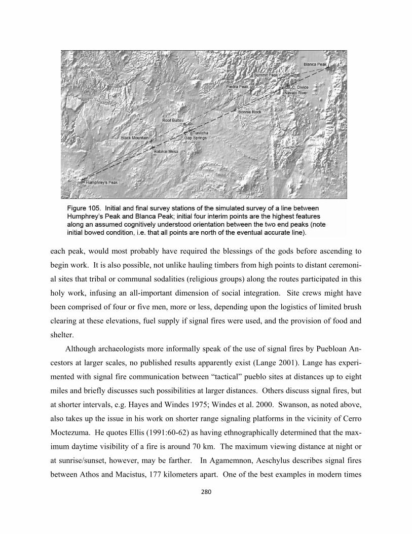
280
each peak, would most probably have required the blessings of the gods before ascending to
begin work. It is also possible, not unlike hauling timbers from high points to distant ceremoni-
al sites that tribal or communal sodalities (religious groups) along the routes participated in this
holy work, infusing an all-important dimension of social integration. Site crews might have
been comprised of four or five men, more or less, depending upon the logistics of limited brush
clearing at these elevations, fuel supply if signal fires were used, and the provision of food and
shelter.
Although archaeologists more informally speak of the use of signal fires by Puebloan An-
cestors at larger scales, no published results apparently exist (Lange 2001). Lange has experi-
mented with signal fire communication between “tactical” pueblo sites at distances up to eight
miles and briefly discusses such possibilities at larger distances. Others discuss signal fires, but
at shorter intervals, e.g. Hayes and Windes 1975; Windes et al. 2000. Swanson, as noted above,
also takes up the issue in his work on shorter range signaling platforms in the vicinity of Cerro
Moctezuma. He quotes Ellis (1991:60-62) as having ethnographically determined that the max-
imum daytime visibility of a fire is around 70 km. The maximum viewing distance at night or
at sunrise/sunset, however, may be farther. In Agamemnon, Aeschylus describes signal fires
between Athos and Macistus, 177 kilometers apart. One of the best examples in modern times
281
is documented naked eye observations of the sun’s reflection off of Sputnik, the size of a beach
ball, orbiting at 250 km above earth close to its perigee (Hyde Memorial Observato-
ry:www.cloudynights.com). The maximum length used in the present simulation is 179.419
km, the initial distance between Humphrey’s Peak and the high point of Black Mountain. The
initial distance between Roof Butte and Piedra Peak is 162.137km. Some simple communica-
tion code, within the capabilities of the signaling method, would have been necessary between
crews.
The use of three different computer applications creates a persuasive simulation of the ac-
tual process. Normally, all crews are active simultaneously, either maintaining fixed signals to
their two neighbors, or moving their station to align with them. The alternation of these roles
eventually straightens the total line. In simulation, one begins with USGS quad map latitude/
longitude locations for each survey station point. Then the three points of particular three-
somes are checked to see the deviation of the interim point to be moved. Returning to the topo
maps, a new trial and error position is located and again checked for alignment. When the in-
terim point is aligned, here within a range close to visual acuity (about 0.005° – 0.020°), each
of the sets of two points between the interim and the two neighbors is checked for visibility in
the Path Profiler. If the distance between the two adjacent stations, for example, is 100 km and
the deviation of an equidistant interim point is 0.017°, the distance off is about 29.6 meters.
Where blockage occurs, the shaded maps of Google Earth provide a means--a good simulation
of actual process--of choosing a more visible interim point at which to repeat the process. Fig-
ures 106a and 106 b list all of the aligned survey stations required before the line between
Humphreys Peak and Blanca Peak became accurately straight. Particularly at early stages of
the process or other times when an interim point must be radically moved to maintain visibil-
ity, sometimes it seems useful along a particular section of the line to do repeated aligning
while other stations remain inactive.
If surveyors had actually laid out this line, once the radical first alignments regularize,
they might well have understood the bowed shape of the line, since all interim points moved
south when aligned. They could have just continued to align in threesomes and eventually the
total line would straighten. But to save labor, they could have moved all the points, eventually
only those that are most bowed to the east, some trial and error distance to the south. The sim-
ulation performs this movement of bowed positions six times beginning with a move of 3000m
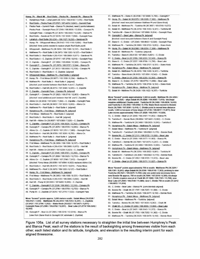
282
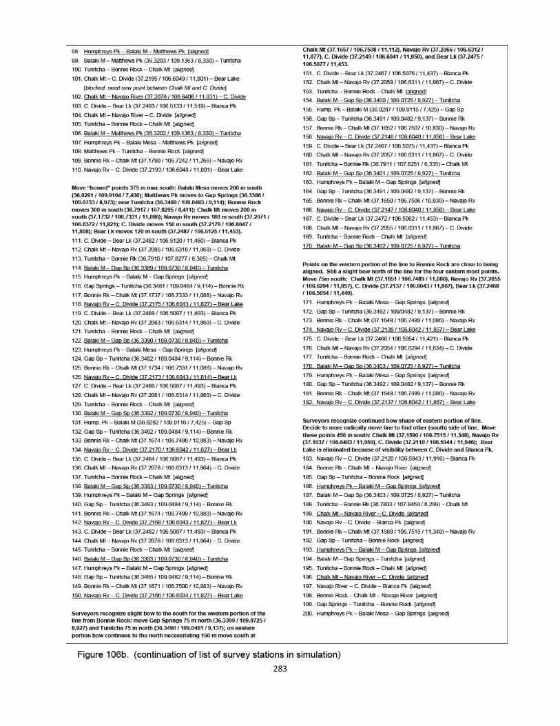
283
284
and ending with 75m. After the sixth move, the line still has bowed characteristics. The strate-
gy then could have been to try to find the south side of the line, i.e. where most interim points
would needed to be moved north instead of south; thus the seventh move is 450m. This, it
turns out is close to the final line illustrated also in figure 105.
The number of station points required in the process, not including the locations of tempo-
rary interim points as they are being moved to align as a particular threesome with their neigh-
bors, is 251 including the seven shifts where many or all of the points of the line are moved
south. The deviations from the precise Humphrey’s Peak – Blanca Peak line of the initial high-
est points are: Black Mountain 2.312° (10,201m north), Roof Butte 2.529° (13,178 m north),
Piedra Peak 3.953° (17,640 m north), and Summit Peak 5.687° (17,853 m north). The seven
interim points of the final line have deviations from the total line of: Balaki Mesa 0.0009°
(3.8m), Gap Springs 0.009° (45.6m), Tunitcha 0.009° (48.1m), Bonnie Rock 0.009 (45.1m),
Chalk Mt 0.038° (130m), Navajo River 0.042° (132.8m), and Continental Divide 0.043°
(131.3m). Thus a slight bow still remains in the location of the three easternmost station
points, this in spite of the fact that the alignment of all final threesomes is close to 0.017° or
visual acuity.
There would have had to have been at least nine or ten crews involved at all times during
the process. During the 200 iterations shown in figure 106a and 106b, about four can be done
at the same time, resulting in 50 periods of activity for each crew. Add to this the eight moves
of all sites including the initial layout, to arrive at a total number of move periods of 58. The
average time for a move, ranging from large distances initially to many very short ones of 30-
60 m in the second half of the process, might be about two days or less. Assuming that each
crew had six men, the total effort would be 60 men working about 116 days. Given the possi-
ble large scale religious context in which the process would have taken place, this time and ef-
fort by cooperating tribal or communal groups can be compared to that of carrying timbers to
Chaco Canyon or building great houses and great kivas. In the Basketmaker III period it could
have been the primary collective religious “work”, even greater in importance than constructing
early great kivas at locations determined by this surveying.
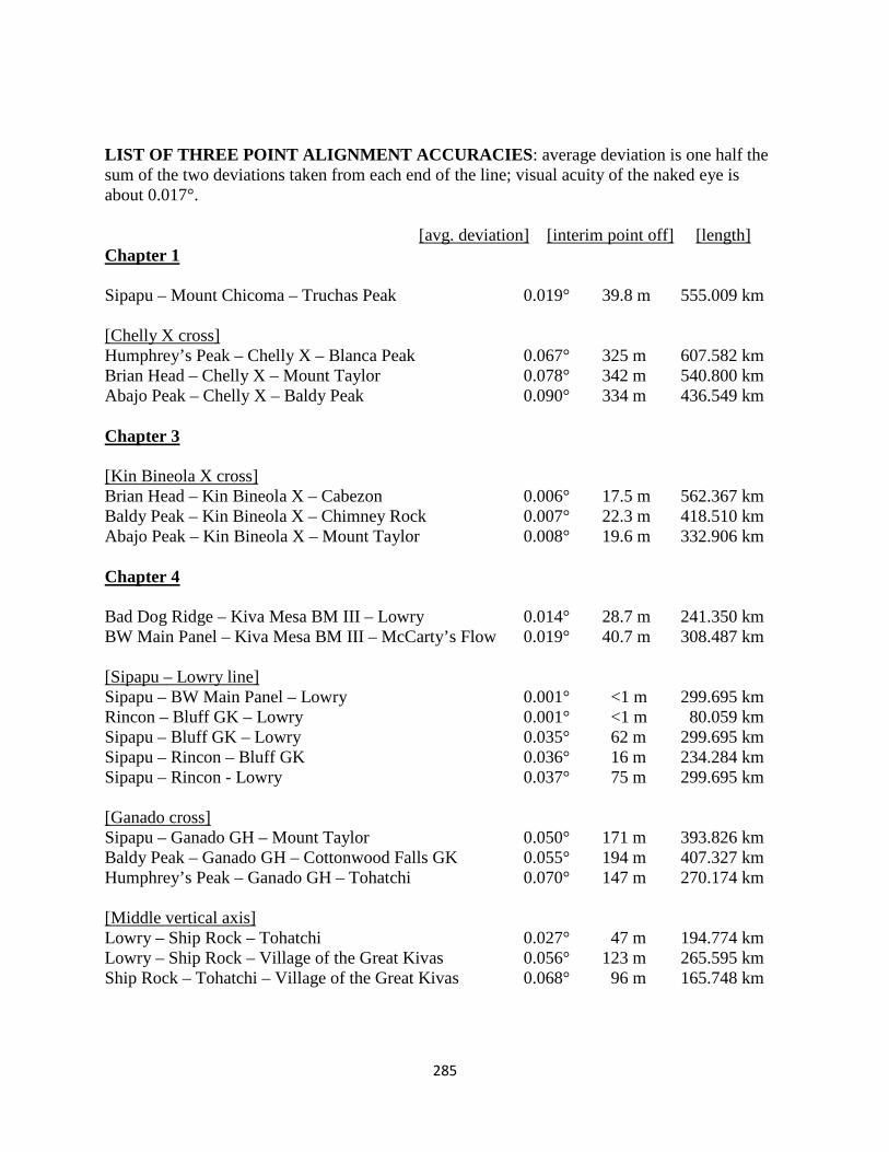
285
LIST OF THREE POINT ALIGNMENT ACCURACIES: average deviation is one half the sum of the two deviations taken from each end of the line; visual acuity of the naked eye is about 0.017°.
[avg. deviation] [interim point off] [length]
Chapter 1 Sipapu – Mount Chicoma – Truchas Peak 0.019° 39.8 m 555.009 km [Chelly X cross] Humphrey’s Peak – Chelly X – Blanca Peak 0.067° 325 m 607.582 km Brian Head – Chelly X – Mount Taylor 0.078° 342 m 540.800 km Abajo Peak – Chelly X – Baldy Peak 0.090° 334 m 436.549 km Chapter 3 [Kin Bineola X cross] Brian Head – Kin Bineola X – Cabezon 0.006° 17.5 m 562.367 km Baldy Peak – Kin Bineola X – Chimney Rock 0.007° 22.3 m 418.510 km Abajo Peak – Kin Bineola X – Mount Taylor 0.008° 19.6 m 332.906 km Chapter 4 Bad Dog Ridge – Kiva Mesa BM III – Lowry 0.014° 28.7 m 241.350 km BW Main Panel – Kiva Mesa BM III – McCarty’s Flow 0.019° 40.7 m 308.487 km [Sipapu – Lowry line] Sipapu – BW Main Panel – Lowry 0.001° <1 m 299.695 km Rincon – Bluff GK – Lowry 0.001° <1 m 80.059 km Sipapu – Bluff GK – Lowry 0.035° 62 m 299.695 km Sipapu – Rincon – Bluff GK 0.036° 16 m 234.284 km Sipapu – Rincon - Lowry 0.037° 75 m 299.695 km [Ganado cross] Sipapu – Ganado GH – Mount Taylor 0.050° 171 m 393.826 km Baldy Peak – Ganado GH – Cottonwood Falls GK 0.055° 194 m 407.327 km Humphrey’s Peak – Ganado GH – Tohatchi 0.070° 147 m 270.174 km [Middle vertical axis] Lowry – Ship Rock – Tohatchi 0.027° 47 m 194.774 km Lowry – Ship Rock – Village of the Great Kivas 0.056° 123 m 265.595 km Ship Rock – Tohatchi – Village of the Great Kivas 0.068° 96 m 165.748 km
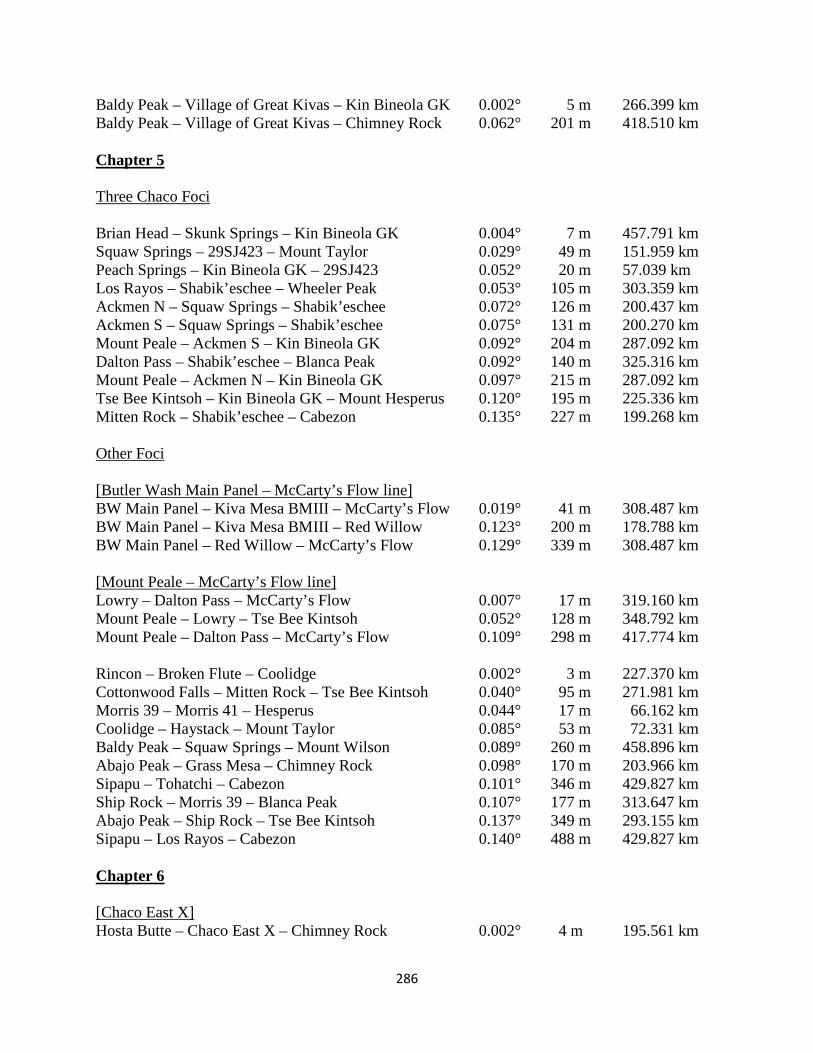
286
Baldy Peak – Village of Great Kivas – Kin Bineola GK 0.002° 5 m 266.399 km Baldy Peak – Village of Great Kivas – Chimney Rock 0.062° 201 m 418.510 km Chapter 5 Three Chaco Foci Brian Head – Skunk Springs – Kin Bineola GK 0.004° 7 m 457.791 km Squaw Springs – 29SJ423 – Mount Taylor 0.029° 49 m 151.959 km Peach Springs – Kin Bineola GK – 29SJ423 0.052° 20 m 57.039 km Los Rayos – Shabik’eschee – Wheeler Peak 0.053° 105 m 303.359 km Ackmen N – Squaw Springs – Shabik’eschee 0.072° 126 m 200.437 km Ackmen S – Squaw Springs – Shabik’eschee 0.075° 131 m 200.270 km Mount Peale – Ackmen S – Kin Bineola GK 0.092° 204 m 287.092 km Dalton Pass – Shabik’eschee – Blanca Peak 0.092° 140 m 325.316 km Mount Peale – Ackmen N – Kin Bineola GK 0.097° 215 m 287.092 km Tse Bee Kintsoh – Kin Bineola GK – Mount Hesperus 0.120° 195 m 225.336 km Mitten Rock – Shabik’eschee – Cabezon 0.135° 227 m 199.268 km Other Foci [Butler Wash Main Panel – McCarty’s Flow line] BW Main Panel – Kiva Mesa BMIII – McCarty’s Flow 0.019° 41 m 308.487 km BW Main Panel – Kiva Mesa BMIII – Red Willow 0.123° 200 m 178.788 km BW Main Panel – Red Willow – McCarty’s Flow 0.129° 339 m 308.487 km [Mount Peale – McCarty’s Flow line] Lowry – Dalton Pass – McCarty’s Flow 0.007° 17 m 319.160 km Mount Peale – Lowry – Tse Bee Kintsoh 0.052° 128 m 348.792 km Mount Peale – Dalton Pass – McCarty’s Flow 0.109° 298 m 417.774 km Rincon – Broken Flute – Coolidge 0.002° 3 m 227.370 km Cottonwood Falls – Mitten Rock – Tse Bee Kintsoh 0.040° 95 m 271.981 km Morris 39 – Morris 41 – Hesperus 0.044° 17 m 66.162 km Coolidge – Haystack – Mount Taylor 0.085° 53 m 72.331 km Baldy Peak – Squaw Springs – Mount Wilson 0.089° 260 m 458.896 km Abajo Peak – Grass Mesa – Chimney Rock 0.098° 170 m 203.966 km Sipapu – Tohatchi – Cabezon 0.101° 346 m 429.827 km Ship Rock – Morris 39 – Blanca Peak 0.107° 177 m 313.647 km Abajo Peak – Ship Rock – Tse Bee Kintsoh 0.137° 349 m 293.155 km Sipapu – Los Rayos – Cabezon 0.140° 488 m 429.827 km Chapter 6 [Chaco East X] Hosta Butte – Chaco East X – Chimney Rock 0.002° 4 m 195.561 km
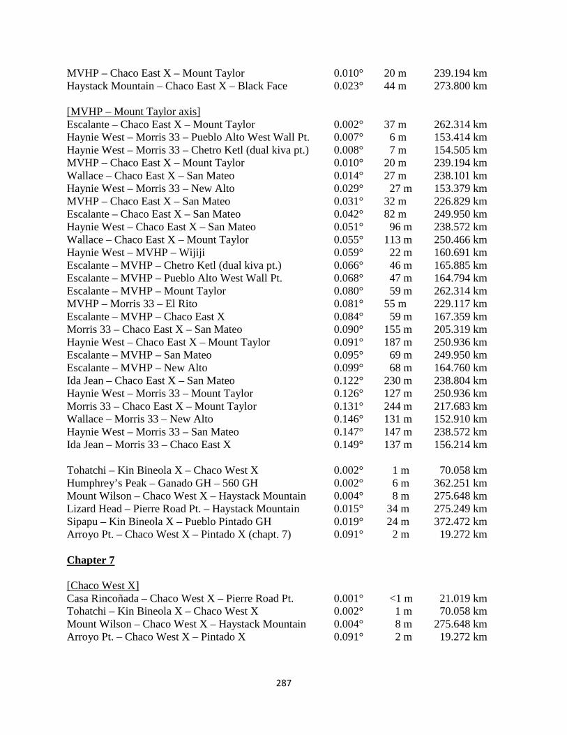
287
MVHP – Chaco East X – Mount Taylor 0.010° 20 m 239.194 km Haystack Mountain – Chaco East X – Black Face 0.023° 44 m 273.800 km [MVHP – Mount Taylor axis] Escalante – Chaco East X – Mount Taylor 0.002° 37 m 262.314 km Haynie West – Morris 33 – Pueblo Alto West Wall Pt. 0.007° 6 m 153.414 km Haynie West – Morris 33 – Chetro Ketl (dual kiva pt.) 0.008° 7 m 154.505 km MVHP – Chaco East X – Mount Taylor 0.010° 20 m 239.194 km Wallace – Chaco East X – San Mateo 0.014° 27 m 238.101 km Haynie West – Morris 33 – New Alto 0.029° 27 m 153.379 km MVHP – Chaco East X – San Mateo 0.031° 32 m 226.829 km Escalante – Chaco East X – San Mateo 0.042° 82 m 249.950 km Haynie West – Chaco East X – San Mateo 0.051° 96 m 238.572 km Wallace – Chaco East X – Mount Taylor 0.055° 113 m 250.466 km Haynie West – MVHP – Wijiji 0.059° 22 m 160.691 km Escalante – MVHP – Chetro Ketl (dual kiva pt.) 0.066° 46 m 165.885 km Escalante – MVHP – Pueblo Alto West Wall Pt. 0.068° 47 m 164.794 km Escalante – MVHP – Mount Taylor 0.080° 59 m 262.314 km MVHP – Morris 33 – El Rito 0.081° 55 m 229.117 km Escalante – MVHP – Chaco East X 0.084° 59 m 167.359 km Morris 33 – Chaco East X – San Mateo 0.090° 155 m 205.319 km Haynie West – Chaco East X – Mount Taylor 0.091° 187 m 250.936 km Escalante – MVHP – San Mateo 0.095° 69 m 249.950 km Escalante – MVHP – New Alto 0.099° 68 m 164.760 km Ida Jean – Chaco East X – San Mateo 0.122° 230 m 238.804 km Haynie West – Morris 33 – Mount Taylor 0.126° 127 m 250.936 km Morris 33 – Chaco East X – Mount Taylor 0.131° 244 m 217.683 km Wallace – Morris 33 – New Alto 0.146° 131 m 152.910 km Haynie West – Morris 33 – San Mateo 0.147° 147 m 238.572 km Ida Jean – Morris 33 – Chaco East X 0.149° 137 m 156.214 km Tohatchi – Kin Bineola X – Chaco West X 0.002° 1 m 70.058 km Humphrey’s Peak – Ganado GH – 560 GH 0.002° 6 m 362.251 km Mount Wilson – Chaco West X – Haystack Mountain 0.004° 8 m 275.648 km Lizard Head – Pierre Road Pt. – Haystack Mountain 0.015° 34 m 275.249 km Sipapu – Kin Bineola X – Pueblo Pintado GH 0.019° 24 m 372.472 km Arroyo Pt. – Chaco West X – Pintado X (chapt. 7) 0.091° 2 m 19.272 km Chapter 7 [Chaco West X] Casa Rincoñada – Chaco West X – Pierre Road Pt. 0.001° <1 m 21.019 km Tohatchi – Kin Bineola X – Chaco West X 0.002° 1 m 70.058 km Mount Wilson – Chaco West X – Haystack Mountain 0.004° 8 m 275.648 km Arroyo Pt. – Chaco West X – Pintado X 0.091° 2 m 19.272 km
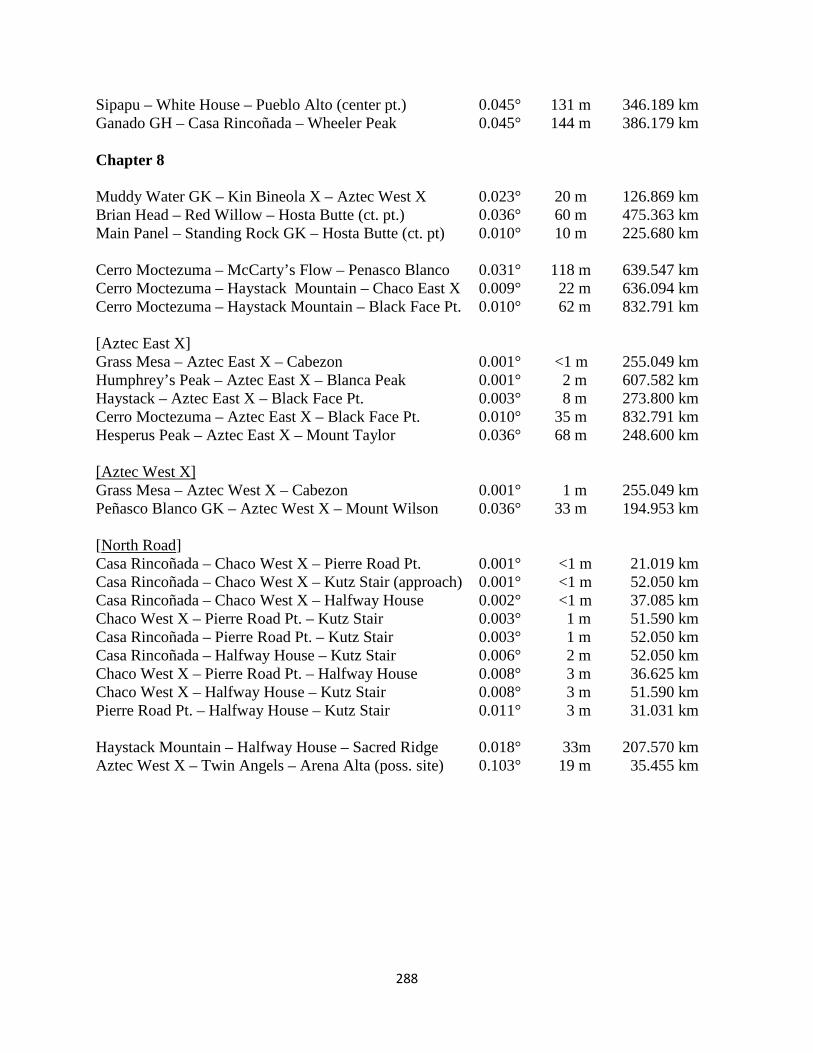
288
Sipapu – White House – Pueblo Alto (center pt.) 0.045° 131 m 346.189 km Ganado GH – Casa Rincoñada – Wheeler Peak 0.045° 144 m 386.179 km Chapter 8 Muddy Water GK – Kin Bineola X – Aztec West X 0.023° 20 m 126.869 km Brian Head – Red Willow – Hosta Butte (ct. pt.) 0.036° 60 m 475.363 km Main Panel – Standing Rock GK – Hosta Butte (ct. pt) 0.010° 10 m 225.680 km Cerro Moctezuma – McCarty’s Flow – Penasco Blanco 0.031° 118 m 639.547 km Cerro Moctezuma – Haystack Mountain – Chaco East X 0.009° 22 m 636.094 km Cerro Moctezuma – Haystack Mountain – Black Face Pt. 0.010° 62 m 832.791 km [Aztec East X] Grass Mesa – Aztec East X – Cabezon 0.001° <1 m 255.049 km Humphrey’s Peak – Aztec East X – Blanca Peak 0.001° 2 m 607.582 km Haystack – Aztec East X – Black Face Pt. 0.003° 8 m 273.800 km Cerro Moctezuma – Aztec East X – Black Face Pt. 0.010° 35 m 832.791 km Hesperus Peak – Aztec East X – Mount Taylor 0.036° 68 m 248.600 km [Aztec West X] Grass Mesa – Aztec West X – Cabezon 0.001° 1 m 255.049 km Peñasco Blanco GK – Aztec West X – Mount Wilson 0.036° 33 m 194.953 km [North Road] Casa Rincoñada – Chaco West X – Pierre Road Pt. 0.001° <1 m 21.019 km Casa Rincoñada – Chaco West X – Kutz Stair (approach) 0.001° <1 m 52.050 km Casa Rincoñada – Chaco West X – Halfway House 0.002° <1 m 37.085 km Chaco West X – Pierre Road Pt. – Kutz Stair 0.003° 1 m 51.590 km Casa Rincoñada – Pierre Road Pt. – Kutz Stair 0.003° 1 m 52.050 km Casa Rincoñada – Halfway House – Kutz Stair 0.006° 2 m 52.050 km Chaco West X – Pierre Road Pt. – Halfway House 0.008° 3 m 36.625 km Chaco West X – Halfway House – Kutz Stair 0.008° 3 m 51.590 km Pierre Road Pt. – Halfway House – Kutz Stair 0.011° 3 m 31.031 km Haystack Mountain – Halfway House – Sacred Ridge 0.018° 33m 207.570 km Aztec West X – Twin Angels – Arena Alta (poss. site) 0.103° 19 m 35.455 km
289
References Cited Adams, E. Charles. 1991 The origin and development of the Pueblo Katsina cult. Tucson: University of
Arizona Press. Adler M. A., Wilshusen R. H. 1990. Large-Scale Integrative Facilities in Tribal Societies: Cross-Cultural
and Southwestern US Examples. World Archaeology, Vol. 22, No. 2, pp. 133-146. Ahlstrom, Richard 1985. New tree-ring dates from Lowry Ruin. Kiva, Vol. 51:1, pp. 39-42. Albert, Bruce and Le Tourneau, Francois-Michel. 2007. Ethnography and Resource Use among the
Yanomami: Toward a Model of “Reticular Space”. Current Anthropology, Vol. 48, No. 4, pp. 584-592.
Aldred, Lisa. 2000. Changing Woman and Her Children: The Enmeshment of NavajoReligion in Their Homelands. Native American Studies 14:1. pp. 23 – 30.
Alexander, Christopher 2013. The city is not a tree. In The Urban Design Reader (second edition), Larice, Michael and MacDonald, Elizabeth (eds.), N.Y. Routledge, pp. 152-166.
Anschuetz, Kurt F. 2007. The Valles Caldera National Preserve as a Multi-Layered Ethnographic Landscape. Chapter nine in More Than a Scenic Mountain Landscape: Valles Caldera National Preserve Land Use History, Kurt Anschuetz and Thomas Merlan (eds), USDA Forest Service RMRS-GTR 196, pp. 129 – 162.
Barandiaran, Daniel de. 1979. Introduccion a la cosmovision de los indios Ye’huana Makiritare. Montalban –Caracas no. 9, pp. 737-1004.
Bauer, Brian 1998. The Sacred Landscape of the Inca: the ceque system of Cuzco. University of Texas Press, Austin.
Bernardini, Wesley 2011 North, South, and Center: An Outline of Hopi Ethnogenesis 196-220 Glowacki & Van Keuren
Bernardini, Wesley. 2005. Reconsidering spatial and temporal aspects of prehistoric cultural identity: a case study from the American Southwest. American Antiquity, 70 (1), pp. 31-54.
Bernbaum, Edwin 1997. Sacred Mountains of the World. Berkeley: UC Berkeley Press. Blake, Kevin. 1999. Sacred and Secular Landscape Symbolism at Mount Taylor, New Mexico. Journal of
the Southwest. Vol. 41, No. 4, Winter. Bourdieu, Pierre. 1977. Outline of a Theory of Practice. Cambridge: Cambridge University Press. Bourdieu, Pierre: "The Berber House", in Rules and Meanings, Mary Douglas (ed). Middlesex,
England: Penguin 1973. Bradley, R. 2006. Can archaeologists study prehistoric cosmology? In Andrén, Anders; Jennbert,
Kristina; and Raudvere, Catharina (eds) Old Norse Religion in Long-Term Perspective. Lund: Nordic Press.
Bradley, R. 2000. An Archaeology of Natural Places. London: Routledge. Brisbin, J. M., A. E. Kane, and J. N. Morris (1988) ‘Excavations at McPhee Pueblo (Site 5MT4475), a
Pueblo I and Early Pueblo II Multicomponent Village’, in A. E. Kane and C. K. Robinson (eds) Dolores Archaeological Program: Anasazi Communities at Dolores: McPhee Village, pp. 62–403. Bureau of Reclamation, Engineering and Research Center, Denver.
Broda, Johanna. 1987. Templo Mayor as Ritual Space. In Broda, Carrasco & Moctezuma (eds) The Great Temple of Tenochtitlan, Center and Perphery in the Aztec World. Berkeley: University of California Press, p. 61-123.
Cameron, C. N. 2009. Understanding the Bluff Great House Site (chapter 8). In Cameron C. (ed) Chaco and after in the northern San Juan: excavations at the Bluff Great House. University of Arizona Press, Tucson pp.297-315.
Copeland, James M. 2012. Heaven On Earth: The Chaco North Road (unpublished CAASW conference paper).
Cooper, L.M. 1995. Space Syntax Analysis of Chacoan Great Houses. Dissertation: University of Arizona.
Cunningham, Clark: "Order in the Atoni House" in Reader in Comparative Religion, Lessa & Vogt (eds). New York: Harper and Row,1972.
290
Darvill, T. 1999. The historic environment, historic landscapes, and space-time—action models in landscape archaeology. In Peter J. Ucko and Robert Layton (eds) The Archaeology and Anthropology of Landscape. London: Routledge.
Doxtater, Dennis. 2009. Rethinking the Sacred Landscape: Minoan Palaces in a Georitual Framework of Natural Features on Crete. Landscape Journal Vol. 28-1, Spring, 1-21.
Doxtater, Dennis. 2007. A Report on Geopatterns Software: describing and analyzing large-scale geometry between Chacoan and natural sites, in Digital Discovery: Exploring New Frontiers in Human Heritage. CAA 2006.
Doxtater, Dennis. 2003. Parallel Universes on the Colorado Plateau: Indications of Chacoan Integration of an Earlier Anasazi Focus at Canyon De Chelly. The Journal of the Southwest. Vol 45, No. 1 & 2, Spring/Summer.
Doxtater, Dennis. 2002. A Hypothetical Layout of Chaco Canyon Structures Via Large- Scale Alignments Between Significant Natural Features. Kiva, Vol. 68, No. 1.
Doxtater, Dennis. 1994. Architecture, Ritual Practice and Co-Determination in the Swedish Office. Ethnoscapes Series. Aldershot (UK), Avebury.
Doxtater, Dennis. 1991. Reflections of the Anasazi Cosmos. In Social Space. edited by Gron, Engelstad and Lindblom, pp. 155-184. Odense University Press, Odense.
Doxtater, Dennis 1989. 'Cultural Space' as a Needed Research Concept in the Study of Housing Change: The White Pueblos of Andalusia. In Housing, Culture and Design: A Comparative Perspective, Setha Low & Erv Chambers (eds). Philadelphia: The University of Pennsylvania Press.
Doxtater, Dennis 1984. Spatial Opposition in Non-Discursive Expression: Architecture as a Ritual Process. Canadian Journal of Anthropology, Vol. 4, No. 1 Summer, pp. ??.
Doxtater, Dennis. 1981. Thursday at a Crossroads: The Symbolism, Structure and Politics of "Center" in the Old Scandinavian Farm Culture. Dissertation: University of Michigan, Ann Arbor (Architecture).
Doxtater, Dennis. 1978. The Hopi Ritual Landscape. In Megaliths to Medicine Wheels: Selected Papers of the 11th Annual Chacmool Archaeology Conference, pp. 313-331. University of Calgary Press, Calgary.
Doxtater, Dennis. 1971. The Organization of Primitive Socio-Cultural Groups via Places: an Essay. M.A. Thesis in Anthropology, University of Washington, Seattle.
Durand, Stephen R. and Durand, Kathy Roler 2000. Notes from the edge: settlement pattern changes at the Guadalupe community. In John Kantner and Nancy Mahoney (eds) Great House Communities Across the Chacoan Landscape. Tucson: The University of Arizona Press, pp. 101 – 110.
Eiseman, Fred. B. Jr. 1959. The Hopi Salt Trail. Plateau, Vol. 32, No. 2, pp. 25-32. Eliade, Mircea 1959. The Sacred and the Profane: The Nature of Religion. New York: Harcourt, Brace &
World. Ellis, A. 1991. Towers of the Gallina Areas and Greater Southwest. In Puebloan Past and Present:
Papers in Honor of Stewart Peckham. Duran, M. S. and Kirkpatrick, D. T. (eds) pp. 57-70. Albuquerque: Archaeological Society of New Mexico.
Engelhard, Michael 2004. A Salt Pilgrimage, essay in Where the Rain Children Sleep: A Sacred Geography of the Colorado Plateau. Guilford, CT: The Lyons Press
Ferguson, T. J. 1996. Historic Zuni Architecture and Society: An Archaeological Adaptation of Space Syntax. Anthropological papers of the University of Arizona, No. 60. Tucson. University of Arizona Press.
Ferguson, T.J., and E. Richard Hart. 1985. A Zuni Atlas. University of Oklahoma Press, Norman. Fowler, A. P., Stein, J. R. and Anyon, R. 1989. An archaeological reconnaissance of West-Central New
Mexico: The Anasazi Monuments Project. Office of Cultural Affairs, Historic Preservation Division, State of New Mexico.
Fowler, Catherine, 1992. In the Shadow of Fox Peak: An Ethnography of the Cattail-Easter Northern Paiute Paiute People of Stillwater Marsh. Cultural Resource Series no. 5. Fallon: U.S. Department of the Interior. Fish and Wildlife Service Region I, Stillwater National Wildlife Refuge.
Fowles, Severin M. 2009. The enshrined Pueblo: villagescape and cosmos in the Northern Rio Grande. American Antiquity 74(3), pp.448-466.
291
Gallo, I.M. 2004. Roman Surveying. Proceedings of the European congress “Las Obras Públicas Romanas”. Tarragona, Spain.
Ganns, Doug. 2003. Spatial Integration: a Space Syntax Analysis of the Villages of the Homol’ovi Cluster. PhD dissertation, University of Arizona.
Geertz, Armin W. 1984. A Reed Pierced the Sky: Hopi Indian Cosmography on Third Mesa, Arizona. Numen Vol. 31, Fasc. 2, pp. 216-241.
Gilpin, D., Benallie Jr., L., 2000. Juniper Cove and Early Anasazi Structure West of the Chuska Mountains. In: Reed, P. F. (Ed.), Foundations of Anasazi culture: the Basketmaker-Pueblo transition. University of Utah Press, Salt Lake City, 161-173.
Glowacki, and Van Keuren 2011 Gossen, Gary: 1972. "Temporal and spatial equivalents in Chamula ritual symbolism". Reader in
Comparative Religion, William Lessa & Evon Vogt (eds). New York: Harper and Row, pp. ?? Griffin-Pierce, Trudy. 1992. Earth Is My Mother, Sky is My Father: space, time and astronomy
in Navajo sandpainting. Albuquerque: University of New Mexico Press. Hayes, A.C. and Windes, T.C. 1975. An Anasazi Shrine in Chaco Canyon, in Papers in Honor of
Florence Hawley Ellis, ed Frisbie, T.R, 143-156. Santa Fe: Papers of the Archaeological Society of New Mexico, No. 2.
Hays-Gilpin, Kelly, 2004. Ambiguous images: gender and rock art. Walnut Creek, CA: AltaMira Press. Hieb, Louis 1994. Hopi thought and archaeological theory: the sipapu reconsidered. American Indian
Religions, Vol. 1, Issue 1, pp. 17-36. Hillier, Bill & Hanson, Julienne 1984. The Social Logic of Space. Cambridge: Cambridge University
Press. Hudson, Dee. T. 1972. Anasazi Measurement Systems at Chaco Canyon, New Mexico. Kiva, Vol. 38,
No. 1, pp. 27-42. Hurst, Winston B. 2000. Chaco outlier, or backwoods pretender? A provincial great house at Edge of the
Cedars Ruin, Utah. In John Kantner and Nancy Mahoney (eds) Great House Communities Across the Chacoan Landscape. Tucson: The University of Arizona Press, pp. 63-78.
Jernigan, Wes 1982. Ceramic Studies, Cholla Project Archaeology, Vol. 5, J. Jefferson Reid (ed). Tucson: Arizona State Museum.
Jokic, Zeljko 2008. Yanomami Shamanic Initiation: The Meaning of Death and Postmortem Consciousness in Transformation. Anthropology of Consciousness, Vol. 19, Issue 1, pp. 33-59.
Kamau, Lucy: "Conceptual Patterns in Yoruba Culture". The Mutual Interaction of People and Their Built Environment, Amos Rapoport (ed). The Hauge: Mouton, 1976.
Kantner, John. 2004. Ancient Puebloan Southwest. Cambridge: Cambridge University Press. Kantner, J. 1999. The Influence of Self-Interested Behavior on Sociopolitical Change: The Evolution of
the Chaco Anasazi in the Prehistoric American Southwest. Dissertation: University of California, Santa Barbara.
Kantner, John 1997. Ancient Roads Modern Mapping. Expedition Vol. 39, No. 3 pp. 49-61. Kantner, J. 1995. Actor based modeling of political behavior among the Chacoan Anasazi in the
American Southwest. Paper at 60th Annual Meeting of the Society for American Archaeology Minneapolis, Minnesota May 3-7 1995.
Kearns, Timothy M., McVickar, Janet L, & Reed, Lori Stephens. 2000. The Early to Late Basketmaker III Transition in Tohatchi Flats, New Mexico. In: Foundations of Anasazi culture: the Basketmaker-Pueblo transition, ed. Paul F. Reed, Salt Lake City: University of Utah Press, pp.
Kelly & Francis 2005 Kelley, Klara Bonsack & Francis, Harris. 1994. Navajo Sacred Places. Indiana University Press,
Indianapolis. Kendrick, James W. and Judge, James W. 2000. Household economic autonomy and great house
development in the Lowry area. In John Kantner and Nancy Mahoney (eds) Great House Communities Across the Chacoan Landscape. Tucson: The University of Arizona Press, pp. 111 – 129.
Kincaid, Chris (editor) 1983. Chaco Roads Project Phase I. U. S. Department of Interior, Albuquerque. Lamphere, Louise 1983. Southwestern Ceremonialism. In Handbook for North American Indians.
Washington: Smithsonian. Lange, Richard C. 2001. Tactful tactical insights from the Sierre Ancha, East-Central Arizona. The
Arizona Archaeologist, 32: 67-76.
292
Lekson, Stephen 2007 ‘Great House Form’, in Stephen Lekson (ed) The architecture of Chacon Canyon, New Mexico, pp. 31-42. Salt Lake City: The University of Utah Press.
Lekson, S. H. (Ed.) 2006. The Archaeology of Chaco Canyon. Santa Fe: School of American Research Press.
Lekson, Steven. 1999. The Chaco Meridian. Altamira Press, Walnut Creek, California. Lekson, Stephen (1984) Great Pueblo Architecture of Chaco Canyon, New Mexico Publications in
Archeology 18B, Chaco Canyon Studies. Albuquerque: National Park Service. Levi-Strauss 1955. Tristes Topiques. Paris: Plon. Lewis, M. J. T. 2001. Surveying Instruments of Greece and Rome. Cambridge University Press,
Cambridge. Lightfoot & Feinman 1982. Lightfoot, Ricky R. 2008. Roofing and Early Anasazi Great Kiva: Analysis of an Architectural Model.
Kiva, Vol. 74, No. 2, Winter, pp. 227-246. Lipe, W. D., Morris J.s N, Kohler T. A. 1988. Dolores Archaeological Program: Anasazi Communities at
Dolores: Grass Mesa Village. US Bureau of Reclamation, Denver, Colorado. Lipe, William D. and Varien, Mark D. 1999. Pueblo II (A.D. 900-1150), chapter 8 in Colorado
Prehistory: A Context for the Southern Colorado River Basin. Colorado Council of Professional Archaeologists, pp. 242-289.
Loose, Richard W. 2008 Tse’Biinaholts’a Yalti (Curved Rock That Speaks). Time and Mind: The Journal of Archaeology, Consciousness and Culture, Vol 1, Issue 1, pp. 31-50.
Lynch, Kevin. 1960. The Image of the City. Cambridge, Mass: The M.I.T. Press. Malville J. M. 2004. Ceremony and Astronomy at Chimney Rock (chapter 10), in Malville J. M. (ed)
Chimney Rock: The Ultimate Outlier. Boulder: Lexington Books, pp. 131-150.Nichols, R. L. 1949 McCarty’s basalt flow, Valencia County, New Mexico. Geological Society of America Bulletin, No. 57, 1049.
Marshall M., Stein, J. 1978 Archaeological investigations in the Squaw Springs district of the Ute Mountain Ute Indian Reservation NW NM. BIA, Albuqueque NM, July.
Marshall, Michael; Stein, John; Loose, Richard and Novotny, Judith. 1979. Anasazi Communities of the San Juan Basin. Public Service Company of New Mexico, State of New Mexico, and Department of Interior.
Martin, P. S. , Rinaldo J. B. 1939. Modified Basket Maker sites Akmen-Lowry area, southwest Colorado. Anthropological Series, Vol. 23, No. 3, Field Museum of Natural History, Chicago.
Martin, Paul S.; Roys, Lawrence; and Von Bonin, Gerhardt. 1936-1939. Lowry Ruins in Southwestern Colorado. In Archaeology of Southwestern Colorado. Anthropological Series Field Museum of Natural History, volume XXIII, Chicago.
McCormick, Michael (1986) Eternal Victory: triumphal rulership in late antiquity, Byzantium, and the early medieval West, pp. 11-25, 80-101. Cambridge: University of Cambridge Press.
McPherson, Robert S. 1992. Sacred land, sacred view: Navajo perceptions of the Four Corners Region. Charles Redd Center of Western Study, Monograph Series No. 19. BYU Press.
Miller, Jay. 1983. Basin Religion and Theology: a Comparative Study of Power (Puha). Journal of California and Great Basin Anthropology 5 (1.2), pp. 66-86.
Morris, Earl. 1939. Archaeological studies in the La Plata district, southwestern Colorado and northwestern New Mexico. Carnegie Institution of Washington, Publication no. 519.
Mulk, I. and Bayliss-Smith T. 2007. Liminality, Rock Art and the Sami Sacred Landscape. Journal of Northern Studies 1-2, pp.95-122.
Mulk, I. and Bayliss-Smith, T. 2006. Rock art and Sami sacred geography in Badjelánnda, Laponia, Sweden: sailing boats, anthropomorphs and reindeer. Umeå: Institutionen för arkeologi och samiska studier.
Neitzel, J. 2007 – Architectural Studies of Pueblo Bonito: The Past, the Present, and the Future. In Architecture of Chaco Canyon, New Mexico, edited by S.H. Lekson, pp. 127-154. University of Utah Press, Salt Lake City.
Nelson M. C., Schachner G. 2002. Understanding Abandonments in the North American Southwest. Journal of Archaeological Research, Vol. 10, No. 2, pp. 167 – 206.
O’Carroll, M.J. 1979. On the probability of general and concurrent alignments of random distributed points. Science and Archaeology no. 21.
Ortiz, Alfonso 1972: Ritual Drama and the Pueblo World View 134- 161 in Ortiz’ New Perspectives
293
Ortiz, Alfonso. 1969 The Tewa world: Space, time being and becoming in a Pueblo society. University of Chicago Press, Chicago. Papadopoulos, Jason 2003. Ley Lines and Coincidence. Web publication
(www.boo.net/~jasonp.leyline.html). Parker, D. R. 2004 Changing Settlement Patterns. In Malville J. M. (ed) Chimney Rock: The Ultimate
Outlier. Boulder: Lexington Books, pp. 51-60. Peckham & Allan, 1990 Pitt-Rivers, Julian A. 1971. People of the Sierra. Chicago: University of Chicago Press. Plog, Stephen 2011. Ritual and Cosmology in the Chaco Era 50-65 in Glowacki & Van Keuren (eds)
Religious Transformation in the Late Pre-Hispanic Pueblo World…. Potter, James M. & Perry, Elizabeth M. 2000. Ritual as a power resource in the American Southwest. In:
Alternative leadership strategies in the prehispanic Southwest, ed. Barbara J. Mills, pp. 61-78. Tucson: University of Arizona Press.
Potter, James M. and Chuipka, Jason 2007. Early Pueblo Communities and Cultural Diversity in the Durango Area: Preliminary Results from the Animas – La Plata Project. Kiva, Vol. 72, No. 4, pp. 407 – 430.
Powers, Robert P.; William B. Gillespie and Stephen H. Lekson. 1983. The Outlier Survey: A Regional View of Settlement in the San Juan Basin. National Park Service, Albuquerque.
Raglan, Fitz Roy Somerset, Baron (1964) The Temple and the House. London: Routledge and Paul. Reed P. 2000. The development and evolution of the Cove Anasazi Community (A.D. 470-1300) in
Anasazi Community Development in Cove-Red Rock Valley. Archaeological Excavations along the N33 road in Apache County, AZ. Vol II. Reed P.F. , Hensler K. N. (eds). Navajo Nation Papers in Anthropology #33, Navajo Nation Archaeology Department.
Reichard, Gladys Amanda 1928. The Social Life of Navajo Indians, with Some attention to Minor Ceremonies. N.Y.: Columbia University Press.
Renfrew, C. 2001. Production and Consumption in a Sacred Economy: The Material Correlates of High Devotional Expression at Chaco Canyon. American Antiquity, Vol. 66, No. 1, 14-25.
Roberts, F. H. H. 1939 Archaeological remains in the Whitewater District, eastern Arizona. Bulletin 121, Part 1, Bureau of American Ethnology, Washington D.C.
Roberts, Frank H. H. Jr. 1932. The Village of the Great Kivas on the Zuni Reservation NewMexico. Smithsonian Institution Bureau of American Ethnology Bulletin 111, Washington D.C.
Roberts, Frank H. H. Jr. 1929. Shabik’eshchee village. A late basket maker site in the Chaco canyon, New Mexico. Washington: Bureau of American Ethnology, Bulletin 92.
Robins, M. R. & Hays-Gilpin, K. A. 2000. The bird in the basket: gender and social change in Basketmaker iconography, in Foundations of Anasazi culture: the Basketmaker-Pueblo transition, ed. P. F. Reed, 231-47. Salt Lake City: University of Utah Press.
Roslund, Curt 1999. Alignments in profusion and confusion; the growing pains of archaeoastronomy. Lund Archaeological Review, Vol. 5, pp. 105-115.
Ruggles, C. 1999. Astronomy in Prehistoric Britain and Ireland. New Haven: Yale University Press. Rykwert, Joseph (1979) The idea of a town: the anthropology of urban form in Rome, Italy and the ancient
world. Princeton, N.J.: Princeton University Press. Sahlqvist, Leif. 2000. Det Rituella Landskapet. PhD dissertation, Uppsala University, Sweden. Saile, David 1977. Architecture in Prehispanic Pueblo archaeology: examples from Chaco Canyon, New
Mexico. World Archaeology Vol. 9, no. 2, pp. 157-173. Schaafsma, Polly 1980. Indian Rock Art of the Southwest. Albuquerque: University of New Mexico
Press. Schaafsma, Polly. 1994. Trance and Transformation in the Canyons: Shamanism and Early Rock Art on
the Colorado Plateau. Shamanism and rock art in North America. Vol. 1, pp. 45-71. Scully, V. 1989 Pueblo: mountain, village, dance. University of Chicago Press, Chicago. Scully, V. 1962. The Earth, the Temple, and the Gods: Greek Sacred Architecture. Yale University Press,
New Haven. Severance, O. 2004. Cottonwood Falls and its place in SE Utah’s prehistoric landscape. In Wiseman R.
N., O’Laughlin T. C., Snow C. T. (eds) Ever westward: papers in honor of Elizabeth Kelly. The Archaeological Society of New Mexico 30, pp. 139 – 155.
294
Seymour, Timothy P, and Edberg, Stephen J. 1979. A Simple Method of Determining Archaeoastronomical Alignments in the Field. Journal of California and Great Basin Anthropology, 1(1), pp. 64-70.
Smith, Jonathan 1972. ‘The wobbling pivot’, Journal of Religion 52 Apr.: 134 – 149. Snead, James E. & Preucel, Robert W. 1999. The ideology of settlement: ancestral Keres
landscapes in the Northern Rio Grande. In Ashmore, Wendy & Knapp, Bernard A. (eds) Archaeologies of Landscape. Oxford: Blackwell Publishers, pp. 169-197.
Snygg, J. and Windes, T. 1998. Long, wide roads and great kiva roofs, in Kiva, Vol. 64, No. 1, 7-25. Söderman, I. 1989. Från lertavla till satellitbild. Uppsala: Geographica. Sofaer , Anna 1999. The Mystery of Chaco Canyon (film). Bullfrog Films. McLeod, Christopher
(producer & director) 2001. In the Light of Reverence. Bullfrog Films. Sofaer, Anna 1997. ‘The Primary Architecture of the Chacoan Culture: A Cosmological Expression’, in B.
H. Morrow and V. B. Price (eds) Anasazi Architecture and American Design, pp. 88-132. Albuquerque: University of New Mexico Press.
Sofaer, Anna, Marshall, Michael P., Sinclair, Rolf M. 1989. The Great North Road: a Cosmographic Expression of the Chaco Culture of New Mexico. In World Archeoastronomy, ed. Aveni, A.F.. Cambridge: Cambridge University Press.
Sofaer, Anna, Sinclair, Rolf R.M., and Doggett, L.E. (1982) ‘Lunar Markings on Fajada Butte’, in A.F. Aveni (ed) Archaeoastronomy in the New World. Cambridge: Cambridge University Press.
Stein J. R., McKenna P. J. 1988. An Archaeological Reconnaissance of a Late BonitoPhase Occupation near Aztec Ruins National Monument, New Mexico. Southwest Cultural Resources Center, National Park Service, Santa Fe, New Mexico.
Stein, John R., Suiter, Judith E., Ford, Dabney 1997. High Noon in Old Bonito. In Anasazi Architecture and American Design, edited by Baker H. Marrow and V. B. Price, pp. 133-148. University of New Mexico Press, Albuquerque.
Stephen, Alexander M. 1936. Hopi Journal. AMS Press, New York. Stoffle, R. W., Zedeño, M. N.. 2002. The Concept of “Power” in Numic and Yuman Epistemology. High
Plains Applied Anthropologist, Vol. 22, 2, pp. 172-193. Swanson, S. 2003. Documenting Prehistoric Communication Networks: A Case Study in the Paquime
Polity. American Antiquity, 68 (4), 753-767. Titiev, Mischa. 1937. A Hopi Salt Expedition. American Anthropologist 39, pp. 244-258. Turner, Victor. 1968. The ritual process. Middlesex: Penguin Books. Van Dyke, Ruth. 2007. Great Kivas in Time, Space and Society. In The Architecture of Chaco Canyon,
Lekson S. (ed). University of Utah Press, Salt Lake City, pp. 93-126. Van Dyke, R. 2002. The Chacoan great kiva in outlier communities: investigating integrative spaces
across the San Juan Basin. Kiva, Vol. 67, No. 3. 231-247. Van Dyke, Ruth M. 1999. The Andrews Community: A Chacoan Outlier in the Red Mesa Valley, New
Mexico. Journal of Field Archaeology, Vol. 26. pp. 55-67. Van Gennup, Arnold 1960. The Rites of Passage. London: Routledge. Vecsey, Christopher 1983. The Emergence of the Hopi People. American Indian Quarterly, Vol. 7, No. 3,
American Indian Religions, (Summer), pp. 69-92. Vivian, G., Reiter, P. 1960. The Great Kivas of Chaco Canyon. Monographs of the School of American
Research and the Museum of New Mexico, No. 22. Santa Fe, NM. Warburton, M., Graves D. K. 1992. Navajo Springs, Arizona: Frontier Outlier or Autonomous Great
House? Journal of Field Archaeology Vol. 19, pp.51-69. Ware J. A., Blinman E. 2000. Cultural Collapse and Reorganization: The Origin and Spread of Pueblo
Ritual Sodalities. In Hegmon M. (ed.) The archaeology of regional interaction : religion, warfare, and exchange across the American Southwest and beyond. Boulder: the University Press of Colorado, pp. 381-409.
Ware, John. 2002. Descent group and sodality. In Traditions, transitions, and technologies: themes in SW archaeology 2000, Sarah Schlanger (ed.), . Boulder: University of Colorado Press, pp. 94-112.
Washburn, Dorothy; Webster, Laurie 2006. Kiva, Vol. 71, Issue 3, pp. 235-264. Wasserman, Judith R. 1998. To Trace the Shifting Sands: Community Ritual, and the Memorial
Landscape. Landscape Journal, Vol. 17, No. 1, pp. 42 – 61. Welch, John R. 1997. White Eye’s Lies and the Battle for Dzil Nchaa Si’an. American Indian Quarterly,
Vol. 21, No. 1, pp. 75-109.
295
Wienberg, J. 2004. Sakral geometri. In A. Andrén, K. Jennbert, and C. Raudvere (eds) Ording Mot kaos. Vägar to Midgård 4:23-57. Lund: Nordic Academic Press.
Wilbert, Johannes. 1993. Mystic Endowment: Religious Ethnography of the Warao Indians. Harvard University Center for the Study of World Religions, Cambridge.
Williamson, Tom, & Bellamy, Liz. 1983. Ley Lines in Question. Surrey: World’s Work Ltd. Wills, W. H. 2000 Political Leadership and the Construction of Chacoan Great Houses, 1020-1140. In
Alternative leadership strategies in the prehispanic Southwest, ed. Barbara J. Mills, pp. Wills, W. H. & Windes, Thomas C. 1989. Evidence for population aggregation and dispersal during the
Basketmaker III period in Chaco Canyon, New Mexico. American Antiquity, 54(2), pp. 347-369. Wills, W. H.; Worman, F. Scott; Dorshow, Wetherbee; Richards-Rissetto, Heather 2012. Shabikeschee
Village in Chaco Canyon: Beyond the Archetype. American Antiquity 77(2), pp. 326-350. Wilshusen, Richard H., and Potter, James M. 2010. The Emergence of Early Villages in the American
Southwest. In Becoming Villagers: Comparing Early Village Societies, Bandy, Matthew S. and Fox, Jake R. (eds). Tucson: The University of Arizona Press, pp.165-183.
Wilshusen, Richard H., Scott G. Ortman, and Ann Phillips, 2012. Processions, Leaders, and Gathering Places, in Crucible of Pueblos: The Early Pueblo Period in the Northern Southwest, by Wilshusen, Richard H., Gregson Schachner, and James R. Allison, editors, Monograph 71, Cotsen Institute of Archaeology Press, UCLA, p. 198-218.
Windes 2003. This Old House: Construction and Abandonment at Pueblo Bonito. In Pueblo Bonito, Center of the Chacoan World, Jill Neitzel (ed.). Washington: Smithsonian Books, 14-32.
Windes, T.C., 1987. Investigations at the Pueblo Alto Complex, Chaco Canyon, New Mexico, 1975 - 1979. In: Summary of Tests and Excavations at the Pueblo Alto Community, vol. 1. Publications in Archaeology 18F. Chaco Canyon Studies, National Park Service, Santa Fe, New Mexico.
Windes, Thomas C., Anderson, Rachel, Johnson, Brian K., and Ford, Cheryl (2000) ‘Sunrise, Sunset: Sedentism and Mobility in the Chaco East Community’, in John Kantner and Nancy Mahoney (eds) Great House Communities Across the Chacoan Landscape, pp. 39-56. Tucson: The University of Arizona Press.
Witherspoon, Gary 1983. Navajo Social Organization. In Handbook of North American Indians. Washington: Smithsonian.
Witherspoon, Gary and Peterson, Glen. 1995. Dynamic Symmetry and Holistic Asymmetry in Navajo and Western Art and Cosmology. Peter Lang, New York.
Wyman, Leland C. 1983. Navajo Ceremonial System. In Handbook of North American Indians. Washington D. C.: Smithsonian Institution.
Zedeno, Maria Nieves. 1997. Landscapes, Land Use, and the History of Territory Formation: An Example from the Puebloan Southwest. Journal of Archaeological Method and Theory, Vol. 4, No. 1.