How the First Forty Years of Circuit Precedent Got Title VII's ...
The Roman transport network: a precedent for the integration of the EuropeanmobilityI,II
CÈSAR CARRERASa, PAU DE SOTOb
aDepartament de CC. de l’Antiguitat i l’Edat Mitjana. Universitat Autònoma de BarcelonabCentro Superior de Inverstigaciones Científica (CSIC) Instituto de Arqueología de Mérida
Abstract
In the last years, the use of geographical information systems has been common in many historical and geographicalstudies. Perhaps one of the least known applications is network analysis, a series of functions related to hydrology andmobility. Since 1994, researchers have used network analyses to understand costs and time expenditure in transportationin Roman times, with the aim of modeling commercial routes. Archaeological objects were employed to confirm thosecommercial distributions whose quantities were related basically to transport costs. The present articles go far beyondand attempt to understand decisions in building a transport network based on time series. It seems that not all Romandecisions in transport infrastructure were due to economic reasons; some parts of Roman roads were built basically forpolitical reasons and affected later developments.
Keywords:costs, GIS, network analyses, roads, Roman, time series, transport
People normally identify the Roman Empire as a hugepolitical extension covering parts of three continents cen-tred in the Mediterranean basin. It covered half Europefrom the Western Atlantic coasts up to Rhine and Danuberivers and all the Balkans and Greece. Besides, its bor-ders reached the Near East up to the river Euphrates andthe whole Northern African coastal strip and Egypt. Suchextension of land could not be rule without a sophistica-ted transport infrastructure and developed courier publicsystem (Chevalier, 1976; Eck, 1979; Kolb, 2000).
Therefore, the Roman Empire as a political projectcould not have carried on without a well planned mobilitysystem, which fostered economic exchange and informa-tion transference. Notwithstanding the temporal distance,the Roman Empire constitutes an excellent example forthe integration of European mobility.
Moreover, the Roman road network was the first inlandtransport network in Europe and the basis of most nationalroad systems in the European nations over centuries up tothe present. The first Roman road layout was designedto favor contact between Roman citizens and colonies inthe way that they first built up road infrastructures, andlater cities were founded. Perhaps people still believe thatRoman roads were built after cities foundation, but in factit was the other way around.
IPublished in HISTORICAL METHODS, July September 2013,Volume 46, Number 3, Pages 117-133
IIPre-print version submitted by the authors
As happens with any other land transport infrastructu-re, it was the economic success that developed the urbanfoundation and condemned some others. Actually, it is theclosest precedent of how transport network affects urbani-zation in the same way that were effects by other transportinfrastructures such as railways.
The uniqueness of the Roman road network as well asits layout continuity over the centuries made compulsoryreferring and comparing to it in any serious study on thehistory of land transport in Europe. Perhaps people stillbelieve that Train a Grand Vitesse has an original layout,but their main railways still followed the basic Roman rou-tes designed more than 2,000 years ago.
Roman transport infrastructures
When anyone refers to Roman transport infrastructures,normally people think about Roman roads. The RomanEmpire was the first political European entity that builta complete road system linking different parts of its terri-tory. The reason of such important investment in terms ofmoney and labour was facilitating army movement aroundthe Empire as well as an effective control of all conqueredterritories. It was not an original policy; in fact the PersianEmpire (Vth c. BC) and the Macedonian kingdom (IVthc. BC) had already created a sophisticated road networkfor identical aims. As usual, Romans made an outstandingimitation that overcame the original model.
However, they paid even more attention to other meansof transport such as maritime and river navigation, since
1
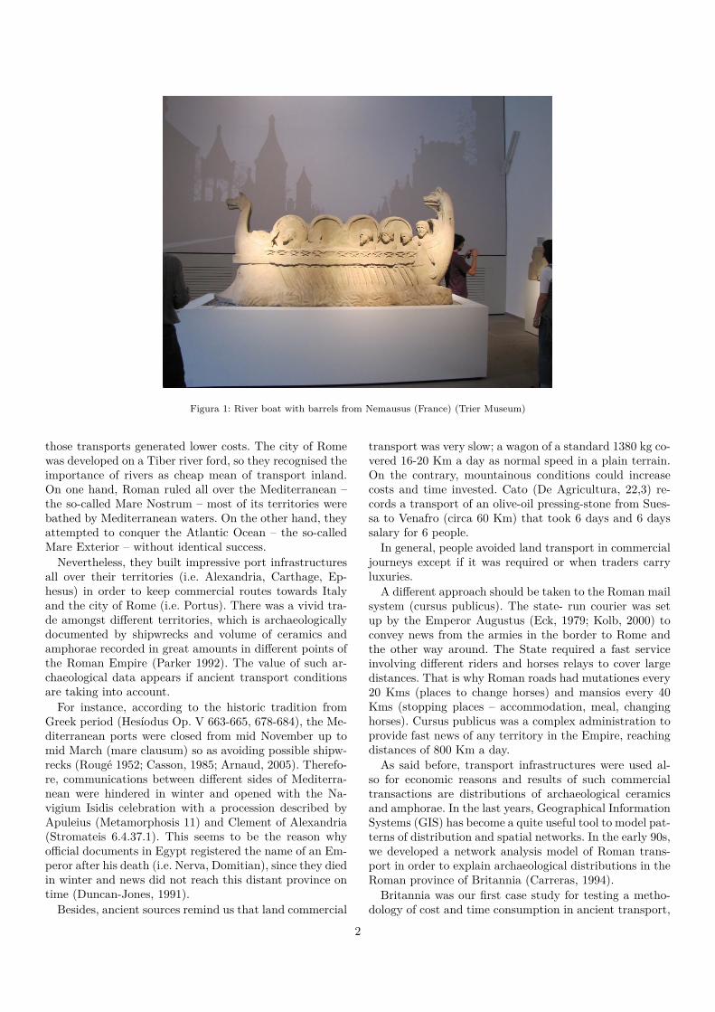
Figura 1: River boat with barrels from Nemausus (France) (Trier Museum)
those transports generated lower costs. The city of Romewas developed on a Tiber river ford, so they recognised theimportance of rivers as cheap mean of transport inland.On one hand, Roman ruled all over the Mediterranean –the so-called Mare Nostrum – most of its territories werebathed by Mediterranean waters. On the other hand, theyattempted to conquer the Atlantic Ocean – the so-calledMare Exterior – without identical success.
Nevertheless, they built impressive port infrastructuresall over their territories (i.e. Alexandria, Carthage, Ep-hesus) in order to keep commercial routes towards Italyand the city of Rome (i.e. Portus). There was a vivid tra-de amongst different territories, which is archaeologicallydocumented by shipwrecks and volume of ceramics andamphorae recorded in great amounts in different points ofthe Roman Empire (Parker 1992). The value of such ar-chaeological data appears if ancient transport conditionsare taking into account.
For instance, according to the historic tradition fromGreek period (Hesíodus Op. V 663-665, 678-684), the Me-diterranean ports were closed from mid November up tomid March (mare clausum) so as avoiding possible shipw-recks (Rougé 1952; Casson, 1985; Arnaud, 2005). Therefo-re, communications between different sides of Mediterra-nean were hindered in winter and opened with the Na-vigium Isidis celebration with a procession described byApuleius (Metamorphosis 11) and Clement of Alexandria(Stromateis 6.4.37.1). This seems to be the reason whyofficial documents in Egypt registered the name of an Em-peror after his death (i.e. Nerva, Domitian), since they diedin winter and news did not reach this distant province ontime (Duncan-Jones, 1991).
Besides, ancient sources remind us that land commercial
transport was very slow; a wagon of a standard 1380 kg co-vered 16-20 Km a day as normal speed in a plain terrain.On the contrary, mountainous conditions could increasecosts and time invested. Cato (De Agricultura, 22,3) re-cords a transport of an olive-oil pressing-stone from Sues-sa to Venafro (circa 60 Km) that took 6 days and 6 dayssalary for 6 people.
In general, people avoided land transport in commercialjourneys except if it was required or when traders carryluxuries.
A different approach should be taken to the Roman mailsystem (cursus publicus). The state- run courier was setup by the Emperor Augustus (Eck, 1979; Kolb, 2000) toconvey news from the armies in the border to Rome andthe other way around. The State required a fast serviceinvolving different riders and horses relays to cover largedistances. That is why Roman roads had mutationes every20 Kms (places to change horses) and mansios every 40Kms (stopping places – accommodation, meal, changinghorses). Cursus publicus was a complex administration toprovide fast news of any territory in the Empire, reachingdistances of 800 Km a day.
As said before, transport infrastructures were used al-so for economic reasons and results of such commercialtransactions are distributions of archaeological ceramicsand amphorae. In the last years, Geographical InformationSystems (GIS) has become a quite useful tool to model pat-terns of distribution and spatial networks. In the early 90s,we developed a network analysis model of Roman trans-port in order to explain archaeological distributions in theRoman province of Britannia (Carreras, 1994).
Britannia was our first case study for testing a metho-dology of cost and time consumption in ancient transport,
2
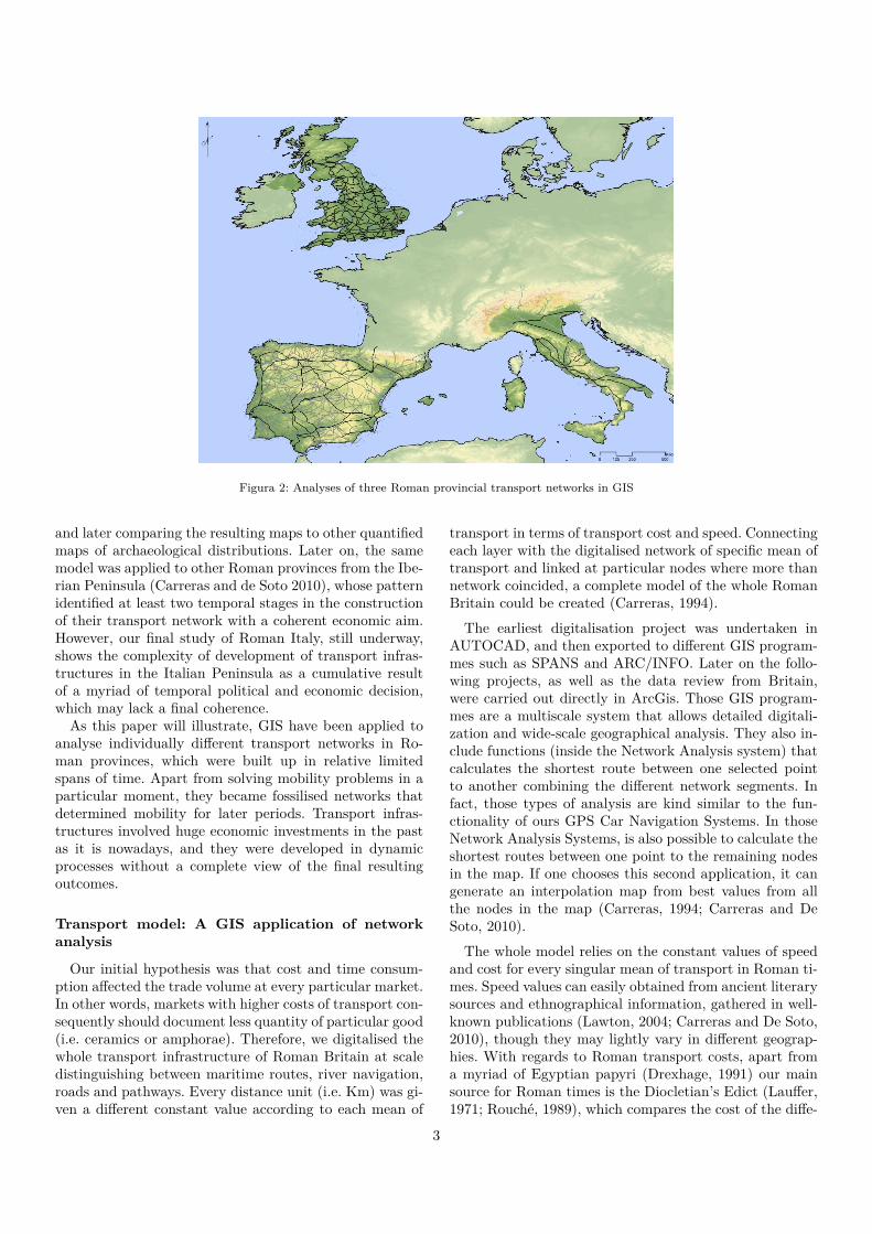
Figura 2: Analyses of three Roman provincial transport networks in GIS
and later comparing the resulting maps to other quantifiedmaps of archaeological distributions. Later on, the samemodel was applied to other Roman provinces from the Ibe-rian Peninsula (Carreras and de Soto 2010), whose patternidentified at least two temporal stages in the constructionof their transport network with a coherent economic aim.However, our final study of Roman Italy, still underway,shows the complexity of development of transport infras-tructures in the Italian Peninsula as a cumulative resultof a myriad of temporal political and economic decision,which may lack a final coherence.
As this paper will illustrate, GIS have been applied toanalyse individually different transport networks in Ro-man provinces, which were built up in relative limitedspans of time. Apart from solving mobility problems in aparticular moment, they became fossilised networks thatdetermined mobility for later periods. Transport infras-tructures involved huge economic investments in the pastas it is nowadays, and they were developed in dynamicprocesses without a complete view of the final resultingoutcomes.
Transport model: A GIS application of networkanalysis
Our initial hypothesis was that cost and time consum-ption affected the trade volume at every particular market.In other words, markets with higher costs of transport con-sequently should document less quantity of particular good(i.e. ceramics or amphorae). Therefore, we digitalised thewhole transport infrastructure of Roman Britain at scaledistinguishing between maritime routes, river navigation,roads and pathways. Every distance unit (i.e. Km) was gi-ven a different constant value according to each mean of
transport in terms of transport cost and speed. Connectingeach layer with the digitalised network of specific mean oftransport and linked at particular nodes where more thannetwork coincided, a complete model of the whole RomanBritain could be created (Carreras, 1994).
The earliest digitalisation project was undertaken inAUTOCAD, and then exported to different GIS program-mes such as SPANS and ARC/INFO. Later on the follo-wing projects, as well as the data review from Britain,were carried out directly in ArcGis. Those GIS program-mes are a multiscale system that allows detailed digitali-zation and wide-scale geographical analysis. They also in-clude functions (inside the Network Analysis system) thatcalculates the shortest route between one selected pointto another combining the different network segments. Infact, those types of analysis are kind similar to the fun-ctionality of ours GPS Car Navigation Systems. In thoseNetwork Analysis Systems, is also possible to calculate theshortest routes between one point to the remaining nodesin the map. If one chooses this second application, it cangenerate an interpolation map from best values from allthe nodes in the map (Carreras, 1994; Carreras and DeSoto, 2010).
The whole model relies on the constant values of speedand cost for every singular mean of transport in Roman ti-mes. Speed values can easily obtained from ancient literarysources and ethnographical information, gathered in well-known publications (Lawton, 2004; Carreras and De Soto,2010), though they may lightly vary in different geograp-hies. With regards to Roman transport costs, apart froma myriad of Egyptian papyri (Drexhage, 1991) our mainsource for Roman times is the Diocletian’s Edict (Lauffer,1971; Rouché, 1989), which compares the cost of the diffe-
3

Figura 3: Resulting transport costs from the Roman port of Dover
rent types of transport in the year A.D. 301. The resultingcost ratios are approximately:
1 (sea): 3,4 (downstream river): 6,8 (upstream river):43,4 (pack animal): 50,7 (wagon) Likewise, the availablespeed values applied to the time model for Roman timeswere: 3,7 Km/h (sea): 2,51 (downstream river): 0,62 (ups-tream river): 2 (land transport)
Those theoretical models of transport efficiency in Ro-man Britain were compared to some archaeological dis-tribution of local ceramics (i.e. Oxfordshire ware, Black-Burnished 2) and imported amphorae providing an in-teresting result. Distributions were normally matched bycost maps from either the production area in local wares,or cross-channel points in imported amphorae (Carreras,2000). In other words, archaeological distributions fulfilledroughly the rule that a lesser transport higher archaeolo-gical quantities, so more potential commercial benefits.
A second transport model developed later was the ac-cessibility one (De Soto and Carreras, 2007). It is anot-her application of the graphs theory, initially developedby Dicks (1971) for Roman Britain. Considering the de-sign of the whole transport network from the start, nodesthat concentrate more segments of network such as roads,maritime and river ports would have a more prominentrole in the network, so higher accessibility. In other words,planned network infrastructures define always a kind ofhierarchy amongst cities (i.e. nodes) from the beginning,which responds to decision taken in a very particular mo-
Figura 4: Resulting accessibility model for Roman Britain
ment. Sometimes those decisions affected the developmentof the whole territory and they were not suitable all overthe time. Romans when conquered new lands establisheda kind of hierarchies in the new territories aiming to ob-tain the maximum resources (i.e. cereals, minerals, taxes)with the minimum effort (i.e. cost, time) and transportedto the city of Rome. This is what can be called a colonialtransport model.
The model can be implemented in the same digitalisedtransport network providing a value for each individualnode according to the number of segment of network thatends at that point. For instance, every secondary road en-ding at that point would add 1, a primary road 2, a riverport adds 3 and maritime port 4. The final sum would gi-ve a rate for each node and an interpolation map couldrepresent the territory as a whole.
The accessibility model applied to Roman Britain showsa clear hierarchy in a series of cities such as Londinium(London) as the provincial capital from the early conquest.In fact, Dicks (1971) already identified the route betweenLondon and Chester as the most important communica-tion axis in the province. Likewise, Laurence (2001) recog-nized the role of itinerary II from Richborough to Chestercrossing London, and afterwards to York and Carlisle asone of the main axis. The GIS accessibility model (figure4) shows an indirect route from Richborough up to Lon-don and following Thames valley up to Cirencester andGlouchester and then, central Wales and Chester. This
4
road together with another road leading from London upto Leicester, Lincoln and York to Newcastle and SouthShields, gave structure to the whole mobility in the pro-vince, combined with the maritime transport.
Transport infrastructure in Roman Britain appears tobe a quite well-planned colonial network to supply the le-gions in the Northern border as well as obtained resourcesfrom the Welsh and South-Eastern mines and high popu-lated south. If you combine the accessibility map to thecost and time consumption maps, it looks like the Ro-mans planned carefully the whole transport infrastructureto facilitate movements of troops and merchandises in theisland. They even take care about the distance betweenmansios (stopping places) that was shorter than other pro-vinces such as Italy and Hispania. Laurence (2001, 82) ar-gues that such difference may have been due to the kindof road surface – being gravel the typical British material-, but it is same case as Hispania. One possible reason isthe weather conditions of Roman Britain that favored ashortest travel journey.
Britannia was a later conquered territory by Claudius(AD 43), so organization of transport infrastructures wasalready tested successfully in other previous territories.Therefore, knowledge of the new territory as well as requi-rements of the army and economic exploitation was key inthe planned network layout.
First overseas experiences: the Iberian Peninsula
The Iberian Peninsula was one of the first overseas terri-tories conquered by the Romans as a result of the SecondPunic War (late IIIrd century BC). Probably, Romans didnot know much about the inner parts of the Peninsula,and at the beginning, they only had military headquartersand allied tribes in the coastal regions.
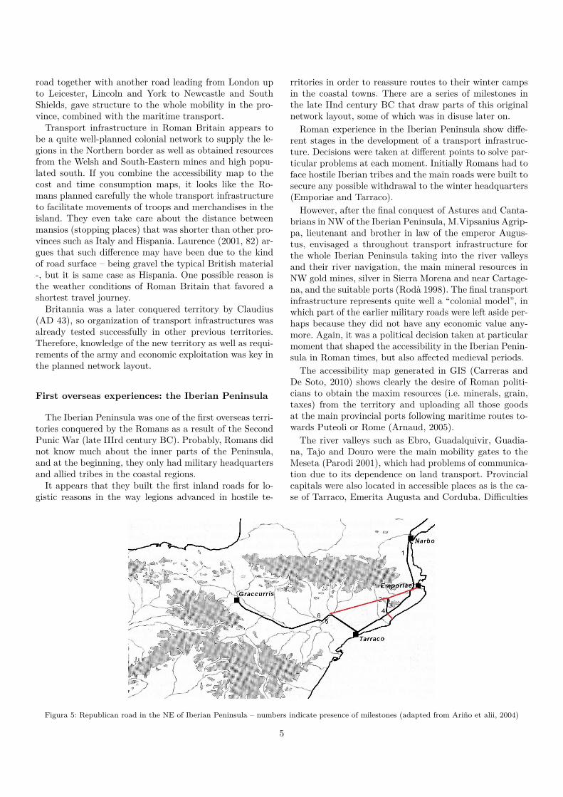
It appears that they built the first inland roads for lo-gistic reasons in the way legions advanced in hostile te-
rritories in order to reassure routes to their winter campsin the coastal towns. There are a series of milestones inthe late IInd century BC that draw parts of this originalnetwork layout, some of which was in disuse later on.
Roman experience in the Iberian Peninsula show diffe-rent stages in the development of a transport infrastruc-ture. Decisions were taken at different points to solve par-ticular problems at each moment. Initially Romans had toface hostile Iberian tribes and the main roads were built tosecure any possible withdrawal to the winter headquarters(Emporiae and Tarraco).
However, after the final conquest of Astures and Canta-brians in NW of the Iberian Peninsula, M.Vipsanius Agrip-pa, lieutenant and brother in law of the emperor Augus-tus, envisaged a throughout transport infrastructure forthe whole Iberian Peninsula taking into the river valleysand their river navigation, the main mineral resources inNW gold mines, silver in Sierra Morena and near Cartage-na, and the suitable ports (Rodà 1998). The final transportinfrastructure represents quite well a “colonial model”, inwhich part of the earlier military roads were left aside per-haps because they did not have any economic value any-more. Again, it was a political decision taken at particularmoment that shaped the accessibility in the Iberian Penin-sula in Roman times, but also affected medieval periods.
The accessibility map generated in GIS (Carreras andDe Soto, 2010) shows clearly the desire of Roman politi-cians to obtain the maxim resources (i.e. minerals, grain,taxes) from the territory and uploading all those goodsat the main provincial ports following maritime routes to-wards Puteoli or Rome (Arnaud, 2005).
The river valleys such as Ebro, Guadalquivir, Guadia-na, Tajo and Douro were the main mobility gates to theMeseta (Parodi 2001), which had problems of communica-tion due to its dependence on land transport. Provincialcapitals were also located in accessible places as is the ca-se of Tarraco, Emerita Augusta and Corduba. Difficulties
Figura 5: Republican road in the NE of Iberian Peninsula – numbers indicate presence of milestones (adapted from Ariño et alii, 2004)
5
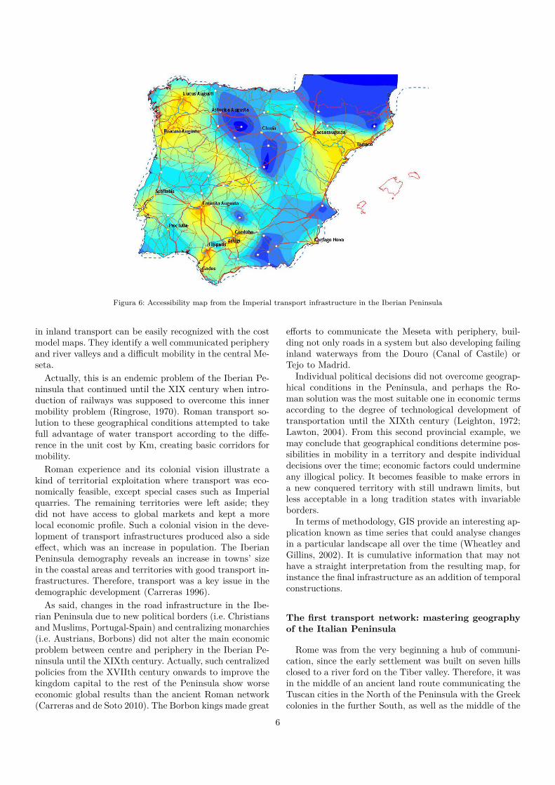
Figura 6: Accessibility map from the Imperial transport infrastructure in the Iberian Peninsula
in inland transport can be easily recognized with the costmodel maps. They identify a well communicated peripheryand river valleys and a difficult mobility in the central Me-seta.
Actually, this is an endemic problem of the Iberian Pe-ninsula that continued until the XIX century when intro-duction of railways was supposed to overcome this innermobility problem (Ringrose, 1970). Roman transport so-lution to these geographical conditions attempted to takefull advantage of water transport according to the diffe-rence in the unit cost by Km, creating basic corridors formobility.
Roman experience and its colonial vision illustrate akind of territorial exploitation where transport was eco-nomically feasible, except special cases such as Imperialquarries. The remaining territories were left aside; theydid not have access to global markets and kept a morelocal economic profile. Such a colonial vision in the deve-lopment of transport infrastructures produced also a sideeffect, which was an increase in population. The IberianPeninsula demography reveals an increase in towns’ sizein the coastal areas and territories with good transport in-frastructures. Therefore, transport was a key issue in thedemographic development (Carreras 1996).
As said, changes in the road infrastructure in the Ibe-rian Peninsula due to new political borders (i.e. Christiansand Muslims, Portugal-Spain) and centralizing monarchies(i.e. Austrians, Borbons) did not alter the main economicproblem between centre and periphery in the Iberian Pe-ninsula until the XIXth century. Actually, such centralizedpolicies from the XVIIth century onwards to improve thekingdom capital to the rest of the Peninsula show worseeconomic global results than the ancient Roman network(Carreras and de Soto 2010). The Borbon kings made great
efforts to communicate the Meseta with periphery, buil-ding not only roads in a system but also developing failinginland waterways from the Douro (Canal of Castile) orTejo to Madrid.
Individual political decisions did not overcome geograp-hical conditions in the Peninsula, and perhaps the Ro-man solution was the most suitable one in economic termsaccording to the degree of technological development oftransportation until the XIXth century (Leighton, 1972;Lawton, 2004). From this second provincial example, wemay conclude that geographical conditions determine pos-sibilities in mobility in a territory and despite individualdecisions over the time; economic factors could undermineany illogical policy. It becomes feasible to make errors ina new conquered territory with still undrawn limits, butless acceptable in a long tradition states with invariableborders.
In terms of methodology, GIS provide an interesting ap-plication known as time series that could analyse changesin a particular landscape all over the time (Wheatley andGillins, 2002). It is cumulative information that may nothave a straight interpretation from the resulting map, forinstance the final infrastructure as an addition of temporalconstructions.
The first transport network: mastering geographyof the Italian Peninsula
Rome was from the very beginning a hub of communi-cation, since the early settlement was built on seven hillsclosed to a river ford on the Tiber valley. Therefore, it wasin the middle of an ancient land route communicating theTuscan cities in the North of the Peninsula with the Greekcolonies in the further South, as well as the middle of the
6

Figura 7: Cost map generated from the city of Hispalis (Seville)
Figura 8: Transport roads in the Iberian Peninsula (up-down and left-right): Medieval Christian kingdoms, Muslim Califate, XVIth centuryand XVIIIth century
7

Figura 9: Itinerary of the via Appia
river Tiber and the Salaria route coming to the Apenninesto Tiber mouth.
During the IVth century BC, Rome started expandingits influence towards the South, helping the city of Capuaagainst the indigenous tribes of Samnites. In the SecondSamnite War, Roman legions were defeated due to lackof water supply in the so-called Caudine Forks (321 BC).That is the reason why the censor Appius Claudius (312BC) order to build the first Roman road (via Appia) lin-king the city of Rome with Capua (115 Km), to avoid anylack of supply to the Roman armies (Laurence, 1999, 11-26). This first road was constructed by military reasonsand connected only Roman colonies on its route towardsCapua. It was not exactly the shortest and the cheapestroute, but the safest one at the end of the IIIrd centuryBC, crossing the Pontine Marshes for a first stop at thecoastal Roman colony of Terracina.
Crossing the Pontine Marshes involved land reclamationto the sea and wooden-floors to some parts of the itinerary.Besides, according to Diodorus Siculus (20.36) it was a hu-ge economic investment that represented the State revenueof a whole year. The new Appian road required the foun-dation of two new Roman colonies on the way, Sinuessaand Minturnae, the second of which was on the river Liristhat allowed direct inland access. The via Appia, as thefirst Roman road, showed a clear pattern of linking onlyRoman settlements and avoiding foreign cities. Militaryand political reasons were behind those initial transportdecisions, since Roman politicians at that time could notforesee the State future expansion.
The second Roman road, the so-called Flaminian road(220 BC), changed the transport geography of the who-le Italian Peninsula, connecting the Tyrrhenian with theAdriatic sea (Laurence, 1999, 22). Again, it was a decision
Figura 10: The main Roman roads in the Italian Peninsula
related to the space conquered by Rome at that time andlinked only the Roman colonies (Spoleto, Nania, Rimini)following a straight line. This road was a still a complex en-gineering work since it crossed the Apennines range, witha second alternative road called the via Flaminia minor.
Roman road construction followed similar pattern con-necting the city of Rome with the new conquered terri-tories and Roman colonies, with some exceptions such asthe via Aemilia that connected Roman colonies amongstthemselves (Rimini-Cremona-Piacenza). Therefore, the fi-nal centralized road network was a simple result of a seriesof temporal decisions in the expansion of Roman Republic.
With regards to the maritime ports, Rome was not acoastal town, so the port at the Tiber estuary was not im-portant until the Imperial period. Roman Republic usedthe infrastructures of Greek colonies in the South andfounded Puteoli (Puzzoles) in the bay of Naples, beco-ming the main maritime port of the whole Mediterranean.Puteoli and Rome were connected by the via Appia, andthis axis combined the main transport infrastructure ofthe early State, combined with some navigable rivers suchas Tiber and Po.
A detailed analysis of the accessibility model revealssuch development of transport network in Roman Italy asresult of individual decision according to determined tem-poral constrains (Fig 12). Those political decision favoredcontact between communities of Roman citizens but did
8

Figura 11: Accessibility map in the Italian Peninsula
not foresee a political union of the whole Peninsula. The-refore, the accessibility maps show difficulties in crossingby road the Peninsula from Tyrrhenian to the AdriaticSea, in other points not covered by the Flaminian road.
Accessibility was considered only from the capital, Ro-me, which was the centre of the whole transport systemnot only by road, but from other means. At least, the cons-truction of Portus (port of Ostia) in Claudius and Trajanperiod converted Rome also in the main maritime portin the Mediterranean. Therefore, Puteoli lost part of themaritime traffic of Republican period, and Rome was themain hub of communication of the Empire. As is said, "allthe roads lead to Rome".
However, most part of the contact within the Italian Pe-ninsula appears to have been by sea according to the acces-sibility map. There is a good access between the Northernports of the Adriatic from Ancona to Ravenna and Pata-vium with the Po valley as inner river route. The port ofAterno in central Adriatic was another well-communicatedarea, and the same happened with Brundisium and Tarent,though with a lack of accessibility inland. A similar picturecan be drawn in the Thyrrenian coast with an excellent ac-cessibility in the Bay of Naples and around Rome. In theTuscan region, there is an extensive area well-connectedroad network that reaches areas such as Florentia withthe coastal ports (Luni, Pisa, Populonia, Cosa).
Difficulties in transport were evident in the inlandmountainous regions in the Appenines. There is a cleartransport barrier crossing the centre of the whole Penin-sula from North to South, with only a few roads connec-ting the two seas. Besides, some southern regions from theMagna Grecia suffered a limited investment in roads, asis the case of the present Puglia, Basilicata and Calabria,which hardly depended on maritime transport in coastalareas.
Again, the transport network development in the ItalianPeninsula does not follow any economic criteria. There is a
Figura 12: Transport cost from the city of Arretium
lack of roads in less populated regions inland, but this alsoaffects accessibility of most ancient coastal Greek colonies,which were still basically connected by ship.
Some Italian industries or exporting areas were locatedin those regions with facilities for transporting their goodsto potential consumers. Figure 13 represents the transportcost model from Arretium (Arezzo), which was the mainproduction area of Terra Sigillata Italica (TSI). This fineware was distributed all over the Western Roman Empiresince it was located in a place in the Tuscan region well-connected with coastal ports in the Tyrrhenian. Despite itsexcellent accessibility towards the Tyrrhenian coast, landtransport increased product cost so distribution in inlandItaly and other provinces was limited to some extent. Thatis why branches of TSI were developed in other placessuch as Lyon and the Western provinces created their ownindustries shortly such as Terra Sigillata Gallica (TSG) inSouthern and Central Gaul.
Arretium (Arezzo) location inland, close to Arno valley,did not give any advantage to other location closer to ma-ritime routes and the final consumer markets. Italian roadnetwork was not built up, as we have seen, with an econo-mic perspective but a political one. Therefore, some inlandtowns in Italy could not compete in economic terms withother provincial towns. As soon as those provinces such asHispania or Britannia were romanised, they were in betterconditions to access to distant and even central marketssuch as the city of Rome.
Because Rome, and other coastal cities in Italy such asOstia, Pisa, Puteoli and Ravenna, were the real hubs ofcommunication in the Italian Peninsula; so they could takeadvantage as economic centers in Italy. A series of timedecision constructed the transport network of the ItalianPeninsula in a way that mainly favored the capital, Rome,and other main ports all over the Peninsula: Puteoli in theSouth (port of Magna Grecia), Pisa (port of Etruria) andRavenna (north Adriatic).
9
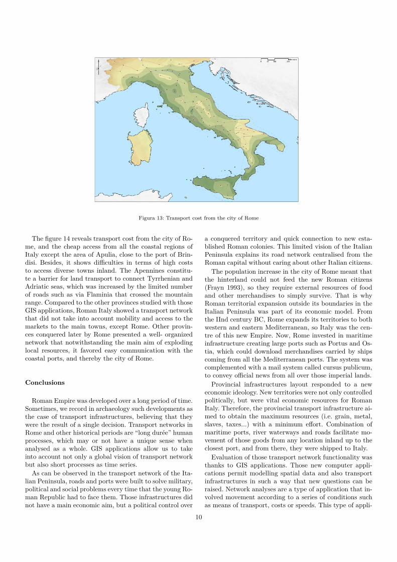
Figura 13: Transport cost from the city of Rome
The figure 14 reveals transport cost from the city of Ro-me, and the cheap access from all the coastal regions ofItaly except the area of Apulia, close to the port of Brin-disi. Besides, it shows difficulties in terms of high coststo access diverse towns inland. The Apennines constitu-te a barrier for land transport to connect Tyrrhenian andAdriatic seas, which was increased by the limited numberof roads such as via Flaminia that crossed the mountainrange. Compared to the other provinces studied with thoseGIS applications, Roman Italy showed a transport networkthat did not take into account mobility and access to themarkets to the main towns, except Rome. Other provin-ces conquered later by Rome presented a well- organizednetwork that notwithstanding the main aim of explodinglocal resources, it favored easy communication with thecoastal ports, and thereby the city of Rome.
Conclusions
Roman Empire was developed over a long period of time.Sometimes, we record in archaeology such developments asthe case of transport infrastructures, believing that theywere the result of a single decision. Transport networks inRome and other historical periods are “long durée” humanprocesses, which may or not have a unique sense whenanalysed as a whole. GIS applications allow us to takeinto account not only a global vision of transport networkbut also short processes as time series.
As can be observed in the transport network of the Ita-lian Peninsula, roads and ports were built to solve military,political and social problems every time that the young Ro-man Republic had to face them. Those infrastructures didnot have a main economic aim, but a political control over
a conquered territory and quick connection to new esta-blished Roman colonies. This limited vision of the ItalianPeninsula explains its road network centralised from theRoman capital without caring about other Italian citizens.
The population increase in the city of Rome meant thatthe hinterland could not feed the new Roman citizens(Frayn 1993), so they require external resources of foodand other merchandises to simply survive. That is whyRoman territorial expansion outside its boundaries in theItalian Peninsula was part of its economic model. Fromthe IInd century BC, Rome expands its territories to bothwestern and eastern Mediterranean, so Italy was the cen-tre of this new Empire. Now, Rome invested in maritimeinfrastructure creating large ports such as Portus and Os-tia, which could download merchandises carried by shipscoming from all the Mediterranean ports. The system wascomplemented with a mail system called cursus publicum,to convey official news from all over those imperial lands.
Provincial infrastructures layout responded to a neweconomic ideology. New territories were not only controlledpolitically, but were vital economic resources for RomanItaly. Therefore, the provincial transport infrastructure ai-med to obtain the maximum resources (i.e. grain, metal,slaves, taxes...) with a minimum effort. Combination ofmaritime ports, river waterways and roads facilitate mo-vement of those goods from any location inland up to theclosest port, and from there, they were shipped to Italy.
Evaluation of those transport network functionality wasthanks to GIS applications. Those new computer appli-cations permit modelling spatial data and also transportinfrastructures in such a way that new questions can beraised. Network analyses are a type of application that in-volved movement according to a series of conditions suchas means of transport, costs or speeds. This type of appli-
10

cation has been employed for us to explain the Romantransport infrastructures in different territories and pe-riods and also comparing the same territory (i.e. IberianPeninsula) over the time (Carreras and De Soto 2010) withquite remarkable results.
Modelling influence of military, political or economic in-terests sheds some light in how societies change their lands-cape and helps us to understand their historical evolutionand incidence of mobility or communication in their deve-lopment
Bibliography
ARIÑO, E; GURT, J.M.; PALET, J.M. (2004) El pa-sado presente: Arqueología de los paisajes en la Hispaniaromana. Barcelona.
ARNAUD, P. (2005) Les routes de la navigation antique.Itinéraires en Méditerranée. Paris.
CARRERAS, C. (1994) Una reconstrucción del comer-cio en cerámicas: la red de transportes en Britannia. Cua-dernos de Arqueología, 7. Barcelona.
CARRERAS, C. (1996) “A new perspective for the de-mographic study of Roman Spain”. Revista de Historia daArte e Arqueologia n.2, 1995-1996; pp 59-82.
CARRERAS, C. (2000) La economía de la Britanniaromana: la importación de alimentos.Barcelona.
CARRERAS, C.; DE SOTO, P. (2010) Historia de lamovilidad en la Península Ibérica. Barcelona.
CASSON, L. (1985) Ships and Seamanship in the An-cient World. London.
CHEVALIER, R. (1976) Roman roads. London.DE SOTO, P.; CARRERAS, C. (2007) “Anàlisi de la
xarxa de transport a la Catalunya romana: alguns apunts”.Revista d’Arqueologia de Ponent 16-17: 177-192.
DE SOTO, P.; CARRERAS, C. (2009) “La movilidad enépoca romana en Hispania: aplicaciones de redes de análi-sis (SIG) para el estudio diacrónico de las infraestructurasde transporte”. Habis 40,pp.303-324.
DICKS, T.R.B. (1972) “Network analysis and historicalgeography”. Area 4: 4-9
DREXHAGE, H.J. (1991) Preise, Mieten/Pachten, Kos-ten und Löhne im römischen Äegypten.St.Katherinen.
DUNCAN-JONES, R.P. (1991) Structure and scale ofthe Roman Economy. Cambridge.
ECK, W. (1979) Die staatliche Organisation Italiens inder hohen Kaiserzeit. Beck, München.
FRAYN, F. (1993) Markets and fairs in Roman Italy.Oxford
KOLB, A. (2000) Transport und Nachrichtentransfer imRomischen Reich. Berlin: Akademie Verlag, (Klio. Beitrae-ge zur Alten Geschichte, Beihefte, Neue Folge, 2).
LAUFFER, S. (1971) Diokletian’s Preisedikt. Berlin.LAURENCE, R. (1999) The roads of Roman Italy: Mo-
bility and Cultural change. London.LAURENCE, R. (2001) “The creation of geography.
An interpretation of Roman Britain”. In C.ADAMS and
R.LAURENCE (eds.) Travel and geography in the RomanEmpire. London: 67-94.
LAWTON, B. (2004) Various and indigenous machines.Power generation and transport. Volume I. Brill, Leiden.
LEIGHTON, A.C. (1972) Transport and communica-tion in early medieval Europe AD 500-1100. Oxford.
PARKER, A.J. (1992) Ancient Shipwrecks of the Medi-terranean and the Roman Provinces. British Archaeologi-cal Reports. International Series 580. Oxford.
PARODI, J.M. (2001) Ríos y lagunas de Hispania comovías de comunicación. Écija.
RINGROSE, D.R. (1970) Transportation and EconomicStagnation in Spain, 1750-1850. Durham.
RODÀ, I. (1998) “El papel de Agripa en la trama urbanade la Hispania Augustea”. Los orígenes de la ciudad en elNoroeste hispánico (Lugo 1996). Vol I. 276-293
ROUGÉ, J. (1952) “La navigation hivernale sousl’Empire Romain”. Revue des etudes anciennes. 316-325.
ROUCHÉ, C. (1989) Aphrodisias in the Late Antiquity.Monographs JRS. London.
WHEATLEY, D.; GILLINGS, M. (2002) Spatial tech-nology and archaeology. The Archaeological Applicationsof GIS. London.
11
Copyright © 2022 FDOKUMEN